Embed Size (px)
Citation preview

Eawag: Swiss Federal Institute of Aquatic Science and Technology
New information sources for rain fields
− cheap sensors
− (ab)use of existing infrastructure
− community sensing
June 17, 2014
Jörg Rieckermann, Andreas Scheidegger
Water Horizon Conference 2014, Berlin

Density of rain gauges
weather stations listed by the World Meteorological Organisation

World Water Development Report 4. World Water Assessment Program (WWAP), March 2012.
Water scarcity

For urban run-off modeling rainfall information in
very high-resolution is required
https://flic.kr/p/wYJxB, Guillaume Bertocchi
?

New sources of
information
We need:

New sources of information
1. Cheap and dirty
2. (Ab)use of existing infrastructure
3. Community sensing

Cheap and dirty sensors
http://www.bbc.com/news/science-environment-27222282, Delft University
Rabiei et al. (2013)
www.instructables.com/id/Make-an-
acoustic-rain-gauge-
disdrometer/?lang=es
Building automation
sensors
http://imomohub.org/?id=1-1027-1093-1098

Cheap and dirty sensors
Example Airquality100m x 100m resolution
Hasenfr
atz
, et al (2
014)
Measure roof runoff?

Cheap and dirty sensors
Paradigm shift I:
Sensors do not have to be precise

New sources of information
1. Cheap and dirty
2. (Ab)use of existing infrastructure
3. Community sensing
Use of existing infrastructure in a new wayMicrowave links – backbone of mobile networks

Microwave links as rain sensor
Receiv
ed s
ignal le
vel [d
Bm
]
Rain
fall
[mm
/hr]
rain intensity
Attenuation
of signal
Use of existing infrastructure in a new way

Donnerstag, 25. Juni 2009 13
Meteoswiss A-Netz vs. ORANGE Network
Use of existing infrastructure in a new way

Zurich, CH
Use of existing infrastructure in a new way
ORANGE network in urban area

Prag, CZ
Use of existing infrastructure in a new way
Microwave network in urban areas
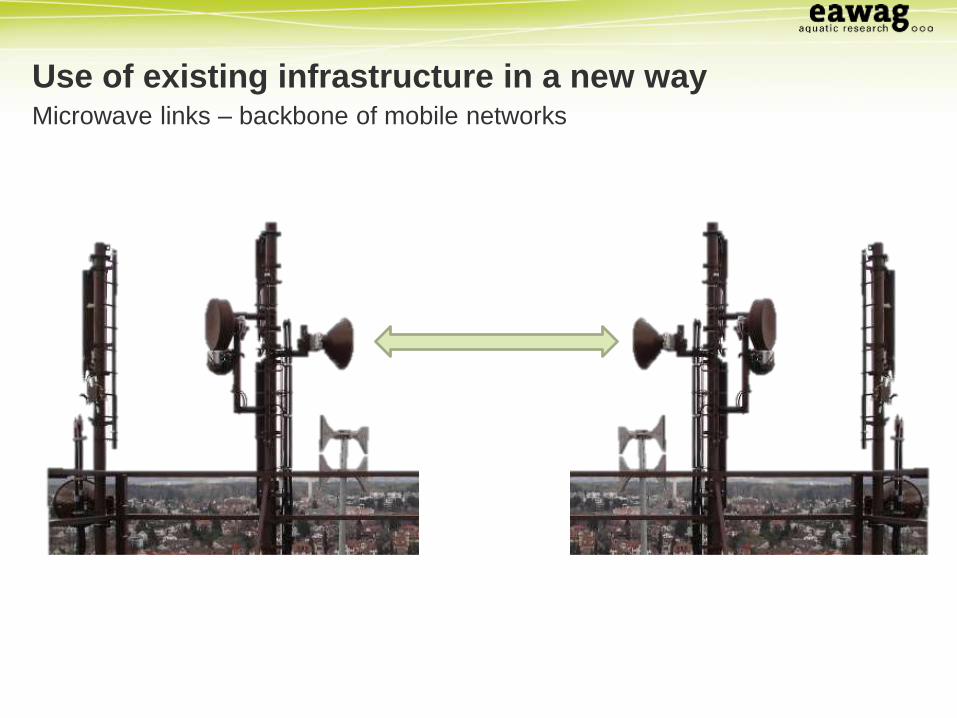
Comparing rain gauges to radar and MWLs (point estimates)
No. 1No. 2
No. 3No. 4
No. 5No. 6No. 7
No. 1No. 2
No. 3No. 4
No. 5No. 6No. 7
Microwave links case study Adliswil
Rain gauges [mm/h] Rain gauges [mm/h]
Radar
[mm
/h]
MW
L [
mm
/h]

No. 1No. 2
No. 3No. 4
No. 5No. 6No. 7
No. 1No. 2
No. 3No. 4
No. 5No. 6No. 7
Comparing rain gauges to radar and MWLs (point estimates)
Microwave links case study Adliswil
Rain gauges [mm/h] Rain gauges [mm/h]
Radar
[mm
/h]
MW
L [
mm
/h]

LCF = 0.99 LCF = 2.3
LCF = linear correction factor
No. 1No. 2
No. 3No. 4
No. 5No. 6No. 7
No. 1No. 2
No. 3No. 4
No. 5No. 6No. 7
Comparing rain gauges to radar and MWLs (point estimates)
Microwave links case study Adliswil
Rain gauges [mm/h] Rain gauges [mm/h]
Radar
[mm
/h]
MW
L [
mm
/h]

http://worldplantage.blogspot.ch/2010/02/african-farmers-and-web.html
Wo
rld B
ank, W
irele
ss In
telli
ge
nce
and
ITU

Microwave links – work and collaboration of Eawag
CZECH TECHNICAL
UNIVERSITY IN PRAGUE
Deutschland:
Harald Kunstmann
(KIT Karlsruhe)
Africa / Central Asia:

Use of existing infrastructure in a new way
Paradigm shift II:
Use existing infrastructure for
new purposes

New sources of information
1. Cheap and dirty
2. (Ab)use of existing infrastructure
3. Community sensing

Community sensing I
Oxford Flood Network http://oxfloodnet.co.uk/
“Making a citizen-built flood
detection network in Oxford,
based on river levels,
groundwater and local
knowledge.”
Ben Ward

Community sensing I
Oxford Flood Network http://oxfloodnet.co.uk/
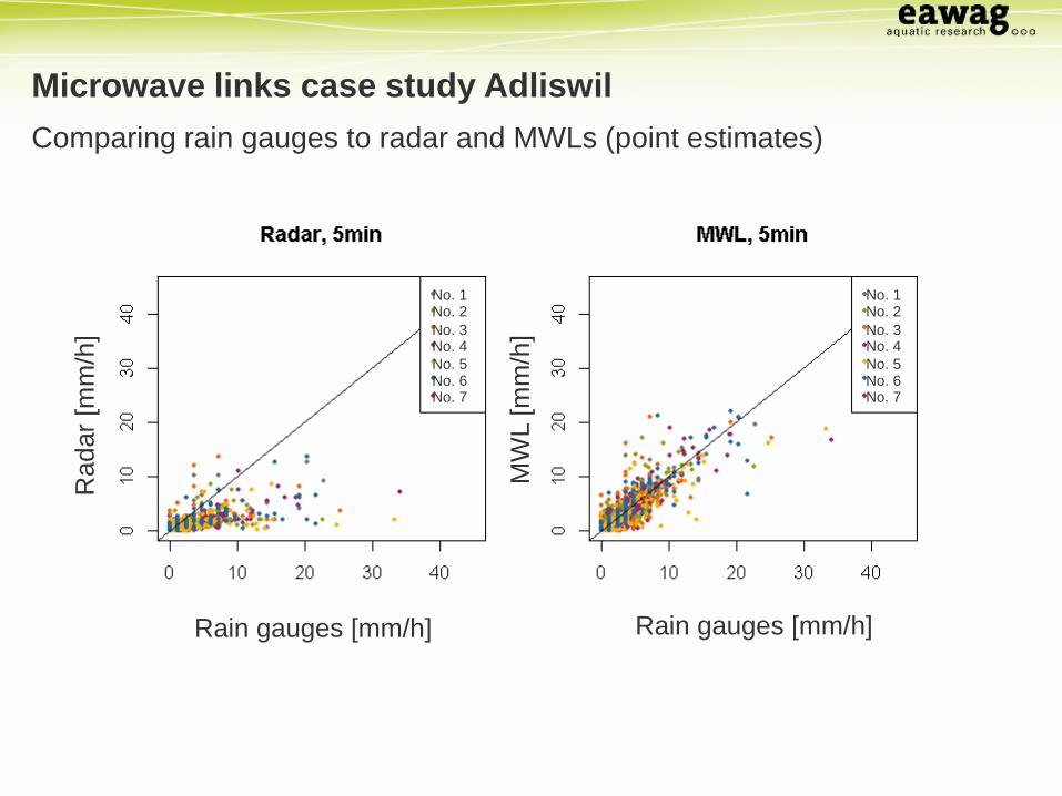
Community sensing II
British Met office http://wow.metoffice.gov.uk/

Community sensing III
www.openstreetmap.org

COBWEB Citizen OBservatory WEB
TU Dresden
“The Citizen OBservatory WEB project seeks to […] enabling the
fusion of citizen-sourced data with reference data […].”

Use of existing infrastructure in a new way
Paradigm shift III:
Trust non-experts

Making use of all
information

Many ways to measure rain
Rasmussen et al.
(2008)
www.unidata.com.au/ww
w.o
tt.c
om
Building
automation
sensor
Microwave Links
Rabiei et al. (2013)

Sensor properties
• What does it measure?
• point/areal measurement?
• What kind of information is provided?
• Continuous, binary signal, …
• How reliable is this information?
• Noise, biases, …

1D-example
time
Rain
inte
nsity

Continuous Assimilation of Integrating Rain Sensors
CAIRS is under development
Feedback is highly welcome!
https://github.com/scheidan/CAIRS.jl
Interested in collaborating? [email protected]
CAIRS
Aims:
• Generality: every signal is correctly
considered
• Flexibility: moving sensors,
irregular time intervals, …
• Fast: near real time assimilation
• “Good” code: stable, reusable, user friendly

Microwave Links + Pluviometers
2013-06-09 21:38:00 2013-06-09 21:38:00
x-coordinate [m] x-coordinate [m]
y-c
oord
inate
[m
]
y-c
oord
inate
[m
]
Rain intensities Uncertainty of rain intensities

Microwave Links + Radar + Pluviometers
2013-06-09 21:38:00 2013-06-09 21:38:00
x-coordinate [m] x-coordinate [m]
y-c
oord
inate
[m
]
y-c
oord
inate
[m
]
Rain intensities Uncertainty of rain intensities

Measure roof run-off?
maps.google.com

Signals in arbitrary time resolution
Time resolution of predicted
rain maps:
10 seconds
Measurement intervals:
MWLs: 174 – 276 seconds
Gauges: 60 seconds
time

Arbitrary prediction points
Compute higher
resolution for critical
areas

Making use of all information: Assimilation
Paradigm shift IV:
Not “A or B” but “A and B”

Conclusions

Why now?
• Telecommunication: the internet is
everywhere
• Low energy demand: micro controller and
with very low consumption available energy
harvesting seems possible
• Computer power: Assimilation of a variety of
different signals is demanding (MCMC)
• Social media: everybody is always online
What changed in the last 10 years?
http://www.ines.zhaw.ch/
4G
-Ab
de
cku
ng
de
r T
ele
ko
m

Interdisciplinarity
“Sensors”Data
transmissionModel
Energy
Data
assimilationUser
Computer science
Social science
Electrical engineering
Meteorology
Hydrology
Statistics

Paradigm shifts
I. Sensors don’t have to be precise
II. Use existing infrastructure for new purposes
III. Trust non-experts
IV.Not “A or B” but “A and B”