Embed Size (px)
Citation preview
WIFIRE is funded by NSF 1331615
İlkay ALTINTAŞ, Ph.D. PI, WIFIRE San Diego Supercomputer Center, UCSD [email protected]
Using Cyberinfrastructure for Wildfire Resilience
- A Scalable Data-Driven Monitoring and Dynamic Prediction Approach -

WIFIRE is funded by NSF 1331615
Fire is Part of the Natural Ecology … but requires Monitoring, PredicCon and Resilience
• Wildfires are criCcal for ecology, but volaCle
• Fuel load is high due to fire suppression over the last century
• Changes in rainfall, wind, seasons, and thus wildfires, potenCally induced by climate change
• BeKer prevenCon, predicCon and maintenance of wildfires is needed
Photo of Harris Fire (2007) by former Fire Captain Bill Clayton
Disaster management of (ongoing) wildfires heavily relies on understanding
their DirecCon and Rate of Spread (RoS).

WIFIRE is funded by NSF 1331615
A Scalable Data-‐Driven Monitoring, Dynamic PredicCon and Resilience Cyberinfrastructure for Wildfires (WIFIRE)
Development of: “cyberinfrastructure” for “analysis of large dimensional heterogeneous real-‐Cme sensed data” for fire resilience before, during and a0er a wildfire
WIFIRE is funded by NSF 1331615
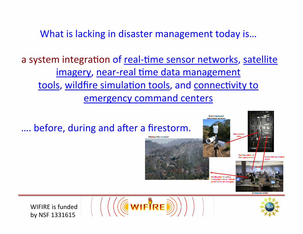
What is lacking in disaster management today is…
a system integraCon of real-‐Cme sensor networks, satellite imagery, near-‐real Cme data management
tools, wildfire simulaCon tools, and connecCvity to emergency command centers
. …. before, during and aZer a firestorm.

WIFIRE is funded by NSF 1331615
Research QuesCons
• Make sensor data useful – Large dimension to levels ingesCble by analyCcal and visual pla]orms
• Combine real-‐Cme data with physical models – Data-‐driven predicCve and prevenCve capabiliCes
• Risk assessment, training and disseminaCon using developed tools – Both municipal and firefighCng

WIFIRE is funded by NSF 1331615
Data Modeling VisualizaCon Monitoring

WIFIRE is funded by NSF 1331615
• How can large dimensional heterogeneous sensor data be analyzed systemaCcally to a (lower dimensional) format useful for informa6on processing, real-‐6me monitoring and visualiza6on?
• How can such data be combined with exis6ng scien6fic models to allow for predic6on of propaga6ng wildfires and potenCal future events to prepare fire fighters and the public for regions of highest risk?
• What quality and density of real-‐Cme sensors is necessary to improve both the predic6ve and preventa6ve capabili6es of current fire models?
• How can such informaCon processing be easily configured, programmed and computed by end-‐users with various skill levels to formulate actual real-‐6me data-‐driven environmental alerts?

WIFIRE is funded by NSF 1331615
Data to
Monitoring
• Data Catalog for all data sources
• Web interfaces to look at data

WIFIRE is funded by NSF 1331615
Decision making for wildfire fighting and disaster management based on heterogeneous data:
Photograph by Mark Thiessen
Satellite data
Wildfire perimeter Wind, Vegetation Terrain.
Fire Data Today

WIFIRE is funded by NSF 1331615
High Performance Wireless Research and EducaCon Network
Major success to bring internet to incident command in the field. Used in over 20 fires over Cme.

WIFIRE is funded by NSF 1331615
Sensor Network and Monitoring Interfaces
hKp://hpwren.ucsd.edu/cameras/ >160 Meteorological Sensors and Growing

WIFIRE is funded by NSF 1331615
May 14, 2014
¤
San Diego County Emergency Map displaying fire perimeter informaCon from NICS.
EM-‐COP system is powered by NICS.

WIFIRE is funded by NSF 1331615
May 14th, 2014: 9 fires burning at once in SD!
• Red Mountain Cams South (leZ) "Highway” Fire
SW (center rear) is the "Pointsela” Fire West (right) is the "Tomahawk” Fire
May 14: More than 1.8 million HTTP request from about 9,000 individual IP addresses

WIFIRE is funded by NSF 1331615
Data needs to be integrated and accessible! • Data sources formally described
– using XML-‐based ontologies and cataloged
• Data merged from mulCple sources into a single, unified model – Measurements from > 150 weather staCons – Color and Near-‐IR images from > 100 cameras – Fire perimeters, e.g., InciWeb , GeoMac, SANDAG – Model output, e.g., FARSITE, Firefly, etc.
• A unified interface to access data – Via a web service (REST-‐based) – Offers mulCple formats
• XML, GeoJSON, WindNinja, etc.

WIFIRE is funded by NSF 1331615
Data CommunicaCon Interface • Data is
– extracted, quality-‐controlled, and stored – available through REST-‐based web service interfaces – homogenously integrated from mulCple sources
• IniCal goal: Up-‐to-‐the-‐minute coverage availability – Up-‐to-‐the-‐moment coverage is a future goal.
• Proposed fire-‐modeling interface is uniform over modeled and real fires

WIFIRE is funded by NSF 1331615
What quesCons can you ask when you have access to such a data interface?

WIFIRE is funded by NSF 1331615
Generalized QuesCons Related to Data
• A list of all sensor types • Get metadata for specific sensor types • A list of all data-‐sources (instances of sensor types)
• Get all data-‐sources within a bounding box, and observe air temperature, and a specific form of Average Wind DirecCon.

WIFIRE is funded by NSF 1331615
Some QuesCons Related to a Specific Event Q1: What is the current temperature at all the staCons? Q2: What was the temperature on Lyons Peak at 1:30pm on May 14, 2014? Q3: What staCon is the closest to 32.614, -‐116.234? Q4: What was the wind speed and direcCon for the staCon in Q3 in the WindNinja format?

WIFIRE is funded by NSF 1331615
VisualizaCon • VisualizaCon for data verificaCon and interpretaCon • Using high-‐end visualizaCon systems • Can run anywhere from laptop to visualizaCon cluster

WIFIRE is funded by NSF 1331615
Terrain VisualizaCon • Post-‐fire burn map
– SDG&E and HPWREN weather data
20

WIFIRE is funded by NSF 1331615
3D Terrain with Photos and Perimeters
21
• Terrain imagery from 2009 and 2012 • Fire perimeters from the San Diego May 2014 fires • Images were collected via TwiKer
– CapConed with tweet tag on top

WIFIRE is funded by NSF 1331615
Crowd-‐Sourced Fire Perimeter CalculaCon
• Photos of fire locaCons from TwiKer and Instagram
• Custom app allows recording addiConal data such as phone’s locaCon and orientaCon, focal length, etc.
• Improve camera locaCon and orientaCon calculaCon through terrain map matching
• Image processing for fire/smoke localizaCon within photos
• Goal: map of fire perimeter over Cme
22

WIFIRE is funded by NSF 1331615
3D Terrain Map • Consolidates geo-‐located measured data and simulaCon results – Fire perimeter – Wind speed and direcCon animaCon with stream lines
23

WIFIRE is funded by NSF 1331615
Data DisseminaCon
• Incident commander: support decision making – Large high resoluCon displays
• Firefighters in the field: help navigate, give warnings – Smart phone, augmented reality
• General public: informaCon, evacuaCon support – Web site, smart phone app
24

WIFIRE is funded by NSF 1331615
Modeling

WIFIRE is funded by NSF 1331615
More accurate situaConal awareness using data -‐-‐ Data to Modeling in WIFIRE -‐-‐
Real-‐6me remote data –> Modeling, data assimilaCon and dynamic wildfire behavior predicCon
Sensors:

WIFIRE is funded by NSF 1331615
Need to improve programmability to build such data-‐driven models!

WIFIRE is funded by NSF 1331615
System IntegraCon of sensor data, data assimilaCon, dynamic models and fire direcCon and RoS predicCons (computaCons) is based on ScienCfic and Engineering Workflows (Kepler) • Visual programming • Scalable parallel execuCon • Standardized data interfaces • Reuse and reproducibility
WIFIRE System IntegraCon

WIFIRE is funded by NSF 1331615
Kepler Workflows for WIFIRE Use Cases
• Kepler is an open source, graphical environment for combining and automaCng Cyberinfrastructure components – Execute models – Read real-‐Cme and archived weather staCon measurements
– GIS components to pre-‐ and post-‐process data – Parallel execuCon – Provenance for execuCon history
www.kepler-project.org
WIFIRE is funded by NSF 1331615
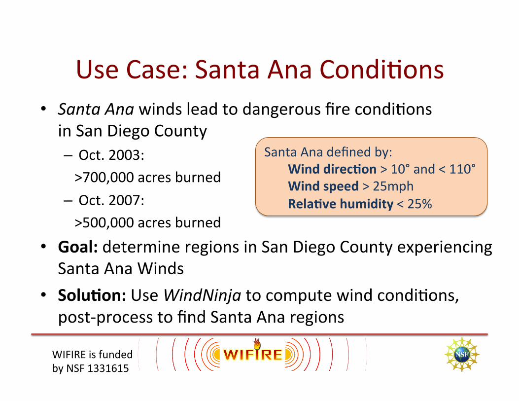
Use Case: Santa Ana CondiCons • Santa Ana winds lead to dangerous fire condiCons in San Diego County – Oct. 2003: >700,000 acres burned – Oct. 2007: >500,000 acres burned
Santa Ana defined by: Wind direc6on > 10° and < 110° Wind speed > 25mph Rela6ve humidity < 25%
• Goal: determine regions in San Diego County experiencing Santa Ana Winds
• Solu6on: Use WindNinja to compute wind condiCons, post-‐process to find Santa Ana regions

WIFIRE is funded by NSF 1331615
HPWREN Real-‐Time Weather Alerts • Weather staCons measurements monitored Santa Ana condiCons
• Alerts sent via email

WIFIRE is funded by NSF 1331615
Wind CondiCons Around Weather StaCons
• Run WindNinja to model wind condiCons • Inputs:
– Topography & vegetaCon – Weather staCon measurements – SpaCal and temporal ranges – etc.
• Outputs: – Wind direcCon & speed over region

WIFIRE is funded by NSF 1331615
SpaCal Coverage • WindNinja run on domain size up to 50x50km
– Split SD County into Cles – Run WindNinja for each Cle
WindNinja WindNinja
WindNinja

WIFIRE is funded by NSF 1331615
Temporal Coverage • WindNinja calculates wind condiCons for specific point in Cme – Run WindNinja for each Cmestamp
WindNinja WindNinja WindNinja
WindNinja WindNinja WindNinja
WindNinja WindNinja WindNinja
1:00pm, May 14 1:10pm, May 14 6:00pm, May 14

WIFIRE is funded by NSF 1331615
Execute in Parallel • Run WindNinja for each Cle
• Run WindNinja for each Cmestamp
• Each execu6on is independent, so can be done in parallel
WindNinja WindNinja WindNinja WindNinja WindNinja WindNinja
Compute Compute Compute Compute Compute Compute Compute Compute Compute

WIFIRE is funded by NSF 1331615
Post-‐Processing WindNinja Output
• WindNinja outputs wind direcCon and speed • Process these outputs to find regions with Santa Ana winds
Union Filter Rasterize Find Polygons

WIFIRE is funded by NSF 1331615
ApplicaCon Outputs • Output shows Santa Ana regions • OZen much larger area surrounding weather staCon

WIFIRE is funded by NSF 1331615
Use Case: Fire Growth
• Goal: Simulate fire growth in SD County • Run FARSITE and Firefly • Inputs:
– Landscape (topography, fuel, etc.) – Weather (wind, temperature, humidity, etc.) – IgniCon perimeter
• Outputs: – Fire perimeters – Intensity, flame length, spread rate, etc.

WIFIRE is funded by NSF 1331615
Example Output of Fire Perimeters • Two simulaCons with different weather: – White is “normal” weather – Red is Santa Ana weather

WIFIRE is funded by NSF 1331615

WIFIRE is funded by NSF 1331615
To summarize: EffecCve systems for real-‐Cme acquisiCon and
analysis of wildfire big data can make a huge impact on wildfire resilience.
• Website: hKp://wifire.ucsd.edu
• TwiKer: @WIFIREProject
WIFIRE is on the web!