Embed Size (px)
Citation preview
OpenStreetMap and open maps in Estonia

MTÜ Avatud maakaardi selts
• Registered NGO
• “Open Map Society”
• Established 2009 August
• Why?
• To do projects
• Estonian language world map, own styling
• Specific services
• To do something together

Plans for the AMS
• What
• Own technical platform
• World map in Estonian language and projection
• Soft side. Events, information, trainings
• Projects
• KÜSK 2010-2011

Activities of AMS
• Technical
• www.maakaart.ee - localized OSM info portal
• kaart.maakaart.ee – localized OSM map server
• World in Estonian language
• Supports Estonian coordinate system via WMS
• Own map layout
• Translations: JOSM, OSM Web, Wiki guides
• Other
• OSM mapping parties: Pärnu, Paide, Võrumaa.
• OSM Seminars to other NGOs, schools, universities
• Free GIS seminars in universities
• Promo in GIS and mapping conferences.

• Tartu, August 2013
• 40 participants from 10 countries

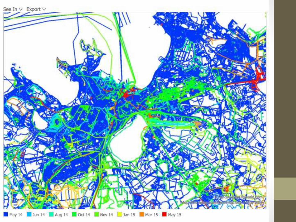
Data imports
• Tallinn city buildings
• Unofficial, 2008
• Tartu city government
• All city data, 2009
• Eesti Maaamet, National Land Survey
• Permission to use online maps and WMS, 2009
• Corine Land Cover
• Mixed result
• Addressess and buildings
• osm.svimik.com, 2013


Open Data in Estonia
• Tech-savvy (self-)image• Tweeting President
• EE-country
• ID-Card for everyone, Mobile ID
• E-voting
• E-citizenship
• Some realistic notes• Quite empty open data portal
• Laws requires “machine-readable open data”
• Open Geodata - NLB• “Symbolic” price: 0.01 EUR / thousand objects
• License discussions: CC 4.0 proposal
• Work in progress

Open Geo Datasets for Estonia
• OpenStreetMap
• Corine Land Cover – not very good
• Keskkonnateenistus – rivers, waters
• Forest register - shapefiles
• NLB open datasets – www.maaamet.ee
• Administrative borders – shapefiles
• Address database – ftp per request
• WMS for most data layers, including address GetFeatureInfo
• Geo Web portals
• Maa-ameti geoportaal - geoportaal.maaamet.ee
• Eesti Geoportaal – inspire.maaamet.ee

ESTGIS
• www.estgis.ee
• Established 2010
• Over 100 members
• Estonian NLB
• Companies: ESRI, Regio etc
• Universities: Tartu etc
• GIS experts
• Activities
• Yearly conference – November
• Yearly summer school - August
• GIS day
• Policy participation - tricky

Open Source GIS
• General approach
• Preferred in state level
• Not mandatory
• GIS usage
• Quite a lot in server level – Geoserver, PostGIS, Leaflet
• Desktop – more limited
• Contribution, development
• Very little

Nutiteq Offline Maps apphttps://play.google.com/store/apps/details?id=com.nutiteq.app.nutimap3d

Nutiteq Maps SDK
1.Nutiteq Maps SDK for Enterprise
• Mobile Maps SDK for advanced requirements
• iOS, Android, Xamarin, Windows Phone – common API
• Vector map rendering
• GIS extension: vector (Shape etc), raster (WMS, GeoTIFF etc)
• 3D tools: 3D models, 3D city
• Custom additions and pro services
2.Nutiteq Maps as a Service
• OSM vector base map – online and offline
• Nutiteq Maps SDK for public apps
• developer.nutiteq.com monthly subscription packages
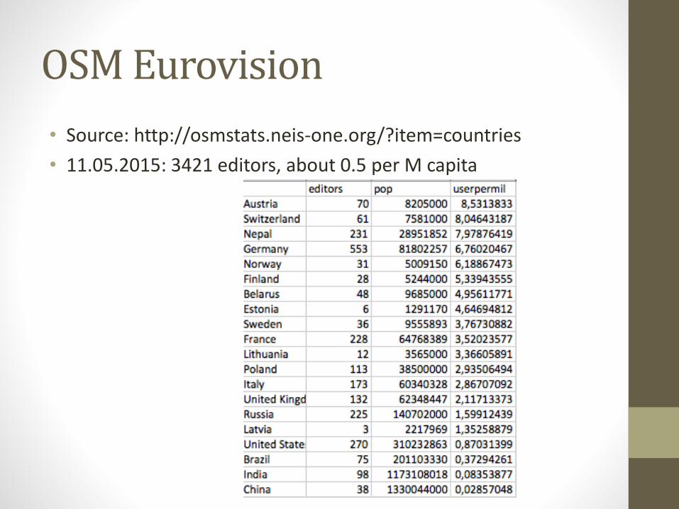
OSM Eurovision
• Source: http://osmstats.neis-one.org/?item=countries
• 11.05.2015: 3421 editors, about 0.5 per M capita

Contacts and thank you!
• General info
• www.maakaart.ee - has English page
• List: [email protected]
• Jaak Laineste
• @jaakl