Embed Size (px)
Citation preview

Geospatial Big DataLocation Intelligence in Digital
Transformation
Mifan CareemDirector, Solution Architecture
WSO2

“As geospatial technology becomes more pervasive
across a multitude of applications, it is becoming
harder to quantify it as a discrete sector, as opposed
to part of the broader IT industry”Dr. Vanessa Lawrence, Director General, Ordnance Survey, “Investigation into spatial capability of Australia”

GEOGRAPHICAL INFORMATION SYSTEMS (GIS) - EVOLUTION
Paper Maps
ESRI (1969) Google Maps (2005)Google Earth (2001)
OSM (2006)Google Maps Mobile (2012)Google Traffic (2013)
Link: Simpsons @ Springfield
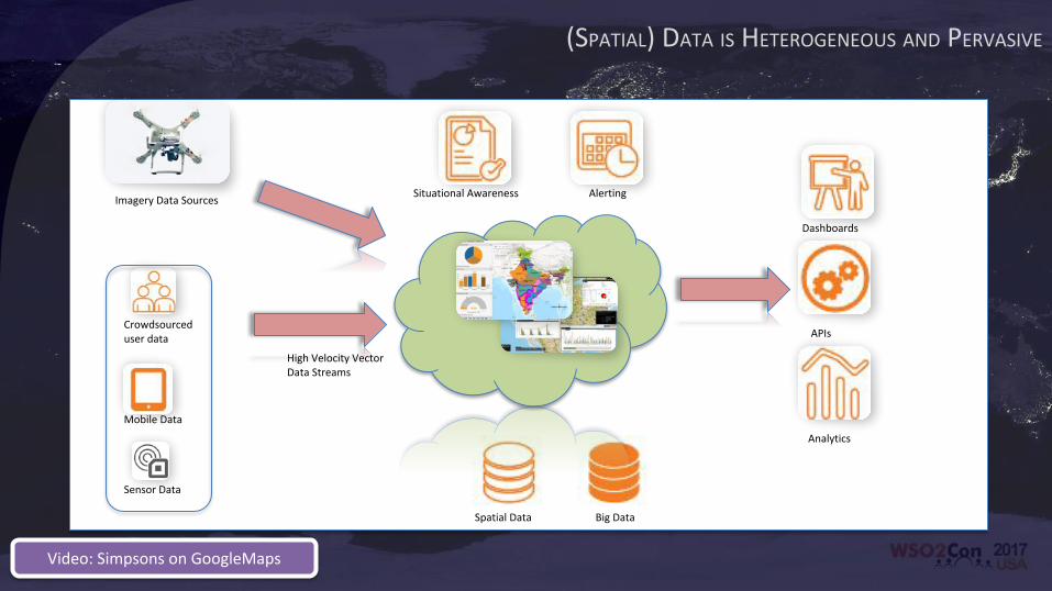
(SPATIAL) DATA IS HETEROGENEOUS AND PERVASIVE
Crowdsourced user data
Mobile Data
Sensor Data
Big DataSpatial Data
High Velocity Vector Data Streams
Imagery Data Sources
Dashboards
APIs
Analytics
Situational Awareness Alerting
Video: Simpsons on GoogleMaps

Five GIS Trends Changing the WorldJack Dangermond, President, ESRI – 2017
• Location as a Service
• Advanced Analytics
• Big Data Analytics
• Real Time GIS
• Mobility
http://geoawesomeness.com/five-gis-trends-changing-world-according-jack-dangermond-president-esri/
http://www.gartner.com/smarterwithgartner/top-ten-technology-trends-signal-the-digital-mesh/
More Facts…
• 25 Billion+ connected devices by 2025
• IoT and Digital Industries will produce a large amount of location data
• Spatial Dimension adds value to Predictive Analytics
• Open data and collaborative spatial data sources continue to increase
• Location will be a part of everything!

• Stream Processing can use
a location attribute to
spatially analyze and
process data, real time, in
memory
• WSO2’s Stream Processor
(Complex Event Processor)
has GeoTools integration
• E.g operations
– Within
– Clustering
REAL TIME SPATIAL STREAM PROCESSING
Video: WSO2 CEP with TFL Data

• Nearly all IoT devices
have a location attribute
that can be utilized to
provide more optimal
solutions
– Fleet management
• WSO2 IoT Server
provides spatial analysis
via WSO2 Analytics
OPTIMIZE IOT AND SENSOR DATA PROCESSING

WHICH LEADS TO UBIQUITOUS DATA STREAMS• Consumer driven
applications that are
ubiquitous
– Uber
– Google Maps
– Google Now
– Google Traffic, Waze

API MANAGEMENT ENABLES PARTICIPATORY BUSINESS• The GIS world has had
standards based services for
some time now
– OGC WMS, WFS, WCS
• Coupling this with API
Management provides
powerful API capabilities
• Encourage participatory
business models
• Ordnance Survey in UK
exposes national map data as
standard APIs
• Video – Open Street Maps
participatory contribution
Link: OS API Store

INTEGRATION ACROSS MULTIPLE HETEROGENEOUS SOURCES• Integration across multiple
systems serving different
formats enable a global
unified view across the board
• Case study: Rolta uses WSO2
ESB (Integration) to connect
disparate sources providing
solutions for Govt. Agencies
• Case study: TFL’s London
Works combines multiple
systems to provide a unified
view of Utility Management
for London

TECHNOLOGY FOR DIGITAL TRANSFORMATION
Build internal and external developer ecosystems with an API marketplace.
Platform enable your digital business with microservices and micro integrations.
Manage identity, security, and privacy across your digital business.
Create real-time, intelligent, actionable business insights and data products.
Make mobile and IoTdevices integral to your digital business.

DIGITALLY TRANSFORM AND INNOVATE INDUSTRIES
Banking
Insurance
Retail
Finance
Supply Chain
Utilities
Federal, State, Local
Search and Rescue
Public Works
Intelligence
Agriculture
Farming
Land Management
Irrigation
Climate Change
Forestry
Fire and Safety
Emergency Mgt.
Law Enforcement
Homeland Security
Video: OSM Data edits in HOSM

Thank You!
I believe we need a "Digital Earth". A multi-resolution, three-dimensional representation of the planet, into which we can embed vast quantities of geo-referenced data. Al Gore, “Digital Earth – Understanding our planet in the 21st Century”, California, 1998


![[WSO2Con EU 2017] Keynote: Digital Transformation in the Guise of a Regulation - PSD2 and Open Banking](https://img.pdfslide.net/doc/110x75/5a64901d7f8b9a27568b67f7/wso2con-eu-2017-keynote-digital-transformation-in-the-guise-of-a-regulation.jpg)
![[WSO2Con EU 2017] Travis Perkins - Our Digital Transformation & the Importance of Integration](https://img.pdfslide.net/doc/110x75/5a6490047f8b9a27568b67db/wso2con-eu-2017-travis-perkins-our-digital-transformation-the-importance.jpg)


![[WSO2Con EU 2017] Container-native Architecture](https://img.pdfslide.net/doc/110x75/5a6490d17f8b9a31568b548b/wso2con-eu-2017-container-native-architecture.jpg)


![[WSO2Con EU 2017] Integration Platform Strategy for Digital Transformation](https://img.pdfslide.net/doc/110x75/5a647bd37f8b9a31568b4aef/wso2con-eu-2017-integration-platform-strategy-for-digital-transformation.jpg)