Embed Size (px)
Citation preview
1
Rama Setu: world heritage Table of contents Rama Setu: world heritage Introduction Chapter 1 Historicity and ancient monument of international importance Chapter 2 Economics of Setusamudram Project Chapter 3 Marine bioreserve and world heritage Chapter 4 National security and integrity Annex 1. Rama Setu through the ages Annex 2. AR Mudaliar Committee (1956) Report against any passage across Adam’s Bridge (Rama Setu) Annex 3 Sethusamudram Shipping Channel: it doesn’t make nautical sense Annex 4 Ecological disaster Annex 5 Scientific evidence for ancient human activity in the project area Annex 6 Geological and Geophysical Perspective of the Ramsetu Bridge Annex 7 Impact of Tsunami on Setusamudram Shipping Channel and the neighboring coastal areas Annex 8 Memorandum signed by Smt. Indira Gandhi and Smt. Sirimavo Bandaranaike on 16 June 1974 on Historic Waters between India and Sri Lanka Annex 9 Implications of damaging Rama Setu under international Law of the Sea Annex 10 Ancient monuments and archaeological sites and remains act 1958 Annex 11 Setusamudram Shipping Channel Project (SSCP) -- A Mariner’s Perspective Annex 12 Dr. SR Rao’s letter to Min. of Shipping and Transport
2
Rama Setu: world heritage
Introduction Om versus Rome signifies of rationale for and the quintessence of the ongoing national and international movements to protect Rama Setu as world heritage. Om is the primordial sound denoting supreme divinity in Bharatiya tradition. Rome is signified by the Vatican which wants to harvest souls through devious strategies to promote envangelisation and conversion of Bharatiya into Christians, by a process of denial of the heritage exemplified by Rama Setu or Setubandha or Nala Setu (the man-made bund built by Architect Nala). Om is the sound which emanates from a s’ankha (chank trumpet), called s’ankhanaada. This s’ankha called turbinella pyrum is a unique product available only in the coastline of Bharatam, in the Gulf of Mannar in particular where Rama Setu is located and where a Setusamudram Channel Project at a cost of over Rs. 2200 crores is sought to be implemented as a channel passage cutting through this worle heritage monument. This project should be stopped and re-evaluated, since a monument which should be protected by the state is sought to be desiccated. Rama Setu together with the nearby Marine Biosphere are world heritage and should be deemed to be ancient monuments. There is overwhelming evidence to prove the existence of Rama Setu and its use as a land-bridge between Bharatam and Sri Lanka for generations. On either side of the bridge there are sacred pilgrimages and temples, e.g., s’ivalinga at Rameswaram and s’ivalinga at Tirukedeswaram (Mantota on Sri Lanka side at the end of Talaimannar). Rama Setu as world heritage should be protected and should not be destroyed in the name of a project which is of doubtful economic viability. To salvage the losses from this sick unit, a shorter alignment,shorter by about 39 nautical miles (an equivalent of about 6.5 hours saving in navigation time) should be chosen to create a land-based canal like the Panama or Suez canals and with locks on either side to prevent incursion of Bay of Bengal turbulent waters into the serene Gulf of Mannar waters. In addition, the land-based canal close to the coastline of Bharatam will facilitate incorporation of tsunami walls to protect the lives and property along the coast in case another tsunami occurs caused by plate tectonics (earthquakes caused by the clash of Indian and Eurasian/Burmese plates). The traditions and sensitivities are so intense that the citizens of Ramanathapuram do not use ploughs or ploughshares for farming since the entire earth in the region is considered sacred because the s’ivalinga installed by Sri Rama and Sita Devi were made of this earth. Fisherfolk do not cause damage to Rama Setu and if even a small piece of rock is disturbed while collecting algae or corals, the people perform prayas’cittam, as penance of repentance and seeking divine compassion.
3
Chapter 1 Historicity and ancient monument of international importance
Rama Setu is a cultural monument of international importance. Rama Setu or Setubandha or Nala Setu is the very embodiment of the indomitable spirit exemplified by Sri Rama as vigrahavan dharmah (role model of dharma) in the fight against evil. Rama Setu is an eternal symbol of universal ethic. The building of Rama Setu is narrated on sculptures of Parambanan (Brahmavana) temple complex of Java, Indonesia. This is what a French historian said about Ramayana: Jules Michelet (1798-1874), famous French historian on the Ramayana :
The year 1863 will remain cherished and blessed. It was the first time I could read India's great sacred poem, the divine Ramayana.... This great stream of poetry carries away the bitter leaven left behind by time and purifies us. Whoever has his heart dried up, let him drench it in the Ramayana. Whoever has lost and wept, let him find in it a soothing softness and Nature's compassion. Whoever has done too much, willed too much, let him drink a long draught of life and youth from this deep chalice.... Everything is narrow in the Occident. Greece is small — I stifle. Judea is dry — I pant. Let me look a little towards lofty Asia, towards the deep Orient. There I find my immense poem, vast as India's seas, blessed and made golden by the sun , a book of divine harmony in which nothing jars. There reigns a lovable peace, and even in the midst of battle, an infinite softness, an unbounded fraternity extending to all that lives, a bottomless and shoreless ocean of love, piety, clemency. I have found what I was looking for : the bible of kindness. Great poem, receive me !… Let me plunge into it ! It is the sea of milk. [i]
[i] Michelet, La Bible de l'humanité, volume 5 of Œuvres (Paris : Bibliothèque Larousse, 1930), p. 109-110.
Sri Rama said: Jananee janmabhoomishca svargaadapi gariyasi; mother and motherland are greater by far than even heaven. (translation by Aurobindo). These immortal words find a geophysical presence in Rama Setu or Setubandha, a bridge on the motherland. The immortal words attributed to Sri Rama will remain as long as the earth survives and as long as life exists on earth. Setu is sacred. It is a heritage, a tirthasthaana.
Justice K.T. Thomas says "Ram Sethu should not be broken"
Justice K.T. Thomas, former judge of Supreme Court of Bharat, is well known for his rectitude. President of India Dr Abdul Kalam decorated him with ‘Padma Bhushan’ award at a grand function at Rashtrapati Bhavan, New Delhi, on April 5, 2007 for his impeccable judicial career and for the service he rendered to the cause of justice.
4
After his retirement, Justice (Retd.) Thomas had headed as many as four judicial commissions, that too on sensitive issues. But he completed the task within the stipulated time in all the four instances. Never did he ask for extension of the tenure of his commissions. Also, never did he take a paisa as remuneration for his work in any of these four commissions. His logic: "The pension I get after my retirement from the Supreme Court is from government treasury. How can I take money from the government a second time for doing a government job?" He can afford to be candid on vital issues, thanks to his spotless career. For example: “In projects like this (Sethusamudram Shipping Canal Project), decisions are to be based not only on a study of geological implications; the religious sentiments of the people are also to be taken into account. The religious sentiments of the people of Bharat must be honoured and there exists a tradition in this land, of honouring religious sentiments. So, it is my definite opinion that Ram Sethu must not be broken”, says Justice (Retd.) Thomas.
http://www.organiser.org/dynamic/modules.php?name=Content&pa=showpage&pid=181&page=6 Environment Impact Analysis is supposed to include an evaluation of cultural impact of the project and the imperative of exploring archaeological sites. Rama Setu is part of a marine archaeological zone. Failures of NEERI are stark and call for a review of the project evaluation. Read a US Appeals court judgement on damaging a mountain sacred to Navajo in USA. A monument does NOT have to be man-made to be declared an Ancient Monument. Rama Setu should be deemed to be an ancient monument based on archaeological, textual evidences and bharatiya traditions (including the traditions of Hindu and Muslim and Christian who refer to the monument as Adam's Bridge). Whether it is Rama Setu or Adam's Bridge, both Rama and Adam are ancient; the monument is ancient. It is surprising that unlike the involvement of Archaeologists in Nagarjunasagar dam project, Narmada dam project and in Dwaraka, there has been a gross failure to involve the archaeologists (marine archaeology wing of ASI, in particular) in the evaluation of the project. Why was there a world outcry when the Taliban demolished the Buddha statue of Bamiyan? Cherishing world heritage can coexist with abhyudayam. Why is there a plea, accompanied by 25 lakh signatures of concerned citizens of Bharat sent to the Rashtrapati ji, to realign the Setu channel passage into a Setu Canal across the Dhanushkodi land stretch? It is because, such a realignment will not damage Rama Setu, a world heritage, ancient monument which is clearly seen as a dominant feature in many space images. Supreme Court's observations given vide paragraph number 7 of its judgement reported as S. Veerabadran Chettiar v. E. V. Ramaswami Naicker and others (AIR 1958 Supreme Court 1032) may be recalled The said observations (as appearing on page 1035 of AIR 1958 Supreme Court) are reproduced:
"…. Any object however trivial or destitute of real value in itself if regarded as sacred by any class of persons would come within the meaning of the penal section (295 of Indian Penal Code). Nor is it absolutely necessary that the object, in order to be held sacred, should have been actually worshipped. An object may be held sacred by a class of persons without being worshipped by them. It is clear, therefore, that the courts below were rather cynical in so lightly brushing aside the religious susceptibilities of that class of persons to which the complainant claims to belong. The section has been intended to respect the religious susceptibilities of persons of
5
different religious persuasions or creeds. Courts have got to be very circumspect in such matters, and to pay due regard to the feelings and religious emotions of different classes of persons with different beliefs, irrespective of the consideration whether or not they share those beliefs, or whether they are rational or otherwise, in the opinion of the court."
This is a historic moment in our history. This is historic because the word 'setu' evokes immediately a sacred social memory of Sri Rama, under whose command the bridge was built. This tradition is a world wide tradition, a sacred memory in particular in the Indian Ocean Rim states populated by over 2 billion people. The memory of Sri Rama is immortal and will survive this and future generations. Sri Rama was a person who was divine. Our tradition says that he is divine incarnate. The events and places associated with this social memory related to Sri Rama are indelible and are integral parts of our lives and the lives of future generations. It is our responsibility, our dharma to protect, preserve and cherish a monument associated with Sri Rama at the intersection of land and ocean, at the intersection of civilization and progress. In bharatiya tradition, spiritual and secular intersect. What is setubandha for one is Rama Setu for another. Brige it is, linking abhyudayam and nihs'reyas. Both abhyudayam and nihs'reyas are two sides of dharma which is sanaatana, esha dhammo sanantano. This social, civilization memory is eternal and will continue to guide us as we embark on projects for abhyudayam. Abhyudayam does not have to be at the expense of cherishing sacred tradition. The bhakti movement of Azhwar like Thiru Mangai Azhwar and Thondar Adi Podi Azhwar will continue to be an inspiration for the youngest nation in the world with over 70% of the population being less than 35 years of age. Akananooru, a great Sangam period work, cites Rama and his setu. The word, ‘setu’ is defined as 'man-made bund' in Abhidaana kocam, an ancient Tamil encyclopaedia? Parantaka Chola's copper plate epigraph of the 10th century refers to his pilgrimate and sacred offerings at Setutirtha. Annex 1 provides space images, cartographic, numismatic, archaeological and textual evidences for the historicity of Rama Setu. Rama Setu had saved the coastline during tsunami; stop Setu Project Ramar bridge (RamaSetu) had saved the coastline during tsunami 2004. Breaking the bridge with a 300-meter wide channel passage in the Indian Ocean (Hindumahasagar) will suck the next, impending, tsunami directly into the Bharatam coastline. Devastation will be incalculable, particularly in the coastline of southern Bharatam including Tamilnadu and Kerala.
6
Scientific and other evidences prove that the Rama Setu is an ancient land-bridge. This is a monument of national and international significance and should be declared as a World Heritage Monument.
See: http://ramasetu.blogspot.com/2007/04/bamiyan-and-setu.html
See the following from among the lists of World Heritage Sites of UNESCO:
http://whc.unesco.org/en/list/1138 Coiba National Park and its Special Zone of Marine Protection in Panama http://whc.unesco.org/en/list/653 Tubbataha Reef Marine Park in the Philippines http://whc.unesco.org/en/list/898 Kvarken Archipelago / High Coast in Sweden/Finland http://whc.unesco.org/en/list/369 Giant's causeway and Causeway coast in UK http://whc.unesco.org/en/list/154 Great Barrier Reef in Australia http://whc.unesco.org/en/list/764 Belize Barrier Reef Reserve System in Belize http://whc.unesco.org/en/list/80 Mont St. Michel and its bay in France http://whc.unesco.org/en/list/672 Ha Long Bay in Vietnam http://whc.unesco.org/en/list/306 Matobo Hills in Zimbabwe Aren't there good reasons why Rama Setu (or Nala Setu) should be declared as a World Heritage Site? Is it not abhyudayam to cherish and protect ancient monuments? Could anyone support what the Taliban did to the Buddha in Bamiyan? Were the Taliban merely quarrying stone? Surely, there should be some limits to ignominy. NASA images clearly establish a land bridge between Dhanushkodi island (Rameshwaram side) and Talaimannar island (Srilanka side). This bridge is composed of a series of islands and shoals (sand accumulations created by ocean currents). Thus, the entire bridge right from the sea-bed to the surface sea level is a bridge formation which has been recognized as a land bridge linking the two regions: Bharatam and Srilanka. To what extent there was manual intervention in connecting the gaps between the shoals and islands during the pre-historic periods as detailed in the ancient texts such as Ramayanam is a matter for detailed marine archaeological and geological evaluation. The reports of submergence of Kumarikandam, Poompuhar, Dwaraka along the coastline and the formation of the Gulf of Khamba about 10000 years ago (confirmed by scientists of National Institute of Ocean Technology) point to the possibility that the recent historical record of submergence of Dhanushkodi island should provide for a pause and re-evaluation of the impact of the ocean currents and changes in sea-level on the coastline and also on the SSCP. Such a multi-disciplinary archaeological-geological-aquatic environment study should be undertaken respecting the sentiments of the people who has looked upon the bridge as a land-link between Bharatam and Srilanka. The fact that India is described in Government logo as Aasetu himachala paryantam, the fact that the project itself is called Setusamudram canal project (Setu means bridge), confirms the tradition related to the bridge. Hurting the sentiments of the people who revere Sri Rama as a divinity and personification of dharma will be a serious breach of trust and utter disdain for peoples’ sentiments. In fact, the SSCP should be reconsidered and the pros-and-cons of reactivating the land bridge between Srilanka and Bharatam should be considered afresh. A bridge may be more beneficial for both countries than a canal. The canal has limited draught and will NOT provide for the movement of large-sized tankers of the carrying capacity of, say, 2 million tones of fuel oils from the
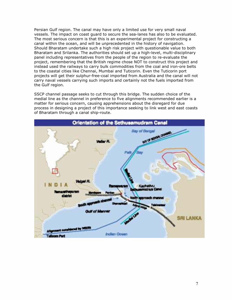
7
Persian Gulf region. The canal may have only a limited use for very small naval vessels. The impact on coast guard to secure the sea-lanes has also to be evaluated. The most serious concern is that this is an experimental project for constructing a canal within the ocean, and will be unprecedented in the history of navigation. Should Bharatam undertake such a high risk project with questionable value to both Bharatam and Srilanka. The authorities should set up a high-level, multi-disciplinary panel including representatives from the people of the region to re-evaluate the project, remembering that the British regime chose NOT to construct this project and instead used the railways to carry bulk commodities from the coal and iron-ore belts to the coastal cities like Chennai, Mumbai and Tuticorin. Even the Tuticorin port projects will get their sulphur-free-coal imported from Australia and the canal will not carry naval vessels carrying such imports and certainly not the fuels imported from the Gulf region. SSCP channel passage seeks to cut through this bridge. The sudden choice of the medial line as the channel in preference to five alignments recommended earlier is a matter for serious concern, causing apprehensions about the disregard for due process in designing a project of this importance seeking to link west and east coasts of Bharatam through a canal ship-route.
8
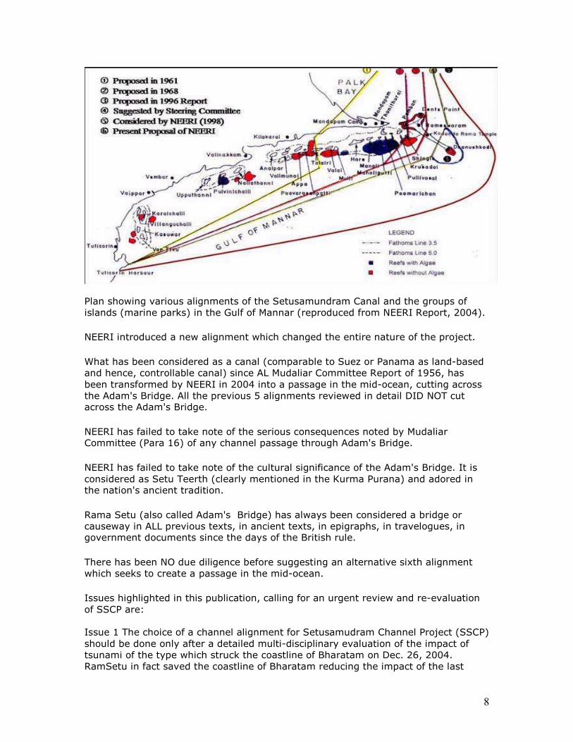
Plan showing various alignments of the Setusamundram Canal and the groups of islands (marine parks) in the Gulf of Mannar (reproduced from NEERI Report, 2004).
NEERI introduced a new alignment which changed the entire nature of the project.
What has been considered as a canal (comparable to Suez or Panama as land-based and hence, controllable canal) since AL Mudaliar Committee Report of 1956, has been transformed by NEERI in 2004 into a passage in the mid-ocean, cutting across the Adam's Bridge. All the previous 5 alignments reviewed in detail DID NOT cut across the Adam's Bridge.
NEERI has failed to take note of the serious consequences noted by Mudaliar Committee (Para 16) of any channel passage through Adam's Bridge.
NEERI has failed to take note of the cultural significance of the Adam's Bridge. It is considered as Setu Teerth (clearly mentioned in the Kurma Purana) and adored in the nation's ancient tradition.
Rama Setu (also called Adam's Bridge) has always been considered a bridge or causeway in ALL previous texts, in ancient texts, in epigraphs, in travelogues, in government documents since the days of the British rule.
There has been NO due diligence before suggesting an alternative sixth alignment which seeks to create a passage in the mid-ocean.
Issues highlighted in this publication, calling for an urgent review and re-evaluation of SSCP are: Issue 1 The choice of a channel alignment for Setusamudram Channel Project (SSCP) should be done only after a detailed multi-disciplinary evaluation of the impact of tsunami of the type which struck the coastline of Bharatam on Dec. 26, 2004. RamSetu in fact saved the coastline of Bharatam reducing the impact of the last
9
tsunami. If the work is continued on the present alignment is continued, an enormous energy of the next tsunami will be absorbed through this channel and result in the destruction of Kerala and significant parts of Tamilnadu coastline.
On 8 March 2005, Prime Minister’s Office raised 16 objections including the observations of the world-renowned tsunami expert, Prof. Tad S. Murthy of Canada who has been enaged as an expert by the Govt. of Inda to set up a tsunami-warning system in the country. Prof. Murthy is firmly of the opinion that this present alignment will destroy Kerala and most of the coastline of southern Bharatam. These concerns and the impact of a tsunami should be subjected to detailed, multi-disciplinary evaluation before work on a channel is resumed using any one of the other five alternative channels available (including the one recommended by GOI steering committee 1996) which will NOT involve destruction of RamaSetu.
Issue 2 The creation of an artificial boundary between Srilanka and India in the Indian Ocean will adversely impact the livelihood of coastal people, particularly the fishing community, who will be prevented from crossing the channel boundary. Issue 3 There is also the issue of thorium and other rich mineral deposits close to the RamSetu in Kerala thorium sands. The entire region should be subjected to geological exploration to utilize these mineral resources which will have a profound impact on the country’s nuclear program according to the website of Bhabha Atomic Research Centre.
Issue 4 Declaration of Rama Setu as a Protected Monument of national importance. The proposed channel alignment involving the destruction of Ram Setu, hurts the sentiments of millions of people who look upon Ram Setu as Setumandir, a pilgrimage site, a sacred monument, a temple. This age-old Setubandhan, this age-old temple, should be declared as a World Heritage Site, citing textual, epigraphic and scientific evidences of Dept. of Earth Sciences (March 2007) pointing to ancient human activity.
It may be seen from the following scientific report that the Rama Setu was formed because of slumps of a canyon on the opposite margins of Gulf of Mannar and is a feature uniquely distinct from the sand shoals between Kodiakkarai (Point Calimere) and Jaffna which are the result of fault-lines near Kodiakkarai. The geophysical studies of Dept. of Earth Sciences (Govt. of India) show that there has been human activity in bringing in coral rocks to create a land-bridge, authenticating the evidence from ancient texts and Asiatick Research Report of 1799 attesting to the fact that the bridge was inhabited and wood was growing on it – an emphatic proof of settlements, and the presence of nearly reef of s’ankha which is an 8,500 year-old industry, making the Rama Setu an ancient monument of national and international importance, an underwater cultural heritage in accordance with the criteria indicated by UNESCO (see Annex 12 Dr. SR Rao’s letter to Min. of Shipping and Transport) and the terms of the Ancient Monuments and Archeological Sites and Remains Act, 1958.
Journal: Geo-Marine letters, Vol. 2, Nos. 3-4, September 1982, pages 171-177
William Vestal1 and Allen Lowrie1
10
(1) Geology and Geophysics Branch-Code 7220, U.S. Naval Oceanographic Office NSTL Station, 39522, MS
Abstract Two suites of slumps from opposite margins of the Gulf of Mannar, between Sri Lanka and southern India, have met and coalesced. The “Eastern Comorin” Slump is the more coherent of the two with a length of 70 to 100 km. The “Colombo” side slump consists of two to four blocks 15 to 35 km in length. Both slump-suites decrease to the south. A paleoslump underlies the western toe of the East Comorin Slump at a depth of some 800 meters. To the south, an enlarging and deepening submarine canyon marks the area of slump coalescence. http://www.springerlink.com/content/m602j3k746342lnl/
11
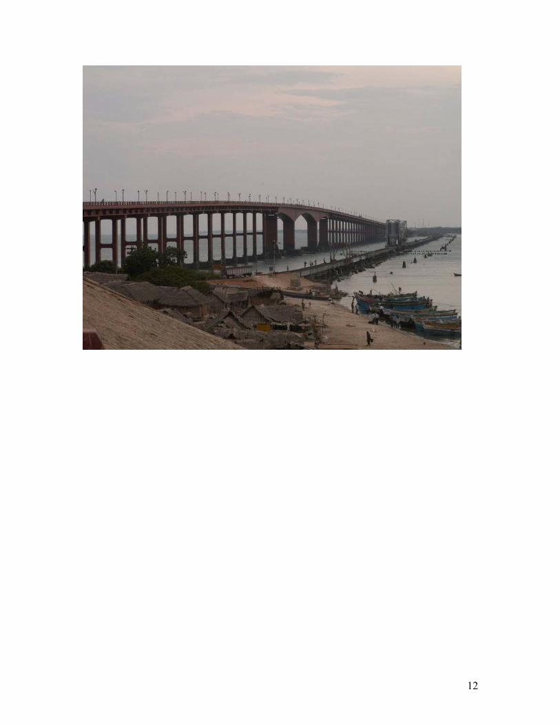
Chapter 2. Economics of Setusamudram Project There is a navigable passage between Tuticorin and Kolkata through the Pamban gap where a cantilever bridge is in operation since 1911. This metre-gauge railwayline has recently been converted into broadgauge. Through this gap, ships with a draught of about 11 feet, namely, small vessels, can navigate. Cut the losses, choose alignment 4 across Dhanushkodi
The economically unviable project can be salvaged by choosing a shorter navigation canal through Dhanushkodi, an alignment which was considered the best choice in the feasibility and environmental impact analysis reports until 2002. Such a land-based canal will also facilitate protective structures to reduce navigational hazards caused by mudslides and also provide for tsunami protection walls along the canal, that is along the coastline. Setusamudram Channel Project is intended to make available at a cost of over Rs. 2,200 crores another navigable shipping route for small vessels of less than 30,000 dead-weight-tonnes (DWT) with a draught of about 10 metres. The economic viability of the proposed channel passage has been questioned. One way to cut the losses from this enterprise is to choose a shorter route by a land-based canal through Dhanushkodi which can save an additional 39 nautical lines (or 6.5 hours of navigation time) for small vessels navigating between Tuticorin and Kolkata. Such a land-based canal across Dhanushkodi can be equipped with locks on either side to prevent the incursion of Bay of Bengal turbulence into the marine bioreserve of Gulf of mannar and also provide for tsunami protection walls along the coastline on the lines of the walls built by Japan to protect against recurring tsunami. Such a protective measure ensuring the stability of the channel will not be possible in a mid-ocean channel across Rama Setu. The canal alignment has to be close to the coastline without impacting on the bioreserve. Alignment 4 is about 10 kms. away from the nearest marine national park on the Shingle islands (as opposed to the 20 kms. distance sought to be achieved by the channel passage across Rama Setu, Alignment 6 presently chosen for implementation).
12
13
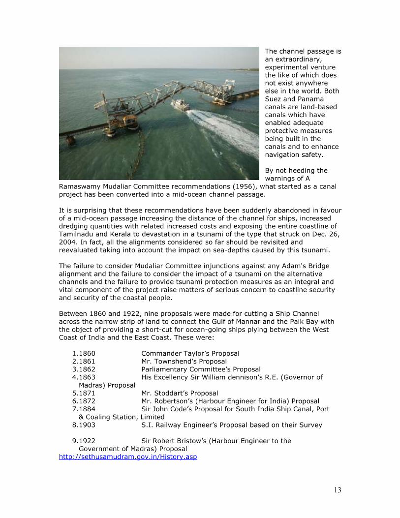
The channel passage is an extraordinary, experimental venture the like of which does not exist anywhere else in the world. Both Suez and Panama canals are land-based canals which have enabled adequate protective measures being built in the canals and to enhance navigation safety. By not heeding the warnings of A
Ramaswamy Mudaliar Committee recommendations (1956), what started as a canal project has been converted into a mid-ocean channel passage. It is surprising that these recommendations have been suddenly abandoned in favour of a mid-ocean passage increasing the distance of the channel for ships, increased dredging quantities with related increased costs and exposing the entire coastline of Tamilnadu and Kerala to devastation in a tsunami of the type that struck on Dec. 26, 2004. In fact, all the alignments considered so far should be revisited and reevaluated taking into account the impact on sea-depths caused by this tsunami. The failure to consider Mudaliar Committee injunctions against any Adam's Bridge alignment and the failure to consider the impact of a tsunami on the alternative channels and the failure to provide tsunami protection measures as an integral and vital component of the project raise matters of serious concern to coastline security and security of the coastal people. Between 1860 and 1922, nine proposals were made for cutting a Ship Channel across the narrow strip of land to connect the Gulf of Mannar and the Palk Bay with the object of providing a short-cut for ocean-going ships plying between the West Coast of India and the East Coast. These were:
1. 1860 Commander Taylor’s Proposal 2. 1861 Mr. Townshend’s Proposal 3. 1862 Parliamentary Committee’s Proposal 4. 1863 His Excellency Sir William dennison’s R.E. (Governor of Madras) Proposal
5. 1871 Mr. Stoddart’s Proposal 6. 1872 Mr. Robertson’s (Harbour Engineer for India) Proposal 7. 1884 Sir John Code’s Proposal for South India Ship Canal, Port & Coaling Station, Limited
8. 1903 S.I. Railway Engineer’s Proposal based on their Survey
9. 1922 Sir Robert Bristow’s (Harbour Engineer to the Government of Madras) Proposal
http://sethusamudram.gov.in/History.asp
14
[quote] It has taken 145 years for a British marine's dream to take shape. The Sethusamudram Ship Channel Project, for which the foundation is to be laid by Prime Minister Manmohan Singh in Madurai on July 2, has a long and interesting history. The project for digging up a ship canal across the `Thoni Thurai' peninsula to connect the Bay of Bengal with the Indian Ocean was conceived by Commander A.D. Taylor of the Indian Marines in 1860. A British parliamentary committee surveyed the Rameswaram island and suggested the digging of a canal one mile west of Pamban in 1862. In 1863, Sir William Dennison, Governor of Madras, chose a site one mile east of the recommended one.
The committee's recommendation was endorsed by Sir John Stoddart, Chief
Assistant to the Surveyor-General of Ceylon, in 1871. In 1872, Sir J.D. Elphinstone
requested the Secretary of State for India to direct George Robertson, Harbour
Engineer, to "visit Pamban and examine the proposal." He selected a new site at
Rameswaram.
Twelve years later, the South Indian Ship Canal Port and Coaling Station Limited
started a project for construction of a 100-foot wide canal across the Rameswaram
island. The Secretary of State for India granted the company "a perpetual
concession" reserving the right to purchase the canal.
The Government of Madras wanted the Government of India to reject the proposal
on grounds that vessels of deep-sea draught could not use the canal. After
protracted correspondence and because of the rising financial cost, the proposal was
dropped.
In 1902, the South Indian Railway Company came up with a Rs. 60-lakh proposal,
with an anticipated annual income of Rs. 7.59 lakhs. But it was not pursued
vigorously. he Technical Committee kept all the proposals in abeyance in 1945 in
anticipation of India's freedom.
In 1947, the Government of Madras included the project in its port development
scheme and suggested deepening of the Pamban Canal by at least 20 feet to allow
the passage of vesselsof below 2000 tonnage. In 1955 the Union Government
appointed a five-member expert committee, headed by Sir A. Ramasamy Mudaliar. It
favoured the execution of the project along with the Tuticorin development project —
as they were "closely interrelated" — at a cost of Rs. 9.98 crores. The Government
sanctioned the Tuticoin harbour project in 1959, included the Sethu project in the
`Advance Action' list and formed a committee with Nagendra Singh, Secretary,
Ministry of Shipping and Transport, as Chairman. C.V. Venkateswaran was appointed
Chief Engineer for the committee in 1965.
Venkateswaran submitted a comprehensive report in 1968. It was revised and the
cost updated to Rs. 53 crores in 1971 and further to Rs. 72 crores in 1974.
15
Meanwhile, the Tuticorin port, an integral part of the Sethu project, was
commissioned in 1975.
When the Union Government expressed inability to implement a "technically viable
and economically costly" project due to a paucity of funds, James Isaac Koilpillai,
former Chief Engineer and Administrator, Tuticorin harbour project, prepared a
detailed report on "technical feasibility and economic viability" in 1980 with
comments from V. Sundaram, then Chairman, Tuticorin Port Trust. The cost of
execution at that time was Rs. 110 crores.
Based on this report, a special committee, headed by H.R. Lakshmi Narayanan,
Development Adviser, was formed to make thorough investigations and elicit the
views of the stakeholders. It submitted its report in 1983 and the cost was estimated
at Rs. 282 crores. On November 16, 1986, the Tamil Nadu Assembly passed a
"unanimous resolution" for the immediate execution of the project. It directed the
Pallavan Transport Consultancy Services in 1994 to "reappraise and revalidate" the
scheme report. The report was submitted in 1996.
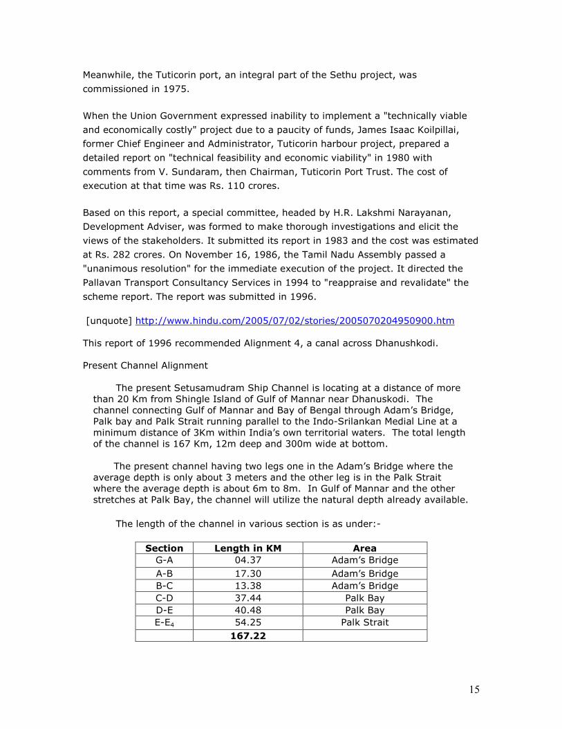
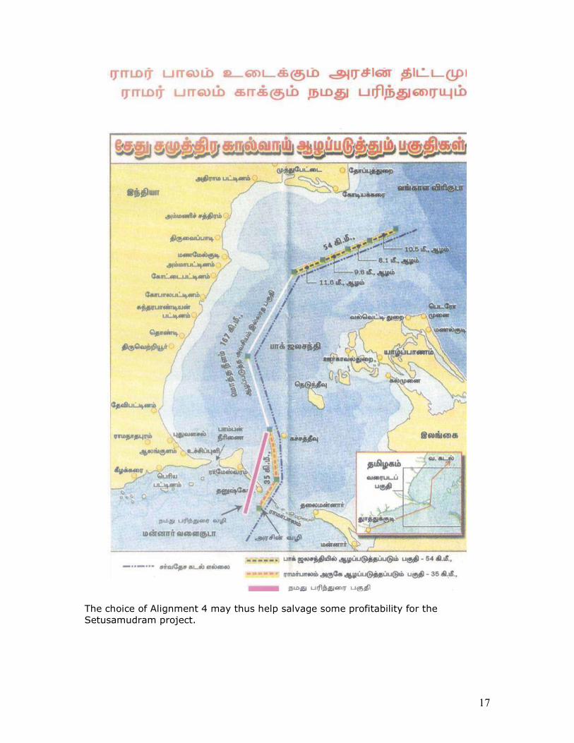
[unquote] http://www.hindu.com/2005/07/02/stories/2005070204950900.htm This report of 1996 recommended Alignment 4, a canal across Dhanushkodi. Present Channel Alignment
The present Setusamudram Ship Channel is locating at a distance of more than 20 Km from Shingle Island of Gulf of Mannar near Dhanuskodi. The channel connecting Gulf of Mannar and Bay of Bengal through Adam’s Bridge, Palk bay and Palk Strait running parallel to the Indo-Srilankan Medial Line at a minimum distance of 3Km within India’s own territorial waters. The total length of the channel is 167 Km, 12m deep and 300m wide at bottom.
The present channel having two legs one in the Adam’s Bridge where the
average depth is only about 3 meters and the other leg is in the Palk Strait where the average depth is about 6m to 8m. In Gulf of Mannar and the other stretches at Palk Bay, the channel will utilize the natural depth already available.
The length of the channel in various section is as under:-
Section Length in KM Area
G-A 04.37 Adam’s Bridge A-B 17.30 Adam’s Bridge B-C 13.38 Adam’s Bridge C-D 37.44 Palk Bay D-E 40.48 Palk Bay E-E4 54.25 Palk Strait 167.22
16
For further details visit http://Setusamudram.gov.in/
After the NEERI suggestion of alignment 6 (the present alignment on which work is proceeding), a cataclysmic event occurred, the tsunami of Dec. 26, 2004. This event should have necessitated a TOTAL and COMPREHENSIVE review of the entire project since the bathymetry (sea-depths) had changed (with rise of the sea-bed by about 200 metres in some regions) and devastation of aquatic life by denuding the resources in the Gulf of Mannar by as much as 66 percent. As observed in PMO observations of 8 March 2005, the impact of any future tsunami on the chosen channel passage should have been subjected to a careful, multi-disciplinary review and evaluation. This was not done. PMO observations also referred to the views of tsunami-expert, Prof. Tad S Murthy who opined that the chosen alignment with the mouth of the channel directed to the direction of the tsunami would result in the destruction of Kerala and of Tamilnadu coastline due to 1. experience of the tsunami of 1964 in Alberni canal and 2. the principle of quarter wave resonance amplification (when a body of water forcefully tries to enter a tube, the wave amplitude increases four-fold). This is what happened in Alberni canal resulting in the devastation of Alberni port.
NEERI did not take into account the role of Rama Setu (Adam's bridge) and ocean currents in the accumulation of placer deposits of thorium, a vital nuclear resource of the nation. The impact of another tsunami on these resources have also not been taken into account since the new passage is likely to function like a funnel absorbing the energy of the tsunami (instead of the waves going around Srilanka) and thus, directly impacting the coastline.
Rama Setu (Adam's bridge) is a sacred monument. NEERI has failed to take this fact into account before suggesting the new channel passage route.
The economic viability of the project has also been questioned. Even if for the sake of argument, it is deemed necessary to establish a short navigational path between Tuticorin port and Kolkata, a route shorter than the present alignment of a channel passage cutting across Rama Setu can be chosen. It is assessed that there will only be a saving of 1.75 hours by choosing a navigational route through the present alignment of Setusamudram channel. The difference in time taken to reach Tuiticorin from Kolkata, circumnavigating Sri Lanka and navigating through the SSCP at speeds of 12 and 6 knots is = 1.75 hours . This time saving can be increased significantly if a shorter route of Alignment 4 through Dhanushkodi is chosen which will be 39 nautical miles shorter than the chosen channel passage. The shorter distance of 39 nautical miles means an additional saving in time of 6.3 hours.
17
The choice of Alignment 4 may thus help salvage some profitability for the Setusamudram project.
18
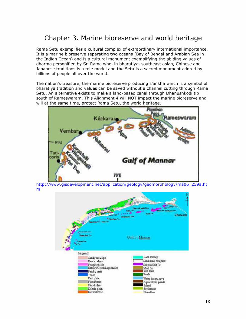
Chapter 3. Marine bioreserve and world heritage Rama Setu exemplifies a cultural complex of extraordinary international importance. It is a marine bioreserve separating two oceans (Bay of Bengal and Arabian Sea in the Indian Ocean) and is a cultural monument exemplifying the abiding values of dharma personified by Sri Rama who, in bharatiya, southeast asian, Chinese and Japanese traditions is a role model and the Setu is a sacred monument adored by billions of people all over the world. The nation’s treasure, the marine bioreserve producing s’ankha which is a symbol of bharatiya tradition and values can be saved without a channel cutting through Rama Setu. An alternative exists to make a land-based canal through Dhanushkodi tip south of Rameswaram. This Alignment 4 will NOT impact the marine bioreserve and will at the same time, protect Rama Setu, the world heritage.
http://www.gisdevelopment.net/application/geology/geomorphology/ma06_259a.ht m
19
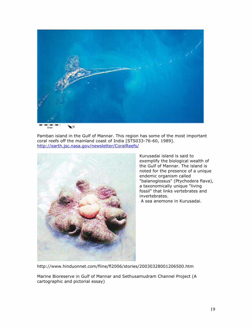
Pamban island in the Gulf of Mannar. This region has some of the most important coral reefs off the mainland coast of India [STS033-76-60, 1989]. http://earth.jsc.nasa.gov/newsletter/CoralReefs/
Kurusadai island is said to exemplify the biological wealth of the Gulf of Mannar. The island is noted for the presence of a unique endemic organism called "balanoglossus" (Ptychodera flava), a taxonomically unique "living fossil" that links vertebrates and invertebrates. A sea anemone in Kurusadai.
http://www.hinduonnet.com/fline/fl2006/stories/20030328001206500.htm Marine Bioreserve in Gulf of Mannar and Sethusamudram Channel Project (A cartographic and pictorial essay)
20
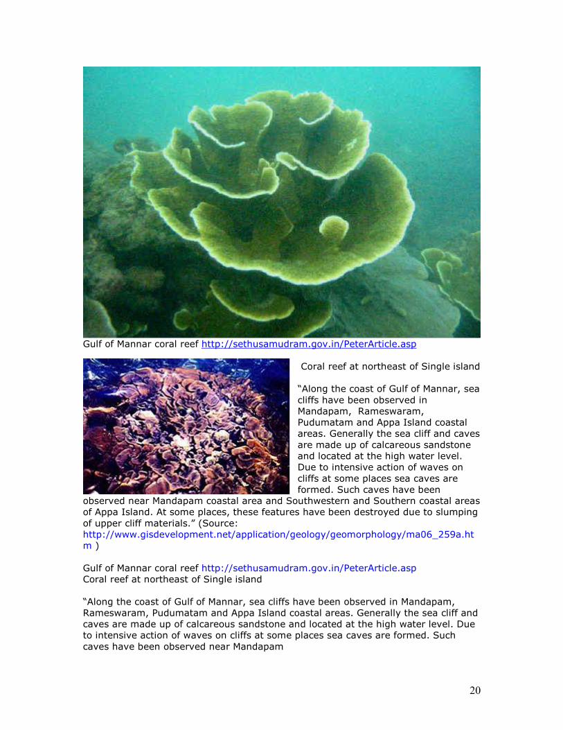
Gulf of Mannar coral reef http://sethusamudram.gov.in/PeterArticle.asp
Coral reef at northeast of Single island “Along the coast of Gulf of Mannar, sea cliffs have been observed in Mandapam, Rameswaram, Pudumatam and Appa Island coastal areas. Generally the sea cliff and caves are made up of calcareous sandstone and located at the high water level. Due to intensive action of waves on cliffs at some places sea caves are formed. Such caves have been
observed near Mandapam coastal area and Southwestern and Southern coastal areas of Appa Island. At some places, these features have been destroyed due to slumping of upper cliff materials.” (Source: http://www.gisdevelopment.net/application/geology/geomorphology/ma06_259a.htm ) Gulf of Mannar coral reef http://sethusamudram.gov.in/PeterArticle.asp Coral reef at northeast of Single island “Along the coast of Gulf of Mannar, sea cliffs have been observed in Mandapam, Rameswaram, Pudumatam and Appa Island coastal areas. Generally the sea cliff and caves are made up of calcareous sandstone and located at the high water level. Due to intensive action of waves on cliffs at some places sea caves are formed. Such caves have been observed near Mandapam
21
coastal area and Southwestern and Southern coastal areas of Appa Island. At some places, these features have been destroyed due to slumping of upper cliff materials.” (Source: http://www.gisdevelopment.net/application/geology/geomorphology/ma06_259a.htm )
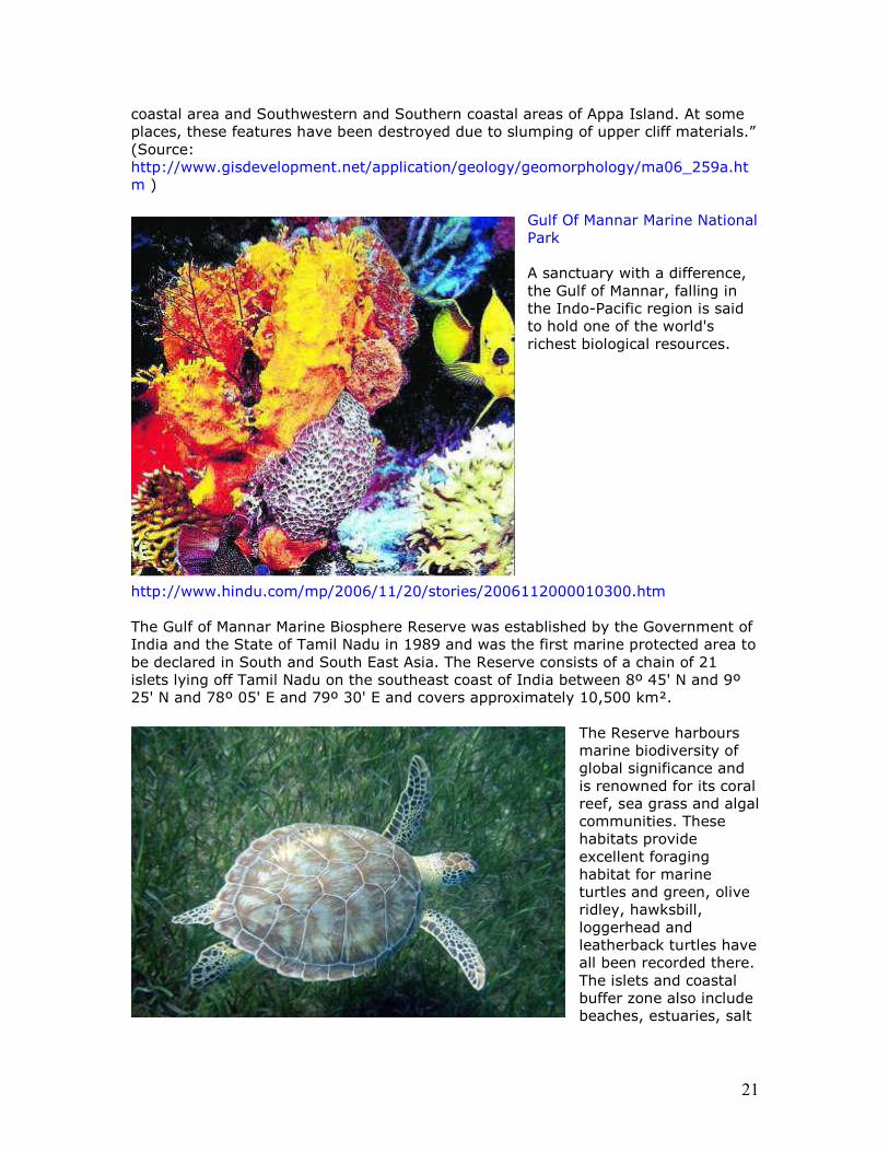
Gulf Of Mannar Marine National Park A sanctuary with a difference, the Gulf of Mannar, falling in the Indo-Pacific region is said to hold one of the world's richest biological resources.
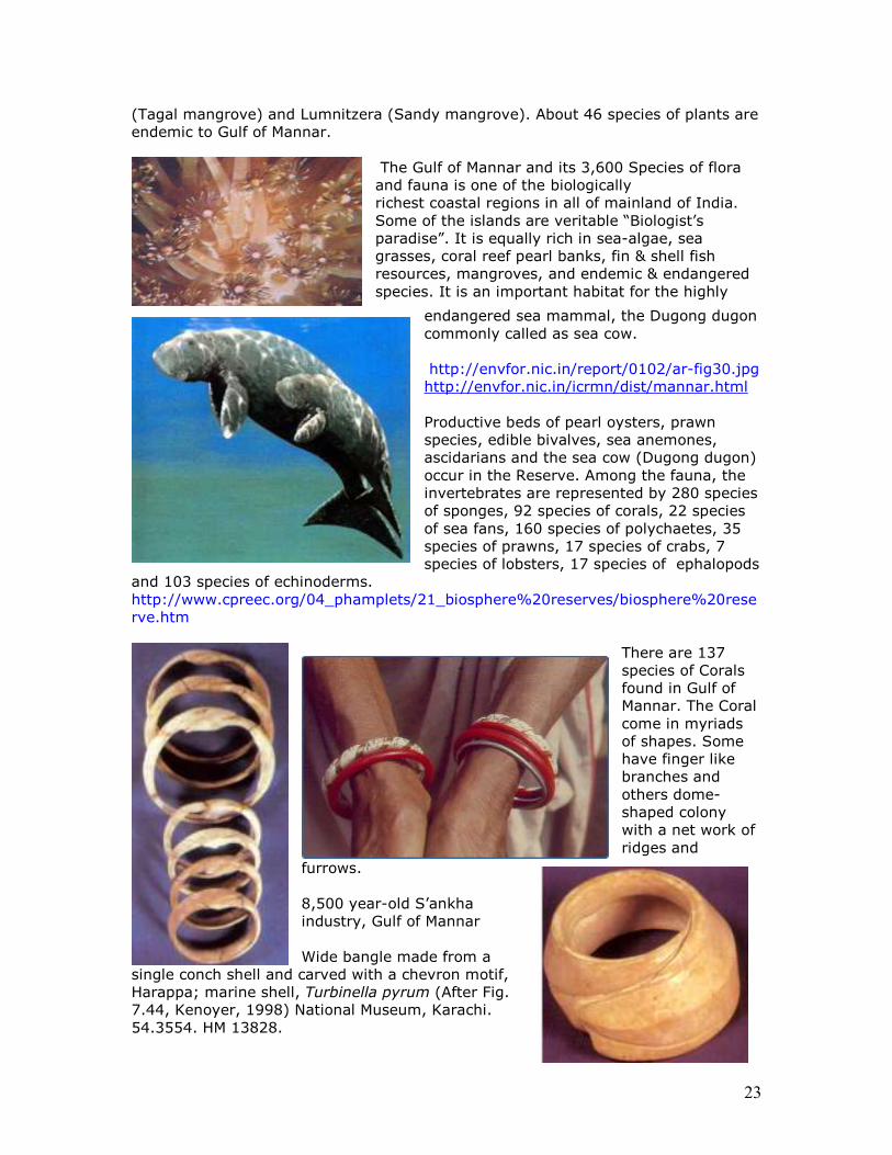
http://www.hindu.com/mp/2006/11/20/stories/2006112000010300.htm The Gulf of Mannar Marine Biosphere Reserve was established by the Government of India and the State of Tamil Nadu in 1989 and was the first marine protected area to be declared in South and South East Asia. The Reserve consists of a chain of 21 islets lying off Tamil Nadu on the southeast coast of India between 8º 45' N and 9º 25' N and 78º 05' E and 79º 30' E and covers approximately 10,500 km².
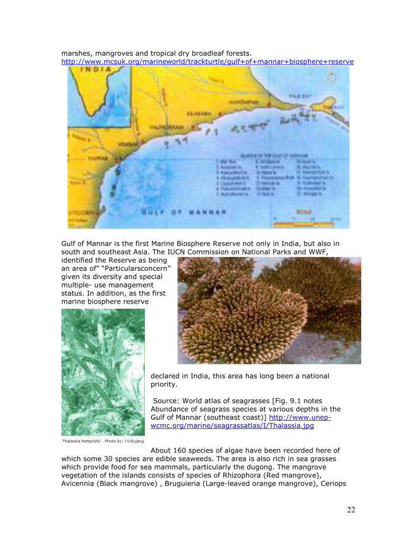
The Reserve harbours marine biodiversity of global significance and is renowned for its coral reef, sea grass and algal communities. These habitats provide excellent foraging habitat for marine turtles and green, olive ridley, hawksbill, loggerhead and leatherback turtles have all been recorded there. The islets and coastal buffer zone also include beaches, estuaries, salt
22
marshes, mangroves and tropical dry broadleaf forests. http://www.mcsuk.org/marineworld/trackturtle/gulf+of+mannar+biosphere+reserve
Gulf of Mannar is the first Marine Biosphere Reserve not only in India, but also in south and southeast Asia. The IUCN Commission on National Parks and WWF, identified the Reserve as being an area of” “Particularsconcern” given its diversity and special multiple- use management status. In addition, as the first marine biosphere reserve
declared in India, this area has long been a national priority. Source: World atlas of seagrasses [Fig. 9.1 notes Abundance of seagrass species at various depths in the Gulf of Mannar (southeast coast)] http://www.unep-wcmc.org/marine/seagrassatlas/I/Thalassia.jpg About 160 species of algae have been recorded here of
which some 30 species are edible seaweeds. The area is also rich in sea grasses which provide food for sea mammals, particularly the dugong. The mangrove vegetation of the islands consists of species of Rhizophora (Red mangrove), Avicennia (Black mangrove) , Bruguieria (Large-leaved orange mangrove), Ceriops
23
(Tagal mangrove) and Lumnitzera (Sandy mangrove). About 46 species of plants are endemic to Gulf of Mannar.
The Gulf of Mannar and its 3,600 Species of flora and fauna is one of the biologically richest coastal regions in all of mainland of India. Some of the islands are veritable “Biologist’s paradise”. It is equally rich in sea-algae, sea grasses, coral reef pearl banks, fin & shell fish resources, mangroves, and endemic & endangered species. It is an important habitat for the highly
endangered sea mammal, the Dugong dugon commonly called as sea cow. http://envfor.nic.in/report/0102/ar-fig30.jpg http://envfor.nic.in/icrmn/dist/mannar.html Productive beds of pearl oysters, prawn species, edible bivalves, sea anemones, ascidarians and the sea cow (Dugong dugon) occur in the Reserve. Among the fauna, the invertebrates are represented by 280 species of sponges, 92 species of corals, 22 species of sea fans, 160 species of polychaetes, 35 species of prawns, 17 species of crabs, 7 species of lobsters, 17 species of ephalopods
and 103 species of echinoderms. http://www.cpreec.org/04_phamplets/21_biosphere%20reserves/biosphere%20reserve.htm
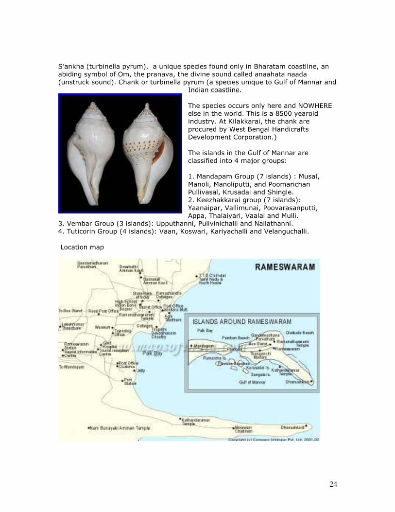
There are 137 species of Corals found in Gulf of Mannar. The Coral come in myriads of shapes. Some have finger like branches and others dome-shaped colony with a net work of ridges and
furrows. 8,500 year-old S’ankha industry, Gulf of Mannar Wide bangle made from a
single conch shell and carved with a chevron motif, Harappa; marine shell, Turbinella pyrum (After Fig. 7.44, Kenoyer, 1998) National Museum, Karachi. 54.3554. HM 13828.
24
S’ankha (turbinella pyrum), a unique species found only in Bharatam coastline, an abiding symbol of Om, the pranava, the divine sound called anaahata naada (unstruck sound). Chank or turbinella pyrum (a species unique to Gulf of Mannar and
Indian coastline. The species occurs only here and NOWHERE else in the world. This is a 8500 yearold industry. At Kilakkarai, the chank are procured by West Bengal Handicrafts Development Corporation.) The islands in the Gulf of Mannar are classified into 4 major groups: 1. Mandapam Group (7 islands) : Musal, Manoli, Manoliputti, and Poomarichan Pullivasal, Krusadai and Shingle. 2. Keezhakkarai group (7 islands): Yaanaipar, Vallimunai, Poovarasanputti, Appa, Thalaiyari, Vaalai and Mulli.
3. Vembar Group (3 islands): Upputhanni, Pulivinichalli and Nallathanni. 4. Tuticorin Group (4 islands): Vaan, Koswari, Kariyachalli and Velanguchalli. Location map
25
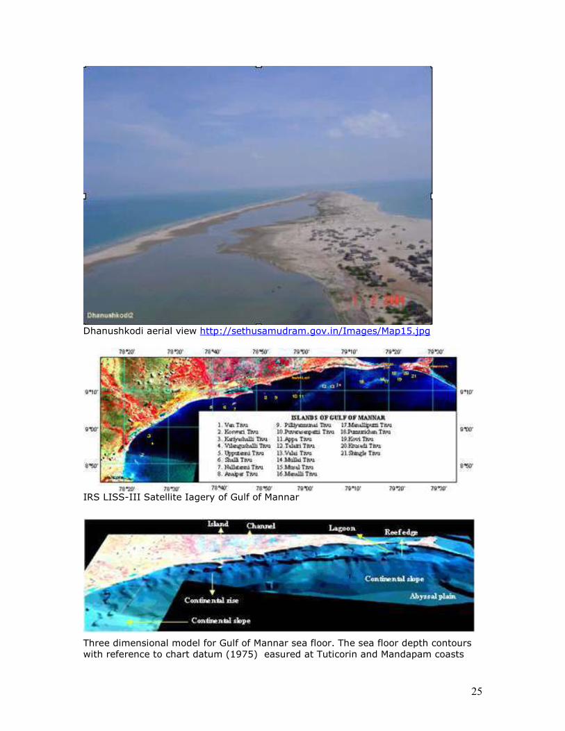
Dhanushkodi aerial view http://sethusamudram.gov.in/Images/Map15.jpg
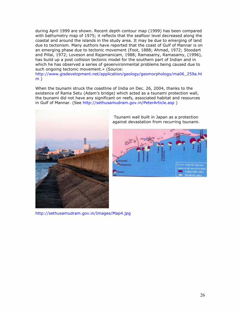
IRS LISS-III Satellite Iagery of Gulf of Mannar
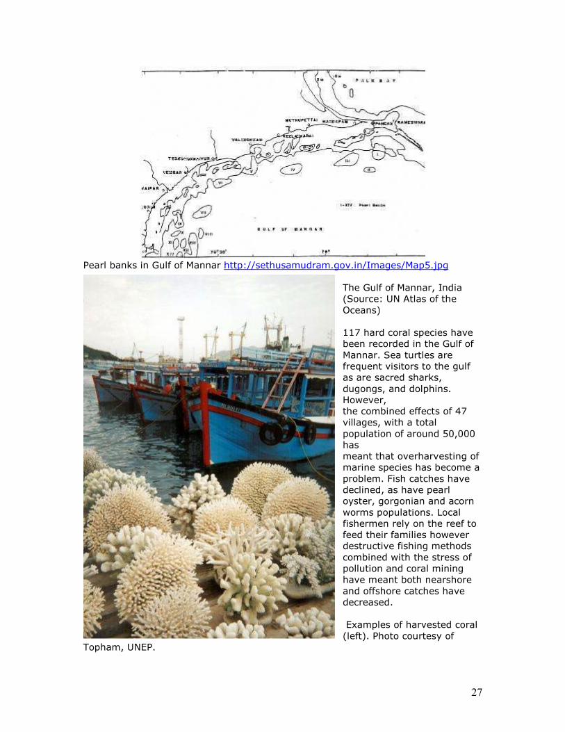
Three dimensional model for Gulf of Mannar sea floor. The sea floor depth contours with reference to chart datum (1975) easured at Tuticorin and Mandapam coasts
26
during April 1999 are shown. Recent depth contour map (1999) has been compared with bathymetry map of 1975; it reflects that the seafloor level decreased along the coastal and around the islands in the study area. It may be due to emerging of land due to tectonism. Many authors have reported that the coast of Gulf of Mannar is on an emerging phase due to tectonic movement (Foot, 1888; Ahmad, 1972; Stoodart and Pillai, 1972; Loveson and Rajamanicam, 1988; Ramasamy, Ramasamy, (1996), has build up a post collision tectonic model for the southern part of Indian and in which he has observed a series of geoenvironmental problems being caused due to such ongoing tectonic movement.« (Source: http://www.gisdevelopment.net/application/geology/geomorphology/ma06_259a.ht m ) When the tsunami struck the coastline of India on Dec. 26, 2004, thanks to the existence of Rama Setu (Adam’s bridge) which acted as a tsunami protection wall, the tsunami did not have any significant on reefs, associated habitat and resources in Gulf of Mannar. (See http://sethusamudram.gov.in/PeterArticle.asp )
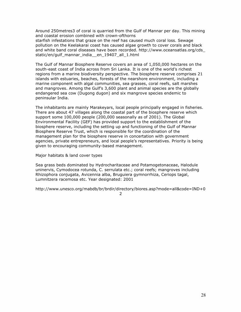
Tsunami wall built in Japan as a protection against devastation from recurring tsunami.
http://sethusamudram.gov.in/Images/Map4.jpg
27
Pearl banks in Gulf of Mannar http://sethusamudram.gov.in/Images/Map5.jpg
The Gulf of Mannar, India (Source: UN Atlas of the Oceans) 117 hard coral species have been recorded in the Gulf of Mannar. Sea turtles are frequent visitors to the gulf as are sacred sharks, dugongs, and dolphins. However, the combined effects of 47 villages, with a total population of around 50,000 has meant that overharvesting of marine species has become a problem. Fish catches have declined, as have pearl oyster, gorgonian and acorn worms populations. Local fishermen rely on the reef to feed their families however destructive fishing methods combined with the stress of pollution and coral mining have meant both nearshore and offshore catches have decreased. Examples of harvested coral (left). Photo courtesy of
Topham, UNEP.
28
Around 250metres3 of coral is quarried from the Gulf of Mannar per day. This mining and coastal erosion combined with crown-ofthorns starfish infestations that graze on the reef has caused much coral loss. Sewage pollution on the Keelakarai coast has caused algae growth to cover corals and black and white band coral diseases have been recorded. http://www.oceansatlas.org/cds_ static/en/gulf_mannar_india__en_19407_all_1.html The Gulf of Mannar Biosphere Reserve covers an area of 1,050,000 hectares on the south-east coast of India across from Sri Lanka. It is one of the world’s richest regions from a marine biodiversity perspective. The biosphere reserve comprises 21 islands with estuaries, beaches, forests of the nearshore environment, including a marine component with algal communities, sea grasses, coral reefs, salt marshes and mangroves. Among the Gulf’s 3,600 plant and animal species are the globally endangered sea cow (Dugong dugon) and six mangrove species endemic to peninsular India. The inhabitants are mainly Marakeyars, local people principally engaged in fisheries. There are about 47 villages along the coastal part of the biosphere reserve which support some 100,000 people (200,000 seasonally as of 2001). The Global Environmental Facility (GEF) has provided support to the establishment of the biosphere reserve, including the setting up and functioning of the Gulf of Mannar Biosphere Reserve Trust, which is responsible for the coordination of the management plan for the biosphere reserve in concertation with government agencies, private entrepreneurs, and local people’s representatives. Priority is being given to encouraging community-based management. Major habitats & land cover types Sea grass beds dominated by Hydrocharitaceae and Potamogetonaceae, Halodule uninervis, Cymodocea rotunda, C. serrulata etc.; coral reefs; mangroves including Rhizophora conjugata, Avicennia alba, Bruguiera gymnorrhiza, Ceriops tagal, Lumnitzera racemosa etc. Year designated: 2001 http://www.unesco.org/mabdb/br/brdir/directory/biores.asp?mode=all&code=IND+0
2
29
Chapter 4. National Security and integrity Importance of thorium for Bharatam’s nuclear program: • From BARC website: Thorium deposits - ~ 3,60,000 tonnes
• The currently known Indian thorium reserves amount to 358,000 GWe-yr of
electrical energy and can easily meet the energy requirements during the next century and beyond.
• India’s vast thorium deposits permit design and operation of U-233 fuelled
breeder reactors. • These U-233/Th-232 based breeder reactors are under development and
would serve as the mainstay of the final thorium utilization stage of the Indian nuclear programme.
http://www.barc.ernet.in/webpages/about/anu1.htm Rama Setu has been instrumental in the accumulation of placer deposits of thorium acting like a sieve against the ocean currents and ocean counter currents of the Gulf of Mannar. The impact of cutting a hole through Rama Setu in this ongoing accumulation of the world’s largest reserves of thorium has to be studied by a multi-disciplinary team of experts. Another tsunami of the type which struck the coastline on Dec. 26, 2004 will draw the energy of the tsunami through this channel passage and devastate the thorium accumulations and also make it virtually impossible to retrieve the precious mineral, so critical for the nation’s nuclear program, from the depths of the ocean. Thorium reserves in Manavalakurichi (Tamilnadu), Aluva and Chavara (Kerala) have the potential to serve the electricity generation needs of the nation for the next 400 years. Respecting the agreement on Historic Waters signed between Smt. Indira Gandhi and Smt. Sirimavo Bandaranaike in June 1974, any idea of cutting a channel passage through Rama Setu close to the medial line should be abandoned. Because, such a channel creates an International Waters Boundary and is virtually an abrogation of this historic treaty which only underscored the historic rights of the people of both Sri Lanka and Bharatam, that is India.
An unusual (coincidence?) event occurred on 23 June 2005 following the visit of US naval ships in 1993, 1994 and 1999 in the region to assert the US failure to recognize the traditional claims of India and Srilanka treating these as HISTORIC waters under the Law of the Sea 1958.
By choosing a channel passage running close to the medial line, a new phenomenon is sought to be created: an international waters boundary between India and Srilanka. A medial line is only relevant for recognizing the ownership of ocean properties of shanka (chank) and pearl fisheries. Traditionally, fishermen and pearl-divers had the freedom to move across the medial line treating the waters as historic, internal waters. US Navy Operational Directive of 23 June 2005 treating these as international waters is a serious assault on the nation's sovereignty and integrity.
30
NEERI did not take into account the implications of the intrusion of international politics in this region by arbitrarily drawing a line on the map close to the medial line and called it a channel passge, effectively de facto creating an international boundary and converting the gulf of manner into international waters – a seachange from the age-old, recognised tradition of historic waters.
The impact on the lives of fisherfolk and coastal people will be devastating if the new new channel passage becomes a de facto international waters boundary since fish resources are available on the Srilanka side and will become inaccessible to the coastal people of Bharatam.
As the 34 experts of Sri Lanka have noted, drinking water supplies of Rameswaram and Jaffna will be adversely impacted by damaging the Rama Setu near the medial line. (Annex 11 details the security implications including the LTTE threats in the ocean region).
31
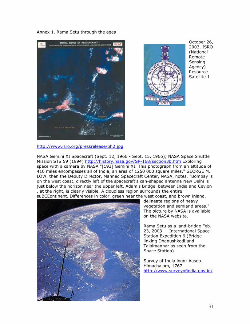
Annex 1. Rama Setu through the ages
October 26, 2003, ISRO (National Remote Sensing Agency) Resource Satellite 1
http://www.isro.org/pressrelease/ph2.jpg NASA Gemini XI Spacecraft (Sept. 12, 1966 - Sept. 15, 1966); NASA Space Shuttle Mission STS 59 (1994) http://history.nasa.gov/SP-168/section3b.htm Exploring space with a camera by NASA "[193] Gemini XI. This photograph from an altitude of 410 miles encompasses all of India, an area of 1250 000 square miles," GEORGE M. LOW, then the Deputy Director, Manned Spacecraft Center, NASA, notes. "Bombay is on the west coast, directly left of the spacecraft's can-shaped antenna New Delhi is just below the horizon near the upper left. Adam's Bridge between India and Ceylon , at the right, is clearly visible. A cloudless region surrounds the entire suBCEontinent. Differences in color, green near the west coast, and brown inland,
delineate regions of heavy vegetation and semiarid areas." The picture by NASA is available on the NASA website. Rama Setu as a land-bridge Feb. 23, 2003 International Space Station Expedition 6 (Bridge linking Dhanushkodi and Talaimannar as seen from the Space Station) Survey of India logo: Aasetu Himachalam, 1767 http://www.surveyofindia.gov.in/
32
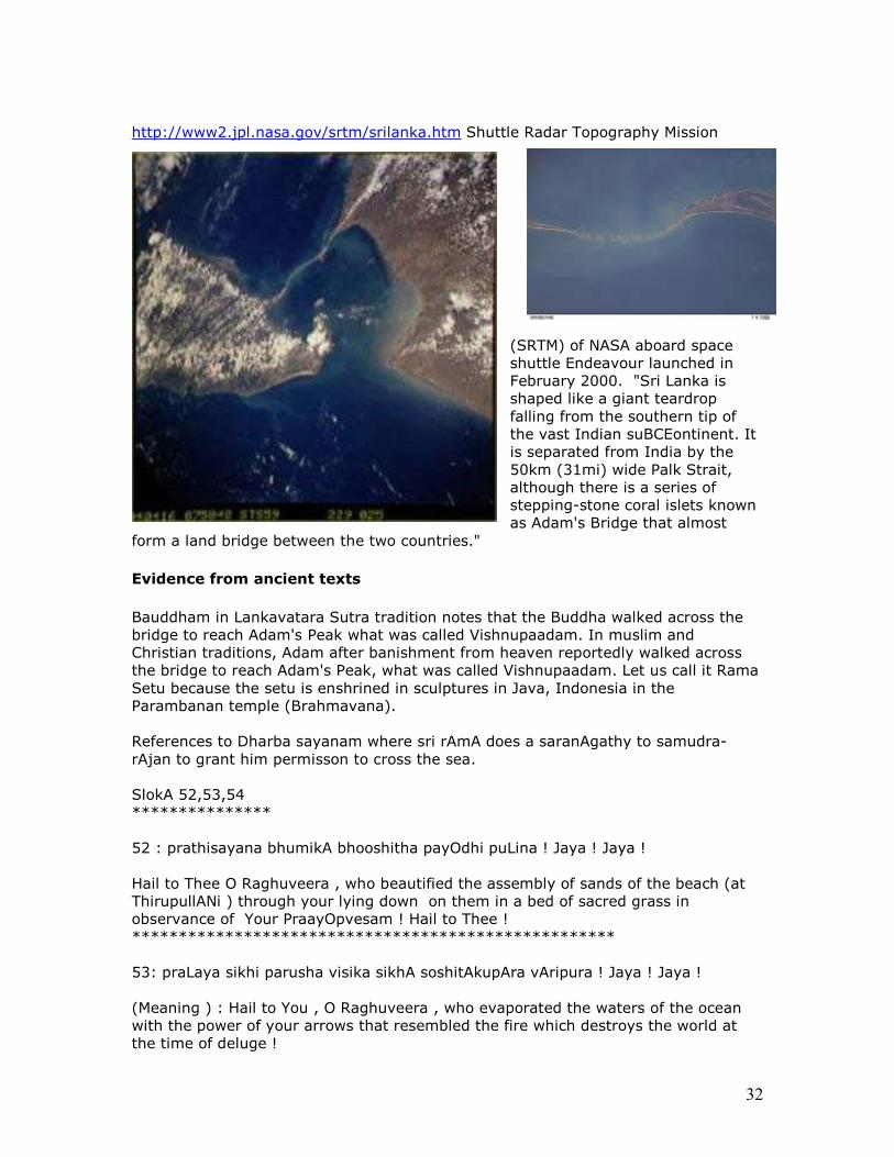
http://www2.jpl.nasa.gov/srtm/srilanka.htm Shuttle Radar Topography Mission
(SRTM) of NASA aboard space shuttle Endeavour launched in February 2000. "Sri Lanka is shaped like a giant teardrop falling from the southern tip of the vast Indian suBCEontinent. It is separated from India by the 50km (31mi) wide Palk Strait, although there is a series of stepping-stone coral islets known as Adam's Bridge that almost
form a land bridge between the two countries."
Evidence from ancient texts
Bauddham in Lankavatara Sutra tradition notes that the Buddha walked across the bridge to reach Adam's Peak what was called Vishnupaadam. In muslim and Christian traditions, Adam after banishment from heaven reportedly walked across the bridge to reach Adam's Peak, what was called Vishnupaadam. Let us call it Rama Setu because the setu is enshrined in sculptures in Java, Indonesia in the Parambanan temple (Brahmavana). References to Dharba sayanam where sri rAmA does a saranAgathy to samudra-rAjan to grant him permisson to cross the sea. SlokA 52,53,54 *************** 52 : prathisayana bhumikA bhooshitha payOdhi puLina ! Jaya ! Jaya ! Hail to Thee O Raghuveera , who beautified the assembly of sands of the beach (at ThirupullANi ) through your lying down on them in a bed of sacred grass in observance of Your PraayOpvesam ! Hail to Thee ! **************************************************** 53: praLaya sikhi parusha visika sikhA soshitAkupAra vAripura ! Jaya ! Jaya ! (Meaning ) : Hail to You , O Raghuveera , who evaporated the waters of the ocean with the power of your arrows that resembled the fire which destroys the world at the time of deluge !
33
************************************************** 54 : prabhala ripu kalaha kuthuka chatula kapikula karatala toolitha Hrutha giri nikara sAdhita sethupatha seemA semanthitha samudhra ! Jaya ! Jaya ! ( meaning ) :O mighty hero of the scion of Raghus, who created the demarcation of the ocean with your bridge built by the mighty monkeys,who out of their eagerness to reach LankhA to fight their enemies splintered huge mountains and threw them into the ocean as though they were feathery bales of cotton ! Hail to Thee! Hail to Thee ! (Source: Swami Desikan's Raghu veraa Gadhyam (aka) Sri mahAveera Vaibhavam.) Periya thirumozhi of Thiru Mangai azhwar (Parakala Naayaki) 9.4.5 about dharbas'ayanam/ thirupullani a divya desam 15 kms from Rameshwaram "PullaaNi Emperumaan poi kettirunde_ne_.. " (I have only heard now of His lies..!) All my relatives come and tell me.."You should have listened to us. You listened to Him. We spoke truth; He has become a liar. ". "Okay. I will now listen to you all. But, only after getting my heart back that had gone behind Him." says Parakala Nayaki. (vallaaLan pin pOna nenjam varumaLavum..) Though all of them talk about me, I am still trusting that "Great liar (of ThirupullaaNi Emperumaan's)'s words and am living with a (faint?) hope. Thirumaalai by Thondar Adi Podi Azhwar also refers to emperumaan at the Setu. This section is an answer to the question: why should Rama Setu or Setu Bandha be deemed to be an ancient monument of national and international significance?

34
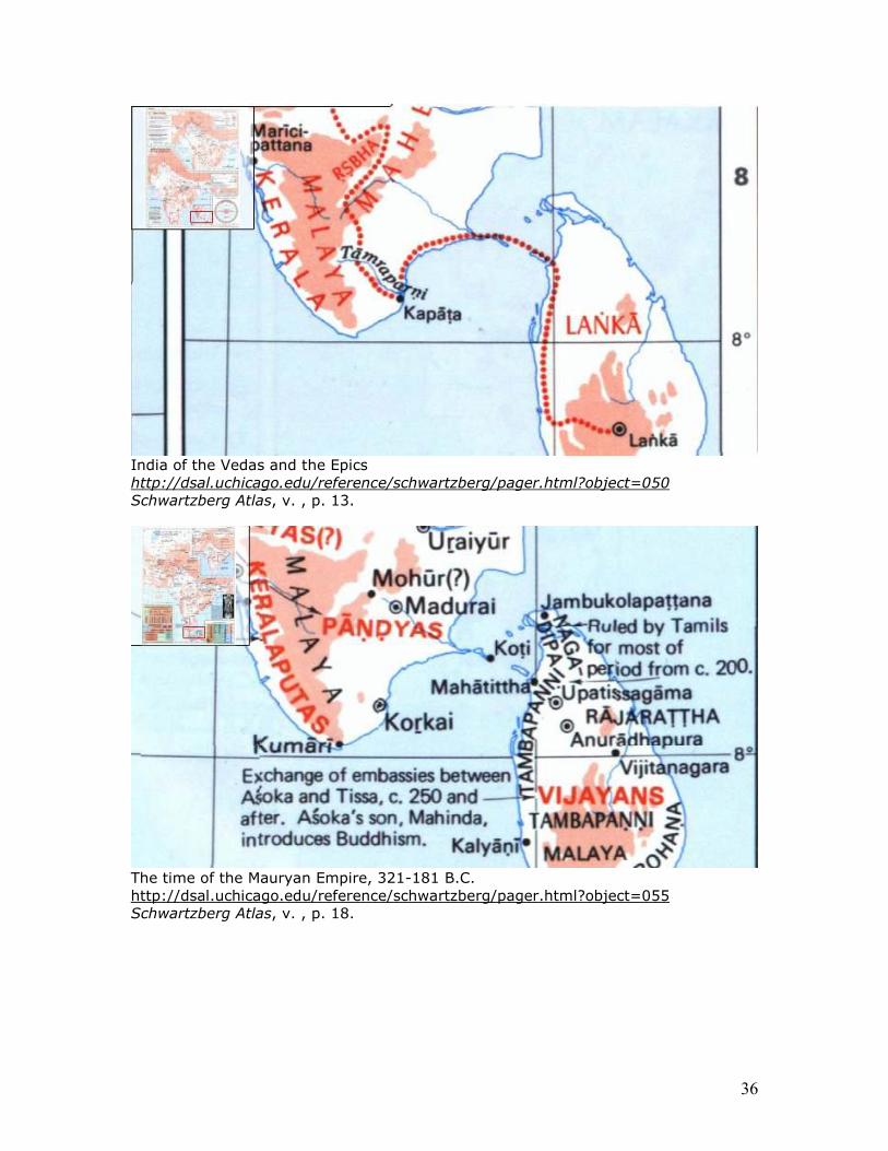
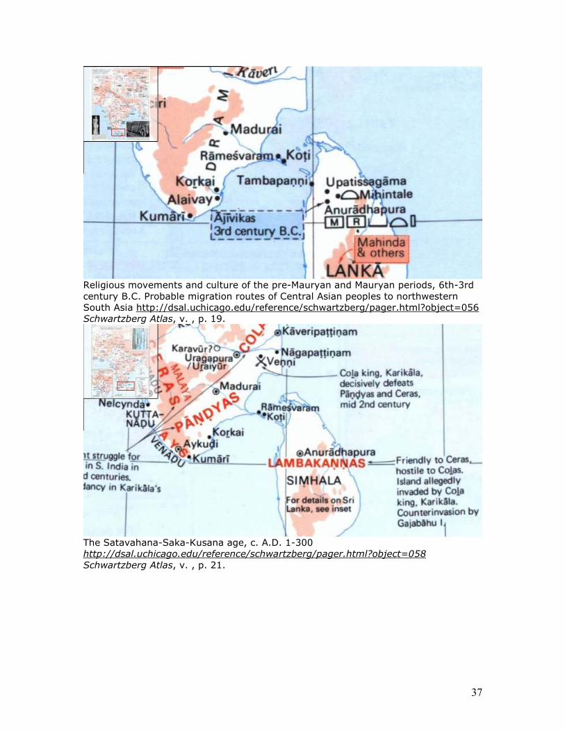
Holy places of South Asia http://dsal.uchicago.edu/reference/schwartzberg/pager.html?object=136 Schwartzberg Atlas, v. , p. 99. (Joseph E. Schwartzberg, ed., 1978, A historical atlas of South Asia, University of Chicago Press, Chicago) The legends shown on this map clearly demonstrate the importance of Rameswaram and the link to Tirukketisvaram (in Srilanka) as a holy tirtha. Rameswaram is recognized as one of the twelve jyotirlingas of Shiva. Srilanka gets associated with Naga. Historical sources evidence the fact that Rama Setu was a land bridge linking Bharatam and Lanka for many millennia. The following maps and images are principally drawn from Schwartzberg Atlas, 1978. The Epics refer to the link between Kapaata and Lanka. From the time of the pre-Mauryan and Mauryan Empire (from 6th century BCEE), the holy site called Koti gains prominence. This is the short-form of Dhanushkoti, evoking the Ramayana narration of Sri Rama confronting Samudra Raja (King of Ocean) by fixing the end of his bow at this island which links with Lanka at Tambapanni or Tamraparni (at a place called Mahatittha, meaning Maha Tirtha, or Great Tirthasthaana) through Setu Bandha. Thus, the link between Dhanushkodi and Mahatittha constitute the tirthasthaana for over two millennia. During the Satavahana-Saka-Kusana age, c. A.D. 1-300, Rameshwaram close to Dhanushkodi gains prominence as a holy place. Puranic India (Bharata) recognizes Setuka as the bridge connecting Bharatam (Pandyan kingdom) and Lanka (then called Simhala). Koti (Dhanushkodi) and Mahatittha continue to be holy, religious places during post-Mauryan period, from circa 200 BCEE.
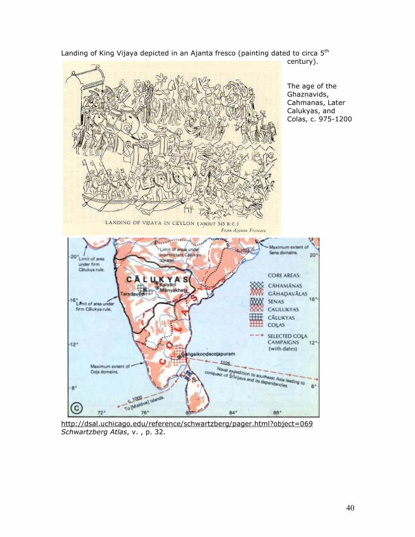
35
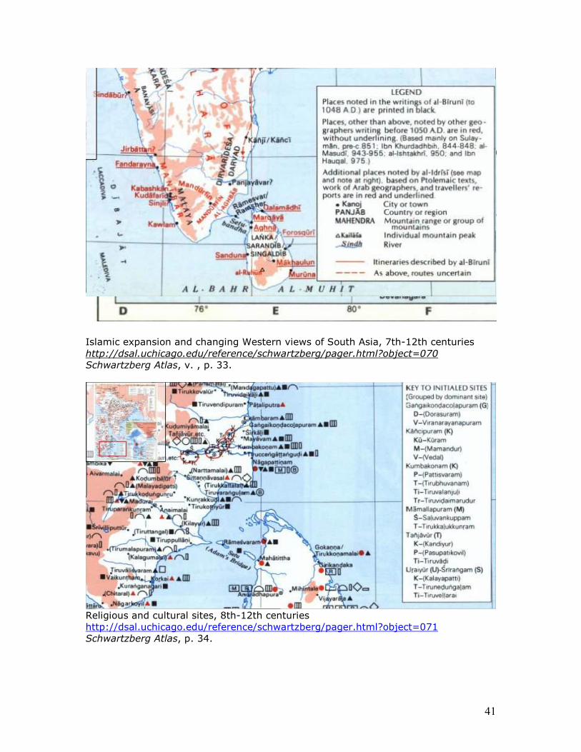
The region across the Rama Setu constitutes the limits of regions under the control of Rastrakuta during the age of the Gurjara-Pratiharas, Palas, and Rastrakutas, circa 700-975. Naval expedition to southeast Aia leading to conquest of Srivijaya and its dependencies proceeds from Gangaikondacolapuram and contacts are also established with Maldive islands circa 1000 going through the Gulf of Mannar. An Ajanta fresco depicts the arrival of King Vijaya in this region. During the period islamic expansion and changing Western views of South Asia, between 7th-12th centuries, the Rama Setu (bridge) between Rameswaram and Marqaya is also called Setu Bandha (evoking the Prakrit kavya written in the 6th century by King Pravarasena with the title Setu Bandha or Ravana Vaho). It is during this period, ca. 12th century that Setu gets bracketed and referred to as Adam’s Bridge. South Asia in the time of the Khaljis and Tughluqs, c. 1290-1390 shows the island on Lanka side referred to Mannara (later called Talaimannar). In the height of the Bhakti movement and in the time of the Khaljis and Tughluqs, c. 1290-1390, the bridge area gets referred to as Setubandha Rameswaram, as a holy tirtha. Two maps of Netherlands drawn in 16th and 17th centuries and a French map of 18th century, clearly refer to Adamsbrug (or Pont) as a functioning bridge between Rameswaram and Talaimannar. Setu Bandha is celebrated in an early talkie-movie of the same title made by Phalke. As NASA and Indian Space Research Organization images dramatically establish the land bridge between Bharatam and Srilanka, these historical references to Rama Setu come alive as an inalienable tradition of the Bharatiya civilization. The Gulf of Mannar region gets recognized as the first Marine Biosphere of South and Southeast Asia, in 1956.
36
India of the Vedas and the Epics http://dsal.uchicago.edu/reference/schwartzberg/pager.html?object=050 Schwartzberg Atlas, v. , p. 13.
The time of the Mauryan Empire, 321-181 B.C. http://dsal.uchicago.edu/reference/schwartzberg/pager.html?object=055 Schwartzberg Atlas, v. , p. 18.
37
Religious movements and culture of the pre-Mauryan and Mauryan periods, 6th-3rd century B.C. Probable migration routes of Central Asian peoples to northwestern South Asia http://dsal.uchicago.edu/reference/schwartzberg/pager.html?object=056 Schwartzberg Atlas, v. , p. 19.
The Satavahana-Saka-Kusana age, c. A.D. 1-300 http://dsal.uchicago.edu/reference/schwartzberg/pager.html?object=058 Schwartzberg Atlas, v. , p. 21.
38
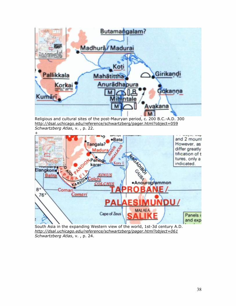
Religious and cultural sites of the post-Mauryan period, c. 200 B.C.-A.D. 300 http://dsal.uchicago.edu/reference/schwartzberg/pager.html?object=059 Schwartzberg Atlas, v. , p. 22. +
South Asia in the expanding Western view of the world, 1st-3d century A.D. http://dsal.uchicago.edu/reference/schwartzberg/pager.html?object=061 Schwartzberg Atlas, v. , p. 24.
39
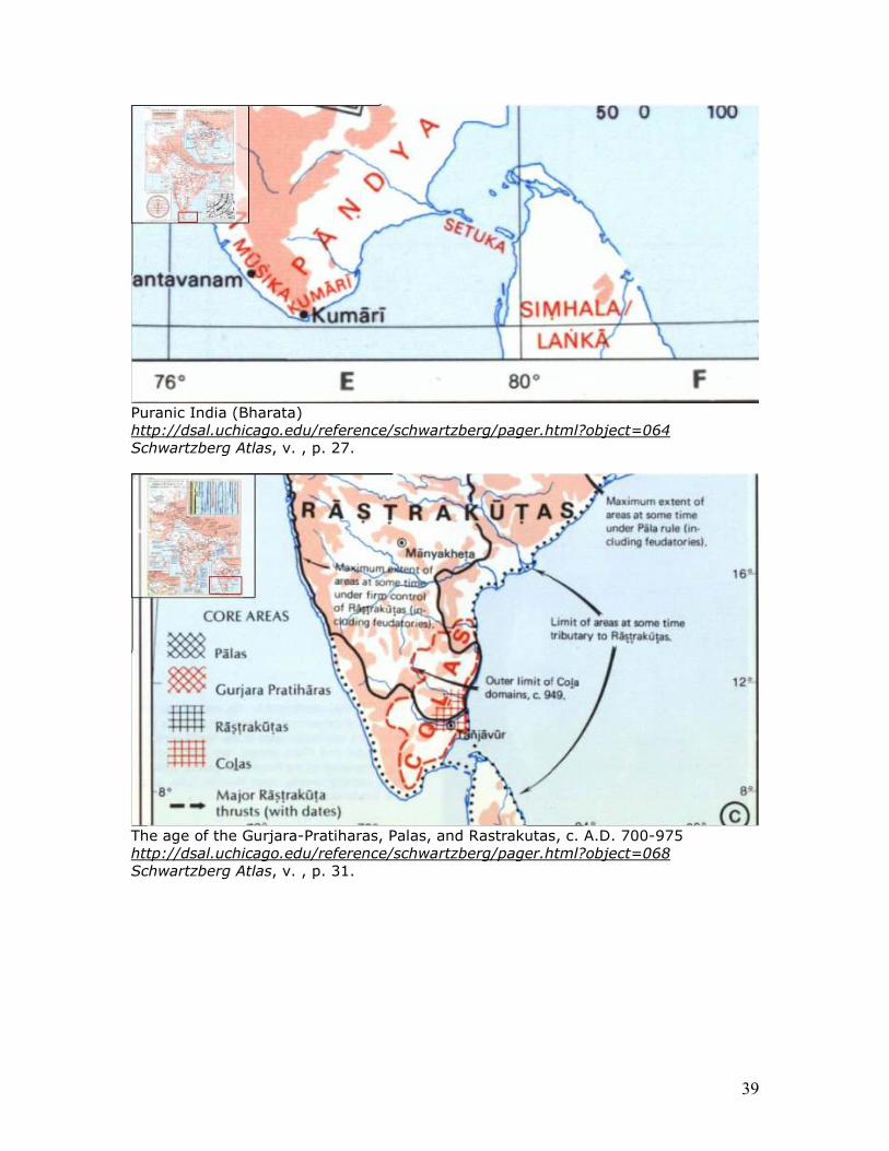
Puranic India (Bharata) http://dsal.uchicago.edu/reference/schwartzberg/pager.html?object=064 Schwartzberg Atlas, v. , p. 27.
The age of the Gurjara-Pratiharas, Palas, and Rastrakutas, c. A.D. 700-975 http://dsal.uchicago.edu/reference/schwartzberg/pager.html?object=068 Schwartzberg Atlas, v. , p. 31.
40
Landing of King Vijaya depicted in an Ajanta fresco (painting dated to circa 5th century). The age of the Ghaznavids, Cahmanas, Later Calukyas, and Colas, c. 975-1200
http://dsal.uchicago.edu/reference/schwartzberg/pager.html?object=069 Schwartzberg Atlas, v. , p. 32.
41
Islamic expansion and changing Western views of South Asia, 7th-12th centuries http://dsal.uchicago.edu/reference/schwartzberg/pager.html?object=070 Schwartzberg Atlas, v. , p. 33.
Religious and cultural sites, 8th-12th centuries http://dsal.uchicago.edu/reference/schwartzberg/pager.html?object=071 Schwartzberg Atlas, p. 34.
42
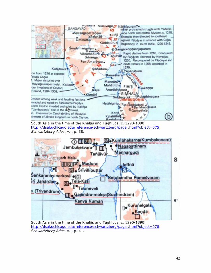
South Asia in the time of the Khaljis and Tughluqs, c. 1290-1390 http://dsal.uchicago.edu/reference/schwartzberg/pager.html?object=075 Schwartzberg Atlas, v. , p. 38.
South Asia in the time of the Khaljis and Tughluqs, c. 1290-1390 http://dsal.uchicago.edu/reference/schwartzberg/pager.html?object=078 Schwartzberg Atlas, v. , p. 41.
43
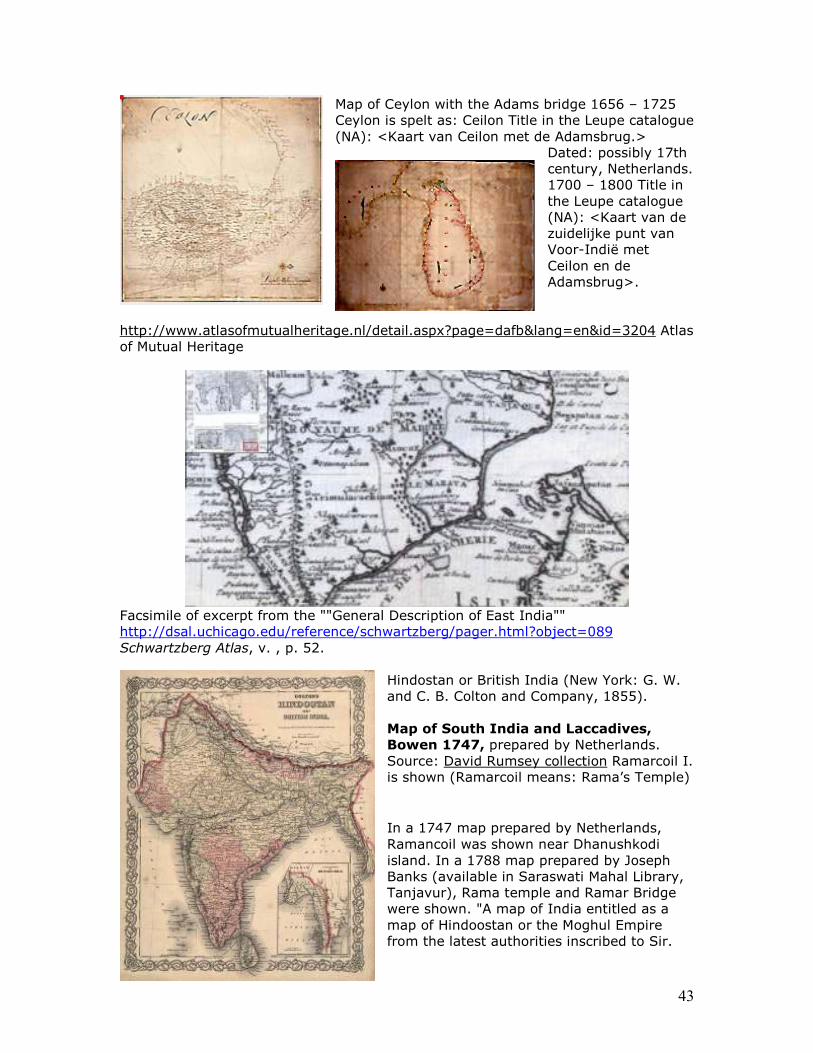
Map of Ceylon with the Adams bridge 1656 – 1725 Ceylon is spelt as: Ceilon Title in the Leupe catalogue (NA): <Kaart van Ceilon met de Adamsbrug.>
Dated: possibly 17th century, Netherlands. 1700 – 1800 Title in the Leupe catalogue (NA): <Kaart van de zuidelijke punt van Voor-Indië met Ceilon en de Adamsbrug>.
http://www.atlasofmutualheritage.nl/detail.aspx?page=dafb&lang=en&id=3204 Atlas of Mutual Heritage
Facsimile of excerpt from the ""General Description of East India"" http://dsal.uchicago.edu/reference/schwartzberg/pager.html?object=089 Schwartzberg Atlas, v. , p. 52.
Hindostan or British India (New York: G. W. and C. B. Colton and Company, 1855). Map of South India and Laccadives,
Bowen 1747, prepared by Netherlands. Source: David Rumsey collection Ramarcoil I. is shown (Ramarcoil means: Rama’s Temple)
In a 1747 map prepared by Netherlands, Ramancoil was shown near Dhanushkodi island. In a 1788 map prepared by Joseph Banks (available in Saraswati Mahal Library, Tanjavur), Rama temple and Ramar Bridge were shown. "A map of India entitled as a map of Hindoostan or the Moghul Empire from the latest authorities inscribed to Sir.
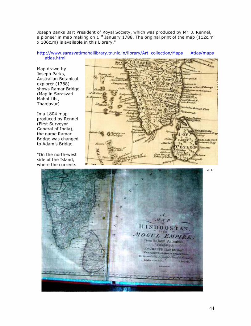
44
Joseph Banks Bart President of Royal Society, which was produced by Mr. J. Rennel, a pioneer in map making on 1 st January 1788. The original print of the map (112c.m x 106c.m) is available in this Library."
http://www.sarasvatimahallibrary.tn.nic.in/library/Art_collection/Maps___Atlas/maps___atlas.html
Map drawn by Joseph Parks, Australian Botanical explorer (1788) shows Ramar Bridge (Map in Sarasvati Mahal Lib., Thanjavur) In a 1804 map produced by Rennel (First Surveyor General of India), the name Ramar Bridge was changed to Adam’s Bridge.
“On the north-west side of the Island, where the currents
are
45
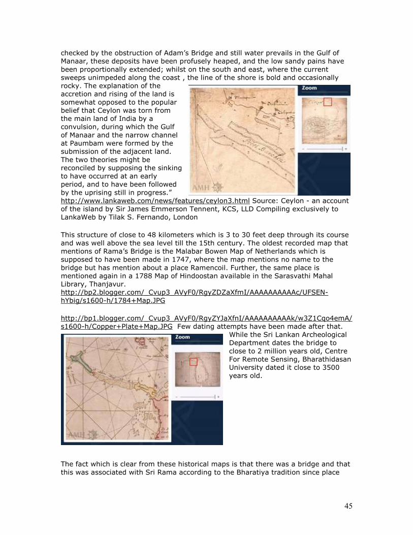
checked by the obstruction of Adam’s Bridge and still water prevails in the Gulf of Manaar, these deposits have been profusely heaped, and the low sandy pains have been proportionally extended; whilst on the south and east, where the current sweeps unimpeded along the coast , the line of the shore is bold and occasionally rocky. The explanation of the accretion and rising of the land is somewhat opposed to the popular belief that Ceylon was torn from the main land of India by a convulsion, during which the Gulf of Manaar and the narrow channel at Paumbam were formed by the submission of the adjacent land. The two theories might be reconciled by supposing the sinking to have occurred at an early period, and to have been followed by the uprising still in progress.” http://www.lankaweb.com/news/features/ceylon3.html Source: Ceylon - an account of the island by Sir James Emmerson Tennent, KCS, LLD Compiling exclusively to LankaWeb by Tilak S. Fernando, London
This structure of close to 48 kilometers which is 3 to 30 feet deep through its course and was well above the sea level till the 15th century. The oldest recorded map that mentions of Rama’s Bridge is the Malabar Bowen Map of Netherlands which is supposed to have been made in 1747, where the map mentions no name to the bridge but has mention about a place Ramencoil. Further, the same place is mentioned again in a 1788 Map of Hindoostan available in the Sarasvathi Mahal Library, Thanjavur. http://bp2.blogger.com/_Cvup3_AVyF0/RgyZDZaXfmI/AAAAAAAAAAc/UFSEN-hYbig/s1600-h/1784+Map.JPG
http://bp1.blogger.com/_Cvup3_AVyF0/RgyZYJaXfnI/AAAAAAAAAAk/w3Z1Cqo4emA/s1600-h/Copper+Plate+Map.JPG Few dating attempts have been made after that.
While the Sri Lankan Archeological Department dates the bridge to close to 2 million years old, Centre For Remote Sensing, Bharathidasan University dated it close to 3500 years old.
The fact which is clear from these historical maps is that there was a bridge and that this was associated with Sri Rama according to the Bharatiya tradition since place
46
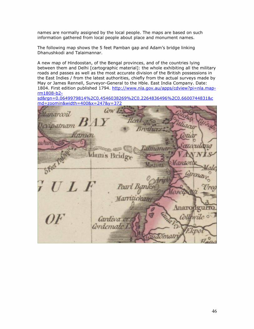
names are normally assigned by the local people. The maps are based on such information gathered from local people about place and monument names. The following map shows the 5 feet Pamban gap and Adam’s bridge linking Dhanushkodi and Talaimannar. A new map of Hindoostan, of the Bengal provinces, and of the countries lying between them and Delhi [cartographic material]: the whole exhibiting all the military roads and passes as well as the most accurate division of the British possessions in the East Indies / from the latest authorities, chiefly from the actual surveys made by May or James Rennell, Surveyor-General to the Hble. East India Company. Date: 1804. First edition published 1794. http://www.nla.gov.au/apps/cdview?pi=nla.map-rm1808-b2-sd&rgn=0.0649979814%2C0.4546038269%2C0.2264836496%2C0.6600744831&cmd=zoomin&width=400&x=247&y=372
47
Textual evidences for Rama Setu (or Setu bandha)
Mirrored at: http://hinduthought.googlepages.com/setuband.doc
Apart from the Ramayana which has emphatic references to the construction of Setu bandha in 85 s’lokas in a separate sarga in Yuddha kanda, Mahabharata also refers to the continued protection of Nala Setu following the command of Sri Rama. Sri Rama refers in Kalidasa’s Raghuvams’a also refers to the Setu of mountains. So does Skanda Purana (III.1.2.1-114), Vishnu Purana (IV.4.40-49), Agni Purana (V-XI), Brahma Purana (138.1-40) refer to the construction of Rama Setu.
The evidences -- textual, epigraphic, scientific marine-archaeological explorations -- document Rama Setu (or, Setu bandha) as an ancient monument. A channel linking Tuticorin Port with Haldia can be designed without damaging this monument which is an object of national importance, indeed, a world heritage site with Ramayana episodes including the construction of Setu bandha by Nala venerated in many Ramayana's in many parts of the world. . Development imperative or abhyudayam can co-exist with protection of monuments, places and objects of national and international importance. Let us hope that Govt. of India will see it fit to realign the Setusamudram Channel to avoid impacting on Ram Setu, the heritage which should be immediately declared as a protected monument under the AMASR Act, 1958. This is a solemn duty of the State of Bharatam. Mirrored at: http://hinduthought.googlepages.com/setuband.doc
Apart from the Ramayana which has emphatic references to the construction of Setu bandha in 85 s’lokas in a separate sarga in Yuddha kanda, Mahabharata also refers to the continued protection of Nala Setu following the command of Sri Rama. Sri Rama refers in Kalidasa’s Raghuvams’a also refers to the Setu of mountains. So does Skanda Purana (III.1.2.1-114), Vishnu Purana (IV.4.40-49), Agni Purana (V-XI), Brahma Purana (138.1-40) refer to the construction of Rama Setu.
Epics and classics
• Valmiki describes the construction of Setu in detail. For an exquisite rendering of Valmiki’s descriptions see: http://ramasetu.blogspot.com/2007/03/setu-bandhan-in-valmiki-ramayana.html Also: http://bridgeofram.com/
hastimaatraan mahaakaayaaH paaSaaNaamshca mahaabalaaH parvataamshca samutpaaTya yantraiH parivahanti ca Valmiki Ramayana 2-22-58 Vaanara having huge bodies, with mighty strength uprooted elephant-sized rocks and mountains and transported them by mechanical contrivances (yantraih).
• Vedavyasa refers to Nalasetu and notes how the setu was protected during Mahabharata times
nalasetur iti khyāto yo 'dyāpi prathito bhuvi rāmasyājñāṃ puraskṛtya dhāryate girisaṃnibhaḥ MBh. 3.267.45
48
.... which even today, popular on earth as Nala's bridge, mountain-like, is sustained out of respect for [Lord] Rama's command. (Nala was son of Vis’wakarma)
Kalidasa's Raghuvams’a (sarga 13): Rama, while returning from SriLanka in pushpaka vimaana: "Behold, Sita, My Setu of mountains dividing this frothy ocean is like the milky way dividing the sky into two parts"
There is a kavya in Prakrit by King Pravarasena II (550-600 CE) called “Setu bandha or Ravanavaho.” "Dasamuha Vadha" (Setubandha Kavya) was written by the King Damodara Sen (5th Century).
Lankavatara Sutra
Lankavatara Sutra is one of the most important sutras of Mahayana Buddhism.
According to the traditions of Sri Lanka, this Sutra contains the actual words spoken
by Bhagwan Gautama Buddha himself, when he visited Sri Lanka. Although it is
historically doubtful that Bhagwan Gautama Buddha ever physically visited Sri Lanka,
nevertheless, Lankavatara, which literally means 'Arrival in Lanka', is a very
important source of Mahayan Bauddha philosophy.
Dr. Daisetz Teitaro Suzuki, who has translated the Sutra from original Sanskrit into
other languages, says, "As is the case with other Buddhist texts it is quite impossible
with our present knowledge of Indian history to decide the age of the Sutra. The one
thing that is certain is that it was compiled before 443 CE when the first Chinese
translation is reported to have been attempted. Even with the text that was in
existence before 443 CE we do not know how it developed, for it was not surely
written from the beginning as one complete piece of work as we write a book in
these modern days. Some parts of it must be older than others, since there is no
doubt that it has many layers of added passages."
Lankavatara Sutra and Ramayana share several descriptions. Even ten-headed
Ravana and Kumbhakarna, Ashok Vatica, Ocean and so many other points tally. In
the Sutra, Ravana is described as the king of Lanka who is desirous of learning the
Truth from Buddha, and invites him across the ocean into Sri Lanka.
Some parts from the first chapter of the Sutra:
...Thus have I heard. The Blessed One once stayed on the peak of Lanka in Mount
Malaya on the great ocean...
49
...At that time, the Blessed One who had been preaching in the palace of the King of
Sea-serpents came out at the end of seven days and was greeted by an innumerable
host of Nāgakanyās including Śakra and Brahma, and looking at Lanka on Mount
Malaya smiled...
...Blessed One said, By the Tathagatas of the past, who were Arhats and Buddhas,
the fuly Enlightened Ones, this Truth was made the subject of their discourse, at
Lanka on the mountain-peak of Malaya... (Referring to Rama?)
...the Truth realisable by noble wisdom in one's inmost self, which is beyond the
reasoning knowledge of the philosophers as well as the state of consciousness of the
Sravakas and Pratyekabuddhas. I, too, would now for the sake of Ravana, Overlord
of the Yakshas, discourse on this Truth...
...After seven nights, the Blessed One leaving the ocean, the abode of the Makaras,
the palace of the sea-God, now stands on the shore...
...Just as the Buddha rises, Ravana, accompanied by the numerous Apsaras and
Yakshas, Suka, Sarana, and learned men, miraculously goes over to the place where
the Lord is standing...and invites Him into the city of Lanka...
..."Mahamati, accept my mansion, the company of the Apsaras, necklaces of various
sorts, and the delightful Asoka garden"...
..."I give myself up to serve the Buddhas and their sons; there is nothing with me
that I do not give up, for their sake; Great Muni, have compassion on me!"...
...Hearing him speak thus, the Lord of the Triple World said, "King of Yakshas, this
mountain of precious stones was visited by the Great Buddhas in the past. And,
taking pity on you, they had discoursed on the Truth revealed in their inmost
consciousness...
Throughout the rest of the chapters in the Sutra, examples of Ocean, Bridge, Raft,
Boat etc. are richly used.
http://ramasetu.blogspot.com/2007/04/lankavatara-sutra.html
50
Epigraphs
“…the most common reference to Rama in early inscriptions is in a verse that begins to appear commonly at the end of land-grants from the early 9th century onwards in Rashtrakuta regions. “Common to all kings is the setu of dharma: you should abide by it moment by moment. Again and again Ramabhadra implores all future kings to do the same (Epigraphica Indica 23.212 – a record of CE 807)… Tiruvalangadu plates of Rajaraja Cola I (CE 985-1014) describe the king as surpassing Rama in military prowess and crossing the ocean with his powerful army and subduing the king of Lanka… The concept of a hill-top imprinted by the feet of Visnu is repeatedly found in the Mahabharata24 and it is suggested that a column on the hill may have enshrined Visnupada. (Vishnupadam in Srilanka was renamed as Adam’s peak just as Ramar bridge was renamed as Adam’s Bridge by James Rennel in 1804 when he was the first surveyor general of British India)… In the temples of Orissa dated from 7th to 10th centuries, Rama is represented both as an avatara of Visnu as also the hero of the Ramayana narrative. In a dasavatara group, the image of Rama is sculpted along with Balarama and Parasurama at the entrance of Manibhadresvara and also at Simhanatha. Ramayana friezes occur on several temples, such as Svarnajalesvara, Sisiresvara, Varahi and Panca-Pandava. These include scenes of Rama shooting through seven trees, killing the golden deer, abduction of Sita, fight between Bali and Sugriva and building the bridge across the ocean.” http://www.ochs.org.uk/publications/multimedia/documents/HinduTemple3_Ramayana_HPRay_1006.doc
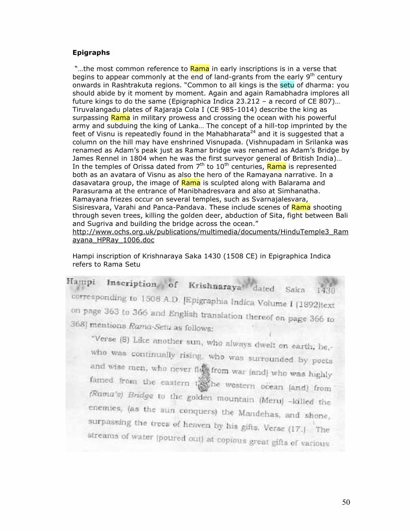
Hampi inscription of Krishnaraya Saka 1430 (1508 CE) in Epigraphica Indica refers to Rama Setu
51
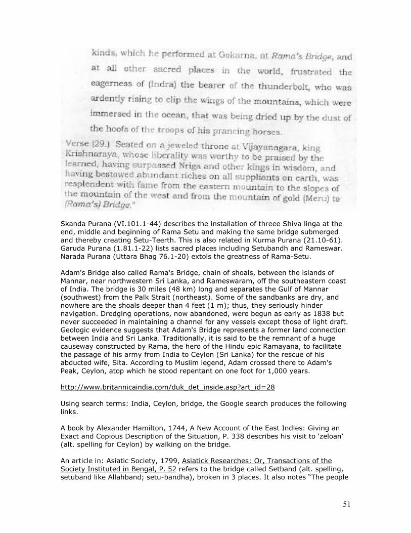
Skanda Purana (VI.101.1-44) describes the installation of threee Shiva linga at the end, middle and beginning of Rama Setu and making the same bridge submerged and thereby creating Setu-Teerth. This is also related in Kurma Purana (21.10-61). Garuda Purana (1.81.1-22) lists sacred places including Setubandh and Rameswar. Narada Purana (Uttara Bhag 76.1-20) extols the greatness of Rama-Setu.
Adam's Bridge also called Rama's Bridge, chain of shoals, between the islands of Mannar, near northwestern Sri Lanka, and Rameswaram, off the southeastern coast of India. The bridge is 30 miles (48 km) long and separates the Gulf of Mannar (southwest) from the Palk Strait (northeast). Some of the sandbanks are dry, and nowhere are the shoals deeper than 4 feet (1 m); thus, they seriously hinder navigation. Dredging operations, now abandoned, were begun as early as 1838 but never succeeded in maintaining a channel for any vessels except those of light draft. Geologic evidence suggests that Adam's Bridge represents a former land connection between India and Sri Lanka. Traditionally, it is said to be the remnant of a huge causeway constructed by Rama, the hero of the Hindu epic Ramayana, to facilitate the passage of his army from India to Ceylon (Sri Lanka) for the rescue of his abducted wife, Sita. According to Muslim legend, Adam crossed there to Adam's Peak, Ceylon, atop which he stood repentant on one foot for 1,000 years.
http://www.britannicaindia.com/duk_det_inside.asp?art_id=28 Using search terms: India, Ceylon, bridge, the Google search produces the following links. A book by Alexander Hamilton, 1744, A New Account of the East Indies: Giving an Exact and Copious Description of the Situation, P. 338 describes his visit to ‘zeloan’ (alt. spelling for Ceylon) by walking on the bridge. An article in: Asiatic Society, 1799, Asiatick Researches: Or, Transactions of the Society Instituted in Bengal, P. 52 refers to the bridge called Setband (alt. spelling, setuband like Allahband; setu-bandha), broken in 3 places. It also notes “The people
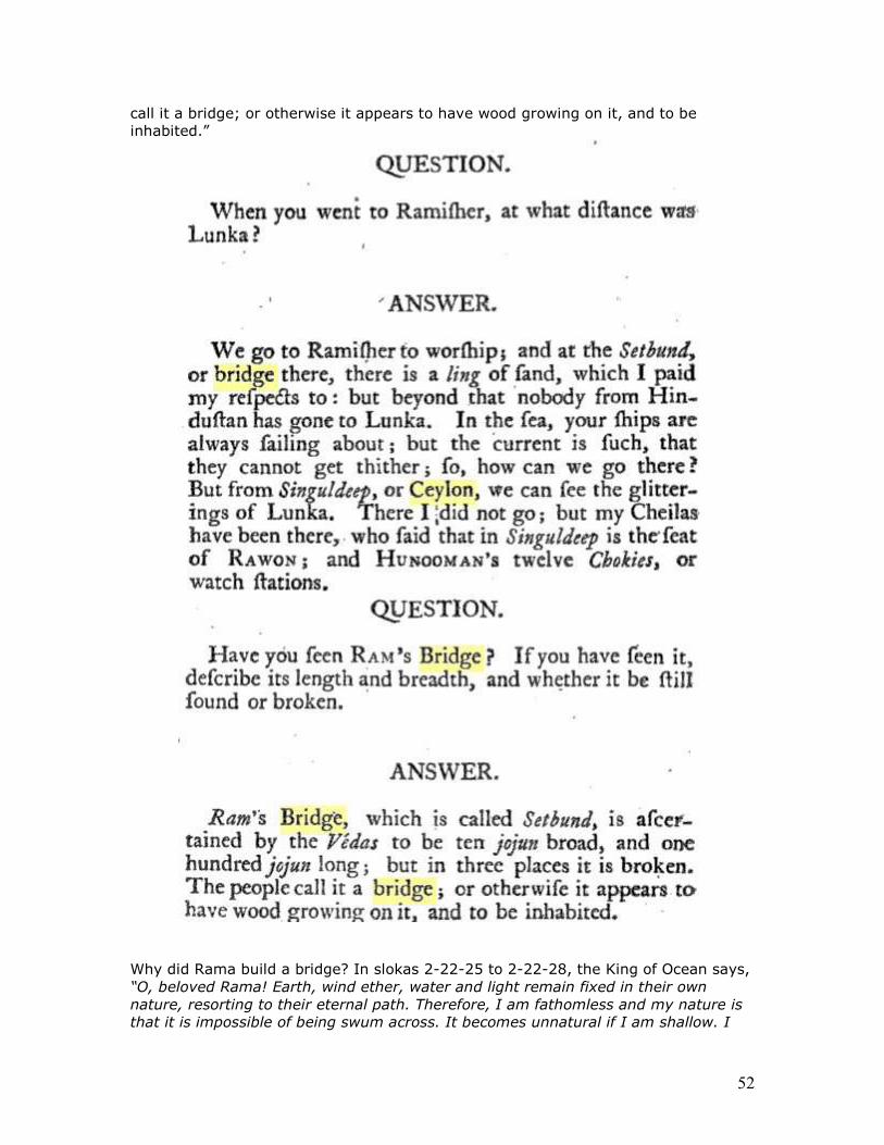
52
call it a bridge; or otherwise it appears to have wood growing on it, and to be inhabited.”
Why did Rama build a bridge? In slokas 2-22-25 to 2-22-28, the King of Ocean says, “O, beloved Rama! Earth, wind ether, water and light remain fixed in their own nature, resorting to their eternal path. Therefore, I am fathomless and my nature is that it is impossible of being swum across. It becomes unnatural if I am shallow. I
53
am telling you the following device to cross me. O, prince! Neither from desire nor ambition nor fear nor from affection, I am able to solidify my waters inhabited by alligators. O, Rama! I shall make it possible to see that you are able to cross over. I will arrange a place for the monkeys to cross me and bear with it. As far as the army crosses me, the crocodiles will not be aggressive to them.”
Valmiki describes construction of this bridge between Slokas 2-22-50 and 2-22-72 “I am a son born of Visvakarma’s own loins. I am equal to Viswakarma. This god of Ocean has reminded me. The great ocean spoke the truth. Being unasked, I have not told you my details earlier. I am capable of constructing a bridge across the ocean. Hence, let the foremost of monkeys build the bridge now itself. Then, being sent by Rama, hundreds and thousands of monkey heroes jumped in joy on all sides towards the great forest. Those army-chiefs of monkeys, who resembled mountains, broke the rocks and trees there and dragged them away towards the sea. Those monkeys filled the ocean with all types of trees like Sala and Asvakarna, Dhava and bamboo, Kutaja, Arjuna, palmyra,Tilaka, Tinisa, Bilva, Saptaparna, Karnika, in blossom as also mango and Asoka. The excellent monkeys, the forest animals lifted and brought, like Indra’s flag posts, some trees with roots intact and some others without roots. From here and there the monkeys brought Palmyra trees, pomegranate shrubs, coconut and Vibhitaka, Karira, Bakula and neem trees. The huge bodied monkeys with mighty strength uprooted elephant-sized rocks and mountains and transported them by mechanical contrivances. The water, raised up due to sudden throwing of mountains in the sea, soured upward towards the sky and from there again, gushed back. The rocks befalling on all sides perturbed the ocean. Some others drew up strings a hundred Yojanas long (in order to keep the rocks in a straight line.) Nala on his part initiated a monumental bridge in the middle of the ocean. The bridge was built at that time with the cooperation of other monkeys, of terrible doings. Some monkeys were holding poles for measuring the bridge and some others collected the material. Reeds and logs resembling clouds and mountains, brought by hundreds of monkeys, lead by the command of Rama, fastened some parts of the bridge. Monkeys constructed the bridge with trees having blossom at the end of their boughs. Some monkeys looking like demons seized rocks resembling mountains and peaks of mountains and appeared running hither and thither. Then, a tumultuous sound occurred when the rocks were thrown into the sea and when mountains were caused to fall there. On the first day, fourteen Yojanas of bridge were constructed by the monkeys speedily, thrilled with delight as theywere, resembling elephants. In the same manner, on the second day twenty Yojanas of bridge were constructed speedily by the monkeys of terrific bodies and of mighty strength. Thus, on the third day twenty-one Yojanas of the bridge were constructed in the ocean speedily by the monkeys with their colossal bodies. On the forth day, a further of twenty-two Yojanas were constructed by the dashingmonkeys with a great speed. In that manner, on the fifth day, the monkeys working quickly constructed twenty-three yojanas of the bridge up to the other seashore. That Nala, the strong and illustrious son of Visvakarma and an excellent monkey built the bridge across the sea as truly as his father would have built it. That beautiful and lovely bridge constructed by Nala across the ocean the abode of alligators, shone brightly like a milky way of stars in the sky.”
Dr Subramanian Swamy has, in April 2007, written to Mrs. Ambika Soni, Union Minister for Culture, in connection with the status of the Rama Setu under the Ancient Monuments and Archeological Sites and Remains Act, and raising fundamental legal, administrative, quasi-judicial and cultural issues. He has urged
54
Ambika Soni to initiate action in order to notify officially the Rama Setu as an Ancient Monument. The Rama Setu is a formation of shoal stones of 30 kilometers long and 3 kilometers wide which served for many centuries as foot-bridge from Dhanushkodi on the coast of Tamilnadu to Sri Lanka. It is a very old historic formation, and hence would come within the expression 'ancient monument'. The Brahma Sarovar at Kurukshetra was on a similar consideration declared by the Punjab and Haryana High Court as an ancient monument. Judged by Ambika Soni's answer to an Unstarred Question in Rajya Sabha in the current Budget Session, it is clear that the Government have so far not conducted any study to determine the nature, antiquity, and heritage value of the Rama Setu. However, at the non-governmental level, as also on the basis of Hindu scriptures, it is a widely held opinion that Rama Setu facilitated Sri Rama and his army to cross the Palk Strait, as described in Valmiki Ramayana and other scriptures. That such a formation per se exists has been admitted by Ambika Soni in answer to the said Rajya Sabha Unstarred Question, which answer is confirmed by US National Aeronautics and Space Agency through satellite mapping and imaging.
The Punjab and Haryana High Court in a historic order delivered in 1993 declared the Brahma Sarovar at Kurukshetra as an 'Ancient Monument'. They declared Brahma Sarovar as a very, very old historic formation and hence qualified for notification as an Ancient Monument. The cultural, spiritual and religious considerations had weighed with the Punjab and Haryana High Court in passing this order of timeless significance. These considerations seem to be irrelevant to the Islam-embracing, Christianity-coveting, Hindu-hating and Nation-destroying minority UPA Government in New Delhi nominally led by an unelected and nominated Prime Minister.
Among the holiest of water tanks in India, the Brahma Sarovar in Kurukshetra is an important national and international tourist centre in Haryana State. It has been the cradle of Indian civilization from times immemorial. Any responsible Union Minister for Culture, who respects the cultural, spiritual and religious traditions, feelings and sentiments of more than 800 millions of Hindus in majority in India, would have declared the Rama Setu Bridge as an Ancient Monument on par with Brahma Sarovar in Kurukshetra on the same analogy and for similar and equally forceful and valid reasons.
http://www.sulekha.com/groups/postdisplay.aspx?cid=731607&forumid=756919
Britannica Encyclopadia: Adam's Bridge also called Rama's Bridge, chain of shoals, between the islands of Mannar, near northwestern Sri Lanka, and Rameswaram, off the southeastern coast of India. The bridge is 30 miles (48 km) long and separates the Gulf of Mannar (southwest) from the Palk Strait (northeast). Some of the sandbanks are dry, and nowhere are the shoals deeper than 4 feet (1 m); thus, they seriously hinder navigation. Dredging operations, now abandoned, were begun as early as 1838 but never succeeded in maintaining a channel for any vessels except those of light draft. Geologic evidence suggests that Adam's Bridge represents a former land connection between India and Sri Lanka. Traditionally, it is said to be the remnant of a huge causeway constructed by Rama, the hero of the Hindu epic Ramayana, to facilitate the passage of his army from India to Ceylon (Sri Lanka) for the rescue of his abducted wife, Sita. According to Muslim legend, Adam crossed there to Adam's Peak, Ceylon, atop which he stood repentant on one foot for 1,000 years.
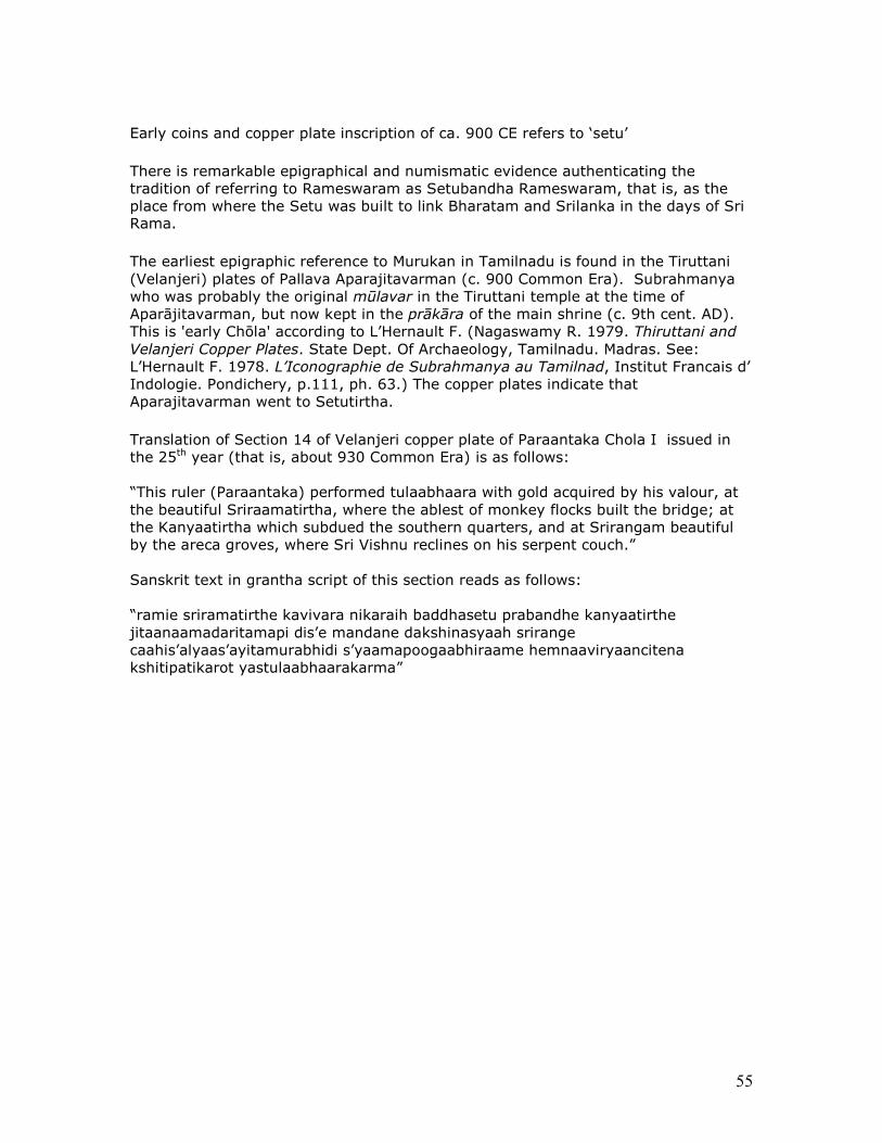
55
Early coins and copper plate inscription of ca. 900 CE refers to ‘setu’
There is remarkable epigraphical and numismatic evidence authenticating the tradition of referring to Rameswaram as Setubandha Rameswaram, that is, as the place from where the Setu was built to link Bharatam and Srilanka in the days of Sri Rama.
The earliest epigraphic reference to Murukan in Tamilnadu is found in the Tiruttani (Velanjeri) plates of Pallava Aparajitavarman (c. 900 Common Era). Subrahmanya who was probably the original mūlavar in the Tiruttani temple at the time of Aparājitavarman, but now kept in the prākāra of the main shrine (c. 9th cent. AD). This is 'early Chōla' according to L’Hernault F. (Nagaswamy R. 1979. Thiruttani and Velanjeri Copper Plates. State Dept. Of Archaeology, Tamilnadu. Madras. See: L’Hernault F. 1978. L’Iconographie de Subrahmanya au Tamilnad, Institut Francais d’ Indologie. Pondichery, p.111, ph. 63.) The copper plates indicate that Aparajitavarman went to Setutirtha.
Translation of Section 14 of Velanjeri copper plate of Paraantaka Chola I issued in the 25th year (that is, about 930 Common Era) is as follows: “This ruler (Paraantaka) performed tulaabhaara with gold acquired by his valour, at the beautiful Sriraamatirtha, where the ablest of monkey flocks built the bridge; at the Kanyaatirtha which subdued the southern quarters, and at Srirangam beautiful by the areca groves, where Sri Vishnu reclines on his serpent couch.” Sanskrit text in grantha script of this section reads as follows: “ramie sriramatirthe kavivara nikaraih baddhasetu prabandhe kanyaatirthe jitaanaamadaritamapi dis’e mandane dakshinasyaah srirange caahis’alyaas’ayitamurabhidi s’yaamapoogaabhiraame hemnaaviryaancitena kshitipatikarot yastulaabhaarakarma”
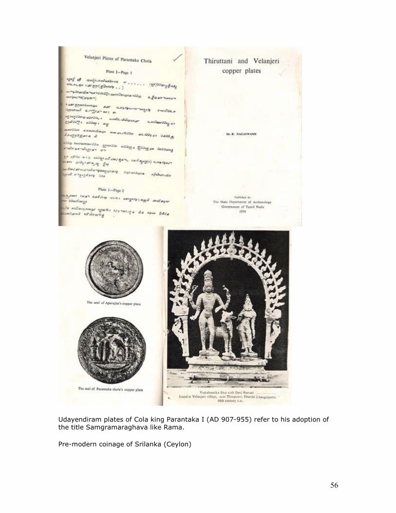
56
Udayendiram plates of Cola king Parantaka I (AD 907-955) refer to his adoption of the title Samgramaraghava like Rama.
Pre-modern coinage of Srilanka (Ceylon)
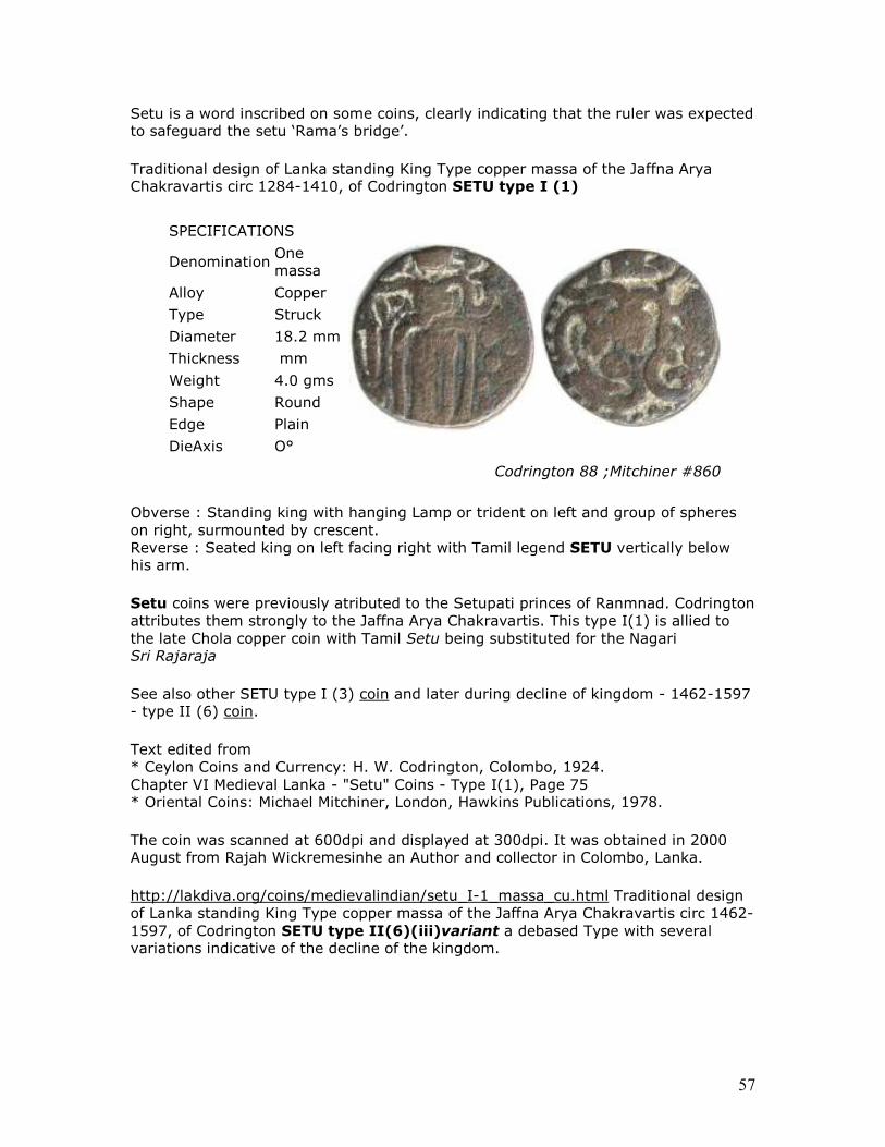
57
Setu is a word inscribed on some coins, clearly indicating that the ruler was expected to safeguard the setu ‘Rama’s bridge’.
Traditional design of Lanka standing King Type copper massa of the Jaffna Arya Chakravartis circ 1284-1410, of Codrington SETU type I (1)
SPECIFICATIONS
Denomination One massa
Alloy Copper
Type Struck
Diameter 18.2 mm
Thickness mm
Weight 4.0 gms
Shape Round
Edge Plain
DieAxis O°
Codrington 88 ;Mitchiner #860
Obverse : Standing king with hanging Lamp or trident on left and group of spheres on right, surmounted by crescent. Reverse : Seated king on left facing right with Tamil legend SETU vertically below his arm.
Setu coins were previously atributed to the Setupati princes of Ranmnad. Codrington attributes them strongly to the Jaffna Arya Chakravartis. This type I(1) is allied to the late Chola copper coin with Tamil Setu being substituted for the Nagari Sri Rajaraja
See also other SETU type I (3) coin and later during decline of kingdom - 1462-1597 - type II (6) coin.
Text edited from * Ceylon Coins and Currency: H. W. Codrington, Colombo, 1924. Chapter VI Medieval Lanka - "Setu" Coins - Type I(1), Page 75 * Oriental Coins: Michael Mitchiner, London, Hawkins Publications, 1978.
The coin was scanned at 600dpi and displayed at 300dpi. It was obtained in 2000 August from Rajah Wickremesinhe an Author and collector in Colombo, Lanka.
http://lakdiva.org/coins/medievalindian/setu_I-1_massa_cu.html Traditional design of Lanka standing King Type copper massa of the Jaffna Arya Chakravartis circ 1462-1597, of Codrington SETU type II(6)(iii)variant a debased Type with several variations indicative of the decline of the kingdom.
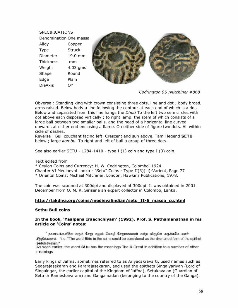
58
SPECIFICATIONS
Denomination One massa
Alloy Copper
Type Struck
Diameter 19.0 mm
Thickness mm
Weight 4.03 gms
Shape Round
Edge Plain
DieAxis O°
Codrington 95 ;Mitchiner #868
Obverse : Standing king with crown consisting three dots, line and dot ; body broad, arms raised. Below body a line following the contour at each end of which is a dot. Below and separated from this line hangs the Dhoti To the left two semicircles with dot above each disposed virtically ; to right lamp, the stem of which consists of a large ball between two smaller balls, and the head of a horizontal line curved upwards at either end enclosing a flame. On either side of figure two dots. All within cicle of dashes. Reverse : Bull couchant facing left. Crescent and sun above. Tamil legend SETU below ; large kombu. To right and left of bull a group of three dots.
See also earlier SETU - 1284-1410 - type I (1) coin and type I (3) coin.
Text edited from * Ceylon Coins and Currency: H. W. Codrington, Colombo, 1924. Chapter VI Mediaeval Lanka - "Setu" Coins - Type II(3)(iii)-Varient, Page 77 * Oriental Coins: Michael Mitchiner, London, Hawkins Publications, 1978.
The coin was scanned at 300dpi and displayed at 300dpi. It was obtained in 2001 December from O. M. R. Sirisena an expert collector in Colombo, Lanka.
http://lakdiva.org/coins/medievalindian/setu_II-6_massa_cu.html
Sethu Bull coins
In the book, ‘Yaalpana Iraachchiyam’ (1992), Prof. S. Pathamanathan in his
article on ‘Coins’ notes:
Early kings of Jaffna, sometimes referred to as Ariyacakravarti, used names such as Segarajasekaran and Pararajasekaran, and used the epithets Singaiyariyan (Lord of Singaingar, the earlier capital of the Kingdom of Jaffna), Setukavalan (Guardian of Setu or Rameshavaram) and Gangainadan (belonging to the country of the Ganga).
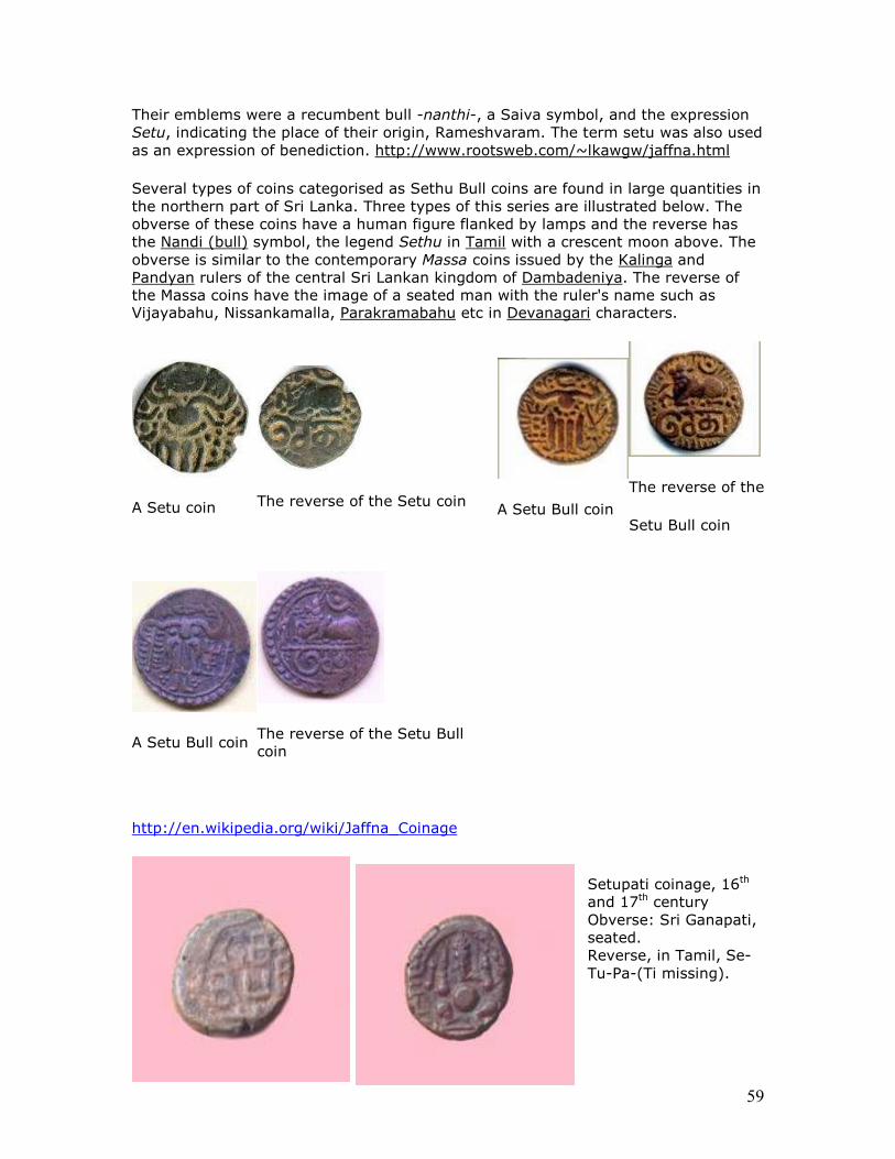
59
Their emblems were a recumbent bull -nanthi-, a Saiva symbol, and the expression Setu, indicating the place of their origin, Rameshvaram. The term setu was also used as an expression of benediction. http://www.rootsweb.com/~lkawgw/jaffna.html
Several types of coins categorised as Sethu Bull coins are found in large quantities in the northern part of Sri Lanka. Three types of this series are illustrated below. The obverse of these coins have a human figure flanked by lamps and the reverse has the Nandi (bull) symbol, the legend Sethu in Tamil with a crescent moon above. The obverse is similar to the contemporary Massa coins issued by the Kalinga and Pandyan rulers of the central Sri Lankan kingdom of Dambadeniya. The reverse of the Massa coins have the image of a seated man with the ruler's name such as Vijayabahu, Nissankamalla, Parakramabahu etc in Devanagari characters.
A Setu coin
The reverse of the Setu coin
A Setu Bull coin
The reverse of the
Setu Bull coin
A Setu Bull coin
The reverse of the Setu Bull coin
http://en.wikipedia.org/wiki/Jaffna_Coinage
Setupati coinage, 16th and 17th century Obverse: Sri Ganapati, seated. Reverse, in Tamil, Se-Tu-Pa-(Ti missing).
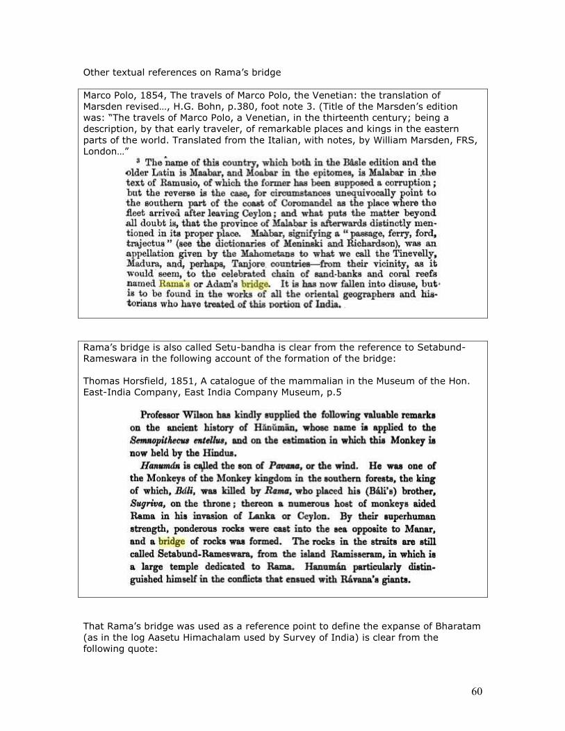
60
Other textual references on Rama’s bridge Marco Polo, 1854, The travels of Marco Polo, the Venetian: the translation of Marsden revised…, H.G. Bohn, p.380, foot note 3. (Title of the Marsden’s edition was: “The travels of Marco Polo, a Venetian, in the thirteenth century; being a description, by that early traveler, of remarkable places and kings in the eastern parts of the world. Translated from the Italian, with notes, by William Marsden, FRS, London…”
Rama’s bridge is also called Setu-bandha is clear from the reference to Setabund-Rameswara in the following account of the formation of the bridge: Thomas Horsfield, 1851, A catalogue of the mammalian in the Museum of the Hon. East-India Company, East India Company Museum, p.5
That Rama’s bridge was used as a reference point to define the expanse of Bharatam (as in the log Aasetu Himachalam used by Survey of India) is clear from the following quote:
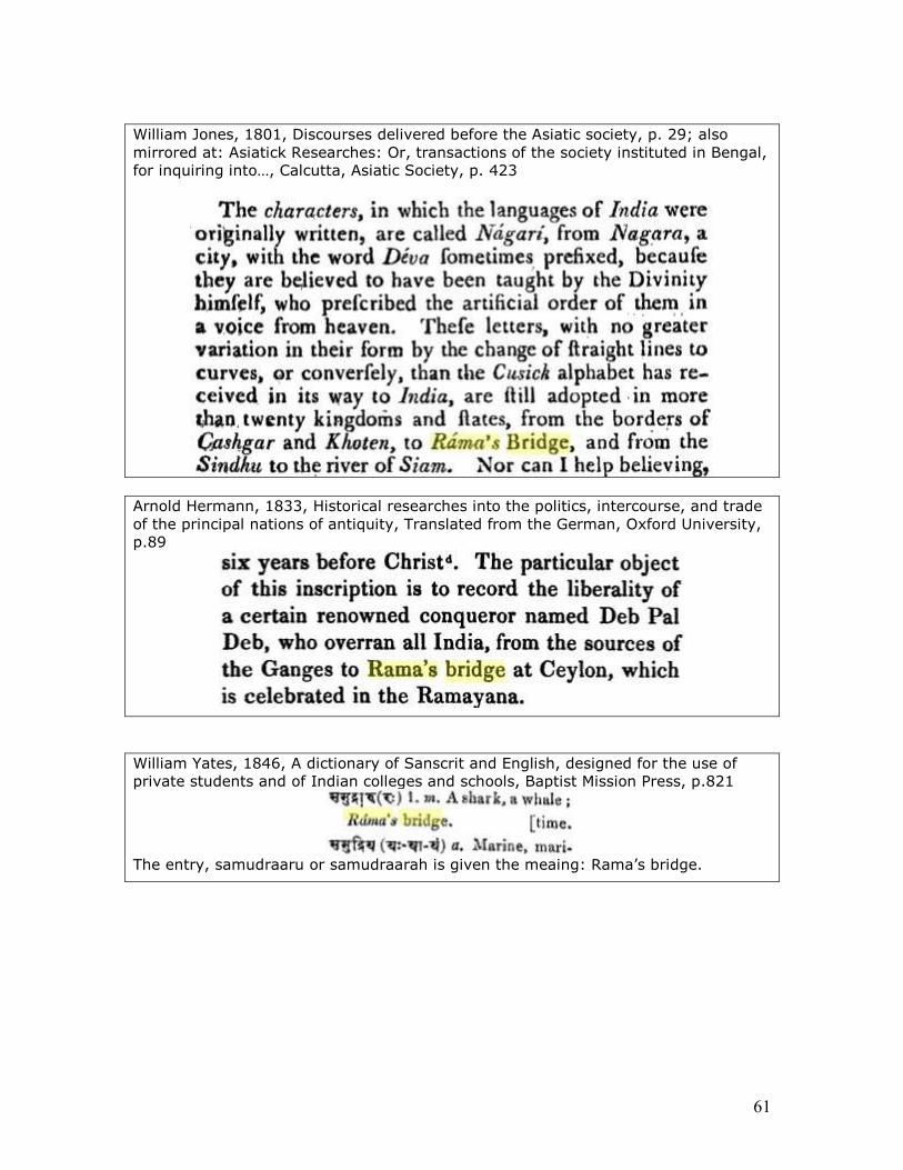
61
William Jones, 1801, Discourses delivered before the Asiatic society, p. 29; also mirrored at: Asiatick Researches: Or, transactions of the society instituted in Bengal, for inquiring into…, Calcutta, Asiatic Society, p. 423
Arnold Hermann, 1833, Historical researches into the politics, intercourse, and trade of the principal nations of antiquity, Translated from the German, Oxford University, p.89
William Yates, 1846, A dictionary of Sanscrit and English, designed for the use of private students and of Indian colleges and schools, Baptist Mission Press, p.821
The entry, samudraaru or samudraarah is given the meaing: Rama’s bridge.
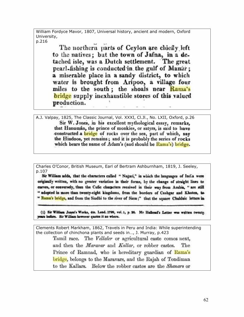
62
William Fordyce Mavor, 1807, Universal history, ancient and modern, Oxford University, p.216
A.J. Valpay, 1825, The Classic Journal, Vol. XXXI, Cl.Jl., No. LXII, Oxford, p.26
Charles O’Conor, British Museum, Earl of Bertram Ashburnham, 1819, J. Seeley, p.107
Clements Robert Markham, 1862, Travels in Peru and India: While superintending the collection of chinchona plants and seeds in…, J. Murray, p.423

63
Charlotte Speir Manning, George Scharf, 1856, Life in Ancient India, Oxford University, p. 117:
Lodovico de Varthema, George Percy Badger, John Winter Jones, 1863, The travels of Ludovico di Varthema in Egypt, Syria, Arabia Deserta and Arabia Felix, in Persia, India…, Published for the Hakluyt Society, (Translated from the original Italian edition), p.185
Entry: INDIA, INDIES In a copperplate of the 11th century, by the Chalukya dynasty of Kalyāna, we find the expression "from the Himālaya to the Bridge" (Ind. Antiq. i. 81), i.e. the Bridge of Rāma, or 'Adam's Bridge,' as our maps have it. And Mahommedan definitions as old, and with the name, will be found below. Under the Hindu kings of Vijayanagara also (from the 14th century) inscriptions indicate all
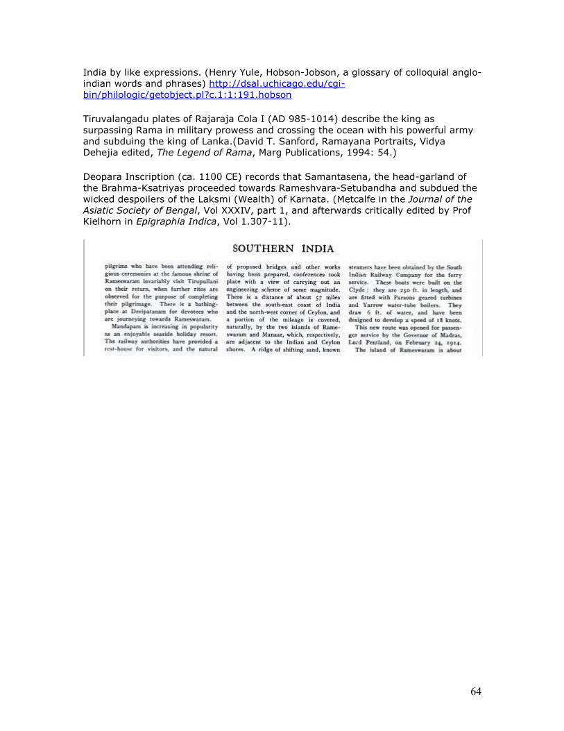
64
India by like expressions. (Henry Yule, Hobson-Jobson, a glossary of colloquial anglo-indian words and phrases) http://dsal.uchicago.edu/cgi-bin/philologic/getobject.pl?c.1:1:191.hobson
Tiruvalangadu plates of Rajaraja Cola I (AD 985-1014) describe the king as surpassing Rama in military prowess and crossing the ocean with his powerful army and subduing the king of Lanka.(David T. Sanford, Ramayana Portraits, Vidya Dehejia edited, The Legend of Rama, Marg Publications, 1994: 54.)
Deopara Inscription (ca. 1100 CE) records that Samantasena, the head-garland of the Brahma-Ksatriyas proceeded towards Rameshvara-Setubandha and subdued the wicked despoilers of the Laksmi (Wealth) of Karnata. (Metcalfe in the Journal of the Asiatic Society of Bengal, Vol XXXIV, part 1, and afterwards critically edited by Prof Kielhorn in Epigraphia Indica, Vol 1.307-11).
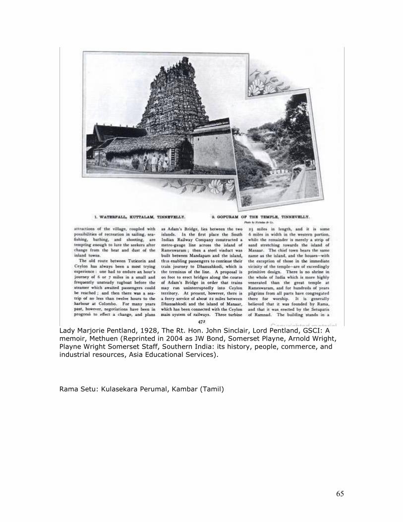
65
Lady Marjorie Pentland, 1928, The Rt. Hon. John Sinclair, Lord Pentland, GSCI: A memoir, Methuen (Reprinted in 2004 as JW Bond, Somerset Playne, Arnold Wright, Playne Wright Somerset Staff, Southern India: its history, people, commerce, and industrial resources, Asia Educational Services).
Rama Setu: Kulasekara Perumal, Kambar (Tamil)
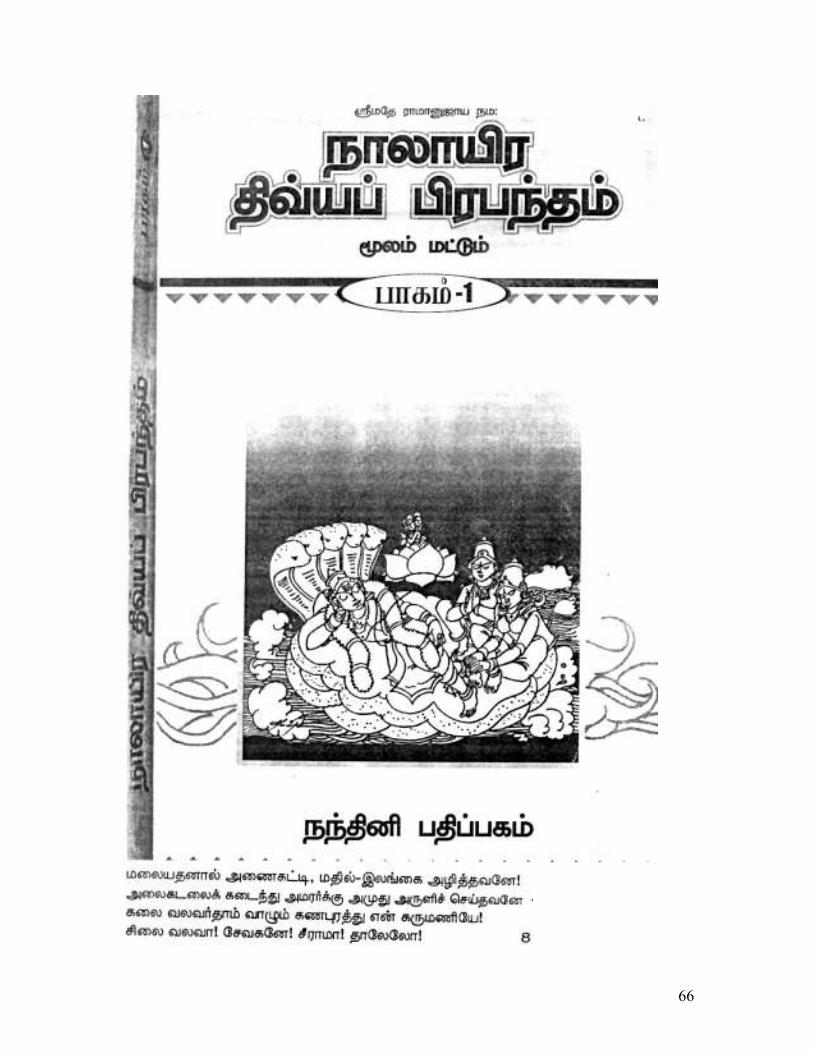
66
67
(Kulasekara Perumal)
68
69
70
71
72
73
74
75
76
77
78
79
80
Rama Setu: Tulasidas
81
82
83
84
85
86
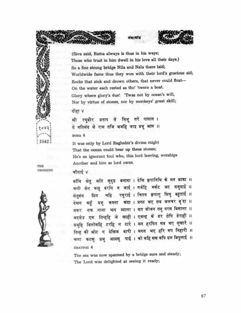
87
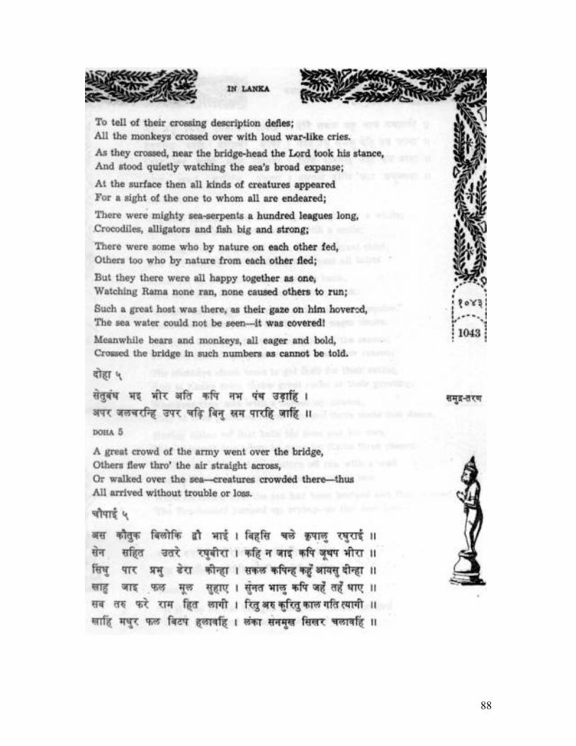
88
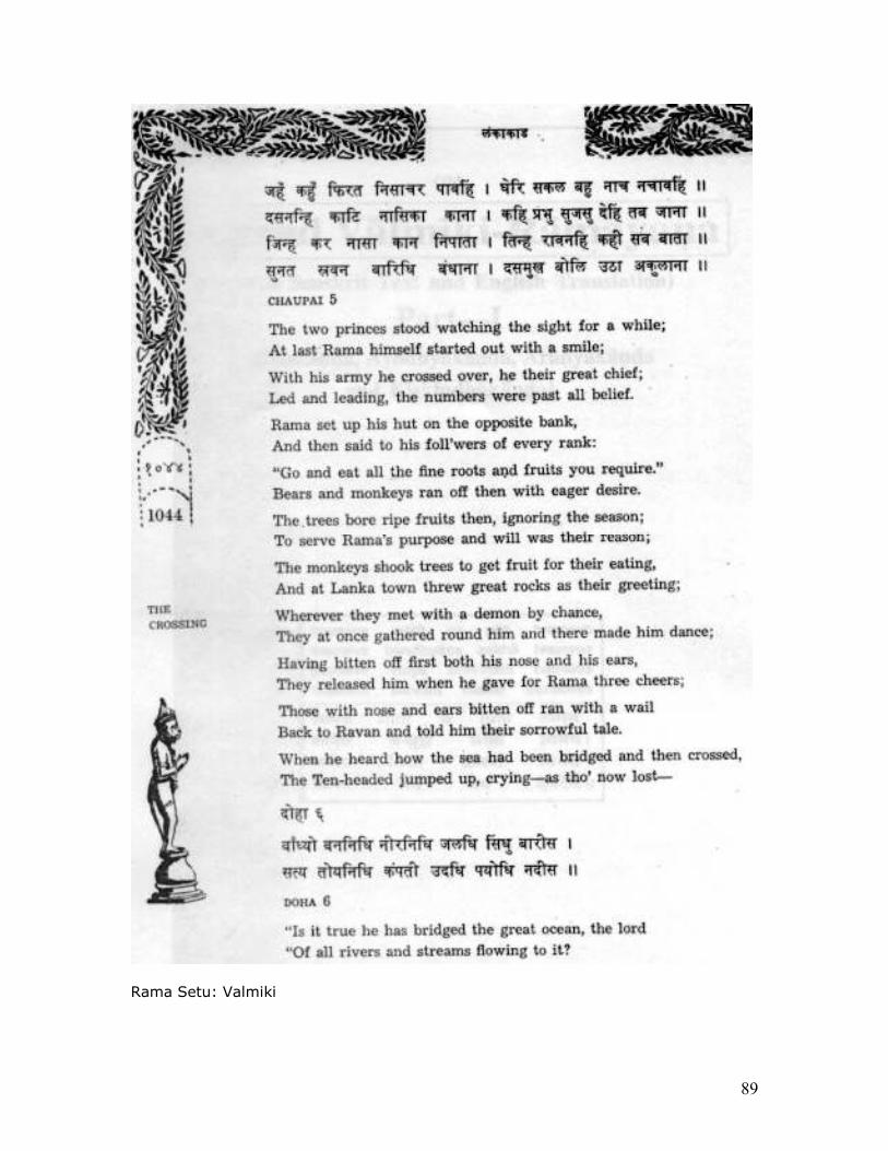
89
Rama Setu: Valmiki
90
91
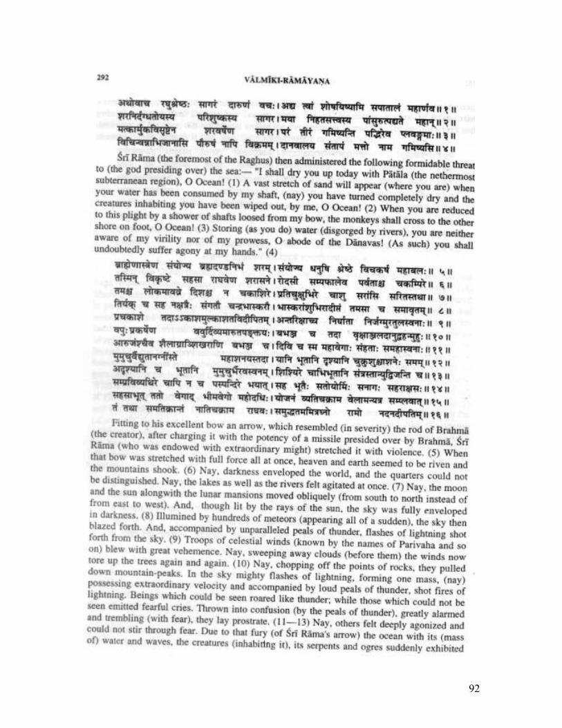
92
93
94
95
96
97
98
99
Sri Rama’s Sethu in Literature- A truth
Sri. TV Rengarajan
South Zone Organizing Secretary, Itihasa Sankalan Samiti -Tamilnadu
Annal Kakutthan Aazhpunal Sethuvai, Kanninal orukal Kanda manavan Ennil Velvi Tavam Punal Yattirai, Panni Muttriya Panpudaiyan Aro !! - Sethu Puranam - Sethu Sarukkam -
Verse 16
“One who sees the ‘sethu’ built by the great Rama, who is also called Kakutthan
once, will perform countless yagnas, tapas and tirtha yatras and will remain a
man of great strength and character”, says Sethu Purana.
1.1. The word ‘sethu’ means ‘anai’, ‘seikarai’1. Tamil Akaramudali gives the meaning
‘anaikkattu’ (dam) to the word ‘sethubandhanam’2. Kamban, who wrote the Tamil
classic ‘Kamba Ramayanam’ also refers as ‘sethubandhanappadalam’3. All these
points make it clear that this was built by human beings.
1.2. ‘Sethu’ is the waterbody in which SriRama purified himself from ‘Brammahatti
dosha’ on his return from Lanka after killing Ravana. It is located in the sea in
Rameshwaram area near ‘sethubandhanam’. Abhidhanakosam4 calls
‘Sethubandhanam’ as ‘Tiruvanai’ - a dam or bridge built by Sri Rama and the Vanara
Sena (Monkey’s army) in the sea to cross over it and reach Sri Lanka. Further,
Rameshwara Talapuranam calls all these happenings as “Sethu Puranam”.
1.3. ‘Somalay’5, a great Tamil scholar says ‘sethu’ was the dam built by Sri Rama in
order to crossover to Srilanka with his huge vanara sena (monkey army) with the
help of monkey leaders.
1.4. ‘Tiruppullani’ - which is at a distance of 6 miles from Ramanathapuram
(Ramnad) is known as ‘Pullaranyam’, ‘Pullanai’, ‘Adisethu’, ‘Tiruvanai’ and
‘Sethukkarai’6
1.5. ‘Namadheepa Nikhandu’ names ‘seikarai’ as ‘seikarai’, ‘kurambu’, ‘sethu’, and
‘kulai’7. It also names Rameshwaram as ‘Sethupuram’ and ‘Ramasuram’8.
100
1.6. The area surrounding ‘sethu’ - the dam built by Sri Rama on sea is called as
‘sethunadu’. Kalaikkalangiyam (Tamil encyclopedia) 9 refers to ‘Ramanathapuram
district’ as ‘Sethu Nadu’.
1. Tamil - Tamil Akaramudali - Editor M.Shanmukam Pillai - Tamil Nadu Text Book Society, A Government of
Tamil Nadu Publication - First Edition - Jine 1985.
2. Valmiki Ramayanam - Yuddha Kandam - Sarukka 22 - Sethubhandha
3. Kamba Ramayanam - Yuddha Kandam - Sethubhandhanappadalam
4. Abhidanakosam - The Tamil Classical Dictionary - Yazhppanattu Manippai A.Muthuthambi Pillai - Asian
Educational Services - First Published 1902
5. Namadu Tamil Nadu Series 9 - Ramanathapuram Mavattam - Somalay - Pari Nilayam Chennai, May 1972 -
P.33
6. Pullai Andati - Thanjai Saraswati Mahal Publication 116 - 1967- P.2,Price 1.25
7. Namadeepa Nikandu - Idavargam - P.159 - verse 54 (Nurpa 530)
8. Namadeepa Nikandu - Idavargam - P.153 - verse 33 (Nurpa 509)
9. Kalaikkalangiyam - Volume 5 - Tamil Valarcci Kazhakam, Chennai - First edition - 1958 - P.207
Sethu bandhanam in epics
2.1. Valmiki10 describes the construction of ‘Sethu’, which was built in a record time
of 5 days under the leadership of Nala, the son of Viswakarma, in his Ramayana in
25 verses. Rama asks Nala to construct a dam on the sea to Srilanka, as advised by
Samudraraja. Nala agrees and Vanaras who looked like high mountains went in all
directions and brought mountain like rocks and stones. They brought trees, either
cut or uprooted.
The vanara sena uprooted rocks which resembled huge elephants, using machines
and brought them to the seashore with the help of carrier vehicles. “The dam
constructed by Nala who was as skilled and talented as his illustrious father, looked
like milky way” says Valmiki. The joyous roar raised by the vanaras on completion
of the dam silenced even the deadliest noise of the mighty ocean.11
2.2. Valmiki further describes in another verse in the words of Rama returning with
Sita in a Pushpaka Vimana in ‘Yuddha Kanda’ of Adyatma Ramayanam as follows:
“Here is the Sethubandhana worshipped by three worlds. It is a holy place. It has
the ability to relieve all the greatest of sins. It is here ‘Mahadeva ’ [Lord Siva]
extended his whole hearted support to me earlier.”12
101
2.3. After initiating the construction of Sethu, Rama installed the idol of
‘Rameshwara’, and worshipped. Then he said, “Those who worship Rameshwara
by observing fasting and prayer, those who perform ‘abhiseka’ with the holy water of
Ganga brought by them from Kasi - all their sins will be thrown in to the mighty
ocean. They will attain ‘moksha’ (Mukti) without any doubt”, says Adhyathma
Ramayanam about Sethu bandhanam and its holiness.13
2.4. Ananda Ramayanam14 describes the beginning of the construction of the dam as
follows: ‘Rama, who hails from Raghu Dynasty, installed the idol of Lord Vinayaka
after explaining about the dam to Nala. Then Rama worshipped the 9 stones
installed by Nala, representing the 9 planets. He then conveyed his willingness to
Hanuman about installing a wonderful linga in his name where the three seas meet.
2.5. “The mountain like dam ‘Nalasethu’ was built as per the orders of Rama” says
Vyasa in his Mahabharatha15.
10. Hastimathran Mahakaya: Basha Namsa Mahabala: Parvathamsa Samuthpatya yanthrai: parivahantisa - Valmiki
Ramayanam - Yuddha Kandam Sarukkam 22 - Verse 58
11. Valmiki Ramayanam - Sarukkam 22 - Slokas 51 - 75
12. Yetat drushyate tirtham sagarasya mahatmana:
Sethubhandha idikyathan Trilokyenapi poojitham\\
Yetat pavitram paramam mahapataka nasanam
Atra purvam Mahadeva: Prastha Maharotaprabhu: - Valmiki Ramayanam - Yuddha Kandam - 126.20.1
13. Adyathma Ramayanam - Yuddha Kandam
14. Ananda Ramayanam - Sarakandam (Sarukkam 10 - verse 69)
15. Mahabharatham 3.267.45
Puranas
3.1. Bhagavatha Puranam says that Balarama went to the dam which can purify
even the greatest sins. ‘Samudhram Se Mahamath Mahapataka Nasanam’, Says
Bhagavatha16.
3.2. Padma Puranam17 says, “this sethu was built by me within 3 days with the help
of Vanara Sena.”
3.3. Skanda Purana 18 says the mere vision of Rama Sethu will relieve one from
Samsara bandhas.
102
Thus, Epics and Puranas say that the dam Sethu was built in the middle of the sea
by Rama and say that it is a holy one.
Literature
4.1. There is a reference to Sethu in Tamil Sangam classic Akananuru 19 which
compares the sound made in a village to that of the sound heard from the sea near
‘Thriuvanaikkarai (Adi Sethu), in Pandya Kingdom which was built by Rama, the
great warrior.
4.2. Periyavaccan Pillai, one of the Vaishnava Acharyas, writes as
“Malaiyal Anaikatti Marukarai eri”20 in his Pasurappadi Ramayanam.
4.3. ‘Sethu Puranam’ also known as ‘Sethu Mahatmiyam’ - a sangam classic which
contains45 Sarukkas and 3438 verses and which was written by Niramba Alagiya
Singar (16th Century) and Verified by Nallur Arumuga Navalar of Jaffna and
published by Chidambaram Saivapprakasa Vidyasala Dharmaparipalakas. Sri
Ponnusamy Thevar of Ramanathapuram Samasthanam took up the efforts to publish
this work to which Sodashavadanam Subbiraya Chettiyar, a deciple of Tiricirapuram
Mahavidvan Meenatchisundaram Pillai has contributed the ‘Sirappuppayiram’. In
that, he has sung in
praise of Sethu as - ‘ Titara oduum Sethu Manmiyatthai’. Another poet Kumarasami
Pillai has mentioned as ‘Sethumanyamana vadanul thannai’. In the prayer song of ‘
Sethu Puranam’ the dam built by sri Rama has been mentioned as “Tuya Seer
Ramasethu”.
Sethu’s greatness and its holiness has been sung in 64 verses in the chapter ‘Sethu
Sarukkkam’. The necessity to built Sethu for Sri Rama has been explained in Sethu
Vanda Sarrukkam’. After explaining’ ‘Sethu Madhava Sarukkam’, Sethu Yatthirai
Sarukkam’, the benefits reaped in merely thinking about Sethu and taking the holy
dip are detailed in 151 verses. Tala Puranam 21 (Volume I) in Tamil literature also
mentions about ‘Sethu puranam’.
16. Bhagavathapuranam 10th Skandam - Sarukkam 79
17. Padmapuranam - Srustikandam - Sarukkam 38
18. Skandapuranam - Sethu Mahatmiya Kandam - Sarukkam 1
19. Venverkavuriyar tonmudukodi
Muzhangirum Bouvam Irangum Mundrurai
velpor Raman arumaraik kavittha
Palvizh alampola oliyavindandru iv vazhungal ure - Akananuru - Kalirt - Padal 70
103
20. Vizhineer Ilankai aruli, saranpukka kuraikadalai
adalampal marukaeidu, tollai vilangu ani seyya
malayal anaikatti marukarai eri Pasurappadi Ramayanam - Yuddhakandam - Periyavaccan Pillai
21.Tamizhil Talapuranangal (Part 1) Dr.V.R.Madhavan - Tamil University - Thanjavur - P.193 - Tirumala Tiruppati
Devasthana Aid - 1995
4.4. It remained a traditional practice of Tamilians to give lectures in praise of ‘Sethu
Puranam’. Arumuga Navalar, who was one among those, has also written it in
manuscripts. It was printed and published by Sri M.R.M.S. Ramalinga Pillai of
Rameshwaram for 12 anas in the name of ‘Sethu Makattuvam’ (Rameshwara
Manmiyam). This “Sethu Puranaprasangam’ which begins with Suta Puran is
narrating the story to Sounakadi Rishis in Naimisaranyanm is a dialogue based one22.
4.5. “Anaiyalai Sulkadal Andradainadu Vazhiseithavan” 23 says Thiru Gnana
Sambandar in his Tevaram.
4.6. Thirunavukkarasar in his Tevaram sings the construction of the dam by Sri
Rama as “ Kadalidai Malaikal Tammal Adaittu Mal Karumam Muttri”.24
All the above references from epics puranas and literature - written in different
languages, in different times stand testimony to the fact that the dam ‘Sethu’ was
built as per the orders given by Sri Rama to Nala.
5.1. Sethu Nadu: The Samashthana of Ramanathapuram (Ramnad) was called as
‘Sethu Nadu only
because of the very existence of ‘Sethu’. The king of this samashthana was known
as Sethupati 25, ‘Sethu Kavalar [Lord of the Cause way]. Thirupullani which is at a
distance of 6 miles southeast of ‘Ramnad’ is known as Adisethu. Ramayana says
Sri Rama appointed people from Maravar community to protect ‘Sethu’ and the
people who come to take a holy bathe in it. One of the kings of ‘Sethupati dynasty’
constructed a town near ‘Thirupullani’.
It was named as “Mugavai” as it stood as the gateway to reach ‘Sethu’. Later it
became Ramanathapuram26. It is obvious that the kings of ‘Sethu’had longcherished
tradition. Among them, :
Adiraghunatha Sethupati, Jeyatunga Raghunatha Sethupathi,Ativeera Rahunatha
Sethupati Varaguna Raghunatha Sethupati and 6 others are mentioned as the
earliest ones of the Sethupati dynasty27.
104
The names ‘Rahunatha’ and ‘Sethupati’ are attached to them, because of their
relationship with Sri Rama [Who is also called Raghunatha] and the dam built by
him. All the kings of this dynasty are called as ‘ Sethupati’ by the people of
successive generations. It stands as a clear testimony to the existence of Rama
Sethu and also to the point that all the kings of the ‘Sethupati’ dynasty ruled this
area with great devotion and dedication28.
22. Inaiya Sethu Neeradinum, teendinum, idutanai egngnandru ninaivu
seikinum kankinum, ketpinum, neengidun tuyarellam anaiyum
atthanmayidum mayavan arul seyyum ac Sethutanai
nikarppatondrillaiyam - tavaneri tazhaikkum andanarkalo - Sethubhandhana Makattuvam
23. Sanpanta Tevaram - verse 6
24. Thirunavukkarasar Tevaram - verse 3
25. Kalaikkalangiyam Volume 5 Tamil Valarccikkazhakam, Chennai - First Edition 1958
26. Rameshwaram (The Sacred Island) by Major H.A.Newell - Indian army - II edition
27. Abhidana Cintamani - A.Singaravelu Mudalaiyar - V.1628 The Setupatis of Ramnad - Page 126, by
S.Thiruvenkatachari
28. Kizhavan Setupati - M.Manoharan, 1983, Setupatikal Varalaru - Chiranjeevi 1981
5.2. Things have changed dramatically since the inception of Ramanathapuram
district in 1910. The finalization of manual about the political, geographical,
industrial, agricultural, economical growth, besides information about population its
distribution, transport, revenue, ports, holy places got a final shape after passing
through several stages in 1968. It was released only in 1972 after making necessary
changes.
The foreword to the district manual of Ramanathapuram released by the then Chief
Minister of Tamilnadu, Sri M. Karunanidi is note worthy.
“The task of collecting and publishing the district manuals was given top
priority after independence and was given preference in the five year plans. The
District manual of today is not only a guide furnishing mear information. It is of
great help containing several important topics and can be used very much as a
source of great reference. A manual throws light on our age and traditions and long
cherished culture. It serves as a mirror which reflects our society. Once having a
thorough knowledge of the manual we can march forward keeping our head high and
be proud of our well nurtured culture and traditions, which has been passed on to
105
the successive generations by our ancestors. Only the passage of time will reveal
the necessity of such manuals, which help us to know about our country and people.
By publishing the district manual of Ramanathapuram district, a commendable work
has been completed. It is all the more commendable since it contains detailed
information about the district and its people. I am sure that this manual will be of
immense help to the rulers and people who are involved in welfare projects and
research work. -M. Karunanidhi
14.06.1972
The above cited literary and historical evidences prove the existence and the
greatness of ‘Rama Sethu’, which are acceptable to even today’s politicians. Once
knowing its greatness it becomes a necessity to take all steps to protect it.
Annex 2. AR Mudaliar Committee (1956) Report against any passage across Adam’s Bridge (Rama Setu)
Excerpts below provide an overview of the alternative channel alignments considered to either create a canal or just a passage across the Gulf of Mannar and Palk Straits. The categorical recommendations of AR Mudaliar Committee (1956) in Paragraph 16 are as follows, against any passage across the Adam's Bridge.
We are convinced that the Adam's Bridge site is unsuitable for the following reasons: First: The shifting Sandbanks in this area present a far more formidable problem – both at the stage of construction and during maintenance – than the sand dunes on the island site. Secondly: The approaches to a channel would be far too open with no possibility of construction of protective works. A channel at this site – even if it can be made and maintained (which is unlikely) – would entail definite navigational hazard. Thirdly: The channel would be bordering on the Setusamudram Medial Line. In these circumstances we have no doubt, whatever that the junction between the two sea should be effectd by a Canal; and the idea of cutting a passage in the sea through Adam's Bridge should be abandoned.
106
Annex 3. Sethusamudram Shipping Channel: it doesn’t make nautical sense
Will ships use canal at such costs?
K.S.Ramakrishnan
Former Deputy Chairman, Madras Port Trust
Madras Musings 1-16 July 2005
The basic justification of the Setusamudram Ship Canal Project (SSCP) is that it will reduce the distance between Kolkata and Tuticorin by 340 nautical miles and between Chennai and Tuticorin by 434 nautical miles, thereby saving for the ships plying between these places both fuel cost and time involved in sailing the additional distance.
This justification will be readily valid if the SSC is a free seaway which ships can sail through without any payment to the project authority.
But the SSC can not be a free seaway… as ships will be allowed to pass through the canal only under regulated pilotage, and pushed /pulled by tugs belonging to the SSCP.
Obviously, even while saving on the cost of fuel, a ship passing through the canal will be expected to make a payment to the SSCP for using the facility.
The likely pilotage charge to be levied by the SSCP has not been made public, but an approximate figure can be guessed by extrapolating similar charges levied by the Chennai and Tuticorin Port at present.
The approach channel to the Chennai port has a length of 7 km. A 36,000 tonne coal ship calling at Chennai has to pay approximately Rs.21.75 a tonne, or a total of Rs.7.83 lakh, as pilotage charges averaging Rs.1.11 lakh per km.
Tuticorin's approach channel is only 2.4 km long and an identical coal ship calling at this port is levied Rs.17 a tonne, or a total of 6.12 lakh, towards pilotage, working out to Rs.3 lakh per km.
(The comparative lower rate per km at Chennai is because the capitol cost of digging the much older channel has been amortised a long time ago.)
The projected length of the Setusamudram channel is 56 km. Both capital and recurring cost will be much higher for the SSCP than for the Chennai and Tuticorin ports, and its levy of pilotage per km is likely to be substantially higher than that of even the latter if it has to have a 9 per cent return on the capital.
Even if the Chennai rate is assumed, the same ship will have to pay over 60 lakhs to the SSCP for passing through the canal.
107
But the cost of fuel that will be saved by the same ship by taking the shorter route through the Setusamudram canal instead of sailing round Sri Lanka will be less than Rs. 7 lakh, which is even less than 1/8 of SSCP's likely levy.
The saving in sailing time for that ship will also be substantially less than the 36 hours projected by the SSCP because the ship can not be towed through the canal at its normal speed through the canal, and the time will also be lost in embarkation/disembarkation of pilots and other inspection procedures. The saving in sailing time of just about a day will not justify the incurring of over 8 times the cost of fuel saved.
http://www.Setusamudram.in/htmdocs/Articles/Article%201.htm An essay in three parts by Capt (Retd) H. Balakrishnan, I.N Part 1: A mariner’s perspective Part 2: Time and space calculations – navigating around Sri Lanka and through SSCP Part 3: Cost-benefit analysis Part 1: THE SETHUSAMUDRAM SHIPPING CANAL PROJECT-(SSCP) -A MARINER’S PERSPECTIVE INTRODUCTION
1. The SSCP is an off-shore shipping canal project in the PalkBay. It plans to cut short the distance navigated by ships sailing from the West coast of India and bound for ports on the Eastern seaboard and vice versa, by precluding the necessity to circumnavigate around Sri Lanka.
2. The total length of the SSCP in the Palk Bay is 152.2 Kms. It is divided into three legs. The Southern leg in the Adam’s Bridge area is 20 Kms. The Northern leg in the Palk Strait area is 54.2 Kms. The Central portion is 78 Kms. Dredging is to be carried out in the Southern and Northern legs to maintain a dredged depth of 12 metres. This would facilitate a navigable channel for ships with a draught of upto 10.7 meters. The canal will be 300 meters wide.
3. The basic justification advanced in favour of the project is that it will reduce the sailing distance between Kolkata and Tuiticorin by 340 nautical miles and between Chennai and Tuiticorin by 434 nautical miles. This enables savings in fuel costs and sailing time, for ships plying between these ports.
4. This paper aims to analyse the viability of the SSCP against the canvas of the following factors, that have a bearing on shipping:
(a) Environmental Factors (b) Security Implications (c) Navigational and Allied Factors
ENVIRONMENTAL FACTORS
108
Tropical Cyclones
5. The India Meteorological Department has assigned the Palk Bay area as a ‘High Risk Area’ for cyclonic activity. The cyclone season in the Bay of Bengal is generally between Oct to Jan. It is interesting to note that the IMD’s records from 1891-2001, states that of the 452 cyclones that hit the Indian coastline, 256 were on the East coast. We mariners, in a lighter vein, refer to the Tamil Nadu coast between Rameswaram and Cuddalore as the ‘cyclone coast’!! There are valid reasons for this quip. Of the 256 cyclones referred, 64 have crossed the Tamil Nadu coast in this period. Of these, 36 were ‘severe cyclones’ (winds in excess of 90 Kmph). More interesting, of these cyclones, SIX have crossed the Palk Bay, 14 have crossed the coast at Nagapattinam and THREE have crossed the Gulf of Mannar. All these cyclones can have a devastating consequence on the SSCP and shipping in the area.
6. A few more examples of the devastating consequences of these cyclones, will be illustrative:
(a) In Dec 1964, a cyclone washed away the Pamban Bridge. (b) In Dec 1973, FIVE metres high tidal waves hit the Palk Bay area – the very same
area where the SSCP is to be dredged!! (c) In Dec 1977/78, under the influence of a severe cyclonic storm that crossed the
coast near Nagapattinam, 120 Kmph winds were recorded in the Palk Bay area. (d) In Nov/Dec 1997/98, an oil-drilling ship, anchored with SIX anchors in the
Cauvery Basin, broke loose from her anchors and was washed ashore by a cyclone.
7. The foregoing will serve to illustrate the fact that the Bay of Bengal cyclones pose a ‘clear, live and present danger’ to ‘Safety of Lives at Sea’ (SOLAS). And, the SSCP is sought to be created in a ‘cyclone danger area’!! Siltation
8. Allied to the cyclonic activity in the area, is the problem of siltation leading to a loss of sea depth. Scientists have concluded that the Palk Bay area is one of the FIVE areas, off the Indian coast, where siltation takes place regularly. Some of their calculations have indicated a loss in sea depth of about 1 cms every year. It is pertinent to state that TWO of the LEGS of the SSCP, where dredging is to be undertaken, happen to cross two such micro regions where high siltation takes place.
9. To conclude, the environmental factors of cyclonic activity and siltation rates in the Palk Bay area, impinge on shipping safety. It is also appreciated that maintenance dredging may have to be undertaken through the year to maintain dredged depths. This could lead to substantially increasing the costs of the SSCP. SECURITY IMPLICATIONS Global Scene on Maritime Terrorism
10. While terrorist attacks are predominantly land based, non-state actors have also sought to exploit vulnerabilities in shipping, ports and the container supply chains in Asia, Middle- East, Europe and North America.

109
11. Conventional arms trade and smuggling, both highly profitable global businesses,
are spreading increasingly sophisticated conventional weapons to non-state actors, including long- range anti-ship missiles, unmanned aerial vehicles and close range armour piercing missiles and rocket propelled grenades. All these weapons are capable of inflicting serious damage to ships.
12. The list of foiled, failed and successful attempts in maritime related terrorism over the past decade is significant. Yet, there is a tendency to overlook or downplay what has happened, and thus ignore the possibility of further trouble. It is clear that terrorists can see the potential of using the maritime trading system and its land links in the container supply chain to conceal weapons or agents for attack purposes. Two recent examples of terrorist attacks on naval warships help illustrate the point.
13. Attack on the U.S.S. Cole. In Oct 2000, Al-Qaeda operatives in Yemen, packed a
small boat with explosives and rammed the same onto the U.S. Navy destroyer, U.S.S. Cole, while the ship was in harbour. The blast left a gaping hole on the side of the destroyer and the cost of repairs amounted to USD 250 million. The blast killed 17 U.S. Naval sailors and, wounded another 40 seamen. 14. Missile attack on Israeli Naval Ships. On 14 Jul 2006, two days after hostilities between Israel and the Hezbollah commenced, the latter fired TWO, C-802 radar guided cruise missiles from ashore in Lebanon, at Israeli naval vessels patrolling off the Lebanese coast. One missile seriously damaged an Israeli naval corvette. The second missile narrowly missed another corvette. Instead it hit a Cambodian registered merchant vessel, sinking it with eleven hands on board. The LTTE Factor
15. The LTTE factor has a direct bearing on the safety of shipping navigating through the SSCP. The LTTE has control over most of North Sri Lanka coastal region and the seas contiguous to it. The Sea Tigers, the naval arm of the LTTE, have displayed considerable ingenuity and daring in sea borne insurgency. They have carried out numerous daring attacks on Sri Lankan naval ships, and have not hesitated in resorting to suicide missions. It is pertinent to note that the SSCP is a ‘next-door-neighbour’ in the area of operations of the Sea Tigers!!
16.A new addition to the LTTE’s fighting capability is its ‘Air Arm’. They have todate carried out THREE daring ‘night attacks’ on Sri Lankan assets. This factor adds a new dimension to the threat perception along the SSCP.
17.Reports in open source literature indicate that the aircraft deployed by the LTTE Air Force is the Czech manufactured ‘ZLIN-Z 242 L’ aircraft. These appear to have been purchased from a private South African flying club. The aircraft is delivered in a knocked-down condition and can be easily smuggled as automobile parts or components of heavy commercial vehicles. By all accounts these aircraft were ferried by sea using forged Bills of Lading. This corroborates Para 11 above.
18. Reports also indicate that the flying training for the LTTE’s pilots was carried out by the same South African flying club. It is also suspected that armament training were carried out by mercenaries in South Africa. All the air attacks on Sri Lankan assets todate have been at night, indicating a high degree of proficiency. The SSCP falls within the radius of operation of these aircraft!!
110
19. Media reports of 28 Apr 2007 in Chenai, attributed the recent killings of the TN
fishermen at sea to the LTTE Sea Tigers. The grounds for the killings, attributed to LTTE sources, was that these fishermen were ‘spying’ on the LTTE’s activities at sea!! If that be the case, the possibility of the LTTE advancing the same argument for attacking ships navigating through the SSCP cannot be ruled out. The consequences of a ship sinking in the canal could have a disastrous impact on the viability of the project itself. It would have a psychological impact on the shipping industry which may then tend to avoid the SSCP and circumnavigate Sri Lanka in the larger interests of safety of men and material. NAVIGATIONAL AND ALLIED FACTORS
20.The official website of the SSCP states: “ Ships originating in the West of India and destined for Chennai, Ennore, Vishakapatnam, Paradeep, Haldia and Kolkata have to travel around the Sri Lankan coast resulting in increase of travel distance and time. Apart from this ships belonging to the Indian Navy and Cost Guard need also to traverse around Sri Lanka- - “ . Navy and Coast Guard
21. The website statement about the Navy and the Coast Guard would give the impression Naval/Coast Guard ships sail to and from either coasts on a frequent basis. In reality this is not the case.
22. The navy has been operating on a ‘Two Fleet’ concept for over three decades, to safeguard our maritime interests on the Eastern and Western seaboards. New induction ships are allotted to both Fleet to maintain the required Force Levels on both coasts. Thus the requirement for ships to cross over to the other coast is more the exception than the rule. At the most, they may meet annually for a combined Fleet exercise programme.
23. Besides, peacetime sailings of the Fleet are to hone skill levels in battle-manoeuvres, missile and gun firings, submarine exercises, aircraft operations and underway re-fuelling exercise at sea. All these and other exercises are conducted in areas far removed from the coastal and international shipping lanes for obvious reasons. Under these circumstances and considering the security implications in the area contiguous to the SSCP, it is debatable whether a Fleet would prefer to navigate through the SSCP. Also, if the Fleet happens to be a carrier battle group, availing the SSCP route can be almost ruled out, on account of various tactical factors.
24. During the period of hostilities, it is improbable that ships on passage to either coast would navigate through the SSCP as it militates against the basic principles of naval operations of avoiding straits and narrows to maintain secrecy of deployment.
25. Similar arguments can also be advanced on the deployment of Coast Guard vessels. Mercantile Marine
26. It must be borne in mind that the SSCP is not an ‘open seaway’. Thus for ships to safely traverse through the canal, it will be mandatory to embark a ‘pilot’. A ‘pilot’ is a mariner with experience pertaining to local conditions. He would normally board a vessel at either extremity of the canal and take the vessel safely to the other
111
extremity before disembarking. It is not clear at the present juncture, whether vessels calling at the SSCP will have a ‘pilot’ boarding on arrival. Delays in the boarding of the ‘pilot’ will entail the vessel to anchor and await the ‘pilot’. Under adverse weather conditions this is not a comforting thought to a mariner. Besides, during cyclonic weather, sea conditions may preclude the embarkation of a ‘pilot’. What does the vessel then do?
27. Open source literature on the SSCP indicates that vessels upto 32,000 DWT can navigate through the canal. However, in the current global shipping scenario, to reduce the operating costs and cater to the enormous growth in shipping needs, trends are towards operating vessels of 60,000 DWT and above. This trend is likely to grow further in future, resulting in vessels of larger tonnage. A passage along the international shipping lane from South of Sri Lanka to South of the Great Nicobar Island will prove this point. None of these large vessels can avail of the facility of the SSCP.
28.This would leave the coal carrying bulk carriers on charter to the TNEB, the only ships that would use the SSCP on a regular basis. These vessels load coal at Haldia/ Paradeep/ Vishakapatnam and discharge the same at Chennai and Tuiticorin for the Thermal Power Plants. Besides, some smaller container feeder vessels from Colombo and bound for Chennai could also use the SSCP.
29. In the opinion of Mr. K.S. Ramakrishnan, former Deputy Chairman of Chennai Port Trust and former Managing Director of the Poompuhar Shipping Corporation, the pilotage costs of navigating through the SSCP and certain allied factors, could make the SSCP unattractive to the shipping industry. It is his opinion that the actual use of the SSCP maybe substantially lower than the projected figure of 3417 vessels by 2010 and 7141 vessels by 2025. CONCLUSION
30.A report in the magazine ‘Frontline’ of 01 Jan-14 Jan 2005, entitled ‘Of Gains and Loses’, states: “ George Gomez, Tamil Nadu Manual Workers’ Union, Tuiticorin, who has several decades of experience in the shipping industry, says the Project cost will work out to Rs. 3000 crores. He says the Project will be a ‘sick unit’ as the money invested can never be recovered. ‘I don’t think any container ship will use the canal’. Major container operators deploying mother-vessels, will not use it. The difference in time between ships using the canal and those going around Sri Lanka will only be a few hours. Ships would not be able to cruise fast in the canal because they will have to be piloted, he argues. Moreover, the canal will have to be dredged continuously.”
31. In the Chennai based English daily, The Hindu, of 21 Dec 2004, Mr. K.S.
Ramakrishnan, former Deputy Chairman of the Chennai Port Trust had questioned the need for the canal. He had stated: “- - - . But the canal cannot be a free seaway because the grounding of a wayward coal or oil ship that strays from the alignment or a collision of two ships in the channel will result in an ecological disaster of unimaginable proportions to the Gulf of Mannar and the Palk Bay”. He further stated: “ The two statements that the ships using the canal will save money and that the project will be a financially viable undertaking are therefore mutually contradictory and cannot have simultaneous validity”.
112
32. In the light of the foregoing analysis, it is debatable whether the investments made in the construction of the canal is justified from the security, environment or economic standpoints. The old adage ‘Haste Makes Waste’ readily comes to mind in the case of the SSCP. REFERENCES (A) Business Line- 29 Dec 2004- ‘Will We Ever Learn’- P.Devarajan.
(B) “Is the Sethusamudram Shipping Canal Project Technically Feasible?”- R. Ramesh
(C) “Cyclones, Tsunami and the Sethusamudram Project”- Papri Sri Raman- (www.boloji.com/environment/25.htm)
(D) Frontline- Vol 22- Issue 01, Jan 01-14, 2005- “Of Gains and Loses”- T.S. Subramanian
(E) “Strategic Security and Sethusamudram Project”-Col. R.Hariharan (Retd)- www.saag.org- Paper No: 1713
(F) “ Countering LTTE’s Air Capability”- B.Raman-www.saag.org- Paper No: 2222 (G) “Maritime Related Terrorism”- Michael Richardson Part 2: TIME AND SPACE CALCULATIONS-NAVIGATING AROUND SRI LANKA AND THROUGH SSCP- PASSAGES FROM KOLKATA/CHENNAI TO TUITICORIN
DISTANCES (in nautical miles- nm)- AROUND SRI LANKA
1. KOLKATA TO TUITICORIN = 1227 nm 2. CHENNAI TO TUITICORIN = 750 nm (NB: Distances taken from Admiralty Distance Tables) DISTANCES- KOLKATA-SSCP-TUTICORIN 3. Kolkata to Palk Straits = 969 nm 4. SSCP length (152.2 KMS) = 84 nm 5. SSCP to Tuiticorin =45nm 6. Total Distance = (3) + (4) + (5)= 1098 nm DISTANCES- CHENNAI-SSCP-TUTICORIN 7. Chennai to Palk Straits = 180 nm 8. SSCP length (152.2 KMS) = 84 nm 9. SSCP to Tuiticorin = 45 nm 10. Total Distance = (7) + (8) + (9) = 309 nm = (say) 310 nm
113
SAILING TIME- KOLKATA TO TUITICORIN AROUND SRI LANKA (in ‘hours’-‘h’) 11. @ 12 knots speed = 1227/12 = 102.25 h 12. @ 15 knots speed = 1227/15 = 81.80 h SAILING TIME- KOLKATA TO TUITICORIN VIA SSCP 13. Kolkata to Palk Straits (A) @ 12 knots speed =969/12 = 80.75 h (B) @ 15 knots speed = 969/15 = 64.60 h 14. SSCP (A) @ 6 knots speed = 84/6 = 14 h (B) @ 8 knots speed = 84/8 = 10.50 h 15. SSCP to Tuiticorin ( A) @ 12 knots speed = 45/12 = 3.75 h (B) @ 15 knots speed = 45/15 = 3.00 h 16. Total time taken (A) @ 12 knots and 6 knots = 80.75+14+3.75 = 98.5 h (B) @ 12 knots and 8 knots = 80.75+10.50+3.75 = 95.0 h (C) @ 15 knots and 6 knots = 64.60+14+3.00 = 81.60 h (D) @ 15 knots and 8 knots = 64.60+10.50+3.00 = 78.10h SAILING TIME- CHENNAI TO TUITICORIN- AROUND SRI LANKA AND VIA SSCP 17. In a similar manner, the passage times from Chennai to Tuiticorin, around Sri Lanka and via the SSCP at speeds and combinations thereof, indicated above, the times taken are indicated below. 18. Around Sri Lanka (A) @ 12 knots speed = 750/12 = 62.50h (B) @ 15 knots speed = 750/15 = 50.00 h 19. Via the SSCP (A) @ 12 and 6 knots combination = 15.0+14.0+3.75 = 32.75 h (B) @ 12 and 8 knots combination = 15.0+10.5+3.75 = 29.25 h (C) @ 15 and 6 knots combination = 12.0+14.0+3.00 = 29.00 h (D) @ 15 and 8 knots combination = 12.0+10.5+3.00 = 25.50 h (N.B. The foregoing distances at paras 3 to 19 above have been derived from actual plotting on navigational charts.) 20. Additional Time For Passage Planning For purposes of embarkation/disembarkation of ‘Pilot’, manoeuvering of engines in the SSCP, as also for any delays in embarkation of ‘Pilot’- ADD = 2 hours (at the minimum) to all the passage times indicated above. DEDUCTIONS
21. From the foregoing calculations, the following deductions can be arrived at:
114
(A) The difference in time taken to reach Tuiticorin from Kolkata, circumnavigating Sri
Lanka and navigating through the SSCP at speeds of 12 and 6 knots is = 1.75 h (B) The difference in time taken to reach Tuiticorin from Kolkata, circumnavigating Sri
Lanka and navigating through the SSCP at speeds of 12 and 8 knots is = 5.25 h (C) The difference in time taken to reach Tuiticorin from Kolkata, circumnavigating Sri
Lanka and navigating through the SSCP at speeds of 15 and 6 knots is = 18.6 h (D) The difference in time taken to reach Tuiticorin from Kolkata, circumnavigating Sri
Lanka and navigating through the SSCP at speeds of 15 and 8 knots is = 22.15 h (E) The difference in time taken to reach Tuiticorin from Chennai circumnavigating Sri
Lanka and navigating through the SSCP at speeds of 12 and 6 knots is = 27.75 h (F) The difference in time taken to reach Tuiticorin from Chennai circumnavigating Sri
Lanka and navigating through the SSCP at speeds of 15 and 8 knots is = 22.50 h (G) Comment: The Indian Flag coal carrying bulk-carriers plying the coastal route to
Chennai/ Tuiticorin transit at speeds of 12 to 13 knots. Therefore, time differences between circumnavigating Sri Lanka and transiting through the Sethusamdram Canal are NOT going to be very marked.
(H) While there is savings in distance navigating through the SSCP, this does not
automatically translate into commensurate savings in time, on account of the ‘slow speeds’ required to navigate through the SSCP. This is on account of a phenomenon termed ‘SHALLOW WATER EFFECT’, or, ‘SQUAT EFFECT, where the ship’s propellers tend to seek the sea bottom while proceeding at High Speeds in shallow waters. The SSCP is to have a dredged depth of 12 meters and can be used by ships having a draught of upto 10.7 meters. Thus the difference between the ship’s keel and the sea bottom will be 12.0-10.7=1.3 metres. This explains the necessity for ‘slow speeds’ through the SSCP.
(I) It is mandatory for ships using the SSCP to embark a ‘pilot’. In the calculations
above, at a conservative estimate, a time 2 hours has been added to passage time calculations. Under actual conditions, this time may be more than the 2 hours. All the major ports of India suffer from a shortage of ‘pilots’. Therefore, the SSCP is also likely to suffer from this prevailing malaise. It is therefore appreciated that vessels arriving at the ‘pilot boarding grounds’ at the SSCP may have to anchor and await ‘pilot boarding’. In this light, it would further tend reduce the difference in time between circumnavigating Sri Lanka and using the SSCP.
(J) The ‘pilotage rates’ that are going to be charged for availing of the
Sethusamudram Canal are not known at present. However, this is the only recourse available to recover the ‘capital costs’ involved in the making of the ‘Sethusamudrm Canal’. It is therefore appreciated that the ‘pilotage rates’ for navigating through the Sethsamudram Canal might not prove to be competitive for the shipping industry.
(K) Navigating through the Sethusamudram Canal, does reduce the distances between
Kolkata/Cennai and Tuiticorin. This will reduce fuel costs. However, this advantage will be offset by anticipated ‘high pilotage rates’ and ‘time delays’ in embarking ‘pilot’.
115
CONCLUSION
22. The foregoing calculations, from first principles, clearly highlight the non-viability of the SSCP, from the shipping standpoint. Part 3: SETHUSAMUDRAM CANAL PROJECT COST BENEFIT ANALYSIS
INTRODUCTION
1. The official project paper of the SSCP states that the estimated investment of Rs. 2400 crores will “ earn an operating profit from its very FIRST YEAR of operation and that the capital will be recovered with 9% interest WITHIN THE FIRST 25 YEARS after which THERE WILL BE A MAMOTH PROFIT GENERATION in the next 25 years”. (REF: THE HINDU- OPEN PAGE- 21 DEC 2004- “SETHUSAMUDRAM- WILL THE HIPS USE IT”- MR. K.S. Ramakrishnan, Former Dy. Chairman, Chennai Port Trust and Former M.D. Poompuhar Shipping Corporation, Chennai).
2. The Capital cost of constructing the SSC is Rs. 2330 crores. The equity component of the Special Purpose Vehicle (SPV) is Rs. 971 crores. The debt portion has been pegged at Rs. 1456.40 crores. (REF: BUSINESSLINE- 19 MAY 2005- “CCEA CLEARS SETHUSAMUDRAM PROJECT AT RS. 2427 CRORES”)
3. For the debt portion of Rs. 1456.40 crores, assuming an interest burden of 10%, it works out to Rs. 145.64 crores per annum. Assuming a repayment period of 25 years, the annual installments work out to Rs. 58.25 crores.
4. Thus, the total annual financial repayment for servicing the debt would be Rs.145.64 + Rs. 58.25 crores = Rs. 203.89 crores OR Rs. 204 crores (approx).
5. The major contributor to the earnings of the SSCP will be the ships that navigate through the canal.
6. This paper analyses the cost benefit that accrues to the ships
that navigate through the Sethusamudram Canal. ESTIMATE OF SHIPS THAT WILL ANVIGATE THROUGH THE SETHUSAMUDRAM CANAL
7. According to the consultants for the SSCP, the number of ships that are expected
to navigate through the SSC is 3055 in 2008 and 7141 in 2025.
8. Coal Ships One can predict with a reasonable accuracy the number of coal carrying bulk-carriers that will navigate through the SSC. These vessels carry thermal coal from Haldia/Paradeep/Vizag to Chennai/Tuiticorin to cater to the requirements of the Thermal Power Plants located at these ports.
9. Annual Requirement of Coal Ships for Tuitcorin
116
(a) Installed capacity of the Tuiticorin Thermal Power plant = 1050 MW (b) Annual requirement of coal = 1050 X 6144.8 Tonnes =
6452040 Tonnes ( NOTE: The figure 6144.8 Tonnes is the annual requirement of coal to generate 1 MW of power. TNEB website refers) (c ) Deadweight Tonnage of a bulk-carrier = 30,000 DWT (d) Thus, number of vessels required annually =6452040/30,000 = 215 ships. 10. Other Vessels To cater to the requirement of petroleum products for Tuiticorin and nearby areas, at a very optimistic rate = 200 vessels.
11. At the most, it may be possible that 1000 vessels use the SSC annually, though this figure may not be realized, and is nowhere near the projected 3055 vessels in 2008. This is on account of the fact that global shipping trends are towards larger vessels of 60,000 DWT and above, and the SSC being restricted to vessels of 30,000 DWT- 34,000 DWT, with a draught limitation of 10.7 Metres.
COST RECOVERY
12. (a) The annual financial repayment burden on the SSCP vide Para 4
above =204 crores. (b) Maximum number of ships expected to use the SSC = 1000 ships (c ) Thus, cost per ship to be levied through pilotage/allied rates = Rs. 204/1000= Rs. 0.2 crores OR RUPEES TWENTY LAKHS AND FORTY THOUSAND ( at a very conservative estimate )
FUEL COSTS FOR VOYAGES KOLKATA/CHENNAI TO TUITICORIN AROUND SRI
LANKA/ SSCP
13. Vessels use Heavy Fuel Oil (HFO). The cost of 1 Metric Tonne (MT) of HFO as per I.O.C. pricing as on 01 MAY 2007, with 12.5% VAT works out = Rs 24,020 14. Kolkata to Tuiticorin (a) Distance Kolkata-Tuiticorin around Sri Lanka = 1227 nm (b) Distance Kolkata- Tuiticorin via SSCP = 1098 nm (c )Time taken at 12 knots for (a) above = 102.25 h (d) Time taken at 15 knots for (a) above = 81.80 h
117
(e) Time taken at 12 and 6 knots for (b) above = 98.5 h (f) Time taken at 12 and 8 knots for (b) above = 95.0 h (g) Time taken at 15 and 6 knots for (b) above = 81.6 h (h) Time taken at 15 and 8 knots for (b) above = 78.1 h 15. Fuel consumption rate for these vessels is = 1 MT/h 16. Thus, total voyage fuel consumption will be as follows: (a) For Para 14 (c) = 102.25 MT (b) For Para 14 (d) = 81.80 MT (C ) For Para 14 (e) = 98.5 MT (d) For Para 14 (f) = 95.0 MT (e) For Para 14 (g) = 81.6 MT (f) For Para 14 (h) = 78.1 MT 17. Total voyage fuel costs
(a) Para 16 (a) above = Rs. 24,020 X 102.5 = Rs. 24,56,045.00 (b) Para 16 (b) above = Rs. 24,020 X 81.80 = Rs. 19,64,836.00 (c) Para 16 (c ) above =Rs. 24,020 X 98.50 = Rs. 23,65,970.00 (d) Para 16 (d) above = Rs. 24,020 X 95.00 = Rs. 22,81,900.00 (e) Para 16 (e) above = Rs. 24,020 X 81.60 = Rs. 19,60,032.00 (f) Para 16 (f) above = Rs. 24,020 X 78.10 = Rs. 18,75,962.00
18. Total voyage costs including pilotage and allied costs. In addition to the foregoing, pilotage and other allied charges as at Para 12 (c ) above have to be added to the values at Paras 17 (c ) to 17 (f). Thus the total costs will work out as follows:
(a) Rs. 23,65,970.00 + Rs. 20,40,000.00 = Rs. 44,05,970.00 (b) Rs. 22,81,900.00 + Rs. 20,40,000.00 = Rs. 43,21,900.00 (c) Rs. 19,60,032.00 + Rs. 20,40,000.00 = Rs. 40,00,032.00 ( d) Rs. 18,75,962.00 + Rs. 20,40,000.00 = Rs. 39,15,962.00
19. Chennai to Tuiticorin
(a) Distance Chennai to Tuticorin around Sri Lanka=750 nm
118
(b) Distance Chennai to Tuticorin via SSCP =310 nm (c) Time taken at 12 knots for (a) =62.5h (d) Time taken at 15 knots for (a) =50.0h (e) Time taken at 12 and 6 knots for (b) =32.75h (f) Time taken at 12 and 8 knots for (b) =29.25h (g) Time taken at 15 and 6 knots for (b) =29.0h (h) Time taken at 15 and 8 knots for (b) =25.5h
20. Thus, total fuel consumption for the voyage will be as follows: (a) For 19 (c ) above =62.5 MT (b) For 19 (d) above =50.0 MT (c )For 19 (e) above =32.75 MT (d) For 19 (f) above =29.25 MT (e) For 19 (g) above =29.0 MT (f) For 19 (h) above =25.5 MT 21 Total Voyage Fuel Costs.
(a) For Para 20 (a) above = Rs.24,020 X 62.5 = Rs.15,01,250 (b) For Para 20 (b) above = Rs.24,020 X 50.0 = Rs. 12,01,000 (c) For Para 20 (c )above = Rs. 24,020 X 32.75=Rs. 7,86,655 (d) For Para 20 (d) above = Rs. 24,020 X 29.25=Rs. 7,02,585 (e) For Para 20 (e) above = Rs.24,020 X 29.00 =Rs. 6,96,580 (f) For Para 20 (f) above = Rs. 24,020 X 25.50 =RS. 6,12,510
22. Total Voyage Costs Including Plotage and Allied Costs. The total voyage costs work out as follows:
(a) Rs. 7,86,655.00 + Rs. 20,40,000.00 = Rs. 28,26,655.00 (b) Rs. 7,02,585.00 + Rs. 20,40,000.00 = Rs. 27,42,585.00 (c) Rs. 6,96,580.00 + Rs. 20,40,000.00 = Rs. 27,36,580.00
119
(d) Rs. 6,12,510.00 + Rs. 20,40,000.00 = Rs. 26,52,510.00 (Note: Many ocean going vessels use a combination of HFO for the ocean passage, and Motor Diesel Oil (MDO) for manoeuvering engines in restricted waters, like the SSCP. The I.O.C. rate for MDO/MT as on 01 MAY 2007, with 25% VAT, works out to Rs. 40,53,745.00. This would further increase the ‘total voyage costs. For the purposes of this paper, only HFO is being taken as the basis for the calculations.)
DEDUCTIONS 23. Kolkata to Tuticorin around Sri Lanka/ via SSCP. It is ‘MORE COST EFFECTIVE’ to CIRCUMNAVIGATE Sri Lanka than routing through the SSC by amounts ranging from Rs. 19,49,925.00 (Rupees NINETEEN LAKHS, FORTY NINE THOUSAND, NINE HUNDRED AND TWENT FIVE ONLY), [Para 18 (a) – Para 17 (a)], TO, Rs. 19,51,126.00 (Rupees NINETEEN LAKHS, FIFTY ONE THOUSAND, ONE HUNDRED AND TWENTY SIX ONLY ), [ Para 18 (d) – Para 17 (b) ] 24. Chennai to Tuticorin around Sri Lanka / via SSCP. It is ‘MORE COST EFFECTIVE’ to CIRCUMNAVIGATE Sri Lanka than routing through the SSC by amounts ranging from Rs. 13,25,405.00 (Rupees THIRTEEN LAKHS, TWENTY FIVE THOUSAND, FOUR HUNDRED AND FIVE ONLY), [Para 22 (a) – Para 21 (a) ], TO, Rs. 14,51,260.00 (Rupees FOURTEEN LAKHS, FIFTYONE THOUSAND, TWO HUNDRED AND SIXTY ONLY), [ Para 22 (d) – Para 21 (b) ].
CONCLUSION 25. In the reference quoted at Para 1 above, Mr. K.S. Ramakrishnan, had made TWO insightful comments. Firstly, “the saving in sailing time for that ship will also be substantially less than the 36 hours projected by the SSCP because the ship cannot be towed at its normal speed through the canal, and time will also be lost in embarkation/disembarkation of pilots and other inspection procedures. The saving in sailing time of just about a day will not justify the incurring of over 8 times the cost of the saved fuel”. Secondly, “ the two statements that the ships using the Sethsamudram Canal will save money and that the SSCP will be a financially viable undertaking are therefore mutually contradictory and cannot have simultaneous validity”. His wise words of reason have been corroborated by the ‘Time and Space’ and ‘Voyage Costs’ calculations. 26. It is quite possible that Indian Flag flying ships maybe ‘coerced’ into using the SSC to justify its existence. However, no such compulsions exist in respect of foreign flag ships. 27. THE SETHUSAMUDRAM CANAL PROJECT JUST DOES NOT MAKE ‘NAUTICAL SENSE’.
ACKNOWLEDGEMENT 28 . My profound gratitude is due to Dr. S.Kalyanaraman, Phd., former Executive Director, Asian Development Bank, Manila, Shri V.Sundaram, I.A.S. (retd) and, First Chairman, Tuiticorin Port Trust, and Shri Govindan Menon. But for their valuable and insightful inputs, this analysis would not have been possible.
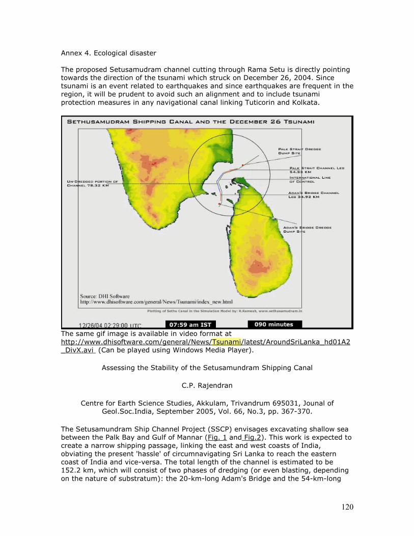
120
Annex 4. Ecological disaster The proposed Setusamudram channel cutting through Rama Setu is directly pointing towards the direction of the tsunami which struck on December 26, 2004. Since tsunami is an event related to earthquakes and since earthquakes are frequent in the region, it will be prudent to avoid such an alignment and to include tsunami protection measures in any navigational canal linking Tuticorin and Kolkata.
The same gif image is available in video format at http://www.dhisoftware.com/general/News/Tsunami/latest/AroundSriLanka_hd01A2_DivX.avi (Can be played using Windows Media Player).
Assessing the Stability of the Setusamundram Shipping Canal
C.P. Rajendran
Centre for Earth Science Studies, Akkulam, Trivandrum 695031, Jounal of Geol.Soc.India, September 2005, Vol. 66, No.3, pp. 367-370.
The Setusamundram Ship Channel Project (SSCP) envisages excavating shallow sea between the Palk Bay and Gulf of Mannar (Fig. 1 and Fig.2). This work is expected to create a narrow shipping passage, linking the east and west coasts of India, obviating the present 'hassle' of circumnavigating Sri Lanka to reach the eastern coast of India and vice-versa. The total length of the channel is estimated to be 152.2 km, which will consist of two phases of dredging (or even blasting, depending on the nature of substratum): the 20-km-long Adam's Bridge and the 54-km-long
121
Bay of Bengal segments. Besides these, the third segment falls in the Palk Bay with a total length of 78 km, which is reportedly requires no dredging as this area has a clearance of 12 m depth (NEERI, 2004). One must bear in mind that these are pre-tsunami estimates, as we do not yet know if there are any changes in depths in various zones of this region because of the December 26 tsunami sediment dispersal, and its effect on deposition or erosion.
The National Environmental Engineering Research Institute (NEERI) had been entrusted with the environmental impact assessment (EIA). The EIA conducted by NEERI and also the Technical Feasibility Report (TFR) certifies that the project is feasible and rules out any environmental hazard. However, serious concerns have been raised from different quarters on the stability of the proposed canal and the environmental impact of this project that would cost more than Rs. 2,233 crore, going by the pre-tsunami estimates (see Ramesh, 2004, 2005). With the approval of the Cabinet Committee on Economic Affairs, the concerned ministry is now going ahead with the project work with full steam.
The obvious issue is whether the authorities have made any sincere efforts to address some of the questions on this expensive project. In my judgment, the Government agencies entrusted with this work show an extraordinary enthusiasm to brush aside the uncomfortable questions, and keep the public at large in the dark about the stability of the canal and also on possible environmental impact. I must also point out that the efforts from the geological community to bring out the facts and initiate a wide-ranging discussion on this venture have been minimal, notwithstanding some tentative steps. Summarized from the above sources, especially the report prepared by Ramesh (2004), I highlight the major scientific objections with regard to this project:
1) Sedimentation dynamics: The Palk Bay region is a veritable sediment sink and is characterized by a high depositional rate (for details see Agarwal, 1988; Rajamanickam and Tooley, 2000, articles therein; Natesan, 1993;2002; Chandramohan et al., 2001; Sanil Kumar et al., 2002). However, various authors having given contradictory values, and all of them from different sites in the region. The EIA has used the values selectively to come up with an average eastimate to suit its conclusions. Fact of the matter is that different stretches of the Palk Bay, through which the alignment of the canal passes, may have variable sedimentation rate. Further, Ramesh (2004), in his report, persuasively argues that the EIA report is yet to identify the source for 99.386% of the net annual quantum of sediment that is supposed to enter into the Palk Bay. A review of the EIA report prepared by the National Environmental Engineering Research Institute (NEERI) indicates that it has not addressed the question of sedimentation dynamics, comprehensively. In particular the EIA has been ambivalent about the net annual quantum of sediment transported into the Palk Bay. The lack of precise understanding on the net annual quantum of sediment will make the predicted values on both the capital as well as on the maintenance dredging, a suspect.
2) The impact of the cyclones: The cyclonic storms are a major risk factor in the region. The coast of Tamil Nadu in general and the project area in particular is considered to be most vulnerable to tropical cyclones (Pant et al., 1977). The cyclone occurred on December 23, 1964 is a typical example when the storm surge washed away the Pamban Bridge and the Dhanushkodi Island (reflections of this tragedy are given in "Wings of Fire- An Autobiography" by A.P.J. Abdul Kalam). The cyclones can
122
unleash an autonomous dynamics of their own in redistributing sediment and also dispersing the dredged material (Dubey, 2004). The question of cyclonic disturbances in changing the sedimentary budget of the region has not been properly addressed by the EIA studies, and consequently skews the predicted estimates of the sedimentation pattern and its rate. This means that total amount of material to be dredged could be much more than what had been predicted. Another question is how would the cyclones rework the dredged material to be dumped at various sites, although fortified with embankments (e.g. Dhanushkodi).
3) The threat of tsunamis- a newly realized danger: The Indian press quoted a note (March 9, 2005) reportedly issued from the Prime Minister's office voicing the concern about the sustainability of this canal in the event of a cyclonic storm or tsunami. This was a valid query not only from a purely hazard point of view and this phenomenon is yet another process typical of this region that adds to sedimentation. However, in a recent statement, the Union Minister for Shipping, Ports and Highways states that this canal will have a 'dissipating effect' on tsunamis if they strike the east coast (The Hindu, dated June 6, 2005). He further states that the Ministry is now ready with scientific data to answer any questions on this project. I assume the Minister's repertoire also includes a tsunami model of deep-sea wave propagation in a post-project scenario. The post December 26 tsunami simulation models (Steven Ward, Univ. of California; and Aditya Riyadi, the Pusat Penelitian Kelautan Institut Teknologi, Bandung, Indonesia) that are available at web sites (http://manisanga.blogspot.com). After reviewing these models, Ramesh (2005) (http://palkbay.wikicities.com) suggested that the central portions of the Palk Bay and those located to the northeast and the east of Palk Bay received waves of higher energy. In other words, this part of the bay received higher amount of sediments, rendering it more turbid than other parts. Ramesh (2005) further points out that the above models also indicate that waves entered the Palk Bay from the north and south, corresponding with the canal alignment. Therefore, the open question is that whether the deepening activities would 'create a new deep water route' for a future tsunami to reach the west coast with a devastating impact, a concern already expressed by a tsunami expert. I would like to know whether the Ministry sponsored modeling studies have come up with a different scenario. However, an expert thinks that that the Bay of Bengal entrance of the present orientation of the canal will funnel tsunami energy into the channel and through constructive interference with the tsunami propagating from the south of Sri Lanka at the southern part of Kerala will augment the tsunami wave amplitudes, which will impact the Kerala Coast (Tad Murty, personal communication).
4) Nature of substratum: With limited availability of borings, we are still not certain about the nature of the substratum of the region: are they soft or hard? This information is important to decide on whether to dredge or blast the sea bottom and to plan the safe disposal of the dredged material.
5) Finding the sites for safe disposal of dredged material: The EIA study appears to be ambivalent regarding identifying the areas of safe disposal of dredged material and that too without posing environmental hazard for the marine organisms (Sri Lanka has a major stake here). Recently, some experts have also pointed out threat of sediment slides as a cause for instability of the channel.
6) Economic viability: Have we considered the pollution that would be created by ships in such a narrow channel and its modes of dispersal or other dangers, for
123
example the prospect of grounding or straying, from the canal alignment, of a rogue ship containing coal or oil or even a collision of such ships, and the ensuing ecological disaster? On the other hand, if the ships are going to be guided by tugs, there will certainly be a huge toll that would work out be more expensive than sailing around Sri Lanka (see Ramakrishnan, K.S., The Hindu dated Dec. 21, 2004). Would this be finally end up as a patrolling route for the Indian Navy and the Indian Coast Guard? We have to work out a realistic cost-benefit analysis of this project, taking all the above contingencies into account?
I have not touched upon much on the possible environmental impact of this project. I hope somebody who is qualified to deal with that topic will speak out. Personally, I believe all the objections highlighted in this article will remain valid until these issues are resolved by an independent group of experts. I am curious to know how our scientists respond to such projects. What is appalling is the complete silence from the earth science community of the country. I think here we have an excellent geological problem (according to the NEERI report, the depth of the area has been reduced by about 0.51 m between 1975-1999; What more do you need to excite a geologist?), and an area where our expertise would make a difference (see also Rajendran, 2005 for a reiteration of this issue).
Our academies and other professional bodies of Indian scientists should take their positions on such important issues, based on the considered opinions of the independent experts. Setusamundram, as the name suggests, is the part of an ocean that is being constantly bridged by natural sedimentation processes, and the nature has been at this work for hundreds of thousands of years (Indian epic Ramayana makes direct reference to a putative land bridge in this region). Going by the rates of sediment build up, some believe that in another 500 years there would be a land bridge connecting Rameswaram with Sri Lanka (Ramasamy et al., 1998). By implementing this project, we are disturbing the natural processes for reasons that are not convincing. The onus is on the project sponsors to convince us about this project's technical, scientific and economic credibility, and prove that why this is not another disaster in the making. Let us call up on the Ministry and the institutes concerned to prepare a forum to debate these issues, involving both national and international experts as well as the stakeholders.
Acknowledgments:
I thank Dr. R. Ramesh for providing the background material on the Setusamundram project. I am indebted to Dr. B.P. Radhakrishna for his encouragement to prepare this article.
References:
Chandramohan, P., Jena, B.K., and Sanil Kumar, V., 2001. Littoral drift sources and sinks along the Indian coast, Current Science, 81, 3, 10 p.295.
Dubey, S.K., 2004. A strategy for cyclone disaster reduction- real time storm surge prediction. In: Coping with Natural Hazards: Indian Context. K.S. Valdiya (ed.). Orient Longman, Hyderabad, 197-203.
Murty, G.R.K., Satyanarayana, Y., Pradeep Kumar, T., 1994. Magnetic profile across Gulf of Munnar, Journal Geological Society of India, 44, 443-449.
124
NEERI, 2004. Environment impact assessment for the proposed Setusamundram ship channel project, along with the executive summary, National Environmental Engineering Research Institute, Nagpur.
Natesan, U. 1993. Seasonal shoreline oscillation of Tamil Nadu Coast. Current Science, 65, 9, 667-668.
Pant, P.S., Ramakrishnan, A.R. and Jambunathan, R. 1980. Cyclones and depressions over the Indian seas in 1977, Mausam, 31, 3, 343-344.
Rajendran, C.P. 2005. Setusamundram shipping canal project and the eternal silence of the Indian earth scientists. Current Science (in press).
Ramesh, R. 2004. Setusamundram shipping canal project and the unconsidered high risk factors: Can it withstand them? Doctors for Safer Environment, Coimbatore, Tamil Nadu, 71p.
Ramesh, R. 2005. Setusamundram shipping canal project. Current Science, 88, 536-537.
Rajamanickam, V.G. and Tooley, M. (eds.). 2000. Proc. Sem. Quaternary Sea Level Variation, Shoreline Displacement and Coastal Environment. New Academic Publication.
Ramasamy, SM., Ramesh, D., Paul, M.A., Kusumgar, S., Yadhava, M.A., Nair, A.R., Sinha, U.K., Joseph, T.B. 1998. Rapid land building activity along Vedaranniyam coast and its possible implications. Current Science, 75, 9, 10, 884-886.
Sanil Kumar, V., Anand, N.M., and Gowthaman, R. 2002. Variations in nearshore processes along Nagapattinam coast, India. Current Science, 82, 11, 1381-1389.

125
Location map. Inset: bathymetry map of the Gulf of Mannar (reproduced from Murty et al., 1994) http://www.Setusamudram.in/htmdocs/Articles/cp_rajendran_2.htm
The impact of Sethusamudram canal on Tamil Nadu and Kerala coasts
C.S.P. Iyer, Exec. Director, Centre for Marine Analytical Reference and Standards,
Regional Research Laboratory, Trivandrum; Senior Scientist, Kerala State Council for Science, Technology and Environment.
Background India does not have a continuous navigable route around the peninsula, within her territorial waters, due to the presence of a shallow patch, Adam’s bridge, where average depth is only 3 meters. The Sethusamudram ship canal project (SSCP) envisages the creation of a navigable channel of 152.2 km from Gulf of Mannar to the Bay of Bengal through the Palk Bay and Palk Strait to facilitate the movement of ships. A 20 kilometer 300 meter - width channel will be created by dredging shallow areas of Adam’s bridge up to 12 meters depth. Similar excavation is to be carried out in Palk Straits over a distance of 26 kilometers. This would connect the east and west coasts of India, thus obviating the necessity of going around Sri Lanka. It would also provide a direct link between Tutucorin and Chennai. Once the project is completed, the ships now traveling around Sri Lanka are expected to reduce travel time by 36 hrs and the distance by 400 nautical miles. The proposal for such a canal was discussed as far back as 1860. After Independence, it was taken up by Pt. Jawaharlal Nehru cabinet in 1955. Further, it was reviewed by three expert committees. Finally it was approved by the cabinet and inaugurated by Prime Minister Manmohan Singh on July 2, 2005.
126
Though the clearance of the project has been given based on the EIA and technical feasibility report of NEERI, many doubts about its scientific aspects still persist. This has been further accentuated by the tsunami of Dec 26 2004, and the destruction it caused on the east and west coasts of India. In the light of above, it is necessary to reevaluate the project from all angles, supported by further scientific studies. Some of the issues which are causes of concern are discussed below. Ecological and Environmental Issues Biodiversity The Palk bay and the Gulf of Mannar covering an area of 10500 km2 in which the proposed canal is to be built are biologically rich but fragile ecosystem. The Gulf of Mannar has been internationally recognized as a marine biosphere reserve. The 21 islands between the coast and the proposed canal route have been declared as National Parks. The marine bio – reserve houses more than 3600 rare species of plants and animals. It is believed to have the highest concentration of sea grass species along India coast. It is the largest remaining breeding ground for the globally endangered species Dugong. Endangered sea turtles, dolphins and sea horses are found here. Coral Reefs abound in this region. Though the proposed navigation route would be 6 - 20 km away from the marine national park, it is very difficult to accept the argument that there would be no adverse effect on this sensitive ecosystem. The waters cannot be compartmentalized. Sedimentation and dredging The Gulf of Mannar and the Palk bay form a backwater system. The Adam’s bridge acts as a barrier to flow of water. In the area, a complex ecosystem exists. A factor for serious consideration is the fact that the Palk Bay is a sedimentation sink with high deposition rate. Various sedimentation rates have been reported, depending on the area studied. The EIA report of NEERI selectively takes a convenient value for the sedimentation rate which does not reflect the true picture. Even accepting the NEERI report, around 85 million m3 of material has to be dredged (20 km of dredging at Adams Bridge and 54.2km in the Bay of Bengal). In addition, for the maintenance of the canal, material of 0.1 million cubic metres has to be removed annually for the Adam’s Bridge Leg alone. This is excluding the Bay of Bengal leg for which no value has been reported. Due to dredging, the bottom flora and fauna would be destroyed. Doubts have also been expressed about the nature of sea bed in this area. It is feared that that with depth some places would be rocky which would call for blasting. The damage to marine life by such underwater blasting can be imagined. The impact of dredging and dumping on the marine life has not been assessed. Literature survey has brought out very clearly that turbidity, which would result from such activities would drastically reduce the productivity in the area and thus of the fish population. Many of the species in this region would face extinction. Similarly the corals would also be destroyed. Excessive inputs of sediments can destroy coral reefs by smothering, reducing the light availability and potentially reducing coral photosynthesis. Once the material is dredged, the next important question is the dumping site. It is suggested that the sites for dumping would be over Pampan Island, between Rameswram and Dhansukodi and in the Bay of Bengal. Oil Pollution
127
Besides dredging which results in turbidity, another source of pollution is from oil spills from the ships passing through the canal. Major oil spills from cargo spills are frequent events that have serious consequences on the environment. On the global scale about 1% of the cargo vessels are involved in accidents resulting in oil spills. It may be mentioned that the traffic potential in the canal is estimated to be 11000 ships per year which means that every three days there will be an accidental spill. It is worth mentioning that the sea bed surrounding the proposed route of the canal through the Adams Bridge is shallow no more than 4m deep. Thus even a small deviation from the planned route would be catastrophic. Cyclonic storms and Tsunamis The east coast of India is subjected to frequent cyclonic storms. These can disturb the sedimentation dynamics of the region and thus the quantity of dredging to be undertaken. Similarly cyclones can rework the dumped material. Unfortunately, the EIA report has not paid any serious attention to the meteorological factors. Added to that is the realization that the east coast is vulnerable to disasters like Tsunami. In this context, It is worth recalling the Tsunami which occurred on Dec 2004. The epicenter of the earthquake, which triggered the Tsunami, was located south west of Sumatra at the interface of Indian and Burmese plates. Due to the presence of the lithosphere boundary around Simeuleus Islands which continues up to Nicobar Island, the earthquake rupture initiated west of this boundary did not cross to the east, but got propagated northwards to the Andaman and Nicobar Islands. The tsunami caused destruction in 12 countries, from Indonesia to Somalia Islands. It killed 1, 76,260 people. In addition, 49, 682 were reported missing. Indonesia suffered the maximum damage as the epicenter of the earthquake which initiated the Tsunami was located there. It affected Andaman and Nicobar Islands, Sri Lanka, Tamil Nadu coast and to a lesser extent, the Kerala coast. Further, it affected the southern part of the eastern continental shelf of India, from Karaikal in the south to Vishakapatnam in the north. In particular, Nagapatnam – Cuddalore part was worst affected. The reasons for this high surge in this area were the bathymetry of the shelf and the concave configuration of the coastline It has been noted that the Park Bay received tsunami waves of higher energy and that these could not directly pass on to the Gulf of Mannar due to the presence of Adam’s bridge. The waves taking a higher arc, circumventing Sri Lanka (Carolio’s effect) and which hit the Kerala coast, were thus of lower energy. In case the Adam’s bridge is broken, making a wider passage, it is feared that the waves coming into the Park Bay, would be funneled through this passage. The funneling process would increase the intensity of the waves. Further increase would take place due to the waves propagating from south of Sri Lanka. Thus, if these waves of higher intensity were to hit the Kerala coast, the devastation would be catastrophic. The funneling effect and the destruction it can cause is noted to a certain extent at Valiazhckal on the Kerala Coast. Economic issues Another lacuna in the project report is the lack of the economic benefits that would accrue, if the canal is established. The investment, at present proposed, is 2500crores. This expenditure is proposed to be met entirely from Governmental or semi governmental source. No private participation is expected. This gives the feeling that private entrepreneurs are not attracted to the enterprise. With the kind of unrealistic figures on the amount of dredging and the additional costs to be incurred if blasting of rocky surfaces have to be undertaken, the final figures on investment would be much higher. There are varying figures on the number of ships
128
which would be plying on the route and the charges to be levied on them. A cost benefit ratio for the project is called for. It is argued that ships can save time and fuel by taking the route. However, for ships coming all the way from Africa or Europe, the gain is minimal. Moreover, the passage through the canal would take longer, as they have to be piloted. Another issue of concern is the number of people who would be displaced from the area, affecting their livelihood. The report of NEERI admits the adverse impact on traditional fishing activities. Defense One factor, which appears to have been, may be purposefully kept out of the public view, are the strategic benefits. The movement of the naval ships from east to west and vice versa would be facilitated by the SSSC. Defense experts should discuss this issue and come out with their opinion. Conclusion There is a necessity to address the issues mentioned above in a rational and scientific manner before proceeding further with the project. Some of these relate to further studies on
• Bathymetry of the region after Tsunami • More realistic estimates of the sedimentation rate • Modeling Tsunami waves with and without Adam’s Bridge • Taking into account Meteorological factors • Environmental impact on the biodiversity • Economic viability of the project
References
1. Environmental impact Assessment for proposed Sethusamudram Ship Canal Project NEERI, May2004
2. Sethusamudram Project- Divergent perspectives, Edited by E.K.G. Nambiar and Suryanarayanan, University of Calicut,2005
3. Ramesh R, Sethusamudram Shipping Canal Project, Current Science,88,536 4. Rajendran C.P., Assessing stability of the Sethusamudram Shipping Canal,
Journal of Geological Society of India, 66,367 5. The Indian Tsunami, Edited by Tad S. Murty, U. Aswathanarayana and N.
Nirupama, published by Taylor and Francis, London, 2007 Sunday Times, Colombo, May 20, 2007 Sethusamudram project: Verdict of experts handed over to Cabinet
The report of an expert group set up by the Government to study the implications of the Sethusamudram Ship Canal Project (SSCP), was handed over to the Cabinet last Wednesday.
The inter-ministerial committee which appointed the expert group will now study the report and decide on how best to address Sri lanka's concern regarding the project, Science and Technology Minister Tisssa Vitarana who is a member of the ministerial committee said.
129
The expert committee headed by the Secretary to the Ministry of Education Ariyaratna Hewage handed over its report to the Ministry of Foreign Affairs late last month and it was presented to Cabinet on Wednesday.
The expert committee consisted of people drawn from various areas relating to marine science as well as a representative of the Sri Lanka Navy. One of the main concerns of the committee was the adverse environment impact the project could have on Sri lanka.
The Sethusamuduram project involved linking the Palk Strait and the Gulf of Mannar to the east coast of India by creating a shipping canal through Rameswaram Island, providing a continuous navigable sea route around the Indian peninsula within India's territorial waters.
The ministerial committee headed by the Foreign Minister includes the Ministers of Environment and Natural resources, Ports and Aviation, Fisheries and Aquatic Resources, Defence and Science and Technology. http://www.sundaytimes.lk/070520/News/nws11.html Controversial Sethusamudram canal dredging project
Lankan experts caution against eco disasters
By Ravi Ladduwahetty
http://www.nation. lk/2007/04/22/lankan.jpg
An eminent 34- member advisory group of Sri Lankan professionals have cautioned that the Sethusamudram canal dredging project could have disastrous environment impacts, particularly, maritime environment, for Sri Lanka.
What is most disconcerting is the absence of any response from the Indian Government to the Lankan concerns.
The Group, after a year's study, submitted their report to Foreign Secretary Dr. Palitha Kohona, earlier this month.
The Experts Group comprised Secretary, Education Ministry Ariyaratne Hewage - Chairman, Peradeniya University Professor of Geography Shantha Hennayake - Deputy Chairman, Special Advisor, Technical Planning & Development, Sri Lanka Ports Authority, Prasanna Weerasinghe and Systems Advisor, Sethusamudram Ship Canal Project (SSCP), Tikiri Jayatilleke. The Advisory Group was supported by sub committees from the Ministry of Foreign Affairs headed by Assistant Director Sugeesawara Gunatunga, on hydrodynamic modeling headed by Moratuwa University's Prof of Coastal Engineering Samantha Hettiarachchi, on Environmental Measures for Sustainability headed by the Director, Institute of Technological Studies, Dr Aziz Mubarak, including IUCN Ecologist Dr. Channa Bambaradeniya and Head of Oceanography, NARA, K. Arulananthan, on Fisheries Resources & Livelihood, headed by Head of Marine Biological Resources, NARA, Dr Champa Amarasiri and on Navigational Emergencies headed by Commander Y.N. Jayaratne, Sri Lanka Navy.
130
The primary concern for Sri Lanka is that the initial dredging, the infinite maintenance dredging and subsequent shipping through the channel, could have negative impacts on Sri Lanka's maritime and environment resources, sources in the Advisory Group told The Nation yesterday.
Another major Sri Lankan concern which also relates to environment resources, is that the Indian studies have not taken into account the single environment impact on the Sri Lankan side of the international boundary, they said. The Advisory Group is of the view that, despite the SSCP being located only one mile away from the Indian side of the maritime boundary, the impact is unlikely to remain only on the Indian side and that, Sri Lanka's concerns have become even more significant, in the light of insufficient attention paid to minimise the environmental aspects on the Lankan side of the boundary. The Advisory Group has also noted that the Environmental Impact Assessment (EIA) carried out by India is inadequate for a number of reasons.
The Nation in its edition of January 7, 2007, exclusively reported that, despite the Indian assertion (Commercial Counsellor, Indian High Commission, Colombo, Sanjay Sudhir refers) that it has shared the Ahamedabad based Indian National Environment & Ecological Research Institute (NEERI) report with Sri Lanka, is insufficient justification to prove that there will be no adverse impact on the environment. Simply because, the NEERI report by itself, was flawed and was sufficient legal justification to put the entire NEERI repot into scientific question.
For example, the NEERI report is yet to explain the sedimentation issue, silting possibilities and underwater ocean currents, when the canal is constructed. According to Sudharshan Rodriguez, a Chennai based conservation analyst, the EIA report furnished by NEERI, has used secondary data going back to 1976. "Hence, how can a project, which will pass through a biological hot spot, with so many likely impacts, be assessed on the basis of secondary data?" is the next most logical question.
The Convenor, Indian Coastal Action Network, Ossie Fernandez has alleged that the NEERI EIA report is also a re-hash of the preliminary report and that, many activists and professionals are querying the data sources, including the bio diversity readings.
Furthermore, there would be increased turbidity, which has never been studied by NEERI, which has neither studied the possibility of a tsunami through the canal water flow, due to the deep water channel linking the Indian Ocean and the Bay of Bengal.
The United Nations Law of the Sea mandates that neighbouring States need to be consulted and sufficient safeguards and guarantees provided. Fishery resources There is also concern of the lack of concern on the Indian side, of the unique, biologically rich resource areas linking two Marine Eco systems in the Gulf of Mannar and the Palk Bay. Unless accurate forecasts are made of the mitigation effects, it could eventually destroy this fragile marine eco system. This is all the more significant in the light of the Northern and North western communities in Sri Lanka being heavily dependent on the fisheries resources of this area.
The concerns that Sri Lanka has expressed are protecting the endangered species, protecting the fisheries resources, the coastal and maritime eco diversity system,
131
integrity of the eco system in the seas around the island and immediate and long-term ecological stability.
According to research done in Jaffna, by Sri Lanka born Monash University's Professor of Systems Ecology and UNDP Consultant Prof. Ranil Senanayake, fresh water fish such as Dandiya (Rasbora Daniconius), Tittaya (Amblypharygnodon Melenittus) and Amblypharygnodon Melenittus, migrate down towards underground caverns and chambers, during dry weather and surface when it rains. This also demonstrates the existence of massive underground freshwater caves off Jaffna, with which the salt water of the Palk Straits would mix, if the dredging continues.
This is a shallow area which is highly productive, biologically. As a consequence to the dredging, rare species of mammals, dugongs and fish and invertebrates such as the guitar shark and cone shells would become extinct. One cone shell (Conus Zonatus and Conus Gloria Maris) is worth around US$ 3,500 apiece.
Dredging will also reduce the photosynthetic rate, resulting in the collapse of the fishing industry.
Ecological and archaeological concerns
Among a host of serious problems, one major issue is that the canal is to be dug through vesicular limestone, which is a formation of limestone, consequent to the myocene sea encroaching upon parts of Northern Sri Lanka and Southern India. This entails Mannar and Jaffna on the Sri Lankan side and Tuticorin and Rameswaran on the Indian side, which means that the groundwater on both sides of the channel, would be affected.
It is also salient that no maritime archaeology has been conducted on this site. Scientific evidence, in a paper presented by Prof. Senanayake, indicates that 13,000-years ago, the area around the Kalpitiya lagoon, up to Mannar, was forested. Even today, stumps of old trees are found underwater. There are innumerable stories in Sinhala history, regarding noblemen and royalty living underwater.
Navigational Emergencies
Sri Lanka has proposed that a plan to ensure vessels that cause pollution and oil spillage are identified and necessary compensation mechanisms put in place, is established. Sri Lanka should, invariably, be involved in the preparation of contingency plans for oil spills, including modalities to work out the cost of marine pollution and other navigational emergencies and how they be met.
Recommendations
Sri Lanka has also proposed the sharing of information on existing studies and collaboration on further studies and assessments and the setting up of a common database. Also that a Joint Environment Management Plan for impact assessment and monitoring of the project area be established.
132
Both Sri Lanka and India will be tremendously benefited if the recommendations are implemented to minimize the adverse environmental impacts of the SSCP, the Advisory Group has pointed out.
http://www.nation. lk/2007/04/22/newsfe3.htm
Crusader against the Setusamudram project speaks
The Rediff Interview/O Fernandes, Co-convenor, Coastal Action Network July 19, 2005
O Fernandes, co-convenor of the Coastal Action Network (CAN) had filed an unsuccessful petition in the Madras high court seeking issue of a writ to quash the March 31, 2005 order of the Central government granting environment clearance to the Setusamudram Canal Project near Rameswaram in Tamil Nadu.
The Coastal Action Network and several other NGOs are relentlessly fighting to discontinue any action by the shipping ministry in the Palk Strait. What they are trying to do is garner public support against what they consider would be an environmental disaster.
The voice of the Coastal Action Network has reached far and wide -- Fernandes was being interviewed by BBCE when rediff called on him. He spoke to Shobha Warrier on CAN's future course of action as far as the Setu canal project is concerned.
Are you disappointed with the high court's decision to reject your petition
seeking to quash the Centre's order granting environmental clearance to the Setu project?
There were two high court orders. The first one was regarding the unscientific and undemocratic nature with which the public hearings were held. There, the high court said it was premature because the public hearings weren't completed. We had said that because of the tsunami, many fishermen were unable to come to the hearings but the court refused to entertain our arguments on merit, and dismissed it as premature.
The more recent high court petition which we had prayed for was for staying or quashing the clearance given to the project. The court did not go into the merits of the arguments. They asked us to look at the alternative, to go to the environment tribunal, which already exists.
The judges suggested that we go before the tribunal (The National Environment Appellate Authority). We said the tribunal should be headed by a Supreme Court judge; it has remained headless for the last five years. Hence, we said we cannot go before the tribunal. So, the judge ordered that within thirty days, such a head must be appointed, and we were given 30 days to file a petition there.
So, to that extent, the second order, since it hasn't gone into the merits of the argument, was another disastrous judgement or order. Still, it's open to us.
133
Are you not losing out on time? The project has been inaugurated.
No. Our entire strategy is not based on the legal case. It's also based on people's resistance to the project. You know in Madurai, Tuticorin, Rameswaram, Nagapattinam -- everywhere, people are resisting the need for this project. So, it's based on people's strength.
How do you plan to make people resist the project? How do you plan to unite them against the project?
As a representative of the Coastal Action Network, we are members of the movement against the Setusamudram Canal Project. So, we jointly plan, though I am petitioner in the matter, with people's movements, scientists, environmentalists and lawyers, and co-ordinate our strategies.
How optimistic are you about creating a strong people's movement against the project? Will a people's movement be able to resist political power?
I am very optimistic. Increasingly, there is a growing awareness among a lot of fishing people and coastal people, and the awareness is growing in cities too. It's growing not only in Tamil Nadu but across India.
We are creating awareness that this canal is not going to benefit the people at all. The question then is, who is it going to benefit?
The shipping industry is not going to use this canal. The international shipping lines are not going to use this canal. So, then, who is going to use it and at what cost?
Our estimate is that for the 10 year period which we calculated, not less than 24,000 crore rupees of the wealth of fishing people will be destroyed. They have said publicly that it will take 10-13 years for the project to even get back what is invested. It will take 18-19 years to break even. It is a ridiculously, economically unviable project.
The argument from the other side is, it is a 135-year-old dream of the Tamils.
The first thing I want to ask these politicians is, which Tamils are they talking about? If they are really talking about Tamil people, they shouldn't be digging this canal. It's not going to bring in commerce.
Secondly, it is not going to bring any development or employment excepting during the construction period.
The real issue is [this] -- right now the coast is protected by the Coastal Regulation Zone (CRZ). They cannot dig a road through this coast because it is banned under the CRZ law. So, instead of digging the road, they are digging the canal. Once you dredge the canal, they are going to have stopovers, or small harbours. Once you set that up, you break the CRZ law. So, the real interest is to smash the CRZ law because they claim the CRZ law is not allowing them to put up projects along the coast.
134
For international and national big capital, the coast is the easiest dumping site you can get for all your wastes, whether you are looking at thermal plants, ports, chemical industries, petrochemicals or pharmaceuticals. All the big industries are trying hard to locate themselves on the coast, including tourism.
Since the CRZ law is there and since the fishing people have used the law to resist [it], they have not succeeded. So, you dig a canal a little outside and then you invade the inside. That's the strategy. But they are not telling this to anyone.
If you see the arguments of the former chief minister [K Karunanidhi] or Union Minister T R Baalu or the Tuticurin port authorities, every single argument of theirs is not based on any scientific report. They haven't quoted a single scientific report. On the other hand, I will name 40 scientific studies showing that it's not viable. Now, they have appointed five institutes to do the environmental studies. On what scientific basis did you give clearance when you say in the clearance order, you have to do 16 more studies? This is what I told the BBCE also when they asked me the question.
We are carrying out a big international campaign. We have begun by asking all foreign companies to stay off this canal or face the wrath of the people.
Another thing I want to point out is, the Prime Minister's Office objected to this project first, and said there was no comprehensive Environmental Impact Analysis . The PMO has not answered our letters on how they cleared this project when they themselves raised objections in the first place. The PMO raised the same objections that we have raised. Within two months, it gets passed. How? We have politicians who are simply selling this country piece by piece.
Arguing your case, the CAN lawyer said you are not against the project per
se. You only wanted a concrete scientific study before the project starts. Does that mean you don't object to this project at all?
Well, that's for the courts. We want the courts to appreciate that our arguments are scientific. Hence we want the court to recognise that here's a project going through without a scientific base. That's why we spoke like that. It's illegal and violates several laws of the land. Several aspects like fishing are state subjects. If the fishing people's access to the sea is going to be hampered by the canal, obviously it is the state government's job to examine the project.
If the project under a Union minister has violated so many laws, who is going to stop him?
In both the times of judgement, that's what we wanted to open up. We want to open up the discussion on merits. We would like to have the judges set up a scientific team to guide them.
So, what is your course of action?
One is, the people's resistance will go on. There's no doubt about it. We, and by we I mean the people, are not going to allow dredging. In the worst scenario, the fishing people are going to just log their catamarans in ports when the dredging starts.
135
Secondly, we are very grateful to the media for supporting us over the last 2-3 months in a very major way. So, we do like to communicate through the media as that is our only means of communication. From the litigation point of view, we have three options, one is going before the centrally empowered Supreme Court appointed committee which is looking at wildlife and environment.
The other is, we go to the Supreme Court, again looking at the clearance aspect and asking the SC to examine our argument. Number three is, we go before the Tribunal, the Appellate body.
Professor KNJ Katupotha of the Sri Jayewardenepura University said in a
seminar that the project could upset the entire ecological system in the
seabed of the fertile Indian Ocean. He also talked about the project causing
earthquakes. Later, Union Minister T R Baalu said they have cleared Sri
Lanka's fears.
It's a chain of fragile zone right from Kanyakumari up to West Bengal. The tsunami showed the mud and sludge that was thrown up had killed a lot of flora and fauna right from the Gulf of Mannar biosphere in the Palk Strait.
Tsunami is a good lesson which they are not willing to learn from. This is the only major biosphere you have in India. If this goes, it will totally affect fish breeding. Our calculation shows immediately, 70,000 families will be affected. It will soon be five times more than that.
A good part of the part of the Gulf Mannar biosphere is in the Sri Lankan territorial waters. Now, I think they are going to court to challenge this canal for violation of international law and the law of the sea.
The minister also says the project will help our defence…
That's the height of ridiculousness. No naval fleet will ever commit suicide by going through that 12m canal.
Chief Minister J Jayalalithaa has raised several questions, though a bit late. Do you feel it is also a political game?
Whether it is politics or not, they were correct. The authorities had no business to clear the project without the Tamil Nadu government giving them the no-objection certificate from the TN Pollution Control Board.
But Union Minister Baalu has said in a press conference that he didn't have
to get the NOC from TN Pollution Control Board.
He is not reading the law correctly. Mr Baalu can be challenged for illegality. We haven't yet challenged them on violation of several laws. The NOC is absolutely necessary.
There is no use of Chief Minister Jayalalithaa trying to say, I want the project but procedurally, environmental matters have to be followed. If you look at procedurally and scientifically, the project is unsustainable. She is only technically correct.

136
Are you optimistic about your fight becoming successful?
Very, very optimistic because the fight is not between Mr Baalu and us, or us and ministry of environment and forests. The fight is between sustainable development and destructive development, and that's the key issue.
http://in.rediff.com/news/2005/jul/19inter.htm?zcc=rl
137
Annex 5. Scientific evidence for ancient human activity in the project area
Scientific evidences point to human activity in ancient times on both sides of
Ramsetu as found by Dept. of Earth Sciences and ocean technologists of Bharatam.
This area should be declared a protected monument under the Protection of
Monuments Act and declared as a World Heritage site by the Govt. of India and
advised to UNESCO…
[quote]… During the glacial Maxima, the sea level was about 130 m lower than what
is today. This is evidenced both on the east and west coast of India, where
submerged Corals occur around 1 to 2m water depths and they are clear indicators
of near coastal zone… However, during the last ice age (18,000 year BP) the entire
area from India to Sri Lanka and further south and southeast were contagious land
due to the highly lowered sea level. As and when there were major melting of
glaciers both from the mountains as well as from the Antarctic area, the sea level
was rising. These features were well recorded and studied by several submerged
Coral formations all over the world. About 7,300 years BP the sea level in the
southern part of India was about 3.5 m above the present level. This has been
deciphered by Dr.P.K.Banerjee, who studied Corals that found in the land part as of
Pamban, Rameswaram, and Tuticorin etc. Subsequently the sea level went down and
rose +2m above than what is today between 5000 to 4000 years B.P. .. In almost of
all the boreholes between 4.5 and 7.5m the borehole intersected hard formations,
which have been found to be calcareous sand stones and corals. It is to be pointed
out here that Corals are comparatively less dense, compact and somewhat easy to
carry. The Corals normally grow atop compact to hard formations for the purpose of
stability, and as the sea level rises, the Coral colony grows up vertically to maintain
water depth of 1 to 2 m, which is essential for their survival. It is always observed
that these Corals have continuous vertical growth like Lakshadweep, Andaman's, and
Gulf Of Mannar Natural Park. These have always been found to grow on hard rock
bottom. In the case of Adams bridge area we observe that the Coral formations
hardly occur 1 to 2.5m in length and resting on loose marine sands. Most of these
coral rock pieces are seem to be rounded pebbles of corals. These things appear to
point these coral rock pieces and pebbles have been transported and placed in these
areas. Since the calcareous sand stones and Corals are less dense than normal hard
rock and quite compact, probably these were used by the ancients to form a
138
connecting link to Sri Lanka, on the higher elevations of the Adams bridge ridge and
this is analogous to modern day causeway. In support of these observations there
are many archaeological and geoarchaeological evidences on the south east coast of
India around Rameswaram, Tuticorin and the western coast of Sri Lanka. There are
raised Teri formations that supported a rich assemblage of mesolithic – microlithic
tools indicating the presence of strong human habitation and activity in these areas
as early as 8000 to 9000 years B.P and as recent as 4000 years B.P. On Sri Lanka
side there are indications of human habitation extending to late Pleistocene (about
13,000 B.P) based on bone and fossils of human and animal form. All these point to
a flourishing human activity on both side of Adams Bridge and probably when the
sea levels were just right the link between India and Sri Lanka could have been
established. [unquote] Source: Dept. of Earth Sciences, Govt. of India (March 2007)
http://hinduthought.googlepages.com/
139
Annex 6 Geological and Geophysical Perspective of the Ramsetu Bridge
S.Badrinarayanan Director (Retd), Geological Survey of India, Formerly, coordinator, Survey Division, National Institute of Ocean Technology, Ministry of Earth Science, Pallikkaranai,
Chennai. Preamble There has been lot of interesting debate on the Ramsethu Bridge said to be connecting south-eastern part of India with Sri Lanka. Most of the arguments are based on assumptions and partial data obtained from NASA satellite images. No doubt these images are astounding as they bring out the marine geomorphology of the area. But as stated by NASA official themselves “Remote sensing images from orbit cannot provide direct information about the origin or age of a chain of island and cannot determine whether humans were involved in producing any of the patterns seen”. However several other images including close range aerial photographs, bathymetric charts etc were examined. The observations given below are based purely on hard field work including geological and geophysical surveys coupled with logging and interpretations of several cores and boreholes carried out in the area. Introduction In order to understand the subject a little amount of geological information is essential. The earth has not always been very warm or cold. There have been periods of extreme cold climate that occurred in the geological past wherein most of the surface of the earth was covered with vast quantities of ice and these periods are referred to as ICE AGES. The recent one occurred during the late Pleistocene age eighteen thousand years before present. During this period the sea level was lowered by about 130m than what is today. Due to this the land area was extending far greater distances than what is today. The Indian subcontinent was extending far beyond Sri Lanka. Subsequently due to global warming and other causes there have been periodic rises in sea level submerging several of these additional areas. About 7300 BP there was a major spurt in sea level rise which resulted in submergence of several areas all over the world. Geology of the area The Indian side of the land mass adjoining the Ramsethu originates from the south-eastern end of the Rameswaram Island. The island itself is a long linear sandy terrain providing calcareous sand stone and occasional coral formation. This area was devastated by a major cyclone in 1956 when part of the area was lost to the sea. The Rameswaram Island connects the main land through the Pamban area. Further to the west charnocites and granites are exposed. In order to understand the geology and the structure of the area in the marine domain several surveys were carried out onboard a research vessel with underwater sensor. These included multibeam echo sounder survey, sub bottom profiler survey, side scan sonar and magnetic survey. The entire area was sampled by deploying vibro core, mainly to the north of the Adams Bridge (Ramsethu). These surveys generally required at least 4m of water surface so that the equipments are not
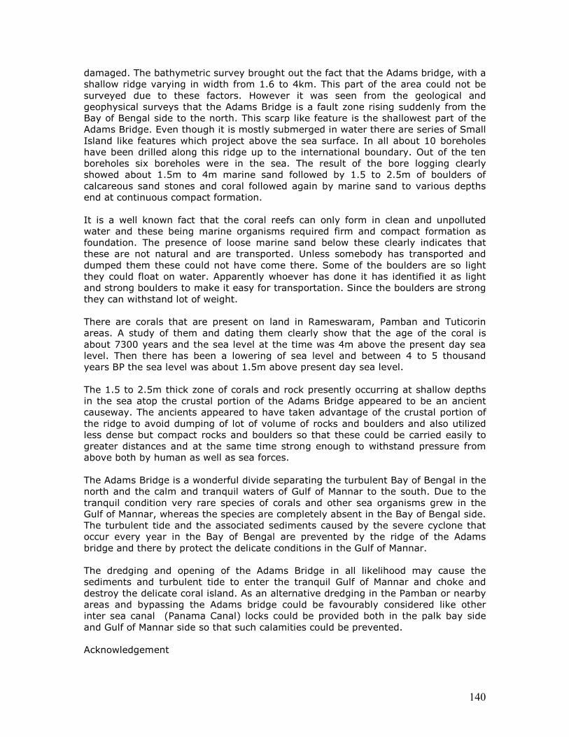
140
damaged. The bathymetric survey brought out the fact that the Adams bridge, with a shallow ridge varying in width from 1.6 to 4km. This part of the area could not be surveyed due to these factors. However it was seen from the geological and geophysical surveys that the Adams Bridge is a fault zone rising suddenly from the Bay of Bengal side to the north. This scarp like feature is the shallowest part of the Adams Bridge. Even though it is mostly submerged in water there are series of Small Island like features which project above the sea surface. In all about 10 boreholes have been drilled along this ridge up to the international boundary. Out of the ten boreholes six boreholes were in the sea. The result of the bore logging clearly showed about 1.5m to 4m marine sand followed by 1.5 to 2.5m of boulders of calcareous sand stones and coral followed again by marine sand to various depths end at continuous compact formation. It is a well known fact that the coral reefs can only form in clean and unpolluted water and these being marine organisms required firm and compact formation as foundation. The presence of loose marine sand below these clearly indicates that these are not natural and are transported. Unless somebody has transported and dumped them these could not have come there. Some of the boulders are so light they could float on water. Apparently whoever has done it has identified it as light and strong boulders to make it easy for transportation. Since the boulders are strong they can withstand lot of weight. There are corals that are present on land in Rameswaram, Pamban and Tuticorin areas. A study of them and dating them clearly show that the age of the coral is about 7300 years and the sea level at the time was 4m above the present day sea level. Then there has been a lowering of sea level and between 4 to 5 thousand years BP the sea level was about 1.5m above present day sea level. The 1.5 to 2.5m thick zone of corals and rock presently occurring at shallow depths in the sea atop the crustal portion of the Adams Bridge appeared to be an ancient causeway. The ancients appeared to have taken advantage of the crustal portion of the ridge to avoid dumping of lot of volume of rocks and boulders and also utilized less dense but compact rocks and boulders so that these could be carried easily to greater distances and at the same time strong enough to withstand pressure from above both by human as well as sea forces. The Adams Bridge is a wonderful divide separating the turbulent Bay of Bengal in the north and the calm and tranquil waters of Gulf of Mannar to the south. Due to the tranquil condition very rare species of corals and other sea organisms grew in the Gulf of Mannar, whereas the species are completely absent in the Bay of Bengal side. The turbulent tide and the associated sediments caused by the severe cyclone that occur every year in the Bay of Bengal are prevented by the ridge of the Adams bridge and there by protect the delicate conditions in the Gulf of Mannar. The dredging and opening of the Adams Bridge in all likelihood may cause the sediments and turbulent tide to enter the tranquil Gulf of Mannar and choke and destroy the delicate coral island. As an alternative dredging in the Pamban or nearby areas and bypassing the Adams bridge could be favourably considered like other inter sea canal (Panama Canal) locks could be provided both in the palk bay side and Gulf of Mannar side so that such calamities could be prevented. Acknowledgement
141
The author thanks D. Venkata Rao, Project Director and B.Sasisekaran, Scientist ‘D’ of National Institute of Ocean Technology for the help extended in the preparation of the paper and power point presentation.
Illustration:
Proposed Navigational Channel Alignment – Sethu Samudram Project- Drilled Borehole Locations. Differences between Rama Setu and terraces near Kodiakkarai This is in response to Kalaignar Karunanidhi’s comments of May 22, 2007 about a possible land-link between Kodiakkarai (Point Calimere) and Jaffna (Yaashpaanam). It may be seen from the following article by GG Vaz et al., that the
formation of Rama Setu was due to subsidence (The full article is annexed):
Current Science, Vol. 92, No. 5, 10 March 2007, pp. 671-675 Subsidence of
southern part of erstwhile Dhanushkodi township, Tamil Nadu – evidences
from bathymetry, side scan and underwater videography
The causes for the formation of Rama Setu from Dhanushkodi are entirely
different from the fault lines at work near Kodiakkarai resulting in
accumulation of shoals.
It is a welcome development that Kalaignar is talking geology. It will be
necessary to entrust the review to a team of scientists from many
disciplines as recommended by the Ramanathapuram Judge before
attempting to damage or destroy Rama Setu.
It should be noted that the Gulf of Mannar is a clearly identified ocean, distinct from the Bay of Bengal because of the existence of Rama Setu (Adam’s bridge). Such a

142
land-bridge does NOT exist between Kodiakkarai and Jaffna. That such a land-bridge may be formed in the future is speculation assuming that the sea regressions and sedimentations will follow a secular pattern. The ocean currents and counter-currents in the Gulf of Mannar are far too complex to make such speculative conjectures. Kodiakkarai is also called Point Calimere. It is a wild life sanctuary. The depth of the ocean between Dhanushkodi and Talaimannar is on an average three fathoms, while the depth between Point Calimere and Kanakesanturai is over eight fathoms. Only a lower sea level by over 8 metres would have connected the land between Bharatam and Srilanka through this route. Explanations offered for the existence of a land bridge between Dhanushkodi and Talaimannar are: eustatic changes and rising coastlines occurring concurrently. (Akkaraju Sarma, 1978, Paleoecology of Coastal Tamilnadu, South India: chronology of raised beaches, in: Proceedings, American Philosophical Society, Vol. 122, No. 6, p.416). The conclusions of this study are: “There are several marine terraces in Tamilnadu whose elevations have been mentioned. The younger marine terraces probably are late Pleistocene formations. The higher marine terraces are of marginal archaeological interest. The tectonically derived (uplift-associated) terraces are of extreme archaeological interest. Regions with spot elevations of 3 and 6 m are especially interesting, as the archaeological material in these provided clues to chronology of the uplift. The 3 and 6 m uplifted areas were found to be associated with archaeological sites ranging from the second century B.C. to the first century A.D., and sites extending from the seventh century A.D. to the thirteenth century A.D. These terraces and uplifted areas are all overlain by quaternary deposits in the districts of Kanyakumari, Tirunelveli, and Ramnad. Some of these deposits are composed of corals, limestones mixed with organic debris, and marine shells. In the coastal Tanjore district, these coastal terraces are uniquely different, being mostly alluvial sediments deposited over beach ridges. In South Arcot and Chingleput, beach sands predominate which, as such, obliterate the uplift evidences.” In this study which attempts to study palaeoecology of regressions of the sea in the past, one point stands out: the distinct differences in the coral terraces of the Rama Setu (between Dhanushkodi and Talaimannar) area and the area between Kodiakkarai (Point Calimere) and Jaffna (Yashppaanam).
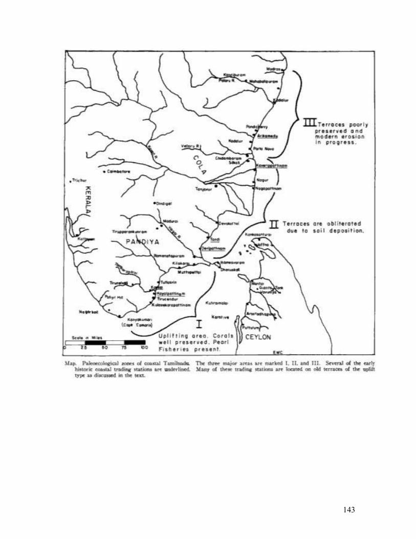
143
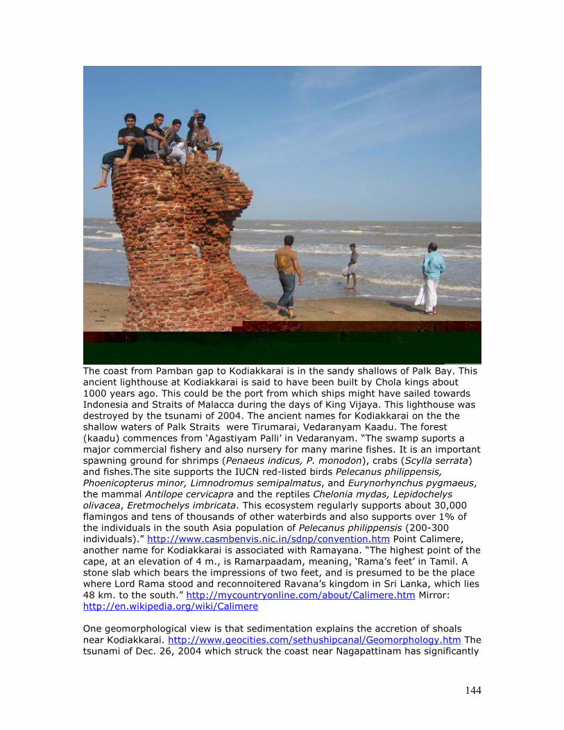
144
The coast from Pamban gap to Kodiakkarai is in the sandy shallows of Palk Bay. This ancient lighthouse at Kodiakkarai is said to have been built by Chola kings about 1000 years ago. This could be the port from which ships might have sailed towards Indonesia and Straits of Malacca during the days of King Vijaya. This lighthouse was destroyed by the tsunami of 2004. The ancient names for Kodiakkarai on the the shallow waters of Palk Straits were Tirumarai, Vedaranyam Kaadu. The forest (kaadu) commences from ‘Agastiyam Palli’ in Vedaranyam. “The swamp suports a major commercial fishery and also nursery for many marine fishes. It is an important spawning ground for shrimps (Penaeus indicus, P. monodon), crabs (Scylla serrata) and fishes.The site supports the IUCN red-listed birds Pelecanus philippensis, Phoenicopterus minor, Limnodromus semipalmatus, and Eurynorhynchus pygmaeus, the mammal Antilope cervicapra and the reptiles Chelonia mydas, Lepidochelys olivacea, Eretmochelys imbricata. This ecosystem regularly supports about 30,000 flamingos and tens of thousands of other waterbirds and also supports over 1% of the individuals in the south Asia population of Pelecanus philippensis (200-300 individuals).” http://www.casmbenvis.nic.in/sdnp/convention.htm Point Calimere, another name for Kodiakkarai is associated with Ramayana. “The highest point of the cape, at an elevation of 4 m., is Ramarpaadam, meaning, ‘Rama’s feet’ in Tamil. A stone slab which bears the impressions of two feet, and is presumed to be the place where Lord Rama stood and reconnoitered Ravana’s kingdom in Sri Lanka, which lies 48 km. to the south.” http://mycountryonline.com/about/Calimere.htm Mirror: http://en.wikipedia.org/wiki/Calimere One geomorphological view is that sedimentation explains the accretion of shoals near Kodiakkarai. http://www.geocities.com/sethushipcanal/Geomorphology.htm The tsunami of Dec. 26, 2004 which struck the coast near Nagapattinam has significantly
145
altered the sea-depths near Kodiakkarai. http://www.recoverlanka.net/docs/Ignorance.pdf
Journal of Geodynamics Volume 31, Issue 5, July 2001, Pages 481-498
A qualitative assessment of seismic risk along the Peninsular coast of India, south of 19°N Pronab. K. Banerjee , , a, G. G. Vazb, B. J. Senguptac and A. Bagchic a C/1, Greenwood, 315B, Upen Banerjee Road, Calcutta 700, 060, India b Marine Wing, Geological Survey of India, Vishakhapatnam 530023, India c Marine Wing, Geological Survey of India, Calcutta 700 016, India
Received 12 July 2000; revised 10 May 2001; accepted 10 May 2001. Available online 13 August 2001.
Abstract
Many earthquakes have been recorded from the coastal margin of the Indian peninsular shield during the last 200 years. Largely made up of Precambrian assemblages with variable cover of Jurassic to Quaternary sedimentary rocks and Cretaceous-Eocene volcanics, the peninsular shield was long held to be aseismic. Recent measurements, however, show that this continental fragment is being pushed northeastward by the Carlsberg and Central Indian ridges; and the Indo-Myanmar subduction zone is exerting vigorous slab pull towards the east. Repeated cycles of sea level change during the Quaternary have also induced continuing hydro-isostatic adjustment due to variable melt water loading in the Bay of Bengal and the Arabian sea. All these forces produce space-time fluctuations of strain around many small to large faults, which occur in the upper crust of the shield. Some of the faults have been intermittently active (during the past 100 kyr); others were active earlier. Although the Shillong plateau and the associated hill ranges of northeastern India and Myanmar are subject to the maximum seismic hazard, the peninsular coast is also vulnerable to intermittent seismicity. We present illustrative evidence of some active faults, which are recognisable (a) on coastal land by displaced Pleistocene weathered cover, hot springs, leakages of native mercury and allochthonous geochemical anomalies of base metals and (b) offshore below the inner shelf by horst-shaped uplifted segments and intra-formational slump folds on and below the top shallow seismic (3.5 kHz) reflector. On the other hand, there are long stretches of the east coast at Vishakhapatnam and Manappad Point, which do not show active faults. Step-like marine terraces, which occur up to+6 m above the low tide level (LTL) preserve records of relative sea level fluctuations during the Holocene and the Last Interglacial. In such sectors, absence of tectonic disturbance during the last 100 ka is also corroborated by lateral continuity of shallow seismic reflectors below the inner shelf over many kilometers. Since authentic historical (200–1000 years B.P.) records of seismicity along the Peninsular coast are virtually unavailable, the likely recurrence interval between earthquakes in each sector cannot be gauged. We, therefore, propose a scale of seismic risk, based on geometry of the mappable faults and available seismic records of the last two centuries. These could be used in combination to rank the densely populated coastal tracts sector-wise.
http://www.sciencedirect.com/science?_ob=ArticleURL&_udi=B6V9X-43RC9TP-3&_user=10&_coverDate=07%2F31%2F2001&_rdoc=1&_fmt=&_orig=search&_sort
146
=d&view=c&_acct=C000050221&_version=1&_urlVersion=0&_userid=10&md5=2010131e5698e1f0aa21720c4da5008e Current Science, Vol. 92, No. 5, 10 March 2007, pp. 671-675
Subsidence of southern part of erstwhile Dhanushkodi township,
Tamil Nadu – evidences from bathymetry, side scan and underwater
videography
G. G. Vaz1,2,*, M. Hariprasad1, B. R. Rao1 and
V. Subba Rao1
1Operations: East Coast-II, Marine Wing, Geological Survey of India, NH-5, Marripalem, Visakhapatnam 530 018, India 2Present address: Operations: West Coast-II, Marine Wing, GSI, Kurekal Buildings, Edappally, Cochin 682 024, India The southern part of erstwhile Dhanushkodi township, Tamil Nadu,
experienced subsidence and submergence during AD 1948–49. Shallow
bathymetric and sidescan surveys together with sampling and underwater
videography confirm the extent and quantum of subsidence. The studies
reveal that a vertical tectonic movement (fault) parallel to the coastline
with a displacement of ~ 5 m led to the subsidence of the southern part of
the township. This fault movement has occurred 57 years ago and hence
could be the latest neo-tectonic movement ever recorded along the east
coast of India.
Keywords: Dhanushkodi, neo-tectonic activity, subsidence, submergence, vertical displacement. THE coastal zone, the link between ocean and land margins, constantly experiences several dynamic processes, which at times result in various hazards to human beings. Such processes include erosion, accretion, upliftment, subsidence,submergence and their combined influence. The extreme southeastern part of Rameswaram Island (Figure 1), known as Dhanushkodi Foreland, is well-known in Hindu mythology and is of religious importance. Highintensity storms and cyclones have frequently attacked this area and led to vast material and human losses in the past, particularly the cyclone of AD 1964. The erstwhile Dhanushkodi township (presently in ruins) underwent subsidence during the mid-twentieth century. This communication documents the marine geo-scientific investigations at Dhanushkodi area and provides evidences for coastal subsidence in the southern part of the erstwhile Dhanushkodi township in the Gulf of Mannar (Figure 1) and geological reasons for subsidence during AD 1948– 49. Bathymetry, side scan and sampling surveys provide an insight into subsidence through underwater videography. The southeastern tip of peninsular India assumes much importance from a geological point of view. However, till date, geological studies around Dhanushkodi are meagre, except for limited geomorphological observations by Geographical Information System (GIS)-based animation1 and IRS-ID LISS III data around Adam’s Bridge Islands2. Due to the shallow nature of the sea, no research vessel could attempt to negotiate the area around Dhanushkodi for marine geo-scientific studies. Geomorphologically, the onshore area is known for its extensive stretch of longitudinal sand dunes and sandy beach. The Geological Survey of India made systematic geomorphological studies of Rameswaram Island and drilling operations from Dhanushkodi to Adam’s Bridge Islands, and also obtained information through enquiries from the local elderly people who were eyewitnesses
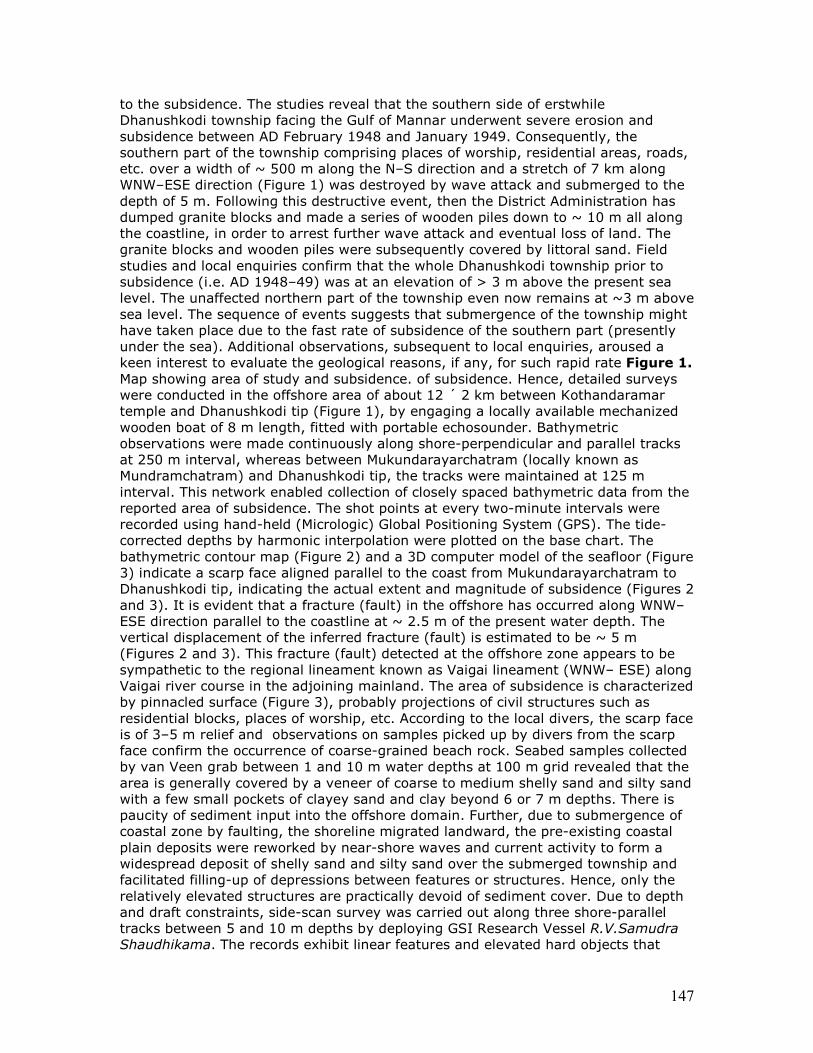
147
to the subsidence. The studies reveal that the southern side of erstwhile Dhanushkodi township facing the Gulf of Mannar underwent severe erosion and subsidence between AD February 1948 and January 1949. Consequently, the southern part of the township comprising places of worship, residential areas, roads, etc. over a width of ~ 500 m along the N–S direction and a stretch of 7 km along WNW–ESE direction (Figure 1) was destroyed by wave attack and submerged to the depth of 5 m. Following this destructive event, then the District Administration has dumped granite blocks and made a series of wooden piles down to ~ 10 m all along the coastline, in order to arrest further wave attack and eventual loss of land. The granite blocks and wooden piles were subsequently covered by littoral sand. Field studies and local enquiries confirm that the whole Dhanushkodi township prior to subsidence (i.e. AD 1948–49) was at an elevation of > 3 m above the present sea level. The unaffected northern part of the township even now remains at ~3 m above sea level. The sequence of events suggests that submergence of the township might have taken place due to the fast rate of subsidence of the southern part (presently under the sea). Additional observations, subsequent to local enquiries, aroused a keen interest to evaluate the geological reasons, if any, for such rapid rate Figure 1.
Map showing area of study and subsidence. of subsidence. Hence, detailed surveys were conducted in the offshore area of about 12 ´ 2 km between Kothandaramar temple and Dhanushkodi tip (Figure 1), by engaging a locally available mechanized wooden boat of 8 m length, fitted with portable echosounder. Bathymetric observations were made continuously along shore-perpendicular and parallel tracks at 250 m interval, whereas between Mukundarayarchatram (locally known as Mundramchatram) and Dhanushkodi tip, the tracks were maintained at 125 m interval. This network enabled collection of closely spaced bathymetric data from the reported area of subsidence. The shot points at every two-minute intervals were recorded using hand-held (Micrologic) Global Positioning System (GPS). The tide-corrected depths by harmonic interpolation were plotted on the base chart. The bathymetric contour map (Figure 2) and a 3D computer model of the seafloor (Figure 3) indicate a scarp face aligned parallel to the coast from Mukundarayarchatram to Dhanushkodi tip, indicating the actual extent and magnitude of subsidence (Figures 2 and 3). It is evident that a fracture (fault) in the offshore has occurred along WNW–ESE direction parallel to the coastline at ~ 2.5 m of the present water depth. The vertical displacement of the inferred fracture (fault) is estimated to be ~ 5 m (Figures 2 and 3). This fracture (fault) detected at the offshore zone appears to be sympathetic to the regional lineament known as Vaigai lineament (WNW– ESE) along Vaigai river course in the adjoining mainland. The area of subsidence is characterized by pinnacled surface (Figure 3), probably projections of civil structures such as residential blocks, places of worship, etc. According to the local divers, the scarp face is of 3–5 m relief and observations on samples picked up by divers from the scarp face confirm the occurrence of coarse-grained beach rock. Seabed samples collected by van Veen grab between 1 and 10 m water depths at 100 m grid revealed that the area is generally covered by a veneer of coarse to medium shelly sand and silty sand with a few small pockets of clayey sand and clay beyond 6 or 7 m depths. There is paucity of sediment input into the offshore domain. Further, due to submergence of coastal zone by faulting, the shoreline migrated landward, the pre-existing coastal plain deposits were reworked by near-shore waves and current activity to form a widespread deposit of shelly sand and silty sand over the submerged township and facilitated filling-up of depressions between features or structures. Hence, only the relatively elevated structures are practically devoid of sediment cover. Due to depth and draft constraints, side-scan survey was carried out along three shore-parallel tracks between 5 and 10 m depths by deploying GSI Research Vessel R.V.Samudra Shaudhikama. The records exhibit linear features and elevated hard objects that
148
could possibly be roads and collapsed residential buildings, respectively (Figure 4 a–d). On the basis of bathymetric records, potential locations were selected and skilled divers from local fishermen community were deployed to retrieve materials from the zone of subsidence. Construction materials like bricks, chiseled coral blocks, clay tiles, asbestos roof sheets, etc. were recovered. Subsequently, locally available wooden boats (8 m length) and professional underwater divers (Diving Consultancy, Tuticorin, Tamil Nadu) with underwater still and movie cameras attached with on-board monitor, were engaged for systematic and detailed underwater videography. For every diving operation, a marker buoy was tied on the location of objects or structures for detailed video recording and retrieval of materials. Locations of every buoy were recorded on-board using hand-held GPS. On reaching the important spots, the divers manually cleaned the objects, videographed and retrieved materials of significance. Underwater video observations confirmed one main road with collapsed houses of the erstwhile Dhanushkodi township at 5 to 7 m depth. The above observation matches well with the area of subsidence picked up from the bathymetric map prepared exclusively for this purpose. A number of objects located and retrieved during the underwater videography could be further classified into (i) E– W-aligned road, rectangular brick-wall structures suggesting collapsed houses/buildings, (ii) circular and semi-circular brick walls considered as the full or a portion of ring wells, (iii) walls constructed by chiselled coral blocks (Figure 5 a), (iv) well-chiselled and faceted pillars made from shelly sandstone, possibly parts of temple structure and (v) a variety of household articles such as metal tumbler, broken frying pan, sanitary iron pipes, etc. (Figure 5 a and c). The granite blocks and wooden piles laid along the coastline to arrest further erosion have now been exposed due to recent seasonal coastal erosion (Figure 5 d). After collection of all scientific data, local Tamil Nadu State Land Records were consulted for old survey records pertaining to this area, to gather additional information about the past habitation. Comparison of the maps of Dhanushkodi village prepared by State Revenue authorities prior to (AD 1948–49) and after the (AD 1950) subsidence has facilitated demarcation of the actual area of subsidence by survey numbers, names of the important buildings, etc. (Figure 6). Land records prepared after 1950 provide yet another proof of subsidence of the southern part of erstwhile Dhanushkodi township. The observations mentioned above substantially prove the subsidence and submergence of erstwhile Dhanushkodi township. Reportedly, when sea retreated to about 500 m from the present coastline prior to the arrival of recent tsunami wave in December 2004, the subsided and submerged part of the township got exposed for a while. This rare sight has been witnessed by the local fishermen community. The local inhabitants believed that coastal erosion was the main causative factor for the destruction and subsidence of the township in mid-twentieth century. The present marine geo-scientific observations, however, confirm a vertical movement parallel to the coastline with a displacement of ~5 m in the offshore segment (Figures 2 and 3), which actually led to the subsidence of the southern part of the township. Such neo-tectonic movements at various places along the east coast of India have been reported3–6. Normally, neotectonic movements in the coastal zone may be discerned by the study of palaeo-strandlines. However, the area of study does not show any indication of such strandline positions, except a wide Aeolian belt along the coast. Under this scenario, other critical sets of data pertaining to nearshore bathymetry, side scan, sampling and underwater videography have provided valuable clues in support of the subsidence phenomenon through neo-tectonic activity. Usually it is not an easy task to confirm the evidence of Holocene faulting within the unconsolidated sediments. The present evidence of faulting off erstwhile Dhanushkodi township is documented with geo-scientific clues from offshore field evidences, and hence stands out as a unique study. The fault throw of ~5 m
149
discerned in the study area may be only a surficial manifestation of a deep-seated and major faulting at depth, whose actual and destructive effect has not reached the surface. The faulting has understandably caused severe loss to the coastal zone, its inhabitants and their properties. This event of subsidence along with field evidence of faulting does not warrant any dating method to prove the age of this faulting, because according to eyewitnesses and landsurvey records, this geological event occurred during AD 1948–49. Most likely, this Dhanushkodi fault is the latest neo-tectonic movement ever recorded along the east coast of India. 1. Ramasamy, S. M., GIS-based animation of changing terrain features in Rameswaram Island, Tamil Nadu, during the last century. Proc. Indian Natl. Sci. Acad. Part A, 2003, 69, 251–256. 2. Bahuguna, A., Nayak, S. and Deshmukh, B., IRS views the Adam’s Bridge (bridging India and Sri Lanka). J. Indian Soc. Remote Sensing,2003, 31, 237–239. 3. Loveson, V. J., Rajamanickam, G. V. and Anbarasu, K., Remote sensing application in the study of sea level variation along the Tamil Nadu coast. In National Seminar on Sea Level Variation and its Impact on Coastal Environment (ed. Rajamanickam, G. V.), Tamil University, Thanjavur, 1990, pp. 179–197. 4. Vaz, G. G. and Banerjee, P. K., Middle and late Holocene sea level changes in and around Pulicat Lagoon, Bay of Bengal, India. Mar. Geol., 1997, 139, 261–271. 5. Vaz, G. G., Mohapatra, G. P. and Hariprasad, M., Geomorphology and evolution of barrier-Lagoon coast I part of north Andhra Pradesh. Mem. Geol. Soc. India, 2002, 49, 30–40. 6. Banerjee, P. K., Vaz, G. G., Sengupta, B. J. and Bagchi, A., A qualitative assessment of seismic risk along the Peninsular coast of India, south of 19°N. J. Geodyn., 2001, 31, 481–498. ACKNOWLEDGEMENTS. We thank P. C. Mandal, Director General (Rtd.), GSI and P. C. Srivastava, Dy. Director General (Rtd.), Marine Wing, GSI for their keen interest and permission to take up this work. We also thank B. K. Saha, Sr. Dy. Director General, Marine Wing, GSI, Kolkata for support and permission to publish this paper. Encouragement given by Dr B. L. Narasayya, Director (CT), Marine Wing, GSI, Visakhapatnam is acknowledged. http://www.ias.ac.in/currsci/mar102007/671.pdf Journal: Geo-Marine letters, Vol. 2, Nos. 3-4, September 1982, pages 171-177
William Vestal1 and Allen Lowrie1
(1) Geology and Geophysics Branch-Code 7220, U.S. Naval Oceanographic Office NSTL Station, 39522, MS
Abstract Two suites of slumps from opposite margins of the Gulf of Mannar, between Sri Lanka and southern India, have met and coalesced. The “Eastern Comorin” Slump is the more coherent of the two with a length of 70 to 100 km. The “Colombo” side slump consists of two to four blocks 15 to 35 km in length. Both slump-suites decrease to the south. A paleoslump underlies the western toe of the East Comorin Slump at a depth of some 800 meters. To the south, an enlarging and deepening submarine canyon marks the area of slump coalescence. http://www.springerlink.com/content/m602j3k746342lnl/
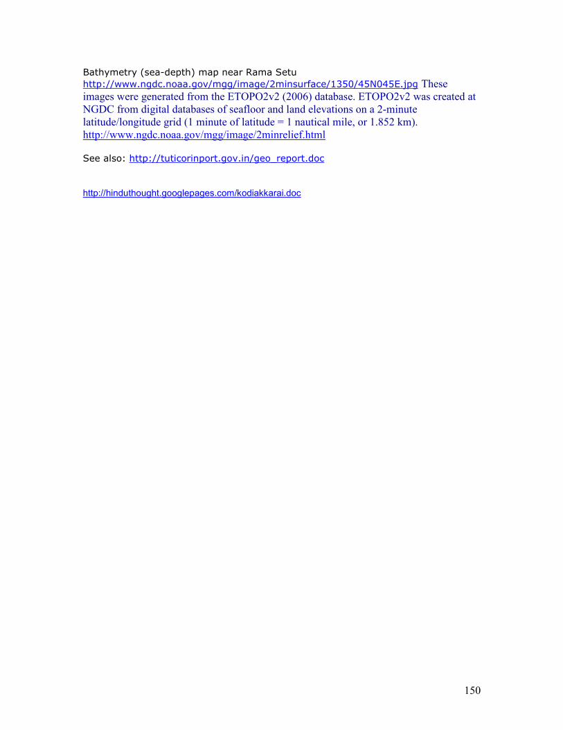
150
Bathymetry (sea-depth) map near Rama Setu http://www.ngdc.noaa.gov/mgg/image/2minsurface/1350/45N045E.jpg These images were generated from the ETOPO2v2 (2006) database. ETOPO2v2 was created at
NGDC from digital databases of seafloor and land elevations on a 2-minute
latitude/longitude grid (1 minute of latitude = 1 nautical mile, or 1.852 km).
http://www.ngdc.noaa.gov/mgg/image/2minrelief.html See also: http://tuticorinport.gov.in/geo_report.doc
http://hinduthought.googlepages.com/kodiakkarai.doc
151
Annex 7 Impact of Tsunami on Setusamudram Shipping Channel and the neighboring coastal areas
Interview with Professor Tad S. Murty
Prof. Tad S. Murty is one of the most respected Tsunami Experts around the world; he advises the Government of Canada on Tsunamis and had played an important role in the development of the 'Baird' simulation model of the December 26th Tsunami. He was in the Editorial Board of the most prestigeous Tsunami Journal "Science of Tsunami Hazards" for many years.
He along with Dr.Arun Bapat, had analysed the Tsunamis of the Indian Ocean in 1999.* He was in India this January to participate in the 'Brainstorming' Session on the Tsunami of 26 th December organized jointly by Department of Science & Technology (DST), Department of Ocean Development (DOD), Council of Scientific and Industrial Research (CSIR) and Indian National Science Academy (INSA) on 21-22 January, 2005 at New Delhi. Subsequently, when National Institute of Oceanography, Goa organised a National Workshop on Formulation of Science Plan for “Coastal Hazard Preparedness” on 18 - 19 February 2005, he set the tone for the workshop with his paper titled "Perspectives on Coastal Hazard Preparedness".
The following is an e-mail interview conducted with him by the Editor of this web portal on 7- 11 July 2005.
The interview assumes its importance following the July 24, 2005 Nicobar 7.3 R Earthquake that had caused much panic. It also assumes its importance as the Expert Level discussion between India and Sri Lanka on the possible impact of the Setusamudram Shipping Channel Project on the marine and coastal environments of both the countries is scheduled on 1 August 2005 at New Delhi.
* [" TSUNAMIS ON THE COASTLINES OF INDIA" Science of Tsunami Hazards Volume 17(3), 1999]
Question: Respected Professor! Would you please tell me what you
personally think about the reply given to the Prime Minister by Tuticorin
Port Trust with regard to your critical opinion about the present alignment
of the Setusamudram Shipping Channel published in the Indian Express dated 18 January 2005?
Prof. Tad S.Murty: I would first of all share with you a bit of background on my slight involvement with Setusamudram Shipping Channel Project.
In January 2005, I was in India as the tsunami expert on the delegation of Prime minister Paul Martin (Canada) visit to various Asian countries following the tsunami. On 18th January I was with the prime minister at a press briefing in Delhi.
152
Later some Indian express and Telegraph reporters spoke to me about SSCP and I made these comments. Earlier I was working on a paper on SSCP and was interested in the scientific aspects of the project.
In May Tuticorin Port Trust (TPT) sent me a fax dated early February asking for my comments and said that the project is finalized by end of Feb and they wanted my comments within 24 hours. I replied to Mr. Raghunadh(IAS officer) ( read: Mr.Ragupathy - Editor ) that I received his fax only in May and possibly I cannot reply by mid-Feb. I sent a page explaining why the eastern entrance of the channel should be re-oriented.
After a few days I received a reply saying that his experts outright dismissed my idea as ridiculous and has absolutely no merit. I did not do anything after this, as I have no official involvement. If you include my student days in the Andhra University and later at the university of Chicago, I have more than 45 years of experience with tsunamis worldwide and I know what I am talking about.
I cannot understand why Tuticorin Port Trust could not find me when everyone else can find me. The Indian Express newspaper article clearly says that I was staying at the Taj Palace hotel in Delhi and will be there for another week or so.
Question: How do you react to Tuticorin Port Trust's statement that the
suggestion you had made with respect to the present alignment of the
Channel and its possible chance of acting as a conduit to future tsunamis, thus paving way to causing damage to South Kerala coast as untenable?
Prof. Tad S.Murty: Tuticorin Port Trust (TPT) of course can draw whatever conclusions they want to.
I feel that the Bay of Bengal entrance of the present orientation of the channel will undoubetedly funnel tsunami energy into the channel and this will meet the tsunami traveling from south of Sri Lanka at the southern part of Kerala and through constructive interference will augment the tsunami wave amplitudes. The southern part of Kerala was not much impacted by the 26th December 2004 tsunami mainly because the tsunami that arrived from the Indian Ocean has to diffract around Sri Lanka, which necessarily has to take a very wide turn (because tsunamis are long gravity waves and cannot bend as easily as short waves, just like a big car versus a mini. A mini cut cut corners, but a big car has to take very wide turns.) and missed south Kerala.
It is very easy to show that the SSCP channel with a depth of 12m will indeed provide another route for the tsunami and the energy will be directed towards south Kerala.
I have no official connection with the SSCP, only a scientific curiosity plus my concern that south Kerala will be put at risk in future. I do not worry that TPT does not think much of my ideas or me. I do not have to justify myself to TPT. I have to fight my battles, not with TPT but in the field of peer reviewed international scientific journals.
153
To summarize, a re-orientation of the eastern entrance of the channel towards northwest will fix the tsunami problem.
Why this concerns me is a parallel example in the Alberni canal on Vancouver Island, British Columbia province of Canada. In the March 28th 1964 Alaska earthquake tsunami, outside of Alaska, the largest tsunami amplitude was at the head of the Alberni canal well inland and not at the open coast as everyone expected. Later when I joined the Canadian Oceanographic Service, I explained this as due to quarter wave resonance amplification.
The SSP canal has many characteristics similar to the Alberni canal, and this is the reason I am concerned.
Question: Professor! The Detailed Project Report prepared by L&T - Ramboll has finalized the location of the dumping sites for the dredged materials.
They are located in Bay of Bengal and Gulf of Mannar and have a depth
ranging from 30 to 40 km. These sites happen to lie just north of and south
of the entrance and exit of the channel. What are the chances for these sites
to remain safe and stable during the time of a future tsunamis and
cyclones? Also, what are the chances for them to be carried over into the channel in the event of future tsunamis and cyclones?
Prof. Tad S.Murty: I need to do some back of the envelope calculations to precisely answer your question, which I will do in a few days.
However, my initial intuition is that the dumping sites will not be completely stable, especially if they happen to be in the path of the tsunami waves. They may be relatively stable from the cyclones and storm surges, since these do not cause much bottom scouring like tsunamis. The safety issue arises if they are contaminants, especially radioactive contaminants.
Again, I need to do a back of the envelope type computation for a definite answer, again my intuition is that the cyclone and storm surge effects will be less as compared to tsunamis. Certainly tsunamis have the potential to pull all this material back into the channel, if the orientation is right.
The basic question I will attempt to answer through an analytical analysis is simply this.
Would storm surges and tsunamis have the energy to move the dredged material back into the channel? As I said earlier, my present feeling is, storm surges probably will not move much material, but tsunamis definitely would. I will try to quantify this in a couple of days.
As per the TPT's conclusion that no re-orientation of the eastern entrance of the channel is required, I absolutely disagree with it. I do not need to analyze that any more.
I have analyzed the problem to my complete satisfaction.
154
………….
I now have more definite answers to your questions.
In spite of what the TPT says, there is a real threat to southern Kerala from future tsunamis from SSP.
At this time I do not have the resources to actually do a numerical model to determine the quantitative aspects of the movement aspects of the dredged material.
(However) I did some analytical analysis of whether cyclones (and storm surges) and tsunamis can move the dredged material from Palk Bay into the channel.
The impact from cyclones and storm surges will be minimal, but tsunamis can move a significant amount of the dredged material into the channel.
Date of Publication: 1 August 2005 http://www.Setusamudram.in/htmdocs/Articles/Interviews/tad_murty.htm
Prof Murty reiterated his concerns in February 2007. From Personal Communication, Feb. 2007: “I requested him (Raghupathy) to consider slightly re-orienting the entrance of the Setu canal on the Bay of Bengal side, so that in future tsunami events, tsunami energy will not be preferentially funnelled into the Setu canal. Shri Raghupathy assured me that he will look into this matter. When a senior IAS officer like Shri Raghupathy says something, I beleive him and I have no further concerns on this matter.”
URL is an animated model of how the last tsunami moved, doing a pradakshinam around the Ramar bridge: http://www.Setusamudram.in/Simulation/Setu_DHI%20Tsunami%20Model.gif This shows the spread of the massive displacement of waters displaced by the plate tectonic event at Aceh. The spread was dosn the southern Tamilnadu coastline, circled the entire Srilanka island and moved partially into Kerala and towards the Ramar bridge. This circling around Srilanka occurred because the Ramar bridge acted as a natural shoal barrier preventing the inflow of waters. If a Setusamudram channel is dug through the bridge, it will act as the channel for the waters to flow directly into the entire southern bharatam coastline beyond Dhanushkodi and into the coastline of Kerala right into the Konkan region. The devastation of such direct onrush of tsunami waters will be incalculable. There are clear indications that the environmental clearance was done without taking into account fundamental engineering and cost-benefit factors: 1. Effect of a tsunami-type of event on the project (all scientists are unanimous that a recurrence of tsunami's cannot be ruled out). 2. Locations for dumping the dredged sand. 3. Costs of continuous dredging given the continuous sea currents which tend to create the shoals and again rebuild the Ramar bridge making the project inoperatble for most of the time.
155
4. The types of naval craft which can navigate through the project channel (Apparently, the heavy oil tankers cannot go through this channel given the limited draft and will continue to circumnavigate around Srilanka and through Straits of Malacca to reach the markets of Southeast and East Asia.) There has been no market study of the numbers and types of vessels which will navigate through the channel and the freight rates expected to be paid by these vessel for being tugged through the channel. Sources cited at http://manisanga.blogspot.com/2005_05_08_manisanga_archive.html In the interests of safety of the lives of the coastal people, it is prudent to stop the project work until the fundamental factors are re-studied and re-evaluated. It is also essential to involve NIOT and create a Marine Archaeological Unit to study the archaeology of the Ramar Bridge and Kizhakkarai (Tiruchendur) where a s'ankha industry flourishes. It will be a tragedy of incalculable proportiont to the cultural traditions of Bharatam, if this industry were to be devastated by the project. It will be prudent to study the impact of the project on the cultural aspirations of the people and industries such as the ones which support livelihood of s'ankha divers. Impact on fisheries and future projects for desalination of seawater to provide drinking water to coastal towns should also be evaluated. The possibility of choosing an alternative route for the channel with little impact on the Ramar bridge should also be re-studied, taking into account the satellite image analyses which show that the secular historical trend of incursions and recessions of seawaters from almost the entire Bharatam coastline from Dwaraka through Gulf of Khambat, through Gulf of Mannar upto Ganga Sagar (West Bengal) -- caused by a number of factors not excluding plate tectonics and global warming cycles. The received narratives of the submergence of Kumarikandam should be a pointer to the imperative of careful studies before embarking on projects which hurt the cultural sentiments of the people who are inheritors of a glorious sea-faring, maritime, riverine civilization continuum.
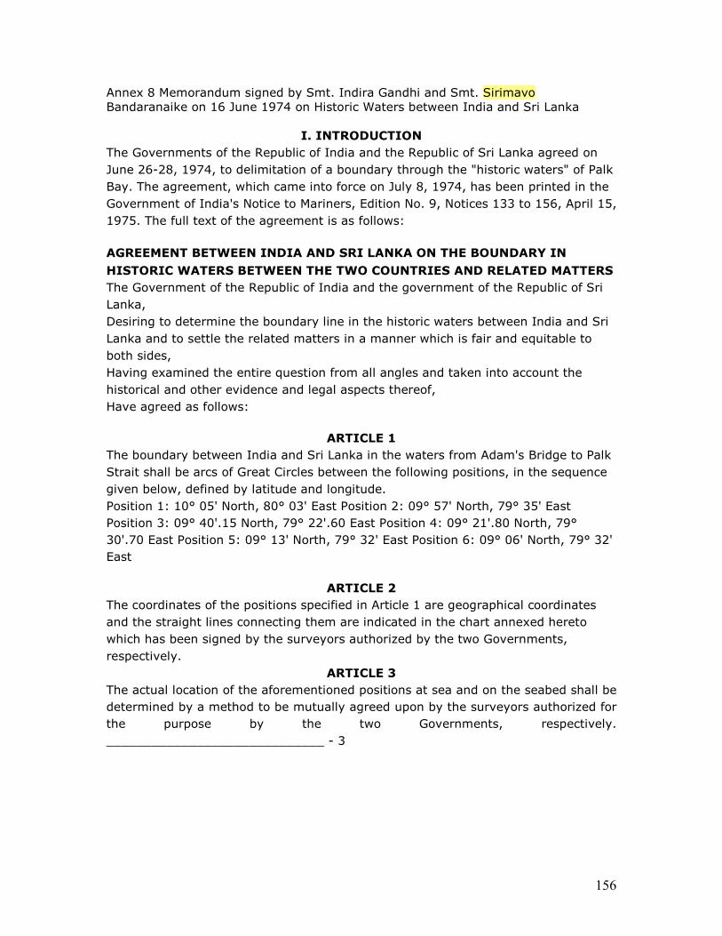
156
Annex 8 Memorandum signed by Smt. Indira Gandhi and Smt. Sirimavo Bandaranaike on 16 June 1974 on Historic Waters between India and Sri Lanka
I. INTRODUCTION The Governments of the Republic of India and the Republic of Sri Lanka agreed on June 26-28, 1974, to delimitation of a boundary through the "historic waters" of Palk Bay. The agreement, which came into force on July 8, 1974, has been printed in the Government of India's Notice to Mariners, Edition No. 9, Notices 133 to 156, April 15, 1975. The full text of the agreement is as follows: AGREEMENT BETWEEN INDIA AND SRI LANKA ON THE BOUNDARY IN
HISTORIC WATERS BETWEEN THE TWO COUNTRIES AND RELATED MATTERS The Government of the Republic of India and the government of the Republic of Sri Lanka, Desiring to determine the boundary line in the historic waters between India and Sri Lanka and to settle the related matters in a manner which is fair and equitable to both sides, Having examined the entire question from all angles and taken into account the historical and other evidence and legal aspects thereof, Have agreed as follows:
ARTICLE 1 The boundary between India and Sri Lanka in the waters from Adam's Bridge to Palk Strait shall be arcs of Great Circles between the following positions, in the sequence given below, defined by latitude and longitude. Position 1: 10° 05' North, 80° 03' East Position 2: 09° 57' North, 79° 35' East Position 3: 09° 40'.15 North, 79° 22'.60 East Position 4: 09° 21'.80 North, 79° 30'.70 East Position 5: 09° 13' North, 79° 32' East Position 6: 09° 06' North, 79° 32' East
ARTICLE 2 The coordinates of the positions specified in Article 1 are geographical coordinates and the straight lines connecting them are indicated in the chart annexed hereto which has been signed by the surveyors authorized by the two Governments, respectively.
ARTICLE 3 The actual location of the aforementioned positions at sea and on the seabed shall be determined by a method to be mutually agreed upon by the surveyors authorized for the purpose by the two Governments, respectively. _____________________________ - 3
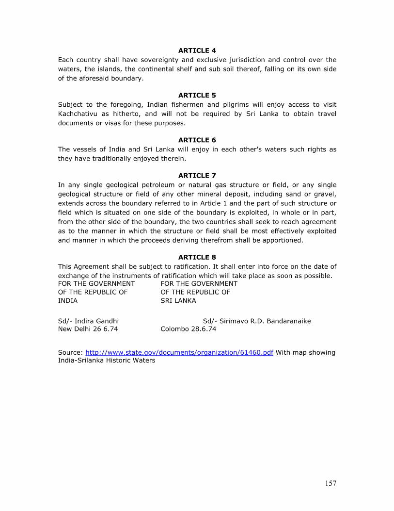
157
ARTICLE 4 Each country shall have sovereignty and exclusive jurisdiction and control over the waters, the islands, the continental shelf and sub soil thereof, falling on its own side of the aforesaid boundary.
ARTICLE 5 Subject to the foregoing, Indian fishermen and pilgrims will enjoy access to visit Kachchativu as hitherto, and will not be required by Sri Lanka to obtain travel documents or visas for these purposes.
ARTICLE 6 The vessels of India and Sri Lanka will enjoy in each other's waters such rights as they have traditionally enjoyed therein.
ARTICLE 7 In any single geological petroleum or natural gas structure or field, or any single geological structure or field of any other mineral deposit, including sand or gravel, extends across the boundary referred to in Article 1 and the part of such structure or field which is situated on one side of the boundary is exploited, in whole or in part, from the other side of the boundary, the two countries shall seek to reach agreement as to the manner in which the structure or field shall be most effectively exploited and manner in which the proceeds deriving therefrom shall be apportioned.
ARTICLE 8 This Agreement shall be subject to ratification. It shall enter into force on the date of exchange of the instruments of ratification which will take place as soon as possible. FOR THE GOVERNMENT FOR THE GOVERNMENT OF THE REPUBLIC OF OF THE REPUBLIC OF INDIA SRI LANKA
Sd/- Indira Gandhi Sd/- Sirimavo R.D. Bandaranaike New Delhi 26 6.74 Colombo 28.6.74 Source: http://www.state.gov/documents/organization/61460.pdf With map showing India-Srilanka Historic Waters
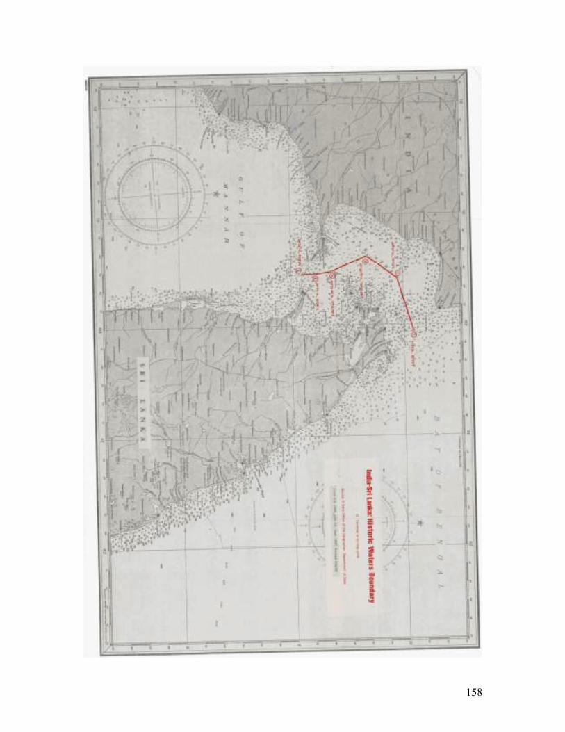
158
159
Annex 9 Implications of damaging Rama Setu under international Law of the Sea The arbitrary choice of the medial line as the passage channel opens up serious concerns for national sovereignty and security and the arbitrary creation of an international boundary in what have always been considered to be Historic (Internal) Waters. The medial line was only an administrative boundary to delimit ownership of chank and pearl fishery areas between Bharatam and Srilanka and SHOULD NOT be converted into a de facto international waters boundary. The new channel alignment now being implemented was never considered by any of the previous committees since 1860 when Commander Taylor proposed a canal. The channel alignment will only satisfy the US interests as seen from the US Navy Operational Directive of 23 June 2005 which refuses to recognize India’s claim and Srilanka’s claim of the Gulf of Mannar and Palk Straits and Palk bay as Historic (Internal) Waters and sought to impose its military (naval) might by sending operational ships during 1993, 1994 and 1999. The US Directive says: “This claim(of historic waters) is not recognized by the United States. U.S. conducted operational assertions in 1993 and 1994, to Gulf of Mannar claim in 1999.”
• This stance of USA is in direct contravention of United Nations Conference on the Law of the Sea (1958), Convnention of the Territorial Sea and Contiguous Zone recognizes HISTORIC Waters
• Agreement between Sri Lanka and India on the Maritime Boundary between the two Countries in the Gulf of Mannar and the Bay of Bengal and Related Matters 23 March 1976 on Historic waters.
It is a matter of serious concern related to National Sovereignty and Integrity, apart from security of the coastline which will be adversely impacted if the mid-sea passage opens up a funnel to absorb the energy of a next tsunami with incalculable devastation and destruction of Kerala and Tamilnadu coastline apart from the desiccation of the nation’s Thorium reserves (as placer deposits on the beach sands) crucial for the nation’s nuclear programme. (See appended article on how placer deposits are accumulated due to ocean currents on the west of the Rama Setu which divides the two oceans).
a) India and Sri Lanka have consistently treated Palk Bay, Gulf of Mannar and Palk Straits as 'historic' and 'internal'.
b) USA does not recognize this claim, has always protested against these, and considers the waters as 'international' and rejects the 'historic' claim too.
c) India , by choosing a Setu Samudram Channel alignment running VERY close to international waters, involving damage the Ramar bridge (called Adam's Bridge) is going back on its earlier claims of waters being historic waters.
d) This view of historic waters also means Sri Lanka is free to do what it likes on its side of the waters.
e) A more serious situation arises by keeping the alignment close to the 'international' waters. Coast guard will be handicapped in protecting the channel from the Srilanka side since coast guard vessels will have to constantly get into international waters.
f) It will make eminent sense in terms of the juridical regime of historic and internal waters to choose an alignment close to Pamban island WITHOUT damaging the Ramar Bridge (Adam's Bridge). The relevant extracts from UN documents are given below.
160
Juridical Regime of Historic Waters, including Historic Bays Bottom of Form
last update: 30 June 2005 The first United Nations Conference on the Law of the Sea (1958) adopted, in paragraph 6 of article 7 of the Convention of the Territorial Sea and Contiguous Zone, a provision to the effect that its rules on bays "shall not apply to so-called 'historic' bays". [1] The Conference also adopted on 27 April 1958 a resolution requesting the General Assembly to arrange for the study of the juridical regime of historic waters, including historic bays. [2] The General Assembly thereafter adopted resolution 1453 (XIV) of 7 December 1959 ( E, F, S, R , C , A), which requested the International Law Commission, as soon as it considers it advisable, to undertake the study of the question of the juridical regime of historic waters, including historic bays, and to make such recommendations regarding the matter as the Commission deems appropriate. The Commission, at its twelfth session (1960) requested the Secretariat to undertake a study of the topic, and deferred further consideration to a future session. [3] A study prepared by the Secretariat was published in 1962. [4] Also in 1962, the Commission, at its fourteenth session, decided to include the topic in its programme, but without setting any date for the start of its consideration. [5] At its nineteenth session (1967), the Commission examined the advisability of proceeding actively with the study of this topic. The Commission's report (which also dealt with the topic "Right of asylum") summarized the views expressed as follows: "Most members doubted whether the time had yet come to proceed actively with either of these topics. Both were of considerable scope and raised some political problems, and to undertake either of them at the present time might seriously delay the completion of work on the important topics already under study [...]"[6]
[1] United Nations, Treaty Series, vol. 516, p. 210. [2] Official Records of the United Nations Conference on the Law of the Sea, vol. II, Plenary Meetings , (United Nations publication, Sales No.: 58.V.4, vol. II), p. 145. [3] See Yearbook of the International Law Commission, 1960, vol. II, , p. 180, document A/4425, para. 40. (see Analytical Guide ) [4] Ibid., 1962, vol. II, p. 1, document A/CN.4/143. (see Analytical Guide) [5] Ibid., p. 190, document A/5209, para. 60. (see Analytical Guide) [6] Ibid., 1967, vol. II, document A/6709/Rev.1, para. 45. (see Analytical Guide)
http://untreaty.un.org/ilc/summaries/8_4.htm#_ftnref2 Paragraphs 4 to 6 of Article 7 of the Convention of the Territorial Sea and Contiguous Zone read as follows: 4. If the distance between the low-water marks of the natural entrance points of a bay does not exceed twenty-four miles, a closing line may be drawn between these two low-water marks, and the waters enclosed thereby shall be considered as internal waters. 5.Where the distance between the low-water marks of the natural entrance points of a bay exceed twenty-four miles, a straight baseline of twenty-four miles shall be drawn within the bay in such a manner as to enclose the maximum area of water that is possible with a line of that length. 6.The foregoing provisions
161
shall not apply to so-called "historic" bays, or in any case where the straight baseline system provided for in article 4 is applied. Section 7 of President of the Republic of Srilanka in Presidential Proclamation of 15 January 1977 in pursuance of Maritime Zones Law No. 22 of 1 September 1976 reads as follows: (7) (i) that the historic waters of Sri Lanka shall comprise the areas of sea in the Palk Strait, Palk Bay and the Gulf of Mannar bounded by: (a) the coast of the mainland of Sri Lanka; (b) the maritime boundary between Sri Lanka and India as defined in Section 8 of the Maritime Zones Law, No. 22 of 1976; (c) the arc of Great Circle between the following positions defined by latitude and longitude in the Gulf of Mannar: (i) 08° 15' 0" North, 79° 44' 0" East, (ii) 08° 22' 2" North, 78° 55' 4" East; and (d) the arc of Great Circle between the following positions defined by latitude and longitude in the Palk Strait: (i) 09° 49' 8" North, 80° 15' 2" East, (ii) 10° 05' 0" North, 80° 03' 0" East; (ii) the historic waters in the Palk Bay and Palk Strait shall form part of the internal waters of Sri Lanka; (iii) the historic waters in the Gulf of Mannar shall form part of the territorial sea of Sri Lanka. http://www.un.org/Depts/los/LEGISLATIONANDTREATIES/PDFFILES/LKA_1977_Proclamation.pdf Agreement between Sri Lanka and India on the Maritime Boundary between the two Countries in the Gulf of Mannar and the Bay of Bengal and Related Matters 23 March 1976 The Government of the Republic of Sri Lanka and the Government of the Republic of India, Recalling that the boundary in the Palk Strait has been settled by the Agreement between the Republic of Sri Lanka and the Republic of India on the Boundary in Historic Waters between the Two Countries and Related Matters, signed on 26/28 June, 1974, And desiring to extend that boundary by determining the maritime boundary between the two countries in the Gulf of Mannar and the Bay of Bengal, Have agreed as follows: …Article 5 (1) Each Party shall have sovereignty over the historic waters and territorial sea, as well as over the islands, falling on its side of the aforesaid boundary. (2) Each Party shall have sovereign rights and exclusive jurisdiction over the continental shelf and the exclusive economic zone as well as over their resources, whether living or non-living, falling on its side of the aforesaid boundary. (3) Each Party shall respect rights of navigation through its territorial sea and exclusive economic zone in accordance with its laws and regulations and the rules of international law. http://www.un.org/Depts/los/LEGISLATIONANDTREATIES/PDFFILES/TREATIES/LKA-IND1976MB.PDF
162
Document:- A/CN.4/143 Juridical Regime of Historic waters including historic bays - Study prepared by the Secretariat Topic:Juridical régime of historic waters, including historic bays Extract from the Yearbook of the International Law Commission:- 1962 , vol. II 38. In summary, the concept of "historic waters" has its root in the historic fact that States through the ages claimed and maintained sovereignty over maritime areas which they considered vital to them without paying much attention to divergent and changing opinions about what general international law might prescribe with respect to the delimitation of the territorial sea. This fact had to be taken into consideration when attempts were made to codify the rules of international law in this field, i.e., to reduce the sometimes obscure and contested rules of customary law to clear and generally acceptable written rules. It was felt that States could not be expected to accept rules which would deprive them of considerable maritime areas over which they had hitherto had sovereignty. http://untreaty.un.org/ilc/documentation/english/a_cn4_143.pdf
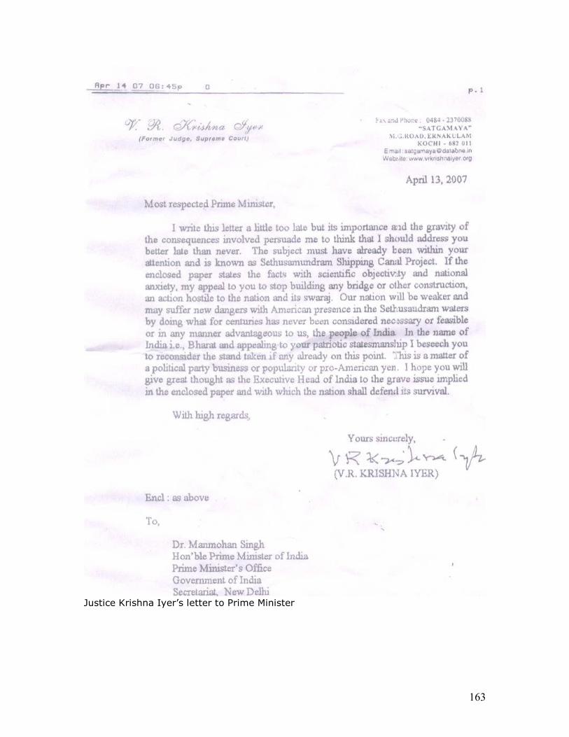
163
Justice Krishna Iyer’s letter to Prime Minister
164
Annex 10. Ancient monuments and archaeological sites and remains act 1958
Monuments The Ancient Monuments and Archaeological Sites and Remains Act, 1958 defines an ‘ Ancient Monument ’ as follows:-
Ancient Monument means any structure, erection or monument, or any tumulus or place of interment, or any cave, rock-sculpture, inscription or monolith which is of historical, archaeological or artistic interest and which has been in existence for not less than 100 years and includes—
1. Remains of an ancient monument, 2. Site of an ancient monument, 3. Such portion of land adjoining the site of an ancient monument as may be
required for fencing or covering in or otherwise preserving such monument, a 4. The means of access to, and convenient inspection of, an ancient monument;
The section 2(d) defines archaeological site and remains as follows: Archaeological site and remains means any area which contains or is reasonably believed to contain ruins or relics of historical or archaeological importance which have been in existence for not less than one hundred years, and includes—
1. Such portion of land adjoining the area as may be required for fencing or covering in or otherwise preserving it, and
2. The means of access to, and convenient inspection of the area;
Protection of monuments The Archaeological Survey of India (ASI) under the provisions of the AMASR Act, 1958 protects monuments, sites and remains of national importance by giving a two-month’s notice for inviting objections, if any in this regard.
After the specified two-month’s period, and after scrutinizing the objections, if any, received in this regard, the ASI makes decision to bring a monument under its protection.
There are at present more than 3650 ancient monuments and archaeological sites and remains of national importance. These monuments belong to different periods, ranging from the prehistoric period to the colonial period and are located in different geographical settings. They include temples, mosques, tombs, churches, cemeteries, forts, palaces, step-wells, rock-cut caves, and secular architecture as well as ancient mounds and sites which represent the remains of ancient habitation. These monuments and sites are maintained and preserved through various Circles of the ASI spread all over the country. The Circles look after the research on these monuments and conservation activities, while the Science Branch with its headquarters at Dehradun carries out chemical preservation and the Horticulture
165
Branch with its headquarters at Agra is entrusted with the laying out gardens and environmental development.
http://asi.nic.in/asi_monuments.asp
THE ANCIENT MONUMENTS AND ARCHAEOLOGICAL SITES AND REMAINS ACT, 1958 ACT NO. 24 OF 1958 1* [28th August, 1958.] An Act to provide for the preservation of ancient and historical monuments and archaeological sites and remains of national importance, for the regulation of archaeological excavations and for the protection of sculptures, carvings and other like objects. BE it enacted by Parliament in the Ninth Year of the Republic ofIndia as follows:- 1.Short title, extent and commencemnt. (1)This Act may be called the Ancient Monuments and Archaeological Sites and Remains Act, 1958. (2) 2 [It extends to the whole of India.] (3) It shall come into force on such date:3 as the Central Government may, by notification in the Official Gazette, appoint. 2.Definitions. In this Act, unless the context otherwise requires,- (a) "ancient monument" means any structure erection or monument, or any tumulus or place of interment, or any cave, rock-sculpture, inscription or monolith, which is of historical, archaeological or artistic interest and which has been in existence for not less than one hundred years, and includes- (i) the remains of an ancient monument, (ii) the site of an ancient monument, (iii)such portion of land adjoining the site of an ancient monument as may be required for fencing or covering in or otherwise preserving such monument, and (iv)the means of access to, and convenient inspection of, an ancient monument;
166
--------------------------------------------------------------------- 1 Extended to Goa, Daman and Diu with modifications by Reg. 12 of 1962, S. 3 and Sch. (w.e.f. 22-11-1962). Extended to Dadra and Nagar Haveli by Reg. 6 of 1963, s. 2 and Sch. I (w.e.f. 11-7-1965) and Pondicherry by Reg. 7 of 1963, s. 3 and Sch. I (w.e.f. 1-10-1963). 2 Subs. by Act 52 of 1972, s. 33, for sub-section (2) (w.e.f. 5-4-1976). 3 15th October, 1959, see Notification No. S. 0. 2307, dated 15th October, 1959, Gazette of India, Extraordinary, 1959, Pt. II, See. 3 (ii), p. 537. (b) "antiquity" includes- (i)any coin, sculpture, manuscript, epigraph, or other work of art or craftsmanship, (ii)any article, object or thing detached, from a building or cave, (iii)any article, object or thing illustrative of science, art, crafts, literature, religion, customs, morals or politics in bygone ages, (iv) any article, object or thing of historical interest, and (v) any article, object or thing declared by the Central Government, by notification in the Official Gazette, to be an antiquity for the purposes of this Act, which has been in existence for not less than one hundred years ; (c) "archaelogical officer" means an officer of the Department of Archaeology of the Government of India not lower in rank than Assistant Superintendent of Archaeology ; (d) "archaeological site and remains" means any area which contains or is reasonably believed to contain ruins or relics of historical or archaeological importance which have been in existence for not less than one hundred years, and includes- (i)such portion of land adjoining the area as may be required for fencing or covering in or otherwise preserving it, and (ii)the means of access to, and convenient inspection of, the area;
167
(e) Director-General " means the Director-General of Archaeology, and includes any officer authorised by the Central Government to perform the duties of the Director General ; (f) "maintain", with its grammatical variations and cognate expressions, includes the fencing, covering in, repairing, restoring and cleansing of a protected monument, and the doing of any act which may be necessary for the purpose of preserving a protected monument or of securing convenient access thereto; (g) "owner" includes- (i)a joint owner invested with powers of management on behalf of himself and other joint owners and the successor-in-title of any such owner, and (ii) any manager or trustee exercising power of management and the successor-in-office of any such manager or trustee ; (h) " prescribed " means prescribed by rules made under this Act; (i) "protected area" means any archaeological site and remains which is declared to be of national importance by or under this Act ; (j) "Protected monument" means an ancient monument which is declared to be of national importance by or under this Act. 1[2A. Construction of references to any law not in force in the state of Jammu and Kashmir. Any reference in this Act to any law which is not in force in the State of Jammu and Kashmir shall, in relation to that State, be construed as a reference to the corresponding law, if any, in force in that State.] ANCIENT MONUMENTS AND ARCHAEOLOGICAL SITES AND REMAINS OF NATIONAL IMPORTANCE 3.Certain ancient monuments, etc., deemed to be of national importance. All ancient and historical monuments and all archaeological sites and remains which have been declared by the Ancient and Historical Monuments and Archaeological Sites and Remains (Declaration of ,National Importance) Act, 1951, (71 of 1951.) or by section 126 of the States Reorganisation Act, 1956, (37 of 1956) to be of national importance shall be deemed to be ancient and historical monuments or archaeological Sites and remains declared to be of national importance for the purposes of this Act.
168
4. Power of Central Governement to declare ancient monuments etc., to be of national importance. (1)Where the Central Government is of opinion that any ancient monument or archaeological site and remains not included in section 3 is of national importance, it may, by notification in the Official Gazette, give two months' notice of its intention to declare such ancient monument or archaeological site and remains to be of national importance; and a copy of every such notification shall be affixed in a conspicuous place near the monument or site and remains, as the case may be. (2) Any person interested in any such ancient monument or archaeological site and remains may, within two months after the issue of the notification, object to the declaration of the monument or the archaeological site and remains, to be of national importance. (3) On the expiry of the said period of two months, the Central Government may, after considering the objections, if any, received by it, declare by notification in the Official Gazette, the ancient monument or the archaeological site and remains, as the case may be, to be of national importance. --------------------------------------------------------------------- 1 Ins. by Act 52 1972, s. 33 (w.e.f. 5-4-1976). (4) A notification published under sub-section (3) shall, unless and until it is withdrawn, be conclusive evidence of the fact that the ancient monument or the archaeological site and remains to which it relates is of national importance for the purposes of this Act. PROTECTED MONUMENTS 5.Acquisition of rights in a protected monument. (1)The Director- General may, with the sanction of the Central Government, purchase, or take a lease of, or accept a gift or request of, any protected monument. (2) Where a protected monument is without an owner, the Director General may, by notification in the Official Gazette, assume the guardianship of the monument. (3) The owner of any protected monument may, by written instru- ment, constitute the Director-General the guardian of the monument, and the Director-General may, with the sanction of the Central Government, accept such guardianship. (4) When the Director-General has accepted the guardianship of a monument under sub-section (3), the owner shall, except as expressly provided in this Act, have the same estate, right, title and interest
169
in and to the monument as if the Director-General had not been constituted a guardian thereof. (5) When the Director-General has accepted the guardianship of a monument under sub-section (3), the provisions of this Act relating to agreements executed under section 6 shall apply to the written instrument executed under the said sub-section. (6) Nothing in this section shall affect the use of any protected monument for customary religious observances. 6. Preservation of protected monument by agreement. (1) The Collector, when so directed by the Central Government, shall propose to the owner of a protected monument to enter into an agreement with the Central Government within a specified period for the maintenance of the monument. (2) An agreement under this section may provide :for all or any of the following matters, namely:- (a) the maintenance of the monument (b) the custody of the monument and the duties of any person who may be employed to watch it (c) the restriction of the owner's right- (i) to use the monument for any purpose, (ii) to charge any fee for entry into, or inspection of, the monument, (iii)to destroy, remove, alter or deface the monument, or (iv) to build on or near the site of the monument; ((d) the facilities of access to be permitted to the public or any section thereof or to archaeological officers or to persons deputed by the owner or any archaeological officer or the Collector to inspect or maintain the monument; (e) the notice to be given to the Central Government in case the land on which the monument is situated or any ad- joining land is offered for sale by the owner, and the right to be reserved to the Central Government to purchase such land, or any specified portion of such land, at its market value (f) the payment of any expenses incurred by the owner or by the Central Government in connection with the maintenance of
170
the monument; (g) the proprietary or other rights which are to vest in the Central Government in respect of the monument when any expenses are incurred by the Central Government in connection within the maintenance of the monument; (h) the appointment of an authority to decide any dispute arising out of the agreement; and (i) any matter connected with the maintenance of the monument which is a proper subject of agreement between the owner and the Central Government. (3) The Central Government or the owner may, at any time after the expiration of three years from the date of execution of an agree- ment under this section, terminate it on giving six months' notice in writing to the other party: Provided that where the agreement is terminated by the owner, he shall pay to the Central Government the expenses, if any, incurred by it on the maintenance of the monument during the five years immediately preceding the termination of the agreement or, if the agreement has been in force for a shorter Period, during the period the agreement was in force. (4)An agreement under this section shall be binding on any per- son claiming to be the owner of the monument to which it relates, from, through or under a party by whom or on whose behalf the agreement was executed. 7. Owners under disability or not in possession. (1)If the owner of a protected monument is unable, by reason of infancy or other disability, to act for himself, the son legally competent to act on his behalf may exercise the powers conferred upon an owner by section 6. [[ (2)In the case of village property, the headman or other village officer exercising powers of management over such property may exercise the powers conferred upon an owner by section 6. (3)Nothing in this section shall be deemed to empower any person not being of the same religion as the person on whose behalf he is acting to make or execute an agreement relating to a protected monument which or any part of which is periodically used for the religious worship or observances of that religion. 8. Application of endowment to repair a protected monument. (1)If any owner or other person competent to enter into an agreement under section 6 for the maintenance of a protected monument refuses or fails to enter into such an agreement, and if any endowment has been created for the purpose of keeping such monument in repair or for that purpose among others, the Central Government may institute a suit in the court
171
of the district judge, or, if the estimated cost of repairing the monument does not exceed one thousand rupees, may make an application to the district judge, for the proper application of such endowment or part thereof. (2)On the hearing of an application under sub-section (1), the district judge may summon and examine the owner and any person whose evidence appears to him necessary and may pass an order for the proper application of the endowment or of any part thereof, and any such order may be executed as if it were a decree of a civil court. 9. Failure or refusal to enter into an agreement. (1)If any owner or other person competent to enter into an agreement under section 6 for the maintenance of a protected monument refuses or fails to enter into such an agreement, the Central Government may make an order providing for all or any of the matters specified in sub-section (2) of section 6 and such order shall be binding on the owner or such. other person and on every person claiming title to the monument from, through or under, the owner or such other person. (2)Where an order made tinder sub-section (1) provides that the monument shall be maintained by the owner or other person competent to enter into an agreement, all reasonable expenses for the maintenance of the monument shall be payable by the Central Government. (3) No order under sub-section (1) shall be made unless the owner or other person has been given an opportunity of making a representation in writing against the proposed order. 10.(1)Power to make order prohibiting contravention of agreement under section 6. If the Director-General apprehends that the owner or occupier of a protected monument intends to destroy, remove, alter, deface, imperil or misuse the monument or to build on or near the site thereof in contravention of the terms of an agreement under section 6, the Director-General may, after giving the owner or occupier an opportunity of making a representation in writing, make an order prohibiting any such contravention of the agreement: Provided that no such opportunity may be given in any case where the Director-General, for reasons to be recorded, is satisfied that it is not expedient or practicable to do so. (2) Any person aggrieved by an order under this section may appeal to the Central Government within such time and in such manner as may be prescribed and the decision of the Central Government shall 11.(1)Enforcement of agreements. If an owner or other person who is bound by an agreement for the maintenance of a monument under section 6 refuses or fails within such reasonable time as the Director-General may fix, to do any act which in the opinion of the
172
Director-General is necessary for the maintenance of the monument, the Director-General may authorise any person to do any such act, and the owner or other person shall be liable to pay the expenses of doing any such act or such portion of the expenses as the owner may be liable to pay under, the agreement. (2) If any dispute arises regarding the amount of expenses pay- able by the owner or other person under sub-section (1), it shall be referred to the Central Government whose decision shall be final. 12.Purchasers at certain sales and persons claiming throgh owner bound by instrument executed by owner. Every person who purchases, at a sale for arrears of land revenue or any other public demand, any land on which is situated a monument in respect of which any instrument has been executed by the owner for the time being under section 5 or section 6, and every person claiming any title to a monument from, through or under, an owner who executed any such instrument, shall--be bound by such instrument. 13.Acuquistion of protected monuments. If the Central Government apprehends that a protected monument is in danger of being destroyed, injured, misused, or allowed to fall into decay, it may acquire the protected monument under the provisions of the- Land Acquisition Act,1894, as if the maintenance of the protected monument were a public purpose within the meaning of that Act. 14.Maintenance of certain protected monuments. (1) The Central Government shall maintain every monument which has been acquired under section 13 or in respect of which any of the rights mentioned in section 5 have been acquired. (2)When the Director-General has assumed the guardianship of a monument under section 5, he shall, for the purpose of maintaining such monument, have access to the monument at all reasonable times, by himself and by his agents, subordinates and workmen, for the purpose of inspecting the monument and for the purpose of bringing such materials and doing such acts as he may consider necessary or desirable for the maintenance thereof. 15.Voluntary contributions.The Director-General may receive voluntary contributions towards the cost of maintaining a protected monument and may give orders as to the management and application of any funds so received by him: Provided that no contribution received under this section shall be applied to any purpose other than the purpose for which it was contributed. 16. Protection of place of worship form misuse, pollution or desecration. (1)A protected monument maintained by the Central
173
Government under this Act which is a place of worship or shrine shall not be used for any purpose inconsistent with its character. (2)Where the Central Government has acquired a protected monument under section 13, or where the Director-General has purchased, or taken a lease or accepted a gift or bequest or assumed guardianship of a protected monument under section 5, and such monument or any part thereof is used for religious worship or observances by any community. the Collector shall make due provision for the protection of such monument or part thereof, from pollution or desecration- (a) by prohibiting the entry therein, except in accordance with the conditions prescribed with the concurrence of the persons, if any, in religious charge of the said monument or part thereof, of any person not entitled so to enter by the religious usages. of the community by which the monument or part thereof is used, or (b) by taking such other action as he may think necessary in this behalf. 17.Relinquishemnt of Government rights in monument. With the sanction of the Central Government, the DirectorGeneral may,- (a) where rights have been acquired by the Director- General in respect of any monument under this Act by virtue of any sale, lease, gift or will, relinquish, by notification in the Official Gazette, the rights so acquired to the person who would for the time being be the owner of the monument if such rights had not been acquired; or (b) relinquish any guardianship of a monument which he has assumed under this Act. 18.Right of access to protected monuments. Subject to any rules made under this Act, the public shall have right of access to any protected monument. PROTECTED AREAS 19. Restictions on enjoyment of property rights in protected areas. (1)No person, including the owner or occupier of a protected area, shall construct any building within the protected area or carry on any mining, quarrying, excavating, blasting or any operation of a like nature in such area, or utilise such area or any part thereof in any others manner without the permission of the Central Government: Provided that nothing in this sub-section shall be deemed to
174
prohibit the use of any such area or part thereof for purposes of cultivation if such cultivation does not involve the digging of not more than one foot of soil from the surface. (2)The Central Government may, by order, direct that any building constructed by any person within a protected area in contravention of the provisions of sub-section (1) shall be removed within a specified period and, if the person refuses or fails to comply with the order, the Collector may cause the building to be removed and the person shall be liable to pay the cost of such removal. 20.Power to acquire a protected area. If the Central Government is of opinion that may protected area contains an ancient monument or antiquities of national interest and value, it may acquire such area under the provisions of the Land Acquisition Act, 1984, as if the acquisition were for a public purpose within the meaning of that Act. ARCHAEOLOGICAL EXCAVATIONS 21.Excavations in Protected areas. An archaeological officer or an officer authorised by him in this behalf or any person holding a licence granted in this behalf under this Act (hereinafter referred to as the licensee) may, after giving notice in writing to the Collector and the owner, enter upon and make excavations in any protected area. 22.Excavations in areas other than protected areas. Where an archaeological officer has reason to believe that any area not being a protected area contains ruins or relies of historical or archaeological importance, he or an officer authorised by, him in this behalf may, after giving notice in writing to the Collector and the owner, enter upon and make excavations in the area. 23. Compulsory purchase of antiquities, etc., discovered during excavation operations.(1)Where, as a result of any excavations made in any area under section 21 or section 22, any antiquities are discovered, the archaeological officer or the licensee, as the case may be, shall,- (a) as soon as practicable, examine such antiquities and submit a report to the Central Government in such manner and containing such particulars as may be prescribed ; (b) at the conclusion of the excavation operations, give notice in writing to the owner of the land from which such antiquities have been discovered, of the nature of such antiquities.
175
(2) Until an order for the 1[compulsory acquisition] of any such antiquities is made under sub-section (3), the archaeological officer or the licensee, as the case may be, shall keep them in such safe custody as (3) On receipt of a report under sub-section (1), the Central Govern-he may deem fit. ment may make an order for the 2[compulsory acquisition of any such antiquities.] --------------------------------------------------------------------- 1 Subs. by Act 52 of 1972 s. 33, for "compulsory purchase" (w.e.f. 5-4-1976). 2 Subs. by s. 33, ibid., for certain words (w.e.f. 5-4-1976). --------------------------------------------------------------------- (4)When an order for the 1[compulsory acquisition] of any antiquities is made under sub-section (3), such antiquities shall rest in the Central Government with effect from the date of the order. 24. Excavations, etc., for archaeological purposes. 24.Excavations, etc., for archaeological purposes. No State Government shall undertake or authorise any person to undertake any excavation or other like operation for archaeological purposes in any area which is not a protected area except with the previous approval of the. Central Government and in accordance with such rules or directions, if any, as the Central Government may make or give in this behalf. PROTECTION OF ANTIQUITIES 25. Power of Central Government to control moving of antiquities. 25. Power of Central Government to control moving of antiquities. (1) If the Central Government considers that any antiquities or class of antiquities ought not to be moved from the place where they are without the sanction of the Central Government, the Central Government may, by notification in the Official Gazette, direct that any such antiquity or any class, of such antiquities shall not be moved except with the written permission of the Director-General.
176
(2)Every application for permission under sub-section (1) shall be in such form and contain such particulars as may be prescribed. (3)Any person aggrieved by an order refusing permission may appeal to the Central Government whose decision shall be final. 26. Purchase of antiquities by Central Government. (1) If the Central Government apprehends that any antiquity mentioned in a notification issued under sub-section (1) of section 25 is in danger of being destroyed, removed, injured, misused or allowed, to fall into decay or is of opinion that, by reason of its historical or archaeo- logical importance, it is desirable to preserve such antiquity in a public place, the Central Government may make an order for the 2[compulsory acquisition of such antiquity] and the Collector shall thereupon give notice to the owner of the antiquity 2[to be acquired.] (2)Where a notice of 1[compulsory acquisition] is issued under subsection (1) in respect of any antiquity, such antiquity shall vest in the Central Government with effect from the date of the notice. --------------------------------------------------------------------- 1 Subs. by Act 52 of 1972 s. 33, for "compulsory Purchase" (w.e.f 5-4- 1976). 2 Subs. by a. 33, ibid. for certain; words (w.e.f. 5-4-1976). --------------------------------------------------------------------- (3) The power of 1[compulsory acquisition] given by this section shall not extend to any image or symbol actually used for bona fide religious observances. PRINCIPLES OF COMPENSATION 27.Compensation for loss or damage. Any owner or occupier of land who has sustained any loss or damage or any diminution of profits from the land by reason of any entry on, or excavations in such land or the exercise of any other power conferred by this Act shall be paid compensation by the Central Government for such loss, damage or diminution of profits. 28. Assessement of market value of compensation. (1) The market value of any property which the Central Government is empowered to
177
purchase at such value under this Act or the compensation to be paid by the Central Government in respect of anything done under this Act shall, where any dispute arises in respect of such market value or compensation, be ascertained in the manner provided in sections 3, 5, 8 to 34, 45 to 47, 51 and 52 of the. Land Acquisition Act, 1894,(1 of 1984.) so far as they can be made applicable : Provided that, when making an enquiry under the said Land Acqui- sition Act, the Collector shall be assisted by two assessors, one of whom shall be a competent person nominated by the Central Government and one a person nominated by the owner, or, in case the owner fails to nominate an assessor within such reasonable time as may be fixed by the Collector in this behalf, by the Collector. 2[ (2) For every antiquity in respect of which an order for compulsory acquisition has been made under sub-section (3) of section 23 or under sub-section (1) of section 26, there shall be paid compensation and the provisions of section 20 and 22 of the Antiquities and Art Treasures Act, 1972 (52 of 1972,) shall, so far as may be, apply in relation to the determination and payment of such compensation as they apply in relation to the determination and payment of compensation for any antiquity or art treasure compulsorily acquired under section 19 of that Act.] MISCELLANEOUS 29.Delegation of powers.The Central Government may, by notification in the Official Gazette, direct that any powers conferred on it by or under this Act shall. subject to such conditions as may be specified in the direction, be exercisable also by- (a) such officer or authority subordinate to the Central Govern- ment, or --------------------------------------------------------------------- 1 Subs. by Act 52 of 1972, s. 33. for " compulsory purchase" (w.e.f. 5-4-1976). 2 Subs: by s. 33, ibid., for sub-section (2)(w.e.f. 5-4-1976). --------------------------------------------------------------------- (b) such State Government or such officer or authority subordinate to the State Government, as may be specified in the direction. 30. (1) Whoever-
178
(i) destroys, removes, injures, alters, defaces, imperils or misuses Penalties. a protected monument, or (ii) being the owner or occupier of a protected monument, contravenes an order made under sub-section (1) of section 9 or under sub-section (1) of section 10, or (iii) removes from a protected monument any sculpture, carving, image, bas-relief, inscription, or other like object, or (iv) does any act in contravention of sub-section (1) of section 19, shall be punishable with imprisonment which may extend to three months, -or with fine which may extend to five thousand rupees, or with both. (2) Any person who moves any antiquity in contravention of a notification issued under sub-section (1) of section 25 shall be punishable with fine which may extend to five thousand rupees; and the court convicting a per-son of any such contravention may by order direct such person to restore the antiquity to the place from which it was moved. 31.Jurisdiction to try offences. No court inferior to that of a presidency magistrate or a magistrate of the first class shall try any offence under this Act. 32.Certain offences to be cognizable. Notwithstanding anything contained in the Code of Criminal Procedure, 1898, (5 of 1898.) an offence under clause (i) or clause (iii) of subsection (1) of section 30, shall be deemed to be a cognizable offence within the meaning of that Code. 33.Special provision regarding fine. Notwithstanding anything contained in section 32 of the Code of Criminal Procedure, 1898,(5 of 1898.) it shall be lawful for any magistrate of the first class specially empowered by the State Government in this behalf and for any presidency magistrate to pass a sentence of fine exceeding two thousand rupees on any person convicted of an offence which under this Act is punishable with fine exceeding two thousand rupees. 34.Recovery of amounts due to the Government. Any amount due to the Government from any person under this Act may, on a certificate issued by the Director-General or an' archaeological officer authorised by him in this behalf be recovered in the same manner as an arrear of land revenue.
179
35. Ancient monuments, etc., which have ceased to be of nationalimportance. 35.Ancient monuments, etc., which have ceased to be of national importance. If the Central Government is of opinion that any ancient and historical monument or archaeological site and remains declared to be of national importance by or under this Act has ceased to be of nationals importance, it may, by notification in the Official Gazette, declare that the ancient and historical monument or archaeological (f)the form and manner of preferring appeals under this Act and the time within which they may be preferred; (g) the manner of service of any order or notice under this Act ; (h) the manner in which excavations and other like operations for archaeological purposes may be carried on ; (i) any other matter which is to be or may be prescribed. (3)Any rule made under this section may provide that a breach thereof shall be punishable,- (i) inthe case of a rule made with reference to clause (a) of sub-section (2), with imprisonment which may extend to three months, or with fine which may extend to five thousand rupees, or with both ; (ii) in the case of a rule made with reference to clause (b) of sub-section (2), with fine which may extend to five thousand rupees; (iii)in the case of a rule made with reference to clause (c) of sub-section (2), with fine which may extend to five hundred rupees. (4)All rules made under this section shall be laid for not less than thirty days before each House of Parliament as soon as possible after they are made, and shall be subject to such modifications as Parliament may make during the session in which they are so laid or the session immediately following. 39. Repeals and savings. (1)The Ancient and Historical Monuments and Archaeological Sites and Remains (Declaration of National Importance) Act, 1951, (71 of 1951.) and section 126 of the States Reorganisation Act, 1956, (37 of 1956.) are hereby repealed.
180
(2) The Ancient Monuments. Preservation Act, 1904, (7 of 1904) shall cease to have effect in relation to ancient and historical monuments and archaeological sites and remains declared by or under this Act to be of national importance, except as respects things done or omitted to be done before the commencement of this Act.
© 2005 Indian Government. Reproduced in accordance with s52(q) of the Copyright Act 1957 (India)
181
Annex 11 Setusamudram Shipping Channel Project (SSCP) -- A Mariner’s Perspective
By Capt (Retd) H. Balakrishnan, I.N
Introduction
1. The SSCP is an off-shore shipping canal project in the Palk Bay. It plans to cut short the distance navigated by ships sailing from the West coast of India and bound for ports on the Eastern seaboard and vice versa, by precluding the necessity to circumnavigate around Sri Lanka.
2. The total length of the SSCP in the Palk Bay is 152.2 Kms. It is divided into
three legs. The Southern leg in the Adam’s Bridge area is 20 Kms. The Northern leg in the Palk Strait area is 54.2 Kms. The Central portion is 78 Kms. Dredging is to be carried out in the Southern and Northern legs to maintain a dredged depth of 12 metres. This would facilitate a navigable channel for ships with a draught of upto 10.7 meters. The canal will be 300 meters wide.
3. The basic justification advanced in favour of the project is that it will reduce
the sailing distance between Kolkata and Tuiticorin by 340 nautical miles and between Chennai and Tuiticorin by 434 nautical miles. This enables savings in fuel costs and sailing time, for ships plying between these ports.
4. This paper aims to analyse the viability of the SSCP against the canvas of the
following factors, that have a bearing on shipping:
(a) Environmental Factors (b) Security Implications (c) Navigational and Allied Factors
ENVIRONMENTAL FACTORS
Tropical Cyclones
5. The India Meteorological Department has assigned the Palk Bay area as a ‘High Risk Area’ for cyclonic activity. The cyclone season the Bay of Bengal is generally between Oct to Jan. It is interesting to note that the IMD’s records from 1891-2001, states that of the 452 cyclones that hit the Indian coastline, 256 were on the East coast. We mariners, in a lighter vein, refer to the Tamil Nadu coast between Rameswaram and Cuddalore as the ‘cyclone coast’!! There are valid reasons for this quip. Of the 256 cyclones referred, 64 have crossed the Tamil Nadu coast in this period. Of these, 36 were ‘severe cyclones’ (winds in excess of 90 Kmph). More interesting, of these cyclones, SIX have crossed the Palk Bay, 14 have crossed the coast at Nagapattinam and THREE have crossed the Gulf of Mannar. All these cyclones can have a devastating consequence on the SSCP and shipping in the area.
182
6. A few more examples of the devastating consequences of these cyclones, will be illustrative:
(a) In Dec 1964, a cyclone washed away the Pamban Bridge. (b) In Dec 1973, FIVE metres high tidal waves hit the Palk
Bay area – the very same area where the SSCP is to be dredged!!
(c) In Dec 1977/78, under the influence of a severe cyclonic storm that crossed the coast near Nagapattinam, 120 Kmph winds were recorded in the Palk Bay area.
(d) In Nov/Dec 1997/98, an oil-drilling ship, anchored with SIX anchors in the Cauvery Basin, broke loose from her anchors and was washed ashore by a cyclone.
7. The foregoing will serve to illustrate the fact that the Bay of Bengal cyclones
pose a ‘clear, live and present danger’ to ‘Safety of Lives at Sea’ (SOLAS). And, the SSCP is sought to be created in a ‘cyclone danger area’!!
Siltation
8. Allied to the cyclonic activity in the area, is the problem of siltation leading to
a loss of sea depth. Scientists have concluded that the Palk Bay area is one of the FIVE areas, off the Indian coast, where siltation takes place regularly. Some of their calculations have indicated a loss in sea depth of about 1 cms every year. It is pertinent to state that TWO of the LEGS of the SSCP, where dredging is to be undertaken, happen to cross two such micro regions where high siltation takes place.
9. To conclude, the environmental factors of cyclonic activity and siltation rates
in the Palk Bay area, impinge on shipping safety. It is also appreciated that maintenance dredging may have to be undertaken through the year to maintain dredged depths. This could lead to substantially increasing the costs of the SSCP.
SECURITY IMPLICATIONS
Global Scene on Maritime Terrorism 10. While terrorist attacks are predominantly land based, non- state actors have also sought to exploit vulnerabilities in shipping, ports and the container supply chains in Asia, Middle- East, Europe and North America. 11. Conventional arms trade and smuggling, both highly profitable global businesses, are spreading increasingly sophisticated conventional weapons to non-state actors, including long- range anti-ship missiles, unmanned aerial vehicles and close range armour piercing missiles and rocket propelled grenades. All these weapons are capable of inflicting serious damage to ships. 12. The list of foiled, failed and successful attempts in maritime-related
terrorism over the past decade is significant. Yet, there is a tendency to overlook or downplay what has happened, and thus ignore the possibility of further trouble. It is
183
clear that terrorists can see the potential of using the maritime trading system and its land links in the container supply chain to conceal weapons or agents for attack purposes. Two recent examples of terrorist attacks on naval warships help illustrate the point. 13. Attack on the U.S.S. Cole. In Oct 2000, Al-Qaeda operatives in Yemen, packed a small boat with explosives and rammed the same onto the U.S. Navy destroyer, U.S.S. Cole, while the ship was in harbour. The blast left a gaping hole on the side of the destroyer and the cost of repairs amounted to USD 250 million. The blast killed 17 U.S. Naval sailors and, wounded another 40 seamen.
14. Missile attack on Israeli Naval Ships. On 14 Jul 2006, two days after hostilities between Israel and the Hezbollah commenced, the latter fired TWO, C-802 radar guided cruise missiles from ashore in Lebanon, at Israeli naval vessels patrolling off the Lebanese coast. One missile seriously damaged an Israeli naval corvette. The second missile narrowly missed another corvette. Instead it hit a Cambodian registered merchant vessel, sinking it with eleven hands on board.
The LTTE Factor 15. The LTTE factor has a direct bearing on the safety of shipping navigating through the SSCP. The LTTE has control over most of North Sri Lanka coastal region and the seas contiguous to it. The Sea Tigers, the naval arm of the LTTE, have displayed considerable ingenuity and daring in sea borne insurgency. They have carried out numerous daring attacks on Sri Lankan naval ships, and have not hesitated in resorting to suicide missions. It is pertinent to note that the SSCP is a ‘next-door-neighbour’ in the area of operations of the Sea Tigers!! 16. A new addition to the LTTE’s fighting capability is its ‘Air Arm’. They have todate carried out THREE daring ‘night attacks’ on Sri Lankan assets. This factor adds a new dimension to the threat perception along the SSCP. 17. Reports in open source literature indicate that the aircraft deployed by the LTTE Air Force is the Czech manufactured ‘ZLIN-Z 242 L’ aircraft. These appear to have been purchased from a private South African flying club. The aircraft is delivered in a knocked-down condition and can be easily smuggled as automobile parts or components of heavy commercial vehicles. By all accounts these aircraft were ferried by sea using forged Bills of Lading. This corroborates Para 11 above. 18. Reports also indicate that the flying training for the LTTE’s pilots was carried out by the same South African flying club. It is also suspected that armament training were carried out by mercenaries in South Africa. All the air attacks on Sri Lankan assets todate have been at night, indicating a high degree of proficiency. The SSCP falls within the radius of operation of these aircraft!! 19. Media reports of 28 Apr 2007 in Chenai, attributed the recent killings of the TN fishermen at sea to the LTTE Sea Tigers. The grounds for the killings, attributed to LTTE sources, was that these fishermen were ‘spying’ on the LTTE’s activities at sea!! If that be the case, the possibility of the LTTE advancing the same argument for attacking ships navigating through the SSCP cannot be ruled out. The consequences of a ship sinking in the canal could have a disastrous impact on the viability of the project itself. It would have a psychological on the shipping industry which may then
184
tend to avoid the SSCP and circumnavigate Sri Lanka in the larger interests of safety of men and material.
NAVIGATIONAL AND ALLIED FACTORS 20. The official website of the SSCP states: “ Ships originating in the West of India and destined for Chennai, Ennore, Vishakapatnam, Paradeep, Haldia and Kolkata have to travel around the Sri Lankan coast resulting in increase of travel distance and time. Apart from this ships belonging to the Indian Navy and Cost Guard need also to traverse around Sri Lanka- - “ .
Navy and Coast Guard 21. The website statement about the Navy and the Coast Guard would give the impression Naval/Coast Guard ships sail to and from either coasts on a frequent basis. In reality this is not the case.
22. The navy has been operating on a ‘Two Fleet’ concept for over three decades, to safeguard our maritime interests on the Eastern and Western seaboards. New induction ships are allotted to both Fleet to maintain the required Force Levels on both coasts. Thus the requirement for ships to cross over to the other coast is more the exception than the rule. At the most, they may meet annually for a combined Fleet exercise programme. 23.Besides, peacetime sailings of the Fleet are to hone skill levels in battle-manoeuvres, missile and gun firings, submarine exercises, aircraft operations and underway re-fuelling exercise at sea. All these and other exercises are conducted in areas far removed from the coastal and international shipping lanes for obvious reasons. Under these circumstances and considering the security implications in the area contiguous to the SSCP, it is debatable whether a Fleet would prefer to navigate through the SSCP. Also, if the Fleet happens to be a carrier battle group, availing the SSCP route can be almost ruled out, on account of various tactical factors. 24. During the period of hostilities, it is improbable that ships on passage to either coast would navigate through the SSCP as it militates against the basic principles of naval operations of avoiding straits and narrows to maintain secrecy of deployment. 25. Similar arguments can also be advanced on the deployment of Coast Guard vessels.
Mercantile Marine
26. It must be borne in mind that the SSCP is not an ‘open seaway’. Thus for ships to safely traverse through the canal, it will be mandatory to embark a ‘pilot’. A ‘pilot’ is a mariner with experience pertaining to local conditions. He would normally board a vessel at either extremity of the canal and take the vessel safely to the other extremity before disembarking. It is not clear at the present juncture, whether vessels calling at the SSCP will have a ‘pilot’ boarding on arrival. Delays in the boarding of the ‘pilot’ will entail the vessel to anchor and await the ‘pilot’. Under adverse weather conditions this is not a comforting thought to a mariner. Besides, during cyclonic weather, sea conditions may preclude the embarkation of a ‘pilot’. What does the vessel then do?
185
27. Open source literature on the SSCP indicates that vessels upto 32,000 DWT can navigate through the canal. However, in the current global shipping scenario, to reduce the operating costs and cater to the enormous growth in shipping needs, trends are towards operating vessels of 60,000 DWT and above. This trend is likely to grow further in future, resulting in vessels of larger tonnage. A passage along the international shipping lane from South of Sri Lanka to South of the Great Nicobar Island will prove this point. None of these large vessels can avail of the facility of the SSCP. 28. This would leave the coal carrying bulk carriers on charter to the TNEB, the only ships that would use the SSCP on a regular basis. These vessels load coal at Haldia/ Paradeep/ Vishakapatnam and discharge the same at Chennai and Tuiticorin for the Thermal Power Plants. Besides, some smaller container feeder vessels from Colombo and bound for Chennai could also use the SSCP. 29. In the opinion of Mr. K.S. Ramakrishnan, former Deputy Chairman of Chennai Port Trust and former Managing Director of the Poompuhar Shipping Corporation, the pilotage costs of navigating through the SSCP and certain allied factors, could make the SSCP unattractive to the shipping industry. It is his opinion that the actual use of the SSCP maybe substantially lower than the projected figure of 3417 vessels by 2010 and 7141 vessels by 2025.
CONCLUSION
30. A report in the magazine ‘Frontline’ of 01 Jan-14 Jan 2005, entitled ‘Of Gains and Loses’, states: “ George Gomez, Tamil Nadu Manual Workers’ Union, Tuiticorin, who has several decades of experience in the shipping industry, says the Project cost will work out to Rs. 3000 crores. He says the Project will be a ‘sick unit’ as the money invested can never be recovered. ‘I don’t think any container ship will use the canal’. Major container operators deploying mother-vessels, will not use it. The difference in time between ships using the canal and those going around Sri Lanka will only be a few hours. Ships would not be able to cruise fast in the canal because they will have to be piloted, he argues. Moreover, the canal will have to be dredged continuously.”
31. In the Chennai based English daily, The Hindu, of 21 Dec 2004, Mr. K.S. Ramakrishnan, former Deputy Chairman of the Chennai Port Trust had questioned the need for the canal. He had stated: “- - - . But the canal cannot be a free seaway because the grounding of a wayward coal or oil ship that strays from the alignment or a collision of two ships in the channel will result in an ecological disaster of unimaginable proportions to the Gulf of Mannar and the Palk Bay”. He further stated: “ The two statements that the ships using the canal will save money and that the project will be a financially viable undertaking are therefore mutually contradictory and cannot have simultaneous validity”. 32. In the light of the foregoing analysis, it is debatable whether the investments made in the construction of the canal is justified from the security, environment or economic standpoints. The old adage ‘Haste Makes Waste’ readily comes to mind in the case of the SSCP.
REFERENCES
186
(A) Business Line- 29 Dec 2004- ‘Will We Ever Learn’- P.Devarajan. (B) “Is the Sethusamudram Shipping Canal Project Technically Feasible?”- R.
Ramesh
(C) “Cyclones, Tsunami and the Sethusamudram Project”- Papri Sri Raman- (www.boloji.com/environment/25.htm)
(D) Frontline- Vol 22- Issue 01, Jan 01-14, 2005- “Of Gains and Loses”- T.S.
Subramanian
(E) “Strategic Security and Sethusamudram Project”- Col. R.Hariharan (Retd)- www.saag.org- Paper No: 1713 (F) “ Countering LTTE’s Air Capability”- B.Raman www.saag.org- Paper No: 2222 (G) “Maritime Related Terrorism”- Michael Richardson
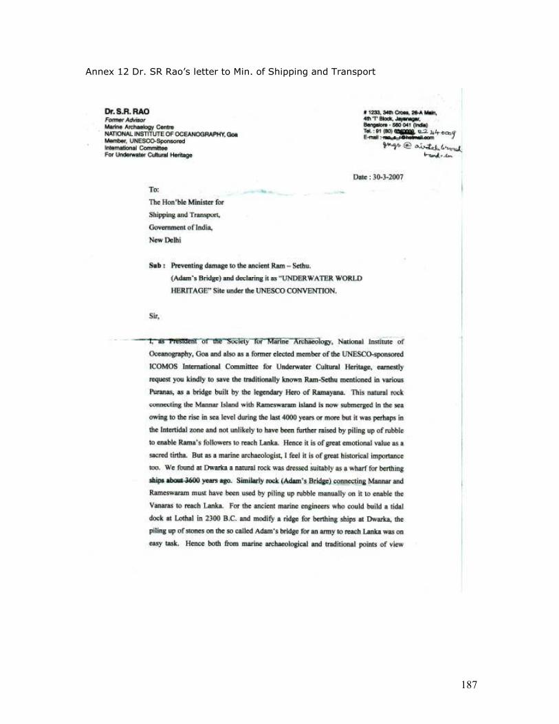
187
Annex 12 Dr. SR Rao’s letter to Min. of Shipping and Transport
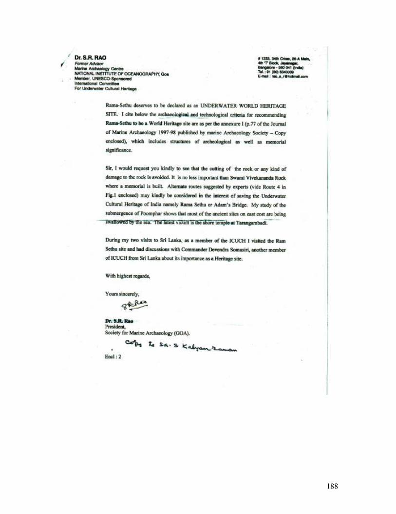
188


![Packages[1]](https://img.pdfslide.net/doc/110x75/53fc639c8d7f72aa518b4747/packages1.jpg)