Embed Size (px)
Citation preview

SCOTIAN BASIN EXPLORATION DRILLING PROJECT – ENVIRONMENTAL IMPACT STATEMENT
Introduction
October 2016
File: 121413516 1.1
1.0 INTRODUCTION
BP Canada Energy Group ULC (BP Canada Energy Group ULC and/or any of its affiliates are
hereafter generally referred to as “BP”) is proposing to conduct an exploration drilling program
on Exploration Licences (ELs) 2431, 2432, 2433, and 2434 known as the Scotian Basin Exploration
Drilling Project (the Project) (refer to Figure 1.1.1). BP holds a 40% interest in the Nova Scotia
Offshore ELs and will operate the exploration program. Partners, Hess Canada Oil and Gas ULC
and Woodside Energy International (Canada) Limited, hold a 40% and 20% interest, respectively.
Offshore exploration drilling is a designated activity under the Canadian Environmental
Assessment Act, 2012 (CEAA, 2012). This document is intended to fulfill requirements for an
environmental assessment (EA) pursuant to CEAA, 2012 as well as EA requirements of the
Canada-Nova Scotia Offshore Petroleum Board (CNSOPB) pursuant to the Canada-Nova Scotia
Offshore Petroleum Resources Accord Implementation Act and the Canada-Nova Scotia
Offshore Petroleum Resources Accord Implementation (Nova Scotia) Act (hereafter referred to
as the “Accord Acts”). This Environmental Impact Statement (EIS) has been prepared to satisfy
Project-specific Guidelines for the Preparation of an Environmental Impact Statement Pursuant
to CEAA, 2012 (CEA Agency 2015a; hereafter referred to as the “EIS Guidelines” and included as
Appendix A) which were developed by the Canadian Environmental Assessment Agency (CEA
Agency) with input from other government departments and agencies, and the public.
1.1 PROJECT OVERVIEW
BP will drill up to seven exploration wells in phases over the term of the licences, from 2018 to
2022. A Mobile Offshore Drilling Unit (MODU) will be contracted to drill wells within the ELs.
Logistics support will be provided through a fleet of platform supply vessels (PSVs) and
helicopters. A supply base in Halifax Harbour will be used to store materials and equipment. It is
expected that drilling activity for the first well in the program will commence in 2018. At this time,
it is anticipated that exploration drilling will be carried out in multiple phases so that initial well
results can be analyzed to inform the execution strategy for subsequent wells. Information about
the proposed Project that is assessed within the EIS can be found in Section 2.

SCOTIAN BASIN EXPLORATION DRILLING PROJECT – ENVIRONMENTAL IMPACT STATEMENT
Introduction
October 2016
File: 121413516 1.2
Figure 1.1.1. Scotian Basin Exploration Drilling Project Location

SCOTIAN BASIN EXPLORATION DRILLING PROJECT – ENVIRONMENTAL IMPACT STATEMENT
Introduction
October 2016
File: 121413516 1.3
1.2 SCOPE OF THE EIS
The Project that is assessed within the scope of the EIS, in accordance with the EIS Guidelines
includes:
presence and operation of the MODU;
o establishment of a safety (exclusion) zone, and light and sound emissions associated
with MODU presence and operation; and
o well drilling and testing operations;
waste management;
o discharge of drill muds and cuttings; and
o other discharges and emissions (including drilling and well flow testing emissions);
Vertical Seismic Profiling (VSP) operations;
supply and servicing operations; and
o helicopter transportation; and
o PSV operations (including transit and transfer activities);
well abandonment.
Some other components or activities which are not included within the scope of the EIS
Guidelines may be described where necessary in relevant chapters for broader context.
The exact well locations have not yet been finalized, however will be confirmed as part of the
regulatory approval process for each well in the program as described in detail in Section 1.5.1.
The EIS is defined by spatial boundaries to adequately consider potential adverse environmental
effects from the Project. The Project Area encompasses the immediate area in which Project
activities and components may occur and includes the area within which direct physical
disturbance to the marine benthic environment may occur, and includes ELs 2431, 2432, 2433,
and 2434 (Figure 1.1.1). Additionally, a Local Assessment Area (LAA) and Regional Assessment
Area (RAA) have also been defined to assess potential environmental effects which may occur
beyond the Project Area. Section 6 of this EIS provides additional information on spatial
boundaries used to evaluate potential environmental effects from the Project.
1.3 PROPONENT INFORMATION
BP is one of the world's leading international oil and gas companies with decades of experience
managing the extraction of oil and natural gas in all types of environments around the world,
both onshore and offshore. BP has operations in more than 70 countries across Europe, North
and South America, Australasia, Asia and Africa.

SCOTIAN BASIN EXPLORATION DRILLING PROJECT – ENVIRONMENTAL IMPACT STATEMENT
Introduction
October 2016
File: 121413516 1.4
BP in Canada focuses on developing energy from Canada’s oil sands, home to the third-largest
crude reserves in the world, and is also pursuing offshore opportunities in the Beaufort Sea,
Newfoundland and Labrador, as well as Nova Scotia. BP’s integrated supply and trading (IST)
business in Canada spans the country and is one of the top oil and natural gas marketer and
trading organizations in Canada, helping to supply customers with safe and reliable energy.
BP Canada’s head office is based in Calgary, Alberta. BP has established an office in Halifax,
Nova Scotia to oversee the Project. Technical resources will also be drawn from BP’s Canadian
headquarters in Calgary, Alberta and BP’s global headquarters in the United Kingdom (UK) and
Houston, Texas.
The overall Project will be managed by BP through a multidisciplinary Project Team based on a
functional model to provide technical and management expertise to the Project. The Team will
include members of BP’s global wells organization who are responsible for delivering a consistent
and standardized approach to the safe delivery of wells-related activity across the company.
The Project Team will also include professionals responsible for health, safety, environment and
emergency response management.
1.3.1 How BP Operates
BP is dedicated to maintaining values of Safety, Respect, Excellence, Courage and One Team,
upholding these values in the areas it operates. The BP values are described in Table 1.3.1.
Table 1.3.1 BP Values
Safety
Safety is good business. Everything we do relies upon the safety of our workforce and the communities
around us. We care about the safe management of the environment. We are committed to safely
delivering energy to the world.
Respect
We respect the world in which we operate. It begins with compliance with laws and regulations. We hold
ourselves to the highest ethical standards and behave in ways that earn the trust of others. We depend on
the relationships we have and respect each other and those we work with. We value diversity of people
and thought. We care about the consequences of our decisions, large and small, on those around us.
Excellence
We are in a hazardous business and are committed to excellence through the systematic and disciplined
management of our operations. We follow and uphold the rules and standards we set for our company.
We commit to quality outcomes, have a thirst to learn and to improve. If something is not right, we correct
it.
Courage
What we do is rarely easy. Achieving the best outcomes often requires the courage to face difficulty, to
speak up and stand by what we believe. We always strive to do the right thing. We explore new ways of
thinking and are unafraid to ask for help. We are honest with ourselves and actively seek feedback from
others. We aim for an enduring legacy, despite the short-term priorities of our world.
One Team
Whatever the strength of the individual, we will accomplish more together. We put the team ahead of our
personal success and commit to building its capability. We trust each other to deliver on our respective
obligations.

SCOTIAN BASIN EXPLORATION DRILLING PROJECT – ENVIRONMENTAL IMPACT STATEMENT
Introduction
October 2016
File: 121413516 1.5
The BP code of conduct sets out the standards of behaviour and working in line with these
values, and defines how to work at a group, team and individual level within the company. With
clear and concise content setting out the principles and expectations on topics such as equal
opportunities, human rights and conflicts of interest, it helps BP’s workforce to operate in line with
BP’s values and maintain the company’s commitment to high ethical standards throughout its
activities and operations. The BP code of conduct applies to all BP employees, officers and
members of the Board, and BP expects and encourages all contractors and their employees to
act in a way that is consistent with the BP code of conduct.
One of BP’s values is safety. Everyone who works for BP is responsible for ensuring his or her safety
and the safety of colleagues, partners, suppliers and local communities. BP’s policy on health,
safety, security and environment (HSSE) sets out the company’s goals of no accidents, no harm
to people and no damage to the environment (shown in Figure 1.3.1). Safety is at the heart of
everything BP does as a company, driven by leadership and applied across all operations
through the operating management system (OMS), which is described below.
Figure 1.3.1 BP HSSE Policy

SCOTIAN BASIN EXPLORATION DRILLING PROJECT – ENVIRONMENTAL IMPACT STATEMENT
Introduction
October 2016
File: 121413516 1.6
The OMS is a framework that brings together BP’s global operating principles. It includes
requirements for HSSE management, social responsibility and operational reliability, as well as
requirements for other operational aspects, for example, maintenance requirements, contractor
relations and organizational learning.
The OMS helps BP to manage and reduce risks throughout its activities globally, as well as
continuously improve the quality of its operating activities. It sets out consistent principles and
processes that are applied across BP Group. Together these are designed to simplify the
organization, improve productivity and enable consistent execution and focus throughout BP. It
sets out the requirements of what a BP operation needs to do across eight focus areas under the
categories of people, plant, process and performance, shown below in the elements of
operating component of OMS illustrated in Figure 1.3.2. The elements of operating are used to
inform the performance improvement cycle which sets out how BP should operate.
The OMS includes requirements and guidance for the identification and management of
environmental and social impacts within BP. These include topics such as management of
drilling waste, wastewater and cultural heritage.
Figure 1.3.2 BP OMS Framework
BP’s ability to be a safe and responsible operator depends in part on the capability and
performance of contractors and suppliers. Contractors and suppliers can make up a major part
of the workforce throughout the life of a project or operation.

SCOTIAN BASIN EXPLORATION DRILLING PROJECT – ENVIRONMENTAL IMPACT STATEMENT
Introduction
October 2016
File: 121413516 1.7
BP’s OMS defines requirements and practices for working with contractors. Contracts will include
clear and consistent information, setting out specific details of BP’s expectations. Contracts will
be awarded following a bidding and contract tender evaluation process, which shall take
account of factors such as safety, technical quality and cost. Contractors and subcontractors
shall be required to demonstrate conformance with the requirements that have been
established, including HSSE standards and performance requirements. Bridging documents are
necessary in some cases to define how BP’s safety management systems and those of BP’s
contractors will co-exist to manage risk on a site.
Contractors, such as drilling and well services contractors, will be accountable for the
development and delivery of their safety management systems. Contractors will be responsible
for carrying out self-verification activity to assess conformance with their contractual
requirements. Contractor safety performance is typically assessed and reviewed by BP using a
number of leading and lagging indicators. Additionally, BP will carry out reviews and assurance
activity throughout the duration of the contract.
1.3.2 Proponent Contact Information
All communications regarding the EA for the Project, including this EIS, should be directed to the
following contacts.
Primary Contact:
Anita Perry
Regional Manager, Nova Scotia
VP, Comms & External Affairs Canada
Tel: (902) 420-2338
BP Canada Energy Group ULC
Suite 505, CIBC Building
1809 Barrington Street
Halifax, NS B3J 3K8
Canada
Additional Contacts:
Rob O’Connor
Canada Exploration Manager
Tel: (281) 892-5683
BP America
200 Westlake Park Boulevard
Houston, Texas 77079
United States
Paul Sutherland
Environment Manager, Exploration & New
Ventures
Upstream HSE
Tel: +44 (0) 2034 015 036
BP Exploration Operating Company Limited
Chertsey Road,
Sunbury on Thames
Middlesex, TW16 7BP
United Kingdom

SCOTIAN BASIN EXPLORATION DRILLING PROJECT – ENVIRONMENTAL IMPACT STATEMENT
Introduction
October 2016
File: 121413516 1.8
1.3.3 Project Team
This EIS was prepared by BP and a consulting team led by Stantec Consulting Ltd. (Stantec).
Stantec is a consulting firm with extensive experience conducting environmental assessments in
Nova Scotia, Canada and internationally.
In addition to Stantec as the EIS lead, the following consultants provided key expertise and
services in support of EIS preparation:
JASCO Applied Sciences (Canada) Ltd. conducted acoustic modelling;
Membertou Geomatics Solutions (MGS) and Unama’ki Institute of Natural Resources (UINR)
completed the Traditional Use Study (TUS); and
SayleGroup Inc. provided input regarding offshore regulatory requirements.
1.4 BENEFITS OF THE PROJECT
The Project is predicted to result in several economic, social and technological benefits realized
on local, regional and national scales. The following describes some of the predicted benefits
the Project will generate.
Energy Diversification and Sustainability
Energy demand is forecast to increase globally over the next 20 years, including in North
America. Population growth and increases in per capita income are the key drivers behind the
growth in energy demand, and Canada has been recognized as one of the areas within North
America where demand is likely to grow the most (BP 2015). The global energy mix continues to
shift as the balance of energy demand and supply varies, economies expand and contract and
energy prices fluctuate. Political unrest and extreme weather continue to affect energy
production and consumption patterns and emphasize the need for secure, sustainable energy
supplies.
BP recognizes the energy challenge – managing and meeting growing worldwide demand for
energy while addressing climate change and other environmental and social issues (BP 2014a).
BP believes that a diverse mix of fuels and technologies can enhance national and global
energy security while supporting the transition to a lower carbon economy. Oil and natural gas
are likely to play a significant part in meeting energy demand for several decades. Exploration is
a critical activity to enable continued oil and gas discoveries to maintain production to meet
global demand for energy. The exploration licences in the Scotian Basin present potentially
significant geological formations and hydrocarbon reserves.
Nova Scotia’s 2009 Energy Strategy – Toward a Greener Future (NSDOE 2009a), highlights the
importance of a sustainable energy mix, and the role that offshore hydrocarbon exploration and
development plays within the province’s ongoing energy strategy. In the strategy, Nova Scotia
commits to “encourage renewed offshore exploration and development, with its enormous

SCOTIAN BASIN EXPLORATION DRILLING PROJECT – ENVIRONMENTAL IMPACT STATEMENT
Introduction
October 2016
File: 121413516 1.9
potential for building future prosperity”. In order to achieve their stated goal, the province has
stated that it will invest revenues from offshore hydrocarbon activity into expenditures that offer
enduring benefits.
Economic Benefits
The Canada-Nova Scotia Offshore Petroleum Resources Accord (1986), promotes the early
development of petroleum resources in the offshore area of Nova Scotia “for the benefit of
Canada as a whole and Nova Scotia in particular” and recognizes Nova Scotia as “the principal
beneficiary of the petroleum resources in the offshore area”. The offshore oil and gas industry
has generated billions of dollars in economic activity for the people of Nova Scotia through
royalties, crown share adjustment payments, offshore accord payments, forfeiture payments
from offshore licenses and rental payment from offshore exploration licenses (NSDOE n.d.).
Nova Scotia’s 2009 Energy Strategy - Toward a Greener Future, recognizes that exploration and
production activity has “contributed greatly to Nova Scotia’s economy and provincial finances”
which pay for public services such as health, education and debt reduction (NSDOE 2009a).
Industrial Benefits
BP is committed to investing in the areas where BP operates. The Project will contribute to the
Nova Scotia economy through the procurement of equipment and services, referred to by the
Nova Scotia Department of Energy (NSDOE) as industrial benefits. In 2012, BP committed to a
total exploration expenditure of approximately $1.05 billion as part of its successful bid for the
exploration licences in the Scotian Basin. The qualified work expenditures are associated with
exploration activity, including seismic and drilling activity, in the exploration licences over the
initial six-year period of the nine-year exploration licence. This exploration expenditure will
contribute, in part, industrial benefits to the Nova Scotia economy. BP is committed to
incorporating processes and procedures for Nova Scotia and Canadian businesses,
manufacturers, consultants, contractors and service companies to receive a full and fair
opportunity to provide goods and services to the program on a competitive basis.
Employment Benefits
It is likely that there will be some employment opportunities associated with the Project. These
opportunities will be communicated to local and regional audiences, using methods such as
local media. Where employment opportunities are identified, all hiring will be carried out
according to BP’s code of conduct and include a transparent hiring process. First consideration
will be given to residents of Nova Scotia and Canada as a whole where they have the
appropriate competencies.
BP has established a local office in Halifax. The office will be staffed with management and
administrative support staff. During planning and operations, technical staff directly working on

SCOTIAN BASIN EXPLORATION DRILLING PROJECT – ENVIRONMENTAL IMPACT STATEMENT
Introduction
October 2016
File: 121413516 1.10
the Project will also work in the Halifax office. BP recognizes the importance of having a local
presence and location known to stakeholders and local businesses.
Community Investment
BP’s community investment strategy is to invest in people and programs that pursue sustainable
and long-lasting progress. BP seeks to work closely with partner organizations so that BP can play
an active, dedicated role in the communities we operate within.
The BP community investment program’s main focus areas are:
education;
environment; and
community.
Benefits Plan
In accordance with section 45 of the Accord Act, BP, as operator, will submit a benefits plan for
approval to the CNSOPB. BP is required to have an approved benefits plan prior to the approval
or authorization of any work or activity in the Nova Scotia offshore area (refer to Section 1.5.1).
This plan will describe how BP shall provide benefits to Nova Scotia in terms of procurement
opportunity for goods and services and employment opportunity. It will also address how BP will
develop and implement an education, training, research and development expenditure
program in Nova Scotia. The benefits plan will describe how BP will give first consideration to
Canadian residents and organizations, particularly from Nova Scotia, where possible within the
recruitment and procurement processes.
Knowledge Benefits
In addition to the economic and associated community and social benefits described above,
the Project is likely to contribute to technological and scientific knowledge sharing and
advancement in Canada and Nova Scotia.
The Scotian Basin includes water depths that extend to greater than 3,000 m. BP has deepwater
drilling interests in a number of locations around the globe and can offer a wealth of experience
in deepwater operations and technology.
BP will submit reports to the CNSOPB on environmental and operational performance which will
also contribute to the understanding of deepwater drilling operations offshore Nova Scotia.

SCOTIAN BASIN EXPLORATION DRILLING PROJECT – ENVIRONMENTAL IMPACT STATEMENT
Introduction
October 2016
File: 121413516 1.11
1.5 REGULATORY FRAMEWORK AND THE ROLE OF GOVERNMENT
1.5.1 Offshore Regulatory Framework
Petroleum activities in the Nova Scotia offshore environment are regulated by the CNSOPB, a
joint federal-provincial agency reporting to the federal Minister of Natural Resources Canada
and the provincial Minister of Energy. In 1986, the Government of Canada and the Province of
Nova Scotia signed the Canada-Nova Scotia Offshore Petroleum Resource Accord to promote
social and economic benefits associated with petroleum exploitation. The federal and
provincial governments established mirror legislation to implement the Accord. The Canada-
Nova Scotia Offshore Petroleum Resources Accord Implementation Act and the Canada-Nova
Scotia Offshore Petroleum Resources Accord Implementation (Nova Scotia) Act are collectively
referred to as the Accord Acts. Under the Accord Acts, the CNSOPB issues licences for offshore
exploration and development, the management and conservation of offshore petroleum
resources, and protection of the environment as well as the health and safety of offshore
workers, while enhancing employment and industrial benefits for Nova Scotians and Canadians.
Offshore petroleum activities and the CNSOPB’s decision-making processes are governed by
legislation, regulations, guidelines and memoranda of understanding. Exploration drilling projects
require an Operations Authorization (OA) under the Accord Acts. Prior to issuing an OA, the
CNSOPB requires the following to be submitted:
an Environmental Assessment report;
a Canada-Nova Scotia Benefits Plan;
a Safety Plan;
an Environmental Protection Plan (including a waste management plan);
Incident Management Plan and Spill Contingency Plans;
financial security; and
certificates of fitness for the equipment proposed for use in the activities.
For each well in the drilling program, a separate Approval to Drill a Well (ADW) is required. This
authorization process involves specific details about the drilling program and well design.
There are several regulations under the Accord Acts, which govern specific exploration or
development activities. There are also guidelines, some of which have been jointly developed
with the Canada-Newfoundland and Labrador Offshore Petroleum Board (C-NLOPB) and
National Energy Board (NEB), which are intended to address environmental, health, safety and
economic aspects of offshore petroleum exploration and development activities. Of particular
relevance to the environmental assessment of this Project are the Offshore Waste Treatment
Guidelines (OWTG) (NEB et al. 2010) and the Offshore Chemical Selection Guidelines (OCSG) for
Drilling and Production Activities on Frontier Lands (NEB et al. 2009). Relevant regulations and
guidelines that fall under the jurisdiction of the CNSOPB are summarized in Table 1.5.1. Additional
legislation and regulations relevant to offshore exploration activity are discussed in Section 1.5.3.
BP will comply with all applicable Canadian regulations and the terms and conditions for all
permits, authorizations and licenses obtained in support of the Project.

SCOTIAN BASIN EXPLORATION DRILLING PROJECT – ENVIRONMENTAL IMPACT STATEMENT
Introduction
October 2016
File: 121413516 1.12
Table 1.5.1 Summary of Key Relevant Offshore Legislation and Guidelines
Legislation/Guideline Regulatory Authority Relevance Potentially Applicable Permitting
Requirement(s)
Canada-Nova Scotia
Offshore Petroleum
Resources Accord
Implementation Act and
the Canada-Nova Scotia
Offshore Petroleum
Resource Accord
Implementation (Nova
Scotia) Act (Accord Acts)
Natural Resources
Canada (NRCan)/
NSDOE
The Accord Acts give the CNSOPB the authority
and responsibility for the management and
conservation of the petroleum resources offshore
Nova Scotia in a manner that protects health,
safety and the environment while maximizing
economic benefits. The Accord Acts are the
governing legislation under which various
regulations are established to govern specific
petroleum exploration and development activities.
The regulatory approvals identified
below may be required pursuant to
section 142 of the Canada-Nova
Scotia Offshore Petroleum Resources
Accord Implementation Act, section
135 of the Canada-Nova Scotia
Offshore Petroleum Resources
Accord Implementation (Nova
Scotia) Act, and the regulations
made under the Accord Acts.
Nova Scotia Offshore Area
Petroleum Geophysical
Operations Regulations
(and associated
Guidelines)
CNSOPB These regulations pertain to the geophysical
operations in relation to exploration for petroleum in
the Nova Scotia Offshore area and outline specific
requirements for authorization applications and
operations.
A Geophysical Operations
Authorization may be required in
support of the Project if walkaway
VSP methods are employed in
support of exploratory drilling
activities, although currently BP
plans to conduct zero offset VSP
(refer to Section 2.4.2).
Nova Scotia Offshore
Petroleum Drilling and
Production Regulations
(and associated
Guidelines)
CNSOPB These regulations outline the various requirements
that must be adhered to when conducting
exploratory and or production drilling for petroleum.
The primary regulatory approvals
necessary to conduct an offshore
drilling program are an Operations
Authorization (Drilling) and a Well
Approval (Approval to Drill a Well)
pursuant to the Accord Acts and
these regulations.
Nova Scotia Offshore
Certificate of Fitness
Regulations
CNSOPB Pursuant to subsection 136(b) of the Canada-Nova
Scotia Offshore Petroleum Resources
Implementation Act, these regulations outline the
associated requirements for the issuance of a
Certificate of Fitness to support an authorization for
petroleum exploration and or production drilling in
the Nova Scotia Offshore Area.
A Certificate of Fitness will be
required in support of the Project.
SCOTIAN BASIN EXPLORATION DRILLING PROJECT – ENVIRONMENTAL IMPACT STATEMENT
Introduction
October 2016
File: 121413516 1.13
Table 1.5.1 Summary of Key Relevant Offshore Legislation and Guidelines
Legislation/Guideline Regulatory Authority Relevance Potentially Applicable Permitting
Requirement(s)
More specifically, the Regulations are implemented
to require that the equipment and/or installation of
exploratory or production equipment is fit for the
purposes for which it is intended to be used and
may be operated safely without posing threat to
persons or the environment in a specified location
and timeframe.
Offshore Waste Treatment
Guidelines (OWTG)
NEB/CNSOPB/C-NLOPB These guidelines outline recommended practices
for the management of waste materials from oil
and gas drilling and production facilities operating
in offshore areas regulated by the Boards. The
OWTG were prepared in consideration of the
offshore waste/effluent management approaches
of other jurisdictions, as well as available waste
treatment technologies, environmental compliance
requirements, and the results of environmental
effects monitoring programs in Canada and
internationally. The OWTG specify performance
expectations for the following types of discharges
(NEB et al. 2010):
emissions to air
produced water and sand
drilling muds and solids
storage displacement water
bilge water, ballast water and deck drainage
well treatment fluids
cooling water
desalination brine
sewage and food wastes
water for testing of fire control systems
Compliance with OWTG
SCOTIAN BASIN EXPLORATION DRILLING PROJECT – ENVIRONMENTAL IMPACT STATEMENT
Introduction
October 2016
File: 121413516 1.14
Table 1.5.1 Summary of Key Relevant Offshore Legislation and Guidelines
Legislation/Guideline Regulatory Authority Relevance Potentially Applicable Permitting
Requirement(s)
discharges associated with subsea systems
naturally occurring radioactive material.
Offshore Chemical
Selection Guidelines
(OCSG)
NEB/CNSOPB/
C-NLOPB
These guidelines provide a framework for chemical
selection that minimizes the potential for
environmental effects from the discharge of
chemicals used in offshore drilling and production
operations. The framework incorporates criteria for
environmental acceptability that were originally
developed by the Oslo and Paris Commissions
(OSPAR) for the North Sea.
An operator must meet the minimum expectations
outlined in the OCSG as part of the authorization for
any work or activity related to offshore oil and gas
exploration and production. The OCSG includes the
following requirements (NEB et al. 2009):
the quantity of each chemical used, its hazard
rating, and its ultimate fate (e.g., storage,
discharge, onshore disposal, downhole injection,
abandonment in the well, or consumption by
chemical reaction) must be tracked and
reported
all products to be used as biocides must be
registered under the Pest Control Products Act
(PCPA) and used in accordance with label
instructions
all chemicals other than those with small quantity
exemptions must be on the Domestic Substances
List (DSL) of approved substances pursuant to the
Canadian Environmental Protection Act, 1999
(CEPA, 1999), or must be assessed under the New
Substances Notification process to identify any
restrictions, controls, or prohibitions
Compliance with OCSG

SCOTIAN BASIN EXPLORATION DRILLING PROJECT – ENVIRONMENTAL IMPACT STATEMENT
Introduction
October 2016
File: 121413516 1.15
Table 1.5.1 Summary of Key Relevant Offshore Legislation and Guidelines
Legislation/Guideline Regulatory Authority Relevance Potentially Applicable Permitting
Requirement(s)
any chemicals included on the List of Toxic
Substances under Schedule 1 of CEPA, 1999 must
be used in accordance with CEPA, 1999 risk
management strategies for the substance and
alternatives must be considered for any
substances on the CEPA, 1999 Virtual Elimination
List
any chemicals intended for discharge to the
marine environment must
o be included on the OSPAR Pose Little or No Risk
to the Environment (PLONOR) List
o meet certain requirements for hazard
classification under the OCNS
o pass a Microtox test (i.e., toxicity bioassay)
o undergo a chemical-specific hazard
assessment in accordance with UK OCNS
models
o and/or have the risk of its use justified through
demonstration to the Board that discharge of
the chemical will meet OCSG objectives.
Compensation Guidelines
Respecting Damage
Relating to Offshore
Petroleum Activity
(Compensation Guidelines)
CNSOPB/C-NLOPB These guidelines describe compensation sources
available to potential claimants for loss or damage
related to petroleum activity offshore Nova Scotia
and Newfoundland and Labrador; and outline the
regulatory and administrative roles which the
Boards exercise respecting compensation
payments for actual loss or damage directly
attributable to offshore operators.
Compliance with Compensation
Guidelines
Environmental Protection
Plan Guidelines (EPP
Guidelines)
CNSOPB These guidelines assist an operator in the
development of an environmental protection plan
(EPP) that meets the requirements of the Accord
Compliance with EPP Guidelines

SCOTIAN BASIN EXPLORATION DRILLING PROJECT – ENVIRONMENTAL IMPACT STATEMENT
Introduction
October 2016
File: 121413516 1.16
Table 1.5.1 Summary of Key Relevant Offshore Legislation and Guidelines
Legislation/Guideline Regulatory Authority Relevance Potentially Applicable Permitting
Requirement(s)
Acts and associated regulations and the objective
of protection of the environment from its proposed
work or activity.
Statement of Canadian
Practice with respect to the
Mitigation of Seismic Sound
in the Marine Environment
(SOCP)
Fisheries and Oceans
Canada (DFO)/
Environment and
Climate Change
Canada
(ECCC)/CNSOPB/
C-NLOPB
The SOCP specifies the minimum mitigation
requirements that must be met during the planning
and conduct of marine seismic surveys, in order to
reduce effects on life in the oceans. These
mitigation measures can be applied to VSP
operations. These mitigation requirements focus on
planning and monitoring measures to avoid
interactions with marine mammal and sea turtle
species at risk where possible and reduce adverse
effects on species at risk and marine populations.
Compliance with SOCP
Guidelines Respecting
Financial Responsibility
Requirements
CNSOPB Pursuant to the Accord Act, proponents wishing to
conduct any work or activity in Nova Scotia
offshore area are required to provide proof of
financial responsibility in a form and amount
satisfactory to the CNSOPB. These regulations and
guidelines provide guidance to operators in
providing proof of financial requirements regarding
authorization being sought for any work or activity
relating to drilling, development, decommissioning
or other operations in the offshore areas.
Compliance with Regulations and
Guidelines
Source: Modified from Stantec 2014a

SCOTIAN BASIN EXPLORATION DRILLING PROJECT – ENVIRONMENTAL IMPACT STATEMENT
Introduction
October 2016
File: 121413516 1.17
Project activities and associated potential effects are not predicted to extend beyond
provincial boundaries. However, if transboundary activities are required (e.g., in the event of a
spill which could extend beyond Canada’s jurisdictional boundary and require spill response in
international waters), then the appropriate regulatory authorities will be consulted, and BP will
comply with additional regulatory requirements as applicable.
1.5.2 Environmental Assessment Requirements
The Project requires environmental assessment under CEAA, 2012. The Regulations Designating
Physical Activities under CEAA, 2012 (amended October 24, 2013) specify the physical activities
to which CEAA, 2012 applies. Based on the activities and location of the Project, it is classed as a
“designated project” under section 10 of the amended regulations. Section 10 of the amended
Regulations Designating Physical Activities includes:
The drilling, testing and abandonment of offshore exploratory wells in the first
drilling program in an area set out in one or more exploration licences issued in
accordance with the Canada-Newfoundland Atlantic Accord Implementation
Act or the Canada-Nova Scotia Petroleum Resources Accord Implementation
Act.
Although there have been other wells drilled in the Project Area (Shubenacadie H-100 drilled in
1982, Evangeline H-98 drilled in 1984, Newburn H-23 drilled in 2002 and Weymouth A-45 drilled in
2003), these wells were not associated with the current ELs issued to BP. The Project consists of
the drilling, testing and abandonment of offshore exploratory wells within the ELs issued to BP by
the CNSOPB.
A Project Description was filed by BP with the CEA Agency on July 15, 2015 (Stantec 2015).
Following a public review and comment period on the Project Description, the CEA Agency
determined that an EA under CEAA, 2012 would be required for the Project and subsequently
issued a Notice of Commencement on September 16, 2015 to mark the beginning of the federal
EA process. Draft EIS Guidelines were issued by the CEA Agency for public review and comment
on the same date, and the final EIS Guidelines were issued on the CEA Agency website on
November 4, 2015.
Following submission of this EIS to the CEA Agency, another public comment period will occur in
conjunction with government review. The CEA Agency will prepare a draft EA Report which will
take into consideration public and government comments and detail the CEA Agency’s
conclusions regarding the potential for environmental effects from the Project. The EA Report will
be subject to public review and comment before being finalized. Following finalization of the EA
Report, the Minister of the Environment will review the EA Report and issue an EA decision, which
will include a determination of significance of environmental effects.
It is expected that the EIS completed to satisfy the CEAA, 2012 requirements will also satisfy the
CNSOPB requirements for an EA as part of the OA review process under the Accord Acts.

SCOTIAN BASIN EXPLORATION DRILLING PROJECT – ENVIRONMENTAL IMPACT STATEMENT
Introduction
October 2016
File: 121413516 1.18
A provincial EA under the Nova Scotia Environment Act is not required based on the proposed
Project scope.
1.5.3 Other Applicable Regulatory Requirements
Project activities and components in the nearshore and offshore marine environment will take
place within federal waters, which, under CEAA, 2012 constitutes “federal lands”. Given the
focus of offshore activities for this Project, the term “federal waters” is used although it is
acknowledged that the Act does not differentiate between federal lands and federal waters.
The Project is subject to various federal legislative and regulatory requirements (see Table 1.5.2).
Table 1.5.2 Summary of Key Relevant Federal Legislation
Legislation Regulatory
Authority Relevance
Potentially
Applicable
Permitting
Requirement(s)
Canada Oil and
Gas Operations
Act (R.S., 1985, c.
O-7)
Natural
Resources
Canada
(NRCan)
The Act is intended to promote, in respect
of the exploration for and exploitation of
oil and gas:
(a) safety, particularly by encouraging
persons exploring for and exploiting oil or
gas to maintain a prudent regime for
achieving safety;
(b) the protection of the environment;
(b.1) the safety of navigation in navigable
waters;
(c) the conservation of oil and gas
resources;
(d) joint production arrangements; and
(e) economically efficient infrastructures.
No specific
permitting
requirements are
anticipated under
this legislation
although new
pending legislation
(Energy Safety and
Security Act (ESSA);
Regulations
Establishing a List of
Spill-treating Agents)
will have implications
for spill prevention
and response (see
below).
Canadian
Environmental
Assessment Act,
2012 (CEAA, 2012)
CEA Agency “The drilling, testing and abandonment of
offshore exploratory wells in the first drilling
program in an area set out in one or more
exploration licences” has been added to
the list of designated activities under
CEAA, 2012. The CEA Agency determined
that exploratory drilling for the Project
requires an EA under CEAA, 2012.
Under current legislation, the CEA Agency
is the responsible authority for
administering the EA process for projects in
the two Atlantic offshore areas (Nova
Scotia and Newfoundland and Labrador).
However, the proposed Federal Authority
as a Responsible Authority for Designated
Projects Regulations would prescribe the
CNSOPB as a responsible authority,
thereby minimizing duplication of effort
The Project is
contingent upon EA
approval (i.e., an EA
Decision Statement
that allows the
Project to proceed).

SCOTIAN BASIN EXPLORATION DRILLING PROJECT – ENVIRONMENTAL IMPACT STATEMENT
Introduction
October 2016
File: 121413516 1.19
Table 1.5.2 Summary of Key Relevant Federal Legislation
Legislation Regulatory
Authority Relevance
Potentially
Applicable
Permitting
Requirement(s)
and harmonizing the review process of
designated projects under CEAA, 2012
and the Accord Acts. It is anticipated that
these changes would come into effect in
2016. The CEA Agency and CNSOPB are
therefore working together on the EA
process for the Scotian Basin Exploration
Drilling Project to improve efficiencies and
strive for a smooth transition of authority
over the EA process for this Project.
Canadian
Environmental
Protection Act,
1999 (CEPA, 1999)
ECCC CEPA, 1999 pertains to pollution prevention
and the protection of the environment
and human health in order to contribute
to sustainable development. Among other
items, CEPA, 1999 provides a wide range
of tools to manage toxic substances, and
other pollution and wastes, including
disposal at sea.
Disposal at Sea
Permits (under the
Disposal at Sea
Regulations pursuant
to CEPA, 1999) have
not been required in
the past for
operational
discharges of drill
muds or cuttings.
Therefore, such a
permit is not
anticipated to be
required in support of
the Project.
Energy Safety and
Security Act
(ESSA)(S.C. 2015, c.
4)
NRCan Introduced in Parliament as Bill C-22, ESSA
received Royal Assent on February 26,
2015 and came into effect on February 26,
2016.
ESSA aims to strengthen the safety and
security of offshore oil production through
improved oil spill prevention, response,
accountability and transparency and
amends the Accord Acts and the
Canadian Oil and Gas Operations Act
with the intent of updating, strengthening
and increasing the level of transparency
of the liability regime that is applicable to
spills and debris in the offshore areas. The
Act also promotes harmonization of the EA
process for offshore oil and gas projects
and includes provisions to allow the
offshore petroleum boards (e.g., CNSOPB)
to enable them to conduct EAs under
CEAA, 2012.
Financial
Responsibility and
Financial Resources
requirements have
increased. Specific
additional relevance
to be determined,
but likely to have
specific implications
for spill prevention
and response.

SCOTIAN BASIN EXPLORATION DRILLING PROJECT – ENVIRONMENTAL IMPACT STATEMENT
Introduction
October 2016
File: 121413516 1.20
Table 1.5.2 Summary of Key Relevant Federal Legislation
Legislation Regulatory
Authority Relevance
Potentially
Applicable
Permitting
Requirement(s)
Fisheries Act DFO
ECCC
(administers
section 36,
specifically)
The Fisheries Act contains provisions for the
protection of fish, shellfish, crustaceans,
marine mammals and their habitats. Under
the Fisheries Act, no person shall carry on
any work, undertaking, or activity that
results in serious harm to fish that are part
of a commercial, recreational, or
Aboriginal fishery, or to fish that support
such a fishery, unless this activity has been
authorized by the Minister of Fisheries and
Oceans. Section 36 of the Fisheries Act
pertains to the prohibition of the
deposition of a deleterious substance into
waters frequented by fish.
Authorization from
the Minister of
Fisheries and Oceans
under section 35(2)
of the Fisheries Act
has not been
required in the past
for offshore
exploration drilling
projects. Therefore,
such an
authorization is not
anticipated to be
required in support of
the Project.
Migratory Birds
Convention Act,
1994 (MBCA)
ECCC Under the MBCA, it is illegal to kill migratory
bird species not listed as game birds or
destroy their eggs or young. The Act also
prohibits the deposit of oil, oil wastes or
any other substance harmful to migratory
birds in any waters or any area frequented
by migratory birds.
The salvage of
stranded birds during
offshore Project
operations would
require a handling
permit under section
4(1) of the Migratory
Birds Regulations
pursuant to the
MBCA.
Navigation
Protection Act
(NPA)
Transport
Canada (TC)
The NPA came into force in April 2014 and
replaced the former Navigable Waters
Protection Act (NWPA). The NPA is
intended to protect specific inland and
nearshore navigable waters (as identified
on the list of “Scheduled Waters” under
the NPA) by regulating the construction of
works on those waters and by providing
the Minister of Transport with the power to
remove obstructions to navigation.
No applicable
permitting
requirements under
the NPA have been
identified for the
Project, as the
Project Area is
located offshore,
outside of the
Scheduled Waters
specified in the NPA.
Oceans Act DFO The Oceans Act provides for the
integrated planning and management of
ocean activities and legislates the marine
protected areas (MPA) program,
integrated management program, and
marine ecosystem health program. MPAs
are designated under the authority of the
Oceans Act.
No applicable
permitting
requirements under
the Oceans Act
have been identified
for the Project.

SCOTIAN BASIN EXPLORATION DRILLING PROJECT – ENVIRONMENTAL IMPACT STATEMENT
Introduction
October 2016
File: 121413516 1.21
Table 1.5.2 Summary of Key Relevant Federal Legislation
Legislation Regulatory
Authority Relevance
Potentially
Applicable
Permitting
Requirement(s)
Species at Risk Act
(SARA)
DFO/ECCC/
Parks Canada
SARA is intended to protect species at risk
in Canada and their “critical habitat” (as
defined by SARA). The main provisions of
the Act are scientific assessment and
listing of species, species recovery,
protection of critical habitat,
compensation, permits and enforcement.
The Act also provides for development of
official recovery plans for species found to
be most at risk, and management plans
for species of special concern. Under the
Act, proponents are required to complete
an assessment of the environment and
demonstrate that no harm will occur to
listed species, their residences or critical
habitat or identify adverse effects on
specific listed wildlife species and their
critical habitat, followed by the
identification of mitigation measures to
avoid or minimize effects. All activities must
be in compliance with SARA. Section 32 of
the Act provides a complete list of
prohibitions.
Under certain
circumstances, the
Minister of Fisheries
and Oceans may
issue a permit under
section 73 of SARA
authorizing an
activity that has
potential to affect a
listed aquatic
species, any part of
its critical habitat, or
the residences of its
individuals. However,
such a permit is not
anticipated to be
required in support of
the Project.
Regulations
Establishing a List of
Spill-treating
Agents (proposed;
Canada Gazette
July 4, 2015)
ECCC The Minister of the Environment has
determined that certain spill treating
agents (as listed in the proposed
Regulations) are acceptable for use in
Canada’s offshore. As a result, upon the
coming into force of the Regulations, the
CNSOPB will be able to authorize the use
of one or more of the spill treating agent
products listed in the proposed
Regulations under the conditions
described above to respond to an oil spill.
Specific relevance to
be determined, but
likely to have specific
implications for spill
prevention and
response.
Source: Modified from Stantec 2014a
1.6 APPLICABLE GUIDELINES AND RESOURCES
Other applicable guidelines and resources include federal government guidelines, Aboriginal
policies and guidelines, and other relevant studies that will be used to inform the EA process.
Project activities and components will be located in areas of the marine environment that are
under federal jurisdiction and are not subject to provincial or municipal regulatory requirements.

SCOTIAN BASIN EXPLORATION DRILLING PROJECT – ENVIRONMENTAL IMPACT STATEMENT
Introduction
October 2016
File: 121413516 1.22
1.6.1 Government Guidelines and Resources
In addition to the EIS Guidelines (CEA Agency 2015a) developed for the Project (refer to
Appendix A), other guidance developed by the CEA Agency and federal government has
been consulted during the preparation of the EIS.
The Operational Policy Statement, Determining Whether a Designated Project is Likely to
Cause Significant Environmental Effects under the Canadian Environmental Assessment Act,
2012 (CEA Agency 2015b) was considered in defining criteria or established thresholds for
determining the significance of residual adverse environmental effects.
The Operational Policy Statement, Assessing Cumulative Environmental Effects Under the
Canadian Environmental Assessment Act, 2012 (CEA Agency 2013a) was taken into
consideration during the development of the cumulative effects assessment scope and
methods.
The Operational Policy Statement, Addressing “Purpose of” and “Alternative Means” under
the Canadian Environmental Assessment Act, 2012 (CEA Agency 2013b) was consulted with
respect to the assessment of Project alternatives (refer to Section 2.9).
The CEA Agency’s Technical Guidance for Assessing Physical and Cultural Heritage or any
Structure, Site or Thing that is of Historical, Archaeological, Paleontological or Architectural
Significance under the Canadian Environmental Assessment Act, 2012 (CEA Agency 2015c)
was consulted with respect to the consideration of effects on heritage and culture.
Health Canada’s Useful Information for Environmental Assessments (Health Canada 2010)
was consulted with respect to the consideration of effects on quality, noise and Aboriginal
health.
The government has conducted a number of environmental studies (inclusive of technical
reports) regarding the Scotian Slope and Scotian Shelf marine region, including the following
which are pertinent to the EA:
Strategic Environmental Assessment for Offshore Petroleum Exploration Activities – Western
Scotian Slope (Phase 3B) (Stantec 2014b);
Strategic Environmental Assessment for Offshore Petroleum Exploration Activities – Eastern
Scotian Shelf – Middle and Sable Island Banks (Phase 1A)(Stantec 2012a);
Strategic Environmental Assessment for Offshore Petroleum Exploration Activities – Eastern
Scotian Slope (Phase 1B)(Stantec 2012b);
Strategic Environmental Assessment: Petroleum Exploration Activities on the Southwestern
Scotian Slope (Hurley 2011);
The Scotian Shelf in Context: The State of the Scotian Shelf Report (ACZISC 2011);
An Ecological and Biodiversity Assessment of Sable Island (Freedman 2014); and
Several Canadian Science Advisory Secretariat Science Advisory Reports pertaining to the
Scotian Shelf and marine species, including the Review of Mitigation and Monitoring
Measures for Seismic Survey Activities in and near the Habitat of Cetacean Species at Risk
(DFO 2015a).

SCOTIAN BASIN EXPLORATION DRILLING PROJECT – ENVIRONMENTAL IMPACT STATEMENT
Introduction
October 2016
File: 121413516 1.23
The studies above have been considered as part of the EA process and have informed
preparation of this EIS. In particular, the recent Strategic Environmental Assessments (SEAs)
undertaken by the CNSOPB for the Scotian Shelf and Slope have been used extensively to
characterize the Project Area and surrounding region (refer to Section 5).
This EIS also incorporates relevant data from various databases managed by DFO and
Environment and Climate Change Canada (ECCC) including marine mammal observation data
and fisheries licences and landings from DFO, meteorological data and avifauna observation
data (Eastern Canadian Seabirds at Sea [ECSAS], and Programme intégré de recherches sur les
oiseaux pélagiques [PIROP] from ECCC’s Canadian Wildlife Service), and seabird colony data
from Nova Scotia Department of Natural Resources (NSDNR) (refer to Section 5).
The Shelburne Basin Venture Exploration Drilling Environmental Impact Statement (Stantec
2014a) and Environmental Assessment Report (CEA Agency 2015d) have also been drawn on in
the preparation of this EIS, along with the Environmental Assessment of Exploration Drilling of the
Cabot Licence EL 2403 Final Report (BP 2003) and Environmental Assessment of BP Exploration
(Canada) Limited’s Tangier 3D Seismic Survey (LGL 2014).
1.6.2 Aboriginal Policies and Guidelines
There are two key Mi’kmaq guidelines that have influenced the EA process for this Project. The
Proponents’ Guide: The Role of Proponents in Crown Consultation with the Mi’kmaq of Nova
Scotia (NSOAA 2012) was used to inform engagement activities with Aboriginal groups (refer to
Section 4); the Mi’kmaq Ecological Knowledge Study Protocol (Assembly of Nova Scotia
Mi’kmaq Chiefs 2007) was adhered to in the preparation of a TUS for the Project by MGS and
UINR (refer to Appendix B).
In the absence of similar guidelines or an equivalent protocol for New Brunswick, these
documents were also used to direct engagement and TUS activities involving select Mi’kmaq
and Wolastoqiyik (Maliseet) Nations in that province. This approach was used to engage
relevant First Nations in New Brunswick (i.e., Fort Folly, St. Mary’s, and Woodstock) during the
Shelburne Basin Venture Exploration Drilling Project EA process and has been adopted in this
case as well.
Other pertinent guidelines which influenced the EA process with respect to Aboriginal
engagement include:
Aboriginal Consultation and Accommodation - Updated Guidelines for Federal Officials to
Fulfill the Duty to Consult (AANDC 2011); and
Reference Guide: Considering Aboriginal Traditional Knowledge in Environmental
Assessments Conducted Under the Canadian Environmental Assessment Act, 2012 (CEA
Agency 2013c).

SCOTIAN BASIN EXPLORATION DRILLING PROJECT – ENVIRONMENTAL IMPACT STATEMENT
Project Description
October 2016
File: 121413516 2.1
2.0 PROJECT DESCRIPTION
This section provides key Project information in support of this EIS, explaining the rationale and
need for the Project, describing the location and nature of Project components and activities,
including the management of emissions and discharges that would likely be generated by the
Project. This section also provides detail on required personnel and the Project schedule, and
examines alternative means for carrying out the Project.
2.1 RATIONALE AND NEED FOR THE PROJECT
On January 15, 2013, BP was awarded exploration rights to ELs 2431, 2432, 2433 and 2434 from
the CNSOPB with a total work expenditure bid (i.e., amount of money proposed to be spent on
exploration activity in the licences) of approximately $1.05 billion. In 2014, following an EA and
authorization process under the Accord Acts, BP carried out a 3D Wide Azimuth Towed Streamer
(WATS) seismic survey known as the Tangier 3D Seismic Survey. The 3D seismic data acquisition
was completed in September 2014 and is being analyzed to identify potential drilling targets.
Exploration drilling is required to determine the presence, nature and quantities of the potential
hydrocarbon resources within the ELs further to the information gathered and analyzed as part
of the WATS seismic survey. The exploration drilling program also presents an opportunity for the
interest holders, including BP, to fulfill their work expenditure commitments that must be met over
the term of the licence period.
As indicated in Section 1.4, the Project is expected to result in several economic, social and
technological benefits realized on local, regional and national scales, including a contribution to
energy diversity and supply. Oil and natural gas are likely to play a significant part in meeting
energy demand for several decades. Exploration is a critical activity to enable continued oil and
gas discoveries to maintain production to meet global demand for energy. The exploration
licences in the Scotian Basin present potentially significant geological formations and
hydrocarbon reserves.
2.2 PROJECT LOCATION
BP proposes to drill up to seven wells on ELs 2431, 2432, 2433, and 2434. These licences cover
13,982 km2 and, at their shortest distance, are located approximately 230 km southeast of Halifax
and 48 km from Sable Island National Park Reserve. Sable Island is also the nearest permanent,
seasonal or temporary residence to the Project Area except for workers inhabiting offshore
platforms at the Sable Offshore Energy Project and the Deep Panuke developments. Water
depths in the ELs range from 100 metres (m) to more than 3,000 m. The Project will not take place
on lands that have been subject to a regional study as described in sections 73-77 of CEAA,
2012, nor are there any zoning designations or management plans that apply to the Project
Area.

SCOTIAN BASIN EXPLORATION DRILLING PROJECT – ENVIRONMENTAL IMPACT STATEMENT
Project Description
October 2016
File: 121413516 2.2
Specific drill sites have not yet been finalized but will be located within the ELs delineated in
Figure 2.2.1. Corner coordinates for this area are provided in Table 2.2.1.
Table 2.2.1 Project Area Coordinates
Project Area “Corner” NAD 83_CSRS_UTM Zone 20 N
X (metres) Y (metres) Latitude DMS Longitude DMS
1 702995.10700 4790378.89572 42° 10' 0.000" N 61° 45' 0.000" W
2 702995.10700 4790378.89572 43° 10' 0.000" N 61° 45' 0.000" W
3 702995.10700 4790378.89572 43° 10' 0.000" N 61° 15' 0.000" W
4 702995.10700 4790378.89572 43° 0' 0.000" N 61° 15' 0.000" W
5 702995.10700 4790378.89572 43° 0' 0.000" N 61° 0' 0.000" W
6 702995.10700 4790378.89572 43° 20' 0.000" N 61° 0' 0.000" W
7 702995.10700 4790378.89572 43° 20' 0.000" N 60° 45' 0.000" W
8 702995.10700 4790378.89572 43° 30' 0.000" N 60° 45' 0.000" W
9 702995.10700 4790378.89572 43° 30' 0.000" N 60° 0' 0.000" W
10 702995.10700 4790378.89572 42° 40' 0.000" N 60° 0' 0.000" W
11 702995.10700 4790378.89572 42° 40' 0.000" N 60° 15' 0.000" W
12 702995.10700 4790378.89572 42° 30' 0.000" N 60° 15' 0.000" W
13 702995.10700 4790378.89572 42° 30' 0.000" N 61° 0' 0.000" W
14 702995.10700 4790378.89572 42° 20' 0.000" N 61° 0' 0.000" W
15 702995.10700 4790378.89572 42° 20' 0.000" N 61° 30' 0.000" W
16 702995.10700 4790378.89572 42° 10' 0.000" N 61° 30' 0.000" W
Prospective areas will be selected to optimize the potential discovery of hydrocarbon reservoirs.
A number of factors are considered with respect to wellsite location, including:
geophysical data;
geohazard data; and
seabed baseline conditions, including environmental sensitivities and anthropogenic
features.
Extensive geophysical data acquisition and interpretation has been undertaken within the ELs as
part of the Tangier 3D WATS survey, which was executed in 2014. The presence of prospective
hydrocarbon reserves is a complex interaction of many factors including time, pressures, source
rock, migration pathways and impermeable traps all of which need to be accounted for in
interpreting the geophysical data and deciding where to drill. Prospective well locations within
the ELs are being identified based on information gathered during the seismic program. Seismic
data has provided information about the subsurface formations and consequently has guided
the strategy for the location of potential exploration well location.

SCOTIAN BASIN EXPLORATION DRILLING PROJECT – ENVIRONMENTAL IMPACT STATEMENT
Project Description
October 2016
File: 121413516 2.3
Within the prospective areas, the selection of wellsite locations also takes in account
geohazards. A geohazard is a feature or geological condition which could pose a potential
hazard to drilling activity, up to the depth of the first pressure containment casing string
(generally from the seabed to 1,000 to 1,200 m depth below mudline). Some examples of
geohazards include: faults, erosion and truncation surfaces; shallow gas pockets, gas charged
sediments and hydrates; shallow water flow zones; seabed topography and soft seabed
conditions; slump or scour features and mud slides; and abnormal pressure zones. These are all
factors which could affect the delivery of safe and efficient drilling operations. Geohazard
analysis is being carried out using reprocessed seismic data from the 3D WATS survey, and
existing regional data, such as geotechnical cores and offset wells where available. Prior to any
drilling activity, BP will conduct a comprehensive regional geohazard baseline review (GBR),
followed by detailed geohazard assessments for each proposed wellsite.
An assessment of existing anthropogenic features, including unexploded ordnances, shipwrecks
and telecommunication cables has been carried out (refer to Section 5.32). BP will conduct an
imagery based seabed survey in the vicinity of wellsites to ground-truth the findings of the GBR.
This includes confirming the absence of shipwrecks, debris on the seafloor, unexploded
ordnance and sensitive environmental features, such as habitat-forming corals or species at risk.
The survey will be carried out prior to drilling. If any environmental or anthropogenic sensitivities
are identified during the survey, BP will move the wellsite to avoid affecting them if it is feasible to
do so. If it is not feasible, BP will consult with the CNSOPB to determine an appropriate course of
action.
For the purpose of environmental assessment a “Regional Assessment Area” (RAA) has been
defined as the main study area boundary for describing existing baseline conditions and
assessing potential direct and cumulative environmental effects of the Project (refer to Figure
2.2.1). The RAA is the area within which residual environmental effects from Project activities and
components may interact cumulatively with the residual environmental effects of other past,
present, and future (i.e., certain or reasonably foreseeable) physical activities. The RAA is
restricted to the 200 nautical mile limit of Canada’s Exclusive Economic Zone (EEZ), including
offshore marine waters of the Scotian Shelf and Slope within Canadian jurisdiction. The western
extent of the RAA encompasses the Georges Bank Oil and Gas Moratorium Area and terminates
at the international maritime boundary between Canada and the United States. The eastern
extent of the RAA extends into the Laurentian Channel to the Northwest Atlantic Fisheries
Organization (NAFO) division 4S boundary and approaches the Nova Scotia coastline along the
boundary of NAFO Unit Area 4VSb. The RAA extends along the Nova Scotia coastline from North
Fourchu, Richmond County to Comeaus Hill, Yarmouth County. Section 6 of this EIS provides
additional information on spatial boundaries used to evaluate potential environmental effects
from the Project.

SCOTIAN BASIN EXPLORATION DRILLING PROJECT – ENVIRONMENTAL IMPACT STATEMENT
Project Description
October 2016
File: 121413516 2.4
Figure 2.2.1 Project Area and Regional Assessment Area

SCOTIAN BASIN EXPLORATION DRILLING PROJECT – ENVIRONMENTAL IMPACT STATEMENT
Project Description
October 2016
File: 121413516 2.5
2.3 PROJECT COMPONENTS
The Project includes two main physical components: the drilling vessel and the offshore
exploration wells. The Project also includes components for logistics support for servicing and
supplying offshore activity. Logistics related components include supply vessels and helicopters
for the transportation of personnel and equipment, and a supply base in Nova Scotia.
The offshore exploration wells are the only new pieces of infrastructure that need to be
constructed as part of the Project. All other Project components, including the drilling vessel,
supply vessels, helicopters and supply base are pre-existing and will be used by the Project on a
temporary basis through contractual arrangements.
2.3.1 Drilling Vessel
Within Atlantic Canadian waters, three main types of exploration drilling vessels are typically
used. The selection of the drilling vessel generally depends on physical characteristics of the
wellsite, including water depth and oceanographic conditions, and logistical considerations
(e.g., rig availability). In shallow waters (less than 100 m), a jack-up rig (e.g., Rowan Gorilla II used
on Sable Bank) is typically used; in deeper waters a semi-submersible rig or drillship is used. These
drilling vessels (i.e., semi-submersible rigs, drillships and jack ups) are often referred to as mobile
offshore drilling units (MODU). A schematic of the three types of MODUs described here is shown
in Figure 2.3.1.
Source: Modified from Maersk Energy (n.d.)
Figure 2.3.1 Different Types of MODUs Used in Atlantic Canadian Waters
BP has not yet selected the MODU that will be used to drill the wells in the Scotian Basin. In
consideration of the water depths in the ELs (up to approximately 3,000 m), it is expected that
either a semi-submersible rig or a drillship will be used.

SCOTIAN BASIN EXPLORATION DRILLING PROJECT – ENVIRONMENTAL IMPACT STATEMENT
Project Description
October 2016
File: 121413516 2.6
2.3.1.1 MODU Selection and Approval Process
To deliver the goal of drilling safe, compliant and reliable wells, BP will use several criteria for
MODU selection, focusing on regulatory compliance, meteorological and physical
oceanographic conditions, and the technical capability of the MODU. The MODU is expected
to be capable of ultra-deepwater drilling to accommodate the water depths and
meteorological and oceanographic (metocean) conditions within the ELs. It is also expected to
be winterized to allow year-round drilling if required.
Once the MODU has been identified, it will be subject to a BP internal rig intake process. The rig
intake process provides the means to identify and effectively manage risks for rig start-ups and
verify that contracted rigs conform to specified BP practices and industry standards. Pursuant to
the Accord Acts and the requirements of an OA, a Certificate of Fitness for the drilling vessel will
be required which will be issued by a recognized Certifying Authority prior to approval for use. BP
will obtain a Certificate of Fitness from an independent third party Certifying Authority for the
MODU prior to the commencement of drilling operations in accordance with the Nova Scotia
Offshore Certificate of Fitness Regulations.
2.3.1.2 General Operational Requirements
Although not yet identified, the MODU selected by BP shall, as a minimum, satisfy the
operational requirements listed in Table 2.3.1.
Table 2.3.1 Operational Requirements for Mobile Offshore Drilling Unit (MODU)
General
The MODU will be equipped with the following for the rig to operate:
Drilling Mast The support structure for the equipment used to lower and raise the drill string
into and out of the wellbore.
Ballast Control Maintains stability during operations.
Power System Diesel generated power system to safely operate the MODU and all associated
drilling equipment. The rig shall also be equipped with an emergency power
system.
Positioning System Dynamic positioning (DP) to maintain position under a range of meteorological
and ocean conditions. Thrusters on the MODU are automatically controlled by
the DP system to maintain the MODU in position. A variety of sensors, monitoring
the ambient conditions and in combination with global positioning system
(GPS) and acoustic referencing control the DP system.
Subsea Equipment Inclusive of well control equipment such as blowout preventers (BOP), and a
marine riser to act as a conduit from seafloor to rig floor. BOPs are devices
installed on the wellhead that act as barriers to prevent the uncontrolled
release of formation fluids escaping from the wellbore. These can take the form
of an annular, pipe rams and blind shear rams.

SCOTIAN BASIN EXPLORATION DRILLING PROJECT – ENVIRONMENTAL IMPACT STATEMENT
Project Description
October 2016
File: 121413516 2.7
Table 2.3.1 Operational Requirements for Mobile Offshore Drilling Unit (MODU)
Logistics Support
The MODU shall be equipped with the following to support drilling operations:
Helicopter Deck and
Refuelling Equipment
For safe landings and departures for helicopters which are used for transfer of
personnel and equipment.
Storage Space Houses material used in drilling operations. This can include bulk storage for
liquids, such as drilling fluid, fuel oil, cement etc., as well as drilling equipment,
such as casing, tubular equipment, etc.
Cranes To transfer equipment between the supply vessels and the MODU.
Waste Management
Facilities To allow for offshore treatment or temporary storage of hazardous and non-
hazardous waste streams prior to shipment to shore or disposal in line with the
OWTG.
Emergency and
Lifesaving Equipment Inclusive of firefighting equipment, lifeboats and rafts for emergency
evacuation.
Accommodation Inclusive of welfare facilities, such as sleeping, washing, toilet and mess facilities,
and recreational facilities and medical facilities. Accommodation facilities will
provided for a maximum of 200 persons on board.
Additional detail on the two types of MODUs, which are currently under consideration for use by
BP (i.e., semi-submersible drilling rig and drillship), is presented below.
2.3.1.3 Semi-submersible MODU
A semi-submersible is characterized by a lower hull of separate pontoons with a number of
vertical columns supporting a large upper deck. The upper deck contains drilling equipment,
equipment and material storage areas and accommodation. During drilling operations, to
ensure stability, the lower hull is submerged to a nominated depth using a ballast system and the
semi’s configuration minimizes the environmental loading compared to a ship-shaped hull,
providing a relatively stable platform for drilling operations. Semi-submersible MODUs can either
be moored in position over the drilling site using anchors, or maintained on station by DP.
The standard mooring technique for a semi-submersible in water depths up to approximately
1,200 m is a multi-point mooring system using a combination of wire rope, chains, and anchors.
The anchors are set in a pre-determined pattern using an anchor handling offshore vessel. Given
the location and water depths of the Project Area, it is assumed that the MODU would employ a
DP system for positioning, rather than using anchors.
In DP mode, the drilling vessel maintains position using thrusters positioned on the hulls, which are
controlled by a computerized DP system using GPS and acoustic positioning data. The acoustic
system transmits energy signals to transponders (receivers) positioned on the seafloor, which

SCOTIAN BASIN EXPLORATION DRILLING PROJECT – ENVIRONMENTAL IMPACT STATEMENT
Project Description
October 2016
File: 121413516 2.8
then send signals back to the transmitter allowing an accurate calculation of the position of the
transponder relative to the vessel (Kongsberg 2015). This system is used to improve underwater
positioning accuracy and redundancy to keep the drilling vessel in its intended position.
Figure 2.3.2 is a photo of the West Hercules, a semi-submersible drilling rig that has been
employed by Statoil Petroleum in the Barents Sea and Newfoundland and Labrador.
Source: Offshore Energy Today 2014a
Figure 2.3.2 West Hercules Semi-Submersible
2.3.1.4 Drillship
A drillship is a self-propelled drilling vessel with very large variable deck load (VDL) capacity to
allow for increased storage of equipment and materials to drill ultra-deep water wells, similar to
those encountered within the ELs, and in remote locations. Drillships utilize DP to maintain
position and rotate the ship over well center to head the ship into prevailing weather, following
shifts in wind or wave direction to minimize the pitch and roll motion. Drillships are different from
typical offshore vessels, such as cargo vessels, by the presence of a drilling package and a
moon pool. The moon pool is an opening in the bottom of the hull of the vessel, which allows
direct access to the water, enabling drilling equipment on the vessel to connect to equipment
on the seafloor in order to drill the well.
Figure 2.3.3 is a photo of the Stena IceMax drillship, which has been contracted for use by Shell
on the Shelburne Basin Venture Exploration Drilling Project.

SCOTIAN BASIN EXPLORATION DRILLING PROJECT – ENVIRONMENTAL IMPACT STATEMENT
Project Description
October 2016
File: 121413516 2.9
Source: Chronicle-Herald 2014
Figure 2.3.3 Stena IceMax Drillship
2.3.2 Offshore Exploration Wells
BP will drill up to seven exploration wells within ELs 2431, 2432, 2433, and 2434 in phases over the
term of the licences, from 2018 to 2022.
The well design and location for the proposed wells have not yet been finalized. Once
confirmed, these details for the wells will be provided for review and approval to the CNSOPB as
part of the OA and ADW for each well submitted in association with the Project.
Typically, oil and gas wells are drilled using a drill bit in a number of sections of progressively
smaller-diameter intervals. Drill bits are available in many sizes to drill different diameter holes.
The top interval is drilled starting at the sea floor and has the largest diameter hole. The drill bit is
controlled from the MODU through a series of pipes, referred to as the drill string, which rotate
the drill bit. The drill bit is lubricated by drilling fluids, also known as drilling “muds”.
Drilling fluids are formulated according to the well design and the expected geological
conditions. They comprise a base fluid, weighting agents and other chemicals that give the
drilling fluid the properties required to drill a well safely and efficiently. Several types of drilling
fluids are available including water-based mud (WBM) and synthetic-based mud (SBM). A
framework for chemical selection to minimize the potential for environmental effects from the
discharge of chemicals in drilling fluids used in offshore operations is provided in the OCSG (refer
to Section 2.9.3 for more information on chemical management).
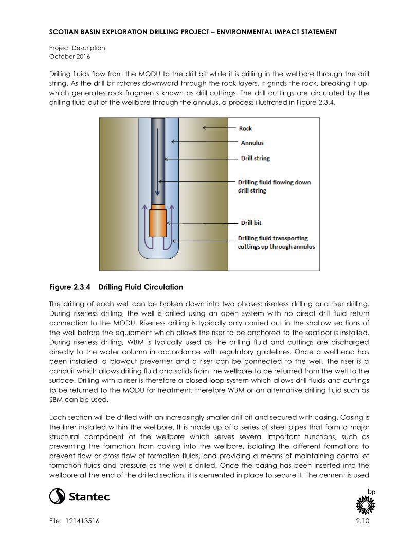
SCOTIAN BASIN EXPLORATION DRILLING PROJECT – ENVIRONMENTAL IMPACT STATEMENT
Project Description
October 2016
File: 121413516 2.10
Drilling fluids flow from the MODU to the drill bit while it is drilling in the wellbore through the drill
string. As the drill bit rotates downward through the rock layers, it grinds the rock, breaking it up,
which generates rock fragments known as drill cuttings. The drill cuttings are circulated by the
drilling fluid out of the wellbore through the annulus, a process illustrated in Figure 2.3.4.
Figure 2.3.4 Drilling Fluid Circulation
The drilling of each well can be broken down into two phases: riserless drilling and riser drilling.
During riserless drilling, the well is drilled using an open system with no direct drill fluid return
connection to the MODU. Riserless drilling is typically only carried out in the shallow sections of
the well before the equipment which allows the riser to be anchored to the seafloor is installed.
During riserless drilling, WBM is typically used as the drilling fluid and cuttings are discharged
directly to the water column in accordance with regulatory guidelines. Once a wellhead has
been installed, a blowout preventer and a riser can be connected to the well. The riser is a
conduit which allows drilling fluid and solids from the wellbore to be returned from the well to the
surface. Drilling with a riser is therefore a closed loop system which allows drill fluids and cuttings
to be returned to the MODU for treatment; therefore WBM or an alternative drilling fluid such as
SBM can be used.
Each section will be drilled with an increasingly smaller drill bit and secured with casing. Casing is
the liner installed within the wellbore. It is made up of a series of steel pipes that form a major
structural component of the wellbore which serves several important functions, such as
preventing the formation from caving into the wellbore, isolating the different formations to
prevent flow or cross flow of formation fluids, and providing a means of maintaining control of
formation fluids and pressure as the well is drilled. Once the casing has been inserted into the
wellbore at the end of the drilled section, it is cemented in place to secure it. The cement is used

SCOTIAN BASIN EXPLORATION DRILLING PROJECT – ENVIRONMENTAL IMPACT STATEMENT
Project Description
October 2016
File: 121413516 2.11
to permanently seal the annular spaces between the casing and the wall of the borehole. It also
seals the formation, preventing the loss of drilling fluid. To cement the casing in place, slurrified
cement is flowed through the casing and up into the annular space between the formation and
the casing, displacing any drilling fluid. The cement fills the annular space and solidifies. During
the riserless phase, excess cement may be discharged to the seafloor. Once the riser has been
installed, excess cement can be returned to the MODU.
A typical casing configuration is illustrated in Figure 2.3.5 to show the increasingly smaller
diameter sections of a well. This figure is indicative and does not represent the Project casing
design.
Source: Encana 2015
Figure 2.3.5 Typical Casing Configuration
Figure 2.3.6 illustrates the drilling sequence described above. The wells drilled as part of the
Project will be drilled in line with the principles described above. Further information about the
Project wells is described in Section 2.4.2.

SCOTIAN BASIN EXPLORATION DRILLING PROJECT – ENVIRONMENTAL IMPACT STATEMENT
Project Description
October 2016
File: 121413516 2.12
Source: Modified from Petroleum Club of Western Australia, Drilling for Oil and Gas
Figure 2.3.6 Drilling Sequence (NB – not to scale)

SCOTIAN BASIN EXPLORATION DRILLING PROJECT – ENVIRONMENTAL IMPACT STATEMENT
Project Description
October 2016
File: 121413516 2.13
2.3.3 Supply and Servicing Components
Offshore drilling operations will be supported by logistics arrangements for supply and servicing
activity. Such arrangements shall allow the transportation and movement of equipment and
personnel between the MODU and land, and shall allow sufficient stocks of equipment and
supplies to be maintained for reliable, ongoing drilling operations.
In accordance with the Final Guidelines for the Preparation of an Environmental Impact
Statement issued to BP by the CEA Agency (CEA Agency 2015a), activity within the supply base
is not considered within the scope of this EIS. The supply base is described below with the intent
to clarify PSV routes between the supply base and the Project Area. Supply and servicing
components and activities included in the scope of assessment comprise PSV operations (e.g.,
loading, transit and unloading of vessels) and helicopter support (e.g., crew transport and
delivery of supplies and equipment).
Additional details on supply and servicing activities are provided in Section 2.4.5.
2.3.3.1 Onshore Supply Base
An onshore supply base will be used to support offshore drilling operations in Nova Scotia. The
supply base serves as a location to temporarily store, stage, and load materials onto PSVs to be
brought offshore. Likewise, the supply base serves as a location for materials to be returned
onshore by PSVs, as needed, throughout the Project.
The Woodside Terminal has been selected as the preferred supply base location that will be
used to support the Project. The Woodside Terminal is an existing multi-user industrial port facility
located in Dartmouth, Nova Scotia on Halifax Harbour across from downtown Halifax (refer to
Table 2.3.2 for geographic coordinates).
Table 2.3.2 Supply Base Location Geographic Coordinates
Supply Base Location Latitude DMS Longitude DMS
Woodside Terminal (Halifax Harbour) 44°38'49.00"N 63°32'53.00"W
The proposed facility is made up of two areas. This first area is dedicated to quayside operations
and the second area serves as a temporary storage and laydown area (refer to Figure 2.3.7).
Blue Water Group, which has been selected as the third party logistics service provider for BP,
operates the Woodside Terminal, providing supply base operations for the Sable Offshore Energy
Project (SOEP) and Deep Panuke offshore gas developments as well as the Shelburne Basin
Venture Exploration Drilling Project.

SCOTIAN BASIN EXPLORATION DRILLING PROJECT – ENVIRONMENTAL IMPACT STATEMENT
Project Description
October 2016
File: 121413516 2.14
Figure 2.3.7 Woodside Supply Base Location

SCOTIAN BASIN EXPLORATION DRILLING PROJECT – ENVIRONMENTAL IMPACT STATEMENT
Project Description
October 2016
File: 121413516 2.15
2.3.3.2 Support Vessels and Helicopters
The Project will require support from PSVs and helicopters for equipment and supplies and for
crew changes. Both PSV and helicopter operations will be based out of the Halifax area. Like the
supply base, the helicopter and PSVs will be owned and operated by third-party service
providers, and will be used to support the Project on a temporary basis through contractual
arrangements.
PSVs will be used to re-supply the MODU with equipment and supplies during the drilling
program. The PSVs have not yet been identified; however, the fleet will be selected to fulfill the
following functions for the MODU:
supply food, fuel and bulk powders, drilling fluid and drilling materials;
collect waste;
assist in emergency response situations; and
monitor the safety (exclusion) zone around the MODU and intercept vessels if required.
It is anticipated that two or three PSVs will be required in total. A PSV will remain on standby at
the MODU at all times in the event that operational assistance or emergency response support is
required. Figure 2.3.8 is a photo of a typical PSV that could be used on the Project. PSVs will
undergo BP’s internal audit process, as well as additional inspections/audits inclusive of the
CNSOPB pre-authorization inspection process in preparation for the Project.
Source: Farstad 2012
Figure 2.3.8 Typical Platform Supply Vessel
Helicopters will be used to transfer personnel and light supplies to and from the MODU and land.
These will also be used for emergency support services, including medical evacuation from the
MODU in the event that it is required, as well as search and rescue operations if requested by
the Canadian authorities. Figure 2.3.9 shows a typical offshore helicopter that could be used to
support the Project.

SCOTIAN BASIN EXPLORATION DRILLING PROJECT – ENVIRONMENTAL IMPACT STATEMENT
Project Description
October 2016
File: 121413516 2.16
Source: Offshore Energy Today 2014b
Figure 2.3.9 Typical Offshore Helicopter
Additional details on PSV and helicopter operations are provided in Section 2.4.5.
2.4 PROJECT ACTIVITIES
2.4.1 MODU Mobilization
As described in Section 2.2, drilling locations will be selected taking account of geohazard data,
geophysical data and seabed baseline conditions. Further information about the reviews for
each wellsite location is presented in Section 9.5.5.
As explained in 2.3.1.1, the MODU will be subject to the BP rig intake process as well as regulatory
inspections which are required in order to deliver a Certificate of Fitness prior to approval for use.
After all of the permits, regulatory approvals and authorizations have been obtained, the MODU
will be mobilized to the drilling location.
The MODU will be either towed or will move self-propelled to the drilling location. Once the
MODU is in place, positioning and stability operations will occur. This will include ballasting to
increase the stability of the MODU and implementing the DP system to maintain position.
The DP system is made up a series of thrusters, which operate to continually adjust the vessel to
counteract current, waves and wind forces to maintain the position of the MODU. Figure 2.4.1
illustrates dynamic positioning forces and does not represent the MODU or the configuration of
thrusters for the Project, which have not yet been determined.

SCOTIAN BASIN EXPLORATION DRILLING PROJECT – ENVIRONMENTAL IMPACT STATEMENT
Project Description
October 2016
File: 121413516 2.17
Source: Rigzone 2015
Figure 2.4.1 Dynamic Positioning Forces
In accordance with the Nova Scotia Offshore Drilling and Production Regulations, a safety
(exclusion) zone (estimated to be a 500-m wide radius) will be established around the MODU
within which non-Project related vessels are prohibited. This safety (exclusion) zone will be
established around the MODU during initial mobilization activities and drilling operations,
including well evaluation and abandonment processes. The safety (exclusion) zone is put in
place to prevent collisions between the MODU and other vessels (e.g., fishing, research or cargo
vessels) operating in the area. The safety (exclusion) zone will be monitored by the standby
vessel at the MODU. BP will provide details of the safety (exclusion) zone to the Marine
Communication and Traffic Services for broadcasting and publishing in the Notice to Shipping
and Notice to Mariners. Details of the safety (exclusion) zone will also be communicated during
ongoing consultations with commercial and Aboriginal fishers.
To maintain navigational safety at all times during the Project, obstruction lights, navigation lights
and foghorns will be kept in working condition on board the MODU and PSVs. Radio
communication systems will be in place and in working order for contacting other marine vessels
as necessary.
The MODU will be equipped with local communication equipment to enable radio
communication between the PSVs and the MODU’s bridge. Communication channels will also
be put in place for internet access, and enable communication between the MODU and shore.

SCOTIAN BASIN EXPLORATION DRILLING PROJECT – ENVIRONMENTAL IMPACT STATEMENT
Project Description
October 2016
File: 121413516 2.18
2.4.2 Drilling
2.4.2.1 Well Execution Strategy and Drilling Sequence
Designs for Project wells have not yet been finalized, although an indicative well design is
presented in Table 2.4.1. Well design depends on a number of factors including the geology of
the formations. Wells will be drilled in line with the principles set out in Section 2.3.2. The
information below sets out the general execution strategy for wells drilled as part of the Project.
Detailed plans will be provided for review and approval to the CNSOPB before drilling
operations commence as part of the OA and ADW processes.
Table 2.4.1 Indicative Well Casing Plan for Project Wells
Section Section Name Drilling Fluid Hole size
(inches)
Casing Size
(inches)
Interval Depth
(metres)
1 Conductor Section Seawater / WBM 36” or 42” 36” 100 m
2 Surface Casing Seawater / WBM 26” 22” 800 m
3 Intermediate Casing 1 SBM / WBM 17” x 20” 16” 950 m
4 Intermediate Casing 2 SBM / WBM 14 3/4"” x 17 1/2” 14” 1,100 m
5 Intermediate Casing / Liner 3 SBM / WBM 10 5/8” x 12 1/4” 9 5/8 ” 2,250 m
6 Production Hole 1 SBM / WBM 8 1/2” 250 m
If a planned section total depth (TD) cannot be reached, contingency casing sections, also
referred to as strings, will be available. A contingency string is effectively an additional string
inserted into the well to enable the well to be drilled to TD. Typical contingency strings include
casing or liner sizes of 18", 11.3/4" and 7". It is expected the well can be completed in six sections
or less; however there could be up to three additional sections if contingencies are used.
It is possible, that in the event of well success, a planned sidetrack may be drilled to explore
other areas of the reservoir that are nearby. In the event of sidetracking, a secondary wellbore
will be “kicked-off” from the original wellbore using a similar methodology described in Section
2.3.2 and below. The original wellbore will be abandoned using cement prior to side track drilling
commencing. The details and design of the sidetrack will be contingent on the results of the
original well and therefore have not yet been finalized. Once they have been established, plans
and designs for the sidetrack will be submitted to CNSOPB for approval.
It is expected that the conductor and surface casing sections of wells drilled as part of the
Project will be drilled riserless. During the riserless phase, the well will be drilled with either WBM or
seawater. The drilling fluid is used to provide overbalance to the formation pressure with the
hydrostatic pressure in the wellbore, keep the drill bit cool and flush out cuttings from the
wellbore. During the riserless phase, as there is no mechanism to return cuttings to the MODU,
cuttings and any associated fluid will be discharged at the seafloor as is permitted by the OWTG
(NEB et al. 2010).

SCOTIAN BASIN EXPLORATION DRILLING PROJECT – ENVIRONMENTAL IMPACT STATEMENT
Project Description
October 2016
File: 121413516 2.19
The first section of the well will be the conductor section. The conductor section provides the
initial structural foundation for the borehole and the foundation for the subsea wellhead. A large
diameter hole, potentially 42” in diameter, will be drilled to approximately 100 m depth below
the seafloor. Once the section has been drilled, the conductor pipe can be run and cemented
to secure the wellbore. The conductor can also be “jetted” into place, which effectively means
that the conductor string is directly drilled into place. No cement is required when the conductor
string is jetted in place.
After the completion of the conductor section, a smaller size drill bit will be passed through the
conductor, and a new hole is drilled to section TD. Once the section is drilled, a surface casing
string will be run and cemented to secure the wellbore. The top of the surface string will be
connected to the wellhead. The wellhead is a pressure-containing mechanism that is the anchor
point for casing used in drilling the well. The wellhead will be lowered down with the surface
casing string attached, and installed on the conductor section. The surface casing section will
be drilled with seawater or WBM, and like the conductor section, drill cuttings and associated
fluids will be discharged to the seafloor as is permitted by the OWTG (NEB et al. 2010).
Once the surface casing has been installed, a BOP stack is run on the end of a drilling riser and
connected to the wellhead. The riser creates a conduit back to the MODU. The BOP is a critical
piece of safety equipment and is put in place to protect the crew and the environment against
unplanned fluid releases from the well. It allows the wellbore to be closed through a series of
rams and annular preventers, thereby closing the aperture, preventing any hydrocarbons from
escaping the wellbore. More information on the BOP and additional well control features is
provided in Section 2.5.
Once the riser and BOP have been installed, the drilling fluids and cuttings generated from the
wellbore can be circulated back to the MODU for treatment. It is unknown at this stage which
drilling fluids will be used to drill the remaining well sections. It is currently proposed that either a
WBM or SBM will be used. The choice of which drilling fluids and other components of well
design, such as section depths will be determined by the specific geology and predicted pore
pressure of each individual well. The process of drilling, casing and cementing is continued for
the remaining drill sections. This sequence of events is repeated until the TD of the well is
reached. For more information on drilling fluids and drilling waste management, refer to Section
2.8.2.
2.4.3 Well Evaluation
If the exploration drilling results indicate that hydrocarbons are present in the target formations,
the wells will be evaluated and possibly tested to provide further information about the
stratigraphic column with special emphasis on reservoir characteristics. Well evaluation is an
important component of exploration drilling as it helps to determine the viability of a prospect
and commercial potential of the reservoirs.

SCOTIAN BASIN EXPLORATION DRILLING PROJECT – ENVIRONMENTAL IMPACT STATEMENT
Project Description
October 2016
File: 121413516 2.20
There are a number of processes involved in well evaluation. While drilling, the well will be
monitored and evaluated using Measurement while Drilling and Logging While Drilling
(MWD/LWD) techniques, mud logging, drilling parameters evaluation and subsurface pressure
evaluation activities. Wireline logging, vertical seismic profiling and formation testing may be
performed after drilling activity has been completed based on the results of the primary
evaluation tools.
2.4.3.1 Wireline Logging
A formation evaluation contractor will be employed to deploy specialized equipment and tools
in the well to gather petrophysical data. The logging tools are used to take and record detailed
measurements of the geological formations encountered in and around the well and the rock
and fluid properties of the targeted reservoirs.
2.4.3.2 Vertical Seismic Profiling
VSP may be carried out which facilitates the correlation of surface seismic data (recorded in
time, milliseconds) to well data (recorded in depth, metres). This effectively allows an accurate
correlation of seismic reflectivity events to geological formations encountered in the wellbore
through time to depth calibration and matching of wavelet character between the surface
seismic data and the VSP result.
VSP operations can be carried out in a number of ways; for the BP exploration wells it is likely that
a stationary acoustic sound source will be deployed from the MODU while a number of
receivers, positioned at different levels within the drilled hole, will measure the travel time of the
sound generated at the source as it arrives at those receivers. This form of VSP operation is
referred to as zero-offset VSP. An offset VSP could also be used in the exploration wells. This is
where the acoustic source is used from a marine vessel, and deployed at a distance of up to 8
km from the well.
Up to 12 sound sources may be used, each with a volume of up to 250 cubic inches. These
multiple sources are tuned to one another to effectively simulate one larger sound source. These
sound sources are generally positioned at 5 to 10 m below the water surface. VSP operations are
typically short duration, normally taking no more than a day to complete the profiling. Longer
duration VSP operations for additional characterization may be run, which could extend the
duration of the VSP by a few additional days. VSPs are quieter and shorter in duration than
exploration seismic surveys (refer to Section 2.8.5 for more information on underwater sound
generated by VSP).
VSP activity will be planned and conducted in consideration of the Statement of Canadian
Practice with respect to the Mitigation of Seismic Sound in the Marine Environment (SOCP, DFO
2007b). Specific details of the VSP program will depend on the geological target and the
objectives of the VSP.
SCOTIAN BASIN EXPLORATION DRILLING PROJECT – ENVIRONMENTAL IMPACT STATEMENT
Project Description
October 2016
File: 121413516 2.21
2.4.3.3 Well Flow Testing
Well testing may be required for the Project. Well testing can be used to gather information
about subsurface characteristics such as potential productivity, connected volumes, fluid
properties, composition, flow, pressure, and temperature. This dynamic data set in turn enables
the confirmation of data in logs and cores assimilated during drilling activity, which in turn can
build a comprehensive picture of reservoir potential. Flow testing is required under the Accords
Act to convert an EL to a Significant Discovery Licence (SDL), to demonstrate the potential for
sustained production.
It is not currently anticipated that well testing will be carried out on the wells drilled in the initial
phase of the Project (i.e., one to two wells). In the event of well success in the initial wells, and if
the need for well testing is identified, a well test program will be developed and executed on
subsequent wells drilled as part of the primary term of the licence.
In the event that a well test is required, it will be subject to BP’s process for well test planning
which is designed to promote safe and efficient well test operations. A key requirement of these
processes is the use of process safety design methods to ensure effective barriers are in place for
the well test activity, and an internal approval process for any well test activity and any
associated flaring.
Where well testing is considered necessary, specialized equipment and services will be
contracted to carry out the activity. Equipment that will be used in the well test will be designed
to be able to safely control the maximum potential pressure that the reservoirs may be able to
generate. It is likely that the well test operation will be run using conventional drill stem test (DST)
tooling, subsea safety systems and temporary surface flow equipment to manage and measure
the well fluids, collect fluid samples and necessary data sets. A DST is envisioned as historically
the only acceptable type of flow test to support a SDL application. However alternative testing
technologies may be proposed to satisfy the legislated requirements, with benefits that include
potentially improved safety and environmental performance and protection.
The primary purposes of the DST tools and tubing are: (i) to provide a controlled flow path for the
reservoir fluids to surface; (ii) provide downhole shut in; (iii) facilitate well killing operations; and
(iv) convey the data measurement instrumentation and specialized sampling equipment as
close to the formation being tested as practically possible. At the seabed level, subsea tools will
be placed inside the drilling BOP. These tools are primary safety tools that provide fast acting
(emergency) isolation of the well fluids at subsea level and permit disconnection of the test string
from the well if required. The subsea tools will also be designed to ensure the emergency BOP
functions such as shearing and emergency disconnect are available for use during the well test.
The well will subsequently be suspended or abandoned in accordance with the Nova Scotia
Offshore Petroleum Drilling and Production Regulations.
Any formation hydrocarbons, such as gas, oil or formation water that are brought to surface as
part of the well test activity will be flared to enable their safe disposal. All flaring will be via one of
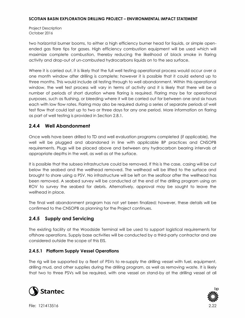
SCOTIAN BASIN EXPLORATION DRILLING PROJECT – ENVIRONMENTAL IMPACT STATEMENT
Project Description
October 2016
File: 121413516 2.22
two horizontal burner booms, to either a high efficiency burner head for liquids, or simple open-
ended gas flare tips for gases. High efficiency combustion equipment will be used which will
maximize complete combustion, thereby reducing the likelihood of black smoke in flaring
activity and drop-out of un-combusted hydrocarbons liquids on to the sea surface.
Where it is carried out, it is likely that the full well testing operational process would occur over a
one month window after drilling is complete; however it is possible that it could extend up to
three months. This would include all testing through to well abandonment. Within this operational
window, the well test process will vary in terms of activity and it is likely that there will be a
number of periods of short duration where flaring is required. Flaring may be for operational
purposes, such as flushing, or bleeding where it will be carried out for between one and six hours
each with low flow rates. Flaring may also be required during a series of separate periods of well
test flow that could last up to two or three days for any one period. More information on flaring
as part of well testing is provided in Section 2.8.1.
2.4.4 Well Abandonment
Once wells have been drilled to TD and well evaluation programs completed (if applicable), the
well will be plugged and abandoned in line with applicable BP practices and CNSOPB
requirements. Plugs will be placed above and between any hydrocarbon bearing intervals at
appropriate depths in the well, as well as at the surface.
It is possible that the subsea infrastructure could be removed. If this is the case, casing will be cut
below the seabed and the wellhead removed. The wellhead will be lifted to the surface and
brought to shore using a PSV. No infrastructure will be left on the seafloor after the wellhead has
been removed. A seabed survey will be conducted at the end of the drilling program using an
ROV to survey the seabed for debris. Alternatively, approval may be sought to leave the
wellhead in place.
The final well abandonment program has not yet been finalized; however, these details will be
confirmed to the CNSOPB as planning for the Project continues.
2.4.5 Supply and Servicing
The existing facility at the Woodside Terminal will be used to support logistical requirements for
offshore operations. Supply base activities will be conducted by a third-party contractor and are
considered outside the scope of this EIS.
2.4.5.1 Platform Supply Vessel Operations
The rig will be supported by a fleet of PSVs to re-supply the drilling vessel with fuel, equipment,
drilling mud, and other supplies during the drilling program, as well as removing waste. It is likely
that two to three PSVs will be required, with one vessel on stand-by at the drilling vessel at all

SCOTIAN BASIN EXPLORATION DRILLING PROJECT – ENVIRONMENTAL IMPACT STATEMENT
Project Description
October 2016
File: 121413516 2.23
times. It is estimated that the PSVs will make two to three round trips per week between the
MODU and the supply base.
Typical PSVs travel at approximately 12 knots at service speed. It is therefore expected that a
PSV could take approximately 16 hours to reach the furthest point of the Project Area from
Halifax. Existing shipping lanes will be used as practicable to minimize incremental effects.
Supplies will be loaded and unloaded onto PSVs using personnel and cranes for drilling materials
and closed piping systems (e.g., pumps, hoses) for bulk powders, liquid supplies and waste (e.g.,
drilling fluids).
PSVs will undergo BP’s internal audit process as well as additional external inspections/audits
inclusive of the CNSOPB pre-authorization inspection process in preparation for the Project.
Procedures will be put in place to ensure that hoses are inspected and operated correctly to
minimize the risk of an unintended release. The PSVs, MODU and supply base will be equipped
with primary spill contingency equipment to deal with spills in the unlikely event that they occur.
The PSVs will transfer diesel fuel, also referred to as marine gas oil (MGO) to the MODU from
shore. Fuel is required offshore to power the MODU, including drilling equipment and thrusters.
Fuel will not be loaded from the Woodside Terminal. Instead, an existing field distribution facility
will be used within Halifax Harbor. A number of potential locations have been identified within
Halifax Harbor; however, the exact location for fuel loading operations has not yet been
confirmed. Fuelling operations, according to standard vessel fuelling procedures, are expected
to take place up to two to three times per week by a third party contractor.
2.4.5.2 Helicopter Traffic and Operations
Helicopters will be used for crew changes on a routine basis and to support medical evacuation
from the MODU and search and rescue activities in the area, if required.
It is anticipated that approximately one helicopter trip per day would be required to transfer
crew and any supplies not carried by the PSV to the MODU. The MODU will be equipped with a
helideck for safe landings. Helicopter operations will be run out of Halifax Stanfield International
Airport (YHZ).
Routes to the well locations from shore have not yet been finalized, as the well locations have
not yet been confirmed. The maximum distance that a journey from Halifax International
Stanfield Airport to a well location is 198 nautical miles (nm), based on the boundaries of the ELs.
The maximum flight time is therefore expected to be 90 minutes, including taxi time. Military
exclusion areas and areas of high environmental sensitivity have been identified and will be
avoided as the helicopter flight paths are determined by the helicopter operators.
The helicopters that will make up the helicopter fleet have not yet been contracted; however, it
is expected that the helicopters used by the Project will have a capacity of approximately 19
passengers and a maximum range of approximately 540 nm without refuelling. Refuelling

SCOTIAN BASIN EXPLORATION DRILLING PROJECT – ENVIRONMENTAL IMPACT STATEMENT
Project Description
October 2016
File: 121413516 2.24
operations are expected to take place at Halifax Stanfield International Airport; however, the
MODU will be equipped with refuelling equipment.
2.5 WELL CONTROL AND BLOWOUT PREVENTION
A number of barriers are used in drilling operations to manage formation pressure, including the
drilling fluid and casing, and dedicated pressure control equipment. Formation pressures are
managed in order to prevent a blowout, which is an uncontrolled flow of formation fluids. A
blowout can occur when the specific well control barriers have failed.
Blowouts are prevented in the first instance using primary well control measures and procedures.
This includes monitoring the formation pressure and controlling the density of the drilling fluid
accordingly. The density, or weight, of the drilling fluid is increased to maintain an overbalance
of pressure against the formation, which keeps the wellbore stable. In the event that a primary
barrier fails, the next line of defense is a BOP system, which is a secondary well control barrier.
A BOP is a mechanical device, which is designed to seal off a well at the wellhead when
required. The system is made up of a series of different types of closing mechanisms. These
include rams, which are pistons that move horizontally across the top of the well creating a seal
around the drill string. Blind shear rams are also used to sever the pipe in the drill string and
create a seal. Additionally, blind shear rams are used to seal the well when no pipe is present in
the wellbore. Annular preventers can also be used to physically close off the well aperture
around various sizes of pipe.
The BOPs that will be used as part of the Project will comply with American Petroleum Institute
(API) standards, specifically Standard 53 (Blowout Prevention Equipment Systems for Drilling
Wells). For each well drilled as part of the Project, a BOP rated to 15,000 psi working pressure
(which will be able to accommodate the anticipated formation pressures) will be installed and
pressure tested. These BOPs will consist of a series of control measures, including hydraulically-
operated valves and sealing mechanisms that are open to allow the mud to circulate during
drilling, but can be quickly closed if reservoir fluids, referred to as a “kick”, enter the well. If a kick
occurs and additional controls are required, an annular preventer will be closed to prevent any
further influx from the reservoir into the well if there is pipe in the hole. If no pipe is in the hole,
blind shear rams will be closed. The next line of defense, provided there is pipe in the hole, are
the pipe rams, of which there are multiple for redundancy. The last line of defense is the blind
shear rams, which, if necessary, cut right through the drill pipe and seal the well completely.
There will also be a ram that is capable of cutting planned casing sizes, which is called a casing
shear ram.
Prior to installation on the well, the BOP stack will be pressure tested on the MODU deck, and
then again following installation on the well to test the wellhead connection with the BOP. It is
expected that the BOP will be function tested every 7 days in accordance with API Standard 53
(Blowout Prevention Equipment Systems for Drilling Wells), and pressure tested every 21 days
while connected to the wellhead. Additionally, when the BOP is initially installed, the ROV

SCOTIAN BASIN EXPLORATION DRILLING PROJECT – ENVIRONMENTAL IMPACT STATEMENT
Project Description
October 2016
File: 121413516 2.25
intervention capability for operating the BOP, if necessary, will be tested. This is done by
physically engaging the ROV control panel to function the controls. The BOP will only be
removed once the well has been plugged and abandoned and the casing pressure tested
above the abandonment plugs to confirm plug integrity.
A discussion of emergency response measures and strategies is presented in Section 8.
2.6 PROJECT PERSONNEL
The overall Project will be managed by BP through a multidisciplinary Project Team. The Project
Team will include members of BP’s global wells organization who are responsible for delivering a
consistent and standardized approach to the delivery of wells-related activity across the
company. This team will be responsible for planning and delivering the Project as a whole;
however a number of contractors will be engaged to carry out specific components of the
work. Key contractors include: the drilling contractor, who will provide and operate the MODU;
well services providers who provide equipment and services to support drilling operations; and
logistics contractors who provide and operate the shore base, supply vessels and helicopters.
As the Project progresses, the number of BP and contractor personnel involved in the Project will
change. The contractor providing the most number of personnel is the drilling contractor. During
drilling operations, a maximum of 200 people from the drilling contractor will work on board the
MODU. A small number of BP personnel, such as drilling supervisors and drilling engineers will also
work offshore on the MODU. BP and contractor personnel will be trained and capable of
carrying out their functions.
During the drilling program, the offshore BP team led by the drilling supervisor, also known as the
wellsite leader (WSL), is responsible for coordinating the overall execution of the drilling program
and providing oversight of well-related operations. The WSL interfaces with the drilling contractor
offshore leadership team to ensure that drilling is carried out safely and efficiently and complies
with all relevant regulations. The WSL reports to the BP well superintendent, who is based onshore
and is responsible for supervising the execution of the approved drilling program.
Offshore drilling contractor roles will include management positions, such as the offshore
installation manager (OIM) and tool pusher, who work with the BP drilling management team to
deliver safe, reliable drilling operations. The drilling contractor team will also include a number of
roustabouts, technicians and health, safety and environmental (HSE) personnel. BP and drilling
contractor personnel will also support drilling operations from offices onshore.
2.7 PROJECT SCHEDULE
BP plans to commence exploration drilling in 2018 pending regulatory approval to proceed. At
this time, it is anticipated that exploration drilling will be carried out in multiple phases so that
initial well results can be analyzed to inform the strategy for subsequent wells. Up to seven
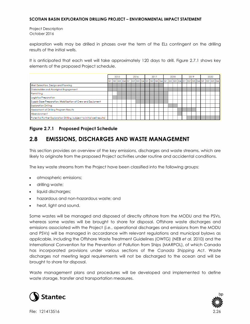
SCOTIAN BASIN EXPLORATION DRILLING PROJECT – ENVIRONMENTAL IMPACT STATEMENT
Project Description
October 2016
File: 121413516 2.26
exploration wells may be drilled in phases over the term of the ELs contingent on the drilling
results of the initial wells.
It is anticipated that each well will take approximately 120 days to drill. Figure 2.7.1 shows key
elements of the proposed Project schedule.
Figure 2.7.1 Proposed Project Schedule
2.8 EMISSIONS, DISCHARGES AND WASTE MANAGEMENT
This section provides an overview of the key emissions, discharges and waste streams, which are
likely to originate from the proposed Project activities under routine and accidental conditions.
The key waste streams from the Project have been classified into the following groups:
atmospheric emissions;
drilling waste;
liquid discharges;
hazardous and non-hazardous waste; and
heat, light and sound.
Some wastes will be managed and disposed of directly offshore from the MODU and the PSVs,
whereas some wastes will be brought to shore for disposal. Offshore waste discharges and
emissions associated with the Project (i.e., operational discharges and emissions from the MODU
and PSVs) will be managed in accordance with relevant regulations and municipal bylaws as
applicable, including the Offshore Waste Treatment Guidelines (OWTG) (NEB et al. 2010) and the
International Convention for the Prevention of Pollution from Ships (MARPOL), of which Canada
has incorporated provisions under various sections of the Canada Shipping Act. Waste
discharges not meeting legal requirements will not be discharged to the ocean and will be
brought to shore for disposal.
Waste management plans and procedures will be developed and implemented to define
waste storage, transfer and transportation measures.

SCOTIAN BASIN EXPLORATION DRILLING PROJECT – ENVIRONMENTAL IMPACT STATEMENT
Project Description
October 2016
File: 121413516 2.27
Information on the releases, wastes and discharges will be reported as part of a regular
environmental reporting program in accordance with regulatory requirements as described in
the OWTG.
2.8.1 Atmospheric Emissions
Key Project activities resulting in atmospheric emissions are:
combustion from the MODU and PSV diesel engines, and fixed and mobile deck equipment,
and helicopters; and
flaring during well test activity, in the event that well testing is required.
Emissions from diesel combustion activity are likely to include carbon dioxide (CO2), carbon
monoxide (CO), sulphur dioxides (SOx), nitrogen oxides (NOx), and particulate matter (PM). Air
emissions from the Project will adhere to applicable regulations and standards including the
Nova Scotia Air Quality Regulations under the Nova Scotia Environment Act, the National
Ambient Air Quality Objectives (SO2, NO2, total suspended PM, and CO) and the Canadian
Ambient Air Quality Standards (fine PM).
Marine engines are also subject to NOX limits set by the International Maritime Organization
(IMO) of the United Nations, with Tier II limits applicable in 2011 and Tier III limits to become
applicable in 2016 in Emission Control Areas (ECA), which include the offshore waters of Nova
Scotia to the 200 nautical mile (370 km) limit. On January 1, 2015, the sulphur limit in fuel in the
ECAs in large marine diesel engines dropped from 1.0% to 0.1% in accordance with the Vessel
Pollution and Dangerous Chemicals Regulations under the Canada Shipping Act. The IMO is also
responsible for development of efficiency measures that will involve mandatory measures to
increase energy efficiency on ships, a process that will reduce the greenhouse gas emissions
(GHG) in the offshore.
Ultra-low sulphur diesel (ULSD) fuel will be used for the Project wherever practicable and
available. Using ULSD instead of regular diesel will reduce the potential for adverse local air
quality effects.
Atmospheric emissions from individual components are contingent on fuel consumption. Activity
and therefore fuel consumption will be variable throughout the Project; however, expected
emissions from individual components are presented below (Table 2.8.1 and Table 2.8.2).
Emission factors from US EPA AP-42 (Fifth Edition, Volume 1, Chapter 3.4) have been used to
estimate the amount of carbon dioxide and other atmospheric emissions from expected routine
emission sources. It has been assumed that evaporation in diesel engines has been negligible,
and therefore only exhaust emissions have been considered.

SCOTIAN BASIN EXPLORATION DRILLING PROJECT – ENVIRONMENTAL IMPACT STATEMENT
Project Description
October 2016
File: 121413516 2.28
Table 2.8.1 Gaseous Emissions Factors for Large Stationary Diesel Internal Combustion
Sources
Air Contaminant Emission Factor from US EPA AP-42 (lb/MMBtu)
CO2 165
CO 0.85
NOx 3.2
SOx * 1.01S1
PM 0.1
* Note:
Assumes that all sulphur in the fuel is converted to SO2. S1 is the sulphur in fuel oil and it has been assumed that the sulphur
content will be 0.05% The emission factor is therefore 0.0505.
MODU
As described previously, the MODU for the drilling program has not yet been identified and
therefore exact fuel consumption data is not available. It is expected that on average,
based on fuel consumption information from a comparable semi-sub DP powered MODU (as
an example) that approximately 56 tonnes of fuel will be used by the MODU per day while
on station (under extreme metocean conditions).
PSV
It is possible that up to three PSVs will be required to support MODU operations. PSVs will
make approximately two to three trips per week at a service speed of 12 knots and a PSV
shall remain on standby at the wellsite at all times. PSV emissions will be dependent on the
speed of the vessel; however, it has been assumed that on average, each PSV will consume
approximately 12 tonnes of fuel per day.
Helicopter
A helicopter will be used to transport personnel to and from the MODU. It is expected that
one trip will be required per day. The furthest distance that the helicopter will travel from
Halifax to the drilling location, based on the boundaries of the ELs is 198 nm. It is likely that
approximately 1.2 tonnes of fuel could be used per round trip from Halifax to the wellsite and
back again.

SCOTIAN BASIN EXPLORATION DRILLING PROJECT – ENVIRONMENTAL IMPACT STATEMENT
Project Description
October 2016
File: 121413516 2.29
Table 2.8.2 Daily Criteria Air Contaminant Emissions for the MODU and Support Vessels
and Helicopter
Daily Fuel
consumption
(tonnes)
Daily Energy
consumption
(MMBtu)
CO2
(tonnes
per day)
CO
(tonnes
per day)
NOx
(tonnes
per day)
SOx
(tonnes
per day)
PM
(tonnes
per day)
MODU 56 2,380 178 0.9 3.5 0.006 0.1
PSV 1 12 510 38 0.2 0.7 0.001 0.02
PSV 2 12 510 38 0.2 0.7 0.001 0.02
PSV 3 12 510 38 0.2 0.7 0.001 0.02
Helicopter 1.2 51 3.8 0.02 0.07 0. 0.002
TOTAL 93.2 3,961 295.8 1.52 5.75 0.009 0.18
In terms of GHG emissions from routine activity, the Project is predicted to emit approximately
295.8 tonnes of CO2 equivalent per day from fuel combustion for the MODU, helicopters and
PSVs. ECCC reports an annual GHG emission value for the province of Nova Scotia of 17,000
kilotonnes of CO2 equivalent per year (46,575 tonnes of CO2 equivalent per day) (Environment
Canada 2016). BP’s predicted daily CO2 emissions for the Project therefore represent
approximately 0.64% of Nova Scotia’s average daily emission.
It is not currently anticipated that well flow testing will be carried out on the wells drilled in the
initial phase of the Project (i.e., one to two wells). In the event of well success in the initial wells,
and if the need for well flow testing is identified, a well test program will be developed and
executed on subsequent wells drilled as part of the primary term of the licence. If well flow
testing is carried out, atmospheric emissions will be generated as a result of flaring activity.
Well flow testing is a non-routine activity that occurs over a short period of time at the end of the
drilling program. The well flow test window is likely to last no more than a month, although it
could extend up to three months. Within this operational window, the well flow test process will
vary in terms of activity and it is likely that there will be periods where flaring is required. Flaring
may be for operational purposes, such as flushing or bleeding, and it would be carried out over
one to six hours per flaring event, with low flow rates. Flaring may also be required during a series
of separate well flow test periods that could last two or three days per period. It is also possible
that there could be multiple targets containing hydrocarbons within each well, each of which
could be subject to a well flow test.
In the event that a well flow test is desired, it will be subject to BP’s process for well flow test
planning, which is designed to promote safe and efficient well test operations. A key
requirement of these processes is the use of process safety design methods and an internal
approval process for any well test activity and associated flaring. Once the well design has been
defined, a detailed well evaluation plan will be prepared and will be submitted for regulatory
approval as part of the OA process.

SCOTIAN BASIN EXPLORATION DRILLING PROJECT – ENVIRONMENTAL IMPACT STATEMENT
Project Description
October 2016
File: 121413516 2.30
For the purposes of quantifying GHG emissions from a non-routine flaring event for this
assessment, it has been assumed that there could be two targets in each well that could
potentially be tested as part of the evaluation program, and that no more than 10,000 bbls of oil
would be flared per target in each well. Using a mass balance approach, the tonnes of CO2
equivalents emitted as a result of flaring 10,000 bbls of oil from one target during a well flow test
are 4,362 tonnes. In the assumption that two targets could be tested in each well, it is therefore
possible that up to 8,724 tonnes of CO2 equivalents could be emitted.
In line with the Project schedule, it is possible that two wells could be drilled in any year, and
consequently, it is assumed that up to 17,448 tonnes of CO2 equivalents could be released as a
result of non-routine flaring during well flow testing, per year. This represents approximately 0.10 %
of Nova Scotia’s annual GHG emissions (17,000 kilotonnes CO2eq/yr), as reported for 2014.
2.8.2 Drilling Waste Discharges
A number of drilling related waste streams will be generated as part of the Project; including:
drill cuttings;
drill fluids; and
cement.
All drilling related waste streams will be disposed of in accordance with the OWTG.
The shallow sections of the wells will be drilled with WBM or seawater, and then deeper sections
with either WBM or SBM.
WBM is primarily made up of water (approximately 75%), which can be freshwater, seawater or
brine. Barium sulphate (barite) is added to the water in WBM to control mud density and thus
help balance formation pressures within the well. Bentonite clay is also added which is used as a
viscosifier, which thickens the mud to suspend and carry drill cuttings to the surface. Other
substances can be added to the WBM to obtain the required drilling properties of the fluid, such
as thinners, filtration control agents and lubrication agents. The vast majority of WBMs
discharged are classified under the OCNS as substances which pose little or no risk to the
environment (PLONOR.)
SBM is a water-in-oil emulsion which contains non-aqueous (water insoluble) fluids manufactured
through chemical processes. SBMs can be made up of internal olefins, alpha olefins,
polyalphaolefins, paraffins, esters or blends of these materials. The same weighting materials,
such as barite, used in WBMs to control density are typically added to SBMs, as well as additives
to manage viscosity, fluid loss, alkalinity, emulsion stability and wettability, where required. SBMs
may be selected over WBM as they can offer improved lubricity, thermal stability, wellbore
integrity and protection against gas hydrates in the well.

SCOTIAN BASIN EXPLORATION DRILLING PROJECT – ENVIRONMENTAL IMPACT STATEMENT
Project Description
October 2016
File: 121413516 2.31
It is proposed that cuttings will be disposed to the seabed along with associated WBM or
seawater drilling fluids used in the initial riserless sections. Cuttings from subsequent sections
drilled with the riser will be returned to the MODU for treatment.
The MODU will be equipped with specialized solids control equipment for cuttings management.
Shale shakers will be used to recover drilling fluids from the cuttings. Shale shakers are made up
of a system of coarse and fine mesh screens that collect cuttings and allow drilling fluids to pass
through and be collected. The purpose of solids control is to quickly and simply remove as much
of the drilling fluids as possible from the cuttings for re-use in the drilling process. Additional solids
control equipment, such as centrifuges may be required depending on the drilling fluid basis of
design, and geological characteristics for reconditioning of the drilling fluid for re-use. Following
treatment with solids control, WBM cuttings can be discharged to sea from the MODU through a
caisson. Any excess or spent WBM may be discharged to the marine environment without
treatment in line with the OWTG.
Additional treatment of cuttings will be required when SBM is used as the drilling fluid to enable
disposal in accordance with the OWTG. SBM cuttings will only be discharged once the
performance targets in OWTG of 6.9 g/100 g retained “synthetic on cuttings” on wet solids can
be satisfied. The concentration of SBM on cuttings will be monitored on the MODU for
compliance with the OWTG. It is expected that this SBM treatment will be done using a cuttings
dryer, equipment that uses high-speed centrifuge technology to separate drilling fluid from the
liquids. In accordance with the OWTG, no excess or spent SBM will be discharged to the sea.
Spent or excess SBM that cannot be re-used during drilling operations will be brought back to
shore for disposal.
Cement is used in drilling operations to secure casing in the well, and to prevent the escape of
hydrocarbons around the outside of the well casing. Cement is pumped into the well and up
and around the casing, and typically sets in approximately 5 to 6 hours.
Excess cement slurry may be discharged to the seabed during the initial phases of the well,
which will be drilled without a riser. Once the riser has been installed, all cement waste will be
returned to the MODU. Cement waste will then be transported to shore for disposal in an
approved facility.
Based on the typical well design presented in Section 2.4.2, estimated quantities of cuttings that
could be generated by drilling are presented below in Table 2.8.3. Predictive dispersion
modelling for cuttings discharges is presented in Appendix C with a summary provided in Section
7.1.

SCOTIAN BASIN EXPLORATION DRILLING PROJECT – ENVIRONMENTAL IMPACT STATEMENT
Project Description
October 2016
File: 121413516 2.32
Table 2.8.3 Estimated Drill Cuttings Discharges Based on Typical Well Profile
Hole Size Section
Depth (m)
Quantity of
Cuttings
(tons)
Type of Drilling
Fluid Used Treatment
Discharge
Location
1 36”x 42” 100 224 Seawater / WBM None Seabed
2 26” 800 766 Seawater / WBM None Seabed
3 17” x 20" 950 490 SBM / WBM
Shale shakers and
cuttings dryers for SBM
where used
Water
column
4 14.3/4"” x
17.1/2"” 1,100 439 SBM / WBM
Shale shakers and
cuttings dryers for SBM
where used
Water
column
5 10.5/8” x 12.1/4” 2,250 462 SBM / WBM
Shale shakers and
cuttings dryers for SBM
where used
Water
column
6 8.1/2” 250 26 SBM / WBM
Shale shakers and
cuttings dryers for SBM
where used
Water
column
TOTAL 5,450 2,406
Table 2.8.4 Estimated Drill Fluids Discharges Based on Typical Well Profile (assumed
that SBM will be Used for Sections 3-6)
Discharges While Drilling Batch Discharge of WBM 3
Hole Size
Mud
Discharged
(tonnes)
Chemicals
Discharged 1
(tonnes)
Oil
Discharged 2
(tonnes)
Whole Mud
Displacement
(tonnes)
Chemicals
Discharged
(tonnes)
1 36”x 42” 146 2 0 703 193
2 26” 1,168 19 0 2,184 772
3 17” x 20" 91 77 40 0 0
4 14.3/4"” x 17.1/2 “ 101 89 37 0 0
5 10.5/8” x 12.1/4” 128 116 40 0 0
6 8.1/2” 8 8 2 0 0
TOTAL 1,499 183 70 2,887 965
Note: 1 Chemicals include commercial solids (barite, bentonite etc.) added to the mud system. 2 Assumes that SBM will be used to drill sections 3, 4, 5 and 6 and that SBM cuttings will be treated with cuttings dryers
prior to discharge. Oil discharged is synthetic base oil only. 3 WBM will be discharged in bulk at the end of sections drilled with WBM in line with OWTG.

SCOTIAN BASIN EXPLORATION DRILLING PROJECT – ENVIRONMENTAL IMPACT STATEMENT
Project Description
October 2016
File: 121413516 2.33
2.8.3 Liquid Discharges
A number of liquid wastes could be generated from the MODU and associated drilling
equipment, and on the PSVs. Some of these liquid wastes can be discharged directly from the
MODU or PSVs, following treatment where necessary, in accordance with the OWTG. Where
discharges occur offshore, the points of discharge will be below the water surface.
A short description of the major liquid discharge streams and the way in which they will be
managed and disposed is shown below in Table 2.8.5.
Table 2.8.5 Potential Project-Related Liquid Discharges
Discharge Source and Characterization Waste Management
Produced water Produced water includes formation
water encountered in a hydrocarbon
bearing reservoir. Produced water
would only be produced during well
evaluation and testing processes when
formation fluids are brought to surface.
Small amounts of produced water may
be flared. If volumes of produced water
are large, some produced water may be
brought onto the MODU for treatment so
that it can be discharged in line with the
OWTG.
Bilge and deck
drainage water
Deck drainage is water on deck
surfaces of the MODU from -
precipitation, sea spray or MODU
activities such as rig wash-down, or from
fire control system or equipment testing.
Bilge water is seawater that may seep
or flow into parts of the MODU. Water
may pass through pieces of equipment
into other spaces of the MODU. As it
may come into contact with equipment
and machinery, deck drainage and
bilge water may be contaminated with
oil and other chemicals.
Deck drainage and bilge water will be
discharged according to the OWTG
which state that deck drainage and
bilge water can only be discharged if the
residual oil concentration of the water
does not exceed 15 mg/L.
Ballast water Ballast water is used in MODU and PSVs
for stability and balance. It is taken up
or discharged when the cargo is
loaded or unloaded, or when extra
stability is needed to manage weather
conditions. The water typically does not
contain hydrocarbons or chemicals as it
is stored in dedicated tanks on the
vessel.
Ballast water will be discharged
according to IMO Ballast Water
Management Regulations and Transport
Canada’s Ballast Water Control and
Management Regulations. The MODU will
carry out ballast tank flushing prior to
arriving in Canadian waters.
Grey and black
water
Black and grey water will be generated
from ablution, laundry and galley
facilities onboard the MODU and PSVs.
Grey water will be generated from
washing and laundry facilities, and
black water includes sewage water
generated from the accommodation
areas.
Sewage will be macerated prior to
discharge. In line with the OWTG and
International Convention for the
Prevention of Pollution from Ships
(MARPOL) requirements, sewage will be
macerated so that particles are less than
6 mm in size prior to discharge.
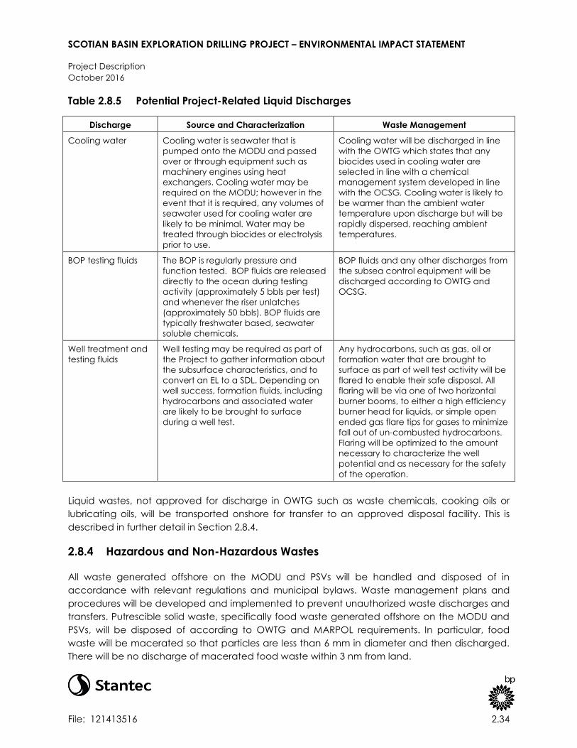
SCOTIAN BASIN EXPLORATION DRILLING PROJECT – ENVIRONMENTAL IMPACT STATEMENT
Project Description
October 2016
File: 121413516 2.34
Table 2.8.5 Potential Project-Related Liquid Discharges
Discharge Source and Characterization Waste Management
Cooling water Cooling water is seawater that is
pumped onto the MODU and passed
over or through equipment such as
machinery engines using heat
exchangers. Cooling water may be
required on the MODU; however in the
event that it is required, any volumes of
seawater used for cooling water are
likely to be minimal. Water may be
treated through biocides or electrolysis
prior to use.
Cooling water will be discharged in line
with the OWTG which states that any
biocides used in cooling water are
selected in line with a chemical
management system developed in line
with the OCSG. Cooling water is likely to
be warmer than the ambient water
temperature upon discharge but will be
rapidly dispersed, reaching ambient
temperatures.
BOP testing fluids The BOP is regularly pressure and
function tested. BOP fluids are released
directly to the ocean during testing
activity (approximately 5 bbls per test)
and whenever the riser unlatches
(approximately 50 bbls). BOP fluids are
typically freshwater based, seawater
soluble chemicals.
BOP fluids and any other discharges from
the subsea control equipment will be
discharged according to OWTG and
OCSG.
Well treatment and
testing fluids
Well testing may be required as part of
the Project to gather information about
the subsurface characteristics, and to
convert an EL to a SDL. Depending on
well success, formation fluids, including
hydrocarbons and associated water
are likely to be brought to surface
during a well test.
Any hydrocarbons, such as gas, oil or
formation water that are brought to
surface as part of well test activity will be
flared to enable their safe disposal. All
flaring will be via one of two horizontal
burner booms, to either a high efficiency
burner head for liquids, or simple open
ended gas flare tips for gases to minimize
fall out of un-combusted hydrocarbons.
Flaring will be optimized to the amount
necessary to characterize the well
potential and as necessary for the safety
of the operation.
Liquid wastes, not approved for discharge in OWTG such as waste chemicals, cooking oils or
lubricating oils, will be transported onshore for transfer to an approved disposal facility. This is
described in further detail in Section 2.8.4.
2.8.4 Hazardous and Non-Hazardous Wastes
All waste generated offshore on the MODU and PSVs will be handled and disposed of in
accordance with relevant regulations and municipal bylaws. Waste management plans and
procedures will be developed and implemented to prevent unauthorized waste discharges and
transfers. Putrescible solid waste, specifically food waste generated offshore on the MODU and
PSVs, will be disposed of according to OWTG and MARPOL requirements. In particular, food
waste will be macerated so that particles are less than 6 mm in diameter and then discharged.
There will be no discharge of macerated food waste within 3 nm from land.

SCOTIAN BASIN EXPLORATION DRILLING PROJECT – ENVIRONMENTAL IMPACT STATEMENT
Project Description
October 2016
File: 121413516 2.35
Non-hazardous wastes, such as other domestic wastes, packaging material, scrap metal and
other recyclables such as waste plastic for example, will be stored in designated areas on board
the MODU. At scheduled intervals, waste will be transferred to the PSVs so that it can be
transported to shore where it will be transferred to a third party waste management contractor
at an approved facility.
Some solid and liquid hazardous wastes are likely to be produced as part of the Project,
including oily wastes (e.g., filters, rags and waste oil), waste chemicals and containers, batteries,
biomedical waste and spent drilling fluids. Biomedical waste will be collected onboard by the
doctor and stored in special containers before being sent to land for incineration. Hazardous
wastes will be stored in designated areas on the MODU and will be transferred to shore on a PSV
for disposal by a third party contractor at an approved facility. Transfer of hazardous wastes will
be conducted according to the Transportation of Dangerous Goods Act. Any applicable
approvals for the transportation, handling and temporary storage, of these hazardous wastes will
be obtained as required.
2.8.5 Sound and Light Emissions
2.8.5.1 Sound Emissions
Underwater sound will be generated by the MODU and PSVs, as well as during VSP operations.
The level of underwater sound generated by a MODU can be influenced by the type of MODU
and by the method of positioning on station (i.e., DP or mooring system). The extent to which
sound travels is determined by environmental conditions, including water depths, water salinity
and temperature.
The sound generated by the MODU will be continuous throughout the drilling program, whereas
underwater sound generated during the VSP operations are typically impulsive in nature,
occurring over a short duration (e.g., typically no more than a day as described in Section
2.4.3.2).
Acoustic modelling of underwater sound generated by the Project is presented in Appendix D. A
general overview of underwater sound and how it affects the marine environment is presented
in Section 7.1.
Atmospheric sound (e.g., sound above the sea surface) is not of particular concern given the
relative low level of atmospheric sound sources (above sea level) and limited transmission of
underwater sound through the air-sea interface. The nearest communities to the Project Area
are coastal Nova Scotia communities more than 200 km away. Potential receptors on Sable
Island (e.g., temporary residents or visitors) would also be geographically separated from the
Project Area (approximately 48 km away) such that they would not perceive atmospheric sound
generated by Project activities.

SCOTIAN BASIN EXPLORATION DRILLING PROJECT – ENVIRONMENTAL IMPACT STATEMENT
Project Description
October 2016
File: 121413516 2.36
Helicopter traffic associated with the Project will generate atmospheric sound emissions
although the use of an existing operational airport (Halifax Stanfield International Airport) will
reduce effects on human receptors. Effects of helicopter traffic (including atmospheric sound)
on wildlife will be mitigated through avoidance of Sable Island and bird colonies (refer to
Section 7.4).
2.8.5.2 Light
Artificial lighting will be generated by the Project from several sources.
MODU and PSV navigation and deck lighting will be operating 24 hours a day throughout
drilling and PSV operations for maritime safety and crew safety (refer to Section 2.4.1 for
further information).
Flaring activity during well flow testing, in the event that it is carried out, will generate light
and thermal emissions on the MODU. Well flow testing, where it occurs, will be carried out on
a temporary basis at the end of drilling operations. It is possible that there could be several,
intermittent, short periods of flaring (lasting up to two or three days) during a one to three
month window at the end of drilling operations. It is not expected that well flow testing will
take place on the first two wells drilled as part of the Project (refer to Section 2.4.3.3 for
further information).
2.9 ALTERNATIVE MEANS OF CARRYING OUT THE PROJECT
2.9.1 Options Analysis Framework
As required under section 19(1)(g) of CEAA, 2012, every environmental assessment of a
designated project must take into account alternative means of carrying out the project that
are considered technically and economically feasible, and considers the environmental effects
of any such alternative means.
Consistent with the Operational Policy Statement: Addressing “Purpose of” and “Alternative
Means” under the Canadian Environmental Assessment Act, 2012 (CEA Agency 2013b), the
process for consideration of alternative means of carrying out the Project includes the following
steps:
consideration of legal compliance, technical feasibility, and economic feasibility of
alternative means of carrying out the Project;
description of each identified alternative to the extent needed to identify and compare
potential environmental effects;
consideration of the environmental (including socio-economic) effects of the identified
technically and economically feasible alternatives of carrying out the Project; this includes

SCOTIAN BASIN EXPLORATION DRILLING PROJECT – ENVIRONMENTAL IMPACT STATEMENT
Project Description
October 2016
File: 121413516 2.37
potential adverse effects on potential or established Aboriginal and Treaty rights and related
interests (where this information has been provided); and
selection of the preferred alternative means of carrying out the Project, based on the
relative consideration of effects.
There are several components of the Project that remain to be finalized. Some options under
review will be confirmed to CNSOPB as part of the OA and ADW process (e.g., wellsite location).
2.9.2 Identification and Evaluation of Alternatives
As per the EIS Guidelines, the analysis of alternative means considers the following alternative
means of carrying out the Project:
drilling fluid selection (e.g., WBM or SBM);
drilling waste management; and
platform lighting and flaring options.
A consideration of legal compliance, technical feasibility and economic feasibility, as well as the
environmental effects (where applicable) of each alternative means is described for each
option.
Technical feasibility considers criteria, which could influence safe, reliable and efficient
operations. Technology must be available and proven for use in a similar environment and
activity set (i.e., offshore drilling in deep water), and cannot compromise personnel and process
safety for it to be considered. Economic feasibility considers capital and operational project
expenditure. Project expenditure can be impacted directly (e.g., equipment and personnel
requirements) and indirectly (e.g., schedule delays).
Each option for the alternative means identified above is summarized in a tabular format.
Options are colour-coded red to demonstrate where an option is unfeasible, orange to
demonstrate if there are potential issues and green to demonstrate if there are no issues. The
preferred alternative means form the basis for the Project to be assessed (i.e., assumed to be the
base case that is assessed for environmental effects in Section 7 of this EIS).
2.9.2.1 Drilling Fluids Selection
Both WBM and SBM could be used to drill wells associated with the Project. Drilling fluids are
formulated according to the well design and the expected geological conditions. Both WBM
and SBM are acceptable according to local regulations, provided that the components of the
drilling fluids are selected according to criteria of the OCSG and their disposal is carried out
according to the OWTG.
Both drilling fluids are available within Nova Scotia; however, there are several factors, which
determine the technical feasibility of one drilling fluid relative to another. In general, SBM can

SCOTIAN BASIN EXPLORATION DRILLING PROJECT – ENVIRONMENTAL IMPACT STATEMENT
Project Description
October 2016
File: 121413516 2.38
enable more efficient drilling operations than WBM when drilling through challenging geological
conditions, including areas containing hydrate shales.
A summary of the comparison between WBM and SBM is presented in Table 2.9.1. As a preferred
option has not been selected, the EIS considers the use of WBM and SBM in the effects
assessment (refer to Section 7).
Table 2.9.1 Summary of Drilling Fluid Alternative Analysis
Option Legally
acceptable?
Technically
feasible?
Economically
feasible? Environmental Issues Preferred Option
WBM only Yes
Yes –
potential
challenges
with
borehole
stability
Yes –
potential
increased
cost from
non-
productive
time and
losses
No substantial
difference between
either options. Both
are considered
acceptable provided
that appropriate
controls are in place
and chemicals are
selected in line with
OCSG.
A preferred
option has not
yet been
identified as well
planning is still
underway. It is
likely both drilling
fluid types will be
used and both
are assessed in
the EIS.
WBM / SBM
hybrid for
different
sections
Yes Yes Yes
2.9.2.2 Drilling Waste Management
Drilling waste management options vary depending on the type of drilling fluid used. In the
event that different drilling fluids are used to drill different sections of the well, it is likely that a
combination of drilling waste management options will be used.
Figure 2.9.1 describes the options available for treatment and disposal of WBM and SBM wastes,
excluding the direct discharge of WBM associated with the riserless section. The options can be
broadly categorized into onshore and offshore disposal.

SCOTIAN BASIN EXPLORATION DRILLING PROJECT – ENVIRONMENTAL IMPACT STATEMENT
Project Description
October 2016
File: 121413516 2.39
Figure 2.9.1 Drilling Waste Management Options
Offshore disposal treatment on board the MODU is described in Section 2.8.2. An alternative
method of offshore disposal is cuttings reinjection. Reinjection involves slurrifying cuttings (i.e.,
mixing them with a liquid) and then pumping them into a dedicated well, designed for
reinjection. Under pressurized conditions, cuttings pass into targeted formations down the well.
Offshore injection of cuttings from fixed wellhead platforms is well proven, but subsea injection
from mobile drilling units is limited. The subsea injection equipment involved is very specialized
(i.e., it requires a flexible injection riser and a specially designed wellhead) and has only been
developed for water depths of 1,000 feet (305 m). It is likely that some Project wells will be drilled
at water depths much greater than 305 m, so implementing subsea injection at these water
depths would require the use of unproven technology. Additionally, equipment weight increases
considerably with the length of the pipe, so the use of a flexible pipe at deep water depths
would be costly and require a large storage capacity on the rig. There would ultimately be a
length limitation for deep water applications. Special installation procedures may also be
required. Therefore, subsea cuttings reinjection has never been developed for deep water either
by operators or the service sector, because the risked costs are too high especially for
exploration drilling.
For onshore disposal, cuttings are shipped to shore where both WBM and SBM waste can be
treated prior to onshore disposal. Cuttings would be shipped from the MODU to shore using a
PSV. Some typical onshore treatment and disposal options for WBM and SBM waste are
presented in Figure 2.9.1. Ship-to-shore treatment of waste reduces offshore effects associated

SCOTIAN BASIN EXPLORATION DRILLING PROJECT – ENVIRONMENTAL IMPACT STATEMENT
Project Description
October 2016
File: 121413516 2.40
with drilling waste discharge; however, additional effects due to increased marine transportation
(e.g., atmospheric emissions) and onshore treatment and disposal (e.g., habitat alteration) will
be introduced instead. Ship-to-shore options are expected to be more expensive than the
offshore options due to additional transportation costs. In general, ship-to-shore and associated
onshore disposal presents a potentially higher operational risk option as it is dependent on a
number of external factors, specifically onshore waste management facility availability and PSV
availability. PSV transit may be affected by poor weather conditions, which could impact their
ability to collect cuttings on a regular basis from the MODU. If cuttings cannot be removed from
the MODU, drilling operations may have to stop.
Discharge to the water column following treatment to OWTG standards is the preferred option
for cuttings generated as part of the Project and has been assessed as part of the Project (refer
to Section 7). This analysis of alternative means for drilling waste management is summarized in
Table 2.9.2.
Table 2.9.2 Summary of Drilling Waste Management Alternative Analysis
Disposal Option Legally
acceptable?
Technically
feasible?
Economically
feasible? Environmental Issues
Preferred
Option
Discharge to
water column
(following
treatment)
Yes Yes Yes
Some localized effects
are expected on the
seafloor from discharge
of cuttings.
Offshore
Reinjection Yes No
Not considered as option has been
identified as unfeasible
Ship-to-shore Yes Yes
Yes – but
increased
costs from
increased
transportation
and
operational
delays
Some limited offshore
effects are expected
from increased
transportation, and
some onshore effects
from transportation and
onshore disposal of
waste
2.9.2.3 Offshore Vessel Lighting
Lighting will be used on the MODU and the PSVs for navigation and deck lighting 24 hours a day
throughout drilling and PSV operations for maritime safety and crew safety. Lighting is required
under Canadian and international law to minimize the risk of collisions between offshore vessels.

SCOTIAN BASIN EXPLORATION DRILLING PROJECT – ENVIRONMENTAL IMPACT STATEMENT
Project Description
October 2016
File: 121413516 2.41
Alternative MODU lighting techniques have been tested elsewhere in the industry. In the North
Sea, spectral modified lighting, which uses red light (570 nm to 650 nm) has been tested on
offshore platforms and has demonstrated a reduced effect on marine birds. The technology is
not considered yet commercially viable. The lighting has satisfied regulatory requirements in a
number of regions, including in the Netherlands, Germany and in the United States, however
implementation in the offshore oil and gas industry has been restricted by commercial
availability, limited capability in extreme weather, safety concerns around helicopter approach
and landing and lower energy efficiency (Marquenie et al. 2014).
Options to reduce lighting on the MODU and PSVs as far as practicable will be investigated;
however, it will be maintained at a level that will not impede the safety of the workforce or
drilling operations (see Table 2.9.3). The EIS considers the environmental effects associated with
standard MODU lighting (refer to Section 7).
Table 2.9.3 Summary of Lighting Alternative Analysis
Disposal Option Legally
acceptable?
Technically
feasible?
Economically
feasible? Environmental Issues
Preferred
Option
No lighting
No – lighting
is required by
local and
international
law
Not considered as option has been identified as legally
unacceptable
Standard
MODU lighting Yes Yes Yes
Some localized visual
effect is expected which
could affect migratory
birds
Spectral
modified
lighting
Yes
No – not
considered
ready for
commercial
use yet
No - not
considered
as
commercially
viable yet
Not considered as
option has been
identified as unfeasible
2.9.2.4 Well Test Flaring
In the event that well flow testing is conducted, flaring will be required. Well flow testing, where it
occurs, will be carried out on a temporary basis at the end of drilling operations as described in
Section 2.4.4.3.
Well testing is required by the CNSOPB to declare a significant discovery and to convert an EL to
an SDL. When well flow testing is carried out, flaring is required to safely dispose of hydrocarbons
that may come to surface. No flaring is therefore not an option.
Another alternative option could be to manage the timing of flaring activity. Flaring could be
restricted during periods of poor visibility including at night and during inclement weather to
reduce light generated during flaring. However, data gathered during the well test could be

SCOTIAN BASIN EXPLORATION DRILLING PROJECT – ENVIRONMENTAL IMPACT STATEMENT
Project Description
October 2016
File: 121413516 2.42
compromised if the well flow was restricted during test period (i.e., restricted to certain weather
conditions). This could mean prolonged well test activity (i.e., greater than one month as
currently predicted) which could also increase operational costs (i.e., increased rig costs).
Flaring is expected to be brief and intermittent in nature (lasting two to three days at a time)
which could occur several times in the well flow test period, which in total is expected to last
between one to three months. Flaring alternatives are provided in Table 2.9.4. The analysis of
Project effects (refer to Section 7) assumes there will be routine flaring. However, it is not currently
anticipated that well testing will be carried out on the wells drilled in the initial phase of the
Project (i.e., one to two wells).
Table 2.9.4 Summary of Flaring Alternative Analysis
Disposal Option Legally
acceptable?
Technically
feasible?
Economically
feasible? Environmental Issues
Preferred
Option
No flaring No
Not considered as option; current regulatory practice
requires DST/Flaring to secure Significant Discovery
Licence. Industry continues to advocate for alternative
methods.
Reduced
flaring (i.e. no
flaring during
night time or
inclement
weather)
Yes
Yes –
although
activity could
give result to
compromised
data
Yes – but
increased
MODU costs
and risk of
delays
Reduced flaring would
still result in some
measure of light and
atmospheric emissions.
Flaring as
required Yes Yes Yes
Some limited offshore
effects are expected
from the light and
atmospheric emissions
generated during flaring.
These are expected to
be intermittent and brief
in duration over a
temporary period at the
end of drilling.
2.9.3 Chemical Management
The details of chemicals to be used in the Project have not yet been confirmed and potential
alternatives have not yet been identified. A drilling fluid contractor for the Project has not yet
been selected, and the drilling fluid basis of design for the wells is under development.
Nonetheless, as planning for the Project continues, BP will follow chemical management and
selection processes to define the ways in which chemicals will be chosen and used.
Chemical management processes will be defined prior to the start of any drilling activity and will
be conducted in accordance with applicable legislation as summarized in Table 2.9.5.

SCOTIAN BASIN EXPLORATION DRILLING PROJECT – ENVIRONMENTAL IMPACT STATEMENT
Project Description
October 2016
File: 121413516 2.43
Table 2.9.5 Applicable Offshore Chemical Management Legislation and Guidelines
Legislation Regulatory Authority Relevance
Canadian Environmental
Protection Act (CEPA)
ECCC Provides for the notification and control of
certain manufactured and imported substances.
The DSL is a list of substances approved for use in
Canada.
Schedule 1 includes a list of substances that are
considered toxic and subsequent restrictions or
phase out requirements
Fisheries Act DFO; ECCC Prohibits the deposition of toxic or harmful
substances into waters containing fish
Hazardous Product Act Health Canada Standards for chemical classification and hazard
communication
Migratory Birds
Convention Act, 1994
ECCC Prohibits the deposition of harmful substances in
waters or areas frequented by migratory birds
Pest Control Products
Act
Health Canada Regulates the importation, sale and use of pest
control products, including products used as
biocides offshore
Offshore Chemical
Selection Guidelines
(OCSG)
CNSOPB Framework for the selection of drilling and
production chemicals for use and possible
discharge in offshore areas
At a minimum, selection of drilling chemicals will be in accordance with the OCSG. The OCSG
establishes a procedure and criteria for offshore chemical selection. The objective of the
guidelines is to promote the selection of lower toxicity chemicals to minimize the potential
environmental impact of a discharge where technically feasible.
Figure 2.9.2 shows the chemical selection process outlined in the OCSG which will be employed
by BP. Furthermore, BP will document the process used to evaluate prospective chemicals.

SCOTIAN BASIN EXPLORATION DRILLING PROJECT – ENVIRONMENTAL IMPACT STATEMENT
Project Description
October 2016
File: 121413516 2.44
Source: CNSOPB 2009
Figure 2.9.2 Chemical Selection Flowchart

SCOTIAN BASIN EXPLORATION DRILLING PROJECT – ENVIRONMENTAL IMPACT STATEMENT
Project Description
October 2016
File: 121413516 2.45
Proposal for Use: Initial Screening and Regulatory Controls Identification
As shown in Figure 2.9.2, a screening of the proposed chemical will be carried out to determine
whether it is restricted through any of the other elements of legislation as described in Table
2.9.5. This includes specific aspects of the use of the chemical, including likely volume demand
and discharge assumptions.
In line with the regulations, certain restrictions, controls and prohibitions agreed with applicable
regulatory agencies will be placed on:
chemicals which will be used as a biocide;
chemicals which have not been approved for use in Canada previously (i.e. are not
registered on the domestic substances list (DSL)) or have not been used previously for the
purpose which is proposed;
chemicals which have been identified as toxic under Schedule 1 of CEPA. In the event that
a chemical is proposed for use that is listed under Schedule 1 of CEPA, BP will consider
alternative means of operation, and / or will evaluate less toxic alternatives.
Chemicals Intended for Marine Discharge: Toxicity Assessment
Following the initial screening activity to identify any restrictions, controls and prohibitions on
proposed chemicals, BP will conduct a further assessment for chemicals that will be discharged
to the marine environment. This assessment will be carried out to evaluate the potential toxicity
of proposed chemicals (and any constituents of the chemical as applicable), and to establish if
additional restrictions, controls or prohibitions are required.
In line with the OCSG chemical selection framework shown in Figure 2.9.2, any chemicals
intended for discharge to the marine environment shall be reviewed against a number of
criteria. Chemicals that are intended for discharge to the marine environment must:
be included on the OSPAR PLONOR list; or
meet certain requirements for hazard classification under the OCNS; or
pass a Microtox test (i.e., toxicity bioassay); or
undergo a chemical-specific hazard assessment in accordance with the OCNS model; or
have the risk of its use justified through demonstration to the Board that discharge of the
chemical will meet OCSG objectives.
BP will review each criteria in turn.
OSPAR PLONOR List: If a proposed chemical is included on the OSPAR PLONOR list, it will be
considered acceptable for use and discharge in line with OCSG.
OCNS Hazard Classification: If BP proposes the use of a chemical which will be discharged to
the marine environment that is not included on the OSPAR PLONOR list, BP will review the
SCOTIAN BASIN EXPLORATION DRILLING PROJECT – ENVIRONMENTAL IMPACT STATEMENT
Project Description
October 2016
File: 121413516 2.46
hazard classification in line with the Offshore Chemical Notification Scheme (OCNS). This
scheme ranks chemical products according to a hazard quotient (HQ) based on a range of
physical, chemical and ecotoxological properties of products, including toxicity,
biodegradation and bioaccumulation information.
The Chemical Hazard and Risk Management (CHARM) model is used to determine the HQ
which is subsequently used to rank chemicals into groups, linked to their expected hazard
rating. If the chemical that is proposed for use is ranked as being least hazardous under the
OCNS scheme (i.e., C, D or E, gold or silver), BP will consider the chemical acceptable for
use and discharge in line with the OCSG.
Risk Justification: Where a chemical is identified for potential use which is not ranked as C, D
or E, or gold or silver under the OCNS scheme, BP will consider alternative means of
operation, and / or will evaluate less toxic alternatives. If it is not possible to identify
alternatives, BP will conduct a hazard assessment to determine its suitability of use in line with
the OCSG. The hazard assessment process will be documented and will be provided to the
CNSOPB to allow them to evaluate whether that the objectives of OCSG have been met.
Microtox Test and Chemical-Specific Hazard Assessment: In the event that a chemical is
proposed for use which does not have an OCNS rating, BP will work with the chemical
contractors to carry out a Microtox test to determine the potential toxicity of the chemical. If
the chemical passes the test and is considered non-toxic, restrictions will be placed on
discharge volumes and time limits in line with the OCSG. If the chemical does not pass the
test, it will be subject to a hazard assessment as per OCSG to determine suitability for use.
It is expected that the following categories of chemicals will be used as part of the Project:
drilling fluids, including sweeps and displacement fluids;
well conditioning fluids;
blowout preventer fluids;
cement slurry;
fuel, including diesel;
hydraulic oil and greases;
fire suppressant systems;
cleaning fluids; and
biocides.
A Material Safety Data Sheet (MSDS) will be available for chemicals present on the PSVs and
MODU. The inventory of chemicals on board the MODU will be monitored regularly and an
annual report will be submitted to the CNSOPB to outline each chemical used including the
hazard rating, quantity used, and its ultimate fate.

SCOTIAN BASIN EXPLORATION DRILLING PROJECT – ENVIRONMENTAL IMPACT STATEMENT
Stakeholder Consultation and Engagement
October 2016
File: 121413516 3.1
3.0 STAKEHOLDER CONSULTATION AND ENGAGEMENT
This section of the EIS describes the ongoing and proposed engagement activities with public
stakeholders that may have an interest in the Project. This section also provides a summary of
questions, comments, and key issues raised in relation to the Project. For information on
Aboriginal engagement, including ongoing and proposed engagement activities, and
questions and comments raised, refer to Section 4.
3.1 ENGAGEMENT PROCESS
BP recognizes the importance of early and ongoing stakeholder engagement that continues
over the life of the Project. BP believes that it is important to build positive relationships with
Aboriginal groups and key stakeholders, and their primary objective around engagement is to
provide transparent and timely communications to help build understanding and trust. BP views
Aboriginal and stakeholder engagement as a continuous process which consists of a number of
iterative steps (shown in Figure 3.1.1):
INFORM: Provide accurate, relevant, timely and culturally appropriate information about the
Project, its potential effects, and the EIS process;
ENGAGE: Provide opportunities for Aboriginal groups and stakeholders to express their
opinions and concerns about the Project, and to seek support for the Project and effects
mitigation;
UNDERSTAND: Enable the Project team to understand the concerns and priorities of
Aboriginal groups and stakeholders;
REVIEW: Incorporate as appropriate these concerns and priorities into the design,
construction and operation of the Project; and
INFORM: Provide feedback to Aboriginal groups and stakeholders as the Project develops so
that engagement continues.
Figure 3.1.1 Consultation and Engagement Process

SCOTIAN BASIN EXPLORATION DRILLING PROJECT – ENVIRONMENTAL IMPACT STATEMENT
Stakeholder Consultation and Engagement
October 2016
File: 121413516 3.2
BP’s key objectives for stakeholder engagement are to:
provide appropriate information in a timely manner to relevant, interested and affected
parties based on the nature, location and duration of the Project;
create an understanding of BP’s proposed drilling operations and address questions and
concerns that arise; and
provide feedback to stakeholders so that they are satisfied, or if not satisfied, that they
understand how BP has represented and responded to their input.
BP’s stakeholder and community outreach objectives include providing transparent and factual
information about its plans and activities and encouraging input from stakeholders. As an active
member of the broader Nova Scotia community, investing in local energy education and
research initiatives and participating in association memberships, BP also has opportunities to
develop and maintain positive working relationships with stakeholders.
This section of the EIS discusses ongoing and proposed engagement with public stakeholders
along with questions and comments raised during engagement.
3.2 IDENTIFICATION OF STAKEHOLDERS AND MEANS OF
ENGAGEMENT
BP employs a broad definition of stakeholders to include fisheries organizations, environmental
non-governmental organizations (ENGOs), industry associations, government, and the interested
public. BP has developed a preliminary list of stakeholders that potentially have an interest in the
Project. The list will be reviewed regularly and updated appropriately throughout the Project
planning and execution stages to make sure that the appropriate parties are kept informed and
updated about key Project information on a timely basis.
The preliminary list of stakeholders was developed through an evaluation of the economic,
social and environmental aspects of the Project, and a review of groups with a potential vested
interest in the Project. BP has consulted with regulatory agencies and government departments
to further refine the list of potential stakeholders. BP also used the list of stakeholders from the
Tangier 3D WATS seismic survey program in developing the preliminary list of stakeholders.
Stakeholders that have been identified to date include the following:
federal, provincial and municipal governments;
fish producers and fisheries associations;
non-governmental stakeholders; and
the general public.
Each of these stakeholder groups is described below.

SCOTIAN BASIN EXPLORATION DRILLING PROJECT – ENVIRONMENTAL IMPACT STATEMENT
Stakeholder Consultation and Engagement
October 2016
File: 121413516 3.3
3.2.1 Federal, Provincial and Municipal Governments
Federal, provincial and municipal government departments and agencies identified thus far
during the Project planning and EIS preparation stages include those that:
have a regulatory mandate concerning the authorization of Project activities;
have technical knowledge concerning the assessment or mitigation of environmental
effects; and/or
are involved in Crown consultation.
Specific departments and agencies are listed in Table 3.2.1.
Table 3.2.1 Government Departments and Agencies Identified for Consultation
Level of Government Specific Department or Agency
Federal Canadian Environmental Assessment Agency
Department of Fisheries and Oceans (including Canadian Coast Guard)
Environment and Climate Change Canada
Department of National Defence
Parks Canada
Transport Canada – Navigable Waters
Natural Resources Canada
Provincial Nova Scotia Department of Environment
Nova Scotia Department of Energy
Nova Scotia Department of Fisheries and Aquaculture
Nova Scotia Office of Aboriginal Affairs
Emergency Management Office of Nova Scotia
Federal-Provincial Canada-Nova Scotia Offshore Petroleum Board
Municipal Halifax Regional Municipality
Coastal Nova Scotia municipalities
BP will engage with these stakeholders through face to face meetings, written correspondence,
and project presentation meetings. BP has started to engage with a number of the stakeholder
groups and will continue to do so over the lifetime of the Project. BP will provide continuous
information and opportunities for dialogue to stakeholders as project planning or activity
milestones are nearing or achieved. Engagement will continue throughout the CEAA, 2012 and
drilling program authorization processes, through to Project completion.
3.2.2 Fish Producers and Fisheries Associations (including the CNSOPB Fisheries
Advisory Committee)
Fish producers and fisheries associations have primarily been engaged through the CNSOPB
Fisheries Advisory Committee (FAC) meetings. The Board's FAC includes representatives from
various fishing groups, DFO, the Nova Scotia Department of Fisheries and Aquaculture, Natural
Resources Canada, and the Nova Scotia Department of Energy. FAC members provide advice

SCOTIAN BASIN EXPLORATION DRILLING PROJECT – ENVIRONMENTAL IMPACT STATEMENT
Stakeholder Consultation and Engagement
October 2016
File: 121413516 3.4
and suggestions to the CNSOPB for consideration in work authorization applications, regulations
and guidelines. Meetings are held quarterly and briefings are distributed to inform and engage
members in discussion of upcoming projects and other petroleum related activities. Committee
members are provided with notice of all environmental assessments and are invited to submit
comments to the CNSOPB for consideration during the review processes.
Through the FAC, BP has participated in a number of meetings to present an overview of
proposed plans and activities, and to gather feedback from interested parties. This will continue
throughout the duration of the Project.
3.2.3 Non-Governmental Stakeholders
Non-governmental stakeholders include: environmental non-government organizations (ENGOs)
particularly those with an interest in environmental and social issues within the area; industry and
business associations; chambers of commerce; the media; and academic institutions. These
stakeholders can make important contributions to the EA process due to their knowledge and
perspectives on relevant issues and/or their strong links with communities. BP has long-standing
relationships with scientific and academic communities, which often have valuable technical
perspectives on aspects of Project design and development.
Key groups that have been identified to date include the following:
ENGOs: Ecology Action Centre (EAC); World Wildlife Fund (WWF); Ducks Unlimited; Pembina
Institute; Sierra Club; Canadian Parks and Wilderness (ENGOs may be engaged through the
EAC);
petroleum industry associations (e.g., Maritime Energy Association, Canadian Association of
Petroleum Producers) and peer companies;
economic development agencies and chambers of commerce;
post-secondary institutions and research organizations (e.g., Offshore Energy Research
Association (OERA)); and
cultural organizations (e.g., Black Business Initiative).
BP will engage with the organizations listed above throughout the duration of the Project and
will provide them with information about upcoming activity.
3.2.4 General Public
The general public has been and will continue to be primarily consulted through the public
participation opportunities as required under CEAA, 2012. In addition to the Project Description
and EIS Guidelines, the EIS and other documents related to public participation opportunities will
be posted on the CEA Agency’s Registry website for the Project (http://www.ceaa-
acee.gc.ca/050/details-eng.cfm?evaluation=80109).
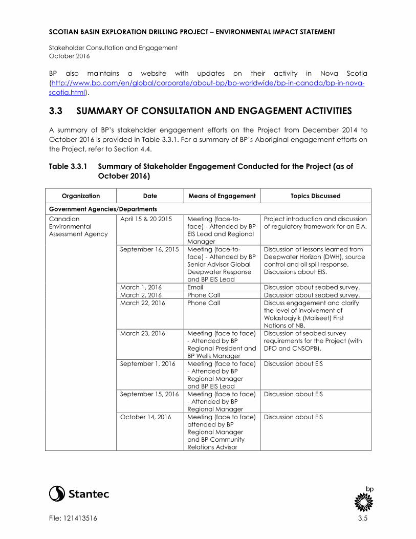
SCOTIAN BASIN EXPLORATION DRILLING PROJECT – ENVIRONMENTAL IMPACT STATEMENT
Stakeholder Consultation and Engagement
October 2016
File: 121413516 3.5
BP also maintains a website with updates on their activity in Nova Scotia
(http://www.bp.com/en/global/corporate/about-bp/bp-worldwide/bp-in-canada/bp-in-nova-
scotia.html).
3.3 SUMMARY OF CONSULTATION AND ENGAGEMENT ACTIVITIES
A summary of BP’s stakeholder engagement efforts on the Project from December 2014 to
October 2016 is provided in Table 3.3.1. For a summary of BP’s Aboriginal engagement efforts on
the Project, refer to Section 4.4.
Table 3.3.1 Summary of Stakeholder Engagement Conducted for the Project (as of
October 2016)
Organization Date Means of Engagement Topics Discussed
Government Agencies/Departments
Canadian
Environmental
Assessment Agency
April 15 & 20 2015 Meeting (face-to-
face) - Attended by BP
EIS Lead and Regional
Manager
Project introduction and discussion
of regulatory framework for an EIA.
September 16, 2015 Meeting (face-to-
face) - Attended by BP
Senior Advisor Global
Deepwater Response
and BP EIS Lead
Discussion of lessons learned from
Deepwater Horizon (DWH), source
control and oil spill response.
Discussions about EIS.
March 1, 2016 Email Discussion about seabed survey.
March 2, 2016 Phone Call Discussion about seabed survey.
March 22, 2016 Phone Call Discuss engagement and clarify
the level of involvement of
Wolastoqiyik (Maliseet) First
Nations of NB.
March 23, 2016 Meeting (face to face)
- Attended by BP
Regional President and
BP Wells Manager
Discussion of seabed survey
requirements for the Project (with
DFO and CNSOPB).
September 1, 2016 Meeting (face to face)
- Attended by BP
Regional Manager
and BP EIS Lead
Discussion about EIS
September 15, 2016 Meeting (face to face)
- Attended by BP
Regional Manager
Discussion about EIS
October 14, 2016 Meeting (face to face)
attended by BP
Regional Manager
and BP Community
Relations Advisor
Discussion about EIS

SCOTIAN BASIN EXPLORATION DRILLING PROJECT – ENVIRONMENTAL IMPACT STATEMENT
Stakeholder Consultation and Engagement
October 2016
File: 121413516 3.6
Table 3.3.1 Summary of Stakeholder Engagement Conducted for the Project (as of
October 2016)
Organization Date Means of Engagement Topics Discussed
Canada-Nova Scotia
Offshore Petroleum
Board
September 17, 2015 Meeting (face to face)
- Attended by BP
Senior Advisor Global
Deepwater Response
and BP EIS Lead
Lessons learned from DWH, source
control and oil spill response.
November 11, 2015 Meeting (telecom) Workshop concerning oil spill
modelling approach (with DFO
and ECCC).
November 19, 2015 Meeting (telecom) Overview of metocean data to be
used in modelling work (with DFO
and ECCC).
December 7, 2015 Meeting (telecom) Discussion about spill modelling
thresholds.
April 13, 2016 Meeting (face-to-
face) - Attended by BP
Regional Manager
and Country President
Project update
June 28, 2016 Meeting (face-to-
face) attended by
Attended by BP
Regional Manager, BP
Wells Manager and BP
Exploration Manager
Project technical update
June 28, 2016 Meeting (face-to-
face) – Attended by
BP Exploration
Manager
Project technical update
June 29, 2016 Meeting (face-to-
face) - Attended by BP
Exploration Manager
Project technical update
July 22, 2016 &
August 2, 2016
Meeting (face-to-
face) - Attended by BP
Regional Manager
Discussion about Project
Communication
August 23, 2016 Meeting (face-to-
face) -Attended by BP
Regional Manager
and BP Business
Manager
Discussion about exploration
licenses
September 23, 2016 Meeting (face to face)
– Attended by BP
Regional Manager
Project update
Fisheries and Oceans
Canada (DFO)
March 16, 2015 Meeting (face to face) Discussion about Aboriginal
commercial fishing program.
April 13, 2015 Meeting (face to face) Discussion on insights into areas of
interest in EIS.

SCOTIAN BASIN EXPLORATION DRILLING PROJECT – ENVIRONMENTAL IMPACT STATEMENT
Stakeholder Consultation and Engagement
October 2016
File: 121413516 3.7
Table 3.3.1 Summary of Stakeholder Engagement Conducted for the Project (as of
October 2016)
Organization Date Means of Engagement Topics Discussed
September 15, 2015 Meeting (face to face)
– Attended by BP
Senior Advisor Global
Deepwater Response
Project introduction and EIS
update; Discussion of lessons
learned from DWH.
June 27, 2016 Meeting (face-to-
face)
Introductions and BP Project
overview
September 20, 2016 Meeting (face to face)
Anita Perry, Mike
Wamboldt
Discussion about Project
approach for baseline data
Environment and
Climate Change
Canada
April 20, 2015 Meeting (face to face) Discussed insights into areas of
interest in EIS.
Nova Scotia
Department of
Energy
April 1, 2016 Meeting (face to face) Update on Scotian Basin
Exploration Project.
June 29, 2016 Meeting (face to face) Project technical update
September 21, 2016 Meeting (face to face) Project update
September 27, 2016 Meeting (face to face) Project update
Nova Scotia Office
of Aboriginal Affairs
December 4, 2014 Meeting (face to face) Regulatory requirements around
consultation.
September 17, 2015 Meeting (face to face) Introductory meeting with
environment team to discuss
consultation.
Nova Scotia
Emergency
Management Office
June 29, 2016 Meeting (face to face) Introductory meeting to discuss
project and to provide awareness
on where NSEMO can assist with
co-ordination to support an
offshore incident.
October 4, 2016 Email BP provided update on Project
schedule.
Joint Rescue
Coordination Centre
October 4, 2016 Email BP provided update on Project
schedule.
Fisheries
Fisheries Advisory
Committee (FAC)
(CNSOPB)
January 21, 2015 Notes for Meeting BP provided a written update on
the exploration drilling Project for
communication at the FAC
meeting.
May 12, 2015 Meeting (face to
face)
BP provided a timeline update
and discussed the key areas
requiring further discussion as BP
progresses to an exploration
program.
September 16, 2015 Meeting (face to face)
– Attended by BP
Senior Advisor Global
Deepwater Response
BP presented an overview and
update on EIS process, lessons
learned from DWH, and an
overview of BP’s source control
methods and Oil Spill Response
Plan.

SCOTIAN BASIN EXPLORATION DRILLING PROJECT – ENVIRONMENTAL IMPACT STATEMENT
Stakeholder Consultation and Engagement
October 2016
File: 121413516 3.8
Table 3.3.1 Summary of Stakeholder Engagement Conducted for the Project (as of
October 2016)
Organization Date Means of Engagement Topics Discussed
February 17, 2016 Meeting (face-to-
face)
BP provided an update on project
planning to the FAC, focusing on
pending EIS submission to CEA
Agency later than anticipated
due to taking the time up-front to
address matters raised in
engagement meetings related to
spill modelling. Also discussed FAC
members’ consultation style
preferences (response was face-
to-face as much as possible) and
what topics they wished to cover.
Topics discussed included: BP as
an operator, use of dispersants,
worst case discharge impact,
emergency preparedness, the role
of BOPs, cap and containment.
June 22, 2016 Meeting (face-to-
face)
BP provided presentation on EIS
and spill modelling approach and
results
September 21, 2016 Meeting (face-to-
face)
BP provided update on the
Project.
Guysborough
County Inshore
Fishermen’s
Association
March 24, 2015 Meeting (face to face) Identified the key areas requiring
further discussion as BP progresses
to an exploration program.
Seafood Producers
of Nova Scotia
(SPANS)
March 25, 2015 Meeting (face to face) Identified the key areas requiring
further discussion as BP progresses
to an exploration program.
Other Interest Groups
Maritime Energy
Association
May 12, 2015 Information Session
(face-to-face) –
Attended by BP’s
Logistics &
Infrastructure Manager
and Regional
Manager,
Procurement Supply
Chain Management
BP presented information on
logistics including: Project scope;
procurement process – approach
to local business, local content
strategy, expectations from
vendors, and procurement
process; and proposed timeline on
exploration project plan.
Maritime Energy
Association
September 29, 2015 CORE Conference
Presentation (face-to-
face) - Attended by BP
Canada Exploration
Manager
Updated participants on
exploration project area,
proposed timeline, expanded
exploration joint venture EL2431-
2434, project planning and early
look at 3D seismic.
Stakeholder engagement will continue beyond the EIS, throughout the full project life-cycle. BP is
committed to listening and responding to stakeholder concerns if and as they arise.

SCOTIAN BASIN EXPLORATION DRILLING PROJECT – ENVIRONMENTAL IMPACT STATEMENT
Stakeholder Consultation and Engagement
October 2016
File: 121413516 3.9
3.4 QUESTIONS AND COMMENTS RAISED DURING ENGAGEMENT
Questions and comments raised during engagement, including comments raised during the
public comment periods held thus far under CEAA, 2012, have been taken into consideration
during the preparation of this EIS. In general, questions and comments include those related to:
potential environmental, health and safety implications of an accidental spill; the current
regulatory framework and industry response to an accidental spill; potential environmental
effects on marine life and fisheries; and economic development opportunities.
A summary of key issues that have been raised during the public comment period under CEAA,
2012 and how they have been addressed is presented in Table 3.4.1.

SCOTIAN BASIN EXPLORATION DRILLING PROJECT – ENVIRONMENTAL IMPACT STATEMENT
Stakeholder Consultation and Engagement
October 2016
File: 121413516 3.10
Table 3.4.1 Summary of Key Issues Raised During Public Stakeholder Engagement
Question or Comment Response EIS Reference
What has BP learned since
the Deepwater Horizon
(DWH) incident in the Gulf of
Mexico?
BP’s internal investigation of the DWH incident, which culminated in the Bly
Report (BP 2010), involved a team of over 50 internal and external specialists
from a variety of fields, including safety, operations, subsea, drilling, well
control, cementing, well flow dynamic modelling, BOP systems, and process
hazard analysis. Eight key findings relating to the causal chain of events were
made, with 26 associated recommendations to enable the prevention of a
similar accident and aimed at further reducing risk across BP’s global drilling
activities.
The Bly Report recommended a number of measures to strengthen BPs
operational practices, and these are being addressed through the
implementation of enhanced drilling requirements. Key requirements have
been captured in guidance documents and engineering technical practices.
Key areas that have been addressed include: cementing and zonal isolation
practices; process safety management through the life cycle of a well; well
casing design; and rig audit and verification.
In addition to these technical requirements, BP has focused on enhancement
of capability and competency; verification, assurance and audit; and process
safety performance management.
An account of lessons learned from the DWH incident and information about
progress against recommendations in the Bly Report are presented in the EIS
(refer to Section 8.3.4).
Section 8.3.4: Information about
lessons from the DWH incident
Request for more
information on BP’s
environmental
management, spill
prevention and incident
management plans
BP works in line with its operating management system (OMS), a framework
which sets out requirements on a range of criteria, such as health and safety,
security, environmental management, social responsibility and operational
reliability.
Contractors, such as drilling and well services contractors, will be accountable
for the development and delivery of their safety and environmental
management systems. Contractors will be responsible for carrying out self-
verification activity to assess conformance with their contractual requirements.
Contractor safety performance is typically assessed and reviewed by BP
throughout the duration of the contract. Further information will be presented
in the Environment Protection Plan which will be submitted to CNSOPB as part
of the OA process.
Section 1.3.1: Information about
how BP operates, including
information about management
systems and working with
contractors
Section 8.3.1: Information about
the incident management plan
and spill response plan
Section 12: Information about
environmental management
plans for the Project
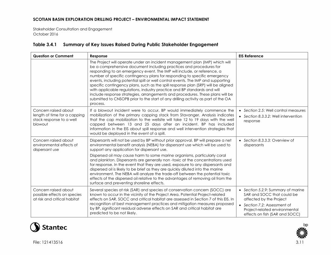
SCOTIAN BASIN EXPLORATION DRILLING PROJECT – ENVIRONMENTAL IMPACT STATEMENT
Stakeholder Consultation and Engagement
October 2016
File: 121413516 3.11
Table 3.4.1 Summary of Key Issues Raised During Public Stakeholder Engagement
Question or Comment Response EIS Reference
The Project will operate under an incident management plan (IMP) which will
be a comprehensive document including practices and procedures for
responding to an emergency event. The IMP will include, or reference, a
number of specific contingency plans for responding to specific emergency
events, including potential spill or well control events. The IMP and supporting
specific contingency plans, such as the spill response plan (SRP) will be aligned
with applicable regulations, industry practice and BP standards and will
include response strategies, arrangements and procedures. These plans will be
submitted to CNSOPB prior to the start of any drilling activity as part of the OA
process.
Concern raised about
length of time for a capping
stack response to a well
blowout
If a blowout incident were to occur, BP would immediately commence the
mobilization of the primary capping stack from Stavanger. Analysis indicates
that the cap mobilization to the wellsite will take 12 to 19 days with the well
capped between 13 and 25 days after an incident. BP has included
information in the EIS about spill response and well intervention strategies that
would be deployed in the event of a spill.
Section 2.5: Well control measures
Section 8.3.3.2: Well intervention
response
Concern raised about
environmental effects of
dispersant use
Dispersants will not be used by BP without prior approval. BP will prepare a net
environmental benefit analysis (NEBA) for dispersant use which will be used to
support any application for dispersant use.
Dispersed oil may cause harm to some marine organisms, particularly coral
and plankton. Dispersants are generally non -toxic at the concentrations used
for response. In the event that they are used, exposure to any dispersants and
dispersed oil is likely to be brief as they are quickly diluted into the marine
environment. The NEBA will analyze the trade-off between the potential toxic
effects of the dispersed oil relative to the advantages of removing oil from the
surface and preventing shoreline effects.
Section 8.3.3.3: Overview of
dispersants
Concern raised about
possible effects on species
at risk and critical habitat
Several species at risk (SAR) and species of conservation concern (SOCC) are
known to occur in the vicinity of the Project Area. Potential Project-related
effects on SAR, SOCC and critical habitat are assessed in Section 7 of this EIS. In
recognition of best management practices and mitigation measures proposed
by BP, significant residual adverse effects on SAR and critical habitat are
predicted to be not likely.
Section 5.2.9: Summary of marine
SAR and SOCC that could be
affected by the Project
Section 7.2: Assessment of
Project-related environmental
effects on fish (SAR and SOCC)

SCOTIAN BASIN EXPLORATION DRILLING PROJECT – ENVIRONMENTAL IMPACT STATEMENT
Stakeholder Consultation and Engagement
October 2016
File: 121413516 3.12
Table 3.4.1 Summary of Key Issues Raised During Public Stakeholder Engagement
Question or Comment Response EIS Reference
Section 7.3: Assessment of
Project-related environmental
effects on marine mammal (SAR
and SOCC)
Section 7.3: Assessment of
Project-related environmental
effects on sea turtle (SAR and
SOCC)
Section 7.4: Assessment of
Project-related environmental
effects on marine bird (SAR and
SOCC)
Section 8.5: Environmental effects
of potential accidental events
Section 10: Cumulative
environmental effects
Concern raised about
possible effects on the
fishing industry
Routine Project activities and components have potential to interact with
fisheries resources by direct or indirect effects on commercially fished species
and/or effects on fishing activity from displacement from fishing areas, gear
loss or damage that could potentially result in a demonstrated financial loss to
commercial fishing interests. For the most part, effects on the fishery will be
limited to a 500-m safety (exclusion) zone from the MODU that is standard for
the offshore industry.
BP has committed to employing mitigation measures and standard practices
to reduce Project-related effects on fish and fish habitat, as well as fisheries
activities. BP will continue to engage commercial and Aboriginal fishers to
share Project details as applicable and facilitate coordination of information
sharing. A Fisheries Communication Plan will be used to facilitate coordinated
communication with fishers. A Fisheries Communication Plan will facilitate
communication of Project updates, issues and concerns as the Project moves
past the EA process and into the implementation stage.
Section 5.3.5: Existing conditions
regarding commercial fisheries
Section 7.6: Project-related
environmental effects on
commercial fisheries
Section 8.5: Environmental effects
of potential accidental events
Section 10: Cumulative
environmental effects

SCOTIAN BASIN EXPLORATION DRILLING PROJECT – ENVIRONMENTAL IMPACT STATEMENT
Stakeholder Consultation and Engagement
October 2016
File: 121413516 3.13
Table 3.4.1 Summary of Key Issues Raised During Public Stakeholder Engagement
Question or Comment Response EIS Reference
Concern raised about
possible effects on the
tourism industry
The Project is not predicted to interact with the provincial tourism industry. Most
tourism and recreational activities occur in coastal or nearshore areas and
would not interact with routine Project activities (the Project Area is located
more than 200 km offshore and 48 km from Sable Island National Park Reserve).
In the event of a large spill (e.g., blowout), there could potentially be an
interaction with coastal resources which could be related to local tourism and
recreation. As discussed in Section 8, the likelihood of such a spill event is
extremely low, and BP would implement spill response measures to reduce
interactions with coastal resources.
Section 5.3.4.4: Existing conditions
regarding tourism and
recreational activities
Section 7.2: Project-related
environmental effects on fish and
fish habitat
Section 8.5: Environmental effects
of potential accidental events
Concern raised about
effect of underwater sound
and preventative measures
to mitigate effects on
marine life
Underwater sound will be generated by the MODU and PSVs, as well as during
VSP operations. The extent to which sound travels is determined by
environmental conditions, including water depths, water salinity and
temperature. The sound generated by the MODU will be continuous
throughout the drilling program, whereas underwater sound generated during
the VSP operations are typically impulsive in nature, occurring over a short
duration (e.g., up to one day per well). BP has commissioned an acoustic
modelling study to inform the assessment of underwater sound effects on
marine life.
BP will assess in consultation with the appropriate authorities the potential for
undertaking an acoustic monitoring program during the drilling program to
collect field measurements of underwater sound in order to verify predicted
underwater sound levels. The objectives of such a program will be identified in
collaboration with DFO and the CNSOPB and in consideration of lessons
learned from the underwater sound monitoring program to be undertaken by
Shell as part of the Shelburne Basin Venture Exploration Drilling Project in 2016.
Section 2.8.5: Information about
potential underwater sound
sources
Section 7.2: Project-related
environmental effects on fish and
fish habitat
Section 7.3: Assessment of
project-related environmental
effects on marine mammals and
sea turtles
Section 7.6: Project-related
environmental effects on
commercial fisheries
Section 10: Cumulative
environmental effects
Section 11: A summary of effects
Appendix D: Acoustic Modelling
Study
Concern raised about
effects of drilling discharges
and emissions
Drilling activities give rise to a range of wastes, discharges and emissions. All
emissions, wastes and discharges will be disposed of in accordance with
applicable legislation and guidelines including MARPOL and the OWTG. In
accordance with regulatory requirements, some wastes will be managed and
disposed of directly offshore from the MODU and the PSVs, whereas some
Section 2.8: Overview of
emissions, discharges and waste
management
Section 7.2: Assessment of
Project-related environmental

SCOTIAN BASIN EXPLORATION DRILLING PROJECT – ENVIRONMENTAL IMPACT STATEMENT
Stakeholder Consultation and Engagement
October 2016
File: 121413516 3.14
Table 3.4.1 Summary of Key Issues Raised During Public Stakeholder Engagement
Question or Comment Response EIS Reference
wastes will be brought to shore for disposal.
The effect of drilling waste, discharges and emissions is considered as part of
the EIS. Drilling waste discharges have been quantified and modelled as part
of the EIS.
effects on fish and fish habitat
Section 7.3: Assessment of
Project-related environmental
effects on marine mammals and
sea turtles
Section 7.4: Assessment of
Project-related environmental
effects on migratory birds
Section 7.5: Assessment of
Project-related environmental
effects on Special Areas
Section 7.6: Assessment of
Project-related environmental
effects on commercial fisheries
Section 7.7: Assessment of
Project-related environmental
effects on Aboriginal use of lands
and resources for traditional
purposes
Section 10: Cumulative
environmental effects
Concern raised about
proximity to Sable Island, the
Gully, and northern
bottlenose whale critical
habitat
The EIS assesses potential Project-related (and cumulative) effects on Special
Areas which include, among other areas, Sable Island, the Gully and SARA-
designated critical habitat.
Routine Project activities and components could potentially interact with
Special Areas, which could affect the ability of the Special Area to continue to
provide important biological and ecological functions on which marine
species and/or fisheries depend. These potential interactions most closely
relate to concerns with the changes to the existing quality and use of natural
habitats within these Special Areas.
To reduce potential adverse effects on Special Areas, BP has committed to
implementing best management practices and mitigation measures including
Section 5.2.10: Existing conditions
regarding Special Areas
Section 7.5: Project-related
environmental effects on Special
Areas
Section 8.5: Environmental effects
of potential accidental events
Section 10: Cumulative
environmental effects

SCOTIAN BASIN EXPLORATION DRILLING PROJECT – ENVIRONMENTAL IMPACT STATEMENT
Stakeholder Consultation and Engagement
October 2016
File: 121413516 3.15
Table 3.4.1 Summary of Key Issues Raised During Public Stakeholder Engagement
Question or Comment Response EIS Reference
avoidance of Sable Island, the Gully and northern bottlenose whale critical
habitat. Mitigation measures identified for Fish and Fish Habitat, Marine
Mammals and Sea Turtles, and Migratory Birds will be implemented to reduce
the potential environmental effects of the Project on Special Areas. BP will also
implement multiple preventative and response barriers to manage risk of
incidents occurring and mitigate potential consequences (refer to Section 8.3
for details on plans and specific response strategies).
Concern raised about
geohazards including slope
failure
Prior to any drilling activity, BP will conduct a comprehensive regional
geohazard baseline review (GBR), followed by detailed geohazard
assessments for each proposed wellsite to identify potential geohazards that
may affect drilling operations. The GBR and detailed wellsite assessments will
be based primarily on reprocessed 3D Wide Azimuth Towed Streamer (WATS)
seismic data acquired by BP in 2014. Existing regional data, such as
geotechnical cores and offset wells, will be incorporated where available. The
geohazard assessments will focus on identifying potential drilling hazards at the
seabed and subsurface. This work will be conducted by a BP geohazards
specialist following internal guidelines that either meet or exceed local
regulatory requirements.
Section 2.2: Information about
well location selection criteria,
including geohazards
Section 9.1.6: Information about
geohazards
Section 9.2: Information about
mitigation measures for
geohazard management
General concern regarding
use of fossil fuels and
implications for climate
change
Energy demand is forecast to increase globally over the next 20 years.
Population growth and increases in per capita income are the key drivers
behind the growth in energy demand. Energy production and consumption
patterns vary and emphasize the need for secure, sustainable energy supplies.
Nova Scotia’s 2009 Energy Strategy – Toward a Greener Future (NSDOE 2009b),
highlights the importance of a sustainable energy mix, and the role that
offshore hydrocarbon exploration and development plays within the
province’s ongoing energy strategy. In the strategy, Nova Scotia commits to
“encourage renewed offshore exploration and development, with its
enormous potential for building future prosperity”. In order to achieve their
stated goal, the province has stated that it will invest revenues from offshore
hydrocarbon activity into expenditures that offer enduring benefits.
Section 1.4: Benefits of the
Project, including information
about energy diversification and
sustainability
Request for information on
management of drilling
waste, including waste
It is likely that the initial, shallow sections of the well will be drilled without a riser
and that deeper sections will be drilled with a drilling riser attached. During
riserless drilling, WBM will be used as the drilling fluid and cuttings are
Section 2.3.2: Information about
cuttings
Section 2.8.2: Information about

SCOTIAN BASIN EXPLORATION DRILLING PROJECT – ENVIRONMENTAL IMPACT STATEMENT
Stakeholder Consultation and Engagement
October 2016
File: 121413516 3.16
Table 3.4.1 Summary of Key Issues Raised During Public Stakeholder Engagement
Question or Comment Response EIS Reference
minimization discharged directly to the water column in accordance with regulatory
guidelines. Once a riser is attached, cuttings can be returned to the MODU for
treatment; therefore, WBM or an alternative drilling fluid such as SBM can be
used. The MODU will be equipped with specialized solids control equipment for
cuttings management. Treatment technology will include shale shakers which
recover drilling fluids from the cuttings to minimize the amount of waste fluids.
Additional treatment of cuttings will be required when SBM is used to enable
disposal in accordance with the OWTG. SBM cuttings will only be discharged
once the performance targets in OWTG of 6.9 g/100 g retained “synthetic on
cuttings” on wet solids can be satisfied. The concentration of SBM on cuttings
will be monitored on the MODU to achieve compliance with the OWTG.
BP has modelled the dispersion of predicted drilling waste (refer to Appendix
C); this modelling study has been used to inform the assessment of effects of
drilling waste on marine life. Overall, the dispersion of sediments associated
with drill waste discharges is predicted to be limited to approximately 1,367 m
(for a minimum deposition thickness of 0.1 mm). Using a threshold of 9.6 mm to
assume burial of benthic species, it is predicted that this sediment thickness
could extend approximately 116 m from the discharge point, or cover an area
of approximately 0.54 ha per well.
drilling waste discharges
Section 7.1.2.1: Summary of drill
waste discharges and modelling
results
Section 7.2: Assessment of
Project-related environmental
effects on fish and fish habitat
Section 7.3: Assessment of
Project-related environmental
effects on marine mammals and
sea turtles
Section 7.4: Assessment of
Project-related environmental
effects on migratory birds
Section 7.5: Assessment of
Project-related environmental
effects on Special Areas
Section 7.6 Assessment of Project-
related environmental effects on
commercial fisheries
Section 7.7 Assessment of Project-
related environmental effects on
Aboriginal use of lands and
resources for traditional purposes
Section 10: Cumulative
environmental effects
Appendix C: Drilling Waste
Dispersion Modelling Study
Request for information on
anticipated greenhouse gas
emissions related to Project
activities
Key Project activities resulting in atmospheric emissions are:
Combustion from the MODU and PSV diesel engines, and fixed and mobile
deck equipment and helicopter engines; and
Section 2.8.1: Information about
atmospheric emissions from
Project activities

SCOTIAN BASIN EXPLORATION DRILLING PROJECT – ENVIRONMENTAL IMPACT STATEMENT
Stakeholder Consultation and Engagement
October 2016
File: 121413516 3.17
Table 3.4.1 Summary of Key Issues Raised During Public Stakeholder Engagement
Question or Comment Response EIS Reference
Flaring during well test activity, in the event that well testing is required. It is
currently anticipated that well testing (and associated flaring) will not be
carried out on the first two wells drilled as part of the Project. When well
testing is required, these emissions will be short-term and intermittent (e.g.,
flaring from a few hours up to three days).
In terms of GHG emissions, the Project is predicted to emit approximately 295.8
tonnes of CO2 per day. ECCC reports an annual GHG emissions value for the
province of Nova Scotia of 17,000 kilotonnes of CO2 equivalent per year
(Environment Canada 2016). BP’s predicted daily CO2 emissions for the Project
therefore represent approximately 0.59 % of Nova Scotia’s average daily
emission. Atmospheric emissions, including GHGs, will be variable over the
lifetime of the Project as activity varies.
Request that the EIS
considers how local
conditions and natural
hazards can affect the
Project and result in
environmental effects
Aspects of the environment that could potentially affect the Project include:
fog; sea ice and superstructure icing; seismic events and tsunamis; extreme
weather conditions; and sediment and seafloor stability.
The EIS includes information about local conditions and natural hazards which
could potentially affect the Project and mitigation measures to manage these.
Section 9.1: Environmental
conditions which could affect the
Project
Section 9.2: Mitigation measures
which will be put in place to
manage environmental
conditions
Request for information on
well abandonment
including monitoring or
inspection
Once wells have been drilled to total depth and well evaluation programs
completed, the well will be plugged and abandoned in line with applicable
BP practices and CNSOPB requirements. Plugs will be placed above and
between any hydrocarbon bearing intervals at appropriate depths in the well,
as well as at the surface.
The final well abandonment program has not yet been finalized; however,
these details will be confirmed as planning for the Project continues. A seabed
survey will be conducted at the end of the drilling program using an ROV to
survey the seabed for debris. Inspection and monitoring of abandoned
wellheads will be conducted according to CNSOPB requirements.
Section 2.4.4: Overview of plan
for well abandonment

SCOTIAN BASIN EXPLORATION DRILLING PROJECT – ENVIRONMENTAL IMPACT STATEMENT
Aboriginal Engagement
October 2016
File: 121413516 4.1
4.0 ABORIGINAL ENGAGEMENT
This section of the EIS discusses ongoing and proposed engagement with Aboriginal
organizations that may have an interest in the Project. For information on public stakeholder
engagement including ongoing and proposed engagement activities, and questions and
comments raised, refer to Section 3.
4.1 ABORIGINAL ENGAGEMENT OBJECTIVES
BP recognizes the potential for the Project to affect Aboriginal interests including potential or
established Aboriginal or Treaty rights, and acknowledges the importance of engaging
Aboriginal organizations to provide Project information and obtain feedback on potential issues
and concerns. BP also recognizes the importance of supporting Project-related Crown
consultation efforts that may arise as part of the EIS process and related government decision-
making.
4.2 ABORIGINAL ORGANIZATIONS
4.2.1 First Nations in Nova Scotia
According to the 2011 National Household Survey (Statistics Canada 2013a), 33,850 individuals
of Aboriginal identity live in Nova Scotia, of which 12,910 have “registered or Treaty Indian”
status. The majority of Aboriginal people in Nova Scotia are from the Mi’kmaw nation (NSOAA
2011).
There are 13 First Nations in Nova Scotia (refer to Table 4.2.1 and Figure 4.2.1). The General
Assembly of Nova Scotia Mi’kmaq Chiefs represents the governance for the Mi’kmaq of Nova
Scotia. The Kwilmu’kw Maw-klusuaqn Negotiation Office (KMKNO) represents the Assembly with
respect to consultation on Mi’kmaq Aboriginal or treaty rights. Sipekne’katik First Nation and
Millbrook First Nation are members of the Assembly of Nova Scotia Mi’kmaq Chiefs but in 2013
and 2016 respectively chose to independently represent themselves in consultation, as opposed
to representation by the KMKNO. Sipekne’katik First Nation and Millbrook First Nation assert the
same rights as other Mi’kmaq communities. Mi’kmaq and other Aboriginal peoples residing off-
reserve in Nova Scotia are discussed in Section 4.2.4.

SCOTIAN BASIN EXPLORATION DRILLING PROJECT – ENVIRONMENTAL IMPACT STATEMENT
Aboriginal Engagement
October 2016
File: 121413516 4.2
Table 4.2.1 First Nations in Nova Scotia
Band Census Subdivision/Designated Place1 Location Chief
Registered Population (2015)2
Total On
Reserve3
Off
Reserve
Acadia Gold River 21 (IRI), Medway River 11 (IRI), Ponhook
Lake 10 (IRI), Wildcat 12 (IRI), Yarmouth 33 (IRI)
Yarmouth,
Nova Scotia
Deborah
Robinson
1,511 229 1,282
Annapolis Valley Cambridge 32 (IRI), St. Croix 34 (IRI) Kings County,
Nova Scotia
Gerald Toney 286 119 167
Bear River Bear River 6 (IRI), Bear River 6A (IRI), Bear River 6B (IRI) Bear River,
Nova Scotia
Carol Thompson 331 106 225
Eskasoni Eskasoni 3 (IRI), Eskasoni 3A (IRI), Malagawatch 4 (IRI) Eskasoni,
Nova Scotia
Leroy Denny 4,371 3733 608
Glooscap Glooscap 35 (IRI) Hantsport,
Nova Scotia
Sidney Peters 367 90 276
Membertou Caribou Marsh 29 (IRI), Malagawatch 4 (IRI),
Membertou 28B (IRI), Sydney 28A (IRI)
Sydney,
Nova Scotia
Terry Paul 1,369 880 532
Millbrook Beaver Lake 17 (IRI), Cole Harbour 30 (IRI), Millbrook
27 (IRI), Sheet Harbour 36 (IRI), Truro 27A (IRI), Truro
27B (IRI), Truro 27C (IRI)
Truro,
Nova Scotia
Robert Gloade 1,787 856 893
Paq’tnkek
(Afton)
Franklin Manor 22 (IRI), Paqtnkek-Niktuek 23 (IRI),
Welnek 38 (IRI)
Afton,
Nova Scotia
Paul Prosper 570 405 137
Pictou Landing Boat Harbour West 37 (IRI), Fisher's Grant 24 (IRI),
Fisher’s Grant 24G, Franklin Manor 22 (IRI),
Merigomish Harbour 31 (IRI)
Trenton,
Nova Scotia
Andrea Paul 649 473 154
Potlokek
(Chapel Island)
Chapel Island 5 (IRI), Malagawatch 4 (IRI) Chapel Island,
Nova Scotia
Wilbert Marshall 716 547 134
Sipekne’katik Indian Brook 14 (IRI), New Ross 20 (IRI), Pennal 19 (IRI),
Shubenacadie 13 (IRI), Wallace Hills 14A (IRI)
Indian Brook,
Nova Scotia
Rufus Copage 2,495 1283 1,212
Wagmatcook Malagawatch 4 (IRI), Margaree 25 (IRI),
Wagmatcook 1 (IRI)
Wagmatcook,
Nova Scotia
Norman Bernard 826 604 179

SCOTIAN BASIN EXPLORATION DRILLING PROJECT – ENVIRONMENTAL IMPACT STATEMENT
Aboriginal Engagement
October 2016
File: 121413516 4.3
Table 4.2.1 First Nations in Nova Scotia
Band Census Subdivision/Designated Place1 Location Chief
Registered Population (2015)2
Total On
Reserve3
Off
Reserve
We’koqma’q
(Whycocomagh)
Malagawatch 4 (IRI), Whycocomagh 2 (IRI) Whycocomagh,
Nova Scotia
Rod Googoo 981 864 83
1Aboriginal Affairs and Northern Development Canada: First Nation Profiles (2015).
2 Population estimates based on Aboriginal Affairs and Northern Development Canada Registered Population (2015).
3 On reserve population estimates only include registered males and females on own reserve.

SCOTIAN BASIN EXPLORATION DRILLING PROJECT – ENVIRONMENTAL IMPACT STATEMENT
Aboriginal Engagement
October 2016
File: 121413516 4.4
Figure 4.2.1 Location of First Nations Communities in Nova Scotia, New Brunswick and PEI

SCOTIAN BASIN EXPLORATION DRILLING PROJECT – ENVIRONMENTAL IMPACT STATEMENT
Aboriginal Engagement
October 2016
File: 121413516 4.5
4.2.2 First Nations in New Brunswick
The 2011 National Household Survey (Statistics Canada 2013b) indicates that there are 22,620
individuals of Aboriginal identity living in New Brunswick, of which 10,275 are “registered or Treaty
Indian”. In New Brunswick, there are 15 First Nations communities, six are from the Wolastoqiyik
(Maliseet) nation and nine are from the Mi’kmaw nation (NBDAA 2015). Wolastoqiyik (Maliseet)
First Nations communities reside along the Saint John River, predominately in the west and
northwest areas of the province. Mi’kmaq First Nations communities reside along the eastern
and northern coasts of the province. Table 4.2.2 provides a summary of demographic
information on each First Nation. Locations of band councils for each community are shown on
Figure 4.2.1.
The Assembly of First Nations’ Chiefs in New Brunswick (AFNCNB), the highest level of decision-
making in the negotiation and consultation processes in New Brunswick, was established in 2007.
The AFNCNB was a political organization, mandated to promote a unified voice for the 15 First
Nations in New Brunswick. In 2015, the six Wolastoqiyik (Maliseet) communities split from the
AFNCNB and announced they will be forming their own organization to conduct their
administrative affairs. The AFNCNB is now defunct; Mi’gmawe’ Tplu’taqn Incorporated (MTI) was
created by the Mi’gmag First Nations of New Brunswick.

SCOTIAN BASIN EXPLORATION DRILLING PROJECT – ENVIRONMENTAL IMPACT STATEMENT
Aboriginal Engagement
October 2016
File: 121413516 4.6
Table 4.2.2 First Nations in New Brunswick
Band Census Subdivision/Designated
Place1 Contact Information Chief
Registered Population (2015)2
Total On
Reserve3
Off
Reserve
Buctouche Buctoche 16 (IRI) Buctouche Reserve,
New Brunswick
Ann Mary Steele (Simon) 119 75 43
Eel Ground Big Hole Tract 8 (IRI), Eel Ground 2
(IRI), Renous 12 (IRI)
Eel Ground,
New Brunswick
George Ginnish 1,026 559 452
Eel River Bar First
Nation
Eel River 3 (IRI), Indian Ranch (IRI),
Moose Meadows 4 (IRI)
Eel River Bar,
New Brunswick
Thomas Everett Martin 726 346 367
Elsipogtog First
Nation
Richibucto 15 (IRI), Soegao 35 (IRI) Elsipogtog First Nation,
New Brunswick
Arren Sock 3,285 2,519 721
Esgenoopetitj First
Nation
Esgenoopetitj Indian Reserve 14
(IRI), Pokemouche 13 (IRI),
Tabusintac 9 (IRI)
Burnt Church,
New Brunswick
Alvery Paul 1,865 1,310 515
Fort Folly Fort Folly 1, (IRI) Dorchester,
New Brunswick
Rebecca Knockwood 132 35 96
Indian Island Indian Island 28 (IRI) Indian Island,
New Brunswick
Ken Barlow 183 103 79
Kingsclear Kingsclear 6 (IRI), The Brothers 18
(IRI)
Kingsclear First Nation,
New Brunswick
Gabriel Atwin 1,007 706 200
Madawaska
Wolastoqiyik
(Maliseet) First
Nation
St Basile 10 (IRI), The Brothers 18
(IRI)
Madawaska Maliseet
First Nation
Patricia Bernard 367 150 217
Metepenagiag
Mi’kmaq Nation
Big Hole Tract 8 (North Half) (IRI),
Indian Point 1 (IRI), Red Bank 4 (IRI),
Red Bank 7 (IRI)
Metepenagiag
Mi’kmaq Nation, New
Brunswick
Alan Blowers 668 211 211
Oromocto Oromocto 26 (IRI) Oromocto,
New Brunswick
Shelly Sabattis 664 311 351
Pabineau Pabineau 11 (IRI) Pabineau First Nation,
New Brunswick
David Peter-Paul 301 199 100

SCOTIAN BASIN EXPLORATION DRILLING PROJECT – ENVIRONMENTAL IMPACT STATEMENT
Aboriginal Engagement
October 2016
File: 121413516 4.7
Table 4.2.2 First Nations in New Brunswick
Band Census Subdivision/Designated
Place1 Contact Information Chief
Registered Population (2015)2
Total On
Reserve3
Off
Reserve
Saint Mary’s Devon 30 (IRI), St. Mary’s 24 (IRI) Fredericton, New
Brunswick
Candice Paul 1,849 839 966
Tobique The Brothers 18 (IRI), Tobique 20
(IRI)
Tobique First Nation,
New Brunswick
Ross Perley 2,281 1,507 767
Woodstock The Brothers 18 (IRI), Woodstock 23
(IRI)
Woodstock First Nation,
New Brunswick
Timothy Paul 1,004 287 713
1 Aboriginal Affairs and Northern Development Canada: First Nation Profiles (2015).
2 Population estimates based on Aboriginal Affairs and Northern Development Canada Registered Population (2015).
3 On reserve population estimates only include registered males and females on own reserve.
SCOTIAN BASIN EXPLORATION DRILLING PROJECT – ENVIRONMENTAL IMPACT STATEMENT
Aboriginal Engagement
October 2016
File: 121413516 4.8
4.2.3 First Nations in Prince Edward Island
In 2011, based on the National Household Survey, Prince Edward Island (PEI) was home to 1,520
First Nations people, of which 770 are “registered or Treaty Indian” (Statistics Canada 2013c). The
majority of Aboriginal people are from the Mi’kmaw Nation (Statistics Canada 2013c). There are
two First Nation communities in PEI: Lennox Island Mi’kmaq First Nation and Abegweit Mi’kmaq
First Nation. Abegweit First Nation was formed in 1972 to improve communication and
governance issues that had resulted in part due to geographic separations between the Lennox
Island Band Council and member reserves that were geographically separated from Lennox
Island. Through a majority vote it was agreed that Morell Reserve #2, Rocky Point Reserve #3,
and Scotchfort Reserve #4 would form the new Abegweit Band (Abegweit First Nation 2015).
The Mi’kmaq Confederacy of PEI is a tribal council and provincial territorial organization which
provides a common forum for the two First Nations of PEI, offering a unified voice for the
advancement of Treaty and Aboriginal rights.
Table 4.2.3 provides a summary of the demographic information on each of two PEI First Nations.
Locations of band councils for each community are shown on Figure 4.2.1.

SCOTIAN BASIN EXPLORATION DRILLING PROJECT – ENVIRONMENTAL IMPACT STATEMENT
Aboriginal Engagement
October 2016
File: 121413516 4.9
Table 4.2.3 First Nations in Prince Edward Island
Band Census
Subdivision/Designated
Place1
Contact Information Chief Registered Population (2016)2
Total On Reserve3 Off Reserve
Lennox Island Lennox Island 1, Lennox
Island No. 6, Lennox Island
Reserve No. 5
Lennox Island, Prince
Edward Island
Matilda
Ramjattan
952 389 553
Abeqweit Morell 2, Rocky Point 3,
Scotchfort 4
Scotfort, Prince Edward
Island
Brian Francis 374 213 147
1Aboriginal Affairs and Northern Development Canada: First Nation Profiles (2015).
2Population estimates based on Aboriginal Affairs and Northern Development Canada Registered Population (2016)
3On reserve population estimates only include registered males and females on own reserve.

SCOTIAN BASIN EXPLORATION DRILLING PROJECT – ENVIRONMENTAL IMPACT STATEMENT
Aboriginal Engagement
October 2016
File: 121413516 4.10
4.2.4 Off-Reserve Aboriginal Peoples
The Maritime Aboriginal Peoples Council (MAPC) is a regional Aboriginal Peoples Leaders
Institution established by the Native Council of Nova Scotia (NCNS), the Native Council of Prince
Edward Island (NCPEI), and the New Brunswick Aboriginal Peoples Council (NBAPC). MAPC
represents the Traditional Ancestral Homeland of the Mi’kmaq, Wolastoqiyik (Maliseet), and
Passamaquoddy Aboriginal Peoples of Canada who live off-reserve.
In Nova Scotia, the NCNS advocates for all off-reserve Mi’kmaq and other Aboriginal people
throughout traditional Mi’kmaw territory (NCNS 2015) and has established 13 geographic zones
encompassing the province of Nova Scotia to administer their affairs (refer to Figure 4.2.2). The
NCNS’s 13 community zones have an Aboriginal ancestry population of 32,465, which represents
80% of the total Aboriginal ancestry (i.e., having at least one Aboriginal ancestor) population of
40,415 in Nova Scotia (MAPC 2014). The NCNS community identity population of 16,190
represents approximately 67% of the total Aboriginal identity population in Nova Scotia (MAPC
2014).
The NBAPC constitutes a community of off-reserve Aboriginal people residing in New Brunswick,
and provides programs and services, including advocacy services. Similar to the NCNS, the
NBAPC has organized off-reserve Aboriginal communities into seven zones (refer to Figure 4.2.2).
The NBAPC community zones have an Aboriginal ancestry population of 24,550, which
represents 78% of the total Aboriginal ancestry population of 31,540 in New Brunswick (MAPC
2014). The NBAPC community identity population of 10,645 represents 60% of the total Aboriginal
identity population of 17,655 in New Brunswick (MAPC 2014).
The NCPEI is the self-governing authority for all off-reserve Aboriginal people living on PEI. The
NCPEI has organized off-reserve Aboriginal communities into three zones (refer to Figure 4.2.2).
The NCPEI’s three community zones have an Aboriginal ancestry population of 2,960,
representing approximately 88% of the total Aboriginal ancestry population in PEI (MAPC 2014).

SCOTIAN BASIN EXPLORATION DRILLING PROJECT – ENVIRONMENTAL IMPACT STATEMENT
Aboriginal Engagement
October 2016
File: 121413516 4.11
Figure 4.2.2 Off Reserve Aboriginal Origin and Identity by Community Zones (MAPC 2014)

SCOTIAN BASIN EXPLORATION DRILLING PROJECT – ENVIRONMENTAL IMPACT STATEMENT
Aboriginal Engagement
October 2016
File: 121413516 4.12
4.3 POTENTIAL OR ESTABLISHED RIGHTS AND RELATED INTERESTS
Under the federal Constitution Act, 1982, existing Aboriginal and Treaty rights are recognized as
constitutionally protected rights. Various Peace and Friendship Treaties were established
between the Mi’kmaq, the Wolastoqiyik (Maliseet), and British settlers between 1725 and 1779,
the terms of which were intended to assist in establishing peace and commercial relations
(AANDC 2013). As affirmed by various recent Supreme Court decisions, these treaties guarantee
Aboriginal rights to hunt and fish throughout the region and to maintain a moderate livelihood.
These rights are protected by section 35(1) of the Constitution Act, 1982.
In the 1990 Sparrow Decision, the Supreme Court of Canada found that the Musqueam First
Nation had an Aboriginal right to fish for food, social and ceremonial (FSC) purposes. This
landmark decision highlighted the importance of consulting with Aboriginal groups when their
fishing right may be affected (DFO 2008c). The Governments of Canada and Nova Scotia
continue to work with First Nations to negotiate outstanding treaty, title and Aboriginal rights
questions in Nova Scotia. A description of Mi’kmaq access to FSC and commercial fisheries is
provided in Section 5.3.6 and the Traditional Use Study (TUS) (Appendix B).
A “Made-in-Nova Scotia Process” has been established as a process for the Mi’kmaq, the
Province of Nova Scotia and the Government of Canada to ensure that the interests of
Aboriginal groups in land, resource management and environmental protection are realized
and that claimants share in the benefits of development. On February 23, 2007, a Framework
Agreement was signed between the Mi’kmaq of Nova Scotia, the Province of Nova Scotia and
the Government of Canada to set out the process to promote efficient, effective, orderly and
timely negotiations towards a resolution of issues respecting Mi’kmaq rights and title.
In New Brunswick, the Mi'kmaq and Wolastoqiyik (Maliseet), the Province of New Brunswick and
the Government of Canada are involved in tripartite exploratory discussions. These discussions
are focused on establishing a tripartite process to address issues of mutual concern, including
Aboriginal and treaty rights and self-government.
In addition to the engagement efforts by BP, the federal government is consulting with
Aboriginal organizations in Nova Scotia and New Brunswick to understand potential Project
effects on Aboriginal and Treaty rights and to take any adverse effects into consideration before
reaching a regulatory decision on the Project.
To facilitate the engagement process for this Project and provide input to the EIS, a TUS has
been conducted (refer to Appendix B) to characterize Aboriginal use of marine waters near the
Project. Additional information about the TUS is provided in Section 4.4.

SCOTIAN BASIN EXPLORATION DRILLING PROJECT – ENVIRONMENTAL IMPACT STATEMENT
Aboriginal Engagement
October 2016
File: 121413516 4.13
4.4 ABORIGINAL ENGAGEMENT ACTIVITIES
BP’s engagement with the Mi’kmaq of Nova Scotia began in October 2013 when BP was
planning the Tangier 3D Seismic Survey Project. Since then, their engagement program has
expanded in recognition of a potentially larger regional area of influence associated with the
exploration drilling program and has included engagement of Mi’kmaq and Wolastoqiyik
(Maliseet) in New Brunswick in addition to the Mi’kmaq of Nova Scotia. BP has also commenced
engagement with the First Nations in PEI.
Engagement methods used by BP to provide Project information and obtain feedback have
included:
face to face meetings;
provision of information packages; and
phone calls and emails.
Table 4.4.1 summarizes the Aboriginal engagement conducted by BP for this Project as of
October 2016. BP will continue its Aboriginal engagement over the lifetime of the Project.
Table 4.4.1 Summary of Aboriginal Engagement Conducted for the Project (as of
October 2016)
Organization Date Means of
Engagement Key Issues
Kwilmu’kq Maw-
Klusuaqn Negotiation
Office (KMKNO)
December 3, 2014 Meeting with
Benefits
Committee
Emphasis on meaningful
engagement and benefits
December 4, 2014 Meeting with KMK
consultant
KMKNO’s training and capacity
strategic plan discussion
January 28, 2015 Meeting with KMK
consultant
KMKNO’s training and capacity
strategic plan discussion update
February 23, 2015 Meeting Project update and discussion
around BP/KMKNO relationship
development including
engagement principles and
commitments
February 24, 2015 Meeting Update on timing of EIS related to
exploration project
March 12, 2015 Meeting Progress made on engagement
protocol discussion
April 15, 2015 Meeting Detailed discussion on engagement
principles
April 15, 2015 Meeting Regulatory process and inclusion of
KMKNO discussed

SCOTIAN BASIN EXPLORATION DRILLING PROJECT – ENVIRONMENTAL IMPACT STATEMENT
Aboriginal Engagement
October 2016
File: 121413516 4.14
Table 4.4.1 Summary of Aboriginal Engagement Conducted for the Project (as of
October 2016)
Organization Date Means of
Engagement Key Issues
May 27, 2015 Meeting Detailed discussion on engagement
expectations as well as follow up on
regulatory process and inclusion of
KMKNO
June 15, 2015 Meeting Relationship discussion
July 9, 2015 Meeting Relationship protocol discussion
July 17, 2015 Provided
information
package meeting
BP provided information package
for the KMKNO to share with the
General Assembly of NS Mi’kmaq
Chiefs (meeting agenda could not
accommodate a BP presentation)
August 20, 2015 Email BP requested guidance for
introductory meeting with Chief Paul
Prosper, Lead on the Energy file for
the Assembly of NS Mi’kmaq Chiefs
August 26, 2015 Phone Call Relationship discussion, touching
base on sponsorship opportunities
and BP’s request to be included on
the agenda for Assembly of NS
Mi’kmaq Chiefs meeting
September 15,
2015
Meeting/
Presentation
BP presented project overview,
provided an update on the EIS, and
shared lessons learned from
Deepwater Horizon, source control
and OSRP; KMKNO recommended
an EIS findings workshop be held in
February 2016
October 16, 2015 Meeting Met to discuss sponsorship
opportunities for Annual Youth
Trades Fair
November 27,
2015
Email Seeking guidance from KMKNO
regarding First Nations requesting BP
participation; Request came
through TUS interview activity
March 3, 2016 Email Update on timing of EIS related to
exploration project
March 22, 2016 Email Relationship update discussion to
address any outcomes from
upcoming meetings
March 30, 2016 Phone call Discussion about Project timeline, EIS
submission and planned technical
session
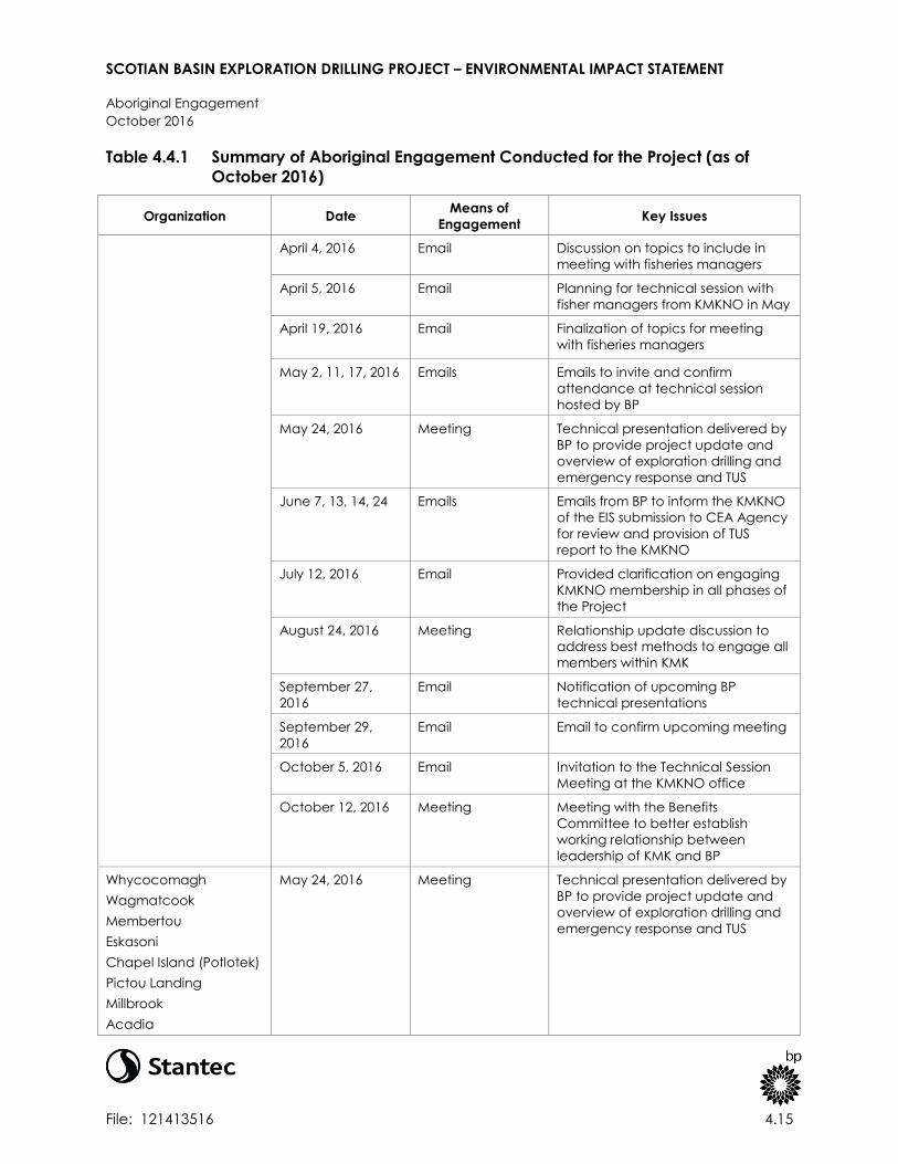
SCOTIAN BASIN EXPLORATION DRILLING PROJECT – ENVIRONMENTAL IMPACT STATEMENT
Aboriginal Engagement
October 2016
File: 121413516 4.15
Table 4.4.1 Summary of Aboriginal Engagement Conducted for the Project (as of
October 2016)
Organization Date Means of
Engagement Key Issues
April 4, 2016 Email Discussion on topics to include in
meeting with fisheries managers
April 5, 2016 Email Planning for technical session with
fisher managers from KMKNO in May
April 19, 2016 Email Finalization of topics for meeting
with fisheries managers
May 2, 11, 17, 2016 Emails Emails to invite and confirm
attendance at technical session
hosted by BP
May 24, 2016 Meeting Technical presentation delivered by
BP to provide project update and
overview of exploration drilling and
emergency response and TUS
June 7, 13, 14, 24 Emails Emails from BP to inform the KMKNO
of the EIS submission to CEA Agency
for review and provision of TUS
report to the KMKNO
July 12, 2016 Email Provided clarification on engaging
KMKNO membership in all phases of
the Project
August 24, 2016 Meeting Relationship update discussion to
address best methods to engage all
members within KMK
September 27,
2016
Email Notification of upcoming BP
technical presentations
September 29,
2016
Email Email to confirm upcoming meeting
October 5, 2016 Email Invitation to the Technical Session
Meeting at the KMKNO office
October 12, 2016 Meeting Meeting with the Benefits
Committee to better establish
working relationship between
leadership of KMK and BP
Whycocomagh
Wagmatcook
Membertou
Eskasoni
Chapel Island (Potlotek)
Pictou Landing
Millbrook
Acadia
May 24, 2016 Meeting Technical presentation delivered by
BP to provide project update and
overview of exploration drilling and
emergency response and TUS

SCOTIAN BASIN EXPLORATION DRILLING PROJECT – ENVIRONMENTAL IMPACT STATEMENT
Aboriginal Engagement
October 2016
File: 121413516 4.16
Table 4.4.1 Summary of Aboriginal Engagement Conducted for the Project (as of
October 2016)
Organization Date Means of
Engagement Key Issues
Paq’tnkek
Bear River
Annapolis Valley
Glooscap
Sipekne'katik February 24, 2015 Meeting Update on timing of EIS related to
exploration project
May 20, 2015 Meeting Meeting to engage the community
of Sipekne'katik on the Scotian Basin
Project
March 1, 2016 Email Confirmation of upcoming meeting
March 24, 2016 Meeting Meeting to discuss Project, including
timeline, location and EIS submission
May 16, 2016 Email Email to provide update on Project
status including delay in operations
schedule
August 25, 2016 Email Email to provide an update on
Project status
Native Council of Nova
Scotia
(NCNS)/Netukulimkewe’l
Commission
December 3, 2014 Meeting General discussion around BP's
future plans in Nova Scotia
February 24, 2015 Meeting Update on timing of EIS related to
exploration project
February 25, 2015 Meeting Employment and capacity training
and contract opportunity discussion
March 19, 2015 Meeting Discussion around BP’s plans and
NCNS’s interest in offshore fishery;
Identified the key areas requiring
further discussion as BP progresses to
an exploration program
March 25, 2015 Teleconference
meeting
General discussion around BP’s
exploration program
May 13, 2016 Email Email to provide update on Project
status including delay in operations
schedule
July 11, 2016 Email Consideration of an initiative that
NCNS is promoting in the fall in Nova
Scotia
Maritime Aboriginal
Peoples Council
May 13, 2016 Email Email to provide update on Project
status including delay in operations
schedule
Kingsclear First Nation - October 20, 2015 Meeting Meeting to introduce the Project

SCOTIAN BASIN EXPLORATION DRILLING PROJECT – ENVIRONMENTAL IMPACT STATEMENT
Aboriginal Engagement
October 2016
File: 121413516 4.17
Table 4.4.1 Summary of Aboriginal Engagement Conducted for the Project (as of
October 2016)
Organization Date Means of
Engagement Key Issues
Wolastoqiyik (Maliseet)
Nation May 13, 2016 Email Email to provide update on Project
status including delay in operations
schedule
June 13, 2016 Email Email to provide update on Project
status and submission of EIS to CEA
Agency for review
Woodstock First Nation -
Wolastoqiyik (Maliseet)
Nation
October 20, 2015 Meeting Meeting to introduce the Project
March 3, 2016 Email Reaching out to arrange a time to
discuss the Project
May 13, 2016 Email Email to provide update on Project
status including delay in operations
schedule
June 13, 2016 Email Email to provide update on Project
status and submission of EIS to CEA
Agency for review
August 4, 2016 Email Brief Project update
St. Mary’s First Nation -
Wolastoqiyik (Maliseet)
Nation
June 13, 2016 Email Email to provide update on Project
status and submission of EIS to CEA
Agency for review
August 4, 2016 Email Brief Project update
May 13, 2016 Email Email to provide update on Project
status including delay in operations
schedule
Tobique First Nation -
Wolastoqiyik (Maliseet)
Nation
October 20, 2015 Meeting Meeting to introduce the Project
March 3, 2016 Email Update on timing of EIS related to
exploration project
March 18, 2016 Email Planning for upcoming meeting
March 21, 2016 Meeting Meeting to discuss Project, including
timeline, location and EIS submission
May 13, 2016 Email Email to provide update on Project
status including delay in operations
schedule
Oromocto First Nation -
Wolastoqiyik (Maliseet)
Nation
October 20, 2015 Meeting Meeting to introduce the Project
March 3, 2016 Email Update on timing of EIS related to
exploration project
March 21, 2016 Meeting Meeting to discuss Project, including
timeline, location and EIS submission

SCOTIAN BASIN EXPLORATION DRILLING PROJECT – ENVIRONMENTAL IMPACT STATEMENT
Aboriginal Engagement
October 2016
File: 121413516 4.18
Table 4.4.1 Summary of Aboriginal Engagement Conducted for the Project (as of
October 2016)
Organization Date Means of
Engagement Key Issues
May 13, 2016 Email Email to provide update on Project
status including delay in operations
schedule
June 2, 2016 Meeting Meeting to discuss project update;
Oromocto indicated Maliseet are
looking into having an organization
represent interests of all Maliseet in
New Brunswick and expressed
interest in a technical presentation;
Oromocto indicated they are in
regular contact with CEA Agency
on several projects
June 13, 2016 Email Email to provide update on Project
status and submission of EIS to CEA
Agency for review
Madawaska First Nation -
Wolastoqiyik (Maliseet)
Nation
March 3, 2016 Email Update on timing of EIS related to
exploration project
March 21, 2016 Meeting Meeting to discuss Project, including
timeline, location and EIS submission
May 13, 2016 Email Email to provide update on Project
status including delay in operations
schedule
June 2, 2016 Meeting Meeting to discuss Project status
and ongoing engagement with BP
and CEA Agency; Madawaska First
Nation expressed interest in broad
presentation on offshore oil and gas
exploration
June 13, 2016 Email Email to provide update on Project
status and submission of EIS to CEA
Agency for review
St. Mary’s First Nation
Woodstock First Nation
Kingsclear First Nation
Madawaska First Nation
Oromocto First Nation
Tobique First Nation
June 27, 2016 Meeting Meeting to provide general
presentation (technical session) on
offshore drilling and incident
response as well as the TUS
October 5, 2016 Email Confirming meeting at St. Mary’s First
Nation to discuss the Project
Woodstock First Nation
Madawaska First Nation
Oromocto First Nation
August 23, 2016 Meeting BP provided info and update on
submission of EIS and shared
communal commercial fisheries
information from DFO

SCOTIAN BASIN EXPLORATION DRILLING PROJECT – ENVIRONMENTAL IMPACT STATEMENT
Aboriginal Engagement
October 2016
File: 121413516 4.19
Table 4.4.1 Summary of Aboriginal Engagement Conducted for the Project (as of
October 2016)
Organization Date Means of
Engagement Key Issues
Mi'gmawe'l Tplu'taqnn
Incorporated (MTI)
(formerly Assembly of First
Nation Chiefs of New
Brunswick)
October 20, 2015 Meeting Meeting to introduce the Project
March 3, 2016 Email Update on timing of EIS related to
exploration project
March 8, 2016 Email Confirmation of upcoming meeting
March 16, 2016 Meeting Meeting to discuss the Project: BP EIS
submission date, TUS, MTI
involvement, budget
April 11, 2016 Email Email to confirm communications
with New Brunswick Mi’kmaq is
transitioning from AFNCNB to MTI
May 18, 2016 Email to provide update on Project
status including delay in operations
schedule
June 1, 2016 Meeting Meeting to discuss continued
engagement with BP and CEA
Agency with preference for MTI First
Nations to be engaged as unified
group; expressed interest in
American eel as important species,
and interest in broad presentation
informing MTI First Nations in offshore
oil and gas exploration
June 7, 2016 Email MTI provided BP copy of Indigenous
Study Guide
June 13-14, 2016 Emails BP provided update of Project
status, discussed option for follow up
meeting with Wells Manager, and
copy of TUS report
September 23,
2016
Email Received email informing BP that as
of April 1, 2016 Mi'gmawe'l
Tplu'taqnn has been designated to
hold the mandate of consultation
and accommodation, and rights
implementation for its member
communities in New Brunswick.
Abegweit First Nation October 12, 2016 Email Email to introduce the Project
Lennox First Nation October 12, 2016 Email Email to introduce the Project
As noted in Table 4.4.1, BP held technical sessions with several First Nations groups in Nova Scotia
(through the KMKNO) and New Brunswick in May and June 2016 to provide an overview of
offshore exploration drilling activities and emergency planning and response. A further technical
session is planned in November 2016.

SCOTIAN BASIN EXPLORATION DRILLING PROJECT – ENVIRONMENTAL IMPACT STATEMENT
Aboriginal Engagement
October 2016
File: 121413516 4.20
In addition to activities listed in Table 4.4.1, BP sought to engage the Aboriginal Peoples Training
and Employment Commission to meet and discuss the Project.
BP also attended the Business Together Symposium on March 11, 2015 where BP had
conversations with several leaders of the Assembly of Nova Scotia Mi’kmaq Chiefs about
economic opportunities.
BP will continue to reach out to Aboriginal organizations in Nova Scotia and New Brunswick to
share Project information and obtain feedback on issues and concerns. BP will also continue to
engage with Aboriginal fishery groups through the FAC.
Information sessions focussed on topics or concerns expressed about the proposed Project will
be conducted. BP subject matter experts will participate in the presentations to address
concerns highlighted for the discussions.
In an effort to better understand traditional use of marine areas and resources by Aboriginal
peoples and potential effects on Aboriginal and Treaty rights, Membertou Geomatics Solutions
(MGS) and Unama’ki Institute of Natural Resources (UINR) were commissioned to undertake a
Traditional Use Study (TUS). Based on knowledge of fishing interests obtained from DFO and/or
through consultation with the CEA Agency, the TUS targeted interviews with the NCNS and all 13
First Nation Bands in Nova Scotia, and Fort Folly, St. Mary’s, and Woodstock First Nations in New
Brunswick. Interviews with fisheries managers, captains and fishers, along with a literature review
and review of DFO licensing information were used to help characterize communal commercial
and/or FSC fisheries that could be occurring in the RAA. Organizations that were interested and
available to participate are included in the study results. The TUS is not intended to represent an
exhaustive inventory of Aboriginal resource use occurring in the RAA but provides a reasonable
characterization of potential interactions with the Project. BP has presented information about
commercial and FSC fisheries that could interact with the RAA in Section 5. As part of ongoing
engagement activity, BP will continue to gather information about commercial and FSC fishing
by Aboriginal groups and monitor the suitability of any mitigation measures to manage any
potential effects from the Project. Refer to the TUS in Appendix B for more information on study
participants, methods, and results.
4.5 QUESTIONS AND COMMENTS RAISED DURING ABORIGINAL
ENGAGEMENT
Questions and comments raised during Aboriginal engagement, including comments submitted
to the CEA Agency during the public comment periods held thus far under CEAA, 2012, have
been taken into consideration during the preparation of this EIS.
Key concerns raised by various Aboriginal organizations were a perceived lack of funding,
limited duty to consult, and limited engagement scope. On December 8, 2015, the CEA Agency
announced the allocation of federal funding through the Participant Funding Program to assist

SCOTIAN BASIN EXPLORATION DRILLING PROJECT – ENVIRONMENTAL IMPACT STATEMENT
Aboriginal Engagement
October 2016
File: 121413516 4.21
public and Aboriginal groups in their participation in the EA process. Federal funding was
allocated to 10 applicants; all are Aboriginal organizations in Nova Scotia or New Brunswick.
In addition to concerns raised about the engagement process, Aboriginal organizations raised
questions and concerns about the collection and integration of traditional knowledge for the
EIS, and potential effects of the Project on potential or established Aboriginal and Treaty rights,
through effects on marine resources and/or through potential obstruction to these resources.
A summary of key issues and how they have been addressed is provided in Table 4.5.1.
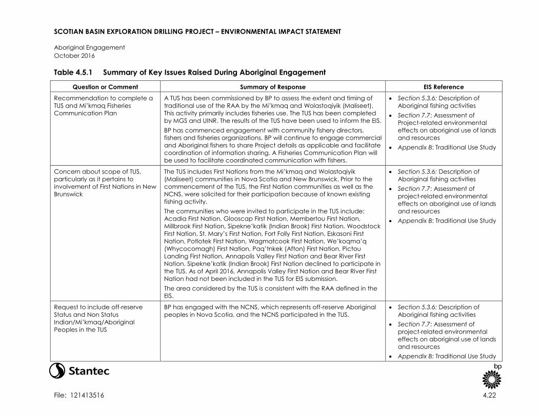
SCOTIAN BASIN EXPLORATION DRILLING PROJECT – ENVIRONMENTAL IMPACT STATEMENT
Aboriginal Engagement
October 2016
File: 121413516 4.22
Table 4.5.1 Summary of Key Issues Raised During Aboriginal Engagement
Question or Comment Summary of Response EIS Reference
Recommendation to complete a
TUS and Mi’kmaq Fisheries
Communication Plan
A TUS has been commissioned by BP to assess the extent and timing of
traditional use of the RAA by the Mi’kmaq and Wolastoqiyik (Maliseet).
This activity primarily includes fisheries use. The TUS has been completed
by MGS and UINR. The results of the TUS have been used to inform the EIS.
BP has commenced engagement with community fishery directors,
fishers and fisheries organizations. BP will continue to engage commercial
and Aboriginal fishers to share Project details as applicable and facilitate
coordination of information sharing. A Fisheries Communication Plan will
be used to facilitate coordinated communication with fishers.
Section 5.3.6: Description of
Aboriginal fishing activities
Section 7.7: Assessment of
Project-related environmental
effects on aboriginal use of lands
and resources
Appendix B: Traditional Use Study
Concern about scope of TUS,
particularly as it pertains to
involvement of First Nations in New
Brunswick
The TUS includes First Nations from the Mi’kmaq and Wolastoqiyik
(Maliseet) communities in Nova Scotia and New Brunswick. Prior to the
commencement of the TUS, the First Nation communities as well as the
NCNS, were solicited for their participation because of known existing
fishing activity.
The communities who were invited to participate in the TUS include:
Acadia First Nation, Glooscap First Nation, Membertou First Nation,
Millbrook First Nation, Sipekne’katik (Indian Brook) First Nation, Woodstock
First Nation, St. Mary’s First Nation, Fort Folly First Nation, Eskasoni First
Nation, Potlotek First Nation, Wagmatcook First Nation, We’koqma’q
(Whycocomagh) First Nation, Paq’tnkek (Afton) First Nation, Pictou
Landing First Nation, Annapolis Valley First Nation and Bear River First
Nation. Sipekne’katik (Indian Brook) First Nation declined to participate in
the TUS. As of April 2016, Annapolis Valley First Nation and Bear River First
Nation had not been included in the TUS for EIS submission.
The area considered by the TUS is consistent with the RAA defined in the
EIS.
Section 5.3.6: Description of
Aboriginal fishing activities
Section 7.7: Assessment of
project-related environmental
effects on aboriginal use of lands
and resources
Appendix B: Traditional Use Study
Request to include off-reserve
Status and Non Status
Indian/Mi’kmaq/Aboriginal
Peoples in the TUS
BP has engaged with the NCNS, which represents off-reserve Aboriginal
peoples in Nova Scotia, and the NCNS participated in the TUS.
Section 5.3.6: Description of
Aboriginal fishing activities
Section 7.7: Assessment of
project-related environmental
effects on aboriginal use of lands
and resources
Appendix B: Traditional Use Study

SCOTIAN BASIN EXPLORATION DRILLING PROJECT – ENVIRONMENTAL IMPACT STATEMENT
Aboriginal Engagement
October 2016
File: 121413516 4.23
Table 4.5.1 Summary of Key Issues Raised During Aboriginal Engagement
Question or Comment Summary of Response EIS Reference
Concern that an oil spill could
reach the Bay of Fundy and
affect species at risk, migratory
waterfowl, and tidal salt marshes
Safe operations are BP’s priority. BP will implement multiple preventative
and response barriers to manage risk of incidents occurring and mitigate
potential consequences (refer to Section 8.3 for details on plans and
specific response strategies). BP has conducted spill trajectory modelling
to determine the likely fate and behavior of a blowout in the extremely
unlikely event one should occur over the life of the Project. The results of
this modelling indicate that, if left unmitigated (i.e., with no oil spill
response measures to manage or contain spilled oil), oil from a blowout
could potentially reach the Bay of Fundy under certain oceanographic
conditions. However, the probability of oil reaching the Bay of Fundy at
levels where environmental effects could be detected is 0 to 5% (if left
unmitigated). Furthermore, the length of time it would take to reach the
Bay of Fundy at these concentrations is in excess of 50 days, which would
be considerable time to implement spill response measures to further
reduce the probability of interaction of oil and sensitive receptors.
Section 8.3: Emergency response
and spill management
Section 8.5: Environmental effects
of potential accidental events
Appendix H: Oil Spill Modelling
Study
Concern that a spill could affect
migration, spawning and/or
feeding grounds of species of
significance to Mi’kmaq culture
including American eel, Atlantic
sturgeon, Bluefin tuna, herring and
gaspereau, whales, and migratory
birds
Safe operations are BP’s priority. BP will implement multiple preventative
and response barriers to manage risk of incidents occurring and mitigate
potential consequences. BP’s oil spill response plan will contain specific
details of response methods which could be used in the event of an oil
spill (refer to Section 8.3 for details on plans and specific response
strategies). The EIS has used oil spill modelling (refer to Appendix H) to
inform the assessment of effects on valued components of the marine
environment (refer to Section 8.5).
Section 8.3: Emergency response
and spill management
Section 8.5: Environmental effects
of potential accidental events
Appendix H: Oil Spill Modelling
Study
Concern of potential cumulative
effects with proposed
TransCanada marine terminal and
shipping in the Bay of Fundy
Routine Project activities will not interact with the Bay of Fundy, therefore
the proposed TransCanada marine terminal and associated shipping
was not considered as a foreseeable activity with effects that would
likely interact spatially and temporally with effects of the Project.
Shipping in general within the RAA is considered in the cumulative effects
assessment.
Section 10: Cumulative Effects
Assessment

SCOTIAN BASIN EXPLORATION DRILLING PROJECT – ENVIRONMENTAL IMPACT STATEMENT
Aboriginal Engagement
October 2016
File: 121413516 4.24
Table 4.5.1 Summary of Key Issues Raised During Aboriginal Engagement
Question or Comment Summary of Response EIS Reference
Concern that the Project will result
in obstruction of Mi’kmaq fishing
areas
Similar to commercial fisheries, the Project could have an effect on
fisheries resources by direct or indirect effects on fished species and/or
effects on fishing activity from displacement from fishing areas, gear loss
or damage.
Routine Project activities are not expected to interact with nearshore
fishing activities. A 500-m safety (exclusion) zone will be established
around the MODU, in accordance with the Nova Scotia Offshore
Petroleum Drilling and Production Regulations, within which Aboriginal
(and commercial) fishing activities will be excluded while the MODU is in
operation. This will result in localized Aboriginal fisheries exclusion within
an area of approximately 0.8 km2 (80 ha) for an expected maximum of
120 days for each well to be drilled. Although fishing efforts may be
disrupted within this safety (exclusion) zone, it is anticipated to be a
temporary and localized fishing exclusion and is not likely to have a
substantial effect on Aboriginal fishing activities and fisheries resources.
The Project Area does not include any unique fishing grounds or
concentrated fishing effort; similar alternative sites are readily available
within the immediate area.
Section 7.7: Assessment of
project-related effects on
aboriginal use of lands and
resources
Appendix B: Traditional Use Study
Recommendation for
compensation and/or
accommodation for impacts to
fish and fish habitat
The Canada Nova Scotia Offshore Petroleum Board provides guidelines
respecting damages relating to offshore petroleum activity. BP adheres
to and complies with the principles outlined within the guidelines.
Specified concerns regarding BP activity resulting in gear loss or damage
will be investigated.
Section 7.6: Assessment of
project-related effects on
commercial fisheries
Section 7.7: Assessment of
project-related effects on
aboriginal use of lands and
resources
Question about PSV fuelling and
fuel transfer to the MODU
Fuel will be transferred to the PSV for PSV fuelling and for transfers to the
MODU using closed piping systems (e.g., pumps and hoses).
Procedures will be implemented for the safe management and use of
fuelling systems to minimize the risk of an unintended release. The vessels,
MODU and fuelling base will be equipped with primary spill contingency
equipment to deal with spills in the unlikely event that they occur.
The PSVs will transfer diesel fuel, also referred to as marine gas oil to the
MODU from shore. Fuel is required offshore to power the MODU,
Section 2.4.5.1: Information about
platform supply vessels and
fuelling operations

SCOTIAN BASIN EXPLORATION DRILLING PROJECT – ENVIRONMENTAL IMPACT STATEMENT
Aboriginal Engagement
October 2016
File: 121413516 4.25
Table 4.5.1 Summary of Key Issues Raised During Aboriginal Engagement
Question or Comment Summary of Response EIS Reference
including drilling equipment and thrusters. Fuel will be loaded from an
existing field distribution facility within Halifax Harbour according to
standard vessel fuelling procedures up to two to three times per week by
a third party contractor.
Request for more information on
drill waste dispersion modelling
exercise and effects on marine life
It is likely that the initial, shallow sections of the well will be drilled without
a riser and that deeper sections will be drilled with a drilling riser
attached.
During riserless drilling, WBM will be used as the drilling fluid and cuttings
are discharged directly to the water column in accordance with
regulatory guidelines. Once a riser is attached, cuttings can be returned
to the MODU for treatment. SBM cuttings will only be discharged once
the performance targets in OWTG of 6.9 g/100 g retained “synthetic on
cuttings” on wet solids can be satisfied. The concentration of SBM on
cuttings will be monitored on the MODU to achieve compliance with the
OWTG.
BP has modelled the dispersion of predicted drilling waste (refer to
Appendix C); this modelling study has been used to inform the
assessment of effects of drilling waste on marine life. Overall, the
dispersion of sediments associated with drill waste discharges is
predicted to be limited to approximately 1,367 m (for a deposition
thickness of 0.1 mm). Using a threshold of 9.6 mm to assume burial of
benthic species, it is predicted that this sediment thickness could extend
approximately 116 m from the discharge point, or cover an area of
approximately 0.54 ha per well.
Section 2.3.2: Information about
cuttings
Section 2.8.2: Information about
drilling waste discharges
Section 7.1.2.1: Summary of drill
waste discharges and modelling
results
Section 7.2: Assessment of
Project-related effects on fish and
fish habitat
Section 7.3: Assessment of
Project-related effects on marine
mammals and sea turtles
Section 7.4: Assessment of
Project-related effects on
migratory birds
Section 7.5: Assessment of
Project-related effects on Special
Areas
Section 7.6 Assessment of Project-
related effects on commercial
fisheries
Section 7.6: Assessment of
Project-related effects on
Aboriginal use of lands and
resources for traditional purposes
commercial fisheries
Section 10: Cumulative effects
Appendix C: Drilling Waste

SCOTIAN BASIN EXPLORATION DRILLING PROJECT – ENVIRONMENTAL IMPACT STATEMENT
Aboriginal Engagement
October 2016
File: 121413516 4.26
Table 4.5.1 Summary of Key Issues Raised During Aboriginal Engagement
Question or Comment Summary of Response EIS Reference
Dispersion Modelling Study
Question about whether drill
wastes will contain naturally
occurring radioactive material
(NORM) and if so, how it will be
managed
NORM is not expected to occur in the drilling waste. NORM typically is
created in the production process, when the produced water may
create sulfate scale on the wall of production tubing and surface
equipment.
None
Request for more information on
predictive spill modelling exercise
and spill effects on nearshore and
inshore resources
BP has conducted stochastic and deterministic modelling to predict the
fate and behavior of an oil spill in the unlikely event that one occurs
(refer to Appendix H). The results of the modelling have been used to
inform the assessment of effects of accidental spills on the marine
environment (refer to Section 8.5). As part of stakeholder and Aboriginal
engagement efforts, BP intends to present an overview of spill modelling
results, as well as spill prevention and response measures that will be
implemented to reduce adverse environmental effects from a spill.
Section 8.3: Emergency response
and spill management
Section 8.5: Environmental effects
of potential accidental events
Appendix H: Oil Spill Modelling
Study
Request for more information on
Project effects on sensitive and
protected areas (Special Areas)
The EIS assesses potential Project-related (and cumulative) effects on
Special Areas which includes sensitive and protected areas including,
but not limited to, Sable Island, the Gully and SARA-designated critical
habitat.
Routine Project activities and components could potentially interact with
Special Areas (e.g., drilling and VSP), which could affect habitats in
Special Areas. Special Areas could also be affected in the unlikely event
of large spills.
To reduce potential adverse effects on Special Areas, BP has committed
to implementing best management practices and mitigation measures
including avoidance of Sable Island, the Gully and northern bottlenose
whale critical habitat. Mitigation measures identified for Fish and Fish
Habitat, Marine Mammals and Sea Turtles, and Migratory Birds will be
implemented to reduce the potential environmental effects of the
Project on Special Areas. BP will also implement multiple preventative
and response barriers to manage risk of incidents occurring and mitigate
potential consequences (refer to Section 8.3 for details on plans and
specific response strategies).
Section 5.2.8: Existing conditions
regarding Special Areas
Section 7.5: Project-related
effects on Special Areas
Section 8.3: Emergency response
and spill management
Section 8.5: Environmental effects
of potential accidental events
Section 10: Cumulative effects


