Embed Size (px)
Citation preview

The entries with an indicator () at the margin indicates changes in the paragraph
EFFECTIVE DATE: 21 APR 2022 - 00:01 UTC
THIS AMDT MUST NOT BE INSERTED INTO THE AIP BEFORE THE EFFECTIVE DATE. HOWEVER, IT IS SUGGESTED TO STUDY
ITS CONTENT BEFORE THAT DATE.
INSERT AND/OR DESTROY THE FOLLOWING PAGES:
DESTROY INSERT
GEN
GEN 0.1-1 ......................................... 01 APR 2005 0.1-1 ............................... 21 APR 2022 0.1-2 ......................................... 04 NOV 2021 0.1-2 ............................... 21 APR 2022 0.1-3 ......................................... 27 JAN 2022 0.1-3 ............................... 21 APR 2022 0.1-4 ......................................... 27 JAN 2022 0.1-4 ............................... 27 JAN 2022 0.4-1 ......................................... 27 JAN 2022 0.4-1 ............................... 21 APR 2022 0.4-2 ......................................... 27 JAN 2022 0.4-2 ............................... 21 APR 2022 0.4-3 ......................................... 27 JAN 2022 0.4-3 ............................... 21 APR 2022 0.4-4 ......................................... 27 JAN 2022 0.4-4 ............................... 21 APR 2022 0.4-5 ......................................... 27 JAN 2022 0.4-5 ............................... 21 APR 2022 1.2-1 ......................................... 28 MAY 2015 1.2-1 ............................... 21 APR 2022 1.2-2 ......................................... 01 DEC 2006 1.2-2 ............................... 21 APR 2022 1.2-3 ......................................... 01 AUG 2000 1.2-3 ............................... 21 APR 2022 1.2-4 ......................................... 20 MAY 2021 1.2-4 ............................... 20 MAY 2021 1.4-1 ......................................... 01 JUN 1997 1.4-1 ............................... 21 APR 2022 1.4-2 ............................... 21 APR 2022 1.4-3 ............................... 21 APR 2022 3.2-5 ......................................... 27 JAN 2022 3.2-5 ............................... 21 APR 2022 3.2-6 ......................................... 04 NOV 2021 3.2-6 ............................... 21 APR 2022 3.2-7 ......................................... 04 NOV 2021 3.2-7 ............................... 21 APR 2022 3.2-8 ......................................... 04 NOV 2021 3.2-8 ............................... 21 APR 2022 4.1-17 ....................................... 02 JAN 2017 4.1-17 ............................. 21 APR 2022 4.1-18 ....................................... 02 JAN 2017 4.1-18 ............................. 21 APR 2022 4.1-19 ....................................... 02 JAN 2017 4.1-19 ............................. 21 APR 2022 4.1-20 ....................................... 02 JAN 2017 4.1-20 ............................. 21 APR 2022 4.1-21 ....................................... 02 JAN 2017 4.1-21 ............................. 21 APR 2022 4.1-22 ............................. 21 APR 2022
Telephone: 598 26040329 ext. 1260, 1463 Telefax: 598 26040067 AFTN: SUMUYNYX e-mail: [email protected]
AIRAC AIP
AMDT
NR 01 24 FEB 2022
U R U G U A Y
Dirección Nacional de Aviación Civil e Infraestructura Aeronáutica Servicio de Información Aeronáutica
Aeropuerto Intl de Carrasco “Gral. Cesáreo L. Berisso” 14000 Canelones

DESTROY INSERT
ENR
ENR 1.6-1 ......................................... 28 JAN 2021 1.6-1 ............................... 21 APR 2022 1.6-2 ......................................... 28 JAN 2021 1.6-2 ............................... 28 JAN 2021 1.6-3 ......................................... 01 AUG 2009 1.6-3 ............................... 01 AUG 2009 1.6-4 ......................................... 28 JAN 2021 1.6-4 ............................... 21 APR 2022 2.2-1 ......................................... 18 JUL 2019 2.2-1 ............................... 21 APR 2022 2.2-2 ......................................... 05 NOV 2020 2.2-2 ............................... 05 NOV 2020 2.2-3 ......................................... 05 NOV 2020 2.2-3 ............................... 05 NOV 2020 2.2-4 ......................................... 05 NOV 2020 2.2-4 ............................... 21 APR 2022 5.1-1 ......................................... 01 DEC 2013 5.1-1 ............................... 21 APR 2022 5.1-2 ......................................... 01 DEC 2014 5.1-2 ............................... 21 APR 2022 5.1-3 ......................................... 01 DEC 2013 5.1-3 ............................... 21 APR 2022 5.1-4 ......................................... 10 DEC 2015 5.1-4 ............................... 21 APR 2022 5.1-5 ......................................... 10 DEC 2015 5.1-5 ............................... 21 APR 2022 5.2-1 ......................................... 05 NOV 2020 5.2-1 ............................... 21 APR 2022 5.2-2 ......................................... 05 NOV 2020 5.2-2 ............................... 21 APR 2022 5.2-3 ............................... 21 APR 2022 6.1-1 ......................................... 04 NOV 2021 6.1-1 ............................... 21 APR 2022 6.1-2 ......................................... 04 NOV 2021 6.1-2 ............................... 21 APR 2022 6.1-3 ......................................... 04 NOV 2021 6.1-3 ............................... 21 APR 2022 6.1-4 ......................................... 04 NOV 2021 6.1-4 ............................... 21 APR 2022 6.1-5 ......................................... 04 NOV 2021 6.1-5 ............................... 21 APR 2022 6.1-6 ......................................... 04 NOV 2021 6.1-6 ............................... 21 APR 2022 6.1-7 ......................................... 04 NOV 2021 6.1-7 ............................... 21 APR 2022 6.2-3 ......................................... 18 JUL 2019 6.2-3 ............................... 21 APR 2022 6.2-5 ......................................... 04 NOV 2021 6.2-5 ............................... 21 APR 2022 6.3 ........................................... 02 JAN 2017 6.3 .................................. 21 APR 2022 6.4 ........................................... 05 NOV 2020 6.4 .................................. 21 APR 2022
AD
AD 2.4-17 ....................................... 01 DEC 2013 2.4-17 ............................. 21 APR 2022 2.4-19 ....................................... 01 DEC 2013 2.4-19 ............................. 21 APR 2022 2.4-21 ....................................... 10 DEC 2015 2.4-21 ............................. 21 APR 2022 2.4-23 ....................................... 10 DEC 2015 2.4-23 ............................. 21 APR 2022 2.4-25 ....................................... 01 DEC 2013 2.4-25 ............................. 21 APR 2022 2.4-27 ....................................... 01 DEC 2013 2.4-27 ............................. 21 APR 2022 2.4-29 ....................................... 01 DEC 2013 2.4-29 ............................. 21 APR 2022 2.4-31 ....................................... 01 DEC 2013 2.4-31 ............................. 21 APR 2022 2.4-33 ....................................... 01 DEC 2013 2.4-33 ............................. 21 APR 2022 2.4-35 ....................................... 01 DEC 2013 2.4-35 ............................. 21 APR 2022 2.4-37 ....................................... 01 DEC 2013 2.4-37 ............................. 21 APR 2022 2.4-39 ....................................... 01 DEC 2013 2.4-39 ............................. 21 APR 2022 2.4-41 ....................................... 01 DEC 2013 2.4-41 ............................. 21 APR 2022 2.4-43 ....................................... 01 DEC 2013 2.4-43 ............................. 21 APR 2022 2.5-1 ......................................... 20 MAY 2021 2.5-1 ............................... 21 APR 2022

DESTROY INSERT
AD
AD 2.5-2 ......................................... 01 AUG 2007 2.5-2 ............................... 21 APR 2022 2.5-3 ......................................... 01 AUG 2001 2.5-3 ............................... 21 APR 2022 2.5-4 ......................................... 01 DEC 2000 2.5-4 ............................... 21 APR 2022 2.5-5 ......................................... 20 MAY 2021 2.5-5 ............................... 21 APR 2022 2.5-6 ......................................... 01 DEC 2014 2.5-6 ............................... 21 APR 2022 2.5-7 ......................................... 04 NOV 2021 2.5-7 ............................... 21 APR 2022 2.5-8 ......................................... 01 DEC 2013 2.5-8 ............................... 21 APR 2022 2.5-9 ......................................... 01 DEC 2004 2.5-9 ............................... 21 APR 2022 2.5-10 ....................................... 05 DEC 2019 2.5-10 ............................. 21 APR 2022 2.5-11 ....................................... 01 DEC 2018 2.5-11 ............................. 21 APR 2022 2.5-12 ....................................... 14 SEP 2017 2.5-12 ............................. 21 APR 2022 2.5-13 ....................................... 20 MAY 2021 2.5-13 ............................. 21 APR 2022 2.5-14 ............................. 21 APR 2022 2.5-15 ....................................... 20 MAY 2021 2.5-15 ............................. 21 APR 2022 2.5-16 ............................. 21 APR 2022 2.5-17 ....................................... 20 MAY 2021 2.5-17 ............................. 21 APR 2022 2.5-18 ............................. 21 APR 2022 2.5-19 ....................................... 20 MAY 2021 2.5-19 ............................. 21 APR 2022 2.5-21 ....................................... 14 SEP 2017 2.5-21 ............................. 21 APR 2022 2.5-23 ....................................... 14 SEP 2017 2.5-23 ............................. 21 APR 2022 2.5-25 ....................................... 14 SEP 2017 2.5-25 ............................. 21 APR 2022 2.5-27 ....................................... 14 SEP 2017 2.5-27 ............................. 21 APR 2022 2.5-29 ....................................... 14 SEP 2017 2.5-29 ............................. 21 APR 2022 2.5-31 ....................................... 14 SEP 2017 2.5-31 ............................. 21 APR 2022 2.5-33 ....................................... 14 SEP 2017 2.5-33 ............................. 21 APR 2022 2.5-35 ....................................... 14 SEP 2017 2.5-35 ............................. 21 APR 2022 2.5-37 ....................................... 14 SEP 2017 2.5-37 ............................. 21 APR 2022 2.5-39 ....................................... 14 SEP 2017 2.5-39 ............................. 21 APR 2022 2.5-41 ....................................... 14 SEP 2017 2.5-41 ............................. 21 APR 2022 2.5-43 ....................................... 14 SEP 2017 2.5-43 ............................. 21 APR 2022 2.5-45 ....................................... 14 SEP 2017 2.5-45 ............................. 21 APR 2022 2.5-47 ............................. 21 APR 2022 2.5-49 ............................. 21 APR 2022 2.5-51 ............................. 21 APR 2022 2.8-17 ....................................... 01 DEC 2017 2.8-17 ............................. 21 APR 2022 2.8-19 ....................................... 01 DEC 2017 2.8-19 ............................. 21 APR 2022 2.9-9 ......................................... 26 MAR 2020 2.9-9 ............................... 21 APR 2022 2.9-10 ....................................... 01 DEC 2018 2.9-10 ............................. 01 DEC 2018 2.9-39 ....................................... 05 DEC 2019 2.9-39 ............................. 21 APR 2022 2.9-40 ....................................... 05 DEC 2019 2.9-40 ............................. 05 DEC 2019 2.9-41 ....................................... 05 DEC 2019 2.9-41 ............................. 21 APR 2022 2.9-43 ....................................... 20 MAY 2021 2.9-43 ............................. 21 APR 2022 2.9-44 ....................................... 20 MAY 2021 2.9-44 ............................. 20 MAY 2021 2.9-45 ....................................... 20 MAY 2021 2.9-45 ............................. 21 APR 2022 2.9-46 ....................................... 20 MAY 2021 2.9-46 ............................. 20 MAY 2021 2.9-47 ....................................... 01 AUG 2018 2.9-47 ............................. 21 APR 2022

DESTROY INSERT
AD
AD 2.9-49 ....................................... 01 AUG 2018 2.9-49 ............................. 21 APR 2022 2.9-51 ....................................... 01 AUG 2018 2.9-51 ............................. 21 APR 2022 2.9-53 ....................................... 26 MAR 2020 2.9-53 ............................. 21 APR 2022 2.9-55 ....................................... 01 AUG 2018 2.9-55 ............................. 21 APR 2022 2.9-57 ....................................... 01 AUG 2018 2.9-57 ............................. 21 APR 2022 2.9-59 ....................................... 01 AUG 2018 2.9-59 ............................. 21 APR 2022 2.9-61 ....................................... 01 AUG 2018 2.9-61 ............................. 21 APR 2022 2.9-63 ....................................... 01 AUG 2018 2.9-63 ............................. 21 APR 2022 2.9-65 ....................................... 01 AUG 2018 2.9-65 ............................. 21 APR 2022 2.9-67 ....................................... 01 AUG 2018 2.9-67 ............................. 21 APR 2022 AIRAC AIP/SUP included in this AMDT:
Nil. AIC included in this AMDT: Nil. AIP Supplements included in this AMDT: Nil. NOTAM included in this AMDT: Nil.
Remember to record the inclusion of the amendment on page GEN 0.2-1 Record of AIP Amendments

AIP GEN 0.1-1 URUGUAY 21 APR 2022
PART 1 - GENERAL (GEN) GEN 0. GEN 0.1 PREFACE
1. Name of the publishing authority The AIP URUGUAY is published by authority of the Dirección de Circulación Aérea that is part of the Dirección Nacional de Aviación Civil e Infraestructura Aeronáutica (DINACIA).
2. Applicable ICAO documents The AIP is prepared in accordance with the Standards and Recommended Practices (SARPS) of Annex 15 to the Convention on International Civil Aviation and the ICAO Aeronautical Information Services Manual (Doc 8126). Charts contained in the AIP are produced in accordance with Annex 4 to the Convention on International Civil Aviation and the Aeronautical Chart Manual (Doc 8697). Differences from ICAO Standards, Recommended Practices and Procedures are given in subsection GEN 1.7.
3. Publication media
The AIP is published in digital format. The aeronautical information service (AIS) documents are made available in electronic format on the AIS website www.dinacia.gub.uy/ais.
4. The AIP structure and established regular amendment interval. 4.1 The AIP structure The AIP is the major part of the Aeronautical Information Products, details of which are given in the subsection GEN 3.1. The principal AIP structure is shown in graphic form on page GEN 0.1-4. The AIP is made up of three parts, General (GEN), En-route (ENR) and Aerodrome (AD), each divided into sections and subsections as applicable, containing various types of information subjects. 4.1.1 Part 1 - General (GEN) Part 1 consists of five sections containing information as briefly described hereafter:
GEN 0. - Preface, Record of AIP Amendments; Record of AIP Supplements, Checklist of AIP pages; List of hand amendments to the AIP; and the Table of Contests to Part 1. GEN 1. - National regulations and requirements – Designated authorities, Entry, transit and departure of aircraft; Entry, transit and departure of passengers and crew; Entry, transit and departure of cargo; Aircraft instruments, equipment and flight documents; Summary of national regulations and international agreements/conventions; and Differences from ICAO Standards, Recommended Practices and Procedures.
AIS URUGUAY AIRAC AIP AMDT NR 01

GEN 0.1-2 AIP 21 APR 2022 URUGUAY
GEN 2. - Tables and codes - Measuring system, aircraft markings, holidays; Abbreviations used in AIS publications; Chart symbols; Location indicators; List of radio navigation aids; Conversion tables; and Sunrise/Sunset tables. GEN 3. - Services – Aeronautical information services; Aeronautical charts; Air traffic services; Communication services; Meteorological services; and Search and rescue.
GEN 4. - Charges for aerodromes/heliports and air navigations services – Aerodrome/heliport charges; and Air navigation services charges.
4.1.2 Part 2 – En-route (ENR) Part 2 consists of seven sections containing information as briefly described hereafter:
ENR 0. Preface; Record of AIP Amendments; record of AIP Supplements; Checklist of AIP pages; List of hand amendments to the AIP; and the Table of Contents to Part 2. ENR 1. General Rules and procedures – General rules; Visual flight rules; Instrument flight rules; ATS airspace classification; Holding, approach and departure procedures; Radar services and procedures; Altimeter setting procedures; Regional supplementary procedures; Air traffic flow Management; Flight planning; Addressing of flight plan messages; Interception of civil Aircraft; Unlawful interference; Air traffic incidents; ACAS operational procedures; and Suspension of RVSM procedures. ENR 2. Air traffic services airspace – Detailed description of Flight information regions (FIR), Upper flight information regions (UIR), Terminal control areas (TMA), and Other regulated airspace. ENR 3. ATS routes - Detailed description of Conventional navigation routes, Area navigation routes, Other routes; and En-route holding. Note.- Other types of routes which are specified in connection with procedures for traffic to and from aerodromes/heliports are described in the relevant sections and subsections of Part 3 - Aerodromes. ENR 4. Radio navigation aids/systems – Radio navigation aids – en-route; Special navigation systems; Name-code designators for significant points; and Aeronautical ground lights – en-route. ENR 5. Navigation warnings – Prohibited, restricted and danger areas; Military exercise and training areas and air defence identification zone (ADIZ); Other activities of a dangerous nature and other potential hazards; Air navigation obstacles — en-route; Aerial sporting and recreational activities; and Bird migration and areas with sensitive fauna. ENR 6. En-route charts – En-route Chart – ICAO and index charts.
AIRAC AIP AMDT NR 01 AIS URUGUAY

AIP GEN 0.1-3 URUGUAY 21 APR 2022 4.1.3 Part 3 - Aerodromes (AD) Part 3 consist of four sections containing information as briefly described hereafter.
AD 0. - Preface; Record of AIP Amendments, Record of AIP Supplements; Checklist of AIP pages; List of hand amendments to the AIP; and the Table of Contents of Part 3. AD 1. - Aerodromes/heliports - Introduction - Aerodromes/heliports availability; recue and firefighting services and Snow plan; Index to aerodromes and heliports; and Grouping of aerodromes/heliports. AD 2. - Aerodromes – Detailed information about aerodromes, including helicopter landing areas, if located at the aerodromes, listed under 24 subsections. AD 3. - Heliports - Detailed information about heliports (not located at aerodromes), listed under 23 subsections.
4.2 Regular amendment interval Regular amendments to the AIP will be issued once every fourth months. The publication dates will be on the first day of April, August and December of each year.
5. Copyright policy This document is the property of AIS Uruguay. All rights reserved. No part of this publication may be reproduced, stored in a retrieval system, or transmitted, in any form or by any means, electronic, mechanical, photocopying, recording, or otherwise, without the prior written permission of the copyright owner.
6. Service to contact in case of detected AIP error or omissions In the compilation of the AIP, care has been taken to ensure that the information contained therein is accurate and complete. Any errors and omissions which may nevertheless be detected, as well as any correspondence concerning the Aeronautical Information Products, should be referred to: Servicio de Información Aeronáutica (AIS) Aeropuerto Intl de Carrasco "Gral. Cesáreo L. Berisso" 14000 Canelones Uruguay Tel.: (598) 2604 0408 extension 5101 – 5203 Telefax: (598) 2604 0067 AFS: SUMUYNYX e-mail: [email protected] AIS URUGUAY AIRAC AIP AMDT NR 01

GEN 0.1-4 AIP 27 JAN 2022 URUGUAY
AIRAC AIP AMDT NR 04 AIS URUGUAY
AERONAUTICAL INFORMATION PRODUCTS IN A STANDARDIZED PRESENTATION
PART 1 GENERAL (GEN)
PART 2 EN-ROUTE (ENR)
PART 3 AERODROMES (AD)
GEN 0 ENR 0
ENR 1 General Rules and Procedures
ENR 2 ATS Airspace
ENR 3 ATS Routes
ENR 4 Radio Navigation Aids/Systems
ENR 5 Navigation Warnings
ENR 6 En-route Charts
GEN 1 National Regulations and Requirements
GEN 2 Tables and Codes
GEN 3 Services
GEN 4 Charges for Aerodromes/Heliports and Air Navigation Services
AD 0
AD 1 Aerodromes/Heliports - Introduction
AD 2 Aerodromes
AD 3 Heliports
NOTAM AIP including Amendments
and Supplements
AIC Aeronautical
Charts

AIP GEN 0.4-1 URUGUAY 21 APR 2022 GEN 0.4 CHECKLIST OF AIP PAGES
Page
Date
Page
Date
Page
Date
PART 1 GENERAL (GEN) 0.1-1 21 APR 2022 0.1-2 21 APR 2022 0.1-3 21 APR 2022 0.1-4 27 JAN 2022 0.2-1 20 MAY 2021 0.3-1 01 JUN 1997 0.4-1 21 APR 2022 0.4-2 21 APR 2022 0.4-3 21 APR 2022 0.4-4 21 APR 2022 0.4-5 21 APR 2022 0.5-1 01 JUN 1997 0.6-1 01 JUN 1997 0.6-2 01 DEC 2006 0.6-3 01 APR 2005 GEN 1 1.1-1 05 DEC 2019 1.1-2 12 AUG 2021 1.1-3 01 DEC 2010 1.2-1 21 APR 2022 1.2-2 21 APR 2022 1.2-3 21 APR 2022 1.2-4 20 MAY 2021 1.2-5 20 MAY 2021 1.2-6 20 MAY 2021 1.2-7 04 NOV 2021 1.3-1 01 AUG 2016 1.3-2 01 DEC 2001 1.4-1 21 APR 2022 1.4-2 21 APR 2022 1.4-3 21 APR 2022 1.5-1 01 DEC 2018 1.6-1 28 MAR 2019 1.7-1 23 MAY 2019 1.7-2 18 JUL 2019 1.7-3 23 MAY 2019 1.7-4 23 MAY 2019
GEN 2 2.1-1 10 DEC 2015 2.1-2 05 NOV 1998 2.1-3 05 NOV 1998 2.2-1 02 JAN 2017 2.2-2 02 JAN 2017 2.2-3 02 JAN 2017 2.2-4 12 AUG 2021 2.2-5 02 JAN 2017 2.2-6 02 JAN 2017 2.2-7 28 MAR 2019 2.2-8 02 JAN 2017 2.2-9 02 JAN 2017 2.2-10 02 JAN 2017 2.2-11 02 JAN 2017 2.2-12 02 JAN 2017 2.2-13 02 JAN 2017 2.2-14 02 JAN 2017 2.2-15 02 JAN 2017 2.3-1 01 DEC 2005 2.3-2 01 DEC 2005 2.3-3 01 DEC 2005 2.3-4 01 DEC 2005 2.3-5 01 APR 2017 2.3-6 05 NOV 2020 2.3-7 01 AUG 2011 2.3-8 01 AUG 2011 2.4-1 01 JUN 2008 2.4-2 01 AUG 2010 2.4-3 01 DEC 2004 2.4-4 01 DEC 2002 2.4-5 01 DEC 2002 2.5-1 01 DEC 2013 2.5-2 01 AUG 2010 2.5-3 01 AUG 2010 2.6-1 01 JUN 1997 2.6-2 01 JUN 1997 2.7-1 23 MAY 2019 2.7-2 23 MAY 2019 2.7-3 23 MAY 2019 2.7-4 23 MAY 2019 2.7-5 23 MAY 2019
GEN 3 3.1-1 01 DEC 2014 3.1-2 01 DEC 2012 3.1-3 01 DEC 2012 3.1-4 02 JAN 2017 3.1-5 02 JAN 2017 3.1-6 02 JAN 2017 3.1-7 02 JAN 2017 3.1-8 23 MAY 2019 3.2-1 01 DEC 2014 3.2-2 18 JUL 2019 3.2-3 18 JUL 2019 3.2-4 18 JUL 2019 3.2-5 21 APR 2022 3.2-6 21 APR 2022 3.2-7 21 APR 2022 3.2-8 21 APR 2022 3.3-1 01 DEC 2018 3.3-2 14 SEP 2017 3.3-3 01 DEC 2010 3.4-1 01 DEC 2010 3.4-2 01 DEC 2001 3.4-3 01 AUG 2002 3.4-4 01 DEC 2009 3.4-5 01 DEC 2009 3.4-6 01 DEC 2002 3.5-1 05 DEC 2019 3.5-2 05 DEC 2019 3.5-3 05 DEC 2019 3.5-4 05 DEC 2019 3.5-5 05 DEC 2019 3.5-6 05 DEC 2019 3.5-7 05 DEC 2019 3.5-8 05 DEC 2019 3.5-9 05 DEC 2019 3.5-10 05 DEC 2019 3.6-1 01 APR 2011 3.6-2 01 DEC 2008 3.6-3 01 DEC 2008 3.6-4 01 APR 2001 3.6-5 01 DEC 2008 3.6-6 12 AUG 2021
AIS URUGUAY AIRAC AIP AMDT NR 01

GEN 0.4-2 AIP 21 APR 2022 URUGUAY
Page
Date
Page
Date
Page
Date
3.6-7 18 JUL 2019 3.6-8 18 JUL 2019 3.6-9 28 MAY 2015 3.6-11 01 DEC 2008 3.7-1 01 DEC 2014 3.7-2 01 DEC 2014 GEN 4 4.1-1 01 APR 2006 4.1-2 01 DEC 2004 4.1-3 01 DEC 2004 4.1-4 02 JAN 2017 4.1-5 02 JAN 2017 4.1-6 02 JAN 2017 4.1-7 02 JAN 2017 4.1-8 02 JAN 2017 4.1-9 02 JAN 2017 4.1-10 02 JAN 2017 4.1-11 02 JAN 2017 4.1-12 02 JAN 2017 4.1-13 02 JAN 2017 4.1-14 02 JAN 2017 4.1-15 02 JAN 2017 4.1-16 02 JAN 2017 4.1-17 21 APR 2022 4.1-18 21 APR 2022 4.1-19 21 APR 2022 4.1-20 21 APR 2022 4.1-21 21 APR 2022 4.1-22 21 APR 2022 PART 2 EN - ROUTE (ENR) 0.6-1 04 NOV 2021 0.6-2 04 NOV 2021 ENR 1 1.1-1 01 DEC 2018 1.1-2 05 NOV 2020 1.1-3 28 MAR 2019 1.2-1 20 MAY 2021 1.2-2 01 APR 2018
1.2-3 28 MAR 2019 1.3-1 12 AUG 2021 1.4-1 01 AUG 2003 1.4-2 14 SEP 2017 1.4-3 04 NOV 2021 1.5-1 01 AUG 2016 1.5-2 01 DEC 2004 1.6-1 21 APR 2022 1.6-2 28 JAN 2021 1.6-3 01 AUG 2009 1.6-4 21 APR 2022 1.7-1 01 AUG 2005 1.7-2 01 DEC 2010 1.7-3 01 APR 2002 1.7-4 01 APR 2002 1.7-5 01 AUG 2005 1.8-1 05 DEC 2019 1.9-1 01 AUG 2005 1.10-1 12 AUG 2021 1.10-2 05 DEC 2019 1.10-3 05 DEC 2019 1.10-4 05 DEC 2019 1.10-5 05 DEC 2019 1.10-6 05 DEC 2019 1.11-1 01 AUG 2007 1.12-1 01 JUN 1997 1.12-2 01 JUN 1997 1.12-3 01 JUN 1997 1.12-4 01 JUN 1997 1.13-1 01 JUN 1997 1.14-1 01 JUN 1997 1.14-2 01 DEC 2010 1.14-3 01 JUN 1997 1.14-4 01 DEC 2005 1.14-5 01 DEC 2005 1.14-6 01 DEC 2005 1.14-7 01 DEC 2005 1.15-1 01 AUG 2003 1.16-1 01 AUG 2005 1.16-2 01 AUG 2005 1.16-3 01 AUG 2005 1.16-4 01 AUG 2005 1.16-5 01 AUG 2005 1.16-6 01 AUG 2005 1.16-7 01 AUG 2014 1.16-8 01 AUG 2005
1.16-9 01 AUG 2005 1.16-10 01 APR 2006 1.16-11 01 APR 2006 ENR 2
2.1-1 01 APR 2009 2.1-2 01 DEC 2013 2.1-3 01 DEC 2012 2.1-4 26 MAR 2020 2.1-5 05 NOV 2020 2.1-7 04 NOV 2021 2.2-1 21 APR 2022 2.2-2 05 NOV 2020 2.2-3 05 NOV 2020 2.2-4 21 APR 2022 2.2-5 04 NOV 2021 2.2-6 28 JAN 2021 2.2-7 18 JUL 2019 ENR 3 3.1-1 04 NOV 2021 3.1-2 04 NOV 2021 3.1-3 04 NOV 2021 3.1-4 04 NOV 2021 3.1-5 04 NOV 2021 3.1-6 04 NOV 2021 3.1-7 04 NOV 2021 3.1-8 04 NOV 2021 3.1-9 04 NOV 2021 3.1-10 27 JAN 2022 3.1-11 04 NOV 2021 3.1-12 04 NOV 2021 3.1-13 04 NOV 2021 3.1-14 04 NOV 2021 3.1-15 04 NOV 2021 3.1-16 04 NOV 2021 3.2-1 04 NOV 2021 3.2-2 04 NOV 2021 3.2-3 04 NOV 2021 3.2-4 04 NOV 2021 3.2-5 04 NOV 2021 3.2-6 04 NOV 2021 3.2-7 04 NOV 2021 3.2-8 04 NOV 2021
AIRAC AIP AMDT NR 01 AIS URUGUAY

AIP GEN 0.4-3 URUGUAY 21 APR 2022
Page
Date
Page
Date
Page
Date
3.2-9 04 NOV 2021 3.2-10 04 NOV 2021 3.2-11 04 NOV 2021 3.2-12 04 NOV 2021 3.2-13 04 NOV 2021 3.2-14 04 NOV 2021 3.2-15 04 NOV 2021 3.2-16 04 NOV 2021 3.2-17 04 NOV 2021 3.2-18 04 NOV 2021 3.2-19 04 NOV 2021 3.3-1 04 NOV 2021 3.3-2 04 NOV 2021 3.3-3 04 NOV 2021 3.3-4 04 NOV 2021 3.3-5 04 NOV 2021 3.3-6 04 NOV 2021 3.4-1 04 NOV 2021 ENR 4 4.1-1 28 MAY 2015 4.2-1 01 DEC 2010 4.2-2 01 APR 2005 4.2-3 01 AUG 2009 4.2-4 01 AUG 2003 4.2-5 01 AUG 2010 4.2-6 01 AUG 2003 4.2-7 01 APR 2012 4.3-1 04 NOV 2021 4.3-2 04 NOV 2021 4.3-3 04 NOV 2021 4.3-4 04 NOV 2021 4.3-5 12 AUG 2021 4.3-6 12 AUG 2021 4.4-1 01 AUG 2014 4.4-2 01 DEC 2014 ENR 5 5.1-1 21 APR 2022 5.1-2 21 APR 2022 5.1-3 21 APR 2022 5.1-4 21 APR 2022 5.1-5 21 APR 2022 5.2-1 21 APR 2022
5.2-2 21 APR 2022 5.2-3 21 APR 2022 5.3-1 05 DEC 2019 5.4-1 01 JUN 1997 5.5-1 05 DEC 2019 5.5-2 28 JAN 2021 5.5-3 12 AUG 2021 5.5-4 05 DEC 2019 5.5-5 05 DEC 2019 5.6-1 01 DEC 2018 5.6-2 01 MAR 1999 5.6-3 01 AUG 1998 ENR 6 6.1-1 21 APR 2022 6.1-2 21 APR 2022 6.1-3 21 APR 2022 6.1-4 21 APR 2022 6.1-5 21 APR 2022 6.1-6 21 APR 2022 6.1-7 21 APR 2022 6.2-1 01 DEC 2008 6.2-2 04 NOV 2021 6.2-3 21 APR 2022 6.2-5 21 APR 2022 6.3 21 APR 2022 6.4 21 APR 2022 6.5 01 JUN 1997 6.6 01 JUN 1997 6.7 01 JUN 1997 6.8 02 JAN 2017 6.9 02 JAN 2017 PART 3 AERODROMES (AD) 0.6-1 01 APR 2012 0.6-2 01 APR 2012 0.6-3 01 APR 2012 0.6-4 01 DEC 2004 0.6-5 01 DEC 2008 0.6-6 01 AUG 2007 0.6-7 01 APR 2012 0.6-8 01 DEC 2004 0.6-9 01 DEC 2004
0.6-10 02 JAN 2017 0.6-11 02 JAN 2017 AD 1 1.1-1 01 DEC 2012 1.1-2 01 DEC 2002 1.1-3 01 AUG 2009 1.1-4 01 DEC 2005 1.1-5 01 DEC 2005 1.2-1 01 JUN 1997 1.3-1 01 AUG 2014 1.3-2 02 JAN 2017 1.3-3 01 APR 2018 1.3-5 05 NOV 2020 1.4-1 05 NOV 2020 1.5-1 01 APR 2018 1.5-2 02 JAN 2017 AD 2 2.1-1 27 JAN 2022 2.1-2 01 AUG 2015 2.1-3 18 JUL 2019 2.1-4 01 DEC 2013 2.1-5 20 MAY 2021 2.1-6 18 JUL 2019 2.1-7 18 JUL 2019 2.1-8 01 DEC 2013 2.1-9 01 DEC 2013 2.1-10 28 MAY 2015 2.1-11 20 MAY 2021 2.1-13 28 MAY 2015 2.1-15 01 APR 20172.2-1 20 MAY 2021 2.2-2 02 JAN 2017 2.2-3 01 JUN 1997 2.2-4 01 DEC 2013 2.2-5 20 MAY 2021 2.2-6 01 JUN 1997 2.2-7 18 JUL 2019 2.2-8 01 DEC 2002 2.2-9 01 APR 2011 2.2-11 20 MAY 2021 2.2-13 01 APR 2011 2.3-1 27 JAN 2022
AIS URUGUAY AIRAC AIP AMDT NR 01

GEN 0.4-4 AIP 21 APR 2022 URUGUAY
Page
Date
Page
Date
Page
Date
2.3-2 27 JAN 2022 2.3-3 05 DEC 2019 2.3-4 01 DEC 2013 2.3-5 20 MAY 2021 2.3-6 02 JAN 2017 2.3-7 05 NOV 2020 2.3-8 05 DEC 2019 2.3-9 23 MAY 2019 2.3-10 23 MAY 2019 2.3-11 20 MAY 2021 2.3-13 10 DEC 2015 2.3-15 10 DEC 2015 2.4-1 27 JAN 2022 2.4-2 10 DEC 2015 2.4-3 02 JAN 2017 2.4-4 01 DEC 2007 2.4-5 20 MAY 2021 2.4-6 02 JAN 2017 2.4-7 01 APR 2018 2.4-8 01 AUG 2006 2.4-9 01 AUG 2007 2.4-7 05 NOV 2020 2.4-11 10 DEC 2015 2.4-13 12 AUG 2021 2.4-15 12 AUG 2021 2.4-17 21 APR 2022 2.4-19 21 APR 2022 2.4-21 21 APR 2022 2.4-23 21 APR 2022 2.4-25 21 APR 2022 2.4-27 21 APR 2022 2.4-29 21 APR 2022 2.4-31 21 APR 2022 2.4-33 21 APR 2022 2.4-35 21 APR 2022 2.4-37 21 APR 2022 2.4-39 21 APR 2022 2.4-41 21 APR 2022 2.4-43 21 APR 2022 2.5-1 21 APR 2022 2.5-2 21 APR 2022 2.5-3 21 APR 2022 2.5-4 21 APR 2022 2.5-5 21 APR 2022 2.5-6 21 APR 2022 2.5-7 21 APR 2022
2.5-8 21 APR 2022 2.5-9 21 APR 2022 2.5-10 21 APR 2022 2.5-11 21 APR 2022 2.5-12 21 APR 2022 2.5-13 21 APR 2022 2.5-14 21 APR 2022 2.5-15 21 APR 2022 2.5-16 21 APR 2022 2.5-17 21 APR 2022 2.5-18 21 APR 2022 2.5-19 21 APR 2022 2.5-21 21 APR 2022 2.5-23 21 APR 2022 2.5-25 21 APR 2022 2.5-27 21 APR 2022 2.5-29 21 APR 2022 2.5-31 21 APR 2022 2.5-33 21 APR 2022 2.5-35 21 APR 2022 2.5-37 21 APR 2022 2.5-39 21 APR 2022 2.5-41 21 APR 2022 2.5-43 21 APR 2022 2.5-45 21 APR 2022 2.5-47 21 APR 2022 2.5-49 21 APR 2022 2.5-51 21 APR 2022 2.6-1 20 MAY 2021 2.6-2 01 AUG 2009 2.6-3 02 JAN 2017 2.6-4 01 DEC 2013 2.6-5 20 MAY 2021 2.6-6 02 JAN 2017 2.6-7 18 JUL 2019 2.6-8 02 JAN 2017 2.6-9 05 DEC 2019 2.6-10 02 JAN 2017 2.6-11 20 MAY 2021 2.6-13 02 JAN 2017 2.7-1 20 MAY 2021 2.7-2 01 JUN 1997 2.7-3 01 JUN 1997 2.7-4 01 AUG 2010 2.7-5 20 MAY 2021 2.7-6 01 DEC 2004
2.7-7 01 JUN 1997 2.7-8 01 JUN 1997 2.7-9 01 JUN 1997 2.7-11 20 MAY 2021 2.8-1 20 MAY 2021 2.8-2 01 AUG 2014 2.8-3 05 NOV 1998 2.8-4 10 DEC 2015 2.8-5 20 MAY 2021 2.8-6 01 APR 2013 2.8-7 05 NOV 2020 2.8-8 05 DEC 2019 2.8-9 01 DEC 2017 2.8-11 20 MAY 2021 2.8-13 20 MAY 2021 2.8-15 20 MAY 2021 2.8-17 21 APR 2022 2.8-19 21 APR 2022 2.9-1 20 MAY 2021 2.9-2 01 DEC 2013 2.9-3 01 AUG 2018 2.9-4 01 AUG 2018 2.9-5 05 DEC 2019 2.9-6 20 MAY 2021 2.9-7 01 AUG 2018 2.9-8 01 AUG 2018 2.9-9 21 APR 2022 2.9-10 01 DEC 2018 2.9-11 26 MAR 2020 2.9-12 01 AUG 2018 2.9-13 01 DEC 2018 2.9-14 05 DEC 2019 2.9-15 12 SEP 2019 2.9-16 05 DEC 2019 2.9-17 05 DEC 2019 2.9-18 05 DEC 2019 2.9-19 05 DEC 2019 2.9-20 05 DEC 2019 2.9-21 05 DEC 2019 2.9-22 05 DEC 2019 2.9-23 28 JAN 2021 2.9-24 28 JAN 2021 2.9-25 28 JAN 2021 2.9-26 28 JAN 2021 2.9-27 20 MAY 2021 2.9-28 12 AUG 2021
AIRAC AIP AMDT NR 01 AIS URUGUAY

AIP GEN 0.4-5 URUGUAY 21 APR 2022
Page
Date
Page
Date
Page
Date
2.9-29 20 MAY 2021 2.9-30 12 AUG 2021 2.9-31 20 MAY 2021 2.9-33 20 MAY 2021 2.9-35 12 AUG 2021 2.9-37 12 AUG 2021 2.9-39 21 APR 2022 2.9-40 05 DEC 2019 2.9-41 21 APR 2022 2.9-43 21 APR 2022 2.9-44 20 MAY 2021 2.9-45 21 APR 2022 2.9-46 20 MAY 2021 2.9-47 21 APR 2022 2.9-49 21 APR 2022 2.9-51 21 APR 2022 2.9-53 21 APR 2022 2.9-55 21 APR 2022 2.9-57 21 APR 2022 2.9-59 21 APR 2022 2.9-61 21 APR 2022 2.9-63 21 APR 2022 2.9-65 21 APR 2022 2.9-67 21 APR 2022 2.9-69 28 JAN 2021 2.10-1 27 JAN 2022 2.10-2 01 AUG 2016 2.10-3 01 DEC 2013 2.10-4 01 AUG 2016 2.10-5 20 MAY 2021 2.10-6 01 AUG 2016 2.10-7 18 JUL 2019 2.10-8 28 JAN 2021 2.10-9 05 DEC 2019 2.10-10 10 DEC 2015 2.10-11 20 MAY 2021 2.10-13 20 MAY 2021 2.10-15 12 AUG 2021 2.11-1 20 MAY 2021 2.11-2 28 MAY 2015 2.11-3 27 JAN 2022 2.11-4 01 DEC 2013 2.11-5 27 JAN 2022 2.11-6 27 JAN 2022 2.11-7 01 AUG 2010
2.11-8 01 AUG 2001 2.11-9 27 JAN 2022 2.11-10 12 AUG 2021 2.11-11 12 AUG 2021 2.11-13 27 JAN 2022 2.12-1 20 MAY 2021 2.12-2 01 AUG 2009 2.12-3 01 AUG 2009 2.12-4 01 DEC 2002 2.12-5 20 MAY 2021 2.12-6 01 DEC 2002 2.12-7 01 DEC 2002 2.12-8 01 DEC 2002 2.12-9 01 DEC 2002 2.12-11 20 MAY 2021 2.13-1 20 MAY 2021 2.13-2 26 MAR 2020 2.13-3 01 AUG 2009 2.13-4 01 AUG 2009 2.13-5 20 MAY 2021 2.13-6 01 JUN 1997 2.13-7 05 NOV 2020 2.13-8 01 DEC 2013 2.13-9 05 DEC 2019 2.13-10 10 DEC 2015 2.13-11 20 MAY 2021 2.13-13 10 DEC 2015 2.14-1 20 MAY 2021 2.14-2 14 SEP 2017 2.14-3 01 APR 2012 2.14-4 01 DEC 2013 2.14-5 20 MAY 2021 2.14-6 01 AUG 2014 2.14-7 05 NOV 2020 2.14-8 01 APR 2012 2.14-9 05 DEC 2019 2.14-10 10 DEC 2015 2.14-11 20 MAY 2021 2.14-13 10 DEC 2015 2.14-15 01 DEC 2013 2.14-17 01 DEC 2013 2.14-19 01 DEC 2013 2.15-1 20 MAY 2021 2.15-2 26 MAR 2020 2.15-3 05 NOV 1998
2.15-4 01 DEC 2013 2.15-5 20 MAY 2021 2.15-6 05 NOV 1998 2.15-7 18 JUL 2019 2.15-8 01 AUG 2009 2.15-9 05 DEC 2019 2.15-10 01 DEC 1999 2.15-11 20 MAY 2021 2.15-13 01 AUG 2016 2.15-15 01 AUG 2016 2.15-17 01 AUG 2009 2.15-19 01 AUG 2009 2.16-1 20 MAY 2021 2.16-2 01 AUG 2009 2.16-3 01 AUG 2009 2.16-4 01 DEC 2013 2.16-5 12 AUG 2021 2.16-6 01 AUG 2007 2.16-7 01 AUG 2007 2.16-8 01 AUG 2007 2.16-9 01 JUN 1997 2.16-11 12 AUG 2021 2.17-1 20 MAY 2021 2.17-2 02 JAN 2017 2.17-3 02 JAN 2017 2.17-4 20 MAY 2021 2.17-5 01 DEC 2017 2.17-6 18 JUL 2019 2.17-7 02 JAN 2017 2.17-8 02 JAN 2017 2.17-9 20 MAY 2021 AD 3 3.1-1 01 JUN 1997
AIS URUGUAY AIRAC AIP AMDT NR 01

IIINNNTTTEEENNNTTTIIIOOONNNAAALLLLLLYYY
LLLEEEFFFTTT BBBLLLAAANNNKKK

AIP GEN 1.2-1 URUGUAY 21 APR 2022 GEN 1.2 ENTRY, TRANSIT AND DEPARTURE OF AIRCRAFT 1. General
1.1 International flights into, from or over Uruguayan territory shall be subject to the current Uruguayan regulations relating to civil aviation. These regulations correspond in all essentials with the following regulations:
1) Código Aeronáutico (Aeronautical Code) - Act 14,305 dated November 29th, 1974 2) Digesto Aeronáutico de la República Oriental del Uruguay - Collection of Acts and Decrees
approved by the Executive, from the years 1942 to 1980 inclusive. 3) Decree: 160/013 dated May 24th, 2013 and AIG RAU Regulations for Research Accidentes and Incidents
of Civil Aviation, approved by DINACIA resolution 657-2010 with the attributes delegated by the Executive Branch.
4) Decree: 114/77 dated 01 MAR 1977 78/78 dated 08 FEB 1978 7/80 dated 23 FEB 1980 22/81 dated 20 JAN 1981 454/82 dated 01 JAN 1982 (all modify the maximum amount of the Fine under Title XVI, Article 193 of Act 14,305, dated 29 NOV 1974 - Aeronautical Code-)
5) Decree NR 611/78, dated 03 NOV 1978: Documentation system is established for international airlines
6) Decree NR 420/003 as modified by Decree NR 317/003 7) Decree NR 636/81, dated 22 DEC 1981: Title XIII Article 181 of the Aeronautical Code (liability amounts)
is updated. 8) Decree NR 261/994, dated 07 JUN 1994: Compulsory Sworn Statement from arriving passengers. 9) Decree NR 363/94, dated 16 AUG 1994: Safety Regulations - Code offenses and penalties for the
International Airports of the República Oriental del Uruguay. 10) Law 19889, dated 09 JUL 2020: Reglamentación sobre Protección de la Soberanía del Espacio Aéreo
Nacional (Regulations on the Protection of the Sovereignty of the National Airspace), articles 112 to 117.
1.2 Aircraft flying into or leaving the territory of Uruguay shall make their first landing or final departure at an International aerodrome/heliport (see AIP URUGUAY, sections AD 1.3, AD 2 and AD 3).
1.3 Provisions applicable to landing, parking or shelter aircraft at aerodromes depending from the Dirección Nacional de Aviación Civil e Infraestructura Aeronáutica. 1.3.1 The parking area of aerodromes is under the jurisdiction of the Dirección Nacional de Aviación Civil e Infraestructura Aeronáutica which is carried out through the Dirección de aeropuertos (Operations office) or through the administration of the aerodrome. 1.3.2 The fares and landing rights as well as parking and shelter of aircraft are published in the GEN 4 section of AIP URUGUAY. The payment will be made in accordance with the regulations of such section. 1.3.3 The problems related to maintenance and refuelling must be agreed by the owners of aircraft with refuelling companies, workshops aeronautical companies, flying clubs and private companies, as appropriate.
AIS URUGUAY AIRAC AMDT NR 01

GEN 1.2-2 AIP 21 APR 2022 URUGUAY 1.3.4 Under no circumstances the Dirección Nacional de Aviación Civil e Infraestructura Aeronáutica will be responsible for deterioration, theft, damage of any kind during the stay of the aircraft in an aerodrome whether during landing, take off, parking area, hangars or it is being towed. The owners will have to safeguard and watch over their aircraft at all times.
1.4 Landing at non-international airports (with custom office) either as a destination or as an alternate airport 1.4.1 If in case of an emergency, an aircraft leaving or coming to Uruguay, either national or from abroad, and has to land at a non-international airport or anywhere else, the pilot in command will have to comply with the following:
a) the pilot will have to report his/her landing immediately to the nearest Police Station; b) the pilot or any other person aboard must not move away from the aircraft until authorization to do so is
given, except in case of extreme necessity or until after the authority has checked the documentation of the people and aircraft;
c) the pilot will be able to proceed with his/her flight when authorization to do so is given. d) goods, baggage or mail from the aircraft must be removed except in case of extreme necessity.
1.5 Traffic of people and vehicles at aerodromes 1.5.1 Zone limits 1.5.1.1 An aerodrome building is divided into two areas:
a) a public area open to the general public b) a restricted area which comprises the rest of the building.
1.5.2 Movement of people 1.5.2.1 Access to the restricted area will be authorized only according to the special regulations of the aerodrome 1.5.2.2 Customs inspection, Police, Operations, Health unit and other offices assigned to traffic in transit, are normally only accessible to passengers, staff of public authorities and airlines and staff carrying out their duties in such areas. 1.5.2.3 The movement of people who have access to the restricted areas of the aerodrome is subject to the conditions and regulations of air traffic and special requirements established by the administration of the aerodrome. 1.5.3 Movement of vehicles 1.5.3.1 The movement of vehicles in the restricted areas is limited to the vehicles driven or used by people who hold a special permit or have an official card of access. 1.5.3.2 The drivers of the vehicles, whatever type of vehicle it is, and which get around within the limits of the aerodrome, must respect the direction of the traffic and speed limits stated, and comply with the requirements of the authority of the aerodrome. AIRAC AMDT NR 01 AIS URUGUAY

AIP GEN 1.2-3 URUGUAY 21 APR 2022 1.5.3.3 Drivers must know the system of signals used by the control tower and will limit all their movements to what such authority indicates. The instructions are given via VHF/FM, for vehicles equipped with a radio.
The Control Tower has a gun flares. The code employed is as follows: a) Steady GREEN light "Authorized to circulate" b) Steady red light: "Shut off" c) A series of RED flashes: "Circulate separated of the aircraft transit zones," which is to say that upon
receipt of this signal must immediately leave the transit area of aircraft (runways, taxiways and access to the apron), and
d) A series of WHITE flashes, "Return to the starting point of the vehicle." Subject to strict compliance of the above, it shall be denial of access to runways and taxiway, the switch on of the demarcation lights of any of the runways. 2. Scheduled flights 2.1 For regular international scheduled flights operated by foreign airlines into or in transit across Uruguay, must be met to the established in Article 115 of the Aeronautical Code República Oriental del Uruguay (International Air Services, by Foreign Companies), that reads as follows:
1) Foreign companies may perform international air transportation services in accordance with international conventions signed by the Republic and prior grant of permission to the Executive. To this end the Executive will require:
a) to establish an agent in the Republic b) that constitutes home to all legal purposes in the Republic, c) expressly submit to the national jurisdiction.
2) when dealing with international public transport services, the grant or authorization is granted to include at least the same obligations as those imposed on domestic companies providing similar services. 2.2 Documentary requirements for clearance of aircraft
Decree 611/978 - Establishing a system of documentation for international airlines: Art. 1) The international air transport companies, on arrival or departure airport, any of its aircraft, must submit the following documents:
a) General declaration, b) Cargo Manifest, and c) Boarding-landing card for each passenger arriving or leaving the country.
Art. 2) The documents referred to in the preceding article shall be made according to the formats and records of the forms attached to Annex 9 of the International Civil Aviation Convention on Facilitation of International Air Transport and its amendments.
Art. 3) The documents referred to in Article 1, shall be delivered to: - The Dirección General de Aviación Civil: a) A copy of the General Declaration, and b) a Cargo Manifest. - The Dirección General de Infraestructura Aeronáutica: a) A copy of the General Declaration, and b) A Cargo Manifest.
AIS URUGUAY AIRAC AMDT NR 01
GEN 1.2-4 AIP 20 MAY 2021 URUGUAY - The National Customs:
a) Two copies of the General Declaration, and b) Three Cargo Manifest. - The Department of Migration: a) A copy of the General Declaration, specifying the number of passengers embarking or disembarking, b) The Boarding-landing cards. - Health Service: a) A copy of the General Declaration, and b) A Cargo Manifest.
Art. 4°) REPEALED BY DECREE NR 376/980 DATED JULY 8, 1980. Art. 5°) In connection with the use of the documents required for entry or departure of aircraft, visas are not
required, nor taken any class rights. Art. 6°) The National Directorate of Migration shall deliver the Police Authority outstanding on-site copy of the embarkation and disembarkation cards, also making available to the authorities referred to in this Decree, which require it, the list or lists that are made as resulting from the embarkation or disembarkation cards.
3. Non-scheduled flights 3.1 Procedures 3.1.1 If an aircraft operator intends to carry out a flight or series of flights within the territory and territorial waters of Uruguay, in order to land or take on passengers, cargo or mail, must obtain permission, at the Dirección General de Aviación Civil. 3.1.2 The regular service is not considered "accidental" when flights are made a matter involving imminent, temporary and sporadic. In this capacity the companies concerned may carry out, previously authorized by the Dirección General de Aviación Civil del Uruguay (who shall take into account the national interest) those flights without limitation does not require that the company is authorized to operate in the Republic. 3.1.3 Applications for performing non-scheduled "accidental" shall be forwarded to the Dirección General de Aviación Civil of Uruguay by correspondence or telegraph, in the latter case, response and at least pay in advance at least 24 hours Uruguayan air space entry, may be less in cases of urgency duly substantiated. This should include the following data:
- type, registration number and nationality of the aircraft, - name and surname of the owner and crews, - postal and telegraph, telex and telephone number of owner or operator, - licensing of flight personnel, - flying object, - number of passengers, - point of departure and destination, - date and approximate time of entry to the Uruguayan airspace and landing, - route to follow, - aerodrome of scale, - frequency and communication features of your radio station, - in case of load carried, shall specify the nature and characteristics of it.
Note: The authorization granted will expire 15 days granted in cases that had not been used. AIRAC AIP AMDT NR 01 AIS URUGUAY

AIP GEN 1.4-1 URUGUAY 21 APR 2022 GEN 1.4 ENTRY, TRANSIT AND DEPARTURE OF CARGO 1. Customs requirements concerning cargo and other articles
1.1 All goods to be imported must be accompanied by a cargo manifest, and have an Air Waybill and the Import Permit. Upon payment of royalties and presentation of permits issued, goods will be delivered to the recipient.
1.2 The export of goods is authorized by the authorities if there is documentation handled by a customs broker. 1.3 Upon receipt of goods for air transport, the carrier shall require the consignor the "air waybill". If the
document is issued by the carrier, at the request of the consignor, shall, unless the contrary that the carrier has acted on behalf of the consignor.
1.4 Upon request, brought before the National Customs Directorate (Central Building) may be exported without the presentation of shipping permission: commodities such as samples, film developing, family gifts and products to analyze.
2. Provision on General Declarations and Cargo Manifests 2.1 General Declarations and / or Cargo Manifests must be presented in all international aeronautical operations in and out of the country that operate at the International Airports of the República Oriental del Uruguay, regardless of whether they are private or commercial operations. 2.2 The General Declarations must be prepared and completed in accordance with the model that emerges from the aforementioned Annex 9 and each Cargo Manifest must contain, among the other aspects to be completed, the description of the type of merchandise being transported. 2.3 The documentation shall be presented for its intervention before the dependencies of the Dirección Nacional de Migración, Dirección Nacional de Aduanas and before the corresponding income offices of each Airport. 2.4 Once the General Declarations and / or Cargo Manifests have been intervened, as established, the aeronautical operator must retransmit the information to the following organizations and / or dependencies electronically: I) Carrasco International Airport “Gral. Cesáreo L. Berisso”: a) TAC Inspectors: [email protected] b) Migrations: [email protected] c) Customs: [email protected] d) Operations: [email protected] e) Inspection: [email protected] f) Public Health: [email protected] g) Puertas del Sur: operations@ aeropuertodecarrasco.com.uy AIS URUGUAY AIRAC AIP AMDT NR 01

GEN 1.4-2 AIP 21 APR 2022 URUGUAY II) Laguna del Sauce International Airport “C / C Carlos A Curbelo”. a) TAC Inspectors: [email protected] b) Migrations: [email protected] c) Customs: [email protected] d) Operations: [email protected] e) Inspection: [email protected] f) Public Health: [email protected] g) CAISA: [email protected] III) Melilla International Airport “Angel S. Adami”. a) TAC Inspectors: [email protected] b) Migrations: [email protected] c) Customs: [email protected] d) Operations: [email protected] e) Inspection: [email protected] f) Public Health: [email protected] IV) Other International Airports.
At the other international airports, those responsible for each aeronautical operation must remit via electronic or paper the information referred to above to the offices and dependencies concerned in each airport in accordance with the facilities that each terminal has.
2.5 Without prejudice to the obligation of each operator to present the General Declarations and / or Cargo Manifests upon entering and leaving the country, the operations carried out internally between Airports, Aerodromes or duly authorized spaces will be documented by means of the corresponding “Guide of Transit” issued by the Operations Department of each terminal. 2.6 The airlines must keep the Cargo Declarations and / or Manifests on file for a period of two (2) years and if they are required by the Aeronautical Authority, they will have a period of 24 hours to deliver them with the corresponding data and duly intervened. 2.7 The Dirección General de Aviación Civil shall keep a registry of Fixed Base Operators (FBO) in which those natural or legal persons who prove that they meet the general requirements for the exercise of commerce, as well as moral, legal, economic and technical suitability for the performance of the activity. 2.8 The suitability shaill be considered accredited through the approval of the Training Course for FBO that shall be projected and implemented by the Dirección General de Aviación Civil with the cooperation of the interested parties. 2.9 Give a period of 180 days from the date of this Resolution so that the persons who to date have an antiquity equal to or greater than one year in the performance of the activity, are registered in the Registry of Fixed Base Operators (FBO) being able to prove their suitability through any type of test. 2.10 The Dirección General de Aviación Civil may suspend or cancel the registration and / or authorization of those FBOs that have lost their technical or moral suitability for the performance of their activity or have incurred in aeronautical administrative fault in the terms of the provisions of the current RAU SAN. AIRAC AIP AMDT NR 01 AIS URUGUAY

AIP GEN 1.4-3 URUGUAY 21 APR 2022 2.11 The General Declarations, Cargo Manifests and other referred documentation must be presented with the aforementioned interventions within a period of 24 hours from the time of operation performed. 2.12 Failure to comply with the obligations established above shall make the aeronautical operator liable to the aeronautical administrative fault commission in accordance with the norms contained in the Uruguayan Aeronautical Regulations (RAU SAN). The representatives, FBO and other operators acting on behalf of the operator (s), shall be jointly and severally liable for compliance with the obligations established in 2. 3. Requirements relating to animal and plant quarantine
3.1 All animals and animal products entering the country must be accompanied by a certificate issued by the origin Official Ministry or the appropriate office and approved by the Uruguayan Consul accredited there. This certificate must be submitted at the time of landing and when requested.
3.2. In the case of the importation of dogs, when accompanied by the "pedigree", this too shall come stamped by the Consul of Uruguay.
23.3 All animals or animal products when exported must be inspected by the Health Directorate who granted the authorization. The permit for the export of cats and dogs must be handled within 10 days prior to shipment, presenting an official certificate or private.
3.4 For dogs and cats require rabies vaccine whose duration shall not exceed 1 year or less than 15 days after application.
3.5 Any plant or part thereof that is imported into the country, or it is exported, in whatever form, shall: a) be submitted to his office for inspection by the Plant Health, b) must be accompanied by phytosanitary certificate obtained at the place of origin and legalized by the Uruguayan Consul accredited there. (For Argentina consular visa is deleted).
3.6 For vacuum-packed vegetables do not apply these requirements and must pass the same only by Customs.
3.7 It is forbidden the entry of all types of birds to our country, if this happens should re-embark to the place of origin, otherwise these services are authorized to proceed to slaughter them.
23.8 The animal products and subproducts (sausages, etc..), who enter with the passengers' baggage will be confiscated by the Service, styling the relevant Act and proceeding to denaturation in the presence of the person concerned. 3.9 The passenger must submit to their arrival, the Affidavit required, according to Decree 261/94 from 07 JUN 1994. AIS URUGUAY AIRAC AIP AMDT NR 01

IIINNNTTTEEENNNTTTIIIOOONNNAAALLLLLLYYY LLLEEEFFFTTT BBBLLLAAANNNKKK

AIP GEN 3.2-5 URUGUAY 21 APR 2022 5. List of aeronautical charts available Those chart series marked by an asterisk (*) form part of the AIP:
Title of Series Scale Name and/or number Price ($) Date Aerodrome/Heliport Chart – ICAO (AC)*
1:10 000
Artigas Carmelo Colonia/Laguna de los Patos Durazno/Santa Bernardina 03-21 Durazno/Santa Bernardina 10-28 Maldonado/Carlos A. Curbelo Laguna del Sauce 01-19 Maldonado/Carlos A. Curbelo Laguna del Sauce 08-26 Melo/Cerro Largo Mercedes/Ricardo Detomasi Montevideo/Ángel S. Adami Montevideo/Carrasco Cesáreo L. Berisso 01-19 Montevideo/Carrasco Cesáreo L. Berisso 06-24 Paysandú/Tydeo Larre Borges 02-20 10-28 Punta del Este/El Jagüel Río Branco Rivera Salto/Nueva Hespérides Tacuarembó Treinta y Tres Vichadero
20 MAY 21 20 MAY 21 20 MAY 21
12 AUG 21
12 AUG 21
21 APR 22
21 APR 22
20 MAY 21 20 MAY 21 20 MAY 21
20 MAY 21
20 MAY 21
20 MAY 21 20 MAY 21 27 JAN 22 20 MAY 21 20 MAY 21 20 MAY 21 20 MAY 21 12 AUG 21 20 MAY 21
Aerodrome Ground Movement Chart - ICAO (AGMC)*
Montevideo/Ángel S. Adami Montevideo/Carrasco Cesáreo L. Berisso
20 MAY 21 20 MAY 21
Aircraft Parking/Docking Chart - ICAO (APC)*
Maldonado/Carlos A. Curbelo Laguna del Sauce (Commercial Aviation) (General Aviation) Montevideo/Ángel S. Adami Montevideo/Carrasco Cesáreo L. Berisso
21 APR 22 21 APR 22
20 MAY 21 20 MAY 21
Aerodrome Obstacle Chart - ICAO Type A (AOC)*
Maldonado/Carlos A. Curbelo Laguna del Sauce 01-19 Maldonado/Carlos A. Curbelo Laguna del Sauce 08-26 Montevideo/Carrasco Cesáreo L. Berisso (RWY 01/19) Montevideo/Carrasco Cesáreo L. Berisso (RWY 06/24)
21 APR 22
21 APR 22
12 AUG 21
12 AUG 21
AIS URUGUAY AIRAC AIP AMDT NR 01

GEN 3.2-6 AIP 21 APR 2022 URUGUAY
Title of Series Scale Name and/or number Price ($) Date En-route Chart - ICAO (EC)* 1:2 000 000 EC Conventional Navigation
International Routes EC Area Navigation Routes EC Conventional Navigation National Routes
21 APR 22 21 APR 22
21 APR 22
Area Chart - ICAO* TMA Carrasco - Conventional Navigation International and National Routes TMA Carrasco - Area Navigation Routes TMA Durazno - Conventional Navigation International and National Routes TMA Durazno - Area Navigation Routes
21 APR 22
21 APR 22
21 APR 22
21 APR 22
Standard Departure Chart - Instrument (SID) - ICAO*
1:600 000 Maldonado/Carlos A. Curbelo Laguna del Sauce RWY 08 Carrasco RWY 06 RWY24
21 APR 22
21 APR 22 21 APR 22
Standard Arrival Chart - Instrument (STAR) - ICAO*
1:600 000 Maldonado/Carlos A. Curbelo Laguna del Sauce RWY 08 Carrasco RWY 06 RWY 24
21 APR 22
21 APR 22 21 APR 22
Instrument Approach Chart - ICAO (IAC)*
1:300 000 Artigas NDB 30
RNAV (GNSS) 11
Colonia/Laguna de los Patos NDB 30
RNAV (GNSS) 13 RNAV (GNSS) 31 Durazno/Santa Bernardina DME ILS 21 DME VOR 03 RNAV (GNSS) 10 RNAV (GNSS) 21 HI ILS 21 HI NDB 21 HI VOR/DME 03 HI VOR 21 NDB 21 NDB DME 10 VOR 21
28 MAY 15
10 DEC 15 10 DEC 15
21 APR 22 21 APR 22 21 APR 22 21 APR 22 21 APR 22 21 APR 22 21 APR 22 21 APR 22 21 APR 22 21 APR 22 21 APR 22
AIRAC AIP AMDT NR 01 AIS URUGUAY

AIP GEN 3.2-7 URUGUAY 21 APR 2022
Title of Series Scale Name and/or number Price ($) Date Instrument Approach Chart - ICAO (IAC)*
1:300 000 Durazno/Santa Bernardina VOR DME 03 VOR DME 21 VOR DME ILS 21 Maldonado/Carlos A. Curbelo Laguna del Sauce COPTER VOR/DME 26 RNAV (GNSS) 08 RNAV (GNSS) 26 NDB 01 NDB 26 VOR 01 VOR/DME 01 VOR/DME 08 VOR/DME 19 VOR/DME 26 Melo/Cerro Largo VOR 25 Montevideo/Ángel S. Adami NDB 19 RNAV (GNSS) 19
Montevideo/Carrasco Gral. Cesáreo L. Berisso COPTER ILS 24 ILS/DME 19 ILS DME/VOR DME 24 LOC/DME 19 NDB 24 RNAV (GNSS) 01 RNAV (GNSS) 06 RNAV (GNSS) 24 VOR 24 VOR DME 06 Paysandú RNAV (GNSS) 20 Rivera RNAV (GNSS) 05 Salto RNAV (GNSS) 05 NDB 05 VOR 05 VOR 23
21 APR 22 21 APR 22 21 APR 22
21 APR 22 21 APR 22 21 APR 22 21 APR 22 21 APR 22 21 APR 22 21 APR 22 21 APR 22 21 APR 22 21 APR 22
02 JAN 17
21 APR 22 21 APR 22
21 APR 22 21 APR 22 21 APR 22 21 APR 22 21 APR 22 21 APR 22 21 APR 22 21 APR 22 21 APR 22 21 APR 22
12 AUG 21
10 DEC 15
10 DEC 15 01 DEC 13 01 DEC 13 01 DEC 13
AIS URUGUAY AIRAC AIP AMDT NR 01

GEN 3.2-8 AIP 21 APR 2022 URUGUAY
Title of Series Scale Name and/or number Price ($) Date Instrument Approach Chart - ICAO (IAC)*
1:300 000 Tacuarembó NDB 10 NDB 28 NDB 10 VOR 10 VOR 28
01 AUG 16 01 AUG 16 01 AUG 09 01 AUG 09
Radar Minimum Altitude Chart - OACI *
Maldonado/Carlos A. Curbelo Laguna del Sauce Montevideo/Carrasco Gral. Cesáreo L. Berisso
21 APR 22
21 APR 22
Visual Approach Chart - ICAO (VAC)*
1:350 000 Artigas Carmelo
28 MAY 15 01 APR 11
AIRAC AIP AMDT NR 01 AIS URUGUAY

AIP GEN 4.1-17 URUGUAY 21 APR 2022
FARES FOR AIRCRAFT ATTENTION AT C/C CARLOS A. CURBELO – LAGUNA DEL SAUCE INTERNATIONAL AIRPORT
Detailed below prices for airport services by Consorcio Aeropuertos Internacionales S.A. (Consortium International Airports SA) and conditions shall take effect from January 11th, 2019 at the C/C Carlos A. Curbelo, Laguna del Sauce International Airport (SULS), Maldonado, Uruguay, according to the provisions in Annex A of the Concession Contract for Public Works of December 9th, 1993, and subsequent amendments and update parametric. a) Form of payment and deadline:
Uruguayan air services companies and foreign with accredited representation at CAISA in Uruguay: they are charged against the service, and will be charged the amount due within the first five days of the month following the service. Payment of charges for airport services performed beyond the 10-day payment period expires automatically accrue interest at 12% in U.S. dollars or the maximum interest on arrears in Uruguayan pesos supported by the Central Bank of Uruguay. Other users: in cash, credit and debit card (VISA, MASTER, AMEX, DINERS), or national bank check payable to CAISA, crossed and up to the date of issue (issuer authorized by CAISA administration), prior take off, with the aircraft already landed in SULS and two hours before the scheduled take off according to the flight plan.
b) Aircraft weight:
For the application of the different tables indicated here, the weight of the aircraft is the Maximum Takeoff Weight (MTOGW) according to the Certificate of Airworthiness.
c) The airport dealer is authorized to adopt in each case the measures it deems appropriate to guarantee the payment of airport services provided, may apply to the aviation authority stopping the aircraft in accordance with the terms of art. 196 of the Código Aeronáutico Uruguayo (Uruguayan Aeronautical Code).
TABLE 1 : LANDING FARE – INTERNATIONAL FLIGHTS
Aircraft weight in Tones U$S
Up to 10 95.00
More than 10 up to 30 411.00
More than 30 up to 70 611.00
More than 70 up to 170 918.00
More than 170 1177.00
AIS URUGUAY AIRAC AIP AMDT NR 01

GEN 4.1-18 AIP 21 APR 2022 URUGUAY
LANDING SPECIAL FARES FOR GENERAL AVIATION
Aircraft weight in Tones U$S
Up to 2 34.00
More than 2 up to 4 52.00
More than 4 up to 10 99.00
More than 10 up to 30 366.00
More than 30 up to 70 539.00
Operations between 22:30 and 09:00 UTC have a surcharge of 30% (thirty percent) Exemptions and dispensations: 1) State Aircraft in non-commercial basis of reciprocity mission. 2) Aircraft chartered or operated by ICAO, the UN, OAS and the Red Cross. 3) Aircraft forced to land in Uruguayan territory by Uruguayan aviation authorities. 4) Aircraft having left the airport, stop their flight to their destination and return to it. 5) Aircraft engaged in test flights and training. TABLE 2: FARE FOR LANDING – DOMESTIC FLIGHTS Foreign aircraft shall be subject to the provisions of Table 1.
Aircraft weight in Tones U$S
Up to 10 37.00
More than 10 up to 30 165.00
More than 30 up to 70 244.00
More than 70 up to 170 368.00
More than 170 471.00
Operations between 22:30 and 09:00 UTC have a surcharge of 30% (thirty percent). Are considered domestic flights those with departure and destination within Uruguayan territory. Exemptions and dispensations: 1) State Aircraft in non-commercial mission. 2) Aircraft chartered or operated by ICAO, the UN, OAS and the Red Cross. 3) Aircraft forced to land in Uruguayan territory by Uruguayan aviation authorities. 4) Aircraft having left the airport, stop their flight to their destination and return to it. 5) Aircraft engaged in test flights and training.
TABLE 3: FARE FOR AIRCRAFT PARKING
The fare for parking shall apply to commercial and general aviation aircraft after 3 and 1 hours respectively of stay at the airport claiming for this concept: AIRAC AIP AMDT NR 01 AIS URUGUAY

AIP GEN 4.1-19 URUGUAY 21 APR 2022 a) on operating platform 7% (seven percent) of the landing fare corresponding to the aircraft on an international flight, per hour or fraction; b) special price of parking for general aviation aircraft on platform operating 5% (five percent) of the landing fare corresponding to the aircraft. For aircraft relating to domestic flights will be waived the first 4 days of parking. Exemptions and dispensations: 1) State Aircraft in non-commercial mission. 2) Aircraft chartered or operated by ICAO, the UN, OAS and the Red Cross. 3) Aircraft forced to land in Uruguayan territory by Uruguayan aviation authorities. TABLE 4: FARE FOR THE SERVICE OF INTERNAL AIRPORT BUS For each bus trip U$S 69.00 (U.S. dollars sixty-nine)
1) Applies only to commercial and general aviation flights 2) The national and foreign authorities in the exercise of its functions will have a free courtesy vehicle within
the VIP room services. 3) Governing special rates for air services companies with accredited representative at CAISA TABLE 5: FARE FOR EMBARKATION SERVICE Passengers to any destination: U$S 32.00 (U.S. dollars thirty-two).
A) Form and payment terms: In cash, credit and debit card (VISA, MASTER, AMEX, DINERS) prior to take off B) Exemptions and dispensations:
1) Persons exempted by the eighth article of Decree 646/978 of November 21st, 1978 (diplomats, members of international organizations, etc.).
2) Children under 2 years of age. 3) Passengers in transit who do not leave the customs area 4) Members of the crew.
C) For Civil Aviation passenger in domestic flights it will apply a special rate for embarkation service of U$S 3.00 (three U.S. dollars) per passenger.
TABLE 6: FARE FOR RAMP SERVICES
A) COMMERCIAL FLIGHTS
1) By way of attention on operating platform and pulled and removal of stairs (if applicable) and loading,
unloading and transportation of luggage. AIS URUGUAY AIRAC AIP AMDT NR 01

GEN 4.1-20 AIP 21 APR 2022 URUGUAY
Aircraft weight in Tones U$S
For Landing/take-off
Up to 10 473.00
More than 10 up to 70 1177.00
More than 70 2757.00
For flights in transit, the fees will be reduced by 20% (twenty percent).
B) CIVIL FLIGHTS
1) For attention on operating apron (commercial or civil), pull-up and removal of stairs (if applicable), and shuttle service to and from the aircraft.
Aircraft weight in Tones U$S
For Landing/take-off
Up to MTOW 4 16.00
More than 4 up to MTOW 10 NOT AVBL
More than MTOW 10 96.00
2) The removal and incineration of solid waste: will be charge U$S 6.00 (U.S. dollars six) per seat available. 3) For water charge: The charge U$S 57.00 (U.S. dollars fifty-seven).
C) CIVIL OR COMMERCIAL FLIGHTS
1) Other services.
Services U$S Remarks
Power unit 28V CC 107.00
Applicable every half hour or fraction
Power unit 115/220V, 400 Hz, 60 KVA 282.00
Power unit 115/220V, 400 Hz, 90 KVA 225.00
Air conditioning of 70 T 132.00
Air conditioning of 100 T or more 165.00
Tow aircraft up to 85 tons 142.00
Applicable for every use Pneumatic starter 185.00
Water load 107.00
Parking and shims 34.00
AIRAC AIP AMDT NR 01 AIS URUGUAY

AIP GEN 4.1-21 URUGUAY 21 APR 2022 TABLE 6: OTHERS
A) COMMERCIAL FLIGHTS
Services U$S
Regular companies NON regular companies Using spaces for check-in counters and scales
0.13 (per embarking passenger)
100.00 (per flight)
Potable water load 89.00 89.00
B) CIVIL FLIGHTS
Services U$S
Check-in (per embarking passenger) 3.00
Ramp safety (price per hour with a maximum price of U$S 90)
3.00
By the usage of wastewater truck 44.00
C) CIVIL OR COMMERCIAL FLIGHTS
Services U$S
Using onboard service lift truck 44.00
Additional services of luggage mobilization (airline requirement), per employee
5.00
Using fork lift for disabled (maximum 2 passengers at a time) 40.00
Usage of wastewater truck 138.00For removal and incineration of solid waste (per seat available)
2.00
Catering 10% over the bill for aboard services that
perform Airlines
D) OTHERS
1) Cleaning spills on floors: U$S 100 per square meter
2) Canon to Handler Operators for flight care, General and Commercial Aviation:
The greater of the following two alternatives:
a) 10% of the invoice, or b) A flat fee for the following scale, according to the weight of the aircraft:
AIS URUGUAY AIRAC AIP AMDT NR 01

GEN 4.1-22 AIP 21 APR 2022 URUGUAY
Aircraft weight in Tones U$S
Up to 2 18.00
More than 2 up to 4 28.00
More than 4 up to 10 69.00
More than 10 up to 30 120.00
More than 30 192.00
D) GENERAL AVIATION FARES
Aircraft weight in Tones U$S
Up to 2 100.00
More than 2 up to 4 300.00
More than 4 up to 10 500.00
More than 10 up to 20 600.00
More than 20 up to 30 850.00
More than 30 up to 40 1500.00
More than 40 up to 60 1800.00
More than 60 up to 80 2000.00
More than 80 3500.00
Exemptions and dispensations: 1) Aircraft with national registration with an MTOW of less than 4 tons are exempt from the Fare for General Aviation
as long as the arrival and departure of the same is within the national territory.
AIRAC AIP AMDT NR 01 AIS URUGUAY

AIP ENR 1.6-1 URUGUAY 21 APR 2022 ENR 1.6 RADAR SERVICES AND PROCEDURES 1.1 Radar Service
Radar service is provided from PSR and MSSR information 1 .1.1 A radar unit normally operates as an integral part of the parent ATS unit and provides radar service to aircraft, to the maximum extent practicable, to meet the operational requirement. Many factors, such as radar coverage, controller workload, equipment capabilities and congestion of communications may affect these services, and the radar controller shall determine the practicability of providing or continuing to provide radar services in any specific case. 1.1.2 A pilot will know when radar services are being provided because the radar controller will use the following call signs: a) inside Montevideo Control Area: "Montevideo Radar" b) inside Carrasco Terminal Area: "Carrasco Radar" 1.1.3 Radar coverage Montevideo Control Centre and Carrasco Approach operate:
a) Primary Surveillance Radar PSR of 80 NM located at Carrasco Intl. Airport position 34°49'16.1"S 056°02'22.3"W, b) Secondary Surveillance Radar MSSR of 200 NM located at Carrasco Intl. Airport position 34°49'16.1"S
056°02'22.3"W and secondary radar MSSR of 220 NM located in Durazno/Santa Bernardina Intl de Alternativa position 33°21'04.7"S 056°30'09.9"W,
c) Secondary Surveillance Radar SSR (Selex) mode S of 200 NM located at Carrasco Intl. Airport position 34°49'15.90"S 056°02'23.03"W.
d) Secondary Surveillance Radar MSSR of 180 NM located at Santa Clara, department of Treinta y Tres. Note: It integrates information from Ezeiza’s radar data.
1.2 The application of radar control service 1.2.1 Radar identification is achieved according to the provisions specified by ICAO.
1.2.2 Radar control service is provided in controlled airspaces to aircraft operated by Montevideo and Carrasco
Radar under radar surveillance. This service may include: a) radar separation of arriving, departing and en-route traffic;
b) radar monitoring of arriving, departing and en-route traffic to provide information on any significant deviation from the normal flight path;
c) radar vectoring when required; d) assistance to aircraft in emergency; e) assistance to aircraft flying VFR; f) warnings and position information on other aircraft considered to constitute a hazard; g) information to assist in navigation of aircraft.
AIS URUGUAY AIRAC AIP AMDT NR 01
ENR 1.6-2 AIP 28 JAN 2021 URUGUAY 1.2.3 The minimum horizontal radar separations are:
a) Primary Radar, 5 NM b) Secondary Radar, 5 NM
Note: The minimum horizontal separation shall increase when circumstances such as bearings or relative speeds of the aircraft, the workload of controllers and difficulties caused by congestion of communications, so require. 1.2.4 Vector and Sequencing Guide (See ATC Surveillance Minimum Altitude Chart - ICAO) 1.2.5 The levels and/or altitudes assigned by the radar controller to pilots shall provide a minimum clearance of land, according to the phase of flight. 2.1 Emergency procedures 2.1.1 Except as provided in following paragraphs, the pilot in command shall operate the transponder (SSR), selecting modes and codes in accordance with instructions issued by ATC units. 2.1.2 The aircraft with transponders in operation, shall keep it on during all the flight regardless they are in airspace with radar coverage. Emergency: When an aircraft equipped with a transponder, was in a state of emergency, the pilot in command must operate Code 7700 in Mode A. Communication failure: When an aircraft equipped with a transponder, was with bilateral communication failure, the pilot in command must operate Code 7600 in Mode A. Unlawful Interference: When a transponder-equipped aircraft, was subject of unlawful interference, the pilot in command must operate Code 7500 in Mode A. 2.2 Radio communications and radar failure procedures 2.2.1 Radar failure In case of failure or loss of radar identification, instructions shall provide to restore normal non-radar separation. As an emergency measure if non-radar normal separation could not be provided, vertically separation shall be applied by separated levels 500 feet (150 M) below FL 290 and 1 000 feet (300 M) above FL 290. 2.2.2 Communication failure in the transmission of the aircraft. 2.2.2.1 The radar controller shall determine whether the aircraft receiver work, instructing the pilot: a) to carry out one or more turns, or b) to activate the special position identification (SPI) of the SSR, or c) to change SSR code. Looking at the performance of the instruction, the radar will continue to provide radar service to aircraft. 2.2.2.2 Total failure of communication of the aircraft. If the aircraft radio is completely out of service, the pilot must carry out the procedures for the communication failure in accordance with the provisions of ICAO. AIRAC AIP AMDT NR 03 AIS URUGUAY

AIP ENR 1.6-3 URUGUAY 01 AUG 2009 If you have already established radar identification the controller provide radar vectoring to other aircraft identified outside their track up to the time the aircraft leaves radar coverage. 2.3 System of Code assignment 2.3.1 The SSR Codes - mode A/3 - assigned by ICAO for the identification of the Montevideo FIR flights correspond to the following series: a) domestic flights, series 11 and 12 b) international flights, 60, 61 and 73 series 2.3.2 The codes are automatically assigned by ATC integrated system except the following: 1101 to 1117 - Durazno Control Tower (SUDU) 1160 to 1167 - Gral. Artigas Control Tower (E.M.A) 1260 to 1267 - Gral. Artigas Control Tower (E.M.A) 1270 to 1277 - Adami Control Tower (SUAA) 7711 to 7727 - SAR missions NOTE 1: Codes for SAR missions shall be assigned exclusively by the Montevideo ACC. NOTE 2: When there are bilateral or multilateral agreements with neighbouring authorities, the flight may be instructed to keep their original code in adjacent FIRs. INTERNATIONAL CODE OF EMERGENCY 7500 - Unlawful Interference 7600 - Communications Failure 7700 - Emergency 2.4 Criteria for checking the accuracy of the information on the flight level derived of Mode C 2.4.1 The tolerance value used to determine that the information on the flight level derived of Mode C presented to the controller is accurate shall be ±60 m (±200 ft) for all Uruguayan airspace. AIS URUGUAY AM DT NR 33
1200 - VFR flights with no code assigned
2000 - IFR flights with no code assigned

URUGUAY
GRAPHICAL REPRESENTATION OF THE RADAR COVERAGE
AIPENR 1.6-421 APR 2022
AIS URUGUAYAIRAC AIP AMDT NR 01
CARMELO/Intl
COLONIA/Intl
ARTIGAS/Intl
DURAZNO/Altn Intl
CURBELO/Intl
P. del
MELO/Intl
ADAMI/Intl CARRASCO/Intl
PAYSANDU/IntlRIO BRANCO/Ad
RIVERA/Intl
SALTO/Intl TACUAREMBO/Ad
TREINTAY TRES/Ad
20 200 40 60 80 100 KM
010 10 20 30 40 50 NM
MERCEDES/Intl
ESTE/Dptal.
MSSR = Monopulse Secondary Surveillance Radar
Chan
ge::
Santa
Clar
a COO
RD
DURAZNOTMA
TMACARRASCO
VICHADERO20
0 NM
MSSR
PSR80 NM
RADAR ANTENNA34°49'16.1"S
056°02'22.3"W
220 NM
MSSR
RADAR ANTENNA33°21'04.7"S
056°30'09.9"W
MSSR
180 NM
RADAR ANTENNA
Santa Clara
AIP ENR 2.2-1 URUGUAY 21 APR 2022 2.2 OTHER REGULATED AIRSPACE
Name
Lateral limits Vertical limits
Class of airspace
Unit providing
service
Callsign
Languages Area and conditions of use
Hours of service
Frequency/
Purpose
Remarks 1
2
3
4
5
ARTIGAS CTR CTR arc, radius 10 NM (18.5 Km) centred at 302357S/0563039W FL 055 GND Class of airspace: from Monday to Friday (except holidays) from 11:00 to 23:00 UTC: “C”; others: “G”.
Artigas TWR
Artigas Tower Spanish
122.1 MHZ
CAPITÁN CURBELO CTR CTR arc, radius 10 NM (18.5 KM) centred at LDS VOR/DME.
FL 035 GND
Class of airspace: C
Carrasco APP
Carrasco Approach Spanish, English
119.2 MHZ 120.2 MHZ
CARRASCO CTR CTR arc, radius 15 NM (27.8 KM) centred at CRR VOR/DME clockwise from 343511S/0560444W up to 350217S/0561158W, straight line up to 345534S/0562246W, CTR arc radius 10 NM (18.5 KM) centred at ASI NDB clockwise up to 343731S/0561754W and straight up to 343511S/0560444W. FL 035 GND
Class of airspace: C
Carrasco APP
Carrasco Approach Spanish, English
119.2 MHZ 120.2 MHZ
If ZOM 5 were active, it will be excluded from CARRASCO CTR.
AIS URUGUAY AIRAC AIP AMDT NR 01

ENR 2.2-2 AIP 05 NOV 2020 URUGUAY
Name
Lateral limits Vertical limits
Class of airspace
Unit providing
service
Callsign
Languages Area and conditions of use
Hours of service
Frequency/
Purpose
Remarks 1
2
3
4
5
COLONIA CTR CTR arc, radius 10 NM (18 KM) centred at 342705S/0574601W
FL 055 GND
Class of airspace: from Monday to Sunday from 10:00 to 22:00 UTC: “C”; others: “G”.
Colonia TWR
Colonia Tower Spanish, English (O/R)
120.8 MHZ 122.1 MHZ
Inside Montevideo FIR
DURAZNO CTR CTR circle, radius 5 NM (9 KM) centred at DUR VOR/DME 900 M GND Class of airspace: C
Durazno TWR
Durazno Tower Spanish, English (O/R)
126.20 MHZ
MIL AD
MELO CTR CTR circle, radius 10 NM (18.5KM) centred at MLO VOR FL 055 GND Class of airspace: from Monday to Friday (except holidays) from 11:00 to 23:00 UTC: “C”; others: “G”.
Melo TWR
Melo Tower Spanish
118.6 MHZ 122.1 MHZ
AIRAC AIP AMDT NR 02 AIS URUGUAY

AIP ENR 2.2-3 URUGUAY 05 NOV 2020
Name
Lateral limits Vertical limits
Class of airspace
Unit providing
service
Callsign
Languages Area and conditions of use
Hours of service
Frequency/
Purpose
Remarks 1
2
3
4
5
RIVERA CTR CTR arc, radius 10 NM (18 KM) centred at 305810S/0552824W FL 055 GND
Class of airspace: from Monday to Friday (except holidays) from 10:00 to 22:00 UTC: “C”; others: “G”.
Rivera TWR
Rivera Tower Spanish, English (O/R)
118.0 MHZ 122.1 MHZ
Inside Montevideo FIR
SALTO CTR CTR arc, radius 10 NM (18 KM) centred at STO VOR
FL 055 GND
Class of airspace: from Monday to Sunday from 10:00 to 22:00 UTC: “C”; others: “G”.
Salto TWR
Salto Tower Spanish, English (O/R)
118.8 MHZ 122.1 MHZ
Inside Montevideo FIR
A.S. ADAMI ATZ ATZ arc, radius 8 NM (14.8 KM) centred at ASI NDB clockwise from 345350S/0561002W up to 344331S/0560716W. 450 M GND Class of airspace: from Monday to Sunday from 10:00 to 22:00 UTC: “C”; others: “G”.
Adami TWR
Adami Tower Spanish, English (O/R)
118.4 MHZ 122.1 MHZ
AIS URUGUAY AIRAC AIP AMDT NR 02

ENR 2.2-4 AIP 21 APR 2022 URUGUAY
Name
Lateral limits Vertical limits
Class of airspace
Unit providing
service
Callsign
Languages Area and conditions of use
Hours of service
Frequency/
Purpose
Remarks 1
2
3
4
5
ARTIGAS ATZ ATZ circle, radius 4 NM (7.4 KM) centred at 302357S/0563039W 450 M GND
Class of airspace: from Monday to Friday (except holidays) from 11:00 to 23:00 UTC: “C”; others: “G”.
Artigas TWR
Artigas Tower Spanish
122.1 MHZ
CARRASCO ATZ ATZ circle, radius 8 NM (14.8 KM) centred at CRR VOR/DME. 600 M GND
Class of airspace: C
Carrasco TWR
Carrasco Tower Spanish, English.
118.1 MHZ 121.8 MHZ
If ZOM 5 were active, it will be excluded from CARRASCO CTR.
COLONIA ATZ
ATZ circle, radius 4 NM (7.4 KM) centred at 342705S/0574601W.
450 M GND
Class of airspace: from Monday to Sunday from 10:00 to 22:00 UTC: “C”; others: “G”.
Colonia TWR
Colonia Tower Spanish, English (O/R)
118.7 MHZ 122.1 MHZ
AIRAC AIP AMDT NR 01 AIS URUGUAY

AIP ENR 5.1-1 URUGUAY 21 APR 2022
ENR 5. NAVIGATION WARNINGS
ENR 5.1 PROHIBITED, RESTRICTED AND DANGER AREAS
Identification, name and lateral limits
Upper Limit Lower Limit
Remarks
(time of activity, type of restriction, nature of hazard, risk of interception)
1 2 3
PROHIBITED AREAS
SU P2 Isla de Lobos Circle of 5 KM radius centered in point 350200S/0545300W
ALT 600 M MSL
DINACIA Resolution 450/2009. See ENR 6.3
SU P8 Circle of 1.5 NM centered in point 344839S/0560949W
1000 FT GND
SU P9 Isla de Flores Circle of 1 KM radius centered in point 345633S/05555535W
ALT 600 M MSL
DINACIA Resolution 396/2013. See ENR 6.3
SU P10 Paysandú Circle of 1 KM radius centered in point 321500S/0580500W
ALT 600 M GND
DINACIA Resolution 450/2009. ANCAP. See ENR 6.3
SU P11 Juan Lacaze Circle of 1 KM radius centered in point 342500S/0572700W
ALT 600 M GND
DINACIA Resolution 450/2009. ANCAP Oil plant. See ENR 6.3
SU P12 Dolores Circle of 1 KM radius centered in point 333100S/0581400W
ALT 600 M GND
Dec. 568/970. ANCAP Oil plant. See ENR 6.3
SU P14 Treinta y Tres Circle of 1 KM radius centered in point 331400S/0542200W
ALT 600 M GND
DINACIA Resolution 450/2009. Planta de combustible de ANCAP. See ENR 6.3
SU P15 Minas Circle of 1 KM radius centered in point 342400S/0551700W
ALT 600 M GND
DINACIA Resolution 450/2009. Portland cement factory. See ENR 6.3
SU P18 Salto Grande Circle section 5 KM radius centered in 311700S/0575600W, limited by borderline between República Oriental del Uruguay and República Argentina
ALT 600 M GND
DINACIA Resolution 450/2009. Salto Grande dam. See ENR 6.3
AIS URUGUAY AIRAC AIP AMDT NR 01

ENR 5.1-2 AIP 21 APR 2022 URUGUAY
Identification, name and lateral limits Upper Limit Lower Limit
Remarks (time of activity, type of restriction, nature of hazard,
risk of interception)
1 2 3
PROHIBITED AREAS
SU P19 Palmar Circle of 5 KM radius centered over point 330400S/0572700W
ALT 600 M GND
DINACIA Resolution 450/2009. Palmar dam. See ENR 6.3
SU P20 Libertad Circle of 1.5 KM radius centered over point 343814S/0563847W
ALT 600 M GND
DINACIA Resolution 396/2013. Unit for persons deprived of their liberty. See ENR 6.3
SU P21 Punta del Este Area comprised between the following points: 345402S/0545906W; 345402S/0545657W; 345610S/0545610W; 345654S/0545435W y 345918S/0545657W.
ALT 600 M GND
DINACIA Resolution 450/2009. Noise abatement and SUPE traffic obstacles. See ENR 6.3
SU P22 Circle of 5 KM radius centered over point 342422S/0534531W (Isla Rasa). Area comprises Encantada, Round, Castillo Chico islands and a small island in front of Cabo Polonio.
ALT 600 M MSL
DINACIA Resolution 450/2009. Fauna protection. See ENR 6.3
SU P23 Circle of 5 KM radius centered in point 342051S/0534426W (Isla del Marco) in front of Barra de Valizas.
ALT 600 M MSL
DINACIA Resolution 450/2009. Fauna protection. See ENR 6.3
SU P24 Circle of 5 KM radius centered in point 335611S/0532905W (Coronilla Island). Area comprises Verde island and Coronilla small island.
ALT 600 M MSL
DINACIA Resolution 450/2009. Fauna protection. See ENR 6.3
SU P General Prohibited areas Military units: Overflights are Prohibited.
ALT 600 M GND
DINACIA Resolution 450/2009. See ENR 6.3
SU P25 La Tablada Circle of 500 M radius centered in point 344913S/0561433W
ALT 600 M GND
DINACIA Resolution 450/2009. Storage and fuel distribution plant. See ENR 6.3
SU P26 Refinery and Alcohol Circle of 1 KM radius centered in point 345229S/0561347W
ALT 600 M GND-MSL
DINACIA Resolution 450/2009. Oil refinery, alcohol and fuel tanks. See ENR 6.3
AIRAC AIP AMDT NR 01 AIS URUGUAY

AIP ENR 5.1-3 URUGUAY 21 APR 2022
Identification, name and lateral limits Upper Limit Lower Limit
Remarks (time of activity, type of restriction, nature of hazard,
risk of interception)
1 2 3
PROHIBITED AREAS
SU P27 Terminal del Este Circle of 2 KM radius centered in 345120S/0544355W
ALT 600 M GND-MSL
DINACIA Resolution 450/2009. Oil reception and storage. See ENR 6.3
SU P28 Santiago Vázquez Circle of 1.5 KM radius centered in point 344808S/0562100W
ALT 600 M GND
DINACIA Resolution 396/2013. Unit for persons deprived of their liberty. See ENR 6.3
SU P29 Femenino Circle of 0.5 KM radius centered in point 344731S/0561350W
ALT 600 M GND
DINACIA Resolution 396/2013. Unit for persons deprived of their liberty. See ENR 6.3
SU P30 Punta de Rieles Circle of 0.75 KM radius centered in point 345013S/0560518W
ALT 600 M GND
DINACIA Resolution 396/2013. Unit for persons deprived of their liberty. See ENR 6.3
SU P31 Canelones Circle of 0.5 KM radius centered in point 343125S/0561540W
ALT 600 M GND
DINACIA Resolution 396/2013. Unit for persons deprived of their liberty. See ENR 6.3
SU P32 Cerro Carancho Circle of 0.5 KM radius centered in point 305856S/0553152W
ALT 600 M GND
DINACIA Resolution 396/2013. Unit for persons deprived of their liberty. See ENR 6.3
SU P33 Las Rosas Circle of 0.5 KM radius centered in point 345014S/0545714W
ALT 600 M GND
DINACIA Resolution 396/2013. Unit for persons deprived of their liberty. See ENR 6.3
SU P34 Piedra de los Indios Circle of 0.5 KM radius centered in point 342325S/0574944W
ALT 600 M GND
DINACIA Resolution 396/2013. Unit for persons deprived of their liberty. See ENR 6.3
SU P35 Conventos Circle of 0.5 KM radius centered in point 322040S/0541435W
ALT 600 M GND
DINACIA Resolution 396/2013. Unit for persons deprived of their liberty. See ENR 6.3
SU P36 Paysandú Circle of 0.5 KM radius centered in point 321956S/0580413W
ALT 600 M GND
DINACIA Resolution 396/2013. Unit for persons deprived of their liberty. See ENR 6.3
AIS URUGUAY AIRAC AIP AMDT NR 01

ENR 5.1-4 AIP 21 APR 2022 URUGUAY
Identification, name and lateral limits Upper Limit Lower Limit
Remarks (time of activity, type of restriction, nature of hazard,
risk of interception)
1 2 3
PROHIBITED AREAS
SU P37 Campanero Circle of 0.75 KM radius centered in point 342140S/0551046W
ALT 600 M GND
DINACIA Resolution 396/2013. Unit for persons deprived of their liberty. See ENR 6.3
SU P38 Durazno Circle of 0.75 KM radius centered in point 332357S/0563345W
ALT 600 M GND
DINACIA Resolution 396/2013. Unit for persons deprived of their liberty. See ENR 6.3
SU P39 Las Cañitas Circle of 0.5 KM radius centered in point 330940S/0581414W
ALT 600 M GND
DINACIA Resolution 396/2013. Unit for persons deprived of their liberty. See ENR 6.3
SU P40 Salto Circle of 0.5 KM radius centered in point 312258S/0575427W
ALT 600 M GND
DINACIA Resolution 396/2013. Unit for persons deprived of their liberty. See ENR 6.3
SU P41 Torre Ejecutiva Circle of 950 M radius centered in point 345426S/0561200W
450 M GND-MSL
DINACIA Resolution 092/2015. See ENR 6.3
SU P42 Residencia Presidencial Suárez Circle of 950 M radius centered in point 345137S/0561150W
450 M GND
DINACIA Resolution 092/2015. See ENR 6.3
SU P43 Estancia presidencial Anchorena Circle of 1852 M radius centered in point 341656S/0575830W
450 M GND-MSL
DINACIA Resolution 092/2015. See ENR 6.3
RESTRICTED AREAS
AIRAC AIP AMDT NR 01 AIS URUGUAY

AIP ENR 5.1-5 URUGUAY 21 APR 2022
Identification, name and lateral limits Upper Limit Lower Limit
Remarks (time of activity, type of restriction, nature of hazard,
risk of interception)
1 2 3
DANGER AREAS
SU D8 Límits: from S of José Ignacio lagoon to the following coord: 345100S/0544100W, following straight N, up to intercept Rocha railway at the coord 344300S/0544700W. Then follow the railway to Rocha up to the coord 343400S/0542700W. Then to the S up to the sea at the following coord: 344400S/0542400W. The trapezoid will be complete by following the sea coast up to the origin point 345100S/0544100W
UNL GND
Area assigned for Naval Airbase C/C Capitán Carlos A. Curbelo local flights. See ENR 6.3 Dec. 461/1980.
SU D16 Area comprised between the following coord: 350100S/0543200W; 345000S/0540500W; 350900S/0535600W y 351900S/0542300W.
UNL MSL
Area assigned for Naval Airbase C/C Capitán Carlos A. Curbelo local flights. See ENR 6.3. Dec.812/974
AIS URUGUAY AIRAC AIP AMDT NR 01

IIINNNTTTEEENNNTTTIIIOOONNNAAALLLLLLYYY
LLLEEEFFFTTT BBBLLLAAANNNKKK

AIP ENR 5.2-1 URUGUAY 21 APR 2022
ENR 5.2 MILITARY EXERCISE AND TRAINING AREAS AND AIR DEFENCE IDENTIFICATION ZONE (ADIZ)
Name Lateral limits
Upper/lower limits and
system/means of activation announcement INFO for CIV FLT
Remarks Time of ACT Risk of interception (ADIZ)
1
2
3
TRAINING AREAS SU D16 Area limited by the following coord: 350100S/0543200W; 345000S/0540500W; 350900S/0535600W y 351900S/0542300W.
UNL MSL
Training flights of C/C Carlos A. Curbelo naval airbase.
Note: Also military training operations activities. Consult TWR SULS - 118.3 –122.1 or MONTEVIDEO ACC 128.5 MHz
EXERCISE AREAS
ZOM 3 Perimeter comprised by the lines which links the following places: Colón, La Paz, one point located at 2.7 miles S of Toledo and Manga. SU D8
Limits: from S of José Ignacio lagoon to the following coord: 345100S/0544100W, following straight N, up to intercept Rocha railway at the coord 344300S/0544700W. Then follow the railway to Rocha up to the coord 343400S/0542700W. Then to the S up to the sea at the following coord: 344400S/0542400W. The trapezoid will be complete by following the sea coast up to the origin point 345100S/0544100W
UNL GND
Restricted zone assigned to Cap. Boiso Lanza Airdrome local flights
UNL GND
ATC shall consult COA for authorization to overflight ZOM 3 Consult SULS TWR freq.118.3 – 122.1 MHZ or MONTEVIDEO ACC 128.5 MHZ - 126.3 MHZ
AIS URUGUAY AIRAC AIP AMDT NR 01
ENR 5.2-2 AIP 21 APR 2022 URUGUAY
Name Lateral limits
Upper/lower limits and
system/means of activation announcement INFO for CIV FLT
Remarks Time of ACT Risk of interception (ADIZ)
1
2
3
MILITARY OPERATION AREAS (ZOM)
ZOM 5 Area of 3 KM radius centered in 344450S/0555740W (Gral. Artigas Mil Ad) clockwise from 344400S/0555600W up to 344300S/0555800W and from this point straight lines determined by the following coord: 344300S/0555800W; 343900S/0555900W; 343300S/0555200W; 343200S/0553730W; 343200S/0553200W; 344800S/0552330W; 344700S/0554600W; 344200S/0554800W y 344400S/0555600W
Area W
FL 050 GND
Area E FL 070 GND
Activation coordinated between ATC and COA
ZOM 7 Sideway comprised area by the lines which link the following points: 323112S/0561741W; 323248S/0560421W; 325624S/0561825W; 325539S/0560636W.
FL 100 GND
Activation coordinated between ATC and COA
ZOM 13 Circle of 1 KM centered in point 332400S/0563100W
ALT 600 M GND
Activation coordinated between ATC and COA
DINACIA Resolution 594/2010. ANCAP fuel tanks. See ENR 6.3
AIRAC AIP AMDT NR 01 AIS URUGUAY

AIP ENR 5.2-3 URUGUAY 21 APR 2022
ENR 5.2 MILITARY EXERCISE AND TRAINING AREAS AND AIR DEFENCE IDENTIFICATION ZONE (ADIZ)
Name Lateral limits
Upper/lower limits and
system/means of activation announcement INFO for CIV FLT
Remarks Time of ACT Risk of interception (ADIZ)
1
2
3
AIR DEFENCE IDENTIFICATION ZONE (ADIZ) Area delimited by:
external limit: from 301046S/0573622W, Rio
Uruguay coastline up to 340000S/0581820W,
343500S/0575000W, 345259S/0570600W,
350734S/0561044W, 351004S/0545631W,
344802S/0535946W, 343000S/0533600W,
334900S/0531920W, 334136S/0532629W,
334120S/0533156W, Laguna Merin coastline,
terrestrial border with Brazil, up to
301046S/0573622W;
internal limit: 305749S/0571708W,
324603S/0541923W, 334956S/0535140W,
343130S/0561646W, 335128S/0574801W y
305749S/0571708W.
UNL SFC
It is mandatory to present Flight Plan to enter the ADIZ H24
AIS URUGUAY AIRAC AIP AMDT NR 01

IIINNNTTTEEENNNTTTIIIOOONNNAAALLLLLLYYY
LLLEEEFFFTTT BBBLLLAAANNNKKK

30°
31°
32°
33°
34°
35°
30°
31°
32°
33°
34°
35°
36°36°
52°53°54°55°56°57°58°59°
52°53°54°55°56°57°58°59°
See TMA DuraznoArea Chart
See TMA CarrascoArea Chart
31°23'26"S054°06'35"W
BAGENDB 235BGE
055°55'43.0"W31°45'03.7"S
NDB 260TACUAREMBO
TBO
057°59'48.2"W31°27'02.4"S
NDB 410SALTO
ST
33°21'35.1"S056°32'59.1"W
DONDB 245DURAZNO
34°58'33"S057°53'54"W
PTANDB 250LA PLATA
34°47'22.3"S056°15'46.9"W
ASINDB 395ADAMI
NDB 239LS
055°06'01.1"W34°51'44.0"S
CURBELO
COMMUNICATIONFACILITIES
ADAMIARTIGAS
COLONIACURBELODURAZNO
MELOGENERAL ARTIGAS
PAYSANDUP. del ESTERIVERASALTOTACUAREMBO
TWR 118.4 - 122.1TWR 122.1
TWR 118.1 - 121.8TWR 120.8 - 122.1TWR 118.3 - 122.1APP 120.4TWR 126.2
TWR 118.6 - 122.1TWR 118.5
AFIS 118.2TWR 118.7TWR 118.0 - 122.1TWR 118.8 - 122.1AFIS 118.9 - 122.1
AIPURUGUAY
AIS URUGUAY
20 200 40 60 80 100 KILOMETRES
010 10 20 30 40 50 NAUTICAL MILES
ENR 6-1.121 APR 2022
AIRAC AIP AMDT NR 01
ENROUTE CHART - ICAO CONVENTIONAL NAVIGATION INTERNATIONAL ROUTES
FIR CURITIBA
FIR
MONTEVIDEO
FIR M
ONTE
VIDE
O
FIR E
ZEIZA
34°31'04.6"S058°29'11.5"W
OPNDB 260AEROPARQUE
Cha
nge:
CARMELO AFIS 122.1
N
N
ZOM
5 b
y SU
R5,
ZO
M 7
by
SU R
7, S
U P
8 by
SU
R8,
ZO
M 1
3 by
SU
R13
052°19'38"W31°43'09"S
NDB 340PELOTAS
PTS
LEGENDAerodrome
Flight information region (FIR)
Control area (CTA)
Conventional navigation route
Reporting point (REP)
ATS/MET reporting point (MRP)
Restricted airspace
VHF omnidirectional radio range (VOR)
Non-directional radio beacon (NDB)
Distance measuring equipment (DME)
Collocated VOR and DMEradio navigation aids (VOR/DME)
Identification for Radio navigation Aids
Isogonal or isogonic line
Area minimun altitude
Conformal conic projectionIsogonal information 2020 (calculated values)
(NAVAID)
CTA NAMEATS AIRSPACE CLASSUPPER LIMITLOWER LIMITATS UNIT PROVIDING THE
FLY-BY
FLY-BY
COMPULSORY
ON REQUEST
IDENTIFICATION OR AREANATIONALITY LETTERVERTICAL LIMITS
P=PROHIBITEDR=RESTRICTEDD=DANGER
COMPASS ROSE ORIENTED BYMAGNETIC NORTH
EACH 1° QUADRILATERAL CONTAIN THE AREA MINIMUM ALTITUDE (AMA) THAT REPRESENTS THE LOWEST ALTITUDE TE BE USED UNDERINSTRUMENTAL METEOROLOGICAL CONDITIONS (IMC). THE AMA WILL PROVIDE A MINIMUM CLEARANCE OF 1000 FEET ABOVE ALL OBSTACLES LOCATED IN THE QUADRILATERAL.IT IS REPRESENTED IN THOUSAND AND HUNDRED OF FEETABOVE MEAN SEA LEVEL.
EXAMPLE: 2100 FEET
COMPULSORY
A SOLICITUD
FLYOVER
FLYOVER
COMPULSORY
A SOLICITUD
ATS AIRSPACE CLASS
from 10:00 to 22:00 UTC: Class "C"Others: Class "G"
Monday to Friday (except holidays)
from 10:00 to 22:00 UTC: Class "C"Others: Class "G"
Monday to Sunday
SERVICE
from 11:00 to 23:00 UTC: Class "C"Others: Class "G"
Monday to Friday (except holidays)
Terminal control area (TMA)
TMA NAMEATS AIRSPACE CLASSUPPER LIMITLOWER LIMITATS UNIT PROVIDiNG THE
SERVICE
Control zone (CTR)CTR NAMEATS AIRSPACE CLASSUPPER LIMITATS UNIT THAT PROVIDES THE
SERVICE
UNL245
30
FL
225°025°ROUTE DESIGNATORMAGNETIC BEARINGDISTANCE IN NAUTICAL MILES
UPPER LIMITMINIMUN FLIGHT ALTITUDE
UA305
NAMENAVAID, FREQUENCY, IDENTIFICATION
OR CALL SIGNGEOGRAPHICAL COORDINATESELEVATION OF DME SITE
(TO THE NEAREST 30 M)
2
21
21
52
827282
32
7102 3
52 52
62
02
326212
0261
02 02
0101
4101
22
30
20 30 30
12
6° W
11° W10° W
9° W
12° W
13° W
14° W
15° W
9° W
10° W11° W
12° W
13° W
14° W
15° W
BAGE
054°06'35"W
VOR 115.3
31°23'26"SBGE
PELOTAS
052°19'38"W31°43'09"S
VOR 113.3PTS
MELO
054°13'19.1"W32°20'32.8"S
VOR 114.3MLO
TACUAREMBO
055°55'25.9"W31°45'01.0"S
VOR 112.6TMB
SALTO
057°59'03.3"W31°26'05.0"S
VOR 117.9STO
33°00'35"S058°36'51"W
GUAVOR/DME 113.2
GUALEGUAYCHU
33°21'22.5"S056°29'45.8"W
DURVOR/DME 117.5
DURAZNO
PTA34°58'33"S
057°53'54"W
VOR 113.7LA PLATA
90 m
34°27'05"S058°35'03"W
S. FERNANDOVOR/DME 114.4
FDO
34°49'27"S058°32'07"W
EZEIZAVOR/DME 116.5
EZE 34°49'57.8"S056°01'30.5"W
CARRASCOVOR/DME 116.9
30 m
CRR
34°51'29.9"S055°05'30.2"W
CURBELOVOR/DME 117.6
30 m
LDS
VOR/DME 116.9
056°01'30.5"W
CRR34°49'57.8"S
30 m
CARRASCO
27
9
18
0
27
9
18
0
27
9
18
0
27
9
18
0
27
9
18
0
27
9
18
0
27
9
18
0
279
18
0
27
9
18
0
27
9
18
0
27
918
0
27
9
18
0
27
9
18
0
CARMELO/
COLONIA/Intl
ARTIGAS/Intl
DURAZNO/Altn Intl
CURBELO/Intl P. del
MELO/Intl
CARRASCO/Intl
PAYSANDU/Intl
BRANCO/Ad
RIVERA/Intl
SALTO/Intl
TACUAREMBO/Ad
TREINTAY TRES/Ad
MERCEDES/Intl
Intl
RIO
ESTE/Dptal.
VICHADERO
ADAMI/Intl
057°57'38"W
SURBO34°26'58"S 101°
281°9
SU P9 ALT 600 MMSL
SU P2ALT 600 M
MSL
SU P10
GNDALT 600 M
SU P11
GNDALT 600 M
SU P12
GNDALT 600 M
ZOM 13
GNDALT 600 M
SU P14
GNDALT 600 M
SU P15
GNDALT 600 M
SU P18ALT 600 M
GND
SU P20ALT 600 M
GND
SU P21
GNDALT 600 M
SU P23
SU P22
ALT 600 MMSL
MSLALT 600 M
SU P24ALT 600 M
MSL
GND1000 FT
SU P8
ZOM 5
FL 050GND
ZOM 5FL 070
GND
ZOM 7FL 100
GND
SU D8
GNDUNL
SU D16UNLMSL
GNDFL 100
SU R7
SU P43
GND-450 M
GNDALT 600 M
SU P26
GND-MSLALT 600 M
SU P27 GND-MSLALT 600 MSU P28
SU P29
SU
SU P32
GNDALT 600 M
SU P33
GNDALT 600 M
GNDALT 600 M
SU P34
SU P35
GNDALT 600 M
SU P36
GNDALT 600 M
SU P37GND
ALT 600 M
SU P38
GNDALT 600 M
SU P39ALT 600 M
GND
SU P40
GNDALT 600 M
P31
SUP30
SUP41
SUP42
GND-MSL450 M
SU P19ALT 600 M
GND
SU P25
GND450 M
MSL
CARRASCOTMA
FL 245FL 195600 M
AC
CARRASCO APP
TMA
GNDC
PSR - 80 NM
CCARRASCO
CARRASCO APPFL 035
CTR
CARRASCO APP
C. CURBELOFL 035
CTR
C
COLONIA
COLONIA TWRFL 055
CTR
PAYSANDU INFO ADG FL 055PAYSANDU
FIZ
MELOFL 055
MELO TWR
CTR
TACUAREMBOFL 055
TACUAREMBO INFO ADG
FIZ
RIVERAFL 055
RIVERA TWR
CTR
SALTOFL 055
SALTO TWR
CTR
ARTIGASFL 055
ARTIGAS TWR
CTR
MONTEVIDEOCTA
FL 195
MONTEVIDEO ACC GNDFL 085
CG
UNLFL 195A
FL 195C FL 085
MONTEVIDEO ACC GNDG
MONTEVIDEOFL 195
CTA
A UNL
DURAZNO900 m
DURAZNO TWRC
CTR
FL 195FL 085G
C
CTA
FL 195
MONTEVIDEO
MONTEVIDEO ACC GND
UNLA
FL 035CARRASCO APP
CARRASCOC
CTR
CARRASCO APP600 MFL 195FL 245
TMACARRASCO
CA
MONTEVIDEO ACC 128.5 - 126.3
APP 119.2 - 120.2CARRASCO
GNDG
CARMELO INFO ADG FL 055CARMELO
FIZ
MONTEVIDEOCTA
FL 085FL 035F
MONTEVIDEO ACC
MONTEVIDEOCTA
FL 085FL 035F
MONTEVIDEO ACC
MONTEVIDEOCTA
FL 085FL 035F
MONTEVIDEO ACC
ACC EZEIZA 125.2 - 121.5EZEIZA RADAR 124.1 - 121.5
SECTOR SUR
ACC EZEIZAEZEIZA RADAR
SECTOR NORTE
ACC RESISTENCIA124.3 - 121.5
ACC CURITIBA126.75 - 127.40 - 121.50
ACC CURITIBA126.75 - 127.40 - 121.50
EMERGENCIA 121.5
DURAZNOFL 195
DURAZNO APP
124.5 - 121.5125.6 - 121.5
*
†
†
*‡
‡
‡
†
055°02'44"W33°30'02"SAROMO
31°52'03"SASUMA
054°09'19"W
31°32'23"STULIO
054°30'01"W
31°40'34"SISALA
054°26'47"W
32°36'17"SUGURA
053°20'27"W
32°40'42"SUGELO
053°08'50"W
33°17'35"SOGMAR
054°08'56"W
33°39'49"SBOLAT
054°00'39"W
32°24'18"SOPSOS
056°51'25"W
33°56'25"SPONPA
057°18'59"W
34°42'58"SDORVO
057°31'02"W
34°24'58"SPAPIX
058°00'02"W
056°53'02"W34°58'58"S
UGIMI
FL 24596
FL 24586
FL 090FL 24524
FL 090
FL 24544
FL 24553
900
m
FL 2
4559
FL 0
90
FL 2
4581FL 09
0
FL 24561
FL 090
FL 24558
FL 09
0
FL 24
573
FL 09
0
FL 24
559
93
FL 090
FL 24511
5
FL 24
524
FL 245131
FL 245101
FL 24574 FL
24571
900 mFL 245
40
FL 24550
FL 090
FL 090
22FL 245
080° 259°FL 145
FL 14
5059°
238°
199°
018°
FL 2
45
29
29FL
245
FL 1
45
201°
021°
FL 0
90
259° 079°
260°
239°
078°
141°
282°
314°
FL 145
257°
FL 090
225°
044°
224°
230°
058°
050°
FL 145 FL
145
058°
050°
230°
058°
238°
058°
241°
061°
241°
060°
103°
265°
286°286°
213°
032°
213°
032°
211°
031°
240°
321°141°
106°106°
277°
FL 045
64
134°
79102°
060°
234°
36
054°
900 m
321°141°
043°
057°
223°
043°
057°
049°
229°
049°
231°
090°51
FL 245FL 045
FL 2
45FL
075
113°293°
33FL 245FL 045
FL 245
FL 045
FL 245FL 045
076°
FL 045
FL 245
058°
900 mFL 24
528
055°01'02"W34°00'57"S
TIDRU
056°57'30"W
ROPIS36°44'30"S
B555
B555
A314
A314
A305
A305
A305
A309
A309
A309
A309
A310
A310
TOKAM
LITOS
SOLIS
TELAK
NIMBO
LUCIO
DARKA
DAGUS
NEGIR
MUMET
321°
30°23'11"SPAMUG
051°58'02"W
31°11'39"SAKPIG
053°40'51"W
FL 24525
FL 145
076°
256°
A305
A306
A314
A305
A306
A310
G680
G680
G680
B555 A314
G680
A314
A310
A31
0
A314
A314

30°
31°
32°
33°
34°
35°
30°
31°
32°
33°
34°
35°
36°36°
52°53°54°55°56°57°58°59°
52°53°54°55°56°57°58°59°
See TMA DuraznoArea Chart
See TMA CarrascoArea Chart
31°23'26"S054°06'35"W
BAGENDB 235BGE
055°55'43.0"W31°45'03.7"S
NDB 260TACUAREMBO
TBO
057°59'48.2"W31°27'02.4"S
NDB 410SALTO
ST
33°21'35.1"S056°32'59.1"W
DONDB 245DURAZNO
34°58'33"S057°53'54"W
PTANDB 250LA PLATA
34°47'22.3"S056°15'46.9"W
ASINDB 395ADAMI
NDB 239LS
055°06'01.1"W34°51'44.0"S
CURBELO
COMMUNICATIONFACILITIES
ADAMIARTIGAS
COLONIACURBELODURAZNO
MELOGENERAL ARTIGAS
PAYSANDUP. del ESTERIVERASALTOTACUAREMBO
TWR 118.4 - 122.1TWR 122.1
TWR 118.1 - 121.8TWR 120.8 - 122.1TWR 118.3 - 122.1APP 120.4TWR 126.2
TWR 118.6 - 122.1TWR 118.5
AFIS 118.2TWR 118.7TWR 118.0 - 122.1TWR 118.8 - 122.1AFIS 118.9 - 122.1
AIPURUGUAY
AIS URUGUAY
20 200 40 60 80 100 KILOMETRES
010 10 20 30 40 50 NAUTICAL MILES
ENROUTE CHART - ICAO AREA NAVIGATION ROUTES
FIR CURITIBA
FIR
MONTEVIDEO
FIR M
ONTE
VIDE
O
FIR E
ZEIZA
34°31'04.6"S058°29'11.5"W
OPNDB 260AEROPARQUE CARMELO AFIS 122.1
N
N
Cha
nge:
052°19'38"W31°43'09"S
NDB 340PELOTAS
PTS
LEGENDAerodrome
Flight information region (FIR)
Control area (CTA)
Area navigation route (RNAV)
Reporting point (REP)
ATS/MET reporting point (MRP)
Restricted airspace
VHF omnidirectional radio range (VOR)
Non-directional radio beacon (NDB)
Distance measuring equipment (DME)
Collocated VOR and DMEradio navigation aids (VOR/DME)
Identification for Radio navigation Aids
Isogonal or isogonic line
Area minimun altitude
Conformal conic projectionIsogonal information 2020 (calculated values)
(NAVAID)
CTA NAMEATS AIRSPACE CLASSUPPER LIMITLOWER LIMITATS UNIT PROVIDING THE
FLY-BY
FLY-BY
COMPULSORY
ON REQUEST
IDENTIFICATION OR AREANATIONALITY LETTERVERTICAL LIMITS
P=PROHIBITEDR=RESTRICTEDD=DANGER
COMPASS ROSE ORIENTED BYMAGNETIC NORTH
EACH 1° QUADRILATERAL CONTAIN THE AREA MINIMUM ALTITUDE (AMA) THAT REPRESENTS THE LOWEST ALTITUDE TE BE USED UNDERINSTRUMENTAL METEOROLOGICAL CONDITIONS (IMC). THE AMA WILL PROVIDE A MINIMUM CLEARANCE OF 1000 FEET ABOVE ALL OBSTACLES LOCATED IN THE QUADRILATERAL.IT IS REPRESENTED IN THOUSAND AND HUNDRED OF FEETABOVE MEAN SEA LEVEL.
EXAMPLE: 2100 FEET
COMPULSORY
A SOLICITUD
FLYOVER
FLYOVER
COMPULSORY
A SOLICITUD
ATS AIRSPACE CLASS
from 10:00 to 22:00 UTC: Class "C"Others: Class "G"
Monday to Friday (except holidays)
from 10:00 to 22:00 UTC: Class "C"Others: Class "G"
Monday to Sunday
SERVICE
from 11:00 to 23:00 UTC: Class "C"Others: Class "G"
Monday to Friday (except holidays)
Terminal control area (TMA)
TMA NAMEATS AIRSPACE CLASSUPPER LIMITLOWER LIMITATS UNIT PROVIDiNG THE
SERVICE
Control zone (CTR)CTR NAMEATS AIRSPACE CLASSUPPER LIMITATS UNIT THAT PROVIDES THE
SERVICE
245FL
43UNL
207°027°ROUTE DESIGNATORMAGNETIC BEARINGDISTANCE IN NAUTICAL MILES
VERTICAL LIMITS
UL324
NAMENAVAID, FREQUENCY, IDENTIFICATION
OR CALL SIGNGEOGRAPHICAL COORDINATESELEVATION OF DME SITE
(TO THE NEAREST 30 M)
ZOM
5 b
y SU
R5,
ZO
M 7
by
SU R
7, S
U P
8 by
SU
R8,
ZO
M 1
3 by
SU
R13
2
21
21
52
827282
32
7102 3
52 52
62
02
326212
0261
02 02
0101
4101
22
30
20 30 30
12
6° W
11° W10° W
9° W
12° W
13° W
14° W
15° W
9° W
10° W11° W
12° W
13° W
14° W
15° W
BAGE
054°06'35"W
VOR 115.3
31°23'26"SBGE
PELOTAS
052°19'38"W31°43'09"S
VOR 113.3PTS
MELO
054°13'19.1"W32°20'32.8"S
VOR 114.3MLO
TACUAREMBO
055°55'25.9"W31°45'01.0"S
VOR 112.6TMB
SALTO
057°59'03.3"W31°26'05.0"S
VOR 117.9STO
33°00'35"S058°36'51"W
GUAVOR/DME 113.2
GUALEGUAYCHU
33°21'22.5"S056°29'45.8"W
DURVOR/DME 117.5
DURAZNO
PTA34°58'33"S
057°53'54"W
VOR 113.7LA PLATA
90 m
34°27'05"S058°35'03"W
S. FERNANDOVOR/DME 114.4
FDO
34°49'27"S058°32'07"W
EZEIZAVOR/DME 116.5
EZE 34°49'57.8"S056°01'30.5"W
CARRASCOVOR/DME 116.9
30 m
CRR
34°51'29.9"S055°05'30.2"W
CURBELOVOR/DME 117.6
30 m
LDS
VOR/DME 116.9
056°01'30.5"W
CRR34°49'57.8"S
30 m
CARRASCO
27
9
18
0
27
9
18
0
27
9
18
0
27
9
18
0
27
9
18
0
27
9
18
0
27
9
18
0
279
18
0
27
9
18
0
27
9
18
0
27
918
0
27
9
18
0
27
9
18
0
CARMELO/
COLONIA/Intl
ARTIGAS/Intl
DURAZNO/Altn Intl
CURBELO/Intl P. del
MELO/Intl
CARRASCO/Intl
PAYSANDU/Intl
BRANCO/Ad
RIVERA/Intl
SALTO/Intl
TACUAREMBO/Ad
TREINTAY TRES/Ad
MERCEDES/Intl
Intl
RIO
ESTE/Dptal.
VICHADERO
ADAMI/Intl
ENR 6.1-221 APR 2022
AIRAC AIP AMDT NR 01
SU P9 ALT 600 MMSL
SU P2ALT 600 M
MSL
SU P10
GNDALT 600 M
SU P11
GNDALT 600 M
SU P12
GNDALT 600 M
ZOM 13
GNDALT 600 M
SU P14
GNDALT 600 M
SU P15
GNDALT 600 M
SU P18ALT 600 M
GND
SU P20ALT 600 M
GND
SU P21
GNDALT 600 M
SU P23
SU P22
ALT 600 MMSL
MSLALT 600 M
SU P24ALT 600 M
MSL
GND1000 FT
SU P8
ZOM 5
FL 050GND
ZOM 5FL 070
GND
ZOM 7FL 100
GND
SU D8
GNDUNL
SU D16UNLMSL
GNDFL 100
SU R7
SU P43
GND-450 M
GNDALT 600 M
SU P26
GND-MSLALT 600 M
SU P27 GND-MSLALT 600 MSU P28
SU P29
SU
SU P32
GNDALT 600 M
SU P33
GNDALT 600 M
GNDALT 600 M
SU P34
SU P35
GNDALT 600 M
SU P36
GNDALT 600 M
SU P37GND
ALT 600 M
SU P38
GNDALT 600 M
SU P39ALT 600 M
GND
SU P40
GNDALT 600 M
P31
SUP30
SUP41
SUP42
GND-MSL450 M
SU P19ALT 600 M
GND
SU P25
GND450 M
MSL
CARRASCOTMA
FL 245FL 195600 M
AC
CARRASCO APP
TMA
GNDC
PSR - 80 NM
CCARRASCO
CARRASCO APPFL 035
CTR
CARRASCO APP
C. CURBELOFL 035
CTR
C
COLONIA
COLONIA TWRFL 055
CTR
PAYSANDU INFO ADG FL 055PAYSANDU
FIZ
MELOFL 055
MELO TWR
CTR
TACUAREMBOFL 055
TACUAREMBO INFO ADG
FIZ
RIVERAFL 055
RIVERA TWR
CTR
SALTOFL 055
SALTO TWR
CTR
ARTIGASFL 055
ARTIGAS TWR
CTR
MONTEVIDEOCTA
FL 195
MONTEVIDEO ACC GNDFL 085
CG
UNLFL 195A
FL 195C FL 085
MONTEVIDEO ACC GNDG
MONTEVIDEOFL 195
CTA
A UNL
DURAZNO900 m
DURAZNO TWRC
CTR
FL 195FL 085G
C
CTA
FL 195
MONTEVIDEO
MONTEVIDEO ACC GND
UNLA
FL 035CARRASCO APP
CARRASCOC
CTR
CARRASCO APP600 MFL 195FL 245
TMACARRASCO
CA
MONTEVIDEO ACC 128.5 - 126.3
APP 119.2 - 120.2CARRASCO
GNDG
CARMELO INFO ADG FL 055CARMELO
FIZ
MONTEVIDEOCTA
FL 085FL 035F
MONTEVIDEO ACC
MONTEVIDEOCTA
FL 085FL 035F
MONTEVIDEO ACC
MONTEVIDEOCTA
FL 085FL 035F
MONTEVIDEO ACC
ACC EZEIZA 125.2 - 121.5EZEIZA RADAR 124.1 - 121.5
SECTOR SUR
ACC EZEIZAEZEIZA RADAR
SECTOR NORTE
ACC RESISTENCIA124.3 - 121.5
ACC CURITIBA126.75 - 127.40 - 121.50
ACC CURITIBA126.75 - 127.40 - 121.50
EMERGENCIA 121.5
DURAZNOFL 195
DURAZNO APP
124.5 - 121.5125.6 - 121.5
*
†
†
*‡
‡
‡
†
UM418053°15'48"W
IRUBI30°52'58"S
055°29'37"W
GAMOT30°56'40"S
056°26'59"W
CUARA30°22'11"S
056°53'02"W
UGIMI34°58'58"S
058°13'02"W
KUKEN34°10'58"S
UNLFL 24
5
68UNL
FL 245
116
UNL
FL 2
45
48FL 450
FL 245
93FL
450
FL 2
45
50FL 450FL 245
034°
218°
223°
141°
211°
277°
24
FL 245
FL 450
056°
314°
053°50'34"W32°03'43"S
OGRUN
FL 2
6073 UNL
063°
053°33'41"W
AKPOD32°27'57"S
245
UNL
FL
057°
048°
TODUM31°18'55"S
052°51'12"W
031°
011°
191°
FL 4
5061
FL 2
45
ILTOG31°33'20"S
052°35'11"W
IMBAK30°56'01"S
058°46'59"W
057°48'17"W
RODOV30°50'04"S
056°09'44"W
UBLAM30°39'35"S
SIDUL30°32'56"S
055°10'34W
273° 093°
273°
096°276°
21FL 450FL 245
DALAB32°20'00"S
058°40'15"W
SUGRA
096°
DADUT30°59'04"S
054°09'00"W
056°47'58"W
SEKLO30°06'29"S
185°005°
UNL35
FL 245
52UNL
FL 245
UNL
FL 24
5
26
FL 450
FL 245080º
261º
083º
263º
54UNL
FL 245
29
056°57'30"W
ROPIS36°44'30"S
057°36'54"W
PULEN29°14'18"S
056°53'29"W
KIMIK29°32'04"S 055°38'52"W
POPKU28°33'20"S
UM418
UM402
UP5
26
UM534
UM534
UL417
UL32
4
UM65
4
UN857
UN857
UL405
UM79
2
UM540
UM79
2
38UN741
ANRAL32°32'00"S
059°22'08"W
134°
37UM534
DARKA
078º258º
053°05'10"W
TOLEP32°43'41"S
243° 061°
242°
245UNL
FL
28052°41'01"W
SIDIT32°24'35"S
047°
UNL
FL 24
5
UM661
UM42
472
227°
063° 245UNL
FL
83UM661
244°
74
237°
057°
51
FL 245
36FL 45
0
42FL
450
FL 2
45
029°
090°
209°
234°
42
FL 450
UL32
4UM
654
UN741
UM424FL 24
5
057°54'06"W
TOGAL33°31'31"S
057°05'14"W
DAYMA31°47'14"S
057°31'02"W
DORVO34°42'58"S
058°00'02"W
PAPIX34°24'58"S
33UNLFL 245
58UN
LFL
245
62UNLFL 245
104
UNL
FL 2
45
41UNL
FL 245
47245
UNLFL
132UNL
FL 245 81 24
5
UNL
FL
40UNL
FL 245
35UNL
FL 245
214°
214°
175°
355° 033°
213°
174°
063°
225°
321° 032°
212°
032°
FL 2
45
42 UNL
UNL43
FL 245
177°
106°106°06
0°
321° 061°
321° 141°
356°
103°
213°
032°
286°286°
213°
032°
265°
223°
AROMO33°30'02"S
055°02'44"W
053°55'01"W31°57'44"S
VUGNI
FL 245UNL26
243°
053°
FL
UNL24
5149
046°
81UN
LFL
245
053°
242°
149
245UNL
FL
SASKU30°47'54"S
057°26'51"WMUKIB
30°43'11"S056°42'13"W
ANLUN30°42'30"S
056°36'05"W
095° 275° 095°276° 096° 276°
ENSAS31°54'40"S
057°08'49"W
LOLIL31°52'59"S
057°03'03"W
ILSIM31°44'00"S
056°32'32"W
PORLI31°34'19"S
056°00'10"W
56UNL
FL 245 ILMUL32°08'44"S
056°28'32"W
MIGOT30°52'48"S
UNL33
FL 245003°
183°003°
184°
061°
184°185°
004°
PUMIL32°32'27"S
056°48'20"W
UNL25
FL 245UNL52
FL 24510
UNL 37
FL 245
005°185°
185°
19
39UNL
FL 245
5 23UNL
FL 245
1103
4° 2211
40UN
LFL
245
046°
047°
048°
29 UNL
FL 24
5
UNL
FL 24
5
UNL
FL 24
5
048°
083º
263º 5083º
263º28UNL
FL 245
083º
264º
29UNL
FL 245
084º
264º
48UNL
FL 245
8
6
42
46
355°
UNLFL 245
224°
59 245
UNL
FL
UM418
UM402
UM402
UP526
UP526
UP526
UM534
UM534
UL417
UL417
UL32
4
UL32
4
UM65
4
UM65
4
UM65
4
UM65
4
UM424
UN857
UM661
UM418
TOKAM
LUCIO
NIMBO
PABOT MONSAVUKAS
TELAKMOLBI
TOSIB
RAVEL
321°
FL 24
5
UNL 229°
061°
062°
UNLFL
245UM42
4
051°
051°
132
232°
231°
055°07'26"W
URURI31°18'10"S
057°23'03"W
GUVON33°53'32"S
24UNLFL 245
34UNLFL 245
125
UNLFL
245
141°
321°
FL 24544
UNL
357°
141°
354°
184°004°
184°UNL51
FL 245
174°
UM402
UL417
UN741
005°
004°
354°
UN741
UN857
UM79
2
UM79
2
UM79
2
UM402
UN857
UL32
4UM
654
UM540
UN857
238º
UM418
UL32
4
UM534
UM534
UM402
TILDA33°38'20"S
057°44'32"W
32°12'34"S058°11'24"W
UL417
141°
DAGUS
UM79
2
244°
28
237º UMRUD
31°26'50"S054°39'33"W
236º
235º
235º
ATIPI30°53'36"S
058°22'32"W
273° 093° 30FL 450FL 245
UM418
FL 090FL 245134
175°
354°174°
177°
356°176°
FL 245124
FL 045
057°35'25"W
BITUS28°12'04"S
P526
P526
32°24'18"SOPSOS
056°51'25"W
354°174°
BISOK
ENTED
VUDUP
ANRUPLOMID
354°
ASIVA
357°177°
29UP526
31P526
900 mFL 245
057°38'18"W
GEMSU30°16'00"S
056°40'42"W

30°
31°
32°
33°
34°
35°
30°
31°
32°
33°
34°
35°
36°36°
52°53°54°55°56°57°58°59°
52°53°54°55°56°57°58°59°
See TMA DuraznoArea Chart
See TMA CarrascoArea Chart
31°23'26"S054°06'35"W
BAGENDB 235BGE
055°55'43.0"W31°45'03.7"S
NDB 260TACUAREMBO
TBO
057°59'48.2"W31°27'02.4"S
NDB 410SALTO
ST
33°21'35.1"S056°32'59.1"W
DONDB 245DURAZNO
34°58'33"S057°53'54"W
PTANDB 250LA PLATA
34°47'22.3"S056°15'46.9"W
ASINDB 395ADAMI
NDB 239LS
055°06'01.1"W34°51'44.0"S
CURBELO
COMMUNICATIONFACILITIES
ADAMIARTIGAS
COLONIACURBELODURAZNO
MELOGENERAL ARTIGAS
PAYSANDUP. del ESTERIVERASALTOTACUAREMBO
TWR 118.4 - 122.1TWR 122.1
TWR 118.1 - 121.8TWR 120.8 - 122.1TWR 118.3 - 122.1APP 120.4TWR 126.2
TWR 118.6 - 122.1TWR 118.5
AFIS 118.2TWR 118.7TWR 118.0 - 122.1TWR 118.8 - 122.1AFIS 118.9 - 122.1
AIPURUGUAY
AIS URUGUAY
20 200 40 60 80 100 KILOMETRES
010 10 20 30 40 50 NAUTICAL MILES
ENROUTE CHART - ICAO CONVENTIONAL NAVIGATION NATIONAL ROUTES
FIR CURITIBA
FIR
MONTEVIDEO
FIR M
ONTE
VIDE
O
FIR E
ZEIZA
34°31'04.6"S058°29'11.5"W
OPNDB 260AEROPARQUE CARMELO AFIS 122.1
Cha
nge:
N
N
ZOM
5 b
y SU
R5,
ZO
M 7
by
SU R
7, S
U P
8 by
SU
R8,
ZO
M 1
3 by
SU
R13
052°19'38"W31°43'09"S
NDB 340PELOTAS
PTS
LEGENDAerodrome
Flight information region (FIR)
Control area (CTA)
Reporting point (REP)
ATS/MET reporting point (MRP)
Restricted airspace
VHF omnidirectional radio range (VOR)
Non-directional radio beacon (NDB)
Distance measuring equipment (DME)
Collocated VOR and DMEradio navigation aids (VOR/DME)
Identification for Radio navigation Aids
Isogonal or isogonic line
Area minimun altitude
Conformal conic projectionIsogonal information 2020 (calculated values)
(NAVAID)
CTA NAMEATS AIRSPACE CLASSUPPER LIMITLOWER LIMITATS UNIT PROVIDING THE
FLY-BY
FLY-BY
COMPULSORY
ON REQUEST
IDENTIFICATION OR AREANATIONALITY LETTERVERTICAL LIMITS
P=PROHIBITEDR=RESTRICTEDD=DANGER
COMPASS ROSE ORIENTED BYMAGNETIC NORTH
EACH 1° QUADRILATERAL CONTAIN THE AREA MINIMUM ALTITUDE (AMA) THAT REPRESENTS THE LOWEST ALTITUDE TE BE USED UNDERINSTRUMENTAL METEOROLOGICAL CONDITIONS (IMC). THE AMA WILL PROVIDE A MINIMUM CLEARANCE OF 1000 FEET ABOVE ALL OBSTACLES LOCATED IN THE QUADRILATERAL.IT IS REPRESENTED IN THOUSAND AND HUNDRED OF FEETABOVE MEAN SEA LEVEL.
EXAMPLE: 2100 FEET
COMPULSORY
A SOLICITUD
FLYOVER
FLYOVER
COMPULSORY
A SOLICITUD
ATS AIRSPACE CLASS
from 10:00 to 22:00 UTC: Class "C"Others: Class "G"
Monday to Friday (except holidays)
from 10:00 to 22:00 UTC: Class "C"Others: Class "G"
Monday to Sunday
SERVICE
from 11:00 to 23:00 UTC: Class "C"Others: Class "G"
Monday to Friday (except holidays)
Terminal control area (TMA)
TMA NAMEATS AIRSPACE CLASSUPPER LIMITLOWER LIMITATS UNIT PROVIDiNG THE
SERVICE
Control zone (CTR)CTR NAMEATS AIRSPACE CLASSUPPER LIMITATS UNIT THAT PROVIDES THE
SERVICE
NAMENAVAID, FREQUENCY, IDENTIFICATION
OR CALL SIGNGEOGRAPHICAL COORDINATESELEVATION OF DME SITE
(TO THE NEAREST 30 M)
2
21
21
52
827282
32
7102 3
52 52
62
02
326212
0261
02 02
0101
4101
22
30
20 30 30
12
6° W
11° W10° W
9° W
12° W
13° W
14° W
15° W
9° W
10° W11° W
12° W
13° W
14° W
15° W
BAGE
054°06'35"W
VOR 115.3
31°23'26"SBGE
PELOTAS
052°19'38"W31°43'09"S
VOR 113.3PTS
MELO
054°13'19.1"W32°20'32.8"S
VOR 114.3MLO
TACUAREMBO
055°55'25.9"W31°45'01.0"S
VOR 112.6TMB
SALTO
057°59'03.3"W31°26'05.0"S
VOR 117.9STO
33°00'35"S058°36'51"W
GUAVOR/DME 113.2
GUALEGUAYCHU
33°21'22.5"S056°29'45.8"W
DURVOR/DME 117.5
DURAZNO
PTA34°58'33"S
057°53'54"W
VOR 113.7LA PLATA
90 m
34°27'05"S058°35'03"W
S. FERNANDOVOR/DME 114.4
FDO
34°49'27"S058°32'07"W
EZEIZAVOR/DME 116.5
EZE 34°49'57.8"S056°01'30.5"W
CARRASCOVOR/DME 116.9
30 m
CRR
34°51'29.9"S055°05'30.2"W
CURBELOVOR/DME 117.6
30 m
LDS
VOR/DME 116.9
056°01'30.5"W
CRR34°49'57.8"S
30 m
CARRASCO
27
9
18
0
27
9
18
0
27
9
18
0
27
9
18
0
27
9
18
0
27
9
18
0
27
9
18
0
279
18
0
27
9
18
0
27
9
18
0
27
918
0
27
9
18
0
27
9
18
0
CARMELO/
COLONIA/Intl
ARTIGAS/Intl
DURAZNO/Altn Intl
CURBELO/Intl P. del
MELO/Intl
CARRASCO/Intl
PAYSANDU/Intl
BRANCO/Ad
RIVERA/Intl
SALTO/Intl
TACUAREMBO/Ad
TREINTAY TRES/Ad
MERCEDES/Intl
Intl
RIO
ESTE/Dptal.
VICHADERO
ADAMI/Intl
ENR 6-1.321 APR 2022
AIRAC AIP AMDT NR 01
NuevaHelvecia
VFR126 288°
057°13'42"W
107°
Is. Martín García34°10'56"S
058°14'50"W
51VFR1
287°
34°17'10"S
Minas
San Ramon
San Jose107°
SU P9 ALT 600 MMSL
SU P2ALT 600 M
MSL
SU P10
GNDALT 600 M
SU P11
GNDALT 600 M
SU P12
GNDALT 600 M
ZOM 13
GNDALT 600 M
SU P14
GNDALT 600 M
SU P15
GNDALT 600 M
SU P18ALT 600 M
GND
SU P20ALT 600 M
GND
SU P21
GNDALT 600 M
SU P23
SU P22
ALT 600 MMSL
MSLALT 600 M
SU P24ALT 600 M
MSL
GND1000 FT
SU P8
ZOM 5
FL 050GND
ZOM 5FL 070
GND
ZOM 7FL 100
GND
SU D8
GNDUNL
SU D16UNLMSL
GNDFL 100
SU R7
SU P43
GND-450 M
GNDALT 600 M
SU P26
GND-MSLALT 600 M
SU P27 GND-MSLALT 600 MSU P28
SU P29
SU
SU P32
GNDALT 600 M
SU P33
GNDALT 600 M
GNDALT 600 M
SU P34
SU P35
GNDALT 600 M
SU P36
GNDALT 600 M
SU P37GND
ALT 600 M
SU P38
GNDALT 600 M
SU P39ALT 600 M
GND
SU P40
GNDALT 600 M
P31
SUP30
SUP41
SUP42
GND-MSL450 M
SU P19ALT 600 M
GND
SU P25
GND450 M
MSL
CARRASCOTMA
FL 245FL 195600 M
AC
CARRASCO APP
TMA
GNDC
PSR - 80 NM
CCARRASCO
CARRASCO APPFL 035
CTR
CARRASCO APP
C. CURBELOFL 035
CTR
C
COLONIA
COLONIA TWRFL 055
CTR
PAYSANDU INFO ADG FL 055PAYSANDU
FIZ
MELOFL 055
MELO TWR
CTR
TACUAREMBOFL 055
TACUAREMBO INFO ADG
FIZ
RIVERAFL 055
RIVERA TWR
CTR
SALTOFL 055
SALTO TWR
CTR
ARTIGASFL 055
ARTIGAS TWR
CTR
MONTEVIDEOCTA
FL 195
MONTEVIDEO ACC GNDFL 085
CG
UNLFL 195A
FL 195C FL 085
MONTEVIDEO ACC GNDG
MONTEVIDEOFL 195
CTA
A UNL
DURAZNO900 m
DURAZNO TWRC
CTR
FL 195FL 085G
C
CTA
FL 195
MONTEVIDEO
MONTEVIDEO ACC GND
UNLA
FL 035CARRASCO APP
CARRASCOC
CTR
CARRASCO APP600 MFL 195FL 245
TMACARRASCO
CA
MONTEVIDEO ACC 128.5 - 126.3
APP 119.2 - 120.2CARRASCO
GNDG
CARMELO INFO ADG FL 055CARMELO
FIZ
MONTEVIDEOCTA
FL 085FL 035F
MONTEVIDEO ACC
MONTEVIDEOCTA
FL 085FL 035F
MONTEVIDEO ACC
MONTEVIDEOCTA
FL 085FL 035F
MONTEVIDEO ACC
ACC EZEIZA 125.2 - 121.5EZEIZA RADAR 124.1 - 121.5
SECTOR SUR
ACC EZEIZAEZEIZA RADAR
SECTOR NORTE
ACC RESISTENCIA124.3 - 121.5
ACC CURITIBA126.75 - 127.40 - 121.50
ACC CURITIBA126.75 - 127.40 - 121.50
EMERGENCIA 121.5
DURAZNOFL 195
DURAZNO APP
124.5 - 121.5125.6 - 121.5
*
†
†
*‡
‡
‡
†
Conventional navigation route
UNL245
30
FL
225°025°ROUTE DESIGNATORMAGNETIC BEARINGDISTANCE IN NAUTICAL MILES
UPPER LIMITMINIMUN FLIGHT ALTITUDE
UA305
AROMO33°30'02"S
055°02'44"W
31°01'00"SARAPE
057°22'13"W
31°07'06"SEKEKI
056°11'24"W
32°12'04"SSANDU
057°33'23"W
52FL
245
FL 0
90
81FL
090
FL 24
5
5990
0 mFL 24
5
43
900
mFL
245
31
900 mFL 245
36900 mFL 245
30900 mFL 245
94FL 090FL 245
60FL 090
FL 245
51FL 090FL 245
99
FL 090FL 245W
19
104FL 090FL 245
FL 090FL 245
40
FL 090FL 24538
FL 090FL 24546
FL 090FL 24558
FL 090FL 24556
FL 090FL 24538
FL 090FL 24540
FL 090FL 24547
18
057°15'46"W
MEVIV31°18'39"S
56 FL 2
45FL
090
FL 09051FL 245
56900 mFL 245
82
FL 0
90FL
245
175°
355°
063°
244°175°
271° 091°
355°175°
063°
090°
166°196°
243° 172°
271° 090°
173°
352°
270° 156°220°
353° 039°
194°
346° 336°
225°
015°
166°
157°
138°
345°318°
138°165°
174°354°
014°
194°
013°
193°
354°318°
177°
336°156° 345°
165°
357°177°
336°345°
356°
013°
156° 336°165°
345°356°
013°
043°
176° 193°
223°
043°
295°
116°
295°
044°
224°
34°35'03"SNEMAS
057°11'11"W
28900 mFL 245
115°296°
W15
W3
W15
W15
W16
W16
W18
W18
W19
W19
W19
W20
W20
W23
W23
W23
W25
W25
W25
W25
W25
W25
W27
W29
W29
REGOV
TELAKMONSA
SISEL
KORBU
ASIVA
BISOK
GUVIN
VULRO
GORIO
REBIN
RIONE
DRACA
KOSPI
30°58'10"SARP (SURV)
055°28'24"W
RIVERA
32°21'47"SARP (SUPU)
058°03'59"W
PAYSANDÚ
30°23'57"SARP (SUAG)
056°30'39"W
ARTIGAS
34°27'05"SARP (SUCA)
057°46'01"W
COLONIA
115°
TESAD33°39'31"S
057°00'52"W
057°38'18"W
GEMSU30°16'00"S

35°35°
55°56°57°
CURBELO/Intl
P. del ESTE/Dptal.
CARRASCO/Intl
AIPURUGUAY
AIS URUGUAY
20 200 40 KILOMETRES
010 10 20 NAUTICAL MILES
AREA CHART - OACI ENR 6.1-455°56°
57°
LEGENDTerminal control area (TMA)
Control zone (CTR)
Conventional navigation routes
Reporting point (REP)
Area minimum altitude
UNL245FL
025°
COMPULSORY
ON REQUEST
EACH 1° QUADRILATERAL CONTAIN THE AREA MINIMUM ALTITUDE (AMA) THAT REPRESENTS THE LOWEST ALTITUDE TE BE USED UNDER INSTRUMENTAL METEOROLOGICAL CONDITIONS (IMC). THE AMA WILL PROVIDE A MINIMUM CLEARANCE OF 1000 FEET ABOVE ALL OBSTACLES LOCATED IN THE QUADRILATERAL.IT IS REPRESENTED IN THOUSAND AND HUNDRED OF FEETABOVE MEAN SEA LEVEL.
EXAMPLE: 2100 FEET
Distance in Nautical Miles
Upper LimitLower Limit
Magnetic bearing
Radio navigation Aid Name
Identification and frequency
Geographical coordinates
Elevation of DME site
MONTEVIDEO ACC 128.5 - 126.3
CARRASCO APP 119.2 - 120.2CARRASCO TWR 118.1 - 121.8
CURBELO TWR 118.3 - 122.1GENERAL ARTIGAS TWR 118.5
PUNTA del ESTE TWR 118.7
ADAMI TWR 118.4 - 122.1
CARRASCO TMA CONVENTIONAL NAVIGATION INTERNATIONAL AND NATIONAL ROUTES
14
0101
12
02Departamental Dptal.
30
30 m
CARRASCOVOR/DME 116.9
056°01'30.5"W34°49'57.8"S
CRR
30 m
CARRASCOVOR/DME 116.9
056°01'30.5"W34°49'57.8"S
CRR
CARRASCOTMA
FL 245FL 195600 M
AC
CARRASCO APP
G GNDCARRASCO APP
C. CURBELOFL 035
CTR
C
CARRASCO APP
CARRASCOFL 035
CTR
C
18
27
9
0
18
27
9
0
MONTEVIDEO FIR
EZEIZA FIR
EZEIZA ACC 125.2 - 121.5EZEIZA RADAR 124.1 - 121.5
SOUTH SECTOR
EMERGENCIA 121.5
COMPULSORY
ON REQUEST
FLY-BY
FLY-BY
FLYOVER
FLYOVER
30
30 m
CURBELOVOR/DME 117.6
055°05'30.2"W34°51'29.9"S
LDS
CURBELONDB 239
055°06'01.1"W34°51'44.0"SLS
SU P9ALT 600 M
MSL
SU P2ALT 600 M
MSL
SU P15
GNDALT 600 M
SU P20ALT 600 M
GND
SU P21
GNDALT 600 M
ZOM 5
FL 050GND
ZOM 5FL 070GND
SU D8
GNDUNL
SU D16
UNLMSL
GND-MSLALT 600 M
SU P27
SU P28ALT 600 M
GND
SU P29ALT 600 M
GND
SU P31ALT 600 M
GND
SU P33ALT 600 M
GND
SU P37ALT 600 M
GND
ADAMINDB 395
056°15'46.9"W34°47'22.3"SASI
ADAMI/Intl
GND1000 FT
SU P8
GNDALT 600 M
SU P25
GND-MSLALT 600 M
SU P26
SU P30ALT 600 M
GND
GND-MSL450 M
SU P41GND
450 MSU P42
ZOM
5 b
y SU
R5,
SU
P8
by S
U R
8C
hang
e:
030303
21 APR 2022
AIRAC AIP AMDT NR 01
SAN JOSE
900 mFL
24590
0 m
FL 2
45
900 mFL 245
900 mFL 245
900 mFL 245
VFR1
156° 165°336°
345°
356°
013°
156°
336°
165°
345°356°
013°
176° 193°
223°
043°
103°
115°295°
288°
FL 245
900 mFL 245
900 mFL 245
265°
286°286°
213°
213°
032°
211°
141°
106°106°
277°
900 m
321°141°
321°
057°
097°
34°20'15"S056°42'37"W
VFR1
SAN RAMON34°17'23"S
055°57'18"W
MINAS34°22'48"S055°14'11"W
VFR1277° 110°
FL 245FL 045
FL 245900 m
115°
900 mFL 245
FL 245900 m
FL 245
900 m
900 mFL 245
FL 2
4590
0 m
FL 24
590
0 m FL 245
900 m
900 mFL 245
900
m
FL 2
45
FL 245900 m
FL 245
900
m
FL 2
45
DRACA34°25'24"S
056°22'27"W
GUVIN34°23'02"S
056°17'37"W
KOSPI34°42'02"S
056°38'56"W
56
53
NIMBO34°30'49"S
056°29'32"W
900 mFL 245
TOKAM34°46'53"S
056°42'56"W
28
40
REGOV34°19'56"S
056°00'29"W
LITOS34°27'32"S
054°43'34"W
TELAK34°20'34"S
055°39'38"W
LUCIO35°03'18"S
055°52'18"W
DARKA35°17'58"S
056°15'02"W
DAGUS35°02'17"S
056°07'25"WUGIMI
34°58'58"S056°53'02"W
MONSA34°20'56"S
056°10'53"W
42
46
34
12
3850
36
31 43
59
34
30
30
30
30
32
13
17
382636
28
A305A305
A306 A306
A306
A306
A305
A310
A310
B555
B555
A310
A310
A309
A309
W25
W25
W23
W23
W29
W15
W18
W18
ROPIS36°44'30"S056°57'30"W
VOR "PTA"34°58'33"S057°53'54"W
DORVO34°42'58"S057°31'02"W
NEMAS34°35'03"S057°11'11"W
PONPA33°56'25"S057°18'59"W
TESAD33°39'31"S
057°00'52"WVULRO
33°50'53"S056°36'37"W
ASIVA33°50'26"S
056°20'35"WSISEL
33°36'54"S055°59'03"W
AROMO33°30'02"S
055°02'44"W
224°
193°
177°
031°
107°
NUEVA HELVECIA34°17'10"S057°13'42"W
141°
VFR330
265°VFR2
9
326°
VFR29
353°VFR2
13
335°
VFR28
313°
VFR223 178°
358°
VFR423
321°
161°
341°
VFR413
248°
068°VFR4
11
PUENTE34°37'35"S054°52'22"W
LAGUNA34°48'45"S054°44'16"W
PUNTACOLORADA34°54'02"S055°15'30"W
SOLISGRANDE34°48'00"S055°23'00"W
SOLIS DEMATAOJO34°36'00"S055°28'00"W
MONTES34°29'34"S055°33'41"W
295°
W29
W15
FL 09
0
FL 24
5
049°
229°
FL 24
590
0 m
59
30
049°
230°
A305
BOLAT33°39'49"S
054°00'39"W
A305
SOLIS34°20'57"S
055°25'29"W
900 mFL 24
5
290°
TIDRU34°00'57"S
055°01'02"W
043°
057°
032°
ELEV, ALT IN FEET AND METRESDIST IN NMBRG ARE MAGVAR 11°06' W
40
FL 245
900 m
30
W19
W19

35°35°
55°56°57°
CURBELO/Intl
P. del ESTE/Dptal.
CARRASCO/Intl
AIPURUGUAY
AIS URUGUAY
20 200 40 KILOMETRES
010 10 20 NAUTICAL MILES
AREA CHART - OACI ENR 6.1-555°56°
57°
LEGENDTerminal control area (TMA)
Control zone (CTR)
Area navigation route (RNAV)
Reporting point (REP)
Area minimum altitude
UNL245FL
025°
COMPULSORY
ON REQUEST
EACH 1° QUADRILATERAL CONTAIN THE AREA MINIMUM ALTITUDE (AMA) THAT REPRESENTS THE LOWEST ALTITUDE TE BE USED UNDER INSTRUMENTAL METEOROLOGICAL CONDITIONS (IMC). THE AMA WILL PROVIDE A MINIMUM CLEARANCE OF 1000 FEET ABOVE ALL OBSTACLES LOCATED IN THE QUADRILATERAL.IT IS REPRESENTED IN THOUSAND AND HUNDRED OF FEETABOVE MEAN SEA LEVEL.
EXAMPLE: 2100 FEET
Distance in Nautical Miles
Upper LimitLower Limit
Magnetic bearing
Radio navigation Aid Name
Identification and frequency
Geographical coordinates
Elevation of DME site
MONTEVIDEO ACC 128.5 - 126.3
CARRASCO APP 119.2 - 120.2CARRASCO TWR 118.1 - 121.8
CURBELO TWR 118.3 - 122.1GENERAL ARTIGAS TWR 118.5
PUNTA del ESTE TWR 118.7
ADAMI TWR 118.4 - 122.1
CARRASCO TMA AREA NAVIGATION ROUTES
14
0101
12
02Departamental Dptal.
30
30 m
CARRASCOVOR/DME 116.9
056°01'30.5"W34°49'57.8"S
CRR
30 m
CARRASCOVOR/DME 116.9
056°01'30.5"W34°49'57.8"S
CRR
CARRASCOTMA
FL 245FL 195600 M
AC
CARRASCO APP
G GNDCARRASCO APP
C. CURBELOFL 035
CTR
C
CARRASCO APP
CARRASCOFL 035
CTR
C
18
27
9
0
18
27
9
0
MONTEVIDEO FIR
EZEIZA FIR
EZEIZA ACC 125.2 - 121.5EZEIZA RADAR 124.1 - 121.5
SOUTH SECTOR
EMERGENCIA 121.5
COMPULSORY
ON REQUEST
FLY-BY
FLY-BY
FLYOVER
FLYOVER
30
30 m
CURBELOVOR/DME 117.6
055°05'30.2"W34°51'29.9"S
LDS
CURBELONDB 239
055°06'01.1"W34°51'44.0"SLS
SU P9ALT 600 M
MSL
SU P2ALT 600 M
MSL
SU P15
GNDALT 600 M
SU P20ALT 600 M
GND
SU P21
GNDALT 600 M
ZOM 5
FL 050GND
ZOM 5FL 070GND
SU D8
GNDUNL
SU D16
UNLMSL
GND-MSLALT 600 M
SU P27
SU P28ALT 600 M
GND
SU P29ALT 600 M
GND
SU P31ALT 600 M
GND
SU P33ALT 600 M
GND
SU P37ALT 600 M
GND
ADAMINDB 395
056°15'46.9"W34°47'22.3"SASI
ADAMI/Intl
GND1000 FT
SU P8
GNDALT 600 M
SU P25
GND-MSLALT 600 M
SU P26
SU P30ALT 600 M
GND
GND-MSL450 M
SU P41GND
450 MSU P42
ZOM
5 b
y SU
R5,
SU
P8
by S
U R
8C
hang
e:
030303
21 APR 2022
AIRAC AIP AMDT NR 01
ELEV, ALT IN FEET AND METRESDIST IN NMBRG ARE MAGVAR 11°06' W
356°
356°
176° 223°
043°
103°
265°
286°286°
213°
213°
032°
211°
141°
106°106°
277°
321°141°
321°
UNLFL 245
UNLFL 245
FL 450FL 245
UNL
FL 245
UNL
FL 245
UNL
FL 245
060°
061°
141°
321°
UNLFL 245
UNL
FL 24
5
UNLFL 245
UNL
FL 245UN
LFL
245
UNLFL 245
UNL
FL 2
45
FL 245UNL
UNL
FL 245
UNL
FL 2
45
FL 24
5UNL
UNLFL
245
053°
PABOT34°15'36"S
056°51'34"W
35
4324
NIMBO34°30'49"S
056°29'32"W
UNLFL 245
TOKAM34°46'53"S
056°42'56"W
40
MOLBI34°20'50"S
055°30'18"W
TELAK34°20'34"S
055°39'38"W
LUCIO35°03'18"S
055°52'18"W
DARKA35°17'58"S
056°15'02"W
DAGUS35°02'17"S
056°07'25"WUGIMI
34°58'58"S056°53'02"W
MONSA34°20'56"S
056°10'53"W
39
46
34
40
12
3850
59
3429
149
30
13
17
30
003°
UNLFL 245
30
33003°
183°
VUKAS34°20'13"S
056°06'37"W
UP526
UP526
UM402
UM79
2
UM79
2
UM540
UM540
UL417
UL417
UM424
UL405 UL405UL405
UL405
UM424
UM79
2
UM79
2
UN857
A309
ROPIS36°44'30"S056°57'30"W
VOR "PTA"34°58'33"S057°53'54"W
DORVO34°42'58"S057°31'02"W
DORVO34°42'58"S057°31'02"W
LOMID33°53'08"S
056°19'45"W
LOMID (UP526)33°53'08"S
056°19'45"W
ANRUP33°47'41"S
056°12'09"W
AROMO33°30'02"S
055°02'44"W
AKPOD32°27'57"S
053°33'41"W
224°184°
177°
031°
UN857
UM402
UM424
242°
UNL
FL 245
45
UNL
FL 245
149
062°
243°
TOSIB34°21'06"S
055°19'55"W
UM661
UM661
TOLEP32°43'41"S
053°05'10"W
051°
UNLFL
24530UM42
4
UNLFL
24513
2UM424
051°
TOLEP32°43'41"S
053°05'10"W
RAVEL34°28'02"S
054°42'49"W
232°
231°
043°
053°
061°
GUVON33°53'32"S057°23'03"W
032°
P526
FL 245
900 m
31FL 245
900 m
P526
ASIVA (P526)33°50'26"S
056°20'35"W
UNLFL 245
UNLFL 245
34
UL417

33°
34°34°
57°
56°57°
DURAZNO/Altn Intl18
27
9
0
33°21'35.1"S056°32'59.1"W
DONDB 245DURAZNO
33°21'22.5"S056°29'45.8"W
DURVOR/DME 117.5
DURAZNO
90 m
23
ZOM 13
GNDALT 600 M
DURAZNOTMA
FL 195
DURAZNO APP GNDC
DURAZNO900 m
DURAZNO TWRC
CTR
LEGENDTerminal control area (TMA)
Control zone (CTR)
Conventional navigation route
Reporting point (REP)
Area minimum altitude
21
UNL245
30
FL
025°
COMPULSORY
ON REQUEST
EACH 1° QUADRILATERAL CONTAIN THE AREA MINIMUM ALTITUDE (AMA) THAT REPRESENTS THE LOWEST ALTITUDE TE BE USED UNDER INSTRUMENTAL METEOROLOGICAL CONDITIONS (IMC). THE AMA WILL PROVIDE A MINIMUM CLEARANCE OF 1000 FEET ABOVE ALL OBSTACLES LOCATED IN THE QUADRILATERAL.IT IS REPRESENTED IN THOUSAND AND HUNDRED OF FEETABOVE MEAN SEA LEVEL.
EXAMPLE: 2100 FEET
AIPURUGUAY
AIS URUGUAY
20 200 40 60 KILOMETRES
010 10 20 30 NAUTICAL MILES
ENR 6-1.6AREA CHART - OACI
21
DURAZNO TMA
2602
CONVENTIONAL NAVIGATION ROUTESINTERNATIONAL AND NATIONAL
90 m
DURAZNOVOR/DME 117.5
056°29'45.8"W33°21'22.5SDUR
Distance in:Nautical Miles
Upper Limit
Lower Limit
Magnetic bearing
Radio navigation Aid NameIdentification and frequency
Geographical coordinates
Elevation of DME site
DURAZNO APP 120.4 TWR 126.2
FLY-BY
FLY-BYCOMPULSORY
ON REQUESTFLYOVER
FLYOVERSU P38
GNDALT 600 M
AIRAC AIP AMDT NR 01
ZOM
7 b
y SU
R7,
ZO
M 1
3 by
SU
R13
Chang
e:
21 APR 2022
33°39'31"STESAD
057°00'52"W
43 245
900
FLm
94245
FL 090FL
60245
FL 090
FL
51245
FL 090FL
56900 245FL
m
82 245
FL 0
90FL
194°
157°
345°318°
138°
174°
354°
014°
194°
013°
193°
354°
177°
336°156°
345°165°
357°177°
336°
013°FL 0
90FL24 24
5
FL 090
FL11
524
5
058°
238°
058°
241°
061°
241°
060°
11
9
30245
FL900m
30FL900 245m
90024
5FL
29
m
30FL
245900
m
48245FL900
mVULRO
33°50'53"S056°36'37"W
ASIVA33°50'26"S
056°20'35"W
SISEL33°36'54"S
055°59'03"W
KORBU33°07'26"S
055°58'05"W
PONPA33°56'25"S
057°18'59"W
239°
30 245m
FL90
0
FL30 m24
5
900GORIO
33°07'47"S057°01'39"W
REBIN32°57'58"S
057°07'18"W
RIONE33°03'30"S
056°58'30"W
BISOK32°52'46"S
056°40'41"W
MUMET33°00'38"S
056°03'53"W
NEGIR33°40'54"S
056°57'02"W
FL245
FL 090
166°
165° 345°
138°
FL 090245
FL
W23
W23
W23
W25
W25
W19
W27
W27
W27
W19
A314
A314
A314
A314
W15
W15
W15
345°
356°
175° ISALA31°40'34"S
054°26'47"W
VOR TMB31°45'01.0"S055°55'25.9"W
MEVIV31°18'39"S
057°15'46"W
99W19245
FL 090FL
SANDU32°12'04"S
057°33'23"W
36245FL900
m
W23
DRACA34°25'24"S
056°22'27"W
GUVIN34°23'02"S
056°17'37"W
MONSA34°20'56"S
056°10'53"W
REGOV34°19'56"S
056°00'29"W
ARP (SUPU)32°21'47"S058°03'59"W
ARP (SUPU)32°21'47"S058°03'59"W
31FL
245900
m
W19
165°
318°
0252
ZOM 7FL 100
GND
ELEV, ALT IN FEET AND METRESDIST IN NMBRG ARE MAGVAR 11°35' W

33°
34°34°
57°
56°57°
DURAZNO/Altn Intl
LEGENDTerminal control area (TMA)
Control zone (CTR)
Area navigation route
Reporting point (REP)
Area minimum altitude
UNL245
30
FL
025°
COMPULSORY
ON REQUEST
EACH 1° QUADRILATERAL CONTAIN THE AREA MINIMUM ALTITUDE (AMA) THAT REPRESENTS THE LOWEST ALTITUDE TE BE USED UNDER INSTRUMENTAL METEOROLOGICAL CONDITIONS (IMC). THE AMA WILL PROVIDE A MINIMUM CLEARANCE OF 1000 FEET ABOVE ALL OBSTACLES LOCATED IN THE QUADRILATERAL.IT IS REPRESENTED IN THOUSAND AND HUNDRED OF FEETABOVE MEAN SEA LEVEL.
EXAMPLE: 2100 FEET
AIPURUGUAY
AIS URUGUAY
20 200 40 60 KILOMETRES
010 10 20 30 NAUTICAL MILES
ENR 6-1.7AREA CHART - OACI DURAZNO TMA AREA NAVIGATION ROUTES
Distance in:Nautical Miles
Upper Limit
Lower Limit
Magnetic bearing
Radio navigation Aid NameIdentification and frequency
Geographical coordinates
Elevation of DME site
DURAZNO APP 120.4 TWR 126.2
FLY-BY
FLY-BYCOMPULSORY
ON REQUESTFLYOVER
FLYOVER
AIRAC AIP AMDT NR 01
ZOM
7 b
y SU
R7,
ZO
M 1
3 by
SU
R13
Chang
e:
21 APR 2022
18
27
9
0
33°21'35.1"S056°32'59.1"W
DONDB 245DURAZNO
33°21'22.5"S056°29'45.8"W
DURVOR/DME 117.5
DURAZNO
90 m
23
ZOM 13
GNDALT 600 M
ZOM 7FL 100
GND
DURAZNOTMA
FL 195
DURAZNO APP GNDC
DURAZNO900 m
DURAZNO TWRC
CTR
174°354°
354°
177°
357°177°
21
21
30FL900 245m
ASIVA33°50'26"S
056°20'35"W26
02
BISOK32°52'46"S
056°40'41"W
90 m
DURAZNOVOR/DME 117.5
056°29'45.8"W33°21'22.5SDUR
356°
174°
OPSOS (P526)32°24'18"S
056°51'25"W
30245
FL 090FL
MONSA34°20'56"S
056°10'53"W
SU P38
GNDALT 600 M
UP526
P526
P526
30FL900 245m
P526
31P526
ENTED33°10'47"S
056°33'48"W
LOMID33°53'08"S
056°19'45"W
ANRUP33°47'41"S
056°12'09"W
VUDUP32°58'54"S
056°20'18"W29
357°177°
UP52633U
NL
FL 245
PUMIL (UP526)32°32'27"S
056°48'20"W
174°
UP52611U
NL
FL 245
UP52640U
NL
FL 245354°
UN741
59
UNL
FL 245
236°
235°
237°
061°
061°
061°
003°
004°184°
184°
184°004°
VUKAS34°20'13"S
056°06'37"W
PABOT34°15'36"S
056°51'34"W
UN857
35
UN857
8
UN857
132UNL
FL 245
UM402
49
UM402
33
UN
LFL 245
ILMUL32°08'44"S
056°28'32"W
UM402
51U
NL
FL 245
UMRUD31°26'50"S
054°39'33"W
UN741
125
UNL
FL 245
UN741
16
UNL
FL 245
GUVON33°53'32"S
057°23'03"W
UM654
81UN
LFL
245
046°
VOR "MLO"32°20'32.8"S
054°13'19.1"W
TILDA33°38'20"S
057°44'32"W
PUMIL32°32'27"S
056°48'20"W
02 52
ELEV, ALT IN FEET AND METRESDIST IN NMBRG ARE MAGVAR 11°35' W

21 APR 2022
CARRASCO CTR
ENR 6.2-3AIPURUGUAY
AIRAC AMDT NR 01AIS URUGUAY
CA
RR
ASC
O C
TR
CA
RR
ASC
O A
TZ
Mon
tevi
deo
Las
Pied
ras
La P
az
Prog
reso
Del
ta d
el
Tole
do
Pand
oTi
gre
Empa
lme
Olm
os
Sauc
e
Atlá
ntid
a
Los
Cer
rillo
s
Sant
iago
Vazq
uez
Isla
del
Tigr
e
Isla
de
Flor
es
Soca
El D
orad
o
Punta Brava
PuntaMansa
Barra deCarrasco
Puerto deMontevideo
Cer
ro d
eM
onte
vide
o
Punta de Lobos
Yeguas
Punt
a de
l Esp
inillo
Punta del Buceo
San José de
Carrasco
El Pinar
Punta Santa Rosa
Hip
ódro
mo
Cilin
dro
Esta
dio
1
36
49
484846
47
1
3487
8
35
11
107
33
6
7
67
66
3268
6
6 84
102
101
8
32
Río
de la
Pla
taRí
o de
la P
lata
Adam
i/Int
l
Bois
o La
nza/
Mil
Car
rasc
o/In
tl
Gra
l. A
rtiga
s/M
il
Arroy
o
Solis Chico
Pand
o
Arroy
o
la Pe
drera
Arroyo
de C
arras
co
Arroyo
Arroyo deTo
ledo
Arroyo Canelón Chico
del M
iguele
te
Arroyo
Arroyo
Pantanoso
Río Santa
Lucía
15 N
M
8 NM
8 NM
FL 0
35G
ND
GN
D60
0 m
300
mG
ND
10 NM
14
36
5
205
6°10
'02"W
34°5
3'50"
S6
056°
07'16
"W34
°43'3
1"S
5
056°
11'58
"W35
°02'1
7"S
4
056°
22'46
"W34
°55'3
4"S
3
34°3
5'11"
S05
6°04
'44"W
34°3
7'31"
S05
6°17
'54"W
21
PuntaC
C
C
Chan
ge:
SU P
8
ALT
600
M
SU P
25
SU P
26
SU P
9
MSL
1000
FT
GN
D
ALT
600
MM
SL
ALT
600
MM
SL
SU P
29AL
T 60
0 M
MSL
SU P
30AL
T 60
0 M
MSL
SU P
28AL
T 60
0 M
MSL
ZOM
5FL
050
GN
D
SU P
4145
0 M
GN
D-M
SL
SU P
4245
0 M
GN
D
GEN
ERA
LA
RTI
GA
S A
TZ
1.6NM
Cap
. Jua
nA.
Arti
gas
Suar
ezJo
aquí
n
ZOM
5 by S
U R5
, SU
P8 by
SU
R8
* ADAM
I ATZ
GND45
0 m
KM0
510
20
105
0N
M*
from
10:
00 to
22:
00 U
TC: C
lass
"C"
Oth
ers:
Cla
ss "G
"
Mon
day
to S
unda
y (e
xcep
t hol
iday
s)

IIINNNTTTEEENNNTTTIIIOOONNNAAALLLLLLYYY LLLEEEFFFTTT BBBLLLAAANNNKKK

21 APR 2022
CURBELO CTR
ENR 6.2-5AIPURUGUAY
AIRAC AIP AMDT NR 01AIS URUGUAY
SU D
8
Río
de la
Plat
a
Océ
ano
Atlá
ntico
CU
RB
ELO
CTR
CU
RB
ELO
ATZ
Cur
belo
/Intl
Piriá
polis
Solís
de
Mat
aojo
Pan
de A
zúca
r
San
Mal
dona
do
Punt
a de
lEs
te
0 0
510 5
20
10
KM NM
Cer
ro d
el T
oro
Cer
ro S
anAn
toni
o
Cer
ro P
ande
Azú
car
Sier
ra d
ela
s Án
imas
Car
los
1
1037
93
93
9
9
39
12
3910
4
10
609
8
Punta Solís
Punta ColoradaPunta Negra
Punt
a Ba
llena
Isla
Gor
ritti
Punta dela BarraBa
rra d
e M
aldo
nado
Isla
d
e Lo
bos
10 N
MFL
035
GN
D750
mG
ND Lagu
na
del
Sauc
e
Lagu
na José Ign
acio
Grande
Solis
Arroyo
Arroyo
Pan
deAzúcar
Arroyo del
Sauce
ArroyoMaldonado
Arroyo
SanCarlos
ArroyoJoséIgnacion
C
C
Punt
a d
el E
ste
/ Dpt
al.
10 N
M
ZOM
5 by S
U R5
Chan
ge:
PUN
TA d
el E
STE
ATZ
300
mG
ND
G
3 N
M
UN
LG
ND
SU P
27AL
T 60
0 M
GN
D -
MSL
SU P
21AL
T 60
0 M
GN
D
SU P
2AL
T 60
0 M
MSL
ZOM
5FL
070
GN
D
SU P
33AL
T 60
0 M
MSL
1
2
054°
53'22
"W34
°52'0
9"S
34°5
7'43"
S05
4°55
'59"W
21
CURB
ELO
ATZ
Circl
e 10 N
M, ex
cept
PUNT
A de
l EST
E AT
Z(S
ee E
NR 2)

IIINNNTTTEEENNNTTTIIIOOONNNAAALLLLLLYYY LLLEEEFFFTTT BBBLLLAAANNNKKK

AIPURUGUAY
ENR 6.321 APR 2022
AIS URUGUAY AIRAC AIP AMDT NR 01
30°
31°
32°
33°
34°
35°
30°
31°
32°
33°
34°
35°
53°54°55°56°57°58°
53°54°55°56°57°58°
CARMELO/Intl
COLONIA/Intl
ARTIGAS/Intl
DURAZNO/Altn Intl
CURBELO/Intl P. del ESTE/Dptal.
MELO/Intl
ADAMI/IntlCARRASCO/Intl
PAYSANDU/Intl
RIO BRANCO/Ad
RIVERA/Intl
SALTO/Intl
TACUAREMBO/Ad
TREINTAY TRES/Ad
20 200 40 60 80 100 KILOMETRES
010 10 20 30 40 50 NAUTICAL MILES
PROHIBITED, RESTRICTED AND DANGER AREAS - INDEX CHART
MONTEVIDEO FIR
CURITIBA FIR
EZEI
ZA FI
R
MERCEDES/Intl
ZOM
5 by S
U R5
, ZOM
7 by
SU
R7, S
U P8
bySU
R8,
ZOM
13 by
SU
R13
Chan
ge:
SU P9SU P2
ALT 600 MMSL
SU P10
GNDALT 600 M
SU P11
SU P12 ZOM 13SU P14SU P15
SU P18
SU P19
SU P20
SU P21
GNDALT 600 M
SU P23
SU P22
ALT 600 MMSL
MSLALT 600 M
SU P24
MSL
ZOM 5FL 050
GND
ZOM 5 FL 070GND
ZOM 7FL 100GND
SU D8
GNDUNL
SU D16UNLMSL
GND-MSLALT 600 MSU P27
SU P81000 FT
GND
GNDALT 600 M
GNDALT 600 M
GNDALT 600 M GND
ALT 600 M
ALT 600 M
ALT 600 MGND
ALT 600 MGND
ALT 600 MGND
ALT 600 MMSL
ALT 600 MGND
SU P34ALT 600 M
GND
SU P32
GNDALT 600 M
SU P40
GNDALT 600 M
SU P35
GNDALT 600 M
SU P38
GNDALT 600 M
SU P36
GNDALT 600 M
SU P39ALT 600 M
GND
SU P37ALT 600 M
GND SU P33ALT 600 M
GNDSU P29ALT 600 M
GND
SU P31ALT 600 M
GND
MONT
EVID
EO FI
R
SU P43450 M
GND-MSL
GNDALT 600 MSU P25 SU P26
ALT 600 MGND-MSL
GNDALT 600 MSU P28
GNDALT 600 MSU P30
SU P41450 M
GND-MSL
SU P42450 MGND
VICHADERO

IIINNNTTTEEENNNTTTIIIOOONNNAAALLLLLLYYY LLLEEEFFFTTT BBBLLLAAANNNKKK

AIPURUGUAY
ENR 6.421 APR 2022
AIS URUGUAY AIRAC AIP AMDT NR 01
30°
31°
32°
33°
34°
35°
30°
31°
32°
33°
34°
35°
53°54°55°56°57°58°
53°54°55°56°57°58°
20 200 40 60 80 100 KILOMETRES
010 10 20 30 40 50 NAUTICAL MILES
MILITARY EXERCISE TRAINING AREAS AND ADIZ - INDEX CHART
CURITIBA FIR
EZEI
ZA FI
R
ZOM
5 by S
U R5
, ZOM
7 by
SU
R7, Z
OM 13
, elim
inated
SU
R3Ch
ange
:
MONTEVIDEO FIR
MONT
EVID
EO FI
R
ZOM 5FL 050
GNDZOM 5FL 070
GND
ZOM 7FL 100GND
GNDUNL
SU D16UNLMSL
A D I Z
A D
I Z
A D I Z
A D I Z
A D I Z
A D I Z
A D I Z
A D I Z
A D I Z
A D
I Z
A D
I Z
A D
I Z
DURAZNO/Altn Intl
CURBELO/Intl
MELO/Intl
ADAMI/IntlCARRASCO/Intl
TREINTAY TRES/Ad
ARTIGAS/Intl
RIVERA/Intl
VICHADEROTACUAREMBO/Ad
SALTO/Intl
MERCEDES/Intl
PAYSANDU/Intl
CARMELO/Intl
COLONIA/Intl
RIO BRANCO/Ad
P. del ESTE/Dptal.
SU D8
ZOM 13
GNDALT 600 M

IIINNNTTTEEENNNTTTIIIOOONNNAAALLLLLLYYY LLLEEEFFFTTT BBBLLLAAANNNKKK

RDL 2
21
RDL 264
10 NM
ZOM 13ALT 600 M
GND
SU P38ALT 600 MGND
Not authorizedto fly in this areaapproaching,circling or after
take-off
AIPURUGUAY
AIS URUGUAY
INSTRUMENTAPPROACH TWR 126.2
DURAZNO/Intl Altn
BRG ARE MAG
AERODROME ELEVHEIGHTS RELATED TOCHART - ICAO
305 FT
OCA/H
Straight-inApproach
10 NM
2 1 0 1 2 3 4 5 6 7 8
01 1 2 3 4
km
NM
SCALE 1:360 000 10 NM
APP 120.4 Santa Bernardina
CirclingVIS
MM
OMFAP
210°
RDL 0
42
056°27'13.9"W33°16'13.4"S
DURAZNO
DURAZNONDB 298
MP
070°
250°
RWY 21DME ILS
21 APR 2022AD 2.4-17
AIRAC AIP AMDT NR 01
1 MIN
IAF11 DME
RDL 0
30
RDL 070
FAP-Mapt (4.75 NM)KT
Feet/Min 640
12010080
430 530
140 160
750 850
200180
950 1060
INOPGP INOP
VIS-ALS
VISCat I
800 (495)
980
800 M - 1200 M ALS INOP620 (315)
1200 M - 1500 M(575)
A
to M880
CB
1500 m
D
1500 M
3500 m(675) 1080
4500 m(775)
DUR
IAF 11 DME 070°- 250°
VOR/DME
210°G.P. 3°(315)
6205.5 DME
(1745)2050
MM OM
180°580
(275)
3000(2695)
ELEV 305(THR RWY 21)
NM to VOR/DME DUR101050510
IF 10 DME2050
(1745)
FAP
(MAPT GP INOP)
ILS RDH 56
Min : Sec 3:33 2:51 2:22 2:02 1:46 1:35 1:25
DME VOR DUR 1 2 3 4 5 6580 900 1210 1530 1850 2170
186515451225905595275
IF
THR RWY 21 - ELEV 305 FT
VAR 08º06'W 1997
580(275)
1900'
MSA VOR/DME DUR
671(366)
ZOM
13 by
SU
R13
Chan
ge:
TRANSITION ALT 3000
CAT 1, 2, 3 ACFTwith Glide Slope forMatching PAPI
MISSEDAPPROACH
to TWR.and ask for directives180° up to 2000 FTClimb heading
HEIGHTALTITUDE
of descent 5,2%Rate
33°20'35.4"S056°29'28.2"W
OM
ALT, ELEV AND
DIMENSIONS IN NAUTICAL MILESHEIGHTS IN FEET
056°29'45.8"W33°21'22.5"SDUR
DURAZNOVOR/DME 117.5
180°
I-DUR LLZ 109.9
(255)560
(275)580
Durazno
33°
33°
56°30'56°40' 56°20'
20'
30'
56°40' 56°30' 56°20'
33°20'
33°30'
33°10'
33°10'
9
18
27
0

IIINNNTTTEEENNNTTTIIIOOONNNAAALLLLLLYYY LLLEEEFFFTTT BBBLLLAAANNNKKK

RDL 2
21
RDL 264
10 NM
ZOM 13ALT 600 M
GND
SU P38ALT 600 MGND
Not authorizedto fly in this areaapproaching,circling or after
take-off
10 NM
10 NM
THR RWY 03 - ELEV 272 FT DME VORRWY 03
1 MIN
RDL 0
35
VOR/DME 117.5
056°29'45.8"W33°21'22.5"S
DURAZNO
DUR
ELEV 272(THR RWY 03)
DME VORVIS
700 (428)1500 M
NM to VOR/DME DUR5 10010 5
580(275)
VOR/DMEDUR173°- 353° (2728)
3000
RDL 0352000(1728)
AD 2.4-1921 APR 2022
DURAZNO/Intl AltnSanta Bernardina
305 FT APP 120.4TWR 126.2
AIPURUGUAY
VAR 10°13'W 2008
SCALE 1:360 000
1
2
0 1
1 0 1 2 7
2 3
543 6
NM4
km8
DCBAOCA/H
CirclingVIS
AIS URUGUAY
1800(1528)IF 10 DME
FAF 7 DME
035º
RDL 2
06
RDL 183RDL 173
FAF 7 DME
2 NMIF
IAF 11.4 DME
173°
353°
10 DME
3000 M
AIRAC AIP AMDT NR 01
(308)
(288)560
580
580(308)
1900'
MSA VOR/DME DUR
980(575)8801500 m 3500 m
(675) 10804500 m
(775)
035º 800(528)
1200(928)
700(428)
2.9 2.4
MAPt
035º
035º
ZOM
13 by
SU
R13
Chan
ge:
ALT, ELEV AND
DIMENSIONS IN NAUTICAL MILES
BRG ARE MAG
HEIGHTS IN FEET
INSTRUMENTAPPROACHCHART - ICAO
AERODROME ELEVHEIGHTS RELATED TO
TRANSITION ALT 3000
Straight-inApproach
for directives to TWR.3000 FT and askRDL 035 ascending toClimb up by
MISSEDAPPROACH
Durazno
33°
33°
56°30'56°40' 56°20'
20'
30'
56°40' 56°30' 56°20'
33°20'
33°30'
33°10'
33°10'
9
18
27
0

IIINNNTTTEEENNNTTTIIIOOONNNAAALLLLLLYYY LLLEEEFFFTTT BBBLLLAAANNNKKK

RDL 2
21
RDL 264
10 NM
ZOM 13ALT 600 M
GND
SU P38ALT 600 MGND
Not authorizedto fly in this areaapproaching,circling or after
take-off
AIPURUGUAY
AIS URUGUAY
INSTRUMENTAPPROACH TWR 126.2
DURAZNO/Intl Altn
BRG ARE MAG
AERODROME ELEVHEIGHTS RELATED TOCHART - ICAO
305 FT
OCA/H
Straight-inApproach
2 1 0 1 2 3 4 5 6 7 8
01 1 2 3 4
km
NM
SCALE 1:360 000
APP 120.4 Santa Bernardina
CirclingVIS
AD 2.4-2121 APR 2022
RNAV (GNSS)RWY 10
ELEV 276(THR RWY 10)
481(205)
096°
NM to THR RWY 10010 5
GPSVIS
VIS-ALS(675)
1600 M680(404)
1500 m(575)
A
inINOP880
M980
B
(775)3500 m 4500 m
1080
C D
NM RWY 09
ALTURAALTITUD
15451920
4046801.3
970695
2
13301605
10141290
3 4 5
AIRAC AIP AMDT NR 01
de descenso 5,2%Velocidad verticalWFAF - RWY 09 (5 NM)
MinPies/
Min : SegKT
3:45400
803:00500
1002:08700
1402:30600
1201:48800
1601:301000
2001:36900
180
(2724)3000 096°
THR RWY 09 - ELEV 276 FT
VAR 10°13'W 2008
276°
096°096°
096°
276°096°
ALBES
DIDER
THR RWY 10
GEMOT
5 NM10 NM
5 10
(1644)1920
680(404)
ALBES
DIDER THR RWY 10
over GEMOT
2000 M
5 NM096°
(304)580
560(284)
(304)580
096°- 276°1 MIN
1 NM
33°22'09.24"S056°42'34.20"W
056°36'36.48"W33°21'52.08"S
056°30'39.00"W33°21'34.45"S
33°20'58.38"S056°18'43.92"W
1900'
MSA VOR/DME DUR
GEMOT
1600 m
AERODROME ELEVHEIGHTS RELATED TO
ZOM
13 by
SU
R13
Chan
ge:
TRANSITION ALT 3000 MISSEDAPPROACH
holding patternand wait in left096º up to 3000 FTClimb heading
ALT, ELEV AND
DIMENSIONS IN NAUTICAL MILESHEIGHTS IN FEET
Durazno
33°
33°
56°30'56°40' 56°20'
20'
30'
56°40' 56°30' 56°20'
33°20'
33°30'
33°10'
33°10'

IIINNNTTTEEENNNTTTIIIOOONNNAAALLLLLLYYY LLLEEEFFFTTT BBBLLLAAANNNKKK

RDL 2
21
RDL 264
10 NM
ZOM 13ALT 600 M
GND
SU P38ALT 600 MGND
Not authorizedto fly in this areaapproaching,circling or after
take-off
AIPURUGUAY
AIS URUGUAY
INSTRUMENTAPPROACH TWR 126.2
DURAZNO/Intl Altn
BRG ARE MAG
AERODROME ELEVHEIGHTS RELATED TOCHART - ICAO
305 FT
2 1 0 1 2 3 4 5 6 7 8
01 1 2 3 4
km
NM
SCALE 1:360 000
APP 120.4 Santa Bernardina
580(275)
1700'
MSA 25 NM RWY 21
ELEV 305(THR RWY 21)
NM to THR RWY 21010 5
(3325)3630
5 10
(275)580
705(400)
ESORITHR RWY 21
034°- 214°1 MIN
BUTSI
AD 2.4-2321 APR 2022
RNAV (GNSS)RWY 21
180°
THR RWY 21 - ELEV 305 FT
VAR 9°58'W 2010
AIRAC AIP AMDT NR 01
034°21
4°
214°
BUTSI
ESORI
THR RWY 21
5 NM
5 NM214°
1 NM
33°11'49.53"S056°24'59.14"W
056°27'20.32"W33°16'25.70"S
056°29'41.76"W33°21'01.80"S
MAPt 1970(1665)
214°
180° 5.2 %
(366)671
671(366)
OCA/H
CirclingVIS
GPSVIS
VIS-ALS(675)
1200 M - 1500 M ALS INOP705 (400)
1500 m(575)
A
inINOP880
M980
B
(775)3500 m 4500 m
1080
C D
1200 M - 1500 M 1500 M
EESORI - Mapt (5 NM)
MinFeet/
Min : SecKT
3:52430
803:00530
1002:10750
1402:30640
1201:50850
1601:251060
2001:42950
180
249º21 NM23 NM4000 FT
MUMET
BISOK156º
4000 FT
to BUTSI
AERODROME ELEVHEIGHTS RELATED TO
ZOM
13 by
SU
R13
Chan
ge:
TRANSITION ALT 3000MISSEDAPPROACH
up to 3000 FT directTurn left ascending180º up to 2000 FT.Climb heading
to BUTSI and askfor directives to TWR.
Straight-inApproach
of descent 5,2%Rate
ALT, ELEV AND
DIMENSIONS IN NAUTICAL MILESHEIGHTS IN FEET
(255)560
(275)580
Durazno
33°
33°
56°30'56°40' 56°20'
20'
30'
56°40' 56°30' 56°20'
33°20'
33°30'
33°10'
33°10'

IIINNNTTTEEENNNTTTIIIOOONNNAAALLLLLLYYY LLLEEEFFFTTT BBBLLLAAANNNKKK

RDL 2
21
RDL 264
10 NM
ZOM 13ALT 600 M
GND
SU P38ALT 600 MGND
Not authorizedto fly in this areaapproaching,circling or after
take-off
AIPURUGUAY
AIS URUGUAY
INSTRUMENTAPPROACH TWR 126.2
DURAZNO/Intl Altn
BRG ARE MAG
AERODROME ELEVHEIGHTS RELATED TOCHART - ICAO
305 FT
OCA/H
Straight-inApproach
10 NM
2 1 0 1 2 3 4 5 6 7 8
01 1 2 3 4
km
NM
SCALE 1:360 000 10 NM
APP 120.4 Santa Bernardina
CirclingVIS
DURVOR/DME 117.5
33°21'22.5"S056°29'45.8"W
DURAZNO
21 APR 2022
HI ILS
AD 2.4-25
RWY 21THR RWY 21 - ELEV 305 FT
RDL 060OM
FAP
210°
MM
OM
056°27'13.9"W33°16'13.4"S
DURAZNO
DURAZNO
33°20'35.4"S
NDB 298
056°29'28.2"W
MP
240°
1 MIN 30
SEG
060°
LLZ 109.9I-DUR
180°
FAP-Mapt (4.75 NM)
DME VOR DURINOP
GP INOP
ILS RDH 56
(THR RWY 21)ELEV 305
VIS-ALS
VISCat I 620 (315)
800 M - 1200 M ALS INOP
(675)
800 (495)
5
(575)1200 M - 1500 M
A
8801500 m
in M
10B
980
D
10804500 m
C
3500 m
1500 M
180°(275)580
(775)
0
19000(18695) 060°- 240°
VOR/DMEDUR
160
8501:46
AIRAC AIP AMDT NR 01
NM to VOR/DME DUR
060°
1210905
580275
210°G.P. 3°
620(315)
KTMin : Sec
2
595900
1 3
Feet/Min
5
120
6402:22
(3695)
10080
415301225
4303:33
518501545
5302:51
(1745)2050
140
7502:02
621701865
1010
4000
(MAPT GP INOP)MM OM
180 2001:35950 1060
1:25
RDL 0
30
1 MIN 30 SEG
FAP
11000(10695)
10 DME
VAR 10°13'W 2008
580(275)
1900'
MSA VOR/DME DUR671(366)
AERODROME ELEVHEIGHTS RELATED TO
ZOM
13 by
SU
R13
Chan
ge:
TRANSITION ALT 3000
CAT 1, 2, 3 ACFTwith Glide Slope forMatching PAPI
MISSEDAPPROACH
directives to TWR.and ask for180º up to 2000 FTClimb heading
HEIGHTALTITUDE
of descent 5,2%Rate
ALT, ELEV AND
DIMENSIONS IN NAUTICAL MILESHEIGHTS IN FEET
(255)560
(275)580
Durazno
33°
33°
56°30'56°40' 56°20'
20'
30'
56°40' 56°30' 56°20'
33°20'
33°30'
33°10'
33°10'
9
18
27
0

IIINNNTTTEEENNNTTTIIIOOONNNAAALLLLLLYYY LLLEEEFFFTTT BBBLLLAAANNNKKK

RDL 2
21
RDL 264
10 NM
ZOM 13ALT 600 M
GND
SU P38ALT 600 MGND
Not authorizedto fly in this areaapproaching,circling or after
take-off
AIPURUGUAY
AD 2.4-2721 APR 2022
AIS URUGUAY
INSTRUMENTAPPROACH TWR 126.2
DURAZNO/Intl Altn
BRG ARE MAG
AERODROME ELEVHEIGHTS RELATED TOCHART - ICAO
305 FT
OCA/H
Straight-inApproach
10 NM
2 1 0 1 2 3 4 5 6 7 8
01 1 2 3 4
km
NM
SCALE 1:360 000 10 NM
APP 120.4 Santa Bernardina
CirclingVIS
052°
1 MIN 30
SEG
056°29'28.2"W33°20'35.4"S
NDB 298DURAZNO
MP
HI NDBRWY 21THR RWY 21 - ELEV 305 FT
ELEV 305(THR RWY 21)
NM to NDB MP10 5 5 100
580(275)
1 MIN 30 SEG19000
(18695) 052°
4000
232°- 052° NDBMP
(525) 202°830(3695)187°
NDBVIS
830 (525)1200 M
3500 m(675)980
4500 m
AIRAC AIP AMDT NR 01
202°
232°
052°
187°
10 DME11000
(10695)
C D
Feet/Min
KT 140 160 180 200
710 810 910 10101500 M3000 M ALS INOP2500 M
VAR 8°06'W 1997
580(275)
1900'
MSA VOR/DME DUR
(775)1080
E
3000 m
671(366)
ZOM
13 by
SU
R13
Chan
ge:
AERODROME ELEVHEIGHTS RELATED TO
TRANSITION ALT 3000MISSEDAPPROACH
communicate with TWR.than 1000 FT and ascending no moreDirected with 187º
of descent 5%Rate
ALT, ELEV AND
DIMENSIONS IN NAUTICAL MILESHEIGHTS IN FEET
(255)560
(275)580
Durazno
33°
33°
56°30'56°40' 56°20'
20'
30'
56°40' 56°30' 56°20'
33°20'
33°30'
33°10'
33°10'

IIINNNTTTEEENNNTTTIIIOOONNNAAALLLLLLYYY LLLEEEFFFTTT BBBLLLAAANNNKKK

RDL 2
21
RDL 264
10 NM
ZOM 13ALT 600 M
GND
SU P38ALT 600 MGND
Not authorizedto fly in this areaapproaching,circling or after
take-off
AIPURUGUAY
AIS URUGUAY
INSTRUMENTAPPROACH TWR 126.2
DURAZNO/Intl Altn
BRG ARE MAG
AERODROME ELEVHEIGHTS RELATED TOCHART - ICAO
305 FT
OCA/H
Straight-inApproach
10 NM
2 1 0 1 2 3 4 5 6 7 8
01 1 2 3 4
km
NM
SCALE 1:360 000 10 NM
APP 120.4 Santa Bernardina
CirclingVIS
THR RWY 03 - ELEV 272 FTHI VOR/DME
RWY 03
056°29'45.8"W33°21'22.5"S
DURAZNOVOR/DME 117.5DUR
185°
005°
700 (428)C
3000 MVISVOR
D
3500 m980 (675) 1080
4500 m(775)
AIRAC AIP AMDT NR 01
NM to VOR/DME DUR(THR RWY 03)
ELEV 27210 5 0 5 10
(308)580
DURVOR/DME
(2728)
035°
10 DME(9728)
3000
10000185°
RDL 035
1 MIN 30 SEG
005°- 185°
(18728)19000
035°
185°RDL 185
RDL 2
15
RDL 0
35
1 MIN 30 SEG
21 APR 2022AD 2.4-29
VAR 10°13'W 2008
(308)
(288)560
580
580(308)
1900'
MSA VOR/DME DUR
FAF 7 DME
FAF 7 DME800
(528)1200(928) 700
(428)
2.9 2.4
035°1800
(1528)
035°
AERODROME ELEVHEIGHTS RELATED TO
TRANSITION ALT 3000ZO
M 13
by S
U R1
3Ch
ange
:MISSED
APPROACH
for directives to TWR.3000 FT and askRDL 035 ascending toClimb up by
ALT, ELEV AND
DIMENSIONS IN NAUTICAL MILESHEIGHTS IN FEET
Durazno
33°
33°
56°30'56°40' 56°20'
20'
30'
56°40' 56°30' 56°20'
33°20'
33°30'
33°10'
33°10'
9
18
27
0

IIINNNTTTEEENNNTTTIIIOOONNNAAALLLLLLYYY LLLEEEFFFTTT BBBLLLAAANNNKKK
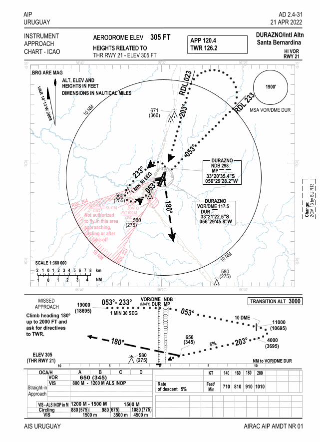
RDL 2
21
RDL 264
10 NM
ZOM 13ALT 600 M
GND
SU P38ALT 600 MGND
Not authorizedto fly in this areaapproaching,circling or after
take-off
AIPURUGUAY
AIS URUGUAY
INSTRUMENTAPPROACH TWR 126.2
DURAZNO/Intl Altn
BRG ARE MAG
AERODROME ELEVHEIGHTS RELATED TOCHART - ICAO
305 FT
OCA/H
Straight-inApproach
10 NM
2 1 0 1 2 3 4 5 6 7 8
01 1 2 3 4
km
NM
SCALE 1:360 000 10 NM
APP 120.4 Santa Bernardina
CirclingVIS
THR RWY 21 - ELEV 305 FTHI VORRWY 21
1 MIN 30 SEG
VOR
(THR RWY 21)
VIS
ELEV 305(275)
800 M - 1200 M ALS INOP650 (345)
10C D
3500 m880 (575)
5
(18695)19000
180°
053°- 233°
580
200
1010MinFeet/
0
KT5
710
140
910
180
810
160
053°MPNDB
(345)650
203°
10 DME
NM to VOR/DME DUR
AIRAC AIP AMDT NR 01
10
(10695)11000
4000(3695)
DURAZNONDB 298
33°20'35.4"S056°29'28.2"W
MP
180°
053°
233°
053°
DURAZNOVOR/DME 117.5
DUR33°21'22.5"S056°29'45.8"W
203° RDL 23
3RDL 0
23
VOR/DMEDUR
1 MIN 30
SEG
AD 2.4-3121 APR 2022
5%
(MAPt)
VIS - ALS INOP in M 1200 M - 1500 M 1500 M
4500 m(775)1080
VAR 10°13'W 2008
580(275)
1900'
MSA VOR/DME DUR
A B
980 (675)1500 m
671(366)
AERODROME ELEVHEIGHTS RELATED TO
ZOM
13 by
SU
R13
Chan
ge:
TRANSITION ALT 3000MISSEDAPPROACH
to TWR.ask for directivesup to 2000 FT andClimb heading 180º
of descent 5%Rate
ALT, ELEV AND
DIMENSIONS IN NAUTICAL MILESHEIGHTS IN FEET
(255)560
(275)580
Durazno
33°
33°
56°30'56°40' 56°20'
20'
30'
56°40' 56°30' 56°20'
33°20'
33°30'
33°10'
33°10'
9
18
27
0

IIINNNTTTEEENNNTTTIIIOOONNNAAALLLLLLYYY LLLEEEFFFTTT BBBLLLAAANNNKKK
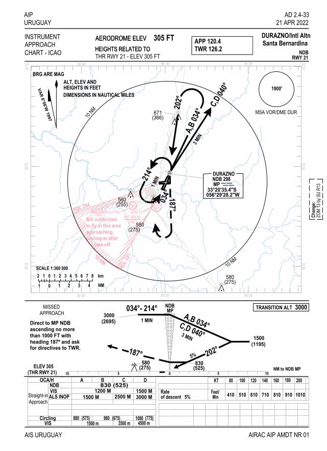
RDL 2
21
RDL 264
10 NM
ZOM 13ALT 600 M
GND
SU P38ALT 600 MGND
Not authorizedto fly in this areaapproaching,circling or after
take-off
AIPURUGUAY
AIS URUGUAY AIRAC AIP AMDT NR 01
INSTRUMENTAPPROACH TWR 126.2
DURAZNO/Intl Altn
BRG ARE MAG
AERODROME ELEVHEIGHTS RELATED TOCHART - ICAO
305 FT
OCA/HNDBVIS
Straight-inApproach
10 NM
DURAZNONDB 298MP
33°20'35.4"S056°29'28.2"W
2 1 0 1 2 3 4 5 6 7 8
01 1 2 3 4
km
NM
SCALE 1:360 000 10 NM
034°- 214°
3 MIN
1 MIN A,B 034°
187°
1500(1195)
3000(2695)
580(275)
830(525)
202°
MPNDB
0510 5 10ELEV 305
(THR RWY 21) NM to NDB MP
830 (525)1200 M
NDBRWY 21THR RWY 21 - ELEV 305 FT
187°
3 MIN
APP 120.4 Santa Bernardina
202°
A,B
034°
C,D 04
0°
214°
034°
1 MIN
CirclingVIS
C,D 040°
A B C D
AD 2.4-3321 APR 2022
5%
2500 M1500 M
ALS INOP 1500 M 3000 M
KT 80 100 120 140 160 180 200
1010910810710610510410Feet/Min
VAR 8°06'W 1997
580(275)
1900'
MSA VOR/DME DUR
980(575)8801500 m 3500 m
(675) 10804500 m
(775)
671(366)
AERODROME ELEVHEIGHTS RELATED TO
ZOM
13 by
SU
R13
Chan
ge:
TRANSITION ALT 3000
of descent 5%Rate
MISSEDAPPROACH
heading 187º and askthan 1000 FT withascending no moreDirect to MP NDB
for directives to TWR.
ALT, ELEV AND
DIMENSIONS IN NAUTICAL MILESHEIGHTS IN FEET
(255)560
(275)580
Durazno
33°
33°
56°30'56°40' 56°20'
20'
30'
56°40' 56°30' 56°20'
33°20'
33°30'
33°10'
33°10'

IIINNNTTTEEENNNTTTIIIOOONNNAAALLLLLLYYY LLLEEEFFFTTT BBBLLLAAANNNKKK

RDL 2
21
RDL 264
10 NM
ZOM 13ALT 600 M
GND
SU P38ALT 600 MGND
Not authorizedto fly in this areaapproaching,circling or after
take-off
AIPURUGUAY
AIS URUGUAY
INSTRUMENTAPPROACH TWR 126.2
DURAZNO/Intl Altn
BRG ARE MAG
AERODROME ELEVHEIGHTS RELATED TOCHART - ICAO
305 FT
OCA/H
Straight-inApproach
10 NM
2 1 0 1 2 3 4 5 6 7 8
01 1 2 3 4
km
NM
SCALE 1:360 000 10 NM
APP 120.4 Santa Bernardina
CirclingVIS
095°
C,D 293°
095° 291°
111°1 MINA,B 287°
056°29'45.8"W33°21'22.5"S
VOR/DME 117.5DURAZNO
DUR
NDB 245DURAZNO
33°21'35.1"SDO
056°32'59.1"W
NDB/DMERWY 10THR RWY 09 - ELEV 276 FT
ELEV 276(THR RWY 10)
750 (474)1500 M
NDB DMEVIS
KT 80 100 120
510MinFeet/ 410 610
NM to VOR/DME DUR10 5 0 5 10
VOR/DME
A,B 287°
095°(474)750
10 DME
NDBDO DUR
095°
291°3000
(2724)
1800(1524) 5%
C,D 293°111°
140 160 180 200
710 810 910 1010
DME VOR DURDIST THRAltitudeHeight
10 9 8 79.2 8.2 7.2 6.2
18001524
15001224
1190914
890614
A B C D
AIRAC AIP AMDT NR 01
AD 2.4-3521 APR 2022
580(304)
2000 M 2500 M
VAR 8°06'W 1997
(304)580
560(284)
(304)580
1900'
MSA VOR/DME DUR
880(505)8101500 m 3000 m
(575) 9803500 m
(675)
AERODROME ELEVHEIGHTS RELATED TO
ZOM
13 by
SU
R13
Chan
ge:
TRANSITION ALT 3000
of descent 5%Rate
MISSEDAPPROACH
1000 FT and askno more thanheading 095ºClimb direct
to TWR.for directives
ALT, ELEV AND
DIMENSIONS IN NAUTICAL MILESHEIGHTS IN FEET
Durazno
33°
33°
56°30'56°40' 56°20'
20'
30'
56°40' 56°30' 56°20'
33°20'
33°30'
33°10'
33°10'
9
18
27
0

IIINNNTTTEEENNNTTTIIIOOONNNAAALLLLLLYYY LLLEEEFFFTTT BBBLLLAAANNNKKK

RDL 2
21
RDL 264
10 NM
ZOM 13ALT 600 M
GND
SU P38ALT 600 MGND
Not authorizedto fly in this areaapproaching,circling or after
take-off
AIPURUGUAY
AIS URUGUAY
INSTRUMENTAPPROACH TWR 126.2
DURAZNO/Intl Altn
BRG ARE MAG
AERODROME ELEVHEIGHTS RELATED TOCHART - ICAO
305 FT
OCA/H
Straight-inApproach
10 NM
2 1 0 1 2 3 4 5 6 7 8
01 1 2 3 4
km
NM
SCALE 1:360 000 10 NM
APP 120.4 Santa Bernardina
CirclingVIS
203°700(395)180°
(2695)3000
226°- 046°1 MIN A,B RDL 040C,D RDL 0463 MIN 1500
(1195)
DURAZNOVOR/DME 117.5
DUR33°21'22.5"S056°29'45.8"W
DURAZNONDB 298MP
33°20'35.4"S056°29'28.2"W
203°
RDL 0
23A,B
RDL 0
40
C,D RDL 046
180°
226°04
6°
10 5 0 5 10
NDBMP
VOR/DMEDUR
THR RWY 21 - ELEV 305 FT VORRWY 21
700 (395)800 M - 1200 M ALS INOP
880 (575) 980 (675)4500 m3500 m1500 m
1 MIN
NM to VOR/DME DUR(THR RWY 21)
VORVIS
ELEV 305(THR RWY 21)
A B C D
AD 2.4-3721 APR 2022
AIRAC AIP AMDT NR 01
20018016014012010080KT
Feet/Min 410 510 610 710 810 910 1010
580(275)
5%
VIS - ALS INOP in M 1200 M - 1500 M 1500 M
(MAPt)
(775)1080
VAR 8°41'W 2001
3 MIN
580(275)
1900'
MSA VOR/DME DUR671(366)
AERODROME ELEVHEIGHTS RELATED TO
ZOM
13 by
SU
R13
Chan
ge:
TRANSITION ALT 3000
of descent 5%Rate
MISSEDAPPROACH
to TWR.and ask for directives180º up to 2000 FTClimb heading
ALT, ELEV AND
DIMENSIONS IN NAUTICAL MILESHEIGHTS IN FEET
(255)560
(275)580
Durazno
33°
33°
56°30'56°40' 56°20'
20'
30'
56°40' 56°30' 56°20'
33°20'
33°30'
33°10'
33°10'
9
18
27
0

IIINNNTTTEEENNNTTTIIIOOONNNAAALLLLLLYYY LLLEEEFFFTTT BBBLLLAAANNNKKK
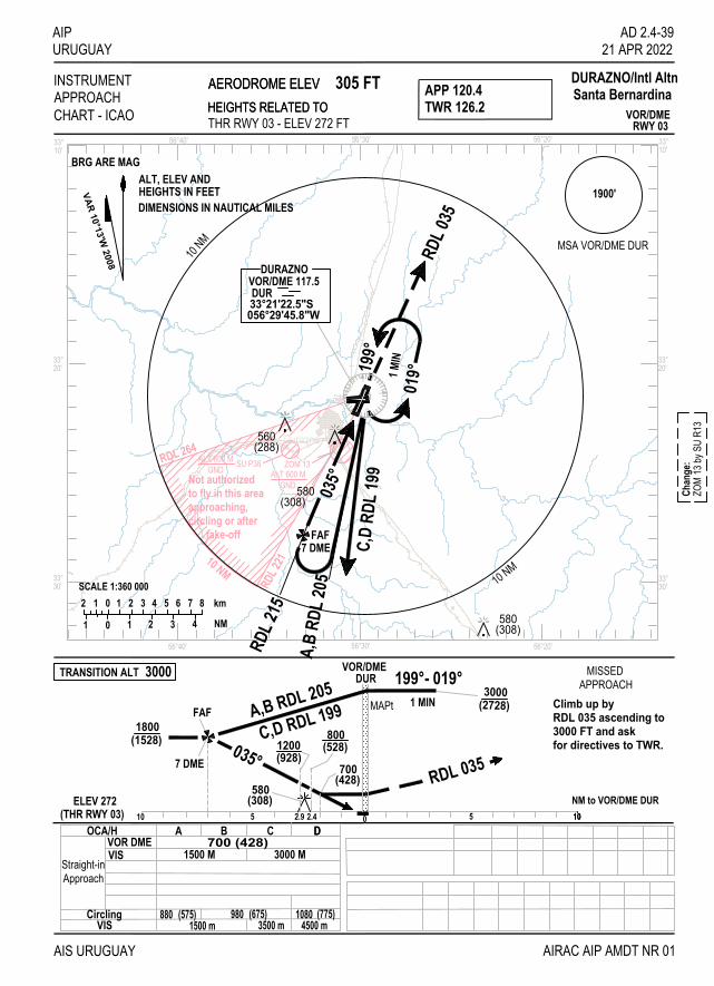
RDL 2
21
RDL 264
10 NM
ZOM 13ALT 600 M
GND
SU P38ALT 600 MGND
Not authorizedto fly in this areaapproaching,circling or after
take-off
AIPURUGUAY
AIS URUGUAY
INSTRUMENTAPPROACH TWR 126.2
DURAZNO/Intl Altn
BRG ARE MAG
AERODROME ELEVHEIGHTS RELATED TOCHART - ICAO
305 FT
OCA/H
Straight-inApproach
10 NM
2 1 0 1 2 3 4 5 6 7 8
01 1 2 3 4
km
NM
SCALE 1:360 000 10 NM
APP 120.4 Santa Bernardina
D
CirclingVIS
10
VOR/DMERWY 03THR RWY 03 - ELEV 272 FT
RDL 0
35
019°1 M
IN199°
035°
A,B
RDL 2
05
RDL 2
15DUR
056°29'45.8"W33°21'22.5"S
DURAZNOVOR/DME 117.5
700 (428)1500 M
VOR DMEVIS
ELEV 272(THR RWY 03)
NM to VOR/DME DUR10 5 0 5 10
(1528)1800
035°
A,B RDL 205
580
800(528)
RDL 035
(308)
DURVOR/DME
199°- 019°3000
(2728)
C,D
RDL 1
99
1 MIN
C,D RDL 199
7 DME
A B C D
AIRAC AIP AMDT NR 01
AD 2.4-3921 APR 2022
3000 M
VAR 10°13'W 2008
(308)
(288)560
580
580(308)
1900'
MSA VOR/DME DUR
FAF7 DME
FAF
980(575)8801500 m 3500 m
(675) 10804500 m
(775)
1200(928)
700(428)
2.9 2.4
MAPt
AERODROME ELEVHEIGHTS RELATED TO
TRANSITION ALT 3000ZO
M 13
by S
U R1
3Ch
ange
:MISSED
APPROACH
for directives to TWR.3000 FT and askRDL 035 ascending toClimb up by
ALT, ELEV AND
DIMENSIONS IN NAUTICAL MILESHEIGHTS IN FEET
Durazno
33°
33°
56°30'56°40' 56°20'
20'
30'
56°40' 56°30' 56°20'
33°20'
33°30'
33°10'
33°10'
9
18
27
0

IIINNNTTTEEENNNTTTIIIOOONNNAAALLLLLLYYY LLLEEEFFFTTT BBBLLLAAANNNKKK

RDL 2
21
RDL 264
10 NM
ZOM 13ALT 600 M
GND
SU P38ALT 600 MGND
Not authorizedto fly in this areaapproaching,circling or after
take-off
AIPURUGUAY
AIS URUGUAY
INSTRUMENTAPPROACH TWR 126.2
DURAZNO/Intl Altn
BRG ARE MAG
AERODROME ELEVHEIGHTS RELATED TOCHART - ICAO
305 FT
OCA/H
Straight-inApproach
10 NM
2 1 0 1 2 3 4 5 6 7 8
01 1 2 3 4
km
NM
SCALE 1:360 000 10 NM
APP 120.4 Santa Bernardina
CirclingVIS
RWY 21VOR/DME
AD 2.4-4121 APR 2022
180°
056°29'45.8"W33°21'22.5"SDUR
VOR/DME 117.5DURAZNO056°29'28.2"W
33°20'35.4"SMPNDB 298DURAZNO
RDL 0
2320
3°A,B
RDL 0
40
C,D RDL 046
6 DME
3 MIN
(THR RWY 21)(THR RWY 21)ELEV 305 NM to VOR/DME DUR
1050510
(1195)1500
203°
C,D RDL 0463 MIN
A,B RDL 040
650(345)
180°
226°- 046°1 MIN
VOR/DMEDUR MP
NDB
(2695)3000
VOR DMEVIS
(675)9803500 m
1080 (775)4500 m
800 M - 1200 M ALS INOP650 (345)
A B C D
710
140
Feet/Min
KT
410
80
610
120
510
100
910
180
810
160
1010
200
AltitudeDIST THRDME VOR DUR
1200
56
15005.7 4.7
4
9003.7
2 DME 5%
6 DME
AIRAC AIP AMDT NR 01
(275)580
THR RWY 21 - ELEV 305 FT
VAR 8°49'W 2001
VIS - ALS INOP in M 1200 M - 1500 M 1500 M
1500 m880 (575)
32.7690
(MAPt)
1 MIN
046°
226°
580(275)
1900'
MSA VOR/DME DUR671(366)
AERODROME ELEVHEIGHTS RELATED TO
ZOM
13 by
SU
R13
Chan
ge:
TRANSITION ALT 3000
of descent 5%Rate
MISSEDAPPROACH
to TWR.and ask for directives180º up to 2000 FTClimb heading
ALT, ELEV AND
DIMENSIONS IN NAUTICAL MILESHEIGHTS IN FEET
(255)560
(275)580
Durazno
33°
33°
56°30'56°40' 56°20'
20'
30'
56°40' 56°30' 56°20'
33°20'
33°30'
33°10'
33°10'
9
18
27
0

IIINNNTTTEEENNNTTTIIIOOONNNAAALLLLLLYYY LLLEEEFFFTTT BBBLLLAAANNNKKK

RDL 2
21
RDL 264
10 NM
ZOM 13ALT 600 M
GND
SU P38ALT 600 MGND
Not authorizedto fly in this areaapproaching,circling or after
take-off
AIPURUGUAY
AIS URUGUAY
INSTRUMENTAPPROACH TWR 126.2
DURAZNO/Intl Altn
BRG ARE MAG
AERODROME ELEVHEIGHTS RELATED TOCHART - ICAO
305 FT
OCA/H
Straight-inApproach
10 NM
2 1 0 1 2 3 4 5 6 7 8
01 1 2 3 4
km
NM
SCALE 1:360 000 10 NM
APP 120.4 Santa Bernardina
CirclingVIS
180°
LLZ 109.9I-DUR
AD 2.4-4321 APR 2022
VOR DME ILSRWY 21
053°233
°
1 MIN
A, B RDL 0
47
33°16'13.4"S056°27'13.9"W
OMDURAZNO
056°29'28.2"W
NDB 298
33°20'35.4"S
DURAZNO
MP
OM
FAP
210°
MM
ELEV 305(THR RWY 21)
ILS RDH 56
to TWR.and ask for directives180° up to 2000 FTClimb heading
(MAPT GP INOP)VOR/DMEDUR MM OM
580(275)
180°(315)620
210°G.P. 3° 2050
(1745) NM to VOR/DME DUR
(1745)2050
010 5 5 1010
Cat IVIS
VIS-ALSGP INOP 800(495)
(675)
800 M - 1200 M ALS INOP620 (315)
1200 M - 1500 M(575)
A
inINOP880
M
1500 m980
B
(775)1500 M
3500 m 4500 m1080
C D
DME VOR DUR
HEIGHTALTITUDE
15451850
275580
1900595
2
12251530
9051210
3 4 5
18652170
6
AIRAC AIP AMDT NR 01
of descent 5,2%Rate FAP-Mapt (4.75 NM)
MinFeet/
Min : SecKT
3:33430
802:51530
1002:02750
1402:22640
1201:46850
1601:251060
2001:35950
180
7 DME
7 DME
C, D RDL 05
3
233°- 053°(2695)3000
A, B RDL 047C, D RDL 053
THR RWY 21 - ELEV 305 FT
DURAZNO
056°29'45.8"W33°21'22.5"S
VOR/DME 117.5DUR
VAR 8°06'W 1997
CAT 1, 2, 3 ACFTwith Glide Slope forMatching PAPI
580(275)
MISSEDAPPROACH
1900'
MSA VOR/DME DUR
ZOM
13 by
SU
R13
Chan
ge:
671(366)
TRANSITION ALT 3000
AERODROME ELEVHEIGHTS RELATED TO
ALT, ELEV AND
DIMENSIONS IN NAUTICAL MILESHEIGHTS IN FEET
(255)560
(275)580
Durazno
33°
33°
56°30'56°40' 56°20'
20'
30'
56°40' 56°30' 56°20'
33°20'
33°30'
33°10'
33°10'
9
18
27
0

IIINNNTTTEEENNNTTTIIIOOONNNAAALLLLLLYYY LLLEEEFFFTTT BBBLLLAAANNNKKK

AIP AD 2.5-1 URUGUAY 21 APR 2022
AD 2. AERODROMES
SULS AD 2.5-1 AERODROME LOCATION INDICATOR AND NAME
SULS - MALDONADO/Intl C/C Carlos A. Curbelo "Laguna del Sauce" (Punta del Este) SULS 2.5-2 AERODROME GEOGRAPHICAL AND ADMINISTRATIVE DATA
1 ARP coordinates and site at AD 345127S 0550553W Location: geometric centre of the aerodrome
2 Direction and distance from (city) 15 KM WNW from Maldonado/ Punta del Este city
3 Elevation/Reference temperature 29 M (95 FT) / 29°C
4 Geoid undulation at AD ELEV PSN 13 M
5 MAG VAR/Annual change 12º W (JAN 2020) / 0.14° increasing
6 AD operator, address, telephone, telefax, e-mail address, AFS address, website address
Consorcio Aeropuertos Intl S.A. (C.A.I.S.A.) Aeropuerto Intl C/C Carlos A. Curbelo "Laguna del Sauce" Ruta 93 KM 113 Maldonado Tel: 4255 9777 - 4255 9387 - 4255 9388 Telefax: 4255 9389 e-mail: [email protected] AFS: SULSYPYX (OPS) website address: www.puntadeleste.aero
7 Types of traffic permitted (IFR/VFR) IFR/VFR
8 Remarks Administrative Coordinator: DINACIA
SULS AD 2.5-3 OPERATIONAL HOURS
1 AD Operator H24
2 Customs and immigration As AD Operator
3 Health and sanitation During commercial flights hours; others O/R
4 AIS Briefing Office Nil
5 ATS Reporting Office (ARO) As AD Operator
6 MET Briefing Office As AD Operator
7 ATS As AD Operator
8 Fuelling H24
9 Handling As AD Operator
10 Security As AD Operator
11 De-icing Nil
12 Remarks Nil
AIS URUGUAY AIRAC AIP AMDT NR 01
AD 2.5-2 AIP 21 APR 2022 URUGUAY SULS AD 2.5-4 HANDLING SERVICES AND FACILITIES
1
Cargo-handling facilities
4 powered ladders, 2 Ambulift 2 conveyor belts, 3 GPU 115v 400hz and 2 GPU 28v 3 ASU 90 and 1 ASU 140 PSI, 10 flats and 4 closed trolleys for suitcases
2
Fuel/oil types
JET A-1 – Fuel 100/130
3
Fuelling facilities/capacity
ANCAP 2 JET A-1 Tanks 100,000 L each 1 AVGAS Tank 10,000 L JET A-1 Mobile Unit 20,000 L AVGAS Mobile Unit 900 L CAISA JET A-1 Mobile Unit 18,500 L
4
De-icing facilities
Nil
5
Hangar space for visiting aircraft
Nil
6
Repair facilities for visiting aircraft
Nil
7
Remarks
Cargo aircraft Ramp assistance without modification of payload (alternate only)
SULS AD 2.5-5 PASSENGER FACILITIES
1
Hotels
In the city of Punta del Este/Maldonado
2
Restaurants
Service bar, restaurant and confectionery. (Hours of business operation)
3
Transportation
Buses, taxis, remises and cars without driver.
4
Medical facilities
First aid medical company hired by CAISA Permanent medical presence during commercial flight hours, outside business hours O/R.
5
Bank and Post Office
Foreign Exchange Office at Terminal Area
6
Tourist Office
Intendencia Municipal de Maldonado (Tourist Information)
7
Remarks
Nil
AIRAC AIP AMDT NR 01 AIS URUGUAY

AIP AD 2.5-3 URUGUAY 21 APR 2022 SULS AD 2.5-6 RESCUE AND FIRE FIGHTING SERVICES
1
AD category for fire fighting
CAT 7
2
Rescue equipment
Approach tools and equipment. For events in Laguna del Sauce, motorized boat for rescue and combat, 6 self-inflating life rafts with capacity for 25 people each
3
Capability for removal of disabled aircraft
To coordinate with CAISA aerodrome operator
4
Remarks
Nil
SULS AD 2.5-7 SEASONAL AVAILABILITY - CLEARING
1
Types of clearing equipment
Nil
SULS AD 2.5-8 APRONS, TAXIWAYS AND CHECK LOCATIONS/POSITIONS DATA
1
Apron surface and strength
Surface: asphalt concrete Strength: Commercial Apron: PCN 50/F/C/X/T – 45/R/B/W/T General Aviation Apron: PCN 30/F/B/X/T
2
Taxiway width, surface and strength
Width: "C","D" 23 M - "E" 10 M - "A" 15 M - "B" 18 M Surface: asphalt concrete Strength: "A" PCN 30/F/B/X/T; "B" 20/F/C/Y/T; "C" 57/F/C/X/T; "D" PCN 43/F/C/X/T; "E" PCN 18/F/C/W/T
3
Altimeter checkpoint location and elevation
THR RWY 01 (345152.57S/0550537.02W) 29 M
THR RWY 08 (345135.59S/0550643.68W) 28 M 4
VOR/INS checkpoints
Nil
5
Remarks
Nil
AIS URUGUAY AIRAC AIP AMDT NR 01

AD 2.5-4 AIP 21 APR 2022 URUGUAY SULS AD 2.5-9 SURFACE MOVEMENT GUIDANCE AND CONTROL SYSTEM AND MARKINGS
1
Use of aircraft stand ID signs, TWY guide lines and visual docking/parking guidance system of aircraft stands
Apron taxi guidance indications. Aircraft stands identification signs. Taxiway centre line and nose aircraft stop bar signs, with aircraft type ID. Parking guided by Aerodrome Signalman
2
RWY and TWY markings and LGT
RWY 08: Markings: THR, RWY designation, RWY centre line, touchdown zone, aiming point, 180° turn-over for ACFT code letter C, taxiing indicator line from and to TWY, holding point to RWY 01-19. LGT: THR, RWY edge, RWY end lights and turning edge. RWY 26: Markings: THR, RWY designation, RWY centre line, touchdown zone, aiming point, 180° turn-over for ACFT code letter C, taxiing indicator line from and to TWY, holding point to RWY 01-19.
LGT: THR, RWY edge, RWY end lights and turning edge.
RWY 01: Markings: THR, RWY designation, RWY centre line, aiming point, taxiing indicator line from and to TWY, holding point to RWY 08-26. LGT: THR, RWY edge, RWY end lights. RWY 19: Markings: THR, RWY designation, RWY centre line, aiming point, taxiing indicator line from and to TWY, holding point to RWY 08-26. LGT: THR, RWY edge, RWY end lights. TWY: Markings: TWY centre line, intermediate holding position, RWY holding position, mandatory instructions, directional to parking stands before entering the platform. LGT: TWY edge lights.
3
Stop bars
Nil
4
Remarks
Nil
SULS AD 2.5-10 AERODROME OBSTACLES
In approach/TKOF areas
In circling area and at AD
Remarks
1
2
3
RWY/Area affected
Obstacle type Elevation Markings/LGT
Coordinates
Obstacle type Elevation Markings/LGT
Coordinates
Nil
a
b
c
a
b
No data AVBL
No data AVBL
AIRAC AIP AMDT NR 01 AIS URUGUAY

AIP AD 2.5-5 URUGUAY 21 APR 2022
SULS AD 2.5-11 METEOROLOGICAL INFORMATION PROVIDED
1
Associated MET Office
CAP. CURBELO
2
Hours of service MET Office outside hours
H24 -
3
Office responsible for TAF preparation Periods of validity
Surveillance MET Office CARRASCO H 24
4
Trend forecast Interval of issuance
ATIS (via VOR transmitter continuously)
5
Briefing/consultation provided
Personal inquiries: O/R
6
Flight documentation Language(s) used
Chart, En-Route chart Spanish
7
Charts and other information available for briefing or consultation
S, U, P, T
8
Supplementary equipment available for providing information
ATIS
9
ATS units provided with information
MALDONADO TWR, OPS
10
Additional information (limitation of service, etc.)
Nil
AIS URUGUAY AIRAC AIP AMDT NR 01

AD 2.5-6 AIP 21 APR 2022 URUGUAY SULS AD 2.5-12 RUNWAY PHYSICAL CHARACTERISTICS
Designations RWY NR TRUE BRG
Dimensions of RWY (M)
Strength (PCN) and surface of RWY and SWY
THR coordinates. RWY end
coordinates. THR geoid undulation
THR elevation and highest elevation of
TDZ of precision APP RWY
1 2 3 4 5 6
19 177.68º 1 600 x 38 43/F/A/X/T Asphalt concrete
345100.79S 0550539.56W 345100.79S 0550539.56W GUND 13.1 M
THR 23 M/75 FT
01 357.68º 1 600 x 38 43/F/A/X/T Asphalt concrete
345152.57S 0550537.02W 345152.57S 0550537.02W GUND 13.1 M
THR 29 M/95 FT
08 072.42º 2 133 x 45 46/F/B/X/T Asphalt concrete
345135.59S 0550643.68W 345135.59S 0550643.68W GUND 13.1 M
THR 29 M/95 FT
26 252.41º 2 133 x 45 46/F/B/X/T Asphalt concrete
345114.69S 0550523.69W 345114.69S 0550523.69W GUND 13.1 M
THR 22 M/72 FT
Slope of RWY-SWY
SWY dimensions
(M)
CWY dimensions
(M)
Strip dimensions
(M) OFZ
RESA
(M) Remarks
7 8 9 10 11 12 13
-0.19%/0%/+0.4%/ +0.7%/ +0.4%/+0.4 (100 M) (50 M) (480 M) (340 M) (250 M) (380 M)
Nil Nil 1 720 x 280 Nil 60 x 60 Nil
-0.4%/-0.4%/-0.7%/ -0.4%/0%/+0.19% (380 M) (250 M) (340 M) (480 M) (50 M) (100 M)
Nil Nil 1 720 x 280 Nil 60 x 90 Nil
-0,5%/-0,2%/-0,5%/ (483 M) (1250 M) (400 M)
Nil Nil 2 253 x 280 Nil 90 x 90 Open drains, 76 M from RWY axis, on both sides, along the strip. +0,5%/+0,2%/+0,5%/
(400 M) (1250 M) (483 M)
Nil Nil 2 253 x 280 Nil 90 x 90
AIRAC AIP AMDT NR 01 AIS URUGUAY

AIP AD 2.5-7 URUGUAY 21 APR 2022 SULS AD 2.5-13 DECLARED DISTANCES
RWY Designator
TORA (M)
TODA (M)
ASDA (M)
LDA (M)
Remarks
1
2
3
4
5
6
19 01 08 26
1600 1600 2133 2133
1 600 1 600 2 133 2 133
1 600 1 600 2 133 2 133
1 600 1 600 2 133 2 133
Nil Nil Nil Nil
SULS AD 2.5-14 APPROACH AND RUNWAY LIGHTING
RWY
Desig-nator
APCH LGT type LEN
INTST
THR LGT
colour WBAR
VASIS (MEHT)
PAPI
TDZ, LGT LEN
RWY
Centre Line LGT
Length, spacing, colour, INTST
RWY edge LGT LEN,
spacing colour INTST
RWY End LGT
colour WBAR
SWY LGT
LEN (M) colour
Remarks
1
2
3
4
5
6
7
8
9
10
19
01
08
26
ALS
240 M LIM
Nil
MALSR CAT 1 720 M
LIM
ALS
420 M LIM
Green Green Green Green
PAPI
PAPI
PAPI
PAPI
Nil
Nil
Nil
Nil
Nil
Nil
Nil
Nil
1600 M, 60 M
White Amber
1600 M, 60 M
White Amber
2133 M 60 M White Amber
2133 M 60 M White Amber
Red
Red
Red
Red
Nil
Nil
Nil
Nil
Nil
Nil
Nil
Nil
AIS URUGUAY AIRAC AIP AMDT NR 01

AD 2.5-8 AIP 21 APR 2022 URUGUAY SULS AD 2.5-15 OTHER LIGHTING, SECONDARY POWER SUPPLY
1
ABN/IBN location, characteristics and hours of operation
ABN: TWR, GP, FL, W, G. H24
2
LDI location and LGT Anemometer location and LGT
WDI 680 M of ARP lighted / WDI 1188 M of ARP Anemometer: 170 M of RWY centre line
3
TWY edge and centre line lighting
Edge: all the TWY Centre: Nil
4
Secondary power supply/switch-over time
Secondary power supply: 120 KW generator. Switch-over time: 10 SEC; 410 KW generator, switch-over time: 13 SEC and 110 KW generator, switch-over time: 10 SEC
5
Remarks
Nil
SULS AD 2.5-16 HELICOPTER LANDING AREA
1
Coordinates TLOF or THR of FATO
Nil
2
TLOF and/or FATO elevation M/FT
Nil
3
TLOF and FATO area dimensions, surface, strength, marking
4
True and MAG BRG FATO
Nil
5
Declared distance available
Nil
6
APP and FATO lighting
Nil
7
Remarks
Helicopter PRKG stand on East Apron
AIRAC AIP AMDT NR 01 AIS URUGUAY

AIP AD 2.5-9 URUGUAY 21 APR 2022 SULS AD 2.5-17 ATS AIRSPACE
1
Designation and lateral limits
C. CURBELO CTR CTR arc, radius 10 NM centred at 345129.9S 0550530.2W
C. CURBELO ATZ
Circle, radius 10 NM centred at 345129.9S 0550530.2W 2
Vertical limits
CTR: SFC up to FL 035 ATZ: SFC up to 750 M
3
Airspace classification
C
4
ATS unit call sign Language(s)
Capitán Curbelo Tower Spanish, english
5
Transition altitude
900 M
6
Remarks
DF on FREQ 118.3, 122.1, 121.5
SULS AD 2.5-18 ATS COMMUNICATION FACILITIES
Service
designation
Call sign
Frequency
Hours of operation
Remarks
1
2
3
4
5
TWR G/A/G
Cap. Curbelo Tower
118.3 MHZ 122.1 MHZ 122.1 MHZ
H24 H24
Nil Nil
SULS AD 2.5-19 RADIO NAVIGATION AND LANDING AIDS
Type of aid, MAG VAR,
Type of supported OP
(for VOR/ILS/MLS,
give declination)
ID
Frequency
Hours of
operation
Position of transmitting
antenna coordinates
Elevation of
DME transmitting
antenna
Remarks
1
2
3
4
5
6
7
VOR/DME NDB
LDS CH 123 X LS
117.6 MHZ 239 KHZ
H24 H24
345129.9S 0550530.2W 345144.0S 0550601.1W
030 M/098 FT Nil
Nil Nil
AIS URUGUAY AIRAC AIP AMDT NR 01

AD 2.5-10 AIP 21 APR 2022 URUGUAY
SULS AD 2.5-21 NOISE ABATEMENT PROCEDURES All day and night takeoffs, shall apply the noise abatement procedures, specific to each aircraft. In the takeoff runway 08, the right turns can not be made before reaching 1500 FT (450 M) of altitude. AIRAC AIP AMDT NR 01 AIS URUGUAY

AIP AD 2.5-11 URUGUAY 21 APR 2022
SULS AD 2.5-22 FLIGHT PROCEDURES General Flights within the SULS CTR shall be made in accordance with instrument flight rules or visual as appropriate. IFR takeoff minimums The applicable minimum for takeoff in terms of ceiling and visibility shall be the minimum expected for the published instrument approach procedure for runway in use. If a visual circulation is necessary, the published minimums will be applied for it.
a) Aircraft shall be equipped with the instruments necessary for the operation; b) The necessary navigation aids must be operational.
Reduction of the IFR takeoff minimums The minimum visibility required for takeoff with two or more engines will be: 800 M
1) It is required in box 18 of Flight Plan Form an alternate aerodrome post-launch located within the following distances in relation to the aerodrome of departure:
a) twin-engine aircraft: less than an hour at normal cruising speed in calm air with one engine inoperative. b) three or more aircraft engines: less than two hours at normal cruising speed in calm air with one engine
inoperative. c) for single engine aircraft the ceiling for take-off shall be equal to or greater than the maximum
established in the instrument approach charts and the minimum visibility required will be 1 600 M Note 1: Indicate the alternate aerodrome post-launch as follows: RMK / DEP ALTN (4 letters Aerodrome location indicator) Note 2: Fill in the forms of Repetitive Flight Plan in the box Q "Remarks"
2) MET conditions for the alternate aerodrome post-launch. The alternate aerodrome post-launch shall at least be operational for IFR landings at the time of takeoff and
forecasts indicate that conditions will be at or above minimum values using the aerodrome at the expected time of landing.
3) IFR minimum flight level The aircraft must be able to climb with one engine inoperative until the IFR flight level appropriate to proceed to
the alternate aerodrome post-takeoff or destination aerodrome. IFR landing minimums The minimum necessary for landing in terms of ceiling and visibility, shall be the minimum for the instrumental approach procedure published for the runway in use. NOTE: During peak season (December 15 to March 15) and to reduce the inconvenience caused in certain critical periods of high traffic density, has structured a special air operations planning especially weekends, holidays and eve of public holidays (Uruguay and Argentina) and in any other period that the circumstances justify its implementation. - During these periods the air traffic control may assign estimated times of departure for all flights whether VFR or IFR, so prior to the launch Mr. pilots must apply to the Operaciones de aeródromo office (airfield operations office) for the expected delay for output. AIS URUGUAY AIRAC AIP AMDT NR 01
AD 2.5-12 AIP 21 APR 2022 URUGUAY The Aerodrome Control permanently kept informed Operations office in terms of delays and estimated times of departure. - Flights conducted under visual flight rules coming from the adjacent Flight Information Regions, will not be allowed to enter the Montevideo FIR, if previously and according to current regulations have not received their filed flight plan and its subsequent take-off update. - Flights conducted under visual flight rules that enter Montevideo FIR by Colonia or Isla Martin Garcia (Martin Garcia Island) and directed to the C / C Carlos A. Curbelo INTL Airport must use only the VFR 1 corridor.- - It is recalled that the lower limit of the corridor is 2,000 FT (600 M), the minimum flight altitude is 2,500 FT (750M) and the maximum FL 075. - To regulate the operations at times of high traffic density, aircraft directed to SUCA from all airports in the Carrasco TMA will proceed by VFR 1 Corridor, unless expressly authorized by the Air Traffic Control. - With high traffic density and when weather conditions are not determinants, it will not accept filed flight plans from the air. - When weather conditions permit, IFR flights may be directed by radar vectoring near the C / C Carlos A. Curbelo INTL Airport, then to proceed for visual transit accordingly. NOTE: During this period delays are expected in operations especially on Fridays, Sundays and eve of public holidays from the 16:00 UTC and on Mondays between 10:00 and 16:00 UTC. - VFR flights may not cross the final approach areas of the C / C Carlos A. Curbelo INTL Airport without authorization of the respective control. Minimum vertical separation in the Traffic Circuit of Cap. Curbelo. Nil. AIRAC AIP AMDT NR 01 AIS URUGUAY
AIP AD 2.5-13 URUGUAY 21 APR 2022 SULS AD 2.5-23 ADDITIONAL INFORMATION Presence of birds at the airport Caution is advised in operations due to the presence of birds at the Aerodrome. According to the fauna surveys, registered by the Aviary and Fauna Control staff of the Laguna del Sauce International Airport, the overflight of flocks of birds belonging to the Threskiornithidae family stands out, heading W to E over the water mirror of the Laguna del Sauce and the vicinity of the end of RWY 19, during sunrise, returning from E to W during sunset. Resident Birds TERO (Vanellus chilensis). This species increases its attendance and activity in the reproductive period, during the months of August to January. Make short, low-altitude flights (45 FT). It is active to a lesser extent at night. Weight: 400 grams approximately. Size: approximately 35 CM. COTORRA (Myiopsitta monachus). Its behavior varies during the different months of the year. They can be seen feeding in green areas or moving towards the hills bordering the airport property. Weight: approximately 100 grams. Size: 30 CM approximately. CHIMANGO (Milvago chimango). They can be seen alone or in groups, perched on green areas, feeding on insects or perched on posts of the perimeter fence. Weight: 300 grams approximately. Size: 40 CM approximately. Given the occurrence of rains, the presence of sea and coastal birds of the Sternidae family, Cook Gull (Larus dominicanus) and Brown Hooded Gull (Chroicocephalus maculipennis) is verified. In the presence of Efimeras (class: insecta, order: ephemeroptera) flocks of Capucho Brown Gull (Chroicocephalus maculipennis) are observed feeding on them on the property. Bird and Wildlife Control Program Reactive and preventive control methods are used. Reactive: it is based on the use of Pyrotechnics. Preventive: it is based on inspections of the Maneuvering Area for the identification of hazards and the implementation of Biological Control with falconry. (Flights of trained raptors are carried out, in order to generate fear and expel the fauna that approaches the aerodrome site). Service coverage H24 by the Operations Headquarters. Notification of collisions with Fauna An IBIS Report track shall be delivered to Operaciones DINACIA Office and another to the Airport Operator's Head of Operations. AIS URUGUAY AIRAC AIP AMDT NR 01

AD 2.5-14 AIP 21 APR 2022 URUGUAY SULS AD 2.5-24 CHARTS RELATED TO AN AERODROME Aerodrome/Heliport Chart - ICAO RWY 01/19................................................................................. AD 2.5-15 Aerodrome/Heliport Chart - ICAO RWY 08/26................................................................................. AD 2.5-17 Aircraft Parking/Docking Chart - ICAO (Commercial Aviation)....................................................... AD 2.5-19 Aircraft Parking/Docking Chart - ICAO (General Aviation)............................................................. AD 2.5-21 Aerodrome Obstacle Chart – OACI Type A – RWY 01/19............................................................ AD 2.5-23 Aerodrome Obstacle Chart – OACI Type A – RWY 08/26............................................................ AD 2.5-25 Standard Departure Chart – Instrument (SID) – ICAO RWY 08................................................ AD 2.5-27 Standard Arrival Chart – Instrument (STAR) – ICAO RWY 08................................................ AD 2.5-29 Instrument Approach Chart - ICAO COPTER VOR/DME RWY 26 ................................................. AD 2.5-31 Instrument Approach Chart - ICAO RNAV (GNSS) RWY 08 ...................................................... AD 2.5-33 Instrument Approach Chart - ICAO RNAV (GNSS) RWY 26 ...................................................... AD 2.5-35 Instrument Approach Chart - ICAO NDB RWY 01 .......................................................................... AD 2.5-37 Instrument Approach Chart - ICAO NDB RWY 26 .......................................................................... AD 2.5-39 Instrument Approach Chart - ICAO VOR RWY 01 .......................................................................... AD 2.5-41 Instrument Approach Chart - ICAO VOR/DME RWY 01 ................................................................. AD 2.5-43 Instrument Approach Chart - ICAO VOR/DME RWY 08 ................................................................. AD 2.5-45 Instrument Approach Chart - ICAO VOR/DME RWY 19 ………….................................................. AD 2.5-47 Instrument Approach Chart - ICAO VOR/DME RWY 26 ................................................................. AD 2.5-49 ATC Surveillance Minimum Altitude Chart - ICAO........................................................................... AD 2.5-51 AIRAC AIP AMDT NR 01 AIS URUGUAY

AIPURUGUAY
AD 2.5-15
AIS URUGUAY
AERODROME/HELIPORTCHART - ICAO
34°51'27"S055°05'53"W
ELEV 29 (95)
TWR 118.3 - 122.1APRON 118.3 - 122.1
MALDONADO/Intl
MARKING AIDS RWY 01/19 AND EXIT TWY
LIGHTING AIDS RWY 01/19 AND EXIT TWY
C/C Carlos A. CurbeloLaguna del Sauce
0
0
100 200 metres
200 400 600 feet
Chan
ge:
21 APR 2022
AIRAC AIP AMDT NR 01
ARP,
STR
IP, P
API, R
ESA,
MAL
SR, H
LP
VAR 12° W - 2020
ANNUAL RATE
OF CHANG
E 08' W
ELEVATIONS IN METRES (AND FEET)DIMENSIONS IN METRESBEARINGS ARE MAGNETIC
01
19
26
08
STRIP 2253 x 280
2133 x 45 ASPHALTIC CONCRETE
1600 x 38 ASPHALTIC CONCRETE
STRIP 1720 x 280
E
DC
B
A
PAPI
WDI
REILS
ELEV28 (92)
ELEV23 (75)
REILS
PAPI
PAPI
RESA
ELEV29 (95)
REILS
REILS ELEV21 (69)
PAPI
NDB 239LS
34°51'44.0"S055°06'01.1"W
055°05'30.2"W
VOR/DME 117.6
34°51'29.9"SLDS
30 M
0
0
300
100
500 pies
100 200
1000
300metres
VHF-DF118.3 - 122.1
121.5
TWRCommercial
aviation apron
Generalaviation apron
Fire station
ARP90 x 90
RESA90 x 90
WDI
RESA60 x 90
RESA60 x 60
TAXIWAYS:"A" 15 WIDE; "B" 18 WIDE; "C" and "D" 23 WIDE; "E" 10 WIDESTRIP Rwy 08/26: open drains, 76 M from RWY axis, on both sides, along the strip.
SIMPLE APPROACHLIGHTING SYSTEM
Automatic METstation
MEDIUM-INTENSITY APPROACHLIGHTING SYSTEM WITH RUNWAYALIGNMENT INDICATOR LIGHTS(MALSR) CAT 1
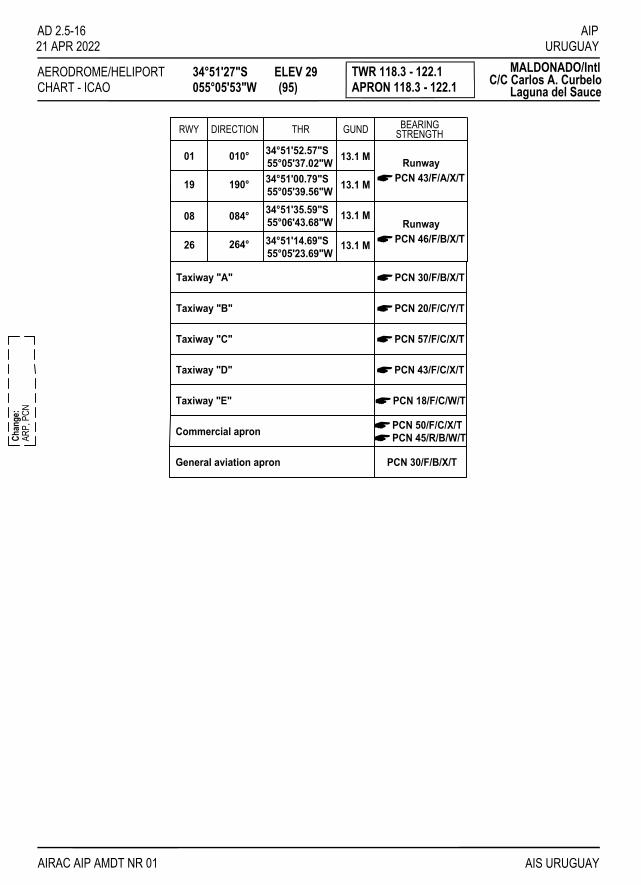
AERODROME/HELIPORTCHART - ICAO
34°51'27"S055°05'53"W
ELEV 29 (95)
TWR 118.3 - 122.1APRON 118.3 - 122.1
MALDONADO/IntlC/C Carlos A. Curbelo
Laguna del Sauce
RWY DIRECTION THR GUND
13.1 M
13.1 M
01 010° 34°51'52.57"S55°05'37.02"W
19 190° 55°05'39.56"W34°51'00.79"S
55°05'23.69"W26
08
264°
084° 55°06'43.68"W34°51'14.69"S
34°51'35.59"S 13.1 M
13.1 M
A
AIPURUGUAY
AD 2.5-1621 APR 2022
AIS URUGUAYAIRAC AIP AMDT NR 01
ARP,
PCN
Chan
ge:
PCN 43/F/A/X/TRunway
APCN 46/F/B/X/TRunway
Taxiway "A" APCN 30/F/B/X/T
Taxiway "B" APCN 20/F/C/Y/T
Taxiway "C" APCN 57/F/C/X/T
Taxiway "D" APCN 43/F/C/X/T
Taxiway "E" APCN 18/F/C/W/T
Commercial apron APCN 50/F/C/X/T
General aviation apron PCN 30/F/B/X/T
APCN 45/R/B/W/T
BEARINGSTRENGTH

AERODROME/HELIPORTCHART - ICAO
34°51'27"S055°05'53"W
ELEV 29 (95)
TWR 118.3 - 122.1APRON 118.3 - 122.1
MALDONADO/IntlC/C Carlos A. Curbelo
Laguna del Sauce
AIPURUGUAY
AD 2.5-17
AIS URUGUAY
metres
feet
MARKING AIDS RWY 08/26 AND EXIT TWY
LIGHTING AIDS RWY 08/26 AND EXIT TWY
Chan
ge:
ARP,
STR
IP, P
API, R
ESA,
MAL
SR, H
LP
21 APR 2022
AIRAC AIP AMDT NR 01
VAR 12° W - 2020
ANNUAL RATE
OF CHANG
E 08' W
ELEVATIONS IN METRES (AND FEET)DIMENSIONS IN METRESBEARINGS ARE MAGNETIC
01
19
26
08
STRIP 2253 x 280
2133 x 45 ASPHALTIC CONCRETE
1600 x 38 ASPHALTIC CONCRETE
STRIP 1720 x 280
E
DC
B
A
PAPI
WDI
REILS
ELEV28 (92)
ELEV23 (75)
REILS
PAPI
PAPI
RESA
ELEV29 (95)
REILS
REILS ELEV21 (69)
PAPI
NDB 239LS
34°51'44.0"S055°06'01.1"W
055°05'30.2"W
VOR/DME 117.6
34°51'29.9"SLDS
30 M
0
0
300
100
500 pies
100 200
1000
300metres
VHF-DF118.3 - 122.1
121.5
TWRCommercial
aviation apron
Generalaviation apron
Fire station
ARP90 x 90
RESA90 x 90
WDI
RESA60 x 90
RESA60 x 60
TAXIWAYS:"A" 15 WIDE; "B" 18 WIDE; "C" and "D" 23 WIDE; "E" 10 WIDESTRIP Rwy 08/26: open drains, 76 M from RWY axis, on both sides, along the strip.
SIMPLE APPROACHLIGHTING SYSTEM
Automatic METstation
MEDIUM-INTENSITY APPROACHLIGHTING SYSTEM WITH RUNWAYALIGNMENT INDICATOR LIGHTS(MALSR) CAT 1
0
0
100 200
200 400 600

AERODROME/HELIPORTCHART - ICAO
34°51'27"S055°05'53"W
ELEV 29 (95)
TWR 118.3 - 122.1APRON 118.3 - 122.1
MALDONADO/IntlC/C Carlos A. Curbelo
Laguna del Sauce
RWY DIRECTION THR GUND
13.1 M
13.1 M
01 010° 34°51'52.57"S55°05'37.02"W
19 190° 55°05'39.56"W34°51'00.79"S
55°05'23.69"W26
08
264°
084° 55°06'43.68"W34°51'14.69"S
34°51'35.59"S 13.1 M
13.1 M
A
ARP,
PCN
Chan
ge:
PCN 43/F/A/X/TRunway
APCN 46/F/B/X/TRunway
Taxiway "A" APCN 30/F/B/X/T
Taxiway "B" APCN 20/F/C/Y/T
Taxiway "C" APCN 57/F/C/X/T
Taxiway "D" APCN 43/F/C/X/T
Taxiway "E" APCN 18/F/C/W/T
Commercial apron APCN 50/F/C/X/T
General aviation apron PCN 30/F/B/X/T
APCN 45/R/B/W/T
BEARINGSTRENGTH
AIPURUGUAY
AD 2.5-1821 APR 2022
AIS URUGUAYAIRAC AIP AMDT NR 01

AIPURUGUAY
AD 2.5-19
AIS URUGUAY
AIRCRAFT PARKING/DOCKING CHART - ICAO
APRON ELEV27 (89)
TWR 118.3APRON 118.3
MALDONADO/Intl
ANNUAL RATE
OF CHANGE 08' W
ELEVATIONS IN METRES (AND FEET)DIMENSIONS IN METRESBEARINGS ARE MAGNETIC
TAXIWAY "D" 23 WIDE
TWY D
0
0
100
50
300feet
100metres
C/C Carlos A. CurbeloLaguna del Sauce
LEGENDAIRCRAFT STAND
TAXIWAY LIGHT
50
TWRPASSENGER TERMINALService road
APRONCommercial Aviation
Chan
ge:
ACFT
stan
ds
21 APR 2022
AIRAC AIP AMDT NR 01
VAR 12° W - 2020
TAXIWAY AND APRON STRENGTTAXIWAY "D": PCN 43/F/C/X/T
INS COORDINATES FOR AIRCRAFT STANDS
1 34°51'34.68"S 055°05'59.39"W 2 34°51'34.26"S 055°05'57.79"W
4 34°51'33.43"S 055°05'54.60"W 3 34°51'33.84"S 055°05'56.19"W
5W 34°51'35.28"S 055°05'56.36"W 5E 34°51'35.05"S 055°05'55.47"W
67
89
1110
5W 5E
1 2 3 4
6
78
910
11
6 34°51'33.99"S 055°05'50.85"W 7 34°51'33.86"S 055°05'50.90"W
9 34°51'32.34"S 055°05'51.49"W 8 34°51'32.88"S 055°05'51.27"W
11 34°51'30.65"S 055°05'52.13"W 10 34°51'31.77"S 055°05'51.71"W
APRON: PCN 50/F/C/X/T - 45/R/BW/T

IIINNNTTTEEENNNTTTIIIOOONNNAAALLLLLLYYY LLLEEEFFFTTT BBBLLLAAANNNKKK
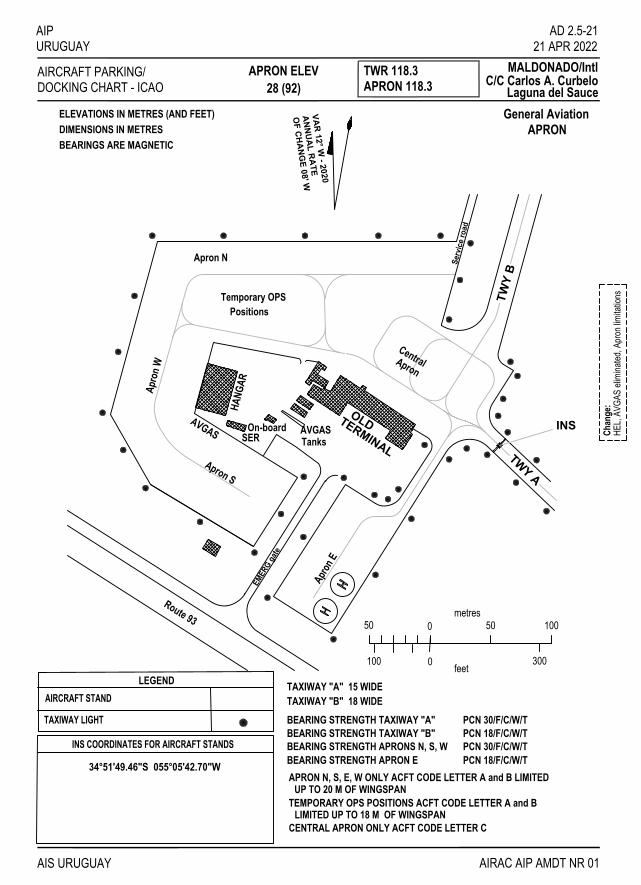
AIPURUGUAY
AIS URUGUAY
AIRCRAFT PARKING/DOCKING CHART - ICAO
APRON ELEV TWR 118.3APRON 118.3
MALDONADO/Intl
ELEVATIONS IN METRES (AND FEET)DIMENSIONS IN METRESBEARINGS ARE MAGNETIC
C/C Carlos A. CurbeloLaguna del Sauce
LEGENDAIRCRAFT STAND
TAXIWAY LIGHT
AD 2.5-21
General AviationAPRON
28 (92)
OF CHANG
E 08' WANNUAL RATE
TAXIWAY "B" 18 WIDEBEARING STRENGTH TAXIWAY "A" PCN 30/F/C/W/T
Serv
ice
road
TWY
B
TWY A
Route 93
TERMINALTanks
HANG
AR
CentralApron
Apron N
Temporary OPSPositions
Apro
n W
Apron S
Apron
E
AVGASOn-boardSER
AVGAS
EMER
G ga
te
INS
INS COORDINATES FOR AIRCRAFT STANDS
34°51'49.46"S 055°05'42.70"W
TAXIWAY "A" 15 WIDE
BEARING STRENGTH TAXIWAY "B" PCN 18/F/C/W/TBEARING STRENGTH APRONS N, S, W PCN 30/F/C/W/T
100 0
metres0 50
300
10050
feet
OLD
BEARING STRENGTH APRON E PCN 18/F/C/W/T
Chan
ge:
HEL,
AVGA
S eli
mina
ted, A
pron
limita
tions
21 APR 2022
VAR 12° W - 2020
AIRAC AIP AMDT NR 01
APRON N, S, E, W ONLY ACFT CODE LETTER A and B LIMITED
TEMPORARY OPS POSITIONS ACFT CODE LETTER A and B
CENTRAL APRON ONLY ACFT CODE LETTER C
UP TO 20 M OF WINGSPAN
LIMITED UP TO 18 M OF WINGSPAN

IIINNNTTTEEENNNTTTIIIOOONNNAAALLLLLLYYY LLLEEEFFFTTT BBBLLLAAANNNKKK

AIPURUGUAY
AIS URUGUAY
AERODROME OBSTACLE CHART - ICAOAD 2.5-23
21 APR 2022
AIRAC AIP AMDT NR 01
TYPE A (OPERATING LIMITATIONS)
New
cha
rtC
hang
e:
ORDER OF ACCURACYHORIZONTAL 00 MVERTICAL 00 M
MAGNETIC VARIATION 12º W JAN 2020
DIMENSIONS AND ELEVATIONS IN METRES
RWY 01 DECLARED DISTANCES
TAKE-OFF RUN AVAILABLE
RWY 01 / 19
RWY 19
TAKE-OFF DISTANCE AVAILABLE
ACCELERATE STOP DISTANCE AVAILABLE
LANDING DISTANCE AVAILABLE
16001600
16001600
16001600
16001600
IDENTIFICATION NUMBERLEGEND
1
POLE, TOWER, SPIRE, ANTENNA, ETC.BUILDING OR LARGE STRUCTURERAILROADTERRAIN CONTOURTERRAIN PENETRATING OBSTACLE PLANE
TREE OR SHRUBHIGHWAY
0
30
60
90
120
150
1596 2432 2732 3032 3332 3632 3932 4232 4532 4832 5132 5432 5732 6032 6332 6632 6932 7232
SLOPE 1.2%
2132 3800 4100 4400 4700 5000 5300 5600 5900 6200 6500 6800 7100 7400 7700 8000 8300
30
60
90
120
150
SLOPE 1.2%
100
75
50
25
0
300250200150100 50 0
0 500 1000 1500 2000 2500 3000
0 1000 2000 3000 4000 5000 6000 7000 8000 9000 10000 1000
200 400
0
180 180
210 210
01
1 600 m x 38 m ASPHALTIC CARPET
STRIP 1 720 m x 280 m359º 179º
SAUCE LAGOONATLANTIC OCEAN
EL P
OTRE
RO 69.8m
32 m
METRESFEET
VERTICALSCALE1:2 000
STREAM
00 1596
29
23
HORIZONTAL SCALE 1:20 000
1
METRES
FEET
19
MALDONADO/Intl C/C Carlos A. Curbelo - Laguna del SauceMALDONADO/Intl C/C Carlos A. Curbelo - Laguna del Sauce
1

IIINNNTTTEEENNNTTTIIIOOONNNAAALLLLLLYYY LLLEEEFFFTTT BBBLLLAAANNNKKK

AIPURUGUAY
AIS URUGUAY
AERODROME OBSTACLE CHART - ICAO TYPE A (OPERATING LIMITATIONS)
ORDER OF ACCURACYHORIZONTAL 00 MVERTICAL 00 M
MAGNETIC VARIATION 12º W JAN 2020
DIMENSIONS AND ELEVATIONS IN METRES
DECLARED DISTANCES
TAKE-OFF RUN AVAILABLE
TAKE-OFF DISTANCE AVAILABLE
ACCELERATE STOP DISTANCE AVAILABLE
LANDING DISTANCE AVAILABLE
IDENTIFICATION NUMBERLEGEND
1
POLE, TOWER, SPIRE, ANTENNA, ETC.BUILDING OR LARGE STRUCTURERAILROADTERRAIN CONTOURTERRAIN PENETRATING OBSTACLE PLANE
TREE OR SHRUBHIGHWAY
MALDONADO/Intl C/C Carlos A. Curbelo - Laguna del SauceMALDONADO/Intl C/C Carlos A. Curbelo - Laguna del Sauce
HORIZONTAL SCALE 1:20 000
RWY 08
RWY 08 / 26
RWY 2621332133
21332133
21332133
21332133
0
30
60
90
120
150
2432 2732 3032 3332 3632 3932 4232 4532 4832 5132 5432 5732 6032 6332 6632 6932 7232
SLOPE 1.2%
2432 2732 3032 3332 3632 3932 4232 4532 4832 5132 5432 5732 6032 6332 6632 6932 7232
30
60
90
120
150
SLOPE 1.2%
100
75
50
25
0
300250200150100 50 0
0 500 1000 1500 2000 2500 3000
0 1000 2000 3000 4000 5000 6000 7000 8000 9000 10000 5001000
200400
08
0
2 133 m x 45 m ASPHALTIC CARPET
STRIP 2 253 m x 280 m
7532 7832 8132 8432 8732
180 160
210 190
0
30
60
90
0
30
60
90
7532 7832 8132 8432 8732
26
1
90
148.2
METRESFEET
VERTICALSCALE1:2 000
METRES
FEET
1
100
100110
120
110120
130140150
90100
110120130
174.41 39
2 42
123
4
3444
45
5
553
654.5
965
1066
7 59
863.3
67
89
10
4950
2132
073º 253º
00 2132
AD 2.5-2521 APR 2022
AIRAC AIP AMDT NR 01
New
cha
rtC
hang
e:

IIINNNTTTEEENNNTTTIIIOOONNNAAALLLLLLYYY LLLEEEFFFTTT BBBLLLAAANNNKKK

AIPURUGUAY
AIS URUGUAY
ACC 128.5 - 126.3APP 119.2 - 120.2
VAR 10°11'W
MSA 25 NMfrom LDS VOR/DME
2800 FT
2000 FT
3000 FT TWR 118.3 - 122.1900 M RWY 08LUCIO1D
AD 2.5-2721 APR 2022
AIRAC AIP AMDT NR 01
ZOM
5 by S
U R5
Chan
ge:
MALDONADO/IntlC/C Carlos A. CurbeloLaguna del Sauce
270°
090°
P. del ESTE/Dptal.
SU P2ALT 600 M
MSL
SU P15GND
ALT 600 M
SU P21
GNDALT 600 M
ZOM 5FL 070GND
SU D8
GNDUNL
GND-MSLALT 600 M
SU P27
SU P33ALT 600 M
GND
0
0123
12345 5 10 15 20
5 10
055°20'38.29"W35°02'13.46"S
VOLCA
055°05'37.02"W34°54'51.89"S
OSUKI
055°01'09.49"W34°52'27.75"S
PUNKI
055°01'55.24"W34°50'20.15"S
LIVUR
055°52'18"W35°03'18"S
LUCIO
kilometres
nautical miles
55°00'
55°00'
35°00'
35°00'
26 279ºLUCIO1D
03
03
41
01
FL 080 FL 060 14.3
251º
LUCIO1D
3000 FT
247º
2000 FT
1500 FT
3082º 2.2
174º
4.4
2 6RWY 08/26
NO TO SCALE
082º 3174º
247º
2.2
4.4
LIVUR
PUNKI
OSUKI
LUCIO 1D: Climb heading 082º to LIVUR at or
turn right heading 174º to PUNKI
turn right heading 247º to OSUKI
turn right heading 251º to VOLCA
turn right heading 279º to LUCIO
above 1500 FT,
at or above 2000 FT,
at or above 3000 FT,
at or above FL 060,
at or above FL 080,according to ATC AUTH.Minimun climb gradient: 500 FT/NMup to LIVUR.
REMARKS:1) RNAV1 or RNP1 aproved required.2) GNSS required
STANDARDDEPARTURE CHARTINSTRUMENT (SID) - ICAO
TRANSITIONALTITUDE
ALTITUDES AND ELEVATIONS ARE IN FEETDISTANCES IN NAUTICAL MILES
BEARINGS, TRACKS AND RADIALS ARE MAGNETIC

IIINNNTTTEEENNNTTTIIIOOONNNAAALLLLLLYYY LLLEEEFFFTTT BBBLLLAAANNNKKK

AIPURUGUAY
AIS URUGUAY
ACC 128.5 - 126.3APP 119.2 - 120.23000 FT TWR 118.3 - 122.1900 M
0
0123
12345 5 10 15 20
5 10
kilometres
nautical miles
RWY 08DORVO8A
AD 2.5-2921 APR 2022
AIRAC AIP AMDT NR 01
ZOM
5 by S
U R
5Ch
ange
:
MALDONADO/IntlC/C Carlos A. CurbeloLaguna del Sauce
ASI NDB
ADAMINDB 395ASI
34°47'22.3"S056°15'46.9"W
KUDOG
057°02'40"W34°44'38"S
DORVO
057°31'02"W34°42'58"S
SU P9 ALT 600 MMSL
SU P15
GNDALT 600 M
ZOM 5
FL 050GND
ZOM 5FL 070GND
SU P37ALT 600 M
GND
055°20'38.29"W34°55'12.78"S
ALBUM
REMUV
055°55'35"W34°56'32"S
DORVO8A28.8098°
DORVO8A23.5104° DORVO8A
38.5104° 19130°
REMUV
284º
104ºFL 070
FL 070FL 070FL 070 FL 245
NOT TO SCALE
FL 070
3000 FT
FL 070
MSA 25 NMfrom LDS VOR/DME
2800 FT
2000 FT
270°
090°
VAR 10°11'W
DORVO8A: From DORVO heading 104º to KUDOG at or above FL 070 and at or below FL 245,
at or above FL 070,heading 104º to "ASI" NDB
turn left heading 098º to ALBUMat or above FL 070,turn right heading 130º to REMUV
at 3000 FT or to IAC VOR/DME RWY 08 IAF, or according to ATC AUTH.
03
01
35°00'
55°00'
55°00'
35°00'
REMARKS:1) RNAV1 or RNP1 aproved required.2) GNSS required
5 NM
STANDARDARRIVAL CHARTINSTRUMENT (STAR) - ICAO
TRANSITIONALTITUDE
ALTITUDES AND ELEVATIONS ARE IN FEETDISTANCES IN NAUTICAL MILES
BEARINGS, TRACKS AND RADIALS ARE MAGNETIC
MAX IAS 220 KT
Maximum indicated airspeed inALBUM: 220 KT.

IIINNNTTTEEENNNTTTIIIOOONNNAAALLLLLLYYY LLLEEEFFFTTT BBBLLLAAANNNKKK

SAN CARLOS
MALDONADO
PUNTA delESTE
PIRIAPOLIS
PAN deAZUCAR
1749
522339492492
339
633
590
925211
690
AIPURUGUAY
AIS URUGUAY
INSTRUMENTAPPROACH TWR 118.3 - 122.1
MALDONADO/IntlAERODROME ELEVHEIGHTS RELATED TOCHART - ICAO
95 FT
OCA/H
C/C Carlos A. CurbeloLaguna del SauceATIS 117.6
THR RWY 26 - ELEV 69 FT
AD 2.5-3121 APR 2022
VOR/DMERWY 26
LDS
(2531)2600
238°- 058°
RDL 250
1 MIN
ELEV 69
VOR/DME
(THR RWY 26) 10A B
5 0
CirclingVIS
VIS500(431)
1500 M - 1600 M ALS INOP
DME VOR LDS
AIRAC AIP AMDT NR 01
620689
Feet/Min
302371
1 2
100
8819503
KT
430
80
530
1700
RDL 0703 DME
MAPt
(431)500 (881)
950
NM to VOR/DME LDS
(1631)
(521)5.2%
590
6 DME
at 950 FT at 3 NM DME.Matching PAPIS
A,B RDL 058FAF
- COPTER-
1.3
SU P 2
SU P 21ALT 600 M
GND
ALT 600 MMSL
5 10
CURBELO
LDSVOR/DME 117.6
34°51'29.9"S055°05'30.2"W
RDL 250
1 MIN238°
180°
360°RDL 180
1 MIN
6 DME
RDL 070A,B RDL 058
3 DME
FAF
VOR/DME
270°090°
2800'
2000'
MSA LDS VOR/DME
VAR 8°33'W 1997
10 NM
10 NM
2 1 0 1 2 3 4 5 6 7 8
01 1 2 3 4
km
NM
SCALE 1:350 000
ALT, ELEV AND
DIMENSIONS IN NAUTICAL
BRG ARE MAG
HEIGHTS IN FEET
MILES
Page
NR
Chan
ge:
TRANSITION ALT 3000
Straight-inApproach
3000 FT to intercept RDL 180turn left ascending up toto 10 NM LDS VOR/DME, Direct climb up to 2000 FT
MISSEDAPPROACH
HEIGHTALTITUDE
of descent 5,2%Rate
holding pattern.outside 10 DME in rightLDS VOR/DME, and wait
SU P33ALT 600 M
GND
1506(1437)
(458)527 340
(269)338 (271)
(433)
(138)
333(264)
502
207
(325)394
660(591)
RIO DE LA PLATA
OCÉANO ATLÁNTICO
55°00'55°20' 54°50'55°10'
55°00'55°20' 54°50'55°10'
34°
35°
50'
00'
34°40'
34°
35°
50'
00'
34°40'
9
18
27
0
058°

IIINNNTTTEEENNNTTTIIIOOONNNAAALLLLLLYYY LLLEEEFFFTTT BBBLLLAAANNNKKK

SAN CARLOS
MALDONADO
PUNTA delESTE
PIRIAPOLIS
PAN deAZUCAR
1749
522339492492
339
633
590
925211
690
AIPURUGUAY
AIS URUGUAY
INSTRUMENTAPPROACH TWR 118.3 - 122.1
MALDONADO/IntlAERODROME ELEVHEIGHTS RELATED TOCHART - ICAO
95 FT
OCA/H
C/C Carlos A. CurbeloLaguna del SauceATIS 117.6
SU P 2
SU P 21ALT 600 M
GND
ALT 600 MMSL
500(408)
of descent 5,2%Rate
HEIGHTALTITUDENM RWY 08
THR RWY 08 - ELEV 92 FT
Circling
ELEV 92(THR RWY 08)
GPS
VIS
VIS
(598)690
(658)
1200 M 1600 M ALS INOP500(408)
1600 M(508)600
10A
1600 M750
B
(808)3500 M
900
C5
4500 M
D
5.2%NM to THR RWY 08
140
700MinFeet/
780688
0
1.12500
408
2
500
10081100
3
13281420
4
KT5
400
80 120
600
100
082°- 262°
AIRAC AIP AMDT NR 01
180160
800
10
900 1000
200
AD 2.5-3321 APR 2022
RNAV (GNSS)RWY 08
590(498)
082°
082°
3000(2908)
(1408)1500
MAPTTHRRWY 08
4.315001408
ANDIB - RWY 08 (4.3 NM) Min:Sec 3:13 3:00 2:09 1:50 1:35 1:26 1:17
Clircling authorized only for RWY 01
ALBUM
ANDIB
12 NM
4.3 NM
(IAF)
2 1 0 1 2 3 4 5 6 7 8
01 1 2 3 4
km
NM
SCALE 1:350 000
270°090°
2800'
2000'ALT, ELEV AND
DIMENSIONS IN NAUTICAL
BRG ARE MAG
HEIGHTS IN FEET
MILES
082°
262°
082°
7.7 NM082°
4.3 NM
10 NMLOBIX34°48'33.51"S
054°55'09.05"W
MSA THR RWY 08
34°51'35.59"S055°06'43.68"W
THR RWY 08
055°11'42.61"W
ANDIB34°52'53.60"S
055°20'38.29"W
ALBUM34°55'12.78"S
VAR 9°42'W 2005
(IAF)
082°
262°
Chan
ge:
Page
NR
Straight-inApproach
TRANSITION ALT 3000
holding patternand wait in right082° up to 3000 FTClimb heading
MISSEDAPPROACH
over LOBIX
SU P33ALT 600 M
GND
1506(1414)
(435)527
340
(246)338 (248)
(410)
(115)
333(241)
502
207
(302)394
660(568)
RIO DE LA PLATA
OCÉANO ATLÁNTICO
55°00'55°20' 54°50'55°10'
55°00'55°20' 54°50'55°10'
34°
35°
50'
00'
34°40'
34°
35°
50'
00'
34°40'

IIINNNTTTEEENNNTTTIIIOOONNNAAALLLLLLYYY LLLEEEFFFTTT BBBLLLAAANNNKKK

SAN CARLOS
MALDONADO
PUNTA delESTE
PIRIAPOLIS
PAN deAZUCAR
1749
522339492492
339
633
590
925211
690
AIPURUGUAY
AIS URUGUAY
INSTRUMENTAPPROACH TWR 118.3 - 122.1
MALDONADO/IntlAERODROME ELEVHEIGHTS RELATED TOCHART - ICAO
95 FT
OCA/H
C/C Carlos A. CurbeloLaguna del SauceATIS 117.6
500(431)
of descent 5,2%Rate
HEIGHTALTITUDENM RWY 26
THR RWY 26 - ELEV 69 FT
ELEV 69(THR RWY 26)
GPS
VIS
VIS
(621)690
(655)
1200 M - 1500 M ALS INOP500(431)
1900 M(505)600
10A
2800 M750
B
(905)3700 M
1000
C5
4600 M
D
5.2%
NM to THR RWY 26
140
700MinPies/
760691
0
1.18500431
2
500
8519202.5
13311400
4
KT5
400
80 120
600
100
262°- 082°
AIRAC AIP AMDT NR 01
180160
800
10
900 1000
200
AD 2.5-3521 APR 2022
RNAV (GNSS)RWY 26
590(521)
262°
262°
MAPT
THRRWY 26
517201651
PANUR - RWY 26 (5 NM) Min:Seg 3:13 3:00 2:09 1:50 1:35 1:26 1:17
ALBUM
5 NM
SU P 2
SU P 21
VDP
2.5 NM 8.85 NM
to
5.2%920
(851) 1720(1651)
2940(2871)KOVIT
PANUR
LOBIX
1.18 NM 500 FT
19612030
6
22812350
7
26012670
8
287129408.85
ALT 600 MGND
ALT 600 MMSL
Circling
MSA THR RWY 26
34°51'14.69"S055°05'23.69"W
THR RWY 26
VAR 10°W 2009
2 1 0 1 2 3 4 5 6 7 8
01 1 2 3 4
km
NM
SCALE 1:350 000
ALT, ELEV AND
DIMENSIONS IN NAUTICAL
BRG ARE MAG
HEIGHTS IN FEET
MILES
KOVIT34°50'29.26"S
055°02'29.97"W
PANUR34°49'43.77"S
054°59'36.30"WLOBIX34°48'33.51"S
054°55'09.05"W
ALBUM34°55'12.78"S
055°20'38.29"W
2.5 NM 2.5 NM3.85 NM
082°
262°262°
082°
262°
262°
Chan
ge:
Page
NR.
270°090°
2800'
2000'
Straight-inApproach
TRANSITION ALT 3000
and wait.direct to ALBUMClimb up to 3000 FT
MISSEDAPPROACH
SU P33ALT 600 M
GND
1506(1437)
(458)527 340
(269)338 (271)
(433)
(138)
333(264)
502
207
(325)394
660(591)
RIO DE LA PLATA
OCÉANO ATLÁNTICO
55°00'55°20' 54°50'55°10'
55°00'55°20' 54°50'55°10'
34°
35°
50'
00'
34°40'
34°
35°
50'
00'
34°40'

IIINNNTTTEEENNNTTTIIIOOONNNAAALLLLLLYYY LLLEEEFFFTTT BBBLLLAAANNNKKK

SAN CARLOS
MALDONADO
PUNTA delESTE
PIRIAPOLIS
PAN deAZUCAR
1749
522339492492
339
633
590
925211
690
AIPURUGUAY
AD 2.5-3721 APR 2022
AIS URUGUAY AIRAC AIP AMDT NR 01
INSTRUMENTAPPROACH TWR 118.3 - 122.1
MALDONADO/IntlAERODROME ELEVHEIGHTS RELATED TOCHART - ICAO
95 FT
OCA/HNDBVIS
A B
185°- 005°1 MINA,B 185°
350° 2 MIN 30 SEG1700(1605)
3000(2905)
500(405)
350°
LS
0510 5 10ELEV 95
(THR RWY 01) NM to NDB LS
500(405)2300 M - 2400 M ALS INOP
NDBNDBRWY 01AL THR RWY 01 - ELEV 95 FT
C/C Carlos A. CurbeloLaguna del Sauce
C,D 192°
C D
ATIS 117.6
SU P 2
SU P 21ALT 600 M
GND
ALT 600 MMSL
NDB
350°
A,B 185°C,
D 19
2°185°
005°350°
1 MIN
2 MIN 30 SEG
MSA LS NDB
VAR 8°33'W 1997
10 NM
10 NM
2 1 0 1 2 3 4 5 6 7 8
01 1 2 3 4
km
NM
SCALE 1:350 000
ALT, ELEV AND
DIMENSIONS IN NAUTICAL
BRG ARE MAG
HEIGHTS IN FEET
MILES
Chan
ge:
Page
NR
270°090°
2800'
2000'
Straight-inApproach
TRANSITION ALT 3000
to TWR.350º and communicateLS NDB headingClimb up to 2500 over
MISSEDAPPROACH
SU P33ALT 600 M
GND
34°51'44.0"S
NDB 239CURBELO
LS
055°06'01.1"W
1506(1411)
(432)527 340
(243)338 (245)
(407)
(112)
333(238)
502
207
(299)394
660(565)
RIO DE LA PLATA
OCÉANO ATLÁNTICO
55°00'55°20' 54°50'55°10'
55°00'55°20' 54°50'55°10'
34°
35°
50'
00'
34°40'
34°
35°
50'
00'
34°40'

IIINNNTTTEEENNNTTTIIIOOONNNAAALLLLLLYYY LLLEEEFFFTTT BBBLLLAAANNNKKK

SAN CARLOS
MALDONADO
PUNTA delESTE
PIRIAPOLIS
PAN deAZUCAR
1749
522339492492
339
633
590
925211
690
AIPURUGUAY
AIS URUGUAY
INSTRUMENTAPPROACH TWR 118.3 - 122.1
MALDONADO/IntlAERODROME ELEVHEIGHTS RELATED TOCHART - ICAO
95 FT
OCA/H
C/C Carlos A. CurbeloLaguna del SauceATIS 117.6
AD 2.5-3921 APR 2022
RWY 26NDBNDBTHR RWY 26 - ELEV 69 FT
AIRAC AIP AMDT NR 01
NM to NDB LS
NDB
(THR RWY 26)
VIS 4000 M 1000 (931)
A B C D
ELEV 69
250°
1 MIN230°- 050°
(2931)3000
LS
(931)1000 250°
C,D 050°3 MIN
A,B 058°
(1631)1700
CirclingVIS
(931)1000 1000 (931) 1000 (931)4600 M4600 M4600 M4600 M
MAPt
(521)590
SU P 2
SU P 21ALT 600 M
GND
ALT 600 MMSL
0510 5 10
C,D 050°
230°
1 MIN
250°
3 MIN
A,B 058°
250°
055°06'01.1"W
CURBELONDB 239
34°51'44.0"S
050°
LS
NDB
VAR 8°33'W 1997
MSA LS NDB
10 NM
10 NM
2 1 0 1 2 3 4 5 6 7 8
01 1 2 3 4
km
NM
SCALE 1:350 000
ALT, ELEV AND
DIMENSIONS IN NAUTICAL
BRG ARE MAG
HEIGHTS IN FEET
MILES
Chan
ge:
Page
NR
270°090°
2800'
2000'
Straight-inApproach
TRANSITION ALT 3000
up to 3000 FT toturn left ascending reach 2000 FT then Climb up direct to
MISSEDAPPROACH
LS NDB.
SU P33ALT 600 M
GND
1506(1437)
(458)527 340
(269)338 (271)
(433)
(138)
333(264)
502
207
(325)394
660(591)
RIO DE LA PLATA
OCÉANO ATLÁNTICO
55°00'55°20' 54°50'55°10'
55°00'55°20' 54°50'55°10'
34°
35°
50'
00'
34°40'
34°
35°
50'
00'
34°40'

IIINNNTTTEEENNNTTTIIIOOONNNAAALLLLLLYYY LLLEEEFFFTTT BBBLLLAAANNNKKK

SAN CARLOS
MALDONADO
PUNTA delESTE
PIRIAPOLIS
PAN deAZUCAR
1749
522339492492
339
633
590
925211
690
AIPURUGUAY
AIS URUGUAY
INSTRUMENTAPPROACH TWR 118.3 - 122.1
MALDONADO/IntlAERODROME ELEVHEIGHTS RELATED TOCHART - ICAO
95 FT
OCA/H
C/C Carlos A. CurbeloLaguna del Sauce
ELEV 95(THR RWY 01)
1700(1605)
NM to VOR/DME LDS
LDS 210°- 030°1 MIN 3000
(2905)
RDL 015
A,B 210°
C,D 217°
2 MIN 30 SEG
490(395)
015°
VORRWY 01THR RWY 01 - ELEV 95 FT
VORVIS 1200 M - 1500 M ALS INOP
490(395)A B C D
AIRAC AIP AMDT NR 01
AD 2.5-4121 APR 2022
1500 M
ATIS 117.6
SU P 2
SU P 21ALT 600 M
GND
ALT 600 MMSL
0510 5 10
VOR/DME
015°
2 MIN
30 SE
G055°05'30.2"W34°51'29.9"S
VOR/DME 117.6CURBELO
LDS
030°21
0°RD
L 015
C,D 21
7°A,
B 21
0°
1 MIN
VAR 8°33'W 1997
MSA LDS VOR/DME
10 NM
10 NM
2 1 0 1 2 3 4 5 6 7 8
01 1 2 3 4
km
NM
SCALE 1:350 000
ALT, ELEV AND
DIMENSIONS IN NAUTICAL
BRG ARE MAG
HEIGHTS IN FEET
MILES
Chan
ge:
Page
NR
270°090°
2800'
2000'
Straight-inApproach
TRANSITION ALT 3000
to TWR, then headask for directivesover RDL 015, Climb up to 2500
MISSEDAPPROACH
to LDS VOR/DME.
SU P33ALT 600 M
GND
1506(1411)
(432)527 340
(243)338 (245)
(407)
(112)
333(238)
502
207
(299)394
660(565)
RIO DE LA PLATA
OCÉANO ATLÁNTICO
55°00'55°20' 54°50'55°10'
55°00'55°20' 54°50'55°10'
34°
35°
50'
00'
34°40'
34°
35°
50'
00'
34°40'
9
18
27
0

IIINNNTTTEEENNNTTTIIIOOONNNAAALLLLLLYYY LLLEEEFFFTTT BBBLLLAAANNNKKK

SAN CARLOS
MALDONADO
PUNTA delESTE
PIRIAPOLIS
PAN deAZUCAR
1749
522339492492
339
633
590
925211
690
AIPURUGUAY
AIS URUGUAY
INSTRUMENTAPPROACH TWR 118.3 - 122.1
MALDONADO/IntlAERODROME ELEVHEIGHTS RELATED TOCHART - ICAO
95 FT
OCA/H
C/C Carlos A. CurbeloLaguna del Sauce
VOR/DMERWY 01THR RWY 01 - ELEV 95 FT
AIRAC AIP AMDT NR 01
NM to VOR/DME LDS
VOR/DMEVIS
440(345)A B C D
(THR RWY 01)ELEV 95 440
(345)
015°
RDL 195
LDS
RDL 015
195°- 015°3000
(2905)
5%
1.5 DME
FAF5 DME
KT 80 100 120 140 160 180 200
Rate of descent 5%
Feet/Min 410 510 610 710 810 910 1010
DME VOR LDSDIST THRAltitudeHeight
5 4 3 24.73 3.73 2.73 1.7315001405
12001105
890795
590495
AD 2.5-4321 APR 2022
1500 M1200 M - 1500 M ALS INOP
240°- 060°A,B 1 MIN
C,D 1 MIN 15 SEC
1700(1605)
ATIS 117.6
SU P 2
SU P 21ALT 600 M
GND
ALT 600 MMSL
0510 5 10
1 MIN
34°51'29.9"S055°05'30.2"W
VOR/DME 117.6CURBELO
LDS
VOR/DME
195°
015°
015°
240°
060°
RDL 0
1519
5°
FAF 5 DMEA,B 1 MIN
C,D 1 MIN 15 SEC
RDL 1
95
MSA LDS VOR/DME
VAR 8°33'W 1997
10 NM
10 NM
2 1 0 1 2 3 4 5 6 7 8
01 1 2 3 4
km
NM
SCALE 1:350 000
ALT, ELEV AND
DIMENSIONS IN NAUTICAL
BRG ARE MAG
HEIGHTS IN FEET
MILES
Chan
ge:
Page
NR
270°090°
2800'
2000'
Straight-inApproach
TRANSITION ALT 3000
to TWR, then headask for directivesover RDL 015, Climb up to 2500
to LDS VOR/DME.
MISSEDAPPROACH
SU P33ALT 600 M
GND
1506(1411)
(432)527 340
(243)338 (245)
(407)
(112)
333(238)
502
207
(299)394
660(565)
RIO DE LA PLATA
OCÉANO ATLÁNTICO
55°00'55°20' 54°50'55°10'
55°00'55°20' 54°50'55°10'
34°
35°
50'
00'
34°40'
34°
35°
50'
00'
34°40'
9
18
27
0

IIINNNTTTEEENNNTTTIIIOOONNNAAALLLLLLYYY LLLEEEFFFTTT BBBLLLAAANNNKKK

SAN CARLOS
MALDONADO
PUNTA delESTE
PIRIAPOLIS
PAN deAZUCAR
1749
522339492492
339
633
590
925211
690
AIPURUGUAY
AIS URUGUAY
INSTRUMENTAPPROACH TWR 118.3 - 122.1
MALDONADO/IntlAERODROME ELEVHEIGHTS RELATED TOCHART - ICAO
95 FT
OCA/H
IAF
C/C Carlos A. CurbeloLaguna del Sauce
THR RWY 08 - ELEV 92 FT VOR/DMERWY 08
AIRAC AIP AMDT NR 01
408500
NM DME LDS
AltitudeHeight
32.2
688780
Rate of descent 5,2%
Pies/Min
KT
400
100
500
80
600
120
900
180
800
160
700
140
1000
200VOR/DMEVIS
B500(408)
1200 - 1600 M ALS INOP
A C D(THR RWY 08)
ELEV 92 NM to VOR/DME LDS
3000(2908)
690(598)
1500(1408)
RDL 267(408)500
5.2% RDL 080
to267°- 087°
LDS
10 NM
5.2 NM
VIS600 (508) 750 (658) 900 (808)
1600 M 1600 M 3500 M 4500 M
4
11001008
5
14201328
AD 2.5-4521 APR 2022
ATIS 117.6
FAF LOBIXMAPt
590(498)
Clircling authorized only for RWY 01
FAF - RWY 08 (4.3 NM) 3:13Min : Seg 3:00 2:09 1:50 1:35 1:26 1:17
5.2
15001408
IAF
SU P 2
SU P 21ALT 600 M
GND
ALT 600 MMSL
0510 5 10
Circling
055°05'30.2"W34°51'29.9"S
VOR/DME 117.6LDS
CURBELO
VOR/DME
087°
267°
RDL 0805.2 DMEFAF
MSA LDS VOR/DME
VAR 9°24'W 2005
10 DME
9 DMELOBIX
RDL 267
080°
260°
10 NM
10 NM
2 1 0 1 2 3 4 5 6 7 8
01 1 2 3 4
km
NM
SCALE 1:350 000
ALT, ELEV AND
DIMENSIONS IN NAUTICAL
BRG ARE MAG
HEIGHTS IN FEET
MILES
Chan
ge:
Page
NR
270°090°
2800'
2000'
Straight-inApproach
TRANSITION ALT 3000
and wait in right9 NM LDS (LOBIX)over RDL 080 toClimb up to 3000 FT
holding pattern
MISSEDAPPROACH
SU P33ALT 600 M
GND
1506(1414)
(435)527
340
(246)338 (248)
(410)
(115)
333(241)
502
207
(302)394
660(568)
RIO DE LA PLATA
OCÉANO ATLÁNTICO
55°00'55°20' 54°50'55°10'
55°00'55°20' 54°50'55°10'
34°
35°
50'
00'
34°40'
34°
35°
50'
00'
34°40'
9
18
27
0

IIINNNTTTEEENNNTTTIIIOOONNNAAALLLLLLYYY LLLEEEFFFTTT BBBLLLAAANNNKKK
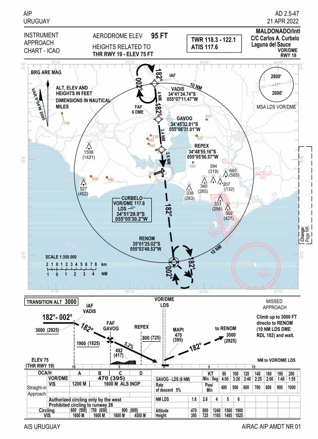
SAN CARLOS
MALDONADO
PUNTA delESTE
PIRIAPOLIS
PAN deAZUCAR
1749
522339492492
339
633
590
925211
690
AIPURUGUAY
AIS URUGUAY
INSTRUMENTAPPROACH TWR 118.3 - 122.1
MALDONADO/IntlAERODROME ELEVHEIGHTS RELATED TOCHART - ICAO
95 FT
OCA/H
C/C Carlos A. CurbeloLaguna del Sauce
RWY 19VOR/DMETHR RWY 19 - ELEV 75 FT
ELEV 75(THR RWY 19)
VOR/DMEVIS 1200 M 1600 M ALS INOP
470 (395)BA
HeightAltitude
NM LDS
725800
2.61.6
395470
of descent 5%Rate 700
140
MinPies/
KT
400
80
600
120
500
100
900
180
800
160
1000
200
NM to VOR/DME LDS10 5
800 (725)5.2%
0
182°
182°- 002°LDS
(2925)3000
AIRAC AIP AMDT NR 01
10
AD 2.5-4721 APR 2022
FAF
ATIS 117.6
GAVOG
SU P 2
SU P 21
to RENOM
5
REPEX470
(395)
MAPt
492(417)
(1825)1900
IAFVADIS
C D
VIS
Authorized circling only by the westProhibited circling to runway 26
600 (508) 750 (658) 900 (808)1600 M 1600 M 1600 M 4500 M
GAVOG - LDS (6 NM) 4:00Min : Seg 3:20 2:40 2:25 2:00 1:40 1:55
14851560
54
11651240
18251900
6
(2925)3000
ALT 600 MGND
ALT 600 MMSL
Circling
VOR/DME
182°
10 NM
10 NM
182°182°FAF
6 DME
182°002°182°002°
055°05'56.57"W34°48'55.16"S
35°01'25.02"S055°03'48.53"W
RENOM
055°07'11.47"W34°41'34.74"S
VADIS
REPEX
IAF
2 1 0 1 2 3 4 5 6 7 8
01 1 2 3 4
km
NM
SCALE 1:350 000
MSA LDS VOR/DME
ALT, ELEV AND
DIMENSIONS IN NAUTICAL
BRG ARE MAG
HEIGHTS IN FEET
MILES
VAR 9°04'W 2005
4 NM3.4 NM
Chan
ge:
Page
NR.
270°090°
2800'
2000'
Straight-inApproach
TRANSITION ALT 3000
RDL 182) and wait.(10 NM LDS DMEdirecto to RENOMClimb up to 3000 FT
MISSEDAPPROACH
SU P33ALT 600 M
GND
055°06'31.01"W34°45'32.81"S
GAVOG
CURBELOVOR/DME 117.6
055°05'30.2"W34°51'29.9"SLDS
1506(1431)
(452)527 340
(263)338 (265)
(427)
(132)
333(258)
502
207
(319)394
660(585)
RIO DE LA PLATA
OCÉANO ATLÁNTICO
55°00'55°20' 54°50'55°10'
55°00'55°20' 54°50'55°10'
34°
35°
50'
00'
34°40'
34°
35°
50'
00'
34°40'
9
18
27
0
2.6 NM

IIINNNTTTEEENNNTTTIIIOOONNNAAALLLLLLYYY LLLEEEFFFTTT BBBLLLAAANNNKKK

SAN CARLOS
MALDONADO
PUNTA delESTE
PIRIAPOLIS
PAN deAZUCAR
1749
522339492492
339
633
590
925211
690
AIPURUGUAY
AIS URUGUAY
INSTRUMENTAPPROACH TWR 118.3 - 122.1
MALDONADO/IntlAERODROME ELEVHEIGHTS RELATED TOCHART - ICAO
95 FT
OCA/H
C/C Carlos A. CurbeloLaguna del Sauce
RWY 26VOR/DMETHR RWY 26 - ELEV 69 FT
AIRAC AIP AMDT NR 01
ELEV 69(THR RWY 26)
RDL 250
1 MIN230°- 050°
3000(2931)
LDSA,B RDL 058C,D RDL 050
500(431)
5.2% RDL 0703 DME(2531)2600
FAF8 DME
NM to VOR/DME LDS(495)590
VOR/DMEVIS 1500 M - 1600 M ALS INOP
500(431)A B
2000 M
C D
VIS(571)
1900 M(451)520
2800 M640
3700 M(911)980
4600 M
140KT 80 120100 180160 200
750MinFeet/ 430 640530 950850 1060Rate
of descent 5,2%
HEIGHTALTITUDEDME VOR LDS
68921
3713 4
950 1326
AD 2.5-4921 APR 2022
MAPt950
(881)
5 6 7 81645 1963 2282 2600
25312213189415761257881620302
ATIS 117.6
1.3
SU P 2
SU P 21ALT 600 M
GND
ALT 600 MMSL
10 5 0 105
Circling
3 DME
A,B RDL 058
C,D RDL 050
RDL 250
230°
1 MIN
050°
RDL 070RDL 180
360°1 MIN
180°
055°05'30.2"W34°51'29.9"S
VOR/DME 117.6LDS
CURBELO
VOR/DME
FAF8 DME
MSA LDS VOR/DME
VAR 8°33'W 1997
10 NM
10 NM
2 1 0 1 2 3 4 5 6 7 8
01 1 2 3 4
km
NM
SCALE 1:350 000
ALT, ELEV AND
DIMENSIONS IN NAUTICAL
BRG ARE MAG
HEIGHTS IN FEET
MILES
Chan
ge:
Page
NR
270°090°
2800'
2000'
Straight-inApproach
TRANSITION ALT 3000at 950 FT at 3 NM DME.Matching PAPIMISSED
APPROACH
3000 FT to intercept RDL 180turn left ascending up toto 10 NM LDS VOR/DME, Direct climb up to 2000 FT
holding pattern.outside 10 DME in rightLDS VOR/DME, and wait
SU P33ALT 600 M
GND
1506(1437)
(458)527 340
(269)338 (271)
(433)
(138)
333(264)
502
207
(325)394
660(591)
RIO DE LA PLATA
OCÉANO ATLÁNTICO
55°00'55°20' 54°50'55°10'
55°00'55°20' 54°50'55°10'
34°
35°
50'
00'
34°40'
34°
35°
50'
00'
34°40'
9
18
27
0

IIINNNTTTEEENNNTTTIIIOOONNNAAALLLLLLYYY LLLEEEFFFTTT BBBLLLAAANNNKKK
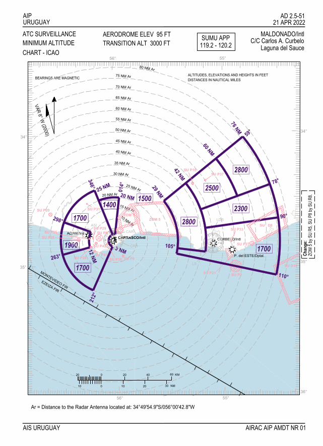
AIPURUGUAY
AIS URUGUAY
ATC SURVEILLANCE
VAR 8° W (2000)
ALTITUDES, ELEVATIONS AND HEIGHTS IN FEETDISTANCES IN NAUTICAL MILESBEARINGS ARE MAGNETIC
21 APR 2022AD 2.5-51
AIRAC AIP AMDT NR 01
Ar = Distance to the Radar Antenna located at: 34°49'54.9"S/056°00'42.8"W
MINIMUM ALTITUDEAERODROME ELEV 95 FTTRANSITION ALT 3000 FT
MALDONADO/IntlC/C Carlos A. Curbelo
Laguna del SauceSUMU APP
119.2 - 120.2
20 NM Ar25 NM
298° 1700
MONTEVIDEO FIR
35°
EZEIZA FIR
0
020
10 10
20
1900ADAMI/Intl
263°
1700
12 NM
212°
ASI
34°
346°
10 NM Ar 2800
P. del ESTE/Dptal.
CURBELO/Intl
NM
60
56°
20
40
30
KM
55°
105°CARRASCO/Intl
CAR
CRR3 NM
9
27
18
0
27
LS
LDS
18
9
0
36°
35°
1700
76 NM
2800
2300
42 NM
55 NM Ar
25 NM Ar
150015 NM Ar
30 NM Ar
35 NM Ar
40 NM Ar
45 NM Ar
50 NM Ar
29 NM
75 NM Ar
60 NM Ar
65 NM Ar
70 NM Ar
80 NM Ar
60 NM
2500
56° 55°
34°
78°
59°
20 NM1400
014°
Chan
ge:
ZOM
5 by S
U R5
, SU
P8 by
SU
R8.
CHART - ICAO
SU P20
ZOM 5
SU P2SU P21
SU D8
SU D16
SU P15
ZOM 5
SU P27
SU P31
SU P33
SU P37
SU P26 SU P9
SU P8SU P25SU P28
SU P29
SU P30SU P41
SU P42
110°
90°

IIINNNTTTEEENNNTTTIIIOOONNNAAALLLLLLYYY LLLEEEFFFTTT BBBLLLAAANNNKKK

RIO DE LA PLATA
RIO DE LA PLATA
Toledo
Montevideo
La Paz
SU P28ALT 600 M
GND
SU P30ALT 600 M
GND
SU P29ALT 600 M
GND
SU P25ALT 600 M
GND
SU P42450 MGND
SU P41450 M
GND-MSLSU P26
ALT 600 MGND-MSL
SU P81000 FT
GND
AIPURUGUAY
AD 2.8-1721 APR 2022
AIS URUGUAY AIRAC AIP AMDT NR 01
INSTRUMENTAPPROACH TWR 118.4 - 122.1
MONTEVIDEO/IntlAERODROME ELEVHEIGHTS RELATED TOCHART - ICAO
174 FT
OCA/HNDBVIS
A B
ASINDB
0510 5 10NM al NDB ASI
345°
180°
345°- 165°
180°3 MIN
1 MIN
1500(1349)
3000(2849)
600(449)
ELEV 151(THR RWY 19)
600(449)1600 M
34°
56°10' 56°00'
40'
34°50'
34°40'
34°50'
56°20'56°30'
56°00'56°10'56°20'56°30'
Angel S. Adami
C
2000 M
CirclingVIS
660 (509)1600 m
(649)800 (869)10204500 m
THR RWY 19 - ELEV 151 FTNDB
RWY 19
D
3500 m
MAPT
(149)300
VAR 8°00'W 2000
ALT, ELEV AND
DIMENSIONS IN NAUTICAL MILES
10 NM
2 1 0 1 2 3 4 5 6 7 8
01 1 2 3 4
km
NM
SCALE 1:350 00010 NM
1 MIN
HEIGHTS IN FEET
180°345°
165°
345°180°
3 MIN
(489)640
640(489)
855(704)
603(452)
379(228) 414
(263)
500(349)
(611)762
(119)270
396(245)
328(177)
335(174)
(39)190
(219)370
(230)381
(413)564
(532)683(495)
600
(454)605
300(149)
(458)609(387)
538
MSA THR RWY 19
1900'
Straight-inApproach
TRANSITION ALT 3000
ASI NDB and ask for2000 FT, turn right toheading 180º up toClimb up over ASI NDB
MISSEDAPPROACH
directives to TWR.
SU P
8 by S
U R8
Chan
ge:
ADAMINDB 395ASI
34°47'22.3"S056°15'46.9"W
BRG ARE MAG

IIINNNTTTEEENNNTTTIIIOOONNNAAALLLLLLYYY LLLEEEFFFTTT BBBLLLAAANNNKKK

RIO DE LA PLATA
RIO DE LA PLATA
Toledo
Montevideo
La Paz
SU P28ALT 600 M
GND
SU P30ALT 600 M
GND
SU P29ALT 600 M
GND
SU P25ALT 600 M
GND
SU P42450 MGND
SU P41450 M
GND-MSLSU P26
ALT 600 MGND-MSL
SU P81000 FT
GND
AIPURUGUAY
AIS URUGUAY
INSTRUMENTAPPROACH TWR 118.4 - 122.1
MONTEVIDEO/IntlAERODROME ELEVHEIGHTS RELATED TOCHART - ICAO
174 FT
OCA/H
34°
56°10' 56°00'
40'
34°50'
34°40'
34°50'
56°20'56°30'
56°00'56°10'56°20'56°30'
Angel S. Adami
CirclingVIS
ALT, ELEV AND
DIMENSIONS IN NAUTICAL MILES
10 NM
2 1 0 1 2 3 4 5 6 7 8
01 1 2 3 4
km
NM
SCALE 1:350 00010 NM
HEIGHTS IN FEET
(489)640
640(489)
855(704)
603(452)
379(228) 414
(263)
500(349)
(611)762
(119)270
396(245)
328(177)
335(174)
(39)190
(219)370
(230)381
(413)564
(532)683(495)
600
(454)605
300(149)
(458)609(387)
538
AD 2.8-1921 APR 2022
AIRAC AIP AMDT NR 01
GPSVIS
A B0510 5 10
NM to THR RWY 19
185°
185°- 005°185° 1 MIN
3000(2849)550
(369)
ELEV 151(THR RWY 19)
550(399)1600 M
C
2000 M
660 (509)1600 m
(649)800 (869)10204500 m
THR RWY 19 - ELEV 151 FTRNAV (GNSS)
RWY 19
D
3500 m
(149)300
VAR 8°00'W 2000
1 MIN
005°
185°185°
NM RWY 19
HEIGHTALTITUDE
16491800
3995501
840689
2
13291480
10091160
3 4 5of descent 5,2%Rate IREDU - RWY 19 (5 NM)
MinFeet/
Min : SecKT
3:45400
803:00500
1002:08700
1402:30600
1201:48800
1601:301000
2001:36900
180
IREDU
185°185°
THR RWY 1934°47'00.18"S
056°15'55.20"W
ILMAS34°37'00.18"S056°16'37.17"W
IREDU34°42'00.18"S
056°16'16.21"W
to
1800(1649)
ILMAS
THRRWY 19
5 NM5 NM
ILMAS
(IAF)
(IAF)
MSA THR RWY 19
1900'
5 NM
10 NM
SU P
8 by S
U R8
Chan
ge:
TRANSITION ALT 3000MISSEDAPPROACH
up to 3000 FTturn right ascending185° up to 2000 FTClimb heading
to ILMAS
Straight-inApproach
BRG ARE MAG

IIINNNTTTEEENNNTTTIIIOOONNNAAALLLLLLYYY LLLEEEFFFTTT BBBLLLAAANNNKKK

AIP AD 2.9-9
URUGUAY 21 APR 2022 SUMU AD 2.9-16 HELICOPTER LANDING AREA
1 Coordinates TLOF or THR of FATO Geoid undulation
Nil
2 TLOF and/or FATO elevation M/FT Nil
3 TLOF and FATO area dimensions, surface, strength, marking
Nil
4 True BRG FATO Nil
5 Declared distance available Nil
6 APP and FATO lighting Nil
7 Remarks Remote point H. Coord: 345015.18S 0560124.14W
SUMU AD 2.9-17 ATS AIRSPACE
1 Designation and lateral limits CARRASCO TMA Straight line which join the following points (UGIMI) 345858S/0565302W up to 343300S/0563200W. 30 NM arc centred at CRR VOR/ DME up to 342000S/0560000W. Straight line up to 342127S/0550546W. 30 NM arc from LDS VOR/DME up to the following points 345200S/0542900W, straight line up to 361000S/0542900W, straight line up to the following points 345900S/0565300W. CARRASCO CTR Circumference arc, radius 15 NM centred at 344957.8S 0560130.5W clockwise from 343511S/0560444W up to 350217S/0561158W, straight line up to 345534S/0562246W, CTR arc radius 10 NM (18.5 KM) centred at ASI NDB clockwise up to 343731S/0561754W and straight up to 343511S/0560444W, excluded ZOM 5 (if it is activated).
CARRASCO ATZ
Circle, radius 8 NM centred at 344957.8S 0560130.5W, excluded ZOM 5 (if it is activated)
2 Vertical limits TMA: GND up to FL 245. CTR: SFC up to FL 035.
ATZ: SFC up to 600 M
3 Airspace classification CTR, ATZ: C. TMA: G from GND up to 600 M; C above 600 M up to FL 195; A above FL 195 up to FL 245.
4 ATS unit call sign Language(s)
Carrasco Tower Spanish, english
5 Transition altitude 900 M
6 Remarks Nil
AIS URUGUAY AIRAC AIP AMDT NR 01

AD 2.9-10 AIP
01 DEC 2018 URUGUAY
SUMU AD 2.9-18 ATS COMMUNICATION FACILITIES
Service designation Call sign Frequency
Hours of operation Remarks
1 2 3 4 5
ACC Montevideo/ Radar Control
128.5 MHZ 126.3MHZ
121.5 MHZ
H 24 H 24 H 24 H 24
Montevideo ACC accepted as secondary Air-Ground communication the telephone usage:
(598) 2604 0295 Emergency FREQ
APP/I Carrasco Radar Approach
119.2 MHZ 120.2 MHZ
H 24 H 24
TWR Carrasco Tower
118.1 MHZ 121.8 MHZ
H 24 H 24
Nil Nil
AMS/AFS Fuerza Aérea Carrasco CXJ
8315 KHZ 5610 KHZ
HJ - O/R HJ - O/R
Nil Nil
AMDT NR 56 AIS URUGUAY

AIPURUGUAY
AIS URUGUAY
STANDARDDEPARTURE CHART
TRANSITIONALTITUDE ACC 128.5 - 126.3
APP 119.2 - 120.2MONTEVIDEO/Intl
ALTITUDES AND ELEVATIONS ARE IN FEETDISTANCES IN NAUTICAL MILES
BEARINGS, TRACKS AND RADIALS ARE MAGNETIC
MSA 25 NMfrom CRR VOR/DME
2000 FT600 M
INSTRUMENT (SID) - ICAO 3000 FT TWR 118.1 - 121.8900 M
Carrasco "Gral.Cesáreo L. Berisso"
03
0
0123
12345 5 10 15 20
5 10
kilometres
nautical miles
30 M056°01'30.5"W34°49'57.8"SCRRVOR/DME 116.9
CARRASCO
RWY 06AKPOD1B, DAGUS1A, DAGUS1C, CRR1R56°00'
35°00'
56°00'
35°00'
AD 2.9-3921 APR 2022
AIRAC AIP AMDT NR 01
1 01 0
02DA
GUS1
C
056°53'02"W34°58'58"S
UGIMI
056°07'25"W35°02'17"S
DAGUS
056°15'02"W35°17'58"S
DARKAVOR 113.7
34°58'42"S057°53'48"W
PTA
LA PLATA
MONSA34°20'56"S
056°10'53"W
NIMBO34°30'49"S
Initial climb up to FL 050 except ATC authorization.
ZOM
5 by S
U R5
, SU
P8 by
SU
R8Ch
ange
:
RDL 102 PTA
38
RDL
209
DAG1
CDA
17
RDL 317
RDL 353CRR1RM
O
CRR1RNI
30
30
ZOM 5FL 050GND
ZOM 5FL 070GND
SU P9
MSLALT 600 M
SU P31ALT 600 M
GND
1000 FTGND
SU P8
SU P25
ALT 600 MGND
ALT 600 MSU P26
GND-MSL
SU P28ALT 600 M
GND
SU P29ALT 600 M
GND
SU P30ALT 600 M
GND
450 MSU P41
GND-MSL
450 MSU P42
GND
056°29'32"W
215°
CRR1R
DAG1CUG - DAGUS1A
055°58'50.27"W34°48'28.13"S
AKRUT
2 NM, 064º from DER06
055°55'36.00"W34°54'58.00"S
RELUS
168º 7DAGUS1A
12
244º
DAGUS1A
1000 FT
FL 030FL 050
FL 040FL 060
FL 060
055°37'01.16"W34°49'36.32"S
KAMAMFL 080AKPOD1B
18104º
AKPOD1B
175
047º
AKPOD
053°33'41"W32°27'57"S
FL 250
3 DME2 NM
AKRUT
CRR1R
DAGU
S1CDAGUS1A
AKPOD1B
from DER06
RWY 06/24
2 4
NOT TO SCALE
064º
055°56'36.3"W34°47'04.9"S
NDB 280CARRASCO
CA
3 DME
VAR 10°24'W
3 DME
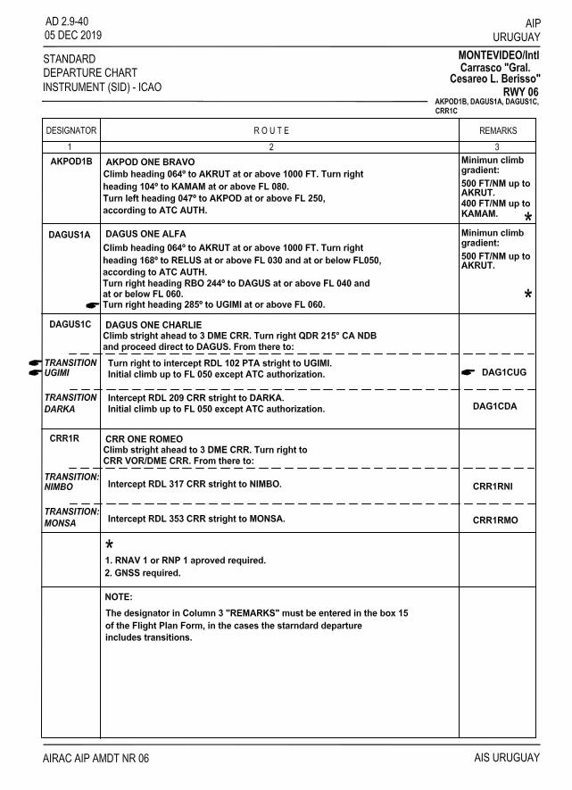

AIPURUGUAY
AIS URUGUAY
STANDARDDEPARTURE CHART
TRANSITIONALTITUDE ACC 128.5 - 126.3
APP 119.2 - 120.2MONTEVIDEO/Intl
ALTITUDES AND ELEVATIONS ARE IN FEETDISTANCES IN NAUTICAL MILES
BEARINGS, TRACKS AND RADIALS ARE MAGNETIC
MSA 25 NMfrom CRR VOR/DME
2000 FT600 M
INSTRUMENT (SID) - ICAO 3000 FT TWR 118.1 - 121.8900 M
Carrasco "Gral.Cesáreo L. Berisso"
03
0
0123
12345 5 10 15 20
5 10
kilometres
nautical miles
DAGUS1M, NIMBO1M, MONSA2MRWY 24
56°00'
35°00'
56°00'
35°00'
AD 2.9-4121 APR 2022
AIRAC AIP AMDT NR 01
1 01 0
02
MONSA2M
Initial climb up to FL 050 except ATC authorization.
056°10'53"W
MONSA34°20'56"S
056°29'32"W
NIMBO34°30'49"S
34°58'58"S056°53'02"W
UGIMI
35°02'17"S056°07'25"W
DAGUS
35°17'58"S056°15'02"W
DARKA
VOR/DME 116.9
34°49'57.8"S056°01'30.5"W
30 M
CARRASCO
CRR
1000 FT
DAGU
S1M
RDL
209
ADAMINDB 395
ASI34°47'22.3"S
056°15'46.9"W
3 DME
RDL 317
NIMBO1M
RDL 353
6 DME
7 DME
Chan
ge:
ZOM
5 by S
U R5
, SU
P8 by
SU
R8
RDL
209
RDL 102 PTA
38
17
DAG1MUG
DAG1
MDA
DARKA.TRANSITION:DARKA
Include DAG1MDA in the box 15of the Flight Plan Form.
DAGUS 1M:
Climb stright ahead to 3 DME CRR.Turn right QDM 310° ASI NDB to6 DME CRR. Turn right to keepan arc of 7 DME CRR to intercept
NIMBO 1M:
RDL 317 CRR stright to NIMBO.
Climb stright ahead to 3 DME CRR.Turn right QDM 310° ASI NDB to6 DME CRR. Turn right to keep an arc of 7 DME CRR to intercept
MONSA 2M:
RDL 353 CRR stright to MONSA.
ZOM 5FL 050GND
ZOM 5FL 070GND
SU P9
MSLALT 600 M
SU P31ALT 600 M
GND
1000 FTGND
SU P8
SU P25
ALT 600 MGND
ALT 600 MSU P26
GND-MSL
SU P28ALT 600 M
GND
SU P29ALT 600 M
GND
SU P30ALT 600 M
GND
450 MSU P41
GND-MSL
450 MSU P42
GND
Climb stright ahead up to cross 1000 FT.Turn left to interceptRDL 209 CRR direct to DAGUS.
Intercept RDL 209 CRR stright to
From there to:Turn right to intercept
RDL 102 PTA stright to UGIMI. TRANSITION:UGIMI
Include DAG1MUG in the box 15of the Flight Plan Form.
VAR 10°24'W
VOR 113.7
34°58'42"S057°53'48"W
PTA
LA PLATA

IIINNNTTTEEENNNTTTIIIOOONNNAAALLLLLLYYY LLLEEEFFFTTT BBBLLLAAANNNKKK

AIPURUGUAY
AIS URUGUAY
STANDARDARRIVAL CHART
TRANSITIONALTITUDE ACC 128.5 - 126.3
APP 119.2 - 120.2MONTEVIDEO/Intl
ALTITUDES AND ELEVATIONS ARE IN FEETDISTANCES IN NAUTICAL MILES
BEARINGS, TRACKS AND RADIALS ARE MAGNETIC
MSA 25 NMfrom CRR VOR/DME
600 M
INSTRUMENT (STAR) - ICAO 3000 FT TWR 118.1 - 121.8900 M
Carrasco "Gral.Cesáreo L. Berisso"
RWY 06
AD 2.9-4321 APR 2022
AIRAC AIP AMDT NR 01
VAR 10° 24' W
2000 FT
056°10'53"W34°20'56"S
MONSA
0
0123
12345 5 10 15 20
5 10
kilometres
nautical miles
56°00'
35°00'
56°00'
35°00'
056°17'37"W34°23'02"S
GUVIN
056°22'27"W34°25'24"S
DRACA
DAGUS055°05'30.2"W34°51'29.9"S
VOR/DME 117.6CURBELO
30 M
LDS
TELAK34°20'34"S
055°39'38"W
056°00'29"W34°19'56"S
REGOV
ADAMINDB 395ASI
34°47'22.3"S056°15'46.9"W
055°52'18"W35°03'18"S
LUCIO
TOKAM34°46'53"S
DARKA35°17'58"S
056°15'02"W
176°
187°
199° 21
5° 239°
285° RDL 262 LDS
TOKAM1C
NIMBO1C
DRACA1C
GUVIN1C
MON
SA1C
REGO
V1C
TELAK1C
LDS1CLDS1C
DARK
A1C
IAF
IAF
ALDIK34°54'41.96"S
TOKAM1A
ZOM 5FL 050GND
ZOM 5FL 070GND
SU P9
MSLALT 600 M
1000 FTGND
SU P8
SU P25ALT 600 M
GND
ALT 600 MSU P26
GND-MSL
SU P28ALT 600 M
GND
SU P29ALT 600 M
GND
SU P30ALT 600 M
GND
SU P31ALT 600 M
GND
03
1 01 0
02
450 MSU P41
GND-MSL
450 MSU P42
GND
056°42'56"W
056°17'41.23"W
34°42'02"SKOSPI
056°38'56"W
KOSPI1C
101°
116°
156°
120°
PAFIM34°49'53.82"S
056°47'41.67"W
111° 06 ALFA
NO TO SCALE
DORVO34°42'58"S
057°31'02"W
111º
PAFIM
06 ALFA
36.4 111º
291º
5 NM
FL 090
25.1
FL 090
FL 090
3000 FT
NIMBO
056°29'32"W34°30'49"S
056°07'25"W35°02'17"S
MAX IAS 220 KT
06 ALFA, DARKA1C, DRACA1C,GUVIN1C, KOSPI1C, LDS1C, MONSA1C, NIMBO1C, REGOV1C, TELAK1C, TOKAM1A, TOKAM1C
ZOM
5 by S
U R5
, SU
P8 by
SU
R8Ch
ange
:
RDL
209 C
RR

AIPURUGUAY
STANDARDARRIVAL CHARTINSTRUMENT (STAR) - ICAO
AD 2.9-4420 MAY 2021
MONTEVIDEO/IntlCarrasco "Gral.
Cesáreo L. Berisso"
AIS URUGUAYAIRAC AIP AMDT NR 01
RWY 0606 ALFA, DARKA1C, DRACA1C,
GUVIN1C, KOSPI1C, LDS1C, MONSA1C, NIMBO1C, REGOV1C, TELAK1C, TOKAM1A, TOKAM1C
DESIGNATOR R O U T E REMARKS1 2 3
From DORVO heading 111º to PAFIM at or above FL 090, heading 111º to ALDIK at or above and complete IAC RNAV (GNSS) RWY 06 or according to ATC AUTH.
06 ALFA
REMARKS:1) RNAV 1 or RNP 1 aproved required.2) GNSS required.
MAX IAS 220 KT at ALDIK.
Traffic coming from A310, UA310. In DARKA intercept RDL 209 CRRto DAGUS (IAF)
DARKA ONE CHARLIEDARKA1C
MAX IAS 250 KT at 30 DME CRR.
DRACA1CTraffic coming from W25. In DRACA QDM 176° ASI NDB (IAF)MAX IAS 250 KT at 30 DME CRR.
DRACA ONE CHARLIE
KOSPI1CTraffic coming from W29. In KOSPI QDM 116° ASI NDB (IAF)MAX IAS 250 KT at 30 DME CRR.
KOSPI ONE CHARLIE
Traffic coming from A305, UA305. In LDS intercept RDL 262 LDS to LUCIO.In LUCIO follow magnetic track 285° stright to DAGUS (IAF)
LAGUNA DEL SAUCE ONE CHARLIELDS1C
MAX IAS 250 KT at 30 DME CRR.
Traffic coming from W23. In GUVIN QDM 187° ASI NDB (IAF)MAX IAS 250 KT at 30 DME CRR.
GUVIN ONE CHARLIEGUVIN1C
MAX IAS 250 KT at 30 DME CRR.Traffic coming from W19, A556, UA556. In MONSA QDM 199° ASI NDB (IAF)MONSA ONE CHARLIEMONSA1C
NIMBO1CTraffic coming from B555, UB555. In NIMBO QDM 156° ASI NDB (IAF)MAX IAS 250 KT at 30 DME CRR.
NIMBO UNO CHARLIE
MAX IAS 250 KT at 30 DME CRR.Traffic coming from W15. In REGOV QDM 215° ASI NDB (IAF)REGOV ONE CHARLIEREGOV1C
(IAF) MAX IAS 250 KT at 30 DME CRR.Traffic coming from W18, A310, UA310, UA425. In TELAK QDM 239° ASI NDBTELAK ONE CHARLIETELAK1C
TOKAM1C TOKAM ONE CHARLIETraffic coming from A305, UA305. In TOKAM QDM 101° ASI NDB (IAF)MAX IAS 250 KT at 30 DME CRR.
Traffic coming from A305, UA305. In TOKAM QDM 120° ALDIKMAX IAS 250 KT at 30 DME CRR.
TOKAM ONE ALPHA TOKAM1A
A
ZERO SIX ALPHA

RWY 24
VAR 10° 24' W
2000 FT600 M
AD 2.9-45
0
0123
12345 5 10 15 20
5 10
kilometres
nautical miles
56°00'
35°00'
56°00'
35°00'
TOKAM34°46'53"S
056°42'56"W
34°42'02"S056°38'56"W IAF
DRACA34°25'24"S
056°22'27"W
34°23'02"S056°17'37"W
GUVIN 056°10'53"W
MONSA34°20'56"S 34°19'56"S
056°00'29"W055°39'38"W34°20'34"S
TELAK
VOR/DME 117.6
34°51'29.9"S055°05'30.2"W
30 M
LDS
CURBELORDL 281 LDS
056°15'02"W35°17'58"S
DARKA
056°07'25"W35°02'17"S
DAGUS
055°46'43"W34°50'29"S
KEVIS
056°15'46.9"W34°47'22.3"S
ASI
055°53'53"W34°39'58"S
KONBI
IAF
078°
056°29'32"W34°30'49"S
NIMBO
118° NIMBO1G
132° DRACA1G
GUVIN1G
141°
MONSA1G
154°
176°
RDL 0
40 C
RR
TELA
K1G
LDS1G
RDL
209 C
RR
DARK
A1G
DARKA1G
065°
12 DME CRR
12 DME CRR
ZOM 5FL 050GND
ZOM 5FL 070GND
SU P9
MSLALT 600 M
1000 FTGND
SU P8
SU P25ALT 600 M
GND
ALT 600 MSU P26
GND-MSLSU P28
ALT 600 MGND
SU P29ALT 600 M
GND
SU P30ALT 600 M
GND
SU P31ALT 600 M
GND
03
1 01 0
02
450 MSU P41
GND-MSL
450 MSU P42
GND
116°101°
TOKAM1G
NDB 395ADAMI
AIPURUGUAY
AIS URUGUAY
STANDARDARRIVAL CHART
TRANSITIONALTITUDE ACC 128.5 - 126.3
APP 119.2 - 120.2MONTEVIDEO/Intl
ALTITUDES AND ELEVATIONS ARE IN FEETDISTANCES IN NAUTICAL MILES
BEARINGS, TRACKS AND RADIALS ARE MAGNETIC
MSA 25 NMfrom CRR VOR/DME
INSTRUMENT (STAR) - ICAO 3000 FT TWR 118.1 - 121.8900 M
Carrasco "Gral.Cesáreo L. Berisso"
21 APR 2022
REGOV
AIRAC AIP AMDT NR 01
KOSPI1G
REGOV1G
KOSPI1G - TOKAM1GKOSPI
ZOM
5 by S
U R5
, SU
P8 by
SU
R8Ch
ange
:
DARKA1G, DRACA1G, GUVIN1G,KOSPI1G, LDS1G, MONSA1G, NIMBO1G, REGOV1G, TELAK1G, TOKAM1G

AIPURUGUAY
STANDARDARRIVAL CHARTINSTRUMENT (STAR) - ICAO
MONTEVIDEO/IntlCarrasco "Gral.
Cesáreo L. Berisso"
AIS URUGUAY
RWY 24
AIRAC AIP AMDT NR 01
AD 2.9-4620 MAY 2021
DARKA1G, DRACA1G, GUVIN1G, KOSPI1G, LDS1G, MONSA1G, NIMBO1G, REGOV1G, TELAK1G, TOKAM1G
DESIGNATOR
1
R O U T E
2
REMARKS
3
Traffic coming from A310, UA310. In DARKA intercept RDL 209 CRR
MAX IAS 250 KT at 30 DME CRR.to DAGUS. In DAGUS follow magnetic track 065° to KEVIS (IAF).
DARKA ONE GOLFDARKA1G
Traffic coming from W25. In DRACA follow magnetic track 132ºto KONBI (IAF).
DRACA ONE GOLFDRACA1G
MAX IAS 250 KT at 30 DME CRR.
Traffic coming from W29. In KOSPI QDM 116° ASI NDBKOSPI ONE GOLFKOSPI1G
MAX IAS 250 KT at 30 DME CRR.In ASI QDR 078° ASI NDB to KONBI (IAF).
Traffic coming from A305, UA305. In LDS intercept RDL 281 LDS
MAX IAS 250 KT at 30 DME CRR.to KEVIS (IAF).
LAGUNA DEL SAUCE ONE GOLFLDS1G
Traffic coming from W23. In GUVIN follow magnetic track 141º toGUVIN ONE GOLF
Traffic coming from W19, A556, UA556. In MONSA follow magnetic MONSA ONE GOLF
GUVIN1G
MONSA1G
MAX IAS 250 KT at 30 DME CRR.track 154º to KONBI (IAF).
MAX IAS 250 KT at 30 DME CRR.KONBI (IAF).
Traffic coming from B555, UB555. In NIMBO follow magnetic track 118º NIMBO ONE GOLF NIMBO1G
to KONBI (IAF).MAX IAS 250 KT at 30 DME CRR.
Traffic coming from W18, A310, UA310, UA425. In TELAK follow with RDL 040 CRR
Traffic coming from W15. In REGOV follow magnetic track 176º
TELAK ONE GOLF
REGOV ONE GOLF
TELAK1G
REGOV1G
MAX IAS 250 KT at 30 DME CRR.to KONBI (IAF).
MAX IAS 250 KT at 30 DME CRR.to KONBI (IAF).
Traffic coming from A305, UA305. In TOKAM QDM 101° ASI NDB.In ASI QDR 078° ASI NDB to KONBI (IAF).
TOKAM ONE GOLF TOKAM1G
MAX IAS 250 KT at 30 DME CRR.
A

ZOM 5
GNDFL 050
GND1000 FT
SU P8
GNDALT 600 MSU P28
GNDALT 600 MSU P29
GNDALT 600 M
SU P25
GND-MSLALT 600 M
SU P26GND
ALT 600 MSU P30
GND-MSL450 M
SU P41
GND450 MSU P42
SU P9
MSLALT 600 M
ZOM 5FL 070
GND
AIPURUGUAY
AIS URUGUAY
INSTRUMENTAPPROACH TWR 118.1 - 121.8
MONTEVIDEO/IntlAERODROME ELEVHEIGHTS RELATED TOCHART - ICAO
105 FT
OCA/H
Carrasco "Gral. Av.APP 119.2 - 120.2 Cesáreo L. Berisso"
THR RWY 24 - ELEV 105 FT RWY 24COPTER-ILS
10 and 15 NM DME in
ILS RDH 52
VOR/DME and wait between
Climb up stright to 1000 FT
to intercept RDL 180 CRRand turn left up to 2000 FT,
ELEV 105(THR RWY 24)
A305(200)
800 M - 1200 M MALSR INOP420(315)
800 M - 1500 M MALSR INOPVISGP INOPVISCAT I 3:00
80
430FAP - Mapt (4 NM)Rate of descent 5,2%
Min:SecFeet/Min
KT2:24530
100
AIRAC AIP AMDT NR 01
(1495)1600
(200)5 0 5
074°- 254°
RDL 1801 MIN
G.P. 3°
RDL 074
CRRVOR/DME
MM
242°305
4 MIN
OM
10NM to CRR VOR/DME
(1495)1600
10
right holding pattern.
21 APR 2022AD 2.9-47
1202:00640
(MAPT GP INOP)
FAP
CirclingVIS
RIO DE LA PLATA
RIO DE LA PLATA 1
2 1 4
1
2
0
0 1
2
3
3
5 6
4
7 8
SCALE 1:450 000
NM
km
(223)328
190(85)
(498)
(535)640
855(750)
603
609(504)
414(309)
640(535)
(274)379
(614)719
500(395)
(657)762
(265)
381(276)
370(459)564
683(578)
(291)396
(165)
(161)266
276(171)
481(376)
335
270(230)
(143)248
(298)403
VAR 9°08' W 2007
34°47'04.9"S
NDB 280CARRASCO
055°56'36.3"W
CA056°00'22.6"W
CARRASCONDB 260
34°49'24.4"SAR
OM
MM
242°
4 MIN
I-CARLLZ 109.9
RDL 180
VOR/DME 116.9
34°49'57.8"S
CARRASCO
056°01'30.5"W
CRR
000°
180°
DME REQUIRED
FAP
desde VOR/DME
DIMENSIONS IN NAUTICAL MILES
BRG ARE MAGHEIGHTS IN FEETALT, ELEV AND
APPROACHMISSED
360°180°
1900' 1600'
MSA VOR/DME CRR
ZOM
5 by S
U R5
, SU
P8 by
SU
R8Ch
ange
:TRANSITION ALT 3000
Straight-inApproach
345(240)
074°
254°
1 MIN RDL 074
600(495)
10 NM
10 NM
Atlántida
Montevideo
La Paz
Toledo
Pando
00'35°
40'
50'34°
34°
56°10' 56°00' 55°50'
00'35°
40'
34°50'
34°
55°50'56°00'56°10'
56°20'
56°20'
9
18
27
0

IIINNNTTTEEENNNTTTIIIOOONNNAAALLLLLLYYY LLLEEEFFFTTT BBBLLLAAANNNKKK

ZOM 5
GNDFL 050
GND1000 FT
SU P8
GNDALT 600 MSU P28
GNDALT 600 MSU P29
GNDALT 600 M
SU P25
GND-MSLALT 600 M
SU P26GND
ALT 600 MSU P30
GND-MSL450 M
SU P41
GND450 MSU P42
SU P9
MSLALT 600 M
ZOM 5FL 070
GND
AIPURUGUAY
AIS URUGUAY
INSTRUMENTAPPROACH TWR 118.1 - 121.8
MONTEVIDEO/IntlAERODROME ELEVHEIGHTS RELATED TOCHART - ICAO
105 FT
OCA/H
Carrasco "Gral. Av.APP 119.2 - 120.2 Cesáreo L. Berisso"
CirclingVIS
RIO DE LA PLATA
RIO DE LA PLATA 1
2 1 4
1
2
0
0 1
2
3
3
5 6
4
7 8
SCALE 1:450 000
NM
km
(215)266
(558)
683(632)
(513)
(552)
(328)379
(589)640
(804)855
(668)
(549)(589)640
600
(363)414
719
603
(711)
(449)500
609
762
(219)
381(330)
(319)564 370
(215)266
276(225)
(277)328(345)
396481
(430)
(284)270
335
345(197) (294)248
403(352)
GP INOP
1 M
IN
HEIGHTALTITUDEDME IMVD
008°
188°
THR RWY 19 - ELEV 51 FT
of descent 5,24%Rate MUDIR-MIDUN (3.4 NM)
VOR/DMEAPPROACH
MISSED
up to 2000 FT andwait in RENAX in
Climb heading 188°
right holding pattern.
(THR RWY 19)
520 (469)
800 M - 1200 M MALSR INOP251 (200)
10A B
5C D
to RENAX
188°
RENAX10 DME IMVD
4.1 DME IMVD
GATUS
MUDIR00
8°
056°01'30.5"W
AIRAC AIP AMDT NR 01
1:30700
140
(289)
322271
Feet/Min
Min:Sec
0
2002510,7 1
960909
500
100
640589
2 3
KT5
2:30400
801:55600
1202:00
1 NM DME IMVD340 FT MSL until reachingNo descend below
0.7 IMVDMIDUNGP Inop)
CRR
5.24%
340
188°1
MIN
(1329)1380
4.1 IMVDMUDIR
188°
NM to IMVD
1:07900
1801:20800
16010
1:001000
200
SUNGA11.8 IMVD
3000(2949)
188°
LLZ/DME 111.1
CRRVOR/DME 116.9
CARRASCO
34°49'57.8"S
IMVD
RDL 007 CRR
SUNGA12 DME
AD 2.9-4921 APR 2022
RWY 19ILS/DME
ELEV 51
(MAPT
GP 3°1 IMVD
188°
Cat I
4,113801329
RDH 55
BRG ARE MAG
1600 m(575)
1600 m880
3500 m980 (675) 1080(775)
4500 m
VAR 9°08' W 2007
DIMENSIONS IN NAUTICAL MILESHEIGHTS IN FEETALT, ELEV AND
360°180°
1900' 1600'
MSA VOR/DME CRR
Chan
ge:
VISRVR 550 M - 1200 M MALSR INOP
ZOM
5 by S
U R5
, SU
P8 by
SU
R8
TRANSITION ALT 3000
Straight-inApproach
MIDUN
10 NM
10 NM
(139)190
Atlántida
Montevideo
La Paz
Toledo
Pando
00'35°
40'
50'34°
34°
56°10' 56°00' 55°50'
00'35°
40'
34°50'
34°
55°50'56°00'56°10'
56°20'
56°20'
9
18
27
0

IIINNNTTTEEENNNTTTIIIOOONNNAAALLLLLLYYY LLLEEEFFFTTT BBBLLLAAANNNKKK

ZOM 5
GNDFL 050
GND1000 FT
SU P8
GNDALT 600 MSU P28
GNDALT 600 MSU P29
GNDALT 600 M
SU P25
GND-MSLALT 600 M
SU P26GND
ALT 600 MSU P30
GND-MSL450 M
SU P41
GND450 MSU P42
SU P9
MSLALT 600 M
ZOM 5FL 070
GND
AIPURUGUAY
AIS URUGUAY
INSTRUMENTAPPROACH TWR 118.1 - 121.8
MONTEVIDEO/IntlAERODROME ELEVHEIGHTS RELATED TOCHART - ICAO
105 FT
OCA/H
Carrasco "Gral. Av.APP 119.2 - 120.2 Cesáreo L. Berisso"
CirclingVIS
RIO DE LA PLATA
RIO DE LA PLATA 1
2 1 4
1
2
0
0 1
2
3
3
5 6
4
7 8
SCALE 1:450 000
NM
km
(223)328
190(85)
(498)
(535)640
855(750)
603
609(504)
414(309)
640(535)
(274)379
(614)719
500(395)
(657)762
(265)
381(276)
370(459)564
683(578)
(291)396
(165)
(161)266
276(171)
481(376)
335
270(230)
(143)248
(298)403
BRG ARE MAG
ILS RDH 53
Climb stright up to 1000 FTand turn left ascending up to 2000 FT, to interceptRDL 180 CRR VOR/DME andwait between 10 and 15 NMin right holding pattern.
ELEV 105(THR RWY 24)
800 M - 1200 M MALSR INOP
420(315)
305(200)A B C D
GP INOP
CAT IVIS
AIRAC AIP AMDT NR 01
of descent 5,24%
OM - Mapt (4 NM)Rate
Min:SecKT
MinFeet/
3:0080
4002:24500
100 160
8001:30
1401:43700
2:00600
1201:20900
1801:121000
2001050510
CRRVOR/DME
MM OM
NM to CRR VOR/DME
RDL 180G.P. 3°
THR RWY 24 - ELEV 105 FT RWY 24ILS-DME/VOR-DME
2420(2315)1600
(1495)
IF7.5 NM ICARFAP
10 DME
(MAPT GP INOP)APPROACH
MISSED
VAR 9°08' W 2007
242°
RDL 053
RDL 180000°
VOR/DME 116.9CRR
056°01'30.5"W
CARRASCO
34°49'57.8"SCA
055°56'36.3"W34°47'04.9"S
NDB 280CARRASCO
ARC12
DME
056°00'22.6"W34°49'24.4"S
CARRASCONDB 260AR
LLZ 109.9I-CAR
180°RDL 074242°
222°
042°
281°
101°
IAF
IAF
CRR
3000FT
1 MIN
1 MIN
KEVIS12 DME
RDL 101 CRR
KONBI12 DME
RDL 042 CRR
IF 10 DME3000 FT
OM
MM
3000(2895)
5.24%
1 MIN
2420 FT
21 APR 2022AD 2.9-51
DIMENSIONS IN NAUTICAL MILESHEIGHTS IN FEETALT, ELEV AND
360°180°
1900' 1600'
MSA VOR/DME CRR
1600 m(575)
1600 m880
3500 m980 (675) 1080(775)
4500 m
Chan
ge:
055°53'37.78"W34°45'17.39"S
ELARU
0.6 NMICAR
4.5 NMICAR
ELARU
RVR 550 M - 1200 M MALSR INOP
ZOM
5 by S
U R5
, SU
P8 by
SU
R8
TRANSITION ALT 3000
Straight-inApproach
345(240)
242°
7.5 NM ICARFAF
600(495)
10 NM
10 NM
Atlántida
Montevideo
La Paz
Toledo
Pando
00'35°
40'
50'34°
34°
56°10' 56°00' 55°50'
00'35°
40'
34°50'
34°
55°50'56°00'56°10'
56°20'
56°20'
9
18
27
0

IIINNNTTTEEENNNTTTIIIOOONNNAAALLLLLLYYY LLLEEEFFFTTT BBBLLLAAANNNKKK

ZOM 5
GNDFL 050
GND1000 FT
SU P8
GNDALT 600 MSU P28
GNDALT 600 MSU P29
GNDALT 600 M
SU P25
GND-MSLALT 600 M
SU P26GND
ALT 600 MSU P30
GND-MSL450 M
SU P41
GND450 MSU P42
SU P9
MSLALT 600 M
ZOM 5FL 070
GND
AIPURUGUAY
AIS URUGUAY
INSTRUMENTAPPROACH TWR 118.1 - 121.8
MONTEVIDEO/IntlAERODROME ELEVHEIGHTS RELATED TOCHART - ICAO
105 FT
OCA/H
Carrasco "Gral. Av.APP 119.2 - 120.2 Cesáreo L. Berisso"
CirclingVIS
VOR/DME
(THR RWY 19)ELEV 51
10 5
188°
3000(2949)
NM to IMVD0 5
188°
CRR
5.24%
(1329)1380
10
20018016014012010080KTMin:SecMUDIR-MIDUN (3.4 NM)
Rate of descent 5,24% Min
Feet/ 400 500 600 700 800 900 10001:001:071:201:301:552:002:30
BA C D450 (399)
800 M - 1600 M MALSR INOP
520 (469) RADAR REQUIRED
LOC/DMERWY 19
21 APR 2022AD 2.9-53
AIRAC AIP AMDT NR 01
RIO DE LA PLATA
RIO DE LA PLATA 1
2 1 4
1
2
0
0 1
2
3
3
5 6
4
7 8
SCALE 1:450 000
VAR 9°08' W 2007
NM
km
HEIGHTS RELATED TOTHR RWY 19 - ELEV 51 FT
34°49'57.8"S
CARRASCOVOR/DME 116.9
056°01'30.5"W
CRR
008°
1 M
IN
188°
LLZ/DME 111.1IMVD
188°
188°
008°
SUNGA12 DME
RDL 007 CRR
4.1 DME IMVD
MUDIR
10 DME IMVD
RENAX
GATUS
MIDUN
(215)266
MUDIR4.1 IMVD
2 IMVDGATUS
MIDUN0.7 IMVD
640(589)
(MAPT)to RENAX
11.8 IMVDSUNGA
(558)
683(632)
(513)
(552)
(328)379
(589)640
(804)855
(668)
(549)(589)640
600
(363)414
719
603
(711)
(449)500
609
762
(219)
381(330)
(319)564 370
(215)266
276(225)
(277)328(345)
396481
(430)
(284)270
335
345(197) (294)248
403(352)
MDA/H
DME IMVDALTITUDEHEIGHT
1,2 2 3 4,1400349 589
640909960
13291380
1 M
IN
DME INOP
BRG ARE MAG
DIMENSIONS IN NAUTICAL MILESHEIGHTS IN FEETALT, ELEV AND
360°180°
1900' 1600'
MSA VOR/DME CRR
1600 m(575)
1600 m880
3500 m980 (675) 1080(775)
4500 m
Chan
ge:
ZOM
5 by S
U R5
, SU
P8 by
SU
R8TRANSITION ALT 3000APPROACH
MISSED
up to 2000 FT andwait in RENAX in
Climb heading 188°
right holding pattern.
GATUS 2 NM DME IMVD640 FT MSL until reachingNo descend below
Straight-inApproach
10 NM
10 NM
(139)190
Atlántida
Montevideo
La Paz
Toledo
Pando
00'35°
40'
50'34°
34°
56°10' 56°00' 55°50'
00'35°
40'
34°50'
34°
55°50'56°00'56°10'
56°20'
56°20'
9
18
27
0

IIINNNTTTEEENNNTTTIIIOOONNNAAALLLLLLYYY LLLEEEFFFTTT BBBLLLAAANNNKKK

ZOM 5
GNDFL 050
GND1000 FT
SU P8
GNDALT 600 MSU P28
GNDALT 600 MSU P29
GNDALT 600 M
SU P25
GND-MSLALT 600 M
SU P26GND
ALT 600 MSU P30
GND-MSL450 M
SU P41
GND450 MSU P42
SU P9
MSLALT 600 M
ZOM 5FL 070
GND
AIPURUGUAY
AIS URUGUAY
INSTRUMENTAPPROACH TWR 118.1 - 121.8
MONTEVIDEO/IntlAERODROME ELEVHEIGHTS RELATED TOCHART - ICAO
105 FT
OCA/H
Carrasco "Gral. Av.APP 119.2 - 120.2 Cesáreo L. Berisso"
2
(2895) 1 MINA,B 077°
VISNDB
1200 M
A B10(THR RWY 24)
ELEV 105
C
180°
5
(595)
0
700
3000083°- 263° NDB
AR
NM to AR NDB
243°
5 10
(1495)1600
RWY 24NDBTHR RWY 24 - ELEV 105 FT
D
of descent 5.2 %Rate CA-AR 3.8 NM
9101:17180
5102:19100
Feet/Min:Sec
Min
KT
4102:5480
1:39710
140
6101:56120
8101:27160
10101:09200
NDBCA
Mapt5.2%
C,D 083°
AD 2.9-5521 APR 2022
AIRAC AIP AMDT NR 01
1500 MMALSR
INOPVIS 1500 M 2000 M 2500 M
700 (595)
MINSEG
30
CirclingVIS
RIO DE LA PLATA
RIO DE LA PLATA 1
2 1 4
1
2
0
0 1
2
3
3
5 6
4
7 8
SCALE 1:450 000
NM
km
(223)328
190(85)
(498)
(535)640
855(750)
603
609(504)
414(309)
640(535)
(274)379
(614)719
500(395)
(657)762
(265)
381(276)
370(459)564
683(578)
(291)396
(165)
(161)266
276(171)
481(376)
335
270(230)
(143)248
(298)403
VAR 9°08' W 2007
CARRASCONDB 280
34°47'04.9"S055°56'36.3"W
CA
A,B 077°
C,D 083°243°
263°
083°
180°
2 MIN1 MIN
CARRASCONDB 260AR
34°49'24.4"S056°00'22.6"W
30 SEG
BRG ARE MAG
DIMENSIONS IN NAUTICAL MILESHEIGHTS IN FEETALT, ELEV AND
360°180°
1900' 1600'
MSA VOR/DME CRR
1600 m(575)
1600 m880
3500 m980 (675) 1080(775)
4500 m
Chan
ge:
ZOM
5 by S
U R5
, SU
P8 by
SU
R8TRANSITION ALT 3000
Straight-inApproach
Climb stright up over AR NDB ascending up to1000 FT with 243º, turn 180º and ask fordirectives to TWR.
APPROACHMISSED
345(240)
600(495)
10 NM
10 NM
Atlántida
Montevideo
La Paz
Toledo
Pando
00'35°
40'
50'34°
34°
56°10' 56°00' 55°50'
00'35°
40'
34°50'
34°
55°50'56°00'56°10'
56°20'
56°20'

IIINNNTTTEEENNNTTTIIIOOONNNAAALLLLLLYYY LLLEEEFFFTTT BBBLLLAAANNNKKK

ZOM 5
GNDFL 050
GND1000 FT
SU P8
GNDALT 600 MSU P28
GNDALT 600 MSU P29
GNDALT 600 M
SU P25
GND-MSLALT 600 M
SU P26GND
ALT 600 MSU P30
GND-MSL450 M
SU P41
GND450 MSU P42
SU P9
MSLALT 600 M
ZOM 5FL 070
GND
AIPURUGUAY
AIS URUGUAY
INSTRUMENTAPPROACH TWR 118.1 - 121.8
MONTEVIDEO/IntlAERODROME ELEVHEIGHTS RELATED TOCHART - ICAO
105 FT
OCA/H
Carrasco "Gral. Av.APP 119.2 - 120.2 Cesáreo L. Berisso"
CirclingVIS
RIO DE LA PLATA
RIO DE LA PLATA 1
2 1 4
1
2
0
0 1
2
3
3
5 6
4
7 8
SCALE 1:450 000
NM
km
BRG ARE MAG
up to 3000 FT andClimb heading 008º
turn left to RENAXand wait in rightholding pattern.
(THR RWY 01)ELEV 62
GNSS (RNAV)RWY 01THR RWY 01 - ELEV 62 FT
VISMDA 520(458)
A B C D
1600 m(575)
1600 m880
3500 m980 (675)
Rate AKVAL- RWY 01 (4.3 NM)
of descent 5,2% (3°)Feet/Min
KTMin:Sec
400
803:14 2:35
500
1001:32800
160
7001:50140
2:06600
1201:25900
1801:201000
200
NM RWY 01
HeightAltitude
14381500
10281090
21.2
458520
708770
543
13481410
AIRAC AIP AMDT NR 01
5 0
008°
5 10
5.2% (3%)520
008°
(458)
RENAX
NM to THR RWY 01
(2938)3000
10
188°
008°
1 M
IN
008°
1080(775)4500 m
4.3% (2.5°)AKVAL
1500(1438)
AKVAL34°54'49.49"S056°01'47.46"W
RENAX35°00'32.19"S
056°01'43.22"W
(547)
683(621)
(502)
(541)
(317)379
(578)640
(793)855
(657)
(538)(578)640
600
(352)414
719
603
(700)
(438)500
609
762
(208)
381(319)
(308)564 370
(128)190
(204)266
276(214)
(266)328(334)
396481
(419)
(273)270
335
345(186) (283)248
403(341)
VAR 9°08' W 2007
APPROACHMISSED
Matching PAPIin AKVAL
220(158)
THRRWY 01
008°- 188°1 MIN
21 APR 2022AD 2.9-57
5.7
NM4.
3 NM
360°180°
1900' 1600'
MSA THR RWY 01
(IAF)
(IAF)
10 NM
4.3 NM
INOPVIS ALS 1500 M 2000 M 2500 M1500 M1200 M
Chan
ge:
ZOM
5 by S
U R5
, SU
P8 by
SU
R8TRANSITION ALT 3000
Straight-inApproach
THR RWY 0134°50'31.08"S
056°01'50.65"W
DIMENSIONS IN NAUTICAL MILESHEIGHTS IN FEETALT, ELEV AND
008°to RENAX Atlántida
Montevideo
La Paz
Toledo
Pando
00'35°
40'
50'34°
34°
56°10' 56°00' 55°50'
00'35°
40'
34°50'
34°
55°50'56°00'56°10'
56°20'
56°20'

IIINNNTTTEEENNNTTTIIIOOONNNAAALLLLLLYYY LLLEEEFFFTTT BBBLLLAAANNNKKK

ZOM 5
GNDFL 050
GND1000 FT
SU P8
GNDALT 600 MSU P28
GNDALT 600 MSU P29
GNDALT 600 M
SU P25
GND-MSLALT 600 M
SU P26GND
ALT 600 MSU P30
GND-MSL450 M
SU P41
GND450 MSU P42
SU P9
MSLALT 600 M
ZOM 5FL 070
GND
AIPURUGUAY
AIS URUGUAY
INSTRUMENTAPPROACH TWR 118.1 - 121.8
MONTEVIDEO/IntlAERODROME ELEVHEIGHTS RELATED TOCHART - ICAO
105 FT
OCA/H
Carrasco "Gral. Av.APP 119.2 - 120.2 Cesáreo L. Berisso"
CirclingVIS
RIO DE LA PLATA
RIO DE LA PLATA 1
2 1 4
1
2
0
0 1
2
3
3
5 6
4
7 8
SCALE 1:450 000
NM
km
BRG ARE MAG
21 APR 2022AD 2.9-59
GNSS (RNAV)RWY 06
AIRAC AIP AMDT NR 01
Chan
ge:
VAR 9°30' W 2008 360°
180°
1900' 1600'
MSA THR RWY 06
up to 2000 FT, thenClimb heading 100°
right turn to DAGUSand wait in leftholding pattern.
APPROACHMISSED
100°
DAGUS35°02'17"S056°07'25"W
DISPLACED THR RWY 0634°50'31.64"S056°02'12.96"W
to DAGUS
5 NM
(THR RWY 06)ELEV 59
5 0
100°
5 10
MAPt
NM to DISPLACED THR RWY 0610
THRRWY 06
Rate FAF a RWY 06
of descent 5,2%Feet/Min
KT
430
80
530
100
850
160
750
140
640
120
950
180
1060
200
NM RWY 06
HeightAltitude
861920
45
14411700
13411400
1,12,5
421480
VISGPS 480 (421)
A B C D
(441)1600 m
5503300 m
597 (538) 794 (735)4600 m
2000 M1600 M
696 (637)
THR RWY 06 - ELEV 59 FT
157°
337°1 MIN
300°
120°1 MIN
ALDIK34°54'41.96"S
056°17'41.23"W
OPSAR34°51'10.91"S
056°03'17.47"W
063°OSEKU
34°52'00.17"S056°04'38.41"W
MIKIK34°53'30.08"S
056°07'06.30"W
LOKUS34°56'28.32"S
056°12'00.00"W
1.1NM
1.4NM
2.5NM
(IF)
(FAF)
(2941)3000
063°4.2%
063°
(1641)1700 5.2%
MIKIK(FAF)
OSEKU OPSAR
10 NM
5 NM
(861)920
185(126)
Matching PAPIat 920 FT at 2.5 NM RWY 06.
(421)480
2.5 NM1.1 NM
LOKUS(IF)
No descend below 920 FT beforereach 2.5 NM RWY 06.
762(703)
(546)
(550)609
(581)640
855(796)
(581)640 (541)
600
(355)414
(320)379
605
(441)500
(211)
(131)190
370
(322)381
(311)
683(624)
564(505)
276(217)
396(337)
(276)328
(269)270
335(422)481
345(189) (286)248
403(344)
190(131)
370(311)
683(624)
184(125)
DIMENSIONS IN NAUTICAL MILESHEIGHTS IN FEETALT, ELEV AND
ZOM
5 by S
U R5
, SU
P8 by
SU
R8TRANSITION ALT 3000
Straight-inApproach
Atlántida
Montevideo
La Paz
Toledo
Pando
00'35°
40'
50'34°
34°
56°10' 56°00' 55°50'
00'35°
40'
34°50'
34°
55°50'56°00'56°10'
56°20'
56°20'

IIINNNTTTEEENNNTTTIIIOOONNNAAALLLLLLYYY LLLEEEFFFTTT BBBLLLAAANNNKKK

ZOM 5
GNDFL 050
GND1000 FT
SU P8
GNDALT 600 MSU P28
GNDALT 600 MSU P29
GNDALT 600 M
SU P25
GND-MSLALT 600 M
SU P26GND
ALT 600 MSU P30
GND-MSL450 M
SU P41
GND450 MSU P42
SU P9
MSLALT 600 M
ZOM 5FL 070
GND
AIPURUGUAY
AIS URUGUAY
INSTRUMENTAPPROACH TWR 118.1 - 121.8
MONTEVIDEO/IntlAERODROME ELEVHEIGHTS RELATED TOCHART - ICAO
105 FT
OCA/H
Carrasco "Gral. Av.APP 119.2 - 120.2 Cesáreo L. Berisso"
CirclingVIS
RIO DE LA PLATA
RIO DE LA PLATA 1
2 1 4
1
2
0
0 1
2
3
3
5 6
4
7 8
SCALE 1:450 000
NM
km
(223)328
190(85)
(498)
(535)640
855(750)
603
609(504)
414(309)
640(535)
(274)379
(614)719
500(395)
(657)762
(265)
381(276)
370(459)564
683(578)
(291)396
(165)
(161)266
276(171)
481(376)
335
270(230)
(143)248
(298)403
BRG ARE MAG
Straight-inApproach
21 APR 2022AD 2.9-61
RNAV (GNSS)RWY 24
VAR 10°03' W 2013
360°180°
1900' 1600'
MSA THR RWY 24
(THR RWY 24)ELEV 105
RateATAMO - RWY 24 (5 NM)
of descent 5,24%Feet/Min
KT
400
80
500
100
800
160
700
140
600
120
900
180
1000
200
VISMDA 450 (345)
A B C D
(395)1600 m
5003300 m
597 (492) 794 (689)4600 m
1500 M - 2000 M MALSR INOP
696 (591)
THR RWY 24 - ELEV 105 FT
VIS - MALSR INOP in M 1200 M - 1500 M 1500 M
THR RWY 2434°49'39.56"S
056°00'47.49"W ISVAL34°47'43.73"S055°47'25.54"W
154°
334°
000°
180°1 MIN
180°
SILOT34°39'40.32"S
055°54'38.05"W
ATAMO34°46'40.92"S055°55'54.55"W
XOMAR34°59'31.39"S
055°58'40.68"W
ILPOX34°43'42.08"S
055°51'01.97"W
5 NM
5 NM
5 NM
5 NM
244°10 NM
5 0 5 10
MAPt
NM to RWY 2410
THRRWY 24
10 NM
5 NM
(4827)4932
SILOT or ISVAL
(3235)3340
ILPOX
(1645)1750
ATAMO(FAF)
244°
5.24%180°
(345)450
2:14Min:Sec 3:45 2:503:00 1:351:50 1:30
064°
244°1 MIN
toXOMAR
DIMENSIONS IN NAUTICAL MILESHEIGHTS IN FEETALT, ELEV AND
TRANSITION ALT 3000
Climb stright up to 1000 FTand turn left ascending withheading 180º up to 2000 FT,to XOMAR and wait inright holding pattern.
APPROACHMISSED
Chan
ge:
ZOM
5 by S
U R5
, SU
P8 by
SU
R8
AIRAC AIP AMDT NR 01
345(240)
(IAF)
600(495)
Atlántida
Montevideo
La Paz
Toledo
Pando
00'35°
40'
50'34°
34°
56°10' 56°00' 55°50'
00'35°
40'
34°50'
34°
55°50'56°00'56°10'
56°20'
56°20'

IIINNNTTTEEENNNTTTIIIOOONNNAAALLLLLLYYY LLLEEEFFFTTT BBBLLLAAANNNKKK

ZOM 5
GNDFL 050
GND1000 FT
SU P8
GNDALT 600 MSU P28
GNDALT 600 MSU P29
GNDALT 600 M
SU P25
GND-MSLALT 600 M
SU P26GND
ALT 600 MSU P30
GND-MSL450 M
SU P41
GND450 MSU P42
SU P9
MSLALT 600 M
ZOM 5FL 070
GND
AIPURUGUAY
AIS URUGUAY
INSTRUMENTAPPROACH TWR 118.1 - 121.8
MONTEVIDEO/IntlAERODROME ELEVHEIGHTS RELATED TOCHART - ICAO
105 FT
OCA/H
Carrasco "Gral. Av.APP 119.2 - 120.2 Cesáreo L. Berisso"
THR RWY 24 - ELEV 105 FT VORRWY 24
ELEV 105(THR RWY 24)
085°- 265°
5
3000(2895)
RDL 180
1 MIN
1500(1395)
0 5
ARNDB
C,D RDL 085(445)
A,B RDL 0812 MIN 30 SEG550
249°
NM to CRR VOR/DME1010
A B C DVORVIS
140100KT 80 120 180160 200
Feet/Min
Rate of descent 5%
AIRAC AIP AMDT NR 01
VOR/DMECRR
21 APR 2022AD 2.9-63
INOPVIS MALSR 1500 M 2000 M 2500 M
1500 M1200 MCA-AR 3.8 NM 2:54 2:19 1:56 1:39 1:27 1:17 1:09
1010910810710610510410550(445)
CirclingVIS
RIO DE LA PLATA
RIO DE LA PLATA 1
2 1 4
1
2
0
0 1
2
3
3
5 6
4
7 8
SCALE 1:450 000
NM
km
(223)328
190(85)
(498)
(535)640
855(750)
603
609(504)
414(309)
640(535)
(274)379
(614)719
500(395)
(657)762
(265)
381(276)
370(459)564
683(578)
(291)396
(165)
(161)266
276(171)
481(376)
335
270(230)
(143)248
(298)403
VAR 9°08' W 2007 055°56'36.3"W
34°47'04.9"SCANDB 280
CARRASCO
VOR/DME 116.9CARRASCO
34°49'57.8"S056°01'30.5"W
CRR
249°
C,D RDL 085265°RDL 180
2 MIN1 MIN
RDL 069
A,B RDL 081
085°
000°
180°
NDB 260
056°00'22.6"W34°49'24.4"S
CARRASCO
AR
30 SEG
BRG ARE MAG
DIMENSIONS IN NAUTICAL MILESHEIGHTS IN FEETALT, ELEV AND
360°180°
1900' 1600'
MSA VOR/DME CRR
1600 m(575)
1600 m880
3500 m980 (675) 1080(775)
4500 m
Chan
ge:
ZOM
5 by S
U R5
, SU
P8 by
SU
R8TRANSITION ALT 3000
Climb stright up to 1000 FTand turn left ascending up to 2000 FT, to interceptRDL 180 CRR VOR/DME andwait between 10 and 15 NMin right holding pattern.
APPROACHMISSED
Straight-inApproach
345(240)
600(495)
10 NM
10 NM
Atlántida
Montevideo
La Paz
Toledo
Pando
00'35°
40'
50'34°
34°
56°10' 56°00' 55°50'
00'35°
40'
34°50'
34°
55°50'56°00'56°10'
56°20'
56°20'
9
18
27
0

IIINNNTTTEEENNNTTTIIIOOONNNAAALLLLLLYYY LLLEEEFFFTTT BBBLLLAAANNNKKK

ZOM 5
GNDFL 050
GND1000 FT
SU P8
GNDALT 600 MSU P28
GNDALT 600 MSU P29
GNDALT 600 M
SU P25
GND-MSLALT 600 M
SU P26GND
ALT 600 MSU P30
GND-MSL450 M
SU P41
GND450 MSU P42
SU P9
MSLALT 600 M
ZOM 5FL 070
GND
AIPURUGUAY
AIS URUGUAY AIRAC AIP AMDT NR 01
INSTRUMENTAPPROACH TWR 118.1 - 121.8
MONTEVIDEO/IntlAERODROME ELEVHEIGHTS RELATED TOCHART - ICAO
105 FT
OCA/HVOR/DMEVIS
A B0510 5 10
NM to CRR VOR/DME
RDL 239RDL 239
100°
3000(2941)
480(421)
ELEV 59(THR RWY 06)
Climb heading 100º up to 2000 FT, turn right to intercept RDL 214
480 (421)
Carrasco "Gral. Av.
CRR VOR/DME and wait
C
THR RWY 06 - ELEV 59 FT VOR/DMERWY 06
APP 119.2 - 120.2 Cesáreo L. Berisso"
IF10 DME
920(861)
5.2%
CRRVOR/DME
D
in DAGUS 13 NM inleft holding pattern.
FAF a MAPRate of descent 5.2 %
KT 80 100 120 140 160 180 200
Feet/Min 430 530 640 750 850 950 1060
DIST CRR NM
AltitudeHeight
5 4 3.3 1.9
15001441
11421083
920861
480421
21 APR 2022AD 2.9-65
CirclingVIS
MISSEDAPPROACH
4.9%
FAF5 DME
1500(1441)
3.3 DME1.9 DME
MAPt
RIO DE LA PLATA
RIO DE LA PLATA 1
2 1 4
1
2
0
0 1
2
3
3
5 6
4
7 8
SCALE 1:450 000
NM
km
762(703)
(660)
(550)609
(544)
(581)640
855(796)
(581)640 (541)
600
(355)414
(320)379
719
603
(441)500
(211)
(131)190
370
(322)381
(311)
683(624)
564(505)
266(207)
276(217)
396(337)
(276)328
(269)270
335(422)481
(189)248
403(344)
VAR 9°08' W 2007
CARRASCOVOR/DME 116.9
CRR34°49'57.8"S056°01'30.5"W
291°
111°
RDL 2
14
IF 10 DME
034°21
4°1 M
IN IAF13 DME
3000 FT
FAF5 DME
1500 FT
35°02'17"S056°07'25"W
DAGUS
IAF12 DME
NDB 395ADAMI
ASI34°47'22.3"S056°15'46.9"W
RDL 230
RDL 239ARC
12 NMDME CRR
3000 FT
100°
BRG ARE MAG
683(624)
370(311)
185(126)184
(125)190
(131)
toDAGUS
1600 m(575)
1600 m880
3500 m980 (675) 1080(775)
4500 m
INOPVIS ALS 1500 M 2000 M 2500 M1500 M1200 M
DIMENSIONS IN NAUTICAL MILESHEIGHTS IN FEETALT, ELEV AND
360°180°
1900' 1600'
MSA VOR/DME CRR
ZOM
5 by S
U R5
, SU
P8 by
SU
R8Ch
ange
:TRANSITION ALT 3000
reaching 3.3 DME920 FT MSL before No descend below
Matching PAPIat 920 FT at 3.3 DME
Straight-inApproach
RDL 2911 MIN
345(286)
RDL 248
10 NM
10 NM
Atlántida
Montevideo
La Paz
Toledo
Pando
00'35°
40'
50'34°
34°
56°10' 56°00' 55°50'
00'35°
40'
34°50'
34°
55°50'56°00'56°10'
56°20'
56°20'
9
18
27
0

IIINNNTTTEEENNNTTTIIIOOONNNAAALLLLLLYYY LLLEEEFFFTTT BBBLLLAAANNNKKK

AIPURUGUAY
AD 2.9-6721 APR 2022
AIS URUGUAY AIRAC AIP AMDT NR 01
ATC SURVEILLANCE
VAR 8° W (2000)
ALTITUDES, ELEVATIONS AND HEIGHTS IN FEETDISTANCES IN NAUTICAL MILESBEARINGS ARE MAGNETIC
Ar = Distance to the Radar Antenna located at: 34°49'54.9"S/056°00'42.8"W
MINIMUM ALTITUDEAERODROME ELEV 95 FTTRANSITION ALT 3000 FT
SUMU APP119.2 - 120.2
20 NM Ar
298° 1700
MONTEVIDEO FIR
35°
EZEIZA FIR
0
020
10 10
20
263°
1700
12 NM
212°
ASI
34°
346°
10 NM Ar 2800
P. del ESTE/Dptal.
CURBELO/Intl
NM
60
56°
20
40
30
KM
55°
105°CARRASCO/Intl
CAR
CRR3 NM
9
27
18
0
27
LS
LDS
18
9
0
36°
35°
1700
76 NM
2800
2300
42 NM
55 NM Ar
25 NM Ar
150015 NM Ar
30 NM Ar
35 NM Ar
40 NM Ar
45 NM Ar
50 NM Ar
29 NM
75 NM Ar
60 NM Ar
65 NM Ar
70 NM Ar
80 NM Ar
60 NM
2500
56° 55°
34°
78°
59°
20 NM1400
014°
Chan
ge:
ZOM
5 by S
U R5
, SU
P8 by
SU
R8
Cesáreo L. Berisso"Carrasco "Gral. Av.MONTEVIDEO/Intl
CHART - ICAO
SU P20
SU R5
SU P2SU P21
SU D8
SU D16
SU P15
SU R5
SU P27
SU P31
SU P33
SU P37
SU P26 SU P9
SU R8SU P25SU P28
SU P29
SU P30SU P41
SU P421900ADAMI/Intl
110°
90°
25 NM

IIINNNTTTEEENNNTTTIIIOOONNNAAALLLLLLYYY LLLEEEFFFTTT BBBLLLAAANNNKKK


