Embed Size (px)
Citation preview

1275
ANNALS OF GEOPHYSICS, VOL. 49, N. 6, December 2006
Key words Colli Albani volcano – Albano Lake –multibeam bathymetry
1. Introduction
The Colli Albani volcanic complex occupiesa wide area about 25 km SE of Rome. Its gener-al structure is a caldera with a central cone. Thiscomplex displays two nested calderas and sever-al more or less eccentric post-caldera vents, mostof which have been produced by explosive activ-ity. The highest point is Monte Cavo at 949 m,which consists in a scoria cone located in an ec-centric position on the SW rim of the youngerFaete caldera. The two crater lakes of Albanoand Nemi fill the most recent craters of the vol-cano (fig. 1) (Trigila, 1995).
The former geological studies performed byMercalli (1883), Fornaseri et al. (1963) and De
Rita et al. (1988, 1992) dated all deposits of theColli Albani at an age older than Holocene(>10000 years). Until recent times, they have beenconsidered an extinct volcano, although somehistorical documents reported some eruptive ac-tivity around 114 B.C. (Funiciello et al., 2002)and 7000 years BP (Andretta and Voltaggio,1988). In recent times, evidence of an ongoingvolcanic unrest based on instrumental seismolog-ical and geodetic data have been detected (Ama-to and Chiarabba, 1995; Chiarabba et al., 1997;Anzidei et al., 1998), and new researches indicatethat an eruptive activity likely occurred during theHolocene (Funiciello et al., 2003; Porreca et al.,2003), as also previously suggested by Andrettaand Voltaggio (1998) and Villa et al. (1999).
Measurements of ground deformation avail-able from high precision levelling lines estab-lished by IGM in 1951, as well as other bench-marks measured at the end of the last century, in-dicated a uplift at 30 cm in 43 years at a rate at∼0.7 mm/yr (Amato and Chiarabba, 1995). Thebroad deformation zone evidenced through Din-SAR observations by Salvi et al. (2004), mainlyacross the two lakes of Albano and Nemi, was in-terpreted as related to a superficial source (3-6
The dark side of the Albano crater lake
Marco Anzidei (1), Alessandra Esposito (1) and Francesco De Giosa (2)(1) Istituto Nazionale di Geofisica e Vulcanologia, Roma, Italy
(2) Coastal Consulting and Exploration, Bari, Italy
AbstractThe Albano Lake is the deepest volcanic lake among the volcanoes located in the Italian Peninsula. It belongsto the Colli Albani volcanic complex whose last largest eruptions are dated back to about ∼30 Kyr, although mi-nor events likely occurred during historical times at 7000 years BP or earlier. After the end of the volcanic ac-tivity the Crater of Albano became a lake whose level changes have been known since historical times. In No-vember 2005, the first very high resolution bathymetric survey of the Albano Lake was performed by means ofa multibeam echo sounder, integrated with the GPS/RTK positioning technique. Special effort was devoted toproduce a high resolution morphobathymetric map, which aims to provide a Digital Terrain Model of the lakefloor for wide applications. The surveys did not revealed significant gas exhalative centres, which should indi-cate a current active gas release from the lake floor. Here we show the technical details of the bathymetric sur-veys, the very high resolution bathymetric map and the main morphological features of the Albano Lake bottom.
Mailing address: Dr. Marco Anzidei, Istituto Naziona-le di Geofisica e Vulcanologia, Via di Vigna Murata 605,00143 Roma, Italy; e-mail: [email protected]

1276
Marco Anzidei, Alessandra Esposito and Francesco De Giosa
km), producing a signal similar to many activevolcanoes (Amato and Chiarabba, 1995; Chia-rabba et al., 1997; Salvi et al., 2004). Dangerousgas releases occurred from the ground in thisdensely populated area (Chiodini and Frondini,2001; Annunziatellis et al., 2003; Carapezza et al., 2003) is likely the result of rock fracturingproduced during the seismicity of 1989-1990,1995 and 1999 (Beaubien et al., 2003).
From regional tectonic evidence and long-term behaviour of the volcanic complex, Karneret al. (2001a,b) and Marra et al. (2003) estimat-ed that the volcano could be at the beginning ofa new eruptive phase. The existence of a poten-tially active volcano so close to the centre ofRome and other minor but not less importanttowns, all densely inhabited, is now leading sci-entists to revise the volcanic hazards of this area
Fig. 1. Regional setting of the Colli Albani volcanic complex (from De Rita et al., 1992, modified). Key: 1 –travertine; 2 – Plio-Pleistocene sedimentary units; 3 – «final» hydromagmatic units; 4 – air fall deposits; 5 – lavaflows; 6 – pyroclastic flow units of the Colli Albani; 7 – pyroclastic flow units of the Sabatini volcanic field (innorthwestern part of the map); 8 – Tortonian flysch; 9 – caldera rims; 10 – late explosion craters (a: Ariccia, b:Nemi, c: Albano, d: Giuturna, e: Valle Marciana, f: Pantano Secco, g: Prata Porci, h: Castiglione); 11 – Meso-Cenozoic pelagic carbonate units (Sabina facies); 12 – Meso-Cenozoic carbonate platform units (Latium-Abruzzifacies). Black dots are the fiducial GPS station of INGR, and the reference station of ALBA. The latter was usedas reference for the real time positioning of the vessel during bathymetric surveys.

1277
The dark side of the Albano crater lake
not only for the scenario of new eruptions but al-so for the recurrent seismicity that periodicallystrikes the volcano (Amato et al., 1994) and ofthe possibility of dangerous sudden gas release,rich in CO2, from the bottom of the lakes of Al-bano and Nemi. Such catastrophic events oc-curred in the recent past in the African craterlakes of Monoun (Sigurdsson et al., 1987) andNyos (Barberi et al., 1989; Rice, 2000).
The Albano Lake, also known as the Castel-gandolfo Lake, is located at 293 m above sealevel and it is the deepest among the volcaniccrater lakes of Italy, being nowadays 167 mdeep. At present it is 3.5 km long and 2.3 kmwide with an extension of about 6 km2. It hasbeen settled since pre-historical times (Meli,1911; Ryves et al., 1996; Manca et al., 1996;Lowe et al., 1996) and during the Roman epochbecame a place of great importance (Carandini,1997). In recent times, this nice quiet place fre-quented by tourists, is the summer residence ofthe Pope at Castel Gandolfo village, locatedjust on the top of the crater rim which containsthe Albano Lake. Its frequent level changes(Marra and Karner, 2005), produced by deepwater circulation and a likely catastrophic over-spill in 398 B.C., induced the Romans to exca-vate an artificial outlet to control the lake level(Funiciello et al., 2002, 2003).
Based on these data, under the umbrella ofthe Italian Dipartimento della Protezione Civile,a multiparametric study of the Colli Albani vol-cano was started, including a high resolution ba-thymetry of the groundfloor of the Lake of Al-bano, still not yet investigated by such surveys.This technique is able to produce 2D and 3D im-ages of the morphology of submerged volcanicareas, useful for wide applications, includinghazard estimation (Anzidei, 2000; Anzidei et al.,2005; Esposito et al., 2006).
2. Bathymetric surveys
A multibeam high resolution survey thatcovered the whole area of the lake was per-formed for the first time in November 2005, us-ing the Alsea boat of Coastal Consulting andExploration Company (fig. 2), equipped with ul-tra high resolution multibeams and additionalsurvey instrumentation (fig. 3). Particularly, dueto the depth of the lake, an ultra high resolutionReson Seabat 8125 multibeam (250 beams,0.5°×1.0 sector coverage, 455 Khz) were usedup to 80 m depth and a Reson Seabat 8101multibeam (101 beams, 0.5°×0.5° sector cover-age, 455 Khz), in the depth range 80-167 m,down to the deepest point of the lake (table I).
Fig. 2. The ALSEA vessel used during bathymetric surveys of the Albano lake.

1278
Marco Anzidei, Alessandra Esposito and Francesco De Giosa
Before starting the surveys, a check of thehealth of the GPS/RTK data link, as well as for theother equipments, was performed. The bathymet-ric datum was established by measuring the water
level through some GPS measurements along theshore of the lake. The instrumental height of thezero level was referred to a WGS84 geodeticbenchmark (named ALBA), previously set up
Fig. 3. Sketch of the instrumentation used during surveys.

1279
The dark side of the Albano crater lake
Table I. Instrumentation used during the bathymetric surveys.
Albano Lake bathymetry – Instrumental featuresInstrumentation Type Features
Vessel M/B ALSEA -Differential GPS receiver Ashtech-Aquarius 02 10 mm+0.5 ppm, XY
(RTK mode) 20 mm+1.0 ppm, ZMulti beam Reson SeaBat 8125 Frequency 455 KHz
Angle 120°Beams 240
Swath 0.5°×1.0°Max depth 120 mResolution 6 mm
Reson SeaBat 8101 Frequency 240 KHzAngle 150°-210°
Beams 101Swath 1.5°×1.5°
Max depth 300 mResolution 12.5 mm
Gyrocompass SG BROWN Meridian 0.05° static secant latitude0.2° dynamic secant latitude
Velocity sounder NAVITRONIC SVP 15 Resolution 0.1 m/sAccuracy ±0.25 m/s
CTD MICROCAT SBE 37-SI Conductivity accuracy 0.0003 S/mTemperature accuracy 0.002°C
Motion Sensor TSS DMS 2-05 WavesStatic accuracy 5 cm
Dynamic accuracy 0÷20 s periodPitch and roll
Static accuracy 0.025°Dynamic accuracy 0.03°±5°
On board Computers Pentium IV-Windows 2000 Data acquisisition Software RESON B.V. PDS 2000 Navigation and data analysisSoftware CARIS HIPS 5.2 Data analysisSoftware ArcView GIS 8.2 Data management
Table II. Coordinates of INGR station and ALBA GPS stations (WGS84, ellipsoidal heights).
Albano Lake bathymetry – Reference survey coordinates (WGS84, UTM33)
Station Geographic UTM Height (m)
ALBA Lat N38°37l58.909 N4276057.468 144.554Long E15°04l26.457 E506442.1583
INGR Lat N38°38l16.772 N4276608.335 43.30Long E15°04l40.257 E506775.313
close to the lake (fig. 1; table II). The latter wasmeasured by geodetic space techniques using acouple of dual frequency GPS receivers, with ref-erence to the GPS geodetic monument of INGR,
located at INGV in Rome (fig. 1), which belongsto the National GPS network of the INGV, whose3D coordinates are known at a few millime-ters level (Anzidei et al., 1998; Serpelloni et al.,

1280
Marco Anzidei, Alessandra Esposito and Francesco De Giosa
2005). Elevation data of the lake floor were thusgiven into the WGS84 reference system (ellip-soidal heights) because the reference benchmarkALBA was not linked to any levelling line and itshortometric elevation was not available.
The centimetric positioning of the vesselwas computed by GPS technique in RTK modeduring surveys. Real time coordinates were ob-tained by installing an Ashtech Aquarius refer-ence station located on the GPS station ALBAand transmitting the differential corrections bya High Frequency link at 1 Hz rate to the mo-bile Aquarius GPS receiver, placed on board thevessel. In addition to this, a Sg-Brown Meridi-an Surveyor gyrocompass, a Tss DM505 MRUand a Fugro Omnistar Differential GPS, werecoupled with the Reson PDS2000 Navigationsoftware for data acquisition (multibeam andpositioning), control, calibration and pre-pro-cessing. An SBE 37-SI Microcat CTD probewas located at the sonar head and interfaced to
the sonar processor, providing in real timespeed of sound data for the beam production,whereas the Navitronics SVP15 and a SeaBirdCTD probes were also used for profiling thetemperature, conductibility and the speed ofsound along the water column (fig. 6a,b). Addi-tional details on the employed instrumentationare reported in table I.
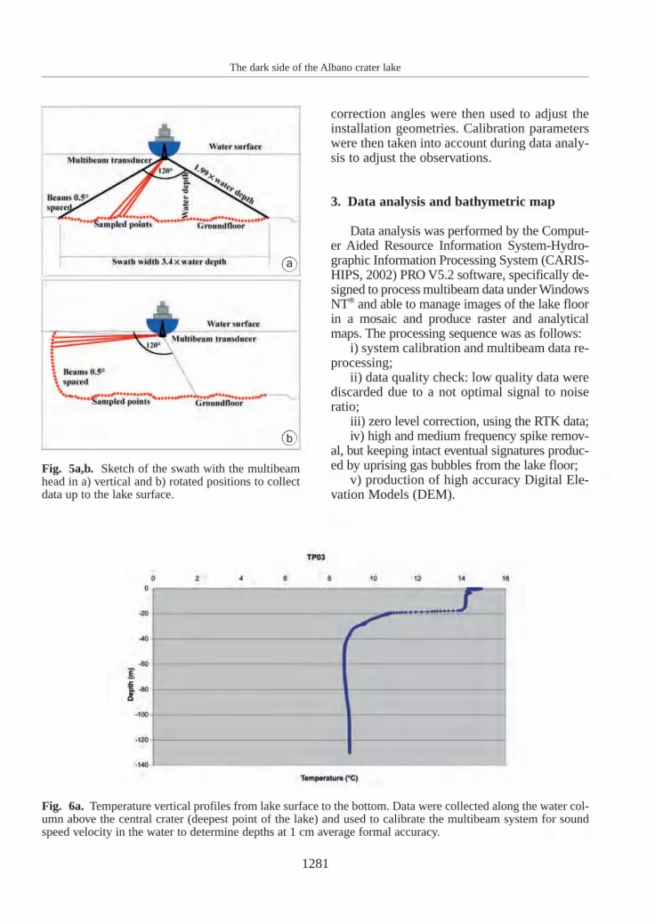
Navigation routes (fig. 4) were performedto achieve the full coverage of the lake bottom,with at least 20-30% overlap between parallelswaths, up to the lake surface (fig. 5a,b). TheReson PDS2000 software was able to show inreal time to the operator and the pilot the ongo-ing multibeam and Digital Terrain Model(DTM) and the positioning information thatwere used for guidance.
At the beginning of each survey session, afull set of multibeam calibration lines were ac-quired, on flat bottoms and steep targets atabout 30 m water depth. The roll, pitch and yaw
Fig. 4. Course over the ground performed by ALSEA vessel during bathymetric surveys. The 30% overlappingbetween parallel lines guarantee the full coverage of the area.
1281
The dark side of the Albano crater lake
correction angles were then used to adjust theinstallation geometries. Calibration parameterswere then taken into account during data analy-sis to adjust the observations.
3. Data analysis and bathymetric map
Data analysis was performed by the Comput-er Aided Resource Information System-Hydro-graphic Information Processing System (CARIS-HIPS, 2002) PRO V5.2 software, specifically de-signed to process multibeam data under WindowsNT® and able to manage images of the lake floorin a mosaic and produce raster and analyticalmaps. The processing sequence was as follows:
i) system calibration and multibeam data re-processing;
ii) data quality check: low quality data werediscarded due to a not optimal signal to noiseratio;
iii) zero level correction, using the RTK data;iv) high and medium frequency spike remov-
al, but keeping intact eventual signatures produc-ed by uprising gas bubbles from the lake floor;
v) production of high accuracy Digital Ele-vation Models (DEM).
Fig. 5a,b. Sketch of the swath with the multibeamhead in a) vertical and b) rotated positions to collectdata up to the lake surface.
Fig. 6a. Temperature vertical profiles from lake surface to the bottom. Data were collected along the water col-umn above the central crater (deepest point of the lake) and used to calibrate the multibeam system for soundspeed velocity in the water to determine depths at 1 cm average formal accuracy.
a
b

Fig. 7a. Digital Elevation Model (DEM) showing the morphobathymetry of the area. Scale colour showsdepths ranging between 0 and –167 m.
1282
Marco Anzidei, Alessandra Esposito and Francesco De Giosa
To produce the MDEM, were used a total of1466914 of 3D punctual data (latitude, longi-tude and depth), that were converted in theUTM33-WGS84 coordinate system.
The survey data set was analysed to reduceany positioning offset or error in the MDEM to-gether with the analysis of the standard deviationsof the mutibeam data. The latter show values
Fig. 6b. Conducibility vertical profiles from lake surface to the bottom. Data were collected along the watercolumn above the central crater (deepest point of the lake) and used to calibrate the multibeam system for soundspeed velocity in the water.
1283
The dark side of the Albano crater lake
ranging between 10-15 cm up to depths of −20m;15-30 cm at depths between −20 and −50 m and30-50 cm at depths greater than −50 m.
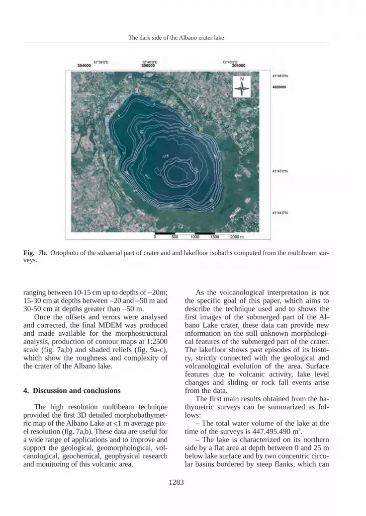
Once the offsets and errors were analysedand corrected, the final MDEM was producedand made available for the morphostructuralanalysis, production of contour maps at 1:2500scale (fig. 7a,b) and shaded reliefs (fig. 9a-c),which show the roughness and complexity ofthe crater of the Albano lake.
4. Discussion and conclusions
The high resolution multibeam techniqueprovided the first 3D detailed morphobathymet-ric map of the Albano Lake at <1 m average pix-el resolution (fig. 7a,b). These data are useful fora wide range of applications and to improve andsupport the geological, geomorphological, vol-canological, geochemical, geophysical researchand monitoring of this volcanic area.
As the volcanological interpretation is notthe specific goal of this paper, which aims todescribe the technique used and to shows thefirst images of the submerged part of the Al-bano Lake crater, these data can provide newinformation on the still unknown morphologi-cal features of the submerged part of the crater.The lakefloor shows past episodes of its histo-ry, strictly connected with the geological andvolcanological evolution of the area. Surfacefeatures due to volcanic activity, lake levelchanges and sliding or rock fall events arisefrom the data.
The first main results obtained from the ba-thymetric surveys can be summarized as fol-lows:
– The total water volume of the lake at thetime of the surveys is 447.495.490 m3.
– The lake is characterized on its northernside by a flat area at depth between 0 and 25 mbelow lake surface and by two concentric circu-lar basins bordered by steep flanks, which can
Fig. 7b. Ortophoto of the subaerial part of crater and and lakefloor isobaths computed from the multibeam sur-veys.

be addressed to crater rims. The first is betweenabout –50 and –120 m; the second between –120 and –167 m.
– The deepest point of the lake is at −166.86m, lower than the previous measurements (173m). This value could be explained with the low-ering of the water table around the basin whichcan reduce the hydrologic balance of the area,as reported by Capelli et al. (2000).
– The deepest point coincides with a circularcrater about 1000 m wide, with steep innerflanks about 45 m height. The steep flanks showerosion phenomena, likely sub aerial, that couldhave occurred before the crater was filled withwater. The flatness of this area suggests a con-tinuous sedimentation at this depth, in agree-ment with Oldfield et al. (1996) (fig. 8).
– Other sub circular depression size could beaddressed to craters. But without further evidencefrom seismic soundings or drillings, with the ex-ception of those reported in Oldfield et al. (1996),we cannot confirm or exclude this hypothesis.
– Slides or rock fall of different sizes haveoccurred in the lake since its formation. Theymainly occurred along the steepest inner flanksof the crater and partially in the central crater(fig. 9a,c).
– Three levels of submerged shores, at themoment of unknown age, are clearly located atdepths between –31 and –41 in the north-eastern
side of the lake. They witness the past lake levelstandings at these heights likely due to a changein the environment as also reported by Chondro-gianni et al. (1996), Ryves et al. (1996), Lowe et al. (1996) and Marra and Karner (2005).
– Data did not reveal any relevant gas exhala-tive centres in the whole basin. This is in contrastwith previous observations (Oldfield et al., 1996)that disclosed some exhalative points mainly inthe eastern side of the basin. This can be ex-plained by a temporary change in the gas exhala-tion from the ground or with the sealing of frac-tures which prevent the gas release up to the sur-face.
The issues related to the occurrence of slidesand gas exhalative points are relevant for scien-tific discussion and hazard assessment of the Al-bano crater lake volcano and its bathymetry opennew questions on its recent evolution, thus sug-gesting further investigations through the inte-gration of different geological and geophysicalstudies. Mainly, if the central crater is a suitabletrap for CO2 accumulation that can be suddenlyreleased, as occurred in lake Nyos (Rice, 2000),taking into account that the Albano Lake has thehighest CO2 concentration among the Italiancrater lakes (up to 200 mg/l at –175 m) (Martiniet al., 1994). In such case, it would be subjectedto a water rollover with dangerous consequencesof gas or hot fluids release from the deepest part
1284
Marco Anzidei, Alessandra Esposito and Francesco De Giosa
Fig. 8. Multibeam image of the central crater.

1285
The dark side of the Albano crater lake
Fig. 9a-c. Multibeam images of slides located along a,b) the north eastern side and c) the southern side of thecrater, respectively.
a
b
c

1286
Marco Anzidei, Alessandra Esposito and Francesco De Giosa
of the lake. Concerning slides, a slide hazardmust be taken into account because their occur-rence would induce tsunami lake waves, danger-ous for humans and the environment. Some cas-es of tsunamis triggered by slides in closedbasin, are reported in the literature such as thatwhich occurred in the artificial lake of Vajont,Italy, in 1963 which produced heavy destructionand about two thousand victims. So far, the oc-currence of such events in the Albano Lakeshould not be excluded due to the seismicity ofthe area, the features of the lake floor and to thesteep slopes of the inner side of the crater facingthe lake. The morphological features of the lakefloor suggest the existence of at least two largercraters and three more coalescent smaller erup-tive centres (Anzidei et al., 2007). Further sur-veys, such as seismic soundings and sub bottomprofiles, should be performed to provide data onthe still unknown structural features of the lakefloor.
Acknowledgements
Surveys were performed under the Colli Al-bani Project V-3 funded by the Italian Diparti-mento della Protezione Civile. We wish to tankLuca Pizzino, Maria Luisa Carapezza, Piergior-gio Scarlato of INGV, Renato Funiciello andGuido Giordano of the University of Roma Trefor the fruitful discussion on the results.
REFERENCES
AMATO, A. and C. CHIARABBA (1995): Recent uplift of theAlban Hills Volcano (Italy): evidence for magmatic in-flation?, Geophys. Res. Lett., 22, 1985-1988.
AMATO, A., C. CHIARABBA, M. COCCO, M. DI BONA and G.SELVAGGI (1994): The 1989-1990 seismic swarm in theAlban Hills volcanic area, Central Italy, J. Volcanol.Geotherm. Res., 61, 225-237.
ANDRETTA, D. and M. VOLTAGGIO (1988): La cronologia re-cente del vulcanismo dei Colli Albani, Scienze, 41(243), 26-36.
ANNUNZIATELLIS, A., G. CIOTOLI, S. LOMBARDI and F. NO-LASCO (2003): Short- and long-term gas hazard: the re-lease of toxic gases in the Alban Hills volcanic area(Central Italy), J. Geochem. Explor., 77, 93-108.
ANZIDEI, M. (2000): Rapid bathymetric surveys in marinevolcano areas: a case study in Panarea aera, Phys.Chem. Earth A, 25 (1), 77-80.
ANZIDEI, M., P. BALDI, G. CASULA, A. GALVANI, F. RIGUZZI
and A. ZANUTTA (1998): Evidence of active crustal defor-mation of the Colli Albani volcanic area (Central Italy)by GPS surveys, J. Volcanol. Geotherm. Res., 80, 55-65
ANZIDEI, M., A. ESPOSITO, G. BORTOLUZZI and F. DE GIOSA
(2005): The first high resolution bathymetric map ofthe exhalative area of Panarea (Aeolian Islands, Italy),Ann. Geophysics, 48 (6), 17-39
ANZIDEI, M., M.L. CARAPEZZA, G. GIORDANO, M. LELLI andL. TARCHINI (2007): New discoveries on the AlbanoMaar Lake from high resolution bathymetry and dis-solved CO2 budget (Colli Albani volcano, CentralItaly), J. Volcanol. Geotherm. Res. (submitted).
BARBERI, F., F. CHELINI, G. MARINELLI and M. MARTINI
(1989): The gas cloud of Lake Nyos (Cameroon,1986): results of the Italian technical mission, J. Vol-canol. Geotherm. Res., 39, 125-134.
BEAUBIEN, S.E., G. CIOTOLI and S. LOMBARDI (2003): Carbondioxide and radon gas hazard in the Alban Hills area(Central Italy), J. Volcanol. Geotherm. Res., 123, 63-80.
CAPELLI, G., R. MAZZA, G. GIORDANO, A. CECILI, D. DE RI-TA and D. SALVATI (2000): The Colli Albani Volcano(Rome, Italy): equilibrium breakdown of a hydrogeo-logical unita as a results of unplanned and uncountedover exploitation, Hydrogeologique, 4, 63-70.
CARANDINI, A. (1997): La Nascita di Roma: Dei, Lari, Eroi eUomini all’Alba di una Civiltà (Torino, Einaudi), pp.766.
CARAPEZZA, M.L., B. BADALAMENTI, L. CAVARA and A.SCALZO (2003): Gas hazard assessment in a densely in-habited area of Colli Albani Volcano (Cava dei Selci,Roma), J. Volcanol. Geotherm. Res., 123, 81-94.
CARIS-HIPS (2002): Hydrographic Information ProcessingSystem and SIPS Professional v.5.2 Software User Guide,MA-HIPS-UG-02-02, 264 Rookwood av. Fredericton,Canada (available on line: http://www.caris.com/).
CHIARABBA, C., A. AMATO and P.T. DELANEY (1997): Crustalstructure, evolution, and volcanic unrest of the AlbanHills, Central Italy, Bull. Volcanol., 59, 161-170.
CHIODINI, G. and F. FRONDINI (2001): Carbon dioxide de-gassing from the Alban Hills volcanic region, CentralItaly, Chem. Geol., 177, 67-83.
CHONDROGIANNI, C., D. ARIZTEGUI, F. NIESSEN, C. OHLEN-DORF and G. LISTER (1996): Late Pleistocene and Ho-locene sedimentation in Lake Albano and Lake Nemi(Central Italy), in Paleoenvironmental Analysis of Ital-ian Crater Lake and Adriatic Sediments, edited by G.GUILIZZONI and F. OLDFIELD, Mem. Ist. Ital. Idrobiol.,55, 23-38.
DE RITA, D., R. FUNICIELLO and M. PAROTTO (1988): CartaGeologica del Complesso vulcanico dei Colli Albani(Geological map of the Colli Albani volcanic com-plex), scale 1:50000, CNR.
DE RITA, D., R. FUNICIELLO and C. ROSA (1992): Volcanic ac-tivity and drainage network evolution of the Alban Hillsarea (Rome, Italy), Acta Vulcanologica, 2, 185-198.
ESPOSITO, A., G. GIORDANO and M. ANZIDEI (2006): The2002-2003 submarine gas eruption at Panarea island(Aeolian Archipelago, Italy): structure and volcanolo-gy of the seafloor and implications for hazard evalua-tion, Marine Geol., 227, 119-134
FORNASERI, M., A. SCHERILLO and U. VENTRIGLIA (1963):La Regione Vulcanica dei Colli Albani (Vulcano Lazia-le), CNR, Roma, pp. 550.

1287
The dark side of the Albano crater lake
FUNICIELLO, R., G. GIORDANO, D. DE RITA, M.L. CARAPEZ-ZA and F. BARBERI (2002): L’attività recente del crateredel Lago Algano di Castelgandolfo, Rend. Accad. Lin-cei (Scienze Fisiche e Naturali) Ser. 9, 13, 113-143
FUNICIELLO, R., G. GIORDANO and D. DE RITA (2003): TheAlbano maar lake (Colli Albani Volcano, Italy): recentvolcanic activity and evidence of pre-Roman Age cata-strophic lahar events, J. Volcanol. Geotherm. Res., 123,43-61.
KARNER, D.B., F. MARRA and P.R. RENNE (2001a): The his-tory of the Monti Sabatini and Alban Hills volcanoes:groundwork for assessing volcanic-tectonic hazards forRome, J. Volcanol. Geotherm. Res., 107, 185-219.
KARNER, D.B., F. MARRA, F. FLORINDO and E. BOSCHI
(2001b): Pulsed uplift estimated from terrace eleva-tions in the coast of Rome: evidence for a new phase ofvolcanic activity?, Earth Planet. Sci. Lett., 188, 135-148.
LOWE, J.J., C.A. ACCORSI, M. BANDINI MAZZANTI, A. BISH-OP, S. VAN DER KAARS, L. FORLANI, A.M. MERCURI, C.RIVALENTI, P. TORRI and C. WATSON (1996): Pollenstratigraphy of sediment sequences from lakes Albanoand Nemi and from central Adriatic, in Paleoenviron-mental Analysis of Italian Crater Lake and AdriaticSediments, edited by G. GUILIZZONI and F. OLDFIELD,Mem. Ist. Ital. Idrobiol., 55, 71-98.
MANCA, M., A.M. NOCENTINI, C. BELIS, P. COMOLI and L.CORBELLA (1996): Invertebrate fossil remains and pale-oenvironmental reconstruction, in PaleoenvironmentalAnalysis of Italian Crater Lake and Adriatic Sedi-ments, edited by G. GUILIZZONI and F. OLDFIELD, Mem.Ist. Ital. Idrobiol., 55, 160-173.
MARRA, F. and D.B. KARNER (2005): The Albano maar (Al-ban Hills volcanic district, Italy): active or dormantvolcano?, Il Quaternario, 18 (2), 173-185.
MARRA, F., C. FREDA, P. SCARLATO, J. TADDEUCCI, D.B.KARNER, P.R. RENNE, M. GAETA, D.M. PALLADINO, R.TRIGILA and G. CAVARRETTA (2003): Post-caldera ac-tivity in the Albani Hills volcanic district (Italy):4040Ar/39Ar geochronology and insights into magmaevolution, Bull. Volcanol., 65, 227-247, doi: 10.1007/s00445-002-0255-9.
MARTINI, M., L. GIANNINI, F. PRATI, F. TASSI, B. CAPACCIONI
and P. IOZZELLI (1994): Chemical characters of craterlakes in the Azores and Italy: the anomaly of Lake Al-bano, Geochem. J., 28, 173-184.
MELI, R. (1911): Intorno l’origine dei due laghi Albano eNemorense. Ristampa di una dissertazione scritta nel1758 dal dott. Giovanni Girolamo, Lapi Romano, conindicazione dei naturalisti, che nella seconda metà del
secolo XVIII parlarono dei monti vulcanici dell’anticoLazio, Boll. Soc. Geol. Ital., XXX, 981-1006.
MERCALLI, G. (1883): Vulcani e fenomeni Vulcanici, in Ge-ologia d’Italia, edited by G. NEGRI, A. STOPPANI and G.MERCALLI (Milano), 3rd part., pp. 374.
OLDFIELD, F. (1996): The PALICLAS Project: synthesis andoverview, in Paleoenvironmental Analysis of ItalianCrater Lake and Adriatic Sediments, edited by G.GUILIZZONI and F. OLDFIELD, Mem. Ist. Ital. Idrobiol.,55, 329-357.
PORRECA, M., M. MATTEI, G. GIORDANO, D. DE RITA and R.FUNICIELLO (2003): Magnetic fabric and implications forpyroclastic flow and lahar emplacement, Albano maar,Italy, J. Geophys. Res., 108, doi: 10.1029/2002JB002102
RICE, A. (2000): Rollover in volcanic crater lakes: a possi-ble cause for Lake Nyos type disaster, J. Volcanol. Ge-otherm. Res., 97, 233-239.
RYVES, D.B., V.G. JONES, P. GUILIZZONI, A. LAMI, A. MAR-CHETTO, R.W. BATTARBEE, R. BETTINETTI and E.C. DE-VO (1996): Late Pleistocene and Holocene environmen-tal changes at lake Albano and Nemi as indicated by al-gal remains, in Paleoenviromental Analysis of ItalianCrater Lakes and Adriatic Sediments (PALICLAS), ed-ited by P. GUILIZZONI and F. OLDFIELD, Mem. Ist. It.Idrobiol., 55, 119-148.
SALVI, S., S. ATZORI, C. TOLOMEI, J. ALLIEVI, A. FERRETTI,C. PRATI, F. ROCCA, S. STRAMONDO and N. FEUILLET
(2004): Inflation rate of the Colli Albani volcanic com-plex retrieved by the Permanent Scatterers SAR inter-ferometry-technique, Geophys. Res. Lett., 31, L12606,doi: 10.1029/2004GL020253.
SERPELLONI, E., M. ANZIDEI, P. BALDI, G. CASULA and A.GALVANI (2005): Crustal velocity and strain-rate fieldsin Italy and surrounding regions: new results from theanalysis of permanent and non-permanent GPS net-works, Geophys. J. Int., 161 (3), 861-880, doi: 10.1111/j.1365-246X.2005.02618.x.
SIGURDSSON, H., J.D. DEVINE, F.M. TCHOVA, T.S. PRESSER,M.K.W. PRINGLE and W.C. EVANS (1987): Orogin ofthe lethal gas burst from Lake Monoun, Cameroon, J.Volcanol. Geotherm. Res., 31, 1-16.
TRIGILA, R. (Editor) (1995): The Volcano of the Alban Hills(Tipografia SGS, Roma), pp. 283.
VILLA, I.M., N. CALANCHI, E. DINELLI and F. LUCCHINI
(1999): Age and evolution of the Albano crater lake (Ro-man Volcanic Province), Acta Vulcanol., 11, 305-310.
(received January 23, 2006;accepted October 18, 2006)


