Embed Size (px)
Citation preview

������������ ��������������������������

Paper #5i
Technical study led by Cole Engineering Group Ltd.
1. TRAFFIC CONTROL MEASURES
Traffic control measures in the town include traffic signals, intersection pedestrian signals (IPS), pedestrian crossovers (PXO), stop signs and school crossing guards. Traffic controls regulate competing traffic at intersections and mid-block locations, allowing road users to share a roadway in a safe and efficient manner. The town’s existing traffic control procedures provide guidelines for decisions regarding introduction and operation of traffic controls. As part of the overall transportation master plan update, this paper reviews the current practices and procedures used in the town and assesses the need for changes to better reflect conditions in the town. 2. Current Practices and Procedures
2.1. Traffic Warrants
The Town of Oakville currently has warrant justification for traffic signals, all-way stops, pedestrian crossovers and school crossing guards (enclosed in Appendix A). The following summarizes the available warrants in the town’s traffic control procedures: Traffic Signal The town’s traffic signal justification considers four warrant criteria: minimum vehicular
volumes, delay to cross traffic, collision experience, and combination justification. The warrant criteria are consistent with the Ontario Traffic Manual Book 12 (OTM Book 12, July 2001), and are generally consistent with the 2007 update of OTM Book 12 and industry standard practice. It is noted that the current version of the OTM Book 12 recognizes warrant criteria that are not part of the current Town procedures. This includes signal justifications based on i) 4-hour vehicle volumes and ii) projected volumes. The new criteria in the OTM Book 12 update are intended to provide practitioners additional tools to assess wider range of traffic conditions.
PXO/IPS The PXO warrant adopted by the town is a modified version of the Ontario Manual of Uniform Traffic Control Devices (now incorporated into OTM Book 12). The town is in the process of phasing out pedestrian cross overs in favour of intersection pedestrian signals. As of the end of 2011, the town has replaced eight of the original 15 PXOs, with the intent that the remaining seven PXOs will be replaced or modified in the near future. In the absence of a formal procedure for introducing IPS, the warrant thresholds for PXO have been applied by the town to assess the need justification for an IPS. This approach is consistent with OTM Book 12, which uses the PXO warrant. The current PXO justification contains three criteria: pedestrian and traffic volumes, geometric requirements, and routing consideration of children.
All-way Stop The town’s all-way stop control warrant contains criteria based on minimum vehicular volumes, accident hazard, sight lines and geometric design. The general basis of the warrant thresholds is consistent with the Ontario Traffic Manual Book 5.
School Crossing Guard
The current set of warrants for a crossing guard is based on vehicular volume, school children volume and accident hazard. The warrants were developed based on a review of existing crossing guard locations in Oakville producing a best-fit curve that establishes an exposure threshold. The current town’s practice establishes a “local” threshold that caters to the traffic and school children volumes in Oakville. The current town procedure remains adequate.

Paper #5i – Traffic Control Measures, February 2013 2
2.2. Traffic Signal Operations – Timing Parameters and Coordination
In addition to warrant justifications, traffic signal operation is also a key aspect of traffic control procedures, which some municipalities also recognize as part of their procedures. This includes procedures on signal timing parameters and coordination timing. Signal Timing Parameters Signal timing parameters are established to move traffic as efficiently and safely as possible, and to meet motorists’ expectation for consistent signal operations. Uniform signal timing parameters provide a basis to establish a consistent operational environment and consistent road users’ expectations in the town. The industry’s standard practice is based on the guidelines in OTM Book 12, which provides references to signal timing applications, including minimum green times, phase times (including pedestrian crossing times), and cycle lengths. Some jurisdictions, such as the Town of Milton, have adopted standard procedures based on OTM Book 12. The town’s current traffic control procedures do not include guidelines for traffic signal operations and timing parameters. Coordination Timing Signal timing and coordination improvements enable greater efficiency through the transportation system. Through modifications to signal timings and coordinated signal strategy, improvements can be achieved through reduced travel time, delay, congestion and emissions. Increasingly, municipalities of different sizes are engaging in signal coordination projects. These include City of Toronto, City of London, City of Barrie, Town of Richmond Hill, City of Peterborough, Town of Milton, Region of Durham and Region of Peel. Within the Region of Halton, there have been a number of signal coordination projects. However these do not include any of Oakville’s signals. The town’s policies currently do not include formal or regular programs for traffic signal coordination. Signal Pre-emption It is common practice among Ontario jurisdictions to include the pre-emption of the normal operation of traffic lights to assist emergency vehicles. As of 2007, all of the town’s major intersections have pre-emptive traffic signals using an uncoded OPTICOM system that is currently maintained by the town. This system is currently accessed by only local fire services to reduce the response times. Other emergency vehicle response units have not adopted its use due to implementation costs and unknown benefits to EMS vehicles. This approach is similar to the majority of other jurisdictions in Ontario. It is recommended that the existing system be maintained. It is also recommended that this procedure be reviewed in the future when more research has been conducted on the benefits of pre-emptive traffic signals on EMS vehicles. Furthermore, signal pre-emption technology has also been used alongside transit signal priority in some jurisdiction such as York Region and City of Toronto. The Town of Oakville currently has not adopted the use of transit signal priority, however it is recommended that signal pre-emption technology be reviewed when considering the implementation of transit signal priorities.
Paper #5i – Traffic Control Measures, February 2013 3
3. Updating the Town’s Procedure
3.1. Traffic Control Warrants
Traffic Signals The town’s practice on traffic signal justification is generally consistent to the OTM Book 12. However, the current version of the OTM Book 12 recognizes some additional warrant criteria which are not part of the current town procedure; these being: signal justifications based on i) 4-hour vehicle volumes and ii) projected volumes. It is suggested that these could provide the town additional tools to assess its traffic needs: • The application of the 4-hour warrant is focused on locations where intersections experience excessive
delays for four or more peak hours of the day, but do not have prolonged demands throughout the day to meet an eight hour warrant (e.g. commuter-dominated roadways, commercial areas, manufacturing, office or industrial areas/access).
• The application of projected peak hour warrant is focused on assessing needs for signals for future horizons. In light of the recent updates to the OTM Book 12, the town may consider further review of noted additional warrant criteria and their applicability in relation to the operational and safety needs of the town. Following on this review, the town may choose not to adopt the additional noted warrant criteria in its procedure, adopt the noted warrant criteria as part of the procedure, or customize its approach based on the OTM Book 12 guideline. Pedestrian Signals – IPS/PXO The town currently applies the existing PXO warrants to help assess the need for IPS at study locations. This method is consistent to the approach of OTM Book 12 which uses the same warrant thresholds for PXO and IPS. As such, the current approach by the town appears reasonable based on the guidelines of OTM Book 12. However, in consideration that the town’s warrant thresholds for PXO have been modified based on local conditions, further review is recommended to assess the applicability of the same thresholds for IPS. As part of this Transportation Master Plan update, it is recommended that specific IPS warrants be developed in order to justify future IPS locations. The recommended justification for IPS should take into consideration the justifications of IPS in other jurisdictions in the GTA and the guidelines set forth in the Ontario Traffic Manual (OTM) Book 15 (Pedestrian Crossings) and Book 12 (Traffic Signals). Based on this review, the town may choose to maintain its current procedure, adopt the warrant criteria in Book 12 as part of the procedure, or customize its approach based on the OTM Book 12 guideline. 3.2. Traffic Signal Operations – Timing Parameters and Coordination Timing
Signal timing parameters should be established to move traffic as efficiently and safely as possible and to meet motorists’ expectations for consistent signal operations. The town’s traffic control procedure should recognize the need for uniform signal timing parameters and may refer to the OTM Book 12 to provide the basis for establishing standard timing parameters. The town does not have a formal program for the coordination between signals at the corridor level. The town currently responds reactively to requests for the review of the timing of individual traffic control signals. Given the potential benefit of an improved signal timing and coordination strategy, the town should proactively consider a town-wide signal progression study or, at minimum, a program of corridor studies, as part its procedure development and budget allocation. A regular program for proactive signal timing review, improvements and

Paper #5i – Traffic Control Measures, February 2013 4
maintenance on a corridor basis is recommended. Cooperation from the Region of Halton and MTO will be required. 3.3. Recommendations
In addressing the appropriateness of the town’s current control measures, the following is recommended: • For traffic signal controls, the OTM Book 12 traffic signal justifications provide consistency in engineering
judgment and are line with other jurisdictions. In light of the recent updates to the OTM Book 12, the town may consider further review of new warrant criteria not included in the current policy and its applicability in relation to the operational and safety needs of the town. Following on this review, the town may choose to adopt the noted warrant criteria in its procedure, not adopt the noted warrant criteria as part of the procedure, or customize its approach based on the OTM Book 12 guideline.
• The IPS warrants be developed for adoption by the town. • The town should proactively explore opportunities to optimize signal timing operations and initiate a town-
wide signal progression study or, at a minimum, a program of corridor signal progression studies to improve overall road network efficiency.
• Existing town warrants for all-way stop control is consistent with the OTM Book 5, which remains adequate for the justification of all-way stop control.
• The current justifications for adult school crossing guard controls remain adequate.

������������ �����������������

Paper #5j
Technical study led by Cole Engineering Group Ltd.
TRAFFIC CALMING This paper reviews previous traffic calming studies and current guidelines, as well as existing and planned traffic calming practices within the town. The purpose of the review is to identify if there are any gaps or unresolved issues and opportunities for improvement in the area of traffic management by traffic calming. Traffic calming measures have been used to successfully reduce vehicle speeds in residential neighbourhoods. Over the last 10 to 15 years, traffic calming has become an accepted form of traffic management in Canadian communities. The 1998 publication of the Canadian Guide to Neighbourhood Traffic Calming was a major validating step. Traffic calming can be perceived as a process rather than just a one time change, and is often advocated by community groups. Many Canadian municipalities now have significant traffic calming experience, and have developed policies and guidelines to help ensure consistency, equity and effectiveness in their traffic calming endeavours. 1. Benefits of Traffic Calming
Traffic calming is the term used to describe “passive” and “physical” measures that aim to address speeding concerns, alter driver behaviour, optimize overall traffic operations, and improve safety and livability for all road users within neighbourhoods. Passive traffic calming measures refer to the application of modified pavement markings and additional roadway signs, which are limited to certain conditions, such as wide roads. These measures have been shown to achieve marginal reductions in speeds. Physical traffic calming measures refer to modifications of the road platform and these have been observed to significantly alter driver behaviour and improve safety conditions for road users. These measures are applicable to all widths of roads and can include chicane, curb extension, raised crosswalk, raised centre median, speed cushion, traffic circle and roundabout. Physical traffic calming measures provide more effective deterrence to speeding than passive measures. 2. Current Practices
The Town of Oakville has been proactive in addressing undesirable traffic characteristics by implementing traffic calming initiatives and measures in a variety of neighbourhoods across the town. The town completed various traffic calming studies including Traffic Calming Policy for Retrofit Situations (2003), Traffic Calming Guidelines for New Developments (2008), Policy Discussion Paper Transportation for the Livable Oakville Plan (2009), and Review of Traffic Calming Policy for Retrofit Situations (2009). The 2003 and 2009 traffic calming policy reports were developed as a basis by which the town could consider and implement traffic calming measures effectively and consistently. The main purpose of these reports and the process recommended was to reduce undesirable high traffic speeds to acceptable levels and improve safety for all road users. Typical traffic calming measures that were considered to be applicable to the town’s road network included chicane, curb extension, raised crosswalk, raised centre median, speed cushion, traffic circle and roundabout (see Section 3 for description of each traffic calming measure). There was public input from residents, businesses and emergency services in developing the traffic calming policy. The town has conducted speed surveys at numerous locations and results have generally indicated success with various traffic calming measures. Public meetings were held prior to implementing physical traffic calming

Paper #5j – Traffic Calming, February 2013 2
measures and notices were issued to stakeholders on affected streets prior to implementing passive traffic calming measures. There has been general support/acceptance by the public for both types of measures. A traffic calming warrant assessment was also established, which considered the following factors: • 85th percentile speed (speeds of 10-12 km/h over the posted speed limit for 40-60 km/h). • Priority ranking that considered vehicular speed and exposure with highest priority given to school zones,
medium priority given to local and collector roads, and lowest priority given to major collector and arterial roads.
The the town’s 2008 document “Traffic Calming Guidelines for New Developments” discussed the opportunity to create new developments that encourage walking and cycling and restricting vehicular travel speeds, resulting in more livable neighbourhoods. Studies have shown that in most cases, subdivision road design with short block lengths on local and collector roads reduce the occurrence of undesirable traffic speeds. In cases where this element cannot be achieved in the design of the neighbourhood, traffic calming measures may become necessary to manage traffic operations. The 2009 Policy Discussion Paper on transportation discussed traffic calming methods that support controlling traffic speeds within residential areas through effective subdivision and road design as per the town’s guidelines for new developments. The Town of Oakville Active Transportation Master Plan (2009) discussed the use of roadway edge lines as a traffic calming measure. It stated that in urban areas where there is no opportunity to provide formal bike lanes, edge lines could be added as a traffic calming measure. Edge lines along both sides of an urban residential street can benefit pedestrians and cyclists, by narrowing the perceived vehicle travel lane to help reduce vehicle speeds, and by directing vehicles away from the boulevard and sidewalk which creates a wider buffer zone between pedestrians and moving vehicles. This measure provides an informal but delineated space on the street that many on-road cyclists are comfortable using. Also, traffic calming techniques such as travel restrictions for cars, traffic circles and reduction in the number of stops signs can be used to create “bicycle priority streets” which allow the cyclist to travel more efficiently by not having to break momentum and stop at frequently placed four way stops. The following issues would warrant investigation of the suitability of traffic calming measures: • Excessive Speed:
- Long, straight (includes minor deflections and large radius curves) and uninterrupted sections of road (300+ m) that would result in 85th percentile speeds more than 10 km/h above the posted speed limit of 50 km/h for local and collector residential roads.
- Factors that potentially influence the driver’s choice to speed, e.g. wide lane widths (over 3.5 m), clear zone, no provision for on-street parking.
• Conflicts in Elementary School Zones:
- Roads in elementary school zones with straight roadway sections that are uninterrupted for distances of 160+ m, could result in 85th percentile speeds more than 10 km/h above the posted speed limit of 40 km/h.
• Areas of other conflicts:
- Heavy pedestrian/cyclist activity (e.g. parks, libraries, community centres, shopping facilities).

Paper #5j – Traffic Calming, February 2013 3
The town is dedicated to proactively plan, design and build streets to accommodate all road users, while improving transportation operations on existing roads. There has been diligent research conducted and policies developed to consider and implement various traffic calming measures. As discussed in Traffic Calming Policy for Retrofit Situations (2003) and Review of Traffic Calming Policy for Retrofit Situations (2009), the town has developed a comprehensive traffic calming process which has been effective in screening potential issues, and identifying and evaluating alternatives. The town’s Traffic Engineering Section has been proactively monitoring traffic operations and planning for potential locations to implement traffic calming measures throughout the town on an ongoing basis for more than ten years. Reviews of findings from various reports and investigations (related to traffic operations and speed) are usually undertaken to determine locations eligible for consideration of passive or physical traffic calming measures as per the town’s Traffic Calming Policy. The latest traffic calming plan (2011 Traffic Calming Plan) shows existing traffic calming locations as well as future passive and physical traffic calming locations where implementation is scheduled to occur over the next few years, until 2015. Future locations are located primarily north of the QEW/Royal Windsor Drive. Figure 1 shows the existing and short-term, planned locations for traffic calming in the town. Recently, in 2011, the town’s Traffic Engineering Section introduced traffic calming measures at nine locations in Oakville. Passive traffic calming measures in the form of pavement markings and signage to narrow driving lanes, create cycle lanes, and increase side friction via dedicated parking space were introduced at five local and collector roads in residential areas: • River Oaks Boulevard. • McCraney Street. • Nottinghill Gate. • Grand Boulevard. • Fourth Line. Physical traffic calming measures in the form of speed cushions and bollards on two-lane roads and raised barrier medians on 3-lane roads were introduced to four local and collector roads in elementary school zones: • Bayshire Drive at St. Margueritte D’Youville School. • Fourth Line at West Oak School. • Caldwell Drive at Post Corners School. • Lancaster Drive at Sheridan School.

Paper #5j – Traffic Calming, February 2013 4
Figure 1: Traffic Calming Locations in Oakville
Paper #5j – Traffic Calming, February 2013 5
3. Alternative Approaches to Traffic Calming
Traffic calming can involve either “Vertical Deflection” or “Horizontal Deflection” measures.
Vertical Deflection – These are traffic calming measures that create a physical change in the height of the roadway. When appropriately designed, vehicles are observed to reduce speed when manoeuvring to avoid unpleasant jostling feelings. � Horizontal Deflection – These refer to two types of traffic calming measures. One reduces the driver’s ability to continue in a straight line by using a barrier deflection in the roadway. This deflection causes drivers to reduce their speed in order to navigate around the barrier. The other narrows the width of the travel lane thereby reducing the usable surface of the roadway which causes drivers to reduce their speed in order to maintain an acceptable level of comfort while driving. These measures are primarily used to address speed concerns, but can also improve pedestrian safety due to the reduced crossing width.
Though vertical traffic calming measures can be effective in reducing speeds, they are intrusive and can have significant adverse impacts to emergency and transit vehicles, as well as on-road cyclists. As a result of this, vertical measures are not recommended as part of a new development plan. Instead, for new developments, horizontal traffic calming measures are recommended. New developments have unique opportunities for the introduction of cost effective traffic calming measures, and from a right-of-way perspective, these are more feasible when incorporated into a new roadway design than in a retrofit situation. These elements can offer benefits to pedestrians, and can be seamlessly integrated into the subdivision development plan, allowing the plan to achieve its desired urban design objectives. Traffic calming measures are considered and assessed based on impacts to road safety, emergency vehicles, cyclists, transit service, maintenance practices; preservation of neighbourhood equity; questions of applicability to major streets and new neighbourhoods; methods of achieving public consensus and approval; balancing costs and financing opportunities; managing liability; environmental approvals; and the use of temporary installations. Physical traffic calming measures used in retrofit situations in the town include: • Raised centre median. • Rubber speed cushion. • Mountable concrete median with flexible bollard. Physical traffic calming measures recommended for use in new developments can include: • Curb extension. • Chicane. • Traffic circle. • Roundabout (mini). • Raised centre median. It is recommended that physical traffic calming measures be complemented with passive measures (e.g. pavement markings and signage), where appropriate. All measures are applicable to/appropriate for emergency vehicles, cyclists and transit services, and are applicable to roads with posted speeds of 50 km/h or less. The aforementioned measures and some other previously identified applicable measures (from other studies) are described below.

Paper #5j – Traffic Calming, February 2013 6
Traffic Calming Measure Description Associated Advantages Associated Disadvantages
Raised centre median
• An elevated median constructed within the centre of a road opposite to a left turn lane to deter passing.
• Reduce vehicle speeds. • Deter vehicle passing. • Reduce crossing distance for
pedestrians. • Visually enhance the street
when landscaped.
• Requires a portion of street width.
• Limits full movement turns to and from some properties/ side streets for local residents and emergency services.
Rubber speed cushion
• Newest available traffic calming device.
• Three small speed humps that effectively slow cars down while wider axle of emergency vehicles allows them to pass without slowing down.
• Reduce vehicle speeds, without slowing emergency vehicles.
• Easy to install. • Inexpensive, portable and
durable.
• Can cause a rough ride. • Drivers may swerve to avoid so
that only one wheel crosses, and this may impact cyclist safety.
• May introduce noise concerns as vehicles cross.
• Unattractive.

Paper #5j – Traffic Calming, February 2013 7
Traffic Calming Measure Description Associated Advantages Associated Disadvantages
Concrete median with flexible bollard
• A series of poles placed in the centre of a road to separate opposing traffic.
• Flexible, so able to withstand impact from a vehicle and return to original upright position when the force is removed.
• Reduce vehicle speeds. • Discourage through traffic. • Can be implemented where
road right-of-way or budget is constrained.
• May limit full movement turns to and from some properties/ side streets for local residents and emergency services.
• Unattractive.
Curb extension
• Horizontal intrusion of the curb into the roadway resulting in a narrower section of roadway.
• Typically used at intersections, but also used at mid-block locations if significant pedestrian activity is present (e.g. school crossings).
• Reduce vehicle speeds. • Slows vehicles making turns. • Reduce crossing distance for
pedestrians, and increase pedestrian visibility.
• Prevent parking close to an intersection, and protect parked vehicles.
• Visually enhance the street if landscaped.
• May require cyclists to briefly merge with vehicular traffic.
• May eliminate some on-street parking.
• Can cause drainage issues.

Paper #5j – Traffic Calming, February 2013 8
Traffic Calming Measure Description Associated Advantages Associated Disadvantages
Chicane
• A series of curb extensions on one side or on alternating sides of a roadway, depending on the width of the roadway used to slow vehicles by creating a visual physical change to the roadway.
• Reduce vehicle speeds. • Discourage shortcuts through
traffic. • Visually enhance the street
when landscaped.
• Must be designed carefully to discourage drivers from deviating out of the appropriate lane.
• Can be expensive. • May eliminate some on-street
parking. • Can cause drainage issues.
Traffic Circle
• A raised circular island located in the centre of an intersection, which requires vehicles to travel through the intersection in a counter-clockwise direction around the island.
• Reduce vehicle speeds (most effective when several are used in a series).
• Can calm two streets at once. • Reduce vehicle-vehicle
conflicts and severity at intersections.
• Reduce starts and stops which may benefit the environment.
• Visually enhance the street when landscaped.
• Difficult for large vehicles to maneuvre.
• May eliminate some on-street parking.
• Costly to maintain landscaping. • May increase the walking
distance to adjoining streets for transit users since transit stops may be set back from the intersection.

Paper #5j – Traffic Calming, February 2013 9
Traffic Calming Measure Description Associated Advantages Associated Disadvantages
Roundabout (mini)
• Similar to a traffic circle, but larger and with raised or traversable splitter islands on each leg.
• Reduce vehicle speeds. • Reduce vehicle-vehicle
conflicts and severity at intersections.
• Reduce starts and stops which may benefit the environment.
• Visually enhance the street when landscaped.
• Difficult for some vehicles to manoeuvre.
• Cyclist safety may be compromised at busy intersections.
• May eliminate some on-street parking.
• Costly to maintain landscaping. • May increase the walking
distance to adjoining streets for transit users since transit stops may be set back from the intersection.

Paper #5j – Traffic Calming, February 2013 10
4. Recommendations
The existing traffic calming policies and guidelines for retrofit situations (Review of Traffic Calming Policy for Retrofit Situations, 2009) and new developments (Traffic Calming Guidelines for New Developments, 2008), are exhaustive in their content, as they offer concise information and processes involved in traffic calming planning and implementation. Traffic calming warrants and alternative solutions for various scenarios are also discussed thoroughly. The town should continue to apply these guidelines to identify areas that warrant traffic calming, and continue to proactively plan other measures to be employed in new developments. However, best practices from other neighbouring towns can be reviewed and considered if current methods fail to produce significant results. It should be noted that when considering traffic calming measures, the impacts to road safety, emergency vehicles, cyclists and transit service should be considered. In the case of speed cushions, while the larger axle of the emergency vehicles may avoid the cushion by straddling it, transit vehicles tires will come into contact with the cushions (the dual tires on the transit buses require one edge of the tires to travel over the cushion). Also, for roundabouts or traffic circles, depending upon the configuration of the circle, transit stops may be set back from the intersection, thereby potentially increasing the walking distance to adjoining streets for transit users.

���������!�� ���"#��$���%�����

Paper #5k
Technical study led by Cole Engineering Group Ltd.
Goods Movement Freight or goods movement refers to the transportation of goods, for a price, by road, rail, air, water or pipeline. Road vehicles dominate this group, and can include trucks, vans, pick-ups and cars. Goods movement impacts the transportation network and can become a significant issue, especially when growth and associated additional traffic is expected. An efficient transportation network should focus not only on how to move people from one point to another, but also on goods movement and the mitigation of associated impacts to local communities. Road vehicles are likely to continue to be the predominant mode of transportation of goods in the Greater Toronto and Hamilton Area (GTHA). This paper reviews previous goods movement studies and resources, and their applicability to goods movement process in Oakville. 1. Benefits of a Goods Movement System
A goods movement system is required to transport items such as food, fuel, raw materials and semi-finished goods to production plants, which in turn generate commodities that are housed in wholesale, terminal or warehousing structures, and then forwarded to retail and servicing establishments, or other processing plants to be later shipped and consumed by individuals or firms. Additional transportation is then required to dispose of the subsequent waste. Goods movement can result in issues such as congestion, noise, pollution or pavement damage, which can impact the profitability and competitiveness of industries and regions. An efficient goods movement system can contribute to, or sustain, economic growth, while an inefficient system can negatively impact it, or encourage economic activity to locate elsewhere. Areas that are well equipped from a goods movement infrastructure perspective and strategically located can benefit considerably from their ability to receive, sort and deliver goods and services quickly, cheaply and effectively. Fast, frequent and reliable deliveries reduce inventory and product costs and maintain customer loyalty, but are dependent on the abilities of transportation carriers and transportation infrastructure. 2. Current Practices in Goods Movement
The GTHA generates about 30 percent of Canada’s economic activity, and more than 400 million tonnes of goods are transported to, from or through the GTHA each year1. Future planning initiatives must consider the ability of the road network to support manufacturing (shipping of goods to wholesale/retail facilities, “just in time” deliveries), resource related industry (shipping of aggregates and other materials from source), and agriculture (shipping of produce, and movement of equipment between farms). Transportation of goods requires use of the road network for at least part of the journey from origin to destination. There is a relatively good distribution of arterial roads throughout the town which provide connections for goods movement, but a more focused and efficient system, including truck routes, can be developed and implemented. Trucks are typically used for consumer goods and household products, especially for journeys less than 500 kilometres in length. Provincial highways, including Highway 401, Highway 403, Highway 407 and the Queen Elizabeth Way, carry much of the longer distance and “pass-through” truck traffic. According to The Ontario Trucking Association, the types of trucks traveling in a municipality will depend on the types of businesses and industries operating within it, and the nature of the community’s local businesses and industries will dictate the truck traffic and determine whether a truck route is needed to facilitate its movement.
1 Halton Region Transportation Master Plan 2010-2031, Appendix F4 – Goods Movement, September 2011

Paper #5k – Goods Movement, February 2013 2
The movement of trucks within a municipality can be classified into four categories: 1. Internal-to-internal trips (truck trips whose origins and destinations are both located within the municipality). 2. Internal-to-external trips (truck trips whose origins begin within the municipality and travel to a destination
outside municipal boundaries). 3. External-to-internal trips (truck trips whose origins begin outside the municipality and travel to a destination
within municipal boundaries). 4. External-to-external trips (truck trips whose origins and destinations lie outside the municipality and should
be routed on the Provincial highway system within the municipality). All types of truck traffic and truck movements are found in every municipality. A truck route system provides rules that balance the needs of commerce and the trucking industry with the desire to minimize the impacts of trucks on sensitive land uses. Under such a system, trucks would be required to use roads that are most suitable for their movement, and limit their intrusion into sensitive areas. The purpose of truck route planning is to define the street network that provides the following: • Maximum safety for the movement of large vehicles. • Support for local and regional commerce. • Capacity and design features to accommodate the anticipated volume, size and weight of vehicles. 3. Planning for Goods Movement
Planning for goods movement is complex, given the influence of a global trading environment, a rapidly evolving production and distribution process, multiple trip purposes, numerous modes of travel, large numbers of diverse transportation providers, operational regulations and market based decisions by shippers who may be located well beyond Oakville’s borders. Planning for goods movement would benefit from engaging stakeholders with an interest in freight to identify measures and processes to enhance goods mobility. Goods movement is critical to the economy. Absence of an efficient goods movement system can result in issues such as congestion, noise, pollution or pavement damage, which can impact the profitability and competitiveness of industries and municipalities, In planning an efficient goods movement system, the following factors should be considered: Road Network Congestion Road congestion is identified as an issue throughout the GTHA, on arterials and highways during peak periods and increasingly throughout the day. High levels of congestion increase travel times and the unpredictability of travel, and therefore can impact goods movement delivery times and scheduling. This is a particular issue for businesses employing “just in time” delivery systems because it can result in diversion of truck traffic from higher order corridors to local routes, resulting in noise, safety and environmental concerns. Congestion and travel times are likely to increase with the expected substantial population and employment growth in the town.

Paper #5k – Goods Movement, February 2013 3
Land Use Planning Potential issues of compatibility exist between freight/logistics facilities and other land uses, particularly residential communities. Improved planning of warehousing, logistics and inter-modal facilities, in conjunction with residential planning, are necessary as freight and transportation land uses are critical to the day-to-day function and economic competitiveness of the town. Current land use planning involves the concept of higher density, transit-oriented development that could increase the mode share of transit and active transportation methods, resulting in an improvement in the efficiency of people movement, and thus indirectly offer benefits to goods movement. Impacts on Residential Areas When roads become congested, there is the potential for heavy commercial vehicles to use local roads that are not designed nor intended for such types of traffic. Trucks typically diverge from expected routes to avoid overall congested conditions and intermittent congestion due to non-recurring incidents such as collisions, road maintenance and inclement weather. Diversion of trucks to local roads results in localized impacts, such as air pollution from vehicle emissions, noise pollution and safety concerns. Pavement Damage Heavy trucks and commercial vehicles can impact the condition of the arterial road network, due in part to heavier vehicle weights. These vehicle weights, along with the winter climate, can cause deterioration of road surfaces. Increased truck movements in the future may require additional road maintenance and rehabilitation. Environmental Considerations Transportation is a major contributor to greenhouse gas emissions in Canada and goods movement accounts for approximately 43% of Canada’s transportation energy use1. There are opportunities to improve the environmental performance of goods movement, through increased use of rail and marine modes and more efficient trucking. Modal Integration Inter-modal transportation is becoming increasingly important to increase efficiency with respect to goods movement. Efficient road access is an important element of existing, as well as future inter-modal facilities. 4. Recommendations for Goods Movement
Oakville’s major employment lands are located along the QEW, Highway 403 and Highway 407 corridors, which is illustrated in the town’s Urban Structure. For example, Ford Canada, one of the largest employers in Oakville is located immediately south of the QEW to the west of Ford Drive. Proposed employment lands, located north of Dundas Street and south of Highway 407 should also be considered when planning the goods movement system. Maintaining efficient access between the employment lands and the freeway system is an important factor in future economic activity in Oakville. A strategic goods movement network would facilitate the increasing demand for goods movement throughout the town. Through an assessment of the town’s road and rail goods movement corridors, as well as an assessment of existing and future economic activity centres, a key goods movement network can be developed. Such a network could reduce the impact of goods movement on local communities and the environment, including noise, air emissions and safety, and could improve the efficiency of goods movement in Oakville.

Paper #5k – Goods Movement, February 2013 4
Truck routes should be designated and their travel prohibited on non-arterial streets, especially in residential neighbourhoods. However, provisions should be made for drivers of heavy vehicles if their destinations cannot be reached via unrestricted roads. The Ontario Trucking Association – Local Truck Routes: A Guide for Municipal Officials (December 2011) provides guidance for planning truck routes. This report states that any municipality, regardless of size, has the ability to develop a set of rules and policies that ensure future development does not impede the flow of goods. It recognizes that each community has different characteristics and, therefore, different transportation needs. Municipalities can proactively plan to accommodate freight movements within their jurisdiction through the designation of a network of truck routes in their Official Plans and/or Transportation Master Plans. Key considerations when planning truck routes include: • Anticipation, planning and incorporation of future development access needs. • Development of off-peak deliveries program in key commercial areas. • Identifying the businesses served by trucks. • Location of current trucking companies within the municipality. • Incorporation into and/or modification of major thoroughfare plan. • Consideration of the traffic impacts to surrounding roads if truck traffic is restricted to a single road. • Development of freight-supportive land use guidelines. • Actively involving the region since major roads that may potentially be used for truck traffic are regional
roads. Regulations for loading/unloading truck deliveries should be reviewed and updated. Such initiatives should be integrated with land use planning. To improve integration of transportation planning for a multi-modal network, the town should work with stakeholders to better understand goods movement needs, and investigate the potential options for and implications of time of day shifts and mode changes, as well as changes in people movement patterns that may benefit goods movement (e.g. reducing peak period road congestion). A holistic planning approach should be promoted by the town, to improve the integration of goods movement and people movement, making the best use of the road and rail transportation networks throughout the day. Opportunities to reduce environmental impacts through increased use of fuel- and energy-efficient modes of shipping, such as rail and marine, should be explored. Goods movement can benefit from ongoing relationships between the town and stakeholders, including local, regional, provincial and federal levels of government, area transportation service providers, and representatives from the goods movement industry, including shippers, the Ontario Chamber of Commerce, Ontario Trucking Association, Southern Ontario Gateway Council, CN and CP Railways, logistics companies, freight forwarders, manufacturers and exporters, the agricultural community, environmental groups, municipalities, port authorities and the province. Technology can be used to benefit goods movement through improved efficiencies and linkages between modes and services, route and load optimization, inventory and information control, advanced traveler information (e.g. weather information), support for efficient and integrated passenger and goods movements and support for information and coordination for smaller urban goods movements. Some ITS applications that could benefit goods movement in the town include1:

Paper #5k – Goods Movement, February 2013 5
• Telematics – the integrated use of telecommunications and information technology: sending, receiving and storing information via telecommunication devices. It includes GPS technology integrated with computers and mobile communications technology in automotive navigation systems.
• GPS/satellite positioning and real time traffic data. • Transponders – minimizes stops for tolls, weigh stations, border crossings, etc. • Commercial fleet management – communication between drivers, dispatchers, and intermodal clearance
centres to improve reliability and efficiency. An efficient goods movement system can be developed by considering the above factors. By balancing the needs of residents and other commuters with the economic needs and responsibilities of the town, an effective goods movement system can be implemented and monitored.

���������&�� ����#��$�'� �������'���������

Paper #5l
Technical study led by Cole Engineering Group Ltd.
GRADE SEPARATION STRUCTURES 1.0 Benefits of Grade Separation Structures Warrants and Standards
Grade separation structures allow for physical protection between conflicting streams of travel. Grade separations serve competing modes, either vehicle-pedestrian, vehicle-train or pedestrian train, and also allow for continuity of routes: pedestrian, vehicular or railway and can represent an important component of the transportation infrastructure. Road-rail grade separations remove at-grade conflicts and the potential for high severity collisions. They can also address queuing and capacity related needs associated with growth in vehicle and train traffic. Pedestrian structures allow for the crossing of major barriers such as freeways and railway lines; and provide connectivity, continuity, efficiency and safety in a transportation network. A grade separation structure, in the form of a bridge or a tunnel, allows for a higher degree of safety by reducing or eliminating interaction and conflicts with traffic at grade. It connects and maintains community links over major barriers where at-grade alternatives are not feasible; and it increases convenience for pedestrians and cyclists by reducing the travel distances to get across major barriers. The major barriers in Oakville include the Queen Elizabeth Way (QEW), Highway 403, Highway 407 and the Canadian National Railway tracks. Managing the town’s network of transportation links at interconnecting points along these barriers is critical in planning the town’s future transportation network that: • is safe, efficient and accessible with choices in mobility, • fosters the use and development of a sustainable transportation network, and • provides a network of on- and off-road pedestrian and cycling facilities that allow the use of active
transportation modes as an alternative to the automobile. Grade separation structures, however, require significant capital and maintenance costs. Developing warrants and standards as part of a town policy can facilitate decision making by having a screening tool to prioritize needs and resources. This paper reviews the available warrants and standards for introduction of new grade separations and focuses on the following forms for grade separation: 1. Road and Rail Grade Separation – separation of vehicular traffic from railway traffic. 2. Pedestrian and Cycling Grade Separation – separation of pedestrian/cycling traffic from vehicular traffic. 2.0 State of Practice
2.1. Road and Rail Grade Separation Warrant
The common approach to considering introduction of grade separation is the use of an exposure-based warrant, also referred to as the exposure index, which is a cross-product of the average daily traffic and the average daily number of trains. The exposure index, in effect, measures the level of interaction and conflict. If the exposure index exceeds a predetermined threshold, then grade separation improvements may be warranted. Industry practice generally follows thresholds established by the Ministry of Transportation (MTO) in the manual entitled Inventory Manual – Municipal Roads and Railway Level Crossings, August 1988 (MTO Inventory Manual). The different levels of exposure index and warrant protection is summarized in Table 1.

Paper #5l – Grade Separation, February 2013 2
Table 1: Railway Crossings – Exposure Index & Warranted Protection Exposure Index Warranted Protection Less than 1,000 Cross Bucks and Advance Warning Signs 1,000 – 100,000 Flashing Lights and Bells1 100,000 – 200,000 Flashing Lights, Bells and Gates2 Over 200,000 Grade Separation
Source: Inventory Manual: Municipal Roads and Railway Level Crossings, MTO 1. Where there are special considerations, such as school buses or any other special circumstances, such as accident records, gates may be considered. 2. Other factors can influence installation of equipment or construction of grade separation based on site-specific conditions. As can be seen above, this is a simple method in terms of data input and calculation requirements. It is noted that the thresholds in the MTO Inventory Manual method were not derived from safety performance functions. The thresholds do not necessarily reflect level of service conditions necessary for efficient operations. In addition to the level of interaction and potential conflict associated with the cross-product, it would be appropriate to identify explicit safety and operational efficiency to determine needs for grade separation. Furthermore, the use and cost effectiveness of a grade separation should be considered in determining need. Within the Town of Oakville the CN rail line has existing at-grade crossings of arterial and local roads. Currently, the cross-product of the following road-rail crossings exceed the 200,000 threshold: • Burloak Drive (2,290,000). • Fourth Line (1,430,000). • Kerr Street (1,160,000). • Chartwell Road (210,000). The cross-product measure threshold can be used to determine which locations merit further assessment for the need of a grade separation. 2.2. Pedestrian/Cycling Grade Separation Warrant
The use of numeric warrant for pedestrians/cycling grade separation is not common in Ontario. The recently published Ontario Traffic Manual Book 15 – Pedestrians Crossings (OTM Book 15) recommends that need for grade separated pedestrian crossings “be assessed using a numeric warrant as a screening tool to determine if further assessments” will be required. The suggested numeric warrant includes the following elements: • An exposure-based criterion that measures the level of interaction and conflict of a crossing (i.e. the
vehicular and pedestrian traffic must exceed a minimum threshold such as that of a controlled crossing). • A directness ratio that measures crossing opportunities. • Condition-based criteria (e.g. crossing of major barriers such as freeways and railway links). • Consideration of alternative at-grade measures to accommodate the crossing needs. • Safety records if it is an existing facility. OTM Book 15 recommends that local municipalities adopt customized pedestrian policies as tools to assist in the decision processes. Exposure warrants for at-grade controlled pedestrian crossings are outlined in OTM Book 12. An example of numerical warrant found in the Traffic Authority of New South Wales’ Guidelines for Traffic Facilities – Part 4.3 Grade Separated Pedestrian Facilities, July 1987 is shown in Table 2.

Paper #5l – Grade Separation, February 2013 3
Table 2: Grade Separation for Pedestrians - Exposure Index & Warranted Protection Criteria Warranted Conditions Exposure Index Where the proportion of pedestrians under 12 and over 60 years of age is 40% or less of the total crossing sample.
Undivided Road: Vehicles1 > 850; Pedestrians > 250 Divided Road: Vehicles1 > 1,500; Pedestrians > 250
212,500 (preferred > 250,000) 375,500 (preferred > 400,000)
Where the proportion of pedestrians under 12 years and over 60 years of age is greater than 40% of the total crossing sample or less.
Undivided Road: Vehicles1 > 750; Pedestrians > 200 Divided Road: Vehicles1 > 1,100; Pedestrians > 200
150,500 (preferred > 180,000) 220,000 (preferred > 280,000)
1 Threshold must be met for at least the busiest 3 hours of a normal weekday The specific operational benefits of pedestrian grade separations include: • Convenience – measured by directness of route that may affect travel time savings and increases to the
number of people who choose to walk rather than drive. • Safety – measured by the number of collisions at current at-grade crossings that could be reduced. • Accessibility – would provide crossing opportunities for residents using mobility devices, who cannot easily
cross tracks. The effectiveness of these benefits are contingent on the actual anticipated use. If only a percentage of pedestrians using an at-grade crossing are expected to use a planned grade separated structure, then the benefits will only be realized for that percentage of potential users. 2.3. Feasibility Assessment
In most circumstances, the satisfaction of numerical criteria does not solely justify grade separation improvements. Decisions regarding grade separation must also consider impact on natural environment, cultural environment, land-use, social-economics, engineering feasibility and economics. Invariably, a comprehensive assessment is required that systematically evaluates the overall feasibility of the solution based on benefit/cost assessments. The need for grade separations is best assessed through a comparison of benefits and costs. Grade separations should be deemed warranted when 1) cross-product thresholds are met, and 2) the operational benefits are deemed by the town to outweigh the costs through an engineering assessment. The planning of municipal infrastructure such as grade separated structures is governed by the Environmental Assessment Act, with mandated processes for developing needs assessment, detailed assessment of impacts and consultations with public, stakeholders and agencies. As such, the Environmental Assessment process provides the framework for detailed assessment and feasibility for the introduction of grade separation structures.

Paper #5l – Grade Separation, February 2013 4
3.0 Adopting Warrant Standards as Part of Town Policy
The Town of Oakville currently does not have a formal policy that recognizes particular warrants and standards for introducing grade separation. Adopting warrants and standards as part of a formal policy can: • Provide a screening tool for prioritizing needs and resources. • Provide tools to help complete the Needs Assessment stage of an Environmental Assessment process. 3.1. Screening Mechanisms
The MTO rail and road grade separation warrant (Table 1) represents a commonly used and generally accepted method. It is recommended that the town adopt the MTO Inventory Manual – Municipal Roads and Railway Level Crossings to screen and prioritize crossing locations for consideration of warrants based on a benefit/cost assessment. For pedestrian/cycling grade separations at barriers, OTM Book 15 provides key elements required for warrant assessment but does not include actual numerical criteria. OTM Book 15 recommends that local road authorities adopt criteria which reflects local conditions. It is recommended that the town adopt the following screening mechanisms to further consider pedestrian/cycling grade separations through a benefit/cost assessment: 1. Exposure-based criteria: Does the location have sufficient pedestrian and/or cycling demand to meet the
threshold requirements of a controlled crossing point (i.e. pedestrian or traffic signals)? 2. A directness ratio: Is the distance and/or time required to reach destinations with a grade separation 50%
shorter or 5 minutes quicker? 3. Community connection: Is there a need to connect communities or provide active transportation corridors
crossing major barriers such as freeways and railway links? 4. Safety: Is there a trend of pedestrian related collisions at the existing alternative at-grade pedestrian and/or
cycling crossing points? 3.2. Benefit Cost Analysis
Following the screening of potential grade separation locations, warrants for pedestrian or rail grade separated crossings should be a site specific benefit/cost assessment. The assessment should include: Operational Benefits • Potential user value of time benefits (based on utilization and travel time savings). • Potential user safety benefits (reduction in cost of collisions). • Land-use and social-economical impacts (adjacent landowners impact, community linkages, walkability). • Qualitative convenience benefits associated with resolving operational issues (vehicle delay or queuing) or
providing substantially more convenient/direct routes. Costs and Impacts • Capital costs. • Life-cycle maintenance costs. • Impact on natural environment, built heritage, archaeological sites.

Paper #5l – Grade Separation, February 2013 5
4.0 Recommended Practice
For consideration of grade-separated structures, it is recommended that the town adopt the following process incorporating the noted warrant standards:

������������ ����(��$)�*�� ����*���$�

Paper #5m
Technical study led by Cole Engineering Group Ltd.
ROADWAY CAPACITY NEEDS 1.0 Level of Service Policy
The Town of Oakville will be establishing traffic level-of-service policies articulated in Switching Gears. Level-of-service is a measure describing operational conditions of an element of the transportation system and the perceived condition by the users. Level-of-service thresholds identify infrastructure needs based primarily on road link and screenline volume to capacity ratios using a threshold of 0.90 and a level-of-service D or better. Operational improvements can be provided to meet traffic level-of-service needs by either providing additional road capacity or reducing auto demand through shifting demand to alternative modes of travel. Switching Gears has developed a Complete Streets Policy to accommodate walking, cycling and transit and reduce auto demand. 2.0 2031 Traffic Conditions Network
Within the twenty year time horizon, the town is expected to experience capacity constraints given the current percentage of travel by auto, the future growth in transportation demand and the committed transportation improvements. Additional transportation solutions are required to maintain levels of service. Network needs have been assessed based on a comparison of projected traffic volumes and current and anticipated transportation capacity or strategies to reduce demand.
The review of the 2031 traffic volumes based on the current and EA approved road capacities in Paper #2e Existing and Future Base Traffic Conditions identified future potential constraints along many of the major arterials and some collector roads. This section further reviews the 2031 traffic conditions based on sequential improvements to the road network in order to note progressive changes to the future network. These three scenarios consider the following: • Scenario 1: Widen town arterials. • Scenario 2: Widen arterials plus new road improvements in Midtown Oakville area. • Scenario 3: Widen arterials, plus road improvements to Midtown Oakville, plus new barrier crossings. Scenario 1 was developed based on the network deficiencies and network plans identified in previous studies including the recent Region of Halton Transportation Master Plan to meet future travel demand. Scenarios 2 and 3 were identified to address remaining network deficiencies with improvements projected with Scenario 1 improvements. Table 1 summarizes the road corridor improvements that were considered each of the above scenarios.

Paper #5m – Road Capacity Needs, February 2013 2
Table 1: 2031 Network Scenario Summary Road Improvements
Widen town arterials • Burloak Drive (Superior Court to Wyecroft Road) grade separation and widen to 6 lanes. • Great Lakes Boulevard-Burloak Drive (Rebecca Street to Superior Court) new 4 lanes. • Iroquois Shore Road (Trafalgar Road to Eighth Line) widen to 4 lanes. • Kerr Street (Speers Road to north of the QEW) widen to 4 lanes. • Sixth Line (Dundas Street to North Oakville Corridor) widen to 4 lanes. • South Service Road (Third Line to Fourth Line) widen to 4 lanes. • Speers Road-Cornwall Road (Bronte Road to Trafalgar Road) widen to 6 lanes. • Wyecroft Road (Burloak Drive to Bronte Road) new 4 lanes. • Wyecroft Road (Bronte Road to Third Line) widen to 4 lanes. • Wyecroft Road (Fourth Line to Weller Court) widen to 4 lanes.
Scen
ario
1
• Wyecroft Road (Sinclair Road to Kerr Street) widen to 4 lanes.
Midtown Oakville road improvements
• Chartwell Road (South Service Road to Cornwall Road) widen to 4 lanes.
• Cross Avenue extension.
• Eighth Line (North Service Road to Iroquois Shore Road) widen to 4 lanes. • Iroquois Shore Road extension to Royal Windsor Drive new road.
• Royal Windsor Drive / QEW interchange improvements.
• Trafalgar Road / QEW interchange improvements.
• New QEW crossing (Iroquois Shore Road to Cross Avenue) new road.
Scen
ario
2
• New priority lane / active transportation crossing of the QEW (Iroquois Shore Road to Cross Avenue)
New Crossings
• Crossing of Sixteen Mile Creek (within either North Service Road or QEW corridor)
Scen
ario
3
• Highway 403 mid-block crossing north of Upper Middle Road (Ninth Line to Bristol Circle) 4 lane road and pedestrian/bicycle.

Paper #5m – Road Capacity Needs, February 2013 3
2.1. Scenario 1
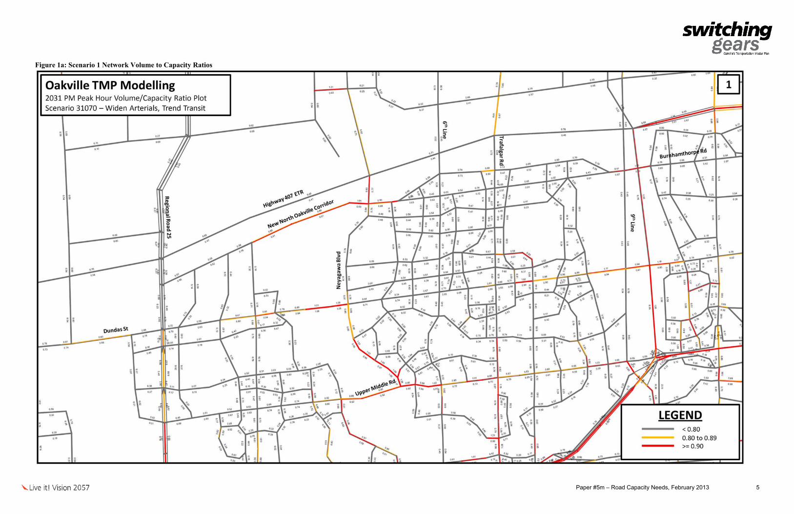
Scenario 1 considers the widening of town arterials. Figures 1a and1b illustrate the link volume to capacity ratios (v/c ratios) for the Scenario 1 network. Even with the widened arterials, the following east-west corridors will continue to approach or exceed capacity: • Dundas Street (Meadowridge Drive to Vega Boulevard). • QEW. • Rebecca Street (Third Line to Fourth Line). • Upper Middle Road (Dorval Drive to Ninth Line). For the north-south corridors, the following sections will approach or exceed capacity: • Bronte Road (Dundas Street to QEW). • Dorval Drive (Upper Middle Road to Kerr Street). • Neyagawa Boulevard (Dundas Street to Upper Middle Road). • Trafalgar Road (Glenaston Drive to South Service Road). • Ford Drive (QEW to Royal Windsor Drive). • Highway 403 (Highway 407 to QEW). In general, a reduction to the volume to capacity ratios on east-west corridors is observed when compared to the base network conditions. However, capacity constraints are expected to continue on sections of Upper Middle Road and Dundas Street. 2.2. Scenario 2
Scenario 2 considers the widening of town arterials plus additional road improvements in the growth area of Midtown Oakville. Figures 2a and 2b illustrate the link v/c ratios for the scenario 2 network. With these network capacity improvements in place, the following east-west corridors will continue to approach or exceed capacity: • Dundas Street (Meadowridge Drive to Vega Boulevard). • QEW. • Rebecca Street (Third Line to Fourth Line). • Upper Middle Road (Dorval Drive to Ninth Line). For the north-south corridors, the following sections will approach or exceed capacity: • Bronte Road (Dundas Street to QEW). • Dorval Drive (Upper Middle Road to Kerr Street). • Neyagawa Boulevard (Dundas Street to Upper Middle Road). • Trafalgar Road (Glenaston Drive to South Service Road). • Ford Drive (QEW to Royal Windsor Drive). • Highway 403 (Highway 407 to QEW). In comparing to the Scenario 1 network, a reduction to the volume to capacity ratio on road link in the Midtown growth area is observed. However, Trafalgar Road will continue to operate at or above capacity through the noted section.

Paper #5m – Road Capacity Needs, February 2013 4
2.3. Scenario 3
Scenario 3 considers the widening of town arterials, plus additional road improvements in Midtown Oakville, and plus new crossings over Sixteen Mile Creek and Highway 403. Figures 3a and 3b illustrate the link v/c ratios for the scenario 3 network. The following east-west corridors will continue to approach or exceed capacity in scenario 3: • Dundas Street (Meadowridge Drive to Vega Boulevard). • QEW. • Rebecca Street (Third Line to Fourth Line). • Upper Middle Road (Dorval Drive to Ninth Line). For the north-south corridors, the following sections will approach or exceed capacity: • Bronte Road (Dundas Street to QEW). • Dorval Road (Upper Middle Road to Kerr Street). • Neyagawa Boulevard (Dundas Street to Upper Middle Road). • Trafalgar Road (Glenaston Drive to South Service Road). • Ford Drive (QEW to Royal Windsor Drive). • Highway 403 (Highway 407 to QEW). Minor reductions to the volume to capacity ratios along the east-west corridors in the vicinity of the new crossings are observed. For the Sixteen Mile Creek crossing, decreases in the v/c ratios are observed along Upper Middle Road near Sixteen Mile Creek, however the corridor will still approach capacity. For the Highway 403 crossing, reductions to the v/c ratios on Upper Middle Road and on Dundas Street near Highway 403 are noted. Even with the new crossing, Dundas Street will continue to operate at capacity in this section. 2.4. Shift in Travel Demand to Non-automobile Modes
Based on a review of the sequential improvements to the road network, it is observed that additional road capacity will result in some improvements to the v/c ratios on the major corridors. Additional capacity is needed and a scenario with capacity improvements to collector roads and residential minor arterials was considered. However, this scenario could have significant impact to existing neighbourhoods and communities. A shift in travel demand from the private automobile to non-auto modes such as transit, cycling and walking was assessed. In this scenario, additional strategies to reduce vehicular traffic was undertaken to encourage transit ridership, cycling and walking, with a target of a 6% reduction in automobile travel to account for transportation demand management (TDM) and active transportation strategies and a 14% reduction in automobile travel (target of 20% transit mode share) in response to transit strategies and infrastructure improvements. Figures 4a and 4b illustrates the link v/c ratios for the scenario 3 network with a shift in travel demand. Based on these strategies, the 2031 network will generally operate within capacity. It is however expected that QEW will continue to operate with capacity constraints, along with north-south connections to QEW interchanges especially at Bronte Road, Trafalgar Road and Ford Drive.
Paper #5m – Road Capacity Needs, February 2013 5
Figure 1a: Scenario 1 Network Volume to Capacity Ratios

Paper #5m – Road Capacity Needs, February 2013 6
Figure 1b: Scenario 1 Network Volume to Capacity Ratios

Paper #5m – Road Capacity Needs, February 2013 7
Figure 2a: Scenario 2 Network Volume to Capacity Ratios

Paper #5m – Road Capacity Needs, February 2013 8
Figure 2b: Scenario 2 Network Volume to Capacity Ratios

Paper #5m – Road Capacity Needs, February 2013 9
Figure 3a: Scenario 3 Network Volume to Capacity Ratios

Paper #5m – Road Capacity Needs, February 2013 10
Figure 3b: Scenario 3 2031 Network Volume to Capacity Ratios

Paper #5m – Road Capacity Needs, February 2013 11
Figure 4a: Scenario 3 with Reduction Strategies Network Volume to Capacity Ratios

Paper #5m – Road Capacity Needs, February 2013 12
Figure 4b: Scenario 3 with Reduction Strategies Network Volume to Capacity Ratios

Paper #5m – Road Capacity Needs, February 2013 13
3.0 Road Urbanization
3.1. Need for Urbanized Roadways
In light of the traffic demands through the town’s network, infrastructure improvements will be necessary to support active transportation and transit strategies. In addition to capacity needs, urbanization of existing roads with rural cross-sections is recommended to promote and accommodate walking, cycling and transit use. Throughout the Town of Oakville, there are some established collector and arterial roads with rural cross-sections, as summarized in Table 2. Although these streets have not been identified as requiring capacity improvements, they are not conducive to active transportation or supportive to community activities. As the town plans for a 2031 population of 246,400, there will be increasing need to accommodate all users. Urbanized roadways allow for separation of vehicles and pedestrians and novice cyclists and lessen the exposure and safety risks of interaction with vehicles. Table 2: Identified Established Roads with Rural Cross-section Road Section Water Street Lakeshore Road East to Navy Street McCraney Street Sixth Line to Montclair Drive Falgarwood Drive Gainsborough Drive to Grosvenor Street Bridge Road Third Line to Fourth Line Chisholm Street Rebecca Street to Bond Street Deer Run Avenue East of Acacia Court to Winston Churchill Boulevard
Urban roads have cross sections that typically include curbs, gutters, catch basins, underground storm sewer and sidewalks. Meanwhile, rural roads may be lacking some or all of these components and are more likely to include culverts and ditches for stormwater management. The reconstruction of a rural road section to urban specifications is referred to as urbanization. The construction of urban roads in critical locations will help enhance pedestrian and cycling mobility and be more supportive for transit usage in established neighbourhoods. This approach is supported by Ministry of Transportation and Ministry of Municipal Affairs, in their Transit-Supportive Land-Use Planning Guidelines and is inline with the principles in the town’s Active Transportation Master Plan (ATMP) and the Livable Oakville Plan. 3.2. Alternative Approaches
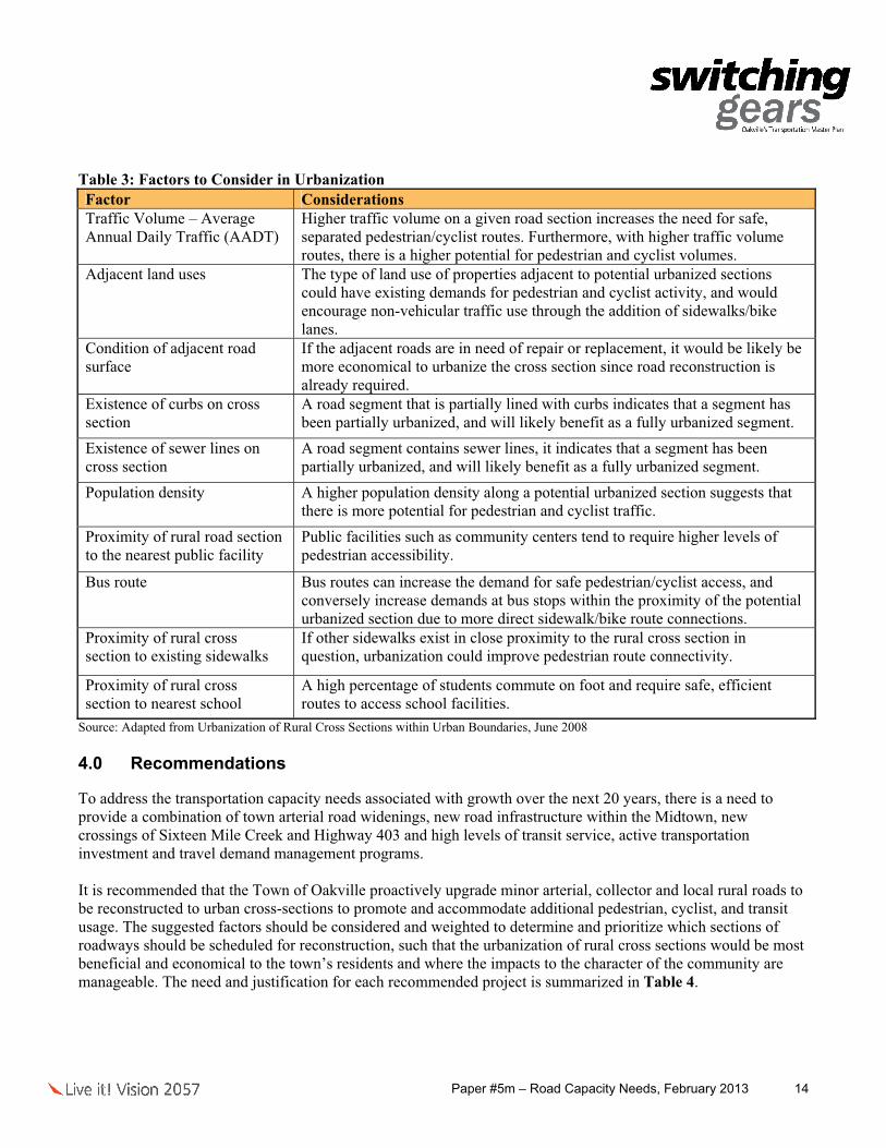
The concept of development of urban cross-sections for the purposes of supporting pedestrians and cyclists has been studied in various other cities in Ontario. The following Table 3 lists the factors that should be considered in assessing the priorities for urban roads sections.
Paper #5m – Road Capacity Needs, February 2013 14
Table 3: Factors to Consider in Urbanization Factor Considerations Traffic Volume – Average Annual Daily Traffic (AADT)
Higher traffic volume on a given road section increases the need for safe, separated pedestrian/cyclist routes. Furthermore, with higher traffic volume routes, there is a higher potential for pedestrian and cyclist volumes.
Adjacent land uses The type of land use of properties adjacent to potential urbanized sections could have existing demands for pedestrian and cyclist activity, and would encourage non-vehicular traffic use through the addition of sidewalks/bike lanes.
Condition of adjacent road surface
If the adjacent roads are in need of repair or replacement, it would be likely be more economical to urbanize the cross section since road reconstruction is already required.
Existence of curbs on cross section
A road segment that is partially lined with curbs indicates that a segment has been partially urbanized, and will likely benefit as a fully urbanized segment.
Existence of sewer lines on cross section
A road segment contains sewer lines, it indicates that a segment has been partially urbanized, and will likely benefit as a fully urbanized segment.
Population density A higher population density along a potential urbanized section suggests that there is more potential for pedestrian and cyclist traffic.
Proximity of rural road section to the nearest public facility
Public facilities such as community centers tend to require higher levels of pedestrian accessibility.
Bus route Bus routes can increase the demand for safe pedestrian/cyclist access, and conversely increase demands at bus stops within the proximity of the potential urbanized section due to more direct sidewalk/bike route connections.
Proximity of rural cross section to existing sidewalks
If other sidewalks exist in close proximity to the rural cross section in question, urbanization could improve pedestrian route connectivity.
Proximity of rural cross section to nearest school
A high percentage of students commute on foot and require safe, efficient routes to access school facilities.
Source: Adapted from Urbanization of Rural Cross Sections within Urban Boundaries, June 2008 4.0 Recommendations
To address the transportation capacity needs associated with growth over the next 20 years, there is a need to provide a combination of town arterial road widenings, new road infrastructure within the Midtown, new crossings of Sixteen Mile Creek and Highway 403 and high levels of transit service, active transportation investment and travel demand management programs. It is recommended that the Town of Oakville proactively upgrade minor arterial, collector and local rural roads to be reconstructed to urban cross-sections to promote and accommodate additional pedestrian, cyclist, and transit usage. The suggested factors should be considered and weighted to determine and prioritize which sections of roadways should be scheduled for reconstruction, such that the urbanization of rural cross sections would be most beneficial and economical to the town’s residents and where the impacts to the character of the community are manageable. The need and justification for each recommended project is summarized in Table 4.

Road-Rail Capacity Queuing Development
Access Within Corridor Adjacent Corridor
Goods Movement
Accommodates Pedestrians
Accommodates Cyclists
Accommodates Transit
Active Transportation Initiatives Bicycle parking, rings and shelters, racks •AT Cycle Lanes, Routes and Pathways See Tables PED1, PED2 and PED3 • •AT Facilities on Regional Roads See Table PED5 and PED6 • •
South of Wyecroft Road North of Prince William Drive Construction of CN rail grade separation and widening to a 6 lane urban roadway • • • • •North of Prince Willam Drive Old Burloak Drive Widening to a 6 lane urban roadway • • • • •South Service Road Cornwall Road Construction of a 4 lane urban roadway and level CN crossing • • •Industry Street Melvin Avenue Construction of a 4 lane grade separation structure • •Chartwell Road Morrison Road Reconstruction and widening to a 4 lane urban roadway • • • •Ford Drive Winston Churchill Boulevard Widening to a 4 lane urban roadway • • • • •Speers Road CNR Overhead Rail Bridge Intersection improvements (dual right turn lane) • •West of Lyons Lane East of Lyons Lane Widening of roadway and signalization • • • • •Lyons Lane Argus Road Modifications to Cross Avenue • • • •Argus Road Chartwell Road Extension and reconfiguration of Cross Avenue • • • • •Chartwell Road Royal Windsor Drive Extension and reconfiguration of Cross Avenue • • • •Falgarwood Drive Iroquois Shore Road Widening from a 2 lane urban to 3 lane urban roadway • • • • •Iroquois Shore Road North Sevice Road Reconstruction to a 3 lane urban roadway • • • •Wyecroft Road Speers Road Construction of a 4 lane grade separation structure • • • • • •Wyecroft Road Speers Road Widening from a 2 lane to 4 lane roadway with level crossing • •
Goods Movement Study • • • • •Goods Movement Study Update • •Great Lakes Boulevard Burloak Drive Rebecca Street Widening and resurfacing to a 4 lane urban roadway • • • •Highway 403 Crossing Ninth Line Bristol Circle Construction of a new 4 lane urban roadway and grade separation • • • •Implementation Plan and Monitoring Study Update report every 5 years in advance of TMP/ATMP • • • • • • • • •
Wyecroft Road Speers Road Construction of a 4 lane grade separation structure • • • • •North of QEW Wyecroft Road Relocation of the westerly abutment of the QEW/Sixteen Mile Creek structureEast Street Third Line Reconstruction to an urban arterial road standard • • •Third Line Sandwell Drive (100m west) Reconstruction to an urban arterial road standard • • •Sandwell Drive Wittington Place (100m west) Reconstruction to an urban arterial road standard • • •Wittington Place (100m west) Dorval Drive Reconstruction to an urban arterial road standard • • •
Lower Base Line Bronte Road Fourth Line Reconstruction of a 2 lane rural roadway (excluding valley section) •Midtown - 2 lane connection (Phase 1) Eighth Line Royal Windsor Drive Widening and extending Iroquois Shore Road, widening and realigning SSR, NSR and RWD • • • • • •Midtown - 4 lane connection (Phase 2) Eighth Line QEW off-ramp connection Widening and resurfacing to a 4 lane urban roadway • • • • •Midtown - EW South Alignment Road East of New Cross Avenue Chartwell Road (or approximate) Construction of a new 2 lane roadway • • • •Midtown - NS QEW Crossing (AT/priority lanes) Trafaglar Road Cross Avenue Elevated structure from Trafalgar Road to Cross Avenue • • • •Midtown - NS QEW Crossing (Road) Cross Avenue Iroquois Shore Road New North/South Crossing of the QEW • • • • •New Burnhamthorpe Road Tremaine Road Bronte Road Construction of a new 4 lane urban arterial roadway • • • •New Shelters New Roadside Shelters • •
West of Deerfield Golf Course Third Line Reconstruction and widening to a 3 lane urban roadway • • • • •Third Line West of Fourth Line Reconstruction and widening to a 4 lane urban roadway • • • • • •Kerr Street Sixth Line Extend NSR over Sixteen Mile Creek and connect to Kerr Street at CTC Signals • • • • •West of Eighth Line Eighth Line Widening from a 2 lane urban to 3 lane urban roadway • • • • •Joshuas Creek Drive Ford Drive Construction of a new 4 lane urban roadway • • • • •
Oakville Share - Park and Ride Facilities Park and Ride Facilities • •Palermo Terminal Transit Station •Pedestrian Structures See Table PED4 • • •QEW-Cross Avenue QEW Cross Avenue New buttonhook EB off-ramp • • • •QEW-Midtown QEW Midtown Modified EB off-ramp to pass under Trafalgar Road to Midtown • • • •QEW-Royal Windsor Drive Royal Windsor Drive QEW New EB on-ramp to QEW • • •QEW-Royal Windsor Drive QEW Royal Windsor Drive Modified EB off-ramp to Royal Windsor Drive •QEW-Trafalgar Road QEW Trafalgar Road Modified EB off-ramp to Trafalgar Road • •
QEW The Canadian Road Widening from 2 to 5 lanes • •Ford Drive Winston Churchill Boulevard Reconstruction to a 4 lane urban roadway • • •
Signal Optimization Program Once every 5 years (key corridors)and optimize key corridors other years • • • • •407 New Burnhamthorpe Road Reconstruction to a 4 lane urban roadway • • • •New Burhamthorpe Road E-W Avenue 2 Reconstruction to a 4 lane urban roadway • • • •E-W Avenue 2 E-W Connector 1 Reconstruction to a 4 lane urban roadway • • • •E-W Connector 1 Dundas Street Reconstruction to a 4 lane urban roadway • • • •Third Line West of Fourth Line Reconstruction and widening to a 4 lane urban roadway • • • • •Proposed roundabout South Service Road Construction of a new 2 lane roadway • •Davis Road Chartwell Road Reconstruction and widening to a 2 lane urban roadway • • • •Chartwell Road Industry Street Reconstruction and widening to a 2 lane urban roadway • • • •
Description of WorksLimits ToLimits From
Lakeshore Road West
Burloak Drive
Chartwell Road
Cornwall Road
Cross Avenue
Royal Windsor Drive
Sixth Line
South Service Road
North Service Road
Table 4: Need and Justification for Recommended Highways Projects
Reduces Vehicle DemandAddresses Capacity NeedsPotential Benefits
Project Name
Eighth Line
Fourth Line
Kerr Street
Paper #5m – Road Capacity Needs, February 2013

Road-Rail Capacity Queuing Development
Access Within Corridor Adjacent Corridor
Goods Movement
Accommodates Pedestrians
Accommodates Cyclists
Accommodates Transit
Description of WorksLimits ToLimits From
Table 4: Need and Justification for Recommended Highways Projects
Reduces Vehicle DemandAddresses Capacity NeedsPotential Benefits
Project Name
Bronte Road Procor Widening and resurfacing of a 4 lane urban roadway • • • •Procor Third Line Widening and resurfacing of a 4 lane urban roadway • • • • •Third Line West of Fourth Line Widening and resurfacing of a 4 lane urban roadway • • • • •East of Fourth Line West of Dorval Drive Widening and resurfacing of a 4 lane urban roadway • • • • •East of Dorval Drive West of Kerr Street Widening and resurfacing of a 4 lane urban roadway • • • • •Kerr Street Cross Avenue Widening of Sixteen Mile Creek structure (6 lanes Speers Road) • • • • •Bronte Road Third Line Widening from 4 to 6 lanes • • • •Third Line Fourth Line Widening from 4 to 6 lanes • • • •Fourth Line Dorval Drive Widening from 4 to 6 lanes • • • •Dorval Drive Kerr Street Widening from 4 to 6 lanes • • • •Kerr Street Trafalgar Road Widening from 4 to 6 lanes • • • •
Third Line New Burnhamthorpe Road Dundas Street Construction of a new 4 lane urban roadway • • • • •Traffic Impact Assessment Guidelines • • • • • •Traffic Management - Intersections Intersection improvements, transit priority and queue jump lanes - See Tables TM1, TM2 and TM3 • • • •Traffic Signals (2013-2022) Two new signals per year (20 signals total) • • • •Traffic Signals (2023-2032) Two new signals per year (20 signals total) • • • •Transit Centres North Oakville West, Centre and East • • •Transportation Master Plan Studies Major Transportation Study Updates 2/5 years, TMP and ATMP • • • • • • • • •Travel Demand Management Studies
Burloak Drive (up to the interesection) RRL Burloak Limit Construction of a new 4 lane urban roadway • • • • •RRL Burloak Lands Bronte Road Construction of a new 4 lane urban roadway • • • • •Bronte Road Third Line Widening and resurfacing to a 4 lane urban roadway • • • • • •East of Fourth Line Weller Court Reconstruction and widening to a 4 lane urban roadway • • • • •Sinclair Road Kerr Street Reconstruction of a 2 lane rural to 4 lane urban roadway plus centre turning lane • • • • •
Wyecroft Road
Speers Road
Paper #5m – Road Capacity Needs, February 2013

Table PED1: Cycle Lanes and Signed Routes on Town RoadsProject Name Limits From Limits To
Abbeywood Drive Third Line Pilgrims WayBishops Gate Upper Middle Road Pilgrims WayBristol Circle Winston Park Boulevard Winston Churchill BoulevardChurch Street Navy Street Allan StreetForsythe Street Bond Street Rebecca StreetGlen Abbey Gate Third Line Pilgrims WayGrand Oak Trail Dundas Street Pine Glen RoadGrand Oak Trail Pine Glen Road Westoak Trails BoulevardGrand Oak Trail Westoak Trails Boulevard Upper Middle RoadHeritage Way Kings College Kings CollegeKingsway Drive Ford Drive Winston Churchill BoulevardLakeshore Road Dorval Drive Wilson StreetLyons Lane QEW Cross AvenueMcCraney Street Sewell Drive Trafalgar RoadMerchants Gate Heritage Way Third LineNavy Street Randall Street Church StreetNorth Service Road Dorval Drive Kerr Street QEW ExitPine Glen Road Bronte Road Falling Green DrivePine Glen Road Third Line Proudfoot TrailPostmaster Drive Upper Middle Road Heritage WayProudfoot Trail Pine Glen Road Westoak Trails BoulevardRandall Street Navy Street Allan StreetRebecca Street Morden Road Kerr StreetReeves Gate Upper Middle Road Heritage WayRiver Glen Boulevard Neyagawa Boulevard Sixth LineShepherd Road Kerr Street Speers RoadSheridan Garden Drive Ford Drive Winston Churchill BoulevardSixth Line Dundas Street Upper Middle RoadSixth Line Upper Middle Road McCraney Street
Allan Street Cornwall Road Robinson StreetArgus Road South Service Road Cross AvenueArrowhead Road North Ridge Trail Pinery CrescentAspen Forest Drive Ford Drive Ford DriveBayshire Drive North Ridge Trail Grand BoulevardBriarhall Gate Trafalgar Road Golden Briar TrailBridge Road Bronte Road Third LineBristol Circle Winston Park Drive Bristol Circle (south)Brookmill Road Devon Road Dunedin RoadBuckingham Road Bristol Circle Upper Middle RoadBurnhamthorpe Road Tremaine Road Regional Road 25 Central Park Drive Oak Park Boulevard Glenashton DriveClearview Drive Kingsway Drive Prince John CircleConstance Drive Maple Grove Drive Dunedin RoadConstance Drive Wedgewood Drive Maple Grove DriveCornwall Road Cross Avenue Trafalgar RoadCornwall Road Trafalgar Road Chartwell RoadCreek Path Avenue Great Lakes Boulevard Great Lakes BoulevardDeer Run Avenue Aspen Forest Drive Winston Churhill BoulevardDevon Road Ford Drive Lakeshore RoadDevon Road Morrison Road Ford DriveDunedin Road Constance Road Ford DriveDunn Street Trafalgar Road Randall StreetElmhurst Avenue Maple Grove Drive Devon RoadFalgarwood Drive Eighth Line Gainsborough DriveFord Drive Constance Avenue Lakeshore RoadFourth Line 150m north of Hilltop Lane Westoak Trails BoulevardFourth Line Dundas Street 250m south of Dundas StreetFourth Line Lower Base Line Highway 407Gable Drive Wynten Way Sheridan Garden DriveGlenashton Drive Sixth Line Trafalgar RoadGolden Briar Trail Glenashton Drive Upper Middle Road
Cycle Lanes (On-road)
Signed Routes (On-road)

Table PED1: Cycle Lanes and Signed Routes on Town RoadsProject Name Limits From Limits ToGrand Boulevard Upper Middle Road Eighth LineGrosvenor Street Glenashton Drive Upper Middle RoadGrosvenor Street Upper Middle Road Falgarwood Drive Hillhurst Road/Trelawn Avenue Morrison Road Lakeshore RoadHixon Street Bronte Road Third LineHixon Street Third Line Woodhaven Park DriveHyde Park Gate Dundas Street Bristol Circle Jonathan Drive Sir David Drive Sheridan Garden DriveJones Street Rebecca Street Lakeshore RoadJoshuas Creek Drive Bayshire Drive Upper Middle RoadKerr Street Speers Road Lakeshore RoadKhalsa Gate Pine Glen Road Bronte RoadLakeshore Road Navy Street Allan StreetLees Lane Pinegrove Road Rebecca StreetLinbrook Road Chartwell Road Morrison RoadLower Base Line Regional Road 25 Fourth LineMacDonald Road Trafalgar Road Chartwell RoadMaple Avenue Allan Street Chartwell RoadMary Street Morden Road Maurice DriveMaurice Drive Mary Street Stewart StreetMcCraney Street Oxford Avenue Sixth LineMeadowridge Drive Dundas Street Arrowhead RoadMorrison Road Cornwall Road Lakeshore RoadNautical Boulevard Great Lakes Boulevard Great Lakes BoulevardNorth Service Road Bronte Road West of Deerfield Golf CourseNorth Service Road Pearson Drive Trafalgar RoadNorth Service Road Sixth Line Pearson DriveNorth Service Road West of Fourth Line Fourth LineOak Park Boulevard Dundas Street Trafalgar RoadOakmead Boulevard Wembley Road Upper Middle RoadOld Bronte Road Regional Road 25 Pine Glen RoadOxford Avenue River Oaks Boulevard McCraney StreetParkside Drive Fourth Line Glen Oak DrivePinegrove Road Warminster Drive Mary StreetPinery Crescent Arrowhead Road Rockingham DrivePrince John Circle Clearview Drive Kingsway DriveRebecca Street Fourth Line Morden RoadRiverview Street Mississaga Street Lakeshore RoadRobinson Street Water Street Allan StreetRockingham Drive Pinery Crescent Bayshire DriveSandwell Drive Rebecca Street Lakeshore RoadSawgrass Drive Oak Park Boulevard Glenashton DriveSedgewick Crescent Woodhaven Park Drive Sandwell DriveSir David Drive Wynten Way Kingsway DriveSixth Line Upper Middle Road McCraney StreetStewart Street Maurice Drive Queen Mary DriveSunset Drive Bridge Road Rebecca StreetThe Canadian Road/South Service Road Royal Windsor Drive Ford DriveTrafalgar Road Cornwall Road Robinson StreetWarminster Drive Bridge Road Rebecca StreetWarminster Drive Pinegrove Road Bridge RoadWarren Drive Wedgewood Drive Maple Grove DriveWedgewood Drive Trelawn Avenue Constance DriveWembley Road Glenashton Drive Oakmead BoulevardWildwood Drive Fourth Line Morden RoadWinston Park Drive Dundas Street Bristol Circle (south)Winterbourne Drive Kingsway Drive Clearview DriveWoodhaven Park Drive Sedgewick Crescent Lakeshore RoadWyecroft Road Weller Court Dorval DriveWyecroft Road (SSR) Third Line Fourth LineWynten Way Kingsway Drive Kingsway DriveYolanda Drive Bridge Road Sunset Drive

Table PED2: Multiuse Trails on Town RoadsProject Name Limits From Limits ToBeryl Road West limit Winston Churchill BoulevardCornwall Road East of Ford Drive East limitHydro Corridor Bronte Road Fourth LineHydro Corridor Trafalgar Road Ninth LineHydro Corridor Bristol Circle Winston Churchill BoulevardHydro Corridor Neyagawa Boulevard Glenashton DriveLakeshore Road Allan Street Chartwell RoadLakeshore Road Chartwell Road Morrison RoadLakeshore Road Ford Drive Winston Churchill BoulevardLakeshore Road Maple Grove Drive Ford DriveLakeshore Road Morrison Road Maple Grove Drive
Table PED3: Sidewalks on Town RoadsProject Name Limits From Limits ToChartwell Road Cornwall Road Lakeshore Road EConstance Drive Wedgewood Drive Maple Grove DriveCornwall Road Maple Grove Drive Ford DriveDeer Run Avenue 200m west of Winston Churchill Boulevard Winston Churchill BoulevardDorval Drive 200m south of Speers Road Rebecca StreetFord Drive Aspen Forest Drive Aspen Forest DriveFord Drive Devon Road Lakeshore RoadGrand Oak Trail Dundas Street W Montagne AvenueHillhurst Road Morrison Road Cardinal DriveIroquois Shore Road North Service Road E Eighth LineKerr Street Dorval Crossing 200m north of QEWKingsway Drive Ford Drive Sherwood Heights DriveLyons Lane South of QEW South Service Road ELyons Lane South Service Road E Cross AvenueMaple Grove Drive Devon Road Lakeshore Road ENorth Service Road E 175m east of Sixth Line Kent AvenueNorth Service Road E Kent Avenue Pearson DriveNorth Service Road E Pearson Drive Trafalgar RoadNorth Service Road E Sixth Line 175m east of Sixth LineNorth Service Road W 100m east of 381 North Service Road W Lindsay DriveNorth Service Road W Bronte Road West of Deerfield Golf CourseOak Park Boulevard Oak Walk Drive Taunton RoadParkside Drive Fourth Line End/ParkPine Glen Road Bronte Road Kwinter RoadPine Glen Road Postmaster Drive Castlebrook RoadPostmaster Drive Dundas Street W Crestmont DriveSandwell Drive Rebecca Street Lakeshore Road WSeneca Drive West Street West River StreetSixth Line Culham Street Ridge DriveSixth Line Dundas Street Glenashton DriveSouth Service Road E Royal Windsor Drive Ford DriveTrelawn Avenue Cardinal Drive Wedgewood DriveWarren Drive 200m west of Maple Grove Drive Maple Grove DriveWedgewood Drive Constance Drive Devon RoadWest River Street Lakeshore Road W Seneca DriveWest Street Lakeshore Road W Seneca DriveWinston Park Drive 250m south of Brighton Road 250m north of Plymouth DriveWinston Park Drive Bristol Circle Brighton RoadWinston Park Drive Bristol Circle Upper Middle Road EWoodhaven Park Drive Hixon Street Lakeshore Rd W

Table PED4: Pedestrian Structures
Table PED5: Sidewalks on Regional RoadsProject Name Limits From Limits ToBronte Road Highway 407 Dundas StreetDorval Drive Upper Middle Road Old Abbey LaneDundas Street Highway 403 Trafalgar RoadDundas Street Trafalgar Road Oak Walk DriveDundas Street Oak Walk Drive Sixth LineDundas Street Sixth Line Neyagawa BoulevardDundas Street Neyagawa Boulevard Sixteen Mile Creek BridgeDundas Street Over Sixteen Mile Creek StructureDundas Street Sixteen Mile Creek Bridge Proudfoot TrailDundas Street Proudfoot Trail Postmaster DriveDundas Street Postmaster Drive Bronte RoadDundas Street Bronte Road Valley Ridge Drive Dundas Street Valley Ridge Drive Tremaine RoadFord Drive 275m north of Sheridan Garden Drive Sheridan Garden DriveFord Drive Upper Middle Road Kingsway Drive Ford Drive Kingsway Drive 275m north of Sheridan Garden DriveNew North Oakville Transportation Corridor Bronte Road Ninth LineNeyagawa Boulevard Dundas Street Burnhamthorpe RoadNinth Line Dundas Street Upper Middle RoadNinth Line Burnhamthorpe Road Dundas StreetNorth Service Road extension Burloak Drive Bronte RoadTrafalgar Road Highway 407 Dundas StreetUpper Middle Road Ford Drive West of Winston Park DriveUpper Middle Road Grand Boulevard Ford DriveUpper Middle Road West of Winston Park Drive Winston Park DriveWinston Churchill Boulevard Royal Windsor Drive Lakeshore Road
Midtown - QEW midblock crossing Midtown - QEW priority lane/AT crossing
Project Name403 - North of Upper Middle RoadBronte Road / QEW - Underpass on abandoned corridorBronte Creek in Bronte Provincial Park
Trafalgar Road / Leighland AvenueTrafalgar Road / White Oaks Boulevard
NOE - Unnamed street (west of Neyagawa Boulevard)Third Line / Dundas Street WTrafalgar Road / Cornwall RoadTrafalgar Road / Dundas Street E - 2 StructuresTrafalgar Road / Glenashton DriveTrafalgar Road / GO Rail
Midtown - West of Trafalgar RoadNeyagawa Boulevard / Dundas Street WNOE - Neyagawa BoulevardNOE - Unnamed street (east of Trafalgar Road)
Bronte Road / Dundas Street WKerr Street over GO Rail

Table PED6: Multiuse Trails on Regional RoadsProject Name Limits From Limits ToBronte Road North Service Road Wyecroft RoadBronte Road Dundas Street Highway 407Dundas Street Bronte Road Proudfoot TrailDundas Street Neyagawa Boulevard Oak Park BoulevardDundas Street Oak Park Boulevard Winston Churchill BoulevardDundas Street Proudfoot Trail Neyagawa BoulevardDundas Street Tremaine Road Bronte RoadFord Drive Sheridan Garden Drive Kingsway DriveFord Drive Kingsway Drive Upper Middle RoadNew North Oakville Transportation Corridor Bronte Road Ninth LineNeyagawa Boulevard Dundas Street Burnhamthorpe RoadNeyagawa Boulevard Burnhamthorpe Road Highway 407Ninth Line Burnhamthorpe Road Dundas StreetNinth Line Dundas Street Upper Middle RoadNinth Line Burnhamthorpe Road Highway 407Trafalgar Road Dundas Street Glenashton DriveUpper Middle Road Grand Boulevard Ford DriveUpper Middle Road Highway 403 Winston Churchill BoulevardWinston Churchill Bouleavard Dundas Street Lakeshore Road

1 Rebecca Street2 Speers Road3 Upper Middle Road
1 Third Line2 Fourth Line3 Dorval Drive4 Kerr Street5 Cross Avenue6 Trafalgar Road7 Chartwell Road8 Maple Grove Drive
1 Bronte Road2 Third Line3 Fourth Line4 Dorval Drive5 Kerr Street6 Trafalgar Road
1 Bronte Road2 Third Line3 Fourth Line4 Dorval Drive5 Kerr Street6 Trafalgar Road
Dundas Street - Queue Jump Lanes EB/WB at 8 intersections 1 Tremaine Road2 Colonel William Parkway3 Bronte Road4 Postmaster Drive5 Third Line6 Proudfoot Trail7 Neyagawa Boulevard8 Sixth Line
Trafalgar Road - Queue Jump Lanes NB/SB at 9 intersections1 Street X2 New Burnhamthorpe Road3 EW Connector 24 EW Connector 15 Glenashton Drive6 Upper Middle Road7 Ceremonial Road (Sheridan College)8 McCraney Street9 Leighland Avenue - Iroquois Shore Road
Table TM3: Intersection Improvements1 10 locations - 1 per year from 2013-2022 2 10 locations - 1 per year from 2023-2032
Table TM1: Transit Priority Third Line - Transit Priority NB/SB at 3 intersections
Lakeshore Road West - Transit Priority EB/WB at 6 intersections
Table TM2: Queue Jump Lanes
Speers Road - Transit Priority EB/WB at 8 intersections
Rebecca Street - Transit Priority EB/WB at 6 intersections