Embed Size (px)
Citation preview
Agenda Item 6.7
Report No PLN/021/20
HIGHLAND COUNCIL
Committee: North Planning Applications Committee
Date: 9 June 2020
Report Title: 19/05404/FUL: Highland Housing Alliance
Land 110m SW of 12 Thomas MacIver St, Evanton Report By: Area Planning Manager – North
Purpose/Executive Summary
Description: Erection of 140 houses
Ward: 06, Cromarty Firth
Development category: Major Development
Reason referred to Committee: Major Development
All relevant matters have been taken into account when appraising this application. It is considered that the proposal accords with the principles and policies contained within the Development Plan and is acceptable in terms of all other applicable material considerations.
Recommendation
Members are asked to agree the recommendation to Grant Planning Permission as set out in section 11 of the report.
1. PROPOSED DEVELOPMENT
1.1 The application is for a phased development for the erection of 140 houses. A detailed road layout, including levels and engineering drawings, has been received for the entire development, along with a detailed landscaping plan. Full details have been submitted in respect of Phase 1. The remaining phases detail the road, plot boundaries, boundary treatment including retaining walls, levels for each plot, parking areas, an indicative house footprint, but the design of house has been omitted.
1.2 The proposal is to be built over 7 phases:
• Phase 1 - 40 affordable housing units; • Phase 2 - 16 private units; • Phase 3 – 16 private units; • Phase 4 – 23 units; • Phase 5 – 21 units; • Phase 6 – 11 units; and • Phase 7 – 13 units.
The tenure for phases 4-7 is to be confirmed.
Phase 1 will consist of the following housing mix:
• 8 x 2 bedroomed semi-detached houses • 17 x 3 bedroomed semi-detached houses • 2 x 2 bedroomed semi-detached bungalows • 3 x 3 bedroomed semi-detached bungalows • 2 x 1 bedroomed semi-detached bungalows • 8 x 2 bedroomed flats.
1.3 The proposed homes will be a maximum of two storey in height and vary in their design.
1.4 The main access into the site will be off Hermitage Street at the point where it becomes Swordale Road. The alignment of the existing road will be amended to form a bend at the access point, with priority being given to traffic travelling into the site, and a turning manoeuvre being required for traffic wishing to continue along Swordale Road/Hermitage St. The site is well located with regards to access to the strategic road network, with the A9(T) accessible and within a short drive of the site.
1.5 A secondary access point will be formed off Thomas MacIver Street. A convoluted route is proposed between Thomas MacIver Street and the main access off Swordale Road to prevent this route being used by vehicles as a ‘short cut’ through the adjacent residential roads. The linkage will not however be delivered until Phase 4 with limited development of each assess until that time.
1.6 A statutory pre-application consultation event involved an advert in the Ross-shire Journal and Highland News, a public exhibition held in the Cornerstone Café (28th May – 1st June 2018), and a meeting between the Highland Housing Association and Kiltearn Community Council on 17th April 2018. In addition, the applicant held a drop in public consultation event on 26th May 2018 at the Diamond Jubilee Hall.
1.7 The applicant also sought pre-application advice from the Planning Authority prior to submitting their application. The pre-application advice set out that the principle of residential development was acceptable but a few matters remain to be resolved. These relate to the increase in the number of units and thus also a higher density than that indicated in the local plan; the provision of active travel links to the village centre; and the timing/viability of the bridge link between Teandallon and Drummond Road. Any detailed application would also need to satisfactorily address visual and landscape impact; access; and layout.
1.8 The application was supported by the following documents:
• Design statement • Flood Risk Assessment • Drainage Impact Assessment • Protected Species Walkover survey • Transport Assessment • Design and Access Statement • Pre-application Consultation Report • Pre-Development Enquiry Form • Tree Constraints Data • Arboricultural Impact Assessment and Method Statement • Soft Landscape Works and Maintenance Programme • Tree Survey • Design Brief • Phase II Geotechnical and Environmental Report • Storm Sewer Design • Response to Consultee Comments • Response to Transport Planning • Air Source Heat Pump product information • Full Site Cut and Fill Analysis
1.8 The following variations have been made to the application following validation: boundary treatment added; landscaping amended; drainage and SuDS basin amended; footpaths amended; canopies added above entrance doors for some housing units; parking layby added; red edge amended to include road linkages into the site; air source heat pumps added; bike sheds added; road geometry amended; levels updated;
house footprints amended for some plots; and design brief amended.
2. SITE DESCRIPTION
2.1 The site is currently two arable fields with an open watercourse running east – west between them, and further drainage ditches/watercourses running along both side boundaries (culverted in part). A steep embankment, wooded in part, denotes the south field boundary, and drops down to a flattish area covered in bracken and the River Sgitheach. The riverside is wooded and waterlogged in nature.
2.2 Located on a hillside, the site slopes down from the Swordale Road along the north site boundary to the River Sgitheach to the south. Existing high density affordable housing (Teandallon Place), Thomas MacIver Street, and an existing children’s play area adjoin the site to the east, with substantial house gardens towards the river. Swordale Road forms the northern boundary, with individual detached houses lying along the opposite side of the road. The area to the west remains arable farmland.
2.3 There are no natural or cultural heritage designations covering the site. The site sits within Landscape Character Type 345 Farmed and Forested Slopes as identified by Scottish Natural Heritage.
2.4 The Novar Special Protection Area (SPA) lies approximately 1.7km to the north of the site. This is a Scots pine woodland designated for its population of breeding capercaillie. The Cromarty Firth SPA and Ramsar site lies approximately 900m to the south of the site. This is designated for its water birds and the Cromarty Firth Site of Special Scientific Interest for the same birds plus the mudflats, saltmarsh and sandflats on which they depend.
2.5 Because of the distance between these protected areas and the site, plus the marked difference in habitats between them, it is not anticipated that developing this site would adversely affect these designated areas.
3. PLANNING HISTORY
3.1 07/02/2018 17/05900/PREAPP Pre-application advice - erection of 150 houses, deliver site for community use/school, and new road layout with associated services.
3.2 06/12/2019 18/01209/PAN New development to provide approximately 150 new dwellings, community use, amenity areas, associated roads and services.
4. PUBLIC PARTICIPATION
4.1 Advertised: Schedule 3 development (S34) and potential departure Date Advertised: 17.01.2020 Representation deadline: 31.01.20

Timeous representations: 2 representations received; one objecting, one neutral.
Late representations: 1 representation received, objecting
4.2 Material considerations raised are summarised as follows: a) Impact on privacy b) Disruption to wildlife c) Impact of increased traffic on road network (including road safety and visibility) d) Suggest developer contribution for community facilities could be used to acquire
and develop an area of land for parking for the Jubilee Hall e) Suggest creating a new route from Teandallon crossing the end of Hill Terrace
and some private land to join Balconie St to the NE of the River Sgitheach bridge to avoid Chapel Road being the sole access from the village.
f) Existing village streets inadequate to serve this development; will be detrimental to amenity and safety
g) Vehicular access should be directly to the B817, not via local roads.
4.3 All letters of representation are available for inspection via the Council’s eplanning portal which can be accessed through the internet www.wam.highland.gov.uk/wam.
5. CONSULTATIONS
5.1 Kiltearn Community Council do not object to the application. It notes that the application has highlighted a long-standing issue in relation to parking at the Village Hall and safety in the Village. The lack of an identified car park for the Hall leads to on-street parking close to the junction between Chapel Rd and Hermitage St. which affects the visibility for drivers exiting Hermitage St. The Community Council welcomes development of new housing to meet the growing needs of the community if progressed in a phased manner with the detail of each phase taking cognisance of needs identified at that point in time. It considers that appropriate steps need to be taken to improve the parking situation at the Hall. Improvements to the safe routes to school are sought in advance of development due to their current state of repair. It considers that consideration should be given to a pedestrian bridge to serve the school as part of a later phase of development. It requests that pot holes on Hermitage St and Livera St at the entrance to Teandallon Square should be repaired prior to commencement of any works on site. A 20mph scheme within the centre of the village is requested. The effect of each phase on the A9 junction should be assessed, and action taken as appropriate. Any damage by construction traffic should be made good. Developer contributions are requested to improve the existing Teandallon Play Area. Requests that steps are taken to ensure that the inclusion of fibre Broadband will assist in the delivery of the network to existing homes unable to access this service. It would like to see priority given to the allocation of completed homes to people with a local connection.
5.2 Transport Planning do not object to the application. It considers that the traffic levels will increase substantially on Hermitage St/Chapel Rd, and to a lesser extent on Livera St. However, it is satisfied that the junction and link capacities are not exceeded and a bridge link between the site and Drummond Road, while desirable, is not essential. A 20mph zone supported by traffic management measures are proposed which form part of the mitigation. This includes raised junction tables and a change to junction priorities. These measures provide a safe environment for active travel users and motorists. A focus has been placed on improving the active travel link into the village and providing a lit safe route to Kiltearn Primary School. Developer contributions are requested towards public transport improvements. This would take the form of the provision of a new bus stop with shelter near the end of Hill Terrace closer to the site, and the provision of real time passenger information units including maintenance at the proposed bus stop and on the opposite carriageway at the existing stop. It notes that it would be beneficial to expand existing bus service provision and to contribute towards an existing Community Transport Project. The surface water drainage adjacent to the low point at 1 Livera St must be upgraded. Road Construction Consent is required, along with finalised drawings for the road layout, road drainage, culverts, internal road junctions, accesses, driveways, and parking. A Construction Traffic Management Plan is required. Footpath links are to be provided both on and off site as per the submitted plans.
5.3 Flood Risk Management do not object following the submission of further information. The information on flood risk and the location of the culverted watercourse along the north-east boundary show that the flood risk to the development is low. The culverted watercourse is outwith the development boundary. It notes that care should be taken to ensure that construction work does not damage the culvert. It has been demonstrated that the SuDS basin can accommodate storms up to and including the 1 in 200 year plus climate change event. The drainage strategy proposed is satisfactory. Conditions are requested to ensure: that the new watercourse crossings are designed to convey a 1 in 200 year plus climate change flow with an appropriate allowance for freeboard; a 6m buffer measured from the top of the bank of the watercourses will be kept free from development; and surface water discharge will be limited to the greenfield rate for each of the corresponding storm events. that the final detailed drainage design is submitted for review and approval and that all design will be in accordance with Sewers for Scotland and suitable for vesting by The Highland Council and Scottish Water under a Section 7 Agreement.
5.4 Environmental Health do not object to the application. It requires that the proposed air source heat pumps be installed in accordance with MCS 020 Planning Standards for Permitted Development Installations of Wind Turbines and Air Source Heat Pumps on Domestic Premises.
5.5 Forestry Officer does not object to the application. He requests that the stand of Sitka spruce within the application site is felled and replanted with native species. He requests that the native woodland creation area to the south of the site is planted prior to commencement of development in order to provide a well-established plantation as the subsequent phases are built. This will also provide an alternative and undisturbed habitat for displaced wildlife during construction phases. All other landscaping should be completed prior to first occupation of each phase of development. He recommends conditions to secure the implementation of the tree protection plan and arboricultural method statement, the implementation of the landscape works, and a factoring agreement to secure the long-term maintenance of communal areas.
5.6 Development Plans do not object to the application. It considers that if the bridge link is not provided to Drummond Road that active travel provision will be critically important if this site is to be supported without the new bridge crossing. It identifies that while the number of units proposed is higher than the indicative capacity in the plan, that site layout is considered to be an efficient use of land and still provides ample green space. However, it notes that the site is some distance from the main concentration of amenities within Evanton; therefore it is essential that clear active travel provision both within the site and linking into Evanton are provided, in particular to the primary school. These must be effective and attractive to encourage their use to ensure that the majority of journeys to the school are not being made by car. It welcomes the masterplan layout as it proposes a range of permeable, legible streets which can accommodate the principles of good design and sets out a phased approach to the development. Considering the layout of Phase 1, it feels that the use of properties accessed from a cul-de-sac is disappointing, but its design as a home zone shared surface with several paths to provide active travel links in and out of the cul-de-sac mitigates this concern. Whilst Phase 1 is not adjacent to the large area of amenity space, there are pathways which will enable people to access the existing playground to the east of the site. In terms of later phases, it is pleasing to see the use of perimeter blocks and sections of home zone shared surfaces. There are a number of examples of active frontages being used across streets, but it would be good to see more overlooking the large amenity space in the south eastern section of the site. The response welcomes the amenity space, including the pathways shown through it which help provide linkages between the site, the existing playground provision and the rest of the village, but there is a lack of natural surveillance due to the orientation of the adjacent houses. A suggestion is made that the SuDS basin needs to be combined with a landscaping strategy so it is incorporated as a positive landscape feature.
There are two gateway features shown. These should be small amenity spaces which are actively used, rather than serving no useful purpose and offering little positive benefit to the public realm. It sets out the developer contributions for the site as follows:
• Primary school 2 classroom extension £2,041 per house, £1,157 per flat • Secondary school – not required • Active travel – as per Transport Planning advice • Green infrastructure – prefer on site provision; minimum 25 sqm per person • Public art – prefer on site provision • Community facilities (Averon Leisure Centre) £1,019 per unit • Community facilities (Evanton Sports Centre) £1,019 per unit • Affordable housing minimum 25% of units • Standard transport requirements – as per Transport Planning advice
5.7 Access Officer does not object to the application. He considers that the site layout has a good network of paths, which appear to connect well with the surrounding existing roads and path network. The construction on most of the path links should be appropriate for use by cycle, disabled uses and pushchairs, and thus a 2m minimum width and bitmac or paved surface. The Whin dust paths should not require timber edging, but a tray with turf edges provides a softer natural edge. Future maintenance should be accounted for with a factoring arrangement. The optimal safe route to school would be a footbridge over the river. This should be installed prior to commencement of phase 4, with a linking path to the track at the SuDS basin.
5.8 Historic Environment Team do not object to the application. It considers the site to have archaeological potential, and request a condition requiring a programme of work for the evaluation, preservation and recording of archaeological and historic features.
5.9 SEPA do not object to the application. It considers that the proposals have been adapted to benefit the topography of the site and locate development away from flood risk areas. It recommends a 6m buffer applied to the ditch running along the east boundary. The proposal to connect to the public sewer and the proposed sustainable drainage is welcomed, as is the inclusion of a blue green corridor through the site.
5.10 Transport Scotland does not propose to advise against the granting of permission.
6. DEVELOPMENT PLAN POLICY
The following policies are relevant to the assessment of the application
6.1 Highland Wide Local Development Plan 2012
28 – Sustainable Design 29 – Design Quality and Place-making 31 – Developer Contributions 32 – Affordable Housing 34 – Settlement Development Areas
51 – Trees and Development 56 – Travel 57 – Natural, Built and Cultural Heritage 61 – Landscape 64 – Flood Risk 65 – Waste Water Treatment 66 – Surface Water Drainage 75 – Open Space
6.2 Inner Moray Firth Local Development Plan 2015
Policy 2 – Delivering Development Evanton Settlement Development Area Allocation EV1, Teandallon East. Housing allocation, indicative capacity of 125 units. A Masterplan/development brief should be prepared to address/include:
• Transport assessment including new access road and bridge crossing linking to Drummond Road over the River Sgitheach, and consideration of limited development prior to a bridge crossing; footpath/cycleway adjacent to River Sgitheach, traffic calming at Swordale Road, Hermitage St and Chapel St, formation of increased school parking and pedestrian underpass under new bridge crossing, with restriction of traffic on Drummond Road;
• Green space and landscaping – amenity strip adjacent to River Sgitheach, set back and provision of tree planting;
• Built form – medium/low density housing, carefully phased development; and future expansion – allowing for potential future long tern development of Teandallon West;
• Flood Risk assessment • Landscape Assessment with supporting Landscape Plan • Design Statement.
6.5 Highland Council Supplementary Planning Policy Guidance Construction Environmental Management Process for Large Scale Projects (August 2010) Developer Contributions (November 2018) Flood Risk and Drainage Impact Assessment (Jan 2013) Green Networks (Jan 2013) Highland Historic Environment Strategy (Jan 2013) Highland’s Statutorily Protected Species (March 2013) Managing Waste in New Developments (March 2013) Open Space in New Residential Developments (Jan 2013) Public Art Strategy (March 2013) Standards for Archaeological Work (March 2012) Sustainable Design Guide (Jan 2013) Trees, Woodlands and Development (Jan 2013)
7. OTHER MATERIAL POLICY CONSIDERATIONS
7.1 Scottish Government Planning Policy and Guidance • Scottish Planning Policy (The Scottish Government, June 2014) • National Planning Framework 3 (The Scottish Government, June 2014) • Creating Places (The Scottish Government, June 2013) • Designing Streets (The Scottish Government, 2010) • PAN 61 – Sustainable Drainage Systems • PAN 68 – Design Statements • PAN 75 – Planning for Transport • PAN 77 – Designing for Safer Places • PAN 1/2011 Planning and Noise
8. PLANNING APPRAISAL
8.1 Section 25 of the Town and Country Planning (Scotland) Act 1997 requires planning applications to be determined in accordance with the development plan unless material considerations indicate otherwise.
Determining Issues
8.2 This means that the application requires to be assessed against all policies of the Development Plan relevant to the application, all national and local policy guidance and all other material considerations relevant to the application.
Planning Considerations
8.3 The key considerations in this case are: a) compliance with the development plan and other planning policy b) design and layout c) roads, access and parking d) drainage e) impact on the natural environment (including protected species and trees) f) amenity impacts g) impact on infrastructure (including education) h) archaeology i) any other material considerations.
Development plan/other planning policy
8.4 Development Plan policy is set out in the Highland-wide Local Development Plan (HwLDP), the Inner Moray Firth Local Development Plan (IMFLDP) and statutorily adopted supplementary guidance. The site is within the Evanton settlement
development area where there is general support for development. The site is allocated as site EV1 (Teandallon East) with an indicative capacity of 125 houses. The principle of residential development on this site is therefore broadly supported.
8.5 The response from the Development Plans Team identifies matters set out in the site requirements for the allocation. This include the requirement for a masterplan development brief to address:
• Transport assessment including new access road and bridge crossing over the River Sgitheach and consideration of a limited development prior to a bridge crossing, footpath/cycleway adjacent to River Sgitheach, traffic calming at Swordale Road, Hermitage St and Chapel St, formation of increased school parking and pedestrian underpass under new bridge crossing, with restriction of traffic on Drummond Road;
• Green space and landscaping – amenity strip adjacent to River Sgitheach, set back and provision of tree planting;
• Built form – medium/low density housing, carefully phased development; and future expansion – allowing for potential future long-term development of Teandallon West
• Flood Risk Assessment • Landscape Assessment with supporting Landscape Plan • Design Statement.
As set out in Policy 2 of the IMDFLP, development of allocated sites will only be supported subject to provision of the necessary infrastructure, services and facilities required to support new development.
8.6 A bridge crossing providing a link to Drummond Road over the River Sgitheach is a developer requirement for this site. The development plan indicates that limited housing may be permitted prior to the bridge crossing. A bridge crossing does not, however, form part of this proposal. As set out in the Development Plans response, if a bridge link is not delivered, significant active travel improvements toward the primary school will be required.
8.7 Transport Planning consider that a road bridge would be desirable to connect this part of Evanton to Drummond Road while also delivering benefits in terms of active travel. However, it recognises that since the existing junctions and road network can safely accommodate the additional traffic which would arise as a result of the development, it is unreasonable to pursue a bridge link at this time. Furthermore, the costs of providing a road bridge would be substantial, in particular given its location within a flood plain and design considerations which would need to be overcome. In addition, the environmental impact of such an intervention would also be prohibitive to providing a bridge crossing.
8.8 It is noted that while the provision of a footbridge would serve the primary school, it would have limited benefit to the wider community. Instead, a focus has been placed on improving the active travel link into the village and a safe route to school. The active travel enhancements are considered in paragraph 8.41 of this report.
8.9 Although the application is for 140 houses rather than the allocated 125, paragraph 2.12 of the IMFLDP advises that the housing capacities for each site are indicative, and, whilst planning applications are expected to be consistent with the indicated
capacities, a different capacity may be acceptable. This is subject to a detailed design that demonstrates the efficient use of land and a satisfactory site layout. The proposed layout achieves this.
8.10 The Development Plan contains a number of further policy tests that must be taken into account in determining this application, in particular matters related to layout, design, place-making and infrastructure provision.
Design and Layout
8.11 The application is made in full, and therefore the layout, house designs (Phase 1), materials, levels, landscaping, boundary treatments, access, parking, and drainage all require to be assessed as part of this application. Phases 2 – 7 do not include any house designs, so are in effect for the formation of serviced house plots. Policy 29 (Design Quality and Placemaking) of the HwLDP requires any application to make a positive, net contribution to the architectural and visual quality of the place within which it is proposed.
8.12 The main vehicular access for the proposed development is off Swordale Road/Hermitage Street, to the north. The route of the existing road will be amended to introduce a bend to the south which will lead into the new development, with priority given to traffic entering/leaving the site. Traffic continuing along Swordale Road in a westerly direction will bear left and have to make a right turn, and traffic continuing along Swordale Roadleft/Hermitage St in an easterly direction will need to ‘give way’ and make a left turn to continue down the hill towards the village. While providing the access to the site, it also addresses some concerns raised in representations around the suitability of the existing road network and should also act as a traffic calming feature.
8.13 The proposed houses will be set back from this new junction to give a green corridor alongside the primary road, which will be planted with trees to form an ‘avenue’. This will be overlooked by semi-detached houses to the west, whereas to the east the green corridor alongside the road will provide a buffer between the gables and rear of semi-detached houses and bungalows, which sit below the level of this road. Two blocks of two storey flats will also front this primary road, and are designed to provide a focal point.
8.14 A new access will also be formed into the site by extending Thomas MacIver Street. This will in the future link to a new residential road (forming part of Phase 4) which includes a junction onto the primary access off Swordale Road. This route has been designed to encourage the majority of vehicular traffic to utilise the primary access off Swordale Road, whilst not relying on one access point to the site. The access from Swordale Road will accommodate 30 units and the access from Thomas Maciver Street will accommodate 10 units as part of Phase 1.
8.15 The site is located on a hillside, and levels therefore need to be addressed. The houses have been designed to step down the hillside and are primarily orientated to address the road frontages. Where required, retaining features have been utilised along plot boundaries. This is an acceptable approach to developing a sloping site, which avoids the creation of an unsightly platform or excessive underbuild.
8.16 It is considered that the roads are simple to use and facilitate the creation of ‘home zones’. Whilst none of the house types include ‘double fronted’ designs, housing on corner plots does include additional detailing on the gables to provide focal interest and to avoid a ‘dead’ frontage. The layout on the whole allows for houses overlooking the street and the orientation of the layout creates vistas at key locations. These measures help to define changes in the hierarchy.
8.17 The main spine road off Swordale Road provides access to a shared surface cul-de-sac, around which much of the Phase 1 houses are focussed. The use of a cul-de-sac instead of a through road is disappointing, but it is mitigated by the inclusion of pathways which provide good active travel links into adjacent areas. The later phases utilise perimeter blocks and sections of home zone shared surfaces, in addition to path links, which is welcomed.
8.18 The layout accommodates the majority of parking within curtilage in the form of driveways, many of which are to the side rather than front of properties which helps reduce the dominance of car parking in the streetscape. Rear parking courts are utilised for the flats and the semi-detached houses which front the primary access off Swordale Road. The difference in levels, landscaping alongside the primary road, and its design will discourage on street parking and encourage these households to use the rear parking courts provided.
8.19 Although the parking court for the proposed flats accessed off Thomas MacIver Street is located at the entrance to the flats, these blocks front the proposed new primary access road off Swordale Road. This presents the potential for visitors and those unfamiliar with the area to try to access these flats via Swordale Road, and being unable to access the rear parking area since there is no direct vehicular link proposed between the two. Although Phase 4 will provide a through route, this is not a direct link and will be problematic for visitors unfamiliar with the area to navigate. The layout has therefore been amended to include a visitor parking spaces in the form of a layby alongside the primary access road, near the flat frontages. There are good pedestrian and cycle links from the parking court to the flat entrances, which will encourage the use of the parking court by those familiar with the layout. Cycle parking ‘hoops’ are proposed near the entrances, along with a bike shed alongside the path to the flats.
8.20 The application includes a landscape scheme, which is designed to ensure that the proposed development is of a high quality. Avenue tree planting is proposed to the site entrance off Swordale Road, along with walling and hedging planting features to create a sense of place. Throughout the scheme, hedges and street trees are used to help define street edges, provide visual relief and enhanced amenity. More informal tree planting, and areas of meadow grass are proposed to form wildlife corridors within the amenity areas, along with areas of mown grass to facilitate play.
8.21 The Council’s open space guidance requires the provision of high quality, fit for purpose and accessible open space in new residential developments. In applying the quantity standards in the guidance, there is a requirement for 40sqm of open space per person. There is a large area of open space in the south and the east of the site, along with an east-west linear greenspace following the route of a watercourse. These areas all link together and provide adequate levels of open space.
8.22 The location of the greenspace within the development, while not central to the development, is appropriate as it links in to and thereby extends the existing greenspace provision adjacent to the site. Whilst it lies adjacent to the later phases of development, there are good links to it from Phase 1. Furthermore, it contains the SuDS basin, making it appropriate to provide it in part in conjunction with Phase 1. This complies with Policy 74, green networks, which seeks to improve routes for wildlife and for people.
8.23 The proposal also includes upgrading the existing adjoining children’s play area, as requested by the Community Council. Whilst this is off site, it lies adjacent to the proposed eastern section of open space, and good linkages between the site and the playground are proposed. Its proximity to the site, and ease of access, along with its current poor state of repair, make its upgrade and repair an appropriate way to comply with the requirement to provide an equipped play area. The type of play equipment has not been detailed, but it would be appropriate for it to augment the existing play provision, either by catering for a different age group, or being of a different type and interest. The details of the play equipment and play features can be secured by condition. The proposed open space within the site also includes areas of mounding to create a natural play area, and to provide a cycle track. This helps augment the play opportunities.
8.24 Policy 74 (green networks) seeks to protect and enhance green networks, and, where appropriate, improve its connectivity. The proposed footpaths/cycle paths through the site connect well with the proposed green spaces within the site, the proposed road network, and through the site to the play area and the road network beyond. Furthermore, there are ‘remote paths’ proposed (to be finished in whin dust), and mown routes through the areas of meadow grass, to provide a diverse choice of both formal and informal routes which can be used for recreation as well as active travel.
8.25 The existing east-west watercourse flowing through the site will be enhanced with tree planting and a path, and will connect to the west with the existing farm track in the adjacent farmer’s field, and to the east with an area of proposed open greenspace. Further tree planting will take place to the south of the site, to enhance the wooded feel of the river banks and the escarpment down to river level. The south east corner of the site will also be subject to woodland planting, which again links to adjacent areas of woodland and trees. The existing stand of Sitka spruce will be felled and replaced with native species. Although the proposal will result in the loss of a field, this has low biodiversity and low recreational value since it is farmed land. The extensive planting proposed will enhance the biodiversity value of the site and provide connectivity through the site and into adjacent woodland and greenspace.
8.26 The proposed phasing of development enables the primary access road into the site off Swordale Road to be delivered early in the development and extends the existing built form at Teandallon Place into the adjacent field. This also enables development to be largely contained to the upper field alongside Swordale Road for the early phases, before extending south into the field to the south of the east-west watercourse and Thomas MacIver Street. The SuDS basin in this field will need to be constructed within the first phase of development to allow management of the surface water. In doing so, the landscaping and tree planting proposed to the lower sections of this field will be able to be delivered ahead of the later phases. This will
establish a treed area in advance of subsequent housing phases, and provide an alternative and undisturbed habitat for displaced wildlife during the construction phases.
8.27 Although the local plan seeks the provision of a footpath/cycleway alongside the River Sgitheach, this does not form part of the proposals. Any such path would have limited value, since there are no linkages at either the east or west boundaries. It would also require negotiating the escarpment down to the river bank and back up again, which raises issues of gradients for wheeled transport. Furthermore, any improved access to the river banks would result in increased disturbance to wildlife (eg otters), whilst also raising safety concerns. The river bank is also overgrown and waterlogged, which would also present obstacles to the construction of a formal footpath/cycleway.
8.28 Alternative paths are proposed, including a footpath/cycleway, through the green space along the top of the escarpment, which link into the proposed housing in the site, and to the adjacent road network and children’s play area. These would encourage active travel both through the site and from the site to the village centre and the school, and are considered more appropriate than a path directly alongside the River.
8.29 Public art is also a requirement of any development. The preferred approach is to integrate public art into the design of fixtures and fittings in the public realm to promote neighbourhood identity and a distinctive sense of place. This would normally be secured by means of a planning condition. The site size, layout, and design provides opportunities for the provision of public art, for example, as part of the gateway features, or the provision of benches within the public open space.
8.30 The site layout has been designed to ensure that the amenity of neighbouring households to the north, north-west and east of the site has been taken into account. Phase 1 lies adjacent to the existing high density 2 storey housing at Teandallon Place. Proposed paths from the site tie in to the existing paths at Teandallon Place, and provide good linkages between the two.
8.31 The site is at a lower density than Teandallon Place, but higher density than the housing alongside Swordale Road. It is generally expected that the density of housing will decrease as you transition from village centre to periphery and countryside, and this is reflected in the density proposed for this site.
8.32 The houses to the north along the opposite side of Swordale Road are low density detached properties, but their location at a higher level up the hillside will help to maintain their privacy and amenity. Swordale Road provides further visual separation and distinction between these areas.
8.33 The mixture of single and two storey housing relates well to the scale of existing nearby housing. It is generally accepted that a minimum distance of 18m should be retained between opposing windows to help preserve privacy of both properties. The proposed layout achieves this. The site levels and proposed layout, along with its orientation, will ensure daylight and sunlight to existing houses is maintained. In addition it will help ensure that adequate light is available to the proposed houses.
8.34 The proposed housing utilises grey roof tiles, white dry dash walls, feature stone panels, and vertically proportioned fenestration. This gives a sense of coherence between the different house types, whilst the variety in house types and scale helps to define the streets within the development. A condition can be used to achieve a palette of colour for the entrance doors, to provide an opportunity for individuality and definition. The proposed house designs and layout will create a place with amenity value to future householders.
Roads, access and parking
8.35 A Transport Assessment has been carried out in conjunction with the proposed development of this site. This includes an analysis of the capacity of the existing junctions on the existing road network, both within the village and onto the A9(T) to accommodate the additional vehicular traffic which is predicted to be generated by this site. This concludes that no junction improvements are required to accommodate the proposed vehicle trips generated by the proposed development, with all junctions predicted to operate within capacity. The Transport Assessment concludes that a road bridge is not required to support the development of this site.
8.36 The proposals include the creation of a 20mph zone to encompass the proposed site and the area between the site and the village centre/school. This includes traffic calming measures:
• Junction of Livera St and Chapel Rd to have a raised junction; • Priority road marking altered at the junction of Chapel Rd and Hermitage St; • Raised junction at the junction of Hermitage St/Assynt Place; • Traffic calming feature on Hermitage St to the west of the junction with
Teandallon Place; • Re-alignment of Hermitage Street /Swordale Road.
The delivery of the 20mph scheme and associated modifications to the local road network are supported by Transport Planning and can be secured by condition.
8.37 There is a recognised existing issue with on street parking obstructing the visibility at junctions, in particular from those using Kiltearn Free Church of Scotland and the Diamond Jubilee Hall. Furthermore, parked cars on the wider road network can prevent oncoming vehicles being able to pass one another, and block the road for larger vehicles. This raises concerns in relation to road and pedestrian safety, that will be exacerbated by the increased traffic which will result from this site.
8.38 It has been suggested that the required developer contribution for community facilities could be utilised to acquire and develop an area of land to provide off street parking for the Diamond Jubilee Hall. It is, however, understood that the piece of land which has been suggested for providing parking has recently been incorporated within the curtilage of a neighbouring house, and may therefore not be available. The proposed junction alterations at Hermitage St/Chapel Road, and at Livera Street/Chapel Road, should help discourage on street parking immediately adjacent to the junctions, and thus improve safety. They will not, however, prevent on street parking. It is for the operators of the aforementioned facilities to manage parking.
8.39 It has also been suggested that a new route could be created from Balconie St to Teandallon utilising some private land and crossing the end of Hill Terrace to prevent Chapel Road being the sole vehicular access to the site from the village. Hill Terrace is a minor residential road, with a pavement along one side only in part, and a short section without any pavement. The junction of Hill Terrace and Balconie St is also poorly aligned. Although an alternative route from the village would be beneficial, this needs to be balanced against the capability of Hill Terrace to accommodate additional traffic, and the poor alignment of the junction. Hill Terrace also forms part of the proposed ‘safe route to school’, and the encouragement of additional vehicular traffic along it is therefore not desirable. This also relies on acquiring additional land, and there is no guarantee that this will be made available by the current owners. The housing scheme has been assessed as capable of going ahead without this suggested route being forthcoming, and it is therefore unreasonable to insist that it is pursued further by the applicant.
8.40 The provision of a pedestrian/active travel bridge would provide a more direct route to the school from the site, along with an additional access to the site. It would provide a segregated route to the school negating the need for pupils to travel along Hill Terrace and Balconie Street/Drummond Road. It also has potential to provide a slightly shorter route to the nearest bus stops (as the crow flies) which are adjacent to the War Memorial at the junction of Drummond Road and Balconie Street. This would, however, be dependent upon the actual route from the site to the bridge, and the location of the bridge itself. A bridge would not reduce the travel distance to the facilities in the village centre but would increase it. An active travel bridge is therefore likely to be used for travel to and from the primary school, potentially for travel to and from the bus stop, but not for visits to the facilities in the village centre. Given the scale of the development, the existing facilities available to support active travel, and the potential use of a bridge, its introduction, although desirable, is not essential to support the development.
8.41 Footways in the vicinity of the site are generally of a good quality although some maintenance works are required. A new footpath link is proposed between Teandallon Place and application site, along with new sections of path to provide additional connections between the existing Teandallon Place paths. Resurfacing works are proposed to part of Hill Terrace footway, and the provision of a resurfaced path inset within an existing hardstanding area on Hill Terrace in the vicinity of the existing bollards/garage court which will form part of the new safe routes to school. These measures combine to provide a high quality pedestrian route from the site to the primary school and improve existing off site active travel opportunities.
8.42 There are currently no formal cycling facilities within the immediate vicinity of the site. However, the local road network is lightly trafficked and therefore conducive to cycling. This links to on-road cycle lanes (part of NCN1) on Balconie Street which provide access to Alness, Invergordon and Dingwall.
8.43 Public transport services (buses) are available within approximately 700m of the site, with services operating hourly to a range of destinations. This fails to comply with national guidance which seeks a minimum distance of 400m (5 minutes walk) to the
nearest bus stop from any house. It would be beneficial to provide real time information at these existing bus stops, and developer contributions can be pursued towards this provision.
8.44 The applicant has agreed to pay for the provision a new bus shelter on the north bound carriageway in the proximity of Hill Terrace (£4,500), and to pay for the provision of real time passenger information units at this shelter and at the existing shelter on the opposite carriageway (£2,500 each, total of £5,000), and to payment of £2,200 for 5 years maintenance of the real time passenger information units (£1,100 per shelter)
8.45 An additional payment per house completed is currently being pursued to enhance the bus service when this reaches a sufficient total to enable a useful improvement, and to support additional uptake of the community car scheme run by Ross-shire Voluntary Action.
8.46 Parking within the site complies with Council guideline standards. A bike shed is proposed to provide cycle parking for the flats, along with visitor cycle parking hoops in the vicinity of the flat entrances.
8.47 A condition can be used to ensure that each property that has in-curtilage parking with the ability to charge electric vehicles, and that ducting to retrofit electric charging points at communal car parking areas will be provided. This is appropriate in helping secure reduced emissions and a move toward a low carbon economy.
8.48 Overall, the application layout offers good connectivity within and beyond the site, and provides for an alternative active travel route to the primary school through the adjoining play area and adjacent road network. This complies with Policy 56, travel, since it maximises opportunities for walking within the site and Evanton, and incorporates an appropriate level of parking provision.
Drainage
8.49 The SuDS basin will be located within the area of open space to the south of the proposed housing development. Some mounding and tree planting will take place around it, to enable it to be seen as a more natural landscape feature, rather than an engineered drainage solution. It will initially remain unfenced to enable it to be incorporated visually into its surroundings.
8.50 Flood Risk Management are content that the initial Drainage Impact Assessment submitted in support of this application is appropriate. They do, however, request a condition requiring the submission of a finalised DIA based on the final drainage design before any construction commences.
Impact on the natural environment
8.51 Policy 51 supports development which promotes significant protection to existing hedges, trees, and woodlands on and around development sites. The proposed development of this site includes a landscaping plan, which both provides for the
retention of most of the existing trees and proposes additional planting. These measures comply with Policy 51, since they both afford protection to existing trees, and propose additional planting of native species to increase woodland cover.
8.52 Policies 57-61 (Natural, Built and Cultural Heritage) require all development proposals to be assessed taking into account the level of importance and type of heritage features, the form and scale of the development, and any impact on the feature and its setting in the context of the policy framework of heritage features.
8.53 An ecological walkover survey has been carried out to determine whether any protected species are present, and to assess any potential impacts from the development on protected species on and around the site, as per the requirements of Policy 58.
8.54 Since the site is arable farmland, its value is limited to foraging, with no protected species within the site boundary. It is therefore not assessed as fragmenting existing wildlife habitats. Appropriate conditions can be used to ensure that disturbance to nearby wildlife is limited. The walkover survey did, however, identify the presence of protected species in close proximity to the area being developed, which could be subject to disturbance.
8.55 Signs of otters were found alongside the River Sgitheach. Although the river bank forms the site boundary, an existing embankment provides separation from the proposed construction works. The existing vegetation along this embankment will be protected during the course of construction works, and this will form a buffer between the proposed works and the river. A more detailed survey of the river is however recommended, to ascertain the likely impact of works on otters and to support any necessary licence application to SNH.
8.56 The site’s mature trees have the potential to support bats, and it is therefore recommended that further survey work takes place during the active summer season (May – September inclusive) to ascertain the likely direct (eg where felling is proposed) and indirect (eg disturbance) impacts on bats.
8.57 No signs of red squirrel or pine marten were discovered during the walk-over survey However, records show that these species exist in the vicinity of the site. A walkover survey is therefore recommended to check for dens/dreys where any felling is proposed.
8.58 The site has the potential to support adder, viviparous lizard, and slow worms. A reptile survey should therefore be carried out during the active summer season (March – October inclusive) to discover if reptiles are present on site and to ascertain what mitigation or compensation measures might be required during works.
8.59 Similarly, nesting birds will have opportunities in the scrub, grass, and trees on site. A nesting bird survey will be required if any vegetation removal is proposed between March – August inclusive.
8.60 Himalayan knotweed was found on the site. It is recommended that an Invasive Species Management Plan is written and implemented before earth movement begins.
8.61 The tree planting to the south east and along the escarpment can be carried out in advance of construction works commencing. This will provide a well established area of plantation as the subsequent housing phases are built. It will also provide an area for displaced wildlife (including non-protected species, eg fox) to re-home to during the course of construction works.
Amenity Impacts
8.62 Traffic calming along with a 20mph zone is proposed to ensure lower traffic speeds, but this is primarily to promote safety, and will have limited impact on noise, disturbance, and pollution.
8.63 Construction inevitably results in disturbance, vibration, noise, and dust which can adversely impact upon the amenity of nearby residents. Construction traffic travelling through residential areas also raises safety issues. It is therefore appropriate to require a Construction Noise Management Plan and Dust Suppression plan to be submitted. These can be secured through a condition relating to construction environmental management. A construction traffic management plan should also be required. This will need to detail construction traffic routes, construction site operation times, and provide a commitment to no deliveries or heavy goods movements immediately before or after school pick up and drop off times.
8.64 Given the distance to, and orientation of, the proposed properties it is unlikely that Tighandallon House would experience impacts on privacy. Nevertheless, the proposal includes tree planting along the west boundary between the proposed houses and Tighandallon House. There is existing vegetation around this property which provides a high level of screening, but the applicant has agreed to provide screening following a request from the occupier. The proposed tree planting will help provide this, whilst also helping provide wildlife linkages.
8.65 The application has been amended to include the installation of air source heat pumps. This presents a sustainable form of heating which is appropriate. However, it can result in issues with noise. Environmental Health have therefore been consulted. They comment that as long as the units are installed in accordance with MCS 020 Planning Standards for Permitted Development Installations of Wind Turbines and Air Source Heat Pumps on Domestic Premises, they have no objections.
Impact on Infrastructure (Education)
8.66 The site lies within the catchment for Kiltearn Primary School and Alness Academy. Alness Academy is not forecast to go above 60% over the next 15 years and it is unlikely that this proposal would mean the roll exceeding 90%. Therefore, no contributions towards secondary school provision will be sought.
8.67 Kiltearn Primary School is currently operating at 83% capacity. The site is allocated in the development plan and has been factored into the school roll forecast. However, it was programmed to not become effective for 10 years due to known issues regarding the new bridge link. Once the house numbers and the proposed phasing
information for this proposal are used to re-run the school roll forecast, the school is forecast to be at or above 90% capacity for 7 of the 15 years of the forecast, peaking at 107% from 2033/34 onwards. Accordingly, developer contributions based on 2 classroom extension rates are required.
Developer Contributions
8.68 Policy 31 (Developer Contributions) and Policy 32 (Affordable Housing) and their related Supplementary Guidance allow the Council to seek from the developer a fair and reasonable contribution in cash or kind towards additional costs or requirements for improved public services, facilities or infrastructure.
8.69 The Affordable Housing Policy 31 and the Developer Contributions Supplementary Guidance require that at least 25% of all homes on the site must be affordable, which for the proposed 140 houses requires a minimum of 35 affordable units. The proposed provision of 40 affordable houses therefore exceeds this requirement. Their provision within Phase 1 is welcomed. A Section 75 Agreement should be used to ensure that these are provided and thereafter retained as affordable housing units in accordance with policy requirements.
8.70 Developments of 4 or more houses are required to contribute towards the enhancement or creation of new community facilities where a deficiency has been identified. The Inner Moray Firth LDP Action Programme, identifies a requirement for all housing developments within Alness Academy catchment to contribute towards the expansion or relocation of a fitness room and the creation of a new dance studio at Averon Leisure Centre. Furthermore, all housing developments within Kiltearn Primary School catchment are expected to contribute towards a car park extension at Evanton Sports Centre to address capacity constraints. It is understood that the fitness room and dance studio have since been relocated, and that there are over-riding issues which would need to be resolved in the provision of an extension to the Evanton Sports Centre car park. There are a number of other capital projects related both these buildings that could be taken forward. The requirement for a contribution for community facilities remains,but should be in the first instance toward enhancements or increased capacity in community facilities within Evanton. The community facilities rate is set within the Supplementary Guidance is £1,019 per home (including all flats).
Other Material Considerations
8.71 The site is considered to have archaeological potential. Accordingly, a condition can be used to require that an evaluation is carried out to establish the archaeological content and potential, before any development or work commences.
8.72 While representations have raised concerns with the pre-application consultation undertaken, the consultation process which was carried out complies with Planning regulations.
Non-material Considerations
8.73 The following issues have been raised but are non-material matters. a) Lack of written consultation prior to January 2020

b) Only one telephone call by means of consultation c) Access to property without permission d) Construction impacts (noise, dust, smoke and vibration) e) Devaluation of property f) Old water mains pipe beneath Swordale Road periodically bursts g) No notification of initial boring being undertaken, noise from boring, and no
apology when water pipe hit h) No survey to neighbouring property to assess impact from development i) Water previously re-routed to flow through their property j) Rights to septic tank overflow k) Disruption to view l) Future development at Teandalloch will not have a direct access to the B817
so will also have to use local roads m) Site owned by Council, so conflict of interests
8.74 The ownership certificate submitted with the application states that the applicant, Highland Housing Alliance, owns the site.
8.75 The planning process has no control over who occupies the housing units.
8.76 Any future development proposals at Teandalloch will be assessed in accordance with Planning policy and other material considerations as and when they are received. This will include an assessment of access proposals. Currently, there is no additional allocated development land at Teandalloch.
Matters to be secured by Section 75 Agreement
8.77 a) Contributions to the delivery of Primary Education capacity within the Alness Academy Catchment Area, in the first instance an enhanced capacity at Kiltearn Primary School at a 2 classroom extension rate (£2,041 per house (130 x 2 or more bedroomed houses); £1,157 per flat (8 x 2 or more bedroomed flats); 2 x one bed units are exempt) (Q2 2018)
b) Contributions to the delivery of enhanced community facilities within the Alness Academy Catchment Area in the first instance towards enhancements or increased capacity of community facilities within Evanton. (£1,019 per home, for 140 units); (Q2 2018)
c) Payment for the introduction of a 20mph zone and associated works including traffic calming measures within Evanton village as per drawing No INV0538-105-0200 rev 02
d) Payment of £2,200 for 5 years maintenance of real time passenger information to be provided at bus shelters (£1,100 per shelter)
e) Minimum of 25% affordable housing to be delivered on site in Phase 1 of the proposed housing development.
f) Payment of an amount to be agreed per house completed to enhance the bus service when this reaches a sufficient total to enable a useful improvement, and to support additional uptake of the community car scheme run by Ross-shire Voluntary Action.
8.78 The applicant has four months from the date that the Council's solicitor writes to the Applicant/Applicant's solicitor indicating the terms of the legal agreement, to deliver to the Council a signed legal agreement. Should an agreement not be delivered within four months, the application shall be refused under delegated powers.
9. CONCLUSION
9.1 The principle of providing housing on this site is supported by the Inner Moray Firth Local Development Plan. The details of the proposed scheme have been assessed against the provisions of the Development Plan and seen to accord with the policies contained therein. The proposal offers the opportunity to deliver a significant amount of affordable and private housing within the village.
9.2 Impacts have been considered mitigated through the design of the proposal with outstanding impacts able to be adequately mitigated through appropriately worded conditions and, where appropriate, secured through a S75 legal agreement.
9.3
All relevant matters have been taken into account when appraising this application. It is considered that the proposal accords with the principles and policies contained within the Development Plan and is acceptable in terms of all other applicable material considerations.
10. IMPLICATIONS
10.1 Resource: Not applicable
10.2 Legal: Not applicable
10.3 Community (Equality, Poverty and Rural): Not applicable
10.4 Climate Change/Carbon Clever: The proposed development has been designed in a manner which encourages the reduction in use of the private car and facilitates active travel. Further, the properties are to be provided with facilties for electric car charging.
10.5 Risk: Not applicable
10.6 Gaelic: Not applicable
11. RECOMMENDATION
Action required before decision issued Y
Conclusion of Section 75 Obligation Y
Subject to the above, it is recommended that planning permission be GRANTED subject to the following: Conditions and Reasons
1. No development shall commence until a Phasing Plan outlining details of the phasing of the development has been submitted to, and approved in writing by, the Planning Authority. For the avoidance of doubt, each phase shall commence within 3 years of the commencement of the previous phase.

Thereafter, development shall be undertaken in accordance with this approved Phasing Plan.
Reason: To ensure that build-out of the development is phased so as to avoid adverse impact on local services and infrastructure until required improvements have been put in place.
2. For Phases 2 onwards, no buildings shall be erected until their siting, design and external appearance have been approved on application to the Planning Authority. For the avoidance of doubt, it is expected that any such buildings will comply in full with the requirements of the Design Brief hereby approved.
Reason: for the avoidance of doubt, since these specified matters remain to be approved for Phases 2 onwards.
3. No development or work shall commence until the native woodland creation area to the south of the site has been planted, in full accordance with the landscape plan hereby approved.
Reason: In the interests of amenity, conservation, to provide a well established plantation as the development progresses, and an area of refuge for any displaced wildlife.
4. No development or work (including site clearance) shall commence until a programme of work for the evaluation, preservation and recording of any archaeological and historic features affected by the proposed development/work, including a timetable for investigation, all in accordance with the attached specification, has been submitted to, and approved in writing by, the Planning Authority. The approved programme shall be implemented in accordance with the agreed timetable for investigation.
Reason: In order to protect the archaeological and historic interest of the site.
5. No other development shall commence until the site access off Swordale Road/Hermitage Street has been constructed to base course level, with the junction formed to comply with drawing No INV0538-105-0010 rev 04. Visibility splays of 2.4m x 25m (the X dimension and Y dimension respectively) shall be provided from the centre line of the junction. Within the stated visibility splays, at no time shall anything obscure visibility between a driver’s eye height of 1.05m positioned at the X dimension and an object height of 0.60m anywhere along the Y dimension.
Reason: To ensure that an adequate level of access is timeously provided for the development; in the interests of road safety and amenity.
6. All roads and pavements within the application site as they relate to a particular phase shall be formed to base course level prior to the first occupation of any of the residential units within that phase. Thereafter, the final wearing surface shall be applied concurrently with the construction of the
last residential unit within the phase in question, or upon the expiry of a period of three years from the date of first occupation within that phase, whichever is the sooner.
Reason: To ensure that an adequate level of access is timeously provided for the development; in the interests of road safety and amenity.
7. No phase of residential development shall be occupied until a detailed Residential Travel Pack for the relevant phase or sub-phase, which sets out options for residents for reducing dependency on the private car, has been submitted to, and approved in writing by, the Planning Authority. For the avoidance of doubt this shall include:
• Timetables for all buses serving or passing close to the site;
• Timetables for train services from Alness and details of access to Alness station by all modes including walking and cycling;
• Maps and details of active travel opportunities;
• Descriptive information of active travel routes to nearby facilities and attractions and, public transport routes to those outwith walking distance;
• Information relating to school travel; and,
• Taxi Services.
The Residential Travel Pack shall be provided to each property within the relevant phase on first occupation of each property.
Reason: In order to reduce dependency on the private car and to encourage greater use of public transport
8. No development shall commence on site until a construction phase Traffic Management Plan (including a routing plan for construction vehicles and a wear and tear agreement for the route) has been submitted to, and approved in writing by, the Planning Authority. This shall detail construction traffic routes, construction site operating times, removal of material from the site, and provide a commitment to no deliveries or heavy goods movements immediately before or after school pick up or drop off times for Kiltearn Primary School.
The approved traffic management plan shall be implemented prior to development commencing and remain in place until the development is complete.
Reason: In the interests of road safety, to limit the impacts on the local road network, and to limit the amenity impacts of the construction phase of the development on local residents.
9. No development shall commence until full details of all new and improved sections of footway outwith the application site boundary, as indicated on approved drawing No INV0538-105-0200 rev 02 have been submitted to and approved in writing by the Planning Authority, in consultation with the Roads Authority. Thereafter these works shall be undertaken in full prior to the first occupation of any of the residential units in the development hereby approved. The footway and footpath links shall be designed and constructed in accordance with The Highland Council's Road Guidelines for New Developments standards.
Reason: In the interests of road and pedestrian safety, and in order to promote the use of active travel.
10. No development shall commence until full details of all new sections of footway within the application site boundary have been submitted to and approved in writing by the Planning Authority. This shall include the width, construction, finish, edging, and drainage details. These paths should be appropriate for use by cycle, disabled users and pushchairs, and comply with the Cycling by Design guidance. Whin dust paths should be constructed in accordance with the specification in the Lowland Path Construction Guide.
Reason: In the interests of road and pedestrian safety, and in order to promote the use of active travel.
11. The 20mph scheme, associated traffic calming measures, and other off site works as per approved drawing No INV0538-105-0200 rev 02 shall be implemented in full prior to the first occupation of any of the units in Phase 1.
Reason: In the interests of road and pedestrian safety.
12. No development shall commence until detailed plans showing an upgraded surface water drainage proposal adjacent to the low point at 1 Livera Street have been submitted to and approved in writing by the Planning Authority, in consultation with the Roads Authority. Thereafter, the agreed scheme shall be implemented in full prior to the first occupation of any unit within the development.
Reason : In the interests of road and pedestrian safety, in order to improve links into the village.
13. No development shall commence until detailed plans showing a replacement culvert at the north east corner of the site, on Hermitage St, have been submitted to and approved in writing by the Planning Authority in consultation with the Roads Authority. This shall include replacing a carrier pipe located under the adjacent footway. The carrier pipe shall be replaced from the replacement culvert for a distance of approximately 100m to the west. Thereafter, these works shall be carried out in full prior to the first occupation of any unit within the development.
Reason: In the interests of road safety, and in order to protect the water environment and guard against flood risk, and that the works involved comply with applicable standards.
14. The bicycle parking stands indicated on approved drawing No 4347-01-002 rev D shall be installed and available for use prior to the first occupation of any one of units 19 – 26 inclusive.
Reason: In order to facilitate the use of a variety of modes of transport.
15. No part of the development shall be occupied until scheme for the delivery of a new bus stop with shelter and real time passenger information for northbound buses on Balconie Road near the end of Hill Terrace, and real time passenger information to the existing bus shelter on the opposite southbound carriageway, has been submitted to and approved in writing by the Planning Authority. The scheme shall include details of the shelter and its location. Thereafter, the approved scheme shall be implemented in full before any of the residential units are first occupied.
Reason: In order to reduce dependency on the private car and to encourage greater use of public transport.
16. Car parking spaces shall be provided and formed in accordance with The Highland Council’s Roads and Transportation Guidelines for New Developments, as detailed on the plans hereby approved, prior to first occupation of the element of the development to which it relates, thereafter being maintained for this use in perpetuity.
Reason: To ensure adequate provision for car parking.
17. No development shall commence until a scheme detailing electric vehicle charging points, has been submitted to and approved in writing by the planning authority. This shall include:
i. identification of locations for communal electric vehicle charging points in the communal parking areas in each associated phase or sub-phase and these charging point locations are to be made available to The Highland Council or other public body for the installation of the charging point infrastructure;
ii. the provision of infrastructure, defined as the provision of cabling from the consumer unit within the property to an external point, to allow the charging of electric vehicles within the curtilage of each house in each phase or sub phase, where the house has in-curtilage car parking provision;
iii. a timescale for implementation for infrastructure within each phase or sub phase; and
iv. outline details of a communication pack to be provided to each household on first occupation explaining how they can access electric vehicle charging infrastructure.
The approved scheme shall be implemented in line with the approved timescales.
Reason: To facilitate the move toward the reduction in reliance of petrol and diesel cars.
18. No development shall commence within each Phase, or sub-Phase, until a Construction Environmental Management Document has been submitted to and approved in writing by the Planning Authority. The Document shall include:
a) details for the parking of vehicles of site operatives and visitors; b) the loading and unloading of plant and materials; c) the storage of plant and materials used in constructing the
development; d) the erection and maintenance of security hoarding including decorative
displays and facilities for public viewing, where appropriate; e) wheel washing facilities; f) measures to control the emission of dust and dirt during construction; g) Pollution prevention plan; h) Construction Noise, Vibration and Assessment and Mitigation Plan in
accordance with BS5228 Code of practice for noise and vibration control on construction and open sites – Part 1: Noise
i) Site waste management plan; j) Details of the appointment of an appropriately qualified Environmental
Clerk of Works with roles and responsibilities; k) Details of toolbox talks for all staff on breeding birds. For any works
carried out within the breeding birds season, no works shall be carried out until such time as habitats have first been checked for breeding birds, and all pipes and voids shall be covered over at the end of each day to avoid birds nesting in openings.
l) Methods of monitoring, auditing, reporting and communication of environmental management on site and with the client, Planning Authority and other relevant parties;
m) Statement of responsibility to ‘stop the job/activity’ if in potential breach of a mitigation or legislation occurs.
Thereafter, development shall proceed in accordance with the approved Construction Environmental Management Document.
Reason: To protect the environment and safeguard the amenity of neighbouring properties and occupants from the construction and operation of the development.
19. No development shall commence until details of the material palette including colour of entrance doors has been submitted to and approved in writing by the Planning Authority. Thereafter the development shall be completed in accordance with the approved details.
Reason: to promote a sense of individuality and sense of place within the development, in the interests of visual amenity.
20. No development shall commence until a detailed otter survey for the River Sgitheach has been carried out, to ascertain the likely impact of the proposed works on otters. Thereafter, a Species Protection Plan shall be produced, and all measures identified in it shall be implemented in full within the timescales identified.
Reason: To ensure that the development does not have an adverse impact on protected species.
21. No development shall commence until a bat survey has been carried out between May – September to ascertain the likely direct (eg where felling is proposed) and indirect (eg disturbance) impacts on bats. Thereafter, a bat species protection plan shall be produced to identify suitable measures to ensure that the bat population is not adversely impacted by the development proposals, and any measures identified shall be implemented in full within the timescales identified.
Reason: To ensure that the development does not have an adverse impact on protected species.
22. No tree felling shall be carried out until that area has first been subject to a walkover survey to ascertain the presence of pine marten dens and red squirrel dreys. Should any dens or dreys be discovered, a Species Protection Plan shall be produced and any mitigation identified therein shall be carried out in full within the identified timescales.
Reason: To ensure that the development does not have an adverse impact on protected species.
23. No development shall commence until a reptile survey has been carried out during March – October, to ascertain whether reptiles are present on the site and to identify any necessary mitigation or compensation measures. Thereafter, all identified mitigatio /compensation shall be carried out in full within the identified timescales.
Reason: To ensure that the development does not have an adverse impact on protected species.
24. No earth movement shall take place until an Invasive Species Management Plan (Himalayan Knotweed) has been produced. Thereafter, the measures proposed in the plan shall be carried out in full within the identified timescales.
Reason: To control the spread of invasive species, in the interests of conservation.
25. No development shall commence until a scheme for the layout, design, and construction of all play areas (including specifications, protection measures, drainage, and timescales for implementation) has been submitted to and
approved in writing by the Planning Authority. Thereafter, the approved scheme shall be implemented in full and in accordance with the timescales contained therein.
Reason: In order to comply with the requirements of the Council's Open Space in New Residential Development supplementary planning guidance (adopted 20th May 2009) and to ensure that sufficient play equipment exists within and adjacent to the application site to serve future residents’ needs.
26. No development shall commence until a scheme for the provision of public art within the site, through measures such as the gateway features and the provision of benches within the public open space has been submitted to and approved in writing by the Planning Authority. Thereafter, the approved scheme shall be implemented in full and in accordance with the timescales contained therein.
Reason : In the interests of visual amenity, and to promote a sense of place.
27. No development shall commence until a scheme for the maintenance, in perpetuity, of all on-site green spaces and/or woodland and/or sports facilities and/or play areas and/or other spaces, facilities, features or parts of the development that are not the exclusive property of any identifiable individual home owner (such as communal parking areas, the common entrances to flatted developments and estate lighting, and those elements of surface water drainage regimes not maintained either by the Council or Scottish Water), have been submitted to, and approved in writing by, the Planning Authority. Thereafter, the approved scheme shall be implemented in full and in accordance with the timescales contained therein.
Reason: To ensure that all communal spaces, facilities and landscaping areas are properly managed and maintained.
28. No development shall commence until a suitably qualified landscape consultant has been appointed and a work instruction issued enabling them to undertake the necessary supervision unhindered for the duration of the project. The appointed landscape consultant must ensure that the approved Landscape Plan is implemented to the agreed standard and in accordance with the timescales in the Phasing Plan to be approved under Condition 1 above. Stages requiring supervision are to be agreed with the planning authority and certificates of compliance for each stage are to be submitted for approval. Any trees or plants which within a period of five years from the completion of the development die, for whatever reason are removed or damaged shall be replaced in the next planting season with others of the same size and species.
Reason: In order to ensure that the approved landscaping works are properly undertaken on site.
29. No development shall commence until a suitably qualified Arboricultural consultant has been appointed by the applicant and a work instruction issued enabling them to undertake the necessary supervision unhindered for the duration of the project. The appointed arboricultural consultant must ensure that all tree protection measures are implemented in accordance with the approved Tree Protection Plan and Arboricultural Method Statement. Stages requiring supervision are to be agreed in writing by the Planning Authority and certificates of compliance for each stage are to be submitted to and approved in writing by the Planning Authority.
Reason: In order to ensure the protection of retained trees, which are important amenity assets, during construction.
30. Notwithstanding the provisions of Article 3 and Schedule 1 of the Town and Country Planning (General Permitted Development) (Scotland) Order 1992 (as amended, revoked or re-enacted; with or without modification), no development shall take place within 6 metres of any watercourse without planning permission being granted on application to the Planning Authority.
Reason : To ensure that development which is normally permissible without the need for a planning application is carefully managed and does not encroach onto riparian buffer strips. Such buffers strips are required a) for the maintenance of watercourses within the application site, b) to account for natural watercourse migration, and c) in order to safeguard property from flood risk.
31. All new and upgraded watercourse crossings shall be designed to convey a 1 in 200 year plus climate change flow with an appropriate allowance for freeboard.
Reason : To ensure that all water crossings are free from flood risk and do not exacerbate flood risk elsewhere.
32. No development shall commence until the final detailed drainage design to comply with Highland Council and Scottish Water guidance, has been submitted to and approved in writing by the Planning Authority. Thereafter, all surface water drainage provision within the application site shall be implemented in accordance with the finalised drainage design and, as it relates to, or is relied upon by, any individual phase, shall be completed prior to the first occupation of any of the development within that phase. All design shall be in accordance with Sewers for Scotland and suitable for vesting by The Highland Council and Scottish Water under a Section 7 Agreement.
Reason: To ensure that surface water drainage is provided timeously and complies with the principles of SUDS; in order to protect the water environment.
33. No residential unit shall be occupied until connection has been made for that residential property to the public water and waste water network.
Reason: In order to ensure that the water and sewerage infrastructure is provided timeously, in the interests of public health and environmental protection, and in order to comply with the policy requirements.
REASON FOR DECISION
The proposal accords with the provisions of the Development Plan and applicable supplementary guidance. There are no material considerations which would warrant refusal of the application.
TIME LIMIT FOR THE IMPLEMENTATION OF THIS PLANNING PERMISSION The Highland Council hereby makes the following Direction under Section 58(2) of the Town and Country Planning (Scotland) Act 1997 (as amended). The development to which this planning permission relates must commence within THREE YEARS of the date of this decision notice, and each subsequent phase shall commence within THREE YEARS of the commencement of the previous phase. If development has not commenced within this period, then this planning permission shall lapse in respect of each non-commenced phase.
INFORMATIVES Initiation and Completion Notices The Town and Country Planning (Scotland) Act 1997 (as amended) requires all developers to submit notices to the Planning Authority prior to, and upon completion of, development. These are in addition to any other similar requirements (such as Building Warrant completion notices) and failure to comply represents a breach of planning control and may result in formal enforcement action.
1. The developer must submit a Notice of Initiation of Development in accordance with Section 27A of the Act to the Planning Authority prior to work commencing on site.
2. On completion of the development, the developer must submit a Notice of
Completion in accordance with Section 27B of the Act to the Planning Authority.
Copies of the notices referred to are attached to this decision notice for your convenience. Accordance with Approved Plans and Conditions You are advised that development must progress in accordance with the plans approved under, and any conditions attached to, this permission. You must not deviate from this permission without consent from the Planning Authority (irrespective of any changes that may separately be requested at the Building Warrant stage or
by any other Statutory Authority). Any pre-conditions (those requiring certain works, submissions etc. prior to commencement of development) must be fulfilled prior to work starting on site. Failure to adhere to this permission and meet the requirements of all conditions may invalidate your permission or result in formal enforcement action. Section 75 Obligation You are advised that this planning permission has been granted subject to a Section 75 Obligation. The terms of the obligation must be read in conjunction with the planning permission hereby approved. The terms of the obligation may affect further development rights or land ownership and you are therefore advised to consult with the Planning Authority if considering any further development. Major Development Site Notice Prior to the commencement of this development, the attached Site Notice must be posted in a publicly accessible part of the site and remain in place until the development is complete. This is a statutory requirement of the Town and Country Planning (Scotland) Acts and associated regulations.
Culverts The culverted watercourse is close to, but outwith, the development boundary. Care must be taken to ensure that groundworks do not damage the culvert.
Air Source Heat Pumps You are advised that the proposed air source heat pumps must be installed in accordance with MCS 020 Planning Standards for Permitted Development Installations of Wind Turbines and Air Source Heat Pumps on Domestic Premises. Mud and Debris on Road Please note that it an offence under Section 95 of the Roads (Scotland) Act 1984 to allow mud or any other material to be deposited, and thereafter remain, on a public road from any vehicle or development site. You must, therefore, put in place a strategy for dealing with any material deposited on the public road network and maintain this until development is complete. Damage to the Public Road Please note that the Council, under Section 96 of the Roads (Scotland) Act 1984, reserves the right to recover all costs for repairing any damage to the public road (and/or pavement) which can be attributed to construction works for this development. Traffic Calming Measures Please note that the specific detail of any traffic calming measures must be discussed with the Council's Community Services, and may require separate consent from them, prior to work commencing. You are also advised to read the Department of Transport's Traffic Advisory Leaflet 11/94 for further guidance and, in particular, you must ensure that all parties with an interest in the amenity, conservation or development of the area are notified of all traffic calming proposals.

Road Construction Consent You are advised that Road Construction Consent, including a bond, is required for the access road into the development. This must be obtained from TECS Roads prior to work commencing. Local Roads Authority Consent In addition to planning permission, you may require one or more separate consents (such as dropped kerb consent, a road openings permit, occupation of the road permit etc.) from TECS Roads prior to work commencing. Consent may also be required for any works impacting upon the road surface, the verge, drainage or any roadside footway or pavement. These consents may require additional work and/or introduce additional specifications and you are therefore advised to contact your local TECS Roads office for further guidance at the earliest opportunity. Failure to comply with access, parking and drainage infrastructure requirements may endanger road users, affect the safety and free-flow of traffic and is likely to result in enforcement action being taken against you under both the Town and Country Planning (Scotland) Act 1997 and the Roads (Scotland) Act 1984. Further information on the Council's roads standards can be found at: http://www.highland.gov.uk/yourenvironment/roadsandtransport Application forms and guidance notes for access-related consents can be downloaded from: http://www.highland.gov.uk/yourenvironment/roadsandtransport/roads/Applicationformsforroadoccupation.htm Construction Hours and Noise-Generating Activities You are advised that construction work associated with the approved development (incl. the loading/unloading of delivery vehicles, plant or other machinery), for which noise is audible at the boundary of the application site, should not normally take place outwith the hours of 08:00 and 19:00 Monday to Friday, 08:00 and 13:00 on Saturdays or at any time on a Sunday or Bank Holiday in Scotland, as prescribed in Schedule 1 of the Banking and Financial Dealings Act 1971 (as amended). Work falling outwith these hours which gives rise to amenity concerns, or noise at any time which exceeds acceptable levels, may result in the service of a notice under Section 60 of the Control of Pollution Act 1974 (as amended). Breaching a Section 60 notice constitutes an offence and is likely to result in court action. If you wish formal consent to work at specific times or on specific days, you may apply to the Council's Environmental Health Officer under Section 61 of the 1974 Act. Any such application should be submitted after you have obtained your Building Warrant, if required, and will be considered on its merits. Any decision taken will reflect the nature of the development, the site's location and the proximity of noise sensitive premises. Please contact [email protected] for more information.

Flood Risk It is important to note that the granting of planning permission does not imply there is an unconditional absence of flood risk relating to (or emanating from) the application site. As per Scottish Planning Policy (p.198), planning permission does not remove the liability position of developers or owners in relation to flood risk. Scottish Water You are advised that a supply and connection to Scottish Water infrastructure is dependent on sufficient spare capacity at the time of the application for connection to Scottish Water. The granting of planning permission does not guarantee a connection. Any enquiries with regards to sewerage connection and/or water supply should be directed to Scottish Water on 0845 601 8855. Street Names In line with the Council's Gaelic Language Plan and Policies, you are encouraged to consider the adoption of Gaelic or Gaelic-influenced street names in this development. For further guidance, you may wish to contact the Council's Gaelic Development Manager (01463 724287) or Comunn na Gàidhlig (01463 234138). Permitted Development Rights Please note that certain permitted development rights have been removed from the land covered by the permission, as explained in the conditions above. This means that certain developments, for which an application for planning permission is not ordinarily required, will now require planning permission. You are therefore advised to contact your local planning office prior to commencing any future developments. Protected Species - Halting of Work You are advised that work on site must stop immediately, and Scottish Natural Heritage must be contacted, if evidence of any protected species or nesting/breeding sites, not previously detected during the course of the application and provided for in this permission, are found on site. For the avoidance of doubt, it is an offence to deliberately or recklessly kill, injure or disturb protected species or to damage or destroy the breeding site of a protected species. These sites are protected even if the animal is not there at the time of discovery. Further information regarding protected species and developer responsibilities is available from SNH: www.snh.gov.uk/protecting-scotlands-nature/protected-species Protected Species - Contractors' Guidance You must ensure that all contractors and other personnel operating within the application site are made aware of the possible presence of protected species. They must also be provided with species-specific information (incl. guidance on identifying their presence) and should be made aware of all applicable legal requirements (incl. responsibilities and penalties for non-compliance).
Protected Species - Ground Nesting Birds Construction/demolition works have the potential to disturb nesting birds or damage their nest sites, and as such, checks for ground nesting birds should be made prior to the commencement of development if this coincides with the main bird breeding season (April - July inclusive). All wild bird nests are protected from damage, destruction, interference and obstruction under the Wildlife and Countryside Act 1981 (as amended). Some birds (listed on schedule 1 of the Wildlife and Countryside Act) have heightened protection where it is also an offence to disturb these birds while they are in or around the nest. For information please see: www.snh.org.uk/publications/online/wildlife/law/birdseggs.asp
Designation: Area Planning Manager – North Author: Susan Hadfield Background Papers: Documents referred to in report and in case file. Relevant Plans: Plan 1 - 4347-01-LOC rev B Location Plan Plan 2 - 4347-01-001 rev E Site Layout Plan Plan 3 - 4347-01-002 rev D Site Layout Plan Phase 1 Plan 4 - 4347-01-003 rev C Site Layout Plan Phase 2 - 3 Plan 5 - 4347-01-004 rev C Site layout Plan Phase 4 - 6 Plan 6 - 4347-01-007 rev B Site layout Plan Path Links Plan 7 - 4347-01-005 rev A Site section plan Plan 8 - 4347-01-0600 2B4P villa floor/elevation plan Plan 9 - 4347-01-100 rev B Elevations 3B5P bungalow and 3B5P villa Plan 10 - 4347-01-101 rev A Floor plan 3B5P bungalow and 3B5P villa Plan 11 - 4347-01-200 rev B Floor / elevation 3B5P bungalow Plan 12 - 4347-01-300 rev A Floor / elevations 2B3P bungalow Plan 13 - 4347-01-400 rev A Floor / elevations 1B2P bungalow Plan 14 - 4347-01-500 rev B Floor / elevations 3B5P villa Plan 15 - 4347-01-501 rev B Floor / elevations 3B5P villa Plan 16 - 4347-01-502 rev B Floor / elevations 3B5P villa Plan 17 - 4347-01-503 rev B Floor / elevations 3B5P villa Plan 18 - 4347-01-601 rev B Floor / elevations 2B4P villa Plan 19 - 4347-01-602 rev B Floor / elevations 2B4P villa Plan 20 - 4347-01-700 rev A Elevations 2B4P flats Plan 21 - 4347-01-701 rev A Floor plan 2B4P flats Plan 22 - 4347-01-050 Visual information – images Plan 23 - 4347-01-051 Visual information - images Plan 24 - 4347-01-008 rev C Cycle store Plan 25 - BS117.19SL-01 rev E Landscaping Plan Plan 26 - BS117.19SL-02 rev C Landscaping Plan Plan 27 -INV0538-105-0200 rev 02 Off site works Plan 28 - INV0538-107-5000 rev 01 Drainage Plan 29 - INV0538-105-0010 rev 04 visibility splay Plan Plan 30 - INV0538-105-0001 rev 01 Traffic calming details Plan 31 - INV0538-105-0002 rev 01 Traffic calming details Plan 32 - 4347-01-006 Phasing plan
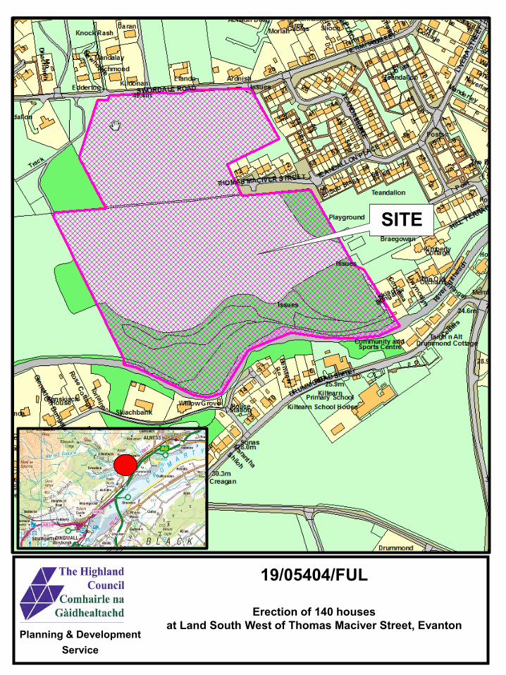
¯© Crown copyright.
All rights reserved 100023369
Planning & Development Service
19/05404/FUL
Erection of 140 housesat Land South West of Thomas Maciver Street, Evanton
SITE
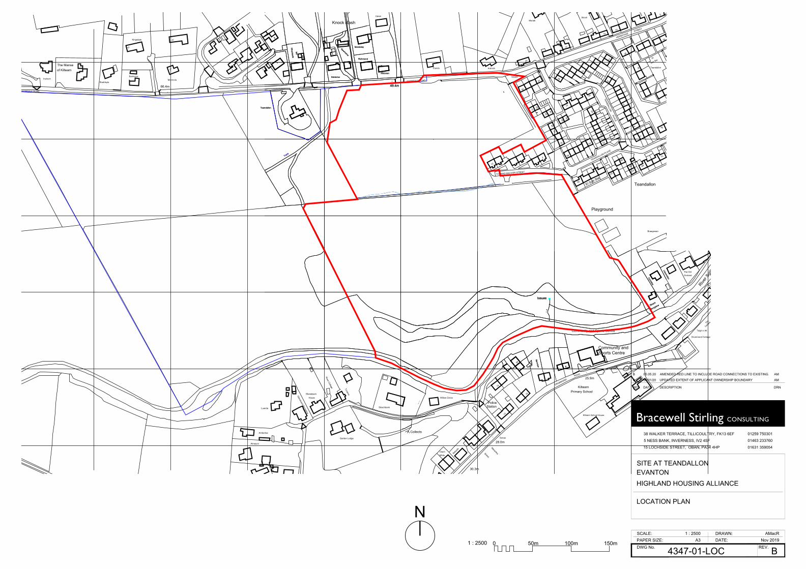
Moriah
27
Teandallon
50
Kildonan
Bungalow
16
17
45
Ardnish
49.4m
TEANDALLON PLACE
52
HERMITAGE
Sub Sta
39
Slioch
Richmond
TEANDALLON
SWORDALE ROAD
30
2
Issues
44
34
31
17
30
Benview
3
Newholme
Track
6
Skiach
58
STREET
Elando
32
9
41
Mandalay
20
10
1
Dhachaidh
El
59
Community and Sports Centre
17
LlwyncelynCorrielea
Playground
53
5
37
Sunnyholm12
Braegowan
66
63
56
28
3
26IssuesEdderton
33
67
El Sub Sta
35
69
1
18
38
14
PLACE
22
13
Knock Rash
Teandallon
THOMAS MACIVER STREET
40
72
68
Uaran
Mo
Teandallon
Belsyd
e
Bungalow
ROAD
Station
Mhile
Drummond Cottage
River S
githe
ach
The
DRUMMOND
30.3m
Police
25.9m
Issues
Benview 6
Skiach
28.0m
Cedars
Clach
Sports Centre
14
Community and
17
LlwyncelynCorrielea
Primary School
Collects
13 Kiltearn School House
Kiltearn
Taigh n Alt
Orchard
Fingal
Sonas
Shiloh
10
Marantha
Willow Grove
The Old
Glenskiach
Amberlea
7
Monrovia
66.4m
Torlaine
Kildonan
Garden Lodge
49.4m
Rose Cottage
Richmond
House
15 3
Bankview
Newholme
Track
Luanda
The Manse
1
2
Dhachaidh
14 Mandalay
Edderton
Almayon
StrathkyleInshoch
Glenskiach Bungalow
6of Kiltearn
13
Skiachbank
Kingsdale
SWORDALE ROAD
Mo
Teandallon
Ordnance Survey (c) Crown Copyright 2019. All rights reserved. Licence number 100022432
38 WALKER TERRACE, TILLICOULTRY, FK13 6EF
5 NESS BANK, INVERNESS, IV2 4SF
15 LOCHSIDE STREET, OBAN, PA34 4HP
Bracewell Stirling CONSULTING
DWG No. REV.PAPER SIZE:SCALE: DRAWN:
DATE:
01259 750301
01463 233760
01631 359054
HIGHLAND HOUSING ALLIANCE
4347-01-LOC
1 : 2500 AMacRNov 2019
B
SITE AT TEANDALLON
LOCATION PLAN
A3
EVANTON
REV DATE DESCRIPTION DRN
A 30/01/20 UPDATED EXTENT OF APPLICANT OWNERSHIP BOUNDARY AM
B 05.05.20 AMENDED RED LINE TO INCLUDE ROAD CONNECTIONS TO EXISTING. AM
N
0 50m1 : 2500 150m100m
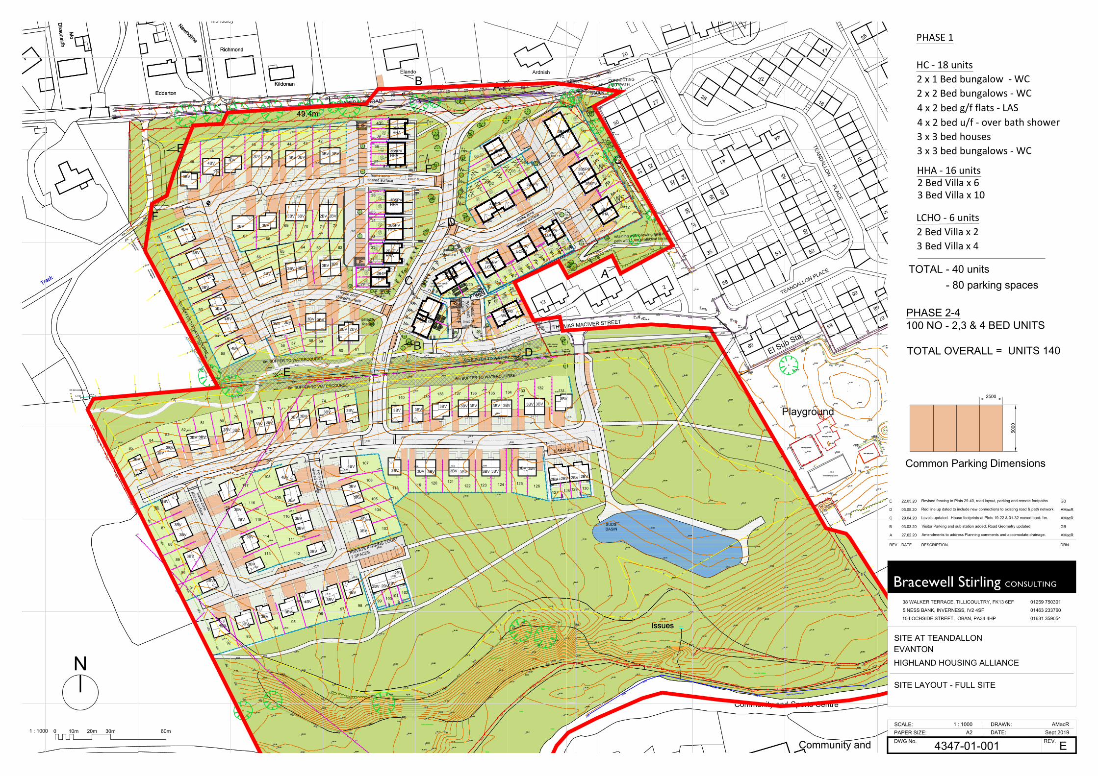
46.0
45.5
45.0
44.5
44.0
43.5
43.0
42.5
42.0
41.5
41.0
40.5
40.0
39.5
39.0
38.5
38.0
37.5
36.5
37.0
36.0
35.5
35.0
47.0
46.5
47.5
48.549.0
49.550.0
50.551.0
51.552.052.5
53.053.5
54.054.5
55.0
55.5
41.0
40.5
40.0
39.5
39.0
38.5
38.0
37.5
37.0
37.0
36.5
36.0
35.5
37.0
36.5
36.0
35.5
34.5
35.0
33.0
33.5
34.0
34.5
35.0
32.0
32.5 33.5
34.0
34.5
34.5
34.0
24.5
25.0
24.0
32.0
31.5
31.0
30.5
30.0
29.5
29.0
27.5
27.0
28.0
28.5
26.5
26.0
25.5
32.5
33.0
33.0
29.0
33.0
33.5
34.0
34.5
35.0
32.032.5
31.5
31.0
30.5
30.0
29.5
33.0
33.5
33.033.0 33.0
33.5
34.0
34.5
33.5
34.0
34.5
33.5
34.0
34.5
31.0
35.5
35.036.0
36.5
36.5
37.0
36.0
41.0
40.5
40.0
39.5
39.0
38.5
38.0
37.5
43.0
42.5
42.0
41.5
43.5
edge of river (water level)
trees
trees
trees
trees
trees
track
edge of crop
edge of crop
over
head
pow
er
culvert
IL 33.76
diam 450
cable crossingditch in duct
trees and bushes
trees and bushes
trees and bushes
trees and bushes
trees and bushes
blocked culvert
stone wallheadwall
headwall
450 diam plastic pipe
IL 29.79
450 diam plastic pipeIL 40.17
400 diam metal corrugated pipe IL 41.01
under track
ditch silted up
and overgrown
Tarmac Playing Court
bark play area
bark play area
play equipment
swings
400 diam concrete pipe
IL 41.34IL 40.87
tree canopy
865750N
865800N
865850N
865900N
865950N
866000N
866050N
866100N
865750N
865800N
865850N
865900N
865950N
866000N
866050N
866100N
47.9247.32
46.89
DK50.02 49.49 DK
48.34 47.95DK
47.36 46.89 46.41 45.86 45.23 44.64 DK43.80
43.1242.55
42.1742.10
42.0642.01
41.92
GIC
LP
MHCL 44.34
G
LPMHCL 46.09
G
LP
ICSV
55.60 55.14 54.62 54.06 53.51 52.99 52.43 51.75 51.14 50.56 49.91 49.3848.22 47.84
47.22 46.79 46.30 45.75 45.11 44.52 43.7043.00
42.4442.10
42.0141.93
41.90
41.80
41.87
41.9642.03
42.14
42.2342.5443.0643.78
44.6145.19
45.8346.40
46.82
46.9947.43
48.0648.34
48.7449.47
50.0050.62
51.2751.88
52.5053.03
53.58
54.0954.50
54.7055.01
55.7355.74 55.22 54.72 54.15 53.8055.72 55.27 54.72 54.16 53.61 DK
51.25 50.68
LPTP
LP
G
WV
MHCL 53.33 MH
CL 52.73
WV
IC
TP
WV MHCL 52.09
G
LPMHCL 50.97
LPMHCL 49.01 SV
IC G
MHCL 48.77
LP
49.9
0
51.4653.37
54.34
Gate
53.41 53.0152.40
51.45 50.8750.00 49.47
48.3347.50
46.9846.49
45.9545.32
44.0943.23
42.16
40.81
39.88
38.73
36.81
35.65
35.94
36.51
36.80
36.98
36.78
36.03
35.22
34.3533.92
33.3933.11
33.0833.10
33.33
33.13
33.09
33.16
33.38
33.46
33.13
32.09
30.29
27.74
26.12
24.85
24.36
23.82
23.8623.9624.28
24.80
25.18
25.9627.10
27.70
MHCL 49.87
34.7335.07
35.2735.52
35.7936.26
36.77
36.9537.21
37.77
38.29
38.6138.65
38.8539.26
39.6240.44
41.04
40.95
41.51
42.28
47.36
46.32
45.28
44.59
43.43
42.74
41.93
41.20
40.63
40.36
40.25
39.86
40.72
41.53
41.82
42.2141.70
41.8541.45
41.1841.00
40.0839.31
37.4037.12
36.8936.51
36.1535.78
35.55 35.16 34.77 34.5234.51
36.76
37.21
36.71
35.0134.39
37.12
37.35
38.92
40.41
41.47
41.66
BushesBushes
Bushes34.97
34.39 34.18 34.00
33.98
34.17
34.23
34.44
35.09
36.32
36.6436.54
34.9632.67
EP
EP
EP
EP
EP
23.82
22.27
22.40
22.53
23.1123.36
23.37
23.47
23.56
24.5324.66
25.49
24.95
25.26
24.99
25.04
25.24
25.54
27.65
29.21
29.76
30.18
23.01 22.8922.57
29.10
25.31
25.68
25.89
30.45
30.41
24.34
24.39
24.28
24.01
24.97
24.84
25.3630.18
28.33
28.04 25.79
25.93
25.84
25.41
25.37
25.27
25.63
25.50
28.23
28.95
31.02
30.79
31.55
30.92
30.20
28.35
28.3028.55
28.75
28.25
27.99
25.80
25.96
33.5632.27
29.98
33.8234.29
34.3534.53
34.54
34.83
35.1235.54
36.00
36.15
36.57
37.0037.20
37.9138.42
38.5638.80
37.62
38.8138.32 38.31
EP
EP
53.4252.24
51.31
49.7948.80
47.70
46.7846.20
45.6244.76
43.33
41.46
40.00
41.43
42.72
43.52
44.3044.79
45.1545.22
45.8447.00
48.5149.72
50.77
51.40
49.14
48.48
47.94
47.07
45.25
43.54
42.85
43.13
42.8341.95
41.07
39.84
38.6337.94
36.47
37.69
38.51
39.16
39.86
40.5240.93
41.2742.21
43.5945.10
45.7646.33
46.53
46.83
44.9144.36
44.13 43.17 42.3141.32
40.46
38.99
38.32
37.91
37.42
36.94
36.30
35.85
36.6736.7437.55
38.7339.39
40.3041.1641.6742.55
42.53
42.98
41.03 40.3539.66
39.2138.70
37.8637.25
36.4235.64
35.18
34.93
35.68
36.40
36.8137.33
37.95
38.5738.66
38.9639.48
41.57
40.19
38.15
36.93
37.18
36.86
36.04
35.37
36.05
36.14
36.57
37.16
37.19
36.71
37.24
39.03
40.48
41.19
41.08
40.32
38.87
36.86
36.60
37.15
37.27
36.89
36.66
36.73
36.83
36.21
36.44
36.63
36.80
37.04
36.96
36.48
36.29
38.49
40.29
40.5639.23
39.05
38.47
36.14
35.68
36.19
36.52
36.65
36.46
36.05
35.57
35.0034.16
34.62
35.10
35.60
36.15
36.56
36.47
35.63
35.10
36.41
37.74
38.1537.42
36.07
34.83
34.78
35.69
36.48
36.37
35.66
34.87
34.50
34.22
34.09
34.15
34.38
34.75
35.26
35.81
35.62
34.87
34.26
34.32
35.65
36.87
36.80
35.47
34.03
33.68
34.02
34.54
34.99
35.10
35.00
34.69
35.51
34.20
33.68
33.43
33.32
33.12
33.53
34.78
35.95
36.5035.89
34.50
33.15
32.80
32.83
32.82
32.76
33.17
34.05
31.77
32.17
32.08
32.18
32.24
32.35
32.64
33.51
34.63
35.3334.37
33.87
33.38
32.68
32.14
31.75
31.68
31.83
31.58
30.64
30.53
30.75
31.28
31.93
32.60
33.28
33.92
34.56
34.25
34.32
34.47
34.44
34.76
34.29
33.75
33.20
32.55
31.51
30.87
32.17
33.04
33.37
33.66
34.08
34.69
34.66
34.35
34.18 33.74
33.76
33.67
33.59
33.72
33.53
33.10
32.51
33.39
33.47
33.19
32.83
32.62
32.62
32.68
32.82
32.88
32.63
32.64
32.68
32.82
33.07
33.08
32.66
32.86
33.53
33.38
33.01
32.93
33.1
333
.22
33.24
33.2833.4733.65
33.8233.9434.24
34.4634.61
34.8
634
.9835.08
35.00
34.9535.07
35.07 34.87
34.6534.42 34.35
34.1433.93
33.75 33.6333.48
33.25
33.2
8
33.17
33.18
33.10
MHCL 33.25
MHCL 33.15
MHCL 33.16
MHCL 33.21
IC
MHCL 34.16
MHCL 34.16
MHCL 45.79
24.34
25.12
26.95
28.94
31.20
31.75
29.76
27.19
24.73
24.18
23.80
24.20
24.38
25.04
27.33
30.52
32.44
31.57
30.01
26.60
25.30
24.77
25.46
26.62
29.39
31.0630.29
29.58
28.00
28.43
25.76
29.58
28.10
24.59
27.6327.85
24.60
28.99
29.2330.23
33.10
33.13
27.58
30.95
29.55
30.41
31.02
31.78
28.50
28.40
28.81
29.0829.23
29.00
29.41
30.59
29.93
29.37
29.04
28.96
29.10
29.15
28.87
EP
33.11
34.28
34.37
34.20
34.0333.52
35.23
21.7021.99
22.36
22.63
23.69
23.72
23.84
23.90
48.36
48.76
48.45
48.16
33.00
34.85
35.33
35.79
36.16
36.65
37.21
37.46
37.01
EP
25.41
MHCL 35.16
MHCL 3
5.17
MHCL 33.34
cross section
cross
section
cross section
cross
section
MHCL 32.92
31.38
32.58
33.19
33.32
33.13
33.04
33.02
32.97
33.06
33.32
33.56
33.68
34.04
34.64
35.72
36.94
38.36
39.31
MHCL 39.34
40.79
cross section
cross
section
cross section
cross
section
cross section
cross section
41.38
cross section
cross section
cross section
cross section
cross section
cross section
cross section
cross section
32.96
32.91
32.91
32.94
33.00
32.93
31.19
32.30
33.20
33.11
33.37
33.27
33.23
33.04
33.02
33.80
34.19
34.15
33.56
33.21
32.86
31.19
33.50
33.92
34.69
34.95
34.26
32.78
32.65
33.70
34.26
33.83
32.90
32.62
33.00
33.40
33.34
33.10
33.01
32.69
31.91
31.07
31.17
LP
33.24
LP
Gate
33.20
32.96
33.10
LP
ELEC BOX
LP
32.55
32.3232.59
33.15
33.23
33.1133.2033.43
33.6033.5833.58
33.4533.33
34.72
33.40
33.90
34.1034.15
34.00
33.74
33.5133.53
33.49
33.3932.99
32.94
32.90
32.81
32.79 32.6933.06
LP
WV
WV
WVWV
LP33.72
33.90
33.83
34.1434.18
34.38
34.85
34.8
6
34.4434.65
35.06
35.48
Bushes
Bushes
Bushes
Bushes
Bushes35.73
36.56
36.74
36.70
36.30
36.19
36.55
36.27
36.07
36.09
35.93
35.85
35.55
35.03
34.92
35.35
35.70
35.5335.93
35.67
36.33
37.20
37.86
38.43
36.11
36.94
37.36
LP
38.6038.50
WVLP
39.15
39.51
39.87
40.5440.53
40.87
41.67
42.2542.31
41.9141.36
41.10
42.7542.48
41.98
41.21
41.22
42.02
41.04
41.52
IC
G
LP
RS
38.4
3
37.36
36.73
36.48
41.10
41.38
41.02
40.17
2BV
2BV
2BV
2BV
2BV
2BV
2BV
2BV
3BV3BV
3BV3BV
Cu
3BV
3BV
2BV
2BV
2BV
2BV
Kin Kin
Ara
Ara
1BB
1BB
3BV
3BV
Ara
Ara
Cu
Cu
Cu
Cu
Cu
Lo
Lo
Cu
Cu
Cu
Ne
Arr ArrNe
Lo
Lo
Cu
Cu
Cu
Mo
Mo
Arr
Arr
Mo
Mo
Mo
Mo
Mo
Mo
Arr
Lo
Ara
Ara
Lo
Ara
Ara
Ne
AraAraAraAra Kin Kin
AraAra
AraAra
AraAra
Mo
Mo
Ara
Ara
Ara
Ara
27
Teandallon
50
Kildonan
16
17
45
Ardnish
49.4m
TEANDALLON PLACE
52
39
Richmond
TEANDALLON
SWORDALE ROAD
2
Issues44
34
31
17
30
Newholme
Track58
Elando
32
41
Mandalay
20
10
1
Dhachaidh
59
Community and Sports Centre
Playground
53
5
37
12
66
63
28
26IssuesEdderton
33
67
El Sub Sta
35
38
PLACE
22
THOMAS MACIVER STREET
40
68
Mo
Issues
Sports CentreCommunity and
Kildonan
49.4m
Richmond
Newholme
Track
1
Dhachaidh
Mandalay
Edderton
Mo
Ne
Ne
3BV
3BV
2BB
2BB
3BV
3BV
AraAra
AraAra
Kin Kin
AraAra
AraAra
02
10
01
0604
0305
07
09
15
08
13
12
14
11
16
21/22
17
1819/2028
23/24
25/26
27
Ne
Cu
Lo
Ara
Ara
Ara
Ara
AraAra
Ara
Ara
2BV2BV
29
30
31
32
33
34
35
36
38
39
40
3B5PBWC
3B5PBWC
3B5PV
3B5PVHHA
2B4PBWC
2B4PFLAS GF
2B4PFLAS GF
2B4PVLCHO
1B2PBWC
3B5PVLCHO
3B5PVLCHO
3B5PV
3BBWC
3BBWC
3BBWC
3BV
2B4PVHHA
2B4PVHHA
3B5PVHHA
3B5PVHHA
2B4PVHHA
3BV
3BV
3B5PVHHA
37
3B5PVHHA
133136
70
74
80
41424344454647
48
49
50
51
52
53
54
55
56 57 58 59
60 61
62636465
66
6768
69 71 72
73
7576
7877
7981
8283
84
88
86
85
87
93
89
90
96
91
98
92
9594
97
99
102100
101
113
103
112
114
115
111
122 124
116
110
117 118
109
104
129
105
106
107
108
119 120 121123 125
137
126127 128 130
139138
131132
135 134140
home zoneshared surface
gatewayfeature
gatewayfeature
home zoneshared surface
home zone
shared surface
limit ofadoption
PRIVATE
PARKIN
GC
OU
RT
12 SPACES
PRIVATE PARKING COURT
7 SPACES
RCPplots19-20
RCPplots29-31
RCPplots 32-36
RCPplots 37-40
RCPplots 7-8
RCPplots 4-6
RCPplots12-13
8 SPACES
RCPplots21-26
8no Cycle Store &4no D-bar visitorcycle parking
A
AB
C
B
C
home zone
shared surfacehome zone
shared surface
46.0
45.5
45.0
44.5
44.0
43.5
43.0
42.5
42.0
41.5
41.0
40.5
40.0
39.5
39.0
38.5
38.0
37.5
36.5
37.0
36.0
35.5
35.0
47.0
46.5
47.5
48.549.0
49.550.0
50.551.0
51.552.052.5
53.053.5
54.054.5
55.0
55.5
41.0
40.5
40.0
39.5
39.0
38.5
38.0
37.5
37.0
37.0
36.5
36.0
35.5
37.0
36.5
36.0
35.5
34.5
35.0
33.0
33.5
34.0
34.5
35.0
32.0
32.5 33.5
34.0
34.5
34.5
34.0
24.5
25.0
24.0
32.0
31.5
31.0
30.5
30.0
29.5
29.0
27.5
27.0
28.0
28.5
26.5
26.0
25.5
32.5
33.0
33.0
29.0
33.0
33.5
34.0
34.5
35.0
32.032.5
31.5
31.0
30.5
30.0
29.5
33.0
33.5
33.033.0 33.0
33.5
34.0
34.5
33.5
34.0
34.5
33.5
34.0
34.5
31.0
35.5
35.036.0
36.5
36.5
37.0
36.0
41.0
40.5
40.0
39.5
39.0
38.5
38.0
37.5
43.0
42.5
42.0
41.5
43.5
edge of river (water level)
trees
trees
trees
trees
trees
track
edge of crop
edge of crop
over
head
pow
er
culvert
IL 33.76
diam 450
cable crossingditch in duct
trees and bushes
trees and bushes
trees and bushes
trees and bushes
trees and bushes
blocked culvert
stone wallheadwall
headwall
450 diam plastic pipe
IL 29.79
450 diam plastic pipeIL 40.17
400 diam metal corrugated pipe IL 41.01
under track
ditch silted up
and overgrown
Tarmac Playing Court
bark play area
bark play area
play equipment
swings
400 diam concrete pipe
IL 41.34IL 40.87
tree canopy
865750N
865800N
865850N
865900N
865950N
866000N
866050N
866100N
865750N
865800N
865850N
865900N
865950N
866000N
866050N
866100N
47.9247.32
46.89
DK50.02 49.49 DK
48.34 47.95DK
47.36 46.89 46.41 45.86 45.23 44.64 DK43.80
43.1242.55
42.1742.10
42.0642.01
41.92
GIC
LP
MHCL 44.34
G
LPMHCL 46.09
G
LP
ICSV
55.60 55.14 54.62 54.06 53.51 52.99 52.43 51.75 51.14 50.56 49.91 49.3848.22 47.84
47.22 46.79 46.30 45.75 45.11 44.52 43.7043.00
42.4442.10
42.0141.93
41.90
41.80
41.87
41.9642.03
42.14
42.2342.5443.0643.78
44.6145.19
45.8346.40
46.82
46.9947.43
48.0648.34
48.7449.47
50.0050.62
51.2751.88
52.5053.03
53.58
54.0954.50
54.7055.01
55.7355.74 55.22 54.72 54.15 53.8055.72 55.27 54.72 54.16 53.61 DK
51.25 50.68
LPTP
LP
G
WV
MHCL 53.33 MH
CL 52.73
WV
IC
TP
WV MHCL 52.09
G
LPMHCL 50.97
LPMHCL 49.01 SV
IC G
MHCL 48.77
LP
49.9
0
51.4653.37
54.34
Gate
53.41 53.0152.40
51.45 50.8750.00 49.47
48.3347.50
46.9846.49
45.9545.32
44.0943.23
42.16
40.81
39.88
38.73
36.81
35.65
35.94
36.51
36.80
36.98
36.78
36.03
35.22
34.3533.92
33.3933.11
33.0833.10
33.33
33.13
33.09
33.16
33.38
33.46
33.13
32.09
30.29
27.74
26.12
24.85
24.36
23.82
23.8623.9624.28
24.80
25.18
25.9627.10
27.70
MHCL 49.87
34.7335.07
35.2735.52
35.7936.26
36.77
36.9537.21
37.77
38.29
38.6138.65
38.8539.26
39.6240.44
41.04
40.95
41.51
42.28
47.36
46.32
45.28
44.59
43.43
42.74
41.93
41.20
40.63
40.36
40.25
39.86
40.72
41.53
41.82
42.2141.70
41.8541.45
41.1841.00
40.0839.31
37.4037.12
36.8936.51
36.1535.78
35.55 35.16 34.77 34.5234.51
36.76
37.21
36.71
35.0134.39
37.12
37.35
38.92
40.41
41.47
41.66
BushesBushes
Bushes34.97
34.39 34.18 34.00
33.98
34.17
34.23
34.44
35.09
36.32
36.6436.54
34.9632.67
EP
EP
EP
EP
EP
23.82
22.27
22.40
22.53
23.1123.36
23.37
23.47
23.56
24.5324.66
25.49
24.95
25.26
24.99
25.04
25.24
25.54
27.65
29.21
29.76
30.18
23.01 22.8922.57
29.10
25.31
25.68
25.89
30.45
30.41
24.34
24.39
24.28
24.01
24.97
24.84
25.3630.18
28.33
28.04 25.79
25.93
25.84
25.41
25.37
25.27
25.63
25.50
28.23
28.95
31.02
30.79
31.55
30.92
30.20
28.35
28.3028.55
28.75
28.25
27.99
25.80
25.96
33.5632.27
29.98
33.8234.29
34.3534.53
34.54
34.83
35.1235.54
36.00
36.15
36.57
37.0037.20
37.9138.42
38.5638.80
37.62
38.8138.32 38.31
EP
EP
53.4252.24
51.31
49.7948.80
47.70
46.7846.20
45.6244.76
43.33
41.46
40.00
41.43
42.72
43.52
44.3044.79
45.1545.22
45.8447.00
48.5149.72
50.77
51.40
49.14
48.48
47.94
47.07
45.25
43.54
42.85
43.13
42.8341.95
41.07
39.84
38.6337.94
36.47
37.69
38.51
39.16
39.86
40.5240.93
41.2742.21
43.5945.10
45.7646.33
46.53
46.83
44.9144.36
44.13 43.17 42.3141.32
40.46
38.99
38.32
37.91
37.42
36.94
36.30
35.85
36.6736.7437.55
38.7339.39
40.3041.1641.6742.55
42.53
42.98
41.03 40.3539.66
39.2138.70
37.8637.25
36.4235.64
35.18
34.93
35.68
36.40
36.8137.33
37.95
38.5738.66
38.9639.48
41.57
40.19
38.15
36.93
37.18
36.86
36.04
35.37
36.05
36.14
36.57
37.16
37.19
36.71
37.24
39.03
40.48
41.19
41.08
40.32
38.87
36.86
36.60
37.15
37.27
36.89
36.66
36.73
36.83
36.21
36.44
36.63
36.80
37.04
36.96
36.48
36.29
38.49
40.29
40.5639.23
39.05
38.47
36.14
35.68
36.19
36.52
36.65
36.46
36.05
35.57
35.0034.16
34.62
35.10
35.60
36.15
36.56
36.47
35.63
35.10
36.41
37.74
38.1537.42
36.07
34.83
34.78
35.69
36.48
36.37
35.66
34.87
34.50
34.22
34.09
34.15
34.38
34.75
35.26
35.81
35.62
34.87
34.26
34.32
35.65
36.87
36.80
35.47
34.03
33.68
34.02
34.54
34.99
35.10
35.00
34.69
35.51
34.20
33.68
33.43
33.32
33.12
33.53
34.78
35.95
36.5035.89
34.50
33.15
32.80
32.83
32.82
32.76
33.17
34.05
31.77
32.17
32.08
32.18
32.24
32.35
32.64
33.51
34.63
35.3334.37
33.87
33.38
32.68
32.14
31.75
31.68
31.83
31.58
30.64
30.53
30.75
31.28
31.93
32.60
33.28
33.92
34.56
34.25
34.32
34.47
34.44
34.76
34.29
33.75
33.20
32.55
31.51
30.87
32.17
33.04
33.37
33.66
34.08
34.69
34.66
34.35
34.18 33.74
33.76
33.67
33.59
33.72
33.53
33.10
32.51
33.39
33.47
33.19
32.83
32.62
32.62
32.68
32.82
32.88
32.63
32.64
32.68
32.82
33.07
33.08
32.66
32.86
33.53
33.38
33.01
32.93
33.1
333
.22
33.24
33.2833.4733.65
33.8233.9434.24
34.4634.61
34.8
634
.9835.08
35.00
34.9535.07
35.07 34.87
34.6534.42 34.35
34.1433.93
33.75 33.6333.48
33.25
33.2
8
33.17
33.18
33.10
MHCL 33.25
MHCL 33.15
MHCL 33.16
MHCL 33.21
IC
MHCL 34.16
MHCL 34.16
MHCL 45.79
24.34
25.12
26.95
28.94
31.20
31.75
29.76
27.19
24.73
24.18
23.80
24.20
24.38
25.04
27.33
30.52
32.44
31.57
30.01
26.60
25.30
24.77
25.46
26.62
29.39
31.0630.29
29.58
28.00
28.43
25.76
29.58
28.10
24.59
27.6327.85
24.60
28.99
29.2330.23
33.10
33.13
27.58
30.95
29.55
30.41
31.02
31.78
28.50
28.40
28.81
29.0829.23
29.00
29.41
30.59
29.93
29.37
29.04
28.96
29.10
29.15
28.87
EP
33.11
34.28
34.37
34.20
34.0333.52
35.23
21.7021.99
22.36
22.63
23.69
23.72
23.84
23.90
48.36
48.76
48.45
48.16
33.00
34.85
35.33
35.79
36.16
36.65
37.21
37.46
37.01
EP
25.41
MHCL 35.16
MHCL 3
5.17
MHCL 33.34
cross section
cross
section
cross section
cross
section
MHCL 32.92
31.38
32.58
33.19
33.32
33.13
33.04
33.02
32.97
33.06
33.32
33.56
33.68
34.04
34.64
35.72
36.94
38.36
39.31
MHCL 39.34
40.79
cross section
cross
section
cross section
cross
section
cross section
cross section
41.38
cross section
cross section
cross section
cross section
cross section
cross section
cross section
cross section
32.96
32.91
32.91
32.94
33.00
32.93
31.19
32.30
33.20
33.11
33.37
33.27
33.23
33.04
33.02
33.80
34.19
34.15
33.56
33.21
32.86
31.19
33.50
33.92
34.69
34.95
34.26
32.78
32.65
33.70
34.26
33.83
32.90
32.62
33.00
33.40
33.34
33.10
33.01
32.69
31.91
31.07
31.17
LP
33.24
LP
Gate
33.20
32.96
33.10
LP
ELEC BOX
LP
32.55
32.3232.59
33.15
33.23
33.1133.2033.43
33.6033.5833.58
33.4533.33
34.72
33.40
33.90
34.1034.15
34.00
33.74
33.5133.53
33.49
33.3932.99
32.94
32.90
32.81
32.79 32.6933.06
LP
WV
WV
WVWV
LP33.72
33.90
33.83
34.1434.18
34.38
34.85
34.8
6
34.4434.65
35.06
35.48
Bushes
Bushes
Bushes
Bushes
Bushes35.73
36.56
36.74
36.70
36.30
36.19
36.55
36.27
36.07
36.09
35.93
35.85
35.55
35.03
34.92
35.35
35.70
35.5335.93
35.67
36.33
37.20
37.86
38.43
36.11
36.94
37.36
LP
38.6038.50
WVLP
39.15
39.51
39.87
40.5440.53
40.87
41.67
42.2542.31
41.9141.36
41.10
42.7542.48
41.98
41.21
41.22
42.02
41.04
41.52
IC
G
LP
RS
38.4
3
37.36
36.73
36.48
41.10
41.38
41.02
40.17
3BV
4BV 3BV
3BV 3BV
3BV
4BV3BV 3BV
3BV
4BV
4BV
4BV
3BV3BV3BV 3BV
2BV 2BV
2BV2BV
3BV3BV3BV3BV
3BV
3BV
4BV
4BV
3BV
3BV
3BV
3BV
3BV3BV 3BV 3BV 3BV 3BV 3BV
3BV3BV3BV3BV
3BV3BV3BV3BV
3BV3BV
3BV3BV
3BV
3BV
3BV
3BV
3BV
3BV
3BV
3BV
3BV 3BV
3BV
3BV
3BV
3BV
3BV 3BV
3BV 3BV 3BV 3BV 3BV 3BV 3BV3BV 3BV4BV
4BV
4BV
4BV
4BV
3BV
3BV
3BV
3BV
3BV
3BV
3BV
3BV
2BV2BV2BV2BV
2BV
2BV2BV2BV
E
E
F
F
SUDSBASIN
6m BUFFER TO WATERCOURSE
6m BUFFER TO WATERCOURSE
6m BUFFER TO WATERCOURSE
6m BUFFER TO WATERCOURSE
6m BUFFER TO
WATERCO
URSE
4no D-bar visitorcycle parking
CONNECTINGFOOTPATHAT 1:21
V
VV
V
V
V
V
VV
V
V
V
V
V
V
retaining wall following rake of
path with 1.1m protective barrier
3BV
3BV
ASHP
ASHP
ASHP
ASHP
ASHP
ASHP
ASHP
ASHP
ASHP
ASHP
ASHP
ASHP
ASHP
ASHP
ASHP
ASHP
ASHP
ASHP
ASHP
ASHP
ASHP
ASHP
ASHP
ASHP
ASHP
ASHP
ASHP
ASHP
ASHP
ASHP
ASHP
ASHP
ASHP
ASHP
ASHP
ASHP
ASHP
ASHP
ASHP
ASHP
D
D
5000
2500
38 WALKER TERRACE, TILLICOULTRY, FK13 6EF
5 NESS BANK, INVERNESS, IV2 4SF
15 LOCHSIDE STREET, OBAN, PA34 4HP
Bracewell Stirling CONSULTING
DWG No. REV.PAPER SIZE:SCALE: DRAWN:
DATE:
01259 750301
01463 233760
01631 359054
HIGHLAND HOUSING ALLIANCE
4347-01-001
1 : 1000 AMacRSept 2019
E
SITE AT TEANDALLON
SITE LAYOUT - FULL SITE
A2
EVANTON
REV DATE DESCRIPTION DRN
A 27.02.20 Amendments to address Planning comments and accomodate drainage. AMacR
B 03.03.20 Visitor Parking and sub station added, Road Geometry updated GB
C 29.04.20 Levels updated. House footprints at Plots 19-22 & 31-32 moved back 1m. AMacR
D 05.05.20 Red line up dated to include new connections to existing road & path network. AMacR
E 22.05.20 Revised fencing to Plots 29-40, road layout, parking and remote footpaths GB
N
1 : 1000 60m30m20m10m0
HHA - 16 units2 Bed Villa x 63 Bed Villa x 10
LCHO - 6 units2 Bed Villa x 23 Bed Villa x 4
TOTAL - 40 units- 80 parking spaces
PHASE 1
HC - 18 units2 x 1 Bed bungalow - WC2 x 2 Bed bungalows - WC4 x 2 bed g/f flats - LAS4 x 2 bed u/f - over bath shower3 x 3 bed houses3 x 3 bed bungalows - WC
PHASE 2-4100 NO - 2,3 & 4 BED UNITS
TOTAL OVERALL = UNITS 140
Common Parking Dimensions

2BV
2BV
2BV
2BV
2BV
2BV
2BV
2BV
3BV
3BV
3BV
3BV
3BV
3BV
1BB
1BB
3BV
3BV
27SWORDALE ROAD
2
31
30
32
12
Issues
33
THOMAS MACIVER STREET
3BV
3BV
2BB
2BB3BV
3BV
02
10
01
0604
0305
07
09
15
08
13
12
14
11
16
21/22
17
1819/2028
23/24
25/26
27
2BV2BV
29
30
31
32
33
34
35
36
38
39
40
3B5PBWC
3B5PBWC
3B5PV
3B5PVHHA
2B4PBWC
2B4PFLAS GF
2B4PFLAS GF
2B4PVLCHO
1B2PBWC
3B5PVLCHO
3B5PVLCHO
3B5PV
3BBWC
3BBWC
3BBWC
3BV
2B4PVHHA
2B4PVHHA
3B5PVHHA
3B5PVHHA
2B4PVHHA
3BV
3BV
3B5PVHHA
37
3B5PVHHA
60 61
home zoneshared surface
gatewayfeature
gatewayfeature
home zoneshared surface
home zone
shared surface
limit ofadoption
PRIVATE
PARKIN
GC
OU
RT
12 SPACES
RCPplots19-20
RCPplots29-31
RCPplots 32-36
RCPplots 37-40
RCPplots 7-8
RCPplots 4-6
RCPplots12-13
RCPplots21-26
8no CycleStore &4no D-bar
visitorcycleparking
FFL 40.000
FFL 40.900
FFL 39.700
FFL 38.800
FFL 38.200
FFL 37.300
FFL 40.54
FFL 38.800
FFL 39.00
FFL 39.77
FFL 39.050
FFL 38.75
FFL 38.30
FFL 45.300
FFL 44.850
FFL 44.850
FFL 43.775
FFL 43.100
FFL 42.00
FFL 41.550
FFL 40.875
FFL 40.875
FFL 39.975
FFL 39.575
FFL 38.9
FFL 42.900900m
m
STEP
900mm
STEP
900mm
STEP
675mm
STEP900m
mSTEP
FFL 44.850
41.164
37.150
38.050
38.450
39.550
39.850
40.750
41.29
40.39
42.0
40.50
41.15
42.40
41.146
1 in 7
38.15
37.7
38.150
1 in 2.0
40.725 40.725
40.53
40.725
900mm
STEP
41.40041.400
41.40041.400
42.75042.750
42.750 42.750
44.70 44.70
44.70 44.70
1 in 2
39.845
1 in 2
675mm
STEP
39.62
39.0
38.650
38.650
38.20
38.200
38.150
37.500
38.550
37.500
38.125
37.600
39.22
40.65
40.40
36.325
36.325
38.50
38.000
38.50
39.470
35.650
35.650
37.475
38.025
39.25
39.62
39.35
38.95
38.90
38.90
37.875
37.9
37.8
37.175
37.0
36.475
38.665
38.900
39.050
37.300
39.75
42.942.7
41.85
40.7
39.825
39.21
40.972
39.76
39.0
43.62543.625
44.7044.70
38.60
38.60
40.6440.64
41.290
40.39
FFL 41.4441.29 900m
m
STEP
450mm
STEP
45.1545.15
38.15
39.85
39.85
39.05
39.05
39.075
39.075
39.425
39.425
39.850
40.750
39.550
38.450
38.050
37.150
39.900
41.000
38.720
37.650
36.800
35.500
41.000
38.300
39.720
1 in 3
40.40
36.8
38.15
44.75
44.70
45.0
44.70
44.70
37.3
37.1
36.8
36.9
40.80
40.74540.75
40.0740.07
40.80
41.85041.850
44.7044.70
44.7044.70
40.39
40.39
43.62542.950
43.62542.950
42.750 42.750
39.05
39.05
39.075
39.075
37.150
37.37538.050
38.050
38.65039.550
38.65039.550
39.850
39.850
40.750
40.750
38.90
38.90
39.620
39.0
38.150
38.200
39.1
900mm
RT w
all with 1100m
m fence
43.8
44.2
4
43.4
142
.9
FFL39.3
FFL40.2
900mmSTEP
40.9
39.15
41.05
41.05
41.0541.05
E
E
E
E
E
E
E
E
E
E
E
E
E
E
E
E
E
E
E
E
E
E
E
E
E
E
E
E
E
E
E
E
E
E
E
E
E
E
E
E
E
E
E
E
E
E
E
E
E
E
E
E
E
E
E
E
E
E
E
E
E
E
E
E
E
E
E
E
E
E
46.0
45.5
45.0
44.5
44.0
43.5
43.0
42.5
42.0
41.5
41.0
40.5
40.0
39.5
39.0
38.5
38.0
37.5
36.5
37.0
36.0
35.5
35.0
47.0
46.5
47.5
35.5
35.036.0
36.5
36.5
37.0
36.0
41.0
40.5
40.0
39.5
39.0
38.5
38.0
37.5
43.0
42.5
42.0
41.5
43.5
culvert
IL 33.76
diam 450
cable crossingditch in duct
headwall450 diam plastic pipe
IL 40.17
400 diam metal corrugated pipe IL 41.01
865950N
866000N
866050N
865950N
866000N
866050N
47.9247.32
46.8948.34 47.95 DK
47.36 46.89 46.41 45.86 G
GICSV
48.22 47.8447.22 46.79 46.30 45.75 45.11 44.52
42.2342.5443.0643.78
44.6145.19
45.8346.40
46.82
46.9947.43
48.0648.34
LP
47.5046.98
46.4945.95
45.3244.09
43.23
42.16
40.81
39.88
38.73
36.81
35.65
35.94
36.51
36.80
36.98
36.78
36.03
35.22
34.3533.92
33.3933.11
34.7335.07
35.2735.52
35.79 33.82
46.7846.20
45.6244.76
43.33
41.46
40.00
41.43
42.72
43.52
44.3044.79
45.1545.22
42.85
43.13
42.8341.95
41.07
39.84
38.6337.94
36.47
37.69
38.51
39.16
39.86
40.5240.93
41.2742.21
41.32
40.46
38.99
38.32
37.91
37.42
36.94
36.30
35.85
36.6736.7437.55
38.7339.39
40.30
37.8637.25
36.4235.64
35.18
34.93
35.68
36.40
33.9434.2434.46
34.6134
.86
34.9835.08
35.00
34.9535.07
35.07 34.87
34.6534.42 34.35
34.1433.93
MHCL 34.16
MHCL 34.16
MHCL 45.79
MHCL 35.16
MHCL 3
5.17
34.04
34.64
35.72
36.94
38.36
39.31
MHCL 39.34
40.79
cross section
cross section
LP
WV
WV
34.18
34.38
34.85
34.8
6
34.4434.65
35.06
35.48
Bushes
Bushes
Bushes
Bushes
Bushes35.73
36.56
36.74
36.70
36.30
36.19
36.55
36.27
36.07
36.09
35.93
35.85
35.55
35.03
34.92
35.35
35.70
35.5335.93
35.67
36.33
37.20
37.86
38.4336.11
36.94
37.36
LP
38.6038.50
WVLP
39.15
39.51
39.87
40.5440.53
40.87
41.67
42.2542.31
41.9141.36
41.10
42.7542.48
41.21
41.22
41.04
41.52
38.4
3
37.36
36.73
36.48
41.10
41.38
41.02
40.17
36.65
42.8
41.6
35.4
2BV2BV
4noD-barvisitor
cycleparking
AT 1:21
VV
V
V
V
sub stat
V
40.0
39.220
40.0
40.444
38.9
39.75
40.39
41.29
43.622
41.164
42.485
900mm RT wall with 110mm fence
protective barrier on top
40.90041.800
1 in 20 tarred footpath
1 in 20 tarred footpath
36.5037.00
36.9
35.9
34.9
36.4
34.4
38.55
38.3
38.60
38.66
38.75
FFL 39.50
38.90
37.9
38.90
37.90
39.05
40.232
37.9
39.9
FFL 35.800
FFL 36.47536.850
36.225
36.350
35.650
36.325
36.50
41.584
39.37
39.0
38.0
FFL 39.2
FFL 40.1
1 in 4
40.10
1 in 4
39.05
40.40
41.40
1 in 2.0
1 in 4
1 in 4
40.369
FFL 39.77
1 in 20 tarred footpath
37.500
39.8
39.0
37.95
38.505
38.25537.75
36.500
37.400
38.0
38.0
1 in 20 tarred footpath
1 in 20 tarred footpath
45.52
45.242
45.132
44.95
44.472
44.26944.0744.125
44.06844.148
43.891
43.3
43.085
42.905
42.10
41.825
40.925
43.9543.988
43.85
41.75
41.6
40.745
39.855
40.825
40.2
40.12539.8
38.860
38.700
39.510
39.156
1 in 2
1 in 2 1m high retaining wall
1m high retaining wall
1.2m high retaining wall
1.2m high retaining wall
exposed underbuilding
exposed
underbuilding
exposed underbuilding
expo
sed
unde
rbui
ldin
g
450mm RT wall
with 1100mm fence
protective
barrier on top
1 in 2
0 tar
red f
ootpa
th
retaining wall following rake of
path with 1.1m protective barrier
3BV
3BV
39.65
41.645
37.80
38.15
37.70
38.15450mm
RT wall
38.90
ASHP
ASHP
ASHP
ASHP
ASHP
ASHP
ASHP
ASHP
ASHP
ASHP
ASHP
ASHP
ASHP
ASHP
ASHP
ASHP
ASHP
ASHP
ASHP
ASHP
ASHP
ASHP
ASHP
ASHP
ASHP
ASHP
ASHP
ASHP
ASHP
ASHP
ASHP
ASHP
ASHP
ASHP
ASHP
ASHP
ASHP
ASHP
ASHP
ASHP
40.652
40.75
FENCE TYPE TWOnot to scale
FENCE TYPE ONEnot to scale
inside view of fence
outside view of fence
outside view of fence
inside view of fence
N.B. All timbers to beRedwood pressureimpregnated withpreservative and all cutfaces on site to be liberallytreated with equal. All nailfixings to be galvanised, andevery palisade nailed twiceto each rail.
150
N.B. All timbers to beRedwood pressureimpregnated withpreservative and all cutfaces on site to be liberallytreated with equal. All nailfixings to be galvanised, andevery palisade nailed twiceto each rail.
300x300 In-situ concbase to post withweathered top surface.
75x19 rough sawn timberpalisades @ 100mm ctrs on100x38mm top rail @ 75mmfrom top of post, 100x38mmbottom rail at nominal100mm above F.G.L.
100x38 rails 75x19 palisadesroughsawn with 25mmspacings
150
600
150
1800 1800
Post to be once weathered25mm on top face.
75x19 rough sawn timberpalisades @ 100mm ctrs on100x38mm top rail @ 75mmfrom top of post,100x38mm bottom rail atnominal 100mm aboveF.G.L.
300x300 In-situ concbase to post withweathered top surface.
50mm clearance to G.L.from foot of palisades.
600
100x38 rails 75x19 palisadesroughsawn with 25mmspacings
600
150
800
1800 1800
Post to be once weathered25mm on top face.
50mm clearance to G.L.from foot of palisades.
600
1800
1800
900
Fence Between Gardens
HouseDividing fences betweengardens to be 900mm highwith 2m length of 1.8m highprivacy fence between rearaccess doors
1500
1500
1100
1100
FENCE TYPE THREEscale 1:25
outside view of fence
inside view of fence
150
R18
00
194
350
500
1800
Post to be once weathered25mm on top face.
N.B. All timbers to beRedwood pressureimpregnated withpreservative and all cutfaces on site to be liberallytreated with equal. All nailfixings to be galvanised, andevery palisade nailed twiceto each rail.
300x300 In-situ concbase to post withweathered top surface.
50mm clearance to G.L.from foot of palisades.
100x38 rails 75x19 palisadesroughsawn with 25mmspacings
500
600
194
1800
1500
At boundary to parking courts Plots 29-40
38 WALKER TERRACE, TILLICOULTRY, FK13 6EF
5 NESS BANK, INVERNESS, IV2 4SF
15 LOCHSIDE STREET, OBAN, PA34 4HP
Bracewell Stirling CONSULTING
DWG No. REV.PAPER SIZE:SCALE: DRAWN:
DATE:
01259 750301
01463 233760
01631 359054
HIGHLAND HOUSING ALLIANCE
4347-01-002
1 : 250 AMacRMay 2020
D
SITE AT TEANDALLON
SITE LAYOUT - PHASE 1
A2
EVANTON
REV DATE DESCRIPTION DRN
A 27.02.20 Amendments to address Planning comments and accomodate drainage AMacR
B 03.03.20 Visitor Parking added, Road Geometry updated GB
C 29.04.20 Levels updated. House footprints at Plots 19-22 & 31-31 moved back 1m. AMacR
D 22.05.20 Revised fencing to Plots 29-40, road layout, parking and remote footpaths. GB
N
0 5m1 : 250 15m10m
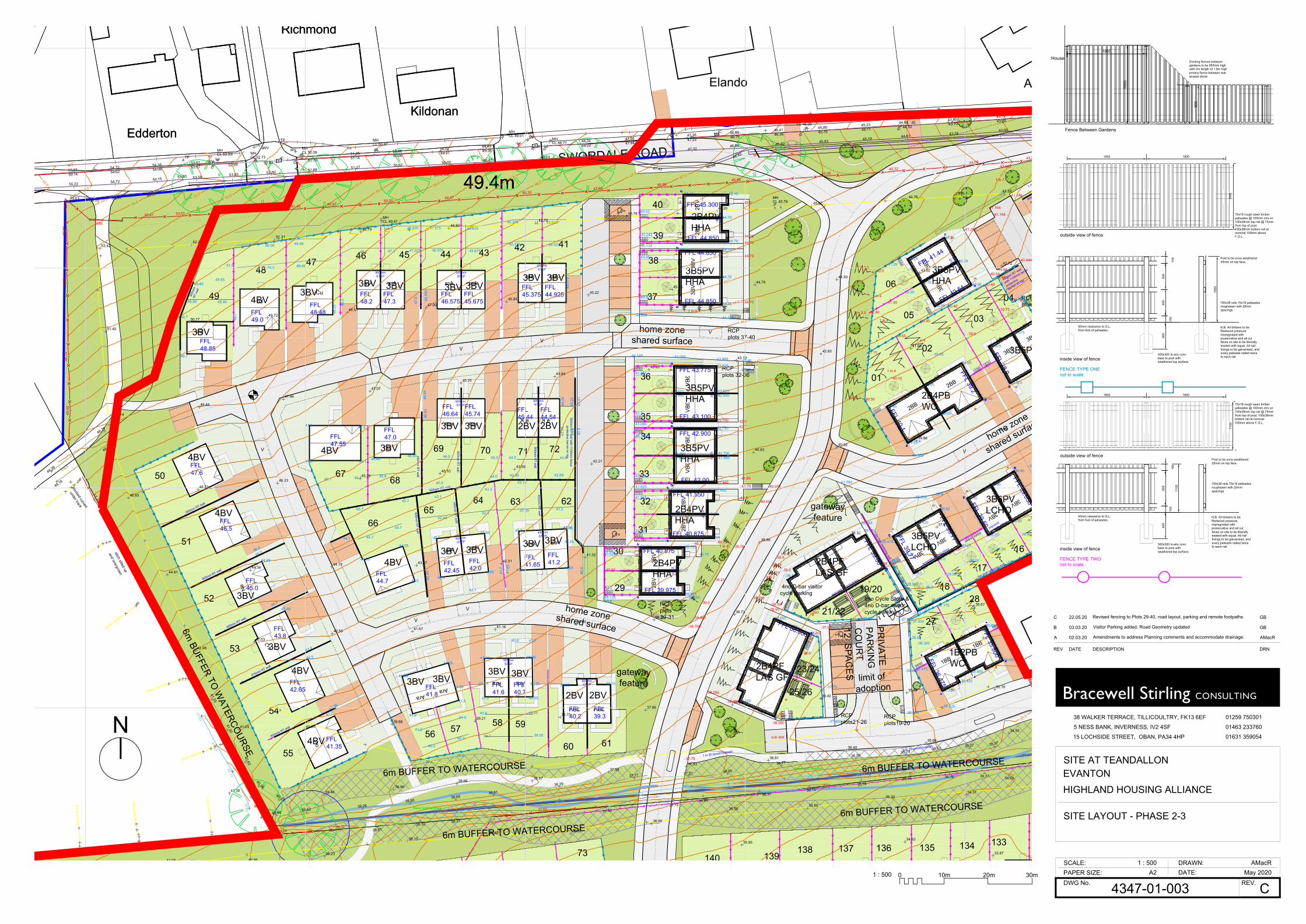
2BV
2BV
2BV
2BV
2BV
2BV
3BV3BV
3BV3BV
Cu
3BV
3BV
1BB
1BB
3BV
3BV
Cu
Cu
Lo
Kildonan
Ardnish
49.4m
Richmond
SWORDALE ROAD
Elando
Edderton
Kildonan
49.4m
Richmond
Edderton
2BB
2BB
3BV
3BV
AraAra
AraAraKin Kin
AraAra
AraAra
02
01
0604
0305
16
21/22
17
1819/2028
23/24
25/26
27
Ne
Cu
Lo
AraAra
AraAra
AraAraAra
Ara
2BV2BV
29
30
31
32
33
34
35
36
38
39
40
2B4PBWC
2B4PFLAS GF
2B4PFLAS GF
1B2PBWC
3B5PVLCHO
3B5PVLCHO
3B5PV
2B4PVHHA
2B4PVHHA
3B5PVHHA
3B5PVHHA
2B4PVHHA
3BV
3BV
3B5PVHHA
37
3B5PVHHA
133136
70
41424344454647
48
49
50
51
52
53
54
55
56 57 58 59
60 61
62636465
66
6768
69 71 72
73 137139
138 135 134140
home zoneshared surface
gatewayfeature
gatewayfeature
home zoneshared surface
home zone
shared surface
limit ofadoption
PRIVATE
PARKIN
GC
OU
RT
12 SPACES
RCPplots19-20
RCPplots29-31
RCPplots 32-36
RCPplots 37-40
RCPplots 4-6
RCPplots21-26
46.375
43.38
8no Cycle Store &4no D-bar visitorcycle parking
FFL 40.54
FFL 38.800
FFL 39.00
FFL 39.77
FFL 39.050
FFL 45.300
FFL 44.850
FFL 44.850
FFL 43.775
FFL 43.100
FFL 42.00
FFL 41.550
FFL 40.875
FFL 40.875
FFL 39.975
FFL 39.575
FFL 38.9
FFL 42.900
675mm
STEP900m
mSTEP
FFL 44.850
41.164
41.29
40.39
42.0
40.50
41.15
42.40
41.146
1 in 7
1 in 2.0
40.725 40.725
40.53
40.725
900mm
STEP
41.40041.400
41.40041.400
42.75042.750
42.750 42.750
44.70 44.70
44.70 44.70
1 in 2
39.845
1 in 2
675mm
STEP
39.62
39.0
38.650
38.650
38.20
38.200
38.150
37.500
38.550
37.500
38.125
37.600
39.22
40.65
40.40
36.325
36.325
38.50
38.000
38.50
39.470
35.650
35.650
37.475
38.025
39.25
39.62
39.35
38.95
38.90
37.875
37.9
37.175
37.0
36.475
38.665
38.900
39.050
37.300
39.75
42.942.7
41.85
40.7
39.825
39.21
40.972
39.76
39.0
43.62543.625
44.7044.70
40.6440.64
41.290
40.39
FFL 41.4441.29 900m
m
STEP
450mm
STEP
45.1545.15
39.85
39.85
39.05
39.05
39.075
39.075
1 in 3
40.40
44.75
44.70
45.0
44.70
44.70
40.80
40.74540.75
40.0740.07
40.80
41.85041.850
44.7044.70
44.7044.70
40.39
40.39
43.62542.950
43.62542.950
42.750 42.750
39.05
39.05
39.075
38.90
38.90
39.620
39.0
FFL44.925
FFL45.375
450mmSTEP
FFL45.675
FFL46.575
900mmSTEP
FFL47.3
FFL48.2
900mmSTEP
46.5
50
47.0
FFL48.85
FFL49.0
FFL48.48 48
.33 48
.2
FFL44.54
FFL45.44
900mmSTEP
900mm
RT w
all with 1100m
m fence
protective barrier on top
44.7
75
44.92545.375
45.925
45.675
46.675
46.575
47.575
47.025
48.025
47.3
48.3
48.2
49.2
48.48
49.48
49.0
50.00
48.85
49.85
48.7
48.85
48.7
48.7
51.5
49.85
FFL47.6
FFL46.5
FFL47.55
FFL47.0
FFL46.64
FFL45.7446
.64
46.6
4
900mmSTEP 44
.39
43.9
5
43.8
44.2
4
43.4
142
.9FFL45.0
FFL43.8
900mm RT wall
900mm RT wall
675mm RT wall
900mm RT wall
FFL42.65
FFL41.35
FFL44.7
FFL41.65
FFL41.2
450mmSTEP
FFL39.3
FFL40.2
FFL40.7
FFL41.6
FFL41.8
900mmSTEP
900mmSTEP
450mm
RT w
all
450mm
RT w
all
900mm
RT w
all
900mm
RT w
all
900mm
RT w
all
450mm
RT w
all
900mm RT wall
FFL42.45
FFL42.0
450mmSTEP
42.88
45.0
43.1
43.3
45.7
45.7 41.65
42.4542.3
40.9
41.6
5
41.7
42.4
5
44.7
44.7
41.2
41.0
40.2
40.2
39.239.2
40.8 40.05
39.0539.7
38.5
46.8
46.0 45.0
44.0
44.5 43.8
46.146.1
41.2
43.15
42.5
43.65
44.8545.7
46.2
44.7
43.4
41.95
41.5 41.2
41.241.0 40.05
41.3541.15 40.35 40.05 39.15
41.65
41.6541.45 40.55
40.8
42.1
42.341.95 41.4 41.05
41.05
41.0541.0541.441.95
42.3
44.55
44.0
44.55
41.0
44.7
46.147.0
47.3 47.3
46.8546.85
450mm
46.0
45.5
45.0
44.5
44.0
43.5
43.0
42.5
42.0
41.5
41.0
40.5
40.0
39.5
39.0
38.5
38.0
37.5
36.5
37.0
36.0
35.5
35.0
47.0
46.5
47.5
48.549.0
49.550.0
50.551.0
51.552.052.5
53.053.5
54.054.5
55.0
55.5 43.0
43.5
track
edge of crop
trees and bushes
trees and bushes
blocked culvert
stone wall
under track
ditch silted up
and overgrown
47.9247.32
46.89
DK50.02 49.49 DK
48.34 47.95 DK47.36 46.89 46.41 45.86 45.23 44.64 DK
43.8043.12
MHCL 44.34
G
LPMHCL 46.09
G
LP
ICSV
55.60 55.14 54.62 54.06 53.51 52.99 52.43 51.75 51.14 50.56 49.91 49.3848.22 47.84
47.22 46.79 46.30 45.75 45.11 44.52 43.70 43.00
43.0643.78
44.6145.19
45.8346.40
46.82
46.9947.43
48.0648.34
48.7449.47
50.0050.62
51.2751.88
52.5053.03
53.58
54.0954.50
54.7055.01
55.22 54.72 54.15 53.8055.72 55.27 54.72 54.16 53.61 DK
51.25 50.68
LPTP
LP
G
WV
MHCL 53.33 MH
CL 52.73
WV
IC
TP
WV MHCL 52.09
G
LPMHCL 50.97
LPMHCL 49.01 SV
IC G
MHCL 48.77
LP
49.9
0
51.4653.37
54.34
Gate
53.41 53.0152.40
51.45 50.8750.00
49.4748.33
47.5046.98
46.4945.95
45.3244.09
43.23
36.78
36.03
35.22
MHCL 49.87
34.7335.07
35.2735.52
35.7936.26
36.77
36.9537.21
37.77
38.29
38.6138.65
38.8539.26
39.6240.44
41.04
40.95
41.51
42.28
47.36
46.32
45.28
44.59
43.43
42.74
41.93
41.20
40.63
40.36
40.25
39.86
40.72
41.53
41.82
41.7041.85
41.4541.18
41.00
40.0839.31
37.4037.12
36.8936.51
36.1535.78
35.55 35.16 34.77 34.52
EP
EP
34.2934.35
34.5334.54
34.83
35.1235.54
36.00
36.15
36.57
37.0037.20
37.9138.42
38.5638.80
37.62
38.8138.32 38.31
53.4252.24
51.31
49.7948.80
47.70
46.7846.20
45.6244.76
43.33
42.72
43.52
44.3044.79
45.1545.22
45.8447.00
48.5149.72
50.77
51.40
49.14
48.48
47.94
47.07
45.25
43.54
42.85
43.13
42.8341.95
41.07
39.16
39.86
40.5240.93
41.2742.21
43.5945.10
45.7646.33
46.53
46.83
44.9144.36
44.13 43.17 42.3141.32
40.46
38.99
38.32
37.91
37.42
36.6736.7437.55
38.7339.39
40.3041.1641.6742.55
42.53
42.98
41.03 40.3539.66
39.2138.70
37.8637.25
36.4235.64
35.18
34.93
35.68
36.40
36.8137.33
37.95
38.5738.66
38.9639.48
41.08 40.5639.23
38.1537.42 36.87
36.80
35.95
36.5035.89
34.63
35.3334.37
33.87
MHCL 45.79
48.36
48.76
48.45
48.16
cross
section
cross section
cross
section
cross section
cross section
41.38
cross section
cross section
cross section
3BV
4BV 3BV
3BV 3BV
3BV
4BV3BV 3BV
3BV
4BV
4BV
4BV
3BV3BV3BV 3BV
2BV 2BV
2BV2BV
3BV3BV3BV3BV
3BV
3BV
4BV
4BV
3BV
3BV
3BV
900m
mRT
wal
l
900mm RT wall
6m BUFFER TO WATERCOURSE
6m BUFFER TO WATERCOURSE
6m BUFFER TO WATERCOURSE
6m BUFFER TO WATERCOURSE
6m BUFFER TO
WATERCO
URSE
4no D-bar visitorcycle parking
V
VV
V V
V
sub stat
V
40.0
40.444
38.9
39.75
40.39
41.29
43.622
41.164
900mm RT wall with 110mm fence
protective barrier on top1 in 20 tarred footpath
38.75
FFL 39.50
38.90
37.939.05
40.232
37.9
39.9
FFL 35.800
FFL 36.475
36.850
36.225
36.350
35.650
36.325
36.50
41.584
39.37
39.0
38.0
FFL 39.2
FFL 40.1
1 in 4
40.10
1 in 4
39.05
40.40
41.40
1 in 2.0
1 in 4
1 in 4
40.369
FFL 39.77
37.500
39.8
39.0
37.95
38.505
38.25537.75
36.500
37.400
38.0
38.0
37.75
1 in 20 tarred footpath
1 in 20 tarred footpath
45.52
45.242
45.132
44.95
44.472
44.26944.0744.125
44.06844.148
43.891
43.3
43.085
42.905
42.10
41.825
40.925
43.9543.988
43.85
41.75
41.6
40.745
39.855
40.825
40.2
40.12539.8
38.860
38.700
39.510
39.156
1 in 2
1 in 2 1m high retaining wall1.2m high retaining wall
1.2m high retaining wall
exposed underbuilding
exposed
underbuilding
exposed underbuilding
expo
sed
unde
rbui
ldin
g
450mm RT wall
with 1100mm fence
protective
barrier on top
3BV
3BV
39.65
41.645
38.90
ASHP
ASHP
ASHP
ASHP
ASHP
ASHP
ASHP
ASHP
ASHP
ASHP
ASHP
ASHP
ASHP
ASHP
ASHP
ASHP
ASHP
ASHP
ASHP
ASHP
ASHP
ASHP
ASHP
ASHP
ASHP
ASHP
ASHP
ASHP
ASHP
ASHP
ASHP
ASHP
40.652
40.75FENCE TYPE TWOnot to scale
FENCE TYPE ONEnot to scale
inside view of fence
outside view of fence
outside view of fence
inside view of fence
N.B. All timbers to beRedwood pressureimpregnated withpreservative and all cutfaces on site to be liberallytreated with equal. All nailfixings to be galvanised, andevery palisade nailed twiceto each rail.
150
N.B. All timbers to beRedwood pressureimpregnated withpreservative and all cutfaces on site to be liberallytreated with equal. All nailfixings to be galvanised, andevery palisade nailed twiceto each rail.
300x300 In-situ concbase to post withweathered top surface.
75x19 rough sawn timberpalisades @ 100mm ctrs on100x38mm top rail @ 75mmfrom top of post, 100x38mmbottom rail at nominal100mm above F.G.L.
100x38 rails 75x19 palisadesroughsawn with 25mmspacings
150
600
150
1800 1800
Post to be once weathered25mm on top face.
75x19 rough sawn timberpalisades @ 100mm ctrs on100x38mm top rail @ 75mmfrom top of post,100x38mm bottom rail atnominal 100mm aboveF.G.L.
300x300 In-situ concbase to post withweathered top surface.
50mm clearance to G.L.from foot of palisades.
600
100x38 rails 75x19 palisadesroughsawn with 25mmspacings
600
150
800
1800 1800
Post to be once weathered25mm on top face.
50mm clearance to G.L.from foot of palisades.
600
1800
1800
900
Fence Between Gardens
HouseDividing fences betweengardens to be 900mm highwith 2m length of 1.8m highprivacy fence between rearaccess doors
1500
1500
1100
1100
38 WALKER TERRACE, TILLICOULTRY, FK13 6EF
5 NESS BANK, INVERNESS, IV2 4SF
15 LOCHSIDE STREET, OBAN, PA34 4HP
Bracewell Stirling CONSULTING
DWG No. REV.PAPER SIZE:SCALE: DRAWN:
DATE:
01259 750301
01463 233760
01631 359054
HIGHLAND HOUSING ALLIANCE
4347-01-003
1 : 500 AMacRMay 2020
C
SITE AT TEANDALLON
SITE LAYOUT - PHASE 2-3
A2
EVANTON
REV DATE DESCRIPTION DRN
A 02.03.20 Amendments to address Planning comments and accommodate drainage. AMacR
B 03.03.20 Visitor Parking added, Road Geometry updated GB
C 22.05.20 Revised fencing to Plots 29-40, road layout, parking and remote footpaths GB
N
10m 30m1 : 500 0 20m
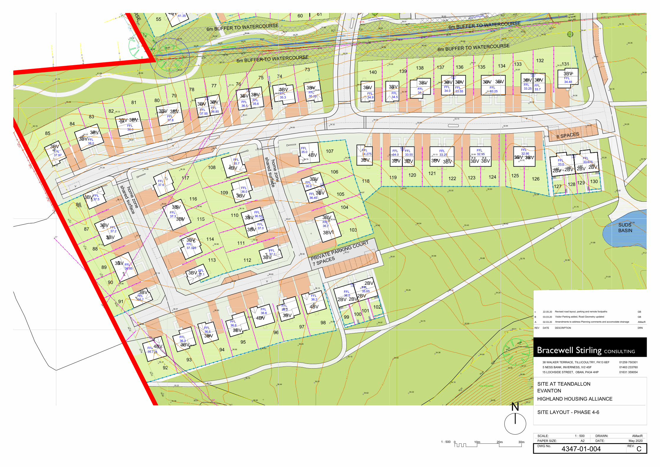
2BV2BV2BV2BV
Kin Kin
Ara
Ara
Ara
AraCu
Cu
Cu
Lo
Cu
Cu
Cu
Ne
Arr ArrNe
Lo
Lo
Cu
Cu
Cu
Mo
Mo
Arr
Arr
Mo
Mo
Mo
Mo
Mo
Mo
Arr
Lo
Ara
Ara
Lo
Ara
Ara
Ne
AraAraAraAra Kin Kin
AraAra
AraAra
AraAra
Mo Mo
AraAra
AraAra
Ne
Ne
Lo
133136
74
80
5560 61
73
7576
7877
7981
8283
84
88
86
85
87
93
89
90
96
91
98
92
9594
97
99
102100
101
113
103
112
114
115
111
122 124
116
110
117 118
109
104
129
105
106
107
108
119 120 121123 125
137
126127 128 130
139138
131132
135 134140
PRIVATE PARKING COURT
7 SPACES
8 SPACES
FFL41.35 40.2
39.2
39.2 38.5
FFL33.675
675mmSTEP
FFL33.0
FFL32.95
FFL32.95
FFL33.25
FFL33.55
900mmSTEPFFL
34.275FFL34.0
FFL33.7
FFL34.48
450mmSTEP
FFL33.25FFL
33.25FFL33.55
FFL34.0
450mmSTEP
FFL34.2FFL
34.5FFL34.9
FFL35.35
FFL35.3
FFL35.6FFL
36.5
900mmSTEP
FFL36.85FFL
37.55
675mmSTEP
900mm
RT w
all
FFL35.0
FFL36.0
FFL36.45
FFL36.7
FFL35.65FFL
36.0
450mmSTEP
FFL36.2
FFL36.2FFL
36.6
FFL36.6
FFL36.6
FFL35.7
home zone
shared surfacehome zone
shared surface
FFL36.0
FFL36.55
FFL37.0
FFL37.2
FFL37.1
450mm
STEP
450mm
STEP
FFL37.8
FFL38.0
FFL38.0
FFL37.97
FFL37.5
FFL37.6
FFL37.3
FFL37.2
FFL37.325
FFL36.85
FFL36.7
FFL36.3
FFL35.775
41.0
40.5
40.0
39.5
39.0
38.5
38.0
37.5
37.0
37.0
36.5
36.0
35.5
37.0
36.5
36.0
35.5
34.5
35.0
33.0
33.5
34.0
34.5
35.0
32.0
32.5
34.0
34.5
34.5
34.5
35.0
trees
edge of crop
over
head
pow
er
culvert
IL 33.76
diam 450
trees and bushes
trees and bushes
trees and bushes
865800N
865850N
865900N
865800N
865850N
865900N
34.3533.92
34.7335.07
35.2735.52
35.7936.26
36.77
36.9537.21
37.77
38.29
38.6138.65
38.8539.26
39.6240.44
41.04
40.95
41.51 40.63
40.36
40.25
39.86
40.72
41.53
41.7041.85
41.4541.18
41.00
40.0839.31
37.4037.12
36.8936.51
36.1535.78
35.55 35.16 34.77 34.5234.51
36.71
35.0134.39
37.12
37.35
38.92
40.41
34.17
34.23
34.44
35.09
36.32
36.6436.54
34.9632.67
EP
EP
EP
EP
EP
24.66
25.49
24.95
25.26
29.10
25.31
25.68
25.89
30.45
30.41
25.27
25.63
25.50
33.5632.27
29.98
33.8234.29
34.3534.53
34.54
34.83
35.1235.54
36.00
36.15
36.57
37.0037.20
37.9138.42
38.5638.80
37.62
38.8138.32 38.31
EP
EP
35.68
36.40
36.8137.33
37.95
38.5738.66
38.9639.48
41.57
40.19
38.15
36.93
37.18
36.86
36.04
35.37
36.05
36.14
36.57
37.16
37.19
36.71
37.24
39.03
40.48
41.19
41.08
40.32
38.87
36.86
36.60
37.15
37.27
36.89
36.66
36.73
36.83
36.44
36.63
36.80
37.04
36.96
36.48
36.29
38.49
40.29
40.5639.23
39.05
38.47
36.14
35.68
36.19
36.52
36.65
36.46
36.05
35.57
34.62
35.10
35.60
36.15
36.56
36.47
35.63
35.10
36.41
37.74
38.1537.42
36.07
34.83
34.78
35.69
36.48
36.37
35.66
34.87
34.50
34.22
34.15
34.38
34.75
35.26
35.81
35.62
34.87
34.26
34.32
35.65
36.87
36.80
35.47
34.03
33.68
34.02
34.54
34.99
35.10
35.00
34.69
35.51
34.20
33.68
33.43
33.32
33.12
33.53
34.78
35.95
36.5035.89
34.50
33.15
32.80
32.83
32.82
32.76
33.17
34.05
31.77
32.17
32.08
32.18
32.24
32.35
32.64
33.51
34.63
35.3334.37
33.87
33.38
32.68
32.14
31.75
31.68
31.83
31.58
30.64
31.28
31.93
32.60
33.28
33.92
34.56
34.25
34.32
34.47
34.44
34.76
34.29
33.75
34.66
34.35
34.18
27.85
29.2330.23
33.10
33.13
27.58
30.95
29.55
35.23
34.85
35.33
35.79
36.16
36.65
37.21
37.46
37.01
EP
cross section
41.38
cross section
cross section
cross section
4BV
3BV 3BV3BV 3BV 3BV 3BV 3BV 3BV
3BV3BV3BV3BV
3BV3BV3BV3BV
3BV3BV
3BV3BV
3BV
3BV
3BV
3BV
3BV
3BV
3BV
3BV
3BV 3BV
3BV
3BV
3BV
3BV
3BV 3BV
3BV 3BV 3BV 3BV 3BV 3BV 3BV3BV 3BV4BV
4BV
4BV
4BV
4BV
3BV
3BV
3BV
3BV
3BV
3BV
3BV
3BV
2BV2BV2BV2BV
2BV
2BV2BV2BV
SUDSBASIN
6m BUFFER TO WATERCOURSE
6m BUFFER TO WATERCOURSE
6m BUFFER TO WATERCOURSE
6m BUFFER TO WATERCOURSE
6m BUFFER TO
WATERCO
URSE
V
V
V
V
37.75
1 in 20 tarred footpath
1 in 20 tarred footpath
38 WALKER TERRACE, TILLICOULTRY, FK13 6EF
5 NESS BANK, INVERNESS, IV2 4SF
15 LOCHSIDE STREET, OBAN, PA34 4HP
Bracewell Stirling CONSULTING
DWG No. REV.PAPER SIZE:SCALE: DRAWN:
DATE:
01259 750301
01463 233760
01631 359054
HIGHLAND HOUSING ALLIANCE
4347-01-004
1 : 500 AMacRMay 2020
C
SITE AT TEANDALLON
SITE LAYOUT - PHASE 4-6
A2
EVANTON
REV DATE DESCRIPTION DRN
A 02.03.20 Amendments to address Planning comments and accomodate drainage AMacR
B 03.03.20 Visitor Parking added, Road Geometry updated GB
c 22.05.20 Revised road layout, parking and remote footpaths GB
N
10m 30m1 : 500 0 20m
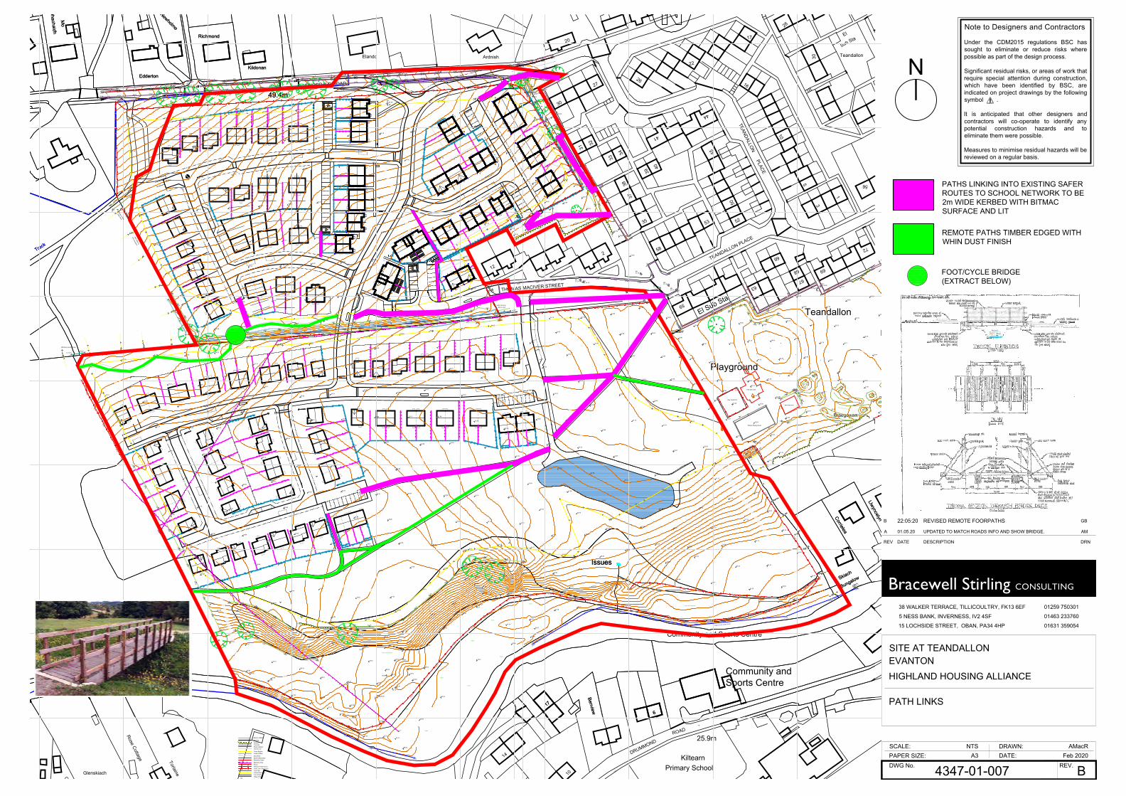
Cu
3BV
3BV
Kin Kin
Ara
Ara
3BV
3BV
Ara
Ara
Cu
Cu
Cu
Cu
Cu
Lo
Lo
Cu
Cu
Cu
Ne
Arr ArrNe
Lo
Lo
Cu
Cu
Cu
Mo
Mo
Arr
Arr
Mo
Mo
Mo
Mo
Mo
Mo
Arr
Lo
Ara
Ara
Lo
Ara
Ara
Ne
AraAraAraAra Kin Kin
AraAra
AraAra
AraAra
Mo
Mo
Ara
Ara
Ara
Ara
27
Teandallon
50
Kildonan
Bungalow
16
45
Ardnish
49.4m
TEANDALLON PLACE
52
Sub Sta
39
Richmond
TEANDALLON
SWORDALE ROAD
30
2
Issues
44
34
31
17
30
Benview
Newholme
Track
6
Skiach
58
Elando
32
41
20
10
Dhachaidh
El
59
Community and Sports Centre
17
LlwyncelynCorrielea
Playground
53
5
37
12
Braegowan
66
63
56
28
3
26IssuesEdderton
33
67
El Sub Sta
35
69
1
38
PLACE
22
Teandallon
THOMAS MACIVER STREET
40
72
68
Mo
Bungalow
ROAD
DRUMMOND 25.9m
Issues
Benview 6
Skiach
Sports Centre
14
Community and
17
LlwyncelynCorrielea
Primary SchoolKiltearn
10
Willow Grove
Glenskiach
Torlaine
Kildonan
49.4m
Rose Cottage
Richmond
House
Newholme
Track
Dhachaidh
Edderton
Glenskiach Bungalow
Mo
Ne
Ne
3BV
3BV
2BB
2BB
3BV
3BV
AraAra
AraAra
Kin Kin
AraAra
AraAra
Ne
Cu
Lo
Ara
Ara
Ara
Ara
AraAra
Ara
Ara
2BV2BV
3BV
3BV
Bottom of Bank
BuildingBushes
BushesConcreteRoad ChannelCentre Line
cross sectionCross SectionInvert of Ditch
DKDrop KerbExternal BoundaryElectricity Cable
EPElectricity PoleFencePaling or Panel FenceChain Link Wire FenceFoot PathInternal BoundaryTop of KerbEdge of Road
RSRoad Sign
46.0
45.5
45.0
44.5
44.0
43.5
43.0
42.5
42.0
41.5
41.0
40.5
40.0
39.5
39.0
38.5
38.0
37.5
36.5
37.0
36.0
35.5
35.0
47.0
46.5
47.5
48.549.0
49.550.0
50.551.0
51.552.052.5
53.053.5
54.054.5
55.0
55.5
41.0
40.5
40.0
39.5
39.0
38.5
38.0
37.5
37.0
37.0
36.5
36.0
35.5
37.0
36.5
36.0
35.5
34.5
35.0
33.0
33.5
34.0
34.5
35.0
32.0
32.5 33.5
34.0
34.5
34.5
34.0
24.5
25.0
24.0
32.0
31.5
31.0
30.5
30.0
29.5
29.0
27.5
27.0
28.0
28.5
26.5
26.0
25.5
32.5
33.0
33.0
27.527.0
28.0
26.5
29.0
28.5
33.0
33.5
34.0
34.5
35.0
32.032.5
31.5
31.0
30.5
30.0
29.5
33.0
33.5
33.0
33.0 33.0
33.5
34.0
34.5
33.0
33.5
34.0
34.5
32.5
32.0
32.0
33.5
34.0
34.5
33.0
33.5
33.032.5
32.0
32.5
31.5
31.0
35.5
35.036.0
36.5
36.5
37.0
36.0
41.0
40.5
40.0
39.5
39.0
38.5
38.0
37.5
43.0
42.5
42.0
41.5
43.5
edge of river (water level)
edge of river (water level)
trees
trees
trees
trees
trees
trees
trees
trees
track
edge of crop
edge of crop
over
head
pow
er
culvert
IL 33.76
diam 450
cable crossingditch in duct
trees and bushes
trees and bushes
trees and bushes
trees and bushes
trees and bushes
blocked culvert
stone wall headwall
headwall
450 diam plastic pipe
IL 29.79
450 diam plastic pipeIL 40.17
400 diam metal corrugated pipe IL 41.01
under track
ditch silted up
and overgrown
Tarmac Playing Court
bark play area
bark play area
play equipment
swings
400 diam concrete pipe
IL 41.34IL 40.87
tree canopy
tree canopy
tree canopy
bike track mounds
865700N
865750N
865800N
865850N
865900N
865950N
866000N
866050N
866100N
865700N
865750N
865800N
865850N
865900N
865950N
866000N
866050N
866100N
47.9247.32
46.89
DK50.02 49.49 DK
48.34 47.95 DK47.36 46.89 46.41 45.86 45.23 44.64 DK
43.8043.12
42.5542.17
42.1042.06
42.0141.92
GIC
LP
MHCL 44.34
G
LPMHCL 46.09
G
LP
ICSV
55.60 55.14 54.62 54.06 53.51 52.99 52.43 51.75 51.14 50.56 49.91 49.3848.22 47.84
47.22 46.79 46.30 45.75 45.11 44.5243.70 43.00
42.4442.10
42.0141.93
41.90
41.80
41.87
41.96
42.03
42.14
42.2342.5443.0643.78
44.6145.19
45.8346.40
46.82
46.9947.43
48.0648.34
48.7449.47
50.0050.62
51.2751.88
52.5053.03
53.58
54.0954.50
54.7055.01
55.7355.74 55.22 54.72 54.15 53.8055.72 55.27 54.72 54.16 53.61 DK
51.25 50.68
LPTP
LP
G
WV
MHCL 53.33 MH
CL 52.73
WV
IC
TP
WV MHCL 52.09
G
LPMHCL 50.97
LPMHCL 49.01 SV
IC G
MHCL 48.77
LP
49.9
0
51.4653.37
54.34
Gate
53.41 53.0152.40
51.45 50.8750.00
49.4748.33
47.5046.98
46.4945.95
45.3244.09
43.23
42.16
40.81
39.88
38.73
36.81
35.65
35.94
36.51
36.80
36.98
36.78
36.03
35.22
34.3533.92
33.3933.11
33.0833.10
33.33
33.13
33.09
33.16
33.38
33.46
33.13
32.09
30.29
27.74
26.12
24.85
24.36
23.6
3
23.82
23.8623.9624.28
24.80
25.18
25.9627.10
27.70
MHCL 49.87
34.7335.07
35.2735.52
35.7936.26
36.77
36.9537.21
37.77
38.29
38.6138.65
38.8539.26
39.6240.44
41.04
40.95
41.51
42.28
47.36
46.32
45.28
44.59
43.43
42.74
41.93
41.20
40.63
40.36
40.25
39.86
40.72
41.53
41.82
42.2141.70
41.8541.45
41.1841.00
40.0839.31
37.4037.12
36.8936.51
36.1535.78
35.55 35.16 34.77 34.5234.51
36.76
37.21
36.71
35.0134.39
37.12
37.35
38.92
40.41
41.47
41.66
BushesBushes
Bushes34.97
34.39 34.18 34.00
33.98
34.17
34.23
34.44
35.09
36.32
36.6436.54
34.9632.67
EP
EP
EP
EP
EP
23.82
22.78
22.27
22.40
22.53
23.1123.36
23.37
23.47
23.56
24.5324.66
25.49
24.95
25.26
24.99
25.04
25.24
25.54
25.95
26.22
26.45
26.68
27.04
27.21
27.24
27.20
28.56
27.90
27.72
27.65
29.21
29.76
30.18
23.01 22.8922.57
29.10
25.31
25.68
25.89
30.45
30.41
24.34
24.39
24.28
24.01
24.97
24.84
25.3630.18
28.33
28.04
26.13
25.79
25.93
25.84
25.41
25.37
25.27
25.63
25.50
28.23
26.92
27.02
27.17
27.31
27.62
28.78
28.95
26.30 26.1325.75
25.82
31.02
30.79
31.55
30.92
30.20
28.35
28.3028.55
28.75
28.25
27.99
25.80
25.91
26.40
25.96
25.39
33.5632.27
29.98
33.8234.29
34.3534.53
34.54
34.83
35.1235.54
36.00
36.15
36.57
37.0037.20
37.9138.42
38.5638.80
37.62
38.8138.32 38.31
EP
EP
EP
53.4252.24
51.31
49.7948.80
47.70
46.7846.20
45.6244.76
43.33
41.46
40.00
41.43
42.72
43.52
44.3044.79
45.1545.22
45.8447.00
48.5149.72
50.77
51.40
49.14
48.48
47.94
47.07
45.25
43.54
42.85
43.13
42.8341.95
41.07
39.84
38.6337.94
36.47
37.69
38.51
39.16
39.86
40.5240.93
41.2742.21
43.5945.10
45.7646.33
46.53
46.83
44.9144.36
44.13 43.17 42.3141.32
40.46
38.99
38.32
37.91
37.42
36.94
36.30
35.85
36.6736.7437.55
38.7339.39
40.3041.1641.6742.55
42.53
42.98
41.03 40.3539.66
39.2138.70
37.8637.25
36.4235.64
35.18
34.93
35.68
36.40
36.8137.33
37.95
38.5738.66
38.9639.48
41.57
40.19
38.15
36.93
37.18
36.86
36.04
35.37
36.05
36.14
36.57
37.16
37.19
36.71
37.24
39.03
40.48
41.19
41.08
40.32
38.87
36.86
36.60
37.15
37.27
36.89
36.66
36.73
36.83
36.21
36.44
36.63
36.80
37.04
36.96
36.48
36.29
38.49
40.29
40.5639.23
39.05
38.47
36.14
35.68
36.19
36.52
36.65
36.46
36.05
35.57
35.0034.16
34.62
35.10
35.60
36.15
36.56
36.47
35.63
35.10
36.41
37.74
38.1537.42
36.07
34.83
34.78
35.69
36.48
36.37
35.66
34.87
34.50
34.22
34.09
34.15
34.38
34.75
35.26
35.81
35.62
34.87
34.26
34.32
35.65
36.87
36.80
35.47
34.03
33.68
34.02
34.54
34.99
35.10
35.00
34.69
35.51
34.20
33.68
33.43
33.32
33.12
33.53
34.78
35.95
36.5035.89
34.50
33.15
32.80
32.83
32.82
32.76
33.17
34.05
31.77
32.17
32.08
32.18
32.24
32.35
32.64
33.51
34.63
35.3334.37
33.87
33.38
32.68
32.14
31.75
31.68
31.83
31.58
30.64
30.53
30.75
31.28
31.93
32.60
33.28
33.92
34.56
34.25
34.32
34.47
34.44
34.76
34.29
33.75
33.20
32.55
31.51
30.87
32.17
33.04
33.37
33.66
34.08
34.69
34.66
34.35
34.18 33.74
33.76
33.67
33.59
33.72
33.53
33.10
32.51
33.39
33.47
33.19
32.83
32.62
32.62
32.68
32.82
32.88
32.63
32.64
32.68
32.82
33.07
33.08
32.66
32.86
33.53
33.38
33.01
32.93
33.1
333
.22
33.24
33.2833.4733.65
33.8233.9434.2434.46
34.61
34.8
634
.9835.08
35.00
34.9535.07
35.07 34.87
34.6534.42 34.35
34.1433.93
33.75 33.6333.48
33.25
33.2
8
33.17
33.18
33.10
MHCL 33.25
MHCL 33.15
MHCL 33.16
MHCL 33.21
IC
MHCL 34.16
MHCL 34.16
MHCL 45.79
23.73
24.34
25.12
26.95
28.94
31.20
31.75
29.76
27.19
24.73
24.18
23.80
24.20
24.38
25.04
27.33
30.52
32.44
31.57
30.01
26.60
25.30
24.77
25.46
26.62
29.39
31.0630.29
29.58
28.00
28.43
25.76
29.58
28.10
24.59
27.6327.85
24.60
28.99
29.2330.23
33.10
33.13
27.58
30.95
29.55
30.41
31.02
31.78
28.50
28.40
28.35
26.35
26.36
27.07
28.36
28.57
28.81
29.0829.23
29.00
29.41
30.59
29.93
29.37
29.04
28.96
29.10
29.15
28.58
28.87
EP
33.11
34.28
34.37
34.20
34.0333.52
35.23
24.75
24.99
25.25
25.56
25.73
26.27
26.35
21.62
21.73
21.7021.99
22.36
22.63
23.69
23.72
23.84
23.90
48.36
48.76
48.45
48.16
33.00
34.85
35.33
35.79
36.16
36.65
37.21
37.46
37.01
EP
25.41
25.66
MHCL 35.16
MHCL 3
5.17
MHCL 33.34
cross section
cross section
cross
section
cross section
cross
section
MHCL 32.92
31.38
32.58
33.19
33.32
33.13
33.04
33.02
32.97
33.06
33.32
33.56
33.68
34.04
34.64
35.72
36.94
38.36
39.31
MHCL 39.34
40.79
cross section
cross
section
cross section
cross
section
cross section
cross section
41.38
cross section
cross section
cross section
MHCL 22.43
cross section
21.39
21.08
cross section
cross section
cross section
cross section
cross section
cross section
32.96
32.91
32.91
32.94
33.00
32.93
31.19
32.30
33.20
33.11
33.37
33.27
33.23
33.04
33.02
33.80
34.19
34.15
33.56
33.21
32.86
31.19
31.43
32.77
33.50
33.92
34.69
34.95
34.26
32.78
32.65
33.70
34.26
33.83
33.81
33.13
32.67
31.54
31.61
32.45
32.09
32.27
32.70
33.11
32.90
32.62
32.53
32.48
32.25
32.11
31.83
31.51
31.43
31.17
32.04
32.16
32.33
32.40
32.28
32.04
32.23
32.35
31.76
33.00
33.40
33.34
33.10
33.01
32.69
31.91
31.07
31.17
LP
33.24
LP
Gate
33.20
32.96
33.10
LP
ELEC BOX
LP LP
MHCL 32.57
MHCL 32.56
Bushe
s
MP
32.14
32.0232.28
31.88
32.55
32.3232.59
33.15
33.23
33.1133.2033.43
33.6033.5833.58
33.4533.33
34.72
33.72
32.50
31.51
33.40
33.90
34.1034.15
34.00
33.74
33.5133.53
33.49
33.3932.99
32.94
32.90
32.81
32.79 32.6933.06
LP
WV
WV
WVWV
LP33.72
33.90
33.83
34.1434.18
34.38
34.85
34.8
6
34.4434.65
35.06
35.48
Bushes
Bushes
Bushes
Bushes
Bushes35.73
36.56
36.74
36.70
36.30
36.19
36.55
36.27
36.07
36.09
35.93
35.85
35.55
35.03
34.92
35.35
35.70
35.5335.93
35.67
36.33
37.20
37.86
38.43
36.11
36.94
37.36
LP
38.6038.50
WVLP
39.15
39.51
39.87
40.5440.53
40.87
41.67
42.2542.31
41.9141.36
41.10
42.7542.48
41.98
41.21
41.22
42.02
41.04
41.52
IC
G
LP
RS
38.4
3
37.36
36.73
36.48
41.10
41.38
41.02
40.17
3BV
3BV
38 WALKER TERRACE, TILLICOULTRY, FK13 6EF
5 NESS BANK, INVERNESS, IV2 4SF
15 LOCHSIDE STREET, OBAN, PA34 4HP
Bracewell Stirling CONSULTING
DWG No. REV.PAPER SIZE:SCALE: DRAWN:
DATE:
01259 750301
01463 233760
01631 359054
HIGHLAND HOUSING ALLIANCE
4347-01-007
NTS AMacRFeb 2020
B
SITE AT TEANDALLON
PATH LINKS
A3
EVANTON
REV DATE DESCRIPTION DRN
A 01.05.20 UPDATED TO MATCH ROADS INFO AND SHOW BRIDGE. AM
B 22:05:20 REVISED REMOTE FOORPATHS GB
N
Note to Designers and Contractors
Under the CDM2015 regulations BSC hassought to eliminate or reduce risks wherepossible as part of the design process.
Significant residual risks, or areas of work thatrequire special attention during construction,which have been identified by BSC, areindicated on project drawings by the followingsymbol .
It is anticipated that other designers andcontractors will co-operate to identify anypotential construction hazards and toeliminate them were possible.
Measures to minimise residual hazards will bereviewed on a regular basis.
PATHS LINKING INTO EXISTING SAFERROUTES TO SCHOOL NETWORK TO BE2m WIDE KERBED WITH BITMACSURFACE AND LIT
REMOTE PATHS TIMBER EDGED WITHWHIN DUST FINISH
FOOT/CYCLE BRIDGE(EXTRACT BELOW)