Embed Size (px)
Citation preview
T H E O F F I C I A L G U I D E T O C A L I F O R N I A S T A T E P A R K S
California
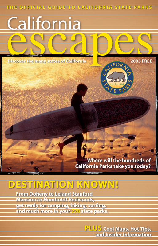
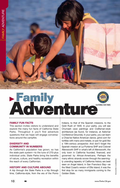
From Doheny to Leland Stanford Mansion to Humboldt Redwoods, get ready for camping, hiking, surfing, and much more in your 278 state parks.
Where will the hundreds of California Parks take you today?
escapes
DESTINATION KNOWN!
2005 FREEDiscover the many states of California
PLUS Cool Maps, Hot Tips, and Insider Information
CaliforniaStateParks2 www.CAescapes.com
JAM
ES
BL
AN
K/
PH
OT
OP
HIL
E
Welcome Friends,Where will the hundreds of California state parks
take you today?Like California itself, California state parks are bold,
adventurous, inspiring—allowing you to stretch yourphysical, mental and spiritual boundaries.
California State Parks is an unending adventure withmore than 275 state parks consisting of nearly 1.4 million
acres, over 280 miles of coastline, 625 miles of lake and river frontage and13,000 campsites. Whether you are a history buff, cultural admirer, an avidoutdoor enthusiast, an off-highway motor-vehicle fan, or a family vacationaficionado, the adventure never stops in the California state parks system,with literally something for everyone.
So prepare to create memories of a lifetime, because whether you’replanning your first adventure or your 100th, I guarantee it will take you to avery satisfied state.
Discover the many states of California!
Ruth ColemanDirector, California State Parks
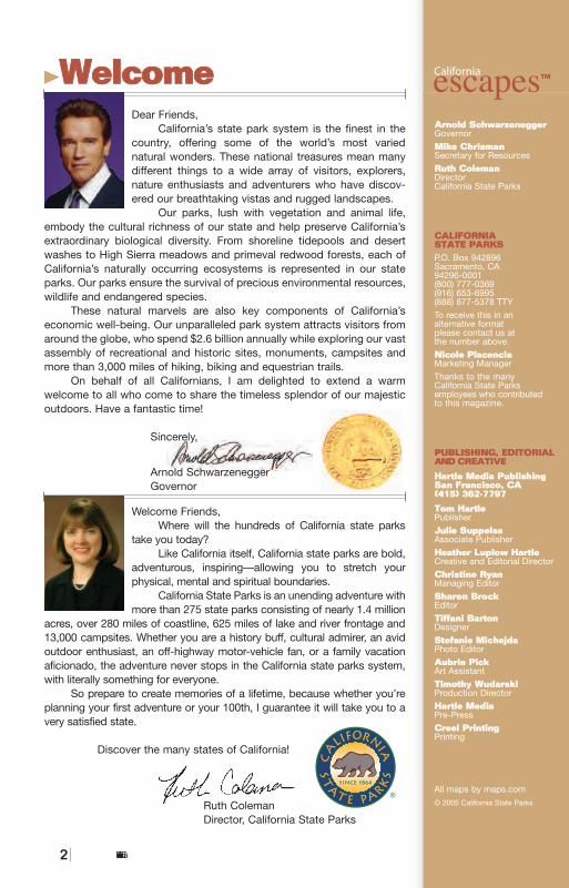
WWeellccoommeeDear Friends,
California’s state park system is the finest in thecountry, offering some of the world’s most varied natural wonders. These national treasures mean manydifferent things to a wide array of visitors, explorers,nature enthusiasts and adventurers who have discov-ered our breathtaking vistas and rugged landscapes.
Our parks, lush with vegetation and animal life,embody the cultural richness of our state and help preserve California’sextraordinary biological diversity. From shoreline tidepools and desertwashes to High Sierra meadows and primeval redwood forests, each ofCalifornia’s naturally occurring ecosystems is represented in our stateparks. Our parks ensure the survival of precious environmental resources,wildlife and endangered species.
These natural marvels are also key components of California’s economic well-being. Our unparalleled park system attracts visitors fromaround the globe, who spend $2.6 billion annually while exploring our vastassembly of recreational and historic sites, monuments, campsites andmore than 3,000 miles of hiking, biking and equestrian trails.
On behalf of all Californians, I am delighted to extend a warm welcome to all who come to share the timeless splendor of our majesticoutdoors. Have a fantastic time!
Sincerely,
Arnold SchwarzeneggerGovernor
AArrnnoolldd SScchhwwaarrzzeenneeggggeerrGovernor
MMiikkee CChhrriissmmaannSecretary for Resources
RRuutthh CCoolleemmaannDirectorCalifornia State Parks
CCAALLIIFFOORRNNIIAASSTTAATTEE PPAARRKKSSP.O. Box 942896Sacramento, CA94296-0001(800) 777-0369(916) 653-6995(888) 877-5378 TTY
To receive this in an alternative format please contact us at the number above.
NNiiccoollee PPllaacceenncciiaaMarketing Manager
Thanks to the many California State Parks employees who contributed to this magazine.
PPUUBBLLIISSHHIINNGG,, EEDDIITTOORRIIAALLAANNDD CCRREEAATTIIVVEE
HHaarrttllee MMeeddiiaa PPuubblliisshhiinnggSSaann FFrraanncciissccoo,, CCAA((441155)) 336622--77779977
TToomm HHaarrttlleePublisher
JJuulliiee SSuuppppeellssaaAssociate Publisher
HHeeaatthheerr LLuuppllooww HHaarrttlleeCreative and Editorial Director
CChhrriissttiinnee RRyyaannManaging Editor
SShhaarroonn BBrroocckkEditor
TTiiffffaannii BBaarrttoonnDesigner
SStteeffaanniiee MMiicchheejjddaaPhoto Editor
AAuubbrriiee PPiicckkArt Assistant
TTiimmootthhyy WWuuddaarrsskkiiProduction Director
HHaarrttllee MMeeddiiaaPre-Press
CCrreeeell PPrriinnttiinnggPrinting
All maps by maps.com
© 2005 California State Parks
CaliforniaescapesTTMM
CCoonntteennttssON THE COVER:Heading home at the goldenhour in San Diego CountyPhotograph by Richard Cumming
MA
RK
J.
DO
LYA
K
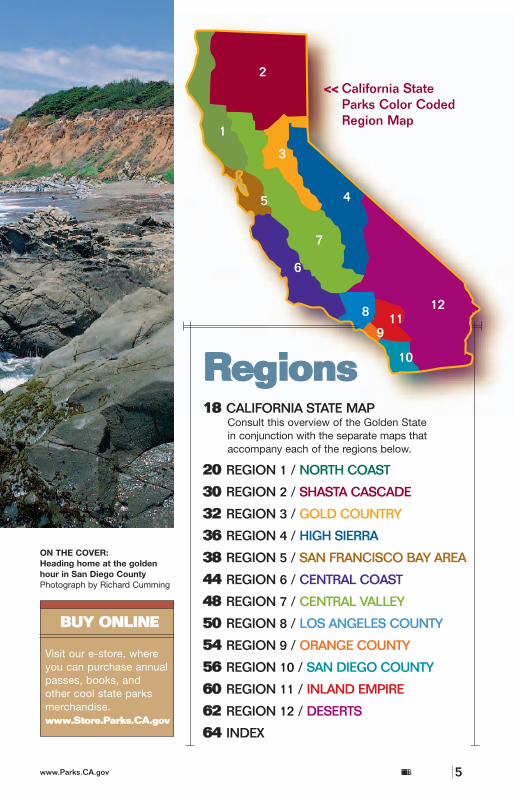
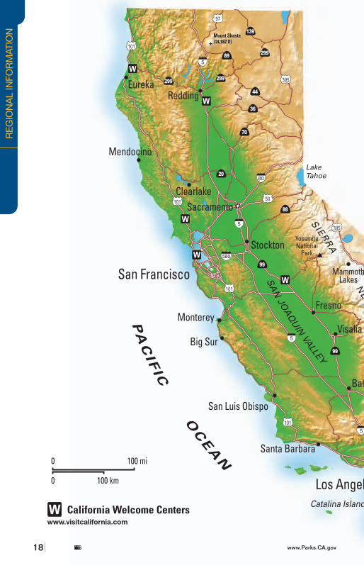
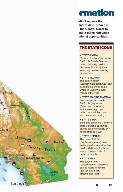
RReeggiioonnss1188 CALIFORNIA STATE MAP
Consult this overview of the Golden Statein conjunction with the separate maps thataccompany each of the regions below.
2200 REGION 1 / NORTH COAST
3300 REGION 2 / SHASTA CASCADE
3322 REGION 3 / GOLD COUNTRY
3366 REGION 4 / HIGH SIERRA
3388 REGION 5 / SAN FRANCISCO BAY AREA
4444 REGION 6 / CENTRAL COAST
4488 REGION 7 / CENTRAL VALLEY
5500 REGION 8 / LOS ANGELES COUNTY
5544 REGION 9 / ORANGE COUNTY
5566 REGION 10 / SAN DIEGO COUNTY
6600 REGION 11 / INLAND EMPIRE
6622 REGION 12 / DESERTS
6644 INDEX
1
2
3
45
6
7
8
9
10
1112
California State Parks Color CodedRegion Map
<<<<
California State Parks4 www.Parks.CA.gov California State Parkswww.Parks.CA.gov 5
TO
P:
RIC
HA
RD
CU
MM
INS
; M
AR
K J
. D
OLY
AK
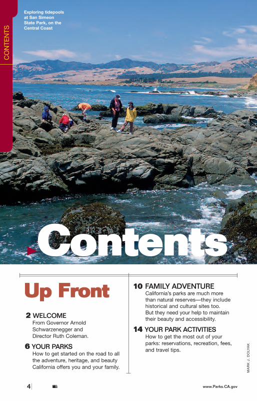
Exploring tidepoolsat San SimeonState Park, on theCentral Coast
UUpp FFrroonntt22 WELCOME
From Governor Arnold Schwarzenegger and Director Ruth Coleman.
0066 YOUR PARKSHow to get started on the road to all the adventure, heritage, and beauty California offers you and your family.
1100 FAMILY ADVENTURECalifornia’s parks are much more than natural reserves—they includehistorical and cultural sites too.But they need your help to maintaintheir beauty and accessibility.
1144 YOUR PARK ACTIVITIESHow to get the most out of your parks: reservations, recreation, fees,and travel tips.
CO
NTE
NTS
BBUUYY OONNLLIINNEE
Visit our e-store, where you can purchase annualpasses, books, and other cool state parks merchandise.wwwwww..SSttoorree..PPaarrkkss..CCAA..ggoovv
CCoonntteennttssON THE COVER:Heading home at the goldenhour in San Diego CountyPhotograph by Richard Cumming
MA
RK
J.
DO
LYA
K
RReeggiioonnss1188 CALIFORNIA STATE MAP
Consult this overview of the Golden Statein conjunction with the separate maps thataccompany each of the regions below.
2200 REGION 1 / NORTH COAST
3300 REGION 2 / SHASTA CASCADE
3322 REGION 3 / GOLD COUNTRY
3366 REGION 4 / HIGH SIERRA
3388 REGION 5 / SAN FRANCISCO BAY AREA
4444 REGION 6 / CENTRAL COAST
4488 REGION 7 / CENTRAL VALLEY
5500 REGION 8 / LOS ANGELES COUNTY
5544 REGION 9 / ORANGE COUNTY
5566 REGION 10 / SAN DIEGO COUNTY
6600 REGION 11 / INLAND EMPIRE
6622 REGION 12 / DESERTS
6644 INDEX
1
2
3
45
6
7
8
9
10
1112
California State Parks Color CodedRegion Map
<<<<
California State Parks4 www.Parks.CA.gov California State Parkswww.Parks.CA.gov 5
TO
P:
RIC
HA
RD
CU
MM
INS
; M
AR
K J
. D
OLY
AK
Exploring tidepoolsat San SimeonState Park, on theCentral Coast
UUpp FFrroonntt22 WELCOME
From Governor Arnold Schwarzenegger and Director Ruth Coleman.
0066 YOUR PARKSHow to get started on the road to all the adventure, heritage, and beauty California offers you and your family.
1100 FAMILY ADVENTURECalifornia’s parks are much more than natural reserves—they includehistorical and cultural sites too.But they need your help to maintaintheir beauty and accessibility.
1144 YOUR PARK ACTIVITIESHow to get the most out of your parks: reservations, recreation, fees,and travel tips.
CO
NTE
NTS
BBUUYY OONNLLIINNEE
Visit our e-store, where you can purchase annualpasses, books, and other cool state parks merchandise.wwwwww..SSttoorree..PPaarrkkss..CCAA..ggoovv
THE NEW LOOK OF CALIFORNIASTATE PARKS!As a park visitor, you may have always knownthat California’s state parks are what makeCalifornia unique. That’s why California StateParks has launched a new look and advertis-ing campaign that communicates this whileemphasizing the many exciting adventuresCalifornia’s 278 state parks have to offer.
For instance, have you explored theplace where presidents stayed and moviestars played? Well, now it is your turn. So gosee the grandeur of this architectural wonderhigh in the mountains above the Pacific, andexperience the rich history Hearst Castle®has to offer. Or go back in time and feel theexcitement of the Gold Rush era as you panfor gold at Marshall Gold Discovery StateHistoric Park. Or discover the thrills ofAmerica’s most famous method of trans-portation at the California Railroad Museum.
Leave your troubles behind and step intoan adventure. Where will the hundreds ofCalifornia state parks take you today?
SURF, TURF, ANDEVERYTHING IN BETWEENThe California state parks are your parks—all278 of them! That’s a lot of parks and a lot ofvariety. If state parks make you think of giantredwood forests, beaches, cascading water-falls, and winding mountain trails, well, we can’targue with that. But California’s state parksoffer so much more.
California’s state parks are virtually every-where in the state. Last year, more than 85 million people visited this state’s parks, historicsites, and beaches to camp, hike, bike, swim,
surf, sightsee, and just about anything else youhave in mind. This guide will help you do any orall of those things. We want to get you on theroad, wave, mountain-bike trail, or wheelchair-accessible path—whatever it takes for you tomake the most of our parks and beaches.
WHERE TO GO? AND HOW?What’s your passion? Whale-watching?Fishing? Bird-watching? Maybe you’re a cyclist,an equestrian, or an aspiring photographer. Nomatter—your interests are our pleasure.
It’s also our pleasure to tell you how. Howcan you reserve a campsite? How can your family hold an outdoor reunion on the shores ofPoint Sur? How do you find remnants of theclassic television show M*A*S*H in Malibu CreekState Park? We’ll tell you.
This guide answers all of your questions. Inthe pages that follow, you’ll find:
• Park unit and reservations information. • A large overview map of California (page 18).• Maps of the 12 California travel regions that
show the locations of the parks. • Regional charts listing facilities (including
visitor centers, food/dining, lodging, RVhookups, and much more) and activities (from camping to biking to windsurfing).
• Capsule descriptions of each park, including telephone numbers and road directions for those parks that are a little out of the way.
And remember…The best way to get the big picture, along withthe latest information on each park and themany activities offered, is to visit the CaliforniaState Parks website at www.Parks.CA.gov. It’s what really puts the state park system atyour fingertips, any day, any time.
HEALTHY LIVINGDid you know it is recommended that we do 30minutes to an hour of physical activity each dayto stay healthy? However, our kids often don’thave the chance to play outside.
A great way for you and your family to meetits fitness goal is to visit a local or state park. Gofor a walk, ride a bike, camp with friends, splashin the ocean or swim in a lake. Park rangers arehappy to help you find trails for all fitness levelsor discover a new outdoor activity.
A recent Surgeon General’s report statedthat children who participate in physical recre-ation at a young age will establish healthyhabits that will follow them into and throughadulthood. To find a park near you and recre-ation tips visit www.Parks.CA.gov.
THE WRONG TIME IS THE RIGHT TIMEDo yourself a favor. Explore the parks in theiroff-seasons. Thanks to California’s mild weather,you don’t need a summer day to hike through agiant redwood grove or share a campfire withfamily and friends. Historic sites that make
California State Parks6 www.Parks.CA.gov
RIC
HA
RD
CU
MM
INS
FR
AN
K S
. B
ALT
HIS
California State Parkswww.Parks.CA.gov 7
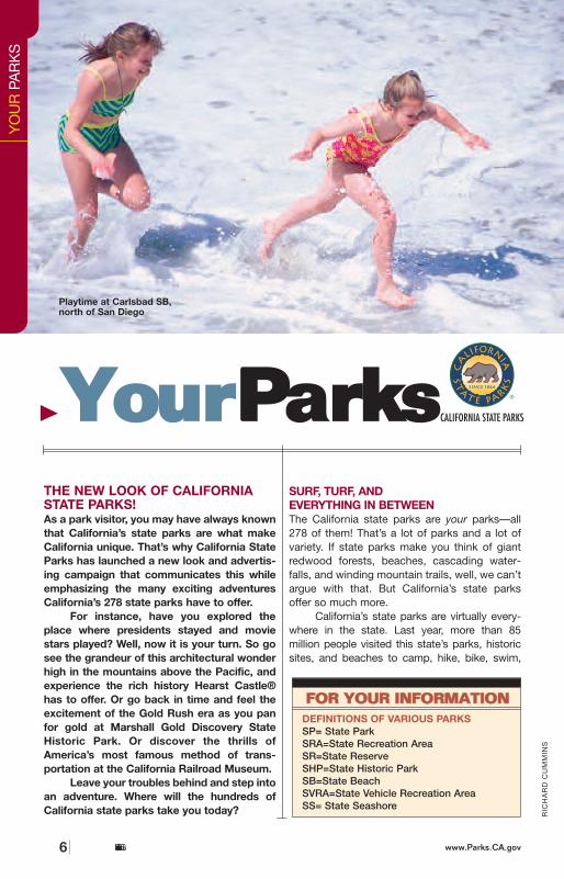
Playtime at Carlsbad SB,north of San Diego
YO
UR
PA
RK
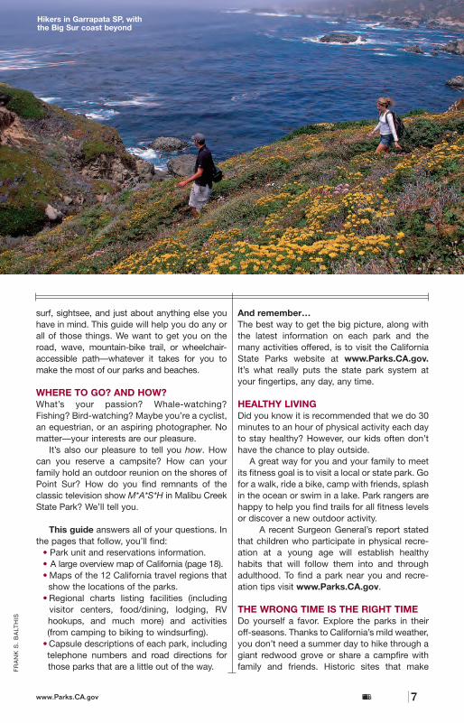
SHikers in Garrapata SP, withthe Big Sur coast beyond
DEFINITIONS OF VARIOUS PARKSSP= State ParkSRA=State Recreation AreaSR=State ReserveSHP=State Historic ParkSB=State BeachSVRA=State Vehicle Recreation AreaSS= State Seashore
FFOORR YYOOUURR IINNFFOORRMMAATTIIOONN
YYoouurrPPaarrkkss
THE NEW LOOK OF CALIFORNIASTATE PARKS!As a park visitor, you may have always knownthat California’s state parks are what makeCalifornia unique. That’s why California StateParks has launched a new look and advertis-ing campaign that communicates this whileemphasizing the many exciting adventuresCalifornia’s 278 state parks have to offer.
For instance, have you explored theplace where presidents stayed and moviestars played? Well, now it is your turn. So gosee the grandeur of this architectural wonderhigh in the mountains above the Pacific, andexperience the rich history Hearst Castle®has to offer. Or go back in time and feel theexcitement of the Gold Rush era as you panfor gold at Marshall Gold Discovery StateHistoric Park. Or discover the thrills ofAmerica’s most famous method of trans-portation at the California Railroad Museum.
Leave your troubles behind and step intoan adventure. Where will the hundreds ofCalifornia state parks take you today?
SURF, TURF, ANDEVERYTHING IN BETWEENThe California state parks are your parks—all278 of them! That’s a lot of parks and a lot ofvariety. If state parks make you think of giantredwood forests, beaches, cascading water-falls, and winding mountain trails, well, we can’targue with that. But California’s state parksoffer so much more.
California’s state parks are virtually every-where in the state. Last year, more than 85 million people visited this state’s parks, historicsites, and beaches to camp, hike, bike, swim,
surf, sightsee, and just about anything else youhave in mind. This guide will help you do any orall of those things. We want to get you on theroad, wave, mountain-bike trail, or wheelchair-accessible path—whatever it takes for you tomake the most of our parks and beaches.
WHERE TO GO? AND HOW?What’s your passion? Whale-watching?Fishing? Bird-watching? Maybe you’re a cyclist,an equestrian, or an aspiring photographer. Nomatter—your interests are our pleasure.
It’s also our pleasure to tell you how. Howcan you reserve a campsite? How can your family hold an outdoor reunion on the shores ofPoint Sur? How do you find remnants of theclassic television show M*A*S*H in Malibu CreekState Park? We’ll tell you.
This guide answers all of your questions. Inthe pages that follow, you’ll find:
• Park unit and reservations information. • A large overview map of California (page 18).• Maps of the 12 California travel regions that
show the locations of the parks. • Regional charts listing facilities (including
visitor centers, food/dining, lodging, RVhookups, and much more) and activities (from camping to biking to windsurfing).
• Capsule descriptions of each park, including telephone numbers and road directions for those parks that are a little out of the way.
And remember…The best way to get the big picture, along withthe latest information on each park and themany activities offered, is to visit the CaliforniaState Parks website at www.Parks.CA.gov. It’s what really puts the state park system atyour fingertips, any day, any time.
HEALTHY LIVINGDid you know it is recommended that we do 30minutes to an hour of physical activity each dayto stay healthy? However, our kids often don’thave the chance to play outside.
A great way for you and your family to meetits fitness goal is to visit a local or state park. Gofor a walk, ride a bike, camp with friends, splashin the ocean or swim in a lake. Park rangers arehappy to help you find trails for all fitness levelsor discover a new outdoor activity.
A recent Surgeon General’s report statedthat children who participate in physical recre-ation at a young age will establish healthyhabits that will follow them into and throughadulthood. To find a park near you and recre-ation tips visit www.Parks.CA.gov.
THE WRONG TIME IS THE RIGHT TIMEDo yourself a favor. Explore the parks in theiroff-seasons. Thanks to California’s mild weather,you don’t need a summer day to hike through agiant redwood grove or share a campfire withfamily and friends. Historic sites that make
California State Parks6 www.Parks.CA.gov
RIC
HA
RD
CU
MM
INS
FR
AN
K S
. B
ALT
HIS
California State Parkswww.Parks.CA.gov 7
Playtime at Carlsbad SB,north of San Diego
YO
UR
PA
RK
S
Hikers in Garrapata SP, withthe Big Sur coast beyond
DEFINITIONS OF VARIOUS PARKSSP= State ParkSRA=State Recreation AreaSR=State ReserveSHP=State Historic ParkSB=State BeachSVRA=State Vehicle Recreation AreaSS= State Seashore
FFOORR YYOOUURR IINNFFOORRMMAATTIIOONN
YYoouurrPPaarrkkss
great winter escapes include Hearst Castle®,Bidwell Mansion, or Old Town San Diego.Summer tip: Campsites are often less crowdedmidweek, even in prime Sierra locations.
RANGER RECRUITMENTLooking for a job that offers culture, escape,and adventure? California State Parks is lookingfor rangers and lifeguards who seek careerchoices beyond working in the woods, includ-ing lakes, beaches, deserts, and urban parks.For information go to www.Parks.CA.gov orcall (866) PARK-JOBS.
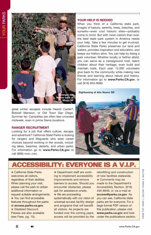
YOUR HELP IS NEEDEDWhen you think of a California state park,images of beauty, serenity, trees, beaches, andsunsets—even cool historic sites—probablycome to mind. But with more visitors than ever,the best state park system in America needsyour help. Take a few minutes to get involved.California State Parks preserves our land andwaters, provides inspiration and education, andkeeps our history alive. You can help by being apark volunteer. Whether locally or farther afield,you can serve as a campground host, teachchildren about their heritage, even build andmaintain trails. Each year, 12,000 volunteersgive back to the community while making newfriends and learning about nature and history.For information go to www.Parks.CA.gov, orcall (916) 653-9069.
California State Parks8 www.Parks.CA.gov
FR
OM
TO
P:
MA
RK
J.
DO
LYA
K;
FR
AN
K S
. B
ALT
HIS
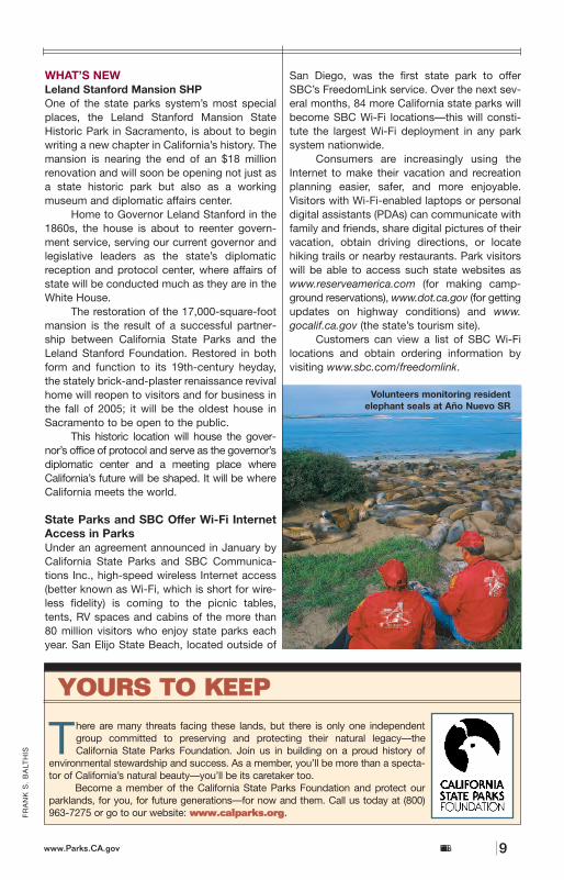
• California State Parkswelcomes all visitors, regardless of their abilities.When planning your visit,please call the park to obtainadditional information orrequest suitable arrangements.
• You can find accessiblefeatures throughout the parksat access.parks.ca.gov.
• Disabled Discount Passes are also available (see Fees, pg. 15).
• Department staff are work-ing to implement accessibilityimprovements and removebarriers to access. Should youencounter obstacles, pleaseask for assistance onsite.
• We are proceedingsystematically with our vision ofuniversal-access facility designand programs that will benefitall visitors. As projects arefunded over the coming years,access will be provided by the
retrofitting and construction of new facilities statewide.
• Comments may be made to the Department’sAccessibility Section, (916)445-8949, or via e-mail [email protected]. As you can see, California stateparks are for everyone. For alarge format PDF version of this publication, please visitwww.parks.ca.gov and lookunder the publications section.
AACCCCEESSSSIIBBIILLIITTYY:: EEVVEERRYYOONNEE IISS AA VV..II..PP..
Sightseeing at Año Nuevo SR
California State Parkswww.Parks.CA.gov 9
FR
AN
K S
. B
ALT
HIS
WHAT’S NEWLeland Stanford Mansion SHPOne of the state parks system’s most specialplaces, the Leland Stanford Mansion StateHistoric Park in Sacramento, is about to beginwriting a new chapter in California’s history. Themansion is nearing the end of an $18 millionrenovation and will soon be opening not just asa state historic park but also as a workingmuseum and diplomatic affairs center.
Home to Governor Leland Stanford in the1860s, the house is about to reenter govern-ment service, serving our current governor andlegislative leaders as the state’s diplomaticreception and protocol center, where affairs ofstate will be conducted much as they are in theWhite House.
The restoration of the 17,000-square-footmansion is the result of a successful partner-ship between California State Parks and theLeland Stanford Foundation. Restored in bothform and function to its 19th-century heyday,the stately brick-and-plaster renaissance revivalhome will reopen to visitors and for business inthe fall of 2005; it will be the oldest house inSacramento to be open to the public.
This historic location will house the gover-nor’s office of protocol and serve as the governor’sdiplomatic center and a meeting place whereCalifornia’s future will be shaped. It will be whereCalifornia meets the world.
State Parks and SBC Offer Wi-Fi InternetAccess in ParksUnder an agreement announced in January byCalifornia State Parks and SBC Communica-tions Inc., high-speed wireless Internet access(better known as Wi-Fi, which is short for wire-less fidelity) is coming to the picnic tables,tents, RV spaces and cabins of the more than80 million visitors who enjoy state parks eachyear. San Elijo State Beach, located outside of
San Diego, was the first state park to offerSBC’s FreedomLink service. Over the next sev-eral months, 84 more California state parks willbecome SBC Wi-Fi locations—this will consti-tute the largest Wi-Fi deployment in any parksystem nationwide.
Consumers are increasingly using theInternet to make their vacation and recreationplanning easier, safer, and more enjoyable.Visitors with Wi-Fi-enabled laptops or personaldigital assistants (PDAs) can communicate withfamily and friends, share digital pictures of theirvacation, obtain driving directions, or locatehiking trails or nearby restaurants. Park visitorswill be able to access such state websites aswww.reserveamerica.com (for making camp-ground reservations), www.dot.ca.gov (for gettingupdates on highway conditions) and www.gocalif.ca.gov (the state’s tourism site).
Customers can view a list of SBC Wi-Filocations and obtain ordering information byvisiting www.sbc.com/freedomlink.
There are many threats facing these lands, but there is only one independentgroup committed to preserving and protecting their natural legacy—theCalifornia State Parks Foundation. Join us in building on a proud history of
environmental stewardship and success. As a member, you’ll be more than a specta-tor of California’s natural beauty—you’ll be its caretaker too.
Become a member of the California State Parks Foundation and protect ourparklands, for you, for future generations—for now and them. Call us today at (800)963-7275 or go to our website: wwwwww..ccaallppaarrkkss..oorrgg.
Volunteers monitoring residentelephant seals at Año Nuevo SR
YO
UR
PA
RK
S
A ranger-lednature walk at
Pt. Mugu SP
YYOOUURRSS TTOO KKEEEEPP
great winter escapes include Hearst Castle®,Bidwell Mansion, or Old Town San Diego.Summer tip: Campsites are often less crowdedmidweek, even in prime Sierra locations.
RANGER RECRUITMENTLooking for a job that offers culture, escape,and adventure? California State Parks is lookingfor rangers and lifeguards who seek careerchoices beyond working in the woods, includ-ing lakes, beaches, deserts, and urban parks.For information go to www.Parks.CA.gov orcall (866) PARK-JOBS.
YOUR HELP IS NEEDEDWhen you think of a California state park,images of beauty, serenity, trees, beaches, andsunsets—even cool historic sites—probablycome to mind. But with more visitors than ever,the best state park system in America needsyour help. Take a few minutes to get involved.California State Parks preserves our land andwaters, provides inspiration and education, andkeeps our history alive. You can help by being apark volunteer. Whether locally or farther afield,you can serve as a campground host, teachchildren about their heritage, even build andmaintain trails. Each year, 12,000 volunteersgive back to the community while making newfriends and learning about nature and history.For information go to www.Parks.CA.gov, orcall (916) 653-9069.
California State Parks8 www.Parks.CA.gov
FR
OM
TO
P:
MA
RK
J.
DO
LYA
K;
FR
AN
K S
. B
ALT
HIS
• California State Parkswelcomes all visitors, regardless of their abilities.When planning your visit,please call the park to obtainadditional information orrequest suitable arrangements.
• You can find accessiblefeatures throughout the parksat access.parks.ca.gov.
• Disabled Discount Passes are also available (see Fees, pg. 15).
• Department staff are work-ing to implement accessibilityimprovements and removebarriers to access. Should youencounter obstacles, pleaseask for assistance onsite.
• We are proceedingsystematically with our vision ofuniversal-access facility designand programs that will benefitall visitors. As projects arefunded over the coming years,access will be provided by the
retrofitting and construction of new facilities statewide.
• Comments may be made to the Department’sAccessibility Section, (916)445-8949, or via e-mail [email protected]. As you can see, California stateparks are for everyone. For alarge format PDF version of this publication, please visitwww.parks.ca.gov and lookunder the publications section.
AACCCCEESSSSIIBBIILLIITTYY:: EEVVEERRYYOONNEE IISS AA VV..II..PP..
Sightseeing at Año Nuevo SR
California State Parkswww.Parks.CA.gov 9
FR
AN
K S
. B
ALT
HIS
WHAT’S NEWLeland Stanford Mansion SHPOne of the state parks system’s most specialplaces, the Leland Stanford Mansion StateHistoric Park in Sacramento, is about to beginwriting a new chapter in California’s history. Themansion is nearing the end of an $18 millionrenovation and will soon be opening not just asa state historic park but also as a workingmuseum and diplomatic affairs center.
Home to Governor Leland Stanford in the1860s, the house is about to reenter govern-ment service, serving our current governor andlegislative leaders as the state’s diplomaticreception and protocol center, where affairs ofstate will be conducted much as they are in theWhite House.
The restoration of the 17,000-square-footmansion is the result of a successful partner-ship between California State Parks and theLeland Stanford Foundation. Restored in bothform and function to its 19th-century heyday,the stately brick-and-plaster renaissance revivalhome will reopen to visitors and for business inthe fall of 2005; it will be the oldest house inSacramento to be open to the public.
This historic location will house the gover-nor’s office of protocol and serve as the governor’sdiplomatic center and a meeting place whereCalifornia’s future will be shaped. It will be whereCalifornia meets the world.
State Parks and SBC Offer Wi-Fi InternetAccess in ParksUnder an agreement announced in January byCalifornia State Parks and SBC Communica-tions Inc., high-speed wireless Internet access(better known as Wi-Fi, which is short for wire-less fidelity) is coming to the picnic tables,tents, RV spaces and cabins of the more than80 million visitors who enjoy state parks eachyear. San Elijo State Beach, located outside of
San Diego, was the first state park to offerSBC’s FreedomLink service. Over the next sev-eral months, 84 more California state parks willbecome SBC Wi-Fi locations—this will consti-tute the largest Wi-Fi deployment in any parksystem nationwide.
Consumers are increasingly using theInternet to make their vacation and recreationplanning easier, safer, and more enjoyable.Visitors with Wi-Fi-enabled laptops or personaldigital assistants (PDAs) can communicate withfamily and friends, share digital pictures of theirvacation, obtain driving directions, or locatehiking trails or nearby restaurants. Park visitorswill be able to access such state websites aswww.reserveamerica.com (for making camp-ground reservations), www.dot.ca.gov (for gettingupdates on highway conditions) and www.gocalif.ca.gov (the state’s tourism site).
Customers can view a list of SBC Wi-Filocations and obtain ordering information byvisiting www.sbc.com/freedomlink.
There are many threats facing these lands, but there is only one independentgroup committed to preserving and protecting their natural legacy—theCalifornia State Parks Foundation. Join us in building on a proud history of
environmental stewardship and success. As a member, you’ll be more than a specta-tor of California’s natural beauty—you’ll be its caretaker too.
Become a member of the California State Parks Foundation and protect ourparklands, for you, for future generations—for now and them. Call us today at (800)963-7275 or go to our website: wwwwww..ccaallppaarrkkss..oorrgg.
Volunteers monitoring residentelephant seals at Año Nuevo SR
YO
UR
PA
RK
S
A ranger-lednature walk at
Pt. Mugu SP
YYOOUURRSS TTOO KKEEEEPP
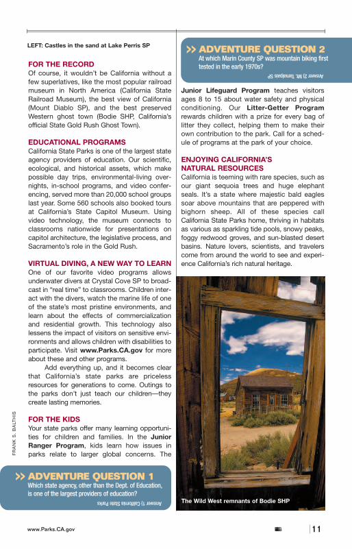
FOR THE RECORDOf course, it wouldn’t be California without afew superlatives, like the most popular railroadmuseum in North America (California StateRailroad Museum), the best view of California(Mount Diablo SP), and the best preservedWestern ghost town (Bodie SHP, California’sofficial State Gold Rush Ghost Town).
EDUCATIONAL PROGRAMS California State Parks is one of the largest stateagency providers of education. Our scientific,ecological, and historical assets, which makepossible day trips, environmental-living over-nights, in-school programs, and video confer-encing, served more than 20,000 school groupslast year. Some 560 schools also booked toursat California’s State Capitol Museum. Usingvideo technology, the museum connects toclassrooms nationwide for presentations oncapitol architecture, the legislative process, andSacramento’s role in the Gold Rush.
VIRTUAL DIVING, A NEW WAY TO LEARNOne of our favorite video programs allowsunderwater divers at Crystal Cove SP to broad-cast in “real time” to classrooms. Children inter-act with the divers, watch the marine life of oneof the state’s most pristine environments, andlearn about the effects of commercializationand residential growth. This technology alsolessens the impact of visitors on sensitive envi-ronments and allows children with disabilities toparticipate. Visit www.Parks.CA.gov for moreabout these and other programs.
Add everything up, and it becomes clearthat California’s state parks are pricelessresources for generations to come. Outings tothe parks don’t just teach our children—theycreate lasting memories.
FOR THE KIDSYour state parks offer many learning opportuni-ties for children and families. In the JuniorRanger Program, kids learn how issues inparks relate to larger global concerns. The
Junior Lifeguard Program teaches visitorsages 8 to 15 about water safety and physicalconditioning. Our Litter-Getter Programrewards children with a prize for every bag oflitter they collect, helping them to make theirown contribution to the park. Call for a sched-ule of programs at the park of your choice.
ENJOYING CALIFORNIA’SNATURAL RESOURCESCalifornia is teeming with rare species, such asour giant sequoia trees and huge elephantseals. It’s a state where majestic bald eaglessoar above mountains that are peppered withbighorn sheep. All of these species callCalifornia State Parks home, thriving in habitatsas various as sparkling tide pools, snowy peaks,foggy redwood groves, and sun-blasted desertbasins. Nature lovers, scientists, and travelerscome from around the world to see and experi-ence California’s rich natural heritage.
AAddvveennttuurree
World’s largest elephant seal rookery is at Año Nuevo SR
California State Parks10 www.Parks.CA.gov California State Parkswww.Parks.CA.gov 11
FR
AN
K S
. B
ALT
HIS
RIC
HA
RD
CU
MM
INS
LEFT: Castles in the sand at Lake Perris SP
AADDVVEENNTTUURREE QQUUEESSTTIIOONN 11Which state agency, other than the Dept. of Education,is one of the largest providers of education?
>>
AADDVVEENNTTUURREE QQUUEESSTTIIOONN 22At which Marin County SP was mountain biking firsttested in the early 1970s?
>>
FAM
ILY
AD
VE
NTU
RE
The Wild West remnants of Bodie SHP
FAMILY FUN FACTSThis section invites visitors to understand andexplore the many fun facts of California StateParks. Throughout it you’ll find adventurequestions that we hope will engage conversa-tions around the campfire.
DIVERSITY ANDCOMMUNITY IN NUMBERSAs California’s population has grown, so hasthe state park system—to the tune of 270-plusindividual units. State Parks bring the benefitsof nature, culture, and healthy recreation withinthe reach of every Californian.
HISTORY AND CULTURE ABOUNDA trip through the State Parks is a trip throughtime, California-style, from the era of the Pomo
Indians, to that of the Spanish missions, to theGold Rush of 1849. In your parks, you will seeChumash cave paintings and Craftsman-stylearchitecture (as found, for instance, at AsilomarConference Grounds). In your parks, you can learna Chaw’se Native American dance, grind corn fortortillas with mano and metate, or pan for gold likea 19th-century prospector. And don’t forget theSpanish mission at La Purísima SHP and ColonelAllensworth SHP in what’s left of Allensworth, theonly town in California founded, financed, andgoverned by African-Americans. Perhaps themany ethnic strands woven through the seeming-ly unending tapestry of California history are bestseen on Angel Island, in San Francisco Bay—asthe West Coast’s version of Ellis Island, it was thefirst stop for so many immigrants coming to theGolden State.
FFaammiillyy
Answer 1) California State Parks
Answer 2) Mt. Tamalpais SP
Our state parks are priceless repositories ofnature, sanctuaries for the human spirit, placeswhere anyone can observe, explore, andmarvel at the beauty of the natural world.
PRESERVING YOUR PARKS To protect this vast and varied heritage requiresactive management to repair damaged land-scapes and to help restore their natural cycles.
Unfortunately, human impact on California’snatural resources has been significant over thecenturies, and our state parks also pay a pricefor their popularity. If the resources we enjoyand take for granted are to survive for futuregenerations, we must all accept responsibilityfor their preservation.
HOW CALIFORNIA HELPS TOPRESERVE YOUR STATE PARKSFire managementBecause total fire suppression has resulted indangerous accumulations of dry tinder that canfeed destructive wildfires, “prescribed burn”fires are allowed to slowly burn away duff,smaller brush, and some trees. Non-native speciesThe impact of non-native plant and animalspecies on native ecosystems is of nationalconcern. Among the greatest problems is thewell-intentioned feeding of feral animals, whichhas resulted in a greater rabies hazard and athreat to endangered native species.Endangered species The past three decades have seen, in Californiaalone, 137 native animal species and more than400 native plant species classified as endan-gered or threatened. Success stories By 1994, the peregrine falcon and theCalifornia gray whale had come back from thebrink of extinction. Animal rescue programs
California State Parks12 www.Parks.CA.gov California State Parkswww.Parks.CA.gov 13
FR
OM
TO
P:
BR
EN
DA
N M
cK
EN
NA
; R
ICH
AR
D C
UM
MIN
S
FR
AN
K S
. B
ALT
HIS
(2
)
have also kept species such as the Californiabighorn sheep, found at Anza-Borrego DesertSP, and the tule elk (for which Tule Elk SR isnamed) from disappearing.
PRESERVING OUR PAST Archaeologists, historians, and restoration spe-cialists are involved in the study of California’sdiverse cultures, helping to identify and protectNative American burial grounds, restoreSpanish missions, and even maintain the stateof “arrested decay” found at the Gold Rushghost town of Bodie. California State Parks’ongoing preservation work makes it possible toeducate thousands of schoolchildren each yearabout the importance of California’s past.
PPRREESSEERRVVAATTIIOONN RRUULLEESS
• Put litter in its place.
• Stay on designated trails (no shortcuts).
• Avoid disturbing tidepool creatures.
• Do not feed the animals.
• Do not dispose of wastewater in lakes and streams.
• Do not disturb historic andarchaeological artifacts.
FAM
ILY
AD
VE
NTU
RE
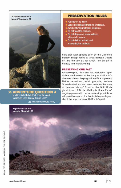
A scenic overlook atMount Tamalpais SP
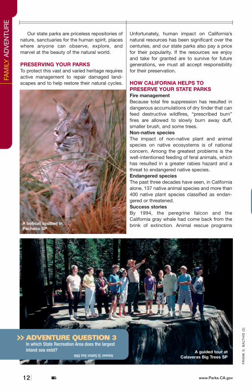
A bobcat spotted inPacheco SP
AADDVVEENNTTUURREE QQUUEESSTTIIOONN 44In which State Historic Park does the oldest continously used Chinese Temple exist?
>>
Answer 4) Weaverville Joss House SHP
AADDVVEENNTTUURREE QQUUEESSTTIIOONN 33In which State Recreation Area does the largestinland sea exist?
>>
Answer 3) Salton Sea SRA A guided tour atCalaveras Big Trees SP
High drama at SanJacinto Mountain SP
Our state parks are priceless repositories ofnature, sanctuaries for the human spirit, placeswhere anyone can observe, explore, andmarvel at the beauty of the natural world.
PRESERVING YOUR PARKS To protect this vast and varied heritage requiresactive management to repair damaged land-scapes and to help restore their natural cycles.
Unfortunately, human impact on California’snatural resources has been significant over thecenturies, and our state parks also pay a pricefor their popularity. If the resources we enjoyand take for granted are to survive for futuregenerations, we must all accept responsibilityfor their preservation.
HOW CALIFORNIA HELPS TOPRESERVE YOUR STATE PARKSFire managementBecause total fire suppression has resulted indangerous accumulations of dry tinder that canfeed destructive wildfires, “prescribed burn”fires are allowed to slowly burn away duff,smaller brush, and some trees. Non-native speciesThe impact of non-native plant and animalspecies on native ecosystems is of nationalconcern. Among the greatest problems is thewell-intentioned feeding of feral animals, whichhas resulted in a greater rabies hazard and athreat to endangered native species.Endangered species The past three decades have seen, in Californiaalone, 137 native animal species and more than400 native plant species classified as endan-gered or threatened. Success stories By 1994, the peregrine falcon and theCalifornia gray whale had come back from thebrink of extinction. Animal rescue programs
California State Parks12 www.Parks.CA.gov California State Parkswww.Parks.CA.gov 13
FR
OM
TO
P:
BR
EN
DA
N M
cK
EN
NA
; R
ICH
AR
D C
UM
MIN
S
FR
AN
K S
. B
ALT
HIS
(2
)
have also kept species such as the Californiabighorn sheep, found at Anza-Borrego DesertSP, and the tule elk (for which Tule Elk SR isnamed) from disappearing.
PRESERVING OUR PAST Archaeologists, historians, and restoration spe-cialists are involved in the study of California’sdiverse cultures, helping to identify and protectNative American burial grounds, restoreSpanish missions, and even maintain the stateof “arrested decay” found at the Gold Rushghost town of Bodie. California State Parks’ongoing preservation work makes it possible toeducate thousands of schoolchildren each yearabout the importance of California’s past.
PPRREESSEERRVVAATTIIOONN RRUULLEESS
• Put litter in its place.
• Stay on designated trails (no shortcuts).
• Avoid disturbing tidepool creatures.
• Do not feed the animals.
• Do not dispose of wastewater in lakes and streams.
• Do not disturb historic andarchaeological artifacts.
FAM
ILY
AD
VE
NTU
RE
A scenic overlook atMount Tamalpais SP
A bobcat spotted inPacheco SP
AADDVVEENNTTUURREE QQUUEESSTTIIOONN 44In which State Historic Park does the oldest continously used Chinese Temple exist?
>>
Answer 4) Weaverville Joss House SHP
AADDVVEENNTTUURREE QQUUEESSTTIIOONN 33In which State Recreation Area does the largestinland sea exist?
>>
Answer 3) Salton Sea SRA A guided tour atCalaveras Big Trees SP
High drama at SanJacinto Mountain SP
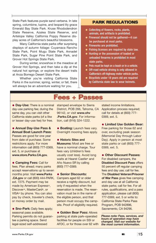
State Park features purple sand verbena. In latespring, columbine, lupine, and leopard lily graceEmerald Bay State Park. Kruse RhododendronState Reserve, Azalea State Reserve, andAntelope Valley California Poppy Reserve dis-play acres of California’s beautiful blossoms.
Many California state parks offer surprisingdisplays of autumn foliage: Cuyamaca RanchoState Park, Point Mugu State Park, AnnadelState Park, Sugar Pine Point State Park, andGrover Hot Springs State Park.
During winter, snowshoe in the meadow atGrover Hot Springs, and then take a dip at thenatural hot springs; or explore the desert trailsat Anza Borrego Desert State Park.
Whether you’re visiting California StateParks in the summer, spring, winter, or fall, therewill always be an adventure waiting for you.
ADVENTURE: IT’S IN OUR BLOODThanks to our parks, adventure recreation hasbecome a birthright for Californians. With morethan 280 miles of coastline, over 1,200 miles ofwaterfront, thousands of campsites and picnicareas, and hundreds of sites of historical, cul-tural, and ecological interest, your state parkshave something for everybody.
BEACHESCalifornia State Parks’ beaches are legendary,from the ruggedly beautiful North Coast to PointLobos (called the greatest meeting of ocean andland in all the world) to the sandy playgrounds ofsouthern California, where “beach culture” wasvirtually invented.
CAMPINGBusy parks may be full if you arrive without reser-vations, particularly during the summer season.Many coastal parks remain busy year round,especially on weekends. Fortunately, campsitesfor individuals, families, or groups can bereserved up to seven months in advance atwww.Parks.CA.gov or via ReserveAmerica at
(800) 444-PARK. Other campgrounds may beavailable first come, first served. For information,call (800) 777-0369 or (916) 653-6995. Severalparks, some with horse rental facilities, provideequestrian camping. Call (916) 653-6995 formore information.
SIERRA SNO-PARKSEasy access to some of the Sierra’s finest cross-country ski trails, snowmobile routes, and snowplay areas can be found at various plowed parkinglots. California State Parks administers this pro-gram November 1 through May 30; from Septem-ber to March, rangers lead hikes and ski tours.Call (916) 324-1222 or www.OHV.parks.ca.gov.
HIKING: FOUR SEASONS OF ADVENTUREWith more than 300 miles of hiking, biking andequestrian trails, California’s parks offer fourseasons of outdoor adventure and naturalbeauty. In early spring, Anza Borrego Desert
California State Parks14 www.Parks.CA.gov
GA
RY
CR
AB
BE
California State Parkswww.Parks.CA.gov 15
FFuunnSSttuuffff
More than three decades ago,California State Parks began aneffort to responsibly manage arecreational sport that contin-ues to grow. Today, the stateoffers the largest off-highwayvehicle recreation program inthe U.S., with the most environ-mentally friendly rules of anyU.S. state park system.
The Off-Highway MotorVehicle Recreation Divisionoperates six main recreationareas and provides for astatewide system of managedrecreational opportunitiesthrough funding to other publicagencies. Among its visitorsare dirt bikers, all-terrainvehicle drivers, 4x4 and dune
buggy riders, snowmobilers,mountain bikers, equestrians,cross-country skiers, back-packers, hikers, campers, andeven rock climbers. Visitwww.ohv.parks.ca.gov orcontact OHVMR, POB 942896,Sacramento, CA 94296; Call(916) 324-4442 for more infor-mation regarding OHV access.
• Collecting of flowers, rocks, plants,animals, and artifacts is prohibited.
• Firewood should not be gathered—it can be purchased at most parks.
• Fireworks are prohibited.
• Fishing licenses are required by state law.
• Hunting or the possession of loaded or unloaded firearms is prohibited in most state parks.
• Pets must be kept on a leash or in a vehicle.
• Off-road vehicle driving is only allowed in California’s off-highway motor vehicle parks.
• Bicyclists under 18 years old are requiredby California state law to wear helmets.
AADDVVEENNTTUURREE QQUUEESSTTIIOONN 55What National Park was the first California StatePark, before the state’s park system existed?
>>
YO
UR
PA
RK
AC
TIV
ITIE
S
• Day-Use: There is a nominalday-use parking fee; during thesame day, you can visit otherCalifornia state parks (of a likeor lesser day-use fee) for free.
• Annual Day-Use Pass &Annual Boat Launch Pass:Passes are good for one yearfrom date of purchase. Somerestrictions apply. For moreinformation call (800) 777-0369,ext. 5, or purchase atwww.store.Parks.CA.gov.
• Camping Fees: Call forfees. Plan ahead; many parksaccept reservations up to sevenmonths prior. Visit www.Parks.CA.gov or call (800) 444-PARK,ext. 7275. Payment may bemade by American Express®,Discover®, MasterCard®, orVISA® by phone. You can alsopay by check, traveler’s check,or money order by mail.
• Sno-Park: Daily fees apply;seasonal pass available.Parking permits do not guaran-tee a parking space. Sendlegal-sized self-addressed
stamped envelope to SierraDistrict, POB 266, Tahoma, CA96142, or visit www.ohv.Parks.CA.gov. For informa-tion, call (916) 324-1222.
• Boating: Launch fees vary.Overnight mooring fees apply.
• Historic Sites andMuseums: Most are free orhave a nominal charge. Tourfees vary (children’s feesusually cost less). Avoid longwaits at Hearst Castle® andAño Nuevo SR by calling (800) 777-0369.
• Senior Discounts:Campers aged 62 or olderreceive a nightly discount, butonly if requested when thereservation is made. The reser-vation must be in the name ofthe eligible person, and thatperson must occupy the camp-site. Proof of eligibility required.
• Golden Bear Pass: Allowsparking at state park–operatedfacilities for people on SSI orAFDC, or for those over 62 with
stated income limitations.Application process required;call for details at (800) 777-0369, ext. 5.
• Limited Use Golden Bear:Free parking for those 62 andover, excluding peak season(Memorial Day through LaborDay). Apply in person at moststate parks or call (800) 777-0369, ext. 5.
• Other Discount Passes:For disabled campers, theDisabled Discount Pass offers50 percent off regular campingfees and day use; call for fee.The Disabled Veteran/Prisonerof War Pass gives free campingand day use at all Californiastate parks; call for fee. For allrules, qualifications, and a passapplication, please call (800)777-0369, ext. 5 or write to:California State Parks PassProgram, POB 942896,Sacramento, CA 94296.
FFeeeess ++ PPaasssseess
Climbing lessons atPoint Dume SB
OOffff--HHiigghhwwaayy VVeehhiicclleess——CCoommee OOuutt AAnndd PPllaayy
PPAARRKK RREEGGUULLAATTIIOONNSS
Answer 5) Yosemite National Park
Please note: Fees, services, andhours of operation may havechanged. Visit our website forthe most current information.
TTHHEE SSTTAATTEE IICCOONNSS
The state of California can be divided into 12 distinct regions thatencompass a rich diversity of culture, terrain, and wildlife. From the
Gold Country to the San Francisco Bay Area, from the Central Coast toSan Diego County, these regions are home to 278 state parks renownedfor natural beauty, historic significance, and recreational opportunities.
>>>>RReeggiioonnaall IInnffoorrmmaattiioonn
• STATE ANIMALUrsus arctos horribilis, as theCalifornia Grizzly Bear wascalled, definitely lived up tohis name. But today he isseen only on the state flagor state seal.
• STATE FLOWERThe golden poppy(Eschscholtzia californica) canbe found blooming some-where in California everymonth of the year.
• STATE MARINE MAMMALYou can spy the mightyCalifornia gray whale(Eschrichtius robustus) as it travels in groups called pods off the coast each winter and spring.
• STATE BIRDStout and social, the Californiaquail (Callipepla californica)can be seen individually or inflocks of up to 1,000.
• STATE REPTILEThe desert tortoise (Gopherus agassizii) is anendangered species that haslived in California for thou-sands of years. It shouldnever be handled.
• STATE FISHThe golden trout(Oncorhynchus aguabonita)can be found in certainhigh-altitude Sierrastreams and lakes.
A gray whale calfcaught “spy-hopping”
FR
AN
K S
. B
ALT
HIS
California State Parks 19
Monterey
Big Sur
Eureka
Clearlake
Redding
Mendocino
Fresno
Visalia
Stockton
Sacramento
BishopMammothLakes
San Luis Obispo
Santa Barbara
Catalina Island
Bakersfield
San Bernardino
San Diego
Barstow
Needles
Los Angeles
San Francisco
395
395
395
50
97
6
101
101
101
101
99
99
88
70
36
44
89
299
299
299
139
20
5
5
80
5
5
5
8
10
40
15
15
15
580
MOJAVE DESERT
SA
NJO
AQ
UIN
VALLEY
LakeTahoe
SaltonSea
SIER
RA
NE
VA
DA
DEATHVA
LLE
Y
Mount Shasta(14,162 ft)
Mount Whitney(14,494 ft)P
AC
IFIC
OC
EA
N
California Welcome Centers
W
W
W
W
W
W
WW
W
W
W
0
0
100 mi
100 km
YosemiteNational
Park
California State Parks18 www.Parks.CA.gov
www.visitcalifornia.com
RE
GIO
NA
L IN
FOR
MAT
ION
TTHHEE SSTTAATTEE IICCOONNSS
The state of California can be divided into 12 distinct regions thatencompass a rich diversity of culture, terrain, and wildlife. From the
Gold Country to the San Francisco Bay Area, from the Central Coast toSan Diego County, these regions are home to 278 state parks renownedfor natural beauty, historic significance, and recreational opportunities.
>>>>RReeggiioonnaall IInnffoorrmmaattiioonn
• STATE ANIMALUrsus arctos horribilis, as theCalifornia Grizzly Bear wascalled, definitely lived up tohis name. But today he isseen only on the state flagor state seal.
• STATE FLOWERThe golden poppy(Eschscholtzia californica) canbe found blooming some-where in California everymonth of the year.
• STATE MARINE MAMMALYou can spy the mightyCalifornia gray whale(Eschrichtius robustus) as it travels in groups called pods off the coast each winter and spring.
• STATE BIRDStout and social, the Californiaquail (Callipepla californica)can be seen individually or inflocks of up to 1,000.
• STATE REPTILEThe desert tortoise (Gopherus agassizii) is anendangered species that haslived in California for thou-sands of years. It shouldnever be handled.
• STATE FISHThe golden trout(Oncorhynchus aguabonita)can be found in certainhigh-altitude Sierrastreams and lakes.
A gray whale calfcaught “spy-hopping”
FR
AN
K S
. B
ALT
HIS
California State Parks 19
Monterey
Big Sur
Eureka
Clearlake
Redding
Mendocino
Fresno
Visalia
Stockton
Sacramento
BishopMammothLakes
San Luis Obispo
Santa Barbara
Catalina Island
Bakersfield
San Bernardino
San Diego
Barstow
Needles
Los Angeles
San Francisco
395
395
395
50
97
6
101
101
101
101
99
99
88
70
36
44
89
299
299
299
139
20
5
5
80
5
5
5
8
10
40
15
15
15
580
MOJAVE DESERT
SA
NJO
AQ
UIN
VALLEY
LakeTahoe
SaltonSea
SIER
RA
NE
VA
DA
DEATHVA
LLE
Y
Mount Shasta(14,162 ft)
Mount Whitney(14,494 ft)P
AC
IFIC
OC
EA
NCalifornia Welcome Centers
W
W
W
W
W
W
WW
W
W
W
0
0
100 mi
100 km
YosemiteNational
Park
California State Parks18 www.Parks.CA.gov
www.visitcalifornia.com
RE
GIO
NA
L IN
FOR
MAT
ION
any length, begins at the Armstrong Redwoodspicnic area. District office (707) 865-2391.AZALEA SRWestern azaleas thrive in this 30-acre reservenorth of Eureka. In spring, pink and white blos-soms scent the air. (707) 677-3132.BALE GRIST MILL SHPEdward Turner Bale turned Napa Valley’s graininto flour on land received via a Mexican grantin the 1840s. The park is open every day; therestored mill, most days. (707) 942-4575. BENBOW LAKE SRALocated on the Eel River near the historicBenbow Inn, this park offers accessible camp-
ing and picnicking. The day-use area has a sea-sonal lake for water activities. Benbow hosts asummer arts festival. (707) 247-3318.BOTHE-NAPA VALLEY SPThis area was home to the Wappo Indians untilthe 1840s. The park has a seasonal swimmingpool and accessible camping, picnicking, visitorcenter (open weekends), and trails. A horse-back riding concession operates during summerand fall. (707) 942-4575.CASPAR HEADLANDS SB & SRThese 2 park units protect about half a mile ofsculpted rocks, crashing waves, and splashydisplays of seasonal wildflowers. The reserve’s
California State Parkswww.Parks.CA.gov 21
FR
AN
K S
. B
ALT
HIS
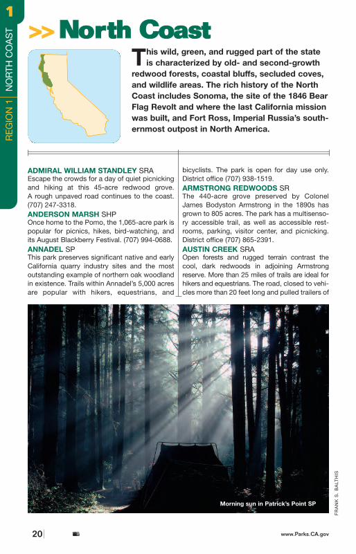
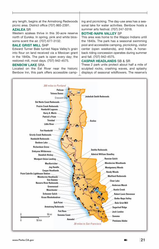
This wild, green, and rugged part of the stateis characterized by old- and second-growth
redwood forests, coastal bluffs, secluded coves,and wildlife areas. The rich history of the NorthCoast includes Sonoma, the site of the 1846 BearFlag Revolt and where the last California missionwas built, and Fort Ross, Imperial Russia’s south-ernmost outpost in North America.
ADMIRAL WILLIAM STANDLEY SRAEscape the crowds for a day of quiet picnickingand hiking at this 45-acre redwood grove. A rough unpaved road continues to the coast.(707) 247-3318.ANDERSON MARSH SHPOnce home to the Pomo, the 1,065-acre park ispopular for picnics, hikes, bird-watching, andits August Blackberry Festival. (707) 994-0688.ANNADEL SPThis park preserves significant native and earlyCalifornia quarry industry sites and the mostoutstanding example of northern oak woodlandin existence. Trails within Annadel’s 5,000 acresare popular with hikers, equestrians, and
bicyclists. The park is open for day use only.District office (707) 938-1519.ARMSTRONG REDWOODS SRThe 440-acre grove preserved by ColonelJames Bodyston Armstrong in the 1890s hasgrown to 805 acres. The park has a multisenso-ry accessible trail, as well as accessible rest-rooms, parking, visitor center, and picnicking.District office (707) 865-2391.AUSTIN CREEK SRAOpen forests and rugged terrain contrast thecool, dark redwoods in adjoining Armstrongreserve. More than 25 miles of trails are ideal forhikers and equestrians. The road, closed to vehi-cles more than 20 feet long and pulled trailers of
>>>>NNoorrtthh CCooaasstt
Morning sun in Patrick’s Point SP
www.Parks.CA.govCalifornia State Parks20
RE
GIO
N 1
NO
RTH
CO
AS
T11
any length, begins at the Armstrong Redwoodspicnic area. District office (707) 865-2391.AZALEA SRWestern azaleas thrive in this 30-acre reservenorth of Eureka. In spring, pink and white blos-soms scent the air. (707) 677-3132.BALE GRIST MILL SHPEdward Turner Bale turned Napa Valley’s graininto flour on land received via a Mexican grantin the 1840s. The park is open every day; therestored mill, most days. (707) 942-4575. BENBOW LAKE SRALocated on the Eel River near the historicBenbow Inn, this park offers accessible camp-
ing and picnicking. The day-use area has a sea-sonal lake for water activities. Benbow hosts asummer arts festival. (707) 247-3318.BOTHE-NAPA VALLEY SPThis area was home to the Wappo Indians untilthe 1840s. The park has a seasonal swimmingpool and accessible camping, picnicking, visitorcenter (open weekends), and trails. A horse-back riding concession operates during summerand fall. (707) 942-4575.CASPAR HEADLANDS SB & SRThese 2 park units protect about half a mile ofsculpted rocks, crashing waves, and splashydisplays of seasonal wildflowers. The reserve’s
California State Parkswww.Parks.CA.gov 21
FR
AN
K S
. B
ALT
HIS
This wild, green, and rugged part of the stateis characterized by old- and second-growth
redwood forests, coastal bluffs, secluded coves,and wildlife areas. The rich history of the NorthCoast includes Sonoma, the site of the 1846 BearFlag Revolt and where the last California missionwas built, and Fort Ross, Imperial Russia’s south-ernmost outpost in North America.
ADMIRAL WILLIAM STANDLEY SRAEscape the crowds for a day of quiet picnickingand hiking at this 45-acre redwood grove. A rough unpaved road continues to the coast.(707) 247-3318.ANDERSON MARSH SHPOnce home to the Pomo, the 1,065-acre park ispopular for picnics, hikes, bird-watching, andits August Blackberry Festival. (707) 994-0688.ANNADEL SPThis park preserves significant native and earlyCalifornia quarry industry sites and the mostoutstanding example of northern oak woodlandin existence. Trails within Annadel’s 5,000 acresare popular with hikers, equestrians, and
bicyclists. The park is open for day use only.District office (707) 938-1519.ARMSTRONG REDWOODS SRThe 440-acre grove preserved by ColonelJames Bodyston Armstrong in the 1890s hasgrown to 805 acres. The park has a multisenso-ry accessible trail, as well as accessible rest-rooms, parking, visitor center, and picnicking.District office (707) 865-2391.AUSTIN CREEK SRAOpen forests and rugged terrain contrast thecool, dark redwoods in adjoining Armstrongreserve. More than 25 miles of trails are ideal forhikers and equestrians. The road, closed to vehi-cles more than 20 feet long and pulled trailers of
>>>>NNoorrtthh CCooaasstt
Morning sun in Patrick’s Point SP
www.Parks.CA.govCalifornia State Parks20
RE
GIO
N 1
NO
RTH
CO
AS
T
11
entry permit can be obtained free of charge at the California State Parks district office 2 milesnorth of Mendocino at Russian Gulch, east ofHwy. 1 at Pt. Cabrillo Drive. (707) 937-5804.CLEAR LAKE SPThis park is on the south end of California’s third-largest freshwater lake. Fishing for bass,catfish, and bluegill is accessible, as are picnicking and camping. Summer brings swimmers and water-skiers to the lake’s relatively warm waters. (707) 279-4293.DEL NORTE COAST REDWOODS SPCombining spectacular Pacific coastline withdense stands of old-growth redwoods, thispark has a campground with accessible camp-sites and restrooms. (707)464-6101, ext. 5120.FORT HUMBOLDT SHPThis outpost, built in the 1850s to settle theconflict between local Native Americans andincoming settlers, is now partially reconstructedand features a historical museum with military
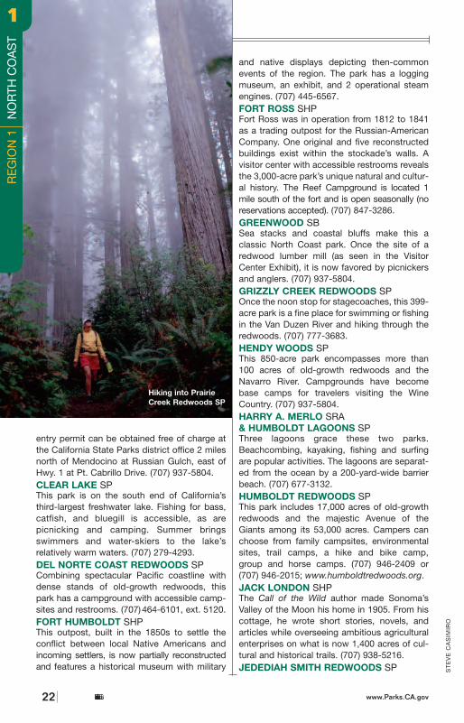
and native displays depicting then-commonevents of the region. The park has a loggingmuseum, an exhibit, and 2 operational steamengines. (707) 445-6567.FORT ROSS SHPFort Ross was in operation from 1812 to 1841as a trading outpost for the Russian-AmericanCompany. One original and five reconstructedbuildings exist within the stockade’s walls. A visitor center with accessible restrooms revealsthe 3,000-acre park’s unique natural and cultur-al history. The Reef Campground is located 1mile south of the fort and is open seasonally (noreservations accepted). (707) 847-3286.GREENWOOD SBSea stacks and coastal bluffs make this a classic North Coast park. Once the site of aredwood lumber mill (as seen in the VisitorCenter Exhibit), it is now favored by picnickersand anglers. (707) 937-5804.GRIZZLY CREEK REDWOODS SPOnce the noon stop for stagecoaches, this 399-acre park is a fine place for swimming or fishingin the Van Duzen River and hiking through theredwoods. (707) 777-3683.HENDY WOODS SPThis 850-acre park encompasses more than100 acres of old-growth redwoods and theNavarro River. Campgrounds have becomebase camps for travelers visiting the WineCountry. (707) 937-5804.HARRY A. MERLO SRA& HUMBOLDT LAGOONS SPThree lagoons grace these two parks.Beachcombing, kayaking, fishing and surfingare popular activities. The lagoons are separat-ed from the ocean by a 200-yard-wide barrierbeach. (707) 677-3132.HUMBOLDT REDWOODS SPThis park includes 17,000 acres of old-growthredwoods and the majestic Avenue of theGiants among its 53,000 acres. Campers canchoose from family campsites, environmentalsites, trail camps, a hike and bike camp,group and horse camps. (707) 946-2409 or (707) 946-2015; www.humboldtredwoods.org.JACK LONDON SHPThe Call of the Wild author made Sonoma’sValley of the Moon his home in 1905. From hiscottage, he wrote short stories, novels, and articles while overseeing ambitious agriculturalenterprises on what is now 1,400 acres of cul-tural and historical trails. (707) 938-5216.JEDEDIAH SMITH REDWOODS SP S
TE
VE
CA
SIM
IRO
Hiking into PrairieCreek Redwoods SP
California State Parks22 www.Parks.CA.gov
RE
GIO
N 1
N
OR
TH C
OA
ST
11
24 www.Parks.CA.govCalifornia State Parks
This 10,000-acre park with some of the world’stallest old-growth trees was named forJedediah Smith, who in 1827 became the firstwhite man known to have crossed the coastalrange. Accessible group camping and restrooms,hiking trails, river access, and fishing are alsoavailable. (707) 464-6101, ext. 5112.JUG HANDLE SRThis reserve offers a firsthand look at 500,000years of California’s geological history. A 2.5-mile self-guided interpretive nature trail leadsthrough 5 terraces uplifted from the sea approx-imately 100,000 years apart. The lowest terracestill battles ocean waves, the third terrace has aunique pygmy forest, and terraces above dis-play a more advanced vegetation. Picnickingand beach access. (707) 937-5804.KRUSE RHODODENDRON SRThis park, north of Jenner, boasts thickets ofsun-loving rhododendrons, which sprang upafter the original forest was destroyed by fire. Now, clusters of pink blossoms cover parts of the reserve from April through June. District office. (707) 865-2391.LITTLE RIVER SBThe park’s 112 acres of undeveloped expansesof flat sand and low dunes are located on thesouth side of Little River. (707) 677-3132.MacKERRICHER SPEight miles of beach offer refuge to harborseals, plus a visitor center, exhibits, fishing,and accessible camping and trails. There are139 developed and 10 walk-in campsites, aswell as a horseback riding concession nearby.From December through March, the park’sheadland is a great place to see migratingwhales. (707) 964-5804.MAILLIARD REDWOODS SRBy redwood park standards, MailliardRedwoods is quite small, with only 242 acresof old-growth and second-growth forests, butit is a good place in which to escape crowds. (707) 937-5804.MANCHESTER SPThe San Andreas Fault runs into the ocean at1,400-acre Manchester State Park in southernMendocino County. The park offers winter steelhead runs in 2 creeks, habitat for tundraswans, great surf fishing, and 5 miles of sandybeach. Primitive camping is available year-round. Efforts are under way to move 18 camp-sites out of the Point Arena mountain beaverhabitat; this will be a temporary inconveniencethis coming year. (707) 937-5804.
MENDOCINO HEADLANDS SPWind through the picturesque village ofMendocino, just off Hwy. 1, and you will begreeted by headlands that jut into the PacificOcean. The park’s paths provide ocean vistas,seasonal whale migration viewing, and spring-time wildflower displays. The 7,400-acre BigRiver Unit has a sandy beach, multipurposeredwood forest trails, and estuary explorationopportunities for nonmotorized watercraft travelers. (707) 937-5804.MENDOCINO WOODLANDS SPThis 720-acre, year-round retreat lies deep in apeaceful redwood forest 7 miles east ofMendocino’s spectacular coastline. Each of its3 camp areas (for groups only) is equipped withrustic, well-appointed dining and recreationhalls, 2- and 4-bedroom cabins, and communalrestrooms with hot showers and electricity. Forreservations call (707) 937-5755.MONTGOMERY WOODS SRRemote and beautiful, the reserve’s 1,140acres offer picnicking and a 2-mile nature trailthat winds through small yet impressive old-growth stands of redwoods. West of Hwy.101 in the heart of the Coast Range, it is nearthe resort of Orrs Springs. (707) 937-5804.NAVARRO RIVER REDWOODS SPThis 673-acre park parallels the Navarro Riverand Hwy. 128. Walking paths from the highwayto the river are available. There are 2 year-roundcampgrounds: Paul M. Dimmick, with 25 devel-oped sites, and Navarro Beach, with 10 primitive sites (no water, chemical toilets).Ranger-led canoe trips are offered at NavarroBeach spring through fall. (707) 937-5804.PATRICK’S POINT SPWhale watching from high bluffs, wanderingmiles of beach, exploring tide pools, and searching for agates are typical activities atPatrick’s Point. Sumeg, a recently constructedYurok Indian village, offers a look at an ancientand fascinating culture. Accessible camping,picnicking, exhibits, and trails. (707) 677-3570.PELICAN SBTravel north of Crescent City along California’scoastline to find this small, secluded beach, aquiet retreat for beachcombers. Pay close attention, as the road to the beach is easy tomiss; take the last road before the agriculturalinspection station, 21 miles north of CrescentCity on Hwy. 101. (707) 464-6101, ext. 5151.PETALUMA ADOBE SHPIn the 19th century, General Mariano Guadalupe
RE
GIO
N 1
N
OR
TH C
OA
ST
11
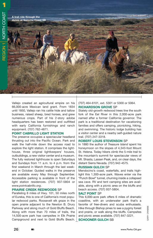
This small beach and headland is for picnicking,beachcombing, and surfing. (707) 937-5804.SINKYONE WILDERNESS SPLocated on the rugged Lost Coast of California,this park has spectacular scenery, abundantwildlife, and some 20 miles of hiking trails.There is a primitive campground at Usal Beachand walk-in tent sites at Needle Rock. Accessroads are steep, narrow, and unpaved; trailersand motor homes are not recommended. (707)986-7711 or (707) 247-3318.SMITHE REDWOODS SRFormerly a private resort, this stand of old-growth redwoods makes a pleasant stoppingpoint for travelers on Highway 101. There isundeveloped access to the Eel River for fishingand swimming. No restrooms. (707) 925-6482.SONOMA SHPSonoma was home of California’s last mission,San Francisco Solano, built in 1823. Later it wassecularized by the Mexican commander of SanFrancisco’s Presidio, Mariano Guadalupe Vallejo,who was imprisoned by American settlers during1846’s Bear Flag Revolt. (707) 938-9560. SONOMA COAST SBSpectacular views, sandy strands, and quietcoves invite exploration of 19 miles of coastline.Enjoy picnics, exhibits, and accessible trails aswell as spring wildflowers, colorful sunsets, and whale-watching. Reservations (800-444-7275)are recommended at the 2 popular coastalcampgrounds: Bodega Dunes (wheelchairaccessible) and Wright’s Beach. (707) 875-3483.STANDISH-HICKEY SRALocated at the southern gateway of the state’s redwood country, this park offers camp-ing and hiking in the redwoods, and goodaccess to the south fork of the Eel River forswimming and fishing. (707) 925-6482.SUGARLOAF RIDGE SPThe park’s 2,700 acres offer 25 miles of hikingtrails, the headwaters of Sonoma Creek, and ahorseback riding concession. Clear days bringbreathtaking views of the Golden Gate Bridgeand the Sierra Nevada from the 2,729-foot-summit of Bald Mountain. In addition, there areaccessible picnicking spots, educationalexhibits, and the Ferguson Observatory to visit.(707) 833-5712 or (707) 938-1519.TOLOWA DUNES SPThe Smith River ends its journey to the PacificOcean after passing through a rich delta thatconsists of a sandy beach, grass-covered
dunes, lakes, ponds, and marshes. Coastalaccesses are not well signposted. Take LakeEarl Drive, turn west on Lower Lake Road, andaccess the park by turning west on Kellogg orPala Road. For access from the south, takeNorthcrest Drive north from Crescent City, turnwest on Old Mill Road and follow to the end.(707) 464-6101, ext. 5151.TRINIDAD SBTucked in a secluded cove near the smalltown of Trinidad, 15 miles north of Arcata, thissandy beach is a pleasant retreat. It’s a shorthike through woods, across open bluffs, andpast seasonal wildflowers down to the beach.There is a natural arch near the north end ofthe beach. Low tide is the best time to visit.(707) 677-3132.
VAN DAMME SP
The park’s sheltered and easily reached beach
is a gathering place for abalone and sea urchin
divers. Ten miles of hiking trails follow the Little
River. The park has accessible camping, a vis-
itor center, and exhibits, as well as a wheel-
chair-accessible trail in the pygmy forest. (707)
937-5804.WESTPORT-UNION LANDING SBThe 41-acre park is a narrow, 2-mile-long stripwith primitive camping and beautiful beaches.It is a haven for tidepool explorers, surfanglers, abalone divers, and spearfishingenthusiasts. (707) 937-5804.
California State Parkswww.Parks.CA.gov 27www.Parks.CA.govCalifornia State Parks26
GA
RY
CR
AB
BE
A trail ride through thedunes at Sonoma Coast SB
Vallejo created an agricultural empire on his66,000-acre Mexican land grant. From 1834until 1850, Vallejo ran his cattle hide and tallowbusiness, raised sheep, bred horses, and grewnumerous crops. Part of his 2-story adobeheadquarters has been restored and outfittedwith early California furnishings and ranchequipment. (707) 762-4871.POINT CABRILLO LIGHT STATION The preserve occupies a spectacular headlandthrusting out into the Pacific Ocean. Park andwalk the half-mile down the access road toexplore the light station. It comprises the light-house, three original lightkeepers’ houses, outbuildings, a new visitor center and a museum.The fully restored lighthouse is open Saturdaysand Sundays from 11 a.m. to 4 p.m. from thefirst weekend in March through the last week-end in October. Guided walks in the preserveare available every May through September.Accessible parking is available in front of thelight station residences. (707) 937-5804 orwww.pointcabrillo.org.PRAIRIE CREEK REDWOODS SPParalleling 8 miles of Hwy. 101, 50 miles northof Eureka, this is one of California’s most popu-lar redwood parks. Roosevelt elk graze in theopen prairie adjacent to the Newton B. DruryParkway and along much of Gold Bluffs Beach.Along with more than 70 miles of trails, the14,500-acre park has campsites in Elk PrairieCampground and next to Gold Bluffs Beach.
(707) 464-6101, ext. 5301 or 5300 or 5064.RICHARDSON GROVE SPStately old-growth redwood trees line the southfork of the Eel River in this 2,000-acre parknamed after a former California governor. Thepark is a traditional destination for vacationingfamilies and offers camping, picnicking, hiking,and swimming. The historic lodge building hasa visitor center and a nearby self-guided naturetrail. (707) 247-3318.ROBERT LOUIS STEVENSON SPIn 1880 the author of Treasure Island spent hishoneymoon on the slopes of 4,343-foot MountSt. Helena. Today hikers climb the 5-mile trail tothe mountain’s summit for spectacular views ofMt. Shasta, Lassen Peak, and, on clear days, thedistant Sierra Nevada. (707) 942-4575.RUSSIAN GULCH SPMendocino’s coast, waterfalls, and trails high-light this 1,300-acre park. Waves enter via the“Punch Bowl” tunnel, churning inside a collapsedsea cave. RV and tent camping sites are avail-able, along with a picnic area on the bluffs andbeach access. (707) 937-5804.SALT POINT SPThis 6,000-acre park offers 6 miles of dramaticcoastline, with an underwater park that’s afavorite of free-divers and scuba enthusiasts.Hike through Bishop pines to see a pygmy forestand prairie, or walk along the bluffs. Campsitesand picnic areas available. (707) 847-3221.SCHOONER GULCH SB
RE
GIO
N 1
N
OR
TH C
OA
ST
11
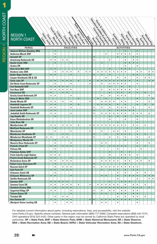
RE
GIO
N 1
N
OR
TH C
OA
ST
11
California State Parks28 www.Parks.CA.gov
Admiral William Standley SRA • • •Anderson Marsh SHP • • • • • • •Annadel SP • • • • • •Armstrong Redwoods SR • • • • • • • • •Austin Creek SRA • • • • • • •Azalea SR • •Bale Grist Mill SHP • • • • • •Benbow Lake SRA • • • • • • • • • • • • • • • • • • •Bothe-Napa Valley SP • • • • • • • • •Caspar Headlands SB & SR • • • • • •Clear Lake SP • • • • • • • • • • • • • • • • • • •Del Norte Coast Redwoods SP • • • • • • • • • •Fort Humboldt SHP • • • • • • • •Fort Ross SHP • • • • • • • • • • • • • •Greenwood SB • • • • • • • • •Grizzly Creek Redwoods SP • • • • • • • • •Harry A. Merlo SRA • • • • • •Hendy Woods SP • • • • • • • • • • • • •Humboldt Lagoons SP • • • • • • • • • • • • •Humboldt Redwoods SP • • • • • • • • • • •Jack London SHP • • • • • • • • •Jedediah Smith Redwoods SP • • • • • • • • • • • • • • •Jug Handle SR • • • • •Kruse Rhododendron SR • • •Little River SB • •MacKerricher SP • • • • • • • • • • • • • • • • • • •Mailliard Redwoods SR • •Manchester SP • • • • • • • •Mendocino Headlands SP • • • • • • • • • • •Mendocino Woodlands SP • • • • • • • • •Montgomery Woods SR • • •Navarro River Redwoods SP • • • • • •Patrick’s Point SP • • • • • • • • • • • • • •Pelican SB • • •Petaluma Adobe SHP • • • • •Point Cabrillo Light Station • • • • • • • •Prairie Creek Redwoods SP • • • • • • • • • • • • •Richardson Grove SP • • • • • • • • • • • • • • •Robert Louis Stevenson SP • • •Russian Gulch SP • • • • • • • • • • • • • • •Salt Point SP • • • • • • • • • • • •Schooner Gulch SB • • • • •Sinkyone Wilderness SP • • • • • • • • • • • • •Smithe Redwoods SR • • • •Sonoma SHP • • • • • • • • •Sonoma Coast SB • • • • • • • • • • • • • • • • •Standish-Hickey SRA • • • • • • • • • • • • • • •Sugarloaf Ridge SP • • • • • • • • • • •Tolowa Dunes SP • • • • • • • • •Trinidad SB • • • • • • • •Van Damme SP • • • • • • • • • • • • • • • •Westport-Union Landing SB • • • • • • •
REGION 1NORTH COAST
For detailed current information about parks, including reservations, fees, and accessibility, visit the websitewww.Parks.CA.gov. Specific phone numbers: General park information (800) 777-0369; Campsite reservations (800) 444-7275;OHV operations (916) 324-4442. Other parks in this region may be owned by California State Parks but operated by localauthorities. SP = State Park; SHP = State Historic Park; SHM = State Historical Monument; SR = State Reserve; SRA = State Recreation Area; SB = State Beach; SVRA = State Vehicular Recreation Area; SS = State Seashore.
•
•
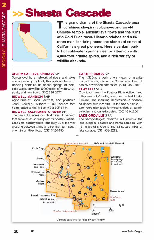
MA
RK
J.
DO
LYA
K
Ahjumawi Lava Springs SP • • • • • • • • • • • • •Bidwell Mansion SHP • • • • • • • • • •Bidwell-Sacramento River SP • • • • • • • • • • • • • • •Castle Crags SP • • • • • • • • • • • • • •Clay Pit SVRA •Lake Oroville SRA • • • • • • • • • • • • • • • • • • • • • • • • • •McArthur-Burney Falls Mem. SP • • • • • • • • • • • • • • • • • •Plumas Eureka SP • • • • • • • • • • • • • • • •Shasta SHP • • • • • • •Weaverville Joss House SHP • • • •William B. Ide Adobe SHP • • • • • • • • • • •Woodson Bridge SRA • • • • • • • • • • • •
REGION 2SHASTA CASCADE
For detailed current information about parks, including reservations, fees, and accessibility, visit the website www.Parks.CA.gov.Specific phone numbers: General park information (800) 777-0369; Campsite reservations (800) 444-7275; OHV operations (916) 324-4442. Other parks in this region may be owned by California State Parks but operated by local authorities. SP = State Park; SHP = State Historic Park; SHM = State Historical Monument; SR = State Reserve; SRA = State Recreation Area; SB = StateBeach; SVRA = State Vehicular Recreation Area; SS = State Seashore.
www.Parks.CA.gov 31California State Parks
McARTHUR-BURNEY FALLS MEMORIAL SPCamp to the ambient sounds of 100 milliongallons of water flowing over this 129-foot cas-cade each day—surely one of the most dramaticsites in the region (530) 335-2777. PLUMAS-EUREKA SP The 6,700-acre park protects the remains of theMohawk Stamp Mill and several other buildings.Camp and fish here during summer and cross-country ski in winter. (530) 836-2380.SHASTA SHP This park honors the “Queen City of theNorthern Mines.” The restored courthouse is
now a museum displaying more than 100 paint-ings by early California artists. (530) 243-8194.WEAVERVILLE JOSS HOUSE SHPThe oldest continuously used intact Chinese temple in California, this joss house was rebuilt in1874 after the first one burned. (530) 623-5284.WILLIAM B. IDE ADOBE SHPThis park, located next to the SacramentoRiver, honors William B. Ide, a leader of the BearFlag Republic. (530) 529-8599.WOODSON BRIDGE SRAAcres of valley oak meadows flank the Sacra-mento River, great for shad, steelhead, stripedbass, and salmon fishing. (530) 839-2112.
100 million gallons perday and counting, atMcArthur-Burney FallsMemorial SP
AHJUMAWI LAVA SPRINGS SPSurrounded by a network of rivers and lakesaccessible only by boat, this park northeast ofRedding contains abundant springs of cold,clear water, as well as 6,000 acres of waterways,pools, and lava flows. (530) 335-2777.BIDWELL MANSION SHP Agriculturalist, social activist, and politicianJohn Bidwell’s 26-room, 10,000-square- foothome dates to the 1860s. (530) 895-6144. BIDWELL-SACRAMENTO RIVER SPThe park’s 180 acres include 4 miles of riverfrontthat serve as an access point for boaters, rafters,canoeists, and kayakers. Take Hwy. 32 at the rivercrossing between Chico and I-5, then turn southone mile on River Road. (530) 342-5185.
CASTLE CRAGS SPThe 4,350-acre park offers views of granitespires towering above the Sacramento River. Ithas 76 developed campsites. (530) 235-2684.CLAY PIT SVRAClay taken from the Feather River Valley, threemiles west of Oroville, was used to build LakeOroville. The resulting depression—a shallowpit ringed with low hills—is the site of this 220-acre recreation area for motorcycles, all-terrainvehicles, and dune-buggies. (530) 538-2200.LAKE OROVILLE SRA The second-largest reservoir in California, thelake supplies boaters and horse campers with167 miles of shoreline and 23 square miles oflake surface. (530) 538-2219.
The grand drama of the Shasta Cascade areacombines sleeping volcanoes and an old
Chinese temple, ancient lava flows and the ruinsof a Gold Rush town. Historic adobes and a 26-room mansion bring home the stories of some ofCalifornia’s great pioneers. Here a verdant parkfull of coldwater springs vies for attention with4,000-foot granite spires, and a rich variety ofwildlife abounds.
>>>>SShhaassttaa CCaassccaaddee
California State Parks30 www.Parks.CA.gov
RE
GIO
N 2
S
HA
STA
CA
SC
AD
E22
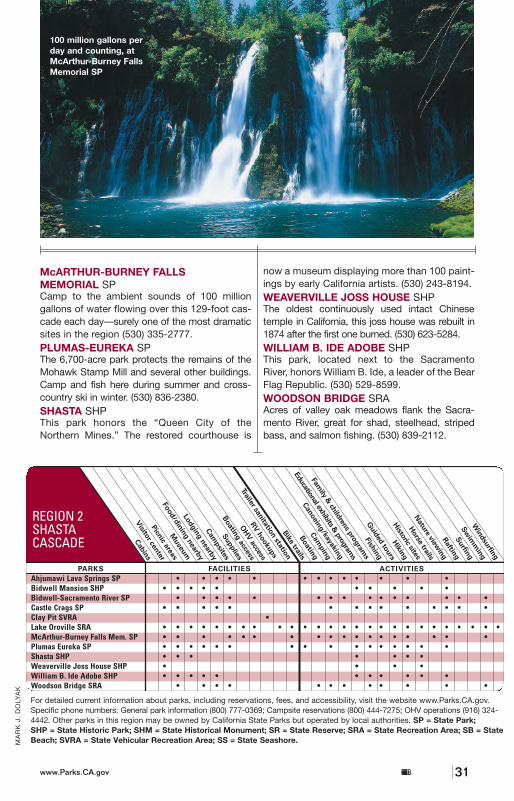
MA
RK
J.
DO
LYA
K
Ahjumawi Lava Springs SP • • • • • • • • • • • • •Bidwell Mansion SHP • • • • • • • • • •Bidwell-Sacramento River SP • • • • • • • • • • • • • • •Castle Crags SP • • • • • • • • • • • • • •Clay Pit SVRA •Lake Oroville SRA • • • • • • • • • • • • • • • • • • • • • • • • • •McArthur-Burney Falls Mem. SP • • • • • • • • • • • • • • • • • •Plumas Eureka SP • • • • • • • • • • • • • • • •Shasta SHP • • • • • • •Weaverville Joss House SHP • • • •William B. Ide Adobe SHP • • • • • • • • • • •Woodson Bridge SRA • • • • • • • • • • • •
REGION 2SHASTA CASCADE
For detailed current information about parks, including reservations, fees, and accessibility, visit the website www.Parks.CA.gov.Specific phone numbers: General park information (800) 777-0369; Campsite reservations (800) 444-7275; OHV operations (916) 324-4442. Other parks in this region may be owned by California State Parks but operated by local authorities. SP = State Park; SHP = State Historic Park; SHM = State Historical Monument; SR = State Reserve; SRA = State Recreation Area; SB = StateBeach; SVRA = State Vehicular Recreation Area; SS = State Seashore.
www.Parks.CA.gov 31California State Parks
McARTHUR-BURNEY FALLS MEMORIAL SPCamp to the ambient sounds of 100 milliongallons of water flowing over this 129-foot cas-cade each day—surely one of the most dramaticsites in the region (530) 335-2777. PLUMAS-EUREKA SP The 6,700-acre park protects the remains of theMohawk Stamp Mill and several other buildings.Camp and fish here during summer and cross-country ski in winter. (530) 836-2380.SHASTA SHP This park honors the “Queen City of theNorthern Mines.” The restored courthouse is
now a museum displaying more than 100 paint-ings by early California artists. (530) 243-8194.WEAVERVILLE JOSS HOUSE SHPThe oldest continuously used intact Chinese temple in California, this joss house was rebuilt in1874 after the first one burned. (530) 623-5284.WILLIAM B. IDE ADOBE SHPThis park, located next to the SacramentoRiver, honors William B. Ide, a leader of the BearFlag Republic. (530) 529-8599.WOODSON BRIDGE SRAAcres of valley oak meadows flank the Sacra-mento River, great for shad, steelhead, stripedbass, and salmon fishing. (530) 839-2112.
100 million gallons perday and counting, atMcArthur-Burney FallsMemorial SP
AHJUMAWI LAVA SPRINGS SPSurrounded by a network of rivers and lakesaccessible only by boat, this park northeast ofRedding contains abundant springs of cold,clear water, as well as 6,000 acres of waterways,pools, and lava flows. (530) 335-2777.BIDWELL MANSION SHP Agriculturalist, social activist, and politicianJohn Bidwell’s 26-room, 10,000-square- foothome dates to the 1860s. (530) 895-6144. BIDWELL-SACRAMENTO RIVER SPThe park’s 180 acres include 4 miles of riverfrontthat serve as an access point for boaters, rafters,canoeists, and kayakers. Take Hwy. 32 at the rivercrossing between Chico and I-5, then turn southone mile on River Road. (530) 342-5185.
CASTLE CRAGS SPThe 4,350-acre park offers views of granitespires towering above the Sacramento River. Ithas 76 developed campsites. (530) 235-2684.CLAY PIT SVRAClay taken from the Feather River Valley, threemiles west of Oroville, was used to build LakeOroville. The resulting depression—a shallowpit ringed with low hills—is the site of this 220-acre recreation area for motorcycles, all-terrainvehicles, and dune-buggies. (530) 538-2200.LAKE OROVILLE SRA The second-largest reservoir in California, thelake supplies boaters and horse campers with167 miles of shoreline and 23 square miles oflake surface. (530) 538-2219.
The grand drama of the Shasta Cascade areacombines sleeping volcanoes and an old
Chinese temple, ancient lava flows and the ruinsof a Gold Rush town. Historic adobes and a 26-room mansion bring home the stories of some ofCalifornia’s great pioneers. Here a verdant parkfull of coldwater springs vies for attention with4,000-foot granite spires, and a rich variety ofwildlife abounds.
>>>>SShhaassttaa CCaassccaaddee
California State Parks30 www.Parks.CA.gov
RE
GIO
N 2
S
HA
STA
CA
SC
AD
E
22
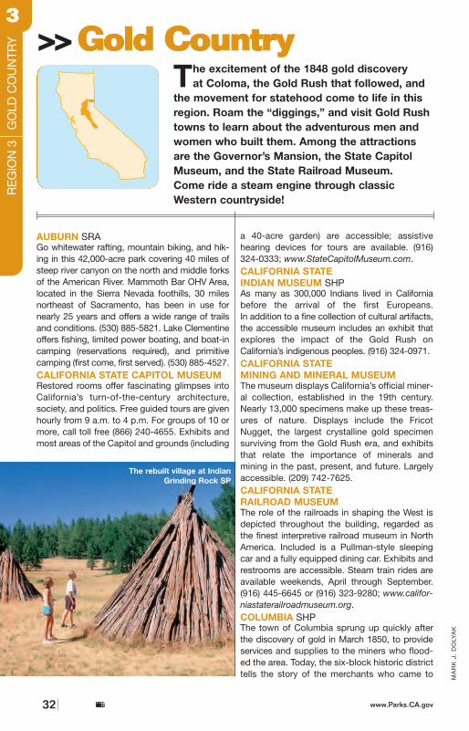
California to “mine the pockets of the miner.”Over 20 concessions in the historic districtrecreate the businesses of the Gold Rush, fromsaloons, to hotels, to dry-goods merchants, toa candy store. Activities such as gold panningare also available. (209) 588-9128.DELTA MEADOWSDelta Meadows preserves a remnant of theSacramento River Delta as it was before damsand levees controlled the annual flooding. The300-acre park is most accessible by boat. Boatsmay anchor for up to 15 consecutive days in“Railway Slough.” (916) 777-7701.EMPIRE MINE SHPGrass Valley was an active gold-mining town formore than 100 years, and its Empire Mine was
one of the state’s richest, producing nearly 6 mil-lion ounces. The entrance to 367 miles of aban-doned and flooded mine shafts is open, alongwith many mine buildings, the former owner’shome, and the formal gardens. (530) 273-8522.FOLSOM LAKE SRALocated at the base of the Sierra Nevada goldcountry, Folsom Lake is one of the most popularrecreational lakes in the state. Its 75 miles ofshoreline offer beautiful vistas of the SierraNevada foothills. Access to more than 32 milesof paved bike/hike paths provides connectionto multipurpose trails offering horseback riding,hiking, and mountain biking opportunities.Within the park, Lake Natoma offers 14 miles of shoreline and is ideal for canoeing, kayaking,
California State Parkswww.Parks.CA.gov 33
The excitement of the 1848 gold discovery at Coloma, the Gold Rush that followed, and
the movement for statehood come to life in thisregion. Roam the “diggings,” and visit Gold Rushtowns to learn about the adventurous men andwomen who built them. Among the attractionsare the Governor’s Mansion, the State CapitolMuseum, and the State Railroad Museum. Come ride a steam engine through classicWestern countryside!
>>>>GGoolldd CCoouunnttrryy
MA
RK
J.
DO
LYA
K
AUBURN SRAGo whitewater rafting, mountain biking, and hik-ing in this 42,000-acre park covering 40 miles ofsteep river canyon on the north and middle forksof the American River. Mammoth Bar OHV Area,located in the Sierra Nevada foothills, 30 milesnortheast of Sacramento, has been in use fornearly 25 years and offers a wide range of trailsand conditions. (530) 885-5821. Lake Clementineoffers fishing, limited power boating, and boat-incamping (reservations required), and primitivecamping (first come, first served). (530) 885-4527.CALIFORNIA STATE CAPITOL MUSEUMRestored rooms offer fascinating glimpses intoCalifornia’s turn-of-the-century architecture,society, and politics. Free guided tours are givenhourly from 9 a.m. to 4 p.m. For groups of 10 ormore, call toll free (866) 240-4655. Exhibits andmost areas of the Capitol and grounds (including
a 40-acre garden) are accessible; assistive hearing devices for tours are available. (916)324-0333; www.StateCapitolMuseum.com.CALIFORNIA STATE INDIAN MUSEUM SHPAs many as 300,000 Indians lived in Californiabefore the arrival of the first Europeans. In addition to a fine collection of cultural artifacts,the accessible museum includes an exhibit thatexplores the impact of the Gold Rush onCalifornia’s indigenous peoples. (916) 324-0971.CALIFORNIA STATE MINING AND MINERAL MUSEUMThe museum displays California’s official miner-al collection, established in the 19th century.Nearly 13,000 specimens make up these treas-ures of nature. Displays include the FricotNugget, the largest crystalline gold specimensurviving from the Gold Rush era, and exhibitsthat relate the importance of minerals and mining in the past, present, and future. Largelyaccessible. (209) 742-7625.CALIFORNIA STATE RAILROAD MUSEUMThe role of the railroads in shaping the West isdepicted throughout the building, regarded asthe finest interpretive railroad museum in NorthAmerica. Included is a Pullman-style sleepingcar and a fully equipped dining car. Exhibits andrestrooms are accessible. Steam train rides areavailable weekends, April through September.(916) 445-6645 or (916) 323-9280; www.califor-niastaterailroadmuseum.org.COLUMBIA SHPThe town of Columbia sprung up quickly afterthe discovery of gold in March 1850, to provideservices and supplies to the miners who flood-ed the area. Today, the six-block historic districttells the story of the merchants who came to
The rebuilt village at IndianGrinding Rock SP
California State Parks32 www.Parks.CA.gov
RE
GIO
N 3
G
OLD
CO
UN
TRY
33
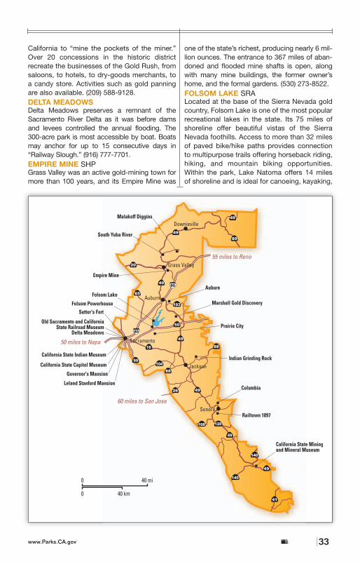
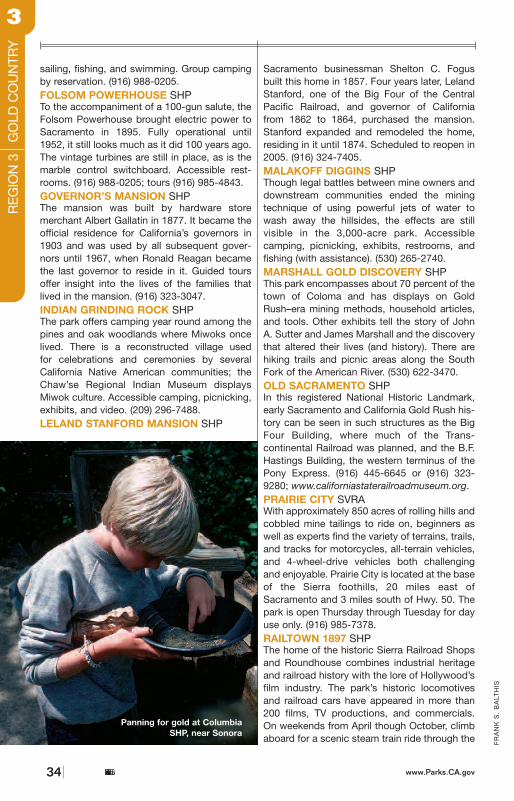
35
FR
AN
K S
. B
ALT
HIS
Sierra foothills. Accessible parking and exhibits.(209) 984-3953 or recorded information: (916)445-6645; www.railtown1897.org.SOUTH YUBA RIVER SPThis park stretches 20 miles along the SouthYuba River from Edwards Crossing to Bridge-port, site of the world’s longest single-spanwooden-truss covered bridge. Bridgeport has aLiving History program, docent-led talks, andgold-panning demonstrations. There’s anaccessible trail to the river and accessible pic-nic and fishing areas. The whole-accessIndependence Trail follows the old ExcelsiorDitch. (530) 432-2546 or (530) 273-3884.SUTTER’S FORT SHPJohn Sutter, a Swiss immigrant, applied for aMexican land grant in the Sacramento Valley in1839. Sutter’s Fort became the destination forearly migrants to California, including the ill-fatedDonner Party. Restored to its 1846 appearance,the fort is open daily, except for some major holi-days. Accessible grounds, exhibits, restrooms,and text transcripts. (916) 445-4422.
Auburn SRA • • • • • • • • • • • • • • • • •California State Capitol Museum • • • • • • • • • •California State Indian Museum • • • • • •CA State Mining & Mineral Mus. • • • • • • • • • •California State Railroad Mus. • • • • • • • •Columbia SHP • • • • • • • • • •Delta Meadows • • • • • • • •Empire Mine SHP • • • • • • • • • • • •Folsom Lake SRA • • • • • • • • • • • • • • • • • • • • •Folsom Powerhouse SHP • • • • • •Governor’s Mansion SHP • • • • • • •Indian Grinding Rock SHP • • • • • • • • • • • • •Leland Stanford Mansion SHP SCHEDULED TO OPEN IN 2005Malakoff Diggins SHP • • • • • • • • • • • • • • • •Marshall Gold Discovery SHP • • • • • • • • • • •Old Sacramento SHP • • • • • • • •Prairie City SVRA • • • •Railtown 1897 SHP • • • • • • •South Yuba River SP • • • • • • • • • • • • • •Sutter’s Fort SHP • • • • •
REGION 3GOLD COUNTRY
For detailed current information about parks, including reservations, fees, and accessibility, visit the website www.Parks.CA.gov.Specific phone numbers: General park information (800) 777-0369; Campsite reservations (800) 444-7275; OHV operations (916)324-4442. Other parks in this region may be owned by California State Parks but operated by local authorities. SP = StatePark; SHP = State Historic Park; SHM = State Historical Monument; SR = State Reserve; SRA = State Recreation Area;SB = State Beach; SVRA = State Vehicular Recreation Area; SS = State Seashore.
California State Parkswww.Parks.CA.gov
•
The California State Railroad Museum at Old Sacramento SHP
FR
AN
K S
. B
ALT
HIS
sailing, fishing, and swimming. Group campingby reservation. (916) 988-0205.FOLSOM POWERHOUSE SHPTo the accompaniment of a 100-gun salute, theFolsom Powerhouse brought electric power toSacramento in 1895. Fully operational until1952, it still looks much as it did 100 years ago.The vintage turbines are still in place, as is themarble control switchboard. Accessible rest-rooms. (916) 988-0205; tours (916) 985-4843.GOVERNOR’S MANSION SHPThe mansion was built by hardware store merchant Albert Gallatin in 1877. It became theofficial residence for California’s governors in1903 and was used by all subsequent gover-nors until 1967, when Ronald Reagan becamethe last governor to reside in it. Guided toursoffer insight into the lives of the families thatlived in the mansion. (916) 323-3047.INDIAN GRINDING ROCK SHPThe park offers camping year round among thepines and oak woodlands where Miwoks oncelived. There is a reconstructed village usedfor celebrations and ceremonies by severalCalifornia Native American communities; theChaw’se Regional Indian Museum displaysMiwok culture. Accessible camping, picnicking,exhibits, and video. (209) 296-7488.LELAND STANFORD MANSION SHP
Sacramento businessman Shelton C. Fogusbuilt this home in 1857. Four years later, LelandStanford, one of the Big Four of the CentralPacific Railroad, and governor of Californiafrom 1862 to 1864, purchased the mansion.Stanford expanded and remodeled the home,residing in it until 1874. Scheduled to reopen in2005. (916) 324-7405.MALAKOFF DIGGINS SHPThough legal battles between mine owners anddownstream communities ended the miningtechnique of using powerful jets of water towash away the hillsides, the effects are still visible in the 3,000-acre park. Accessible camping, picnicking, exhibits, restrooms, andfishing (with assistance). (530) 265-2740.MARSHALL GOLD DISCOVERY SHPThis park encompasses about 70 percent of thetown of Coloma and has displays on GoldRush–era mining methods, household articles,and tools. Other exhibits tell the story of John A. Sutter and James Marshall and the discoverythat altered their lives (and history). There arehiking trails and picnic areas along the SouthFork of the American River. (530) 622-3470.OLD SACRAMENTO SHP In this registered National Historic Landmark,early Sacramento and California Gold Rush his-tory can be seen in such structures as the BigFour Building, where much of the Trans-continental Railroad was planned, and the B.F.Hastings Building, the western terminus of thePony Express. (916) 445-6645 or (916) 323-9280; www.californiastaterailroadmuseum.org.PRAIRIE CITY SVRAWith approximately 850 acres of rolling hills andcobbled mine tailings to ride on, beginners aswell as experts find the variety of terrains, trails,and tracks for motorcycles, all-terrain vehicles,and 4-wheel-drive vehicles both challengingand enjoyable. Prairie City is located at the baseof the Sierra foothills, 20 miles east ofSacramento and 3 miles south of Hwy. 50. Thepark is open Thursday through Tuesday for dayuse only. (916) 985-7378.RAILTOWN 1897 SHPThe home of the historic Sierra Railroad Shopsand Roundhouse combines industrial heritageand railroad history with the lore of Hollywood’sfilm industry. The park’s historic locomotivesand railroad cars have appeared in more than200 films, TV productions, and commercials.On weekends from April though October, climbaboard for a scenic steam train ride through the
California State Parks34 www.Parks.CA.gov
RE
GIO
N 3
GO
LD C
OU
NTR
Y33
Panning for gold at ColumbiaSHP, near Sonora
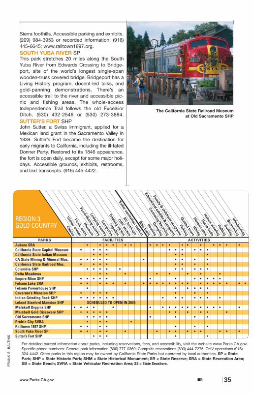
35
FR
AN
K S
. B
ALT
HIS
Sierra foothills. Accessible parking and exhibits.(209) 984-3953 or recorded information: (916)445-6645; www.railtown1897.org.SOUTH YUBA RIVER SPThis park stretches 20 miles along the SouthYuba River from Edwards Crossing to Bridge-port, site of the world’s longest single-spanwooden-truss covered bridge. Bridgeport has aLiving History program, docent-led talks, andgold-panning demonstrations. There’s anaccessible trail to the river and accessible pic-nic and fishing areas. The whole-accessIndependence Trail follows the old ExcelsiorDitch. (530) 432-2546 or (530) 273-3884.SUTTER’S FORT SHPJohn Sutter, a Swiss immigrant, applied for aMexican land grant in the Sacramento Valley in1839. Sutter’s Fort became the destination forearly migrants to California, including the ill-fatedDonner Party. Restored to its 1846 appearance,the fort is open daily, except for some major holi-days. Accessible grounds, exhibits, restrooms,and text transcripts. (916) 445-4422.
Auburn SRA • • • • • • • • • • • • • • • • •California State Capitol Museum • • • • • • • • • •California State Indian Museum • • • • • •CA State Mining & Mineral Mus. • • • • • • • • • •California State Railroad Mus. • • • • • • • •Columbia SHP • • • • • • • • • •Delta Meadows • • • • • • • •Empire Mine SHP • • • • • • • • • • • •Folsom Lake SRA • • • • • • • • • • • • • • • • • • • • •Folsom Powerhouse SHP • • • • • •Governor’s Mansion SHP • • • • • • •Indian Grinding Rock SHP • • • • • • • • • • • • •Leland Stanford Mansion SHP SCHEDULED TO OPEN IN 2005Malakoff Diggins SHP • • • • • • • • • • • • • • • •Marshall Gold Discovery SHP • • • • • • • • • • •Old Sacramento SHP • • • • • • • •Prairie City SVRA • • • •Railtown 1897 SHP • • • • • • •South Yuba River SP • • • • • • • • • • • • • •Sutter’s Fort SHP • • • • •
REGION 3GOLD COUNTRY
For detailed current information about parks, including reservations, fees, and accessibility, visit the website www.Parks.CA.gov.Specific phone numbers: General park information (800) 777-0369; Campsite reservations (800) 444-7275; OHV operations (916)324-4442. Other parks in this region may be owned by California State Parks but operated by local authorities. SP = StatePark; SHP = State Historic Park; SHM = State Historical Monument; SR = State Reserve; SRA = State Recreation Area;SB = State Beach; SVRA = State Vehicular Recreation Area; SS = State Seashore.
California State Parkswww.Parks.CA.gov
•
The California State Railroad Museum at Old Sacramento SHP
FR
AN
K S
. B
ALT
HIS
sailing, fishing, and swimming. Group campingby reservation. (916) 988-0205.FOLSOM POWERHOUSE SHPTo the accompaniment of a 100-gun salute, theFolsom Powerhouse brought electric power toSacramento in 1895. Fully operational until1952, it still looks much as it did 100 years ago.The vintage turbines are still in place, as is themarble control switchboard. Accessible rest-rooms. (916) 988-0205; tours (916) 985-4843.GOVERNOR’S MANSION SHPThe mansion was built by hardware store merchant Albert Gallatin in 1877. It became theofficial residence for California’s governors in1903 and was used by all subsequent gover-nors until 1967, when Ronald Reagan becamethe last governor to reside in it. Guided toursoffer insight into the lives of the families thatlived in the mansion. (916) 323-3047.INDIAN GRINDING ROCK SHPThe park offers camping year round among thepines and oak woodlands where Miwoks oncelived. There is a reconstructed village usedfor celebrations and ceremonies by severalCalifornia Native American communities; theChaw’se Regional Indian Museum displaysMiwok culture. Accessible camping, picnicking,exhibits, and video. (209) 296-7488.LELAND STANFORD MANSION SHP
Sacramento businessman Shelton C. Fogusbuilt this home in 1857. Four years later, LelandStanford, one of the Big Four of the CentralPacific Railroad, and governor of Californiafrom 1862 to 1864, purchased the mansion.Stanford expanded and remodeled the home,residing in it until 1874. Scheduled to reopen in2005. (916) 324-7405.MALAKOFF DIGGINS SHPThough legal battles between mine owners anddownstream communities ended the miningtechnique of using powerful jets of water towash away the hillsides, the effects are still visible in the 3,000-acre park. Accessible camping, picnicking, exhibits, restrooms, andfishing (with assistance). (530) 265-2740.MARSHALL GOLD DISCOVERY SHPThis park encompasses about 70 percent of thetown of Coloma and has displays on GoldRush–era mining methods, household articles,and tools. Other exhibits tell the story of John A. Sutter and James Marshall and the discoverythat altered their lives (and history). There arehiking trails and picnic areas along the SouthFork of the American River. (530) 622-3470.OLD SACRAMENTO SHP In this registered National Historic Landmark,early Sacramento and California Gold Rush his-tory can be seen in such structures as the BigFour Building, where much of the Trans-continental Railroad was planned, and the B.F.Hastings Building, the western terminus of thePony Express. (916) 445-6645 or (916) 323-9280; www.californiastaterailroadmuseum.org.PRAIRIE CITY SVRAWith approximately 850 acres of rolling hills andcobbled mine tailings to ride on, beginners aswell as experts find the variety of terrains, trails,and tracks for motorcycles, all-terrain vehicles,and 4-wheel-drive vehicles both challengingand enjoyable. Prairie City is located at the baseof the Sierra foothills, 20 miles east ofSacramento and 3 miles south of Hwy. 50. Thepark is open Thursday through Tuesday for dayuse only. (916) 985-7378.RAILTOWN 1897 SHPThe home of the historic Sierra Railroad Shopsand Roundhouse combines industrial heritageand railroad history with the lore of Hollywood’sfilm industry. The park’s historic locomotivesand railroad cars have appeared in more than200 films, TV productions, and commercials.On weekends from April though October, climbaboard for a scenic steam train ride through the
California State Parks34 www.Parks.CA.gov
RE
GIO
N 3
GO
LD C
OU
NTR
Y
33
Panning for gold at ColumbiaSHP, near Sonora
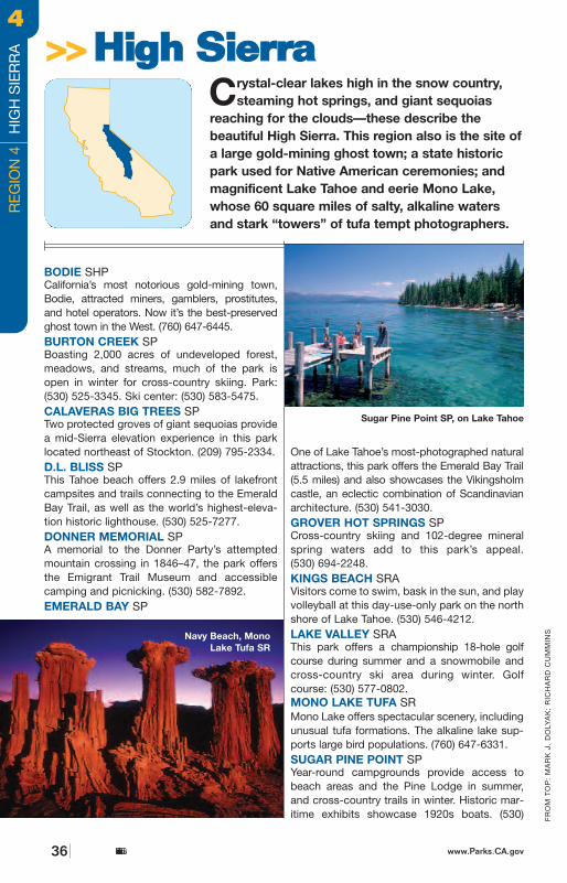
80
89
108
88
4
168
178
178
120
41
182
270167
140
180
198
49
Tahoe City
South Lake Tahoe
Bridgeport
YosemiteVillage
Bishop
MammothLakes
130 milesto Monterey
110 miles to Los Angeles
175 milesto
SanFrancisco
20 miles to Reno
0
0
50 mi
50 km
Calaveras Big Trees
Mono Lake Tufa
WassamaRound House
Kings BeachTahoe
Lake Valley
Burton Creek
D.L. Bliss
Washoe Meadows
Grover Hot Springs
Bodie
Emerald Bay
Sugar Pine Point
Donner Memorial
Closed in Winter
Bodie SHP • • • • • • • •Burton Creek SP •Calaveras Big Trees SP • • • • • • • • • • • • • • • • •D.L. Bliss SP • • • • • • • • • • • •Donner Memorial SP • • • • • • • • • • • • • • • •Emerald Bay SP • • • • • • • • • • • • • •Grover Hot Springs SP • • • • • • •Kings Beach SRA • • • • •Lake Valley SRA •Mono Lake Tufa SR • • • • • • • • • •Sugar Pine Point SP • • • • • • • • • • • • • • • • •Tahoe SRA • • • • • • • • • • • • • • •Washoe Meadows SP •Wassama Round House SHP • • • • • • •
REGION 4HIGH SIERRA
525-7232 or (530) 525-7982.TAHOE SRAThis 57-acre park offers excellent views ofthe lake, direct access to the shoreline, ahistoric dam, an Indian basket museumand 26 campsites. (530) 583-3074.WASHOE MEADOWS SPThe Washoe tribe of Native Americansfished in this area for thousands of years.The 620-acre park’s meadows and forestlands have not been developed.(530) 525-3345.WASSAMA ROUND HOUSE SHPThis 27-acre park is still used as a cere-monial meeting place; visitors can viewthe massive wooden round house, thefocus of cermonial activities of localMiwok and Chukchansi. (209) 742-7625.
California State Parkswww.Parks.CA.gov 37
For detailed current information about parks,including reservations, fees, and accessibility, visitthe website www.Parks.CA.gov. Specific phonenumbers: General park information (800) 777-0369;Campsite reservations (800) 444-7275; OHV operations (916) 324-4442. Other parks in thisregion may be owned by California State Parks but operated by local authorities. SP = StatePark; SHP = State Historic Park; SHM = StateHistorical Monument; SR = State Reserve; SRA = State Recreation Area; SB = StateBeach; SVRA = State Vehicular RecreationArea; SS = State Seashore.
FR
OM
TO
P:
MA
RK
J.
DO
LYA
K;
RIC
HA
RD
CU
MM
INS
BODIE SHPCalifornia’s most notorious gold-mining town,Bodie, attracted miners, gamblers, prostitutes,and hotel operators. Now it’s the best-preservedghost town in the West. (760) 647-6445.BURTON CREEK SPBoasting 2,000 acres of undeveloped forest,meadows, and streams, much of the park isopen in winter for cross-country skiing. Park: (530) 525-3345. Ski center: (530) 583-5475.CALAVERAS BIG TREES SPTwo protected groves of giant sequoias providea mid-Sierra elevation experience in this parklocated northeast of Stockton. (209) 795-2334.D.L. BLISS SPThis Tahoe beach offers 2.9 miles of lakefrontcampsites and trails connecting to the EmeraldBay Trail, as well as the world’s highest-eleva-tion historic lighthouse. (530) 525-7277.DONNER MEMORIAL SPA memorial to the Donner Party’s attemptedmountain crossing in 1846–47, the park offersthe Emigrant Trail Museum and accessiblecamping and picnicking. (530) 582-7892.EMERALD BAY SP
One of Lake Tahoe’s most-photographed naturalattractions, this park offers the Emerald Bay Trail(5.5 miles) and also showcases the Vikingsholmcastle, an eclectic combination of Scandinavianarchitecture. (530) 541-3030.GROVER HOT SPRINGS SPCross-country skiing and 102-degree mineral spring waters add to this park’s appeal. (530) 694-2248.KINGS BEACH SRAVisitors come to swim, bask in the sun, and playvolleyball at this day-use-only park on the northshore of Lake Tahoe. (530) 546-4212.LAKE VALLEY SRAThis park offers a championship 18-hole golfcourse during summer and a snowmobile andcross-country ski area during winter. Golfcourse: (530) 577-0802.MONO LAKE TUFA SRMono Lake offers spectacular scenery, includingunusual tufa formations. The alkaline lake sup-ports large bird populations. (760) 647-6331.SUGAR PINE POINT SPYear-round campgrounds provide access tobeach areas and the Pine Lodge in summer,and cross-country trails in winter. Historic mar-itime exhibits showcase 1920s boats. (530)
Crystal-clear lakes high in the snow country,steaming hot springs, and giant sequoias
reaching for the clouds—these describe the beautiful High Sierra. This region also is the site ofa large gold-mining ghost town; a state historicpark used for Native American ceremonies; andmagnificent Lake Tahoe and eerie Mono Lake,whose 60 square miles of salty, alkaline watersand stark “towers” of tufa tempt photographers.
>>>>HHiigghh SSiieerrrraa
Navy Beach, MonoLake Tufa SR
California State Parks36 www.Parks.CA.gov
RE
GIO
N 4
H
IGH
SIE
RR
A44
Sugar Pine Point SP, on Lake Tahoe
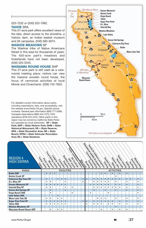
80
89
108
88
4
168
178
178
120
41
182
270167
140
180
198
49
Tahoe City
South Lake Tahoe
Bridgeport
YosemiteVillage
Bishop
MammothLakes
130 milesto Monterey
110 miles to Los Angeles
175 milesto
SanFrancisco
20 miles to Reno
0
0
50 mi
50 km
Calaveras Big Trees
Mono Lake Tufa
WassamaRound House
Kings BeachTahoe
Lake Valley
Burton Creek
D.L. Bliss
Washoe Meadows
Grover Hot Springs
Bodie
Emerald Bay
Sugar Pine Point
Donner Memorial
Closed in Winter
Bodie SHP • • • • • • • •Burton Creek SP •Calaveras Big Trees SP • • • • • • • • • • • • • • • • •D.L. Bliss SP • • • • • • • • • • • •Donner Memorial SP • • • • • • • • • • • • • • • •Emerald Bay SP • • • • • • • • • • • • • •Grover Hot Springs SP • • • • • • •Kings Beach SRA • • • • •Lake Valley SRA •Mono Lake Tufa SR • • • • • • • • • •Sugar Pine Point SP • • • • • • • • • • • • • • • • •Tahoe SRA • • • • • • • • • • • • • • •Washoe Meadows SP •Wassama Round House SHP • • • • • • •
REGION 4HIGH SIERRA
525-7232 or (530) 525-7982.TAHOE SRAThis 57-acre park offers excellent views ofthe lake, direct access to the shoreline, ahistoric dam, an Indian basket museumand 26 campsites. (530) 583-3074.WASHOE MEADOWS SPThe Washoe tribe of Native Americansfished in this area for thousands of years.The 620-acre park’s meadows and forestlands have not been developed.(530) 525-3345.WASSAMA ROUND HOUSE SHPThis 27-acre park is still used as a cere-monial meeting place; visitors can viewthe massive wooden round house, thefocus of cermonial activities of localMiwok and Chukchansi. (209) 742-7625.
California State Parkswww.Parks.CA.gov 37
For detailed current information about parks,including reservations, fees, and accessibility, visitthe website www.Parks.CA.gov. Specific phonenumbers: General park information (800) 777-0369;Campsite reservations (800) 444-7275; OHV operations (916) 324-4442. Other parks in thisregion may be owned by California State Parks but operated by local authorities. SP = StatePark; SHP = State Historic Park; SHM = StateHistorical Monument; SR = State Reserve; SRA = State Recreation Area; SB = StateBeach; SVRA = State Vehicular RecreationArea; SS = State Seashore.
FR
OM
TO
P:
MA
RK
J.
DO
LYA
K;
RIC
HA
RD
CU
MM
INS
BODIE SHPCalifornia’s most notorious gold-mining town,Bodie, attracted miners, gamblers, prostitutes,and hotel operators. Now it’s the best-preservedghost town in the West. (760) 647-6445.BURTON CREEK SPBoasting 2,000 acres of undeveloped forest,meadows, and streams, much of the park isopen in winter for cross-country skiing. Park: (530) 525-3345. Ski center: (530) 583-5475.CALAVERAS BIG TREES SPTwo protected groves of giant sequoias providea mid-Sierra elevation experience in this parklocated northeast of Stockton. (209) 795-2334.D.L. BLISS SPThis Tahoe beach offers 2.9 miles of lakefrontcampsites and trails connecting to the EmeraldBay Trail, as well as the world’s highest-eleva-tion historic lighthouse. (530) 525-7277.DONNER MEMORIAL SPA memorial to the Donner Party’s attemptedmountain crossing in 1846–47, the park offersthe Emigrant Trail Museum and accessiblecamping and picnicking. (530) 582-7892.EMERALD BAY SP
One of Lake Tahoe’s most-photographed naturalattractions, this park offers the Emerald Bay Trail(5.5 miles) and also showcases the Vikingsholmcastle, an eclectic combination of Scandinavianarchitecture. (530) 541-3030.GROVER HOT SPRINGS SPCross-country skiing and 102-degree mineral spring waters add to this park’s appeal. (530) 694-2248.KINGS BEACH SRAVisitors come to swim, bask in the sun, and playvolleyball at this day-use-only park on the northshore of Lake Tahoe. (530) 546-4212.LAKE VALLEY SRAThis park offers a championship 18-hole golfcourse during summer and a snowmobile andcross-country ski area during winter. Golfcourse: (530) 577-0802.MONO LAKE TUFA SRMono Lake offers spectacular scenery, includingunusual tufa formations. The alkaline lake sup-ports large bird populations. (760) 647-6331.SUGAR PINE POINT SPYear-round campgrounds provide access tobeach areas and the Pine Lodge in summer,and cross-country trails in winter. Historic mar-itime exhibits showcase 1920s boats. (530)
Crystal-clear lakes high in the snow country,steaming hot springs, and giant sequoias
reaching for the clouds—these describe the beautiful High Sierra. This region also is the site ofa large gold-mining ghost town; a state historicpark used for Native American ceremonies; andmagnificent Lake Tahoe and eerie Mono Lake,whose 60 square miles of salty, alkaline watersand stark “towers” of tufa tempt photographers.
>>>>HHiigghh SSiieerrrraa
Navy Beach, MonoLake Tufa SR
California State Parks36 www.Parks.CA.gov
RE
GIO
N 4
H
IGH
SIE
RR
A
44
Sugar Pine Point SP, on Lake Tahoe
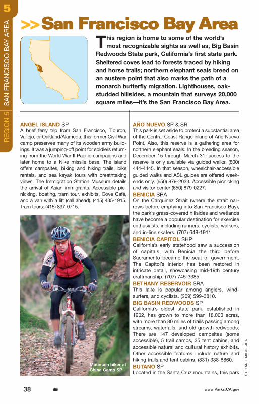
is only 3 miles from the ocean. Trails meanderthrough coastal scrub and redwood forests.The higher mountains afford coastal views.Butano offers 20 developed campsites, as wellas 18 walk-in sites. (800) 444-7275. Accessiblevisitor center. (650) 879-2040.CANDLESTICK POINT SRAThis popular Bay Area park has many activitiesto offer—windsurfing, group picnicking, andbike riding along the trail. Accessible approachto the pier, fishing platform, picnic area, andgarden. (415) 671-0145.CARNEGIE SVRAWith more than 1,500 acres of open area,Carnegie offers a variety of terrain upon whichto ride. Characterized by rocky washes, rollinghills and rugged canyons, the park provides asetting for off-highway vehicle users of all skilllevels. Carnegie offers a motocross track, anATV track, a track for younger riders, and a 4x4obstacle course, as well as a campground andpicnic area. Carnegie is located in the hills off I-580 between Livermore and Tracy. Day-usehours are from 8 a.m. until sunset, and the park
is open seven days a week. (925) 447-9027.CASTLE ROCK SPStands of coastal redwood, madrone, andDouglas fir are broken by rock formations andviews of the coast range to the ocean. Morethan 33 miles of trails for hikers and equestrianswind through the park. Overnight camping forbackpackers. (408) 867-2952 or (831) 338-8861(for backcountry registration).CHINA CAMP SPSite of the Bay Area’s last Chinese shrimp-fishing village—dating to the 1880s—this parkoffers 30 developed walk-in campsites. Visitorscome to watch the multitudes of birds and tomountain bike, hike, swim, fish, boat, or wind-surf. Accessible camping. (415) 456-0766.THE FOREST OF NISENE MARKS SPIn 1963, the Marks family donated 10,000 acresof second-growth redwood forest to the state.There are several picnic areas, but the onlycampground is located 6 miles from the nearestparking area. (831) 763-7062 or (831) 429-2850.HENRY COWELL REDWOODS SPEnjoy some of the most spectacular redwoods
San Bruno Mt.*
Lighthouse Fields*
*
Robert W. Crown Memorial*
California State Parkswww.Parks.CA.gov 39
ST
EFA
NIE
MIC
HE
JDA
ANGEL ISLAND SPA brief ferry trip from San Francisco, Tiburon,Vallejo, or Oakland/Alameda, this former Civil Warcamp preserves many of its wooden army build-ings. It was a jumping-off point for soldiers return-ing from the World War II Pacific campaigns andlater home to a Nike missile base. The islandoffers campsites, biking and hiking trails, bikerentals, and sea kayak tours with breathtakingviews. The Immigration Station Museum detailsthe arrival of Asian immigrants. Accessible pic-nicking, boating, tram tour, exhibits, Cove Café,and a van with a lift (call ahead). (415) 435-1915.Tram tours: (415) 897-0715.
AÑO NUEVO SP & SRThis park is set aside to protect a substantial areaof the Central Coast Range inland of Año NuevoPoint. Also, this reserve is a gathering area fornorthern elephant seals. In the breeding season,December 15 through March 31, access to thereserve is only available via guided walks: (800)444-4445. In that season, wheelchair-accessibleguided walks and ASL guides are offered week-ends only. (650) 879-2033. Accessible picnickingand visitor center (650) 879-0227.BENICIA SRAOn the Carquinez Strait (where the strait nar-rows before emptying into San Francisco Bay),the park’s grass-covered hillsides and wetlandshave become a popular destination for exerciseenthusiasts, including runners, cyclists, walkers,and in-line skaters. (707) 648-1911.BENICIA CAPITOL SHPCalifornia’s early statehood saw a successionof capitals, with Benicia the third beforeSacramento became the seat of government.The Capitol’s interior has been restored inintricate detail, showcasing mid-19th centurycraftmanship. (707) 745-3385.BETHANY RESERVOIR SRAThis lake is popular among anglers, wind-surfers, and cyclists. (209) 599-3810.BIG BASIN REDWOODS SPCalifornia’s oldest state park, established in1902, has grown to more than 18,000 acres,with more than 80 miles of trails passing amongstreams, waterfalls, and old-growth redwoods.There are 147 developed campsites (someaccessible), 5 trail camps, 35 tent cabins, andaccessible natural and cultural history exhibits.Other accessible features include nature andhiking trails and tent cabins. (831) 338-8860.BUTANO SPLocated in the Santa Cruz mountains, this park
This region is home to some of the world’smost recognizable sights as well as, Big Basin
Redwoods State park, California’s first state park.Sheltered coves lead to forests traced by hikingand horse trails; northern elephant seals breed onan austere point that also marks the path of amonarch butterfly migration. Lighthouses, oak-studded hillsides, a mountain that surveys 20,000square miles—it’s the San Francisco Bay Area.
>>>>SSaann FFrraanncciissccoo BBaayy AArreeaa
California State Parks38 www.Parks.CA.gov
RE
GIO
N 5
S
AN
FR
AN
CIS
CO
BAY
AR
EA
55
Mountain biker atChina Camp SP
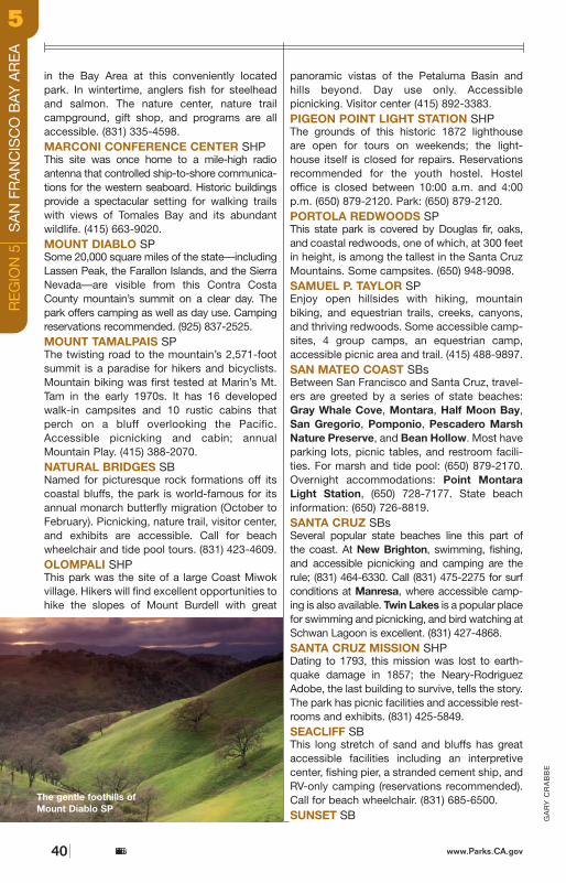
www.Parks.CA.gov
GA
RY
CR
AB
BE
in the Bay Area at this conveniently locatedpark. In wintertime, anglers fish for steelheadand salmon. The nature center, nature trailcampground, gift shop, and programs are allaccessible. (831) 335-4598.MARCONI CONFERENCE CENTER SHPThis site was once home to a mile-high radioantenna that controlled ship-to-shore communica-tions for the western seaboard. Historic buildingsprovide a spectacular setting for walking trailswith views of Tomales Bay and its abundantwildlife. (415) 663-9020.MOUNT DIABLO SPSome 20,000 square miles of the state—includingLassen Peak, the Farallon Islands, and the SierraNevada—are visible from this Contra CostaCounty mountain’s summit on a clear day. Thepark offers camping as well as day use. Campingreservations recommended. (925) 837-2525.MOUNT TAMALPAIS SPThe twisting road to the mountain’s 2,571-foot summit is a paradise for hikers and bicyclists.Mountain biking was first tested at Marin’s Mt.Tam in the early 1970s. It has 16 developedwalk-in campsites and 10 rustic cabins thatperch on a bluff overlooking the Pacific.Accessible picnicking and cabin; annualMountain Play. (415) 388-2070.NATURAL BRIDGES SBNamed for picturesque rock formations off itscoastal bluffs, the park is world-famous for itsannual monarch butterfly migration (October toFebruary). Picnicking, nature trail, visitor center,and exhibits are accessible. Call for beachwheelchair and tide pool tours. (831) 423-4609.OLOMPALI SHPThis park was the site of a large Coast Miwokvillage. Hikers will find excellent opportunities tohike the slopes of Mount Burdell with great
panoramic vistas of the Petaluma Basin andhills beyond. Day use only. Accessible picnicking. Visitor center (415) 892-3383.PIGEON POINT LIGHT STATION SHPThe grounds of this historic 1872 lighthouse are open for tours on weekends; the light-house itself is closed for repairs. Reservationsrecommended for the youth hostel. Hosteloffice is closed between 10:00 a.m. and 4:00p.m. (650) 879-2120. Park: (650) 879-2120.PORTOLA REDWOODS SPThis state park is covered by Douglas fir, oaks,and coastal redwoods, one of which, at 300 feetin height, is among the tallest in the Santa CruzMountains. Some campsites. (650) 948-9098.SAMUEL P. TAYLOR SPEnjoy open hillsides with hiking, mountain biking, and equestrian trails, creeks, canyons,and thriving redwoods. Some accessible camp-sites, 4 group camps, an equestrian camp,accessible picnic area and trail. (415) 488-9897.SAN MATEO COAST SBsBetween San Francisco and Santa Cruz, travel-ers are greeted by a series of state beaches:Gray Whale Cove, Montara, Half Moon Bay,San Gregorio, Pomponio, Pescadero MarshNature Preserve, and Bean Hollow. Most haveparking lots, picnic tables, and restroom facili-ties. For marsh and tide pool: (650) 879-2170.Overnight accommodations: Point MontaraLight Station, (650) 728-7177. State beachinformation: (650) 726-8819.SANTA CRUZ SBsSeveral popular state beaches line this part of the coast. At New Brighton, swimming, fishing,and accessible picnicking and camping are therule; (831) 464-6330. Call (831) 475-2275 for surf conditions at Manresa, where accessible camp-ing is also available. Twin Lakes is a popular placefor swimming and picnicking, and bird watching atSchwan Lagoon is excellent. (831) 427-4868.SANTA CRUZ MISSION SHPDating to 1793, this mission was lost to earth-quake damage in 1857; the Neary-RodriguezAdobe, the last building to survive, tells the story.The park has picnic facilities and accessible rest-rooms and exhibits. (831) 425-5849.SEACLIFF SBThis long stretch of sand and bluffs has greataccessible facilities including an interpretivecenter, fishing pier, a stranded cement ship, andRV-only camping (reservations recommended).Call for beach wheelchair. (831) 685-6500.SUNSET SB
California State Parks40
RE
GIO
N 5
S
AN
FR
AN
CIS
CO
BAY
AR
EA
55
The gentle foothills ofMount Diablo SP
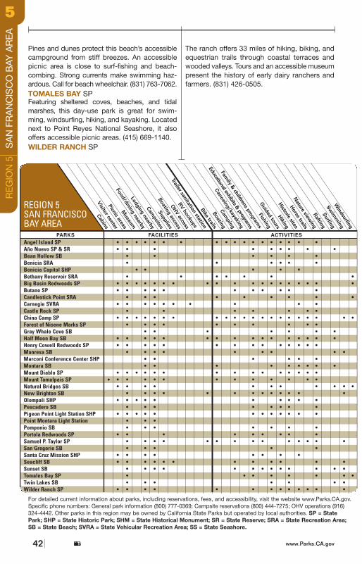
Pines and dunes protect this beach’s accessiblecampground from stiff breezes. An accessiblepicnic area is close to surf-fishing and beach-combing. Strong currents make swimming haz-ardous. Call for beach wheelchair. (831) 763-7062.TOMALES BAY SPFeaturing sheltered coves, beaches, and tidalmarshes, this day-use park is great for swim-ming, windsurfing, hiking, and kayaking. Locatednext to Point Reyes National Seashore, it alsooffers accessible picnic areas. (415) 669-1140.WILDER RANCH SP
The ranch offers 33 miles of hiking, biking, andequestrian trails through coastal terraces andwooded valleys. Tours and an accessible museumpresent the history of early dairy ranchers andfarmers. (831) 426-0505.
REGION 5SAN FRANCISCOBAY AREA
For detailed current information about parks, including reservations, fees, and accessibility, visit the website www.Parks.CA.gov.Specific phone numbers: General park information (800) 777-0369; Campsite reservations (800) 444-7275; OHV operations (916)324-4442. Other parks in this region may be owned by California State Parks but operated by local authorities. SP = StatePark; SHP = State Historic Park; SHM = State Historical Monument; SR = State Reserve; SRA = State Recreation Area;SB = State Beach; SVRA = State Vehicular Recreation Area; SS = State Seashore.
California State Parks42 www.Parks.CA.gov
Angel Island SP • • • • • • • • • • • • • • • • • •Año Nuevo SP & SR • • • • • • • • •Bean Hollow SB • • • • • •Benicia SRA • • • • • •Benicia Capitol SHP • • • • •Bethany Reservoir SRA • • • • • • •Big Basin Redwoods SP • • • • • • • • • • • • • • • • • • •Butano SP • • • • • • • • • • •Candlestick Point SRA • • • • • • • • •Carnegie SVRA • • • • • • • • • •Castle Rock SP • • • • • • •China Camp SP • • • • • • • • • • • • • • • • • • • • •Forest of Nisene Marks SP • • • • • • • • • •Gray Whale Cove SB • • • • • • •Half Moon Bay SB • • • • • • • • • • • • • • • •Henry Cowell Redwoods SP • • • • • • • • • • • • • •Manresa SB • • • • • • • • •Marconi Conference Center SHP • • • • • •Montara SB • • • • • • • • •Mount Diablo SP • • • • • • • • • • • • • • •Mount Tamalpais SP • • • • • • • • • • • •Natural Bridges SB • • • • • • • • • • •New Brighton SB • • • • • • • • • • • • •Olompali SHP • • • • • • • • • •Pescadero SB • • • • • • • •Pigeon Point Light Station SHP • • • • • • • • • • • •Point Montara Light Station • • •Pomponio SB • • • • • • •Portola Redwoods SP • • • • • • • • •Samuel P. Taylor SP • • • • • • • • • • • • • •San Gregorio SB • • • • •Santa Cruz Mission SHP • • • • • • • •Seacliff SB • • • • • • • • • • • •Sunset SB • • • • • • • • • • • • •Tomales Bay SP • • • • • • • •Twin Lakes SB • • • • • • •Wilder Ranch SP • • • • • • • • • • • • •
RE
GIO
N 5
S
AN
FR
AN
CIS
CO
BAY
AR
EA
55
•
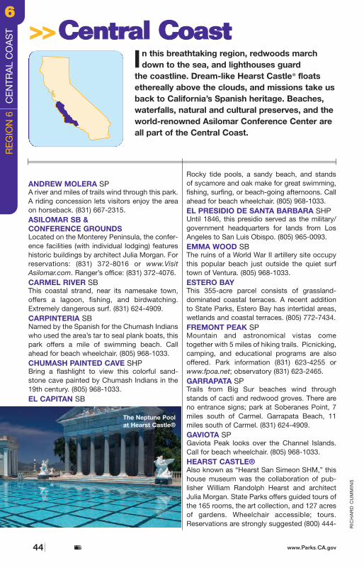
1
166
1229
58
33
118
1
1
126
135
150
33
198
154
152
25
41
46
46
68
23
101
101
101
101
101
Andrew Molera Pfeiffer Big Sur
Julia Pfeiffer Burns
Hearst Castle
San Simeon
Gaviota
Morro Bay
Point LobosGarrapata
Carmel River
Henry W. Coe
McGrath San Buenaventura
Point Mugu
Emma Wood Carpinteria
El Presidio deSanta Barbara
Chumash PaintedCave
El Capitan Refugio
Point Sal
Oceano Dunes Pismo
Estero Bay
Morro Strand
Los Osos Oaks
William Randolph Hearst Memorial
Limekiln
Point Sur
Monterey Marina
Salinas River Moss Landing
Zmudowski Pacheco San Juan Bautista
Asilomar
Hollister Hills
Monterey
Salinas
SantaBarbara
Ventura
Oxnard
San Luis Obispo
Santa Maria
PasoRobles
0
0
50 mi
50 km
54 miles toSan Francisco
60 miles toLos Angeles
150 miles to Yosemite Valley
4445 or www.hearstcastle.com.HENRY W. COE SPA hiker’s paradise with over 400 miles of trailsand dirt roads. (408) 779-2728.HOLLISTER HILLS SVRAThe Lower Ranch offers more than 2,400 acresand 64 miles of trails for motorcycles and ATVs.The Upper Ranch, an 800-acre area, is used for 4-wheel-drive, recreation, and motorcycleevents. The park is open 7 days a week, 24hours a day; the Upper Ranch is open from 8 a.m. until sunset. The red sticker riding sea-son is October 1 to May 31. (831) 637-3874.JULIA PFEIFFER BURNS SPThis park encompasses some of Big Sur’s mostspectacular coastline, including an 80-foot water-fall. Individual environmental campsites provide
limited accomodations. (831) 667-2315.LA PURÍSIMA MISSION SHPFounded in 1787, the most completely restoredmission includes a visitor center, museum, 3-mile trail, and historic buildings. (805) 733-3713.LIMEKILN SPThis rugged area includes crashing surf, 32 devel-oped campsites—some in the trees along LimekilnCreek and some near the beach—and 3 hikingtrails through a redwood forest. (831) 667-2403.LOS OSOS OAKS SRThis small reserve protects several oak standsdating back 700 years. (805) 772-7434.MARINA SBThis beach offers a ranger station, surf fishing,kite flying, an accessible boardwalk, and acces-sible hang-gliding conditions. (831) 384-7695.
RIC
HA
RD
CU
MM
INS
ANDREW MOLERA SPA river and miles of trails wind through this park.A riding concession lets visitors enjoy the areaon horseback. (831) 667-2315.ASILOMAR SB &CONFERENCE GROUNDSLocated on the Monterey Peninsula, the confer-ence facilities (with individual lodging) featureshistoric buildings by architect Julia Morgan. Forreservations: (831) 372-8016 or www.VisitAsilomar.com. Ranger’s office: (831) 372-4076.CARMEL RIVER SBThis coastal strand, near its namesake town,offers a lagoon, fishing, and birdwatching.Extremely dangerous surf. (831) 624-4909.CARPINTERIA SBNamed by the Spanish for the Chumash Indianswho used the area’s tar to seal plank boats, thispark offers a mile of swimming beach. Callahead for beach wheelchair. (805) 968-1033.CHUMASH PAINTED CAVE SHPBring a flashlight to view this colorful sand-stone cave painted by Chumash Indians in the19th century. (805) 968-1033.EL CAPITAN SB
Rocky tide pools, a sandy beach, and stands of sycamore and oak make for great swimming,fishing, surfing, or beach-going afternoons. Callahead for beach wheelchair. (805) 968-1033.EL PRESIDIO DE SANTA BARBARA SHPUntil 1846, this presidio served as the military/government headquarters for lands from LosAngeles to San Luis Obispo. (805) 965-0093.EMMA WOOD SBThe ruins of a World War II artillery site occupythis popular beach just outside the quiet surftown of Ventura. (805) 968-1033.ESTERO BAYThis 355-acre parcel consists of grassland-dominated coastal terraces. A recent additionto State Parks, Estero Bay has intertidal areas,wetlands and coastal terraces. (805) 772-7434.FREMONT PEAK SPMountain and astronomical vistas come together with 5 miles of hiking trails. Picnicking,camping, and educational programs are alsooffered. Park information (831) 623-4255 orwww.fpoa.net; observatory (831) 623-2465.GARRAPATA SPTrails from Big Sur beaches wind throughstands of cacti and redwood groves. There areno entrance signs; park at Soberanes Point, 7miles south of Carmel. Garrapata Beach, 11miles south of Carmel. (831) 624-4909.GAVIOTA SPGaviota Peak looks over the Channel Islands.Call for beach wheelchair. (805) 968-1033.HEARST CASTLE®Also known as “Hearst San Simeon SHM,” thishouse museum was the collaboration of pub-lisher William Randolph Hearst and architectJulia Morgan. State Parks offers guided tours ofthe 165 rooms, the art collection, and 127 acresof gardens. Wheelchair accessible; tours.Reservations are strongly suggested (800) 444-
In this breathtaking region, redwoods marchdown to the sea, and lighthouses guard
the coastline. Dream-like Hearst Castle® floats ethereally above the clouds, and missions take usback to California’s Spanish heritage. Beaches,waterfalls, natural and cultural preserves, and theworld-renowned Asilomar Conference Center areall part of the Central Coast.
>>>>CCeennttrraall CCooaasstt
The Neptune Poolat Hearst Castle®
California State Parks44 www.Parks.CA.gov California State Parkswww.Parks.CA.gov 45
RE
GIO
N 6
C
EN
TRA
L C
OA
ST
66
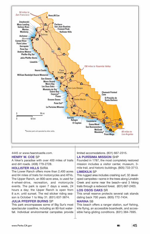
1
166
1229
58
33
118
1
1
126
135
150
33
198
154
152
25
41
46
46
68
23
101
101
101
101
101
Andrew Molera Pfeiffer Big Sur
Julia Pfeiffer Burns
Hearst Castle
San Simeon
Gaviota
Morro Bay
Point LobosGarrapata
Carmel River
Henry W. Coe
McGrath San Buenaventura
Point Mugu
Emma Wood Carpinteria
El Presidio deSanta Barbara
Chumash PaintedCave
El Capitan Refugio
Point Sal
Oceano Dunes Pismo
Estero Bay
Morro Strand
Los Osos Oaks
William Randolph Hearst Memorial
Limekiln
Point Sur
Monterey Marina
Salinas River Moss Landing
Zmudowski Pacheco San Juan Bautista
Asilomar
Hollister Hills
Monterey
Salinas
SantaBarbara
Ventura
Oxnard
San Luis Obispo
Santa Maria
PasoRobles
0
0
50 mi
50 km
54 miles toSan Francisco
60 miles toLos Angeles
150 miles to Yosemite Valley
4445 or www.hearstcastle.com.HENRY W. COE SPA hiker’s paradise with over 400 miles of trailsand dirt roads. (408) 779-2728.HOLLISTER HILLS SVRAThe Lower Ranch offers more than 2,400 acresand 64 miles of trails for motorcycles and ATVs.The Upper Ranch, an 800-acre area, is used for 4-wheel-drive, recreation, and motorcycleevents. The park is open 7 days a week, 24hours a day; the Upper Ranch is open from 8 a.m. until sunset. The red sticker riding sea-son is October 1 to May 31. (831) 637-3874.JULIA PFEIFFER BURNS SPThis park encompasses some of Big Sur’s mostspectacular coastline, including an 80-foot water-fall. Individual environmental campsites provide
limited accomodations. (831) 667-2315.LA PURÍSIMA MISSION SHPFounded in 1787, the most completely restoredmission includes a visitor center, museum, 3-mile trail, and historic buildings. (805) 733-3713.LIMEKILN SPThis rugged area includes crashing surf, 32 devel-oped campsites—some in the trees along LimekilnCreek and some near the beach—and 3 hikingtrails through a redwood forest. (831) 667-2403.LOS OSOS OAKS SRThis small reserve protects several oak standsdating back 700 years. (805) 772-7434.MARINA SBThis beach offers a ranger station, surf fishing,kite flying, an accessible boardwalk, and acces-sible hang-gliding conditions. (831) 384-7695.
RIC
HA
RD
CU
MM
INS
ANDREW MOLERA SPA river and miles of trails wind through this park.A riding concession lets visitors enjoy the areaon horseback. (831) 667-2315.ASILOMAR SB &CONFERENCE GROUNDSLocated on the Monterey Peninsula, the confer-ence facilities (with individual lodging) featureshistoric buildings by architect Julia Morgan. Forreservations: (831) 372-8016 or www.VisitAsilomar.com. Ranger’s office: (831) 372-4076.CARMEL RIVER SBThis coastal strand, near its namesake town,offers a lagoon, fishing, and birdwatching.Extremely dangerous surf. (831) 624-4909.CARPINTERIA SBNamed by the Spanish for the Chumash Indianswho used the area’s tar to seal plank boats, thispark offers a mile of swimming beach. Callahead for beach wheelchair. (805) 968-1033.CHUMASH PAINTED CAVE SHPBring a flashlight to view this colorful sand-stone cave painted by Chumash Indians in the19th century. (805) 968-1033.EL CAPITAN SB
Rocky tide pools, a sandy beach, and stands of sycamore and oak make for great swimming,fishing, surfing, or beach-going afternoons. Callahead for beach wheelchair. (805) 968-1033.EL PRESIDIO DE SANTA BARBARA SHPUntil 1846, this presidio served as the military/government headquarters for lands from LosAngeles to San Luis Obispo. (805) 965-0093.EMMA WOOD SBThe ruins of a World War II artillery site occupythis popular beach just outside the quiet surftown of Ventura. (805) 968-1033.ESTERO BAYThis 355-acre parcel consists of grassland-dominated coastal terraces. A recent additionto State Parks, Estero Bay has intertidal areas,wetlands and coastal terraces. (805) 772-7434.FREMONT PEAK SPMountain and astronomical vistas come together with 5 miles of hiking trails. Picnicking,camping, and educational programs are alsooffered. Park information (831) 623-4255 orwww.fpoa.net; observatory (831) 623-2465.GARRAPATA SPTrails from Big Sur beaches wind throughstands of cacti and redwood groves. There areno entrance signs; park at Soberanes Point, 7miles south of Carmel. Garrapata Beach, 11miles south of Carmel. (831) 624-4909.GAVIOTA SPGaviota Peak looks over the Channel Islands.Call for beach wheelchair. (805) 968-1033.HEARST CASTLE®Also known as “Hearst San Simeon SHM,” thishouse museum was the collaboration of pub-lisher William Randolph Hearst and architectJulia Morgan. State Parks offers guided tours ofthe 165 rooms, the art collection, and 127 acresof gardens. Wheelchair accessible; tours.Reservations are strongly suggested (800) 444-
In this breathtaking region, redwoods marchdown to the sea, and lighthouses guard
the coastline. Dream-like Hearst Castle® floats ethereally above the clouds, and missions take usback to California’s Spanish heritage. Beaches,waterfalls, natural and cultural preserves, and theworld-renowned Asilomar Conference Center areall part of the Central Coast.
>>>>CCeennttrraall CCooaasstt
The Neptune Poolat Hearst Castle®
California State Parks44 www.Parks.CA.gov California State Parkswww.Parks.CA.gov 45
RE
GIO
N 6
C
EN
TRA
L C
OA
ST
66
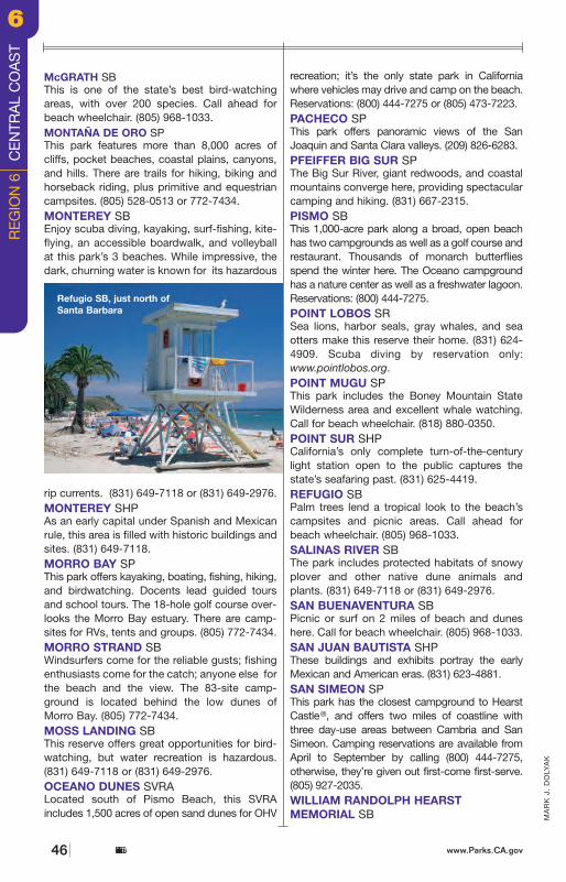
This cove offers ocean kayaking, picnicking,and easy beach access. (805) 927-2010.ZMUDOWSKI SBThis park north of Monterey is popular with bird-ers and equestrians. Fishing and hiking are alsoavailable. (831) 649-7118 or (831) 649-2976.
Andrew Molera SP • • • • • • • • • • • • • • •Asilomar SB & Conf. Grounds • • • • • • • •Carmel River SB • • • • •Carpinteria SB • • • • • • • • • • • • • • • •Chumash Painted Cave SHP • • • •El Capitan SB • • • • • • • • • • • • • • • • •El Presidio de Santa Barbara SHP • • • • • •Emma Wood SB • • • • • • • • • • • •Estero BayFremont Peak SP • • • • • •Garrapata SP • • • • •Gaviota SP • • • • • • • • • • • • • •Hearst Castle® • • • • • • • • • • • • • • • • • •Henry W. Coe SP • • • • • • • • • • • • • •Hollister Hills SVRA • • • • • • • • • •Julia Pfeiffer Burns SP • • • • • • •La Puríísima Mission SHP • • • • • • • • • • • • •Limekiln SP • • • • • • • •Los Osos Oaks SR • • • •Marina SB • • • • •McGrath SB • • • • • • • • • • • • •Montaña de Oro SP • • • • • • • • • • • • • •Monterey SB • • •Monterey SHP • • • • • • • • •Morro Bay SP • • • • • • • • • • • • • • • •Morro Strand SB • • • • • • •Moss Landing SB • • • • • • • • •Oceano Dunes SVRA • • • • • • • • • • • • • • • •Pacheco SP • • • • • •Pfeiffer Big Sur SP • • • • • • • • • • • • •Pismo SB • • • • • • • • • • • • •Point Lobos SR • • • • • • • • •Point Mugu SP • • • • • • • • • • • • • • • • •Point Sur SHP • • • • • • •Refugio SB • • • • • • • • • • • • • • •Salinas River SB • • • • •San Buenaventura SB • • • • • • • • •San Juan Bautista SHP • • • • • • • • •San Simeon SP • • • • • • • • • • • • •Wm. Randolph Hearst Mem. SB • • • • • • • •Zmudowski SB • • • • •
REGION 6CENTRAL COAST
For detailed current information about parks, including reservations, fees, and accessibility, visit the website www.Parks.CA.gov.Specific phone numbers: General park information (800) 777-0369; Campsite reservations (800) 444-7275; OHV operations (916)324-4442. Other parks in this region may be owned by California State Parks but operated by local authorities. SP = StatePark; SHP = State Historic Park; SHM = State Historical Monument; SR = State Reserve; SRA = State Recreation Area;SB = State Beach; SVRA = State Vehicular Recreation Area; SS = State Seashore.
California State Parkswww.Parks.CA.gov 47
MA
RK
J.
DO
LYA
K
McGRATH SBThis is one of the state’s best bird-watchingareas, with over 200 species. Call ahead forbeach wheelchair. (805) 968-1033.MONTAÑA DE ORO SPThis park features more than 8,000 acres ofcliffs, pocket beaches, coastal plains, canyons,and hills. There are trails for hiking, biking andhorseback riding, plus primitive and equestriancampsites. (805) 528-0513 or 772-7434.MONTEREY SBEnjoy scuba diving, kayaking, surf-fishing, kite-flying, an accessible boardwalk, and volleyballat this park’s 3 beaches. While impressive, thedark, churning water is known for its hazardous
rip currents. (831) 649-7118 or (831) 649-2976.MONTEREY SHPAs an early capital under Spanish and Mexicanrule, this area is filled with historic buildings andsites. (831) 649-7118.MORRO BAY SPThis park offers kayaking, boating, fishing, hiking,and birdwatching. Docents lead guided toursand school tours. The 18-hole golf course over-looks the Morro Bay estuary. There are camp-sites for RVs, tents and groups. (805) 772-7434.MORRO STRAND SBWindsurfers come for the reliable gusts; fishingenthusiasts come for the catch; anyone else forthe beach and the view. The 83-site camp-ground is located behind the low dunes ofMorro Bay. (805) 772-7434.MOSS LANDING SBThis reserve offers great opportunities for bird-watching, but water recreation is hazardous.(831) 649-7118 or (831) 649-2976.OCEANO DUNES SVRALocated south of Pismo Beach, this SVRAincludes 1,500 acres of open sand dunes for OHV
recreation; it’s the only state park in Californiawhere vehicles may drive and camp on the beach.Reservations: (800) 444-7275 or (805) 473-7223.PACHECO SPThis park offers panoramic views of the SanJoaquin and Santa Clara valleys. (209) 826-6283.PFEIFFER BIG SUR SPThe Big Sur River, giant redwoods, and coastalmountains converge here, providing spectacularcamping and hiking. (831) 667-2315.PISMO SBThis 1,000-acre park along a broad, open beachhas two campgrounds as well as a golf course andrestaurant. Thousands of monarch butterfliesspend the winter here. The Oceano campgroundhas a nature center as well as a freshwater lagoon.Reservations: (800) 444-7275.POINT LOBOS SRSea lions, harbor seals, gray whales, and seaotters make this reserve their home. (831) 624-4909. Scuba diving by reservation only:www.pointlobos.org. POINT MUGU SPThis park includes the Boney Mountain StateWilderness area and excellent whale watching.Call for beach wheelchair. (818) 880-0350.POINT SUR SHPCalifornia’s only complete turn-of-the-centurylight station open to the public captures thestate’s seafaring past. (831) 625-4419.REFUGIO SBPalm trees lend a tropical look to the beach’scampsites and picnic areas. Call ahead forbeach wheelchair. (805) 968-1033.SALINAS RIVER SBThe park includes protected habitats of snowyplover and other native dune animals andplants. (831) 649-7118 or (831) 649-2976.SAN BUENAVENTURA SBPicnic or surf on 2 miles of beach and duneshere. Call for beach wheelchair. (805) 968-1033.SAN JUAN BAUTISTA SHPThese buildings and exhibits portray the earlyMexican and American eras. (831) 623-4881.SAN SIMEON SPThis park has the closest campground to HearstCastle®, and offers two miles of coastline withthree day-use areas between Cambria and SanSimeon. Camping reservations are available fromApril to September by calling (800) 444-7275, otherwise, they’re given out first-come first-serve.(805) 927-2035.WILLIAM RANDOLPH HEARSTMEMORIAL SB
www.Parks.CA.govCalifornia State Parks46
Refugio SB, just north of Santa Barbara
RE
GIO
N 6
C
EN
TRA
L C
OA
ST
66
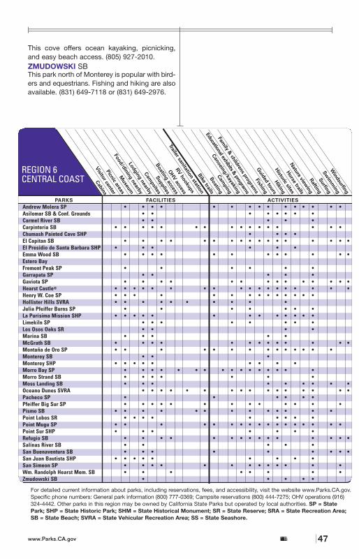
This cove offers ocean kayaking, picnicking,and easy beach access. (805) 927-2010.ZMUDOWSKI SBThis park north of Monterey is popular with bird-ers and equestrians. Fishing and hiking are alsoavailable. (831) 649-7118 or (831) 649-2976.
Andrew Molera SP • • • • • • • • • • • • • • •Asilomar SB & Conf. Grounds • • • • • • • •Carmel River SB • • • • •Carpinteria SB • • • • • • • • • • • • • • • •Chumash Painted Cave SHP • • • •El Capitan SB • • • • • • • • • • • • • • • • •El Presidio de Santa Barbara SHP • • • • • •Emma Wood SB • • • • • • • • • • • •Estero BayFremont Peak SP • • • • • •Garrapata SP • • • • •Gaviota SP • • • • • • • • • • • • • •Hearst Castle® • • • • • • • • • • • • • • • • • •Henry W. Coe SP • • • • • • • • • • • • • •Hollister Hills SVRA • • • • • • • • • •Julia Pfeiffer Burns SP • • • • • • •La Puríísima Mission SHP • • • • • • • • • • • • •Limekiln SP • • • • • • • •Los Osos Oaks SR • • • •Marina SB • • • • •McGrath SB • • • • • • • • • • • • •Montaña de Oro SP • • • • • • • • • • • • • •Monterey SB • • •Monterey SHP • • • • • • • • •Morro Bay SP • • • • • • • • • • • • • • • •Morro Strand SB • • • • • • •Moss Landing SB • • • • • • • • •Oceano Dunes SVRA • • • • • • • • • • • • • • • •Pacheco SP • • • • • •Pfeiffer Big Sur SP • • • • • • • • • • • • •Pismo SB • • • • • • • • • • • • •Point Lobos SR • • • • • • • • •Point Mugu SP • • • • • • • • • • • • • • • • •Point Sur SHP • • • • • • •Refugio SB • • • • • • • • • • • • • • •Salinas River SB • • • • •San Buenaventura SB • • • • • • • • •San Juan Bautista SHP • • • • • • • • •San Simeon SP • • • • • • • • • • • • •Wm. Randolph Hearst Mem. SB • • • • • • • •Zmudowski SB • • • • •
REGION 6CENTRAL COAST
For detailed current information about parks, including reservations, fees, and accessibility, visit the website www.Parks.CA.gov.Specific phone numbers: General park information (800) 777-0369; Campsite reservations (800) 444-7275; OHV operations (916)324-4442. Other parks in this region may be owned by California State Parks but operated by local authorities. SP = StatePark; SHP = State Historic Park; SHM = State Historical Monument; SR = State Reserve; SRA = State Recreation Area;SB = State Beach; SVRA = State Vehicular Recreation Area; SS = State Seashore.
California State Parkswww.Parks.CA.gov 47
MA
RK
J.
DO
LYA
K
McGRATH SBThis is one of the state’s best bird-watchingareas, with over 200 species. Call ahead forbeach wheelchair. (805) 968-1033.MONTAÑA DE ORO SPThis park features more than 8,000 acres ofcliffs, pocket beaches, coastal plains, canyons,and hills. There are trails for hiking, biking andhorseback riding, plus primitive and equestriancampsites. (805) 528-0513 or 772-7434.MONTEREY SBEnjoy scuba diving, kayaking, surf-fishing, kite-flying, an accessible boardwalk, and volleyballat this park’s 3 beaches. While impressive, thedark, churning water is known for its hazardous
rip currents. (831) 649-7118 or (831) 649-2976.MONTEREY SHPAs an early capital under Spanish and Mexicanrule, this area is filled with historic buildings andsites. (831) 649-7118.MORRO BAY SPThis park offers kayaking, boating, fishing, hiking,and birdwatching. Docents lead guided toursand school tours. The 18-hole golf course over-looks the Morro Bay estuary. There are camp-sites for RVs, tents and groups. (805) 772-7434.MORRO STRAND SBWindsurfers come for the reliable gusts; fishingenthusiasts come for the catch; anyone else forthe beach and the view. The 83-site camp-ground is located behind the low dunes ofMorro Bay. (805) 772-7434.MOSS LANDING SBThis reserve offers great opportunities for bird-watching, but water recreation is hazardous.(831) 649-7118 or (831) 649-2976.OCEANO DUNES SVRALocated south of Pismo Beach, this SVRAincludes 1,500 acres of open sand dunes for OHV
recreation; it’s the only state park in Californiawhere vehicles may drive and camp on the beach.Reservations: (800) 444-7275 or (805) 473-7223.PACHECO SPThis park offers panoramic views of the SanJoaquin and Santa Clara valleys. (209) 826-6283.PFEIFFER BIG SUR SPThe Big Sur River, giant redwoods, and coastalmountains converge here, providing spectacularcamping and hiking. (831) 667-2315.PISMO SBThis 1,000-acre park along a broad, open beachhas two campgrounds as well as a golf course andrestaurant. Thousands of monarch butterfliesspend the winter here. The Oceano campgroundhas a nature center as well as a freshwater lagoon.Reservations: (800) 444-7275.POINT LOBOS SRSea lions, harbor seals, gray whales, and seaotters make this reserve their home. (831) 624-4909. Scuba diving by reservation only:www.pointlobos.org. POINT MUGU SPThis park includes the Boney Mountain StateWilderness area and excellent whale watching.Call for beach wheelchair. (818) 880-0350.POINT SUR SHPCalifornia’s only complete turn-of-the-centurylight station open to the public captures thestate’s seafaring past. (831) 625-4419.REFUGIO SBPalm trees lend a tropical look to the beach’scampsites and picnic areas. Call ahead forbeach wheelchair. (805) 968-1033.SALINAS RIVER SBThe park includes protected habitats of snowyplover and other native dune animals andplants. (831) 649-7118 or (831) 649-2976.SAN BUENAVENTURA SBPicnic or surf on 2 miles of beach and duneshere. Call for beach wheelchair. (805) 968-1033.SAN JUAN BAUTISTA SHPThese buildings and exhibits portray the earlyMexican and American eras. (831) 623-4881.SAN SIMEON SPThis park has the closest campground to HearstCastle®, and offers two miles of coastline withthree day-use areas between Cambria and SanSimeon. Camping reservations are available fromApril to September by calling (800) 444-7275, otherwise, they’re given out first-come first-serve.(805) 927-2035.WILLIAM RANDOLPH HEARSTMEMORIAL SB
www.Parks.CA.govCalifornia State Parks46
Refugio SB, just north of Santa Barbara
RE
GIO
N 6
C
EN
TRA
L C
OA
ST
66
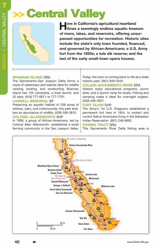
accessed by boat. (916) 777-6671 or 777-7701.GEORGE J. HATFIELD SRAOak forests skirt the confluence of the Mercedand San Joaquin rivers. (209) 632-1852.GREAT VALLEY GRASSLANDS SP This park offers anglers access to the SanJoaquin River. (209) 826-1197.McCONNELL SRAThis area showcases the Merced River’s camping,fishing, and swimming. (209) 394-7755.MILLERTON LAKE SRAIn spring, wildflowers carpet the hills; in winter,bald eagles may be spotted from special tour
boats. (559) 822-2332.SAN LUIS RESERVOIR SRAThis area includes 3 reservoirs with world-classboardsailing, fishing, picnicking, camping, andswimming; off-highway vehicle riding at JasperSears. Weather: (800) 805-4805; informationhotline: (800) 346-2711; park: (209) 826-1196.TOMO-KAHNI SHPThis 240-acre park offers (guided-only) walkingtours of the Nuooah Native American VillageSite on spring and fall weekends. Not recom-mended for small children. (661) 942-0662.TULE ELK SRThe reserve hosts a herd of elk descended fromthe 28 introduced in 1895. (661) 764-6881.TURLOCK LAKE SRAThis area offers campers fishing, boating, andpicnicking (all accessible) as well as waterskiing.(209) 874-2008 or (209) 874-2056.WOODLAND OPERA HOUSE SHPThis is the last of the once-numerous operahouses of California’s early small towns; openfor tours and classes. (530) 666-9617.
Brannan Island SRA • • • • • • • • • • • • • • • • • • •Caswell Memorial SP • • • • • • • • • • • •Colonel Allensworth SHP • • • • • • • •Colusa-Sacramento River SRA • • • • • • • • • • • • • •Fort Tejon SHP • • • • • • • • • •Franks Tract SRA • •George J. Hatfield SRA • • • • • • • • •Great Valley Grasslands SP • • •McConnell SRA • • • • • • • •Millerton Lake SRA • • • • • • • • • • • • • • • • • • • •San Luis Reservoir SRA • • • • • • • • • • • • • • • • • • • • •Tomo-Kahni SHP •Tule Elk SR • • • • • • •Turlock Lake SRA • • • • • • • • • • • •Woodland Opera House SHP • •
REGION 7CENTRAL VALLEY
For detailed current information about parks, including reservations, fees, and accessibility, visit the website www.Parks.CA.gov.Specific phone numbers: General park information (800) 777-0369; Campsite reservations (800) 444-7275; OHV operations (916)324-4442. Other parks in this region may be owned by California State Parks but operated by local authorities. SP = StatePark; SHP = State Historic Park; SHM = State Historical Monument; SR = State Reserve; SRA = State Recreation Area;SB = State Beach; SVRA = State Vehicular Recreation Area; SS = State Seashore.G
AR
Y C
RA
BB
E
California State Parkswww.Parks.CA.gov 49
Great Valley Grasslands SP casting its spell
BRANNAN ISLAND SRAThe Sacramento–San Joaquin Delta forms amaze of waterways and islands ideal for wildlifeviewing, boating, and windsurfing. BrannanIsland has 125 campsites, a boat launch, and32 slips. (916) 777-6671 or 777-7701.CASWELL MEMORIAL SPPreserving an aquatic habitat of 258 acres ofwillows, oaks, and cottonwoods, this park shel-ters an abundance of wildlife. (209) 599-3810.COLONEL ALLENSWORTH SHPIn 1908, a group of African-Americans, led byColonel Allen Allensworth, established a smallfarming community in the San Joaquin Valley.
Today, the town is coming back to life as a statehistoric park. (661) 849-3433.COLUSA-SACRAMENTO RIVER SRA Visitors enjoy educational programs, picnicsites, and a launch ramp for boats. Fishing andcamping make it ideal for overnight anglers.(530) 458-4927.FORT TEJON SHP The Army’s 1st U.S. Dragoons established apermanent fort here in 1854, to protect and control Native Americans living in the SebastianIndian Reservation. (661) 248-6692.FRANKS TRACT SRA This Sacramento River Delta fishing area is
Here in California’s agricultural heartland flows a seemingly endless aquatic treasure
of rivers, lakes, and reservoirs, offering unsur-passed opportunities for recreation. Historic sitesinclude the state’s only town founded, financed,and governed by African-Americans; a U.S. Armyfort from the 1850s; a tule elk reserve; and thelast of the early small-town opera houses.
>>>>CCeennttrraall VVaalllleeyy
www.Parks.CA.govCalifornia State Parks48
RE
GIO
N 7
C
EN
TRA
L VA
LLE
Y77
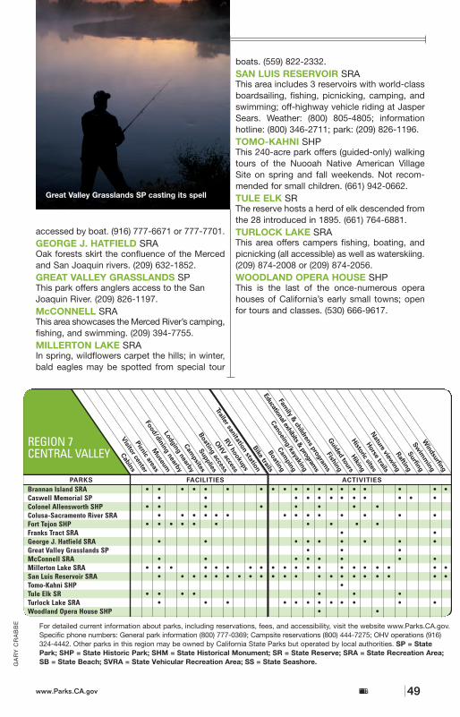
accessed by boat. (916) 777-6671 or 777-7701.GEORGE J. HATFIELD SRAOak forests skirt the confluence of the Mercedand San Joaquin rivers. (209) 632-1852.GREAT VALLEY GRASSLANDS SP This park offers anglers access to the SanJoaquin River. (209) 826-1197.McCONNELL SRAThis area showcases the Merced River’s camping,fishing, and swimming. (209) 394-7755.MILLERTON LAKE SRAIn spring, wildflowers carpet the hills; in winter,bald eagles may be spotted from special tour
boats. (559) 822-2332.SAN LUIS RESERVOIR SRAThis area includes 3 reservoirs with world-classboardsailing, fishing, picnicking, camping, andswimming; off-highway vehicle riding at JasperSears. Weather: (800) 805-4805; informationhotline: (800) 346-2711; park: (209) 826-1196.TOMO-KAHNI SHPThis 240-acre park offers (guided-only) walkingtours of the Nuooah Native American VillageSite on spring and fall weekends. Not recom-mended for small children. (661) 942-0662.TULE ELK SRThe reserve hosts a herd of elk descended fromthe 28 introduced in 1895. (661) 764-6881.TURLOCK LAKE SRAThis area offers campers fishing, boating, andpicnicking (all accessible) as well as waterskiing.(209) 874-2008 or (209) 874-2056.WOODLAND OPERA HOUSE SHPThis is the last of the once-numerous operahouses of California’s early small towns; openfor tours and classes. (530) 666-9617.
Brannan Island SRA • • • • • • • • • • • • • • • • • • •Caswell Memorial SP • • • • • • • • • • • •Colonel Allensworth SHP • • • • • • • •Colusa-Sacramento River SRA • • • • • • • • • • • • • •Fort Tejon SHP • • • • • • • • • •Franks Tract SRA • •George J. Hatfield SRA • • • • • • • • •Great Valley Grasslands SP • • •McConnell SRA • • • • • • • •Millerton Lake SRA • • • • • • • • • • • • • • • • • • • •San Luis Reservoir SRA • • • • • • • • • • • • • • • • • • • • •Tomo-Kahni SHP •Tule Elk SR • • • • • • •Turlock Lake SRA • • • • • • • • • • • •Woodland Opera House SHP • •
REGION 7CENTRAL VALLEY
For detailed current information about parks, including reservations, fees, and accessibility, visit the website www.Parks.CA.gov.Specific phone numbers: General park information (800) 777-0369; Campsite reservations (800) 444-7275; OHV operations (916)324-4442. Other parks in this region may be owned by California State Parks but operated by local authorities. SP = StatePark; SHP = State Historic Park; SHM = State Historical Monument; SR = State Reserve; SRA = State Recreation Area;SB = State Beach; SVRA = State Vehicular Recreation Area; SS = State Seashore.G
AR
Y C
RA
BB
E
California State Parkswww.Parks.CA.gov 49
Great Valley Grasslands SP casting its spell
BRANNAN ISLAND SRAThe Sacramento–San Joaquin Delta forms amaze of waterways and islands ideal for wildlifeviewing, boating, and windsurfing. BrannanIsland has 125 campsites, a boat launch, and32 slips. (916) 777-6671 or 777-7701.CASWELL MEMORIAL SPPreserving an aquatic habitat of 258 acres ofwillows, oaks, and cottonwoods, this park shel-ters an abundance of wildlife. (209) 599-3810.COLONEL ALLENSWORTH SHPIn 1908, a group of African-Americans, led byColonel Allen Allensworth, established a smallfarming community in the San Joaquin Valley.
Today, the town is coming back to life as a statehistoric park. (661) 849-3433.COLUSA-SACRAMENTO RIVER SRA Visitors enjoy educational programs, picnicsites, and a launch ramp for boats. Fishing andcamping make it ideal for overnight anglers.(530) 458-4927.FORT TEJON SHP The Army’s 1st U.S. Dragoons established apermanent fort here in 1854, to protect and control Native Americans living in the SebastianIndian Reservation. (661) 248-6692.FRANKS TRACT SRA This Sacramento River Delta fishing area is
Here in California’s agricultural heartland flows a seemingly endless aquatic treasure
of rivers, lakes, and reservoirs, offering unsur-passed opportunities for recreation. Historic sitesinclude the state’s only town founded, financed,and governed by African-Americans; a U.S. Armyfort from the 1850s; a tule elk reserve; and thelast of the early small-town opera houses.
>>>>CCeennttrraall VVaalllleeyy
www.Parks.CA.govCalifornia State Parks48
RE
GIO
N 7
C
EN
TRA
L VA
LLE
Y
77
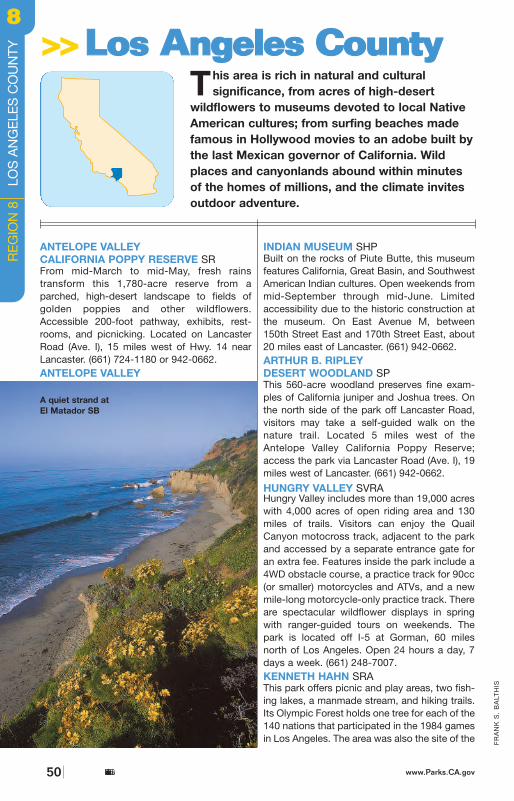
1932 Olympic Village. Located at 4100 S. LaCienega Blvd. in Baldwin Hills. (323) 298-3660.
LEO CARRILLO SPNamed for a state parks advocate and celebritydescended from Californios, this beach andcanyon park offers tidepooling, swimming,windsurfing, and hiking. Giant sycamoresshade the campground. Accessible camping,picnicking, partial pathway, beach wheelchair,and restrooms. Located 25 miles west of SantaMonica on Hwy. 1. (818) 880-0350.LOS ENCINOS SHPIn 1769, Spanish explorer Captain Gaspar dePortolá stopped at a natural spring that hadattracted Native Californians to the SanFernando Valley for centuries. De La OssaAdobe, which dates from 1849, is the center-piece of the park, as it was for the 4,460-acreRancho El Encino. Basque rancher EugeneGanier made other major improvements to the
rancho, including the construction of the two-story limestone structure in the late 1800s.Living history days occur every third Sunday ofthe month, except December. Accessible picnicking and restrooms. The park is located at16756 Moorpark St. in Encino. (818) 784-4849.
MALIBU CREEK SPThis 8,000-acre park in the Santa MonicaMountains includes land once owned by 20thCentury Fox; TV and movie productions suchas M*A*S*H and Planet of the Apes were filmedhere. The park offers hiking, equestrian, andmountain biking trails. Tapia Park, a recentaddition, is ideal for day use. There are 60developed campsites and one group site.Accessible camping, restrooms, and a visitorcenter. The entrance is at 1925 Las VirgenesRd., 4 miles south of Hwy. 101 in Calabasas.(818) 880-0367.MALIBU LAGOON SB& ADAMSON HOUSEMuseum exhibits cover the Native Americanperiod through the mid-20th century, whenRancho Malibu was a 22-mile-long privatecoastal domain of 17,000 acres. The 1930Adamson House is known for its famous Malibutile and custom-built features. House tours areavailable Wednesday through Saturday 11 a.m.to 2 p.m. Call (310) 456-8432. On the west sideof Malibu Creek Bridge, enjoy nature trails, bird-watching, tide pools, surfing, and picnicking.
SB
Verdugo Mts.*
California State Parkswww.Parks.CA.gov 51
Antelope Valley California Poppy Reserve SR
RIC
HA
RD
CU
MM
INS
FR
AN
K S
. B
ALT
HIS
ANTELOPE VALLEY CALIFORNIA POPPY RESERVE SRFrom mid-March to mid-May, fresh rains transform this 1,780-acre reserve from aparched, high-desert landscape to fields ofgolden poppies and other wildflowers.Accessible 200-foot pathway, exhibits, rest-rooms, and picnicking. Located on LancasterRoad (Ave. I), 15 miles west of Hwy. 14 nearLancaster. (661) 724-1180 or 942-0662.ANTELOPE VALLEY
INDIAN MUSEUM SHPBuilt on the rocks of Piute Butte, this museumfeatures California, Great Basin, and SouthwestAmerican Indian cultures. Open weekends frommid-September through mid-June. Limitedaccessibility due to the historic construction atthe museum. On East Avenue M, between150th Street East and 170th Street East, about20 miles east of Lancaster. (661) 942-0662.ARTHUR B. RIPLEY DESERT WOODLAND SPThis 560-acre woodland preserves fine exam-ples of California juniper and Joshua trees. Onthe north side of the park off Lancaster Road,visitors may take a self-guided walk on thenature trail. Located 5 miles west of theAntelope Valley California Poppy Reserve;access the park via Lancaster Road (Ave. I), 19miles west of Lancaster. (661) 942-0662.
HUNGRY VALLEY SVRAHungry Valley includes more than 19,000 acreswith 4,000 acres of open riding area and 130miles of trails. Visitors can enjoy the QuailCanyon motocross track, adjacent to the parkand accessed by a separate entrance gate foran extra fee. Features inside the park include a4WD obstacle course, a practice track for 90cc(or smaller) motorcycles and ATVs, and a newmile-long motorcycle-only practice track. Thereare spectacular wildflower displays in springwith ranger-guided tours on weekends. Thepark is located off I-5 at Gorman, 60 milesnorth of Los Angeles. Open 24 hours a day, 7days a week. (661) 248-7007.KENNETH HAHN SRAThis park offers picnic and play areas, two fish-ing lakes, a manmade stream, and hiking trails.Its Olympic Forest holds one tree for each of the140 nations that participated in the 1984 gamesin Los Angeles. The area was also the site of the
This area is rich in natural and cultural significance, from acres of high-desert
wildflowers to museums devoted to local NativeAmerican cultures; from surfing beaches madefamous in Hollywood movies to an adobe built bythe last Mexican governor of California. Wildplaces and canyonlands abound within minutesof the homes of millions, and the climate invitesoutdoor adventure.
>>>>LLooss AAnnggeelleess CCoouunnttyy
www.Parks.CA.govCalifornia State Parks50
A quiet strand at El Matador SB
RE
GIO
N 8
L
OS
AN
GE
LES
CO
UN
TY88
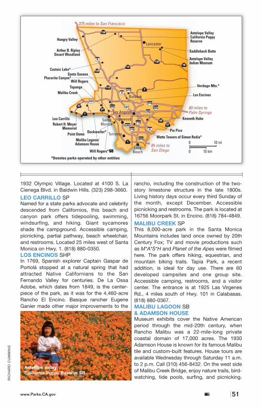
1932 Olympic Village. Located at 4100 S. LaCienega Blvd. in Baldwin Hills. (323) 298-3660.
LEO CARRILLO SPNamed for a state parks advocate and celebritydescended from Californios, this beach andcanyon park offers tidepooling, swimming,windsurfing, and hiking. Giant sycamoresshade the campground. Accessible camping,picnicking, partial pathway, beach wheelchair,and restrooms. Located 25 miles west of SantaMonica on Hwy. 1. (818) 880-0350.LOS ENCINOS SHPIn 1769, Spanish explorer Captain Gaspar dePortolá stopped at a natural spring that hadattracted Native Californians to the SanFernando Valley for centuries. De La OssaAdobe, which dates from 1849, is the center-piece of the park, as it was for the 4,460-acreRancho El Encino. Basque rancher EugeneGanier made other major improvements to the
rancho, including the construction of the two-story limestone structure in the late 1800s.Living history days occur every third Sunday ofthe month, except December. Accessible picnicking and restrooms. The park is located at16756 Moorpark St. in Encino. (818) 784-4849.
MALIBU CREEK SPThis 8,000-acre park in the Santa MonicaMountains includes land once owned by 20thCentury Fox; TV and movie productions suchas M*A*S*H and Planet of the Apes were filmedhere. The park offers hiking, equestrian, andmountain biking trails. Tapia Park, a recentaddition, is ideal for day use. There are 60developed campsites and one group site.Accessible camping, restrooms, and a visitorcenter. The entrance is at 1925 Las VirgenesRd., 4 miles south of Hwy. 101 in Calabasas.(818) 880-0367.MALIBU LAGOON SB& ADAMSON HOUSEMuseum exhibits cover the Native Americanperiod through the mid-20th century, whenRancho Malibu was a 22-mile-long privatecoastal domain of 17,000 acres. The 1930Adamson House is known for its famous Malibutile and custom-built features. House tours areavailable Wednesday through Saturday 11 a.m.to 2 p.m. Call (310) 456-8432. On the west sideof Malibu Creek Bridge, enjoy nature trails, bird-watching, tide pools, surfing, and picnicking.
SB
Verdugo Mts.*
California State Parkswww.Parks.CA.gov 51
Antelope Valley California Poppy Reserve SR
RIC
HA
RD
CU
MM
INS
FR
AN
K S
. B
ALT
HIS
ANTELOPE VALLEY CALIFORNIA POPPY RESERVE SRFrom mid-March to mid-May, fresh rains transform this 1,780-acre reserve from aparched, high-desert landscape to fields ofgolden poppies and other wildflowers.Accessible 200-foot pathway, exhibits, rest-rooms, and picnicking. Located on LancasterRoad (Ave. I), 15 miles west of Hwy. 14 nearLancaster. (661) 724-1180 or 942-0662.ANTELOPE VALLEY
INDIAN MUSEUM SHPBuilt on the rocks of Piute Butte, this museumfeatures California, Great Basin, and SouthwestAmerican Indian cultures. Open weekends frommid-September through mid-June. Limitedaccessibility due to the historic construction atthe museum. On East Avenue M, between150th Street East and 170th Street East, about20 miles east of Lancaster. (661) 942-0662.ARTHUR B. RIPLEY DESERT WOODLAND SPThis 560-acre woodland preserves fine exam-ples of California juniper and Joshua trees. Onthe north side of the park off Lancaster Road,visitors may take a self-guided walk on thenature trail. Located 5 miles west of theAntelope Valley California Poppy Reserve;access the park via Lancaster Road (Ave. I), 19miles west of Lancaster. (661) 942-0662.
HUNGRY VALLEY SVRAHungry Valley includes more than 19,000 acreswith 4,000 acres of open riding area and 130miles of trails. Visitors can enjoy the QuailCanyon motocross track, adjacent to the parkand accessed by a separate entrance gate foran extra fee. Features inside the park include a4WD obstacle course, a practice track for 90cc(or smaller) motorcycles and ATVs, and a newmile-long motorcycle-only practice track. Thereare spectacular wildflower displays in springwith ranger-guided tours on weekends. Thepark is located off I-5 at Gorman, 60 milesnorth of Los Angeles. Open 24 hours a day, 7days a week. (661) 248-7007.KENNETH HAHN SRAThis park offers picnic and play areas, two fish-ing lakes, a manmade stream, and hiking trails.Its Olympic Forest holds one tree for each of the140 nations that participated in the 1984 gamesin Los Angeles. The area was also the site of the
This area is rich in natural and cultural significance, from acres of high-desert
wildflowers to museums devoted to local NativeAmerican cultures; from surfing beaches madefamous in Hollywood movies to an adobe built bythe last Mexican governor of California. Wildplaces and canyonlands abound within minutesof the homes of millions, and the climate invitesoutdoor adventure.
>>>>LLooss AAnnggeelleess CCoouunnttyy
www.Parks.CA.govCalifornia State Parks50
A quiet strand at El Matador SB
RE
GIO
N 8
L
OS
AN
GE
LES
CO
UN
TY
88
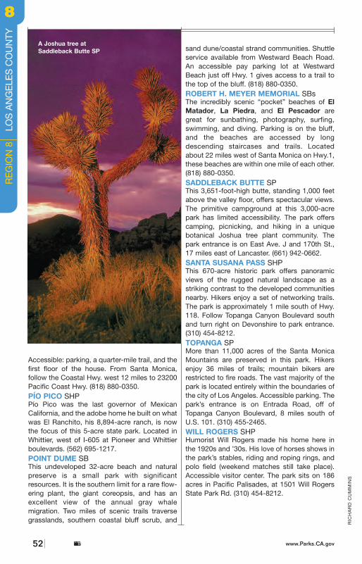
53
FR
AN
K S
. B
ALT
HIS
Antelope Valley CA Poppy Res. • • • • • •Antelope Valley Indian Mus. SHP • • • • • • • •Arthur B. Ripley Desert Wood. SP • • • •Hungry Valley SVRA • • • • • • • • • •Kenneth Hahn SRA • • • • • • • • •Leo Carrillo SP • • • • • • • • • • • • • • • •Los Encinos SHP • • • • • • • •Malibu Creek SP • • • • • • • • • • • • • • • • • • •Malibu Lagoon SB/Adamson Hse. • • • • • • • • • • • • • •Pío Pico SHP • •Point Dume SB • • • • • • • • •Robert H. Meyer Memorial SBs • • • • •Saddleback Butte SP • • • • • • • • • • • •Santa Susana Pass SHP • • • • • • • •Topanga SP • • • • • • • • • • •Will Rogers SHP • • • • • • • • • • • •
REGION 8LOS ANGELES COUNTY
For detailed current information about parks, including reservations, fees, and accessibility, visit the websitewww.Parks.CA.gov. Specific phone numbers: General park information (800) 777-0369; Campsite reservations (800) 444-7275;OHV operations (916) 324-4442. Other parks in this region may be owned by California State Parks but operated by localauthorities. SP = State Park; SHP = State Historic Park; SHM = State Historical Monument; SR = State Reserve; SRA = State Recreation Area; SB = State Beach; SVRA = State Vehicular Recreation Area; SS = State Seashore.
The lush springtime hills andcalm waters of Malibu Creek SP
California State Parkswww.Parks.CA.gov
RIC
HA
RD
CU
MM
INS
Accessible: parking, a quarter-mile trail, and thefirst floor of the house. From Santa Monica, follow the Coastal Hwy. west 12 miles to 23200Pacific Coast Hwy. (818) 880-0350.PÍO PICO SHPPío Pico was the last governor of MexicanCalifornia, and the adobe home he built on whatwas El Ranchito, his 8,894-acre ranch, is nowthe focus of this 5-acre state park. Located inWhittier, west of I-605 at Pioneer and Whittierboulevards. (562) 695-1217.POINT DUME SBThis undeveloped 32-acre beach and naturalpreserve is a small park with significantresources. It is the southern limit for a rare flow-ering plant, the giant coreopsis, and has anexcellent view of the annual gray whale migration. Two miles of scenic trails traversegrasslands, southern coastal bluff scrub, and
sand dune/coastal strand communities. Shuttleservice available from Westward Beach Road.An accessible pay parking lot at WestwardBeach just off Hwy. 1 gives access to a trail tothe top of the bluff. (818) 880-0350.ROBERT H. MEYER MEMORIAL SBsThe incredibly scenic “pocket” beaches of ElMatador, La Piedra, and El Pescador aregreat for sunbathing, photography, surfing,swimming, and diving. Parking is on the bluff,and the beaches are accessed by longdescending staircases and trails. Locatedabout 22 miles west of Santa Monica on Hwy.1,these beaches are within one mile of each other.(818) 880-0350.SADDLEBACK BUTTE SPThis 3,651-foot-high butte, standing 1,000 feetabove the valley floor, offers spectacular views.The primitive campground at this 3,000-acrepark has limited accessibility. The park offerscamping, picnicking, and hiking in a uniquebotanical Joshua tree plant community. Thepark entrance is on East Ave. J and 170th St.,17 miles east of Lancaster. (661) 942-0662.SANTA SUSANA PASS SHPThis 670-acre historic park offers panoramicviews of the rugged natural landscape as astriking contrast to the developed communitiesnearby. Hikers enjoy a set of networking trails.The park is approximately 1 mile south of Hwy.118. Follow Topanga Canyon Boulevard southand turn right on Devonshire to park entrance.(310) 454-8212.TOPANGA SPMore than 11,000 acres of the Santa MonicaMountains are preserved in this park. Hikersenjoy 36 miles of trails; mountain bikers arerestricted to fire roads. The vast majority of thepark is located entirely within the boundaries ofthe city of Los Angeles. Accessible parking. Thepark’s entrance is on Entrada Road, off ofTopanga Canyon Boulevard, 8 miles south ofU.S. 101. (310) 455-2465.WILL ROGERS SHPHumorist Will Rogers made his home here inthe 1920s and ’30s. His love of horses shows inthe park’s stables, riding and roping rings, andpolo field (weekend matches still take place).Accessible visitor center. The park sits on 186acres in Pacific Palisades, at 1501 Will RogersState Park Rd. (310) 454-8212.
www.Parks.CA.govCalifornia State Parks52
RE
GIO
N 8
L
OS
AN
GE
LES
CO
UN
TY88
A Joshua tree atSaddleback Butte SP
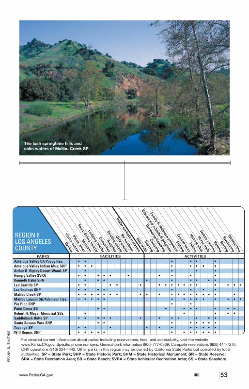
53
FR
AN
K S
. B
ALT
HIS
Antelope Valley CA Poppy Res. • • • • • •Antelope Valley Indian Mus. SHP • • • • • • • •Arthur B. Ripley Desert Wood. SP • • • •Hungry Valley SVRA • • • • • • • • • •Kenneth Hahn SRA • • • • • • • • •Leo Carrillo SP • • • • • • • • • • • • • • • •Los Encinos SHP • • • • • • • •Malibu Creek SP • • • • • • • • • • • • • • • • • • •Malibu Lagoon SB/Adamson Hse. • • • • • • • • • • • • • •Pío Pico SHP • •Point Dume SB • • • • • • • • •Robert H. Meyer Memorial SBs • • • • •Saddleback Butte SP • • • • • • • • • • • •Santa Susana Pass SHP • • • • • • • •Topanga SP • • • • • • • • • • •Will Rogers SHP • • • • • • • • • • • •
REGION 8LOS ANGELES COUNTY
For detailed current information about parks, including reservations, fees, and accessibility, visit the websitewww.Parks.CA.gov. Specific phone numbers: General park information (800) 777-0369; Campsite reservations (800) 444-7275;OHV operations (916) 324-4442. Other parks in this region may be owned by California State Parks but operated by localauthorities. SP = State Park; SHP = State Historic Park; SHM = State Historical Monument; SR = State Reserve; SRA = State Recreation Area; SB = State Beach; SVRA = State Vehicular Recreation Area; SS = State Seashore.
The lush springtime hills andcalm waters of Malibu Creek SP
California State Parkswww.Parks.CA.gov
RIC
HA
RD
CU
MM
INS
Accessible: parking, a quarter-mile trail, and thefirst floor of the house. From Santa Monica, follow the Coastal Hwy. west 12 miles to 23200Pacific Coast Hwy. (818) 880-0350.PÍO PICO SHPPío Pico was the last governor of MexicanCalifornia, and the adobe home he built on whatwas El Ranchito, his 8,894-acre ranch, is nowthe focus of this 5-acre state park. Located inWhittier, west of I-605 at Pioneer and Whittierboulevards. (562) 695-1217.POINT DUME SBThis undeveloped 32-acre beach and naturalpreserve is a small park with significantresources. It is the southern limit for a rare flow-ering plant, the giant coreopsis, and has anexcellent view of the annual gray whale migration. Two miles of scenic trails traversegrasslands, southern coastal bluff scrub, and
sand dune/coastal strand communities. Shuttleservice available from Westward Beach Road.An accessible pay parking lot at WestwardBeach just off Hwy. 1 gives access to a trail tothe top of the bluff. (818) 880-0350.ROBERT H. MEYER MEMORIAL SBsThe incredibly scenic “pocket” beaches of ElMatador, La Piedra, and El Pescador aregreat for sunbathing, photography, surfing,swimming, and diving. Parking is on the bluff,and the beaches are accessed by longdescending staircases and trails. Locatedabout 22 miles west of Santa Monica on Hwy.1,these beaches are within one mile of each other.(818) 880-0350.SADDLEBACK BUTTE SPThis 3,651-foot-high butte, standing 1,000 feetabove the valley floor, offers spectacular views.The primitive campground at this 3,000-acrepark has limited accessibility. The park offerscamping, picnicking, and hiking in a uniquebotanical Joshua tree plant community. Thepark entrance is on East Ave. J and 170th St.,17 miles east of Lancaster. (661) 942-0662.SANTA SUSANA PASS SHPThis 670-acre historic park offers panoramicviews of the rugged natural landscape as astriking contrast to the developed communitiesnearby. Hikers enjoy a set of networking trails.The park is approximately 1 mile south of Hwy.118. Follow Topanga Canyon Boulevard southand turn right on Devonshire to park entrance.(310) 454-8212.TOPANGA SPMore than 11,000 acres of the Santa MonicaMountains are preserved in this park. Hikersenjoy 36 miles of trails; mountain bikers arerestricted to fire roads. The vast majority of thepark is located entirely within the boundaries ofthe city of Los Angeles. Accessible parking. Thepark’s entrance is on Entrada Road, off ofTopanga Canyon Boulevard, 8 miles south ofU.S. 101. (310) 455-2465.WILL ROGERS SHPHumorist Will Rogers made his home here inthe 1920s and ’30s. His love of horses shows inthe park’s stables, riding and roping rings, andpolo field (weekend matches still take place).Accessible visitor center. The park sits on 186acres in Pacific Palisades, at 1501 Will RogersState Park Rd. (310) 454-8212.
www.Parks.CA.govCalifornia State Parks52
RE
GIO
N 8
L
OS
AN
GE
LES
CO
UN
TY
88
A Joshua tree atSaddleback Butte SP
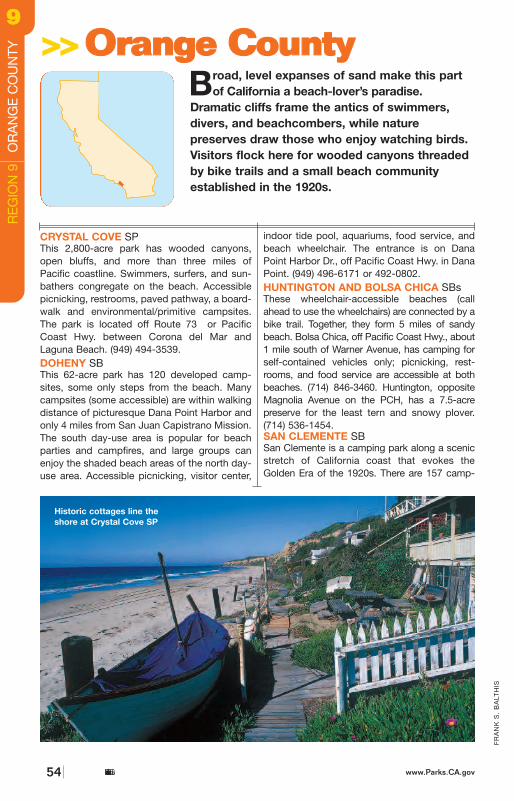
55
FR
AN
K S
. B
ALT
HIS
sites, of which 72 offer RV hookups. Trails lead toa mile of beach that is popular with surfers, bodysurfers, and swimmers. Accessible camping,restrooms, picnicking, trail, and exhibits. Callahead to use the beach wheelchair. Entrance viathe Avenida Calafia exit off I-5 near the south endof San Clemente. (949) 492-3156.
Bolsa Chica SB • • • • • • • • • • • • • • • •Crystal Cove SP • • • • • • • • • • • • • • • • • • •Doheny SB • • • • • • • • • • • • • • • • • •Huntington SB • • • • • • • • • • • •San Clemente SB • • • • • • • • • • • • • • •
REGION 9ORANGE COUNTY
For detailed current information about parks, including reservations, fees, and accessibility, visit the websitewww.Parks.CA.gov. Specific phone numbers: General park information (800) 777-0369; Campsite reservations (800) 444-7275;OHV operations (916) 324-4442. Other parks in this region may be owned by California State Parks but operated by localauthorities. SP = State Park; SHP = State Historic Park; SHM = State Historical Monument; SR = State Reserve; SRA = State Recreation Area; SB = State Beach; SVRA = State Vehicular Recreation Area; SS = State Seashore.
California State Parkswww.Parks.CA.gov
Another sunny day at Doheny SB
>>>>OOrraannggee CCoouunnttyyBroad, level expanses of sand make this part
of California a beach-lover’s paradise.Dramatic cliffs frame the antics of swimmers,divers, and beachcombers, while nature preserves draw those who enjoy watching birds.Visitors flock here for wooded canyons threadedby bike trails and a small beach communityestablished in the 1920s.
www.Parks.CA.govCalifornia State Parks54
Historic cottages line theshore at Crystal Cove SP
FR
AN
K S
. B
ALT
HIS
RE
GIO
N 9
O
RA
NG
E C
OU
NTY
99
CRYSTAL COVE SPThis 2,800-acre park has wooded canyons,open bluffs, and more than three miles ofPacific coastline. Swimmers, surfers, and sun-bathers congregate on the beach. Accessiblepicnicking, restrooms, paved pathway, a board-walk and environmental/primitive campsites.The park is located off Route 73 or PacificCoast Hwy. between Corona del Mar andLaguna Beach. (949) 494-3539.DOHENY SBThis 62-acre park has 120 developed camp-sites, some only steps from the beach. Manycampsites (some accessible) are within walkingdistance of picturesque Dana Point Harbor andonly 4 miles from San Juan Capistrano Mission.The south day-use area is popular for beachparties and campfires, and large groups canenjoy the shaded beach areas of the north day-use area. Accessible picnicking, visitor center,
indoor tide pool, aquariums, food service, andbeach wheelchair. The entrance is on DanaPoint Harbor Dr., off Pacific Coast Hwy. in DanaPoint. (949) 496-6171 or 492-0802.HUNTINGTON AND BOLSA CHICA SBsThese wheelchair-accessible beaches (call ahead to use the wheelchairs) are connected by abike trail. Together, they form 5 miles of sandybeach. Bolsa Chica, off Pacific Coast Hwy., about1 mile south of Warner Avenue, has camping for self-contained vehicles only; picnicking, rest-rooms, and food service are accessible at bothbeaches. (714) 846-3460. Huntington, oppositeMagnolia Avenue on the PCH, has a 7.5-acre preserve for the least tern and snowy plover. (714) 536-1454.SAN CLEMENTE SBSan Clemente is a camping park along a scenicstretch of California coast that evokes theGolden Era of the 1920s. There are 157 camp-
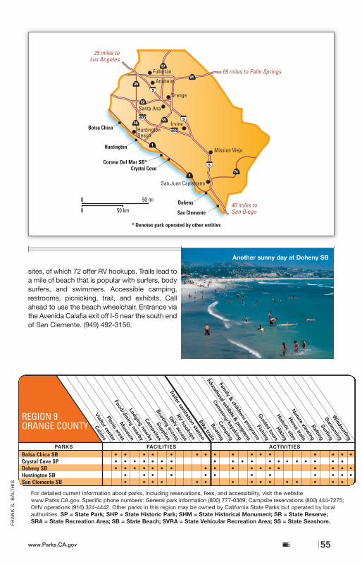
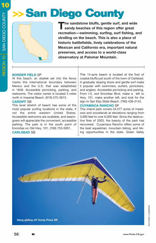
Campground has a creek running through it,and Paso Picacho Campground is only 2 milesfrom Lake Cuyamaca. The park is located onHwy. 79, approximately 50 miles east of SanDiego. (760) 765-0755.OLD TOWN SAN DIEGO SHPThis park is located on the site of San Diego’sfirst Pueblo settlement and features restoredand reconstructed buildings with accessiblemuseums, exhibits, shops, and restaurantsdepicting the lifestyle of the early Californians.Restrooms and parking are accessible. Park atTaylor and Pacific Hwy., and walk through thetunnel to the park. (619) 220-5422.PALOMAR MOUNTAIN SPThis 1,897-acre park has spectacular views ofthe Pacific Ocean from its forested vantagepoint. Visitors can enjoy picnicking, hiking, andfishing here as well as accessible camping,restrooms, parking, and a campfire center.Located off Hwy. 76, up Hwy. S6, then left onHwy. S7 State Park Road at the junction nearthe peak. (760) 742-3462.SAN ELIJO SBSan Elijo offers a prime camping location, withsurfing breaks and beaches for tidepool play.Accessible camping and restrooms. The park is
on Old Hwy. 101 in Encinitas. (760) 753-5091.SAN ONOFRE SBSan Onofre is a 3,000-acre park with two camp-grounds, The Bluffs and San Mateo. The Bluffscampground is located on Basilone Road andhas 173 developed, non-hookup campsites. It
California State Parkswww.Parks.CA.gov 57
RIC
HA
RD
CU
MM
INS
Cinco de Mayo at OldTown San Diego SHP
BORDER FIELD SPAt this beach, an obelisk set into the fence marks the international boundary betweenMexico and the U.S. that was established in 1848. Accessible picnicking, parking, and restrooms. The visitor center is located 3 milesnorth in Imperial Beach. (619) 575-3613.CARDIFF SBThis level stretch of beach has some of themost popular surfing locations in the state, ifnot the entire western United States.Accessible restrooms are available, and beach-goers will appreciate the convenient, accessibleparking. The park is in the south point ofEncinitas on Old Hwy. 101. (760) 753-5091.CARLSBAD SB
This 14-acre beach is located at the foot ofcoastal bluffs just south of the town of Carlsbad.A gradually sloping shore and gentle surf makeit popular with swimmers, surfers, picnickers,and anglers. Accessible picnicking and parking.From I-5, exit Encinitas Blvd, make a left toHwy. 101, make another left, and look for thesign to San Elijo State Beach. (760) 438-3143.CUYAMACA RANCHO SPThis inland park covers 24,577 acres of mead-ows and woodlands at elevations ranging from3,000 feet to over 6,000 feet. Since the destruc-tive fires of 2003, the beauty of the park hasrecovered. Cuyamaca Rancho offers some ofthe best equestrian, mountain biking, and hik-ing opportunities in the state. Green Valley
RIC
HA
RD
CU
MM
INS
>>>>SSaann DDiieeggoo CCoouunnttyyThe sandstone bluffs, gentle surf, and wide
sandy beaches of this region offer great recreation—swimming, surfing, surf fishing, andstrolling on the beach. This is also a place of historic battlefields, lively celebrations of theMexican and Californio era, important naturalpreserves, and access to a world-class observatory at Palomar Mountain.
Hang gliding off Torrey Pines SR
www.Parks.CA.govCalifornia State Parks56
RE
GIO
N 1
0
SA
N D
IEG
O C
OU
NTY
1100
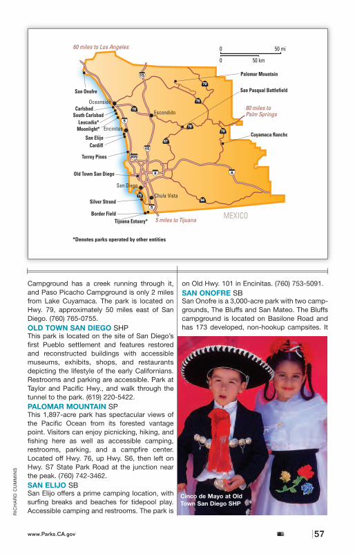
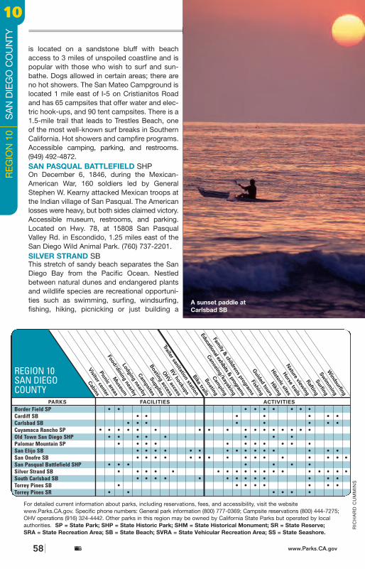
California State Parkswww.Parks.CA.gov 59
RIC
HA
RD
CU
MM
INS
(2
)
simple sandcastle. There are stretches of openbeach, nature trails, an overnight campground for recreational vehicles (self-containedmotorhome or trailer only), and a new AquaticsCenter specializing in instructional classes for
select water sports. (619) 435-5184. SOUTH CARLSBAD SBStaircases lead down to the beach at this 110-acre park located just south of Carlsbad.Visitors can swim, fish, picnic, skin-dive, andsurf. Its 226 developed, bluff-top campsites(some accessible) are a favorite. Accessible200-foot paved path to the beach and rest-rooms. From I-5, take the Palomar Airport Roadexit west to Carlsbad Boulevard. (Hwy. 521),then go south to the park. (760) 438-3143.TORREY PINES SR & SBThese adjacent park units cover over 1,700acres of beach, marsh, and coastal bluffs.Hiking trails take in the picturesque pine trees(which grow only here and on Santa RosaIsland, off Santa Barbara), eroded bluffs, and agloriously undeveloped set of sandy beaches.Accessible parking, restrooms, and visitor cen-ter (at reserve). Reserve entrance on NorthTorrey Pines Road (Hwy. S21) as it parallels I-5,south of Del Mar. (858) 755-2063.
California State Parkswww.Parks.CA.gov 59
The end of the day atTorrey Pines SB
A Cinco de Mayo mock battle,Old Town San Diego SHP
is located on a sandstone bluff with beachaccess to 3 miles of unspoiled coastline and ispopular with those who wish to surf and sun-bathe. Dogs allowed in certain areas; there areno hot showers. The San Mateo Campground islocated 1 mile east of I-5 on Cristianitos Roadand has 65 campsites that offer water and elec-tric hook-ups, and 90 tent campsites. There is a1.5-mile trail that leads to Trestles Beach, oneof the most well-known surf breaks in SouthernCalifornia. Hot showers and campfire programs.Accessible camping, parking, and restrooms.(949) 492-4872.SAN PASQUAL BATTLEFIELD SHPOn December 6, 1846, during the Mexican-American War, 160 soldiers led by GeneralStephen W. Kearny attacked Mexican troops atthe Indian village of San Pasqual. The Americanlosses were heavy, but both sides claimed victory.Accessible museum, restrooms, and parking.Located on Hwy. 78, at 15808 San PasqualValley Rd. in Escondido, 1.25 miles east of theSan Diego Wild Animal Park. (760) 737-2201. SILVER STRAND SBThis stretch of sandy beach separates the SanDiego Bay from the Pacific Ocean. Nestledbetween natural dunes and endangered plantsand wildlife species are recreational opportuni-ties such as swimming, surfing, windsurfing,fishing, hiking, picnicking or just building a
Border Field SP • • • • • • • • •Cardiff SB • • • • • • •Carlsbad SB • • • • • • • •Cuyamaca Rancho SP • • • • • • • • • • • • • • • • Old Town San Diego SHP • • • • • • • •Palomar Mountain SP • • • • • • • • • • •San Elijo SB • • • • • • • • • • • • • • •San Onofre SB • • • • • • • • • • • • • • • •San Pasqual Battlefield SHP • • • • • • •Silver Strand SB • • • • • • • • • • • • • • • • • •South Carlsbad SB • • • • • • • • • • • • •Torrey Pines SB • • • • • • • •Torrey Pines SR • • • • • •
REGION 10SAN DIEGOCOUNTY
For detailed current information about parks, including reservations, fees, and accessibility, visit the websitewww.Parks.CA.gov. Specific phone numbers: General park information (800) 777-0369; Campsite reservations (800) 444-7275;OHV operations (916) 324-4442. Other parks in this region may be owned by California State Parks but operated by localauthorities. SP = State Park; SHP = State Historic Park; SHM = State Historical Monument; SR = State Reserve; SRA = State Recreation Area; SB = State Beach; SVRA = State Vehicular Recreation Area; SS = State Seashore.
www.Parks.CA.govCalifornia State Parks58
RIC
HA
RD
CU
MM
INS
RE
GIO
N 1
0
SA
N D
IEG
O C
OU
NTY
1100
A sunset paddle atCarlsbad SB
•
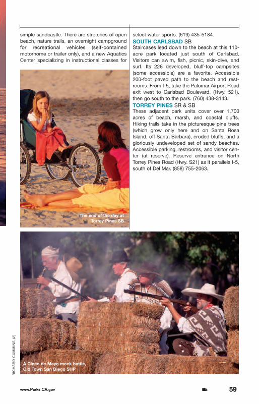
California State Parkswww.Parks.CA.gov 59
RIC
HA
RD
CU
MM
INS
(2
)
simple sandcastle. There are stretches of openbeach, nature trails, an overnight campground for recreational vehicles (self-containedmotorhome or trailer only), and a new AquaticsCenter specializing in instructional classes for
select water sports. (619) 435-5184. SOUTH CARLSBAD SBStaircases lead down to the beach at this 110-acre park located just south of Carlsbad.Visitors can swim, fish, picnic, skin-dive, andsurf. Its 226 developed, bluff-top campsites(some accessible) are a favorite. Accessible200-foot paved path to the beach and rest-rooms. From I-5, take the Palomar Airport Roadexit west to Carlsbad Boulevard. (Hwy. 521),then go south to the park. (760) 438-3143.TORREY PINES SR & SBThese adjacent park units cover over 1,700acres of beach, marsh, and coastal bluffs.Hiking trails take in the picturesque pine trees(which grow only here and on Santa RosaIsland, off Santa Barbara), eroded bluffs, and agloriously undeveloped set of sandy beaches.Accessible parking, restrooms, and visitor cen-ter (at reserve). Reserve entrance on NorthTorrey Pines Road (Hwy. S21) as it parallels I-5,south of Del Mar. (858) 755-2063.
California State Parkswww.Parks.CA.gov 59
The end of the day atTorrey Pines SB
A Cinco de Mayo mock battle,Old Town San Diego SHP
is located on a sandstone bluff with beachaccess to 3 miles of unspoiled coastline and ispopular with those who wish to surf and sun-bathe. Dogs allowed in certain areas; there areno hot showers. The San Mateo Campground islocated 1 mile east of I-5 on Cristianitos Roadand has 65 campsites that offer water and elec-tric hook-ups, and 90 tent campsites. There is a1.5-mile trail that leads to Trestles Beach, oneof the most well-known surf breaks in SouthernCalifornia. Hot showers and campfire programs.Accessible camping, parking, and restrooms.(949) 492-4872.SAN PASQUAL BATTLEFIELD SHPOn December 6, 1846, during the Mexican-American War, 160 soldiers led by GeneralStephen W. Kearny attacked Mexican troops atthe Indian village of San Pasqual. The Americanlosses were heavy, but both sides claimed victory.Accessible museum, restrooms, and parking.Located on Hwy. 78, at 15808 San PasqualValley Rd. in Escondido, 1.25 miles east of theSan Diego Wild Animal Park. (760) 737-2201. SILVER STRAND SBThis stretch of sandy beach separates the SanDiego Bay from the Pacific Ocean. Nestledbetween natural dunes and endangered plantsand wildlife species are recreational opportuni-ties such as swimming, surfing, windsurfing,fishing, hiking, picnicking or just building a
Border Field SP • • • • • • • • •Cardiff SB • • • • • • •Carlsbad SB • • • • • • • •Cuyamaca Rancho SP • • • • • • • • • • • • • • • • Old Town San Diego SHP • • • • • • • •Palomar Mountain SP • • • • • • • • • • •San Elijo SB • • • • • • • • • • • • • • •San Onofre SB • • • • • • • • • • • • • • • •San Pasqual Battlefield SHP • • • • • • •Silver Strand SB • • • • • • • • • • • • • • • • • •South Carlsbad SB • • • • • • • • • • • • •Torrey Pines SB • • • • • • • •Torrey Pines SR • • • • • •
REGION 10SAN DIEGOCOUNTY
For detailed current information about parks, including reservations, fees, and accessibility, visit the websitewww.Parks.CA.gov. Specific phone numbers: General park information (800) 777-0369; Campsite reservations (800) 444-7275;OHV operations (916) 324-4442. Other parks in this region may be owned by California State Parks but operated by localauthorities. SP = State Park; SHP = State Historic Park; SHM = State Historical Monument; SR = State Reserve; SRA = State Recreation Area; SB = State Beach; SVRA = State Vehicular Recreation Area; SS = State Seashore.
www.Parks.CA.govCalifornia State Parks58
RIC
HA
RD
CU
MM
INS
RE
GIO
N 1
0
SA
N D
IEG
O C
OU
NTY
1100
A sunset paddle atCarlsbad SB
•
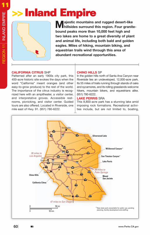
www.Parks.CA.gov 61
RIC
HA
RD
CU
MM
INS
camping, fishing, swimming, hiking, rock-climb-ing, and picnicking. In addition, Lake Perrisoffers a variety of interpretive programs fromMay through September and hosts the “Lightson the Lake” Christmas boat parade inDecember. Visitors can enjoy 167 tent camp-sites and 265 paved sites with RV hookups.Located 11 miles east of Riverside via Hwy. 60,or I-215. (951) 657-0676.MOUNT SAN JACINTO SP Hikers and backpackers may roam this vastand rugged 13,700-acre park, which boasts 4mountain peaks above 10,000 feet. Wildlifeabounds, including lizards, birds, deer, and coy-otes. There are 32 developed campsites in theIdyllwild Campground, with hot showers andflush toilets. Stone Creek Campground has 50developed sites, vault toilets, and fresh drinkingwater. All sites have picnic tables and fire rings.In this state wilderness, the 48 campsites in 4primitive camping areas are not reachable bycar. Wilderness permits are required for day hikers, and camping permits are required forbackpackers. The park can be reached from themountains via Hwy. 243 or from the desert sidevia the Palm Springs Aerial Tramway (fee),which takes visitors to the Mountain Station at8,500 feet. (909) 659-2607 or (760) 327-0222.SILVERWOOD LAKE SRAFire damage has been significant to the highest reservoir in the California State Water Project,which nonetheless offers boating, water skiing,fishing, and swimming; the surrounding park hashiking and biking trails. Numerous picnic areasand a visitor center are available. There are 136
sites in the developed campground, with acces-sible showers and restrooms. Bald eagles winterin the park, giving visitors the rare opportunity tosee this national symbol in its natural environ-ment. Guided eagle tours are offered (reserva-tions are recommended). Other animal sightingsmay include coyotes, black bears, bobcats, anddeer. Call the park for more information. (760) 389-2303 or (760) 389-2281.
California Citrus SHP • • • • • • • • • •Chino Hills SP • • • • • • • • • • • • •Lake Perris SRA • • • • • • • • • • • • • • • • • • • • • •Mount San Jacinto SP • • • • • • • • • • • • • • •Silverwood Lake SRA • • • • • • • • • • • • • • • • • • • •
REGION 11INLAND EMPIRE
For detailed current information about parks, including reservations, fees, and accessibility, visit the website www.Parks.CA.gov. Specific phone numbers: General park information (800) 777-0369; Campsite reservations (800) 444-7275; OHV operations (916)324-4442. Other parks in this region may be owned by California State Parks but operated by local authorities. SP = StatePark; SHP = State Historic Park; SHM = State Historical Monument; SR = State Reserve; SRA = State Recreation Area;SB = State Beach; SVRA = State Vehicular Recreation Area; SS = State Seashore.
California State Parks
Tahoe? No—it’sLake Perris SRA
CALIFORNIA CITRUS SHPPatterned after an early 1900s city park, this400-acre historic site evokes the days when theword “California” meant oranges (and othereasy-to-grow produce) to the rest of the world.The importance of the citrus industry is recog-nized here with an ampitheater, a visitor center,and interpretative groves. Accessible rest-rooms, picnicking, and visitor center. Guidedtours are also offered. Located in Riverside, onemile east of Hwy. 91. (951) 780-6222.
CHINO HILLS SPIn the golden hills north of Santa Ana Canyon nearRiverside lies an undeveloped, 12,000-acre park.Its 55 miles of trails running through stands of oaksand sycamores, and its rolling grasslands welcomehikers, mountain bikers, and equestrians alike.(951) 780-6222.LAKE PERRIS SRAThis 8,800-acre park has a stunning lake amidimposing rock formations. Recreational activi-ties include, but are not limited to, boating,
Majestic mountains and rugged desert-likehillsides surround this region. Four granite-
bound peaks more than 10,000 feet high and two lakes are home to a great diversity of plant and animal life, including both bald and goldeneagles. Miles of hiking, mountain biking, andequestrian trails wind through this area of abundant recreational opportunities.
>>>>IInnllaanndd EEmmppiirree
www.Parks.CA.govCalifornia State Parks60
RE
GIO
N 1
1 I
NLA
ND
EM
PIR
E1111
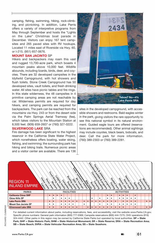
www.Parks.CA.gov 61
RIC
HA
RD
CU
MM
INS
camping, fishing, swimming, hiking, rock-climb-ing, and picnicking. In addition, Lake Perrisoffers a variety of interpretive programs fromMay through September and hosts the “Lightson the Lake” Christmas boat parade inDecember. Visitors can enjoy 167 tent camp-sites and 265 paved sites with RV hookups.Located 11 miles east of Riverside via Hwy. 60,or I-215. (951) 657-0676.MOUNT SAN JACINTO SP Hikers and backpackers may roam this vastand rugged 13,700-acre park, which boasts 4mountain peaks above 10,000 feet. Wildlifeabounds, including lizards, birds, deer, and coy-otes. There are 32 developed campsites in theIdyllwild Campground, with hot showers andflush toilets. Stone Creek Campground has 50developed sites, vault toilets, and fresh drinkingwater. All sites have picnic tables and fire rings.In this state wilderness, the 48 campsites in 4primitive camping areas are not reachable bycar. Wilderness permits are required for day hikers, and camping permits are required forbackpackers. The park can be reached from themountains via Hwy. 243 or from the desert sidevia the Palm Springs Aerial Tramway (fee),which takes visitors to the Mountain Station at8,500 feet. (909) 659-2607 or (760) 327-0222.SILVERWOOD LAKE SRAFire damage has been significant to the highest reservoir in the California State Water Project,which nonetheless offers boating, water skiing,fishing, and swimming; the surrounding park hashiking and biking trails. Numerous picnic areasand a visitor center are available. There are 136
sites in the developed campground, with acces-sible showers and restrooms. Bald eagles winterin the park, giving visitors the rare opportunity tosee this national symbol in its natural environ-ment. Guided eagle tours are offered (reserva-tions are recommended). Other animal sightingsmay include coyotes, black bears, bobcats, anddeer. Call the park for more information. (760) 389-2303 or (760) 389-2281.
California Citrus SHP • • • • • • • • • •Chino Hills SP • • • • • • • • • • • • •Lake Perris SRA • • • • • • • • • • • • • • • • • • • • • •Mount San Jacinto SP • • • • • • • • • • • • • • •Silverwood Lake SRA • • • • • • • • • • • • • • • • • • • •
REGION 11INLAND EMPIRE
For detailed current information about parks, including reservations, fees, and accessibility, visit the website www.Parks.CA.gov. Specific phone numbers: General park information (800) 777-0369; Campsite reservations (800) 444-7275; OHV operations (916)324-4442. Other parks in this region may be owned by California State Parks but operated by local authorities. SP = StatePark; SHP = State Historic Park; SHM = State Historical Monument; SR = State Reserve; SRA = State Recreation Area;SB = State Beach; SVRA = State Vehicular Recreation Area; SS = State Seashore.
California State Parks
Tahoe? No—it’sLake Perris SRA
CALIFORNIA CITRUS SHPPatterned after an early 1900s city park, this400-acre historic site evokes the days when theword “California” meant oranges (and othereasy-to-grow produce) to the rest of the world.The importance of the citrus industry is recog-nized here with an ampitheater, a visitor center,and interpretative groves. Accessible rest-rooms, picnicking, and visitor center. Guidedtours are also offered. Located in Riverside, onemile east of Hwy. 91. (951) 780-6222.
CHINO HILLS SPIn the golden hills north of Santa Ana Canyon nearRiverside lies an undeveloped, 12,000-acre park.Its 55 miles of trails running through stands of oaksand sycamores, and its rolling grasslands welcomehikers, mountain bikers, and equestrians alike.(951) 780-6222.LAKE PERRIS SRAThis 8,800-acre park has a stunning lake amidimposing rock formations. Recreational activi-ties include, but are not limited to, boating,
Majestic mountains and rugged desert-likehillsides surround this region. Four granite-
bound peaks more than 10,000 feet high and two lakes are home to a great diversity of plant and animal life, including both bald and goldeneagles. Miles of hiking, mountain biking, andequestrian trails wind through this area of abundant recreational opportunities.
>>>>IInnllaanndd EEmmppiirree
www.Parks.CA.govCalifornia State Parks60
RE
GIO
N 1
1 I
NLA
ND
EM
PIR
E
1111
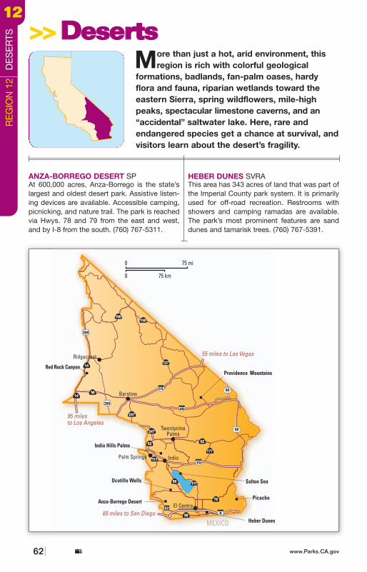
63
RIC
HA
RD
CU
MM
INS
INDIO HILLS PALMS SPThe harsh, beautiful life of the desert is on displayhere; a concessionaire offers lively coveredwagon tours of oases. (760) 393-3059.OCOTILLO WELLS SVRAMore than 82,000 acres of desert are availablefor off-highway exploration and recreation.Located in east San Diego County and westImperial County, Ocotillo Wells is accessible viaHwy. 86. Ocotillo Wells is open to the public 24hours a day, 7 days a week. (760) 767-5391.PICACHO SRAThis park lies near the remains of a formerColorado River gold-mining town. There’s boating, hiking, fishing, and primitive campingas well as accessible camping. Take the 6-milepaved road, followed by 18 miles of unpavedroad north from Winterhaven. (760) 393-3052.PROVIDENCE MOUNTAINS SRAMitchell Caverns are the draw at this 5,500-acrepark. Cavern tours take place daily (on week-ends only during summer months). Activitiesinclude accessible camping, picnicking, andhiking. Located 100 miles east of Barstow, 17miles from I-40 on Essex Road. (760) 928-2586.RED ROCK CANYON SPThe colorful rock formations of this 27,000-acrepark were a landmark for 19th-century stage-coaches. Many major movies and televisionshows have been filmed here. There are 50primitive campsites, 2 are accessible to the dis-abled. Pit toilets, running water, tables and firerings are provided. An accessible visitor center
is located in the campground area. The park islocated 25 miles northeast of Mojave on Hwy.14. (661) 942-0662.SALTON SEA SRAAn accidental break in a hastily constructeddike supplying Colorado River water to theImperial Valley created one of the world’slargest inland seas here. There are 150 devel-oped campsites (some accessible), and 3 prim-itive campgrounds, plus fishing, boating, andwaterskiing. Accessible picnicking and visitorcenter. The visitor center is 25 miles southeastof Indio via Hwy. 111. (760) 393-3052.
Anza-Borrego Desert SP • • • • • • • • • • • • • • •Heber Dunes SVRA • • • •Indio Hills Palms SP • •Ocotillo Wells SVRA • • • • •Picacho SRA • • • • • • • • • • • • • • • •Providence Mountains SRA • • • • • • • • • • • •Red Rock Canyon SP • • • • • • • • • • •Salton Sea SRA • • • • • • • • • • • • • • • •
REGION 12DESERTS
For detailed current information about parks, including reservations, fees, and accessibility, visit the websitewww.Parks.CA.gov. Specific phone numbers: General park information (800) 777-0369; Campsite reservations (800) 444-7275;OHV operations (916) 324-4442. Other parks in this region may be owned by California State Parks but operated by localauthorities. SP = State Park; SHP = State Historic Park; SHM = State Historical Monument; SR = State Reserve; SRA = State Recreation Area; SB = State Beach; SVRA = State Vehicular Recreation Area; SS = State Seashore.
California State Parkswww.Parks.CA.gov
Wildflower season at Anza-Borrego Desert SP
ANZA-BORREGO DESERT SPAt 600,000 acres, Anza-Borrego is the state’slargest and oldest desert park. Assistive listen-ing devices are available. Accessible camping,picnicking, and nature trail. The park is reachedvia Hwys. 78 and 79 from the east and west,and by I-8 from the south. (760) 767-5311.
HEBER DUNES SVRAThis area has 343 acres of land that was part ofthe Imperial County park system. It is primarilyused for off-road recreation. Restrooms withshowers and camping ramadas are available.The park’s most prominent features are sanddunes and tamarisk trees. (760) 767-5391.
More than just a hot, arid environment, thisregion is rich with colorful geological
formations, badlands, fan-palm oases, hardyflora and fauna, riparian wetlands toward theeastern Sierra, spring wildflowers, mile-highpeaks, spectacular limestone caverns, and an“accidental” saltwater lake. Here, rare andendangered species get a chance at survival, andvisitors learn about the desert’s fragility.
>>>>DDeesseerrttss
www.Parks.CA.govCalifornia State Parks62
RE
GIO
N 1
2 D
ES
ER
TS1122
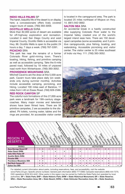
63
RIC
HA
RD
CU
MM
INS
INDIO HILLS PALMS SPThe harsh, beautiful life of the desert is on displayhere; a concessionaire offers lively coveredwagon tours of oases. (760) 393-3059.OCOTILLO WELLS SVRAMore than 82,000 acres of desert are availablefor off-highway exploration and recreation.Located in east San Diego County and westImperial County, Ocotillo Wells is accessible viaHwy. 86. Ocotillo Wells is open to the public 24hours a day, 7 days a week. (760) 767-5391.PICACHO SRAThis park lies near the remains of a formerColorado River gold-mining town. There’s boating, hiking, fishing, and primitive campingas well as accessible camping. Take the 6-milepaved road, followed by 18 miles of unpavedroad north from Winterhaven. (760) 393-3052.PROVIDENCE MOUNTAINS SRAMitchell Caverns are the draw at this 5,500-acrepark. Cavern tours take place daily (on week-ends only during summer months). Activitiesinclude accessible camping, picnicking, andhiking. Located 100 miles east of Barstow, 17miles from I-40 on Essex Road. (760) 928-2586.RED ROCK CANYON SPThe colorful rock formations of this 27,000-acrepark were a landmark for 19th-century stage-coaches. Many major movies and televisionshows have been filmed here. There are 50primitive campsites, 2 are accessible to the dis-abled. Pit toilets, running water, tables and firerings are provided. An accessible visitor center
is located in the campground area. The park islocated 25 miles northeast of Mojave on Hwy.14. (661) 942-0662.SALTON SEA SRAAn accidental break in a hastily constructeddike supplying Colorado River water to theImperial Valley created one of the world’slargest inland seas here. There are 150 devel-oped campsites (some accessible), and 3 prim-itive campgrounds, plus fishing, boating, andwaterskiing. Accessible picnicking and visitorcenter. The visitor center is 25 miles southeastof Indio via Hwy. 111. (760) 393-3052.
Anza-Borrego Desert SP • • • • • • • • • • • • • • •Heber Dunes SVRA • • • •Indio Hills Palms SP • •Ocotillo Wells SVRA • • • • •Picacho SRA • • • • • • • • • • • • • • • •Providence Mountains SRA • • • • • • • • • • • •Red Rock Canyon SP • • • • • • • • • • •Salton Sea SRA • • • • • • • • • • • • • • • •
REGION 12DESERTS
For detailed current information about parks, including reservations, fees, and accessibility, visit the websitewww.Parks.CA.gov. Specific phone numbers: General park information (800) 777-0369; Campsite reservations (800) 444-7275;OHV operations (916) 324-4442. Other parks in this region may be owned by California State Parks but operated by localauthorities. SP = State Park; SHP = State Historic Park; SHM = State Historical Monument; SR = State Reserve; SRA = State Recreation Area; SB = State Beach; SVRA = State Vehicular Recreation Area; SS = State Seashore.
California State Parkswww.Parks.CA.gov
Wildflower season at Anza-Borrego Desert SP
ANZA-BORREGO DESERT SPAt 600,000 acres, Anza-Borrego is the state’slargest and oldest desert park. Assistive listen-ing devices are available. Accessible camping,picnicking, and nature trail. The park is reachedvia Hwys. 78 and 79 from the east and west,and by I-8 from the south. (760) 767-5311.
HEBER DUNES SVRAThis area has 343 acres of land that was part ofthe Imperial County park system. It is primarilyused for off-road recreation. Restrooms withshowers and camping ramadas are available.The park’s most prominent features are sanddunes and tamarisk trees. (760) 767-5391.
More than just a hot, arid environment, thisregion is rich with colorful geological
formations, badlands, fan-palm oases, hardyflora and fauna, riparian wetlands toward theeastern Sierra, spring wildflowers, mile-highpeaks, spectacular limestone caverns, and an“accidental” saltwater lake. Here, rare andendangered species get a chance at survival, andvisitors learn about the desert’s fragility.
>>>>DDeesseerrttss
www.Parks.CA.govCalifornia State Parks62
RE
GIO
N 1
2 D
ES
ER
TS
1122
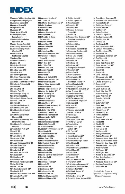
California State Parks64 www.Parks.CA.gov
IINNDDEEXX20 Admiral William Standley SRA30 Ahjumawi Lava Springs SP20 Anderson Marsh SHP44 Andrew Molera SP38 Angel Island SP20 Annadel SP38 Año Nuevo SP & SR50 Antelope Valley CA
Poppy Reserve50 Antelope Valley Indian
Museum S HP62 Anza-Borrego Desert SP20 Armstrong Redwoods SR50 Arthur B. Ripley Desert
Woodland SP44 Asilomar SB &
Conference Grounds32 Auburn SRA20 Austin Creek SRA21 Azalea SR21 Bale Grist Mill SHP40 Bean Hollow SB21 Benbow Lake SRA38 Benicia SRA38 Benicia Capitol SHP38 Bethany Reservoir SRA30 Bidwell Mansion SHP30 Bidwell-Sacramento River SP38 Big Basin Redwoods SP36 Bodie SHP54 Bolsa Chica SB56 Border Field SP21 Bothe-Napa Valley SP48 Brannan Island SRA39 Burleigh H. Murray Ranch*36 Burton Creek SP39 Butano SP36 Calaveras Big Trees SP60 California Citrus SHP32 California State Capitol
Museum32 California State Indian
Museum SHP32 California State Mining and
Mineral Museum32 California State Railroad
Museum39 Candlestick Point SRA56 Cardiff SB56 Carlsbad SB44 Carmel River SB39 Carnegie SVRA44 Carpinteria SB22 Caspar Headlands SB & SR51 Castaic Lake SRA*30 Castle Crags SP39 Castle Rock SP48 Caswell Memorial SP45 Cayucos SB*39 China Camp SP60 Chino Hills SP44 Chumash Painted Cave SHP30 Clay Pit SVRA22 Clear Lake SP48 Colonel Allensworth SHP32 Columbia SHP48 Colusa-Sacramento River SRA55 Corona Del Mar SB*54 Crystal Cove SP
56 Cuyamaca Rancho SP36 D.L. Bliss SP22 Del Norte Coast Redwoods SP33 Delta Meadows51 Dockweiler SB*54 Doheny SB36 Donner Memorial SP44 El Capitan SB44 El Presidio de Santa
Barbara SHP36 Emerald Bay SP44 Emma Wood SB33 Empire Mine SHP44 Estero Bay 33 Folsom Lake SRA34 Folsom Powerhouse SHP39 The Forest of Nisene
Marks SP22 Fort Humboldt SHP22 Fort Ross SHP48 Fort Tejon SHP49 Franks Tract SRA44 Fremont Peak SP44 Garrapata SP44 Gaviota SP49 George J. Hatfield SRA34 Governor’s Mansion SHP40 Gray Whale Cove SB49 Great Valley Grasslands SP22 Greenwood SB22 Grizzly Creek Redwoods SP36 Grover Hot Springs SP40 Half Moon Bay SB22 Harry A. Merlo SRA44 Hearst Castle®
62 Heber Dunes SVRA22 Hendy Woods SP40 Henry Cowell Redwoods SP45 Henry W. Coe SP45 Hollister Hills SVRA22 Humboldt Lagoons SP22 Humboldt Redwoods SP50 Hungry Valley SVRA54 Huntington SB34 Indian Grinding Rock SHP63 Indio Hills Palms SP 24 Jack London SHP24 Jedediah Smith Redwoods SP24 Jug Handle SR45 Julia Pfeiffer Burns SP50 Kenneth Hahn SRA36 Kings Beach SRA24 Kruse Rhododendron SR45 La Purísima Mission SHP39 Lake Del Valle SRA*30 Lake Oroville SRA60 Lake Perris SRA36 Lake Valley SRA34 Leland Stanford Mansion SHP51 Leo Carrillo SP57 Leucadia SB*39 Lighthouse Field SB*45 Limekiln SP24 Little River SB51 Los Encinos SHP45 Los Osos Oaks SR24 MacKerricher SP24 Mailliard Redwoods SR34 Malakoff Diggins SHP
51 Malibu Creek SP51 Malibu Lagoon SB24 Manchester SP45 Mandalay SB*40 Manresa SB*40 Marconi Conference
Center SHP46 Marina SB34 Marshall Gold Discovery SHP31 McArthur-Burney Falls
Memorial SP49 McConnell SRA46 McGrath SB24 Mendocino Headlands SP24 Mendocino Woodlands SP49 Millerton Lake SRA36 Mono Lake Tufa SR46 Montaña de Oro SP40 Montara SB46 Monterey SB46 Monterey SHP24 Montgomery Woods SR57 Moonlight SB*46 Morro Bay SP46 Morro Strand SB46 Moss Landing SB40 Mount Diablo SP61 Mount San Jacinto SP40 Mount Tamalpais SP40 Natural Bridges SB24 Navarro River Redwoods SP40 New Brighton SB46 Oceano Dunes SVRA63 Ocotillo Wells SVRA34 Old Sacramento SHP57 Old Town San Diego SHP40 Olompali SHP46 Pacheco SP39 Pacifica SB*57 Palomar Mountain SP24 Patrick’s Point SP26 Pelican SB40 Pescadero SB26 Petaluma Adobe SHP46 Pfeiffer Big Sur SP63 Picacho SRA40 Pigeon Point Light
Station SHP52 Pío Pico SHP46 Pismo SB51 Placerita Canyon SP*31 Plumas-Eureka SP26 Point Cabrillo Light Station52 Point Dume SB46 Point Lobos SR40 Point Montara Light Station46 Point Mugu SP45 Point Sal SB*46 Point Sur SHP40 Pomponio SB40 Portola Redwoods SP34 Prairie City SVRA26 Prairie Creek Redwoods SP63 Providence Mountains SRA35 Railtown 1897 SHP63 Red Rock Canyon SP46 Refugio SB26 Richardson Grove SP52 Robert H. Meyer Memorial SBS
26 Robert Louis Stevenson SP39 Robert W. Crow Memorial SB*27 Russian Gulch SP52 Saddleback Butte SP46 Salinas River SB27 Salt Point SP63 Salton Sea SRA40 Samuel P. Taylor SP46 San Buenaventura SB55 San Clemente SB57 San Elijo SB40 San Gregorio SB46 San Juan Bautista SHP49 San Luis Reservoir SRA40 San Mateo Coast SBs58 San Onofre SB58 San Pasqual Battlefield SHP47 San Simeon SP40 Santa Cruz SBs40 Santa Cruz Mission SHP52 Santa Susana Pass SHP27 Schooner Gulch SB42 Seacliff SB31 Shasta SHP59 Silver Strand SB61 Silverwood Lake SRA27 Sinkyone Wilderness SP27 Smithe Redwoods SR27 Sonoma SHP27 Sonoma Coast SB59 South Carlsbad SB35 South Yuba River SP27 Standish-Hickey SRA36 Sugar Pine Point SP27 Sugarloaf Ridge SP42 Sunset SB35 Sutter’s Fort SHP37 Tahoe SRA57 Tijuana Estuary NP*27 Tolowa Dunes SP42 Tomales Bay SP49 Tomo-Kahni SHP52 Topanga SP59 Torrey Pines SR & SB27 Trinidad SB49 Tule Elk SR49 Turlock Lake SRA40 Twin Lakes SB27 Van Damme SP51 Verdugo Mountains*37 Washoe Meadows SP37 Wassama Round House SHP51 Watts Tower of Simon Rodia*31 Weaverville Joss House SHP27 Westport-Union Landing SB42 Wilder Ranch SP51 Will Rogers SB*53 Will Rogers SHP31 William B. Ide Adobe SHP47 Wm. Randolph Hearst
Memorial SB49 Woodland Opera House SHP31 Woodson Bridge SRA47 Zmudowski SB
*State Parks Property operated by separate entity.+ No public access.