Embed Size (px)
Citation preview
1 | P a g e
Table of Contents
Foreword ............................................................................................................................................................ 6
Acknowledgement ............................................................................................................................................. 7
ACRONYMS ........................................................................................................................................................ 9
1.0 INTRODUCTION ..................................................................................................................................... 11
1.1 Overview of Vanuatu ……………………………………………………………………………………………………………………………11
1.2 Biodiversity Conservation in Vanuatu ........................................................................................................ 11
2.0 THE CBD AND NBSAP REVIEW PROCESS ............................................................................................... 12
2.1 The CBD Strategic Plan and Aichi Targets .................................................................................................. 12
2.2 Vanuatu NBSAP Review Process ................................................................................................................ 12
3.0 OVERVIEW OF THE STATUS OF BIODIVERSITY IN VANUATU ................................................................ 14
3.1 Threats to Biodiversity ............................................................................................................................... 14
3.2 Terrestrial Biodiversity ............................................................................................................................... 15
3.2.1 Overview .............................................................................................................................................. 15
3.2.2 Threats ................................................................................................................................................. 15
3.3 Inland Waters Biodiversity ......................................................................................................................... 16
3.3.1 Overview .............................................................................................................................................. 16
3.3.2 Threats ................................................................................................................................................. 17
3.4 Marine and Coastal Biodiversity ................................................................................................................ 18
3.4.1 Overview .............................................................................................................................................. 18
3.4.2 Threats ................................................................................................................................................. 19
3.5 Species………………………………….. .................................................................................................................. 20
4.0 MEASURES IN PLACE TO ADDRESS THREATS TO BIODIVERSITY ........................................................... 21
4.1 Traditional Governance and Management ................................................................................................ 21
4.2 Protected Areas or Conservation Areas ..................................................................................................... 21
4.2.1 Community Conservation Areas (CCAs) ............................................................................................... 22
4.2.2 Terrestrial Protected Areas .................................................................................................................. 22
4.2.3 Marine Protected Areas ....................................................................................................................... 23
4.2.4 Species Conservation ........................................................................................................................... 23
4.3 Vanuatu International Conventions and Commitment to Biodiversity ..................................................... 23
4.4 Vanuatu Environment-Related Legislation Aimed to Protect Biodiversity and Promote Sustainable-Use 25
5.0 VANUATU NATIONAL BIODIVERSITY STRATEGY AND ACTION PLAN (NBSAP) .................................... 27
5.1 Mission Statement………………… .................................................................................................................. 27
5.2 Principles Underpinning the Strategy ........................................................................................................ 27
2 | P a g e
5.3 NBSAP Link to NSDP…………. ....................................................................................................................... 29
6.0 VANUATU NBSAP STRATEGIC AREAS ................................................................................................... 30
6.1 STRATEGIC AREA 1: CONSERVATION AREA MANAGEMENT................................................................... 31
6.2 STRATEGIC AREA 2: FOREST AND INLAND WATERS ECOSYSTEMS CONSERVATION AND
MANAGEMENT………………………………….. ........................................................................................................... 36
6.3 STRATEGIC AREA 3: COASTAL AND MARINE ECOSYSTEMS CONSERVATION AND MANAGEMENT
(CME)………………………………………… ................................................................................................................... 39
6.4 STRATEGIC AREA 4: SPECIES MANAGEMENT (SM) .................................................................................. 43
6.5 STRATEGIC AREA 5: MANAGEMENT OF INVASIVE Alien SPECIES (MIAS) ................................................ 47
6.6 STRATEGIC AREA 6: MAINSTREAMING BIODIVERSITY ACROSS SECTORS AND SOCIETY (MB) ................ 52
6.7 STRATEGIC AREA 7: RESOURCE MOBILISATION FOR THE NATIONAL BIODIVERSITY STRATEGY AND ACTION
PLAN…………………………………………….. ................................................................................................................ 56
7.0 ACTION STRATEGY IMPLEMENTATION FRAMEWORK ........................................................................ 60
7.1 THE NBSAP IMPLEMENTATION FRAMEWORK ........................................................................................... 60
8.0 PROVINCIAL PLANS ........................................................................................................................... 107
8.1 TORBA PROVINCIAL NBSAP IMPLEMENTATION FRAMEWORK ............................................................... 108
8.1.1 Background ........................................................................................................................................ 108
8.1.2 Marine ................................................................................................................................................ 109
8.1.3 Forest and Inland Waters ................................................................................................................... 112
8.1.4 Torba Provincial Target for 2018 to 2030 .......................................................................................... 114
8.1.5 TORBA Provincial Target Statement .................................................................................................. 116
8.1.6 Reference ........................................................................................................................................... 116
8.2 SANMA PROVINCIAL NBSAP IMPLEMENTATION FRAMEWORK .............................................................. 117
8.2.1 Background ........................................................................................................................................ 117
8.2.2 Marine ................................................................................................................................................ 118
8.2.3 Forest and Inland Waters ................................................................................................................... 121
8.2.4 Sanma Provincial Target for 2016 to 2030 ......................................................................................... 125
8.2.5 SANMA Provincial Target Statement ................................................................................................. 126
8.2.6 Reference ........................................................................................................................................... 126
8.3 PENAMA PROVINCIAL NBSAP IMPLEMENTATION FRAMEWORK ............................................................ 127
8.3.1 Background ........................................................................................................................................ 127
8.3.2 Marine ................................................................................................................................................ 128
8.3.3 Forest and Inland Waters ................................................................................................................... 131
8.3.4 Penama Provincial Target for 2016 to 2030....................................................................................... 134
8.3.5 Penama Provincial Target Statement................................................................................................. 137
3 | P a g e
8.2.6 References .......................................................................................................................................... 137
8.4 MALAMPA PROVINCIAL NBSAP IMPLEMENTATION FRAMEWORK ......................................................... 138
8.4.1 Background ........................................................................................................................................ 138
8.4.2 Marine ................................................................................................................................................ 139
8.4.3 Forest and Inland Waters ................................................................................................................... 143
8.4.4 Malampa Provincial Target for 2016 to 2030 .................................................................................... 146
8.4.5 Malampa Provincial Target Statement .............................................................................................. 149
8.4.6 Reference ........................................................................................................................................... 149
8.5 SHEFA PROVINCIAL NBSAP IMPLEMENTATION FRAMEWORK ................................................................ 150
8.5.1 Background ........................................................................................................................................ 150
8.5.2 Marine ................................................................................................................................................ 151
8.5.3 Forest and Inland Waters ................................................................................................................... 155
8.5.4 Shefa Provincial Target for 2018 to 2030 ........................................................................................... 158
8.5.5 SHEFA Provincial Target Statement ................................................................................................... 161
8.5.6 Reference ........................................................................................................................................... 161
8.6 TAFEA PROVINCIAL NBSAP IMPLEMENTATION FRAMEWORK ................................................................ 162
8.6.1 Background ........................................................................................................................................ 162
8.6.2 Marine ................................................................................................................................................ 163
8.6.3 Forest and Inland Waters ................................................................................................................... 166
8.6.4 Tafea Provincial Target for 2018 to 2030 ........................................................................................... 170
8.6.5 TAFEA Provincial Target statement .................................................................................................... 173
8.6.6 Reference ........................................................................................................................................... 173
9.0 NBSAP REPORTING…………………. ........................................................................................................ 173
9.1 NBSAP MONITORING AND INDICATORS GUIDELINE ............................................................................... 174
9.2 IMPLEMENTATION STRUCTURE AND COORDINATION ............................................................................ 176
9.3 AMENDING THE NBSAP ............................................................................................................................ 177
References ..................................................................................................................................................... 178
ANNEXES ........................................................................................................................................................ 180
ANNEX 1: DEFINITIONS AND TERMS .............................................................................................................. 180
ANNEX 2: LIST OF PROTECTED AREAS ............................................................................................................ 181
ANNEX 3: IMPORTANT BIRD AREAS ............................................................................................................... 183
Important Bird Areas ................................................................................................................................... 183
ANNEX 4: IMPORTANT FOREST AREAS .......................................................................................................... 184
Important Forest Areas ............................................................................................................................... 184
4 | P a g e
ANNEX 5: CURRENT IMPORTANT WETLAND AREAS ..................................................................................... 184
List from Updated Vanuatu National Wetland Inventory ........................................................................... 184
ANNEX 6: SIGNIFICANT BIODIVERSITY SITES WITHIN VULNERABLE DISASTER AREAS .................................. 185
Key Biodiversity Areas ................................................................................................................................. 185
Vanuatu Cyclones ........................................................................................................................................ 186
Vanuatu Tsunami occurance ....................................................................................................................... 187
Earthquake Occurance ................................................................................................................................ 188
Reefs at Risk ................................................................................................................................................ 189
Volcanoe Occurrance .................................................................................................................................. 190
Competing Marine Resource Uses .............................................................................................................. 191
ANNEX 7: List of important marine areas ...................................................................................................... 192
ANNEX 8 – Vanuatu Endemic & Threatened species List .............................................................................. 193
Terrestrial Fauna ......................................................................................................................................... 193
Terrestrial Flora ........................................................................................................................................... 195
Marine Fauna .............................................................................................................................................. 198
ANNEX 9 – Important Economic and Cultural Species................................................................................... 201
ANNEX 10 – Important cultural sites, Ecotourism sites and Provincial Target Sites ..................................... 203
ANNEX 11 – NAMES OF PARTICIPANTS IN ALL CONSULTATION MEETINGS & WORKSHOPS ........................ 247
5 | P a g e
6 | P a g e
Foreword
In Vanuatu, biodiversity is our food, our culture, our tradition, our money, our medicine, our shelter, our
fresh air (oxygen), our firewood, our coastline stabiliser, our protector against storm surge, protector of
our freshwater systems, our carbon sequester, our ecosystem-based adaptation to climate change, our
ecosystem-based approaches to disaster risk reduction, our beautiful sceneries for our enjoyment
through camping, picnicking, swimming and snorkelling. Our biodiversity is vital for our survival.
Vanuatu signed and ratified the United Nations Convention on Biological Diversity (UNCBD) joining
other 190 CBD parties to protect our global biodiversity. Vanuatu’s first National Biodiversity Strategy
and Action Plan (NBSAP) was developed and endorsed in November 1999. Revision of this NBSAP
has led Vanuatu to develop this new NBSAP (2018-2030). This revised NBSAP indicates the progress,
successes and gaps that lie within the organisational, systemic and individual capacities at national,
provincial and community levels to protect, conserve and wisely use our biodiversity. The NBSAP
(2018-2030) has seven strategic areas with country indicators and targets towards achieving the Global
Strategic Programme of 2020 Aichi targets. The new NBSAP includes the views of the national and
provincial government, non government organisations (NGOs), community based organisations
(CBOs) and local communities, which are indicated in seven strategic areas. These are:
1. Conservation Area Management 2. Forest and Inland Waters Ecosystems Conservation and Management 3. Coastal and Marine Ecosystems Conservation and Management 4. Species and Genetic Diversity Conservation
5. Invasive Species Eradication and Control 6. Mainstreaming Biodiversity across sectors and society
7. Resource Mobilisation
The strategy and action plan also includes the provincial implementation plans, which outline specific
local actions to address threats affecting the islands’ biodiversity, including identifying potential
conservation areas. This create the avenue for local communities to actively participate in implementing
the NBSAP.
Vanuatu is within the East Melanesian Islands Biodiversity Hot Spot region that needs attention for the
protection of its unique flora and fauna. Vanuatu has a number of endemic plant and animal species
that are not found elsewhere and some are at risk of becoming extinct if measures are not continuously
taken to protect them.
We also show our commitment to protect and conserve our biodiversity through the inclusion of
environment as one of the three main pillars of the National Sustainable Development Plan (NSDP)
that is directly linked to policy objectives of the National Environment Policy and Implementation Plan
(NEPIP). Other relevant policies ranging from climate change and overarching productive sectors’
policy and other respective natural resource management sector policies also include measures
towards protection, conservation and sustainable use of biodiversity.
The Vanuatu NBSAP will be the main implementing strategy for the Environment Pillar of the National
Sustainable Development Goals and Policies 2016-2030 environment goals and policy objectives which
are: (1) A nation that ensures our food and nutrition security needs are adequately met by all people
through increasing sustainable food production, (2) An economy which fosters sustainable growth and
development through low impact industries and modern technologies to ensure the well-being of future
generations systems, (3) A strong and resilient nation in the face of climate change and risks posed by
hazards and natural disasters and improving household production, (4) A nation which utilizes and
7 | P a g e
sustainably manages our land, water and natural resources and (5) A nation committed to ensuring the
conservation and sustainable management of our biodiversity and ecosystems. I am glad that the
mainstreaming biodiversity strategic area have been dedicated to ensure this strategy is aligned into
our NSDP.
The government will take a critical role in this strategy but it needs the cooperation and commitments
of wider stakeholders ranging from provincial governments, NGOs, private sector, local communities,
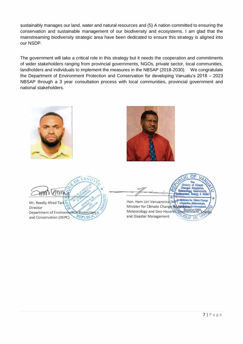
landholders and individuals to implement the measures in the NBSAP (2018-2030). We congratulate
the Department of Environment Protection and Conservation for developing Vanuatu’s 2018 – 2023
NBSAP through a 3 year consultation process with local communities, provincial government and
national stakeholders.
8 | P a g e
Acknowledgement
The Department of Environmental Protection and Conservation (DEPC) would like to thank the
government and non-government stakeholders that were part of the review of the previous NBSAP
(1999). A number of one to one sectoral consultations, and provincial and national consultations took
place that resulted in this current NBSAP (2018-2030). DEPC would like to make mention of the
following stakeholders:
Department of Forest SANMA Province Vanuatu Fisheries Department PENAMA Province Department of Agriculture and Rural Development
MALAMPA Province
Biosecurity Vanuatu SHEFA Province Livestock Department TAFEA Province Department of Tourism Wan Smol Bag Department of Trade Live and Learn Cultural Centre Vanuatu Environment Science Society Department of Lands Vanuatu Environment Association Network Department of Customs VANGO Department of Provincial Affairs Vila-based CSOs MOCC Project Management Unit Other NGOs Shefa Province TORBA Province
Without your commitment and participation in the series of meetings and workshops we would not have
been able to complete this document.
We are also grateful to the following projects and programmes: the Marine and Coastal Biodiversity in
Pacific Islands Countries and Atolls (MACBIO) Project, Critical Ecosystem Partnership Fund (CEPF),
Vanuatu Environment Science Society (VESS) and Birdlife International through Vanuatu Environment
Association Network that also provided information.
The DEPC extends its profound gratitude to the IUCN Oceania Regional Office as the organisation
leading the review, and in particular to Etika Rupeni Qica, the review leader and Seema Deo for editing
the document. DEPC also thank Mark Kalotap, the former NBSAP Coordinator, for the work done during
his term with the project and Trinison Tari for his great assistance with the six provincial validation
workshops. A huge appreciation goes to the following for their tireless efforts during the series of final
reviews and for ensuring the final compilation and production of the document together with IUCN:
- Josephine Rambay, NBSAP Coordinator
- Donna Kalfatak, Principal Officer, Biodiversity and Conservation
- Vatumaraga Molisa, MACBIO Project and CEPF Liaison Officer.
- DEPC Biodiversity and Conservation Division staff for their support
Finally, we are grateful to the Convention on Biological Diversity, UN Environment as the project’s
international implementing agency and to the project donor Global Environment Facility (GEF).
Department of Agriculture and Rural
Vanuatu Environment Association Network
9 | P a g e
ACRONYMS
ABS Access and Benefit Sharing
AZE Alliance for Zero Extiction
BIOFIN Biodiversity Finance
CA Conservation Area
CBAM Community Based Adaptive Management
CBD Convention Biological Diversity
CCA Community Conservation Area
CEPF Critical Ecosystem Partnership Fund
CHM Clearing House Mechanism
CITES Convention on International Trade in Endangered Species
CME Coastal and Marine Ecosystems
CMS Conservation of Migratory Species
COP Conference of the Parties
CR Critically Endangered
CSO Civil Society Organization
DARD Department of Agriculture and Rural Development
DEPC Department of Environmental Protection and Conservation
DGMWR Department of Geology & Mines and Water Resources
DLA Department of Local Authorities
DoE Department of Education
DoF Department of Forestry
DoFT Department of Financial Treasury
DoL Department o Lands
DoLiv Department of Livestock
DoT Department of Tourism
EEZ Exclusive Economic Zone
EIA Environment Impact Assessment
EN Endangered
EPC Environment Protection and Conservation Act
FIW Forest and Inland Waters
FLR Forest Landscape Restoration
FPAM Forest Protected Area Management
GDP Gross Domestic Product
GEF Global Environment Facility
GOV Government of Vanuatu
IAS Invasive Alien Species
IBA Important Bird Area
IBAT Integrated Biodiversity Assessment Tool
ICCA Indigenous and Community Conserved Areas
IOSEA Indian Ocean and South-East Asian (Marine Turtle MOU)
IUCN The International Union for Conservation of Nature
IW Internationall Waters
KBA Key Biodiversity Area
LMMA Locally Marine Managed Area
10 | P a g e
MACBIO Marine & Coastal Biodiversity in Pacific Islands Countries & Atolls
MAT Mutually Agreed Terms
MEA Multi-lateral Environment Agreements
MESCAL Mangrove Ecosystems for Climate Change Adaptation and Livelihoods
MESV Marine Ecosystem Service Valuation
MIS Management of Invasive Species
MOU Memorandum of Understanding
MPA Marine Protected Area
MSG Melanesian Spearhead Group
MSP Marine Spatial Plan
NAB National Advisory Board
NBSAP National Biodiversity Strategy and Action Plan
NEPIP National Environmental Policy and Implementation Plan
NGO Non Government Organisation
NISSAP National Invasive Species Strategy and Action Plan
NRI National Resource Inventory
NSDP National Sustainable Development Plan
PA Protected Area
PES Payment for Ecosystem Services
PIC Prior Informed Consent
PWD Public Works Department
RM Resource Mobilisation
SDG Sustainable Development Goals
SPREP Secretariat of the Pacific Regional Environment Programme
SUMA Special and Unique Marine Area
UN United Nation
UNCCD United Nations Convention to Combat Desertification
UNCLOS United Nations Convention on the Law of the Sea
UNDP United Nations Development Programme
UNFCCC United Nations Framework Convention on Climate Change
VANGO Vanuatu Association of Non Government Organization
VBSAP Vanuatu Biodiversity Strategy and Action Plan
VESS Vanuatu Environmental Science Society
VFD Vanuatu Fisheries Department
VNSO Vanuatu National Statistic Office
WDPA World Database on Protected Areas
WHC World Heritage Convention
11 | P a g e
1.0 INTRODUCTION
1.1 Overview of Vanuatu
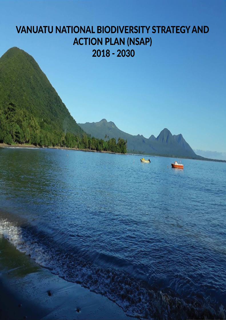
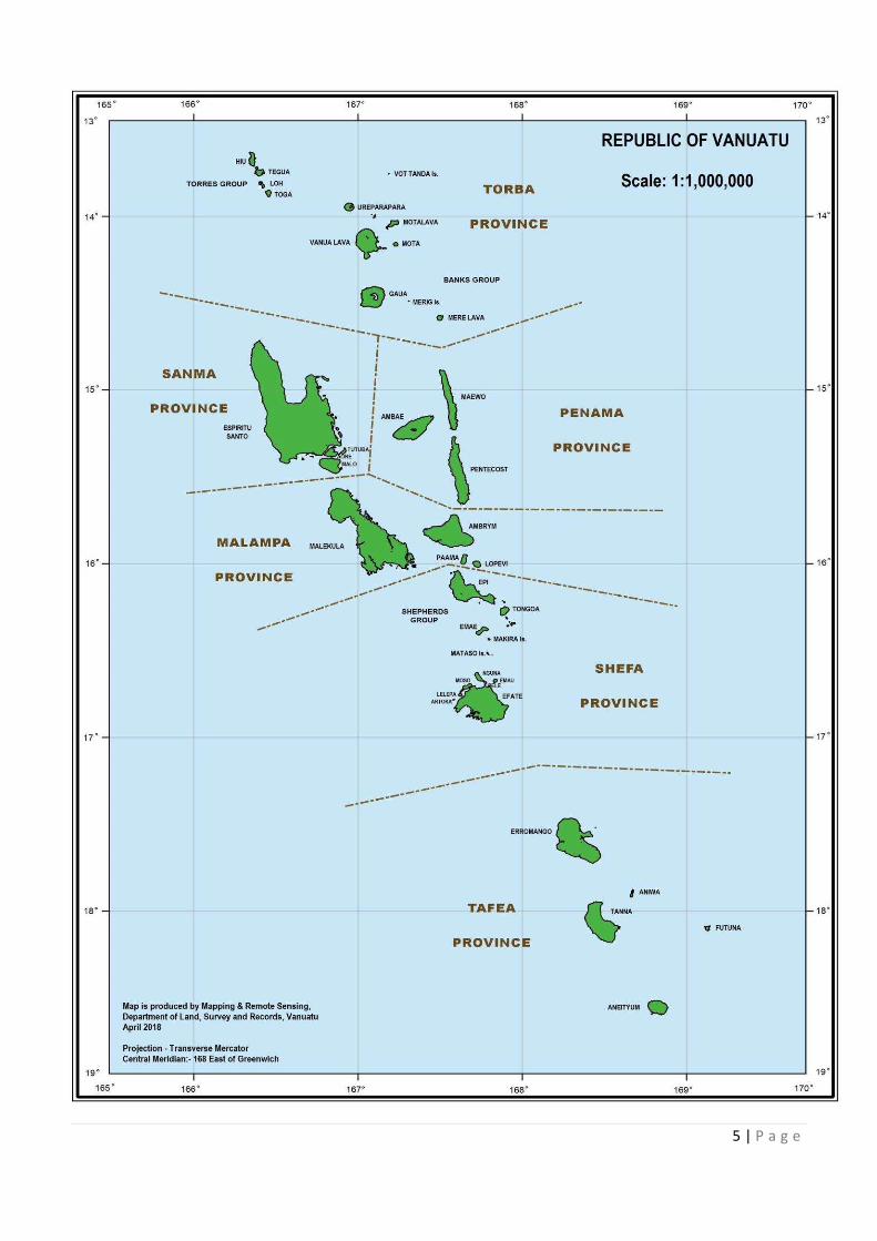
Vanuatu is located in the South Pacific Ocean (about three quarters of the way from Hawaii to Australia)
and includes more than 80 islands, of which about 65 are inhabited. The combined land area of all
islands in the group is over 12,000 km2 with a combined coastline of 3,132 km. Vanuatu's island chains
are mostly of volcanic origin and are mountainous by Pacific standards, with many island interiors
remaining uninhabited. The highest peak of Mount Tabwemasana on Espiritu Santo rises to 1,879 m
above sea level. The weather is tropical characterised by moderate rainfall from April to November and
cyclones from December to April.
A mini-census conducted in 2016 puts the population of Vanuatu at 272,459 people, with a growth rate
of 2.3% per annum (Vanuatu National Statistics Office, 2016). The population is relatively young and
38% is under 15 years old. 24% of the population lives in urban areas.
Over 110 different cultural and linguistic groups are recognised and, with its small population, Vanuatu
is considered to be the third most linguistically diverse country in the world (Regenvanu, 2009). On
average, 2,000 people speak each language. English, French and Bislama are the common languages
that allow the people of Vanuatu to communicate with each other. Although the ni-Vanuatu culture is
similar across the country, there are three cultural regions: northern; central; and southern. In the
northern cultural region, men and women can acquire wealth by demonstrating how much they can give
away (through mats and killing of pigs). This increased status does not transfer to having greater
authority. The central cultural region exhibits a more typical Melanesian cultural system, involving the
inheritance of titles through lineage and being active in ceremonies as dictated by custom. In the
southern cultural region there is a system of granting titles and privileges, which appears to have been
influenced by religion and western culture.
Vanuatu’s economy is based on small-scale agriculture, which provides a living for about two thirds of
the population. Fishing, offshore financial services and tourism are other key sectors. The total visitor
arrivals to Vanuatu in the third quarter of 2017 stood at 76,836, an increase of 6% over the
corresponding quarter in 2016, and 13% over the previous (second) quarter (Vanuatu National Statistics
Office, 2017). The main suppliers of tourists and foreign aid are Australia and New Zealand. The service
sector accounts for 77% of Gross Domestic Product (GDP). Other service industries include food and
fish freezing, wood processing and meat canning. Agricultural products include copra, coconut oil, kava,
cocoa, coffee, taro, yams, fruits, vegetables, beef and fish. Mineral deposits are negligible.
In addition to the formal economic sector, there is the informal economy which involves at least 84% of
the population. This rural-dwelling component of the population depends on the informal economy to
support their livelihood on a daily basis (Regenvanu, 2009). Even urban-dwellers depend on it to
subsidise their modern lifestyles. The informal economy is centred on production, processing and sale
of agricultural and marine products, supplemented by provision of services such as carpentry and
transportation, and production of baskets, mats and other handicrafts. These activities depend on the
natural environment and the living and non-living resources it provides. Protection and conservation of
these natural resources-Vanuatu’s biological diversity-is thus essential to the nation’s long-term well-
being and sustainable development.
1.2 Biodiversity Conservation in Vanuatu
Biodiversity is defined as: The variety of life forms, the different plants, animals and micro-organisms,
the genes they contain, and the ecosystems they form. It is usually considered at three levels, genetic
diversity, species diversity, and ecosystem diversity.
12 | P a g e
Biological diversity underpins ecosystem functioning and the provision of ecosystem services essential
for human well-being. It provides for food security, human health, and clean air and water; contributes
to local livelihoods, and economic development; and is essential for the achievement of the Sustainable
Development Goals (SDG), including poverty reduction. In addition, it is a central component of many
belief systems, worldviews and identities. Yet despite its fundamental importance, biodiversity
continues to be lost.
In recognition of the need to address biodiversity loss, the Vanuatu Government signed the Convention
on Biological Diversity (CBD) at its launch in 1992 and ratified it in 1993. As a party to the CBD, the
government is obliged to report to the other convention signatories on in-country biodiversity
management activities and to develop a strategy and action plan to manage and conserve Vanuatu’s
biological diversity (Box 1).
The Convention places clear obligations on Contracting Parties. Specifically, Article 6, General
Measures for Conservation and Sustainable Use states that the Contracting Parties shall prepare
national strategies, plans or programmes for the conservation and sustainable use of their biological
resources. The first Vanuatu Biodiversity Strategy and Action Plan (VBSAP) was launched in 1999. The
VBSAP has been reviewed and has resulted in this revised NBSAP for 2018–2030. The NBSAP also
addresses the commitments made by parties at the 12th CBD Conference of Parties (COP12) in 2010
to align their NBSAPs to the CBD Strategic Plan and it’s Aichi Targets (Box 2).
2.0 THE CBD AND NBSAP REVIEW PROCESS
2.1 The CBD Strategic Plan and Aichi Targets
In 2010, Parties to the CBD meeting in Nagoya, Japan, adopted the Strategic Plan for Biodiversity
2011-2020 with the purpose of inspiring broad-based action in support of biodiversity over the next
decade by all countries and stakeholders. In recognition of the urgent need for action the United Nations
General Assembly has also declared 2011-2020 as the United Nations Decade on Biodiversity (United
Nations General Assembly, 2010) The CBD Strategic Plan for Biodiversity 2011-2020 is a ten-year
framework for action by countries and stakeholders to save biodiversity and enhance its benefits for
people. The parties are obligated to reviewing and updating their current NBSAPs in line with the
Strategic Plan for Biodiversity 2011-2020. This involves developing national targets and using the
Strategic Plan and Aichi Target and integrating these national targets into the updated NBSAPs and
taking into account national priorities.
2.2 Vanuatu NBSAP Review Process
The 1999 VBSAP identified six key objectives and more than 20 priority actions for effective
management of biological resources. The six objectives were:
1. Protection and wise use of biodiversity;
2. Application of policy, planning and legal mechanisms to enable sustainable management
of biodiversity;
3. Research, assessment and monitoring of biodiversity;
4. Capacity building for environmental management;
5. Environmental education, awareness and information sharing; and
13 | P a g e
6. Participation of local communities in the management of biodiversity.
The review process for the 1999 VBSAP was initiated in 2014 when Vanuatu undertook an extensive
provincial awareness and consultation process to assess the priorities of the communities in terms of the
sustainable use and conservation of biodiversity. In 2015, a consultant was engaged to assist. The process
included the review of existing national strategies to identify NBSAP-related priorities and conducting
sector and national stakeholder consultations to finalise the NBSAP. The review was also informed by
some of the latest assessments such as the SPREP/IUCN State of Conservation in Oceania Report for
the Pacific (SPREP, 2013), which provided recent information on the status and trends of biodiversity in
Vanuatu.
The strategic areas of the NBSAP 2018-2030 have been aligned to the CBD Strategic Plan and Aichi
Targets and also to two key national strategies: the National Sustainable Development Plan (NSDP) and
the National Environment Policy and Implementation Plan (NEPIP). It is important to note that the Vanuatu
NBSAP has been aligned with the NSDP timing which is 2016–2030 and this should align with the next
CBD 2020-2030 Strategic Plan.
Box 1: Convention on Biological Diversity Objectives:
The conservation of biological diversity, the sustainable use of its components and the fair
and equitable sharing of the benefits arising out of the utilisation of genetic resources,
including by appropriate access to genetic resources and by appropriate transfer of relevant
technologies, taking into account all rights over those resources and technologies, and by
appropriate funding (Article1).
Obligations:
The convention obliges governments to take a number of measures, these include:
§ Monitoring and identification of biodiversity § Environmental Impact Assessments; § National Strategies, plans or programmes to conserve and use the components of
biological diversity sustainably, and § The integration of biodiversity policy into relevant sectoral or cross sectoral plans,
programmes and policies. The Convention constitutes an historic commitment by nations of the world to address directly
the detrimental impacts of human activity on biodiversity. It is the first time that biodiversity is
comprehensively addressed in a binding global treaty, the first time genetic diversity is
specifically recognized and the first time that the conservation of biodiversity conservation in
inter-generational equity, the assurance that future generations gain equal access to essential
biological resources.
14 | P a g e
3.0 OVERVIEW OF THE STATUS OF BIODIVERSITY IN VANUATU
Vanuatu’s biodiversity remains poorly known, with detailed studies of only a few genera and few studies
of the biota of smaller or less accessible islands. However a review of studies of the flora and fauna of
Vanuatu has shown that there are endemic species, rare species and uncommon variants within many
of the genera that have been studied in detail. Much of Vanuatu’s diversity beneath the species level
has only been classified by indigenous knowledge systems that vary from one language group to
another and are not documented.
Patterns of species diversity reflect classic island biogeography, where island size and distance from
continental source are key determinants of number of species. The larger and older islands generally
support a greater diversity of terrestrial ecosystems, and a greater diversity of plants and animals (Taiki
et al., Unpublished). The islands are separated by the sea, and catchments and lowland habitats are
separated by mountains – these are barriers to many species, and produce conditions whereby
relatively rapid sub-speciation and speciation occurs. Altitudinal gradients provide opportunities for
montane endemics, such as the Mountain Starling (Aplonis santovestris) of Santo, which add diversity
to high island faunas that is not possible on low islands no matter how large they are. Frequent
disturbance due to tropical cyclones, earthquakes and volcanic activity also affects the distribution and
abundance of species, especially on the smaller islands. Lastly, there is significant variation with
latitude, with species that occur at high altitudes in the tropical north occurring at much lower altitudes
in the sub-tropical south. Consequently, there is considerable variation in the distribution of species
within and between islands, and Vanuatu’s biodiversity is of particular interest for its on-going processes
of immigration, range extension and contraction, and sub-speciation (Department of Environmental
Protection and Conservation, 2014).
3.1 Threats to Biodiversity
The greatest threats to biodiversity conservation result from human activities. Human settlements are
generally found concentrated in the coastal lowlands. Consequently, biodiversity is most at risk in
lowland and coastal areas and small islands, yet remains relatively intact in the high altitude forests of
larger islands.
Land cannot be alienated from the traditional landholders, but can be leased from the landholders for
fixed periods and agreed purposes. This system of land and resource management limits the capacity
of government to conserve biodiversity without the support, understanding and commitment of
landholders. This therefore, creates an imperative for landholders as resource owners and managers
to work independently or in cooperation with other landholders, organisations or government to
conserve biodiversity (VEU MSP, 2003).
The 2010 Vanuatu National Assessment Report notes that Vanuatu’s environment quality is rapidly
deteriorating. It lists increasing frequency and severity of natural disasters, including cyclones, flooding
and coral bleaching; and deforestation, air, land and marine pollution as growing problems. The
assessment observes that population growth leads to more pressure for food and investment resulting
“not only in land degradation and overfishing, but also destruction of mangroves and fish breeding
areas” (GOV, 2010). Invasive Alien Species (IAS) is an existing and growing concern, threatening
forests and biodiversity of Vanuatu. The direct effects of climate change and their interactions with the
current threats will only exacerbate the risks to biodiversity. These pressures work singly or in tandem
with each other in complex ways.
15 | P a g e
3.2 Terrestrial Biodiversity
3.2.1 Overview
Seventy four percent (74%) of land in Vanuatu is covered with natural vegetation. Forest types include
tropical lowland evergreen rain forest, broad-leaved deciduous forest, closed conifer forest, montane
rain forest, cloud forest and coastal forest. Other notable vegetation includes swamp forest on Efate,
kauri pine strands on Erromango and scattered mangrove forests covering around 3,000 ha (most of
which occur on Malekula Island).
Lowland forest has largely been cleared and replaced by anthropogenic vegetation but forested areas
remain the dominant landscape element on most islands. High forests are restricted on most of the
islands (especially those that are densely populated, such as Pentecost, Ambae, Tanna and Shepherd;
or have active volcanoes, such as Ambrym). However low montane forests are generally well preserved
and occupy large areas. Secondary forests (often consisting of a Hibiscus community) are dense and
extensive in Vanuatu.
There are about 1,000 vascular plant species in Vanuatu of which around 150 are endemic. There is
high diversity of orchids with 158 species and palms with 21 species, including 14 endemic species
(GOV, 2014). There are 121 bird species, 28 species of reptiles and 12 species of Chiropterae (Flying
Foxes and Bats). Invertebrate diversity is not fully described but includes the coconut crab (Birgus latro)
the largest land crab, which is an important food resource in Vanuatu (GOV, 2014).
Invasive animal species are a threat in Vanuatu and include the Indian Mynah (Acridotheres tristis), the
Giant African Snail (Achatina fulica) and the Rosy Wolf Snail (Euglandina rosea). E. rosea was
introduced as a biological control agent for Achatina fulica but the species has caused the extinction of
numerous native snails in other countries. Another species of concern in Vanuatu is the Little Fire Ant
(Wasmannia auropunctata), which has reduced arthropod species diversity in other locations, and may
threaten crab species, including the coconut crab (Bakeo and Qarani 2005).
Vanuatu has one recorded extinction: the Tanna Ground Dove (Gallicolumba ferruginea). Extinction
drivers for this species are believed to have been hunting and predation by domesticated and feral
mammals.
3.2.2 Threats
The forests of Vanuatu have been impacted by human activities, which have diminished and altered
forest cover and biodiversity. There has been immense pressure on some timber species on the larger
islands, where harvesting is concentrated. In 1998, for instance, 92% of logs harvested were of just two
species, Endospermum medullosum (Whitewood or Basswood), and Antiaris toxicaria (known in
Vanuatu as Milk Tree) (Bakeo and Qarani, 2005).
Agriculture, Fishing and Forestry has recovered from a decline in 2015 by registering a positive growth
of 5.1%; an increase of 10.7 percentage points. The components of agriculture that contribute to this
positive growth, were crop production, it grew by 5.9%, followed by animal production at 2.6%, fishing
at 3.9% and forestry at 0.7% (Vanuatu National Statistic Office, 2017). In the mid-2000s, natural forest
cover in Vanuatu was estimated at 444,000 ha, equivalent to 36% of the total land area (1.22 million
ha) (FAO, 2010), and at least 40% of the commercial forest area was regarded as degraded (King,
2007). Most of the high value forests were over-exploited in the 1980s and 1990s, until the government
imposed a ban on the export of round logs in 1998. However, large scale logging has been banned
since the late 1990s. Many landowners have used their logged forest lands for alternative activities like
commercial agriculture.
16 | P a g e
In addition to traditional forest management concerns, such as declining forest cover and imbalance
between utilisation and reforestation, invasive alien species are of significant concern and several have
been identified as priority species for management under Vanuatu’s National Invasive Species Strategy
and Action Plan (NISSAP) 2014-2020. Of all invasive plants in Vanuatu, perhaps the most widely cited
pest is Ecuador Laurel or Salmwood (Cordia alliodora). Introduced as a forestry tree to Vanuatu in the
1970s, this species has now become dominant and is considered a serious pest in locations where it
was planted. Another invasive plant species that is common in the drier parts of certain islands, is kasis
(Leucaena leucocephala), which forms dense monospecific thickets and is difficult to eradicate,
rendering extensive areas unusable and inaccessible (Bakeo and Qarani, 2005).
Exploitation is the most significant threat faced by (or potentially faced by) Vanuatu’s threatened
(Critically Endangered, Rare, Endangered or Vulnerable) species recorded in the IUCN Red List.
Hunting and exploitation affect 66% of total threatened species in Vanuatu, while agriculture and
invasive alien species impact 20% and 15% of threatened species in Vanuatu, respectively. Some
species face multiple threats. For example the Endangered Santa Cruz Ground Dove (Gallicolumba
sanctaecrucis) is threatened by hunting and exploitation, the establishment of the invasive vine
Merremia peltata in the Vatthe Conservation Area, and competition from the common native Emerald
Dove (Chalcophaps indica) in degraded forest.
Agriculture, farming and forestry impact a number of threatened plant species in Vanuatu including the
endangered Fijian Kauri Pine (Agathis macrophylla), which faces ongoing unsustainable logging in
natural forests in parts of its range. The Pacific Sheath-tailed Bat (Emballonura semicaudata) is also
impacted by the loss of native forests to agricultural and grazing land. This bat faces multiple threats
including disturbance of roosting sites, pesticide use, invasive species and stochastic events.
3.3 Inland Waters Biodiversity
3.3.1 Overview
Large rivers are present on the larger islands but the most common freshwater habitats are steep-
gradient mountain streams. Unique and rare habitats include freshwater lakes on several islands
(including crater lakes on inactive volcanic islands) and subterranean streams in karst areas.
Exploration of caves on Santo revealed four species of invertebrate that were new to science and
confined exclusively to these caves (Deharveng, 2011). Atolls and coral islets generally have
underground freshwater lenses due to the porosity of the rock.
Most islands of Vanuatu contain a dense network of seas, lakes and rivers. The larger islands are well
watered by rapid mountain rivers and creeks. Other freshwater systems include low gradient lowland
streams, deep pits called blue holes, some lakes and swamps/marshes on plains. Most of the 25-30
lakes are crater lakes, with Lake Letas on the volcanic island of Gaua, being the largest freshwater
system in the Pacific at 19 km2 in area and 350 m deep (Vanuatu National Museum and Vanuatu
Environment Unit, 2004). The caldera lakes of Ambae lie at an altitude of over 1,300m and are the
highest of the South Pacific (Scott, 1993). Freshwater swamps and swamp forests are generally
restricted to fringing areas around lakes (Efate, Thion), in depressions on plateaux (Efate, Epi, Maewo
and Gaua), in extinct volcanoes (Vanua Lava) or on floodplains (East Santo). Dasheen (taro) fields may
sometime host freshwater species.
Streams and rivers in Vanuatu are highly variable in size and length and can be divided into six zones
depending on altitude and water velocity: spring zone (over 800 m); higher course (450-800 m; steep);
middle course (150-450 m; less than 10% slope), upper lower course (50-150 m) and lower course
(less than 50 m; tidal) (Keith, et al,2010). Understanding this typical zonation allows understanding of
the distribution of freshwater species. While the majority of species are found in low velocity reaches,
17 | P a g e
high velocity reaches often contain unique species adapted to this type of environment (e.g. Sicyopterus
spp, Gobiidae). The estuarine zone is also an important thoroughfare for a freshwater fauna dominated
by migratory species.
All freshwater fishes in the identified important biodiversity areas are amphidromous (i.e. with a marine
larval stage), providing a clear linkage between freshwater and marine ecosystems. Diversity is
dominated by gobies and some endemism is known in the subfamily Sicydiinae. However, these are
very small fish, which are not currently utilised by local communities or represented in indigenous
taxonomies. The larger but non-endemic species like eels (Anguilla spp.), Spot-tail Bass (Lutjanus
fuscescens), Mullets (Mugilidae) and Grunters (Terapontidae) are utilised for food, as are neritid snails
and prawns, and reduction in their populations is of direct concern to villagers. Surveys in Vanuatu
indicate there may be some endemism in freshwater crustacea (Marquet et al. 2002). The intense
utilisation of freshwater species for protein in some areas is having an impact on freshwater ecosystems
but there is little to no research in this area.
Freshwater fish biodiversity can be highly localised and even small lake or stream systems may harbour
unique locally evolved forms of life. The numbers of different species in any given freshwater habitat
can be high even if the population numbers of the individual species are low. Generally speaking, the
fauna of riverine systems has been better studied than other systems. The number of endemic species
is greater in older islands that have retained a good natural vegetation cover and where flows have not
been altered. Of the 96 known crustacean and fish species (29 decapod crustaceans and 67 fish), 5
are endemic to Vanuatu and 7 to both Vanuatu and New Caledonia (Keith, et al, 2010).
3.3.2 Threats
The major threats to freshwater ecosystems in Vanuatu are from human activities including poor land
use practices; catchment alteration primarily for irrigation, weirs or hydropower dams; pollution from
urban areas; and invasion of exotic species such as water lily (Water Hyacinths (Eichhornia crassipes),
Guppy (Poecilia reticulata), Mosquitofish (Gambusia affinis) and Tilapia (Sarotherodon occidentalis).
Poor agricultural practices often result in loss of riparian habitat, erosion of soil and increased turbidity
which may disrupt feeding success of fishes. Forest clearance and land reclamation may affect river
flows and water temperature in some catchments. Higher course species in particular, require good
vegetation cover to survive. Dams or weirs reduce or block flow in others to the extent that lower
reaches of waterways can no longer support aquatic life and migratory species such as eels and
amphidromous species lose their migratory paths and cannot complete their life cycles.
Pollutants from increased agricultural practices may be washed into the water during rainfall events and
affect the chemical and biophysical characteristics of the water, making the habitat non-conducive to
aquatic life. Other threats to freshwaters include overfishing. For example, during the Santo expedition
in 2006 it was observed that some villages were relying on freshwater fish for food because of the
scarcity of marine resources. The aquarium trade is another threat to freshwater fish, especially
colourful species (Keith et al., 2010).
Vanuatu is particularly exposed to cyclones and hydrological changes resulting from climate change
could be significant in some of the catchments.
Conservation initiatives have included freshwater surveys by the Department of Environmental
Protection and Conservation (DEPC) and the requirement for an assessment of impacts on freshwater
ecosystems as part of development projects and to implement good practice (Keith et al., 2011) have
also considered options for optimising conservation of freshwater habitats in Santo.
18 | P a g e
Vanuatu updated its wetlands inventory (Kalfatak and Jaensch, 2014) and initial work is underway to
document GIFT tilapia farms near wetland systems that may have impacts on them if they are not well
managed by farmers.
The Teouma River is also a critical ecosystem that is threatened by water hyacinth which covers a large
surface area of the river. However, the losses that water hyacinth may have caused is still to be
confirmed.
3.4 Marine and Coastal Biodiversity
3.4.1 Overview
Vanuatu’s marine and coastal biodiversity contributes to generating goods and services that people
value. These values total over VT4.5 billion. The values include, not surprisingly, tourism and tuna. The
net value of tourism in 2013 was approximately VT850 million. The value of tuna to Vanuatu, mainly
from access fees, was about VT160 million in 2013. The benefits of Vanuatu’s tuna to the world is
billions of Vatu/year. More surprising is how coastal habitats are valued in terms of what they contribute
to subsistence fishers (about VT580 million), small-scale inshore commercial fishers (VT290 million),
coastal protection (VT1.6 billion) and carbon sequestration (VT760 million) (Pascal et al., 2015).
Vanuatu has a range of marine habitats and species, from inshore coral reefs to deepwater seamounts
and canyons that generate these values and some are described in more detail here.
Vanuatu’s coral reefs are categorised as either fringing, barrier or atoll reefs. Within each of these
categories there are patch reefs, where the coral reef forms patches within a matrix of sand or seagrass.
Coral species generally have wide geographic ranges in the Indo-Pacific region, but many are listed as
globally threatened due to reef damage and bleaching, and will suffer additional impacts from sea
temperature and pH changes associated with climate change. Reefs support a variety of mollusks,
crustaceans and fishes, which in turn provide the main source of protein for people living in coastal
villages. Coral reefs are also the habitat for most of the threatened coastal fishes of the region, such as
Humphead Wrasse (Cheilinus undulatus), Green Bumphead Parrotfish (Bolbometopon muricatum) and
Hump-backed Rock Cod (Cromileptes altivelis). White sand beaches adjacent to coral reefs are
important nesting sites for Green Turtle (Chelonia mydas) and Hawksbill Turtle (Eretmochelys
imbricata).
Seagrass beds occur in soft-bottom areas and, like coral reefs, require clear water (low turbidity) away
from sediment plumes of large rivers. Seagrass beds are the habitat of Dugong (Dugong dugon), which
reaches the eastern limits of its distribution in Vanuatu.
Results of aerial and postal surveys conducted at least 17 years ago (in 1987) indicated that dugongs
occur in small groups (single or pairs of animals) throughout the sheltered waters of Vanuatu (Chambers
et al., 1989). Tame dugong are known to reside in Lamen Bay (Epi Island) and Tanna Bay (Tanna
Island) (Pacific Island Travel, 1999).
Dugong are protected in Vanuatu under the Fisheries Act 2014, which prohibits the capture of marine
mammals in Vanuatu’s international waters. Dugongs were formerly hunted but their numbers are so
low now that there are few contemporary records of hunting. A recent initiative being implemented by
the Vanuatu Environmental Science Society (VESS) involves mapping the distribution of dugong and
their seagrass habitat, which will help to identify priority areas of conservation and raise awareness in
moving the dugong conservation forward.
Mangroves are a marine habitat and widely recognised as an important nursery for juvenile fish. They
also provide coastal buffering against tropical cyclones and other extreme weather events. As with
terrestrial forests, mangroves and seagrass meadows remove and store carbon from the atmosphere.
19 | P a g e
Other ecosystem services include tourism, wood extraction and bioremediation and sediment trapping.
In 2009, the Mangrove Ecosystems for Climate Change Adaptation and Livelihoods (MESCAL) project
conducted an economic valuation of nine ecosystem services in Crab Bay, Malekula and Eratap on
Efate Island. The study found that in 2012, 136.5 ha of mangroves in Crab Bay produced ecosystem
services worth US$586,000, while in Eratap, 31.2 ha produced ecosystem services worth US$266,000
(Pascal, 2014).
Rocky shorelines occur along the coasts of islands of recent volcanic origin, or where rapid uplift or
steep drop-offs preclude the development of coral reefs. The intertidal zones are frequented by people
collecting gastropods for food.
River mouths and sandy beaches often form small lagoons, which are important spawning sites for
amphidromous fish. The river mouths themselves are important for larval/juvenile fish exchange
between marine and freshwater ecosystems, and thus are favourite sites for fishing during “whitebait”
runs, with people targeting both the larval fish themselves and the large predatory fish chasing them,
such as trevallies.
Intertidal zones on coral reef flats, mangrove mudflats, rocky shores and river mouths are important
habitats for migratory waders (families Charadriidae and Scolopacidae), which migrate from breeding
grounds mostly in Siberia but also in Alaska, and include species such as the Bristle-thighed Curlew
(Numenius taitensis). Most species recorded from the hotspot are passage migrants en route to or from
“wintering” (i.e. northern hemisphere winter) grounds in New Zealand but a few are regular winter
visitors, which remain in the islands through the non-breeding season, and, in some cases, the first few
years of life. These include Whimbrel (Numenius phaeopus), Ruddy Turnstone (Arenaria interpres),
common Sandpiper (Actitis hypoleucos) and Pacific Golden Plover (Pluvialis fulva).
3.4.2 Threats
While the oceans offer great potential in terms of sustainable economic development, they are also
under increasing pressure from many uses and impacts. Changes in the marine environment resulting
from human activities are occurring faster than previously anticipated, affecting, especially, vulnerable
marine ecosystems such as coral reefs. Major threats to the marine ecology of Vanua t u include:
impacts associated with climate change including rising ocean temperatures, acidity and sea level
rise; coastal and offshore developments (e.g. from Deep Sea Mining, shipping) and the destruction of
marine ecosystems such as coral reefs and mangroves; unsustainable and destructive fisheries
practices; pollution from land-based and offshore sources including from ships and damage from
shipwrecks;; conflicting uses and the increasing intensity of hurricanes and other storm events, as
recently experienced.
Many stretches of coastline, notably some important tourism areas within Vanuatu, have experienced
dramatic rates of coastal erosion with considerable economic costs to owners and the nation.
Nevertheless, significant areas remain relatively pristine and are targeted for tourism and other
development.
The marine environment’s ability to maintain its diversity and productivity, and to provide a wide array
of valuable services to people, is therefore increasingly being compromised. Designing and
implementing effective governance and management strategies is critical to address the challenges
posed by the increasing impacts of human activities on the marine environment and to ensure the
effective management and sustainable use of living and non-living marine resources (Vanuatu’s
National Ocean Policy, 2017).
20 | P a g e
3.5 Species
Under the IUCN Red List of Endangered Species, 65 species endemic to Vanuatu have been assessed
for their conservation status. Of these, 18 were found to be of conservation concern. This includes 12
bird species, one of which, the Tanna Ground Dove (Gallicolumba ferruginea) is considered extinct.
Five are considered ‘vulnerable’: the Santo Mountain Starling (Aplonis santovestris), Green Palm
Lorikeet (Charmosyna palmarum), Royal Parrotfinch (Erythrura regia), Vanuatu Mountain Pigeon
(Ducula bakeri) and Vanuatu Megapode (Megapodius layardi).
Of the mammals, the Banks Flying Fox (Pteropus fundutas) is ‘endangered’ and the Vanuatu Flying
Fox (Pteropus anetianus) is ‘vulnerable’.
There are nine endemic reptiles of which the Anatom Emo Skink (Emoia aneityumensis), found only on
Aneityum, is endangered and the common Emo Skink (E. erronan), found only on Futuna and Aniwa,
is endangered.
One endemic land snail (Partula milleri) is critically endangered and P. eurania is endangered.
There are 38 recorded endemic freshwater species, of which only the Lobed River Mullet (Cestraeus
plicatilis) is listed on the IUCN Redlist. The rest still need to be assessed.
These endemic species are threatened with extinction by a variety of factors and invasive species are
likely to be one of the most important. Rats, particularly the ship or Black Rat (Rattus rattus) which is a
very good climber, are known to prey on the eggs and chicks of many birds and take lizards. They are
implicated in the extinction of the Tanna ground dove. Big leaf rope (Merremia peltata) (or locally, Big
Lif) and other weeds damage the forest habitats in which most of these species live, and rats and Mice
(Mus musculus) eat the fruits and seeds of trees and alter the composition of the forest. Native partulid
land snails have been wiped out in several countries by the Rosy Wolf-Snail (Euglandina rosea). Lizards
are a favourite food of feral cats though this is not an issue for the two threatened skinks as they live
up in trees, but they will be vulnerable to rats. Yellow Crazy Ants (Anoplolepis gracilipes) have been
recorded, for example, on Australia’s Christmas Island) killing crabs, lizards and nestling birds and can
change the forest structure leading to declines in other native species.
Important terrestrial ecosystems occupied by a range of species can also be threatened by invasive
species. For example, the Vatthe Conservation Area covers 2,720 ha of Big Bay, on the Island of
Espiritu Santo and is Vanuatu’s biodiversity hot spot. It is the most significant area of extensive alluvial
and limestone forest left in Vanuatu. It provides habitat for a diversity of wildlife, including six of
Vanuatu’s endemic bird species, including the globally endangered Santa Cruz Ground Dove
(Galliclumba santecrusis), three vulnerable or near threatened endemic bird species (the Vanuatu
Megapode, Royal Parrotfinch, Chestnut-bellied Kingfisher (Todirampus farquahri)), three of Vanuatu’s
six endemic skinks and three endemic freshwater fish. The conservation area hosts many culturally
significant tabu sites for the communities nearby. The people from Matantas and Sara depend on this
area for their daily activities, including tourism, bean tree seed harvesting and copra production.
However, this massive primary forest is now threatened by the Big Lif vine, which is smothering and
killing the native trees. This vine is seen as the number one killer of intact forest in the islands where
they exist in Vanuatu. The Teouma River is also a critical ecosystem that was threatened by water
hyacinth, which covered a large surface area of the river. The Water Hyacinth (Eichhornia crassipes)
has been removed through biocontrol processes however the losses that it may have caused is still to
be confirmed.
Many communities have concerns about the impact of crown-of-thorn starfish on reef habitats in the
country. This species is considered native to Vanuatu but it can occasionally build up in large numbers,
usually if the reefs are under stress from pollution or the impacts of natural disasters such as cyclones
21 | P a g e
and tsunamis. Some parts of the country have experienced unusual outbreaks lasting several seasons.
Reef cleaning for crown-of-thorns is happening in some communities with funding from outside donors
but that is limited and is not able to fund all the infested reef areas.
4.0 MEASURES IN PLACE TO ADDRESS THREATS TO BIODIVERSITY
4.1 Traditional Governance and Management
In Vanuatu, constitutionally vested, inalienable land ownership rights rests with customary tenure, with
recognised leasing arrangements under ministerial consent. All land in Vanuatu belongs to the
indigenous 'custom owners' and almost all land is held under customary tenure, whether leased (9.3%)
or un-leased (89.7%).
A National Land Summit resolution in 2006, resulted in wider recognition and inclusion of mandatory
consultative processes with traditional governance systems, from the national to local
(community/village/land owning unit) levels. These recommendations will drive the call for major
Constitutional changes giving more jurisdiction to traditionally instituted forums at local levels (and less
to the Courts) for land dispute determination/settlement.
Under the National Land Use Planning Policy (GOV, 2013) “Kastom” provides one of three pillar
foundations informing the way forward for land use planning. Vanuatu’s traditional societies and the
inter-relationships between units of family, clans, and tribes is organised in meaningful patterns of
customary resource access rights, which are communally shared, and which in turn supports a highly
resilient traditional economy. Of particular note is that such access rights are inextricably linked to
kinship ties, which transcend the physical boundaries of defined localities. Although direct and physical
access to land and its produce is guaranteed to those that hold active stewardship over customary
land/marine areas, participation and access (to land/sea and its produce) is open to kin-folk in urban
areas.
Regenvanu (2007) notes:
The ill-considered alienation of land from the traditional economy in Vanuatu through leasehold title, for
example, is removing the means for ordinary people to be economically productive and enjoy food and
social security, in addition to often massively degrading our natural environment.
Protected Areas (marine and terrestrial) as conservation measures are being increasingly used, by
villages/communities, as unique and time-tested customary tools in resource management, accepted
and understood by the indigenous population.
4.2 Protected Areas or Conservation Areas
There has generally been little progress towards the establishment of formal protected areas. In part
this reflects the limitations of conventional protected area approaches in a context of customary land
ownership and resource tenure and limited government capacity, and in part, it reflects conflicting land-
uses, especially logging in lowlands and mining in highlands. The World Database on Protected Areas
(WDPA) lists four formal protected areas, covering 98 km2 or 1 per cent of the total land area:
Erromango Kauri Forest Conservation Area; Nguna-Pele Marine Protected Area; President Coolidge
and Million Dollar Point Marine Reserve; and Vatthe Forest Conservation Area, the latter two on Santo.
Although established with government support, these areas are typically managed by, or in
collaboration with, customary land owners.
22 | P a g e
As an alternative to conventional, government-managed protected areas, various approaches to
community-managed conservation areas have been piloted in Vanuatu’s Key Biodiversity Areas (KBAs)
for both terrestrial and marine areas. Government and civil society partners have promoted LMMAs,
which are seen as a way to empower local people to manage their marine and coastal resources, while
similar approaches have been promoted for terrestrial forests, including community conserved areas
(CCAs) and the Emua Marine Protected Area and Vatthe Forest Conservation Area.
4.2.1 Community Conservation Areas (CCAs)
The Pacific has experienced a proliferation of Locally Managed Marine Areas (LMMAs) in the last
decade. The approaches being developed at national levels are built on the unique features of the
region, customary tenure and resource access, and make use of existing community strengths in
traditional knowledge, traditional resource management techniques and traditional governance,
combined with a local awareness of the need for action.
Govan (2009) reported that many communities in Vanuatu have preserved traditional management in
the form of ‘tabu’ areas and, in others, this tradition has been revived with the support of fisheries
officers, environment officers, other government organisations and NGOs. Over 40 villages have been
reported to manage their marine resources in this manner in Vanuatu but the real numbers may be
significantly higher.
An estimated 80 traditional LMMAs exist in Vanuatu, and there is evidence that they have been effective
at increasing size and abundance of target species, but they are not well documented.
There has been significant buy-in from local communities and organisations to the model of community-
based protected areas, Community Conservation Areas (CCAs), as reflected in the considerable
number established to date. These models present an alternative that allows community members to
continue to use the areas in accordance with their traditions and needs and have been piloted in the
Key Biodiversity Areas (KBAs) for Vanuatu in both terrestrial and marine areas. There are around 50
listed sites which are currently considered to be legally recognised as conservation areas (but not legally
registered under the Environment Protection and Conservation Act CAP 283.). This has been supported
by initiatives such as GEF 4 Forest Protected Areas Management (FPAM) project which supported sites
such as Lake Letas on Gaua Island and Kauri Reserve in Erromango including other projects such as
the Nakau Programme and Critical Ecosystem Partnership Fund (CEPF).
4.2.2 Terrestrial Protected Areas
Vanuatu has a total land area of 12,189 km2. Terrestrial habitat losses from deforestation, urban,
agricultural and industrial expansion as well as pollution, pose serious risks.The magnitude of these
risks is compounded through a combination of demographic growth, pressure for economic
development, changes in natural resource management models and climate change. Vanuatu has set
ambitous national targets under the National Sustainable Development Plan (NSDP) and the NEPIP to
effectively conserve 15% of natural forest and 10% of wetland areas through community and
government management measures by 2030. Targets include 90% of community management
committees complying with their CCA reporting obligations by 2020 and 10 registered CCAs in Vanuatu
by 2020. The Vanuatu Forestry Policy has set a target to actively manage 30% of Vanuatu’s forest by
2030 and the Vanuatu Ocean policy has set a goal to establish, by 2020, a national ecologically
representative system of marine protected areas (GOV, 2012 and 2016).
23 | P a g e
The WDPA lists four formal protected areas, covering 98 km2 or 1% of the total land area, however the
Department of Environment Protection and Conservation (DEPC) has registered three formal forest
areas and one mangrove area covering an estimated area of 11,000 ha. Protected terrestrial and inland
waters comprise only 4.2% of the total land area and only approximately 45 km2 of coastal and marine
areas are covered by some form of Protected Area status.
This largely reflects the limitations of formal approaches to protected areas in Vanuatu’s context of
customary land ownership and limited government capacity and the CCA approach, as described
above, appears to present a better model.
4.2.3 Marine Protected Areas
In spite of 98% of Vanuatu’s total area consisting of ocean there has been very little progress towards
the establishment of formal marine protected areas nor traditional management areas in the wider EEZ.
Near-shore areas remain focused on local interests but there are significant opportunities to prioritise
and plan for the wider EEZ. The Government has outlined a clear way forward under the Vanuatu
Ocean policy, including a comprehensive consultation process to ensure all competing interests are
taken into account. This will require significant inputs for progress but has the potential to significantly
expand the protected area coverage and protect Vanuatu’s critical marine biodiversity and ecosystem
services. Currently, approximately 45 km2 of coastal and marine areas are covered by some form of
Protected Area status in Vanuatu (Integrated Biodiversity Assessment Tool (IBAT) 2013). DEPC has to
date, registered one marine managed area as a conservation area registered under the EPC Act.
Initiatives such as the Marine and Coastal Biodiversity Management in Pacific Island Countries project
(MACBIO) are assisting the government to carry out assessments to identify important bioregions or
areas of high biodiversity, which may help guide priority areas for a network of MPAs. Also included is
the GEF 5 National Ridge to Reef project, which aims to expand MPAs and integrated land and coastal
management on sites such as Aneityum, Tanna, Efate and South Pentecost.
4.2.4 Species Conservation
The Alliance for Zero Extinction (AZE), a joint initiative of biodiversity conservation organisations from
around the world, aims to prevent extinctions by identifying and safeguarding key sites, each one of
which is the last remaining refuge of one or more Endangered or Critically Endangered species. AZE
is first focusing on species that face extinction either because their last remaining habitat is being
degraded at a local level, or because their tiny global ranges make them especially vulnerable to
external threats. In order to be designated as an AZE site, a site must meet all of the three criteria: it
must contain at least one Endangered (EN) or Critically Endangered (CR) species, as listed on the
IUCN Red List; it must be the only area where an EN or CR species occurs, and contain the
overwhelmingly significant known resident population (>95%) of the EN or CR species and it must have
a definable boundary. There is one AZE site in Vanuatu on Vanua Lava and Mota for the Vanikoro
Flying Fox (Pteropus tuberculatus).
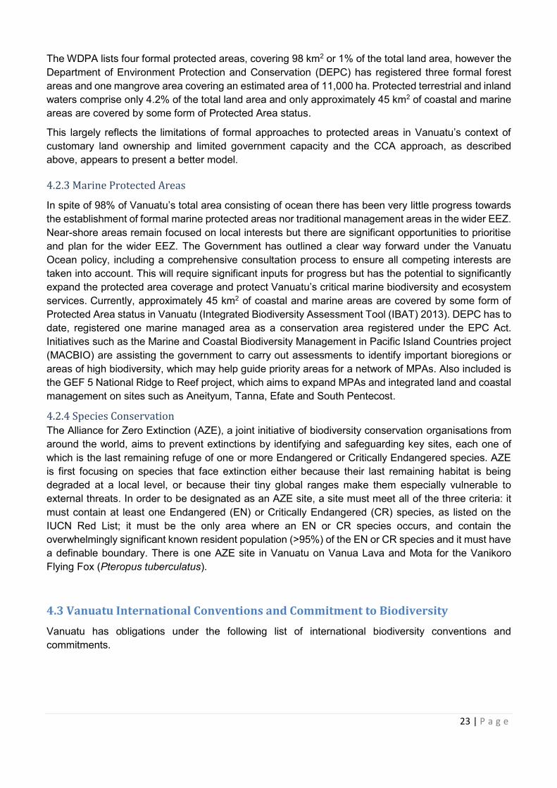
4.3 Vanuatu International Conventions and Commitment to Biodiversity
Vanuatu has obligations under the following list of international biodiversity conventions and
commitments.
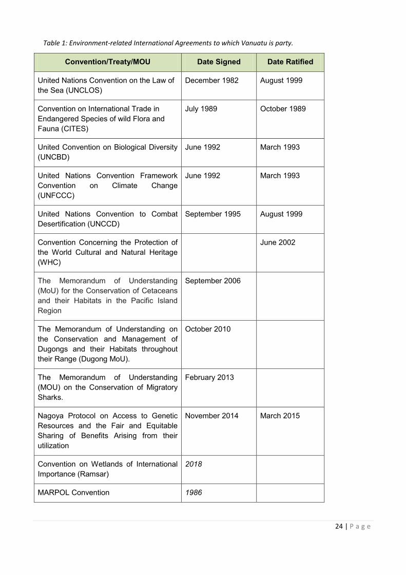
24 | P a g e
Table 1: Environment-related International Agreements to which Vanuatu is party.
Convention/Treaty/MOU Date Signed Date Ratified
United Nations Convention on the Law of
the Sea (UNCLOS)
December 1982 August 1999
Convention on International Trade in
Endangered Species of wild Flora and
Fauna (CITES)
July 1989 October 1989
United Convention on Biological Diversity
(UNCBD)
June 1992 March 1993
United Nations Convention Framework
Convention on Climate Change
(UNFCCC)
June 1992 March 1993
United Nations Convention to Combat
Desertification (UNCCD)
September 1995 August 1999
Convention Concerning the Protection of
the World Cultural and Natural Heritage
(WHC)
June 2002
The Memorandum of Understanding
(MoU) for the Conservation of Cetaceans
and their Habitats in the Pacific Island
Region
September 2006
The Memorandum of Understanding on
the Conservation and Management of
Dugongs and their Habitats throughout
their Range (Dugong MoU).
October 2010
The Memorandum of Understanding
(MOU) on the Conservation of Migratory
Sharks.
February 2013
Nagoya Protocol on Access to Genetic
Resources and the Fair and Equitable
Sharing of Benefits Arising from their
utilization
November 2014 March 2015
Convention on Wetlands of International
Importance (Ramsar)
2018
MARPOL Convention 1986
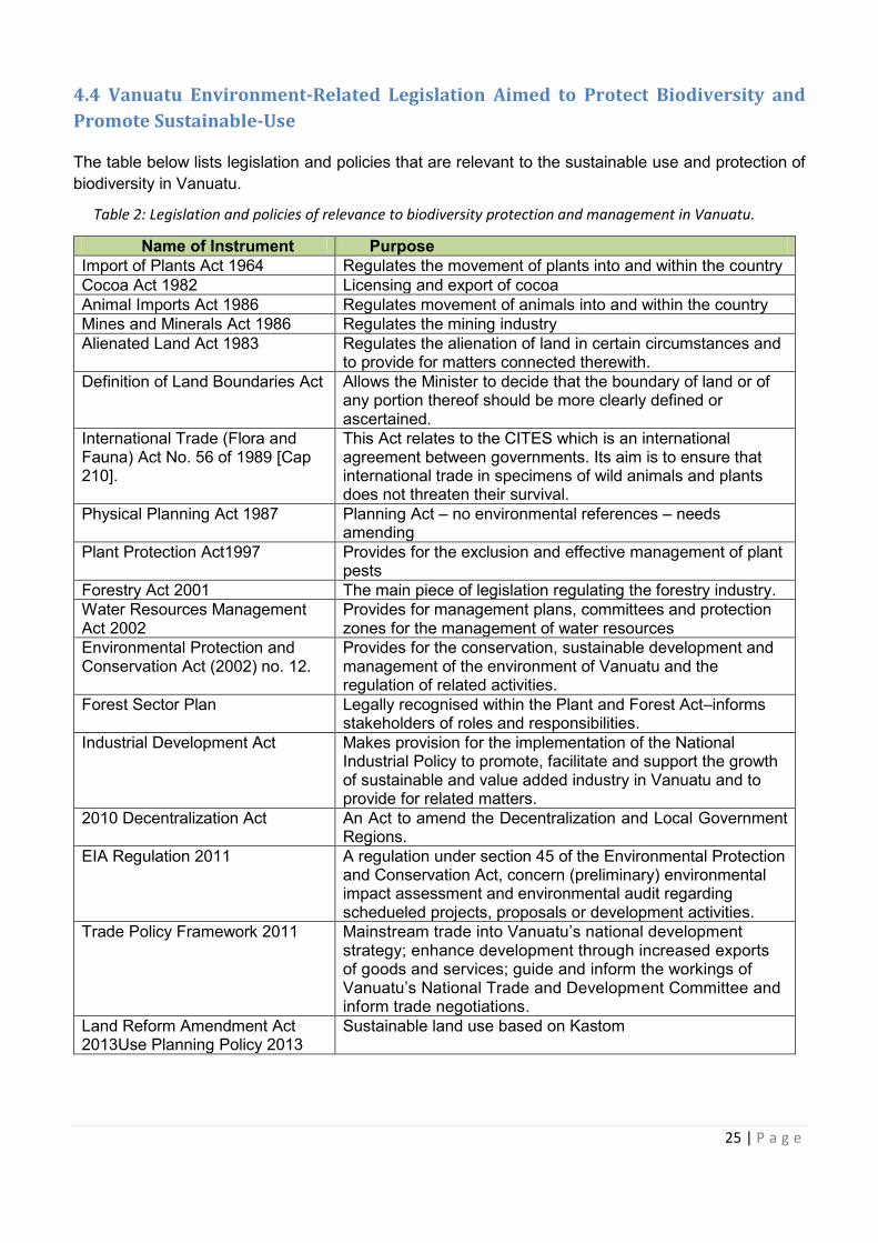
25 | P a g e
4.4 Vanuatu Environment-Related Legislation Aimed to Protect Biodiversity and
Promote Sustainable-Use
The table below lists legislation and policies that are relevant to the sustainable use and protection of
biodiversity in Vanuatu.
Table 2: Legislation and policies of relevance to biodiversity protection and management in Vanuatu.
Name of Instrument Purpose
Import of Plants Act 1964 Regulates the movement of plants into and within the country Cocoa Act 1982 Licensing and export of cocoa Animal Imports Act 1986 Regulates movement of animals into and within the country Mines and Minerals Act 1986 Regulates the mining industry Alienated Land Act 1983 Regulates the alienation of land in certain circumstances and
to provide for matters connected therewith. Definition of Land Boundaries Act Allows the Minister to decide that the boundary of land or of
any portion thereof should be more clearly defined or ascertained.
International Trade (Flora and Fauna) Act No. 56 of 1989 [Cap 210].
This Act relates to the CITES which is an international agreement between governments. Its aim is to ensure that international trade in specimens of wild animals and plants does not threaten their survival.
Physical Planning Act 1987
Planning Act – no environmental references – needs amending
Plant Protection Act1997
Provides for the exclusion and effective management of plant pests
Forestry Act 2001 The main piece of legislation regulating the forestry industry. Water Resources Management Act 2002
Provides for management plans, committees and protection zones for the management of water resources
Environmental Protection and Conservation Act (2002) no. 12.
Provides for the conservation, sustainable development and management of the environment of Vanuatu and the regulation of related activities.
Forest Sector Plan Legally recognised within the Plant and Forest Act–informs stakeholders of roles and responsibilities.
Industrial Development Act Makes provision for the implementation of the National Industrial Policy to promote, facilitate and support the growth of sustainable and value added industry in Vanuatu and to provide for related matters.
2010 Decentralization Act An Act to amend the Decentralization and Local Government Regions.
EIA Regulation 2011 A regulation under section 45 of the Environmental Protection and Conservation Act, concern (preliminary) environmental impact assessment and environmental audit regarding schedueled projects, proposals or development activities.
Trade Policy Framework 2011 Mainstream trade into Vanuatu’s national development strategy; enhance development through increased exports of goods and services; guide and inform the workings of Vanuatu’s National Trade and Development Committee and inform trade negotiations.
Land Reform Amendment Act 2013Use Planning Policy 2013
Sustainable land use based on Kastom
26 | P a g e
Name of Instrument Purpose
Foreshore Development Act (amended 2013)
Regulates the carrying out of works on the foreshore.
National Industry Policy 2010-15 Permits private sectors access of usage; will create more access to markets; and will assist producers to operate in a sustainable environment.
Vanuatu Forest Policy 2013-2023 Sets clear policy directives for the management of Vanuatu's forests and forest resources for the next 10 years (2013 – 2023).
Fisheries Act 2014 Makes provision for management, development and regulation of fisheries in nearshore, offshore and aquaculture and for the control of fishing vessels entitled to fly the flag of Vanuatu outside of Vanuatu waters in a manner consistent with Vanuatu’s international obligations, and for related matters.
Vanuatu’s National Ocean Policy 2016
Government's policy for the management of its sovereign water and marine ecosystems through to 2030.
Deep Sea Mineral Policy 2016 Sets out Vanuatu’s vision and strategic goals in relation to its deep sea minerals, and will form the basis for future drafting of laws in line with the policy.
Vanuatu Forestry Act 2014 Makes provision for the protection, development and sustainable management of forests and the regulation of the forestry industry in Vanuatu, and for related purposes.
Overarching Productive Sector Policy
Pomotes private sector-led agriculture growth which recognises that the private sector - including farmers and fishers (big and small), traders, food vendors, processors and exporters - are the major sector output generators.
National Environment Policy and Implementation Plan
Is an illustration of the Government's commitment to environmental sustainability and meets the requirements of a national policy and plan set out in the Environmental Protection and Conservation Act [CAP 283].
Vanuatu National Sustainable Development Plan
Its vision is: Building a stable, sustainable and prosperous nation. It focuses on three main pillars: society, environment and economy.
Vanuatu Sustainable Tourism Policy 2018
This is important as sustainable tourism is not a discrete special form of tourism, rather, all forms of tourism should strive to be more responsible and sustainable.
Vanuatu National Livestock Policy 2015-2030
Recognizes the major stakeholders in the livestock sector and it defines their respective roles. It also recognizes the impact of livestock activities on the environment and the availability of other natural recourses such as land, water, and wildlife/livestock interaction on livestock production.
Vanuatu Agriculture Sector Policy This Policy, underpinned by social, economic, ecological and cultural principles and sustainable development pillars, is organized around 13 thematic areas.
Vanuatu National Fisheries Policy 2016-2031
Sets out the vision, high level formal policy directions and implementation strategic framework for the sustainable conservation, management and development of fisheries and aquaculture in the Republic of Vanuatu.
With regard to regulating development activities with potential negative environmental impacts, the key
pieces of legislation are the Environmental Protection and Conservation (EPC) Act 2002 CAP 283 and
Foreshore Development Act
15 Permits private sectors access of usage; will create more
2023 Vanuatu's
Ocean Policy
ets out Vanuatu’s vision and strategic goals in relation to its
Overarching Productive Sector
National Environment Policy and
ding a stable, sustainable and prosperous
This is important as sustainable tourism is not a discrete
Vanuatu National Livestock Policy ecognizes the major stakeholders in the livestock sector
Policy This Policy, underpinned by social, economic, ecological and
Vanuatu National Fisheries Policy ets out the vision, high level formal policy directions and
27 | P a g e
the Environmental Impact Assessment (EIA) Regulation of 2011. These specify the requirements of an
EIA and lay out the process to be followed when carrying one out. The act applies to all development
activities that either impact or are likely to impact on the environment of Vanuatu, and which require
any license, permit or approval under any law (Clarke et al. 2008).
5.0 VANUATU NATIONAL BIODIVERSITY STRATEGY AND ACTION PLAN
(NBSAP)
5.1 Mission Statement
1. To manage and safeguard biological resources through government, provinces
and local communities so as to maintain fully our natural and cultural heritage for
all Ni-Vanuatu.
2. Guide governments, provinces, local communities, landowners and landholders in
the sustainable management of Vanuatu’s natural resources.
3. Ensure that all Ni-Vanuatu, including future generations, are able to benefit from
biodiversity and enjoy its use.
4. Protect the custom, intellectual and legal rights of Ni-Vanuatu as resource
custodians and users.
There are various measures that can be used to meet these goals. In developing this strategy and
action plan priority has been given to activities that are: affordable, within the capacity of existing
government or community institutions, and that meet established needs. It is also recognised that
conservation of biodiversity is an ongoing and evolving process.
5.2 Principles Underpinning the Strategy
Principle 1. Community participation and ownership
Most natural resources in Vanuatu are owned and used by indigenous and local communities.
Conservation of biodiversity in Vanuatu is greatly dependent on the manner in which
landowners, landholders and local user communities choose to manage their landholdings
ownership and fishing rights. Community property rights include traditional rights over natural
resources, indigenous intellectual property relating to natural resources and cultural knowledge.
Any conservation or development work should ensure respect for community decision-making
structures, equal participation and ownership of resource owners and active involvement in
planning, implementation, monitoring and evaluation.
Principle 2. Biodiversity is the foundation for all development and inter-generational
equity
Biodiversity conservation is the collective responsibility of all levels of government, the private
sector, resource users and landowners. This principle places biodiversity at the heart of policy,
legislation, plans and projects, highlighting the benefits of taking biodiversity into account – and
the associated costs – and the risk of business as usual. This is to ensure that future generations
of landowners and citizens, as well as today’s youth and children, all have an equal opportunity
to use and enjoy Vanuatu’s biodiversity.
Principle 3. Biodiversity mainstreaming and ownership
This Principle is based on the understanding that lasting conservation in Vanuatu can only be
achieved if:
28 | P a g e
· Biodiversity is mainstreamed into national development and poverty reduction
efforts,
· Sectors and development partners (including communities) take responsibility for
leadership of the design, implementation and evaluation of all conservation
programmes in their respective areas and,
· Sectors and development partners commit to biodiversity-development
mainstreaming and cross-sector coordination.
Principle 4: Gender mainstreaming and equality
Gender perspective must be mainstreamed or integrated into all NBSAP related policies,
strategies actions and project stages. It must also ensure equal rights, possibilities and
obligations for both men and women in society. It will ensure that stereotyped concepts of
gender roles must not restrict the opportunities of individuals and equal appreciation of the
values, choices and life experiences typical of women and men. It does not mean seeking to
make women and men the same.
Principle 5: Adopting an ecosystem-based management approach
All conservation and development programmes should adopt an ecosystem-based, ridge to reef
or island-system approach to ensure an integrated approach that sustains healthy, productive
and resilient ecosystems and restores connectivity between social, economic and cultural
values. Involvement of stakeholders must be ensured through participatory governance,
adaptive management and integration of scientific, traditional and local knowledge in designing
and implementing conservation programmes.
Principle 6: Managed and Protected Areas for species protection, forest, watersheds and
marine should be comprehensive and representative
The establishment of a comprehensive and representative system of marine and terrestrial
reserves and conservation areas at the national and local levels is critical to successful
biodiversity conservation. A comprehensive and representative system includes examples of all
habitats and species.
Principle 7: Improving knowledge, capacity and intellectual property
The intellectual property rights to biodiversity, genetic resources, and bio-derivate knowledge
about biodiversity must be recognised and appropriate mechanisms established to ensure that
fair remuneration, credit or other benefits are received by local communities, the discoverer or
developer, and the nation. Improved scientific knowledge of biodiversity and enhanced
ethnobiological understanding is required for improved conservation management and
sustainable use. Education, public awareness and local knowledge are essential for enabling
the conservation of biodiversity and ensuring conservation is continuously improved by
recording, disseminating and incorporating lessons learned and best practices
Principle 8. Financial sustainability and accountability
This principle reflects the fact that conservation initiatives must be adequately resourced over
time if they are to be successful and that conservation programmes should be of a scale and
budget appropriate to the local context. Long-term strategic planning and resource mobilisation
that sustains conservation over time is needed. International and national partners will need to
be accountable to the communities and countries they work in for their investment and
engagement in conservation programmes.
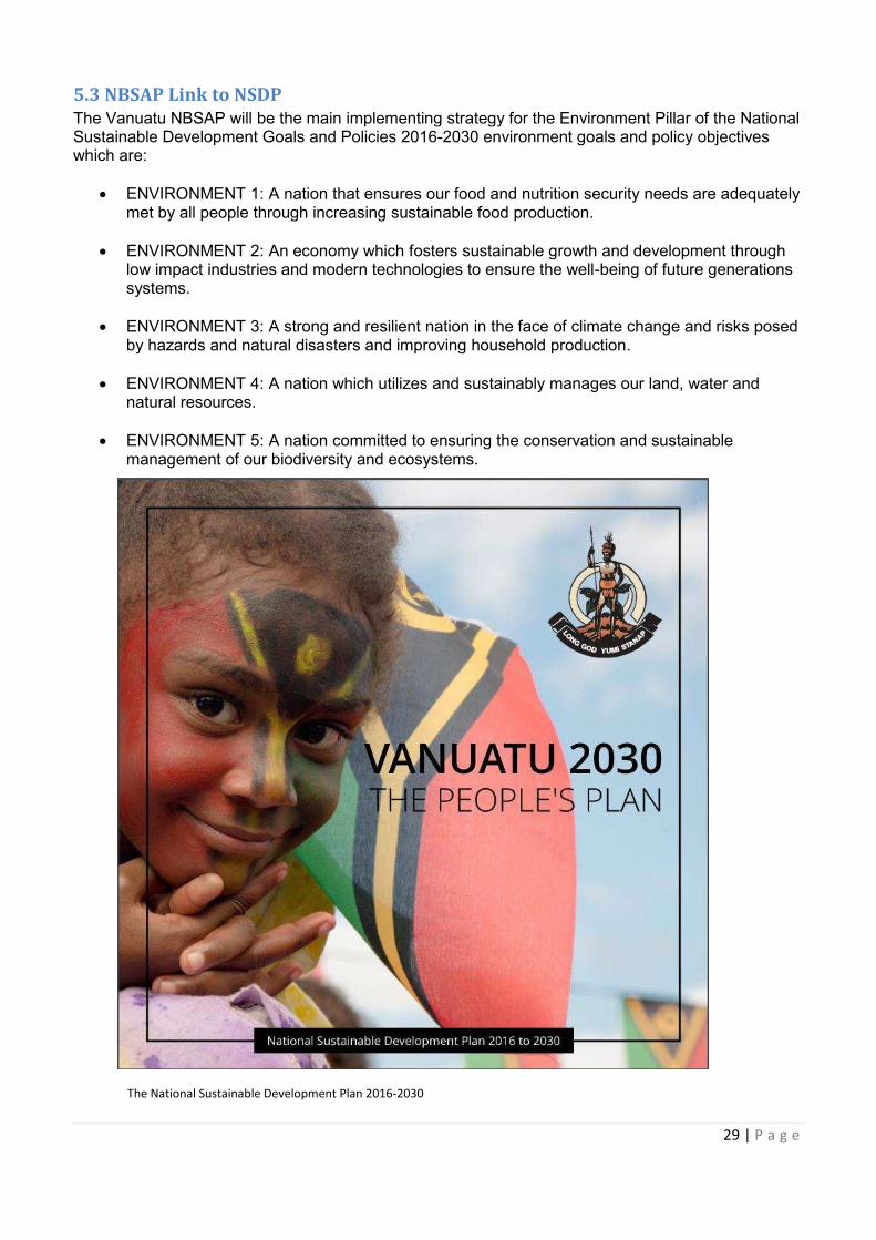
29 | P a g e
5.3 NBSAP Link to NSDP
The Vanuatu NBSAP will be the main implementing strategy for the Environment Pillar of the National Sustainable Development Goals and Policies 2016-2030 environment goals and policy objectives which are:
· ENVIRONMENT 1: A nation that ensures our food and nutrition security needs are adequately met by all people through increasing sustainable food production.
· ENVIRONMENT 2: An economy which fosters sustainable growth and development through low impact industries and modern technologies to ensure the well-being of future generations systems.
· ENVIRONMENT 3: A strong and resilient nation in the face of climate change and risks posed
by hazards and natural disasters and improving household production.
· ENVIRONMENT 4: A nation which utilizes and sustainably manages our land, water and natural resources.
· ENVIRONMENT 5: A nation committed to ensuring the conservation and sustainable
management of our biodiversity and ecosystems.
The National Sustainable Development Plan 2016-2030
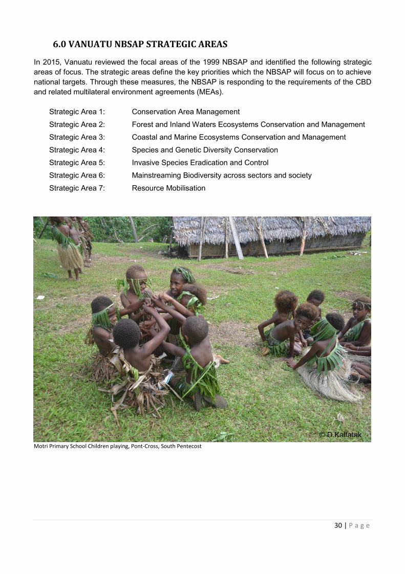
30 | P a g e
6.0 VANUATU NBSAP STRATEGIC AREAS
In 2015, Vanuatu reviewed the focal areas of the 1999 NBSAP and identified the following strategic
areas of focus. The strategic areas define the key priorities which the NBSAP will focus on to achieve
national targets. Through these measures, the NBSAP is responding to the requirements of the CBD
and related multilateral environment agreements (MEAs).
Strategic Area 1: Conservation Area Management
Strategic Area 2: Forest and Inland Waters Ecosystems Conservation and Management
Strategic Area 3: Coastal and Marine Ecosystems Conservation and Management
Strategic Area 4: Species and Genetic Diversity Conservation
Strategic Area 5: Invasive Species Eradication and Control
Strategic Area 6: Mainstreaming Biodiversity across sectors and society
Strategic Area 7: Resource Mobilisation
Motri Primary School Children playing, Pont-Cross, South Pentecost
© D.Kalfatak
31 | P a g e
6.1 STRATEGIC AREA 1: CONSERVATION AREA MANAGEMENT
Aichi Strategic Focus Area: Safeguard ecosystems, species, genes and improving the status of
biodiversity to support national income and livelihoods
Aichi Strategic Goal C: To improve the status of biodiversity by safeguarding ecosystems, species
and genetic diversity
Aichi Target 11: By 2020, at least 17 per cent of terrestrial and inland water, and 10 per cent of coastal
and marine areas of particular importance for biodiversity and ecosystem services, are conserved through
effectively and equitably managed, ecologically representative and well-connected systems of protected
areas and other effective area-based conservation measures, and integrated into the wilder landscapes
and seascapes.
VANUATU CONSERVATION AREAS TARGET
1. By 2030, representative examples of at least 17% of terrestrial and 10% of coastal and marine
areas to support 100% of local communities’ livelihoods and kastom importance are conserved
through effective community and government management measures.
2. By 2020, there are 10 legally registered CCAs and 50% of CCAs are effectively supported and managed in Vanuatu.
3. By 2030, 90% of CCA management committees are complying with their reporting obligations to DEPC (NEPIP, 2016).
4. Targets for conservation areas set in provincial strategic plans are achieved.
Indicators:
· Total area of representative coverage of legally recognised, other effective conserved areas
and locally managed areas in terrestrial and marine areas including sites of particular
importance for biodiversity.
· Percentage of terrestrial and marine protected areas that are effectively managed based on
agreed national and international protected area conditions and management effectiveness.
· Measure of ecosystem service values and equity of benefits from CAs.
· Level of connectivity of CAs and other area based approaches with broader landscapes and
seascapes.
IUCN’s “Guidelines for Applying Protected Area Management Categories” defines a protected area
as: A clearly defined geographical space, recognised, dedicated and managed, through legal or other
effective means, to achieve the long-term conservation of nature with associated ecosystem services
and cultural values. The IUCN guidelines provide an opportunity for Vanuatu to ensure that our CA
efforts towards sustainable resource management qualify as protected areas and therefore meet our
international commitments and obligations.
Well-governed and effectively managed protected areas are a proven method for safeguarding both
habitats and populations of species and for delivering important ecosystem services. Protected areas
should be integrated into the wider land and seascape, and relevant sectors, bearing in mind the
importance of complementarity and spatial configuration. In doing so, the ecosystem approach should
be applied, taking into account ecological connectivity and the concept of ecological networks, including
connectivity for migratory species (through, for example, “fly-ways” for migratory birds).
32 | P a g e
Protected areas should also be established and managed in close collaboration with, and
through equitable processes that recognise and respect the rights of indigenous and local
communities, and vulnerable populations.
Vanuatu has a rudimentary system of conservation areas, however, none of the areas have been
selected through formal planning processes on the basis of ecological knowledge or biodiversity values.
In most cases, their existence is historical, traditional or opportunistic. Nonetheless, these sites in
combination with other priority sites which have been identified for their biodiversity values, have the
potential to provide the basis of a representative system of protected areas. The intention is for the
representative system of protected areas to be strengthened by a large number and variety of protected
areas which are important at the national, provincial or local level.
FOCUS AREA CA1: EXPANDED NATIONAL REPRESENTATIVE NETWORK OF
CONSERVATION AREAS IN MARINE, TERRESTRIAL AND INLAND
WATERS.
Objective CA1a: To carry out marine, terrestrial and inland waters biodiversity rapid assessment,
inventories and threat identification, gap analyses and prioritisation to guide the development of a
national representative network of CAs.
ACTION PLANS:
CA1.1 Carry out gap analysis and prioritisation in terrestrial, marine and inland waters
ecosystems to identify key biodiversity areas for biodiversity protection to meet our
national targets.
CA1.2 Analyse and map the occurrence and status of all existing conservation areas, including
their governance structures.
CA1.3 Prioritise key biodiversity areas for focal species, species/groups, habitats and
important ecological connectivity and processes.
CA 1.4 Identify sites that can achieve not just biodiversity conservation but also social and
economic outcomes to do with, for example, fisheries, culture and heritage, agriculture,
timber resources, watershed protection, sustainable tourism, to ensure they provide
benefits to local people.
Objective CA 1b: To develop and apply an implementation plan to meet Vanuatu’s CA targets in
terrestrial, marine and inland waters protected areas systems.
ACTION PLANS:
CA1.5 Conduct a national planning process to develop a CA action and implementation plan for
land, marine and inland waters.
CA1.6 Develop priority biodiversity areas maps for terrestrial, marine and inland waters.
CA1.7 Describe the entirety of Vanuatu’s natural terrestrial, coastal and marine environment as
a basis for selecting ecologically representative areas.
CA1.8 Develop terrestrial and marine protected area typologies.
33 | P a g e
CA1.9 Describe protected area design criteria to guide placement of different types of protected
areas.
FOCUS AREA CA2: Improve Information Management and Monitoring Conservation Area
Management Effectiveness and Practice.
Objective CA2a: Develop a national information system, database and monitoring framework for
Vanuatu’s CAs to assess the management effectiveness of CAs, and promote adaptive management.
ACTION PLANS:
CA2.1 Adopt a national 100% target to support all communities, provinces and districts in
Vanuatu through government policies, provincial endorsements and supported by
national sector strategies and plans.
CA2.2 Use some of the Conservation Areas as role models whether they are formally
registered or not.
CA2.3 Monitor and evaluate protected areas to ensure they are effective and are achieving their
core objectives.
CA2.4 Ensure monitoring and evaluation is fed into the national CA network plans for learning
and adaptive management.
Objectives CA2b: To develop context specific co-management plans, recognising both informal and
formal CA sites at national, provincial and local level.
ACTION PLANS:
CA2.5 For each priority CA, establish opportunities for mutually beneficial co-management
arrangements, which takes into account and builds upon good governance practices
where they exist.
CA2.6 Ensure at each CA there are wide participatory discussions with local communities and
key stakeholders to discuss opportunities for co-management.
CA2.7 Build capacity at all levels, with strong focus on supporting provincial and district level
committees to implement PAs.
CA2.8 Apply, as appropriate, a diversity of governance arrangements that include recognition
of Indigenous and Community Conserved Areas (ICCA) through national legislation or
other effective means of formal inclusion in the national systems.
Objective CA2c: To maintain the integrity of PA networks by ensuring they are recognised and
supported by other sectors including in the National Sustainable Development Plan and other
government policies and frameworks.
ACTION PLANS:
CA2.9 Coordination between relevant natural resource management sectors such as
environment and conservation, agriculture, forestry, fisheries, biosecurity and tourism
sector-specific sustainable natural resource management activities to support CA
management and systems.
34 | P a g e
CA2.10 Incorporate CA planning (marine, inland waters and terrestrial) within broader national
planning exercises including spatial planning and frameworks such as the National
Sustainable Development Plan.
CA2.11 Assess the value and contribution of Protected Areas to national and local economies
and to achieving the SDGs.
CA2.12 Develop a Conservation Registry and regularly update this.
FOCUS AREA CA3: Develop Sustainable Finance Mechanisms for New and Existing Protected
Areas
Objective CA3: To establish sustainable financing mechanisms to support the establishment,
management and long-term effectiveness of protected areas.
ACTION PLANS:
CA3.1 Calculate financial costs for managing a comprehensive and representative CA network
for Vanuatu’s land, sea and freshwater, including establishment as well as long term-
management costs.
CA3.2 Identify innovative sustainable financing mechanisms to support the establishment and
management of CAs in Vanuatu. These may include initiatives such as green tax, tax
benefit systems for CAs, establishment of trust or endowment funds, etc.
CA3.3 Set up the legal, policy and institutional framework for establishing the financial
structures and mechanism for a national CA network.
CA3.4 Ensure meaningful participation and provide equitable incentives and remuneration to
resource owners for CA establishment and management.
FOCUS AREA CA4: National awareness and education on conservation areas to share best
practices and lessons learned to improve management effectiveness
and governance.
Objective CA4: To develop and collate best practice guidelines and disseminate among local and
national conservation area sites.
ACTION PLANS:
CA4.1 Collate best practices for management, governance and sustainable financing from
existing protected area sites in Vanuatu.
CA4.2 Identify key lessons learned for distribution to management authorities across national
protected area sites.
CA4.3 Develop appropriate awareness, information kits, manuals, toolkits specific to different
stakeholders such as planners, community leaders, researchers and practitioners.
CA4.4 Promote Vanuatu’s best practices for CA management, governance and sustainable
financing at national, regional and international fora.
CA4.5 Develop nationally appropriate capacity development programmes, including peer
networks, for exchange of experiences in conservation practice.
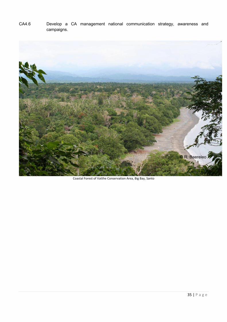
35 | P a g e
CA4.6 Develop a CA management national communication strategy, awareness and
campaigns.
Coastal Forest of Vatthe Conservation Area, Big Bay, Santo
© R. Baereleo
36 | P a g e
6.2 STRATEGIC AREA 2: FOREST AND INLAND WATERS ECOSYSTEMS
CONSERVATION AND MANAGEMENT
Aichi Strategic Goal B: Reduce the direct pressures on biodiversity and promote sustainable use Target 5: By 2020, the rate of loss of all natural habitats, including forests, is at least halved and where feasible brought close to zero, and degradation and fragmentation is significantly reduced. Target 6: By 2020, all fish and invertebrate stocks and aquatic plants are managed and harvested sustainably, legally and applying ecosystem based approaches, so that: overfishing is avoided, recovery plans and measures are in place for all depleted species, fisheries have no significant adverse impacts on threatened species and vulnerable ecosystems and the impacts of fisheries on stocks, species and ecosystems are within safe ecological limits. Target 7: By 2020 areas under agriculture, aquaculture and forestry are managed sustainably, ensuring conservation of biodiversity. Target 8: By 2020, pollution, including from excess nutrients, has been brought to levels that are not detrimental to ecosystem function and biodiversity.
Target 11 (Aichi Goal C): By 2020, at least 17 per cent of terrestrial and inland water, and 10 per cent
of coastal and marine areas of particular importance for biodiversity and ecosystem services, are
conserved through effectively and equitably managed, ecologically representative and well-connected
systems of protected areas and other effective are-based conservation measures, and integrated into
the wilder landscapes and seascapes.
Vanuatu Forest and Inland Waters Target
1. By 2030, at least 17% of important biodiversity areas, livelihoods and kastom importance
are conserved through community and government effective management measures.
2. By 2030, at least 15% of natural forest and 10% of wetland areas are conserved through
effective community and government management measures.
3. By 2030, 30% of Vanuatu’s natural forest (Forestry) is being actively managed and
protected.
Indicators:
· Trends in forest and inland waters species diversity including traded ones. · Trend to which biodiversity and ecosystem service values are incorporated into
government accounting reporting.
· Percentage of forest and inland waters conservation areas to meet national and global
targets.
· Impact of threats to forest and inland waters such as invasive species, deforestation,
logging and other threats.
Aichi Strategic Goal B: Reduce the direct pressures on biodiversity and promote sustainable
37 | P a g e
FOCUS AREA FIW1: Reduce major threats to forest and inland waters ecosystems such as
unsustainable logging, agriculture, mining and human settlements.
Objective FIW1: The forest and inland waters ecosystem are managed in an integrated and
sustainable manner to maintain the ecosystem functions of forest and inland waters and contribute to
local and national economies and social well-being.
ACTION PLANS:
FIW1.1 Improve and update information on status of forest and inland waters biodiversity.
FIW1.2 Carry out forest and inland waters resource inventory, biological rapid assessments and
identify high biodiversity areas, important cultural sites and other sites of national
significance in forest and inland waters.
FIW1.3 Identify the root causes of major threats to forest and inland waters ecosystems at local
and national level.
FIW1.4 Develop and implement a national forest and inland waters conservation management
plan to address threats and, where possible, their root causes.
FIW1.5 Conduct valuation of wetland services so that they are properly accounted for in decision
making
FIW1.6 Conduct awareness and education at local and national level on the importance of
conservation and sustainable use of forest and inland waters ecosystems.
FIW1.7 Capture best practice and lessons learning to improve management of forest
ecosystems.
FOCUS AREA 2: Establishment of Forest and Inland Waters Conservation Areas in important
biodiversity areas such as KBAs.
Objective 2: Establishment of effective forest and inland waters conservation in important biodiversity
areas with effective sustainable financing to support management in the long term.
FIW2.1 Support establishment of Forest and inland waters conservation areas at important
biodiversity areas.
FIW2.2 Improve effective management of existing forest and inland waters conservation areas.
FIW2.3 Support internal significant forest and inland waters to be registered as Ramsar and
heritage sites.
FIW2.4 Establish sustainable financing mechanisms such as payment of ecosystem services,
alternative income generating best practices and national financing mechanisms.
FIW2.5 Increase capacities of government departments and ministries such as Forestry,
Agricultures, DEPC and Biosecurity to carry out their roles and responsibilities in
sustainable management of forest and inland waters
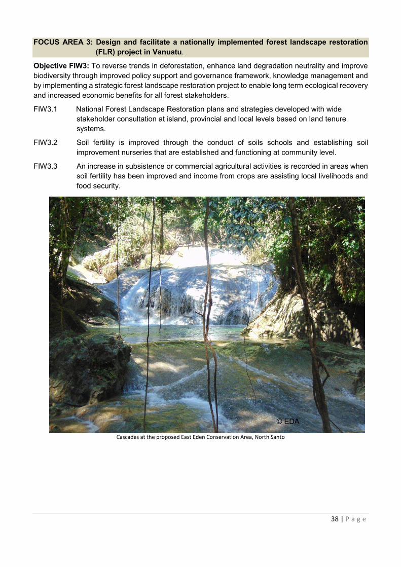
38 | P a g e
FOCUS AREA 3: Design and facilitate a nationally implemented forest landscape restoration
(FLR) project in Vanuatu.
Objective FIW3: To reverse trends in deforestation, enhance land degradation neutrality and improve
biodiversity through improved policy support and governance framework, knowledge management and
by implementing a strategic forest landscape restoration project to enable long term ecological recovery
and increased economic benefits for all forest stakeholders.
FIW3.1 National Forest Landscape Restoration plans and strategies developed with wide
stakeholder consultation at island, provincial and local levels based on land tenure
systems.
FIW3.2 Soil fertility is improved through the conduct of soils schools and establishing soil
improvement nurseries that are established and functioning at community level.
FIW3.3 An increase in subsistence or commercial agricultural activities is recorded in areas when
soil fertility has been improved and income from crops are assisting local livelihoods and
food security.
Cascades at the proposed East Eden Conservation Area, North Santo
© EDA
39 | P a g e
6.3 STRATEGIC AREA 3: COASTAL AND MARINE ECOSYSTEMS CONSERVATION AND
MANAGEMENT (CME)
Aichi Strategic Focus Area : Safeguard ecosystems, species, genes and improving the status
of biodiversity to support national economy and livelihoods
Aichi Strategic Goal C: To improve the status of biodiversity by safeguarding ecosystems,
species and genetic diversity
Aichi Target 11: By 2020, at least 17 per cent of terrestrial and inland water, and at least 10 per cent
of coastal and marine areas of particular importance for biodiversity and ecosystem services, are
conserved through effectively and equitably managed, ecologically representative and well-connected
systems of protected areas and other effective are-based conservation measures, and integrated into
the wilder landscapes and seascapes.
VANUATU COASTAL AND MARINE ECOSYSTEMS TARGET
1. By 2030, at least 10% of important marine biodiversity areas, and areas of livelihood and
kastom importance are conserved through effective community and government
management areas.
Indicators:
· Total area of representative coverage of legally recognised, other conserved areas and
locally managed areas in marine areas including sites of particular importance for
biodiversity
· Total number of marine protected areas that are effectively managed based on agreed
national protected area conditions and management effectiveness
· Measurement of ecosystem services and equitable benefits from CAs
· Account for Payment of Ecosystem Service (PES) and other sustainable financing
strategies
· Measure if trends in connectivity of CAs and other area based approaches integrated into
landscapes and seascapes
· Assess impact of coastal developments through EIAs and measures of EIA enforcements and compliance
40 | P a g e
FOCUS AREA CME1: Reduce major threats to Vanuatu’s coastal and marine ecosystems such
overharvesting, reclamation, unsustainable tourism development, natural
disaster impacts, climate change impacts, river dredging and pollution.
Objective CME1: Improve understanding and status of coastal and marine ecosystems through
research, resource assessments, threat identification and mitigation and information management
ACTION PLANS:
CME1.1 Carry out coastal and marine resource inventories, biological rapid assessments and
identify high biodiversity areas, important cultural sites and other sites of national
significance including information on local scale fisheries, conservation area tabu sites,
and locally managed area. Use MACBIO report on Vanuatu’s special, unique marine
areas to inform this work.
CME1.2 Identify root causes of major threats to coastal and marine ecosystems at local and
national level.
CME1.3 Develop and implement a national coastal and marine conservation management plan
to address major threats and, where possible, their root causes.
CME1.4 Promote recommendations of MACBIO coastal and marine ecosystem service valuation
report to government to ensure national budgets and accounting considers and
implement recommendations.
CME1.5 Conduct awareness raising and education at local and national levels on the importance
of conservation and sustainable use of coastal and marine ecosystems.
CME1.6 Capture best practices and lessons learned about improving management of coastal
and marine ecosystems.
CME1.7 Develop and promote partnerships between government, communities and private
sector towards sustainable management of coastal and marine ecosystems.
CME1.8 Strengthen national mangrove management through legislation, awareness raising,
priority site management and rehabilitation.
CME1.9 Monitor and evaluate effect of coastal developments at different scales including
consideration of cumulative impacts.
FOCUS AREA CME2: Inshore Fisheries Management: strengthen management of coastal
fisheries to reduce overharvesting and destructive fishing methods to
maintain and improve coastal and coral reef ecosystems.
Objective CME2: Scale up successes in sustainable fisheries management in customary fishing
grounds including use of locally managed marine areas tools (e.g. tabus) and put in place supportive
enabling mechanisms.
ACTION PLANS:
CME2.1 Support the development of inshore fisheries management plans at national, provincial
and village levels. Increase production and food security, aquaculture and alternative
livelihoods.
41 | P a g e
CME2.2 Promote tools such as the ‘Community Based Adaptive Management’ (CBAM) in
developing integrated community management plans which include managing locally
managed marine areas within customary fishing grounds.
CME2.3 Strengthen science and research in inshore fisheries management including regarding
aquaculture, target species management, licensing, and marine managed areas.
CME2.4 Support the effective establishment of provincial and district level customary and
traditional environment committees to support inshore fisheries management at
provincial level.
CME2.5 Encourage coastal rehabilitation in post-disaster/climate change affected areas.
CME2.6 Promote restrictions on illegal importation of illegal fishing gear.
FOCUS AREA CME3: Integrated Offshore fisheries management
Objective CME3: Improve management of Vanuatu’s marine resources within the EEZ.
CME3.1 Strengthen surveillance, enforcement and monitoring within Vanuatu’s EEZ through
strengthened partnerships with international stakeholders and neighbouring states.
CME3.2 Strengthen, support and secure data and information collation, establish central
repository, for better decision making.
CME3.3 Conduct valuation of offshore marine ecosystem services so that they are properly
accounted for in decision making.
CME3.4 The Government will build on existing spatial planning mechanisms, including traditional
spatial management systems (e.g. tabus), for improving management of maritime space
to achieve economic development, cultural, social and environmental objectives.
CME3.5 Collate and audit existing marine data to determine data gaps.
CME3.6 Map biological information, including biological regions, and existing and possible future
uses of the marine environment by different activities and prioritisation of high
biodiversity areas to establish MPAs and other sustainable use areas.
CME3.7 Facilitate workshops and consultations to evaluate and synthesise the data and to start
generating a Marine Spatial Plan which provides for zoning of Vanuatu’s ocean.
CME3.8 Protected areas within the EEZ, shall be established to ensure the future sustainability
of Vanuatu’s ocean environment and so established on the basis of, inter alia, ecosystem
function, ecological adequacy, representativeness, critical habitats, natural genetic
resources, connectivity and scenic values.
CME3.9 Promote the sustainable development of offshore fisheries for large pelagic species
including through the development of appropriate regulations for the fishery and manage
the fisheries to maximize benefits to Vanuatu.
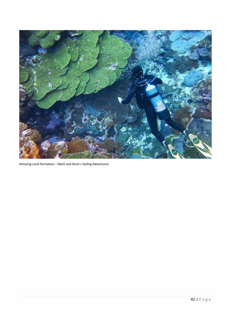
42 | P a g e
Amazing coral formation – Mark and Anne’s Sailing Adventures
43 | P a g e
6.4 STRATEGIC AREA 4: SPECIES MANAGEMENT (SM)
FOCUS AREA SM1: Establish effective management arrangement for the conservation of
endemic, endangered and culturally important species and habitats.
Objective SM1: To work with local communities, government, non-government organisations, private
sector and research institutions to develop habitat and species management plans and ensure relevant
conservation measures are in place.
ACTION PLANS:
SM1.1 Conservation of forest in the area of Homo Bay and Ranwas in South Pentecost (high
species diversity and vulnerable).
SM1.2 Document and describe remnant vegetation on Tanna and work with TAFEA and
interested landowners to establish an appropriate conservation plan.
SM1.3 Establish a conservation plan for the Petaview catchment on Epi.
SM1.4 Prepare conservation and rehabilitation plans for mangroves on Malekula, Efate, Moso,
Emau, Emae, Aneityum, Tanna, Santo and Vanua Lava.
SM1.5 Manage the catchment of Creek Ai, Efate, to protect its high biodiversity value.
SM1.6 Royal Parrot-finch, Wedge-tailed Shearwater, Vanuatu Flying Fox and Megapode - work
with chiefs, community leaders and landholders of the Shefa Province to encourage the
protection of the birds and their habitat by raising awareness of the rarity of these birds
and their limited distribution.
Aichi Strategic Goal C: To improve the status of biodiversity by safeguarding
ecosystems, species and genetic diversity
Aichi Target 12: By 2020 the extinction of known threatened species has been
prevented and their conservation status, particularly of those most in decline, has been
improved and sustained.
Aichi Target 13: By 2020, the genetic diversity of cultivated plants and farmed and
domesticated animals and of wild relatives, including other socio-economically as well
as culturally valuable species, is maintained, and strategies have been developed and
implemented for minimizing genetic erosion and safeguarding their genetic diversity.
Vanuatu Target
1. By 2030, the conservation status of at least 10 known threatened species has
been improved and sustained, particularly for those most in decline.
Indicators:
· Reduced trend in extinction risks of Vanuatu’s five national priority species.
· Increased trend in population of the five priority threatened species for Vanuatu.
· Increased trends in distribution of the five selected (priority) species.
44 | P a g e
SM1.7 Flying Foxes on Mota Lava –raise awareness of the Mota Lava community that it is the
only island supporting four species of flying foxes. Encourage chief, community leaders
and landholders to manage the flying foxes and the habitat by implementing
conservation site/s and delivering information and education.
SM1.8 Crocodile on Vanua Lava – Facilitate local monitoring of the crocodile population.
Prepare a management plan that considers the needs of the local people, financial
resources and international scientific concerns.
SM1.9 Conservation of coconut crab habitat on Hui, Tegua, Loh, Toga Linua and Metoma in
the Torres Group.
SM1.10 Conservation of bat roosting caves and feeding areas on Malo, northwest Malekula,
Vanua Lava, Santo and Efate.
SM1.11 Support the implementation of the Lake Letas management plan noting that it is a
registered CCA, one of the national wetland sites as well as the first Ramsar Site for
Vanuatu.
SM1.12 Conservation of Megapode bird (Namalau) on Tongoa, Ambrym, Efate and Epi.
SM1.13 Conservation of Collared Petrel on Tanna and Vanua Lava, and of the Vanuatu petrel
on Vanua Lava.
SM1.14 Conservation of natural stands of Carpoxylon macrospermum on the islands where they
exist.
SM1.15 Conservation of Anietyum Skink (Emoia aneityumensis).
SM1.16 Conservation of the six hot spots (IUCN Red list/ CBF Ecosystem profile): Aneityum,
Futuna, Tanna, Tongoa Laika Island Santo Mountain Range, Gaua (Banks).
SM1.17 Conservation of leatherback, green and hawksbill turtles (Aneityum, Tanna, Erromango,
Efate and offshore islands, Epi, Malekula, Santo, Malo, Aore, Gaua, Vanua Lava,
Ureparapara and Torres Groups).
SM1.18 Conservation of dugongs (sea grass areas on Aneityum, Efate, Epi, Malekula, Vanua
Lava, Santo, Gaua and Vanua Lava).
FOCUS AREA SM2: Establish data collection and storage systems for endemic, endangered,
threatened and critical species.
Objective SM2: To establish, maintain and update the National Resource Inventory (NRI) database for
all species and their status and link to other relevant global databases..
SM2.1 Conduct appropriate research to develop resource inventory on terrestrial (including
insects) and freshwater/marine biodiversity and establish NRI database.
SM2.2 Link the NRI database to Biodiversity Clearing House Mechanism (CHM) and other
databases to support MEAS, UNCBD, UNCCD and UNFCCC such as the Vanuatu
CCCD national information system maintained by DEPC in collaboration with relevant
stakeholders.
SM2.3 Undertake conservation management-oriented research on prioritised species that are
threatened or exploited for cultural/subsistence and economic purposes.
45 | P a g e
SM2.4 Explore potential sustainable use of non-threatened and endangered species in
collaboration with Conservation Officers, tourism, customs, biosecurity and community
representatives -
SM2.5 Develop a national biodiversity database at DEPC of all species; classifying level of
significance and status (IUCN Red List). The database must be accessible to all
stakeholders inclusive but not limited to government, non-government organisations,
and private business and communities.
SM2.6 Draw up an appropriate framework and mechanism for identifying, monitoring and
documenting the status of rare and endangered species.
FOCUS AREA SM3: Decrease in trade of endangered and threatened species
Objective SM3a: To assist in improving enforcement of border control and monitoring, and increase
support and capacity for enforcement and monitoring of EPC Act and CITES.
ACTION PLANS:
SM 3.1 Formalise relationships/collaborations with border control and enforcement authorities
through memoranda of understanding (Biosecurity, Customs, Border control and
DEPC).
SM 3.2 Empower authorised officers from DEPC, Customs, Border control and Biosecurity, to
enforce EPC related Acts effectively.
Objective SM3b: To increase capacity for enforcement of the International Trade of Flora and Fauna
Act 1989 and its regulations, and increase monitoring of endangered protected species.
ACTION PLANS:
SM 3.3 Quarterly surveillance of markets, traders etc. by trained and gazetted officers under the
International Trade (Flora and Fauna) Act No. 56 of 1989 [Cap 210].
SM 3.4 Review all native species and other related provisions in the International Trade (Flora
and Fauna) Act No. 56 of 1989 [Cap 210].
SM 3.5 Establish administrative responsibilities and strengthen capacity within relevant line
ministries and authorities.
SM 3.6 Appoint of authorised officers under International Trade (Flora and Fauna) Act No. 56 of
1989 [Cap 210].
SM 3.7 Establish an effective electronic CITES permitting system to manage and ease annual
reporting.
FOCUS AREA SM4: Extend Government contribution to conservation activities at community
levels
Objective SM4: To develop mechanisms for facilitating community feedback to DEPC on management
of species of special concern.
ACTION PLANS:
SM4.1 Increase DEPC representation/participation/presentation at islands and provincial
governance mechanisms and forums and private sectors.
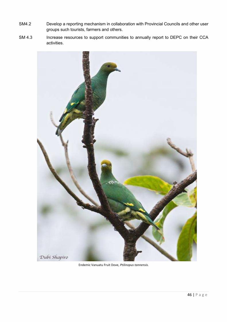
46 | P a g e
SM4.2 Develop a reporting mechanism in collaboration with Provincial Councils and other user
groups such tourists, farmers and others.
SM 4.3 Increase resources to support communities to annually report to DEPC on their CCA
activities.
Endemic Vanuatu Fruit Dove, Ptilinopus tannensis.
47 | P a g e
6.5 STRATEGIC AREA 5: MANAGEMENT OF INVASIVE Alien SPECIES (MIAS)
Aichi Strategic Goal B. Reduce the direct pressures on biodiversity and promote
sustainable use
Aichi Target 9: By 2020, invasive alien species and pathways are identified and
prioritized, priority species are controlled or eradicated, and measures are in place to
manage pathways to prevent their introduction and establishment.
Vanuatu Goal (from NISSAP)
“Yumi ol man Vanuatu I mas wok tugeta blong lukaotem gud envaeromen blong yumi
long ol rabis sik blong ol animol mo ol plant, ol rabis kras, wud, rop mo ol animol we I
stap afektem laef blo yumi mo hem ya we I no stap yet long Vanuatu blong mekem se
yumi save stap gud” - Vanuatu NISSAP.
To facilitate and guide the protection of the pristine biodiversity and livelihoods of
Vanuatu from impacts of invasive alien species through strong collaboration.
Vanuatu Target
1. By 2030 Vanuatu’s invasive alien species and pathways are identified and
prioritised, priority species are controlled or eradicated, and measures are in
place to manage pathways to prevent their introduction and establishment.
2. Emphasis will be placed on maintaining current status of native species,
improving border control, developing inter-island biosecurity programmes, IAS
eradication and control.
3. Communities’ understanding and knowledge on invasive alien species is
increased.
Indicators:
· Assessment and measure of impact of invasive alien species on biodiversity
and food security.
· Impact of policy responses, legislation and management plans to control and
prevent spread of invasive alien species.
· Required information and data on invasive alien species are available.
· National government commitment through financing of management of IAS.
· Level of invasive alien species understanding increased.
· More improve legal frameworks and policies are available.
· International border control system improved and internal quarantine system
established.
· Invasive alien species population density are reduced.
· The population density of invasive species in Conservation Areas are reduced.
48 | P a g e
Definition: Invasive Alien Species (IAS) are defined by the CBD as organisms found outside
their native geographical ranges that have spread and become invasive in their new habitats
and cause harm to biodiversity and other things that humans value. IAS include a wide range
of weeds, vertebrate and invertebrate animals and micro-organism sand diseases that
constitute a “living pollution” just as serious, but often harder to prepare for and recover from
than natural disasters, overexploitation, environmental degradation and economic
downturns. It should be noted that some indigenous, non-alien, organisms can, given
environmental degradation or change, also become invasive.
Invasive alien species are a major threat to agriculture, tourism and biodiversity and ecosystem
services, and increasing trade and travel means that this threat is likely to increase unless additional
action is taken. Pathways for the introduction of invasive alien species can be managed through
improved border controls and quarantine, including through better coordination with national and
regional bodies responsible for plant and animal health.
Given the multiple pathways for invasive alien species introductions and that multiple alien species are
already present in many countries in the region, it will be necessary to prioritise control and eradication
efforts on those species and pathways which will have the greatest impact on biodiversity and/or which
are the most resource effective to address. While well-developed and globally-applicable indicators are
lacking, some basic methodologies do exist which can serve as a starting point for further monitoring
or provide baseline information.
Many introduced species have been found to be invasive and pose threats to Vanuatu’s native flora
and fauna. These include Cordia allidora (Cordia), Panicum maximum (Elephant Grass), Cycling sp.
(Agriculture Rope), the freshwater fish Gampusia sp. (Gampusia), Oreochromis sp. (Tilapia) and
Poecilia sp., Acridothere tristis (Indian Mynah Bird), Euglandina rosea (Predatory Snail). The Vanuatu
NISSAP 2014-2020 identifies 20 national priority species for focus on management, control and
eradication. These species were brought to Vanuatu for commercial cultivation, biological control
purposes or as curiosities or pets. Once in Vanuatu, species are spread from one island to another for
similar reasons.
Travel within the Vanuatu group is increasing rapidly too and there is a need for measures to be
introduced to prevent the spread of invasive alien species within Vanuatu’s 80+ islands. Currently there
is only very limited awareness of internal quarantine requirements and this is confined to species of
agricultural or economic significance; biodiversity values are not included. Biodiversity issues need to
be very thoroughly evaluated in the licencing of introduced plants and in biocontrol programmes.
The NISSAP outlines key invasive alien species, their pathways of introduction and possible ways of
controlling future introductions.
The actions below mirror the Vanuatu National Invasive Species Strategy and Action Plan (NISSAP)
2014-2020. Note that the NISSAP generally uses the term “invasive species” (IS) rather than “invasive
alien species”. The terms are used interchangeably here in the NBSAP.
FOCUS AREA MIAS1: Building a strong foundation for effective invasive alien species
management
Objective MIAS1a: To increase understanding of the impacts of priority invasive alien species on
biodiversity, economies, livelihoods and health and actions to manage them are supported.
ACTION PLANS:
49 | P a g e
MIAS 1.1 Raise awareness and carry out outreach on impacts of IAS on biodiversity, economy,
health and cultural values.
MIAS 1.2 Develop community focused education awareness resources and materials for the wider
public.
MIAS 1.3 Develop syllabus in schools on IAS.
MIAS 1.4 Develop materials on marine invasive alien species of most threat to Vanuatu.
MIAS 1.5 Develop Island-specific materials as part of inter-island biosecurity management.
MIAS 1.6 Encourage collaboration in the management of IAS between Vanuatu and other regional
countries and institutions.
Objective MIAS1b: To build capacity and develop institutions, skills, infrastructure, technical support,
information management, networks, and exchanges required to manage IAS effectively.
ACTION PLANS:
MIAS 1.7 Establish a Vanuatu IAS national committee to provide overall coordination of IAS work
and initiatives in Vanuatu.
MIAS 1.8 Upgrade national invasive alien species database and make it accessible for public
viewing and information input.
MIAS 1.9 Identify knowledge gaps and prioritise terrestrial, freshwater and marine invasive alien
species surveys for Vanuatu.
MIAS 1.10 Collect baseline data for terrestrial, aquatic and marine invasives.
MIAS 1.11 Put in place an IAS Information review process to continually assess capacity, skills,
information and research gaps.
MIAS 1.12 Identify training and capacity needs and develop and implement training programmes
for key invasives management issues such as inter-island and border control biosecurity.
MIAS 1.13 Encourage environmental science studies for Ni-Vanuatu students.
MIAS 1.14 Provide training for harbour masters, custom officers and other port staff on identifying
invasive species issues associated with shipping and border controls.
MIAS 1.15 Provide training to community leaders to identify invasive alien species in the
communities.
MIAS 1.16 Upgrade government and NGO technical skills and knowledge on management of
invasive alien species.
MIAS 1.17 Advocate for the establishment of a Melanesian IAS council in partnership with the
Melanesian Spearhead Group (MSG) with support by the Vanuatu Government.
Objective MIAS1c: To ensure appropriate policies, legislations, protocols and procedures are in place
and operating to underpin the effective management of IAS.
ACTION PLANS:
MIAS 1.18 Enact the current draft Biosecurity Bill and translate it into local language.
50 | P a g e
MIAS 1.19 Include management of invasive alien species in Agriculture, Livestock, Forestry and
Fisheries Acts.
MIAS 1.20 Amend the Environmental Protection and Conservation Act to include additional
regulations on IAS and regulations of importation of new organisms that are a risk to the
environment.
MIAS 1.21 Revise national regulations (DEPC) and the provincial legislation for DEPC Act to
override provincial laws and by-laws.
MIAS 1.22 Amend legislation (e.g Ports Act) to address management of ballast water, ship cleaning
and the use of anti-fouling paints in line with international conventions.
MIAS 1.23 Revise and update NISSAP.
MIAS 1.24 Develop island or province-based regulations to assist inter-island biosecurity
programmes.
MIAS 1.25 Enforce current livestock regulations to prevent cattle spreading weed and seeds
between islands.
MIAS 1.26 Revise Public Works Departmetn policy and legislation for clean machinery for new
roads developments and inter-island movements.
FOCUS AREA MIAS2: Establish national baselines and monitoring of IAS in Vanuatu.
Objective MIAS2a: Systems are in place to generate baseline information on the status and the
distribution of invasive alien species, detect trends and emerging impacts.
ACTION PLANS:
MIAS 2.1 Identify priority islands (e.g Malekula, Santo) to carry out surveys to identify full range of
priority IAS at initial stages and then target all islands.
MIAS 2.2 Carry our surveys to delimit priority IAS such as fire-ants, climbing vines (Merremia
peltata), including others.
MIAS 2.3 Develop an invasive alien species alert system for Vanuatu.
MIAS 2.4 Secure sustainable funding mechanisms for surveillance, monitoring and enforcement.
Objective MIAS2b: Improve research and knowledge for priority IAS biology and impacts and
development of effective management techniques.
ACTION PLANS:
MIAS 2.5 Assess and review existing national response framework.
MIAS 2.6 Develop control programmes for priority invasive alien species.
MIAS 2.7 Train government and NGOs on management aspects of IAS.
MIAS 2.8 Secure adequate financial and technical resources for management of invasive alien
species.
MIAS 2.9 Develop protocols which require an EIA by an independent body before the introduction
of exotic species, in line with theEPC Act.
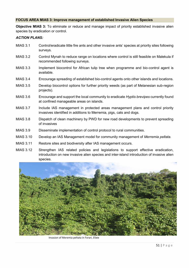
51 | P a g e
FOCUS AREA MIAS 3: Improve management of established Invasive Alien Species
Objective MIAS 3: To eliminate or reduce and manage impact of priority established invasive alien
species by eradication or control.
ACTION PLANS:
MIAS 3.1 Control/eradicate little fire ants and other invasive ants’ species at priority sites following
surveys.
MIAS 3.2 Control Mynah to reduce range on locations where control is still feasible on Malekula if
recommended following surveys.
MIAS 3.3 Implement biocontrol for African tulip tree when programme and bio-control agent is
available.
MIAS 3.4 Encourage spreading of established bio-control agents onto other islands and locations.
MIAS 3.5 Develop biocontrol options for further priority weeds (as part of Melanesian sub-region
projects).
MIAS 3.6 Encourage and support the local community to eradicate Hyptis brevipes currently found
at confined manageable areas on islands.
MIAS 3.7 Include IAS management in protected areas management plans and control priority
invasives identified in additions to Merremia, pigs, cats and dogs.
MIAS 3.8 Dispatch of clean machinery by PWD for new road developments to prevent spreading
of invasives
MIAS 3.9 Disseminate implementation of control protocol to rural communities.
MIAS 3.10 Develop an IAS Management model for community management of Merremia peltata.
MIAS 3.11 Restore sites and biodiversity after IAS management occurs.
MIAS 3.12 Strengthen IAS related policies and legislations to support effective eradication,
introduction on new invasive alien species and inter-island introduction of invasive alien
species.
Invasion of Meremia peltata in Forari, Efate
©M.Bethel
52 | P a g e
6.6 STRATEGIC AREA 6: MAINSTREAMING BIODIVERSITY ACROSS SECTORS AND
SOCIETY (MB)
Aichi Strategic Goal A. Address the underlying causes of biodiversity loss by mainstreaming
biodiversity across government and society
Target 4: By 2020, at the latest, Governments, business and stakeholders at all levels have taken
steps to achieve or have implemented plans for sustainable production and consumption and have
kept the impacts of use of natural resources well within safe ecological limits.
Vanuatu Target
1. By 2020, government has put in place relevant legislations and policies and Access and
Benefit-Sharing (ABS) protocols to support NBSAP implementation; businesses and
production sectors are adopting Vanuatu’s National Sustainable Development Plan; and
stakeholders at all levels have taken steps and implemented plans for sustainable production
and consumption.
Indicators:
· Trends in population and extinction risk of utilised species, including species in trade.
· Trends in ecological footprint and/or related concepts.
· Ecological limits assessed in terms of sustainable production and consumption.
· Trends in biodiversity of cities (decision X/22).
· Trends in extent to which biodiversity and ecosystem service values are incorporated into
organisational accounting and reporting.
Bringing the use of natural resources within safe ecological limits will be an integral part of Vanuatu’s
NBSAP. Reducing total demand and increasing resource use and energy efficiency contribute to the
target which can be pursued through government regulations and/or incentives, education and
research, and social and corporate responsibility. Mainstreaming will be achieved through dialogue
among sectors and stakeholders, supported by planning tools such as strategic environmental impact
assessment and economic tools, such as incentive measures, that integrate biodiversity issues.
Initially, process indicators, such as the establishment of plans with clear and measurable targets and
the presence of strategic environmental impact assessment or similar assessment tools, would be the
main indicators to monitor progress towards this goal. A further possible indicator is the number of
companies (or their market share) with polices for biodiversity-friendly practices. One relevant outcome
indicator is the ecological footprint (and related concepts) for which baseline data is available.
The Vanuatu NBSAP will be the main implementing strategy for the Environment Pillar of the National
Sustainable Development Goals and Policies 2016-2030 environment goals and policy objectives which
are:
Address the underlying causes of biodiversity loss by mainstreaming
53 | P a g e
ENVIRONMENT 1: A nation that ensures our food and nutrition security needs are adequately met by
all people through increasing sustainable food production
ENVIRONMENT 2: An economy which fosters sustainable growth and development through low impact
industries and modern technologies to ensure the well-being of future
generations systems
ENVIRONMENT 3: A strong and resilient nation in the face of climate change and risks posed by
hazards and natural disasters and improving household production
ENVIRONMENT 4: A nation which utilises and sustainably manages our land, water and natural
resources
ENVIRONMENT 5: A nation committed to ensuring the conservation and sustainable management of
our biodiversity and ecosystems.
FOCUS AREA EEM1: Strengthen legal, policy and institutional frameworks that support
implementation of Vanuatu’s NBSAP.
Objective EEM1a: Ensure environment and related policy frameworks are in place.
ACTION PLANS:
MB 1.1 Carry out the review of environment-related Acts, Regulations and Environment Policies.
MB 1.2 Establish and strengthen an effective and efficient enforcement system of environment
laws at national, provincial and local levels.
MB 1.3 Increase public awareness on environment related Acts, Regulations and Policies.
MB 1.4 Increase political awareness and will to support environmental good governance and
implementation.
MB 1.5 Carry out an institutional and capacity building assessment of the environment sector
and develop an institutional development strategy to support NBSAP implementation.
MB 1.6 Strengthen enforcement and identify gaps for effective implementation of EIA
guidelines/standards and strengthen national capacities of EIA practitioners and
enforcement officers.
FOCUS AREA EEM2: Strengthen application and operationalisation of the Nagoya Protocol on
Access to Genetic Resources and Benefit Sharing (ABS) in Vanuatu.
Objective EEM2a: Strengthen inter-agency collaboration to put in appropriate ABS policies, legislations
and institutional arrangements for Vanuatu and strengthen links at regional level for lesson learning and
to support regional mechanisms.
ACTION PLANS:
MB2.1 Define the overall ABS strategy, policies and action plan for Vanuatu.
MB2.2 Put in place the appropriate ABS regulation in Vanuatu including review of existing
Environmental Protection and Conservation (EPC) Act to cover ABS.
MB2.3 Establish institutional arrangements and assignment of role and responsibilities within
national institutional landscape to implement ABS.
MB2.4 Review and define procedures and rules for access to traditional knowledge, to protect
the rights of indigenous and local communities and to ensure equitable sharing of
54 | P a g e
benefits such as Prior Informed Conscent (PIC) and Mutually Agreed Terms (MAT).
MB2.5 Work at regional level with other countries and partners to define common level of ABS
arrangements, e.g. model laws, guidelines and principles.
MB2.6 Integrate an education and awareness programme on ABS through government
ministries, NGOs, schools and provincial government.
MB2.7 Compile an inventory of all ABS-related industries or biotrade industries and strengthen
partnership and awareness on ABS related activities.
Objective MB2b: Review and put in place appropriate protocols and procedures for different ABS
related activities.
ACTION PLANS:
MB2.8 Strengthen role of the competent authority, focal point and National Biodiversity
Advisory Council1 established under EPC Act to review protocols and procedures of
ABS.
MB 2.9 DevelopABS contract agreements, interim guidelines, negotiation procedures and
legal/customary protocols in accordance with the Nagoya Protocol and the
Traditional Knowledge and Expressions of Culture Act.
MB2.10 Establish national and regional networks amongst research stakeholders
(researchers, food security, medicinal, bio-prospecting, community interests
including government, NGO's, private sector and community groups).
MB2.11 Organise awareness raising amongst government departments, divisions and
provincial level workshops on ABS for stakeholders and facilitate site/field visits
where appropriate.
MB2.12 Establish benefit sharing mechanism (e.g. Trust Fund) for ABS and strengthen
availability of resources towards the conservation of biological diversity.
MB 2.13 Establish and strengthen administrative systems/procedures for ABS agreement
negotiations between the government and relevant Mutually Agreed Terms (MATs)
and other relevant agreements.
1 Has been established, known as the National Biodiversity Advisory Council.Represented by Dept of Forest, Dept of
Agriculture, Vanuatu Cultural Centre, Dept of Fisheries, Dept of foreign affairs and DEPC. Other relevant agencies are invited
based on the nature of a research application. This body is established under the EPC Act.
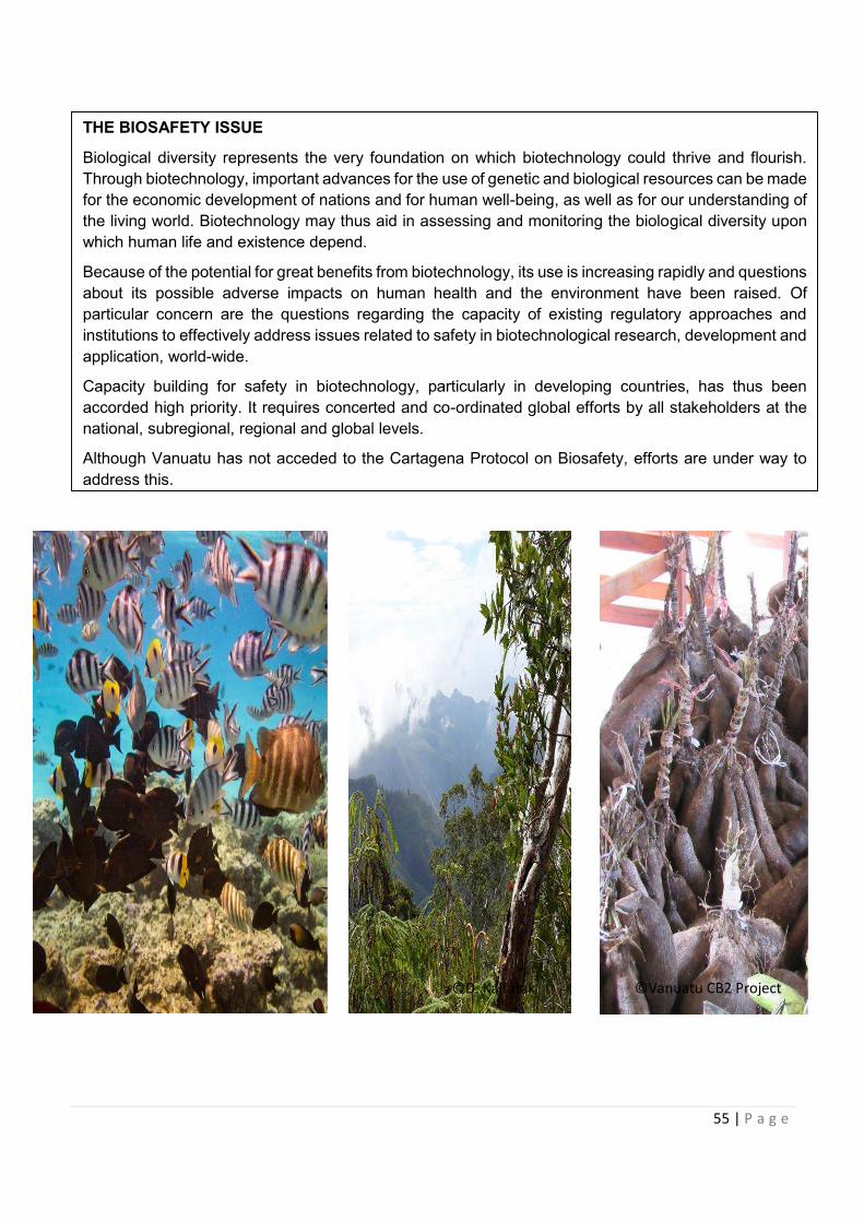
55 | P a g e
THE BIOSAFETY ISSUE
Biological diversity represents the very foundation on which biotechnology could thrive and flourish.
Through biotechnology, important advances for the use of genetic and biological resources can be made
for the economic development of nations and for human well-being, as well as for our understanding of
the living world. Biotechnology may thus aid in assessing and monitoring the biological diversity upon
which human life and existence depend.
Because of the potential for great benefits from biotechnology, its use is increasing rapidly and questions
about its possible adverse impacts on human health and the environment have been raised. Of
particular concern are the questions regarding the capacity of existing regulatory approaches and
institutions to effectively address issues related to safety in biotechnological research, development and
application, world-wide.
Capacity building for safety in biotechnology, particularly in developing countries, has thus been
accorded high priority. It requires concerted and co-ordinated global efforts by all stakeholders at the
national, subregional, regional and global levels.
Although Vanuatu has not acceded to the Cartagena Protocol on Biosafety, efforts are under way to
address this.
©Vanuatu CB2 Project ©D. Kalfatak
56 | P a g e
6.7 STRATEGIC AREA 7: RESOURCE MOBILISATION
FOR THE NATIONAL BIODIVERSITY STRATEGY AND ACTION PLAN
Aichi Target 20: By 2020, at the latest, the mobilization of financial resources for effectively implementing the Strategic Plan 2011-2020 from all sources and in accordance with the consolidated and agreed process in the Strategy for Resource Mobilization should increase substantially from the current levels. This target will be subject to changes contingent to resources needs assessments to be developed and reported by Parties.
At COP 11, October 2012, the parties agreed to include resource mobilisation into the
NBSAP reviews and endeavored to include biodiversity in their national priorities or
development plans by 2015. This to include assess/evaluate the intrinsic, ecological,
genetic, socioeconomic, scientific, educational, cultural, recreational and aesthetic values
of biological diversity and its components.
There is no greater challenge for the NBSAP than locating adequate funding for biodiversity
management. Current funding for biodiversity conservation is from two principal sources:
1. Government’s annual departmental budget; and
2. Donor assistance.
The NBSAP envisages a major ‘step-change’ from the current predominantly passive
approach based on resource management for extractive purposes with little inherent
biodiversity management capacity, to an active, ‘hands on’ management with adequate
domestic technical capacity.
Experience with the national environment strategies and plans has shown that although
Government may endorse a strategy, it is most unlikely to have funds available to initiate
actions other than provide administrative frameworks. This situation is expected to continue
for the NBSAP. The majority of the funding can, therefore, be expected to come initially from
donor assistance with government providing a more active funding role in the medium term.
Significant problems which arise as a result of an undue reliance on donor assistance are:
· A lack of continuity in funding and inability to provide recurrent expenditure (i.e.
lease-rental and/or management of protected areas; CITES implementation;
threatened species management; invasive species management etc.);
· Donors are inevitably selective in their choice of projects and their priorities may not
coincide with those of the Government;
· Undue reliance on expatriate technical specialists;
· A lack of flexibility or the ability to meet changing circumstances or emergency
situations;
· Government neglecting its funding role because of availability of project funding; and
· Sustainability of donor funded projects.
In these circumstances, the NBSAP envisages the Government’s main initial contribution
will be:
· To endorse the NBSAP as Government’s policy on biodiversity planning and
management;
By 2020, at the latest, the mobilization of financial resources for
57 | P a g e
· Put in place the required legislative and administrative framework;
· To develop a national capacity for biodiversity management with trained specialists;
and
· Address the issues of a rapidly increasing requirement for recurrent funding for
biodiversity management.
Financial mechanisms other than trust funds, projects and increased government allocation
have also been used by certain countries. Examples of such alternative initiatives are given
in Box 5.4. Some of these initiatives have been used to raise funds for a trust, others
become part of Government revenue. Some or all of these initiatives may be appropriate
in Vanuatu. Certainly for a country with a growing foreign exchange earner is tourism, a
sector which cannot exist in the absence of a clean, green and unspoilt environment, a
tourist tax would appear to be appropriate. Similarly, the growing dive industry may need
to support a Dive Tax, part of which could be used to increase the participation of Ni-
Vanuatu communities.
Developing the user pays principle, water and hydroelectricity users could well be expected
to pay for the preservation of the catchments from whence they derive their source of water.
Target: The Ministry of Finanace will need to set realistic annual budgetary targets and
DEPC to do 3 yearly resource mobilization plan based on realistic NBSAP Actions
& Targets.
Indicators
· Indicator 1: Aggregated financial flows, in the amount and where relevant
percentage, of biodiversity related funding, per annum, for achieving the Vanuatu
NBSAP National Targets
· Indicator 2: Number of assessments values of biodiversity in accordance with
CBD,
· Indicator 3: Identified and reported funding needs, gaps and priorities.
· Indicator 4: Developed National Financial Plans for Biodiversity.
· Indicator 5: Amount of national financial support, per annum, in respect of those
national activities which are intended to achieve the objectives of NBSAP.
58 | P a g e
FOCUS AREA RM1: Stakeholder engagement, awareness, ecosystem valuation, assessments
and mapping.
Objective RM1a: To increase understading and buy-in from relevant government, NGOs,
implementing partners and communities on the resource mobilisation approach,
methodology and action plan.
ACTIONS:
RM1.1: Organise stakeholder engagement to consider biodiversity and ecosystem services to
be the key priority areas for economic valuation and assessments.
RM1.2: Carry out ecosystem assessments, mapping, indicators and valuation for each focal
areas
RM1.3: Carry out capacity building activities to equip actors with necessary skills to carry out
value-based actions e.g tools to gather information on biodiversity and ecosystem
advising them on how to incorporate biodiversity and ecosystem service values into their
business plans make economic and financial sense.
RM1.4: Engage funders strategically and identify key sectors benefitting from biodiversity and
ecosystem service values who are primary users, how will they benefit from investing in
biodiversity ecosystem services and what ongoing financial mechanism are available to
secure sustained funding
RM1.5: Assess financial flows associated with drivers of biodiversity loss such as harmful
incentives, and how they can be influenced to reduce their impact.
RM 1.6 Conduct annual stakeholders’ meeting to discuss budget and report on progress of
NBSAP species component implementation. Species conservation implementation to
include enforcement roles of the relevant authorities e.g. biosecurity.
RM 1.7 Establish a conservation trust fund to be managed by DEPC under government
budgetary process.
FOCUS AREA RM2: Development of Vanuatu NBSAP Resource Mobilisation Plan
Objective RM2: Develop Resource mobilisation plan using best available data and scenario
development
ACTIONS:
RM2.1 Conduct an ecosystem service mapping to assess state and trend in ecosystem service
provision and human well-being, to provide spatial quantification of ecosystem services
and their values
RM2.2 Conduct economic valuation of ecosystems and biodiversity using variety of economic
valuation methods to determine monetary value of biodiversity i.e direct market valuation
approaches, revealed preferences and stated preference approaches.
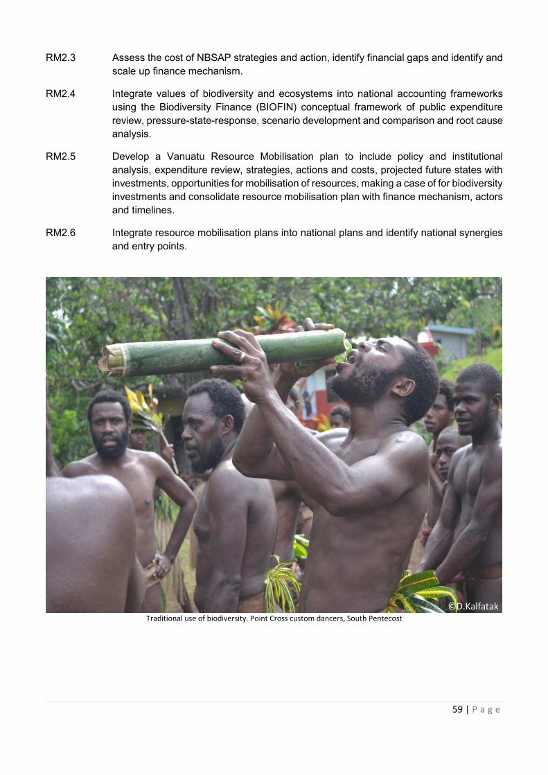
59 | P a g e
RM2.3 Assess the cost of NBSAP strategies and action, identify financial gaps and identify and
scale up finance mechanism.
RM2.4 Integrate values of biodiversity and ecosystems into national accounting frameworks
using the Biodiversity Finance (BIOFIN) conceptual framework of public expenditure
review, pressure-state-response, scenario development and comparison and root cause
analysis.
RM2.5 Develop a Vanuatu Resource Mobilisation plan to include policy and institutional
analysis, expenditure review, strategies, actions and costs, projected future states with
investments, opportunities for mobilisation of resources, making a case of for biodiversity
investments and consolidate resource mobilisation plan with finance mechanism, actors
and timelines.
RM2.6 Integrate resource mobilisation plans into national plans and identify national synergies
and entry points.
Traditional use of biodiversity. Point Cross custom dancers, South Pentecost
©D.Kalfatak
60 | P a g e
7.0 ACTION STRATEGY IMPLEMENTATION FRAMEWORK
The Vanuatu NBSAP Implementation Framework is in two parts. The first is the implementation of each
strategic area and the second is the provincial implementation plans.
7.1 THE NBSAP IMPLEMENTATION FRAMEWORK
The implementation plan below outlines
Strategic Area 1: Conservation Areas Management
Strategic Area 2: Forest and Inland Waters Ecosystems Conservation and Management
Strategic Area 3: Coastal and Marine Ecosystems Conservation and Management
Strategic Area 4: Species and Genetic Diversity Conservation
Strategic Area 5: Invasive Species Eradication and Control
Strategic Area 6: Mainstreaming Biodiversity across sectors and society
Strategic Area 7: Resource Mobilisation
Strategic Area 1: Conservation Areas Management
TARGET
1. By 2030, representative examples of at least 17% of terrestrial and 10% of coastal and marine areas
to support 100% of local communities’ livelihoods and kastom importance are conserved through
effective community and government management measures.
2. By 2020, there are 10 legally registered CCAs and 50% of CCAs are effectively supported and
managed in Vanuatu.
3. By 2030, 90% of CCA management committees are complying with their reporting obligations to
DEPC (NEPIP, 2016).
4. Targets for conservation areas set in provincial strategic plans are achieved.
INDICATORS:
· Total area of representative coverage of legally recognised, other effective conserved areas and
locally managed areas in terrestrial and marine areas including sites of particular importance for
biodiversity.
· Percentage of terrestrial and marine protected areas that are effectively managed based on agreed
national and international protected area conditions and management effectiveness.
· Measure of ecosystem service values and equity of benefits from CAs.
· Level of connectivity of CAs and other area based approaches with broader landscapes and
seascapes.
61 | P a g e
IMPLEMENTATION PLAN FOR CONSERVATION AREA MANAGEMENT
FOCUS AREA OBJECTIVES ACTIONS SPECIFIC ACTIVITIES COMPLETED
BY
LEAD
AGENCY
FOCUS AREA
CA1: Expanded
National
Representative
Network of
Conservation
Areas in
Marine,
Terrestrial and
Inland Waters
Objective
CA1a: To carry
out marine,
terrestrial and
inland waters
biodiversity
rapid
assessment,
inventories
and threat
identification,
gap analyses
and
prioritisation
to guide the
development
of a national
representative
network of
CAs.
CA1.1: Carry out gap
analysis and
prioritisation in
terrestrial, marine and
inland waters
ecosystems to identify
key biodiversity areas for
biodiversity protection
to meet our national
targets.
· Carry out terrestrial/
forest ecosystem
inventory in identify key
biodiversity areas.
· Use Vanuatu Bioregions
and SUMA data report
as a baseline to verify
and ground truth
inventory actions for
inshore, coral,
mangrove, offshore
Species, habitats and
ecosystems of Key
Marine Biodiversity
Areas in the marine
environment.
· Carry out gap analysis
and prioritisation in in-
land water ecosystem to
identify key biodiversity
areas.
2018-2021
2019
2018-2024
DoF
DEPC
VFD
DEPC
DoL
DGMWR
DGMWR
DEPC
CA1.2: Analyse and map
the occurrence and
status of all existing
conservation areas,
including their
governance structures.
Map out wetland sites,
national Key Biodiversity
Areas (KBA) and existing
effective
protected/conservation
areas.
2018-2022 DEPC
DoL
CA1.3: Prioritise key
biodiversity areas for
focal species,
species/groups, habitats
and important ecological
connectivity and
processes.
Carry out assessment on
animal and plant species
that are threatened in CAs
and protect their habitats.
2018 - 2020 DEPC
62 | P a g e
FOCUS AREA OBJECTIVES ACTIONS SPECIFIC ACTIVITIES COMPLETED
BY
LEAD
AGENCY
FOCUS AREA
CA1: Expanded
National
Representative
Network of
Conservation
Areas in
Marine,
Terrestrial and
Inland Waters
Objective CA1a:
To carry out
marine, terrestrial
and inland waters
biodiversity rapid
assessment,
inventories and
threat
identification, gap
analyses and
prioritisation to
guide the
development of a
national
representative
network of CAs.
CA1.4: Identify sites that
can achieve not just
biodiversity conservation
but also social and
economic outcomes to
do with, for example,
fisheries, culture and
heritage, agriculture,
timber resources,
watershed protection,
sustainable tourism, to
ensure they provide
benefits to local people.
Develop map that outlines
social and economic sites
for example, fisheries,
culture and heritage,
agriculture, timber
resources, watershed
protection, sustainable
tourism and other sites that
hold a value.
2018-2030 DoL
Relevant
Agencies
Objective CA1b:
To develop and
apply an
implementation
plan to meet
Vanuatu’s CA
targets in
terrestrial,
marine and
inland waters
protected areas
systems.
CA1.5: Conduct a
national planning
process to develop a CA
action and
implementation plan for
land, marine and inland
waters.
Update the VANRIS
database to outline the
national planning areas for
R2R CAs using field
verification methods.
2018-2025
DoL
CA1.6: Develop priority
biodiversity areas maps
for terrestrial, marine
and inland waters.
Review, update and map
Key Biodiversity Areas (KBA)
on important terrestrial and
marine areas.
2018-2025 DEPC
CA1.7: Describe the
entirety of Vanuatu’s
natural terrestrial,
coastal and marine
environment as a basis
for selecting ecologically
representative areas.
Review and update Vanuatu
Wetlands Directory.
2018-2024 DEPC
CA 1.8: Develop
terrestrial protected
area typologies.
Carry out terrestrial
protected areas typology.
2018-2030 DEPC
DoF
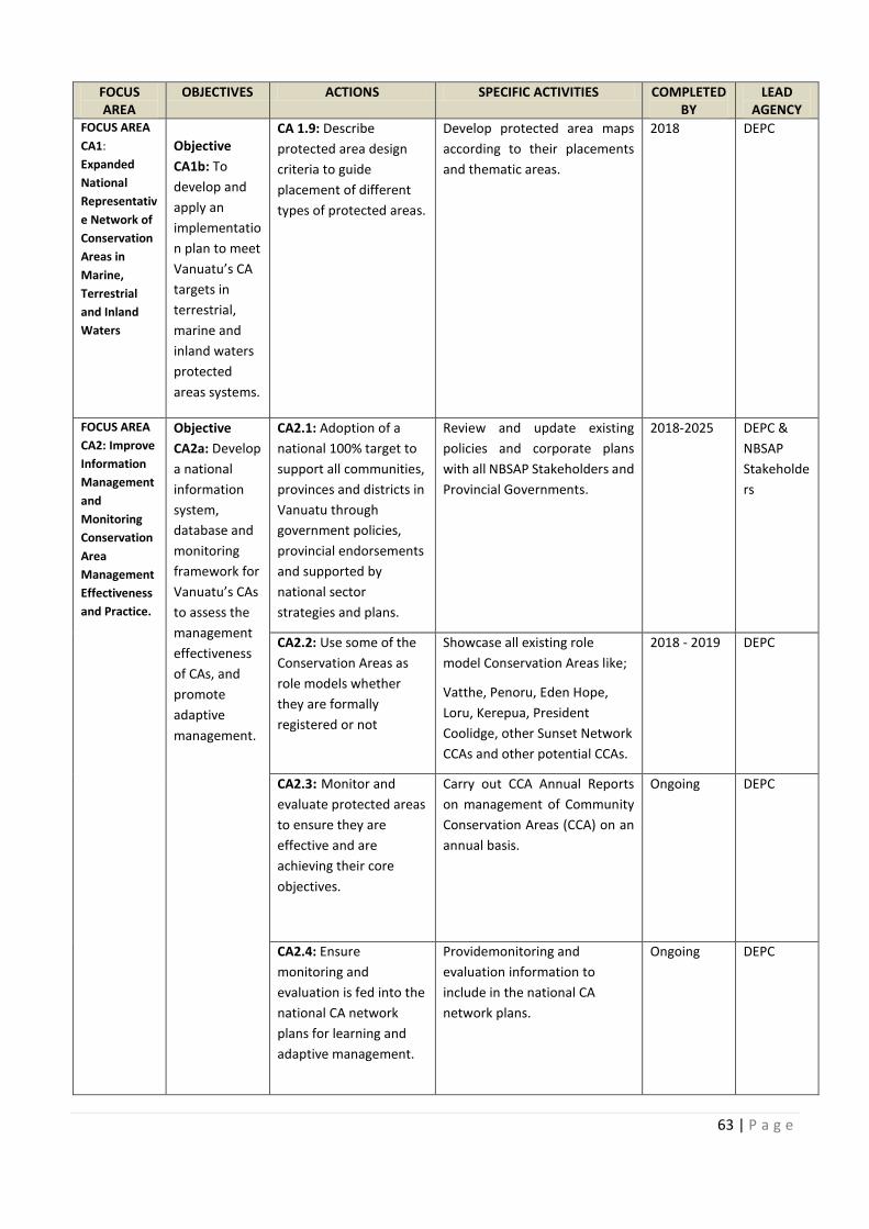
COMPLETED
Identify sites that
Review and update Vanuatu
63 | P a g e
FOCUS
AREA
OBJECTIVES ACTIONS SPECIFIC ACTIVITIES COMPLETED
BY
LEAD
AGENCY
FOCUS AREA
CA1:
Expanded
National
Representativ
e Network of
Conservation
Areas in
Marine,
Terrestrial
and Inland
Waters
Objective
CA1b: To
develop and
apply an
implementatio
n plan to meet
Vanuatu’s CA
targets in
terrestrial,
marine and
inland waters
protected
areas systems.
CA 1.9: Describe
protected area design
criteria to guide
placement of different
types of protected areas.
Develop protected area maps
according to their placements
and thematic areas.
2018 DEPC
FOCUS AREA
CA2: Improve
Information
Management
and
Monitoring
Conservation
Area
Management
Effectiveness
and Practice.
Objective
CA2a: Develop
a national
information
system,
database and
monitoring
framework for
Vanuatu’s CAs
to assess the
management
effectiveness
of CAs, and
promote
adaptive
management.
CA2.1: Adoption of a
national 100% target to
support all communities,
provinces and districts in
Vanuatu through
government policies,
provincial endorsements
and supported by
national sector
strategies and plans.
Review and update existing
policies and corporate plans
with all NBSAP Stakeholders and
Provincial Governments.
2018-2025 DEPC &
NBSAP
Stakeholde
rs
CA2.2: Use some of the
Conservation Areas as
role models whether
they are formally
registered or not
Showcase all existing role
model Conservation Areas like;
Vatthe, Penoru, Eden Hope,
Loru, Kerepua, President
Coolidge, other Sunset Network
CCAs and other potential CCAs.
2018 - 2019 DEPC
CA2.3: Monitor and
evaluate protected areas
to ensure they are
effective and are
achieving their core
objectives.
Carry out CCA Annual Reports
on management of Community
Conservation Areas (CCA) on an
annual basis.
Ongoing DEPC
CA2.4: Ensure
monitoring and
evaluation is fed into the
national CA network
plans for learning and
adaptive management.
Providemonitoring and
evaluation information to
include in the national CA
network plans.
Ongoing DEPC
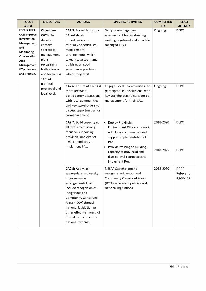
64 | P a g e
FOCUS
AREA
OBJECTIVES ACTIONS SPECIFIC ACTIVITIES COMPLETED
BY
LEAD
AGENCY
FOCUS AREA
CA2: Improve
Information
Management
and
Monitoring
Conservation
Area
Management
Effectiveness
and Practice.
Objectives
CA2b: To
develop
context
specific co-
management
plans,
recognising
both informal
and formal CA
sites at
national,
provincial and
local level.
CA2.5: For each priority
CA, establish
opportunities for
mutually beneficial co-
management
arrangements, which
takes into account and
builds upon good
governance practices
where they exist.
Setup co-management
arrangement for outstanding
existing registered and effective
managed CCAs.
Ongoing DEPC
CA2.6: Ensure at each CA
there are wide
participatory discussions
with local communities
and key stakeholders to
discuss opportunities for
co-management.
Engage local communities to
participate in discussions with
key stakeholders to consider co-
management for their CAs.
Ongoing DEPC
CA2.7: Build capacity at
all levels, with strong
focus on supporting
provincial and district
level committees to
implement PAs.
· Deploy Provincial
Environment Officers to work
with local communities and
support implementation of
PAs.
· Provide training to building
capacity of provincial and
district level committees to
implement PAs.
2018-2020
2018-2025
DEPC
DEPC
CA2.8: Apply, as
appropriate, a diversity
of governance
arrangements that
include recognition of
Indigenous and
Community Conserved
Areas (ICCA) through
national legislation or
other effective means of
formal inclusion in the
national systems.
NBSAP Stakeholders to
recognise Indigenous and
Community Conserved Areas
(ICCA) in relevant policies and
national legislations.
2018-2030 DEPC
Relevant
Agencies
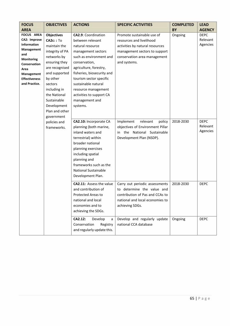
COMPLETED
REA For each priority
Ensure at each CA Engage local communities to
Build capacity at
65 | P a g e
FOCUS
AREA
OBJECTIVES ACTIONS SPECIFIC ACTIVITIES COMPLETED
BY
LEAD
AGENCY
FOCUS AREA
CA2: Improve
Information
Management
and
Monitoring
Conservation
Area
Management
Effectiveness
and Practice.
Objectives
CA2c: : To
maintain the
integrity of PA
networks by
ensuring they
are recognised
and supported
by other
sectors
including in
the National
Sustainable
Development
Plan and other
government
policies and
frameworks.
CA2.9: Coordination
between relevant
natural resource
management sectors
such as environment and
conservation,
agriculture, forestry,
fisheries, biosecurity and
tourism sector specific
sustainable natural
resource management
activities to support CA
management and
systems.
Promote sustainable use of
resources and livelihood
activities by natural resources
management sectors to support
conservation area management
and systems.
Ongoing DEPC
Relevant
Agencies
CA2.10: Incorporate CA
planning (both marine,
inland waters and
terrestrial) within
broader national
planning exercises
including spatial
planning and
frameworks such as the
National Sustainable
Development Plan.
Implement relevant policy
objectives of Environment Pillar
in the National Sustainable
Development Plan (NSDP).
2018-2030 DEPC
Relevant
Agencies
CA2.11: Assess the value
and contribution of
Protected Areas to
national and local
economies and to
achieving the SDGs.
Carry out periodic assessments
to determine the value and
contribution of Pas and CCAs to
national and local economies to
achieving SDGs.
2018-2030 DEPC
CA2.12: Develop a
Conservation Registry
and regularly update this.
Develop and regularly update
national CCA database
Ongoing DEPC
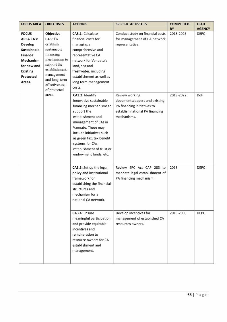
66 | P a g e
FOCUS AREA OBJECTIVES ACTIONS SPECIFIC ACTIVITIES COMPLETED
BY
LEAD
AGENCY
FOCUS
AREA CA3:
Develop
Sustainable
Finance
Mechanism
for new and
Existing
Protected
Areas.
Objective
CA3: To
establish
sustainable
financing
mechanisms to
support the
establishment,
management
and long-term
effectiveness
of protected
areas.
CA3.1: Calculate
financial costs for
managing a
comprehensive and
representative CA
network for Vanuatu’s
land, sea and
freshwater, including
establishment as well as
long term-management
costs.
Conduct study on financial costs
for management of CA network
representative.
2018-2025 DEPC
CA3.2: Identify
innovative sustainable
financing mechanisms to
support the
establishment and
management of CAs in
Vanuatu. These may
include initiatives such
as green tax, tax benefit
systems for CAs,
establishment of trust or
endowment funds, etc.
Review working
documents/papers and existing
PA financing initiatives to
establish national PA financing
mechanisms.
2018-2022 DoF
CA3.3: Set up the legal,
policy and institutional
framework for
establishing the financial
structures and
mechanism for a
national CA network.
Review EPC Act CAP 283 to
mandate legal establishment of
PA financing mechanism.
2018 DEPC
CA3.4: Ensure
meaningful participation
and provide equitable
incentives and
remuneration to
resource owners for CA
establishment and
management.
Develop incentives for
management of established CA
resources owners.
2018-2030 DEPC
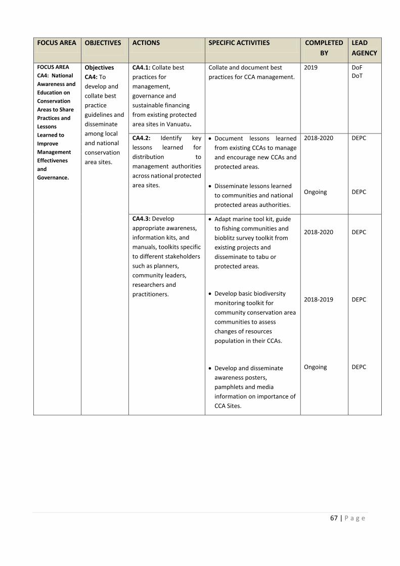
FOCUS AREA
on financial costs
Review EPC Act CAP 283 to
67 | P a g e
FOCUS AREA OBJECTIVES ACTIONS SPECIFIC ACTIVITIES COMPLETED
BY
LEAD
AGENCY
FOCUS AREA
CA4: National
Awareness and
Education on
Conservation
Areas to Share
Practices and
Lessons
Learned to
Improve
Management
Effectivenes
and
Governance.
Objectives
CA4: To
develop and
collate best
practice
guidelines and
disseminate
among local
and national
conservation
area sites.
CA4.1: Collate best
practices for
management,
governance and
sustainable financing
from existing protected
area sites in Vanuatu.
Collate and document best
practices for CCA management.
2019 DoF
DoT
CA4.2: Identify key
lessons learned for
distribution to
management authorities
across national protected
area sites.
· Document lessons learned
from existing CCAs to manage
and encourage new CCAs and
protected areas.
· Disseminate lessons learned
to communities and national
protected areas authorities.
2018-2020
Ongoing
DEPC
DEPC
CA4.3: Develop
appropriate awareness,
information kits, and
manuals, toolkits specific
to different stakeholders
such as planners,
community leaders,
researchers and
practitioners.
· Adapt marine tool kit, guide
to fishing communities and
bioblitz survey toolkit from
existing projects and
disseminate to tabu or
protected areas.
· Develop basic biodiversity
monitoring toolkit for
community conservation area
communities to assess
changes of resources
population in their CCAs.
· Develop and disseminate
awareness posters,
pamphlets and media
information on importance of
CCA Sites.
2018-2020
2018-2019
Ongoing
DEPC
DEPC
DEPC
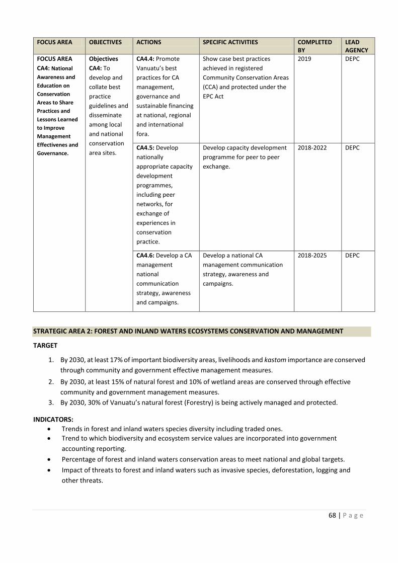
68 | P a g e
FOCUS AREA OBJECTIVES ACTIONS SPECIFIC ACTIVITIES COMPLETED
BY
LEAD
AGENCY
FOCUS AREA
CA4: National
Awareness and
Education on
Conservation
Areas to Share
Practices and
Lessons Learned
to Improve
Management
Effectivenes and
Governance.
Objectives
CA4: To
develop and
collate best
practice
guidelines and
disseminate
among local
and national
conservation
area sites.
CA4.4: Promote
Vanuatu’s best
practices for CA
management,
governance and
sustainable financing
at national, regional
and international
fora.
Show case best practices
achieved in registered
Community Conservation Areas
(CCA) and protected under the
EPC Act
2019 DEPC
CA4.5: Develop
nationally
appropriate capacity
development
programmes,
including peer
networks, for
exchange of
experiences in
conservation
practice.
Develop capacity development
programme for peer to peer
exchange.
2018-2022 DEPC
CA4.6: Develop a CA
management
national
communication
strategy, awareness
and campaigns.
Develop a national CA
management communication
strategy, awareness and
campaigns.
2018-2025 DEPC
STRATEGIC AREA 2: FOREST AND INLAND WATERS ECOSYSTEMS CONSERVATION AND MANAGEMENT
TARGET
1. By 2030, at least 17% of important biodiversity areas, livelihoods and kastom importance are conserved
through community and government effective management measures.
2. By 2030, at least 15% of natural forest and 10% of wetland areas are conserved through effective
community and government management measures.
3. By 2030, 30% of Vanuatu’s natural forest (Forestry) is being actively managed and protected.
INDICATORS:
· Trends in forest and inland waters species diversity including traded ones.
· Trend to which biodiversity and ecosystem service values are incorporated into government
accounting reporting.
· Percentage of forest and inland waters conservation areas to meet national and global targets.
· Impact of threats to forest and inland waters such as invasive species, deforestation, logging and
other threats.
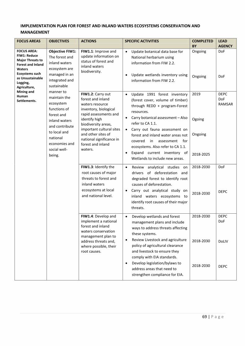
Develop capacity development
Develop a CA
69 | P a g e
IMPLEMENTATION PLAN FOR FOREST AND INLAND WATERS ECOSYSTEMS CONSERVATION AND
MANAGEMENT
FOCUS AREAS OBJECTIVES ACTIONS SPECIFIC ACTIVITIES COMPLETED
BY
LEAD
AGENCY
FOCUS AREA:
FIW1: Reduce
Major Threats to
Forest and Inland
Waters
Ecoystems such
as Unsustainable
Logging,
Agriculture,
Mining and
Human
Settlements.
Objective FIW1:
The forest and
inland waters
ecosystem are
managed in an
integrated and
sustainable
manner to
maintain the
ecosystem
functions of
forest and
inland waters
and contribute
to local and
national
economies and
social well-
being.
FIW1.1: Improve and
update information on
status of forest and
inland waters
biodiversity.
· Update botanical data base for
National herbarium using
information from FIW 2.2.
· Update wetlands inventory using
information from FIW 2.2.
Ongoing
Ongoing
DoF
DoF
FIW1.2: Carry out
forest and inland
waters resource
inventory, biological
rapid assessments and
identify high
biodiversity areas,
important cultural sites
and other sites of
national significance in
forest and inland
waters.
· Update 1991 forest inventory
(forest cover, volume of timber)
through REDD + program-Forest
resources.
· Carry botanical assessment – Also
refer to CA 1.1.
· Carry out fauna assessment on
forest and inland water areas not
covered in assessment for
ecosystems. Also refer to CA 1.1.
· Expand current inventory of
Wetlands to include new areas.
2019
Ogoing
Ongoing
2018-2025
DEPC
DoF
RAMSAR
FIW1.3: Identify the
root causes of major
threats to forest and
inland waters
ecosystems at local
and national level.
· Review analytical studies on
drivers of deforestation and
degraded forest to identify root
causes of deforestation.
· Carry out analytical study on
inland waters ecosystems to
identify root causes of their major
threats.
2018-2030
2018-2030
DoF
DEPC
FIW1.4: Develop and
implement a national
forest and inland
waters conservation
management plan to
address threats and,
where possible, their
root causes.
· Develop wetlands and forest
management plans and include
ways to address threats affecting
these systems.
· Review Livestock and agriculture
policy of agricultural clearance
and livestock to ensure they
comply with EIA standards.
· Develop legislation/bylaws to
address areas that need to
strengthen compliance for EIA.
2018-2030
2018-2030
2018-2030
DEPC
DoF
DoLIV
DEPC
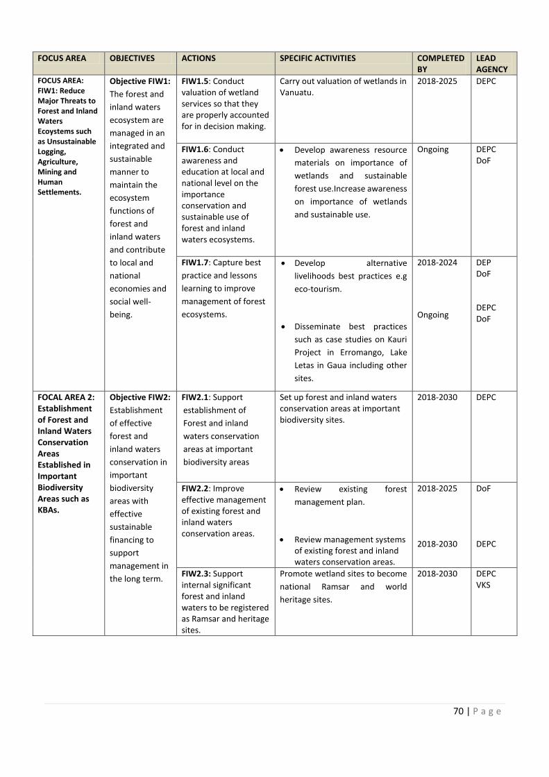
70 | P a g e
FOCUS AREA OBJECTIVES ACTIONS SPECIFIC ACTIVITIES COMPLETED
BY
LEAD
AGENCY
FOCUS AREA:
FIW1: Reduce
Major Threats to
Forest and Inland
Waters
Ecoystems such
as Unsustainable
Logging,
Agriculture,
Mining and
Human
Settlements.
Objective FIW1:
The forest and
inland waters
ecosystem are
managed in an
integrated and
sustainable
manner to
maintain the
ecosystem
functions of
forest and
inland waters
and contribute
to local and
national
economies and
social well-
being.
FIW1.5: Conduct
valuation of wetland
services so that they
are properly accounted
for in decision making.
Carry out valuation of wetlands in
Vanuatu.
2018-2025 DEPC
FIW1.6: Conduct
awareness and
education at local and
national level on the
importance
conservation and
sustainable use of
forest and inland
waters ecosystems.
· Develop awareness resource
materials on importance of
wetlands and sustainable
forest use.Increase awareness
on importance of wetlands
and sustainable use.
Ongoing
DEPC
DoF
FIW1.7: Capture best
practice and lessons
learning to improve
management of forest
ecosystems.
· Develop alternative
livelihoods best practices e.g
eco-tourism.
· Disseminate best practices
such as case studies on Kauri
Project in Erromango, Lake
Letas in Gaua including other
sites.
2018-2024
Ongoing
DEP
DoF
DEPC
DoF
FOCAL AREA 2:
Establishment
of Forest and
Inland Waters
Conservation
Areas
Established in
Important
Biodiversity
Areas such as
KBAs.
Objective FIW2:
Establishment
of effective
forest and
inland waters
conservation in
important
biodiversity
areas with
effective
sustainable
financing to
support
management in
the long term.
FIW2.1: Support
establishment of
Forest and inland
waters conservation
areas at important
biodiversity areas
Set up forest and inland waters
conservation areas at important
biodiversity sites.
2018-2030 DEPC
FIW2.2: Improve
effective management
of existing forest and
inland waters
conservation areas.
· Review existing forest
management plan.
· Review management systems
of existing forest and inland
waters conservation areas.
2018-2025
2018-2030
DoF
DEPC
FIW2.3: Support
internal significant
forest and inland
waters to be registered
as Ramsar and heritage
sites.
Promote wetland sites to become
national Ramsar and world
heritage sites.
2018-2030 DEPC
VKS
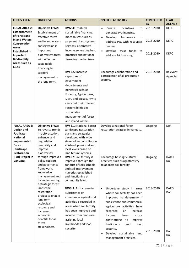
COMPLETED
Objective FIW1: Carry out valuation of wetlands in
Develop awareness resource
lternative
FOCAL AREA 2: 2:
Review existing forest
Promote wetland sites to become
71 | P a g e
FOCUS AREA OBJECTIVES ACTIONS SPECIFIC ACTIVITIES COMPLETED
BY
LEAD
AGENCY
FOCAL AREA 2:
Establishment
of Forest and
Inland Waters
Conservation
Areas
Established in
Important
Biodiversity
Areas such as
KBAs.
Objective FIW2:
Establishment of
effective forest
and inland waters
conservation in
important
biodiversity areas
with effective
sustainable
financing to
support
management in
the long term.
FIW2.4: Establish
sustainable financing
mechanisms such as
payment of ecosystem
services, alternative
income generating best
practices and national
financing mechanisms.
· Create incentives to
generate PA financing.
· Develop framework to
address PES with resources
owners.
· Develop trust funds to
address PA financing.
2018-2030
2018-2030
2018-2030
DEPC
DEPC
DEPC
FIW 2.5: Increase
capacities of
government
departments and
ministries such as
Forestry, Agricultures,
DEPC and Biosecurity to
carry out their role and
responsibilities in
sustainable
management of forest
and inland waters.
Encourage collaboration and
participation of all productive
sectors.
2018-2030
Relevant
Agencies
FOCAL AREA 3:
Design and
Facilitate
National
Implemented
Forest
Landscape
Restoration
(FLR) Project in
Vanuatu.
Objective FIW3:
To reverse trends
in deforestation,
enhance land
degradation
neutrality and
improve
biodiversity
through improved
policy support
and governance
framework,
knowledge
management and
by implementing
a strategic forest
landscape
restoration
project to enable
long term
ecological
recovery and
increased
economic
benefits for all
forest
stakeholders.
FIW 3.1: National Forest
Landscape Restoration
plans and strategies
developed with wide
stakeholder consultation
at island, provincial and
local levels based on
land tenure systems.
Develop a national forest
restoration strategy in Vanuatu.
Ongoing DoF
FIW3.2: Soil fertility is
improved through the
conduct of soils schools
and soil improvement
nurseries established
and functioning at
community level.
Encourage best agricultural
practices such as agroforestry
to address soil fertility.
Ongoing DARD
DoF
FIW3.3: An increase in
subsistence or
commercial agricultural
activities is recorded in
areas when soil fertility
has been improved and
income from crops are
assisting local
livelihoods and food
security.
· Undertake study in areas
where soil fertility has been
improved to determine if
subsistence and commercial
agriculture activities have
recorded an increase
income from crops
contributing to improve
livelihoods and food
security.
· Develop sustainable land
management practices.
2018-2030
2018-2030
DARD
DoF
DoL
DoF
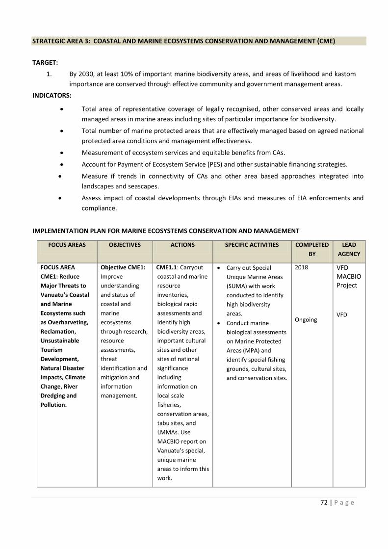
72 | P a g e
STRATEGIC AREA 3: COASTAL AND MARINE ECOSYSTEMS CONSERVATION AND MANAGEMENT (CME)
TARGET:
1. By 2030, at least 10% of important marine biodiversity areas, and areas of livelihood and kastom
importance are conserved through effective community and government management areas.
INDICATORS:
IMPLEMENTATION PLAN FOR MARINE ECOSYSTEMS CONSERVATION AND MANAGEMENT
FOCUS AREAS OBJECTIVES ACTIONS SPECIFIC ACTIVITIES COMPLETED
BY
LEAD
AGENCY
FOCUS AREA
CME1: Reduce
Major Threats to
Vanuatu’s Coastal
and Marine
Ecosystems such
as Overharveting,
Reclamation,
Unsustainable
Tourism
Development,
Natural Disaster
Impacts, Climate
Change, River
Dredging and
Pollution.
Objective CME1:
Improve
understanding
and status of
coastal and
marine
ecosystems
through research,
resource
assessments,
threat
identification and
mitigation and
information
management.
CME1.1: Carryout
coastal and marine
resource
inventories,
biological rapid
assessments and
identify high
biodiversity areas,
important cultural
sites and other
sites of national
significance
including
information on
local scale
fisheries,
conservation areas,
tabu sites, and
LMMAs. Use
MACBIO report on
Vanuatu’s special,
unique marine
areas to inform this
work.
· Carry out Special
Unique Marine Areas
(SUMA) with work
conducted to identify
high biodiversity
areas.
· Conduct marine
biological assessments
on Marine Protected
Areas (MPA) and
identify special fishing
grounds, cultural sites,
and conservation sites.
2018
Ongoing
VFD
MACBIO
Project
VFD
· Total area of representative coverage of legally recognised, other conserved areas and locally
managed areas in marine areas including sites of particular importance for biodiversity.
· Total number of marine protected areas that are effectively managed based on agreed national
protected area conditions and management effectiveness.
· Measurement of ecosystem services and equitable benefits from CAs.
· Account for Payment of Ecosystem Service (PES) and other sustainable financing strategies.
· Measure if trends in connectivity of CAs and other area based approaches integrated into
landscapes and seascapes.
· Assess impact of coastal developments through EIAs and measures of EIA enforcements and
compliance.
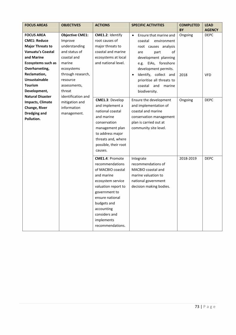
COMPLETED
:
73 | P a g e
FOCUS AREAS OBJECTIVES ACTIONS SPECIFIC ACTIVITIES COMPLETED
BY
LEAD
AGENCY
FOCUS AREA
CME1: Reduce
Major Threats to
Vanuatu’s Coastal
and Marine
Ecosystems such as
Overharveting,
Reclamation,
Unsustainable
Tourism
Development,
Natural Disaster
Impacts, Climate
Change, River
Dredging and
Pollution.
Objective CME1:
Improve
understanding
and status of
coastal and
marine
ecosystems
through research,
resource
assessments,
threat
identification and
mitigation and
information
management.
CME1.2: Identify
root causes of
major threats to
coastal and marine
ecosystems at local
and national level.
· Ensure that marine and
coastal environment
root causes analysis
are part of
development planning
e.g. EIAs, foreshore
development permits.
· Identify, collect and
prioritise all threats to
coastal and marine
biodiversity.
Ongoing
2018
DEPC
VFD
CME1.3: Develop
and implement a
national coastal
and marine
conservation
management plan
to address major
threats and, where
possible, their root
causes.
Ensure the development
and implementation of
coastal and marine
conservation management
plan is carried out at
community site level.
Ongoing DEPC
CME1.4: Promote
recommendations
of MACBIO coastal
and marine
ecosystem service
valuation report to
government to
ensure national
budgets and
accounting
considers and
implements
recommendations.
Integrate
recommendations of
MACBIO coastal and
marine valuation to
national government
decision making bodies.
2018-2019 DEPC

74 | P a g e
FOCUS AREAS OBJECTIVES ACTIONS SPECIFIC ACTIVITIES COMPLETED
BY
LEAD
AGENCY
FOCUS AREA
CME1: Reduce
Major Threats to
Vanuatu’s Coastal
and Marine
Ecosystems such as
Overharveting,
Reclamation,
Unsustainable
Tourism
Development,
Natural Disaster
Impacts, Climate
Change, River
Dredging and
Pollution.
Objective CME1:
Improve
understanding
and status of
coastal and
marine
ecosystems
through research,
resource
assessments,
threat
identification and
mitigation and
information
management.
CME1.5: Conduct
awareness raising
and education at
local and national
levels on the
importance of
conservation and
sustainable use
of coastal and
marine
ecosystems.
Carry out awareness in
media mediums, community
awareness and posters on
the importance of marine
conservation and
ecosystems.
Ongoing DEPC
CME1.6: Capture
best practices
and lessons
learned about
improving
management of
coastal and
marine
ecosystems.
Showcase best practices for
outstanding marine
conservation areas in
management and long term
sustainability.
Ongoing DEPC
VFD
CME1.7: Develop
and promote
partnership
between
government,
communities and
private sectors
towards
sustainable
management of
coastal and
marine
ecosystems.
Collaborate with
government, NGOs and
communities in building
strong relationship links in
management and
sustainability of coastal and
marine ecosystems.
Ongoing DEPC
CME1.8: Develop
and promote
partnerships
between
government,
communities and
private sectors
towards
sustainable
management of
coastal and
marine
ecosystems.
Create a map layer on
mangrove occurrence
around Vanuatu islands and
develop a national
mangrove management
plan/ strategy.
2018-2019 DoL
DEPC
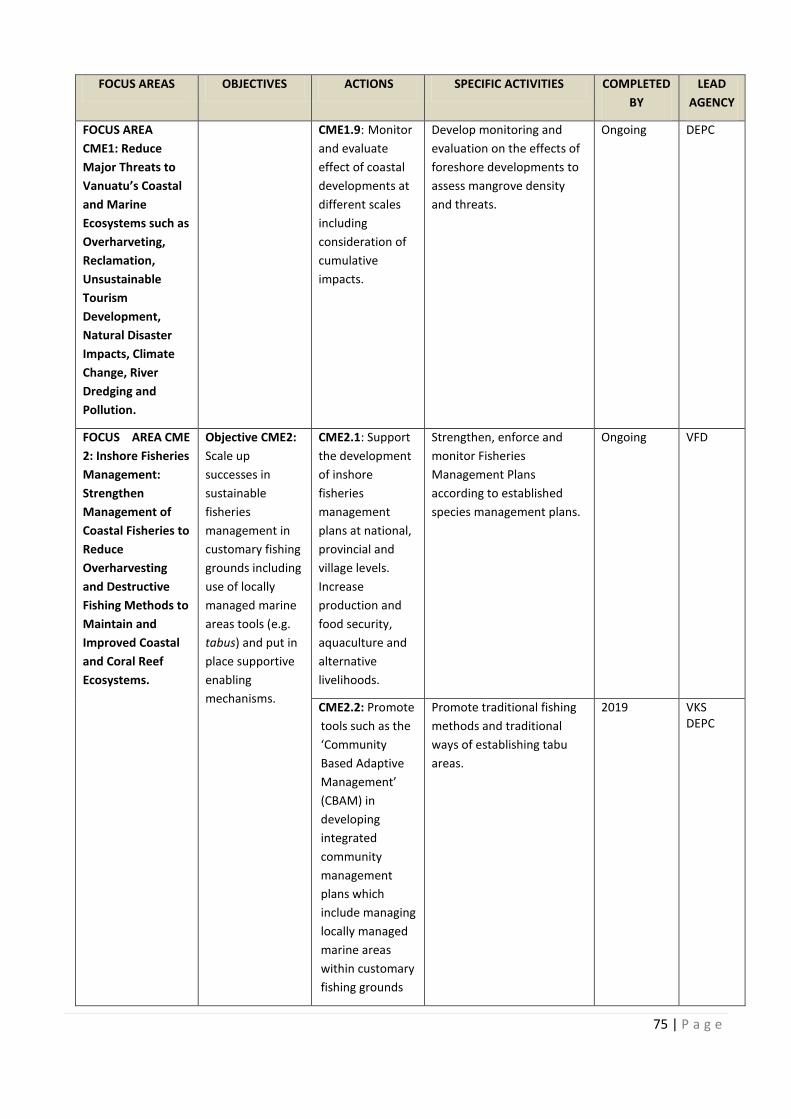
COMPLETED
Objective CME1: Conduct
Capture Showcase best practices for
Develop
Develop
75 | P a g e
FOCUS AREAS OBJECTIVES ACTIONS SPECIFIC ACTIVITIES COMPLETED
BY
LEAD
AGENCY
FOCUS AREA
CME1: Reduce
Major Threats to
Vanuatu’s Coastal
and Marine
Ecosystems such as
Overharveting,
Reclamation,
Unsustainable
Tourism
Development,
Natural Disaster
Impacts, Climate
Change, River
Dredging and
Pollution.
CME1.9: Monitor
and evaluate
effect of coastal
developments at
different scales
including
consideration of
cumulative
impacts.
Develop monitoring and
evaluation on the effects of
foreshore developments to
assess mangrove density
and threats.
Ongoing DEPC
FOCUS AREA CME
2: Inshore Fisheries
Management:
Strengthen
Management of
Coastal Fisheries to
Reduce
Overharvesting
and Destructive
Fishing Methods to
Maintain and
Improved Coastal
and Coral Reef
Ecosystems.
Objective CME2:
Scale up
successes in
sustainable
fisheries
management in
customary fishing
grounds including
use of locally
managed marine
areas tools (e.g.
tabus) and put in
place supportive
enabling
mechanisms.
CME2.1: Support
the development
of inshore
fisheries
management
plans at national,
provincial and
village levels.
Increase
production and
food security,
aquaculture and
alternative
livelihoods.
Strengthen, enforce and
monitor Fisheries
Management Plans
according to established
species management plans.
Ongoing VFD
CME2.2: Promote
tools such as the
‘Community
Based Adaptive
Management’
(CBAM) in
developing
integrated
community
management
plans which
include managing
locally managed
marine areas
within customary
fishing grounds
Promote traditional fishing
methods and traditional
ways of establishing tabu
areas.
2019 VKS
DEPC
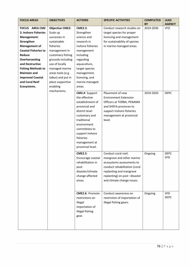
76 | P a g e
FOCUS AREAS OBJECTIVES ACTIONS SPECIFIC ACTIVITIES COMPLETED
BY
LEAD
AGENCY
FOCUS AREA CME
2: Inshore Fisheries
Management:
Strengthen
Management of
Coastal Fisheries to
Reduce
Overharvesting
and Destructive
Fishing Methods to
Maintain and
Improved Coastal
and Coral Reef
Ecosystems.
Objective CME2:
Scale up
successes in
sustainable
fisheries
management in
customary fishing
grounds including
use of locally
managed marine
areas tools (e.g.
tabus) and put in
place supportive
enabling
mechanisms.
CME2.3:
Strengthen
science and
research in
inshore fisheries
management
including
regarding
aquaculture,
target species
management,
licensing, and
marine managed
areas.
Conduct research studies on
target species for proper
licencing and management
for sustainability of species
in marine managed areas.
2019-2030
VFD
CM2.4: Support
the effective
establishment of
provincial and
district level
customary and
traditional
environment
committees to
support inshore
fisheries
management at
provincial level.
Placement of new
Environment Extension
Officers at TORBA, PENAMA
and SHEFA provinces to
support inshore fisheries
management at provincial
level.
2019-2020 DEPC
CME2.5:
Encourage coastal
rehabilitation in
post-
disaster/climate
change affected
areas.
Conduct coral reef,
mangrove and other marine
ecosystems assessments to
conduct rehabilitation (coral
replanting and mangrove
replanting) on post –disaster
and climate change issues.
Ongoing DEPC
VFD
CME2.6: Promote
restrictions on
illegal
importation of
illegal fishing
gear.
Conduct awareness on
restriction of importation of
illegal fishing gears.
Ongoing VFD
DEPC
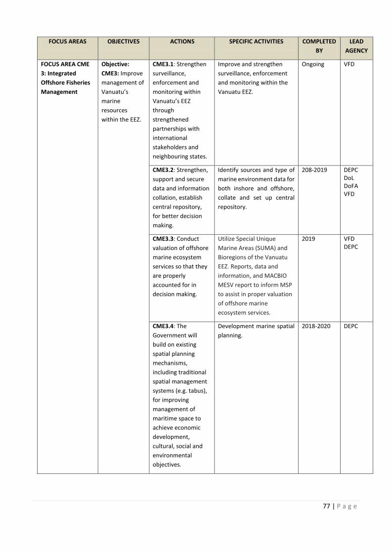
COMPLETED
FOCUS AREA CME Objective CME2: Conduct research studies on
Promote
77 | P a g e
FOCUS AREAS OBJECTIVES ACTIONS SPECIFIC ACTIVITIES COMPLETED
BY
LEAD
AGENCY
FOCUS AREA CME
3: Integrated
Offshore Fisheries
Management
Objective:
CME3: Improve
management of
Vanuatu’s
marine
resources
within the EEZ.
CME3.1: Strengthen
surveillance,
enforcement and
monitoring within
Vanuatu’s EEZ
through
strengthened
partnerships with
international
stakeholders and
neighbouring states.
Improve and strengthen
surveillance, enforcement
and monitoring within the
Vanuatu EEZ.
Ongoing VFD
CME3.2: Strengthen,
support and secure
data and information
collation, establish
central repository,
for better decision
making.
Identify sources and type of
marine environment data for
both inshore and offshore,
collate and set up central
repository.
208-2019 DEPC
DoL
DoFA
VFD
CME3.3: Conduct
valuation of offshore
marine ecosystem
services so that they
are properly
accounted for in
decision making.
Utilize Special Unique
Marine Areas (SUMA) and
Bioregions of the Vanuatu
EEZ. Reports, data and
information, and MACBIO
MESV report to inform MSP
to assist in proper valuation
of offshore marine
ecosystem services.
2019 VFD
DEPC
CME3.4: The
Government will
build on existing
spatial planning
mechanisms,
including traditional
spatial management
systems (e.g. tabus),
for improving
management of
maritime space to
achieve economic
development,
cultural, social and
environmental
objectives.
Development marine spatial
planning.
2018-2020 DEPC
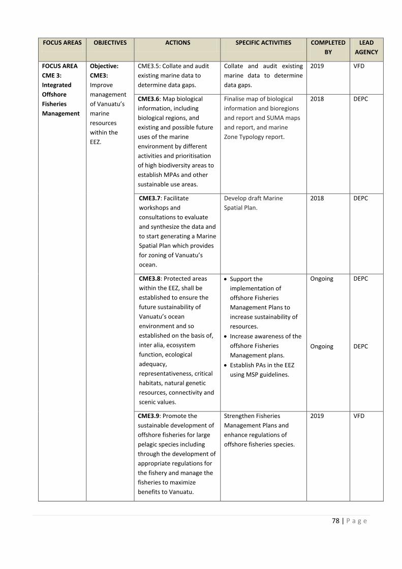
78 | P a g e
FOCUS AREAS OBJECTIVES ACTIONS SPECIFIC ACTIVITIES COMPLETED
BY
LEAD
AGENCY
FOCUS AREA
CME 3:
Integrated
Offshore
Fisheries
Management
Objective:
CME3:
Improve
management
of Vanuatu’s
marine
resources
within the
EEZ.
CME3.5: Collate and audit
existing marine data to
determine data gaps.
Collate and audit existing
marine data to determine
data gaps.
2019 VFD
CME3.6: Map biological
information, including
biological regions, and
existing and possible future
uses of the marine
environment by different
activities and prioritisation
of high biodiversity areas to
establish MPAs and other
sustainable use areas.
Finalise map of biological
information and bioregions
and report and SUMA maps
and report, and marine
Zone Typology report.
2018 DEPC
CME3.7: Facilitate
workshops and
consultations to evaluate
and synthesize the data and
to start generating a Marine
Spatial Plan which provides
for zoning of Vanuatu’s
ocean.
Develop draft Marine
Spatial Plan.
2018 DEPC
CME3.8: Protected areas
within the EEZ, shall be
established to ensure the
future sustainability of
Vanuatu’s ocean
environment and so
established on the basis of,
inter alia, ecosystem
function, ecological
adequacy,
representativeness, critical
habitats, natural genetic
resources, connectivity and
scenic values.
· Support the
implementation of
offshore Fisheries
Management Plans to
increase sustainability of
resources.
· Increase awareness of the
offshore Fisheries
Management plans.
· Establish PAs in the EEZ
using MSP guidelines.
Ongoing
Ongoing
DEPC
DEPC
CME3.9: Promote the
sustainable development of
offshore fisheries for large
pelagic species including
through the development of
appropriate regulations for
the fishery and manage the
fisheries to maximize
benefits to Vanuatu.
Strengthen Fisheries
Management Plans and
enhance regulations of
offshore fisheries species.
2019 VFD
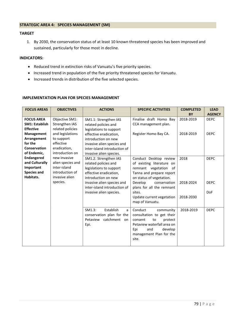
FOCUS AREAS COMPLETED
FOCUS AREA Collate and audit existing
79 | P a g e
STRATEGIC AREA 4: SPECIES MANAGEMENT (SM)
TARGET
1. By 2030, the conservation status of at least 10 known threatened species has been improved and
sustained, particularly for those most in decline.
INDICATORS:
· Reduced trend in extinction risks of Vanuatu’s five priority species.
· Increased trend in population of the five priority threatened species for Vanuatu.
· Increased trends in distribution of the five selected species.
IMPLEMENTATION PLAN FOR SPECIES MANAGEMENT
FOCUS AREAS OBJECTIVES ACTIONS SPECIFIC ACTIVITIES COMPLETED
BY
LEAD
AGENCY
FOCUS AREA
SM1: Establish
Effective
Management
Arrangement
for the
Conservation
of Endemic,
Endangered
and Culturally
Important
Species and
Habitats.
Objective SM1:
Strengthen IAS
related policies
and legislations
to support
effective
eradication,
introduction on
new invasive
alien species and
inter-island
introduction of
invasive alien
species.
SM1.1: Strengthen IAS
related policies and
legislations to support
effective eradication,
introduction on new
invasive alien species and
inter-island introduction of
invasive alien species.
Finalise draft Homo Bay
CCA management plan.
Register Homo Bay CA.
2018-2019
2018-2019
DEPC
DEPC
SM1.2: Strengthen IAS
related policies and
legislations to support
effective eradication,
introduction on new
invasive alien species and
inter-island introduction of
invasive alien species.
Conduct Desktop review
of existing literature on
remnant vegetation of
Tanna and prepare report
on status of vegetation.
Develop conservation
plans for all the remnant
sites.
Update current vegetation
map of Vanuatu.
2018
2018-2024
2018-2030
DEPC
DEPC
DoF
SM1.3: Establish a
conservation plan for the
Petaview catchment on
Epi.
Conduct community
consultation to get their
consent to protect
Petaview waterfall area on
Epi and develop
management Plan for the
site.
2018-2019 DEPC
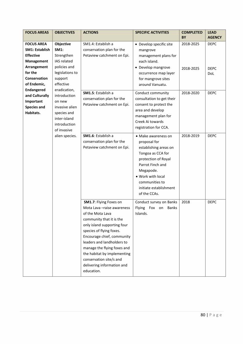
80 | P a g e
FOCUS AREAS OBJECTIVES ACTIONS SPECIFIC ACTIVITIES COMPLETED
BY
LEAD
AGENCY
FOCUS AREA
SM1: Establish
Effective
Management
Arrangement
for the
Conservation
of Endemic,
Endangered
and Culturally
Important
Species and
Habitats.
Objective
SM1:
Strengthen
IAS related
policies and
legislations to
support
effective
eradication,
introduction
on new
invasive alien
species and
inter-island
introduction
of invasive
alien species.
SM1.4: Establish a
conservation plan for the
Petaview catchment on Epi.
· Develop specific site
mangrove
management plans for
each island.
· Develop mangrove
occurrence map layer
for mangrove sites
around Vanuatu.
2018-2025
2018-2025
DEPC
DEPC
DoL
SM1.5: Establish a
conservation plan for the
Petaview catchment on Epi.
Conduct community
consultation to get their
consent to protect the
area and develop
management plan for
Creek Ai towards
registration for CCA.
2018-2020 DEPC
SM1.6: Establish a
conservation plan for the
Petaview catchment on Epi.
· Make awareness on
proposal for
establishing areas on
Tongoa as CCA for
protection of Royal
Parrot Finch and
Megapode.
· Work with local
communities to
initiate establishment
of the CCAs.
2018-2019 DEPC
SM1.7: Flying Foxes on
Mota Lava –raise awareness
of the Mota Lava
community that it is the
only island supporting four
species of flying foxes.
Encourage chief, community
leaders and landholders to
manage the flying foxes and
the habitat by implementing
conservation site/s and
delivering information and
education.
Conduct survey on Banks
Flying Fox on Banks
Islands.
2018
DEPC
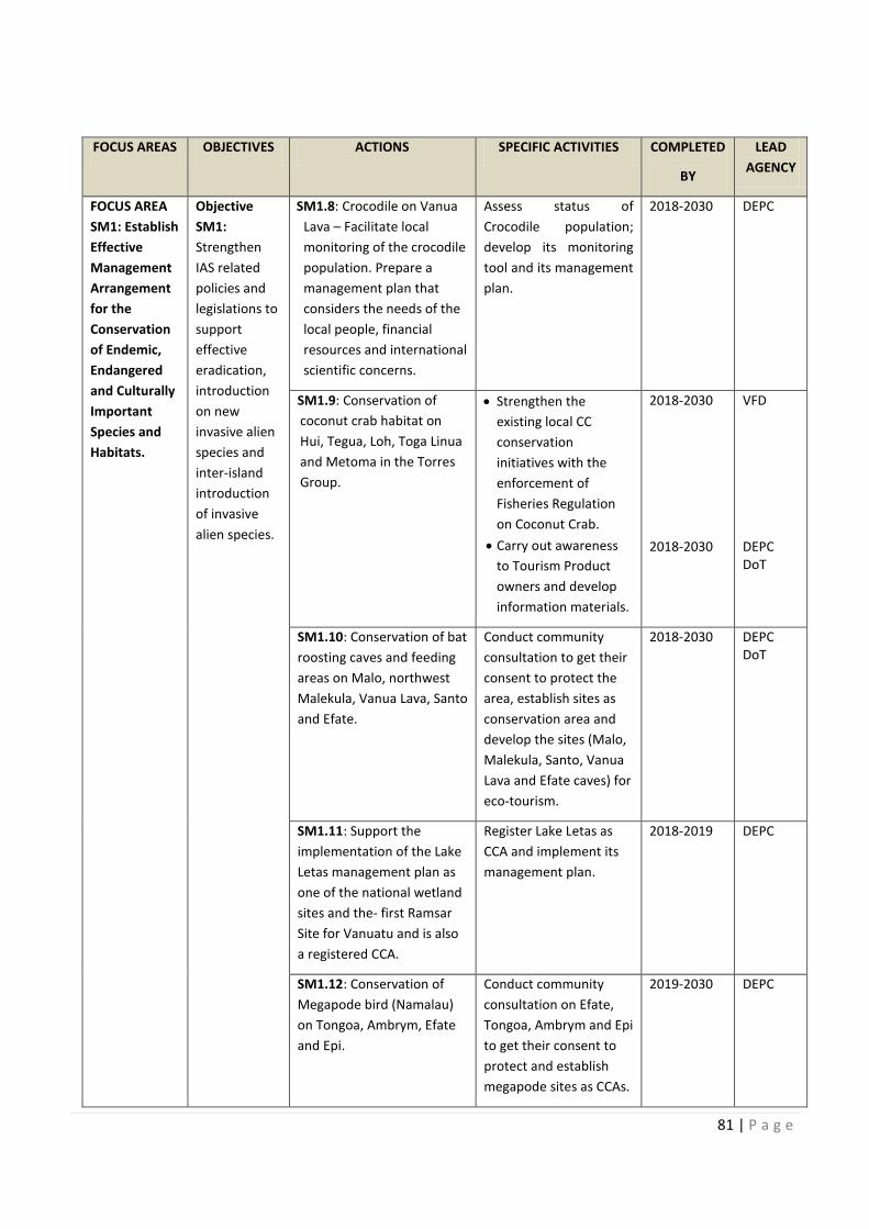
anks
81 | P a g e
FOCUS AREAS OBJECTIVES ACTIONS SPECIFIC ACTIVITIES COMPLETED
BY
LEAD
AGENCY
FOCUS AREA
SM1: Establish
Effective
Management
Arrangement
for the
Conservation
of Endemic,
Endangered
and Culturally
Important
Species and
Habitats.
Objective
SM1:
Strengthen
IAS related
policies and
legislations to
support
effective
eradication,
introduction
on new
invasive alien
species and
inter-island
introduction
of invasive
alien species.
SM1.8: Crocodile on Vanua
Lava – Facilitate local
monitoring of the crocodile
population. Prepare a
management plan that
considers the needs of the
local people, financial
resources and international
scientific concerns.
Assess status of
Crocodile population;
develop its monitoring
tool and its management
plan.
2018-2030 DEPC
SM1.9: Conservation of
coconut crab habitat on
Hui, Tegua, Loh, Toga Linua
and Metoma in the Torres
Group.
· Strengthen the
existing local CC
conservation
initiatives with the
enforcement of
Fisheries Regulation
on Coconut Crab.
· Carry out awareness
to Tourism Product
owners and develop
information materials.
2018-2030
2018-2030
VFD
DEPC
DoT
SM1.10: Conservation of bat
roosting caves and feeding
areas on Malo, northwest
Malekula, Vanua Lava, Santo
and Efate.
Conduct community
consultation to get their
consent to protect the
area, establish sites as
conservation area and
develop the sites (Malo,
Malekula, Santo, Vanua
Lava and Efate caves) for
eco-tourism.
2018-2030 DEPC
DoT
SM1.11: Support the
implementation of the Lake
Letas management plan as
one of the national wetland
sites and the- first Ramsar
Site for Vanuatu and is also
a registered CCA.
Register Lake Letas as
CCA and implement its
management plan.
2018-2019 DEPC
SM1.12: Conservation of
Megapode bird (Namalau)
on Tongoa, Ambrym, Efate
and Epi.
Conduct community
consultation on Efate,
Tongoa, Ambrym and Epi
to get their consent to
protect and establish
megapode sites as CCAs.
2019-2030 DEPC
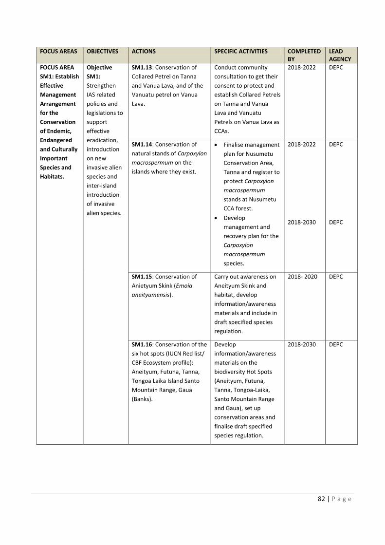
82 | P a g e
FOCUS AREAS OBJECTIVES ACTIONS SPECIFIC ACTIVITIES COMPLETED
BY
LEAD
AGENCY
FOCUS AREA
SM1: Establish
Effective
Management
Arrangement
for the
Conservation
of Endemic,
Endangered
and Culturally
Important
Species and
Habitats.
Objective
SM1:
Strengthen
IAS related
policies and
legislations to
support
effective
eradication,
introduction
on new
invasive alien
species and
inter-island
introduction
of invasive
alien species.
SM1.13: Conservation of
Collared Petrel on Tanna
and Vanua Lava, and of the
Vanuatu petrel on Vanua
Lava.
Conduct community
consultation to get their
consent to protect and
establish Collared Petrels
on Tanna and Vanua
Lava and Vanuatu
Petrels on Vanua Lava as
CCAs.
2018-2022 DEPC
SM1.14: Conservation of
natural stands of Carpoxylon
macrospermum on the
islands where they exist.
· Finalise management
plan for Nusumetu
Conservation Area,
Tanna and register to
protect Carpoxylon
macrospermum
stands at Nusumetu
CCA forest.
· Develop
management and
recovery plan for the
Carpoxylon
macrospermum
species.
2018-2022
2018-2030
DEPC
DEPC
SM1.15: Conservation of
Anietyum Skink (Emoia
aneityumensis).
Carry out awareness on
Aneityum Skink and
habitat, develop
information/awareness
materials and include in
draft specified species
regulation.
2018- 2020 DEPC
SM1.16: Conservation of the
six hot spots (IUCN Red list/
CBF Ecosystem profile):
Aneityum, Futuna, Tanna,
Tongoa Laika Island Santo
Mountain Range, Gaua
(Banks).
Develop
information/awareness
materials on the
biodiversity Hot Spots
(Aneityum, Futuna,
Tanna, Tongoa-Laika,
Santo Mountain Range
and Gaua), set up
conservation areas and
finalise draft specified
species regulation.
2018-2030 DEPC
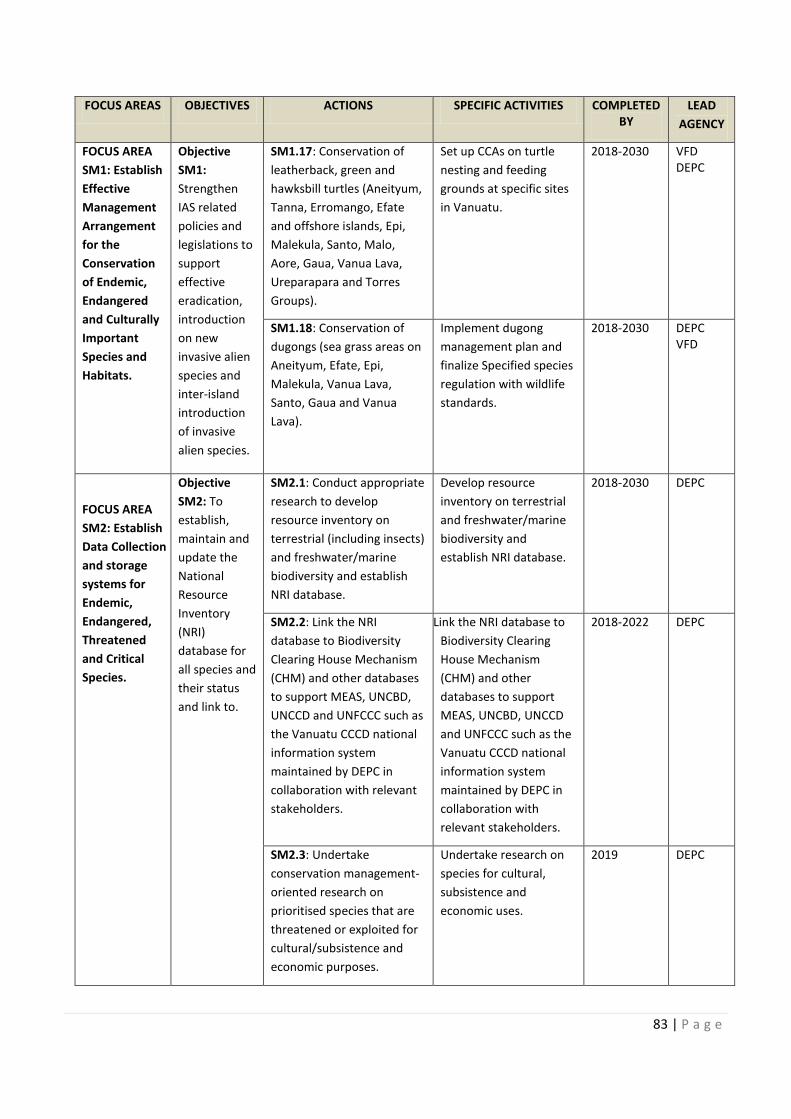
Finalise management
Carry out awareness on
Conservation of the
83 | P a g e
FOCUS AREAS OBJECTIVES ACTIONS SPECIFIC ACTIVITIES COMPLETED
BY
LEAD
AGENCY
FOCUS AREA
SM1: Establish
Effective
Management
Arrangement
for the
Conservation
of Endemic,
Endangered
and Culturally
Important
Species and
Habitats.
Objective
SM1:
Strengthen
IAS related
policies and
legislations to
support
effective
eradication,
introduction
on new
invasive alien
species and
inter-island
introduction
of invasive
alien species.
SM1.17: Conservation of
leatherback, green and
hawksbill turtles (Aneityum,
Tanna, Erromango, Efate
and offshore islands, Epi,
Malekula, Santo, Malo,
Aore, Gaua, Vanua Lava,
Ureparapara and Torres
Groups).
Set up CCAs on turtle
nesting and feeding
grounds at specific sites
in Vanuatu.
2018-2030 VFD
DEPC
SM1.18: Conservation of
dugongs (sea grass areas on
Aneityum, Efate, Epi,
Malekula, Vanua Lava,
Santo, Gaua and Vanua
Lava).
Implement dugong
management plan and
finalize Specified species
regulation with wildlife
standards.
2018-2030 DEPC
VFD
FOCUS AREA
SM2: Establish
Data Collection
and storage
systems for
Endemic,
Endangered,
Threatened
and Critical
Species.
Objective
SM2: To
establish,
maintain and
update the
National
Resource
Inventory
(NRI)
database for
all species and
their status
and link to.
SM2.1: Conduct appropriate
research to develop
resource inventory on
terrestrial (including insects)
and freshwater/marine
biodiversity and establish
NRI database.
Develop resource
inventory on terrestrial
and freshwater/marine
biodiversity and
establish NRI database.
2018-2030 DEPC
SM2.2: Link the NRI
database to Biodiversity
Clearing House Mechanism
(CHM) and other databases
to support MEAS, UNCBD,
UNCCD and UNFCCC such as
the Vanuatu CCCD national
information system
maintained by DEPC in
collaboration with relevant
stakeholders.
Link the NRI database to
Biodiversity Clearing
House Mechanism
(CHM) and other
databases to support
MEAS, UNCBD, UNCCD
and UNFCCC such as the
Vanuatu CCCD national
information system
maintained by DEPC in
collaboration with
relevant stakeholders.
2018-2022 DEPC
SM2.3: Undertake
conservation management-
oriented research on
prioritised species that are
threatened or exploited for
cultural/subsistence and
economic purposes.
Undertake research on
species for cultural,
subsistence and
economic uses.
2019 DEPC
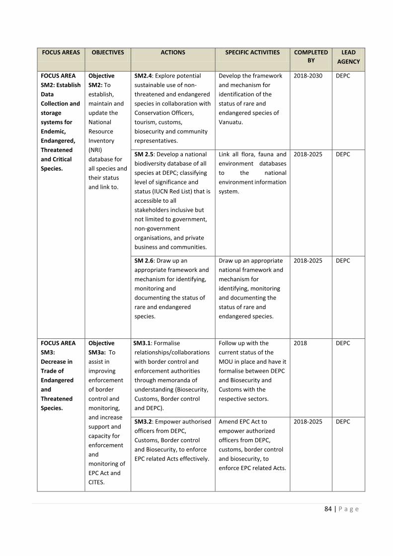
84 | P a g e
FOCUS AREAS OBJECTIVES ACTIONS SPECIFIC ACTIVITIES COMPLETED
BY
LEAD
AGENCY
FOCUS AREA
SM2: Establish
Data
Collection and
storage
systems for
Endemic,
Endangered,
Threatened
and Critical
Species.
Objective
SM2: To
establish,
maintain and
update the
National
Resource
Inventory
(NRI)
database for
all species and
their status
and link to.
SM2.4: Explore potential
sustainable use of non-
threatened and endangered
species in collaboration with
Conservation Officers,
tourism, customs,
biosecurity and community
representatives.
Develop the framework
and mechanism for
identification of the
status of rare and
endangered species of
Vanuatu.
2018-2030 DEPC
SM 2.5: Develop a national
biodiversity database of all
species at DEPC; classifying
level of significance and
status (IUCN Red List) that is
accessible to all
stakeholders inclusive but
not limited to government,
non-government
organisations, and private
business and communities.
Link all flora, fauna and
environment databases
to the national
environment information
system.
2018-2025 DEPC
SM 2.6: Draw up an
appropriate framework and
mechanism for identifying,
monitoring and
documenting the status of
rare and endangered
species.
Draw up an appropriate
national framework and
mechanism for
identifying, monitoring
and documenting the
status of rare and
endangered species.
2018-2025 DEPC
FOCUS AREA
SM3:
Decrease in
Trade of
Endangered
and
Threatened
Species.
Objective
SM3a: To
assist in
improving
enforcement
of border
control and
monitoring,
and increase
support and
capacity for
enforcement
and
monitoring of
EPC Act and
CITES.
SM3.1: Formalise
relationships/collaborations
with border control and
enforcement authorities
through memoranda of
understanding (Biosecurity,
Customs, Border control
and DEPC).
Follow up with the
current status of the
MOU in place and have it
formalise between DEPC
and Biosecurity and
Customs with the
respective sectors.
2018 DEPC
SM3.2: Empower authorised
officers from DEPC,
Customs, Border control
and Biosecurity, to enforce
EPC related Acts effectively.
Amend EPC Act to
empower authorized
officers from DEPC,
customs, border control
and biosecurity, to
enforce EPC related Acts.
2018-2025 DEPC
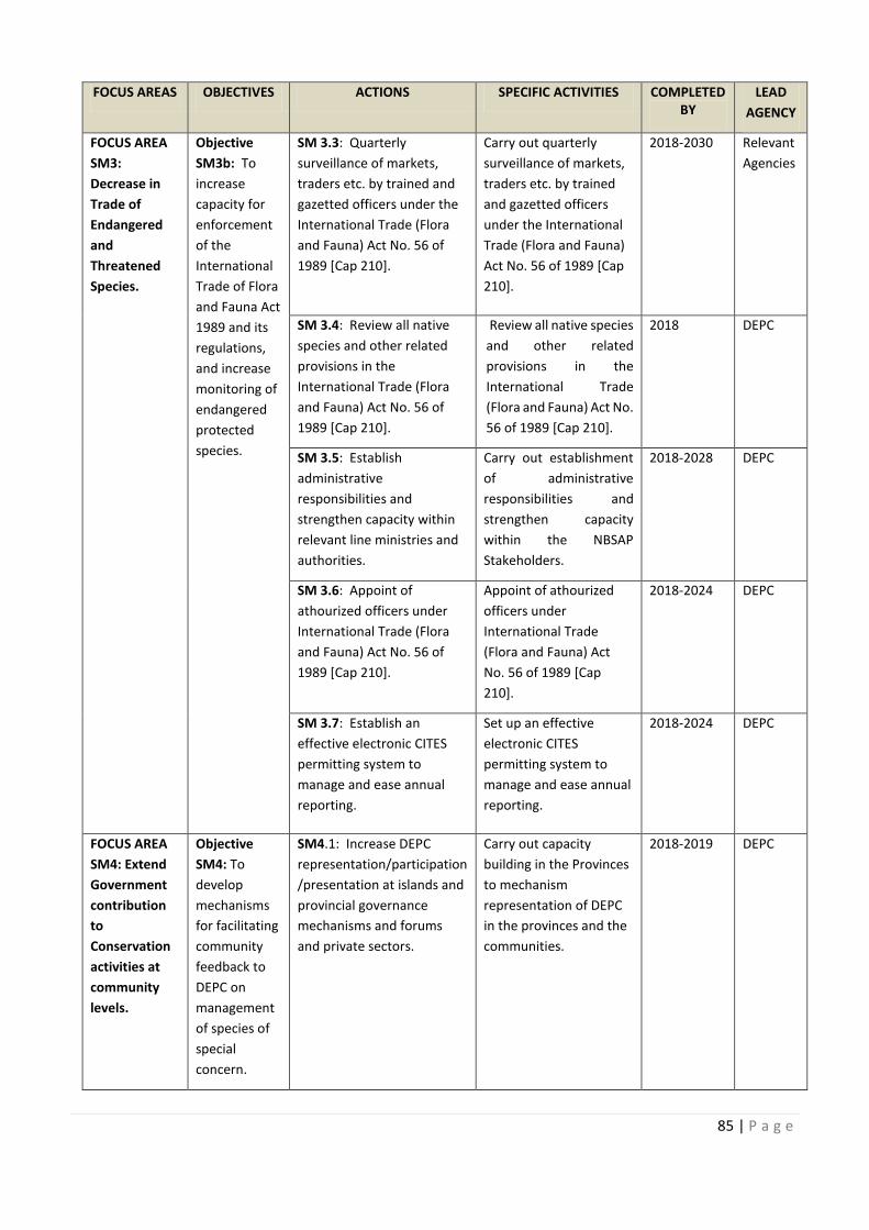
FOCUS AREAS COMPLETED
Develop the framework
: Develop a national Link all flora, fauna and
Draw up an appropriate
: Empower authorised
85 | P a g e
FOCUS AREAS OBJECTIVES ACTIONS SPECIFIC ACTIVITIES COMPLETED
BY
LEAD
AGENCY
FOCUS AREA
SM3:
Decrease in
Trade of
Endangered
and
Threatened
Species.
Objective
SM3b: To
increase
capacity for
enforcement
of the
International
Trade of Flora
and Fauna Act
1989 and its
regulations,
and increase
monitoring of
endangered
protected
species.
SM 3.3: Quarterly
surveillance of markets,
traders etc. by trained and
gazetted officers under the
International Trade (Flora
and Fauna) Act No. 56 of
1989 [Cap 210].
Carry out quarterly
surveillance of markets,
traders etc. by trained
and gazetted officers
under the International
Trade (Flora and Fauna)
Act No. 56 of 1989 [Cap
210].
2018-2030 Relevant
Agencies
SM 3.4: Review all native
species and other related
provisions in the
International Trade (Flora
and Fauna) Act No. 56 of
1989 [Cap 210].
Review all native species
and other related
provisions in the
International Trade
(Flora and Fauna) Act No.
56 of 1989 [Cap 210].
2018 DEPC
SM 3.5: Establish
administrative
responsibilities and
strengthen capacity within
relevant line ministries and
authorities.
Carry out establishment
of administrative
responsibilities and
strengthen capacity
within the NBSAP
Stakeholders.
2018-2028 DEPC
SM 3.6: Appoint of
athourized officers under
International Trade (Flora
and Fauna) Act No. 56 of
1989 [Cap 210].
Appoint of athourized
officers under
International Trade
(Flora and Fauna) Act
No. 56 of 1989 [Cap
210].
2018-2024 DEPC
SM 3.7: Establish an
effective electronic CITES
permitting system to
manage and ease annual
reporting.
Set up an effective
electronic CITES
permitting system to
manage and ease annual
reporting.
2018-2024 DEPC
FOCUS AREA
SM4: Extend
Government
contribution
to
Conservation
activities at
community
levels.
Objective
SM4: To
develop
mechanisms
for facilitating
community
feedback to
DEPC on
management
of species of
special
concern.
SM4.1: Increase DEPC
representation/participation
/presentation at islands and
provincial governance
mechanisms and forums
and private sectors.
Carry out capacity
building in the Provinces
to mechanism
representation of DEPC
in the provinces and the
communities.
2018-2019 DEPC
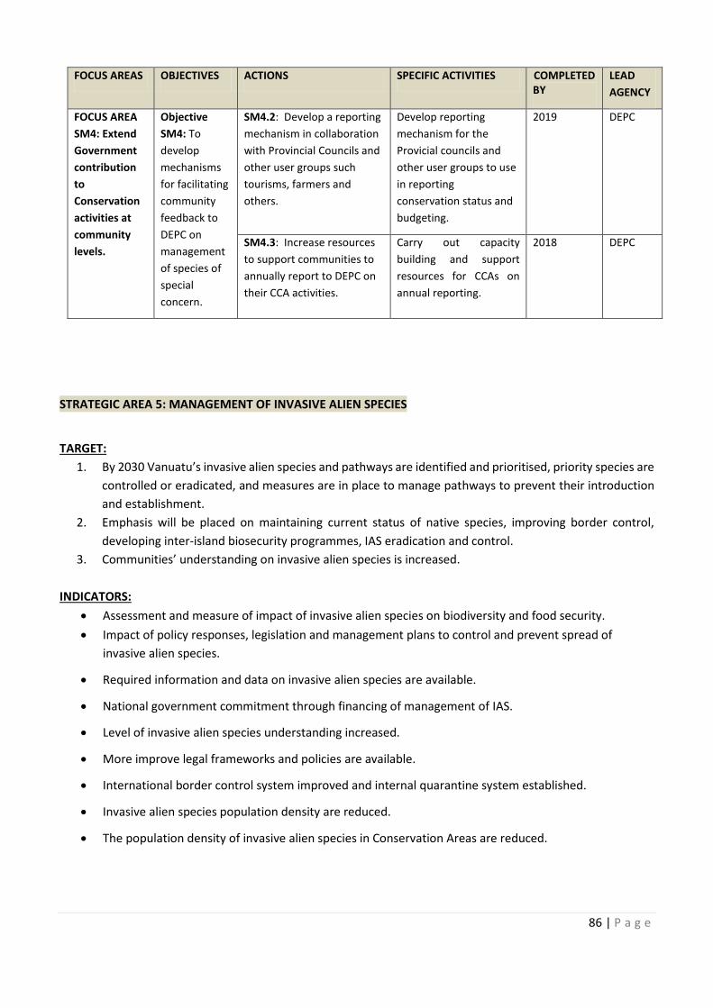
86 | P a g e
STRATEGIC AREA 5: MANAGEMENT OF INVASIVE ALIEN SPECIES
TARGET:
1. By 2030 Vanuatu’s invasive alien species and pathways are identified and prioritised, priority species are
controlled or eradicated, and measures are in place to manage pathways to prevent their introduction
and establishment.
2. Emphasis will be placed on maintaining current status of native species, improving border control,
developing inter-island biosecurity programmes, IAS eradication and control.
3. Communities’ understanding on invasive alien species is increased.
INDICATORS:
· Assessment and measure of impact of invasive alien species on biodiversity and food security.
· Impact of policy responses, legislation and management plans to control and prevent spread of
invasive alien species.
· Required information and data on invasive alien species are available.
· National government commitment through financing of management of IAS.
· Level of invasive alien species understanding increased.
· More improve legal frameworks and policies are available.
· International border control system improved and internal quarantine system established.
· Invasive alien species population density are reduced.
· The population density of invasive alien species in Conservation Areas are reduced.
FOCUS AREAS OBJECTIVES ACTIONS SPECIFIC ACTIVITIES COMPLETED
BY
LEAD
AGENCY
FOCUS AREA
SM4: Extend
Government
contribution
to
Conservation
activities at
community
levels.
Objective
SM4: To
develop
mechanisms
for facilitating
community
feedback to
DEPC on
management
of species of
special
concern.
SM4.2: Develop a reporting
mechanism in collaboration
with Provincial Councils and
other user groups such
tourisms, farmers and
others.
Develop reporting
mechanism for the
Provicial councils and
other user groups to use
in reporting
conservation status and
budgeting.
2019 DEPC
SM4.3: Increase resources
to support communities to
annually report to DEPC on
their CCA activities.
Carry out capacity
building and support
resources for CCAs on
annual reporting.
2018 DEPC
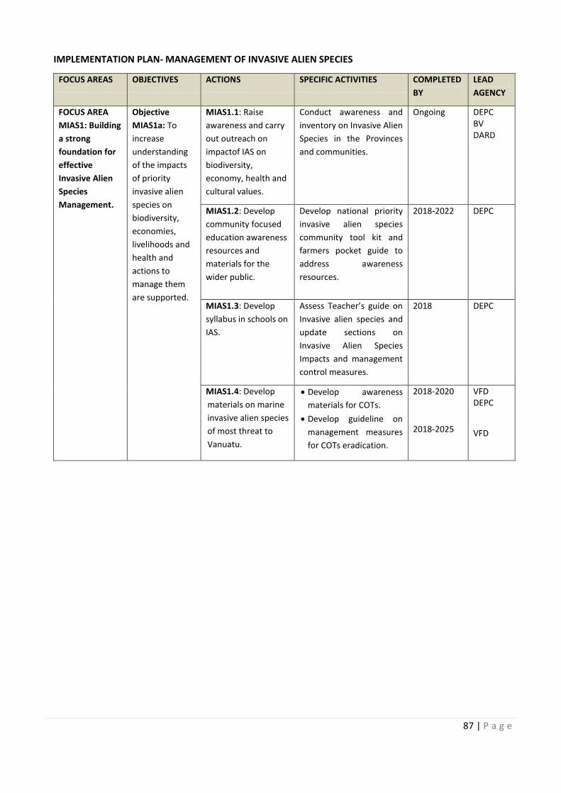
COMPLETED
: Develop a reporting
Carry out capacity
87 | P a g e
IMPLEMENTATION PLAN- MANAGEMENT OF INVASIVE ALIEN SPECIES
FOCUS AREAS OBJECTIVES ACTIONS SPECIFIC ACTIVITIES COMPLETED
BY
LEAD
AGENCY
FOCUS AREA
MIAS1: Building
a strong
foundation for
effective
Invasive Alien
Species
Management.
Objective
MIAS1a: To
increase
understanding
of the impacts
of priority
invasive alien
species on
biodiversity,
economies,
livelihoods and
health and
actions to
manage them
are supported.
MIAS1.1: Raise
awareness and carry
out outreach on
impactof IAS on
biodiversity,
economy, health and
cultural values.
Conduct awareness and
inventory on Invasive Alien
Species in the Provinces
and communities.
Ongoing DEPC
BV
DARD
MIAS1.2: Develop
community focused
education awareness
resources and
materials for the
wider public.
Develop national priority
invasive alien species
community tool kit and
farmers pocket guide to
address awareness
resources.
2018-2022
DEPC
MIAS1.3: Develop
syllabus in schools on
IAS.
Assess Teacher’s guide on
Invasive alien species and
update sections on
Invasive Alien Species
Impacts and management
control measures.
2018 DEPC
MIAS1.4: Develop
materials on marine
invasive alien species
of most threat to
Vanuatu.
· Develop awareness
materials for COTs.
· Develop guideline on
management measures
for COTs eradication.
2018-2020
2018-2025
VFD
DEPC
VFD
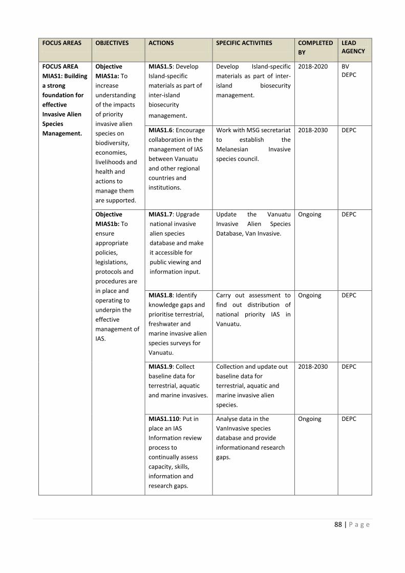
88 | P a g e
FOCUS AREAS OBJECTIVES ACTIONS SPECIFIC ACTIVITIES COMPLETED
BY
LEAD
AGENCY
FOCUS AREA
MIAS1: Building
a strong
foundation for
effective
Invasive Alien
Species
Management.
Objective
MIAS1a: To
increase
understanding
of the impacts
of priority
invasive alien
species on
biodiversity,
economies,
livelihoods and
health and
actions to
manage them
are supported.
MIAS1.5: Develop
Island-specific
materials as part of
inter-island
biosecurity
management.
Develop Island-specific
materials as part of inter-
island biosecurity
management.
2018-2020 BV
DEPC
MIAS1.6: Encourage
collaboration in the
management of IAS
between Vanuatu
and other regional
countries and
institutions.
Work with MSG secretariat
to establish the
Melanesian Invasive
species council.
2018-2030 DEPC
Objective
MIAS1b: To
ensure
appropriate
policies,
legislations,
protocols and
procedures are
in place and
operating to
underpin the
effective
management of
IAS.
MIAS1.7: Upgrade
national invasive
alien species
database and make
it accessible for
public viewing and
information input.
Update the Vanuatu
Invasive Alien Species
Database, Van Invasive.
Ongoing DEPC
MIAS1.8: Identify
knowledge gaps and
prioritise terrestrial,
freshwater and
marine invasive alien
species surveys for
Vanuatu.
Carry out assessment to
find out distribution of
national priority IAS in
Vanuatu.
Ongoing DEPC
MIAS1.9: Collect
baseline data for
terrestrial, aquatic
and marine invasives.
Collection and update out
baseline data for
terrestrial, aquatic and
marine invasive alien
species.
2018-2030 DEPC
MIAS1.110: Put in
place an IAS
Information review
process to
continually assess
capacity, skills,
information and
research gaps.
Analyse data in the
VanInvasive species
database and provide
informationand research
gaps.
Ongoing DEPC
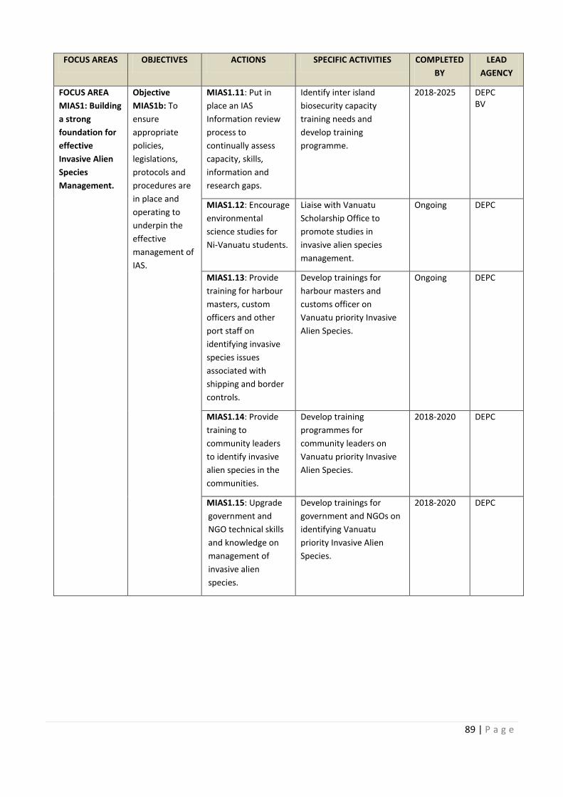
COMPLETED
ific
Encourage Work with MSG secretariat
Update the Vanuatu
Carry out assessment to
Collection and update out
89 | P a g e
FOCUS AREAS OBJECTIVES ACTIONS SPECIFIC ACTIVITIES COMPLETED
BY
LEAD
AGENCY
FOCUS AREA
MIAS1: Building
a strong
foundation for
effective
Invasive Alien
Species
Management.
Objective
MIAS1b: To
ensure
appropriate
policies,
legislations,
protocols and
procedures are
in place and
operating to
underpin the
effective
management of
IAS.
MIAS1.11: Put in
place an IAS
Information review
process to
continually assess
capacity, skills,
information and
research gaps.
Identify inter island
biosecurity capacity
training needs and
develop training
programme.
2018-2025 DEPC
BV
MIAS1.12: Encourage
environmental
science studies for
Ni-Vanuatu students.
Liaise with Vanuatu
Scholarship Office to
promote studies in
invasive alien species
management.
Ongoing DEPC
MIAS1.13: Provide
training for harbour
masters, custom
officers and other
port staff on
identifying invasive
species issues
associated with
shipping and border
controls.
Develop trainings for
harbour masters and
customs officer on
Vanuatu priority Invasive
Alien Species.
Ongoing DEPC
MIAS1.14: Provide
training to
community leaders
to identify invasive
alien species in the
communities.
Develop training
programmes for
community leaders on
Vanuatu priority Invasive
Alien Species.
2018-2020 DEPC
MIAS1.15: Upgrade
government and
NGO technical skills
and knowledge on
management of
invasive alien
species.
Develop trainings for
government and NGOs on
identifying Vanuatu
priority Invasive Alien
Species.
2018-2020 DEPC
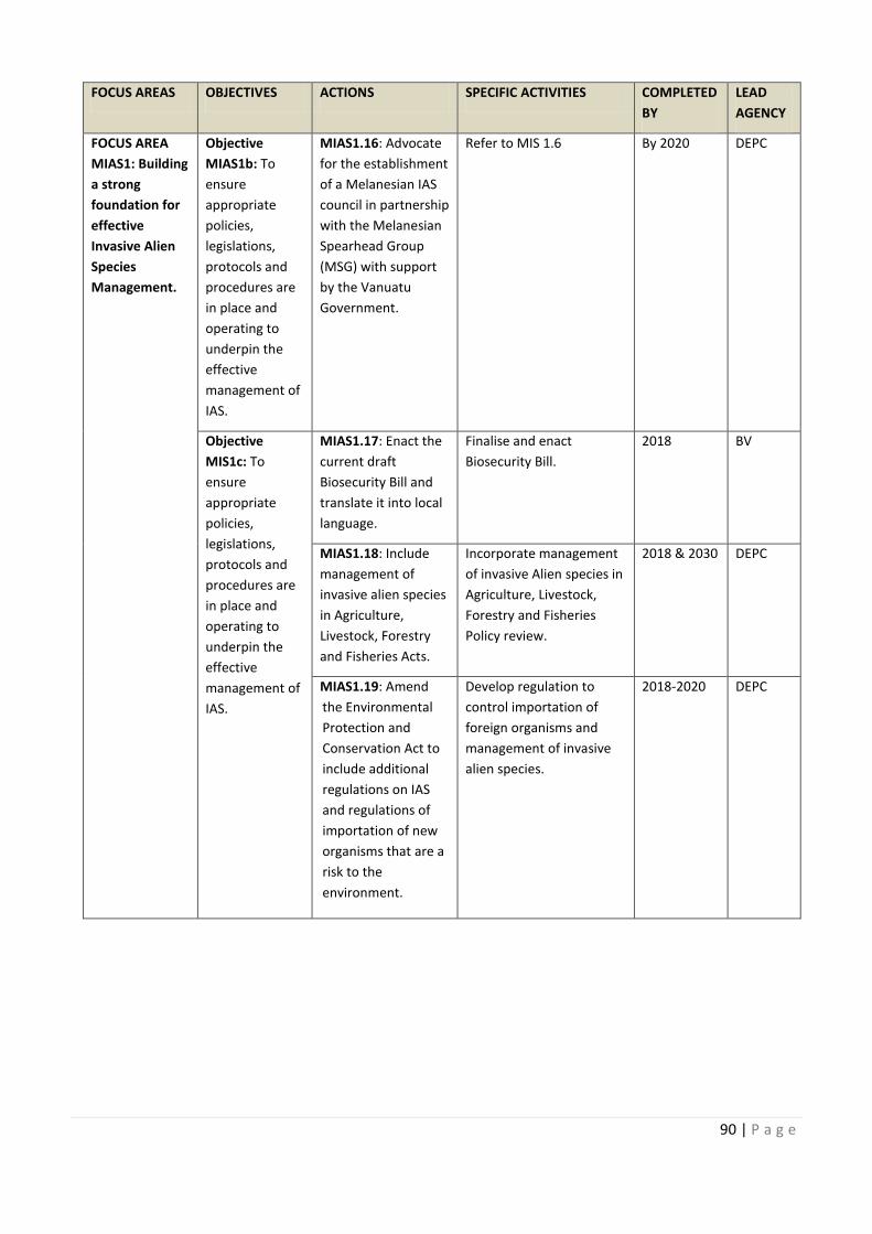
90 | P a g e
FOCUS AREAS OBJECTIVES ACTIONS SPECIFIC ACTIVITIES COMPLETED
BY
LEAD
AGENCY
FOCUS AREA
MIAS1: Building
a strong
foundation for
effective
Invasive Alien
Species
Management.
Objective
MIAS1b: To
ensure
appropriate
policies,
legislations,
protocols and
procedures are
in place and
operating to
underpin the
effective
management of
IAS.
MIAS1.16: Advocate
for the establishment
of a Melanesian IAS
council in partnership
with the Melanesian
Spearhead Group
(MSG) with support
by the Vanuatu
Government.
Refer to MIS 1.6 By 2020 DEPC
Objective
MIS1c: To
ensure
appropriate
policies,
legislations,
protocols and
procedures are
in place and
operating to
underpin the
effective
management of
IAS.
MIAS1.17: Enact the
current draft
Biosecurity Bill and
translate it into local
language.
Finalise and enact
Biosecurity Bill.
2018 BV
MIAS1.18: Include
management of
invasive alien species
in Agriculture,
Livestock, Forestry
and Fisheries Acts.
Incorporate management
of invasive Alien species in
Agriculture, Livestock,
Forestry and Fisheries
Policy review.
2018 & 2030 DEPC
MIAS1.19: Amend
the Environmental
Protection and
Conservation Act to
include additional
regulations on IAS
and regulations of
importation of new
organisms that are a
risk to the
environment.
Develop regulation to
control importation of
foreign organisms and
management of invasive
alien species.
2018-2020 DEPC
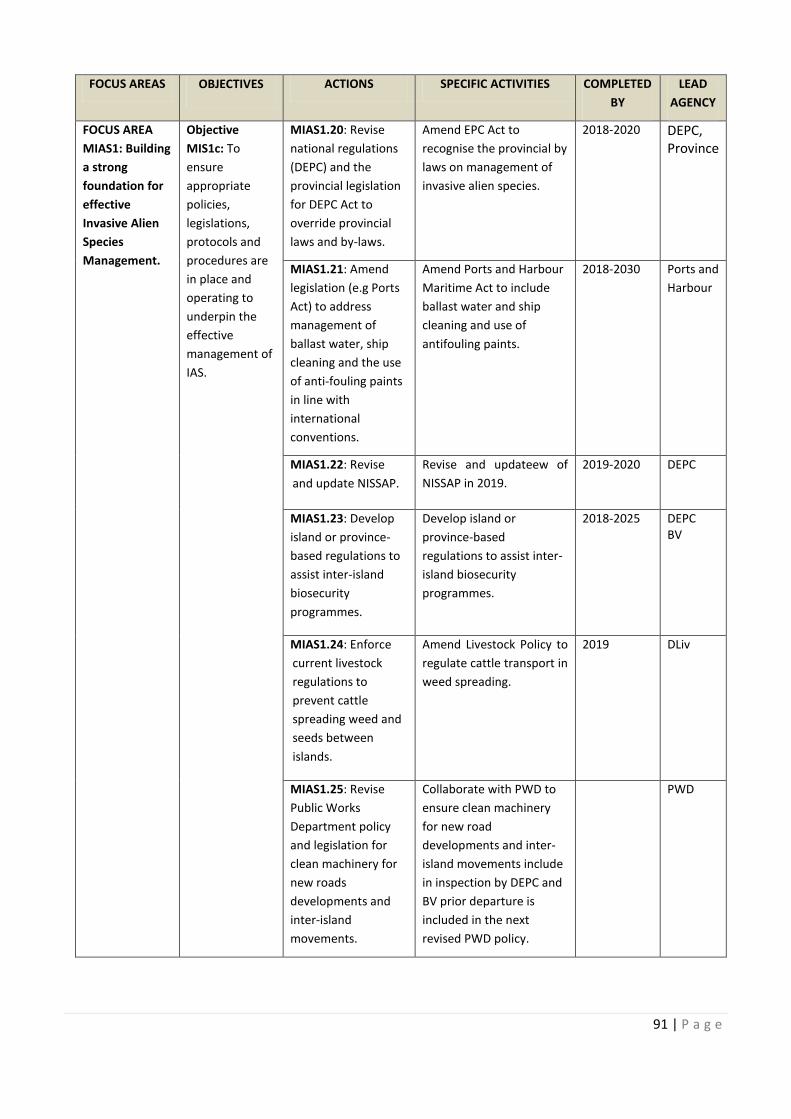
COMPLETED
: Advocate
: Enact the
Incorporate management 2018 & 2030
91 | P a g e
FOCUS AREAS OBJECTIVES ACTIONS SPECIFIC ACTIVITIES COMPLETED
BY
LEAD
AGENCY
FOCUS AREA
MIAS1: Building
a strong
foundation for
effective
Invasive Alien
Species
Management.
Objective
MIS1c: To
ensure
appropriate
policies,
legislations,
protocols and
procedures are
in place and
operating to
underpin the
effective
management of
IAS.
MIAS1.20: Revise
national regulations
(DEPC) and the
provincial legislation
for DEPC Act to
override provincial
laws and by-laws.
Amend EPC Act to
recognise the provincial by
laws on management of
invasive alien species.
2018-2020 DEPC,
Province
MIAS1.21: Amend
legislation (e.g Ports
Act) to address
management of
ballast water, ship
cleaning and the use
of anti-fouling paints
in line with
international
conventions.
Amend Ports and Harbour
Maritime Act to include
ballast water and ship
cleaning and use of
antifouling paints.
2018-2030 Ports and
Harbour
MIAS1.22: Revise
and update NISSAP.
Revise and updateew of
NISSAP in 2019.
2019-2020 DEPC
MIAS1.23: Develop
island or province-
based regulations to
assist inter-island
biosecurity
programmes.
Develop island or
province-based
regulations to assist inter-
island biosecurity
programmes.
2018-2025 DEPC
BV
MIAS1.24: Enforce
current livestock
regulations to
prevent cattle
spreading weed and
seeds between
islands.
Amend Livestock Policy to
regulate cattle transport in
weed spreading.
2019 DLiv
MIAS1.25: Revise
Public Works
Department policy
and legislation for
clean machinery for
new roads
developments and
inter-island
movements.
Collaborate with PWD to
ensure clean machinery
for new road
developments and inter-
island movements include
in inspection by DEPC and
BV prior departure is
included in the next
revised PWD policy.
PWD
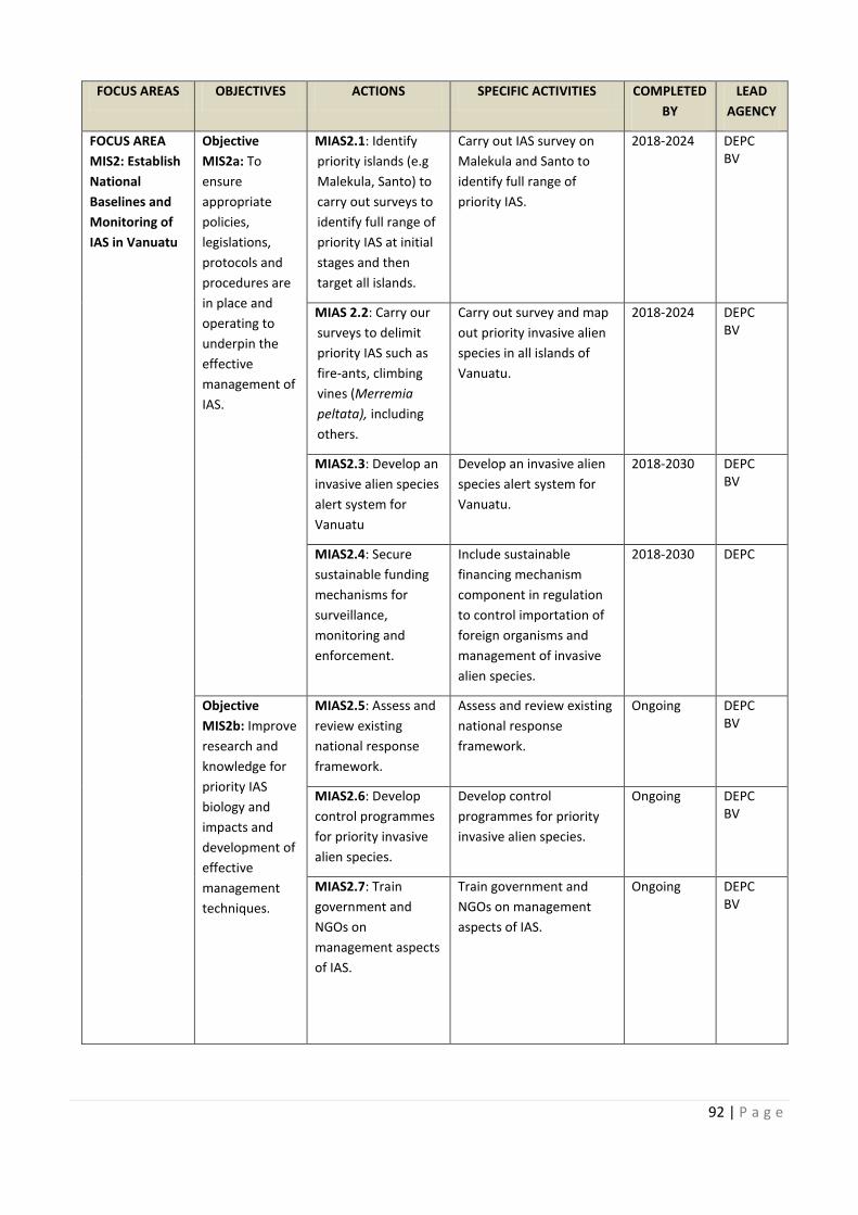
92 | P a g e
FOCUS AREAS OBJECTIVES ACTIONS SPECIFIC ACTIVITIES COMPLETED
BY
LEAD
AGENCY
FOCUS AREA
MIS2: Establish
National
Baselines and
Monitoring of
IAS in Vanuatu
Objective
MIS2a: To
ensure
appropriate
policies,
legislations,
protocols and
procedures are
in place and
operating to
underpin the
effective
management of
IAS.
MIAS2.1: Identify
priority islands (e.g
Malekula, Santo) to
carry out surveys to
identify full range of
priority IAS at initial
stages and then
target all islands.
Carry out IAS survey on
Malekula and Santo to
identify full range of
priority IAS.
2018-2024 DEPC
BV
MIAS 2.2: Carry our
surveys to delimit
priority IAS such as
fire-ants, climbing
vines (Merremia
peltata), including
others.
Carry out survey and map
out priority invasive alien
species in all islands of
Vanuatu.
2018-2024 DEPC
BV
MIAS2.3: Develop an
invasive alien species
alert system for
Vanuatu
Develop an invasive alien
species alert system for
Vanuatu.
2018-2030 DEPC
BV
MIAS2.4: Secure
sustainable funding
mechanisms for
surveillance,
monitoring and
enforcement.
Include sustainable
financing mechanism
component in regulation
to control importation of
foreign organisms and
management of invasive
alien species.
2018-2030 DEPC
Objective
MIS2b: Improve
research and
knowledge for
priority IAS
biology and
impacts and
development of
effective
management
techniques.
MIAS2.5: Assess and
review existing
national response
framework.
Assess and review existing
national response
framework.
Ongoing DEPC
BV
MIAS2.6: Develop
control programmes
for priority invasive
alien species.
Develop control
programmes for priority
invasive alien species.
Ongoing DEPC
BV
MIAS2.7: Train
government and
NGOs on
management aspects
of IAS.
Train government and
NGOs on management
aspects of IAS.
Ongoing DEPC
BV
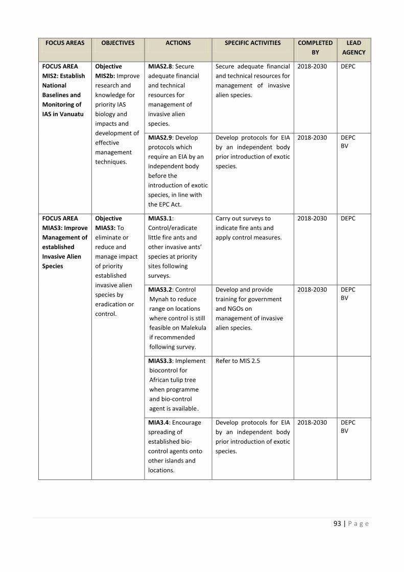
COMPLETED
Carry out survey and map
: Develop an ve alien
Assess and Assess and review existing
93 | P a g e
FOCUS AREAS OBJECTIVES ACTIONS SPECIFIC ACTIVITIES COMPLETED
BY
LEAD
AGENCY
FOCUS AREA
MIS2: Establish
National
Baselines and
Monitoring of
IAS in Vanuatu
Objective
MIS2b: Improve
research and
knowledge for
priority IAS
biology and
impacts and
development of
effective
management
techniques.
MIAS2.8: Secure
adequate financial
and technical
resources for
management of
invasive alien
species.
Secure adequate financial
and technical resources for
management of invasive
alien species.
2018-2030 DEPC
MIAS2.9: Develop
protocols which
require an EIA by an
independent body
before the
introduction of exotic
species, in line with
the EPC Act.
Develop protocols for EIA
by an independent body
prior introduction of exotic
species.
2018-2030 DEPC
BV
FOCUS AREA
MIAS3: Improve
Management of
established
Invasive Alien
Species
Objective
MIAS3: To
eliminate or
reduce and
manage impact
of priority
established
invasive alien
species by
eradication or
control.
MIAS3.1:
Control/eradicate
little fire ants and
other invasive ants’
species at priority
sites following
surveys.
Carry out surveys to
indicate fire ants and
apply control measures.
2018-2030 DEPC
MIAS3.2: Control
Mynah to reduce
range on locations
where control is still
feasible on Malekula
if recommended
following survey.
Develop and provide
training for government
and NGOs on
management of invasive
alien species.
2018-2030 DEPC
BV
MIAS3.3: Implement
biocontrol for
African tulip tree
when programme
and bio-control
agent is available .
Refer to MIS 2.5
MIA3.4: Encourage
spreading of
established bio-
control agents onto
other islands and
locations.
Develop protocols for EIA
by an independent body
prior introduction of exotic
species.
2018-2030 DEPC
BV
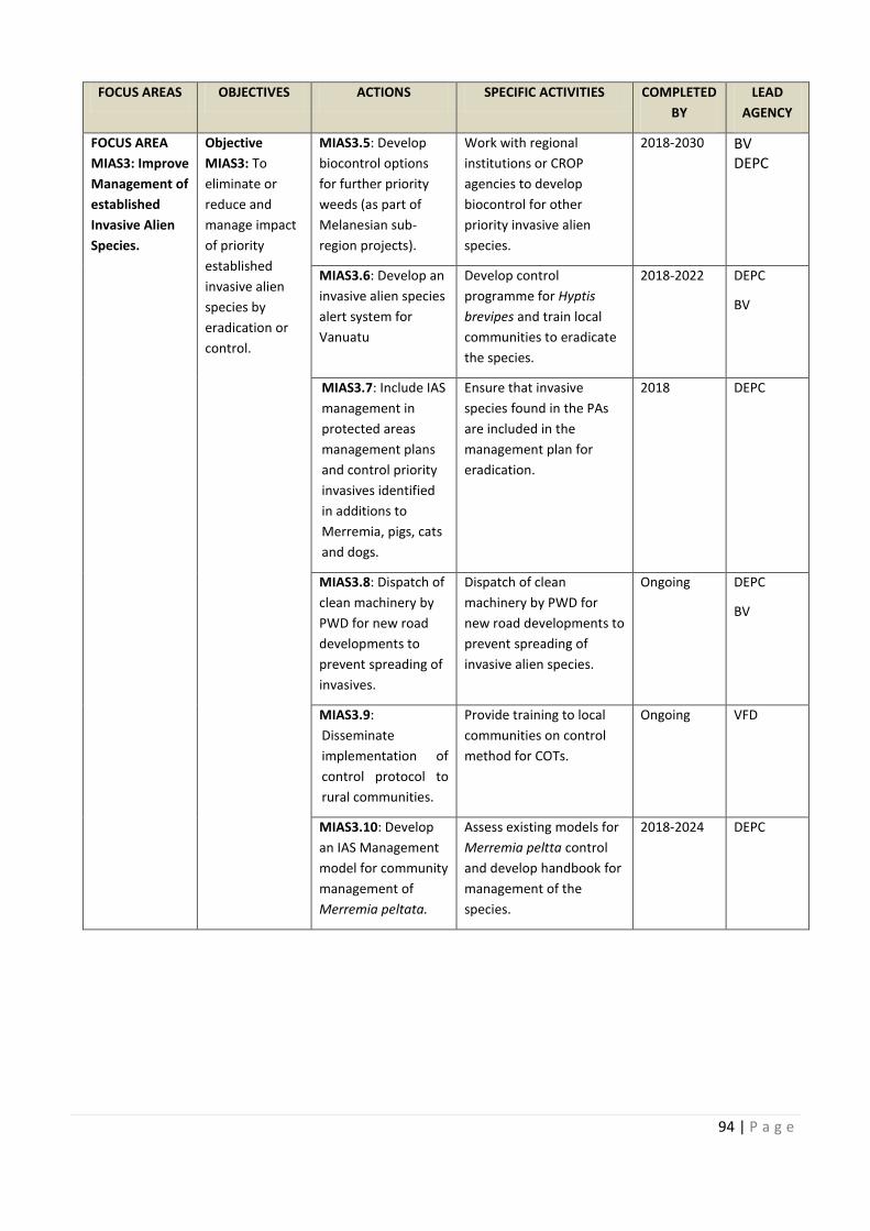
94 | P a g e
FOCUS AREAS OBJECTIVES ACTIONS SPECIFIC ACTIVITIES COMPLETED
BY
LEAD
AGENCY
FOCUS AREA
MIAS3: Improve
Management of
established
Invasive Alien
Species.
Objective
MIAS3: To
eliminate or
reduce and
manage impact
of priority
established
invasive alien
species by
eradication or
control.
MIAS3.5: Develop
biocontrol options
for further priority
weeds (as part of
Melanesian sub-
region projects).
Work with regional
institutions or CROP
agencies to develop
biocontrol for other
priority invasive alien
species.
2018-2030 BV
DEPC
MIAS3.6: Develop an
invasive alien species
alert system for
Vanuatu
Develop control
programme for Hyptis
brevipes and train local
communities to eradicate
the species.
2018-2022 DEPC
BV
MIAS3.7: Include IAS
management in
protected areas
management plans
and control priority
invasives identified
in additions to
Merremia, pigs, cats
and dogs.
Ensure that invasive
species found in the PAs
are included in the
management plan for
eradication.
2018 DEPC
MIAS3.8: Dispatch of
clean machinery by
PWD for new road
developments to
prevent spreading of
invasives.
Dispatch of clean
machinery by PWD for
new road developments to
prevent spreading of
invasive alien species.
Ongoing DEPC
BV
MIAS3.9:
Disseminate
implementation of
control protocol to
rural communities.
Provide training to local
communities on control
method for COTs.
Ongoing VFD
MIAS3.10: Develop
an IAS Management
model for community
management of
Merremia peltata.
Assess existing models for
Merremia peltta control
and develop handbook for
management of the
species.
2018-2024 DEPC
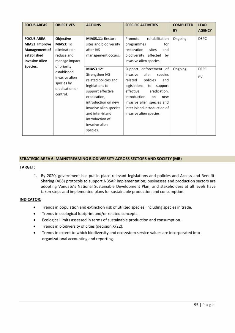
COMPLETED
: Develop an
Include IAS
Dispatch of
Assess existing models for
95 | P a g e
FOCUS AREAS OBJECTIVES ACTIONS SPECIFIC ACTIVITIES COMPLETED
BY
LEAD
AGENCY
FOCUS AREA
MIAS3: Improve
Management of
established
Invasive Alien
Species.
Objective
MIAS3: To
eliminate or
reduce and
manage impact
of priority
established
invasive alien
species by
eradication or
control.
MIAS3.11: Restore
sites and biodiversity
after IAS
management occurs.
Promote rehabilitation
programmes for
restoration sites and
biodiversity affected by
invasive alien species.
Ongoing DEPC
MIAS3.12:
Strengthen IAS
related policies and
legislations to
support effective
eradication,
introduction on new
invasive alien species
and inter-island
introduction of
invasive alien
species.
Support enforcement of
invasive alien species
related policies and
legislations to support
effective eradication,
introduction on new
invasive alien species and
inter-island introduction of
invasive alien species.
Ongoing DEPC
BV
STRATEGIC AREA 6: MAINSTREAMING BIODIVERSITY ACROSS SECTORS AND SOCIETY (MB)
TARGET:
1. By 2020, government has put in place relevant legislations and policies and Access and Benefit-
Sharing (ABS) protocols to support NBSAP implementation; businesses and production sectors are
adopting Vanuatu’s National Sustainable Development Plan; and stakeholders at all levels have
taken steps and implemented plans for sustainable production and consumption.
INDICATOR:
· Trends in population and extinction risk of utilized species, including species in trade.
· Trends in ecological footprint and/or related concepts.
· Ecological limits assessed in terms of sustainable production and consumption.
· Trends in biodiversity of cities (decision X/22).
· Trends in extent to which biodiversity and ecosystem service values are incorporated into
organizational accounting and reporting.
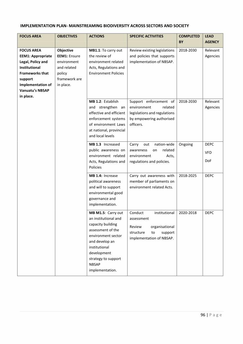
96 | P a g e
IMPLEMENTATION PLAN- MAINSTREAMING BIODIVERSITY ACROSS SECTORS AND SOCIETY
FOCUS AREA OBJECTIVES ACTIONS SPECIFIC ACTIVITIES COMPLETED
BY
LEAD
AGENCY
FOCUS AREA
EEM1: Appropriate
Legal, Policy and
Institutional
Frameworks that
support
Implementation of
Vanuatu’s NBSAP
in place.
Objective
EEM1: Ensure
environment
and related
policy
framework are
in place.
MB1.1: To carry out
the review of
environment related
Acts, Regulations and
Environment Policies
Review existing legislations
and policies that supports
implementation of NBSAP.
2018-2030 Relevant
Agencies
MB 1.2: Establish
and strengthen an
effective and efficient
enforcement systems
of environment Laws
at national, provincial
and local levels
Support enforcement of
environment related
legislations and regulations
by empowering authorised
officers.
2018-2030 Relevant
Agencies
MB 1.3 Increased
public awareness on
environment related
Acts, Regulations and
Policies
Carry out nation-wide
awareness on related
environment Acts,
regulations and policies.
Ongoing DEPC
VFD
DoF
MB 1.4: Increase
political awareness
and will to support
environmental good
governance and
implementation.
Carry out awareness with
member of parliaments on
environment related Acts.
2018-2025 DEPC
MB M1.5: Carry out
an institutional and
capacity building
assessment of the
environment sector
and develop an
institutional
development
strategy to support
NBSAP
implementation.
Conduct institutional
assessment
Review organisational
structure to support
implementation of NBSAP.
2020-2018 DEPC
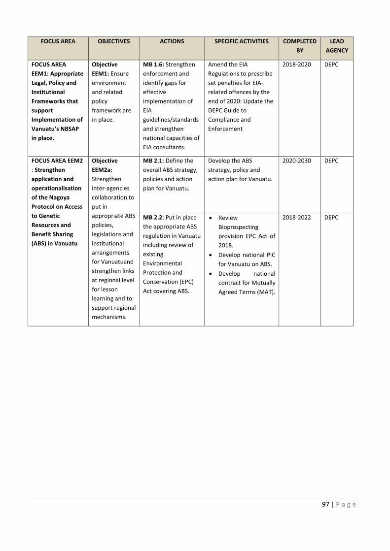
COMPLETED
Review existing legislations Relevant
Support enforcement of Relevant
wide
Carry out awareness with
Carry out Conduct institutional
97 | P a g e
FOCUS AREA OBJECTIVES ACTIONS SPECIFIC ACTIVITIES COMPLETED
BY
LEAD
AGENCY
FOCUS AREA
EEM1: Appropriate
Legal, Policy and
Institutional
Frameworks that
support
Implementation of
Vanuatu’s NBSAP
in place.
Objective
EEM1: Ensure
environment
and related
policy
framework are
in place.
MB 1.6: Strengthen
enforcement and
identify gaps for
effective
implementation of
EIA
guidelines/standards
and strengthen
national capacities of
EIA consultants.
Amend the EIA
Regulations to prescribe
set penalties for EIA-
related offences by the
end of 2020: Update the
DEPC Guide to
Compliance and
Enforcement
2018-2020 DEPC
FOCUS AREA EEM2
: Strengthen
application and
operationalisation
of the Nagoya
Protocol on Access
to Genetic
Resources and
Benefit Sharing
(ABS) in Vanuatu
Objective
EEM2a:
Strengthen
inter-agencies
collaboration to
put in
appropriate ABS
policies,
legislations and
institutional
arrangements
for Vanuatuand
strengthen links
at regional level
for lesson
learning and to
support regional
mechanisms.
MB 2.1: Define the
overall ABS strategy,
policies and action
plan for Vanuatu.
Develop the ABS
strategy, policy and
action plan for Vanuatu.
2020-2030 DEPC
MB 2.2: Put in place
the appropriate ABS
regulation in Vanuatu
including review of
existing
Environmental
Protection and
Conservation (EPC)
Act covering ABS.
· Review
Bioprospecting
provision EPC Act of
2018.
· Develop national PIC
for Vanuatu on ABS.
· Develop national
contract for Mutually
Agreed Terms (MAT).
2018-2022 DEPC
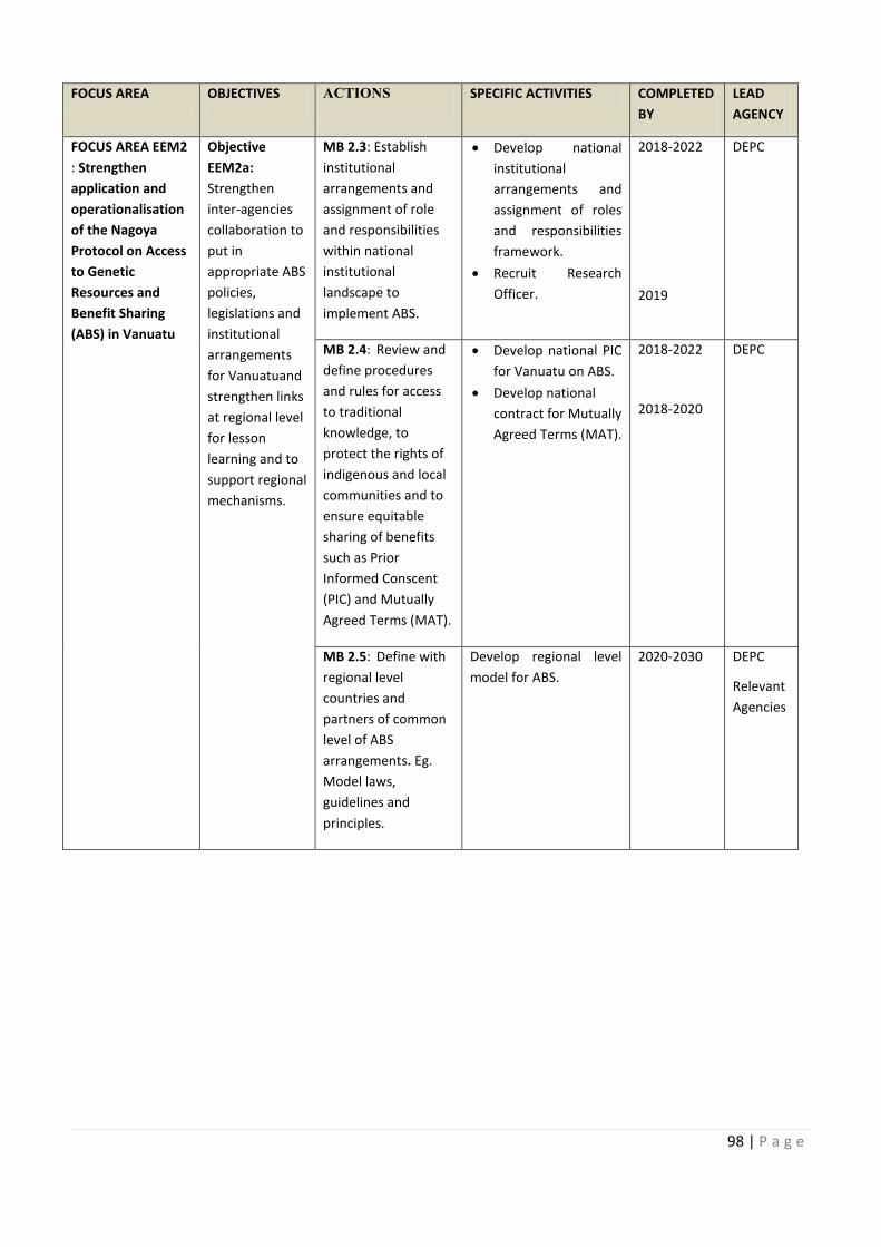
98 | P a g e
FOCUS AREA OBJECTIVES ACTIONS SPECIFIC ACTIVITIES COMPLETED
BY
LEAD
AGENCY
FOCUS AREA EEM2
: Strengthen
application and
operationalisation
of the Nagoya
Protocol on Access
to Genetic
Resources and
Benefit Sharing
(ABS) in Vanuatu
Objective
EEM2a:
Strengthen
inter-agencies
collaboration to
put in
appropriate ABS
policies,
legislations and
institutional
arrangements
for Vanuatuand
strengthen links
at regional level
for lesson
learning and to
support regional
mechanisms.
MB 2.3: Establish
institutional
arrangements and
assignment of role
and responsibilities
within national
institutional
landscape to
implement ABS.
· Develop national
institutional
arrangements and
assignment of roles
and responsibilities
framework.
· Recruit Research
Officer.
2018-2022
2019
DEPC
MB 2.4: Review and
define procedures
and rules for access
to traditional
knowledge, to
protect the rights of
indigenous and local
communities and to
ensure equitable
sharing of benefits
such as Prior
Informed Conscent
(PIC) and Mutually
Agreed Terms (MAT).
· Develop national PIC
for Vanuatu on ABS.
· Develop national
contract for Mutually
Agreed Terms (MAT).
2018-2022
2018-2020
DEPC
MB 2.5: Define with
regional level
countries and
partners of common
level of ABS
arrangements. Eg.
Model laws,
guidelines and
principles.
Develop regional level
model for ABS.
2020-2030 DEPC
Relevant
Agencies
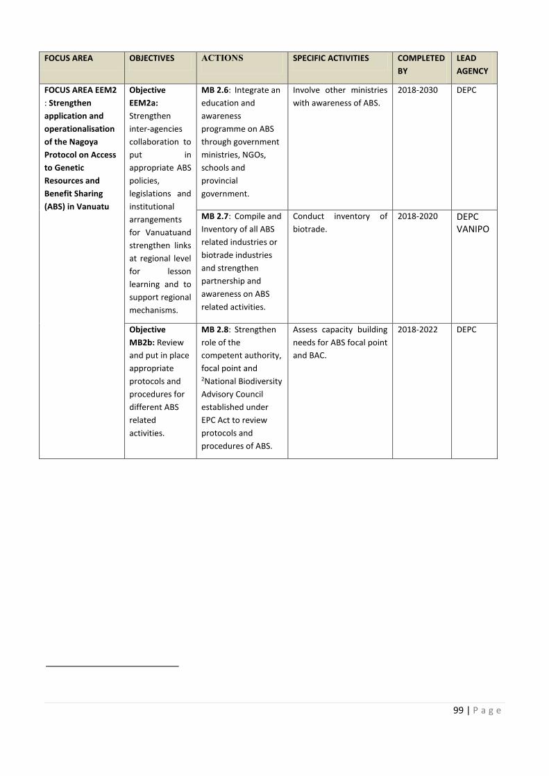
COMPLETED
Develop national
Review and Develop national PIC
Define with Develop regional level
99 | P a g e
FOCUS AREA OBJECTIVES ACTIONS SPECIFIC ACTIVITIES COMPLETED
BY
LEAD
AGENCY
FOCUS AREA EEM2
: Strengthen
application and
operationalisation
of the Nagoya
Protocol on Access
to Genetic
Resources and
Benefit Sharing
(ABS) in Vanuatu
Objective
EEM2a:
Strengthen
inter-agencies
collaboration to
put in
appropriate ABS
policies,
legislations and
institutional
arrangements
for Vanuatuand
strengthen links
at regional level
for lesson
learning and to
support regional
mechanisms.
MB 2.6: Integrate an
education and
awareness
programme on ABS
through government
ministries, NGOs,
schools and
provincial
government.
Involve other ministries
with awareness of ABS.
2018-2030 DEPC
MB 2.7: Compile and
Inventory of all ABS
related industries or
biotrade industries
and strengthen
partnership and
awareness on ABS
related activities.
Conduct inventory of
biotrade.
2018-2020 DEPC
VANIPO
Objective
MB2b: Review
and put in place
appropriate
protocols and
procedures for
different ABS
related
activities.
MB 2.8: Strengthen
role of the
competent authority,
focal point and 2National Biodiversity
Advisory Council
established under
EPC Act to review
protocols and
procedures of ABS.
Assess capacity building
needs for ABS focal point
and BAC.
2018-2022 DEPC
100 | P a g e
FOCUS AREA OBJECTIVES ACTIONS SPECIFIC ACTIVITIES COMPLETED
BY
LEAD
AGENCY
FOCUS AREA EEM2
: Strengthen
application and
operationalisation
of the Nagoya
Protocol on Access
to Genetic
Resources and
Benefit Sharing
(ABS) in Vanuatu
Objective
MB2b: Review
and put in place
appropriate
protocols and
procedures for
different ABS
related
activities.
MB 2.9: ABS contract
agreements, interim
guidelines,
negotiation
procedures and
legal/customary
protocols developed
in accordance with
the Nagoya Protocol
and the Traditional
Knowledge and
Expressions of
Culture Act.
Develop appropriate
contracts, interim
guidelines, negotiation
procedures and legal
customary protocols in
accordance with NP.
2018-2025 DEPC
VANIPO
VKS
MB2.10:
Establishment of
national and regional
networks amongst
research
stakeholders
(researchers, food
security, medicinal,
bio-prospecting,
community interests
including
government, NGO's,
private sector and
community groups).
Set up the national
network first and expand
to include regional
network for research
stakeholders
2019-2030 DEPC
MB 2.11: Organise
awareness raising
amongst government
departments,
divisions and
provincial levels
workshops on ABS
for stakeholders and
facilitate site/field
visits where
appropriate.
Conduct awareness
raising on ABS at
provincial and
community levels.
2018-2030 DEPC
COMPLETED
ABS contract
101 | P a g e
FOCUS AREA OBJECTIVES ACTIONS SPECIFIC ACTIVITIES COMPLETED
BY
LEAD
AGENCY
FOCUS AREA EEM2:
Strengthen
application and
operationalisation
of the Nagoya
Protocol on Access
to Genetic
Resources and
Benefit Sharing
(ABS) in Vanuatu.
Objective
MB2b: Review
and put in place
appropriate
protocols and
procedures for
different ABS
related
activities.
MB 2.12: Establish
benefit sharing
mechanism (e.g.
Trust Fund) for ABS
strengthened
contributes to the
conservation of
biological diversity.
Set up national ABS trust
fund.
2022-2030 DEPC
MB 2.13: Establish
and strengthen
administrative
systems / procedures
for ABS agreement
negotiations
between the
government and
relevant MATs and
other relevant
agreements.
Strengthen ABS
agreement for
negotiations between
government and other
relevant MATs.
2018-2030 DEPC
Strategic Area 7: RESOURCE MOBILISATION FOR THE NATIONAL BIODIVERSITY STRATEGY AND ACTION PLAN
TARGET:
The Ministry of Finanance will need to set realistic annual budgetary targets and DEPC to do 3
yearly resource mobilisation plan based on realistic NBSAP Actions & Targets.
INDICATORS:
· Aggregated financial flows, in the amount and where relevant percentage, of biodiversity related funding, per annum, for achieving the Vanuatu NBSAP National Targets,
· Number of assessments values of biodiversity in accordance with CBD,
· Identified and reported funding needs, gaps and priorities,
· Developed National Financial Plans for Biodiversity,
· Amount of national financial support, per annum, in respect of those national activities which
are intended to achieve the objectives of NBSAP.
102 | P a g e
IMPLEMENTATION PLAN RESOURCE MOBILISATION FOR THE NATIONAL BIODIVERSITY
FOCUS AREA OBJECTIVES ACTIONS SPECIFIC ACTIVITIES COMPLETED
BY
LEAD
AGENCY
FOCUS AREA RM1:
Resource
Mobilisation for
the National
Biodiversity
Strategy and
Action Plan.
Objective
RM1: To
increase
understading
and buy-in
from relevant
government,
NGOs,
implementing
partners and
communities
on the
resource
mobilisation
approach,
methodology
and action
plan.
RM1.1:
Organise
stakeholder
engagement
to consider
biodiversity
and
ecosystem
services to be
the key
priority areas
for economic
valuation and
assessments.
· Conduct awareness
to relevant
government
sectors such as
fisheries and
forestry on
ecosystem
valuation principles
and approaches.
· Develop and
costing of
ecosystem
valuation for
marine, terrestrial
and wetlands in
collaboration with
relevant
stakeholders.
2019-2030
2019-2030
DEPC
DEPC
Relevant
Agencies
RM 1.2: Carry out
ecosystem
assessments,
mapping, indicators
and valuation for
each focal areas.
· Undertake
ecosystem
assessments and
valuation of each
ecosystem types
such as marine,
terrestrial and
wetlands
ecosystems.
· Conduct costing of
each focal area of
the NBSAP.
· Develop
sustainable
financing strategies
for implementing
the NBSAP.
2020-2030
2020-2030
2020-2030
DEPC
Relevant
Agencies
DEPC
DEPC
DoFT
COMPLETED
FOCUS AREA RM1: Conduct awareness
103 | P a g e
FOCUS AREA OBJECTIVES ACTIONS SPECIFIC ACTIVITIES COMPLETED
BY
LEAD
AGENCY
FOCUS AREA RM1:
Resource
Mobilisation for
the National
Biodiversity
Strategy and
Action Plan.
Objective RM1:
To increase
understading
and buy-in from
relevant
government,
NGOs,
implementing
partners and
communities on
the resource
mobilisation
approach,
methodology
and action plan.
RM1.3: Carry out
capacity building
activities to equip
actors with
necessary skills to
carry out value-
based actions e.g
tools to gather
information on
biodiversity and
ecosystem advising
them on how to
incorporate
biodiversity and
ecosystem service
values into their
business plans
make economic
and financial sense.
Carry out the capacity
building training to
equip relevant actors
with required skills to
carry out value-based
actions as indicated in
RM 1.3.
2019-2030 DEPC
Relevant
Agencies
RM1.4: Engage
funders
strategically and
identify key sectors
benefitting from
biodiversity and
ecosystem service
values who are
primary users, how
will they benefit
from investing in
biodiversity
ecosystem services
and what ongoing
financial
mechanism are
available to secure
sustained funding.
Carry out a study or
survey on this action to
map out sectors
benefiting from
biodiversity and
ecosystem service
values, who are
primary users, how will
they benefit from
investing in
biodiversity ecosystem
services and what
ongoing financial
system are in place to
secure sustained
funding.
2019-2030 DEPC
Relevant
Agencies
104 | P a g e
FOCUS AREA OBJECTIVES ACTIONS SPECIFIC ACTIVITIES COMPLETED
BY
LEAD
AGENCY
FOCUS AREA RM1:
Resource
Mobilisation for
the National
Biodiversity
Strategy and
Action Plan.
Objective RM1:
To increase
understading
and buy-in from
relevant
government,
NGOs,
implementing
partners and
communities on
the resource
mobilisation
approach,
methodology
and action plan.
RM1.5: Assess
financial flows
associated with
drivers of
biodiversity loss
such as harmful
incentives, and how
they can be
influenced to
reduce their
impact.
Carry out the financial
assessment with
biodiversity loss drivers
and how they can be
influenced to reduce
their impacts.
2019-2030 DEPC
DoFT
RM1.6: Conduct
annual
stakeholders’
meeting to discuss
budget and report
on progress of
NBSAP species
component
implementation.
Species
conservation
implementation to
include
enforcement roles
of the relevant
authorities e.g.
biosecurity.
Carry out annual
meetings with NBSAP
Stakeholder
Administration to
assess update on
species
implementation work.
2019-2030 DEPC
Relevant
Agencies
RM1.7: Establish a
conservation trust
fund to be
managed by DEPC
under government
budgetary process.
Initiate the idea of
developing a
Conservation Trust
Fund.
2019-2030 DEPC
OBJECTIVES COMPLETED
FOCUS AREA RM1: Objective RM1: Carry out the financial
Establish a
105 | P a g e
FOCUS AREA OBJECTIVES ACTIONS SPECIFIC ACTIVITIES COMPLETED
BY
LEAD
AGENCY
FOCUS AREA RM2:
Development of
Vanuatu NBSAP
Resource
Mobilisation Plan.
Objective RM2:
Develop
Resource
mobilisation
plan using best
available data
and scenario
development.
RM2.1: Conduct
an ecosystem
service mapping to
assess state and
trend in ecosystem
service provision
and human well-
being, to provide
spatial
quantification of
ecosystem services
and their values.
Undertake ecosystem
service mapping to
assess state and trend
in ecosystem service
provision and human
well-being.
2020-2030 DEPC
Relevant
Agencies
RM2.2: Conduct
economic valuation
of ecosystems and
biodiversity using
variety of economic
valuation methods
to determine
monetary value of
biodiversity i.e
direct market
valuation
approaches,
revealed
preferences and
stated preference
approaches.
Carry out economic
valuation of
biodiversity and
ecosystems different
methods to determine
monetary value of
biodiversity.
2019-2030 DEPC
DoFT
RM2.3: Assess the
cost of NBSAP
strategies and
action, identify
financial gaps and
scale up finance
mechanism.
Carry out assessment
of the NBSAP strategies
and actions cost to find
out financial gaps and
scale up the finance
mechanism
2020-2030 DEPC
DoFT
106 | P a g e
FOCUS AREA OBJECTIVES ACTIONS SPECIFIC ACTIVITIES COMPLETED
BY
LEAD
AGENCY
FOCUS AREA RM2:
Development of
Vanuatu NBSAP
Resource
Mobilisation Plan.
Objective RM2:
Develop
Resource
mobilisation
plan using best
available data
and scenario
development.
RM2.4: Integrate
values of
biodiversity and
ecosystems into
national accounting
frameworks using
the Biodiversity
Finance (BIOFIN)
conceptual
framework of
public expenditure
review, pressure-
state-response,
scenario
development and
comparison and
root cause analysis.
Develop project
proposal to use the
BIOFIN conceptual
framework to integrate
values of biodiversity
and ecosystems into
national accounting
frameworks.
2019-2030 DEPC
DoFT
RM2.5: Develop a
Vanuatu Resource
Mobilisation plan
to include policy
and institutional
analysis,
expenditure
review, strategies,
actions and costs,
projected future
states with
investments,
opportunities for
mobilisation of
resources, making a
case of for
biodiversity
investments and
consolidate
resource
mobilisation plan
with finance
mechanism, actors
and timelines.
Develop national
Resource Mobilisation
plan to implement the
NBSAP and address
this action.
2019-2030 DEPC
DoFT
COMPLETED
FOCUS AREA RM2: Objective RM2:
Develop a
107 | P a g e
FOCUS AREA OBJECTIVES ACTIONS SPECIFIC ACTIVITIES COMPLETED
BY
LEAD
AGENCY
FOCUS AREA RM2:
Development of
Vanuatu NBSAP
Resource
Mobilisation Plan.
Objective RM2:
Develop
Resource
mobilisation
plan using best
available data
and scenario
development.
RM2.6: Integrate
resource
mobilisation plans
into national plans
and identify
national synergies
and entry points.
Integration resource
mobilisation plan into
national plans and find
out national strategies
and entry point.
2019-2030 DEPC
8.0 PROVINCIAL PLANS
Most of the NBSAP work will be implemented in partnerships with communities through their provincial
government and administration in collaboration with DEPC and national level stakeholders. The six
provincial implementation plans provide the background of each province, the population, and total land
and sea areas under provincial management. It then provides the provincial vision and mission of the
whole province. The key components are:
a. MARINE:
(i) Existing conservation areas,
(ii) Proposed conservation areas,
(iii) Marine biodiversity,
(iv) Threat to marine species,
(v) Action to address threats.
b. FOREST AND INLAND WATERS
(i) Existing conservation areas,
(ii) Proposed conservation areas,
(iii) Forest and inland biodiversity,
(iv) Threat to forest and inland species,
(v) Action to address threats.
c. PROVINCIAL TARGET FOR 2018 -2030
The following provincial NBSAP Implementation plans were developed through an extensive
consultation process based on the current NBSAP.
8.1 Torba Province– NBSAP Implementation Plan
8.2 Sanma Province - NBSAP Implementation Plan
8.3 Penama Province - NBSAP Implementation Plan
8.4 Malampa Province - NBSAP Implementation Plan
8.5 Shefa Province - NBSAP Implementation Plan
8.6 Tafea Province - NBSAP Implementation Plan
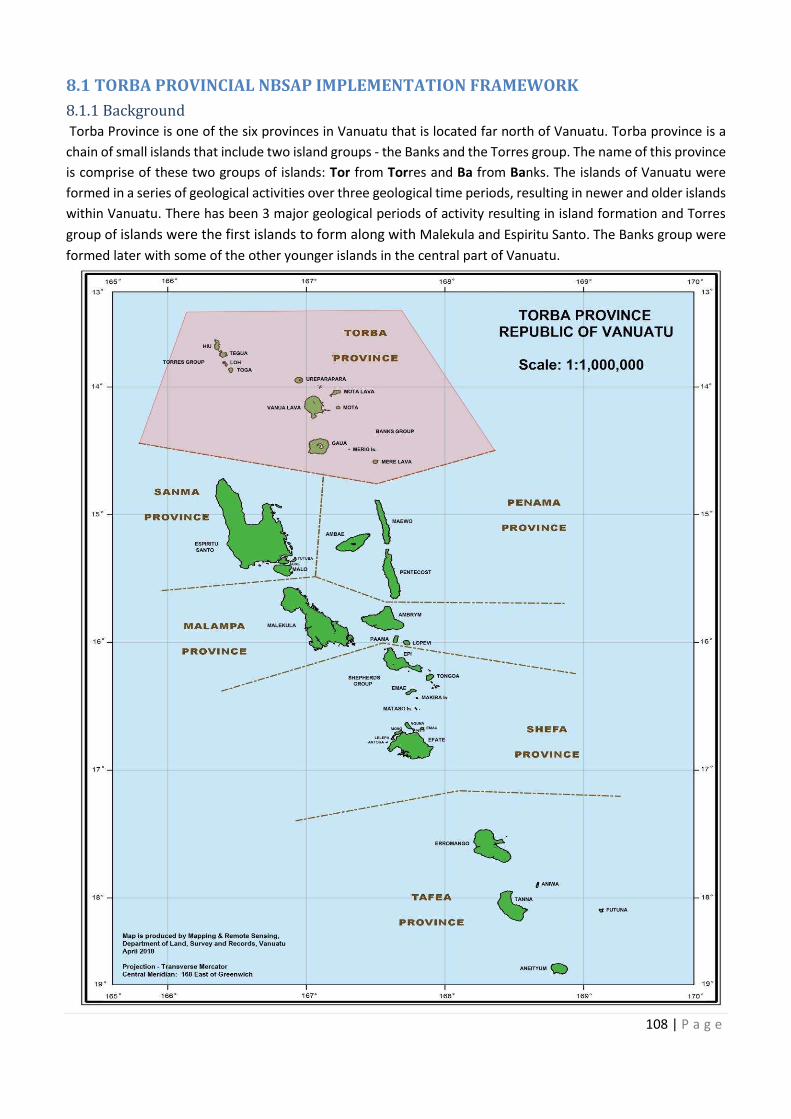
108 | P a g e
8.1 TORBA PROVINCIAL NBSAP IMPLEMENTATION FRAMEWORK
8.1.1 Background
Torba Province is one of the six provinces in Vanuatu that is located far north of Vanuatu. Torba province is a
chain of small islands that include two island groups - the Banks and the Torres group. The name of this province
is comprise of these two groups of islands: Tor from Torres and Ba from Banks. The islands of Vanuatu were
formed in a series of geological activities over three geological time periods, resulting in newer and older islands
within Vanuatu. There has been 3 major geological periods of activity resulting in island formation and Torres
group of islands were the first islands to form along with Malekula and Espiritu Santo. The Banks group were
formed later with some of the other younger islands in the central part of Vanuatu.
109 | P a g e
8.1.1.1 Population & total land area
The total population of Torba province from the 2016 mini census is 9,875 people with a total land area of 882
km2 (VNSO, 2016). The main source of income for Torba people comes from copra, cacao, kava, sale of fish, food
and root crops, handicrafts and other invertebrates like coconut crab in Torres Islands.
The largest single landmass area of Torba province is the island of Vanua Lava which is where the Torba Provincial
headquarters is located in Sola.
8.1.1.2 Torba Provincial Government
Provincial Governments have been established through the Decentralisation Act of 1994. Through this
decentralisation system, government extension offices were then established at the provincial headquarters.
The department extension services form a Technical Advisory Group (TAG) that makes decisions along with the
key personnel of Torba province for the development of the province. Torba Province with the advice of the TAG
has developed a provincial policy that guides development of this province for the good of the province and its
people.
8.1.1.3 Vision
Torba’s future generations enjoying abundant natural resources by 2060 through wise use, improve livelihoods,
maintaining custom values and healthy island ecosystems.
8.1.1.4 Mission
To have a healthy, wealthy and sustainable environment by year 2050.
8.1.2 Marine
Torba Province has a large marine area with small land mass. The small islands of Torba are surrounded with a
high density of coral reefs. Some of the islands are not inhabited with people and so nearby habited islands use
these islands as fishing grounds. Torba province has classified Key Biodiversity Areas /Hotspots wthin its islands
according to the Critical Ecosystem Partnership Fund (CEPF).
There is a vast marine biodiversity with different habitats but coral reefs dominate most of the small islands with
invertebrates and fishes. Turtles and coconut crabs and various marine mammals are well known in Torba
Province especially in the Torres group. Habitats listed for Torba are seagrass beds, coral reefs and mangrove
areas with diversity of marine organisms. Offshore having areas of good pelagic and benthic fisheries such as
tuna, poulet, snapper, seamounts, canyons, trench, etc. The only management system that is used to protect
the marine resources is by community or landowners emphasizing tabu systems on the resources.
The following are the list of areas listed as being protected with community or landownership management
system.
8.1.2.1 List of Existing Marine Conservation Areas for Torba Province
Existing Marine Area Location (Island) Important to the community National Priority
Losalava Marine Park (MPA Gaua Big lagoon with great fringing
reef with marine resource
Process for CCA
Turtle Sanctuary (Northeast
Vanualava)
Vanualava Turtle nesting site and eco-
tourism activity
Process for CCA
Crocodile Conservation Vanualava Protect marine crocodile
species
Process for CCA
Rah Motalava Protect fish breeding/ fish
nursery ground, coconut crab
and MPA
Totonglang Motalava Protect marine resources and
fishing grounds
110 | P a g e
Existing Marine Area Location (Island) Important to the community National Priority
Qeremangde Motalava Protect marine resources and
fishing grounds
Avar Motalava Protect nursery grounds
Nerenigman Motalava Protect nursery grounds and
MPA
Rah Rock Motalava Protect fishing ground
Reef Island Conservation
Area
Reef Island Protect marine resources
around the island and also
good fishing ground
Process for CCA
Toga Torres Coconut Crab protection and
MPA
Loh – Lenua Coconut Crab Torres Coconut Crab protection and
MPA
Lilepe Coconut Crab Torres Coconu Crab protection
Metoma – Coconut Crab
Conservation Area
Torres Coconu Crab protection and
MPA
Process for formal
registration
Proposed Marine sites Location (Island) Important to the community National Priority
Lembot- Mangrove Gaua Mangrove protection
Dundu-Mangrove Gaua Mangrove protection
Aver- Mangrove Gaua Mangrove protection
Casca- Mangrove Gaua Mangrove protection
Masivona – Turtle nesting Gaua Protect turtle nesting
Matanoda- Turtle nesting Gaua Protect turtle nesting
Taplon- Turtle nesting Gaua Protect turtle nesting
Biam – Turtle nesting Gaua Protect turtle nesting
Kerebuak-Mangrove Vanualava Mangrove protection
Aligator river-Mangrove &
seagrass
Vanualava Mangrove and seagrass
protection
Quanglap - Mangrove &
seagrass & turtle nesting
Vanualava Mangrove, seagrass and turtle
nesting protection
Leon Bay- Mangrove Vanualava Mangrove protection
Mosina- Mangrove Vanualava Mangrove protection
Divers Bay -Mangrove Ureparapara Mangrove protection
Ambek- Turtle nesting Vanualava Protect turtle nesting
Ravenga – Turtle nesting Vanualava Protect turtle nesting
Honeymoon beach (Lenua)–
turtle nesting
Loh, Torres Protect turtle nesting
Loh lagoon- Mangrove &
seagrass
Torres Mangrove, seagrass, turtle
nesting and coconut crab
protection
The above list is created as a list of important marine sites that are of great significance to the people of Torba
Province. Their livelihood is entirely dependent on marine resources for consumption and earning money.
8.1.2.2 Marine Species Biodiversity
Marine biodiversity in Torba is diverse where coral reefs are covered with invertebrates and fishes sea mammals,
reptiles, sea birds and other marine species of importance to the Torba people. Offshore having areas of good
pelagic and benthic fisheries such as tuna, poulet, snapper, seamounts, etc Marine biodiversity has been
Location (Island)
Protect marine resources and
Protect nursery grounds and
Reef Island Conservation Protect marine resources
Coconut Crab protection and
Coconut Crab protection and
Coconut Crab Coconu Crab protection and Process for formal
Location (Island)
Mangrove &
Mangrove & turtle
–
Mangrove &
111 | P a g e
observed to be slowly decreasing over the past few years and today some of the species that were once plentiful
are rarely seen.
The species on the list are of importance to the Torba people and all the species are common in most of the
islands and suggested marine areas. The ecosystems listed are those that are supporting a good population of
marine resources, and hence identified as needed to be protected.
8.1.2.3 List of important Marine Species in Torba
Fish Invertebrates Mammals/ birds Marine Ecosystems
Eelfish
Fish
Marine Crocodile
Turtle
Crabs
Green snail
Lobster
Octopus
Sea cucumber
Shells
Trochus
Dugong
Sea Birds
Wild Ducks
Beaches
Coral Reefs
Mangrove
Seagrass bed
8.1.2.4 Threats to the Marine Species
Marine resources have been decreasing slowly in this province as seen in the smaller sizes and lower numbers
of fish catches. Human consumption is stressed as being the major contributing factor that drives the decline
of marine resources in Torba and concern was raised during the discussions that fishing grounds extend to the
uninhabited islands where resources are currently plentiful.
8.1.2.5 Key Actions to Address Decrease of Marine Resources
The people of Torba know that their marine resources are declining. The chiefs and communities have taken
some measures to manage the rate at which resources are declining through initiation of marine tabu areas.
Threats to marine resources identified during the validation workshop are population pressure on resources,
lack of respect for conservation or tabu areas, lack of technical knowledge on risk of depletion of marine
resources, and Crown of Thorns (COTs) infestation on coral reefs.
Threats Action Plans to
Address Threats
Agency responsible Timeframe
Overfishing/ over
harvesting due to
rapid population
growth
Ban one finger fishing
net
VFD
Torba Province
2020
Lack of finance Ecotourism activities DoT
Torba Province
2020
Lack of respect of
conservation areas
· Enforcement of
conservation
management laws
· Higher penalties
VFD
Torba Province
2020
Lack of Information
and technical advice
on the risk of depletion
of marine resources
Consider registering
areas with the
Department of
Environment
VFD
DEPC
Torba Province
2030
Crown of Thorn
starfish invasion
Eradication method VFD
Torba Province
2020
112 | P a g e
8.1.3 Forest and Inland Waters
T Torba Province is made up largely of small islands with less land area and thus limited terrestrial resources.
Most of the large forest area can be found on the larger islands, of Vanua Lava and Gaua. Since the land mass
is scarce, and resources limited there is no real consideration of forest conservation, as every piece of land is
vital and can be utilized. There are a number of inland water areas that have given rise to consideration for
forest conservation. Inland water are interconnected with forest areas, therefore the inland waters that are
listed are very much linked with their surrounding forests/watersheds and catchment areas.
The list below shows the inland water areas that needs to be protected due to their importance as alternative
water sources for daily household uses. The surrounding forests must also be conserved to protect these water
sources.
8.1.3.1 List of Existing and Proposed Forest and Inland Water Conservation Areas in Torba
Existing Forest/ Inland
Waters
Location (Island) Important to Community National Priority
Lake Letes Gaua Protect forest, water source,
lake and species
Process for Ramsar
Doctor Mark Special need
school
Gaua Protect Forest
Vanualava Geological Park
(Volcano Area)
Vanu Lava Protect site for tourist activity
Valua Telvet Mota Lava Protect forest and water
catchment
Melebay Mota Lava Protect forest
Abet Mota Lava Protect water catchment
Sleeping Mountain Mota Lava Protect forest
Mountain Bird
Conservation
Mere Lava Protect special bird to this
island
Sletes Conservation Area Ureparapara Protect forest
Proposed forest / inland water areas
Nebehei River Mota Lava Protect forest and water
catchment
Tinision Lake Vanu Lava Protect forest and water
catchment
Blue lake Vanu Lava Protect forest and water
catchment
Port Patterson Vanu Lava Protect forest and water
catchment
Alligator River Vanu Lava Protect mangrove forest, fish,
coconut crab and crabs
Twin Waterfall Vanu Lava Protect forest and water
catchment
Moi River Ureparapara Protect forest and water
catchment
Sirifall Waterfall Gaua Protect forest and water
catchment
Mount Gharat Boiling Mud Gaua Protect geological features
Hiu Hiu Island Protect forest
Tegua Tegua Island Protect forest
Toga Toga Island Protect forest
Linua Loh Island Protect forest
Location (Island)
Protect forest, water source,
l need
ualava Geological Park
Protect forest and water
Mountain Bird Protect special bird to this
and water
Protect forest and water
Protect forest and water
Protect forest and water
sh,
Protect forest and water
Protect forest and water
Protect forest and water
Mount Gharat Boiling Mud
113 | P a g e
8.1.3.2 Forest and Inland Water Species Biodiversity
The two larger islands of Torba Province, Gaua and Vanua Lava harbours high numbers of endemic species of
flora and fauna. Torba province has classified Key Biodiversity Areas /Hotspots wthin its islands according to
Critical Ecosystem Partnership Fund (CEPF) with Gaua being a priority KBA. On Gaua, can be found the largest
volcanic lake in Vanuatu and in the Pacific region outside of Papua New Guinea and New Zealand. Lake Letas sits
at 450m altitude and Mt Garet is at 600m above sea level. Lake Letas is now a conservation area with a finalized
mangement plan ready for legal registration as a recognized CCA. It is also the first Vanuatu national Ramsar
wetland sites resultant from the accompanying signing document for Vanuatu to accede to the Ramsar
Convention on Wetlands in 2018. The lake is also in the World Heritage tentative listing for Vanuatu as a national
World Heritage natural site. Lake Letas has 33 water sources feeding into the 12km by 2km lake. A healthy
population of three freshwater eel fish species and freshwater prawn species of Macrobrachium lar are found
in the Lake. A number of rivers are found in Vanua Lava, including Selva River and Alligator River which are both
national wetland sites for Vanuatu and only habitats in Vanuatu which are home to saltwater crocodile
populations. The Island constitutes various suitable habitats and ecosystems for endemic sea bird species, such
as the Vanuatu Petrel. Mota Island is home to four flying fox species including the endemic Vanuatu Flying Fox
and the Banks Flying Fox.
Terrestrial species are restricted to the confines of the land mass areas that make up Torba Province. In addition
to diversity of species found in this province, there are also some local lianas/bush ropes and wild cane species
of siginificance to the people of Torba which are used for making traditional baskets and traditional house
materials and construction. These vines and wild cane must be protected to enable the continuous use and
practice of traditional knowledge. This province has a unique traditional way of preserving breadfruit and
Canarium nut (Nangae) that can still be consumed months after their fruiting seasons.
8.1.3.3 List of important Forest and Inland Water Species in Torba
Plant Animal
Bara Palm tree
Blue Water
Breadfruit
Bush Vines
Cordia allidora
Flowers
Glyricidia
Loya cane
Nangai (Ngali nut)
Namele
Oil Palm
Palms
Birds
Coconut crab (Birgus latro)
Crocodile
Eel fish
Flying fox
Marine Birds
Megapod- Incubator bird
Water prawns
Snakes
Vanuatu mountain pigeon
Wild duck
Wild pigs/ cows
8.1.3.4 Threats to Forest and Inland Waters
The people of Mere Lava have raised concerns over flying foxes and birds that feed on the ripe Canarium fruits.
As they are consumed, and the nuts arey dispersed away from the fruiting trees and thus causing a reduction
on the local harvest from the fruiting trees, as the canarium nut is an important food source to the people of
Mere Lava.
Threats that have impacts on the forest and inland waters biodiversity include over harvesting, population
pressure on resource due to low income, clearing forest for gardening activities, weak governing system by
village chiefs, invasive Merremia peltata and Little Red Fire Ant, and natural disasters such as earthquakes,
volcanic ashes and climate change. The provincial validation workshop also set actions to address these threats
in the matrix below.
114 | P a g e
8.1.3.5 Key Actions to Address Decrease of Forest and Inland Water Resources
Forest and Inland waters maintanence are not really a highlighted problem to Torba people for now. The
disappearance of some of these important species draws attention to taking actions in conserving their forest
and inland waters. The list of measures below is what Torba Province put together to address these threats.
8.1.3.6 List of important Forest and Inland Water Species in Torba
Threats Action Plans to
Address Threats
Agency Responsible Timeframe
Human being (users)
Environment must be
taught in schools
syllabus and
awareness raised to all
people of Vanuatu.
DoE
Torba Province
2017- 2030
· Population growth
· Low income rate
· Seek for donor
support
· Integrated farming
system
(Aquaculture)
DEPC
Torba Province
2020
Invasive species (Big
leaf & fire ants)
Environment should
be part of everyone’s
business
DEPC
Torba Province
2020
Governing system
Custom governance
Strengthen existing
chiefly governance
(enforcement)
DEPC
Torba Province
2020
· Land dispute
· Garden clearing
Producers cooperative
(Agriculture)
Torba Province 2020
8.1.4 Torba Provincial Target for 2018 to 2030
During the NBSAP Torba Provincial Validation Workshop, there was a lot of discussions on existing protected
sites and new ones in the marine and terrestrial environment. Torba province decided to put up some of its
areas as target sites to contribute to the protection of Vanuatu’s natural environment with the timeframe from
2018 until 2030.
Environment must be
Seek for donor
Invasive species (Big nvironment should
Producers cooperative
115 | P a g e
8.1.4.1 Forest and Inland Waters Target
Forest Types Conservation Objectives Target by 2030
1. Dark Bush: Towlap Hill Forest
and catchment (VL)
Protect water catchment,
plus source of water supply-
Provincial area
Community Management
2. Metoma Hill and forest-
Torres
Protect wild life Community Management
3. Forest interior of land-
Touvetman- Motalava-
Protect coconut crab,
protect wildlife, benefit
through project (Carbon
credit- climate change
project)
Community Management
4. Vanua Lava Geo Park Geological landscape Formal Registration
Inland Waters
1. Tingsion – Vanua Lava,
2. Twin waterfall plus source
(Vanua Lava),
3. Melebay (Mota Lava),
4. Moi (Ureparapara)
Breeding ground for marine
life
Formal Registration
5. Blue lake- Vanua Lava
6. Port Nawono (Aligator)-
Vanua Lava
Habitat for crocodile- sea
crocodile in Vanuatu
Formal Registration
7. Mota-Lava- Melebay Tourist hotspot Formal Registration
8. Valua Telvet – Mota Lava
Protection of water source/
catchment
Formal Registration
9. Abit River- Ureparapara- Main water source, supply
for the community
- Protect water catchment
Community Management
10. Moi River- Ureparapara Same as above- continue
reason
Community Management
11. Lake Letas Largest volcanic lake in the
Pacific and unique plants
and animals in the forest.
World heritage site and
wetland site
Formal Registration
Replanting of trees to
protect water source
Total: Formal – 10 & Informal - 5
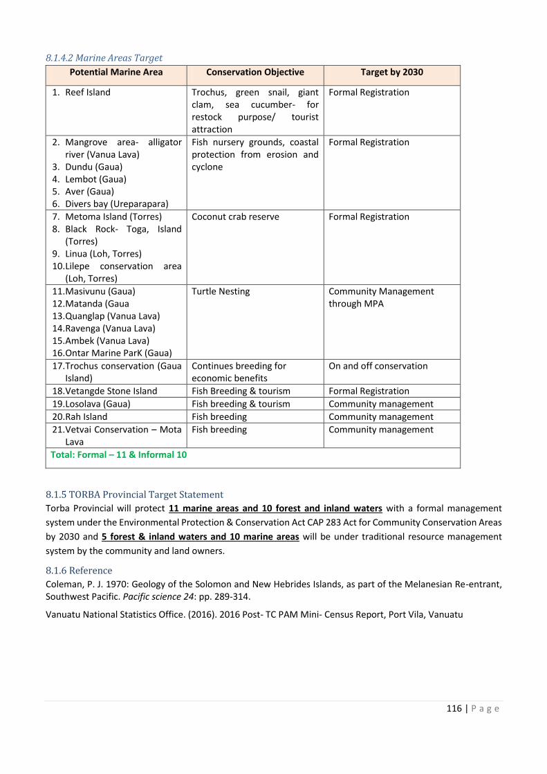
116 | P a g e
8.1.4.2 Marine Areas Target
Potential Marine Area Conservation Objective Target by 2030
1. Reef Island Trochus, green snail, giant
clam, sea cucumber- for
restock purpose/ tourist
attraction
Formal Registration
2. Mangrove area- alligator
river (Vanua Lava)
3. Dundu (Gaua)
4. Lembot (Gaua)
5. Aver (Gaua)
6. Divers bay (Ureparapara)
Fish nursery grounds, coastal
protection from erosion and
cyclone
Formal Registration
7. Metoma Island (Torres)
8. Black Rock- Toga, Island
(Torres)
9. Linua (Loh, Torres)
10. Lilepe conservation area
(Loh, Torres)
Coconut crab reserve Formal Registration
11. Masivunu (Gaua)
12. Matanda (Gaua
13. Quanglap (Vanua Lava)
14. Ravenga (Vanua Lava)
15. Ambek (Vanua Lava)
16. Ontar Marine ParK (Gaua)
Turtle Nesting Community Management
through MPA
17. Trochus conservation (Gaua
Island)
Continues breeding for
economic benefits
On and off conservation
18. Vetangde Stone Island Fish Breeding & tourism Formal Registration
19. Losolava (Gaua) Fish breeding & tourism Community management
20. Rah Island Fish breeding Community management
21. Vetvai Conservation – Mota
Lava
Fish breeding Community management
Total: Formal – 11 & Informal 10
8.1.5 TORBA Provincial Target Statement
Torba Provincial will protect 11 marine areas and 10 forest and inland waters with a formal management
system under the Environmental Protection & Conservation Act CAP 283 Act for Community Conservation Areas
by 2030 and 5 forest & inland waters and 10 marine areas will be under traditional resource management
system by the community and land owners.
8.1.6 Reference
Coleman, P. J. 1970: Geology of the Solomon and New Hebrides Islands, as part of the Melanesian Re-entrant,
Southwest Pacific. Pacific science 24: pp. 289-314.
Vanuatu National Statistics Office. (2016). 2016 Post- TC PAM Mini- Census Report, Port Vila, Vanuatu
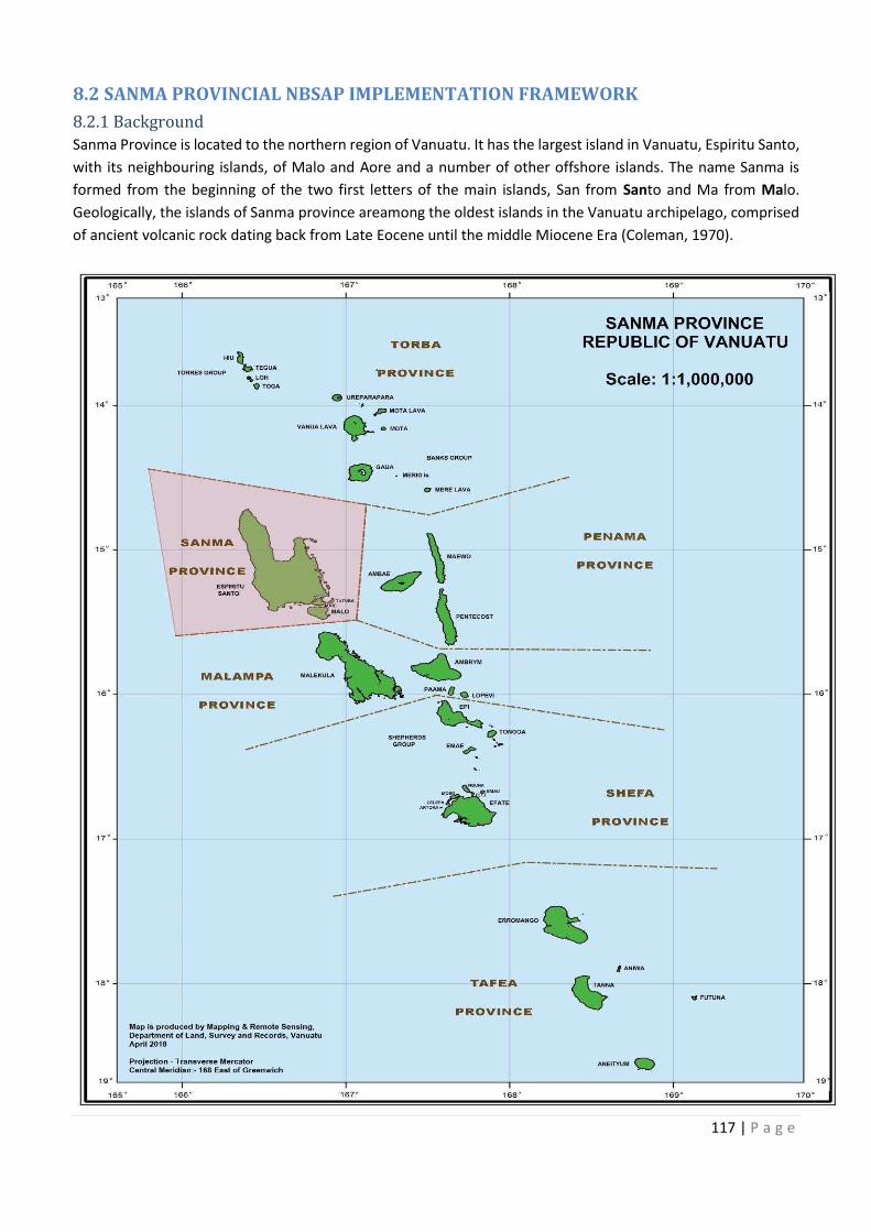
Trochus, green snail, giant
alligator Fish nursery grounds, coastal
hus conservation (Gaua
Mota
117 | P a g e
8.2 SANMA PROVINCIAL NBSAP IMPLEMENTATION FRAMEWORK
8.2.1 Background
Sanma Province is located to the northern region of Vanuatu. It has the largest island in Vanuatu, Espiritu Santo,
with its neighbouring islands, of Malo and Aore and a number of other offshore islands. The name Sanma is
formed from the beginning of the two first letters of the main islands, San from Santo and Ma from Malo.
Geologically, the islands of Sanma province areamong the oldest islands in the Vanuatu archipelago, comprised
of ancient volcanic rock dating back from Late Eocene until the middle Miocene Era (Coleman, 1970).
118 | P a g e
8.2.1.1 Population & Total Land Area
Sanma Province has a population of 52,145 people with a total land area of 4,248 km². Santo Island is the largest
land mass of the province and Vanuatu as a whole with a total of 4,010 km2. The highest peak in Vanuatu stands
at 1,879 m and is named Mount Tabwemasana in west-central Espiritu Santo. Santo, Malo and Aore are the
three main islands with ten more small offshore islands.
The people of Sanma rely on subsistence farming for food, raising cattle, pigs and chicken with yams, taro, root
crops and vegetables. The main source of income is from copra, cacao (being the largest exporting island), kava
and sale of crops in the market. The neighbouring islands sell fish catches to earn money. Handicraft is becoming
one of the increasing sources of income due to increase in tourism. Tourism is on the rise and has developed in
Sanma tremendously, now also with upgraded access entry of cruise ships to an improved Luganville harbor,
which generates a good source of income for the handicraft markets. In the previous years, Santo received a
decent number of cruise ships. However eleven crusise ships are scheduled to arrive in Santo in 2018.
8.2.1.2 Sanma Provincial Government
The headquarters of Sanma Province is located in Luganville Town; which is the second largest township in
Vanuatu after Port Vila. All government offices and private businesses are located in Luganville town. The
establishment of Sanma provincial government is through the Decentralization Act of 1994. The Provincial
Government of Sanma has established area secretaries (Administrators) according to district areas. Sanma
Province has 12 area secretaries. The appointed area secretaries represent the voices of their respective areas
to the provincial government for different development initiatives including the protection of natural resources.
The validation workshop helped the people of Sanma through the area secretaries to raise important areas for
protection. Sanma Province has a Corporate Plan that states that each area secretary has to register at least 1
or 2 conservation area (s) with the Environmental Protection and Conservation Act CAP 283 by 2020.
8.2.1.3 Vision
The Sanma Provincial Government Council (SPGC) envisages; building a stronger, developed and self-sustaining
province, while sustainably managing its unique abundant natural resources and Key Biodiversity to benefit all
its citizens.
8.2.1.4 Mission
To ensuring the conservation and sustainable management of its unique, abundant natural resources and
Key Biodiversity for the people of Samna Province and Luganville in a coherent manner: ensuring that
resources are utilized efficiently and sustainably.
8.2.2 Marine
Sanma Province constitutes the largest land area in Vanuatu, subsequently with very long stretch of coastline
area. Sanma also possesses some of the largest marine areas compared to other provinces in Vanuatu. . The
main island has about twelve (12) surrounding smaller sentinel islands. The island of Santo is a tourist diving
hotspot with many shipwreck dive sites (like the world renowned “president coolidge”which is also a marine
reserve), healthy rich, coral reefs and nice stunning white sandy beaches like the famous champagne beach with
its crystal clear water.
People of Sanma province also depend on marine resources for food and income, however, not as heavily
dependent on it, as they tend to use more of the resources on land rather than those of their marine
environment due to the large size and abundance of resources on Espiritu Santo Island. Participants at the
validation workshop however, felt that measures should be taken now to protect the marine resources, even
though people do not heavily depend on it at this stage yet. This idea of protection and conservation measures
seems to be important at this present time as more immigrants from neighbouring islands are moving to
Luganville to live and find job, with rural to urban drift.
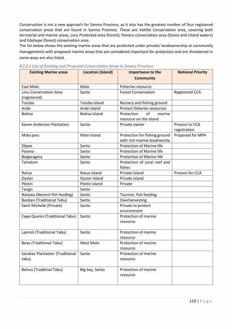
119 | P a g e
Conservation is not a new approach for Sanma Province, as it also has the greatest number of four registered
conservation areas that are found in Sanma Province. These are Vatthe Conservation area, covering both
terrestrial and marine areas, Loru Protected area (forest); Penoru conservation area (forest and inland waters)
and Edehope (forest) conservation area.
The list below shows the existing marine areas that are protected under private/ landownership or community
managements with proposed marine areas that are considered important for protection and are threatened in
some ways are also listed.
8.2.2.1 List of Existing and Proposed Conservation Areas in Sanma Province
Existing Marine areas Location (Island) Importance to the
Community
National Priority
East Malo Malo Fisheries resource
Loru Conservation Area
(registered)
Santo Forest Conservation Registered CCA
Tutuba Tutuba island Nursery and fishing ground
Araki Araki island Protect fisheries resources
Bokisa Bokisa Island Protection of marine
resource on the island
Keven Anderson Plantation Santo Private owner Process to CCA
registration
Malo pass Malo Island Protection for fishing ground
with rich marine biodiversity
Proposed for MPA
Olpoe Santo Protection of Marine life
Pasena Santo Protection of Marine life
Baigaragara Santo Protection of Marine life
Tamalum Santo Protection of coral reef and
fishes
Ratua Ratua Island Private Island Process for CCA
Oyster Oyster Island Private Island
Pilotin Pilotin island Private
Tangis Santo
Natawa (Nerenit fish feeding) Santo Tourism, fish feeding
Banban (Traditional Tabu) Santo Overharvesting
Saint Michelle (Private) Santo Private to protect
environment
Cape Quaros (Traditional Tabu) Santo Protection of marine
resource
Lajmoli (Traditional Tabu) Santo Protection of marine
resource
Beao (Traditional Tabu) West Malo Protection of marine
resource
Savakas Plantation (Traditional
tabu)
Santo Protection of marine
resource
Belvus (Traditinal Tabu) Big bay, Santo Protection of marine
resource
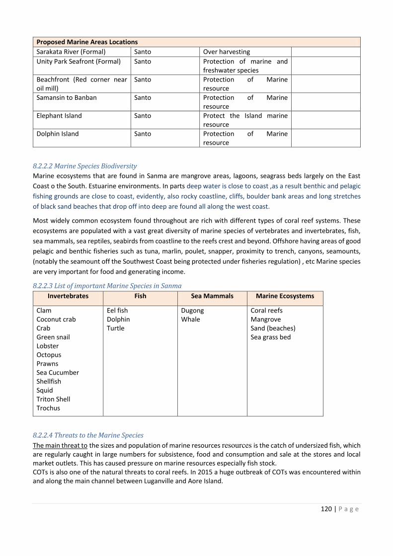
120 | P a g e
Proposed Marine Areas Locations
Sarakata River (Formal) Santo Over harvesting
Unity Park Seafront (Formal) Santo Protection of marine and
freshwater species
Beachfront (Red corner near
oil mill)
Santo Protection of Marine
resource
Samansin to Banban Santo Protection of Marine
resource
Elephant Island Santo Protect the Island marine
resource
Dolphin Island Santo Protection of Marine
resource
8.2.2.2 Marine Species Biodiversity
Marine ecosystems that are found in Sanma are mangrove areas, lagoons, seagrass beds largely on the East
Coast o the South. Estuarine environments. In parts deep water is close to coast ,as a result benthic and pelagic
fishing grounds are close to coast, evidently, also rocky coastline, cliffs, boulder bank areas and long stretches
of black sand beaches that drop off into deep are found all along the west coast.
Most widely common ecosystem found throughout are rich with different types of coral reef systems. These
ecosystems are populated with a vast great diversity of marine species of vertebrates and invertebrates, fish,
sea mammals, sea reptiles, seabirds from coastline to the reefs crest and beyond. Offshore having areas of good
pelagic and benthic fisheries such as tuna, marlin, poulet, snapper, proximity to trench, canyons, seamounts,
(notably the seamount off the Southwest Coast being protected under fisheries regulation) , etc Marine species
are very important for food and generating income.
8.2.2.3 List of important Marine Species in Sanma
Invertebrates Fish Sea Mammals Marine Ecosystems
Clam
Coconut crab
Crab
Green snail
Lobster
Octopus
Prawns
Sea Cucumber
Shellfish
Squid
Triton Shell
Trochus
Eel fish
Dolphin
Turtle
Dugong
Whale
Coral reefs
Mangrove
Sand (beaches)
Sea grass bed
8.2.2.4 Threats to the Marine Species
The main threat to the sizes and population of marine resources resources is the catch of undersized fish, which
are regularly caught in large numbers for subsistence, food and consumption and sale at the stores and local
market outlets. This has caused pressure on marine resources especially fish stock.
COTs is also one of the natural threats to coral reefs. In 2015 a huge outbreak of COTs was encountered within
and along the main channel between Luganville and Aore Island.
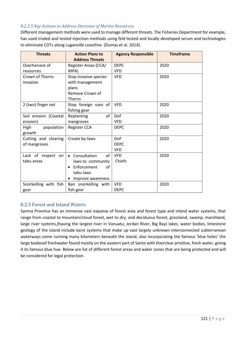
Protection of marine and
Beachfront (Red corner near Protection of Marine
Protection of Marine
Protect the Island marine
Protection of Marine
121 | P a g e
8.2.2.5 Key Actions to Address Decrease of Marine Resources
Different management methods were used to manage different threats. The Fisheries Department for example,
has used trialed and tested injection methods using feld tested and locally developed serum and technologies
to eliminate COTs along Luganville coastline. (Dumas et al. 2014).
Threats Action Plans to
Address Threats
Agency Responsible Timeframe
Overharvest of
resources
Register Areas (CCA/
MPA)
DEPC
VFD
2020
Crown of Thorns
invasion
Stop invasive species
with management
plans
Remove Crown of
Thorns
VFD 2020
2 (two) finger net Stop foreign uses of
fishing gear
VFD 2020
Soil erosion (Coastal
erosion)
Replanting of
mangroves
DoF
VFD
2020
High population
growth
Register CCA DEPC 2020
Cutting and clearing
of mangroves
Create by-laws DoF
DEPC
VFD
2020
Lack of respect on
tabu areas
· Consultation of
laws to community
· Enforcement of
tabu laws
· Improve awareness
VFD
Chiefs
2020
Snorkelling with fish
gear
Ban snorkelling with
fish gear
VFD
DEPC
2020
8.2.3 Forest and Inland Waters
Sanma Province has an immense vast expanse of forest area and forest type and inland water systems, that
range from coastal to mountain/cloud forest, wet to dry, and deciduous forest, grassland, swamp, marshland,
large river systems,(having the largest river in Vanuatu; Jordan River, Big Bay) lakes. water bodies, limestone
geology of the island include karst systems that make up vast largely unknown interconnected subterranean
waterways some running many kilometers beneath the island, also incorporating the famous ‘blue holes’ the
large bodiesof freshwater found mostly on the eastern part of Santo with theirclear prisitine, fresh water, giving
it its famous blue hue. Below are list of different forest areas and water zones that are being protected and will
be considered for legal protection.
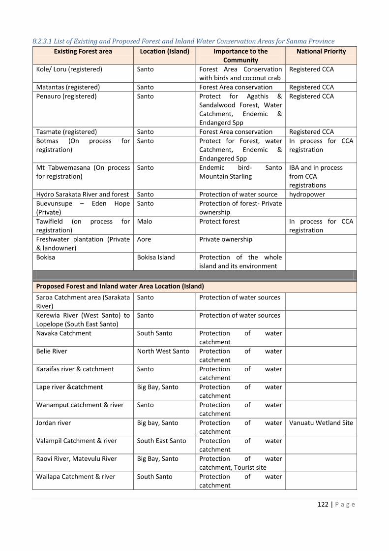
122 | P a g e
8.2.3.1 List of Existing and Proposed Forest and Inland Water Conservation Areas for Sanma Province
Existing Forest area Location (Island) Importance to the
Community
National Priority
Kole/ Loru (registered) Santo Forest Area Conservation
with birds and coconut crab
Registered CCA
Matantas (registered) Santo Forest Area conservation Registered CCA
Penauro (registered) Santo Protect for Agathis &
Sandalwood Forest, Water
Catchment, Endemic &
Endangerd Spp
Registered CCA
Tasmate (registered) Santo Forest Area conservation Registered CCA
Botmas (On process for
registration)
Santo Protect for Forest, water
Catchment, Endemic &
Endangered Spp
In process for CCA
registration
Mt Tabwemasana (On process
for registration)
Santo Endemic bird- Santo
Mountain Starling
IBA and in process
from CCA
registrations
Hydro Sarakata River and forest Santo Protection of water source hydropower
Buevunsupe – Eden Hope
(Private)
Santo Protection of forest- Private
ownership
Tawifield (on process for
registration)
Malo Protect forest In process for CCA
registration
Freshwater plantation (Private
& landowner)
Aore Private ownership
Bokisa Bokisa Island Protection of the whole
island and its environment
Proposed Forest and Inland water Area Location (Island)
Saroa Catchment area (Sarakata
River)
Santo Protection of water sources
Kerewia River (West Santo) to
Lopelope (South East Santo)
Santo Protection of water sources
Navaka Catchment South Santo Protection of water
catchment
Belie River North West Santo Protection of water
catchment
Karaifas river & catchment Santo Protection of water
catchment
Lape river &catchment Big Bay, Santo Protection of water
catchment
Wanamput catchment & river Santo Protection of water
catchment
Jordan river Big bay, Santo Protection of water
catchment
Vanuatu Wetland Site
Valampil Catchment & river South East Santo Protection of water
catchment
Raovi River, Matevulu River Big Bay, Santo Protection of water
catchment, Tourist site
Wailapa Catchment & river South Santo Protection of water
catchment
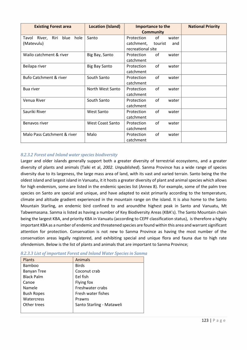
Location (Island)
Forest Area Conservation
Protect for Agathis &
Botmas (On process for water In process for CCA
Mt Tabwemasana (On process Santo
Hydro Sarakata River and forest
Eden Hope Private
Tawifield (on process for In process for CCA
Freshwater plantation (Private
Protection of the whole
Saroa Catchment area (Sarakata Protection of water sources
Kerewia River (West Santo) to Protection of water sources
Protection of water
Protection of water
Protection of water
Protection of water
Protection of water
Protection of water Vanuatu Wetland Site
tion of water
Protection of water
Protection of water
123 | P a g e
Existing Forest area Location (Island) Importance to the
Community
National Priority
Tavol River, Riri blue hole
(Matevulu)
Santo Protection of water
catchment, tourist and
recreational site
Wailo catchment & river Big Bay, Santo Protection of water
catchment
Beilapa river Big Bay Santo Protection of water
catchment
Bufo Catchment & river South Santo Protection of water
catchment
Bua river North West Santo Protection of water
catchment
Venua River South Santo Protection of water
catchment
Sauriki River West Santo Protection of water
catchment
Benavos river West Coast Santo Protection of water
catchment
Malo Pass Catchment & river Malo Protection of water
catchment
8.2.3.2 Forest and Inland water species biodiversity
Larger and older islands generally support both a greater diversity of terrestrial ecosystems, and a greater
diversity of plants and animals (Taiki et al, 2002. Unpublished). Sanma Province has a wide range of species
diversity due to its largeness, the large mass area of land, with its vast and varied terrain. Santo being the the
oldest island and largest island in Vanuatu, it it hosts a greater diversity of plant and animal species which allows
for high endemism, some are listed in the endemic species list (Annex 8). For example, some of the palm tree
species on Santo are special and unique, and have adapted to exist primarily according to the temperature,
climate and altitude gradient experienced in the mountain range on the island. It is also home to the Santo
Mountain Starling, an endemic bird confined to and aroundthe highest peak in Santo and Vanuatu, Mt
Tabwemasana. Sanma is listed as having a number of Key Biodiversity Areas (KBA’s). The Santo Mountain chain
being the largest KBA, and priority KBA in Vanuatu (according to CEPF classification status), is therefore a highly
important KBA as a number of endemic and threatened species are found within this area and warrant significant
attention for protection. Conservation is not new to Sanma Province as having the most number of the
conservation areas legally registered, and exhibiting special and unique flora and fauna due to high rate
ofendemism. Below is the list of plants and animals that are important to Sanma Province;
8.2.3.3 List of important Forest and Inland Water Species in Sanma
Plants Animals
Bamboo
Banyan Tree
Black Palm
Canoe
Namele
Bush Ropes
Watercress
Other trees
Birds
Coconut crab
Eel fish
Flying fox
Freshwater crabs
Fresh water fishes
Prawns
Santo Starling - Mataweli
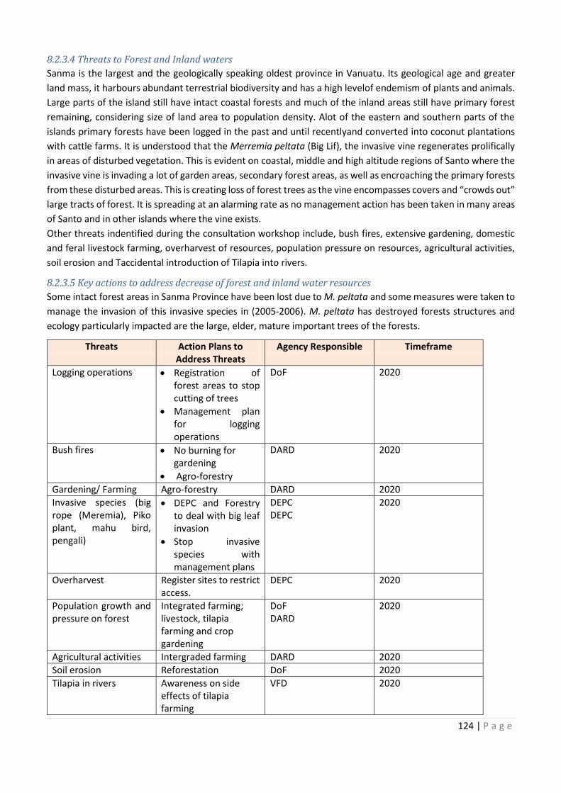
124 | P a g e
8.2.3.4 Threats to Forest and Inland waters
Sanma is the largest and the geologically speaking oldest province in Vanuatu. Its geological age and greater
land mass, it harbours abundant terrestrial biodiversity and has a high levelof endemism of plants and animals.
Large parts of the island still have intact coastal forests and much of the inland areas still have primary forest
remaining, considering size of land area to population density. Alot of the eastern and southern parts of the
islands primary forests have been logged in the past and until recentlyand converted into coconut plantations
with cattle farms. It is understood that the Merremia peltata (Big Lif), the invasive vine regenerates prolifically
in areas of disturbed vegetation. This is evident on coastal, middle and high altitude regions of Santo where the
invasive vine is invading a lot of garden areas, secondary forest areas, as well as encroaching the primary forests
from these disturbed areas. This is creating loss of forest trees as the vine encompasses covers and “crowds out”
large tracts of forest. It is spreading at an alarming rate as no management action has been taken in many areas
of Santo and in other islands where the vine exists.
Other threats indentified during the consultation workshop include, bush fires, extensive gardening, domestic
and feral livestock farming, overharvest of resources, population pressure on resources, agricultural activities,
soil erosion and Taccidental introduction of Tilapia into rivers.
8.2.3.5 Key actions to address decrease of forest and inland water resources
Some intact forest areas in Sanma Province have been lost due to M. peltata and some measures were taken to
manage the invasion of this invasive species in (2005-2006). M. peltata has destroyed forests structures and
ecology particularly impacted are the large, elder, mature important trees of the forests.
Threats Action Plans to
Address Threats
Agency Responsible Timeframe
Logging operations · Registration of
forest areas to stop
cutting of trees
· Management plan
for logging
operations
DoF 2020
Bush fires · No burning for
gardening
· Agro-forestry
DARD 2020
Gardening/ Farming Agro-forestry DARD 2020
Invasive species (big
rope (Meremia), Piko
plant, mahu bird,
pengali)
· DEPC and Forestry
to deal with big leaf
invasion
· Stop invasive
species with
management plans
DEPC
DEPC
2020
Overharvest Register sites to restrict
access.
DEPC 2020
Population growth and
pressure on forest
Integrated farming;
livestock, tilapia
farming and crop
gardening
DoF
DARD
2020
Agricultural activities Intergraded farming DARD 2020
Soil erosion Reforestation DoF 2020
Tilapia in rivers Awareness on side
effects of tilapia
farming
VFD 2020
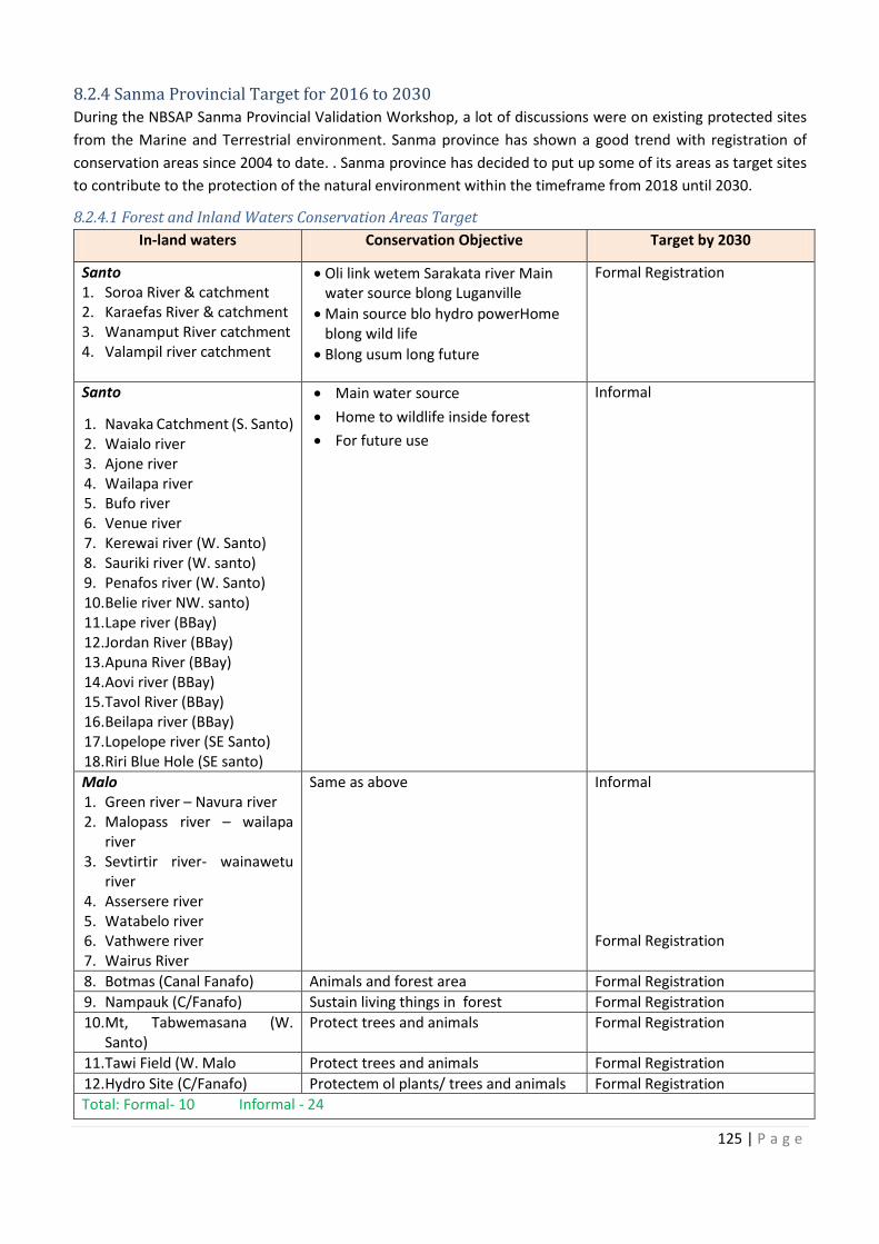
Registration of
Invasive species (big restry
restrict
Population growth and
125 | P a g e
8.2.4 Sanma Provincial Target for 2016 to 2030
During the NBSAP Sanma Provincial Validation Workshop, a lot of discussions were on existing protected sites
from the Marine and Terrestrial environment. Sanma province has shown a good trend with registration of
conservation areas since 2004 to date. . Sanma province has decided to put up some of its areas as target sites
to contribute to the protection of the natural environment within the timeframe from 2018 until 2030.
8.2.4.1 Forest and Inland Waters Conservation Areas Target
In-land waters Conservation Objective Target by 2030
Santo
1. Soroa River & catchment
2. Karaefas River & catchment
3. Wanamput River catchment
4. Valampil river catchment
· Oli link wetem Sarakata river Main
water source blong Luganville
· Main source blo hydro powerHome
blong wild life
· Blong usum long future
Formal Registration
Santo
1. Navaka Catchment (S. Santo)
2. Waialo river
3. Ajone river
4. Wailapa river
5. Bufo river
6. Venue river
7. Kerewai river (W. Santo)
8. Sauriki river (W. santo)
9. Penafos river (W. Santo)
10. Belie river NW. santo)
11. Lape river (BBay)
12. Jordan River (BBay)
13. Apuna River (BBay)
14. Aovi river (BBay)
15. Tavol River (BBay)
16. Beilapa river (BBay)
17. Lopelope river (SE Santo)
18. Riri Blue Hole (SE santo)
· Main water source
· Home to wildlife inside forest
· For future use
Informal
Malo
1. Green river – Navura river
2. Malopass river – wailapa
river
3. Sevtirtir river- wainawetu
river
4. Assersere river
5. Watabelo river
6. Vathwere river
7. Wairus River
Same as above Informal
Formal Registration
8. Botmas (Canal Fanafo) Animals and forest area Formal Registration
9. Nampauk (C/Fanafo) Sustain living things in forest Formal Registration
10. Mt, Tabwemasana (W.
Santo)
Protect trees and animals Formal Registration
11. Tawi Field (W. Malo Protect trees and animals Formal Registration
12. Hydro Site (C/Fanafo) Protectem ol plants/ trees and animals Formal Registration
Total: Formal- 10 Informal - 24
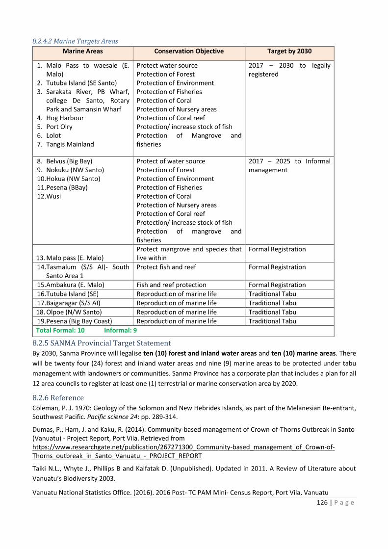
126 | P a g e
8.2.4.2 Marine Targets Areas
Marine Areas Conservation Objective Target by 2030
1. Malo Pass to waesale (E.
Malo)
2. Tutuba Island (SE Santo)
3. Sarakata River, PB Wharf,
college De Santo, Rotary
Park and Samansin Wharf
4. Hog Harbour
5. Port Olry
6. Lolot
7. Tangis Mainland
Protect water source
Protection of Forest
Protection of Environment
Protection of Fisheries
Protection of Coral
Protection of Nursery areas
Protection of Coral reef
Protection/ increase stock of fish
Protection of Mangrove and
fisheries
2017 – 2030 to legally
registered
8. Belvus (Big Bay)
9. Nokuku (NW Santo)
10. Hokua (NW Santo)
11. Pesena (BBay)
12. Wusi
Protect of water source
Protection of Forest
Protection of Environment
Protection of Fisheries
Protection of Coral
Protection of Nursery areas
Protection of Coral reef
Protection/ increase stock of fish
Protection of mangrove and
fisheries
2017 – 2025 to Informal
management
13. Malo pass (E. Malo)
Protect mangrove and species that
live within
Formal Registration
14. Tasmalum (S/S AI)- South
Santo Area 1
Protect fish and reef Formal Registration
15. Ambakura (E. Malo) Fish and reef protection Formal Registration
16. Tutuba Island (SE) Reproduction of marine life Traditional Tabu
17. Baigaragar (S/S AI) Reproduction of marine life Traditional Tabu
18. Olpoe (N/W Santo) Reproduction of marine life Traditional Tabu
19. Pesena (Big Bay Coast) Reproduction of marine life Traditional Tabu
Total Formal: 10 Informal: 9
8.2.5 SANMA Provincial Target Statement
By 2030, Sanma Province will legalise ten (10) forest and inland water areas and ten (10) marine areas. There
will be twenty four (24) forest and inland water areas and nine (9) marine areas to be protected under tabu
management with landowners or communities. Sanma Province has a corporate plan that includes a plan for all
12 area councils to register at least one (1) terrestrial or marine conservation area by 2020.
8.2.6 Reference
Coleman, P. J. 1970: Geology of the Solomon and New Hebrides Islands, as part of the Melanesian Re-entrant,
Southwest Pacific. Pacific science 24: pp. 289-314.
Dumas, P., Ham, J. and Kaku, R. (2014). Community-based management of Crown-of-Thorns Outbreak in Santo
(Vanuatu) - Project Report, Port Vila. Retrieved from
https://www.researchgate.net/publication/267271300_Community-based_management_of_Crown-of-
Thorns_outbreak_in_Santo_Vanuatu_-_PROJECT_REPORT
Taiki N.L., Whyte J., Phillips B and Kalfatak D. (Unpublished). Updated in 2011. A Review of Literature about
Vanuatu’s Biodiversity 2003.
Vanuatu National Statistics Office. (2016). 2016 Post- TC PAM Mini- Census Report, Port Vila, Vanuatu
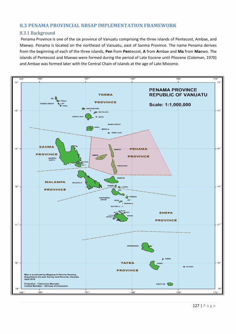
ass to waesale (E. 2030 to legally
nformal
Protect mangrove and species that
South
127 | P a g e
8.3 PENAMA PROVINCIAL NBSAP IMPLEMENTATION FRAMEWORK
8.3.1 Background
Penama Province is one of the six province of Vanuatu comprising the three islands of Pentecost, Ambae, and
Maewo. Penama is located on the northeast of Vanuatu, east of Sanma Province. The name Penama derives
from the beginning of each of the three islands, Pen from Pentecost, A from Ambae and Ma from Maewo. The
islands of Pentecost and Maewo were formed during the period of Late Eocene until Pliocene (Coleman, 1970)
and Ambae was formed later with the Central Chain of islands at the age of Late Miocene.
128 | P a g e
8.3.1.1 Population & total land area
Penama Province has a population of 31,334 people and land area of 1,198 km2. Penama is one of the provinces
in Vanuatu where their traditions and culture is highly valued, maintained and respected. The people of Penama
depend upon their natural resources to sustain their livelihood. The main source of income is the sale of marine
fish, garden crops, livestock and their traditional handicrafts of mats and baskets.
8.3.1.2 Penama Provincial Government
Penama Provincial government was established through the Decentralization Act 1994. The main headquarter
for Penama Province is in Saratamata, Ambae. Some of the government departments established their extension
services under the Penama Provincial government in order to implement the National Policy right down to the
community level. The department extension services form a Technical Advisory Group (TAG) that make
decisions along with the key personnel of Penama province for the development of the province. Area
secretaries are elected to govern their people in remote areas to represent and voice their respective areas’
need to the provincial government. All of the area secretaries were present at the NBSAP provincial validation
workshop.
8.3.1.3 Vision
A diverse and prosperous Penama founded upon good governance respecting and protecting nature for
tomorrow.
8.3.1.4 Mission
A sustainable environment and ecosystem to support social and economic development for the people of
Penama by 2050, where culture and nature live in harmony.
8.3.2 Marine
Marine ecosystems in Penama province are restricted, to the layout and geological and topographical form and
features of the islands in this province, due to the geological formation and biophysical attributes of two islands
of Pentecost and Ambae in particular where most coastline are comprised of volcanic rocks as opposed to the
more common limestone substrate, on most islands throughout Vanuatu. Some coral reef areas are found in
some parts of the islands, mostly on Pentecost and Maewo, with ambae having the least, due to its volcanic
nature. There are areas of pelagc, deep water benthic, offshore species, that are a utilized fishery.. Currently
there is no traditional marine tabus or marine conservation areas but some landowners have interests to protect
their adjacent marine areas.
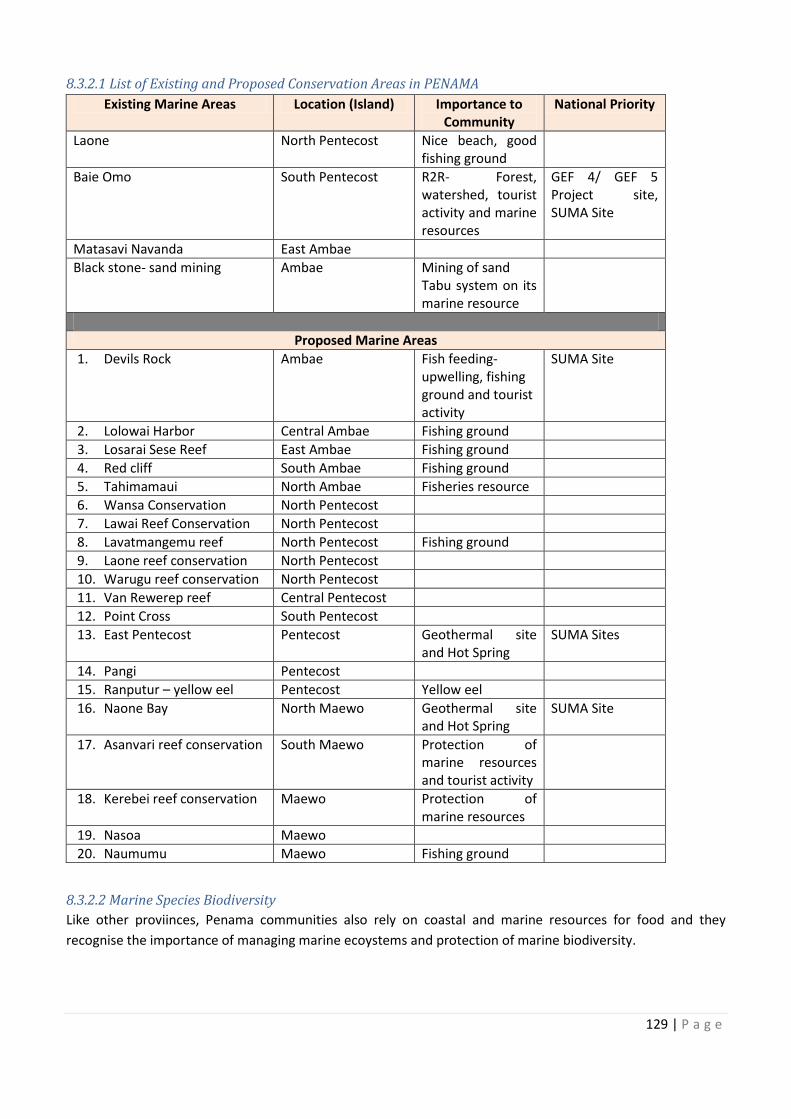
129 | P a g e
8.3.2.1 List of Existing and Proposed Conservation Areas in PENAMA
Existing Marine Areas Location (Island) Importance to
Community
National Priority
Laone North Pentecost Nice beach, good
fishing ground
Baie Omo South Pentecost R2R- Forest,
watershed, tourist
activity and marine
resources
GEF 4/ GEF 5
Project site,
SUMA Site
Matasavi Navanda East Ambae
Black stone- sand mining Ambae Mining of sand
Tabu system on its
marine resource
Proposed Marine Areas
1. Devils Rock Ambae Fish feeding-
upwelling, fishing
ground and tourist
activity
SUMA Site
2. Lolowai Harbor Central Ambae Fishing ground
3. Losarai Sese Reef East Ambae Fishing ground
4. Red cliff South Ambae Fishing ground
5. Tahimamaui North Ambae Fisheries resource
6. Wansa Conservation North Pentecost
7. Lawai Reef Conservation North Pentecost
8. Lavatmangemu reef North Pentecost Fishing ground
9. Laone reef conservation North Pentecost
10. Warugu reef conservation North Pentecost
11. Van Rewerep reef Central Pentecost
12. Point Cross South Pentecost
13. East Pentecost Pentecost Geothermal site
and Hot Spring
SUMA Sites
14. Pangi Pentecost
15. Ranputur – yellow eel Pentecost Yellow eel
16. Naone Bay North Maewo Geothermal site
and Hot Spring
SUMA Site
17. Asanvari reef conservation South Maewo Protection of
marine resources
and tourist activity
18. Kerebei reef conservation Maewo Protection of
marine resources
19. Nasoa Maewo
20. Naumumu Maewo Fishing ground
8.3.2.2 Marine Species Biodiversity
Like other proviinces, Penama communities also rely on coastal and marine resources for food and they
recognise the importance of managing marine ecoystems and protection of marine biodiversity.
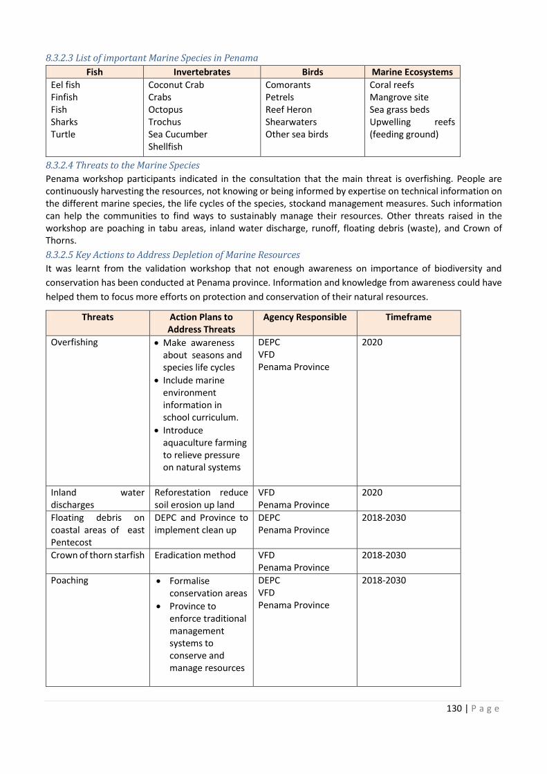
130 | P a g e
8.3.2.3 List of important Marine Species in Penama
Fish Invertebrates Birds Marine Ecosystems
Eel fish
Finfish
Fish
Sharks
Turtle
Coconut Crab
Crabs
Octopus
Trochus
Sea Cucumber
Shellfish
Comorants
Petrels
Reef Heron
Shearwaters
Other sea birds
Coral reefs
Mangrove site
Sea grass beds
Upwelling reefs
(feeding ground)
8.3.2.4 Threats to the Marine Species
Penama workshop participants indicated in the consultation that the main threat is overfishing. People are
continuously harvesting the resources, not knowing or being informed by expertise on technical information on
the different marine species, the life cycles of the species, stockand management measures. Such information
can help the communities to find ways to sustainably manage their resources. Other threats raised in the
workshop are poaching in tabu areas, inland water discharge, runoff, floating debris (waste), and Crown of
Thorns.
8.3.2.5 Key Actions to Address Depletion of Marine Resources
It was learnt from the validation workshop that not enough awareness on importance of biodiversity and
conservation has been conducted at Penama province. Information and knowledge from awareness could have
helped them to focus more efforts on protection and conservation of their natural resources.
Threats Action Plans to
Address Threats
Agency Responsible Timeframe
Overfishing · Make awareness
about seasons and
species life cycles
· Include marine
environment
information in
school curriculum.
· Introduce
aquaculture farming
to relieve pressure
on natural systems
DEPC
VFD
Penama Province
2020
Inland water
discharges
Reforestation reduce
soil erosion up land
VFD
Penama Province
2020
Floating debris on
coastal areas of east
Pentecost
DEPC and Province to
implement clean up
DEPC
Penama Province
2018-2030
Crown of thorn starfish Eradication method VFD
Penama Province
2018-2030
Poaching · Formalise
conservation areas
· Province to
enforce traditional
management
systems to
conserve and
manage resources
DEPC
VFD
Penama Province
2018-2030
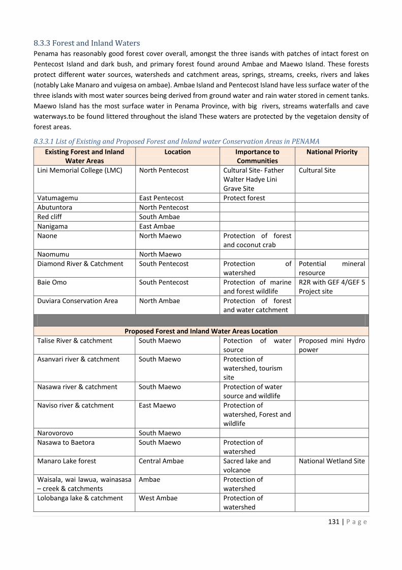
cosystems
Inland water Reforestation reduce
on DEPC and Province to
Crown of thorn starfish
131 | P a g e
8.3.3 Forest and Inland Waters
Penama has reasonably good forest cover overall, amongst the three isands with patches of intact forest on
Pentecost Island and dark bush, and primary forest found around Ambae and Maewo Island. These forests
protect different water sources, watersheds and catchment areas, springs, streams, creeks, rivers and lakes
(notably Lake Manaro and vuigesa on ambae). Ambae Island and Pentecost Island have less surface water of the
three islands with most water sources being derived from ground water and rain water stored in cement tanks.
Maewo Island has the most surface water in Penama Province, with big rivers, streams waterfalls and cave
waterways.to be found littered throughout the island These waters are protected by the vegetaion density of
forest areas.
8.3.3.1 List of Existing and Proposed Forest and Inland water Conservation Areas in PENAMA
Existing Forest and Inland
Water Areas
Location Importance to
Communities
National Priority
Lini Memorial College (LMC) North Pentecost Cultural Site- Father
Walter Hadye Lini
Grave Site
Cultural Site
Vatumagemu East Pentecost Protect forest
Abutuntora North Pentecost
Red cliff South Ambae
Nanigama East Ambae
Naone North Maewo Protection of forest
and coconut crab
Naomumu North Maewo
Diamond River & Catchment South Pentecost Protection of
watershed
Potential mineral
resource
Baie Omo South Pentecost Protection of marine
and forest wildlife
R2R with GEF 4/GEF 5
Project site
Duviara Conservation Area North Ambae Protection of forest
and water catchment
Proposed Forest and Inland Water Areas Location
Talise River & catchment South Maewo Potection of water
source
Proposed mini Hydro
power
Asanvari river & catchment South Maewo Protection of
watershed, tourism
site
Nasawa river & catchment South Maewo Protection of water
source and wildlife
Naviso river & catchment East Maewo Protection of
watershed, Forest and
wildlife
Narovorovo South Maewo
Nasawa to Baetora South Maewo Protection of
watershed
Manaro Lake forest Central Ambae Sacred lake and
volcanoe
National Wetland Site
Waisala, wai lawua, wainasasa
– creek & catchments
Ambae Protection of
watershed
Lolobanga lake & catchment West Ambae Protection of
watershed
132 | P a g e
Existing Forest and Inland
Water Areas
Location Importance to
Communities
National Priority
Wai Memea lake & catchment Ambae Protection of
watershed
Wai Lebutaga Lake &
catchment
Ambae National Wetland Site
Wai meuri catchment,
Lomanga
North Ambae Protect water source
and wildlife
Matamata mei quro (Ambanga
Wai Maeto)
North Ambae Protect water source Akihito- Endemic
freshwater species
Lolovoli Community
Conservation Area (forest)
South Ambae Protect water source
and wildlife
Matawando catchment South Ambae Protect water source
and wildlife
Wai Sine catchment South Ambae
Vatinaqili to Lologaro South to West Ambae
Wairoro catchment Aute
Village
North Pentecost Protection of
watershed
Banmatmat river catchment South Pentecost
Wanur Forest South Pentecost
Waet Water catchment,
Ranmawot School
South Pentecost Protection of
watershed
Waterfall catchment South Pentecost Protection of
watershed & waterfall
Melsisi river catchment Central Pentecost Protection of
watershed
Patnafni river catchment Central Pentecost
Metanami forest (near Levaka
Village)
Central East Pentecost
Aliku river & catchment East Pentecost Protection of
watershed
Walbongi river& catchment North East Pentecost Protect water source
and wildlife
Tuleo forest North Pentecost Protect Forest
Namaram river & catchment,
Surukavien area
Central Pentecost Protection of
watershed
Loltong river & catchment North Pentecost Protection of
watershed
Waiboe lake North East Pentecost Protection of
watershed
8.3.3.2 Forest and Inland Water Species Biodiversity
Penama forest and freshwater systems contain some endemic species of plants and animals. One such is the
freshwater gobby species, Akihito vanuatu, which is only found on Ambae and Pentecost. Some Important Plants
and Animals Species that are important to the people of Penama are listed below.
Wai Memea lake & catchment
National Wetland Site
Protect water source
Matamata mei quro (Ambanga
Protect water source
Protect water source
Metanami forest (near Levaka
Protect water source
133 | P a g e
8.3.3.3 List of important Forest and Inland Water Species in Penama
Plant Animals
Black Palm
Bush vines (ropes)
Cane - Rattan
Namele Cycad
Palm trees (Niniu)
Verns
Wild Orchids
Akihito Vanuatu
Flying fox
Freshwater prawn
Green Palm Lorikeet
Incubator bird
Lolowai fish
Other wild life
8.3.3.4 Threats to Forest and Inland Waters
The main threat to forest and inland waters is the pressure on resources due to high population growth in the
three islands. Resources are being used faster than they are able to be replenished resulting in their decline. At
present Ambae Island is facing natural disaster threats through volcanic ash fall from the eruptions of Lobenben
volcano, which also has impacted severly on vegetation, forests and water sources watersheds and systems.
Below are some of the the threats that affect these resources and actions to address them.
8.3.3.5 Key actions to address decline of Forest and Inland Water Resources
Threats Action Plans to Address Threats Agency Responsible Timeframe
Population pressure
on resources
Educate on natural resource
management
Educate through schools
DoE
DEPC
Penama Province
2020
Fire Reforestation DoF
DEPC
Penama Province
2020
Gardening system-
clearing and burning
Integrated farming system DARD
Penama Province
2020
Over-harvesting of
resources
Formalise conservation areas DEPC
DoF
Penama Province
2020
Forest clearing close
to water sources for
building materials
Set water buffer zones
Carry out awarenss on impact of
clearing close to water sources
DoF
DGMWR
DEPC
Penama Province
2020
Big Lif impact on
forest biodiversity
Eradicate Big Lif DEPC
Penama Province
Invasive Shrub,
Solanum torvum (Piko)
impact on secondary
forests
Eradicate the shrub DEPC
BV
Penama Province
2020
Lack of knowledge on
objective of
conservation
Implementing and promote local
or custom governance to help
zoning or planning how each
activity to take place
Strengthening custom Tabu
Develop by laws to help or
control hunting, fishing or
harvesting of some resources.
Eg: coconut crab & birds.
Local Chiefs
Penama Province DEPC
2020
134 | P a g e
8.3.4 Penama Provincial Target for 2016 to 2030
During the NBSAP Penama Provincial Validation Workshop, the discussions were directed at focus on
protectingof marine and forest areas as target plans for the NBSAP Provincial plan. Penama province decided to
put some of its forests and inland waters areas as target sites to contribute to the protection of the natural
environment. Some of the sites have been categorised timeframes for legal registration under the EPC Act, while
some sites have not been given timeframes for registration.
8.3.4.1 Existing Conservation Areas Target in Terrestrial and Marine
Conservation
Area
Phase 1: 2016 -
2022
Conservation
Objective
Management
System
Status of
Conservation
Area
Target by 2030
1. Hot Water
(South
Pentecost)
· Protect water
source,
· Potential site
for geo-
thermal
energy,
· Proposed PPA
Informal, custom
governance,
Ulinsalean Council
of Chief – AC:
Robinson T
Informal Formal
Registration
2. Matamwado
Water ways
(South Ambae)
· Protect water
source,
· Protect
habitat,
· Proposed PPA-
Provincial
Tourism site
Informal custom
governance
Vatueulu
AC: Annalyn
Informal Formal
Registration
3. Big Wota
Qwilorua, Naone-
North Maewo
· Protect water
source,
· Habitat
protection,
· Hydro power
generation,
· Proposed PPA
(Tourism Site,
Fish farming,
Fresh water
prawn farming
Informal custom
governance,
Bangun Vanua
AC: Nanu Bani
Informal Formal
Registration
4. Manaro Gesa
& Manaro Vui
(Central Ambae)
· Tourism
attraction,
· Habitat for
Orchid
protection &
other
protection
species
In formal Custom
governance,
AC: Stanley &
Morris & Edmond
Hoke, Tokotara,
Vatuerlu, Lungei
Takaro,
Vatubuebulei
Takaro
Informal Formal
Registration
ater
Protect water Informal custom
Protect water
In formal Custom
135 | P a g e
Conservation
Area
Conservation
Objective
Management
System
Status of
Conservation
Area
Target by 2030
Phase 2: 2022-2030
5. Ambanga
Water ways
(North Ambae)
· Endemic fish
protection,
· Tourism site,
· Cultural
village-
Lolosori
Vatuboiboleitakaro
Informal custom
governance
Informal Formal
Registration
6. Vatmangemu
(North East
Pentecost)
· Protect
marine and
forest habitat,
· Custom
Village/
Tourism.
Vatumalanvanua
Informal custom
governance
AC: Marsden
Rongo
Informal Formal
Registration
Phase 3: 2016 – 2030
· Waterfall (S.P)
· Waimemea/
Wailembutaka
(NE Ambae)
· Forestry Area
(NE Ambae)
· Nanigama (E
Ambae)
· Qwala Stone
(W Ambae)
· Vilakalaka
(SW Ambae)
· Tawate Forest
(North
Ambae)
Custom
Governance
Custom
Governance
(Informal)
Total: Formal = 6 Informal =8
136 | P a g e
8.3.4.2 Forest and Inland Waters Area Target
Forest Area / Types
Inland Water/ Types
Existing
Conservation Objective Target by 2030
1. Diamond River (South
Pentecost)
· Potential mineral site
· Protection of water source
and catchment
Informal- custom tabu
(Malbangbang AC)
2. Duviara Conservation Area
(Forest & water Catchemnt &
creek- waimaeto, Ambanga-
N.Ambae
· Protect forest water
catchment
· Protect water and special
endemic fish (Akihito)
Formal Registration (Vatuboe
bulei Tagaro AC)
3. Waimeuri Water Catchment
(Lomalonga, N.Ambae)
· Protect safe drinking water
sources
· Prepare for population
growth
· Protect wild life
Formal Registration (Vatubue
bulei Tagaro AC
4. Vutinaqili to Lolokaro
Conservation Area (S/W
Ambae)
· Protect intact forest and
water catchment
· Protect wildlife (corridors)
Formal Registration (Togatara
& Vatueulu AC)
Proposed – Pentecost
5. Wairoro Water Catchment
(Aute, N. Pentecost)
· Protect water source for
majority of N. Pentecost
· Protect water catchment
and wild life
Formal Registration (
Vatumalanvanua AC)
6. Loltong water source · Protect water source saving
over 2000 people
· protect wild life
Formal Registration
(Vatumalanvanua AC)
7. Melsisi River and Catchment · Protect water source
· Main water source for
health center
· Water saving over 2000
people
Formal Registration (Central
Pentecost 2, Ulinsalean AC)
Proposed – Maewo
8. Talise River (S. Maewo)
· Protect water source &
catchment
· Mini hydro power site
· Protect wild life
Formal Registration (roronda
AC)
9. Naviso river (E. maewo) · Protect water source &
catchment
· Protect wild life
· Cultural site
Formal Registration
(Baganvanua AC)
Total: Formal: 8 Informal: 1
1. Diamond River (South custom tabu
Protect forest water (Vatuboe
3. Waimeuri Water Catchment Protect safe drinking water (Vatubue
4. Vutinaqili to Lolokaro Protect intact forest and Formal Registration (Togatara
Protect water source for Formal Registration (
Protect water source saving Formal Registration
7. Melsisi River and Catchment Formal Registration (Central
Protect water source & Formal Registration (roronda
137 | P a g e
8.3.4.3 Marine Areas Target
Marine Area Conservation Objectives Target by 2030
Loltong Mangrove
Conservation (N. Pentecost)
· Rare in Penama
· Habitat long marine species
mo inland
· Hemi wan breeding
siteProtectem marine life
Formal Registration
(Vatunmalauvanua Area
Council)
Devil’s Rock Conservation (W.
Ambae)
· Natural Habitat blo marine
species
· Upwelling cause feeding
grounds
· Protectem existing
resources we I stap lo hem
Formal Registration
(Tokutara Area Council)
Assanvari Conservation (S.
Maewo)
· Unique reef blo
protectemHabitat blong
marine
· Protectem coral reef
Formal Registration
(Roronda Area Council)
Ranputor reef (S. Pentecost) · Yellow eel fish
· habitat blong marine life
· snorkelling site for tourist
Formal Registration
(Malbangbang AC)
Naone Bay (N. Maewo) · Habitat blong marine mo
freshwater species
· Passage blo namarae mo
naura blo release egg
· Bay I aggregate fish mo nara
marine species
Formal Registration (
Bugauvahua AC)
Lawai (Aligu, E. Pentecost) Habitat blong difren marine
species
Formal Registration
(Vatunmalanvanua AC)
Lolowai Harbor (E. Ambae) · Protect from open sea
· frequent by mangru,
· spawning area blong fish
Informal
(Lungei Tagaro AC)
East Pentecost (Nokat vilij
between Metaname to Levetlis
vilij)
· Special reef blo ol fresh
wota species
· Protectem coral reef
Informal
(Suru AC and Ulinsalean AC)
Laone (N. Pentecost) · Protectem Coral reef
· Habitat blong marine life
Informal
(Vatunmalanvanua AC)
Total : Formal: 6 Informal: 3
8.3.5 Penama Provincial Target Statement
Penama Provincial Target for 2018 to 2013 is 14 forest and inland water areas and 6 marine areas for legal
registration. Some of the areas are set as targets to be registered as custom tabu areas, 6 marine areas and 6
forest areas.
8.2.6 References
Coleman, P. J. 1970: Geology of the Solomon and New Hebrides Islands, as part of the Melanesian Reentrant,
Southwest Pacific. Pacific science 24: pp 289-314.
Vanuatu National Statistics Office. (2016). 2016 Post- TC PAM Mini- Census Report, Port Vila, Vanuatu
138 | P a g e
8.4 MALAMPA PROVINCIAL NBSAP IMPLEMENTATION FRAMEWORK
8.4.1 Background
Malampa Province is situated in the central part of Vanuatu and consists of three main islands; Malekula, Ambrym
and Paama (lopevi being uninhabited). Malekula itself has other small islands, Uripiv, Norsup, Uri, Atchin, Vao
and the Maskelyne islands and four (4) more along the southern part. Malekula is the second largest island in
Vanuatu with a land mass of 2,053km2.
The name of Malampa province is derived from the beginning of the three main islands; MALalakula, AMbrym
and PAama. The island of Malekula is geologically grouped with Espiritu Santo and Torres group of islands as
the oldest formed islands in the late Eocene until the Middle Miocene (Cole, 1970). Ambrym Island is known for
its two volcanic craters, Marum and Benbo volcanoes that attract tourists to this island.
139 | P a g e
8.4.1.1 Population & total land area
Malampa province has a population of 39,997 people and a land area of 2,779 km2. The main business
centre for Malampa is Lakatoro located in the central part of Malekula. The people of Malampa earn
their living through the sale of cash crops; copra, cocoa, kava and fish the market at Lakatoro. Tourism
has become one of the developing businesses in Malampa with its rich and colorful diversity of strong
cultures and traditions still maintained, handicraft being the main product. The people of Ambrym are
specialised in carving, using master carvers, they carve with different species of forest trees and
common fruit trees like breadfruit tree (renowned for their ‘tamtams’; slit gongs’). Carving is a very good
income for the people of this island, which has volcanic ash-enriched soils conducive also for gardening
of crops.
8.4.1.2 Malampa Provincial Government
Under the Decentralization Act 1994, the country was divided administratively into six provinces and
Malampa Province was established. Malampa province has a role play to establish government
institutions within its management. All national government extension services have a role to implement
the National Plan under provincial governance and they exist under Malampa Provincial umbrella.
Malampa province has a President and a Secretary General to head the administration of this province.
Malampa Province has a Corporate Plan that was set to guide this province by the Technical Advisory
Group (TAG) with the help of the Area council secretary elected by the people under each districts
within the three islands of Malampa.
8.4.1.3 Vision
Manage and preserve our resources for a clean environment for Malampa future generations.
8.4.1.4 Mission
Protect and sustain biological diversity for today and tomorrow and for the enjoyment of natural benefits
from our forest, waters and marine resources for Malampa Province.
8.4.2 Marine
Malampa Province has many small sandy islands, islets, sand cays that are uninhabited particularly
around malekula. These small islands are rich in marine resources. For example the Maskylenes. The
marine ecosystems around the three main islands of Malampa constitute mangroves estuarine
swamplands, extensive seagrass beds and meadows (the largest in Vanuatu found in Malekula),
lagoons, mud flats and most commonly a multitude array of coral reef ypes and systems (fringing,
barrier, and atoll) with stretches of white and black sandy beaches. Offshore having areas of good
pelagic and benthic fisheries such as tuna, marlin, poulet, snapper, proximity to trench, canyons, and
seamounts.
Crab Bay is on the east coast of Malekula and it is one of the legally registered conservation areas due
to its large pristine mangrove sites that connects land and the marine environment. Crab bay and Port
Stanley have the largest mangrove sites in Vanuatu with 2100ha (Baereleo et al. 2013). It was protected
for its mangrove density and the high population of crabs inhabiting the site.
Some of the small islands to the southern part of Malekula example the maskelynesare home to some
of the richest marine life; biota and ecosystems found in Vanuatu and are subsequently also very good
fishing grounds generating a large fishery/industry to the locals(with marine produce even being sold to
fish markets as far as Port Vila and Luganville) . The islands of Ambrym and Paama have smaller
marine resources compare to Malekula Island.
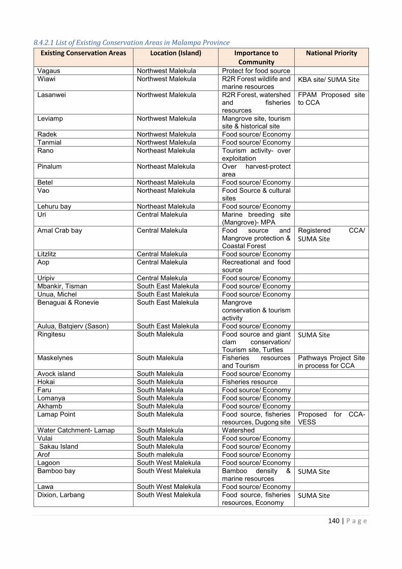
140 | P a g e
8.4.2.1 List of Existing Conservation Areas in Malampa Province
Existing Conservation Areas Location (Island) Importance to
Community
National Priority
Vagaus Northwest Malekula Protect for food source Wiawi Northwest Malekula R2R Forest wildlife and
marine resources KBA site/ SUMA Site
Lasanwei Northwest Malekula R2R Forest, watershed and fisheries resources
FPAM Proposed site to CCA
Leviamp Northwest Malekula Mangrove site, tourism site & historical site
Radek Northwest Malekula Food source/ Economy Tanmial Northwest Malekula Food source/ Economy Rano Northeast Malekula Tourism activity- over
exploitation
Pinalum Northeast Malekula Over harvest-protect area
Betel Northeast Malekula Food source/ Economy Vao Northeast Malekula Food Source & cultural
sites
Lehuru bay Northeast Malekula Food source/ Economy Uri Central Malekula Marine breeding site
(Mangrove)- MPA
Amal Crab bay Central Malekula Food source and Mangrove protection & Coastal Forest
Registered CCA/
SUMA Site
Litzlitz Central Malekula Food source/ Economy Aop Central Malekula Recreational and food
source
Uripiv Central Malekula Food source/ Economy Mbankir, Tisman South East Malekula Food source/ Economy Unua, Michel South East Malekula Food source/ Economy Benaguai & Ronevie South East Malekula Mangrove
conservation & tourism activity
Aulua, Batqierv (Sason) South East Malekula Food source/ Economy Ringitesu South Malekula Food source and giant
clam conservation/ Tourism site, Turtles
SUMA Site
Maskelynes South Malekula Fisheries resources and Tourism
Pathways Project Site in process for CCA
Avock island South Malekula Food source/ Economy Hokai South Malekula Fisheries resource Faru South Malekula Food source/ Economy Lomanya South Malekula Food source/ Economy Akhamb South Malekula Food source/ Economy Lamap Point South Malekula Food source, fisheries
resources, Dugong site Proposed for CCA- VESS
Water Catchment- Lamap South Malekula Watershed Vulai South Malekula Food source/ Economy Sakau Island South Malekula Food source/ Economy Arof South malekula Food source/ Economy Lagoon South West Malekula Food source/ Economy Bamboo bay South West Malekula Bamboo density &
marine resources SUMA Site
Lawa South West Malekula Food source/ Economy Dixion, Larbang South West Malekula Food source, fisheries
resources, Economy SUMA Site
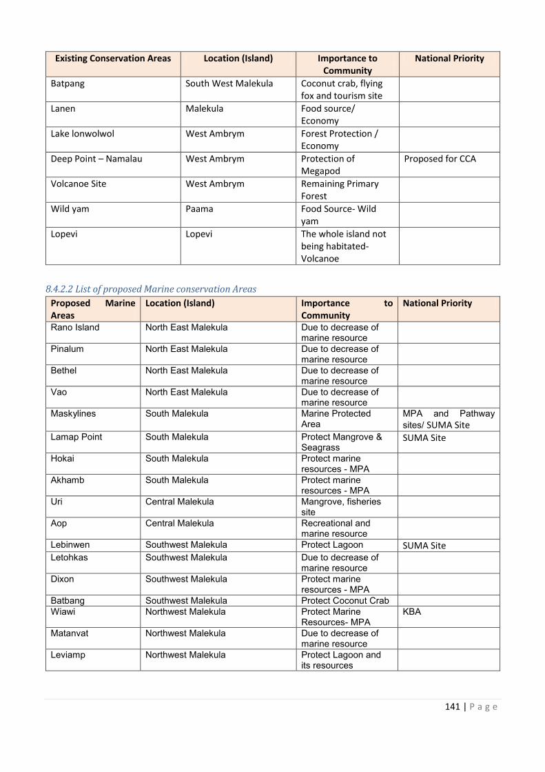
Protect for food source R2R Forest wildlife and
R2R Forest, watershed FPAM Proposed site
Mangrove site, tourism
Food source/ Economy Food source/ Economy
over
protect
rce/ Economy Food Source & cultural
Food source/ Economy Marine breeding site
Food source and Registered CCA/
Food source/ Economy Recreational and food
Food source/ Economy Food source/ Economy Food source/ Economy
Food source/ Economy Food source and giant
Fisheries resources Pathways Project Site
Food source/ Economy
ource/ Economy Food source/ Economy Food source/ Economy Food source, fisheries Proposed for CCA-
Food source/ Economy Food source/ Economy Food source/ Economy Food source/ Economy Bamboo density &
Food source/ Economy Food source, fisheries
141 | P a g e
Existing Conservation Areas Location (Island) Importance to
Community
National Priority
Batpang South West Malekula Coconut crab, flying
fox and tourism site
Lanen Malekula Food source/
Economy
Lake lonwolwol West Ambrym Forest Protection /
Economy
Deep Point – Namalau West Ambrym Protection of
Megapod
Proposed for CCA
Volcanoe Site West Ambrym Remaining Primary
Forest
Wild yam Paama Food Source- Wild
yam
Lopevi Lopevi The whole island not
being habitated-
Volcanoe
8.4.2.2 List of proposed Marine conservation Areas
Proposed Marine
Areas
Location (Island) Importance to
Community
National Priority
Rano Island North East Malekula Due to decrease of marine resource
Pinalum North East Malekula Due to decrease of marine resource
Bethel North East Malekula Due to decrease of marine resource
Vao North East Malekula Due to decrease of marine resource
Maskylines South Malekula Marine Protected Area
MPA and Pathway
sites/ SUMA Site
Lamap Point South Malekula Protect Mangrove & Seagrass
SUMA Site
Hokai South Malekula Protect marine resources - MPA
Akhamb South Malekula Protect marine resources - MPA
Uri Central Malekula Mangrove, fisheries site
Aop Central Malekula Recreational and marine resource
Lebinwen Southwest Malekula Protect Lagoon SUMA Site
Letohkas Southwest Malekula Due to decrease of marine resource
Dixon Southwest Malekula Protect marine resources - MPA
Batbang Southwest Malekula Protect Coconut Crab Wiawi Northwest Malekula Protect Marine
Resources- MPA KBA
Matanvat Northwest Malekula Due to decrease of marine resource
Leviamp Northwest Malekula Protect Lagoon and its resources
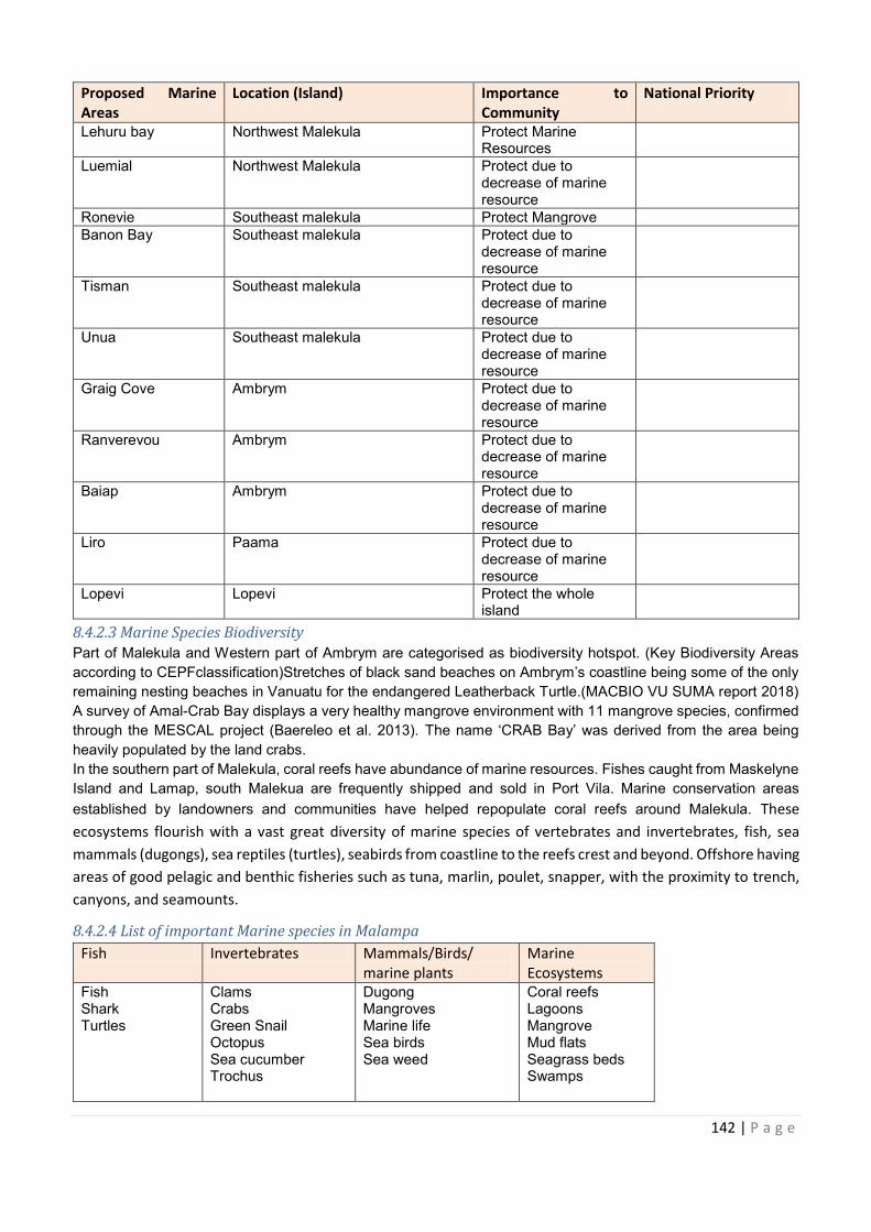
142 | P a g e
Proposed Marine
Areas
Location (Island) Importance to
Community
National Priority
Lehuru bay Northwest Malekula Protect Marine Resources
Luemial Northwest Malekula Protect due to decrease of marine resource
Ronevie Southeast malekula Protect Mangrove Banon Bay Southeast malekula Protect due to
decrease of marine resource
Tisman Southeast malekula Protect due to decrease of marine resource
Unua Southeast malekula Protect due to decrease of marine resource
Graig Cove Ambrym Protect due to decrease of marine resource
Ranverevou Ambrym Protect due to decrease of marine resource
Baiap Ambrym Protect due to decrease of marine resource
Liro Paama Protect due to decrease of marine resource
Lopevi Lopevi Protect the whole island
8.4.2.3 Marine Species Biodiversity
Part of Malekula and Western part of Ambrym are categorised as biodiversity hotspot. (Key Biodiversity Areas
according to CEPFclassification)Stretches of black sand beaches on Ambrym’s coastline being some of the only
remaining nesting beaches in Vanuatu for the endangered Leatherback Turtle.(MACBIO VU SUMA report 2018)
A survey of Amal-Crab Bay displays a very healthy mangrove environment with 11 mangrove species, confirmed
through the MESCAL project (Baereleo et al. 2013). The name ‘CRAB Bay’ was derived from the area being
heavily populated by the land crabs.
In the southern part of Malekula, coral reefs have abundance of marine resources. Fishes caught from Maskelyne
Island and Lamap, south Malekua are frequently shipped and sold in Port Vila. Marine conservation areas
established by landowners and communities have helped repopulate coral reefs around Malekula. These
ecosystems flourish with a vast great diversity of marine species of vertebrates and invertebrates, fish, sea
mammals (dugongs), sea reptiles (turtles), seabirds from coastline to the reefs crest and beyond. Offshore having
areas of good pelagic and benthic fisheries such as tuna, marlin, poulet, snapper, with the proximity to trench,
canyons, and seamounts.
8.4.2.4 List of important Marine species in Malampa
Fish Invertebrates Mammals/Birds/
marine plants
Marine
Ecosystems
Fish Shark Turtles
Clams Crabs Green Snail Octopus Sea cucumber Trochus
Dugong Mangroves Marine life Sea birds Sea weed
Coral reefs Lagoons Mangrove Mud flats Seagrass beds Swamps
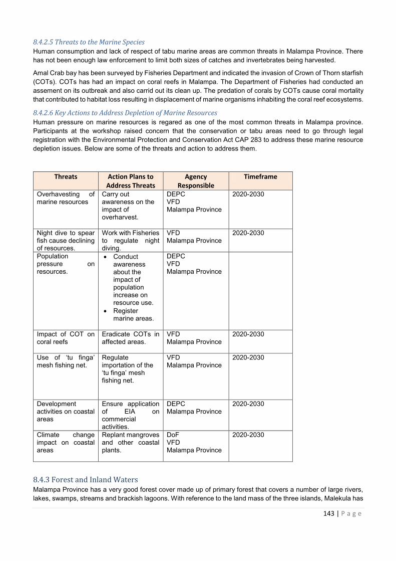
Proposed Marine Importance to
143 | P a g e
8.4.2.5 Threats to the Marine Species
Human consumption and lack of respect of tabu marine areas are common threats in Malampa Province. There
has not been enough law enforcement to limit both sizes of catches and invertebrates being harvested.
Amal Crab bay has been surveyed by Fisheries Department and indicated the invasion of Crown of Thorn starfish
(COTs). COTs has had an impact on coral reefs in Malampa. The Department of Fisheries had conducted an
assement on its outbreak and also carrid out its clean up. The predation of corals by COTs cause coral mortality
that contributed to habitat loss resulting in displacement of marine organisms inhabiting the coral reef ecosystems.
8.4.2.6 Key Actions to Address Depletion of Marine Resources
Human pressure on marine resources is regared as one of the most common threats in Malampa province.
Participants at the workshop raised concern that the conservation or tabu areas need to go through legal
registration with the Environmental Protection and Conservation Act CAP 283 to address these marine resource
depletion issues. Below are some of the threats and action to address them.
Threats Action Plans to
Address Threats
Agency
Responsible
Timeframe
Overhavesting of marine resources
Carry out awareness on the impact of overharvest.
DEPC VFD Malampa Province
2020-2030
Night dive to spear fish cause declining of resources.
Work with Fisheries to regulate night diving.
VFD Malampa Province
2020-2030
Population pressure on resources.
· Conduct awareness about the impact of population increase on resource use.
· Register marine areas.
DEPC VFD Malampa Province
Impact of COT on coral reefs
Eradicate COTs in affected areas.
VFD Malampa Province
2020-2030
Use of ‘tu finga’ mesh fishing net.
Regulate importation of the ‘tu finga’ mesh fishing net.
VFD Malampa Province
2020-2030
Development activities on coastal areas
Ensure application of EIA on commercial activities.
DEPC Malampa Province
2020-2030
Climate change impact on coastal areas
Replant mangroves and other coastal plants.
DoF VFD Malampa Province
2020-2030
8.4.3 Forest and Inland Waters
Malampa Province has a very good forest cover made up of primary forest that covers a number of large rivers,
lakes, swamps, streams and brackish lagoons. With reference to the land mass of the three islands, Malekula has
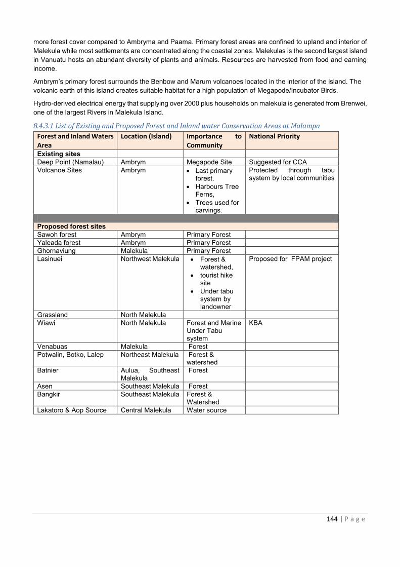
144 | P a g e
more forest cover compared to Ambryma and Paama. Primary forest areas are confined to upland and interior of
Malekula while most settlements are concentrated along the coastal zones. Malekulas is the second largest island
in Vanuatu hosts an abundant diversity of plants and animals. Resources are harvested from food and earning
income.
Ambrym’s primary forest surrounds the Benbow and Marum volcanoes located in the interior of the island. The
volcanic earth of this island creates suitable habitat for a high population of Megapode/Incubator Birds.
Hydro-derived electrical energy that supplying over 2000 plus households on malekula is generated from Brenwei,
one of the largest Rivers in Malekula Island.
8.4.3.1 List of Existing and Proposed Forest and Inland water Conservation Areas at Malampa
Forest and Inland Waters
Area
Location (Island) Importance to
Community
National Priority
Existing sites Deep Point (Namalau) Ambrym Megapode Site Suggested for CCA Volcanoe Sites Ambrym · Last primary
forest. · Harbours Tree
Ferns, · Trees used for
carvings.
Protected through tabu system by local communities
Proposed forest sites
Sawoh forest Ambrym Primary Forest Yaleada forest Ambrym Primary Forest Ghornaviung Malekula Primary Forest Lasinuei Northwest Malekula
· Forest &
watershed, · tourist hike
site · Under tabu
system by landowner
Proposed for FPAM project
Grassland North Malekula Wiawi North Malekula Forest and Marine
Under Tabu system
KBA
Venabuas Malekula Forest Potwalin, Botko, Lalep Northeast Malekula Forest &
watershed
Batnier Aulua, Southeast Malekula
Forest
Asen Southeast Malekula Forest Bangkir Southeast Malekula Forest &
Watershed
Lakatoro & Aop Source Central Malekula Water source
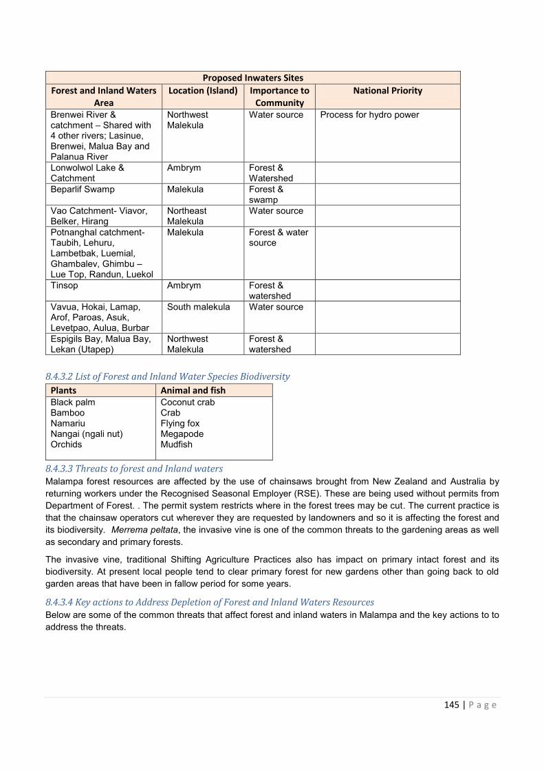
aters Importance to
Protected through tabu
Northwest Malekula Proposed for FPAM project
orest and Marine
Northeast Malekula
Aulua, Southeast
Southeast Malekula Southeast Malekula
145 | P a g e
8.4.3.2 List of Forest and Inland Water Species Biodiversity
Plants Animal and fish
Black palm Bamboo Namariu Nangai (ngali nut) Orchids
Coconut crab Crab Flying fox Megapode Mudfish
8.4.3.3 Threats to forest and Inland waters
Malampa forest resources are affected by the use of chainsaws brought from New Zealand and Australia by
returning workers under the Recognised Seasonal Employer (RSE). These are being used without permits from
Department of Forest. . The permit system restricts where in the forest trees may be cut. The current practice is
that the chainsaw operators cut wherever they are requested by landowners and so it is affecting the forest and
its biodiversity. Merrema peltata, the invasive vine is one of the common threats to the gardening areas as well
as secondary and primary forests.
The invasive vine, traditional Shifting Agriculture Practices also has impact on primary intact forest and its
biodiversity. At present local people tend to clear primary forest for new gardens other than going back to old
garden areas that have been in fallow period for some years.
8.4.3.4 Key actions to Address Depletion of Forest and Inland Waters Resources
Below are some of the common threats that affect forest and inland waters in Malampa and the key actions to to
address the threats.
Proposed Inwaters Sites
Forest and Inland Waters
Area
Location (Island) Importance to
Community
National Priority
Brenwei River & catchment – Shared with 4 other rivers; Lasinue, Brenwei, Malua Bay and Palanua River
Northwest Malekula
Water source Process for hydro power
Lonwolwol Lake & Catchment
Ambrym Forest & Watershed
Beparlif Swamp Malekula Forest & swamp
Vao Catchment- Viavor, Belker, Hirang
Northeast Malekula
Water source
Potnanghal catchment- Taubih, Lehuru, Lambetbak, Luemial, Ghambalev, Ghimbu – Lue Top, Randun, Luekol
Malekula Forest & water source
Tinsop Ambrym Forest & watershed
Vavua, Hokai, Lamap, Arof, Paroas, Asuk, Levetpao, Aulua, Burbar
South malekula Water source
Espigils Bay, Malua Bay, Lekan (Utapep)
Northwest Malekula
Forest & watershed
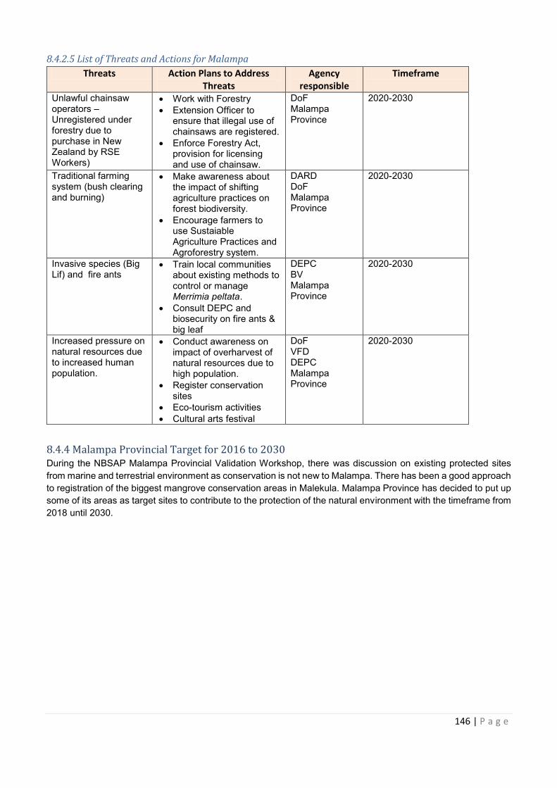
146 | P a g e
8.4.2.5 List of Threats and Actions for Malampa
Threats Action Plans to Address
Threats
Agency
responsible
Timeframe
Unlawful chainsaw operators – Unregistered under forestry due to purchase in New Zealand by RSE Workers)
· Work with Forestry · Extension Officer to
ensure that illegal use of chainsaws are registered.
· Enforce Forestry Act, provision for licensing and use of chainsaw.
DoF Malampa Province
2020-2030
Traditional farming system (bush clearing and burning)
· Make awareness about the impact of shifting agriculture practices on forest biodiversity.
· Encourage farmers to use Sustaiable Agriculture Practices and Agroforestry system.
DARD DoF Malampa Province
2020-2030
Invasive species (Big Lif) and fire ants
· Train local communities about existing methods to control or manage Merrimia peltata.
· Consult DEPC and biosecurity on fire ants & big leaf
DEPC BV Malampa Province
2020-2030
Increased pressure on natural resources due to increased human population.
· Conduct awareness on impact of overharvest of natural resources due to high population.
· Register conservation sites
· Eco-tourism activities · Cultural arts festival
DoF VFD DEPC Malampa Province
2020-2030
8.4.4 Malampa Provincial Target for 2016 to 2030
During the NBSAP Malampa Provincial Validation Workshop, there was discussion on existing protected sites
from marine and terrestrial environment as conservation is not new to Malampa. There has been a good approach
to registration of the biggest mangrove conservation areas in Malekula. Malampa Province has decided to put up
some of its areas as target sites to contribute to the protection of the natural environment with the timeframe from
2018 until 2030.
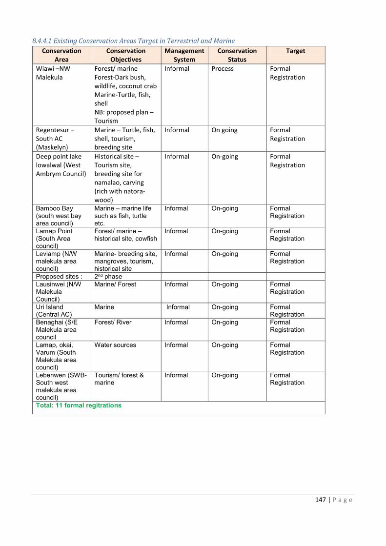
Make awareness about
cies (Big Train local communities
Increased pressure on Conduct awareness on
147 | P a g e
8.4.4.1 Existing Conservation Areas Target in Terrestrial and Marine
Conservation
Area
Conservation
Objectives
Management
System
Conservation
Status
Target
Wiawi –NW
Malekula
Forest/ marine
Forest-Dark bush,
wildlife, coconut crab
Marine-Turtle, fish,
shell
NB: proposed plan –
Tourism
Informal Process Formal
Registration
Regentesur –
South AC
(Maskelyn)
Marine – Turtle, fish,
shell, tourism,
breeding site
Informal On going Formal
Registration
Deep point lake
lowalwal (West
Ambrym Council)
Historical site –
Tourism site,
breeding site for
namalao, carving
(rich with natora-
wood)
Informal On-going Formal
Registration
Bamboo Bay (south west bay area council)
Marine – marine life such as fish, turtle etc.
Informal On-going Formal Registration
Lamap Point (South Area council)
Forest/ marine – historical site, cowfish
Informal On-going Formal Registration
Leviamp (N/W malekula area council)
Marine- breeding site, mangroves, tourism, historical site
Informal On-going Formal Registration
Proposed sites : 2nd phase Lausinwei (N/W Malekula Council)
Marine/ Forest Informal On-going Formal Registration
Uri Island (Central AC)
Marine Informal On-going Formal Registration
Benaghai (S/E Malekula area council
Forest/ River Informal On-going Formal Registration
Lamap, okai, Varum (South Malekula area council)
Water sources Informal On-going Formal Registration
Lebenwen (SWB- South west malekula area council)
Tourism/ forest & marine
Informal On-going Formal Registration
Total: 11 formal regitrations
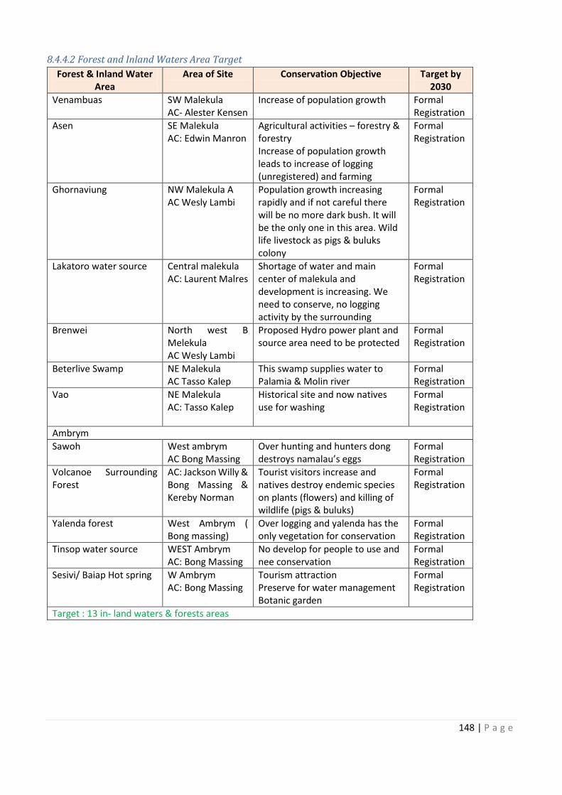
148 | P a g e
8.4.4.2 Forest and Inland Waters Area Target
Forest & Inland Water
Area
Area of Site Conservation Objective Target by
2030
Venambuas SW Malekula
AC- Alester Kensen
Increase of population growth Formal
Registration
Asen SE Malekula
AC: Edwin Manron
Agricultural activities – forestry &
forestry
Increase of population growth
leads to increase of logging
(unregistered) and farming
Formal
Registration
Ghornaviung NW Malekula A
AC Wesly Lambi
Population growth increasing
rapidly and if not careful there
will be no more dark bush. It will
be the only one in this area. Wild
life livestock as pigs & buluks
colony
Formal
Registration
Lakatoro water source Central malekula
AC: Laurent Malres
Shortage of water and main
center of malekula and
development is increasing. We
need to conserve, no logging
activity by the surrounding
Formal
Registration
Brenwei North west B
Melekula
AC Wesly Lambi
Proposed Hydro power plant and
source area need to be protected
Formal
Registration
Beterlive Swamp NE Malekula
AC Tasso Kalep
This swamp supplies water to
Palamia & Molin river
Formal
Registration
Vao NE Malekula
AC: Tasso Kalep
Historical site and now natives
use for washing
Formal
Registration
Ambrym
Sawoh West ambrym
AC Bong Massing
Over hunting and hunters dong
destroys namalau’s eggs
Formal
Registration
Volcanoe Surrounding
Forest
AC: Jackson Willy &
Bong Massing &
Kereby Norman
Tourist visitors increase and
natives destroy endemic species
on plants (flowers) and killing of
wildlife (pigs & buluks)
Formal
Registration
Yalenda forest West Ambrym (
Bong massing)
Over logging and yalenda has the
only vegetation for conservation
Formal
Registration
Tinsop water source WEST Ambrym
AC: Bong Massing
No develop for people to use and
nee conservation
Formal
Registration
Sesivi/ Baiap Hot spring W Ambrym
AC: Bong Massing
Tourism attraction
Preserve for water management
Botanic garden
Formal
Registration
Target : 13 in- land waters & forests areas
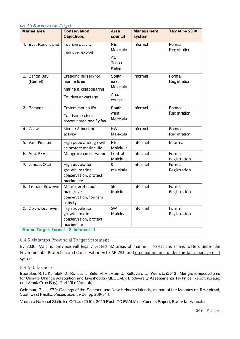
Forest & Inland Water Target by
forestry &
North west B Proposed Hydro power plant and
Volcanoe Surrounding AC: Jackson Willy &
West Ambrym ( Over logging and yalenda has the
nd
149 | P a g e
8.4.4.3 Marine Areas Target
Marine area Conservation
Objectives
Area
council
Management
system
Target by 2030
1. East Rano island Tourism activity
Fish over exploit
NE
Malekula
AC:
Tasso
Kalep
Informal Formal
Registration
2. Banon Bay
(Remef)
Breeding nursery for
marine lives
Marine is disappearing
Tourism advantage
South
east
Malekula
Area
council
Informal Formal
Registration
3. Batbang Protect marine life
Tourism, protect
coconut crab and fly fox
South
west
Malekula
Informal Formal
Registration
4. Wiawi Marine & tourism
activity
NW
Malekula
Informal Formal
Registration
5. Vao, Pinalum High population growth
so protect marine life
NE
Malekula
Informal Informal
6. Aop, PRV Mangrove conservation Central
Malekula
Informal Formal
Registration
7. Lamap, Okai High population
growth, marine
conservation, protect
marine life
S
malekula
Informal Formal
Registration
8. Tisman, Rowevie Marine protection,
mangrove
conservation, tourism
activity
SE
Malekula
Informal Formal
Registration
9. Dixon, Lebinwen High population
growth, marine
conservation, protect
marine life
SW
Malekula
Informal Formal
Registration
Marine Target: Formal – 8, Informal - 1
8.4.5 Malampa Provincial Target Statement
By 2030, Malamp province will legally protect 32 areas of marine, forest and inland waters under the
Environmental Protection and Conservation Act CAP 283, and one marine area under the tabu management
system.
8.4.6 Reference
Baereleo, R.T., Kalfatak, D., Kanas, T., Bulu, M. H., Ham, J., Kaltavara, J., Yuen, L. (2013). Mangrove Ecosystems for Climate Change Adaptation and Livelihoods (MESCAL): Biodiversity Assessments Technical Report (Eratap and Amal/ Crab Bay). Port Vila: Vanuatu
Coleman, P. J. 1970: Geology of the Solomon and New Hebrides Islands, as part of the Melanesian Re-entrant, Southwest Pacific. Pacific science 24: pp 289-314.
Vanuatu National Statistics Office. (2016). 2016 Post- TC PAM Mini- Census Report, Port Vila, Vanuatu
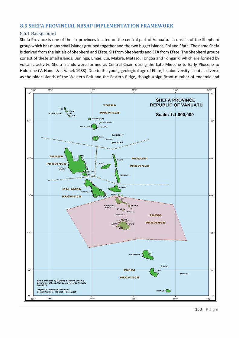
150 | P a g e
8.5 SHEFA PROVINCIAL NBSAP IMPLEMENTATION FRAMEWORK
8.5.1 Background
Shefa Province is one of the six provinces located on the central part of Vanuatu. It consists of the Shepherd
group which has many small islands grouped together and the two bigger islands, Epi and Efate. The name Shefa
is derived from the initials of Shepherd and Efate. SH from Shepherds and EFA from Efate. The Shepherd groups
consist of these small islands; Buninga, Emae, Epi, Makira, Mataso, Tongoa and Tongariki which are formed by
volcanic activity. Shefa Islands were formed as Central Chain during the Late Miocene to Early Pliocene to
Holocene (V. Hanus & J. Vanek 1983). Due to the young geological age of Efate, its biodiversity is not as diverse
as the older islands of the Western Belt and the Eastern Ridge, though a significant number of endemic and
151 | P a g e
restricted range species do exist. The Island contains a number of marine conservation areas which ranges from
the northern part of the island starting from Takara hot springs with mangrove ecosystems right through to
Lelepa Island on the northwest. (Kalfatak D., 2014. Unpublished).
8.5.1.1 Population & total land area
The total population of Shefa Province is 96,405 people which includes Epi and the Shepherd group and Efate
and the offshore islands. The total land area of all the Shefa province islands is 1,455 km2. The headquarters for
Shefa Province is in Port Vila, on Efate. Port Vila is the captal city of Vanuatu. Efate has an area of 899.5km2 and
a population in 2009 of 68,829, of which 44,040 lived in the national capital Port Vila.
8.5.1.2 Shefa Provincial Government
Shefa Provincial Government was set up through the Decentralization Act 1994 that allows the national
government to establish its extension services down to the Provincial level so to implement the National policies
and plans at the community level. . The Government of Vanuatu is centred on this island and it is the gate way
to the regional and international connections.
The Shefa Provincial Government is set up on Efate has extension services within the provincial centre to
safeguard the communities of Shefa Province. The Shefa President and Secretary General are the key people
that head the Shefa Provincial Administration. It has its council and Area Secretaries (Administrators).
The main discussion group for the Shefa Validation Workshop was made up of the Area Secretaries that came
from the Villages and nearby islands. The target areas in this provincial NBSAP implementation plan were
generated by this group.
8.5.1.3 Vision
Living in a green and sustainable environment for the survival of our unique environment and our future
generations.
8.5.1.4 Mission
To uphold the integrity of harmony and to respect our environment in sustaining, managing, owning and
preparing all for the benefit of Shefa Provincial Government Council and its good citizens.
8.5.2 Marine
Marine protected area are not a new approach for the Shefa Province, though there are no conservation areas
that are currently registered under the Environment act, some are soon to be, and many of them mostly have
been initiated from the community level.well known marine reserves like Hideaway island marine sanctuary
With Efate having the Capital city of Port Vila, Efate and to a lesser extent somewhat , other islands have had
the added benefit of being exposed directly by government services, NGO and foreign aid influence. Thus Efate
specifically has the longest history of marine conservation efforts and initiatives, (one such being the Nguna Pele
marine protected area Network,the oldest in Vanuatu) in collaboration between communities, government and
non-government stakeholders,wih some critics arguing that too much effort has been focused on Efate and
shefa at the expense of other provinces, In any case Shefa province hosts a great number of marine ecosystems
consisting of mangroves estuarine swamplands, extensive seagrass beds and meadows
, lagoons, mud flats and most commonly a multitude array of coral reef ypes and systems (fringing, barrier, and
atoll) with stretches of white and black sandy beaches. Offshore having areas of good pelagic and benthic
fisheries such as tuna, marlin, poulet, snapper, proximity to trench, canyons, and seamounts.
152 | P a g e
8.5.2.1 List of Existing and Proposed Conservation Areas at Shefa Province
Existing Marine Areas Location (Island) Importance to Community National Priority
Marae Emae Protection on fishing grounds MPA/ SUMA Site
Makatea Emae Protection on fishing grounds SUMA Site
Tongomea Emae Protection on fishing grounds
Vaitini Emae Protection on fishing grounds SUMA Site
Epau Efate Protection on fishing grounds SUMA Site
Takara Efate Protection on fishing grounds
Siviri Efate Protection on fishing grounds SUMA Site
Emau Efate Protection on fishing grounds SUMA Site
Nguna/Pele Efate Protection on fishing grounds MPA Network/ SUMA
Site
Moso Efate Protection on fishing grounds SUMA Site
Lelepa Efate Protection on fishing grounds
Emau - Marou Efate Protection on fishing grounds SUMA Site
Pangnangisu Efate Protection on fishing grounds
Ngala East Epi Protection of beaches for
turtles nesting
Nuvi East Epi Protection on marines
resources and long sandy
beach
SUMA Site
Nigaura East Epi Protection on marines
resources
Moriu East Epi Protection on marines
resources and long beach
SUMA Site
Paya East Epi Protection on marines
resources
Laman Bay West Epi Protection on dugon and
turtles, good fishing ground
SUMA Site
Laman Island West Epi Protection on marines
resources
Yopuna West Epi Protection on marines
resources
Ruo West Epi Protection on marines
resources
Mavelau North Epi Protection on marines
resources long sandy beach
SUMA Site
Votlo North Epi Protection on marines
resources and good anchorage
SUMA Site
Red Stone South Epi Protection on marines
resources
Proposed Marine areas
Cooks Reef Emae Protection to control fishing
activities
MPA/ SUMA Site
Mataso Monument rock Mataso Protection to prevent illegal
fishing and preserve historical
site
MPA Network/ SUMA
Protection of beaches for
Protection to control fishing
prevent illegal
153 | P a g e
Existing Marine Areas Location (Island) Importance to Community National Priority
Tongoa/ Shepherds Tongoa To sustain marine resource for
future use
Tongoa Wall Tongoa Protection on its marine
resources and tourist site
Mere sauwia Efate To protect seamounts Marine Mammal
Sanctuary
Eratap & Erakor Mangrove
Conservation
Efate Mangrove protection SUMA Site
Mele, Ifira, Pango Efate Protect marine resources LELEMA MPA
Eton Efate Protect marine resources,
Tourist sites, recreational site
SUMA Site
Pangpang Efate Protect marine resources
Epule Efate Protect marine resources
Mangaliliu Efate Protect marine resources
Tanoliu Efate Protect marine resources
Siviri Efate Protect marine resources SUMA Site
Ngala, Nuvi, Nikaura, Paia,
Lemaru, Laman Island,
Ruwo, Wampi
Epi Protection of turtle nestling
beaches, leatherback turtle
8.5.2.2 Marine Species Biodiversity
Like all the other islands of Vanuatu, Shefa Province has similar marine biodiversity and marine ecosystems with
plentiful marine resources and some good fishing grounds, including Cook Reef on Emae Island.Shefa marine
environment comprising coastal lagoons (mangroves) and estuaries with seagrass, hosting shellfish, crab, fishes
and grazers, marine mammals/reptiles and seabirds, beaches identified as nesting ground for turtles.(Epi being
one of only few nesting beaches for endangered Leatherback turtles). Particular lagoons and mangrove areas
identified on Efate were; Eratap mangroves and lagoons, Erakor 1st and 2nd Lagoon, Undine Bay, Moso,
Paunganisu and areas of North Efate that have mangroves. Also mangrove stands found on Epi and Emae,
Massive corals on the seaward side, good coral reefs, parrotfishes, unicornfishes, “strong skin fish” (sand paper
fish), squid, green snail, Trochus, natural barrier to fishing activities on exposed (windward) side. Shepherd
Islands: Strong tides from southeast trade winds, tuna and poulet fishing around the area (eg. Monument rock
mataso). Seaward/ windward differs from the leeward side; this applies to all islands in this central group. On
Efate on the leeward side (from the south to the west), the majority of lagoons, bays, inslets and islands can be
found, with barrier and fringing reefs. These physical feature attributes extend to some extent to the other
islands located in the central region. Similar biophysical characteristics apply to Epi (MACBIO VU Bioreions report
2018). One of the biggest marine conservation area in Shefa is the Nguna-Pele MPA. It was set up by the two
islands and helped in reducing pressure of overharvesting. It is currently managed through traditional resource
management system.
Listed below are some of the marine species and ecosystems that were listed as being important to the people
of Shefa Province.
154 | P a g e
8.5.2.3 List of important Marine Species in Shefa
Fish Invertebrates Mammals/ Birds Marine
Ecosytems
Colourful reef fish
Fishes
Snapper
Turtle
Giant Squid
Green snail
Giant clam shell
Nautilus
Sea Cucumber
Shellfish
Trochus
Dugong
Sea birds
Coral Reefs
Mangrove
Mud flats
Swamps
Sea grass bed
8.5.2.4 Threats to the Marine Species
Shefa Validation workshop participants stated that the most common threat to marine species is human
pressure due to increase of population as a result of influx of islanders seeking to earn a living in Port Vila.
Surrounding villages on Efate also regularly fished and sell their catch at the Port Vila green market outlets and
restaurants. Fish catch on Cook’s Reef on Emae Island and some Shepherd Islands are also sold in Port Vila.
Crown of Thorns (COT) is a threat to coral on Efate. An outbreak in 2015 on Efate’s offshore island of Emau was
cleaned up the Department of Fisheries using its new invented lime juice injection method. An awareness
activity also took place to help the local communities to understand the biology, impact of the COTs on coral
reefs and right method to use to eradicate the COTs.
8.5.2.3 Key Actions to Address Decrease of Marine Resources
Threats Actions Plans to Address Therats Agency
Responsible
Timeframe
Population rapid growth
cause harvest pressure on
resources-
Over harvest/ overfishing
Council of chiefs to produce management
plan according to custom/ traditional ways
Awareness
DEPC
Village or
Community
Chiefs
Shefa Province
2020
Undersize harvest Fisheries to regulate and make awareness VFD
Shefa Province
2020
Crown of thorns Eradication and management plan VFD
Shefa Province
2020
Coastal erosion Replanting of mangrove VFD
DoF
Shefa Province
2020
Sand mining & coral mining Stop sand extraction DEPC
VFD
Shefa Province
2020
Urban Drift, Luck of Respect Put up management plan to apply to
everybody even the man-come
Cooperation with SPGC, environment
department to make management plans,
Informal management is highly encouraged.
Chiefs
Shefa Province
2020
Timeframe
155 | P a g e
Threats Actions Plans to Address Therats Agency
Responsible
Timeframe
· No Proper Monitoring
· Luck of Funds
Register sites to allow proper monitoring DEPC
Shefa Province
2020
· Pouching
· Man Come
Proper agreement between chiefs to make
management plans
Chiefs
Shefa Province
2020
Mangrove clearing Eratap, Erakor to work together with SPGC
Environment for a Mangrove management
plan
Chiefs
VFD
Shefa Province
2020
8.5.3 Forest and Inland Waters
The main forest cover for Shefa Province exist in the bigger islands, Efate and Epi. The main primary forest on
Efate is the Efate Land Management Area (ELMA). It is in the centre of Efate and is in the process of being legally
registered as a CCA. The forests on Efate and Epi and some of the small islands cover critical water
sources/watersheds/water catchment areas. The Water source for Port Vila town comes from the Tagabe River
Catchment area. International Waters (IW) Ridge to Reef (R2R) project is working with relevant government,
private and communities surrounding the Tagabe Catchment to protect this water source.
Some of the Forest and Inland waters areas are listed below for protection.
8.5.3.1 List of Existing and proposed Forest and Inland Water Conservation Areas for Shefa Province
Forest & inland Water Existing
Areas
Location
(Island)
Importance to Community National Priority
Lokorui East Epi Protect Forest and water source
Wampi North Epi Protection of Megapod
Vilakara South Epi Protect forest & water source
Proposed forest and inland waters ELMA Central Efate Protection of remaining dark
forest for Efate Island
GEF 5 Project Site
Mangaliliu Northwest Efate Protect forest
Meten Hill Northwest Efate Protect Forest and water source
Epau & Pangpang East Efate Protect Forest and water source
Epule North Efate Protect Forest and water source
Siviri North Efate Protect Forest and water source
Takara North Efate Protect Forest and water source
Paunangisu North Efate Protect Forest and water source
Mele Efate Protect Forest and water source
Melemat Efate Protect Forest and water source
Erakor Efate Protect water source and marine
Eton Efate Protect Forest and water source
Marou – Emau Efate Protection of forest
Mapua – Emau Efate Protection of Forest
Ngurua Efate Protection of Forest
Ifira Island Efate Forest & Bird Protection
Tasariki, Moso Efate Protection of Forest
Sunai, Moso Efate Protection of Forest
Natapau, Lelepa Efate Protection of Forest
Nikaura East Epi Protect Forest and water source
Ngala East Epi Protect Forest and water source
Nuvi East Epi Protect Forest and water source
Lokopui East Epi Protect Forest and water source
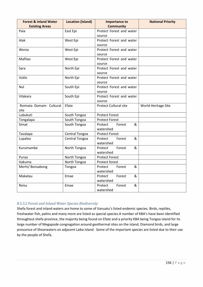
156 | P a g e
Forest & inland Water
Existing Areas
Location (Island) Importance to
Community
National Priority
Paia East Epi Protect Forest and water
source
Alak West Epi Protect Forest and water
source
Wenia West Epi Protect Forest and water
source
Mafilao West Epi Protect Forest and water
source
Sara North Epi Protect Forest and water
source
Votlo North Epi Protect Forest and water
source
Nul South Epi Protect Forest and water
source
Vilakara South Epi Protect Forest and water
source
Roimata Domain- Cultural
site
Efate Protect Cultural site World Heritage Site
Lubukuti South Tongoa Protect Forest
Tongalapa South Tongoa Protect Forest
Simat South Tongoa Protect Forest &
watershed
Tavalapa Central Tongoa Protect Forest
Lupalea Central Tongoa Protect Forest &
watershed
Kurumambe North Tongoa Protect Forest &
watershed
Purao North Tongoa Protect Forest
Itakuma North Tongoa Protect forest
Merhi/ Bonsabong Tongoa Protect Forest &
watershed
Makatau Emae Protect Forest &
watershed
Reisu Emae Protect Forest &
watershed
8.5.3.2 Forest and Inland Water Species Biodiversity
Shefa forest and inland waters are home to some of Vanuatu’s listed endemic species. Birds, reptiles,
freshwater fish, palms and many more are listed as special species.A number of KBA’s have been identified
throughout shefa province, the majority being found on Efate and a priority KBA being Tongoa island for its
large number of Megapode congregation around geothermal sites on the island, Diamond birds, and large
prescence of Shearwaters on adjacent Laika Island Some of the important species are listed due to their use
by the people of Shefa.
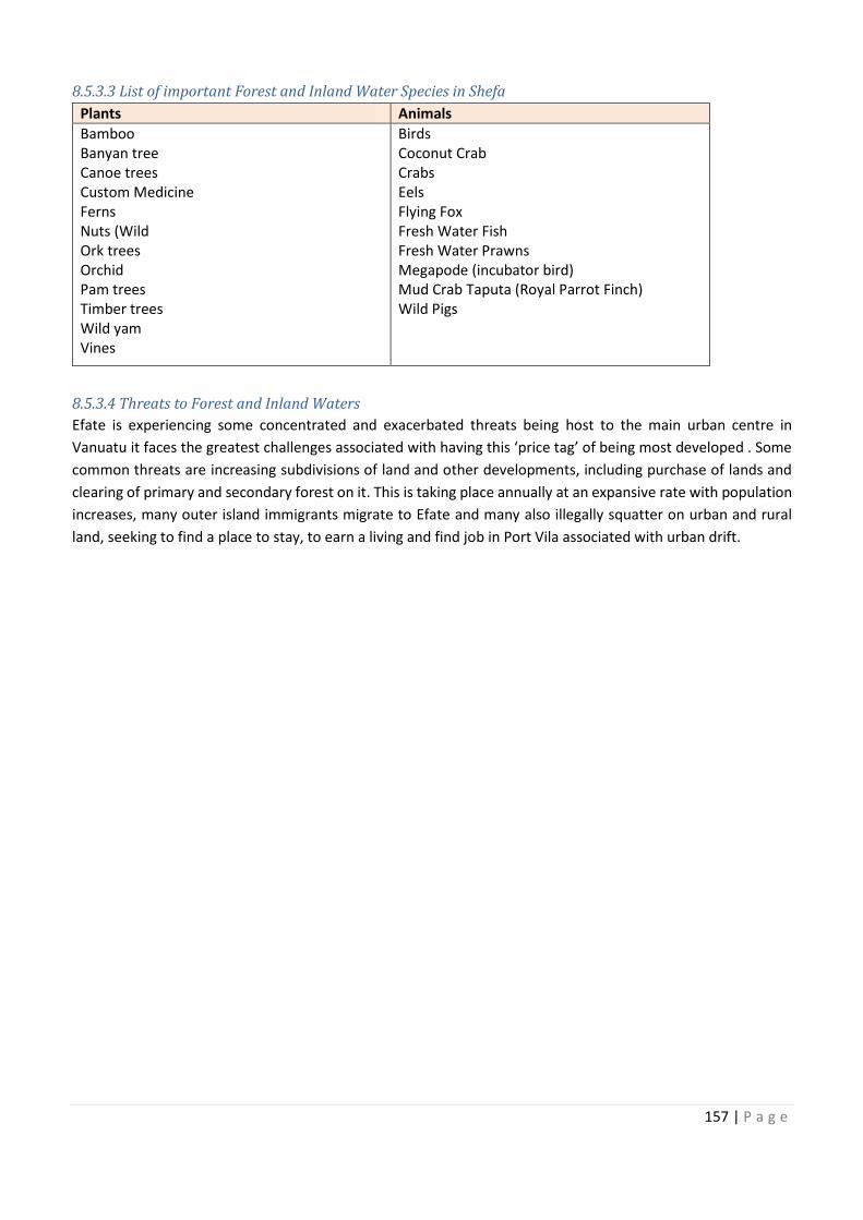
Location (Island)
Protect Forest and water
Protect Forest and water
Protect Forest and water
Protect Forest and water
Protect Forest and water
Protect Forest and water
Protect Forest and water
Protect Forest and water
Cultural
Protect Forest &
Protect Forest &
Protect Forest &
Protect Forest &
Protect Forest &
Protect Forest &
157 | P a g e
8.5.3.3 List of important Forest and Inland Water Species in Shefa
Plants Animals
Bamboo
Banyan tree
Canoe trees
Custom Medicine
Ferns
Nuts (Wild
Ork trees
Orchid
Pam trees
Timber trees
Wild yam
Vines
Birds
Coconut Crab
Crabs
Eels
Flying Fox
Fresh Water Fish
Fresh Water Prawns
Megapode (incubator bird)
Mud Crab Taputa (Royal Parrot Finch)
Wild Pigs
8.5.3.4 Threats to Forest and Inland Waters
Efate is experiencing some concentrated and exacerbated threats being host to the main urban centre in
Vanuatu it faces the greatest challenges associated with having this ‘price tag’ of being most developed . Some
common threats are increasing subdivisions of land and other developments, including purchase of lands and
clearing of primary and secondary forest on it. This is taking place annually at an expansive rate with population
increases, many outer island immigrants migrate to Efate and many also illegally squatter on urban and rural
land, seeking to find a place to stay, to earn a living and find job in Port Vila associated with urban drift.
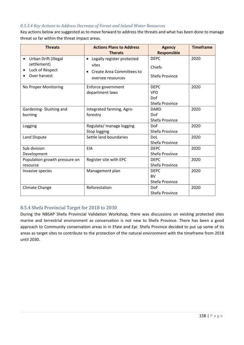
158 | P a g e
8.5.3.4 Key Actions to Address Decrease of Forest and Inland Water Resources
Key actions below are suggested as to move forward to address the threats and what has been done to manage
threat so far within the threat impact areas.
Threats Actions Plans to Address
Therats
Agency
Responsible
Timeframe
· Urban Drift (Illegal
settlement)
· Luck of Respect
· Over harvest
· Legally register protected
sites
· Create Area Committees to
oversee resources
DEPC
Chiefs
Shefa Province
2020
No Proper Monitoring Enforce government
department laws
DEPC
VFD
Dof
Shefa Province
2020
Gardening- Slushing and
burning
Integrated farming, Agro-
forestry
DARD
DoF
Shefa Province
2020
Logging
Regulate/ manage logging
Stop logging
DoF
Shefa Province
2020
Land Dispute Settle land boundaries DoL
Shefa Province
2020
Sub division
Development
EIA DEPC
Shefa Province
2020
Population growth pressure on
resource
Register site with EPC DEPC
Shefa Province
2020
Invasive species Management plan DEPC
BV
Shefa Province
2020
Climate Change Reforestation DoF
Shefa Province
2020
8.5.4 Shefa Provincial Target for 2018 to 2030
During the NBSAP Shefa Provincial Validation Workshop, there was discussions on existing protected sites
marine and terrestrial environment as conservation is not new to Shefa Province. There has been a good
approach to Community conservation areas in in Efate and Epi. Shefa Province decided to put up some of its
areas as target sites to contribute to the protection of the natural environment with the timeframe from 2018
until 2030.
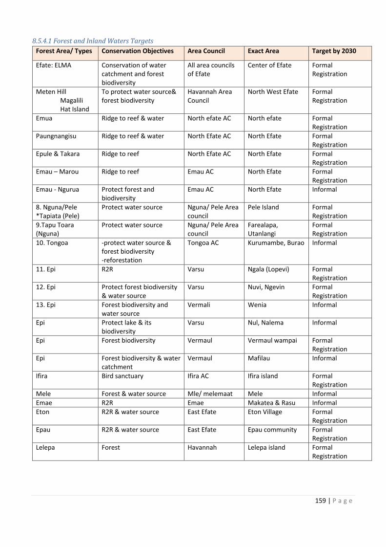
Timeframe
Population growth pressure on
159 | P a g e
8.5.4.1 Forest and Inland Waters Targets
Forest Area/ Types Conservation Objectives Area Council Exact Area Target by 2030
Efate: ELMA
Conservation of water
catchment and forest
biodiversity
All area councils
of Efate
Center of Efate Formal
Registration
Meten Hill
Magalili
Hat Island
To protect water source&
forest biodiversity
Havannah Area
Council
North West Efate Formal
Registration
Emua Ridge to reef & water North efate AC North efate Formal
Registration
Paungnangisu Ridge to reef & water North Efate AC North Efate Formal
Registration
Epule & Takara Ridge to reef North Efate AC North Efate Formal
Registration
Emau – Marou Ridge to reef Emau AC North Efate Formal
Registration
Emau - Ngurua Protect forest and
biodiversity
Emau AC North Efate Informal
8. Nguna/Pele
*Tapiata (Pele)
Protect water source Nguna/ Pele Area
council
Pele Island Formal
Registration
9.Tapu Toara
(Nguna)
Protect water source Nguna/ Pele Area
council
Farealapa,
Utanlangi
Formal
Registration
10. Tongoa -protect water source &
forest biodiversity
-reforestation
Tongoa AC Kurumambe, Burao Informal
11. Epi R2R Varsu Ngala (Lopevi) Formal
Registration
12. Epi Protect forest biodiversity
& water source
Varsu Nuvi, Ngevin Formal
Registration
13. Epi Forest biodiversity and
water source
Vermali Wenia Informal
Epi Protect lake & its
biodiversity
Varsu Nul, Nalema Informal
Epi Forest biodiversity Vermaul Vermaul wampai Formal
Registration
Epi Forest biodiversity & water
catchment
Vermaul Mafilau Informal
Ifira Bird sanctuary Ifira AC Ifira island Formal
Registration
Mele Forest & water source Mle/ melemaat Mele Informal
Emae R2R Emae Makatea & Rasu Informal
Eton R2R & water source East Efate Eton Village Formal
Registration
Epau R2R & water source East Efate Epau community Formal
Registration
Lelepa Forest Havannah Lelepa island Formal
Registration
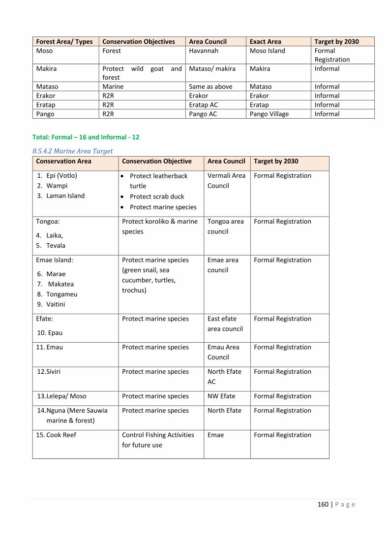
160 | P a g e
Forest Area/ Types Conservation Objectives Area Council Exact Area Target by 2030
Moso Forest Havannah Moso Island Formal
Registration
Makira Protect wild goat and
forest
Mataso/ makira Makira Informal
Mataso Marine Same as above Mataso Informal
Erakor R2R Erakor Erakor Informal
Eratap R2R Eratap AC Eratap Informal
Pango R2R Pango AC Pango Village Informal
Total: Formal – 16 and Informal - 12
8.5.4.2 Marine Area Target
Conservation Area Conservation Objective Area Council Target by 2030
1. Epi (Votlo)
2. Wampi
3. Laman Island
· Protect leatherback
turtle
· Protect scrab duck
· Protect marine species
Vermali Area
Council
Formal Registration
Tongoa:
4. Laika,
5. Tevala
Protect koroliko & marine
species
Tongoa area
council
Formal Registration
Emae Island:
6. Marae
7. Makatea
8. Tongameu
9. Vaitini
Protect marine species
(green snail, sea
cucumber, turtles,
trochus)
Emae area
council
Formal Registration
Efate:
10. Epau
Protect marine species East efate
area council
Formal Registration
11. Emau Protect marine species Emau Area
Council
Formal Registration
12. Siviri Protect marine species North Efate
AC
Formal Registration
13. Lelepa/ Moso Protect marine species NW Efate Formal Registration
14. Nguna (Mere Sauwia
marine & forest)
Protect marine species North Efate Formal Registration
15. Cook Reef Control Fishing Activities
for future use
Emae Formal Registration
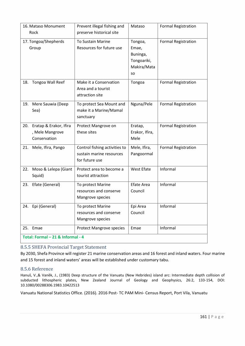
ypes
Protect wild goat and
Area Council
Vermali Area
Protect koroliko & marine Tongoa area
orth Efate
161 | P a g e
16. Mataso Monument
Rock
Prevent illegal fishing and
preserve historical site
Mataso Formal Registration
17. Tongoa/Shepherds
Group
To Sustain Marine
Resources for future use
Tongoa,
Emae,
Buninga,
Tongoariki,
Makira/Mata
so
Formal Registration
18. Tongoa Wall Reef Make it a Conservation
Area and a tourist
attraction site
Tongoa Formal Registration
19. Mere Sauwia (Deep
Sea)
To protect Sea Mount and
make it a Marine/Mamal
sanctuary
Nguna/Pele Formal Registration
20. Eratap & Erakor, Ifira
, Mele Mangrove
Conservation
Protect Mangrove on
these sites
Eratap,
Erakor, Ifira,
Mele
Formal Registration
21. Mele, Ifira, Pango Control fishing activities to
sustain marine resources
for future use
Mele, Ifira,
Pangoormal
Formal Registration
22. Moso & Lelepa (Giant
Squid)
Protect area to become a
tourist attraction
West Efate Informal
23. Efate (General) To protect Marine
resources and conserve
Mangrove species
Efate Area
Council
Informal
24. Epi (General) To protect Marine
resources and conserve
Mangrove species
Epi Area
Council
Informal
25. Emae Protect Mangrove species Emae Informal
Total: Formal – 21 & Informal - 4
8.5.5 SHEFA Provincial Target Statement
By 2030, Shefa Province will register 21 marine conservation areas and 16 forest and inland waters. Four marine
and 15 forest and inland waters’ areas will be established under customary tabu.
8.5.6 Reference
Hanuš, V.,& Vaněk, J., (1983) Deep structure of the Vanuatu (New Hebrides) island arc: Intermediate depth collision of
subducted lithospheric plates, New Zealand Journal of Geology and Geophysics, 26:2, 133-154, DOI:
10.1080/00288306.1983.10422513
Vanuatu National Statistics Office. (2016). 2016 Post- TC PAM Mini- Census Report, Port Vila, Vanuatu
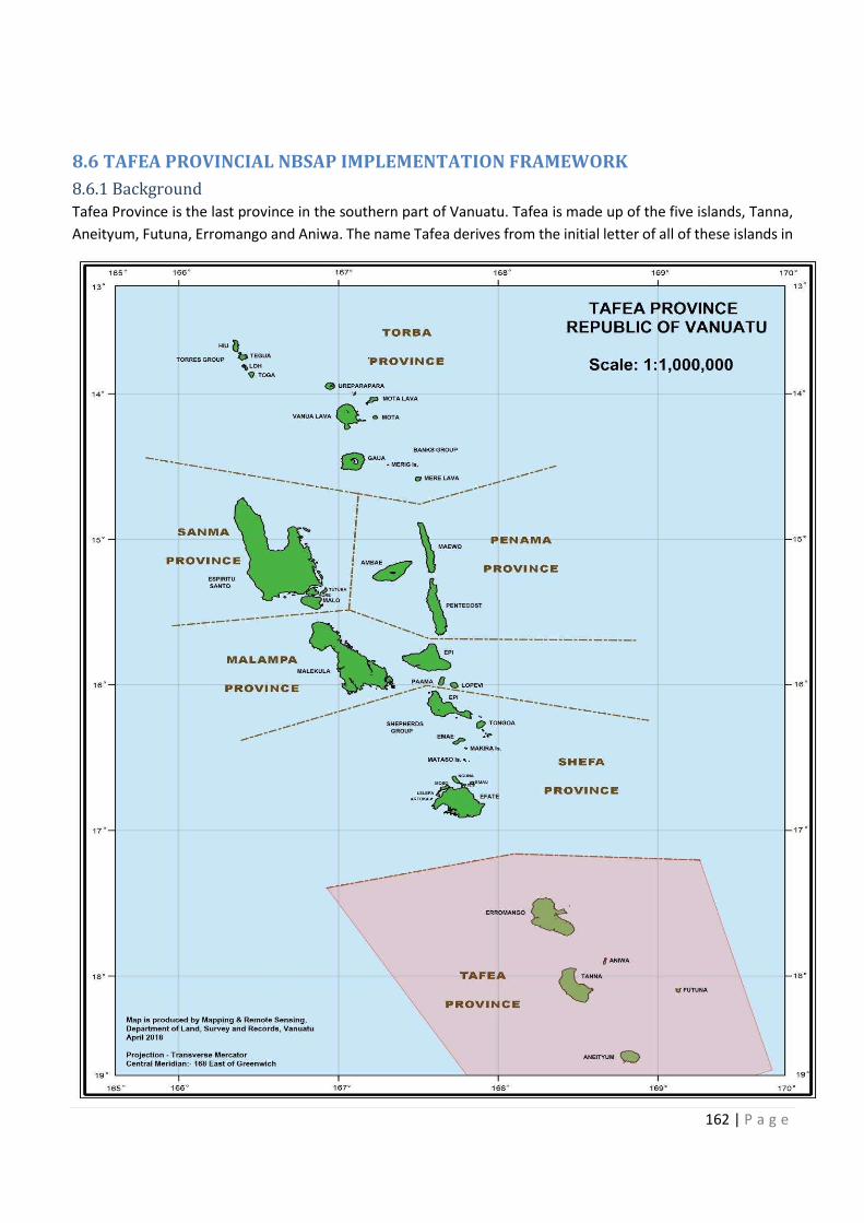
162 | P a g e
8.6 TAFEA PROVINCIAL NBSAP IMPLEMENTATION FRAMEWORK
8.6.1 Background
Tafea Province is the last province in the southern part of Vanuatu. Tafea is made up of the five islands, Tanna,
Aneityum, Futuna, Erromango and Aniwa. The name Tafea derives from the initial letter of all of these islands in
163 | P a g e
Tafea. The islands of Tafea were geologically formed during the formation of the Central Chain during the Late
Miocene to Early Pliocene to Holocene (V. Hanus & J. Vanek 1983).
8.6.1.1 Population & total land area
The total population of Tafea Province is 36,799 people. The province has a total land area of 1,627 km2. Tanna
Island has a mini township of Lenakel infamously known throughout Vanuatu as “Black Man town” where the
headquarters of the province is situated. The island of Tanna is one of the most fertile islands in Vanuatu and
produces kava, coffee, coconut, copra, and other fruits and vegetables from the rich volcanic soils. Recently,
tourism has become the main important economic industry on tanna, as tourists flock to visit one of the world’s
most accessible active volcano; Mt Yasur Volvano on Tanna and also the rich tannese traditional culture.
Aneityum is the southernmost inhabited island of Vanuatu in this province. The island is roughly circular, with
an area of 159.2 km2; its highest point is Mount Inrerow Atamein, with a height of 852m. The larger of its two
villages is Anelghowhat, on the south side. The adjacent offshore island to Anelghowhat village is Mystery Island,
surrounded by its crystal clear waters and healthy coral reefs. The stretch of coral reefs from southeast to west
and northwest is designated as a Marine Protected Area managed through traditional resource management
system. Cruise ships routinely visit Mystery Island every year, by which Aneityum people earn income through
eco-tours, the sale of artifacts and display of cultural activities. Erromango is the most sparsely populated island
in Vanuatu. It is famous for its tracts of huge and toweringKauri trees, Agathis macrophylla. The island
environment is still intact with abundant resources from both marine and terrestrial ecosystems. Futuna is a
raised rock island, land size is smaller to the aforementioned three islands. It is famous for its traditional fishing
practice of night fishig for the species of large pelagic ocean going flying fish. Aniwa Island is smaller than all the
other four islands of Tafea province. It has a very healthy mangrove lagoon and it is famous of its very sweet
native oranges.
8.6.1.2 Tafea Provincial Government
Tafea Province was set up as a Province under the Decentralization Act 1994 and like all the other provinces,
Tafea has a President and a Secretary General that heads the institution. Councillors and Area Secretaries are
also elected by the Provincial Government. A TAG team is represented by extension services from the National
Government present in the province. The TAG team and the Area Secretaries fromed the discussion group during
the Tafea Provincial Validation Workshop.
8.6.1.3 Vision
Terrestrial and Marine resources of Tafea is sustainably managed for healthy environment and for the
socioeconomic benefits for the current and future generations
8.6.1.4 Mission
By 2050 Tafea will:
- Formalise every proposed forest and marine conservation areas
- Grow with friendly people with healthy natural environment
- Grow in tourism with beautification of marine and forest conservation
- Become more unique with protection of its endemic species and become resilient to sustain cultural activities
in relation to forest and marine areas.
8.6.2 Marine
Marine conservation areas in Tafea are administered under custom land tenureship and community tabu area
management. Mystery Island in Aneityum is not a legally registered conservation site but is a tourism site which
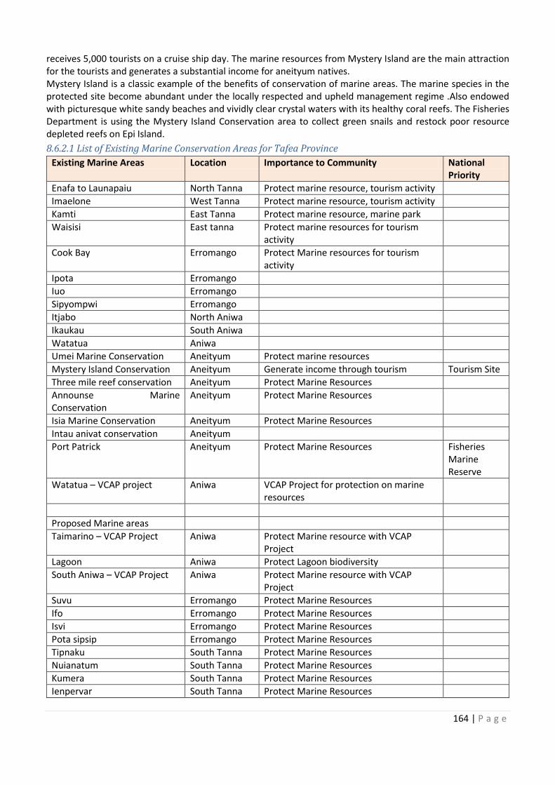
164 | P a g e
receives 5,000 tourists on a cruise ship day. The marine resources from Mystery Island are the main attraction
for the tourists and generates a substantial income for aneityum natives.
Mystery Island is a classic example of the benefits of conservation of marine areas. The marine species in the
protected site become abundant under the locally respected and upheld management regime .Also endowed
with picturesque white sandy beaches and vividly clear crystal waters with its healthy coral reefs. The Fisheries
Department is using the Mystery Island Conservation area to collect green snails and restock poor resource
depleted reefs on Epi Island.
8.6.2.1 List of Existing Marine Conservation Areas for Tafea Province
Existing Marine Areas Location Importance to Community National
Priority
Enafa to Launapaiu North Tanna Protect marine resource, tourism activity
Imaelone West Tanna Protect marine resource, tourism activity
Kamti East Tanna Protect marine resource, marine park
Waisisi East tanna Protect marine resources for tourism
activity
Cook Bay Erromango Protect Marine resources for tourism
activity
Ipota Erromango
Iuo Erromango
Sipyompwi Erromango
Itjabo North Aniwa
Ikaukau South Aniwa
Watatua Aniwa
Umei Marine Conservation Aneityum Protect marine resources
Mystery Island Conservation Aneityum Generate income through tourism Tourism Site
Three mile reef conservation Aneityum Protect Marine Resources
Announse Marine
Conservation
Aneityum Protect Marine Resources
Isia Marine Conservation Aneityum Protect Marine Resources
Intau anivat conservation Aneityum
Port Patrick Aneityum Protect Marine Resources Fisheries
Marine
Reserve
Watatua – VCAP project Aniwa VCAP Project for protection on marine
resources
Proposed Marine areas
Taimarino – VCAP Project Aniwa Protect Marine resource with VCAP
Project
Lagoon Aniwa Protect Lagoon biodiversity
South Aniwa – VCAP Project Aniwa Protect Marine resource with VCAP
Project
Suvu Erromango Protect Marine Resources
Ifo Erromango Protect Marine Resources
Isvi Erromango Protect Marine Resources
Pota sipsip Erromango Protect Marine Resources
Tipnaku South Tanna Protect Marine Resources
Nuianatum South Tanna Protect Marine Resources
Kumera South Tanna Protect Marine Resources
Ienpervar South Tanna Protect Marine Resources
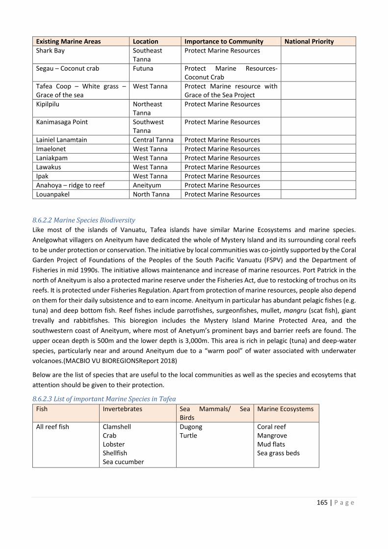
, tourism activity
Protect marine resource, tourism activity
Announse Marine
165 | P a g e
Existing Marine Areas Location Importance to Community National Priority
Shark Bay Southeast
Tanna
Protect Marine Resources
Segau – Coconut crab Futuna Protect Marine Resources-
Coconut Crab
Tafea Coop – White grass –
Grace of the sea
West Tanna Protect Marine resource with
Grace of the Sea Project
Kipilpilu Northeast
Tanna
Protect Marine Resources
Kanimasaga Point Southwest
Tanna
Protect Marine Resources
Lainiel Lanamtain Central Tanna Protect Marine Resources
Imaelonet West Tanna Protect Marine Resources
Laniakpam West Tanna Protect Marine Resources
Lawakus West Tanna Protect Marine Resources
Ipak West Tanna Protect Marine Resources
Anahoya – ridge to reef Aneityum Protect Marine Resources
Louanpakel North Tanna Protect Marine Resources
8.6.2.2 Marine Species Biodiversity
Like most of the islands of Vanuatu, Tafea islands have similar Marine Ecosystems and marine species.
Anelgowhat villagers on Aneityum have dedicated the whole of Mystery Island and its surrounding coral reefs
to be under protection or conservation. The initiative by local communities was co-jointly supported by the Coral
Garden Project of Foundations of the Peoples of the South Pacific Vanuatu (FSPV) and the Department of
Fisheries in mid 1990s. The initiative allows maintenance and increase of marine resources. Port Patrick in the
north of Aneityum is also a protected marine reserve under the Fisheries Act, due to restocking of trochus on its
reefs. It is protected under Fisheries Regulation. Apart from protection of marine resources, people also depend
on them for their daily subsistence and to earn income. Aneityum in particular has abundant pelagic fishes (e.g.
tuna) and deep bottom fish. Reef fishes include parrotfishes, surgeonfishes, mullet, mangru (scat fish), giant
trevally and rabbitfishes. This bioregion includes the Mystery Island Marine Protected Area, and the
southwestern coast of Aneityum, where most of Anetyum’s prominent bays and barrier reefs are found. The
upper ocean depth is 500m and the lower depth is 3,000m. This area is rich in pelagic (tuna) and deep-water
species, particularly near and around Aneityum due to a “warm pool” of water associated with underwater
volcanoes.(MACBIO VU BIOREGIONSReport 2018)
Below are the list of species that are useful to the local communities as well as the species and ecosytems that
attention should be given to their protection.
8.6.2.3 List of important Marine Species in Tafea
Fish Invertebrates Sea Mammals/ Sea
Birds
Marine Ecosystems
All reef fish Clamshell
Crab
Lobster
Shellfish
Sea cucumber
Dugong
Turtle
Coral reef
Mangrove
Mud flats
Sea grass beds
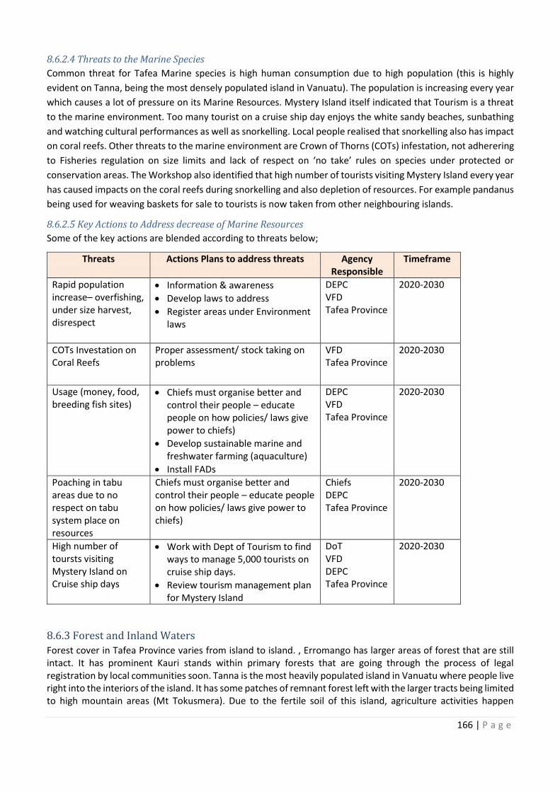
166 | P a g e
8.6.2.4 Threats to the Marine Species
Common threat for Tafea Marine species is high human consumption due to high population (this is highly
evident on Tanna, being the most densely populated island in Vanuatu). The population is increasing every year
which causes a lot of pressure on its Marine Resources. Mystery Island itself indicated that Tourism is a threat
to the marine environment. Too many tourist on a cruise ship day enjoys the white sandy beaches, sunbathing
and watching cultural performances as well as snorkelling. Local people realised that snorkelling also has impact
on coral reefs. Other threats to the marine environment are Crown of Thorns (COTs) infestation, not adherering
to Fisheries regulation on size limits and lack of respect on ‘no take’ rules on species under protected or
conservation areas. The Workshop also identified that high number of tourists visiting Mystery Island every year
has caused impacts on the coral reefs during snorkelling and also depletion of resources. For example pandanus
being used for weaving baskets for sale to tourists is now taken from other neighbouring islands.
8.6.2.5 Key Actions to Address decrease of Marine Resources
Some of the key actions are blended according to threats below;
Threats Actions Plans to address threats Agency
Responsible
Timeframe
Rapid population
increase– overfishing,
under size harvest,
disrespect
· Information & awareness
· Develop laws to address
· Register areas under Environment
laws
DEPC
VFD
Tafea Province
2020-2030
COTs Investation on
Coral Reefs Proper assessment/ stock taking on
problems
VFD
Tafea Province
2020-2030
Usage (money, food,
breeding fish sites) · Chiefs must organise better and
control their people – educate
people on how policies/ laws give
power to chiefs)
· Develop sustainable marine and
freshwater farming (aquaculture)
· Install FADs
DEPC
VFD
Tafea Province
2020-2030
Poaching in tabu
areas due to no
respect on tabu
system place on
resources
Chiefs must organise better and
control their people – educate people
on how policies/ laws give power to
chiefs)
Chiefs
DEPC
Tafea Province
2020-2030
High number of
toursts visiting
Mystery Island on
Cruise ship days
· Work with Dept of Tourism to find
ways to manage 5,000 tourists on
cruise ship days.
· Review tourism management plan
for Mystery Island
DoT
VFD
DEPC
Tafea Province
2020-2030
8.6.3 Forest and Inland Waters
Forest cover in Tafea Province varies from island to island. , Erromango has larger areas of forest that are still
intact. It has prominent Kauri stands within primary forests that are going through the process of legal
registration by local communities soon. Tanna is the most heavily populated island in Vanuatu where people live
right into the interiors of the island. It has some patches of remnant forest left with the larger tracts being limited
to high mountain areas (Mt Tokusmera). Due to the fertile soil of this island, agriculture activities happen
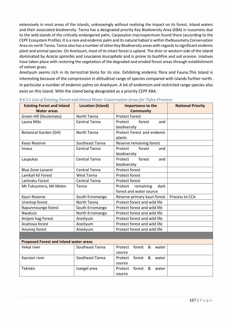
Usage (money, food,
Work with Dept of Tourism to find
167 | P a g e
extensively in most areas of the islands, unknowingly without realising the impact on its forest, inland waters
and their associated biodiversity. Tanna has a designated priority Key Biodiversity Area (KBA) in nusumetu due
to the wild stands of the critically endangered palm, Carpoxylon macrospermum found there (according to the
CEPF Ecosystem Profile). It is a rare and endemic palm and its natural habiat is within theNusumetu Conservation
Area on north Tanna. Tanna also has a number of other Key Biodiversity areas with regards to significant endemic
plant and animal species. On Aneityum, most of its intact forest is upland. The drier or western side of the island
dominated by Acacia spirorbis and Leucaena leucophala and is prone to bushfire and soil erosion. Iniatives
have taken place with restoring the vegetation of the degraded and eroded forest areas through establishment
of vetiver grass.
Aneityum seems rich in its terrestrial biota for its size. Exhibiting endemic flora and Fauna.This Island is
interesting because of the compression in altitudinal range of species compared with islands further north.
In particular a number of endemic palms on Aneityum. A lot of endemism and restricted range species also
exist on this island. With the island being designated as a priority CEPF KBA.
8.6.3.1 List of Existing Forest and Inland Water Conservation Areas for Tafea Province
Existing Forest and Inland
Water areas
Location (Island) Importance to the
Community
National Priority
Green Hill (Nusiematu) North Tanna Protect Forest
Launa Milo Central Tanna Protect forest and
biodiversity
Botanical Garden (GH) North Tanna Protect Forest and endemic
plants
Keasi Reserve Southeast Tanna Reserve remaining forest
Imaus Central Tanna Protect forest and
biodiversity
Laupukas Central Tanna Protect forest and
biodiversity
Blue Zone Lanarei Central Tanna Protect forest
Lamkail Kil Forest West Tanna Protect forest
Lamnatu Forest Central Tanna Protect forest
Mt Tukusmera, Mt Melen Tanna Protect remaining dark
forest and water source
Kauri Reserve South Erromango Reserve primary kauri forest Process to CCA
Urantop forest North Tanna Protect forest and wild life
Rapunmoungo forest South Erromango Protect forest and wild life
Nwalcon North Erromango Protect forest and wild life
Anijem hag Forest Aneityum Protect forest and wild life
Anahoya forest Aneityum Protect forest and wild life
Anumej forest Aneityum Protect forest and wild life
Proposed Forest and inland water areas Vekal river Southeast Tanna Protect forest & water
source
Kasrasir river Southeast Tanna Protect forest & water
source
Tekiskis Isangel area Protect forest & water
source
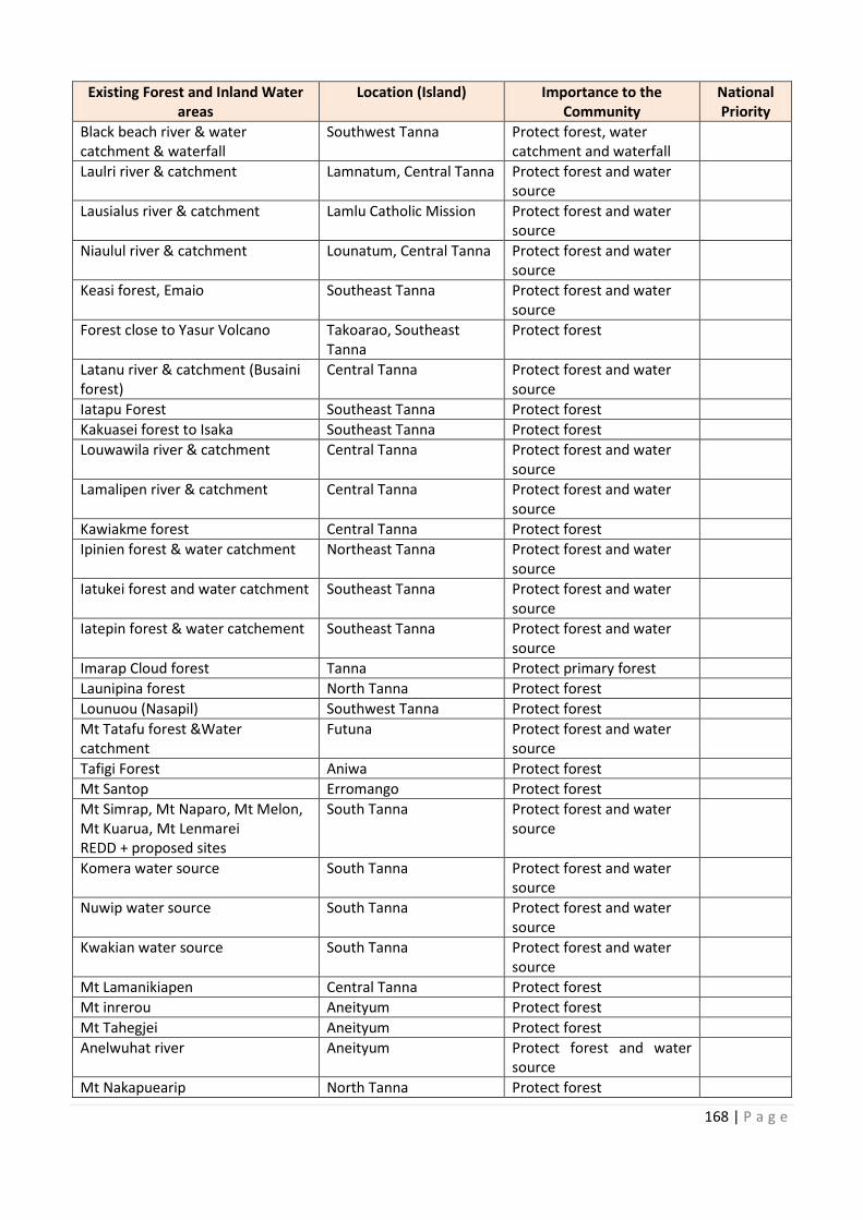
168 | P a g e
Existing Forest and Inland Water
areas
Location (Island) Importance to the
Community
National
Priority
Black beach river & water
catchment & waterfall
Southwest Tanna Protect forest, water
catchment and waterfall
Laulri river & catchment Lamnatum, Central Tanna Protect forest and water
source
Lausialus river & catchment Lamlu Catholic Mission Protect forest and water
source
Niaulul river & catchment Lounatum, Central Tanna Protect forest and water
source
Keasi forest, Emaio Southeast Tanna Protect forest and water
source
Forest close to Yasur Volcano Takoarao, Southeast
Tanna
Protect forest
Latanu river & catchment (Busaini
forest)
Central Tanna Protect forest and water
source
Iatapu Forest Southeast Tanna Protect forest
Kakuasei forest to Isaka Southeast Tanna Protect forest
Louwawila river & catchment Central Tanna Protect forest and water
source
Lamalipen river & catchment Central Tanna Protect forest and water
source
Kawiakme forest Central Tanna Protect forest
Ipinien forest & water catchment Northeast Tanna Protect forest and water
source
Iatukei forest and water catchment Southeast Tanna Protect forest and water
source
Iatepin forest & water catchement Southeast Tanna Protect forest and water
source
Imarap Cloud forest Tanna Protect primary forest
Launipina forest North Tanna Protect forest
Lounuou (Nasapil) Southwest Tanna Protect forest
Mt Tatafu forest &Water
catchment
Futuna Protect forest and water
source
Tafigi Forest Aniwa Protect forest
Mt Santop Erromango Protect forest
Mt Simrap, Mt Naparo, Mt Melon,
Mt Kuarua, Mt Lenmarei
REDD + proposed sites
South Tanna Protect forest and water
source
Komera water source South Tanna Protect forest and water
source
Nuwip water source South Tanna Protect forest and water
source
Kwakian water source South Tanna Protect forest and water
source
Mt Lamanikiapen Central Tanna Protect forest
Mt inrerou Aneityum Protect forest
Mt Tahegjei Aneityum Protect forest
Anelwuhat river Aneityum Protect forest and water
source
Mt Nakapuearip North Tanna Protect forest
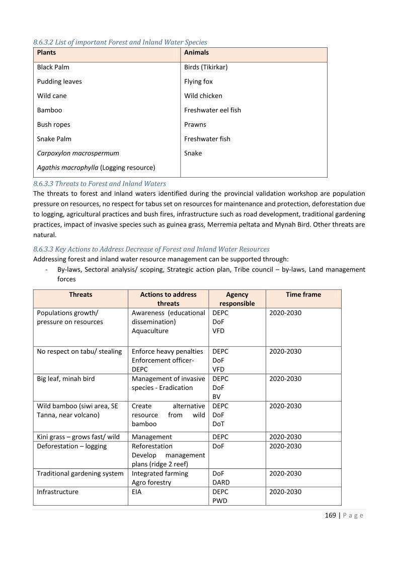
Existing Forest and Inland Water National
Lamnatum, Central Tanna
Latanu river & catchment (Busaini
Iatukei forest and water catchment
Iatepin forest & water catchement
,
Protect forest and water
169 | P a g e
8.6.3.2 List of important Forest and Inland Water Species
Plants Animals
Black Palm
Pudding leaves
Wild cane
Bamboo
Bush ropes
Snake Palm
Carpoxylon macrospermum
Agathis macrophylla (Logging resource)
Birds (Tikirkar)
Flying fox
Wild chicken
Freshwater eel fish
Prawns
Freshwater fish
Snake
8.6.3.3 Threats to Forest and Inland Waters
The threats to forest and inland waters identified during the provincial validation workshop are population
pressure on resources, no respect for tabus set on resources for maintenance and protection, deforestation due
to logging, agricultural practices and bush fires, infrastructure such as road development, traditional gardening
practices, impact of invasive species such as guinea grass, Merremia peltata and Mynah Bird. Other threats are
natural.
8.6.3.3 Key Actions to Address Decrease of Forest and Inland Water Resources
Addressing forest and inland water resource management can be supported through:
- By-laws, Sectoral analysis/ scoping, Strategic action plan, Tribe council – by-laws, Land management
forces
Threats Actions to address
threats
Agency
responsible
Time frame
Populations growth/
pressure on resources
Awareness (educational
dissemination)
Aquaculture
DEPC
DoF
VFD
2020-2030
No respect on tabu/ stealing
Enforce heavy penalties
Enforcement officer-
DEPC
DEPC
DoF
VFD
2020-2030
Big leaf, minah bird
Management of invasive
species - Eradication
DEPC
DoF
BV
2020-2030
Wild bamboo (siwi area, SE
Tanna, near volcano)
Create alternative
resource from wild
bamboo
DEPC
DoF
DoT
2020-2030
Kini grass – grows fast/ wild Management DEPC 2020-2030
Deforestation – logging
Reforestation
Develop management
plans (ridge 2 reef)
DoF 2020-2030
Traditional gardening system Integrated farming
Agro forestry
DoF
DARD
2020-2030
Infrastructure
EIA
DEPC
PWD
2020-2030
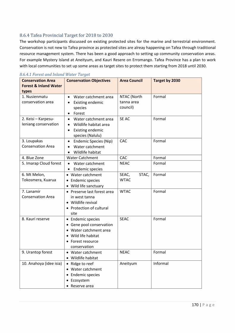
170 | P a g e
8.6.4 Tafea Provincial Target for 2018 to 2030
The workshop participants discussed on existing protected sites for the marine and terrestrial environment.
Conservation is not new to Tafea province as protected sites are alreay happening on Tafea through traditional
resource management system. There has been a good approach to setting up community conservation areas.
For example Mystery Island at Aneityum, and Kauri Resere on Erromango. Tafea Province has a plan to work
with local communities to set up some areas as target sites to protect them starting from 2018 until 2030.
8.6.4.1 Forest and Inland Water Target
Conservation Area
Forest & Inland Water
types
Conservation Objectives Area Council Target by 2030
1. Nusienmatu
conservation area
· Water catchment area
· Existing endemic
species
· Forest
NTAC (North
tanna area
council)
Formal
2. Keisi – Karpesu-
Ieniang conservation
· Water catchment area
· Wildlife habitat area
· Existing endemic
species (Nalulu)
SE AC Formal
3. Loupakas
Conservation Area
· Endemic Species (Nip)
· Water catchment
· Wildlife habitat
CAC Formal
4. Blue Zone Water Catchment CAC Formal
5. Imarap Cloud forest · Water catchment
· Endemic species
NEAC Formal
6. Mt Melon,
Tokosmera, Kuarua
· Water catchment
· Endemic species
· Wild life sanctuary
SEAC, STAC,
WTAC
Formal
7. Lanamir
Conservation Area
· Preserve last forest area
in west tanna
· Wildlife revival
· Protection of cultural
site
WTAC Formal
8. Kauri reserve · Endemic species
· Gene pool conservation
· Water catchment area
· Wild life habitat
· Forest resource
conservation
SEAC Formal
9. Urantop forest · Water catchment
· Wildlife habitat
NEAC Formal
10. Anahoya (idee isia) · Ridge to reef
· Water catchment
· Endemic species
· Ecosystem
· Reserve area
Aneityum Informal
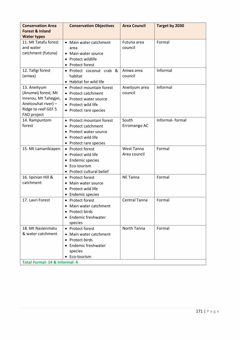
5. Imarap Cloud forest
SEAC, STAC,
st forest area
10. Anahoya (idee isia)
171 | P a g e
Conservation Area
Forest & Inland
Water types
Conservation Objectives Area Council Target by 2030
11. Mt Tatafu forest
and water
catchment (futuna)
· Main water catchment
area
· Main water source
· Protect wildlife
· Protect forest
Futuna area
council
Formal
12. Tafigi forest
(aniwa)
· Protect coconut crab &
habitat
· Habitat for wild life
Aniwa area
council
Informal
13. Aneityum
(Anumeij forest, Mt
Inrerou, Mt Tahegjei,
Anelcouhat river) –
Ridge to reef GEF 5
FAO project
· Protect mountain forest
· Protect catchment
· Protect water source
· Protect wild life
· Protect rare species
Aneityum area
council
Informal
14. Rampuntom
forest
· Protect mountain forest
· Protect catchment
· Protect water source
· Protect wild life
· Protect rare species
South
Erromango AC
Informal- formal
15. Mt Lamanikiapen · Protect forest
· Protect wild life
· Endemic species
· Eco-tourism
· Protect cultural belief
West Tanna
Area council
Formal
16. Iipinian Hill &
catchment
· Protect forest
· Main water source
· Protect wild life
· Endemic species
NE Tanna Formal
17. Lavri Forest · Protect forest
· Main water catchment
· Protect birds
· Endemic freshwater
species
Central Tanna Formal
18. Mt Nasienmatu
& water catchment
· Protect forest
· Main water catchment
· Protect birds
· Endemic freshwater
species
· Eco-tourism
North Tanna Formal
Total Formal: 14 & Informal: 4
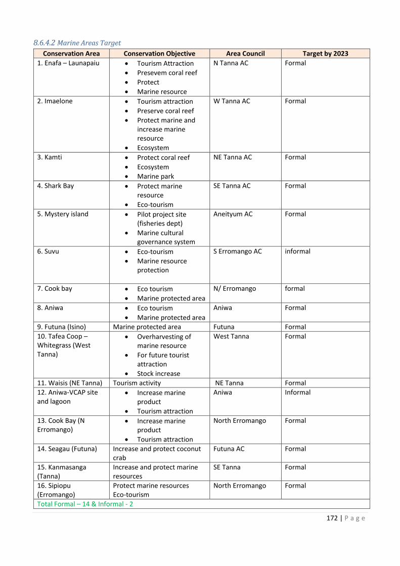
172 | P a g e
8.6.4.2 Marine Areas Target
Conservation Area Conservation Objective Area Council Target by 2023
1. Enafa – Launapaiu · Tourism Attraction
· Presevem coral reef
· Protect
· Marine resource
N Tanna AC Formal
2. Imaelone · Tourism attraction
· Preserve coral reef
· Protect marine and
increase marine
resource
· Ecosystem
W Tanna AC Formal
3. Kamti · Protect coral reef
· Ecosystem
· Marine park
NE Tanna AC Formal
4. Shark Bay · Protect marine
resource
· Eco-tourism
SE Tanna AC Formal
5. Mystery island · Pilot project site
(fisheries dept)
· Marine cultural
governance system
Aneityum AC Formal
6. Suvu · Eco-tourism
· Marine resource
protection
S Erromango AC informal
7. Cook bay · Eco tourism
· Marine protected area
N/ Erromango formal
8. Aniwa · Eco tourism
· Marine protected area
Aniwa Formal
9. Futuna (Isino) Marine protected area Futuna Formal
10. Tafea Coop –
Whitegrass (West
Tanna)
· Overharvesting of
marine resource
· For future tourist
attraction
· Stock increase
West Tanna Formal
11. Waisis (NE Tanna) Tourism activity NE Tanna Formal
12. Aniwa-VCAP site
and lagoon
· Increase marine
product
· Tourism attraction
Aniwa Informal
13. Cook Bay (N
Erromango)
· Increase marine
product
· Tourism attraction
North Erromango Formal
14. Seagau (Futuna) Increase and protect coconut
crab
Futuna AC Formal
15. Kanmasanga
(Tanna)
Increase and protect marine
resources
SE Tanna Formal
16. Sipiopu
(Erromango)
Protect marine resources
Eco-tourism
North Erromango Formal
Total Formal – 14 & Informal - 2
11. Waisis (NE Tanna)
Increase and protect coconut
173 | P a g e
8.6.5 TAFEA Provincial Target statement
By 2030, Tafea Province would like to formally register 14 forest and inland water areas, 14 marine areas under
the environmental act. Of the proposed sites, 4 of the forest and inland waters and 2 marine areas will be
established as community tabu areas.
8.6.6 Reference
Hanuš, V.,& Vaněk, J., (1983) Deep structure of the Vanuatu (New Hebrides) island arc: Intermediate depth
collision of subducted lithospheric plates, New Zealand Journal of Geology and Geophysics, 26:2, 133-154, DOI:
10.1080/00288306.1983.10422513
Vanuatu National Statistics Office. (2016). 2016 Post- TC PAM Mini- Census Report, Port Vila, Vanuatu
9.0 NBSAP REPORTING
The NBSAP progress update will be done bi-annually but reporting will be done annually where a
summary of outcomes on NBSAP will be produced to monitor progress and achievements. This will
also include production of communication materials. This information should also be disseminated to
other sectors and national strategies to ensure NBSAP achievements are reflected under the NSDP
and other national reporting mechanisms.
Table 3: NBSAP 2018 Report Template
Strategic Area: Objective Actions 2018 Key actions 2018 UPDATE
Focus Area
CA1:
Expanded
national
representative
network of
conservation
areas in
marine,
terrestrial and
inland waters.
To carry out
marine,
terrestrial and
inland waters
biodiversity
rapid
assessment,
inventories
and threat
identification,
gap analyses
and
prioritisation to
guide the
development
of a national
representative
network of
CAs
174 | P a g e
9.1 NBSAP MONITORING AND INDICATORS GUIDELINE
Monitoring of the NBSAP will be based on measuring impacts using the indicator guide in Table x.
Baselines will be needed in order to assess change. The impact and monitoring results will provide the
information for the State of Environment Reports and at least every 5 years to produce a NBSAP Impact
Report.
Table 4: Indicator Guide
NBSAP STRATEGIC AREAS NBSAP INDICATORS
CONSERVATION AREA
MANAGEMENT
· Total area of representative coverage of legally recognised, other effective
conserved areas and locally managed areas in terrestrial and marine areas
including sites of particular importance for biodiversity
· Percentage of terrestrial and marine protected areas that are effectively
managed based on agreed national and international protected area
conditions and management effectiveness
· Measure of ecosystem service values and equity of benefits from CAs
· Level of connectivity of CAs and other area based approaches with broader
landscapes and seascapes
FOREST AND INLAND
WATERS ECOSYSTEMS
CONSERVATION AND
MANAGEMENT
· Trends in forest and inland waters species diversity including traded ones
· Trend to which biodiversity and ecosystem service values are incorporated
into government accounting reporting
· Percentage of forest and inland waters conservation areas to meet national
and global targets
· Impact of threats to forest and inland waters such as invasive species,
deforestation, logging and other threats
COASTAL AND MARINE
ECOSYSTEMS
CONSERVATION AND
MANAGEMENT (CME)
· Total area of representative coverage of legally recognised, other conserved
areas and locally managed areas in marine areas including sites of particular
importance for biodiversity
· Total area number of marine protected areas that effectively managed based
on agreed national protected area conditions and management
effectiveness
· Measurement of ecosystem services and equitable benefits from CAs
· Account for Payment of ecosystem service and other sustainable financing
strategies
· Measure if trends in connectivity of CAs and other area based approaches
integrated into landscapes and seascapes
· Assessments on coastal development impact and EIAs enforcements and
compliance
SPECIES
MANAGEMENT(SM)
· Reduced trend in extinction risks of Vanuatu’s 5 priority species
· Increased trend in population of the 5 priority threatened species for Vanuatu
· Increased trends in distribution of the 5 selected species
MANAGEMENT OF
INVASIVE SPECIES (MIS)
· Assessment and measure of impact of invasive alien species on biodiversity
and food security
· Impact of policy responses, legislation and management plans to control and
prevent spread of invasive and alien species
· Required information and data on invasive species are available
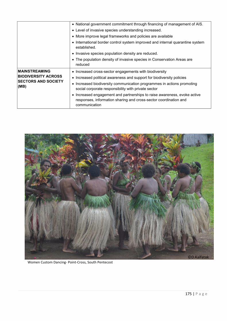
175 | P a g e
· National government commitment through financing of management of AIS.
· Level of invasive species understanding increased.
· More improve legal frameworks and policies are available
· International border control system improved and internal quarantine system
established.
· Invasive species population density are reduced.
· The population density of invasive species in Conservation Areas are
reduced
MAINSTREAMING
BIODIVERSITY ACROSS
SECTORS AND SOCIETY
(MB)
· Increased cross-sector engagements with biodiversity
· Increased political awareness and support for biodiversity policies
· Increased biodiversity communication programmes in actions promoting
social corporate responsibility with private sector
· Increased engagement and partnerships to raise awareness, evoke active
responses, information sharing and cross-sector coordination and
communication
Women Custom Dancing- Point-Cross, South Pentecost
©D.Kalfatak
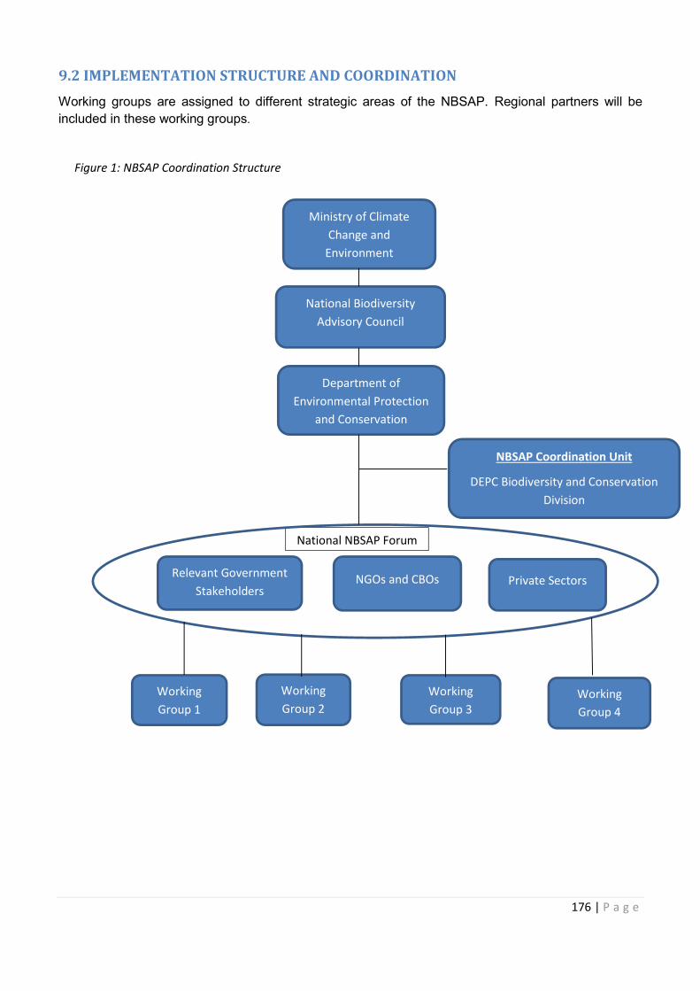
176 | P a g e
9.2 IMPLEMENTATION STRUCTURE AND COORDINATION
Working groups are assigned to different strategic areas of the NBSAP. Regional partners will be
included in these working groups.
Figure 1: NBSAP Coordination Structure
NGOs and CBOs Relevant Government
Stakeholders Private Sectors
National NBSAP Forum
National Biodiversity
Advisory Council
Department of
Environmental Protection
and Conservation
NBSAP Coordination Unit
DEPC Biodiversity and Conservation
Division
Ministry of Climate
Change and
Environment
Working
Group 2
Working
Group 4
Working
Group 1
Working
Group 3
Relevant Government
177 | P a g e
9.3 AMENDING THE NBSAP
The NBSAP will be reviewed and revised after five years (2022) to produce the impact report and the
review process will be initiated following this.
178 | P a g e
References
Chambers, M.R., Bani, E. and Barker-Hudson, B.E.T. (1989). The status of the dugong (Dugong dugon)
in Vanuatu. South Pacific Commission, Noumea (New Caledonia).
Deharveng L. (2011). Caves and soils, in Bouchet P., Le Guyader H. & Pascal O. (eds), The Natural
History of Santo. Patrimoines Naturels 70. Muséum national d'Histoire naturelle, Paris; IRD,
Marseille; Pro-Natura International, Paris: 265–333.
Department of Environment and Conservation. (2014). Biodiversity. Retrieved February 6, 2018, from
Ministry of Lands and Natural Resources: https://mol.gov.vu/index.php/en/biodiversity/189-
biodiversity.
FAO (Food and Agriculture Organization). 2010. Global Forest Resources Assessment 2010. Country
Report. Vanuatu. Forestry Department, Food and Agriculture Organization of the United
Nations. Rome, Italy.
Govan, H. (2009). Achieving the potential of LMMA in the South Pacific Region, SPC Traditional Marine
Resource Management and Knowledge Bulletin #25; 2009,
http://www.spc.int/DigitalLibrary/Doc/FAME/InfoBull/TRAD/25/Trad25_16_ Govan.pdf .
Government of Vanuatu (2010). Vanuatu National Assessment Report - 5 Year Review of the Mauritius
Strategy for Further Implementation of the Barbados Programme of Action for Sustainable
Development
Government of Vanuatu (2012). Forest Policy 2013-2023.
Government of Vanuatu (2013). National Land Use Planning Policy.
Government of Vanuatu (2016). Vanuatu’s National Ocean Policy 2016.
Keith, P., Marquet, G., Lord, C., Kalfatak, D. and Vigneux, E. (2010). Vanuatu Freshwater Fish and Crustaceans. Société Française d’ichtyologie (SFI).
King, P. 2007. Regional: Mainstreaming Environmental Consideration in Economic and Development
Planning Processed in Selected Pacific Developing Member Countries. Technical Assistance
Consultant’s Report for the Asian Development Bank.
https://www.adb.org/sites/default/files/institutional-document/32201/38031-07-reg-tacr.pdf
Marquet, G., Taiki, N., Chadderton, L. and Gerbeaux, P. (2002). Biodiversity and Biogeography of
Freshwater Crustaceans (Decapoda: Natantia) From Vanuatu, A Comparison with Fiji and New
Caledonia. Bull. Fr. Píche Piscic. (2002) 364: 217-232 —
Pascal, N. (2014). Economic valuation of mangrove ecosystem services in Vanuatu: Case study of
Crab Bay (Malekula Is.) and Eratap (Efate Is.) - Summary report. IUCN, Suva, Fiji.
Pascal, N., Leport, G., Molisa, V. and Wendt, H. (2015). National Marine Ecosystem Service Valuation
- Summary Report: Vanuatu. MACBIO 2015.
Pascal, N., Seidl, A. and Tiwok, T. (2015). Analysis of economic benefits of marine protected areas:
case studies in Vanuatu (9 MPAs) and Fiji (5 MPAs), South Pacific, Powerpoint presentation.
Regenvanu, R. (2009). The Traditional Economy as Source of Resilience in Vanuatu. Speech made
at Pacific Islands and the World Conference, Brisbane, August 2009. Retrieved from
http://milda.aidwatch.org.au/sites/default/files/Ralph%20Regenvanu.%20Traditional%20econo
my%20as%20a%20source%20of%20resistance%20in%20Vanuatu.pdf
179 | P a g e
Scott, D. A. (ed.) 1993. A Directory of Wetlands in Oceania. The International Waterfowl and Wetlands
Bureau (IWRB), Slimbridge, U.K. and Asian Wetlands Bureau (AWB), Kuala Lumpur, Malaysia.
SPREP. (2013). State of Conservation in Oceania.
Taiki N.L., Whyte J., Phillips B and Kalfatak D. (unpublished). 2003. Updated in 2011. A Review of
Literature about Vanuatu’s Biodiversity 2003.
United Nations General Assembly. (2010). UNGA Resolution 65/161.
Vanuatu Environment Unit Medium Scale Project (MSP). 2003. Facilitating and Strengthening
Community Conservation Areas.
Vanuatu National Statistics Office. (2016). 2016 Post Pam Mini-Census Report. Port Vila: VNSO.
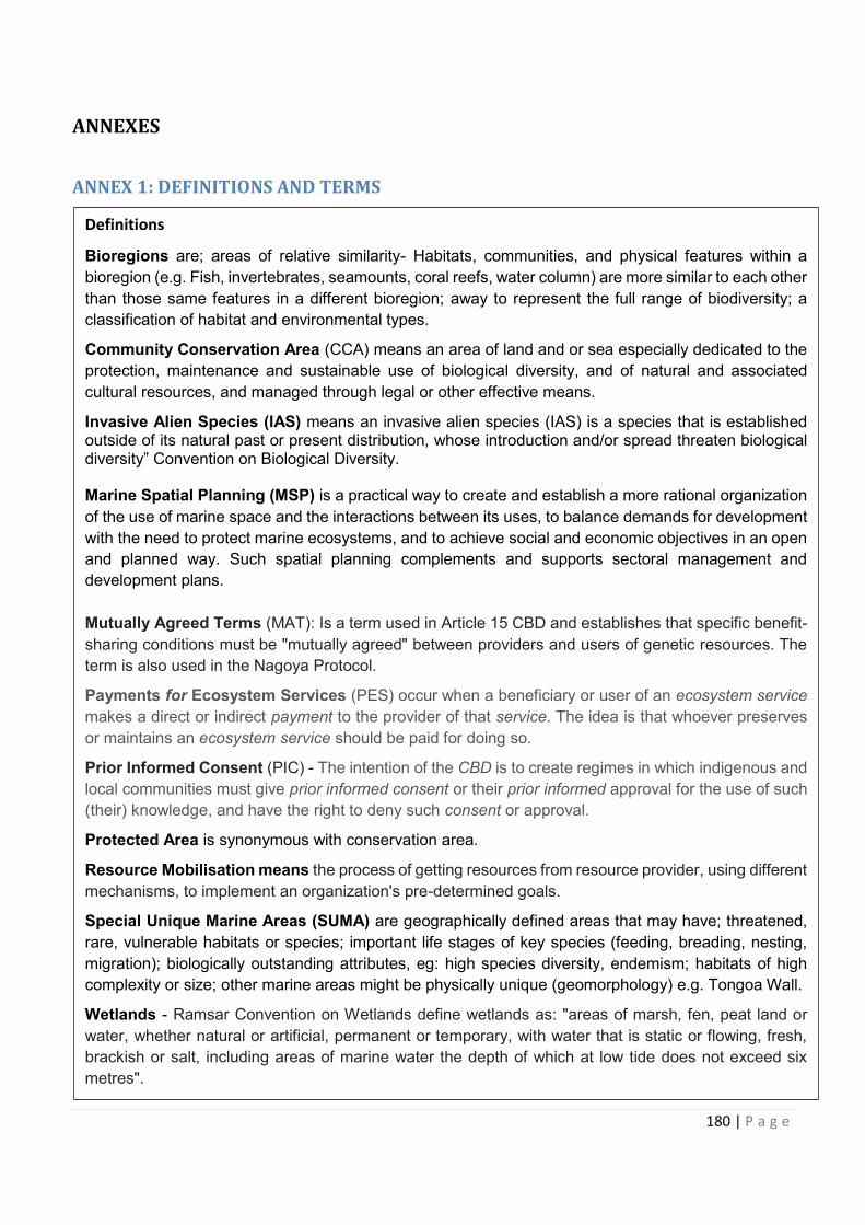
180 | P a g e
ANNEXES
ANNEX 1: DEFINITIONS AND TERMS
Definitions
Bioregions are; areas of relative similarity- Habitats, communities, and physical features within a
bioregion (e.g. Fish, invertebrates, seamounts, coral reefs, water column) are more similar to each other
than those same features in a different bioregion; away to represent the full range of biodiversity; a
classification of habitat and environmental types.
Community Conservation Area (CCA) means an area of land and or sea especially dedicated to the
protection, maintenance and sustainable use of biological diversity, and of natural and associated
cultural resources, and managed through legal or other effective means.
Invasive Alien Species (IAS) means an invasive alien species (IAS) is a species that is established outside of its natural past or present distribution, whose introduction and/or spread threaten biological diversity” Convention on Biological Diversity. Marine Spatial Planning (MSP) is a practical way to create and establish a more rational organization
of the use of marine space and the interactions between its uses, to balance demands for development
with the need to protect marine ecosystems, and to achieve social and economic objectives in an open
and planned way. Such spatial planning complements and supports sectoral management and
development plans.
Mutually Agreed Terms (MAT): Is a term used in Article 15 CBD and establishes that specific benefit-
sharing conditions must be "mutually agreed" between providers and users of genetic resources. The
term is also used in the Nagoya Protocol.
Payments for Ecosystem Services (PES) occur when a beneficiary or user of an ecosystem service
makes a direct or indirect payment to the provider of that service. The idea is that whoever preserves
or maintains an ecosystem service should be paid for doing so.
Prior Informed Consent (PIC) - The intention of the CBD is to create regimes in which indigenous and
local communities must give prior informed consent or their prior informed approval for the use of such
(their) knowledge, and have the right to deny such consent or approval.
Protected Area is synonymous with conservation area.
Resource Mobilisation means the process of getting resources from resource provider, using different
mechanisms, to implement an organization's pre-determined goals.
Special Unique Marine Areas (SUMA) are geographically defined areas that may have; threatened,
rare, vulnerable habitats or species; important life stages of key species (feeding, breading, nesting,
migration); biologically outstanding attributes, eg: high species diversity, endemism; habitats of high
complexity or size; other marine areas might be physically unique (geomorphology) e.g. Tongoa Wall.
Wetlands - Ramsar Convention on Wetlands define wetlands as: "areas of marsh, fen, peat land or
water, whether natural or artificial, permanent or temporary, with water that is static or flowing, fresh,
brackish or salt, including areas of marine water the depth of which at low tide does not exceed six
metres".
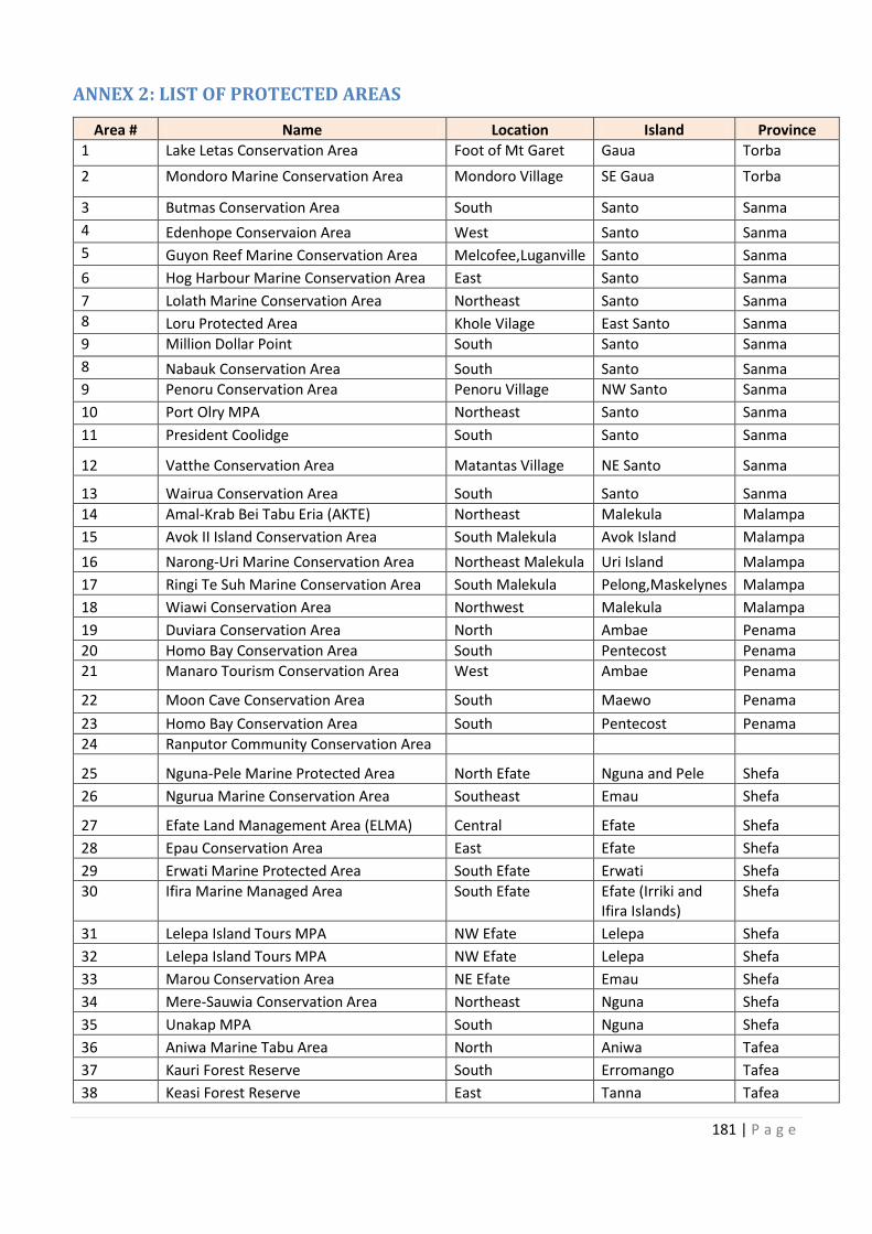
181 | P a g e
ANNEX 2: LIST OF PROTECTED AREAS
Area # Name Location Island Province
1 Lake Letas Conservation Area Foot of Mt Garet Gaua Torba
2 Mondoro Marine Conservation Area Mondoro Village SE Gaua Torba
3 Butmas Conservation Area South Santo Sanma
4 Edenhope Conservaion Area West Santo Sanma
5 Guyon Reef Marine Conservation Area Melcofee,Luganville Santo Sanma
6 Hog Harbour Marine Conservation Area East Santo Sanma
7 Lolath Marine Conservation Area Northeast Santo Sanma
8 Loru Protected Area Khole Vilage East Santo Sanma
9 Million Dollar Point South Santo Sanma
8 Nabauk Conservation Area South Santo Sanma
9 Penoru Conservation Area Penoru Village NW Santo Sanma
10 Port Olry MPA Northeast Santo Sanma
11 President Coolidge South Santo Sanma
12 Vatthe Conservation Area Matantas Village NE Santo Sanma
13 Wairua Conservation Area South Santo Sanma
14 Amal-Krab Bei Tabu Eria (AKTE) Northeast Malekula Malampa
15 Avok II Island Conservation Area South Malekula Avok Island Malampa
16 Narong-Uri Marine Conservation Area Northeast Malekula Uri Island Malampa
17 Ringi Te Suh Marine Conservation Area South Malekula Pelong,Maskelynes Malampa
18 Wiawi Conservation Area Northwest Malekula Malampa
19 Duviara Conservation Area North Ambae Penama
20 Homo Bay Conservation Area South Pentecost Penama
21 Manaro Tourism Conservation Area West Ambae Penama
22 Moon Cave Conservation Area South Maewo Penama
23 Homo Bay Conservation Area South Pentecost Penama
24 Ranputor Community Conservation Area
25 Nguna-Pele Marine Protected Area North Efate Nguna and Pele Shefa
26 Ngurua Marine Conservation Area Southeast Emau Shefa
27 Efate Land Management Area (ELMA) Central Efate Shefa
28 Epau Conservation Area East Efate Shefa
29 Erwati Marine Protected Area South Efate Erwati Shefa
30 Ifira Marine Managed Area South Efate Efate (Irriki and
Ifira Islands)
Shefa
31 Lelepa Island Tours MPA NW Efate Lelepa Shefa
32 Lelepa Island Tours MPA NW Efate Lelepa Shefa
33 Marou Conservation Area NE Efate Emau Shefa
34 Mere-Sauwia Conservation Area Northeast Nguna Shefa
35 Unakap MPA South Nguna Shefa
36 Aniwa Marine Tabu Area North Aniwa Tafea
37 Kauri Forest Reserve South Erromango Tafea
38 Keasi Forest Reserve East Tanna Tafea
182 | P a g e
39 Loanamilo Conservation Area West Tanna Tafea
40 Mystery Island South Anietyum Tafea
41 Port Patrick Marine Protected Area North Anietyum Tafea
42 Tipinime Conservation Area North Tanna Tafea
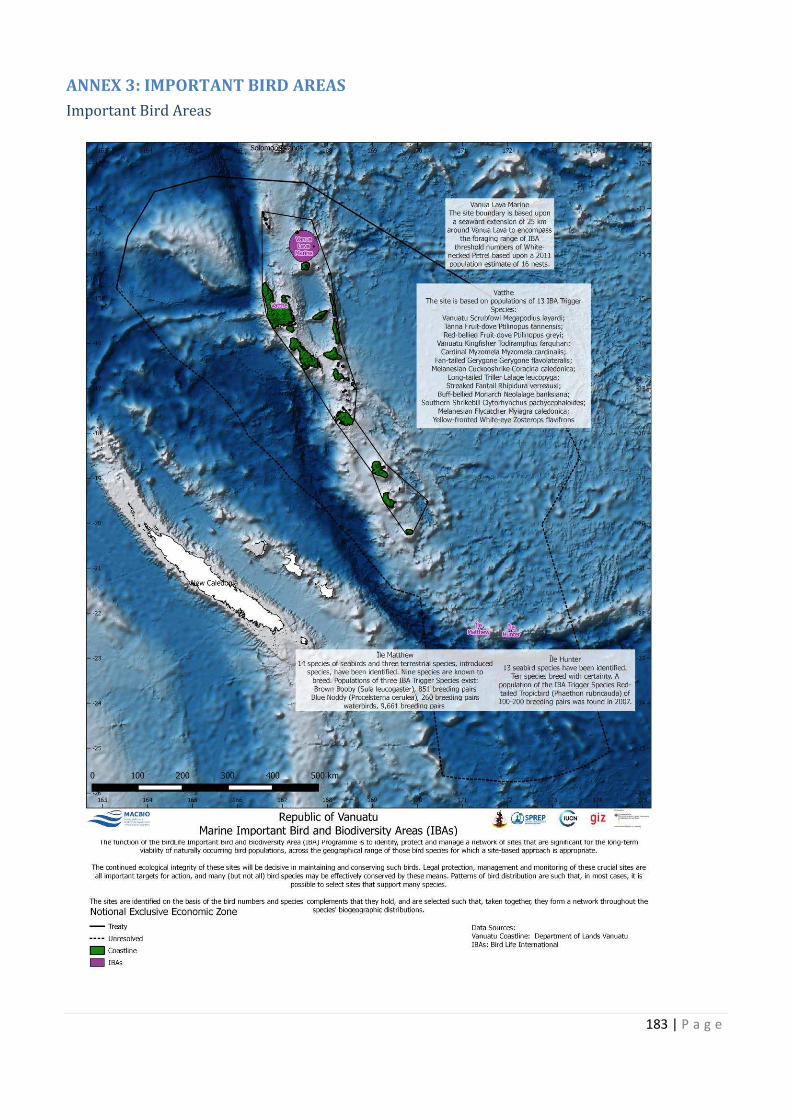
183 | P a g e
ANNEX 3: IMPORTANT BIRD AREAS
Important Bird Areas
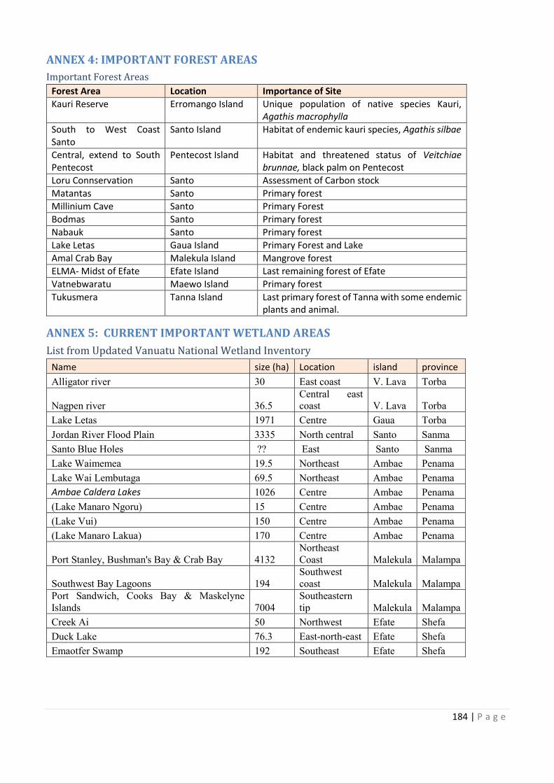
184 | P a g e
ANNEX 4: IMPORTANT FOREST AREAS
Important Forest Areas
Forest Area Location Importance of Site
Kauri Reserve Erromango Island Unique population of native species Kauri,
Agathis macrophylla
South to West Coast
Santo
Santo Island Habitat of endemic kauri species, Agathis silbae
Central, extend to South
Pentecost
Pentecost Island Habitat and threatened status of Veitchiae
brunnae, black palm on Pentecost
Loru Connservation Santo Assessment of Carbon stock
Matantas Santo Primary forest
Millinium Cave Santo Primary Forest
Bodmas Santo Primary forest
Nabauk Santo Primary forest
Lake Letas Gaua Island Primary Forest and Lake
Amal Crab Bay Malekula Island Mangrove forest
ELMA- Midst of Efate Efate Island Last remaining forest of Efate
Vatnebwaratu Maewo Island Primary forest
Tukusmera Tanna Island Last primary forest of Tanna with some endemic
plants and animal.
ANNEX 5: CURRENT IMPORTANT WETLAND AREAS
List from Updated Vanuatu National Wetland Inventory
Name size (ha) Location island province
Alligator river 30 East coast V. Lava Torba
Nagpen river 36.5
Central east
coast V. Lava Torba
Lake Letas 1971 Centre Gaua Torba
Jordan River Flood Plain 3335 North central Santo Sanma
Santo Blue Holes ?? East Santo Sanma
Lake Waimemea 19.5 Northeast Ambae Penama
Lake Wai Lembutaga 69.5 Northeast Ambae Penama
Ambae Caldera Lakes 1026 Centre Ambae Penama
(Lake Manaro Ngoru) 15 Centre Ambae Penama
(Lake Vui) 150 Centre Ambae Penama
(Lake Manaro Lakua) 170 Centre Ambae Penama
Port Stanley, Bushman's Bay & Crab Bay 4132
Northeast
Coast Malekula Malampa
Southwest Bay Lagoons 194
Southwest
coast Malekula Malampa
Port Sandwich, Cooks Bay & Maskelyne
Islands 7004
Southeastern
tip Malekula Malampa
Creek Ai 50 Northwest Efate Shefa
Duck Lake 76.3 East-north-east Efate Shefa
Emaotfer Swamp 192 Southeast Efate Shefa
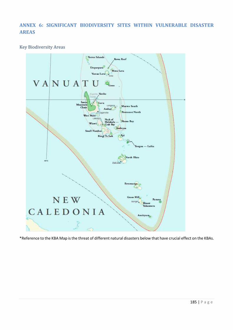
Unique population of native species Kauri,
South to West Coast Agathis silbae
Central, extend to South Veitchiae
some endemic
Central east
Port Sandwich, Cooks Bay & Maskelyne Southeastern
185 | P a g e
ANNEX 6: SIGNIFICANT BIODIVERSITY SITES WITHIN VULNERABLE DISASTER
AREAS
Key Biodiversity Areas
*Reference to the KBA Map is the threat of different natural disasters below that have crucial effect on the KBAs.
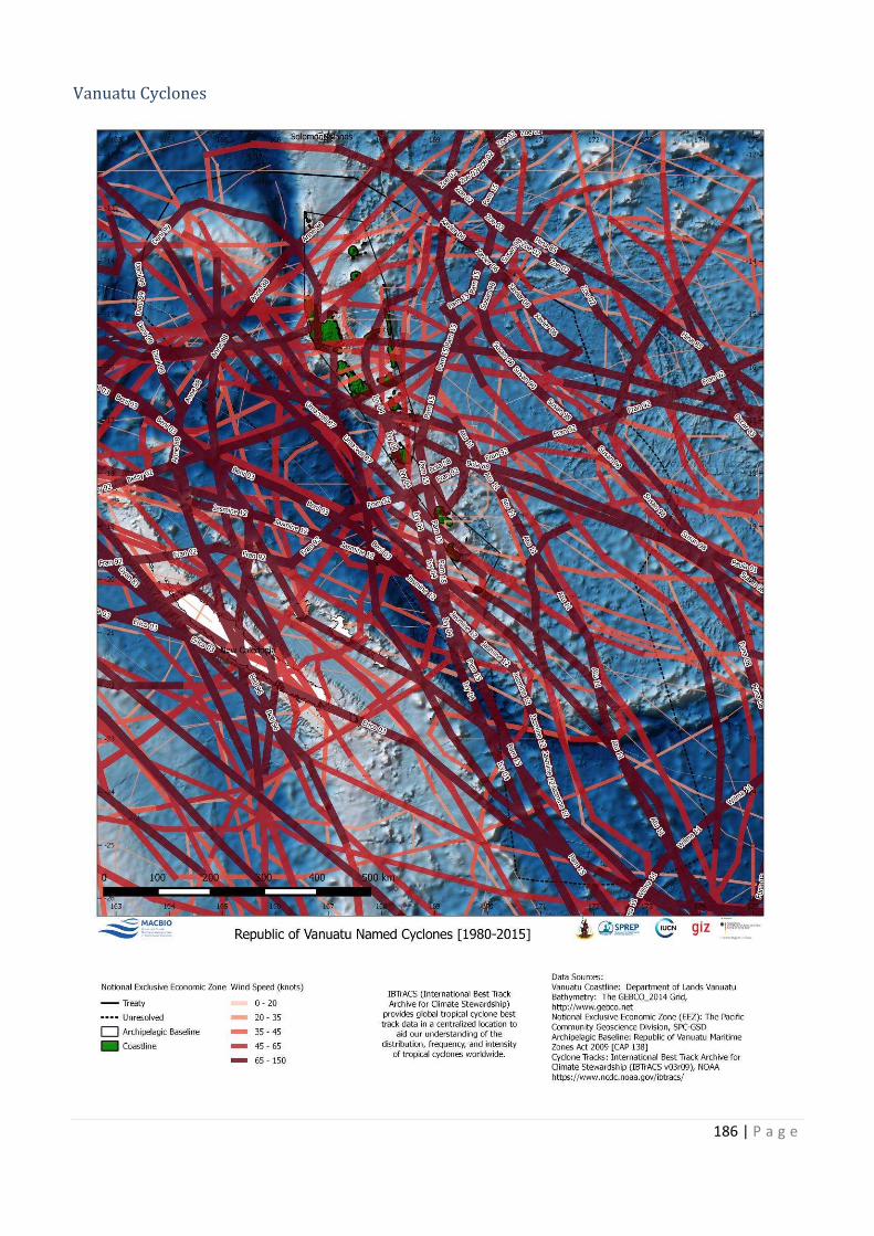
186 | P a g e
Vanuatu Cyclones
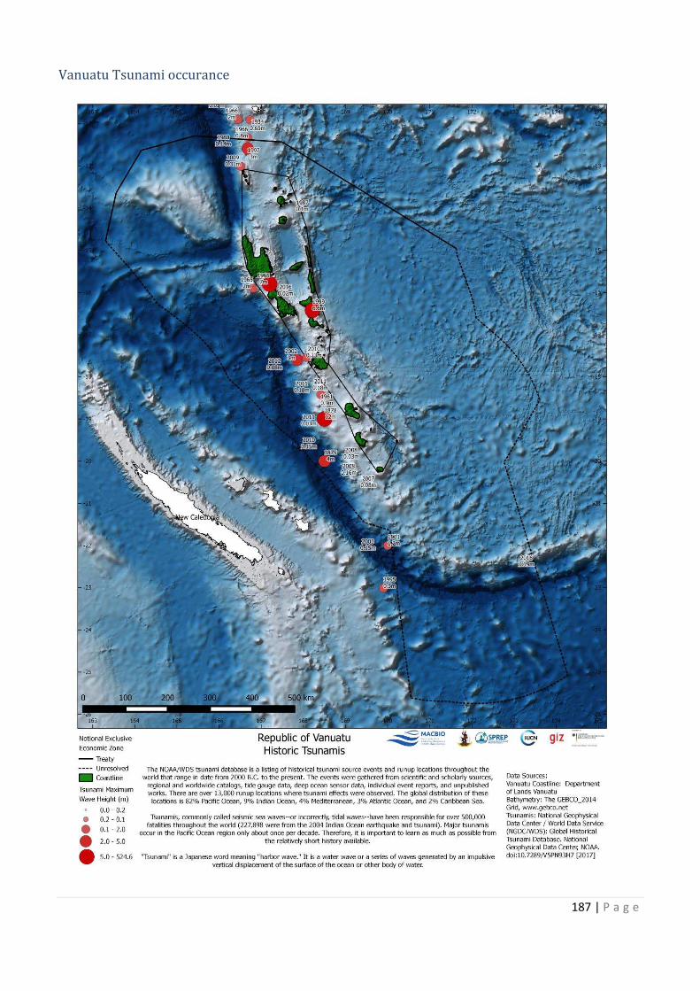
187 | P a g e
Vanuatu Tsunami occurance
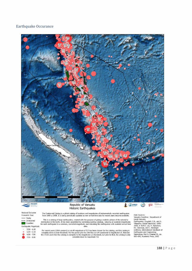
188 | P a g e
Earthquake Occurance
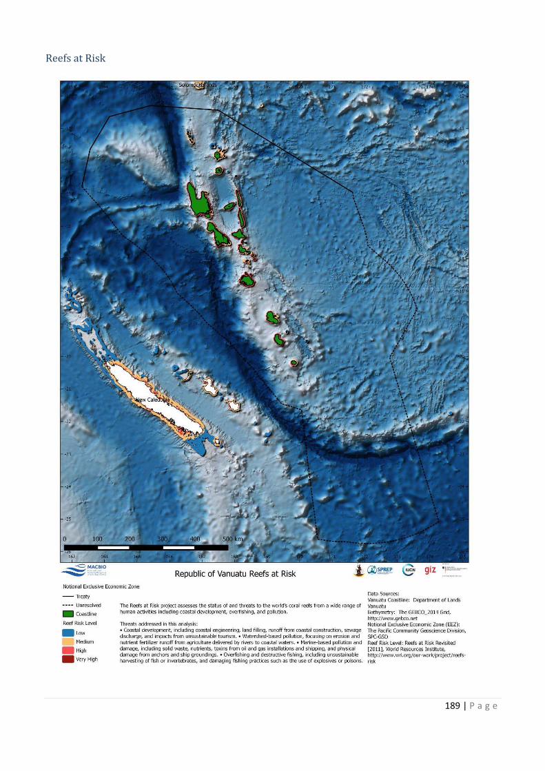
189 | P a g e
Reefs at Risk
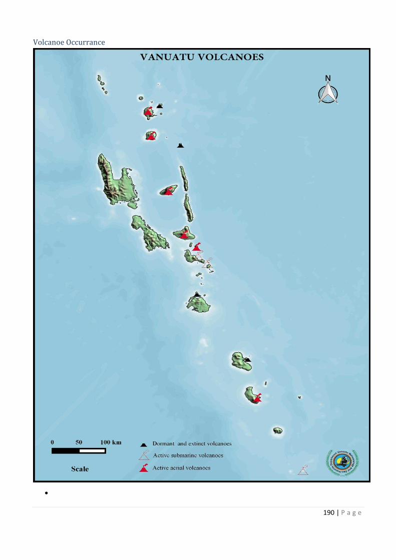
190 | P a g e
Volcanoe Occurrance
·
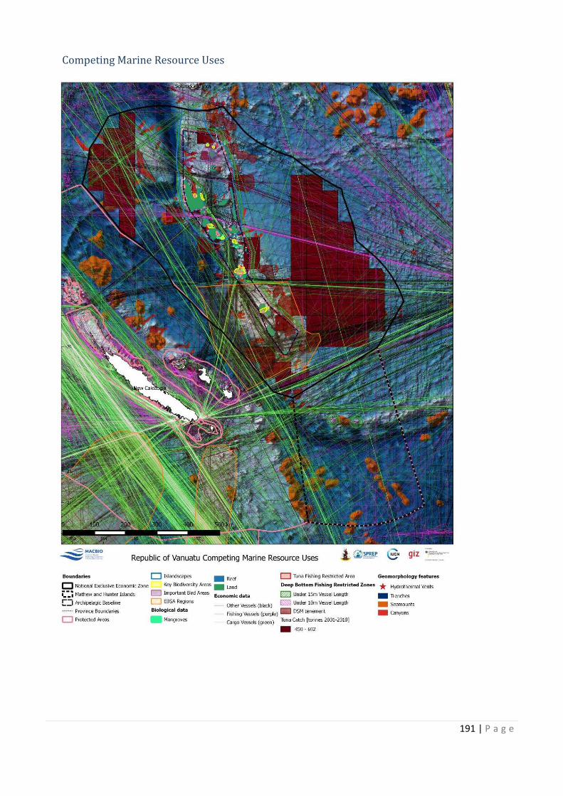
191 | P a g e
Competing Marine Resource Uses
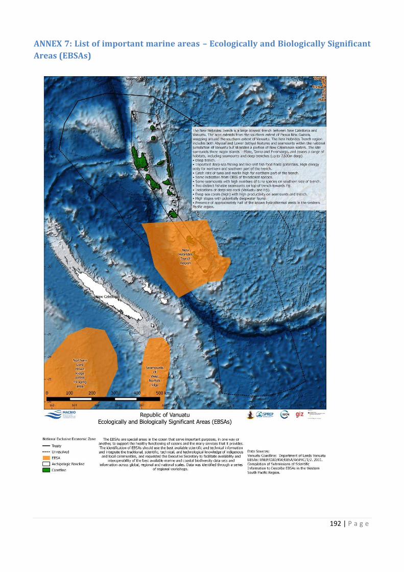
192 | P a g e
ANNEX 7: List of important marine areas – Ecologically and Biologically Significant
Areas (EBSAs)
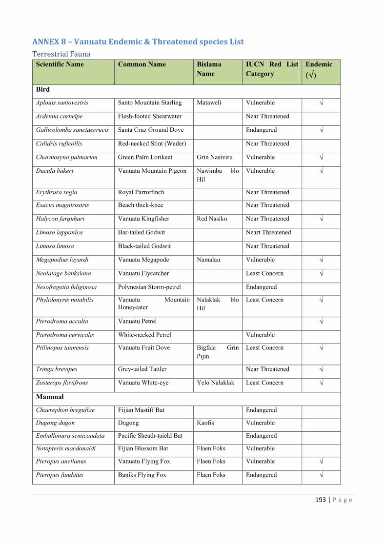
193 | P a g e
ANNEX 8 – Vanuatu Endemic & Threatened species List
Terrestrial Fauna
Scientific Name Common Name Bislama
Name
IUCN Red List
Category
Endemic
)
Bird
Aplonis santovestris Santo Mountain Starling Mataweli Vulnerable √
Ardenna carneipe Flesh-footed Shearwater Near Threatened
Gallicolomba sanctaecrucis Santa Cruz Ground Dove Endangered √
Calidris ruficollis Red-necked Stint (Wader) Near Threatened
Charmosyna palmarum Green Palm Lorikeet Grin Nasiviru Vulnerable √
Ducula bakeri Vanuatu Mountain Pigeon Nawimba blo
Hil
Vulnerable √
Erythrura regia Royal Parrotfinch Near Threatened
Esacus magnirostris Beach thick-knee Near Threatened
Halycon farquhari Vanuatu Kingfisher Red Nasiko Near Threatened √
Limosa lapponica Bar-tailed Godwit Neart Threatened
Limosa limosa Black-tailed Godwit Near Threatened
Megapodius layardi Vanuatu Megapode Namalau Vulnerable √
Neolalage banksiana Vanuatu Flycatcher Least Concern √
Nesofregetta fuliginosa Polynesian Storm-petrel Endangered
Phylidonyris notabilis Vanuatu Mountain
Honeyeater
Nalaklak blo
Hil
Least Concern √
Pterodroma acculta Vanuatu Petrel √
Pterodroma cervicalis White-necked Petrel Vulnerable
Ptilinopus tannensis Vanuatu Fruit Dove Bigfala Grin
Pijin
Least Concern √
Tringa brevipes Grey-tailed Tattler Near Threatened √
Zosterops flavifrons Vanuatu White-eye Yelo Nalaklak Least Concern √
Mammal
Chaerephon bregullae Fijian Mastiff Bat Endangered
Dugong dugon Dugong Kaofis Vulnerable
Emballonura semicaudata Pacific Sheath-taield Bat Endangered
Notopteris macdonaldi Fijian Blossom Bat Flaen Foks Vulnerable
Pteropus anetianus Vanuatu Flying Fox Flaen Foks Vulnerable √
Pteropus fundatus Baniks Flying Fox Flaen Foks Endangered √
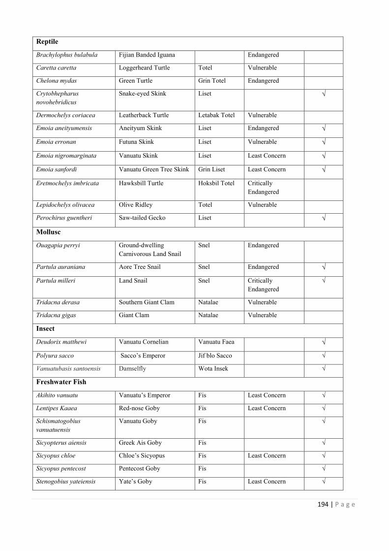
194 | P a g e
Reptile
Brachylophus bulabula Fijian Banded Iguana Endangered
Caretta caretta Loggerheard Turtle Totel Vulnerable
Chelona mydas Green Turtle Grin Totel Endangered
Crytobhepharus
novohebridicus
Snake-eyed Skink Liset √
Dermochelys coriacea Leatherback Turtle Letabak Totel Vulnerable
Emoia aneityumensis Aneityum Skink Liset Endangered √
Emoia erronan Futuna Skink Liset Vulnerable √
Emoia nigromarginata Vanuatu Skink Liset Least Concern √
Emoia sanfordi Vanuatu Green Tree Skink Grin Liset Least Concern √
Eretmochelys imbricata Hawksbill Turtle Hoksbil Totel Critically
Endangered
Lepidochelys olivacea Olive Ridley Totel Vulnerable
Perochirus guentheri Saw-tailed Gecko Liset √
Mollusc
Ouagapia perryi Ground-dwelling
Carnivorous Land Snail
Snel Endangered
Partula auraniana Aore Tree Snail Snel Endangered √
Partula milleri Land Snail Snel Critically
Endangered
√
Tridacna derasa Southern Giant Clam Natalae Vulnerable
Tridacna gigas Giant Clam Natalae Vulnerable
Insect
Deudorix matthewi Vanuatu Cornelian Vanuatu Faea √
Polyura sacco Sacco’s Emperor Jif blo Sacco √
Vanuatubasis santoensis Damselfly Wota Insek √
Freshwater Fish
Akihito vanuatu Vanuatu’s Emperor Fis Least Concern √
Lentipes Kaaea Red-nose Goby Fis Least Concern √
Schismatogobius
vanuatuensis
Vanuatu Goby Fis √
Sicyopterus aiensis Greek Ais Goby Fis √
Sicyopus chloe Chloe’s Sicyopus Fis Least Concern √
Sicyopus pentecost Pentecost Goby Fis √
Stenogobius yateiensis Yate’s Goby Fis Least Concern √
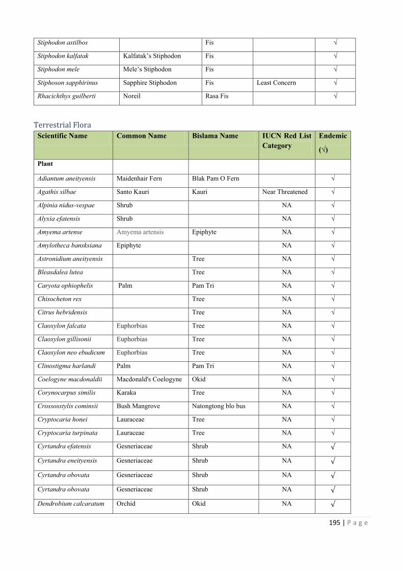
Letabak Totel
Vanuatu Green Tree Skink
Hoksbil Totel
Vanuatu Faea
195 | P a g e
Stiphodon astilbos Fis √
Stiphodon kalfatak Kalfatak’s Stiphodon Fis √
Stiphodon mele Mele’s Stiphodon Fis √
Stiphoson sapphirinus Sapphire Stiphodon Fis Least Concern √
Rhacichthys guilberti Noreil Rasa Fis √
Terrestrial Flora
Scientific Name Common Name Bislama Name IUCN Red List
Category
Endemic
(√)
Plant
Adiantum aneityensis Maidenhair Fern Blak Pam O Fern √
Agathis silbae Santo Kauri Kauri Near Threatened √
Alpinia nidus-vespae Shrub NA √
Alyxia efatensis Shrub NA √
Amyema artense Amyema artensis Epiphyte NA √
Amylotheca bansksiana Epiphyte NA √
Astronidium aneityensis Tree NA √
Bleasdalea lutea Tree NA √
Caryota ophiophelis Palm Pam Tri NA √
Chisocheton rex Tree NA √
Citrus hebridensis Tree NA √
Claoxylon falcata Euphorbias Tree NA √
Claoxylon gillisonii Euphorbias Tree NA √
Claoxylon neo ebudicum Euphorbias Tree NA √
Clinostigma harlandi Palm Pam Tri NA √
Coelogyne macdonaldii Macdonald's Coelogyne Okid NA √
Corynocarpus similis Karaka Tree NA √
Crossosstylis cominsii Bush Mangrove Natongtong blo bus NA √
Cryptocaria honei Lauraceae Tree NA √
Cryptocaria turpinata Lauraceae Tree NA √
Cyrtandra efatensis Gesneriaceae Shrub NA
Cyrtandra eneityensis Gesneriaceae Shrub NA
Cyrtandra obovata Gesneriaceae Shrub NA
Cyrtandra obovata Gesneriaceae Shrub NA
Dendrobium calcaratum Orchid Okid NA
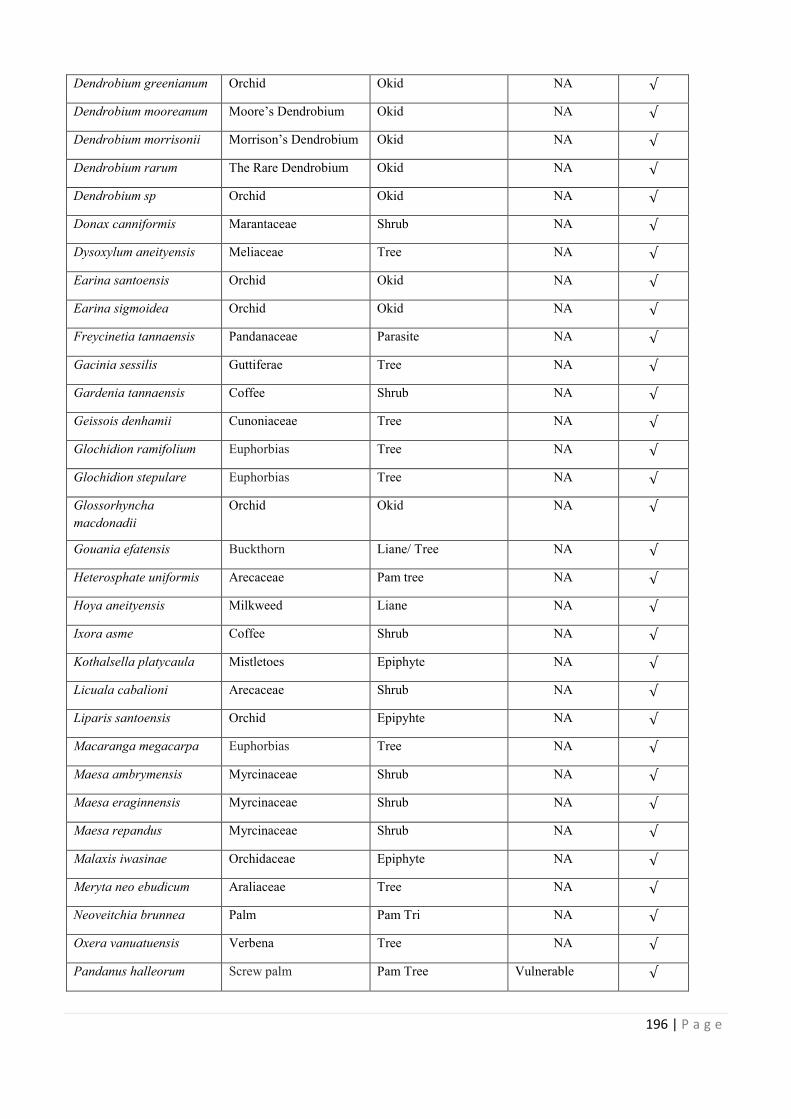
196 | P a g e
Dendrobium greenianum Orchid Okid NA
Dendrobium mooreanum Moore’s Dendrobium Okid NA
Dendrobium morrisonii Morrison’s Dendrobium Okid NA
Dendrobium rarum The Rare Dendrobium Okid NA
Dendrobium sp Orchid Okid NA
Donax canniformis Marantaceae Shrub NA
Dysoxylum aneityensis Meliaceae Tree NA
Earina santoensis Orchid Okid NA
Earina sigmoidea Orchid Okid NA
Freycinetia tannaensis Pandanaceae Parasite NA
Gacinia sessilis Guttiferae Tree NA
Gardenia tannaensis Coffee Shrub NA
Geissois denhamii Cunoniaceae Tree NA
Glochidion ramifolium Euphorbias Tree NA
Glochidion stepulare Euphorbias Tree NA
Glossorhyncha
macdonadii
Orchid Okid NA
Gouania efatensis Buckthorn Liane/ Tree NA
Heterosphate uniformis Arecaceae Pam tree NA
Hoya aneityensis Milkweed Liane NA
Ixora asme Coffee Shrub NA
Kothalsella platycaula Mistletoes Epiphyte NA
Licuala cabalioni Arecaceae Shrub NA
Liparis santoensis Orchid Epipyhte NA
Macaranga megacarpa Euphorbias Tree NA
Maesa ambrymensis Myrcinaceae Shrub NA
Maesa eraginnensis Myrcinaceae Shrub NA
Maesa repandus Myrcinaceae Shrub NA
Malaxis iwasinae Orchidaceae Epiphyte NA
Meryta neo ebudicum Araliaceae Tree NA
Neoveitchia brunnea Palm Pam Tri NA
Oxera vanuatuensis Verbena Tree NA
Pandanus halleorum Screw palm Pam Tree Vulnerable
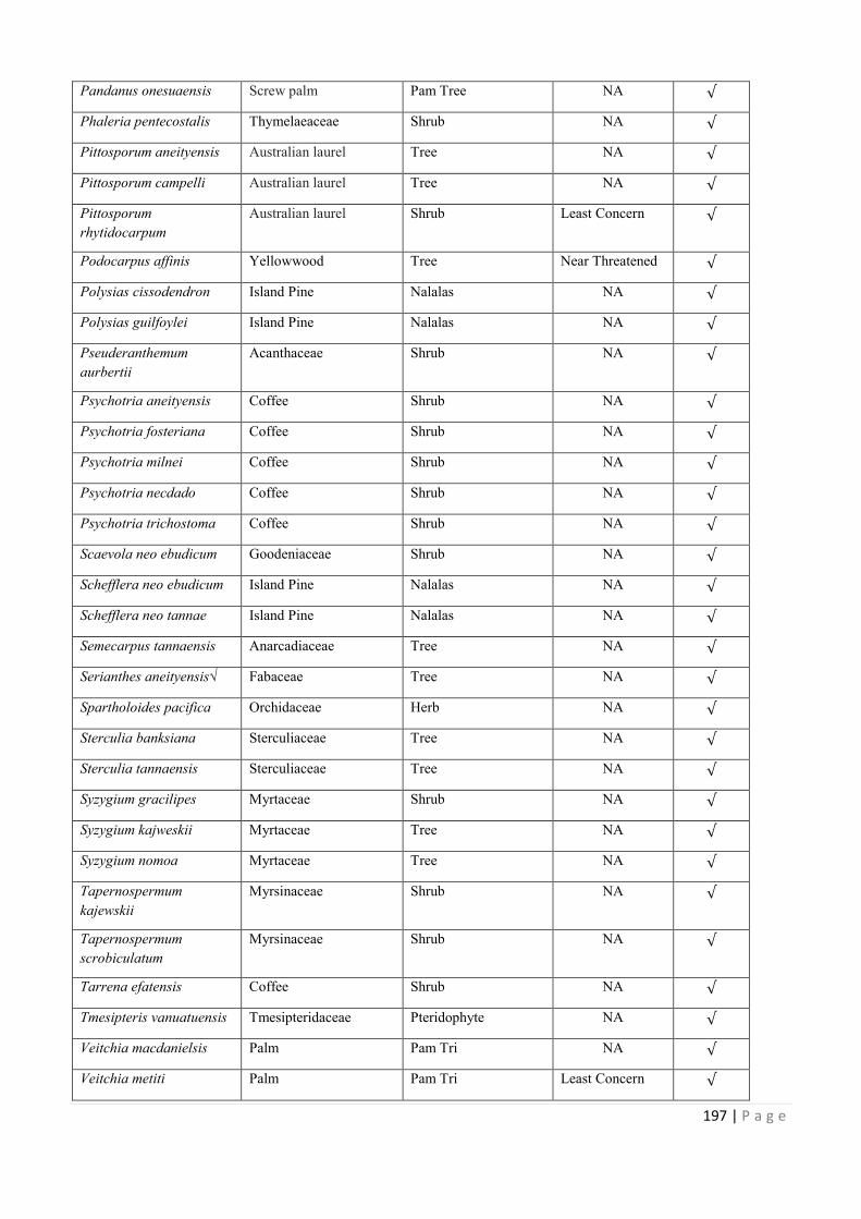
Morrison’s Dendrobium
197 | P a g e
Pandanus onesuaensis Screw palm Pam Tree NA
Phaleria pentecostalis Thymelaeaceae Shrub NA
Pittosporum aneityensis Australian laurel Tree NA
Pittosporum campelli Australian laurel Tree NA
Pittosporum
rhytidocarpum
Australian laurel Shrub Least Concern
Podocarpus affinis Yellowwood Tree Near Threatened
Polysias cissodendron Island Pine Nalalas NA
Polysias guilfoylei Island Pine Nalalas NA
Pseuderanthemum
aurbertii
Acanthaceae Shrub NA
Psychotria aneityensis Coffee Shrub NA
Psychotria fosteriana Coffee Shrub NA
Psychotria milnei Coffee Shrub NA
Psychotria necdado Coffee Shrub NA
Psychotria trichostoma Coffee Shrub NA
Scaevola neo ebudicum Goodeniaceae Shrub NA
Schefflera neo ebudicum Island Pine Nalalas NA
Schefflera neo tannae Island Pine Nalalas NA
Semecarpus tannaensis Anarcadiaceae Tree NA
Serianthes aneityensis√ Fabaceae Tree NA
Spartholoides pacifica Orchidaceae Herb NA
Sterculia banksiana Sterculiaceae Tree NA
Sterculia tannaensis Sterculiaceae Tree NA
Syzygium gracilipes Myrtaceae Shrub NA
Syzygium kajweskii Myrtaceae Tree NA
Syzygium nomoa Myrtaceae Tree NA
Tapernospermum
kajewskii
Myrsinaceae Shrub NA
Tapernospermum
scrobiculatum
Myrsinaceae Shrub NA
Tarrena efatensis Coffee Shrub NA
Tmesipteris vanuatuensis Tmesipteridaceae Pteridophyte NA
Veitchia macdanielsis Palm Pam Tri NA
Veitchia metiti Palm Pam Tri Least Concern
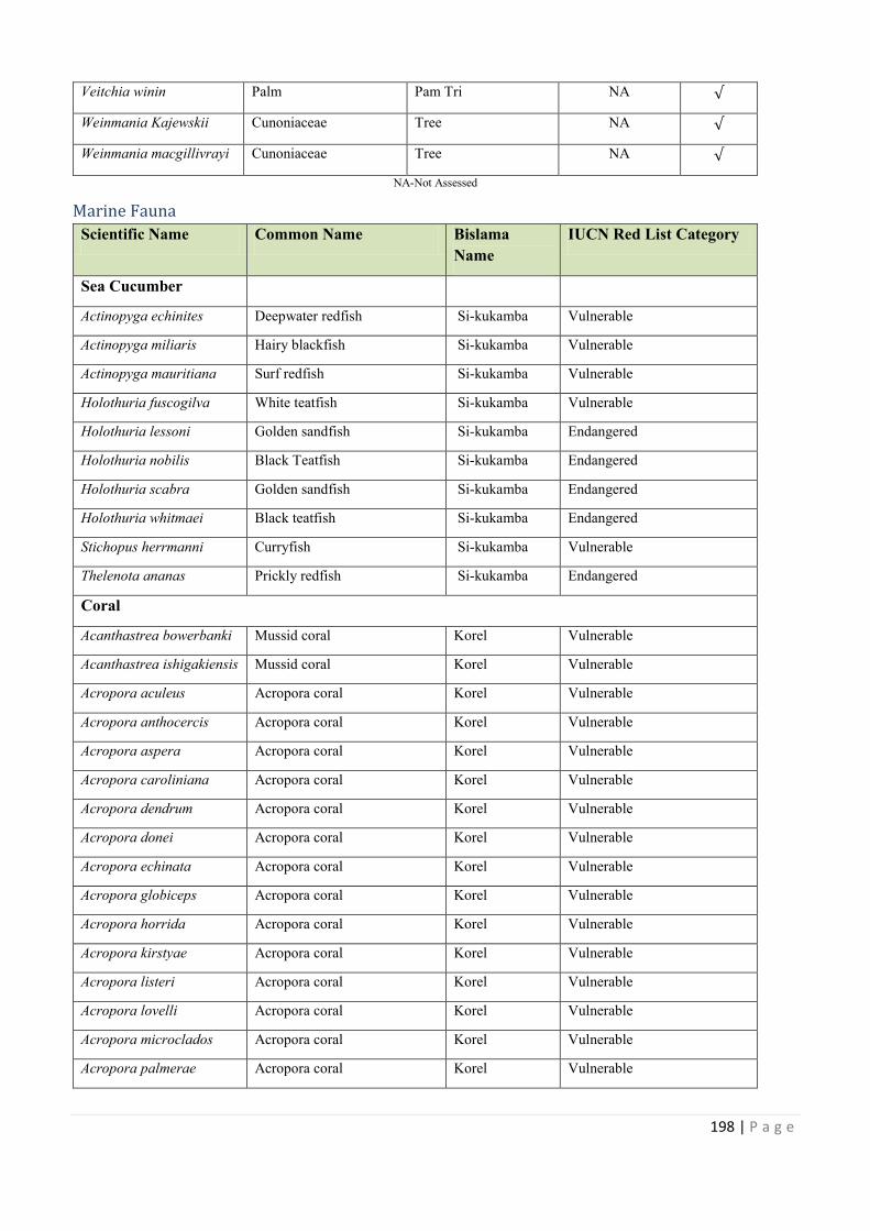
198 | P a g e
Veitchia winin Palm Pam Tri NA
Weinmania Kajewskii Cunoniaceae Tree NA
Weinmania macgillivrayi Cunoniaceae Tree NA
NA-Not Assessed
Marine Fauna
Scientific Name Common Name Bislama
Name
IUCN Red List Category
Sea Cucumber
Actinopyga echinites Deepwater redfish Si-kukamba Vulnerable
Actinopyga miliaris Hairy blackfish Si-kukamba Vulnerable
Actinopyga mauritiana Surf redfish Si-kukamba Vulnerable
Holothuria fuscogilva White teatfish Si-kukamba Vulnerable
Holothuria lessoni Golden sandfish Si-kukamba Endangered
Holothuria nobilis Black Teatfish Si-kukamba Endangered
Holothuria scabra Golden sandfish Si-kukamba Endangered
Holothuria whitmaei Black teatfish Si-kukamba Endangered
Stichopus herrmanni Curryfish Si-kukamba Vulnerable
Thelenota ananas Prickly redfish Si-kukamba Endangered
Coral
Acanthastrea bowerbanki Mussid coral Korel Vulnerable
Acanthastrea ishigakiensis Mussid coral Korel Vulnerable
Acropora aculeus Acropora coral Korel Vulnerable
Acropora anthocercis Acropora coral Korel Vulnerable
Acropora aspera Acropora coral Korel Vulnerable
Acropora caroliniana Acropora coral Korel Vulnerable
Acropora dendrum Acropora coral Korel Vulnerable
Acropora donei Acropora coral Korel Vulnerable
Acropora echinata Acropora coral Korel Vulnerable
Acropora globiceps Acropora coral Korel Vulnerable
Acropora horrida Acropora coral Korel Vulnerable
Acropora kirstyae Acropora coral Korel Vulnerable
Acropora listeri Acropora coral Korel Vulnerable
Acropora lovelli Acropora coral Korel Vulnerable
Acropora microclados Acropora coral Korel Vulnerable
Acropora palmerae Acropora coral Korel Vulnerable
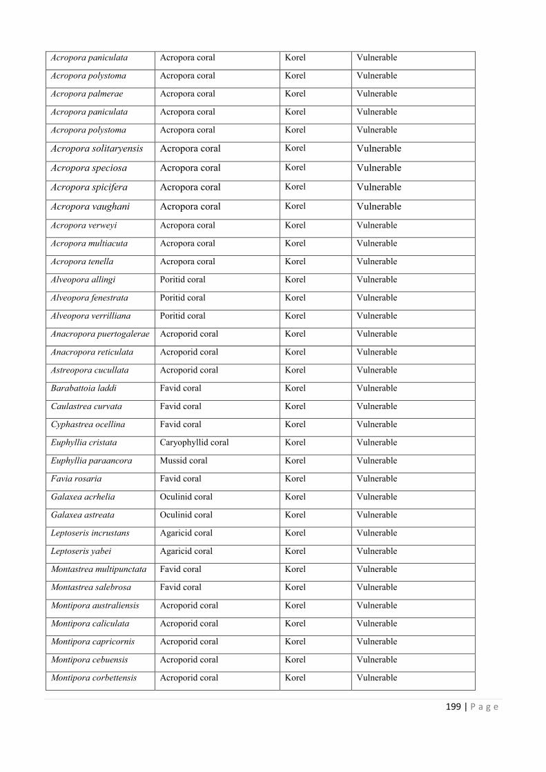
Weinmania macgillivrayi
IUCN Red List Category
Acanthastrea bowerbanki
trea ishigakiensis
199 | P a g e
Acropora paniculata Acropora coral Korel Vulnerable
Acropora polystoma Acropora coral Korel Vulnerable
Acropora palmerae Acropora coral Korel Vulnerable
Acropora paniculata Acropora coral Korel Vulnerable
Acropora polystoma Acropora coral Korel Vulnerable
Acropora solitaryensis Acropora coral Korel Vulnerable
Acropora speciosa Acropora coral Korel Vulnerable
Acropora spicifera Acropora coral Korel Vulnerable
Acropora vaughani Acropora coral Korel Vulnerable
Acropora verweyi Acropora coral Korel Vulnerable
Acropora multiacuta Acropora coral Korel Vulnerable
Acropora tenella Acropora coral Korel Vulnerable
Alveopora allingi Poritid coral Korel Vulnerable
Alveopora fenestrata Poritid coral Korel Vulnerable
Alveopora verrilliana Poritid coral Korel Vulnerable
Anacropora puertogalerae Acroporid coral Korel Vulnerable
Anacropora reticulata Acroporid coral Korel Vulnerable
Astreopora cucullata Acroporid coral Korel Vulnerable
Barabattoia laddi Favid coral Korel Vulnerable
Caulastrea curvata Favid coral Korel Vulnerable
Cyphastrea ocellina Favid coral Korel Vulnerable
Euphyllia cristata Caryophyllid coral Korel Vulnerable
Euphyllia paraancora Mussid coral Korel Vulnerable
Favia rosaria Favid coral Korel Vulnerable
Galaxea acrhelia Oculinid coral Korel Vulnerable
Galaxea astreata Oculinid coral Korel Vulnerable
Leptoseris incrustans Agaricid coral Korel Vulnerable
Leptoseris yabei Agaricid coral Korel Vulnerable
Montastrea multipunctata Favid coral Korel Vulnerable
Montastrea salebrosa Favid coral Korel Vulnerable
Montipora australiensis Acroporid coral Korel Vulnerable
Montipora caliculata Acroporid coral Korel Vulnerable
Montipora capricornis Acroporid coral Korel Vulnerable
Montipora cebuensis Acroporid coral Korel Vulnerable
Montipora corbettensis Acroporid coral Korel Vulnerable
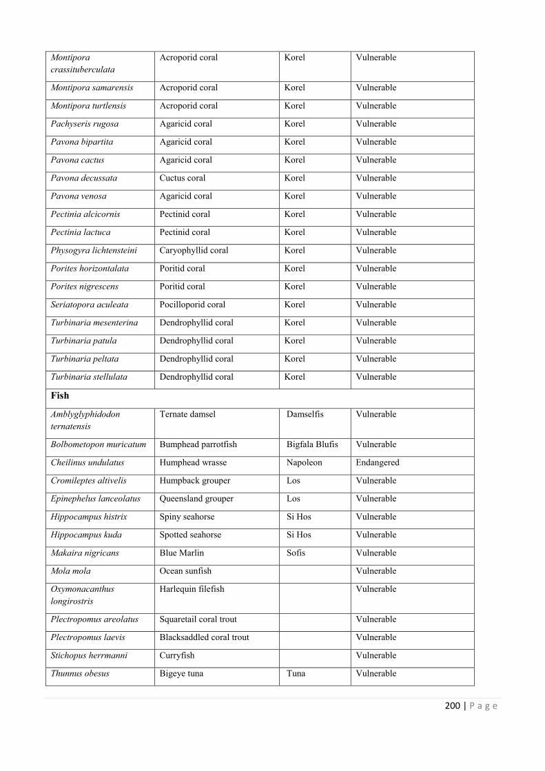
200 | P a g e
Montipora
crassituberculata
Acroporid coral Korel Vulnerable
Montipora samarensis Acroporid coral Korel Vulnerable
Montipora turtlensis Acroporid coral Korel Vulnerable
Pachyseris rugosa Agaricid coral Korel Vulnerable
Pavona bipartita Agaricid coral Korel Vulnerable
Pavona cactus Agaricid coral Korel Vulnerable
Pavona decussata Cuctus coral Korel Vulnerable
Pavona venosa Agaricid coral Korel Vulnerable
Pectinia alcicornis Pectinid coral Korel Vulnerable
Pectinia lactuca Pectinid coral Korel Vulnerable
Physogyra lichtensteini Caryophyllid coral Korel Vulnerable
Porites horizontalata Poritid coral Korel Vulnerable
Porites nigrescens Poritid coral Korel Vulnerable
Seriatopora aculeata Pocilloporid coral Korel Vulnerable
Turbinaria mesenterina Dendrophyllid coral Korel Vulnerable
Turbinaria patula Dendrophyllid coral Korel Vulnerable
Turbinaria peltata Dendrophyllid coral Korel Vulnerable
Turbinaria stellulata Dendrophyllid coral Korel Vulnerable
Fish
Amblyglyphidodon
ternatensis
Ternate damsel Damselfis Vulnerable
Bolbometopon muricatum Bumphead parrotfish Bigfala Blufis Vulnerable
Cheilinus undulatus Humphead wrasse Napoleon Endangered
Cromileptes altivelis Humpback grouper Los Vulnerable
Epinephelus lanceolatus Queensland grouper Los Vulnerable
Hippocampus histrix Spiny seahorse Si Hos Vulnerable
Hippocampus kuda Spotted seahorse Si Hos Vulnerable
Makaira nigricans Blue Marlin Sofis Vulnerable
Mola mola Ocean sunfish Vulnerable
Oxymonacanthus
longirostris
Harlequin filefish Vulnerable
Plectropomus areolatus Squaretail coral trout Vulnerable
Plectropomus laevis Blacksaddled coral trout Vulnerable
Stichopus herrmanni Curryfish Vulnerable
Thunnus obesus Bigeye tuna Tuna Vulnerable
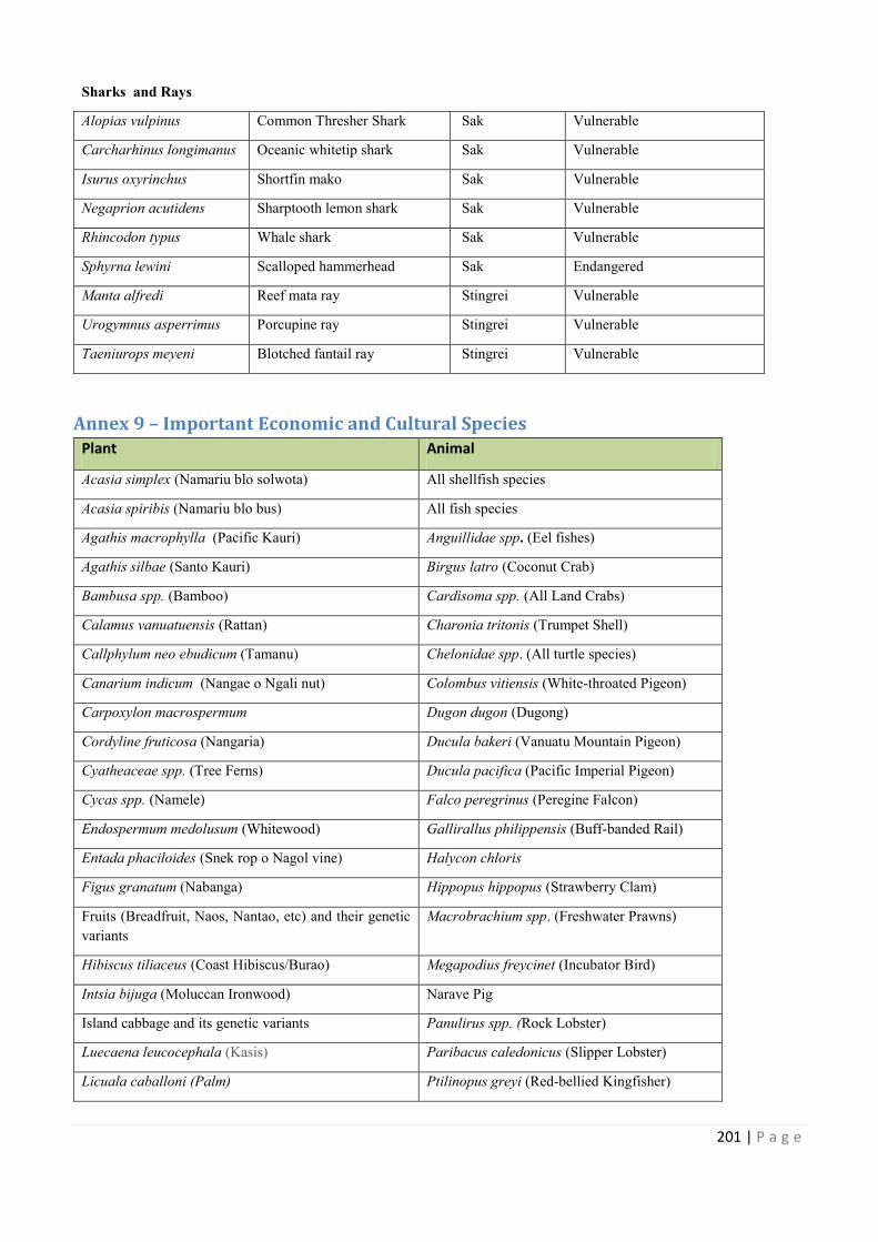
Bigfala Blufis
201 | P a g e
Sharks and Rays
Alopias vulpinus Common Thresher Shark Sak Vulnerable
Carcharhinus longimanus Oceanic whitetip shark Sak Vulnerable
Isurus oxyrinchus Shortfin mako Sak Vulnerable
Negaprion acutidens Sharptooth lemon shark Sak Vulnerable
Rhincodon typus Whale shark Sak Vulnerable
Sphyrna lewini Scalloped hammerhead Sak Endangered
Manta alfredi Reef mata ray Stingrei Vulnerable
Urogymnus asperrimus Porcupine ray Stingrei Vulnerable
Taeniurops meyeni Blotched fantail ray Stingrei Vulnerable
Annex 9 – Important Economic and Cultural Species
Plant Animal
Acasia simplex (Namariu blo solwota) All shellfish species
Acasia spiribis (Namariu blo bus) All fish species
Agathis macrophylla (Pacific Kauri) Anguillidae spp. (Eel fishes)
Agathis silbae (Santo Kauri) Birgus latro (Coconut Crab)
Bambusa spp. (Bamboo) Cardisoma spp. (All Land Crabs)
Calamus vanuatuensis (Rattan) Charonia tritonis (Trumpet Shell)
Callphylum neo ebudicum (Tamanu) Chelonidae spp. (All turtle species)
Canarium indicum (Nangae o Ngali nut) Colombus vitiensis (White-throated Pigeon)
Carpoxylon macrospermum Dugon dugon (Dugong)
Cordyline fruticosa (Nangaria) Ducula bakeri (Vanuatu Mountain Pigeon)
Cyatheaceae spp. (Tree Ferns) Ducula pacifica (Pacific Imperial Pigeon)
Cycas spp. (Namele) Falco peregrinus (Peregine Falcon)
Endospermum medolusum (Whitewood) Gallirallus philippensis (Buff-banded Rail)
Entada phaciloides (Snek rop o Nagol vine) Halycon chloris
Figus granatum (Nabanga) Hippopus hippopus (Strawberry Clam)
Fruits (Breadfruit, Naos, Nantao, etc) and their genetic
variants
Macrobrachium spp. (Freshwater Prawns)
Hibiscus tiliaceus (Coast Hibiscus/Burao) Megapodius freycinet (Incubator Bird)
Intsia bijuga (Moluccan Ironwood) Narave Pig
Island cabbage and its genetic variants Panulirus spp. (Rock Lobster)
Luecaena leucocephala (Kasis) Paribacus caledonicus (Slipper Lobster)
Licuala caballoni (Palm) Ptilinopus greyi (Red-bellied Kingfisher)
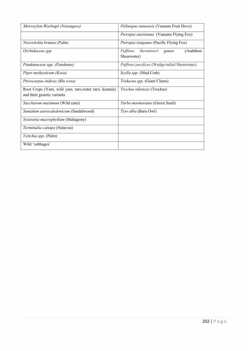
202 | P a g e
Metroxylon Warbugii (Natangura) Ptilinopus tannensis (Vanuatu Fruit Dove)
Pteropus aneitianus (Vanuatu Flying Fox)
Neoveitchia brunea (Palm) Pteropus tonganus (Pacific Flying Fox)
Orchidaceae spp. Puffinus lherminieri gunax (Audubon
Shearwater)
Pandanaceae spp. (Pandanus) Puffinus pacificus (Wedge-tailed Shearwater)
Piper methysticum (Kava) Scylla spp. (Mud Crab)
Pterocarpus indicus (Blu wota) Tridacna spp. (Giant Clams)
Root Crops (Yam, wild yam, taro,water taro, kumala)
and their genetic variants
Trochus niloticus (Trochus)
Saccharum maximum (Wild cane) Turbo marmoratus (Green Snail)
Santalum astrocaledonicum (Sandalwood) Tyto alba (Barn Owl)
Swietenia macrophyllum (Mahagony)
Terminalia cattapa (Natavoa)
Veitchia spp. (Palm)
Wild ‘cabbages’
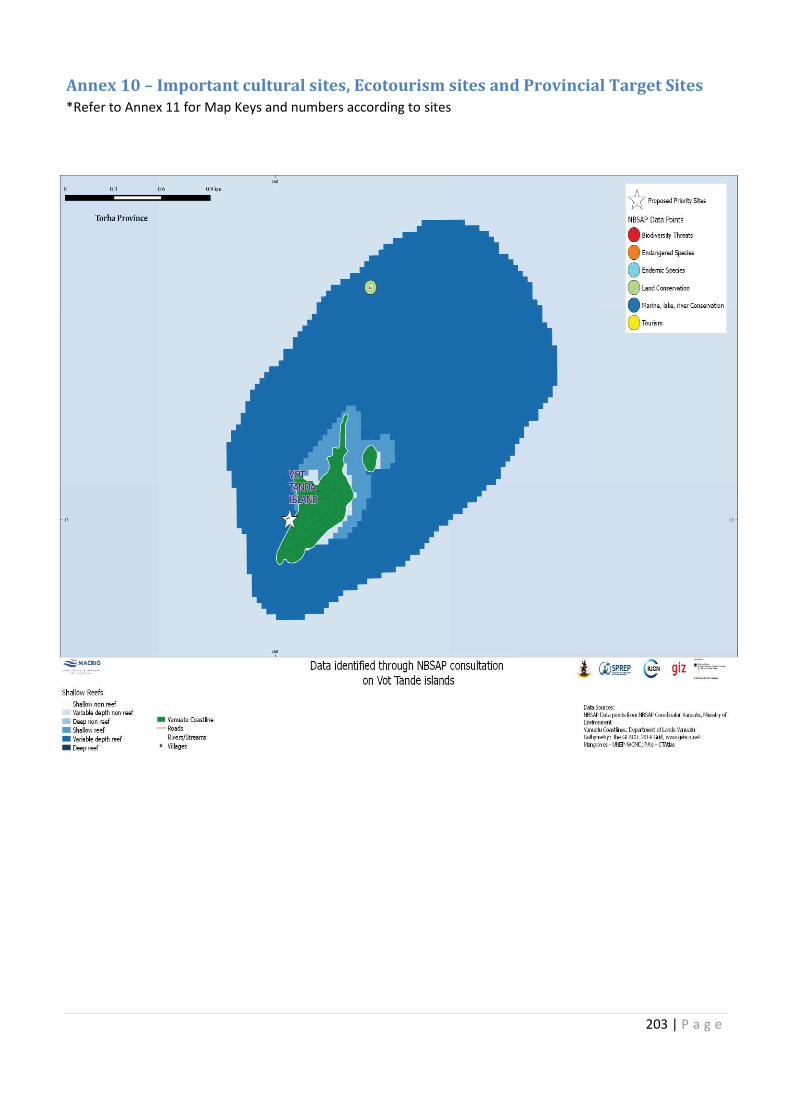
(Audubon
Root Crops (Yam, wild yam, taro,water taro, kumala)
203 | P a g e
Annex 10 – Important cultural sites, Ecotourism sites and Provincial Target Sites
*Refer to Annex 11 for Map Keys and numbers according to sites
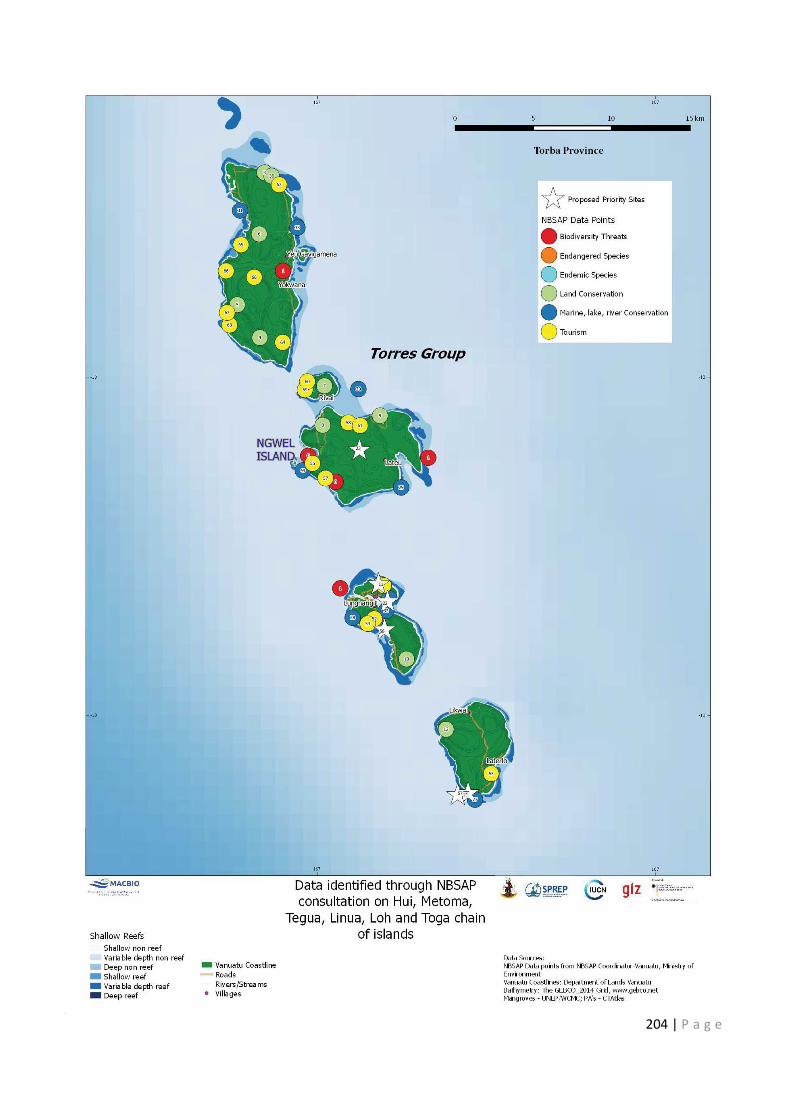
204 | P a g e
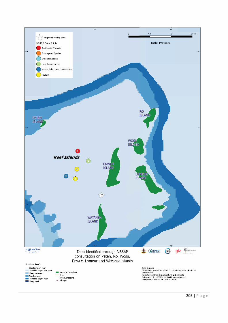
205 | P a g e
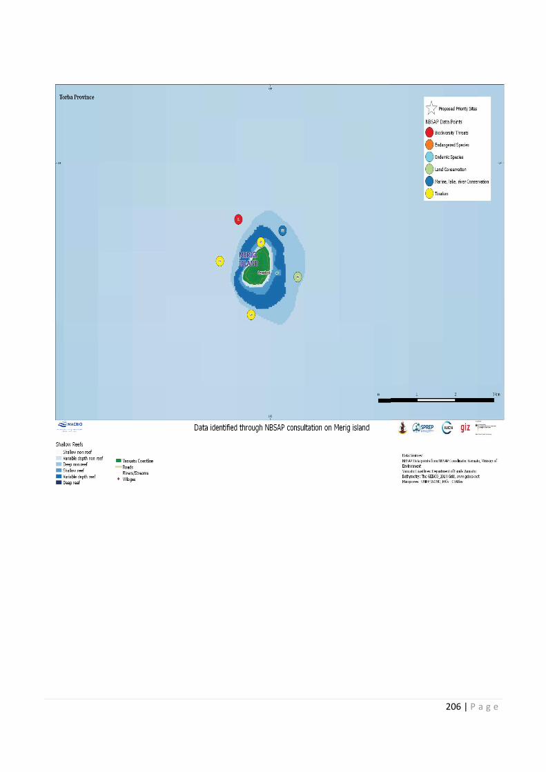
206 | P a g e
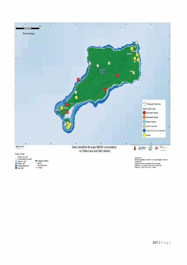
207 | P a g e
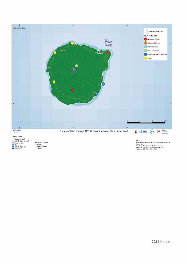
208 | P a g e
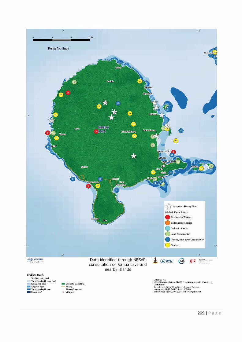
209 | P a g e
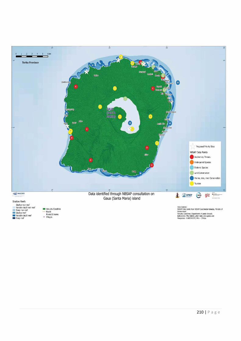
210 | P a g e

211 | P a g e
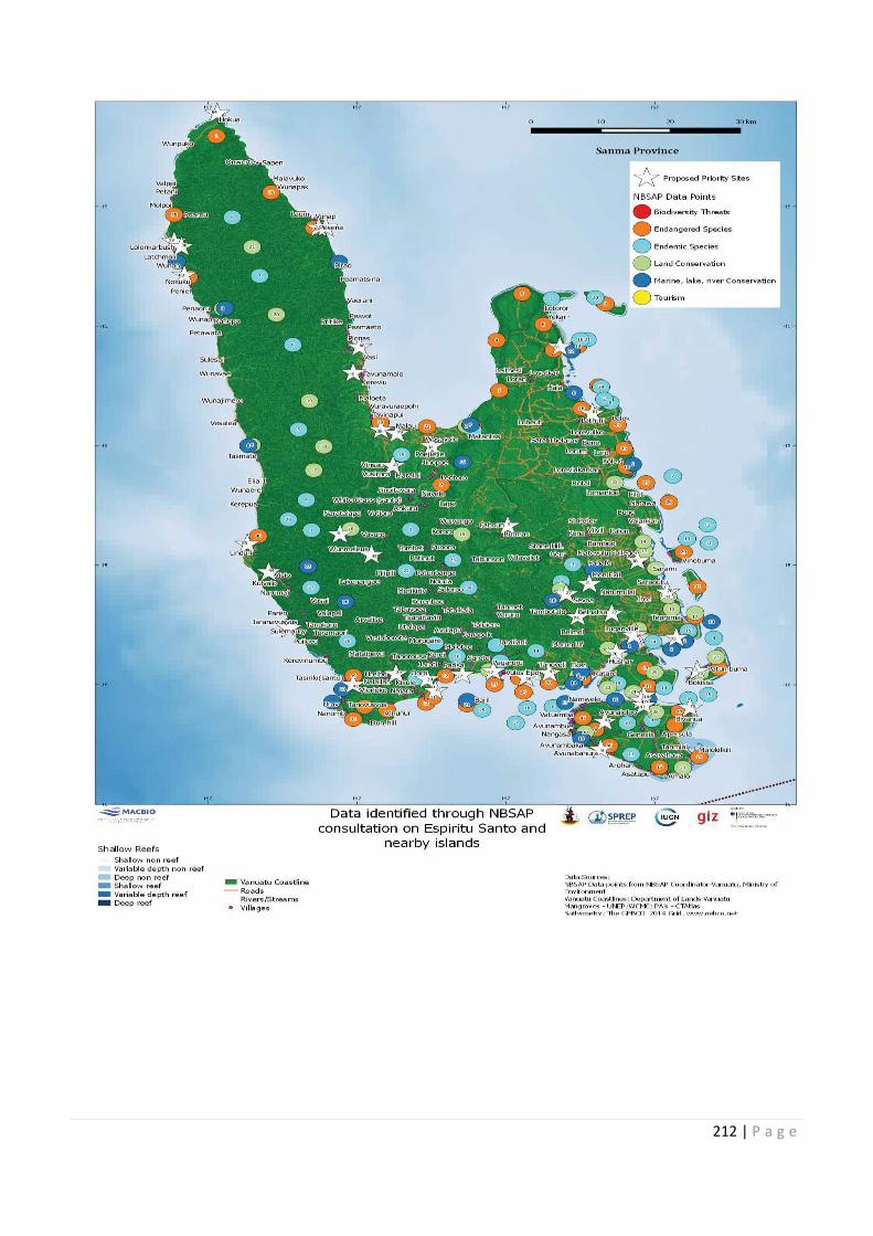
212 | P a g e

213 | P a g e
214 | P a g e
215 | P a g e
216 | P a g e
217 | P a g e
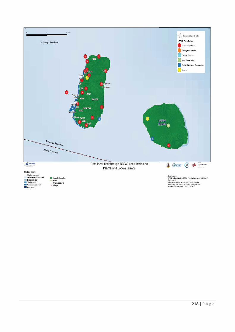
218 | P a g e
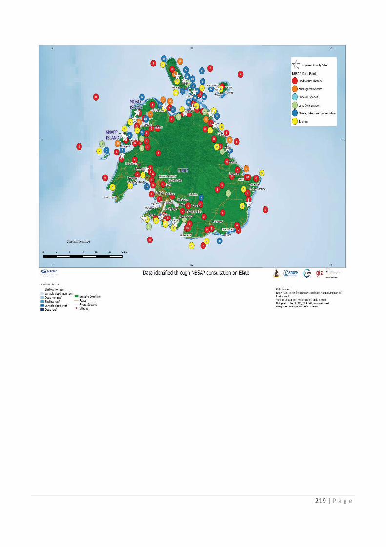
219 | P a g e
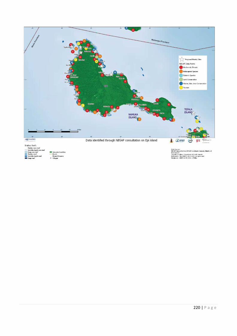
220 | P a g e
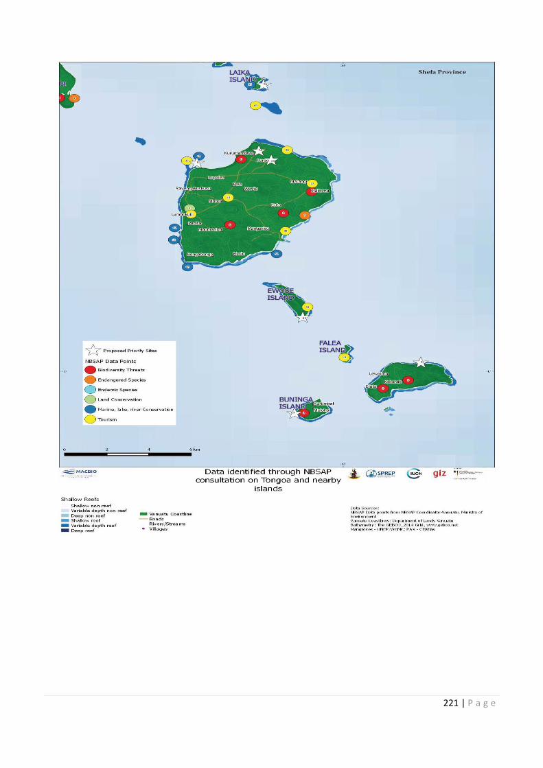
221 | P a g e
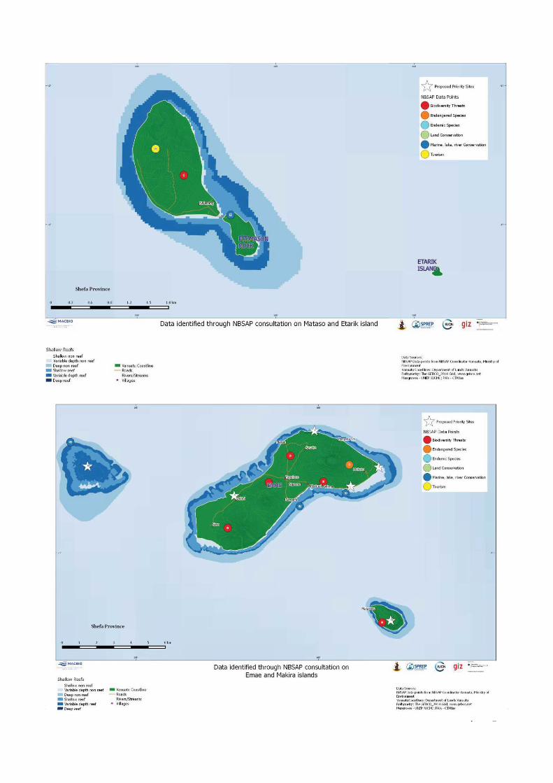
222 | P a g e
222 | P a g e
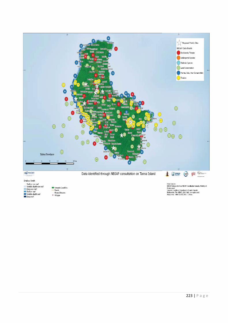
222 | g e 223 | P a g e
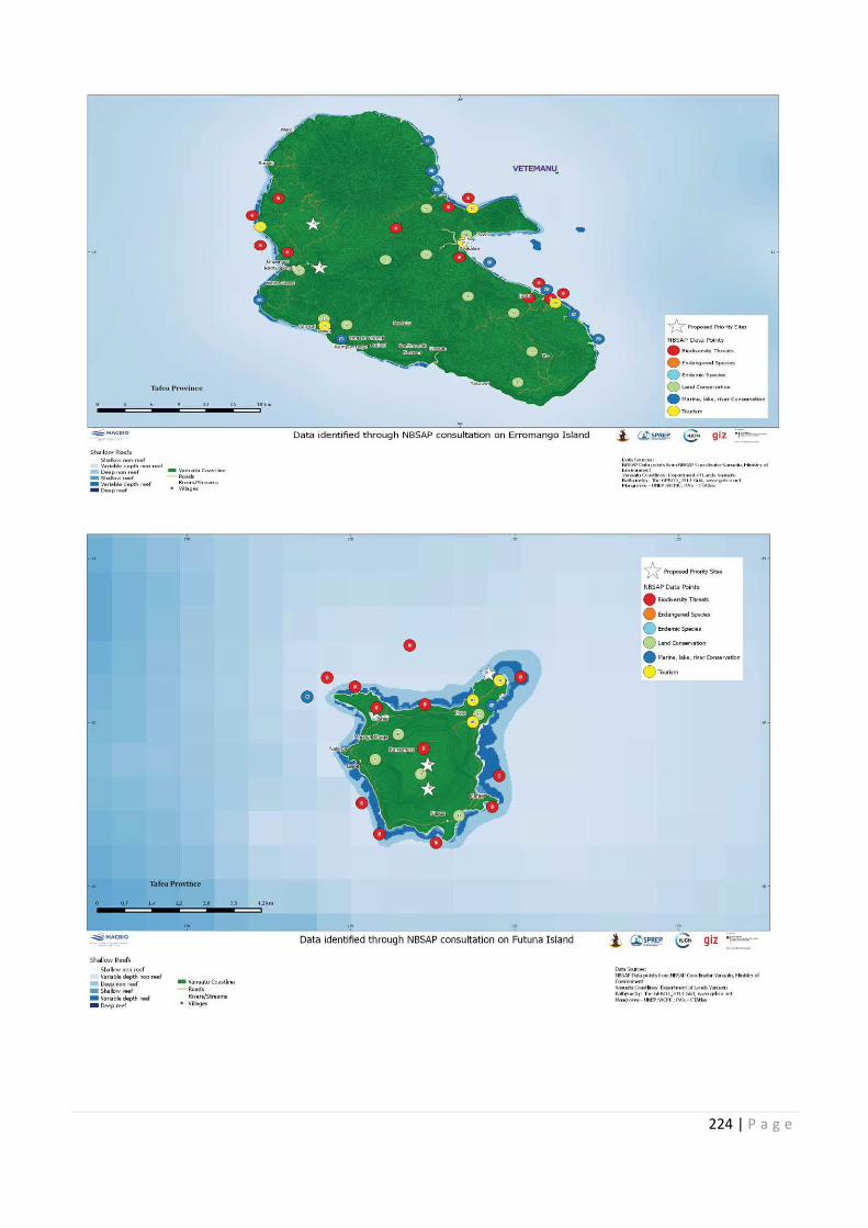
224 | P a g e
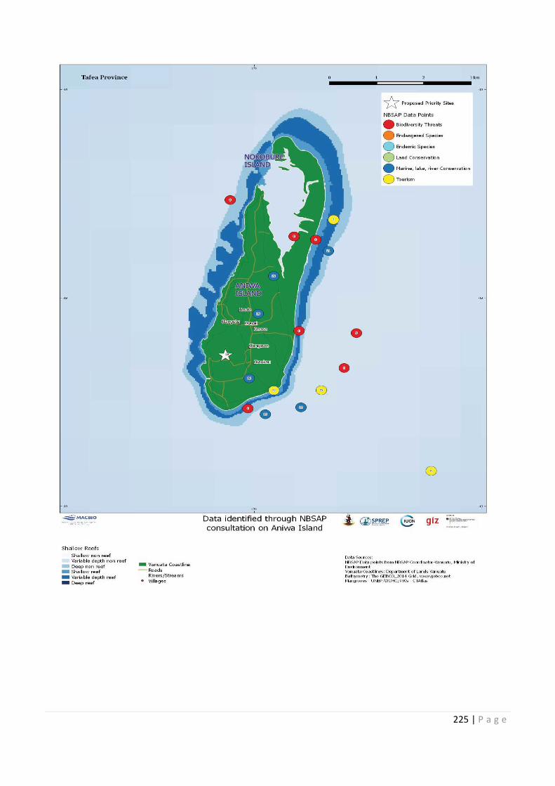
225 | P a g e
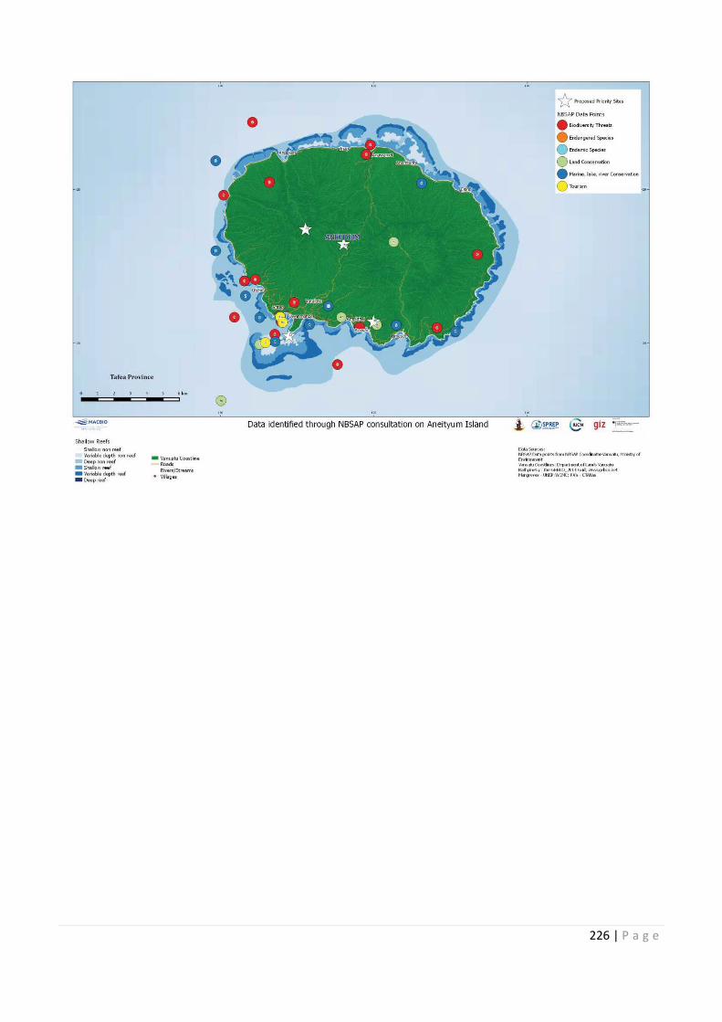
226 | P a g e
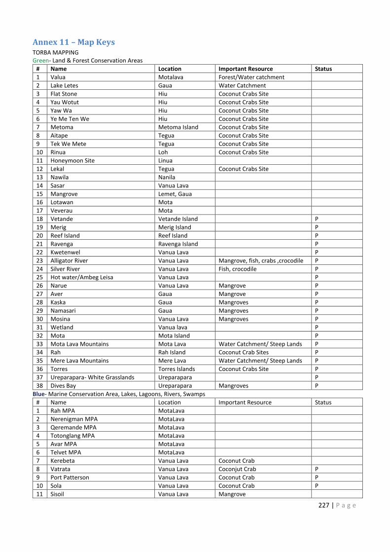
227 | P a g e
Annex 11 – Map Keys
TORBA MAPPING
Green- Land & Forest Conservation Areas
# Name Location Important Resource Status
1 Valua Motalava Forest/Water catchment
2 Lake Letes Gaua Water Catchment
3 Flat Stone Hiu Coconut Crabs Site
4 Yau Wotut Hiu Coconut Crabs Site
5 Yaw Wa Hiu Coconut Crabs Site
6 Ye Me Ten We Hiu Coconut Crabs Site
7 Metoma Metoma Island Coconut Crabs Site
8 Aitape Tegua Coconut Crabs Site
9 Tek We Mete Tegua Coconut Crabs Site
10 Rinua Loh Coconut Crabs Site
11 Honeymoon Site Linua
12 Lekal Tegua Coconut Crabs Site
13 Nawila Nanila
14 Sasar Vanua Lava
15 Mangrove Lemet, Gaua
16 Lotawan Mota
17 Veverau Mota
18 Vetande Vetande Island P
19 Merig Merig Island P
20 Reef Island Reef Island P
21 Ravenga Ravenga Island P
22 Kwetenwel Vanua Lava P
23 Alligator River Vanua Lava Mangrove, fish, crabs ,crocodile P
24 Silver River Vanua Lava Fish, crocodile P
25 Hot water/Ambeg Leisa Vanua Lava P
26 Narue Vanua Lava Mangrove P
27 Aver Gaua Mangrove P
28 Kaska Gaua Mangroves P
29 Namasari Gaua Mangroves P
30 Mosina Vanua Lava Mangroves P
31 Wetland Vanua lava P
32 Mota Mota Island P
33 Mota Lava Mountains Mota Lava Water Catchment/ Steep Lands P
34 Rah Rah Island Coconut Crab Sites P
35 Mere Lava Mountains Mere Lava Water Catchment/ Steep Lands P
36 Torres Torres Islands Coconut Crabs Site P
37 Ureparapara- White Grasslands Ureparapara P
38 Dives Bay Ureparapara Mangroves P
Blue- Marine Conservation Area, Lakes, Lagoons, Rivers, Swamps
# Name Location Important Resource Status
1 Rah MPA MotaLava
2 Nerenigman MPA MotaLava
3 Qeremande MPA MotaLava
4 Totonglang MPA MotaLava
5 Avar MPA MotaLava
6 Telvet MPA MotaLava
7 Kerebeta Vanua Lava Coconut Crab
8 Vatrata Vanua Lava Coconjut Crab P
9 Port Patterson Vanua Lava Coconut Crab P
10 Sola Vanua Lava Coconut Crab P
11 Sisoil Vanua Lava Mangrove
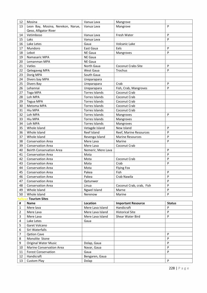
228 | P a g e
12 Mosina Vanua Lava Mangrove
13 Leon Bay, Mosina, Nerekon, Narue,
Qeso, Alligator River
Vanua Lava Mangrove P
14 Vetimboso Vanua Lava Fresh Water P
15 Laks Vanua Lava P
16 Lake Letes Gaua Volcanic Lake
17 Mundoro East Gaua Eels P
18 Lebot NE Gaua Mangroves P
19 Namasaric MPA NE Gaua
20 Lemanman MPA NE Gaua
21 Vatles North Gaua Coconut Crabs Site P
22 Qetegaveg MPA West Gaua Trochus P
23 Dorig MPA South Gaua
24 Divers bay MPA Ureparapara
25 Divers Bay Ureparapara Crab P
26 Lehannai Ureparapara Fish, Crab, Mangroves P
27 Toga MPA Torres Islands Coconut Crab
28 Loh MPA Torres Islands Coconut Crab
29 Tegua MPA Torres Islands Coconut Crab
30 Metoma MPA Torres Islands Coconut Crab
31 Hiu MPA Torres Islands Coconut Crab
32 Loh MPA Torres Islands Mangroves P
33 Hiu MPA Torres Islands Mangroves
34 Loh MPA Torres Islands Mangroves
35 Whole Island Vetagde Island New Island P
36 Whole Island Reef Island Reef, Marine Resources P
37 Whole Island Revenga Island Marine Resources P
38 Conservation Area Mere Lava Marine P
39 Conservation Area Mere Lava Coconut Crab
40 Beirth Conservation Area Nemerir, Mere Lava P
41 Conservation Area Mota P
42 Conservation Area Mota Coconut Crab P
43 Conservation Area Mota Crab P
44 Conservation Area Mota Flying Fox
45 Conservation Area Pakea Fish P
46 Conservation Area Pakea Crab Nawila P
47 Conservation Area Qetunwer P
48 Conservation Area Linua Coconut Crab, crab, Fish P
49 Whole Island Ngwel Island Marne P
50 Whole Island Nerenow Marine P
Yellow- Tourism Sites
# Name Location Important Resource Status
1 Mere lava Mere Lava Island Handicraft P
2 Mere Lava Mere Lava Island Historical Site P
3 Mere Lava Mere Lava Island Shear Water Bird P
4 Lake Letes Gaua
5 Garet Volcano
6 Siri Waterfalls
7 Qetion Cave P
8 Monolite Stone P
9 Original Water Music Dolap, Gaua P
10 Marine Conservation Area Navar, Gaua P
11 Forest Conservation Gaua P
12 Handicraft Bengaren, Gaua
13 Custom Play Dolap P
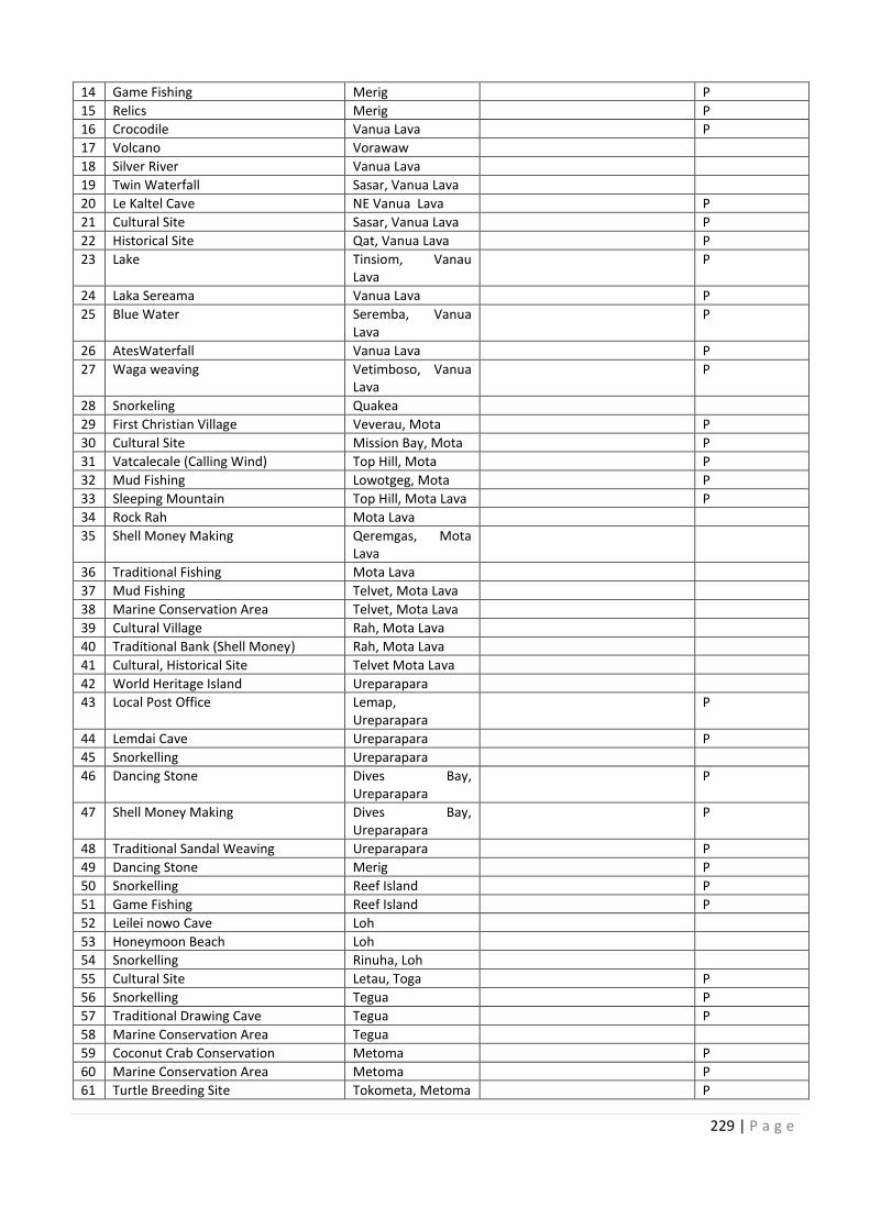
12
13 Leon Bay, Mosina, Nerekon, Narue,
14
15
16
17
18
19
20
21
22
23
24
25
26
27
28
29
30
31
32
33
34
35
36
37
38
39
40 Nemerir, Mere Lava
41
42
43
44
45
46
47
48
49
50
10
11
12
13
229 | P a g e
14 Game Fishing Merig P
15 Relics Merig P
16 Crocodile Vanua Lava P
17 Volcano Vorawaw
18 Silver River Vanua Lava
19 Twin Waterfall Sasar, Vanua Lava
20 Le Kaltel Cave NE Vanua Lava P
21 Cultural Site Sasar, Vanua Lava P
22 Historical Site Qat, Vanua Lava P
23 Lake Tinsiom, Vanau
Lava
P
24 Laka Sereama Vanua Lava P
25 Blue Water Seremba, Vanua
Lava
P
26 AtesWaterfall Vanua Lava P
27 Waga weaving Vetimboso, Vanua
Lava
P
28 Snorkeling Quakea
29 First Christian Village Veverau, Mota P
30 Cultural Site Mission Bay, Mota P
31 Vatcalecale (Calling Wind) Top Hill, Mota P
32 Mud Fishing Lowotgeg, Mota P
33 Sleeping Mountain Top Hill, Mota Lava P
34 Rock Rah Mota Lava
35 Shell Money Making Qeremgas, Mota
Lava
36 Traditional Fishing Mota Lava
37 Mud Fishing Telvet, Mota Lava
38 Marine Conservation Area Telvet, Mota Lava
39 Cultural Village Rah, Mota Lava
40 Traditional Bank (Shell Money) Rah, Mota Lava
41 Cultural, Historical Site Telvet Mota Lava
42 World Heritage Island Ureparapara
43 Local Post Office Lemap,
Ureparapara
P
44 Lemdai Cave Ureparapara P
45 Snorkelling Ureparapara
46 Dancing Stone Dives Bay,
Ureparapara
P
47 Shell Money Making Dives Bay,
Ureparapara
P
48 Traditional Sandal Weaving Ureparapara P
49 Dancing Stone Merig P
50 Snorkelling Reef Island P
51 Game Fishing Reef Island P
52 Leilei nowo Cave Loh
53 Honeymoon Beach Loh
54 Snorkelling Rinuha, Loh
55 Cultural Site Letau, Toga P
56 Snorkelling Tegua P
57 Traditional Drawing Cave Tegua P
58 Marine Conservation Area Tegua
59 Coconut Crab Conservation Metoma P
60 Marine Conservation Area Metoma P
61 Turtle Breeding Site Tokometa, Metoma P
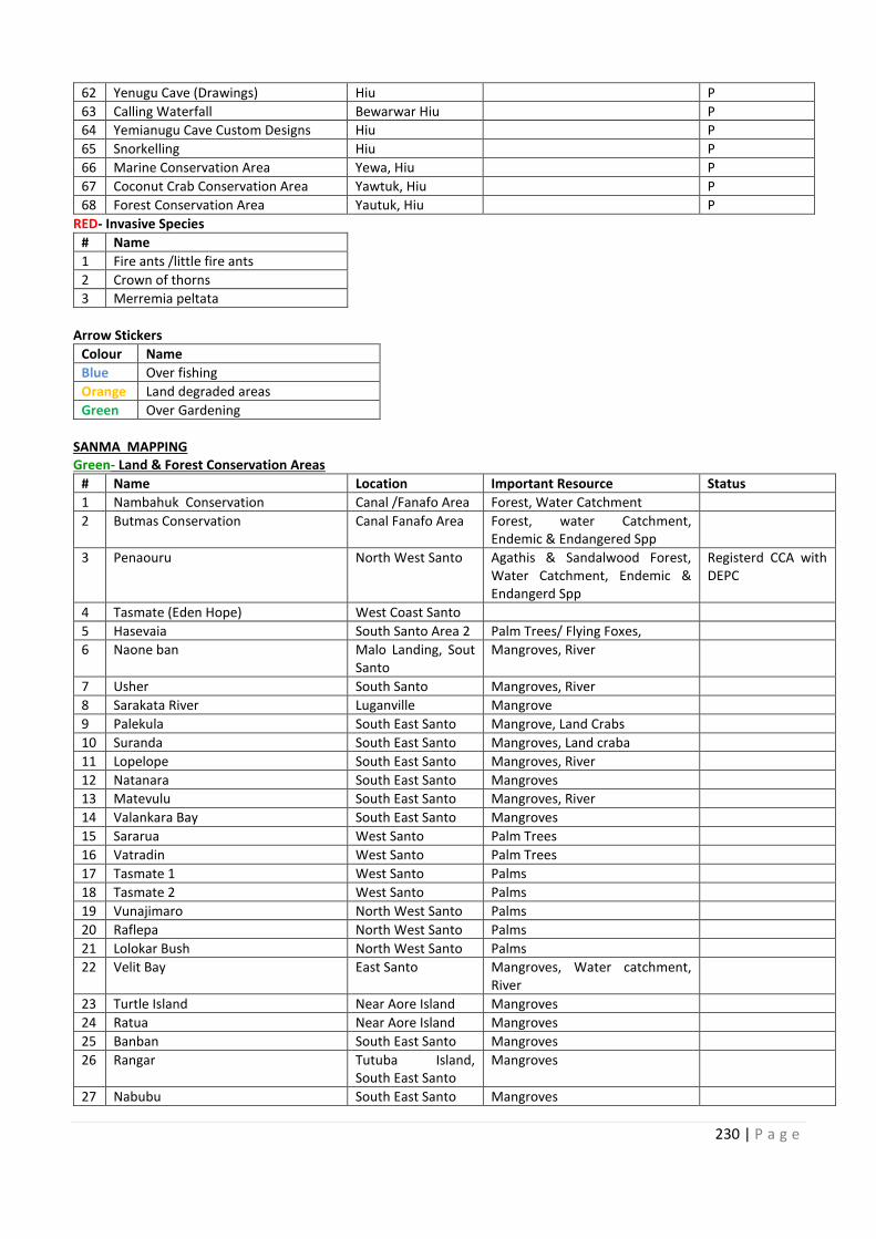
230 | P a g e
62 Yenugu Cave (Drawings) Hiu P
63 Calling Waterfall Bewarwar Hiu P
64 Yemianugu Cave Custom Designs Hiu P
65 Snorkelling Hiu P
66 Marine Conservation Area Yewa, Hiu P
67 Coconut Crab Conservation Area Yawtuk, Hiu P
68 Forest Conservation Area Yautuk, Hiu P
RED- Invasive Species
# Name
1 Fire ants /little fire ants
2 Crown of thorns
3 Merremia peltata
Arrow Stickers
Colour Name
Blue Over fishing
Orange Land degraded areas
Green Over Gardening
SANMA MAPPING
Green- Land & Forest Conservation Areas
# Name Location Important Resource Status
1 Nambahuk Conservation Canal /Fanafo Area Forest, Water Catchment
2 Butmas Conservation Canal Fanafo Area Forest, water Catchment,
Endemic & Endangered Spp
3 Penaouru North West Santo Agathis & Sandalwood Forest,
Water Catchment, Endemic &
Endangerd Spp
Registerd CCA with
DEPC
4 Tasmate (Eden Hope) West Coast Santo
5 Hasevaia South Santo Area 2 Palm Trees/ Flying Foxes,
6 Naone ban Malo Landing, Sout
Santo
Mangroves, River
7 Usher South Santo Mangroves, River
8 Sarakata River Luganville Mangrove
9 Palekula South East Santo Mangrove, Land Crabs
10 Suranda South East Santo Mangroves, Land craba
11 Lopelope South East Santo Mangroves, River
12 Natanara South East Santo Mangroves
13 Matevulu South East Santo Mangroves, River
14 Valankara Bay South East Santo Mangroves
15 Sararua West Santo Palm Trees
16 Vatradin West Santo Palm Trees
17 Tasmate 1 West Santo Palms
18 Tasmate 2 West Santo Palms
19 Vunajimaro North West Santo Palms
20 Raflepa North West Santo Palms
21 Lolokar Bush North West Santo Palms
22 Velit Bay East Santo Mangroves, Water catchment,
River
23 Turtle Island Near Aore Island Mangroves
24 Ratua Near Aore Island Mangroves
25 Banban South East Santo Mangroves
26 Rangar Tutuba Island,
South East Santo
Mangroves
27 Nabubu South East Santo Mangroves
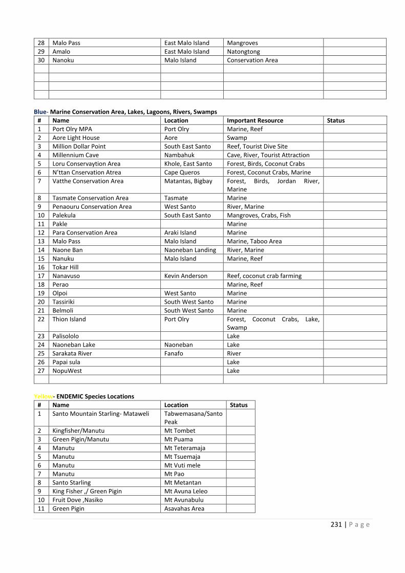
62
63
64
65
66
67
68
Forest, water Catchment,
Agathis & Sandalwood Forest, Registerd CCA with
Malo Landing, Sout
10
11
12
13
14
15
16
17
18
19
20
21
22 Mangroves, Water catchment,
23
24
25
26 Tutuba Island,
27
231 | P a g e
28 Malo Pass East Malo Island Mangroves
29 Amalo East Malo Island Natongtong
30 Nanoku Malo Island Conservation Area
Blue- Marine Conservation Area, Lakes, Lagoons, Rivers, Swamps
# Name Location Important Resource Status
1 Port Olry MPA Port Olry Marine, Reef
2 Aore Light House Aore Swamp
3 Million Dollar Point South East Santo Reef, Tourist Dive Site
4 Millennium Cave Nambahuk Cave, River, Tourist Attraction
5 Loru Conservaytion Area Khole, East Santo Forest, Birds, Coconut Crabs
6 N’ttan Cnservation Atrea Cape Queros Forest, Coconut Crabs, Marine
7 Vatthe Conservation Area Matantas, Bigbay Forest, Birds, Jordan River,
Marine
8 Tasmate Conservation Area Tasmate Marine
9 Penaouru Conservation Area West Santo River, Marine
10 Palekula South East Santo Mangroves, Crabs, Fish
11 Pakle Marine
12 Para Conservation Area Araki Island Marine
13 Malo Pass Malo Island Marine, Taboo Area
14 Naone Ban Naoneban Landing River, Marine
15 Nanuku Malo Island Marine, Reef
16 Tokar Hill
17 Nanavuso Kevin Anderson Reef, coconut crab farming
18 Perao Marine, Reef
19 Olpoi West Santo Marine
20 Tassiriki South West Santo Marine
21 Belmoli South West Santo Marine
22 Thion Island Port Olry Forest, Coconut Crabs, Lake,
Swamp
23 Palisololo Lake
24 Naoneban Lake Naoneban Lake
25 Sarakata River Fanafo River
26 Papai sula Lake
27 NopuWest Lake
Yellow- ENDEMIC Species Locations
# Name Location Status
1 Santo Mountain Starling- Mataweli Tabwemasana/Santo
Peak
2 Kingfisher/Manutu Mt Tombet
3 Green Pigin/Manutu Mt Puama
4 Manutu Mt Teteramaja
5 Manutu Mt Tsuemaja
6 Manutu Mt Vuti mele
7 Manutu Mt Pao
8 Santo Starling Mt Metantan
9 King Fisher ,/ Green Pigin Mt Avuna Leleo
10 Fruit Dove ,Nasiko Mt Avunabulu
11 Green Pigin Asavahas Area
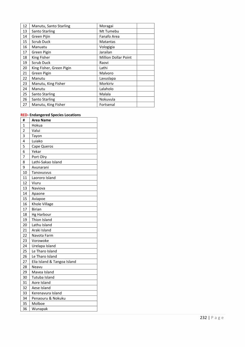
232 | P a g e
12 Manutu, Santo Starling Moragai
13 Santo Starling Mt Tumebu
14 Green Pijin Fanafo Area
15 Scrub Duck Matantas
16 Manuatu Vologigia
17 Green Pigin Jarailan
18 King Fisher Million Dollar Point
19 Scrub Duck Raovi
20 King Fisher, Green Pigin Lathi
21 Green Pigin Malvoro
22 Manutu Lavuslapa
23 Manutu, King Fisher Morkiriv
24 Manutu Lalaholo
25 Santo Starling Malala
26 Santo Starling Nokuvula
27 Manutu, King Fisher Fortsenal
RED- Endangered Species Locations
# Area Name
1 Hokua
2 Valui
3 Tayon
4 Luiako
5 Cape Queros
6 Yekar
7 Port Olry
8 Lathi-Sakao Island
9 Avunarani
10 Tanovusvus
11 Laororo Island
12 Viuru
13 Naviova
14 Apaone
15 Aviapoe
16 Khole Village
17 Birian
18 Hg Harbour
19 Thion Island
20 Lathu Island
21 Araki Island
22 Navota Farm
23 Vorowoke
24 Urelapa Island
25 Le Tharo Island
26 Le Tharo Island
27 Elia Island & Tangoa Island
28 Neavu
29 Mavea Island
30 Tutuba Island
31 Aore Island
32 Aese Island
33 Kerenavura Island
34 Penaouru & Nokuku
35 Molboe
36 Wunapak
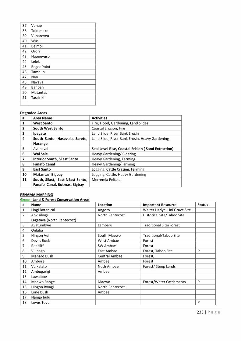
12
13
14
15
16
17
18
19
20
21
22
23
24
25
26
27
10
11
12
13
14
15
16
17
18
19
20
21
22
23
24
25
26
27
28
29
30
31
32
33
34
35
36
233 | P a g e
37 Vunap
38 Tolo mako
39 Vunareveu
40 Wusi
41 Belmoli
42 Orori
43 Naonevuso
44 Lelek
45 Reger Point
46 Tambun
47 Naru
48 Navava
49 Banban
50 Matantas
51 Tassiriki
Degraded Areas
# Area Name Activities
1 West Santo Fire, Flood, Gardening, Land Slides
2 South West Santo Coastal Erosion, Fire
3 Ipayato Land Slide, River Bank Erosin
4 South Santo- Hasevaia, Sarete,
Narango
Land Slide, River Bank Erosin, Heavy Gardening
5 Avunavai Seal Level Rise, Coastal Erision ( Sand Extraction)
6 Wai Sale Heavy Gardening/ Clearing
7 Interior South, SEast Santo Heavy Gardening, Farming
8 Fanafo Canal Heavy Gardening/Farming
9 East Santo Logging, Cattle Crazing, Farming
10 Matantas, Bigbay Logging, Cattle, Heavy Gardening
11 South, SEast, East NEast Santo,
Fanafo Canal, Butmas, Bigbay
Merremia Peltata
PENAMA MAPPING
Green- Land & Forest Conservation Areas
# Name Location Important Resource Status
1 Lingi Botanical Angoro Walter Hadye Lini Grave Site
2 Anvisilingi
Lagatava (North Pentecost)
North Pentecost Historical Site/Taboo Site
3 Avatumbwe Lambaru Traditional Site/Forest
4 Onlaba
5 Hingon Vui South Maewo Traditional/Taboo Site
6 Devils Rock West Ambae Forest
7 Redcliff SW Ambae Forest
8 Vuinago East Ambae Forest, Taboo Site P
9 Manaro Bush Central Ambae Forest,
10 Ambore Ambae Forest
11 Vuikalato Noth Ambae Forest/ Steep Lands
12 Ambugarigi Ambae
13 Lawaiboe
14 Maewo Range Maewo Forest/Water Catchments P
15 Hingon Bwagi North Pentecost
16 Lone Bush Ambae
17 Nango bulu
18 Lovus Tovu P
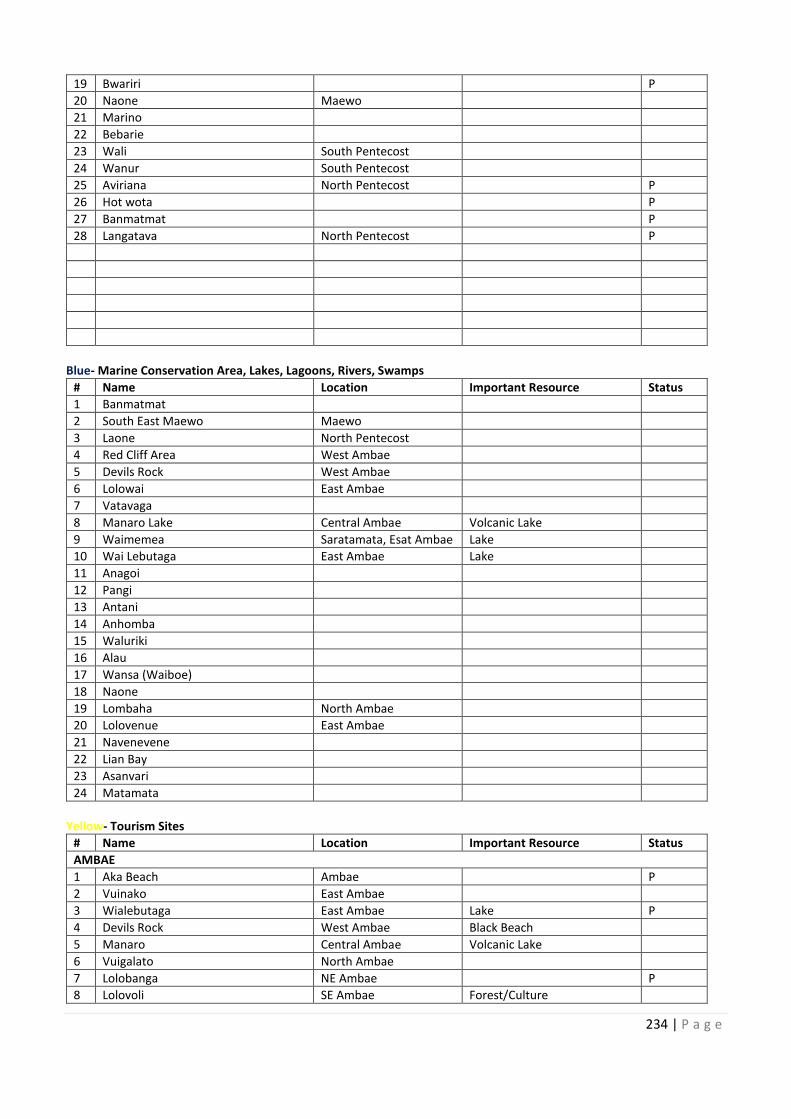
234 | P a g e
19 Bwariri P
20 Naone Maewo
21 Marino
22 Bebarie
23 Wali South Pentecost
24 Wanur South Pentecost
25 Aviriana North Pentecost P
26 Hot wota P
27 Banmatmat P
28 Langatava North Pentecost P
Blue- Marine Conservation Area, Lakes, Lagoons, Rivers, Swamps
# Name Location Important Resource Status
1 Banmatmat
2 South East Maewo Maewo
3 Laone North Pentecost
4 Red Cliff Area West Ambae
5 Devils Rock West Ambae
6 Lolowai East Ambae
7 Vatavaga
8 Manaro Lake Central Ambae Volcanic Lake
9 Waimemea Saratamata, Esat Ambae Lake
10 Wai Lebutaga East Ambae Lake
11 Anagoi
12 Pangi
13 Antani
14 Anhomba
15 Waluriki
16 Alau
17 Wansa (Waiboe)
18 Naone
19 Lombaha North Ambae
20 Lolovenue East Ambae
21 Navenevene
22 Lian Bay
23 Asanvari
24 Matamata
Yellow- Tourism Sites
# Name Location Important Resource Status
AMBAE
1 Aka Beach Ambae P
2 Vuinako East Ambae
3 Wialebutaga East Ambae Lake P
4 Devils Rock West Ambae Black Beach
5 Manaro Central Ambae Volcanic Lake
6 Vuigalato North Ambae
7 Lolobanga NE Ambae P
8 Lolovoli SE Ambae Forest/Culture
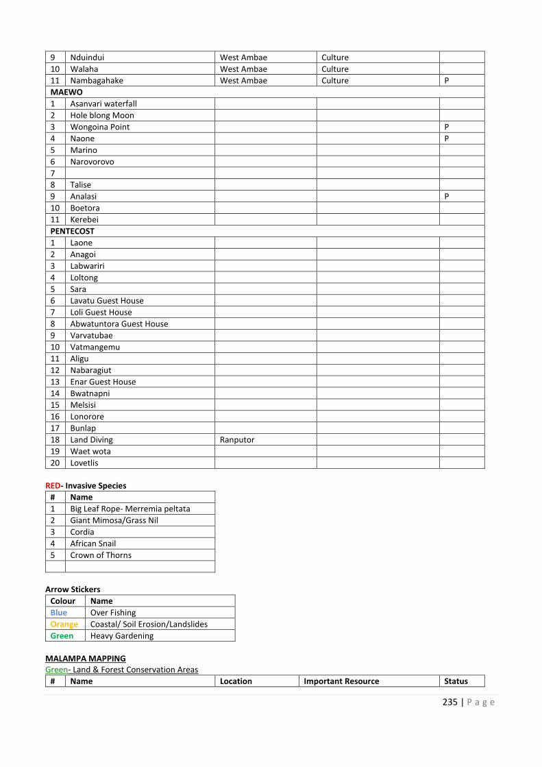
19
20
21
22
23
24
25
26
27
28
Saratamata, Esat Ambae
10
11
12
13
14
15
16
17
18
19
20
21
22
23
24
235 | P a g e
9 Nduindui West Ambae Culture
10 Walaha West Ambae Culture
11 Nambagahake West Ambae Culture P
MAEWO
1 Asanvari waterfall
2 Hole blong Moon
3 Wongoina Point P
4 Naone P
5 Marino
6 Narovorovo
7
8 Talise
9 Analasi P
10 Boetora
11 Kerebei
PENTECOST
1 Laone
2 Anagoi
3 Labwariri
4 Loltong
5 Sara
6 Lavatu Guest House
7 Loli Guest House
8 Abwatuntora Guest House
9 Varvatubae
10 Vatmangemu
11 Aligu
12 Nabaragiut
13 Enar Guest House
14 Bwatnapni
15 Melsisi
16 Lonorore
17 Bunlap
18 Land Diving Ranputor
19 Waet wota
20 Lovetlis
RED- Invasive Species
# Name
1 Big Leaf Rope- Merremia peltata
2 Giant Mimosa/Grass Nil
3 Cordia
4 African Snail
5 Crown of Thorns
Arrow Stickers
Colour Name
Blue Over Fishing
Orange Coastal/ Soil Erosion/Landslides
Green Heavy Gardening
MALAMPA MAPPING
Green- Land & Forest Conservation Areas
# Name Location Important Resource Status
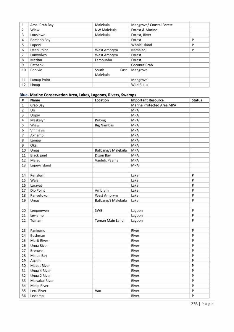
236 | P a g e
1 Amal Crab Bay Malekula Mangrove/ Coastal Forest
2 Wiawi NW Malekula Forest & Marine
3 Lousinwe Malekula Forest, River
4 Bamboo Bay Forest P
5 Lopevi Whole Island P
6 Deep Point West Ambrym Namalao P
7 Lonwolwol West Ambrym Forest
8 Metitar Lambunbu Forest
9 Batbank Coconut Crab
10 Ronivie South East
Malekula
Mangrove
11 Lamap Point Mangrove
12 Limap Wild Buluk
Blue- Marine Conservation Area, Lakes, Lagoons, Rivers, Swamps
# Name Location Important Resource Status
1 Crab Bay Marine Protected Area MPA
2 Uri MPA
3 Uripiv MPA
4 Maskelyn Pelong MPA
5 Wiawi Big Nambas MPA
6 Vinmavis MPA
7 Akhamb MPA
8 Lamap MPA
9 Okai MPA
10 Umas Batbang/S Malekula MPA
11 Black sand Dixon Bay MPA
12 Malau Vauleli, Paama MPA
13 Lopevi Island MPA
14 Penalum Lake P
15 Wala Lake P
16 Laravat Lake P
17 Dip Point Ambrym Lake P
18 Ranvetokon West Ambrym Lake P
19 Umas Batbang/S Malekula Lake P
20 Lenpenwen SWB Lagoon P
21 Leviamp Lagoon P
22 Toman Toman Main Land Lagoon P
23 Pankumo River P
24 Bushman River P
25 Marit River River P
26 Unua River River P
27 Brenwei River P
28 Malua Bay River P
29 Atchin River P
30 Mapat River River P
31 Unua 4 River River P
32 Unua 2 River River P
33 Malvakal River River P
34 Melip River River P
35 Leru River Vao River P
36 Leviamp River P
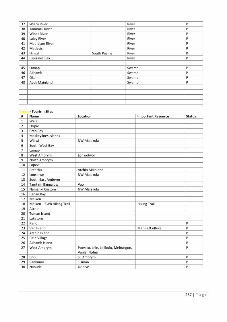
10 South East
11
12
10 Batbang/S Malekula
11
12
13
14
15
16
17
18
19 Batbang/S Malekula
20
21
22
23
24
25
26
27
28
29
30
31
32
33
34
35
36
237 | P a g e
37 Wiaru River River P
38 Tanmaru River River P
39 Winet River River P
40 Laley River River P
41 Mat lelam River River P
42 Matlevis River P
43 Hingal South Paama River P
44 Espigales Bay River P
45 Lamap Swamp P
46 Akhamb Swamp P
47 Okai Swamp P
48 Avok Mainland Swamp P
Yellow- Tourism Sites
# Name Location Important Resource Status
1 Wala
2 Uripiv
3 Crab Bay
4 Maskeylines Islands
5 Wiawi NW Malekula
6 South West Bay
7 Lamap
8 West Ambrym Lonwolwol
9 North Ambrym
10 Lopevi
11 Peterbu Atchin Mainland
12 Lousinwe NW Malekula
13 South East Ambrym
14 Tamtam Bangalow Vao
15 Namanki Custom NW Malekula
16 Banan Bay
17 Melken
18 Melken – SWB Hiking Trail Hiking Trail
19 Atchin
20 Toman Island
21 Lakatoro
22 Rano P
23 Vao Island Marine/Culture P
24 Atchin Island P
25 Pitin Village P
26 Akhamb Island P
27 West Ambrym Potvato, Lele, Lolibulo, Meltungon,
Vanla, Nofea
P
28 Endu SE Ambrym P
29 Pankumo Tisman P
30 Nanude Uripive P

238 | P a g e
SHEFA MAPPING
Green- Land & Forest Conservation Areas
# Name Location Important Resource Status
1 Mere sawia Nguna Forest- Marine
2 Epau Conservation Area Epau, Efate Forest, Water Catchment
3 Efate Land Management Area (ELMA) Central Efate Forest, Water Catchment
4 Nivenue Epi Forest, Water Catchment
5 Greek Ai Lelepa Landing
Efate
Water Catchment, Endemic
freshwater Fish
P
6 Havannah Mangrove Havannah, Efate Mamgrove P
7 Undine Bay Undine Bay Mangrove P
8 Paunangisu North Efate Coastal Forest/ Mangrove P
9 Lumbukuti Conservation Area Lumbukuti, Tongoa Spring Water, Cultural Site P
10 Roimata Domain Hat Island Cultural Site
11 Eratap Mangrove Eratap, Efate Mangrove
12
Blue- Marine Conservation Area, Lakes, Lagoons, Rivers, Swamps
# Name Location Important Resource Status
1 Nguna Pele Nguna and Pele Is Marine MPA-
Unregistered
2 Tanoliu North Efate Marine
3 Lelema Lelepa/Mangalilu Marine MPA-
Unregistered
4 Hat Island Hat Island Marinr P
5 Tuktuk Mangaliliu Marinr P
6 Duck Lake Teouma, Efate Lake P
7 Nikaura Epi Marine MPA-
Unregistered
8 Meresawia Nguna Marine MPA-
Unregistered
9 Epau Efate Marine, Mangrove
10 Unakap Nguna Marine
11 Hide Away Mele Bay, Efate Marine
12 Eruity Efate Marine
13 Panita Tongoa Marine
14 Tongamea Emae Marine
15 Sangava Emae Marine
16 Meresawia Nguna Deep Sea P
17 Undine Bay North Efate Mangrove P
18 Marou Emau Lagoon
19 Tagara Nth Efate Marinr
20 Emua Nth Efate Mangrove, Marine
21 Woralapa Nguna Marine
22 Utanlangi Nguna Marine
23 Rewoka Nguna Marine
24 Farealapa Nguna Marine
25 Piliura Pele Marine
26 Worasiviu Pele Marine
27 Laonamoa Pele Marine
28 Nuvi Epi Marine
29 Mapuna Epi Marine
30 Yapuna Epi Marine
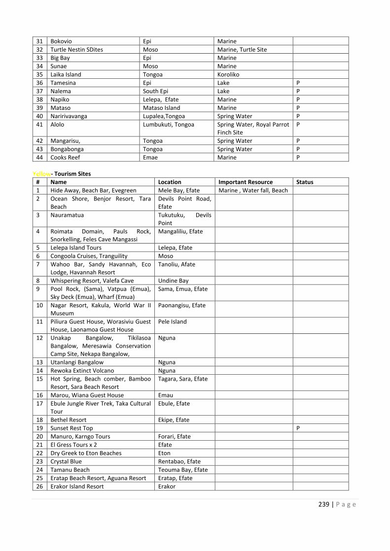
Efate Land Management Area (ELMA)
Lelepa Landing Water Catchment, Endemic
10
11
12
10
11
12
13
14
15
16
17
18
19
20
21
22
23
24
25
26
27
28
29
30
239 | P a g e
31 Bokovio Epi Marine
32 Turtle Nestin SDites Moso Marine, Turtle Site
33 Big Bay Epi Marine
34 Sunae Moso Marine
35 Laika Island Tongoa Koroliko
36 Tamesina Epi Lake P
37 Nalema South Epi Lake P
38 Napiko Lelepa, Efate Marine P
39 Mataso Mataso Island Marine P
40 Naririvavanga Lupalea,Tongoa Spring Water P
41 Alolo Lumbukuti, Tongoa Spring Water, Royal Parrot
Finch Site
P
42 Mangarisu, Tongoa Spring Water P
43 Bongabonga Tongoa Spring Water P
44 Cooks Reef Emae Marine P
Yellow- Tourism Sites
# Name Location Important Resource Status
1 Hide Away, Beach Bar, Evegreen Mele Bay, Efate Marine , Water fall, Beach
2 Ocean Shore, Benjor Resort, Tara
Beach
Devils Point Road,
Efate
3 Nauramatua Tukutuku, Devils
Point
4 Roimata Domain, Pauls Rock,
Snorkelling, Feles Cave Mangassi
Mangaliliu, Efate
5 Lelepa Island Tours Lelepa, Efate
6 Congoola Cruises, Tranguility Moso
7 Wahoo Bar, Sandy Havannah, Eco
Lodge, Havannah Resort
Tanoliu, Afate
8 Whispering Resort, Valefa Cave Undine Bay
9 Pool Rock, (Sama), Vatpua (Emua),
Sky Deck (Emua), Wharf (Emua)
Sama, Emua, Efate
10 Nagar Resort, Kakula, World War II
Museum
Paonangisu, Efate
11 Piliura Guest House, Worasiviu Guest
House, Laonamoa Guest House
Pele Island
12 Unakap Bangalow, Tikilasoa
Bangalow, Meresawia Conservation
Camp Site, Nekapa Bangalow,
Nguna
13 Utanlangi Bangalow Nguna
14 Rewoka Extinct Volcano Nguna
15 Hot Spring, Beach comber, Bamboo
Resort, Sara Beach Resort
Tagara, Sara, Efate
16 Marou, Wiana Guest House Emau
17 Ebule Jungle River Trek, Taka Cultural
Tour
Ebule, Efate
18 Bethel Resort Ekipe, Efate
19 Sunset Rest Top P
20 Manuro, Karngo Tours Forari, Efate
21 El Gress Tours x 2 Efate
22 Dry Greek to Eton Beaches Eton
23 Crystal Blue Rentabao, Efate
24 Tamanu Beach Teouma Bay, Efate
25 Eratap Beach Resort, Aguana Resort Eratap, Efate
26 Erakor Island Resort Erakor
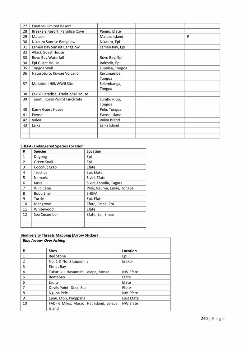
240 | P a g e
27 Ematpei Limited Resort
28 Breakers Resort, Paradise Cove Pango, Efate
29 Mataso Mataso Island P
30 Nikaura Sunrise Bangalow Nikaura, Epi
31 Lamen Bay Sunset Bangalow Lamen Bay, Epi
32 Allack Guest House
33 Rovo Bay Waterfall Rovo Bay, Epi
34 Epi Guest House Valesdir, Epi
35 Tongoa Wall Lupalea, Tongoa
36 Natorotoro, Kuwae Volcano Kurumambe,
Tongoa
37 Mailakom Hill/WWII Site Selembanga,
Tongoa
38 Lekiki Paradise, Traditional House
39 Taputi, Royal Parrot Finch Site Lumbukutiu,
Tongoa
40 Kamy Guest House Pele, Tongoa
41 Ewose Ewose Island
42 Valea Valea Island
43 Laika Laika Island
SHEFA- Endangered Species Location
# Species Location
1 Dugong Epi
2 Green Snail Epi
3 Coconut Crab Efate
4 Trochus Epi, Efate
5 Namariu Siviri, Efate
6 Kasis Siviri, Tanoliu, Tagara
7 Wild Cane Pele, Nguma, Emae, Tongoa
8 Bubu Shell SHEFA
9 Turtle Epi, Efate
10 Mangrove Efate, Emae, Epi
11 Whitewood Efate
12 Sea Cucumber Efate, Epi, Emae
Biodiversity Threats Mapping (Arrow Sticker)
Blue Arrow- Over Fishing
# Sites Location
1 Red Stone Epi
2 No. 1 & No. 2 Lagoon, E Erakor
3 Etmat Bay
4 Tukutuku, Havannah, Lelepa, Mosso NW Efate
5 Rentabao Efate
6 Eruity Efate
7 Devils Point- Deep Sea Efate
8 Nguna Pele Nth Efate
9 Epau, Eton, Pangpang East Efate
10 FAD- 6 Miles, Mosso, Hat Island, Lelepa
Island
NW Efate
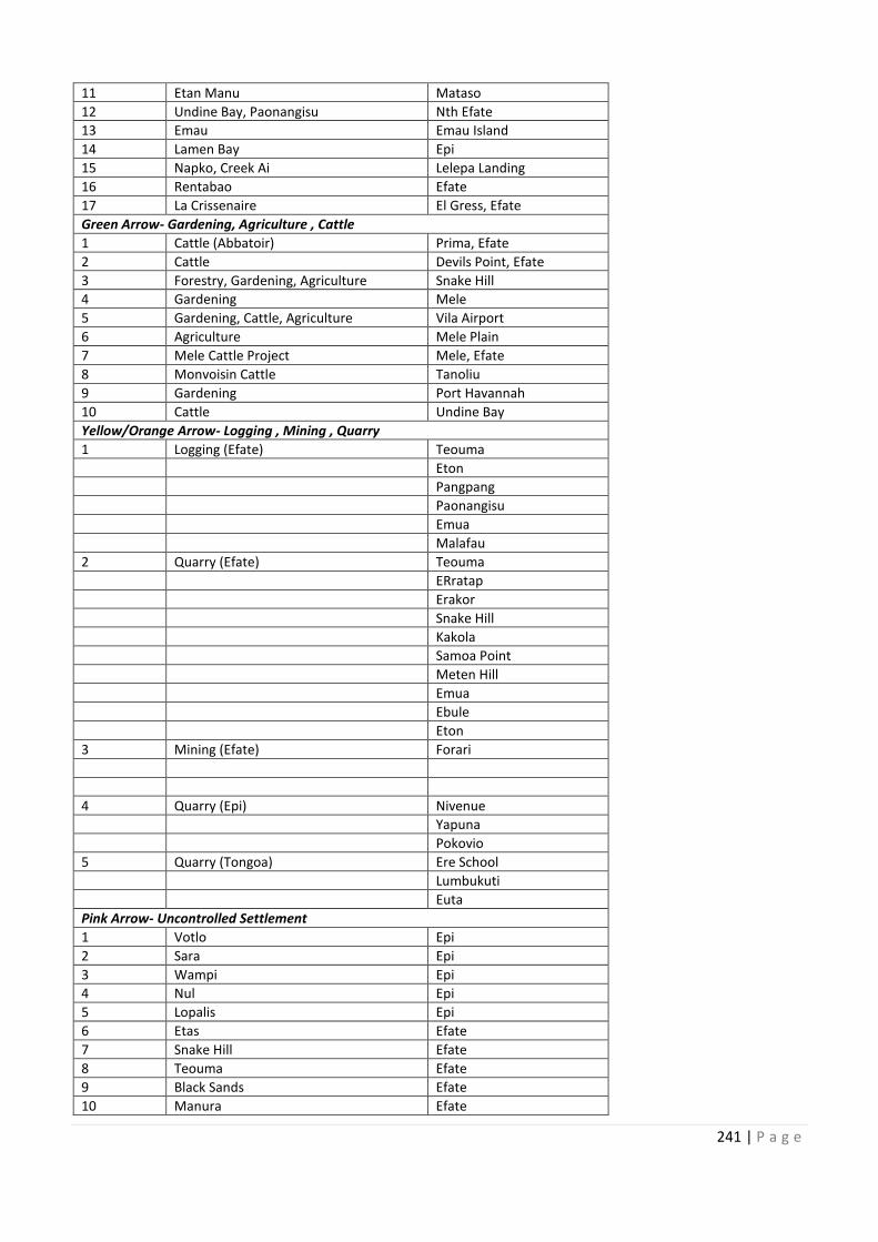
27
28
29
30
31
32
33
34
35
36
37
38
39
40
41
42
43
6 Miles, Mosso, Hat Island, Lelepa
241 | P a g e
11 Etan Manu Mataso
12 Undine Bay, Paonangisu Nth Efate
13 Emau Emau Island
14 Lamen Bay Epi
15 Napko, Creek Ai Lelepa Landing
16 Rentabao Efate
17 La Crissenaire El Gress, Efate
Green Arrow- Gardening, Agriculture , Cattle
1 Cattle (Abbatoir) Prima, Efate
2 Cattle Devils Point, Efate
3 Forestry, Gardening, Agriculture Snake Hill
4 Gardening Mele
5 Gardening, Cattle, Agriculture Vila Airport
6 Agriculture Mele Plain
7 Mele Cattle Project Mele, Efate
8 Monvoisin Cattle Tanoliu
9 Gardening Port Havannah
10 Cattle Undine Bay
Yellow/Orange Arrow- Logging , Mining , Quarry
1 Logging (Efate) Teouma
Eton
Pangpang
Paonangisu
Emua
Malafau
2 Quarry (Efate) Teouma
ERratap
Erakor
Snake Hill
Kakola
Samoa Point
Meten Hill
Emua
Ebule
Eton
3 Mining (Efate) Forari
4 Quarry (Epi) Nivenue
Yapuna
Pokovio
5 Quarry (Tongoa) Ere School
Lumbukuti
Euta
Pink Arrow- Uncontrolled Settlement
1 Votlo Epi
2 Sara Epi
3 Wampi Epi
4 Nul Epi
5 Lopalis Epi
6 Etas Efate
7 Snake Hill Efate
8 Teouma Efate
9 Black Sands Efate
10 Manura Efate
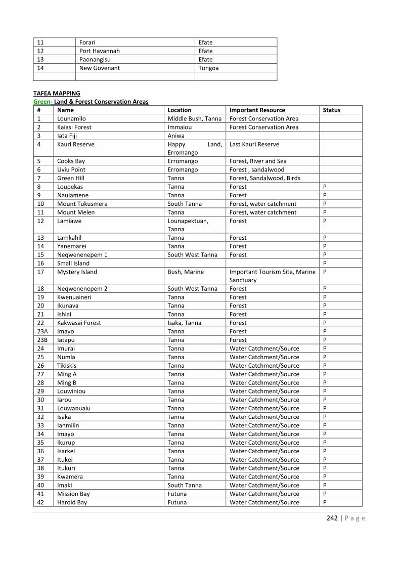
242 | P a g e
11 Forari Efate
12 Port Havannah Efate
13 Paonangisu Efate
14 New Govenant Tongoa
TAFEA MAPPING
Green- Land & Forest Conservation Areas
# Name Location Important Resource Status
1 Lounamilo Middle Bush, Tanna Forest Conservation Area
2 Kaiasi Forest Immaiou Forest Conservation Area
3 Iata Fiji Aniwa
4 Kauri Reserve Happy Land,
Erromango
Last Kauri Reserve
5 Cooks Bay Erromango Forest, River and Sea
6 Uviu Point Erromango Forest , sandalwood
7 Green Hill Tanna Forest, Sandalwood, Birds
8 Loupekas Tanna Forest P
9 Naulamene Tanna Forest P
10 Mount Tukusmera South Tanna Forest, water catchment P
11 Mount Melen Tanna Forest, water catchment P
12 Lamiawe Lounapektuan,
Tanna
Forest P
13 Lamkahil Tanna Forest P
14 Yanemarei Tanna Forest P
15 Neqwenenepem 1 South West Tanna Forest P
16 Small Island P
17 Mystery Island Bush, Marine Important Tourism Site, Marine
Sanctuary
P
18 Neqwenenepem 2 South West Tanna Forest P
19 Kwenuaineri Tanna Forest P
20 Ikunava Tanna Forest P
21 Ishiai Tanna Forest P
22 Kakwasai Forest Isaka, Tanna Forest P
23A Imayo Tanna Forest P
23B Iatapu Tanna Forest P
24 Imurai Tanna Water Catchment/Source P
25 Numla Tanna Water Catchment/Source P
26 Tikiskis Tanna Water Catchment/Source P
27 Ming A Tanna Water Catchment/Source P
28 Ming B Tanna Water Catchment/Source P
29 Louwiniou Tanna Water Catchment/Source P
30 Iarou Tanna Water Catchment/Source P
31 Louwanualu Tanna Water Catchment/Source P
32 Isaka Tanna Water Catchment/Source P
33 Ianmilin Tanna Water Catchment/Source P
34 Imayo Tanna Water Catchment/Source P
35 Ikurup Tanna Water Catchment/Source P
36 Isarkei Tanna Water Catchment/Source P
37 Itukei Tanna Water Catchment/Source P
38 Itukuri Tanna Water Catchment/Source P
39 Kwamera Tanna Water Catchment/Source P
40 Imaki South Tanna Water Catchment/Source P
41 Mission Bay Futuna Water Catchment/Source P
42 Harold Bay Futuna Water Catchment/Source P
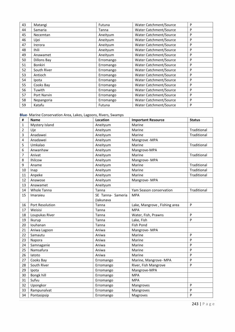
Middle Bush, Tanna
Land,
Important Tourism Site, Marine
243 | P a g e
43 Matangi Futuna Water Catchment/Source P
44 Samaria Tanna Water Catchment/Source P
45 Necemtan Aneityum Water Catchment/Source P
46 Ujei Aneityum Water Catchment/Source P
47 Irerora Aneityum Water Catchment/Source P
48 Ihili Aneityum Water Catchment/Source P
49 Anawamet Aneityum Water Catchment/Source P
50 Dillons Bay Erromango Water Catchment/Source P
51 Bonkiri Erromango Water Catchment/Source P
52 South River Erromango Water Catchment/Source P
53 Antioch Erromango Water Catchment/Source P
54 Ipota Erromango Water Catchment/Source P
55 Cooks Bay Erromango Water Catchment/Source P
56 Tuwith Erromango Water Catchment/Source P
57 Port Narvin Erromango Water Catchment/Source P
58 Nepangoria Erromango Water Catchment/Source P
59 Katafu Futuna Water Catchment/Source P
Blue- Marine Conservation Area, Lakes, Lagoons, Rivers, Swamps
# Name Location Important Resource Status
1 Mystery Island Aneityum Marine
2 Uje Aneityum Marine Traditional
3 Anadawei Aneityum Marine Traditional
4 Anadawei Aneityum Mangrove -MPA
5 Umkalao Aneityum Marine Traditional
6 Anwanhaw Aneityum Mangrove-MPA
7 Anivat Aneityum Marine Traditional
8 Ihilcow Aneityum Mangrove- MPA
9 Aname Aneityum Marine Traditional
10 Inap Aneityum Marine Traditional
11 Anpeke Aneityum Marine Traditional
12 Anawose Aneityum Mangrove- MPA
13 Anawamet Aneityum
14 Whole Tanna Tanna Yam Season conservation Traditional
15 Imaraieu SE Tanna- Sameria
(Iakunava
MPA
16 Port Resolution Tanna Lake, Mangrove , Fishing area P
17 Weisisi Tanna MPA
18 Loupukas River Tanna Water, Fish, Prawns P
19 Ikurup Tanna Lake, Fish P
20 Iouhanan Tanna Fish Pond
21 Aniwa Lagoon Aniwa Mangrove- MPA
22 Samautu Aniwa Marine P
23 Napora Aniwa Marine P
24 Samnaganie Aniwa Marine P
25 Namsafura Aniwa Marine P
26 Iatoto Aniwa Marine P
27 Cooks Bay Erromango Marine, Mangrove- MPA P
28 South River Erromango River, Fish Mangrove P
29 Ipota Erromango Mangrove-MPA
30 Bongk hill Erromango MPA
31 Sufvu Erromango MPA
32 Upongkor Erromango Mangroves P
33 Rampunalvat Erromango Mangroves P
34 Pontasipsip Erromango Magroves P
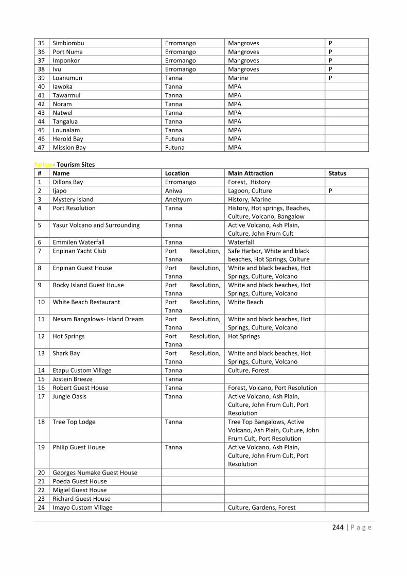
244 | P a g e
35 Simbiombu Erromango Mangroves P
36 Port Numa Erromango Mangroves P
37 Imponkor Erromango Mangroves P
38 Ivu Erromango Mangroves P
39 Loanumun Tanna Marine P
40 Iawoka Tanna MPA
41 Tawarmul Tanna MPA
42 Noram Tanna MPA
43 Natwel Tanna MPA
44 Tangalua Tanna MPA
45 Lounalam Tanna MPA
46 Herold Bay Futuna MPA
47 Mission Bay Futuna MPA
Yellow- Tourism Sites
# Name Location Main Attraction Status
1 Dillons Bay Erromango Forest, History
2 Ijapo Aniwa Lagoon, Culture P
3 Mystery Island Aneityum History, Marine
4 Port Resolution Tanna History, Hot springs, Beaches,
Culture, Volcano, Bangalow
5 Yasur Volcano and Surrounding Tanna Active Volcano, Ash Plain,
Culture, John Frum Cult
6 Emmilen Waterfall Tanna Waterfall
7 Enpinan Yacht Club Port Resolution,
Tanna
Safe Harbor, White and black
beaches, Hot Springs, Culture
8 Enpinan Guest House Port Resolution,
Tanna
White and black beaches, Hot
Springs, Culture, Volcano
9 Rocky Island Guest House Port Resolution,
Tanna
White and black beaches, Hot
Springs, Culture, Volcano
10 White Beach Restaurant Port Resolution,
Tanna
White Beach
11 Nesam Bangalows- Island Dream Port Resolution,
Tanna
White and black beaches, Hot
Springs, Culture, Volcano
12 Hot Springs Port Resolution,
Tanna
Hot Springs
13 Shark Bay Port Resolution,
Tanna
White and black beaches, Hot
Springs, Culture, Volcano
14 Etapu Custom Village Tanna Culture, Forest
15 Jostein Breeze Tanna
16 Robert Guest House Tanna Forest, Volcano, Port Resolution
17 Jungle Oasis Tanna Active Volcano, Ash Plain,
Culture, John Frum Cult, Port
Resolution
18 Tree Top Lodge Tanna Tree Top Bangalows, Active
Volcano, Ash Plain, Culture, John
Frum Cult, Port Resolution
19 Philip Guest House Tanna Active Volcano, Ash Plain,
Culture, John Frum Cult, Port
Resolution
20 Georges Numake Guest House
21 Poeda Guest House
22 Migiel Guest House
23 Richard Guest House
24 Imayo Custom Village Culture, Gardens, Forest
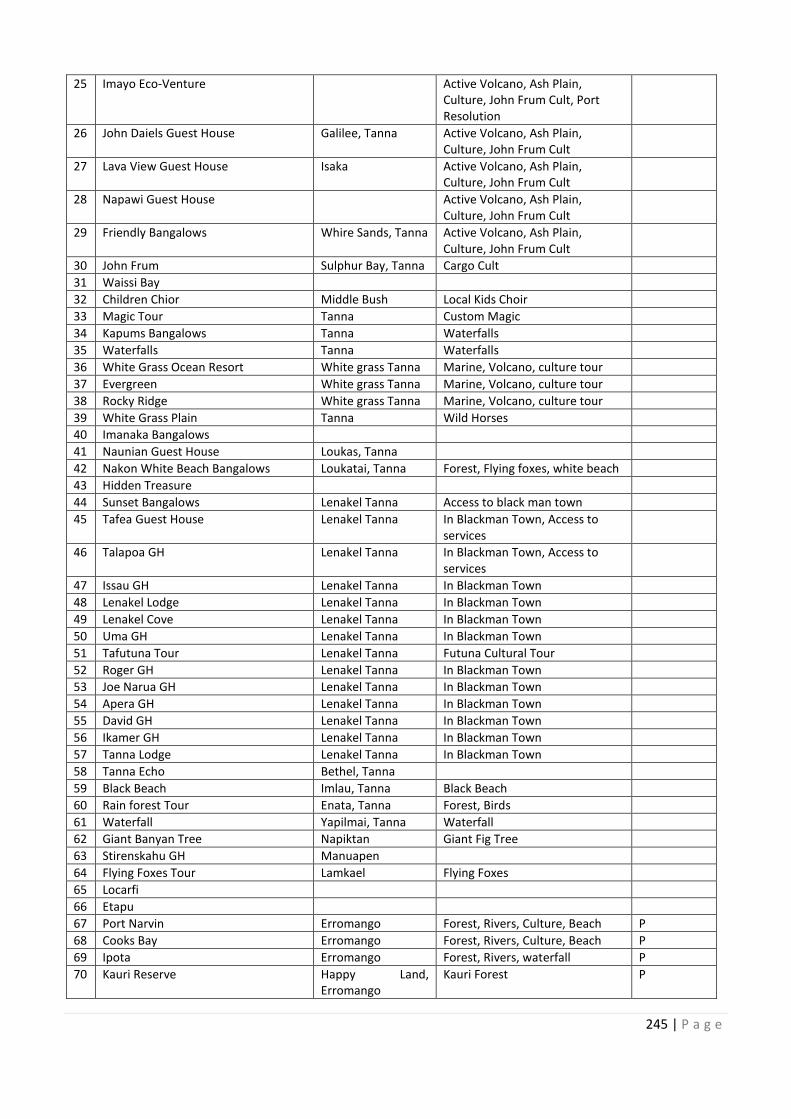
35
36
37
38
39
40
41
42
43
44
45
46
47
Port Resolution,
Port Resolution,
Port Resolution,
10 Port Resolution,
11 Port Resolution,
12 Port Resolution,
13 Port Resolution,
14
15
16
17
18
19
20
21
22
23
24
245 | P a g e
25 Imayo Eco-Venture Active Volcano, Ash Plain,
Culture, John Frum Cult, Port
Resolution
26 John Daiels Guest House Galilee, Tanna Active Volcano, Ash Plain,
Culture, John Frum Cult
27 Lava View Guest House Isaka Active Volcano, Ash Plain,
Culture, John Frum Cult
28 Napawi Guest House Active Volcano, Ash Plain,
Culture, John Frum Cult
29 Friendly Bangalows Whire Sands, Tanna Active Volcano, Ash Plain,
Culture, John Frum Cult
30 John Frum Sulphur Bay, Tanna Cargo Cult
31 Waissi Bay
32 Children Chior Middle Bush Local Kids Choir
33 Magic Tour Tanna Custom Magic
34 Kapums Bangalows Tanna Waterfalls
35 Waterfalls Tanna Waterfalls
36 White Grass Ocean Resort White grass Tanna Marine, Volcano, culture tour
37 Evergreen White grass Tanna Marine, Volcano, culture tour
38 Rocky Ridge White grass Tanna Marine, Volcano, culture tour
39 White Grass Plain Tanna Wild Horses
40 Imanaka Bangalows
41 Naunian Guest House Loukas, Tanna
42 Nakon White Beach Bangalows Loukatai, Tanna Forest, Flying foxes, white beach
43 Hidden Treasure
44 Sunset Bangalows Lenakel Tanna Access to black man town
45 Tafea Guest House Lenakel Tanna In Blackman Town, Access to
services
46 Talapoa GH Lenakel Tanna In Blackman Town, Access to
services
47 Issau GH Lenakel Tanna In Blackman Town
48 Lenakel Lodge Lenakel Tanna In Blackman Town
49 Lenakel Cove Lenakel Tanna In Blackman Town
50 Uma GH Lenakel Tanna In Blackman Town
51 Tafutuna Tour Lenakel Tanna Futuna Cultural Tour
52 Roger GH Lenakel Tanna In Blackman Town
53 Joe Narua GH Lenakel Tanna In Blackman Town
54 Apera GH Lenakel Tanna In Blackman Town
55 David GH Lenakel Tanna In Blackman Town
56 Ikamer GH Lenakel Tanna In Blackman Town
57 Tanna Lodge Lenakel Tanna In Blackman Town
58 Tanna Echo Bethel, Tanna
59 Black Beach Imlau, Tanna Black Beach
60 Rain forest Tour Enata, Tanna Forest, Birds
61 Waterfall Yapilmai, Tanna Waterfall
62 Giant Banyan Tree Napiktan Giant Fig Tree
63 Stirenskahu GH Manuapen
64 Flying Foxes Tour Lamkael Flying Foxes
65 Locarfi
66 Etapu
67 Port Narvin Erromango Forest, Rivers, Culture, Beach P
68 Cooks Bay Erromango Forest, Rivers, Culture, Beach P
69 Ipota Erromango Forest, Rivers, waterfall P
70 Kauri Reserve Happy Land,
Erromango
Kauri Forest P
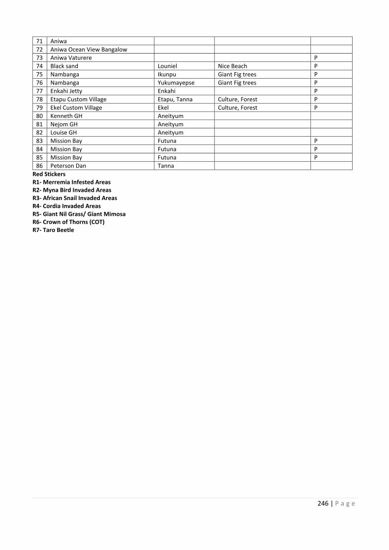
246 | P a g e
71 Aniwa
72 Aniwa Ocean View Bangalow
73 Aniwa Vaturere P
74 Black sand Louniel Nice Beach P
75 Nambanga Ikunpu Giant Fig trees P
76 Nambanga Yukumayepse Giant Fig trees P
77 Enkahi Jetty Enkahi P
78 Etapu Custom Village Etapu, Tanna Culture, Forest P
79 Ekel Custom Village Ekel Culture, Forest P
80 Kenneth GH Aneityum
81 Nejom GH Aneityum
82 Louise GH Aneityum
83 Mission Bay Futuna P
84 Mission Bay Futuna P
85 Mission Bay Futuna P
86 Peterson Dan Tanna
Red Stickers
R1- Merremia Infested Areas
R2- Myna Bird Invaded Areas
R3- African Snail Invaded Areas
R4- Cordia Invaded Areas
R5- Giant Nil Grass/ Giant Mimosa
R6- Crown of Thorns (COT)
R7- Taro Beetle
71
72
73
74
75
76
77
78
79
80
81
82
83
84
85
86
247 | P a g e
Annex 12 – Names OF PARTICIPANTS IN ALL CONSULTATION MEETINGS &
WORKSHOPS
Torba Province
1. Judah Silas (Torba Police Officer)
2. Amos Tali (Torba PWD Officer)
3. Michael Silona (Torba Planner)
4. Daniel Nenet (Torba Agriculture Officer)
5. Antas John (DARD)
6. Fr. Benjamin Gisapwos (Anglican Priest)
7. Dudley Woksen (Torba Livestock Officer)
8. Frezer Job (Torba)
9. Taylor Stephen (Torba Province)
10. Lendy Joel (Torba Province)
11. Christopher Mackenzie (Torba Province)
12. Arthur Kete (Torba Province)
13. Tommie Bollen (Torba Youth Rep)
14. Salatiel Nava (Torba Water Supply)
15. Tensley Atkin (Torba Youth Rep)
16. Alain Kutos (Torba Livestock Officer)
17. Simon Ambi (Arep J.S.S)
18. Fred Abraham Palas (SDA Church)
19. George. A. Bet (Torba Chief Rep)
20. Shedrack Obed (Arep J.S.S)
21. Lonsdale Coppage (Torba Red Cross)
©NBSAP
22. Stephen Bet (Torba AC)
23. Olivet Dorony (Torba AC)
24. Paul Fidal (Torba Chief Rep)
25. Thomas Simon (Torba AC)
26. Peter Maho (Torba Agriuculture Officer)
27. Joyline Gete (Torba Finance Dept Officer)
28. Aris Apo (Torba AC)
29. Barry Webur (Torba AC)
30. Grace Ralph (Torba Women Rep)
31. Ricky Simeon (Secretary, Lake Letas)
32. Richie Tamata (Torba Customs Officer)
33. Kasen Alick (Torba Forest Officer)
34. Stanly Womack (Torba Church Rep)
35. Kalep Wilkins (Torba Correctional Officer)
36. Henry Wetul (Torba Health Officer)
37. Kipu Loius (Torba Education Officer)
38. Albert Toa (Torba Livestock Officer)
39. Eddie Woksen (Torba Cooperative Officer)
40. Jimmy Willie (Torba Fishery Officer)
41. Albert Rudley (Torba TVET Officer)
42. David Keith (VRSC)
248 | P a g e
Sanma Province
62. John Martin (Sanma Fisheries Officer)
63. Ps. Edmo Hasutsele (Sanma Church Rep)
64. Votangi Aru (Sanma Women Rep)
65. Juliet Sumbe (Sanma Officer)
66. Malon Rasu (Sanma Officer)
67. Andre Vaturi (Sanma AC)
68. Vuti Muele (Sanma AC)
69. Bani Landohi (Sanma AC)
70. Kalfao Lum (Sanma AC)
71. Paul Jamaran (Sanma AC)
72. Edmond Ron (Sanma AC)
73. Sammy Kaka (Sanma Forest Officer)
74. Johnny Varangele (Sanma Youth Rep)
75. Shirley Johnson (Sanma Red Cross officer)
76. Johnson Vuti (Sanma Officer)
77. Anaclet Philip (Sanma Environment Officer)
78. Pala Blessing (Sanma AC)
79. Remo Wine (Sanma AC)
43. Alsen Obed (Sanma Fishery Officer)
44. Sompert Gereva (Vanuatu Fisheries Department)
45. Rosette Kalmet (IWRM- Water Dept)
46. Bill Tavue (Vathe CCA)
47. Riman Ser (Loru CCA)
48. Keith Antfalo (Sanma Industry Officer)
49. Michel Tomker (Sanma Province)
50. Sandy H Moel (Sanma Live & Learn)
51. Prosper Buletare (Sanma Province)
52. Marie Avock (Sanma Province)
53. Leon Magareth (Sanma Province)
54. Pakoro Remy (Sanma AC)
55. Solomon Tavue (Matantas, Big Bay)
56. Paul Mark (Big Bay)
57. Jean Pierre (Sanma AC)
58. Vuti Takasi (Sanma AC)
59. James Surai (Sanma AC)
60. Newman Tangis (Sanma Youth Rep)
61. Roselyn Garae (Sanma Women Rep)
©NBSAP
249 | P a g e
Penama Province
80. Georgina Faerua (Penama Planner)
81. Gorgewin Garae (Penama Province SG)
82. Marsden Rongo (Penama AC)
83. Jean Paul Toure (Penama Police Officer)
84. Sarah Ahlin (Penama Tourism Volunteer)
85. Dee Dendian (Penama Waste Volunteer)
86. Reginald Tarilaka (Penama Officer)
87. Lesly Mera (Penama Tourism Officer)
88. Benson Tari (Penama FSB)
89. Malcom Tambe (Penama Fisheries Officer)
90. Steward Natu (Penama PWD Officer)
91. Hendry Georges (Penama)
92. Nailyn Abel (Penama Island Court Officer)
93. Kahom James (Penama Save the Children Officer
94. Ralph Lolo (Penama Red Cross Officer)
95. Heguy Tabi (Penama Asst. Planner)
96. Stanley Ngwele (Penama AC)
97. Moris Tari (Penama Officer)
98. Manson Tari (Penama NDMO Officer)
©NBSAP
99. Annaline Tari (Penama AC)
100. Godfrey Daruhi (Penama Officer)
101. Melisa Hinge (Ambulu J.S.S)
102. Tari Lini (Ambulu J.S.S)
103. Tari Sulu (Ambulu J.S.S)
104. Zimaco (Student- Tagaga)
105. Tari Bulu (LMC)
106. Rosan Aru (Vureas High)
107. Lolo (Vureas High)
108. Jim (Ambae Bulu)
109. Roy (Student)
110. Manuel Ure (Penama Officer)
111. Georgina Dimas (Penama SPC Officer)
112. Elvina Henry (Penama SPC Officer)
113. Carolyn Joe (Ambulu J.S.S)
114. Bruce John (Penama Polic Officer)
250 | P a g e
Malamp Province
130. Wesley Lamby (Malampa Officer)
131. Tasso Caleb (Malampa AC)
132. Alester Kensen (Malampa AC)
133. Massing Bong (Malampa AC)
134. Lapi Kalmet (Malampa Officer)
135. Ben Nebemiah (Malampa Officer)
136. Jackie Willie (Malamp Police)
137. Edwin Manrou (Malampa AC)
138. Akain Atpatun (Malamp Youth Rep)
139. Mothy Viranmal (Malampa Women Rep)
140. Lulu Leymag (Malampa AC)
141. David Sailas (Malampa Forest Officer)
142. Kalite Tamau (Malampa Youth Council)
143. Daniel Layang (Malampa Forestry Officer
115. Roger Veremaito (Uri/ Uripiv)
116. Beeman Saite (Malapa Police Officer)
117. Maureen Gordon (Malampa NDMO
118. Naomi Malau (Malampa Women Council)
119. Gloria Jeremiah (M.I.C)
120. George Lingtamat (Malampa Agriculture
Officer)
121. Grenly Kavodar (Malampa Police Officer)
122. Charles Tari (Malampa Livestock Officer)
123. Cyrus Willie (Malampa AC)
124. Spethy Jonas (Amal Crab Bay Rep)
125. Kalfau Malisa (Uripiv)
126. Kalen Abbie (Amal Crab Bay Rep)
127. Ron Netvurak (Uri Island)
128. Jackson Saimon (Uri Island)
129. Robert Abel (Malampa)
©NBSAP
251 | P a g e
Shefa Province
161. Taman Onesmas (Shefa Officer)
162. Christopher Daniel (Shefa AC)
163. Jeffry Daniel (Shefa AC)
164. Janet Orah (Shefa AC)
165. Kalmaire Kalman (Shefa AC)
166. Philip Dick (Shefa AC)
167. Morrison Dick Makau (Shefa AC)
168. Balu Wabayat (Shefa AC)
169. John Tapang (Shefa AC)
170. Anne Marie Sarisets (DoF)
171. Roger Kalpukai (Shefa AC)
172. Edwin Tapasei (Shefa AC)
173. Edson Willie (VKS)
174. Malian Andrew (Shefa AC)
175. Johnny Kaltapiri (Shefa AC)
176. Joseph Kalfau (Shefa AC)
177. Kalpeau Vatoko (Shefa AC)
144. Vatu Molisa (Environment Dep.)
145. Alan Sope (Shefa AC)
146. William Billy (Mangaliliu)
147. Charley Kalnasei (Tongoa)
148. Ian Kalsuak (Shefa)
149. Leisara Kalotiti (Mangaliliu)
150. Christine Kapalu (Shefa Industry)
151. Berthy Vireial (Infrstructure)
152. Erick Massing (MIPU)
153. Jack Kallon (Shefa Chief Rep)
154. Ishmael Thomas (Shefa)
155. John Ronneth (NGO)
156. John Firiam (Shefa)
157. Sylverio Bule (Biosecurity)
158. Leonard Kaltonga (Shefa)
159. Anna Bule (DEPC)
160. Chris Bulerop (DEPC)
©NBSAP
252 | P a g e
Tafea Province
193. Tokal Iatipu (Tafea AC)
194. Reuben Neriam (Tafea AC)
195. Noel Yalu (AC)
196. Remi Yalu (AC)
197. Henry Saute (AC)
198. Lui Alick (AC)
199. Thomas Simpet (Tafea AC)
200. John Nocklam (Tafea AC)
201. Lenon Luken (Tafea AC)
202. Luke David (Tafea AC)
203. Rassai Jeffet (Tafea AC)
204. Noel Noar (Tafea AC)
205. Stephen Kaveng (Tafea AC)
206. Simon Naupa (Tafea Forest Officer)
©NBSAP
178. Albu Dan (Tafea SPREP Officer)
179. Tom Kiri (Tafea Fishery Officer)
180. Henry Joe Johnson (Police Patrol)
181. Tony Keith (Aneityum)
182. Wendy Tamasi (Tafea Province)
183. Dorothy Pel (Tafea Women Rep)
184. Tom Kawia (Tafea)
185. Sawaram Freeman (Tafea Chief Rep)
186. Nakampta Matua (Tafea Province)
187. Manu Marie (Tafea Education)
188. Dores Oken (Tafea Education)
189. Mayaru (Tafea Education)
190. Andrew Seielce (Tafea PWD)
191. Samuel Lolwe (Tafea Forest Officer)
192. Lislie Rossie (Tafea Live & Learn)
©NBSAP
253 | P a g e
National Stakeholder
223. Presly Dovo (Forestry Department)
224. Jessie Kampai (Live & Learn)
225. Touasi Tiwok (DEPC)
226. Lai Sakita (VEAN)
227. Kehana Andrews (Ecotourism Officer)
228. Kaltuk Kalomor (Livestock Department)
229. Lucas Sarvanu (VKS)
230. Godfrey Bome (Forestry Department)
231. Gordon Willie (Lands Department)
232. Roger Smithy (DEPC)
233. Mark Kalotap (Shefa Tourism)
234. Frances Hicky (VKS)
235. Helen Pipette (CEPF)
236. Wensie Naki (Trade Department)
237. Mark Kalotap (NBSAP Coordinator- 2013-2016)
238. Sombert Gereva (VFD)
239. Reedley Tari (DEPC Director)
240. Jill Horry (Forestry)
241. Ioan Viji (Forestry)
242. Richard Shing (VKS)
207. Glarinda Andre (Live & Learn)
208. Kate Mcpherson (DEPC)
209. Wycliff Bakeo (DESPAC)
210. Sylverio Bulero (BV)
211. Amy Yang (DEPC)
212. Donna Kalfatak (DEPC)
213. Trinison Tari (DEPC)
214. Chris Bulerop (DEPC)
215. Kency Bulu (Forestry)
216. Alick Berry (Trade)
217. Jayven Ham (VFD)
218. Urafo Nafuki (PWD)
219. Jerry Spooner (Tourism Department)
220. Christine Kapalu (Shefa Tourism)
221. Vivian Obed
222. Solstice Middleby
©NBSAP

254 | P a g e
Ministry of Climate Change
Government of Vanuatu
Lini Highway
Namba 2 Area
Port Vila
Vanuatu
Phone: +678 24686/ 23866
Department of Environmental Protec on and
Conserva on
Ministry of Climate Change
Lini Highway
Namba 2 Area
Port Vila
Vanuatu
Phone: +678 25302


![Canon in D (C version) [Easy version] - Sheets Daily](https://img.pdfslide.net/doc/110x75/6331def97f0d9c38da012b43/canon-in-d-c-version-easy-version-sheets-daily.jpg)


