Embed Size (px)
Citation preview
Consult NOTAMs for latest informationWarning: Refer to current foreign charts and flight information publications for information within foreign airspacePublished in accordance with Interagency Air Cartographic Committee specifications and agreements approved by: Department of Defense • Federal Aviation Administration
CHART SUPPLEMENTNORTHWEST U.S.
Effective 0901Z 31 MAR 2016 to 0901Z 26 MAY 2016
Note: Minor changes have been made to implement updated IACC 8 Specifications. For more information go to the Chart Notices at the following link:https://www.faa.gov/air_traffic/flight_info/aeronav/safety_alerts/
GENERAL INFORMATION This Chart Supplement is a Civil Flight Information Publication published and distributed every eight weeks by the U.S. Department of Transportation, Federal Aviation Administration, Aeronautical Information Services, http://www.faa.gov/go/ais.It is designed for use with Aeronautical Charts covering the conterminous United States, Puerto Rico and the Virgin Islands.
The Airport/Facility Directory section contains all public–use airports, seaplane bases and heliports, military facilities, and selected private use facilities specifically requested by the Department of Defense (DoD) for which a DoD Instrument Approach Procedure has been published in the U.S. Terminal Procedures Publication. Additionally, this publication contains communications data, navigational facilities and certain special notices and procedures.
Military data contained within this publication is provided by the National Geospatial–Intelligence Agency and is intended to provide reference data for military and/or joint use airports. Not all military data contained in this publication is applicable to civil users.
CORRECTIONS, COMMENTS, AND/OR PROCUREMENTCRITICAL information such as equipment malfunction, abnormal field conditions, hazards to flight, etc., should be reported assoon as possible.
FOR CORRECTIONS TO AERONAUTICAL DATA: http://nfdc.faa.gov/FAA, Aeronautical Information ServicesNational Flight Data Center (NFDC)1575 I Street, NW, Room 9304Washington, DC 20005
NOTICE: Changes must be received by Aeronautical Information Services as soon as possible but not later than the ‘‘cut–off’’ dates listed below to assure publication on the desired effective date. Information cut–off dates that fall on a federal holiday must be received the previous work day.
*Airspace Information includes changes to preferred routes and graphic depictions on charts.
FOR CHARTING COMMENTS:FAA, Aeronautical Information Services1305 East West HighwaySSMC–4 Suite 4400Silver Spring, MD 20910–3281Telephone 1–800–638–8972Email 9–AMC–[email protected]
Frequently asked questions (FAQs) are answered on our website at http://www.faa.gov/go/ais.See the FAQs prior to contact via toll free number.
FOR PROCUREMENT:Contact an Authorized FAA Chart Sales Agent. Visit our website at http://www.faa.gov/go/ais andclick on “Chart Agent Locator.” For digital products, visit http://faacharts.faa.gov.
THIS PUBLICATION COMPRISES PART OF THE FOLLOWING SECTIONS OF THE UNITED STATES AERONAUTICAL INFORMATION PUBLICATION (AIP): GEN, ENR AND AD.
Effective DateAirport Information
Cut–off dateAirspace Information*
Cut–off date31 Mar 16 17 Feb 16 2 Feb 1626 May 16 13 Apr 16 29 Mar 16
21 Jul 16 8 Jun 16 24 May 1615 Sep 16 3 Aug 16 19 Jul 1610 Nov 16 28 Sep 16 13 Sep 16
5 Jan 17 23 Nov 16 8 Nov 16
GENERAL INFORMATION 1TABLE OF CONTENTS
GENERAL INFORMATION........................................................................................................................... Inside Front CoverCity/Military Airport Cross Reference .................................................................................................................................2Seaplane Landing Areas ..................................................................................................................................................3Abbreviations .................................................................................................................................................................4
SECTION 1: AIRPORT/FACILITY DIRECTORY LEGEND ........................................................................................................12SECTION 2: AIRPORT/FACILITY DIRECTORY
Idaho ..........................................................................................................................................................................30Montana......................................................................................................................................................................74Oregon ......................................................................................................................................................................125Washington................................................................................................................................................................165Wyoming ...................................................................................................................................................................223
SECTION 3: NOTICESAeronautical Chart Bulletins .........................................................................................................................................246Special Notices...........................................................................................................................................................250Regulatory Notices......................................................................................................................................................262
SECTION 4: ASSOCIATED DATAFAA Telephone Numbers and National Weather Service ..................................................................................................263Air Route Traffic Control Centers...................................................................................................................................268Flight Service Station Communication Frequencies..........................................................................................................271Flight Standards District Offices....................................................................................................................................274VOR Receiver Checkpoints and VOR Test Facilities .........................................................................................................275Parachute Jumping Areas ............................................................................................................................................278Supplemental Communication Reference .......................................................................................................................280Preferred IFR Routes ...................................................................................................................................................286Q-Routes ...................................................................................................................................................................289High Altitude Redesign (HAR) Phase 1 RNAV Routing ....................................................................................................302
SECTION 5: AIRPORT DIAGRAMSAirport Diagrams Legend .............................................................................................................................................313Airport Hot Spots ........................................................................................................................................................315Airport Diagrams ........................................................................................................................................................318
National Weather Service (NWS) Upper Air Observing Stations............................................................................................384Enroute Flight Advisory Service (EFAS) ......................................................................................................... Inside Back Cover
NW, 31 MAR 2016 to 26 MAY 2016
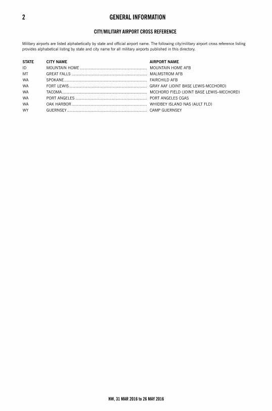
2 GENERAL INFORMATIONCity/Military Airport Cross Reference
CITY/MILITARY AIRPORT CROSS REFERENCE
Military airports are listed alphabetically by state and official airport name. The following city/military airport cross reference listing provides alphabetical listing by state and city name for all military airports published in this directory.
STATE CITY NAME AIRPORT NAME
ID MOUNTAIN HOME ....................................................... MOUNTAIN HOME AFB
MT GREAT FALLS .............................................................. MALMSTROM AFB
WA SPOKANE.................................................................... FAIRCHILD AFB
WA FORT LEWIS................................................................ GRAY AAF (JOINT BASE LEWIS-MCCHORD)
WA TACOMA...................................................................... MCCHORD FIELD (JOINT BASE LEWIS–MCCHORD)
WA PORT ANGELES ........................................................... PORT ANGELES CGAS
WA OAK HARBOR.............................................................. WHIDBEY ISLAND NAS (AULT FLD)
WY GUERNSEY.................................................................. CAMP GUERNSEY
NW, 31 MAR 2016 to 26 MAY 2016
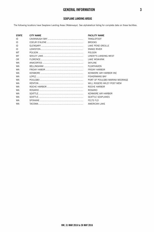
GENERAL INFORMATION 3Seaplane Landing Areas
SEAPLANE LANDING AREAS
The following locations have Seaplane Landing Areas (Waterways). See alphabetical listing for complete data on these facilities.
STATE CITY NAME FACILITY NAME
ID CAVANAUGH BAY.................................................... TANGLEFOOT
ID COEUR D’ALENE ..................................................... BROOKS
ID GLENGARY ............................................................. LAKE PEND OREILLE
ID LEWISTON.............................................................. SNAKE RIVER
MT POLSON ................................................................. POLSON
MT SEELEY LAKE.......................................................... LINDEY’S LANDING WEST
OR FLORENCE.............................................................. LAKE WOAHINK
WA ANACORTES ........................................................... SKYLINE
WA BELLINGHAM ......................................................... FLOATHAVEN
WA FRIDAY HABOR....................................................... FRIDAY HARBOR
WA KENMORE .............................................................. KENMORE AIR HARBOR INC
WA LOPEZ .................................................................... FISHERMANS BAY
WA POULSBO ............................................................... PORT OF POULSBO MARINA MOORAGE
WA RENTON................................................................. WILL ROGERS WILEY POST MEM
WA ROCHE HARBOR..................................................... ROCHE HARBOR
WA ROSARIO ................................................................ ROSARIO
WA SEATTLE................................................................. KENMORE AIR HARBOR
WA SEATTLE................................................................. SEATTLE SEAPLANES
WA SPOKANE ............................................................... FELTS FLD
WA TACOMA ................................................................. AMERICAN LAKE
NW, 31 MAR 2016 to 26 MAY 2016
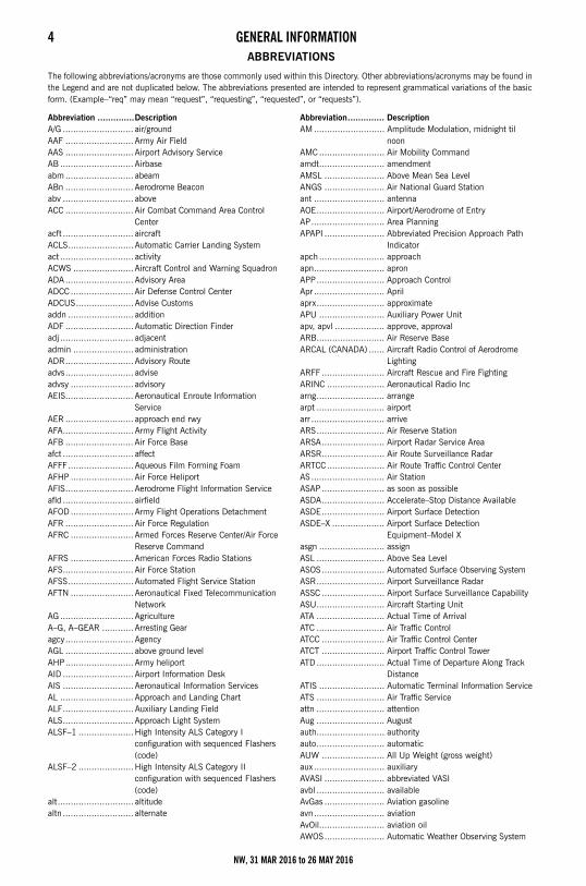
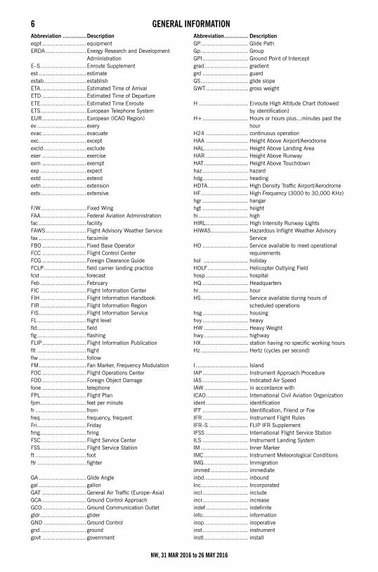
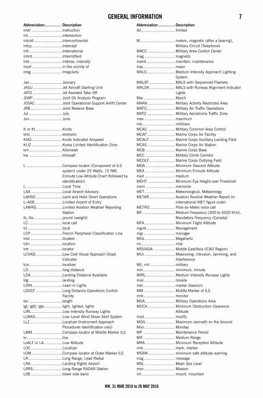
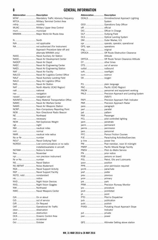
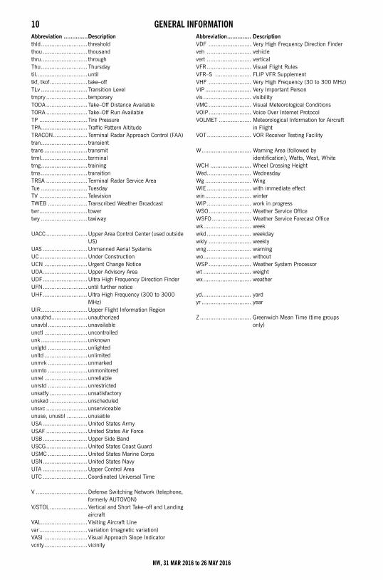
4 GENERAL INFORMATIONAbbreviations ABBREVIATIONS
The following abbreviations/acronyms are those commonly used within this Directory. Other abbreviations/acronyms may be found in the Legend and are not duplicated below. The abbreviations presented are intended to represent grammatical variations of the basic form. (Example–“req” may mean “request”, “requesting”, “requested”, or “requests”).
Abbreviation ..............DescriptionA/G ........................... air/groundAAF .......................... Army Air FieldAAS .......................... Airport Advisory ServiceAB ............................ Airbaseabm .......................... abeamABn .......................... Aerodrome Beaconabv ........................... aboveACC .......................... Air Combat Command Area Control
Centeracft ........................... aircraftACLS......................... Automatic Carrier Landing Systemact ............................ activityACWS ....................... Aircraft Control and Warning SquadronADA .......................... Advisory AreaADCC ........................ Air Defense Control CenterADCUS...................... Advise Customsaddn ......................... additionADF .......................... Automatic Direction Finderadj ............................ adjacentadmin ....................... administrationADR.......................... Advisory Routeadvs.......................... adviseadvsy ........................ advisoryAEIS.......................... Aeronautical Enroute Information
ServiceAER .......................... approach end rwyAFA........................... Army Flight ActivityAFB .......................... Air Force Baseafct ........................... affectAFFF......................... Aqueous Film Forming FoamAFHP ........................ Air Force HeliportAFIS.......................... Aerodrome Flight Information Serviceafld ........................... airfieldAFOD ........................ Army Flight Operations DetachmentAFR .......................... Air Force RegulationAFRC ........................ Armed Forces Reserve Center/Air Force
Reserve CommandAFRS ........................ American Forces Radio StationsAFS........................... Air Force StationAFSS......................... Automated Flight Service StationAFTN ........................ Aeronautical Fixed Telecommunication
NetworkAG ............................ AgricultureA–G, A–GEAR ............ Arresting Gearagcy.......................... AgencyAGL .......................... above ground levelAHP.......................... Army heliportAID ........................... Airport Information DeskAIS ........................... Aeronautical Information ServicesAL ............................ Approach and Landing ChartALF........................... Auxiliary Landing FieldALS........................... Approach Light SystemALSF–1 .....................High Intensity ALS Category I
configuration with sequenced Flashers (code)
ALSF–2 .....................High Intensity ALS Category II configuration with sequenced Flashers (code)
alt............................. altitudealtn ........................... alternate
Abbreviation.............. DescriptionAM ........................... Amplitude Modulation, midnight til
noonAMC ......................... Air Mobility Commandamdt......................... amendmentAMSL ....................... Above Mean Sea LevelANGS ....................... Air National Guard Stationant ........................... antennaAOE.......................... Airport/Aerodrome of EntryAP............................ Area PlanningAPAPI ....................... Abbreviated Precision Approach Path
Indicatorapch ......................... approachapn........................... apronAPP.......................... Approach ControlApr ........................... Aprilaprx.......................... approximateAPU ......................... Auxiliary Power Unitapv, apvl ................... approve, approvalARB.......................... Air Reserve BaseARCAL (CANADA) ...... Aircraft Radio Control of Aerodrome
LightingARFF ........................ Aircraft Rescue and Fire FightingARINC ...................... Aeronautical Radio Incarng.......................... arrangearpt .......................... airportarr ............................ arriveARS.......................... Air Reserve StationARSA........................ Airport Radar Service AreaARSR........................ Air Route Surveillance RadarARTCC...................... Air Route Traffic Control CenterAS ............................ Air StationASAP ........................ as soon as possibleASDA........................ Accelerate–Stop Distance AvailableASDE........................ Airport Surface DetectionASDE–X .................... Airport Surface Detection
Equipment–Model Xasgn ......................... assignASL .......................... Above Sea LevelASOS........................ Automated Surface Observing SystemASR.......................... Airport Surveillance RadarASSC ........................ Airport Surface Surveillance Capability ASU.......................... Aircraft Starting UnitATA .......................... Actual Time of ArrivalATC .......................... Air Traffic ControlATCC ........................ Air Traffic Control CenterATCT ........................ Airport Traffic Control TowerATD.......................... Actual Time of Departure Along Track
DistanceATIS ......................... Automatic Terminal Information ServiceATS .......................... Air Traffic Serviceattn .......................... attentionAug .......................... Augustauth.......................... authorityauto.......................... automaticAUW ........................ All Up Weight (gross weight)aux ........................... auxiliaryAVASI ....................... abbreviated VASIavbl .......................... availableAvGas ....................... Aviation gasolineavn........................... aviationAvOil......................... aviation oilAWOS....................... Automatic Weather Observing System
NW, 31 MAR 2016 to 26 MAY 2016
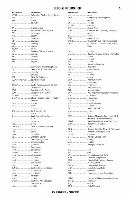
GENERAL INFORMATION 5Abbreviation.............. DescriptionAWSS........................Automated Weather Sensor Systemawt ...........................awaitawy ...........................airwayaz .............................azimuth
BA ............................braking actionBASH ........................Bird Aircraft Strike HazardBC ............................back coursebcn ...........................beaconbcst...........................broadcastbdry ..........................boundarybldg...........................buildingblkd...........................blockedblo, blw .....................belowBOQ ..........................Bachelor Officers Quartersbrg ............................bearingbtn ............................betweenbus............................businessbyd ...........................beyond
C...............................Commercial Circuit (Telephone)CAC...........................Centralized Approach Controlcap............................capacitycat ............................categoryCAT ...........................Clear Air TurbulenceCCW or cntclkws.........counterclockwiseceil............................ceilingCERAP ......................Center Radar Approach ControlCG ............................Coast GuardCGAF.........................Coast Guard Air FacilityCGAS ........................Coast Guard Air StationCH, chan ...................channelCHAPI .......................Chase Helicopter Approach Path
Indicatorchg............................changecht ............................chartcir .............................circle, circlingCIV, civ ......................Civil, civil, civilianck .............................checkCL.............................Centerline Lighting Systemcl ..............................classclnc...........................clearanceclsd ...........................closedCNATRA ....................Chief of Naval Air Trainingcnl ............................cancelcntr ...........................centercntrln.........................centerlineCo.............................Company, CountyCO ............................Commanding Officercom...........................communicationcomd.........................commandComdr .......................Commandercoml..........................commercialcompul ......................compulsorycomsn .......................commissionconc ..........................concretecond..........................conditionconst .........................constructioncont...........................continueCONUS......................Continental United Statesconvl .........................conventionalcoord ........................coordinatecopter ........................helicoptercorr ...........................correctCPDLC.......................Controller Pilot Data Link
Communication crdr ...........................corridor
Abbreviation .............. Descriptioncros .......................... crossCRP .......................... Compulsory Reporting Pointcrs ............................ courseCS ............................ call signCSTMS...................... CustomsCTA........................... Control AreaCTAF......................... Common Traffic Advisory Frequencyctc ............................ contactctl............................. controlCTLZ......................... Control ZoneCVFR ........................ Controlled Visual Flight Rules AreasCW ........................... Clockwise, Continuous Wave, Carrier
Wave
dalgt ......................... daylightD–ATIS...................... Digital Automatic Terminal Information
Servicedaylt ......................... daylightdb............................. decibelDCL .......................... Departure ClearanceDec........................... Decemberdecom....................... decommissiondeg ........................... degreedel ............................ deliverydep ........................... departDEP .......................... Departure Controldestn......................... destinationdet............................ detachmentDF ............................ Direction FinderDH............................ Decision HeightDIAP ......................... DoD Instrument Approach Proceduredirec ......................... directionaldisem........................ disseminatedispl ......................... displacedist ........................... district, distancediv ............................ divisionDL ............................ Direct Line to FSSdlt............................. deletedly ............................ dailyDME ......................... Distance Measuring Equipment (UHF
standard, TACAN compatible)DNVT........................ Digital Non–Secure Voice TelephoneDoD .......................... Department of Defensedrct........................... directDSN.......................... Defense Switching Network (Telephone)DSN.......................... Defense Switching Networkdsplcd ....................... displacedDT ............................ Daylight Savings Timedur............................ duringdurn.......................... durationDV............................ Distinguished Visitor
E .............................. Eastea............................. eachEAT........................... Expected Approach TimeECN.......................... Enroute Change NoticeEFAS......................... Enroute Flight Advisory Serviceeff............................. effective, effectE–HA ........................ Enroute High AltitudeE–LA......................... Enroute Low Altitudeelev........................... elevationELT ........................... Emergency Locator Transmitter
EMAS........................ Engineered Material Arresting Systememerg........................ emergencyeng ........................... engineEOR.......................... End of Runway
NW, 31 MAR 2016 to 26 MAY 2016
6 GENERAL INFORMATIONAbbreviation ..............Descriptioneqpt .......................... equipmentERDA........................ Energy Research and Development
AdministrationE–S........................... Enroute Supplementest ............................ estimateestab......................... establishETA........................... Estimated Time of ArrivalETD .......................... Estimated Time of DepartureETE........................... Estimated Time EnrouteETS........................... European Telephone SystemEUR.......................... European (ICAO Region)ev ............................. everyevac.......................... evacuateexc............................ exceptexcld ......................... excludeexer .......................... exerciseexm .......................... exemptexp ........................... expectextd .......................... extendextn .......................... extensionextv........................... extensive
F/W........................... Fixed WingFAA........................... Federal Aviation Administrationfac ............................ facilityFAWS........................ Flight Advisory Weather Servicefax ............................ facsimileFBO .......................... Fixed Base OperatorFCC .......................... Flight Control CenterFCG .......................... Foreign Clearance GuideFCLP......................... field carrier landing practicefcst ........................... forecastFeb ........................... FebruaryFIC ........................... Flight Information CenterFIH ........................... Flight Information HandbookFIR ........................... Flight Information RegionFIS............................ Flight Information ServiceFL............................. flight levelfld............................. fieldflg ............................. flashingFLIP.......................... Flight Information Publicationflt ............................. flightflw ............................ followFM............................ Fan Marker, Frequency ModulationFOC .......................... Flight Operations CenterFOD .......................... Foreign Object Damagefone .......................... telephoneFPL........................... Flight Planfpm........................... feet per minutefr .............................. fromfreq........................... frequency, frequentFri............................. Fridayfrng........................... firingFSC........................... Flight Service CenterFSS........................... Flight Service Stationft .............................. footftr ............................. fighter
GA ............................ Glide Anglegal ............................ gallonGAT .......................... General Air Traffic (Europe–Asia)GCA .......................... Ground Control ApproachGCO.......................... Ground Communication Outletgldr ........................... gliderGND ......................... Ground Controlgnd ........................... groundgovt .......................... government
Abbreviation.............. DescriptionGP............................ Glide PathGp............................ GroupGPI........................... Ground Point of Interceptgrad.......................... gradientgrd ........................... guardGS............................ glide slopeGWT......................... gross weight
H ............................. Enroute High Altitude Chart (followed by identification)
H+........................... Hours or hours plus...minutes past the hour
H24 ......................... continuous operationHAA ......................... Height Above Airport/AerodromeHAL.......................... Height Above Landing AreaHAR ......................... Height Above RunwayHAT.......................... Height Above Touchdownhaz........................... hazardhdg........................... headingHDTA........................ High Density Traffic Airport/AerodromeHF............................ High Frequency (3000 to 30,000 KHz)hgr ........................... hangarhgt ........................... heighthi ............................. highHIRL......................... High Intensity Runway LightsHIWAS...................... Hazardous Inflight Weather Advisory
ServiceHO ........................... Service available to meet operational
requirementshol .......................... holidayHOLF........................ Helicopter Outlying Fieldhosp ......................... hospitalHQ ........................... Headquartershr ............................. hourHS............................ Service available during hours of
scheduled operationshsg ........................... housinghvy ........................... heavyHW .......................... Heavy Weighthwy .......................... highwayHX............................ station having no specific working hoursHz ............................ Hertz (cycles per second)
I ............................... IslandIAP........................... Instrument Approach ProcedureIAS ........................... Indicated Air SpeedIAW.......................... in accordance withICAO......................... International Civil Aviation Organizationident......................... identificationIFF ........................... Identification, Friend or FoeIFR........................... Instrument Flight RulesIFR–S ....................... FLIP IFR SupplementIFSS ......................... International Flight Service StationILS ........................... Instrument Landing SystemIM ............................ Inner MarkerIMC .......................... Instrument Meteorological ConditionsIMG.......................... Immigrationimmed ...................... immediateinbd.......................... inboundInc............................ Incorporatedincl ........................... includeincr........................... increaseindef ......................... indefiniteinfo........................... informationinop.......................... inoperativeinst........................... instrumentinstl .......................... install
NW, 31 MAR 2016 to 26 MAY 2016
GENERAL INFORMATION 7Abbreviation.............. Descriptioninstr ..........................instructionint .............................intersectionintcntl........................intercontinentalintcp..........................interceptintl ............................internationalintmt .........................intermittentints ...........................intense, intensityinvof ..........................in the vicinity ofirreg ..........................Irregularly
Jan............................JanuaryJASU.........................Jet Aircraft Starting UnitJATO .........................Jet Assisted Take–OffJOAP.........................Joint Oil Analysis ProgramJOSAC .......................Joint Operational Support Airlift CenterJRB...........................Joint Reserve BaseJul ............................JulyJun............................June
K or Kt.......................KnotskHz ...........................kilohertzKIAS..........................Knots Indicated AirspeedKLIZ ..........................Korea Limited Identification Zonekm ............................Kilometerkw ............................kilowatt
L...............................Compass locator (Component of ILS system) under 25 Watts, 15 NM, Enroute Low Altitude Chart (followed by identification)
L...............................Local TimeLAA...........................Local Airport AdvisoryLAHSO ......................Land and Hold–Short OperationsL–AOE .......................Limited Airport of EntryLAWRS......................Limited Aviation Weather Reporting
Stationlb, lbs ........................pound (weight)LC.............................local calllcl .............................localLCP...........................French Peripheral Classification Linelctd ...........................locatedlctn ...........................locationlctr ............................locatorLCVASI ......................Low Cost Visual Approach Slope
Indicatorlczr............................localizerLD.............................long distanceLDA...........................Landing Distance Availableldg ............................landingLDIN .........................Lead–in LightsLDOCF.......................Long Distance Operations Control
Facilitylen ............................lengthlgt, lgtd, lgts ...............light, lighted, lightsLIRL ..........................Low Intensity Runway LightsLLWAS.......................Low–Level Wind Shear Alert SystemLLZ ...........................Localizer (Instrument Approach
Procedures Identification only)LMM .........................Compass locator at Middle Marker ILSlo ..............................lowLoALT or LA ...............Low AltitudeLOC...........................LocalizerLOM..........................Compass locator at Outer Marker ILSLR.............................Long Range, Lead RadialLRA...........................Landing Rights AirportLRRS.........................Long Range RADAR StationLSB...........................lower side band
Abbreviation .............. Descriptionltd............................. limited
M ............................. meters, magnetic (after a bearing), Military Circuit (Telephone)
MACC ....................... Military Area Control Centermag .......................... magneticmaint ........................ maintain, maintenancemaj ........................... majorMALS........................ Medium Intensity Approach Lighting
SystemMALSF ...................... MALS with Sequenced FlashersMALSR...................... MALS with Runway Alignment Indicator
LightsMar........................... MarchMARA ....................... Military Activity Restricted AreaMATO........................ Military Air Traffic OperationsMATZ ........................ Military Aerodrome Traffic Zonemax .......................... maximummb............................ millibarsMCAC ....................... Military Common Area ControlMCAF........................ Marine Corps Air FacilityMCALF...................... Marine Corps Auxiliary Landing FieldMCAS........................ Marine Corps Air StationMCB ......................... Marine Corps BaseMCC ......................... Military Climb CorridorMCOLF...................... Marine Corps Outlying FieldMDA ......................... Minimum Descent AltitudeMEA ......................... Minimum Enroute Altitudemed .......................... mediumMEHT ....................... Minimum Eye Height over Thresholdmem ......................... memorialMET.......................... Meteorological, MeteorologyMETAR...................... Aviation Routine Weather Report (in
international MET figure code)METRO ..................... Pilot–to–Metro voice cellMF............................ Medium Frequency (300 to 3000 KHz),
Mandatory Frequency (Canada)MFA.......................... Minimum Flight Altitudemgmt ........................ Managementmgr........................... managerMHz.......................... Megahertzmi............................. mileMID/ASIA .................. Middle East/Asia (ICAO Region)MIJI .......................... Meaconing, Intrusion, Jamming, and
InterferenceMil, mil ..................... militarymin........................... minimum, minuteMIRL......................... Medium Intensity Runway Lightsmisl .......................... missilemkr........................... marker (beacon)MM........................... Middle Marker of ILSmnt........................... monitorMOA ......................... Military Operations AreaMOCA ....................... Minimum Obstruction Clearance
Altitudemod .......................... modifyMOG......................... Maximum (aircraft) on the GroundMon.......................... MondayMP ........................... Maintenance PeriodMR ........................... Medium RangeMRA ......................... Minimum Reception Altitudemrk........................... mark, markerMSAW....................... minimum safe altitude warningmsg .......................... messageMSL.......................... Mean Sea Levelmsn .......................... Missionmt ............................ mount, mountain
NW, 31 MAR 2016 to 26 MAY 2016
8 GENERAL INFORMATIONAbbreviation ..............DescriptionMTAF ........................Mandatory Traffic Advisory FrequencyMTCA........................Military Terminal Control Areamthly ........................monthlyMUAC .......................Military Upper Area Controlmuni .........................municipalMWARA ....................Major World Air Route Area
N.............................. NorthN/A ........................... not applicableNA............................ not authorized (For Instrument
Approach Procedure take–off and alternate MINIMA only)
NAAS ........................Naval Auxiliary Air StationNADC........................Naval Air Development CenterNADEP......................Naval Air DepotNAEC ........................Naval Air Engineering CenterNAES ........................Naval Air Engineering StationNAF .......................... Naval Air FacilityNALCO......................Naval Air Logistics Control OfficeNALF ........................Naval Auxiliary Landing FieldNALO ........................Navy Air Logistics OfficeNAS .......................... Naval Air StationNAT .......................... North Atlantic (ICAO Region)natl ........................... nationalnav ........................... navigationnavaid ....................... navigation aidNAVMTO ...................Navy Material Transportation OfficeNAWC.......................Naval Air Warfare CenterNAWS .......................Naval Air Weapons StationNCRP........................Non–Compulsory Reporting PointNDB .........................Non–Directional Radio BeaconNE ............................ Northeastnec ........................... necessaryNEW.........................Net Explosives Weightngt............................ nightNM ........................... nautical milesnml........................... normalNMR......................... nautical mile radiusNo or Nr .................... numberNOLF ........................Naval Outlying FieldNORDO ..................... Lost communications or no radio
installed/available in aircraftNOTAM .....................Notice to AirmenNov........................... Novembernpi............................ non precision instrumentNr or No .................... numberNS ............................ Naval StationNS ABTMT ................ Noise AbatementNSA .......................... Naval Support ActivityNSF .......................... Naval Support FacilityNSTD, nstd................ nonstandardntc............................ noticeNVD.......................... Night Vision DevicesNVG.......................... Night Vision GogglesNW........................... NorthwestNWC.........................Naval Weapons Center
O/A ........................... On or aboutO/S ........................... out of serviceO/R ........................... On RequestOAT .......................... Operational Air Trafficobsn.......................... observationobst .......................... obstructionOCA .......................... Oceanic Control Areaocnl .......................... occasionalOct ........................... October
Abbreviation.............. DescriptionODALS...................... Omnidirectional Approach Lighting
SystemODO ......................... Operations Duty Officeroffl ........................... officialOIC........................... Officer In ChargeOLF .......................... Outlying FieldOLS .......................... Optical Landing SystemOM........................... Outer Marker, ILSopr ........................... operate, operator, operationalOPS, ops................... operationsorig........................... originalOROCA ..................... Off Route Obstruction Clearance
AltitudeORTCA...................... Off Route Terrain Clearance AltitudeOT............................ other timesOTS .......................... out of serviceoutbd........................ outboundovft........................... overflightovrn.......................... overrunOX............................ oxygen
P/L ........................... plain languagePAC .......................... Pacific (ICAO Region)PAEW ....................... personnel and equipment workingPALS ........................ Precision Approach and Landing System
(NAVY)PAPI ......................... Precision Approach Path IndicatorPAR.......................... Precision Approach Radarpara.......................... paragraphparl .......................... parallelpat ........................... patternPAX .......................... PassengerPCL .......................... pilot controlled lightingpent.......................... penetrateperm......................... permanentperms ....................... permissionpers .......................... personnelPFC .......................... Porous Friction CoursesPJE .......................... Parachuting Activities/Exercisesp–line ....................... power linePM ........................... Post meridian, noon til midnightPMRF ....................... Pacific Missile Range FacilityPMSV ....................... Pilot–to–Metro ServicePN ........................... prior noticePOB ......................... persons on boardPOL.......................... Petrol, Oils and Lubricantsposn ......................... positionPPR.......................... prior permission requiredprcht......................... parachutepref .......................... preferprev.......................... previousprim ......................... primaryprk ........................... parkPRM......................... Precision Runway Monitorpro ........................... procedureproh ......................... prohibitedpt ............................. pointPTD.......................... Pilot to Dispatcherpub .......................... publicationpubl.......................... publishPVASI ....................... Pulsating Visual Approach Slope
Indicatorpvt ........................... privatepwr........................... power
QFE .......................... Altimeter Setting above station
NW, 31 MAR 2016 to 26 MAY 2016

GENERAL INFORMATION 9Abbreviation.............. DescriptionQNE ..........................Altimeter Setting of 29.92 inches which
provides height above standard datum plane
QNH..........................Altimeter Setting which provides height above mean sea level
qtrs ...........................quartersquad..........................quadrant
R/T............................RadiotelephonyR/W ..........................Rotary/WingRACON......................Radar Beaconrad ............................radius, radialRAIL..........................Runway Alignment Indicator LightsRAMCC......................Regional Air Movement Control CenterR–AOE.......................Regular Airport of EntryRAPCON....................Radar Approach Control (USAF)RATCF .......................Radar Air Traffic Control Facility (Navy)RCAG ........................Remote Center Air to Ground FacilityRCAGL ......................Remote Center Air to Ground Facility
Long RangeRCL...........................runway centerlineRCLS.........................Runway Centerline Light SystemRCO ..........................Remote Communications Outletrcpt ...........................receptionRCR ..........................Runway Condition Readingrcv ............................receivercvr ...........................receiverrdo ............................radioreconst ......................reconstructreful ..........................refuelingreg ............................regulation, regularREIL..........................Runway End Identifier Lightsrel .............................reliablerelctd.........................relocatedREP ..........................Reporting Pointreq ............................requestRETIL ........................Rapid Exit Taxiway Indicator LightRgn ...........................RegionRgnl ..........................Regionalrgt .............................rightrgt tfc ........................right trafficrlgd ...........................realignedRLLS .........................Runway Lead-in Light Systemrmk ...........................remarkrng ............................range, radio rangeRNP ..........................Required Navigation PerformanceRON..........................Remain OvernightRot Lt or Bcn..............Rotating Light or BeaconRPI ...........................Runway Point of Interceptrpt.............................reportrqr.............................requireRR ............................RailroadRRP ..........................Runway Reference PointRSC...........................Runway Surface ConditionRSDU........................Radar Storm Detection UnitRSE...........................Runway Starter Extension/Starter StripRSRS ........................Reduced Same Runway Separationrstd ...........................restrictedrte.............................routeruf.............................roughRVR ..........................Runway Visual RangeRVSM........................Reduced Vertical Separation Minimarwy ...........................runway
S...............................SouthS/D............................SeadromeSALS .........................Short Approach Lighting System
Abbreviation .............. DescriptionSAR .......................... Search and RescueSat............................ SaturdaySAVASI...................... Simplified Abbreviated Visual Approach
Slope IndicatorSAWRS ..................... Supplement Aviation Weather Reporting
Stationsby ........................... standbySched........................ scheduled servicessctr ........................... sectorSDF .......................... Simplified Directional FacilitySE ............................ Southeastsec............................ second, sectionsecd.......................... secondarySELCAL..................... Selective Calling SystemSELF......................... Strategic Expeditionary Landing FieldSEng ......................... Single EngineSep........................... SeptemberSFA........................... Single Frequency Approachsfc ............................ surfaceSFL........................... Sequence Flashing LightsSFRA ........................ Special Flight Rules AreaSID ........................... Standard Instrument DepartureSIDA ......................... Secure Identification Display AreaSIF............................ Selective Identification Featuresked.......................... scheduleSM............................ statute milesSOAP ........................ Spectrometric Oil Analysis ProgramSOF .......................... Supervisor of FlyingSPB .......................... Seaplane BaseSR ............................ sunriseSRE .......................... Surveillance Radar Element of GCA
(Instrument Approach Procedures Identification only)
SS ............................ sunsetSSALS/R.................... Simplified Short Approach Lighting
System/with RAILSSB .......................... Single SidebandSSR .......................... Secondary Surveillance Radarstd ............................ standardstn ............................ stationstor ........................... storagestr–in ........................ Straight–instu ............................ studentsubj .......................... subjectsum .......................... summerSun........................... Sundaysur............................ surroundsurvl ......................... survival, surveillancesuspd........................ suspendedsvc............................ servicesvcg .......................... servicingSW ........................... Southwestsys............................ system
TA............................. Transition AltitudeTAC........................... Tactical Air CommandTAF........................... Aerodrome (terminal or alternate)
forecast in abbreviated formTALCE....................... Tanker Aircraft Control ElementTCA .......................... Terminal Control AreaTCH .......................... Threshold Crossing HeightTCTA......................... Transcontinental Control AreaTD ............................ TouchdownTDWR....................... Terminal Doppler Weather RadarTDZ .......................... Touchdown ZoneTDZL......................... Touchdown Zone Lightstfc............................. traffic
NW, 31 MAR 2016 to 26 MAY 2016
10 GENERAL INFORMATIONAbbreviation ..............Descriptionthld........................... thresholdthou .......................... thousandthru........................... throughThu........................... Thursdaytil.............................. untiltkf, tkof...................... take–offTLv ........................... Transition Leveltmpry ........................ temporaryTODA ........................ Take–Off Distance AvailableTORA ........................ Take–Off Run AvailableTP ............................ Tire PressureTPA........................... Traffic Pattern AltitudeTRACON.................... Terminal Radar Approach Control (FAA)tran........................... transienttrans ......................... transmittrml........................... terminaltrng........................... trainingtrns ........................... transitionTRSA ........................ Terminal Radar Service AreaTue ........................... TuesdayTV ............................ TelevisionTWEB ....................... Transcribed Weather Broadcasttwr............................ towertwy ........................... taxiway
UACC........................Upper Area Control Center (used outside US)
UAS .......................... Unmanned Aerial SystemsUC............................ Under ConstructionUCN .........................Urgent Change NoticeUDA.......................... Upper Advisory AreaUDF.......................... Ultra High Frequency Direction FinderUFN.......................... until further noticeUHF.......................... Ultra High Frequency (300 to 3000
MHz)UIR........................... Upper Flight Information Regionunauthd..................... unauthorizedunavbl ....................... unavailableunctl ......................... uncontrolledunk ........................... unknownunlgtd ....................... unlightedunltd ......................... unlimitedunmrk ....................... unmarkedunmto ....................... unmonitoredunrel ......................... unreliableunrstd ....................... unrestrictedunsatfy ...................... unsatisfactoryunsked ...................... unscheduledunsvc ........................ unserviceableunuse, unusbl ............ unusableUSA .......................... United States ArmyUSAF ........................United States Air ForceUSB.......................... Upper Side BandUSCG........................United States Coast GuardUSMC .......................United States Marine CorpsUSN.......................... United States NavyUTA .......................... Upper Control AreaUTC .......................... Coordinated Universal Time
V .............................. Defense Switching Network (telephone, formerly AUTOVON)
V/STOL...................... Vertical and Short Take–off and Landing aircraft
VAL........................... Visiting Aircraft Linevar ............................ variation (magnetic variation)VASI ......................... Visual Approach Slope Indicatorvcnty......................... vicinity
Abbreviation.............. DescriptionVDF ......................... Very High Frequency Direction Finderveh .......................... vehiclevert .......................... verticalVFR.......................... Visual Flight RulesVFR–S ..................... FLIP VFR SupplementVHF ......................... Very High Frequency (30 to 300 MHz)VIP ........................... Very Important Personvis ............................ visibilityVMC ......................... Visual Meteorological ConditionsVOIP......................... Voice Over Internet ProtocolVOLMET ................... Meteorological Information for Aircraft
in FlightVOT.......................... VOR Receiver Testing Facility
W............................. Warning Area (followed by identification), Watts, West, White
WCH ........................ Wheel Crossing HeightWed.......................... WednesdayWg ........................... WingWIE .......................... with immediate effectwin........................... winterWIP.......................... work in progressWSO......................... Weather Service OfficeWSFO....................... Weather Service Forecast Officewk............................ weekwkd .......................... weekdaywkly ......................... weeklywng .......................... warningwo............................ withoutWSP......................... Weather System Processorwt ............................ weightwx ............................ weather
yd............................. yardyr ............................. year
Z .............................. Greenwich Mean Time (time groups only)
NW, 31 MAR 2016 to 26 MAY 2016
GENERAL INFORMATION 11
INTENTIONALLY
LEFT
BLANK
NW, 31 MAR 2016 to 26 MAY 2016
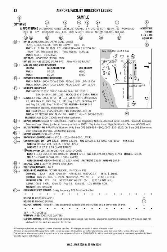
12 AIRPORT/FACILITY DIRECTORY LEGENDSECTION 1: AIRPORT/FACILITY DIRECTORY LEGEND
SAMPLE
CITY NAMEAIRPORT NAME (ALTERNATE NAME) (LTS)(KLTS) CIV/MIL 3 N UTC–6(–5DT) N34º41.93´ W99º20.20´
200 B TPA—1000(800) AOE LRA Class IV, ARFF Index A NOTAM FILE ORL Not insp.
RWY 18–36:H12004X200 (ASPH–CONC–GRVD) S–90, D–160, 2D–300 PCN 80 R/B/W/T HIRL CL
RWY 18: RLLS. MALSF. TDZL. REIL. PAPI(P2R)—GA 3.0º TCH 36´. RVR–TMR. Thld dsplcd 300´. Trees. Rgt tfc. 0.3% up.RWY 36: ALSF1. 0.4% down.
RWY 09–27: H6000X150 (ASPH) MIRLRWY 173–353: H3515X150 (ASPH–PFC) AUW PCN 59 F/A/W/TLAND AND HOLD–SHORT OPERATIONS
LDG RWY HOLD–SHORT POINT AVBL LDG DISTRWY 18 09–27 6500RWY 36 09–27 5400
RUNWAY DECLARED DISTANCE INFORMATIONRWY 18: TORA–12004 TODA–12004 ASDA–11704 LDA–11504RWY 36: TORA–12004 TODA–12004 ASDA–12004 LDA–11704
ARRESTING GEAR/SYSTEMRWY 18 HOOK E5 (65´ OVRN) BAK–14 BAK–12B (1650´)
BAK–14 BAK–12B (1087´) HOOK E5 (74´ OVRN) RWY 36SERVICE: S4 FUEL 100LL, JET A OX 1, 3 LGT ACTIVATE MALSR Rwy
29, REIL Rwy 11, VASI Rwy 11, HIRL Rwy 11–29, PAPI Rwy 17 and Rwy 35, MIRL Rwy 17–35—CTAF. MILITARY— A–GEAR E–5 connected on dep end, disconnected on apch end. JASU 3(AM32A–60) 2(A/M32A–86) FUEL J8(Mil)(NC–100, A) FLUID W SP PRESAIR LOX OIL O–128 MAINT S1 Mon–Fri 1000–2200Z‡
TRAN ALERT Avbl 1300–0200Z‡ svc limited weekends.AIRPORT REMARKS: Special Air Traffic Rules—Part 93, see Regulatory Notices. Attended 1200–0300Z‡. Parachute Jumping.
Deer invof arpt. Heavy jumbo jet training surface to 9000´. Twy A clsd indef. Flight Notification Service (ADCUS) avbl.MILITARY REMARKS: ANG PPR/Official Business Only. Base OPS DSN 638–4390, C503–335–4222. Ctc Base OPS 15 minutes
prior to ldg and after dep. Limited tran parking.AIRPORT MANAGER: (580) 481–5739WEATHER DATA SOURCES: AWOS–1 120.3 (202) 426–8000. LAWRS.COMMUNICATIONS: SFA CTAF 122.8 UNICOM 122.95 ATIS 127.25 273.5 (202) 426–8003 PTD 372.2
NAME FSS (ORL) on arpt. 123.65 122.65 122.2NAME RCO 112.2T 112.1R (NAME RADIO)
®NAME APP/DEP CON 128.35 257.725 (1200–0400Z‡)TOWER 119.65 255.6 (1200–0400Z‡) GND CON 121.7 GCO 135.075 (ORLANDO CLNC) CLNC DEL 125.55CPDLC D–HZWXR, D–TAXI, DCL (LOGON KMEM)NAME COMD POST (GERONIMO) 311.0 321.4 6761 PMSV METRO 239.8 NAME OPS 257.5
AIRSPACE: CLASS B See VFR Terminal Area Chart.VOR TEST FACILITY (VOT): 116.7RADIO AIDS TO NAVIGATION: NOTAM FILE ORL. VHF/DF ctc FSS.
(H) VORTAC 112.2 MCO Chan 59 N28º32.55´ W81º20.12´ at fld. 1110/8E.(H) TACAN Chan 29 CBU (109.2) N28º32.65´ W81º21.12´ at fld. 1115/8E.HERNY NDB (LOM) 221 OR N28º37.40´ W81º21.05´ 177º 5.4 NM to fld.ILS/DME 108.5 I–ORL Chan 22 Rwy 18. Class IIE. LOM HERNY NDB.ASR/PAR (1200–0400Z‡)
COMM/NAV/WEATHER REMARKS: Emerg frequency 121.5 not avbl at twr.
• • • • • • • • • • • • • • • • • •HELIPAD H1: H100X75 (ASPH)HELIPAD H2: H60X60 (ASPH)HELIPORT REMARKS: Helipad H1 lctd on general aviation side and H2 lctd on air carrier side of arpt.
• • • • • • • • • • • • • • • • • •187 TPA 1000(813)WATERWAY 15–33: 5000X425 (WATER)SEAPLANE REMARKS: Birds roosting and feeding areas along river banks. Seaplanes operating adjacent to SW side of arpt not
visible from twr and are required to ctc twr.
All bearings and radials are magnetic unless otherwise specified. All mileages are nautical unless otherwise noted.All times are Coordinated Universal Time (UTC) except as noted. All elevations are in feet above/below Mean Sea Level (MSL) unless otherwise noted.The horizontal reference datum of this publication is North American Datum of 1983 (NAD83), which for charting purposes is considered equivalent to World Geodetic System 1984 (WGS 84).
JACKSONVILLECOPTER
H–4G, L–19CIAP, DIAP, AD
2 3 4 5 6 7 8
9
11 12 13 14 15 16 17
18
10
1
19
22
25
29
30
28
24
23
27
31
20
21
26
1
NW, 31 MAR 2016 to 26 MAY 2016
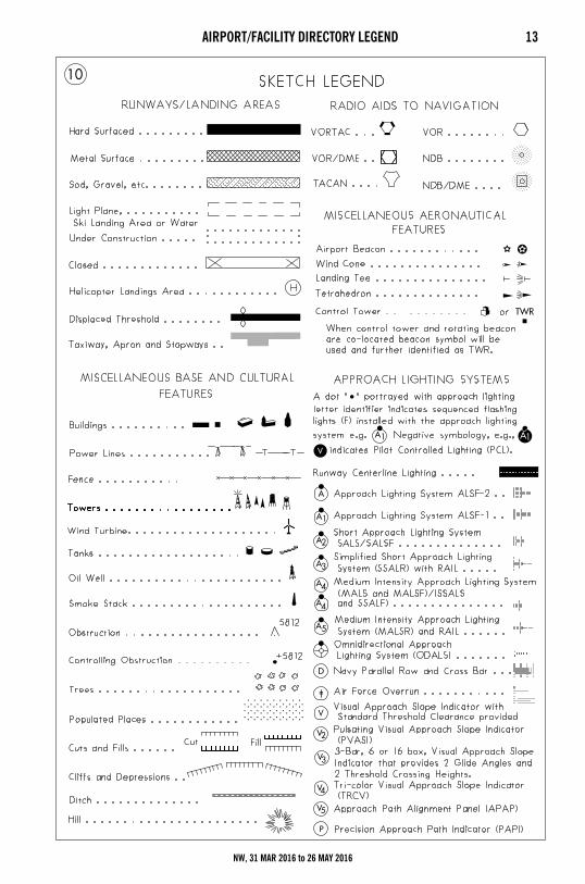
AIRPORT/FACILITY DIRECTORY LEGEND 13
NW, 31 MAR 2016 to 26 MAY 2016
14 AIRPORT/FACILITY DIRECTORY LEGENDLEGEND
This directory is a listing of data on record with the FAA on public–use airports, military airports and selected private–use airports specifically requested by the Department of Defense (DoD) for which a DoD Instrument Approach Procedure has been published in the U.S. Terminal Procedures Publication. Additionally this listing contains data for associated terminal control facilities, air route traffic control centers, and radio aids to navigation within the conterminous United States, Puerto Rico and the Virgin Islands. Civil airports and joint Civil/Military airports which are open to the public are listed alphabetically by state, associated city and airport name and cross–referenced by airport name. Military airports and private–use (limited civil access) joint Military/Civil airports are listed alphabetically by state and official airport name and cross–referenced by associated city name. Navaids, flight service stations and remote communication outlets that are associated with an airport, but with a different name, are listed alphabetically under their own name, as well as under the airport with which they are associated.
The listing of an airport as open to the public in this directory merely indicates the airport operator's willingness to accommodate transient aircraft, and does not represent that the airport conforms with any Federal or local standards, or that it has been approved for use on the part of the general public. Military airports, private–use airports, and private–use (limited civil access) joint Military/Civil airports are open to civil pilots only in an emergency or with prior permission. See Special Notice Section, Civil Use of Military Fields.
The information on obstructions is taken from reports submitted to the FAA. Obstruction data has not been verified in all cases. Pilots are cautioned that objects not indicated in this tabulation (or on the airports sketches and/or charts) may exist which can create a hazard to flight operation. Detailed specifics concerning services and facilities tabulated within this directory are contained in the Aeronautical Information Manual, Basic Flight Information and ATC Procedures.
The legend items that follow explain in detail the contents of this Directory and are keyed to the circled numbers on the sample on the preceding pages.
CITY/AIRPORT NAME Civil and joint Civil/Military airports which are open to the public are listed alphabetically by state and associated city. Where the city name is different from the airport name the city name will appear on the line above the airport name. Airports with the same associated city name will be listed alphabetically by airport name and will be separated by a dashed rule line. A solid rule line will separate all others. FAA approved helipads and seaplane landing areas associated with a land airport will be separated by a dotted line. Military airports and private–use (limited civil access) joint Military/Civil airports are listed alphabetically by state and official airport name.
ALTERNATE NAMEAlternate names, if any, will be shown in parentheses.
LOCATION IDENTIFIER The location identifier is a three or four character FAA code followed by a four–character ICAO code, when assigned, to airports. If two different military codes are assigned, both codes will be shown with the primary operating agency’s code listed first. These identifiers are used by ATC in lieu of the airport name in flight plans, flight strips and other written records and computer operations. Zeros will appear with a slash to differentiate them from the letter “O”.
OPERATING AGENCYAirports within this directory are classified into two categories, Military/Federal Government and Civil airports open to the general public, plus selected private–use airports. The operating agency is shown for military, private–use and joint use airports. The operating agency is shown by an abbreviation as listed below. When an organization is a tenant, the abbreviation is enclosed in parenthesis. No classification indicates the airport is open to the general public with no military tenant.
AIRPORT LOCATION Airport location is expressed as distance and direction from the center of the associated city in nautical miles and cardinal points, e.g., 4 NE.
TIME CONVERSION Hours of operation of all facilities are expressed in Coordinated Universal Time (UTC) and shown as “Z” time. The directory indicates the number of hours to be subtracted from UTC to obtain local standard time and local daylight saving time UTC–5(–4DT). The symbol ‡ indicates that during periods of Daylight Saving Time (DST) effective hours will be one hour earlier than shown. In those areas where daylight saving time is not observed the (–4DT) and ‡ will not be shown. Daylight saving time is in effect from 0200 local time the second Sunday in March to 0200 local time the first Sunday in November. Canada and all U.S. Conterminous States observe daylight saving time except Arizona and Puerto Rico, and the Virgin Islands. If the state observes daylight saving time and the operating times are other than daylight saving times, the operating hours will include the dates, times and no ‡ symbol will be shown, i.e., April 15–Aug 31 0630–1700Z, Sep 1–Apr 14 0600–1700Z.
A US ArmyAFRC Air Force Reserve CommandAF US Air ForceANG Air National GuardAR US Army ReserveARNG US Army National GuardCG US Coast GuardCIV/MIL Joint Use Civil/Military Open to the PublicDND Department of National Defense Canada
MC Marine CorpsMIL/CIV Joint Use Military/Civil Limited Civil AccessN NavyNAF Naval Air FacilityNAS Naval Air StationNASA National Air and Space AdministrationP US Civil Airport Wherein Permit Covers Use by
Transient Military AircraftPVT Private Use Only (Closed to the Public)
1
2
3
4
5
6
NW, 31 MAR 2016 to 26 MAY 2016
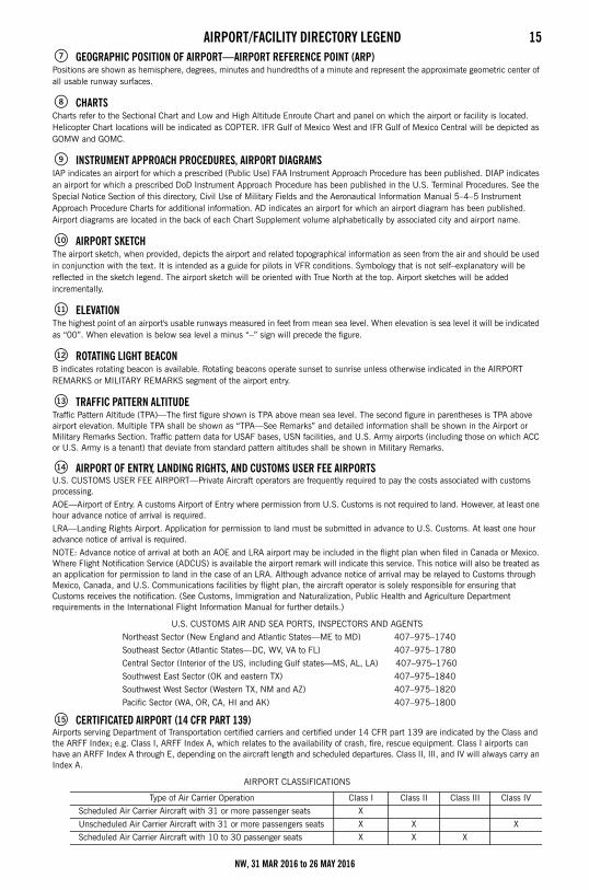
AIRPORT/FACILITY DIRECTORY LEGEND 15GEOGRAPHIC POSITION OF AIRPORT—AIRPORT REFERENCE POINT (ARP)
Positions are shown as hemisphere, degrees, minutes and hundredths of a minute and represent the approximate geometric center of all usable runway surfaces.
CHARTS Charts refer to the Sectional Chart and Low and High Altitude Enroute Chart and panel on which the airport or facility is located. Helicopter Chart locations will be indicated as COPTER. IFR Gulf of Mexico West and IFR Gulf of Mexico Central will be depicted as GOMW and GOMC.
INSTRUMENT APPROACH PROCEDURES, AIRPORT DIAGRAMS IAP indicates an airport for which a prescribed (Public Use) FAA Instrument Approach Procedure has been published. DIAP indicates an airport for which a prescribed DoD Instrument Approach Procedure has been published in the U.S. Terminal Procedures. See the Special Notice Section of this directory, Civil Use of Military Fields and the Aeronautical Information Manual 5–4–5 Instrument Approach Procedure Charts for additional information. AD indicates an airport for which an airport diagram has been published. Airport diagrams are located in the back of each Chart Supplement volume alphabetically by associated city and airport name.
AIRPORT SKETCHThe airport sketch, when provided, depicts the airport and related topographical information as seen from the air and should be used in conjunction with the text. It is intended as a guide for pilots in VFR conditions. Symbology that is not self–explanatory will be reflected in the sketch legend. The airport sketch will be oriented with True North at the top. Airport sketches will be added incrementally.
ELEVATION The highest point of an airport's usable runways measured in feet from mean sea level. When elevation is sea level it will be indicated as “00”. When elevation is below sea level a minus “” sign will precede the figure.
ROTATING LIGHT BEACON B indicates rotating beacon is available. Rotating beacons operate sunset to sunrise unless otherwise indicated in the AIRPORT REMARKS or MILITARY REMARKS segment of the airport entry.
TRAFFIC PATTERN ALTITUDE Traffic Pattern Altitude (TPA)—The first figure shown is TPA above mean sea level. The second figure in parentheses is TPA above airport elevation. Multiple TPA shall be shown as “TPA—See Remarks” and detailed information shall be shown in the Airport or Military Remarks Section. Traffic pattern data for USAF bases, USN facilities, and U.S. Army airports (including those on which ACC or U.S. Army is a tenant) that deviate from standard pattern altitudes shall be shown in Military Remarks.
AIRPORT OF ENTRY, LANDING RIGHTS, AND CUSTOMS USER FEE AIRPORTS U.S. CUSTOMS USER FEE AIRPORT—Private Aircraft operators are frequently required to pay the costs associated with customs processing.
AOE—Airport of Entry. A customs Airport of Entry where permission from U.S. Customs is not required to land. However, at least one hour advance notice of arrival is required.
LRA—Landing Rights Airport. Application for permission to land must be submitted in advance to U.S. Customs. At least one hour advance notice of arrival is required.
NOTE: Advance notice of arrival at both an AOE and LRA airport may be included in the flight plan when filed in Canada or Mexico. Where Flight Notification Service (ADCUS) is available the airport remark will indicate this service. This notice will also be treated as an application for permission to land in the case of an LRA. Although advance notice of arrival may be relayed to Customs through Mexico, Canada, and U.S. Communications facilities by flight plan, the aircraft operator is solely responsible for ensuring that Customs receives the notification. (See Customs, Immigration and Naturalization, Public Health and Agriculture Department requirements in the International Flight Information Manual for further details.)
U.S. CUSTOMS AIR AND SEA PORTS, INSPECTORS AND AGENTS
Northeast Sector (New England and Atlantic States—ME to MD) 407–975–1740
Southeast Sector (Atlantic States—DC, WV, VA to FL) 407–975–1780
Central Sector (Interior of the US, including Gulf states—MS, AL, LA) 407–975–1760
Southwest East Sector (OK and eastern TX) 407–975–1840
Southwest West Sector (Western TX, NM and AZ) 407–975–1820
Pacific Sector (WA, OR, CA, HI and AK) 407–975–1800
CERTIFICATED AIRPORT (14 CFR PART 139) Airports serving Department of Transportation certified carriers and certified under 14 CFR part 139 are indicated by the Class and the ARFF Index; e.g. Class I, ARFF Index A, which relates to the availability of crash, fire, rescue equipment. Class I airports can have an ARFF Index A through E, depending on the aircraft length and scheduled departures. Class II, III, and IV will always carry an Index A.
AIRPORT CLASSIFICATIONS
Type of Air Carrier Operation Class I Class II Class III Class IV
Scheduled Air Carrier Aircraft with 31 or more passenger seats X
Unscheduled Air Carrier Aircraft with 31 or more passengers seats X X X
Scheduled Air Carrier Aircraft with 10 to 30 passenger seats X X X
7
8
9
10
11
12
13
14
15
NW, 31 MAR 2016 to 26 MAY 2016
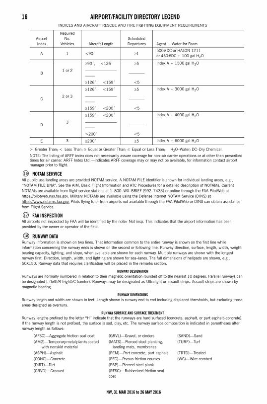
16 AIRPORT/FACILITY DIRECTORY LEGENDINDICES AND AIRCRAFT RESCUE AND FIRE FIGHTING EQUIPMENT REQUIREMENTS
> Greater Than; < Less Than; Equal or Greater Than; Equal or Less Than; H2O–Water; DC–Dry Chemical.
NOTE: The listing of ARFF index does not necessarily assure coverage for non–air carrier operations or at other than prescribed times for air carrier. ARFF Index Ltd.—indicates ARFF coverage may or may not be available, for information contact airport manager prior to flight.
NOTAM SERVICE All public use landing areas are provided NOTAM service. A NOTAM FILE identifier is shown for individual landing areas, e.g., ‘‘NOTAM FILE BNA’’. See the AIM, Basic Flight Information and ATC Procedures for a detailed description of NOTAMs. Current NOTAMs are available from flight service stations at 1–800–WX–BRIEF (992–7433) or online through the FAA PilotWeb at https://pilotweb.nas.faa.gov. Military NOTAMs are available using the Defense Internet NOTAM Service (DINS) at https://www.notams.faa.gov. Pilots flying to or from airports not available through the FAA PilotWeb or DINS can obtain assistance from Flight Service.
FAA INSPECTIONAll airports not inspected by FAA will be identified by the note: Not insp. This indicates that the airport information has been provided by the owner or operator of the field.
RUNWAY DATARunway information is shown on two lines. That information common to the entire runway is shown on the first line while information concerning the runway ends is shown on the second or following line. Runway direction, surface, length, width, weight bearing capacity, lighting, and slope, when available are shown for each runway. Multiple runways are shown with the longest runway first. Direction, length, width, and lighting are shown for sea–lanes. The full dimensions of helipads are shown, e.g., 50X150. Runway data that requires clarification will be placed in the remarks section.
RUNWAY DESIGNATIONRunways are normally numbered in relation to their magnetic orientation rounded off to the nearest 10 degrees. Parallel runways can be designated L (left)/R (right)/C (center). Runways may be designated as Ultralight or assault strips. Assault strips are shown by magnetic bearing.
RUNWAY DIMENSIONSRunway length and width are shown in feet. Length shown is runway end to end including displaced thresholds, but excluding those areas designed as overruns.
RUNWAY SURFACE AND SURFACE TREATMENTRunway lengths prefixed by the letter ‘‘H’’ indicate that the runways are hard surfaced (concrete, asphalt, or part asphalt–concrete). If the runway length is not prefixed, the surface is sod, clay, etc. The runway surface composition is indicated in parentheses after runway length as follows:
Airport Index
Required No.
Vehicles Aircraft Length Scheduled Departures Agent + Water for Foam
A 1 <90´ 1 500#DC or HALON 1211 or 450#DC + 100 gal H2O
90´, <126´ 5 Index A + 1500 gal H2O
B1 or 2 ––––––––––––––––
–––––––––––––
126´, <159´ <5
126´, <159´ 5 Index A + 3000 gal H2O
C2 or 3 ––––––––––––––––
–––––––––––––
159´, <200´ <5
159´, <200´ Index A + 4000 gal H2O
D3 ––––––––––––––––
–––––––––––––
>200´ <5
E 3 200´ 5 Index A + 6000 gal H2O
(AFSC)—Aggregate friction seal coat (GRVL)—Gravel, or cinders (SAND)—Sand
(AM2)—Temporary metal planks coated with nonskid material
(MATS)—Pierced steel planking, landing mats, membranes
(TURF)—Turf
(ASPH)—Asphalt (PEM)—Part concrete, part asphalt (TRTD)—Treated
(CONC)—Concrete (PFC)—Porous friction courses (WC)—Wire combed
(DIRT)—Dirt (PSP)—Pierced steel plank
(GRVD)—Grooved (RFSC)—Rubberized friction seal coat
16
17
18
NW, 31 MAR 2016 to 26 MAY 2016
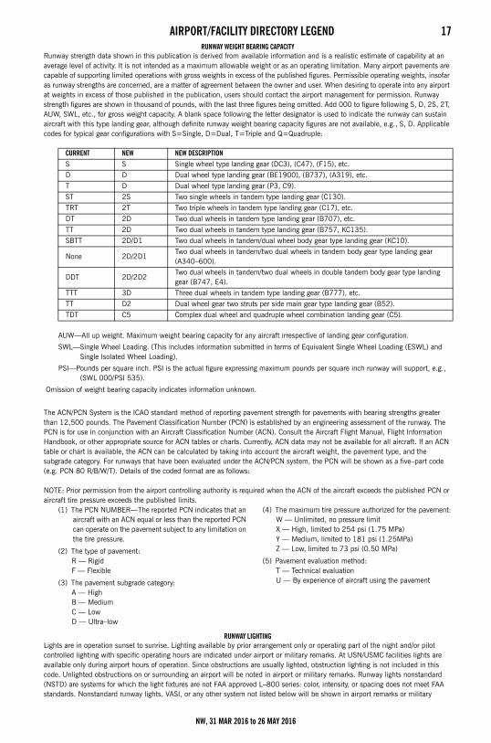
AIRPORT/FACILITY DIRECTORY LEGEND 17RUNWAY WEIGHT BEARING CAPACITY
Runway strength data shown in this publication is derived from available information and is a realistic estimate of capability at an average level of activity. It is not intended as a maximum allowable weight or as an operating limitation. Many airport pavements are capable of supporting limited operations with gross weights in excess of the published figures. Permissible operating weights, insofar as runway strengths are concerned, are a matter of agreement between the owner and user. When desiring to operate into any airport at weights in excess of those published in the publication, users should contact the airport management for permission. Runway strength figures are shown in thousand of pounds, with the last three figures being omitted. Add 000 to figure following S, D, 2S, 2T, AUW, SWL, etc., for gross weight capacity. A blank space following the letter designator is used to indicate the runway can sustain aircraft with this type landing gear, although definite runway weight bearing capacity figures are not available, e.g., S, D. Applicable codes for typical gear configurations with S=Single, D=Dual, T=Triple and Q=Quadruple:
AUW—All up weight. Maximum weight bearing capacity for any aircraft irrespective of landing gear configuration.
SWL—Single Wheel Loading. (This includes information submitted in terms of Equivalent Single Wheel Loading (ESWL) and Single Isolated Wheel Loading).
PSI—Pounds per square inch. PSI is the actual figure expressing maximum pounds per square inch runway will support, e.g., (SWL 000/PSI 535).
Omission of weight bearing capacity indicates information unknown.
The ACN/PCN System is the ICAO standard method of reporting pavement strength for pavements with bearing strengths greater than 12,500 pounds. The Pavement Classification Number (PCN) is established by an engineering assessment of the runway. The PCN is for use in conjunction with an Aircraft Classification Number (ACN). Consult the Aircraft Flight Manual, Flight Information Handbook, or other appropriate source for ACN tables or charts. Currently, ACN data may not be available for all aircraft. If an ACN table or chart is available, the ACN can be calculated by taking into account the aircraft weight, the pavement type, and the subgrade category. For runways that have been evaluated under the ACN/PCN system, the PCN will be shown as a five–part code (e.g. PCN 80 R/B/W/T). Details of the coded format are as follows:
NOTE: Prior permission from the airport controlling authority is required when the ACN of the aircraft exceeds the published PCN or aircraft tire pressure exceeds the published limits.
RUNWAY LIGHTING Lights are in operation sunset to sunrise. Lighting available by prior arrangement only or operating part of the night and/or pilot controlled lighting with specific operating hours are indicated under airport or military remarks. At USN/USMC facilities lights are available only during airport hours of operation. Since obstructions are usually lighted, obstruction lighting is not included in this code. Unlighted obstructions on or surrounding an airport will be noted in airport or military remarks. Runway lights nonstandard (NSTD) are systems for which the light fixtures are not FAA approved L–800 series: color, intensity, or spacing does not meet FAA standards. Nonstandard runway lights, VASI, or any other system not listed below will be shown in airport remarks or military
CURRENT NEW NEW DESCRIPTIONS S Single wheel type landing gear (DC3), (C47), (F15), etc.
D D Dual wheel type landing gear (BE1900), (B737), (A319), etc.
T D Dual wheel type landing gear (P3, C9).
ST 2S Two single wheels in tandem type landing gear (C130).
TRT 2T Two triple wheels in tandem type landing gear (C17), etc.
DT 2D Two dual wheels in tandem type landing gear (B707), etc.
TT 2D Two dual wheels in tandem type landing gear (B757, KC135).
SBTT 2D/D1 Two dual wheels in tandem/dual wheel body gear type landing gear (KC10).
None 2D/2D1Two dual wheels in tandem/two dual wheels in tandem body gear type landing gear (A340–600).
DDT 2D/2D2Two dual wheels in tandem/two dual wheels in double tandem body gear type landing gear (B747, E4).
TTT 3D Three dual wheels in tandem type landing gear (B777), etc.
TT D2 Dual wheel gear two struts per side main gear type landing gear (B52).
TDT C5 Complex dual wheel and quadruple wheel combination landing gear (C5).
(1) The PCN NUMBER—The reported PCN indicates that an aircraft with an ACN equal or less than the reported PCN can operate on the pavement subject to any limitation on the tire pressure.
(2) The type of pavement:R — RigidF — Flexible
(3) The pavement subgrade category:A — HighB — MediumC — LowD — Ultra–low
(4) The maximum tire pressure authorized for the pavement:W — Unlimited, no pressure limitX — High, limited to 254 psi (1.75 MPa)Y — Medium, limited to 181 psi (1.25MPa) Z — Low, limited to 73 psi (0.50 MPa)
(5) Pavement evaluation method:T — Technical evaluationU — By experience of aircraft using the pavement
NW, 31 MAR 2016 to 26 MAY 2016
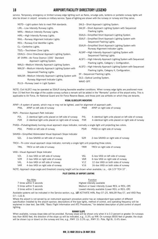
18 AIRPORT/FACILITY DIRECTORY LEGENDservice. Temporary, emergency or limited runway edge lighting such as flares, smudge pots, lanterns or portable runway lights will also be shown in airport remarks or military service. Types of lighting are shown with the runway or runway end they serve.
NOTE: Civil ALSF2 may be operated as SSALR during favorable weather conditions. When runway edge lights are positioned more than 10 feet from the edge of the usable runway surface a remark will be added in the “Remarks” portion of the airport entry. This is applicable to Air Force, Air National Guard and Air Force Reserve Bases, and those joint use airfields on which they are tenants.
VISUAL GLIDESLOPE INDICATORS
APAP—A system of panels, which may or may not be lighted, used for alignment of approach path.
PAPI—Precision Approach Path Indicator
PVASI—Pulsating/steady burning visual approach slope indicator, normally a single light unit projecting two colors.
SAVASI—Simplified Abbreviated Visual Approach Slope Indicator
TRCV—Tri–color visual approach slope indicator, normally a single light unit projecting three colors.
VASI—Visual Approach Slope Indicator
NOTE: Approach slope angle and threshold crossing height will be shown when available; i.e., –GA 3.5º TCH 37´.
PILOT CONTROL OF AIRPORT LIGHTING
Available systems will be indicated in the Service section, e.g., LGT ACTIVATE HIRL Rwy 07–25, MALSR Rwy 07, and VASI Rwy 07—122.8. Where the airport is not served by an instrument approach procedure and/or has an independent type system of different specification installed by the airport sponsor, descriptions of the type lights, method of control, and operating frequency will be explained in clear text. See AIM, “Basic Flight Information and ATC Procedures,” for detailed description of pilot control of airport lighting.
RUNWAY SLOPEWhen available, runway slope data will be provided. Runway slope will be shown only when it is 0.3 percent or greater. On runways less than 8000 feet, the direction of the slope up will be indicated, e.g., 0.3% up NW. On runways 8000 feet or greater, the slope will be shown (up or down) on the runway end line, e.g., RWY 13: 0.3% up., RWY 31: Pole. Rgt tfc. 0.4% down.
NSTD—Light system fails to meet FAA standards.
LIRL—Low Intensity Runway Lights.
MIRL—Medium Intensity Runway Lights.
HIRL—High Intensity Runway Lights.
RAIL—Runway Alignment Indicator Lights.
REIL—Runway End Identifier Lights.
CL—Centerline Lights.
TDZL—Touchdown Zone Lights.
ODALS—Omni Directional Approach Lighting System.
AF OVRN—Air Force Overrun 1000´ Standard Approach Lighting System.
MALS—Medium Intensity Approach Lighting System.
MALSF—Medium Intensity Approach Lighting System with
Sequenced Flashing Lights.
MALSR—Medium Intensity Approach Lighting System with
Runway Alignment Indicator Lights.
RLLS—Runway Lead–in Light System
SALS—Short Approach Lighting System.
SALSF—Short Approach Lighting System with Sequenced Flashing Lights.
SSALS—Simplified Short Approach Lighting System.
SSALF—Simplified Short Approach Lighting System with Sequenced Flashing Lights.
SSALR—Simplified Short Approach Lighting System with Runway Alignment Indicator Lights.
ALSAF—High Intensity Approach Lighting System with Sequenced Flashing Lights.
ALSF1—High Intensity Approach Lighting System with Sequenced
Flashing Lights, Category I, Configuration.
ALSF2—High Intensity Approach Lighting System with Sequenced
Flashing Lights, Category II, Configuration.
SF—Sequenced Flashing Lights.
OLS—Optical Landing System.
WAVE–OFF.
PNIL APAP on left side of runway PNIR APAP on right side of runway
P2L 2–identical light units placed on left side of runway P4L 4–identical light units placed on left side of runwayP2R 2–identical light units placed on right side of runway P4R 4–identical light units placed on right side of runway
PSIL PVASI on left side of runway PSIR PVASI on right side of runway
S2L 2–box SAVASI on left side of runway S2R 2–box SAVASI on right side of runway
TRIL TRCV on left side of runway TRIR TRCV on right side of runway
V2L 2–box VASI on left side of runway V6L 6–box VASI on left side of runwayV2R 2–box VASI on right side of runway V6R 6–box VASI on right side of runwayV4L 4–box VASI on left side of runway V12 12–box VASI on both sides of runwayV4R 4–box VASI on right side of runway V16 16–box VASI on both sides of runway
Key Mike Function 7 times within 5 seconds Highest intensity available 5 times within 5 seconds Medium or lower intensity (Lower REIL or REIL–Off) 3 times within 5 seconds Lowest intensity available (Lower REIL or REIL–Off)
NW, 31 MAR 2016 to 26 MAY 2016
AIRPORT/FACILITY DIRECTORY LEGEND 19RUNWAY END DATA
Information pertaining to the runway approach end such as approach lights, touchdown zone lights, runway end identification lights, visual glideslope indicators, displaced thresholds, controlling obstruction, and right hand traffic pattern, will be shown on the specific runway end. “Rgt tfc”—Right traffic indicates right turns should be made on landing and takeoff for specified runway end. Runway Visual Range shall be shown as "RVR" appended with "T" for touchdown, "M" for midpoint, and "R" for rollout; e.g., RVR-TMR.
LAND AND HOLD–SHORT OPERATIONS (LAHSO)LAHSO is an acronym for ‘‘Land and Hold–Short Operations’’ These operations include landing and holding short of an intersection runway, an intersecting taxiway, or other predetermined points on the runway other than a runway or taxiway. Measured distance represents the available landing distance on the landing runway, in feet. Specific questions regarding these distances should be referred to the air traffic manager of the facility concerned. The Aeronautical Information Manual contains specific details on hold–short operations and markings.
RUNWAY DECLARED DISTANCE INFORMATIONTORA—Take–off Run Available. The length of runway declared available and suitable for the ground run of an aeroplane take–off.TODA—Take–off Distance Available. The length of the take–off run available plus the length of the clearway, if provided.ASDA—Accelerate–Stop Distance Available. The length of the take–off run available plus the length of the stopway, if provided.LDA—Landing Distance Available. The length of runway which is declared available and suitable for the ground run of an aeroplane landing.
ARRESTING GEAR/SYSTEMSArresting gear is shown as it is located on the runway. The a–gear distance from the end of the appropriate runway (or into the overrun) is indicated in parentheses. A–Gear which has a bi–direction capability and can be utilized for emergency approach end engagement is indicated by a (B). Up to 15 minutes advance notice may be required for rigging A–Gear for approach and engagement. Airport listing may show availability of other than US Systems. This information is provided for emergency requirements only. Refer to current aircraft operating manuals for specific engagement weight and speed criteria based on aircraft structural restrictions and arresting system limitations. Following is a list of current systems referenced in this publication identified by both Air Force and Navy terminology:BI–DIRECTIONAL CABLE (B)
TYPE DESCRIPTIONBAK–9 Rotary friction brake.BAK–12A Standard BAK–12 with 950 foot run out, 1–inch cable and 40,000 pound weight setting. Rotary friction
brake.BAK–12B Extended BAK–12 with 1200 foot run, 1¼ inch Cable and 50,000 pounds weight setting. Rotary friction
brake.E28 Rotary Hydraulic (Water Brake).M21 Rotary Hydraulic (Water Brake) Mobile.
The following device is used in conjunction with some aircraft arresting systems:BAK–14 A device that raises a hook cable out of a slot in the runway surface and is remotely positioned for
engagement by the tower on request. (In addition to personnel reaction time, the system requires up to five seconds to fully raise the cable.)
H A device that raises a hook cable out of a slot in the runway surface and is remotely positioned for engagement by the tower on request. (In addition to personnel reaction time, the system requires up to one and one–half seconds to fully raise the cable.)
UNI–DIRECTIONAL CABLETYPE DESCRIPTIONMB60 Textile brake—an emergency one–time use, modular braking system employing the tearing of specially
woven textile straps to absorb the kinetic energy.E5/E5–1/E5–3 Chain Type. At USN/USMC stations E–5 A–GEAR systems are rated, e.g., E–5 RATING–13R–1100 HW
(DRY), 31L/R–1200 STD (WET). This rating is a function of the A–GEAR chain weight and length and is used to determine the maximum aircraft engaging speed. A dry rating applies to a stabilized surface (dry or wet) while a wet rating takes into account the amount (if any) of wet overrun that is not capable of withstanding the aircraft weight. These ratings are published under Service/Military/A-Gear in the entry.
FOREIGN CABLETYPE DESCRIPTION US EQUIVALENT44B–3H Rotary Hydraulic (Water Brake)CHAG Chain E–5
UNI–DIRECTIONAL BARRIERTYPE DESCRIPTIONMA–1A Web barrier between stanchions attached to a chain energy absorber.BAK–15 Web barrier between stanchions attached to an energy absorber (water squeezer, rotary friction, chain).
Designed for wing engagement.NOTE: Landing short of the runway threshold on a runway with a BAK–15 in the underrun is a significant hazard. The barrierin the down position still protrudes several inches above the underrun. Aircraft contact with the barrier short of the runwaythreshold can cause damage to the barrier and substantial damage to the aircraft.
OTHERTYPE DESCRIPTIONEMAS Engineered Material Arresting System, located beyond the departure end of the runway, consisting of high
energy absorbing materials which will crush under the weight of an aircraft.
2219
20
21
NW, 31 MAR 2016 to 26 MAY 2016
20 AIRPORT/FACILITY DIRECTORY LEGEND
SERVICESERVICING—CIVIL
FUEL—CIVIL
*(Fuel System Icing Inhibitor) **(Freeze Point) # (Corrosion Inhibitors/Lubricity Improvers) ## (Static Dissipator Additive)
NOTE: Certain automobile gasoline may be used in specific aircraft engines if a FAA supplemental type certificate has been obtained. Automobile gasoline, which is to be used in aircraft engines, will be identified as “MOGAS”, however, the grade/type and other octane rating will not be published.
Data shown on fuel availability represents the most recent information the publisher has been able to acquire. Because of a variety of factors, the fuel listed may not always be obtainable by transient civil pilots. Confirmation of availability of fuel should be made directly with fuel suppliers at locations where refueling is planned.
OXYGEN—CIVIL
SERVICE—MILITARY Specific military services available at the airport are listed under this general heading. Remarks applicable to any military service are shown in the individual service listing.
JET AIRCRAFT STARTING UNITS (JASU)—MILITARY The numeral preceding the type of unit indicates the number of units available. The absence of the numeral indicates ten or more units available. If the number of units is unknown, the number one will be shown. Absence of JASU designation indicates non–availability.The following is a list of current JASU systems referenced in this publication:
USAF JASU (For variations in technical data, refer to T.O. 35–1–7.)ELECTRICAL STARTING UNITS:
A/M32A–86 AC: 115/200v, 3 phase, 90 kva, 0.8 pf, 4 wireDC: 28v, 1500 amp, 72 kw (with TR pack)
MC–1A AC: 115/208v, 400 cycle, 3 phase, 37.5 kva, 0.8 pf, 108 amp, 4 wireDC: 28v, 500 amp, 14 kw
MD–3 AC: 115/208v, 400 cycle, 3 phase, 60 kva, 0.75 pf, 4 wireDC: 28v, 1500 amp, 45 kw, split bus
MD–3A AC: 115/208v, 400 cycle, 3 phase, 60 kva, 0.75 pf, 4 wireDC: 28v, 1500 amp, 45 kw, split bus
MD–3M AC: 115/208v, 400 cycle, 3 phase, 60 kva, 0.75 pf, 4 wireDC: 28v, 500 amp, 15 kw
MD–4 AC: 120/208v, 400 cycle, 3 phase, 62.5 kva, 0.8 pf, 175 amp, ‘‘WYE’’ neutral ground, 4 wire, 120v, 400 cycle, 3 phase, 62.5 kva, 0.8 pf, 303 amp, ‘‘DELTA’’ 3 wire, 120v, 400 cycle, 1 phase, 62.5 kva, 0.8 pf, 520 amp, 2 wire
S1: Minor airframe repairs.S2: Minor airframe and minor powerplant repairs.S3: Major airframe and minor powerplant repairs.S4: Major airframe and major powerplant repairs.
S5: Major airframe repairs.S6: Minor airframe and major powerplant repairs.S7: Major powerplant repairs.S8: Minor powerplant repairs.
CODE FUEL CODE FUEL
80 Grade 80 gasoline (Red) A1+ Jet A–1, Kerosene with FS–II*, FP** minus 47º C.
100 Grade 100 gasoline (Green) B Jet B, Wide–cut, turbine fuel without
100LL 100LL gasoline (low lead) (Blue) FS–II*, FP** minus 50º C.
115 Grade 115 gasoline (115/145 military B+ Jet B, Wide–cut, turbine fuel with FS–II*, FP**
specification) (Purple) minus 50º C
A Jet A, Kerosene, without FS–II*, FP** J4 (JP4) (JP–4 military specification) FP** minus 58º C.
minus 40º C. J5 (JP5) (JP–5 military specification) Kerosene with
A+ Jet A, Kerosene, with FS–II*, FP** minus 40ºC. FS–II, FP** minus 46ºC.
A++ Jet A, Kerosene, with FS–II*, CI/LI#, SDA##, J8 (JP8) (JP–8 military specification) Jet A–1, Kerosene
FP** minus 40ºC. with FS–II*, CI/LI#, SDA##, FP** minus 47ºC.
A++100 Jet A, Kerosene, with FS–II*, CI/LI#, SDA##, J8+100 (JP–8 military specification) Jet A–1, Kerosene
FP** minus 40ºC, with +100 fuel additive with FS–II*, CI/LI#, SDA##,FP** minus 47ºC,
that improves thermal stability characteristics with +100 fuel additive that improves thermal stability
of kerosene jet fuels. characteristics of kerosene jet fuels.
A1 Jet A–1, Kerosene, without FS–II*, FP** J (Jet Fuel Type Unknown)
minus 47ºC. MOGAS Automobile gasoline which is to be used as aircraft fuel.
OX 1 High Pressure OX 3 High Pressure—Replacement Bottles
OX 2 Low Pressure OX 4 Low Pressure—Replacement Bottles
22
NW, 31 MAR 2016 to 26 MAY 2016
AIRPORT/FACILITY DIRECTORY LEGEND 21AIR STARTING UNITS
AM32–95 150 +/– 5 lb/min (2055 +/– 68 cfm) at 51 +/– 2 psiaAM32A–95 150 +/– 5 lb/min @ 49 +/– 2 psia (35 +/– 2 psig)LASS 150 +/– 5 lb/min @ 49 +/– 2 psiaMA–1A 82 lb/min (1123 cfm) at 130° air inlet temp, 45 psia (min) air outlet pressMC–1 15 cfm, 3500 psiaMC–1A 15 cfm, 3500 psiaMC–2A 15 cfm, 200 psiaMC–11 8,000 cu in cap, 4000 psig, 15 cfm
COMBINED AIR AND ELECTRICAL STARTING UNITS:AGPU AC: 115/200v, 400 cycle, 3 phase, 30 kw gen
DC: 28v, 700 ampAIR: 60 lb/min @ 40 psig @ sea level
AM32A–60* AIR: 120 +/– 4 lb/min (1644 +/– 55 cfm) at 49 +/– 2 psiaAC: 120/208v, 400 cycle, 3 phase, 75 kva, 0.75 pf, 4 wire, 120v, 1 phase, 25 kvaDC: 28v, 500 amp, 15 kw
AM32A–60A AIR: 150 +/– 5 lb/min (2055 +/– 68 cfm at 51 +/– psiaAC: 120/208v, 400 cycle, 3 phase, 75 kva, 0.75 pf, 4 wireDC: 28v, 200 amp, 5.6 kw
AM32A–60B* AIR: 130 lb/min, 50 psiaAC: 120/208v, 400 cycle, 3 phase, 75 kva, 0.75 pf, 4 wireDC: 28v, 200 amp, 5.6 kw
*NOTE: During combined air and electrical loads, the pneumatic circuitry takes preference and will limit the amount ofelectrical power available.
USN JASUELECTRICAL STARTING UNITS:
NC–8A/A1 DC: 500 amp constant, 750 amp intermittent, 28v;AC: 60 kva @ .8 pf, 115/200v, 3 phase, 400 Hz.
NC–10A/A1/B/C DC: 750 amp constant, 1000 amp intermittent, 28v;AC: 90 kva, 115/200v, 3 phase, 400 Hz.
AIR STARTING UNITS:GTC–85/GTE–85 120 lbs/min @ 45 psi.MSU–200NAV/A/U47A–5 204 lbs/min @ 56 psia.WELLS AIR START 180 lbs/min @ 75 psi or 120 lbs/min @ 45 psi. Simultaneous multiple start capability.SYSTEM
COMBINED AIR AND ELECTRICAL STARTING UNITS:NCPP–105/RCPT 180 lbs/min @ 75 psi or 120 lbs/min @ 45 psi. 700 amp, 28v DC. 120/208v, 400 Hz AC, 30
kva.
ARMY JASU59B2–1B 28v, 7.5 kw, 280 amp.
OTHER JASUELECTRICAL STARTING UNITS (DND):
CE12 AC 115/200v, 140 kva, 400 Hz, 3 phaseCE13 AC 115/200v, 60 kva, 400 Hz, 3 phaseCE14 AC/DC 115/200v, 140 kva, 400 Hz, 3 phase, 28vDC, 1500 ampCE15 DC 22–35v, 500 amp continuous 1100 amp intermittentCE16 DC 22–35v, 500 amp continuous 1100 amp intermittent soft start
AIR STARTING UNITS (DND):CA2 ASA 45.5 psig, 116.4 lb/min
COMBINED AIR AND ELECTRICAL STARTING UNITS (DND)CEA1 AC 120/208v, 60 kva, 400 Hz, 3 phase DC 28v, 75 amp
AIR 112.5 lb/min, 47 psigELECTRICAL STARTING UNITS (OTHER)
C–26 28v 45kw 115–200v 15kw 380–800 Hz 1 phase 2 wireC–26–B, C–26–C 28v 45kw: Split Bus: 115–200v 15kw 380–800 Hz 1 phase 2 wireE3 DC 28v/10kw
AIR STARTING UNITS (OTHER):A4 40 psi/2 lb/sec (LPAS Mk12, Mk12L, Mk12A, Mk1, Mk2B)MA–1 150 Air HP, 115 lb/min 50 psiaMA–2 250 Air HP, 150 lb/min 75 psia
CARTRIDGE:MXU–4A USAF
NW, 31 MAR 2016 to 26 MAY 2016

22 AIRPORT/FACILITY DIRECTORY LEGENDFUEL—MILITARY
Fuel available through US Military Base supply, DESC Into–Plane Contracts and/or reciprocal agreement is listed first and is followed by (Mil). At commercial airports where Into–Plane contracts are in place, the name of the refueling agent is shown. Military fuel should be used first if it is available. When military fuel cannot be obtained but Into–Plane contract fuel is available, Government aircraft must refuel with the contract fuel and applicable refueling agent to avoid any breach in contract terms and conditions. Fuel not available through the above is shown preceded by NC (no contract). When fuel is obtained from NC sources, local purchase procedures must be followed. The US Military Aircraft Identaplates DD Form 1896 (Jet Fuel), DD Form 1897 (Avgas) and AF Form 1245 (Avgas) are used at military installations only. The US Government Aviation Into–Plane Reimbursement (AIR) Card (currently issued by AVCARD) is the instrument to be used to obtain fuel under a DESC Into–Plane Contract and for NC purchases if the refueling agent at the commercial airport accepts the AVCARD. A current list of contract fuel locations is available online at https://cis.energy.dla.mil/ip_cis/. See legend item 14 for fuel code and description.
SUPPORTING FLUIDS AND SYSTEMS—MILITARY
CODEADI Anti–Detonation Injection Fluid—Reciprocating Engine Aircraft.W Water Thrust Augmentation—Jet Aircraft.WAI Water–Alcohol Injection Type, Thrust Augmentation—Jet Aircraft.SP Single Point Refueling.PRESAIR Air Compressors rated 3,000 PSI or more.De–Ice Anti–icing/De–icing/Defrosting Fluid (MIL–A–8243).
OXYGEN:LPOX Low pressure oxygen servicing.HPOX High pressure oxygen servicing.LHOX Low and high pressure oxygen servicing.LOX Liquid oxygen servicing.OXRB Oxygen replacement bottles. (Maintained primarily at Naval stations for use in acft where oxygen can be
replenished only by replacement of cylinders.)OX Indicates oxygen servicing when type of servicing is unknown.NOTE: Combinations of above items is used to indicate complete oxygen servicing available;
LHOXRB Low and high pressure oxygen servicing and replacement bottles;LPOXRB Low pressure oxygen replacement bottles only, etc.
NOTE: Aircraft will be serviced with oxygen procured under military specifications only. Aircraft will not be serviced with medical oxygen.
NITROGEN:LPNIT — Low pressure nitrogen servicing.HPNIT — High pressure nitrogen servicing.LHNIT — Low and high pressure nitrogen servicing.
OIL—MILITARYUS AVIATION OILS (MIL SPECS):
CODE GRADE, TYPEO–113 1065, Reciprocating Engine Oil (MIL–L–6082)O–117 1100, Reciprocating Engine Oil (MIL–L–6082)O–117+ 1100, O–117 plus cyclohexanone (MIL–L–6082)O–123 1065, (Dispersant), Reciprocating Engine Oil (MIL–L–22851 Type III)O–128 1100, (Dispersant), Reciprocating Engine Oil (MIL–L–22851 Type II)O–132 1005, Jet Engine Oil (MIL–L–6081)O–133 1010, Jet Engine Oil (MIL–L–6081)O–147 None, MIL–L–6085A Lubricating Oil, Instrument, SyntheticO–148 None, MIL–L–7808 (Synthetic Base) Turbine Engine OilO–149 None, Aircraft Turbine Engine Synthetic, 7.5c StO–155 None, MIL–L–6086C, Aircraft, Medium GradeO–156 None, MIL–L–23699 (Synthetic Base), Turboprop and Turboshaft EnginesJOAP/SOAP Joint Oil Analysis Program. JOAP support is furnished during normal duty hours, other times on request.
(JOAP and SOAP programs provide essentially the same service, JOAP is now the standard joint service supported program.)
TRANSIENT ALERT (TRAN ALERT)—MILITARYTran Alert service is considered to include all services required for normal aircraft turn–around, e.g., servicing (fuel, oil, oxygen, etc.), debriefing to determine requirements for maintenance, minor maintenance, inspection and parking assistance of transient aircraft. Drag chute repack, specialized maintenance, or extensive repairs will be provided within the capabilities and priorities of the base. Delays can be anticipated after normal duty hours/holidays/weekends regardless of the hours of transient maintenance operation. Pilots should not expect aircraft to be serviced for TURN–AROUNDS during time periods when servicing or maintenance manpower is not available. In the case of airports not operated exclusively by US military, the servicing indicated by the remarks will not always be available for US military aircraft. When transient alert services are not shown, facilities are unknown. NO PRIORITY BASIS—means that transient alert services will be provided only after all the requirements for mission/tactical assigned aircraft have been accomplished.
NW, 31 MAR 2016 to 26 MAY 2016
AIRPORT/FACILITY DIRECTORY LEGEND 23AIRPORT REMARKS
The Attendance Schedule is the months, days and hours the airport is actually attended. Airport attendance does not mean watchman duties or telephone accessibility, but rather an attendant or operator on duty to provide at least minimum services (e.g., repairs, fuel, transportation).
Airport Remarks have been grouped in order of applicability. Airport remarks are limited to those items of information that are determined essential for operational use, i.e., conditions of a permanent or indefinite nature and conditions that will remain in effect for more than 30 days concerning aeronautical facilities, services, maintenance available, procedures or hazards, knowledge of which is essential for safe and efficient operation of aircraft. Information concerning permanent closing of a runway or taxiway will not be shown. A note “See Special Notices” shall be applied within this remarks section when a special notice applicable to the entry is contained in the Special Notices section of this publication.
Parachute Jumping indicates parachute jumping areas associated with the airport. See Parachute Jumping Area section of this publication for additional Information.
Landing Fee indicates landing charges for private or non–revenue producing aircraft. In addition, fees may be charged for planes that remain over a couple of hours and buy no services, or at major airline terminals for all aircraft.
Note: Unless otherwise stated, remarks including runway ends refer to the runway’s approach end.
MILITARY REMARKSJoint Civil/Military airports contain both Airport Remarks and Military Remarks. Military Remarks published for these airports are applicable only to the military. Military and joint Military/Civil airports contain only Military Remarks. Remarks contained in this section may not be applicable to civil users. When both sets of remarks exist, the first set is applicable to the primary operator of the airport. Remarks applicable to a tenant on the airport are shown preceded by the tenant organization, i.e., (A) (AF) (N) (ANG), etc. Military airports operate 24 hours unless otherwise specified. Airport operating hours are listed first (airport operating hours will only be listed if they are different than the airport attended hours or if the attended hours are unavailable) followed by pertinent remarks in order of applicability. Remarks will include information on restrictions, hazards, traffic pattern, noise abatement, customs/agriculture/immigration, and miscellaneous information applicable to the Military.
Type of restrictions:
CLOSED: When designated closed, the airport is restricted from use by all aircraft unless stated otherwise. Any closure applying to specific type of aircraft or operation will be so stated. USN/USMC/USAF airports are considered closed during non–operating hours. Closed airports may be utilized during an emergency provided there is a safe landing area.
OFFICIAL BUSINESS ONLY: The airfield is closed to all transient military aircraft for obtaining routine services such as fueling, passenger drop off or pickup, practice approaches, parking, etc. The airfield may be used by aircrews and aircraft if official government business (including civilian) must be conducted on or near the airfield and prior permission is received from the airfield manager.
AF OFFICIAL BUSINESS ONLY OR NAVY OFFICIAL BUSINESS ONLY: Indicates that the restriction applies only to service indicated.
PRIOR PERMISSION REQUIRED (PPR): Airport is closed to transient aircraft unless approval for operation is obtained from the appropriate commander through Chief, Airfield Management or Airfield Operations Officer. Official Business or PPR does not preclude the use of US Military airports as an alternate for IFR flights. If a non–US military airport is used as a weather alternate and requires a PPR, the PPR must be requested and confirmed before the flight departs. The purpose of PPR is to control volume and flow of traffic rather than to prohibit it. Prior permission is required for all aircraft requiring transient alert service outside the published transient alert duty hours. All aircraft carrying hazardous materials must obtain prior permission as outlined in AFJI 11–204, AR 95–27, OPNAVINST 3710.7.
Note: OFFICIAL BUSINESS ONLY AND PPR restrictions are not applicable to Special Air Mission (SAM) or Special Air Resource (SPAR) aircraft providing person or persons on aboard are designated Code 6 or higher as explained in AFJMAN 11–213, AR 95–11, OPNAVINST 3722–8J. Official Business Only or PPR do not preclude the use of the airport as an alternate for IFR flights.
AIRPORT MANAGERThe phone number of the airport manager.
WEATHER DATA SOURCESWeather data sources will be listed alphabetically followed by their assigned frequencies and/or telephone number and hours of operation.
ASOS—Automated Surface Observing System. Reports the same as an AWOS–3 plus precipitation identification and intensity, and freezing rain occurrence;
AWOS—Automated Weather Observing System
AWOS–A—reports altimeter setting (all other information is advisory only).
AWOS–AV—reports altimeter and visibility.
AWOS–1—reports altimeter setting, wind data and usually temperature, dew point and density altitude.
AWOS–2—reports the same as AWOS–1 plus visibility.
AWOS–3—reports the same as AWOS–1 plus visibility and cloud/ceiling data.
AWOS–3P reports the same as the AWOS–3 system, plus a precipitation identification sensor.
AWOS–3PT reports the same as the AWOS–3 system, plus precipitation identification sensor and a thunderstorm/lightning reporting capability.
23
24
25
26
NW, 31 MAR 2016 to 26 MAY 2016
24 AIRPORT/FACILITY DIRECTORY LEGENDAWOS–3T reports the same as AWOS–3 system and includes a thunderstorm/lightning reporting capability.
See AIM, Basic Flight Information and ATC Procedures for detailed description of Weather Data Sources.
AWOS–4—reports same as AWOS–3 system, plus precipitation occurrence, type and accumulation, freezing rain, thunderstorm and runway surface sensors.
HIWAS—See RADIO AIDS TO NAVIGATION
LAWRS—Limited Aviation Weather Reporting Station where observers report cloud height, weather, obstructions to vision, temperature and dewpoint (in most cases), surface wind, altimeter and pertinent remarks.
LLWAS—indicates a Low Level Wind Shear Alert System consisting of a center field and several field perimeter anemometers.
SAWRS—identifies airports that have a Supplemental Aviation Weather Reporting Station available to pilots for current weatherinformation.
SWSL—Supplemental Weather Service Location providing current local weather information via radio and telephone.
TDWR—indicates airports that have Terminal Doppler Weather Radar.
WSP—indicates airports that have Weather System Processor.
When the automated weather source is broadcast over an associated airport NAVAID frequency (see NAVAID line), it shall be indicated by a bold ASOS, AWOS, or HIWAS followed by the frequency, identifier and phone number, if available.
COMMUNICATIONS Airport terminal control facilities and radio communications associated with the airport shall be shown. When the call sign is not the same as the airport name the call sign will be shown. Frequencies shall normally be shown in descending order with the primary frequency listed first. Frequencies will be listed, together with sectorization indicated by outbound radials, and hours of operation. Communications will be listed in sequence as follows: Single Frequency Approach (SFA), Common Traffic Advisory Frequency (CTAF), Aeronautical Advisory Stations (UNICOM) or (AUNICOM), and Automatic Terminal Information Service (ATIS) along with their frequency is shown, where available, on the line following the heading “COMMUNICATIONS.” When the CTAF and UNICOM frequencies are the same, the frequency will be shown as CTAF/UNICOM 122.8.The FSS telephone nationwide is toll free 1–800–WX–BRIEF (1–800–992–7433). When the FSS is located on the field it will be indicated as ‘‘on arpt’’. Frequencies available at the FSS will follow in descending order. Remote Communications Outlet (RCO) providing service to the airport followed by the frequency and FSS RADIO name will be shown when available. FSS’s provide information on airport conditions, radio aids and other facilities, and process flight plans. Airport Advisory Service (AAS) is provided on the CTAF by FSS’s for select non–tower airports or airports where the tower is not in operation. (See AIM, Para 4–1–9 Traffic Advisory Practices at Airports Without Operating Control Towers or AC 90–42C.) Aviation weather briefing service is provided by FSS specialists. Flight and weather briefing services are also available by calling the telephone numbers listed.Remote Communications Outlet (RCO)—An unmanned air/ground communications facility that is remotely controlled and provides UHF or VHF communications capability to extend the service range of an FSS.
Civil Communications Frequencies–Civil communications frequencies used in the FSS air/ground system are operated on 122.0, 122.2, 123.6; emergency 121.5; plus receive–only on 122.1.
a. 122.0 is assigned as the Enroute Flight Advisory Service frequency at selected FSS RADIO outlets.
b. 122.2 is assigned as a common enroute frequency.
c. 123.6 is assigned as the airport advisory frequency at select non–tower locations. At airports with a tower, FSS may provide airport advisories on the tower frequency when tower is closed.
d. 122.1 is the primary receive–only frequency at VOR's.
e. Some FSS's are assigned 50 kHz frequencies in the 122–126 MHz band (eg. 122.45). Pilots using the FSS A/G system should refer to this directory or appropriate charts to determine frequencies available at the FSS or remoted facility through which they wish to communicate.
Emergency frequency 121.5 and 243.0 are available at all Flight Service Stations, most Towers, Approach Control and RADAR facilities.
Frequencies published followed by the letter “T” or “R”, indicate that the facility will only transmit or receive respectively on that frequency. All radio aids to navigation (NAVAID) frequencies are transmit only.
TERMINAL SERVICES SFA—Single Frequency Approach.CTAF—A program designed to get all vehicles and aircraft at airports without an operating control tower on a common
frequency. ATIS—A continuous broadcast of recorded non–control information in selected terminal areas. D–ATIS—Digital ATIS provides ATIS information in text form outside the standard reception range of conventional ATIS via
landline & data link communications and voice message within range of existing transmitters.AUNICOM—Automated UNICOM is a computerized, command response system that provides automated weather, radio check
capability and airport advisory information selected from an automated menu by microphone clicks.UNICOM—A non–government air/ground radio communications facility which may provide airport information.PTD—Pilot to Dispatcher.APP CON—Approach Control. The symbol ® indicates radar approach control.TOWER—Control tower. GCA—Ground Control Approach System.GND CON—Ground Control.
27
NW, 31 MAR 2016 to 26 MAY 2016
AIRPORT/FACILITY DIRECTORY LEGEND 25GCO—Ground Communication Outlet—An unstaffed, remotely controlled, ground/ground communications facility. Pilots at
uncontrolled airports may contact ATC and FSS via VHF to a telephone connection to obtain an instrument clearance or close a VFR or IFR flight plan. They may also get an updated weather briefing prior to takeoff. Pilots will use four ‘‘key clicks’’ on the VHF radio to contact the appropriate ATC facility or six ‘‘key clicks’’ to contact the FSS. The GCO system is intended to be used only on the ground.
DEP CON—Departure Control. The symbol ® indicates radar departure control.
CLNC DEL—Clearance Delivery.
CPDLC—Controller Pilot Data Link Communication. FANS ATC data communication capability from the aircraft to the ATC Data Link system.
PRE TAXI CLNC—Pre taxi clearance.
VFR ADVSY SVC—VFR Advisory Service. Service provided by Non–Radar Approach Control. Advisory Service for VFR aircraft (upon a workload basis) ctc APP CON.
COMD POST—Command Post followed by the operator call sign in parenthesis.
PMSV—Pilot–to–Metro Service call sign, frequency and hours of operation, when full service is other than continuous. PMSV installations at which weather observation service is available shall be indicated, following the frequency and/or hours of operation as “Wx obsn svc 1900–0000Z‡” or “other times” may be used when no specific time is given. PMSV facilities manned by forecasters are considered “Full Service”. PMSV facilities manned by weather observers are listed as “Limited Service”.
OPS—Operations followed by the operator call sign in parenthesis.
CON
RANGE
FLT FLW—Flight Following
MEDIVAC
NOTE: Communication frequencies followed by the letter “X” indicate frequency available on request.
AIRSPACEInformation concerning Class B, C, and part–time D and E surface area airspace shall be published with effective times, if available.
CLASS B—Radar Sequencing and Separation Service for all aircraft in CLASS B airspace.
CLASS C—Separation between IFR and VFR aircraft and sequencing of VFR arrivals to the primary airport.
TRSA—Radar Sequencing and Separation Service for participating VFR Aircraft within a Terminal Radar Service Area.
Class C, D, and E airspace described in this publication is that airspace usually consisting of a 5 NM radius core surface area that begins at the surface and extends upward to an altitude above the airport elevation (charted in MSL for Class C and Class D). Class E surface airspace normally extends from the surface up to but not including the overlying controlled airspace.
When part–time Class C or Class D airspace defaults to Class E, the core surface area becomes Class E. This will be formatted as: AIRSPACE: CLASS C svc ‘‘times’’ ctc APP CON other times CLASS E: orAIRSPACE: CLASS D svc ‘‘times’’ other times CLASS E.
When a part–time Class C, Class D or Class E surface area defaults to Class G, the core surface area becomes Class G up to, but not including, the overlying controlled airspace. Normally, the overlying controlled airspace is Class E airspace beginning at either 700´ or 1200´ AGL and may be determined by consulting the relevant VFR Sectional or Terminal Area Charts. This will be formatted as: AIRSPACE: CLASS C svc ‘‘times’’ ctc APP CON other times CLASS G, with CLASS E 700´ (or 1200´) AGL & abv: orAIRSPACE: CLASS D svc ‘‘times’’ other times CLASS G with CLASS E 700´ (or 1200´) AGL & abv: orAIRSPACE: CLASS E svc ‘‘times’’ other times CLASS G with CLASS E 700´ (or 1200´) AGL & abv.
NOTE: AIRSPACE SVC ‘‘TIMES’’ INCLUDE ALL ASSOCIATED ARRIVAL EXTENSIONS. Surface area arrival extensions for instrument approach procedures become part of the primary core surface area. These extensions may be either Class D or Class E airspace and are effective concurrent with the times of the primary core surface area. For example, when a part–time Class C, Class D or Class E surface area defaults to Class G, the associated arrival extensions will default to Class G at the same time. When a part–time Class C or Class D surface area defaults to Class E, the arrival extensions will remain in effect as Class E airspace.
NOTE: CLASS E AIRSPACE EXTENDING UPWARD FROM 700 FEET OR MORE ABOVE THE SURFACE, DESIGNATED IN CONJUNCTION WITH AN AIRPORT WITH AN APPROVED INSTRUMENT PROCEDURE.Class E 700´ AGL (shown as magenta vignette on sectional charts) and 1200´ AGL (blue vignette) areas are designated when necessary to provide controlled airspace for transitioning to/from the terminal and enroute environments. Unless otherwise specified, these 700´/1200´ AGL Class E airspace areas remain in effect continuously, regardless of airport operating hours or surface area status. These transition areas should not be confused with surface areas or arrival extensions.
(See Chapter 3, AIRSPACE, in the Aeronautical Information Manual for further details)
3328
NW, 31 MAR 2016 to 26 MAY 2016
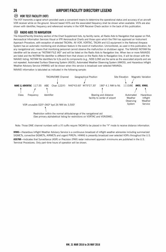
26 AIRPORT/FACILITY DIRECTORY LEGENDVOR TEST FACILITY (VOT)
The VOT transmits a signal which provided users a convenient means to determine the operational status and accuracy of an aircraft VOR receiver while on the ground. Ground based VOTs and the associated frequency shall be shown when available. VOTs are also shown with identifier, frequency and referenced remarks in the VOR Receiver Check section in the back of this publication.
RADIO AIDS TO NAVIGATION The Airport/Facility Directory section of the Chart Supplement lists, by facility name, all Radio Aids to Navigation that appear on FAA, Aeronautical Information Services Visual or IFR Aeronautical Charts and those upon which the FAA has approved an Instrument Approach Procedure, with exception of selected TACANs. All VOR, VORTAC, TACAN and ILS equipment in the National Airspace System has an automatic monitoring and shutdown feature in the event of malfunction. Unmonitored, as used in this publication, for any navigational aid, means that monitoring personnel cannot observe the malfunction or shutdown signal. The NAVAID NOTAM file identifier will be shown as “NOTAM FILE IAD” and will be listed on the Radio Aids to Navigation line. When two or more NAVAIDS are listed and the NOTAM file identifier is different from that shown on the Radio Aids to Navigation line, it will be shown with the NAVAID listing. NOTAM file identifiers for ILSs and its components (e.g., NDB (LOM) are the same as the associated airports and are not repeated. Automated Surface Observing System (ASOS), Automated Weather Observing System (AWOS), and Hazardous Inflight Weather Advisory Service (HIWAS) will be shown when this service is broadcast over selected NAVAIDs.
NAVAID information is tabulated as indicated in the following sample:
Note: Those DME channel numbers with a (Y) suffix require TACAN to be placed in the “Y” mode to receive distance information.
HIWAS—Hazardous Inflight Weather Advisory Service is a continuous broadcast of inflight weather advisories including summarized SIGMETs, convective SIGMETs, AIRMETs and urgent PIREPs. HIWAS is presently broadcast over selected VOR's throughout the U.S.
ASR/PAR—Indicates that Surveillance (ASR) or Precision (PAR) radar instrument approach minimums are published in the U.S. Terminal Procedures. Only part–time hours of operation will be shown.
29
30
NAME (L) ABVORTAC 117.55
VOR unusable 020º–060º byd 26 NM blo 3,500’
ABE Chan 122(Y)
TACAN/DME Channel
Class Frequency Identifier
Restriction within the normal altitude/range of the navigational aid (See primary alphabetical listing for restrictions on VORTAC and VOR/DME).
N40º43.60’ W75º27.30’ 180º 4.1 NM to fld. 1110/8E AWOS. HIWAS.
Bearing and distancefacility to center of airport
AutomatedWeather
ObservingSystem
HazardousInflightWeatherService
Geographical Position Site Elevation Magnetic Variation
NW, 31 MAR 2016 to 26 MAY 2016
AIRPORT/FACILITY DIRECTORY LEGEND 27RADIO CLASS DESIGNATIONS
VOR/DME/TACAN Standard Service Volume (SSV) Classifications
NOTE: Additionally, (H) facilities provide (L) and (T) service volume and (L) facilities provide (T) service. Altitudes are with respect to the station's site elevation. Coverage is not available in a cone of airspace directly above the facility.
The term VOR is, operationally, a general term covering the VHF omnidirectional bearing type of facility without regard to the fact that the power, the frequency protected service volume, the equipment configuration, and operational requirements may vary between facilities at different locations.
SSV Class Altitudes Distance (NM)
(T) Terminal 1000´ to 12,000´ 25
(L) Low Altitude 1000´ to 18,000´ 40
(H) High Altitude 1000´ to 14,500´ 40
14,500´ to 18,000´ 100
18,000´ to 45,000´ 130
45,000´ to 60,000´ 100
AB ___________________ Automatic Weather Broadcast.
DF ___________________ Direction Finding Service.
DME _________________ UHF standard (TACAN compatible) distance measuring equipment.
DME(Y) _______________ UHF standard (TACAN compatible) distance measuring equipment that require TACAN to be placed in the “Y” mode to receive DME.
GS ___________________ Glide slope.
H ____________________ Non–directional radio beacon (homing), power 50 watts to less than 2,000 watts (50 NM at all altitudes).
HH __________________ Non–directional radio beacon (homing), power 2,000 watts or more (75 NM at all altitudes).
H–SAB _______________ Non–directional radio beacons providing automatic transcribed weather service.
ILS___________________ Instrument Landing System (voice, where available, on localizer channel).
IM ___________________ Inner marker.
LDA __________________ Localizer Directional Aid.
LMM _________________ Compass locator station when installed at middle marker site (15 NM at all altitudes).
LOM _________________ Compass locator station when installed at outer marker site (15 NM at all altitudes).
MH __________________ Non–directional radio beacon (homing) power less than 50 watts (25 NM at all altitudes).
MM __________________ Middle marker.
OM __________________ Outer marker.
S ____________________ Simultaneous range homing signal and/or voice.
SABH ________________ Non–directional radio beacon not authorized for IFR or ATC. Provides automatic weather broadcasts.
SDF __________________ Simplified Direction Facility.
TACAN _______________ UHF navigational facility–omnidirectional course and distance information.
VOR__________________ VHF navigational facility–omnidirectional course only.
VOR/DME _____________ Collocated VOR navigational facility and UHF standard distance measuring equipment.
VORTAC ______________ Collocated VOR and TACAN navigational facilities.
W____________________ Without voice on radio facility frequency.
Z ____________________ VHF station location marker at a LF radio facility.
NW, 31 MAR 2016 to 26 MAY 2016
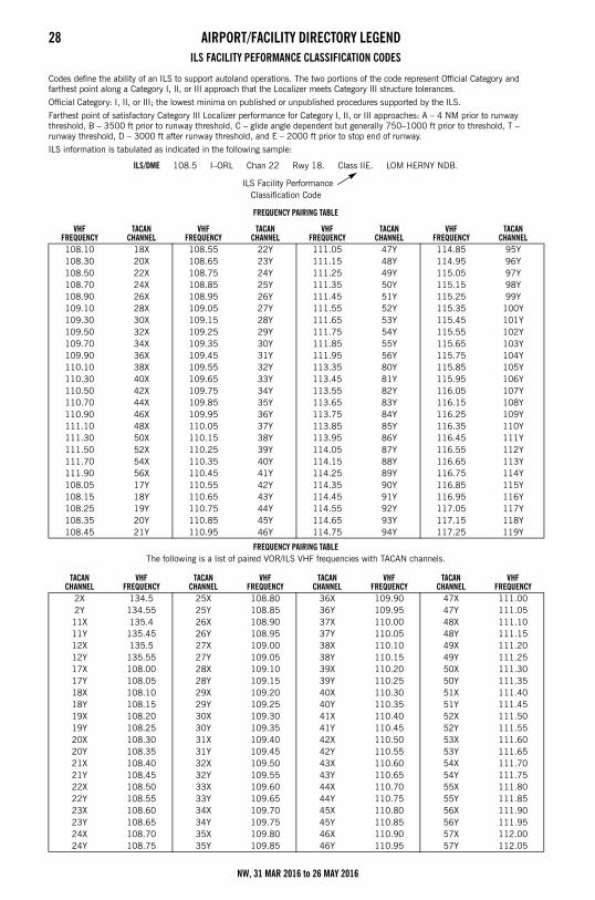
28 AIRPORT/FACILITY DIRECTORY LEGENDILS FACILITY PEFORMANCE CLASSIFICATION CODES
Codes define the ability of an ILS to support autoland operations. The two portions of the code represent Official Category and farthest point along a Category I, II, or III approach that the Localizer meets Category III structure tolerances.
Official Category: I, II, or III; the lowest minima on published or unpublished procedures supported by the ILS.
Farthest point of satisfactory Category III Localizer performance for Category I, II, or III approaches: A – 4 NM prior to runway threshold, B – 3500 ft prior to runway threshold, C – glide angle dependent but generally 750–1000 ft prior to threshold, T – runway threshold, D – 3000 ft after runway threshold, and E – 2000 ft prior to stop end of runway.
ILS information is tabulated as indicated in the following sample:
ILS/DME 108.5 I–ORL Chan 22 Rwy 18. Class IIE. LOM HERNY NDB.
ILS Facility Performance Classification Code
FREQUENCY PAIRING TABLE
FREQUENCY PAIRING TABLE The following is a list of paired VOR/ILS VHF frequencies with TACAN channels.
VHFFREQUENCY
TACANCHANNEL
VHFFREQUENCY
TACANCHANNEL
VHFFREQUENCY
TACANCHANNEL
VHFFREQUENCY
TACANCHANNEL
108.10 18X 108.55 22Y 111.05 47Y 114.85 95Y 108.30 20X 108.65 23Y 111.15 48Y 114.95 96Y 108.50 22X 108.75 24Y 111.25 49Y 115.05 97Y 108.70 24X 108.85 25Y 111.35 50Y 115.15 98Y 108.90 26X 108.95 26Y 111.45 51Y 115.25 99Y 109.10 28X 109.05 27Y 111.55 52Y 115.35 100Y 109.30 30X 109.15 28Y 111.65 53Y 115.45 101Y 109.50 32X 109.25 29Y 111.75 54Y 115.55 102Y 109.70 34X 109.35 30Y 111.85 55Y 115.65 103Y 109.90 36X 109.45 31Y 111.95 56Y 115.75 104Y 110.10 38X 109.55 32Y 113.35 80Y 115.85 105Y 110.30 40X 109.65 33Y 113.45 81Y 115.95 106Y110.50 42X 109.75 34Y 113.55 82Y 116.05 107Y 110.70 44X 109.85 35Y 113.65 83Y 116.15 108Y 110.90 46X 109.95 36Y 113.75 84Y 116.25 109Y 111.10 48X 110.05 37Y 113.85 85Y 116.35 110Y 111.30 50X 110.15 38Y 113.95 86Y 116.45 111Y 111.50 52X 110.25 39Y 114.05 87Y 116.55 112Y 111.70 54X 110.35 40Y 114.15 88Y 116.65 113Y 111.90 56X 110.45 41Y 114.25 89Y 116.75 114Y 108.05 17Y 110.55 42Y 114.35 90Y 116.85 115Y 108.15 18Y 110.65 43Y 114.45 91Y 116.95 116Y 108.25 19Y 110.75 44Y 114.55 92Y 117.05 117Y 108.35 20Y 110.85 45Y 114.65 93Y 117.15 118Y 108.45 21Y 110.95 46Y 114.75 94Y 117.25 119Y
TACANCHANNEL
VHF FREQUENCY
TACANCHANNEL
VHF FREQUENCY
TACANCHANNEL
VHF FREQUENCY
TACANCHANNEL
VHF FREQUENCY
2X 134.5 25X 108.80 36X 109.90 47X 111.00 2Y 134.55 25Y 108.85 36Y 109.95 47Y 111.05 11X 135.4 26X 108.90 37X 110.00 48X 111.10 11Y 135.45 26Y 108.95 37Y 110.05 48Y 111.15 12X 135.5 27X 109.00 38X 110.10 49X 111.20 12Y 135.55 27Y 109.05 38Y 110.15 49Y 111.25 17X 108.00 28X 109.10 39X 110.20 50X 111.30 17Y 108.05 28Y 109.15 39Y 110.25 50Y 111.35 18X 108.10 29X 109.20 40X 110.30 51X 111.40 18Y 108.15 29Y 109.25 40Y 110.35 51Y 111.45 19X 108.20 30X 109.30 41X 110.40 52X 111.50 19Y 108.25 30Y 109.35 41Y 110.45 52Y 111.55 20X 108.30 31X 109.40 42X 110.50 53X 111.60 20Y 108.35 31Y 109.45 42Y 110.55 53Y 111.65 21X 108.40 32X 109.50 43X 110.60 54X 111.70 21Y 108.45 32Y 109.55 43Y 110.65 54Y 111.75 22X 108.50 33X 109.60 44X 110.70 55X 111.80 22Y 108.55 33Y 109.65 44Y 110.75 55Y 111.85 23X 108.60 34X 109.70 45X 110.80 56X 111.90 23Y 108.65 34Y 109.75 45Y 110.85 56Y 111.95 24X 108.70 35X 109.80 46X 110.90 57X 112.00 24Y 108.75 35Y 109.85 46Y 110.95 57Y 112.05
NW, 31 MAR 2016 to 26 MAY 2016
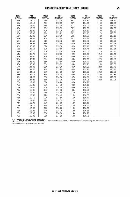
AIRPORT/FACILITY DIRECTORY LEGEND 29
COMM/NAV/WEATHER REMARKS: These remarks consist of pertinent information affecting the current status of
communications, NAVAIDs and weather.
TACANCHANNEL
VHF FREQUENCY
TACANCHANNEL
VHF FREQUENCY
TACANCHANNEL
VHF FREQUENCY
TACANCHANNEL
VHF FREQUENCY
58X 112.10 77X 113.00 96X 114.90 115X 116.80 58Y 112.15 77Y 113.05 96Y 114.95 115Y 116.85 59X 112.20 78X 113.10 97X 115.00 116X 116.90 59Y 112.25 78Y 113.15 97Y 115.05 116Y 116.95 60X 133.30 79X 113.20 98X 115.10 117X 117.00 60Y 133.35 79Y 113.25 98Y 115.15 117Y 117.05 61X 133.40 80X 113.30 99X 115.20 118X 117.10 61Y 133.45 80Y 113.35 99Y 115.25 118Y 117.15 62X 133.50 81X 113.40 100X 115.30 119X 117.20 62Y 133.55 81Y 113.45 100Y 115.35 119Y 117.25 63X 133.60 82X 113.50 101X 115.40 120X 117.30 63Y 133.65 82Y 113.55 101Y 115.45 120Y 117.35 64X 133.70 83X 113.60 102X 115.50 121X 117.40 64Y 133.75 83Y 113.65 102Y 115.55 121Y 117.45 65X 133.80 84X 113.70 103X 115.60 122X 117.50 65Y 133.85 84Y 113.75 103Y 115.65 122Y 117.55 66X 133.90 85X 113.80 104X 115.70 123X 117.60 66Y 133.95 85Y 113.85 104Y 115.75 123Y 117.65 67X 134.00 86X 113.90 105X 115.80 124X 117.70 67Y 134.05 86Y 113.95 105Y 115.85 124Y 117.75 68X 134.10 87X 114.00 106X 115.90 125X 117.80 68Y 134.15 87Y 114.05 106Y 115.95 125Y 117.85 69X 134.20 88X 114.10 107X 116.00 126X 117.90 69Y 134.25 88Y 114.15 107Y 116.05 126Y 117.95 70X 112.30 89X 114.20 108X 116.10 70Y 112.35 89Y 114.25 108Y 116.15 71X 112.40 90X 114.30 109X 116.20 71Y 112.45 90Y 114.35 109Y 116.25 72X 112.50 91X 114.40 110X 116.30 72Y 112.55 91Y 114.45 110Y 116.35 73X 112.60 92X 114.50 111X 116.40 73Y 112.65 92Y 114.55 111Y 116.45 74X 112.70 93X 114.60 112X 116.50 74Y 112.75 93Y 114.65 112Y 116.55 75X 112.80 94X 114.70 113X 116.60 75Y 112.85 94Y 114.75 113Y 116.65 76X 112.90 95X 114.80 114X 116.70 76Y 112.95 95Y 114.85 114Y 116.75
31
NW, 31 MAR 2016 to 26 MAY 2016
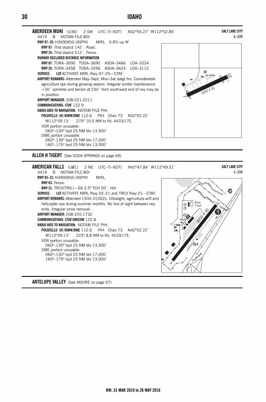
30 IDAHOSECTION 2: AIRPORT/FACILITY DIRECTORYIdaho
ABERDEEN MUNI (U36) 2 SW UTC–7(–6DT) N42º55.27´ W112º52.85´4474 B NOTAM FILE BOIRWY 07–25: H3690X50 (ASPH) MIRL 0.8% up W
RWY 07: Thld dsplcd 142´. Road.RWY 25: Thld dsplcd 512´. Fence.
RUNWAY DECLARED DISTANCE INFORMATIONRWY 07: TORA–3690 TODA–3690 ASDA–3466 LDA–3324RWY 25: TORA–3458 TODA–3458 ASDA–3624 LDA–3112
SERVICE: LGT ACTIVATE MIRL Rwy 07–25—CTAF.AIRPORT REMARKS: Attended May–Sept, Mon–Sat dalgt hrs. Considerable
agriculture ops during growing season. Irregular winter maintenance. +30´ sprinkler and terrain at 230´ from southwest end of rwy may be in position
AIRPORT MANAGER: 208-221-2211COMMUNICATIONS: CTAF 122.9RADIO AIDS TO NAVIGATION: NOTAM FILE PIH.
POCATELLO (H) VORW/DME 112.6 PIH Chan 73 N42º52.22´ W112º39.13´ 270º 10.5 NM to fld. 4433/17E.
VOR portion unusable:060º–130º byd 25 NM blo 13,500´
DME portion unusable:060º–130º byd 25 NM blo 17,000´160º–175º byd 25 NM blo 13,000´
ALLEN H TIGERT (See SODA SPRINGS on page 69)
AMERICAN FALLS (U01) 2 NE UTC–7(–6DT) N42º47.84´ W112º49.51´4419 B NOTAM FILE BOIRWY 03–21: H4900X50 (ASPH) MIRL
RWY 03: Fence.RWY 21: TRCV(TRIL)—GA 3.5º TCH 50´. Hill.
SERVICE: LGT ACTIVATE MIRL Rwy 03–21 and TRCV Rwy 21—CTAF.AIRPORT REMARKS: Attended 1500–0100Z‡. Ultralight, agriculture acft and
helicopter ops during summer months. No line of sight between rwy ends. Irregular snow removal.
AIRPORT MANAGER: 208-220-1732COMMUNICATIONS: CTAF/UNICOM 122.8RADIO AIDS TO NAVIGATION: NOTAM FILE PIH.
POCATELLO (H) VORW/DME 112.6 PIH Chan 73 N42º52.22´ W112º39.13´ 223º 8.8 NM to fld. 4433/17E.
VOR portion unusable:060º–130º byd 25 NM blo 13,500´
DME portion unusable:060º–130º byd 25 NM blo 17,000´160º–175º byd 25 NM blo 13,000´
ANTELOPE VALLEY (See MOORE on page 57)
SALT LAKE CITYL–11C
SALT LAKE CITYL–11C
NW, 31 MAR 2016 to 26 MAY 2016
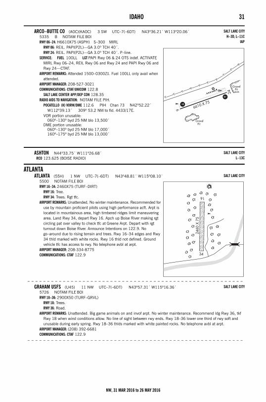
IDAHO 31
ARCO–BUTTE CO (AOC)(KAOC) 3 SW UTC–7(–6DT) N43º36.21´ W113º20.06´5335 B NOTAM FILE BOIRWY 06–24: H6610X75 (ASPH) S–300 MIRL
RWY 06: REIL. PAPI(P2L)—GA 3.0º TCH 40´.RWY 24: REIL. PAPI(P2L)—GA 3.0º TCH 40´. P–line.
SERVICE: FUEL 100LL LGT PAPI Rwy 06 & 24 OTS indef. ACTIVATE MIRL Rwy 06–24, REIL Rwy 06 and Rwy 24 and PAPI Rwy 06 and Rwy 24—CTAF.
AIRPORT REMARKS: Attended 1500–0300Z‡. Fuel 100LL only avail when attended.
AIRPORT MANAGER: 208-527-3021COMMUNICATIONS: CTAF/UNICOM 122.8
SALT LAKE CENTER APP/DEP CON 128.35RADIO AIDS TO NAVIGATION: NOTAM FILE PIH.
POCATELLO (H) VORW/DME 112.6 PIH Chan 73 N42º52.22´ W112º39.13´ 309º 53.2 NM to fld. 4433/17E.
VOR portion unusable:060º–130º byd 25 NM blo 13,500´
DME portion unusable:060º–130º byd 25 NM blo 17,000´160º–175º byd 25 NM blo 13,000´
ASHTON N44º33.75´ W111º26.68´RCO 123.625 (BOISE RADIO)
ATLANTAATLANTA (55H) 1 NW UTC–7(–6DT) N43º48.81´ W115º08.10´
5500 NOTAM FILE BOIRWY 16–34: 2460X75 (TURF–DIRT)
RWY 16: Tree.RWY 34: Trees. Rgt tfc.
AIRPORT REMARKS: Unattended. No winter maintenance. Recommended for use by mountain proficient pilots using high performance acft. Arpt is located in mountainous area, high timbered ridges limit maneuvering area. Land Rwy 34, depart Rwy 16. Apch up Boise River making rgt circling pat over valley to check tfc at Greene Arpt. Depart with rgt turnout down Boise River. Announce Intentions on 122.9. No go–around due to rising terrain and trees. Rwy 16–34 edges and Rwy 34 thld marked with white rocks. Rwy 16 thld not defined. Ground vehicle tfc has access to rwy. No telephone avbl at arpt.
AIRPORT MANAGER: 208-334-8775COMMUNICATIONS: CTAF 122.9
– – – – – – – – – – – – – – – – – – – – – – – – – – – – – – – – – – – – – – – – – – – – – – – – – – – – – – –
GRAHAM USFS (U45) 11 NW UTC–7(–6DT) N43º57.31´ W115º16.36´5726 NOTAM FILE BOIRWY 18–36: 2900X50 (TURF–GRVL)
RWY 18: Trees.RWY 36: Road.
AIRPORT REMARKS: Unattended. Big game animals on and invof arpt. No winter maintenance. Recommend ldg Rwy 36, tkf Rwy 18 when wind conditions allow. No line of sight between rwy ends. Rwy 18–36 lower one third of rwy soft and unusable during early spring. Rwy 18–36 thlds marked with white painted rocks. No telephone avbl at arpt.
AIRPORT MANAGER: (208) 392-6681COMMUNICATIONS: CTAF 122.9
– – – – – – – – – – – – – – – – – – – – – – – – – – – – – – – – – – – – – – – – – – – – – – – – – – – – – – –
SALT LAKE CITYH–3D, L–11C
IAP
SALT LAKE CITYL–13C
SALT LAKE CITY
SALT LAKE CITY
NW, 31 MAR 2016 to 26 MAY 2016
32 IDAHO– – – – – – – – – – – – – – – – – – – – – – – – – – – – – – – – – – – – – – – – – – – – – – – – – – – – – – – –
WEATHERBY USFS (52U) 9 NW UTC–7(–6DT) N43º49.51´ W115º19.88´4503 NOTAM FILE BOIRWY 03–21: 2200X60 (TURF–DIRT) 0.4% up NE
RWY 03: Tree.RWY 21: Trees.
AIRPORT REMARKS: Unattended. No winter maintenance. Arpt located in narrow river canyon subject to local turbulence caused by the terrain configuration. Recommended ldg Rwy 03, tkf Rwy 21 when wind conditions allow. Rwy 03–21 thlds and edges marked with unpainted rocks. No telephone avbl at arpt.
AIRPORT MANAGER: (208) 392-6681COMMUNICATIONS: CTAF 122.9
ATOMIC CITYBIG SOUTHERN BUTTE (U46) 10 W UTC–7(–6DT) N43º25.96´ W113º03.33´
5073 NOTAM FILE BOIRWY 01–19: 2600X110 (DIRT)
RWY 01: Ground.RWY 19: Road.
AIRPORT REMARKS: Unattended. No winter maintenance. Livestock on and invof arpt. Rwy 01–19 sfc may be poor due to damage by livestock, ground vehicles and rodents. Rwy 01–19 +1.5´ berm and –1´ ditch adjacent to entire perimeter of rwy. Rwy 01–19 edges and thlds marked with white rock.
AIRPORT MANAGER: 208-334-8775COMMUNICATIONS: CTAF 122.9
– – – – – – – – – – – – – – – – – – – – – – – – – – – – – – – – – – – – – – – – – – – – – – – – – – – – – – – –
COXS WELL (U48) 23 SW UTC–7(–6DT) N43º13.07´ W113º13.65´5048 NOTAM FILE BOIRWY 07–25: 2700X100 (TURF) 0.7% up E
RWY 07: Road.RWY 25: Fence.
AIRPORT REMARKS: Unattended. No winter maintenance. Rwy 07–25 sfc may be poor due to damage by livestock, ground vehicles and rodents. Rwy 07–25 edges and thlds marked with white rock.
AIRPORT MANAGER: 208-334-8775COMMUNICATIONS: CTAF 122.9
– – – – – – – – – – – – – – – – – – – – – – – – – – – – – – – – – – – – – – – – – – – – – – – – – – – – – – – –
MIDWAY (U37) 1 NE UTC–7(–6DT) N43º27.22´ W112º48.44´5017 NOTAM FILE BOIRWY 02–20: 3800X175 (GRVL–DIRT)
RWY 02: Road.RWY 20: Road. Rgt tfc.
AIRPORT REMARKS: Unattended. No winter maintenance. First 1500´ of Rwy 02 is dirt, remainder is grvl. Rwy 02–20 edges and thlds marked with white rocks.
AIRPORT MANAGER: 208-334-8775COMMUNICATIONS: CTAF 122.9
BANCROFT MUNI (U51) 1 E UTC–7(–6DT) N42º43.25´ W111º52.05´5435 NOTAM FILE BOIRWY 07–25: 3280X30 (GRVL)
RWY 07: Road.AIRPORT REMARKS: Unattended. CAUTION: Unmarked turf crosswind ldg area located SE adjacent to rwy. No winter
maintenance.AIRPORT MANAGER: 208-648-7304COMMUNICATIONS: CTAF 122.9
BEAR LAKE CO (See PARIS on page 62)
BEAR TRAP (See MINIDOKA on page 56)
SALT LAKE CITY
SALT LAKE CITY
SALT LAKE CITY
SALT LAKE CITY
SALT LAKE CITY
NW, 31 MAR 2016 to 26 MAY 2016
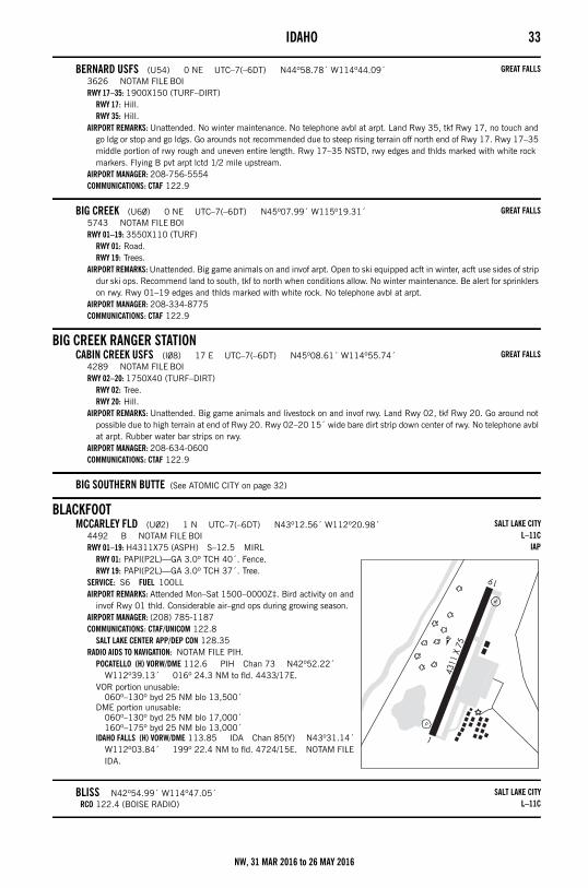
IDAHO 33
BERNARD USFS (U54) 0 NE UTC–7(–6DT) N44º58.78´ W114º44.09´3626 NOTAM FILE BOIRWY 17–35: 1900X150 (TURF–DIRT)
RWY 17: Hill.RWY 35: Hill.
AIRPORT REMARKS: Unattended. No winter maintenance. No telephone avbl at arpt. Land Rwy 35, tkf Rwy 17, no touch and go ldg or stop and go ldgs. Go arounds not recommended due to steep rising terrain off north end of Rwy 17. Rwy 17–35 middle portion of rwy rough and uneven entire length. Rwy 17–35 NSTD, rwy edges and thlds marked with white rock markers. Flying B pvt arpt lctd 1/2 mile upstream.
AIRPORT MANAGER: 208-756-5554COMMUNICATIONS: CTAF 122.9
BIG CREEK (U60) 0 NE UTC–7(–6DT) N45º07.99´ W115º19.31´5743 NOTAM FILE BOIRWY 01–19: 3550X110 (TURF)
RWY 01: Road.RWY 19: Trees.
AIRPORT REMARKS: Unattended. Big game animals on and invof arpt. Open to ski equipped acft in winter, acft use sides of strip dur ski ops. Recommend land to south, tkf to north when conditions allow. No winter maintenance. Be alert for sprinklers on rwy. Rwy 01–19 edges and thlds marked with white rock. No telephone avbl at arpt.
AIRPORT MANAGER: 208-334-8775COMMUNICATIONS: CTAF 122.9
BIG CREEK RANGER STATIONCABIN CREEK USFS (I08) 17 E UTC–7(–6DT) N45º08.61´ W114º55.74´
4289 NOTAM FILE BOIRWY 02–20: 1750X40 (TURF–DIRT)
RWY 02: Tree.RWY 20: Hill.
AIRPORT REMARKS: Unattended. Big game animals and livestock on and invof rwy. Land Rwy 02, tkf Rwy 20. Go around not possible due to high terrain at end of Rwy 20. Rwy 02–20 15´ wide bare dirt strip down center of rwy. No telephone avbl at arpt. Rubber water bar strips on rwy.
AIRPORT MANAGER: 208-634-0600COMMUNICATIONS: CTAF 122.9
BIG SOUTHERN BUTTE (See ATOMIC CITY on page 32)
BLACKFOOTMCCARLEY FLD (U02) 1 N UTC–7(–6DT) N43º12.56´ W112º20.98´
4492 B NOTAM FILE BOIRWY 01–19: H4311X75 (ASPH) S–12.5 MIRL
RWY 01: PAPI(P2L)—GA 3.0º TCH 40´. Fence.RWY 19: PAPI(P2L)—GA 3.0º TCH 37´. Tree.
SERVICE: S6 FUEL 100LL AIRPORT REMARKS: Attended Mon–Sat 1500–0000Z‡. Bird activity on and
invof Rwy 01 thld. Considerable air–gnd ops during growing season.AIRPORT MANAGER: (208) 785-1187COMMUNICATIONS: CTAF/UNICOM 122.8
SALT LAKE CENTER APP/DEP CON 128.35RADIO AIDS TO NAVIGATION: NOTAM FILE PIH.
POCATELLO (H) VORW/DME 112.6 PIH Chan 73 N42º52.22´ W112º39.13´ 016º 24.3 NM to fld. 4433/17E.
VOR portion unusable:060º–130º byd 25 NM blo 13,500´
DME portion unusable:060º–130º byd 25 NM blo 17,000´160º–175º byd 25 NM blo 13,000´
IDAHO FALLS (H) VORW/DME 113.85 IDA Chan 85(Y) N43º31.14´ W112º03.84´ 199º 22.4 NM to fld. 4724/15E. NOTAM FILE IDA.
BLISS N42º54.99´ W114º47.05´RCO 122.4 (BOISE RADIO)
GREAT FALLS
GREAT FALLS
GREAT FALLS
SALT LAKE CITYL–11C
IAP
SALT LAKE CITYL–11C
NW, 31 MAR 2016 to 26 MAY 2016
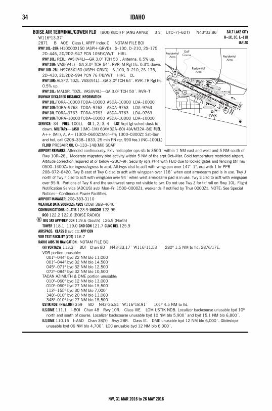
34 IDAHO
BOISE AIR TERMINAL/GOWEN FLD (BOI)(KBOI) P (ANG ARNG) 3 S UTC–7(–6DT) N43º33.86´ W116º13.37´2871 B AOE Class I, ARFF Index C NOTAM FILE BOIRWY 10L–28R: H10000X150 (ASPH–GRVD) S–100, D–210, 2S–175,
2D–446, 2D/2D2–947 PCN 105F/C/W/T HIRLRWY 10L: REIL. VASI(V4L)—GA 3.0º TCH 53´. Antenna. 0.5% up.RWY 28R: VASI(V4L)—GA 3.0º TCH 54´. RVR–M Rgt tfc. 0.3% down.
RWY 10R–28L: H9763X150 (ASPH–GRVD) S–100, D–210, 2S–175, 2D–430, 2D/2D2–994 PCN 76 F/B/W/T HIRL CLRWY 10R: ALSF2. TDZL. VASI(V4L)—GA 3.0º TCH 64´. RVR–TR Rgt tfc. 0.5% up.RWY 28L: MALSR. TDZL. VASI(V4L)—GA 3.0º TCH 50´. RVR–T
RUNWAY DECLARED DISTANCE INFORMATIONRWY 10L:TORA–10000 TODA–10000 ASDA–10000 LDA–10000RWY 10R:TORA–9763 TODA–9763 ASDA–9763 LDA–9763RWY 28L:TORA–9763 TODA–9763 ASDA–9763 LDA–9763RWY 28R:TORA–10000TODA–10000 ASDA–10000 LDA–10000
SERVICE: S4 FUEL 100LL OX 1, 2, 3, 4 LGT Arpt lgt sched dusk to dawn. MILITARY— JASU 1(MC–1M) 6(AM32A–60) 4(A/M32A–86) FUEL A++ (Mil), A, A+ (1300–0600Z‡Mon–Fri; 1300–0300Z‡ Sat–Sun and hol, call C208–338–1833, 25 min PN rqr, $90 fee.) (NC–100LL) FLUID PRESAIR OIL O–133–148(Mil) SOAP
AIRPORT REMARKS: Attended continuously. Extv helicopter ops sfc to 3500´ within 1 NM east and west and 5 NM south of Rwy 10R–28L. Moderate migratory bird activity within 5 NM of the arpt Oct–Mar. Cold temperature restricted airport. Altitude correction required at or below –23C/–9F. Security rqrs PPR with FBO due to locked gates and fencing btn hrs 0500–1400Z‡ for ingress/egress to arpt. All twys clsd to acft with wingspan over 147´ 1", exc with 1 hr PPR 208–972–8420. Twy B east of Twy C clsd to acft with wingspan over 118´ when east arm/dearm pad is in use. Twy J north of Twy F clsd to acft with wingspan over 94´ when west arm/dearm pad is in use. Twy S clsd to acft with wingspan over 95 ft. Portions of Twy K and the southwest ramp not visible to twr. Do not use Twy Z for tkf roll on Rwy 10L. Flight Notification Service (ADCUS) avbl Mon–Fri 1500–0000Z‡, weekends if notified by Thur 0000Z‡. NOTE: See Special Notices—Continuous Power Facilities.
AIRPORT MANAGER: 208-383-3110WEATHER DATA SOURCES: ASOS (208) 388–4640COMMUNICATIONS: D–ATIS 123.9 UNICOM 122.95
RCO 122.2 122.6 (BOISE RADIO)® BIG SKY APP/DEP CON 119.6 (South) 126.9 (North)
TOWER 118.1 119.0 GND CON 121.7 CLNC DEL 125.9AIRSPACE: CLASS C svc ctc APP CONVOR TEST FACILITY (VOT) 116.7RADIO AIDS TO NAVIGATION: NOTAM FILE BOI.
(H) VORTACW 113.3 BOI Chan 80 N43º33.17´ W116º11.53´ 280º 1.5 NM to fld. 2876/17E.VOR portion unusable:
001º–044º byd 22 NM blo 11,000´001º–044º byd 32 NM blo 14,500´045º–071º byd 32 NM blo 12,500´072º–084º byd 32 NM blo 10,500´
TACAN AZIMUTH & DME portion unusable:010º–060º byd 12 NM blo 13,000´010º–060º byd 27 NM blo 15,500´113º–155º byd 30 NM blo 7,000´348º–010º byd 20 NM blo 13,000´348º–010º byd 27 NM blo 15,500´
USTIK NDB (HW/LOM) 359 BO N43º35.81´ W116º18.91´ 101º 4.5 NM to fld.ILS/DME 111.1 I–BOI Chan 48 Rwy 10R. Class IIIE. LOM USTIK NDB. Localizer backcourse unusable byd 10º
north and south of course. Localizer backcourse unusable byd 10 NM blo 5,900´ and byd 15.1 NM blo 6,800´.ILS/DME 110.15 I–AAD Chan 38(Y) Rwy 28R. Class IE. DME unusable byd 12 NM blo 6,000´. Glideslope
unusable byd 06 NM blo 4,700´. LOC unusable byd 12 NM blo 6,000´.
SALT LAKE CITYH–1C, 3C, L–11B
IAP, AD
NW, 31 MAR 2016 to 26 MAY 2016
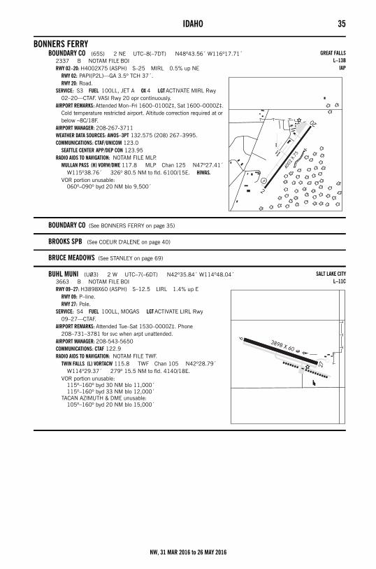
IDAHO 35
BONNERS FERRYBOUNDARY CO (65S) 2 NE UTC–8(–7DT) N48º43.56´ W116º17.71´
2337 B NOTAM FILE BOIRWY 02–20: H4002X75 (ASPH) S–25 MIRL 0.5% up NE
RWY 02: PAPI(P2L)—GA 3.5º TCH 37´.RWY 20: Road.
SERVICE: S3 FUEL 100LL, JET A OX 4 LGT ACTIVATE MIRL Rwy 02–20—CTAF. VASI Rwy 20 opr continuously.
AIRPORT REMARKS: Attended Mon–Fri 1600–0100Z‡, Sat 1600–0000Z‡. Cold temperature restricted airport. Altitude correction required at or below –8C/18F.
AIRPORT MANAGER: 208-267-3711WEATHER DATA SOURCES: AWOS–3PT 132.575 (208) 267–3995.COMMUNICATIONS: CTAF/UNICOM 123.0
SEATTLE CENTER APP/DEP CON 123.95RADIO AIDS TO NAVIGATION: NOTAM FILE MLP.
MULLAN PASS (H) VORW/DME 117.8 MLP Chan 125 N47º27.41´ W115º38.76´ 326º 80.5 NM to fld. 6100/15E. HIWAS.
VOR portion unusable:060º–090º byd 20 NM blo 9,500´
BOUNDARY CO (See BONNERS FERRY on page 35)
BROOKS SPB (See COEUR D'ALENE on page 40)
BRUCE MEADOWS (See STANLEY on page 69)
BUHL MUNI (U03) 2 W UTC–7(–6DT) N42º35.84´ W114º48.04´3663 B NOTAM FILE BOIRWY 09–27: H3898X60 (ASPH) S–12.5 LIRL 1.4% up E
RWY 09: P–line.RWY 27: Pole.
SERVICE: S4 FUEL 100LL, MOGAS LGT ACTIVATE LIRL Rwy 09–27—CTAF.
AIRPORT REMARKS: Attended Tue–Sat 1530–0000Z‡. Phone 208–731–3781 for svc when arpt unattended.
AIRPORT MANAGER: 208-543-5650COMMUNICATIONS: CTAF 122.9RADIO AIDS TO NAVIGATION: NOTAM FILE TWF.
TWIN FALLS (L) VORTACW 115.8 TWF Chan 105 N42º28.79´ W114º29.37´ 279º 15.5 NM to fld. 4140/18E.
VOR portion unusable:115º–160º byd 30 NM blo 11,000´115º–160º byd 33 NM blo 12,000´
TACAN AZIMUTH & DME unusable:105º–160º byd 20 NM blo 15,000´
GREAT FALLSL–13B
IAP
SALT LAKE CITYL–11C
NW, 31 MAR 2016 to 26 MAY 2016
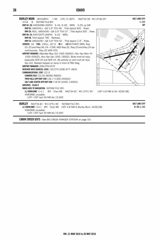
36 IDAHO
BURLEY MUNI (BYI)(KBYI) 1 NE UTC–7(–6DT) N42º32.56´ W113º46.29´4154 B NOTAM FILE BYIRWY 02–20: H4092X80 (ASPH) S–43, D–60 MIRL 0.3% up SW
RWY 02: VASI(V4L)—GA 3.5º TCH 46´. Thld dsplcd 626´. Road.RWY 20: REIL. VASI(V2R)—GA 3.0º TCH 37´. Thld dsplcd 305´. Trees.
RWY 06–24: H4072X75 (ASPH) S–23 MIRLRWY 06: Thld dsplcd 796´. Railroad.RWY 24: VASI(V2R)—GA 3.0º TCH 52´. Thld dsplcd 115´. Poles.
SERVICE: S4 FUEL 100LL, JET A OX 4 LGT ACTIVATE MIRL Rwy 02–20 and Rwy 06–24—CTAF. VASI Rwy 02, Rwy 20 and Rwy 24 opr continuously. Rwy 20 VASI OTS.
AIRPORT REMARKS: Attended May–Oct 1500–0000Z‡, Nov–Apr Mon–Fri 1500–0000Z‡, Nov–Apr Sat 1500–1900Z‡. Birds invof all rwys, especially AER 20 and AER 24. AG activity on and invof all rwys Apr–Oct. Marked helipad on ramp in front of FBO bldg.
AIRPORT MANAGER: 208-678-0372WEATHER DATA SOURCES: ASOS 135.575 (208) 677–3604.COMMUNICATIONS: CTAF 122.9
CONNERS RCO 122.05 (BOISE RADIO)TWIN FALLS APP/DEP CON 126.7 (1300–0400Z‡)SALT LAKE CENTER APP/DEP CON 118.05 (0400–1300Z‡)
AIRSPACE: CLASS ERADIO AIDS TO NAVIGATION: NOTAM FILE BYI.
(L) VORW/DME 114.1 BYI Chan 88 N42º34.81´ W113º51.95´ 100º 4.8 NM to fld. 4226/18E.VOR/DME unusable:
120º–150º byd 30 NM blo 15,000´
BURLEY N42º34.81´ W113º51.95´ NOTAM FILE BYI.(L) VORW/DME 114.1 BYI Chan 88 100º 4.8 NM to Burley Muni. 4226/18E.
VOR/DME unusable:120º–150º byd 30 NM blo 15,000´
CABIN CREEK USFS (See BIG CREEK RANGER STATION on page 33)
SALT LAKE CITYL–11C
IAP
SALT LAKE CITYH–3D, L–11C
NW, 31 MAR 2016 to 26 MAY 2016
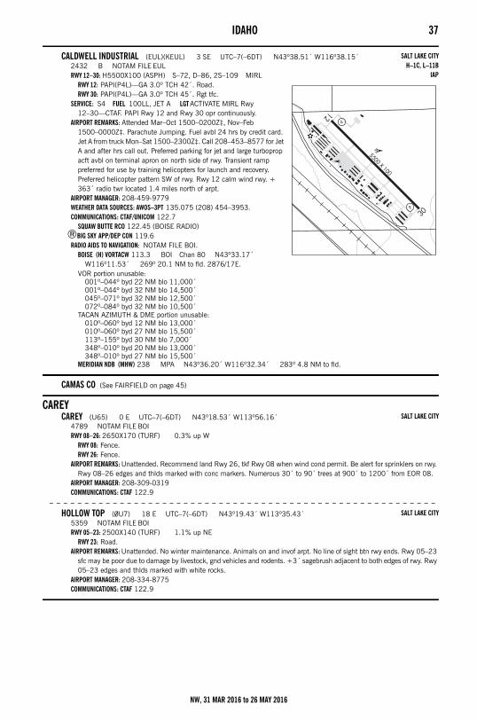
IDAHO 37
CALDWELL INDUSTRIAL (EUL)(KEUL) 3 SE UTC–7(–6DT) N43º38.51´ W116º38.15´2432 B NOTAM FILE EULRWY 12–30: H5500X100 (ASPH) S–72, D–86, 2S–109 MIRL
RWY 12: PAPI(P4L)—GA 3.0º TCH 42´. Road.RWY 30: PAPI(P4L)—GA 3.0º TCH 45´. Rgt tfc.
SERVICE: S4 FUEL 100LL, JET A LGT ACTIVATE MIRL Rwy 12–30—CTAF. PAPI Rwy 12 and Rwy 30 opr continuously.
AIRPORT REMARKS: Attended Mar–Oct 1500–0200Z‡, Nov–Feb 1500–0000Z‡. Parachute Jumping. Fuel avbl 24 hrs by credit card. Jet A from truck Mon–Sat 1500–2300Z‡. Call 208–453–8577 for Jet A and after hrs call out. Preferred parking for jet and large turboprop acft avbl on terminal apron on north side of rwy. Transient ramp preferred for use by training helicopters for launch and recovery. Preferred helicopter pattern SW of rwy. Rwy 12 calm wind rwy. + 363´ radio twr located 1.4 miles north of arpt.
AIRPORT MANAGER: 208-459-9779WEATHER DATA SOURCES: AWOS–3PT 135.075 (208) 454–3953.COMMUNICATIONS: CTAF/UNICOM 122.7
SQUAW BUTTE RCO 122.45 (BOISE RADIO)®BIG SKY APP/DEP CON 119.6
RADIO AIDS TO NAVIGATION: NOTAM FILE BOI.BOISE (H) VORTACW 113.3 BOI Chan 80 N43º33.17´
W116º11.53´ 269º 20.1 NM to fld. 2876/17E.VOR portion unusable:
001º–044º byd 22 NM blo 11,000´001º–044º byd 32 NM blo 14,500´045º–071º byd 32 NM blo 12,500´072º–084º byd 32 NM blo 10,500´
TACAN AZIMUTH & DME portion unusable:010º–060º byd 12 NM blo 13,000´010º–060º byd 27 NM blo 15,500´113º–155º byd 30 NM blo 7,000´348º–010º byd 20 NM blo 13,000´348º–010º byd 27 NM blo 15,500´
MERIDIAN NDB (MHW) 238 MPA N43º36.20´ W116º32.34´ 283º 4.8 NM to fld.
CAMAS CO (See FAIRFIELD on page 45)
CAREYCAREY (U65) 0 E UTC–7(–6DT) N43º18.53´ W113º56.16´
4789 NOTAM FILE BOIRWY 08–26: 2650X170 (TURF) 0.3% up W
RWY 08: Fence.RWY 26: Fence.
AIRPORT REMARKS: Unattended. Recommend land Rwy 26, tkf Rwy 08 when wind cond permit. Be alert for sprinklers on rwy. Rwy 08–26 edges and thlds marked with conc markers. Numerous 30´ to 90´ trees at 900´ to 1200´ from EOR 08.
AIRPORT MANAGER: 208-309-0319COMMUNICATIONS: CTAF 122.9
– – – – – – – – – – – – – – – – – – – – – – – – – – – – – – – – – – – – – – – – – – – – – – – – – – – – – – –
HOLLOW TOP (0U7) 18 E UTC–7(–6DT) N43º19.43´ W113º35.43´5359 NOTAM FILE BOIRWY 05–23: 2500X140 (TURF) 1.1% up NE
RWY 23: Road.AIRPORT REMARKS: Unattended. No winter maintenance. Animals on and invof arpt. No line of sight btn rwy ends. Rwy 05–23
sfc may be poor due to damage by livestock, gnd vehicles and rodents. +3´ sagebrush adjacent to both edges of rwy. Rwy 05–23 edges and thlds marked with white rocks.
AIRPORT MANAGER: 208-334-8775COMMUNICATIONS: CTAF 122.9
SALT LAKE CITYH–1C, L–11B
IAP
SALT LAKE CITY
SALT LAKE CITY
NW, 31 MAR 2016 to 26 MAY 2016
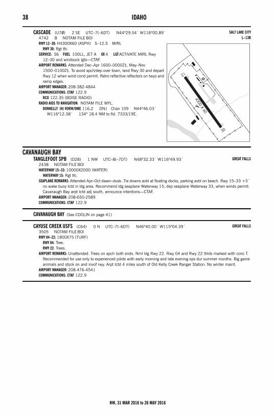
38 IDAHO
CASCADE (U70) 2 SE UTC–7(–6DT) N44º29.54´ W116º00.89´4742 B NOTAM FILE BOIRWY 12–30: H4300X60 (ASPH) S–12.5 MIRL
RWY 30: Rgt tfc.SERVICE: S6 FUEL 100LL, JET A OX 4 LGT ACTIVATE MIRL Rwy
12–30 and windsock lgts—CTAF.AIRPORT REMARKS: Attended Dec–Apr 1600–0000Z‡, May–Nov
1500–0100Z‡. To avoid apch/dep over town, land Rwy 30 and depart Rwy 12 when wind cond permit. Retro reflective reflectors on twys and ramp edges.
AIRPORT MANAGER: 208-382-4844COMMUNICATIONS: CTAF 122.9
RCO 122.35 (BOISE RADIO)RADIO AIDS TO NAVIGATION: NOTAM FILE MYL.
DONNELLY (H) VORW/DME 116.2 DNJ Chan 109 N44º46.03´ W116º12.38´ 134º 18.4 NM to fld. 7333/19E.
CAVANAUGH BAYTANGLEFOOT SPB (D28) 1 NW UTC–8(–7DT) N48º32.33´ W116º49.93´
2438 NOTAM FILE BOIWATERWAY 15–33: 10000X2000 (WATER)
WATERWAY 15: Rgt tfc.SEAPLANE REMARKS: Attended Apr–Oct dawn–dusk. Tie downs avbl at floating docks, parking avbl on beach. Rwy 15–33 +5´
no wake buoy lctd in ldg area. Recommend ldg seaplane Waterway 15, dep seaplane Waterway 33, when winds permit. Cavanaugh Bay arpt lctd adj south, announce intentions—CTAF.
AIRPORT MANAGER: 208-650-2589COMMUNICATIONS: CTAF 122.9
CAVANAUGH BAY (See COOLIN on page 41)
CAYUSE CREEK USFS (C64) 0 N UTC–7(–6DT) N46º40.00´ W115º04.39´3505 NOTAM FILE BOIRWY 04–22: 1800X75 (TURF)
RWY 04: Tree.RWY 22: Trees.
AIRPORT REMARKS: Unattended. Trees on apch both ends. Nml ldg Rwy 22. Rwy 04 and Rwy 22 thlds marked with conc T. Recommended for use only to experienced pilots with early morning and late evening ops dur summer months. Big game animals and stock on and invof rwy. Arpt lctd 4 miles south of Old Kelly Creek Ranger Station. No winter maint.
AIRPORT MANAGER: 208-476-4541COMMUNICATIONS: CTAF 122.9
SALT LAKE CITYL–13B
GREAT FALLS
GREAT FALLS
NW, 31 MAR 2016 to 26 MAY 2016
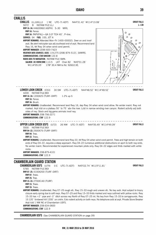
IDAHO 39
CHALLISCHALLIS (LLJ)(KLLJ) 1 NE UTC–7(–6DT) N44º31.42´ W114º13.08´
5072 B NOTAM FILE LLJRWY 16–34: H4600X60 (ASPH) S–30 MIRL
RWY 16: Fence.RWY 34: PAPI(P4L)—GA 3.0º TCH 40´. P–line.
SERVICE: S4 FUEL 100, JET A AIRPORT REMARKS: Attended Mon–Fri 1400–0000Z‡. Deer on and invof
arpt. Be alert helicopter ops adj southeast end of arpt. Recommend land Rwy 16, tkf Rwy 34 when wind cond permit.
AIRPORT MANAGER: (208) 833-7423WEATHER DATA SOURCES: ASOS 119.275 (208) 879–5121. SAWRS.COMMUNICATIONS: CTAF/UNICOM 122.8RADIO AIDS TO NAVIGATION: NOTAM FILE SMN.
SALMON (H) VORW/DME 113.5 LKT Chan 82 N45º01.28´ W114º05.05´ 178º 30.4 NM to fld. 9260/13E.
– – – – – – – – – – – – – – – – – – – – – – – – – – – – – – – – – – – – – – – – – – – – – – – – – – – – – – –
LOWER LOON CREEK (C53) 30 SW UTC–7(–6DT) N44º48.52´ W114º48.52´4200 NOTAM FILE BOIRWY 16–34: 1200X25 (TURF–DIRT) 1.2% up S
RWY 16: Fence.RWY 34: Brush.
AIRPORT REMARKS: Unattended. Recommend land Rwy 16, dep Rwy 34 when wind cond allow. No winter maint. Rwy not marked. Arpt lctd on a plateau 50´ to 75´ abv the river. Lctd in narrow winding river canyon. Rodent activity adj both sides of rwy. Stock and big game animals invof rwy.
AIRPORT MANAGER: 208-756-2271COMMUNICATIONS: CTAF 122.9
– – – – – – – – – – – – – – – – – – – – – – – – – – – – – – – – – – – – – – – – – – – – – – – – – – – – – – –
UPPER LOON CREEK USFS (U72) 26 NW UTC–7(–6DT) N44º35.49´ W114º49.39´5500 NOTAM FILE BOIRWY 04–22: 2500X75 (TURF–DIRT)
RWY 04: Tree.RWY 22: Trees.
AIRPORT REMARKS: Unattended. Recommend land Rwy 22, tkf Rwy 04 when wind cond permit. Trees and high terrain on both ends of Rwy 04–22, requires a steep approach. Rwy 04–22 numerous additional obstructions on apch to both rwy ends. No winter maint. Recommended for experienced mountain pilots only. Rwy 04–22 edges and thlds marked with white rocks.
AIRPORT MANAGER: 208-879-4101COMMUNICATIONS: CTAF 122.9
CHAMBERLAIN GUARD STATIONCHAMBERLAIN USFS (U79) 0 E UTC–7(–6DT) N45º22.74´ W115º11.81´
5765 NOTAM FILE BOIRWY 07–25: 4100X200 (TURF–DIRT)
RWY 07: Trees.RWY 25: Tree.
RWY 15–33: 2700X140 (TURF)RWY 15: Trees.RWY 33: Trees.
AIRPORT REMARKS: Unattended. Rwy 07–25 rough sfc. Rwy 15–33 rough and uneven sfc. No twy avbl. Arpt subject to tmpry closure early spring due to soft rwys. Rwy 07–25 and Rwy 15–33 thlds marked and rwys outlined with yellow rocks. Rwy 15–33 has +2´ pipe and –2´ ditch across rwy North of Rwy 07–25 int. No twy from Rwy 15–33 to campgrounds. Rwy 15 120´ timbered hill 1200´ on cntrln. Extv rodent activity on both rwys. No telephone avbl at arpt. Private Stone Breaker Arpt lctd 1 NM NE of Chamberlain USFS.
AIRPORT MANAGER: 208-634-0600COMMUNICATIONS: CTAF 122.9
CHAMBERLAIN USFS (See CHAMBERLAIN GUARD STATION on page 39)
GREAT FALLSL–13B
GREAT FALLS
GREAT FALLS
GREAT FALLS
NW, 31 MAR 2016 to 26 MAY 2016
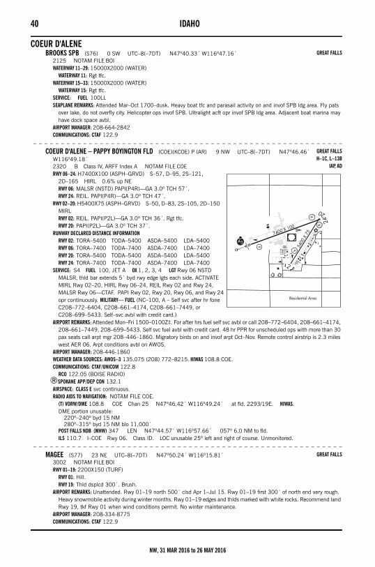
40 IDAHO
COEUR D'ALENEBROOKS SPB (S76) 0 SW UTC–8(–7DT) N47º40.33´ W116º47.16´
2125 NOTAM FILE BOIWATERWAY 11–29: 15000X2000 (WATER)
WATERWAY 11: Rgt tfc.WATERWAY 15–33: 15000X2000 (WATER)
WATERWAY 15: Rgt tfc.SERVICE: FUEL 100LL SEAPLANE REMARKS: Attended Mar–Oct 1700–dusk. Heavy boat tfc and parasail activity on and invof SPB ldg area. Fly pats
over lake, do not overfly city. Helicopter ops invof SPB. Ultralight acft opr invof SPB ldg area. Adjacent boat marina may have dock space avbl.
AIRPORT MANAGER: 208-664-2842COMMUNICATIONS: CTAF 122.9
– – – – – – – – – – – – – – – – – – – – – – – – – – – – – – – – – – – – – – – – – – – – – – – – – – – – – – – –
COEUR D'ALENE – PAPPY BOYINGTON FLD (COE)(KCOE) P (AR) 9 NW UTC–8(–7DT) N47º46.46´ W116º49.18´2320 B Class IV, ARFF Index A NOTAM FILE COERWY 06–24: H7400X100 (ASPH–GRVD) S–57, D–95, 2S–121,
2D–165 HIRL 0.6% up NERWY 06: MALSR (NSTD) PAPI(P4R)—GA 3.0º TCH 57´.RWY 24: REIL. PAPI(P4R)—GA 3.0º TCH 47´.
RWY 02–20: H5400X75 (ASPH–GRVD) S–50, D–83, 2S–105, 2D–150 MIRLRWY 02: REIL. PAPI(P2L)—GA 3.0º TCH 36´. Rgt tfc.RWY 20: PAPI(P2L)—GA 3.0º TCH 37´.
RUNWAY DECLARED DISTANCE INFORMATIONRWY 02: TORA–5400 TODA–5400 ASDA–5400 LDA–5400RWY 06: TORA–7400 TODA–7400 ASDA–7400 LDA–7400RWY 20: TORA–5400 TODA–5400 ASDA–5400 LDA–5400RWY 24: TORA–7400 TODA–7400 ASDA–7400 LDA–7400
SERVICE: S4 FUEL 100, JET A OX 1, 2, 3, 4 LGT Rwy 06 NSTD MALSR, thld bar extends 5´ byd rwy edge lgts each side. ACTIVATE MIRL Rwy 02–20, HIRL Rwy 06–24, REIL Rwy 02 and Rwy 24, MALSR Rwy 06—CTAF. PAPI Rwy 02, Rwy 20, Rwy 06, and Rwy 24 opr continuously. MILITARY— FUEL (NC–100, A – Self svc after hr fone C208–772–6404, C208–661–4174, C208–661–7449, or C208–699–5433. Self–svc avbl with credit card.)
AIRPORT REMARKS: Attended Mon–Fri 1500–0100Z‡. For after hrs fuel self svc avbl or call 208–772–6404, 208–661–4174, 208–661–7449, 208–699–5433. Self svc fuel avbl with credit card. 48 hr PPR for unscheduled ops with more than 30 pax seats call arpt mgr 208–446–1860. Migratory birds on and invof arpt Oct–Nov. Remote control airstrip is 2.3 miles west AER 06. Arpt conditions avbl on AWOS.
AIRPORT MANAGER: 208-446-1860WEATHER DATA SOURCES: AWOS–3 135.075 (208) 772–8215. HIWAS 108.8 COE.COMMUNICATIONS: CTAF/UNICOM 122.8
RCO 122.05 (BOISE RADIO)®SPOKANE APP/DEP CON 132.1
AIRSPACE: CLASS E svc continuous. RADIO AIDS TO NAVIGATION: NOTAM FILE COE.
(T) VORW/DME 108.8 COE Chan 25 N47º46.42´ W116º49.24´ at fld. 2293/19E. HIWAS.DME portion unusable:
220º–240º byd 15 NM280º–315º byd 15 NM blo 11,000´
POST FALLS NDB (MHW) 347 LEN N47º44.57´ W116º57.66´ 057º 6.0 NM to fld.ILS 110.7 I–COE Rwy 06. Class ID. LOC unusable 25º left and right of course. Unmonitored.
– – – – – – – – – – – – – – – – – – – – – – – – – – – – – – – – – – – – – – – – – – – – – – – – – – – – – – – –
MAGEE (S77) 23 NE UTC–8(–7DT) N47º50.24´ W116º15.81´3002 NOTAM FILE BOIRWY 01–19: 2200X150 (TURF)
RWY 01: Hill.RWY 19: Thld dsplcd 300´. Brush.
AIRPORT REMARKS: Unattended. Rwy 01–19 north 500´ clsd Apr 1–Jul 15. Rwy 01–19 first 300´ of north end very rough. Heavy snowmobile activity during winter months. Rwy 01–19 edges and thlds marked with white rocks. Recommend land Rwy 19, tkf Rwy 01 when wind conditions permit. No winter maintenance.
AIRPORT MANAGER: 208-334-8775COMMUNICATIONS: CTAF 122.9
GREAT FALLS
GREAT FALLSH–1C, L–13B
IAP, AD
GREAT FALLS
NW, 31 MAR 2016 to 26 MAY 2016
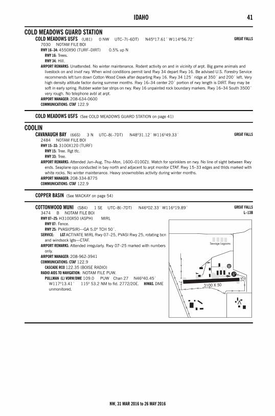
IDAHO 41
COLD MEADOWS GUARD STATIONCOLD MEADOWS USFS (U81) 0 NW UTC–7(–6DT) N45º17.61´ W114º56.72´
7030 NOTAM FILE BOIRWY 16–34: 4550X90 (TURF–DIRT) 0.5% up N
RWY 16: Trees.RWY 34: Hill.
AIRPORT REMARKS: Unattended. No winter maintenance. Rodent activity on and in vicinity of arpt. Big game animals and livestock on and invof rwy. When wind conditions permit land Rwy 34 depart Rwy 16. Be advised U.S. Forestry Service recommends left turn down Cotton Wood Creek after departing Rwy 16. Rwy 34 125´ ridge at 350´ and 200´ left. Very high density altitude factor during summer months. Rwy 16–34 center 20´ portion of rwy length is DIRT. Rwy may be soft in early spring. Rubber water bar strips on rwy. Rwy 16 unpainted rock boundary markers. Rwy 16–34 South 3500´ very rough. No telephone avbl at arpt.
AIRPORT MANAGER: 208-634-0600COMMUNICATIONS: CTAF 122.9
COLD MEADOWS USFS (See COLD MEADOWS GUARD STATION on page 41)
COOLINCAVANAUGH BAY (66S) 3 N UTC–8(–7DT) N48º31.12´ W116º49.33´
2484 NOTAM FILE BOIRWY 15–33: 3100X120 (TURF)
RWY 15: Tree. Rgt tfc.RWY 33: Tree.
AIRPORT REMARKS: Attended Jun–Aug, Thu–Mon, 1600–0100Z‡. Watch for sprinklers on rwy. No line of sight between Rwy ends. Seaplane ops conducted in bay north and adjacent to arpt monitor CTAF. Rwy 15–33 edges and thlds marked with white rocks. No winter maintenance. Heavy snowmobiles activity during winter months.
AIRPORT MANAGER: 208-334-8775COMMUNICATIONS: CTAF 122.9
COPPER BASIN (See MACKAY on page 54)
COTTONWOOD MUNI (S84) 1 SE UTC–8(–7DT) N46º02.33´ W116º19.89´3474 B NOTAM FILE BOIRWY 07–25: H3100X50 (ASPH) MIRL
RWY 07: Fence.RWY 25: PVASI(PSIR)—GA 5.0º TCH 50´.
SERVICE: LGT ACTIVATE MIRL Rwy 07–25, PVASI Rwy 25, rotating bcn and windsock lgts—CTAF.
AIRPORT REMARKS: Attended irregularly. Rwy 07–25 marked with numbers only.
AIRPORT MANAGER: 208-962-3941COMMUNICATIONS: CTAF 122.9
CASCADE RCO 122.35 (BOISE RADIO)RADIO AIDS TO NAVIGATION: NOTAM FILE PUW.
PULLMAN (L) VORW/DME 109.0 PUW Chan 27 N46º40.45´ W117º13.41´ 115º 53.2 NM to fld. 2772/20E. HIWAS. DME unmonitored.
GREAT FALLS
GREAT FALLS
GREAT FALLSL–13B
NW, 31 MAR 2016 to 26 MAY 2016
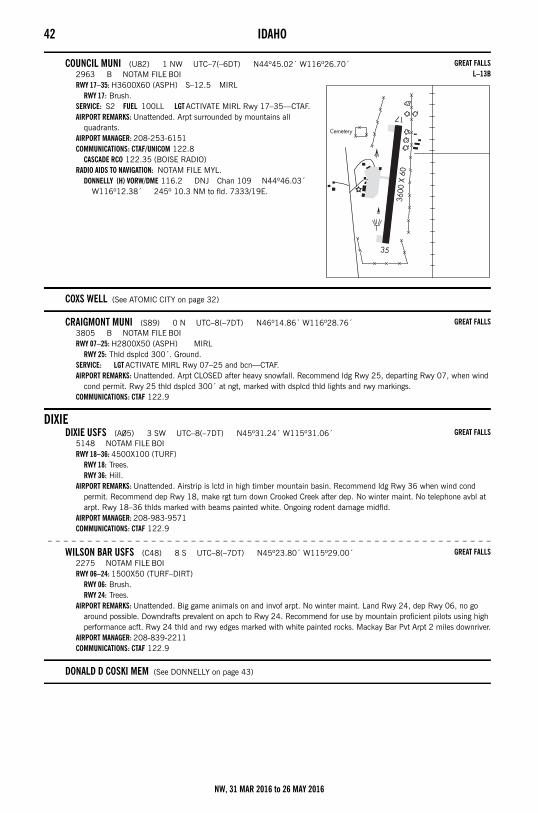
42 IDAHO
COUNCIL MUNI (U82) 1 NW UTC–7(–6DT) N44º45.02´ W116º26.70´2963 B NOTAM FILE BOIRWY 17–35: H3600X60 (ASPH) S–12.5 MIRL
RWY 17: Brush.SERVICE: S2 FUEL 100LL LGT ACTIVATE MIRL Rwy 17–35—CTAF.AIRPORT REMARKS: Unattended. Arpt surrounded by mountains all
quadrants. AIRPORT MANAGER: 208-253-6151COMMUNICATIONS: CTAF/UNICOM 122.8
CASCADE RCO 122.35 (BOISE RADIO)RADIO AIDS TO NAVIGATION: NOTAM FILE MYL.
DONNELLY (H) VORW/DME 116.2 DNJ Chan 109 N44º46.03´ W116º12.38´ 245º 10.3 NM to fld. 7333/19E.
COXS WELL (See ATOMIC CITY on page 32)
CRAIGMONT MUNI (S89) 0 N UTC–8(–7DT) N46º14.86´ W116º28.76´3805 B NOTAM FILE BOIRWY 07–25: H2800X50 (ASPH) MIRL
RWY 25: Thld dsplcd 300´. Ground.SERVICE: LGT ACTIVATE MIRL Rwy 07–25 and bcn—CTAF.AIRPORT REMARKS: Unattended. Arpt CLOSED after heavy snowfall. Recommend ldg Rwy 25, departing Rwy 07, when wind
cond permit. Rwy 25 thld dsplcd 300´ at ngt, marked with dsplcd thld lights and rwy markings. COMMUNICATIONS: CTAF 122.9
DIXIEDIXIE USFS (A05) 3 SW UTC–8(–7DT) N45º31.24´ W115º31.06´
5148 NOTAM FILE BOIRWY 18–36: 4500X100 (TURF)
RWY 18: Trees.RWY 36: Hill.
AIRPORT REMARKS: Unattended. Airstrip is lctd in high timber mountain basin. Recommend ldg Rwy 36 when wind cond permit. Recommend dep Rwy 18, make rgt turn down Crooked Creek after dep. No winter maint. No telephone avbl at arpt. Rwy 18–36 thlds marked with beams painted white. Ongoing rodent damage midfld.
AIRPORT MANAGER: 208-983-9571COMMUNICATIONS: CTAF 122.9
– – – – – – – – – – – – – – – – – – – – – – – – – – – – – – – – – – – – – – – – – – – – – – – – – – – – – – – –
WILSON BAR USFS (C48) 8 S UTC–8(–7DT) N45º23.80´ W115º29.00´2275 NOTAM FILE BOIRWY 06–24: 1500X50 (TURF–DIRT)
RWY 06: Brush.RWY 24: Trees.
AIRPORT REMARKS: Unattended. Big game animals on and invof arpt. No winter maint. Land Rwy 24, dep Rwy 06, no go around possible. Downdrafts prevalent on apch to Rwy 24. Recommend for use by mountain proficient pilots using high performance acft. Rwy 24 thld and rwy edges marked with white painted rocks. Mackay Bar Pvt Arpt 2 miles downriver.
AIRPORT MANAGER: 208-839-2211COMMUNICATIONS: CTAF 122.9
DONALD D COSKI MEM (See DONNELLY on page 43)
GREAT FALLSL–13B
GREAT FALLS
GREAT FALLS
GREAT FALLS
NW, 31 MAR 2016 to 26 MAY 2016
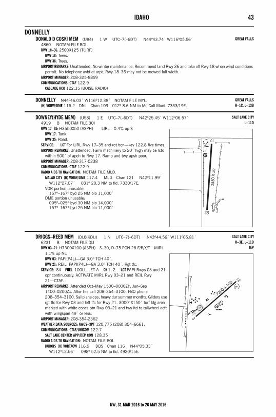
IDAHO 43
DONNELLYDONALD D COSKI MEM (U84) 1 W UTC–7(–6DT) N44º43.74´ W116º05.56´
4860 NOTAM FILE BOIRWY 18–36: 2500X125 (TURF)
RWY 18: Trees.RWY 36: Trees.
AIRPORT REMARKS: Unattended. No winter maintenance. Recommend land Rwy 36 and take off Rwy 18 when wind conditions permit. No telephone avbl at arpt. Rwy 18–36 may not be mowed full width.
AIRPORT MANAGER: 208-325-8859COMMUNICATIONS: CTAF 122.9
CASCADE RCO 122.35 (BOISE RADIO)
DONNELLY N44º46.03´ W116º12.38´ NOTAM FILE MYL.(H) VORW/DME 116.2 DNJ Chan 109 012º 8.6 NM to Mc Call Muni. 7333/19E.
DOWNEY(HYDE MEM) (U58) 1 E UTC–7(–6DT) N42º25.45´ W112º06.57´4919 B NOTAM FILE BOIRWY 17–35: H3550X50 (ASPH) LIRL 0.4% up S
RWY 17: Tank.RWY 35: Road.
SERVICE: LGT For LIRL Rwy 17–35 and rot bcn—key 122.8 five times.AIRPORT REMARKS: Unattended. Farm machinery to 20´ high may be lctd
within 500´ of apch to Rwy 17. Ramp and twy apsh poor.AIRPORT MANAGER: 208-317-5238COMMUNICATIONS: CTAF 122.9RADIO AIDS TO NAVIGATION: NOTAM FILE MLD.
MALAD CITY (H) VORW/DME 117.4 MLD Chan 121 N42º11.99´ W112º27.07´ 031º 20.3 NM to fld. 7330/17E.
VOR portion unusable:157º–167º byd 25 NM blo 11,000´
DME portion unusable:005º–025º byd 30 NM blo 14,000´157º–167º byd 25 NM blo 11,000´
DRIGGS–REED MEM (DIJ)(KDIJ) 1 N UTC–7(–6DT) N43º44.56´ W111º05.81´6231 B NOTAM FILE DIJRWY 03–21: H7300X100 (ASPH) S–30, D–75 PCN 28 F/B/X/T MIRL
1.1% up NERWY 03: PAPI(P4L)—GA 3.0º TCH 40´.RWY 21: REIL. PAPI(P4L)—GA 3.0º TCH 40´. Rgt tfc.
SERVICE: S4 FUEL 100LL, JET A OX 1, 2 LGT PAPI Rwys 03 and 21 opr continuously. ACTIVATE MIRL Rwy 03–21 and REIL Rwy 21—CTAF.
AIRPORT REMARKS: Attended Oct–May 1500–0000Z‡, Jun–Sep 1400–0200Z‡. After hrs call 208–354–3100. FBO phone 208–354–3100. Sailplane ops, heavy dur summer months. Gliders use rgt tfc for Rwy 03 and left tfc for Rwy 21. 3000´X150´ turf ldg area marked with white cones btn Rwy 03–21 and twy ltd to tailwheel acft with wingspan 49´ or less.
AIRPORT MANAGER: 208-354-2362WEATHER DATA SOURCES: AWOS–3PT 120.775 (208) 354–6661.COMMUNICATIONS: CTAF/UNICOM 122.7
SALT LAKE CENTER APP/DEP CON 128.35RADIO AIDS TO NAVIGATION: NOTAM FILE BOI.
DUBOIS (H) VORTACW 116.9 DBS Chan 116 N44º05.33´ W112º12.56´ 098º 52.5 NM to fld. 4920/15E.
GREAT FALLS
GREAT FALLSH–1C, L–13B
SALT LAKE CITYL–11D
SALT LAKE CITYH–3E, L–11D
IAP
NW, 31 MAR 2016 to 26 MAY 2016
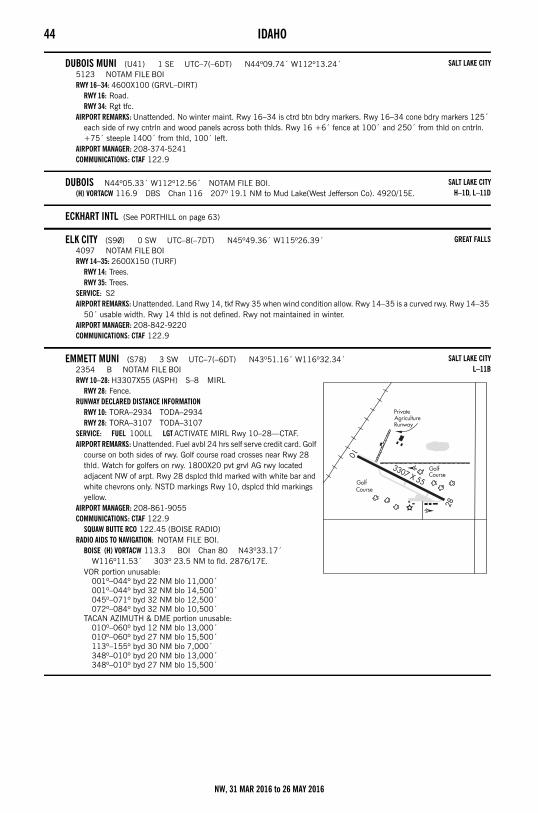
44 IDAHO
DUBOIS MUNI (U41) 1 SE UTC–7(–6DT) N44º09.74´ W112º13.24´5123 NOTAM FILE BOIRWY 16–34: 4600X100 (GRVL–DIRT)
RWY 16: Road.RWY 34: Rgt tfc.
AIRPORT REMARKS: Unattended. No winter maint. Rwy 16–34 is ctrd btn bdry markers. Rwy 16–34 cone bdry markers 125´ each side of rwy cntrln and wood panels across both thlds. Rwy 16 +6´ fence at 100´ and 250´ from thld on cntrln. +75´ steeple 1400´ from thld, 100´ left.
AIRPORT MANAGER: 208-374-5241COMMUNICATIONS: CTAF 122.9
DUBOIS N44º05.33´ W112º12.56´ NOTAM FILE BOI.(H) VORTACW 116.9 DBS Chan 116 207º 19.1 NM to Mud Lake(West Jefferson Co). 4920/15E.
ECKHART INTL (See PORTHILL on page 63)
ELK CITY (S90) 0 SW UTC–8(–7DT) N45º49.36´ W115º26.39´4097 NOTAM FILE BOIRWY 14–35: 2600X150 (TURF)
RWY 14: Trees.RWY 35: Trees.
SERVICE: S2 AIRPORT REMARKS: Unattended. Land Rwy 14, tkf Rwy 35 when wind condition allow. Rwy 14–35 is a curved rwy. Rwy 14–35
50´ usable width. Rwy 14 thld is not defined. Rwy not maintained in winter.AIRPORT MANAGER: 208-842-9220COMMUNICATIONS: CTAF 122.9
EMMETT MUNI (S78) 3 SW UTC–7(–6DT) N43º51.16´ W116º32.34´2354 B NOTAM FILE BOIRWY 10–28: H3307X55 (ASPH) S–8 MIRL
RWY 28: Fence.RUNWAY DECLARED DISTANCE INFORMATION
RWY 10: TORA–2934 TODA–2934RWY 28: TORA–3107 TODA–3107
SERVICE: FUEL 100LL LGT ACTIVATE MIRL Rwy 10–28—CTAF.AIRPORT REMARKS: Unattended. Fuel avbl 24 hrs self serve credit card. Golf
course on both sides of rwy. Golf course road crosses near Rwy 28 thld. Watch for golfers on rwy. 1800X20 pvt grvl AG rwy located adjacent NW of arpt. Rwy 28 dsplcd thld marked with white bar and white chevrons only. NSTD markings Rwy 10, dsplcd thld markings yellow.
AIRPORT MANAGER: 208-861-9055COMMUNICATIONS: CTAF 122.9
SQUAW BUTTE RCO 122.45 (BOISE RADIO)RADIO AIDS TO NAVIGATION: NOTAM FILE BOI.
BOISE (H) VORTACW 113.3 BOI Chan 80 N43º33.17´ W116º11.53´ 303º 23.5 NM to fld. 2876/17E.
VOR portion unusable:001º–044º byd 22 NM blo 11,000´001º–044º byd 32 NM blo 14,500´045º–071º byd 32 NM blo 12,500´072º–084º byd 32 NM blo 10,500´
TACAN AZIMUTH & DME portion unusable:010º–060º byd 12 NM blo 13,000´010º–060º byd 27 NM blo 15,500´113º–155º byd 30 NM blo 7,000´348º–010º byd 20 NM blo 13,000´348º–010º byd 27 NM blo 15,500´
SALT LAKE CITY
SALT LAKE CITYH–1D, L–11D
GREAT FALLS
SALT LAKE CITYL–11B
NW, 31 MAR 2016 to 26 MAY 2016
IDAHO 45
FAIRFIELDCAMAS CO (U86) 0 S UTC–7(–6DT) N43º20.51´ W114º47.90´
5058 NOTAM FILE BOIRWY 08–26: 2950X40 (DIRT)
RWY 08: Road. Rgt tfc.RWY 26: Pole.
AIRPORT REMARKS: Unattended. Irregular winter maintenance and snow removal, check rwy condition before using.AIRPORT MANAGER: 208-764-2652COMMUNICATIONS: CTAF 122.9
FISH LAKE (USFS) (S92) 0 E UTC–8(–7DT) N46º19.81´ W115º03.79´5646 NOTAM FILE BOIRWY 05–23: 2650X50 (TURF)
RWY 05: Tree.RWY 23: Trees.
AIRPORT REMARKS: Unattended. No winter maintenance. Rwy 05–23 soft when wet. Elk wallows on rwy. Land Rwy 23, tkf Rwy 05. No touch and go ldgs or stop and go ldgs, go arounds not recommended due to steep rising terrain off west end of Rwy 05–23. Rwy 05–23 additional 400´ of length avbl for tkf on the end of Rwy 05. Down drafts prevalent over lake. Ctc USFS arpt manager 208–983–9677 for briefings and rwy conditions. Do not park acft in front of USFS administrative site. Recommend early morning and late evening ops during summer months. Normally mowed to a usable width of 50´–75´. Rwy 23 end marked with conc T marker. Rwy 05 and Rwy 23 ends marked with orange cones. No telephone avbl at arpt.
AIRPORT MANAGER: 208-983-9677COMMUNICATIONS: CTAF 122.9
FRIEDMAN MEM (See HAILEY on page 48)
GARDEN VALLEY (U88) 2 SE UTC–7(–6DT) N44º04.02´ W115º55.88´3177 NOTAM FILE BOIRWY 10–28: 3850X125 (TURF) 1.4% up E
RWY 10: Fence.RWY 28: Fence.
AIRPORT REMARKS: Unattended. USFS heliport ops adjacent to SE end of arpt. Watch for sprinkler heads on rwy. Arpt located in mountain valley. No winter maintenance. Recommend ldg Rwy 10, tkf Rwy 28, if winds allow. Rwy 10–28 edges and thlds marked with white rocks. No telephone avbl at arpt.
AIRPORT MANAGER: 208-334-8775COMMUNICATIONS: CTAF 122.9
GLENGARYLAKE PEND OREILLE SPB (S96) 1 SE UTC–8(–7DT) N48º13.00´ W116º21.64´
2062 B NOTAM FILE BOIWATERWAY 14W–32W: 15000X4000 (WATER)SEAPLANE REMARKS: Attended continuously. Unmarked helipad located on beach to the west adjacent to docks with NSTD
helicopter VASI located on winch platform. Helicopter ops on and invof SPB. Bcn activated upon request. Ctc SPB manager 208–263–8554.
AIRPORT MANAGER: 208-263-8554COMMUNICATIONS: CTAF/UNICOM 122.8
SALT LAKE CITY
GREAT FALLS
SALT LAKE CITY
GREAT FALLS
NW, 31 MAR 2016 to 26 MAY 2016
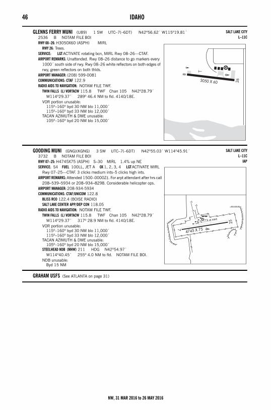
46 IDAHO
GLENNS FERRY MUNI (U89) 1 SW UTC–7(–6DT) N42º56.62´ W115º19.81´2536 B NOTAM FILE BOIRWY 08–26: H3050X60 (ASPH) MIRL
RWY 26: Trees.SERVICE: LGT ACTIVATE rotating bcn, MIRL Rwy 08–26—CTAF.AIRPORT REMARKS: Unattended. Rwy 08–26 distance to go markers every
1000´ south side of rwy. Rwy 08–26 white reflectors on both edges of rwy, green reflectors on both thlds.
AIRPORT MANAGER: (208) 599-0081COMMUNICATIONS: CTAF 122.9RADIO AIDS TO NAVIGATION: NOTAM FILE TWF.
TWIN FALLS (L) VORTACW 115.8 TWF Chan 105 N42º28.79´ W114º29.37´ 289º 46.4 NM to fld. 4140/18E.
VOR portion unusable:115º–160º byd 30 NM blo 11,000´115º–160º byd 33 NM blo 12,000´
TACAN AZIMUTH & DME unusable:105º–160º byd 20 NM blo 15,000´
GOODING MUNI (GNG)(KGNG) 3 SW UTC–7(–6DT) N42º55.03´ W114º45.91´3732 B NOTAM FILE BOIRWY 07–25: H4745X75 (ASPH) S–30 MIRL 1.4% up NESERVICE: S4 FUEL 100LL, JET A OX 1, 2, 3, 4 LGT ACTIVATE MIRL
Rwy 07–25—CTAF. 3 clicks medium ints–5 clicks high ints.AIRPORT REMARKS: Attended 1500–0000Z‡. For arpt attendant after hrs call
208–539–5934 or 208–934–8298. Considerable helicopter ops. AIRPORT MANAGER: 208-934-5934COMMUNICATIONS: CTAF/UNICOM 122.8
BLISS RCO 122.4 (BOISE RADIO)SALT LAKE CENTER APP/DEP CON 118.05
RADIO AIDS TO NAVIGATION: NOTAM FILE TWF.TWIN FALLS (L) VORTACW 115.8 TWF Chan 105 N42º28.79´
W114º29.37´ 317º 28.9 NM to fld. 4140/18E.VOR portion unusable:
115º–160º byd 30 NM blo 11,000´115º–160º byd 33 NM blo 12,000´
TACAN AZIMUTH & DME unusable:105º–160º byd 20 NM blo 15,000´
STEELHEAD NDB (MHW) 211 HDG N42º54.97´ W114º40.45´ 255º 4.0 NM to fld. NOTAM FILE BOI.
NDB unusable:Byd 15 NM
GRAHAM USFS (See ATLANTA on page 31)
SALT LAKE CITYL–11C
SALT LAKE CITYL–11C
IAP
NW, 31 MAR 2016 to 26 MAY 2016
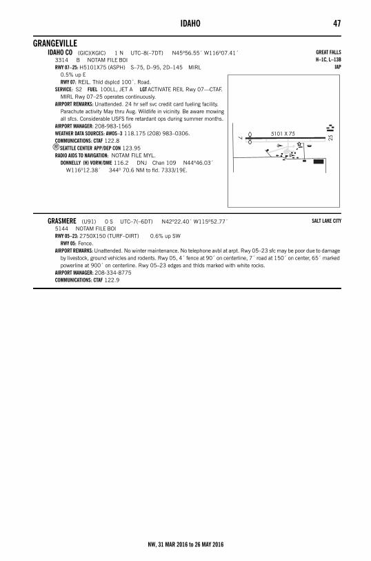
IDAHO 47
GRANGEVILLEIDAHO CO (GIC)(KGIC) 1 N UTC–8(–7DT) N45º56.55´ W116º07.41´
3314 B NOTAM FILE BOIRWY 07–25: H5101X75 (ASPH) S–75, D–95, 2D–145 MIRL
0.5% up ERWY 07: REIL. Thld dsplcd 100´. Road.
SERVICE: S2 FUEL 100LL, JET A LGT ACTIVATE REIL Rwy 07—CTAF. MIRL Rwy 07–25 operates continuously.
AIRPORT REMARKS: Unattended. 24 hr self svc credit card fueling facility. Parachute activity May thru Aug. Wildlife in vicinity. Be aware mowing all sfcs. Considerable USFS fire retardant ops during summer months.
AIRPORT MANAGER: 208-983-1565WEATHER DATA SOURCES: AWOS–3 118.175 (208) 983–0306.COMMUNICATIONS: CTAF 122.8
®SEATTLE CENTER APP/DEP CON 123.95RADIO AIDS TO NAVIGATION: NOTAM FILE MYL.
DONNELLY (H) VORW/DME 116.2 DNJ Chan 109 N44º46.03´ W116º12.38´ 344º 70.6 NM to fld. 7333/19E.
GRASMERE (U91) 0 S UTC–7(–6DT) N42º22.40´ W115º52.77´5144 NOTAM FILE BOIRWY 05–23: 2750X150 (TURF–DIRT) 0.6% up SW
RWY 05: Fence.AIRPORT REMARKS: Unattended. No winter maintenance. No telephone avbl at arpt. Rwy 05–23 sfc may be poor due to damage
by livestock, ground vehicles and rodents. Rwy 05, 4´ fence at 90´ on centerline, 7´ road at 150´ on center, 65´ marked powerline at 900´ on centerline. Rwy 05–23 edges and thlds marked with white rocks.
AIRPORT MANAGER: 208-334-8775COMMUNICATIONS: CTAF 122.9
GREAT FALLSH–1C, L–13B
IAP
SALT LAKE CITY
NW, 31 MAR 2016 to 26 MAY 2016
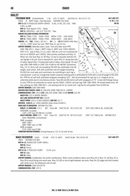
48 IDAHO
HAILEYFRIEDMAN MEM (SUN)(KSUN) 1 SE UTC–7(–6DT) N43º30.23´ W114º17.73´
5320 B ARFF Index—See Remarks NOTAM FILE SUNRWY 13–31: H7550X100 (ASPH–GRVD) S–65, D–95, 2D–150 HIRL
0.8% up NWRWY 13: Thld dsplcd 1701´. Road.RWY 31: PAPI(P4L)—GA 3.5º TCH 55´. Tree.
RUNWAY DECLARED DISTANCE INFORMATIONRWY 13: TORA–7150 TODA–7550 ASDA–7150 LDA–5450RWY 31: TORA–5850 TODA–7550 ASDA–6631 LDA–6631
SERVICE: S4 FUEL 100LL, JET A1+ OX 1, 3 LGT ACTIVATE HIRL Rwy 13–31—CTAF when twr clsd. PAPI Rwy 31 opr 24 hrs.
AIRPORT REMARKS: Attended dawn–dusk. Fuel avbl after dusk PPR 208–788–9511. Class I, ARFF Index A. ARFF avbl 1400–0600Z‡. ATCT 275´ east of Rwy 13–31 cntrln. Afld sfc cond not monitored btn the hrs of 0600Z‡ and 1400Z‡. Bird activity southeast end Rwy 31. When twr clsd land Rwy 31 tkf Rwy 13 due to opposite direction tfc, use ldg lgts in tfc pat. Due to opposite tfc, apch Rwy 31 along east side of valley, depart Rwy 13 along west side of valley, show ldg lgt. Ctc aprt mgr 208–788–4956 or 208–720–5186 for NS ABTMT procedures. Rwy 13–31 ltd to acft not exceeding 95,000 lbs certificated max tkf weight, dual wheel. Acft with published max tkf weight exceeding 95,000 lbs must seek prior permission by submitting to arpt mgr a manufacturer´s acft svc change that installs a placard verifying acft is certificated for SUN with a max tkf weight of 95,000 lbs. PPR for all acft with published wingspan exceeding 100´. Not recommended for ngt use or in marginal wx by unfamiliar pilots due to mountainous terrain. Twys B5 and B6 rstd to acft with wingspans of 79´ or less (Acft Design Group II) only. PPR for all scheduled air carrier ops btn 0600–1300Z‡ call arpt mgr 208–788–4956. No locked brake turns. All tran parking ctc 208–788–9511. Ltd parking avbl for air carrier acft. Ldg fee for acft greater than 6,000 lbs.
AIRPORT MANAGER: 208-788-4956WEATHER DATA SOURCES: AWOS–3 128.225 (208) 788–9213. LAWRS.COMMUNICATIONS: CTAF 125.6 ATIS 128.225 (208) 788–2108 UNICOM 122.95
HAILEY RCO 122.4 (BOISE RADIO)SALT LAKE CENTER APP/DEP CON 118.05HAILEY TOWER 125.6 (1400–0600Z‡) GND CON 121.7
AIRSPACE: CLASS D svc 1400–0600Z‡ other times CLASS E.RADIO AIDS TO NAVIGATION: NOTAM FILE BYI.
BURLEY (L) VORW/DME 114.1 BYI Chan 88 N42º34.81´ W113º51.95´ 323º 58.5 NM to fld. 4226/18E.VOR/DME unusable:
120º–150º byd 30 NM blo 15,000´HAILEY NDB/DME (MHW) 220 HLE Chan 25 N43º19.79´ W114º14.62´ 335º 10.7 NM to fld. NOTAM FILE
SUN. NDB/DME unmonitored.DME unusable:
080º–280º280º–080º byd 12 NM
NDB unusable:310º–350º byd 6 NM
COMM/NAV/WEATHER REMARKS: Emerg frequency 121.5 not avbl at twr.
– – – – – – – – – – – – – – – – – – – – – – – – – – – – – – – – – – – – – – – – – – – – – – – – – – – – – – – –
MAGIC RESERVOIR (U93) 15 SW UTC–7(–6DT) N43º16.84´ W114º23.78´4844 NOTAM FILE BOIRWY 04–22: 4000X100 (TURF–GRVL)
RWY 04: Road.RWY 22: Fence.
RWY 10–28: 1750X100 (TURF) 0.4% up ERWY 10: Sign.RWY 28: Trees.
AIRPORT REMARKS: Unattended. No winter maintenance. When wind conditions allow, land Rwy 04 or Rwy 10, tkf Rwy 22 or Rwy 28 to avoid flying over resort area. Rwy 10–28 no line of sight between rwy ends. Rwy 04–22 edges and thld marked with white rocks. No telephone avbl at arpt.
AIRPORT MANAGER: 208-334-8775COMMUNICATIONS: CTAF 122.9
SALT LAKE CITYH–3D, L–11C
IAP, AD
SALT LAKE CITY
NW, 31 MAR 2016 to 26 MAY 2016
IDAHO 49
HAILEY N43º19.79´ W114º14.62´ NOTAM FILE SUN.NDB/DME (MHW) 220 HLE Chan 25 335º 10.7 NM to Friedman Mem. NDB/DME unmonitored.
DME unusable:080º–280º280º–080º byd 12 NM
NDB unusable:310º–350º byd 6 NM
RCO 122.4 (BOISE RADIO)
HAZELTON MUNI (U94) 1 S UTC–7(–6DT) N42º34.57´ W114º08.16´4172 NOTAM FILE BOIRWY 06–24: H2800X90 (ASPH)
RWY 06: Bldg.RWY 24: Road.
AIRPORT REMARKS: Unattended. No winter maintenance. Rwy 06–24 no line of sight between rwy ends. Rwy 06–24 has a 300´ grvl stopway on northeast end.
AIRPORT MANAGER: 208-324-9980COMMUNICATIONS: CTAF 122.9
HENRY'S LAKE (See ISLAND PARK on page 50)
HOLLOW TOP (See CAREY on page 37)
HOMEDALE MUNI (S66) 0 SE UTC–7(–6DT) N43º36.88´ W116º55.29´2219 NOTAM FILE BOIRWY 13–31: H2900X50 (ASPH) S–6
RWY 13: Thld dsplcd 335´. Tree.RWY 31: Trees.
SERVICE: S1 AIRPORT REMARKS: Unattended. No telephone avbl at arpt. AIRPORT MANAGER: 208-880-2719COMMUNICATIONS: CTAF 122.9
HOWE (U97) 4 NW UTC–7(–6DT) N43º50.34´ W113º02.80´4930 NOTAM FILE BOIRWY 13–31: 3800X25 (GRVL)
RWY 13: Road.RWY 31: Road.
AIRPORT REMARKS: Unattended. Arpt used heavily by spray planes during summer. +15´ to +20´ farm machinery may be parked on apch to Rwy 13, 230´ from end of rwy. Rwy 13–31 thlds defined with white blocks and reflectors.
AIRPORT MANAGER: 208-767-3455COMMUNICATIONS: CTAF 122.9
IDAHO CITY USFS (U98) 1 SW UTC–7(–6DT) N43º49.24´ W115º51.06´3920 NOTAM FILE BOIRWY 04–22: 3400X50 (GRVL–TURF)
RWY 04: Trees.RWY 22: Trees.
AIRPORT REMARKS: Unattended. No winter maintenance. No telephone avbl at arpt. Recommend land Rwy 04, tkf Rwy 22 when wind conditions permit. West 700´ of rwy is turf, remainder is grvl. Rwy 04–22 edges and thlds marked with white rock.
AIRPORT MANAGER: (208) 392-6681COMMUNICATIONS: CTAF 122.9
IDAHO CO (See GRANGEVILLE on page 47)
SALT LAKE CITYL–11C
SALT LAKE CITY
SALT LAKE CITY
SALT LAKE CITY
SALT LAKE CITY
NW, 31 MAR 2016 to 26 MAY 2016
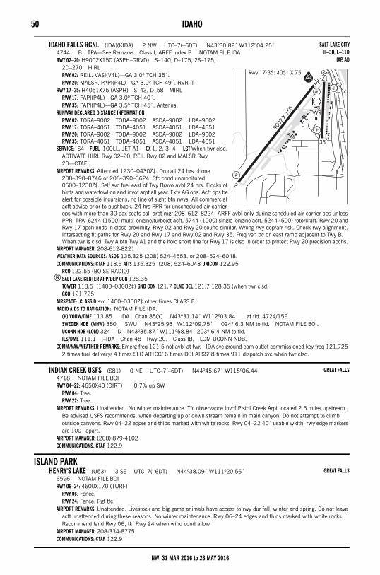
50 IDAHO
IDAHO FALLS RGNL (IDA)(KIDA) 2 NW UTC–7(–6DT) N43º30.82´ W112º04.25´4744 B TPA—See Remarks Class I, ARFF Index B NOTAM FILE IDARWY 02–20: H9002X150 (ASPH–GRVD) S–140, D–175, 2S–175,
2D–270 HIRLRWY 02: REIL. VASI(V4L)—GA 3.0º TCH 35´.RWY 20: MALSR. PAPI(P4L)—GA 3.0º TCH 49´. RVR–T
RWY 17–35: H4051X75 (ASPH) S–43, D–58 MIRLRWY 17: PAPI(P4L)—GA 3.0º TCH 40´.RWY 35: PAPI(P4L)—GA 3.5º TCH 45´. Antenna.
RUNWAY DECLARED DISTANCE INFORMATIONRWY 02: TORA–9002 TODA–9002 ASDA–9002 LDA–9002RWY 17: TORA–4051 TODA–4051 ASDA–4051 LDA–4051RWY 20: TORA–9002 TODA–9002 ASDA–9002 LDA–9002RWY 35: TORA–4051 TODA–4051 ASDA–4051 LDA–4051
SERVICE: S4 FUEL 100LL, JET A1 OX 1, 2, 3, 4 LGT When twr clsd, ACTIVATE HIRL Rwy 02–20, REIL Rwy 02 and MALSR Rwy 20—CTAF.
AIRPORT REMARKS: Attended 1230–0430Z‡. On call 24 hrs phone 208–390–8746 or 208–390–3624. Sfc cond unmonitored 0600–1230Z‡. Self svc fuel east of Twy Bravo avbl 24 hrs. Flocks of birds and waterfowl on and invof arpt all year. Extv AG ops. Acft ops be alert for possible incursions, no line of sight btn rwys. All commercial acft advise prior to pushback. 24 hrs PPR for unscheduled air carrier ops with more than 30 pax seats call arpt mgr 208–612–8224. ARFF avbl only during scheduled air carrier ops unless PPR. TPA–6244 (1500) multi–engine/turbojet acft, 5744 (1000) single–engine acft, 5244 (500) rotorcraft. Rwy 20 and Rwy 17 apch ends in close proximity. Rwy 02 and Rwy 20 sound similar. Wrong rwy dep/arr risk. Check rwy alignment. Intersecting flt paths for Rwy 20 and Rwy 17 and Rwy 02 and Rwy 35. Freq veh tfc on east ramp adjacent to Twy B. When twr is clsd, Twy A btn Twy A1 and the hold short line for Rwy 17 is clsd in order to protect Rwy 20 precision apchs.
AIRPORT MANAGER: 208-612-8221WEATHER DATA SOURCES: ASOS 135.325 (208) 524–4553. or 208–524–6048.COMMUNICATIONS: CTAF 118.5 ATIS 135.325 (208) 524–6048 UNICOM 122.95
RCO 122.55 (BOISE RADIO)®SALT LAKE CENTER APP/DEP CON 128.35
TOWER 118.5 (1400–0300Z‡) GND CON 121.7 CLNC DEL 121.7 128.35 (when twr clsd)GCO 121.725
AIRSPACE: CLASS D svc 1400–0300Z‡ other times CLASS E.RADIO AIDS TO NAVIGATION: NOTAM FILE IDA.
(H) VORW/DME 113.85 IDA Chan 85(Y) N43º31.14´ W112º03.84´ at fld. 4724/15E.SWEDEN NDB (MHW) 350 SWU N43º25.93´ W112º09.75´ 024º 6.3 NM to fld. NOTAM FILE BOI.UCONN NDB (LOM) 324 ID N43º35.87´ W111º58.84´ 203º 6.4 NM to fld. ILS/DME 111.1 I–IDA Chan 48 Rwy 20. Class IB. LOM UCONN NDB.
COMM/NAV/WEATHER REMARKS: Emerg freq 121.5 not avbl at twr. IDA svc ground com outlet commissioned key freq 121.725 2 times fuel delivery/ 4 times SLC ARTCC/ 6 times BOI AFSS/ 8 times 911 dispatch svc when twr clsd.
INDIAN CREEK USFS (S81) 0 NE UTC–7(–6DT) N44º45.67´ W115º06.44´4718 NOTAM FILE BOIRWY 04–22: 4650X40 (DIRT) 0.7% up SW
RWY 04: Tree.RWY 22: Tree.
AIRPORT REMARKS: Unattended. No winter maintenance. Tfc observance invof Pistol Creek Arpt located 2.5 miles upstream. Be advised USFS recommends, when departing up or down stream remain in main canyon. Do not attempt to climb outside canyons. Rwy 04–22 edges and thlds marked with white rocks, Rwy 04–22 40´ usable width, rwy edge markers are 100´ apart.
AIRPORT MANAGER: (208) 879-4102COMMUNICATIONS: CTAF 122.9
ISLAND PARKHENRY'S LAKE (U53) 3 SE UTC–7(–6DT) N44º38.09´ W111º20.56´
6596 NOTAM FILE BOIRWY 06–24: 4600X170 (TURF)
RWY 06: Fence.RWY 24: Fence. Rgt tfc.
AIRPORT REMARKS: Unattended. Livestock and big game animals have access to rwy dur fall, winter and spring. Do not leave acft unattended during these seasons. No winter maintenance. Rwy 06–24 edges and thlds marked with white rocks. Recommend land Rwy 06, tkf Rwy 24 when wind cond allow.
AIRPORT MANAGER: 208-334-8775COMMUNICATIONS: CTAF 122.9
SALT LAKE CITYH–3D, L–11D
IAP, AD
GREAT FALLS
GREAT FALLS
NW, 31 MAR 2016 to 26 MAY 2016
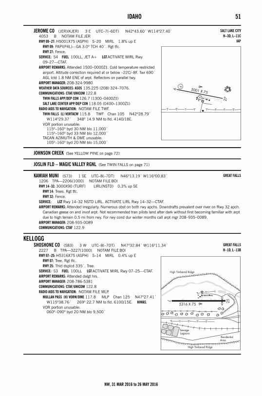
IDAHO 51
JEROME CO (JER)(KJER) 3 E UTC–7(–6DT) N42º43.60´ W114º27.40´4053 B NOTAM FILE JERRWY 09–27: H5001X75 (ASPH) S–20 MIRL 1.8% up E
RWY 09: PAPI(P4L)—GA 3.0º TCH 40´. Rgt tfc.RWY 27: Fence.
SERVICE: S4 FUEL 100LL, JET A+ LGT ACTIVATE MIRL Rwy 09–27—CTAF.
AIRPORT REMARKS: Attended 1500–0000Z‡. Cold temperature restricted airport. Altitude correction required at or below –22C/–8F. Twr 690´ AGL lctd 1.8 NM ENE of arpt. Reflectors on parallel twy.
AIRPORT MANAGER: 208-324-9980WEATHER DATA SOURCES: ASOS 135.225 (208) 324–7076.COMMUNICATIONS: CTAF/UNICOM 122.8
TWIN FALLS APP/DEP CON 126.7 (1300–0400Z‡)SALT LAKE CENTER APP/DEP CON 118.05 (0400–1300Z‡)
RADIO AIDS TO NAVIGATION: NOTAM FILE TWF.TWIN FALLS (L) VORTACW 115.8 TWF Chan 105 N42º28.79´
W114º29.37´ 348º 14.9 NM to fld. 4140/18E.VOR portion unusable:
115º–160º byd 30 NM blo 11,000´115º–160º byd 33 NM blo 12,000´
TACAN AZIMUTH & DME unusable:105º–160º byd 20 NM blo 15,000´
JOHNSON CREEK (See YELLOW PINE on page 72)
JOSLIN FLD – MAGIC VALLEY RGNL (See TWIN FALLS on page 71)
KAMIAH MUNI (S73) 1 SE UTC–8(–7DT) N46º13.19´ W116º00.83´1206 TPA—2206(1000) NOTAM FILE BOIRWY 14–32: 3000X90 (TURF) LIRL(NSTD) 0.3% up SE
RWY 14: Trees. Rgt tfc.RWY 32: Fence.
SERVICE: LGT Rwy 14–32 NSTD LIRL. ACTIVATE LIRL Rwy 14–32—CTAF.AIRPORT REMARKS: Attended irregularly. Numerous obst on both rwy apchs. Downdrafts prevalent over river on Rwy 32 apch.
Canadian geese on and invof arpt. Not recommended tran pilots land after dark without first becoming familiar with arpt due to high terrain 0.5 mi from rwy. For rwy cond dur winter months call arpt mgr 208–935–0089.
AIRPORT MANAGER: 208-935-0089COMMUNICATIONS: CTAF 122.9
KELLOGGSHOSHONE CO (S83) 3 W UTC–8(–7DT) N47º32.84´ W116º11.34´
2227 B TPA—3227(1000) NOTAM FILE BOIRWY 07–25: H5316X75 (ASPH) S–14 MIRL 0.4% up E
RWY 07: Tree. Rgt tfc.RWY 25: Thld dsplcd 335´. Tree.
SERVICE: S3 FUEL 100LL LGT ACTIVATE MIRL Rwy 07–25—CTAF.AIRPORT REMARKS: Attended dalgt hrs. AIRPORT MANAGER: 208-786-5381COMMUNICATIONS: CTAF/UNICOM 122.8RADIO AIDS TO NAVIGATION: NOTAM FILE MLP.
MULLAN PASS (H) VORW/DME 117.8 MLP Chan 125 N47º27.41´ W115º38.76´ 269º 22.7 NM to fld. 6100/15E. HIWAS.
VOR portion unusable:060º–090º byd 20 NM blo 9,500´
SALT LAKE CITYH–3D, L–11C
IAP
GREAT FALLS
GREAT FALLSH–1D, L–13B
NW, 31 MAR 2016 to 26 MAY 2016
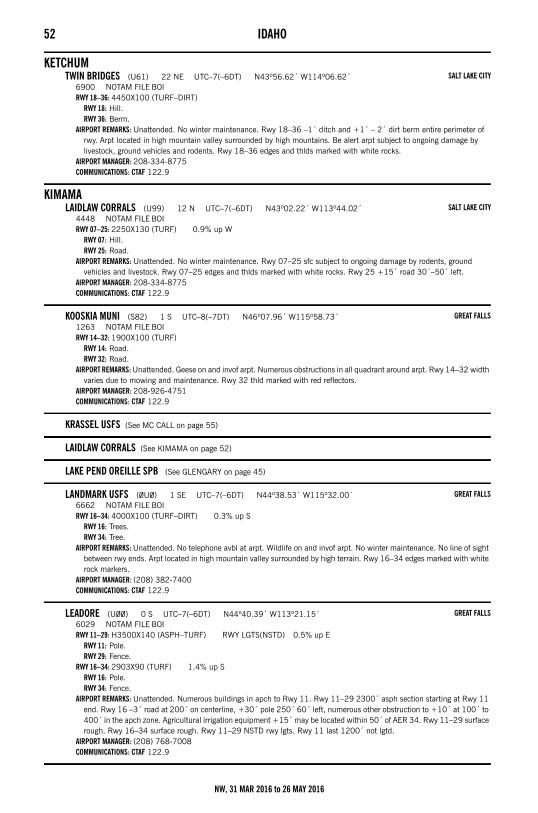
52 IDAHO
KETCHUMTWIN BRIDGES (U61) 22 NE UTC–7(–6DT) N43º56.62´ W114º06.62´
6900 NOTAM FILE BOIRWY 18–36: 4450X100 (TURF–DIRT)
RWY 18: Hill.RWY 36: Berm.
AIRPORT REMARKS: Unattended. No winter maintenance. Rwy 18–36 –1´ ditch and +1´ – 2´ dirt berm entire perimeter of rwy. Arpt located in high mountain valley surrounded by high mountains. Be alert arpt subject to ongoing damage by livestock, ground vehicles and rodents. Rwy 18–36 edges and thlds marked with white rocks.
AIRPORT MANAGER: 208-334-8775COMMUNICATIONS: CTAF 122.9
KIMAMALAIDLAW CORRALS (U99) 12 N UTC–7(–6DT) N43º02.22´ W113º44.02´
4448 NOTAM FILE BOIRWY 07–25: 2250X130 (TURF) 0.9% up W
RWY 07: Hill.RWY 25: Road.
AIRPORT REMARKS: Unattended. No winter maintenance. Rwy 07–25 sfc subject to ongoing damage by rodents, ground vehicles and livestock. Rwy 07–25 edges and thlds marked with white rocks. Rwy 25 +15´ road 30´–50´ left.
AIRPORT MANAGER: 208-334-8775COMMUNICATIONS: CTAF 122.9
KOOSKIA MUNI (S82) 1 S UTC–8(–7DT) N46º07.96´ W115º58.73´1263 NOTAM FILE BOIRWY 14–32: 1900X100 (TURF)
RWY 14: Road.RWY 32: Road.
AIRPORT REMARKS: Unattended. Geese on and invof arpt. Numerous obstructions in all quadrant around arpt. Rwy 14–32 width varies due to mowing and maintenance. Rwy 32 thld marked with red reflectors.
AIRPORT MANAGER: 208-926-4751COMMUNICATIONS: CTAF 122.9
KRASSEL USFS (See MC CALL on page 55)
LAIDLAW CORRALS (See KIMAMA on page 52)
LAKE PEND OREILLE SPB (See GLENGARY on page 45)
LANDMARK USFS (0U0) 1 SE UTC–7(–6DT) N44º38.53´ W115º32.00´6662 NOTAM FILE BOIRWY 16–34: 4000X100 (TURF–DIRT) 0.3% up S
RWY 16: Trees.RWY 34: Tree.
AIRPORT REMARKS: Unattended. No telephone avbl at arpt. Wildlife on and invof arpt. No winter maintenance. No line of sight between rwy ends. Arpt located in high mountain valley surrounded by high terrain. Rwy 16–34 edges marked with white rock markers.
AIRPORT MANAGER: (208) 382-7400COMMUNICATIONS: CTAF 122.9
LEADORE (U00) 0 S UTC–7(–6DT) N44º40.39´ W113º21.15´6029 NOTAM FILE BOIRWY 11–29: H3500X140 (ASPH–TURF) RWY LGTS(NSTD) 0.5% up E
RWY 11: Pole.RWY 29: Fence.
RWY 16–34: 2903X90 (TURF) 1.4% up SRWY 16: Pole.RWY 34: Fence.
AIRPORT REMARKS: Unattended. Numerous buildings in apch to Rwy 11. Rwy 11–29 2300´ asph section starting at Rwy 11 end. Rwy 16 –3´ road at 200´ on centerline, +30´ pole 250´ 60´ left, numerous other obstruction to +10´ at 100´ to 400´ in the apch zone. Agricultural irrigation equipment +15´ may be located within 50´ of AER 34. Rwy 11–29 surface rough. Rwy 16–34 surface rough. Rwy 11–29 NSTD rwy lgts. Rwy 11 last 1200´ not lgtd.
AIRPORT MANAGER: (208) 768-7008COMMUNICATIONS: CTAF 122.9
SALT LAKE CITY
SALT LAKE CITY
GREAT FALLS
GREAT FALLS
GREAT FALLS
NW, 31 MAR 2016 to 26 MAY 2016
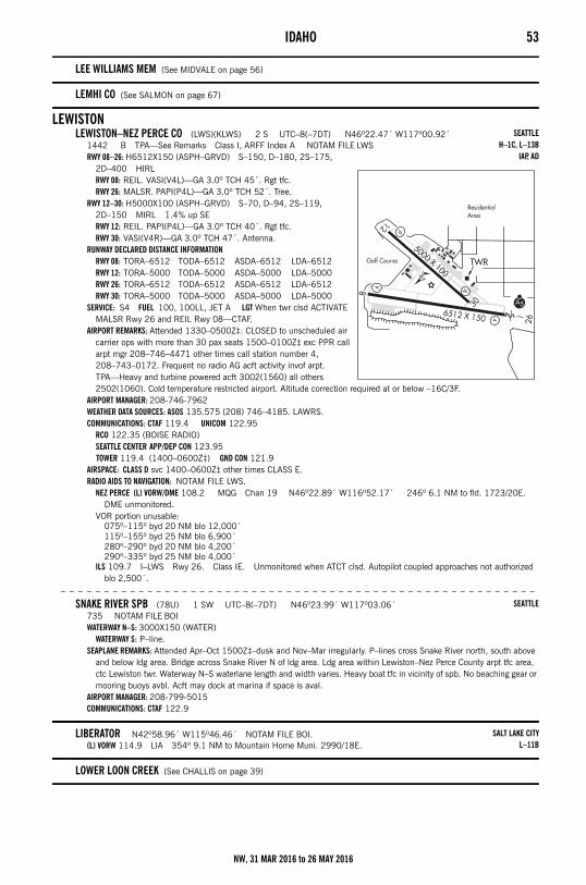
IDAHO 53
LEE WILLIAMS MEM (See MIDVALE on page 56)
LEMHI CO (See SALMON on page 67)
LEWISTONLEWISTON–NEZ PERCE CO (LWS)(KLWS) 2 S UTC–8(–7DT) N46º22.47´ W117º00.92´
1442 B TPA—See Remarks Class I, ARFF Index A NOTAM FILE LWSRWY 08–26: H6512X150 (ASPH–GRVD) S–150, D–180, 2S–175,
2D–400 HIRLRWY 08: REIL. VASI(V4L)—GA 3.0º TCH 45´. Rgt tfc.RWY 26: MALSR. PAPI(P4L)—GA 3.0º TCH 52´. Tree.
RWY 12–30: H5000X100 (ASPH–GRVD) S–70, D–94, 2S–119, 2D–150 MIRL 1.4% up SERWY 12: REIL. PAPI(P4L)—GA 3.0º TCH 40´. Rgt tfc.RWY 30: VASI(V4R)—GA 3.0º TCH 47´. Antenna.
RUNWAY DECLARED DISTANCE INFORMATIONRWY 08: TORA–6512 TODA–6512 ASDA–6512 LDA–6512RWY 12: TORA–5000 TODA–5000 ASDA–5000 LDA–5000RWY 26: TORA–6512 TODA–6512 ASDA–6512 LDA–6512RWY 30: TORA–5000 TODA–5000 ASDA–5000 LDA–5000
SERVICE: S4 FUEL 100, 100LL, JET A LGT When twr clsd ACTIVATE MALSR Rwy 26 and REIL Rwy 08—CTAF.
AIRPORT REMARKS: Attended 1330–0500Z‡. CLOSED to unscheduled air carrier ops with more than 30 pax seats 1500–0100Z‡ exc PPR call arpt mgr 208–746–4471 other times call station number 4, 208–743–0172. Frequent no radio AG acft activity invof arpt. TPA—Heavy and turbine powered acft 3002(1560) all others 2502(1060). Cold temperature restricted airport. Altitude correction required at or below –16C/3F.
AIRPORT MANAGER: 208-746-7962WEATHER DATA SOURCES: ASOS 135.575 (208) 746–4185. LAWRS.COMMUNICATIONS: CTAF 119.4 UNICOM 122.95
RCO 122.35 (BOISE RADIO)SEATTLE CENTER APP/DEP CON 123.95 TOWER 119.4 (1400–0600Z‡) GND CON 121.9
AIRSPACE: CLASS D svc 1400–0600Z‡ other times CLASS E.RADIO AIDS TO NAVIGATION: NOTAM FILE LWS.
NEZ PERCE (L) VORW/DME 108.2 MQG Chan 19 N46º22.89´ W116º52.17´ 246º 6.1 NM to fld. 1723/20E. DME unmonitored.
VOR portion unusable:075º–115º byd 20 NM blo 12,000´115º–155º byd 25 NM blo 6,900´280º–290º byd 20 NM blo 4,200´290º–335º byd 25 NM blo 4,000´
ILS 109.7 I–LWS Rwy 26. Class IE. Unmonitored when ATCT clsd. Autopilot coupled approaches not authorized blo 2,500´.
– – – – – – – – – – – – – – – – – – – – – – – – – – – – – – – – – – – – – – – – – – – – – – – – – – – – – – –
SNAKE RIVER SPB (78U) 1 SW UTC–8(–7DT) N46º23.99´ W117º03.06´735 NOTAM FILE BOIWATERWAY N–S: 3000X150 (WATER)
WATERWAY S: P–line.SEAPLANE REMARKS: Attended Apr–Oct 1500Z‡–dusk and Nov–Mar irregularly. P–lines cross Snake River north, south above
and below ldg area. Bridge across Snake River N of ldg area. Ldg area within Lewiston–Nez Perce County arpt tfc area, ctc Lewiston twr. Waterway N–S waterlane length and width varies. Heavy boat tfc in vicinity of spb. No beaching gear or mooring buoys avbl. Acft may dock at marina if space is aval.
AIRPORT MANAGER: 208-799-5015COMMUNICATIONS: CTAF 122.9
LIBERATOR N42º58.96´ W115º46.46´ NOTAM FILE BOI.(L) VORW 114.9 LIA 354º 9.1 NM to Mountain Home Muni. 2990/18E.
LOWER LOON CREEK (See CHALLIS on page 39)
SEATTLEH–1C, L–13B
IAP, AD
SEATTLE
SALT LAKE CITYL–11B
NW, 31 MAR 2016 to 26 MAY 2016
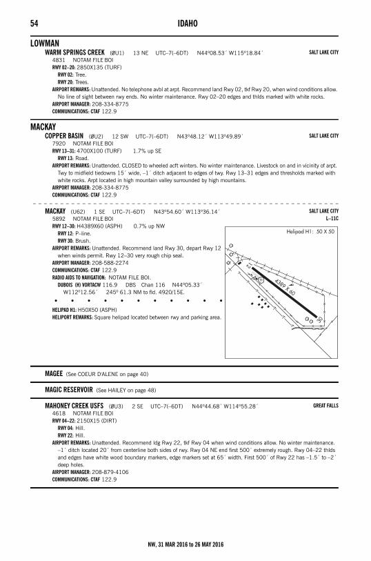
54 IDAHO
LOWMANWARM SPRINGS CREEK (0U1) 13 NE UTC–7(–6DT) N44º08.53´ W115º18.84´
4831 NOTAM FILE BOIRWY 02–20: 2850X135 (TURF)
RWY 02: Tree.RWY 20: Trees.
AIRPORT REMARKS: Unattended. No telephone avbl at arpt. Recommend land Rwy 02, tkf Rwy 20, when wind conditions allow. No line of sight between rwy ends. No winter maintenance. Rwy 02–20 edges and thlds marked with white rocks.
AIRPORT MANAGER: 208-334-8775COMMUNICATIONS: CTAF 122.9
MACKAYCOPPER BASIN (0U2) 12 SW UTC–7(–6DT) N43º48.12´ W113º49.89´
7920 NOTAM FILE BOIRWY 13–31: 4700X100 (TURF) 1.7% up SE
RWY 13: Road.AIRPORT REMARKS: Unattended. CLOSED to wheeled acft winters. No winter maintenance. Livestock on and in vicinity of arpt.
Twy to midfield tiedowns 15´ wide, –1´ ditch adjacent to edges of twy. Rwy 13–31 edges and thresholds marked with white rocks. Arpt located in high mountain valley surrounded by high mountains.
AIRPORT MANAGER: 208-334-8775COMMUNICATIONS: CTAF 122.9
– – – – – – – – – – – – – – – – – – – – – – – – – – – – – – – – – – – – – – – – – – – – – – – – – – – – – – – –
MACKAY (U62) 1 SE UTC–7(–6DT) N43º54.60´ W113º36.14´5892 NOTAM FILE BOIRWY 12–30: H4389X60 (ASPH) 0.7% up NW
RWY 12: P–line.RWY 30: Brush.
AIRPORT REMARKS: Unattended. Recommend land Rwy 30, depart Rwy 12 when winds permit. Rwy 12–30 very rough chip seal.
AIRPORT MANAGER: 208-588-2274COMMUNICATIONS: CTAF 122.9RADIO AIDS TO NAVIGATION: NOTAM FILE BOI.
DUBOIS (H) VORTACW 116.9 DBS Chan 116 N44º05.33´ W112º12.56´ 245º 61.3 NM to fld. 4920/15E.
• • • • • • • • • • • • • • • • • •
HELIPAD H1: H50X50 (ASPH)HELIPORT REMARKS: Square helipad located between rwy and parking area.
MAGEE (See COEUR D'ALENE on page 40)
MAGIC RESERVOIR (See HAILEY on page 48)
MAHONEY CREEK USFS (0U3) 2 SE UTC–7(–6DT) N44º44.68´ W114º55.28´4618 NOTAM FILE BOIRWY 04–22: 2150X15 (DIRT)
RWY 04: Hill.RWY 22: Hill.
AIRPORT REMARKS: Unattended. Recommend ldg Rwy 22, tkf Rwy 04 when wind conditions allow. No winter maintenance. –1´ ditch located 20´ from centerline both sides of rwy. Rwy 04 NE end first 500´ extremely rough. Rwy 04–22 thlds and edges have white wood boundary markers, edge markers set at 65´ width. First 500´ of Rwy 22 has –1.5´ to –2´ deep holes.
AIRPORT MANAGER: 208-879-4106COMMUNICATIONS: CTAF 122.9
SALT LAKE CITY
SALT LAKE CITY
SALT LAKE CITYL–11C
GREAT FALLS
NW, 31 MAR 2016 to 26 MAY 2016
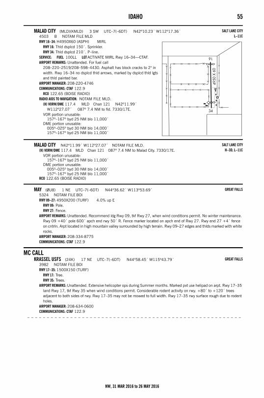
IDAHO 55
MALAD CITY (MLD)(KMLD) 3 SW UTC–7(–6DT) N42º10.23´ W112º17.36´4503 B NOTAM FILE MLDRWY 16–34: H4950X60 (ASPH) MIRL
RWY 16: Thld dsplcd 150´. Sprinkler.RWY 34: Thld dsplcd 210´. P–line.
SERVICE: FUEL 100LL LGT ACTIVATE MIRL Rwy 16–34—CTAF.AIRPORT REMARKS: Unattended. For fuel call
208–220–2519/208–598–4430. Asphalt has block cracks to 2" in width. Rwy 16–34 no dsplcd thld arrows, marked by dsplcd thld lgts and thld painted bar.
AIRPORT MANAGER: 208-220-4746COMMUNICATIONS: CTAF 122.9
RCO 122.65 (BOISE RADIO)RADIO AIDS TO NAVIGATION: NOTAM FILE MLD.
(H) VORW/DME 117.4 MLD Chan 121 N42º11.99´ W112º27.07´ 087º 7.4 NM to fld. 7330/17E.
VOR portion unusable:157º–167º byd 25 NM blo 11,000´
DME portion unusable:005º–025º byd 30 NM blo 14,000´157º–167º byd 25 NM blo 11,000´
MALAD CITY N42º11.99´ W112º27.07´ NOTAM FILE MLD.(H) VORW/DME 117.4 MLD Chan 121 087º 7.4 NM to Malad City. 7330/17E.
VOR portion unusable:157º–167º byd 25 NM blo 11,000´
DME portion unusable:005º–025º byd 30 NM blo 14,000´157º–167º byd 25 NM blo 11,000´
RCO 122.65 (BOISE RADIO)
MAY (0U8) 1 NE UTC–7(–6DT) N44º36.62´ W113º53.69´5324 NOTAM FILE BOIRWY 09–27: 4950X200 (TURF) 4.0% up E
RWY 09: Pole.RWY 27: Fence.
AIRPORT REMARKS: Unattended. Recommend ldg Rwy 09, tkf Rwy 27, when wind conditions permit. No winter maintenance. Rwy 09 +40´ pole 600´ apch end rwy 50´ R. Fence marker located on apch end of Rwy 27. Rwy end 27 +4´ fence on cntrln. Arpt located in high mountain valley surrounded by high terrain. Rwy 09–27 edges and thlds marked with white rocks.
AIRPORT MANAGER: 208-334-8775COMMUNICATIONS: CTAF 122.9
MC CALLKRASSEL USFS (24K) 17 NE UTC–7(–6DT) N44º58.45´ W115º43.79´
3982 NOTAM FILE BOIRWY 17–35: 1500X150 (TURF)
RWY 17: Tree.RWY 35: Trees.
AIRPORT REMARKS: Unattended. Extensive helicopter ops during Summer months. Marked pvt use helipad on arpt. Rwy 17–35 land Rwy 17, tkf Rwy 35 when wind conditions permit. Considerable rodent activity on rwy. +80´ to +120´ trees adjacent to both sides of rwy. Rwy 17–35 may not be mowed to full width. Rwy 17–35 rwy surface rough due to rodent holes.
AIRPORT MANAGER: 208-634-0600COMMUNICATIONS: CTAF 122.9
– – – – – – – – – – – – – – – – – – – – – – – – – – – – – – – – – – – – – – – – – – – – – – – – – – – – – – –
SALT LAKE CITYL–11C
SALT LAKE CITYH–3D, L–11C
GREAT FALLS
GREAT FALLS
NW, 31 MAR 2016 to 26 MAY 2016
56 IDAHO– – – – – – – – – – – – – – – – – – – – – – – – – – – – – – – – – – – – – – – – – – – – – – – – – – – – – – – –
MC CALL MUNI (MYL)(KMYL) 0 S UTC–7(–6DT) N44º53.32´ W116º06.11´5024 B NOTAM FILE MYLRWY 16–34: H6108X75 (ASPH) S–86.5, D–141, 2D–261.5 MIRL
0.3% up NRWY 16: REIL. PAPI(P2L)—GA 3.0º TCH 40´. Road.RWY 34: REIL. VASI(V2L)—GA 3.5º TCH 40´. Ground.
SERVICE: S4 FUEL 100LL, JET A, A1+ LGT ACTIVATE MIRL Rwy 16–34, REIL Rwy 16 and Rwy 34—CTAF.
AIRPORT REMARKS: Attended dalgt hrs. 2 hr prior notice rqr for snow removal at ngt call (208) 634–1488/630–3747. Cold temperature restricted airport. Altitude correction required at or below –20C/–4F. Parachute Jumping. USFS practices parachute jumps invof arpt. Big game animals may be on or invof rwy. Recommend ldg Rwy 34, tkf Rwy 16, when wind conditions permit. Rwy 16 has a marked 50´ blast pad. Lgtd helipad on arpt. No helicopter parking in fixed–wing tie–down areas. Increased Forest Service flt ops during summer months. Parallel twy clsd Dec 1–Apr 30. APU´s may not be started until 30 min prior to engine start.
AIRPORT MANAGER: 208-634-1488WEATHER DATA SOURCES: ASOS 119.925 (208) 634–7198.COMMUNICATIONS: CTAF/UNICOM 122.8
CASCADE RCO 122.35 (BOISE RADIO)SALT LAKE CENTER APP/DEP CON 128.05
RADIO AIDS TO NAVIGATION: NOTAM FILE MYL.DONNELLY (H) VORW/DME 116.2 DNJ Chan 109 N44º46.03´ W116º12.38´ 012º 8.6 NM to fld. 7333/19E.
MCCARLEY FLD (See BLACKFOOT on page 33)
MERIDIAN N43º36.20´ W116º32.34´ NOTAM FILE BOI.NDB (MHW) 238 MPA 136º 1.5 NM to Nampa Muni.
MIDVALELEE WILLIAMS MEM (0U9) 1 SW UTC–7(–6DT) N44º27.68´ W116º45.48´
2617 NOTAM FILE BOIRWY 08–26: H2875X60 (ASPH) 0.8% up W
RWY 08: Fence.RWY 26: Fence.
AIRPORT REMARKS: Unattended. No winter maintenance, arpt clsd when snow conditions indicate. Rwy 08–26 250´ gvl ovrn each end.
AIRPORT MANAGER: 208-355-2391COMMUNICATIONS: CTAF 122.9
CASCADE RCO 122.35 (BOISE RADIO)
MIDWAY (See ATOMIC CITY on page 32)
MINIDOKABEAR TRAP (1U0) 15 NE UTC–7(–6DT) N42º58.52´ W113º21.05´
4716 NOTAM FILE BOIRWY 06–24: 2250X120 (TURF–DIRT)
RWY 06: Road.AIRPORT REMARKS: Unattended. Rwy 06–24 subject to ongoing damage by livestock, ground vehicles and rodents. No winter
maintenance. No line of sight between rwy ends. Rwy 06–24 edges and thlds marked with white rock.AIRPORT MANAGER: 208-334-8775COMMUNICATIONS: CTAF 122.9
GREAT FALLSH–1C, L–13B
IAP
SALT LAKE CITYL–11B
SALT LAKE CITY
SALT LAKE CITY
NW, 31 MAR 2016 to 26 MAY 2016
IDAHO 57
MOOREANTELOPE VALLEY (U92) 12 SW UTC–7(–6DT) N43º40.63´ W113º36.16´
6193 NOTAM FILE BOIRWY 07–25: 3450X130 (TURF) 1.5% up W
RWY 07: Road.RWY 25: P–line.
AIRPORT REMARKS: Unattended. CLOSED to wheeled acft winters. No winter maintenance. Recommend ldg Rwy 07, tkf Rwy 25 when wind conditions allow. Arpt located in mountain valley surrounded by high terrain. Rwy 07–25 edges and thld marked with white rock. Farm machinery and trucks frequently parked on the apch to Rwy 25. +5´ sagebrush adjacent to both rwy edges and Rwy 07 thld.
AIRPORT MANAGER: 208-334-8775COMMUNICATIONS: CTAF 122.9
MOOSE CREEK (USFS) (See MOOSE CREEK RANGER STATION on page 57)
MOOSE CREEK RANGER STATIONMOOSE CREEK (USFS) (1U1) 0 SW UTC–7(–6DT) N46º07.25´ W114º55.64´
2454 NOTAM FILE BOIRWY 01–19: 4100X250 (TURF)
RWY 01: Trees.RWY 19: Trees.
RWY 04–22: 2300X200 (TURF)RWY 04: Trees.RWY 22: Trees.
AIRPORT REMARKS: Unattended. Call 208–983–9677 for rwy conditions. No winter maintenance. Big game animals on and in vicinity of arpt. Rwy 01–19 recommend ldg Rwy 19 tkf Rwy 01 when wind conditions permit. Land Rwy 04, tkf Rwy 22, go around not recommended. Rwy 01–19 muddy spring and winter. Use Rwy 04–22 early spring and late fall/winter when possible due to better drainage and firmer sfc. Rwys subject to temporary closures. Skis winter months.
AIRPORT MANAGER: 208-983-9571COMMUNICATIONS: CTAF 122.9
SALT LAKE CITY
GREAT FALLS
NW, 31 MAR 2016 to 26 MAY 2016
58 IDAHO
MOUNTAIN HOME AFB (MUO)(KMUO) AF 10 SW UTC–7(–6DT) N43º02.62´ W115º52.35´2998 B TPA—See Remarks NOTAM FILE MUO Not insp.RWY 12–30: H13510X200 (PEM) PCN 66 R/C/W/T HIRL
RWY 12: ALSF1. PAPI(P4L)—GA 2.5º TCH 41´.RWY 30: ALSF1. PAPI(P4L)—GA 2.5º TCH 40´.
ARRESTING GEAR/SYSTEMRWY 12 HOOK BAK–12B(B) (1500´) HOOK BAK–12B(B) (1502´) RWY 30
SERVICE: FUEL JET B+ OX 1, 2 LGT Rwy 12–30 PAPI unuse byd 5° fr rwy centerline. Rwy 12–30 ILS and PAPI RRP not coincidental. Thld lgt gated for ftr acft. MILITARY— A–GEAR Rwy 12–30 BAK–12B in raised posn, rqr 30 min PN for removal. JASU 2(AM32A–60) FUEL A++ FLUID De–ice. OIL O–148–156 JOAP TRAN ALERT Opr 1400–0700Z‡ Mon–Thu; 1400–0100Z‡ Fri; clsd wkend and hol.
MILITARY REMARKS: Opr 1400–0700Z‡ Mon–Thu, 1400–0100Z‡ Fri, clsd Sat–Sun, clsd hol. See FLIP AP/1 Supplementary Arpt Remark. RSTD PPR only exc VIP Code 6 or abv, AIREVAC and SAAM. Req VIP code abv, AIREVAC and SAAM obtain PPR number for tracking and support planning purposes. Min 24 hrs ntc rqr and no more than 7 days prior. Acft requiring CSTMS must coord for PPR no later than 72 hrs prior. All acft must adhere to PPR estimated time of arr +/– 30 mins or PPR is invalid. Ctc Base OPS DSN 728–2222, C208–828–2222, fax extn 4128. CAUTION Taxi lines in end of rwy are made for acft with wingspans of 43´ or less only. Waterfowl haz. Rwy edge lgts 27´–32´ from edge of usable rwy sfc. Rwy 30 hold sign at intersection of Rwy 30 and Twy E incorrectly sited. Location may create confusion of actual VFR hold position. Acft shelters lctd aprx 1100´ east of rwy cntrln. TFC PAT TPA—Overhead/Ftr rectangular 4802(1804), lgt acft/helicopter 3802(804). All departures maintain at or blo 4302(1304) until departure end. Cargo rectangular 4302(1304). NS ABTMT Command quiet hr policy in effect 0530–1300Z‡. MISC For emerg ATC svc rqr opening of Mountain Home AFB afld outside of published hrs ctc Mountain Home Comd Post DSN 728–5800 or C208–828–5800. Exp 30 min delay for coord. Afld subject to short ntc closures. First 1280´ Rwy 12–30 conc, mid 10940´ asphaltic conc. Acft carry drag chutes to park or advise twr. Std USAF RSRS applied. ACC acft exp reduced rwy separation, ACC acft not wishing to participate in RSRS will make intentions known on initial ctc with twr. Afld wx is monitored by AN/FMQ–19 automated observing system and augmented by human observer dur opr hr. Human obsn sfc visibility ltd from 310º–090º. DSN 728–6303, C208–828–6303, FAX extension 4438.
AIRPORT MANAGER: 208-828-2222COMMUNICATIONS: ATIS 273.5 PTD 139.3 341.8
RCO 122.6 (BOISE RADIO)®APP CON 124.8 259.1 (1400–0700Z‡ Mon–Thu, 1400–0100Z‡ Fri, 1500–2300Z‡ Sat–Sun, clsd hol)
TOWER 133.85 253.5 (1400–0700Z‡ Mon–Thu, 1400–0100Z‡ Fri, 1500–2300Z‡ Sat–Sun, clsd hol)GND CON 120.5 275.8 CLNC DEL 127.1 290.425
®DEP CON 371.85 (1400–0700Z‡ Mon–Thu, 1400–0100Z‡ Fri, 1500–2300Z‡ Sat–Sun, clsd hol)ACC COMD POST 321.0 311.0 15091 (Have QUICK timing avbl 381.3) (RAYMOND 27) PMSV METRO 324.1(Full svc avbl from wx dur opr hr. Remote briefings svc avbl from 25 OWS, Davis Monthan AFB, DSN 228–6598, C520–228–6598)
AIRSPACE: CLASS D svc 1400–0700Z‡ Mon–Thu, 1400–0100Z‡ f, 1500–2300Z‡ Sat–Sun, closed holidays other times CLASS E.
RADIO AIDS TO NAVIGATION: NOTAM FILE MUO.(L) TACAN Chan 87 MUO (114.0) N43º02.43´ W115º52.48´ at fld. 2999/13E. unmonitored when arpt clsd.
No NOTAM MP: 0701–1300Z‡ WedVORW OTS ufn
LIBERATOR (L) VORW 114.9 LIA N42º58.96´ W115º46.46´ 292º 5.7 NM to fld. 2990/18E. NOTAM FILE BOI.ILS 110.3 I–MUO Rwy 12. Unmonitored when arpt clsd. No NOTAM MP 0701–1300Z‡ Mon/Tue/Thu.ILS 111.7 I–BRN Rwy 30. Unmonitored when arpt clsd. No NOTAM MP 0701–1300Z‡ Mon/Tue/Thu.
COMM/NAV/WEATHER REMARKS: Radar DASR maint Mon–Fri 0701–1300Z‡. TACAN and radar will not be released at same time if Cascade LR Radar feed unavbl.
SALT LAKE CITYH–3C, L–11B
DIAP, AD
NW, 31 MAR 2016 to 26 MAY 2016

IDAHO 59
MOUNTAIN HOME MUNI (U76) 2 W UTC–7(–6DT) N43º07.90´ W115º43.83´3167 B NOTAM FILE BOIRWY 10–28: H5000X75 (ASPH) S–42, D–53 MIRL
RWY 10: REIL. PAPI(P2L)—GA 3.0º TCH 49´.RWY 28: REIL. PAPI(P2L)—GA 3.0º TCH 32´. P–line.
SERVICE: S4 FUEL 100LL, JET A LGT CTIVATE MIRL Rwy 10–28, PAPI Rwy 10 and Rwy 28 and REIL Rwy 10 and Rwy 28—CTAF.
AIRPORT REMARKS: Attended Mon–Fri 1500–0000Z‡. Arpt attended after hrs emerg only. 100LL avbl 24 hrs with credit card. Jet A avbl Mon–Fri 1500–0100Z‡, after hrs by appointment. To make appointment call 208–587–3585. High performance mil jet ops conducted at Mountain Home AFB 8 NM southwest of arpt. Extensive AG ops.
AIRPORT MANAGER: 208-587-3585COMMUNICATIONS: CTAF/AUNICOM 122.8
RCO 122.6 (BOISE RADIO)®APP/DEP CON 124.8 (1400–0700Z‡ Mon–Thu, 1400–0100Z‡ Fri,
1500–2300Z‡ Sat–Sun, clsd hol) other times ctcSALT LAKE CENTER APP/DEP CON 118.05
RADIO AIDS TO NAVIGATION: NOTAM FILE BOI.BOISE (H) VORTACW 113.3 BOI Chan 80 N43º33.17´
W116º11.53´ 124º 32.4 NM to fld. 2876/17E.VOR portion unusable:
001º–044º byd 22 NM blo 11,000´001º–044º byd 32 NM blo 14,500´045º–071º byd 32 NM blo 12,500´072º–084º byd 32 NM blo 10,500´
TACAN AZIMUTH & DME portion unusable:010º–060º byd 12 NM blo 13,000´010º–060º byd 27 NM blo 15,500´113º–155º byd 30 NM blo 7,000´348º–010º byd 20 NM blo 13,000´348º–010º byd 27 NM blo 15,500´
LIBERATOR (L) VORW 114.9 LIA N42º58.96´ W115º46.46´ 354º 9.1 NM to fld. 2990/18E.STURGEON NDB (MHW) 333 STI N43º06.80´ W115º39.51´ 276º 3.4 NM to fld.NDB unusable:
324º–024º byd 15 NMCOMM/NAV/WEATHER REMARKS: See SPECIAL NOTICE—All acft opr within 20 NM of VOR are requested to ctc Mountain Home
APP CON on 124.8 for tfc advisory due to intensive mil training in area.
MUD LAKE(WEST JEFFERSON CO) (1U2) 1 NW UTC–7(–6DT) N43º51.06´ W112º30.08´4794 B NOTAM FILE BOIRWY 02–20: H3300X40 (ASPH) LIRL(NSTD)
RWY 02: Thld dsplcd 400´. Fence.RWY 20: TRCV(TRIL)—GA 3.5º TCH 40´. Road.
AIRPORT REMARKS: Attended May–Oct 1500–0000Z‡, Nov–Apr irregular. Confirm snow removal and winter condition with arpt mgr, 208–663–4328 or 208–529–3875. Ngt ops recommended only to pilots familiar with arpt apches and surrounding terrain. Rwy 02–20 NSTD LIRL. LIRL Rwy 20 and rotating bcn inop each yr 1 Nov–1 Apr. Rwy 20 has low ints thld lgts, first 600´ rwy has low ints edge lgts, remaining 2700´ of rwy illuminated with white edge reflectors. Rwy 02 dsplcd thld marked with retroreflective reflectors. Rwy 20 +40´ pole at 700´, 200´ rgt.
AIRPORT MANAGER: 208-663-4328COMMUNICATIONS: CTAF 122.9RADIO AIDS TO NAVIGATION: NOTAM FILE BOI.
DUBOIS (H) VORTACW 116.9 DBS Chan 116 N44º05.33´ W112º12.56´ 207º 19.1 NM to fld. 4920/15E.
MULLAN PASS MLP N47º27.42´ W115º38.77´/6028ASOS 135.475 (208) 744–1721
SALT LAKE CITYH–3D, L–11B
IAP
SALT LAKE CITYL–11C
GREAT FALLSH–1D, L–13B
NW, 31 MAR 2016 to 26 MAY 2016
60 IDAHO
MULLAN PASS N47º27.41´ W115º38.76´ NOTAM FILE MLP.(H) VORW/DME 117.8 MLP Chan 125 050º 16.4 NM to Thompson Falls. 6100/15E. HIWAS.
VOR portion unusable:060º–090º byd 20 NM blo 9,500´
RCO 122.15 (BOISE RADIO)
MURPHY (1U3) 0 E UTC–7(–6DT) N43º12.96´ W116º32.90´2855 NOTAM FILE BOIRWY 12–30: H2500X45 (ASPH)
RWY 12: Road.RWY 30: Road.
AIRPORT REMARKS: Unattended. Ctc sheriff´s office in courthouse across hwy from arpt for assistance. Recommend land Rwy 12, tkf Rwy 30 when wind condition permits. Rwy 12–30 thlds marked with painted rocks.
AIRPORT MANAGER: 208-938-1270COMMUNICATIONS: CTAF 122.9
MURPHY HOT SPRINGS (See THREE CREEK on page 70)
NAMPA MUNI (MAN)(KMAN) 0 E UTC–7(–6DT) N43º34.88´ W116º31.38´2537 B TPA—3537(1000) NOTAM FILE BOIRWY 11–29: H5000X75 (ASPH) S–26, D–50, 2D–60 MIRL
RWY 11: PAPI(P2L)—GA 3.0º TCH 40´. Bldg.RWY 29: PAPI(P2L)—GA 3.62º TCH 45´. Trees.
SERVICE: S4 FUEL 100LL, JET A, MOGAS OX 3 LGT ACTIVATE MIRL Rwy 11–29—CTAF.
AIRPORT REMARKS: Attended 1500–0000Z‡. 91 octane fuel available. AIRPORT MANAGER: 208-468-5820WEATHER DATA SOURCES: AWOS–3 118.325 (208) 318–0040.COMMUNICATIONS: CTAF/UNICOM 122.7
SQUAW BUTTE RCO 122.45 (BOISE RADIO)®BIG SKY APP/DEP CON 119.6
RADIO AIDS TO NAVIGATION: NOTAM FILE BOI.BOISE (H) VORTACW 113.3 BOI Chan 80 N43º33.17´
W116º11.53´ 260º 14.5 NM to fld. 2876/17E.VOR portion unusable:
001º–044º byd 22 NM blo 11,000´001º–044º byd 32 NM blo 14,500´045º–071º byd 32 NM blo 12,500´072º–084º byd 32 NM blo 10,500´
TACAN AZIMUTH & DME portion unusable:010º–060º byd 12 NM blo 13,000´010º–060º byd 27 NM blo 15,500´113º–155º byd 30 NM blo 7,000´348º–010º byd 20 NM blo 13,000´348º–010º byd 27 NM blo 15,500´
MERIDIAN NDB (MHW) 238 MPA N43º36.20´ W116º32.34´ 136º 1.5 NM to fld.
NEW MEADOWS (1U4) 0 N UTC–7(–6DT) N44º58.68´ W116º17.04´3908 NOTAM FILE BOIRWY 14–32: 2400X150 (TURF–GRVL)
RWY 14: Fence.RWY 32: Tree. Rgt tfc.
AIRPORT REMARKS: Unattended. No telephone avbl at arpt. No winter maint. No line of sight between rwy ends. Rwy 14–32 edges and thlds marked with white rocks. +4´ warning panels at thld Rwy 32. Rwy 14–32 south half 20´ wide grvl strip with loose rocks up to 2", north half sparse gravel up to 2", grass may be high. Rwy and tiedown area soft when wet.
AIRPORT MANAGER: 208-334-8775COMMUNICATIONS: CTAF 122.9
CASCADE RCO 122.35 (BOISE RADIO)
NEZ PERCE MUNI (0S5) 0 NE UTC–8(–7DT) N46º14.31´ W116º14.31´3201 NOTAM FILE BOIRWY 15–33: H2400X30 (ASPH)
RWY 15: Hill. Rgt tfc.RWY 33: Bldg.
AIRPORT REMARKS: Attended Apr–Oct Mon–Fri 1600–0100Z‡, Nov–Mar irregularly. AIRPORT MANAGER: 208-937-1021COMMUNICATIONS: CTAF 122.9
GREAT FALLSH–1D, L–13B
SALT LAKE CITY
SALT LAKE CITYH–1C, L–11B
IAP
GREAT FALLS
GREAT FALLS
NW, 31 MAR 2016 to 26 MAY 2016
IDAHO 61
NEZ PERCE N46º22.89´ W116º52.17´ NOTAM FILE LWS.(L) VORW/DME 108.2 MQG Chan 19 246º 6.1 NM to Lewiston–Nez Perce Co. 1723/20E. DME unmonitored.
VOR portion unusable:075º–115º byd 20 NM blo 12,000´115º–155º byd 25 NM blo 6,900´280º–290º byd 20 NM blo 4,200´290º–335º byd 25 NM blo 4,000´
NORDMANPRIEST LAKE USFS (67S) 3 S UTC–8(–7DT) N48º34.44´ W116º57.52´
2611 NOTAM FILE BOIRWY 14–32: 4400X175 (TURF–GRVL) 0.6% up NW
RWY 14: Road.RWY 32: Road.
AIRPORT REMARKS: Unattended. USFS helipad pvt use. No winter maintenance. Rwy 14–32 may not be mowed to full width. Rwy 32 +14´ road at 300´ on cntrln, 60´ trees at 500´ to 1000´ on cntrln. Rwy 14–32 thlds marked with conc strips. Do not park acft within 100´ of wx station.
AIRPORT MANAGER: 208-762-6901COMMUNICATIONS: CTAF 122.9
OAKLEY MUNI (1U6) 0 S UTC–7(–6DT) N42º14.03´ W113º52.66´4664 NOTAM FILE BOIRWY 17–35: 3795X40 (GRVL) 1.6% up N
RWY 17: Fence.RWY 35: Fence.
AIRPORT REMARKS: Unattended. Rising terrain and +60´ wind turbine 3/4 mile south on rwy cntrln. Rwy sfc soft during early spring. No winter maintenance.
AIRPORT MANAGER: 208-431-6090COMMUNICATIONS: CTAF 122.9
ONTARIO N44º00.70´ W116º24.36´RCO 122.3 (MC MINNVILLE RADIO)
OROFINO MUNI (S68) 1 NW UTC–8(–7DT) N46º29.48´ W116º16.61´1005 NOTAM FILE BOIRWY 09–27: H2500X60 (ASPH) S–17 MIRL
RWY 09: Tree. Rgt tfc.RWY 27: Tree.
SERVICE: FUEL 100LL LGT ACTIVATE MIRL Rwy 09–27—CTAF.AIRPORT REMARKS: Unattended. Two 1968´ MSL (250´ AGL) radio twrs lctd aprx 1 mile East Rwy 27 300´ left. High terrain
in all quads around arpt. Be alert dur ngt ops due to terrain. AIRPORT MANAGER: 208-476-4725COMMUNICATIONS: CTAF/UNICOM 122.8
OROGRANDE (75C) 1 NE UTC–8(–7DT) N45º43.77´ W115º31.67´4419 NOTAM FILE BOIRWY 01–19: 2800X50 (TURF–DIRT) 1.4% up S
RWY 01: Trees.RWY 19: Trees.
AIRPORT REMARKS: Unattended. Land Rwy 19, depart Rwy 01 when wind cond permit. Trees on apch both rwy ends. Big game animals on and invof arpt. Vehicles have access to rwy. Recommended use early morning and late evening in summer.
AIRPORT MANAGER: 208-983-9571COMMUNICATIONS: CTAF 122.9
SEATTLEL–13B
GREAT FALLS
SALT LAKE CITY
KLAMATH FALLSL–11B
GREAT FALLS
GREAT FALLS
NW, 31 MAR 2016 to 26 MAY 2016
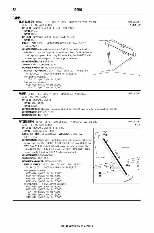
62 IDAHO
PARISBEAR LAKE CO (1U7) 3 E UTC–7(–6DT) N42º14.99´ W111º20.50´
5933 B NOTAM FILE BOIRWY 10–28: H5728X75 (ASPH) S–12.5 MIRL(NSTD)
RWY 10: P–line.RWY 28: Road.
RWY 16–34: H4590X60 (ASPH) S–50, D–64, 2D–102RWY 16: Road.
SERVICE: FUEL 100LL LGT ACTIVATE NSTD MIRL Rwy 10–28 3 clicks—CTAF.
AIRPORT REMARKS: Attended continuously. Fuel 24 hrs credit card self svc avbl. Birds on and invof arpt. No snow removal Rwy 16–34. Reflectors on all twys and aprons. Partial twy 25´ wide. Rwy 10–28 NSTD MIRL mounted aprx 40" abv gnd, 10´ from edge of pavement.
AIRPORT MANAGER: 208-847-1374COMMUNICATIONS: CTAF/UNICOM 122.8RADIO AIDS TO NAVIGATION: NOTAM FILE MLD.
MALAD CITY (H) VORW/DME 117.4 MLD Chan 121 N42º11.99´ W112º27.07´ 069º 49.6 NM to fld. 7330/17E.
VOR portion unusable:157º–167º byd 25 NM blo 11,000´
DME portion unusable:005º–025º byd 30 NM blo 14,000´157º–167º byd 25 NM blo 11,000´
PARMA (50S) 1 S UTC–7(–6DT) N43º46.73´ W116º56.31´2228 NOTAM FILE BOIRWY 12–30: H2700X50 (ASPH)
RWY 12: Tree. Rgt tfc.RWY 30: Fence.
AIRPORT REMARKS: Unattended. Recommend land Rwy 30, tkf Rwy 12 when wind condition permit.AIRPORT MANAGER: 208-722-5138COMMUNICATIONS: CTAF 122.9
PAYETTE MUNI (S75) 2 NE UTC–7(–6DT) N44º05.67´ W116º54.22´2228 B NOTAM FILE BOIRWY 13–31: H3000X50 (ASPH) S–8 LIRL
RWY 13: Thld dsplcd 250´. Tree.SERVICE: S2 FUEL 100LL, MOGAS LGT ACTIVATE LIRL Rwy
13–31—CTAF.AIRPORT REMARKS: Unattended. Fuel 24 hrs credit card svc avbl. Golfers adj
to rwy edges and Rwy 13 thld. Arpt CLOSED to acft over 10,000 lbs GWT. Rwy 31 thld marked with white conc boundary markers. Rwy cntrln NSTD. Rwy 13 dsplcd thld not lgtd. 2885´ MSL (405´ AGL) marked and lgtd steel twr lctd 2.2 miles south of arpt.
AIRPORT MANAGER: 208-642-6024COMMUNICATIONS: CTAF 122.9RADIO AIDS TO NAVIGATION: NOTAM FILE BOI.
BOISE (H) VORTACW 113.3 BOI Chan 80 N43º33.17´ W116º11.53´ 300º 44.8 NM to fld. 2876/17E.
VOR portion unusable:001º–044º byd 22 NM blo 11,000´001º–044º byd 32 NM blo 14,500´045º–071º byd 32 NM blo 12,500´072º–084º byd 32 NM blo 10,500´
TACAN AZIMUTH & DME portion unusable:010º–060º byd 12 NM blo 13,000´010º–060º byd 27 NM blo 15,500´113º–155º byd 30 NM blo 7,000´348º–010º byd 20 NM blo 13,000´348º–010º byd 27 NM blo 15,500´
SALT LAKE CITYH–3D, L–11D
SALT LAKE CITY
SALT LAKE CITYL–11B
NW, 31 MAR 2016 to 26 MAY 2016
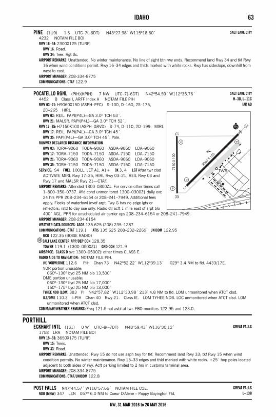
IDAHO 63
PINE (1U9) 1 S UTC–7(–6DT) N43º27.98´ W115º18.60´4232 NOTAM FILE BOIRWY 16–34: 2300X125 (TURF)
RWY 16: Road.RWY 34: Tree. Rgt tfc.
AIRPORT REMARKS: Unattended. No winter maintenance. No line of sight btn rwy ends. Recommend land Rwy 34 and tkf Rwy 16 when wind conditions permit. Rwy 16–34 edges and thlds marked with white rocks. Rwy has sideslope, downhill from west to east.
AIRPORT MANAGER: 208-334-8775COMMUNICATIONS: CTAF 122.9
POCATELLO RGNL (PIH)(KPIH) 7 NW UTC–7(–6DT) N42º54.59´ W112º35.76´4452 B Class I, ARFF Index A NOTAM FILE PIHRWY 03–21: H9060X150 (ASPH–PFC) S–100, D–160, 2S–175,
2D–265 HIRLRWY 03: REIL. PAPI(P4L)—GA 3.0º TCH 53´.RWY 21: MALSR. PAPI(P4L)—GA 3.0º TCH 52´.
RWY 17–35: H7150X100 (ASPH–GRVD) S–74, D–110, 2D–199 MIRLRWY 17: REIL. PAPI(P4L)—GA 3.0º TCH 45´.RWY 35: PAPI(P4L)—GA 3.0º TCH 45´. Pole.
RUNWAY DECLARED DISTANCE INFORMATIONRWY 03: TORA–9060 TODA–9060 ASDA–9060 LDA–9060RWY 17: TORA–7150 TODA–7150 ASDA–7150 LDA–7150RWY 21: TORA–9060 TODA–9060 ASDA–9060 LDA–9060RWY 35: TORA–7150 TODA–7150 ASDA–7150 LDA–7150
SERVICE: S4 FUEL 100LL, JET A1, A1+ OX 3, 4 LGT After twr clsd ACTIVATE MIRL Rwy 17–35, HIRL Rwy 03–21, REIL Rwy 03 and Rwy 17 and MALSR Rwy 21—CTAF.
AIRPORT REMARKS: Attended 1300–0300Z‡. For service other times call 1–800–350–0737. Afld cond unmonitored 1300–0300Z‡ daily exc 24 hrs PPR 208–234–6154 or 208–241–7949. Additional fees apply. Flocks of waterfowl invof arpt. Twy G has no edge lgts or reflectors, rstd to day use only. Radio ctl acft 1 mile east of arpt blo 400´ AGL. PPR for unscheduled air carrier ops 208–234–6154 or 208–241–7949.
AIRPORT MANAGER: 208-234-6154WEATHER DATA SOURCES: ASOS 135.625 (208) 235–1287.COMMUNICATIONS: CTAF 119.1 ATIS 135.625 208–232–2269 UNICOM 122.95
RCO 122.35 (BOISE RADIO)®SALT LAKE CENTER APP/DEP CON 128.35
TOWER 119.1 (1300–0500Z‡) GND CON 121.9AIRSPACE: CLASS D svc 1300–0500Z‡ other times CLASS E.RADIO AIDS TO NAVIGATION: NOTAM FILE PIH.
(H) VORW/DME 112.6 PIH Chan 73 N42º52.22´ W112º39.13´ 029º 3.4 NM to fld. 4433/17E.VOR portion unusable:
060º–130º byd 25 NM blo 13,500´DME portion unusable:
060º–130º byd 25 NM blo 17,000´160º–175º byd 25 NM blo 13,000´
TYHEE NDB (LOM) 383 PI N42º57.82´ W112º30.98´ 213º 4.8 NM to fld. LOM unmonitored when ATCT clsd.ILS/DME 110.3 I–PIH Chan 40 Rwy 21. Class IE. LOM TYHEE NDB. LOC unmonitored when ATCT clsd. LOM
unmonitored when ATCT clsd.COMM/NAV/WEATHER REMARKS: Freq 121.5 not avbl at twr. FBO monitors 122.95 and 123.0.
PORTHILLECKHART INTL (1S1) 0 W UTC–8(–7DT) N48º59.43´ W116º30.12´
1758 LRA NOTAM FILE BOIRWY 15–33: 3650X175 (TURF)
RWY 15: Trees.RWY 33: Road.
AIRPORT REMARKS: Unattended. Rwy 15 do not use asph twy for tkf. Recommend land Rwy 33; tkf Rwy 15 when wind condition permits. No winter maintenance. Rwy 15–33 edges and thld marked with white rocks. +25´ hop poles located adjacent to both sides of rwy. Acft parking limited to 2 hrs in customs terminal area.
AIRPORT MANAGER: 208-334-8775COMMUNICATIONS: CTAF/UNICOM 122.8
POST FALLS N47º44.57´ W116º57.66´ NOTAM FILE COE.NDB (MHW) 347 LEN 057º 6.0 NM to Coeur D'Alene – Pappy Boyington Fld.
SALT LAKE CITY
SALT LAKE CITYH–3D, L–11C
IAP, AD
GREAT FALLS
GREAT FALLSL–13B
NW, 31 MAR 2016 to 26 MAY 2016
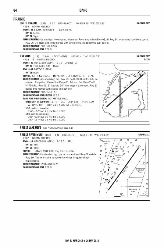
64 IDAHO
PRAIRIESMITH PRAIRIE (2U0) 2 SE UTC–7(–6DT) N43º29.90´ W115º32.82´
4958 NOTAM FILE BOIRWY 06–24: 5400X150 (TURF) 1.6% up NE
RWY 06: Fence.RWY 24: Sign.
AIRPORT REMARKS: Unattended. No winter maintenance. Recommend land Rwy 06, tkf Rwy 24, when wind conditions permit. Rwy 06–24 edges and thlds marked with white rocks. No telephone avbl at arpt.
AIRPORT MANAGER: 208-334-8775COMMUNICATIONS: CTAF 122.9
PRESTON (U10) 2 NW UTC–7(–6DT) N42º06.41´ W111º54.75´4728 B NOTAM FILE BOIRWY 03–21: H3457X50 (ASPH) S–12 LIRL(NSTD)
RWY 21: Thld dsplcd 330´. Road.RWY 16–34: 2437X30 (GRVL)
RWY 16: Road.SERVICE: S2 FUEL 100LL LGT ACTIVATE LIRL Rwy 03–21—CTAF.AIRPORT REMARKS: Attended dalgt hrs. Rwy 16–34 CLOSED winter. Lctd on
plateau. Sharp dropoff near thld Rwys 03, 16, and 34. Rwy 03–21 NSTD LIRL. Rwy 03–21 lgts lctd 50´ from edge of pavement. Rwy 21 dsplcd thld marked with dsplcd thld bar only.
AIRPORT MANAGER: 208-852-2151COMMUNICATIONS: CTAF/UNICOM 122.8RADIO AIDS TO NAVIGATION: NOTAM FILE MLD.
MALAD CITY (H) VORW/DME 117.4 MLD Chan 121 N42º11.99´ W112º27.07´ 086º 24.7 NM to fld. 7330/17E.
VOR portion unusable:157º–167º byd 25 NM blo 11,000´
DME portion unusable:005º–025º byd 30 NM blo 14,000´157º–167º byd 25 NM blo 11,000´
PRIEST LAKE USFS (See NORDMAN on page 61)
PRIEST RIVER MUNI (1S6) 1 N UTC–8(–7DT) N48º11.44´ W116º54.59´2187 NOTAM FILE BOIRWY 01–19: H2950X48 (ASPH) S–12.5 LIRL
RWY 01: Tree.RWY 19: Trees.
SERVICE: LGT ACTIVATE LIRL Rwy 01–19—CTAF.AIRPORT REMARKS: Unattended. Ngt oprs recommend land Rwy 01 and dep
Rwy 19. Tiedown chains removed dur winter. Irregular winter maintenance.
AIRPORT MANAGER: (208) 448-0470COMMUNICATIONS: CTAF 122.9
SALT LAKE CITY
SALT LAKE CITYL–11D
GREAT FALLS
NW, 31 MAR 2016 to 26 MAY 2016
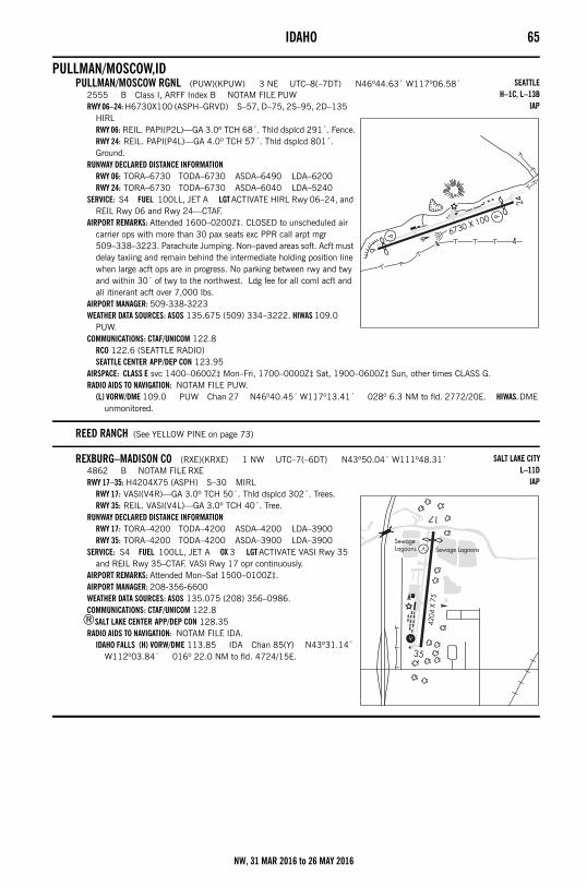
IDAHO 65
PULLMAN/MOSCOW,IDPULLMAN/MOSCOW RGNL (PUW)(KPUW) 3 NE UTC–8(–7DT) N46º44.63´ W117º06.58´
2555 B Class I, ARFF Index B NOTAM FILE PUWRWY 06–24: H6730X100 (ASPH–GRVD) S–57, D–75, 2S–95, 2D–135
HIRLRWY 06: REIL. PAPI(P2L)—GA 3.0º TCH 68´. Thld dsplcd 291´. Fence.RWY 24: REIL. PAPI(P4L)—GA 4.0º TCH 57´. Thld dsplcd 801´. Ground.
RUNWAY DECLARED DISTANCE INFORMATIONRWY 06: TORA–6730 TODA–6730 ASDA–6490 LDA–6200RWY 24: TORA–6730 TODA–6730 ASDA–6040 LDA–5240
SERVICE: S4 FUEL 100LL, JET A LGT ACTIVATE HIRL Rwy 06–24, and REIL Rwy 06 and Rwy 24—CTAF.
AIRPORT REMARKS: Attended 1600–0200Z‡. CLOSED to unscheduled air carrier ops with more than 30 pax seats exc PPR call arpt mgr 509–338–3223. Parachute Jumping. Non–paved areas soft. Acft must delay taxiing and remain behind the intermediate holding position line when large acft ops are in progress. No parking between rwy and twy and within 30´ of twy to the northwest. Ldg fee for all coml acft and all itinerant acft over 7,000 lbs.
AIRPORT MANAGER: 509-338-3223WEATHER DATA SOURCES: ASOS 135.675 (509) 334–3222. HIWAS 109.0
PUW.COMMUNICATIONS: CTAF/UNICOM 122.8
RCO 122.6 (SEATTLE RADIO)SEATTLE CENTER APP/DEP CON 123.95
AIRSPACE: CLASS E svc 1400–0600Z‡ Mon–Fri, 1700–0000Z‡ Sat, 1900–0600Z‡ Sun, other times CLASS G.RADIO AIDS TO NAVIGATION: NOTAM FILE PUW.
(L) VORW/DME 109.0 PUW Chan 27 N46º40.45´ W117º13.41´ 028º 6.3 NM to fld. 2772/20E. HIWAS. DME unmonitored.
REED RANCH (See YELLOW PINE on page 73)
REXBURG–MADISON CO (RXE)(KRXE) 1 NW UTC–7(–6DT) N43º50.04´ W111º48.31´4862 B NOTAM FILE RXERWY 17–35: H4204X75 (ASPH) S–30 MIRL
RWY 17: VASI(V4R)—GA 3.0º TCH 50´. Thld dsplcd 302´. Trees.RWY 35: REIL. VASI(V4L)—GA 3.0º TCH 40´. Tree.
RUNWAY DECLARED DISTANCE INFORMATIONRWY 17: TORA–4200 TODA–4200 ASDA–4200 LDA–3900RWY 35: TORA–4200 TODA–4200 ASDA–3900 LDA–3900
SERVICE: S4 FUEL 100LL, JET A OX 3 LGT ACTIVATE VASI Rwy 35 and REIL Rwy 35–CTAF. VASI Rwy 17 opr continuously.
AIRPORT REMARKS: Attended Mon–Sat 1500–0100Z‡. AIRPORT MANAGER: 208-356-6600WEATHER DATA SOURCES: ASOS 135.075 (208) 356–0986.COMMUNICATIONS: CTAF/UNICOM 122.8
®SALT LAKE CENTER APP/DEP CON 128.35RADIO AIDS TO NAVIGATION: NOTAM FILE IDA.
IDAHO FALLS (H) VORW/DME 113.85 IDA Chan 85(Y) N43º31.14´ W112º03.84´ 016º 22.0 NM to fld. 4724/15E.
SEATTLEH–1C, L–13B
IAP
SALT LAKE CITYL–11D
IAP
NW, 31 MAR 2016 to 26 MAY 2016
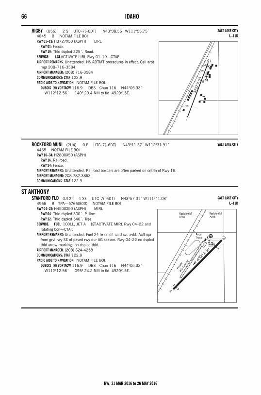
66 IDAHO
RIGBY (U56) 2 S UTC–7(–6DT) N43º38.56´ W111º55.75´4845 B NOTAM FILE BOIRWY 01–19: H3727X50 (ASPH) LIRL
RWY 01: Fence.RWY 19: Thld dsplcd 225´. Road.
SERVICE: LGT ACTIVATE LIRL Rwy 01–19—CTAF.AIRPORT REMARKS: Unattended. NS ABTMT procedures in effect. Call arpt
mgr 208–716–3584. AIRPORT MANAGER: (208) 716-3584COMMUNICATIONS: CTAF 122.9RADIO AIDS TO NAVIGATION: NOTAM FILE BOI.
DUBOIS (H) VORTACW 116.9 DBS Chan 116 N44º05.33´ W112º12.56´ 140º 29.4 NM to fld. 4920/15E.
ROCKFORD MUNI (2U4) 0 E UTC–7(–6DT) N43º11.37´ W112º31.91´4465 NOTAM FILE BOIRWY 16–34: H2800X50 (ASPH)
RWY 16: Railroad.RWY 34: Fence.
AIRPORT REMARKS: Unattended. Railroad boxcars are often parked on cntrln of Rwy 16.AIRPORT MANAGER: 208-782-3863COMMUNICATIONS: CTAF 122.9
ST ANTHONYSTANFORD FLD (U12) 1 SE UTC–7(–6DT) N43º57.01´ W111º41.08´
4966 B TPA—5766(800) NOTAM FILE BOIRWY 04–22: H4500X50 (ASPH) MIRL
RWY 04: Thld dsplcd 300´. P–line.RWY 22: Thld dsplcd 540´. Tree.
SERVICE: FUEL 100LL, JET A LGT ACTIVATE MIRL Rwy 04–22 and rotating bcn—CTAF.
AIRPORT REMARKS: Unattended. Fuel 24 hr credit card svc avbl. Acft opr from grvl rwy SE of paved rwy dur AG season. Rwy 04–22 no dsplcd thld arrow markings on dsplcd thld.
AIRPORT MANAGER: (208) 624-4258COMMUNICATIONS: CTAF 122.9RADIO AIDS TO NAVIGATION: NOTAM FILE BOI.
DUBOIS (H) VORTACW 116.9 DBS Chan 116 N44º05.33´ W112º12.56´ 095º 24.2 NM to fld. 4920/15E.
SALT LAKE CITYL–11D
SALT LAKE CITY
SALT LAKE CITYL–11D
NW, 31 MAR 2016 to 26 MAY 2016
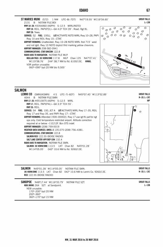
IDAHO 67
ST MARIES MUNI (S72) 1 NW UTC–8(–7DT) N47º19.55´ W116º34.60´2131 B NOTAM FILE BOIRWY 10–28: H3354X60 (ASPH) S–12.5 MIRL(NSTD)
RWY 10: REIL. PAPI(P2L)—GA 4.0º TCH 39´. Road. Rgt tfc.RWY 28: Trees.
SERVICE: S2 FUEL 100LL LGT ACTIVATE NSTD MIRL Rwy 10–28, PAPI Rwy 10 and REIL Rwy 10—CTAF.
AIRPORT REMARKS: Unattended. Rwy 10–28 NSTD MIRL first 715´ west end not lgtd. Rwy 10 NSTD dsplcd thld marking yellow chevrons.
AIRPORT MANAGER: 208-582-0941COMMUNICATIONS: CTAF/UNICOM 122.8RADIO AIDS TO NAVIGATION: NOTAM FILE MLP.
MULLAN PASS (H) VORW/DME 117.8 MLP Chan 125 N47º27.41´ W115º38.76´ 244º 38.7 NM to fld. 6100/15E. HIWAS.
VOR portion unusable:060º–090º byd 20 NM blo 9,500´
SALMONLEMHI CO (SMN)(KSMN) 4 S UTC–7(–6DT) N45º07.40´ W113º52.89´
4044 B NOTAM FILE SMNRWY 17–35: H5510X75 (ASPH) S–12.5 MIRL
RWY 17: REIL. PAPI(P4L)—GA 3.5º TCH 55´.RWY 35: REIL.
SERVICE: S4 FUEL 100, JET A LGT ACTIVATE MIRL Rwy 17–35, REIL Rwy 17 and Rwy 35, and PAPI Rwy 17—CTAF.
AIRPORT REMARKS: Attended 1500–0000Z‡. Rwy 17 use rgt tfc pat for ngt ops only. Cold temperature restricted airport. Altitude correction required at or below –11C/12F. Bcn OTS indef.
AIRPORT MANAGER: (208) 759-0019WEATHER DATA SOURCES: AWOS–3 135.075 (208) 756–4381.COMMUNICATIONS: CTAF/UNICOM 122.8
SALMON RCO 122.55 (BOISE RADIO)SALT LAKE CENTER APP/DEP CON 132.4
RADIO AIDS TO NAVIGATION: NOTAM FILE SMN.SALMON (H) VORW/DME 113.5 LKT Chan 82 N45º01.28´
W114º05.05´ 042º 10.6 NM to fld. 9260/13E.
SALMON N45º01.28´ W114º05.05´ NOTAM FILE SMN.(H) VORW/DME 113.5 LKT Chan 82 042º 10.6 NM to Lemhi Co. 9260/13E.RCO 122.55 (BOISE RADIO)
SANDPOE N48º17.44´ W116º33.79´ NOTAM FILE SZT.NDB (MHW) 264 SZT at Sandpoint.
NDB unusable:170º–200º byd 20 NM200º–360º360º–170º byd 15 NM
GREAT FALLSL–13B
GREAT FALLSH–1D, L–13C
IAP
GREAT FALLSH–1D, L–13C
GREAT FALLSL–13B
NW, 31 MAR 2016 to 26 MAY 2016
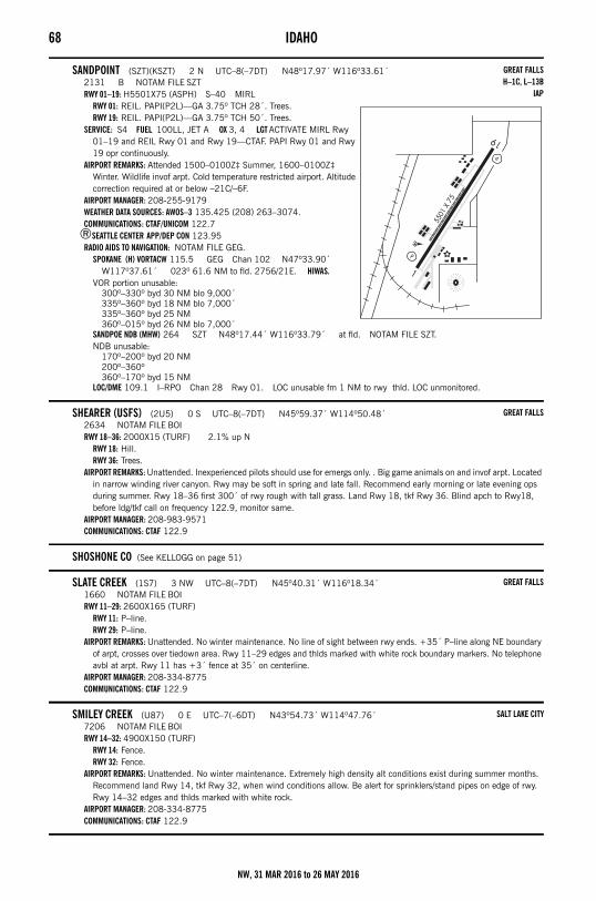
68 IDAHO
SANDPOINT (SZT)(KSZT) 2 N UTC–8(–7DT) N48º17.97´ W116º33.61´2131 B NOTAM FILE SZTRWY 01–19: H5501X75 (ASPH) S–40 MIRL
RWY 01: REIL. PAPI(P2L)—GA 3.75º TCH 28´. Trees.RWY 19: REIL. PAPI(P2L)—GA 3.75º TCH 50´. Trees.
SERVICE: S4 FUEL 100LL, JET A OX 3, 4 LGT ACTIVATE MIRL Rwy 01–19 and REIL Rwy 01 and Rwy 19—CTAF. PAPI Rwy 01 and Rwy 19 opr continuously.
AIRPORT REMARKS: Attended 1500–0100Z‡ Summer, 1600–0100Z‡ Winter. Wildlife invof arpt. Cold temperature restricted airport. Altitude correction required at or below –21C/–6F.
AIRPORT MANAGER: 208-255-9179WEATHER DATA SOURCES: AWOS–3 135.425 (208) 263–3074.COMMUNICATIONS: CTAF/UNICOM 122.7
®SEATTLE CENTER APP/DEP CON 123.95RADIO AIDS TO NAVIGATION: NOTAM FILE GEG.
SPOKANE (H) VORTACW 115.5 GEG Chan 102 N47º33.90´ W117º37.61´ 023º 61.6 NM to fld. 2756/21E. HIWAS.
VOR portion unusable:300º–330º byd 30 NM blo 9,000´335º–360º byd 18 NM blo 7,000´335º–360º byd 25 NM360º–015º byd 26 NM blo 7,000´
SANDPOE NDB (MHW) 264 SZT N48º17.44´ W116º33.79´ at fld. NOTAM FILE SZT.NDB unusable:
170º–200º byd 20 NM200º–360º360º–170º byd 15 NM
LOC/DME 109.1 I–RPO Chan 28 Rwy 01. LOC unusable fm 1 NM to rwy thld. LOC unmonitored.
SHEARER (USFS) (2U5) 0 S UTC–8(–7DT) N45º59.37´ W114º50.48´2634 NOTAM FILE BOIRWY 18–36: 2000X15 (TURF) 2.1% up N
RWY 18: Hill.RWY 36: Trees.
AIRPORT REMARKS: Unattended. Inexperienced pilots should use for emergs only. . Big game animals on and invof arpt. Located in narrow winding river canyon. Rwy may be soft in spring and late fall. Recommend early morning or late evening ops during summer. Rwy 18–36 first 300´ of rwy rough with tall grass. Land Rwy 18, tkf Rwy 36. Blind apch to Rwy18, before ldg/tkf call on frequency 122.9, monitor same.
AIRPORT MANAGER: 208-983-9571COMMUNICATIONS: CTAF 122.9
SHOSHONE CO (See KELLOGG on page 51)
SLATE CREEK (1S7) 3 NW UTC–8(–7DT) N45º40.31´ W116º18.34´1660 NOTAM FILE BOIRWY 11–29: 2600X165 (TURF)
RWY 11: P–line.RWY 29: P–line.
AIRPORT REMARKS: Unattended. No winter maintenance. No line of sight between rwy ends. +35´ P–line along NE boundary of arpt, crosses over tiedown area. Rwy 11–29 edges and thlds marked with white rock boundary markers. No telephone avbl at arpt. Rwy 11 has +3´ fence at 35´ on centerline.
AIRPORT MANAGER: 208-334-8775COMMUNICATIONS: CTAF 122.9
SMILEY CREEK (U87) 0 E UTC–7(–6DT) N43º54.73´ W114º47.76´7206 NOTAM FILE BOIRWY 14–32: 4900X150 (TURF)
RWY 14: Fence.RWY 32: Fence.
AIRPORT REMARKS: Unattended. No winter maintenance. Extremely high density alt conditions exist during summer months. Recommend land Rwy 14, tkf Rwy 32, when wind conditions allow. Be alert for sprinklers/stand pipes on edge of rwy. Rwy 14–32 edges and thlds marked with white rock.
AIRPORT MANAGER: 208-334-8775COMMUNICATIONS: CTAF 122.9
GREAT FALLSH–1C, L–13B
IAP
GREAT FALLS
GREAT FALLS
SALT LAKE CITY
NW, 31 MAR 2016 to 26 MAY 2016
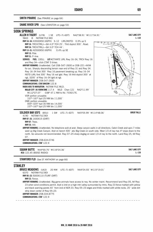
IDAHO 69
SMITH PRAIRIE (See PRAIRIE on page 64)
SNAKE RIVER SPB (See LEWISTON on page 53)
SODA SPRINGSALLEN H TIGERT (U78) 1 SE UTC–7(–6DT) N42º38.91´ W111º34.91´
5843 B NOTAM FILE BOIRWY 16–34: H3500X50 (ASPH) S–12 LIRL(NSTD) 0.3% up S
RWY 16: TRCV(TRIL)—GA 4.0º TCH 25´. Thld dsplcd 300´. Road.RWY 34: TRCV(TRIL)—GA 3.0º TCH 44´.
RWY 13–31: H2500X50 (ASPH) 0.4% up SERWY 13: Pole.RWY 31: P–line.
SERVICE: FUEL 100LL LGT ACTIVATE LIRL Rwy 16–34, TRCV Rwy 16 and Rwy 34—click CTAF 5 times.
AIRPORT REMARKS: Unattended. Call 208–547–2600 or 208–221–4494 for svc. Sharply descending terrain near end of Rwy 31 and Rwy 34. Rwy 16–34 first 300´ Rwy 16 pavement breaking up. Rwy 16–34 NSTD LIRL first 300´ Rwy 16 not lgtd. Rwy 16 thld dsplcd 300´ at ngt, 3200´ of Rwy 16–34 lgtd at ngt.
AIRPORT MANAGER: 208-547-2600COMMUNICATIONS: CTAF/UNICOM 122.8RADIO AIDS TO NAVIGATION: NOTAM FILE MLD.
MALAD CITY (H) VORW/DME 117.4 MLD Chan 121 N42º11.99´ W112º27.07´ 038º 47.1 NM to fld. 7330/17E.
VOR portion unusable:157º–167º byd 25 NM blo 11,000´
DME portion unusable:005º–025º byd 30 NM blo 14,000´157º–167º byd 25 NM blo 11,000´
SOLDIER BAR USFS (85U) 1 SW UTC–7(–6DT) N45º05.99´ W114º48.06´4190 NOTAM FILE BOIRWY 07–25: 1650X15 (DIRT)
RWY 07: Trees.RWY 25: Hill.
AIRPORT REMARKS: Unattended. No telephone avbl at arpt. Steep canyon walls in all directions. Cabin Creek arpt aprx 7 miles west up Big Creek Canyon. Arpt on bench 500´ abv Big Creek on south side. West 1/3 of rwy has 4º slope down to the north. Go–arounds not recommended. Rwy 07–25 sharp dogleg on west 1/3 of rwy to the north. Land Rwy 25, tkf Rwy 07.
AIRPORT MANAGER: 208-634-0746COMMUNICATIONS: CTAF 122.9
SQUAW BUTTE N44º00.70´ W116º24.36´RCO 122.45 (BOISE RADIO)
STANFORD FLD (See ST ANTHONY on page 66)
STANLEYBRUCE MEADOWS (U63) 20 NW UTC–7(–6DT) N44º24.93´ W115º19.01´
6370 NOTAM FILE BOIRWY 05–23: 5000X110 (TURF–DIRT)
RWY 23: Fence.AIRPORT REMARKS: Unattended. Big game animals have access to rwy. No winter maint. Recommend land Rwy 05, tkf Rwy
23 when wind conditions permit. Arpt is lctd on a high mtn valley surrounded by mtns. Rwy 23 fence marked with yellow and black warning panels 40´ from end of AER 23. Rwy 05–23 edges and thlds marked with white rocks. 20´ wide dirt strip down center of Rwy 05–23.
AIRPORT MANAGER: 208-334-8775COMMUNICATIONS: CTAF 122.9
– – – – – – – – – – – – – – – – – – – – – – – – – – – – – – – – – – – – – – – – – – – – – – – – – – – – – – –
SALT LAKE CITYL–11D
GREAT FALLS
SALT LAKE CITYL–11B
SALT LAKE CITY
NW, 31 MAR 2016 to 26 MAY 2016
70 IDAHO– – – – – – – – – – – – – – – – – – – – – – – – – – – – – – – – – – – – – – – – – – – – – – – – – – – – – – – –
STANLEY (2U7) 1 SE UTC–7(–6DT) N44º12.51´ W114º56.07´6403 NOTAM FILE BOIRWY 17–35: H4300X150 (ASPH–DIRT)
RWY 17: Trees.RWY 35: Fence.
AIRPORT REMARKS: Unattended. No winter maint. Arpt lctd in valley surrounded by high mountainous terrain. Numerous air taxi ops dur the summer months. First 1600´ Rwy 17 asph 30´ wide. Rwy 17–35 NSTD markings, rwy edges and thlds marked with white rocks.
AIRPORT MANAGER: 208-334-8775COMMUNICATIONS: CTAF 122.9
– – – – – – – – – – – – – – – – – – – – – – – – – – – – – – – – – – – – – – – – – – – – – – – – – – – – – – – –
THOMAS CREEK (2U8) 31 N UTC–7(–6DT) N44º43.40´ W115º00.24´4415 NOTAM FILE BOIRWY 03–21: 2100X75 (TURF–DIRT) 2.5% up SW
RWY 03: Hill.RWY 21: Tree.
AIRPORT REMARKS: Unattended. No winter maint. Recommend ldg Rwy 21, tkf Rwy 03, go arounds extremely difficult. Rwy 03 first 400´ is dog leg with a heading of 360º. Acft loading and unloading at the south end of Rwy 21. Considerable air taxi ops mid to late summer. Rwy 03–21 usable width may vary from 75´ to 100´. Arpt is lctd on plateau 100–150´ abv river.
AIRPORT MANAGER: 208-334-8775COMMUNICATIONS: CTAF 122.9
STANLEY N44º10.19´ W114º55.87´RCO 122.6 (BOISE RADIO)
STEELHEAD N42º54.97´ W114º40.45´ NOTAM FILE BOI.NDB (MHW) 211 HDG 255º 4.0 NM to Gooding Muni.
NDB unusable:Byd 15 NM
STRIK N42º28.72´ W114º21.26´ NOTAM FILE TWF.NDB (LOM) 389 TW 259º 5.9 NM to Joslin Fld – Magic Valley Rgnl.
STURGEON N43º06.80´ W115º39.51´ NOTAM FILE BOI.NDB (MHW) 333 STI 276º 3.4 NM to Mountain Home Muni.
NDB unusable:324º–024º byd 15 NM
SWEDEN N43º25.93´ W112º09.75´ NOTAM FILE BOI.NDB (MHW) 350 SWU 024º 6.3 NM to Idaho Falls Rgnl.
TANGLEFOOT SPB (See CAVANAUGH BAY on page 38)
THOMAS CREEK (See STANLEY on page 70)
THREE CREEKMURPHY HOT SPRINGS (3U0) 9 W UTC–7(–6DT) N42º01.41´ W115º20.13´
5829 NOTAM FILE BOIRWY 01–19: 5250X120 (TURF) 1.2% up S
RWY 01: Fence.RWY 19: Fence.
AIRPORT REMARKS: Unattended. No telephone avbl at arpt. No winter maint. No line of sight between rwy ends. Recommend land Rwy 19 and depart Rwy 01 when wind conditions permit. Rwy soft in spring and when wet. Rwy 01–19 edges and thlds marked with white rock.
AIRPORT MANAGER: 208-334-8775COMMUNICATIONS: CTAF 122.9
TWIN BRIDGES (See KETCHUM on page 52)
SALT LAKE CITY
GREAT FALLS
SALT LAKE CITYL–11C
SALT LAKE CITYL–11C
SALT LAKE CITY
SALT LAKE CITYL–11B
SALT LAKE CITYL–11D
SALT LAKE CITY
NW, 31 MAR 2016 to 26 MAY 2016
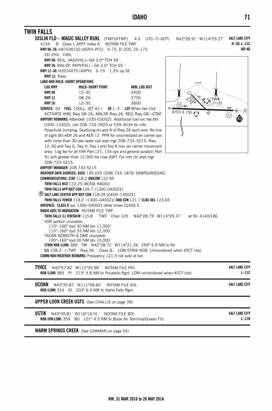
IDAHO 71
TWIN FALLSJOSLIN FLD – MAGIC VALLEY RGNL (TWF)(KTWF) 4 S UTC–7(–6DT) N42º28.91´ W114º29.27´
4154 B Class I, ARFF Index A NOTAM FILE TWFRWY 08–26: H8703X150 (ASPH–PFC) S–75, D–200, 2S–175,
2D–250 HIRLRWY 08: REIL. VASI(V4L)—GA 3.0º TCH 58´.RWY 26: MALSR. PAPI(P4L)—GA 3.0º TCH 55´.
RWY 12–30: H3224X75 (ASPH) S–19 1.3% up SERWY 12: Trees.
LAND AND HOLD–SHORT OPERATIONSLDG RWY HOLD–SHORT POINT AVBL LDG DISTRWY 08 12–30 4500RWY 12 08–26 2750RWY 26 12–30 3600
SERVICE: S4 FUEL 100LL, JET A1+ OX 1, 3 LGT When twr clsd ACTIVATE HIRL Rwy 08–26, MALSR Rwy 26, REIL Rwy 08—CTAF.
AIRPORT REMARKS: Attended 1330–0300Z‡. Additional fuel svc fee btn 0300–1330Z‡, call 208–733–5920 or 539–4034 for info. Parachute Jumping. Skydiving on arpt N of Rwy 26 apch end. No line of sight btn AER 26 and AER 12. PPR for unscheduled air carrier ops with more than 30 pax seats call arpt mgr 208–733–5215. Rwy 12–30 and Twy G, Twy H, Twy J and Twy K non–air carrier movement area. Ldg fee for all FAR Part 121, 135 ops and general aviation Part 91 acft greater than 12,500 lbs max GWT. For info ctc arpt mgr 208–733–5215.
AIRPORT MANAGER: 208-733-5215WEATHER DATA SOURCES: ASOS 135.025 (208) 733–1878. SAWRS/WSO/AG.COMMUNICATIONS: CTAF 118.2 UNICOM 122.95
TWIN FALLS RCO 122.25 (BOISE RADIO)TWIN FALLS APP/DEP CON 126.7 (1300–0400Z‡)
®SALT LAKE CENTER APP/DEP CON 118.05 (0400–1300Z‡)TWIN FALLS TOWER 118.2 (1300–0400Z‡) GND CON 121.7 CLNC DEL 123.65
AIRSPACE: CLASS D svc 1300–0400Z‡ other times CLASS E.RADIO AIDS TO NAVIGATION: NOTAM FILE TWF.
TWIN FALLS (L) VORTACW 115.8 TWF Chan 105 N42º28.79´ W114º29.37´ at fld. 4140/18E.VOR portion unusable:
115º–160º byd 30 NM blo 11,000´115º–160º byd 33 NM blo 12,000´
TACAN AZIMUTH & DME unusable:105º–160º byd 20 NM blo 15,000´
STRIK NDB (LOM) 389 TW N42º28.72´ W114º21.26´ 259º 5.9 NM to fld. ILS 108.3 I–TWF Rwy 26. Class IE. LOM STRIK NDB. Unmonitored when ATCT clsd.
COMM/NAV/WEATHER REMARKS: Frequency 121.5 not avbl at twr.
TYHEE N42º57.82´ W112º30.98´ NOTAM FILE PIH.NDB (LOM) 383 PI 213º 4.8 NM to Pocatello Rgnl. LOM unmonitored when ATCT clsd.
UCONN N43º35.87´ W111º58.84´ NOTAM FILE IDA.NDB (LOM) 324 ID 203º 6.4 NM to Idaho Falls Rgnl.
UPPER LOON CREEK USFS (See CHALLIS on page 39)
USTIK N43º35.81´ W116º18.91´ NOTAM FILE BOI.NDB (HW/LOM) 359 BO 101º 4.5 NM to Boise Air Terminal/Gowen Fld.
WARM SPRINGS CREEK (See LOWMAN on page 54)
SALT LAKE CITYH–3D, L–11C
IAP, AD
SALT LAKE CITYL–11C
SALT LAKE CITY
SALT LAKE CITYL–11B
NW, 31 MAR 2016 to 26 MAY 2016
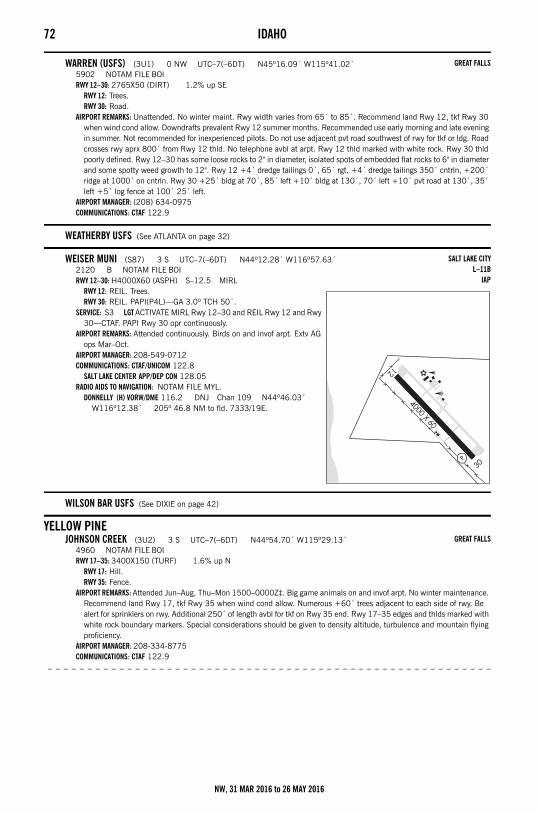
72 IDAHO
WARREN (USFS) (3U1) 0 NW UTC–7(–6DT) N45º16.09´ W115º41.02´5902 NOTAM FILE BOIRWY 12–30: 2765X50 (DIRT) 1.2% up SE
RWY 12: Trees.RWY 30: Road.
AIRPORT REMARKS: Unattended. No winter maint. Rwy width varies from 65´ to 85´. Recommend land Rwy 12, tkf Rwy 30 when wind cond allow. Downdrafts prevalent Rwy 12 summer months. Recommended use early morning and late evening in summer. Not recommended for inexperienced pilots. Do not use adjacent pvt road southwest of rwy for tkf or ldg. Road crosses rwy aprx 800´ from Rwy 12 thld. No telephone avbl at arpt. Rwy 12 thld marked with white rock. Rwy 30 thld poorly defined. Rwy 12–30 has some loose rocks to 2" in diameter, isolated spots of embedded flat rocks to 6" in diameter and some spotty weed growth to 12". Rwy 12 +4´ dredge tailings 0´, 65´ rgt, +4´ dredge tailings 350´ cntrln, +200´ ridge at 1000´ on cntrln. Rwy 30 +25´ bldg at 70´, 85´ left +10´ bldg at 130´, 70´ left +10´ pvt road at 130´, 35´ left +5´ log fence at 100´ 25´ left.
AIRPORT MANAGER: (208) 634-0975COMMUNICATIONS: CTAF 122.9
WEATHERBY USFS (See ATLANTA on page 32)
WEISER MUNI (S87) 3 S UTC–7(–6DT) N44º12.28´ W116º57.63´2120 B NOTAM FILE BOIRWY 12–30: H4000X60 (ASPH) S–12.5 MIRL
RWY 12: REIL. Trees.RWY 30: REIL. PAPI(P4L)—GA 3.0º TCH 50´.
SERVICE: S3 LGT ACTIVATE MIRL Rwy 12–30 and REIL Rwy 12 and Rwy 30—CTAF. PAPI Rwy 30 opr continuously.
AIRPORT REMARKS: Attended continuously. Birds on and invof arpt. Extv AG ops Mar–Oct.
AIRPORT MANAGER: 208-549-0712COMMUNICATIONS: CTAF/UNICOM 122.8
SALT LAKE CENTER APP/DEP CON 128.05RADIO AIDS TO NAVIGATION: NOTAM FILE MYL.
DONNELLY (H) VORW/DME 116.2 DNJ Chan 109 N44º46.03´ W116º12.38´ 205º 46.8 NM to fld. 7333/19E.
WILSON BAR USFS (See DIXIE on page 42)
YELLOW PINEJOHNSON CREEK (3U2) 3 S UTC–7(–6DT) N44º54.70´ W115º29.13´
4960 NOTAM FILE BOIRWY 17–35: 3400X150 (TURF) 1.6% up N
RWY 17: Hill.RWY 35: Fence.
AIRPORT REMARKS: Attended Jun–Aug, Thu–Mon 1500–0000Z‡. Big game animals on and invof arpt. No winter maintenance. Recommend land Rwy 17, tkf Rwy 35 when wind cond allow. Numerous +60´ trees adjacent to each side of rwy. Be alert for sprinklers on rwy. Additional 250´ of length avbl for tkf on Rwy 35 end. Rwy 17–35 edges and thlds marked with white rock boundary markers. Special considerations should be given to density altitude, turbulence and mountain flying proficiency.
AIRPORT MANAGER: 208-334-8775COMMUNICATIONS: CTAF 122.9
– – – – – – – – – – – – – – – – – – – – – – – – – – – – – – – – – – – – – – – – – – – – – – – – – – – – – – – –
GREAT FALLS
SALT LAKE CITYL–11B
IAP
GREAT FALLS
NW, 31 MAR 2016 to 26 MAY 2016
IDAHO 73– – – – – – – – – – – – – – – – – – – – – – – – – – – – – – – – – – – – – – – – – – – – – – – – – – – – – – –
REED RANCH (I92) 12 SW UTC–7(–6DT) N44º53.50´ W115º42.78´4157 NOTAM FILE BOIRWY 16–34: 2175X100 (TURF–DIRT)
RWY 16: Tree.RWY 34: Road.
AIRPORT REMARKS: Unattended. Arpt CLOSED Nov 1 to Apr 30 exc for emerg ops. No line of sight btn rwy ends. No snow removal. Preferred land Rwy 16, depart Rwy 34. All ops conducted in VFR cond. Rwy 16–34 marked with white rock boundary markers. Arpt lctd in valley surrounded by high terrain all quads.
AIRPORT MANAGER: 208-334-8895COMMUNICATIONS: CTAF 122.9
GREAT FALLS
NW, 31 MAR 2016 to 26 MAY 2016
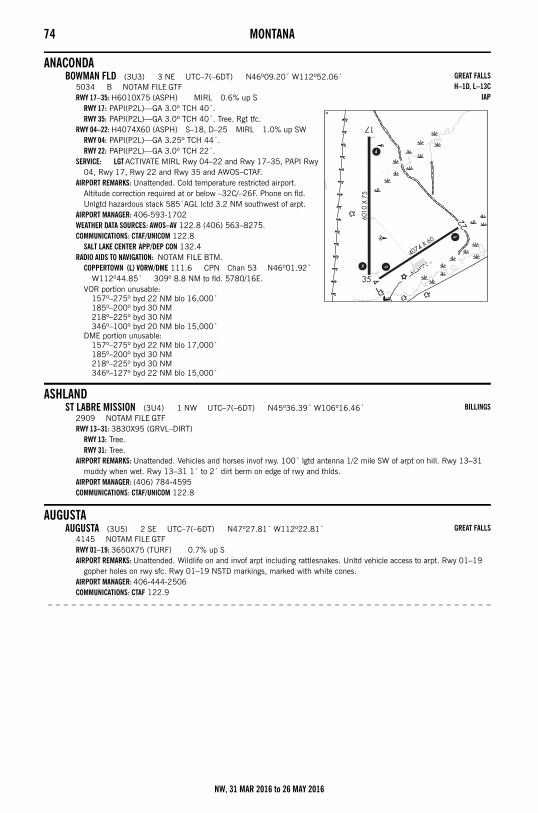
74 MONTANAMontana
ANACONDABOWMAN FLD (3U3) 3 NE UTC–7(–6DT) N46º09.20´ W112º52.06´
5034 B NOTAM FILE GTFRWY 17–35: H6010X75 (ASPH) MIRL 0.6% up S
RWY 17: PAPI(P2L)—GA 3.0º TCH 40´.RWY 35: PAPI(P2L)—GA 3.0º TCH 40´. Tree. Rgt tfc.
RWY 04–22: H4074X60 (ASPH) S–18, D–25 MIRL 1.0% up SWRWY 04: PAPI(P2L)—GA 3.25º TCH 44´.RWY 22: PAPI(P2L)—GA 3.0º TCH 22´.
SERVICE: LGT ACTIVATE MIRL Rwy 04–22 and Rwy 17–35, PAPI Rwy 04, Rwy 17, Rwy 22 and Rwy 35 and AWOS–CTAF.
AIRPORT REMARKS: Unattended. Cold temperature restricted airport. Altitude correction required at or below –32C/–26F. Phone on fld. Unlgtd hazardous stack 585´AGL lctd 3.2 NM southwest of arpt.
AIRPORT MANAGER: 406-593-1702WEATHER DATA SOURCES: AWOS–AV 122.8 (406) 563–8275.COMMUNICATIONS: CTAF/UNICOM 122.8
SALT LAKE CENTER APP/DEP CON 132.4RADIO AIDS TO NAVIGATION: NOTAM FILE BTM.
COPPERTOWN (L) VORW/DME 111.6 CPN Chan 53 N46º01.92´ W112º44.85´ 309º 8.8 NM to fld. 5780/16E.
VOR portion unusable:157º–275º byd 22 NM blo 16,000´185º–200º byd 30 NM218º–225º byd 30 NM346º–100º byd 20 NM blo 15,000´
DME portion unusable:157º–275º byd 22 NM blo 17,000´185º–200º byd 30 NM218º–225º byd 30 NM346º–127º byd 22 NM blo 15,000´
ASHLANDST LABRE MISSION (3U4) 1 NW UTC–7(–6DT) N45º36.39´ W106º16.46´
2909 NOTAM FILE GTFRWY 13–31: 3830X95 (GRVL–DIRT)
RWY 13: Tree.RWY 31: Tree.
AIRPORT REMARKS: Unattended. Vehicles and horses invof rwy. 100´ lgtd antenna 1/2 mile SW of arpt on hill. Rwy 13–31 muddy when wet. Rwy 13–31 1´ to 2´ dirt berm on edge of rwy and thlds.
AIRPORT MANAGER: (406) 784-4595COMMUNICATIONS: CTAF/UNICOM 122.8
AUGUSTAAUGUSTA (3U5) 2 SE UTC–7(–6DT) N47º27.81´ W112º22.81´
4145 NOTAM FILE GTFRWY 01–19: 3650X75 (TURF) 0.7% up SAIRPORT REMARKS: Unattended. Wildlife on and invof arpt including rattlesnakes. Unltd vehicle access to arpt. Rwy 01–19
gopher holes on rwy sfc. Rwy 01–19 NSTD markings, marked with white cones.AIRPORT MANAGER: 406-444-2506COMMUNICATIONS: CTAF 122.9
– – – – – – – – – – – – – – – – – – – – – – – – – – – – – – – – – – – – – – – – – – – – – – – – – – – – – – – –
GREAT FALLSH–1D, L–13C
IAP
BILLINGS
GREAT FALLS
NW, 31 MAR 2016 to 26 MAY 2016
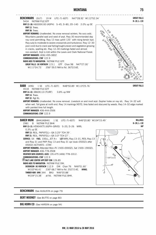
MONTANA 75– – – – – – – – – – – – – – – – – – – – – – – – – – – – – – – – – – – – – – – – – – – – – – – – – – – – – – –
BENCHMARK (3U7) 19 W UTC–7(–6DT) N47º28.92´ W112º52.34´5434 NOTAM FILE GTFRWY 12–30: H6000X100 (ASPH) S–45, D–80, 2D–140 2.0% up SE
RWY 12: Trees.RWY 30: Trees.
AIRPORT REMARKS: Unattended. No snow removal winters. No svcs avbl. Mountains parallel east and west of arpt. Rwy 30 recommended dep rwy cond permitting. Rwy 12 rises uphill 120´ with rising terrain byd. Rwy subj to moderate to severe crosswinds and turbulence. Rwy 12–30 poor cond due to crack seal failing/rough/uneven and vegetation growing in cracks, spalling etc. Rwy 12–30 markings faded and almost non–existant. Arpt is lctd within the Lewis and Clark National Forest.
AIRPORT MANAGER: (406) 495-3832COMMUNICATIONS: CTAF 122.9RADIO AIDS TO NAVIGATION: NOTAM FILE GTF.
GREAT FALLS (H) VORTACW 115.1 GTF Chan 98 N47º27.00´ W111º24.73´ 256º 59.5 NM to fld. 3672/16E.
BABB (49S) 1 SE UTC–7(–6DT) N48º50.89´ W113º25.76´4518 NOTAM FILE GTFRWY 14–32: 3860X110 (TURF) 0.8% up NW
RWY 14: Trees.RWY 32: Rgt tfc.
AIRPORT REMARKS: Unattended. No snow removal. Livestock on and invof arpt. Gopher holes on rwy sfc. Rwy 14–32 soft when wet. Tall grass at north end. Rwy 14 markings NSTD, tires faded and obscured by weeds. Rwy 14–32 edge marked with painted tires full length.
AIRPORT MANAGER: 406-444-2506COMMUNICATIONS: CTAF 122.9
BAKER MUNI (BHK)(KBHK) 1 SE UTC–7(–6DT) N46º20.80´ W104º15.49´2981 B NOTAM FILE BHKRWY 13–31: H5904X75 (ASPH–GRVD) S–20, D–26 MIRL
0.3% up SERWY 13: REIL. PAPI(P2L)—GA 3.25º TCH 39´.RWY 31: REIL. PAPI(P2L)—GA 3.0º TCH 27´.
SERVICE: S4 FUEL 100LL, JET A+ LGT MIRL Rwy 13–31, REIL Rwy 13 and Rwy 31 and PAPI Rwy 13 and Rwy 31 opr dusk–0500Z‡ after 0500Z‡ ACTIVATE—CTAF.
AIRPORT REMARKS: Attended Mon–Fri 1500–0000Z‡, Sat 1500–1900Z‡. AIRPORT MANAGER: 406-778-3508WEATHER DATA SOURCES: ASOS 135.475 (406) 778–3312.COMMUNICATIONS: CTAF 122.9
®SALT LAKE CENTER APP/DEP CON 126.85RADIO AIDS TO NAVIGATION: NOTAM FILE DIK.
DICKINSON (H) VORTACW 112.9 DIK Chan 76 N46º51.60´ W102º46.41´ 230º 68.7 NM to fld. 2527/14E. HIWAS.
TIMBER NDB (HW) 344 BKU N46º20.88´ W104º15.38´ at fld. NOTAM FILE BHK.
BENCHMARK (See AUGUSTA on page 75)
BERT MOONEY (See BUTTE on page 80)
BIG HORN CO (See HARDIN on page 94)
GREAT FALLSH–1D, L–13C
GREAT FALLS
BILLINGSH–2H, L–13E
IAP
NW, 31 MAR 2016 to 26 MAY 2016
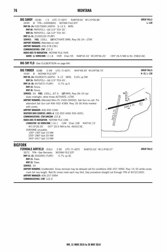
76 MONTANA
BIG SANDY (3U8) 1 S UTC–7(–6DT) N48º09.81´ W110º06.86´2699 B TPA—3499(800) NOTAM FILE GTFRWY 06–24: H3570X60 (ASPH) S–12.5 MIRL
RWY 06: PAPI(P2L)—GA 3.0º TCH 30´.RWY 24: PAPI(P2L)—GA 3.0º TCH 30´.
RWY 13–31: 2100X100 (TURF)SERVICE: FUEL 100LL LGT ACTIVATE MIRL Rwy 06–24—CTAF.AIRPORT REMARKS: Attended on call. AIRPORT MANAGER: 406-378-2361COMMUNICATIONS: CTAF 122.9RADIO AIDS TO NAVIGATION: NOTAM FILE HVR.
HAVRE (L) VORW/DME 111.8 HVR Chan 55 N48º32.43´ W109º46.20´ 195º 26.5 NM to fld. 2583/16E.
BIG SKY FLD (See CULBERTSON on page 84)
BIG TIMBER (6S0) 3 SW UTC–7(–6DT) N45º48.39´ W109º58.70´4494 B NOTAM FILE GTFRWY 06–24: H5285X75 (ASPH) S–12 MIRL 0.6% up SW
RWY 24: PAPI(P2L)—GA 3.5º TCH 45´.RWY 18–36: 3475X75 (TURF) 0.7% up S
RWY 18: Fence.RWY 36: Fence.
SERVICE: S4 FUEL 100LL, JET A LGT MIRL Rwy 06–24 opr dusk–midnight, other times ACTIVATE—CTAF.
AIRPORT REMARKS: Attended Mon–Fri 1500–0000Z‡, Sat–Sun on call. For attendant Sat–Sun call 406–932–4389. Rwy 18–36 thlds marked with cones.
AIRPORT MANAGER: 406-930-1040WEATHER DATA SOURCES: AWOS–A 132.050 (406) 932–6051.COMMUNICATIONS: CTAF/UNICOM 122.8RADIO AIDS TO NAVIGATION: NOTAM FILE LVM.
LIVINGSTON (H) VORW/DME 116.1 LVM Chan 108 N45º42.15´ W110º26.55´ 057º 20.5 NM to fld. 4653/15E.
VOR/DME unusable:100º–190º byd 15 NM255º–280º byd 20 NM345º–041º byd 15 NM
BIGFORKFERNDALE AIRFIELD (53U) 3 NE UTC–7(–6DT) N48º03.63´ W114º00.07´
3072 TPA—See Remarks NOTAM FILE GTFRWY 15–33: 3500X95 (TURF) 0.7% up SE
RWY 15: Trees.RWY 33: Trees.
SERVICE: S4 AIRPORT REMARKS: Unattended. Snow removal may be delayed call for conditions 406–257–5994. Rwy 15–33 white cones
mark full rwy length. Red tfc cones mark each rwy thld. Dep procedure straight out through TPA of 4072(1000).AIRPORT MANAGER: 406-257-5994COMMUNICATIONS: CTAF 122.9
GREAT FALLSL–13D
GREAT FALLSH–1E, L–13D
GREAT FALLS
NW, 31 MAR 2016 to 26 MAY 2016
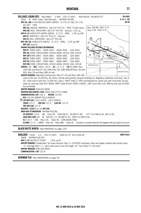
MONTANA 77
BILLINGS LOGAN INTL (BIL)(KBIL) 2 NW UTC–7(–6DT) N45º48.46´ W108º32.57´3652 B ARFF Index—See Remarks NOTAM FILE BILRWY 10L–28R: H10518X150 (ASPH–GRVD) S–116, D–182, 2S–175,
2D–307 HIRLRWY 10L: MALSR. PAPI(P4L)—GA 3.0º TCH 51´. RVR–T 0.8% down.RWY 28R: REIL. PAPI(P4R)—GA 3.0º TCH 56´. Ground. 1.0% up.
RWY 07–25: H5501X75 (ASPH–GRVD) S–12.5 MIRL 1.9% up SWRWY 07: PAPI(P4L)—GA 3.0º TCH 31´. Ground.RWY 25: REIL. PAPI(P4R)—GA 3.0º TCH 36´.
RWY 10R–28L: H3801X75 (ASPH) S–12.5 MIRL 1.2% up NWRWY 10R: Ground.
RUNWAY DECLARED DISTANCE INFORMATIONRWY 07: TORA–5501 TODA–5501 ASDA–5501 LDA–5501RWY 10L:TORA–10518 TODA–10518 ASDA–10518 LDA–10518RWY 10R:TORA–3801 TODA–3801 ASDA–3801 LDA–3801RWY 25: TORA–5501 TODA–5501 ASDA–5501 LDA–5501RWY 28L:TORA–3801 TODA–3801 ASDA–3801 LDA–3801RWY 28R:TORA–10518TODA–10518 ASDA–10518 LDA–10518
SERVICE: S4 FUEL 100LL, JET A OX 1, 2, 3, 4 LGT For MIRL Rwy 10R–28L and Rwy 07–25, HIRL Rwy 10L–28R, MALSR Rwy 10L and REIL Rwy 25 and Rwy 28R ctc twr.
AIRPORT REMARKS: Attended continuously. Rwy 07–25 and Rwy 10R–28L clsd to acft over 12,500 lbs. No cstms, remote acft parking, ltd gnd handling svc. Migratory waterfowl invof arpt. Twy D 35´ wide clsd to acft over 12,500 lbs. Class I, ARFF Index C. PPR unscheduled air carrier ops with more than 30 pax seats ctc arpt ops 406–657–8496. ARFF Index B from 0900–1200Z‡. 180º turns Rwy 10L–28R by acft over 25,000 lbs prohibited.
AIRPORT MANAGER: 406-657-8495WEATHER DATA SOURCES: ASOS (406) 248–2773 LLWAS.COMMUNICATIONS: ATIS 126.3 UNICOM 122.95
RCO 122.55 (GREAT FALLS RADIO)® APP/DEP CON 119.2 (EAST) 120.5 (WEST)
TOWER 127.2 GND CON 121.9 CLNC DEL 121.9 PRE TAXI CLNC 121.9
AIRSPACE: CLASS C svc ctc APP CONRADIO AIDS TO NAVIGATION: NOTAM FILE BIL.
(H) VORTACW 114.5 BIL Chan 92 N45º48.51´ W108º37.48´ 077º 3.4 NM to fld. 3811/14E.SAIGE NDB (LOM) 251 BI N45º51.13´ W108º41.67´ 099º 6.9 NM to fld. ILS 110.3 I–BIL Rwy 10L. Class IB. LOM SAIGE NDB. ILS/DME 111.5 I–BMO Chan 52 Rwy 28R. Class IA. Localizer unusable beyond 20 degrees left and right of course.
BLACK BUTTE NORTH (See WINIFRED on page 122)
BOULDER (3U9) 2 S UTC–7(–6DT) N46º12.70´ W112º06.46´4968 NOTAM FILE GTFRWY 11–29: 3675X72 (TURF) 1.6% up WAIRPORT REMARKS: Unattended. No snow removal. Rwy 11–29 NSTD markings, thlds and edges marked with white cones.
–2´ drainage ditch +1´ berm west side of rwy full length, 43´ from Rwy 11–29 cntrln.AIRPORT MANAGER: 406-225-9529COMMUNICATIONS: CTAF 122.9
BOWMAN FLD (See ANACONDA on page 74)
BILLINGSH–1E, L–13D
IAP, AD
GREAT FALLS
NW, 31 MAR 2016 to 26 MAY 2016
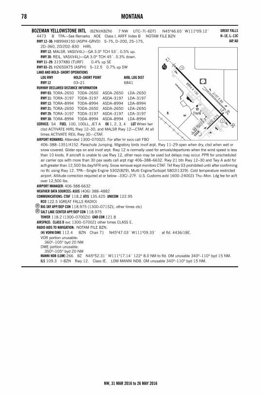
78 MONTANA
BOZEMAN YELLOWSTONE INTL (BZN)(KBZN) 7 NW UTC–7(–6DT) N45º46.65´ W111º09.12´4473 B TPA—See Remarks AOE Class I, ARFF Index B NOTAM FILE BZNRWY 12–30: H8994X150 (ASPH–GRVD) S–75, D–200, 2S–175,
2D–360, 2D/2D2–830 HIRLRWY 12: MALSR. VASI(V4L)—GA 3.0º TCH 53´. 0.5% up.RWY 30: REIL. VASI(V4L)—GA 3.0º TCH 45´. 0.3% down.
RWY 11–29: 3197X80 (TURF) 0.4% up SERWY 03–21: H2650X75 (ASPH) S–12.5 0.7% up SWLAND AND HOLD–SHORT OPERATIONS
LDG RWY HOLD–SHORT POINT AVBL LDG DISTRWY 12 03–21 6841
RUNWAY DECLARED DISTANCE INFORMATIONRWY 03: TORA–2650 TODA–2650 ASDA–2650 LDA–2650RWY 11: TORA–3197 TODA–3197 ASDA–3197 LDA–3197RWY 12: TORA–8994 TODA–8994 ASDA–8994 LDA–8994RWY 21: TORA–2650 TODA–2650 ASDA–2650 LDA–2650RWY 29: TORA–3197 TODA–3197 ASDA–3197 LDA–3197RWY 30: TORA–8994 TODA–8994 ASDA–8994 LDA–8994
SERVICE: S4 FUEL 100, 100LL, JET A OX 1, 2, 3, 4 LGT When twr clsd ACTIVATE HIRL Rwy 12–30, and MALSR Rwy 12—CTAF. At all times ACTIVATE REIL Rwy 30—CTAF.
AIRPORT REMARKS: Attended 1300–0700Z‡. For after hr svcs call FBO 406–388–1351/4152. Parachute Jumping. Migratory birds invof arpt. Rwy 11–29 open when dry, clsd when wet or snow covered. Glider ops on and invof arpt. Rwy 12 is normally used for arrivals/departures when the wind speed is less than 10 knots. If aircraft is unable to use Rwy 12, other rwys may be used but delays may occur. PPR for unscheduled air carrier ops with more than 30 pax seats call arpt mgr 406–388–6632. Rwy 21 btn Rwy 12–30 and Twy A avbl for acft greater than 12,500 lbs day/VFR only. Snow removal eqpt monitors CTAF. Tkf Rwy 03 prohibited until after confirming no tfc using Rwy 12. TPA—Single Engine 5302(829), Multi Engine/Turbojet 5802(1329). Cold temperature restricted airport. Altitude correction required at or below –33C/–27F. U.S. Customs avbl 1600–2400Z‡ Thu–Mon. Ldg fee for acft over 12,500 lbs.
AIRPORT MANAGER: 406-388-6632WEATHER DATA SOURCES: ASOS (406) 388–4882COMMUNICATIONS: CTAF 118.2 ATIS 135.425 UNICOM 122.95
RCO 122.5 (GREAT FALLS RADIO)®BIG SKY APP/DEP CON 118.975 (1300–0715Z‡, other times ctc)®SALT LAKE CENTER APP/DEP CON 118.975
TOWER 118.2 (1300–0700Z‡) GND CON 121.8AIRSPACE: CLASS D svc 1300–0700Z‡ other times CLASS E.RADIO AIDS TO NAVIGATION: NOTAM FILE BZN.
(H) VORW/DME 112.4 BZN Chan 71 N45º47.03´ W111º09.33´ at fld. 4436/18E.VOR portion unusable:
360º–105º byd 20 NMDME portion unusable:
350º–105º byd 20 NMMANNI NDB (LOM) 266 BZ N45º52.31´ W111º17.14´ 122º 8.0 NM to fld. OM unusable 340º–110º byd 15 NM.ILS 109.3 I–BZN Rwy 12. Class IE. LOM MANNI NDB. OM unusable 340º–110º byd 15 NM.
GREAT FALLSH–1E, L–13C
IAP, AD
NW, 31 MAR 2016 to 26 MAY 2016
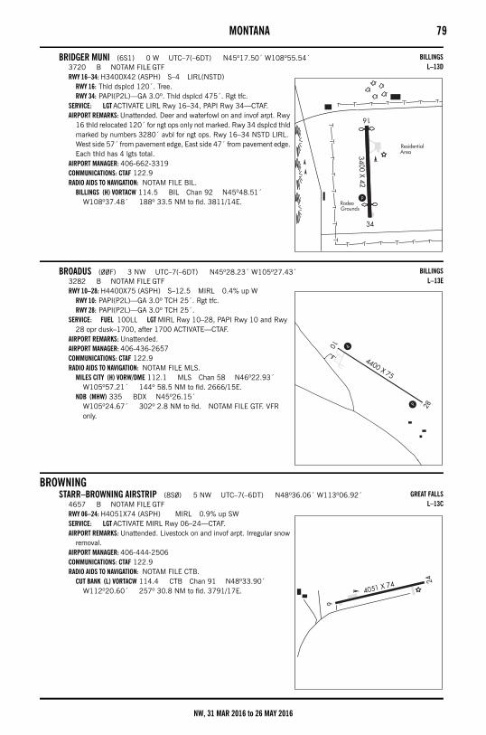
MONTANA 79
BRIDGER MUNI (6S1) 0 W UTC–7(–6DT) N45º17.50´ W108º55.54´3720 B NOTAM FILE GTFRWY 16–34: H3400X42 (ASPH) S–4 LIRL(NSTD)
RWY 16: Thld dsplcd 120´. Tree.RWY 34: PAPI(P2L)—GA 3.0º. Thld dsplcd 475´. Rgt tfc.
SERVICE: LGT ACTIVATE LIRL Rwy 16–34, PAPI Rwy 34—CTAF.AIRPORT REMARKS: Unattended. Deer and waterfowl on and invof arpt. Rwy
16 thld relocated 120´ for ngt ops only not marked. Rwy 34 dsplcd thld marked by numbers 3280´ avbl for ngt ops. Rwy 16–34 NSTD LIRL. West side 57´ from pavement edge, East side 47´ from pavement edge. Each thld has 4 lgts total.
AIRPORT MANAGER: 406-662-3319COMMUNICATIONS: CTAF 122.9RADIO AIDS TO NAVIGATION: NOTAM FILE BIL.
BILLINGS (H) VORTACW 114.5 BIL Chan 92 N45º48.51´ W108º37.48´ 188º 33.5 NM to fld. 3811/14E.
BROADUS (00F) 3 NW UTC–7(–6DT) N45º28.23´ W105º27.43´3282 B NOTAM FILE GTFRWY 10–28: H4400X75 (ASPH) S–12.5 MIRL 0.4% up W
RWY 10: PAPI(P2L)—GA 3.0º TCH 25´. Rgt tfc.RWY 28: PAPI(P2L)—GA 3.0º TCH 25´.
SERVICE: FUEL 100LL LGT MIRL Rwy 10–28, PAPI Rwy 10 and Rwy 28 opr dusk–1700, after 1700 ACTIVATE—CTAF.
AIRPORT REMARKS: Unattended. AIRPORT MANAGER: 406-436-2657COMMUNICATIONS: CTAF 122.9RADIO AIDS TO NAVIGATION: NOTAM FILE MLS.
MILES CITY (H) VORW/DME 112.1 MLS Chan 58 N46º22.93´ W105º57.21´ 144º 58.5 NM to fld. 2666/15E.
NDB (MHW) 335 BDX N45º26.15´ W105º24.67´ 302º 2.8 NM to fld. NOTAM FILE GTF. VFR only.
BROWNINGSTARR–BROWNING AIRSTRIP (8S0) 5 NW UTC–7(–6DT) N48º36.06´ W113º06.92´
4657 B NOTAM FILE GTFRWY 06–24: H4051X74 (ASPH) MIRL 0.9% up SWSERVICE: LGT ACTIVATE MIRL Rwy 06–24—CTAF.AIRPORT REMARKS: Unattended. Livestock on and invof arpt. Irregular snow
removal. AIRPORT MANAGER: 406-444-2506COMMUNICATIONS: CTAF 122.9RADIO AIDS TO NAVIGATION: NOTAM FILE CTB.
CUT BANK (L) VORTACW 114.4 CTB Chan 91 N48º33.90´ W112º20.60´ 257º 30.8 NM to fld. 3791/17E.
BILLINGSL–13D
BILLINGSL–13E
GREAT FALLSL–13C
NW, 31 MAR 2016 to 26 MAY 2016
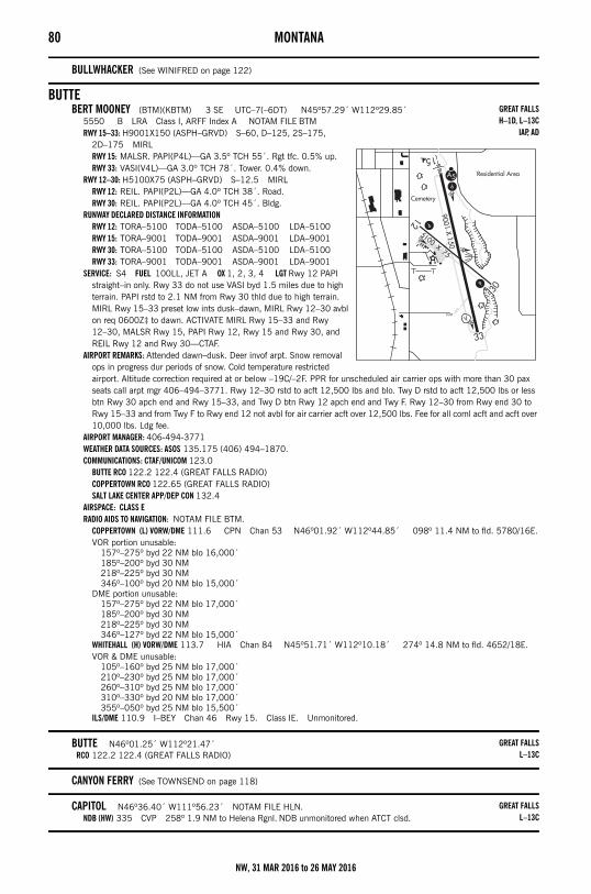
80 MONTANA
BULLWHACKER (See WINIFRED on page 122)
BUTTEBERT MOONEY (BTM)(KBTM) 3 SE UTC–7(–6DT) N45º57.29´ W112º29.85´
5550 B LRA Class I, ARFF Index A NOTAM FILE BTMRWY 15–33: H9001X150 (ASPH–GRVD) S–60, D–125, 2S–175,
2D–175 MIRLRWY 15: MALSR. PAPI(P4L)—GA 3.5º TCH 55´. Rgt tfc. 0.5% up.RWY 33: VASI(V4L)—GA 3.0º TCH 78´. Tower. 0.4% down.
RWY 12–30: H5100X75 (ASPH–GRVD) S–12.5 MIRLRWY 12: REIL. PAPI(P2L)—GA 4.0º TCH 38´. Road.RWY 30: REIL. PAPI(P2L)—GA 4.0º TCH 45´. Bldg.
RUNWAY DECLARED DISTANCE INFORMATIONRWY 12: TORA–5100 TODA–5100 ASDA–5100 LDA–5100RWY 15: TORA–9001 TODA–9001 ASDA–9001 LDA–9001RWY 30: TORA–5100 TODA–5100 ASDA–5100 LDA–5100RWY 33: TORA–9001 TODA–9001 ASDA–9001 LDA–9001
SERVICE: S4 FUEL 100LL, JET A OX 1, 2, 3, 4 LGT Rwy 12 PAPI straight–in only. Rwy 33 do not use VASI byd 1.5 miles due to high terrain. PAPI rstd to 2.1 NM from Rwy 30 thld due to high terrain. MIRL Rwy 15–33 preset low ints dusk–dawn, MIRL Rwy 12–30 avbl on req 0600Z‡ to dawn. ACTIVATE MIRL Rwy 15–33 and Rwy 12–30, MALSR Rwy 15, PAPI Rwy 12, Rwy 15 and Rwy 30, and REIL Rwy 12 and Rwy 30—CTAF.
AIRPORT REMARKS: Attended dawn–dusk. Deer invof arpt. Snow removal ops in progress dur periods of snow. Cold temperature restricted airport. Altitude correction required at or below –19C/–2F. PPR for unscheduled air carrier ops with more than 30 pax seats call arpt mgr 406–494–3771. Rwy 12–30 rstd to acft 12,500 lbs and blo. Twy D rstd to acft 12,500 lbs or less btn Rwy 30 apch end and Rwy 15–33, and Twy D btn Rwy 12 apch end and Twy F. Rwy 12–30 from Rwy end 30 to Rwy 15–33 and from Twy F to Rwy end 12 not avbl for air carrier acft over 12,500 lbs. Fee for all coml acft and acft over 10,000 lbs. Ldg fee.
AIRPORT MANAGER: 406-494-3771WEATHER DATA SOURCES: ASOS 135.175 (406) 494–1870.COMMUNICATIONS: CTAF/UNICOM 123.0
BUTTE RCO 122.2 122.4 (GREAT FALLS RADIO)COPPERTOWN RCO 122.65 (GREAT FALLS RADIO)SALT LAKE CENTER APP/DEP CON 132.4
AIRSPACE: CLASS ERADIO AIDS TO NAVIGATION: NOTAM FILE BTM.
COPPERTOWN (L) VORW/DME 111.6 CPN Chan 53 N46º01.92´ W112º44.85´ 098º 11.4 NM to fld. 5780/16E.VOR portion unusable:
157º–275º byd 22 NM blo 16,000´185º–200º byd 30 NM218º–225º byd 30 NM346º–100º byd 20 NM blo 15,000´
DME portion unusable:157º–275º byd 22 NM blo 17,000´185º–200º byd 30 NM218º–225º byd 30 NM346º–127º byd 22 NM blo 15,000´
WHITEHALL (H) VORW/DME 113.7 HIA Chan 84 N45º51.71´ W112º10.18´ 274º 14.8 NM to fld. 4652/18E.VOR & DME unusable:
105º–160º byd 25 NM blo 17,000´210º–230º byd 25 NM blo 17,000´260º–310º byd 25 NM blo 17,000´310º–330º byd 20 NM blo 17,000´355º–050º byd 25 NM blo 15,500´
ILS/DME 110.9 I–BEY Chan 46 Rwy 15. Class IE. Unmonitored.
BUTTE N46º01.25´ W112º21.47´RCO 122.2 122.4 (GREAT FALLS RADIO)
CANYON FERRY (See TOWNSEND on page 118)
CAPITOL N46º36.40´ W111º56.23´ NOTAM FILE HLN.NDB (HW) 335 CVP 258º 1.9 NM to Helena Rgnl. NDB unmonitored when ATCT clsd.
GREAT FALLSH–1D, L–13C
IAP, AD
GREAT FALLSL–13C
GREAT FALLSL–13C
NW, 31 MAR 2016 to 26 MAY 2016
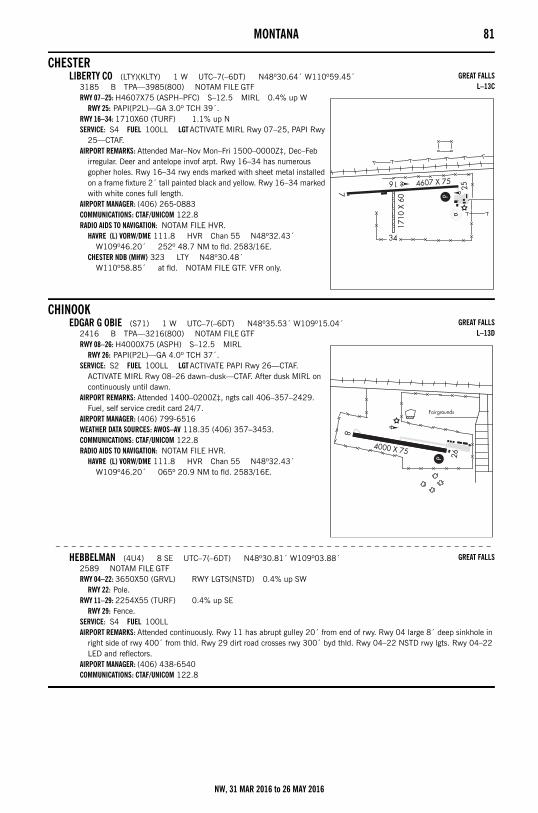
MONTANA 81
CHESTERLIBERTY CO (LTY)(KLTY) 1 W UTC–7(–6DT) N48º30.64´ W110º59.45´
3185 B TPA—3985(800) NOTAM FILE GTFRWY 07–25: H4607X75 (ASPH–PFC) S–12.5 MIRL 0.4% up W
RWY 25: PAPI(P2L)—GA 3.0º TCH 39´.RWY 16–34: 1710X60 (TURF) 1.1% up NSERVICE: S4 FUEL 100LL LGT ACTIVATE MIRL Rwy 07–25, PAPI Rwy
25—CTAF.AIRPORT REMARKS: Attended Mar–Nov Mon–Fri 1500–0000Z‡, Dec–Feb
irregular. Deer and antelope invof arpt. Rwy 16–34 has numerous gopher holes. Rwy 16–34 rwy ends marked with sheet metal installed on a frame fixture 2´ tall painted black and yellow. Rwy 16–34 marked with white cones full length.
AIRPORT MANAGER: (406) 265-0883COMMUNICATIONS: CTAF/UNICOM 122.8RADIO AIDS TO NAVIGATION: NOTAM FILE HVR.
HAVRE (L) VORW/DME 111.8 HVR Chan 55 N48º32.43´ W109º46.20´ 252º 48.7 NM to fld. 2583/16E.
CHESTER NDB (MHW) 323 LTY N48º30.48´ W110º58.85´ at fld. NOTAM FILE GTF. VFR only.
CHINOOKEDGAR G OBIE (S71) 1 W UTC–7(–6DT) N48º35.53´ W109º15.04´
2416 B TPA—3216(800) NOTAM FILE GTFRWY 08–26: H4000X75 (ASPH) S–12.5 MIRL
RWY 26: PAPI(P2L)—GA 4.0º TCH 37´.SERVICE: S2 FUEL 100LL LGT ACTIVATE PAPI Rwy 26—CTAF.
ACTIVATE MIRL Rwy 08–26 dawn–dusk—CTAF. After dusk MIRL on continuously until dawn.
AIRPORT REMARKS: Attended 1400–0200Z‡, ngts call 406–357–2429. Fuel, self service credit card 24/7.
AIRPORT MANAGER: (406) 799-6516WEATHER DATA SOURCES: AWOS–AV 118.35 (406) 357–3453.COMMUNICATIONS: CTAF/UNICOM 122.8RADIO AIDS TO NAVIGATION: NOTAM FILE HVR.
HAVRE (L) VORW/DME 111.8 HVR Chan 55 N48º32.43´ W109º46.20´ 065º 20.9 NM to fld. 2583/16E.
– – – – – – – – – – – – – – – – – – – – – – – – – – – – – – – – – – – – – – – – – – – – – – – – – – – – – – –
HEBBELMAN (4U4) 8 SE UTC–7(–6DT) N48º30.81´ W109º03.88´2589 NOTAM FILE GTFRWY 04–22: 3650X50 (GRVL) RWY LGTS(NSTD) 0.4% up SW
RWY 22: Pole.RWY 11–29: 2254X55 (TURF) 0.4% up SE
RWY 29: Fence.SERVICE: S4 FUEL 100LL AIRPORT REMARKS: Attended continuously. Rwy 11 has abrupt gulley 20´ from end of rwy. Rwy 04 large 8´ deep sinkhole in
right side of rwy 400´ from thld. Rwy 29 dirt road crosses rwy 300´ byd thld. Rwy 04–22 NSTD rwy lgts. Rwy 04–22 LED and reflectors.
AIRPORT MANAGER: (406) 438-6540COMMUNICATIONS: CTAF/UNICOM 122.8
GREAT FALLSL–13C
GREAT FALLSL–13D
GREAT FALLS
NW, 31 MAR 2016 to 26 MAY 2016
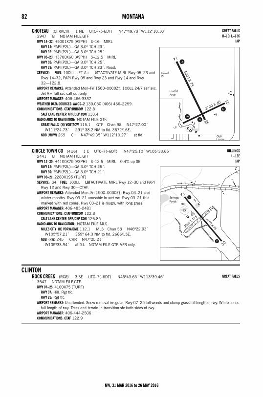
82 MONTANA
CHOTEAU (CII)(KCII) 1 NE UTC–7(–6DT) N47º49.70´ W112º10.10´3947 B NOTAM FILE GTFRWY 14–32: H5001X75 (ASPH) S–16 MIRL
RWY 14: PAPI(P2L)—GA 3.0º TCH 23´.RWY 32: PAPI(P2L)—GA 3.0º TCH 25´.
RWY 05–23: H3700X60 (ASPH) S–12.5 MIRLRWY 05: PAPI(P2L)—GA 3.0º TCH 25´.RWY 23: PAPI(P2L)—GA 3.0º TCH 23´. Road.
SERVICE: FUEL 100LL, JET A+ LGT ACTIVATE MIRL Rwy 05–23 and Rwy 14–32, PAPI Rwy 05 and Rwy 23 and Rwy 14 and Rwy 32—122.8.
AIRPORT REMARKS: Attended Mon–Fri 1500–0000Z‡. 100LL 24/7 self svc. Jet A+ full svc call out only.
AIRPORT MANAGER: 406-466-3337WEATHER DATA SOURCES: AWOS–2 130.050 (406) 466–2259.COMMUNICATIONS: CTAF/UNICOM 122.8
SALT LAKE CENTER APP/DEP CON 133.4RADIO AIDS TO NAVIGATION: NOTAM FILE GTF.
GREAT FALLS (H) VORTACW 115.1 GTF Chan 98 N47º27.00´ W111º24.73´ 291º 38.2 NM to fld. 3672/16E.
NDB (MHW) 269 CII N47º49.35´ W112º10.27´ at fld.
CIRCLE TOWN CO (4U6) 1 E UTC–7(–6DT) N47º25.10´ W105º33.65´2441 B NOTAM FILE GTFRWY 12–30: H4100X75 (ASPH) S–12.5 MIRL 0.4% up SE
RWY 12: PAPI(P2L)—GA 3.0º TCH 25´.RWY 30: PAPI(P2L)—GA 3.0º TCH 21´.
RWY 03–21: 2280X195 (TURF)SERVICE: S4 FUEL 100LL LGT ACTIVATE MIRL Rwy 12–30 and PAPI
Rwy 12 and Rwy 30—CTAF.AIRPORT REMARKS: Attended Mon–Fri 1500–0000Z‡. Rwy 03–21 clsd
winter months. Rwy 03–21 unusable in wet wx. Rwy 03–21 thld marked with red cones. Rwy 03–21 is rough, with long grass.
AIRPORT MANAGER: 406-485-2481COMMUNICATIONS: CTAF/UNICOM 122.8
SALT LAKE CENTER APP/DEP CON 126.85RADIO AIDS TO NAVIGATION: NOTAM FILE MLS.
MILES CITY (H) VORW/DME 112.1 MLS Chan 58 N46º22.93´ W105º57.21´ 359º 64.3 NM to fld. 2666/15E.
NDB (HW) 245 CRR N47º25.21´ W105º33.94´ at fld. NOTAM FILE GTF. VFR only.
CLINTONROCK CREEK (RC0) 3 SE UTC–7(–6DT) N46º43.63´ W113º39.46´
3547 NOTAM FILE GTFRWY 07–25: 4100X75 (TURF)
RWY 07: Hill. Rgt tfc.RWY 25: Rgt tfc.
AIRPORT REMARKS: Unattended. Snow removal irregular. Rwy 07–25 tall weeds and clump grass full length of rwy. White cones full length of rwy. Trees and terrain in transition sfc both sides of rwy.
AIRPORT MANAGER: 406-444-2506COMMUNICATIONS: CTAF 122.9
GREAT FALLSH–1D, L–13C
IAP
BILLINGSL–13E
IAP
GREAT FALLS
NW, 31 MAR 2016 to 26 MAY 2016
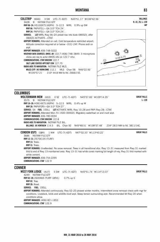
MONTANA 83
COLSTRIP (M46) 3 SW UTC–7(–6DT) N45º51.17´ W106º42.56´3428 B NOTAM FILE GTFRWY 06–24: H5100X75 (ASPH) S–12.5 MIRL 0.9% up SW
RWY 06: PAPI(P2L)—GA 3.0º TCH 24´.RWY 24: PAPI(P2L)—GA 3.0º TCH 24´.
SERVICE: LGT MIRL Rwy 06–24 preset low ints dusk–0800Z‡, after 0800Z‡ ACTIVATE—CTAF.
AIRPORT REMARKS: Attended on call. Cold temperature restricted airport. Altitude correction required at or below –31C/–24F. Phone avbl on arpt.
AIRPORT MANAGER: 406-748-3222WEATHER DATA SOURCES: AWOS–AV 122.7 (406) 748–3849. 3 microphone
clicks are req to actvt AWOS info on 122.7 mhz.COMMUNICATIONS: CTAF/UNICOM 122.7
SALT LAKE CENTER APP/DEP CON 127.75RADIO AIDS TO NAVIGATION: NOTAM FILE MLS.
MILES CITY (H) VORW/DME 112.1 MLS Chan 58 N46º22.93´ W105º57.21´ 210º 44.8 NM to fld. 2666/15E.
COLUMBUSWOLTERMANN MEM (6S3) 0 SE UTC–7(–6DT) N45º37.83´ W109º14.35´
3575 B NOTAM FILE GTFRWY 10–28: H3814X75 (ASPH) S–12.5 MIRL 0.4% up W
RWY 28: PAPI(P2R)—GA 3.0º TCH 27´.SERVICE: S4 FUEL 100LL LGT ACTIVATE MIRL Rwy 10–28 and PAPI Rwy 28—CTAF.AIRPORT REMARKS: Attended Mon–Fri 1500–0000Z‡. Migratory waterfowl on and invof arpt. AIRPORT MANAGER: 406-780-0034COMMUNICATIONS: CTAF/UNICOM 122.8RADIO AIDS TO NAVIGATION: NOTAM FILE BIL.
BILLINGS (H) VORTACW 114.5 BIL Chan 92 N45º48.51´ W108º37.48´ 234º 28.0 NM to fld. 3811/14E.
CONDON USFS (S04) 1 NW UTC–7(–6DT) N47º32.33´ W113º43.22´3686 NOTAM FILE GTFRWY 13–31: 2575X135 (TURF)
RWY 13: Trees.RWY 31: Trees.
AIRPORT REMARKS: Unattended. No snow removal. Trees in all transitional sfcs. Rwy 13–31 measured from Rwy 31 marked thld to end of Rwy 13 maintained area. Rwy 13–31 has white cones marking full length of rwy. Rwy 31 thld marked with white cement.
AIRPORT MANAGER: 406-754-2295COMMUNICATIONS: CTAF 122.9
CONNERWEST FORK LODGE (4U7) 5 SW UTC–7(–6DT) N45º51.74´ W114º13.07´
4249 NOTAM FILE GTFRWY 02–20: 2600X65 (TURF–GRVL) 0.7% up S
RWY 02: Tree.RWY 20: Road.
SERVICE: FUEL 100LL AIRPORT REMARKS: Attended continuously. Rwy 02–20 plowed winter months. Intermittent snow removal check with mgr for
conditions. Livestock, birds and wildlife invof arpt. Steep terrain surrounding arpt. Recommended tkf Rwy 20 when conditions allow.
AIRPORT MANAGER: (406) 821-1853COMMUNICATIONS: CTAF 122.9
BILLINGSH–1E, 2G, L–13D
IAP
GREAT FALLSL–13D
GREAT FALLS
GREAT FALLS
NW, 31 MAR 2016 to 26 MAY 2016
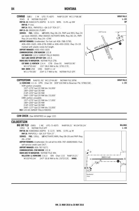
84 MONTANA
CONRAD (S01) 1 W UTC–7(–6DT) N48º10.09´ W111º58.58´3545 B NOTAM FILE GTFRWY 06–24: H4601X75 (ASPH) S–12.5 MIRL 0.4% up SW
RWY 06: P–line.RWY 24: REIL. PAPI(P2L)—GA 3.0º TCH 27´.
RWY 15–33: 2800X100 (TURF)SERVICE: FUEL 100LL LGT MIRL Rwy 06–24, PAPI and REIL Rwy 24
opr dusk–0600Z‡. After 0600Z‡ ACTIVATE MIRL Rwy 06–24, PAPI Rwy 24 and REIL Rwy 24—CTAF.
AIRPORT REMARKS: Unattended. For fuel call 406–788–5790, 406–450–1620, 406–278–3380 or 406–450–3332. Rwy 15–33 marked with plastic cones full length.
AIRPORT MANAGER: (406) 450-1620COMMUNICATIONS: CTAF/AUNICOM 122.8
CUT BANK RCO 122.2 (GREAT FALLS RADIO)SALT LAKE CENTER APP/DEP CON 133.4
RADIO AIDS TO NAVIGATION: NOTAM FILE CTB.CUT BANK (L) VORTACW 114.4 CTB Chan 91 N48º33.90´
W112º20.60´ 131º 28.0 NM to fld. 3791/17E.NDB (MHW) 293 CRD N48º11.14´
W111º54.85´ 234º 2.7 NM to fld. NOTAM FILE GTF.
COPPERTOWN N46º01.92´ W112º44.85´ NOTAM FILE BTM.(L) VORW/DME 111.6 CPN Chan 53 309º 8.8 NM to Bowman Fld. 5780/16E.
VOR portion unusable:157º–275º byd 22 NM blo 16,000´185º–200º byd 30 NM218º–225º byd 30 NM346º–100º byd 20 NM blo 15,000´
DME portion unusable:157º–275º byd 22 NM blo 17,000´185º–200º byd 30 NM218º–225º byd 30 NM346º–127º byd 22 NM blo 15,000´
RCO 122.65 (GREAT FALLS RADIO)
COW CREEK (See WINIFRED on page 122)
CULBERTSONBIG SKY FLD (S85) 1 NE UTC–7(–6DT) N48º09.21´ W104º30.24´
1953 B NOTAM FILE GTFRWY 08–26: H3800X60 (ASPH) S–12.5 MIRL 0.5% up W
RWY 26: PAPI(P2L)—GA 3.0º TCH 27´.SERVICE: FUEL 100LL LGT ACTIVATE MIRL Rwy 08–26 and PAPI Rwy
26—CTAF.AIRPORT REMARKS: Unattended. On call all hrs 406–787–6680/0660. Fuel,
self service credit card 24/7. AIRPORT MANAGER: 406-787-5271COMMUNICATIONS: CTAF/UNICOM 122.8RADIO AIDS TO NAVIGATION: NOTAM FILE ISN.
WILLISTON (L) VORW/DME 116.3 ISN Chan 110 N48º15.21´ W103º45.04´ 247º 30.8 NM to fld. 2372/12E. HIWAS.
GREAT FALLSL–13C
IAP
GREAT FALLSL–13C
BILLINGSL–13E
NW, 31 MAR 2016 to 26 MAY 2016
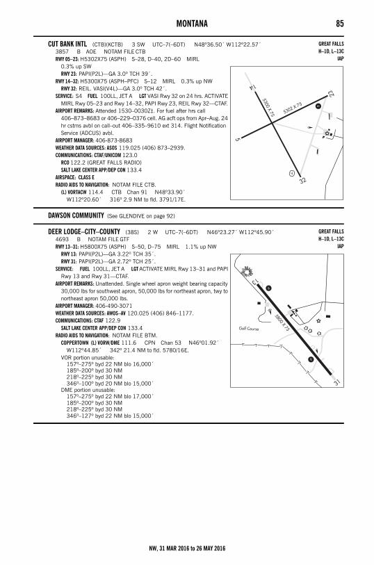
MONTANA 85
CUT BANK INTL (CTB)(KCTB) 3 SW UTC–7(–6DT) N48º36.50´ W112º22.57´3857 B AOE NOTAM FILE CTBRWY 05–23: H5302X75 (ASPH) S–28, D–40, 2D–60 MIRL
0.3% up SWRWY 23: PAPI(P2L)—GA 3.0º TCH 39´.
RWY 14–32: H5300X75 (ASPH–PFC) S–12 MIRL 0.3% up NWRWY 32: REIL. VASI(V4L)—GA 3.0º TCH 42´.
SERVICE: S4 FUEL 100LL, JET A LGT VASI Rwy 32 on 24 hrs. ACTIVATE MIRL Rwy 05–23 and Rwy 14–32, PAPI Rwy 23, REIL Rwy 32—CTAF.
AIRPORT REMARKS: Attended 1530–0030Z‡. For fuel after hrs call 406–873–8683 or 406–229–0376 cell. AG acft ops from Apr–Aug. 24 hr cstms avbl on call–out 406–335–9610 ext 314. Flight Notification Service (ADCUS) avbl.
AIRPORT MANAGER: 406-873-8683WEATHER DATA SOURCES: ASOS 119.025 (406) 873–2939.COMMUNICATIONS: CTAF/UNICOM 123.0
RCO 122.2 (GREAT FALLS RADIO)SALT LAKE CENTER APP/DEP CON 133.4
AIRSPACE: CLASS ERADIO AIDS TO NAVIGATION: NOTAM FILE CTB.
(L) VORTACW 114.4 CTB Chan 91 N48º33.90´ W112º20.60´ 316º 2.9 NM to fld. 3791/17E.
DAWSON COMMUNITY (See GLENDIVE on page 92)
DEER LODGE–CITY–COUNTY (38S) 2 W UTC–7(–6DT) N46º23.27´ W112º45.90´4693 B NOTAM FILE GTFRWY 13–31: H5800X75 (ASPH) S–50, D–75 MIRL 1.1% up NW
RWY 13: PAPI(P2L)—GA 3.22º TCH 35´.RWY 31: PAPI(P2L)—GA 2.72º TCH 25´.
SERVICE: FUEL 100LL, JET A LGT ACTIVATE MIRL Rwy 13–31 and PAPI Rwy 13 and Rwy 31—CTAF.
AIRPORT REMARKS: Unattended. Single wheel apron weight bearing capacity 30,000 lbs for southwest apron, 50,000 lbs for northeast apron, twy to northeast apron 50,000 lbs.
AIRPORT MANAGER: 406-490-3071WEATHER DATA SOURCES: AWOS–AV 120.025 (406) 846–1177.COMMUNICATIONS: CTAF 122.9
SALT LAKE CENTER APP/DEP CON 133.4RADIO AIDS TO NAVIGATION: NOTAM FILE BTM.
COPPERTOWN (L) VORW/DME 111.6 CPN Chan 53 N46º01.92´ W112º44.85´ 342º 21.4 NM to fld. 5780/16E.
VOR portion unusable:157º–275º byd 22 NM blo 16,000´185º–200º byd 30 NM218º–225º byd 30 NM346º–100º byd 20 NM blo 15,000´
DME portion unusable:157º–275º byd 22 NM blo 17,000´185º–200º byd 30 NM218º–225º byd 30 NM346º–127º byd 22 NM blo 15,000´
GREAT FALLSH–1D, L–13C
IAP
GREAT FALLSH–1D, L–13C
IAP
NW, 31 MAR 2016 to 26 MAY 2016
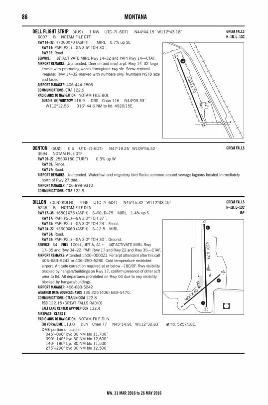
86 MONTANA
DELL FLIGHT STRIP (4U9) 1 NW UTC–7(–6DT) N44º44.15´ W112º43.18´6007 B NOTAM FILE GTFRWY 14–32: H7000X70 (ASPH) MIRL 0.7% up SE
RWY 14: PAPI(P2L)—GA 3.5º TCH 30´.RWY 32: Road.
SERVICE: LGT ACTIVATE MIRL Rwy 14–32 and PAPI Rwy 14—CTAF.AIRPORT REMARKS: Unattended. Deer on and invof arpt. Rwy 14–32 large
cracks with protruding weeds throughout rwy sfc. Snow removal irregular. Rwy 14–32 marked with numbers only. Numbers NSTD size and faded.
AIRPORT MANAGER: 406-444-2506COMMUNICATIONS: CTAF 122.9RADIO AIDS TO NAVIGATION: NOTAM FILE BOI.
DUBOIS (H) VORTACW 116.9 DBS Chan 116 N44º05.33´ W112º12.56´ 316º 44.6 NM to fld. 4920/15E.
DENTON (5U0) 0 S UTC–7(–6DT) N47º19.25´ W109º56.52´3594 NOTAM FILE GTFRWY 09–27: 2550X180 (TURF) 0.3% up W
RWY 09: Fence.RWY 27: Road.
AIRPORT REMARKS: Unattended. Waterfowl and migratory bird flocks common around sewage lagoons located immediately north of Rwy 27 thld.
AIRPORT MANAGER: 406-899-9310COMMUNICATIONS: CTAF 122.9
DILLON (DLN)(KDLN) 4 NE UTC–7(–6DT) N45º15.32´ W112º33.15´5245 B NOTAM FILE DLNRWY 17–35: H6501X75 (ASPH) S–60, D–75 MIRL 1.4% up S
RWY 17: PAPI(P2L)—GA 3.0º TCH 37´.RWY 35: PAPI(P2L)—GA 3.0º TCH 24´. Fence.
RWY 04–22: H3600X60 (ASPH) S–12.5 MIRLRWY 04: Road.RWY 22: PAPI(P2L)—GA 3.0º TCH 30´. Ground.
SERVICE: S4 FUEL 100LL, JET A, A1+ LGT ACTIVATE MIRL Rwy 17–35 and Rwy 04–22; PAPI Rwy 17 and Rwy 22 and Rwy 35—CTAF.
AIRPORT REMARKS: Attended 1500–0000Z‡. For arpt attendant after hrs call 406–683–5242 or 406–250–5280. Cold temperature restricted airport. Altitude correction required at or below –18C/0F. Rwy visibility blocked by hangars/buildings on Rwy 17, confirm presence of other acft prior to tkf. All departures prohibited on Rwy 04 due to rwy visibility blocked by hangars/buildings.
AIRPORT MANAGER: 406-683-5242WEATHER DATA SOURCES: ASOS 135.225 (406) 683–5470.COMMUNICATIONS: CTAF/UNICOM 122.8
RCO 122.15 (GREAT FALLS RADIO)SALT LAKE CENTER APP/DEP CON 132.4
AIRSPACE: CLASS ERADIO AIDS TO NAVIGATION: NOTAM FILE DLN.
(H) VORW/DME 113.0 DLN Chan 77 N45º14.91´ W112º32.83´ at fld. 5257/18E.DME portion unusable:
045º–090º byd 30 NM blo 11,700´090º–140º byd 30 NM blo 12,600´140º–180º byd 30 NM blo 11,500´275º–290º byd 30 NM blo 12,500´
GREAT FALLSH–1D, L–13C
GREAT FALLS
GREAT FALLSH–1D, L–13C
IAP
NW, 31 MAR 2016 to 26 MAY 2016
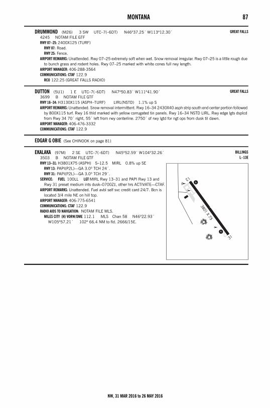
MONTANA 87
DRUMMOND (M26) 3 SW UTC–7(–6DT) N46º37.25´ W113º12.30´4245 NOTAM FILE GTFRWY 07–25: 2400X125 (TURF)
RWY 07: Road.RWY 25: Fence.
AIRPORT REMARKS: Unattended. Rwy 07–25 extremely soft when wet. Snow removal irregular. Rwy 07–25 is a little rough due to bunch grass and rodent holes. Rwy 07–25 marked with white cones full rwy length.
AIRPORT MANAGER: 406-288-3564COMMUNICATIONS: CTAF 122.9
RCO 122.25 (GREAT FALLS RADIO)
DUTTON (5U1) 1 E UTC–7(–6DT) N47º50.83´ W111º41.90´3699 B NOTAM FILE GTFRWY 16–34: H3130X115 (ASPH–TURF) LIRL(NSTD) 1.1% up SAIRPORT REMARKS: Unattended. Snow removal intermittent. Rwy 16–34 2430X40 asph strip south end center portion followed
by 800X115 turf. Rwy 16 thld marked with yellow corrugated tin panels. Rwy 16–34 NSTD LIRL. Rwy edge lgts dsplcd from Rwy 34 70´ right, 55´ left from rwy centerline. 2750´ of rwy lgtd for ngt ops from dusk til dawn.
AIRPORT MANAGER: 406-476-3332COMMUNICATIONS: CTAF 122.9
EDGAR G OBIE (See CHINOOK on page 81)
EKALAKA (97M) 2 SE UTC–7(–6DT) N45º52.59´ W104º32.26´3503 B NOTAM FILE GTFRWY 13–31: H3801X75 (ASPH) S–12.5 MIRL 0.8% up SE
RWY 13: PAPI(P2L)—GA 3.0º TCH 24´.RWY 31: PAPI(P2L)—GA 3.0º TCH 29´.
SERVICE: FUEL 100LL LGT MIRL Rwy 13–31 and PAPI Rwy 13 and Rwy 31 preset medium ints dusk–0700Z‡, other hrs ACTIVATE—CTAF.
AIRPORT REMARKS: Unattended. Fuel avbl self svc credit card 24/7. Bcn is located 3/4 mile NE on hill top.
AIRPORT MANAGER: 406-775-6541COMMUNICATIONS: CTAF 122.9RADIO AIDS TO NAVIGATION: NOTAM FILE MLS.
MILES CITY (H) VORW/DME 112.1 MLS Chan 58 N46º22.93´ W105º57.21´ 102º 66.4 NM to fld. 2666/15E.
GREAT FALLS
GREAT FALLS
BILLINGSL–13E
NW, 31 MAR 2016 to 26 MAY 2016
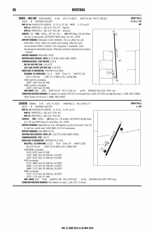
88 MONTANA
ENNIS – BIG SKY (EKS)(KEKS) 6 SE UTC–7(–6DT) N45º16.46´ W111º38.93´5423 B NOTAM FILE GTFRWY 16–34: H6601X75 (ASPH) S–12.5, D–18 MIRL 1.1% up N
RWY 16: PAPI(P2L)—GA 3.0º TCH 37´. Rgt tfc.RWY 34: PAPI(P2L)—GA 3.0º TCH 36´. Ground.
SERVICE: S2 FUEL 100LL, JET A1, A1+ LGT PAPI Rwy 16 and Rwy 34 opr continuously. ACTIVATE MIRL Rwy 16–34—CTAF.
AIRPORT REMARKS: Attended 1400–0000Z‡. For svc after hrs call 406–682–7502. After hrs credit card fueling. Afld sfc cond unmonitored 0400–1300Z‡. De–icing type 1 available. Cold temperature restricted airport. Altitude correction required at or below –15C/5F.
AIRPORT MANAGER: 406-682-7502WEATHER DATA SOURCES: AWOS–3 119.85 (406) 682–3835.COMMUNICATIONS: CTAF/UNICOM 122.8
BIG SKY APP/DEP CON 118.975SALT LAKE CENTER APP/DEP CON 118.975
RADIO AIDS TO NAVIGATION: NOTAM FILE BZN.BOZEMAN (H) VORW/DME 112.4 BZN Chan 71 N45º47.03´
W111º09.33´ 196º 37.0 NM to fld. 4436/18E.VOR portion unusable:
360º–105º byd 20 NMDME portion unusable:
350º–105º byd 20 NMNDB (MHW) 286 EKS N45º16.07´ W111º39.16´ at fld. NOTAM FILE GTF. VFR only.
COMM/NAV/WEATHER REMARKS: To obtain or cancel IFR Clnc on the gnd btn 1300–0715Z‡ ctc Big Sky App 1–208–364–5860, other times ctc flt svcs 1–888–766–8267.
EUREKA (88M) 5 N UTC–7(–6DT) N48º58.11´ W115º04.77´2672 B NOTAM FILE GTFRWY 01–19: H4200X75 (ASPH) S–12.5 0.4% up N
RWY 01: PAPI(P2L)—GA 3.0º TCH 40´.RWY 19: PAPI(P2L)—GA 3.0º TCH 40´.
SERVICE: FUEL 100LL LGT Rwy 01–19 strobe. ACTIVATE strobe Rwy 01–19 and PAPI Rwy 01 and Rwy 19—CTAF.
AIRPORT REMARKS: Attended on call. Ultralights on and invof arpt. Fuel 24 hr self svc credit card, 406–889–5174 if necessary.
AIRPORT MANAGER: 406-889-5174WEATHER DATA SOURCES: AWOS–AV 118.375 (406) 889–3366.COMMUNICATIONS: CTAF 122.9RADIO AIDS TO NAVIGATION: NOTAM FILE FCA.
KALISPELL (H) VORW/DME 113.2 FCA Chan 79 N48º12.85´ W114º10.55´ 304º 57.8 NM to fld. 2984/18E.
VOR/DME unusable:010º–070º byd 10 NM160º–280º byd 30 NM blo 13,000´350º–010º byd 10 NM blo 23,000´
VOR unusable:070º–088º byd 20 NM blo 16,000´088º–113º byd 22 NM blo 13,000´088º–113º byd 35 NM blo 16,000´
DME unusable:070º–113º byd 20 NM blo 16,000´070º–113º byd 37 NM
NDB (MHW) 392 EUR N48º57.96´ W115º05.06´ at fld. NOTAM FILE GTF. VFR only.COMM/NAV/WEATHER REMARKS: Wx station on arpt, 118.375, 3 clicks.
GREAT FALLSH–1D, L–13C
IAP
GREAT FALLSL–13B
NW, 31 MAR 2016 to 26 MAY 2016
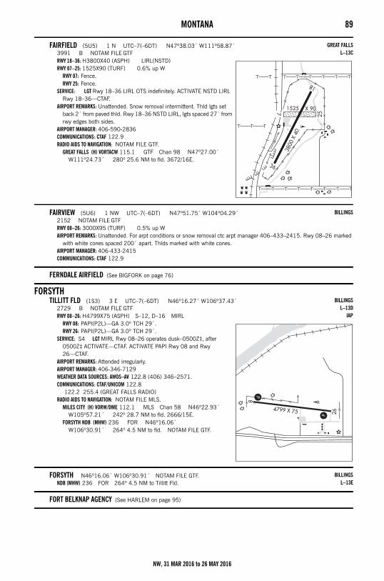
MONTANA 89
FAIRFIELD (5U5) 1 N UTC–7(–6DT) N47º38.03´ W111º58.87´3991 B NOTAM FILE GTFRWY 18–36: H3800X40 (ASPH) LIRL(NSTD)RWY 07–25: 1525X90 (TURF) 0.6% up W
RWY 07: Fence.RWY 25: Fence.
SERVICE: LGT Rwy 18–36 LIRL OTS indefinitely. ACTIVATE NSTD LIRL Rwy 18–36—CTAF.
AIRPORT REMARKS: Unattended. Snow removal intermittent. Thld lgts set back 2´ from paved thld. Rwy 18–36 NSTD LIRL, lgts spaced 27´ from rwy edges both sides.
AIRPORT MANAGER: 406-590-2836COMMUNICATIONS: CTAF 122.9RADIO AIDS TO NAVIGATION: NOTAM FILE GTF.
GREAT FALLS (H) VORTACW 115.1 GTF Chan 98 N47º27.00´ W111º24.73´ 280º 25.6 NM to fld. 3672/16E.
FAIRVIEW (5U6) 1 NW UTC–7(–6DT) N47º51.75´ W104º04.29´2152 NOTAM FILE GTFRWY 08–26: 3000X95 (TURF) 0.5% up WAIRPORT REMARKS: Unattended. For arpt conditions or snow removal ctc arpt manager 406–433–2415. Rwy 08–26 marked
with white cones spaced 200´ apart. Thlds marked with white cones.AIRPORT MANAGER: 406-433-2415COMMUNICATIONS: CTAF 122.9
FERNDALE AIRFIELD (See BIGFORK on page 76)
FORSYTHTILLITT FLD (1S3) 3 E UTC–7(–6DT) N46º16.27´ W106º37.43´
2729 B NOTAM FILE GTFRWY 08–26: H4799X75 (ASPH) S–12, D–16 MIRL
RWY 08: PAPI(P2L)—GA 3.0º TCH 29´.RWY 26: PAPI(P2L)—GA 3.0º TCH 29´.
SERVICE: S4 LGT MIRL Rwy 08–26 operates dusk–0500Z‡, after 0500Z‡ ACTIVATE—CTAF. ACTIVATE PAPI Rwy 08 and Rwy 26—CTAF.
AIRPORT REMARKS: Attended irregularly. AIRPORT MANAGER: 406-346-7129WEATHER DATA SOURCES: AWOS–AV 122.8 (406) 346–2571.COMMUNICATIONS: CTAF/UNICOM 122.8
122.2 255.4 (GREAT FALLS RADIO)RADIO AIDS TO NAVIGATION: NOTAM FILE MLS.
MILES CITY (H) VORW/DME 112.1 MLS Chan 58 N46º22.93´ W105º57.21´ 242º 28.7 NM to fld. 2666/15E.
FORSYTH NDB (MHW) 236 FOR N46º16.06´ W106º30.91´ 264º 4.5 NM to fld. NOTAM FILE GTF.
FORSYTH N46º16.06´ W106º30.91´ NOTAM FILE GTF.NDB (MHW) 236 FOR 264º 4.5 NM to Tillitt Fld.
FORT BELKNAP AGENCY (See HARLEM on page 95)
GREAT FALLSL–13C
BILLINGS
BILLINGSL–13D
IAP
BILLINGSL–13E
NW, 31 MAR 2016 to 26 MAY 2016
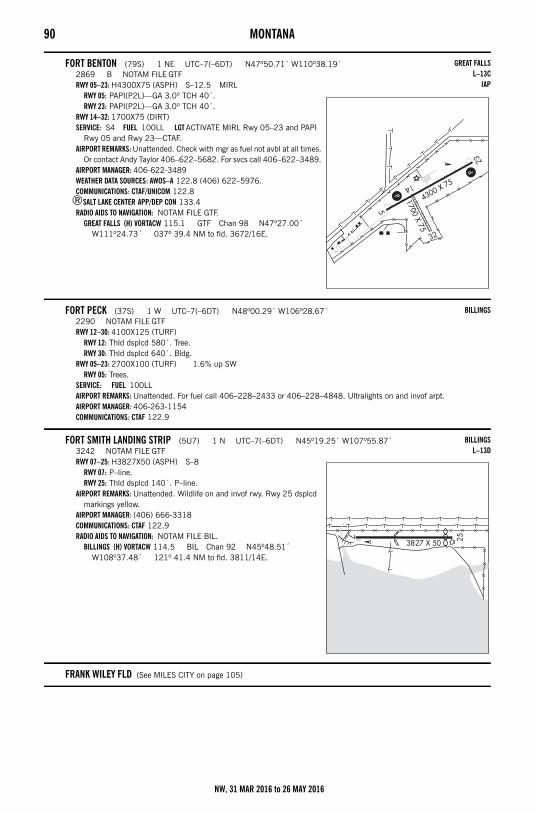
90 MONTANA
FORT BENTON (79S) 1 NE UTC–7(–6DT) N47º50.71´ W110º38.19´2869 B NOTAM FILE GTFRWY 05–23: H4300X75 (ASPH) S–12.5 MIRL
RWY 05: PAPI(P2L)—GA 3.0º TCH 40´.RWY 23: PAPI(P2L)—GA 3.0º TCH 40´.
RWY 14–32: 1700X75 (DIRT)SERVICE: S4 FUEL 100LL LGT ACTIVATE MIRL Rwy 05–23 and PAPI
Rwy 05 and Rwy 23—CTAF.AIRPORT REMARKS: Unattended. Check with mgr as fuel not avbl at all times.
Or contact Andy Taylor 406–622–5682. For svcs call 406–622–3489. AIRPORT MANAGER: 406-622-3489WEATHER DATA SOURCES: AWOS–A 122.8 (406) 622–5976.COMMUNICATIONS: CTAF/UNICOM 122.8
®SALT LAKE CENTER APP/DEP CON 133.4RADIO AIDS TO NAVIGATION: NOTAM FILE GTF.
GREAT FALLS (H) VORTACW 115.1 GTF Chan 98 N47º27.00´ W111º24.73´ 037º 39.4 NM to fld. 3672/16E.
FORT PECK (37S) 1 W UTC–7(–6DT) N48º00.29´ W106º28.67´2290 NOTAM FILE GTFRWY 12–30: 4100X125 (TURF)
RWY 12: Thld dsplcd 580´. Tree.RWY 30: Thld dsplcd 640´. Bldg.
RWY 05–23: 2700X100 (TURF) 1.6% up SWRWY 05: Trees.
SERVICE: FUEL 100LL AIRPORT REMARKS: Unattended. For fuel call 406–228–2433 or 406–228–4848. Ultralights on and invof arpt.AIRPORT MANAGER: 406-263-1154COMMUNICATIONS: CTAF 122.9
FORT SMITH LANDING STRIP (5U7) 1 N UTC–7(–6DT) N45º19.25´ W107º55.87´3242 NOTAM FILE GTFRWY 07–25: H3827X50 (ASPH) S–8
RWY 07: P–line.RWY 25: Thld dsplcd 140´. P–line.
AIRPORT REMARKS: Unattended. Wildlife on and invof rwy. Rwy 25 dsplcd markings yellow.
AIRPORT MANAGER: (406) 666-3318COMMUNICATIONS: CTAF 122.9RADIO AIDS TO NAVIGATION: NOTAM FILE BIL.
BILLINGS (H) VORTACW 114.5 BIL Chan 92 N45º48.51´ W108º37.48´ 121º 41.4 NM to fld. 3811/14E.
FRANK WILEY FLD (See MILES CITY on page 105)
GREAT FALLSL–13C
IAP
BILLINGS
BILLINGSL–13D
NW, 31 MAR 2016 to 26 MAY 2016
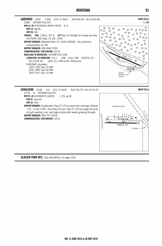
MONTANA 91
GARDINER (29S) 2 NW UTC–7(–6DT) N45º03.00´ W110º44.80´5286 NOTAM FILE GTFRWY 10–28: H3200X55 (ASPH–AFSC) S–4
RWY 10: Rgt tfc.RWY 28: Hill.
SERVICE: FUEL 100LL, JET A LGT Rwy 10–28 lgts for emerg use only. ACTIVATE LIRL Rwy 10–28—CTAF.
AIRPORT REMARKS: Attended Mon–Fri 1500–0000Z‡. No centerline marking Rwy 10–28.
AIRPORT MANAGER: 406-848-7539COMMUNICATIONS: CTAF/UNICOM 122.8RADIO AIDS TO NAVIGATION: NOTAM FILE LVM.
LIVINGSTON (H) VORW/DME 116.1 LVM Chan 108 N45º42.15´ W110º26.55´ 183º 41.2 NM to fld. 4653/15E.
VOR/DME unusable:100º–190º byd 15 NM255º–280º byd 20 NM345º–041º byd 15 NM
GERALDINE (5U8) 0 S UTC–7(–6DT) N47º35.79´ W110º15.97´3178 B NOTAM FILE GTFRWY 07–25: H2900X75 (ASPH) 1.2% up W
RWY 07: Ground.RWY 25: Tree.
AIRPORT REMARKS: Unattended. Rwy 07–25 no pavement markings. Marked +31´ p–line 1400´ from Rwy 25 end. Rwy 07–25 has large amounts of asph spalling, ruts, and large cracks with weeds growing through.
AIRPORT MANAGER: 406-737-4278COMMUNICATIONS: CTAF/UNICOM 122.8
GLACIER PARK INTL (See KALISPELL on page 100)
GREAT FALLSL–13C
GREAT FALLS
NW, 31 MAR 2016 to 26 MAY 2016
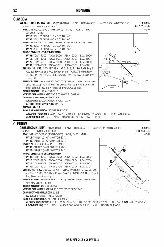
92 MONTANA
GLASGOWWOKAL FLD/GLASGOW INTL (GGW)(KGGW) 1 NE UTC–7(–6DT) N48º12.75´ W106º36.89´
2296 B NOTAM FILE GGWRWY 12–30: H5002X100 (ASPH–GRVD) S–75, D–90.9, 2S–89,
2D–99.9 MIRLRWY 12: REIL. PAPI(P4L)—GA 3.0º TCH 40´.RWY 30: REIL. PAPI(P4L)—GA 3.0º TCH 40´.
RWY 08–26: H5000X75 (ASPH–GRVD) S–25, D–45, 2D–75 MIRLRWY 08: REIL. PAPI(P2L)—GA 3.0º TCH 30´.RWY 26: REIL. PAPI(P2L)—GA 3.0º TCH 32´.
RUNWAY DECLARED DISTANCE INFORMATIONRWY 08: TORA–5000 TODA–5000 ASDA–5000 LDA–5000RWY 12: TORA–5001 TODA–5001 ASDA–5001 LDA–5001RWY 26: TORA–5000 TODA–5000 ASDA–5000 LDA–5000RWY 30: TORA–5001 TODA–5001 ASDA–5001 LDA–5001
SERVICE: S4 FUEL 100, JET A1+ OX 1, 2, 3, 4 LGT PAPI Rwy 8, Rwy 12, Rwy 26 and Rwy 30 opr 24 hrs. ACTIVATE MIRL Rwy 08–26 and Rwy 12–30, REIL Rwy 08, Rwy 12, Rwy 26 and Rwy 30—CTAF.
AIRPORT REMARKS: Attended 1300–0300Z‡. Afld sfc conds unmonitored 0300–1300Z‡. For svc after hrs phone 406–228–4023. After hrs credit card fueling. Flt Notification Svc (ADCUS) avbl.
AIRPORT MANAGER: (406) 228-2719WEATHER DATA SOURCES: ASOS 135.175 (406) 228–8294.COMMUNICATIONS: CTAF/UNICOM 122.8
GLASGOW RCO 122.25 (GREAT FALLS RADIO)SALT LAKE CENTER APP/DEP CON 126.85
AIRSPACE: CLASS ERADIO AIDS TO NAVIGATION: NOTAM FILE GGW.
GLASGOW (H) VORW/DME 113.9 GGW Chan 86 N48º12.92´ W106º37.53´ at fld. 2283/14E.MILK RIVER NDB (HW) 339 MKR N48º12.47´ W106º37.57´ at fld.
GLENDIVEDAWSON COMMUNITY (GDV)(KGDV) 4 NW UTC–7(–6DT) N47º08.32´ W104º48.43´
2458 B NOTAM FILE GDVRWY 12–30: H5704X100 (ASPH–GRVD) S–38, D–50 MIRL
RWY 12: VASI(V4L)—GA 3.0º TCH 37´.RWY 30: VASI(V4L)—GA 3.0º TCH 37´.
RWY 02–20: H3002X60 (ASPH) MIRLRWY 02: PAPI(P2L)—GA 3.0º TCH 26´.RWY 20: PAPI(P2L)—GA 3.0º TCH 24´.
RUNWAY DECLARED DISTANCE INFORMATIONRWY 02: TORA–3002 TODA–3002 ASDA–3002 LDA–3002RWY 12: TORA–5704 TODA–5704 ASDA–5704 LDA–5704RWY 20: TORA–3002 TODA–3002 ASDA–3002 LDA–3002RWY 30: TORA–5704 TODA–5704 ASDA–5704 LDA–5704
SERVICE: S2 FUEL 100LL, JET A+ LGT ACTIVATE MIRL Rwy 02–20 and Rwy 12–30, PAPI Rwy 02 and Rwy 20—CTAF. VASI Rwy 12 and Rwy 30 opr continuously.
AIRPORT REMARKS: Attended 1430–0130Z‡. Afld sfc conds unmonitored Nov–May 0800–1800Z‡.
AIRPORT MANAGER: 406-989-2054WEATHER DATA SOURCES: AWOS–3 135.075 (406) 687–3346.COMMUNICATIONS: CTAF/UNICOM 122.8
RCO 122.55 (GREAT FALLS RADIO)RADIO AIDS TO NAVIGATION: NOTAM FILE MLS.
MILES CITY (H) VORW/DME 112.1 MLS Chan 58 N46º22.93´ W105º57.21´ 031º 65.6 NM to fld. 2666/15E.GLENDIVE NDB (HW) 410 GDV N47º08.00´ W104º48.28´ at fld. NOTAM FILE GDV.
BILLINGSH–1E, 2G, L–13D
IAP, AD
BILLINGSH–1F, 2H, L–13E
IAP, AD
NW, 31 MAR 2016 to 26 MAY 2016
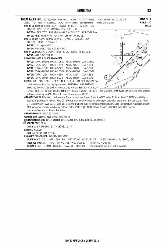
MONTANA 93
GREAT FALLS INTL (GTF)(KGTF) P (ANG) 3 SW UTC–7(–6DT) N47º28.96´ W111º22.24´3680 B TPA—4480(800) AOE ARFF Index—See Remarks NOTAM FILE GTFRWY 03–21: H10502X150 (ASPH–GRVD) S–150, D–173, 2S–175,
2D–331, 2D/D1–555, 2D/2D2–555 HIRL CLRWY 03: ALSF2. TDZL. PAPI(P4L)—GA 3.0º TCH 70´. RVR–TMR Road.RWY 21: REIL. PAPI(P4R)—GA 3.0º TCH 75´. 0.3% up.
RWY 16–34: H5722X150 (ASPH–PFC) S–95, D–120, 2S–152, 2D–190 HIRL 0.5% up SRWY 16: Thld dsplcd 652´.RWY 34: PAPI(P4L)—GA 3.0º TCH 50´.
RWY 07–25: H4294X75 (ASPH–PFC) S–25 MIRL 0.4% up ERWY 25:—GA 3.3º TCH 40´.
RUNWAY DECLARED DISTANCE INFORMATIONRWY 03: TORA–10502 TODA–10502 ASDA–10502 LDA–10502RWY 07: TORA–4294 TODA–4294 ASDA–4294 LDA–4294RWY 16: TORA–5722 TODA–5722 ASDA–5070 LDA–5070RWY 21: TORA–10502 TODA–10502 ASDA–10502 LDA–10502RWY 25: TORA–4294 TODA–4294 ASDA–4294 LDA–4294RWY 34: TORA–5070 TODA–5070 ASDA–5070 LDA–5070
SERVICE: S4 FUEL 100LL, JET A OX 1, 2, 3, 4 LGT REIL Rwy 21 opr continuously when the rwy lgts are on. MILITARY— JASU 7(MD–3) 3(MC–1) 20(MC–11) 9(MD–4MO) 2(M32A–60A) FUEL A++(ANG) A (C406–453–7613) (NC–100LL) FLUID SP PRESAIR OIL O–128–133–148–156(Mil) TRAN ALERT Ltd tran svc only avbl for acft participating in ANG Ops with Prior Coordination (PPR).
AIRPORT REMARKS: Attended continuously. Birds on and invof arpt. Class I, ARFF Index B. Index level C ARFF capability is available 24/hrs/day/365/yr. Rwy 07–25 not avbl for air carrier tkf and ldg of acft with more than 30 pax seats. Rwy 07–25 between Rwys 03–21 and 16–34 unrstd wt and avbl for air carrier taxiing acft. Cold temperature restricted airport. Altitude correction required at or below –33C/–27F. Flight Notification Service (ADCUS) avbl. See Special Notices—Continuous Power Facilities.
AIRPORT MANAGER: 406-727-3404WEATHER DATA SOURCES: ASOS (406) 452–9844COMMUNICATIONS: ATIS 126.6 UNICOM 122.95 RCO 122.6 (GREAT FALLS RADIO)
®APP/DEP CON 128.6TOWER 118.7 GND CON 121.7 CLNC DEL 121.7
AIRSPACE: CLASS DTRSA svc ctc APP CON 128.6
RADIO AIDS TO NAVIGATION: NOTAM FILE GTF.(H) VORTACW 115.1 GTF Chan 98 N47º27.00´ W111º24.73´ 025º 2.6 NM to fld. 3672/16E.TRULY NDB (HW) 371 ITU N47º21.95´ W111º22.37´ 348º 7.0 NM to fld.ILS/DME 111.3 I–SMR Chan 50 Rwy 03. Class IIIE. LOC unusable byd 20º left of course.
GREAT FALLSH–1E, L–13C
IAP, AD
NW, 31 MAR 2016 to 26 MAY 2016
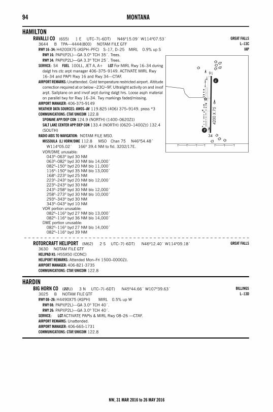
94 MONTANA
HAMILTONRAVALLI CO (6S5) 1 E UTC–7(–6DT) N46º15.09´ W114º07.53´
3644 B TPA—4444(800) NOTAM FILE GTFRWY 16–34: H4200X75 (ASPH–PFC) S–17, D–25 MIRL 0.9% up S
RWY 16: PAPI(P2L)—GA 3.0º TCH 35´. Trees.RWY 34: PAPI(P2L)—GA 3.3º TCH 25´. Trees.
SERVICE: S4 FUEL 100LL, JET A, A+ LGT For MIRL Rwy 16–34 during dalgt hrs ctc arpt manager 406–375–9149. ACTIVATE MIRL Rwy 16–34 and PAPI Rwy 16 and Rwy 34—CTAF.
AIRPORT REMARKS: Unattended. Cold temperature restricted airport. Altitude correction required at or below –23C/–9F. Ultralight activity on and invof arpt. Sailplane on and invof arpt during dalgt hrs. Loose asph material on parallel twy for Rwy 16–34. Twy markings faded/missing.
AIRPORT MANAGER: 406-375-9149WEATHER DATA SOURCES: AWOS–AV 119.825 (406) 375–9149. press *3COMMUNICATIONS: CTAF/UNICOM 122.8
SPOKANE APP/DEP CON 124.9 (NORTH) (1400–0620Z‡)SALT LAKE CENTER APP/DEP CON 133.4 (NORTH) (0620–1400Z‡) 132.4 (SOUTH)
RADIO AIDS TO NAVIGATION: NOTAM FILE MSO.MISSOULA (L) VORW/DME 112.8 MSO Chan 75 N46º54.48´
W114º05.02´ 166º 39.4 NM to fld. 3202/17E.VOR/DME unusable:
043º–063º byd 30 NM063º–082º byd 30 NM blo 14,000´082º–150º byd 20 NM blo 11,000´116º–150º byd 35 NM blo 13,000´168º–223º byd 25 NM223º–243º byd 20 NM blo 12,000´223º–243º byd 30 NM243º–258º byd 30 NM blo 12,000´258º–273º byd 30 NM blo 10,000´293º–343º byd 30 NM343º–043º byd 10 NM
VOR portion unusable:082º–116º byd 27 NM blo 13,000´082º–116º byd 36 NM blo 14,000´
DME portion unusable:082º–116º byd 27 NM blo 14,000´082º–116º byd 39 NM
– – – – – – – – – – – – – – – – – – – – – – – – – – – – – – – – – – – – – – – – – – – – – – – – – – – – – – – –
ROTORCRAFT HELIPORT (M62) 2 S UTC–7(–6DT) N46º12.40´ W114º09.18´3630 NOTAM FILE GTFHELIPAD H1: H55X50 (CONC)HELIPORT REMARKS: Attended Mon–Fri 1500–0000Z‡.AIRPORT MANAGER: 406-821-3735COMMUNICATIONS: CTAF/UNICOM 122.8
HARDINBIG HORN CO (00U) 3 N UTC–7(–6DT) N45º44.66´ W107º39.63´
3025 B NOTAM FILE GTFRWY 08–26: H4490X75 (ASPH) MIRL 0.5% up W
RWY 08: PAPI(P2L)—GA 3.0º TCH 40´.RWY 26: PAPI(P2L)—GA 3.0º TCH 40´.
SERVICE: LGT ACTIVATE PAPIs & MIRL Rwy 08–26 —CTAF.AIRPORT REMARKS: Unattended. AIRPORT MANAGER: 406-665-1731COMMUNICATIONS: CTAF/UNICOM 122.8
GREAT FALLSL–13C
IAP
GREAT FALLS
BILLINGSL–13D
NW, 31 MAR 2016 to 26 MAY 2016
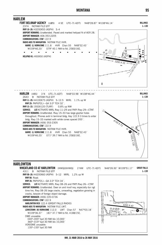
MONTANA 95
HARLEMFORT BELKNAP AGENCY (U09) 4 SE UTC–7(–6DT) N48º28.87´ W108º46.14´
2374 NOTAM FILE GTFRWY 10–28: H3200X55 (ASPH) S–4AIRPORT REMARKS: Unattended. Paved and marked helipad N of AER 28.AIRPORT MANAGER: 406-353-2205COMMUNICATIONS: CTAF 122.9RADIO AIDS TO NAVIGATION: NOTAM FILE HVR.
HAVRE (L) VORW/DME 111.8 HVR Chan 55 N48º32.43´ W109º46.20´ 079º 40.1 NM to fld. 2583/16E.
• • • • • • • • • • • • • • • • • •
HELIPAD H1: H50X50 (ASPH)
– – – – – – – – – – – – – – – – – – – – – – – – – – – – – – – – – – – – – – – – – – – – – – – – – – – – – – – –
HARLEM (48S) 3 N UTC–7(–6DT) N48º33.98´ W108º46.44´2643 B NOTAM FILE GTFRWY 11–29: H4100X75 (ASPH) S–12.5 MIRL 1.1% up W
RWY 29: PAPI(P2L)—GA 3.0º TCH 32´.RWY 15–33: 1933X120 (TURF) 0.8% up NWSERVICE: LGT ACTIVATE MIRL Rwy 11–29 and PAPI Rwy 29—CTAF.AIRPORT REMARKS: Unattended. Rwy 15–33 has large gopher holes
throughout. Phones avbl in terminal bldg. Key 122.9 3 times to enter bldg. Rwy 15–33 marked with white cones spaced 200´.
AIRPORT MANAGER: (406) 353-2305COMMUNICATIONS: CTAF 122.9RADIO AIDS TO NAVIGATION: NOTAM FILE HVR.
HAVRE (L) VORW/DME 111.8 HVR Chan 55 N48º32.43´ W109º46.20´ 071º 39.7 NM to fld. 2583/16E.
HARLOWTONWHEATLAND CO AT HARLOWTON (HWQ)(KHWQ) 2 NW UTC–7(–6DT) N46º26.92´ W109º51.17´
4311 B NOTAM FILE GTFRWY 08–26: H4200X60 (ASPH) S–12 MIRL 1.2% up W
RWY 08: Road.RWY 26: PAPI(P2L)—GA 3.0º TCH 34´.
SERVICE: LGT ACTIVATE MIRL Rwy 08–26 and PAPI Rwy 26—CTAF.AIRPORT REMARKS: Unattended. Deer on and invof rwy, especially dur ngt
time hrs. Rwy 08–26 large cracks, unraveling, vegetation growing in cracks, beware of foreign object damage.
AIRPORT MANAGER: (406) 220-0736COMMUNICATIONS: CTAF 122.9
HARLOWTON RCO 122.4 (GREAT FALLS RADIO)RADIO AIDS TO NAVIGATION: NOTAM FILE LWT.
LEWISTOWN (H) VORW/DME 112.0 LWT Chan 57 N47º03.18´ W109º36.37´ 181º 37.7 NM to fld. 4188/15E.
DME unusable:040º–055º byd 30 NM blo 10,000´360º–015º byd 30 NM blo 10,000´
VOR/DME unusable:135º–155º byd 30 NM
BILLINGSL–13D
BILLINGSL–13D
GREAT FALLSL–13D
NW, 31 MAR 2016 to 26 MAY 2016
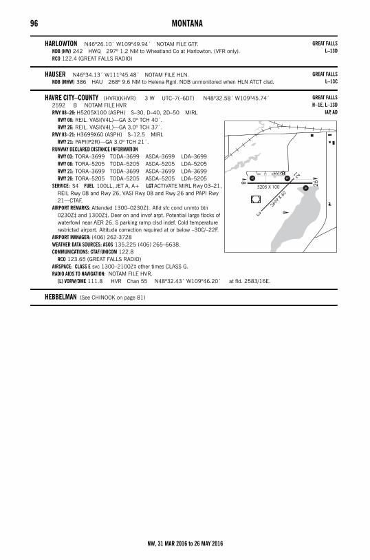
96 MONTANA
HARLOWTON N46º26.10´ W109º49.94´ NOTAM FILE GTF.NDB (HW) 242 HWQ 297º 1.2 NM to Wheatland Co at Harlowton. (VFR only).RCO 122.4 (GREAT FALLS RADIO)
HAUSER N46º34.13´ W111º45.48´ NOTAM FILE HLN.NDB (MHW) 386 HAU 268º 9.6 NM to Helena Rgnl. NDB unmonitored when HLN ATCT clsd.
HAVRE CITY–COUNTY (HVR)(KHVR) 3 W UTC–7(–6DT) N48º32.58´ W109º45.74´2592 B NOTAM FILE HVRRWY 08–26: H5205X100 (ASPH) S–30, D–40, 2D–50 MIRL
RWY 08: REIL. VASI(V4L)—GA 3.0º TCH 40´.RWY 26: REIL. VASI(V4L)—GA 3.0º TCH 37´.
RWY 03–21: H3699X60 (ASPH) S–12.5 MIRLRWY 21: PAPI(P2R)—GA 3.0º TCH 21´.
RUNWAY DECLARED DISTANCE INFORMATIONRWY 03: TORA–3699 TODA–3699 ASDA–3699 LDA–3699RWY 08: TORA–5205 TODA–5205 ASDA–5205 LDA–5205RWY 21: TORA–3699 TODA–3699 ASDA–3699 LDA–3699RWY 26: TORA–5205 TODA–5205 ASDA–5205 LDA–5205
SERVICE: S4 FUEL 100LL, JET A, A+ LGT ACTIVATE MIRL Rwy 03–21, REIL Rwy 08 and Rwy 26, VASI Rwy 08 and Rwy 26 and PAPI Rwy 21—CTAF.
AIRPORT REMARKS: Attended 1300–0230Z‡. Afld sfc cond unmto btn 0230Z‡ and 1300Z‡. Deer on and invof arpt. Potential large flocks of waterfowl near AER 26. S parking ramp clsd indef. Cold temperature restricted airport. Altitude correction required at or below –30C/–22F.
AIRPORT MANAGER: (406) 262-3728WEATHER DATA SOURCES: ASOS 135.225 (406) 265–6638.COMMUNICATIONS: CTAF/UNICOM 122.8
RCO 123.65 (GREAT FALLS RADIO)AIRSPACE: CLASS E svc 1300–2100Z‡ other times CLASS G.RADIO AIDS TO NAVIGATION: NOTAM FILE HVR.
(L) VORW/DME 111.8 HVR Chan 55 N48º32.43´ W109º46.20´ at fld. 2583/16E.
HEBBELMAN (See CHINOOK on page 81)
GREAT FALLSL–13D
GREAT FALLSL–13C
GREAT FALLSH–1E, L–13D
IAP, AD
NW, 31 MAR 2016 to 26 MAY 2016
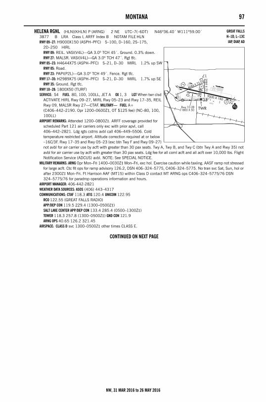
MONTANA 97
HELENA RGNL (HLN)(KHLN) P (ARNG) 2 NE UTC–7(–6DT) N46º36.40´ W111º59.00´3877 B LRA Class I, ARFF Index B NOTAM FILE HLNRWY 09–27: H9000X150 (ASPH–PFC) S–100, D–160, 2S–175,
2D–250 HIRLRWY 09: REIL. VASI(V4L)—GA 3.0º TCH 45´. Ground. 0.3% down.RWY 27: MALSR. VASI(V4L)—GA 3.0º TCH 47´. Rgt tfc.
RWY 05–23: H4644X75 (ASPH–PFC) S–21, D–30 MIRL 1.2% up SWRWY 05: Road.RWY 23: PAPI(P2L)—GA 3.0º TCH 49´. Fence. Rgt tfc.
RWY 17–35: H2989X75 (ASPH–PFC) S–21, D–30 MIRL 1.7% up SERWY 35: Ground. Rgt tfc.
RWY 10–28: 1800X50 (TURF)SERVICE: S4 FUEL 80, 100, 100LL, JET A OX 1, 3 LGT When twr clsd
ACTIVATE HIRL Rwy 09–27, MIRL Rwy 05–23 and Rwy 17–35, REIL Rwy 09, MALSR Rwy 27—CTAF. MILITARY— FUEL A+ (C406–442–2190. Opr 1200–0600Z‡, OT $125 fee) (NC–80, 100, 100LL)
AIRPORT REMARKS: Attended 1200–0800Z‡. ARFF coverage provided for scheduled Part 121 air carriers only exc with prior apvl, call 406–442–2821. Ldg rgts cstms avbl call 406–449–5506. Cold temperature restricted airport. Altitude correction required at or below –16C/3F. Rwy 17–35 and Rwy 05–23 (exc btn Twy F and Rwy 09–27) not avbl for air carrier use by acft with greater than 30 pax seats. Twy A, Twy B, and Twy C (btn Twy A and Rwy 35) not avbl for air carrier use by acft with greater than 30 pax seats. Ldg fee for all coml acft and all acft over 10,000 lbs. Flight Notification Service (ADCUS) avbl. NOTE: See SPECIAL NOTICE.
MILITARY REMARKS: ARNG Opr Mon–Fri 1400–0030Z‡ Mon–Fri, exc hol. Exercise caution while taxiing. AASF ramp not stressed for large acft. Ctc flt ops for ramp advisory 126.2, DSN 406–324–5775, C406–324–5775. No tran svc Sat, Sun, hol or after 2300Z‡ Mon–Fri. Ft Harrison AAF (MT15) within Class D contact MT ARNG ops C406–324–5775/76 DSN 324–5775/76 for paradrop operations information and hours.
AIRPORT MANAGER: 406-442-2821WEATHER DATA SOURCES: ASOS (406) 443–4317COMMUNICATIONS: CTAF 118.3 ATIS 120.4 UNICOM 122.95
RCO 122.55 (GREAT FALLS RADIO)APP/DEP CON 119.5 229.4 (1300–0500Z‡)SALT LAKE CENTER APP/DEP CON 133.4 285.4 (0500–1300Z‡)TOWER 118.3 257.8 (1300–0500Z‡) GND CON 121.9ARNG OPS 40.65 126.2 321.45
AIRSPACE: CLASS D svc 1300–0500Z‡ other times CLASS E.
CONTINUED ON NEXT PAGE
GREAT FALLSH–1D, L–13CIAP, DIAP, AD
NW, 31 MAR 2016 to 26 MAY 2016
98 MONTANACONTINUED FROM PRECEDING PAGE
RADIO AIDS TO NAVIGATION: NOTAM FILE HLN.(H) VORTACW 117.7 HLN Chan 124 N46º36.41´ W111º57.21´ 254º 1.2 NM to fld. 3823/16E.VOR portion unusable:
035º–050º byd 35 NM blo 12,000´105º–165º byd 25 NM blo 17,000´165º–185º byd 25 NM blo 13,500´185º–230º byd 25 NM blo 17,500´203º–213º byd 22 NM blo 13,000´230º–270º byd 25 NM blo 12,500´
TACAN AZIMUTH & DME unusable:035º–070º byd 35 NM blo 13,000´165º–185º byd 25 NM blo 13,500´250º–300º byd 25 NM blo 14,000´320º–035º byd 25 NM blo 13,000´
TACAN DME unusable:035º–070º byd 35 NM blo 13,000´105º–150º byd 25 NM105º–210º byd 15 NM blo 11,100´105º–210º byd 20 NM blo 12,000´150º–165º byd 25 NM blo 17,000´165º–185º byd 25 NM blo 13,500´185º–210º byd 25 NM203º–213º byd 22 NM blo 13,000´210º–250º byd 15 NM blo 12,000´210º–250º byd 25 NM blo 17,500´250º–300º byd 25 NM blo 14,000´320º–035º byd 25 NM blo 13,000´
TACAN AZIMUTH unusable:105º–150º byd 15 NM150º–165º byd 15 NM blo 17,000´185º–210º byd 15 NM210º–250º byd 15 NM blo 17,500´
CAPITOL NDB (HW) 335 CVP N46º36.40´ W111º56.23´ 258º 1.9 NM to fld. NDB unmonitored when ATCT clsd.HAUSER NDB (MHW) 386 HAU N46º34.13´ W111º45.48´ 268º 9.6 NM to fld. NDB unmonitored when HLN
ATCT clsd.ILS 110.1 I–HLN Rwy 27. Unmonitored when ATCT closed. Localizer backcourse unusable byd 22º rgt of course,
unusable within 2.7 DME.
HELLER FARM (See WINIFRED on page 122)
HINSDALE (6U5) 0 SE UTC–7(–6DT) N48º23.28´ W107º05.00´2220 NOTAM FILE GTFRWY 07–25: 2200X75 (TURF) LIRL(NSTD) 0.7% up W
RWY 07: Road.RWY 10–28: 2160X200 (TURF) 0.3% up W
RWY 10: Road.RWY 16–34: 1960X75 (TURF) 1.5% up S
RWY 16: P–line.RWY 34: Fence.
AIRPORT REMARKS: Unattended. Rwys soft when wet. Hay bales and farm equipment adjacent to rwy. Rwys not clearly defined. Rwy 16–34, Rwy 07–25 and Rwy 10–28 marked with white cones full length of rwy. Rwy 16 p–lines marked with globes. Rwy 07–25 NSTD LIRL 335´ spacing between lgts, one thld lgt each end. For rwy lgts phone 406–364–2387.
AIRPORT MANAGER: (406) 672-2448COMMUNICATIONS: CTAF 122.9
HOGELAND (6U6) 1 NW UTC–7(–6DT) N48º51.61´ W108º39.66´3139 B NOTAM FILE GTFRWY 07–25: 3140X60 (GRVL–DIRT) 0.6% up WRWY 16–34: 1230X50 (TURF)
RWY 34: Bldg.AIRPORT REMARKS: Unattended.AIRPORT MANAGER: (406) 390-1374COMMUNICATIONS: CTAF 122.9
BILLINGS
BILLINGS
NW, 31 MAR 2016 to 26 MAY 2016
MONTANA 99
HOT SPRINGS (S09) 2 E UTC–7(–6DT) N47º36.75´ W114º36.81´2763 B NOTAM FILE GTFRWY 06–24: H3550X45 (ASPH–TRTD) MIRL
RWY 24: Thld dsplcd 411´. Road.AIRPORT REMARKS: Unattended. Ultralgts on and invof arpt. Ocnl snow removal. Rwy 06–24 asph grvl composition full length.
Rwy 24 has 411´ unlgtd, 2169´ lgtd at ngt. Rwy 06–24 cones adj to MIRL full length and dsplcd thld marked with white cones. Rwy 06 and Rwy 24 numbers 4´x 8´ in measure, thld line and rwy lines NSTD.
AIRPORT MANAGER: 406-741-3582COMMUNICATIONS: CTAF 122.9
HYSHAM (6U7) 2 E UTC–7(–6DT) N46º17.61´ W107º11.60´2624 B NOTAM FILE GTFRWY 07–25: H3060X45 (ASPH–TRTD) LIRLSERVICE: LGT ACTIVATE LIRL Rwy 07–25—CTAF.AIRPORT REMARKS: Unattended. 1030´ dirt extn E of Rwy 07 thld soft when wet. Rwy 07 basic markings NSTD numbers and
stripes. AIRPORT MANAGER: 406-342-5252COMMUNICATIONS: CTAF 122.9
JORDAN (JDN)(KJDN) 2 NW UTC–7(–6DT) N47º19.73´ W106º57.16´2666 B NOTAM FILE JDNRWY 11–29: H4300X75 (ASPH–PFC) S–12.5 MIRL 0.7% up W
RWY 29: PAPI(P2L)—GA 3.0º TCH 29´.SERVICE: LGT ACTIVATE MIRL Rwy 11–29 and PAPI Rwy 29—CTAF.AIRPORT REMARKS: Unattended. AIRPORT MANAGER: (406) 939-2931COMMUNICATIONS: CTAF 122.9RADIO AIDS TO NAVIGATION: NOTAM FILE GGW.
GLASGOW (H) VORW/DME 113.9 GGW Chan 86 N48º12.92´ W106º37.53´ 180º 54.8 NM to fld. 2283/14E.NDB (MHW) 263 JDN N47º20.00´ W106º56.29´ at fld. NOTAM FILE JDN. VFR only.
JUDITH MOUNTAIN N47º13.03´ W109º13.31´RCO 122.2 (GREAT FALLS RADIO)
GREAT FALLS
BILLINGS
BILLINGSL–13D
GREAT FALLSL–13D
NW, 31 MAR 2016 to 26 MAY 2016
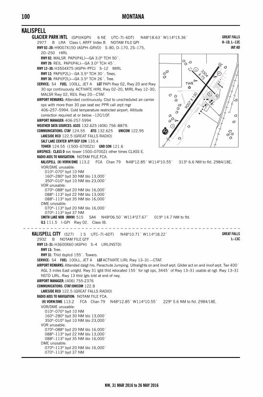
100 MONTANA
KALISPELLGLACIER PARK INTL (GPI)(KGPI) 6 NE UTC–7(–6DT) N48º18.63´ W114º15.36´
2977 B LRA Class I, ARFF Index B NOTAM FILE GPIRWY 02–20: H9007X150 (ASPH–GRVD) S–80, D–170, 2S–175,
2D–250 HIRLRWY 02: MALSR. PAPI(P4L)—GA 3.0º TCH 50´.RWY 20: REIL. PAPI(P4L)—GA 3.0º TCH 45´.
RWY 12–30: H3504X75 (ASPH–PFC) S–12 MIRLRWY 12: PAPI(P2L)—GA 3.5º TCH 30´. Trees.RWY 30: PAPI(P2L)—GA 3.5º TCH 26´. Tree.
SERVICE: S4 FUEL 100LL, JET A LGT PAPI Rwy 02, Rwy 20 and Rwy 30 opr continuously. ACTIVATE HIRL Rwy 02–20, MIRL Rwy 12–30, MALSR Rwy 02, REIL Rwy 20—CTAF.
AIRPORT REMARKS: Attended continuously. Clsd to unscheduled air carrier ops with more than 30 pax seat exc PPR call arpt mgr 406–257–5994. Cold temperature restricted airport. Altitude correction required at or below –12C/10F.
AIRPORT MANAGER: 406-257-5994WEATHER DATA SOURCES: ASOS 132.625 (406) 756–8879.COMMUNICATIONS: CTAF 124.55 ATIS 132.625 UNICOM 122.95
LAKESIDE RCO 122.5 (GREAT FALLS RADIO)SALT LAKE CENTER APP/DEP CON 133.4 TOWER 124.55 (1500–0700Z‡) GND CON 121.6
AIRSPACE: CLASS D svc tower 1500–0700Z‡ other times CLASS E.RADIO AIDS TO NAVIGATION: NOTAM FILE FCA.
KALISPELL (H) VORW/DME 113.2 FCA Chan 79 N48º12.85´ W114º10.55´ 313º 6.6 NM to fld. 2984/18E.VOR/DME unusable:
010º–070º byd 10 NM160º–280º byd 30 NM blo 13,000´350º–010º byd 10 NM blo 23,000´
VOR unusable:070º–088º byd 20 NM blo 16,000´088º–113º byd 22 NM blo 13,000´088º–113º byd 35 NM blo 16,000´
DME unusable:070º–113º byd 20 NM blo 16,000´070º–113º byd 37 NM
SMITH LAKE NDB (MHW) 515 SAK N48º06.50´ W114º27.67´ 019º 14.7 NM to fld.ILS 111.5 I–GPI Rwy 02. Class IB.
– – – – – – – – – – – – – – – – – – – – – – – – – – – – – – – – – – – – – – – – – – – – – – – – – – – – – – – –
KALISPELL CITY (S27) 1 S UTC–7(–6DT) N48º10.71´ W114º18.22´2932 B NOTAM FILE GTFRWY 13–31: H3600X60 (ASPH) S–4 LIRL(NSTD)
RWY 13: Tree.RWY 31: Thld dsplcd 155´. Towers.
SERVICE: S4 FUEL 100LL, JET A LGT ACTIVATE LIRL Rwy 13–31—CTAF.AIRPORT REMARKS: Attended dalgt hrs. Parachute Jumping. Ultralights on and invof arpt. Glider act on and invof arpt. Twr 400´
AGL 3 miles East unlgtd. Rwy 31 lgtd thld relocated 155´ for ngt ops, 3445´ of Rwy 13–31 usable at ngt. Rwy 13–31 NSTD LIRL. Rwy 13 thld lgts lctd at end of rwy.
AIRPORT MANAGER: (406) 755-2376COMMUNICATIONS: CTAF/UNICOM 122.8
LAKESIDE RCO 122.5 (GREAT FALLS RADIO)RADIO AIDS TO NAVIGATION: NOTAM FILE FCA.
(H) VORW/DME 113.2 FCA Chan 79 N48º12.85´ W114º10.55´ 229º 5.6 NM to fld. 2984/18E.VOR/DME unusable:
010º–070º byd 10 NM160º–280º byd 30 NM blo 13,000´350º–010º byd 10 NM blo 23,000´
VOR unusable:070º–088º byd 20 NM blo 16,000´088º–113º byd 22 NM blo 13,000´088º–113º byd 35 NM blo 16,000´
DME unusable:070º–113º byd 20 NM blo 16,000´070º–113º byd 37 NM
GREAT FALLSH–1D, L–13C
IAP, AD
GREAT FALLSL–13C
NW, 31 MAR 2016 to 26 MAY 2016
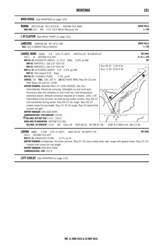
MONTANA 101
KNOX RIDGE (See WINIFRED on page 123)
KONNA N47º05.66´ W114º23.81´ NOTAM FILE MSO.NDB (HW) 521 INE 113º 16.5 NM to Missoula Intl.
L M CLAYTON (See WOLF POINT on page 124)
LAKESIDE N48º00.68´ W114º21.88´RCO 122.5 (GREAT FALLS RADIO)
LAUREL MUNI (6S8) 2 N UTC–7(–6DT) N45º42.26´ W108º45.57´3517 B NOTAM FILE GTFRWY 04–22: H5200X75 (ASPH) S–12.5 MIRL 0.6% up SW
RWY 04: PAPI(P2L)—GA 3.0º TCH 33´.RWY 22: PAPI(P2L)—GA 3.0º TCH 44´.
RWY 14–32: H2725X50 (ASPH) S–8 2.4% up NWRWY 32: Thld dsplcd 516´. Trees.
RWY 09–27: 1100X60 (TURF) 2.3% up WSERVICE: S4 FUEL 100, JET A LGT ACTIVATE MIRL Rwy 04–22 and
PAPI Rwys 04 and 22—CTAF.AIRPORT REMARKS: Attended Mon–Fri 1500–0000Z‡, Sat–Sun
intermittently. Parachute Jumping. Ultralights on and invof arpt. Numerous deer and antelope on and invof rwy. Cold temperature restricted airport. Altitude correction required at or below –25C/–13F. Intermittent snow removal, be alert during winter months. Rwy 09–27 not maintained during winter. Rwy 09–27 sfc rough. Rwy 09–27 marker cones full rwy length. Rwy 14–32 sfc rough. Rwy 32 dsplcd thld marked not lgtd.
AIRPORT MANAGER: 406-628-4595COMMUNICATIONS: CTAF/AUNICOM 123.05
®BILLINGS APP/DEP CON 119.2 120.5RADIO AIDS TO NAVIGATION: NOTAM FILE BIL.
BILLINGS (H) VORTACW 114.5 BIL Chan 92 N45º48.51´ W108º37.48´ 208º 8.4 NM to fld. 3811/14E.
LAVINA (80S) 2 NW UTC–7(–6DT) N46º18.44´ W108º57.29´3512 NOTAM FILE GTFRWY 07–25: 3460X100 (TURF) 0.7% up WAIRPORT REMARKS: Unattended. No snow removal. Rwy 07–25 very muddy when wet, rough with gopher holes. Rwy 07–25
marked with cones full rwy length.AIRPORT MANAGER: 406-444-2506COMMUNICATIONS: CTAF 122.9
LEFT COULEE (See WINIFRED on page 123)
GREAT FALLSL–13B
GREAT FALLSL–13B
BILLINGSH–1E, L–13D
IAP
BILLINGS
NW, 31 MAR 2016 to 26 MAY 2016
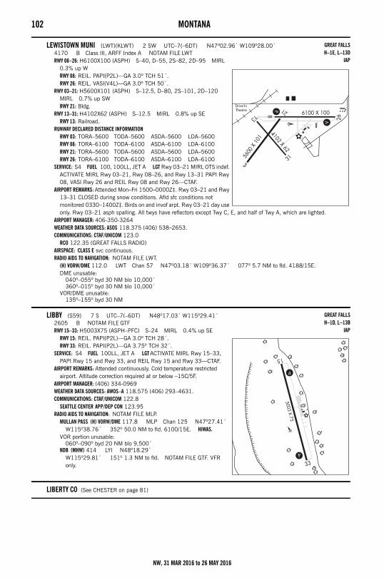
102 MONTANA
LEWISTOWN MUNI (LWT)(KLWT) 2 SW UTC–7(–6DT) N47º02.96´ W109º28.00´4170 B Class III, ARFF Index A NOTAM FILE LWTRWY 08–26: H6100X100 (ASPH) S–40, D–55, 2S–82, 2D–95 MIRL
0.3% up WRWY 08: REIL. PAPI(P2L)—GA 3.0º TCH 51´.RWY 26: REIL. VASI(V4L)—GA 3.0º TCH 50´.
RWY 03–21: H5600X101 (ASPH) S–12.5, D–80, 2S–101, 2D–120 MIRL 0.7% up SWRWY 21: Bldg.
RWY 13–31: H4102X62 (ASPH) S–12.5 MIRL 0.8% up SERWY 13: Railroad.
RUNWAY DECLARED DISTANCE INFORMATIONRWY 03: TORA–5600 TODA–5600 ASDA–5600 LDA–5600RWY 08: TORA–6100 TODA–6100 ASDA–6100 LDA–6100RWY 21: TORA–5600 TODA–5600 ASDA–5600 LDA–5600RWY 26: TORA–6100 TODA–6100 ASDA–6100 LDA–6100
SERVICE: S4 FUEL 100, 100LL, JET A LGT Rwy 03–21 MIRL OTS indef. ACTIVATE MIRL Rwy 03–21, Rwy 08–26, and Rwy 13–31 PAPI Rwy 08, VASI Rwy 26 and REIL Rwy 08 and Rwy 26—CTAF.
AIRPORT REMARKS: Attended Mon–Fri 1500–0000Z‡. Rwy 03–21 and Rwy 13–31 CLOSED during snow conditions. Afld sfc conditions not monitored 0330–1400Z‡. Birds on and invof arpt. Rwy 03–21 day use only. Rwy 03–21 asph spalling. All twys have reflectors except Twy C, E, and half of Twy A, which are lighted.
AIRPORT MANAGER: 406-350-3264WEATHER DATA SOURCES: ASOS 118.375 (406) 538–2653.COMMUNICATIONS: CTAF/UNICOM 123.0
RCO 122.35 (GREAT FALLS RADIO)AIRSPACE: CLASS E svc continuous. RADIO AIDS TO NAVIGATION: NOTAM FILE LWT.
(H) VORW/DME 112.0 LWT Chan 57 N47º03.18´ W109º36.37´ 077º 5.7 NM to fld. 4188/15E.DME unusable:
040º–055º byd 30 NM blo 10,000´360º–015º byd 30 NM blo 10,000´
VOR/DME unusable:135º–155º byd 30 NM
LIBBY (S59) 7 S UTC–7(–6DT) N48º17.03´ W115º29.41´2605 B NOTAM FILE GTFRWY 15–33: H5003X75 (ASPH–PFC) S–24 MIRL 0.4% up SE
RWY 15: REIL. PAPI(P2L)—GA 3.0º TCH 28´.RWY 33: REIL. PAPI(P2L)—GA 3.75º TCH 32´.
SERVICE: S4 FUEL 100LL, JET A LGT ACTIVATE MIRL Rwy 15–33, PAPI Rwy 15 and Rwy 33, and REIL Rwy 15 and Rwy 33—CTAF.
AIRPORT REMARKS: Attended continuously. Cold temperature restricted airport. Altitude correction required at or below –15C/5F.
AIRPORT MANAGER: (406) 334-0969WEATHER DATA SOURCES: AWOS–A 118.575 (406) 293–4631.COMMUNICATIONS: CTAF/UNICOM 122.8
SEATTLE CENTER APP/DEP CON 123.95RADIO AIDS TO NAVIGATION: NOTAM FILE MLP.
MULLAN PASS (H) VORW/DME 117.8 MLP Chan 125 N47º27.41´ W115º38.76´ 352º 50.0 NM to fld. 6100/15E. HIWAS.
VOR portion unusable:060º–090º byd 20 NM blo 9,500´
NDB (MHW) 414 LYI N48º18.29´ W115º29.81´ 151º 1.3 NM to fld. NOTAM FILE GTF. VFR only.
LIBERTY CO (See CHESTER on page 81)
GREAT FALLSH–1E, L–13D
IAP
GREAT FALLSH–1D, L–13B
IAP
NW, 31 MAR 2016 to 26 MAY 2016
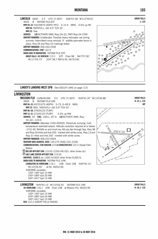
MONTANA 103
LINCOLN (S69) 2 E UTC–7(–6DT) N46º57.28´ W112º39.01´4603 B NOTAM FILE GTFRWY 04–22: H4239X75 (ASPH–PFC) S–12.5 MIRL 0.6% up NE
RWY 04: PAPI(P2L)—GA 4.0º TCH 32´.RWY 22: Tree.
SERVICE: LGT ACTIVATE MIRL Rwy 04–22, PAPI Rwy 04–CTAF.AIRPORT REMARKS: Unattended. Possible heavy helicopter use during
summer. Intermittent snow removal. 9´ wildlife perimeter fence in place. Rwy 04 and Rwy 22 markings faded.
AIRPORT MANAGER: 406-444-2506COMMUNICATIONS: CTAF 122.9RADIO AIDS TO NAVIGATION: NOTAM FILE GTF.
GREAT FALLS (H) VORTACW 115.1 GTF Chan 98 N47º27.00´ W111º24.73´ 224º 58.7 NM to fld. 3672/16E.
LINDEY'S LANDING WEST SPB (See SEELEY LAKE on page 112)
LIVINGSTONMISSION FLD (LVM)(KLVM) 5 E UTC–7(–6DT) N45º41.97´ W110º26.88´
4659 B NOTAM FILE LVMRWY 04–22: H5701X75 (ASPH) S–75, D–99.9 MIRL
RWY 22: REIL. VASI(V2L)—GA 3.0º TCH 32´.RWY 08–26: 3762X125 (TURF)RWY 13–31: 2724X120 (TURF) 0.3% up NWSERVICE: S2 FUEL 100LL, JET A LGT ACTIVATE MIRL Rwy
04–22—123.0.AIRPORT REMARKS: Attended 1500–0000Z‡. Parachute Jumping. Cold
temperature restricted airport. Altitude correction required at or below –21C/–6F. Wildlife on and invof rwy. AG ops Apr through Sep. Rwy 08 and Rwy 26 thlds and first 200´ marked with white cones. Rwy 13 and Rwy 31 thlds and first 200´ marked with white cones.
AIRPORT MANAGER: 406-222-6504WEATHER DATA SOURCES: ASOS 135.275 (406) 222–2338.COMMUNICATIONS: CTAF/UNICOM 123.0 LIVINGSTON RCO 122.2 (Great Falls
Radio)®BIG SKY APP/DEP CON 119.55 (1200–0615Z‡, other times ctc)®SALT LAKE CENTER APP/DEP CON 119.55
AIRSPACE: CLASS E svc 1500–0100Z‡ other times CLASS G.RADIO AIDS TO NAVIGATION: NOTAM FILE LVM.
LIVINGSTON (H) VORW/DME 116.1 LVM Chan 108 N45º42.15´ W110º26.55´ at fld. 4653/15E.
VOR/DME unusable:100º–190º byd 15 NM255º–280º byd 20 NM345º–041º byd 15 NM
LIVINGSTON N45º42.15´ W110º26.55´ NOTAM FILE LVM.(H) VORW/DME 116.1 LVM Chan 108 at Mission Fld. 4653/15E.
VOR/DME unusable:100º–190º byd 15 NM255º–280º byd 20 NM345º–041º byd 15 NM
RCO 122.2 (GREAT FALLS RADIO)
GREAT FALLSL–13C
GREAT FALLSH–1E, L–13C
IAP
GREAT FALLSH–1D, L–13C
NW, 31 MAR 2016 to 26 MAY 2016
104 MONTANA
MALMSTROM AFB HELIPORT (GFA)(KGFA) AF 3 E UTC–7(–6DT) N47º30.28´ W111º11.24´3472 LRA NOTAM FILE GTF Not insp.HELIPAD H1: H100X100 (ASPH)HELIPAD H2: H100X100 (CONC)SERVICE: LGT Perimeter, ldg and apch lgt avbl to helipad 2 HDG 026°. MILITARY— FUEL J8. TRAN ALERT No svc avbl wo prior
coord with Blade OPS DSN 632–3250.MILITARY REMARKS: Ctc 40th Helicopter Squadron for opr hr. See FLIP AP/1 Supplementary Arpt Remark. RSTD Rotary/Wing
acft on Official Business Only, clsd to all Fixed/Wing acft. PPR from 40th Helicopter Flight DSN 632–3250. Heliport ltd to two helipads and slide area btn R and Q. Other areas of old afld littered with obst and acft not authorized for ldg or departure. Orange barriers mark boundaries of heliport. CAUTION 57´ twr lctd 0.5 NM northeast.
COMMUNICATIONS: CTAF 271.9GREAT FALLS APP/DEP CON 128.6 124.15 VFR Advsy.COMD POST 321.0 311.0 PMSV METRO 239.8 (Wx DSN 632–2710. Full svc avbl Mon–Fri 1200–2200Z‡. Other times ctc Davis–Monthan AFB, 25th OWS DSN 228–6588/6598/6599) BLADE OPS 271.9
MALTA (M75) 1 NW UTC–7(–6DT) N48º22.02´ W107º55.16´2254 B NOTAM FILE GTFRWY 08–26: H4500X75 (ASPH) S–12.5 MIRL
RWY 08: PAPI(P2L)—GA 3.0º TCH 27´.RWY 26: PAPI(P2L)—GA 3.0º TCH 27´.
SERVICE: FUEL 100LL, JET A LGT ACTIVATE MIRL Rwy 08–26 and PAPI Rwy 08 and Rwy 26 opr dusk–0700Z‡ after 0700Z‡—CTAF. ACTIVATE Rotating beacon—CTAF.
AIRPORT REMARKS: Attended continuously. Cold temperature restricted airport. Altitude correction required at or below –37C/–35F.
AIRPORT MANAGER: 406-654-1143COMMUNICATIONS: CTAF/AUNICOM 122.8
SALT LAKE CENTER APP/DEP CON 126.85RADIO AIDS TO NAVIGATION: NOTAM FILE GGW.
GLASGOW (H) VORW/DME 113.9 GGW Chan 86 N48º12.92´ W106º37.53´ 266º 52.6 NM to fld. 2283/14E.NDB (MHW) 272 MLK N48º22.13´ W107º55.04´ at fld. NOTAM FILE GTF. VFR only.
MANNI N45º52.31´ W111º17.14´ NOTAM FILE BZN.NDB (LOM) 266 BZ 122º 8.0 NM to Bozeman Yellowstone Intl. OM unusable 340º-110º byd 15 NM.
MEADOW CREEK USFS (0S1) 1 NE UTC–7(–6DT) N47º50.96´ W113º25.05´3993 NOTAM FILE GTFRWY 17–35: 2830X100 (TURF) 1.0% up S
RWY 17: Trees.RWY 35: Trees.
AIRPORT REMARKS: Unattended. Big game animals may be on rwy. Rwy sfc may consist of tall, wet grass. Rwy 17 has 900´ overrun avbl for tkf or ldg. Rwy 17 has white cones marking full length of rwy. Rwy 17–35 marked with white cones spaced 200´.
AIRPORT MANAGER: 406-758-5376COMMUNICATIONS: CTAF 122.9
GREAT FALLS
BILLINGSL–13D
IAP
GREAT FALLS
GREAT FALLS
NW, 31 MAR 2016 to 26 MAY 2016
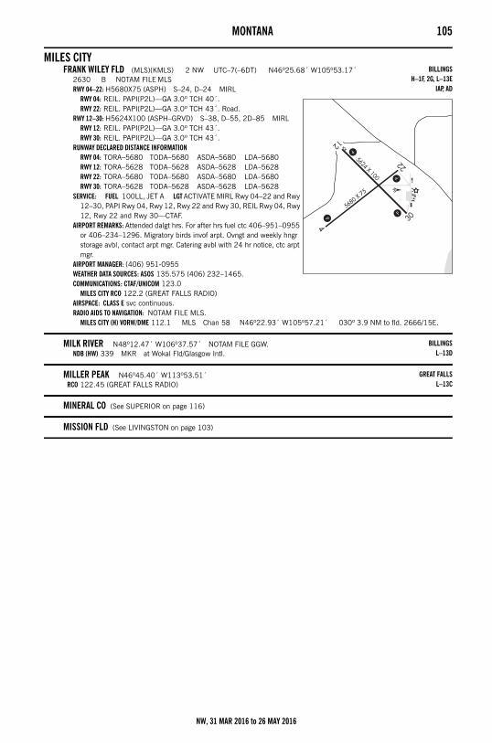
MONTANA 105
MILES CITYFRANK WILEY FLD (MLS)(KMLS) 2 NW UTC–7(–6DT) N46º25.68´ W105º53.17´
2630 B NOTAM FILE MLSRWY 04–22: H5680X75 (ASPH) S–24, D–24 MIRL
RWY 04: REIL. PAPI(P2L)—GA 3.0º TCH 40´.RWY 22: REIL. PAPI(P2L)—GA 3.0º TCH 43´. Road.
RWY 12–30: H5624X100 (ASPH–GRVD) S–38, D–55, 2D–85 MIRLRWY 12: REIL. PAPI(P2L)—GA 3.0º TCH 43´.RWY 30: REIL. PAPI(P2L)—GA 3.0º TCH 43´.
RUNWAY DECLARED DISTANCE INFORMATIONRWY 04: TORA–5680 TODA–5680 ASDA–5680 LDA–5680RWY 12: TORA–5628 TODA–5628 ASDA–5628 LDA–5628RWY 22: TORA–5680 TODA–5680 ASDA–5680 LDA–5680RWY 30: TORA–5628 TODA–5628 ASDA–5628 LDA–5628
SERVICE: FUEL 100LL, JET A LGT ACTIVATE MIRL Rwy 04–22 and Rwy 12–30, PAPI Rwy 04, Rwy 12, Rwy 22 and Rwy 30, REIL Rwy 04, Rwy 12, Rwy 22 and Rwy 30—CTAF.
AIRPORT REMARKS: Attended dalgt hrs. For after hrs fuel ctc 406–951–0955 or 406–234–1296. Migratory birds invof arpt. Ovngt and weekly hngr storage avbl, contact arpt mgr. Catering avbl with 24 hr notice, ctc arpt mgr.
AIRPORT MANAGER: (406) 951-0955WEATHER DATA SOURCES: ASOS 135.575 (406) 232–1465.COMMUNICATIONS: CTAF/UNICOM 123.0
MILES CITY RCO 122.2 (GREAT FALLS RADIO)AIRSPACE: CLASS E svc continuous. RADIO AIDS TO NAVIGATION: NOTAM FILE MLS.
MILES CITY (H) VORW/DME 112.1 MLS Chan 58 N46º22.93´ W105º57.21´ 030º 3.9 NM to fld. 2666/15E.
MILK RIVER N48º12.47´ W106º37.57´ NOTAM FILE GGW.NDB (HW) 339 MKR at Wokal Fld/Glasgow Intl.
MILLER PEAK N46º45.40´ W113º53.51´RCO 122.45 (GREAT FALLS RADIO)
MINERAL CO (See SUPERIOR on page 116)
MISSION FLD (See LIVINGSTON on page 103)
BILLINGSH–1F, 2G, L–13E
IAP, AD
BILLINGSL–13D
GREAT FALLSL–13C
NW, 31 MAR 2016 to 26 MAY 2016
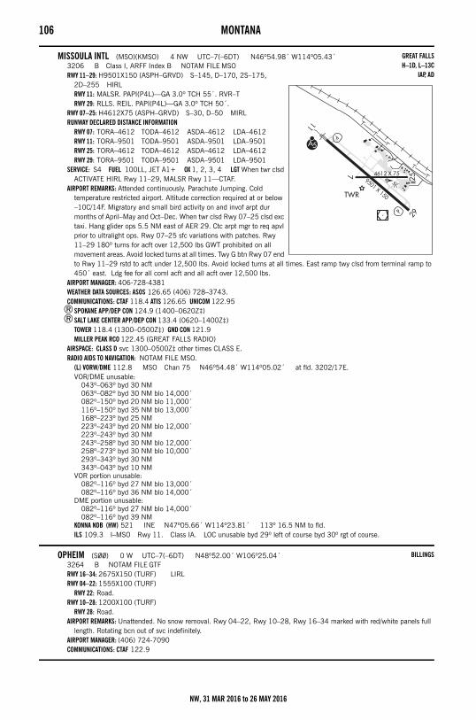
106 MONTANA
MISSOULA INTL (MSO)(KMSO) 4 NW UTC–7(–6DT) N46º54.98´ W114º05.43´3206 B Class I, ARFF Index B NOTAM FILE MSORWY 11–29: H9501X150 (ASPH–GRVD) S–145, D–170, 2S–175,
2D–255 HIRLRWY 11: MALSR. PAPI(P4L)—GA 3.0º TCH 55´. RVR–TRWY 29: RLLS. REIL. PAPI(P4L)—GA 3.0º TCH 50´.
RWY 07–25: H4612X75 (ASPH–GRVD) S–30, D–50 MIRLRUNWAY DECLARED DISTANCE INFORMATION
RWY 07: TORA–4612 TODA–4612 ASDA–4612 LDA–4612RWY 11: TORA–9501 TODA–9501 ASDA–9501 LDA–9501RWY 25: TORA–4612 TODA–4612 ASDA–4612 LDA–4612RWY 29: TORA–9501 TODA–9501 ASDA–9501 LDA–9501
SERVICE: S4 FUEL 100LL, JET A1+ OX 1, 2, 3, 4 LGT When twr clsd ACTIVATE HIRL Rwy 11–29, MALSR Rwy 11—CTAF.
AIRPORT REMARKS: Attended continuously. Parachute Jumping. Cold temperature restricted airport. Altitude correction required at or below –10C/14F. Migratory and small bird activity on and invof arpt dur months of April–May and Oct–Dec. When twr clsd Rwy 07–25 clsd exc taxi. Hang glider ops 5.5 NM east of AER 29. Ctc arpt mgr to req apvl prior to ultralight ops. Rwy 07–25 sfc variations with patches. Rwy 11–29 180º turns for acft over 12,500 lbs GWT prohibited on all movement areas. Avoid locked turns at all times. Twy G btn Rwy 07 end to Rwy 11–29 rstd to acft under 12,500 lbs. Avoid locked turns at all times. East ramp twy clsd from terminal ramp to 450´ east. Ldg fee for all coml acft and all acft over 12,500 lbs.
AIRPORT MANAGER: 406-728-4381WEATHER DATA SOURCES: ASOS 126.65 (406) 728–3743.COMMUNICATIONS: CTAF 118.4 ATIS 126.65 UNICOM 122.95
®SPOKANE APP/DEP CON 124.9 (1400–0620Z‡)®SALT LAKE CENTER APP/DEP CON 133.4 (0620–1400Z‡)
TOWER 118.4 (1300–0500Z‡) GND CON 121.9MILLER PEAK RCO 122.45 (GREAT FALLS RADIO)
AIRSPACE: CLASS D svc 1300–0500Z‡ other times CLASS E.RADIO AIDS TO NAVIGATION: NOTAM FILE MSO.
(L) VORW/DME 112.8 MSO Chan 75 N46º54.48´ W114º05.02´ at fld. 3202/17E.VOR/DME unusable:
043º–063º byd 30 NM063º–082º byd 30 NM blo 14,000´082º–150º byd 20 NM blo 11,000´116º–150º byd 35 NM blo 13,000´168º–223º byd 25 NM223º–243º byd 20 NM blo 12,000´223º–243º byd 30 NM243º–258º byd 30 NM blo 12,000´258º–273º byd 30 NM blo 10,000´293º–343º byd 30 NM343º–043º byd 10 NM
VOR portion unusable:082º–116º byd 27 NM blo 13,000´082º–116º byd 36 NM blo 14,000´
DME portion unusable:082º–116º byd 27 NM blo 14,000´082º–116º byd 39 NM
KONNA NDB (HW) 521 INE N47º05.66´ W114º23.81´ 113º 16.5 NM to fld.ILS 109.3 I–MSO Rwy 11. Class IA. LOC unusable byd 29º left of course byd 30º rgt of course.
OPHEIM (S00) 0 W UTC–7(–6DT) N48º52.00´ W106º25.04´3264 B NOTAM FILE GTFRWY 16–34: 2675X150 (TURF) LIRLRWY 04–22: 1555X100 (TURF)
RWY 22: Road.RWY 10–28: 1200X100 (TURF)
RWY 28: Road.AIRPORT REMARKS: Unattended. No snow removal. Rwy 04–22, Rwy 10–28, Rwy 16–34 marked with red/white panels full
length. Rotating bcn out of svc indefinitely.AIRPORT MANAGER: (406) 724-7090COMMUNICATIONS: CTAF 122.9
GREAT FALLSH–1D, L–13C
IAP, AD
BILLINGS
NW, 31 MAR 2016 to 26 MAY 2016
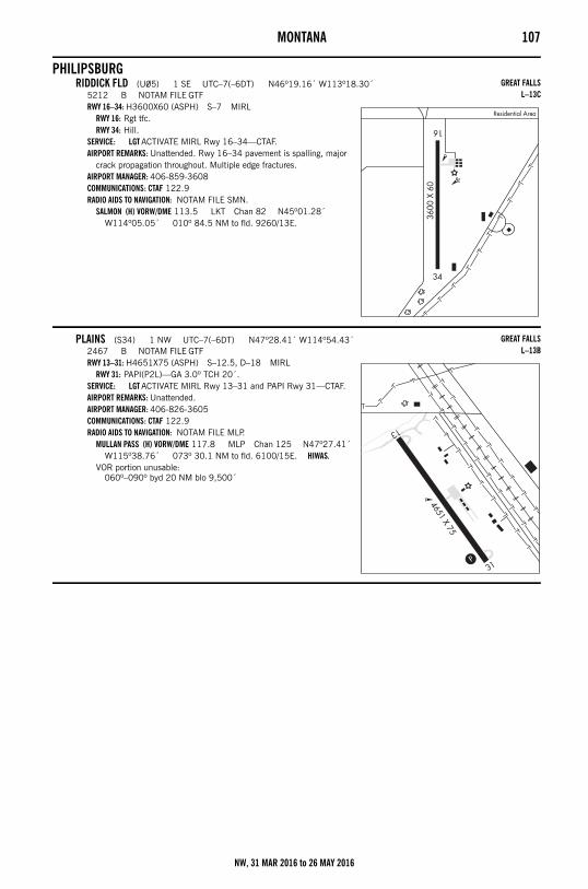
MONTANA 107
PHILIPSBURGRIDDICK FLD (U05) 1 SE UTC–7(–6DT) N46º19.16´ W113º18.30´
5212 B NOTAM FILE GTFRWY 16–34: H3600X60 (ASPH) S–7 MIRL
RWY 16: Rgt tfc.RWY 34: Hill.
SERVICE: LGT ACTIVATE MIRL Rwy 16–34—CTAF.AIRPORT REMARKS: Unattended. Rwy 16–34 pavement is spalling, major
crack propagation throughout. Multiple edge fractures. AIRPORT MANAGER: 406-859-3608COMMUNICATIONS: CTAF 122.9RADIO AIDS TO NAVIGATION: NOTAM FILE SMN.
SALMON (H) VORW/DME 113.5 LKT Chan 82 N45º01.28´ W114º05.05´ 010º 84.5 NM to fld. 9260/13E.
PLAINS (S34) 1 NW UTC–7(–6DT) N47º28.41´ W114º54.43´2467 B NOTAM FILE GTFRWY 13–31: H4651X75 (ASPH) S–12.5, D–18 MIRL
RWY 31: PAPI(P2L)—GA 3.0º TCH 20´.SERVICE: LGT ACTIVATE MIRL Rwy 13–31 and PAPI Rwy 31—CTAF.AIRPORT REMARKS: Unattended. AIRPORT MANAGER: 406-826-3605COMMUNICATIONS: CTAF 122.9RADIO AIDS TO NAVIGATION: NOTAM FILE MLP.
MULLAN PASS (H) VORW/DME 117.8 MLP Chan 125 N47º27.41´ W115º38.76´ 073º 30.1 NM to fld. 6100/15E. HIWAS.
VOR portion unusable:060º–090º byd 20 NM blo 9,500´
GREAT FALLSL–13C
GREAT FALLSL–13B
NW, 31 MAR 2016 to 26 MAY 2016
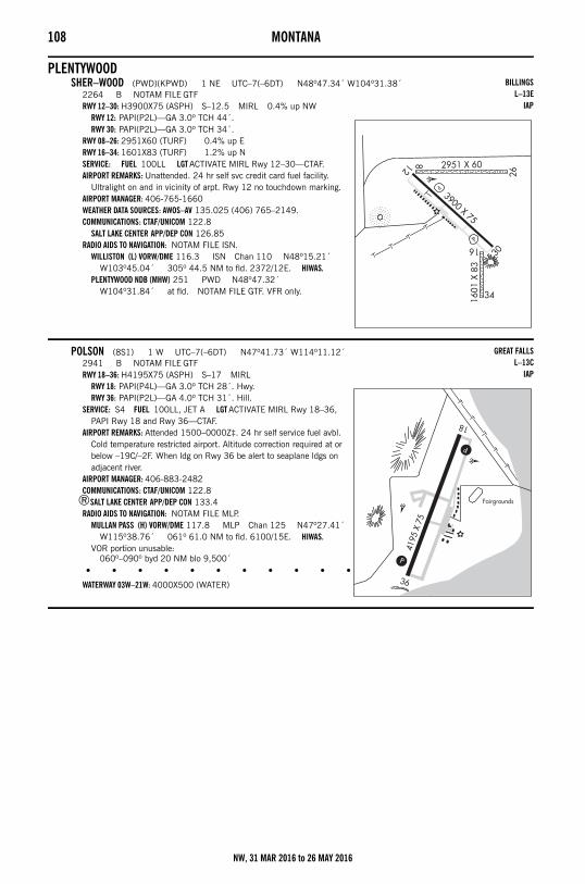
108 MONTANA
PLENTYWOODSHER–WOOD (PWD)(KPWD) 1 NE UTC–7(–6DT) N48º47.34´ W104º31.38´
2264 B NOTAM FILE GTFRWY 12–30: H3900X75 (ASPH) S–12.5 MIRL 0.4% up NW
RWY 12: PAPI(P2L)—GA 3.0º TCH 44´.RWY 30: PAPI(P2L)—GA 3.0º TCH 34´.
RWY 08–26: 2951X60 (TURF) 0.4% up ERWY 16–34: 1601X83 (TURF) 1.2% up NSERVICE: FUEL 100LL LGT ACTIVATE MIRL Rwy 12–30—CTAF.AIRPORT REMARKS: Unattended. 24 hr self svc credit card fuel facility.
Ultralight on and in vicinity of arpt. Rwy 12 no touchdown marking. AIRPORT MANAGER: 406-765-1660WEATHER DATA SOURCES: AWOS–AV 135.025 (406) 765–2149.COMMUNICATIONS: CTAF/UNICOM 122.8
SALT LAKE CENTER APP/DEP CON 126.85RADIO AIDS TO NAVIGATION: NOTAM FILE ISN.
WILLISTON (L) VORW/DME 116.3 ISN Chan 110 N48º15.21´ W103º45.04´ 305º 44.5 NM to fld. 2372/12E. HIWAS.
PLENTYWOOD NDB (MHW) 251 PWD N48º47.32´ W104º31.84´ at fld. NOTAM FILE GTF. VFR only.
POLSON (8S1) 1 W UTC–7(–6DT) N47º41.73´ W114º11.12´2941 B NOTAM FILE GTFRWY 18–36: H4195X75 (ASPH) S–17 MIRL
RWY 18: PAPI(P4L)—GA 3.0º TCH 28´. Hwy.RWY 36: PAPI(P2L)—GA 4.0º TCH 31´. Hill.
SERVICE: S4 FUEL 100LL, JET A LGT ACTIVATE MIRL Rwy 18–36, PAPI Rwy 18 and Rwy 36—CTAF.
AIRPORT REMARKS: Attended 1500–0000Z‡. 24 hr self service fuel avbl. Cold temperature restricted airport. Altitude correction required at or below –19C/–2F. When ldg on Rwy 36 be alert to seaplane ldgs on adjacent river.
AIRPORT MANAGER: 406-883-2482COMMUNICATIONS: CTAF/UNICOM 122.8
®SALT LAKE CENTER APP/DEP CON 133.4RADIO AIDS TO NAVIGATION: NOTAM FILE MLP.
MULLAN PASS (H) VORW/DME 117.8 MLP Chan 125 N47º27.41´ W115º38.76´ 061º 61.0 NM to fld. 6100/15E. HIWAS.
VOR portion unusable:060º–090º byd 20 NM blo 9,500´
• • • • • • • • • • • • • • • • • •
WATERWAY 03W–21W: 4000X500 (WATER)
BILLINGSL–13E
IAP
GREAT FALLSL–13C
IAP
NW, 31 MAR 2016 to 26 MAY 2016
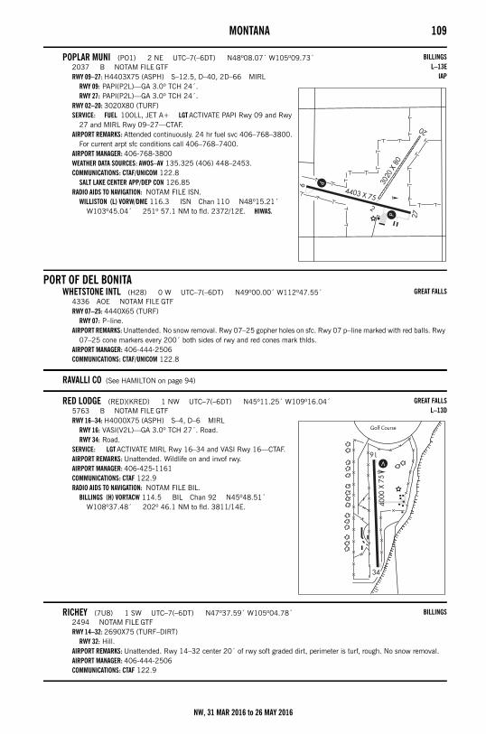
MONTANA 109
POPLAR MUNI (PO1) 2 NE UTC–7(–6DT) N48º08.07´ W105º09.73´2037 B NOTAM FILE GTFRWY 09–27: H4403X75 (ASPH) S–12.5, D–40, 2D–66 MIRL
RWY 09: PAPI(P2L)—GA 3.0º TCH 24´.RWY 27: PAPI(P2L)—GA 3.0º TCH 24´.
RWY 02–20: 3020X80 (TURF)SERVICE: FUEL 100LL, JET A+ LGT ACTIVATE PAPI Rwy 09 and Rwy
27 and MIRL Rwy 09–27—CTAF.AIRPORT REMARKS: Attended continuously. 24 hr fuel svc 406–768–3800.
For current arpt sfc conditions call 406–768–7400. AIRPORT MANAGER: 406-768-3800WEATHER DATA SOURCES: AWOS–AV 135.325 (406) 448–2453.COMMUNICATIONS: CTAF/UNICOM 122.8
SALT LAKE CENTER APP/DEP CON 126.85RADIO AIDS TO NAVIGATION: NOTAM FILE ISN.
WILLISTON (L) VORW/DME 116.3 ISN Chan 110 N48º15.21´ W103º45.04´ 251º 57.1 NM to fld. 2372/12E. HIWAS.
PORT OF DEL BONITAWHETSTONE INTL (H28) 0 W UTC–7(–6DT) N49º00.00´ W112º47.55´
4336 AOE NOTAM FILE GTFRWY 07–25: 4440X65 (TURF)
RWY 07: P–line.AIRPORT REMARKS: Unattended. No snow removal. Rwy 07–25 gopher holes on sfc. Rwy 07 p–line marked with red balls. Rwy
07–25 cone markers every 200´ both sides of rwy and red cones mark thlds.AIRPORT MANAGER: 406-444-2506COMMUNICATIONS: CTAF/UNICOM 122.8
RAVALLI CO (See HAMILTON on page 94)
RED LODGE (RED)(KRED) 1 NW UTC–7(–6DT) N45º11.25´ W109º16.04´5763 B NOTAM FILE GTFRWY 16–34: H4000X75 (ASPH) S–4, D–6 MIRL
RWY 16: VASI(V2L)—GA 3.0º TCH 27´. Road.RWY 34: Road.
SERVICE: LGT ACTIVATE MIRL Rwy 16–34 and VASI Rwy 16—CTAF.AIRPORT REMARKS: Unattended. Wildlife on and invof rwy. AIRPORT MANAGER: 406-425-1161COMMUNICATIONS: CTAF 122.9RADIO AIDS TO NAVIGATION: NOTAM FILE BIL.
BILLINGS (H) VORTACW 114.5 BIL Chan 92 N45º48.51´ W108º37.48´ 202º 46.1 NM to fld. 3811/14E.
RICHEY (7U8) 1 SW UTC–7(–6DT) N47º37.59´ W105º04.78´2494 NOTAM FILE GTFRWY 14–32: 2690X75 (TURF–DIRT)
RWY 32: Hill.AIRPORT REMARKS: Unattended. Rwy 14–32 center 20´ of rwy soft graded dirt, perimeter is turf, rough. No snow removal. AIRPORT MANAGER: 406-444-2506COMMUNICATIONS: CTAF 122.9
BILLINGSL–13E
IAP
GREAT FALLS
GREAT FALLSL–13D
BILLINGS
NW, 31 MAR 2016 to 26 MAY 2016
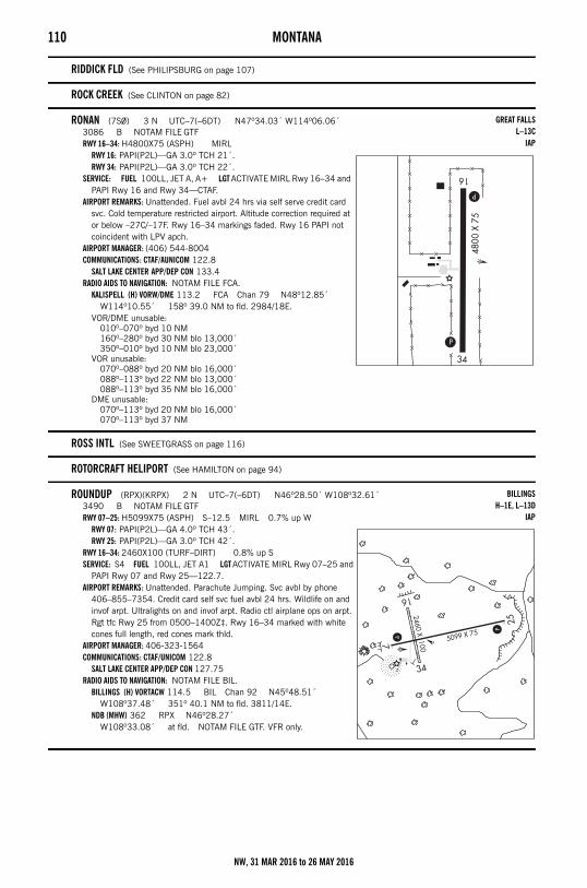
110 MONTANA
RIDDICK FLD (See PHILIPSBURG on page 107)
ROCK CREEK (See CLINTON on page 82)
RONAN (7S0) 3 N UTC–7(–6DT) N47º34.03´ W114º06.06´3086 B NOTAM FILE GTFRWY 16–34: H4800X75 (ASPH) MIRL
RWY 16: PAPI(P2L)—GA 3.0º TCH 21´.RWY 34: PAPI(P2L)—GA 3.0º TCH 22´.
SERVICE: FUEL 100LL, JET A, A+ LGT ACTIVATE MIRL Rwy 16–34 and PAPI Rwy 16 and Rwy 34—CTAF.
AIRPORT REMARKS: Unattended. Fuel avbl 24 hrs via self serve credit card svc. Cold temperature restricted airport. Altitude correction required at or below –27C/–17F. Rwy 16–34 markings faded. Rwy 16 PAPI not coincident with LPV apch.
AIRPORT MANAGER: (406) 544-8004COMMUNICATIONS: CTAF/AUNICOM 122.8
SALT LAKE CENTER APP/DEP CON 133.4RADIO AIDS TO NAVIGATION: NOTAM FILE FCA.
KALISPELL (H) VORW/DME 113.2 FCA Chan 79 N48º12.85´ W114º10.55´ 158º 39.0 NM to fld. 2984/18E.
VOR/DME unusable:010º–070º byd 10 NM160º–280º byd 30 NM blo 13,000´350º–010º byd 10 NM blo 23,000´
VOR unusable:070º–088º byd 20 NM blo 16,000´088º–113º byd 22 NM blo 13,000´088º–113º byd 35 NM blo 16,000´
DME unusable:070º–113º byd 20 NM blo 16,000´070º–113º byd 37 NM
ROSS INTL (See SWEETGRASS on page 116)
ROTORCRAFT HELIPORT (See HAMILTON on page 94)
ROUNDUP (RPX)(KRPX) 2 N UTC–7(–6DT) N46º28.50´ W108º32.61´3490 B NOTAM FILE GTFRWY 07–25: H5099X75 (ASPH) S–12.5 MIRL 0.7% up W
RWY 07: PAPI(P2L)—GA 4.0º TCH 43´.RWY 25: PAPI(P2L)—GA 3.0º TCH 42´.
RWY 16–34: 2460X100 (TURF–DIRT) 0.8% up SSERVICE: S4 FUEL 100LL, JET A1 LGT ACTIVATE MIRL Rwy 07–25 and
PAPI Rwy 07 and Rwy 25—122.7.AIRPORT REMARKS: Unattended. Parachute Jumping. Svc avbl by phone
406–855–7354. Credit card self svc fuel avbl 24 hrs. Wildlife on and invof arpt. Ultralights on and invof arpt. Radio ctl airplane ops on arpt. Rgt tfc Rwy 25 from 0500–1400Z‡. Rwy 16–34 marked with white cones full length, red cones mark thld.
AIRPORT MANAGER: 406-323-1564COMMUNICATIONS: CTAF/UNICOM 122.8
SALT LAKE CENTER APP/DEP CON 127.75RADIO AIDS TO NAVIGATION: NOTAM FILE BIL.
BILLINGS (H) VORTACW 114.5 BIL Chan 92 N45º48.51´ W108º37.48´ 351º 40.1 NM to fld. 3811/14E.
NDB (MHW) 362 RPX N46º28.27´ W108º33.08´ at fld. NOTAM FILE GTF. VFR only.
GREAT FALLSL–13C
IAP
BILLINGSH–1E, L–13D
IAP
NW, 31 MAR 2016 to 26 MAY 2016
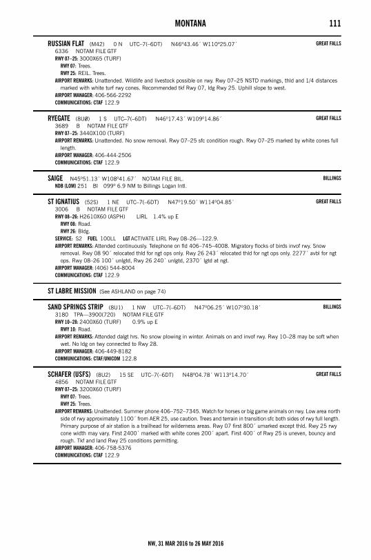
MONTANA 111
RUSSIAN FLAT (M42) 0 N UTC–7(–6DT) N46º43.46´ W110º25.07´6336 NOTAM FILE GTFRWY 07–25: 3000X65 (TURF)
RWY 07: Trees.RWY 25: REIL. Trees.
AIRPORT REMARKS: Unattended. Wildlife and livestock possible on rwy. Rwy 07–25 NSTD markings, thld and 1/4 distances marked with white turf rwy cones. Recommended tkf Rwy 07, ldg Rwy 25. Uphill slope to west.
AIRPORT MANAGER: 406-566-2292COMMUNICATIONS: CTAF 122.9
RYEGATE (8U0) 1 S UTC–7(–6DT) N46º17.43´ W109º14.86´3689 B NOTAM FILE GTFRWY 07–25: 3440X100 (TURF)AIRPORT REMARKS: Unattended. No snow removal. Rwy 07–25 sfc condition rough. Rwy 07–25 marked by white cones full
length.AIRPORT MANAGER: 406-444-2506COMMUNICATIONS: CTAF 122.9
SAIGE N45º51.13´ W108º41.67´ NOTAM FILE BIL.NDB (LOM) 251 BI 099º 6.9 NM to Billings Logan Intl.
ST IGNATIUS (52S) 1 NE UTC–7(–6DT) N47º19.50´ W114º04.85´3006 B NOTAM FILE GTFRWY 08–26: H2610X60 (ASPH) LIRL 1.4% up E
RWY 08: Road.RWY 26: Bldg.
SERVICE: S2 FUEL 100LL LGT ACTIVATE LIRL Rwy 08–26—122.9.AIRPORT REMARKS: Attended continuously. Telephone on fld 406–745–4008. Migratory flocks of birds invof rwy. Snow
removal. Rwy 08 90´ relocated thld for ngt ops only. Rwy 26 243´ relocated thld for ngt ops only. 2277´ avbl for ngt ops. Rwy 08–26 100´ unlgtd, Rwy 26 240´ unlgtd, 2370´ lgtd at ngt.
AIRPORT MANAGER: (406) 544-8004COMMUNICATIONS: CTAF 122.9
ST LABRE MISSION (See ASHLAND on page 74)
SAND SPRINGS STRIP (8U1) 1 NW UTC–7(–6DT) N47º06.25´ W107º30.18´3180 TPA—3900(720) NOTAM FILE GTFRWY 10–28: 2400X60 (TURF) 0.9% up E
RWY 10: Road.AIRPORT REMARKS: Attended dalgt hrs. No snow plowing in winter. Animals on and invof rwy. Rwy 10–28 may be soft when
wet. No ldg on twy connected to Rwy 28.AIRPORT MANAGER: 406-449-8182COMMUNICATIONS: CTAF/UNICOM 122.8
SCHAFER (USFS) (8U2) 15 SE UTC–7(–6DT) N48º04.78´ W113º14.70´4856 NOTAM FILE GTFRWY 07–25: 3200X60 (TURF)
RWY 07: Trees.RWY 25: Trees.
AIRPORT REMARKS: Unattended. Summer phone 406–752–7345. Watch for horses or big game animals on rwy. Low area north side of rwy approximately 1100´ from AER 25, use caution. Trees and terrain in transition sfc both sides of rwy full length. Primary purpose of air station is a trailhead for wilderness areas. Rwy 07 first 800´ umarked except thld. Rwy 25 rwy cone width may vary. First 2400´ marked with white cones 200´ apart. First 400´ of Rwy 25 is uneven, bouncy and rough. Tkf and land Rwy 25 conditions permitting.
AIRPORT MANAGER: 406-758-5376COMMUNICATIONS: CTAF 122.9
GREAT FALLS
GREAT FALLS
BILLINGS
GREAT FALLS
BILLINGS
GREAT FALLS
NW, 31 MAR 2016 to 26 MAY 2016
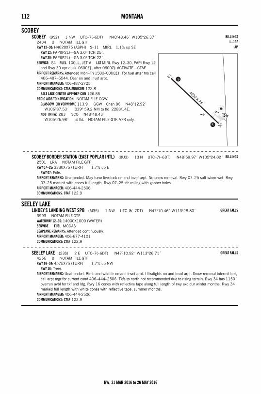
112 MONTANA
SCOBEYSCOBEY (9S2) 1 NW UTC–7(–6DT) N48º48.46´ W105º26.37´
2434 B NOTAM FILE GTFRWY 12–30: H4020X75 (ASPH) S–11 MIRL 1.1% up SE
RWY 12: PAPI(P2L)—GA 3.0º TCH 25´.RWY 30: PAPI(P2L)—GA 3.0º TCH 22´.
SERVICE: S4 FUEL 100LL, JET A LGT MIRL Rwy 12–30, PAPI Rwy 12 and Rwy 30 opr dusk–0600Z‡, after 0600Z‡ ACTIVATE—CTAF.
AIRPORT REMARKS: Attended Mon–Fri 1500–0000Z‡. For fuel after hrs call 406–487–5544. Deer on and invof arpt.
AIRPORT MANAGER: 406-487-2725COMMUNICATIONS: CTAF/AUNICOM 122.8
SALT LAKE CENTER APP/DEP CON 126.85RADIO AIDS TO NAVIGATION: NOTAM FILE GGW.
GLASGOW (H) VORW/DME 113.9 GGW Chan 86 N48º12.92´ W106º37.53´ 039º 59.2 NM to fld. 2283/14E.
NDB (MHW) 283 SCO N48º48.43´ W105º25.98´ at fld. NOTAM FILE GTF. VFR only.
– – – – – – – – – – – – – – – – – – – – – – – – – – – – – – – – – – – – – – – – – – – – – – – – – – – – – – – –
SCOBEY BORDER STATION (EAST POPLAR INTL) (8U3) 13 N UTC–7(–6DT) N48º59.97´ W105º24.02´2501 LRA NOTAM FILE GTFRWY 07–25: 3330X75 (TURF) 1.7% up E
RWY 07: Pole.AIRPORT REMARKS: Unattended. May have livestock on and invof arpt. No snow removal. Rwy 07–25 soft when wet. Rwy
07–25 marked with cones full length. Rwy 07–25 sfc rolling with gopher holes.AIRPORT MANAGER: 406-444-2506COMMUNICATIONS: CTAF 122.9
SEELEY LAKELINDEY'S LANDING WEST SPB (M35) 1 NW UTC–8(–7DT) N47º10.46´ W113º28.80´
3993 NOTAM FILE GTFWATERWAY 12–30: 14000X1000 (WATER)SERVICE: FUEL MOGAS SEAPLANE REMARKS: Attended continuously.AIRPORT MANAGER: 406-677-4101COMMUNICATIONS: CTAF 122.9
– – – – – – – – – – – – – – – – – – – – – – – – – – – – – – – – – – – – – – – – – – – – – – – – – – – – – – – –
SEELEY LAKE (23S) 2 E UTC–7(–6DT) N47º10.92´ W113º26.71´4256 B NOTAM FILE GTFRWY 16–34: 4575X75 (TURF) 1.7% up NW
RWY 16: Trees.AIRPORT REMARKS: Unattended. Birds and wildlife on and invof arpt. Ultralights on and invof arpt. Snow removal intermittent,
call arpt mgr for current cond 406–444–2506. Tkfs to north not recommended due to rising terrain. Rwy 34 has 1150´ overrun avbl for tkf and ldg. Rwy 16 cones with reflective tape along full length of rwy exc dur winter months. Rwy 34 marked full length with white cones with reflective tape, summer months.
AIRPORT MANAGER: 406-444-2506COMMUNICATIONS: CTAF 122.9
BILLINGSL–13E
IAP
BILLINGS
GREAT FALLS
GREAT FALLS
NW, 31 MAR 2016 to 26 MAY 2016
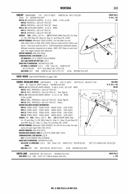
MONTANA 113
SHELBY (SBX)(KSBX) 2 N UTC–7(–6DT) N48º32.44´ W111º52.28´3443 B NOTAM FILE GTFRWY 05–23: H5005X75 (ASPH) S–12.5 MIRL 0.5% up NE
RWY 05: PAPI(P2L)—GA 3.0º TCH 29´.RWY 23: PAPI(P2L)—GA 3.0º TCH 32´. Road.
RWY 11–29: H3701X60 (ASPH) S–12.5 MIRLRWY 11: PAPI(P2L)—GA 3.0º TCH 31´.RWY 29: PAPI(P2L)—GA 3.0º TCH 38´.
SERVICE: FUEL 100LL, JET A+ LGT ACTIVATE MIRL Rwy 05–23, Rwy 11–29, PAPI Rwy 05, Rwy 23, Rwy 11 and Rwy 29—CTAF.
AIRPORT REMARKS: Attended 1500–0100Z‡. For fuel after hrs call 406–450–2461 or 406–450–2463. Self svc credit card for 100LL and Jet A+. Fuel truck avbl for Jet A+. Cold temperature restricted airport. Altitude correction required at or below –36C/–33F. Deer on and invof arpt. Twy edges marked with reflectors.
AIRPORT MANAGER: 406-434-2462COMMUNICATIONS: CTAF/UNICOM 122.8
CUT BANK RCO 122.2 (GREAT FALLS RADIO)SALT LAKE CENTER APP/DEP CON 133.4
RADIO AIDS TO NAVIGATION: NOTAM FILE CTB.CUT BANK (L) VORTACW 114.4 CTB Chan 91 N48º33.90´
W112º20.60´ 077º 18.9 NM to fld. 3791/17E.NDB (MHW) 347 SBX N48º32.46´ W111º51.75´ at fld. NOTAM FILE GTF.
SHER–WOOD (See PLENTYWOOD on page 108)
SIDNEY–RICHLAND MUNI (SDY)(KSDY) 1 W UTC–7(–6DT) N47º42.41´ W104º11.55´1985 B Class III, ARFF Index A NOTAM FILE SDYRWY 01–19: H5705X100 (ASPH–GRVD) S–46.5, D–61, 2D–109 MIRL
RWY 01: REIL. PAPI(P2L)—GA 3.0º TCH 33´.RWY 19: REIL. PAPI(P2L)—GA 3.0º TCH 41´. Tree. Rgt tfc.
RWY 11–29: H4024X100 (ASPH–GRVD) S–12, D–18 MIRL 0.4% up NWRWY 11: REIL. PAPI(P2L)—GA 3.0º TCH 40´. Road. Rgt tfc.RWY 29: REIL. PAPI(P2L)—GA 3.0º TCH 27´. Road.
RUNWAY DECLARED DISTANCE INFORMATIONRWY 01: TORA–5705 TODA–5705 ASDA–5705 LDA–5705RWY 11: TORA–4023 TODA–4023 ASDA–4023 LDA–4023RWY 19: TORA–5705 TODA–5705 ASDA–5705 LDA–5705RWY 29: TORA–4023 TODA–4023 ASDA–4023 LDA–4023
SERVICE: S4 FUEL 100LL, JET A OX 3 LGT ACTIVATE MIRL Rwy 01–19 and Rwy 11–29, REIL Rwy 01, Rwy 11, Rwy 19 and Rwy 29 and PAPI Rwy 01, Rwy 11, Rwy 19, and Rwy 29—CTAF.
AIRPORT REMARKS: Attended 1200–0500Z‡. On call 24 hrs a day. For arpt cond, ctc arpt mgnt 406–433–2415.
AIRPORT MANAGER: 406-433-2415WEATHER DATA SOURCES: AWOS–3 119.275 (406) 482–7323.COMMUNICATIONS: CTAF/UNICOM 122.8
RCO 123.65 (GREAT FALLS RADIO)RADIO AIDS TO NAVIGATION: NOTAM FILE ISN.
WILLISTON (L) VORW/DME 116.3 ISN Chan 110 N48º15.21´ W103º45.04´ 197º 37.3 NM to fld. 2372/12E. HIWAS.
NDB (HW) 359 SDY N47º42.69´ W104º10.91´ at fld. NOTAM FILE SDY.
SMITH LAKE N48º06.50´ W114º27.67´ NOTAM FILE FCA.NDB (MHW) 515 SAK 019º 14.7 NM to Glacier Park Intl.
GREAT FALLSH–1D, L–13C
IAP
BILLINGSH–1F, 2H, L–13E
IAP, AD
GREAT FALLSL–13B
NW, 31 MAR 2016 to 26 MAY 2016
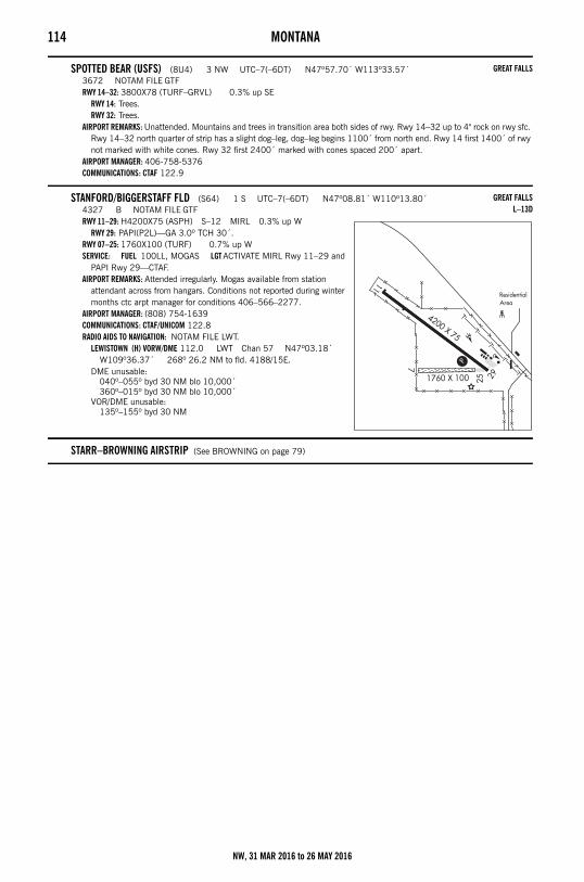
114 MONTANA
SPOTTED BEAR (USFS) (8U4) 3 NW UTC–7(–6DT) N47º57.70´ W113º33.57´3672 NOTAM FILE GTFRWY 14–32: 3800X78 (TURF–GRVL) 0.3% up SE
RWY 14: Trees.RWY 32: Trees.
AIRPORT REMARKS: Unattended. Mountains and trees in transition area both sides of rwy. Rwy 14–32 up to 4" rock on rwy sfc. Rwy 14–32 north quarter of strip has a slight dog–leg, dog–leg begins 1100´ from north end. Rwy 14 first 1400´ of rwy not marked with white cones. Rwy 32 first 2400´ marked with cones spaced 200´ apart.
AIRPORT MANAGER: 406-758-5376COMMUNICATIONS: CTAF 122.9
STANFORD/BIGGERSTAFF FLD (S64) 1 S UTC–7(–6DT) N47º08.81´ W110º13.80´4327 B NOTAM FILE GTFRWY 11–29: H4200X75 (ASPH) S–12 MIRL 0.3% up W
RWY 29: PAPI(P2L)—GA 3.0º TCH 30´.RWY 07–25: 1760X100 (TURF) 0.7% up WSERVICE: FUEL 100LL, MOGAS LGT ACTIVATE MIRL Rwy 11–29 and
PAPI Rwy 29—CTAF.AIRPORT REMARKS: Attended irregularly. Mogas available from station
attendant across from hangars. Conditions not reported during winter months ctc arpt manager for conditions 406–566–2277.
AIRPORT MANAGER: (808) 754-1639COMMUNICATIONS: CTAF/UNICOM 122.8RADIO AIDS TO NAVIGATION: NOTAM FILE LWT.
LEWISTOWN (H) VORW/DME 112.0 LWT Chan 57 N47º03.18´ W109º36.37´ 268º 26.2 NM to fld. 4188/15E.
DME unusable:040º–055º byd 30 NM blo 10,000´360º–015º byd 30 NM blo 10,000´
VOR/DME unusable:135º–155º byd 30 NM
STARR–BROWNING AIRSTRIP (See BROWNING on page 79)
GREAT FALLS
GREAT FALLSL–13D
NW, 31 MAR 2016 to 26 MAY 2016
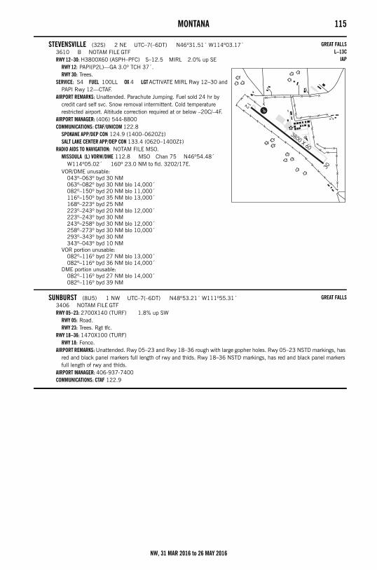
MONTANA 115
STEVENSVILLE (32S) 2 NE UTC–7(–6DT) N46º31.51´ W114º03.17´3610 B NOTAM FILE GTFRWY 12–30: H3800X60 (ASPH–PFC) S–12.5 MIRL 2.0% up SE
RWY 12: PAPI(P2L)—GA 3.0º TCH 37´.RWY 30: Trees.
SERVICE: S4 FUEL 100LL OX 4 LGT ACTIVATE MIRL Rwy 12–30 and PAPI Rwy 12—CTAF.
AIRPORT REMARKS: Unattended. Parachute Jumping. Fuel sold 24 hr by credit card self svc. Snow removal intermittent. Cold temperature restricted airport. Altitude correction required at or below –20C/–4F.
AIRPORT MANAGER: (406) 544-8800COMMUNICATIONS: CTAF/UNICOM 122.8
SPOKANE APP/DEP CON 124.9 (1400–0620Z‡)SALT LAKE CENTER APP/DEP CON 133.4 (0620–1400Z‡)
RADIO AIDS TO NAVIGATION: NOTAM FILE MSO.MISSOULA (L) VORW/DME 112.8 MSO Chan 75 N46º54.48´
W114º05.02´ 160º 23.0 NM to fld. 3202/17E.VOR/DME unusable:
043º–063º byd 30 NM063º–082º byd 30 NM blo 14,000´082º–150º byd 20 NM blo 11,000´116º–150º byd 35 NM blo 13,000´168º–223º byd 25 NM223º–243º byd 20 NM blo 12,000´223º–243º byd 30 NM243º–258º byd 30 NM blo 12,000´258º–273º byd 30 NM blo 10,000´293º–343º byd 30 NM343º–043º byd 10 NM
VOR portion unusable:082º–116º byd 27 NM blo 13,000´082º–116º byd 36 NM blo 14,000´
DME portion unusable:082º–116º byd 27 NM blo 14,000´082º–116º byd 39 NM
SUNBURST (8U5) 1 NW UTC–7(–6DT) N48º53.21´ W111º55.31´3406 NOTAM FILE GTFRWY 05–23: 2700X140 (TURF) 1.8% up SW
RWY 05: Road.RWY 23: Trees. Rgt tfc.
RWY 18–36: 1470X100 (TURF)RWY 18: Fence.
AIRPORT REMARKS: Unattended. Rwy 05–23 and Rwy 18–36 rough with large gopher holes. Rwy 05–23 NSTD markings, has red and black panel markers full length of rwy and thlds. Rwy 18–36 NSTD markings, has red and black panel markers full length of rwy and thlds.
AIRPORT MANAGER: 406-937-7400COMMUNICATIONS: CTAF 122.9
GREAT FALLSL–13C
IAP
GREAT FALLS
NW, 31 MAR 2016 to 26 MAY 2016
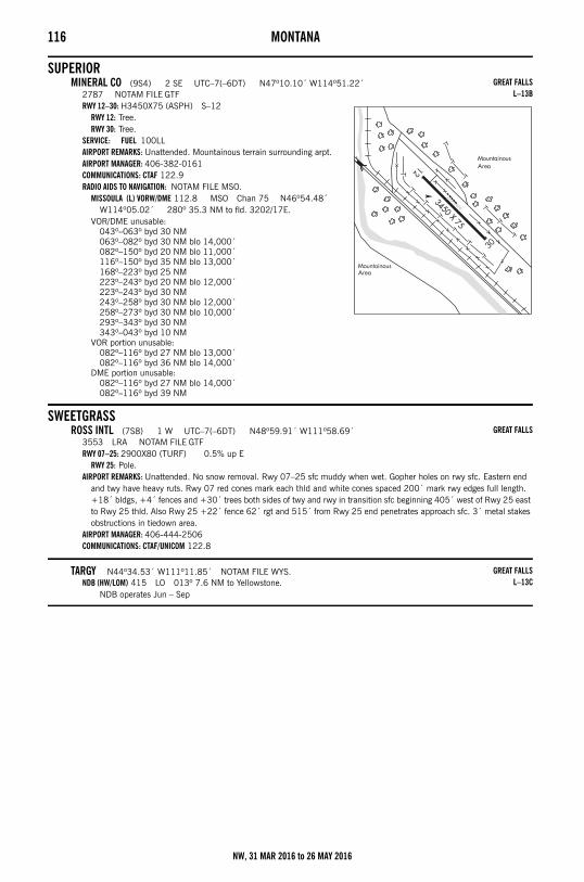
116 MONTANA
SUPERIORMINERAL CO (9S4) 2 SE UTC–7(–6DT) N47º10.10´ W114º51.22´
2787 NOTAM FILE GTFRWY 12–30: H3450X75 (ASPH) S–12
RWY 12: Tree.RWY 30: Tree.
SERVICE: FUEL 100LL AIRPORT REMARKS: Unattended. Mountainous terrain surrounding arpt.AIRPORT MANAGER: 406-382-0161COMMUNICATIONS: CTAF 122.9RADIO AIDS TO NAVIGATION: NOTAM FILE MSO.
MISSOULA (L) VORW/DME 112.8 MSO Chan 75 N46º54.48´ W114º05.02´ 280º 35.3 NM to fld. 3202/17E.
VOR/DME unusable:043º–063º byd 30 NM063º–082º byd 30 NM blo 14,000´082º–150º byd 20 NM blo 11,000´116º–150º byd 35 NM blo 13,000´168º–223º byd 25 NM223º–243º byd 20 NM blo 12,000´223º–243º byd 30 NM243º–258º byd 30 NM blo 12,000´258º–273º byd 30 NM blo 10,000´293º–343º byd 30 NM343º–043º byd 10 NM
VOR portion unusable:082º–116º byd 27 NM blo 13,000´082º–116º byd 36 NM blo 14,000´
DME portion unusable:082º–116º byd 27 NM blo 14,000´082º–116º byd 39 NM
SWEETGRASSROSS INTL (7S8) 1 W UTC–7(–6DT) N48º59.91´ W111º58.69´
3553 LRA NOTAM FILE GTFRWY 07–25: 2900X80 (TURF) 0.5% up E
RWY 25: Pole.AIRPORT REMARKS: Unattended. No snow removal. Rwy 07–25 sfc muddy when wet. Gopher holes on rwy sfc. Eastern end
and twy have heavy ruts. Rwy 07 red cones mark each thld and white cones spaced 200´ mark rwy edges full length. +18´ bldgs, +4´ fences and +30´ trees both sides of twy and rwy in transition sfc beginning 405´ west of Rwy 25 east to Rwy 25 thld. Also Rwy 25 +22´ fence 62´ rgt and 515´ from Rwy 25 end penetrates approach sfc. 3´ metal stakes obstructions in tiedown area.
AIRPORT MANAGER: 406-444-2506COMMUNICATIONS: CTAF/UNICOM 122.8
TARGY N44º34.53´ W111º11.85´ NOTAM FILE WYS.NDB (HW/LOM) 415 LO 013º 7.6 NM to Yellowstone.
NDB operates Jun – Sep
GREAT FALLSL–13B
GREAT FALLS
GREAT FALLSL–13C
NW, 31 MAR 2016 to 26 MAY 2016
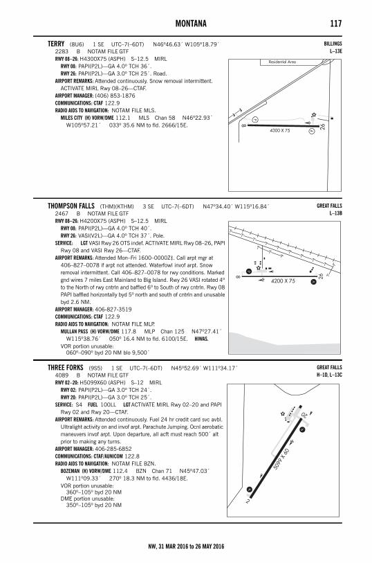
MONTANA 117
TERRY (8U6) 1 SE UTC–7(–6DT) N46º46.63´ W105º18.79´2283 B NOTAM FILE GTFRWY 08–26: H4300X75 (ASPH) S–12.5 MIRL
RWY 08: PAPI(P2L)—GA 4.0º TCH 36´.RWY 26: PAPI(P2L)—GA 3.0º TCH 25´. Road.
AIRPORT REMARKS: Attended continuously. Snow removal intermittent. ACTIVATE MIRL Rwy 08–26—CTAF.
AIRPORT MANAGER: (406) 853-1876COMMUNICATIONS: CTAF 122.9RADIO AIDS TO NAVIGATION: NOTAM FILE MLS.
MILES CITY (H) VORW/DME 112.1 MLS Chan 58 N46º22.93´ W105º57.21´ 033º 35.6 NM to fld. 2666/15E.
THOMPSON FALLS (THM)(KTHM) 3 SE UTC–7(–6DT) N47º34.40´ W115º16.84´2467 B NOTAM FILE GTFRWY 08–26: H4200X75 (ASPH) S–12.5 MIRL
RWY 08: PAPI(P2L)—GA 4.0º TCH 40´.RWY 26: VASI(V2L)—GA 4.0º TCH 37´. Pole.
SERVICE: LGT VASI Rwy 26 OTS indef. ACTIVATE MIRL Rwy 08–26, PAPI Rwy 08 and VASI Rwy 26—CTAF.
AIRPORT REMARKS: Attended Mon–Fri 1600–0000Z‡. Call arpt mgr at 406–827–0078 if arpt not attended. Waterfowl invof arpt. Snow removal intermittent. Call 406–827–0078 for rwy conditions. Marked gnd wires 7 miles East Mainland to Big Island. Rwy 26 VASI rotated 4º to the North of rwy cntrln and baffled 6º to South of rwy cntrln. Rwy 08 PAPI baffled horizontally byd 5º north and south of cntrln and unusable byd 2.6 NM.
AIRPORT MANAGER: 406-827-3519COMMUNICATIONS: CTAF 122.9RADIO AIDS TO NAVIGATION: NOTAM FILE MLP.
MULLAN PASS (H) VORW/DME 117.8 MLP Chan 125 N47º27.41´ W115º38.76´ 050º 16.4 NM to fld. 6100/15E. HIWAS.
VOR portion unusable:060º–090º byd 20 NM blo 9,500´
THREE FORKS (9S5) 1 SE UTC–7(–6DT) N45º52.69´ W111º34.17´4089 B NOTAM FILE GTFRWY 02–20: H5099X60 (ASPH) S–12 MIRL
RWY 02: PAPI(P2L)—GA 3.0º TCH 24´.RWY 20: PAPI(P2L)—GA 3.0º TCH 25´.
SERVICE: S4 FUEL 100LL LGT ACTIVATE MIRL Rwy 02–20 and PAPI Rwy 02 and Rwy 20—CTAF.
AIRPORT REMARKS: Attended continuously. Fuel 24 hr credit card svc avbl. Ultralight activity on and invof arpt. Parachute Jumping. Ocnl aerobatic maneuvers invof arpt. Upon departure, all acft must reach 500´ alt prior to making any turns.
AIRPORT MANAGER: 406-285-6852COMMUNICATIONS: CTAF/AUNICOM 122.8RADIO AIDS TO NAVIGATION: NOTAM FILE BZN.
BOZEMAN (H) VORW/DME 112.4 BZN Chan 71 N45º47.03´ W111º09.33´ 270º 18.3 NM to fld. 4436/18E.
VOR portion unusable:360º–105º byd 20 NM
DME portion unusable:350º–105º byd 20 NM
BILLINGSL–13E
GREAT FALLSL–13B
GREAT FALLSH–1D, L–13C
NW, 31 MAR 2016 to 26 MAY 2016
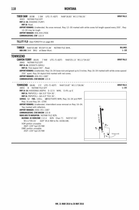
118 MONTANA
TIBER DAM (B70) 1 SW UTC–7(–6DT) N48º18.83´ W111º06.55´3023 NOTAM FILE GTFRWY 12–30: 2550X90 (TURF)
RWY 30: Road.AIRPORT REMARKS: Unattended. No snow removal. Rwy 12–30 marked with white cones full length spaced every 200´. Rwy
12–30 may be rough.AIRPORT MANAGER: 406-444-2506COMMUNICATIONS: CTAF 122.9
TILLITT FLD (See FORSYTH on page 89)
TIMBER N46º20.88´ W104º15.38´ NOTAM FILE BHK.NDB (HW) 344 BKU at Baker Muni.
TOWNSENDCANYON FERRY (8U9) 7 NW UTC–7(–6DT) N46º25.13´ W111º34.63´
3840 NOTAM FILE GTFRWY 16–34: 3200X75 (GRVL)
RWY 34: Thld dsplcd 597´. Road.AIRPORT REMARKS: Unattended. Rwy 16–34 loose rock and gravel up to 3 inches. Rwy 16–34 marked with white cones spaced
200´ apart. Rwy 34 dsplcd thld marked with red cones.AIRPORT MANAGER: 406-351-1687COMMUNICATIONS: CTAF/UNICOM 122.8
– – – – – – – – – – – – – – – – – – – – – – – – – – – – – – – – – – – – – – – – – – – – – – – – – – – – – – – –
TOWNSEND (8U8) 2 E UTC–7(–6DT) N46º19.87´ W111º28.96´3893 B NOTAM FILE GTFRWY 16–34: H4000X60 (ASPH) S–12.5 MIRL 0.4% up S
RWY 16: PAPI(P2L)—GA 3.0º TCH 30´.RWY 34: PAPI(P2L)—GA 4.0º TCH 30´.
SERVICE: S2 FUEL 100LL LGT ACTIVATE MIRL Rwy 16–34 and PAPI Rwy 16 and Rwy 34—CTAF.
AIRPORT REMARKS: Unattended. Intermittent snow removal on Rwy 16–34. Twy marked with reflectors.
AIRPORT MANAGER: (406) 351-1687COMMUNICATIONS: CTAF/UNICOM 122.8RADIO AIDS TO NAVIGATION: NOTAM FILE BZN.
BOZEMAN (H) VORW/DME 112.4 BZN Chan 71 N45º47.03´ W111º09.33´ 320º 35.6 NM to fld. 4436/18E.
VOR portion unusable:360º–105º byd 20 NM
DME portion unusable:350º–105º byd 20 NM
GREAT FALLS
BILLINGSL–13E
GREAT FALLS
GREAT FALLSL–13C
NW, 31 MAR 2016 to 26 MAY 2016
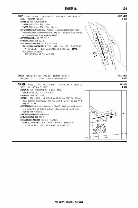
MONTANA 119
TROY (57S) 1 NW UTC–7(–6DT) N48º28.81´ W115º54.21´2017 NOTAM FILE GTFRWY 14–32: H3570X30 (ASPH)
RWY 14: Thld dsplcd 825´. Trees.RWY 32: Thld dsplcd 780´. Trees. Rgt tfc.
AIRPORT REMARKS: Unattended. Pedestrians using walking track invof movement area. No snow removal. Rwy 14–32 dsplcd thlds marked with white arrows. Rwy markings faded.
AIRPORT MANAGER: 406-295-9112COMMUNICATIONS: CTAF 122.9RADIO AIDS TO NAVIGATION: NOTAM FILE MLP.
MULLAN PASS (H) VORW/DME 117.8 MLP Chan 125 N47º27.41´ W115º38.76´ 336º 62.3 NM to fld. 6100/15E. HIWAS.
VOR portion unusable:060º–090º byd 20 NM blo 9,500´
TRULY N47º21.95´ W111º22.37´ NOTAM FILE GTF.NDB (HW) 371 ITU 348º 7.0 NM to Great Falls Intl.
TURNER (9U0) 1 NE UTC–7(–6DT) N48º51.02´ W108º24.23´3051 B NOTAM FILE GTFRWY 07–25: H3612X60 (ASPH) S–12.5 MIRL
RWY 25: PAPI(P2L)—GA 3.0º TCH 38´.RWY 10–28: 2190X90 (TURF)SERVICE: FUEL 100LL LGT MIRL Rwy 07–25 and PAPI Rwy 25 opr
dusk–0500Z‡, after 0500Z‡ ACTIVATE MIRL Rwy 07–25 and PAPI Rwy 25—CTAF.
AIRPORT REMARKS: Attended dawn–dusk Mon–Fri. Fuel, self service credit card 24/7. Rwy 10–28 marked with white cones full length thlds marked with red cones.
AIRPORT MANAGER: 406-379-2584COMMUNICATIONS: CTAF 122.9RADIO AIDS TO NAVIGATION: NOTAM FILE HVR.
HAVRE (L) VORW/DME 111.8 HVR Chan 55 N48º32.43´ W109º46.20´ 055º 57.4 NM to fld. 2583/16E.
GREAT FALLSL–13B
GREAT FALLSL–13C
BILLINGSL–13D
NW, 31 MAR 2016 to 26 MAY 2016
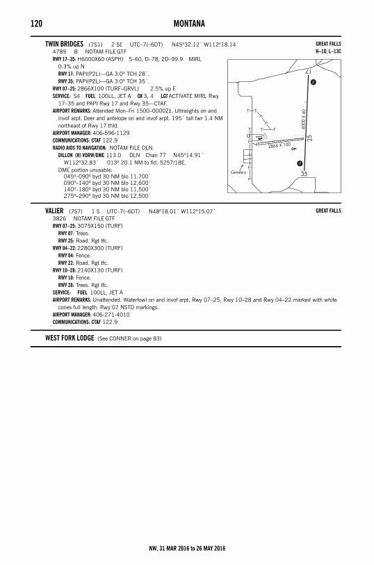
120 MONTANA
TWIN BRIDGES (7S1) 2 SE UTC–7(–6DT) N45º32.12´ W112º18.14´4789 B NOTAM FILE GTFRWY 17–35: H6000X60 (ASPH) S–60, D–78, 2D–99.9 MIRL
0.3% up NRWY 17: PAPI(P2L)—GA 3.0º TCH 28´.RWY 35: PAPI(P2L)—GA 3.0º TCH 35´.
RWY 07–25: 2866X100 (TURF–GRVL) 2.5% up ESERVICE: S4 FUEL 100LL, JET A OX 3, 4 LGT ACTIVATE MIRL Rwy
17–35 and PAPI Rwy 17 and Rwy 35—CTAF.AIRPORT REMARKS: Attended Mon–Fri 1500–0000Z‡. Ultralights on and
invof arpt. Deer and antelope on and invof arpt. 195´ tall twr 1.4 NM northeast of Rwy 17 thld.
AIRPORT MANAGER: 406-596-1129COMMUNICATIONS: CTAF 122.9RADIO AIDS TO NAVIGATION: NOTAM FILE DLN.
DILLON (H) VORW/DME 113.0 DLN Chan 77 N45º14.91´ W112º32.83´ 013º 20.1 NM to fld. 5257/18E.
DME portion unusable:045º–090º byd 30 NM blo 11,700´090º–140º byd 30 NM blo 12,600´140º–180º byd 30 NM blo 11,500´275º–290º byd 30 NM blo 12,500´
VALIER (7S7) 1 S UTC–7(–6DT) N48º18.01´ W112º15.07´3826 NOTAM FILE GTFRWY 07–25: 3075X150 (TURF)
RWY 07: Trees.RWY 25: Road. Rgt tfc.
RWY 04–22: 2280X300 (TURF)RWY 04: Fence.RWY 22: Road. Rgt tfc.
RWY 10–28: 2140X130 (TURF)RWY 10: Fence.RWY 28: Trees. Rgt tfc.
SERVICE: FUEL 100LL, JET A AIRPORT REMARKS: Unattended. Waterfowl on and invof arpt. Rwy 07–25, Rwy 10–28 and Rwy 04–22 marked with white
cones full length. Rwy 07 NSTD markings.AIRPORT MANAGER: 406-271-4010COMMUNICATIONS: CTAF 122.9
WEST FORK LODGE (See CONNER on page 83)
GREAT FALLSH–1D, L–13C
GREAT FALLS
NW, 31 MAR 2016 to 26 MAY 2016
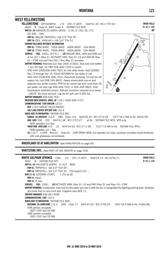
MONTANA 121
WEST YELLOWSTONEYELLOWSTONE (WYS)(KWYS) 1 N UTC–7(–6DT) N44º41.30´ W111º07.06´
6649 B Class III, ARFF Index A NOTAM FILE WYSRWY 01–19: H8400X150 (ASPH–GRVD) S–90, D–150, 2S–175,
2D–280 HIRLRWY 01: MALSR. PAPI(P4L)—GA 3.0º TCH 50´.RWY 19: REIL. VASI(V4L)—GA 3.0º TCH 51´.
RUNWAY DECLARED DISTANCE INFORMATIONRWY 01: TORA–8400 TODA–8400 ASDA–8400 LDA–8400RWY 19: TORA–8400 TODA–8400 ASDA–8400 LDA–8400
SERVICE: FUEL 100LL, JET A1+ LGT MALSR, REIL, VASI and HIRL out of svc Oct 1–May 31. ACTIVATE HIRL Rwy 01–19 and MALSR Rwy 01—CTAF not avbl from Oct 1 thru May 31 annually.
AIRPORT REMARKS: Attended Jun–Sep 1500–0100Z‡. Arpt avbl and staffed 1 Jun–30 Sept, ctc FBO 406–646–7359 or owner 406–444–2506/406–646–7631 for info other times. Arpt CLOSED Nov 15 through Apr 15. Check NOTAMS for opr dates or call 406–444–2506/406–646–7631. Parachute Jumping. For fuel dur off season hrs, call 208–326–8632. Heavy snowmobile use on and adjacent rwy winter months. PPR for air carrier ops with more than 30 pax seats, call arpt mgr 406–646–7631 or 406–459–9825. Cold temperature restricted airport. Altitude correction required at or below –18C/0F. No snow removal. Ldg fee for acft over 9,000 lbs.
AIRPORT MANAGER: 406-646-7631WEATHER DATA SOURCES: AWOS–3P 118.1 (406) 646–7727.COMMUNICATIONS: CTAF/UNICOM 123.0
RCO 119.4 (GREAT FALLS RADIO)SALT LAKE CENTER APP/DEP CON 132.4
RADIO AIDS TO NAVIGATION: NOTAM FILE BOI.DUBOIS (H) VORTACW 116.9 DBS Chan 116 N44º05.33´ W112º12.56´ 037º 59.2 NM to fld. 4920/15E.NDB (HW) 338 ESY N44º41.38´ W111º07.27´ at fld. NOTAM FILE WYS. VFR only.
NDB operates Jun–SepTARGY NDB (HW/LOM) 415 LO N44º34.53´ W111º11.85´ 013º 7.6 NM to fld. NOTAM FILE WYS.
NDB operates Jun – SepILS 110.7 I–LOW Rwy 01. Class IA. LOM TARGY NDB. ILS operates Jun–Sep. Localizer unusable inside threshold.
LOC and glideslope unmonitored.
WHEATLAND CO AT HARLOWTON (See HARLOWTON on page 95)
WHETSTONE INTL (See PORT OF DEL BONITA on page 109)
WHITE SULPHUR SPRINGS (7S6) 3 S UTC–7(–6DT) N46º29.74´ W110º54.71´5061 B NOTAM FILE GTFRWY 01–19: H6100X75 (ASPH) S–16.5 MIRL
RWY 01: PAPI(P2L)—GA 3.0º TCH 39´.RWY 19: PAPI(P2L)—GA 3.0º TCH 35´. Thld dsplcd 231´.
RWY 13–31: 3200X90 (TURF) 1.2% up SERWY 13: Road.RWY 31: P–line.
SERVICE: FUEL 100LL LGT ACTIVATE MIRL Rwy 01–19 and PAPI Rwy 01 and Rwy 19—CTAF.AIRPORT REMARKS: Unattended. Arpt clsd to helicopter ops over 5,000 lbs exc in designated fire fighting parking area. Antelope
and birds freq on and invof arpt. Irrigation twrs AER 13. AIRPORT MANAGER: 406-261-4556COMMUNICATIONS: CTAF 122.9RADIO AIDS TO NAVIGATION: NOTAM FILE BZN.
BOZEMAN (H) VORW/DME 112.4 BZN Chan 71 N45º47.03´ W111º09.33´ 355º 43.9 NM to fld. 4436/18E.VOR portion unusable:
360º–105º byd 20 NMDME portion unusable:
350º–105º byd 20 NM
GREAT FALLSH–1E, L–13C
IAP
GREAT FALLSH–1E, L–13C
NW, 31 MAR 2016 to 26 MAY 2016
122 MONTANA
WHITEFISH (58S) 1 E UTC–7(–6DT) N48º24.48´ W114º17.97´3066 TPA—4066(1000) NOTAM FILE GTFRWY 11–29: 2560X75 (TURF)
RWY 11: Thld dsplcd 278´. Trees.RWY 29: Trees.
AIRPORT REMARKS: Unattended. Arpt CLOSED from 1 Nov through 30 May. No snow removal. Rwy 11–29 trees, railroad and p–lines in transitional sfc full rwy length on north side. Numerous gopher holes on arpt. Rwy 11–29 NSTD markings, marked with white cones. Rwy 11 dsplcd thld marked with red cones
AIRPORT MANAGER: 406-257-5994COMMUNICATIONS: CTAF 122.9
WHITEHALL N45º51.71´ W112º10.18´ NOTAM FILE BTM.(H) VORW/DME 113.7 HIA Chan 84 274º 14.8 NM to Bert Mooney. 4652/18E.
VOR & DME unusable:105º–160º byd 25 NM blo 17,000´210º–230º byd 25 NM blo 17,000´260º–310º byd 25 NM blo 17,000´310º–330º byd 20 NM blo 17,000´355º–050º byd 25 NM blo 15,500´
WILSALL (9U1) 4 NW UTC–7(–6DT) N46º02.98´ W110º41.13´5134 NOTAM FILE GTFRWY 01–19: 3100X78 (TURF)AIRPORT REMARKS: Unattended. Wildlife on and invof arpt. Rwy 01–19 soft when wet, gopher holes on rwy. Rwy 01–19 NSTD
markings, rwy and thld marked with white cones full length. Model airplane usage invof arpt.AIRPORT MANAGER: 406-222-6504COMMUNICATIONS: CTAF 122.9
WINIFREDBLACK BUTTE NORTH (BB0) 18 NE UTC–7(–6DT) N47º50.73´ W109º11.22´
3150 NOTAM FILE GTFRWY 09–27: 1800X60 (TURF)
RWY 27: Hill.AIRPORT REMARKS: Unattended. No snow removal. Wildlife and cattle on and invof arpt. Rwy maintenance irregular. Rwy soft
and muddy when wet. Commercial acft ctc BLM manager 406–538–1950.AIRPORT MANAGER: 406-538-1950COMMUNICATIONS: CTAF 122.9
– – – – – – – – – – – – – – – – – – – – – – – – – – – – – – – – – – – – – – – – – – – – – – – – – – – – – – – –
BULLWHACKER (BW8) 20 NE UTC–7(–6DT) N47º50.87´ W109º05.97´3100 NOTAM FILE GTFRWY 09–27: 1500X60 (TURF)
RWY 09: Trees.AIRPORT REMARKS: Unattended. Wildlife and cattle on and invof arpt. Rwy soft and muddy when wet. Rwy maintenance
irregular. No snow removal. Commercial acft ctc BLM manager 406–538–1950.AIRPORT MANAGER: 406-538-1950COMMUNICATIONS: CTAF 122.9
– – – – – – – – – – – – – – – – – – – – – – – – – – – – – – – – – – – – – – – – – – – – – – – – – – – – – – – –
COW CREEK (CW0) 27 NE UTC–7(–6DT) N47º56.85´ W109º00.48´3300 NOTAM FILE GTFRWY 09–27: 2200X60 (TURF)AIRPORT REMARKS: Unattended. Wildlife and cattle on and invof arpt. Rwy soft and muddy when wet. Rwy maintenance
irregular. No snow removal. Unimproved remote airstrip with rough sfc and high vegetation. Deep vehicle ruts south half of rwy. Commercial acft ctc BLM manager 406–538–1950.
AIRPORT MANAGER: 406-538-1950COMMUNICATIONS: CTAF 122.9
– – – – – – – – – – – – – – – – – – – – – – – – – – – – – – – – – – – – – – – – – – – – – – – – – – – – – – – –
HELLER FARM (L51) 23 WSW UTC–7(–6DT) N47º43.58´ W108º52.50´2304 NOTAM FILE GTF Not insp.RWY 11–29: 2998X80 (TURF–DIRT)AIRPORT REMARKS: Attended irregularly.AIRPORT MANAGER: 406-727-3192COMMUNICATIONS: CTAF 122.9
– – – – – – – – – – – – – – – – – – – – – – – – – – – – – – – – – – – – – – – – – – – – – – – – – – – – – – – –
GREAT FALLS
GREAT FALLSH–1D, L–13C
GREAT FALLS
GREAT FALLS
GREAT FALLS
GREAT FALLS
BILLINGS
NW, 31 MAR 2016 to 26 MAY 2016
MONTANA 123– – – – – – – – – – – – – – – – – – – – – – – – – – – – – – – – – – – – – – – – – – – – – – – – – – – – – – – –
KNOX RIDGE (MT3) 24 E UTC–7(–6DT) N47º37.00´ W108º50.88´2950 NOTAM FILE GTFRWY 09–27: 2100X60 (TURF)AIRPORT REMARKS: Unattended. Wildlife and cattle on and invof arpt. Rwy soft and muddy when wet. Rwy maintenance
irregular. No snow removal. Commercial acft ctc BLM manager 406–538–1950.AIRPORT MANAGER: 406-538-1950COMMUNICATIONS: CTAF 122.9
– – – – – – – – – – – – – – – – – – – – – – – – – – – – – – – – – – – – – – – – – – – – – – – – – – – – – – – –
LEFT COULEE (LC0) 22 NE UTC–7(–6DT) N47º53.12´ W109º01.37´3150 NOTAM FILE GTFRWY 09–27: 1600X60 (TURF)
RWY 27: Tree.AIRPORT REMARKS: Unattended. Wildlife and cattle on and invof arpt. Rwy soft and muddy when wet. Rwy maintenance
irregular. No snow removal. Remote unimproved airstrip with rough sfc and high vegetation. Commercial acft ctc BLM manager 406–538–1950.
AIRPORT MANAGER: 406-538-1950COMMUNICATIONS: CTAF 122.9
– – – – – – – – – – – – – – – – – – – – – – – – – – – – – – – – – – – – – – – – – – – – – – – – – – – – – – – –
WINIFRED (9S7) 1 S UTC–7(–6DT) N47º33.10´ W109º22.66´3311 NOTAM FILE GTFRWY 08–26: 4400X150 (TURF) S–4SERVICE: FUEL 100LL AIRPORT REMARKS: Unattended. Emerg ctc 406–462–5487. Fuel avbl 24 hrs with credit card. Rwy sfc slope varies from nearly
flat on both ends to 3% near the middle. Rwy 08–26 NSTD markings, marked full length with white cones.AIRPORT MANAGER: 406-462-5487COMMUNICATIONS: CTAF 122.9
– – – – – – – – – – – – – – – – – – – – – – – – – – – – – – – – – – – – – – – – – – – – – – – – – – – – – – – –
WOODHAWK (WH0) 15 NE UTC–7(–6DT) N47º46.77´ W109º04.72´3100 NOTAM FILE GTFRWY 09–27: 1200X60 (TURF)
RWY 09: Trees.RWY 27: Trees.
AIRPORT REMARKS: Unattended. Arpt CLOSED from Sep 1 to Nov 30 each year. No snow removal. Wildlife and cattle on and invof arpt. Rwy maintenance irregular. Rwy soft and muddy when wet. Remote unimproved airstrip with rough sfc and high vegetation. Commercial acft ctc BLM manager 406–538–1950.
AIRPORT MANAGER: 406-538-1950COMMUNICATIONS: CTAF 122.9
WINNETT (7S2) 2 SW UTC–7(–6DT) N46º58.60´ W108º21.90´2989 NOTAM FILE GTFRWY 12–30: 3130X75 (TURF)
RWY 30: P–line.AIRPORT REMARKS: Unattended. For rwy conditions call 406–423–6361 or 406–928–6363. No snow removal. Rwy muddy
when wet. Rwy 30 p–line 50´ 846´ east marked with white and orange balls. Rwy 12–30 NSTD markings, marked with white cones.
AIRPORT MANAGER: 406-429-6551COMMUNICATIONS: CTAF 122.9
WISDOM (7S4) 2 S UTC–7(–6DT) N45º35.50´ W113º27.55´6133 NOTAM FILE GTFRWY 01–19: 3445X60 (TURF)
RWY 01: Road.RWY 19: Thld dsplcd 520´. Road.
AIRPORT REMARKS: Unattended. Arpt CLOSED winter months. Rwy 01–19 wedge full length has 8" to 14" berm. Rwy 01–19 multiple gopher and badger holes, especially in southern end of rwy. Rwy 01 first 400´ marked with white cones. Rwy 19 first 600´ marked with white cones. Rwy 19 dsplcd thld marked with 4 red cones.
AIRPORT MANAGER: (406) 660-1791COMMUNICATIONS: CTAF 122.9
WISE RIVER (02T) 2 SW UTC–7(–6DT) N45º46.20´ W112º58.83´5830 NOTAM FILE GTFRWY 02–20: 4050X60 (TURF–DIRT) 1.3% up S
RWY 02: Rgt tfc.AIRPORT REMARKS: Unattended. Arpt not plowed winter months. Rwy 02–20, 2 cones on each rwy end mark thlds.AIRPORT MANAGER: 406-832-3219COMMUNICATIONS: CTAF 122.9
GREAT FALLS
GREAT FALLS
GREAT FALLS
GREAT FALLS
BILLINGS
GREAT FALLS
GREAT FALLS
NW, 31 MAR 2016 to 26 MAY 2016
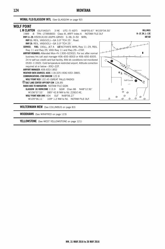
124 MONTANA
WOKAL FLD/GLASGOW INTL (See GLASGOW on page 92)
WOLF POINTL M CLAYTON (OLF)(KOLF) 3 NE UTC–7(–6DT) N48º05.67´ W105º34.50´
1989 B TPA—2789(800) Class III, ARFF Index A NOTAM FILE OLFRWY 11–29: H5091X100 (ASPH–GRVD) S–38, D–50 MIRL
RWY 11: REIL. VASI(V2L)—GA 3.0º TCH 25´. Road.RWY 29: REIL. VASI(V2L)—GA 3.0º TCH 25´.
SERVICE: FUEL 100LL, JET A LGT ACTIVATE MIRL Rwy 11–29, REIL Rwy 11 and Rwy 29, VASI Rwy 11 and Rwy 29—CTAF.
AIRPORT REMARKS: Attended Mon–Fri 1300–0230Z‡. For svc after normal business hrs call arpt manager 406–650–8303 or 406–650–8305. 24 hr self svc credit card fuel facility. Afld sfc conditions not monitored 0530–1130Z‡. Cold temperature restricted airport. Altitude correction required at or below –30C/–22F.
AIRPORT MANAGER: 406-653-1852WEATHER DATA SOURCES: ASOS 118.325 (406) 653–3865.COMMUNICATIONS: CTAF/UNICOM 122.8
WOLF POINT RCO 122.45 (GREAT FALLS RADIO)®SALT LAKE CENTER APP/DEP CON 126.85
RADIO AIDS TO NAVIGATION: NOTAM FILE GGW.GLASGOW (H) VORW/DME 113.9 GGW Chan 86 N48º12.92´
W106º37.53´ 085º 42.8 NM to fld. 2283/14E.WOLF POINT NDB (HW) 404 OLF N48º06.27´
W105º36.11´ 109º 1.2 NM to fld. NOTAM FILE OLF.
WOLTERMANN MEM (See COLUMBUS on page 83)
WOODHAWK (See WINIFRED on page 123)
YELLOWSTONE (See WEST YELLOWSTONE on page 121)
BILLINGSH–1F, 2H, L–13E
IAP, AD
NW, 31 MAR 2016 to 26 MAY 2016
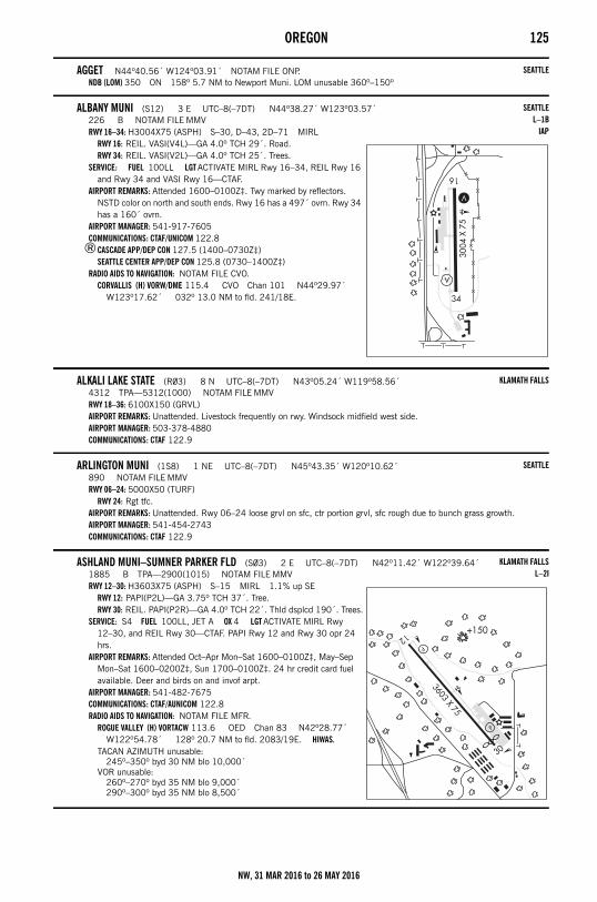
OREGON 125Oregon
AGGET N44º40.56´ W124º03.91´ NOTAM FILE ONP.NDB (LOM) 350 ON 158º 5.7 NM to Newport Muni. LOM unusable 360º–150º
ALBANY MUNI (S12) 3 E UTC–8(–7DT) N44º38.27´ W123º03.57´226 B NOTAM FILE MMVRWY 16–34: H3004X75 (ASPH) S–30, D–43, 2D–71 MIRL
RWY 16: REIL. VASI(V4L)—GA 4.0º TCH 29´. Road.RWY 34: REIL. VASI(V2L)—GA 4.0º TCH 25´. Trees.
SERVICE: FUEL 100LL LGT ACTIVATE MIRL Rwy 16–34, REIL Rwy 16 and Rwy 34 and VASI Rwy 16—CTAF.
AIRPORT REMARKS: Attended 1600–0100Z‡. Twy marked by reflectors. NSTD color on north and south ends. Rwy 16 has a 497´ ovrn. Rwy 34 has a 160´ ovrn.
AIRPORT MANAGER: 541-917-7605COMMUNICATIONS: CTAF/UNICOM 122.8
®CASCADE APP/DEP CON 127.5 (1400–0730Z‡)SEATTLE CENTER APP/DEP CON 125.8 (0730–1400Z‡)
RADIO AIDS TO NAVIGATION: NOTAM FILE CVO.CORVALLIS (H) VORW/DME 115.4 CVO Chan 101 N44º29.97´
W123º17.62´ 032º 13.0 NM to fld. 241/18E.
ALKALI LAKE STATE (R03) 8 N UTC–8(–7DT) N43º05.24´ W119º58.56´4312 TPA—5312(1000) NOTAM FILE MMVRWY 18–36: 6100X150 (GRVL)AIRPORT REMARKS: Unattended. Livestock frequently on rwy. Windsock midfield west side.AIRPORT MANAGER: 503-378-4880COMMUNICATIONS: CTAF 122.9
ARLINGTON MUNI (1S8) 1 NE UTC–8(–7DT) N45º43.35´ W120º10.62´890 NOTAM FILE MMVRWY 06–24: 5000X50 (TURF)
RWY 24: Rgt tfc.AIRPORT REMARKS: Unattended. Rwy 06–24 loose grvl on sfc, ctr portion grvl, sfc rough due to bunch grass growth.AIRPORT MANAGER: 541-454-2743COMMUNICATIONS: CTAF 122.9
ASHLAND MUNI–SUMNER PARKER FLD (S03) 2 E UTC–8(–7DT) N42º11.42´ W122º39.64´1885 B TPA—2900(1015) NOTAM FILE MMVRWY 12–30: H3603X75 (ASPH) S–15 MIRL 1.1% up SE
RWY 12: PAPI(P2L)—GA 3.75º TCH 37´. Tree.RWY 30: REIL. PAPI(P2R)—GA 4.0º TCH 22´. Thld dsplcd 190´. Trees.
SERVICE: S4 FUEL 100LL, JET A OX 4 LGT ACTIVATE MIRL Rwy 12–30, and REIL Rwy 30—CTAF. PAPI Rwy 12 and Rwy 30 opr 24 hrs.
AIRPORT REMARKS: Attended Oct–Apr Mon–Sat 1600–0100Z‡, May–Sep Mon–Sat 1600–0200Z‡, Sun 1700–0100Z‡. 24 hr credit card fuel available. Deer and birds on and invof arpt.
AIRPORT MANAGER: 541-482-7675COMMUNICATIONS: CTAF/AUNICOM 122.8RADIO AIDS TO NAVIGATION: NOTAM FILE MFR.
ROGUE VALLEY (H) VORTACW 113.6 OED Chan 83 N42º28.77´ W122º54.78´ 128º 20.7 NM to fld. 2083/19E. HIWAS.
TACAN AZIMUTH unusable:245º–350º byd 30 NM blo 10,000´
VOR unusable:260º–270º byd 35 NM blo 9,000´290º–300º byd 35 NM blo 8,500´
SEATTLE
SEATTLEL–1B
IAP
KLAMATH FALLS
SEATTLE
KLAMATH FALLSL–2I
NW, 31 MAR 2016 to 26 MAY 2016
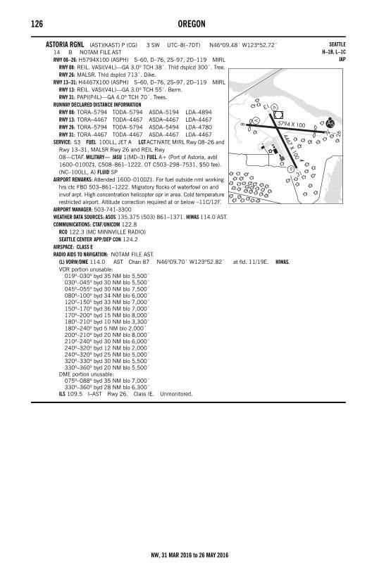
126 OREGON
ASTORIA RGNL (AST)(KAST) P (CG) 3 SW UTC–8(–7DT) N46º09.48´ W123º52.72´14 B NOTAM FILE ASTRWY 08–26: H5794X100 (ASPH) S–60, D–76, 2S–97, 2D–119 MIRL
RWY 08: REIL. VASI(V4L)—GA 3.0º TCH 38´. Thld dsplcd 300´. Tree.RWY 26: MALSR. Thld dsplcd 713´. Dike.
RWY 13–31: H4467X100 (ASPH) S–60, D–76, 2S–97, 2D–119 MIRLRWY 13: REIL. VASI(V4L)—GA 3.0º TCH 55´. Berm.RWY 31: PAPI(P4L)—GA 4.0º TCH 70´. Trees.
RUNWAY DECLARED DISTANCE INFORMATIONRWY 08: TORA–5794 TODA–5794 ASDA–5194 LDA–4894RWY 13: TORA–4467 TODA–4467 ASDA–4467 LDA–4467RWY 26: TORA–5794 TODA–5794 ASDA–5494 LDA–4780RWY 31: TORA–4467 TODA–4467 ASDA–4467 LDA–4467
SERVICE: S3 FUEL 100LL, JET A LGT ACTIVATE MIRL Rwy 08–26 and Rwy 13–31, MALSR Rwy 26 and REIL Rwy 08—CTAF. MILITARY— JASU 1(MD–3) FUEL A+ (Port of Astoria, avbl 1600–0100Z‡, C508–861–1222. OT C503–298–7531, $50 fee). (NC–100LL, A) FLUID SP
AIRPORT REMARKS: Attended 1600–0100Z‡. For fuel outside nml working hrs ctc FBO 503–861–1222. Migratory flocks of waterfowl on and invof arpt. High concentration helicopter opr in area. Cold temperature restricted airport. Altitude correction required at or below –11C/12F.
AIRPORT MANAGER: 503-741-3300WEATHER DATA SOURCES: ASOS 135.375 (503) 861–1371. HIWAS 114.0 AST.COMMUNICATIONS: CTAF/UNICOM 122.8
RCO 122.3 (MC MINNVILLE RADIO)SEATTLE CENTER APP/DEP CON 124.2
AIRSPACE: CLASS ERADIO AIDS TO NAVIGATION: NOTAM FILE AST.
(L) VORW/DME 114.0 AST Chan 87 N46º09.70´ W123º52.82´ at fld. 11/19E. HIWAS.VOR portion unusable:
019º–030º byd 35 NM blo 5,500´030º–045º byd 30 NM blo 5,500´045º–055º byd 30 NM blo 7,500´080º–100º byd 34 NM blo 6,000´120º–150º byd 33 NM blo 7,000´150º–170º byd 36 NM blo 7,000´170º–200º byd 15 NM blo 8,000´180º–210º byd 10 NM blo 3,300´180º–240º byd 5 NM blo 2,000´200º–210º byd 20 NM blo 8,000´210º–240º byd 30 NM blo 6,000´240º–320º byd 12 NM blo 2,000´240º–320º byd 25 NM blo 5,000´320º–330º byd 30 NM blo 5,500´330º–360º byd 20 NM blo 5,500´
DME portion unusable:075º–088º byd 35 NM blo 7,000´330º–360º byd 28 NM blo 6,300´
ILS 109.5 I–AST Rwy 26. Class IE. Unmonitored.
SEATTLEH–1B, L–1C
IAP
NW, 31 MAR 2016 to 26 MAY 2016
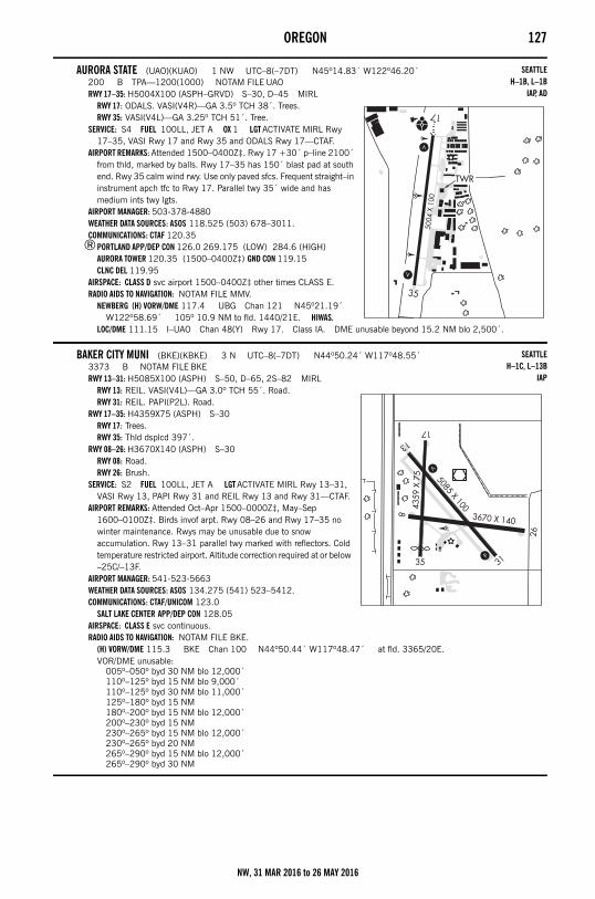
OREGON 127
AURORA STATE (UAO)(KUAO) 1 NW UTC–8(–7DT) N45º14.83´ W122º46.20´200 B TPA—1200(1000) NOTAM FILE UAORWY 17–35: H5004X100 (ASPH–GRVD) S–30, D–45 MIRL
RWY 17: ODALS. VASI(V4R)—GA 3.5º TCH 38´. Trees.RWY 35: VASI(V4L)—GA 3.25º TCH 51´. Tree.
SERVICE: S4 FUEL 100LL, JET A OX 1 LGT ACTIVATE MIRL Rwy 17–35, VASI Rwy 17 and Rwy 35 and ODALS Rwy 17—CTAF.
AIRPORT REMARKS: Attended 1500–0400Z‡. Rwy 17 +30´ p–line 2100´ from thld, marked by balls. Rwy 17–35 has 150´ blast pad at south end. Rwy 35 calm wind rwy. Use only paved sfcs. Frequent straight–in instrument apch tfc to Rwy 17. Parallel twy 35´ wide and has medium ints twy lgts.
AIRPORT MANAGER: 503-378-4880WEATHER DATA SOURCES: ASOS 118.525 (503) 678–3011.COMMUNICATIONS: CTAF 120.35
®PORTLAND APP/DEP CON 126.0 269.175 (LOW) 284.6 (HIGH)AURORA TOWER 120.35 (1500–0400Z‡) GND CON 119.15 CLNC DEL 119.95
AIRSPACE: CLASS D svc airport 1500–0400Z‡ other times CLASS E.RADIO AIDS TO NAVIGATION: NOTAM FILE MMV.
NEWBERG (H) VORW/DME 117.4 UBG Chan 121 N45º21.19´ W122º58.69´ 105º 10.9 NM to fld. 1440/21E. HIWAS.
LOC/DME 111.15 I–UAO Chan 48(Y) Rwy 17. Class IA. DME unusable beyond 15.2 NM blo 2,500´.
BAKER CITY MUNI (BKE)(KBKE) 3 N UTC–8(–7DT) N44º50.24´ W117º48.55´3373 B NOTAM FILE BKERWY 13–31: H5085X100 (ASPH) S–50, D–65, 2S–82 MIRL
RWY 13: REIL. VASI(V4L)—GA 3.0º TCH 55´. Road.RWY 31: REIL. PAPI(P2L). Road.
RWY 17–35: H4359X75 (ASPH) S–30RWY 17: Trees.RWY 35: Thld dsplcd 397´.
RWY 08–26: H3670X140 (ASPH) S–30RWY 08: Road.RWY 26: Brush.
SERVICE: S2 FUEL 100LL, JET A LGT ACTIVATE MIRL Rwy 13–31, VASI Rwy 13, PAPI Rwy 31 and REIL Rwy 13 and Rwy 31—CTAF.
AIRPORT REMARKS: Attended Oct–Apr 1500–0000Z‡, May–Sep 1600–0100Z‡. Birds invof arpt. Rwy 08–26 and Rwy 17–35 no winter maintenance. Rwys may be unusable due to snow accumulation. Rwy 13–31 parallel twy marked with reflectors. Cold temperature restricted airport. Altitude correction required at or below –25C/–13F.
AIRPORT MANAGER: 541-523-5663WEATHER DATA SOURCES: ASOS 134.275 (541) 523–5412.COMMUNICATIONS: CTAF/UNICOM 123.0
SALT LAKE CENTER APP/DEP CON 128.05AIRSPACE: CLASS E svc continuous. RADIO AIDS TO NAVIGATION: NOTAM FILE BKE.
(H) VORW/DME 115.3 BKE Chan 100 N44º50.44´ W117º48.47´ at fld. 3365/20E.VOR/DME unusable:
005º–050º byd 30 NM blo 12,000´110º–125º byd 15 NM blo 9,000´110º–125º byd 30 NM blo 11,000´125º–180º byd 15 NM180º–200º byd 15 NM blo 12,000´200º–230º byd 15 NM230º–265º byd 15 NM blo 12,000´230º–265º byd 20 NM265º–290º byd 15 NM blo 12,000´265º–290º byd 30 NM
SEATTLEH–1B, L–1B
IAP, AD
SEATTLEH–1C, L–13B
IAP
NW, 31 MAR 2016 to 26 MAY 2016
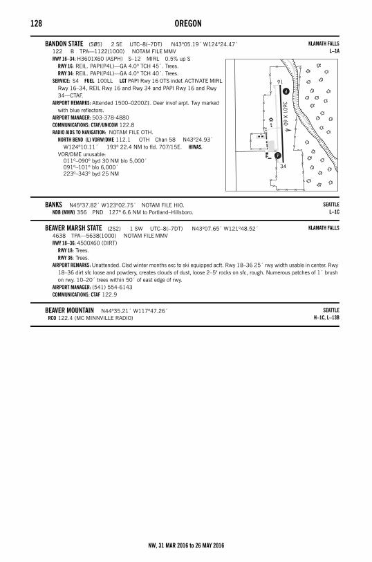
128 OREGON
BANDON STATE (S05) 2 SE UTC–8(–7DT) N43º05.19´ W124º24.47´122 B TPA—1122(1000) NOTAM FILE MMVRWY 16–34: H3601X60 (ASPH) S–12 MIRL 0.5% up S
RWY 16: REIL. PAPI(P4L)—GA 4.0º TCH 45´. Trees.RWY 34: REIL. PAPI(P4L)—GA 4.0º TCH 40´. Trees.
SERVICE: S4 FUEL 100LL LGT PAPI Rwy 16 OTS indef. ACTIVATE MIRL Rwy 16–34, REIL Rwy 16 and Rwy 34 and PAPI Rwy 16 and Rwy 34—CTAF.
AIRPORT REMARKS: Attended 1500–0200Z‡. Deer invof arpt. Twy marked with blue reflectors.
AIRPORT MANAGER: 503-378-4880COMMUNICATIONS: CTAF/UNICOM 122.8RADIO AIDS TO NAVIGATION: NOTAM FILE OTH.
NORTH BEND (L) VORW/DME 112.1 OTH Chan 58 N43º24.93´ W124º10.11´ 193º 22.4 NM to fld. 707/15E. HIWAS.
VOR/DME unusable:011º–090º byd 30 NM blo 5,000´091º–101º blo 6,000´223º–343º byd 25 NM
BANKS N45º37.82´ W123º02.75´ NOTAM FILE HIO.NDB (MHW) 356 PND 127º 6.6 NM to Portland–Hillsboro.
BEAVER MARSH STATE (2S2) 1 SW UTC–8(–7DT) N43º07.65´ W121º48.52´4638 TPA—5638(1000) NOTAM FILE MMVRWY 18–36: 4500X60 (DIRT)
RWY 18: Trees.RWY 36: Trees.
AIRPORT REMARKS: Unattended. Clsd winter months exc to ski equipped acft. Rwy 18–36 25´ rwy width usable in center. Rwy 18–36 dirt sfc loose and powdery, creates clouds of dust, loose 2–5" rocks on sfc, rough. Numerous patches of 1´ brush on rwy. 10–20´ trees within 50´ of east edge of rwy.
AIRPORT MANAGER: (541) 554-6143COMMUNICATIONS: CTAF 122.9
BEAVER MOUNTAIN N44º35.21´ W117º47.26´RCO 122.4 (MC MINNVILLE RADIO)
KLAMATH FALLSL–1A
SEATTLEL–1C
KLAMATH FALLS
SEATTLEH–1C, L–13B
NW, 31 MAR 2016 to 26 MAY 2016
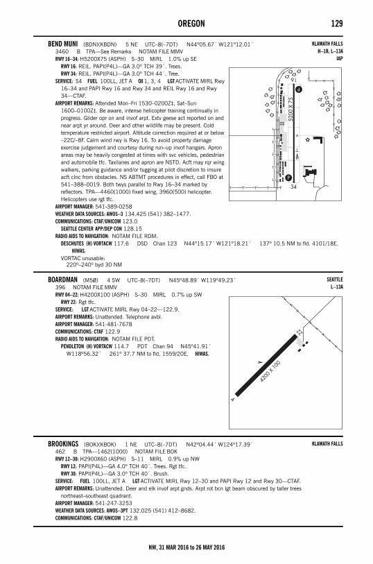
OREGON 129
BEND MUNI (BDN)(KBDN) 5 NE UTC–8(–7DT) N44º05.67´ W121º12.01´3460 B TPA—See Remarks NOTAM FILE MMVRWY 16–34: H5200X75 (ASPH) S–30 MIRL 1.0% up SE
RWY 16: REIL. PAPI(P4L)—GA 3.0º TCH 39´. Trees.RWY 34: REIL. PAPI(P4L)—GA 3.0º TCH 44´. Tree.
SERVICE: S4 FUEL 100LL, JET A OX 1, 3, 4 LGT ACTIVATE MIRL Rwy 16–34 and PAPI Rwy 16 and Rwy 34 and REIL Rwy 16 and Rwy 34—CTAF.
AIRPORT REMARKS: Attended Mon–Fri 1530–0200Z‡, Sat–Sun 1600–0100Z‡. Be aware, intense helicopter training continually in progress. Glider opr on and invof arpt. Extv geese act reported on and near arpt yr around. Deer and other wildlife may be present. Cold temperature restricted airport. Altitude correction required at or below –22C/–8F. Calm wind rwy is Rwy 16. To avoid property damage exercise judgement and courtesy during run–up invof hangars. Apron areas may be heavily congested at times with svc vehicles, pedestrian and automobile tfc. Taxilanes and apron are NSTD. Acft may rqr wing walkers, parking guidance and/or tugging at pilot discretion to insure acft clnc from obstacles. NS ABTMT procedures in effect, call FBO at 541–388–0019. Both twys parallel to Rwy 16–34 marked by reflectors. TPA—4460(1000) fixed wing, 3960(500) helicopter. Helicopters use rgt tfc.
AIRPORT MANAGER: 541-389-0258WEATHER DATA SOURCES: AWOS–3 134.425 (541) 382–1477.COMMUNICATIONS: CTAF/UNICOM 123.0
SEATTLE CENTER APP/DEP CON 128.15RADIO AIDS TO NAVIGATION: NOTAM FILE RDM.
DESCHUTES (H) VORTACW 117.6 DSD Chan 123 N44º15.17´ W121º18.21´ 137º 10.5 NM to fld. 4101/18E. HIWAS.
VORTAC unusable:220º–240º byd 30 NM
BOARDMAN (M50) 4 SW UTC–8(–7DT) N45º48.89´ W119º49.23´396 NOTAM FILE MMVRWY 04–22: H4200X100 (ASPH) S–30 MIRL 0.7% up SW
RWY 22: Rgt tfc.SERVICE: LGT ACTIVATE MIRL Rwy 04–22—122.9.AIRPORT REMARKS: Unattended. Telephone avbl. AIRPORT MANAGER: 541-481-7678COMMUNICATIONS: CTAF 122.9RADIO AIDS TO NAVIGATION: NOTAM FILE PDT.
PENDLETON (H) VORTACW 114.7 PDT Chan 94 N45º41.91´ W118º56.32´ 261º 37.7 NM to fld. 1559/20E. HIWAS.
BROOKINGS (BOK)(KBOK) 1 NE UTC–8(–7DT) N42º04.44´ W124º17.39´462 B TPA—1462(1000) NOTAM FILE BOKRWY 12–30: H2900X60 (ASPH) S–11 MIRL 0.9% up NW
RWY 12: PAPI(P4L)—GA 4.0º TCH 40´. Trees. Rgt tfc.RWY 30: PAPI(P4L)—GA 3.0º TCH 40´. Brush.
SERVICE: FUEL 100LL, JET A LGT ACTIVATE MIRL Rwy 12–30 and PAPI Rwy 12 and Rwy 30—CTAF.AIRPORT REMARKS: Unattended. Deer and elk invof arpt gnds. Arpt rot bcn lgt beam obscured by taller trees
northeast–southeast quadrant. AIRPORT MANAGER: 541-247-3253WEATHER DATA SOURCES: AWOS–3PT 132.025 (541) 412–8682.COMMUNICATIONS: CTAF/UNICOM 122.8
KLAMATH FALLSH–1B, L–13A
IAP
SEATTLEL–13A
KLAMATH FALLS
NW, 31 MAR 2016 to 26 MAY 2016
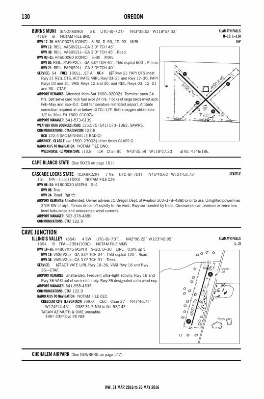
130 OREGON
BURNS MUNI (BNO)(KBNO) 5 E UTC–8(–7DT) N43º35.52´ W118º57.33´4159 B NOTAM FILE BNORWY 12–30: H5100X75 (CONC) S–30, D–50, 2D–90 MIRL
RWY 12: REIL. VASI(V2L)—GA 3.0º TCH 45´.RWY 30: REIL. VASI(V2L)—GA 3.0º TCH 45´. Road.
RWY 03–21: H4600X60 (CONC) S–30 MIRLRWY 03: REIL. PAPI(P2L)—GA 3.0º TCH 40´. Thld dsplcd 600´. P–line.RWY 21: REIL. PAPI(P2L)—GA 3.0º TCH 40´.
SERVICE: S4 FUEL 100LL, JET A OX 4 LGT Rwy 21 PAPI OTS indef. Rwy 21 REIL OTS. ACTIVATE MIRL Rwy 03–21 and Rwy 12–30, PAPI Rwys 03 and 21, VASI Rwys 12 and 30, and REIL Rwys 03, 12, 21 and 30—CTAF.
AIRPORT REMARKS: Attended Mon–Sat 1600–0200Z‡. Terminal open 24 hrs. Self serve card lock fuel avbl 24 hrs. Flocks of large birds invof arpt Feb–May and Sep–Oct. Cold temperature restricted airport. Altitude correction required at or below –27C/–17F. Bottle oxygen obtainable 1/2 hr, Mon–Fri 1600–0100Z‡.
AIRPORT MANAGER: 541-573-6139WEATHER DATA SOURCES: ASOS 135.575 (541) 573–1382. SAWRS.COMMUNICATIONS: CTAF/UNICOM 122.8
RCO 122.5 (MC MINNVILLE RADIO)AIRSPACE: CLASS E svc 1500–2300Z‡ other times CLASS G.RADIO AIDS TO NAVIGATION: NOTAM FILE BNO.
WILDHORSE (L) VORW/DME 113.8 ILR Chan 85 N43º35.59´ W118º57.30´ at fld. 4146/18E.
CAPE BLANCO STATE (See SIXES on page 161)
CASCADE LOCKS STATE (CZK)(KCZK) 1 NE UTC–8(–7DT) N45º40.62´ W121º52.73´151 TPA—1151(1000) NOTAM FILE CZKRWY 06–24: H1800X30 (ASPH) S–4
RWY 06: Tree.RWY 24: Road. Rgt tfc.
AIRPORT REMARKS: Unattended. Owner advises ctc Oregon Dept. of Aviation 503–378–4880 prior to use. Unlighted powerlines 3NM SW of arpt. Terrain drops off rapidly to the west. Rwy surrounded by trees. Crosswinds can produce extreme low level turbulence and unexpected wind currents.
AIRPORT MANAGER: 503-378-4880COMMUNICATIONS: CTAF 122.9
CAVE JUNCTIONILLINOIS VALLEY (3S4) 4 SW UTC–8(–7DT) N42º06.22´ W123º40.95´
1394 B TPA—2394(1000) NOTAM FILE MMVRWY 18–36: H4807X75 (ASPH) S–20, D–30 LIRL 0.9% up S
RWY 18: VASI(V2L)—GA 3.0º TCH 34´. Thld dsplcd 125´. Road.RWY 36: VASI(V2L)—GA 3.0º TCH 31´. Trees.
SERVICE: LGT ACTIVATE LIRL Rwy 18–36, VASI Rwy 18 and Rwy 36—CTAF.
AIRPORT REMARKS: Unattended. Frequent ultra–light activity. Rwy 18 and Rwy 36 VASI out of svc indefinitely. Rwy 36 designated calm wind rwy.
AIRPORT MANAGER: 541-955-4535COMMUNICATIONS: CTAF 122.9RADIO AIDS TO NAVIGATION: NOTAM FILE CEC.
CRESCENT CITY (L) VORTACW 109.0 CEC Chan 27 N41º46.77´ W124º14.45´ 038º 31.7 NM to fld. 53/14E.
TACAN AZIMUTH & DME unusable:195º–235º byd 20 NM
CHEHALEM AIRPARK (See NEWBERG on page 147)
KLAMATH FALLSH–1C, L–11A
IAP
SEATTLE
KLAMATH FALLSL–2I
NW, 31 MAR 2016 to 26 MAY 2016
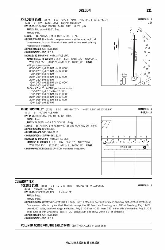
OREGON 131
CHILOQUIN STATE (2S7) 1 W UTC–8(–7DT) N42º34.76´ W121º52.74´4221 B TPA—5221(1000) NOTAM FILE MMVRWY 17–35: H3749X60 (ASPH) S–10 MIRL 0.8% up N
RWY 17: Thld dsplcd 420´. Tree.RWY 35: Tree.
SERVICE: LGT ACTIVATE MIRL Rwy 17–35—CTAF.AIRPORT REMARKS: Unattended. Irregular winter maintenance, arpt clsd
when covered in snow. Downdraft area north of rwy. West side twy marked with reflectors.
AIRPORT MANAGER: 503-378-4880COMMUNICATIONS: CTAF 122.9RADIO AIDS TO NAVIGATION: NOTAM FILE LMT.
KLAMATH FALLS (H) VORTACW 115.9 LMT Chan 106 N42º09.19´ W121º43.65´ 328º 26.4 NM to fld. 4092/17E. HIWAS.
VOR portion unusable:050º–060º byd 30 NM blo 12,000´060º–120º byd 25 NM blo 12,000´170º–195º byd 20 NM210º–245º byd 25 NM blo 12,000´270º–280º byd 20 NM320º–050º byd 23 NM blo 12,000´320º–050º byd 30 NM
TACAN AZIMUTH & DME portion unusable:105º–125º byd 7 NM blo 12,000´153º–195º byd 20 NM blo 11,000´210º–305º byd 25 NM blo 10,500´320º–105º byd 13 NM blo 13,000´320º–125º byd 20 NM
CHRISTMAS VALLEY (62S) 1 SE UTC–8(–7DT) N43º14.18´ W120º39.89´4317 B NOTAM FILE MMVRWY 07–25: H5200X60 (ASPH) S–12 MIRL
RWY 07: Tree.RWY 25: PAPI(P2L)—GA 3.0º TCH 38´. Bldg.
SERVICE: LGT ACTIVATE MIRL Rwy 07–25 and PAPI Rwy 25—CTAF.AIRPORT REMARKS: Unattended. AIRPORT MANAGER: 541-576-2216COMMUNICATIONS: CTAF/UNICOM 122.8RADIO AIDS TO NAVIGATION: NOTAM FILE LKV.
LAKEVIEW (H) VORTACW 112.0 LKV Chan 57 N42º29.57´ W120º30.43´ 332º 45.1 NM to fld. 7460/19E. HIWAS.
COMM/NAV/WEATHER REMARKS: UNICOM monitored irregularly.
CLEARWATERTOKETEE STATE (3S6) 2 S UTC–8(–7DT) N43º13.41´ W122º25.27´
3361 NOTAM FILE MMVRWY 11–29: 5350X60 (TURF) 2.4% up SE
RWY 11: Trees.RWY 29: Trees.
AIRPORT REMARKS: Unattended. Arpt CLOSED from 1 Nov–1 May. Elk, deer and turkey on and invof arpt. Arpt on West side of Cascades and affected by wx West. Best info on arpt thru US Forest svc Roseburg, or lcl FBO at Roseburg. Rwy 11–29 graded, 60´ wide, shoulders rough and rutted. Rwy 11–29 has +120´ trees 250´ either side of centerline. Rwy 11–29 thlds outlined with white tires. Trees 4´–30´ along south side of rwy within 50´ of centerline.
AIRPORT MANAGER: 503-378-4880COMMUNICATIONS: CTAF 122.9
COLUMBIA GORGE RGNL/THE DALLES MUNI (See THE DALLES on page 162)
KLAMATH FALLSL–2J
KLAMATH FALLSH–1B, L–11A
KLAMATH FALLS
NW, 31 MAR 2016 to 26 MAY 2016
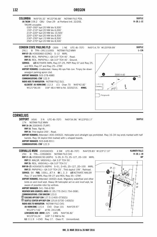
132 OREGON
COLUMBIA N45º35.32´ W122º36.68´ NOTAM FILE PDX.(H) TACAN 109.2 CBU Chan 29 at Portland Intl. 22/20E.
TACAN unusable:030º–050º byd 20 NM blo 9,500´155º–210º byd 20 NM blo 6,000´210º–220º byd 20 NM blo 10,500´220º–230º byd 20 NM blo 8,500´230º–250º byd 15 NM blo 8,500´250º–270º byd 20 NM blo 8,500´
CONDON STATE PAULING FLD (3S9) 1 NE UTC–8(–7DT) N45º14.79´ W120º09.99´2911 B TPA—3911(1000) NOTAM FILE MMVRWY 07–25: H3500X60 (CONC) S–12 MIRL
RWY 07: REIL. PAPI(P4L)—GA 3.0º TCH 40´. Road.RWY 25: REIL. PAPI(P4L)—GA 3.0º TCH 40´. Ground.
SERVICE: LGT ACTIVATE MIRL Rwy 07–25, PAPI Rwy 07 and Rwy 25, and REIL Rwy 07 and Rwy 25—CTAF.
AIRPORT REMARKS: Unattended. Heavy AG ops Feb–Jun. Tmpry tie–down area/grvl parking apron clsd.
AIRPORT MANAGER: 503-378-4880COMMUNICATIONS: CTAF 122.9RADIO AIDS TO NAVIGATION: NOTAM FILE DLS.
KLICKITAT (H) VORW/DME 112.3 LTJ Chan 70 N45º42.82´ W121º06.05´ 104º 48.4 NM to fld. 3220/21E. HIWAS.
CORNELIUSSKYPORT (4S4) 3 N UTC–8(–7DT) N45º34.96´ W123º03.17´
174 NOTAM FILE MMVRWY 16–34: 2000X45 (TURF)
RWY 16: Trees. Rgt tfc.RWY 34: Thld dsplcd 200´. Road.
AIRPORT REMARKS: Attended 1400–0400Z‡. Helicopter and ultralight ops prohibited. Rwy 16–34 rwy ends marked with half barrels. Rwy 34 dsplcd thld marked with L–shaped boards.
AIRPORT MANAGER: 503-648-9311COMMUNICATIONS: CTAF 122.9
CORVALLIS MUNI (CVO)(KCVO) 4 SW UTC–8(–7DT) N44º29.83´ W123º17.37´250 B TPA—1050(800) NOTAM FILE CVORWY 17–35: H5900X150 (ASPH) S–35, D–73, 2S–127, 2D–100 MIRL
RWY 17: MALSR. VASI(V4L)—GA 3.0º TCH 50´.RWY 35: REIL. VASI(V4L)—GA 3.0º TCH 51´.
RWY 09–27: H3545X75 (ASPH) S–51, D–65, 2S–127, 2D–100 MIRLRWY 27: PAPI(P4L)—GA 3.0º TCH 25´. Thld dsplcd 199´. Railroad.
SERVICE: S4 FUEL 100LL, JET A OX 1, 2, 3 LGT ACTIVATE MALSR Rwy 17 and MIRL Rwy 09–27 and REIL Rwy 35—CTAF.
AIRPORT REMARKS: Attended 1600Z‡–dusk. Migratory waterfowl and other birds on and invof arpt. Heavy lift helicopter act on and invof arpt, be aware of possible rotor tip vortices.
AIRPORT MANAGER: 541-766-6783WEATHER DATA SOURCES: AWOS–3 135.775 (541) 754–0081.COMMUNICATIONS: CTAF/UNICOM 123.0
®CASCADE APP/DEP CON 127.5 (1400–0730Z‡)®SEATTLE CENTER APP/DEP CON 125.8 (0730–1400Z‡)
RADIO AIDS TO NAVIGATION: NOTAM FILE CVO.(H) VORW/DME 115.4 CVO Chan 101 N44º29.97´
W123º17.62´ at fld. 241/18E.LEWISBURG NDB (MHW) 225 LWG N44º36.82´
W123º16.24´ 169º 7.0 NM to fld.ILS 111.9 I–CVO Rwy 17. Class IT. Unmonitored.
SEATTLEH–1B, L–1C
SEATTLEL–13A
SEATTLE
KLAMATH FALLSH–1B, L–1B
IAP
NW, 31 MAR 2016 to 26 MAY 2016
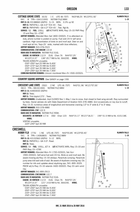
OREGON 133
COTTAGE GROVE STATE (61S) 1 E UTC–8(–7DT) N43º48.25´ W123º01.92´641 B TPA—1641(1000) NOTAM FILE MMVRWY 15–33: H3188X60 (ASPH) S–15 MIRL 0.3% up SE
RWY 15: PAPI(P4L)—GA 3.0º TCH 45´. Tree.RWY 33: PAPI(P4R)—GA 4.2º TCH 45´. Tree. Rgt tfc.
SERVICE: S2 FUEL 100LL LGT ACTIVATE MIRL Rwy 15–33 PAPI Rwy 15 and Rwy 33—CTAF.
AIRPORT REMARKS: Attended Mon–Sat 1800–0300Z‡. If no attendant on duty, phone number is posted on pump. Fuel avbl 24 hr self serve cardlock. High concentration of birds on and invof arpt. Deer on and invof arpt all hrs. Twys 25´ wide, marked with blue reflectors.
AIRPORT MANAGER: 503-378-2523COMMUNICATIONS: CTAF/UNICOM 122.8RADIO AIDS TO NAVIGATION: NOTAM FILE EUG.
EUGENE (H) VORTACW 112.9 EUG Chan 76 N44º07.25´ W123º13.37´ 136º 20.7 NM to fld. 364/20E. HIWAS.
TACAN AZIMUTH unusable:030º–050º byd 25 NM blo 9,400´050º–070º byd 25 NM blo 9,000´220º–225º byd 35 NM blo 5,500´250º–290º byd 35 NM blo 7,500´
COMM/NAV/WEATHER REMARKS: Unicom monitored Mon–Fri 1500–0200Z‡.
COUNTRY SQUIRE AIRPARK (See SANDY on page 159)
CRESCENT LAKE STATE (5S2) 2 NE UTC–8(–7DT) N43º31.96´ W121º57.00´4810 TPA—5810(1000) NOTAM FILE MMVRWY 13–31: H3900X30 (ASPH)
RWY 13: Trees.RWY 31: Thld dsplcd 275´. Trees.
AIRPORT REMARKS: Unattended. Arpt CLOSED Nov 1–May 1 due to snow. Arpt closed to fixed wing aircraft. Rwy surrounded by trees. Owner advises ctc with State Department of Aviation 503–378–4880. Grvl occasionally on rwy due to runoff. Rwy 13–31 numerous areas of longitudinal and transverse cracking 1/2" to 3" wide & 2" to 3" deep.
AIRPORT MANAGER: 503-378-4880COMMUNICATIONS: CTAF 122.9RADIO AIDS TO NAVIGATION: NOTAM FILE RDM.
DESCHUTES (H) VORTACW 117.6 DSD Chan 123 N44º15.17´ W121º18.21´ 195º 51.5 NM to fld. 4101/18E. HIWAS.
VORTAC unusable:220º–240º byd 30 NM
CRESWELLHOBBY FLD (77S) 1 NE UTC–8(–7DT) N43º55.85´ W123º00.40´
541 B TPA—1406(865) NOTAM FILE MMVRWY 15–33: H3102X60 (ASPH) S–12 MIRL
RWY 15: PAPI(P2L)—GA 3.0º. Road.RWY 33: Trees.
SERVICE: S4 FUEL 100LL, JET A LGT ACTIVATE MIRL Rwy 15–33 and PAPI Rwy 15—CTAF.
AIRPORT REMARKS: Attended Mon–Fri 1700–0200Z‡, Sat–Sun 1900–0000Z‡. Self serve fuel avbl 24 hrs. Birds on and invof arpt. Be aware mowing adj Rwy 15–33 wkdays. Parachute Jumping. Parachute jump area lctd east side of arpt. Be aware of skydivers crossing rwy. Ctc number for info and updates about skydiving ops, 541–895–3029. PAEW adj to Rwy 15–33 wkends 1600–0000Z‡. Rwy 33 calm wind rwy.
AIRPORT MANAGER: 541-895-2913COMMUNICATIONS: CTAF/UNICOM 122.7RADIO AIDS TO NAVIGATION: NOTAM FILE EUG.
EUGENE (H) VORTACW 112.9 EUG Chan 76 N44º07.25´ W123º13.37´ 121º 14.8 NM to fld. 364/20E. HIWAS.
TACAN AZIMUTH unusable:030º–050º byd 25 NM blo 9,400´050º–070º byd 25 NM blo 9,000´220º–225º byd 35 NM blo 5,500´250º–290º byd 35 NM blo 7,500´
KLAMATH FALLSL–1A
KLAMATH FALLSL–1A
KLAMATH FALLSL–1A
NW, 31 MAR 2016 to 26 MAY 2016
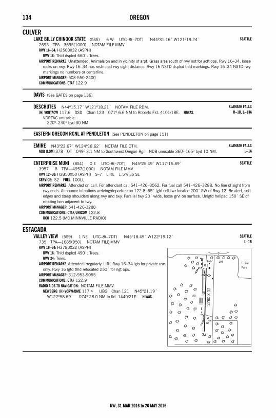
134 OREGON
CULVERLAKE BILLY CHINOOK STATE (5S5) 6 W UTC–8(–7DT) N44º31.16´ W121º19.24´
2695 TPA—3695(1000) NOTAM FILE MMVRWY 16–34: H2500X32 (ASPH)
RWY 16: Thld dsplcd 660´. Trees.AIRPORT REMARKS: Unattended. Animals on and in vicinity of arpt. Grass area south of rwy not for acft ops. Rwy 16–34, loose
rocks on rwy. Rwy 16–34 has restricted rwy sight distance. Rwy 16 NSTD dsplcd thld markings. Rwy 16–34 NSTD rwy markings no numbers or centerline.
AIRPORT MANAGER: 503-550-2400COMMUNICATIONS: CTAF 122.9
DAVIS (See GATES on page 136)
DESCHUTES N44º15.17´ W121º18.21´ NOTAM FILE RDM.(H) VORTACW 117.6 DSD Chan 123 071º 6.6 NM to Roberts Fld. 4101/18E. HIWAS.
VORTAC unusable:220º–240º byd 30 NM
EASTERN OREGON RGNL AT PENDLETON (See PENDLETON on page 151)
EMIRE N43º23.67´ W124º18.62´ NOTAM FILE OTH.NDB (LOM) 378 OT 049º 3.1 NM to Southwest Oregon Rgnl. NDB unusable 360º-165º byd 10 NM.
ENTERPRISE MUNI (8S4) 0 E UTC–8(–7DT) N45º25.49´ W117º15.89´3957 B TPA—4957(1000) NOTAM FILE MMVRWY 12–30: H2850X50 (ASPH) S–7 LIRL 1.5% up SESERVICE: S2 FUEL 100LL AIRPORT REMARKS: Attended on call. For attendant call 541–426–3562. For fuel call 541–426–3288. No line of sight from
rwy ends. Announce intentions arriving/departure on 122.8. 65´ lgtd cell twr located 200´ SW of Rwy 12. Be alert, soft edges and steep shoulders along rwy and twy. Parallel twy 20´ wide, loose grvl on surface. Unlgtd helipad 150´ SE of rotating bcn adjacent to twy.
AIRPORT MANAGER: 541-426-3288COMMUNICATIONS: CTAF/UNICOM 122.8
RCO 122.5 (MC MINNVILLE RADIO)
ESTACADAVALLEY VIEW (5S9) 1 NE UTC–8(–7DT) N45º18.49´ W122º19.12´
735 TPA—1685(950) NOTAM FILE MMVRWY 16–34: H3780X32 (ASPH)
RWY 16: Thld dsplcd 490´. Trees.RWY 34: Trees.
AIRPORT REMARKS: Attended irregularly. LIRL Rwy 16–34 lgts for private use only. Rwy 16 lgtd thld relocated 250´ for ngt ops.
AIRPORT MANAGER: 312-953-9055COMMUNICATIONS: CTAF 122.9RADIO AIDS TO NAVIGATION: NOTAM FILE MMV.
NEWBERG (H) VORW/DME 117.4 UBG Chan 121 N45º21.19´ W122º58.69´ 074º 28.0 NM to fld. 1440/21E. HIWAS.
SEATTLE
KLAMATH FALLSH–1B, L–13A
KLAMATH FALLSL–1A
SEATTLE
SEATTLEL–1B
NW, 31 MAR 2016 to 26 MAY 2016
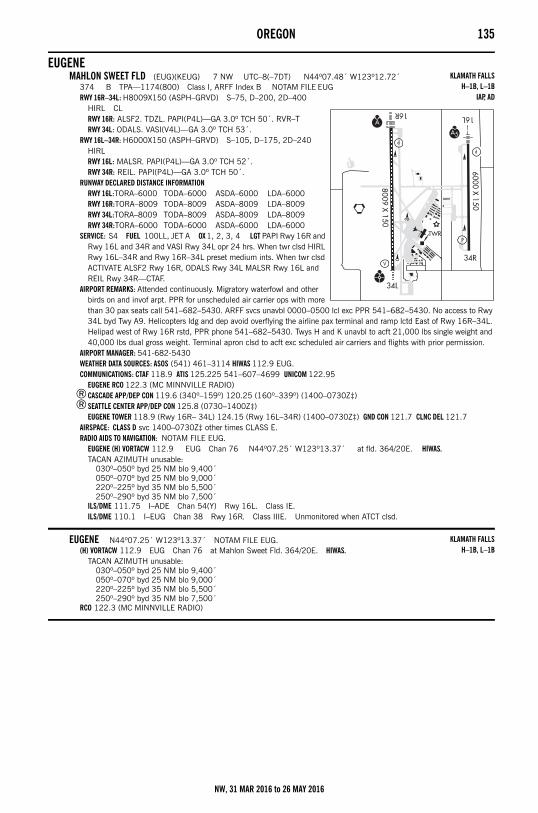
OREGON 135
EUGENEMAHLON SWEET FLD (EUG)(KEUG) 7 NW UTC–8(–7DT) N44º07.48´ W123º12.72´
374 B TPA—1174(800) Class I, ARFF Index B NOTAM FILE EUGRWY 16R–34L: H8009X150 (ASPH–GRVD) S–75, D–200, 2D–400
HIRL CLRWY 16R: ALSF2. TDZL. PAPI(P4L)—GA 3.0º TCH 50´. RVR–TRWY 34L: ODALS. VASI(V4L)—GA 3.0º TCH 53´.
RWY 16L–34R: H6000X150 (ASPH–GRVD) S–105, D–175, 2D–240 HIRLRWY 16L: MALSR. PAPI(P4L)—GA 3.0º TCH 52´.RWY 34R: REIL. PAPI(P4L)—GA 3.0º TCH 50´.
RUNWAY DECLARED DISTANCE INFORMATIONRWY 16L:TORA–6000 TODA–6000 ASDA–6000 LDA–6000RWY 16R:TORA–8009 TODA–8009 ASDA–8009 LDA–8009RWY 34L:TORA–8009 TODA–8009 ASDA–8009 LDA–8009RWY 34R:TORA–6000 TODA–6000 ASDA–6000 LDA–6000
SERVICE: S4 FUEL 100LL, JET A OX 1, 2, 3, 4 LGT PAPI Rwy 16R and Rwy 16L and 34R and VASI Rwy 34L opr 24 hrs. When twr clsd HIRL Rwy 16L–34R and Rwy 16R–34L preset medium ints. When twr clsd ACTIVATE ALSF2 Rwy 16R, ODALS Rwy 34L MALSR Rwy 16L and REIL Rwy 34R—CTAF.
AIRPORT REMARKS: Attended continuously. Migratory waterfowl and other birds on and invof arpt. PPR for unscheduled air carrier ops with more than 30 pax seats call 541–682–5430. ARFF svcs unavbl 0000–0500 lcl exc PPR 541–682–5430. No access to Rwy 34L byd Twy A9. Helicopters ldg and dep avoid overflying the airline pax terminal and ramp lctd East of Rwy 16R–34L. Helipad west of Rwy 16R rstd, PPR phone 541–682–5430. Twys H and K unavbl to acft 21,000 lbs single weight and 40,000 lbs dual gross weight. Terminal apron clsd to acft exc scheduled air carriers and flights with prior permission.
AIRPORT MANAGER: 541-682-5430WEATHER DATA SOURCES: ASOS (541) 461–3114 HIWAS 112.9 EUG.COMMUNICATIONS: CTAF 118.9 ATIS 125.225 541–607–4699 UNICOM 122.95
EUGENE RCO 122.3 (MC MINNVILLE RADIO)®CASCADE APP/DEP CON 119.6 (340º–159º) 120.25 (160º–339º) (1400–0730Z‡)®SEATTLE CENTER APP/DEP CON 125.8 (0730–1400Z‡)
EUGENE TOWER 118.9 (Rwy 16R– 34L) 124.15 (Rwy 16L–34R) (1400–0730Z‡) GND CON 121.7 CLNC DEL 121.7AIRSPACE: CLASS D svc 1400–0730Z‡ other times CLASS E.RADIO AIDS TO NAVIGATION: NOTAM FILE EUG.
EUGENE (H) VORTACW 112.9 EUG Chan 76 N44º07.25´ W123º13.37´ at fld. 364/20E. HIWAS.TACAN AZIMUTH unusable:
030º–050º byd 25 NM blo 9,400´050º–070º byd 25 NM blo 9,000´220º–225º byd 35 NM blo 5,500´250º–290º byd 35 NM blo 7,500´
ILS/DME 111.75 I–ADE Chan 54(Y) Rwy 16L. Class IE.ILS/DME 110.1 I–EUG Chan 38 Rwy 16R. Class IIIE. Unmonitored when ATCT clsd.
EUGENE N44º07.25´ W123º13.37´ NOTAM FILE EUG.(H) VORTACW 112.9 EUG Chan 76 at Mahlon Sweet Fld. 364/20E. HIWAS.
TACAN AZIMUTH unusable:030º–050º byd 25 NM blo 9,400´050º–070º byd 25 NM blo 9,000´220º–225º byd 35 NM blo 5,500´250º–290º byd 35 NM blo 7,500´
RCO 122.3 (MC MINNVILLE RADIO)
KLAMATH FALLSH–1B, L–1B
IAP, AD
KLAMATH FALLSH–1B, L–1B
NW, 31 MAR 2016 to 26 MAY 2016
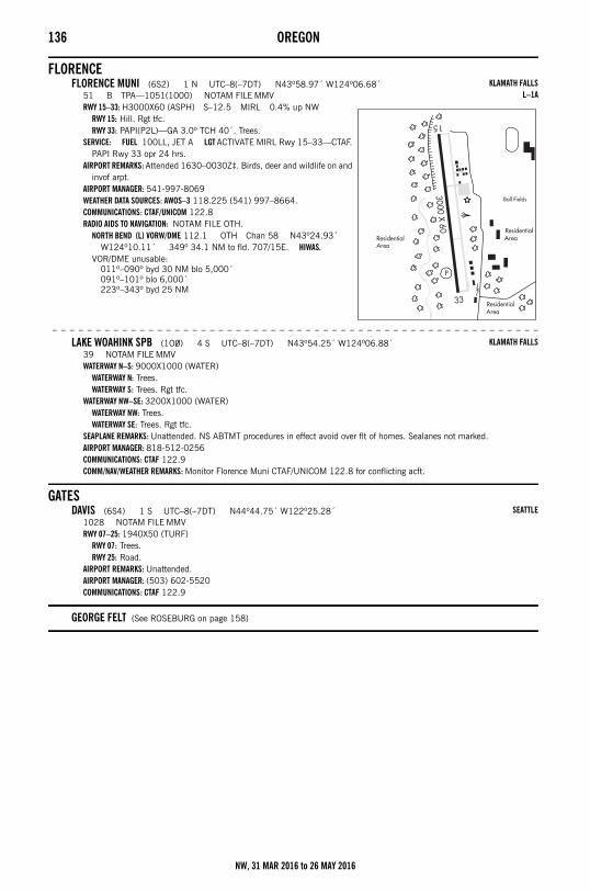
136 OREGON
FLORENCEFLORENCE MUNI (6S2) 1 N UTC–8(–7DT) N43º58.97´ W124º06.68´
51 B TPA—1051(1000) NOTAM FILE MMVRWY 15–33: H3000X60 (ASPH) S–12.5 MIRL 0.4% up NW
RWY 15: Hill. Rgt tfc.RWY 33: PAPI(P2L)—GA 3.0º TCH 40´. Trees.
SERVICE: FUEL 100LL, JET A LGT ACTIVATE MIRL Rwy 15–33—CTAF. PAPI Rwy 33 opr 24 hrs.
AIRPORT REMARKS: Attended 1630–0030Z‡. Birds, deer and wildlife on and invof arpt.
AIRPORT MANAGER: 541-997-8069WEATHER DATA SOURCES: AWOS–3 118.225 (541) 997–8664.COMMUNICATIONS: CTAF/UNICOM 122.8RADIO AIDS TO NAVIGATION: NOTAM FILE OTH.
NORTH BEND (L) VORW/DME 112.1 OTH Chan 58 N43º24.93´ W124º10.11´ 349º 34.1 NM to fld. 707/15E. HIWAS.
VOR/DME unusable:011º–090º byd 30 NM blo 5,000´091º–101º blo 6,000´223º–343º byd 25 NM
– – – – – – – – – – – – – – – – – – – – – – – – – – – – – – – – – – – – – – – – – – – – – – – – – – – – – – – –
LAKE WOAHINK SPB (1O0) 4 S UTC–8(–7DT) N43º54.25´ W124º06.88´39 NOTAM FILE MMVWATERWAY N–S: 9000X1000 (WATER)
WATERWAY N: Trees.WATERWAY S: Trees. Rgt tfc.
WATERWAY NW–SE: 3200X1000 (WATER)WATERWAY NW: Trees.WATERWAY SE: Trees. Rgt tfc.
SEAPLANE REMARKS: Unattended. NS ABTMT procedures in effect avoid over flt of homes. Sealanes not marked.AIRPORT MANAGER: 818-512-0256COMMUNICATIONS: CTAF 122.9COMM/NAV/WEATHER REMARKS: Monitor Florence Muni CTAF/UNICOM 122.8 for conflicting acft.
GATESDAVIS (6S4) 1 S UTC–8(–7DT) N44º44.75´ W122º25.28´
1028 NOTAM FILE MMVRWY 07–25: 1940X50 (TURF)
RWY 07: Trees.RWY 25: Road.
AIRPORT REMARKS: Unattended.AIRPORT MANAGER: (503) 602-5520COMMUNICATIONS: CTAF 122.9
GEORGE FELT (See ROSEBURG on page 158)
KLAMATH FALLSL–1A
KLAMATH FALLS
SEATTLE
NW, 31 MAR 2016 to 26 MAY 2016
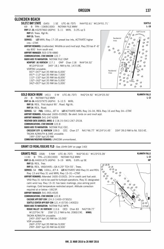
OREGON 137
GLENEDEN BEACHSILETZ BAY STATE (S45) 1 SE UTC–8(–7DT) N44º52.61´ W124º01.71´
69 B TPA—1069(1000) NOTAM FILE MMVRWY 17–35: H3297X60 (ASPH) S–11 MIRL 0.3% up S
RWY 17: Trees. Rgt tfc.RWY 35: Trees.
SERVICE: LGT MIRL Rwy 17–35 preset low ints, ACTIVATE higher ints—CTAF.
AIRPORT REMARKS: Unattended. Wildlife on and invof arpt. Rwy 35 has 4"–6" dip 800´ from south end.
AIRPORT MANAGER: 503-378-4880COMMUNICATIONS: CTAF/UNICOM 122.7RADIO AIDS TO NAVIGATION: NOTAM FILE ONP.
NEWPORT (H) VORTACW 117.1 ONP Chan 118 N44º34.52´ W124º03.64´ 345º 18.1 NM to fld. 147/19E.
VORTAC unusable:007º–047º byd 35 NM blo 6,000´057º–112º byd 35 NM blo 7,000´112º–132º byd 35 NM blo 8,000´132º–162º byd 35 NM blo 5,000´342º–007º byd 35 NM blo 5,000´
GOLD BEACH MUNI (4S1) 0 W UTC–8(–7DT) N42º24.92´ W124º25.50´20 B NOTAM FILE MMVRWY 16–34: H3237X75 (ASPH) S–12.5 MIRL
RWY 16: REIL. Thld dsplcd 90´. Road. Rgt tfc.RWY 34: REIL. Road.
SERVICE: S2 FUEL 100LL, JET A LGT ACTIVATE MIRL Rwy 16–34, REIL Rwy 16 and Rwy 34—CTAF.AIRPORT REMARKS: Attended 1600–0100Z‡. Be alert: birds on and invof arpt. AIRPORT MANAGER: 541-247-6269WEATHER DATA SOURCES: AWOS–3 118.15 (541) 247–2518.COMMUNICATIONS: CTAF/UNICOM 122.8RADIO AIDS TO NAVIGATION: NOTAM FILE CEC.
CRESCENT CITY (L) VORTACW 109.0 CEC Chan 27 N41º46.77´ W124º14.45´ 334º 39.0 NM to fld. 53/14E.TACAN AZIMUTH & DME unusable:
195º–235º byd 20 NMCOMM/NAV/WEATHER REMARKS: UNICOM unmonitored.
GRANT CO RGNL/OGILVIE FLD (See JOHN DAY on page 140)
GRANTS PASS (3S8) 5 NW UTC–8(–7DT) N42º30.61´ W123º23.28´1130 B TPA—2130(1000) NOTAM FILE MMVRWY 13–31: H4001X75 (ASPH) S–19 MIRL 0.8% up SE
RWY 13: REIL. Tree.RWY 31: REIL. VASI(V4R)—GA 4.25º TCH 55´. Trees.
SERVICE: S4 FUEL 100LL, JET A LGT ACTIVATE VASI Rwy 31 and REIL Rwy 13 and Rwy 31 and MIRL Rwy 13–31—CTAF.
AIRPORT REMARKS: Attended 1600–0100Z‡. 24 hr credit card fuel avbl. VASI Rwy 31 not to be used for turbojet operations. Rwy 31 designated calm wind rwy. Rwy 13–31 has basic markings, plus aiming point markings. Cold temperature restricted airport. Altitude correction required at or below –16C/3F.
AIRPORT MANAGER: 541-955-4535COMMUNICATIONS: CTAF/UNICOM 122.8
CASCADE APP/DEP CON 124.3 (1400–0730Z‡)SEATTLE CENTER APP/DEP CON 121.4 (0730–1400Z‡)
RADIO AIDS TO NAVIGATION: NOTAM FILE MFR.ROGUE VALLEY (H) VORTACW 113.6 OED Chan 83 N42º28.77´
W122º54.78´ 256º 21.2 NM to fld. 2083/19E. HIWAS.TACAN AZIMUTH unusable:
245º–350º byd 30 NM blo 10,000´VOR unusable:
260º–270º byd 35 NM blo 9,000´290º–300º byd 35 NM blo 8,500´
SEATTLEL–1B
KLAMATH FALLSL–2J
KLAMATH FALLSL–2J
IAP
NW, 31 MAR 2016 to 26 MAY 2016
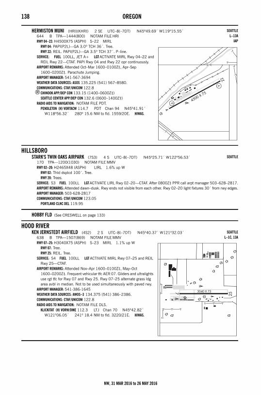
138 OREGON
HERMISTON MUNI (HRI)(KHRI) 2 SE UTC–8(–7DT) N45º49.69´ W119º15.55´644 B TPA—1444(800) NOTAM FILE HRIRWY 04–22: H4500X75 (ASPH) S–22 MIRL
RWY 04: PAPI(P2L)—GA 3.0º TCH 36´. Tree.RWY 22: REIL. PAPI(P2L)—GA 3.5º TCH 37´. P–line.
SERVICE: FUEL 100LL, JET A+ LGT ACTIVATE MIRL Rwy 04–22 and REIL Rwy 22—CTAF. PAPI Rwy 04 and Rwy 22 opr continuously.
AIRPORT REMARKS: Attended Oct–Mar 1600–0100Z‡, Apr–Sep 1600–0200Z‡. Parachute Jumping.
AIRPORT MANAGER: 541-567-3694WEATHER DATA SOURCES: ASOS 135.225 (541) 567–8580.COMMUNICATIONS: CTAF/UNICOM 122.8
®CHINOOK APP/DEP CON 133.15 (1400–0600Z‡)SEATTLE CENTER APP/DEP CON 132.6 (0600–1400Z‡)
RADIO AIDS TO NAVIGATION: NOTAM FILE PDT.PENDLETON (H) VORTACW 114.7 PDT Chan 94 N45º41.91´
W118º56.32´ 280º 15.6 NM to fld. 1559/20E. HIWAS.
HILLSBOROSTARK'S TWIN OAKS AIRPARK (7S3) 4 S UTC–8(–7DT) N45º25.71´ W122º56.53´
170 TPA—1200(1030) NOTAM FILE MMVRWY 02–20: H2465X48 (ASPH) LIRL 1.6% up W
RWY 02: Thld dsplcd 100´. Tree.RWY 20: Trees.
SERVICE: S3 FUEL 100LL LGT ACTIVATE LIRL Rwy 02–20—CTAF. After 0800Z‡ PPR call arpt manager 503–628–2817.AIRPORT REMARKS: Attended dawn–dusk. Rwy ends not visible from each other. Rwy 02–20 light fixtures 30´ from rwy edges.AIRPORT MANAGER: 503-628-2817COMMUNICATIONS: CTAF/UNICOM 123.05
PORTLAND CLNC DEL 119.95
HOBBY FLD (See CRESWELL on page 133)
HOOD RIVERKEN JERNSTEDT AIRFIELD (4S2) 2 S UTC–8(–7DT) N45º40.37´ W121º32.03´
638 B TPA—1507(869) NOTAM FILE MMVRWY 07–25: H3040X75 (ASPH) S–23 MIRL 1.1% up W
RWY 07: Tree.RWY 25: REIL. Tree.
SERVICE: S4 FUEL 100LL LGT ACTIVATE MIRL Rwy 07–25 and REIL Rwy 25—CTAF.
AIRPORT REMARKS: Attended Nov–Apr 1600–0100Z‡, May–Oct 1600–0200Z‡. Frequent vehicular tfc AER 07. Gliders and ultralights use rgt tfc for Rwy 07 and Rwy 25. Rwy 07–25 alternate grass ldg area avbl in median. Not to be used simultaneously with paved rwy.
AIRPORT MANAGER: 541-386-1645WEATHER DATA SOURCES: AWOS–3 134.375 (541) 386–2386.COMMUNICATIONS: CTAF/UNICOM 122.8RADIO AIDS TO NAVIGATION: NOTAM FILE DLS.
KLICKITAT (H) VORW/DME 112.3 LTJ Chan 70 N45º42.82´ W121º06.05´ 241º 18.4 NM to fld. 3220/21E. HIWAS.
SEATTLEL–13A
IAP
SEATTLE
SEATTLEL–1C, 13A
NW, 31 MAR 2016 to 26 MAY 2016
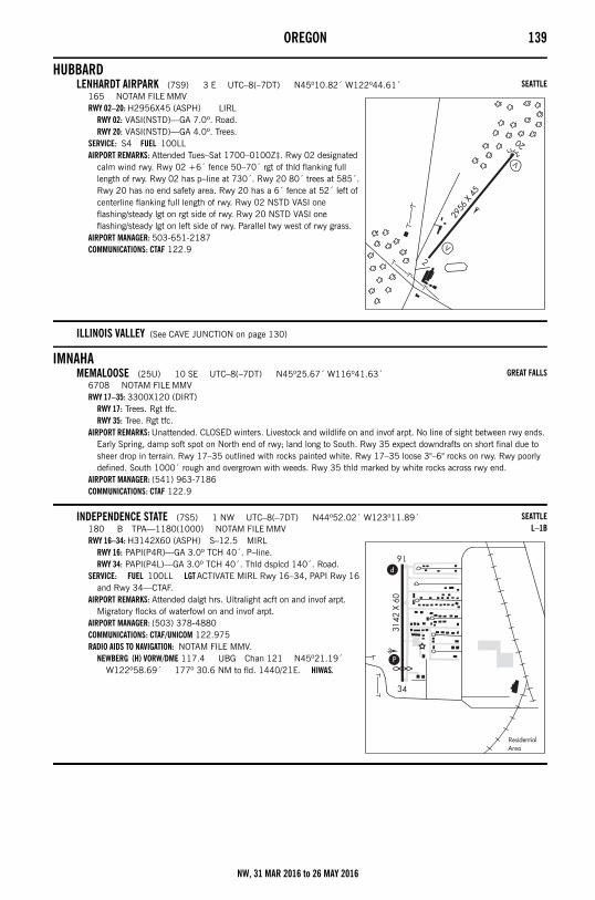
OREGON 139
HUBBARDLENHARDT AIRPARK (7S9) 3 E UTC–8(–7DT) N45º10.82´ W122º44.61´
165 NOTAM FILE MMVRWY 02–20: H2956X45 (ASPH) LIRL
RWY 02: VASI(NSTD)—GA 7.0º. Road.RWY 20: VASI(NSTD)—GA 4.0º. Trees.
SERVICE: S4 FUEL 100LL AIRPORT REMARKS: Attended Tues–Sat 1700–0100Z‡. Rwy 02 designated
calm wind rwy. Rwy 02 +6´ fence 50–70´ rgt of thld flanking full length of rwy. Rwy 02 has p–line at 730´. Rwy 20 80´ trees at 585´. Rwy 20 has no end safety area. Rwy 20 has a 6´ fence at 52´ left of centerline flanking full length of rwy. Rwy 02 NSTD VASI one flashing/steady lgt on rgt side of rwy. Rwy 20 NSTD VASI one flashing/steady lgt on left side of rwy. Parallel twy west of rwy grass.
AIRPORT MANAGER: 503-651-2187COMMUNICATIONS: CTAF 122.9
ILLINOIS VALLEY (See CAVE JUNCTION on page 130)
IMNAHAMEMALOOSE (25U) 10 SE UTC–8(–7DT) N45º25.67´ W116º41.63´
6708 NOTAM FILE MMVRWY 17–35: 3300X120 (DIRT)
RWY 17: Trees. Rgt tfc.RWY 35: Tree. Rgt tfc.
AIRPORT REMARKS: Unattended. CLOSED winters. Livestock and wildlife on and invof arpt. No line of sight between rwy ends. Early Spring, damp soft spot on North end of rwy; land long to South. Rwy 35 expect downdrafts on short final due to sheer drop in terrain. Rwy 17–35 outlined with rocks painted white. Rwy 17–35 loose 3"–6" rocks on rwy. Rwy poorly defined. South 1000´ rough and overgrown with weeds. Rwy 35 thld marked by white rocks across rwy end.
AIRPORT MANAGER: (541) 963-7186COMMUNICATIONS: CTAF 122.9
INDEPENDENCE STATE (7S5) 1 NW UTC–8(–7DT) N44º52.02´ W123º11.89´180 B TPA—1180(1000) NOTAM FILE MMVRWY 16–34: H3142X60 (ASPH) S–12.5 MIRL
RWY 16: PAPI(P4R)—GA 3.0º TCH 40´. P–line.RWY 34: PAPI(P4L)—GA 3.0º TCH 40´. Thld dsplcd 140´. Road.
SERVICE: FUEL 100LL LGT ACTIVATE MIRL Rwy 16–34, PAPI Rwy 16 and Rwy 34—CTAF.
AIRPORT REMARKS: Attended dalgt hrs. Ultralight acft on and invof arpt. Migratory flocks of waterfowl on and invof arpt.
AIRPORT MANAGER: (503) 378-4880COMMUNICATIONS: CTAF/UNICOM 122.975RADIO AIDS TO NAVIGATION: NOTAM FILE MMV.
NEWBERG (H) VORW/DME 117.4 UBG Chan 121 N45º21.19´ W122º58.69´ 177º 30.6 NM to fld. 1440/21E. HIWAS.
SEATTLE
GREAT FALLS
SEATTLEL–1B
NW, 31 MAR 2016 to 26 MAY 2016
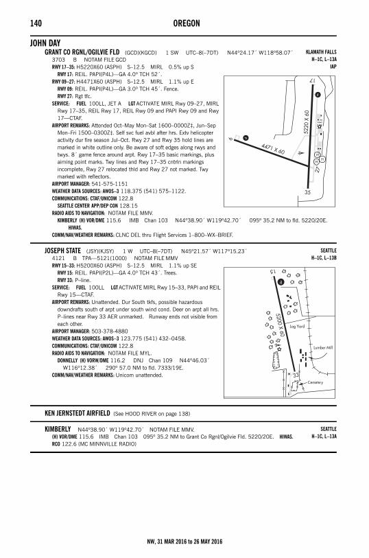
140 OREGON
JOHN DAYGRANT CO RGNL/OGILVIE FLD (GCD)(KGCD) 1 SW UTC–8(–7DT) N44º24.17´ W118º58.07´
3703 B NOTAM FILE GCDRWY 17–35: H5220X60 (ASPH) S–12.5 MIRL 0.5% up S
RWY 17: REIL. PAPI(P4L)—GA 4.0º TCH 52´.RWY 09–27: H4471X60 (ASPH) S–12.5 MIRL 1.1% up E
RWY 09: REIL. PAPI(P4L)—GA 3.0º TCH 45´. Fence.RWY 27: Rgt tfc.
SERVICE: FUEL 100LL, JET A LGT ACTIVATE MIRL Rwy 09–27, MIRL Rwy 17–35, REIL Rwy 17, REIL Rwy 09 and PAPI Rwy 09 and Rwy 17—CTAF.
AIRPORT REMARKS: Attended Oct–May Mon–Sat 1600–0000Z‡, Jun–Sep Mon–Fri 1500–0300Z‡. Self svc fuel avbl after hrs. Extv helicopter activity dur fire season Jul–Oct. Rwy 27 and Rwy 35 hold lines are marked in white outline only. Be aware of soft edges along rwys and twys. 8´ game fence around arpt. Rwy 17–35 basic markings, plus aiming point marks. Twy lines and Rwy 17–35 cntrln markings incomplete, Rwy 27 relocated thld and Rwy 27 not marked. Twy marked with reflectors.
AIRPORT MANAGER: 541-575-1151WEATHER DATA SOURCES: AWOS–3 118.375 (541) 575–1122.COMMUNICATIONS: CTAF/UNICOM 122.8
SEATTLE CENTER APP/DEP CON 128.15RADIO AIDS TO NAVIGATION: NOTAM FILE MMV.
KIMBERLY (H) VOR/DME 115.6 IMB Chan 103 N44º38.90´ W119º42.70´ 095º 35.2 NM to fld. 5220/20E. HIWAS.
COMM/NAV/WEATHER REMARKS: CLNC DEL thru Flight Services 1–800–WX–BRIEF.
JOSEPH STATE (JSY)(KJSY) 1 W UTC–8(–7DT) N45º21.57´ W117º15.23´4121 B TPA—5121(1000) NOTAM FILE MMVRWY 15–33: H5200X60 (ASPH) S–12.5 MIRL 1.1% up SE
RWY 15: REIL. PAPI(P2L)—GA 4.0º TCH 43´. Trees.RWY 33: P–line.
SERVICE: FUEL 100LL LGT ACTIVATE MIRL Rwy 15–33, PAPI and REIL Rwy 15—CTAF.
AIRPORT REMARKS: Unattended. Dur South tkfs, possible hazardous downdrafts south of arpt under south wind cond. Deer on arpt all hrs. P–lines near Rwy 33 AER unmarked. Runway ends not visible from each other.
AIRPORT MANAGER: 503-378-4880WEATHER DATA SOURCES: AWOS–3 123.775 (541) 432–0458.COMMUNICATIONS: CTAF/UNICOM 122.8RADIO AIDS TO NAVIGATION: NOTAM FILE MYL.
DONNELLY (H) VORW/DME 116.2 DNJ Chan 109 N44º46.03´ W116º12.38´ 290º 57.0 NM to fld. 7333/19E.
COMM/NAV/WEATHER REMARKS: Unicom unattended.
KEN JERNSTEDT AIRFIELD (See HOOD RIVER on page 138)
KIMBERLY N44º38.90´ W119º42.70´ NOTAM FILE MMV.(H) VOR/DME 115.6 IMB Chan 103 095º 35.2 NM to Grant Co Rgnl/Ogilvie Fld. 5220/20E. HIWAS.RCO 122.6 (MC MINNVILLE RADIO)
KLAMATH FALLSH–1C, L–13A
IAP
SEATTLEH–1C, L–13B
SEATTLEH–1C, L–13A
NW, 31 MAR 2016 to 26 MAY 2016
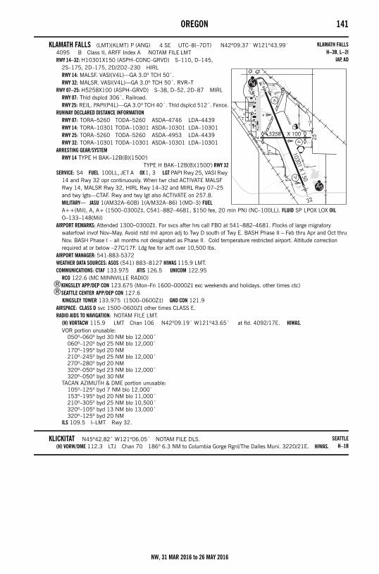
OREGON 141
KLAMATH FALLS (LMT)(KLMT) P (ANG) 4 SE UTC–8(–7DT) N42º09.37´ W121º43.99´4095 B Class II, ARFF Index A NOTAM FILE LMTRWY 14–32: H10301X150 (ASPH–CONC–GRVD) S–110, D–145,
2S–175, 2D–175, 2D/2D2–230 HIRLRWY 14: MALSF. VASI(V4L)—GA 3.0º TCH 50´.RWY 32: MALSR. VASI(V4L)—GA 3.0º TCH 50´. RVR–T
RWY 07–25: H5258X100 (ASPH–GRVD) S–38, D–52, 2D–87 MIRLRWY 07: Thld dsplcd 306´. Railroad.RWY 25: REIL. PAPI(P4L)—GA 3.0º TCH 40´. Thld dsplcd 512´. Fence.
RUNWAY DECLARED DISTANCE INFORMATIONRWY 07: TORA–5260 TODA–5260 ASDA–4746 LDA–4439RWY 14: TORA–10301 TODA–10301 ASDA–10301 LDA–10301RWY 25: TORA–5260 TODA–5260 ASDA–4953 LDA–4439RWY 32: TORA–10301 TODA–10301 ASDA–10301 LDA–10301
ARRESTING GEAR/SYSTEMRWY 14 TYPE H BAK–12B(B)(1500')
TYPE H BAK–12B(B)(1500') RWY 32SERVICE: S4 FUEL 100LL, JET A OX 1, 3 LGT PAPI Rwy 25, VASI Rwy
14 and Rwy 32 opr continuously. When twr clsd ACTIVATE MALSF Rwy 14, MALSR Rwy 32, HIRL Rwy 14–32 and MIRL Rwy 07–25 and twy lgts—CTAF. Rwy and twy lgt also ACTIVATE on 257.8. MILITARY— JASU 1(AM32A–60B) 1(A/M32A–86) 1(MD–3) FUEL A++(Mil), A, A+ (1500–0300Z‡, C541–882–4681, $150 fee, 20 min PN) (NC–100LL). FLUID SP LPOX LOX OIL O–133–148(Mil)
AIRPORT REMARKS: Attended 1300–0300Z‡. For svcs after hrs call FBO at 541–882–4681. Flocks of large migratory waterfowl invof Nov–May. Avoid rstd mil apron adj to Twy D south of Twy E. BASH Phase II – Feb thru Apr and Oct thru Nov. BASH Phase I – all months not designated as Phase II. Cold temperature restricted airport. Altitude correction required at or below –27C/17F. Ldg fee for acft over 10,500 lbs.
AIRPORT MANAGER: 541-883-5372WEATHER DATA SOURCES: ASOS (541) 883–8127 HIWAS 115.9 LMT.COMMUNICATIONS: CTAF 133.975 ATIS 126.5 UNICOM 122.95
RCO 122.6 (MC MINNVILLE RADIO)®KINGSLEY APP/DEP CON 123.675 (Mon–Fri 1600–0000Z‡ exc weekends and holidays. other times ctc)®SEATTLE CENTER APP/DEP CON 127.6
KINGSLEY TOWER 133.975 (1500–0600Z‡) GND CON 121.9AIRSPACE: CLASS D svc 1500–0600Z‡ other times CLASS E.RADIO AIDS TO NAVIGATION: NOTAM FILE LMT.
(H) VORTACW 115.9 LMT Chan 106 N42º09.19´ W121º43.65´ at fld. 4092/17E. HIWAS.VOR portion unusable:
050º–060º byd 30 NM blo 12,000´060º–120º byd 25 NM blo 12,000´170º–195º byd 20 NM210º–245º byd 25 NM blo 12,000´270º–280º byd 20 NM320º–050º byd 23 NM blo 12,000´320º–050º byd 30 NM
TACAN AZIMUTH & DME portion unusable:105º–125º byd 7 NM blo 12,000´153º–195º byd 20 NM blo 11,000´210º–305º byd 25 NM blo 10,500´320º–105º byd 13 NM blo 13,000´320º–125º byd 20 NM
ILS 109.5 I–LMT Rwy 32.
KLICKITAT N45º42.82´ W121º06.05´ NOTAM FILE DLS.(H) VORW/DME 112.3 LTJ Chan 70 186º 6.3 NM to Columbia Gorge Rgnl/The Dalles Muni. 3220/21E. HIWAS.
KLAMATH FALLSH–3B, L–2I
IAP, AD
SEATTLEH–1B
NW, 31 MAR 2016 to 26 MAY 2016
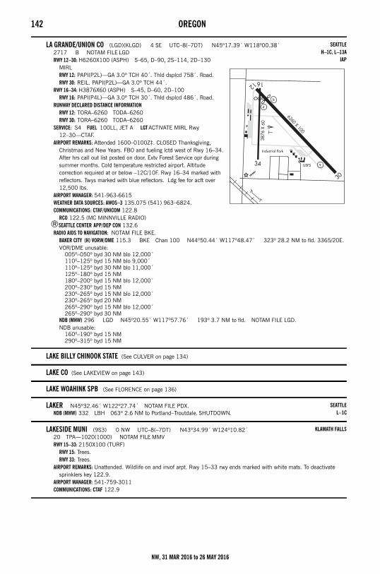
142 OREGON
LA GRANDE/UNION CO (LGD)(KLGD) 4 SE UTC–8(–7DT) N45º17.39´ W118º00.38´2717 B NOTAM FILE LGDRWY 12–30: H6260X100 (ASPH) S–65, D–90, 2S–114, 2D–130
MIRLRWY 12: PAPI(P2L)—GA 3.0º TCH 40´. Thld dsplcd 758´. Road.RWY 30: REIL. PAPI(P2L)—GA 3.0º TCH 44´.
RWY 16–34: H3876X60 (ASPH) S–45, D–60, 2D–100RWY 16: PAPI(P4L)—GA 3.0º TCH 30´. Thld dsplcd 486´. Road.
RUNWAY DECLARED DISTANCE INFORMATIONRWY 12: TORA–6260 TODA–6260RWY 30: TORA–6260 TODA–6260
SERVICE: S4 FUEL 100LL, JET A LGT ACTIVATE MIRL Rwy 12–30—CTAF.
AIRPORT REMARKS: Attended 1600–0100Z‡. CLOSED Thanksgiving, Christmas and New Years. FBO and fueling lctd west of Rwy 16–34. After hrs call out list posted on door. Extv Forest Service opr during summer months. Cold temperature restricted airport. Altitude correction required at or below –12C/10F. Rwy 16–34 marked with reflectors. Twys marked with blue reflectors. Ldg fee for acft over 12,500 lbs.
AIRPORT MANAGER: 541-963-6615WEATHER DATA SOURCES: AWOS–3 135.075 (541) 963–6824.COMMUNICATIONS: CTAF/UNICOM 122.8
RCO 122.5 (MC MINNVILLE RADIO)®SEATTLE CENTER APP/DEP CON 132.6
RADIO AIDS TO NAVIGATION: NOTAM FILE BKE.BAKER CITY (H) VORW/DME 115.3 BKE Chan 100 N44º50.44´ W117º48.47´ 323º 28.2 NM to fld. 3365/20E.VOR/DME unusable:
005º–050º byd 30 NM blo 12,000´110º–125º byd 15 NM blo 9,000´110º–125º byd 30 NM blo 11,000´125º–180º byd 15 NM180º–200º byd 15 NM blo 12,000´200º–230º byd 15 NM230º–265º byd 15 NM blo 12,000´230º–265º byd 20 NM265º–290º byd 15 NM blo 12,000´265º–290º byd 30 NM
NDB (MHW) 296 LGD N45º20.55´ W117º57.76´ 193º 3.7 NM to fld. NOTAM FILE LGD.NDB unusable:
160º–190º byd 15 NM290º–315º byd 15 NM
LAKE BILLY CHINOOK STATE (See CULVER on page 134)
LAKE CO (See LAKEVIEW on page 143)
LAKE WOAHINK SPB (See FLORENCE on page 136)
LAKER N45º32.46´ W122º27.74´ NOTAM FILE PDX.NDB (MHW) 332 LBH 063º 2.6 NM to Portland–Troutdale. SHUTDOWN.
LAKESIDE MUNI (9S3) 0 NW UTC–8(–7DT) N43º34.99´ W124º10.82´20 TPA—1020(1000) NOTAM FILE MMVRWY 15–33: 2150X100 (TURF)
RWY 15: Trees.RWY 33: Trees.
AIRPORT REMARKS: Unattended. Wildlife on and invof arpt. Rwy 15–33 rwy ends marked with white mats. To deactivate sprinklers key 122.9.
AIRPORT MANAGER: 541-759-3011COMMUNICATIONS: CTAF 122.9
SEATTLEH–1C, L–13A
IAP
SEATTLEL–1C
KLAMATH FALLS
NW, 31 MAR 2016 to 26 MAY 2016
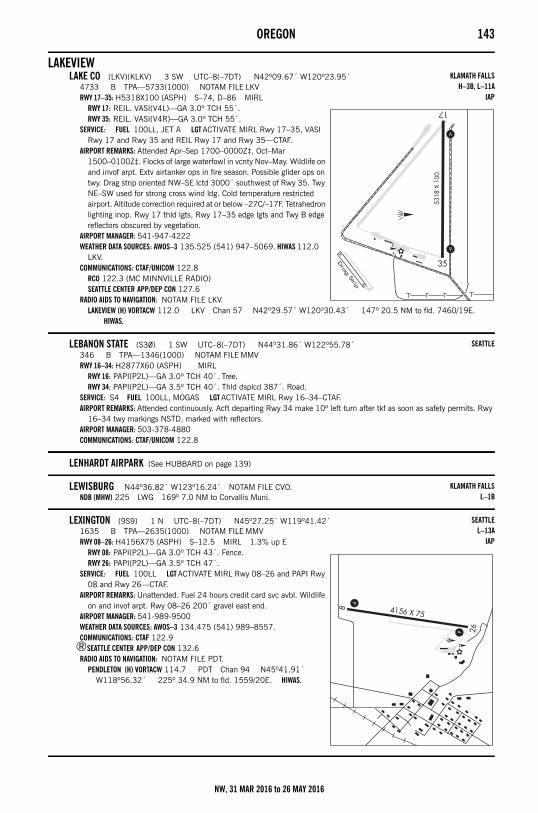
OREGON 143
LAKEVIEWLAKE CO (LKV)(KLKV) 3 SW UTC–8(–7DT) N42º09.67´ W120º23.95´
4733 B TPA—5733(1000) NOTAM FILE LKVRWY 17–35: H5318X100 (ASPH) S–74, D–86 MIRL
RWY 17: REIL. VASI(V4L)—GA 3.0º TCH 55´.RWY 35: REIL. VASI(V4R)—GA 3.0º TCH 55´.
SERVICE: FUEL 100LL, JET A LGT ACTIVATE MIRL Rwy 17–35, VASI Rwy 17 and Rwy 35 and REIL Rwy 17 and Rwy 35—CTAF.
AIRPORT REMARKS: Attended Apr–Sep 1700–0000Z‡, Oct–Mar 1500–0100Z‡. Flocks of large waterfowl in vcnty Nov–May. Wildlife on and invof arpt. Extv airtanker ops in fire season. Possible glider ops on twy. Drag strip oriented NW–SE lctd 3000´ southwest of Rwy 35. Twy NE–SW used for strong cross wind ldg. Cold temperature restricted airport. Altitude correction required at or below –27C/–17F. Tetrahedron lighting inop. Rwy 17 thld lgts, Rwy 17–35 edge lgts and Twy B edge reflectors obscured by vegetation.
AIRPORT MANAGER: 541-947-4222WEATHER DATA SOURCES: AWOS–3 135.525 (541) 947–5069. HIWAS 112.0
LKV.COMMUNICATIONS: CTAF/UNICOM 122.8
RCO 122.3 (MC MINNVILLE RADIO)SEATTLE CENTER APP/DEP CON 127.6
RADIO AIDS TO NAVIGATION: NOTAM FILE LKV.LAKEVIEW (H) VORTACW 112.0 LKV Chan 57 N42º29.57´ W120º30.43´ 147º 20.5 NM to fld. 7460/19E.
HIWAS.
LEBANON STATE (S30) 1 SW UTC–8(–7DT) N44º31.86´ W122º55.78´346 B TPA—1346(1000) NOTAM FILE MMVRWY 16–34: H2877X60 (ASPH) MIRL
RWY 16: PAPI(P2L)—GA 3.0º TCH 40´. Tree.RWY 34: PAPI(P2L)—GA 3.5º TCH 40´. Thld dsplcd 387´. Road.
SERVICE: S4 FUEL 100LL, MOGAS LGT ACTIVATE MIRL Rwy 16–34–CTAF.AIRPORT REMARKS: Attended continuously. Acft departing Rwy 34 make 10º left turn after tkf as soon as safety permits. Rwy
16–34 twy markings NSTD, marked with reflectors. AIRPORT MANAGER: 503-378-4880COMMUNICATIONS: CTAF/UNICOM 122.8
LENHARDT AIRPARK (See HUBBARD on page 139)
LEWISBURG N44º36.82´ W123º16.24´ NOTAM FILE CVO.NDB (MHW) 225 LWG 169º 7.0 NM to Corvallis Muni.
LEXINGTON (9S9) 1 N UTC–8(–7DT) N45º27.25´ W119º41.42´1635 B TPA—2635(1000) NOTAM FILE MMVRWY 08–26: H4156X75 (ASPH) S–12.5 MIRL 1.3% up E
RWY 08: PAPI(P2L)—GA 3.0º TCH 43´. Fence.RWY 26: PAPI(P2L)—GA 3.5º TCH 47´.
SERVICE: FUEL 100LL LGT ACTIVATE MIRL Rwy 08–26 and PAPI Rwy 08 and Rwy 26—CTAF.
AIRPORT REMARKS: Unattended. Fuel 24 hours credit card svc avbl. Wildlife on and invof arpt. Rwy 08–26 200´ gravel east end.
AIRPORT MANAGER: 541-989-9500WEATHER DATA SOURCES: AWOS–3 134.475 (541) 989–8557.COMMUNICATIONS: CTAF 122.9
®SEATTLE CENTER APP/DEP CON 132.6RADIO AIDS TO NAVIGATION: NOTAM FILE PDT.
PENDLETON (H) VORTACW 114.7 PDT Chan 94 N45º41.91´ W118º56.32´ 225º 34.9 NM to fld. 1559/20E. HIWAS.
KLAMATH FALLSH–3B, L–11A
IAP
SEATTLE
KLAMATH FALLSL–1B
SEATTLEL–13A
IAP
NW, 31 MAR 2016 to 26 MAY 2016
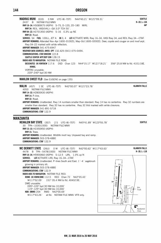
144 OREGON
MADRAS MUNI (S33) 3 NW UTC–8(–7DT) N44º40.21´ W121º09.31´2437 B NOTAM FILE MMVRWY 16–34: H5089X75 (ASPH) S–75, D–120, 2D–180 MIRL
RWY 34: REIL. VASI(V4L)—GA 3.0º TCH 50´.RWY 04–22: H2701X50 (ASPH) S–16 0.3% up NE
RWY 22: Road.SERVICE: S4 FUEL 100LL, JET A OX 3, 4 LGT ACTIVATE MIRL Rwy 16–34, VASI Rwy 34, and REIL Rwy 34—CTAF.AIRPORT REMARKS: Attended Nov–Apr 1600–0100Z‡, May–Oct 1600–0200Z‡. Deer, coyote and cougar on and invof arpt.
Rwy 04–22 marked with white reflectors. AIRPORT MANAGER: 541-475-6947WEATHER DATA SOURCES: AWOS–3PT 132.425 (541) 475–0494.COMMUNICATIONS: CTAF/UNICOM 122.8
SEATTLE CENTER APP/DEP CON 128.15RADIO AIDS TO NAVIGATION: NOTAM FILE RDM.
DESCHUTES (H) VORTACW 117.6 DSD Chan 123 N44º15.17´ W121º18.21´ 356º 25.8 NM to fld. 4101/18E. HIWAS.
VORTAC unusable:220º–240º byd 30 NM
MAHLON SWEET FLD (See EUGENE on page 135)
MALIN (4S7) 1 SE UTC–8(–7DT) N42º00.07´ W121º23.78´4053 NOTAM FILE MMVRWY 14–32: H2800X30 (ASPH)
RWY 14: P–line.RWY 32: Road.
AIRPORT REMARKS: Unattended. Rwy 14 numbers smaller than standard. Rwy 14 has no centerline. Rwy 32 numbers are smaller than standard. Rwy 32 has no centerline. Rwy 32 thld marked with white chevrons.
AIRPORT MANAGER: 541-891-5718COMMUNICATIONS: CTAF 122.9
MANZANITANEHALEM BAY STATE (3S7) 2 S UTC–8(–7DT) N45º41.89´ W123º55.78´
30 TPA—1030(1000) NOTAM FILE MMVRWY 15–33: H2350X50 (ASPH)
RWY 15: Trees.AIRPORT REMARKS: Unattended. Wildlife invof rwy. Unpaved twy and ramp.AIRPORT MANAGER: 503-378-4880COMMUNICATIONS: CTAF 122.9
MC DERMITT STATE (26U) 0 W UTC–8(–7DT) N42º00.62´ W117º43.63´4478 B TPA—5478(1000) NOTAM FILE MMVRWY 16–34: H5900X60 (ASPH) S–12.5 LIRL 1.0% up NSERVICE: LGT ACTIVATE LIRL Rwy 16–34—CTAF.AIRPORT REMARKS: Unattended. P–lines South and East. 1´–4´ sagebrush
growing in primary sfc. AIRPORT MANAGER: 503-378-4880COMMUNICATIONS: CTAF 122.9RADIO AIDS TO NAVIGATION: NOTAM FILE REO.
ROME (H) VORW/DME 112.5 REO Chan 72 N42º35.43´ W117º52.09´ 151º 35.4 NM to fld. 4040/19E.
DME unusable:095º–105º byd 30 NM blo 10,000´115º–125º byd 30 NM blo 10,000´
NDB (MHW) 204 RMD N42º00.69´ W117º43.26´ at fld. NOTAM FILE MMV. VFR only.
SEATTLEH–1B, L–13A
IAP
KLAMATH FALLS
SEATTLE
KLAMATH FALLSH–3D, L–11B
NW, 31 MAR 2016 to 26 MAY 2016
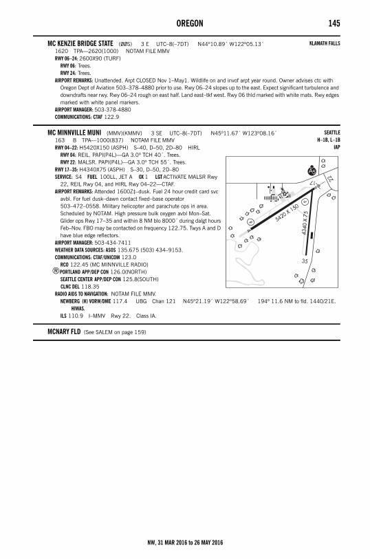
OREGON 145
MC KENZIE BRIDGE STATE (00S) 3 E UTC–8(–7DT) N44º10.89´ W122º05.13´1620 TPA—2620(1000) NOTAM FILE MMVRWY 06–24: 2600X90 (TURF)
RWY 06: Trees.RWY 24: Trees.
AIRPORT REMARKS: Unattended. Arpt CLOSED Nov 1–May1. Wildlife on and invof arpt year round. Owner advises ctc with Oregon Dept of Aviation 503–378–4880 prior to use. Rwy 06–24 slopes up to the east. Expect significant turbulence and downdrafts near rwy. Rwy 06–24 rough on east half. Land east–tkf west. Rwy 06 thld marked with white mats. Rwy edges marked with white panel markers.
AIRPORT MANAGER: 503-378-4880COMMUNICATIONS: CTAF 122.9
MC MINNVILLE MUNI (MMV)(KMMV) 3 SE UTC–8(–7DT) N45º11.67´ W123º08.16´163 B TPA—1000(837) NOTAM FILE MMVRWY 04–22: H5420X150 (ASPH) S–40, D–50, 2D–80 HIRL
RWY 04: REIL. PAPI(P4L)—GA 3.0º TCH 40´. Trees.RWY 22: MALSR. PAPI(P4L)—GA 3.0º TCH 55´. Trees.
RWY 17–35: H4340X75 (ASPH) S–30, D–50, 2D–80SERVICE: S4 FUEL 100LL, JET A OX 1 LGT ACTIVATE MALSR Rwy
22, REIL Rwy 04, and HIRL Rwy 04–22—CTAF.AIRPORT REMARKS: Attended 1600Z‡–dusk. Fuel 24 hour credit card svc
avbl. For fuel dusk–dawn contact fixed–base operator 503–472–0558. Military helicopter and parachute ops in area. Scheduled by NOTAM. High pressure bulk oxygen avbl Mon–Sat. Glider ops Rwy 17–35 and within 8 NM blo 8000´ during dalgt hours Feb–Nov. FBO may be contacted on frequency 122.75. Twys A and D have blue edge reflectors.
AIRPORT MANAGER: 503-434-7411WEATHER DATA SOURCES: ASOS 135.675 (503) 434–9153.COMMUNICATIONS: CTAF/UNICOM 123.0
RCO 122.45 (MC MINNVILLE RADIO)®PORTLAND APP/DEP CON 126.0(NORTH)
SEATTLE CENTER APP/DEP CON 125.8(SOUTH) CLNC DEL 118.35
RADIO AIDS TO NAVIGATION: NOTAM FILE MMV.NEWBERG (H) VORW/DME 117.4 UBG Chan 121 N45º21.19´ W122º58.69´ 194º 11.6 NM to fld. 1440/21E.
HIWAS.ILS 110.9 I–MMV Rwy 22. Class IA.
MCNARY FLD (See SALEM on page 159)
KLAMATH FALLS
SEATTLEH–1B, L–1B
IAP
NW, 31 MAR 2016 to 26 MAY 2016
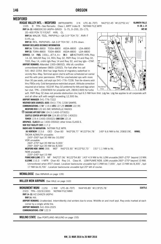
146 OREGON
MEDFORDROGUE VALLEY INTL – MEDFORD (MFR)(KMFR) 3 N UTC–8(–7DT) N42º22.45´ W122º52.41´
1335 B TPA—See Remarks Class I, ARFF Index B NOTAM FILE MFRRWY 14–32: H8800X150 (ASPH–GRVD) S–75, D–200, 2S–175,
2D–400 PCN 72 F/C/X/T HIRL CLRWY 14: MALSR. TDZL. PAPI(P4L)—GA 3.0º TCH 73´. RVR–T 0.4% up.RWY 32: REIL. PAPI(P4R)—GA 3.0º TCH 50´. 0.5% down.
RUNWAY DECLARED DISTANCE INFORMATIONRWY 14: TORA–8800 TODA–8800 ASDA–8800 LDA–8800RWY 32: TORA–8800 TODA–8800 ASDA–8800 LDA–8800
SERVICE: S4 FUEL 100LL, JET A, A+ OX 3 LGT ACTIVATE HIRL Rwy 14–32, MALSR Rwy 14, REIL Rwy 32, PAPI Rwy 14 and Rwy 32, TDZL Rwy 14, cntrln lgts Rwy 14 and Rwy 32, and twy lgts—CTAF.
AIRPORT REMARKS: Attended 1300–0800Z‡. Afld sfc condition unmonitored between 0800–1200Z‡. For fuel after hrs call 541–842–2254. Bird haz large flocks of migratory waterfowl in vicinity Nov–May. Terminal apron clsd to acft exc scheduled air carrier and flts with prior permission. PPR for unscheduled ops with more than 30 pax seats, call arpt ops 541–776–7228. Tran tie–downs avbl thru FBOs only. Cold temperature restricted airport. Altitude correction required at or below –5C/24F. Rwy 32 preferred for tkfs and ldgs when twr clsd. TPA—2304(969) for propeller acft, 2804(1469) for turbo acft. PAPI Rwy 32 does not provide obstruction clnc byd 6.5 NM from thld. Ldg fee. Ldg fee applies to all corporate acft and all other acft with weight exceeding 12,500 lbs.
AIRPORT MANAGER: 541-776-7222WEATHER DATA SOURCES: ASOS (541) 776–1238 SAWRS.COMMUNICATIONS: CTAF 119.4 ATIS 127.25 UNICOM 122.95
MEDFORD RCO 122.65 (MC MINNVILLE RADIO)®CASCADE APP/DEP CON 124.3 (1400–0730Z‡)
SEATTLE CENTER APP/DEP CON 124.85 (0730–1400Z‡)TOWER 119.4 (1400–0500Z‡) GND CON 121.8
AIRSPACE: CLASS D svc 1400–0500Z‡ other times CLASS E.VOR TEST FACILITY (VOT) 117.2RADIO AIDS TO NAVIGATION: NOTAM FILE MFR.
(H) VORTACW 113.6 OED Chan 83 N42º28.77´ W122º54.78´ 145º 6.6 NM to fld. 2083/19E. HIWAS.TACAN AZIMUTH unusable:
245º–350º byd 30 NM blo 10,000´VOR unusable:
260º–270º byd 35 NM blo 9,000´290º–300º byd 35 NM blo 8,500´
MEDFORD NDB (MHW) 356 MEF N42º23.50´ W122º52.73´ 151º 1.1 NM to fld.NDB unusable:
220º–240º byd 15 NMPUMIE NDB (LOM) 373 MF N42º27.06´ W122º54.80´ 143º 4.9 NM to fld. LOM unusable 260º–270º beyond 10 NM.ILS/DME 110.3 I–MFR Chan 40 Rwy 14. Class IA. LOM PUMIE NDB. LOM unusable 260º–270º beyond 10 NM.
Unmonitored when ATCT closed. Localizer backcourse unusable byd 11NM blo 7,000´, byd 13 NM blo 8,300´, byd 17 NM blo 8,700´. Localizer backcourse unusable byd 20º left of course.
MEMALOOSE (See IMNAHA on page 139)
MILLER MEM AIRPARK (See VALE on page 163)
MONUMENT MUNI (12S) 1 NW UTC–8(–7DT) N44º49.89´ W119º25.78´2323 TPA—3323(1000) NOTAM FILE MMVRWY 14–32: H2104X29 (ASPH)
RWY 14: Hill.AIRPORT REMARKS: Unattended. Intermittently clsd winters due to snow. Wildlife on and invof arpt. Rwy ends marked at each
corner by a single white tire.AIRPORT MANAGER: 541-934-2025COMMUNICATIONS: CTAF 122.9
MULINO STATE (See PORTLAND–MULINO on page 155)
KLAMATH FALLSH–3B, L–2I
IAP, AD
SEATTLE
NW, 31 MAR 2016 to 26 MAY 2016
OREGON 147
MYRTLE CREEK MUNI (16S) 2 SW UTC–8(–7DT) N42º59.84´ W123º18.92´619 B TPA—1600(981) NOTAM FILE MMVRWY 03–21: H2600X60 (ASPH) S–12 MIRL
RWY 03: REIL. PAPI(P2L)—GA 4.0º TCH 41´. Tree. Rgt tfc.RWY 21: Trees.
SERVICE: FUEL 100LL LGT ACTIVATE MIRL Rwys 03–21, REIL Rwy 03 and PAPI Rwy 03—CTAF.AIRPORT REMARKS: Unattended. Terrain rises to 2200´ MSL within 2 miles on each side of rwy. AG crop growing within 85´
along east side of rwy. 198´ lighted tower 1.3 NM N–NW MSL elev 2122 obstructs VFR route. AIRPORT MANAGER: 541-863-3171COMMUNICATIONS: CTAF/UNICOM 122.7
NEHALEM BAY STATE (See MANZANITA on page 144)
NEWBERGCHEHALEM AIRPARK (17S) 4 NW UTC–8(–7DT) N45º19.42´ W123º03.26´
190 NOTAM FILE MMVRWY 07–25: H2285X40 (ASPH) RWY LGTS(NSTD)
RWY 07: Thld dsplcd 300´. P–line.RWY 25: Tree.
SERVICE: S4 FUEL 100LL, JET A AIRPORT REMARKS: Attended 1600–0200Z‡. Rwy 25 has NS ABTMT procedures in effect for more information ctc arpt
manager 503–537–0108. Rwy 07–25 NSTD basic markings, NSTD size, rwy edge strips. Rwy 07–25 markings faded. Rwy 07 dsplcd thld NSTD markings, NSTD size. Rwy 07–25 NSTD rwy lgts. Rwy 07–25 NSTD green thld lgts at W end only, no thld lgts on E end; 300´ dsplcd thld unlgtd. NSTD rwy hold position markings at north twy entrance.
AIRPORT MANAGER: 503-537-0108COMMUNICATIONS: CTAF 122.9
– – – – – – – – – – – – – – – – – – – – – – – – – – – – – – – – – – – – – – – – – – – – – – – – – – – – – – –
SPORTSMAN AIRPARK (2S6) 1 SE UTC–8(–7DT) N45º17.74´ W122º57.32´181 NOTAM FILE MMVRWY 17–35: H2755X50 (ASPH) S–30 LIRL
RWY 17: Thld dsplcd 369´. Tree.RWY 35: Thld dsplcd 315´. Brush. Rgt tfc.
SERVICE: S4 FUEL 100LL, JET A LGT Arpt lgts opr sunset–0800Z‡. For LIRL Rwy 17–35 after 0800Z‡ phone 503–538–2134.
AIRPORT REMARKS: Attended dawn–dusk. Rwy 17–35 alligator cracks, dips, patch work in poor condition and edge cracks. AIRPORT MANAGER: 503-538-2134COMMUNICATIONS: CTAF 122.9
CLNC DEL 126.0
NEWBERG N45º21.19´ W122º58.69´ NOTAM FILE MMV.(H) VORW/DME 117.4 UBG Chan 121 105º 10.9 NM to Aurora State. 1440/21E. HIWAS.RCO 122.45 (MC MINNVILLE RADIO)
KLAMATH FALLS
SEATTLE
SEATTLE
SEATTLEH–1B, L–1B
NW, 31 MAR 2016 to 26 MAY 2016
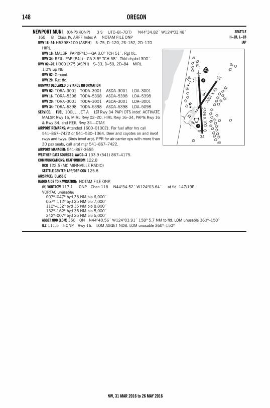
148 OREGON
NEWPORT MUNI (ONP)(KONP) 3 S UTC–8(–7DT) N44º34.82´ W124º03.48´160 B Class IV, ARFF Index A NOTAM FILE ONPRWY 16–34: H5398X100 (ASPH) S–75, D–120, 2S–152, 2D–170
HIRLRWY 16: MALSR. PAPI(P4L)—GA 3.0º TCH 51´. Rgt tfc.RWY 34: REIL. PAPI(P4L)—GA 3.5º TCH 58´. Thld dsplcd 300´.
RWY 02–20: H3001X75 (ASPH) S–33, D–50, 2D–84 MIRL 1.0% up NERWY 02: Ground.RWY 20: Rgt tfc.
RUNWAY DECLARED DISTANCE INFORMATIONRWY 02: TORA–3001 TODA–3001 ASDA–3001 LDA–3001RWY 16: TORA–5398 TODA–5398 ASDA–5398 LDA–5398RWY 20: TORA–3001 TODA–3001 ASDA–3001 LDA–3001RWY 34: TORA–5398 TODA–5398 ASDA–5398 LDA–5098
SERVICE: FUEL 100LL, JET A LGT Rwy 34 PAPI OTS indef. ACTIVATE MALSR Rwy 16, MIRL Rwy 02–20, HIRL Rwy 16–34, PAPIs Rwy 16 & Rwy 34, and REIL Rwy 34—CTAF.
AIRPORT REMARKS: Attended 1600–0100Z‡. For fuel after hrs call 541–867–7422 or 541–530–1364. Deer and coyotes on and invof rwys and twys. Birds invof arpt. PPR for air carrier ops with more than 30 pax seats, call arpt mgr 541–867–7422.
AIRPORT MANAGER: 541-867-3655WEATHER DATA SOURCES: AWOS–3 133.9 (541) 867–4175.COMMUNICATIONS: CTAF/UNICOM 122.8
RCO 122.5 (MC MINNVILLE RADIO)SEATTLE CENTER APP/DEP CON 125.8
AIRSPACE: CLASS ERADIO AIDS TO NAVIGATION: NOTAM FILE ONP.
(H) VORTACW 117.1 ONP Chan 118 N44º34.52´ W124º03.64´ at fld. 147/19E.VORTAC unusable:
007º–047º byd 35 NM blo 6,000´057º–112º byd 35 NM blo 7,000´112º–132º byd 35 NM blo 8,000´132º–162º byd 35 NM blo 5,000´342º–007º byd 35 NM blo 5,000´
AGGET NDB (LOM) 350 ON N44º40.56´ W124º03.91´ 158º 5.7 NM to fld. LOM unusable 360º–150ºILS 111.5 I–ONP Rwy 16. LOM AGGET NDB. LOM unusable 360º–150º
SEATTLEH–1B, L–1B
IAP
NW, 31 MAR 2016 to 26 MAY 2016
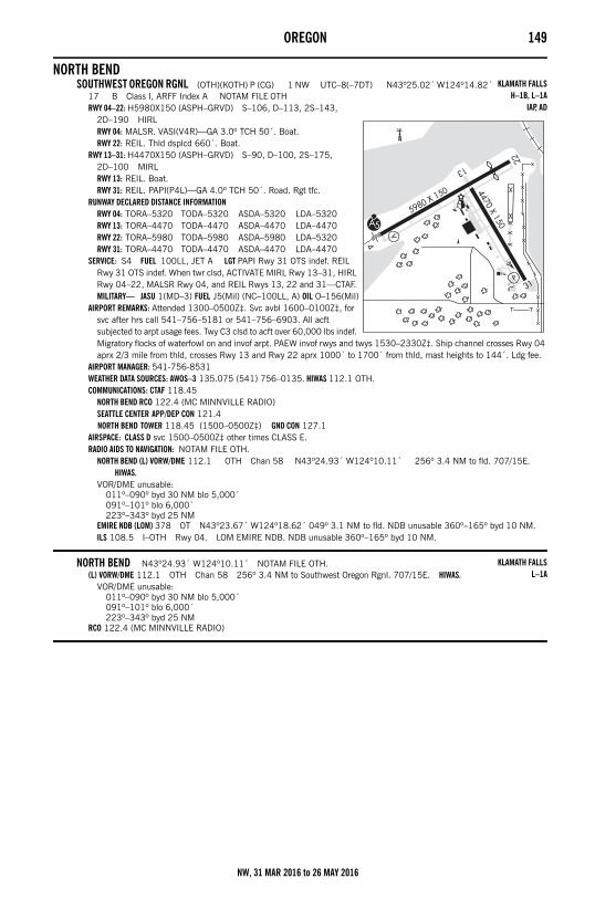
OREGON 149
NORTH BENDSOUTHWEST OREGON RGNL (OTH)(KOTH) P (CG) 1 NW UTC–8(–7DT) N43º25.02´ W124º14.82´
17 B Class I, ARFF Index A NOTAM FILE OTHRWY 04–22: H5980X150 (ASPH–GRVD) S–106, D–113, 2S–143,
2D–190 HIRLRWY 04: MALSR. VASI(V4R)—GA 3.0º TCH 50´. Boat.RWY 22: REIL. Thld dsplcd 660´. Boat.
RWY 13–31: H4470X150 (ASPH–GRVD) S–90, D–100, 2S–175, 2D–100 MIRLRWY 13: REIL. Boat.RWY 31: REIL. PAPI(P4L)—GA 4.0º TCH 50´. Road. Rgt tfc.
RUNWAY DECLARED DISTANCE INFORMATIONRWY 04: TORA–5320 TODA–5320 ASDA–5320 LDA–5320RWY 13: TORA–4470 TODA–4470 ASDA–4470 LDA–4470RWY 22: TORA–5980 TODA–5980 ASDA–5980 LDA–5320RWY 31: TORA–4470 TODA–4470 ASDA–4470 LDA–4470
SERVICE: S4 FUEL 100LL, JET A LGT PAPI Rwy 31 OTS indef. REIL Rwy 31 OTS indef. When twr clsd, ACTIVATE MIRL Rwy 13–31, HIRL Rwy 04–22, MALSR Rwy 04, and REIL Rwys 13, 22 and 31—CTAF. MILITARY— JASU 1(MD–3) FUEL J5(Mil) (NC–100LL, A) OIL O–156(Mil)
AIRPORT REMARKS: Attended 1300–0500Z‡. Svc avbl 1600–0100Z‡, for svc after hrs call 541–756–5181 or 541–756–6903. All acft subjected to arpt usage fees. Twy C3 clsd to acft over 60,000 lbs indef. Migratory flocks of waterfowl on and invof arpt. PAEW invof rwys and twys 1530–2330Z‡. Ship channel crosses Rwy 04 aprx 2/3 mile from thld, crosses Rwy 13 and Rwy 22 aprx 1000´ to 1700´ from thld, mast heights to 144´. Ldg fee.
AIRPORT MANAGER: 541-756-8531WEATHER DATA SOURCES: AWOS–3 135.075 (541) 756–0135. HIWAS 112.1 OTH.COMMUNICATIONS: CTAF 118.45
NORTH BEND RCO 122.4 (MC MINNVILLE RADIO)SEATTLE CENTER APP/DEP CON 121.4 NORTH BEND TOWER 118.45 (1500–0500Z‡) GND CON 127.1
AIRSPACE: CLASS D svc 1500–0500Z‡ other times CLASS E.RADIO AIDS TO NAVIGATION: NOTAM FILE OTH.
NORTH BEND (L) VORW/DME 112.1 OTH Chan 58 N43º24.93´ W124º10.11´ 256º 3.4 NM to fld. 707/15E. HIWAS.
VOR/DME unusable:011º–090º byd 30 NM blo 5,000´091º–101º blo 6,000´223º–343º byd 25 NM
EMIRE NDB (LOM) 378 OT N43º23.67´ W124º18.62´ 049º 3.1 NM to fld. NDB unusable 360º–165º byd 10 NM.ILS 108.5 I–OTH Rwy 04. LOM EMIRE NDB. NDB unusable 360º–165º byd 10 NM.
NORTH BEND N43º24.93´ W124º10.11´ NOTAM FILE OTH.(L) VORW/DME 112.1 OTH Chan 58 256º 3.4 NM to Southwest Oregon Rgnl. 707/15E. HIWAS.
VOR/DME unusable:011º–090º byd 30 NM blo 5,000´091º–101º blo 6,000´223º–343º byd 25 NM
RCO 122.4 (MC MINNVILLE RADIO)
KLAMATH FALLSH–1B, L–1A
IAP, AD
KLAMATH FALLSL–1A
NW, 31 MAR 2016 to 26 MAY 2016
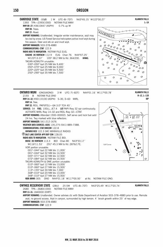
150 OREGON
OAKRIDGE STATE (5S0) 1 W UTC–8(–7DT) N43º45.15´ W122º30.27´1393 TPA—2393(1000) NOTAM FILE MMVRWY 09–27: H3610X47 (ASPH) 0.7% up W
RWY 09: Trees.RWY 27: Road.
AIRPORT REMARKS: Unattended. Irregular winter maintenance, arpt may be clsd by snow. US Forest Service helicopters active invof arpt during fire season. Deer and elk on and invof arpt.
AIRPORT MANAGER: 503-378-4880COMMUNICATIONS: CTAF 122.9RADIO AIDS TO NAVIGATION: NOTAM FILE EUG.
EUGENE (H) VORTACW 112.9 EUG Chan 76 N44º07.25´ W123º13.37´ 105º 38.2 NM to fld. 364/20E. HIWAS.
TACAN AZIMUTH unusable:030º–050º byd 25 NM blo 9,400´050º–070º byd 25 NM blo 9,000´220º–225º byd 35 NM blo 5,500´250º–290º byd 35 NM blo 7,500´
ONTARIO MUNI (ONO)(KONO) 3 W UTC–7(–6DT) N44º01.16´ W117º00.78´2193 B NOTAM FILE ONORWY 14–32: H5011X100 (ASPH) S–30, D–60 MIRL
RWY 14: Tree.RWY 32: REIL. PAPI(P2L)—GA 3.0º TCH 40´.
SERVICE: S4 FUEL 100LL, JET A LGT PAPI Rwy 32 opr continuously. ACTIVATE MIRL Rwy 14–32 and REIL Rwy 32—CTAF.
AIRPORT REMARKS: Attended 1500–0000Z‡. Self serve card lock fuel avbl 24 hrs. Twy marked with blue reflectors.
AIRPORT MANAGER: 541-212-1676WEATHER DATA SOURCES: ASOS 135.275 (541) 889–7388.COMMUNICATIONS: CTAF/UNICOM 122.8
ONTARIO RCO 122.3 (MC MINNVILLE RADIO)®SALT LAKE CENTER APP/DEP CON 128.05
RADIO AIDS TO NAVIGATION: NOTAM FILE BOI.BOISE (H) VORTACW 113.3 BOI Chan 80 N43º33.17´
W116º11.53´ 291º 45.3 NM to fld. 2876/17E.VOR portion unusable:
001º–044º byd 22 NM blo 11,000´001º–044º byd 32 NM blo 14,500´045º–071º byd 32 NM blo 12,500´072º–084º byd 32 NM blo 10,500´
TACAN AZIMUTH & DME portion unusable:010º–060º byd 12 NM blo 13,000´010º–060º byd 27 NM blo 15,500´113º–155º byd 30 NM blo 7,000´348º–010º byd 20 NM blo 13,000´348º–010º byd 27 NM blo 15,500´
NDB (MHW) 305 ONO N44º01.18´ W117º00.50´ at fld. NOTAM FILE ONO.
OWYHEE RESERVOIR STATE (28U) 25 SW UTC–8(–7DT) N43º25.49´ W117º20.74´2680 TPA—3680(1000) NOTAM FILE MMVRWY 13–31: 1840X30 (DIRT)AIRPORT REMARKS: Unattended. Owner advises ctc with State Department of Aviation 503–378–4880 prior to use. Remote
arpt, no ground access. Arpt in canyon, surrounded by high terrain. 4´ brush growth within 20´ of rwy edge.AIRPORT MANAGER: 503-378-4880COMMUNICATIONS: CTAF 122.9
KLAMATH FALLSL–1A
KLAMATH FALLSH–1C, L–11B
IAP
KLAMATH FALLS
NW, 31 MAR 2016 to 26 MAY 2016
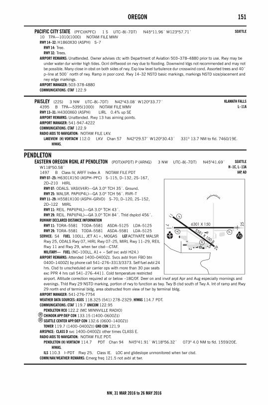
OREGON 151
PACIFIC CITY STATE (PFC)(KPFC) 1 S UTC–8(–7DT) N45º11.96´ W123º57.71´10 TPA—1010(1000) NOTAM FILE MMVRWY 14–32: H1860X30 (ASPH) S–7
RWY 14: Tree.RWY 32: Trees.
AIRPORT REMARKS: Unattended. Owner advises ctc with Department of Aviation 503–378–4880 prior to use. Rwy may be under water dur winter high tides. Ocnl driftwood on rwy due to flooding. Downwind ldgs not recommended and may not be possible. Many close in obst on both sides of rwy. Exp low level turbulence dur crosswind cond. Assorted trees and 40´ p–line at 500´ north of rwy. Ramp in poor cond. Rwy 14–32 NSTD basic markings, markings NSTD size/placement and rwy edge markings.
AIRPORT MANAGER: 503-378-4880COMMUNICATIONS: CTAF 122.9
PAISLEY (22S) 3 NW UTC–8(–7DT) N42º43.08´ W120º33.77´4395 B TPA—5395(1000) NOTAM FILE MMVRWY 13–31: H4300X60 (ASPH) LIRL 0.4% up SEAIRPORT REMARKS: Unattended. Rwy 13 has aiming points.AIRPORT MANAGER: 541-947-4222COMMUNICATIONS: CTAF 122.9RADIO AIDS TO NAVIGATION: NOTAM FILE LKV.
LAKEVIEW (H) VORTACW 112.0 LKV Chan 57 N42º29.57´ W120º30.43´ 331º 13.7 NM to fld. 7460/19E. HIWAS.
PENDLETONEASTERN OREGON RGNL AT PENDLETON (PDT)(KPDT) P (ARNG) 3 NW UTC–8(–7DT) N45º41.69´
W118º50.58´1497 B Class IV, ARFF Index A NOTAM FILE PDTRWY 07–25: H6301X150 (ASPH–PFC) S–115, D–132, 2S–167,
2D–210 HIRLRWY 07: ODALS. VASI(V4R)—GA 3.0º TCH 35´. Ground.RWY 25: MALSR. PAPI(P4L)—GA 3.0º TCH 56´. RVR–T
RWY 11–29: H5581X100 (ASPH–GRVD) S–70, D–120, 2S–152, 2D–122 MIRLRWY 11: REIL. PAPI(P4L)—GA 3.0º TCH 43´.RWY 29: REIL. PAPI(P4L)—GA 3.0º TCH 84´. Thld dsplcd 456´.
RUNWAY DECLARED DISTANCE INFORMATIONRWY 11: TORA–5581 TODA–5581 ASDA–5125 LDA–5125RWY 29: TORA–5581 TODA–5581 ASDA–5581 LDA–5125
SERVICE: S4 FUEL 100LL, JET A1+, MOGAS LGT ACTIVATE MALSR Rwy 25, ODALS Rwy 07, HIRL Rwy 07–25, MIRL Rwy 11–29, REIL Rwy 11 and Rwy 29, when twr clsd—CTAF.MILITARY— FUEL (NC–100LL, A1+ – Self svc avbl H24.)
AIRPORT REMARKS: Attended 1400–0400Z‡. Svcs avbl from FBO btn 0400–1400Z‡ by phone call 541–276–3313/3373. Self fuel avbl 24 hrs. Clsd to unscheduled air carrier ops with more than 30 pax seats exc PPR 4 hrs call 541–276–4411. Cold temperature restricted airport. Altitude correction required at or below –18C/0F. Deer on and invof arpt Apr and Aug especially mornings and evenings. Thld Rwy 29 NSTD marking, portion of rwy to function as twy. Twy B clsd south of Twy A. Int of ramp and Rwy 29 north end of terminal bldg, area obstructed from view of twr by terminal bldg.
AIRPORT MANAGER: 541-276-7754WEATHER DATA SOURCES: ASOS 118.325 (541) 278–2329. HIWAS 114.7 PDT.COMMUNICATIONS: CTAF 119.7 UNICOM 122.95
PENDLETON RCO 122.2 (MC MINNVILLE RADIO)®CHINOOK APP/DEP CON 133.15 (1400–0600Z‡)®SEATTLE CENTER APP/DEP CON 132.6 (0600–1400Z‡)
TOWER 119.7 (1400–0400Z‡) GND CON 121.9 AIRSPACE: CLASS D svc 1400–0400Z‡ other times CLASS E.RADIO AIDS TO NAVIGATION: NOTAM FILE PDT.
PENDLETON (H) VORTACW 114.7 PDT Chan 94 N45º41.91´ W118º56.32´ 073º 4.0 NM to fld. 1559/20E. HIWAS.
ILS 110.3 I–PDT Rwy 25. Class IE. LOC and glideslope unmonitored when twr clsd.COMM/NAV/WEATHER REMARKS: Emerg freq 121.5 not avbl at twr.
SEATTLE
KLAMATH FALLSL–11A
SEATTLEH–1C, L–13A
IAP, AD
NW, 31 MAR 2016 to 26 MAY 2016
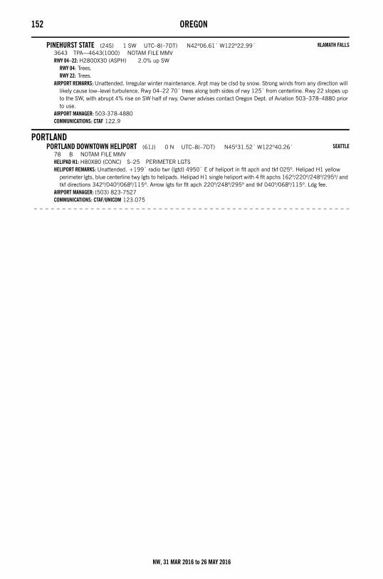
152 OREGON
PINEHURST STATE (24S) 1 SW UTC–8(–7DT) N42º06.61´ W122º22.99´3643 TPA—4643(1000) NOTAM FILE MMVRWY 04–22: H2800X30 (ASPH) 2.0% up SW
RWY 04: Trees.RWY 22: Trees.
AIRPORT REMARKS: Unattended. Irregular winter maintenance. Arpt may be clsd by snow. Strong winds from any direction will likely cause low–level turbulence. Rwy 04–22 70´ trees along both sides of rwy 125´ from centerline. Rwy 22 slopes up to the SW, with abrupt 4% rise on SW half of rwy. Owner advises contact Oregon Dept. of Aviation 503–378–4880 prior to use.
AIRPORT MANAGER: 503-378-4880COMMUNICATIONS: CTAF 122.9
PORTLANDPORTLAND DOWNTOWN HELIPORT (61J) 0 N UTC–8(–7DT) N45º31.52´ W122º40.26´
78 B NOTAM FILE MMVHELIPAD H1: H80X80 (CONC) S–25 PERIMETER LGTSHELIPORT REMARKS: Unattended. +199´ radio twr (lgtd) 4950´ E of heliport in flt apch and tkf 025º. Helipad H1 yellow
perimeter lgts, blue centerline twy lgts to helipads. Helipad H1 single heliport with 4 flt apchs 162º/220º/248º/295º/ and tkf directions 342º/040º/068º/115º. Arrow lgts for flt apch 220º/248º/295º and tkf 040º/068º/115º. Ldg fee.
AIRPORT MANAGER: (503) 823-7527COMMUNICATIONS: CTAF/UNICOM 123.075
– – – – – – – – – – – – – – – – – – – – – – – – – – – – – – – – – – – – – – – – – – – – – – – – – – – – – – – –
KLAMATH FALLS
SEATTLE
NW, 31 MAR 2016 to 26 MAY 2016
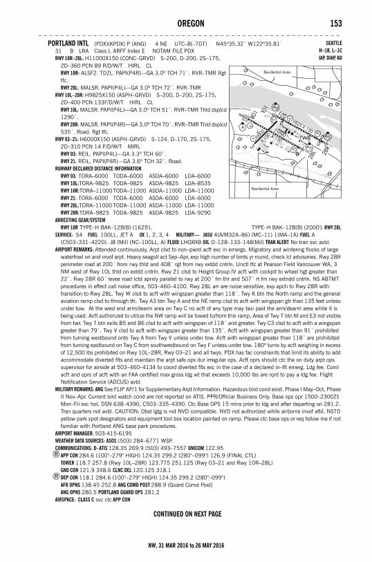
OREGON 153– – – – – – – – – – – – – – – – – – – – – – – – – – – – – – – – – – – – – – – – – – – – – – – – – – – – – – –
PORTLAND INTL (PDX)(KPDX) P (ANG) 4 NE UTC–8(–7DT) N45º35.32´ W122º35.81´31 B LRA Class I, ARFF Index E NOTAM FILE PDXRWY 10R–28L: H11000X150 (CONC–GRVD) S–200, D–200, 2S–175,
2D–360 PCN 89 R/D/W/T HIRL CLRWY 10R: ALSF2. TDZL. PAPI(P4R)—GA 3.0º TCH 71´. RVR–TMR Rgt tfc.RWY 28L: MALSR. PAPI(P4L)—GA 3.0º TCH 72´. RVR–TMR
RWY 10L–28R: H9825X150 (ASPH–GRVD) S–200, D–200, 2S–175, 2D–400 PCN 133F/D/W/T HIRL CLRWY 10L: MALSR. PAPI(P4L)—GA 3.0º TCH 51´. RVR–TMR Thld dsplcd 1290´.RWY 28R: MALSR. PAPI(P4R)—GA 3.0º TCH 70´. RVR–TMR Thld dsplcd 535´. Road. Rgt tfc.
RWY 03–21: H6000X150 (ASPH–GRVD) S–124, D–170, 2S–175, 2D–310 PCN 14 F/D/W/T MIRLRWY 03: REIL. PAPI(P4L)—GA 3.3º TCH 60´.RWY 21: REIL. PAPI(P4R)—GA 3.6º TCH 32´. Road.
RUNWAY DECLARED DISTANCE INFORMATIONRWY 03: TORA–6000 TODA–6000 ASDA–6000 LDA–6000RWY 10L:TORA–9825 TODA–9825 ASDA–9825 LDA–8535RWY 10R:TORA–11000TODA–11000 ASDA–11000 LDA–11000RWY 21: TORA–6000 TODA–6000 ASDA–6000 LDA–6000RWY 28L:TORA–11000 TODA–11000 ASDA–11000 LDA–11000RWY 28R:TORA–9825 TODA–9825 ASDA–9825 LDA–9290
ARRESTING GEAR/SYSTEMRWY 10R TYPE–H BAK–12B(B) (1625'). TYPE–H BAK–12B(B) (2000'). RWY 28L
SERVICE: S4 FUEL 100LL, JET A OX 1, 2, 3, 4 MILITARY— JASU 4(A/M32A–86) (MC–11) 1(MA–1A) FUEL A (C503–331–4220). J8 (Mil) (NC–100LL, A) FLUID LHOXRB OIL O–128–133–148(Mil) TRAN ALERT No tran svc avbl.
AIRPORT REMARKS: Attended continuously. Arpt clsd to non–pwrd acft exc in emergs. Migratory and wintering flocks of large waterfowl on and invof arpt. Heavy seagull act Sep–Apr, exp high number of birds yr round, check lcl advisories. Rwy 28R perimeter road at 200´ from rwy thld and 408´ rgt from rwy extdd cntrln. Unctl tfc at Pearson Field Vancouver WA, 3 NM west of Rwy 10L thld on extdd cntrln. Rwy 21 clsd to Height Group IV acft with cockpit to wheel hgt greater than 22´. Rwy 28R 60´ levee road lctd aprxly parallel to rwy at 200´ fm thr and 507´ rt fm rwy extndd cntrln. NS ABTMT procedures in effect call noise office, 503–460–4100. Rwy 28L arr are noise sensitive, exp apch to Rwy 28R with transition to Rwy 28L. Twy W clsd to acft with wingspan greater than 118´. Twy K btn the North ramp and the general aviation ramp clsd to through tfc. Twy A3 btn Twy A and the NE ramp clsd to acft with wingspan gtr than 135 feet unless under tow. At the west end arm/dearm area on Twy C no acft of any type may taxi past the arm/dearm area while it is being used. Acft authorized to utilize the NW ramp will be towed to/from this ramp. Area of Twy T btn M and E3 not visible from twr. Twy T btn exits B5 and B6 clsd to acft with wingspan of 118´ and greater. Twy C3 clsd to acft with a wingspan greater than 79´. Twy V clsd to acft with wingspan greater than 135´. Acft with wingspan greater than 91´ prohibited from turning westbound onto Twy A from Twy V unless under tow. Acft with wingspan greater than 118´ are prohibited from turning eastbound on Twy C from southwestbound on Twy F unless under tow. 180º turns by acft weighing in excess of 12,500 lbs prohibited on Rwy 10L–28R, Rwy 03–21 and all twys. PDX has fac constraints that limit its ability to add accommodate diverted flts and maintain the arpt safe ops dur irregular ops. Acft oprs should ctc the on duty arpt ops supervisor for airside at 503–460–4134 to coord diverted flts exc in the case of a declared in–flt emerg. Ldg fee. Coml acft and oprs of acft with an FAA certified max gross ldg wt that exceeds 10,000 lbs are rqrd to pay a ldg fee. Flight Notification Service (ADCUS) avbl.
MILITARY REMARKS: ANG See FLIP AP/1 for Supplementary Arpt Information. Hazardous bird cond exist. Phase I May–Oct, Phase II Nov–Apr. Current bird watch cond are not reported on ATIS. PPR/Official Business Only. Base ops opr 1500–2300Z‡ Mon–Fri exc hol, DSN 638–4390, C503–335–4390. Ctc Base OPS 15 mins prior to ldg and after departing on 281.2. Tran quarters not avbl. CAUTION: Obst lgtg is not NVD compatible. NVD not authorized while airborne invof afld. NSTD yellow park spot designators and equipment tool box location painted on ramp. Please ctc base ops or req follow me if not familiar with Portland ANG base park procedures.
AIRPORT MANAGER: 503-415-6195WEATHER DATA SOURCES: ASOS (503) 284–6771 WSP.COMMUNICATIONS: D–ATIS 128.35 269.9 (503) 493–7557 UNICOM 122.95
®APP CON 284.6 (100°–279° HIGH) 124.35 299.2 (280°–099°) 126.9 (FINAL CTL)TOWER 118.7 257.8 (Rwy 10L–28R) 123.775 251.125 (Rwy 03–21 and Rwy 10R–28L) GND CON 121.9 348.6 CLNC DEL 120.125 318.1
®DEP CON 118.1 284.6 (100°–279° HIGH) 124.35 299.2 (280°–099°) AFR OPNS 138.45 252.8 ANG COMD POST 288.9 (Guard Comd Post)ANG OPNS 280.5 PORTLAND GUARD OPS 281.2
AIRSPACE: CLASS C svc ctc APP CON
CONTINUED ON NEXT PAGE
SEATTLEH–1B, L–1CIAP, DIAP, AD
NW, 31 MAR 2016 to 26 MAY 2016
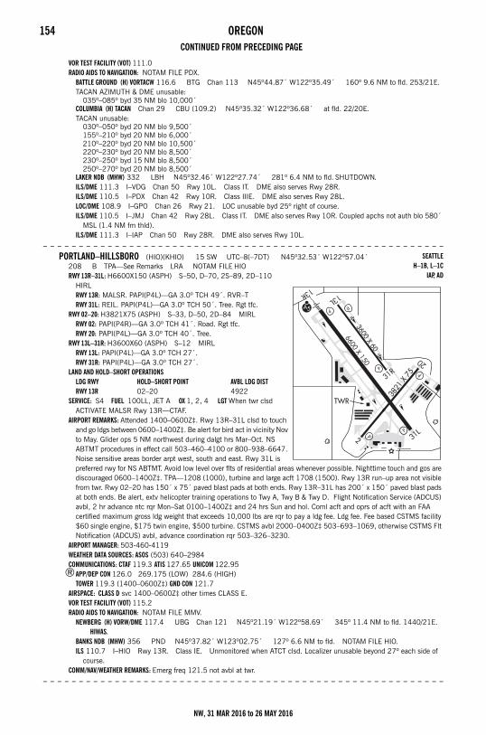
154 OREGONCONTINUED FROM PRECEDING PAGE
VOR TEST FACILITY (VOT) 111.0RADIO AIDS TO NAVIGATION: NOTAM FILE PDX.
BATTLE GROUND (H) VORTACW 116.6 BTG Chan 113 N45º44.87´ W122º35.49´ 160º 9.6 NM to fld. 253/21E.TACAN AZIMUTH & DME unusable:
035º–085º byd 35 NM blo 10,000´COLUMBIA (H) TACAN Chan 29 CBU (109.2) N45º35.32´ W122º36.68´ at fld. 22/20E.TACAN unusable:
030º–050º byd 20 NM blo 9,500´155º–210º byd 20 NM blo 6,000´210º–220º byd 20 NM blo 10,500´220º–230º byd 20 NM blo 8,500´230º–250º byd 15 NM blo 8,500´250º–270º byd 20 NM blo 8,500´
LAKER NDB (MHW) 332 LBH N45º32.46´ W122º27.74´ 281º 6.4 NM to fld. SHUTDOWN.ILS/DME 111.3 I–VDG Chan 50 Rwy 10L. Class IT. DME also serves Rwy 28R.ILS/DME 110.5 I–PDX Chan 42 Rwy 10R. Class IIIE. DME also serves Rwy 28L.LOC/DME 108.9 I–GPO Chan 26 Rwy 21. LOC unusable byd 25º right of course.ILS/DME 110.5 I–JMJ Chan 42 Rwy 28L. Class IT. DME also serves Rwy 10R. Coupled apchs not auth blo 580´
MSL (1.4 NM fm thld).ILS/DME 111.3 I–IAP Chan 50 Rwy 28R. DME also serves Rwy 10L.
– – – – – – – – – – – – – – – – – – – – – – – – – – – – – – – – – – – – – – – – – – – – – – – – – – – – – – – –
PORTLAND–HILLSBORO (HIO)(KHIO) 15 SW UTC–8(–7DT) N45º32.53´ W122º57.04´208 B TPA—See Remarks LRA NOTAM FILE HIORWY 13R–31L: H6600X150 (ASPH) S–50, D–70, 2S–89, 2D–110
HIRLRWY 13R: MALSR. PAPI(P4L)—GA 3.0º TCH 49´. RVR–TRWY 31L: REIL. PAPI(P4L)—GA 3.0º TCH 50´. Tree. Rgt tfc.
RWY 02–20: H3821X75 (ASPH) S–33, D–50, 2D–84 MIRLRWY 02: PAPI(P4R)—GA 3.0º TCH 41´. Road. Rgt tfc.RWY 20: PAPI(P4L)—GA 3.0º TCH 40´. Tree.
RWY 13L–31R: H3600X60 (ASPH) S–12 MIRLRWY 13L: PAPI(P4L)—GA 3.0º TCH 27´.RWY 31R: PAPI(P4L)—GA 3.0º TCH 27´.
LAND AND HOLD–SHORT OPERATIONSLDG RWY HOLD–SHORT POINT AVBL LDG DISTRWY 13R 02–20 4922
SERVICE: S4 FUEL 100LL, JET A OX 1, 2, 4 LGT When twr clsd ACTIVATE MALSR Rwy 13R—CTAF.
AIRPORT REMARKS: Attended 1400–0600Z‡. Rwy 13R–31L clsd to touch and go ldgs between 0600–1400Z‡. Be alert for bird act in vicinity Nov to May. Glider ops 5 NM northwest during dalgt hrs Mar–Oct. NS ABTMT procedures in effect call 503–460–4100 or 800–938–6647. Noise sensitive areas border arpt west, south and east. Rwy 31L is preferred rwy for NS ABTMT. Avoid low level over flts of residential areas whenever possible. Nighttime touch and gos are discouraged 0600–1400Z‡. TPA—1208 (1000), turbine and large acft 1708 (1500). Rwy 13R run–up area not visible from twr. Rwy 02–20 has 150´ x 75´ paved blast pads at both ends. Rwy 13R–31L has 200´ x 150´ paved blast pads at both ends. Be alert, extv helicopter training operations to Twy A, Twy B & Twy D. Flight Notification Service (ADCUS) avbl, 2 hr advance ntc rqr Mon–Sat 0100–1400Z‡ and 24 hrs Sun and hol. Coml acft and oprs of acft with an FAA certified maximum gross ldg weight that exceeds 10,000 lbs are rqr to pay a ldg fee. Ldg fee. Fee based CSTMS facility $60 single engine, $175 twin engine, $500 turbine. CSTMS avbl 2000–0400Z‡ 503–693–1069, otherwise CSTMS Flt Notification (ADCUS) avbl, advance coordination rqr 503–326–3230.
AIRPORT MANAGER: 503-460-4119WEATHER DATA SOURCES: ASOS (503) 640–2984COMMUNICATIONS: CTAF 119.3 ATIS 127.65 UNICOM 122.95
®APP/DEP CON 126.0 269.175 (LOW) 284.6 (HIGH)TOWER 119.3 (1400–0600Z‡) GND CON 121.7
AIRSPACE: CLASS D svc 1400–0600Z‡ other times CLASS E.VOR TEST FACILITY (VOT) 115.2RADIO AIDS TO NAVIGATION: NOTAM FILE MMV.
NEWBERG (H) VORW/DME 117.4 UBG Chan 121 N45º21.19´ W122º58.69´ 345º 11.4 NM to fld. 1440/21E. HIWAS.
BANKS NDB (MHW) 356 PND N45º37.82´ W123º02.75´ 127º 6.6 NM to fld. NOTAM FILE HIO.ILS 110.7 I–HIO Rwy 13R. Class IE. Unmonitored when ATCT clsd. Localizer unusable beyond 27º each side of
course.COMM/NAV/WEATHER REMARKS: Emerg freq 121.5 not avbl at twr.
– – – – – – – – – – – – – – – – – – – – – – – – – – – – – – – – – – – – – – – – – – – – – – – – – – – – – – – –
SEATTLEH–1B, L–1C
IAP, AD
NW, 31 MAR 2016 to 26 MAY 2016
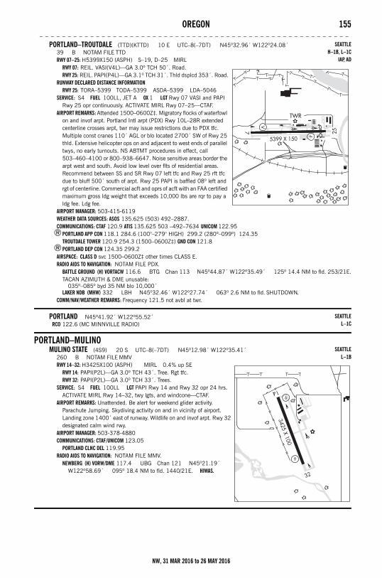
OREGON 155– – – – – – – – – – – – – – – – – – – – – – – – – – – – – – – – – – – – – – – – – – – – – – – – – – – – – – –
PORTLAND–TROUTDALE (TTD)(KTTD) 10 E UTC–8(–7DT) N45º32.96´ W122º24.08´39 B NOTAM FILE TTDRWY 07–25: H5399X150 (ASPH) S–19, D–25 MIRL
RWY 07: REIL. VASI(V4L)—GA 3.0º TCH 50´. Road.RWY 25: REIL. PAPI(P4L)—GA 3.1º TCH 31´. Thld dsplcd 353´. Road.
RUNWAY DECLARED DISTANCE INFORMATIONRWY 25: TORA–5399 TODA–5399 ASDA–5399 LDA–5046
SERVICE: S4 FUEL 100LL, JET A OX 1 LGT Rwy 07 VASI and PAPI Rwy 25 opr continuously. ACTIVATE MIRL Rwy 07–25—CTAF.
AIRPORT REMARKS: Attended 1500–0600Z‡. Migratory flocks of waterfowl on and invof arpt. Portland Intl arpt (PDX) Rwy 10L–28R extended centerline crosses arpt, twr may issue restrictions due to PDX tfc. Multiple const cranes 110´ AGL or blo located 2700´ SW of Rwy 25 thld. Extensive helicopter ops on and adjacent to west ends of parallel twys, no early turnouts. NS ABTMT procedures in effect, call 503–460–4100 or 800–938–6647. Noise sensitive areas border the arpt west and south. Avoid low level over flts of residential areas. Recommend between SS and SR Rwy 07 left tfc and Rwy 25 rft tfc due to bluff 500´ south of arpt. Rwy 25 PAPI is baffled 08º left and rgt of centerline. Commercial acft and oprs of acft with an FAA certified maximum gross ldg weight that exceeds 10,000 lbs are rqr to pay a ldg fee. Ldg fee.
AIRPORT MANAGER: 503-415-6119WEATHER DATA SOURCES: ASOS 135.625 (503) 492–2887.COMMUNICATIONS: CTAF 120.9 ATIS 135.625 503 –492–7634 UNICOM 122.95
®PORTLAND APP CON 118.1 284.6 (100°–279° HIGH) 299.2 (280º–099º) 124.35 TROUTDALE TOWER 120.9 254.3 (1500–0600Z‡) GND CON 121.8
®PORTLAND DEP CON 124.35 299.2AIRSPACE: CLASS D svc 1500–0600Z‡ other times CLASS E.RADIO AIDS TO NAVIGATION: NOTAM FILE PDX.
BATTLE GROUND (H) VORTACW 116.6 BTG Chan 113 N45º44.87´ W122º35.49´ 125º 14.4 NM to fld. 253/21E.TACAN AZIMUTH & DME unusable:
035º–085º byd 35 NM blo 10,000´LAKER NDB (MHW) 332 LBH N45º32.46´ W122º27.74´ 063º 2.6 NM to fld. SHUTDOWN.
COMM/NAV/WEATHER REMARKS: Frequency 121.5 not avbl at twr.
PORTLAND N45º41.92´ W122º55.52´RCO 122.6 (MC MINNVILLE RADIO)
PORTLAND–MULINOMULINO STATE (4S9) 20 S UTC–8(–7DT) N45º12.98´ W122º35.41´
260 B NOTAM FILE MMVRWY 14–32: H3425X100 (ASPH) MIRL 0.4% up SE
RWY 14: PAPI(P2L)—GA 3.0º TCH 43´. Tree. Rgt tfc.RWY 32: PAPI(P2L)—GA 3.0º TCH 33´. Trees.
SERVICE: S4 FUEL 100LL LGT PAPI Rwy 14 and Rwy 32 opr 24 hrs. ACTIVATE MIRL Rwy 14–32, twy lgts, and windcone—CTAF.
AIRPORT REMARKS: Unattended. Be alert for weekend glider activity. Parachute Jumping. Skydiving activity on and in vicinity of airport. Landing zone 1400´ east of runway. Wildlife on and invof arpt. Rwy 32 designated calm wind rwy.
AIRPORT MANAGER: 503-378-4880COMMUNICATIONS: CTAF/UNICOM 123.05
PORTLAND CLNC DEL 119.95RADIO AIDS TO NAVIGATION: NOTAM FILE MMV.
NEWBERG (H) VORW/DME 117.4 UBG Chan 121 N45º21.19´ W122º58.69´ 095º 18.4 NM to fld. 1440/21E. HIWAS.
SEATTLEH–1B, L–1C
IAP, AD
SEATTLEL–1C
SEATTLEL–1B
NW, 31 MAR 2016 to 26 MAY 2016
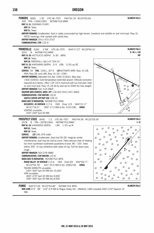
156 OREGON
POWERS (6S6) 1 SE UTC–8(–7DT) N42º52.16´ W124º03.54´326 TPA—1326(1000) NOTAM FILE MMVRWY 13–31: 2500X60 (TURF)
RWY 13: Trees.RWY 31: Trees.
AIRPORT REMARKS: Unattended. Arpt in valley surrounded by high terrain. Livestock and wildlife on and invof arpt. Rwy 31 NSTD markings, thld marked with white tires.
AIRPORT MANAGER: (541) 572-2737COMMUNICATIONS: CTAF 122.9
PRINEVILLE (S39) 3 SW UTC–8(–7DT) N44º17.27´ W120º54.31´3251 B NOTAM FILE MMVRWY 10–28: H5751X75 (ASPH) S–30 MIRL
RWY 10: Trees.RWY 28: PAPI(P4L)—GA 3.0º TCH 41´.
RWY 15–33: H4054X40 (ASPH) S–5 LIRL 0.3% up SERWY 33: Trees.
SERVICE: S4 FUEL 100LL, JET A LGT ACTIVATE MIRL Rwy 10–28, PAPI Rwy 28, and LIRL Rwy 15–33—CTAF.
AIRPORT REMARKS: Attended Oct–Apr 1500–0100Z‡, May–Sep 1500–0200Z‡. Cold temperature restricted airport. Altitude correction required at or below –26C/–15F. 24 hr card lock self–svc fuel avbl. Deer on and invof arpt. Rwy 15–33 ltd by arpt opr to 5000 lbs max weight.
AIRPORT MANAGER: 541-416-0805WEATHER DATA SOURCES: AWOS–3PT 118.325 (541) 447–4060.COMMUNICATIONS: CTAF/UNICOM 122.8
SEATTLE CENTER APP/DEP CON 128.15RADIO AIDS TO NAVIGATION: NOTAM FILE RDM.
DESCHUTES (H) VORTACW 117.6 DSD Chan 123 N44º15.17´ W121º18.21´ 065º 17.3 NM to fld. 4101/18E. HIWAS.
VORTAC unusable:220º–240º byd 30 NM
PROSPECT STATE (64S) 1 S UTC–8(–7DT) N42º44.56´ W122º29.34´2578 B TPA—3578(1000) NOTAM FILE MMVRWY 02–20: H4000X50 (ASPH) LIRL 1.3% up N
RWY 02: Trees.RWY 20: Trees.
SERVICE: LGT LIRL OTS indef.AIRPORT REMARKS: Unattended. Arpt clsd SS–SR. Irregular winter
maintenance, arpt may be clsd by snow. Trees obscure view of rotating bcn from southeast–southwest quadrants of arpt. 80´–100´ trees within 200´ of rwy centerline both sides of rwy. Turf tie down area rough.
AIRPORT MANAGER: 503-378-4880COMMUNICATIONS: CTAF/UNICOM 122.8RADIO AIDS TO NAVIGATION: NOTAM FILE MFR.
ROGUE VALLEY (H) VORTACW 113.6 OED Chan 83 N42º28.77´ W122º54.78´ 031º 24.5 NM to fld. 2083/19E. HIWAS.
TACAN AZIMUTH unusable:245º–350º byd 30 NM blo 10,000´
VOR unusable:260º–270º byd 35 NM blo 9,000´290º–300º byd 35 NM blo 8,500´
PUMIE N42º27.06´ W122º54.80´ NOTAM FILE MFR.NDB (LOM) 373 MF 143º 4.9 NM to Rogue Valley Intl – Medford. LOM unusable 260º–270º beyond 10
NM.
KLAMATH FALLS
KLAMATH FALLSH–1B, L–13A
IAP
KLAMATH FALLSL–2J
KLAMATH FALLS
NW, 31 MAR 2016 to 26 MAY 2016
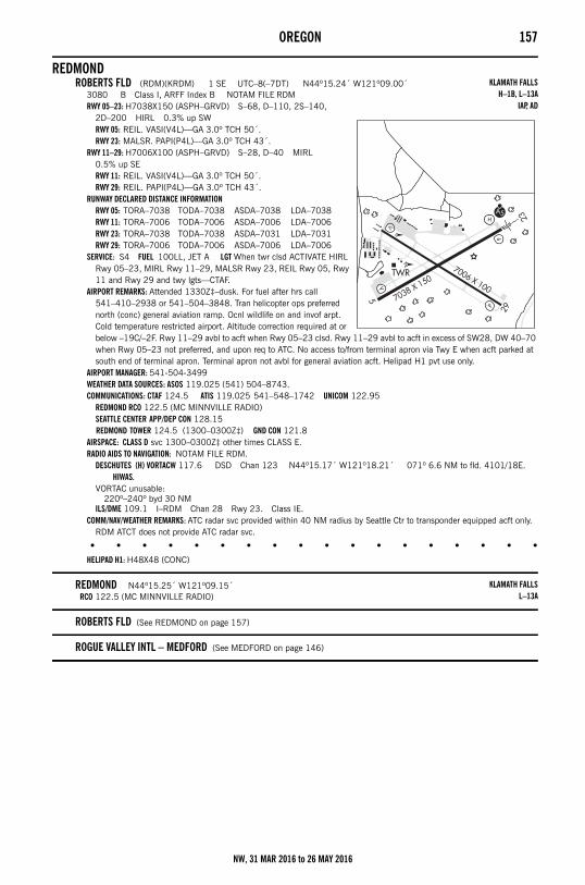
OREGON 157
REDMONDROBERTS FLD (RDM)(KRDM) 1 SE UTC–8(–7DT) N44º15.24´ W121º09.00´
3080 B Class I, ARFF Index B NOTAM FILE RDMRWY 05–23: H7038X150 (ASPH–GRVD) S–68, D–110, 2S–140,
2D–200 HIRL 0.3% up SWRWY 05: REIL. VASI(V4L)—GA 3.0º TCH 50´.RWY 23: MALSR. PAPI(P4L)—GA 3.0º TCH 43´.
RWY 11–29: H7006X100 (ASPH–GRVD) S–28, D–40 MIRL 0.5% up SERWY 11: REIL. VASI(V4L)—GA 3.0º TCH 50´.RWY 29: REIL. PAPI(P4L)—GA 3.0º TCH 43´.
RUNWAY DECLARED DISTANCE INFORMATIONRWY 05: TORA–7038 TODA–7038 ASDA–7038 LDA–7038RWY 11: TORA–7006 TODA–7006 ASDA–7006 LDA–7006RWY 23: TORA–7038 TODA–7038 ASDA–7031 LDA–7031RWY 29: TORA–7006 TODA–7006 ASDA–7006 LDA–7006
SERVICE: S4 FUEL 100LL, JET A LGT When twr clsd ACTIVATE HIRL Rwy 05–23, MIRL Rwy 11–29, MALSR Rwy 23, REIL Rwy 05, Rwy 11 and Rwy 29 and twy lgts—CTAF.
AIRPORT REMARKS: Attended 1330Z‡–dusk. For fuel after hrs call 541–410–2938 or 541–504–3848. Tran helicopter ops preferred north (conc) general aviation ramp. Ocnl wildlife on and invof arpt. Cold temperature restricted airport. Altitude correction required at or below –19C/–2F. Rwy 11–29 avbl to acft when Rwy 05–23 clsd. Rwy 11–29 avbl to acft in excess of SW28, DW 40–70 when Rwy 05–23 not preferred, and upon req to ATC. No access to/from terminal apron via Twy E when acft parked at south end of terminal apron. Terminal apron not avbl for general aviation acft. Helipad H1 pvt use only.
AIRPORT MANAGER: 541-504-3499WEATHER DATA SOURCES: ASOS 119.025 (541) 504–8743.COMMUNICATIONS: CTAF 124.5 ATIS 119.025 541–548–1742 UNICOM 122.95
REDMOND RCO 122.5 (MC MINNVILLE RADIO)SEATTLE CENTER APP/DEP CON 128.15 REDMOND TOWER 124.5 (1300–0300Z‡) GND CON 121.8
AIRSPACE: CLASS D svc 1300–0300Z‡ other times CLASS E.RADIO AIDS TO NAVIGATION: NOTAM FILE RDM.
DESCHUTES (H) VORTACW 117.6 DSD Chan 123 N44º15.17´ W121º18.21´ 071º 6.6 NM to fld. 4101/18E. HIWAS.
VORTAC unusable:220º–240º byd 30 NM
ILS/DME 109.1 I–RDM Chan 28 Rwy 23. Class IE.COMM/NAV/WEATHER REMARKS: ATC radar svc provided within 40 NM radius by Seattle Ctr to transponder equipped acft only.
RDM ATCT does not provide ATC radar svc.
• • • • • • • • • • • • • • • • • •
HELIPAD H1: H48X48 (CONC)
REDMOND N44º15.25´ W121º09.15´RCO 122.5 (MC MINNVILLE RADIO)
ROBERTS FLD (See REDMOND on page 157)
ROGUE VALLEY INTL – MEDFORD (See MEDFORD on page 146)
KLAMATH FALLSH–1B, L–13A
IAP, AD
KLAMATH FALLSL–13A
NW, 31 MAR 2016 to 26 MAY 2016
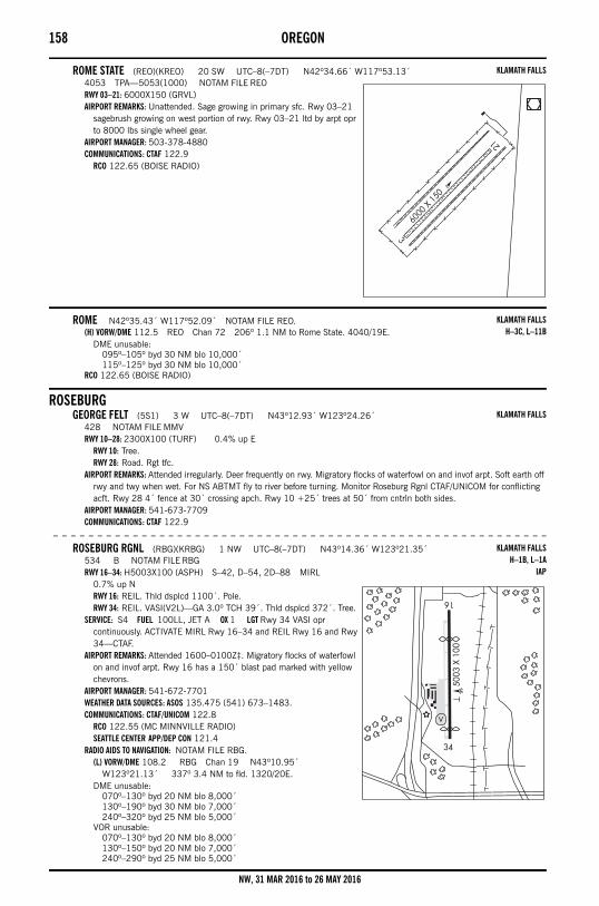
158 OREGON
ROME STATE (REO)(KREO) 20 SW UTC–8(–7DT) N42º34.66´ W117º53.13´4053 TPA—5053(1000) NOTAM FILE REORWY 03–21: 6000X150 (GRVL)AIRPORT REMARKS: Unattended. Sage growing in primary sfc. Rwy 03–21
sagebrush growing on west portion of rwy. Rwy 03–21 ltd by arpt opr to 8000 lbs single wheel gear.
AIRPORT MANAGER: 503-378-4880COMMUNICATIONS: CTAF 122.9
RCO 122.65 (BOISE RADIO)
ROME N42º35.43´ W117º52.09´ NOTAM FILE REO.(H) VORW/DME 112.5 REO Chan 72 206º 1.1 NM to Rome State. 4040/19E.
DME unusable:095º–105º byd 30 NM blo 10,000´115º–125º byd 30 NM blo 10,000´
RCO 122.65 (BOISE RADIO)
ROSEBURGGEORGE FELT (5S1) 3 W UTC–8(–7DT) N43º12.93´ W123º24.26´
428 NOTAM FILE MMVRWY 10–28: 2300X100 (TURF) 0.4% up E
RWY 10: Tree.RWY 28: Road. Rgt tfc.
AIRPORT REMARKS: Attended irregularly. Deer frequently on rwy. Migratory flocks of waterfowl on and invof arpt. Soft earth off rwy and twy when wet. For NS ABTMT fly to river before turning. Monitor Roseburg Rgnl CTAF/UNICOM for conflicting acft. Rwy 28 4´ fence at 30´ crossing apch. Rwy 10 +25´ trees at 50´ from cntrln both sides.
AIRPORT MANAGER: 541-673-7709COMMUNICATIONS: CTAF 122.9
– – – – – – – – – – – – – – – – – – – – – – – – – – – – – – – – – – – – – – – – – – – – – – – – – – – – – – – –
ROSEBURG RGNL (RBG)(KRBG) 1 NW UTC–8(–7DT) N43º14.36´ W123º21.35´534 B NOTAM FILE RBGRWY 16–34: H5003X100 (ASPH) S–42, D–54, 2D–88 MIRL
0.7% up NRWY 16: REIL. Thld dsplcd 1100´. Pole.RWY 34: REIL. VASI(V2L)—GA 3.0º TCH 39´. Thld dsplcd 372´. Tree.
SERVICE: S4 FUEL 100LL, JET A OX 1 LGT Rwy 34 VASI opr continuously. ACTIVATE MIRL Rwy 16–34 and REIL Rwy 16 and Rwy 34—CTAF.
AIRPORT REMARKS: Attended 1600–0100Z‡. Migratory flocks of waterfowl on and invof arpt. Rwy 16 has a 150´ blast pad marked with yellow chevrons.
AIRPORT MANAGER: 541-672-7701WEATHER DATA SOURCES: ASOS 135.475 (541) 673–1483.COMMUNICATIONS: CTAF/UNICOM 122.8
RCO 122.55 (MC MINNVILLE RADIO)SEATTLE CENTER APP/DEP CON 121.4
RADIO AIDS TO NAVIGATION: NOTAM FILE RBG.(L) VORW/DME 108.2 RBG Chan 19 N43º10.95´
W123º21.13´ 337º 3.4 NM to fld. 1320/20E.DME unusable:
070º–130º byd 20 NM blo 8,000´130º–190º byd 30 NM blo 7,000´240º–320º byd 25 NM blo 5,000´
VOR unusable:070º–130º byd 20 NM blo 8,000´130º–150º byd 20 NM blo 7,000´240º–290º byd 25 NM blo 5,000´
KLAMATH FALLS
KLAMATH FALLSH–3C, L–11B
KLAMATH FALLS
KLAMATH FALLSH–1B, L–1A
IAP
NW, 31 MAR 2016 to 26 MAY 2016
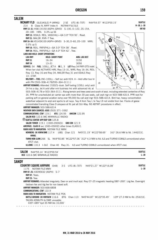
OREGON 159
SALEMMCNARY FLD (SLE)(KSLE) P (ARNG) 2 SE UTC–8(–7DT) N44º54.57´ W123º00.15´
214 B Class IV, ARFF Index A NOTAM FILE SLERWY 13–31: H5811X150 (ASPH–GRVD) S–100, D–122, 2S–154,
2D–185 HIRL 0.3% up SERWY 13: ODALS. REIL. VASI(V4L)—GA 3.0º TCH 50´. Road.RWY 31: MALSR. RVR–T Tree.
RWY 16–34: H5145X100 (ASPH–GRVD) S–30, D–60, 2D–100 MIRL 0.3% up SRWY 16: REIL. PAPI(P4L)—GA 3.0º TCH 38´. Road.RWY 34: REIL. PAPI(P4L)—GA 4.0º TCH 42´. Tree.
LAND AND HOLD–SHORT OPERATIONSLDG RWY HOLD–SHORT POINT AVBL LDG DISTRWY 31 16–34 3150RWY 34 13–31 3050
SERVICE: S4 FUEL 100LL, JET A OX 1, 3 LGT Rwy 34 PAPI OTS indef. When twr clsd ACTIVATE HIRL Rwy 13–31, MIRL Rwy 16–34, REIL Rwy 13, Rwy 16 and Rwy 34, MALSR Rwy 31 and ODALS Rwy 13—CTAF.MILITARY— FUEL (NC–100LL – Self svc avbl H24. A – Avbl after bus hr with PN C503–508–4178/593–364–0111.)
AIRPORT REMARKS: Attended 1530Z‡–dusk. Self fueling (100LL only) avbl 24 hrs a day. Jet A avbl after nml business hrs with advanced ntc at 503–508–4178 or 503–364–0111. Rising terrain and trees west and south of arpt, including extended centerline of Rwy 34. PPR for unscheduled air carrier ops with more than 30 pax seats, call arpt mgr on 503–588–6314. PPR rqrd for parking acft on general aviation ramp over 99,000 lbs call arpt mgr 503–588–6314. Bird haz, heavy concentration waterfowl adjacent to arpt and apchs to all rwys. Twy A from Twy L to Twy L9 not visible from twr. Flocks of geese concentrated transiting Class D airspace at tfc pat alt Oct–May. NS ABTMT procedures in effect.
AIRPORT MANAGER: 503-588-6314WEATHER DATA SOURCES: ASOS (503) 371–1062COMMUNICATIONS: CTAF 119.1 ATIS 124.55 UNICOM 122.95
SALEM RCO 122.6 (MC MINNVILLE RADIO)®SEATTLE CENTER APP/DEP CON 125.8
SALEM TOWER 119.1 (1500–0500Z‡) GND CON 121.9AIRSPACE: CLASS D svc 1500–0500Z‡ other times CLASS E.RADIO AIDS TO NAVIGATION: NOTAM FILE MMV.
NEWBERG (H) VORW/DME 117.4 UBG Chan 121 N45º21.19´ W122º58.69´ 161º 26.6 NM to fld. 1440/21E. HIWAS.
TURNO NDB (LOM) 266 SL N44º50.85´ W122º57.06´ 312º 4.3 NM to fld. ILS and TURNO COMLO unmonitored when ATCT clsd.
ILS/DME 110.3 I–SLE Chan 40 Rwy 31. ILS and TURNO COMLO unmonitored when ATCT clsd.
SALEM N44º55.14´ W123º00.54´RCO 122.6 (MC MINNVILLE RADIO)
SANDYCOUNTRY SQUIRE AIRPARK (S48) 3 S UTC–8(–7DT) N45º21.27´ W122º16.08´
1175 NOTAM FILE MMVRWY 07–25: H3095X32 (ASPH) S–7
RWY 07: Trees.RWY 25: Tree.
AIRPORT REMARKS: Attended irregularly. Deer on and invof arpt. Rwy 07–25 magnetic heading 080°–260°. Ldg fee. Overnight tiedown fee and ldg fee for non based acft.
AIRPORT MANAGER: 503-668-6808COMMUNICATIONS: CTAF 122.9RADIO AIDS TO NAVIGATION: NOTAM FILE PDX.
BATTLE GROUND (H) VORTACW 116.6 BTG Chan 113 N45º44.87´ W122º35.49´ 129º 27.3 NM to fld. 253/21E.TACAN AZIMUTH & DME unusable:
035º–085º byd 35 NM blo 10,000´– – – – – – – – – – – – – – – – – – – – – – – – – – – – – – – – – – – – – – – – – – – – – – – – – – – – – – –
SEATTLEH–1B, L–1B
IAP, AD
SEATTLEL–1B
SEATTLEL–1B
NW, 31 MAR 2016 to 26 MAY 2016
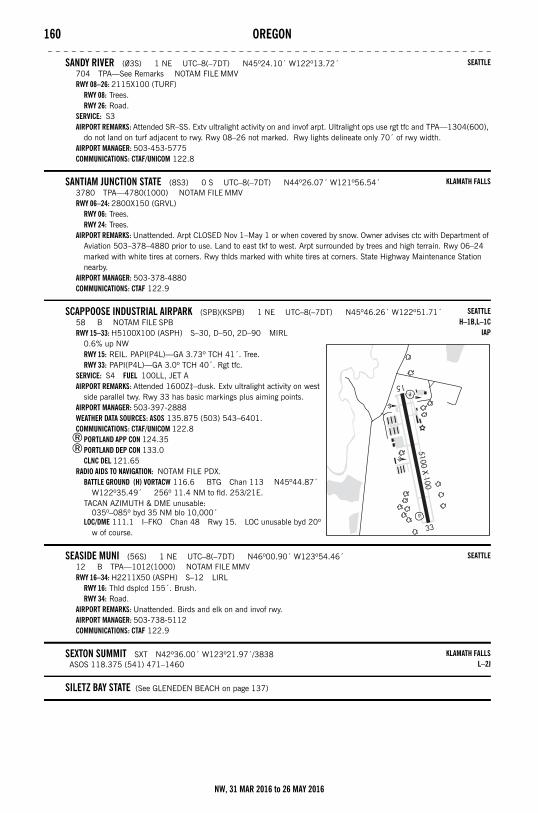
160 OREGON– – – – – – – – – – – – – – – – – – – – – – – – – – – – – – – – – – – – – – – – – – – – – – – – – – – – – – – –
SANDY RIVER (03S) 1 NE UTC–8(–7DT) N45º24.10´ W122º13.72´704 TPA—See Remarks NOTAM FILE MMVRWY 08–26: 2115X100 (TURF)
RWY 08: Trees.RWY 26: Road.
SERVICE: S3 AIRPORT REMARKS: Attended SR–SS. Extv ultralight activity on and invof arpt. Ultralight ops use rgt tfc and TPA—1304(600),
do not land on turf adjacent to rwy. Rwy 08–26 not marked. Rwy lights delineate only 70´ of rwy width.AIRPORT MANAGER: 503-453-5775COMMUNICATIONS: CTAF/UNICOM 122.8
SANTIAM JUNCTION STATE (8S3) 0 S UTC–8(–7DT) N44º26.07´ W121º56.54´3780 TPA—4780(1000) NOTAM FILE MMVRWY 06–24: 2800X150 (GRVL)
RWY 06: Trees.RWY 24: Trees.
AIRPORT REMARKS: Unattended. Arpt CLOSED Nov 1–May 1 or when covered by snow. Owner advises ctc with Department of Aviation 503–378–4880 prior to use. Land to east tkf to west. Arpt surrounded by trees and high terrain. Rwy 06–24 marked with white tires at corners. Rwy thlds marked with white tires at corners. State Highway Maintenance Station nearby.
AIRPORT MANAGER: 503-378-4880COMMUNICATIONS: CTAF 122.9
SCAPPOOSE INDUSTRIAL AIRPARK (SPB)(KSPB) 1 NE UTC–8(–7DT) N45º46.26´ W122º51.71´58 B NOTAM FILE SPBRWY 15–33: H5100X100 (ASPH) S–30, D–50, 2D–90 MIRL
0.6% up NWRWY 15: REIL. PAPI(P4L)—GA 3.73º TCH 41´. Tree.RWY 33: PAPI(P4L)—GA 3.0º TCH 40´. Rgt tfc.
SERVICE: S4 FUEL 100LL, JET A AIRPORT REMARKS: Attended 1600Z‡–dusk. Extv ultralight activity on west
side parallel twy. Rwy 33 has basic markings plus aiming points.AIRPORT MANAGER: 503-397-2888WEATHER DATA SOURCES: ASOS 135.875 (503) 543–6401.COMMUNICATIONS: CTAF/UNICOM 122.8
®PORTLAND APP CON 124.35®PORTLAND DEP CON 133.0
CLNC DEL 121.65RADIO AIDS TO NAVIGATION: NOTAM FILE PDX.
BATTLE GROUND (H) VORTACW 116.6 BTG Chan 113 N45º44.87´ W122º35.49´ 256º 11.4 NM to fld. 253/21E.
TACAN AZIMUTH & DME unusable:035º–085º byd 35 NM blo 10,000´
LOC/DME 111.1 I–FKO Chan 48 Rwy 15. LOC unusable byd 20º w of course.
SEASIDE MUNI (56S) 1 NE UTC–8(–7DT) N46º00.90´ W123º54.46´12 B TPA—1012(1000) NOTAM FILE MMVRWY 16–34: H2211X50 (ASPH) S–12 LIRL
RWY 16: Thld dsplcd 155´. Brush.RWY 34: Road.
AIRPORT REMARKS: Unattended. Birds and elk on and invof rwy.AIRPORT MANAGER: 503-738-5112COMMUNICATIONS: CTAF 122.9
SEXTON SUMMIT SXT N42º36.00´ W123º21.97´/3838ASOS 118.375 (541) 471–1460
SILETZ BAY STATE (See GLENEDEN BEACH on page 137)
SEATTLE
KLAMATH FALLS
SEATTLEH–1B,L–1C
IAP
SEATTLE
KLAMATH FALLSL–2J
NW, 31 MAR 2016 to 26 MAY 2016
OREGON 161
SILVER LAKE F S STRIP (45S) 3 SW UTC–8(–7DT) N43º06.66´ W121º05.65´4492 NOTAM FILE MMVRWY 03–21: 3000X55 (TURF–DIRT)
RWY 03: Fence.RWY 21: Fence.
AIRPORT REMARKS: Unattended. Rwy soft when wet, call 541–576–7520 for current cond. Rwy sfc bumpy when dry. Rwy 03–21 weed growth and sage throughout primary sfc. Rwy 03 outlined with white tires. Rwy 03–21 has fence post at each end of rwy painted orange and white.
AIRPORT MANAGER: 541-219-1439COMMUNICATIONS: CTAF 122.9
SISTERS EAGLE AIR (6K5) 1 N UTC–8(–7DT) N44º18.27´ W121º32.35´3168 TPA—4168(1000) NOTAM FILE MMVRWY 02–20: H3560X60 (ASPH) S–4
RWY 02: Thld dsplcd 340´. Tree.RWY 20: Trees.
SERVICE: FUEL 100LL AIRPORT REMARKS: Unattended. Deer on and invof arpt. Rising terrain off
departure end of Rwy 02. Check density alt/acft performance prior to tkf. Avoid overflights of homes to northeast. Pilots may consider a departure climb over meadow approximately 45º to the left of the departure end of Rwy 02. Rwy 02–20 numbers and centerline smaller than std.
AIRPORT MANAGER: 541-513-8948COMMUNICATIONS: CTAF 122.9RADIO AIDS TO NAVIGATION: NOTAM FILE RDM.
DESCHUTES (H) VORTACW 117.6 DSD Chan 123 N44º15.17´ W121º18.21´ 269º 10.6 NM to fld. 4101/18E. HIWAS.
VORTAC unusable:220º–240º byd 30 NM
SIXESCAPE BLANCO STATE (5S6) 4 NW UTC–8(–7DT) N42º51.48´ W124º31.07´
214 TPA—1214(1000) NOTAM FILE MMVRWY 14–32: H5100X150 (ASPH) S–115, D–185, 2D–340
RWY 14: Trees.RWY 32: Brush.
AIRPORT REMARKS: Unattended.AIRPORT MANAGER: 503-378-4880COMMUNICATIONS: CTAF 122.9
RCO 122.4 (MC MINNVILLE RADIO)RADIO AIDS TO NAVIGATION: NOTAM FILE CEC.
CRESCENT CITY (L) VORTACW 109.0 CEC Chan 27 N41º46.77´ W124º14.45´ 335º 65.8 NM to fld. 53/14E.
TACAN AZIMUTH & DME unusable:195º–235º byd 20 NM
SKYPORT (See CORNELIUS on page 132)
SOUTHWEST OREGON RGNL (See NORTH BEND on page 149)
SPORTSMAN AIRPARK (See NEWBERG on page 147)
STARK'S TWIN OAKS AIRPARK (See HILLSBORO on page 138)
KLAMATH FALLS
KLAMATH FALLSL–1B
KLAMATH FALLSH–1B, L–1A
NW, 31 MAR 2016 to 26 MAY 2016
162 OREGON
SUNRIVER (S21) 1 W UTC–8(–7DT) N43º52.58´ W121º27.18´4163 B TPA—5163(1000) NOTAM FILE MMVRWY 18–36: H5461X75 (ASPH) S–30 LIRL
RWY 18: VASI(V2L)—GA 3.5º TCH 22´. Thld dsplcd 988´. Tree. Rgt tfc.RWY 36: Trees.
SERVICE: FUEL 100LL, JET A, A+ LGT ACTIVATE LIRL Rwy 18–36 and VASI Rwy 18—CTAF.
AIRPORT REMARKS: Attended 1 Apr–15 May 1630–0100Z‡, 16 May–15 Jun 1600–0200Z‡, 16 June–15 Sep 1600–0200Z‡, 16 Sep–15 Oct 1600–0130Z‡, 16 Oct–30 Nov 1600–0100Z‡, 1 Dec–31 Mar 1630–0030Z‡. After hrs fuel call 541–593–4603 for instructions or call after hrs emerg 541–480–1688. Flocks of waterfowl invof arpt. For NS ABTMT departing acft are urged to climb west of arpt prior to turning on course.
AIRPORT MANAGER: 541-593-4603COMMUNICATIONS: CTAF/UNICOM 122.8
RCO 122.3 (MC MINNVILLE RADIO)SEATTLE CENTER APP/DEP CON 128.15
RADIO AIDS TO NAVIGATION: NOTAM FILE RDM.DESCHUTES (H) VORTACW 117.6 DSD Chan 123 N44º15.17´
W121º18.21´ 178º 23.5 NM to fld. 4101/18E. HIWAS.VORTAC unusable:
220º–240º byd 30 NM
THE DALLESCOLUMBIA GORGE RGNL/THE DALLES MUNI (DLS)(KDLS) 2 NE UTC–8(–7DT) N45º37.16´
W121º10.10´247 B NOTAM FILE DLSRWY 13–31: H5097X100 (ASPH) S–30, D–30 MIRL 0.5% up SE
RWY 13: Thld dsplcd 200´. Trees.RWY 31: REIL.
RWY 07–25: H4647X100 (ASPH) S–30, D–30 MIRL 0.7% up ERWY 07: Thld dsplcd 440´. Trees.RWY 25: Thld dsplcd 196´.
SERVICE: S4 FUEL 100LL, JET A1 LGT ACTIVATE MIRL Rwy 13–31, Rwy 07–25 and REIL Rwy 31–CTAF. REIL opr on 7 clicks only.
AIRPORT REMARKS: Attended 1600–0200Z‡. Waterfowl on and inovf arpt. PPR for overweight ldgs. Mountains byd 5000´ apch Rwy 31. Arpt physically located in state of Washington.
AIRPORT MANAGER: 509-767-0005WEATHER DATA SOURCES: ASOS 135.175 (509) 767–1726.COMMUNICATIONS: CTAF/UNICOM 123.0RADIO AIDS TO NAVIGATION: NOTAM FILE DLS.
KLICKITAT (H) VORW/DME 112.3 LTJ Chan 70 N45º42.82´ W121º06.05´ 186º 6.3 NM to fld. 3220/21E. HIWAS.
ILS/DME 109.35 I–DLS Chan 30(Y) Rwy 25. LOC unusable byd 33º rgt of course. Unmonitored.
THE DALLES N45º42.82´ W121º06.06´RCO 122.65 (SEATTLE RADIO)
KLAMATH FALLSH–1B, L–1A, 11A
IAP
SEATTLEH–1B, L–13A
IAP
SEATTLEL–13A
NW, 31 MAR 2016 to 26 MAY 2016
OREGON 163
TILLAMOOK (TMK)(KTMK) 3 S UTC–8(–7DT) N45º25.10´ W123º48.86´39 B NOTAM FILE TMKRWY 13–31: H5001X75 (ASPH) S–60, D–75, 2D–125 MIRL
0.4% up SERWY 13: REIL. PAPI(P2L)—GA 3.0º TCH 42´. Trees.RWY 31: PAPI(P2L)—GA 3.5º TCH 40´. Trees.
RWY 01–19: H2911X75 (ASPH) S–40, D–46, 2D–67 MIRLRWY 01: PAPI(P2L)—GA 4.0º TCH 45´. Fence.RWY 19: PAPI(P2L)—GA 3.0º TCH 40´. Trees. Rgt tfc.
SERVICE: FUEL 100LL, JET A LGT Rwy 13 REIL OTS indef. PAPI Rwy 01, Rwy 13, Rwy 19, and Rwy 31 opr continuously. ACTIVATE MIRL Rwy 01–19 and Rwy 13–31—CTAF.
AIRPORT REMARKS: Attended 1700–0100Z‡. Ultralight acft on and invof arpt. Ocnl flocks of birds on or near arpt. Rwy 01 markings fading and chipping. Rwy 19 markings fading and chipping.
AIRPORT MANAGER: 503-842-2413WEATHER DATA SOURCES: AWOS–3 120.0 (503) 842–8792.COMMUNICATIONS: CTAF/UNICOM 122.8
SEATTLE CENTER APP/DEP CON 124.2RADIO AIDS TO NAVIGATION: NOTAM FILE MMV.
NEWBERG (H) VORW/DME 117.4 UBG Chan 121 N45º21.19´ W122º58.69´ 256º 35.6 NM to fld. 1440/21E. HIWAS.
TOKETEE STATE (See CLEARWATER on page 131)
TOLEDO STATE (5S4) 1 SW UTC–8(–7DT) N44º36.06´ W123º56.38´12 TPA—1012(1000) NOTAM FILE MMVRWY 13–31: H1750X40 (ASPH)
RWY 13: Trees.RWY 31: Trees.
AIRPORT REMARKS: Unattended. Numerous deer and waterfowl invof of arpt. Owner advises ctc with Department of Aviation 503–378–4880 prior to use. Trees in transition area. Curve apch path from over water to avoid obst in transitional areas. Unpaved ramp and twy. Rwy may be under water during high tides. Ocnl driftwood may be on rwy following flooding. +20´ trees in transitional sfc at 50´–75´ from rwy edge.
AIRPORT MANAGER: 503-378-4880COMMUNICATIONS: CTAF 122.9
TURNO N44º50.85´ W122º57.06´ NOTAM FILE SLE.NDB (LOM) 266 SL 312º 4.3 NM to Mcnary Fld. ILS and TURNO COMLO unmonitored when ATCT clsd.
VALEMILLER MEM AIRPARK (S49) 1 SW UTC–7(–6DT) N43º57.83´ W117º15.56´
2249 B NOTAM FILE MMVRWY 18–36: H3872X65 (ASPH) LIRL
RWY 18: Thld dsplcd 880´. Road.RWY 36: Thld dsplcd 125´. Tree.
RWY 10–28: 2100X40 (GRVL)RWY 10: Berm.RWY 28: Tree.
SERVICE: LGT ACTIVATE LIRL Rwy 18–36—CTAF.AIRPORT REMARKS: Unattended. Rwy 18 has a 660´ grvl ovrn. Rwy 36 has very rough grvl extn. Rwy lgtg obscured by
vegetation. AIRPORT MANAGER: 541-473-2530COMMUNICATIONS: CTAF 122.9
VALLEY VIEW (See ESTACADA on page 134)
VANCOUVER N45º41.92´ W122º55.52´RCO 122.35 (SEATTLE RADIO)
SEATTLEH–1B, L–1C
IAP
SEATTLE
SEATTLE
KLAMATH FALLS
SEATTLEL–1C
NW, 31 MAR 2016 to 26 MAY 2016
164 OREGON
VERNONIA MUNI (05S) 2 W UTC–8(–7DT) N45º51.13´ W123º14.57´650 NOTAM FILE MMVRWY 09–27: 2940X45 (TURF)
RWY 09: Trees. Rgt tfc.RWY 27: Hill.
AIRPORT REMARKS: Unattended. Hangars 100´ rgt of cntrln on AER 27. Rwy 09, 4´ fence at rwy end marked by orange pylons. Rwy 27 10´ road 10´ from rwy end.
AIRPORT MANAGER: 503-429-5103COMMUNICATIONS: CTAF 122.9
WAKONDA BEACH STATE (See WALDPORT on page 164)
WALDPORTWAKONDA BEACH STATE (R33) 3 S UTC–8(–7DT) N44º23.07´ W124º05.11´
41 TPA—1041(1000) NOTAM FILE MMVRWY 16–34: 2000X30 (TURF)
RWY 16: Road.RWY 34: Trees.
AIRPORT REMARKS: Unattended. Owner advises ctc Oregon Dept of Aviation 503–378–4880 prior to use. Ldg to the south and tkf to the north not recommended. Rwy sfc may be soft after extv winter rains. Many 10–35´ trees at 30–250´ from rwy end both sides of centerline in apch area. Numerous other 2–6´ trees within 50´ of rwy end both sides of centerline. Rwy 34 curve apch from southwest to avoid high terrain and trees rgt at 800´. Rwy 34 has rising terrain and ditch 7´ wide and 2´ deep at 10´ from thld. Rwy 16 has a road, +30´ trees, and a p–line across the apch path within 50´ of rwy end. 15´ trees at 175´ from Rwy 34 on cntrln. +30´ trees at 70–90´ from rwy along both sides. . Rwy 16–34 white tires mark rwy ends.
AIRPORT MANAGER: 503-378-4880COMMUNICATIONS: CTAF 122.9
WASCO STATE (35S) 1 E UTC–8(–7DT) N45º35.35´ W120º40.44´1503 B TPA—2503(1000) NOTAM FILE MMVRWY 07–25: H3450X60 (ASPH) S–12.5 MIRL 1.5% up ESERVICE: LGT ACTIVATE MIRL Rwy 07–25—CTAF.AIRPORT REMARKS: Unattended. Extv AG sprayer ops, dur spring and
summer. AIRPORT MANAGER: 503-378-4880COMMUNICATIONS: CTAF 122.9RADIO AIDS TO NAVIGATION: NOTAM FILE DLS.
KLICKITAT (H) VORW/DME 112.3 LTJ Chan 70 N45º42.82´ W121º06.05´ 091º 19.5 NM to fld. 3220/21E. HIWAS.
WILDHORSE N43º35.59´ W118º57.30´ NOTAM FILE BNO.(L) VORW/DME 113.8 ILR Chan 85 at Burns Muni. 4146/18E.
SEATTLE
KLAMATH FALLS
SEATTLEL–13A
KLAMATH FALLSL–11A
NW, 31 MAR 2016 to 26 MAY 2016
WASHINGTON 165Washington
ABBOTSFORD (CYXX) 2 SW UTC–8(–7DT) N49º01.52´ W122º21.60´194 B AOE NOTAM FILE CYXX Not insp.RWY 07–25: H9597X200 (ASPH–CONC) HIRL
RWY 07: SSALR. REIL. Rgt tfc.RWY 25: ODALS. REIL. PAPI(P4L)—GA 3.0º. Thld dsplcd 295´.
RWY 01–19: H5328X200 (ASPH) MIRLRWY 01: REIL. PAPI(P4L)—GA 3.0º. Rgt tfc.RWY 19: REIL. PAPI(P4L)—GA 3.0º.
RUNWAY DECLARED DISTANCE INFORMATIONRWY 01: TORA–5328 TODA–6178 ASDA–5328 LDA–5328RWY 07: TORA–9597 TODA–10101 ASDA–9597 LDA–9597RWY 19: TORA–5328 TODA–5854 ASDA–5328 LDA–5328RWY 25: TORA–9597 TODA–10581 ASDA–9695 LDA–9302
SERVICE: S4 FUEL 100LL, JET AAIRPORT REMARKS: Attended continuously. ARFF svc avbl. Turbo–jet, turbo–fan, and turbo–prop not permitted from
0600–1500Z‡. All other ngt trng as authorized by arpt mgr. Parachute area aprx 5 NM NE of arpt. Prior ntc rqrd for cstms (1600–0800Z‡) call 888–226–7277. IFR trng flts PPR ctc 604–775–9674. Helicopter trng on infld. Numerous obst in helicopter trng areas. Oprs ltd winter maintenance 1430–0700Z‡. Other times 2 hrs prior ntc rqrd, call out charge. PPR dur winter maintenance exc scheduled ops, alternate or emerg, CRFI, PLR/PCN. Turf rwy clsd exc with prior permission and agreement plan with arpt mgr. Tall vehicles on road south of thld Rwy 01. Ltd parking and deicing dur winter ops, all wide body acft 24 hr prior ntc ctc ops 604–864–5544. Transit parking rstd to Apron 1. All other parking PPR ctc ops. Apron 1 north of Twy B, including Twy A, ltd to acft with wingspans of 118´ or less. PPR for larger acft. Twy D unctl east of blast fence. Turns from Twy A onto Twy C rstd to C–130 smaller (blast issue). Rwy 01–19 and Twy B not avbl for acft taxiing when RVR below 2600´. Night ops must use PAPI.
COMMUNICATIONS: ATIS 119.8 (1500–0700Z‡) 877–517–2847ABBOTSFORD RADIO (CYXX) on arpt 122.5VICTORIA TERMINAL APP/DEP CON 132.7TOWER 119.4 (inner) 121.0 (outer) (1500–0700Z‡) Mandatory freq 119.4 (0700–1500Z‡ below 4500´ MSL)GND CON 121.8 (1500–0700Z‡)
RADIO AIDS TO NAVIGATION: NOTAM FILE BLI.WHATCOM (H) VORTACW 113.0 HUH Chan 77 N48º56.72´ W122º34.76´ 041º 9.9 NM to fld. 83/20E. HIWAS.TACAN AZM unusable:
155º–165º byd 15 NM blo 6,000´NDB (HW) 344 XX N49°00.93 W122°29.27 068° 4.3 NM to fld. /19E.WHITEROCK NDB (MHW) 332 WC N49°00.20 W122°45.02 067° 14.7 NM to fld. /19E.CULTUS NDB (HW) 214 LU N49°01.27 W122°02.98 252° 12.3 NM to fld.ILS 109.7 I–IXX Rwy 07
COMM/NAV/WEATHER REMARKS: Local call to ABBOTSFORD FSS dial 604–852–2781.
AJ EISENBERG (See OAK HARBOR on page 192)
AMERICAN LAKE SPB (See TACOMA on page 214)
SEATTLEH–1B, L–1E
NW, 31 MAR 2016 to 26 MAY 2016
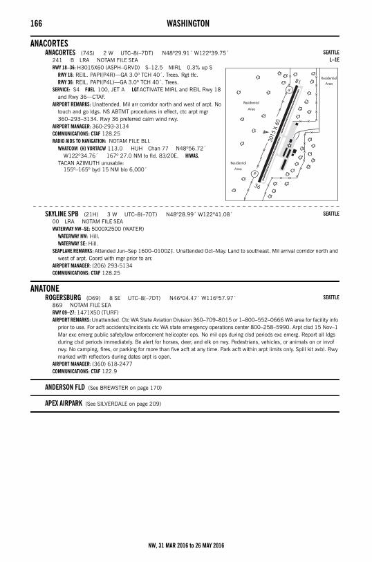
166 WASHINGTON
ANACORTESANACORTES (74S) 2 W UTC–8(–7DT) N48º29.91´ W122º39.75´
241 B LRA NOTAM FILE SEARWY 18–36: H3015X60 (ASPH–GRVD) S–12.5 MIRL 0.3% up S
RWY 18: REIL. PAPI(P4R)—GA 3.0º TCH 40´. Trees. Rgt tfc.RWY 36: REIL. PAPI(P4L)—GA 3.0º TCH 40´. Trees.
SERVICE: S4 FUEL 100, JET A LGT ACTIVATE MIRL and REIL Rwy 18 and Rwy 36—CTAF.
AIRPORT REMARKS: Unattended. Mil arr corridor north and west of arpt. No touch and go ldgs. NS ABTMT procedures in effect, ctc arpt mgr 360–293–3134. Rwy 36 preferred calm wind rwy.
AIRPORT MANAGER: 360-293-3134COMMUNICATIONS: CTAF 128.25RADIO AIDS TO NAVIGATION: NOTAM FILE BLI.
WHATCOM (H) VORTACW 113.0 HUH Chan 77 N48º56.72´ W122º34.76´ 167º 27.0 NM to fld. 83/20E. HIWAS.
TACAN AZIMUTH unusable:155º–165º byd 15 NM blo 6,000´
– – – – – – – – – – – – – – – – – – – – – – – – – – – – – – – – – – – – – – – – – – – – – – – – – – – – – – – –
SKYLINE SPB (21H) 3 W UTC–8(–7DT) N48º28.99´ W122º41.08´00 LRA NOTAM FILE SEAWATERWAY NW–SE: 5000X2500 (WATER)
WATERWAY NW: Hill.WATERWAY SE: Hill.
SEAPLANE REMARKS: Attended Jun–Sep 1600–0100Z‡. Unattended Oct–May. Land to southeast. Mil arrival corridor north and west of arpt. Coord with mgr prior to arr.
AIRPORT MANAGER: (206) 293-5134COMMUNICATIONS: CTAF 128.25
ANATONEROGERSBURG (D69) 8 SE UTC–8(–7DT) N46º04.47´ W116º57.97´
869 NOTAM FILE SEARWY 09–27: 1471X50 (TURF)AIRPORT REMARKS: Unattended. Ctc WA State Aviation Division 360–709–8015 or 1–800–552–0666 WA area for facility info
prior to use. For acft accidents/incidents ctc WA state emergency operations center 800–258–5990. Arpt clsd 15 Nov–1 Mar exc emerg public safety/law enforcement helicopter ops. No mil ops during clsd periods exc emerg. Report all ldgs during clsd periods immediately. Be alert for horses, deer, and elk on rwy. Pedestrians, vehicles, or animals on or invof rwy. No camping, fires, or parking for more than five acft at any time. Park acft within arpt limits only. Spill kit avbl. Rwy marked with reflectors during dates arpt is open.
AIRPORT MANAGER: (360) 618-2477COMMUNICATIONS: CTAF 122.9
ANDERSON FLD (See BREWSTER on page 170)
APEX AIRPARK (See SILVERDALE on page 209)
SEATTLEL–1E
SEATTLE
SEATTLE
NW, 31 MAR 2016 to 26 MAY 2016
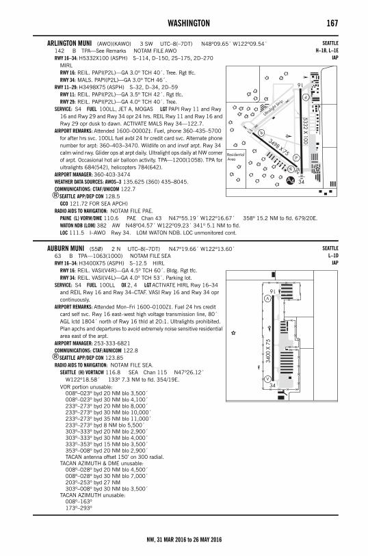
WASHINGTON 167
ARLINGTON MUNI (AWO)(KAWO) 3 SW UTC–8(–7DT) N48º09.65´ W122º09.54´142 B TPA—See Remarks NOTAM FILE AWORWY 16–34: H5332X100 (ASPH) S–114, D–150, 2S–175, 2D–270
MIRLRWY 16: REIL. PAPI(P2L)—GA 3.0º TCH 40´. Tree. Rgt tfc.RWY 34: MALS. PAPI(P2L)—GA 3.0º TCH 46´.
RWY 11–29: H3498X75 (ASPH) S–32, D–34, 2D–59RWY 11: REIL. PAPI(P2L)—GA 3.5º TCH 42´. Rgt tfc.RWY 29: REIL. PAPI(P2L)—GA 4.0º TCH 40´. Tree.
SERVICE: S4 FUEL 100LL, JET A, MOGAS LGT PAPI Rwy 11 and Rwy 16 and Rwy 29 and Rwy 34 opr 24 hrs. REIL Rwy 11 and Rwy 16 and Rwy 29 opr dusk to dawn. ACTIVATE MALS Rwy 34—122.7.
AIRPORT REMARKS: Attended 1600–0000Z‡. Fuel, phone 360–435–5700 for after hrs svc. 100LL fuel avbl 24 hr credit card svc. Alternate phone number for arpt: 360–403–3470. Wildlife on and invof arpt. Rwy 34 calm wind rwy. Glider ops at arpt daily. Ultralight ops daily at NW corner of arpt. Occasional hot air balloon activity. TPA—1200(1058). TPA for ultralights 684(542), helicopters 784(642).
AIRPORT MANAGER: 360-403-3474WEATHER DATA SOURCES: AWOS–3 135.625 (360) 435–8045.COMMUNICATIONS: CTAF/UNICOM 122.7
®SEATTLE APP/DEP CON 128.5GCO 121.72 FOR SEA APCH)
RADIO AIDS TO NAVIGATION: NOTAM FILE PAE.PAINE (L) VORW/DME 110.6 PAE Chan 43 N47º55.19´ W122º16.67´ 358º 15.2 NM to fld. 679/20E.WATON NDB (LOM) 382 AW N48º04.57´ W122º09.23´ 341º 5.1 NM to fld. LOC 111.5 I–AWO Rwy 34. LOM WATON NDB. LOC unmonitored cont.
AUBURN MUNI (S50) 2 N UTC–8(–7DT) N47º19.66´ W122º13.60´63 B TPA—1063(1000) NOTAM FILE SEARWY 16–34: H3400X75 (ASPH) S–12.5 HIRL
RWY 16: REIL. VASI(V4R)—GA 4.5º TCH 60´. Bldg. Rgt tfc.RWY 34: REIL. VASI(V4L)—GA 4.0º TCH 53´. Parking lot.
SERVICE: S4 FUEL 100LL OX 2, 4 LGT ACTIVATE HIRL Rwy 16–34 and REIL Rwy 16 and Rwy 34–CTAF. VASI Rwy 16 and Rwy 34 opr continuously.
AIRPORT REMARKS: Attended Mon–Fri 1600–0100Z‡. Fuel 24 hrs credit card self svc. Rwy 16 east–west high voltage transmission line, 80´ AGL lctd 1804´ north of Rwy 16 thld at 20:1. Ultralights prohibited. Plan apchs and departures to avoid extremely noise sensitive residential area east of the arpt.
AIRPORT MANAGER: 253-333-6821COMMUNICATIONS: CTAF/AUNICOM 122.8
®SEATTLE APP/DEP CON 123.85RADIO AIDS TO NAVIGATION: NOTAM FILE SEA.
SEATTLE (H) VORTACW 116.8 SEA Chan 115 N47º26.12´ W122º18.58´ 133º 7.3 NM to fld. 354/19E.
VOR portion unusable:008º–023º byd 20 NM blo 3,500´008º–023º byd 30 NM blo 4,100´233º–273º byd 20 NM blo 8,000´233º–273º byd 30 NM blo 10,000´233º–273º byd 35 NM blo 11,000´233º–273º byd 8 NM blo 5,500´303º–333º byd 20 NM blo 2,900´303º–333º byd 30 NM blo 4,000´333º–353º byd 15 NM blo 3,500´353º–008º byd 20 NM blo 2,900´TACAN antenna offset 150’ on 300 radial.
TACAN AZIMUTH & DME unusable:008º–028º byd 20 NM blo 4,500´008º–028º byd 30 NM blo 7,000´203º–253º byd 27 NM303º–008º byd 30 NM blo 3,500´
TACAN AZIMUTH unusable:008º–163º173º–293º
SEATTLEH–1B, L–1E
IAP
SEATTLEL–1D
IAP
NW, 31 MAR 2016 to 26 MAY 2016
168 WASHINGTON
AUGSPURGER MOUNTAIN N45º44.06´ W121º40.79´RCO 122.3 (MC MINNVILLE RADIO)
AULT FLD (See WHIDBEY ISLAND NAS (AULT FLD) on page 220)
AVEY FLD (See LAURIER on page 187)
BADGER MOUNTAIN N47º35.29´ W120º08.60´RCO 122.3 (SEATTLE RADIO)
BANDERA STATE (4W0) 0 W UTC–8(–7DT) N47º23.72´ W121º32.19´1636 NOTAM FILE SEARWY 08–26: 2344X100 (TURF)
RWY 08: Trees.RWY 26: Trees.
AIRPORT REMARKS: Unattended. Arpt CLOSED 1 Oct–1 June exc for apvd mil and public safety/law enforcement helicopter ops. Rwy 08–26 west end extremely rough, rwy soft when wet. Vehicles, pedestrians and animals on and invof rwy. Ctc WA State Aviation Division 360–709–8015 or 1–800–552–0666 WA area for facility info prior to use. For acft accidents/incidents ctc WA state emergency operations center 800–258–5990. Rwy marked with reflectors dur dates arpt is open.
AIRPORT MANAGER: (360) 618-2477COMMUNICATIONS: CTAF 122.9
BATTLE GROUNDCEDARS NORTH AIRPARK (W58) 1 NW UTC–8(–7DT) N45º45.87´ W122º30.91´
275 NOTAM FILE SEARWY 08–26: 1960X50 (TURF)
RWY 08: Road.RWY 26: Road.
AIRPORT REMARKS: Unattended. Birds on and invof arpt. Rwy edges marked with white cones.AIRPORT MANAGER: 360-687-1208COMMUNICATIONS: CTAF 122.9
– – – – – – – – – – – – – – – – – – – – – – – – – – – – – – – – – – – – – – – – – – – – – – – – – – – – – – – –
GOHEEN (W52) 3 NW UTC–8(–7DT) N45º49.61´ W122º34.61´292 NOTAM FILE SEARWY 15–33: 2565X50 (TURF) LIRL
RWY 15: VASI(NSTD). Trees.RWY 33: P–line.
RWY 07–25: 1500X48 (TURF)RWY 07: Bldg.RWY 25: Tree.
SERVICE: S4 LGT Rwy 15 NSTD VASI, NSTD single lgt VASI both sides of rwy. ACTIVATE LIRL Rwy 15–33—CTAF.AIRPORT REMARKS: Attended continuously. Rwy 07–25 for emerg only. Rwy 15–33 width of 43´ over culvert in center of fld.
Rwy 15–33 sfc uneven with an incline. AIRPORT MANAGER: 360-687-3038COMMUNICATIONS: CTAF 122.9
BATTLE GROUND N45º44.87´ W122º35.49´ NOTAM FILE PDX.(H) VORTACW 116.6 BTG Chan 113 179º 8.1 NM to Pearson Fld. 253/21E.
TACAN AZIMUTH & DME unusable:035º–085º byd 35 NM blo 10,000´
SEATTLEL–1C
SEATTLEL–1D, 9A
SEATTLE
SEATTLE
SEATTLE
SEATTLEH–1B, L–1C
NW, 31 MAR 2016 to 26 MAY 2016
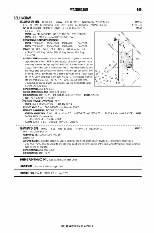
WASHINGTON 169
BELLINGHAMBELLINGHAM INTL (BLI)(KBLI) 3 NW UTC–8(–7DT) N48º47.56´ W122º32.25´
170 B TPA—See Remarks AOE ARFF Index—See Remarks NOTAM FILE BLIRWY 16–34: H6701X150 (ASPH–GRVD) S–75, D–160, 2S–175,
2D–250 HIRLRWY 16: MALSR. PAPI(P4L)—GA 3.0º TCH 50´. RVR–T Rgt tfc.RWY 34: REIL. PAPI(P4L)—GA 3.0º TCH 50´. Tree.
RUNWAY DECLARED DISTANCE INFORMATIONRWY 16: TORA–6701 TODA–6701 ASDA–6701 LDA–6701RWY 34: TORA–6701 TODA–6701 ASDA–6701 LDA–6701
SERVICE: S7 FUEL 100LL, JET A OX 3, 4 LGT When twr clsd ACTIVATE HIRL Rwy 16–34, MALSR Rwy 16 and REIL Rwy 34—CTAF.
AIRPORT REMARKS: Attended continuously. Birds and coyotes on and invof arpt movement areas. PPR for unscheduled air carrier ops with more than 30 pax seats call arpt mgr 360–671–5674. ARFF Index B (24 hrs a day). Twr svc not avbl at Twy A invof Twy G, the south hold area and the runup area due to obstructed vision. Air carrier ops use Twy A, Twy B, Twy E, Twy G, Twy H and Twy D east of Twy A to Twy E , Twy F west of Twy A. Coml ramp clsd to pvt acft. NS ABTMT procedures in effect ctc arpt mgr at 360–671–5674. TPA—1200 (1030) fixed wing, 700(530) helicopter, 2000(1830) turbo. Ldg fee. Flight Notification Service (ADCUS) avbl.
AIRPORT MANAGER: 360-671-5674WEATHER DATA SOURCES: ASOS (360) 671–8688COMMUNICATIONS: CTAF 124.9 ATIS 134.45 360–647–5939 UNICOM 122.95
RCO 122.15 (SEATTLE RADIO)®VICTORIA TERMINAL APP/DEP CON 132.7
TOWER 124.9 (1500–0630Z‡) GND CON 127.4AIRSPACE: CLASS D svc 1500–0630Z‡ other times CLASS E.RADIO AIDS TO NAVIGATION: NOTAM FILE BLI.
WHATCOM (H) VORTACW 113.0 HUH Chan 77 N48º56.72´ W122º34.76´ 150º 9.3 NM to fld. 83/20E. HIWAS.TACAN AZIMUTH unusable:
155º–165º byd 15 NM blo 6,000´ILS/DME 108.5 I–BLI Chan 22 Rwy 16. Class IA.
– – – – – – – – – – – – – – – – – – – – – – – – – – – – – – – – – – – – – – – – – – – – – – – – – – – – – – –
FLOATHAVEN SPB (0W7) 6 SE UTC–8(–7DT) N48º44.14´ W122º20.40´307 NOTAM FILE SEAWATERWAY 12–30: 10000X4000 (WATER)SERVICE: S4 SEAPLANE REMARKS: Attended dalgt hrs. Canoe, sailboat, and hang glider activity invof arpt. For airframe repairs call
206–909–7299 prior to arrival to arrange svcs. Land and tkf in the center of the lake. Avoid flying over noise sensitive area during tkf and ldg.
AIRPORT MANAGER: 206-909-7299COMMUNICATIONS: CTAF 122.9
BOEING FLD/KING CO INTL (See SEATTLE on page 205)
BOWERMAN (See HOQUIAM on page 184)
BOWERS FLD (See ELLENSBURG on page 178)
SEATTLEH–1B, L–1E
IAP, AD
SEATTLE
NW, 31 MAR 2016 to 26 MAY 2016
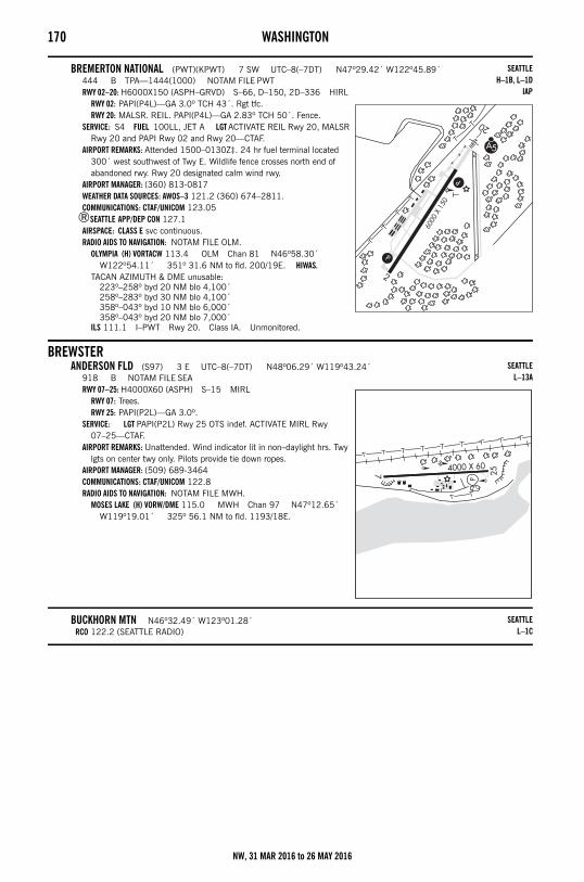
170 WASHINGTON
BREMERTON NATIONAL (PWT)(KPWT) 7 SW UTC–8(–7DT) N47º29.42´ W122º45.89´444 B TPA—1444(1000) NOTAM FILE PWTRWY 02–20: H6000X150 (ASPH–GRVD) S–66, D–150, 2D–336 HIRL
RWY 02: PAPI(P4L)—GA 3.0º TCH 43´. Rgt tfc.RWY 20: MALSR. REIL. PAPI(P4L)—GA 2.83º TCH 50´. Fence.
SERVICE: S4 FUEL 100LL, JET A LGT ACTIVATE REIL Rwy 20, MALSR Rwy 20 and PAPI Rwy 02 and Rwy 20—CTAF.
AIRPORT REMARKS: Attended 1500–0130Z‡. 24 hr fuel terminal located 300´ west southwest of Twy E. Wildlife fence crosses north end of abandoned rwy. Rwy 20 designated calm wind rwy.
AIRPORT MANAGER: (360) 813-0817WEATHER DATA SOURCES: AWOS–3 121.2 (360) 674–2811.COMMUNICATIONS: CTAF/UNICOM 123.05
®SEATTLE APP/DEP CON 127.1AIRSPACE: CLASS E svc continuous. RADIO AIDS TO NAVIGATION: NOTAM FILE OLM.
OLYMPIA (H) VORTACW 113.4 OLM Chan 81 N46º58.30´ W122º54.11´ 351º 31.6 NM to fld. 200/19E. HIWAS.
TACAN AZIMUTH & DME unusable:223º–258º byd 20 NM blo 4,100´258º–283º byd 30 NM blo 4,100´358º–043º byd 10 NM blo 6,000´358º–043º byd 20 NM blo 7,000´
ILS 111.1 I–PWT Rwy 20. Class IA. Unmonitored.
BREWSTERANDERSON FLD (S97) 3 E UTC–8(–7DT) N48º06.29´ W119º43.24´
918 B NOTAM FILE SEARWY 07–25: H4000X60 (ASPH) S–15 MIRL
RWY 07: Trees.RWY 25: PAPI(P2L)—GA 3.0º.
SERVICE: LGT PAPI(P2L) Rwy 25 OTS indef. ACTIVATE MIRL Rwy 07–25—CTAF.
AIRPORT REMARKS: Unattended. Wind indicator lit in non–daylight hrs. Twy lgts on center twy only. Pilots provide tie down ropes.
AIRPORT MANAGER: (509) 689-3464COMMUNICATIONS: CTAF/UNICOM 122.8RADIO AIDS TO NAVIGATION: NOTAM FILE MWH.
MOSES LAKE (H) VORW/DME 115.0 MWH Chan 97 N47º12.65´ W119º19.01´ 325º 56.1 NM to fld. 1193/18E.
BUCKHORN MTN N46º32.49´ W123º01.28´RCO 122.2 (SEATTLE RADIO)
SEATTLEH–1B, L–1D
IAP
SEATTLEL–13A
SEATTLEL–1C
NW, 31 MAR 2016 to 26 MAY 2016
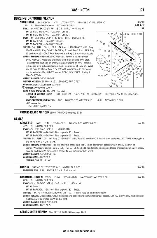
WASHINGTON 171
BURLINGTON/MOUNT VERNONSKAGIT RGNL (BVS)(KBVS) 3 W UTC–8(–7DT) N48º28.23´ W122º25.30´
145 B TPA—See Remarks NOTAM FILE BVSRWY 11–29: H5478X100 (ASPH) S–19 MIRL 0.8% up W
RWY 11: REIL. PAPI(P4L)—GA 3.0º TCH 43´.RWY 29: REIL. PAPI(P4L)—GA 3.0º TCH 42´.
RWY 04–22: H3000X60 (ASPH) S–12.5 LIRL 0.3% up NERWY 04: PAPI(P2L)—GA 4.0º TCH 43´.RWY 22: PAPI(P2L)—GA 3.0º TCH 44´.
SERVICE: S4 FUEL 100LL, JET A OX 3, 4 LGT ACTIVATE MIRL Rwy 11–29 and LIRL Rwy 04–22, PAPI Rwy 11 and Rwy 29 and REIL Rwy 11 and Rwy 29—CTAF. PAPI Rwy 04 and Rwy 22 opr continuously.
AIRPORT REMARKS: Attended 1500–0300Z‡. Terminal building open 1400–0600Z‡. Migratory waterfowl and birds on and invof arpt. Helicopter training ops on arpt with autorotations on rwy. Possible turbulence invof exhaust stacks 3,500´ southwest of Rwy 04, avoid low alt over flt. Use of Twy B by acft with wingspan 49´ or greater prohibited when Rwy 04–22 in use. TPA–1145(1000) Ultralight TPA–645(500).
AIRPORT MANAGER: 360-757-0011WEATHER DATA SOURCES: AWOS–3 121.125 (360) 757–7767.COMMUNICATIONS: CTAF/UNICOM 123.075
®WHIDBEY APP/DEP CON 120.7RADIO AIDS TO NAVIGATION: NOTAM FILE SEA.
TATOOSH (H) VORTACW 112.2 TOU Chan 59 N48º17.99´ W124º37.62´ 061º 88.8 NM to fld. 1650/22E. HIWAS.
SKAGIT/BAY VIEW NDB (MHW) 240 BVS N48º28.12´ W122º25.10´ at fld. NOTAM FILE BVS.NDB unusable:
350º–030º byd 20 NM
CAMANO ISLAND AIRFIELD (See STANWOOD on page 212)
CAMASGROVE FLD (1W1) 3 N UTC–8(–7DT) N45º37.67´ W122º24.26´
429 B NOTAM FILE SEARWY 07–25: H2710X40 (ASPH) MIRL(NSTD)
RWY 07: PAPI(P2L)—GA 5.0º. Thld dsplcd 493´. Trees.RWY 25: PAPI(P2L)—GA 5.0º. Thld dsplcd 413´. Trees.
SERVICE: S4 FUEL 100 LGT Rwy 07–25 NSTD MIRL Rwy 07 and Rwy 25 dsplcd thlds unlighted. ACTIVATE rotating bcn and MIRL Rwy 07–25—CTAF.
AIRPORT REMARKS: Unattended. For fuel after hrs credit card lock. Noise abatement procedures in effect, ctc Port of Camas–Washougal at 360–835–2196. Rwy 07–25 has buildings, telephone poles and trees encroaching in safety areas. Rwy 07 and Rwy 25 have 4 thld stripes falsely indicating 60´ width.
AIRPORT MANAGER: 360-835-2196COMMUNICATIONS: CTAF 122.9
PORTLAND CLNC DEL 121.65
CANYON N47º40.62´ W117º27.01´ NOTAM FILE GEG.NDB (MHW) 388 CRK 205º 4.9 NM to Spokane Intl.
CASHMERE–DRYDEN (8S2) 2 SW UTC–8(–7DT) N47º30.88´ W120º29.08´858 B NOTAM FILE SEARWY 07–25: H1800X50 (ASPH) S–8 MIRL 1.4% up W
RWY 07: Trees.RWY 25: PAPI(P2L)—GA 3.0º. Thld dsplcd 182´. Trees.
SERVICE: LGT ACTIVATE MIRL Rwy 07–25—121.7. PAPI Rwy 25 on continuously.AIRPORT REMARKS: Unattended. Ground vehicles and pedestrians use twy for hangar access. Exit rwy at twys only. Radio control
model activity permitted on W end of arpt. AIRPORT MANAGER: (509) 782-3321COMMUNICATIONS: CTAF 122.9
CEDARS NORTH AIRPARK (See BATTLE GROUND on page 168)
SEATTLEH–1B, L–1E
IAP
SEATTLE
SEATTLE
SEATTLE
NW, 31 MAR 2016 to 26 MAY 2016
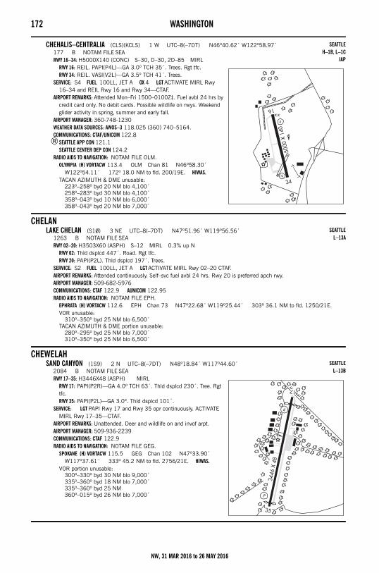
172 WASHINGTON
CHEHALIS–CENTRALIA (CLS)(KCLS) 1 W UTC–8(–7DT) N46º40.62´ W122º58.97´177 B NOTAM FILE SEARWY 16–34: H5000X140 (CONC) S–30, D–30, 2D–85 MIRL
RWY 16: REIL. PAPI(P4L)—GA 3.0º TCH 35´. Trees. Rgt tfc.RWY 34: REIL. VASI(V2L)—GA 3.5º TCH 41´. Trees.
SERVICE: S4 FUEL 100LL, JET A OX 4 LGT ACTIVATE MIRL Rwy 16–34 and REIL Rwy 16 and Rwy 34—CTAF.
AIRPORT REMARKS: Attended Mon–Fri 1500–0100Z‡. Fuel avbl 24 hrs by credit card only. No debit cards. Possible wildlife on rwys. Weekend glider activity in spring, summer and early fall.
AIRPORT MANAGER: 360-748-1230WEATHER DATA SOURCES: AWOS–3 118.025 (360) 740–5164.COMMUNICATIONS: CTAF/UNICOM 122.8
®SEATTLE APP CON 121.1SEATTLE CENTER DEP CON 124.2
RADIO AIDS TO NAVIGATION: NOTAM FILE OLM.OLYMPIA (H) VORTACW 113.4 OLM Chan 81 N46º58.30´
W122º54.11´ 172º 18.0 NM to fld. 200/19E. HIWAS.TACAN AZIMUTH & DME unusable:
223º–258º byd 20 NM blo 4,100´258º–283º byd 30 NM blo 4,100´358º–043º byd 10 NM blo 6,000´358º–043º byd 20 NM blo 7,000´
CHELANLAKE CHELAN (S10) 3 NE UTC–8(–7DT) N47º51.96´ W119º56.56´
1263 B NOTAM FILE SEARWY 02–20: H3503X60 (ASPH) S–12 MIRL 0.3% up N
RWY 02: Thld dsplcd 447´. Road. Rgt tfc.RWY 20: PAPI(P2L). Thld dsplcd 197´. Trees.
SERVICE: S2 FUEL 100LL, JET A LGT ACTIVATE MIRL Rwy 02–20 CTAF.AIRPORT REMARKS: Attended continuously. Self–svc fuel avbl 24 hrs. Rwy 20 is preferred apch rwy. AIRPORT MANAGER: 509-682-5976COMMUNICATIONS: CTAF 122.9 AUNICOM 122.95RADIO AIDS TO NAVIGATION: NOTAM FILE EPH.
EPHRATA (H) VORTACW 112.6 EPH Chan 73 N47º22.68´ W119º25.44´ 303º 36.1 NM to fld. 1250/21E.VOR unusable:
310º–350º byd 25 NM blo 6,500´TACAN AZIMUTH & DME portion unusable:
280º–295º byd 25 NM blo 7,000´310º–350º byd 25 NM blo 6,500´
CHEWELAHSAND CANYON (1S9) 2 N UTC–8(–7DT) N48º18.84´ W117º44.60´
2084 B NOTAM FILE SEARWY 17–35: H3446X48 (ASPH) MIRL
RWY 17: PAPI(P2R)—GA 4.0º TCH 63´. Thld dsplcd 230´. Tree. Rgt tfc.RWY 35: PAPI(P2L)—GA 3.0º. Thld dsplcd 101´.
SERVICE: LGT PAPI Rwy 17 and Rwy 35 opr continuously. ACTIVATE MIRL Rwy 17–35—CTAF.
AIRPORT REMARKS: Unattended. Deer and wildlife on and invof arpt. AIRPORT MANAGER: 509-936-2239COMMUNICATIONS: CTAF 122.9RADIO AIDS TO NAVIGATION: NOTAM FILE GEG.
SPOKANE (H) VORTACW 115.5 GEG Chan 102 N47º33.90´ W117º37.61´ 333º 45.2 NM to fld. 2756/21E. HIWAS.
VOR portion unusable:300º–330º byd 30 NM blo 9,000´335º–360º byd 18 NM blo 7,000´335º–360º byd 25 NM360º–015º byd 26 NM blo 7,000´
SEATTLEH–1B, L–1C
IAP
SEATTLEL–13A
SEATTLEL–13B
NW, 31 MAR 2016 to 26 MAY 2016
WASHINGTON 173
CLAYTONCROSS WINDS (C72) 2 SE UTC–8(–7DT) N47º58.99´ W117º32.56´
2150 TPA—See Remarks NOTAM FILE SEARWY 13L–31R: 3800X125 (TURF)
RWY 13L: P–line.RWY 31R: Thld dsplcd 170´. Road. Rgt tfc.
RWY 13R–31L: 2065X50 (TURF)RWY 13R: Fence. Rgt tfc.RWY 31L: Road.
AIRPORT REMARKS: Unattended. Arpt CLOSED winters, open only to ski equipped acft. Use care during high wind due to turbulence and crosswind. Mole holes on rwys. Rwy 13L–31R and Rwy 13R–31L not useable during heavy snow and spring mud. Radio controlled model acft on and invof arpt. Rwy 13L–31R and Rwy 13R–31L rough with tall grass. Rwy 13R–31L grass is over 3´ tall full length of rwy. Rwy 13L–31R edges marked with red tfc cones, Rwy 13R–31L ultralight rwy. Ultralight tfc on arpt. TPA—3150 (1000), Ultralight—2650 (500).
AIRPORT MANAGER: 509-276-2552COMMUNICATIONS: CTAF 122.9
CLE ELUMCLE ELUM MUNI (S93) 1 E UTC–8(–7DT) N47º11.66´ W120º53.01´
1944 B TPA—2944(1000) NOTAM FILE SEARWY 07–25: H2552X60 (ASPH) MIRL
RWY 07: REIL. PAPI(P2L)—GA 4.0º TCH 20´. Rgt tfc.RWY 25: REIL. PAPI(P2L)—GA 4.0º TCH 20´.
SERVICE: LGT PAPI Rwy 07 and Rwy 25 opr continuously. ACTIVATE rotating bcn, MIRL Rwy 07–25 and REIL Rwy 07 and Rwy 25—CTAF.
AIRPORT REMARKS: Unattended. Wildlife on and invof rwy. Gliders use CTAF freq 122.3. AIRPORT MANAGER: 509-674-2262COMMUNICATIONS: CTAF 122.9
– – – – – – – – – – – – – – – – – – – – – – – – – – – – – – – – – – – – – – – – – – – – – – – – – – – – – – –
DE VERE FLD (2W1) 3 E UTC–8(–7DT) N47º10.65´ W120º51.16´1800 NOTAM FILE SEARWY 08–26: H2055X30 (ASPH) LIRL(NSTD)
RWY 08: Trees. Rgt tfc.RWY 26: Trees.
SERVICE: LGT For LIRL Rwy 08–26 call 509–304–6231. Rwy 08–26 NSTD LIRL— thld lgts 360º green.AIRPORT REMARKS: Attended dalgt hrs. Fld occasionally CLOSED in winter. Wildlife on and invof rwy. Rwy 08–26 has 2" dropoff
along entire rwy both sides. AIRPORT MANAGER: 509-304-6231COMMUNICATIONS: CTAF 122.9
COLFAXLOWER GRANITE STATE (00W) 12 S UTC–8(–7DT) N46º40.37´ W117º26.50´
719 NOTAM FILE SEARWY 14–32: 3400X50 (GRVL) 0.9% up SE
RWY 14: Trees.RWY 32: Hill.
AIRPORT REMARKS: Unattended. Do not land if snow present on rwy. No winter snow removal ops. Ctc WA State Aviation Division 360–709–8015 or 1–800–552–0666 WA area for facility info prior to use. For acft accidents/incidents ctc WA state emergency operations center 800–258–5990. Pedestrians, vehicles and animals on and invof rwy. P–lines west and north, portions of rwy sfc rough and soft. Rwy marked with reflectors dur dates arpt is open.
AIRPORT MANAGER: (360) 618-2477COMMUNICATIONS: CTAF 122.9
– – – – – – – – – – – – – – – – – – – – – – – – – – – – – – – – – – – – – – – – – – – – – – – – – – – – – – –
SEATTLE
SEATTLE
SEATTLE
SEATTLE
NW, 31 MAR 2016 to 26 MAY 2016
174 WASHINGTON– – – – – – – – – – – – – – – – – – – – – – – – – – – – – – – – – – – – – – – – – – – – – – – – – – – – – – – –
PORT OF WHITMAN BUSINESS AIR CENTER (S94) 3 SW UTC–8(–7DT) N46º51.52´ W117º24.84´2181 B TPA—3010(829) NOTAM FILE SEARWY 08–26: H3209X60 (ASPH) S–17 MIRL 1.0% up E
RWY 08: Thld dsplcd 492´. Road.RWY 26: Thld dsplcd 450´. Hill.
RUNWAY DECLARED DISTANCE INFORMATIONRWY 08: TORA–3209 TODA–3209 ASDA–3209 LDA–2718RWY 26: TORA–3209 TODA–3209 ASDA–3209 LDA–2890
SERVICE: FUEL 100LL LGT ACTIVATE MIRL Rwy 08–26—CTAF.AIRPORT REMARKS: Attended May–Sept dawn–dusk, Oct–Apr, Mon–Fri dawn–dusk. 100LL fuel avbl for emerg, call
509–397–3791. Deer invof rwy. Watch for birds invof creek south of arpt. Rwy 08–26 farm machinery may be opr in flds on both sides of rwy and off both rwy ends. 30´ bldg 250´ south AER 26.
AIRPORT MANAGER: 509-397-2061COMMUNICATIONS: CTAF/UNICOM 122.8RADIO AIDS TO NAVIGATION: NOTAM FILE PUW.
PULLMAN (L) VORW/DME 109.0 PUW Chan 27 N46º40.45´ W117º13.41´ 305º 13.6 NM to fld. 2772/20E. HIWAS. DME unmonitored.
COLLEGE PLACEMARTIN FLD (S95) 1 W UTC–8(–7DT) N46º02.82´ W118º25.03´
746 NOTAM FILE SEARWY 05–23: H3819X60 (ASPH) S–12 LIRL(NSTD)
RWY 05: VASI(V2L).RWY 23: VASI(V2R). Road.
SERVICE: S2 FUEL 100LL, MOGAS LGT Rwy 05–23 NSTD LIRL southwest 1240´ medium ints. Arpt lgtg opr from dusk until 1000Z‡. ACTIVATE NSTD LIRL Rwy 05–23 and VASI Rwy 05 and Rwy 23—CTAF.
AIRPORT REMARKS: Attended Mon–Fri 1600–0100Z‡. Attended evenings and Sat–Sun as rqrd, on call 509–522–1847. 24 hr self svc credit card fueling facility. Overnight parking fee of $3.00. Pvt road crosses 700´ from southwest end of rwy. Ldg fee.
AIRPORT MANAGER: 509-522-1847COMMUNICATIONS: CTAF/UNICOM 122.8RADIO AIDS TO NAVIGATION: NOTAM FILE ALW.
WALLA WALLA (L) VORW/DME 116.4 ALW Chan 111 N46º05.22´ W118º17.55´ 225º 5.7 NM to fld. 1179/20E.VOR/DME unusable:
010º–065º byd 31 NM blo 12,500´065º–095º byd 20 NM blo 14,500´095º–140º byd 20 NM blo 13,500´
DME portion unusable:140º–145º byd 20 NM blo 11,500´
COLVILLE MUNI (63S) 1 E UTC–8(–7DT) N48º32.63´ W117º53.03´1882 B NOTAM FILE SEARWY 01–19: H2695X40 (ASPH) S–11 MIRL
RWY 01: PAPI(P2L)—GA 4.0º.RWY 19: Thld dsplcd 255´. Fence.
SERVICE: S4 FUEL 100LL LGT ACTIVATE MIRL Rwy 01–19—CTAF.AIRPORT REMARKS: Attended Mon–Fri 1600–0100Z‡. Watch for deer on and invof arpt. When ldg Rwy 19, bright lgts around
high school stadium, aprx 3/4 miles south of arpt. Ocnl vehicular tfc across end of Rwy 01–19 and twy. Grass ldg area avbl across Rwy 01–19 1500´X150´. Hazards are 50´ obst on both ends, trees/poles. Car avbl.
AIRPORT MANAGER: 509-685-9056COMMUNICATIONS: CTAF/UNICOM 122.8
CONCRETEMEARS FLD (3W5) 1 S UTC–8(–7DT) N48º31.79´ W121º45.49´
267 NOTAM FILE SEARWY 07–25: H2609X60 (ASPH) S–12
RWY 07: Trees. Rgt tfc.RWY 25: Trees.
SERVICE: FUEL 100LL AIRPORT REMARKS: Unattended. Elk and deer freq both rwy ends and mid–fld. All patterns south of arpt.AIRPORT MANAGER: 360-853-7114COMMUNICATIONS: CTAF 122.9
• • • • • • • • • • • • • • • • • •
HELIPAD H1: H40X40 (CONC)HELIPORT REMARKS: Helipad for emerg use only.
SEATTLEL–13B
SEATTLEL–13A
SEATTLE
SEATTLE
NW, 31 MAR 2016 to 26 MAY 2016
WASHINGTON 175
COPALIS STATE (S16) 2 NW UTC–8(–7DT) N47º08.68´ W124º11.34´1 NOTAM FILE SEARWY 14–32: 3560X150 (SAND)
RWY 14: Rgt tfc.AIRPORT REMARKS: Unattended. Arpt CLOSED to vehicles Apr 15 thru the day after Labor Day. Ctc WA State Aviation Division
360–709–8015 or 1–800–552–0666 WA area for facility info prior to use. For acft accidents/incidents ctc WA state emergency operations center 800–258–5990. Vehicles, pedestrians and animals on and invof rwy. River course change may alter rwy length. Stream crossing 1500´ south of Rwy 14 end.
AIRPORT MANAGER: (360) 618-2477COMMUNICATIONS: CTAF 122.9
CREST AIRPARK (See KENT on page 186)
CROSS WINDS (See CLAYTON on page 173)
DARRINGTON MUNI (1S2) 0 N UTC–8(–7DT) N48º15.52´ W121º36.61´553 B NOTAM FILE SEARWY 10–28: H2491X40 (ASPH) MIRL
RWY 10: Fence.RWY 28: Road.
SERVICE: LGT MIRL Rwy 10–28 OTS indef. ACTIVATE MIRL Rwy 10–28—CTAF.AIRPORT REMARKS: Unattended. CLOSED when snow on rwy. Rwy 28 has no markings. Rwy 10 has small numbers only.
Turbulence on hot days ldg west btn rows of trees. Twys marked with blue reflectors. AIRPORT MANAGER: 360-436-1454COMMUNICATIONS: CTAF 122.9
DAVENPORT (68S) 1 W UTC–8(–7DT) N47º39.21´ W118º10.13´2421 B NOTAM FILE SEARWY 05–23: H2747X50 (ASPH) MIRL
RWY 23: Trees. Rgt tfc.RWY 03–21: 2271X45 (GRVL)
RWY 03: Trees.RWY 21: Trees. Rgt tfc.
SERVICE: FUEL 100LL AIRPORT REMARKS: Attended Mar–Jun dawn–dusk, Jul–Feb Mon–Fri on call. Fuel 24 hr credit card svc avbl. Rwy 03–21 very
soft in spring. Rwy 03–21 not marked.AIRPORT MANAGER: 509-725-4352COMMUNICATIONS: CTAF 122.9
DE VERE FLD (See CLE ELUM on page 173)
SEATTLE
SEATTLE
SEATTLE
NW, 31 MAR 2016 to 26 MAY 2016
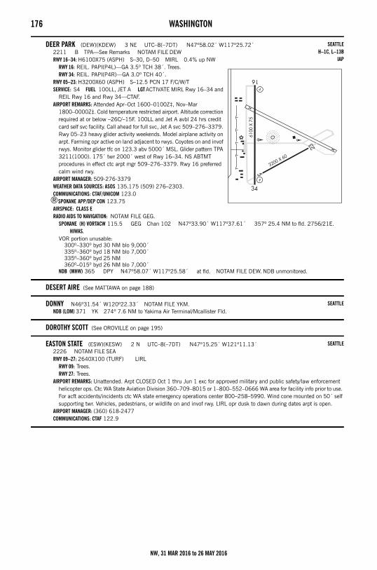
176 WASHINGTON
DEER PARK (DEW)(KDEW) 3 NE UTC–8(–7DT) N47º58.02´ W117º25.72´2211 B TPA—See Remarks NOTAM FILE DEWRWY 16–34: H6100X75 (ASPH) S–30, D–50 MIRL 0.4% up NW
RWY 16: REIL. PAPI(P4L)—GA 3.5º TCH 38´. Trees.RWY 34: REIL. PAPI(P4R)—GA 3.0º TCH 40´.
RWY 05–23: H3200X60 (ASPH) S–12.5 PCN 17 F/C/W/TSERVICE: S4 FUEL 100LL, JET A LGT ACTIVATE MIRL Rwy 16–34 and
REIL Rwy 16 and Rwy 34—CTAF.AIRPORT REMARKS: Attended Apr–Oct 1600–0100Z‡, Nov–Mar
1800–0000Z‡. Cold temperature restricted airport. Altitude correction required at or below –26C/–15F. 100LL and Jet A avbl 24 hrs credit card self svc facility. Call ahead for full svc, Jet A svc 509–276–3379. Rwy 05–23 heavy glider activity weekends. Model airplane activity on arpt. Farming opr active on land adjacent to rwys. Coyotes on and invof rwys. Monitor glider tfc on 123.3 abv 5000´ MSL. Glider pattern TPA 3211(1000). 175´ twr 2000´ west of Rwy 16–34. NS ABTMT procedures in effect ctc arpt mgr 509–276–3379. Rwy 16 preferred calm wind rwy.
AIRPORT MANAGER: 509-276-3379WEATHER DATA SOURCES: ASOS 135.175 (509) 276–2303.COMMUNICATIONS: CTAF/UNICOM 123.0
®SPOKANE APP/DEP CON 123.75AIRSPACE: CLASS ERADIO AIDS TO NAVIGATION: NOTAM FILE GEG.
SPOKANE (H) VORTACW 115.5 GEG Chan 102 N47º33.90´ W117º37.61´ 357º 25.4 NM to fld. 2756/21E. HIWAS.
VOR portion unusable:300º–330º byd 30 NM blo 9,000´335º–360º byd 18 NM blo 7,000´335º–360º byd 25 NM360º–015º byd 26 NM blo 7,000´
NDB (MHW) 365 DPY N47º58.07´ W117º25.58´ at fld. NOTAM FILE DEW. NDB unmonitored.
DESERT AIRE (See MATTAWA on page 188)
DONNY N46º31.54´ W120º22.33´ NOTAM FILE YKM.NDB (LOM) 371 YK 274º 7.6 NM to Yakima Air Terminal/Mcallister Fld.
DOROTHY SCOTT (See OROVILLE on page 195)
EASTON STATE (ESW)(KESW) 2 N UTC–8(–7DT) N47º15.25´ W121º11.13´2226 NOTAM FILE SEARWY 09–27: 2640X100 (TURF) LIRL
RWY 09: Trees.RWY 27: Trees.
AIRPORT REMARKS: Unattended. Arpt CLOSED Oct 1 thru Jun 1 exc for approved military and public safety/law enforcement helicopter ops. Ctc WA State Aviation Division 360–709–8015 or 1–800–552–0666 WA area for facility info prior to use. For acft accidents/incidents ctc WA state emergency operations center 800–258–5990. Wind cone mounted on 50´ self supporting twr. Vehicles, pedestrians, or wildlife on and invof rwy. LIRL opr dusk to dawn during dates arpt is open.
AIRPORT MANAGER: (360) 618-2477COMMUNICATIONS: CTAF 122.9
SEATTLEH–1C, L–13B
IAP
SEATTLE
SEATTLE
NW, 31 MAR 2016 to 26 MAY 2016
WASHINGTON 177
EASTSOUNDORCAS ISLAND (ORS)(KORS) 1 N UTC–8(–7DT) N48º42.50´ W122º54.64´
35 B TPA—1035(1000) NOTAM FILE ORSRWY 16–34: H2901X60 (ASPH–AFSC) S–12.5 MIRL 0.8% up S
RWY 16: REIL. VASI(V4L)—GA 3.6º TCH 37´. Road.RWY 34: REIL. PAPI(P2L)—GA 4.0º TCH 26´. Trees. Rgt tfc.
SERVICE: S3 FUEL 100LL LGT ACTIVATE MIRL Rwy 16–34, VASI Rwy 16, REIL Rwy 16 and Rwy 34 and twy lgts—128.25.
AIRPORT REMARKS: Attended 1600–0030Z‡. Self svc 24 hr fuel avbl with credit card. Deer on and invof rwy. NS ABTMT procedures in effect, ctc arpt manager 360–376–5285. Nighttime circling apchs not permitted from west side of rwy. Additional tran turf tiedowns south of segmented circle. PAPI baffled west of centerline, lateral coverage has been narrowed to avoid obstacles, during decent close alignment to rwy centerline is necessary.
AIRPORT MANAGER: 360-376-5285WEATHER DATA SOURCES: AWOS–3 135.425 (360) 376–6045.COMMUNICATIONS: CTAF 128.25
MT CONSTITUTION RCO 122.3 (SEATTLE RADIO)VICTORIA APP/DEP CON132.7 (ARR and DEP to the North)WHIDBEY APP/DEP CON 118.2 (ARR and DEP to the South)
RADIO AIDS TO NAVIGATION: NOTAM FILE BLI.WHATCOM (H) VORTACW 113.0 HUH Chan 77 N48º56.72´ W122º34.76´ 203º 19.4 NM to fld. 83/20E.
HIWAS.TACAN AZIMUTH unusable:
155º–165º byd 15 NM blo 6,000´COMM/NAV/WEATHER REMARKS: AWOS–3 wind sensor is sheltered by trees and rising terrain to east/southeast and may provide
erroneous data with strong winds aloft from the northeast, east or southeast.
EATONVILLESWANSON (2W3) 1 NE UTC–8(–7DT) N46º52.30´ W122º15.43´
843 TPA—1643(800) NOTAM FILE SEARWY 16–34: H2990X36 (ASPH) MIRL
RWY 16: Trees. Rgt tfc.RWY 34: Ground.
SERVICE: LGT Arpt lgts opr dusk–0800Z‡. After 0800Z‡, ACTIVATE MIRL Rwy 16–34—CTAF.AIRPORT REMARKS: Attended 1600–0400Z‡. Deer on and in vicinity of arpt. Bldgs are in close proximity to rwy. Gravel svc road
around Rwy 16–34 not avbl for acft ops. Taxi on rwy. Rwy 16–34 trees in apch and transitional sfcs both sides of rwy. AIRPORT MANAGER: (253) 691-6654COMMUNICATIONS: CTAF 122.9
ED CARLSON MEM FLD – SOUTH LEWIS CO (See TOLEDO on page 215)
EDIZ HOOK N48º08.39´ W123º24.20´ NOTAM FILE SEA.NDB (MHW) 338 K at Port Angeles CGAS.
NDB unusable:120º–190º byd 10 NM190º–120º byd 15 NM
SEATTLEL–1E
IAP
SEATTLE
SEATTLEL–1E
NW, 31 MAR 2016 to 26 MAY 2016
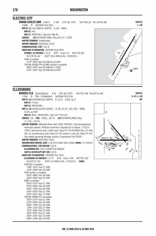
178 WASHINGTON
ELECTRIC CITYGRAND COULEE DAM (3W7) 2 SW UTC–8(–7DT) N47º55.32´ W119º04.98´
1588 B NOTAM FILE SEARWY 03–21: H4199X75 (ASPH) S–26 MIRL
RWY 03: Hill.RWY 21: PAPI(P2L). Ground. Rgt tfc.
SERVICE: LGT ACTIVATE MIRL Rwy 03–21—CTAF.AIRPORT REMARKS: Unattended. AIRPORT MANAGER: 509-633-1319COMMUNICATIONS: CTAF 122.9RADIO AIDS TO NAVIGATION: NOTAM FILE EPH.
EPHRATA (H) VORTACW 112.6 EPH Chan 73 N47º22.68´ W119º25.44´ 002º 35.5 NM to fld. 1250/21E.
VOR unusable:310º–350º byd 25 NM blo 6,500´
TACAN AZIMUTH & DME portion unusable:280º–295º byd 25 NM blo 7,000´310º–350º byd 25 NM blo 6,500´
ELLENSBURGBOWERS FLD (ELN)(KELN) 2 N UTC–8(–7DT) N47º01.98´ W120º31.84´
1764 B TPA—2598(834) NOTAM FILE ELNRWY 07–25: H5590X150 (ASPH) S–12.5 0.8% up E
RWY 07: P–line.RWY 25: PAPI(P4R).
RWY 11–29: H4301X150 (CONC) S–35, D–57, 2D–100 MIRL 0.4% up NWRWY 29: REIL. PAPI(P2R)—GA 3.0º TCH 40´.
SERVICE: S4 FUEL 100LL, JET A LGT ACTIVATE MIRL Rwy 11–29—123.0.
AIRPORT REMARKS: Attended Mon–Sat 1500–0000Z‡. Cold temperature restricted airport. Altitude correction required at or below –17C/1F. 100LL self service avbl, credit card. Rwy 07–25 CLOSED Dec 15–Feb 28, no maintenance avbl. Rwy 07–25 cracks in rwy sfc. Rwy 07–25 has weeds growing through cracks in pavement first 2000´.
AIRPORT MANAGER: 509-962-7523WEATHER DATA SOURCES: ASOS 118.375 (509) 925–2040. HIWAS 117.9 ELN.COMMUNICATIONS: CTAF/UNICOM 123.0
ELLENSBURG RCO 122.2 (SEATTLE RADIO)SEATTLE CENTER APP/DEP CON 132.6
RADIO AIDS TO NAVIGATION: NOTAM FILE ELN.ELLENSBURG (H) VORTACW 117.9 ELN Chan 126 N47º01.46´
W120º27.50´ 259º 3.0 NM to fld. 1770/21E. HIWAS.VORTAC unusable:
158º–163º byd 27 NM163º–268º byd 33 NM
VOR portion unusable:040º–080º byd 34 NM300º–040º byd 25 NM
DME unusable:055º–070º byd 21 NM070º–090º byd 34 NM090º–158º byd 34 NM300º–055º byd 21 NM350º–025º byd 15 NM
TACAN AZIMUTH unusable:055º–070º byd 21 NM070º–090º byd 34 NM090º–158º byd 34 NM158º–163º byd 27 NM163º–268º byd 33 NM300º–055º byd 21 NM350º–025º byd 15 NM090º–158º byd 34 NM
SEATTLEL–13A
SEATTLEH–1C, L–13A
IAP
NW, 31 MAR 2016 to 26 MAY 2016

WASHINGTON 179
ELMA MUNI (4W8) 1 SW UTC–8(–7DT) N46º59.43´ W123º25.78´35 B TPA—835(800) NOTAM FILE SEARWY 07–25: H2280X30 (ASPH) MIRL(NSTD)
RWY 07: Trees. Rgt tfc.RWY 25: Thld dsplcd 180´. Trees.
SERVICE: LGT ACTIVATE NSTD MIRL Rwy 07–25—CTAF.AIRPORT REMARKS: Unattended. Rwy 25 dsplcd thld unlgtd, 2095´ of Rwy 07–25 avbl for ngt ops. Rwy 07–25 rwy
identification NSTD dimensions. AIRPORT MANAGER: (360) 484-4031COMMUNICATIONS: CTAF/UNICOM 122.8
ELWHA N48º09.01´ W123º40.22´ NOTAM FILE CLM.NDB (MHW/LOM) 515 CL 089º 7.1 NM to William R Fairchild Intl.
NDB unusable:100º–235º byd 12 NM
EPHRATA MUNI (EPH)(KEPH) 2 SE UTC–8(–7DT) N47º18.48´ W119º31.01´1276 B TPA—See Remarks NOTAM FILE EPHRWY 03–21: H5500X75 (ASPH) S–30, D–60, 2S–114 MIRL
RWY 03: REIL. PAPI(P4L)—GA 3.0º TCH 40´. Ground. Rgt tfc. 0.3% up.RWY 21: REIL. PAPI(P4L)—GA 3.0º TCH 40´.
RWY 11–29: H3843X60 (ASPH) S–12 MIRLRWY 11: REIL. Ground.RWY 29: REIL. PAPI(P2L)—GA 3.0º TCH 40´.
RWY 04–22: H3467X150 (ASPH) S–12RWY 22: Rgt tfc.
SERVICE: S2 FUEL 100LL LGT PAPI Rwy 29, Rwy 03 and Rwy 21 opr continuously. ACTIVATE MIRL Rwy 03–21 and MIRL Rwy 11–29 and REIL Rwy 03 and Rwy 11 and Rwy 21 and Rwy 29—CTAF.
AIRPORT REMARKS: Attended Mon–Fri 1530–0000Z‡. Fuel 24 hr credit card svc avbl. Rwy 04–22 for gliders only. Be alert aerobatic acft activity over center of arpt. Ultralight activity invof arpt. TPA for ultralight acft 1526(250). Heavy glider activity from apron area Apr–Oct.
AIRPORT MANAGER: 509-750-8623WEATHER DATA SOURCES: ASOS 135.775 (509) 754–3761.COMMUNICATIONS: CTAF/UNICOM 122.8
RCO 122.2 (SEATTLE RADIO)GRANT COUNTY APP/DEP CON 126.4 (1400–0600Z‡)SEATTLE CENTER APP/DEP CON 126.1 (0600–1400Z‡)
AIRSPACE: CLASS E svc 1400–0600Z‡ other times CLASS G.RADIO AIDS TO NAVIGATION: NOTAM FILE EPH.
(H) VORTACW 112.6 EPH Chan 73 N47º22.68´ W119º25.44´ 201º 5.7 NM to fld. 1250/21E.VOR unusable:
310º–350º byd 25 NM blo 6,500´TACAN AZIMUTH & DME portion unusable:
280º–295º byd 25 NM blo 7,000´310º–350º byd 25 NM blo 6,500´
COMM/NAV/WEATHER REMARKS: UNICOM monitored intermittently.
SEATTLE
SEATTLEL–1E
SEATTLEH–1C, L–13A
IAP
NW, 31 MAR 2016 to 26 MAY 2016
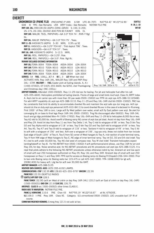
180 WASHINGTON
EVERETTSNOHOMISH CO (PAINE FLD) (PAE)(KPAE) P (AR) 6 SW UTC–8(–7DT) N47º54.42´ W122º16.90´
608 B TPA—See Remarks LRA ARFF Index—See Remarks NOTAM FILE PAERWY 16R–34L: H9010X150 (ASPH–CONC–GRVD) S–100, D–200,
2S–175, 2D–350, 2D/2D2–830 PCN 83 F/A/W/T HIRL CLRWY 16R: MALSR. TDZL. PAPI(P4R)—GA 3.0º TCH 74´. RVR–T Rgt tfc.RWY 34L: MALSF. PAPI(P4L)—GA 3.0º TCH 75´. Trees.
RWY 11–29: H4504X75 (ASPH) S–30 MIRL 0.9% up SERWY 11: VASI(V2L)—GA 3.25º TCH 60´. Thld dsplcd 798´. Trees.RWY 29: VASI(V2R)—GA 4.0º TCH 57´. Trees.
RWY 16L–34R: H3004X75 (ASPH) S–12.5 MIRLRWY 16L: REIL. PAPI(P2L)—GA 3.25º. Pole.RWY 34R: REIL. PAPI(P2L)—GA 3.0º. Pole. Rgt tfc.
RUNWAY DECLARED DISTANCE INFORMATIONRWY 16L:TORA–3004 TODA–3004 ASDA–3004 LDA–3004RWY 16R:TORA–9010 TODA–9010 ASDA–9010 LDA–9010RWY 34L:TORA–9010 TODA–9010 ASDA–9010 LDA–9010RWY 34R:TORA–3004 TODA–3004 ASDA–3004 LDA–3004
SERVICE: S4 FUEL 100LL, JET A OX 1, 3 LGT When twr clsd ACTIVATE HIRL Rwy 16R–34L, MALSR Rwy 16R and PAPI Rwy 34L—CTAF. MILITARY— FUEL Copter proh at fueling islands. A, A+ (1400–0700Z‡, OT C425–355–6600, fee $250, clsd Thanksgiving and Christmas day.) (NC–100LL)
AIRPORT REMARKS: Attended 1500–0500Z‡. Rwy 11–29 clsd exc for taxiing. For jet and helicopter fuel after hrs call 425–355–6600. Helicopters prohibited at fueling islands. Flocks of large and small birds invof arpt. Class IV, ARFF Index A. Arpt clsd to air carrier ops with more than 30 pax seats 0500–1500Z‡ exc PPR ctc arpt ops 425–388–5110/5480. For adnl ARFF capability ctc arpt ops 425–388–5110. Rwy 11–29 and Rwy 16L–34R clsd btn 0500–1500Z‡. PAE has fac constraints that limit its ability to accommodate diverted flts and maintain the arpt safe ops dur irreg ops. Acft opr should ctc the on duty arpt ops personnel (425–610–8411) to coord diverted flts exc in the case of a declared in–flt emerg. First 1000´ of Rwy 16R is conc. Large acft fly West pattern over water, small acft fly East pattern over arpt. Be alert for converging tfc on base to final legs Rwys 16R–34L 0500–1500Z‡. Trng flts discouraged after 0600Z‡. Rwy 16R–34L touch and go ldgs prohibited Mon–Fri 1500–1700Z‡. Rwy 16L–34R and Rwy 11–29 ltd to helicopters 8,000 lbs or less. Twy A2 rstd to 30,000 lbs. Avoid overflt of Boeing ramp NE corner of arpt due jet blast. Avoid int dep from Rwy 16L–34R and Rwy 29. Avoid int dep from Rwy 11 exc from Twy Delta 1 int. Twy C rstd to wingspan of 68´ or less. Twy D btn Twy D2 and Twy Alpha rstd to wingspan of 118´ or less. Twy D btn Twy D2 and Twy Golf rstd to wingspan of 49´ or less. Twy A4, Twy A5, Twy K7 and Twy B rstd to wingspan of 118´ or less. Taxilane H rstd to wingspan of 49´ or less. Twy E ltd to acft with a wingspan of 156´ and less. Acft over a wingspan of 156´, tug ops only. Areas not visible from twr include East edge of South 1200´ of Twy A, Twy E from SE corner of West hangars to Twy A, mid–section of outer terminal ramp, Twy H from NW edge of West hangars to Twy E, NE edge of inner terminal ramp. Twy int D2, D3 and D4 clsd indef. Twy K1 clsd to acft under 30,000 lbs. Twy K6 clsd west of compass rose. Twy W clsd indef. Transient helicopters expect landing/takeoff on Twy B. For NS ABTMT from 0500–1500Z‡ if acft performance/wind allows, use Rwy 16R for arr and Rwy 34L for dep. Noise sensitive arpt, for NS ABTMT procedures and tfc procedures call arpt ops 425–388–5125. It is reqd that pilots adhere to the following NS ABTMT procedures unless otherwise instrd by twr, itinerant arr and low apch of small acft over 250 horsepower authorized on Rwy 29, Rwy 16L and Rwy 34R. Itinerant dep of small acft over 250 horsepower on Rwy 11 and Rwy 34R. PPR rqrd for access on Boeing ramp ctc Boeing Flt Dispatch 206–544–5900. Prior to taxi onto Boeing ramp ctc Boeing radio twr 123.475 or call 425–342–5900. TPA–1608(1000) for lgt acft, 2008(1400) for heavy acft. Ldg fee for acft over 30,000 lbs GWT.
AIRPORT MANAGER: 425-388-5125WEATHER DATA SOURCES: ASOS (425) 355–6192 LAWRS.COMMUNICATIONS: CTAF 132.95 ATIS 128.65 425–355–9797 UNICOM 122.95
PAINE RCO 122.55 (SEATTLE RADIO)®SEATTLE APP/DEP CON 128.5
PAINE TOWER 132.95 (acft arr West of cntrln or dep Rwy 16R–34L) 120.2 (acft arr East of cntrln or dep Rwy 16L–34R) (1500–0500Z‡) GND CON 121.8 CLNC DEL 126.75
AIRSPACE: CLASS D svc 1500–0500Z‡ other times CLASS E.RADIO AIDS TO NAVIGATION: NOTAM FILE PAE.
PAINE (L) VORW/DME 110.6 PAE Chan 43 N47º55.19´ W122º16.67´ at fld. 679/20E.ILS 109.3 I–PAE Rwy 16R. Class IIE. Category: ILS unmonitored 0500–1500Z‡. LOC unusable byd 15º lft of
course.COMM/NAV/WEATHER REMARKS: Emerg freq 121.5 not avbl at twr.
SEATTLEH–1B, L–1D
IAP, AD
NW, 31 MAR 2016 to 26 MAY 2016
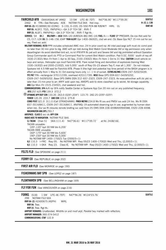
WASHINGTON 181
FAIRCHILD AFB (SKA)(KSKA) AF (ANG) 10 SW UTC–8(–7DT) N47º36.90´ W117º39.35´2462 B TPA—See Remarks AOE NOTAM FILE SKA Not insp.RWY 05–23: H13899X150 (CONC) S–155, D–220, 2D–550 PCN 88 R/B/W/T HIRL CL
RWY 05: ALSF2. TDZL. PAPI(P4L)—GA 3.0º TCH 58´. RVR–TRWY 23: ALSF1. PAPI(P4L)—GA 3.0º TCH 56´. RVR–T Rgt tfc.
SERVICE: S4 OX 2 MILITARY— JASU (MA–1A) (A/M32A–86) (MC–1A) FUEL A++ FLUID SP PRESAIR; De–ice–Not avbl for C5, C17; LOX OIL O–148–156 JOAP TRAN ALERT Opr 1400–0600Z‡, clsd wk end. Ctc Base Ops NLT 15 min out for svc req. Fleet svc avbl.
MILITARY REMARKS: RSTD PPR includes scheduled AMC msn. 24 hr prior coord rqr. All inbd pax/cargo acft must ctc comd post no later than 30 min prior to ldg. AMC acft opr rstd during Bird Watch Cond Moderate (tkf or ldg permission only when departing/arr rte avoid identified bird act, no lcl IFR/VFR tfc pat act) and Severe (tkf and ldg prohibited without Operation Group Commander apvl) ctc PTD or Command Post for current Bird Watch condition. Pad 5 DZ, 5000´ south of rwy eff 1630–2130Z‡ Mon–Fri from 1 Apr to 30 Sep, 2100–2300Z‡ Mon–Fri from 1 Oct to 31 Mar. CAUTION Unctl vehicle on twys and ramps. Helicopter ops invof Fairchild AFB. Flare rocket firing and demolition of explosives training Wed 1530–1630Z‡ and 2000–2100Z‡, lctd 5,000´ south of Rwy 05–23 abeam Twy F, max alt 1,300´. Do not mistake Spokane Intl 4.5 NM east for Fairchild AFB. Phase II (the high bird potential haz time period) of the BASH program is in effect annually from 1 May to 31 Oct evening hours only +/– 1 hr of sunset. CSTMS/AG/IMG C509–247–5202/5439. TFC PAT TPA—rectangular 3701(1239), overhead 4201(1739). MISC Base OPS DSN 657–5439/5202, C509–247–5439/5202. Base OPS OMNI DSN 312–657–2323, C509–247–2323. Air evacuation/tran acft ctc ptd no later than 15 min prior to arr. ARFF avbl upon req. AMOPS avbl to store classified up to secret, ltd storage capability. ANG Opr Mon–Fri 1515–2345Z‡, clsd weekend and hol.
COMMUNICATIONS: SFA Acft rqr SFA notify Seattle Center or Spokane App Con 20 min out on any published frequency. ATIS 257.625 PTD 139.3 372.2
®SPOKANE APP/DEP CON 133.35 263.0 (026º–204º) 123.75 282.25 (205º–025º)TOWER 120.35 233.7 GND CON 123.6 275.8COMD POST 321.0 311.0 (Call STRIKEHAWK) PMSV METRO 234.8 Wx flt svs and PMSV svs avbl 24 hrs. Wx flt DSN 657–5514/8411, C509–247–5514/8411. AN/FMQ–19 automated observing sys in use; augmented by human obsn when nec. Dur wx flt closures remote briefing svc avbl from 25 OWS DSN 228–6598/6599/6588, C520–228–6598.WASHINGTON ANG OPS 293.7
AIRSPACE: CLASS C svc ctc APP CONRADIO AIDS TO NAVIGATION: NOTAM FILE SKA.
(L) TACAN Chan 51 SKA (111.4) N47º36.61´ W117º39.72´ at fld. 2438/16E.TACAN unusable:
105º–135º byd 30 NM blo 6,200´TACAN DME unusable:
160º–175º byd 30 NM blo 5,600´190º–230º byd 30 NM blo 5,000´No NOTAM MP 1400–1700Z‡ Tue (2000/3+1)
ILS 110.3 I–FRC Rwy 05. No NOTAM MP: Rwy 05/23 1400–1700Z‡ Wed and Thu, (2,000/3+1).ILS 110.3 I–SKA Rwy 23. Class IE. No NOTAM MP: Rwy 05/23 1400–1700Z‡ Wed and Thu, (2,000/3+1).
FELTS FLD (See SPOKANE on page 211)
FERRY CO (See REPUBLIC on page 202)
FIRST AIR FLD (See MONROE on page 190)
FISHERMANS BAY SPB (See LOPEZ on page 187)
FLOATHAVEN SPB (See BELLINGHAM on page 169)
FLY FOR FUN (See VANCOUVER on page 216)
FORKS (S18) 1 SW UTC–8(–7DT) N47º56.26´ W124º23.76´299 NOTAM FILE SEARWY 04–22: H2400X75 (ASPH) MIRL
RWY 04: Tree.RWY 22: Tree. Rgt tfc.
AIRPORT REMARKS: Unattended. Wildlife on and invof arpt. Parallel twy marked with reflectors.AIRPORT MANAGER: 360-374-5412COMMUNICATIONS: CTAF 122.9
SEATTLEH–1C, L–13B
DIAP, AD
SEATTLE
NW, 31 MAR 2016 to 26 MAY 2016
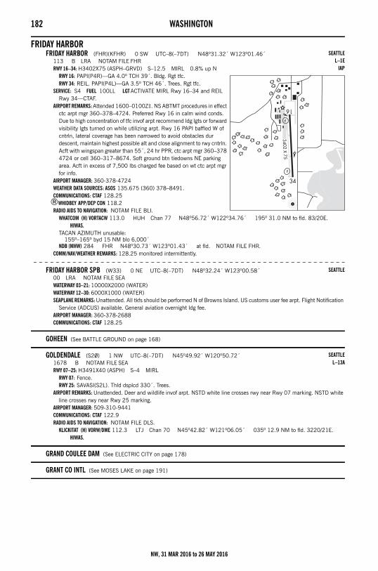
182 WASHINGTON
FRIDAY HARBORFRIDAY HARBOR (FHR)(KFHR) 0 SW UTC–8(–7DT) N48º31.32´ W123º01.46´
113 B LRA NOTAM FILE FHRRWY 16–34: H3402X75 (ASPH–GRVD) S–12.5 MIRL 0.8% up N
RWY 16: PAPI(P4R)—GA 4.0º TCH 39´. Bldg. Rgt tfc.RWY 34: REIL. PAPI(P4L)—GA 3.5º TCH 46´. Trees. Rgt tfc.
SERVICE: S4 FUEL 100LL LGT ACTIVATE MIRL Rwy 16–34 and REIL Rwy 34—CTAF.
AIRPORT REMARKS: Attended 1600–0100Z‡. NS ABTMT procedures in effect ctc arpt mgr 360–378–4724. Preferred Rwy 16 in calm wind conds. Due to high concentration of tfc invof arpt recommend ldg lgts or forward visibility lgts turned on while utilizing arpt. Rwy 16 PAPI baffled W of cntrln, lateral coverage has been narrowed to avoid obstacles dur descent, maintain highest possible alt and close alignment to rwy cntrln. Acft with wingspan greater than 55´, 24 hr PPR, ctc arpt mgr 360–378 4724 or cell 360–317–8674. Soft ground btn tiedowns NE parking area. Acft in excess of 7,500 lbs charged fee based on wt ctc arpt mgr for info.
AIRPORT MANAGER: 360-378-4724WEATHER DATA SOURCES: ASOS 135.675 (360) 378–8491.COMMUNICATIONS: CTAF 128.25
®WHIDBEY APP/DEP CON 118.2RADIO AIDS TO NAVIGATION: NOTAM FILE BLI.
WHATCOM (H) VORTACW 113.0 HUH Chan 77 N48º56.72´ W122º34.76´ 195º 31.0 NM to fld. 83/20E. HIWAS.
TACAN AZIMUTH unusable:155º–165º byd 15 NM blo 6,000´
NDB (MHW) 284 FHR N48º30.73´ W123º01.43´ at fld. NOTAM FILE FHR.COMM/NAV/WEATHER REMARKS: 128.25 monitored intermittently.
– – – – – – – – – – – – – – – – – – – – – – – – – – – – – – – – – – – – – – – – – – – – – – – – – – – – – – – –
FRIDAY HARBOR SPB (W33) 0 NE UTC–8(–7DT) N48º32.24´ W123º00.58´00 LRA NOTAM FILE SEAWATERWAY 03–21: 10000X2000 (WATER)WATERWAY 12–30: 6000X1000 (WATER)SEAPLANE REMARKS: Unattended. All tkfs should be performed N of Browns Island. US customs user fee arpt. Flight Notification
Service (ADCUS) available. General aviation overnight ldg fee.AIRPORT MANAGER: 360-378-2688COMMUNICATIONS: CTAF 128.25
GOHEEN (See BATTLE GROUND on page 168)
GOLDENDALE (S20) 1 NW UTC–8(–7DT) N45º49.92´ W120º50.72´1678 B NOTAM FILE SEARWY 07–25: H3491X40 (ASPH) S–4 MIRL
RWY 07: Fence.RWY 25: SAVASI(S2L). Thld dsplcd 330´. Trees.
AIRPORT REMARKS: Unattended. Deer and wildlife invof arpt. NSTD white line crosses rwy near Rwy 07 marking. NSTD white line crosses rwy near Rwy 25 marking.
AIRPORT MANAGER: 509-310-9441COMMUNICATIONS: CTAF 122.9RADIO AIDS TO NAVIGATION: NOTAM FILE DLS.
KLICKITAT (H) VORW/DME 112.3 LTJ Chan 70 N45º42.82´ W121º06.05´ 035º 12.9 NM to fld. 3220/21E. HIWAS.
GRAND COULEE DAM (See ELECTRIC CITY on page 178)
GRANT CO INTL (See MOSES LAKE on page 191)
SEATTLEL–1E
IAP
SEATTLE
SEATTLEL–13A
NW, 31 MAR 2016 to 26 MAY 2016
WASHINGTON 183
GRAY AAF (JOINT BASE LEWIS–MCCHORD) (GRF)(KGRF) A (AR ARNG) 1 E UTC–8(–7DT) N47º04.75´ W122º34.85´
306 B TPA—See Remarks NOTAM FILE GRF Not insp.RWY 15–33: H6121X147 (ASPH) PCN 55 F/A/W/T HIRL
RWY 15: SSALR. PAPI(P4L)—GA 3.0º TCH 58´. RVR–TRWY 33: SSALR.
SERVICE: MILITARY— FUEL A++ Ltd supply. Ltd tran alert.MILITARY REMARKS: No incoming Space A pax without prior apvl. RSTD 48 hr PPR tran acft, ctc Base Ops DSN
357–6628/5998, C253–967–6628/5998. CAUTION Numerous small arms 0.8 NM east of afld. TFC PAT TPA—E/W tfc, fixed wing 1800(1494), rotary wing 800(494). UAV 1000(694), west tfc only. MISC Special VFR day fixed wing 700–1, rotary wing 300–1/2. Ngt fixed wing not auth, rotary wing 500–1. Acft conducting tactical opr on JBLM mil reservation ctc OPS prior to opr. Ctc Gray tfc on CTAF when twr clsd. No hangar for tran acft. Base ops and tower opr 0800Z‡ Mon–0800Z‡ Fri and 1700–0100Z‡ Sat and Sun. Clsd hol. Rwy cond reading will be reported Mon–Fri, 1500–2300Z‡ via NOTAM and ATIS dur inclement winter wx. Wx obsn visibility ltd to 2 SM in some directions. Wx obsn visibility ltd to 2 SM in some directions. Wx obsn automated by AN/FMQ–19. Wx obsn augmented/backup Mon–Fri 0800–0800Z‡ and 1700–0100Z‡ Sat and Sun or end of lcl flying daily and dur inclement wx, as rqrd. Clsd hol. High volume of night vision scope trng on afld, portions of afld lgtg may be dim or off. Pilots of mil rotary–wing acft shall inform Gray Twr on initial ctc if they are unaided. USAR Ctc OPS DSN 357–3036, C253–967–3036. ARNG Opr 1430–0100Z‡ Tue–Fri exc hol. Tran alert svc not avbl. Ltd prk. PPR for acft rqr fuel and prk, DSN 323–3805, C253–912–3905.
AIRPORT MANAGER: 206-968-2904COMMUNICATIONS: CTAF 119.325 ATIS 124.65 306.2
BULLSEYE RADIO 34.6 141.5 379.1 Opr 0800Z‡ Mon–0800Z‡ Fri and 1700–0100Z‡ Sat and Sun. Clsd hol. All rotary wing acft ctc Bullseye radio prior to entry R6703A–J, range status avbl on UHF 384.525 and VHF 142.7.
®SEATTLE APP/DEP CON 120.1 290.9TOWER 119.325 256.8 276.4 (Opr 0800Z‡ Mon–0800Z‡ Fri and 1700–0100Z‡ Sat and Sun. Clsd hol.) GND CON 121.9 290.2 CLNC DEL 121.9 290.2PMSV METRO 134.1 38.45 Full svc 0800Z‡ Mon–0800Z‡ Fri and 1700Z–0100Z‡ Sat and Sun or end of lcl flying daily and dur inclement wx, as required. Clsd hol. Wx briefings for tran air crews avbl from 25 OWS, Davis–Monthan AFB, DSN 228–6598OPS 41.50 138.6 395.225 USAR OPS 30.5 36.10 245.5 ARNG OPS 32.6
AIRSPACE: CLASS D svc 1600–0800Z‡ except holidays other times CLASS E.RADIO AIDS TO NAVIGATION: NOTAM FILE GRF.
LACOMAS NDB (MHW) 328 LAC N47º00.48´ W122º33.40´ 331º 4.4 NM to fld.GRAYE NDB (MHW) 216 GRF N47º09.02´ W122º36.28´ 151º 4.4 NM to fld.ILS/DME 108.3 I–GRF Chan 20 Rwy 15. ILS – No NOTAM MP 1400–1600Z‡ Fri. Radar – No NOTAM MP
1400–1600Z‡ Fri. See terminal flip for radar minima.PAR Opr continously except federal holidays.
GRAYE N47º09.02´ W122º36.28´ NOTAM FILE GRF.NDB (MHW) 216 GRF 353º 7.1 NM to Tacoma Narrows.
GREENWATERRANGER CREEK (21W) 10 SE UTC–8(–7DT) N47º00.79´ W121º32.02´
2650 NOTAM FILE SEARWY 15–33: H2875X30 (ASPH) 0.9% up SE
RWY 15: Trees.RWY 33: Trees.
AIRPORT REMARKS: Unattended. Arpt clsd Oct 1 to Jun 1 exc for approved mil and public safety/law enforcement helicopter ops. Mountainous terrain surrounds arpt. Pedestrians, vehicles and animals on and invof rwy. USFS campgrounds east and north of rwy. Ctc WA State Aviation Division 360–709–8015 or 1–800–552–0666 WA area for facility info prior to use. For acft accidents/incidents ctc WA state emergency operations center 800–258–5990.
AIRPORT MANAGER: (360) 618-2477COMMUNICATIONS: CTAF 122.9
GROVE FLD (See CAMAS on page 171)
HARVEY FLD (See SNOHOMISH on page 210)
SEATTLEH–1B, L–1D
DIAP, AD
SEATTLEL–1D
SEATTLE
NW, 31 MAR 2016 to 26 MAY 2016
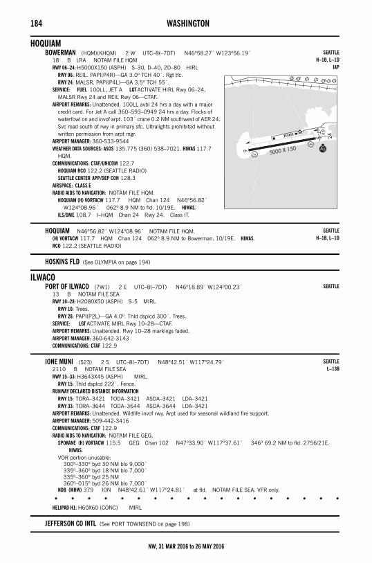
184 WASHINGTON
HOQUIAMBOWERMAN (HQM)(KHQM) 2 W UTC–8(–7DT) N46º58.27´ W123º56.19´
18 B LRA NOTAM FILE HQMRWY 06–24: H5000X150 (ASPH) S–30, D–40, 2D–80 HIRL
RWY 06: REIL. PAPI(P4R)—GA 3.0º TCH 40´. Rgt tfc.RWY 24: MALSR. PAPI(P4L)—GA 3.5º TCH 55´.
SERVICE: FUEL 100LL, JET A LGT ACTIVATE HIRL Rwy 06–24, MALSR Rwy 24 and REIL Rwy 06—CTAF.
AIRPORT REMARKS: Unattended. 100LL avbl 24 hrs a day with a major credit card. For Jet A call 360–593–0949 24 hrs a day. Flocks of waterfowl on and invof arpt. 103´ crane 0.2 NM southwest of AER 24. Svc road south of rwy in primary sfc. Ultralights prohibited without written permission from arpt mgr.
AIRPORT MANAGER: 360-533-9544WEATHER DATA SOURCES: ASOS 135.775 (360) 538–7021. HIWAS 117.7
HQM.COMMUNICATIONS: CTAF/UNICOM 122.7
HOQUIAM RCO 122.2 (SEATTLE RADIO)SEATTLE CENTER APP/DEP CON 128.3
AIRSPACE: CLASS ERADIO AIDS TO NAVIGATION: NOTAM FILE HQM.
HOQUIAM (H) VORTACW 117.7 HQM Chan 124 N46º56.82´ W124º08.96´ 062º 8.9 NM to fld. 10/19E. HIWAS.
ILS/DME 108.7 I–HQM Chan 24 Rwy 24. Class IT.
HOQUIAM N46º56.82´ W124º08.96´ NOTAM FILE HQM.(H) VORTACW 117.7 HQM Chan 124 062º 8.9 NM to Bowerman. 10/19E. HIWAS.RCO 122.2 (SEATTLE RADIO)
HOSKINS FLD (See OLYMPIA on page 194)
ILWACOPORT OF ILWACO (7W1) 2 E UTC–8(–7DT) N46º18.89´ W124º00.23´
13 B NOTAM FILE SEARWY 10–28: H2080X50 (ASPH) S–5 MIRL
RWY 10: Trees.RWY 28: PAPI(P2L)—GA 4.0º. Thld dsplcd 300´. Trees.
SERVICE: LGT ACTIVATE MIRL Rwy 10–28—CTAF.AIRPORT REMARKS: Unattended. Rwy 10–28 markings faded. AIRPORT MANAGER: 360-642-3143COMMUNICATIONS: CTAF 122.9
IONE MUNI (S23) 2 S UTC–8(–7DT) N48º42.51´ W117º24.79´2110 B NOTAM FILE SEARWY 15–33: H3643X45 (ASPH) MIRL
RWY 15: Thld dsplcd 222´. Fence.RUNWAY DECLARED DISTANCE INFORMATION
RWY 15: TORA–3421 TODA–3421 ASDA–3421 LDA–3421RWY 33: TORA–3644 TODA–3644 ASDA–3644 LDA–3421
AIRPORT REMARKS: Unattended. Wildlife invof rwy. Arpt used for seasonal wildland fire support.AIRPORT MANAGER: 509-442-3416COMMUNICATIONS: CTAF 122.9RADIO AIDS TO NAVIGATION: NOTAM FILE GEG.
SPOKANE (H) VORTACW 115.5 GEG Chan 102 N47º33.90´ W117º37.61´ 346º 69.2 NM to fld. 2756/21E. HIWAS.
VOR portion unusable:300º–330º byd 30 NM blo 9,000´335º–360º byd 18 NM blo 7,000´335º–360º byd 25 NM360º–015º byd 26 NM blo 7,000´
NDB (MHW) 379 ION N48º42.61´ W117º24.81´ at fld. NOTAM FILE SEA. VFR only.
• • • • • • • • • • • • • • • • • •
HELIPAD H1: H60X60 (CONC) MIRL
JEFFERSON CO INTL (See PORT TOWNSEND on page 198)
SEATTLEH–1B, L–1D
IAP
SEATTLEH–1B, L–1D
SEATTLE
SEATTLEL–13B
NW, 31 MAR 2016 to 26 MAY 2016
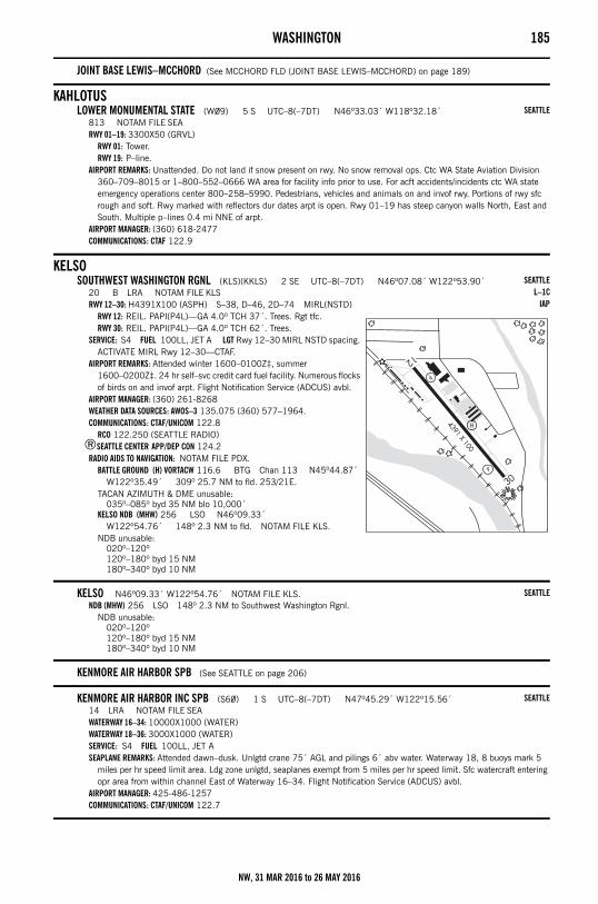
WASHINGTON 185
JOINT BASE LEWIS–MCCHORD (See MCCHORD FLD (JOINT BASE LEWIS–MCCHORD) on page 189)
KAHLOTUSLOWER MONUMENTAL STATE (W09) 5 S UTC–8(–7DT) N46º33.03´ W118º32.18´
813 NOTAM FILE SEARWY 01–19: 3300X50 (GRVL)
RWY 01: Tower.RWY 19: P–line.
AIRPORT REMARKS: Unattended. Do not land if snow present on rwy. No snow removal ops. Ctc WA State Aviation Division 360–709–8015 or 1–800–552–0666 WA area for facility info prior to use. For acft accidents/incidents ctc WA state emergency operations center 800–258–5990. Pedestrians, vehicles and animals on and invof rwy. Portions of rwy sfc rough and soft. Rwy marked with reflectors dur dates arpt is open. Rwy 01–19 has steep canyon walls North, East and South. Multiple p–lines 0.4 mi NNE of arpt.
AIRPORT MANAGER: (360) 618-2477COMMUNICATIONS: CTAF 122.9
KELSOSOUTHWEST WASHINGTON RGNL (KLS)(KKLS) 2 SE UTC–8(–7DT) N46º07.08´ W122º53.90´
20 B LRA NOTAM FILE KLSRWY 12–30: H4391X100 (ASPH) S–38, D–46, 2D–74 MIRL(NSTD)
RWY 12: REIL. PAPI(P4L)—GA 4.0º TCH 37´. Trees. Rgt tfc.RWY 30: REIL. PAPI(P4L)—GA 4.0º TCH 62´. Trees.
SERVICE: S4 FUEL 100LL, JET A LGT Rwy 12–30 MIRL NSTD spacing. ACTIVATE MIRL Rwy 12–30—CTAF.
AIRPORT REMARKS: Attended winter 1600–0100Z‡, summer 1600–0200Z‡. 24 hr self–svc credit card fuel facility. Numerous flocks of birds on and invof arpt. Flight Notification Service (ADCUS) avbl.
AIRPORT MANAGER: (360) 261-8268WEATHER DATA SOURCES: AWOS–3 135.075 (360) 577–1964.COMMUNICATIONS: CTAF/UNICOM 122.8
RCO 122.250 (SEATTLE RADIO)®SEATTLE CENTER APP/DEP CON 124.2
RADIO AIDS TO NAVIGATION: NOTAM FILE PDX.BATTLE GROUND (H) VORTACW 116.6 BTG Chan 113 N45º44.87´
W122º35.49´ 309º 25.7 NM to fld. 253/21E.TACAN AZIMUTH & DME unusable:
035º–085º byd 35 NM blo 10,000´KELSO NDB (MHW) 256 LSO N46º09.33´
W122º54.76´ 148º 2.3 NM to fld. NOTAM FILE KLS.NDB unusable:
020º–120º120º–180º byd 15 NM180º–340º byd 10 NM
KELSO N46º09.33´ W122º54.76´ NOTAM FILE KLS.NDB (MHW) 256 LSO 148º 2.3 NM to Southwest Washington Rgnl.
NDB unusable:020º–120º120º–180º byd 15 NM180º–340º byd 10 NM
KENMORE AIR HARBOR SPB (See SEATTLE on page 206)
KENMORE AIR HARBOR INC SPB (S60) 1 S UTC–8(–7DT) N47º45.29´ W122º15.56´14 LRA NOTAM FILE SEAWATERWAY 16–34: 10000X1000 (WATER)WATERWAY 18–36: 3000X1000 (WATER)SERVICE: S4 FUEL 100LL, JET A SEAPLANE REMARKS: Attended dawn–dusk. Unlgtd crane 75´ AGL and pilings 6´ abv water. Waterway 18, 8 buoys mark 5
miles per hr speed limit area. Ldg zone unlgtd, seaplanes exempt from 5 miles per hr speed limit. Sfc watercraft entering opr area from within channel East of Waterway 16–34. Flight Notification Service (ADCUS) avbl.
AIRPORT MANAGER: 425-486-1257COMMUNICATIONS: CTAF/UNICOM 122.7
SEATTLE
SEATTLEL–1C
IAP
SEATTLE
SEATTLE
NW, 31 MAR 2016 to 26 MAY 2016
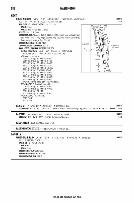
186 WASHINGTON
KENTCREST AIRPARK (S36) 5 SE UTC–8(–7DT) N47º20.23´ W122º06.21´
472 B TPA—1472(1000) NOTAM FILE SEARWY 15–33: H3288X40 (ASPH) S–12 LIRL
RWY 15: Trees.RWY 33: Thld dsplcd 281´. Trees.
SERVICE: S4 FUEL 100LL AIRPORT REMARKS: Attended 1700–0100Z‡. 24 hr credit card fuel avbl. Arpt
clsd when snow on rwy. Night ops use Rwy 15, wind and wx permitting. Trees on both sides of Rwy 15–33.
AIRPORT MANAGER: 253-631-7100COMMUNICATIONS: CTAF/UNICOM 123.0RADIO AIDS TO NAVIGATION: NOTAM FILE SEA.
SEATTLE (H) VORTACW 116.8 SEA Chan 115 N47º26.12´ W122º18.58´ 106º 10.3 NM to fld. 354/19E.
VOR portion unusable:008º–023º byd 20 NM blo 3,500´008º–023º byd 30 NM blo 4,100´233º–273º byd 20 NM blo 8,000´233º–273º byd 30 NM blo 10,000´233º–273º byd 35 NM blo 11,000´233º–273º byd 8 NM blo 5,500´303º–333º byd 20 NM blo 2,900´303º–333º byd 30 NM blo 4,000´333º–353º byd 15 NM blo 3,500´353º–008º byd 20 NM blo 2,900´TACAN antenna offset 150’ on 300 radial.
TACAN AZIMUTH & DME unusable:008º–028º byd 20 NM blo 4,500´008º–028º byd 30 NM blo 7,000´203º–253º byd 27 NM303º–008º byd 30 NM blo 3,500´
TACAN AZIMUTH unusable:008º–163º173º–293º
KLICKITAT N45º42.82´ W121º06.05´ NOTAM FILE DLS.(H) VORW/DME 112.3 LTJ Chan 70 186º 6.3 NM to Columbia Gorge Rgnl/The Dalles Muni. 3220/21E. HIWAS.
LACOMAS N47º00.48´ W122º33.40´ NOTAM FILE GRF.NDB (MHW) 328 LAC 341º 15.6 NM to Tacoma Narrows.
LAKE CHELAN (See CHELAN on page 172)
LAKE WENATCHEE STATE (See LEAVENWORTH on page 187)
LANGLEYWHIDBEY AIR PARK (W10) 2 SW UTC–8(–7DT) N48º01.05´ W122º26.26´
271 NOTAM FILE SEARWY 16–34: H2470X25 (ASPH)
RWY 16: Hill.RWY 34: Tree.
AIRPORT REMARKS: Unattended.AIRPORT MANAGER: (206) 341-5531COMMUNICATIONS: CTAF 122.9
SEATTLEL–1D
SEATTLEH–1B
SEATTLEL–1D
SEATTLE
NW, 31 MAR 2016 to 26 MAY 2016
WASHINGTON 187
LAURIERAVEY FLD (69S) 2 SW UTC–8(–7DT) N48º59.90´ W118º13.36´
1655 LRA NOTAM FILE SEARWY 17–35: 1975X40 (GRVL)
RWY 17: Trees.RWY 35: Trees.
AIRPORT REMARKS: Unattended. Vehicles, pedestrians and animals on and invof rwy. Rwy marked with retro–reflective devices. Shoulders very soft and rough both sides of rwy. Canadian and U.S. customs avbl on hwy to the west. U.S. based acft should park on the U.S. side of ramp, south, and Canadian based acft should park on north side of ramp.
AIRPORT MANAGER: 509-684-2240COMMUNICATIONS: CTAF 122.9
LEAVENWORTHLAKE WENATCHEE STATE (27W) 14 NW UTC–8(–7DT) N47º49.16´ W120º43.19´
1939 NOTAM FILE SEARWY 09–27: 2473X100 (TURF) 0.4% up W
RWY 09: Road.RWY 27: Road.
AIRPORT REMARKS: Unattended. CLOSED 1 Oct–1 Jun. Pedestrians, vehicles and animals on and invof rwy. Two windsocks, one at each rwy end. Ctc WA State Aviation Division 360–709–8015 or 1–800–552–0666 WA area for facility info prior to use. For acft accidents/incidents ctc WA state emergency operations center 800–258–5990. Rwy marked with reflectors dur dates arpt is open.
AIRPORT MANAGER: (360) 618-2477COMMUNICATIONS: CTAF 122.9
LESTER STATE (15S) 2 E UTC–8(–7DT) N47º12.91´ W121º27.74´1693 NOTAM FILE SEARWY 05–23: 400X100 (TURF)
RWY 05: Tree.RWY 23: Tree.
AIRPORT REMARKS: Unattended. Arpt clsd to fixed wing acft indef. Rwy 05–23 clsd indef due to severe erosion from river. Vehicles, pedestrians and animals on and invof rwy. Ctc WA State Aviation Division 360–651–6300 or 1–800–552–0666 WA area for facility info prior to use. Rwy 05–23 sfc rough. Rwy sfc not maintained, very tall grass and weeds.
AIRPORT MANAGER: (360) 618-2477COMMUNICATIONS: CTAF 122.9
• • • • • • • • • • • • • • • • • •
HELIPAD H1: 100X100 (TURF)HELIPORT REMARKS: Grass area available for emergency helicopter operations.
LIND (0S0) 2 NE UTC–8(–7DT) N46º58.61´ W118º35.23´1507 B NOTAM FILE SEARWY 05–23: H3197X50 (ASPH) MIRL
RWY 23: Hill.AIRPORT REMARKS: Unattended. East end of rwy has 800´ by 50´ dirt graded safety area. Rwy 05–23 MIRL OTS indef. Arpt
rotating bcn OTS indef.AIRPORT MANAGER: 509-677-3241COMMUNICATIONS: CTAF 122.9RADIO AIDS TO NAVIGATION: NOTAM FILE MWH.
MOSES LAKE (H) VORW/DME 115.0 MWH Chan 97 N47º12.65´ W119º19.01´ 097º 33.0 NM to fld. 1193/18E.
LITTLE GOOSE LOCK AND DAM (See STARBUCK on page 213)
LOPEZFISHERMANS BAY SPB (81W) 1 S UTC–8(–7DT) N48º30.99´ W122º55.08´
00 NOTAM FILE SEAWATERWAY 05–23: 3000X150 (WATER)
WATERWAY 05: Rgt tfc.SEAPLANE REMARKS: Unattended. Avoid overflights of houses on surrounding land. No step taxi in bay.AIRPORT MANAGER: 360-468-4116COMMUNICATIONS: CTAF 122.9
– – – – – – – – – – – – – – – – – – – – – – – – – – – – – – – – – – – – – – – – – – – – – – – – – – – – – – –
SEATTLE
SEATTLE
SEATTLE
SEATTLEL–13A
SEATTLE
NW, 31 MAR 2016 to 26 MAY 2016
188 WASHINGTON– – – – – – – – – – – – – – – – – – – – – – – – – – – – – – – – – – – – – – – – – – – – – – – – – – – – – – – –
LOPEZ ISLAND (S31) 3 S UTC–8(–7DT) N48º29.03´ W122º56.26´209 B NOTAM FILE SEARWY 16–34: H2904X60 (ASPH–GRVD) S–12.5 MIRL
RWY 16: REIL. PAPI(P2L)—GA 4.0º TCH 40´. Trees. Rgt tfc.RWY 34: REIL. PAPI(P2L)—GA 4.0º TCH 32´. Trees.
AIRPORT REMARKS: Unattended. Rwy 16–34 soft shoulders and thlds. Rwy 16, 200+´ trees 1,320´ north of thld.AIRPORT MANAGER: 360-468-4116COMMUNICATIONS: CTAF 128.25
LOST RIVER RESORT (See MAZAMA on page 189)
LOWER GRANITE STATE (See COLFAX on page 173)
LOWER MONUMENTAL STATE (See KAHLOTUS on page 185)
LYNDEN MUNI AIRPORT JANSEN FLD (38W) 1 N UTC–8(–7DT) N48º57.35´ W122º27.49´106 B NOTAM FILE SEARWY 07–25: H2425X40 (ASPH) S–12 MIRL(NSTD)
RWY 07: PAPI(P2L)—GA 3.0º TCH 15´. Thld dsplcd 262´. Fence.RWY 25: PAPI(P2R)—GA 6.0º TCH 15´. Thld dsplcd 433´. Road.
SERVICE: FUEL 100LL LGT Rwy 07–25 NSTD MIRL. Use 3 clicks to ACTIVATE MIRL Rwy 07–25 and rotating bcn—CTAF. AIRPORT REMARKS: Unattended. Automated credit card system for fuel. Exposed ditch Rwy 07–25. Avoid ngt ldgs to Rwy 25.
Ngt ldgs should be performed on Rwy 07, winds permitting. 1850´ between thld lgts, Rwy 07 thld lgts located 134´ prior to dsplcd thld. Rwy 07 thld relocated 155´ for ngt ops. Rwy 25 thld relocated 434´ for ngt ops, 1871´ usable for ngt ops. No white/red lgts past dsplcd thld. Run–ups not permitted on Rwy 25 turn around twy. Fly PAPI on all approaches to Rwy 07. Rwy 25 departures use full length of available Rwy TODA 2425 ft.
AIRPORT MANAGER: 360-354-3446COMMUNICATIONS: CTAF 122.9COMM/NAV/WEATHER REMARKS: Use 3 clicks to ACTIVATE A–UNICOM.
MANSFIELD (8W3) 0 E UTC–8(–7DT) N47º48.56´ W119º38.22´2272 B NOTAM FILE SEARWY 03–21: H2575X46 (ASPH) MIRL
RWY 03: Pole.RWY 21: Road.
RUNWAY DECLARED DISTANCE INFORMATIONRWY 03: TORA–2400RWY 21: TORA–2400
AIRPORT REMARKS: Unattended. Possible turbulence from grain elevators north side of arpt.AIRPORT MANAGER: 509-884-4700COMMUNICATIONS: CTAF 122.9
MARTIN FLD (See COLLEGE PLACE on page 174)
MASON CO N47º14.88´ W123º05.18´ NOTAM FILE SHN.NDB (MHW) 348 MNC 232º 2.6 NM to Sanderson Fld. NDB unmonitored.
NDB unusable:280º–340º byd 20 NM
MATTAWADESERT AIRE (M94) 3 SW UTC–8(–7DT) N46º41.24´ W119º55.18´
586 B NOTAM FILE SEARWY 10–28: H3665X60 (ASPH) MIRL
RWY 10: Bldg.RWY 28: PAPI(P2L)—GA 4.0º TCH 45´. Ground. Rgt tfc.
SERVICE: LGT ACTIVATE MIRL Rwy 10–28 and rotating bcn—CTAF.AIRPORT REMARKS: Unattended. Rwy 10 preferred low wind rwy (less than 5 kts). No touch and go ldgs prior to 1600Z‡. NS
ABTMT tkf procedure posted at arpt. Long final and extd base apchs to Rwy 28 not advised due to close proximity of low flying fast mil jets. Tran parking lctd on southeast and southwest end of arpt. EMS helicopter parking area on southwest end of arpt. Twy marked with retro–reflective devices.
AIRPORT MANAGER: 360-436-6277COMMUNICATIONS: CTAF/UNICOM 122.8RADIO AIDS TO NAVIGATION: NOTAM FILE MWH.
MOSES LAKE (H) VORW/DME 115.0 MWH Chan 97 N47º12.65´ W119º19.01´ 200º 40.0 NM to fld. 1193/18E.
SEATTLE
SEATTLE
SEATTLE
SEATTLEL–1D
SEATTLEL–13A
NW, 31 MAR 2016 to 26 MAY 2016
WASHINGTON 189
MAZAMALOST RIVER RESORT (W12) 5 NW UTC–8(–7DT) N48º38.98´ W120º30.12´
2415 NOTAM FILE SEARWY 11–29: 3150X85 (TURF–GRVL)
RWY 11: Road. Rgt tfc.RWY 29: Road.
AIRPORT REMARKS: Unattended. Arpt CLOSED 1 Nov thru 1 Apr. Watch for vehicles and pedestrians on rwy. Access roads both side of rwy in primary surface, vehicles cross rwy at various locations, primarily at rwy ends.
AIRPORT MANAGER: 509-996-2385COMMUNICATIONS: CTAF 122.9
MCCHORD FLD (JOINT BASE LEWIS–MCCHORD) (TCM)(KTCM) MIL/CIV AF 3 S UTC–8(–7DT) N47º08.26´ W122º28.59´
322 B TPA—See Remarks AOE NOTAM FILE TCM Not insp.RWY 16–34: H10108X150 (ASPH–CONC–GRVD) S–155, D–220, 2D–390, 2D/2D2–800 PCN 46 R/B/W/T
HIRL CLRWY 16: ALSF1. PAPI(P4R)—GA 3.0º TCH 68´. RVR–T 0.4% up.RWY 34: ALSF2. TDZL. PAPI(P4R)—GA 3.0º TCH 59´. RVR–T Rgt tfc.
RWY 162–342: H3000X60 (ASPH)ARRESTING GEAR/SYSTEM
RWY 16 HOOK E5 (240' OVRN) HOOK BAK–12B(B) (2450'). HOOK BAK–12B(B) (1668') HOOK E5 (102' OVRN) RWY 34 SERVICE: S4 OX 1, 2 LGT Visual TCH set for hgt Gp 3 acft only. Rwy 16–34 cntr 72´ thld lgt removed. PAPI GS not
coincidental with ILS GS. AMP–1/AMP–3 overt/covert assault strip lgt inst mid 5000´ Rwy 16–34. MILITARY— A–GEAR Rwy 16–34 E5 & BAK–12B avbl Mon–Fri 1530Z–0001Z‡. N and S BAK–12B Rwy A–G unavbl dur national hol. When Rwy 16–34 act, apch E5 is removed. Rwy 16–34 BAK–12B 30 min PN rqr to connect cable. JASU (MD–3M) 1(MD–3) 1(MA–1A) (AM32A–60) 1(MC–11) FUEL A++ FLUID SP PRESAIR De–ice–Exp 3 hr delay. LHOX LOX OIL O–128–133–148–156 SOAP – Results rqr 24 hr, 1530–0030Z‡ wkd exc hol, results not avbl OT. Tran acft req SOAP will arr with historical eng SOAP data for trend analysis. TRAN ALERT Opr H24. Delays can be exp. Prk ltd.
MILITARY REMARKS: RSTD PPR incl scheduled AMC msn due to ltd ramp space, tran acft parking extremely ltd. 24 hr prior coord rqr, Base OPS DSN 382–5611, C253–982–5611. All inbd acft must ctc Command Post (Rainier OPS) no later than 30 min prior to ldg. AMC acft opr rstd dur Bird Watch Cond Moderate (tkf and ldg permission only when departing/arr rte avoid identified bird act, no lcl IFR/VFR tfc pat act) and Severe (tkf and ldg prohibited without OG/CC apvl), ctc PTD/ATIS/Command Post for current Bird Watch Cond. Tran aircrews conducting lcl area low–level training msn must receive lcl procedure/rstd briefing from 62 OSS/OSK at DSN 382–3615, C253–982–3615. CAUTION When performing pre–tkf engine runup, align acft so that debris is not blown toward ADTAC alert hangar or adj acft parking ramp. During VFR conds, acft making low apch, nml tkf, TGL, or missed apch remain at or blo 1800´ until departure EOR. Bird haz. South end rwy not visible from official wx station obsn point. When fog/low clouds are present over AER 34, cond report from obsn point may not be representative. TFC PAT Before ldg maintain tfc pat alt commensurate with safety as long as practicable. TPA—Rectangular 1800´ (1478) overhead 2300´(1978). MISC Aircrews notify PTD anytime they plan to delay in lcl IFR pat on separate clnc prior to or departure on filed flt plan. Base OPS DSN 382–5611, C253–982–5611. Rwy 16–34 marked with white non–reflective 90´ X 3500´ VFR daytime assault ldg zone. South 1000´ Rwy 16–34 is conc, rwy is grvd.
AIRPORT MANAGER: 253-982-5611COMMUNICATIONS: SFA ATIS 109.6 270.1 PTD 372.2
®SEATTLE APP/DEP CON 126.5 377.15TOWER 124.8 259.3 109.6T GND CON 118.175 279.65COMD POST 349.4 134.1 PMSV METRO 342.3 Wx stn svc avbl dur afld opr hrs DSN 382–3434/2112, C253–982–3434/2112. All obs provided by AN/FMQ–19 Automated Observing Sys; augmented by human obsn when nec. Full svc PMSV avbl via phone patch with Comd Post. Tran aircrew ctc 25 OWS dur afld closure to request wx briefing DSN 228–6598, or C520–228–6598. When possible provide 3 hr PN for all rqr briefings.
AIRSPACE: CLASS D
CONTINUED ON NEXT PAGE
SEATTLE
SEATTLEH–1B, L–1D
DIAP, AD
NW, 31 MAR 2016 to 26 MAY 2016
190 WASHINGTONCONTINUED FROM PRECEDING PAGE
RADIO AIDS TO NAVIGATION: NOTAM FILE TCM.(T) VORTAC 109.6 TCM Chan 33 N47º08.86´ W122º28.50´ at fld. 283/15E.
VORTAC No NOTAM MP 0800–1700Z‡ and 2100–2300Z‡ WedVOR unusable:
033º–043º byd 12 NM blo 8,500´043º–063º byd 12 NM063º–076º byd 19 NM076º–082º byd 19 NM blo 8,000´076º–082º byd 24 NM blo 10,000´142º–153º byd 12 NM153º–163º byd 12 NM blo 5,800´207º–277º byd 12 NM307º–082º byd 10 NM blo 8,000´307º–347º byd 12 NM347º–033º byd 19 NM
ILS 109.9 I–MAR Rwy 16. Ry 16–34 backcourse unusable. Ry 16–34 No NOTAM MP 0800–1700Z‡ and 2100–2300Z‡ Tue and Thu.
ILS 108.5 I–TCM Rwy 34. Ry 16–34 backcourse unusable. Ry 16–34 No NOTAM MP 0800–1700Z‡ and 2100–2300Z‡ Tue and Thu.
MEAD FLYING SERVICE (70S) 1 N UTC–8(–7DT) N47º47.23´ W117º21.49´1905 TPA—2505(600) NOTAM FILE SEARWY 16–34: H2481X30 (ASPH)
RWY 16: Trees.RWY 34: Trees.
AIRPORT REMARKS: Attended continuously. No winter maintenance.AIRPORT MANAGER: 253-880-7805COMMUNICATIONS: CTAF 122.9
MEARS FLD (See CONCRETE on page 174)
METALINE FALLSSULLIVAN LAKE STATE (09S) 3 SE UTC–8(–7DT) N48º50.45´ W117º17.04´
2614 NOTAM FILE SEARWY 16–34: 1765X100 (TURF)
RWY 16: Trees.RWY 34: Tree.
AIRPORT REMARKS: Unattended. Arpt clsd 1 Oct–1 June exc for apvd mil and public safety/law enforcement helicopter ops. Vehicles, pedestrians, and animals on and invof arpt. Watch for gnd squirrel holes in rwy. Rwy 16–34 sfc rough. Trees both sides in transition sfcs. Ctc WA State Aviation Division 360–709–8015 or 1–800–552–0666 WA area for facility info prior to use. For acft accidents/incidents ctc WA state emergency operations center 800–258–5990. Gnd drops rapidly byd Rwy 16–34 ends. Rwy marked with reflectors dur dates arpt is open. 2 wind socks, one on each rwy end.
AIRPORT MANAGER: (360) 618-2477COMMUNICATIONS: CTAF 122.9
METHOW VALLEY STATE (See WINTHROP on page 221)
MONROEFIRST AIR FLD (W16) 2 NW UTC–8(–7DT) N47º52.28´ W121º59.71´
50 NOTAM FILE SEARWY 07–25: H2087X34 (ASPH)
RWY 07: Tree. Rgt tfc.RWY 25: Thld dsplcd 500´. Pole.
SERVICE: S4 AIRPORT REMARKS: Attended Oct–Mar 1700Z‡–dark, Apr–Sept 1700–0300Z‡. Parachute Jumping. Tran tie downs have no
ropes, pilots must supply own. Additional tran parking avbl SE corner of rwy. Rwy 25 acft parked in primary sfc.AIRPORT MANAGER: 360-794-8570COMMUNICATIONS: CTAF 122.9
SEATTLE
SEATTLE
SEATTLE
NW, 31 MAR 2016 to 26 MAY 2016
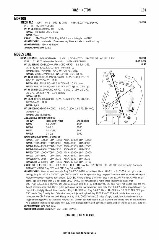
WASHINGTON 191
MORTONSTROM FLD (39P) 0 SE UTC–8(–7DT) N46º33.02´ W122º16.00´
941 B NOTAM FILE SEARWY 07–25: H1810X40 (ASPH) MIRL
RWY 07: Thld dsplcd 200´. Trees.RWY 25: Trees.
SERVICE: LGT ACTIVATE MIRL Rwy 07–25 and rotating bcn—CTAF.AIRPORT REMARKS: Unattended. Trees near rwy. Deer and elk on and invof rwy. AIRPORT MANAGER: (360) 496-5210COMMUNICATIONS: CTAF 122.9
MOSES LAKEGRANT CO INTL (MWH)(KMWH) 5 NW UTC–8(–7DT) N47º12.52´ W119º19.15´
1189 B ARFF Index—See Remarks NOTAM FILE MWHRWY 14L–32R: H13503X200 (ASPH–CONC–GRVD) S–85, D–155,
2S–175, 2D–320, 2D/2D2–600 HIRL(NSTD)RWY 14L: REIL. PAPI(P4L)—GA 3.0º TCH 75´. Bldg.RWY 32R: MALSR. PAPI(P4L)—GA 3.0º TCH 76´. Rgt tfc.
RWY 04–22: H10000X100 (ASPH–GRVD) S–75, D–100, 2S–127, 2D–175, 2D/2D2–475 MIRLRWY 04: REIL. PAPI(P4L)—GA 3.0º TCH 49´. 0.4% down.RWY 22: REIL. VASI(V4L)—GA 3.0º TCH 50´. Rgt tfc. 0.3% up.
RWY 09–27: H3500X90 (CONC–GRVD) S–100, D–150, 2S–270, 2D–270, 2D/2D2–475 0.3% up NWRWY 27: Rgt tfc.
RWY 18–36: H3327X75 (ASPH) S–75, D–170, 2S–175, 2D–300, 2D/2D2–400 MIRLRWY 18: Rgt tfc.
RWY 14R–32L: H2936X75 (CONC) S–100, D–200, 2S–175, 2D–400, 2D/2D2–400RWY 14R: Ground. Rgt tfc.
LAND AND HOLD–SHORT OPERATIONSLDG RWY HOLD–SHORT POINT AVBL LDG DISTRWY 04 14L–32R 4700RWY 14L 04–22 7550RWY 22 14L–32R 4650RWY 32R 04–22 5050
RUNWAY DECLARED DISTANCE INFORMATIONRWY 04: TORA–10000 TODA–10000 ASDA–10000 LDA–10000RWY 09: TORA–3500 TODA–3500 ASDA–3500 LDA–3500RWY 14L:TORA–13503 TODA–13503 ASDA–13503 LDA–13503RWY 14R:TORA–2936 TODA–2936 ASDA–2936 LDA–2936RWY 22: TORA–10000 TODA–10000 ASDA–10000 LDA–10000RWY 27: TORA–3500 TODA–3500 ASDA–3500 LDA–3500RWY 32L:TORA–2936 TODA–2936 ASDA–2936 LDA–2936RWY 32R:TORA–13503TODA–13503 ASDA–13492 LDA–13492
SERVICE: S4 FUEL 80, 100LL, JET A, A1+ OX 1 LGT Rwy 14L–32R NSTD HIRL lctd 50´ from rwy edge markings. ACTIVATE MALSR Rwy 32R and PAPI Rwy 14L—CTAF.
AIRPORT REMARKS: Attended continuously. Rwy 09–27 CLOSED exc mil ops. Rwy 14R–32L is CLOSED to all ngt ops exc taxiing. Rwy 14L–32R is CLOSED ngts 0600–1400Z‡ exc for special mil ngt trng ops. Cold temperature restricted airport. Altitude correction required at or below –22C/–8F. Flocks of large birds invof arpt. Class IV, ARFF Index A. PPR for air carrier ops with more than 30 pax seats 0600–1400Z‡ or for additional ARFF index level svc call arpt mgr 509–762–5363/5304. Rwy 09–27 used as assault strip by C–17 acft. Rwy 09–27 and Twy F not visible from the twr. Twy G compass rose clsd. Rwy 18–36 avbl as air carrier twy movement area only. Rwy 09–27 mil ldg zone lgts only. No edge intensity lgtg. Rwy distance markers Rwy 14L–32R and Rwy 04–22. Rwy 14L–32R first 10,000´ AER 32R grvd 150´ wide. Twy G unlighted. Extensive heavy mil jet acft ngt training 1900 PM–0300 AM lcl daily. Announce ldg intentions on CTAF after twr clsd. Heavy jet trng sfc to 5000´ within 25 miles of arpt, possible wake turbulence from larger acft using Rwy 14L–32R and Rwy 09–27. Mil tran acft rqr support at Grant Co Intl should ctc FBO for svc. Fairchild AFB detachment has no tran alert, fleet svc, crew transportation, acft parking, or comd and ctl svc for tran acft. Ldg fee.
AIRPORT MANAGER: 509-762-5363WEATHER DATA SOURCES: ASOS (509) 762–5082 LAWRS.
CONTINUED ON NEXT PAGE
SEATTLE
SEATTLEH–1C, L–13A
IAP, AD
NW, 31 MAR 2016 to 26 MAY 2016
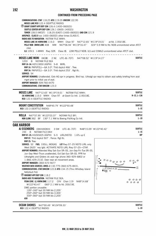
192 WASHINGTONCONTINUED FROM PRECEDING PAGE
COMMUNICATIONS: CTAF 118.25 ATIS 119.05 UNICOM 122.95 MOSES LAKE RCO 122.4 (SEATTLE RADIO)
®GRANT COUNTY APP/DEP CON 126.4 (1400–0600Z‡)SEATTLE CENTER APP/DEP CON 126.1 (0600–1400Z‡)TOWER 128.0 (WEST) 118.25 (EAST) (1400–0600Z‡) GND CON 121.9
AIRSPACE: CLASS D svc 1400–0600Z‡ other times CLASS E.RADIO AIDS TO NAVIGATION: NOTAM FILE MWH.
MOSES LAKE (H) VORW/DME 115.0 MWH Chan 97 N47º12.65´ W119º19.01´ at fld. 1193/18E.PELLY NDB (MHW/LOM) 408 MW N47º06.94´ W119º16.47´ 324º 5.9 NM to fld. NDB unmonitored when ATCT
clsd.ILS 109.5 I–MWH Rwy 32R. Class IB. LOM PELLY NDB. ILS and COMLO unmonitored when ATCT clsd.
– – – – – – – – – – – – – – – – – – – – – – – – – – – – – – – – – – – – – – – – – – – – – – – – – – – – – – – –
MOSES LAKE MUNI (W20) 2 NE UTC–8(–7DT) N47º08.52´ W119º14.27´1203 B NOTAM FILE SEARWY 16–34: H2513X50 (ASPH) S–8 MIRL
RWY 16: PAPI(P2L)—GA 3.0º. Thld dsplcd 466´. Tree.RWY 34: PAPI(P2L)—GA 3.0º. Thld dsplcd 253´. Rgt tfc.
SERVICE: S4 AIRPORT REMARKS: Unattended. Extv AG opr in progress. Bird haz. Ultralgt opr reqd to obtain arpt safety briefing from arpt
mgnt prior to initial use of arpt.AIRPORT MANAGER: 509-760-4470COMMUNICATIONS: CTAF/UNICOM 123.0
MOSES LAKE N47º12.65´ W119º19.01´ NOTAM FILE MWH.(H) VORW/DME 115.0 MWH Chan 97 at Grant Co Intl. 1193/18E.RCO 122.4 (SEATTLE RADIO)
MOUNT CONSTITUTION N48º40.79´ W122º50.48´RCO 122.3 (SEATTLE RADIO)
NOLLA N47º37.95´ W122º23.37´ NOTAM FILE BFI.NDB (LOM) 362 BF 130º 7.1 NM to Boeing Fld/King Co Intl.
OAK HARBORAJ EISENBERG (OKH)(KOKH) 3 SW UTC–8(–7DT) N48º15.09´ W122º40.42´
193 B NOTAM FILE OKHRWY 07–25: H3265X25 (ASPH) S–5 LIRL(NSTD) 1.6% up E
RWY 07: Thld dsplcd 507´. Fence. Rgt tfc.RWY 25: Tree.
SERVICE: S2 FUEL 100LL, MOGAS LGT Rwy 07–25 NSTD LIRL only West 2620´ rwy lgtd. ACTIVATE NSTD LIRL Rwy 07–25—CTAF.
AIRPORT REMARKS: Attended May Sat–Sun SR–SS, Jun–Sep Fri–Tue SR–SS, Jun–Sep Wed–Thurs unattended, Oct Sat–Sun SR–SS. PPR for Ultralights and Gliders ctc arpt mgr phone 360–929–6802 or 1–866–429–2132. Deer near all movement areas.
AIRPORT MANAGER: (360) 672-5677WEATHER DATA SOURCES: AWOS–3 132.775 (360) 675–8431.COMMUNICATIONS: CTAF/UNICOM 122.8 ATIS 134.15 (Thru Whidbey Island
NAS/Ault Fld)®WHIDBEY APP/DEP CON 118.2
RADIO AIDS TO NAVIGATION: NOTAM FILE SEA.PENN COVE (L) VORW/DME 117.2 CVV Chan 119 N48º14.68´
W122º43.47´ 060º 2.1 NM to fld. 200/19E.DME portion unusable:
126º–160º byd 30 NM blo 2,200´250º–260º byd 30 NM blo 3,400´330º–360º byd 30 NM blo 2,200´
ASR
OCEAN SHORES N47º00.49´ W124º09.33´RCO 122.4 (SEATTLE RADIO)
SEATTLE
SEATTLEH–1C, L–13A
SEATTLEL–1E
SEATTLEL–1D
SEATTLEL–1E
IAP
SEATTLEL–1D
NW, 31 MAR 2016 to 26 MAY 2016
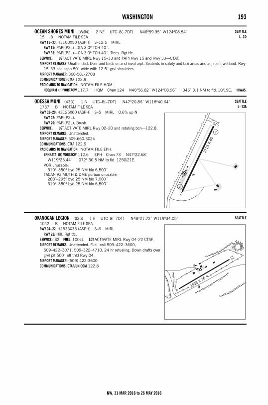
WASHINGTON 193
OCEAN SHORES MUNI (W04) 2 NE UTC–8(–7DT) N46º59.95´ W124º08.54´15 B NOTAM FILE SEARWY 15–33: H3100X50 (ASPH) S–12.5 MIRL
RWY 15: PAPI(P2L)—GA 3.0º TCH 40´.RWY 33: PAPI(P2L)—GA 3.0º TCH 40´. Trees. Rgt tfc.
SERVICE: LGT ACTIVATE MIRL Rwy 15–33 and PAPI Rwy 15 and Rwy 33—CTAF.AIRPORT REMARKS: Unattended. Deer and birds on and invof arpt. Seabirds in safety and taxi areas and adjacent wetland. Rwy
15–33 has asph 50´ wide with 12.5´ grvl shoulders. AIRPORT MANAGER: 360-581-2708COMMUNICATIONS: CTAF 122.9RADIO AIDS TO NAVIGATION: NOTAM FILE HQM.
HOQUIAM (H) VORTACW 117.7 HQM Chan 124 N46º56.82´ W124º08.96´ 346º 3.1 NM to fld. 10/19E. HIWAS.
ODESSA MUNI (43D) 1 N UTC–8(–7DT) N47º20.86´ W118º40.64´1737 B NOTAM FILE SEARWY 02–20: H3125X60 (ASPH) S–5 MIRL 0.6% up N
RWY 02: PAPI(P2L).RWY 20: PAPI(P2L). Brush.
SERVICE: LGT ACTIVATE MIRL Rwy 02–20 and rotating bcn—122.8.AIRPORT REMARKS: Unattended. AIRPORT MANAGER: 509-660-3024COMMUNICATIONS: CTAF 122.9RADIO AIDS TO NAVIGATION: NOTAM FILE EPH.
EPHRATA (H) VORTACW 112.6 EPH Chan 73 N47º22.68´ W119º25.44´ 072º 30.5 NM to fld. 1250/21E.
VOR unusable:310º–350º byd 25 NM blo 6,500´
TACAN AZIMUTH & DME portion unusable:280º–295º byd 25 NM blo 7,000´310º–350º byd 25 NM blo 6,500´
OKANOGAN LEGION (S35) 1 E UTC–8(–7DT) N48º21.72´ W119º34.05´1042 B NOTAM FILE SEARWY 04–22: H2533X36 (ASPH) S–6 MIRL
RWY 22: Hill. Rgt tfc.SERVICE: S2 FUEL 100LL LGT ACTIVATE MIRL Rwy 04–22 CTAF.AIRPORT REMARKS: Unattended. Fuel, call 509–422–3600,
509–422–3071, 509–322–4710. 24 hr refueling. Down drafts over grvl pit 500´ off thld Rwy 04.
AIRPORT MANAGER: (509) 422-3600COMMUNICATIONS: CTAF/UNICOM 122.8
SEATTLEL–1D
SEATTLEL–13A
SEATTLE
NW, 31 MAR 2016 to 26 MAY 2016
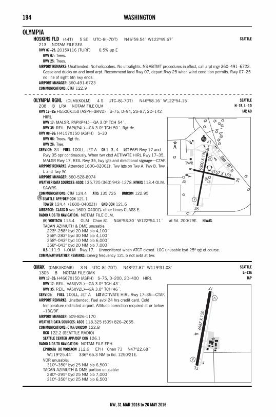
194 WASHINGTON
OLYMPIAHOSKINS FLD (44T) 5 SE UTC–8(–7DT) N46º59.54´ W122º49.67´
213 NOTAM FILE SEARWY 07–25: 2015X116 (TURF) 0.5% up E
RWY 07: Trees.RWY 25: Trees.
AIRPORT REMARKS: Unattended. No helicopters. No ultralights. NS ABTMT procedures in effect, call arpt mgr 360–491–6723. Geese and ducks on and invof arpt. Recommend land Rwy 07, depart Rwy 25 when wind condition permits. Rwy 07–25 no line of sight btn rwy ends.
AIRPORT MANAGER: 360-491-6723COMMUNICATIONS: CTAF 122.9
– – – – – – – – – – – – – – – – – – – – – – – – – – – – – – – – – – – – – – – – – – – – – – – – – – – – – – – –
OLYMPIA RGNL (OLM)(KOLM) 4 S UTC–8(–7DT) N46º58.16´ W122º54.15´208 B LRA NOTAM FILE OLMRWY 17–35: H5500X150 (ASPH–GRVD) S–75, D–94, 2S–87, 2D–142
HIRLRWY 17: MALSR. PAPI(P4L)—GA 3.0º TCH 54´.RWY 35: REIL. PAPI(P4L)—GA 3.0º TCH 50´. Rgt tfc.
RWY 08–26: H4157X150 (ASPH) S–30RWY 08: Trees. Rgt tfc.RWY 26: Tree.
SERVICE: S4 FUEL 100LL, JET A OX 1, 3, 4 LGT PAPI Rwy 17 and Rwy 35 opr continuously. When twr clsd ACTIVATE HIRL Rwy 17–35, MALSR Rwy 17, REIL Rwy 35, twy lgts and directional signage—CTAF.
AIRPORT REMARKS: Attended 1600–0200Z‡. Twy lgts on Twy A, Twy B, Twy L and Twy W.
AIRPORT MANAGER: 360-528-8074WEATHER DATA SOURCES: ASOS 135.725 (360) 943–1278. HIWAS 113.4 OLM.
SAWRS.COMMUNICATIONS: CTAF 124.4 ATIS 135.725 UNICOM 122.95
®SEATTLE APP/DEP CON 121.1 TOWER 124.4 (1600–0400Z‡) GND CON 121.6
AIRSPACE: CLASS D svc 1600–0400Z‡ other times CLASS E.RADIO AIDS TO NAVIGATION: NOTAM FILE OLM.
(H) VORTACW 113.4 OLM Chan 81 N46º58.30´ W122º54.11´ at fld. 200/19E. HIWAS.TACAN AZIMUTH & DME unusable:
223º–258º byd 20 NM blo 4,100´258º–283º byd 30 NM blo 4,100´358º–043º byd 10 NM blo 6,000´358º–043º byd 20 NM blo 7,000´
ILS 111.9 I–OLM Rwy 17. Unmonitored when ATCT closed. LOC unusable byd 25º rgt of course.COMM/NAV/WEATHER REMARKS: Emerg frequency 121.5 not avbl at twr.
OMAK (OMK)(KOMK) 3 N UTC–8(–7DT) N48º27.87´ W119º31.08´1305 B NOTAM FILE OMKRWY 17–35: H4667X150 (ASPH) S–75, D–200, 2D–400 HIRL
RWY 17: REIL. VASI(V2L)—GA 3.0º TCH 43´.RWY 35: REIL. VASI(V2L)—GA 3.0º TCH 46´.
SERVICE: FUEL 100LL, JET A LGT ACTIVATE HIRL Rwy 17–35—CTAF.AIRPORT REMARKS: Unattended. Fuel avbl 24 hrs credit card. Cold
temperature restricted airport. Altitude correction required at or below –13C/9F.
AIRPORT MANAGER: 509-826-1170WEATHER DATA SOURCES: ASOS 118.325 (509) 826–2655.COMMUNICATIONS: CTAF/UNICOM 122.8
RCO 122.2 (SEATTLE RADIO)SEATTLE CENTER APP/DEP CON 126.1
RADIO AIDS TO NAVIGATION: NOTAM FILE EPH.EPHRATA (H) VORTACW 112.6 EPH Chan 73 N47º22.68´
W119º25.44´ 336º 65.3 NM to fld. 1250/21E.VOR unusable:
310º–350º byd 25 NM blo 6,500´TACAN AZIMUTH & DME portion unusable:
280º–295º byd 25 NM blo 7,000´310º–350º byd 25 NM blo 6,500´
SEATTLE
SEATTLEH–1B, L–1D
IAP, AD
SEATTLEL–13A
IAP
NW, 31 MAR 2016 to 26 MAY 2016
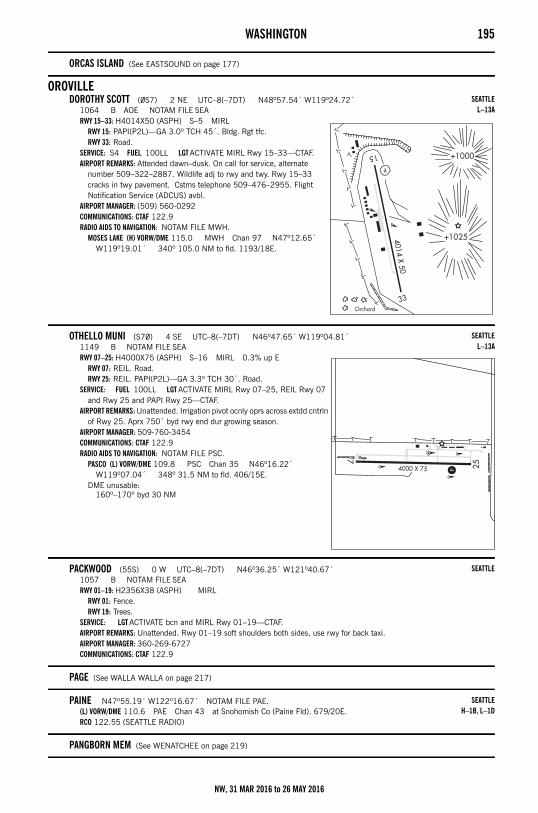
WASHINGTON 195
ORCAS ISLAND (See EASTSOUND on page 177)
OROVILLEDOROTHY SCOTT (0S7) 2 NE UTC–8(–7DT) N48º57.54´ W119º24.72´
1064 B AOE NOTAM FILE SEARWY 15–33: H4014X50 (ASPH) S–5 MIRL
RWY 15: PAPI(P2L)—GA 3.0º TCH 45´. Bldg. Rgt tfc.RWY 33: Road.
SERVICE: S4 FUEL 100LL LGT ACTIVATE MIRL Rwy 15–33—CTAF.AIRPORT REMARKS: Attended dawn–dusk. On call for service, alternate
number 509–322–2887. Wildlife adj to rwy and twy. Rwy 15–33 cracks in twy pavement. Cstms telephone 509–476–2955. Flight Notification Service (ADCUS) avbl.
AIRPORT MANAGER: (509) 560-0292COMMUNICATIONS: CTAF 122.9RADIO AIDS TO NAVIGATION: NOTAM FILE MWH.
MOSES LAKE (H) VORW/DME 115.0 MWH Chan 97 N47º12.65´ W119º19.01´ 340º 105.0 NM to fld. 1193/18E.
OTHELLO MUNI (S70) 4 SE UTC–8(–7DT) N46º47.65´ W119º04.81´1149 B NOTAM FILE SEARWY 07–25: H4000X75 (ASPH) S–16 MIRL 0.3% up E
RWY 07: REIL. Road.RWY 25: REIL. PAPI(P2L)—GA 3.3º TCH 30´. Road.
SERVICE: FUEL 100LL LGT ACTIVATE MIRL Rwy 07–25, REIL Rwy 07 and Rwy 25 and PAPI Rwy 25—CTAF.
AIRPORT REMARKS: Unattended. Irrigation pivot ocnly oprs across extdd cntrln of Rwy 25. Aprx 750´ byd rwy end dur growing season.
AIRPORT MANAGER: 509-760-3454COMMUNICATIONS: CTAF 122.9RADIO AIDS TO NAVIGATION: NOTAM FILE PSC.
PASCO (L) VORW/DME 109.8 PSC Chan 35 N46º16.22´ W119º07.04´ 348º 31.5 NM to fld. 406/15E.
DME unusable:160º–170º byd 30 NM
PACKWOOD (55S) 0 W UTC–8(–7DT) N46º36.25´ W121º40.67´1057 B NOTAM FILE SEARWY 01–19: H2356X38 (ASPH) MIRL
RWY 01: Fence.RWY 19: Trees.
SERVICE: LGT ACTIVATE bcn and MIRL Rwy 01–19—CTAF.AIRPORT REMARKS: Unattended. Rwy 01–19 soft shoulders both sides, use rwy for back taxi. AIRPORT MANAGER: 360-269-6727COMMUNICATIONS: CTAF 122.9
PAGE (See WALLA WALLA on page 217)
PAINE N47º55.19´ W122º16.67´ NOTAM FILE PAE.(L) VORW/DME 110.6 PAE Chan 43 at Snohomish Co (Paine Fld). 679/20E.RCO 122.55 (SEATTLE RADIO)
PANGBORN MEM (See WENATCHEE on page 219)
SEATTLEL–13A
SEATTLEL–13A
SEATTLE
SEATTLEH–1B, L–1D
NW, 31 MAR 2016 to 26 MAY 2016
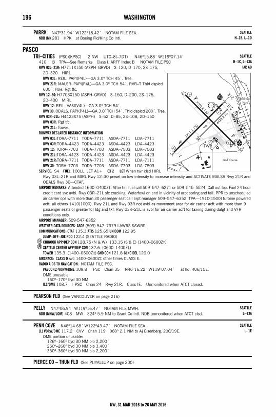
196 WASHINGTON
PARRK N47º31.94´ W122º18.42´ NOTAM FILE SEA.NDB (M) 281 HPK at Boeing Fld/King Co Intl.
PASCOTRI–CITIES (PSC)(KPSC) 2 NW UTC–8(–7DT) N46º15.88´ W119º07.14´
410 B TPA—See Remarks Class I, ARFF Index B NOTAM FILE PSCRWY 03L–21R: H7711X150 (ASPH–GRVD) S–120, D–170, 2S–175,
2D–320 HIRLRWY 03L: REIL. PAPI(P4L)—GA 3.0º TCH 45´. Tree.RWY 21R: MALSR. PAPI(P4L)—GA 3.0º TCH 54´. RVR–T Thld dsplcd 600´. Pole. Rgt tfc.
RWY 12–30: H7703X150 (ASPH–GRVD) S–150, D–200, 2S–175, 2D–400 MIRLRWY 12: REIL. VASI(V4L)—GA 3.0º TCH 54´.RWY 30: ODALS. PAPI(P4L)—GA 3.0º TCH 54´. Thld dsplcd 200´. Tree.
RWY 03R–21L: H4423X75 (ASPH) S–52, D–85, 2S–108, 2D–150RWY 03R: Rgt tfc.RWY 21L: Tower.
RUNWAY DECLARED DISTANCE INFORMATIONRWY 03L:TORA–7711 TODA–7711 ASDA–7711 LDA–7711RWY 03R:TORA–4423 TODA–4423 ASDA–4423 LDA–4423RWY 12: TORA–7703 TODA–7703 ASDA–7503 LDA–7503RWY 21L:TORA–4423 TODA–4423 ASDA–4423 LDA–4423RWY 21R:TORA–7711 TODA–7711 ASDA–7711 LDA–7111RWY 30: TORA–7703 TODA–7703 ASDA–7703 LDA–7503
SERVICE: S4 FUEL 100LL, JET A1+ OX 2 LGT When twr clsd HIRL Rwy 03L–21R and MIRL Rwy 12–30 preset on low intensity to increase intensity and ACTIVATE MALSR Rwy 21R and ODALS Rwy 30—CTAF.
AIRPORT REMARKS: Attended 1600–0400Z‡. After hrs fuel call 509–547–6271 or 509–545–5524. Call out fee. Fuel 24 hour credit card svc avbl. Rwy 03R–21L sfc cracking. Waterfowl on and in vicinity of arpt spring and fall. PPR to unscheduled air carrier ops with more than 30 passenger seat call arpt manager 509–547–6352. TPA—1910(1500) turbine powered acft, all others 1410(1000). Rwy 21L and Rwy 03R not avbl as movement area for air carrier acft with more than 9 passenger seats or greater for ldg and tkf. Rwy 03R–21L is avbl for air carrier acft for taxiing during dalgt and VFR conditions only.
AIRPORT MANAGER: 509-547-6352WEATHER DATA SOURCES: ASOS (509) 547–7379 LAWRS SAWRS.COMMUNICATIONS: CTAF 135.3 ATIS 125.65 UNICOM 122.95
JUMP–OFF–JOE RCO 122.4 (SEATTLE RADIO)®CHINOOK APP/DEP CON 128.75 (N & W) 133.15 (S & E) (1400–0600Z‡)®SEATTLE CENTER APP/DEP CON 132.6 (0600–1400Z‡)
TOWER 135.3 (1400–0600Z‡) GND CON 121.8 CLNC DEL 120.0AIRSPACE: CLASS D svc 1400–0600Z‡ other times CLASS E.RADIO AIDS TO NAVIGATION: NOTAM FILE PSC.
PASCO (L) VORW/DME 109.8 PSC Chan 35 N46º16.22´ W119º07.04´ at fld. 406/15E.DME unusable:
160º–170º byd 30 NMILS/DME 108.7 I–PSC Chan 24 Rwy 21R. Class IE. Unmonitored when ATCT closed.
PEARSON FLD (See VANCOUVER on page 216)
PELLY N47º06.94´ W119º16.47´ NOTAM FILE MWH.NDB (MHW/LOM) 408 MW 324º 5.9 NM to Grant Co Intl. NDB unmonitored when ATCT clsd.
PENN COVE N48º14.68´ W122º43.47´ NOTAM FILE SEA.(L) VORW/DME 117.2 CVV Chan 119 060º 2.1 NM to Aj Eisenberg. 200/19E.
DME portion unusable:126º–160º byd 30 NM blo 2,200´250º–260º byd 30 NM blo 3,400´330º–360º byd 30 NM blo 2,200´
PIERCE CO – THUN FLD (See PUYALLUP on page 200)
SEATTLEH–1B, L–1D
SEATTLEH–1C, L–13A
IAP, AD
SEATTLEL–13A
SEATTLEL–1E
NW, 31 MAR 2016 to 26 MAY 2016
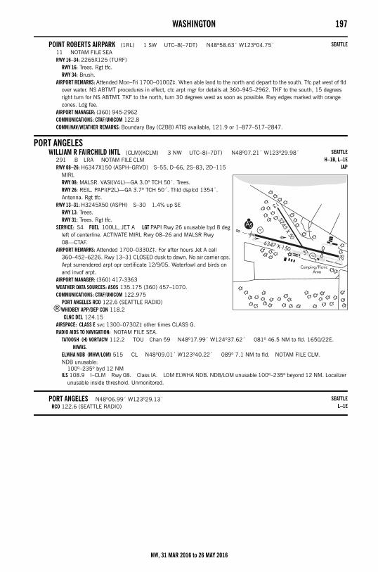
WASHINGTON 197
POINT ROBERTS AIRPARK (1RL) 1 SW UTC–8(–7DT) N48º58.63´ W123º04.75´11 NOTAM FILE SEARWY 16–34: 2265X125 (TURF)
RWY 16: Trees. Rgt tfc.RWY 34: Brush.
AIRPORT REMARKS: Attended Mon–Fri 1700–0100Z‡. When able land to the north and depart to the south. Tfc pat west of fld over water. NS ABTMT procedures in effect, ctc arpt mgr for details at 360–945–2962. TKF to the south, 15 degrees right turn for NS ABTMT. TKF to the north, turn 30 degrees west as soon as possible. Rwy edges marked with orange cones. Ldg fee.
AIRPORT MANAGER: (360) 945-2962COMMUNICATIONS: CTAF/UNICOM 122.8COMM/NAV/WEATHER REMARKS: Boundary Bay (CZBB) ATIS available, 121.9 or 1–877–517–2847.
PORT ANGELESWILLIAM R FAIRCHILD INTL (CLM)(KCLM) 3 NW UTC–8(–7DT) N48º07.21´ W123º29.98´
291 B LRA NOTAM FILE CLMRWY 08–26: H6347X150 (ASPH–GRVD) S–55, D–66, 2S–83, 2D–115
MIRLRWY 08: MALSR. VASI(V4L)—GA 3.0º TCH 50´. Trees.RWY 26: REIL. PAPI(P2L)—GA 3.7º TCH 50´. Thld dsplcd 1354´. Antenna. Rgt tfc.
RWY 13–31: H3245X50 (ASPH) S–30 1.4% up SERWY 13: Trees.RWY 31: Trees. Rgt tfc.
SERVICE: S4 FUEL 100LL, JET A LGT PAPI Rwy 26 unusable byd 8 deg left of centerline. ACTIVATE MIRL Rwy 08–26 and MALSR Rwy 08—CTAF.
AIRPORT REMARKS: Attended 1700–0330Z‡. For after hours Jet A call 360–452–6226. Rwy 13–31 CLOSED dusk to dawn. No air carrier ops. Arpt surrendered arpt opr certificate 12/9/05. Waterfowl and birds on and invof arpt.
AIRPORT MANAGER: (360) 417-3363WEATHER DATA SOURCES: ASOS 135.175 (360) 457–1070.COMMUNICATIONS: CTAF/UNICOM 122.975
PORT ANGELES RCO 122.6 (SEATTLE RADIO)®WHIDBEY APP/DEP CON 118.2
CLNC DEL 124.15AIRSPACE: CLASS E svc 1300–0730Z‡ other times CLASS G.RADIO AIDS TO NAVIGATION: NOTAM FILE SEA.
TATOOSH (H) VORTACW 112.2 TOU Chan 59 N48º17.99´ W124º37.62´ 081º 46.5 NM to fld. 1650/22E. HIWAS.
ELWHA NDB (MHW/LOM) 515 CL N48º09.01´ W123º40.22´ 089º 7.1 NM to fld. NOTAM FILE CLM.NDB unusable:
100º–235º byd 12 NMILS 108.9 I–CLM Rwy 08. Class IA. LOM ELWHA NDB. NDB/LOM unusable 100º–235º beyond 12 NM. Localizer
unusable inside threshold. Unmonitored.
PORT ANGELES N48º06.99´ W123º29.13´RCO 122.6 (SEATTLE RADIO)
SEATTLE
SEATTLEH–1B, L–1E
IAP
SEATTLEL–1E
NW, 31 MAR 2016 to 26 MAY 2016
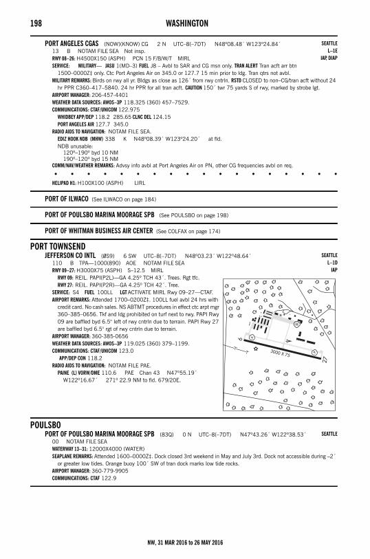
198 WASHINGTON
PORT ANGELES CGAS (NOW)(KNOW) CG 2 N UTC–8(–7DT) N48º08.48´ W123º24.84´13 B NOTAM FILE SEA Not insp.RWY 08–26: H4500X150 (ASPH) PCN 15 F/B/W/T MIRLSERVICE: MILITARY— JASU 1(MD–3) FUEL J8 – Avbl to SAR and CG msn only. TRAN ALERT Tran acft arr btn
1500–0000Z‡ only. Ctc Port Angeles Air on 345.0 or 127.7 15 min prior to ldg. Tran qtrs not avbl.MILITARY REMARKS: Birds on rwy all yr. Bldgs as close as 126´ from rwy cntrln. RSTD CLOSED to non–CG/tran acft without 24
hr PPR C360–417–5840. 24 hr PPR for all tran acft. CAUTION 150´ twr 75 yards S of rwy, marked by strobe lgt.AIRPORT MANAGER: 206-457-4401WEATHER DATA SOURCES: AWOS–3P 118.325 (360) 457–7529.COMMUNICATIONS: CTAF/UNICOM 122.975
WHIDBEY APP/DEP 118.2 285.65 CLNC DEL 124.15PORT ANGELES AIR 127.7 345.0
RADIO AIDS TO NAVIGATION: NOTAM FILE SEA.EDIZ HOOK NDB (MHW) 338 K N48º08.39´ W123º24.20´ at fld.NDB unusable:
120º–190º byd 10 NM190º–120º byd 15 NM
COMM/NAV/WEATHER REMARKS: Advsy info avbl at Port Angeles Air on PN, other CG frequencies avbl on req.
• • • • • • • • • • • • • • • • • •
HELIPAD H1: H100X100 (ASPH) LIRL
PORT OF ILWACO (See ILWACO on page 184)
PORT OF POULSBO MARINA MOORAGE SPB (See POULSBO on page 198)
PORT OF WHITMAN BUSINESS AIR CENTER (See COLFAX on page 174)
PORT TOWNSENDJEFFERSON CO INTL (0S9) 6 SW UTC–8(–7DT) N48º03.23´ W122º48.64´
110 B TPA—1000(890) AOE NOTAM FILE SEARWY 09–27: H3000X75 (ASPH) S–12.5 MIRL
RWY 09: REIL. PAPI(P2L)—GA 4.25º TCH 43´. Trees. Rgt tfc.RWY 27: REIL. PAPI(P2R)—GA 4.25º TCH 42´. Tree.
SERVICE: S4 FUEL 100LL LGT ACTIVATE MIRL Rwy 09–27—CTAF.AIRPORT REMARKS: Attended 1700–0200Z‡. 100LL fuel avbl 24 hrs with
credit card. No cash sales. NS ABTMT procedures in effect ctc arpt mgr 360–385–0656. Tkf and ldg prohibited on turf next to rwy. PAPI Rwy 09 are baffled byd 6.5° left of rwy cntrln due to terrain. PAPI Rwy 27 are baffled byd 6.5° rgt of rwy cntrln due to terrain.
AIRPORT MANAGER: 360-385-0656WEATHER DATA SOURCES: AWOS–3P 119.025 (360) 379–1199.COMMUNICATIONS: CTAF/UNICOM 123.0
APP/DEP CON 118.2RADIO AIDS TO NAVIGATION: NOTAM FILE PAE.
PAINE (L) VORW/DME 110.6 PAE Chan 43 N47º55.19´ W122º16.67´ 271º 22.9 NM to fld. 679/20E.
POULSBOPORT OF POULSBO MARINA MOORAGE SPB (83Q) 0 N UTC–8(–7DT) N47º43.26´ W122º38.53´
00 NOTAM FILE SEAWATERWAY 13–31: 12000X4000 (WATER)SEAPLANE REMARKS: Attended 1600–0000Z‡. Dock closed 3rd weekend in May and July 3rd. Dock not accessible during –2´
or greater low tides. Orange buoy 100´ SW of tran dock marks low tide rocks.AIRPORT MANAGER: 360-779-9905COMMUNICATIONS: CTAF 122.9
SEATTLEL–1E
IAP, DIAP
SEATTLEL–1D
IAP
SEATTLE
NW, 31 MAR 2016 to 26 MAY 2016
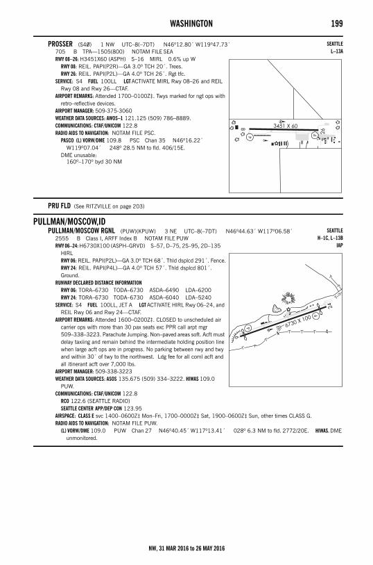
WASHINGTON 199
PROSSER (S40) 1 NW UTC–8(–7DT) N46º12.80´ W119º47.73´705 B TPA—1505(800) NOTAM FILE SEARWY 08–26: H3451X60 (ASPH) S–16 MIRL 0.6% up W
RWY 08: REIL. PAPI(P2R)—GA 3.0º TCH 20´. Trees.RWY 26: REIL. PAPI(P2L)—GA 4.0º TCH 26´. Rgt tfc.
SERVICE: S4 FUEL 100LL LGT ACTIVATE MIRL Rwy 08–26 and REIL Rwy 08 and Rwy 26—CTAF.
AIRPORT REMARKS: Attended 1700–0100Z‡. Twys marked for ngt ops with retro–reflective devices.
AIRPORT MANAGER: 509-375-3060WEATHER DATA SOURCES: AWOS–1 121.125 (509) 786–8889.COMMUNICATIONS: CTAF/UNICOM 122.8RADIO AIDS TO NAVIGATION: NOTAM FILE PSC.
PASCO (L) VORW/DME 109.8 PSC Chan 35 N46º16.22´ W119º07.04´ 248º 28.5 NM to fld. 406/15E.
DME unusable:160º–170º byd 30 NM
PRU FLD (See RITZVILLE on page 203)
PULLMAN/MOSCOW,IDPULLMAN/MOSCOW RGNL (PUW)(KPUW) 3 NE UTC–8(–7DT) N46º44.63´ W117º06.58´
2555 B Class I, ARFF Index B NOTAM FILE PUWRWY 06–24: H6730X100 (ASPH–GRVD) S–57, D–75, 2S–95, 2D–135
HIRLRWY 06: REIL. PAPI(P2L)—GA 3.0º TCH 68´. Thld dsplcd 291´. Fence.RWY 24: REIL. PAPI(P4L)—GA 4.0º TCH 57´. Thld dsplcd 801´. Ground.
RUNWAY DECLARED DISTANCE INFORMATIONRWY 06: TORA–6730 TODA–6730 ASDA–6490 LDA–6200RWY 24: TORA–6730 TODA–6730 ASDA–6040 LDA–5240
SERVICE: S4 FUEL 100LL, JET A LGT ACTIVATE HIRL Rwy 06–24, and REIL Rwy 06 and Rwy 24—CTAF.
AIRPORT REMARKS: Attended 1600–0200Z‡. CLOSED to unscheduled air carrier ops with more than 30 pax seats exc PPR call arpt mgr 509–338–3223. Parachute Jumping. Non–paved areas soft. Acft must delay taxiing and remain behind the intermediate holding position line when large acft ops are in progress. No parking between rwy and twy and within 30´ of twy to the northwest. Ldg fee for all coml acft and all itinerant acft over 7,000 lbs.
AIRPORT MANAGER: 509-338-3223WEATHER DATA SOURCES: ASOS 135.675 (509) 334–3222. HIWAS 109.0
PUW.COMMUNICATIONS: CTAF/UNICOM 122.8
RCO 122.6 (SEATTLE RADIO)SEATTLE CENTER APP/DEP CON 123.95
AIRSPACE: CLASS E svc 1400–0600Z‡ Mon–Fri, 1700–0000Z‡ Sat, 1900–0600Z‡ Sun, other times CLASS G.RADIO AIDS TO NAVIGATION: NOTAM FILE PUW.
(L) VORW/DME 109.0 PUW Chan 27 N46º40.45´ W117º13.41´ 028º 6.3 NM to fld. 2772/20E. HIWAS. DME unmonitored.
SEATTLEL–13A
SEATTLEH–1C, L–13B
IAP
NW, 31 MAR 2016 to 26 MAY 2016
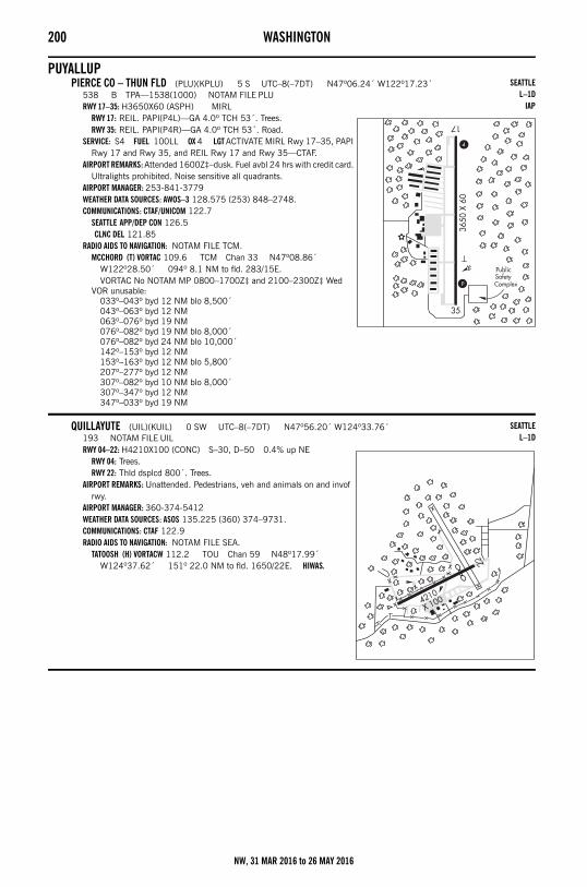
200 WASHINGTON
PUYALLUPPIERCE CO – THUN FLD (PLU)(KPLU) 5 S UTC–8(–7DT) N47º06.24´ W122º17.23´
538 B TPA—1538(1000) NOTAM FILE PLURWY 17–35: H3650X60 (ASPH) MIRL
RWY 17: REIL. PAPI(P4L)—GA 4.0º TCH 53´. Trees.RWY 35: REIL. PAPI(P4R)—GA 4.0º TCH 53´. Road.
SERVICE: S4 FUEL 100LL OX 4 LGT ACTIVATE MIRL Rwy 17–35, PAPI Rwy 17 and Rwy 35, and REIL Rwy 17 and Rwy 35—CTAF.
AIRPORT REMARKS: Attended 1600Z‡–dusk. Fuel avbl 24 hrs with credit card. Ultralights prohibited. Noise sensitive all quadrants.
AIRPORT MANAGER: 253-841-3779WEATHER DATA SOURCES: AWOS–3 128.575 (253) 848–2748.COMMUNICATIONS: CTAF/UNICOM 122.7
SEATTLE APP/DEP CON 126.5 CLNC DEL 121.85
RADIO AIDS TO NAVIGATION: NOTAM FILE TCM.MCCHORD (T) VORTAC 109.6 TCM Chan 33 N47º08.86´
W122º28.50´ 094º 8.1 NM to fld. 283/15E.VORTAC No NOTAM MP 0800–1700Z‡ and 2100–2300Z‡ Wed
VOR unusable:033º–043º byd 12 NM blo 8,500´043º–063º byd 12 NM063º–076º byd 19 NM076º–082º byd 19 NM blo 8,000´076º–082º byd 24 NM blo 10,000´142º–153º byd 12 NM153º–163º byd 12 NM blo 5,800´207º–277º byd 12 NM307º–082º byd 10 NM blo 8,000´307º–347º byd 12 NM347º–033º byd 19 NM
QUILLAYUTE (UIL)(KUIL) 0 SW UTC–8(–7DT) N47º56.20´ W124º33.76´193 NOTAM FILE UILRWY 04–22: H4210X100 (CONC) S–30, D–50 0.4% up NE
RWY 04: Trees.RWY 22: Thld dsplcd 800´. Trees.
AIRPORT REMARKS: Unattended. Pedestrians, veh and animals on and invof rwy.
AIRPORT MANAGER: 360-374-5412WEATHER DATA SOURCES: ASOS 135.225 (360) 374–9731.COMMUNICATIONS: CTAF 122.9RADIO AIDS TO NAVIGATION: NOTAM FILE SEA.
TATOOSH (H) VORTACW 112.2 TOU Chan 59 N48º17.99´ W124º37.62´ 151º 22.0 NM to fld. 1650/22E. HIWAS.
SEATTLEL–1D
IAP
SEATTLEL–1D
NW, 31 MAR 2016 to 26 MAY 2016
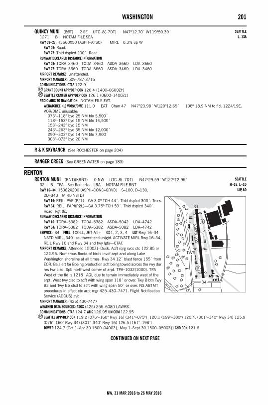
WASHINGTON 201
QUINCY MUNI (80T) 2 SE UTC–8(–7DT) N47º12.70´ W119º50.39´1271 B NOTAM FILE SEARWY 09–27: H3660X50 (ASPH–AFSC) MIRL 0.3% up W
RWY 09: Road.RWY 27: Thld dsplcd 200´. Road.
RUNWAY DECLARED DISTANCE INFORMATIONRWY 09: TORA–3460 TODA–3460 ASDA–3660 LDA–3660RWY 27: TORA–3660 TODA–3660 ASDA–3460 LDA–3460
AIRPORT REMARKS: Unattended.AIRPORT MANAGER: 509-787-3715COMMUNICATIONS: CTAF 122.9
®GRANT COUNT APP/DEP CON 126.4 (1400–0600Z‡)®SEATTLE CENTER APP/DEP CON 126.1 (0600–1400Z‡)
RADIO AIDS TO NAVIGATION: NOTAM FILE EAT.WENATCHEE (L) VORW/DME 111.0 EAT Chan 47 N47º23.98´ W120º12.65´ 108º 18.9 NM to fld. 1224/19E.VOR/DME unusable:
073º–118º byd 25 NM blo 5,500´118º–153º byd 15 NM blo 14,500´153º–243º byd 15 NM243º–263º byd 35 NM blo 12,000´290º–303º byd 14 NM blo 7,900´303º–073º byd 20 NM
R & K SKYRANCH (See ROCHESTER on page 204)
RANGER CREEK (See GREENWATER on page 183)
RENTONRENTON MUNI (RNT)(KRNT) 0 NW UTC–8(–7DT) N47º29.59´ W122º12.95´
32 B TPA—See Remarks LRA NOTAM FILE RNTRWY 16–34: H5382X200 (ASPH–CONC–GRVD) S–100, D–130,
2D–340 MIRL(NSTD)RWY 16: REIL. PAPI(P2L)—GA 3.0º TCH 44´. Thld dsplcd 300´. Trees.RWY 34: REIL. PAPI(P2L)—GA 3.75º TCH 59´. Thld dsplcd 340´. Road. Rgt tfc.
RUNWAY DECLARED DISTANCE INFORMATIONRWY 16: TORA–5382 TODA–5382 ASDA–5042 LDA–4742RWY 34: TORA–5382 TODA–5382 ASDA–5082 LDA–4742
SERVICE: S4 FUEL 100LL, JET A1+ OX 1, 2, 3, 4 LGT Rwy 16–34 NSTD MIRL, 340´ southwest end unlgtd. ACTIVATE MIRL Rwy 16–34, REIL Rwy 16 and Rwy 34 and twy lgts—CTAF.
AIRPORT REMARKS: Attended 1500Z‡–Dusk. Acft rqrg svcs ctc 122.85 or 122.95. Numerous flocks of birds invof arpt and along Lake Washington shoreline at all times. Rwy 34 12´ blast fence 155´ from EOR. Be alert for Boeing production acft being towed across the rwy dur hrs twr clsd. Spb northwest corner of arpt. TPA–1032(1000). TPA West of the fld is 1218´ AGL due to terrain immediately west of the arpt. West twy clsd to acft with wing span 118´ or over. Twy B btn Twy B3 and Twy B5 clsd to acft with wing span 50´ or over. NS ABTMT procedures in effect ctc arpt mgr 425–430–7471. Flight Notification Service (ADCUS) avbl.
AIRPORT MANAGER: (425) 430-7477WEATHER DATA SOURCES: ASOS (425) 255–6080 LAWRS.COMMUNICATIONS: CTAF 124.7 ATIS 126.95 UNICOM 122.95
®SEATTLE APP/DEP CON 119.2 (076°–160° Rwy 16) (341°–075°) 120.1 (199°–300°) 120.4. (301°–340° Rwy 34) 125.9 (076°–160° Rwy 34) (301°–340° Rwy 16) 126.5 (161°–198°)TOWER 124.7 (Oct 1–Apr 30 1500–0400Z‡, May 1–Sept 30 1500–0500Z‡) GND CON 121.6
CONTINUED ON NEXT PAGE
SEATTLEL–13A
SEATTLEH–1B, L–1D
IAP, AD
NW, 31 MAR 2016 to 26 MAY 2016
202 WASHINGTONCONTINUED FROM PRECEDING PAGE
AIRSPACE: CLASS D svc 1500–0400Z‡ Oct 1 thru Apr 30, 1500–0500Z‡ May 1 thru Sep 30, other times CLASS G.RADIO AIDS TO NAVIGATION: NOTAM FILE SEA.
SEATTLE (H) VORTACW 116.8 SEA Chan 115 N47º26.12´ W122º18.58´ 029º 5.2 NM to fld. 354/19E.VOR portion unusable:
008º–023º byd 20 NM blo 3,500´008º–023º byd 30 NM blo 4,100´233º–273º byd 20 NM blo 8,000´233º–273º byd 30 NM blo 10,000´233º–273º byd 35 NM blo 11,000´233º–273º byd 8 NM blo 5,500´303º–333º byd 20 NM blo 2,900´303º–333º byd 30 NM blo 4,000´333º–353º byd 15 NM blo 3,500´353º–008º byd 20 NM blo 2,900´TACAN antenna offset 150’ on 300 radial.
TACAN AZIMUTH & DME unusable:008º–028º byd 20 NM blo 4,500´008º–028º byd 30 NM blo 7,000´203º–253º byd 27 NM303º–008º byd 30 NM blo 3,500´
TACAN AZIMUTH unusable:008º–163º173º–293º
NDB (MHW) 353 RNT N47º29.73´ W122º12.88´ at fld. NOTAM FILE RNT.NDB unusable:
055º–090º byd 20 NM blo 7,000´COMM/NAV/WEATHER REMARKS: Emerg freq 121.5 not avbl at twr.
– – – – – – – – – – – – – – – – – – – – – – – – – – – – – – – – – – – – – – – – – – – – – – – – – – – – – – – –
WILL ROGERS WILEY POST MEM SPB (W36) 1 N UTC–8(–7DT) N47º29.99´ W122º13.16´14 LRA NOTAM FILE RNTWATERWAY 12–30: 5000X200 (WATER)
WATERWAY 12: Rgt tfc.SERVICE: S4 FUEL 100LL, JET A, A1+ OX 1, 2, 3, 4 SEAPLANE REMARKS: Attended 1500Z‡–Dusk. Ctc Renton twr when opr, for tfc data. When twr not opr announce intentions on
124.7. When flying inbd or outbd in the west channel waterway above 800´ AGL ctc Boeing twr freq 118.3 for tfc advisories. Flocks of waterfowl in vcnty, be alert ldgs and tkfs. Water depths vary at docks and seaplane launch ramp. Use caution for localized shoaling. Extv boating and personal watercraft in vcnty. Flight Notification Service (ADCUS) avbl.
AIRPORT MANAGER: (425) 430-7477COMMUNICATIONS: CTAF 124.7 UNICOM 122.8
REPUBLICFERRY CO (R49) 6 NE UTC–8(–7DT) N48º43.09´ W118º39.39´
2522 B TPA—3322(800) NOTAM FILE SEARWY 17–35: H3498X60 (ASPH) MIRL
RWY 17: REIL. Tree. Rgt tfc.RWY 35: REIL. VASI(V2L)—GA 4.0º TCH 23´. Trees.
SERVICE: LGT ACTIVATE MIRL Rwy 17–35 and VASI Rwy 35, REIL Rwy 17 and Rwy 35—122.8.
AIRPORT REMARKS: Unattended. Suggest ngt ldgs be made on Rwy 35. Rwy 17–35 trees located on unlgtd unmarked mountainous terrain. P–lines NE of Rwy 17 lgtd dusk–dawn.
AIRPORT MANAGER: 509-775-3939COMMUNICATIONS: CTAF 122.9RADIO AIDS TO NAVIGATION: NOTAM FILE EPH.
EPHRATA (H) VORTACW 112.6 EPH Chan 73 N47º22.68´ W119º25.44´ 360º 86.2 NM to fld. 1250/21E.
VOR unusable:310º–350º byd 25 NM blo 6,500´
TACAN AZIMUTH & DME portion unusable:280º–295º byd 25 NM blo 7,000´310º–350º byd 25 NM blo 6,500´
• • • • • • • • • • • • • • • • • •
HELIPAD H1: H20X20 (CONC)HELIPAD H2: H20X20 (CONC)
SEATTLE
SEATTLEL–13A
NW, 31 MAR 2016 to 26 MAY 2016
WASHINGTON 203
RICHLAND (RLD)(KRLD) 2 NW UTC–8(–7DT) N46º18.34´ W119º18.25´394 B TPA—1194(800) NOTAM FILE SEARWY 01–19: H4009X75 (ASPH) S–30, D–45, 2D–70 MIRL
RWY 01: REIL. PAPI(P2L)—GA 3.0º TCH 30´. Antenna.RWY 19: MALS. REIL. PAPI(P2L)—GA 3.0º TCH 30´. Pole. Rgt tfc.
RWY 08–26: H4001X100 (ASPH) S–30, D–45, 2D–70 MIRLRWY 08: ODALS. PAPI(P2L)—GA 3.0º TCH 40´. Ground.RWY 26: VASI(V4L)—GA 3.0º TCH 52´. Railroad. Rgt tfc.
SERVICE: S2 FUEL 100LL, JET A LGT VASI Rwy 26 and PAPI Rwy 01, Rwy 08 and Rwy 19 opr 24 hrs. ACTIVATE MIRL Rwy 01–19, REIL Rwy 01 and Rwy 19, MALS Rwy 19 and ODALS Rwy 08—CTAF.
AIRPORT REMARKS: Attended 1600–0200Z‡ Cold temperature restricted airport. Altitude correction required at or below –19C/–2F. Preferred Rwy 01–19 in calm wind conditions. Road 550´ west of AER 08.
AIRPORT MANAGER: 509-375-3060WEATHER DATA SOURCES: AWOS–3PT 132.675 (509) 375–4247.COMMUNICATIONS: CTAF/UNICOM 122.7
®CHINOOK APP/DEP CON 128.75 (1400–0600Z‡)®SEATTLE CENTER APP/DEP CON 132.6 (0600–1400Z‡)
SEATTLE CLNC DEL 122.4RADIO AIDS TO NAVIGATION: NOTAM FILE PSC.
PASCO (L) VORW/DME 109.8 PSC Chan 35 N46º16.22´ W119º07.04´ 270º 8.1 NM to fld. 406/15E.
DME unusable:160º–170º byd 30 NM
LOC/DME 110.5 I–RLD Chan 42 Rwy 19. LOC and LOM unmonitored when PASCO ATCT clsd.
RIMROCKTIETON STATE (4S6) 2 S UTC–8(–7DT) N46º38.25´ W121º07.44´
2964 NOTAM FILE SEARWY 02–20: 2509X100 (TURF)
RWY 02: Trees.RWY 20: Trees.
AIRPORT REMARKS: Unattended. Clsd 1 Oct–1 June exc for approved mil and public safety/law enforcement helicopter ops. Be alert, arpt winter recreation activities during arpt clsd periods. Mil, low apch only during clsd periods. Mountainous terrain surrounds arpt. Rwy 02 obstructed by mountains at 1000´. Rwy 20 obstructed by mountains at 1000´. Vehicles, pedestrians, and animals on and invof arpt. Rwy 02–20 sfc grass and small grvl. Ctc WA State Aviation Division 360–709–8015 or 1–800–552–0666 WA area for facility info prior to use. For acft accidents/incidents ctc WA state emergency operations center 800–258–5990. Rwy marked with reflectors during dates arpt is open.
AIRPORT MANAGER: (360) 618-2477COMMUNICATIONS: CTAF 122.9
RITZVILLEPRU FLD (33S) 1 W UTC–8(–7DT) N47º07.41´ W118º23.36´
1801 B NOTAM FILE SEARWY 01–19: H3433X40 (ASPH) S–12.5 MIRL
RWY 01: PAPI(P2L)—GA 4.0º TCH 40´. P–line.RWY 19: PAPI(P2R)—GA 3.5º TCH 45´. Thld dsplcd 820´. Trees.
RUNWAY DECLARED DISTANCE INFORMATIONRWY 01: TORA–2614 TODA–2614 ASDA–3433 LDA–3433RWY 19: TORA–3433 TODA–3433 ASDA–3433 LDA–2614
SERVICE: LGT ACTIVATE MIRL Rwy 01–19 and PAPI Rwy 01 and Rwy 19—CTAF.
AIRPORT REMARKS: Unattended. Arpt clsd when snow and ice on rwy. AIRPORT MANAGER: 509-659-1930COMMUNICATIONS: CTAF/UNICOM 122.8RADIO AIDS TO NAVIGATION: NOTAM FILE GEG.
SPOKANE (H) VORTACW 115.5 GEG Chan 102 N47º33.90´ W117º37.61´ 209º 40.9 NM to fld. 2756/21E. HIWAS.
VOR portion unusable:300º–330º byd 30 NM blo 9,000´335º–360º byd 18 NM blo 7,000´335º–360º byd 25 NM360º–015º byd 26 NM blo 7,000´
SEATTLEL–13A
IAP
SEATTLE
SEATTLEL–13A
NW, 31 MAR 2016 to 26 MAY 2016
204 WASHINGTON
ROCHE HARBOR SPB (W39) 0 SW UTC–8(–7DT) N48º36.49´ W123º09.58´00 NOTAM FILE SEAWATERWAY NE–SW: 5000X1000 (WATER)WATERWAY NW–SE: 2500X500 (WATER)SEAPLANE REMARKS: Unattended. Call ahead for moorage and ldg instructions 800–586–3590. Call ahead to make cstms
appointment 360–378–2080. Boats in ldg areas and in docking area.AIRPORT MANAGER: (360) 317-6167COMMUNICATIONS: CTAF 128.25
ROCHESTERR & K SKYRANCH (8W9) 1 N UTC–8(–7DT) N46º49.96´ W123º05.49´
149 TPA—999(850) NOTAM FILE SEARWY 16–34: 2480X35 (TURF)
RWY 16: Thld dsplcd 700´. Trees.RWY 34: Thld dsplcd 327´. Fence.
AIRPORT REMARKS: Unattended. Arpt CLOSED except PPR call arpt manager 360–747–7079. No touch and go landings. Rwy 16–34 marked with reflectors. Rwy 16 first 1100´ has shrubs and 70´+ trees approximately 15´ from rwy edges.
AIRPORT MANAGER: (253) 405-0133COMMUNICATIONS: CTAF/UNICOM 123.0
ROGERSBURG (See ANATONE on page 166)
ROSALIA MUNI (72S) 2 W UTC–8(–7DT) N47º14.19´ W117º25.28´2170 B NOTAM FILE SEARWY 02–20: H2807X45 (ASPH) S–15.5 MIRL
RWY 02: Thld dsplcd 165´. Tree.RWY 20: PAPI(P2L)—GA 4.5º. Thld dsplcd 137´. Road.
RUNWAY DECLARED DISTANCE INFORMATIONRWY 02: TORA–2807 TODA–2807 ASDA–2670 LDA–2505RWY 20: TORA–2807 TODA–2807 ASDA–2642 LDA–2505
SERVICE: FUEL 100LL LGT PAPI Rwy 20 opr continuously. ACTIVATE MIRL Rwy 02–20—122.8.AIRPORT REMARKS: Unattended. Rwy 02–20 twy reflectors, not twy lgts. Rotating bcn OTS indef. AIRPORT MANAGER: 509-523-3498COMMUNICATIONS: CTAF 122.9
ROSARIO SPB (W49) 0 S UTC–8(–7DT) N48º38.74´ W122º52.08´00 NOTAM FILE SEAWATERWAY 16–34: 10000X1000 (WATER)
WATERWAY 16: Hill.WATERWAY 07–25: 2500X1000 (WATER)
WATERWAY 07: Hill.WATERWAY 25: Hill.
SEAPLANE REMARKS: Attended dalgt hrs. Tran dock avbl.AIRPORT MANAGER: 360-376-2222COMMUNICATIONS: CTAF 128.25
SAND CANYON (See CHEWELAH on page 172)
SANDERSON FLD (See SHELTON on page 209)
SEATTLE
SEATTLE
SEATTLE
SEATTLE
NW, 31 MAR 2016 to 26 MAY 2016
WASHINGTON 205
SEATTLEBOEING FLD/KING CO INTL (BFI)(KBFI) 4 S UTC–8(–7DT) N47º31.80´ W122º18.12´
21 B TPA—See Remarks AOE Class IV, ARFF Index A NOTAM FILE BFIRWY 13R–31L: H10000X200 (ASPH–GRVD) S–100, D–160, 2S–175,
2D–340 HIRLRWY 13R: MALSF. PAPI(P4L)—GA 3.0º TCH 75´. RVR–T Fence. Rgt tfc.RWY 31L: REIL. PAPI(P4L)—GA 3.1º TCH 66´. Thld dsplcd 880´. Railroad.
RWY 13L–31R: H3710X100 (ASPH–GRVD) S–35, D–60 MIRLRWY 13L: REIL. PAPI(P2L)—GA 3.0º TCH 39´. Thld dsplcd 250´.RWY 31R: REIL. PAPI(P2L)—GA 3.0º TCH 39´. Thld dsplcd 375´. Tree. Rgt tfc.
RUNWAY DECLARED DISTANCE INFORMATIONRWY 13R:TORA–10000TODA–10000 ASDA–9120 LDA–9120RWY 31L:TORA–10000 TODA–10000 ASDA–10000 LDA–9120
SERVICE: S4 FUEL 100LL, JET A OX 1, 2, 3, 4 LGT HIRL Rwy 13R–31L open dusk–dawn. MIRL Rwy 13L–31R not opr 0600–1500Z‡.
AIRPORT REMARKS: Attended continuously. Bird flocks within arpt vcnty, check lcl advisories. Rwy 13L–31R not avbl for air carrier ops. Rwy 13L–31R ltd to use by acft up to 12,500 lbs. Touch and go ldgs prohibited 0600–1500Z‡. Twr 80´ AGL lctd 1200´ N and 900´ W of thld Rwy 13R. 150´ AGL crane 0.75 SW AER 13R. 180´ AGL crane 0.37 NW AER 31L. PPR always for access to Boeing ramp. Ctc Boeing Flt Dispatch 206–544–5900 Mon–Fri 1600–0000Z‡ for apvl. Prior to taxi onto Boeing ramp, ctc Boeing radio twr 123.425 or call 206–662–4500. Twy A1 and Twy A from A1–A3 rstd to acft up to 150,000 lbs and less than 108´ wingspan. Twy A2, Twy B2 and Twy A11 rstd to acft up to 60,000 lbs. Twy A3, Twy A5, and Twy A8 rstd to acft up to 12,500 lbs. PPR for parking arrangements for acft over 12,500 lbs max tkf wt is recommended. Extv helicopter trng act on Twy B. For NS ABTMT procedures, ctc noise office at 206–296–7334. Twy Z and 880´ special use pavement avbl 72 hrs PPR, ctc arpt ops 206–296–7334. For Museum of Flt tran acft parking, PPR, call 206–764–5710. Itinerant/tran parking avbl, PPR ctc ops 206–296–7334. PPR for acft greater than 12,500 lbs. Rwy 13L–31R TPA—1000(979), Rwy 13R–31L TPA—800(779). Flight Notification Service (ADCUS) avbl. NOTE: See Special Notices Section—Simultaneous Operations.
AIRPORT MANAGER: 206-296-7380WEATHER DATA SOURCES: ASOS (206) 763–6904COMMUNICATIONS: ATIS 127.75 206–767–4113 UNICOM 122.95
SEATTLE RCO 122.5 (SEATTLE RADIO)SEATTLE RCO 123.65 (SEATTLE RADIO)
®SEATTLE APP/DEP CON 119.2 (076°–160° Rwy 13) (341°–075°) 120.1 (199°–300°) 120.4 (301°–340° Rwy 31) 125.9 (076°–160° Rwy 31) (301°–340° Rwy 13) 126.5 (161°–198°)BOEING TOWER 120.6 (All IFR) 118.3 (VFR from the East) GND CON 121.9 CLNC DEL 132.4
AIRSPACE: CLASS D svc VOR TEST FACILITY (VOT) 108.6
CONTINUED ON NEXT PAGE
SEATTLEH–1B, L–1D
IAP, AD
NW, 31 MAR 2016 to 26 MAY 2016
206 WASHINGTONCONTINUED FROM PRECEDING PAGE
RADIO AIDS TO NAVIGATION: NOTAM FILE SEA.SEATTLE (H) VORTACW 116.8 SEA Chan 115 N47º26.12´ W122º18.58´ 344º 5.7 NM to fld. 354/19E.VOR portion unusable:
008º–023º byd 20 NM blo 3,500´008º–023º byd 30 NM blo 4,100´233º–273º byd 20 NM blo 8,000´233º–273º byd 30 NM blo 10,000´233º–273º byd 35 NM blo 11,000´233º–273º byd 8 NM blo 5,500´303º–333º byd 20 NM blo 2,900´303º–333º byd 30 NM blo 4,000´333º–353º byd 15 NM blo 3,500´353º–008º byd 20 NM blo 2,900´TACAN antenna offset 150´ on 300 radial.
TACAN AZIMUTH & DME unusable:008º–028º byd 20 NM blo 4,500´008º–028º byd 30 NM blo 7,000´203º–253º byd 27 NM303º–008º byd 30 NM blo 3,500´
TACAN AZIMUTH unusable:008º–163º173º–293º
PARRK NDB (M) 281 HPK N47º31.94´ W122º18.42´ at fld.NOLLA NDB (LOM) 362 BF N47º37.95´ W122º23.37´ 130º 7.1 NM to fld. ILS/DME 110.9 I–BFI Chan 46 Rwy 13R. Class IA. LOM NOLLA NDB. DME unusable byd 30º left of course. LOC
back course unusable byd 13 NM blo 3,500´. LOC unusable byd 20º left of course. LOC back course unusable byd 10º left and right of course.
ILS/DME 110.9 I–CHJ Chan 46 Rwy 31L. Class IA. LOC unusable byd 15º east of course. ILS/DME unusable byd 10º rgt of course.
COMM/NAV/WEATHER REMARKS: Emerg frequency 121.5 not avbl at twr.
– – – – – – – – – – – – – – – – – – – – – – – – – – – – – – – – – – – – – – – – – – – – – – – – – – – – – – – –
KENMORE AIR HARBOR SPB (W55) 1 N UTC–8(–7DT) N47º37.74´ W122º20.32´14 AOE NOTAM FILE SEAWATERWAY 16–34: 5000X500 (WATER)SEAPLANE REMARKS: Attended dawn–dusk. Fuel avbl emerg only. Ngt ldgs not recommended due to unlgtd small watercraft.
Kite flying in public park at north end of arpt. Red buoy indicates start and stop area for tkfs and ldgs. Incr boating ops on lake Apr 15 thru Oct 15. All tkf and ldg in ctr of lake. Special NS ABTMT rules in effect ctc opr for pat info. Do not taxi closer than 200´ from shoreline exc in close proximity to Kenmore Air Harbor. Call 425–486–1257 X2010 for apvl at least 3 hrs prior to arr. Docking fee. Marina freq 130.30. $150 transit docking fee. Flight Notification Service (ADCUS) avbl.
AIRPORT MANAGER: 425-486-1257COMMUNICATIONS: CTAF 122.9
– – – – – – – – – – – – – – – – – – – – – – – – – – – – – – – – – – – – – – – – – – – – – – – – – – – – – – – –
SEATTLE SEAPLANES SPB (0W0) 1 N UTC–8(–7DT) N47º37.66´ W122º19.91´14 NOTAM FILE SEAWATERWAY 18W–36W: 9500X300 (WATER)SERVICE: S2 SEAPLANE REMARKS: Attended 1600Z‡–dusk. Small watercraft act on lake.AIRPORT MANAGER: 206-329-9638COMMUNICATIONS: CTAF 122.9
– – – – – – – – – – – – – – – – – – – – – – – – – – – – – – – – – – – – – – – – – – – – – – – – – – – – – – – –
SEATTLE
SEATTLE
NW, 31 MAR 2016 to 26 MAY 2016
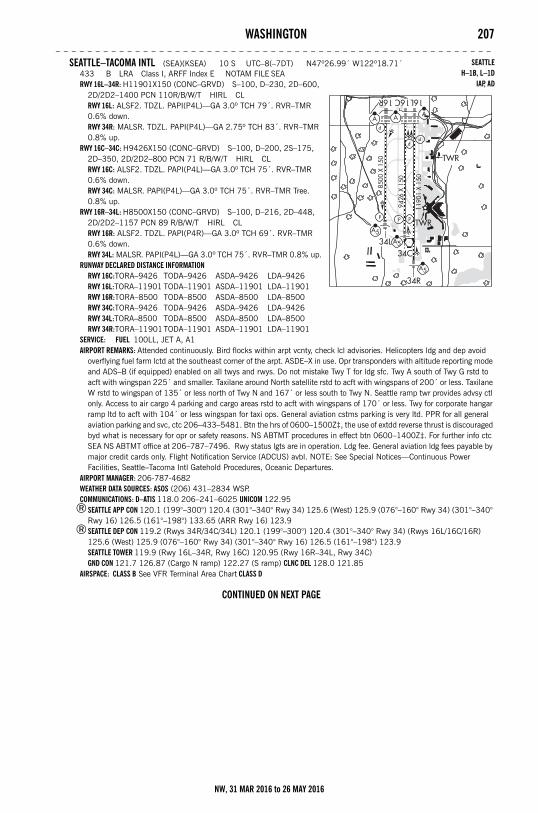
WASHINGTON 207– – – – – – – – – – – – – – – – – – – – – – – – – – – – – – – – – – – – – – – – – – – – – – – – – – – – – – –
SEATTLE–TACOMA INTL (SEA)(KSEA) 10 S UTC–8(–7DT) N47º26.99´ W122º18.71´433 B LRA Class I, ARFF Index E NOTAM FILE SEARWY 16L–34R: H11901X150 (CONC–GRVD) S–100, D–230, 2D–600,
2D/2D2–1400 PCN 110R/B/W/T HIRL CLRWY 16L: ALSF2. TDZL. PAPI(P4L)—GA 3.0º TCH 79´. RVR–TMR 0.6% down.RWY 34R: MALSR. TDZL. PAPI(P4L)—GA 2.75º TCH 83´. RVR–TMR 0.8% up.
RWY 16C–34C: H9426X150 (CONC–GRVD) S–100, D–200, 2S–175, 2D–350, 2D/2D2–800 PCN 71 R/B/W/T HIRL CLRWY 16C: ALSF2. TDZL. PAPI(P4L)—GA 3.0º TCH 75´. RVR–TMR 0.6% down.RWY 34C: MALSR. PAPI(P4L)—GA 3.0º TCH 75´. RVR–TMR Tree. 0.8% up.
RWY 16R–34L: H8500X150 (CONC–GRVD) S–100, D–216, 2D–448, 2D/2D2–1157 PCN 89 R/B/W/T HIRL CLRWY 16R: ALSF2. TDZL. PAPI(P4R)—GA 3.0º TCH 69´. RVR–TMR 0.6% down.RWY 34L: MALSR. PAPI(P4L)—GA 3.0º TCH 75´. RVR–TMR 0.8% up.
RUNWAY DECLARED DISTANCE INFORMATIONRWY 16C:TORA–9426 TODA–9426 ASDA–9426 LDA–9426RWY 16L:TORA–11901 TODA–11901 ASDA–11901 LDA–11901RWY 16R:TORA–8500 TODA–8500 ASDA–8500 LDA–8500RWY 34C:TORA–9426 TODA–9426 ASDA–9426 LDA–9426RWY 34L:TORA–8500 TODA–8500 ASDA–8500 LDA–8500RWY 34R:TORA–11901TODA–11901 ASDA–11901 LDA–11901
SERVICE: FUEL 100LL, JET A, A1 AIRPORT REMARKS: Attended continuously. Bird flocks within arpt vcnty, check lcl advisories. Helicopters ldg and dep avoid
overflying fuel farm lctd at the southeast corner of the arpt. ASDE–X in use. Opr transponders with altitude reporting mode and ADS–B (if equipped) enabled on all twys and rwys. Do not mistake Twy T for ldg sfc. Twy A south of Twy G rstd to acft with wingspan 225´ and smaller. Taxilane around North satellite rstd to acft with wingspans of 200´ or less. Taxilane W rstd to wingspan of 135´ or less north of Twy N and 167´ or less south to Twy N. Seattle ramp twr provides advsy ctl only. Access to air cargo 4 parking and cargo areas rstd to acft with wingspans of 170´ or less. Twy for corporate hangar ramp ltd to acft with 104´ or less wingspan for taxi ops. General aviation cstms parking is very ltd. PPR for all general aviation parking and svc, ctc 206–433–5481. Btn the hrs of 0600–1500Z‡, the use of extdd reverse thrust is discouraged byd what is necessary for opr or safety reasons. NS ABTMT procedures in effect btn 0600–1400Z‡. For further info ctc SEA NS ABTMT office at 206–787–7496. Rwy status lgts are in operation. Ldg fee. General aviation ldg fees payable by major credit cards only. Flight Notification Service (ADCUS) avbl. NOTE: See Special Notices—Continuous Power Facilities, Seattle–Tacoma Intl Gatehold Procedures, Oceanic Departures.
AIRPORT MANAGER: 206-787-4682WEATHER DATA SOURCES: ASOS (206) 431–2834 WSP.COMMUNICATIONS: D–ATIS 118.0 206–241–6025 UNICOM 122.95
®SEATTLE APP CON 120.1 (199°–300°) 120.4 (301°–340° Rwy 34) 125.6 (West) 125.9 (076°–160° Rwy 34) (301°–340° Rwy 16) 126.5 (161°–198°) 133.65 (ARR Rwy 16) 123.9
®SEATTLE DEP CON 119.2 (Rwys 34R/34C/34L) 120.1 (199°–300°) 120.4 (301°–340° Rwy 34) (Rwys 16L/16C/16R) 125.6 (West) 125.9 (076°–160° Rwy 34) (301°–340° Rwy 16) 126.5 (161°–198°) 123.9SEATTLE TOWER 119.9 (Rwy 16L–34R, Rwy 16C) 120.95 (Rwy 16R–34L, Rwy 34C)GND CON 121.7 126.87 (Cargo N ramp) 122.27 (S ramp) CLNC DEL 128.0 121.85
AIRSPACE: CLASS B See VFR Terminal Area Chart CLASS D
CONTINUED ON NEXT PAGE
SEATTLEH–1B, L–1D
IAP, AD
NW, 31 MAR 2016 to 26 MAY 2016
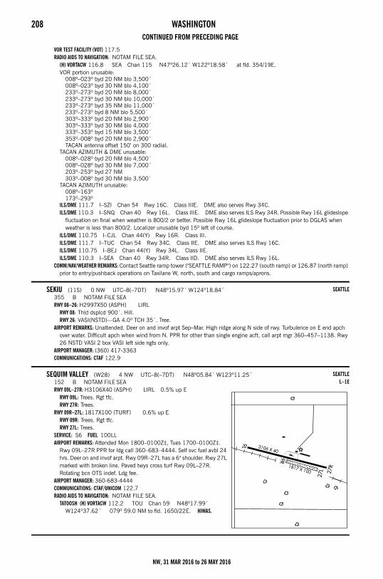
208 WASHINGTONCONTINUED FROM PRECEDING PAGE
VOR TEST FACILITY (VOT) 117.5RADIO AIDS TO NAVIGATION: NOTAM FILE SEA.
(H) VORTACW 116.8 SEA Chan 115 N47º26.12´ W122º18.58´ at fld. 354/19E.VOR portion unusable:
008º–023º byd 20 NM blo 3,500´008º–023º byd 30 NM blo 4,100´233º–273º byd 20 NM blo 8,000´233º–273º byd 30 NM blo 10,000´233º–273º byd 35 NM blo 11,000´233º–273º byd 8 NM blo 5,500´303º–333º byd 20 NM blo 2,900´303º–333º byd 30 NM blo 4,000´333º–353º byd 15 NM blo 3,500´353º–008º byd 20 NM blo 2,900´TACAN antenna offset 150’ on 300 radial.
TACAN AZIMUTH & DME unusable:008º–028º byd 20 NM blo 4,500´008º–028º byd 30 NM blo 7,000´203º–253º byd 27 NM303º–008º byd 30 NM blo 3,500´
TACAN AZIMUTH unusable:008º–163º173º–293º
ILS/DME 111.7 I–SZI Chan 54 Rwy 16C. Class IIIE. DME also serves Rwy 34C.ILS/DME 110.3 I–SNQ Chan 40 Rwy 16L. Class IIIE. DME also serves ILS Rwy 34R. Possible Rwy 16L glideslope
fluctuation on final when weather is 800/2 or better. Possible Rwy 16L glideslope fluctuation prior to DGLAS when weather is less than 800/2. Localizer unusable byd 15º left of course.
ILS/DME 110.75 I–CJL Chan 44(Y) Rwy 16R. Class III.ILS/DME 111.7 I–TUC Chan 54 Rwy 34C. Class IIE. DME also serves ILS Rwy 16C.ILS/DME 110.75 I–BEJ Chan 44(Y) Rwy 34L. Class IIE.ILS/DME 110.3 I–SEA Chan 40 Rwy 34R. Class IID. DME also serves ILS Rwy 16L.
COMM/NAV/WEATHER REMARKS: Contact Seattle ramp tower ("SEATTLE RAMP") on 122.27 (south ramp) or 126.87 (north ramp) prior to entry/pushback operations on Taxilane W, north, south and cargo ramps/aprons.
SEKIU (11S) 0 NW UTC–8(–7DT) N48º15.97´ W124º18.84´355 B NOTAM FILE SEARWY 08–26: H2997X50 (ASPH) LIRL
RWY 08: Thld dsplcd 900´. Hill.RWY 26: VASI(NSTD)—GA 4.0º TCH 35´. Tree.
AIRPORT REMARKS: Unattended. Deer on and invof arpt Sep–Mar. High ridge along N side of rwy. Turbulence on E end apch over water. Difficult apch when wind from N. PPR for other than single engine acft, call arpt mgr 360–457–1138. Rwy 26 NSTD VASI 2 box VASI left side ngts only.
AIRPORT MANAGER: (360) 417-3363COMMUNICATIONS: CTAF 122.9
SEQUIM VALLEY (W28) 4 NW UTC–8(–7DT) N48º05.84´ W123º11.25´152 B NOTAM FILE SEARWY 09L–27R: H3106X40 (ASPH) LIRL 0.5% up E
RWY 09L: Trees. Rgt tfc.RWY 27R: Trees.
RWY 09R–27L: 1817X100 (TURF) 0.6% up ERWY 09R: Trees. Rgt tfc.RWY 27L: Trees.
SERVICE: S6 FUEL 100LL AIRPORT REMARKS: Attended Mon 1800–0100Z‡, Tues 1700–0100Z‡.
Rwy 09L–27R PPR for ldg call 360–683–4444. Self svc fuel avbl 24 hrs. Deer on and invof arpt. Rwy 09R–27L has a 6" shoulder. Rwy 27L marked with broken line. Paved twys cross turf Rwy 09L–27R. Rotating bcn OTS indef. Ldg fee.
AIRPORT MANAGER: 360-683-4444COMMUNICATIONS: CTAF/UNICOM 122.7RADIO AIDS TO NAVIGATION: NOTAM FILE SEA.
TATOOSH (H) VORTACW 112.2 TOU Chan 59 N48º17.99´ W124º37.62´ 079º 59.0 NM to fld. 1650/22E. HIWAS.
SEATTLE
SEATTLEL–1E
NW, 31 MAR 2016 to 26 MAY 2016
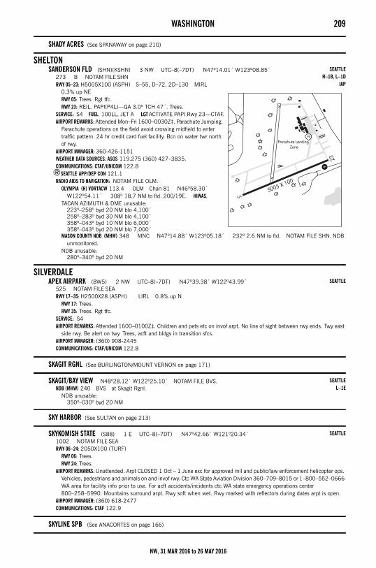
WASHINGTON 209
SHADY ACRES (See SPANAWAY on page 210)
SHELTONSANDERSON FLD (SHN)(KSHN) 3 NW UTC–8(–7DT) N47º14.01´ W123º08.85´
273 B NOTAM FILE SHNRWY 05–23: H5005X100 (ASPH) S–55, D–72, 2D–130 MIRL
0.3% up NERWY 05: Trees. Rgt tfc.RWY 23: REIL. PAPI(P4L)—GA 3.0º TCH 47´. Trees.
SERVICE: S4 FUEL 100LL, JET A LGT ACTIVATE PAPI Rwy 23—CTAF.AIRPORT REMARKS: Attended Mon–Fri 1600–0030Z‡. Parachute Jumping.
Parachute operations on the field avoid crossing midfield to enter traffic pattern. 24 hr credit card fuel facility. Bcn on water twr north of rwy.
AIRPORT MANAGER: 360-426-1151WEATHER DATA SOURCES: ASOS 119.275 (360) 427–3835.COMMUNICATIONS: CTAF/UNICOM 122.8
®SEATTLE APP/DEP CON 121.1RADIO AIDS TO NAVIGATION: NOTAM FILE OLM.
OLYMPIA (H) VORTACW 113.4 OLM Chan 81 N46º58.30´ W122º54.11´ 308º 18.7 NM to fld. 200/19E. HIWAS.
TACAN AZIMUTH & DME unusable:223º–258º byd 20 NM blo 4,100´258º–283º byd 30 NM blo 4,100´358º–043º byd 10 NM blo 6,000´358º–043º byd 20 NM blo 7,000´
MASON COUNTY NDB (MHW) 348 MNC N47º14.88´ W123º05.18´ 232º 2.6 NM to fld. NOTAM FILE SHN. NDB unmonitored.
NDB unusable:280º–340º byd 20 NM
SILVERDALEAPEX AIRPARK (8W5) 2 NW UTC–8(–7DT) N47º39.38´ W122º43.99´
525 NOTAM FILE SEARWY 17–35: H2500X28 (ASPH) LIRL 0.8% up N
RWY 17: Trees.RWY 35: Trees. Rgt tfc.
SERVICE: S4 AIRPORT REMARKS: Attended 1600–0100Z‡. Children and pets etc on invof arpt. No line of sight between rwy ends. Twy east
side rwy. Be alert on twy. Trees, acft and bldgs in transition sfcs.AIRPORT MANAGER: (360) 908-2445COMMUNICATIONS: CTAF/UNICOM 122.8
SKAGIT RGNL (See BURLINGTON/MOUNT VERNON on page 171)
SKAGIT/BAY VIEW N48º28.12´ W122º25.10´ NOTAM FILE BVS.NDB (MHW) 240 BVS at Skagit Rgnl.
NDB unusable:350º–030º byd 20 NM
SKY HARBOR (See SULTAN on page 213)
SKYKOMISH STATE (S88) 1 E UTC–8(–7DT) N47º42.66´ W121º20.34´1002 NOTAM FILE SEARWY 06–24: 2050X100 (TURF)
RWY 06: Trees.RWY 24: Trees.
AIRPORT REMARKS: Unattended. Arpt CLOSED 1 Oct – 1 June exc for approved mil and public/law enforcement helicopter ops. Vehicles, pedestrians and animals on and invof rwy. Ctc WA State Aviation Division 360–709–8015 or 1–800–552–0666 WA area for facility info prior to use. For acft accidents/incidents ctc WA state emergency operations center 800–258–5990. Mountains surround arpt. Rwy soft when wet. Rwy marked with reflectors during dates arpt is open.
AIRPORT MANAGER: (360) 618-2477COMMUNICATIONS: CTAF 122.9
SKYLINE SPB (See ANACORTES on page 166)
SEATTLEH–1B, L–1D
IAP
SEATTLE
SEATTLEL–1E
SEATTLE
NW, 31 MAR 2016 to 26 MAY 2016
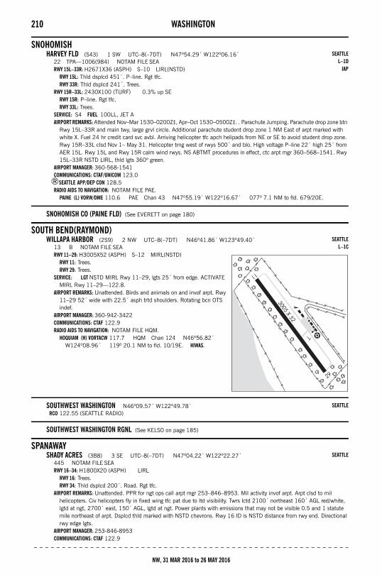
210 WASHINGTON
SNOHOMISHHARVEY FLD (S43) 1 SW UTC–8(–7DT) N47º54.29´ W122º06.16´
22 TPA—1006(984) NOTAM FILE SEARWY 15L–33R: H2671X36 (ASPH) S–10 LIRL(NSTD)
RWY 15L: Thld dsplcd 451´. P–line. Rgt tfc.RWY 33R: Thld dsplcd 241´. Trees.
RWY 15R–33L: 2430X100 (TURF) 0.3% up SERWY 15R: P–line. Rgt tfc.RWY 33L: Trees.
SERVICE: S4 FUEL 100LL, JET A AIRPORT REMARKS: Attended Nov–Mar 1530–0200Z‡, Apr–Oct 1530–0500Z‡. . Parachute Jumping. Parachute drop zone btn
Rwy 15L–33R and main twy, large grvl circle. Additional parachute student drop zone 1 NM East of arpt marked with white X. Fuel 24 hr credit card svc avbl. Arriving helicopter tfc apch helipads from NE or SE to avoid student drop zone. Rwy 15R–33L clsd Nov 1– May 31. Helicopter trng west of rwys 500´ and blo. High voltage P–line 22´ high 25´ from AER 15L. Rwy 15L and Rwy 15R calm wind rwys. NS ABTMT procedures in effect, ctc arpt mgr 360–568–1541. Rwy 15L–33R NSTD LIRL, thld lgts 360º green.
AIRPORT MANAGER: 360-568-1541COMMUNICATIONS: CTAF/UNICOM 123.0
®SEATTLE APP/DEP CON 128.5RADIO AIDS TO NAVIGATION: NOTAM FILE PAE.
PAINE (L) VORW/DME 110.6 PAE Chan 43 N47º55.19´ W122º16.67´ 077º 7.1 NM to fld. 679/20E.
SNOHOMISH CO (PAINE FLD) (See EVERETT on page 180)
SOUTH BEND(RAYMOND)WILLAPA HARBOR (2S9) 2 NW UTC–8(–7DT) N46º41.86´ W123º49.40´
13 B NOTAM FILE SEARWY 11–29: H3005X52 (ASPH) S–12 MIRL(NSTD)
RWY 11: Trees.RWY 29: Trees.
SERVICE: LGT NSTD MIRL Rwy 11–29, lgts 25´ from edge. ACTIVATE MIRL Rwy 11–29—122.8.
AIRPORT REMARKS: Unattended. Birds and animals on and invof arpt. Rwy 11–29 52´ wide with 22.5´ asph trtd shoulders. Rotating bcn OTS indef.
AIRPORT MANAGER: 360-942-3422COMMUNICATIONS: CTAF 122.9RADIO AIDS TO NAVIGATION: NOTAM FILE HQM.
HOQUIAM (H) VORTACW 117.7 HQM Chan 124 N46º56.82´ W124º08.96´ 119º 20.1 NM to fld. 10/19E. HIWAS.
SOUTHWEST WASHINGTON N46º09.57´ W122º49.78´RCO 122.55 (SEATTLE RADIO)
SOUTHWEST WASHINGTON RGNL (See KELSO on page 185)
SPANAWAYSHADY ACRES (3B8) 3 SE UTC–8(–7DT) N47º04.22´ W122º22.27´
445 NOTAM FILE SEARWY 16–34: H1800X20 (ASPH) LIRL
RWY 16: Trees.RWY 34: Thld dsplcd 200´. Road. Rgt tfc.
AIRPORT REMARKS: Unattended. PPR for ngt ops call arpt mgr 253–846–8953. Mil activity invof arpt. Arpt clsd to mil helicopters. Civ helicopters fly in fixed wing tfc pat due to ltd visibility. Twrs lctd 2100´ northeast 160´ AGL red/white, lgtd at ngt, 2700´ east, 150´ AGL, lgtd at ngt. Power plants with emissions that may not be visible 0.5 and 1 statute mile northeast of arpt. Dsplcd thld marked with NSTD chevrons. Rwy 16 ID is NSTD distance from rwy end. Directional rwy edge lgts.
AIRPORT MANAGER: 253-846-8953COMMUNICATIONS: CTAF 122.9
– – – – – – – – – – – – – – – – – – – – – – – – – – – – – – – – – – – – – – – – – – – – – – – – – – – – – – – –
SEATTLEL–1D
IAP
SEATTLEL–1C
SEATTLE
SEATTLE
NW, 31 MAR 2016 to 26 MAY 2016
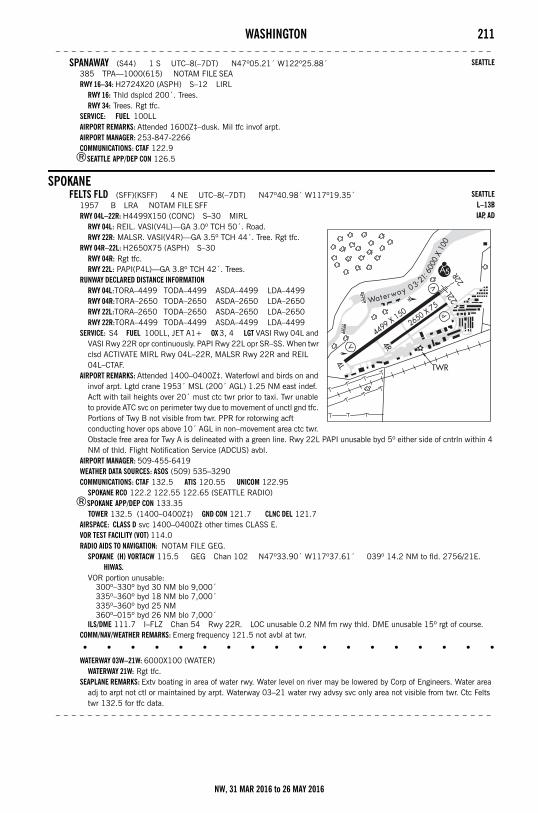
WASHINGTON 211– – – – – – – – – – – – – – – – – – – – – – – – – – – – – – – – – – – – – – – – – – – – – – – – – – – – – – –
SPANAWAY (S44) 1 S UTC–8(–7DT) N47º05.21´ W122º25.88´385 TPA—1000(615) NOTAM FILE SEARWY 16–34: H2724X20 (ASPH) S–12 LIRL
RWY 16: Thld dsplcd 200´. Trees.RWY 34: Trees. Rgt tfc.
SERVICE: FUEL 100LL AIRPORT REMARKS: Attended 1600Z‡–dusk. Mil tfc invof arpt.AIRPORT MANAGER: 253-847-2266COMMUNICATIONS: CTAF 122.9
®SEATTLE APP/DEP CON 126.5
SPOKANEFELTS FLD (SFF)(KSFF) 4 NE UTC–8(–7DT) N47º40.98´ W117º19.35´
1957 B LRA NOTAM FILE SFFRWY 04L–22R: H4499X150 (CONC) S–30 MIRL
RWY 04L: REIL. VASI(V4L)—GA 3.0º TCH 50´. Road.RWY 22R: MALSR. VASI(V4R)—GA 3.5º TCH 44´. Tree. Rgt tfc.
RWY 04R–22L: H2650X75 (ASPH) S–30RWY 04R: Rgt tfc.RWY 22L: PAPI(P4L)—GA 3.8º TCH 42´. Trees.
RUNWAY DECLARED DISTANCE INFORMATIONRWY 04L:TORA–4499 TODA–4499 ASDA–4499 LDA–4499RWY 04R:TORA–2650 TODA–2650 ASDA–2650 LDA–2650RWY 22L:TORA–2650 TODA–2650 ASDA–2650 LDA–2650RWY 22R:TORA–4499 TODA–4499 ASDA–4499 LDA–4499
SERVICE: S4 FUEL 100LL, JET A1+ OX 3, 4 LGT VASI Rwy 04L and VASI Rwy 22R opr continuously. PAPI Rwy 22L opr SR–SS. When twr clsd ACTIVATE MIRL Rwy 04L–22R, MALSR Rwy 22R and REIL 04L–CTAF.
AIRPORT REMARKS: Attended 1400–0400Z‡. Waterfowl and birds on and invof arpt. Lgtd crane 1953´ MSL (200´ AGL) 1.25 NM east indef. Acft with tail heights over 20´ must ctc twr prior to taxi. Twr unable to provide ATC svc on perimeter twy due to movement of unctl gnd tfc. Portions of Twy B not visible from twr. PPR for rotorwing acft conducting hover ops above 10´ AGL in non–movement area ctc twr. Obstacle free area for Twy A is delineated with a green line. Rwy 22L PAPI unusable byd 5º either side of cntrln within 4 NM of thld. Flight Notification Service (ADCUS) avbl.
AIRPORT MANAGER: 509-455-6419WEATHER DATA SOURCES: ASOS (509) 535–3290COMMUNICATIONS: CTAF 132.5 ATIS 120.55 UNICOM 122.95
SPOKANE RCO 122.2 122.55 122.65 (SEATTLE RADIO)®SPOKANE APP/DEP CON 133.35
TOWER 132.5 (1400–0400Z‡) GND CON 121.7 CLNC DEL 121.7AIRSPACE: CLASS D svc 1400–0400Z‡ other times CLASS E.VOR TEST FACILITY (VOT) 114.0RADIO AIDS TO NAVIGATION: NOTAM FILE GEG.
SPOKANE (H) VORTACW 115.5 GEG Chan 102 N47º33.90´ W117º37.61´ 039º 14.2 NM to fld. 2756/21E. HIWAS.
VOR portion unusable:300º–330º byd 30 NM blo 9,000´335º–360º byd 18 NM blo 7,000´335º–360º byd 25 NM360º–015º byd 26 NM blo 7,000´
ILS/DME 111.7 I–FLZ Chan 54 Rwy 22R. LOC unusable 0.2 NM fm rwy thld. DME unusable 15º rgt of course.COMM/NAV/WEATHER REMARKS: Emerg frequency 121.5 not avbl at twr.
• • • • • • • • • • • • • • • • • •
WATERWAY 03W–21W: 6000X100 (WATER)WATERWAY 21W: Rgt tfc.
SEAPLANE REMARKS: Extv boating in area of water rwy. Water level on river may be lowered by Corp of Engineers. Water area adj to arpt not ctl or maintained by arpt. Waterway 03–21 water rwy advsy svc only area not visible from twr. Ctc Felts twr 132.5 for tfc data.
– – – – – – – – – – – – – – – – – – – – – – – – – – – – – – – – – – – – – – – – – – – – – – – – – – – – – – –
SEATTLE
SEATTLEL–13BIAP, AD
NW, 31 MAR 2016 to 26 MAY 2016
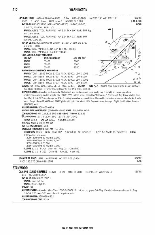
212 WASHINGTON– – – – – – – – – – – – – – – – – – – – – – – – – – – – – – – – – – – – – – – – – – – – – – – – – – – – – – – –
SPOKANE INTL (GEG)(KGEG) P (ARNG) 5 SW UTC–8(–7DT) N47º37.14´ W117º32.11´2385 B AOE Class I, ARFF Index B NOTAM FILE GEGRWY 03–21: H11002X150 (ASPH–CONC–GRVD) S–200, D–200,
2S–175, 2D–400 HIRL CLRWY 03: ALSF2. TDZL. PAPI(P4L)—GA 3.0º TCH 69´. RVR–TMR Rgt tfc. 0.5% down.RWY 21: ALSF2. TDZL. PAPI(P4L)—GA 3.0º TCH 73´. RVR–TMR Ground. 0.6% up.
RWY 07–25: H8199X150 (ASPH–GRVD) S–150, D–180, 2S–175, 2D–280 MIRLRWY 07: REIL. PAPI(P4R)—GA 3.0º TCH 45´. Rgt tfc.RWY 25: REIL. PAPI(P4L)—GA 3.0º TCH 48´.
LAND AND HOLD–SHORT OPERATIONSLDG RWY HOLD–SHORT POINT AVBL LDG DISTRWY 07 03–21 2800RWY 21 07–25 7000RWY 25 03–21 4350
RUNWAY DECLARED DISTANCE INFORMATIONRWY 03: TORA–11002 TODA–11002 ASDA–11002 LDA–11002RWY 07: TORA–8199 TODA–8199 ASDA–8199 LDA–8199RWY 21: TORA–11002 TODA–11002 ASDA–11002 LDA–11002RWY 25: TORA–8199 TODA–8199 ASDA–8199 LDA–8199
SERVICE: S4 FUEL 100, 100LL, JET A OX 1, 2, 3, 4 MILITARY— FUEL A, A+ (C509–455–5204, avbl 1400–0600Z‡, hol 1600–0000Z‡, OT 2 hr PN, $90 per hr fee) (NC–100, 100LL).
AIRPORT REMARKS: Attended continuously. Waterfowl and birds on and invof arpt. Twy K unlgtd on ramp side along maintenance ramp and is unavbl blo 1200´ RVR unless under escort by "follow me." Portions of Twy K not visible from twr. Rwy 21 ALSF2 may be opr as SSALR during favorable wx conditions. Be alert to turbulence over smoke stacks 1 mile east of arpt. Rwy 07 VGSI and RNAV glidepath not coincident. U.S. Customs user fee arpt. Flight Notification Service (ADCUS) avbl.
AIRPORT MANAGER: 509-455-6419WEATHER DATA SOURCES: ASOS (509) 624–4406 HIWAS 115.5 GEG. WSP.COMMUNICATIONS: ATIS 124.325 509–838–0895 UNICOM 122.95
® APP/DEP CON 123.75 (205º–25º) 133.35 (26º–204º) TOWER 118.3 GND CON 121.9 CLNC DEL 127.55
AIRSPACE: CLASS C svc ctc APP CONVOR TEST FACILITY (VOT) 109.6RADIO AIDS TO NAVIGATION: NOTAM FILE GEG.
(H) VORTACW 115.5 GEG Chan 102 N47º33.90´ W117º37.61´ 028º 4.9 NM to fld. 2756/21E. HIWAS.VOR portion unusable:
300º–330º byd 30 NM blo 9,000´335º–360º byd 18 NM blo 7,000´335º–360º byd 25 NM360º–015º byd 26 NM blo 7,000´
ILS/DME 111.1 I–OLJ Chan 48 Rwy 03. Class IIIE.ILS/DME 111.1 I–GEG Chan 48 Rwy 21. Class IIIE.
STAMPEDE PASS SMP N47º15.98´ W121º22.07´/3964ASOS 135.275 (360) 886–2758
STANWOODCAMANO ISLAND AIRFIELD (13W) 3 NW UTC–8(–7DT) N48º15.42´ W122º26.17´
145 NOTAM FILE SEARWY 16–34: H1750X24 (ASPH)
RWY 16: Tree. Rgt tfc.RWY 34: Brush. Rgt tfc.
SERVICE: S4 AIRPORT REMARKS: Attended Mon–Thur 1630–0130Z‡. Do not taxi on grass Oct–May. Parallel driveway adjacent to Rwy
16–34. 20´ trees 35´ west of cntrln in primary sfc.AIRPORT MANAGER: 360-629-4812COMMUNICATIONS: CTAF 122.9
SEATTLEH–1C, L–13B
IAP, AD
SEATTLEL–1D
SEATTLE
NW, 31 MAR 2016 to 26 MAY 2016
WASHINGTON 213
STARBUCKLITTLE GOOSE LOCK AND DAM (16W) 7 NE UTC–8(–7DT) N46º35.04´ W118º00.22´
681 NOTAM FILE SEARWY 07–25: 3400X50 (GRVL)
RWY 07: Road.RWY 25: Hill.
AIRPORT REMARKS: Unattended. Do not land if snow present on rwy. No winter snow removal ops. Ctc WA State Aviation Division 360–709–8015 or 1–800–552–0666 WA area for facility info prior to use. For acft accidents/incidents ctc WA state emergency operations center 800–258–5990. Arpt lctd in canyon, rolling terrain 700–800´ south rising to 750´, canyon wall 800´ south rises steeply to 1800´+, north wall rises to 1600´+. Density altitude. High terrain surrounds arpt. Strong winds possible inside canyon. Pedestrians, vehicles, and animals on and invof rwy. Portions of rwy sfc rough and soft. Rwy marked with reflectors dur dates arpt is open.
AIRPORT MANAGER: (360) 618-2477COMMUNICATIONS: CTAF 122.9
STEHEKIN STATE (6S9) 3 NW UTC–8(–7DT) N48º20.75´ W120º43.25´1230 NOTAM FILE SEARWY 13–31: 2630X100 (TURF) 1.5% up NW
RWY 13: Trees.RWY 31: Brush.
AIRPORT REMARKS: Unattended. Arpt CLOSED 1 Oct—1 Jun exc for apvd mil and public safety/law enforcement helicopter ops. No mil use dur clsd periods exc emerg. Pedestrians, vehicles and animals on and invof rwy. Ctc WA State Aviation Division 360–709–8015 or 1–800–552–0666 WA area for facility info prior to use. For acft accidents/incidents ctc WA state emergency operations center 800–258–5990. Rwy marked with reflectors dur dates arpt is open.
AIRPORT MANAGER: (360) 618-2477COMMUNICATIONS: CTAF 122.9
STROM FLD (See MORTON on page 191)
SULLIVAN LAKE STATE (See METALINE FALLS on page 190)
SULTANSKY HARBOR (S86) 1 E UTC–8(–7DT) N47º52.24´ W121º47.54´
282 NOTAM FILE SEARWY 07–25: 1930X100 (TURF)
RWY 07: Brush.RWY 25: Brush.
AIRPORT REMARKS: Unattended. Ctc arpt mgr 425–359–4625 for facility info prior to use. Watch for animals and children on and invof arpt. West end very soft in winter and spring. Preferred rwy ops wind permitting land west, tkf east. Avoid arpt dur high wind conditions. No touch and go ops. No instr or student ops. Helicopter parking northeast end of rwy.
AIRPORT MANAGER: 425-359-4625COMMUNICATIONS: CTAF 122.9 UNICOM 122.8
SUNNYSIDE MUNI (1S5) 2 E UTC–8(–7DT) N46º19.63´ W119º58.22´768 B NOTAM FILE 1S5RWY 07–25: H3423X60 (ASPH) S–12.5 LIRL 0.6% up E
RWY 07: PAPI(P2L)—GA 3.0º. Road.RWY 25: PAPI(P2L)—GA 3.0º. Pole.
SERVICE: FUEL 100LL AIRPORT REMARKS: Unattended.AIRPORT MANAGER: 509-837-5206WEATHER DATA SOURCES: AWOS–3PT 123.675 (509) 836–2384.COMMUNICATIONS: CTAF 122.9RADIO AIDS TO NAVIGATION: NOTAM FILE PSC.
PASCO (L) VORW/DME 109.8 PSC Chan 35 N46º16.22´ W119º07.04´ 261º 35.7 NM to fld. 406/15E.
DME unusable:160º–170º byd 30 NM
SEATTLE
SEATTLE
SEATTLE
SEATTLEL–13A
NW, 31 MAR 2016 to 26 MAY 2016
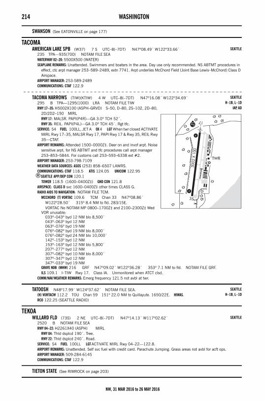
214 WASHINGTON
SWANSON (See EATONVILLE on page 177)
TACOMAAMERICAN LAKE SPB (W37) 7 S UTC–8(–7DT) N47º08.49´ W122º33.66´
235 TPA—935(700) NOTAM FILE SEAWATERWAY 02–20: 5500X500 (WATER)SEAPLANE REMARKS: Unattended. Swimmers and boaters in the area. Day use only recommended. NS ABTMT procedures in
effect, ctc arpt manager 253–589–2489, extn 7741. Arpt underlies McChord Field (Joint Base Lewis–McChord) Class D Airspace.
AIRPORT MANAGER: 253-589-2489COMMUNICATIONS: CTAF 122.9
– – – – – – – – – – – – – – – – – – – – – – – – – – – – – – – – – – – – – – – – – – – – – – – – – – – – – – – –
TACOMA NARROWS (TIW)(KTIW) 4 W UTC–8(–7DT) N47º16.08´ W122º34.69´295 B TPA—1295(1000) LRA NOTAM FILE TIWRWY 17–35: H5002X100 (ASPH–GRVD) S–50, D–80, 2S–102, 2D–80,
2D/2D2–150 MIRLRWY 17: MALSR. PAPI(P4R)—GA 3.0º TCH 52´.RWY 35: REIL. PAPI(P4L)—GA 3.0º TCH 45´. Rgt tfc.
SERVICE: S4 FUEL 100LL, JET A OX 4 LGT When twr closed ACTIVATE MIRL Rwy 17–35, MALSR Rwy 17, PAPI Rwy 17 & Rwy 35, REIL Rwy 35—CTAF.
AIRPORT REMARKS: Attended 1500–0000Z‡. Deer on and invof arpt. Noise sensitive arpt, for NS ABTMT and tfc procedures call arpt manager 253–853–5844. For customs call 253–593–6338 ext #2.
AIRPORT MANAGER: 253-798-7109WEATHER DATA SOURCES: ASOS (253) 858–6507 LAWRS.COMMUNICATIONS: CTAF 118.5 ATIS 124.05 UNICOM 122.95
®SEATTLE APP/DEP CON 120.1 TOWER 118.5 (1600–0400Z‡) GND CON 121.8
AIRSPACE: CLASS D svc 1600–0400Z‡ other times CLASS G.RADIO AIDS TO NAVIGATION: NOTAM FILE TCM.
MCCHORD (T) VORTAC 109.6 TCM Chan 33 N47º08.86´ W122º28.50´ 315º 8.4 NM to fld. 283/15E.VORTAC No NOTAM MP 0800–1700Z‡ and 2100–2300Z‡ Wed
VOR unusable:033º–043º byd 12 NM blo 8,500´043º–063º byd 12 NM063º–076º byd 19 NM076º–082º byd 19 NM blo 8,000´076º–082º byd 24 NM blo 10,000´142º–153º byd 12 NM153º–163º byd 12 NM blo 5,800´207º–277º byd 12 NM307º–082º byd 10 NM blo 8,000´307º–347º byd 12 NM347º–033º byd 19 NM
GRAYE NDB (MHW) 216 GRF N47º09.02´ W122º36.28´ 353º 7.1 NM to fld. NOTAM FILE GRF.ILS 109.1 I–TIW Rwy 17. Class IA. Unmonitored when ATCT clsd.
COMM/NAV/WEATHER REMARKS: Emerg frequency 121.5 not avbl at twr.
TATOOSH N48º17.99´ W124º37.62´ NOTAM FILE SEA.(H) VORTACW 112.2 TOU Chan 59 151º 22.0 NM to Quillayute. 1650/22E. HIWAS.RCO 122.25 (SEATTLE RADIO)
TEKOAWILLARD FLD (73S) 2 NE UTC–8(–7DT) N47º14.13´ W117º02.62´
2520 B NOTAM FILE SEARWY 04–22: H2261X40 (ASPH) MIRL
RWY 04: Thld dsplcd 190´. Tree.RWY 22: Thld dsplcd 240´. Road.
SERVICE: S4 FUEL 100LL LGT ACTIVATE MIRL Rwy 04–22—122.8.AIRPORT REMARKS: Unattended. Self svc fuel with credit card. Parachute Jumping. Grass areas not avbl for acft ops. AIRPORT MANAGER: 509-284-6145COMMUNICATIONS: CTAF 122.9
TIETON STATE (See RIMROCK on page 203)
SEATTLE
SEATTLEH–1B, L–1D
IAP, AD
SEATTLEH–1B, L–1D
SEATTLE
NW, 31 MAR 2016 to 26 MAY 2016
WASHINGTON 215
TOLEDOED CARLSON MEM FLD – SOUTH LEWIS CO (TDO)(KTDO) 3 N UTC–8(–7DT) N46º28.63´
W122º48.39´374 B TPA—1174(800) NOTAM FILE TDORWY 06–24: H4479X150 (ASPH) S–25 MIRL 0.4% up NE
RWY 06: REIL. SAVASI(S2L)—GA 3.0º TCH 28´.RWY 24: REIL. PAPI(P2L)—GA 3.0º TCH 44´.
SERVICE: S4 FUEL 100LL LGT ACTIVATE MIRL Rwy 06–24 and REIL Rwy 06 and Rwy 24—CTAF. SAVASI Rwy 06 and PAPI Rwy 24 opr 24 hrs.
AIRPORT REMARKS: Unattended. 24 hr credit card fuel facility. Parachute Jumping. Glider activity Mar–Nov. Radio controlled acft adjacent Rwy 06–24 400´ and blo. Distance to go markers S side of rwy. LNAV GPS approaches currently published to both runway ends, minima as low as 1 mile.
AIRPORT MANAGER: 360-864-4966COMMUNICATIONS: CTAF 122.9
SEATTLE CENTER APP/DEP CON 124.2RADIO AIDS TO NAVIGATION: NOTAM FILE OLM.
OLYMPIA (H) VORTACW 113.4 OLM Chan 81 N46º58.30´ W122º54.11´ 153º 29.9 NM to fld. 200/19E. HIWAS.
TACAN AZIMUTH & DME unusable:223º–258º byd 20 NM blo 4,100´258º–283º byd 30 NM blo 4,100´358º–043º byd 10 NM blo 6,000´358º–043º byd 20 NM blo 7,000´
TONASKET MUNI (W01) 2 NW UTC–8(–7DT) N48º43.49´ W119º27.94´1311 B NOTAM FILE SEARWY 15–33: H3053X50 (ASPH) MIRL
RWY 15: PAPI(P2L)—GA 5.0º TCH 37´. Ground. Rgt tfc.RWY 33: PAPI(P2L)—GA 4.5º TCH 31´. Fence.
SERVICE: LGT ACTIVATE MIRL Rwy 15–33—CTAF.AIRPORT REMARKS: Unattended. Mountains surround arpt. For night ops and
wind permitting land Rwy 33 and depart Rwy 15. Distance to go markers S side arpt.
AIRPORT MANAGER: (509) 322-5081COMMUNICATIONS: CTAF 122.9RADIO AIDS TO NAVIGATION: NOTAM FILE EPH.
EPHRATA (H) VORTACW 112.6 EPH Chan 73 N47º22.68´ W119º25.44´ 338º 80.9 NM to fld. 1250/21E.
VOR unusable:310º–350º byd 25 NM blo 6,500´
TACAN AZIMUTH & DME portion unusable:280º–295º byd 25 NM blo 7,000´310º–350º byd 25 NM blo 6,500´
TRI–CITIES (See PASCO on page 196)
TRINA N46º10.53´ W118º11.78´ NOTAM FILE ALW.NDB (LOM) 353 AL 198º 6.1 NM to Walla Walla Rgnl.
TWISP MUNI (2S0) 1 SE UTC–8(–7DT) N48º21.04´ W120º05.64´1602 B NOTAM FILE SEARWY 10–28: H2701X36 (ASPH–CONC) MIRL
RWY 10: Trees.RWY 28: PAPI(P2L)—GA 4.0º. Thld dsplcd 200´. Road.
SERVICE: LGT ACTIVATE rotating bcn and MIRL Rwy 10–28 and PAPI Rwy 28—CTAF.AIRPORT REMARKS: Unattended. Mountainous terrain surrounds arpt. Deer and pedestrians on and in vicinity of arpt. Rwy 28
dsplcd thld marked by lgt fixture. Airport CTAF freq 122.9; another airport, Methow Valley State (S52) within 8 NM CTAF freq 122.8.
AIRPORT MANAGER: (509) 322-3950COMMUNICATIONS: CTAF 122.9
SEATTLEL–1C
IAP
SEATTLEL–13A
SEATTLE
SEATTLE
NW, 31 MAR 2016 to 26 MAY 2016
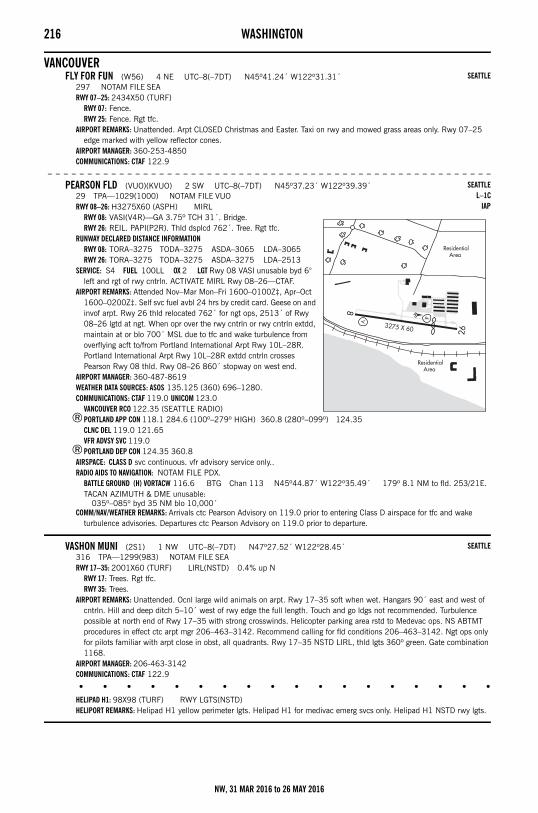
216 WASHINGTON
VANCOUVERFLY FOR FUN (W56) 4 NE UTC–8(–7DT) N45º41.24´ W122º31.31´
297 NOTAM FILE SEARWY 07–25: 2434X50 (TURF)
RWY 07: Fence.RWY 25: Fence. Rgt tfc.
AIRPORT REMARKS: Unattended. Arpt CLOSED Christmas and Easter. Taxi on rwy and mowed grass areas only. Rwy 07–25 edge marked with yellow reflector cones.
AIRPORT MANAGER: 360-253-4850COMMUNICATIONS: CTAF 122.9
– – – – – – – – – – – – – – – – – – – – – – – – – – – – – – – – – – – – – – – – – – – – – – – – – – – – – – – –
PEARSON FLD (VUO)(KVUO) 2 SW UTC–8(–7DT) N45º37.23´ W122º39.39´29 TPA—1029(1000) NOTAM FILE VUORWY 08–26: H3275X60 (ASPH) MIRL
RWY 08: VASI(V4R)—GA 3.75º TCH 31´. Bridge.RWY 26: REIL. PAPI(P2R). Thld dsplcd 762´. Tree. Rgt tfc.
RUNWAY DECLARED DISTANCE INFORMATIONRWY 08: TORA–3275 TODA–3275 ASDA–3065 LDA–3065RWY 26: TORA–3275 TODA–3275 ASDA–3275 LDA–2513
SERVICE: S4 FUEL 100LL OX 2 LGT Rwy 08 VASI unusable byd 6° left and rgt of rwy cntrln. ACTIVATE MIRL Rwy 08–26—CTAF.
AIRPORT REMARKS: Attended Nov–Mar Mon–Fri 1600–0100Z‡, Apr–Oct 1600–0200Z‡. Self svc fuel avbl 24 hrs by credit card. Geese on and invof arpt. Rwy 26 thld relocated 762´ for ngt ops, 2513´ of Rwy 08–26 lgtd at ngt. When opr over the rwy cntrln or rwy cntrln extdd, maintain at or blo 700´ MSL due to tfc and wake turbulence from overflying acft to/from Portland International Arpt Rwy 10L–28R. Portland International Arpt Rwy 10L–28R extdd cntrln crosses Pearson Rwy 08 thld. Rwy 08–26 860´ stopway on west end.
AIRPORT MANAGER: 360-487-8619WEATHER DATA SOURCES: ASOS 135.125 (360) 696–1280.COMMUNICATIONS: CTAF 119.0 UNICOM 123.0
VANCOUVER RCO 122.35 (SEATTLE RADIO)®PORTLAND APP CON 118.1 284.6 (100º–279º HIGH) 360.8 (280º–099º) 124.35
CLNC DEL 119.0 121.65VFR ADVSY SVC 119.0
®PORTLAND DEP CON 124.35 360.8AIRSPACE: CLASS D svc continuous. vfr advisory service only..RADIO AIDS TO NAVIGATION: NOTAM FILE PDX.
BATTLE GROUND (H) VORTACW 116.6 BTG Chan 113 N45º44.87´ W122º35.49´ 179º 8.1 NM to fld. 253/21E.TACAN AZIMUTH & DME unusable:
035º–085º byd 35 NM blo 10,000´COMM/NAV/WEATHER REMARKS: Arrivals ctc Pearson Advisory on 119.0 prior to entering Class D airspace for tfc and wake
turbulence advisories. Departures ctc Pearson Advisory on 119.0 prior to departure.
VASHON MUNI (2S1) 1 NW UTC–8(–7DT) N47º27.52´ W122º28.45´316 TPA—1299(983) NOTAM FILE SEARWY 17–35: 2001X60 (TURF) LIRL(NSTD) 0.4% up N
RWY 17: Trees. Rgt tfc.RWY 35: Trees.
AIRPORT REMARKS: Unattended. Ocnl large wild animals on arpt. Rwy 17–35 soft when wet. Hangars 90´ east and west of cntrln. Hill and deep ditch 5–10´ west of rwy edge the full length. Touch and go ldgs not recommended. Turbulence possible at north end of Rwy 17–35 with strong crosswinds. Helicopter parking area rstd to Medevac ops. NS ABTMT procedures in effect ctc arpt mgr 206–463–3142. Recommend calling for fld conditions 206–463–3142. Ngt ops only for pilots familiar with arpt close in obst, all quadrants. Rwy 17–35 NSTD LIRL, thld lgts 360º green. Gate combination 1168.
AIRPORT MANAGER: 206-463-3142COMMUNICATIONS: CTAF 122.9
• • • • • • • • • • • • • • • • • •
HELIPAD H1: 98X98 (TURF) RWY LGTS(NSTD)HELIPORT REMARKS: Helipad H1 yellow perimeter lgts. Helipad H1 for medivac emerg svcs only. Helipad H1 NSTD rwy lgts.
SEATTLE
SEATTLEL–1C
IAP
SEATTLE
NW, 31 MAR 2016 to 26 MAY 2016
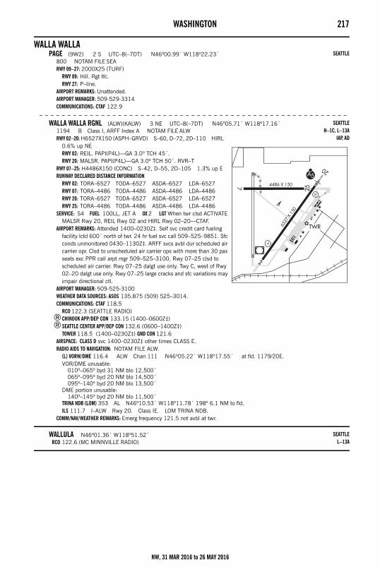
WASHINGTON 217
WALLA WALLAPAGE (9W2) 2 S UTC–8(–7DT) N46º00.99´ W118º22.23´
800 NOTAM FILE SEARWY 09–27: 2000X25 (TURF)
RWY 09: Hill. Rgt tfc.RWY 27: P–line.
AIRPORT REMARKS: Unattended.AIRPORT MANAGER: 509-529-3314COMMUNICATIONS: CTAF 122.9
– – – – – – – – – – – – – – – – – – – – – – – – – – – – – – – – – – – – – – – – – – – – – – – – – – – – – – –
WALLA WALLA RGNL (ALW)(KALW) 3 NE UTC–8(–7DT) N46º05.71´ W118º17.16´1194 B Class I, ARFF Index A NOTAM FILE ALWRWY 02–20: H6527X150 (ASPH–GRVD) S–60, D–72, 2D–110 HIRL
0.6% up NERWY 02: REIL. PAPI(P4L)—GA 3.0º TCH 45´.RWY 20: MALSR. PAPI(P4L)—GA 3.0º TCH 50´. RVR–T
RWY 07–25: H4486X150 (CONC) S–42, D–55, 2D–105 1.3% up ERUNWAY DECLARED DISTANCE INFORMATION
RWY 02: TORA–6527 TODA–6527 ASDA–6527 LDA–6527RWY 07: TORA–4486 TODA–4486 ASDA–4486 LDA–4486RWY 20: TORA–6527 TODA–6527 ASDA–6527 LDA–6527RWY 25: TORA–4486 TODA–4486 ASDA–4486 LDA–4486
SERVICE: S4 FUEL 100LL, JET A OX 2 LGT When twr clsd ACTIVATE MALSR Rwy 20, REIL Rwy 02 and HIRL Rwy 02–20—CTAF.
AIRPORT REMARKS: Attended 1400–0230Z‡. Self svc credit card fueling facility lctd 600´ north of twr. 24 hr fuel svc call 509–525–9851. Sfc conds unmonitored 0430–1130Z‡. ARFF svcs avbl dur scheduled air carrier opr. Clsd to unscheduled air carrier ops with more than 30 pax seats exc PPR call arpt mgr 509–525–3100. Rwy 07–25 clsd to scheduled air carrier. Rwy 07–25 dalgt use only. Twy C, west of Rwy 02–20 dalgt use only. Rwy 07–25 large cracks and sfc variations may impair directional ctl.
AIRPORT MANAGER: 509-525-3100WEATHER DATA SOURCES: ASOS 135.875 (509) 525–3014.COMMUNICATIONS: CTAF 118.5
RCO 122.3 (SEATTLE RADIO)®CHINOOK APP/DEP CON 133.15 (1400–0600Z‡)®SEATTLE CENTER APP/DEP CON 132.6 (0600–1400Z‡)
TOWER 118.5 (1400–0230Z‡) GND CON 121.6AIRSPACE: CLASS D svc 1400–0230Z‡ other times CLASS E.RADIO AIDS TO NAVIGATION: NOTAM FILE ALW.
(L) VORW/DME 116.4 ALW Chan 111 N46º05.22´ W118º17.55´ at fld. 1179/20E.VOR/DME unusable:
010º–065º byd 31 NM blo 12,500´065º–095º byd 20 NM blo 14,500´095º–140º byd 20 NM blo 13,500´
DME portion unusable:140º–145º byd 20 NM blo 11,500´
TRINA NDB (LOM) 353 AL N46º10.53´ W118º11.78´ 198º 6.1 NM to fld. ILS 111.7 I–ALW Rwy 20. Class IE. LOM TRINA NDB.
COMM/NAV/WEATHER REMARKS: Emerg frequency 121.5 not avbl at twr.
WALLULA N46º01.36´ W118º51.52´RCO 122.6 (MC MINNVILLE RADIO)
SEATTLE
SEATTLEH–1C, L–13A
IAP, AD
SEATTLEL–13A
NW, 31 MAR 2016 to 26 MAY 2016
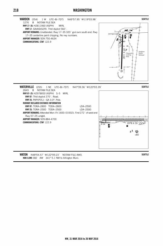
218 WASHINGTON
WARDEN (2S4) 1 W UTC–8(–7DT) N46º57.95´ W119º03.98´1276 B NOTAM FILE SEARWY 17–35: H2811X60 (ASPH) MIRL
RWY 17: SAVASI(S2R). Thld dsplcd 560´.AIRPORT REMARKS: Unattended. Rwy 17–35 320´ grvl ovrn south end. Rwy
17–35 centerline paint chipping. No rwy numbers.AIRPORT MANAGER: 509-750-4634COMMUNICATIONS: CTAF 122.9
WATERVILLE (2S5) 1 NE UTC–8(–7DT) N47º39.36´ W120º03.39´2645 B NOTAM FILE SEARWY 07–25: H2978X50 (ASPH) S–5 MIRL
RWY 07: Thld dsplcd 270´. Road.RWY 25: PAPI(P2L)—GA 3.0º. Pole.
RUNWAY DECLARED DISTANCE INFORMATIONRWY 07: TORA–2800 TODA–2800 LDA–2500RWY 25: TORA–2500 TODA–2500 LDA–2500
AIRPORT REMARKS: Attended Mon–Fri 1600–0100Z‡. First 272´ of west end Rwy 07–25 unlgtd.
AIRPORT MANAGER: 509-884-4700COMMUNICATIONS: CTAF 122.9
WATON N48º04.57´ W122º09.23´ NOTAM FILE AWO.NDB (LOM) 382 AW 341º 5.1 NM to Arlington Muni.
SEATTLE
SEATTLE
SEATTLE
NW, 31 MAR 2016 to 26 MAY 2016
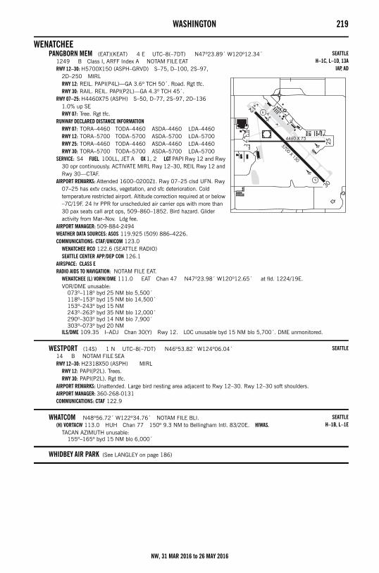
WASHINGTON 219
WENATCHEEPANGBORN MEM (EAT)(KEAT) 4 E UTC–8(–7DT) N47º23.89´ W120º12.34´
1249 B Class I, ARFF Index A NOTAM FILE EATRWY 12–30: H5700X150 (ASPH–GRVD) S–75, D–100, 2S–97,
2D–250 MIRLRWY 12: REIL. PAPI(P4L)—GA 3.6º TCH 50´. Road. Rgt tfc.RWY 30: RAIL. REIL. PAPI(P2L)—GA 4.3º TCH 45´.
RWY 07–25: H4460X75 (ASPH) S–50, D–77, 2S–97, 2D–136 1.0% up SERWY 07: Tree. Rgt tfc.
RUNWAY DECLARED DISTANCE INFORMATIONRWY 07: TORA–4460 TODA–4460 ASDA–4460 LDA–4460RWY 12: TORA–5700 TODA–5700 ASDA–5700 LDA–5700RWY 25: TORA–4460 TODA–4460 ASDA–4460 LDA–4460RWY 30: TORA–5700 TODA–5700 ASDA–5700 LDA–5700
SERVICE: S4 FUEL 100LL, JET A OX 1, 2 LGT PAPI Rwy 12 and Rwy 30 opr continuously. ACTIVATE MIRL Rwy 12–30, REIL Rwy 12 and Rwy 30—CTAF.
AIRPORT REMARKS: Attended 1600–0200Z‡. Rwy 07–25 clsd UFN. Rwy 07–25 has extv cracks, vegetation, and sfc deterioration. Cold temperature restricted airport. Altitude correction required at or below –7C/19F. 24 hr PPR for unscheduled air carrier ops with more than 30 pax seats call arpt ops, 509–860–1852. Bird hazard. Glider activity from Mar–Nov. Ldg fee.
AIRPORT MANAGER: 509-884-2494WEATHER DATA SOURCES: ASOS 119.925 (509) 886–4226.COMMUNICATIONS: CTAF/UNICOM 123.0
WENATCHEE RCO 122.6 (SEATTLE RADIO)SEATTLE CENTER APP/DEP CON 126.1
AIRSPACE: CLASS ERADIO AIDS TO NAVIGATION: NOTAM FILE EAT.
WENATCHEE (L) VORW/DME 111.0 EAT Chan 47 N47º23.98´ W120º12.65´ at fld. 1224/19E.VOR/DME unusable:
073º–118º byd 25 NM blo 5,500´118º–153º byd 15 NM blo 14,500´153º–243º byd 15 NM243º–263º byd 35 NM blo 12,000´290º–303º byd 14 NM blo 7,900´303º–073º byd 20 NM
ILS/DME 109.35 I–ADJ Chan 30(Y) Rwy 12. LOC unusable byd 15 NM blo 5,700´. DME unmonitored.
WESTPORT (14S) 1 N UTC–8(–7DT) N46º53.82´ W124º06.04´14 B NOTAM FILE SEARWY 12–30: H2318X50 (ASPH) MIRL
RWY 12: PAPI(P2L). Trees.RWY 30: PAPI(P2L). Rgt tfc.
AIRPORT REMARKS: Unattended. Large bird nesting area adjacent to Rwy 12–30. Rwy 12–30 soft shoulders.AIRPORT MANAGER: 360-268-0131COMMUNICATIONS: CTAF 122.9
WHATCOM N48º56.72´ W122º34.76´ NOTAM FILE BLI.(H) VORTACW 113.0 HUH Chan 77 150º 9.3 NM to Bellingham Intl. 83/20E. HIWAS.
TACAN AZIMUTH unusable:155º–165º byd 15 NM blo 6,000´
WHIDBEY AIR PARK (See LANGLEY on page 186)
SEATTLEH–1C, L–1D, 13A
IAP, AD
SEATTLE
SEATTLEH–1B, L–1E
NW, 31 MAR 2016 to 26 MAY 2016
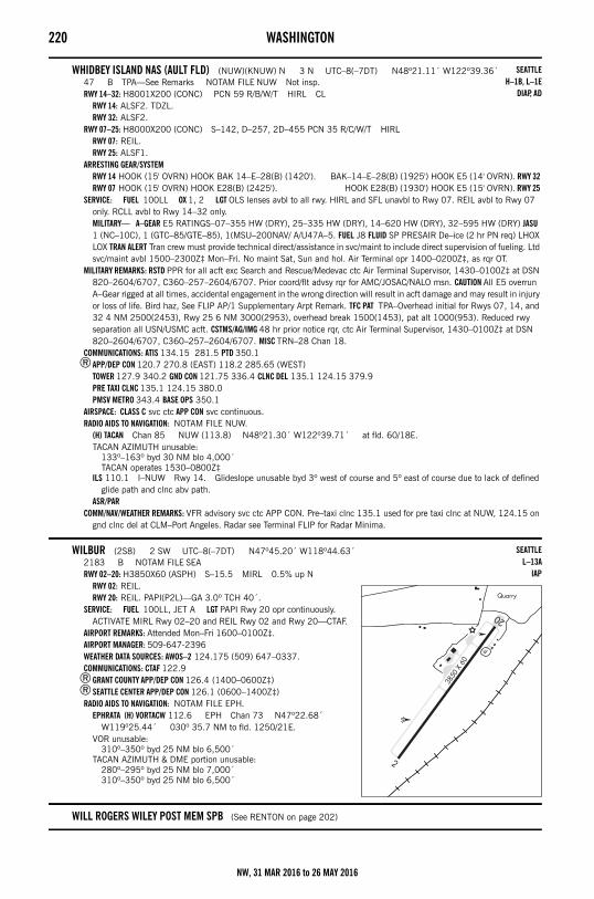
220 WASHINGTON
WHIDBEY ISLAND NAS (AULT FLD) (NUW)(KNUW) N 3 N UTC–8(–7DT) N48º21.11´ W122º39.36´47 B TPA—See Remarks NOTAM FILE NUW Not insp.RWY 14–32: H8001X200 (CONC) PCN 59 R/B/W/T HIRL CL
RWY 14: ALSF2. TDZL.RWY 32: ALSF2.
RWY 07–25: H8000X200 (CONC) S–142, D–257, 2D–455 PCN 35 R/C/W/T HIRLRWY 07: REIL.RWY 25: ALSF1.
ARRESTING GEAR/SYSTEMRWY 14 HOOK (15' OVRN) HOOK BAK 14–E–28(B) (1420'). BAK–14–E–28(B) (1925') HOOK E5 (14' OVRN). RWY 32 RWY 07 HOOK (15' OVRN) HOOK E28(B) (2425'). HOOK E28(B) (1930') HOOK E5 (15' OVRN). RWY 25
SERVICE: FUEL 100LL OX 1, 2 LGT OLS lenses avbl to all rwy. HIRL and SFL unavbl to Rwy 07. REIL avbl to Rwy 07 only. RCLL avbl to Rwy 14–32 only. MILITARY— A–GEAR E5 RATINGS–07–355 HW (DRY), 25–335 HW (DRY), 14–620 HW (DRY), 32–595 HW (DRY) JASU 1 (NC–10C), 1 (GTC–85/GTE–85), 1(MSU–200NAV/ A/U47A–5. FUEL J8 FLUID SP PRESAIR De–ice (2 hr PN req) LHOX LOX TRAN ALERT Tran crew must provide technical direct/assistance in svc/maint to include direct supervision of fueling. Ltd svc/maint avbl 1500–2300Z‡ Mon–Fri. No maint Sat, Sun and hol. Air Terminal opr 1400–0200Z‡, as rqr OT.
MILITARY REMARKS: RSTD PPR for all acft exc Search and Rescue/Medevac ctc Air Terminal Supervisor, 1430–0100Z‡ at DSN 820–2604/6707, C360–257–2604/6707. Prior coord/flt advsy rqr for AMC/JOSAC/NALO msn. CAUTION All E5 overrun A–Gear rigged at all times, accidental engagement in the wrong direction will result in acft damage and may result in injury or loss of life. Bird haz, See FLIP AP/1 Supplementary Arpt Remark. TFC PAT TPA–Overhead initial for Rwys 07, 14, and 32 4 NM 2500(2453), Rwy 25 6 NM 3000(2953), overhead break 1500(1453), pat alt 1000(953). Reduced rwy separation all USN/USMC acft. CSTMS/AG/IMG 48 hr prior notice rqr, ctc Air Terminal Supervisor, 1430–0100Z‡ at DSN 820–2604/6707, C360–257–2604/6707. MISC TRN–28 Chan 18.
COMMUNICATIONS: ATIS 134.15 281.5 PTD 350.1®APP/DEP CON 120.7 270.8 (EAST) 118.2 285.65 (WEST)
TOWER 127.9 340.2 GND CON 121.75 336.4 CLNC DEL 135.1 124.15 379.9PRE TAXI CLNC 135.1 124.15 380.0PMSV METRO 343.4 BASE OPS 350.1
AIRSPACE: CLASS C svc ctc APP CON svc continuous.RADIO AIDS TO NAVIGATION: NOTAM FILE NUW.
(H) TACAN Chan 85 NUW (113.8) N48º21.30´ W122º39.71´ at fld. 60/18E.TACAN AZIMUTH unusable:
133º–163º byd 30 NM blo 4,000´TACAN operates 1530–0800Z‡
ILS 110.1 I–NUW Rwy 14. Glideslope unusable byd 3º west of course and 5º east of course due to lack of defined glide path and clnc abv path.
ASR/PARCOMM/NAV/WEATHER REMARKS: VFR advisory svc ctc APP CON. Pre–taxi clnc 135.1 used for pre taxi clnc at NUW, 124.15 on
gnd clnc del at CLM–Port Angeles. Radar see Terminal FLIP for Radar Minima.
WILBUR (2S8) 2 SW UTC–8(–7DT) N47º45.20´ W118º44.63´2183 B NOTAM FILE SEARWY 02–20: H3850X60 (ASPH) S–15.5 MIRL 0.5% up N
RWY 02: REIL.RWY 20: REIL. PAPI(P2L)—GA 3.0º TCH 40´.
SERVICE: FUEL 100LL, JET A LGT PAPI Rwy 20 opr continuously. ACTIVATE MIRL Rwy 02–20 and REIL Rwy 02 and Rwy 20—CTAF.
AIRPORT REMARKS: Attended Mon–Fri 1600–0100Z‡. AIRPORT MANAGER: 509-647-2396WEATHER DATA SOURCES: AWOS–2 124.175 (509) 647–0337.COMMUNICATIONS: CTAF 122.9
®GRANT COUNTY APP/DEP CON 126.4 (1400–0600Z‡)®SEATTLE CENTER APP/DEP CON 126.1 (0600–1400Z‡)
RADIO AIDS TO NAVIGATION: NOTAM FILE EPH.EPHRATA (H) VORTACW 112.6 EPH Chan 73 N47º22.68´
W119º25.44´ 030º 35.7 NM to fld. 1250/21E.VOR unusable:
310º–350º byd 25 NM blo 6,500´TACAN AZIMUTH & DME portion unusable:
280º–295º byd 25 NM blo 7,000´310º–350º byd 25 NM blo 6,500´
WILL ROGERS WILEY POST MEM SPB (See RENTON on page 202)
SEATTLEH–1B, L–1E
DIAP, AD
SEATTLEL–13A
IAP
NW, 31 MAR 2016 to 26 MAY 2016
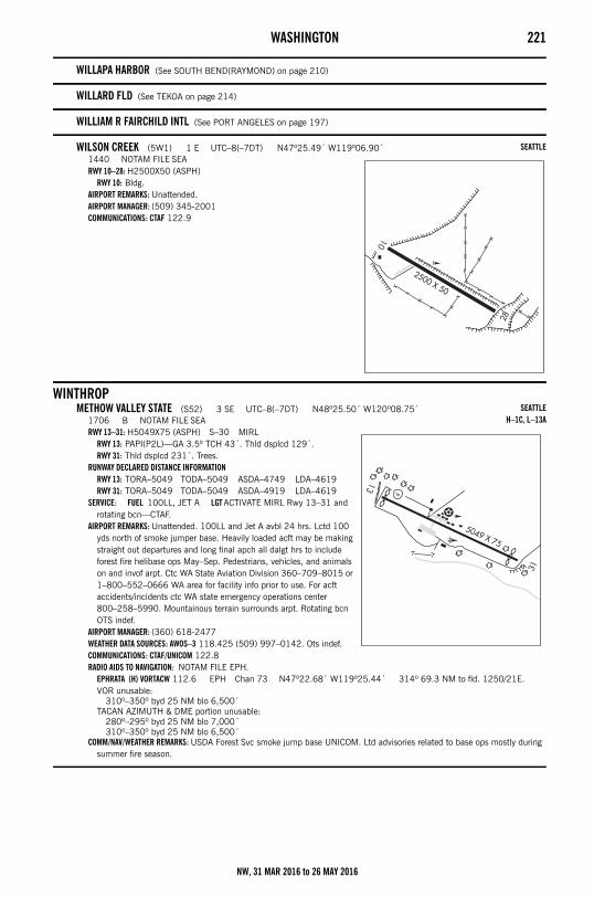
WASHINGTON 221
WILLAPA HARBOR (See SOUTH BEND(RAYMOND) on page 210)
WILLARD FLD (See TEKOA on page 214)
WILLIAM R FAIRCHILD INTL (See PORT ANGELES on page 197)
WILSON CREEK (5W1) 1 E UTC–8(–7DT) N47º25.49´ W119º06.90´1440 NOTAM FILE SEARWY 10–28: H2500X50 (ASPH)
RWY 10: Bldg.AIRPORT REMARKS: Unattended.AIRPORT MANAGER: (509) 345-2001COMMUNICATIONS: CTAF 122.9
WINTHROPMETHOW VALLEY STATE (S52) 3 SE UTC–8(–7DT) N48º25.50´ W120º08.75´
1706 B NOTAM FILE SEARWY 13–31: H5049X75 (ASPH) S–30 MIRL
RWY 13: PAPI(P2L)—GA 3.5º TCH 43´. Thld dsplcd 129´.RWY 31: Thld dsplcd 231´. Trees.
RUNWAY DECLARED DISTANCE INFORMATIONRWY 13: TORA–5049 TODA–5049 ASDA–4749 LDA–4619RWY 31: TORA–5049 TODA–5049 ASDA–4919 LDA–4619
SERVICE: FUEL 100LL, JET A LGT ACTIVATE MIRL Rwy 13–31 and rotating bcn—CTAF.
AIRPORT REMARKS: Unattended. 100LL and Jet A avbl 24 hrs. Lctd 100 yds north of smoke jumper base. Heavily loaded acft may be making straight out departures and long final apch all dalgt hrs to include forest fire helibase ops May–Sep. Pedestrians, vehicles, and animals on and invof arpt. Ctc WA State Aviation Division 360–709–8015 or 1–800–552–0666 WA area for facility info prior to use. For acft accidents/incidents ctc WA state emergency operations center 800–258–5990. Mountainous terrain surrounds arpt. Rotating bcn OTS indef.
AIRPORT MANAGER: (360) 618-2477WEATHER DATA SOURCES: AWOS–3 118.425 (509) 997–0142. Ots indef.COMMUNICATIONS: CTAF/UNICOM 122.8RADIO AIDS TO NAVIGATION: NOTAM FILE EPH.
EPHRATA (H) VORTACW 112.6 EPH Chan 73 N47º22.68´ W119º25.44´ 314º 69.3 NM to fld. 1250/21E.VOR unusable:
310º–350º byd 25 NM blo 6,500´TACAN AZIMUTH & DME portion unusable:
280º–295º byd 25 NM blo 7,000´310º–350º byd 25 NM blo 6,500´
COMM/NAV/WEATHER REMARKS: USDA Forest Svc smoke jump base UNICOM. Ltd advisories related to base ops mostly during summer fire season.
SEATTLE
SEATTLEH–1C, L–13A
NW, 31 MAR 2016 to 26 MAY 2016
222 WASHINGTON
WOODLAND STATE (W27) 1 SE UTC–8(–7DT) N45º53.93´ W122º44.24´29 NOTAM FILE SEARWY 14–32: H1953X25 (ASPH) LIRL
RWY 14: Thld dsplcd 290´. Pole. Rgt tfc.RWY 32: Trees.
AIRPORT REMARKS: Unattended. Vehicles, pedestrians, and animals on and invof arpt. Ctc WA State Aviation Division 360–709–8015 or 1–800–552–0666 WA area for facility info prior to use. For acft accidents/incidents ctc WA state emergency operations center 800–258–5990. 12´ dike northwest end. Extreme turbulence possible when winds from the east. P–line in apch to Rwy 14. Rwy 32 trees, bridge, low hill at southeast end.
AIRPORT MANAGER: (360) 618-2477COMMUNICATIONS: CTAF 122.9
YAKIMA AIR TERMINAL/MCALLISTER FLD (YKM)(KYKM) 3 S UTC–8(–7DT) N46º34.09´ W120º32.64´1099 B Class I, ARFF Index A NOTAM FILE YKMRWY 09–27: H7604X150 (ASPH–GRVD) S–95, D–160, 2S–175, 2D–220, 2D/2D2–550 PCN 33 F/C/X/T
HIRL 0.7% up WRWY 09: REIL. VASI(V4L)—GA 3.0º TCH 50´.RWY 27: MALSR. PAPI(P4L)—GA 3.0º TCH 57´. RVR–T
RWY 04–22: H3835X150 (ASPH–PFC) S–70, D–80, 2S–102, 2D–120 PCN 28 F/C/X/T MIRL 0.5% up SWRWY 04: REIL. PAPI(P4L)—GA 3.0º TCH 57´.RWY 22: REIL. PAPI(P4L)—GA 3.0º TCH 45´.
RUNWAY DECLARED DISTANCE INFORMATIONRWY 04: TORA–3835 TODA–3835 ASDA–3835 LDA–3835RWY 09: TORA–7604 TODA–7604 ASDA–7604 LDA–7604RWY 22: TORA–3835 TODA–3835 ASDA–3835 LDA–3835RWY 27: TORA–7604 TODA–7604 ASDA–7604 LDA–7604
SERVICE: S4 FUEL 100LL, JET A OX 1, 3 LGT MIRL Rwy 04–22, REIL Rwy 04 and Rwy 22, PAPI Rwy 04 and Rwy 22 OTS when twr clsd. Twy B1 and Twy B2 twy lgts OTS when twr clsd. Twy B lgts south of Rwy 09–27 OTS when twr clsd. When twr clsd ACTIVATE HIRL Rwy 09–27 and MALSR Rwy 27—CTAF.
AIRPORT REMARKS: Attended 1400–0400Z‡. Sfc cond unmonitored 0800–1330Z‡. Be alert, birds invof Yakima River 5 NM east of apch to Rwy 27. Cold temperature restricted airport. Altitude correction required at or below –23C/–9F. Reflectors on Twy C only. Rwy 04–22 some spalling and raveling. PPR for unscheduled air carrier ops with more than 30 pax seats, call arpt mgr 509–575–6149/6150. Twy B from AER 22 to Twy A rstd to acft with wingspans 79´ or less.
AIRPORT MANAGER: 509-575-6149WEATHER DATA SOURCES: ASOS (509) 248–1502COMMUNICATIONS: CTAF 133.25 ATIS 125.25 UNICOM 122.95
RCO 122.5 (SEATTLE RADIO)®CHINOOK APP/DEP CON 123.8 (1400–0600Z‡)®SEATTLE CENTER APP/DEP CON 132.6 (0600–1400Z‡)
TOWER 133.25 (1400–0600Z‡) GND CON 121.9 CLNC DEL 121.9AIRSPACE: CLASS D svc 1400–0600Z‡ other times CLASS E.RADIO AIDS TO NAVIGATION: NOTAM FILE YKM.
(H) VORTACW 116.0 YKM Chan 107 N46º34.21´ W120º26.68´ 247º 4.1 NM to fld. 984/21E.TACAN AZIMUTH & DME unusable:
095º–115º byd 26 NM blo 8,000´095º–115º byd 35 NM115º–207º byd 20 NM blo 8,500´115º–207º byd 36 NM blo 10,000´207º–230º byd 20 NM blo 10,000´290º–315º byd 20 NM blo 11,000´315º–080º byd 12 NM blo 15,000´
VOR portion unusable:025º–035º byd 5 NM blo 6,000´080º–105º byd 35 NM blo 6,000´105º–107º byd 25 NM blo 6,000´109º–135º byd 25 NM blo 6,000´135º–180º byd 30 NM blo 7,500´195º–225º byd 30 NM blo 8,500´305º–335º byd 30 NM blo 9,000´350º–080º byd 25 NM blo 9,000´
DONNY NDB (LOM) 371 YK N46º31.54´ W120º22.33´ 274º 7.6 NM to fld. ILS 110.1 I–YKM Rwy 27. LOM DONNY NDB. Unmonitored when ATCT closed.
COMM/NAV/WEATHER REMARKS: During hrs twr is clsd all ops invof arpt rstd to acft with VHF radio capability, unless an emerg exist necessitating UHF equipped acft to land.
SEATTLE
SEATTLEH–1C, L–13AIAP, DIAP, AD
NW, 31 MAR 2016 to 26 MAY 2016
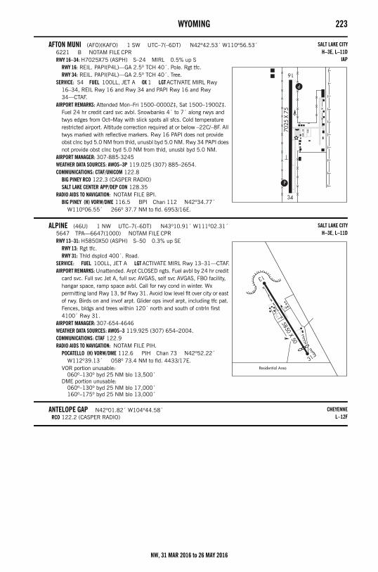
WYOMING 223Wyoming
AFTON MUNI (AFO)(KAFO) 1 SW UTC–7(–6DT) N42º42.53´ W110º56.53´6221 B NOTAM FILE CPRRWY 16–34: H7025X75 (ASPH) S–24 MIRL 0.5% up S
RWY 16: REIL. PAPI(P4L)—GA 2.5º TCH 40´. Pole. Rgt tfc.RWY 34: REIL. PAPI(P4L)—GA 2.5º TCH 40´. Tree.
SERVICE: S4 FUEL 100LL, JET A OX 1 LGT ACTIVATE MIRL Rwy 16–34, REIL Rwy 16 and Rwy 34 and PAPI Rwy 16 and Rwy 34—CTAF.
AIRPORT REMARKS: Attended Mon–Fri 1500–0000Z‡, Sat 1500–1900Z‡. Fuel 24 hr credit card svc avbl. Snowbanks 4´ to 7´ along rwys and twys edges from Oct–May with slick spots all sfcs. Cold temperature restricted airport. Altitude correction required at or below –22C/–8F. All twys marked with reflective markers. Rwy 16 PAPI does not provide obst clnc byd 5.0 NM from thld, unusbl byd 5.0 NM. Rwy 34 PAPI does not provide obst clnc byd 5.0 NM from thld, unusbl byd 5.0 NM.
AIRPORT MANAGER: 307-885-3245WEATHER DATA SOURCES: AWOS–3P 119.025 (307) 885–2654.COMMUNICATIONS: CTAF/UNICOM 122.8
BIG PINEY RCO 122.3 (CASPER RADIO)SALT LAKE CENTER APP/DEP CON 128.35
RADIO AIDS TO NAVIGATION: NOTAM FILE BPI.BIG PINEY (H) VORW/DME 116.5 BPI Chan 112 N42º34.77´
W110º06.55´ 266º 37.7 NM to fld. 6953/16E.
ALPINE (46U) 1 NW UTC–7(–6DT) N43º10.91´ W111º02.31´5647 TPA—6647(1000) NOTAM FILE CPRRWY 13–31: H5850X50 (ASPH) S–50 0.3% up SE
RWY 13: Rgt tfc.RWY 31: Thld dsplcd 400´. Road.
SERVICE: FUEL 100LL, JET A LGT ACTIVATE MIRL Rwy 13–31—CTAF.AIRPORT REMARKS: Unattended. Arpt CLOSED ngts. Fuel avbl by 24 hr credit
card svc. Full svc Jet A, full svc AVGAS, self svc AVGAS, FBO facility, hangar space, ramp space avbl. Call for rwy cond in winter. Wx permitting land Rwy 13, tkf Rwy 31. Avoid low level flt over city or east of rwy. Birds on and invof arpt. Glider ops invof arpt, including tfc pat. Fences, bldgs and trees within 120´ north and south of cntrln first 4100´ Rwy 31.
AIRPORT MANAGER: 307-654-4646WEATHER DATA SOURCES: AWOS–3 119.925 (307) 654–2004.COMMUNICATIONS: CTAF 122.9RADIO AIDS TO NAVIGATION: NOTAM FILE PIH.
POCATELLO (H) VORW/DME 112.6 PIH Chan 73 N42º52.22´ W112º39.13´ 058º 73.4 NM to fld. 4433/17E.
VOR portion unusable:060º–130º byd 25 NM blo 13,500´
DME portion unusable:060º–130º byd 25 NM blo 17,000´160º–175º byd 25 NM blo 13,000´
ANTELOPE GAP N42º01.82´ W104º44.58´RCO 122.2 (CASPER RADIO)
SALT LAKE CITYH–3E, L–11D
IAP
SALT LAKE CITYH–3E, L–11D
CHEYENNEL–12F
NW, 31 MAR 2016 to 26 MAY 2016
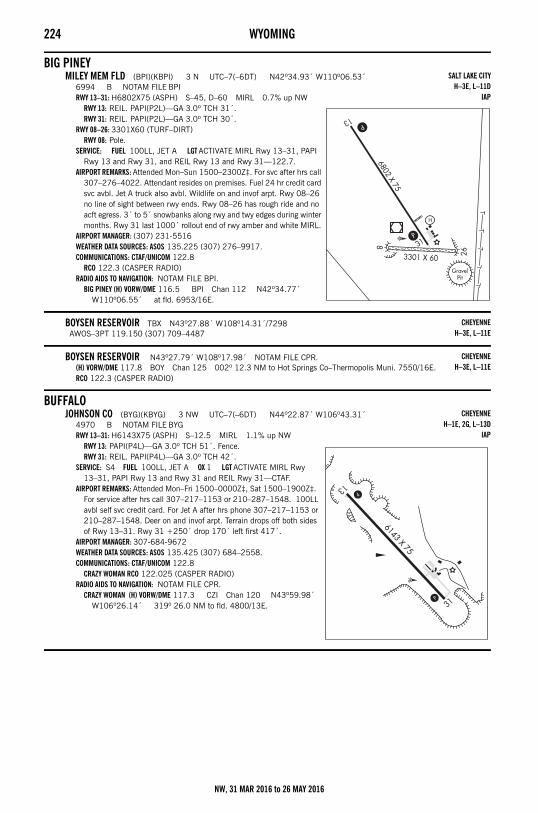
224 WYOMING
BIG PINEYMILEY MEM FLD (BPI)(KBPI) 3 N UTC–7(–6DT) N42º34.93´ W110º06.53´
6994 B NOTAM FILE BPIRWY 13–31: H6802X75 (ASPH) S–45, D–60 MIRL 0.7% up NW
RWY 13: REIL. PAPI(P2L)—GA 3.0º TCH 31´.RWY 31: REIL. PAPI(P2L)—GA 3.0º TCH 30´.
RWY 08–26: 3301X60 (TURF–DIRT)RWY 08: Pole.
SERVICE: FUEL 100LL, JET A LGT ACTIVATE MIRL Rwy 13–31, PAPI Rwy 13 and Rwy 31, and REIL Rwy 13 and Rwy 31—122.7.
AIRPORT REMARKS: Attended Mon–Sun 1500–2300Z‡. For svc after hrs call 307–276–4022. Attendant resides on premises. Fuel 24 hr credit card svc avbl. Jet A truck also avbl. Wildlife on and invof arpt. Rwy 08–26 no line of sight between rwy ends. Rwy 08–26 has rough ride and no acft egress. 3´ to 5´ snowbanks along rwy and twy edges during winter months. Rwy 31 last 1000´ rollout end of rwy amber and white MIRL.
AIRPORT MANAGER: (307) 231-5516WEATHER DATA SOURCES: ASOS 135.225 (307) 276–9917.COMMUNICATIONS: CTAF/UNICOM 122.8
RCO 122.3 (CASPER RADIO)RADIO AIDS TO NAVIGATION: NOTAM FILE BPI.
BIG PINEY (H) VORW/DME 116.5 BPI Chan 112 N42º34.77´ W110º06.55´ at fld. 6953/16E.
BOYSEN RESERVOIR TBX N43º27.88´ W108º14.31´/7298AWOS–3PT 119.150 (307) 709–4487
BOYSEN RESERVOIR N43º27.79´ W108º17.98´ NOTAM FILE CPR.(H) VORW/DME 117.8 BOY Chan 125 002º 12.3 NM to Hot Springs Co–Thermopolis Muni. 7550/16E.RCO 122.3 (CASPER RADIO)
BUFFALOJOHNSON CO (BYG)(KBYG) 3 NW UTC–7(–6DT) N44º22.87´ W106º43.31´
4970 B NOTAM FILE BYGRWY 13–31: H6143X75 (ASPH) S–12.5 MIRL 1.1% up NW
RWY 13: PAPI(P4L)—GA 3.0º TCH 51´. Fence.RWY 31: REIL. PAPI(P4L)—GA 3.0º TCH 42´.
SERVICE: S4 FUEL 100LL, JET A OX 1 LGT ACTIVATE MIRL Rwy 13–31, PAPI Rwy 13 and Rwy 31 and REIL Rwy 31—CTAF.
AIRPORT REMARKS: Attended Mon–Fri 1500–0000Z‡, Sat 1500–1900Z‡. For service after hrs call 307–217–1153 or 210–287–1548. 100LL avbl self svc credit card. For Jet A after hrs phone 307–217–1153 or 210–287–1548. Deer on and invof arpt. Terrain drops off both sides of Rwy 13–31. Rwy 31 +250´ drop 170´ left first 417´.
AIRPORT MANAGER: 307-684-9672WEATHER DATA SOURCES: ASOS 135.425 (307) 684–2558.COMMUNICATIONS: CTAF/UNICOM 122.8
CRAZY WOMAN RCO 122.025 (CASPER RADIO)RADIO AIDS TO NAVIGATION: NOTAM FILE CPR.
CRAZY WOMAN (H) VORW/DME 117.3 CZI Chan 120 N43º59.98´ W106º26.14´ 319º 26.0 NM to fld. 4800/13E.
SALT LAKE CITYH–3E, L–11D
IAP
CHEYENNEH–3E, L–11E
CHEYENNEH–3E, L–11E
CHEYENNEH–1E, 2G, L–13D
IAP
NW, 31 MAR 2016 to 26 MAY 2016
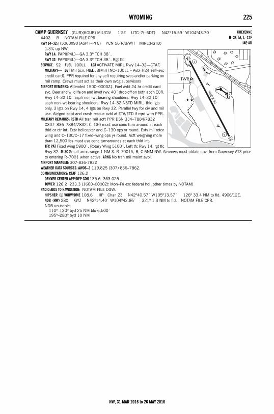
WYOMING 225
CAMP GUERNSEY (GUR)(KGUR) MIL/CIV 1 SE UTC–7(–6DT) N42º15.59´ W104º43.70´4402 B NOTAM FILE CPRRWY 14–32: H5060X90 (ASPH–PFC) PCN 56 R/B/W/T MIRL(NSTD)
1.3% up NWRWY 14: PAPI(P4L)—GA 3.3º TCH 38´.RWY 32: PAPI(P4L)—GA 3.3º TCH 38´. Rgt tfc.
SERVICE: S2 FUEL 100LL LGT ACTIVATE MIRL Rwy 14–32—CTAF.MILITARY— LGT Mil bcn. FUEL J8(Mil) (NC–100LL – Avbl H24 self–svc credit card). PPR required for any acft requiring svcs and/or parking on mil ramp. Crews must act as their own svcg supervisors
AIRPORT REMARKS: Attended 1500–0000Z‡. Fuel avbl 24 hr credit card svc. Deer and wildlife on and invof rwy. 40´ drop off on both apch EOR. Rwy 14–32 10´ asph non–wt bearing shoulders. Rwy 14–32 10´ asph non–wt bearing shoulders. Rwy 14–32 NSTD MIRL, thld lgts only, 3 lgts on Rwy 14, 4 lgts on Rwy 32. Parallel twy for civ and mil use. Air/gnd eqpt and crash rescue avbl at ETA/ETD if rqrd with PPR.
MILITARY REMARKS: RSTD All tran mil acft PPR DSN 334–7884/7832 C307–836–7884/7832. C–130 must use conc turn around at each thld or ctr int. Extv helicopter and C–130 ops yr round. Extv mil rotor wing and C–130/C–17 fixed–wing ops yr round. Acft weighing more than 12,500 lbs must use conc turnarounds at each thld int. TFC PAT Fixed wing 5900´. Rotary Wing 5100´. Left tfc Rwy 14, rgt tfc Rwy 32. MISC Small arms range 1 NM S. R–7001A, B, C 6NM NW. Aircrews must obtain apvl from Guernsey ATS prior to entering R–7001 when active. ARNG No tran mil maint avbl.
AIRPORT MANAGER: 307-836-7832WEATHER DATA SOURCES: AWOS–3 119.825 (307) 836–7862.COMMUNICATIONS: CTAF 126.2
DENVER CENTER APP/DEP CON 135.6 363.025TOWER 126.2 233.3 (1600–0000Z‡ Mon–Fri exc federal hol, other times by NOTAM)
RADIO AIDS TO NAVIGATION: NOTAM FILE DGW.HIPSHER (L) VORW/DME 108.6 IIP Chan 23 N42º40.57´ W105º13.57´ 126º 33.4 NM to fld. 4906/12E.NDB (HW) 280 GYZ N42º14.40´ W104º42.86´ 321º 1.3 NM to fld. NOTAM FILE CPR.NDB unusable:
110º–120º byd 25 NM blo 6,500´195º–280º byd 10 NM
CHEYENNEH–3F, 5A, L–12F
IAP, AD
NW, 31 MAR 2016 to 26 MAY 2016
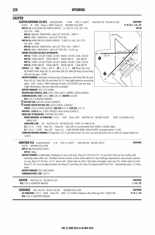
226 WYOMING
CASPERCASPER/NATRONA CO INTL (CPR)(KCPR) 7 NW UTC–7(–6DT) N42º54.35´ W106º27.82´
5344 B LRA Class I, ARFF Index B NOTAM FILE CPRRWY 03–21: H10165X150 (ASPH–GRVD) S–130, D–170, 2S–175,
2D–270 HIRLRWY 03: MALSR. PAPI(P4R)—GA 3.0º TCH 50´. RVR–TRWY 21: REIL. VASI(V4L)—GA 3.0º TCH 56´.
RWY 08–26: H8679X150 (ASPH–GRVD) S–85, D–140, 2S–175, 2D–260 HIRLRWY 08: MALSR. VASI(V4R)—GA 3.0º TCH 103´. RVR–TRWY 26: REIL. PAPI(P4R)—GA 3.0º TCH 50´. 0.4% up.
RUNWAY DECLARED DISTANCE INFORMATIONRWY 03: TORA–10165 TODA–10165 ASDA–10165 LDA–10165RWY 08: TORA–8679 TODA–8679 ASDA–8679 LDA–8679RWY 21: TORA–10165 TODA–10165 ASDA–10165 LDA–10165RWY 26: TORA–8679 TODA–8679 ASDA–8679 LDA–8679
SERVICE: S4 FUEL 100LL, JET A OX 1, 2, 3, 4 LGT When twr clsd ACTIVATE HIRL Rwy 03–21 and Rwy 08–26, MALSR Rwy 03 and Rwy 08 and twy lgts—CTAF.
AIRPORT REMARKS: Attended continuously. Emerg pwr avbl Rwy 08–26 and Rwy 03–21. Rwy 08–26 and Rwy 03–21 have lgtd distance remaining signs. 225´ crane 1 NM northeast of arpt. US CSTMS user fee arpt. Flight Notification Service (ADCUS) available.
AIRPORT MANAGER: 307-472-6688WEATHER DATA SOURCES: ASOS (307) 265–4461 LAWRS 1200–0400Z‡.COMMUNICATIONS: CTAF 118.3 ATIS 126.15 UNICOM 122.95
RCO 122.4 (CASPER RADIO)®APP/DEP CON 120.65 (1200–0400Z‡)®DENVER CENTER APP/DEP CON 135.6 (0400–1200Z‡)
TOWER 118.3 (1200–0400Z‡) GND CON 121.9 CLNC DEL 121.9AIRSPACE: CLASS D svc 1200–0400Z‡ other times CLASS E.RADIO AIDS TO NAVIGATION: NOTAM FILE CPR.
MUDDY MOUNTAIN (H) VORW/DME 116.2 DDY Chan 109 N43º05.45´ W106º16.62´ 205º 13.8 NM to fld. 5863/12E.
JOHNO NDB (LOM) CP N42º54.43´ W106º34.20´ 079º 4.7 NM to fld. ILS 111.3 I–SYD Rwy 03. Class IB. Syd LOC is unmonitored from 0400–1200Z‡ daily.ILS 110.3 I–CPR Rwy 08. Class 1E. LOM JOHNO NDB. Glide SLOPE unusable above 7,100.
COMM/NAV/WEATHER REMARKS: Emerg freq 121.5 not avbl at twr. For clnc req and del when twr is clsd ctc Casper Radio on 118.3.
– – – – – – – – – – – – – – – – – – – – – – – – – – – – – – – – – – – – – – – – – – – – – – – – – – – – – – – –
HARFORD FLD (HAD)(KHAD) 5 N UTC–7(–6DT) N42º55.46´ W106º18.57´5370 NOTAM FILE CPRRWY 07–25: 3810X30 (DIRT)
RWY 07: Bldg.AIRPORT REMARKS: Unattended. Antelope on and invof arpt. Rwy 07–25 first 270´ of rwy from thld can be muddy with
standing water after rain. Possible animal carcass and/or other debris on rwy. Rutting, depressions, and erosion present on rwy. Rwy 07–25 has +2–4´ berms 40´ either side of cntrln. Old style cones/lgts mark rwy 40´ either side of cntrln Rwy 07–25. Line of sight problem btn Rwy 07 and Rwy 25, Rwy 25 slopes uphill first 510´. Abandoned arpt 1.5 miles west.
AIRPORT MANAGER: 307-262-0606COMMUNICATIONS: CTAF 122.9
CASPER N42º53.75´ W106º27.54´RCO 122.4 (CASPER RADIO)
CHEROKEE N41º45.34´ W107º34.92´ NOTAM FILE CPR.(H) VORW/DME 115.0 CKW Chan 97 065º 17.4 NM to Rawlins Muni/Harvey Fld. 7050/15E.RCO 122.4 (CASPER RADIO)
CHEYENNEH–3F, 5A, L–11E, 12F
IAP, AD
CHEYENNE
CHEYENNEL–11E, 12F
CHEYENNEH–3E, L–11E
NW, 31 MAR 2016 to 26 MAY 2016
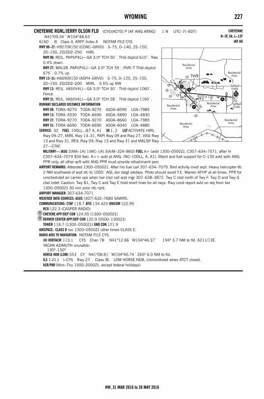
WYOMING 227
CHEYENNE RGNL/JERRY OLSON FLD (CYS)(KCYS) P (AF ANG ARNG) 1 N UTC–7(–6DT) N41º09.34´ W104º48.63´
6160 B Class II, ARFF Index A NOTAM FILE CYSRWY 09–27: H9270X150 (CONC–GRVD) S–75, D–140, 2S–150,
2D–150, 2D/2D2–250 HIRLRWY 09: REIL. PAPI(P4L)—GA 3.0º TCH 50´. Thld dsplcd 610´. Tree. 0.4% down.RWY 27: MALSR. PAPI(P4L)—GA 3.0º TCH 55´. RVR–T Thld dsplcd 675´. 0.7% up.
RWY 13–31: H6690X150 (ASPH–GRVD) S–75, D–120, 2S–150, 2D–150, 2D/2D2–200 MIRL 0.5% up NWRWY 13: REIL. VASI(V4L)—GA 3.0º TCH 30´. Thld dsplcd 1060´. Fence.RWY 31: REIL. VASI(V4L)—GA 3.0º TCH 28´. Thld dsplcd 1160´.
RUNWAY DECLARED DISTANCE INFORMATIONRWY 09: TORA–9270 TODA–9270 ASDA–8595 LDA–7985RWY 13: TORA–5530 TODA–6690 ASDA–5890 LDA–4830RWY 27: TORA–9270 TODA–9270 ASDA–8660 LDA–7985RWY 31: TORA–6690 TODA–6690 ASDA–6040 LDA–4880
SERVICE: S2 FUEL 100LL, JET A, A1 OX 1, 2 LGT ACTIVATE HIRL Rwy 09–27, MIRL Rwy 13–31, PAPI Rwy 09 and Rwy 27, VASI Rwy 13 and Rwy 31, REIL Rwy 09, Rwy 13 and Rwy 31 and MALSR Rwy 27—CTAF.MILITARY— JASU 2(MA–1A) 1(MC–1A) 3(A/M–32A–86D) FUEL A+ (avbl 1300–0500Z‡, C307–634–7071, after hr C307–634–7079 $50 fee). A++ avbl at ANG. (NC–100LL, A, A1). Maint and fuel support for C–130 avbl with ANG PPR only, all other acft with ANG PPR must provide refuel/maint pers
AIRPORT REMARKS: Attended 1300–0500Z‡. After hrs fuel call 307–634–7079. Bird activity invof arpt. Heavy helicopter tfc 2 NM southwest of arpt sfc to 1000´ AGL dur dalgt wkdays. Pilots should avoid F.E. Warren AFHP at all times. PPR for unscheduled air carrier ops when twr clsd call arpt mgr 307–638–3872. Twy C clsd north of Twy F. Twy D and Twy G clsd indef. Caution: Twy B1, Twy C and Twy E hold short lines for all rwys. Rwy cond report avbl on req from twr 1300–0500Z‡ 30 min prior ntc rqrd.
AIRPORT MANAGER: 307-634-7071WEATHER DATA SOURCES: ASOS (307) 632–7680 SAWRS.COMMUNICATIONS: CTAF 118.7 ATIS 134.425 UNICOM 122.95
RCO 122.3 (CASPER RADIO) ®CHEYENE APP/DEP CON 124.55 (1300–0500Z‡)®DENVER CENTER APP/DEP CON 125.9 (0500–1300Z‡)
TOWER 118.7 (1300–0500Z‡) GND CON 121.9 AIRSPACE: CLASS D svc 1300–0500Z‡ other times CLASS E.RADIO AIDS TO NAVIGATION: NOTAM FILE CYS.
(H) VORTACW 113.1 CYS Chan 78 N41º12.66´ W104º46.37´ 194º 3.7 NM to fld. 6211/13E.TACAN AZIMUTH unusable:
130º–150ºHORSE NDB (LOM) 353 CY N41º08.81´ W104º40.74´ 265º 6.0 NM to fld. ILS 110.1 I–CYS Rwy 27. Class IB. LOM HORSE NDB. Unmonitored when ATCT closed.ASR/PAR (Mon–Thu 1500–2000Z‡, except federal holidays)
CHEYENNEH–3F, 5A, L–12F
IAP, AD
NW, 31 MAR 2016 to 26 MAY 2016
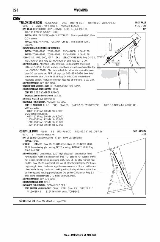
228 WYOMING
CODYYELLOWSTONE RGNL (COD)(KCOD) 2 SE UTC–7(–6DT) N44º31.21´ W109º01.43´
5102 B Class I, ARFF Index A NOTAM FILE CODRWY 04–22: H8268X100 (ASPH–GRVD) S–95, D–124, 2S–101,
2D–193 PCN 38 F/D/X/T HIRLRWY 04: REIL. PAPI(P4L)—GA 3.5º TCH 63´. Thld dsplcd 690´. Pole. 0.7% down.RWY 22: REIL. PAPI(P4L)—GA 3.0º TCH 53´. Thld dsplcd 400´. Ground.
RUNWAY DECLARED DISTANCE INFORMATIONRWY 04: TORA–8268 TODA–8268 ASDA–7868 LDA–7178RWY 22: TORA–8268 TODA–8268 ASDA–7578 LDA–7178
SERVICE: S4 FUEL 100, JET A OX 1 LGT ACTIVATE HIRL Rwy 04–22, REIL Rwy 04 and Rwy 22, PAPI Rwy 04 and Rwy 22—CTAF.
AIRPORT REMARKS: Attended 1200–0700Z‡. Call out after hrs svcs is 307–587–9262. Airfield surface conditions are not monitored btn the hrs of 0500–1200Z‡. Clsd to unscheduled air carrier ops with more than 30 pax seats exc PPR call arpt ops 307–899–5096. Low level waterfowl on lake 1/4 mile SE of Rwy 04 thld. Cold temperature restricted airport. Altitude correction required at or below –31C/–24F.
AIRPORT MANAGER: 307-587-5096WEATHER DATA SOURCES: AWOS–3 135.075 (307) 527–5197.COMMUNICATIONS: CTAF/UNICOM 122.8
CODY RCO 122.3 (CASPER RADIO)SALT LAKE CENTER APP/DEP CON 133.25
AIRSPACE: CLASS E svc continuous. RADIO AIDS TO NAVIGATION: NOTAM FILE COD.
CODY (L) VORW/DME 111.8 COD Chan 55 N44º37.23´ W108º57.90´ 189º 6.5 NM to fld. 4800/14E.VOR unusable:
043º–113º byd 10 NM blo 9,500´DME portion unusable:
043º–113º byd 10 NM blo 9,500´113º–138º byd 22 NM blo 10,000´138º–183º byd 32 NM blo 11,000´183º–343º byd 30 NM blo 17,000´
COKEVILLE MUNI (U06) 3 S UTC–7(–6DT) N42º02.75´ W110º57.96´6270 B NOTAM FILE CPRRWY 15–33: H3400X60 (ASPH) S–10 RWY LGTS(NSTD)
RWY 33: Fence.SERVICE: LGT MIRL Rwy 15–33 OTS indef. Rwy 15–33 NSTD MIRL.
MIRL has missing lgts causing NSTD spacing. ACTIVATE MIRL Rwy 15–33—CTAF.
AIRPORT REMARKS: Unattended. 120´ high electrical transmission lines running east–west 2 miles north of arpt. +2´ ground 70´ west of cntrln full length. Unctl vehicle access to arpt. Rwy 15–33 elev highest near midfld. Rwy 15–33 pavement has lost all structural integrity. Pot holes beginning to form. No line of sight between rwy ends. Some thld lenses clear. Variable rwy conds and braking action during winter months due to thawing and freezing precipitation. Old yellow X visible at Rwy 33 end. Wind indicator lgts OTS indef. Bcn OTS indef.
AIRPORT MANAGER: 307-279-3229COMMUNICATIONS: CTAF 122.9RADIO AIDS TO NAVIGATION: NOTAM FILE CPR.
FORT BRIDGER (L) VORW/DME 108.6 FBR Chan 23 N41º22.71´ W110º25.44´ 315º 46.8 NM to fld. 7058/14E.
CONVERSE CO (See DOUGLAS on page 230)
GREAT FALLSH–1E, L–13D
IAP
SALT LAKE CITYL–11D
NW, 31 MAR 2016 to 26 MAY 2016
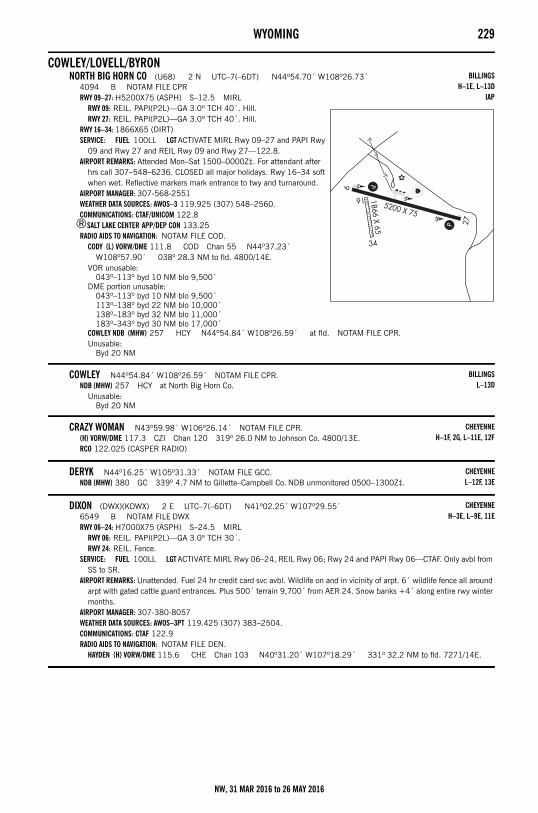
WYOMING 229
COWLEY/LOVELL/BYRONNORTH BIG HORN CO (U68) 2 N UTC–7(–6DT) N44º54.70´ W108º26.73´
4094 B NOTAM FILE CPRRWY 09–27: H5200X75 (ASPH) S–12.5 MIRL
RWY 09: REIL. PAPI(P2L)—GA 3.0º TCH 40´. Hill.RWY 27: REIL. PAPI(P2L)—GA 3.0º TCH 40´. Hill.
RWY 16–34: 1866X65 (DIRT)SERVICE: FUEL 100LL LGT ACTIVATE MIRL Rwy 09–27 and PAPI Rwy
09 and Rwy 27 and REIL Rwy 09 and Rwy 27—122.8.AIRPORT REMARKS: Attended Mon–Sat 1500–0000Z‡. For attendant after
hrs call 307–548–6236. CLOSED all major holidays. Rwy 16–34 soft when wet. Reflective markers mark entrance to twy and turnaround.
AIRPORT MANAGER: 307-568-2551WEATHER DATA SOURCES: AWOS–3 119.925 (307) 548–2560.COMMUNICATIONS: CTAF/UNICOM 122.8
®SALT LAKE CENTER APP/DEP CON 133.25RADIO AIDS TO NAVIGATION: NOTAM FILE COD.
CODY (L) VORW/DME 111.8 COD Chan 55 N44º37.23´ W108º57.90´ 038º 28.3 NM to fld. 4800/14E.
VOR unusable:043º–113º byd 10 NM blo 9,500´
DME portion unusable:043º–113º byd 10 NM blo 9,500´113º–138º byd 22 NM blo 10,000´138º–183º byd 32 NM blo 11,000´183º–343º byd 30 NM blo 17,000´
COWLEY NDB (MHW) 257 HCY N44º54.84´ W108º26.59´ at fld. NOTAM FILE CPR.Unusable:
Byd 20 NM
COWLEY N44º54.84´ W108º26.59´ NOTAM FILE CPR.NDB (MHW) 257 HCY at North Big Horn Co.
Unusable:Byd 20 NM
CRAZY WOMAN N43º59.98´ W106º26.14´ NOTAM FILE CPR.(H) VORW/DME 117.3 CZI Chan 120 319º 26.0 NM to Johnson Co. 4800/13E.RCO 122.025 (CASPER RADIO)
DERYK N44º16.25´ W105º31.33´ NOTAM FILE GCC.NDB (MHW) 380 GC 339º 4.7 NM to Gillette–Campbell Co. NDB unmonitored 0500–1300Z‡.
DIXON (DWX)(KDWX) 2 E UTC–7(–6DT) N41º02.25´ W107º29.55´6549 B NOTAM FILE DWXRWY 06–24: H7000X75 (ASPH) S–24.5 MIRL
RWY 06: REIL. PAPI(P2L)—GA 3.0º TCH 30´.RWY 24: REIL. Fence.
SERVICE: FUEL 100LL LGT ACTIVATE MIRL Rwy 06–24, REIL Rwy 06; Rwy 24 and PAPI Rwy 06—CTAF. Only avbl from SS to SR.
AIRPORT REMARKS: Unattended. Fuel 24 hr credit card svc avbl. Wildlife on and in vicinity of arpt. 6´ wildlife fence all around arpt with gated cattle guard entrances. Plus 500´ terrain 9,700´ from AER 24. Snow banks +4´ along entire rwy winter months.
AIRPORT MANAGER: 307-380-8057WEATHER DATA SOURCES: AWOS–3PT 119.425 (307) 383–2504.COMMUNICATIONS: CTAF 122.9RADIO AIDS TO NAVIGATION: NOTAM FILE DEN.
HAYDEN (H) VORW/DME 115.6 CHE Chan 103 N40º31.20´ W107º18.29´ 331º 32.2 NM to fld. 7271/14E.
BILLINGSH–1E, L–13D
IAP
BILLINGSL–13D
CHEYENNEH–1F, 2G, L–11E, 12F
CHEYENNEL–12F, 13E
CHEYENNEH–3E, L–9E, 11E
NW, 31 MAR 2016 to 26 MAY 2016
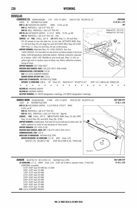
230 WYOMING
DOUGLASCONVERSE CO (DGW)(KDGW) 3 N UTC–7(–6DT) N42º47.83´ W105º23.15´
4933 B NOTAM FILE DGWRWY 11–29: H6534X100 (ASPH) MIRL 0.4% up SE
RWY 11: PAPI(P2L)—GA 3.0º TCH 30´.RWY 29: REIL. PAPI(P2L)—GA 3.0º TCH 40´.
RWY 05–23: H4760X75 (ASPH) S–12.5 MIRL 0.3% up NERWY 23: PAPI(P2L)—GA 3.0º TCH 45´. Hill.
SERVICE: S4 FUEL 100LL, JET A LGT MIRL Rwy 11–29 and Rwy 05–23 preset on low ints dark hrs, to incr ints, ACTIVATE MIRL Rwy 11–29 and Rwy 05–23 dalgt hrs and ACTIVATE REIL Rwy 29–CTAF. PAPI Rwy 11, Rwy 23 and Rwy 29 opr continuously.
AIRPORT REMARKS: Attended Mon–Fri 1330–0000Z‡, Sat–Sun 1500–0000Z‡. For fuel after hrs see phone numbers posted in terminal lobby. Cold temperature restricted airport. Altitude correction required at or below –26C/–15F. Wildlife on and invof arpt. Rwy 11–29, no yellow lgts lctd in caution zone of either rwy. Retro–reflective markers along all twys.
AIRPORT MANAGER: 307-358-3527WEATHER DATA SOURCES: ASOS 135.225 (307) 358–4448.COMMUNICATIONS: CTAF/UNICOM 122.8
RCO 121.975 (CASPER RADIO)DENVER CENTER APP/DEP CON 135.6
RADIO AIDS TO NAVIGATION: NOTAM FILE DGW.HIPSHER (L) VORW/DME 108.6 IIP Chan 23 N42º40.57´ W105º13.57´ 304º 10.1 NM to fld. 4906/12E.
• • • • • • • • • • • • • • • • • •
HELIPAD H1: H60X60 (ASPH)HELIPAD H2: H60X60 (ASPH)HELIPORT REMARKS: H1 NSTD designation markings. H2 NSTD designation markings.
DUBOIS MUNI (DUB)(KDUB) 3 NW UTC–7(–6DT) N43º32.90´ W109º41.42´7297 B NOTAM FILE CPRRWY 10–28: H6100X60 (ASPH) S–24 PCN 8 F/C/Y/T MIRL
0.9% up WRWY 10: PAPI(P2L)—GA 3.0º TCH 40´.RWY 28: REIL. PAPI(P2L)—GA 3.0º TCH 40´. Rgt tfc.
SERVICE: FUEL 100LL, JET A LGT ACTIVATE MIRL Rwy 10–28, PAPI Rwy 10 and Rwy 28, and REIL Rwy 28—CTAF.
AIRPORT REMARKS: Unattended. Fuel avbl 24 hours self serve credit card. All traffic patterns to north of rwy because of mtns south.
AIRPORT MANAGER: 307-455-2100WEATHER DATA SOURCES: AWOS–3PT 118.275 (307) 455–2211.COMMUNICATIONS: CTAF 122.9RADIO AIDS TO NAVIGATION: NOTAM FILE CPR.
BOYSEN RESERVOIR (H) VORW/DME 117.8 BOY Chan 125 N43º27.79´ W108º17.98´ 259º 60.9 NM to fld. 7550/16E.
DUNOIR N43º49.70´ W110º20.13´ NOTAM FILE CPR.(H) VORW/DME 117.2 DNW Chan 119 218º 22.0 NM to Jackson Hole. 7730/15E.
VOR/DME unusable:010º–030º byd 25 NM blo 17,000´030º–130º byd 15 NM130º–210º byd 20 NM210º–230º byd 25 NM230º–240º byd 20 NM240º–270º byd 30 NM270º–330º byd 20 NM330º–340º byd 10 NM340º–010º byd 15 NM
RCO 122.6 (CASPER RADIO)
CHEYENNEH–3F, 5A, L–12F
IAP
SALT LAKE CITYH–3E, L–11D
SALT LAKE CITYH–1D, L–11D
NW, 31 MAR 2016 to 26 MAY 2016
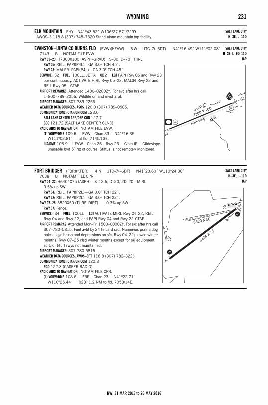
WYOMING 231
ELK MOUNTAIN EHY N41º43.52´ W106º27.57´/7299AWOS–3 118.8 (307) 348–7320 Stand alone mountain top facility.
EVANSTON–UINTA CO BURNS FLD (EVW)(KEVW) 3 W UTC–7(–6DT) N41º16.49´ W111º02.08´7143 B NOTAM FILE EVWRWY 05–23: H7300X100 (ASPH–GRVD) S–30, D–70 HIRL
RWY 05: REIL. PAPI(P4L)—GA 3.0º TCH 45´.RWY 23: MALSR. PAPI(P4L)—GA 3.0º TCH 45´.
SERVICE: S2 FUEL 100LL, JET A OX 2 LGT PAPI Rwy 05 and Rwy 23 opr continuously. ACTIVATE HIRL Rwy 05–23, MALSR Rwy 23 and REIL Rwy 05—CTAF.
AIRPORT REMARKS: Attended 1400–0200Z‡. For svc after hrs call 1–800–789–2256. Wildlife on and invof arpt.
AIRPORT MANAGER: 307-789-2256WEATHER DATA SOURCES: ASOS 120.0 (307) 789–0585.COMMUNICATIONS: CTAF/UNICOM 123.0
SALT LAKE CENTER APP/DEP CON 127.7GCO 121.72 (SALT LAKE CENTER CLNC)
RADIO AIDS TO NAVIGATION: NOTAM FILE EVW.(T) VORW/DME 109.6 EVW Chan 33 N41º16.35´
W111º02.81´ at fld. 7145/13E.ILS/DME 108.9 I–EVW Chan 26 Rwy 23. Class IE. Glideslope
unusable byd 5º rgt of course. Status is not remotely Monitored.
FORT BRIDGER (FBR)(KFBR) 4 N UTC–7(–6DT) N41º23.60´ W110º24.36´7038 B NOTAM FILE CPRRWY 04–22: H6404X75 (ASPH) S–12.5, D–20, 2D–20 MIRL
0.5% up SWRWY 04: REIL. PAPI(P2L)—GA 3.0º TCH 22´.RWY 22: REIL. PAPI(P2L)—GA 3.0º TCH 22´.
RWY 07–25: 3520X50 (TURF–DIRT) 0.3% up SWRWY 07: Fence.
SERVICE: S4 FUEL 100LL LGT ACTIVATE MIRL Rwy 04–22, REIL Rwy 04 and Rwy 22, and PAPI Rwy 04 and Rwy 22–CTAF.
AIRPORT REMARKS: Attended Mon–Fri 1500–0000Z‡. For svc after hrs call 307–780–5815. Fuel avbl by 24 hr card svc. Numerous prairie dog holes, sage brush and depressions on sfc. Rwy 04–22 plowed winter months, Rwy 07–25 clsd winter months except for ski equipment acft, dirt/turf rwys not maintained.
AIRPORT MANAGER: 307-780-5815WEATHER DATA SOURCES: AWOS–3PT 118.8 (307) 782–3226.COMMUNICATIONS: CTAF/UNICOM 122.8
RCO 122.3 (CASPER RADIO)RADIO AIDS TO NAVIGATION: NOTAM FILE CPR.
(L) VORW/DME 108.6 FBR Chan 23 N41º22.71´ W110º25.44´ 028º 1.2 NM to fld. 7058/14E.
SALT LAKE CITYH–3E, L–11D
SALT LAKE CITYH–3E, L–9D, 11D
IAP
SALT LAKE CITYH–3E, L–11D
IAP
NW, 31 MAR 2016 to 26 MAY 2016
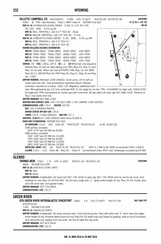
232 WYOMING
GILLETTE–CAMPBELL CO (GCC)(KGCC) 4 NW UTC–7(–6DT) N44º20.94´ W105º32.36´4364 B TPA—See Remarks Class I, ARFF Index A NOTAM FILE GCCRWY 16–34: H7500X150 (CONC–GRVD) S–60, D–110, 2S–139,
2D–160 HIRL 0.4% up SERWY 16: REIL. PAPI(P4L)—GA 3.17º TCH 43´. Road.RWY 34: MALSR. PAPI(P4L)—GA 3.2º TCH 56´. P–line.
RWY 03–21: H5803X75 (CONC–GRVD) S–40 MIRL 0.4% up SWRWY 03: REIL. PAPI(P4L)—GA 4.0º TCH 41´.RWY 21: REIL. PAPI(P4L)—GA 4.0º TCH 39´.
RUNWAY DECLARED DISTANCE INFORMATIONRWY 03: TORA–5803 TODA–5803 ASDA–5803 LDA–5803RWY 16: TORA–7500 TODA–7500 ASDA–7500 LDA–7500RWY 21: TORA–5803 TODA–5803 ASDA–5803 LDA–5803RWY 34: TORA–7500 TODA–7500 ASDA–7500 LDA–7500
SERVICE: S4 FUEL 100LL, JET A OX 1, 2 LGT When twr clsd sequence flashers Rwy 34 avbl on high setting only, REIL Rwy 03, Rwy 21 and Rwy 16 not avbl. When twr clsd ACTIVATE HIRL Rwy 16–34, MIRL Rwy 03–21, MALSR Rwy 34, PAPI Rwy 03, Rwy 21, Rwy 16 and Rwy 34—CTAF.
AIRPORT REMARKS: Attended 1300–0500Z‡. Cond unmo. 24 hr self svc credit card fuel avbl. Cold temperature restricted airport. Altitude correction required at or below –25C/–13F. Migratory waterfowl invof arpt. Mining/blasting ops 1/2 mile northeast AER 21 dur dalgt hrs ctc twr. TPA—5164(800) for light acft, 5564(1200) for large acft. PPR unscheduled air carrier ops with more than 30 pax seats call arpt mgr 307–686–1042. Portions of Twy C not visible from twr.
AIRPORT MANAGER: 307-686-1042WEATHER DATA SOURCES: ASOS 124.175 (307) 682–1745. SAWRS 1300–0500Z‡.COMMUNICATIONS: CTAF 118.5 UNICOM 122.95
RCO 122.3 (CASPER RADIO)DENVER CENTER APP/DEP CON 135.6 TOWER 118.5 (1300–0500Z‡) GND CON 121.7
AIRSPACE: CLASS D svc 1300–0500Z‡ other times CLASS G.RADIO AIDS TO NAVIGATION: NOTAM FILE GCC.
(H) VORW/DME 114.6 GCC Chan 93 N44º20.87´ W105º32.61´ at fld. 4336/12E.VOR portion unusable:
250º–275º byd 20 NM blo 8,000´DME portion unusable:
160º–190º byd 25 NM blo 10,300´190º–265º byd 20 NM blo 8,000´190º–265º byd 30 NM blo 13,000´265º–330º byd 22 NM blo 10,500´
DERYK NDB (MHW) 380 GC N44º16.25´ W105º31.33´ 339º 4.7 NM to fld. NDB unmonitored 0500–1300Z‡.ILS/DME 110.1 I–LLT Chan 38 Rwy 34. Class IT. Unmonitored when ATCT clsd. Glideslope unusable byd 8 NM.
GLENDOTHOMAS MEM (76V) 1 N UTC–7(–6DT) N42º31.20´ W105º01.20´
4666 NOTAM FILE CPRRWY 16–34: 4397X70 (TURF–DIRT)
RWY 16: Tree.RWY 34: Road.
AIRPORT REMARKS: Unattended. Ctc town hall 307–735–4242 or arpt mgr 307–734–0655 prior to use for sfc cond. Ocnl antelope on rwy. Rwy 16–34 first 500´ SE end very rough and +1´ grass entire length of rwy. Rwy 16–34 muddy, slick and soft when wet, ocnl gopher holes.
AIRPORT MANAGER: 307-734-0655COMMUNICATIONS: CTAF 122.9
GREEN RIVERGTR GREEN RIVER INTERGALACTIC SPACEPORT (48U) 4 S UTC–7(–6DT) N41º27.49´
W109º29.40´7182 NOTAM FILE CPRRWY 04–22: 5800X130 (DIRT)AIRPORT REMARKS: Unattended. No snow removal avbl. Unctl vehicle access. Rwy soft when wet. 3´ berm near rwy edges
entire length of rwy. Possible debris found on rwy. Rwy 04–22 width may vary based on grading. Arpt on top of mountain, land descends very steeply from rwy ends. No line of sight btn rwy ends.
AIRPORT MANAGER: 307-872-0554COMMUNICATIONS: CTAF 122.9
CHEYENNEH–1F, 2G, L–12F, 13E
IAP, AD
CHEYENNE
SALT LAKE CITY
NW, 31 MAR 2016 to 26 MAY 2016

WYOMING 233
GREYBULLSOUTH BIG HORN CO (GEY)(KGEY) 2 NW UTC–7(–6DT) N44º31.08´ W108º04.98´
3942 B NOTAM FILE GEYRWY 16–34: H7003X150 (ASPH) S–85, D–150, 2D–290 MIRL
RWY 16: REIL. PAPI(P4L)—GA 3.0º TCH 50´.RWY 34: REIL. PAPI(P4L)—GA 3.0º TCH 50´.
RWY 07–25: H3953X75 (ASPH) S–12.5 0.6% up WSERVICE: S4 FUEL 100LL, JET A OX 1 LGT ACTIVATE MIRL Rwy
16–34, PAPI Rwy 16 and Rwy 34, REIL Rwy 16 and Rwy 34—CTAF.AIRPORT REMARKS: Attended Mon–Fri 1500–0000Z‡. For svc after hrs call
307–431–1464. Fuel 24 hr credit card svc avbl. 100LL only. Jet A avbl during attendance hrs. After hrs call numbers posted on north side of terminal building. Cold temperature restricted airport. Altitude correction required at or below –32C/–26F. Antelope on and invof rwy. Terrain 1066´ abv arpt elevation 4–5 miles north and northeast of arpt.
AIRPORT MANAGER: 307-568-2551WEATHER DATA SOURCES: ASOS 135.325 (307) 765–9406.COMMUNICATIONS: CTAF 122.9
SALT LAKE CENTER APP/DEP CON 133.25RADIO AIDS TO NAVIGATION: NOTAM FILE WRL.
WORLAND (L) VORW/DME 114.8 RLY Chan 95 N43º57.85´ W107º57.05´ 337º 33.7 NM to fld. 4204/13E.
GREYBULL NDB (MHW) 275 GEY N44º30.69´ W108º04.97´ at fld. NOTAM FILE GEY.
GTR GREEN RIVER INTERGALACTIC SPACEPORT (See GREEN RIVER on page 232)
HARFORD FLD (See CASPER on page 226)
HIPSHER N42º40.57´ W105º13.57´ NOTAM FILE DGW.(L) VORW/DME 108.6 IIP Chan 23 304º 10.1 NM to Converse Co. 4906/12E.
HORSE N41º08.81´ W104º40.74´ NOTAM FILE CYS.NDB (LOM) 353 CY 265º 6.0 NM to Cheyenne Rgnl/Jerry Olson Fld.
HOT SPRINGS CO–THERMOPOLIS MUNI (See THERMOPOLIS on page 243)
HOT SPRINGS CO (See THERMOPOLIS on page 243)
HULETT MUNI (W43) 2 SE UTC–7(–6DT) N44º39.77´ W104º34.07´4264 B NOTAM FILE CPRRWY 13–31: H5500X75 (ASPH) S–12.5 MIRL 1.3% up SE
RWY 13: REIL. PAPI(P2L)—GA 4.0º TCH 40´.RWY 31: REIL. PAPI(P2L)—GA 4.0º TCH 40´. Hill. Rgt tfc.
SERVICE: FUEL 100LL, JET A LGT ACTIVATE MIRL Rwy 13–31 and REIL Rwy 13 and Rwy 31—CTAF.
AIRPORT REMARKS: Unattended. 24 hr self svc credit card fuel avbl. Devils Tower National Monument lctd aprx 7 miles southwest of arpt. Voluntary 2 mile flgt avoidance radius in effect Jan–May and Jul–Dec. Voluntary 3 mile flgt avoidance radius in effect in Jun. Retro–reflective markers along twys.
AIRPORT MANAGER: 307-467-5771WEATHER DATA SOURCES: AWOS–3PT 128.775 (307) 467–5575.COMMUNICATIONS: CTAF/UNICOM 122.8
DENVER CENTER APP/DEP CON 127.95RADIO AIDS TO NAVIGATION: NOTAM FILE GCC.
GILLETTE (H) VORW/DME 114.6 GCC Chan 93 N44º20.87´ W105º32.61´ 053º 46.0 NM to fld. 4336/12E.
VOR portion unusable:250º–275º byd 20 NM blo 8,000´
DME portion unusable:160º–190º byd 25 NM blo 10,300´190º–265º byd 20 NM blo 8,000´190º–265º byd 30 NM blo 13,000´265º–330º byd 22 NM blo 10,500´
BILLINGSH–1E, L–13D
IAP
CHEYENNEL–12F
CHEYENNE
BILLINGSH–1F, 2H, L–12F, 13E
IAP
NW, 31 MAR 2016 to 26 MAY 2016
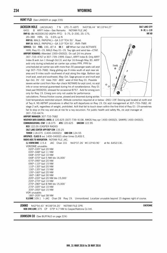
234 WYOMING
HUNT FLD (See LANDER on page 235)
JACKSON HOLE (JAC)(KJAC) 7 N UTC–7(–6DT) N43º36.44´ W110º44.27´6451 B ARFF Index—See Remarks NOTAM FILE JACRWY 01–19: H6300X150 (ASPH–PFC) S–75, D–200, 2S–175,
2D–380 HIRL CL 0.6% up NRWY 01: MALS. PAPI(P4L)—GA 3.0º TCH 50´. Road.RWY 19: MALS. PAPI(P4L)—GA 3.0º TCH 53´. RVR–TMR
SERVICE: S4 FUEL 100, JET A OX 3 LGT When twr clsd ACTIVATE HIRL Rwy 01–19, MALS Rwy 01–19, Twy lgts and wind tee—CTAF.
AIRPORT REMARKS: Attended 1300–0500Z‡. On call 24 hrs phone 307–733–4767 or 307–739–1999. Class I, ARFF Index B. Only ARFF Index B avbl Jun 1 through Oct 31 and Apr 16 through May 30. ARFF avbl only during scheduled air carrier ops unless PPR. PPR for unscheduled air carrier ops with more than 30 passenger seats call arpt mgr 307–733–7682. Hang gliding ops 9 miles south of arpt near ski area and 9 miles south–southwest of arpt along the ridge. Balloon ops invof arpt, west and southwest, May–Oct. Sage grouse on and invof arpt Apr–Oct. 35´–53´ trees 700´–800´ west of thld Rwy 01. Possible severe winter cond from Nov–Apr check NOTAMS for arpt cond, no arpt info or snow removal guaranteed during hrs of nonattendance. Rwy 01 blast pad 950X200, stressed for occasional B757. Avbl for emerg ovrn only for Rwy 19. Emerg ovrn only not usable for performance calculations. Porous friction course, plowed and broomed during winter. Cold temperature restricted airport. Altitude correction required at or below –26C/–15F. Deicing pad located at north end of Twy A. NS ABTMT procedures in effect for acft departures on Rwy 19. Ctc arpt management at 307–733–7682. All stage 2 acft, regardless of weight, prohibited. Acft that fail to touch down within the first third of Rwy 01–19 sometimes fail to stop on the rwy and are at risk for a rwy excursion. For public health and safety flts, ctc arpt manager at 307–733–6474.
AIRPORT MANAGER: 307-733-7682WEATHER DATA SOURCES: AWOS–3 120.625 (307) 739–9108. AWOS freq opr 1400–0400Z‡. SAWRS 1400–0400Z‡.COMMUNICATIONS: CTAF 118.075 ATIS 120.625 UNICOM 122.95
RCO 122.05 (CASPER RADIO)SALT LAKE CENTER APP/DEP CON 133.25 TOWER 118.075 (1400–0400Z‡) GND CON 124.55
AIRSPACE: CLASS D svc 1400–0400Z‡ other times CLASS E.RADIO AIDS TO NAVIGATION: NOTAM FILE JAC.
(L) VORW/DME 115.4 JAC Chan 101 N43º37.26´ W110º43.90´ at fld. 6452/13E.VOR/DME unusable:
020º–035º byd 20 NM035º–048º byd 11 NM048º–070º byd 10 NM048º–070º byd 5 NM blo 16,000´070º–090º byd 20 NM090º–110º byd 15 NM110º–130º byd 20 NM130º–135º byd 15 NM135º–160º byd 20 NM160º–180º byd 30 NM205º–220º byd 20 NM blo 15,000´220º–270º byd 10 NM270º–280º byd 8 NM blo 15,000´270º–335º byd 10 NM335º–350º byd 15 NM
VOR unusable:180º–205º byd 38 NM
ILS/DME 109.1 I–JAC Chan 28 Rwy 19. Unmonitored. Localizer unusable beyond 15 degrees right of course.
JOHNO N42º54.43´ W106º34.20´ NOTAM FILE CPR.NDB (HW/LOM) 375 CP 079º 4.7 NM to Casper/Natrona Co Intl.
JOHNSON CO (See BUFFALO on page 224)
SALT LAKE CITYH–3E, L–11D
IAP, AD
CHEYENNE
NW, 31 MAR 2016 to 26 MAY 2016
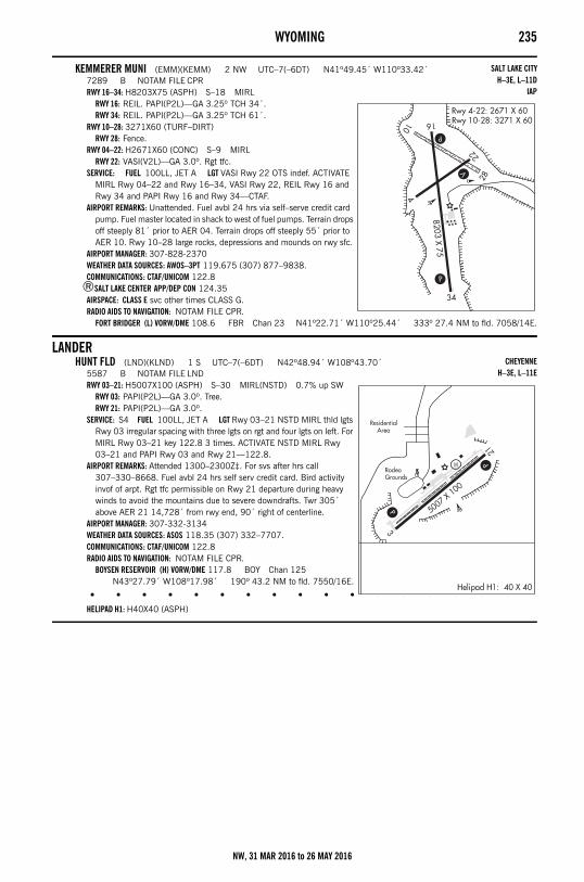
WYOMING 235
KEMMERER MUNI (EMM)(KEMM) 2 NW UTC–7(–6DT) N41º49.45´ W110º33.42´7289 B NOTAM FILE CPRRWY 16–34: H8203X75 (ASPH) S–18 MIRL
RWY 16: REIL. PAPI(P2L)—GA 3.25º TCH 34´.RWY 34: REIL. PAPI(P2L)—GA 3.25º TCH 61´.
RWY 10–28: 3271X60 (TURF–DIRT)RWY 28: Fence.
RWY 04–22: H2671X60 (CONC) S–9 MIRLRWY 22: VASI(V2L)—GA 3.0º. Rgt tfc.
SERVICE: FUEL 100LL, JET A LGT VASI Rwy 22 OTS indef. ACTIVATE MIRL Rwy 04–22 and Rwy 16–34, VASI Rwy 22, REIL Rwy 16 and Rwy 34 and PAPI Rwy 16 and Rwy 34—CTAF.
AIRPORT REMARKS: Unattended. Fuel avbl 24 hrs via self–serve credit card pump. Fuel master located in shack to west of fuel pumps. Terrain drops off steeply 81´ prior to AER 04. Terrain drops off steeply 55´ prior to AER 10. Rwy 10–28 large rocks, depressions and mounds on rwy sfc.
AIRPORT MANAGER: 307-828-2370WEATHER DATA SOURCES: AWOS–3PT 119.675 (307) 877–9838.COMMUNICATIONS: CTAF/UNICOM 122.8
®SALT LAKE CENTER APP/DEP CON 124.35AIRSPACE: CLASS E svc other times CLASS G.RADIO AIDS TO NAVIGATION: NOTAM FILE CPR.
FORT BRIDGER (L) VORW/DME 108.6 FBR Chan 23 N41º22.71´ W110º25.44´ 333º 27.4 NM to fld. 7058/14E.
LANDERHUNT FLD (LND)(KLND) 1 S UTC–7(–6DT) N42º48.94´ W108º43.70´
5587 B NOTAM FILE LNDRWY 03–21: H5007X100 (ASPH) S–30 MIRL(NSTD) 0.7% up SW
RWY 03: PAPI(P2L)—GA 3.0º. Tree.RWY 21: PAPI(P2L)—GA 3.0º.
SERVICE: S4 FUEL 100LL, JET A LGT Rwy 03–21 NSTD MIRL thld lgts Rwy 03 irregular spacing with three lgts on rgt and four lgts on left. For MIRL Rwy 03–21 key 122.8 3 times. ACTIVATE NSTD MIRL Rwy 03–21 and PAPI Rwy 03 and Rwy 21—122.8.
AIRPORT REMARKS: Attended 1300–2300Z‡. For svs after hrs call 307–330–8668. Fuel avbl 24 hrs self serv credit card. Bird activity invof of arpt. Rgt tfc permissible on Rwy 21 departure during heavy winds to avoid the mountains due to severe downdrafts. Twr 305´ above AER 21 14,728´ from rwy end, 90´ right of centerline.
AIRPORT MANAGER: 307-332-3134WEATHER DATA SOURCES: ASOS 118.35 (307) 332–7707.COMMUNICATIONS: CTAF/UNICOM 122.8RADIO AIDS TO NAVIGATION: NOTAM FILE CPR.
BOYSEN RESERVOIR (H) VORW/DME 117.8 BOY Chan 125 N43º27.79´ W108º17.98´ 190º 43.2 NM to fld. 7550/16E.
• • • • • • • • • • • • • • • • • •
HELIPAD H1: H40X40 (ASPH)
SALT LAKE CITYH–3E, L–11D
IAP
CHEYENNEH–3E, L–11E
NW, 31 MAR 2016 to 26 MAY 2016
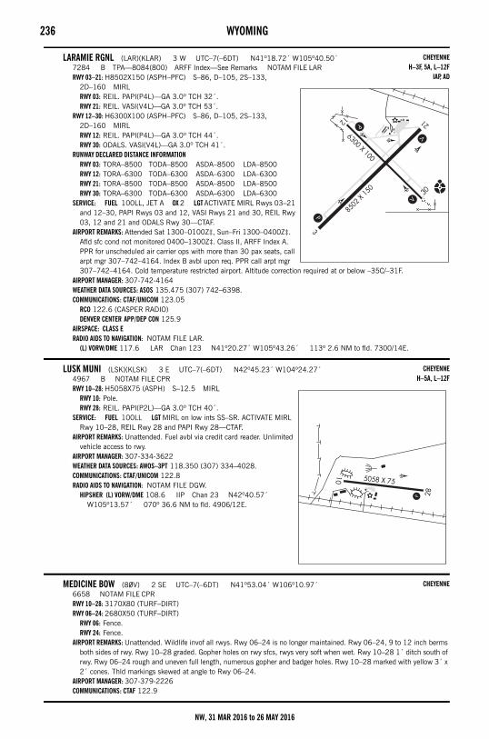
236 WYOMING
LARAMIE RGNL (LAR)(KLAR) 3 W UTC–7(–6DT) N41º18.72´ W105º40.50´7284 B TPA—8084(800) ARFF Index—See Remarks NOTAM FILE LARRWY 03–21: H8502X150 (ASPH–PFC) S–86, D–105, 2S–133,
2D–160 MIRLRWY 03: REIL. PAPI(P4L)—GA 3.0º TCH 32´.RWY 21: REIL. VASI(V4L)—GA 3.0º TCH 53´.
RWY 12–30: H6300X100 (ASPH–PFC) S–86, D–105, 2S–133, 2D–160 MIRLRWY 12: REIL. PAPI(P4L)—GA 3.0º TCH 44´.RWY 30: ODALS. VASI(V4L)—GA 3.0º TCH 41´.
RUNWAY DECLARED DISTANCE INFORMATIONRWY 03: TORA–8500 TODA–8500 ASDA–8500 LDA–8500RWY 12: TORA–6300 TODA–6300 ASDA–6300 LDA–6300RWY 21: TORA–8500 TODA–8500 ASDA–8500 LDA–8500RWY 30: TORA–6300 TODA–6300 ASDA–6300 LDA–6300
SERVICE: FUEL 100LL, JET A OX 2 LGT ACTIVATE MIRL Rwys 03–21 and 12–30, PAPI Rwys 03 and 12, VASI Rwys 21 and 30, REIL Rwy 03, 12 and 21 and ODALS Rwy 30—CTAF.
AIRPORT REMARKS: Attended Sat 1300–0100Z‡, Sun–Fri 1300–0400Z‡. Afld sfc cond not monitored 0400–1300Z‡. Class II, ARFF Index A. PPR for unscheduled air carrier ops with more than 30 pax seats, call arpt mgr 307–742–4164. Index B avbl upon req. PPR call arpt mgr 307–742–4164. Cold temperature restricted airport. Altitude correction required at or below –35C/–31F.
AIRPORT MANAGER: 307-742-4164WEATHER DATA SOURCES: ASOS 135.475 (307) 742–6398.COMMUNICATIONS: CTAF/UNICOM 123.05
RCO 122.6 (CASPER RADIO)DENVER CENTER APP/DEP CON 125.9
AIRSPACE: CLASS ERADIO AIDS TO NAVIGATION: NOTAM FILE LAR.
(L) VORW/DME 117.6 LAR Chan 123 N41º20.27´ W105º43.26´ 113º 2.6 NM to fld. 7300/14E.
LUSK MUNI (LSK)(KLSK) 3 E UTC–7(–6DT) N42º45.23´ W104º24.27´4967 B NOTAM FILE CPRRWY 10–28: H5058X75 (ASPH) S–12.5 MIRL
RWY 10: Pole.RWY 28: REIL. PAPI(P2L)—GA 3.0º TCH 40´.
SERVICE: FUEL 100LL LGT MIRL on low ints SS–SR. ACTIVATE MIRL Rwy 10–28, REIL Rwy 28 and PAPI Rwy 28—CTAF.
AIRPORT REMARKS: Unattended. Fuel avbl via credit card reader. Unlimited vehicle access to rwy.
AIRPORT MANAGER: 307-334-3622WEATHER DATA SOURCES: AWOS–3PT 118.350 (307) 334–4028.COMMUNICATIONS: CTAF/UNICOM 122.8RADIO AIDS TO NAVIGATION: NOTAM FILE DGW.
HIPSHER (L) VORW/DME 108.6 IIP Chan 23 N42º40.57´ W105º13.57´ 070º 36.6 NM to fld. 4906/12E.
MEDICINE BOW (80V) 2 SE UTC–7(–6DT) N41º53.04´ W106º10.97´6658 NOTAM FILE CPRRWY 10–28: 3170X80 (TURF–DIRT)RWY 06–24: 2680X50 (TURF–DIRT)
RWY 06: Fence.RWY 24: Fence.
AIRPORT REMARKS: Unattended. Wildlife invof all rwys. Rwy 06–24 is no longer maintained. Rwy 06–24, 9 to 12 inch berms both sides of rwy. Rwy 10–28 graded. Gopher holes on rwy sfcs, rwys very soft when wet. Rwy 10–28 1´ ditch south of rwy. Rwy 06–24 rough and uneven full length, numerous gopher and badger holes. Rwy 10–28 marked with yellow 3´ x 2´ cones. Thld markings skewed at angle to Rwy 06–24.
AIRPORT MANAGER: 307-379-2226COMMUNICATIONS: CTAF 122.9
CHEYENNEH–3F, 5A, L–12F
IAP, AD
CHEYENNEH–5A, L–12F
CHEYENNE
NW, 31 MAR 2016 to 26 MAY 2016
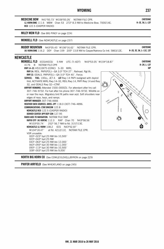
WYOMING 237
MEDICINE BOW N41º50.73´ W106º00.26´ NOTAM FILE CPR.(L) VORW/DME 111.6 MBW Chan 53 272º 8.3 NM to Medicine Bow. 7000/14E.RCO 122.5 (CASPER RADIO)
MILEY MEM FLD (See BIG PINEY on page 224)
MONDELL FLD (See NEWCASTLE on page 237)
MUDDY MOUNTAIN N43º05.45´ W106º16.62´ NOTAM FILE CPR.(H) VORW/DME 116.2 DDY Chan 109 205º 13.8 NM to Casper/Natrona Co Intl. 5863/12E.
NEWCASTLEMONDELL FLD (ECS)(KECS) 5 NW UTC–7(–6DT) N43º53.05´ W104º18.87´
4176 B NOTAM FILE CPRRWY 14–32: H5310X75 (CONC) S–30 MIRL
RWY 14: REIL. PAPI(P2L)—GA 3.0º TCH 27´. Railroad. Rgt tfc.RWY 32: ODALS. PAPI(P2L)—GA 3.0º TCH 40´. Fence.
SERVICE: FUEL 100LL, JET A LGT Rwy 14 PAPI realigned with dsplcd thld. ACTIVATE MIRL Rwy 14–32, REIL Rwy 14, PAPI Rwy 14 and Rwy 32, and ODALS Rwy 32—CTAF.
AIRPORT REMARKS: Attended 1500–0000Z‡. For attendant after hrs call 307–746–9732. For fuel after hrs phone 307–746–9732. Wildlife on or near the rwys. Migratory bird flt paths near arpt. Soft shoulders near edges of rwys, twys, and ramps.
AIRPORT MANAGER: 307-746-4666WEATHER DATA SOURCES: AWOS–3PT 118.0 (307) 746–4896.COMMUNICATIONS: CTAF/UNICOM 122.8
NEWCASTLE RCO 122.5 (CASPER RADIO)DENVER CENTER APP/DEP CON 127.95
RADIO AIDS TO NAVIGATION: NOTAM FILE RAP.RAPID CITY (H) VORTAC 112.3 RAP Chan 70 N43º58.56´
W103º00.74´ 252º 56.7 NM to fld. 3157/13E.NEWCASTLE (L) VORW 108.2 ECS N43º52.87´
W104º18.47´ at fld. 4212/11E. NOTAM FILE CPR.VOR unusable:
003º–023º byd 25 NM blo 10,500´023º–043º byd 25 NM043º–063º byd 25 NM blo 12,000´063º–093º byd 30 NM blo 11,000´093º–113º byd 30 NM blo 10,500´328º–003º byd 25 NM blo 9,000´
NORTH BIG HORN CO (See COWLEY/LOVELL/BYRON on page 229)
PHIFER AIRFIELD (See WHEATLAND on page 245)
CHEYENNEH–3E, 5A, L–12F
CHEYENNEH–2G, 3E, 5A, L–11E, 12F
CHEYENNEH–2H, L–12F
IAP
NW, 31 MAR 2016 to 26 MAY 2016
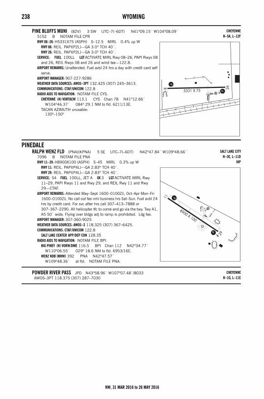
238 WYOMING
PINE BLUFFS MUNI (82V) 3 SW UTC–7(–6DT) N41º09.15´ W104º08.09´5152 B NOTAM FILE CPRRWY 08–26: H5331X75 (ASPH) S–12.5 MIRL 0.4% up W
RWY 08: REIL. PAPI(P2L)—GA 3.0º TCH 40´.RWY 26: REIL. PAPI(P2L)—GA 3.0º TCH 40´.
SERVICE: FUEL 100LL LGT ACTIVATE MIRL Rwy 08–26, PAPI Rwys 08 and 26, REIL Rwys 08 and 26 and wind tee—122.8.
AIRPORT REMARKS: Unattended. Fuel avbl 24 hrs a day with credit card self serve.
AIRPORT MANAGER: 907-227-9286WEATHER DATA SOURCES: AWOS–3PT 132.425 (307) 245–3613.COMMUNICATIONS: CTAF/UNICOM 122.8RADIO AIDS TO NAVIGATION: NOTAM FILE CYS.
CHEYENNE (H) VORTACW 113.1 CYS Chan 78 N41º12.66´ W104º46.37´ 084º 29.1 NM to fld. 6211/13E.
TACAN AZIMUTH unusable:130º–150º
PINEDALERALPH WENZ FLD (PNA)(KPNA) 5 SE UTC–7(–6DT) N42º47.84´ W109º48.66´
7096 B NOTAM FILE PNARWY 11–29: H8900X100 (ASPH) S–45 MIRL 0.3% up W
RWY 11: REIL. PAPI(P4L)—GA 2.83º TCH 40´.RWY 29: REIL. PAPI(P4L)—GA 2.83º TCH 40´.
SERVICE: S4 FUEL 100LL, JET A OX 3 LGT ACTIVATE MIRL Rwy 11–29, PAPI Rwys 11 and Rwy 29, and REIL Rwy 11 and Rwy 29—CTAF.
AIRPORT REMARKS: Attended May–Sept 1600–0100Z‡, Oct–Apr Mon–Fri 1600–0100Z‡. No call out fee nml business hrs Sat–Sun. Fuel avbl 24 hrs by credit card. For svc after hrs call 307–413–7888 or 307–367–2290. All helicopter tfc to come and go via the twy. Twy A1, A5 50´ wide. Flying over bldgs adj to ramp is prohibited. Ldg fee.
AIRPORT MANAGER: 307-360-9025WEATHER DATA SOURCES: AWOS–3 118.325 (307) 367–6425.COMMUNICATIONS: CTAF/UNICOM 122.8
SALT LAKE CENTER APP/DEP CON 128.35RADIO AIDS TO NAVIGATION: NOTAM FILE BPI.
BIG PINEY (H) VORW/DME 116.5 BPI Chan 112 N42º34.77´ W110º06.55´ 029º 18.6 NM to fld. 6953/16E.
WENZ NDB (MHW) 392 PNA N42º47.57´ W109º48.36´ at fld. NOTAM FILE PNA.
POWDER RIVER PASS JPD N43º58.96´ W107º07.48´/8033AWOS–3PT 118.375 (307) 287–7030
CHEYENNEH–5A, L–12F
SALT LAKE CITYH–3E, L–11D
IAP
CHEYENNEH–1G, L–11E
NW, 31 MAR 2016 to 26 MAY 2016
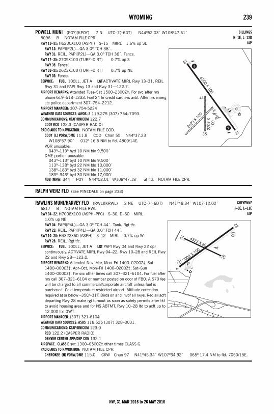
WYOMING 239
POWELL MUNI (POY)(KPOY) 7 N UTC–7(–6DT) N44º52.03´ W108º47.61´5096 B NOTAM FILE CPRRWY 13–31: H6200X100 (ASPH) S–15 MIRL 1.6% up SE
RWY 13: PAPI(P2L)—GA 3.0º TCH 38´.RWY 31: REIL. PAPI(P2L)—GA 3.0º TCH 36´. Fence.
RWY 17–35: 2709X100 (TURF–DIRT) 0.7% up SRWY 35: Fence.
RWY 03–21: 2623X100 (TURF–DIRT) 0.7% up NERWY 03: Fence.
SERVICE: FUEL 100LL, JET A LGT ACTIVATE MIRL Rwy 13–31, REIL Rwy 31 and PAPI Rwy 13 and Rwy 31—122.7.
AIRPORT REMARKS: Attended Tues–Sat 1500–2300Z‡. For svc after hrs phone 619–518–1233. Fuel 24 hr credit card svc avbl. After hrs emerg ctc police department 307–754–2212.
AIRPORT MANAGER: 307-754-5234WEATHER DATA SOURCES: AWOS–3 119.275 (307) 754–7093.COMMUNICATIONS: CTAF/UNICOM 122.7
CODY RCO 122.3 (CASPER RADIO)RADIO AIDS TO NAVIGATION: NOTAM FILE COD.
CODY (L) VORW/DME 111.8 COD Chan 55 N44º37.23´ W108º57.90´ 012º 16.5 NM to fld. 4800/14E.
VOR unusable:043º–113º byd 10 NM blo 9,500´
DME portion unusable:043º–113º byd 10 NM blo 9,500´113º–138º byd 22 NM blo 10,000´138º–183º byd 32 NM blo 11,000´183º–343º byd 30 NM blo 17,000´
NDB (MHW) 344 POY N44º52.01´ W108º47.18´ at fld. NOTAM FILE CPR.
RALPH WENZ FLD (See PINEDALE on page 238)
RAWLINS MUNI/HARVEY FLD (RWL)(KRWL) 2 NE UTC–7(–6DT) N41º48.34´ W107º12.02´6817 B NOTAM FILE RWLRWY 04–22: H7008X100 (ASPH–PFC) S–30, D–60 MIRL
1.0% up NERWY 04: PAPI(P4L)—GA 3.0º TCH 44´. Tank. Rgt tfc.RWY 22: REIL. PAPI(P4L)—GA 3.0º TCH 44´.
RWY 10–28: H4322X60 (ASPH) S–12 MIRL 0.7% up WRWY 28: REIL. Rgt tfc.
SERVICE: FUEL 100LL, JET A LGT PAPI Rwy 04 and Rwy 22 opr continuously. ACTIVATE MIRL Rwy 04–22, Rwy 10–28 and REIL Rwy 22 and Rwy 28—123.0.
AIRPORT REMARKS: Attended Nov–Mar, Mon–Fri 1400–0200Z‡, Sat 1400–0000Z‡, Apr–Oct, Mon–Fri 1400–0200Z‡, Sat–Sun 1400–0000Z‡. For svc other times call 307–321–6104. For fuel after hrs call 307–321–6104 or number posted on door of FBO. A $70 fee will be charged to all commercial/corporate aircraft unless fuel is purchased. Cold temperature restricted airport. Altitude correction required at or below –35C/–31F. Birds on and invof all rwys. Req all acft departing Rwy 28 make rgt turnout as soon as safety permits after tkf to avoid housing area and for NS ABTMT. Rwy 10–28 ltd to acft up to 12,000 lbs GWT.
AIRPORT MANAGER: (307) 321-6104WEATHER DATA SOURCES: ASOS 118.525 (307) 328–0031.COMMUNICATIONS: CTAF/UNICOM 123.0
RCO 122.2 (CASPER RADIO)DENVER CENTER APP/DEP CON 132.1
AIRSPACE: CLASS E svc 1300–0500Z‡ other times CLASS G.RADIO AIDS TO NAVIGATION: NOTAM FILE CPR.
CHEROKEE (H) VORW/DME 115.0 CKW Chan 97 N41º45.34´ W107º34.92´ 065º 17.4 NM to fld. 7050/15E.
BILLINGSH–1E, L–13D
IAP
CHEYENNEH–3E, L–11E
IAP
NW, 31 MAR 2016 to 26 MAY 2016
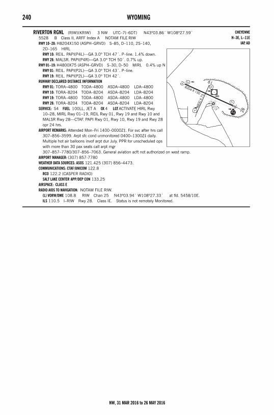
240 WYOMING
RIVERTON RGNL (RIW)(KRIW) 3 NW UTC–7(–6DT) N43º03.86´ W108º27.59´5528 B Class II, ARFF Index A NOTAM FILE RIWRWY 10–28: H8204X150 (ASPH–GRVD) S–85, D–110, 2S–140,
2D–165 HIRLRWY 10: REIL. PAPI(P4L)—GA 3.0º TCH 47´. P–line. 1.4% down.RWY 28: MALSR. PAPI(P4R)—GA 3.0º TCH 50´. 0.7% up.
RWY 01–19: H4800X75 (ASPH–GRVD) S–30, D–50 MIRL 0.4% up NRWY 01: REIL. PAPI(P2L)—GA 3.0º TCH 43´. P–line.RWY 19: REIL. PAPI(P2L)—GA 3.0º TCH 42´.
RUNWAY DECLARED DISTANCE INFORMATIONRWY 01: TORA–4800 TODA–4800 ASDA–4800 LDA–4800RWY 10: TORA–8204 TODA–8204 ASDA–8204 LDA–8204RWY 19: TORA–4800 TODA–4800 ASDA–4800 LDA–4800RWY 28: TORA–8204 TODA–8204 ASDA–8204 LDA–8204
SERVICE: S4 FUEL 100LL, JET A OX 4 LGT ACTIVATE HIRL Rwy 10–28, MIRL Rwy 01–19, REIL Rwy 01, Rwy 19 and Rwy 10 and MALSR Rwy 28—CTAF. PAPI Rwy 01, Rwy 10, Rwy 19 and Rwy 28 opr 24 hrs.
AIRPORT REMARKS: Attended Mon–Fri 1400–0000Z‡. For svc after hrs call 307–856–3599. Arpt sfc cond unmonitored 0400–1300Z‡ daily. Multiple hot air balloons invof arpt dur July. PPR for unscheduled ops with more than 30 pax seats call arpt mgr 307–857–7780/307–856–7063. General aviation acft not authorized on west ramp.
AIRPORT MANAGER: (307) 857-7780WEATHER DATA SOURCES: ASOS 121.425 (307) 856–4473.COMMUNICATIONS: CTAF/UNICOM 122.8
RCO 122.2 (CASPER RADIO)SALT LAKE CENTER APP/DEP CON 133.25
AIRSPACE: CLASS ERADIO AIDS TO NAVIGATION: NOTAM FILE RIW.
(L) VORW/DME 108.8 RIW Chan 25 N43º03.94´ W108º27.33´ at fld. 5458/10E.ILS 110.5 I–RIW Rwy 28. Class IE. Status is not remotely Monitored.
CHEYENNEH–3E, L–11E
IAP, AD
NW, 31 MAR 2016 to 26 MAY 2016
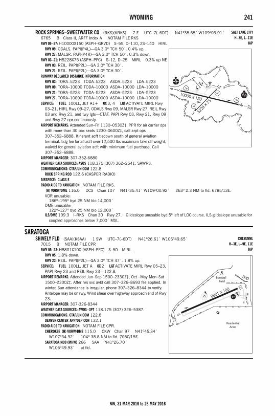
WYOMING 241
ROCK SPRINGS–SWEETWATER CO (RKS)(KRKS) 7 E UTC–7(–6DT) N41º35.65´ W109º03.91´6765 B Class II, ARFF Index A NOTAM FILE RKSRWY 09–27: H10000X150 (ASPH–GRVD) S–55, D–110, 2S–140 HIRL
RWY 09: ODALS. PAPI(P4L)—GA 3.0º TCH 50´. 0.4% up.RWY 27: MALSR. PAPI(P4R)—GA 3.0º TCH 50´. 0.3% down.
RWY 03–21: H5228X75 (ASPH–PFC) S–12, D–25 MIRL 0.3% up NERWY 03: REIL. PAPI(P2L)—GA 3.0º TCH 30´.RWY 21: REIL. PAPI(P2L)—GA 3.0º TCH 30´.
RUNWAY DECLARED DISTANCE INFORMATIONRWY 03: TORA–5223 TODA–5223 ASDA–5223 LDA–5223RWY 09: TORA–10000 TODA–10000 ASDA–10000 LDA–10000RWY 21: TORA–5223 TODA–5223 ASDA–5223 LDA–5223RWY 27: TORA–10000 TODA–10000 ASDA–10000 LDA–10000
SERVICE: FUEL 100LL, JET A1+ OX 3, 4 LGT ACTIVATE MIRL Rwy 03–21, HIRL Rwy 09–27, ODALS Rwy 09, MALSR Rwy 27, REIL Rwy 03 and Rwy 21, and twy lgts—CTAF. PAPI Rwy 03, Rwy 21, Rwy 09 and Rwy 27 opr continuously.
AIRPORT REMARKS: Attended Sun–Fri 1130–0530Z‡. PPR for air carrier ops with more than 30 pax seats 1230–0600Z‡, call arpt ops 307–352–6888. Itinerant acft tiedown south of general aviation terminal. Ldg fee for all acft over 12,500 lbs maximum take off weight, waived for general aviation acft with minimum fuel purchase. Call 307–352–6888.
AIRPORT MANAGER: 307-352-6880WEATHER DATA SOURCES: ASOS 118.375 (307) 362–2541. SAWRS.COMMUNICATIONS: CTAF/UNICOM 122.8
ROCK SPRING RCO 122.6 (CASPER RADIO)AIRSPACE: CLASS ERADIO AIDS TO NAVIGATION: NOTAM FILE RKS.
(H) VORW/DME 116.0 OCS Chan 107 N41º35.41´ W109º00.92´ 263º 2.3 NM to fld. 6785/13E.VOR unusable:
186º–195º byd 25 NM blo 14,000´DME unusable:
122º–127º byd 25 NM blo 12,000´ILS/DME 109.3 I–RKS Chan 30 Rwy 27. Glideslope unusable byd 5º left of LOC course. ILS glideslope unusable for
coupled approaches below 7,000´ MSL.
SARATOGASHIVELY FLD (SAA)(KSAA) 1 SW UTC–7(–6DT) N41º26.61´ W106º49.65´
7015 B NOTAM FILE CPRRWY 05–23: H8801X100 (ASPH–PFC) S–50 MIRL
RWY 05: 1.8% down.RWY 23: REIL. PAPI(P2L)—GA 3.0º TCH 47´. 1.8% up.
SERVICE: FUEL 100LL, JET A OX 2 LGT ACTIVATE MIRL Rwy 05–23, PAPI Rwy 23 and REIL Rwy 23—122.8.
AIRPORT REMARKS: Attended Jun–Sep 1500–2330Z‡, Oct –May Mon–Sat 1500–2300Z‡. After hrs svc avbl call 307–326–8693 fee applied. In winter, Sun attendance is irregular, phone 307–326–8344 to verify. Antelope may be on rwy. Wind shear over highway approach end of Rwy 23.
AIRPORT MANAGER: 307-326-8344WEATHER DATA SOURCES: AWOS–3PT 118.175 (307) 326–5387.COMMUNICATIONS: CTAF/UNICOM 122.8
DENVER CENTER APP/DEP CON 132.1RADIO AIDS TO NAVIGATION: NOTAM FILE CPR.
CHEROKEE (H) VORW/DME 115.0 CKW Chan 97 N41º45.34´ W107º34.92´ 104º 38.8 NM to fld. 7050/15E.
SARATOGA NDB (MHW) 266 SAA N41º26.70´ W106º49.93´ at fld.
SALT LAKE CITYH–3E, L–11E
IAP
CHEYENNEH–3E, L–9E, 11E
IAP
NW, 31 MAR 2016 to 26 MAY 2016
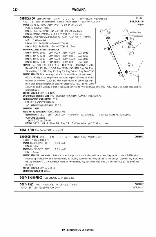
242 WYOMING
SHERIDAN CO (SHR)(KSHR) 2 SW UTC–7(–6DT) N44º46.15´ W106º58.82´4021 B TPA—See Remarks Class II, ARFF Index A NOTAM FILE SHRRWY 15–33: H8301X100 (ASPH–PFC) S–60, D–75, 2S–95
PCN 22 F/B/X/U HIRLRWY 15: REIL. PAPI(P4L)—GA 3.0º TCH 50´. 0.5% down.RWY 33: MALSR. PAPI(P4L)—GA 3.0º TCH 53´. 0.4% up.
RWY 06–24: H5039X75 (ASPH–GRVD) S–36, D–50 PCN 11 F/B/X/U MIRL 1.6% up SWRWY 06: REIL. PAPI(P4R)—GA 4.0º TCH 57´.RWY 24: REIL. PAPI(P4R)—GA 3.0º TCH 39´. Trees.
RUNWAY DECLARED DISTANCE INFORMATIONRWY 06: TORA–5039 TODA–5039 ASDA–5039 LDA–5039RWY 15: TORA–8301 TODA–8301 ASDA–8301 LDA–8301RWY 24: TORA–5039 TODA–5039 ASDA–5039 LDA–5039RWY 33: TORA–8301 TODA–8301 ASDA–8301 LDA–8301
SERVICE: S4 FUEL 100, JET A, A1+ OX 1, 2, 3 LGT ACTIVATE MIRL Rwy 06–24, HIRL Rwy 15–33, MALSR Rwy 33, REIL Rwy 06, Rwy 24 and Rwy 15, PAPI Rwy 15, Rwy 33, Rwy 06 and Rwy 24—CTAF.
AIRPORT REMARKS: Attended dalgt hrs. Afld sfc conditions not monitored 0530–1300Z‡. Cold temperature restricted airport. Altitude correction required at or below –22C/–8F. PPR unscheduled air carrier ops with more than 30 passenger seats ctc ARFF station 307–673–1875. Glider activity on and in vicinity of arpt. Fixed wing acft rstd to rwys and twys only. TPA—4821(800), for Turbo Prop and Jet 5521(1500).
AIRPORT MANAGER: 307-674-4222WEATHER DATA SOURCES: ASOS 135.175 (307) 672–5349. SAWRS 1100–0600Z‡.COMMUNICATIONS: CTAF/UNICOM 123.0
RCO 122.5 (CASPER RADIO)SALT LAKE CENTER APP/DEP CON 127.75
AIRSPACE: CLASS ERADIO AIDS TO NAVIGATION: NOTAM FILE SHR.
(L) VORW/DME 115.3 SHR Chan 100 N44º50.54´ W107º03.67´ 132º 5.6 NM to fld. 4397/10E.VOR/DME unusable:
160º–270º byd 25 NMILS/DME 108.7 I–SHR Chan 24 Rwy 33. DME unusable byd 15º left of course.
SHIVELY FLD (See SARATOGA on page 241)
SHOSHONI MUNI (49U) 1 N UTC–7(–6DT) N43º15.06´ W108º07.32´4818 NOTAM FILE CPRRWY 08–26: 4650X90 (DIRT) 0.4% up E
RWY 08: P–line.RWY 11–29: 2950X75 (DIRT) 1.0% up E
RWY 11: Fence.AIRPORT REMARKS: Unattended. Antelope on arpt. Arpt has uncontrolled vehicle access. Segmented circle is NSTD with
alternating 4 white tires and 4 yellow tires, no spacing between sets. Rwy 08–26 no line of sight between rwy ends. Rwy 08–26 and Rwy 11–29 numerous rocks on rwy surface, rwy soft when wet. Rwy 08–26 and Rwy 11–29 thlds not marked.
AIRPORT MANAGER: 307-876-2515COMMUNICATIONS: CTAF 122.9
SOUTH BIG HORN CO (See GREYBULL on page 233)
SOUTH PASS FWZ N42º30.80´ W108º46.63´/8490AWOS–3PT 118.350 (307) 709–2644
BILLINGSH–1E, 2G, L–13D
IAP, AD
CHEYENNE
CHEYENNEH–3E, L–11E
NW, 31 MAR 2016 to 26 MAY 2016
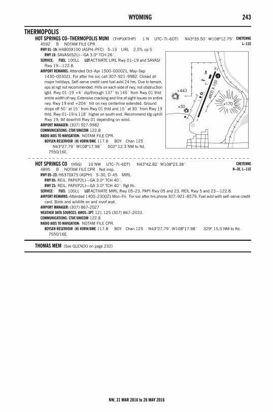
WYOMING 243
THERMOPOLISHOT SPRINGS CO–THERMOPOLIS MUNI (THP)(KTHP) 1 N UTC–7(–6DT) N43º39.50´ W108º12.79´
4592 B NOTAM FILE CPRRWY 01–19: H4800X100 (ASPH–PFC) S–13 LIRL 2.5% up S
RWY 19: SAVASI(S2L)—GA 3.0º TCH 26´.SERVICE: FUEL 100LL LGT ACTIVATE LIRL Rwy 01–19 and SAVASI
Rwy 19—122.8.AIRPORT REMARKS: Attended Oct–Apr 1500–0000Z‡, May–Sep
1430–0030Z‡. For after hrs svc call 307–921–9982. Closed all major holidays. Self–serve credit card fuel avbl 24 hrs. Due to terrain, ops at ngt not recommended. Hills on each side of rwy, not obstruction lgtd. Rwy 01–19 +4´ dip/through 137´ to 145´ from Rwy 01 thld entire width of rwy. Extensive cracking and line of sight issues on entire rwy. Rwy 19 end +204´ hill on rwy centerline extended. Ground drops off 50´ at 15´ from Rwy 01 thld and 15´ at 30´ from Rwy 19 thld. Rwy 01–19 is 118´ higher on south end. Recommend ldg uphill Rwy 19; tkf downhill Rwy 01 depending on wind.
AIRPORT MANAGER: (307) 927-9982COMMUNICATIONS: CTAF/UNICOM 122.8RADIO AIDS TO NAVIGATION: NOTAM FILE CPR.
BOYSEN RESERVOIR (H) VORW/DME 117.8 BOY Chan 125 N43º27.79´ W108º17.98´ 002º 12.3 NM to fld.
7550/16E.
– – – – – – – – – – – – – – – – – – – – – – – – – – – – – – – – – – – – – – – – – – – – – – – – – – – – – – –
HOT SPRINGS CO (HSG) 10 NW UTC–7(–6DT) N43º42.82´ W108º23.38´4895 B NOTAM FILE CPR Not insp.RWY 05–23: H6370X75 (ASPH) S–30, D–45 MIRL
RWY 05: REIL. PAPI(P2L)—GA 3.0º TCH 40´.RWY 23: REIL. PAPI(P2L)—GA 3.0º TCH 40´. Rgt tfc.
SERVICE: FUEL 100LL LGT ACTIVATE MIRL Rwy 05–23, PAPI Rwy 05 and 23, REIL Rwy 5 and 23—122.8.AIRPORT REMARKS: Attended 1400–2300Z‡ Mon–Fri. For svc after hrs phone 307–921–8579. Fuel avbl with self–serve credit
card. Birds and wildlife on and invof arpt. AIRPORT MANAGER: (307) 867-2027WEATHER DATA SOURCES: AWOS–3PT 121.125 (307) 867–2033.COMMUNICATIONS: CTAF/UNICOM 122.8RADIO AIDS TO NAVIGATION: NOTAM FILE CPR.
BOYSEN RESERVOIR (H) VORW/DME 117.8 BOY Chan 125 N43º27.79´ W108º17.98´ 329º 15.5 NM to fld. 7550/16E.
THOMAS MEM (See GLENDO on page 232)
CHEYENNEL–11E
CHEYENNEH–3E, L–11E
NW, 31 MAR 2016 to 26 MAY 2016
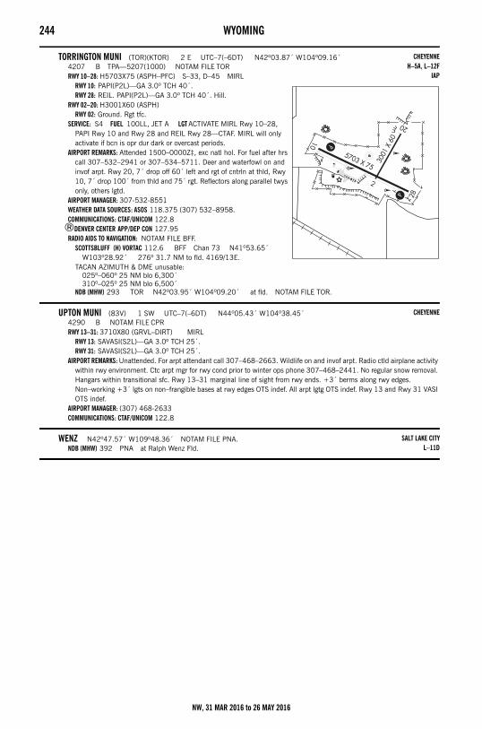
244 WYOMING
TORRINGTON MUNI (TOR)(KTOR) 2 E UTC–7(–6DT) N42º03.87´ W104º09.16´4207 B TPA—5207(1000) NOTAM FILE TORRWY 10–28: H5703X75 (ASPH–PFC) S–33, D–45 MIRL
RWY 10: PAPI(P2L)—GA 3.0º TCH 40´.RWY 28: REIL. PAPI(P2L)—GA 3.0º TCH 40´. Hill.
RWY 02–20: H3001X60 (ASPH)RWY 02: Ground. Rgt tfc.
SERVICE: S4 FUEL 100LL, JET A LGT ACTIVATE MIRL Rwy 10–28, PAPI Rwy 10 and Rwy 28 and REIL Rwy 28—CTAF. MIRL will only activate if bcn is opr dur dark or overcast periods.
AIRPORT REMARKS: Attended 1500–0000Z‡, exc natl hol. For fuel after hrs call 307–532–2941 or 307–534–5711. Deer and waterfowl on and invof arpt. Rwy 20, 7´ drop off 60´ left and rgt of cntrln at thld, Rwy 10, 7´ drop 100´ from thld and 75´ rgt. Reflectors along parallel twys only, others lgtd.
AIRPORT MANAGER: 307-532-8551WEATHER DATA SOURCES: ASOS 118.375 (307) 532–8958.COMMUNICATIONS: CTAF/UNICOM 122.8
®DENVER CENTER APP/DEP CON 127.95RADIO AIDS TO NAVIGATION: NOTAM FILE BFF.
SCOTTSBLUFF (H) VORTAC 112.6 BFF Chan 73 N41º53.65´ W103º28.92´ 276º 31.7 NM to fld. 4169/13E.
TACAN AZIMUTH & DME unusable:025º–060º 25 NM blo 6,300´310º–025º 25 NM blo 6,500´
NDB (MHW) 293 TOR N42º03.95´ W104º09.20´ at fld. NOTAM FILE TOR.
UPTON MUNI (83V) 1 SW UTC–7(–6DT) N44º05.43´ W104º38.45´4290 B NOTAM FILE CPRRWY 13–31: 3710X80 (GRVL–DIRT) MIRL
RWY 13: SAVASI(S2L)—GA 3.0º TCH 25´.RWY 31: SAVASI(S2L)—GA 3.0º TCH 25´.
AIRPORT REMARKS: Unattended. For arpt attendant call 307–468–2663. Wildlife on and invof arpt. Radio ctld airplane activity within rwy environment. Ctc arpt mgr for rwy cond prior to winter ops phone 307–468–2441. No regular snow removal. Hangars within transitional sfc. Rwy 13–31 marginal line of sight from rwy ends. +3´ berms along rwy edges. Non–working +3´ lgts on non–frangible bases at rwy edges OTS indef. All arpt lgtg OTS indef. Rwy 13 and Rwy 31 VASI OTS indef.
AIRPORT MANAGER: (307) 468-2633COMMUNICATIONS: CTAF/UNICOM 122.8
WENZ N42º47.57´ W109º48.36´ NOTAM FILE PNA.NDB (MHW) 392 PNA at Ralph Wenz Fld.
CHEYENNEH–5A, L–12F
IAP
CHEYENNE
SALT LAKE CITYL–11D
NW, 31 MAR 2016 to 26 MAY 2016
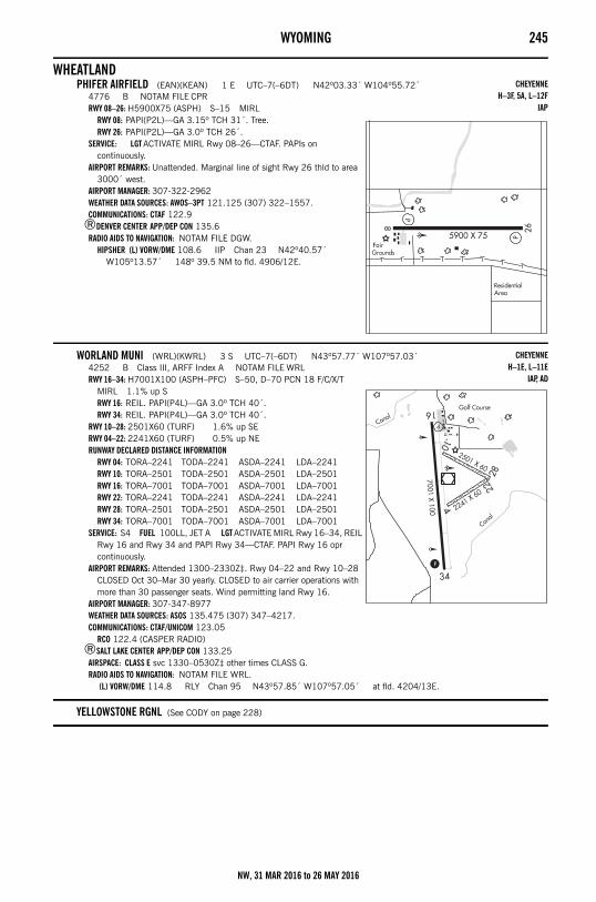
WYOMING 245
WHEATLANDPHIFER AIRFIELD (EAN)(KEAN) 1 E UTC–7(–6DT) N42º03.33´ W104º55.72´
4776 B NOTAM FILE CPRRWY 08–26: H5900X75 (ASPH) S–15 MIRL
RWY 08: PAPI(P2L)—GA 3.15º TCH 31´. Tree.RWY 26: PAPI(P2L)—GA 3.0º TCH 26´.
SERVICE: LGT ACTIVATE MIRL Rwy 08–26—CTAF. PAPIs on continuously.
AIRPORT REMARKS: Unattended. Marginal line of sight Rwy 26 thld to area 3000´ west.
AIRPORT MANAGER: 307-322-2962WEATHER DATA SOURCES: AWOS–3PT 121.125 (307) 322–1557.COMMUNICATIONS: CTAF 122.9
®DENVER CENTER APP/DEP CON 135.6RADIO AIDS TO NAVIGATION: NOTAM FILE DGW.
HIPSHER (L) VORW/DME 108.6 IIP Chan 23 N42º40.57´ W105º13.57´ 148º 39.5 NM to fld. 4906/12E.
WORLAND MUNI (WRL)(KWRL) 3 S UTC–7(–6DT) N43º57.77´ W107º57.03´4252 B Class III, ARFF Index A NOTAM FILE WRLRWY 16–34: H7001X100 (ASPH–PFC) S–50, D–70 PCN 18 F/C/X/T
MIRL 1.1% up SRWY 16: REIL. PAPI(P4L)—GA 3.0º TCH 40´.RWY 34: REIL. PAPI(P4L)—GA 3.0º TCH 40´.
RWY 10–28: 2501X60 (TURF) 1.6% up SERWY 04–22: 2241X60 (TURF) 0.5% up NERUNWAY DECLARED DISTANCE INFORMATION
RWY 04: TORA–2241 TODA–2241 ASDA–2241 LDA–2241RWY 10: TORA–2501 TODA–2501 ASDA–2501 LDA–2501RWY 16: TORA–7001 TODA–7001 ASDA–7001 LDA–7001RWY 22: TORA–2241 TODA–2241 ASDA–2241 LDA–2241RWY 28: TORA–2501 TODA–2501 ASDA–2501 LDA–2501RWY 34: TORA–7001 TODA–7001 ASDA–7001 LDA–7001
SERVICE: S4 FUEL 100LL, JET A LGT ACTIVATE MIRL Rwy 16–34, REIL Rwy 16 and Rwy 34 and PAPI Rwy 34—CTAF. PAPI Rwy 16 opr continuously.
AIRPORT REMARKS: Attended 1300–2330Z‡. Rwy 04–22 and Rwy 10–28 CLOSED Oct 30–Mar 30 yearly. CLOSED to air carrier operations with more than 30 passenger seats. Wind permitting land Rwy 16.
AIRPORT MANAGER: 307-347-8977WEATHER DATA SOURCES: ASOS 135.475 (307) 347–4217.COMMUNICATIONS: CTAF/UNICOM 123.05
RCO 122.4 (CASPER RADIO)®SALT LAKE CENTER APP/DEP CON 133.25
AIRSPACE: CLASS E svc 1330–0530Z‡ other times CLASS G.RADIO AIDS TO NAVIGATION: NOTAM FILE WRL.
(L) VORW/DME 114.8 RLY Chan 95 N43º57.85´ W107º57.05´ at fld. 4204/13E.
YELLOWSTONE RGNL (See CODY on page 228)
CHEYENNEH–3F, 5A, L–12F
IAP
CHEYENNEH–1E, L–11E
IAP, AD
NW, 31 MAR 2016 to 26 MAY 2016
246 AERONAUTICAL CHART BULLETINSSECTION 3: NOTICESAeronautical Chart BulletinsThe purpose of this bulletin is to provide major changes in aeronautical information that have occurred since the last publication date of each Sectional Aeronautical, VFR Terminal Area, and Helicopter Route Chart listed. The general policy is to include only those changes to controlled airspace and special use airspace that present a hazardous condition or impose a restriction on the pilot, and major changes to airports and radio navigational facilities, thereby providing the VFR pilot with the essential data necessary to update and maintain chart currency. The data is grouped by type and then by effective date. When a new edition of the Aeronautical Chart is published, the corrective tabulation will be removed from this bulletin. Inasmuch as this Bulletin provides major changes only, pilots should consult the airport listing in this directory for all new information. Users of U.S. World Aeronautical Charts (WAC) and U.S. Gulf Coast VFR Aeronautical Charts should consult the appropriate Sectional and VFR Terminal Area Charts for revisions. Positions are shown as degrees, minutes, seconds and hemisphere. Data is current as of 56 days prior to the date of this publication. Military Training Routes (MTRs) are shown on Sectional Aeronautical Charts, VFR Terminal Area, and Helicopter Route Charts. Only the route centerline, direction of flight and the route designator are shown — route widths and altitudes are not shown. Since these routes are subject to change every 56 days and the charts are reissued generally every 6 months, routes with a change in the alignment of the charted route centerline will be listed in this Aeronautical Chart Bulletin below. You are advised to contact Flight Service for route dimensions and current status for those routes affecting your flight.
BILLINGS SECTIONAL91st Edition, 31 Mar 2016
OBSTRUCTIONS31 Mar 2016No Major Changes.
AIRPORTS31 Mar 2016No Major Changes.
NAVAIDs31 Mar 2016No Major Changes.
AIRSPACE31 Mar 2016No Major Changes.
SPECIAL USE AIRSPACE31 Mar 2016No Major Changes.
MILITARY TRAINING ROUTES31 Mar 2016No Major Changes.
MISCELLANEOUS31 Mar 2016No Major Changes.
CHEYENNE SECTIONAL93rd Edition, 7 Jan 2016
OBSTRUCTIONS4 Feb 2016Add obst 2620´MSL (349´AGL), 43º53´41N, 100º53´12W.31 Mar 2016No Major Changes.
AIRPORTS4 Feb 2016 – 31 Mar 2016No Major Changes.
NAVAIDs4 Feb 2016No Major Changes.31 Mar 2016Delete RAWLINS VOR-DME, 41º48´17N, 107º12´17W.
AIRSPACE4 Feb 2016 – 31 Mar 2016No Major Changes.
SPECIAL USE AIRSPACE4 Feb 2016 – 31 Mar 2016No Major Changes.
MILITARY TRAINING ROUTES4 Feb 2016 – 31 Mar 2016No Major Changes.
MISCELLANEOUS4 Feb 2016 – 31 Mar 2016No Major Changes.
NW, 31 MAR 2016 to 26 MAY 2016
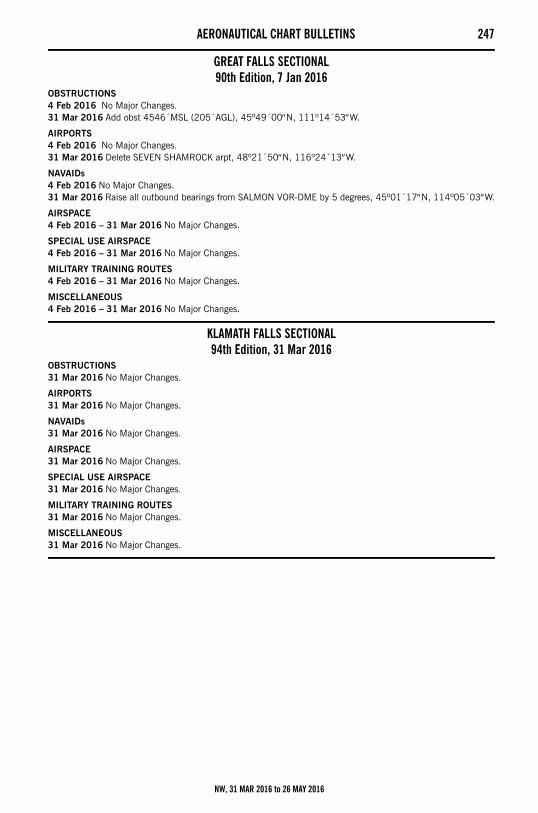
AERONAUTICAL CHART BULLETINS 247
GREAT FALLS SECTIONAL90th Edition, 7 Jan 2016
OBSTRUCTIONS4 Feb 2016 No Major Changes.31 Mar 2016Add obst 4546´MSL (205´AGL), 45º49´00N, 111º14´53W.
AIRPORTS4 Feb 2016 No Major Changes.31 Mar 2016Delete SEVEN SHAMROCK arpt, 48º21´50N, 116º24´13W.
NAVAIDs4 Feb 2016No Major Changes.31 Mar 2016Raise all outbound bearings from SALMON VOR-DME by 5 degrees, 45º01´17N, 114º05´03W.
AIRSPACE4 Feb 2016 – 31 Mar 2016No Major Changes.
SPECIAL USE AIRSPACE4 Feb 2016 – 31 Mar 2016No Major Changes.
MILITARY TRAINING ROUTES4 Feb 2016 – 31 Mar 2016No Major Changes.
MISCELLANEOUS4 Feb 2016 – 31 Mar 2016No Major Changes.
KLAMATH FALLS SECTIONAL94th Edition, 31 Mar 2016
OBSTRUCTIONS31 Mar 2016No Major Changes.
AIRPORTS31 Mar 2016No Major Changes.
NAVAIDs31 Mar 2016No Major Changes.
AIRSPACE31 Mar 2016No Major Changes.
SPECIAL USE AIRSPACE31 Mar 2016No Major Changes.
MILITARY TRAINING ROUTES31 Mar 2016No Major Changes.
MISCELLANEOUS31 Mar 2016No Major Changes.
NW, 31 MAR 2016 to 26 MAY 2016
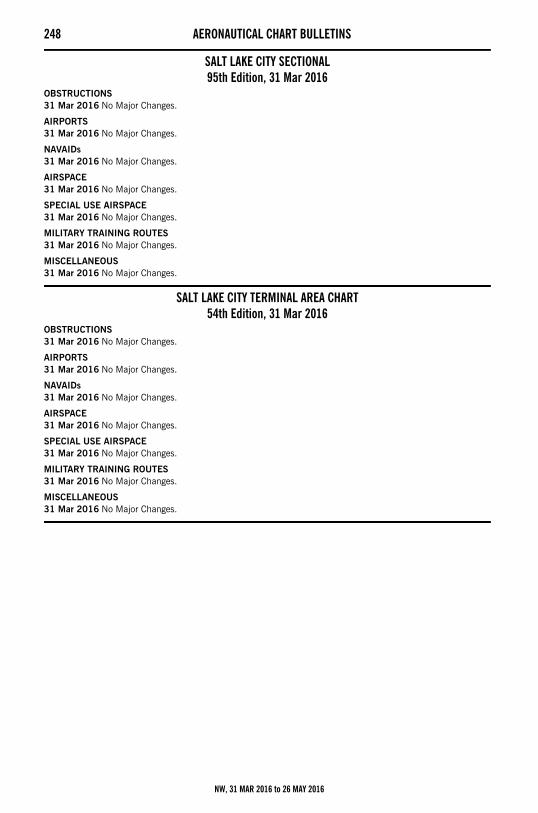
248 AERONAUTICAL CHART BULLETINS
SALT LAKE CITY SECTIONAL95th Edition, 31 Mar 2016
OBSTRUCTIONS31 Mar 2016No Major Changes.
AIRPORTS31 Mar 2016No Major Changes.
NAVAIDs31 Mar 2016No Major Changes.
AIRSPACE31 Mar 2016No Major Changes.
SPECIAL USE AIRSPACE31 Mar 2016No Major Changes.
MILITARY TRAINING ROUTES31 Mar 2016No Major Changes.
MISCELLANEOUS31 Mar 2016No Major Changes.
SALT LAKE CITY TERMINAL AREA CHART54th Edition, 31 Mar 2016
OBSTRUCTIONS31 Mar 2016No Major Changes.
AIRPORTS31 Mar 2016No Major Changes.
NAVAIDs31 Mar 2016No Major Changes.
AIRSPACE31 Mar 2016No Major Changes.
SPECIAL USE AIRSPACE31 Mar 2016No Major Changes.
MILITARY TRAINING ROUTES31 Mar 2016No Major Changes.
MISCELLANEOUS31 Mar 2016No Major Changes.
NW, 31 MAR 2016 to 26 MAY 2016
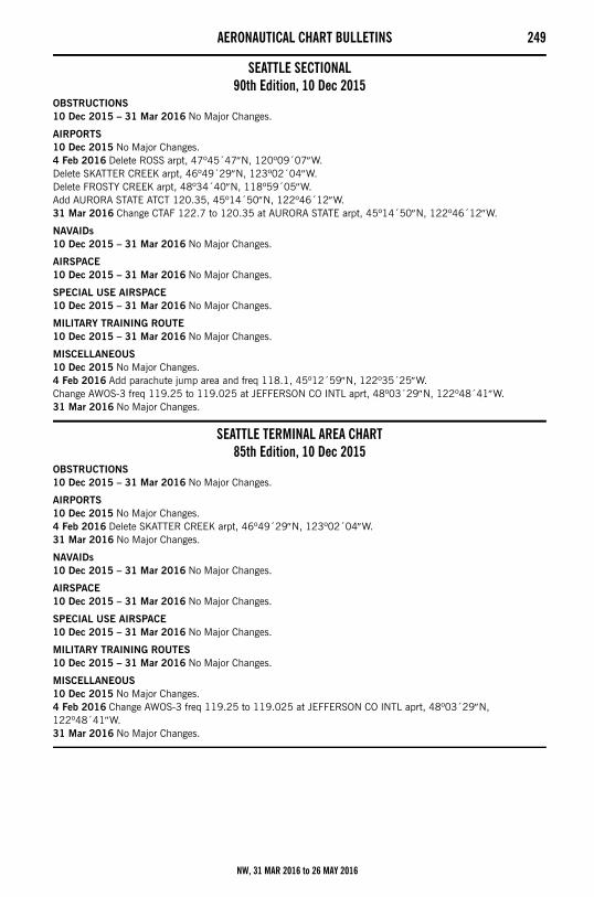
AERONAUTICAL CHART BULLETINS 249
SEATTLE SECTIONAL90th Edition, 10 Dec 2015
OBSTRUCTIONS10 Dec 2015 – 31 Mar 2016No Major Changes.
AIRPORTS10 Dec 2015No Major Changes.4 Feb 2016Delete ROSS arpt, 47º45´47N, 120º09´07W.Delete SKATTER CREEK arpt, 46º49´29N, 123º02´04W.Delete FROSTY CREEK arpt, 48º34´40N, 118º59´05W.Add AURORA STATE ATCT 120.35, 45º14´50N, 122º46´12W.31 Mar 2016Change CTAF 122.7 to 120.35 at AURORA STATE arpt, 45º14´50N, 122º46´12W.
NAVAIDs10 Dec 2015 – 31 Mar 2016No Major Changes.
AIRSPACE10 Dec 2015 – 31 Mar 2016No Major Changes.
SPECIAL USE AIRSPACE10 Dec 2015 – 31 Mar 2016No Major Changes.
MILITARY TRAINING ROUTE10 Dec 2015 – 31 Mar 2016No Major Changes.
MISCELLANEOUS10 Dec 2015No Major Changes.4 Feb 2016Add parachute jump area and freq 118.1, 45º12´59N, 122º35´25W.Change AWOS-3 freq 119.25 to 119.025 at JEFFERSON CO INTL aprt, 48º03´29N, 122º48´41W.31 Mar 2016No Major Changes.
SEATTLE TERMINAL AREA CHART85th Edition, 10 Dec 2015
OBSTRUCTIONS10 Dec 2015 – 31 Mar 2016No Major Changes.
AIRPORTS10 Dec 2015No Major Changes.4 Feb 2016Delete SKATTER CREEK arpt, 46º49´29N, 123º02´04W.31 Mar 2016No Major Changes.
NAVAIDs10 Dec 2015 – 31 Mar 2016No Major Changes.
AIRSPACE10 Dec 2015 – 31 Mar 2016No Major Changes.
SPECIAL USE AIRSPACE10 Dec 2015 – 31 Mar 2016No Major Changes.
MILITARY TRAINING ROUTES10 Dec 2015 – 31 Mar 2016No Major Changes.
MISCELLANEOUS10 Dec 2015No Major Changes.4 Feb 2016Change AWOS-3 freq 119.25 to 119.025 at JEFFERSON CO INTL aprt, 48º03´29N, 122º48´41W.31 Mar 2016No Major Changes.
NW, 31 MAR 2016 to 26 MAY 2016
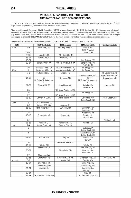
250 SPECIAL NOTICESSpecial Notices
2016 U.S. & CANADIAN MILITARY AERIALAIRCRAFT/PARACHUTE DEMONSTRATIONS
During CY 2016, the U.S. and Canadian Military Aerial Demonstration Teams (Thunderbirds, Blue Angels, Snowbirds, and GoldenKnights) will be performing on the dates and locations listed below.
Pilots should expect Temporary Flight Restrictions (TFR) in accordance with 14 CFR Section 91.145, Management of Aircraftoperations in the vicinity of aerial demonstrations and major sporting events. The dimensions and effective times of the TFRs mayvary based upon the specific aerial demonstration event and will be issued via the U.S. NOTAM system. Pilots are stronglyencouraged to check FDC NOTAMs to verify they have the most current information regarding these airspace restrictions.
The currently scheduled 2016 aerial demonstration locations, subject to change without notice are:
DATE USAF Thunderbirds USN Blue Angels USA Golden Knights Canadian SnowbirdsApril 2-3 Luke AFB, AZ NAS Key West, FL Mobile, AL
Luke AFB, AZ2-4 Lakeland, FL9-10 Lake City, FL NAS Kingsville, TX16-17 March ARB, CA Knoxville, TN16-21 San Antonio, TX23-24 Langley AFB, VA NAS Ft. Worth JRB, TX Langley AFB, VA
Ft.Worth, TX30 Barksdale AFB, LA MCAS Cherry Point, NC Ft. Bragg, NC
May 1 Barksdale AFB, LA MCAS Cherry Point, NC Ft. Bragg, NC7-8 Ft. Lauderdale, FL Lincoln, NE Ft. Lauderdale, FL11 Cape Girardeau, MO Cape Girardeau, MO
14-15 JB McGuire-Dix-Lakehurst,
NJ
St. Louis, MO JB McGuire-Dix-Lakehurst,
NJ
Chesterfield, MO
21-22 Shaw AFB, SC Lynchburg, VA Latrobe, PATorrance, CA
Latrobe, PA
25 US Naval Academy, MD26 Ft. Bragg, NC27 US Naval Academy, MD
28-29 Cannon AFB, NM Jones Beach, NY Columbia, MDJones Beach, NY
Jones Beach, NY
June 2 USAF Academy, CO4-5 Kirtland AFB, NM Smyrna, TN
11-12 North Kingstown, RI Syracuse, NY Clairemore, OKSyracuse, NY
15 West Point, NY18-19 Ocean City, MD Dayton, OH Rockford, IL
Omaha, NE22 Ypsilanti, MI
25-26 Hill AFB, UT Vero Beach, FL Hill AFB, UTJuly 2-4 Battle Creek, MI Traverse City, MI
3 Dubuque, IA Battle Creek, MI
4 Elizabethtown, KY Battle Creek, MI
9-10 Duluth, MN Gary, IN Duluth, MN Gary, IN
16 Pensacola Beach, FL16-17 Toledo, OH Toledo, OH
23 Vance AFB, OK New York City, NY23-24 Sioux Falls, SD Clearfield, PA
Sioux Falls, SD27 Cheyenne, WY
30-31 Offutt AFB, NE Elmendorf AFB, AK Elmendorf AFB, AK Oshkosh, WIAugust 6-7 Seattle, WA Seattle, WA
13-14 Burlington, VT Minot AFB, ND17 Atlantic City, NJ Atlantic City, NJ
20-21 Chicago, IL Camarillo, CA Chicago, IL
22-24 Grey, TN27-28 JB Lewis-McChord, WA JB Lewis-McChord, WA
NW, 31 MAR 2016 to 26 MAY 2016

SPECIAL NOTICES 251
Note: Dates and locations are scheduled “show dates” only and do not reflect arrival or practice date TFR periods that may precede the specific aerial demonstration events listed above. Again, pilots are strongly encouraged to check FDC NOTAMs to verify they have the most current information regarding any airspace restrictions.
September 3-4 New Windsor, NY Cleveland, OH3-5 Cleveland, OH5 Indianapolis, IN
10-11 Ft. Wayne, IN NAS Oceana, VA Waukegan, IL17-18 Sheppard AFB, TX Reno, NV Durango, CO24-25 Salinas, CA MCAS Miramar, CA Salinas, CA
San Diego, CASidney, MT
October 1-2 Robbins AFB, GA Aurora, CO Sacramento, CA Lincoln, NE
Owensboro, KY
8 Lincoln, CA8-9 Daytona Beach, FL San Francisco, CA Daytona Beach, FL Daytona Beach, FL14 Edwardsburg, MI
15-16 Ft. Worth, TX Baltimore, MD Bowie, MD22-23 Huntington Beach, CA Houston, TX Punta Gorda, FL29-30 Rome, GA NAS Patuxent River, MD NAS Patuxent River, MD
November 5-6 Homestead ARB, FL Jacksonville Beach, FL Homestead ARB, FL Kemah, TX
12 NAS Pensacola, FL Austin, TX12-13 Nellis AFB, NV
December 10-11 Baltimore, MD
DATE USAF Thunderbirds USN Blue Angels USA Golden Knights Canadian Snowbirds
NW, 31 MAR 2016 to 26 MAY 2016
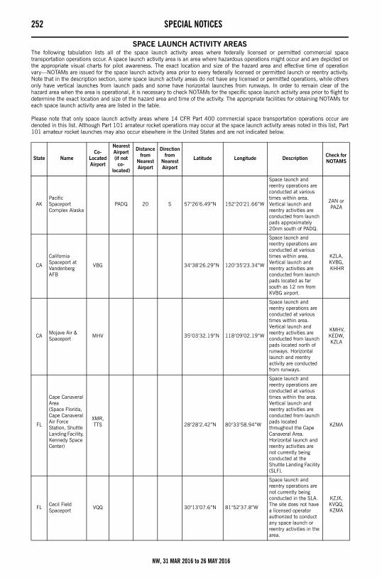
252 SPECIAL NOTICES
SPACE LAUNCH ACTIVITY AREASThe following tabulation lists all of the space launch activity areas where federally licensed or permitted commercial spacetransportation operations occur. A space launch activity area is an area where hazardous operations might occur and are depicted onthe appropriate visual charts for pilot awareness. The exact location and size of the hazard area and effective time of operationvary—NOTAMs are issued for the space launch activity area prior to every federally licensed or permitted launch or reentry activity.Note that in the description section, some space launch activity areas do not have any licensed or permitted operations, while othersonly have vertical launches from launch pads and some have horizontal launches from runways. In order to remain clear of thehazard area when the area is operational, it is necessary to check NOTAMs for the specific space launch activity area prior to flight todetermine the exact location and size of the hazard area and time of the activity. The appropriate facilities for obtaining NOTAMs foreach space launch activity area are listed in the table.
Please note that only space launch activity areas where 14 CFR Part 400 commercial space transportation operations occur aredenoted in this list. Although Part 101 amateur rocket operations may occur at the space launch activity areas noted in this list, Part101 amateur rocket launches may also occur elsewhere in the United States and are not indicated below.
State NameCo-
Located Airport
Nearest Airport (if not
co-located)
Distance from
Nearest Airport
Direction from
Nearest Airport
Latitude Longitude Description Check for NOTAMS
AKPacific Spaceport Complex Alaska
PADQ 20 S 57°26’6.49”N 152°20’21.66”W
Space launch and reentry operations are conducted at various times within area. Vertical launch and reentry activities are conducted from launch pads approximately 20nm south of PADQ.
ZAN orPAZA
CA
California Spaceport at Vandenberg AFB
VBG 34°38’26.29”N 120°35’23.34”W
Space launch and reentry operations are conducted at various times within area. Vertical launch and reentry activities are conducted from launch pads located as far south as 12 nm from KVBG airport.
KZLA, KVBG, KHHR
CA Mojave Air & Spaceport MHV 35°03’32.19”N 118°09’02.19”W
Space launch and reentry operations are conducted at various times within area. Vertical launch and reentry activities are conducted from launch pads located north of runways. Horizontal launch and reentry activity are conducted from runways.
KMHV, KEDW, KZLA
FL
Cape Canaveral Area(Space Florida, Cape Canaveral Air Force Station, Shuttle Landing Facility, Kennedy Space Center)
XMR, TTS 28°28’2.42”N 80°33’58.94”W
Space launch and reentry operations are conducted at various times within the area. Vertical launch and reentry activities are conducted from launch pads located throughout the Cape Canaveral Area.Horizontal launch and reentry activities are not currently being conducted at the Shuttle Landing Facility (SLF).
KZMA
FL Cecil Field Spaceport
VQQ 30°13’07.6”N 81°52’37.8”W
Space launch and reentry operations are not currently being conducted in the SLA. The site does not have a licensed operator authorized to conduct any space launch or reentry activities in the area.
KZJX, KVQQ, KZMA
NW, 31 MAR 2016 to 26 MAY 2016
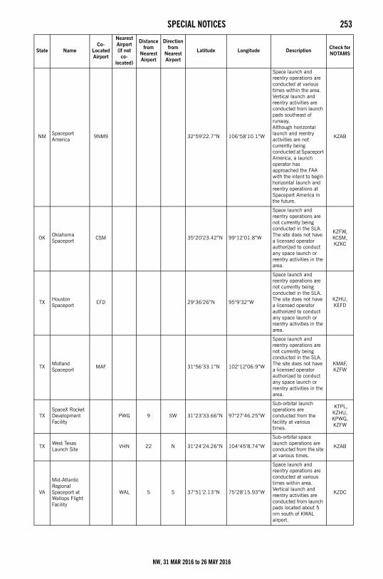
SPECIAL NOTICES 253
NM Spaceport America
9NM9 32°59’22.7”N 106°58’10.1”W
Space launch and reentry operations are conducted at various times within the area. Vertical launch and reentry activities are conducted from launch pads southeast of runway. Although horizontal launch and reentry activities are not currently being conducted at Spaceport America, a launch operator has approached the FAA with the intent to begin horizontal launch and reentry operations at Spaceport America in the future.
KZAB
OK Oklahoma Spaceport CSM 35°20’23.42”N 99°12’01.8”W
Space launch and reentry operations are not currently being conducted in the SLA. The site does not have a licensed operator authorized to conduct any space launch or reentry activities in the area.
KZFW, KCSM, KZKC
TX Houston Spaceport EFD 29°36’26”N 95°9’32”W
Space launch and reentry operations are not currently being conducted in the SLA. The site does not have a licensed operator authorized to conduct any space launch or reentry activities in the area.
KZHU,KEFD
TXMidland Spaceport MAF 31°56’33.1”N 102°12’06.9”W
Space launch and reentry operations are not currently being conducted in the SLA. The site does not have a licensed operator authorized to conduct any space launch or reentry activities in the area.
KMAF, KZFW
TXSpaceX Rocket Development Facility
PWG 9 SW 31°23’33.66”N 97°27’46.25”W
Sub-orbital launch operations are conducted from the facility at various times.
KTPL, KZHU, KPWG, KZFW
TX West Texas Launch Site VHN 22 N 31°24’24.26”N 104°45’8.74”W
Sub-orbital space launch operations are conducted from the site at various times.
KZAB
VA
Mid-Atlantic Regional Spaceport at Wallops Flight Facility
WAL 5 S 37°51’2.13”N 75°28’15.93”W
Space launch and reentry operations are conducted at various times within area. Vertical launch and reentry activities are conducted from launch pads located about 5 nm south of KWAL airport.
KZDC
State NameCo-
Located Airport
Nearest Airport (if not
co-located)
Distance from
Nearest Airport
Direction from
Nearest Airport
Latitude Longitude Description Check for NOTAMS
NW, 31 MAR 2016 to 26 MAY 2016
254 SPECIAL NOTICES
VFR ADVISORY AREACanadian Airspace
VICTORIA–VANCOUVER(Effective: Until Further Notice)
Effective 0901 UTC August 6, 1994, a VFR Advisory Area was permanently established between the two Canadian control zones,from above 1,200 MSL up to 2,500 MSL. Vancouver and Victoria Towers provide radar traffic information to all participating aircraftwithin the VFR Advisory Area.
PROCEDURES
Victoria/Vancouver
*All aircraft operating between Victoria and Vancouver within the VFR Advisory Area should follow the routes shown on the graphic.
*Northbound: Change from Victoria Tower, 119.1, to Vancouver Tower, 124.0, when instructed by ATC.
*Southbound: Change from Vancouver Tower, 124.0, to Victoria Tower, 119.1, when instructed by ATC.
*Set transponder codes as requested.
TRANSITING TRAFFIC
*Call Vancouver Tower on 124.0 when north of the Active Pass/Samuel Island Line.
*Call Victoria Tower on 119.1 when south of the Active Pass/Samuel Island Line.
*Set Transponder codes as requested.
Routes and recommended altitudes will not be usable by all aircraft at all times because of weather and regulations pertaining toflight over water. Higher altitudes may be requested. If unable to maintain VFR, advice ATC.
CONTINUED ON NEXT PAGE
NW, 31 MAR 2016 to 26 MAY 2016
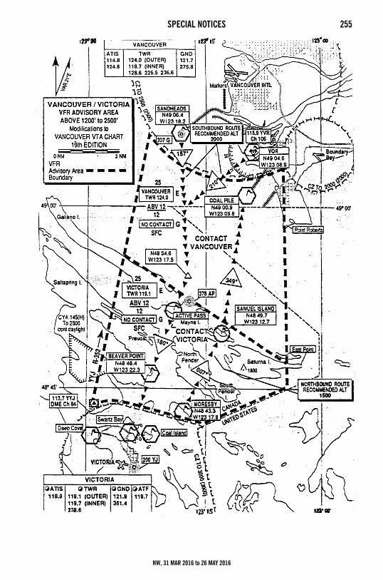
SPECIAL NOTICES 255
NW, 31 MAR 2016 to 26 MAY 2016
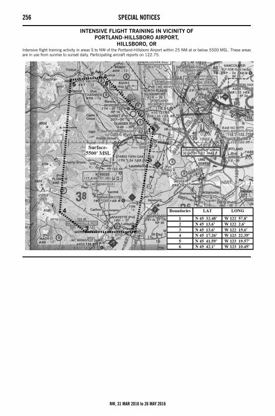
256 SPECIAL NOTICES
INTENSIVE FLIGHT TRAINING IN VICINITY OFPORTLAND-HILLSBORO AIRPORT,
HILLSBORO, ORIntensive flight training activity in areas S to NW of the Portland-Hillsboro Airport within 25 NM at or below 5500 MSL. These areasare in use from sunrise to sunset daily. Participating aircraft reports on 122.75.
NW, 31 MAR 2016 to 26 MAY 2016
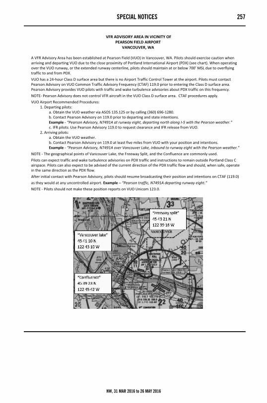
SPECIAL NOTICES 257
�VFR�ADVISORY�AREA�IN�VICINITY�OF�PEARSON�FIELD�AIRPORT�
VANCOUVER,�WA��
A�VFR�Advisory�Area�has�been�established�at�Pearson�Field�(VUO)�in�Vancouver,�WA.�Pilots�should�exercise�caution�when�arriving�and�departing�VUO�due�to�the�close�proximity�of�Portland�International�Airport�(PDX)�(see�chart).�When�operating�over�the�VUO�runway,�or�the�extended�runway�centerline,�pilots�should�maintain�at�or�below�700’�MSL�due�to�overflying�traffic�to�and�from�PDX.�VUO�has�a�24�hour�Class�D�surface�area�but�there�is�no�Airport�Traffic�Control�Tower�at�the�airport.�Pilots�must�contact�Pearson�Advisory�on�VUO�Common�Traffic�Advisory�Frequency�(CTAF)�119.0�prior�to�entering�the�Class�D�surface�area.�Pearson�Advisory�provides�VUO�pilots�with�traffic�and�wake�turbulence�advisories�about�PDX�traffic�on�this�frequency.�NOTE��Pearson�Advisory�does�not�control�VFR�aircraft�in�the�VUO�Class�D�surface�area.��CTAF�procedures�apply.�VUO�Airport�Recommended�Procedures:�� 1.�Departing�pilots:�� a.�Obtain�the�VUO�weather�via�ASOS�135.125�or�by�calling�(360)�696�1280.�� b.�Contact�Pearson�Advisory�on�119.0�prior�to�departing�and�state�intentions.�� Example���“Pearson�Advisory,�N7491A�at�runway�eight,�departing�north�along�I�5�with�the�Pearson�weather.”�� c.�IFR�pilots:�Use�Pearson�Advisory�119.0�to�request�clearance�and�IFR�release�from�VUO.�� 2.�Arriving�pilots:�� a.�Obtain�the�VUO�weather.�� b.�Contact�Pearson�Advisory�on�119.0�at�least�five�miles�from�VUO�with�your�position�and�intentions.�� Example���“Pearson�Advisory,�N7491A�over�Vancouver�Lake,�inbound�to�runway�eight�with�the�Pearson�weather.”�NOTE���The�geographical�points�of�Vancouver�Lake,�the�Freeway�Split,�and�the�Confluence�are�commonly�used.�Pilots�can�expect�traffic�and�wake�turbulence�advisories�on�PDX�traffic�and�instructions�to�remain�outside�Portland�Class�C�airspace.�Pilots�can�also�expect�to�be�advised�of�the�current�direction�of�the�PDX�traffic�flow�and�should,�when�safe,�operate�in�the�same�direction�as�the�PDX�flow.�After�initial�contact�with�Pearson�Advisory,�pilots�should�resume�broadcasting�their�position�and�intentions�on�CTAF�(119.0)�as�they�would�at�any�uncontrolled�airport.�Example�–�“Pearson�traffic,�N7491A�departing�runway�eight.”�NOTE���Pilots�should�not�make�these�position�reports�on�VUO�Unicom�123.0.���
�
NW, 31 MAR 2016 to 26 MAY 2016
258 SPECIAL NOTICES
CONTROLLED FIRINGFort Harrison Controlled Firing Area
Helena, MontanaControlled firing occurs in the vicinity of the Helena, Montana VORTAC (HLN) 24 hours daily, 5’800 MSL and BELOW. The areadefined by the following radial/DME coordinates HLN258008, HLN258005, HLN250008, HLN250005.
Limestone Hills Controlled Firing AreaHelena, Montana
Controlled firing occurs in the vicinity of the Helena, Montana VORTAC (HLN) 24 hours daily, FL180 and BELOW. The area definedby the following radial/DME coordinates HLN125026, HLN127028, HLN140025, HLN125028.
SPECIAL NORTH ATLANTIC, CARIBBEAN ANDPACIFIC AREA COMMUNICATIONS
VHF air-to-air frequencies enable aircraft engaged in flights over remote and oceanic areas out of range of VHF ground stations toexchange necessary operational information and to facilitate the resolution of operational problems.
Frequencies have been designated as follows:
MOUNT ST. HELENS NATIONAL VOLCANIC MONUMENT, WASHINGTON The U.S. Geological Survey (USGS) and the U.S. Forest Service (USFS) conduct low level flights to and from monitor station within
the monument and within the crater itself. Due to this activity, the volatility of the volcano and a high volume of sightseeing flights inthe area, the following procedures are recommended in the interest of flying safety. 1. VFR aircraft are encouraged to transmit an initial position report on 122.75 MHz in the blind when flying at altitudes of less than10,000 feet MSL within 10 nautical miles of the Mount St. Helens volcano crater. 2. VFR flight below 3000 feet AGL – strongly not recommended. 3. VFR flight above 3000 feet AGL – fly a counterclockwise pattern, no closer than 3 miles to the volcano summit. VFR rules of “see and be seen” and good airmanship practices will prevail. Approval to land can only be obtained throughappropriate Federal or State authority. Any significant information will be broadcast on the transcribed weather broadcasts by theSeattle and McMinnville Flight Service Stations and available on the Portland and Seattle ATIS. Marginal radar coverage limitsSeattle Center's ability to provide radar flight following to aircraft in orbit of the volcano.
DEVILS TOWER NATIONAL MONUMENT, WYOMINGFor reasons of national welfare, pilots are requested to avoid flights within 3 nautical miles of Devils Tower National Monument.
BIRD HAZARD OREGON AND WASHINGTON Heavy concentration of migratory and wintering flocks of large waterfowl from the Canadian to California borders annually
November to May. Caution advised at all airports or while transiting area.
SIMULTANEOUS OPERATIONSBoeing Field/King County International Airport
Seattle, WashingtonAll users: Boeing Field Airport Traffic Control Tower is authorized to conduct simultaneous same direction operations to parallelrunways, between sunrise and sunset, for twin engine propeller driven aircraft or smaller.
Spokane International AirportSpokane, Washington
Application of visual separation for simultaneous operations. When weather conditions at the facility providing visual separation are1500´ or greater ceiling and 5 miles or more visibility, controllers at Spokane International Airport or Fairchild Air Force Base mayprovide visual separation between aircraft landing and departing simultaneously at Spokane International Airport and Fairchild AirForce Base.
UNMANNED AIRCRAFT SYSTEMS (UAS)OPERATIONS IN CANYON COUNTY, ID
Unmanned Aircraft System activity within Canyon County ID. Pilots flying within Canyon County, ID should be alert for unmannedaircraft systems operating at or below 400 feet Above the Ground (AGL) inclusive.
OPERATIONS IN THE CITY OF SEATTLE, WAUnmanned Aircraft System activity within the City of Seattle, WA. Pilots flying within the City of Seattle WA should be alert forunmanned aircraft systems operating at or below 400 feet Above the Ground (AGL) inclusive.
North Atlantic area: 123.45 MHz
Caribbean area: 123.45 MHz
Pacific area: 123.45 MHz
NW, 31 MAR 2016 to 26 MAY 2016
SPECIAL NOTICES 259
LASER LIGHT DEMONSTRATIONSBozeman, Montana
Laser research will be conducted daily between 0000 and 2359 MDT until December 1, 2014 at Montana State University, BZNVORTAC 129 degree radial at 08 nm Lat 45-39-59N/Long 111-02-44W. The laser beam elevation will be a maximum of 090 anda minimum of 089. The beam may be injurious to aircrews and passengers’ eyes for a distance of 12000 feet AGL vertically and500 feet laterally of the light source. Other effects cockpit illumination, temporary flash blindness may occur beyond these distances.
SEATTLE–TACOMA INTLSEATTLE, WASHINGTON
Gatehold Procedures:
During peak departure periods, gatehold procedures are implemented for all IFR departures. Additional information will be broadcaston ATIS.
Oceanic Departures:
1. Contact Clearance Delivery only when you will be ready to taxi within ten minutes. State destination, requested altitude, “tenminutes to taxi.”2. If ATC delays are more than 15 minutes for your filed altitude/route, alternatives with less delay will be offered.3. Failure to depart the gate within ten minutes or reach the runway at the release time specified in the IFR clearance may result inthe cancellation of your clearance.
MOUNTAIN HOME, IDAHO All aircraft operating within 25 NM south of Sturgeon NDB 300º/120º bearing area requested to contact Mountain Home
approach on 124.8 for traffic advisories due to intensive military training in the Mountain Home Area.
MILITARY TRAINING ROUTESThe DOD Flight Information Publication AP/1B provides textual and graphic descriptions and operating instructions for all military
training routes (IR, VR, SR) and refueling tracks/anchors. Complete and more comprehensive information relative to policy andprocedures for IRs and VRs is published in FAA Handbook 7610.4 (Special Military Operations) which is agreed to by the DOD andtherefore directive for all military flight operations. The AP/1B is the official source of route data for military users.
CIVIL USE OF MILITARY FIELDS:U.S. Army, Air Force, Navy and Coast Guard Fields are open to civil fliers only in emergency or with prior permission.Army installations, prior permission is required from the Commanding Officer of the installation.For Air Force installations, prior permission should be requested at least 30 days prior to first intended landing from either
Headquarters USAF (PRPOC) or the Commander of the installation concerned (who has authority to approve landing rights forcertain categories of civil aircraft). For use of more than one Air Force installation, requests should be forwarded direct to Hq USAF(PRPOC), Washington, D.C. 20330.
Use of USAF installations must be specifically justified.For Navy and Marine Corps installations, prior permission should be requested at least 30 days prior to first intended landing. An
Aviation Facility License must be approved and executed by the Navy prior to any landing by civil aircraft.Forms and further information may be obtained from the nearest U.S. Navy or Marine Corps aviation activity.For Coast Guard fields prior permission should be requested from the Commandant, U.S. Coast Guard via the Commanding Officer
of the field.When instrument approaches are conducted by civil aircraft at military airports, they shall be conducted in accordance with the
procedures and minimums approved by the military agency having jurisdiction over the airport.
AIRCRAFT LANDING RESTRICTIONS Landing of aircraft at locations other than public use airports may be a violation of Federal or local law. All land and water areas
are owned or controlled by private individuals or organizations, states, cities, local governments, or U.S. Government agencies.Except in emergency, prior permission should be obtained before landing at any location that is not a designated public use airport orseaplane base.
Landing of aircraft is prohibited on lands or water administered by the National Park Service, U.S. Fish and Wildlife Service, U.S.Forest Service, and on many areas controlled by the U.S. Army Corps of Engineers, unless prior authorization is obtained from therespective agency.
NW, 31 MAR 2016 to 26 MAY 2016
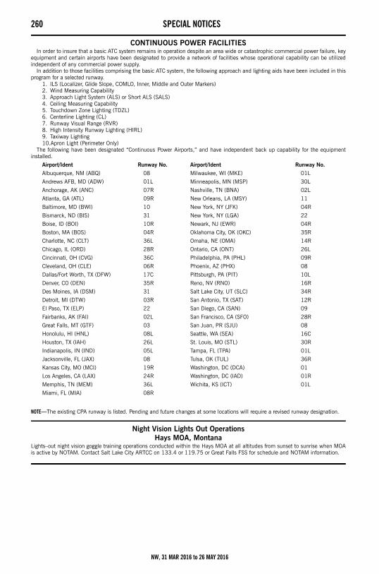
260 SPECIAL NOTICES
CONTINUOUS POWER FACILITIES In order to insure that a basic ATC system remains in operation despite an area wide or catastrophic commercial power failure, key
equipment and certain airports have been designated to provide a network of facilities whose operational capability can be utilizedindependent of any commercial power supply.
In addition to those facilities comprising the basic ATC system, the following approach and lighting aids have been included in thisprogram for a selected runway.
1. ILS (Localizer, Glide Slope, COMLO, Inner, Middle and Outer Markers)2. Wind Measuring Capability3. Approach Light System (ALS) or Short ALS (SALS)4. Ceiling Measuring Capability5. Touchdown Zone Lighting (TDZL)6. Centerline Lighting (CL)7. Runway Visual Range (RVR)8. High Intensity Runway Lighting (HIRL)9. Taxiway Lighting10.Apron Light (Perimeter Only)
The following have been designated “Continuous Power Airports,” and have independent back up capability for the equipmentinstalled.
NOTE—The existing CPA runway is listed. Pending and future changes at some locations will require a revised runway designation.
Night Vision Lights Out OperationsHays MOA, Montana
Lights–out night vision goggle training operations conducted within the Hays MOA at all altitudes from sunset to sunrise when MOAis active by NOTAM. Contact Salt Lake City ARTCC on 133.4 or 119.75 or Great Falls FSS for schedule and NOTAM information.
Airport/Ident Runway No. Airport/Ident Runway No.
Albuquerque, NM (ABQ) 08 Milwaukee, WI (MKE) 01L
Andrews AFB, MD (ADW) 01L Minneapolis, MN (MSP) 30L
Anchorage, AK (ANC) 07R Nashville, TN (BNA) 02L
Atlanta, GA (ATL) 09R New Orleans, LA (MSY) 11
Baltimore, MD (BWI) 10 New York, NY (JFK) 04R
Bismarck, ND (BIS) 31 New York, NY (LGA) 22
Boise, ID (BOI) 10R Newark, NJ (EWR) 04R
Boston, MA (BOS) 04R Oklahoma City, OK (OKC) 35R
Charlotte, NC (CLT) 36L Omaha, NE (OMA) 14R
Chicago, IL (ORD) 28R Ontario, CA (ONT) 26L
Cincinnati, OH (CVG) 36C Philadelphia, PA (PHL) 09R
Cleveland, OH (CLE) 06R Phoenix, AZ (PHX) 08
Dallas/Fort Worth, TX (DFW) 17C Pittsburgh, PA (PIT) 10L
Denver, CO (DEN) 35R Reno, NV (RNO) 16R
Des Moines, IA (DSM) 31 Salt Lake City, UT (SLC) 34R
Detroit, MI (DTW) 03R San Antonio, TX (SAT) 12R
El Paso, TX (ELP) 22 San Diego, CA (SAN) 09
Fairbanks, AK (FAI) 02L San Francisco, CA (SFO) 28R
Great Falls, MT (GTF) 03 San Juan, PR (SJU) 08
Honolulu, HI (HNL) 08L Seattle, WA (SEA) 16C
Houston, TX (IAH) 26L St. Louis, MO (STL) 30R
Indianapolis, IN (IND) 05L Tampa, FL (TPA) 01L
Jacksonville, FL (JAX) 08 Tulsa, OK (TUL) 36R
Kansas City, MO (MCI) 19R Washington, DC (DCA) 01
Los Angeles, CA (LAX) 24R Washington, DC (IAD) 01R
Memphis, TN (MEM) 36L Wichita, KS (ICT) 01L
Miami, FL (MIA) 08R
NW, 31 MAR 2016 to 26 MAY 2016
SPECIAL NOTICES 261
FIREFIGHTING TRAFFIC AREAS
NW, 31 MAR 2016 to 26 MAY 2016
262 REGULATORY NOTICESRegulatory NoticesThe following narratives summarize the FAR Part 93 Special Air Traffic Rules, and Airport Traffic Patterns in effect as prescribed inthe rule. This information is advisory in nature and in no way relieves the pilot from compliance with the specific rules set forth inFAR Parts 91 and 93.
Special Airport Traffic Areas prescribed in Part 93 are depicted on Sectional Aeronautical Charts, World Aeronautical Charts, EnrouteLow Altitude Charts, and where applicable, on VFR Terminal Area Charts.
OPERATIONS RESERVATIONS FOR HIGH DENSITY TRAFFIC AIRPORTSKennedy, LaGuardia, and Washington Reagan National
The Federal Aviation Administration (FAA) has designated New York’s Kennedy and LaGuardia Airports and Washington ReaganNational Airport as High Density Traffic Airports (HDTA), Title 14, Code of Federal Regulations, part 93, subpart K, and hasprescribed air traffic rules and requirements for operating aircraft (excluding helicopters) to and from those airports during certainhours.
Reservations are required for operations from 6 a.m. through 11:59 p.m. local time at LaGuardia Airport and Washington ReaganNational Airport. Reservations at Kennedy Airport are required from 3 p.m. through 7:59 p.m. local time.
Reservation procedures are detailed in Advisory Circular 93–1, Reservations for Unscheduled Operations at High Density TrafficAirports. A copy of the advisory circular is available on the FAA website at http://www.faa.gov. Reservations for unscheduledoperations are allocated through the Enhanced Computer Voice Reservation System (e–CVRS) accessible via telephone or theInternet. This system may not be used to make reservations for scheduled air carrier or commuter flights.
The toll–free telephone number for accessing e–CVRS is 1–800–875–9694 and is available for calls originating within the UnitedStates, Canada, and the Caribbean. Users outside the toll–free areas may access e–CVRS by calling the toll number of703–707–0568. The Internet web address for accessing the e–CVRS is http://www.fly.faa.gov/ecvrs. If you have any questions aboutreservation requirements or are experiencing problems with the system, you may telephone the Airport Reservation Office at the AirTraffic Control System Command Center at (703) 904–4452.
Requests for instrument flight rules (IFR) reservations will be accepted beginning 72 hours prior to the proposed time of operation atthe high–density airport. For example, a request for an 11 a.m. reservation on a Thursday will be accepted beginning at 11 a.m. onthe previous Monday.
IFR reservations must be obtained prior to IFR landing or takeoff at an HDTA during slot controlled hours. An air traffic control (ATC)clearance does not constitute a reservation. A reservation does not constitute permission to operate at an HDTA if additionaloperational limits or procedures are required by NOTAM and/or regulation.
Aircraft involved in medical emergencies will be handled by ATC without regard to a reservation after obtaining prior approval of theATC System Command Center on (703) 904–4452. ATC will accommodate declared other emergency situations without regard toslot reservations.
NOTE: Visual flight rule (VFR) reservations via ATC for unscheduled operations at LaGuardia are not authorized from 7 a.m. through8:59 a.m. local time and 4 p.m. through 6:59 p.m. local time, Monday through Friday and Sunday evenings, unlessotherwise announced by NOTAM. Both IFR and VFR operations during those time periods must obtain an advancereservation through e–CVRS.
NW, 31 MAR 2016 to 26 MAY 2016
FAA TELEPHONE NUMBERS AND NWS 263SECTION 4: ASSOCIATED DATAFAA Telephone Numbers and National Weather Service
FSSTELEPHONE NUMBERS
Flight Service Station (FSS) facilities provide flight planning and weather briefing services to pilots. FSS services in the contiguousUnited States, Hawaii and Puerto Rico, are provided by a network of large FSS facilities and a few select remote facilities some ofwhich operate part–time. Because of the interconnectivity between the facilities, all FSS services including radio frequencies areavailable continuously using published data.
Telephone Information Briefing Service (TIBS) is a FSS service that provides continuous recordings of meteorological and/oraeronautical information. A touch–tone telephone is required to fully utilize this service.
Further information can be found in the Aeronautical Information Manual (AIM).
NATIONAL FSS TELEPHONE NUMBER
OTHER FSS TELEPHONE NUMBERS (except in Alaska)
* District of Columbia Special Flight Rules Area & Flight Restricted Zone
Pilot Weather Briefings......................................... 1–800–WX–BRIEF (1–800–992–7433)
TIBS (see description above) ................................ 1–877–4TIBS–WX (1–877–484–2799)Clearance Delivery Only ....................................... 1–888–766–8267 Lifeguard Flights Only .......................................... 1–877–LIF–GRD3 (1–877–543–4733)Flights within DC SFRA & FRZ * ........................... 1–866–225–7410
NW, 31 MAR 2016 to 26 MAY 2016
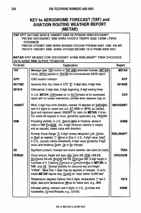
264 FAA TELEPHONE NUMBERS AND NWS
NW, 31 MAR 2016 to 26 MAY 2016
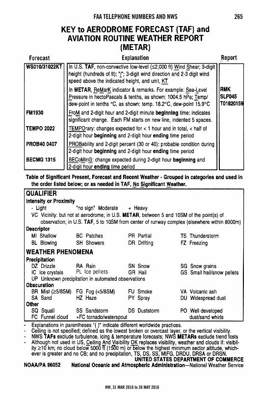
FAA TELEPHONE NUMBERS AND NWS 265
NW, 31 MAR 2016 to 26 MAY 2016
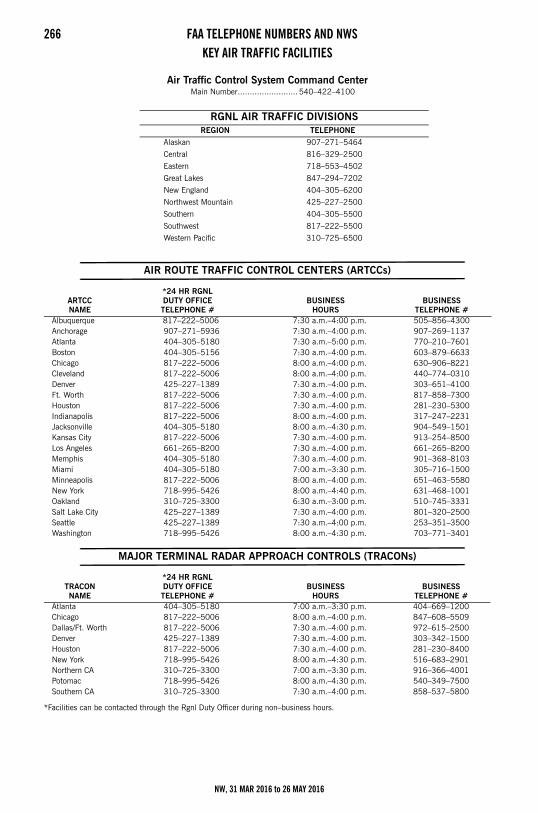
266 FAA TELEPHONE NUMBERS AND NWSKEY AIR TRAFFIC FACILITIES
Air Traffic Control System Command CenterMain Number......................... 540–422–4100
AIR ROUTE TRAFFIC CONTROL CENTERS (ARTCCs)
MAJOR TERMINAL RADAR APPROACH CONTROLS (TRACONs)
*Facilities can be contacted through the Rgnl Duty Officer during non–business hours.
RGNL AIR TRAFFIC DIVISIONSREGION TELEPHONE
Alaskan 907–271–5464
Central 816–329–2500
Eastern 718–553–4502
Great Lakes 847–294–7202
New England 404–305–6200
Northwest Mountain 425–227–2500
Southern 404–305–5500
Southwest 817–222–5500
Western Pacific 310–725–6500
ARTCCNAME
*24 HR RGNLDUTY OFFICETELEPHONE #
BUSINESSHOURS
BUSINESSTELEPHONE #
Albuquerque 817–222–5006 7:30 a.m.–4:00 p.m. 505–856–4300Anchorage 907–271–5936 7:30 a.m.–4:00 p.m. 907–269–1137Atlanta 404–305–5180 7:30 a.m.–5:00 p.m. 770–210–7601Boston 404–305–5156 7:30 a.m.–4:00 p.m. 603–879–6633Chicago 817–222–5006 8:00 a.m.–4:00 p.m. 630–906–8221Cleveland 817–222–5006 8:00 a.m.–4:00 p.m. 440–774–0310Denver 425–227–1389 7:30 a.m.–4:00 p.m. 303–651–4100Ft. Worth 817–222–5006 7:30 a.m.–4:00 p.m. 817–858–7300Houston 817–222–5006 7:30 a.m.–4:00 p.m. 281–230–5300Indianapolis 817–222–5006 8:00 a.m.–4:00 p.m. 317–247–2231Jacksonville 404–305–5180 8:00 a.m.–4:30 p.m. 904–549–1501Kansas City 817–222–5006 7:30 a.m.–4:00 p.m. 913–254–8500Los Angeles 661–265–8200 7:30 a.m.–4:00 p.m. 661–265–8200Memphis 404–305–5180 7:30 a.m.–4:00 p.m. 901–368–8103Miami 404–305–5180 7:00 a.m.–3:30 p.m. 305–716–1500Minneapolis 817–222–5006 8:00 a.m.–4:00 p.m. 651–463–5580New York 718–995–5426 8:00 a.m.–4:40 p.m. 631–468–1001Oakland 310–725–3300 6:30 a.m.–3:00 p.m. 510–745–3331Salt Lake City 425–227–1389 7:30 a.m.–4:00 p.m. 801–320–2500Seattle 425–227–1389 7:30 a.m.–4:00 p.m. 253–351–3500Washington 718–995–5426 8:00 a.m.–4:30 p.m. 703–771–3401
TRACONNAME
*24 HR RGNLDUTY OFFICETELEPHONE #
BUSINESSHOURS
BUSINESSTELEPHONE #
Atlanta 404–305–5180 7:00 a.m.–3:30 p.m. 404–669–1200Chicago 817–222–5006 8:00 a.m.–4:00 p.m. 847–608–5509Dallas/Ft. Worth 817–222–5006 7:30 a.m.–4:00 p.m. 972–615–2500Denver 425–227–1389 7:30 a.m.–4:00 p.m. 303–342–1500Houston 817–222–5006 7:30 a.m.–4:00 p.m. 281–230–8400New York 718–995–5426 8:00 a.m.–4:30 p.m. 516–683–2901Northern CA 310–725–3300 7:00 a.m.–3:30 p.m. 916–366–4001Potomac 718–995–5426 8:00 a.m.–4:30 p.m. 540–349–7500Southern CA 310–725–3300 7:30 a.m.–4:00 p.m. 858–537–5800
NW, 31 MAR 2016 to 26 MAY 2016
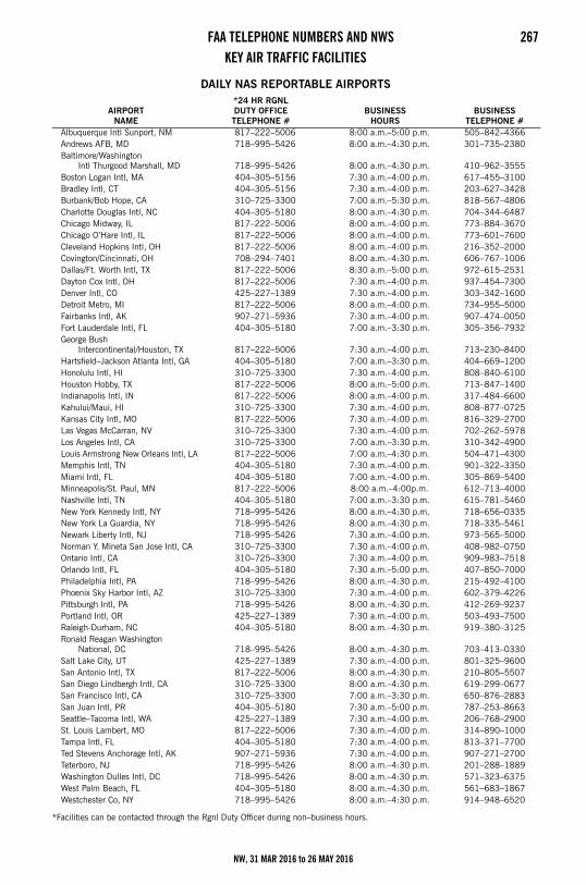
FAA TELEPHONE NUMBERS AND NWS 267KEY AIR TRAFFIC FACILITIES
DAILY NAS REPORTABLE AIRPORTS
*Facilities can be contacted through the Rgnl Duty Officer during non–business hours.
AIRPORTNAME
*24 HR RGNLDUTY OFFICETELEPHONE #
BUSINESSHOURS
BUSINESSTELEPHONE #
Albuquerque Intl Sunport, NM 817–222–5006 8:00 a.m.–5:00 p.m. 505–842–4366Andrews AFB, MD 718–995–5426 8:00 a.m.–4:30 p.m. 301–735–2380Baltimore/Washington
Intl Thurgood Marshall, MD 718–995–5426 8:00 a.m.–4:30 p.m. 410–962–3555Boston Logan Intl, MA 404–305–5156 7:30 a.m.–4:00 p.m. 617–455–3100Bradley Intl, CT 404–305–5156 7:30 a.m.–4:00 p.m. 203–627–3428Burbank/Bob Hope, CA 310–725–3300 7:00 a.m.–5:30 p.m. 818–567–4806Charlotte Douglas Intl, NC 404–305–5180 8:00 a.m.–4:30 p.m. 704–344–6487Chicago Midway, IL 817–222–5006 8:00 a.m.–4:00 p.m. 773–884–3670Chicago O’Hare Intl, IL 817–222–5006 8:00 a.m.–4:00 p.m. 773–601–7600Cleveland Hopkins Intl, OH 817–222–5006 8:00 a.m.–4:00 p.m. 216–352–2000Covington/Cincinnati, OH 708–294–7401 8:00 a.m.–4:30 p.m. 606–767–1006Dallas/Ft. Worth Intl, TX 817–222–5006 8:30 a.m.–5:00 p.m. 972–615–2531Dayton Cox Intl, OH 817–222–5006 7:30 a.m.–4:00 p.m. 937–454–7300Denver Intl, CO 425–227–1389 7:30 a.m.–4:00 p.m. 303–342–1600Detroit Metro, MI 817–222–5006 8:00 a.m.–4:00 p.m. 734–955–5000Fairbanks Intl, AK 907–271–5936 7:30 a.m.–4:00 p.m. 907–474–0050Fort Lauderdale Intl, FL 404–305–5180 7:00 a.m.–3:30 p.m. 305–356–7932George Bush
Intercontinental/Houston, TX 817–222–5006 7:30 a.m.–4:00 p.m. 713–230–8400Hartsfield–Jackson Atlanta Intl, GA 404–305–5180 7:00 a.m.–3:30 p.m. 404–669–1200Honolulu Intl, HI 310–725–3300 7:30 a.m.–4:00 p.m. 808–840–6100Houston Hobby, TX 817–222–5006 8:00 a.m.–5:00 p.m. 713–847–1400Indianapolis Intl, IN 817–222–5006 8:00 a.m.–4:00 p.m. 317–484–6600Kahului/Maui, HI 310–725–3300 7:30 a.m.–4:00 p.m. 808–877–0725Kansas City Intl, MO 817–222–5006 7:30 a.m.–4:00 p.m. 816–329–2700Las Vegas McCarran, NV 310–725–3300 7:30 a.m.–4:00 p.m. 702–262–5978Los Angeles Intl, CA 310–725–3300 7:00 a.m.–3:30 p.m. 310–342–4900Louis Armstrong New Orleans Intl, LA 817–222–5006 7:00 a.m.–4:30 p.m. 504–471–4300Memphis Intl, TN 404–305–5180 7:30 a.m.–4:00 p.m. 901–322–3350Miami Intl, FL 404–305–5180 7:00 a.m.–4:00 p.m. 305–869–5400Minneapolis/St. Paul, MN 817–222–5006 8:00 a.m.–4:00p.m. 612–713–4000Nashville Intl, TN 404–305–5180 7:00 a.m.–3:30 p.m. 615–781–5460New York Kennedy Intl, NY 718–995–5426 8:00 a.m.–4:30 p.m. 718–656–0335New York La Guardia, NY 718–995–5426 8:00 a.m.–4:30 p.m. 718–335–5461Newark Liberty Intl, NJ 718–995–5426 7:30 a.m.–4:00 p.m. 973–565–5000Norman Y. Mineta San Jose Intl, CA 310–725–3300 7:30 a.m.–4:00 p.m. 408–982–0750Ontario Intl, CA 310–725–3300 7:30 a.m.–4:00 p.m. 909–983–7518Orlando Intl, FL 404–305–5180 7:30 a.m.–5:00 p.m. 407–850–7000Philadelphia Intl, PA 718–995–5426 8:00 a.m.–4:30 p.m. 215–492–4100Phoenix Sky Harbor Intl, AZ 310–725–3300 7:30 a.m.–4:00 p.m. 602–379–4226Pittsburgh Intl, PA 718–995–5426 8:00 a.m.–4:30 p.m. 412–269–9237Portland Intl, OR 425–227–1389 7:30 a.m.–4:00 p.m. 503–493–7500Raleigh-Durham, NC 404–305–5180 8:00 a.m.–4:30 p.m. 919–380–3125Ronald Reagan Washington
National, DC 718–995–5426 8:00 a.m.–4:30 p.m. 703–413–0330Salt Lake City, UT 425–227–1389 7:30 a.m.–4:00 p.m. 801–325–9600San Antonio Intl, TX 817–222–5006 8:00 a.m.–4:30 p.m. 210–805–5507San Diego Lindbergh Intl, CA 310–725–3300 8:00 a.m.–4:30 p.m. 619–299–0677San Francisco Intl, CA 310–725–3300 7:00 a.m.–3:30 p.m. 650–876–2883San Juan Intl, PR 404–305–5180 7:30 a.m.–5:00 p.m. 787–253–8663Seattle–Tacoma Intl, WA 425–227–1389 7:30 a.m.–4:00 p.m. 206–768–2900St. Louis Lambert, MO 817–222–5006 7:30 a.m.–4:00 p.m. 314–890–1000Tampa Intl, FL 404–305–5180 7:30 a.m.–4:00 p.m. 813–371–7700Ted Stevens Anchorage Intl, AK 907–271–5936 7:30 a.m.–4:00 p.m. 907–271–2700Teterboro, NJ 718–995–5426 8:00 a.m.–4:30 p.m. 201–288–1889Washington Dulles Intl, DC 718–995–5426 8:00 a.m.–4:30 p.m. 571–323–6375West Palm Beach, FL 404–305–5180 8:00 a.m.–4:30 p.m. 561–683–1867Westchester Co, NY 718–995–5426 8:00 a.m.–4:30 p.m. 914–948–6520
NW, 31 MAR 2016 to 26 MAY 2016
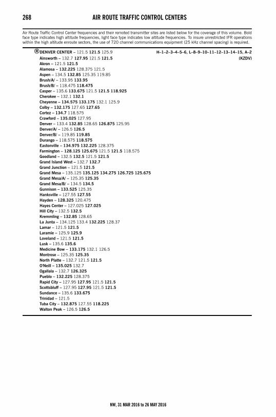
268 AIR ROUTE TRAFFIC CONTROL CENTERSAir Route Traffic Control Centers
Air Route Traffic Control Center frequencies and their remoted transmitter sites are listed below for the coverage of this volume. Boldface type indicates high altitude frequencies, light face type indicates low altitude frequencies. To insure unrestricted IFR operationswithin the high altitude enroute sectors, the use of 720 channel communications equipment (25 kHz channel spacing) is required.
®DENVER CENTER – 121.5 121.5 125.9 H–1–2–3–4–5–6, L–8–9–10–11–12–13–14–15, A–2
Ainsworth – 132.7 127.95 121.5 121.5 (KZDV)Akron – 121.5 121.5Alamosa – 132.225 128.375 121.5Aspen – 134.5 132.85 125.35 119.85Brush/A/ – 133.95 133.95Brush/B/ – 118.475 118.475Casper – 135.6 133.675 121.5 121.5 118.925Cherokee – 132.1 132.1Cheyenne – 134.575 133.175 132.1 125.9Colby – 132.175 127.65 127.65Cortez – 134.7 118.575Crawford – 135.025 127.95Denver – 133.4 132.85 128.65 126.875 125.95Denver/A/ – 126.5 126.5Denver/B/ – 119.85 119.85Durango – 118.575 118.575Eastonville – 134.975 132.225 128.375Farmington – 128.125 125.675 121.5 121.5 118.575Goodland – 132.5 132.5 121.5 121.5Grand Island West – 132.7 132.7Grand Junction – 121.5 121.5Grand Mesa – 135.125 135.125 134.275 126.725 125.675Grand Mesa/A/ – 125.35 125.35Grand Mesa/B/ – 134.5 134.5Gunnison – 133.525 125.35Hanksville – 127.55 127.55Hayden – 128.325 120.475Hayes Center – 127.025 127.025Hill City – 132.5 132.5Kremmling – 132.85 128.65La Junta – 134.125 133.4 132.225 128.37Lamar – 121.5 121.5Laramie – 125.9 125.9Loveland – 121.5 121.5Lusk – 135.6 135.6Medicine Bow – 133.175 132.1 126.5Montrose – 125.35 125.35North Platte – 132.7 121.5 121.5O'Neill – 135.025 132.7Ogallala – 132.7 126.325Pueblo – 132.225 128.375Rapid City – 127.95 127.95 121.5 121.5Scottsbluff – 127.95 127.95 121.5 121.5Sundance – 135.6 133.675Trinidad – 121.5Tuba City – 132.875 127.55 118.225Walton Peak – 126.5 126.5
NW, 31 MAR 2016 to 26 MAY 2016
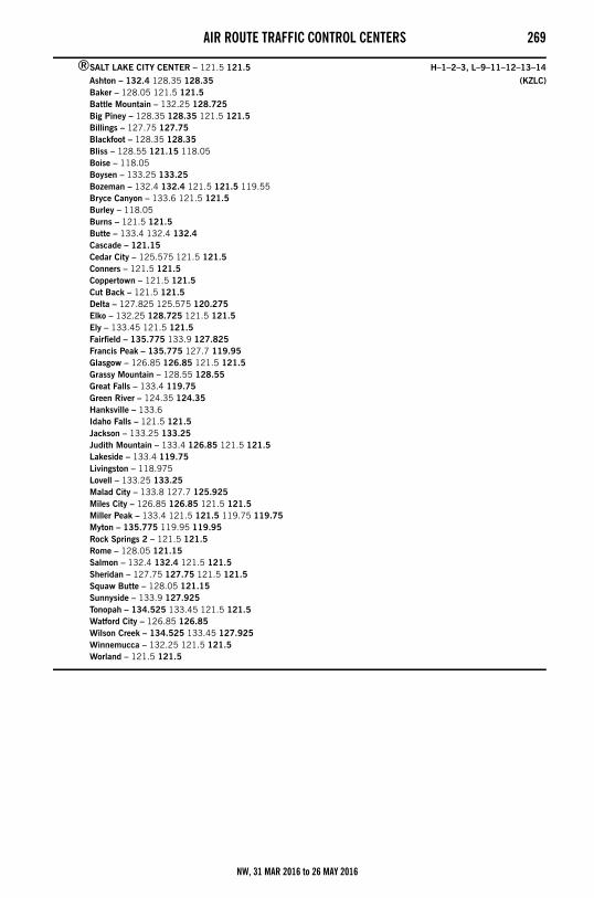
AIR ROUTE TRAFFIC CONTROL CENTERS 269
®SALT LAKE CITY CENTER – 121.5 121.5 H–1–2–3, L–9–11–12–13–14
Ashton – 132.4 128.35 128.35 (KZLC)Baker – 128.05 121.5 121.5Battle Mountain – 132.25 128.725Big Piney – 128.35 128.35 121.5 121.5Billings – 127.75 127.75Blackfoot – 128.35 128.35Bliss – 128.55 121.15 118.05Boise – 118.05Boysen – 133.25 133.25Bozeman – 132.4 132.4 121.5 121.5 119.55Bryce Canyon – 133.6 121.5 121.5Burley – 118.05Burns – 121.5 121.5Butte – 133.4 132.4 132.4Cascade – 121.15Cedar City – 125.575 121.5 121.5Conners – 121.5 121.5Coppertown – 121.5 121.5Cut Back – 121.5 121.5Delta – 127.825 125.575 120.275Elko – 132.25 128.725 121.5 121.5Ely – 133.45 121.5 121.5Fairfield – 135.775 133.9 127.825Francis Peak – 135.775 127.7 119.95Glasgow – 126.85 126.85 121.5 121.5Grassy Mountain – 128.55 128.55Great Falls – 133.4 119.75Green River – 124.35 124.35Hanksville – 133.6Idaho Falls – 121.5 121.5Jackson – 133.25 133.25Judith Mountain – 133.4 126.85 121.5 121.5Lakeside – 133.4 119.75Livingston – 118.975Lovell – 133.25 133.25Malad City – 133.8 127.7 125.925Miles City – 126.85 126.85 121.5 121.5Miller Peak – 133.4 121.5 121.5 119.75 119.75Myton – 135.775 119.95 119.95Rock Springs 2 – 121.5 121.5Rome – 128.05 121.15Salmon – 132.4 132.4 121.5 121.5Sheridan – 127.75 127.75 121.5 121.5Squaw Butte – 128.05 121.15Sunnyside – 133.9 127.925Tonopah – 134.525 133.45 121.5 121.5Watford City – 126.85 126.85Wilson Creek – 134.525 133.45 127.925Winnemucca – 132.25 121.5 121.5Worland – 121.5 121.5
NW, 31 MAR 2016 to 26 MAY 2016
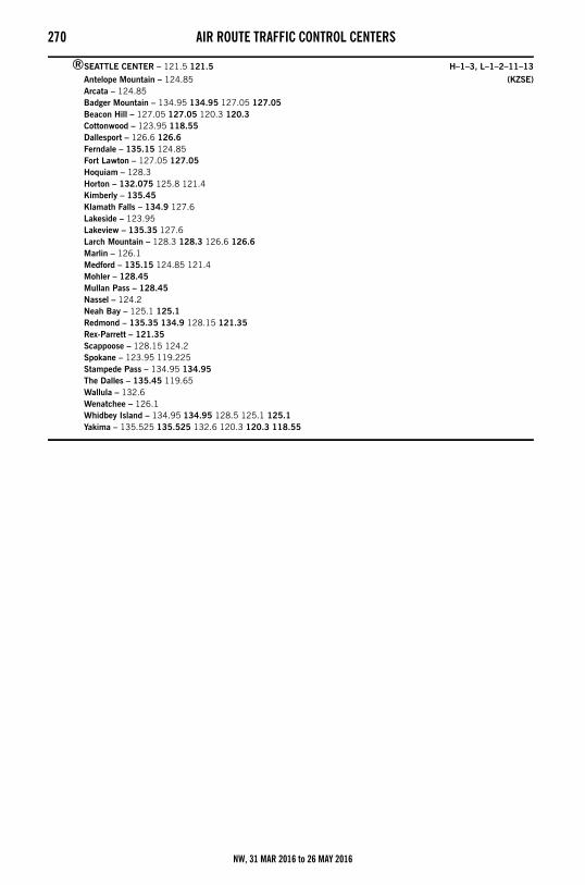
270 AIR ROUTE TRAFFIC CONTROL CENTERS
®SEATTLE CENTER – 121.5 121.5 H–1–3, L–1–2–11–13
Antelope Mountain – 124.85 (KZSE)Arcata – 124.85Badger Mountain – 134.95 134.95 127.05 127.05Beacon Hill – 127.05 127.05 120.3 120.3Cottonwood – 123.95 118.55Dallesport – 126.6 126.6Ferndale – 135.15 124.85Fort Lawton – 127.05 127.05Hoquiam – 128.3Horton – 132.075 125.8 121.4Kimberly – 135.45Klamath Falls – 134.9 127.6Lakeside – 123.95Lakeview – 135.35 127.6Larch Mountain – 128.3 128.3 126.6 126.6Marlin – 126.1Medford – 135.15 124.85 121.4Mohler – 128.45Mullan Pass – 128.45Nassel – 124.2Neah Bay – 125.1 125.1Redmond – 135.35 134.9 128.15 121.35Rex-Parrett – 121.35Scappoose – 128.15 124.2Spokane – 123.95 119.225Stampede Pass – 134.95 134.95The Dalles – 135.45 119.65Wallula – 132.6Wenatchee – 126.1Whidbey Island – 134.95 134.95 128.5 125.1 125.1Yakima – 135.525 135.525 132.6 120.3 120.3 118.55
NW, 31 MAR 2016 to 26 MAY 2016
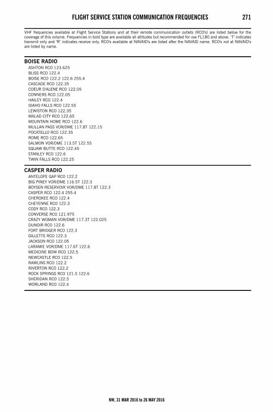
FLIGHT SERVICE STATION COMMUNICATION FREQUENCIES 271Flight Service Station Communication Frequencies
VHF frequencies available at Flight Service Stations and at their remote communication outlets (RCO's) are listed below for thecoverage of this volume. Frequencies in bold type are available all altitudes but recommended for use FL180 and above. ‘T’ indicatestransmit only and ‘R’ indicates receive only. RCO's available at NAVAID's are listed after the NAVAID name. RCO's not at NAVAID'sare listed by name.
BOISE RADIOASHTON RCO 123.625BLISS RCO 122.4BOISE RCO 122.2 122.6 255.4CASCADE RCO 122.35COEUR D'ALENE RCO 122.05CONNERS RCO 122.05HAILEY RCO 122.4IDAHO FALLS RCO 122.55LEWISTON RCO 122.35MALAD CITY RCO 122.65MOUNTAIN HOME RCO 122.6MULLAN PASS VOR/DME 117.8T 122.15POCATELLO RCO 122.35ROME RCO 122.65SALMON VOR/DME 113.5T 122.55SQUAW BUTTE RCO 122.45STANLEY RCO 122.6TWIN FALLS RCO 122.25
CASPER RADIOANTELOPE GAP RCO 122.2BIG PINEY VOR/DME 116.5T 122.3BOYSEN RESERVOIR VOR/DME 117.8T 122.3CASPER RCO 122.4 255.4CHEROKEE RCO 122.4CHEYENNE RCO 122.3CODY RCO 122.3CONVERSE RCO 121.975CRAZY WOMAN VOR/DME 117.3T 122.025DUNOIR RCO 122.6FORT BRIDGER RCO 122.3GILLETTE RCO 122.3JACKSON RCO 122.05LARAMIE VOR/DME 117.6T 122.6MEDICINE BOW RCO 122.5NEWCASTLE RCO 122.5RAWLINS RCO 122.2RIVERTON RCO 122.2ROCK SPRINGS RCO 121.5 122.6SHERIDAN RCO 122.5WORLAND RCO 122.4
NW, 31 MAR 2016 to 26 MAY 2016
272 FLIGHT SERVICE STATION COMMUNICATION FREQUENCIES
GREAT FALLS RADIOBILLINGS RCO 122.55BOZEMAN VOR/DME 112.4T 122.5BUTTE RCO 122.2 122.4COPPERTOWN RCO 122.65CUT BANK VORTAC 114.4T 122.2DILLON RCO 122.15DRUMMOND RCO 122.25GLASGOW RCO 122.25GREAT FALLS RCO 122.6 243.0 255.4HARLOWTON RCO 122.4HAVRE RCO 123.65HELENA RCO 122.55JUDITH MOUNTAIN RCO 122.2LAKESIDE RCO 122.5LEWISTOWN RCO 122.35LIVINGSTON RCO 122.2MILES CITY RCO 122.2 255.4MILLER PEAK RCO 122.45SIDNEY RCO 123.65TOWER HILL RCO 122.3WOLF POINT RCO 122.45YELLOWSTONE RCO 119.4
MC MINNVILLE RADIOASTORIA RCO 122.3AUGSPURGER MOUNTAIN RCO 122.3BEAVER MOUNTAIN RCO 255.4 122.4BURNS RCO 122.5CAPE BLANCO RCO 122.4ENTERPRISE RCO 122.5EUGENE RCO 121.5 122.3KIMBERLY RCO 122.6KLAMATH FALLS RCO 121.5 122.6 255.4LAKEVIEW VORTAC 112.0T 122.3MC MINNVILLE RCO 122.45MEDFORD RCO 121.5 122.65 243.0 255.4NEWBERG RCO 122.45NEWPORT RCO 122.5NORTH BEND RCO 121.5 122.4 255.4ONTARIO RCO 122.3PENDLETON RCO 122.2PORTLAND RCO 122.6 255.4REDMOND RCO 121.5 122.5 243.0 255.4ROSEBURG VOR/DME 108.2T 122.55SALEM RCO 122.6SEXTON SUMMIT RCO 122.5SUNRIVER RCO 122.3WALLULA RCO 121.5 122.6
NW, 31 MAR 2016 to 26 MAY 2016
FLIGHT SERVICE STATION COMMUNICATION FREQUENCIES 273
SEATTLE RADIOBADGER MOUNTAIN RCO 121.5 122.3BELLINGHAM RCO 121.5 122.15 255.4BUCKHORN MTN RCO 122.2ELLENSBURG RCO 121.5 122.2 255.4EPHRATA RCO 121.5 122.2HOQUIAM RCO 122.2 255.4JUMP–OFF–JOE RCO 122.4MOSES LAKE VOR/DME 115.0T 122.4MOUNT CONSTITUTION RCO 122.3OCEAN SHORES RCO 121.5 122.4PAINE RCO 121.5 122.55PORT ANGELES RCO 122.6PULLMAN VOR/DME 109.0T 122.6SEATTLE RCO 122.5 123.65 255.4SOUTHWEST WASHINGTON RCO 121.5 122.250 122.55SPOKANE RCO 122.2 122.55 122.65 255.4TATOOSH VORTAC 112.2T 122.25THE DALLES RCO 121.5 122.65 255.4VANCOUVER RCO 122.35WALLA WALLA RCO 122.3 255.4WENATCHEE RCO 122.6 255.4
YAKIMA RCO 122.5 255.4
NW, 31 MAR 2016 to 26 MAY 2016
274 FLIGHT STANDARDS DISTRICT OFFICES (FSDO)Flight Standards District OfficesBelow is a list of FSDO's in the area of coverage of this directory. These offices serve the aviation industry and the general public onmatters relating to certification and operation of general aviation aircraft. Address letters to Manager, Flight Standards DistrictOffice–Federal Aviation Administration.
IDAHO
3295 Elder StreetAirport Plaza, Suite 350Boise, ID 83705Telephone: 208–387–40001–800–453–0001Fax: 208–387–4020
MONTANA
2725 Skyway DriveHelena, MT 59602–1213Telephone: 406–449–52701–800–457–9917Fax: 406–449–5275
OREGON
3180 NW 229th AvenueHillsboro, OR 97124Telephone: 503–615–32001–800–847–3806Fax: 503–615–3300
WASHINGTON
1601 Lind Ave. S. W., Suite 260Renton, WA 98057Telephone: 425–227–28131–800–354–1940Fax: 425–227–1810
6133 E. Rutter AvenueSpokane, WA 99212Telephone: 509–532–23401–800–341–2623Fax: 509–532–2380
WYOMING
Casper FSFO951 Werner Court, Suite 320Casper, WY 82601–1312Telephone: 307–261–54251–800–325–5785
NW, 31 MAR 2016 to 26 MAY 2016
VOR RECEIVER CHECKPOINTS and VOR TEST FACILITIES 275VOR Receiver Checkpoints and VOR Test FacilitiesThe use of VOR airborne and ground checkpoints is explained in Aeronautical Information Manual, Basic Flight Information and ATCProcedures.
NOTE: Under columns headed “Type of Checkpoint” & “Type of VOT Facility” G stands for ground. A/ stands for airborne followed byfigures (2300) or (1000–3000) indicating the altitudes above mean sea level at which the check should be conducted.Facilities are listed in alphabetical order, in the state where the checkpoints or VOTs are located.
IDAHO VOR RECEIVER CHECKPOINTS
VOR TEST FACILITIES (VOT)
MONTANA VOR RECEIVER CHECKPOINTS
Facility Name (Arpt Name) Freq/Ident
Type Check
Pt. Gnd.
AB/ALT
Azimuth from Fac. Mag
Dist. from Fac. N.M. Checkpoint Description
Boise ..................................................... 113.3/BOI A/5000 090 6.2 Over dam outlet S end Lucky Peak Reservoir
Boise (Boise Air Terminal–Gowen Field) ..... 113.3/BOI G 296 0.6 Twy A in run-up area Rwy 28R.
Coeur D'Alene......................................... 108.8/COE A/4000 011 9.0 Over amusement park.
Idaho Falls (Idaho Falls Rgnl) ................... 113.85/IDA G 208 0.8 NM at intersection of Twys A and A3.
Nez Perce (Lewiston–Nez Perce County) .... 108.2/MQG A/3000 247 6.2 Over tetrahedron on arpt.
Pocatello (Pocatello Rgnl)......................... 112.6/PIH A/5800 034 8.7 Over radio antenna with white storage tanks at base.
Twin Falls (Joslin Fld–Magic Valley Rgnl) ... 115.8/TWF G 065 0.8 On runup area at apch end Rwy 25.
Facility Name (Airport Name) Freq.
Type VOT Facility Remarks
Boise (Boise Air Terminal–Gowen Field) ..... 116.7 G
Facility Name (Arpt Name) Freq/Ident
Type Check
Pt. Gnd.
AB/ALT
Azimuth from Fac. Mag
Dist. from Fac. N.M. Checkpoint Description
Billings .................................................. 114.5/BIL A/5000 199 10.5 Over refinery at Laurel.
Bozeman (Bozeman Yellowstone Intl) ........ 112.4/BZN G 272 0.5 Twy at apch end Rwy 12.
112.4/BZN G 145 0.7 Twy H at Twy A.
Coppertown (Bert Mooney)....................... 111.6/CPN A/6600 098 11.5 Over intersection of Rwys 11–29 and 15–33.
Dillon..................................................... 113.0/DLN A/7000 245 5.0 Over letter ‘B’ on bluff.
Great Falls (Great Falls Intl) ...................... 115.1/GTF G 030 2.3 On Twy A between A5 and A6.
115.1/GTF G 030 2.9 At intersection of Twy A and A3.
Havre .................................................... 111.8/HVR A/4000 278 8.0 Over S end of dam.
Helena (Helena Rgnl) .............................. 117.7/HLN G 238 0.7 On Twy E on South side of Rwy 27.
Kalispell (Glacier Park Intl) ....................... 113.2/FCA A/4000 316 6.4 Over apch end Rwy 30.
Lewistown (Lewistown Muni) ................... 112.0/LWT A/5200 075 5.6 Over apch end Rwy 07.
Livingston .............................................. 116.1/LVM A/6500 237 5.5 Over northern most radio twr NE of city.
Miles City (Frank Wiley Field) ................... 112.1/MLS G 036 4.2 On twy leading to Rwy 30.
Missoula (Missoula Intl) ........................... 112.8/MSO G 344 0.6 Terminal ramp east of Twy D.
NW, 31 MAR 2016 to 26 MAY 2016
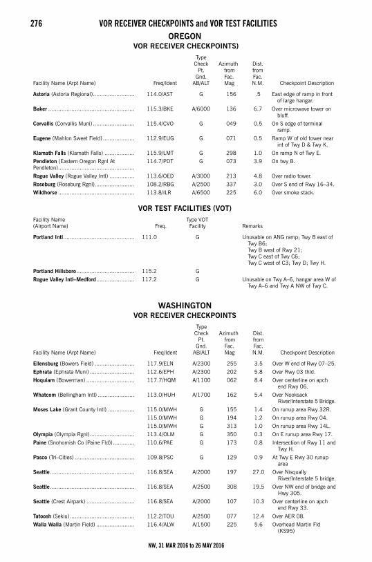
276 VOR RECEIVER CHECKPOINTS and VOR TEST FACILITIESOREGON
VOR RECEIVER CHECKPOINTS)
VOR TEST FACILITIES (VOT)
WASHINGTON VOR RECEIVER CHECKPOINTS
Facility Name (Arpt Name) Freq/Ident
Type Check
Pt. Gnd.
AB/ALT
Azimuth from Fac. Mag
Dist. from Fac. N.M. Checkpoint Description
Astoria (Astoria Regional)......................... 114.0/AST G 156 .5 East edge of ramp in front of large hangar.
Baker .................................................... 115.3/BKE A/6000 136 6.7 Over microwave tower on bluff.
Corvallis (Corvallis Muni) ......................... 115.4/CVO G 049 0.5 On S edge of terminal ramp.
Eugene (Mahlon Sweet Field) ................... 112.9/EUG G 071 0.5 Ramp W of old tower near int of Twy D & Twy K.
Klamath Falls (Klamath Falls) .................. 115.9/LMT G 298 1.0 On ramp N of Twy E.
Pendleton (Eastern Oregon Rgnl At Pendleton)..............................................
114.7/PDT G 073 3.9 On twy B.
Rogue Valley (Rogue Valley Intl) ............... 113.6/OED A/3000 213 4.8 Over radio tower.
Roseburg (Roseburg Rgnl)........................ 108.2/RBG A/2500 337 3.0 Over S end of Rwy 16–34.
Wildhorse .............................................. 113.8/ILR A/6500 225 6.0 Over smoke stack.
Facility Name (Airport Name) Freq.
Type VOT Facility Remarks
Portland Intl........................................... 111.0 G Unusable on ANG ramp; Twy B east of Twy B6; Twy B west of Rwy 21; Twy C east of Twy C6; Twy C west of C3; Twy D; Twy H.
Portland Hillsboro................................... 115.2 G
Rogue Valley Intl–Medford....................... 117.2 G Unusable on Twy A–6, hangar area W of Twy A–6 and Twy A NW of Twy C.
Facility Name (Arpt Name) Freq/Ident
Type Check
Pt. Gnd.
AB/ALT
Azimuth from Fac. Mag
Dist. from Fac. N.M. Checkpoint Description
Ellensburg (Bowers Field) ........................ 117.9/ELN A/2300 255 3.5 Over W end of Rwy 07–25.
Ephrata (Ephrata Muni) ........................... 112.6/EPH A/2300 202 5.8 Over Rwy 03 thld.
Hoquiam (Bowerman) ............................. 117.7/HQM A/1100 062 8.4 Over centerline on apch end Rwy 06.
Whatcom (Bellingham Intl) ...................... 113.0/HUH A/1700 162 5.4 Over Nooksack River/Interstate 5 Bridge.
Moses Lake (Grant County Intl) ................ 115.0/MWH G 155 1.4 On runup area Rwy 32R.
115.0/MWH G 194 1.2 On runup area Rwy 04.
115.0/MWH G 313 1.0 On runup area Rwy 14L.
Olympia (Olympia Rgnl)........................... 113.4/OLM G 350 0.3 On E runup area Rwy 17.
Paine (Snohomish Co (Paine Fld))............. 110.6/PAE G 173 0.8 Intersection of Rwy 11 and Twy H.
Pasco (Tri–Cities) .................................... 109.8/PSC G 129 0.9 At Twy E Rwy 30 runup area
Seattle................................................... 116.8/SEA A/2000 197 27.0 Over Nisqually River/Interstate 5 bridge.
Seattle................................................... 116.8/SEA A/2500 308 19.5 Over NW end of bridge and Hwy 305.
Seattle (Crest Airpark) ............................. 116.8/SEA A/2000 107 10.3 Over centerline on apch end Rwy 33.
Tatoosh (Sekiu)....................................... 112.2/TOU A/2500 077 12.4 Over AER 08.
Walla Walla (Martin Field) ....................... 116.4/ALW A/1500 225 5.6 Overhead Martin Fld (KS95)
NW, 31 MAR 2016 to 26 MAY 2016
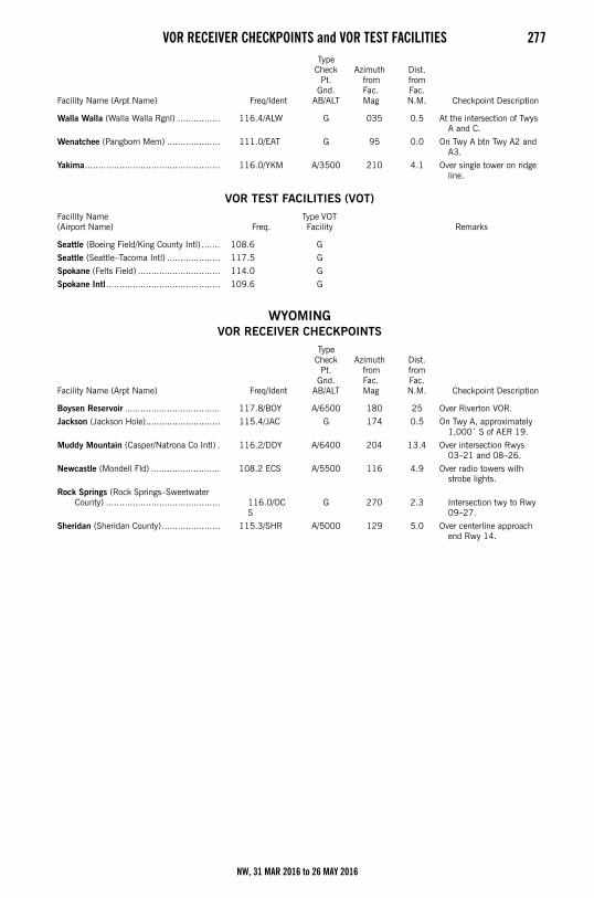
VOR RECEIVER CHECKPOINTS and VOR TEST FACILITIES 277
VOR TEST FACILITIES (VOT)
WYOMING VOR RECEIVER CHECKPOINTS
Walla Walla (Walla Walla Rgnl) ................ 116.4/ALW G 035 0.5 At the intersection of Twys A and C.
Wenatchee (Pangborn Mem) .................... 111.0/EAT G 95 0.0 On Twy A btn Twy A2 and A3.
Yakima................................................... 116.0/YKM A/3500 210 4.1 Over single tower on ridge line.
Facility Name(Airport Name) Freq.
Type VOT Facility Remarks
Seattle (Boeing Field/King County Intl) ....... 108.6 G
Seattle (Seattle–Tacoma Intl) .................... 117.5 G
Spokane (Felts Field) ............................... 114.0 G
Spokane Intl........................................... 109.6 G
Facility Name (Arpt Name) Freq/Ident
Type Check
Pt. Gnd.
AB/ALT
Azimuth from Fac. Mag
Dist. from Fac. N.M. Checkpoint Description
Boysen Reservoir .................................... 117.8/BOY A/6500 180 25 Over Riverton VOR.
Jackson (Jackson Hole)............................ 115.4/JAC G 174 0.5 On Twy A, approximately 1,000´ S of AER 19.
Muddy Mountain (Casper/Natrona Co Intl) . 116.2/DDY A/6400 204 13.4 Over intersection Rwys 03–21 and 08–26.
Newcastle (Mondell Fld) .......................... 108.2 ECS A/5500 116 4.9 Over radio towers with strobe lights.
Rock Springs (Rock Springs–Sweetwater County) ........................................... 116.0/OC
SG 270 2.3
Intersection twy to Rwy 09–27.
Sheridan (Sheridan County)...................... 115.3/SHR A/5000 129 5.0 Over centerline approach end Rwy 14.
Facility Name (Arpt Name) Freq/Ident
Type Check
Pt. Gnd.
AB/ALT
Azimuth from Fac. Mag
Dist. from Fac. N.M. Checkpoint Description
NW, 31 MAR 2016 to 26 MAY 2016
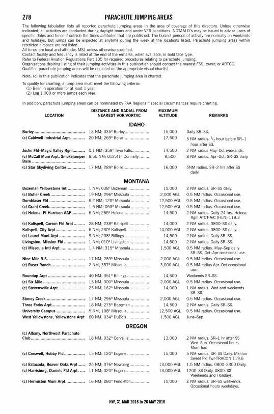
278 PARACHUTE JUMPING AREASParachute Jumping AreasThe following tabulation lists all reported parachute jumping areas in the area of coverage of this directory. Unless otherwiseindicated, all activities are conducted during daylight hours and under VFR conditions. NOTAM D’s may be issued to advise users ofspecific dates and times if outside the times /altitudes that are published. The busiest periods of activity are normally on weekendsand holidays, but jumps can be expected at anytime during the week at the locations listed. Parachute jumping areas withinrestricted airspace are not listed.All times are local and altitudes MSL unless otherwise specified.Contact facility and frequency is listed at the end of the remarks, when available, in bold face type.Refer to Federal Aviation Regulations Part 105 for required procedures relating to parachute jumping.Organizations desiring listing of their jumping activities in this publication should contact the nearest FSS, tower, or ARTCC.Qualified parachute jumping areas will be depicted on the appropriate visual chart(s).
Note: (c) in this publication indicates that the parachute jumping area is charted.
To qualify for charting, a jump area must meet the following criteria:(1) Been in operation for at least 1 year.(2) Log 1,000 or more jumps each year.
In addition, parachute jumping areas can be nominated by FAA Regions if special circumstances require charting.
LOCATIONDISTANCE AND RADIAL FROM
NEAREST VOR/VORTACMAXIMUM ALTITUDE REMARKS
IDAHO Burley ......................................... 13 NM; 035º Burley.................... 15,000 Daily SR–SS.
(c) Caldwell Industrial Arpt ............ 20 NM; 269º Boise..................... 17,500 5 NM radius. 1/2 hour before SR–1 hour after SS.
Joslin Fld–Magic Valley Rgnl.......... 0.1 NM; 359º Twin Falls.............. 14,500 2 NM radius May–Oct weekends.
(c) McCall Muni Arpt, Smokejumper Base ...........................................
8.55 NM; 012.41º Donnelly ........ 9,500 8 NM radius. Apr–Oct, SR–SS daily.
(c) Star Skydiving Center............... 17 NM; 289º Boise..................... 16,000 5NM radius. SR–2 hrs after SS daily.
MONTANA Bozeman Yellowstone Intl.............. 1 NM; 038º Bozeman ................. 15,000 2 NM radius. SR–SS daily.
(c) Butler Creek............................ 19 NM; 296º Missoula ................ 2,000 AGL 0.5 NM radius. Occasional use.
Dornblaser Fld ............................. 5.2 NM; 120º Missoula ............... 12,500 AGL 0.5 NM radius. Occasional use.
(c) Grant Creek............................. 1.5 NM; 053º Missoula ............... 12,500 AGL 0.5 NM radius. Occasional use.
(c) Helena, Ft Harrison AAF........... 6 NM; 265º Helena..................... 14,500 2 NM radius. Daily 24 hrs. Helena Rgnl ATCT-A/C (HLN) 118.3
(c) Kalispell, Carson Fld Arpt ......... 28 NM; 238º Kalispell................. 14,000 2 NM radius. 0800–SS daily.
Kalispell, City Arpt........................ 6 NM; 230º Kalispell................... 14,000 AGL 2 NM radius. 0800–SS daily.
(c) Laurel Muni Arpt ..................... 9 NM; 208º Billings .................... 14,500 2 NM radius. Daily SR–SS.
Livingston, MIssion Fld ................. 1 NM; 010º Livingston ................ 14,500 2 NM radius. Daily SR–SS.
(c) Missoula Intl Arpt .................... 1.4 NM; 315º Missoula ............... 1,500 AGL 0.5 NM radius. May–Sep daily SR–SS, Oct–Apr occasional use.
Nine Mile R.S. ............................. 17 NM; 289º Missoula ................ 2,000 AGL 0.5 NM radius. Occasional use.
(c) Raser Ranch ........................... 2 NM; 357º Missoula .................. 3,000 AGL 0.5 NM radius Apr–Oct occasional use.
Roundup Arpt .............................. 40 NM; 351º Billings .................. 14,500 Weekends SR–SS.
(c) Six Mile .................................. 15 NM; 300º Missoula ................ 2,000 AGL 0.5 NM radius. Occasional use.
(c) Stevensville Arpt...................... 25 NM; 162º Missoula ................ 14,000 1 NM radius. Wed and weekends SR–SS.
Stoney Creek................................ 17 NM; 296º Missoula ................ 2,000 AGL 0.5 NM radius. Occasional use.
Three Forks Arpt........................... 18 NM; 275º Bozeman ............... 14,500 2 NM radius. Daily SR–SS.
University Campus ....................... 5 NM; 108º Missoula .................. 12,500 AGL 0.5 NM radius. Occasional use.
West Yellowstone, Yellowstone Arpt 60 NM; 034º DuBois .................. 1,500 AGL June–Sep.
OREGON (c) Albany, Northwest Parachute Club............................................ 18 NM; 032º Corvallis ................ 13,000 2 NM radius. SR–1 hr after SS
Wed–Sun. Occasional hours Mon–Tue.
(c) Creswell, Hobby Fld. ................ 15 NM; 120º Eugene .................. 15,000 5 NM radius. SR–SS Daily. Mahlon Sweet Fld Twr-TRACON 119.6
(c) Estacada, Beaver Oaks Arpt...... 25 NM; 076º Newberg ................ 13,000 AGL 1.5 NM radius. 0800–2300 Daily.
(c) Harrisburg, Daniels Fld Arpt. .... 11 NM; 020º Eugene .................. 13,000 AGL 1200–SS Daily, 0800–SS Weekends and Holidays.
(c) Hermiston Muni Arpt................ 16 NM; 280º Pendleton............... 15,000 2 NM radius. SR–SS weekends. Occasional hours weekdays.
NW, 31 MAR 2016 to 26 MAY 2016
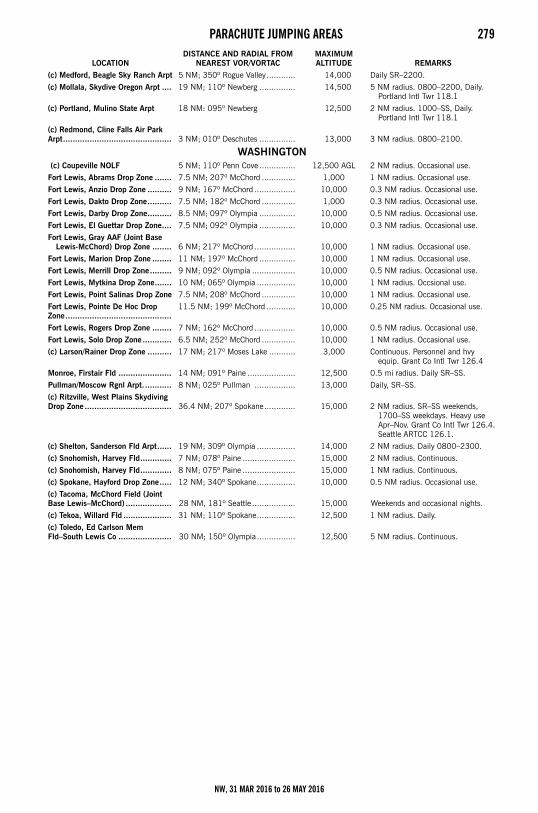
PARACHUTE JUMPING AREAS 279
(c) Medford, Beagle Sky Ranch Arpt 5 NM; 350º Rogue Valley............ 14,000 Daily SR–2200.
(c) Mollala, Skydive Oregon Arpt .... 19 NM; 110º Newberg ............... 14,500 5 NM radius. 0800–2200, Daily. Portland Intl Twr 118.1
(c) Portland, Mulino State Arpt 18 NM: 095º Newberg 12,500 2 NM radius. 1000–SS, Daily. Portland Intl Twr 118.1
(c) Redmond, Cline Falls Air Park Arpt............................................. 3 NM; 010º Deschutes ............... 13,000 3 NM radius. 0800–2100.
WASHINGTON (c) Coupeville NOLF 5 NM; 110º Penn Cove ............... 12,500 AGL 2 NM radius. Occasional use.
Fort Lewis, Abrams Drop Zone ....... 7.5 NM; 207º McChord .............. 1,000 1 NM radius. Occasional use.
Fort Lewis, Anzio Drop Zone .......... 9 NM; 167º McChord ................. 10,000 0.3 NM radius. Occasional use.
Fort Lewis, Dakto Drop Zone.......... 7.5 NM; 182º McChord .............. 1,000 0.3 NM radius. Occasional use.
Fort Lewis, Darby Drop Zone.......... 8.5 NM; 097º Olympia ............... 10,000 0.5 NM radius. Occasional use.
Fort Lewis, El Guettar Drop Zone.... 7.5 NM; 092º Olympia ............... 10,000 0.3 NM radius. Occasional use.
Fort Lewis, Gray AAF (Joint Base Lewis-McChord) Drop Zone ........ 6 NM; 217º McChord ................. 10,000 1 NM radius. Occasional use.
Fort Lewis, Marion Drop Zone ........ 11 NM; 197º McChord ............... 10,000 1 NM radius. Occasional use.
Fort Lewis, Merrill Drop Zone......... 9 NM; 092º Olympia .................. 10,000 0.5 NM radius. Occasional use.
Fort Lewis, Mytkina Drop Zone....... 10 NM; 065º Olympia ................ 10,000 1 NM radius. Occsional use.
Fort Lewis, Point Salinas Drop Zone 7.5 NM; 208º McChord .............. 10,000 1 NM radius. Occasional use.
Fort Lewis, Pointe De Hoc Drop Zone............................................
11.5 NM; 199º McChord ............ 10,000 0.25 NM radius. Occasional use.
Fort Lewis, Rogers Drop Zone ........ 7 NM; 162º McChord ................. 10,000 0.5 NM radius. Occasional use.
Fort Lewis, Solo Drop Zone ............ 6.5 NM; 252º McChord .............. 10,000 1 NM radius. Occasional use.
(c) Larson/Rainer Drop Zone .......... 17 NM; 217º Moses Lake ........... 3,000 Continuous. Personnel and hvy equip. Grant Co Intl Twr 126.4
Monroe, Firstair Fld ...................... 14 NM; 091º Paine .................... 12,500 0.5 mi radius. Daily SR–SS.
Pullman/Moscow Rgnl Arpt............ 8 NM; 025º Pullman ................. 13,000 Daily, SR–SS.
(c) Ritzville, West Plains Skydiving Drop Zone .................................... 36.4 NM; 207º Spokane............. 15,000 2 NM radius. SR–SS weekends,
1700–SS weekdays. Heavy use Apr–Nov. Grant Co Intl Twr 126.4.Seattle ARTCC 126.1.
(c) Shelton, Sanderson Fld Arpt...... 19 NM; 309º Olympia ................ 14,000 2 NM radius. Daily 0800–2300.
(c) Snohomish, Harvey Fld............. 7 NM; 078º Paine ...................... 15,000 2 NM radius. Continuous.
(c) Snohomish, Harvey Fld............. 8 NM; 075º Paine ...................... 15,000 1 NM radius. Continuous.
(c) Spokane, Hayford Drop Zone..... 12 NM; 340º Spokane................ 10,000 0.5 NM radius. Occasional use.
(c) Tacoma, McChord Field (Joint Base Lewis–McChord) ................... 28 NM, 181º Seattle .................. 15,000 Weekends and occasional nights.
(c) Tekoa, Willard Fld .................... 31 NM; 110º Spokane................ 12,500 1 NM radius. Daily.
(c) Toledo, Ed Carlson Mem Fld–South Lewis Co ...................... 30 NM; 150º Olympia ................ 12,500 5 NM radius. Continuous.
LOCATIONDISTANCE AND RADIAL FROM
NEAREST VOR/VORTACMAXIMUM ALTITUDE REMARKS
NW, 31 MAR 2016 to 26 MAY 2016
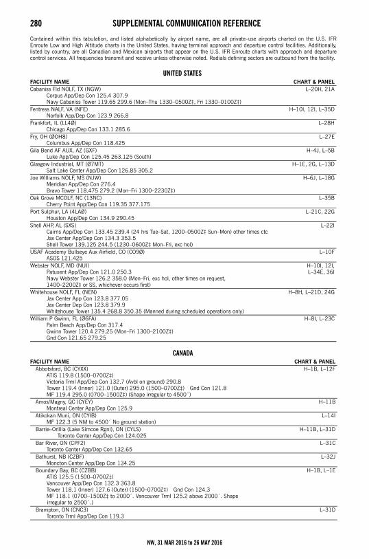
280 SUPPLEMENTAL COMMUNICATION REFERENCESupplemental Communication Reference
Contained within this tabulation, and listed alphabetically by airport name, are all private–use airports charted on the U.S. IFREnroute Low and High Altitude charts in the United States, having terminal approach and departure control facilities. Additionally,listed by country, are all Canadian and Mexican airports that appear on the U.S. IFR Enroute charts with approach and departurecontrol services. All frequencies transmit and receive unless otherwise noted. Radials defining sectors are outbound from the facility.
UNITED STATES FACILITY NAME CHART & PANELCabaniss Fld NOLF, TX (NGW)
Corpus App/Dep Con 125.4 307.9Navy Cabaniss Tower 119.65 299.6 (Mon–Thu 1330–0500Z‡, Fri 1330–0100Z‡)
L–20H, 21A
Fentress NALF, VA (NFE)Norfolk App/Dep Con 123.9 266.8
H–10I, 12I, L–35D
Frankfort, IL (LL4Ø)Chicago App/Dep Con 133.1 285.6
L–28H
Fry, OH (ØOH8)Columbus App/Dep Con 118.425
L–27E
Gila Bend AF AUX, AZ (GXF)Luke App/Dep Con 125.45 263.125 (South)
H–4J, L–5B
Glasgow Industrial, MT (Ø7MT)Salt Lake Center App/Dep Con 126.85 305.2
H–1E, 2G, L–13D
Joe Williams NOLF, MS (NJW)Meridian App/Dep Con 276.4Bravo Tower 118.475 279.2 (Mon–Fri 1300–2230Z‡)
H–6J, L–18G
Oak Grove MCOLF, NC (13NC)Cherry Point App/Dep Con 119.35 377.175
L–35B
Port Sulphur, LA (4LAØ)Houston App/Dep Con 134.9 290.45
L–21C, 22G
Shell AHP, AL (SXS)Cairns App/Dep Con 133.45 239.4 (24 hrs Tue–Sat, 1200–0500Z‡ Sun–Mon) other times ctcJax Center App/Dep Con 134.3 353.5Shell Tower 139.125 244.5 (1230–0600Z‡ Mon–Fri, exc hol)
L–22I
USAF Academy Bullseye Aux Airfield, CO (CO9Ø)ASOS 121.425
L–10F
Webster NOLF, MD (NUI)Patuxent App/Dep Con 121.0 250.3Navy Webster Tower 126.2 358.0 (Mon–Fri, exc hol, other times on request, 1400–2200Z‡ or SS, whichever occurs first)
H–10I, 12I,L–34E, 36I
Whitehouse NOLF, FL (NEN)Jax Center App Con 123.8 377.05Jax Center Dep Con 123.8 379.9Whitehouse Tower 135.4 268.8 350.35 (Manned during scheduled operations only)
H–8H, L–21D, 24G
William P Gwinn, FL (Ø6FA)Palm Beach App/Dep Con 317.4Gwinn Tower 120.4 279.25 (Mon–Fri 1300–2100Z‡)Gnd Con 121.65 279.25
H–8I, L–23C
CANADAFACILITY NAME CHART & PANEL
Abbotsford, BC (CYXX)ATIS 119.8 (1500–0700Z‡)Victoria Trml App/Dep Con 132.7 (Avbl on ground) 290.8Tower 119.4 (Inner) 121.0 (Outer) 295.0 (1500–0700Z‡) Gnd Con 121.8MF 119.4 295.0 (0700–1500Z‡) (Shape irregular to 4500´)
H–1B, L–12F
Amos/Magny, QC (CYEY)Montreal Center App/Dep Con 125.9
H–11B
Atikokan Muni, ON (CYIB)MF 122.3 (5 NM to 4500´ No ground station)
L–14I
Barrie–Orillia (Lake Simcoe Rgnl), ON (CYLS)Toronto Center App/Dep Con 124.025
H–11B, L–31D
Bar River, ON (CPF2)Toronto Center App/Dep Con 132.65
L–31C
Bathurst, NB (CZBF)Moncton Center App/Dep Con 134.25
L–32J
Boundary Bay, BC (CZBB)ATIS 125.5 (1500–0700Z‡)Vancouver App/Dep Con 132.3 363.8Tower 118.1 (Inner) 127.6 (Outer) (1500–0700Z‡) Gnd Con 124.3MF 118.1 (0700–1500Z‡ to 2000´. Vancouver Trml 125.2 above 2000´. Shape
irregular to 2500´.)
H–1B, L–1E
Brampton, ON (CNC3)Toronto Trml App/Dep Con 119.3
L–31D
NW, 31 MAR 2016 to 26 MAY 2016
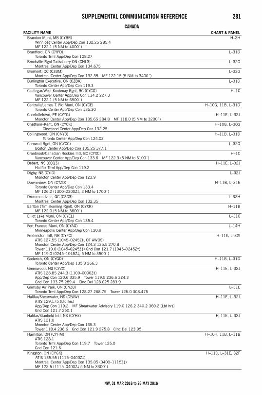
SUPPLEMENTAL COMMUNICATION REFERENCE 281
Brandon Muni, MB (CYBR)Winnipeg Center App/Dep Con 132.25 285.4MF 122.1 (5 NM to 4000´)
H–2H
Brantford, ON (CYFD)Toronto Trml App/Dep Con 128.27
L–31D
Brockville Rgnl Tackaberry ON (CNL3)Montreal Center App/Dep Con 134.675
L–32G
Bromont, QC (CZBM)Montreal Center App/Dep Con 132.35 MF 122.15 (5 NM to 3400´)
L–32G
Burlington Executive, ON (CZBA)Toronto Center App/Dep Con 119.3
L–31D
Castlegar/West Kootenay Rgnl, BC (CYCG)Vancouver Center App/Dep Con 134.2 227.3MF 122.1 (5 NM to 6500´)
H–1C
Centralia/James T. Fld Muni, ON (CYCE)Toronto Center App/Dep Con 135.30
H–10G, 11B, L–31D
Charlottetown, PE (CYYG)Moncton Center App/Dep Con 135.65 384.8 MF 118.0 (5 NM to 3200´)
H–11E, L–32J
Chatham–Kent, ON (CYCK)Cleveland Center App/Dep Con 132.25
H–10G, L–30G
Collingwood, ON (CNY3)Toronto Center App/Dep Con 124.02
H–11B, L–31D
Cornwall Rgnl, ON (CYCC)Boston Center App/Dep Con 135.25 377.1
L–32G
Cranbrook/Canadian Rockies Intl, BC (CYXC)Vancouver Center App/Dep Con 133.6 MF 122.3 (5 NM to 6100´)
H–1C
Debert, NS (CCQ3)Halifax Trml App/Dep Con 119.2
H–11E, L–32J
Digby, NS (CYID)Moncton Center App/Dep Con 123.9
L–32J
Downsview, ON (CYZD)Toronto Center App/Dep Con 133.4 MF 126.2 (1300–2300Z‡, 3 NM to 1700´)
H–11B, L–31E
Drummondville, QC (CSC3)Montreal Center App/Dep Con 132.35
L–32H
Earlton (Timiskaming Rgnl), ON (CYXR)MF 122.0 (5 NM to 3800´)
H–11B
Elliot Lake Muni, ON (CYEL)Toronto Center App/Dep Con 135.4
L–31C
Fort Frances Muni, ON (CYAG)Minneapolis Center App/Dep Con 120.9
L–14H
Fredericton Intl, NB (CYFC)ATIS 127.55 (1045–0245Z‡, OT AWOS)Moncton Center App/Dep Con 124.3 135.5 270.8Tower 119.0 (1045–0245Z‡) Gnd Con 121.7 (1045–0245Z‡) MF 119.0 (0245–1045Z‡, 5 NM to 3500´)
H–11E, L–32I
Goderich, ON (CYGD)Toronto Center App/Dep 135.3 266.3
H–11B, L–31D
Greenwood, NS (CYZX)ATIS 128.85 244.3 (1100–0000Z‡)App/Dep Con 120.6 335.9 Tower 119.5 236.6 324.3Gnd Con 133.75 289.4 Clnc Del 128.025 283.9
H–11E, L–32J
Grimsby Air Park, ON (CNZ8)Toronto Trml App/Dep Con 128.27 268.75 Tower 125.0 308.475
L–31E
Halifax/Shearwater, NS (CYAW)ATIS 129.175 (Ltd hrs)App/Dep Con 119.2 MF Shearwater Advisory 119.0 126.2 340.2 360.2 (Ltd hrs)Gnd Con 121.7 250.1
H–11E, L–32J
Halifax/Stanfield Intl, NS (CYHZ)ATIS 121.0Moncton Center App/Dep Con 135.3Tower 118.4 236.6 Gnd Con 121.9 275.8 Clnc Del 123.95
H–11E, L–32J
Hamilton, ON (CYHM)ATIS 128.1Toronto Trml App/Dep Con 119.7 Tower 125.0Gnd Con 121.6
H–10H, 11B, L–11B
Kingston, ON (CYGK) ATIS 135.55 (1115–0400Z‡)
Montreal Center App/Dep Con 135.05 (0400–1115Z‡)MF 122.5 (1115–0400Z‡ 5 NM to 3300´)
H–11C, L–31E, 32F
CANADAFACILITY NAME CHART & PANEL
NW, 31 MAR 2016 to 26 MAY 2016
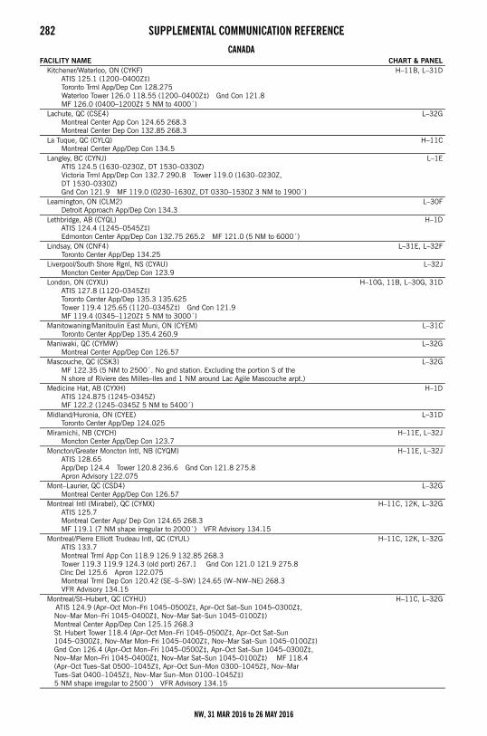
282 SUPPLEMENTAL COMMUNICATION REFERENCE
Kitchener/Waterloo, ON (CYKF)ATIS 125.1 (1200–0400Z‡)Toronto Trml App/Dep Con 128.275Waterloo Tower 126.0 118.55 (1200–0400Z‡) Gnd Con 121.8MF 126.0 (0400–1200Z‡ 5 NM to 4000´)
H–11B, L–31D
Lachute, QC (CSE4)Montreal Center App Con 124.65 268.3 Montreal Center Dep Con 132.85 268.3
L–32G
La Tuque, QC (CYLQ)Montreal Center App/Dep Con 134.5
H–11C
Langley, BC (CYNJ)ATIS 124.5 (1630–0230Z, DT 1530–0330Z)Victoria Trml App/Dep Con 132.7 290.8 Tower 119.0 (1630–0230Z, DT 1530–0330Z)Gnd Con 121.9 MF 119.0 (0230–1630Z, DT 0330–1530Z 3 NM to 1900´)
L–1E
Leamington, ON (CLM2)Detroit Approach App/Dep Con 134.3
L–30F
Lethbridge, AB (CYQL)ATIS 124.4 (1245–0545Z‡) Edmonton Center App/Dep Con 132.75 265.2 MF 121.0 (5 NM to 6000´)
H–1D
Lindsay, ON (CNF4)Toronto Center App/Dep 134.25
L–31E, L–32F
Liverpool/South Shore Rgnl, NS (CYAU)Moncton Center App/Dep Con 123.9
L–32J
London, ON (CYXU)ATIS 127.8 (1120–0345Z‡)Toronto Center App/Dep 135.3 135.625Tower 119.4 125.65 (1120–0345Z‡) Gnd Con 121.9MF 119.4 (0345–1120Z‡ 5 NM to 3000´)
H–10G, 11B, L–30G, 31D
Manitowaning/Manitoulin East Muni, ON (CYEM)Toronto Center App/Dep 135.4 260.9
L–31C
Maniwaki, QC (CYMW)Montreal Center App/Dep Con 126.57
L–32G
Mascouche, QC (CSK3)MF 122.35 (5 NM to 2500´. No gnd station. Excluding the portion S of the N shore of Riviere des Milles–lles and 1 NM around Lac Agile Mascouche arpt.)
L–32G
Medicine Hat, AB (CYXH)ATIS 124.875 (1245–0345Z)MF 122.2 (1245–0345Z 5 NM to 5400´)
H–1D
Midland/Huronia, ON (CYEE)Toronto Center App/Dep 124.025
L–31D
Miramichi, NB (CYCH)Moncton Center App/Dep Con 123.7
H–11E, L–32J
Moncton/Greater Moncton Intl, NB (CYQM)ATIS 128.65App/Dep 124.4 Tower 120.8 236.6 Gnd Con 121.8 275.8Apron Advisory 122.075
H–11E, L–32J
Mont–Laurier, QC (CSD4)Montreal Center App/Dep Con 126.57
L–32G
Montreal Intl (Mirabel), QC (CYMX)ATIS 125.7Montreal Center App/ Dep Con 124.65 268.3MF 119.1 (7 NM shape irregular to 2000´) VFR Advisory 134.15
H–11C, 12K, L–32G
Montreal/Pierre Elliott Trudeau Intl, QC (CYUL)ATIS 133.7Montreal Trml App Con 118.9 126.9 132.85 268.3Tower 119.3 119.9 124.3 (old port) 267.1 Gnd Con 121.0 121.9 275.8
Clnc Del 125.6 Apron 122.075Montreal Trml Dep Con 120.42 (SE–S–SW) 124.65 (W–NW–NE) 268.3VFR Advisory 134.15
H–11C, 12K, L–32G
Montreal/St–Hubert, QC (CYHU) ATIS 124.9 (Apr–Oct Mon–Fri 1045–0500Z‡, Apr–Oct Sat–Sun 1045–0300Z‡,
Nov–Mar Mon–Fri 1045–0400Z‡, Nov–Mar Sat–Sun 1045–0100Z‡)Montreal Center App/Dep Con 125.15 268.3St. Hubert Tower 118.4 (Apr–Oct Mon–Fri 1045–0500Z‡, Apr–Oct Sat–Sun 1045–0300Z‡, Nov–Mar Mon–Fri 1045–0400Z‡, Nov–Mar Sat–Sun 1045–0100Z‡)Gnd Con 126.4 (Apr–Oct Mon–Fri 1045–0500Z‡, Apr–Oct Sat–Sun 1045–0300Z‡, Nov–Mar Mon–Fri 1045–0400Z‡, Nov–Mar Sat–Sun 1045–0100Z‡) MF 118.4 (Apr–Oct Tues–Sat 0500–1045Z‡, Apr–Oct Sun–Mon 0300–1045Z‡, Nov–Mar Tues–Sat 0400–1045Z‡, Nov–Mar Sun–Mon 0100–1045Z‡)5 NM shape irregular to 2500´) VFR Advisory 134.15
H–11C, L–32G
CANADAFACILITY NAME CHART & PANEL
NW, 31 MAR 2016 to 26 MAY 2016
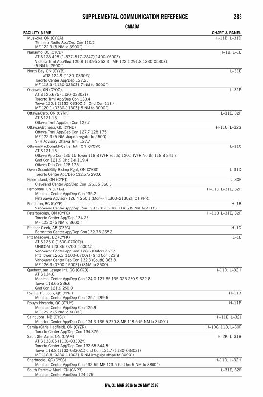
SUPPLEMENTAL COMMUNICATION REFERENCE 283
Muskoka, ON (CYQA)Timmins Radio App/Dep Con 122.3MF 122.3 (5 NM to 3900´)
H–11B, L–31D
Nanaimo, BC (CYCD)ATIS 128.425 (1–877–517–2847)(1400–0500Z)Victoria Trml App/Dep 120.8 133.95 252.3 MF 122.1 291.8 1330–0530Z‡
(5 NM to 2500´)
H–1B, L–1E
North Bay, ON (CYYB)ATIS 124.9 (1130–0330Z‡)
Toronto Center App/Dep 127.25MF 118.3 (1130–0330Z‡ 7 NM to 5000´)
L–31E
Oshawa, ON (CYOO)ATIS 125.675 (1130–0330Z‡)Toronto Trml App/Dep Con 133.4Tower 120.1 (1130–0330Z‡) Gnd Con 118.4MF 120.1 (0330–1130Z‡ 5 NM to 3000´)
L–31E
Ottawa/Carp, ON (CYRP)ATIS 121.15Ottawa Trml App/Dep Con 127.7
L–31E, 32F
Ottawa/Gatineau, QC (CYND)Ottawa Trml App/Dep Con 127.7 128.175MF 122.3 (5 NM shape irregular to 2500)VFR Advisory Ottawa Trml 127.7
H–11C, L–32G
Ottawa/MacDonald–Cartier Intl, ON (CYOW)ATIS 121.15Ottawa App Con 135.15 Tower 118.8 (VFR South) 120.1 (VFR North) 118.8 341.3Gnd Con 121.9 Clnc Del 119.4Ottawa Dep Con 128.175
L–11C
Owen Sound/Billy Bishop Rgnl, ON (CYOS)Toronto Center App/Dep 132.575 290.6
L–31D
Pelee Island, ON (CYPT)Cleveland Center App/Dep Con 126.35 360.0
L–30F
Pembroke, ON (CYTA)Montreal Center App/Dep Con 135.2Petawawa Advisory 126.4 250.1 (Mon–Fri 1300–2130Z‡, OT PPR)
H–11C, L–31E, 32F
Penticton, BC (CYYF)Vancouver Center App/Dep Con 133.5 351.3 MF 118.5 (5 NM to 4100)
H–1B
Peterborough, ON (CYPQ)Toronto Center App/Dep 134.25MF 123.0 (5 NM to 3600´)
H–11B, L–31E, 32F
Pincher Creek, AB (CZPC)Edmonton Center App/Dep Con 132.75 265.2
H–1D
Pitt Meadows, BC (CYPK)ATIS 125.0 (1500–0700Z‡)UNICOM 123.35 (0700–1500Z‡)Vancouver Center App Con 128.6 (Outer) 352.7Pitt Tower 126.3 (1500–0700Z‡) Gnd Con 123.8Vancouver Center Dep Con 132.3 (South) 363.8MF 126.3 (0700–1500Z‡) (3NM to 2500)
L–1E
Quebec/Jean Lesage Intl, QC (CYQB)ATIS 134.6Montreal Center App/Dep Con 124.0 127.85 135.025 270.9 322.8Tower 118.65 236.6Gnd Con 121.9 250.0
H–11D, L–32H
Riviere Du Loup, QC (CYRI)Montreal Center App/Dep Con 125.1 299.6
H–11D
Rouyn Noranda, QC (CYUY)Montreal Center App/Dep Con 125.9MF 122.2 (5 NM to 4000´)
H–11B
Saint John, NB (CYSJ)Moncton Center App/Dep Con 124.3 135.5 270.8 MF 118.5 (5 NM to 3400´)
H–11E, L–32J
Sarnia (Chris Hadfield), ON (CYZR)Toronto Center App/Dep Con 134.375
H–10G, 11B, L–30F
Sault Ste Marie, ON (CYAM)ATIS 133.05 (1130–0330Z‡)Toronto Center App/Dep Con 132.65 344.5Tower 118.8 (1130–0330Z‡) Gnd Con 121.7 (1130–0330Z‡)MF 118.8 (0330–1130Z‡ 5 NM irregular shape to 3000´)
H–2K, L–31B
Sherbrooke, QC (CYSC)Montreal Center App/Dep Con 132.55 MF 123.5 (Ltd hrs 5 NM to 3800´)
H–11D, L–32H
South Renfrew Muni, ON (CNP3)Montreal Center App/Dep 124.275
L–31E, 32F
CANADAFACILITY NAME CHART & PANEL
NW, 31 MAR 2016 to 26 MAY 2016
284 SUPPLEMENTAL COMMUNICATION REFERENCE
Southport, MB (CYPG)ATIS 120.85 (Mon–Fri 1400–2300Z‡ except holidays)Tower 126.2 384.2 (Mon–Fri 1400–2300Z‡ except holidays)Gnd Con 121.7 275.8
H–2H
Springwater Barrie Airpark, ON (CNA3)Toronto Center App/Dep Con 124.025
L–31D
St. Catherines/Niagara District, ON (CYSN)ATIS 128.525 (1215–0200Z‡)Toronto Trml App/Dep Con 133.4MF 123.25 (1215–0200Z‡ 5 NM to 3300´)
H–10H, 11B, L–31E
St. Frederic, QC (CSZ4)Montreal Center App/Dep Con 135.025 270.9
L–32H
St. Georges, QC (CYSG)Montreal Center App/Dep Con 132.35MF 122.15 (5 NM 3900´ ASL)
H–32H, L–11D
St. Jean, QC (CYJN)Montreal Center App/Dep Con 125.15 268.3Tower 118.2 (Apr–Oct 1230–0230Z‡ Nov–Mar 1300–0200Z‡)Gnd Con 121.7
L–32G
Sudbury, ON (CYSB)ATIS 127.4Toronto Center App/Dep Con 135.5 MF 125.5 (7 NM to 4000´) Clnc Del 121.8
H–31B, 10G, L–31D
Summerside, PE (CYSU)Moncton Center App/Dep Con 124.4 384.8
H–11E, L–32J
Thunder Bay, ON (CYQT)ATIS 128.8 (1100–0400Z‡)Winnipeg Center App/Dep Con 132.125Tower 118.1 (1100–0400Z‡) Gnd Con 121.9 (1100–0400Z‡)App/Dep 119.2 MF 118.1 (0400–1100Z‡ 5 NM to 4000´)
H–2J, L–14J
Timmins/Victor M. Power, ON (CYTS)ATIS 124.95 (1000–0500Z‡)Toronto Center App/Dep Con 128.3 MF 122.3 (5 NM to 4000´)
H–11B
Toronto/Buttonville Muni, ON (CYKZ)ATIS 127.1 (1200–0400Z‡)Toronto Trml App/Dep Con 133.4Tower 124.8 119.9 (1200–0400Z‡) Gnd Con 121.8 (1200–0400Z‡)MF 124.8 (0400–1200Z‡ No gnd station. 5 NM shape irregular to below 2500´)
L–31E
Toronto/Billy Bishop Toronto City Airport, ON (CYTZ)ATIS 133.6 (1130–0400Z‡)App/Dep Con 133.4Tower 118.2 119.2 (1130–0400Z‡) Gnd Con 121.7
L–31E
Toronto/Lester B Pearson Intl, ON (CYYZ)ATIS 120.825 133.1App Con 132.8 124.475 125.4 Dep Con 127.575 128.8Tower 118.35 118.7 Gnd Con 121.9 121.65 119.1Clnc Del 121.3 (1200–0400Z‡) Apron Coordinator 122.875 (122.825)
H–11B, L–31D
Trenton, ON (CYTR)ATIS 135.45 257.7App/Dep Con 128.4 324.3 Tower 128.7 236.6 Gnd Con 121.9 275.8Clnc Del 124.35 286.4
H–11C, L–31E, 32F
Trenton/Mountain View, ON (CPZ3)Trenton Mil Advisory 268.0 or 122.35
H–11C, L–31E, 32F
Trois–Rivieres, QC (CYRQ)Montreal Center App/Dep Con 128.225MF 123.0 (5 NM to 3200´)
H–11C, L–32H
Val–D’or, QC (CYVO)Montreal Center App/Dep Con 125.9 308.3MF 118.5 (1030–0325Z‡ 5 NM to 4000´)
H–11B
Vancouver Intl, BC (CYVR)ATIS 124.6App Con 128.6 128.17 (Outer) 133.1 134.225 (Inner) 352.7Dep Con 126.125 (north) 132.3 (south) 363.8Tower 118.7 (south) 119.55 (north) VFR 124.0 125.65 226.5 236.6Gnd Con 121.7 (south) 127.15 (north) 275.8 Clnc Del 121.4
H–1B, L–1E
Victoria Intl, BC (CYYJ) ATIS 118.8 (1400–0800Z‡)App Con 125.95 Dep Con 133.85Tower 119.1 (Outer) 119.7 (Inner) 239.6Gnd Con 121.9 361.4 (1400–0800Z‡ OT ctc Kamloops 119.7)Clnc Del 126.4 (1400–0800Z‡)
H–1B, L–1E
CANADAFACILITY NAME CHART & PANEL
NW, 31 MAR 2016 to 26 MAY 2016
SUPPLEMENTAL COMMUNICATION REFERENCE 285
Victoriaville, QC (CSR3)Montreal Center App Con 132.35
L–32H
Waterville/Kings Co Muni, NS (CCW3)Greenwood Trml App/Dep Con 120.6 335.9Greenwood Tower 119.5 324.3
L–32J
Wiarton, ON (CYVV)Toronto Center App/Dep Con 132.575MF 122.2 (5 NM to 3700´)
H–11B, L–31D
Windsor, ON (CYQG)ATIS 134.5 (1130–0330Z‡)Detroit App/Dep Con 126.85 127.5 134.3 348.3 363.2Tower 124.7 (1130–0330Z‡) Gnd Con 121.7 (1130–0330Z‡)MF 124.7 (0330–1130Z‡ 6 NM irregular shape to below 3000´)VFR Advisory Detroit App Con 134.3
H–10G, L–8J
Yarmouth, NS (CYQI)Moncton Center App/Dep Con 123.9 368.5 MF 123.0 (5 NM to 3100´)
H–11E, L–32I
MEXICOFACILITY NAME CHART & PANEL
Abraham Gonzalez Intl/Ciudad Juarez Intl (MMCS/CJS)Juarez App Con 119.9 Juarez Tower 118.9
H–4K, L–6F
Del Norte Intl (MMAN)ATIS 127.55 (1300–0300Z‡)Monterrey App 119.75 120.4 Tower 118.6 (1300–0600Z‡)Gnd 122.0 (1200–0200Z‡) Clnc Del 122.0 (1200–0200Z‡)
H–7B, L–20G
Durango Intl (MMDO/DGO)ATIS 132.1Tower 118.1 Durango Info 122.3
H–7A
General Abelardo L Rodriguez Intl/Tijuana Intl (MMTJ)ATIS 127.9 (1400–1100Z‡)Tijuana App Con 119.5 120.3 Tijuana Tower 118.1 Tijuana Clnc Del 122.35Tijuana Info 132.1
H–4H, L–4H
General Lucio Blanco Intl/Reynosa Intl (MMRX)Reynosa App Con 127.2 Reynosa Tower 118.8
H–7B, L–20H
General Mariano Escobedo Intl/Monterrey Intl (MMMY)ATIS 127.7Monterrey App Con 119.75 120.4 Monterrey Dep Con 119.75 Monterrey Tower 118.1Monterrey Gnd 121.9 Monterrey Info 122.45
H–7B, L–20G
General R Fierro Villalobos Intl/Chihuahua Intl (MMCU)ATIS 127.9 (1300-0300Z‡)Chihuahua App Con 121.0 Chihuahua Tower 118.4
L–6I
General Rodolfo Sanchez Taboada Intl (MMML)ATIS 127.6Mexicali App Con 118.2 Mexicali Tower 118.2 Mexicali Info 123.9 122.3
H–4H, L–4J, 5A
General Servando Canales Intl (MMMA)Matamoros App Con 118.0 Matamoros Tower 118.0
H–7C, L–21A
Plan De Guadalupe Intl/Saltillo Intl (MMIO/SLW)Saltillo App Con 127.4 Saltillo Tower 118.4
H–7B
Quetzalcoatl Intl/Nuevo Laredo Intl (MMNL/NLD)Nuevo Laredo App Con 118.3 Nuevo Laredo Tower 118.3
H–7B, L–20G
Torreon Intl (MMTC)App Con 119.6 Tower 118.5 Info 122.3
H–7A
CANADAFACILITY NAME CHART & PANEL
NW, 31 MAR 2016 to 26 MAY 2016
286 PREFERRED IFR ROUTESPreferred IFR Routes PREFERRED IFR ROUTES
A system of preferred routes has been established to guide pilots in planning their route of flight, to minimize route changes duringthe operational phase of flight, and to aid in the efficient orderly management of the air traffic using federal airways. The preferredIFR routes which follow are designed to serve the needs of airspace users and to provide for a systematic flow of air traffic in themajor terminal and en route flight environments. Cooperation by all pilots in filing preferred routes will result in fewer traffic delaysand will better provide for efficient departure, en route and arrival air traffic service.
The following lists contain preferred IFR routes for the low altitude stratum and the high altitude stratum. The high altitude list isin two sections; the first section showing terminal to terminal routes and the second section showing single direction route segments.Also, on some high altitude routes low altitude airways are included as transition routes.
The following will explain the terms/abbreviations used in the listing:1. Preferred routes beginning/ending with an airway number indicate that the airway essentially overlies the airport and flight are
normally cleared directly on the airway.2. Preferred IFR routes beginning/ending with a fix indicate that aircraft may be routed to/from these fixes via a Standard
Instrument Departure (SID) route, radar vectors (RV), or a Standard Terminal Arrival Route (STAR).3. Preferred IFR routes for major terminals selected are listed alphabetically under the name of the departure airport. Where
several airports are in proximity they are listed under the principal airport and categorized as a metropolitan area; e.g., NewYork Metro Area.
4. Preferred IFR routes used in one direction only for selected segments, irrespective of point of departure or destination, arelisted numerically showing the segment fixes and the direction and times effective.
5. Where more than one route is listed the routes have equal priority for use.6. Official location identifiers are used in the route description for VOR/VORTAC navaids.7. Intersection names are spelled out.8. Navaid radial and distance fixes (e.g., ARD201113) have been used in the route description in an expediency and
intersection names will be assigned as soon as routine processing can be accomplished. Navaid radial (no distance stated)may be used to describe a route to intercept a specified airway (e.g., MIV MIV101 V39); another navaid radial (e.g., UIMUIM255 GSW081); or an intersection (e.g., GSW081 FITCH).
9. Where two navaids, an intersection and a navaid, a navaid and a navaid radial and distance point, or any navigablecombination of these route descriptions follow in succession, the route is direct.
10. The effective times for the routes are in UTC. During periods of daylight saving time effective times will be one hour earlierthan indicated. All states observe daylight saving time except Arizona, Puerto Rico and the Virgin Islands. Pilots planningflight between the terminals or route segments listed should file for the appropriate preferred IFR route.
11. (90–170 incl) altitude flight level assignment in hundred of feet.12. The notations “pressurized” and “unpressurized” for certain low altitude preferred routes to Kennedy Airport indicate the
preferred route based on aircraft performance.13. High Altitude Preferred IFR Routes are in effect during the following time periods unless otherwise noted.
Sun ..................................................................................................................................1300–2259 local time.Mon thru Fri ......................................................................................................................0701–2259 local time. Sat ...................................................................................................................................0701–1459 local time.
14. Use current SIDs and STARSs for flight planning. 15. For high altitude routes, the portion of the routes contained in brackets [ ] is suggested but optional. The portion of the route
outside the brackets will likely be required by the facilities involved.
SPECIAL LOW ALTITUDE DIRECTIONAL ROUTES
Route
EffectiveTimes(UTC)
Low altitude IFR traffic 13000 feet and below overflying the Portland, OR Area: Southbound/southwestbound .................. OLM V165 UBG .................................................. 1400–0700 Northbound .......................................... UBG V165 OLM .................................................. 1400–0700
Low Altitude IFR traffic 9000 feet and below overflying the Seattle, WA Area: Southbound/Southwestbound.................. V165.................................................................. 1400–0700 Northbound .......................................... V165.................................................................. 1400–0700 Eastbound ............................................ V004 SEA V002.................................................. 1400–0700
Low Altitude IFR traffic 10000 to 15000 overflying the Seattle, WA Area: Southbound .......................................... V165 V495......................................................... 1400–0700 Southbound .......................................... V023 V165 DIGGN V495..................................... 1400–0700 Eastbound ............................................ V004 SEA V2...................................................... 1400–0700
Low Altitude IFR traffic 10000 to 15000 overflying the Seattle, WA Area landing in PDX area: Southbound .......................................... V165 V495 SEA HELNS–STAR ............................. 1400–0700 Southbound .......................................... V023 V165 DIGGN V495 SEA HELNS–STAR ......... 1400–0700
Low Altitude IFR traffic from the North terminating at McMinnville, OR, Aurora State, OR, or Hillsboro, OR: Southbound .......................................... V165 UBG.......................................................... 1400–0700
NW, 31 MAR 2016 to 26 MAY 2016
PREFERRED IFR ROUTES 287SPECIAL LOW ALTITUDE DIRECTIONAL ROUTES
HIGH ALTITUDE
Terminals Route
EffectiveTimes(UTC)
From the Eugene, OR Area: (props and turboprops, 170 and below) Northbound......................................... V481 CVO V495 UBG.......................................... 1400–0700 Southbound......................................... V448 OED .......................................................... 1400–0700
Terminals Route
EffectiveTimes(UTC)
BOISE (BOI)Chicago O’Hare (ORD) .......................... (FL240 and above–Jets) to join DPR J16 MCW
JVL–STAR........................................................ 0000–2359or
DPR J16 MCW ZZIPR FYTTE (RNAV)–STAR ........... 0000–2359PORTLAND (PDX)
Burbank (BUR).................................... J67 LIN J189 AVE FIM ........................................ 1300–0600 Chicago O'Hare (ORD) .......................... J16 MCW JANESVILLE–STAR ............................... 0000–2359
orJ16 MCW ZZIPR FYTTE (RNAV)–STAR ..................
Detroit Metro–Wayne Co (DTW) ............. ODI J34 BAE POLAR–STAR ..................................Houston (HOU).................................... (Turbojets–GPS or DME/DME–IRU equipped) PNH MQP
ELLVR NNEAL KIDDZ (RNAV)–STAR ..................Houston (IAH) ..................................... (Turbojets and Turboprops–GPS or DME/DME–IRU
equipped) (IAH East Flow) PNH MQP GUSHR (RNAV)–STAR ..................................................
or(Turbojets and Turboprops–GPS or DME/DME–IRU
equipped) (IAH West Flow) PNH MQP DRLLR (RNAV)–STAR ..................................................
Long Beach (LGB)................................ J67 LIN J189 AVE FIM ........................................ 1300–0600 Los Angeles (LAX) ................................ J67 LIN J189 AVE FIM ........................................ 1300–0600 Ontario (ONT)...................................... J67 LKV J5 EHF PMD.......................................... 1300–0600 Santa Ana (SNA).................................. J67 LIN J189 AVE FIM ........................................ 1300–0600
SEATTLE BOEING FLD (BFI)Burbank (BUR).................................... SEA J5 LKV J67 LIN J189 AVE FIM ...................... 1300–0600 Long Beach (LGB)................................ SEA J5 LKV J67 LIN J189 AVE FIM ...................... 1300–0600 Los Angeles (LAX) ................................ SEA J5 LKV J67 LIN J189 AVE FIM ...................... 1300–0600 Ontario (ONT)...................................... SEA J5 EHF ZIGGY–STAR ..................................... 1300–0600 Santa Ana (SNA).................................. SEA J5 LKV J67 LIN J189 AVE FIM ...................... 1300–0600
SEATTLE/TACOMA (SEA)Anchorage (ANC) ................................. (RNAV only) SQUIM AKWAY AKHOG LAIRE AKZOO JOHBurbank (BUR).................................... SUMMA–DP SUMMA J5 LKV J67 LIN J189 AVE FIM 1300–0600Cleveland Metro Area (CLE) (CGF) (BKL)
(LNN) (LPR) .................................BAE J34 GRR HIMEZ–STAR .................................
Detroit Metro–Wayne Co. (DTW) ............ J90 HLN J34 BAE POLAR–STAR...........................Houston (HOU).................................... (Turbojets–GPS or DME/DME–IRU equipped) PNH MQP
ELLVR NNEAL KIDDZ (RNAV)–STAR ..................Houston (IAH) ..................................... (Turbojets and Turboprops–GPS or DME/DME–IRU
equipped) (IAH East Flow) MQP GUSHR (RNAV)–STAR ..................................................
or(Turbojets and Turboprops–GPS or DME/DME–IRU
equipped) (IAH West Flow) MQP DRLLR (RNAV)–STAR ..................................................
Kennedy (JFK) ..................................... J90 HLN J34 ODI J30 J90 OBK J584 CRL J554 JHW J70 LVZ LENDY–STAR ......................................
Long Beach (LGB)................................ SUMMA–DP SUMMA J5 LKV J67 LIN J189 AVE FIM 1300–0600 Los Angeles (LAX) ................................ SUMMA–DP SUMMA J5 LKV J67 LIN J189 AVE FIM 1300–0600 Newark (EWR)..................................... J90 ABR J70 GEP DLL J34 CRL J584 SLT FQM–STAROntario (ONT)...................................... SUMMA–DP SUMMA J5 EHF PMD ....................... 1300–0600 Santa Ana (SNA).................................. SUMMA–DP SUMMA J5 LKV J67 LIN J189 AVE FIM 1300–0600
NW, 31 MAR 2016 to 26 MAY 2016
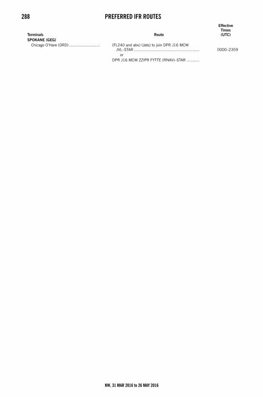
288 PREFERRED IFR ROUTES
SPOKANE (GEG)Chicago O’Hare (ORD) .......................... (FL240 and abv) (Jets) to join DPR J16 MCW
JVL–STAR ........................................................ 0000–2359or
DPR J16 MCW ZZIPR FYTTE (RNAV)–STAR ...........
Terminals Route
EffectiveTimes(UTC)
NW, 31 MAR 2016 to 26 MAY 2016
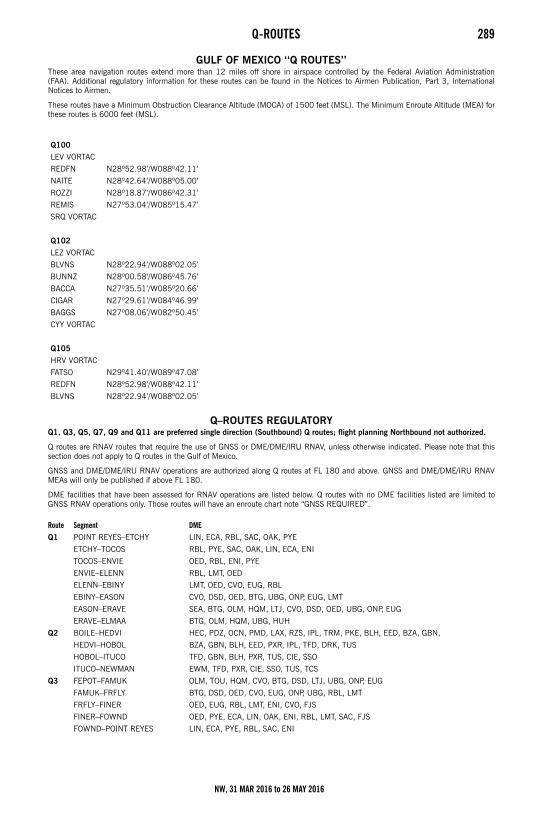
Q-ROUTES 289Q-Routes
GULF OF MEXICO ‘‘Q ROUTES’’These area navigation routes extend more than 12 miles off shore in airspace controlled by the Federal Aviation Administration(FAA). Additional regulatory information for these routes can be found in the Notices to Airmen Publication, Part 3, InternationalNotices to Airmen.
These routes have a Minimum Obstruction Clearance Altitude (MOCA) of 1500 feet (MSL). The Minimum Enroute Altitude (MEA) forthese routes is 6000 feet (MSL).
Q–ROUTES REGULATORYQ1, Q3, Q5, Q7, Q9 and Q11 are preferred single direction (Southbound) Q routes; flight planning Northbound not authorized.
Q routes are RNAV routes that require the use of GNSS or DME/DME/IRU RNAV, unless otherwise indicated. Please note that thissection does not apply to Q routes in the Gulf of Mexico.
GNSS and DME/DME/IRU RNAV operations are authorized along Q routes at FL 180 and above. GNSS and DME/DME/IRU RNAVMEAs will only be published if above FL 180.
DME facilities that have been assessed for RNAV operations are listed below. Q routes with no DME facilities listed are limited toGNSS RNAV operations only. Those routes will have an enroute chart note “GNSS REQUIRED”.
Q100
LEV VORTAC
REDFN N28º52.98’/W088º42.11’
NAITE N28º42.64’/W088º05.00’
ROZZI N28º18.87’/W086º42.31’
REMIS N27º53.04’/W085º15.47’
SRQ VORTAC
Q102
LEZ VORTAC
BLVNS N28º22.94’/W088º02.05’
BUNNZ N28º00.58’/W086º45.76’
BACCA N27º35.51’/W085º20.66’
CIGAR N27º29.61’/W084º46.99’
BAGGS N27º08.06’/W082º50.45’
CYY VORTAC
Q105
HRV VORTAC
FATSO N29º41.40’/W089º47.08’
REDFN N28º52.98’/W088º42.11’
BLVNS N28º22.94’/W088º02.05’
Route Segment DMEQ1 POINT REYES–ETCHY LIN, ECA, RBL, SAC, OAK, PYE
ETCHY–TOCOS RBL, PYE, SAC, OAK, LIN, ECA, ENI
TOCOS–ENVIE OED, RBL, ENI, PYE
ENVIE–ELENN RBL, LMT, OED
ELENN–EBINY LMT, OED, CVO, EUG, RBL
EBINY–EASON CVO, DSD, OED, BTG, UBG, ONP, EUG, LMT
EASON–ERAVE SEA, BTG, OLM, HQM, LTJ, CVO, DSD, OED, UBG, ONP, EUG
ERAVE–ELMAA BTG, OLM, HQM, UBG, HUH
Q2 BOILE–HEDVI HEC, PDZ, OCN, PMD, LAX, RZS, IPL, TRM, PKE, BLH, EED, BZA, GBN,
HEDVI–HOBOL BZA, GBN, BLH, EED, PXR, IPL, TFD, DRK, TUS
HOBOL–ITUCO TFD, GBN, BLH, PXR, TUS, CIE, SSO
ITUCO–NEWMAN EWM, TFD, PXR, CIE, SSO, TUS, TCS
Q3 FEPOT–FAMUK OLM, TOU, HQM, CVO, BTG, DSD, LTJ, UBG, ONP, EUG
FAMUK–FRFLY BTG, DSD, OED, CVO, EUG, ONP, UBG, RBL, LMT
FRFLY–FINER OED, EUG, RBL, LMT, ENI, CVO, FJS
FINER–FOWND OED, PYE, ECA, LIN, OAK, ENI, RBL, LMT, SAC, FJS
FOWND–POINT REYES LIN, ECA, PYE, RBL, SAC, ENI
NW, 31 MAR 2016 to 26 MAY 2016
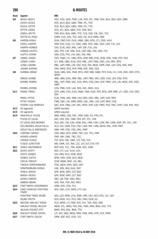
290 Q-ROUTES
Q4 BOILE–HEDVI HEC, PDZ, OCN, PMD, LAX, RZS, IPL, TRM, PKE, BLH, BZA, EED, GBN
HEDVI–SCOLE EED, BLH, BZA, GBN, TRM, IPL, TFD
SCOLE–SPTFR EED, BLH, BZA, GBN, TRM, IPL, TFD
SPTFR–ZEBOL EED, IPL, BZA, GBN, TFD, PXR, BLH
ZEBOL–SKTTR PXR, BLH, BZA, GBN, TFD, TUS, SSO, CIE, SVC, TCS
SKTTR–EL PASO EWM, CUS, SVC, TCS, SSO, CIE, ELP, DMN, CME
Q5 HAROB–HISKU OLM, ONP, CVO, EUG, HQM, UBG, BTG, LTJ, DSD, HUH
HISKU–HARPR ONP, CVO, EUG, LTJ, DSD, UBG, BTG, RBL, OED, LMT, FJS, LKV
HARPR–HOMEG CVO, EUG, OED, RBL, LMT, ENI, FJS, LKV
HOMEG–HUPTU SAC, PYE, LIN, OAK, ECA, LMT, RBL, ENI, OED, FJS
HUPTU–STIKM OAK, ECA, PYE, LIN, SAC, ENI, RBL
Q7 JINMO–JOGEN CVO, HQM, LTJ, UBG, BTG, ONP, IMB, EUG, OLM, DSD, YKM, PDT, SEA
JOGEN–JUNEJ LTJ, IMB, UBG, EUG, CVO, RBL, LMT, FMG, DSD, LKV, OED, BTG
JUNEJ–JAGWA RBL, LMT, FMG, LIN, SAC, ECA, ENI, MOD, SWR, OAK, LKV, CZQ, AVE, SNS
JAGWA–AVENAL OAK, MOD, ECA, EHF, PRB, AVE, SNS, CZQ
Q9 SUMMA–SMIGE OLM, UBG, SEA, YKM, BTG, ONP, IMB, HQM, PDT, EUG, LTJ, CVO, DSD, OED, EPH, MWH
SMIGE–SUNBE IMB, UBG, EUG, IMB, RBL, LMT, FMG, SAC, OED, CVO, LKV, DSD, BTG
SUNBE–REBRG RBL, LMT, FMG, SAC, ECA, MVA, CZQ, OAK, EHF, PMD, LKV, LIN, MOD, AVE, OED, SWR
REBRG–DERBB CZQ, PMD, EHF, LAX, RZS, AVE, MOD, ECA
Q11 PAAGE–PAWLI EPH, UBG, CVO, EUG, HQM, YKM, OLM, PDT, BTG, ONP, IMB, LTJ, DSD, LKV, OED, SEA
PAWLI–PITVE EUG, FMG, SAC, IMB, LKV, OED, DSD, RBL, LMT, CVO, REO
PITVE–PUSHH FMG, SAC, LIN, SWR, MOD, OAL, RBL, LKV, LMT, MVA, CZQ
PUSHH–LOS ANGELES SAC, ECA, FMG, LIN, OAL, MOD, EHF, LAX, PMD, PDZ, HEC, OCN, CZQ, AVE, RZS
Q13 All segments GNSS required
Q15 All segments GNSS required
Q19 NASHVILLE–PLESS BNA, BWG, CSX, ENL, FAM, GQO, IIU, PXV, STL
PLESS–ST LOUIS AXC, CSX, ENL, FAM, PXV, SPI, STL, UIN
ST LOUIS–DES MOINES ALO, AXC, CID, CSX, DSM, ENL, FAM, FOD, LOW, IRK, LMN, OVR, SPI, STL, UIN
DES MOINES–SIOUX FALLS ALO, CID, DSM, FOD, FSD, LOW, IRK, LMN, MCW, ONL, OVR, RWF
SIOUX FALLS–ABERDEEN ABR, FAR, FOD, FSD, ONL, RWF
Q20 CORONA–HONDS CNX, ABQ, ACH, ONM, TXO, LVS, TCC, CME
HONDS–UNNOS CNX, INK, CME, TXO, TCC
UNNOS–FUSCO FST, ACH, INK, CME, SJT, TXO, TCC
FUSCO–JUNCTION ABI, CWK, CSI, INK, LZZ, JCT, SJT, STV, FST
Q21 JONEZ–RAZORBACK BYP, EOS, TUL, TXK, ADM, RZC, OKM
Q22 GUSTI–OYSTY AEX, LFT, LLA, VUH, LCH
OYSTY–ACMES LEV, HRV, PCU, ROR, MCB
ACMES–CATLN BFM, HRV, CEW, GCV, MCB
CATLN–TWOUP CEW, MGM, MVC, SJI, MEI
TWOUP–SPARTANBURG PDK, MCN, AHN, GOO, ODF
SPARTANBURG–NYBLK CAE, SPA, IRQ, SUG, ODF
NYBLK–MASHI SPA, BZM, GRD, CLT, GSO
MASHI–KIDDO SPA, BZM, GRD, CLT, GSO
KIDDO–OMENS SBV, LIB, PSK, GSO, RDU
OMENS–BEARI GVE, FAK, PSK, RIC, RDU
Q23 FORT SMITH–RAZORBACK OKM, RZC, EOS, TUL
Q24 LAKE CHARLES–FIGHTING TIGER
AEX, DAS, LCH, MCB, LFT, LSU
FIGHTING TIGER–IRUBE AEX, LEV, MCB, LCH, RQR, HRV, LSU, GCV, PCU, SJI, LBY
IRUBE–PAYTN GCV, MCB, JYU, PCU, MEI, HRV, CEW, SJI
Q25 MEEOW–WALNUT RIDGE ELD, MEM, LIT, FAM, RZC, EIC, TXK, ARG, GQE
WALNUT RIDGE–WLSUN MEM, STL, BWG, PXV, ENL, FAM, ARG, BNA, CSX, TTH
WLSUN–POCKET CITY BWG, PXV, ENL, BNA, TTH
Q26 WALNUT RIDGE–DEVAC LIT, JKS, GQO, MEM, BNA, FAM, ARG, DYR, VUZ, RMG
Q27 FORT SMITH–ZALDA OKM, SGF, RZC, EOS, TUL
Route Segment DME
NW, 31 MAR 2016 to 26 MAY 2016
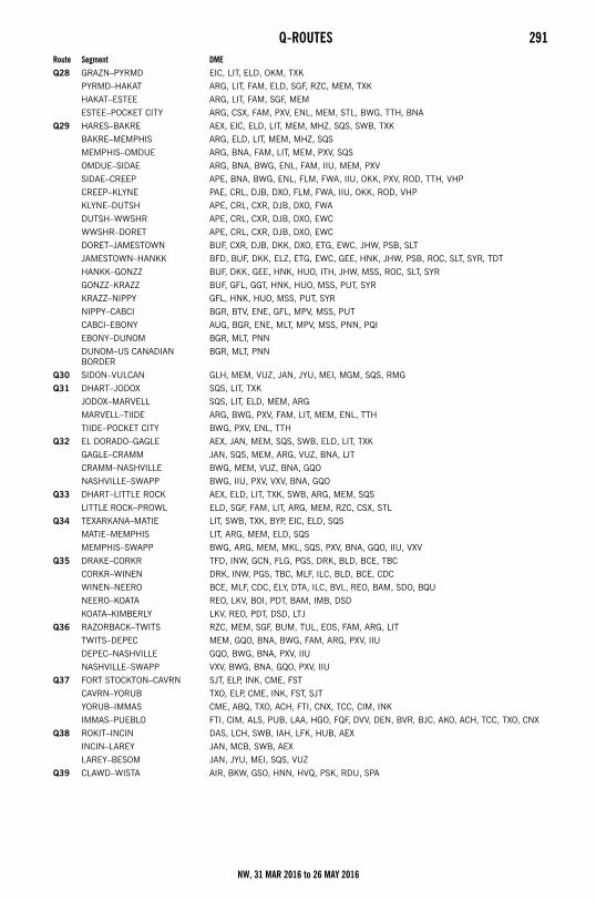
Q-ROUTES 291
Q28 GRAZN–PYRMD EIC, LIT, ELD, OKM, TXK
PYRMD–HAKAT ARG, LIT, FAM, ELD, SGF, RZC, MEM, TXK
HAKAT–ESTEE ARG, LIT, FAM, SGF, MEM
ESTEE–POCKET CITY ARG, CSX, FAM, PXV, ENL, MEM, STL, BWG, TTH, BNA
Q29 HARES–BAKRE AEX, EIC, ELD, LIT, MEM, MHZ, SQS, SWB, TXK
BAKRE–MEMPHIS ARG, ELD, LIT, MEM, MHZ, SQS
MEMPHIS–OMDUE ARG, BNA, FAM, LIT, MEM, PXV, SQS
OMDUE–SIDAE ARG, BNA, BWG, ENL, FAM, IIU, MEM, PXV
SIDAE–CREEP APE, BNA, BWG, ENL, FLM, FWA, IIU, OKK, PXV, ROD, TTH, VHP
CREEP–KLYNE PAE, CRL, DJB, DXO, FLM, FWA, IIU, OKK, ROD, VHP
KLYNE–DUTSH APE, CRL, CXR, DJB, DXO, FWA
DUTSH–WWSHR APE, CRL, CXR, DJB, DXO, EWC
WWSHR–DORET APE, CRL, CXR, DJB, DXO, EWC
DORET–JAMESTOWN BUF, CXR, DJB, DKK, DXO, ETG, EWC, JHW, PSB, SLT
JAMESTOWN–HANKK BFD, BUF, DKK, ELZ, ETG, EWC, GEE, HNK, JHW, PSB, ROC, SLT, SYR, TDT
HANKK–GONZZ BUF, DKK, GEE, HNK, HUO, ITH, JHW, MSS, ROC, SLT, SYR
GONZZ–KRAZZ BUF, GFL, GGT, HNK, HUO, MSS, PUT, SYR
KRAZZ–NIPPY GFL, HNK, HUO, MSS, PUT, SYR
NIPPY–CABCI BGR, BTV, ENE, GFL, MPV, MSS, PUT
CABCI–EBONY AUG, BGR, ENE, MLT, MPV, MSS, PNN, PQI
EBONY–DUNOM BGR, MLT, PNN
DUNOM–US CANADIAN BORDER
BGR, MLT, PNN
Q30 SIDON–VULCAN GLH, MEM, VUZ, JAN, JYU, MEI, MGM, SQS, RMG
Q31 DHART–JODOX SQS, LIT, TXK
JODOX–MARVELL SQS, LIT, ELD, MEM, ARG
MARVELL–TIIDE ARG, BWG, PXV, FAM, LIT, MEM, ENL, TTH
TIIDE–POCKET CITY BWG, PXV, ENL, TTH
Q32 EL DORADO–GAGLE AEX, JAN, MEM, SQS, SWB, ELD, LIT, TXK
GAGLE–CRAMM JAN, SQS, MEM, ARG, VUZ, BNA, LIT
CRAMM–NASHVILLE BWG, MEM, VUZ, BNA, GQO
NASHVILLE–SWAPP BWG, IIU, PXV, VXV, BNA, GQO
Q33 DHART–LITTLE ROCK AEX, ELD, LIT, TXK, SWB, ARG, MEM, SQS
LITTLE ROCK–PROWL ELD, SGF, FAM, LIT, ARG, MEM, RZC, CSX, STL
Q34 TEXARKANA–MATIE LIT, SWB, TXK, BYP, EIC, ELD, SQS
MATIE–MEMPHIS LIT, ARG, MEM, ELD, SQS
MEMPHIS–SWAPP BWG, ARG, MEM, MKL, SQS, PXV, BNA, GQO, IIU, VXV
Q35 DRAKE–CORKR TFD, INW, GCN, FLG, PGS, DRK, BLD, BCE, TBC
CORKR–WINEN DRK, INW, PGS, TBC, MLF, ILC, BLD, BCE, CDC
WINEN–NEERO BCE, MLF, CDC, ELY, DTA, ILC, BVL, REO, BAM, SDO, BQU
NEERO–KOATA REO, LKV, BOI, PDT, BAM, IMB, DSD
KOATA–KIMBERLY LKV, REO, PDT, DSD, LTJ
Q36 RAZORBACK–TWITS RZC, MEM, SGF, BUM, TUL, EOS, FAM, ARG, LIT
TWITS–DEPEC MEM, GQO, BNA, BWG, FAM, ARG, PXV, IIU
DEPEC–NASHVILLE GQO, BWG, BNA, PXV, IIU
NASHVILLE–SWAPP VXV, BWG, BNA, GQO, PXV, IIU
Q37 FORT STOCKTON–CAVRN SJT, ELP, INK, CME, FST
CAVRN–YORUB TXO, ELP, CME, INK, FST, SJT
YORUB–IMMAS CME, ABQ, TXO, ACH, FTI, CNX, TCC, CIM, INK
IMMAS–PUEBLO FTI, CIM, ALS, PUB, LAA, HGO, FQF, DVV, DEN, BVR, BJC, AKO, ACH, TCC, TXO, CNX
Q38 ROKIT–INCIN DAS, LCH, SWB, IAH, LFK, HUB, AEX
INCIN–LAREY JAN, MCB, SWB, AEX
LAREY–BESOM JAN, JYU, MEI, SQS, VUZ
Q39 CLAWD–WISTA AIR, BKW, GSO, HNN, HVQ, PSK, RDU, SPA
Route Segment DME
NW, 31 MAR 2016 to 26 MAY 2016
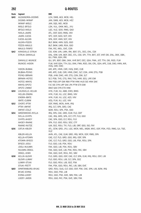
292 Q-ROUTES
Q40 ALEXANDRIA–DOOMS LCH, SWB, AEX, MCB, HEL
DOOMS–WINAP JAN, SWB, AEX, MCB, HEZ
WINAP–MISLE JAN, SQS, MEI, MCB
MISLE–BFOLO LDK, VUL, OKW, MEL, JYU
BFOLO–NIOLA LGC, VUZ, GOO, RMG, GAD
NIOLA–JAARE ATL, ODF, GOO, RMG, VXV
JAARE–OJESS SPZ, ODF, GOO, SOT, VXV
OJESS–ALEAN SPA, ODF, HMV, SOT, VXV
ALEAN–FEEDS BLF, BKW, HMV, GZG, GSO
FEEDS–MAULS BLF, BKW, LWB, ROA, GSO
MAULS–FANPO FAK, RIC, MOL, GVE, CSN
Q42 KIRKSVILLE–STRUK CID, IOW, UIN, LMN, IRK, BDF, STL, DEC, ENL, CSX
STRUK–DANVILLE ENL, IOW, UIN, BDF, DEC, STL, CSX, SPI, TTH, BVT, JOT, VHP, OXI, ENL, OKK, OBK, GIJ, FWA, GSH, IRK
DANVILLE–MUNCIE GIJ, SPI, BDF, OBK, OKK, VHP, BVT, DEC, GSH, FWA, JOT, TTH, OXI, ROD, FLM
MUNCIE–HIDON FLM, VHP, GSH, TTH, GIJ, OKK, FWA, ROD, OXI, CRL, GSH, APE, DJB, DXO, HNN, AIR, HVQ, CXR, EWC
HIDON–BUBAA AIR, APE, HNN, CXR, HVQ, EWC, DJB
BUBAA–PSYKO AIR, APE, DJB, CXR, HNN, EWC, SLT, CSN, JHW, ETG, PSB
PSYKO–BRNAN PSB, JHW, EWC, AIR, ETG, CSN, EMI, SLT
BRNAN–HOTEE SLT, PSB, THS, ETG, RAV, THS, HAR, SEG, LRP, EMI
HOTEE–MIKYG RAV PSB LRP EMI RBV PTW HNK HUO SIE HNK SAX
MIKYG–SPOTZ FJC SIE CYN LRP SAX JFK PTW ETX EMI
SPOTZ–ZIMMZ BWZ SAX CYN ETX HNK
Q50 LOUISVILLE–HELUB HYK, FLM, IIU, ABB, EWO, BWG
HELUB–ENGRA HYK, FLM, IIU, LOZ, BWG, VXV
ENGRA–IBATE HYK, FLM, IIU, LOZ, AZO, VXV
IBATE–CUBIM AZQ, FLM, IIU, LOZ, VXV
Q52 CHOPZ–IPTAY ODF, RMG, MCN, AHN, IRQ
IPTAY–AWYAT IRQ, CLT, SPA, GRD, CAE
AWYAT–COLZI BZM, RDU, SPA, PSK, GSO
Q54 GREENWOOD–NYLLA IRQ, SPA, CAE, GRD, ELW, FLO, ODF
NYLLA–CHYPS CAE, IRQ, GRD, SPA, CLT, CTF, FLO, GSO
CHYPS–AHOEY CAE, SPA, GSO, CLT, RDU, FLO
AHOEY–RAANE SPA, FLO, GSO, RDU, SDZ, CTF
RAANE–NUTZE ILM, SDZ, RDU, TYI, FLO, LIB, ORF, GSO, ISO, FAY
Q56 CATLN–KBLER ATL, CEW, GRD, JYU, LGC, MCN, MEL, MGM, MVC, ODF, PDK, PZD, RMG, SJI, TGE, VUZ
KBLER–KELLN AHN, ATL, CAE, ELW, GRD, IRQ, MCN, ODF, RMG, SPA
KELLN–KTOWN CAE, CLT, FLO, GRD, GSO, IRQ, ODF, SPA
KTOWN–BYSCO CAE, CLT, FLO, GRD, GSO, LIB, PSK, RDU, SPA
BYSCO–JOOLI FLO, GSO, LIB, PSK, RDU
JOOLI–NUUMN FAK, GSO, LIB, PSK, RDU, SBV
NUUMN–ORACL FAK, GSO, GVE, LIB, PSK, RDU, RIC, SBV
ORACL–KIWII FAK, GSO, GVE, RDU, RIC, SBV
Q58 KELLN–GLOVR FLO, GRD, GSO, ODF, CAE, CLT, SPA, ELW, IRQ, RDU, ODF, LIB
GLOVR–LUMAY FLO, GSO, RDU, LIB, CLT, SPA, SDZ
LUMAY–STUKI FLO, GSO, RDU, LIB, SDZ, PSK
STUKI–PEETT FAK, PSK, GSO, RDU, RIC, LIB, SBV, GVE
Q60 SPARTANBURG–BYJAC GRD, RDU, SUG, CLT, GSO, ODF, PSK, CAE, SPA, LIB, BZM, IRQ
BYJAC–EVING RDU, GSO, PSK, LIB
EVING–LOOEY RDU, GSO, PSK, GVE, SBV, FAK, LIB
LOOEY–JAXSN RDU, GSO, RIC, PSK, GVE, SBV, FAK
Route Segment DME
NW, 31 MAR 2016 to 26 MAY 2016
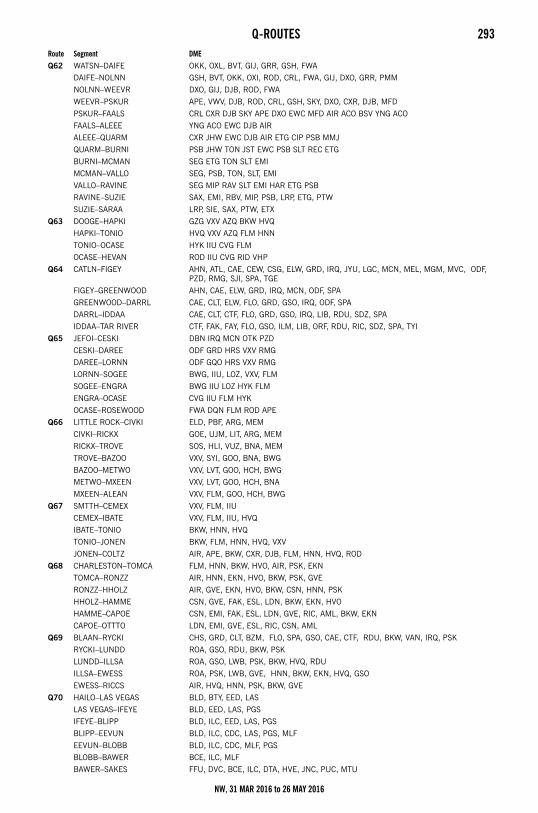
Q-ROUTES 293
Q62 WATSN–DAIFE OKK, OXL, BVT, GIJ, GRR, GSH, FWA
DAIFE–NOLNN GSH, BVT, OKK, OXI, ROD, CRL, FWA, GIJ, DXO, GRR, PMM
NOLNN–WEEVR DXO, GIJ, DJB, ROD, FWA
WEEVR–PSKUR APE, VWV, DJB, ROD, CRL, GSH, SKY, DXO, CXR, DJB, MFD
PSKUR–FAALS CRL CXR DJB SKY APE DXO EWC MFD AIR ACO BSV YNG ACO
FAALS–ALEEE YNG ACO EWC DJB AIR
ALEEE–QUARM CXR JHW EWC DJB AIR ETG CIP PSB MMJ
QUARM–BURNI PSB JHW TON JST EWC PSB SLT REC ETG
BURNI–MCMAN SEG ETG TON SLT EMI
MCMAN–VALLO SEG, PSB, TON, SLT, EMI
VALLO–RAVINE SEG MIP RAV SLT EMI HAR ETG PSB
RAVINE–SUZIE SAX, EMI, RBV, MIP, PSB, LRP, ETG, PTW
SUZIE–SARAA LRP, SIE, SAX, PTW, ETX
Q63 DOOGE–HAPKI GZG VXV AZQ BKW HVQ
HAPKI–TONIO HVQ VXV AZQ FLM HNN
TONIO–OCASE HYK IIU CVG FLM
OCASE–HEVAN ROD IIU CVG RID VHP
Q64 CATLN–FIGEY AHN, ATL, CAE, CEW, CSG, ELW, GRD, IRQ, JYU, LGC, MCN, MEL, MGM, MVC, ODF, PZD, RMG, SJI, SPA, TGE
FIGEY–GREENWOOD AHN, CAE, ELW, GRD, IRQ, MCN, ODF, SPA
GREENWOOD–DARRL CAE, CLT, ELW, FLO, GRD, GSO, IRQ, ODF, SPA
DARRL–IDDAA CAE, CLT, CTF, FLO, GRD, GSO, IRQ, LIB, RDU, SDZ, SPA
IDDAA–TAR RIVER CTF, FAK, FAY, FLO, GSO, ILM, LIB, ORF, RDU, RIC, SDZ, SPA, TYI
Q65 JEFOI–CESKI DBN IRQ MCN OTK PZD
CESKI–DAREE ODF GRD HRS VXV RMG
DAREE–LORNN ODF GQO HRS VXV RMG
LORNN–SOGEE BWG, IIU, LOZ, VXV, FLM
SOGEE–ENGRA BWG IIU LOZ HYK FLM
ENGRA–OCASE CVG IIU FLM HYK
OCASE–ROSEWOOD FWA DQN FLM ROD APE
Q66 LITTLE ROCK–CIVKI ELD, PBF, ARG, MEM
CIVKI–RICKX GOE, UJM, LIT, ARG, MEM
RICKX–TROVE SOS, HLI, VUZ, BNA, MEM
TROVE–BAZOO VXV, SYI, GOO, BNA, BWG
BAZOO–METWO VXV, LVT, GOO, HCH, BWG
METWO–MXEEN VXV, LVT, GOO, HCH, BNA
MXEEN–ALEAN VXV, FLM, GOO, HCH, BWG
Q67 SMTTH–CEMEX VXV, FLM, IIU
CEMEX–IBATE VXV, FLM, IIU, HVQ
IBATE–TONIO BKW, HNN, HVQ
TONIO–JONEN BKW, FLM, HNN, HVQ, VXV
JONEN–COLTZ AIR, APE, BKW, CXR, DJB, FLM, HNN, HVQ, ROD
Q68 CHARLESTON–TOMCA FLM, HNN, BKW, HVO, AIR, PSK, EKN
TOMCA–RONZZ AIR, HNN, EKN, HVO, BKW, PSK, GVE
RONZZ–HHOLZ AIR, GVE, EKN, HVO, BKW, CSN, HNN, PSK
HHOLZ–HAMME CSN, GVE, FAK, ESL, LDN, BKW, EKN, HVO
HAMME–CAPOE CSN, EMI, FAK, ESL, LDN, GVE, RIC, AML, BKW, EKN
CAPOE–OTTTO LDN, EMI, GVE, ESL, RIC, CSN, AML
Q69 BLAAN–RYCKI CHS, GRD, CLT, BZM, FLO, SPA, GSO, CAE, CTF, RDU, BKW, VAN, IRQ, PSK
RYCKI–LUNDD ROA, GSO, RDU, BKW, PSK
LUNDD–ILLSA ROA, GSO, LWB, PSK, BKW, HVQ, RDU
ILLSA–EWESS ROA, PSK, LWB, GVE, HNN, BKW, EKN, HVQ, GSO
EWESS–RICCS AIR, HVQ, HNN, PSK, BKW, GVE
Q70 HAILO–LAS VEGAS BLD, BTY, EED, LAS
LAS VEGAS–IFEYE BLD, EED, LAS, PGS
IFEYE–BLIPP BLD, ILC, EED, LAS, PGS
BLIPP–EEVUN BLD, ILC, CDC, LAS, PGS, MLF
EEVUN–BLOBB BLD, ILC, CDC, MLF, PGS
BLOBB–BAWER BCE, ILC, MLF
BAWER–SAKES FFU, DVC, BCE, ILC, DTA, HVE, JNC, PUC, MTU
Route Segment DME
NW, 31 MAR 2016 to 26 MAY 2016
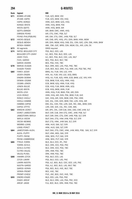
294 Q-ROUTES
Q71 BOBBD–ATUME FLM, AZO, BKW, VXV
ATUME–HAPKI FLM, AZO, BKW, VXV, HVQ
HAPKI–KONGO HNN, AZO, BKW, GZG, HVQ
KONGO–WISTA HNN, HVQ, BKW, PSK
WISTA–GEFFS HNN, HVQ, BKW, AIR
GEFFS–EMNEM AIR, BKW, EWC, HNN, HVQ
EMNEM–PSYKO AIR, ETG, EWC, PSB, SLT
PSYKO–PHILIPSBURG AIR, EMI, ETG, EWC, JHW, PSB, SLT
Q72 HACKS–GEQUE AIR, CKB, APE, HVQ, JPU, EKN, BKW, HNN, MGW
GEQUE–BENSH AIR, EKN, MGW, HVQ, CKB, ESL, CSN, GVE, LDN, EMI, HNN, BKW
BENSH–RAMAY AML, EMI, GVE, MRB, CSN, MGW, ESL, AIR, LDN, EK
Q73 All segments GNSS required
Q74 NATEE–BOULDER CITY PGS, BLD, EED, LAS
BOULDER CITY–ZAINY ILC, BCE, PGS, BLD, EED, LAS
ZAINY–FIZZL ILC, BCE, PGS, BLD, CDC, LAS, MLF
FIZZL–GARDD BCE, PGS, BLD, MLF, TBC
GARDD–DEANN BCE, PGS, HVE, TBC
Q78 MARUE–DUGGN BLD, DRK, EED, LAS, PGS, PKE, TBC
DUGGN–TOADD ZUN, BCE, BLD, DRK, FLG, INW, LAS, PGS TBC, PKE
Q80 FAREV–JEDER BWG, IIU, FLM, VXV, LOZ, HYK
JEDER–ENGRA HYK, IIU, FLM, VXV, LOZ, AZQ, BWG
ENGRA–DEWAK HVQ, IIU, FLM, AZQ, HNN, ECB, BKW, LOZ, VXV, HYK
DEWAK–CEGMA ECB, BKW, FLM, AZQ, HNN, HVQ
CEGMA–JONEN ECB, BKW, AZQ, HNN, FLM, HVQ
JONEN–BULVE ECB, HVQ, FLM, BKW, HNN, AZQ
BULVE–WISTA ECB, HVQ, BKW, HNN, FLM
WISTA–LEVII HNN, HVQ, FLM, BKM, PSK, AIR, EKN
LEVII–RONZZ HNN, HVQ, AIR, EKN, PSK, BKW, FLM, GVE
RONZZ–HHOLZ GVE, HVQ, AIR, EKN, BKW, CSN, PSK, HNN
HHOLZ–HAMME GVE, ESL, CSN, EKN, BKW, FAK, LDN, HVQ, AIR
HAMME–CAPOE EMI, ESL, CSN, FAK, LDN, GVE, RIC, AML, BKW, EKN
CAPOE–OTTTO LDN, EMI, GVE, ESL, RIC, CSN, AML
Q82 WWSHR–DORET AIR, APE, CRL, CXR DJB, DKK, DXO, EWC JHW, SLT
DORET–JAMESTOWN BUF, CXR, DJB, DKK ETG, EWC, JHW, PSB, SLT
JAMESTOWN–WAYLA BUF, CXR, DKK, ETG, EWC JHW, PSB, SLT, SYR
WAYLA–VIEEW BUF, DKK, ETG, HNK JHW, PSB, SLT, SYR
VIEEW–MEMMS BUF, ETG, HNK, JHW SAX, SLT, SYR
MEMMS–LOXXE HNK, HUO, SAX, SLT, SYR
LOXXE–PONCT HNK, HUO, SAX, SLT, SYR
Q84 JAMESTOWN–AUDIL BUF, DKK, ETG, EWC, HNK, JHW, MSS, PSB, SAX, SLT, SYR
AUDIL–PUPPY BUF, HNK, MSS, SAX, SYR
PUPPY–PAYGE HNK, MSS, PUT, SAX, SYR
PAYGE–CAMBRIDGE HNK, MSS, PUT, SAX, SYR
Q86 TTRUE–YORRK BLD, BLH, EED, IPL, PKE
YORRK–SCHLS BLD, DRK, EED, PGS, PKE
SCHLS–CUTRO BLD, DRK, EED, PGS, TBC
CUTRO–VALEQ DRK, INW, PGS, TBC
VALEQ–PLNDL DRK, INW, PGS, TBC
Q88 HAKMN–ZZYZX PGS, BLD, EED, LAS
ZZYZX–LAKRR PGS, BLD, EED, LAS, PKE
LAKRR–NOOTN PGS, ILC, BCE, BLD, CDC, EED, LAS, PKE
NOOTN–GARDD PGS, ILC, BCE, BLD, LAS, MLF, TBC
GARDD–VERKN PGS, BCE, BLD, HVE, MLF, TBC
VERKN–PROMT BCE, HVE, TBC
PROMT–CHESZ PUC, JNC, BCE, DVC, HVE, TBC
Q90 DNERO–ESGEE BLD, EED, LAS, PGS, PKE
ESGEE–AREAF BLD, BLH, DRK, LAS, PGS, PKE, EED
AREAF–JASSE FLG, BCE, BLD, DRK, INW, PGS, TBC
Route Segment DME
NW, 31 MAR 2016 to 26 MAY 2016
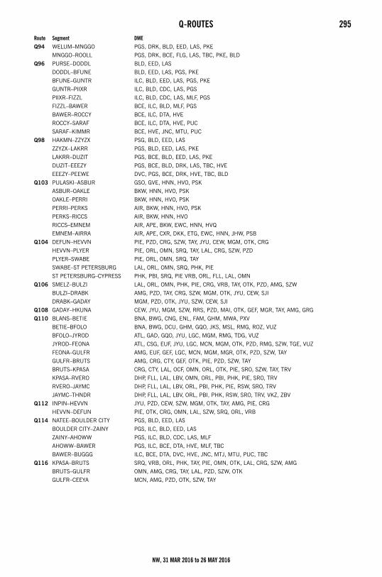
Q-ROUTES 295
Q94 WELUM–MNGGO PGS, DRK, BLD, EED, LAS, PKE
MNGGO–ROOLL PGS, DRK, BCE, FLG, LAS, TBC, PKE, BLD
Q96 PURSE–DODDL BLD, EED, LAS
DODDL–BFUNE BLD, EED, LAS, PGS, PKE
BFUNE–GUNTR ILC, BLD, EED, LAS, PGS, PKE
GUNTR–PIIXR ILC, BLD, CDC, LAS, PGS
PIIXR–FIZZL ILC, BLD, CDC, LAS, MLF, PGS
FIZZL–BAWER BCE, ILC, BLD, MLF, PGS
BAWER–ROCCY BCE, ILC, DTA, HVE
ROCCY–SARAF BCE, ILC, DTA, HVE, PUC
SARAF–KIMMR BCE, HVE, JNC, MTU, PUC
Q98 HAKMN–ZZYZX PSG, BLD, EED, LAS
ZZYZX–LAKRR PGS, BLD, EED, LAS, PKE
LAKRR–DUZIT PGS, BCE, BLD, EED, LAS, PKE
DUZIT–EEEZY PGS, BCE, BLD, DRK, LAS, TBC, HVE
EEEZY–PEEWE DVC, PGS, BCE, DRK, HVE, TBC, BLD
Q103 PULASKI–ASBUR GSO, GVE, HNN, HVO, PSK
ASBUR–OAKLE BKW, HNN, HVO, PSK
OAKLE–PERRI BKW, HNN, HVO, PSK
PERRI–PERKS AIR, BKW, HNN, HVO, PSK
PERKS–RICCS AIR, BKW, HNN, HVO
RICCS–EMNEM AIR, APE, BKW, EWC, HNN, HVQ
EMNEM–AIRRA AIR, APE, CXR, DKK, ETG, EWC, HNN, JHW, PSB
Q104 DEFUN–HEVVN PIE, PZD, CRG, SZW, TAY, JYU, CEW, MGM, OTK, CRG
HEVVN–PLYER PIE, ORL, OMN, SRQ, TAY, LAL, CRG, SZW, PZD
PLYER–SWABE PIE, ORL, OMN, SRQ, TAY
SWABE–ST PETERSBURG LAL, ORL, OMN, SRQ, PHK, PIE
ST PETERSBURG–CYPRESS PHK, PBI, SRQ, PIE VRB, ORL, FLL, LAL, OMN
Q106 SMELZ–BULZI LAL, ORL, OMN, PHK, PIE, CRG, VRB, TAY, OTK, PZD, AMG, SZW
BULZI–DRABK AMG, PZD, TAY, CRG, SZW, MGM, OTK, JYU, CEW, SJI
DRABK–GADAY MGM, PZD, OTK, JYU, SZW, CEW, SJI
Q108 GADAY–HKUNA CEW, JYU, MGM, SZW, RRS, PZD, MAI, OTK, GEF, MGR, TAY, AMG, GRG
Q110 BLANS–BETIE BNA, BWG, CNG, ENL, FAM, GHM, MWA, PXV
BETIE–BFOLO BNA, BWG, DCU, GHM, GQO, JKS, MSL, RMG, ROZ, VUZ
BFOLO–JYROD ATL, GAD, GQO, JYU, LGC, MGM, RMG, TDG, VUZ
JYROD–FEONA ATL, CSG, EUF, JYU, LGC, MCN, MGM, OTK, PZD, RMG, SZW, TGE, VUZ
FEONA–GULFR AMG, EUF, GEF, LGC, MCN, MGM, MGR, OTK, PZD, SZW, TAY
GULFR–BRUTS AMG, CRG, CTY, GEF, OTK, PIE, PZD, SZW, TAY
BRUTS–KPASA CRG, CTY, LAL, OCF, OMN, ORL, OTK, PIE, SRO, SZW, TAY, TRV
KPASA–RVERO DHP, FLL, LAL, LBV, OMN, ORL, PBI, PHK, PIE, SRO, TRV
RVERO–JAYMC DHP, FLL, LAL, LBV, ORL, PBI, PHK, PIE, RSW, SRO, TRV
JAYMC–THNDR DHP, FLL, LAL, LBV, ORL, PBI, PHK, RSW, SRO, TRV, VKZ, ZBV
Q112 INPIN–HEVVN JYU, PZD, CEW, SZW, MGM, OTK, TAY, AMG, PIE, CRG
HEVVN–DEFUN PIE, OTK, CRG, OMN, LAL, SZW, SRQ, ORL, VRB
Q114 NATEE–BOULDER CITY PGS, BLD, EED, LAS
BOULDER CITY–ZAINY PGS, ILC, BLD, EED, LAS
ZAINY–AHOWW PGS, ILC, BLD, CDC, LAS, MLF
AHOWW–BAWER PGS, ILC, BCE, DTA, HVE, MLF, TBC
BAWER–BUGGG ILC, BCE, DTA, DVC, HVE, JNC, MTJ, MTU, PUC, TBC
Q116 KPASA–BRUTS SRQ, VRB, ORL, PHK, TAY, PIE, OMN, OTK, LAL, CRG, SZW, AMG
BRUTS–GULFR OMN, AMG, CRG, TAY, LAL, PZD, SZW, OTK
GULFR–CEEYA MCN, AMG, PZD, OTK, SZW, TAY
Route Segment DME
NW, 31 MAR 2016 to 26 MAY 2016
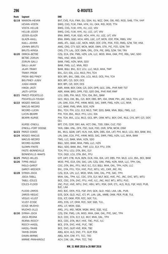
296 Q-ROUTES
Q118 MARION–HEVAN BVT, CVG, FLA, FWA, GIJ, GSH, IIU, MZZ, OKK, OXI, RID, ROD, SHB, TTH, VHP
HEVAN–VOSTK BWG, CVG, FLM, FWA, HYK, IIU, OKK, RID, ROD, TTH
VOSTK–HELUB BWG, CVG, FLM, HYK, IIU, LOZ, VXV
HELUB–JEDER BWG, CVG, FLM, HYK, IIU, LOZ, LVT, VXV
JEDER–GLAZR BNA, BWG, FLM, GQO, HCH, HYK, IIU, LOZ, LVT, VXV
GLAZR–KAILL BNA, BWG, GQO, HCH, HRS, LGC, LVT, MCN, ODF, PDK, RMG, VXV
KAILL–JOHNN AMG, ATL, GQO, LGC, MCN, MGR, ODF, OTK, PDK, PZD, RMG, SZW, TAY, VNA
JOHNN–BRUTS AMG, CRG, CTY, GEF, MCN, MGR, OMN, OTK, PIE, PZD, SZW, TAY
BRUTS–KPASA CRG, CTY, LAL, OCF, OMN, ORL, OTK, PIE, SRQ, SZW, TAY, TRV
Q120 ORRCA–BETBE CZQ, ECA, ENI, FMG, HZN, LIN, LLC, MOD, MVA, OAK, PYE, RBL, SAC, SDO
BETBE–ZORUN FMG, HNZ, MVA, SDO
ZORUN–GALLI BAM, FMG, HZN, MVA, SDO
GALLI–JAJAY BAM, FMG, LLC, MVA, REO
JAJAY–TRAKY BAM, BQU, BVL, ELY, LCU, LLC, MLD, MVA, TWF
TRAKY–PROXI BVL, ELY, IDA, LCU, MLD, PIH, TCH
PROXI–BIG PINEY BOY, BPI, BVL, DBS, IDA, LCU, MLD, OCS, PIH, TCH
BIG PINEY–JUGIV BOY, BPI, CZI, DDY, OCS
JUGIV–HIKOX BOY, BPI, CZI, DDY, OCS
HIKOX–JASTI ABR, ANW, BOY, CKW, CZI, DDY, DPR, GCC, ONL, PHP, RAP, TST
JASTI–UFFDA ABR, ANW, BRD, DPR, FSD, GEP, ONL, PHP, RAP, RWF
Q121 PARZZ–POCATELLO LCU, DBS, PIH, MLD, TCH, IDA, BVL, BAM
POCATELLO–TOUGH GCC, MLS, DIK, BIL, CZI, BOY, DBS, BPI, IDA, DNW, PIH, JAC, MLD, TCH, LCU
Q122 MOGEE–MACUS LIN, OAK, ECA, PYE, HNW, MOD, SAC, SWR, FMG, HZN, LLC, MVA
MACUS–MCORD LLC, BAM, FMG, MVA, SDO, HZN
MCORD–LUCIN BVL, TCH, PIH, LCU, ELY, MLD, TWF, SDO, BAM, MVA, BQU, FMG, LLC
LUCIN–BEARR PIH, TCH, BVL, MLD, FFU, LCU, IDA
BEARR–KURSE PIH, TCH, BVL, LCU, MLD, OCS, BPI, CKW, MTU, BOY, CHE, RLG, CYS, BFF, CZI, DDY, GLL
KURSE–O'NEILL BFF, CYS, CDR, SNY, AIA, HCT, ONL, TDD, OBH, CUZ, FSD
O'NEILL–FORT DODGE YKN, OBH, ONL, OFK, FSD, SUX, FOD, OVR, SPW, MCW, DSM
Q123 PARZZ–COKEE BIL, MLS, GGW, LWT, HLN, HIA, BZN, DBS, IDA, LKT, PIH, MLD, LCU, BOI, BAM, BVL
Q124 MOGEE–MACUS LIN, OAK, ECA, PYE, HNW, MOD, SAC, SWR, FMG, HZN, LLC, MVA, BAM
MACUS–MCORD FMG, LLC, BAM, MVA, HZN, SDO
MCORD–SLOWN BQU, SDO, BAM, MVA, FMG, LLC, HZN
SLOWN–FASTE BQU, SDO, BAM, BVL, TWF, LCU, ELY, FFU, DTA
FASTE–BONNEVILLE TCH, FFU, LCU, DTA, BVL, ELY
BONNEVILLE–WAATS TCH, OGD, LCU, DTA, BVL, FFU
Q125 PARZZ–WLLES GTF, LWT, CTB, HLN, BZN, DLN, HIA, IDA, LKT, DBS, PIH, MLD, LCU, BVL, BOI, BAM
Q126 TIPRE–INSLO MOD, PYE, ECA, ENI, SAC, LIN, CZQ, OAK, FMG, HZN, MVA, LLC, TPH, OAL
INSLO–GAROT CDC, DTA, BVL, FFU, MLF, ILC, ELY, BQU, MVA, OAL, TPH, HZN, LLC
GAROT–MEEKER BVL, DTA, FFU, TCH, HVE, PUC, MTU, VEL, EKR, JNC, RIL
Q128 SYRAH–JSICA CZQ, ECA, LIN, LLC, MOD, MVA, OAK, OAL, PYE, SAC, TPH.
JSICA–TABLL MVA, OAL, TPH, ILC, CDC, DTA, ELY, MLF, BCE, HVE, PIC, JNC, DVC, MTJ, MTU
TABLL–EDLES BCE, CDC, DTA, DVC, FFU, HVE, ILC, JNC, MLF, MTJ, MTU, PUC.
EDLES–FLOOD JNC, PUC, HVE, MTU, DVC, HBU, MTJ, RSK, EKR, ETL, ALS, RLG, FQF, HGO, PUB, BJC, LAA
FLOOD–ZAROS AKO, BJC, DEN, FCS, FQF, DVV, GCK, GLD, HGO, LAA, LBL, PUB.
ZAROS–VEGUC EOS, GCK, GLD, HLC, ICT, IFI, LAA, LBL, MMB, OKM, PER, PUB, TUL
VEGUC–VLUST EOS, ICT, OKM, PER, RZC, SGF, TUL.
VLUST–ECIGE ARG, EOS, LIT, OKM, RZC, SGF, SQS, TUL.
ECIGE–MUDHO ARG, LIT, MEM, SQS.
MUDHO–JILLS ARG, JYU, MEI, MEM, MGM, MHZ, SQS, VUZ.
Q130 SYRAH–JSICA CZQ, ENI, FMG, LIN, MOD, MVA, OAK, OAL, PYE, SAC, TPH
JSICA–REANA BLD, CDC, DTA, ELY, ILC, MLF, MVA, OAL, TPH
REANA–ROCCY BCE, CDC, DTA, MLF, HVE, TBC, PUC, ILC
ROCCY–HASSL BCE, DTA, DVC, HVE, PUC, TBC
HASSL–TAHIB BCE, DVC, GUP, HVE, RSK, TBC
TAHIB–DIXAN ABQ, ACH, ALS, DVC, FTI, GUP, RSK
DIXAN–MIRME ABQ, ACH, CIM, FTI, TCC, TXO
MIRME–PANHANDLE ACH, CIM, LBL, PNH, TCC, TXO
Route Segment DME
NW, 31 MAR 2016 to 26 MAY 2016
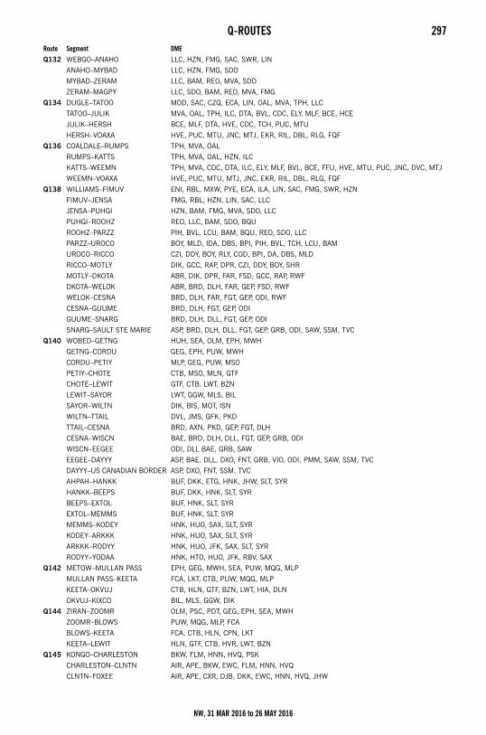
Q-ROUTES 297
Q132 WEBGO–ANAHO LLC, HZN, FMG, SAC, SWR, LIN
ANAHO–MYBAD LLC, HZN, FMG, SDO
MYBAD–ZERAM LLC, BAM, REO, MVA, SDO
ZERAM–MAGPY LLC, SDO, BAM, REO, MVA, FMG
Q134 DUGLE–TATOO MOD, SAC, CZQ, ECA, LIN, OAL, MVA, TPH, LLC
TATOO–JULIK MVA, OAL, TPH, ILC, DTA, BVL, CDC, ELY, MLF, BCE, HCE
JULIK–HERSH BCE, MLF, DTA, HVE, CDC, TCH, PUC, MTU
HERSH–VOAXA HVE, PUC, MTU, JNC, MTJ, EKR, RIL, DBL, RLG, FQF
Q136 COALDALE–RUMPS TPH, MVA, OAL
RUMPS–KATTS TPH, MVA, OAL, HZN, ILC
KATTS–WEEMN TPH, MVA, CDC, DTA, ILC, ELY, MLF, BVL, BCE, FFU, HVE, MTU, PUC, JNC, DVC, MTJ
WEEMN–VOAXA HVE, PUC, MTU, MTJ, JNC, EKR, RIL, DBL, RLG, FQF
Q138 WILLIAMS–FIMUV ENI, RBL, MXW, PYE, ECA, ILA, LIN, SAC, FMG, SWR, HZN
FIMUV–JENSA FMG, RBL, HZN, LIN, SAC, LLC
JENSA–PUHGI HZN, BAM, FMG, MVA, SDO, LLC
PUHGI–ROOHZ REO, LLC, BAM, SDO, BQU
ROOHZ–PARZZ PIH, BVL, LCU, BAM, BQU, REO, SDO, LLC
PARZZ–UROCO BOY, MLD, IDA, DBS, BPI, PIH, BVL, TCH, LCU, BAM
UROCO–RICCO CZI, DDY, BOY, RLY, COD, BPI, DA, DBS, MLD
RICCO–MOTLY DIK, GCC, RAP, DPR, CZI, DDY, BOY, SHR
MOTLY–DKOTA ABR, DIK, DPR, FAR, FSD, GCC, RAP, RWF
DKOTA–WELOK ABR, BRD, DLH, FAR, GEP, FSD, RWF
WELOK–CESNA BRD, DLH, FAR, FGT, GEP, ODI, RWF
CESNA–GUUME BRD, DLH, FGT, GEP, ODI
GUUME–SNARG BRD, DLH, DLL, FGT, GEP, ODI
SNARG–SAULT STE MARIE ASP, BRD, DLH, DLL, FGT, GEP, GRB, ODI, SAW, SSM, TVC
Q140 WOBED–GETNG HUH, SEA, OLM, EPH, MWH
GETNG–CORDU GEG, EPH, PUW, MWH
CORDU–PETIY MLP, GEG, PUW, MSO
PETIY–CHOTE CTB, MSO, MLN, GTF
CHOTE–LEWIT GTF, CTB, LWT, BZN
LEWIT–SAYOR LWT, GGW, MLS, BIL
SAYOR–WILTN DIK, BIS, MOT, ISN
WILTN–TTAIL DVL, JMS, GFK, PKD
TTAIL–CESNA BRD, AXN, PKD, GEP, FGT, DLH
CESNA–WISCN BAE, BRD, DLH, DLL, FGT, GEP, GRB, ODI
WISCN–EEGEE ODI, DLL BAE, GRB, SAW
EEGEE–DAYYY ASP, BAE, DLL, DXO, FNT, GRB, VIO, ODI, PMM, SAW, SSM, TVC
DAYYY–US CANADIAN BORDER ASP, DXO, FNT, SSM, TVC
AHPAH–HANKK BUF, DKK, ETG, HNK, JHW, SLT, SYR
HANKK–BEEPS BUF, DKK, HNK, SLT, SYR
BEEPS–EXTOL BUF, HNK, SLT, SYR
EXTOL–MEMMS BUF, HNK, SLT, SYR
MEMMS–KODEY HNK, HUO, SAX, SLT, SYR
KODEY–ARKKK HNK, HUO, SAX, SLT, SYR
ARKKK–RODYY HNK, HUO, JFK, SAX, SLT, SYR
RODYY–YODAA HNK, HTO, HUO, JFK, RBV, SAX
Q142 METOW–MULLAN PASS EPH, GEG, MWH, SEA, PUW, MQG, MLP
MULLAN PASS–KEETA FCA, LKT, CTB, PUW, MQG, MLP
KEETA–OKVUJ CTB, HLN, GTF, BZN, LWT, HIA, DLN
OKVUJ–KIXCO BIL, MLS, GGW, DIK
Q144 ZIRAN–ZOOMR OLM, PSC, PDT, GEG, EPH, SEA, MWH
ZOOMR–BLOWS PUW, MQG, MLP, FCA
BLOWS–KEETA FCA, CTB, HLN, CPN, LKT
KEETA–LEWIT HLN, GTF, CTB, HVR, LWT, BZN
Q145 KONGO–CHARLESTON BKW, FLM, HNN, HVQ, PSK
CHARLESTON–CLNTN AIR, APE, BKW, EWC, FLM, HNN, HVQ
CLNTN–FOXEE AIR, APE, CXR, DJB, DKK, EWC, HNN, HVQ, JHW
Route Segment DME
NW, 31 MAR 2016 to 26 MAY 2016
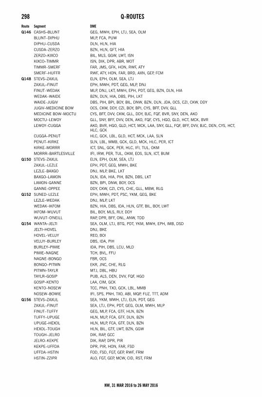
298 Q-ROUTES
Q146 CASHS–BLUNT GEG, MWH, EPH, LTJ, SEA, OLM
BLUNT–DIPHU MLP, FCA, PUW
DIPHU–CUSDA DLN, HLN, HIA
CUSDA–ZERZO BZN, HLN, GFT, HIA
ZERZO–KIXCO BIL, MLS, GGW, LWT, ISN
KIXCO–TIMMR ISN, DIK, DPR, ABR, MOT
TIMMR–SMERF FAR, JMS, GFK, HON, RWF, ATY
SMERF–HUFFR RWF, ATY, HON, FAR, BRD, AXN, GEP, FCM
Q148 STEVS–ZAXUL ELN, EPH, OLM, SEA, LTJ
ZAXUL–FINUT EPH, MWH, PDT, GEG, MLP, DNJ
FINUT–WEDAK MLP, DNJ, LKT, MWH, EPH, PDT, GEG, BZN, DLN, HIA
WEDAK–WAIDE BZN, DLN, HIA, DBS, PIH, LKT
WAIDE–JUGIV DBS, PIH, BPI, BOY, BIL, DNW, BZN, DLN, JDA, OCS, CZI, CKW, DDY
JUGIV–MEDICINE BOW OCS, CKW, DDY, CZI, BOY, BPI, CYS, BFF, DVV, GLL
MEDICINE BOW–MOCTU CYS, BFF, DVV, CKW, GLL, DDY, BJC, FQF, BVR, SNY, DEN, AKO
MOCTU–LEWOY GLL, SNY, BFF, DVV, DEN, AKO, FQF, CYS, HGO, GLD, HCT, MCK, BVR
LEWOY–CUGGA AKO, BVR, HGO, GLD, HCT, MCK, LAA, SNY, GLL, FQF, BFF, DVV, BJC, DEN, CYS, HCT, HLC, GCK
CUGGA–PENUT HLC, GCK, LBL, GLD, HCT, MCK, LAA, SLN
PENUT–KIRKE SLN, LBL, MMB, GCK, GLD, MCK, HLC, PER, ICT
KIRKE–MORRR ICT, SNL, GCK, PER, HLC, IFI, TUL, OKM
MORRR–BARTLESVILLE IFI, IRW, PER, TUL, OKM, EOS, SLN, ICT, BUM
Q150 STEVS–ZAXUL ELN, EPH, OLM, SEA, LTJ
ZAXUL–LEZLE EPH, PDT, GEG, MWH, BKE
LEZLE–BAXGO DNJ, MLP, BKE, LKT
BAXGO–LAMON DLN, IDA, HIA, PIH, BZN, DBS, LKT
LAMON–GANNE BZN, BPI, DNW, BOY, OCS
GANNE–OPPEE DDY, CKW, CZI, CYS, CHE, GLL, MBW, RLG
Q152 SUNED–LEZLE EPH, MWH, PDT, PSC, YKM, GEG, BKE
LEZLE–WEDAK DNJ, MLP, LKT
WEDAK–IKFOM BZN, HIA, DBS, IDA, HLN, GTF, BIL, BOY, LWT
IKFOM–WUVUT BIL, BOY, MLS, RLY, DDY
WUVUT–O'NEILL RAP, DPR, BFF, ONL, ANW, TDD
Q154 WANTA–JELTI SEA, OLM, LTJ, BTG, PDT, YKM, MWH, EPH, IMB, DSD
JELTI–HOVEL DNJ, BKE
HOVEL–VELUY REO, BOI
VELUY–BURLEY DBS, IDA, PIH
BURLEY–PIMIE IDA, PIH, DBS, LCU, MLD
PIMIE–NAGNE TCH, BVL, FFU
NAGNE–BONGO FBR, OCS
BONGO–PITMN EKR, JNC, CHE, RLG
PITMN–TAYLR MTJ, DBL, HBU
TAYLR–GOSIP PUB, ALS, DEN, DVV, FQF, HGO
GOSIP–KENTO LAA, CIM, GCK
KENTO–NOSEW TCC, PNH, TXO, GCK, LBL, MMB
NOSEW–BOWIE IFI, SPS, PNH, TXO, ABI, MQP, FUZ, TTT, ADM
Q156 STEVS–ZAXUL SEA, YKM, MWH, LTJ, ELN, PDT, GEG
ZAXUL–FINUT SEA, LTJ, EPH, PDT, GEG, OLM, MWH, MLP
FINUT–TUFFY GEG, MLP, FCA, GTF, HLN, BZN
TUFFY–UPUGE HLN, MLP, FCA, GTF, DLN, BZN
UPUGE–HEXOL HLN, MLP, FCA, GTF, DLN, BZN
HEXOL–TOUGH HLN, BIL, GTF, LWT, BZN, GGW
TOUGH–JELRO DIK, RAP, GCC
JELRO–KEKPE DIK, RAP, DPR, PIR
KEKPE–UFFDA DPR, PIR, HON, FAR, FSD
UFFDA–HSTIN FOD, FSD, FGT, GEP, RWF, FRM
HSTIN–ZZIPR ALO, FGT, GEP, MCW, CID, RST, FRM
Route Segment DME
NW, 31 MAR 2016 to 26 MAY 2016
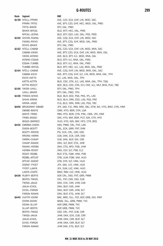
Q-ROUTES 299
Q158 NTELL–PPARK AVE, CZO, ECA, EHF, LIN, MOD, SAC.
PPARK–TRTIS AVE, BTY, CZO, EHF, HEC, MOD, OAL, PMD.
TRTIS–BIKKR BTY, OAL, PMD
BIKKR–MYCAL BLD, BTY, HEC, OAL, PMD
MYCAL–JEDNA BLD, BTY, EED, LAS, OAL, PGS, PMD.
Q160 SHVVR–FAANG AVE, CZQ, ECA, EHF, LIN, MOD, SAC
FAANG–RIVVO AVE, BTY, CZQ, EHF, MOD, OAL, PMD
RIVVO–BIKKR BTY, OAL, PMD
Q162 NTELL–CABAB AVE, CZO, ECA, EHF, LIN, MOD, MVA, SAC
CABAB–VIKSN AVE, BTY, CZO, ECA, EHF, LIN, MOD, MVA, OAL
VIKSN–KENNO AVE, BLD, BTY, ILC, MOD, MVA, OAL
KENNO–ESSAA BLD, BTY, ILC, MVA, OAL, PMD
ESSAA–TUMBE BLD, BTY, ILC, MVA, OAL, PMD
TUMBE–MYCAL BLD, BTY, HEC, ILC, LAS, MVA, OAL, PMD
Q164 NTELL–CABAB AVE, CZQ, EHF, LIN, MOD, MVA, OAL, SAC
CABAB–KICHI AVE, BTY, CZQ, EHF, ILC, LIN, MOD, MVA, OAL, TPH
KICHI–KATTS ILC, LAS, MVA, OAL, TPH
KATTS–KITTN BLD, CDC, DTA, ILC, LAS, MVA, OAL, TPH, TQQ
KITTN–ROCCY BCE, BLD, CDC, DTA, ELY, HVE, ILC, MLF, MVA, PUC, TBC
Q166 VIKSN–UHILL BTY, OAL, PMD, TPH
UHILL–BIKKR BTY, OAL, PMD, TPH
Q168 FNNDA–SHIVA BLD, BLH, EED, PGS, PKE, IPL, LAS
SHIVA–KRINA BLD, BLH, DRK, EED, LAS, PGS, PKE
KRINA–JASSE FLG, BLD, DRK, INW, LAS, PGS, TBC
Q406 BROADWAY–DBABE JFK, SAX, FJC, RBV, ARD, SBJ, STW, SIE, HTO, BWZ, CYN, HNK
DBABE–BASYE CMK, HTO, BDR, CYN, LGA
BASYE–TRIBS RBV, HTO, BDR, CYN, PWL, CMK, JFK, HNK
TRIBS–BIGGO SAX, HTO, BAF, BDR, PUT, IGN, CTR, HFD
BIGGO–BARNES HUO, HTO, IGN, BAF, HFD, CTR, BOS
Q436 EMMMA–DIXSN DXO, PMM, CRL, FNT, LAN
DIXSN–BOOTT CRL, ECK, GRR, FNT, SVM
BOOTT–RRONS PSI, ECK, CRL, CXR, DXO
RRONS–YARRK OJB, DKK, ECK, CXR, DXO
YARRK–CHAAP DJB, DKK, BUF, ERI, CXR
CHAAP–RAAKK DKK, SLT, BUF, ETG, JHW
RAAKK–HERBA DKK, ETG, BFD, PSB, JHW
HERBA–REXXY OKK, EGT, SLT, PSB, ELZ
REXXY–REBBL BUF, ETG, FQM, HNK, PSB
REBBL–MTCAF CFB, ULW, FQM, SAX, HUO
MTCAF–DGRAF CFB, SYR, SLT, HNK, HUO
DGRAF–YYOST JFK, SAX, LVZ, HNK, HUO
YYOST–LAAYK JFK, SLW, LVZ, HNK, HUO
LAAYK–COATE BWZ, RBV, LVZ, HNK, HUO
Q438 RUBYY–BERYS ASP, CRL, DXO, FNT, GRR, PMM
BERYS–TWIGS CRL, FNT, CXR, DXO, DJB
TWIGS–JAAJA DKK, ECK, CXR, JHW, DJB
JAAJA–ICHOL DKK, BUF, CXR, JHW
ICHOL–FARGN DKK, BUF, CXR, JHW, SLT
FARGN–RAAKK DKK, BUF, ETG, JHW, SLT
Q440 HUFFR–IDIOM BAE, BRD, DLL, FGT, GEP, GRB, ODI, RWF
IDIOM–DEANI BAAE, DLL, GRB, PMM, TVC
DEANI–SLLAP ASP, GRB, PMM, TVC
SLLAP–BERYS ASP, GRB, PMM, TVC
BERYS–TWIGS DXO, CRL, FNT, DJB, CXR
TWIGS–JAAJA JHW, DKK, ECK, DJB, CXR
JAAJA–ICHOL JHW, DKK, CXR, BUF, SLT
ICHOL–FARGN JHW, DKK, CXR, BUF, SLT
FARGN–RAAKK JHW DKK, ETG, BUF, SLT
Route Segment DME
NW, 31 MAR 2016 to 26 MAY 2016
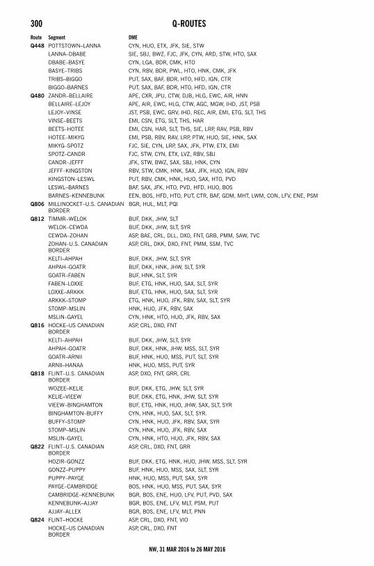
300 Q-ROUTES
Q448 POTTSTOWN–LANNA CYN, HUO, ETX, JFK, SIE, STW
LANNA–DBABE SIE, SBJ, BWZ, FJC, JFK, CYN, ARD, STW, HTO, SAX
DBABE–BASYE CYN, LGA, BDR, CMK, HTO
BASYE–TRIBS CYN, RBV, BDR, PWL, HTO, HNK, CMK, JFK
TRIBS–BIGGO PUT, SAX, BAF, BDR, HTO, HFD, IGN, CTR
BIGGO–BARNES PUT, SAX, BAF, BDR, HTO, HFD, IGN, CTR
Q480 ZANDR–BELLAIRE APE, CXR, JPU, CTW, DJB, HLG, EWC, AIR, HNN
BELLAIRE–LEJOY APE, AIR, EWC, HLG, CTW, AGC, MGW, IHD, JST, PSB
LEJOY–VINSE JST, PSB, EWC, GRV, IHD, REC, AIR, EMI, ETG, SLT, THS
VINSE–BEETS EMI, CSN, ETG, SLT, THS, HAR
BEETS–HOTEE EMI, CSN, HAR, SLT, THS, SIE, LRP, RAV, PSB, RBV
HOTEE–MIKYG EMI, PSB, RBV, RAV, LRP, PTW, HUO, SIE, HNK, SAX
MIKYG–SPOTZ FJC, SIE, CYN, LRP, SAX, JFK, PTW, ETX, EMI
SPOTZ–CANDR FJC, STW, CYN, ETX, LVZ, RBV, SBJ
CANDR–JEFFF JFK, STW, BWZ, SAX, SBJ, HNK, CYN
JEFFF–KINGSTON RBV, STW, CMK, HNK, SAX, JFK, HUO, IGN, RBV
KINGSTON–LESWL PUT, RBV, CMK, HNK, HUO, SAX, HTO, PVD
LESWL–BARNES BAF, SAX, JFK, HTO, PVD, HFD, HUO, BOS
BARNES–KENNEBUNK EEN, BOS, HFD, HTO, PUT, CTR, BAF, GDM, MHT, LWM, CON, LFV, ENE, PSM
Q806 MILLINOCKET–U.S. CANADIAN BORDER
BGR, HUL, MLT, PQI
Q812 TIMMR–WELOK BUF, DKK, JHW, SLT
WELOK–CEWDA BUF, DKK, JHW, SLT, SYR
CEWDA–ZOHAN ASP, BAE, CRL, DLL, DXO, FNT, GRB, PMM, SAW, TVC
ZOHAN–U.S. CANADIAN BORDER
ASP, CRL, DKK, DXO, FNT, PMM, SSM, TVC
KELTI–AHPAH BUF, DKK, JHW, SLT, SYR
AHPAH–GOATR BUF, DKK, HNK, JHW, SLT, SYR
GOATR–FABEN BUF, HNK, SLT, SYR
FABEN–LOXXE BUF, ETG, HNK, HUO, SAX, SLT, SYR
LOXXE–ARKKK BUF, ETG, HNK, HUO, SAX, SLT, SYR
ARKKK–STOMP ETG, HNK, HUO, JFK, RBV, SAX, SLT, SYR
STOMP–MSLIN HNK, HUO, JFK, RBV, SAX
MSLIN–GAYEL CYN, HNK, HTO, HUO, JFK, RBV, SAX
Q816 HOCKE–US CANADIAN BORDER
ASP, CRL, DXO, FNT
KELTI–AHPAH BUF, DKK, JHW, SLT, SYR
AHPAH–GOATR BUF, DKK, HNK, JHW, MSS, SLT, SYR
GOATR–ARNII BUF, HNK, HUO, MSS, PUT, SLT, SYR
ARNII–HANAA HNK, HUO, MSS, PUT, SYR
Q818 FLINT–U.S. CANADIAN BORDER
ASP, DXO, FNT, GRR, CRL
WOZEE–KELIE BUF, DKK, ETG, JHW, SLT, SYR
KELIE–VIEEW BUF, DKK, ETG, HNK, JHW, SLT, SYR
VIEEW–BINGHAMTON BUF, ETG, HNK, HUO, JHW, SAX, SLT, SYR
BINGHAMTON–BUFFY CYN, HNK, HUO, SAX, SLT, SYR.
BUFFY–STOMP CYN, HNK, HUO, JFK, RBV, SAX, SYR
STOMP–MSLIN CYN, HNK, HUO, JFK, RBV, SAX
MSLIN–GAYEL CYN, HNK, HTO, HUO, JFK, RBV, SAX
Q822 FLINT–U.S. CANADIAN BORDER
ASP, CRL, DXO, FNT, GRR
HOZIR–GONZZ BUF, DKK, ETG, HNK, HUO, JHW, MSS, SLT, SYR
GONZZ–PUPPY BUF, HNK, HUO, MSS, SAX, SLT, SYR
PUPPY–PAYGE HNK, HUO, MSS, PUT, SAX, SYR
PAYGE–CAMBRIDGE BOS, HNK, HUO, MSS, PUT, SAX, SYR
CAMBRIDGE–KENNEBUNK BGR, BOS, ENE, HUO, LFV, PUT, PVD, SAX
KENNEBUNK–AJJAY BGR, BOS, ENE, LFV, MLT, PSM, PUT
AJJAY–ALLEX BGR, BOS, ENE, LFV, MLT, PNN
Q824 FLINT–HOCKE ASP, CRL, DXO, FNT, VIO
HOCKE–US CANADIAN BORDER
ASP, CRL, DXO, FNT
Route Segment DME
NW, 31 MAR 2016 to 26 MAY 2016
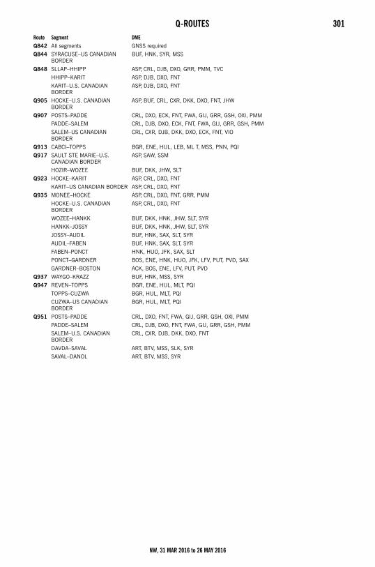
Q-ROUTES 301
Q842 All segments GNSS required
Q844 SYRACUSE–US CANADIAN BORDER
BUF, HNK, SYR, MSS
Q848 SLLAP–HHIPP ASP, CRL, DJB, DXO, GRR, PMM, TVC
HHIPP–KARIT ASP, DJB, DXO, FNT
KARIT–U.S. CANADIAN BORDER
ASP, DJB, DXO, FNT
Q905 HOCKE–U.S. CANADIAN BORDER
ASP, BUF, CRL, CXR, DKK, DXO, FNT, JHW
Q907 POSTS–PADDE CRL, DXO, ECK, FNT, FWA, GIJ, GRR, GSH, OXI, PMM
PADDE–SALEM CRL, DJB, DXO, ECK, FNT, FWA, GIJ, GRR, GSH, PMM
SALEM–US CANADIAN BORDER
CRL, CXR, DJB, DKK, DXO, ECK, FNT, VIO
Q913 CABCI–TOPPS BGR, ENE, HUL, LEB, ML T, MSS, PNN, PQI
Q917 SAULT STE MARIE–U.S. CANADIAN BORDER
ASP, SAW, SSM
HOZIR–WOZEE BUF, DKK, JHW, SLT
Q923 HOCKE–KARIT ASP, CRL, DXO, FNT
KARIT–US CANADIAN BORDER ASP, CRL, DXO, FNT
Q935 MONEE–HOCKE ASP, CRL, DXO, FNT, GRR, PMM
HOCKE–U.S. CANADIAN BORDER
ASP, CRL, DXO, FNT
WOZEE–HANKK BUF, DKK, HNK, JHW, SLT, SYR
HANKK–JOSSY BUF, DKK, HNK, JHW, SLT, SYR
JOSSY–AUDIL BUF, HNK, SAX, SLT, SYR
AUDIL–FABEN BUF, HNK, SAX, SLT, SYR
FABEN–PONCT HNK, HUO, JFK, SAX, SLT
PONCT–GARDNER BOS, ENE, HNK, HUO, JFK, LFV, PUT, PVD, SAX
GARDNER–BOSTON ACK, BOS, ENE, LFV, PUT, PVD
Q937 WAYGO–KRAZZ BUF, HNK, MSS, SYR
Q947 REVEN–TOPPS BGR, ENE, HUL, MLT, PQI
TOPPS–CUZWA BGR, HUL, MLT, PQI
CUZWA–US CANADIAN BORDER
BGR, HUL, MLT, PQI
Q951 POSTS–PADDE CRL, DXO, FNT, FWA, GIJ, GRR, GSH, OXI, PMM
PADDE–SALEM CRL, DJB, DXO, FNT, FWA, GIJ, GRR, GSH, PMM
SALEM–U.S. CANADIAN BORDER
CRL, CXR, DJB, DKK, DXO, FNT
DAVDA–SAVAL ART, BTV, MSS, SLK, SYR
SAVAL–DANOL ART, BTV, MSS, SYR
Route Segment DME
NW, 31 MAR 2016 to 26 MAY 2016
302 HIGH ALTITUDE REDESIGN (HAR) PHASE 1 RNAV ROUTINGHigh Altitude Redesign (HAR) Phase 1 RNAV Routing
RNAV Routing Pitch and Catch PointsThe purpose of this section of the Special High Altitude Routes is to present user routing options for flight within the initial HARPhase I expansion airspace. Users are able to fly user-preferred routes, referred to as non-restrictive routing (NRR), between specificfixes described by pitch (entry into) and catch (exit out of) fixes in the HAR airspace. Pitch points indicate an end of departureprocedures, preferred IFR routings, or other established routing programs where a flight can begin a segment of NRR. The catchpoint indicates where a flight ends a segment of NRR and joins published arrival procedures, preferred IFR routing, or otherestablished routing programs.
The HAR Phase I expansion airspace is defined as that airspace at and above FL 350 in fourteen of the western and southern AirRoute Traffic Control Centers (ARTCCs). The airspace includes Minneapolis (ZMP), Chicago (ZAU), Kansas City (ZKC), Denver (ZDV),Salt Lake City (ZLC), Oakland (ZOA), Seattle Centers (ZSE), Los Angeles (ZLA), Albuquerque (ZAB), Fort Worth (ZFW), Memphis(ZME), and Houston (ZHU). Jacksonville (ZJX) and Miami (ZMA) are included for east-west routes only.
To develop a flight plan, select pitch and catch points based upon your desired route across the Phase I airspace. Filing requirementsto pitch points, and from catch points, remain unchanged from current procedures. For the portion of the route between the pitchand catch points, non-restrictive routing is permitted.
Where pitch points for a specific airport are not identified, aircraft should file an appropriate departure procedure (DP), or any otheruser preferred routing prior to the NRR portion of their routing. Where catch points for a specific airport are not identified aircraftshould file, after the NRR portion of their routing, an appropriate arrival procedure or other user preferred routing to their destination.
Additionally, information concerning the location and schedule of Special Use Airspace (SUA) and Air Traffic Control AssignedAirspace (ATCAA) can be found on the Web Site: http://sua.faa.gov/sua/Welcome.do. ATCAA refers to airspace in the high altitudestructure supporting military and other special operations. Users are encouraged to file around these areas when they are scheduledto be active, thereby avoiding unplanned reroutes around them.
In conjunction with the HAR program RNAV routes have been established to provide for a systematic flow of air traffic in specificportions of the enroute flight environment. The designator for these RNAV routes begin with the letter Q, for example, Q-501. Wherethose routes aid in the efficient orderly management of air traffic they will be published as preferred IFR routes.
NW, 31 MAR 2016 to 26 MAY 2016
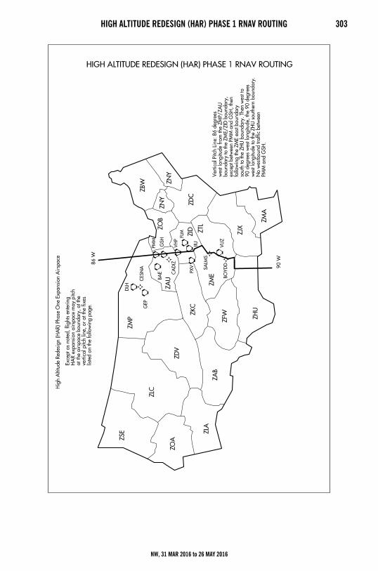
HIGH ALTITUDE REDESIGN (HAR) PHASE 1 RNAV ROUTING 303
NW, 31 MAR 2016 to 26 MAY 2016
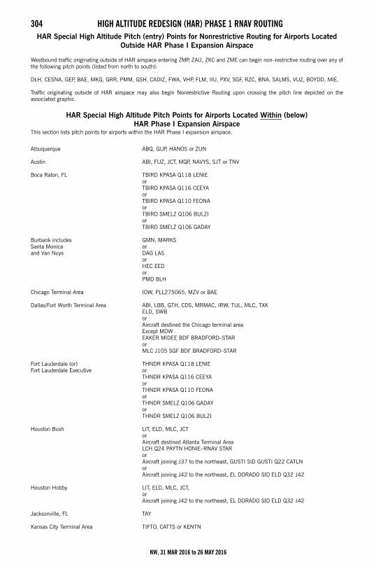
304 HIGH ALTITUDE REDESIGN (HAR) PHASE 1 RNAV ROUTINGHAR Special High Altitude Pitch (entry) Points for Nonrestrictive Routing for Airports Located
Outside HAR Phase I Expansion Airspace
Westbound traffic originating outside of HAR airspace entering ZMP, ZAU, ZKC and ZME can begin non–restrictive routing over any ofthe following pitch points (listed from north to south):
DLH, CESNA, GEP, BAE, MKG, GRR, PMM, GSH, CADIZ, FWA, VHP, FLM, IIU, PXV, SGF, RZC, BNA, SALMS, VUZ, BOYDD, MIE.
Traffic originating outside of HAR airspace may also begin Nonrestrictive Routing upon crossing the pitch line depicted on theassociated graphic.
HAR Special High Altitude Pitch Points for Airports Located Within (below) HAR Phase I Expansion Airspace
This section lists pitch points for airports within the HAR Phase I expansion airspace.
Albuquerque ABQ, GUP, HANOS or ZUN
Austin ABI, FUZ, JCT, MQP, NAVYS, SJT or TNV
Boca Raton, FL TBIRD KPASA Q118 LENIEorTBIRD KPASA Q116 CEEYAorTBIRD KPASA Q110 FEONAorTBIRD SMELZ Q106 BULZIorTBIRD SMELZ Q106 GADAY
Burbank includes Santa Monicaand Van Nuys
GMN, MARKSorDAG LASorHEC EEDorPMD BLH
Chicago Terminal Area IOW, PLL275065, MZV or BAE
Dallas/Fort Worth Terminal Area ABI, LBB, GTH, CDS, MRMAC, IRW, TUL, MLC, TXK ELD, SWBorAircraft destined the Chicago terminal area Except MDWEAKER MIDEE BDF BRADFORD–STARorMLC J105 SGF BDF BRADFORD–STAR
Fort Lauderdale (or)Fort Lauderdale Executive
THNDR KPASA Q118 LENIEorTHNDR KPASA Q116 CEEYAorTHNDR KPASA Q110 FEONAorTHNDR SMELZ Q106 GADAYorTHNDR SMELZ Q106 BULZI
Houston Bush LIT, ELD, MLC, JCTorAircraft destined Atlanta Terminal Area LCH Q24 PAYTN HONIE–RNAV STARor Aircraft joining J37 to the northeast, GUSTI SID GUSTI Q22 CATLNorAircraft joining J42 to the northeast, EL DORADO SID ELD Q32 J42
Houston Hobby LIT, ELD, MLC, JCT,orAircraft joining J42 to the northeast, EL DORADO SID ELD Q32 J42
Jacksonville, FL TAY
Kansas City Terminal Area TIFTO, CATTS or KENTN
NW, 31 MAR 2016 to 26 MAY 2016
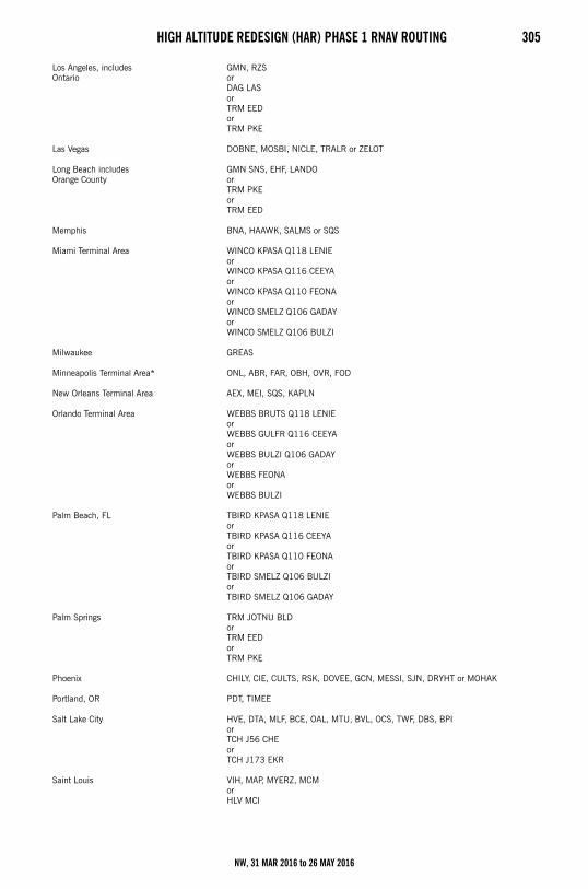
HIGH ALTITUDE REDESIGN (HAR) PHASE 1 RNAV ROUTING 305
Los Angeles, includes Ontario
GMN, RZSorDAG LASor TRM EEDorTRM PKE
Las Vegas DOBNE, MOSBI, NICLE, TRALR or ZELOT
Long Beach includesOrange County
GMN SNS, EHF, LANDOorTRM PKEorTRM EED
Memphis BNA, HAAWK, SALMS or SQS
Miami Terminal Area WINCO KPASA Q118 LENIEorWINCO KPASA Q116 CEEYAorWINCO KPASA Q110 FEONAorWINCO SMELZ Q106 GADAYor WINCO SMELZ Q106 BULZI
Milwaukee GREAS
Minneapolis Terminal Area* ONL, ABR, FAR, OBH, OVR, FOD
New Orleans Terminal Area AEX, MEI, SQS, KAPLN
Orlando Terminal Area WEBBS BRUTS Q118 LENIEorWEBBS GULFR Q116 CEEYAorWEBBS BULZI Q106 GADAYorWEBBS FEONAorWEBBS BULZI
Palm Beach, FL TBIRD KPASA Q118 LENIEorTBIRD KPASA Q116 CEEYAorTBIRD KPASA Q110 FEONAorTBIRD SMELZ Q106 BULZIorTBIRD SMELZ Q106 GADAY
Palm Springs TRM JOTNU BLDorTRM EEDorTRM PKE
Phoenix CHILY, CIE, CULTS, RSK, DOVEE, GCN, MESSI, SJN, DRYHT or MOHAK
Portland, OR PDT, TIMEE
Salt Lake City HVE, DTA, MLF, BCE, OAL, MTU, BVL, OCS, TWF, DBS, BPIorTCH J56 CHEorTCH J173 EKR
Saint Louis VIH, MAP, MYERZ, MCMorHLV MCI
NW, 31 MAR 2016 to 26 MAY 2016
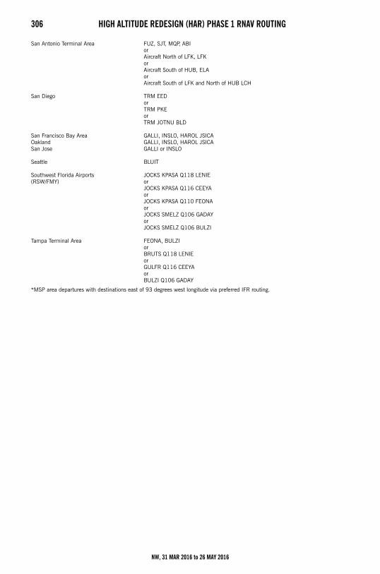
306 HIGH ALTITUDE REDESIGN (HAR) PHASE 1 RNAV ROUTING
*MSP area departures with destinations east of 93 degrees west longitude via preferred IFR routing.
San Antonio Terminal Area FUZ, SJT, MQP, ABIorAircraft North of LFK, LFKorAircraft South of HUB, ELAorAircraft South of LFK and North of HUB LCH
San Diego TRM EEDorTRM PKEorTRM JOTNU BLD
San Francisco Bay AreaOaklandSan Jose
GALLI, INSLO, HAROL JSICAGALLI, INSLO, HAROL JSICAGALLI or INSLO
Seattle BLUIT
Southwest Florida Airports (RSW/FMY)
JOCKS KPASA Q118 LENIEorJOCKS KPASA Q116 CEEYAorJOCKS KPASA Q110 FEONAorJOCKS SMELZ Q106 GADAYorJOCKS SMELZ Q106 BULZI
Tampa Terminal Area FEONA, BULZIorBRUTS Q118 LENIEorGULFR Q116 CEEYAorBULZI Q106 GADAY
NW, 31 MAR 2016 to 26 MAY 2016
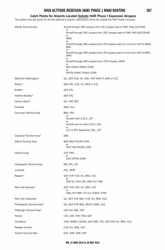
HIGH ALTITUDE REDESIGN (HAR) PHASE 1 RNAV ROUTING 307Catch Points for Airports Located Outside HAR Phase I Expansion Airspace
This section lists exit points for aircraft destined to specific destinations which are outside the HAR Phase I airspace.
Atlanta Terminal Area Aircraft through ZME airspace from ZKC airspace east of FAM, Pless Q19 BNAorAircraft through ZME airspace from ZKC airspace west of FAM, ARG Q26 DEVACorMEMorAircraft through ZME airspace from ZID airspace west of a line from VHP to BWG, BNAorAircraft through ZME airspace from ZID airspace east of a line from VHP to BWG, BWGorAircraft through ZME airspace from ZFW airspace, MEMorMEI HONIE (RNAV)–STARorPATYN HONIE (RNAV)–STAR
Baltimore–Washington* GIJ, GEP, FLM, IIU, BAE, VHP, WHETT, BNA or VUZ
Boston* GEP, CRL, ECK, IIU, BNA or VUZ
Buffalo* GEP, CRL
Hartford Bradley* GEP, CRL
Canton–Akron* GIJ, VHP, GEP
Charlotte BNA, VUZ
Cincinnati Terminal Area BNA, PXV orAircraft north of SLC, JOTorAircraft over or south of SLC, ENLorSLC or SFO departures, ENL, JOT
Cleveland Terminal Area* OBK
Detroit Terminal Area BAE MKG POLAR–STARorVHP FWA MIZAR–STAR
Detroit Young VHP FWAorLAN SPRTN–STAR
Indianapolis Terminal Area BIB, SPI, JOT
Louisville ENL, MEM
Newark* GEP, VHP, FLM, IIU, BNA, VUZorIOW GIJ J554 CRL J584 SLT FQM
New York Kennedy* GEP, VHP, FLM, IIU, BNA, VUZorDBQ J94 PMM J70 LVZ LENDY–STAR
New York LaGuardia* GIJ, GEP, VHP, BAE, FLM, IIU, BNA, VUZ
Philadelphia Terminal Area* GIJ, GEP, VHP, BAE, WHETT, BNA, VUZ
Pittsburgh Terminal Area* VHP, GIJ, BAE, GEP
Pontiac LFD, LAN, VHP, FWA, GEP
Providence JHW, HEMDI, CESNA, GEP, GRB, TVC, ASP, VHP, IIU, BNA, VUZ
Raleigh–Durham FLM, IIU, BNA, VUZ
Toronto Terminal Area ECK, SVM, SSM, GEP
NW, 31 MAR 2016 to 26 MAY 2016
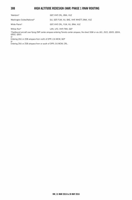
308 HIGH ALTITUDE REDESIGN (HAR) PHASE 1 RNAV ROUTING
*Eastbound aircraft over flying ZMP center airspace entering Toronto center airspace, file direct SSM or via J63, J522, Q505, Q504,Q502, Q501orEntering ZAU or ZOB airspace from north of DPR J16 MCW, GEP orEntering ZAU or ZOB airspace from or south of DPR J16 MCW, CRL.
Teterboro* GEP, VHP, CRL, BNA, VUZ
Washington Dulles/National* GIJ, GEP, FLM, IIU, BAE, VHP, WHETT, BNA, VUZ
White Plains* GEP, VHP, CRL, FLM, IIU, BNA, VUZ
Willow Run* LAN, LFD, VHP, FWA, GEP
NW, 31 MAR 2016 to 26 MAY 2016
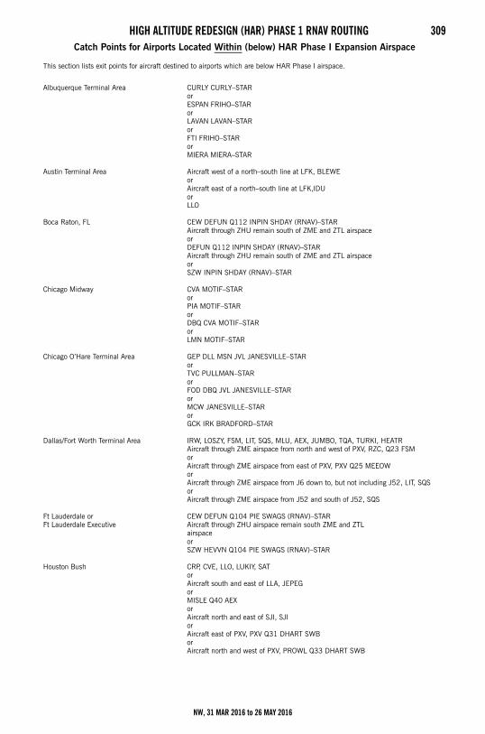
HIGH ALTITUDE REDESIGN (HAR) PHASE 1 RNAV ROUTING 309Catch Points for Airports Located Within (below) HAR Phase I Expansion Airspace
This section lists exit points for aircraft destined to airports which are below HAR Phase I airspace.
Albuquerque Terminal Area CURLY CURLY–STARorESPAN FRIHO–STARorLAVAN LAVAN–STARorFTI FRIHO–STARorMIERA MIERA–STAR
Austin Terminal Area Aircraft west of a north–south line at LFK, BLEWEorAircraft east of a north–south line at LFK,IDUorLLO
Boca Raton, FL CEW DEFUN Q112 INPIN SHDAY (RNAV)–STARAircraft through ZHU remain south of ZME and ZTL airspace orDEFUN Q112 INPIN SHDAY (RNAV)–STARAircraft through ZHU remain south of ZME and ZTL airspace orSZW INPIN SHDAY (RNAV)–STAR
Chicago Midway CVA MOTIF–STARorPIA MOTIF–STARorDBQ CVA MOTIF–STARorLMN MOTIF–STAR
Chicago O’Hare Terminal Area GEP DLL MSN JVL JANESVILLE–STARorTVC PULLMAN–STARorFOD DBQ JVL JANESVILLE–STARorMCW JANESVILLE–STARorGCK IRK BRADFORD–STAR
Dallas/Fort Worth Terminal Area IRW, LOSZY, FSM, LIT, SQS, MLU, AEX, JUMBO, TQA, TURKI, HEATRAircraft through ZME airspace from north and west of PXV, RZC, Q23 FSMor Aircraft through ZME airspace from east of PXV, PXV Q25 MEEOWorAircraft through ZME airspace from J6 down to, but not including J52, LIT, SQSor Aircraft through ZME airspace from J52 and south of J52, SQS
Ft Lauderdale orFt Lauderdale Executive
CEW DEFUN Q104 PIE SWAGS (RNAV)–STARAircraft through ZHU airspace remain south ZME and ZTL airspaceorSZW HEVVN Q104 PIE SWAGS (RNAV)–STAR
Houston Bush CRP, CVE, LLO, LUKIY, SATorAircraft south and east of LLA, JEPEGorMISLE Q40 AEXorAircraft north and east of SJI, SJIorAircraft east of PXV, PXV Q31 DHART SWBorAircraft north and west of PXV, PROWL Q33 DHART SWB
NW, 31 MAR 2016 to 26 MAY 2016
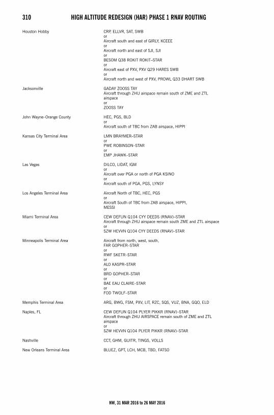
310 HIGH ALTITUDE REDESIGN (HAR) PHASE 1 RNAV ROUTING
Houston Hobby CRP, ELLVR, SAT, SWBorAircraft south and east of GIRLY, KCEEEorAircraft north and east of SJI, SJIorBESOM Q38 ROKIT ROKIT–STARorAircraft east of PXV, PXV Q29 HARES SWBorAircraft north and west of PXV, PROWL Q33 DHART SWB
Jacksonville GADAY ZOOSS TAYAircraft through ZHU airspace remain south of ZME and ZTL airspaceorZOOSS TAY
John Wayne–Orange County HEC, PGS, BLDorAircraft south of TBC from ZAB airspace, HIPPI
Kansas City Terminal Area LMN BRAYMER–STARorPWE ROBINSON–STARorEMP JHAWK–STAR
Las Vegas DILCO, LIDAT, IGMorAircraft over PGA or north of PGA KSINOorAircraft south of PGA, PGS, LYNSY
Los Angeles Terminal Area Aircraft North of TBC, HEC, PGSorAircraft South of TBC from ZAB airspace, HIPPI,MESSI
Miami Terminal Area CEW DEFUN Q104 CYY DEEDS (RNAV)–STARAircraft through ZHU airspace remain south ZME and ZTL airspaceorSZW HEVVN Q104 CYY DEEDS (RNAV)–STAR
Minneapolis Terminal Area Aircraft from north, west, south,FAR GOPHER–STARorRWF SKETR–STARorALO KASPR–STARorBRD GOPHER–STARorBAE EAU CLAIRE–STARorFOD TWOLF–STAR
Memphis Terminal Area ARG, BWG, FSM, PXV, LIT, RZC, SQS, VUZ, BNA, GQO, ELD
Naples, FL CEW DEFUN Q104 PLYER PIKKR (RNAV)–STARAircraft through ZHU AIRSPACE remain south of ZME and ZTL airspaceorSZW HEVVN Q104 PLYER PIKKR (RNAV)–STAR
Nashville CCT, GHM, GUITR, TINGS, VOLLS
New Orleans Terminal Area BLUEZ, GPT, LCH, MCB, TBD, FATSO
NW, 31 MAR 2016 to 26 MAY 2016
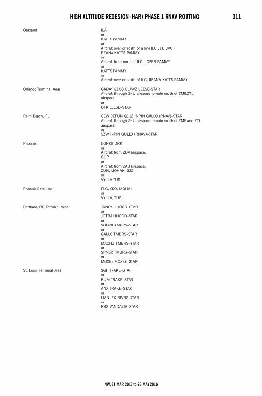
HIGH ALTITUDE REDESIGN (HAR) PHASE 1 RNAV ROUTING 311
Oakland ILAorKATTS PAMMYorAircraft over or south of a line ILC J16 DVC REANA KATTS PAMMYorAircraft from north of ILC, JOPER PAMMY orKATTS PAMMYorAircraft over or south of ILC, REANA KATTS PAMMY
Orlando Terminal Area GADAY Q108 CLAWZ LEESE–STARAircraft through ZHU airspace remain south of ZME/ZTL airspaceorOTK LEESE–STAR
Palm Beach, FL CEW DEFUN Q112 INPIN GULLO (RNAV)–STARAircraft through ZHU airspace remain south of ZME and ZTL airspaceorSZW INPIN GULLO (RNAV)–STAR
Phoenix CORKR DRKorAircraft from ZDV airspace,GUPorAircraft from ZAB airspace,ZUN, MOHAK, SSOorVYLLA TUS
Phoenix Satellites FLG, SSO, MOHAKorVYLLA, TUS
Portland, OR Terminal Area JKNOX HHOOD–STARorJOTBA HHOOD–STARorSOERN TMBRS–STARorGALLO TMBRS–STARorMACHU TMBRS–STARorSPNSR TMBRS–STARorMOXEE MOXEE–STAR
St. Louis Terminal Area SGF TRAKE–STARorBUM TRAKE–STARorANX TRAKE–STARorLMN IRK RIVRS–STARorRBS VANDALIA–STAR
NW, 31 MAR 2016 to 26 MAY 2016
312 HIGH ALTITUDE REDESIGN (HAR) PHASE 1 RNAV ROUTING
Salt Lake City Terminal Area JNC J12 HELPR SPANE–STARorEKR MTU SPANE–STARorBCE DTA–TCHorMLF DTA–TCHorBVL BONNEVILLE–STARorBYI BEARR–STARorPIH BEARR–STARorDBS BRIGHAM CITY–STARorJAC BRIGHAM CITY–STARorBPI BRIGHAM CITY–STARorOCS BRIGHAM CITY–STAR
San Diego Terminal Area EED, LAX, GBN
Santa Ana HEC, PGS, BLD, HIPPI
San Antonio Terminal Area IDU, CSI, JCT, LLO, CRP, LRDorWest of a north–south line at LFK, BLEWE orEast of a north–south line at LFK, IDU
San Francisco FMG GOLDEN GATE–STARorMVA MODESTO–STARorENI GOLDEN GATE–STARorOAL MODESTO–STARorSouth of a line ILC to DVC,REANA KATTS OAL MODESTO–STAR
San Jose FMG HYP EL NIDO–STARorOAL HYP EL NIDO–STARorENI GOLDEN GATE–STARorSouth of a line ILC to DVC, REANA KATTS KICHI CANDA EL NIDO–STAR
Seattle Terminal Area Aircraft from northeast, southeast, south,TEMPL GLASR–STARorSUNED CHINS–STARorBTG HAWKZ–STAR
Southwest Florida Airports RSW and FMY
CEW DEFUN Q104 SWABE JOSFF–STARAircraft through ZHU airspace remain south of ZME and ZTL airspaceorSZW HEVVN Q104 SWABE JOSFF–STAR
Tampa Terminal Area CEW DEFUN Q104 HEVVN DARBS–STARAircraft through ZHU airspace remain south of ZME and ZTL airspaceorSZW DARBS–STAR
Tucson DRK PXRorMOHAK GBN
NW, 31 MAR 2016 to 26 MAY 2016
AIRPORT DIAGRAMS 313SECTION 5: AIRPORT DIAGRAMSAirport Diagrams LegendIn support of the Federal Aviation Administration’s Runway Incursion Program, selected towered airport diagrams have beenpublished in the Airport Diagram section of the Chart Supplements. Diagrams will be listed alphabetically by associated city andairport name. Airport diagrams, depicting runway and taxiway configurations, will assist both VFR and IFR pilots in ground taxioperations. The airport diagrams in this publication are the same as those published in the U.S. Terminal Procedures Publications.For additional airport diagram legend information see the U.S. Terminal Procedures Publication.
NOTE: Some text data published under the individual airport in the A/FD section may be more current than the data published onthe Airport Diagrams. The airport diagrams are updated only when significant changes occur.
NW, 31 MAR 2016 to 26 MAY 2016
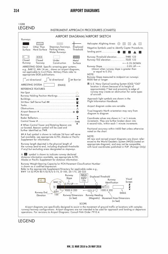
314 AIRPORT DIAGRAMS
NW, 31 MAR 2016 to 26 MAY 2016
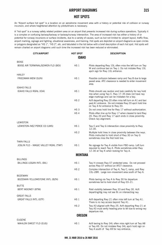
AIRPORT DIAGRAMS 315Airport Hot Spots
HOT SPOTSAn “Airport surface hot spot” is a location on an aerodrome movement area with a history or potential risk of collision or runwayincursion, and where heightened attention by pilots/drivers is necessary.
A “hot spot” is a runway safety related problem area on an airport that presents increased risk during surface operations. Typically it is a complex or confusing taxiway/taxiway or taxiway/runway intersection. The area of increased risk has either a history of or potential for runway incursions or surface incidents, due to a variety of causes, such as but not limited to: airport layout, traffic flow, airport marking, signage and lighting, situational awareness, and training. Hot spots are depicted on airport diagrams as open circles or polygons designated as “HS 1”, “HS 2”, etc. and tabulated in the list below with a brief description of each hot spot. Hot spots will remain charted on airport diagrams until such time the increased risk has been reduced or eliminated.
CITY/AIRPORT HOT SPOT DESCRIPTION
IDAHOBOISE
BOISE AIR TERMINAL/GOWEN FLD (BOI) HS 1 Pilots departing Rwy 10L often miss the left turn on Twy W and continue taxi on Twy J. Do not mistake Rwy 10L apch sign for Rwy 10L entrance.
HAILEY
FRIEDMAN MEM (SUN) HS 1 Possible confusion between ramp and Twy B due to large paved area. ATC clearance is needed to enter movement area.
IDAHO FALLS
IDAHO FALLS RGNL (IDA) HS 1 Pilots should use caution and look carefully for rwy hold line when using Twy C. Rwy 17–35 does not have rwy edge markings and can be mistaken for a twy.
HS 2 Acft departing Rwy 20 often miss left turn on A1 and taxi past A1 entrance. Do not mistake Rwy 20 apch hold line on Twy A for entrance to Rwy 20.
HS 3 Do not cross hold line for Rwy 17 without authorization.
HS 4 Pilots often line up for Rwy 17 when cleared to land Rwy 20. Rwy 20 and Rwy 17 apch ends in close proximity. Check rwy alignment.
LEWISTON
LEWISTON–NEZ PERCE CO (LWS) HS 1 Twy C and Twy G intersection close proximity to Rwy 12–30.
HS 2 Multiple hold lines in close proximity between the rwys. Pilots instructed to hold short of Rwy 30 on Twy G sometimes miss the first hold line.
TWIN FALLS
JOSLIN FLD – MAGIC VALLEY RGNL (TWF) HS 1 No signage for Twy A visible from FBO ramp. Left turn required to reach Twy A. Pilots sometimes enter Rwy 12–30 at Twy K when looking for Twy A.
MONTANABILLINGS
BILLINGS LOGAN INTL (BIL) HS 1 Twy H crosses Rwy 07 protected area. Do not proceed across Rwy 07 without an ATCT clearance.
HS 2 Complex intersection of Twy A, Twy C, ramp, and Rwy 10L–28R. Large non–movement area south of Twy A.
BOZEMAN
BOZEMAN YELLOWSTONE INTL (BZN) HS 1 Pilots taxiing via Twy A to Rwy 30 for departure sometimes fail to hold short of Rwy 03–21.
BUTTE
BERT MOONEY (BTM) HS 1 Rstd visibility between Rwy 33 and Rwy 30. Acft departing/ldg may not see tfc on intersecting rwy.
GREAT FALLS
GREAT FALLS INTL (GTF) HS 1 Acft departing Rwy 21 often miss left turn at Twy A1. There is no rwy access beyond Twy A1.
HS 2 Twy A3 aligned with Rwy 25. Acft departing Rwy 21 at Twy A3 must verify heading prior to tkf due to wrong rwy departure risk.
OREGONEUGENE
MAHLON SWEET FLD (EUG) HS 1 Acft taxiing to Rwy 34L often miss right turn at Twy A8 or Twy A9. Do not mistake Rwy 34L apch hold sign on Twy A south of Twy A9 for rwy entrance.
NW, 31 MAR 2016 to 26 MAY 2016
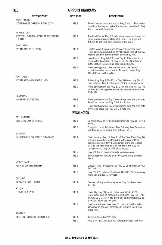
316 AIRPORT DIAGRAMS
NORTH BEND
SOUTHWEST OREGON RGNL (OTH) HS 1 Twy C crosses the north end of Rwy 13–31. Pilots have mistaken the rwy as part of the twy and taxied onto Rwy 13–31 without clearance.
PENDLETON
EASTERN OREGON RGNL AT PENDLETON (PDT)
HS 1 The hold line for Rwy 29 extends across a portion of the ramp and is approximately 360' long. The signs are difficult to see from some spots on the ramp.
PORTLAND
PORTLAND INTL (PDX) HS 1 Limited wing–tip clearance at twy convergence point. Pilots taxiing eastbound on Twy B should hold at the twy holding position marking when directed by ATC.
HS 2 Hold line for Rwy 03–21 is on Twy K. Pilots should be prepared to hold short of Rwy 21 on Twy K unless an authorization to cross has been issued by ATC.
HS 3 Pilots taxiing outbd from the GA ramp via Twy A4 sometimes miss the turn onto Twy A and enter Rwy 10L–28R wo authorization.
PORTLAND
PORTLAND–HILLSBORO (HIO) HS 1 Acft exiting Rwy 13R–31L at Twy A6 have only 90' of clnc between Twy A cntrln and holding posn markings.
HS 2 Pilots taxiing from the Rwy 31L run–up area via Twy A8 to Rwy 31L for dep sometimes fail to hold short of Rwy 13R–31L.
REDMOND
ROBERTS FLD (RDM) HS 1 Pilots eastbound on Twy G sometimes miss the turn onto Twy F and cross the Rwy 05–23 hold line.
HS 2 Pilots eastbound on Twy C sometimes miss the turn onto Twy F and cross the Rwy 05–23 hold line.
WASHINGTONBELLINGHAM
BELLINGHAM INTL (BLI) HS 1 Confusing twy int for pilots exiting/taxiing Rwy 16–34 via Twy D.
HS 2 Congested int of Twy A and Twy F during Rwy 34 ops for acft taxiing to, or exiting Rwy 34 via Twy F.
EVERETT
SNOHOMISH CO (PAINE FLD) (PAE) HS 1 Pilots holding short of Rwy 11–29 at Twy A5 or Twy A6 should use caution to stop prior to the rwy holding position marking. Rwy hold position signs are located 230' to the right and 350' to the left of the Twy A5 centerline and may be difficult to locate.
HS 2 Rwy 29 thld in close proximity to ramp areas.
HS 3 Twy A between Twy A9 and Twy A10 not visible from ATCT.
MOSES LAKE
GRANT CO INTL (MWH) HS 1 Unusual hold line location on Twy C, 1568' short of Rwy 18 Thld.
HS 2 Rwy 09–27 clsd except mil ops. Rwy 09–27 has no rwy markings and NSTD rwy lgts.
OLYMPIA
OLYMPIA RGNL (OLM) HS 1 No rwy holding position signs for Rwy 8–26 on Rwy 17–35.
PASCO
TRI–CITIES (PSC) HS 1 Pilots ldg Rwy 30 should listen carefully to ATCT instructions and be prepared to exit onto Rwy 03R–21L or Rwy 03L–21R. Pilots often exit at the wrong rwy as directions signs are not avbl.
HS 2 Pilots sometimes cross Rwy 21L without authorization. When twr is opr, ATC clearance is required to enter or cross rwy.
SEATTLE
BOEING FLD/KING CO INTL (BFI) HS 1 Twy Z restricted access area.
HS 2 Rwy 13R–31L and Twy A9. Wrong rwy departure risk.
CITY/AIRPORT HOT SPOT DESCRIPTION
NW, 31 MAR 2016 to 26 MAY 2016
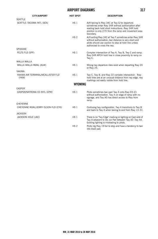
AIRPORT DIAGRAMS 317
SEATTLE
SEATTLE–TACOMA INTL (SEA) HS 1 Acft taxiing to Rwy 34C at Twy Q for departure sometimes enter Rwy 34R without authorization after reading back hold short instructions. Rwy 34R hold position is only 275' from the ramp and movement area boundary.
HS 2 Acft exiting Rwy 34C at Twy F sometimes enter Rwy 34R without authorization, taxi distance is very short and pilots should use caution to stop at hold line unless authorized to cross the rwy.
SPOKANE
FELTS FLD (SFF) HS 1 Complex intersection of Twy A, Twy B, Twy C and ramp. Rwy 04R APCH hold line in close proximity to ramp on Twy C.
WALLA WALLA
WALLA WALLA RGNL (ALW) HS 1 Wrong rwy departure risks exist when departing Rwy 20 or Rwy 25.
YAKIMA
YAKIMA AIR TERMINAL/MCALLISTER FLD (YKM)
HS 1 Twy C, Twy B, and Rwy 22 complex intersection. Rwy hold lines are at an unusual distance from rwy edge, rwy markings not easily visible from hold line.
WYOMINGCASPER
CASPER/NATRONA CO INTL (CPR) HS 1 Pilots sometimes taxi past Twy A onto Rwy 03–21 without authorization. Twy A on edge of ramp with no signage, and Twy A5 has direct access to Rwy from ramp.
CHEYENNE
CHEYENNE RGNL/JERRY OLSON FLD (CYS) HS 1 Confusing twy configuration. Twy A transitions to Twy B and back to Twy A when taxiing to and from Rwy 13–31.
JACKSON
JACKSON HOLE (JAC) HS 1 There is no "Twy Edge" marking or lighting on East side of Twy A adjacent to De–ice Pad between Twy A2–Twy A4. Existing lighting is misleading to pilots.
HS 2 Pilots ldg Rwy 19 fail to stop and have a tendency to taxi into blast pad.
CITY/AIRPORT HOT SPOT DESCRIPTION
NW, 31 MAR 2016 to 26 MAY 2016
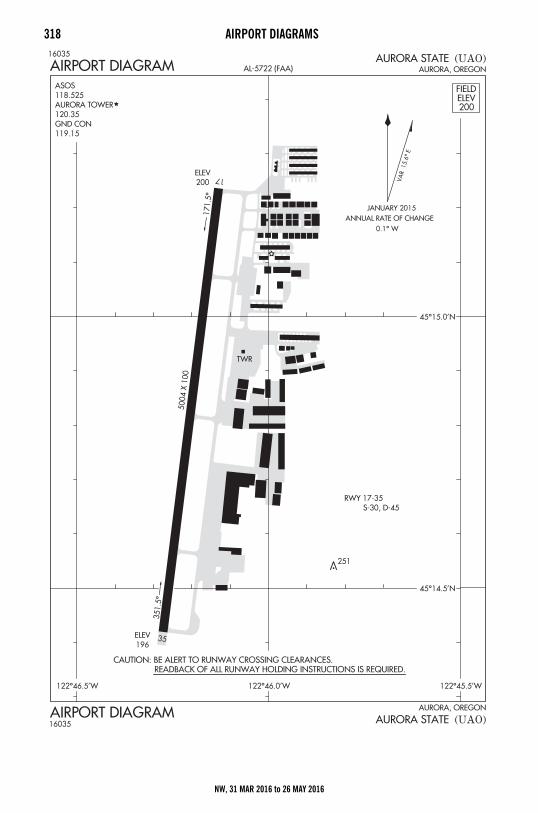
318 AIRPORT DIAGRAMS
Airport Diagrams
NW, 31 MAR 2016 to 26 MAY 2016
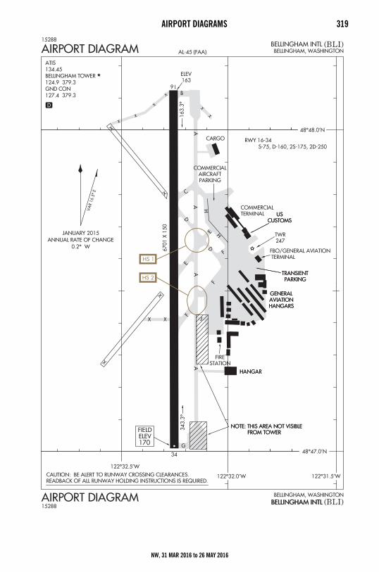
AIRPORT DIAGRAMS 319
NW, 31 MAR 2016 to 26 MAY 2016
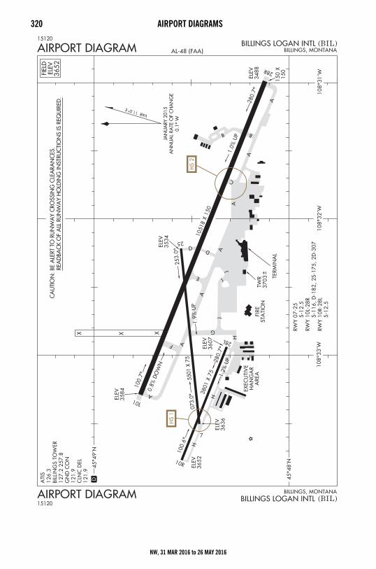
320 AIRPORT DIAGRAMS
NW, 31 MAR 2016 to 26 MAY 2016
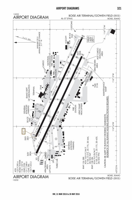
AIRPORT DIAGRAMS 321
NW, 31 MAR 2016 to 26 MAY 2016
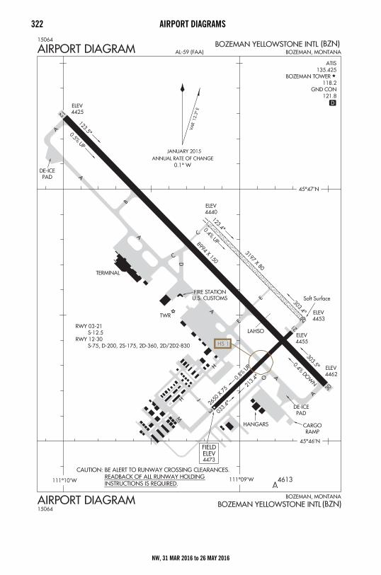
322 AIRPORT DIAGRAMS
NW, 31 MAR 2016 to 26 MAY 2016
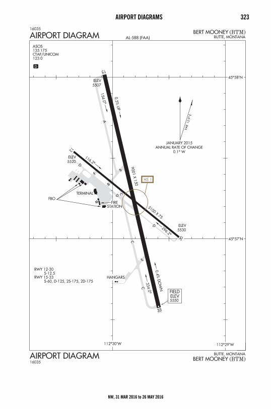
AIRPORT DIAGRAMS 323
NW, 31 MAR 2016 to 26 MAY 2016
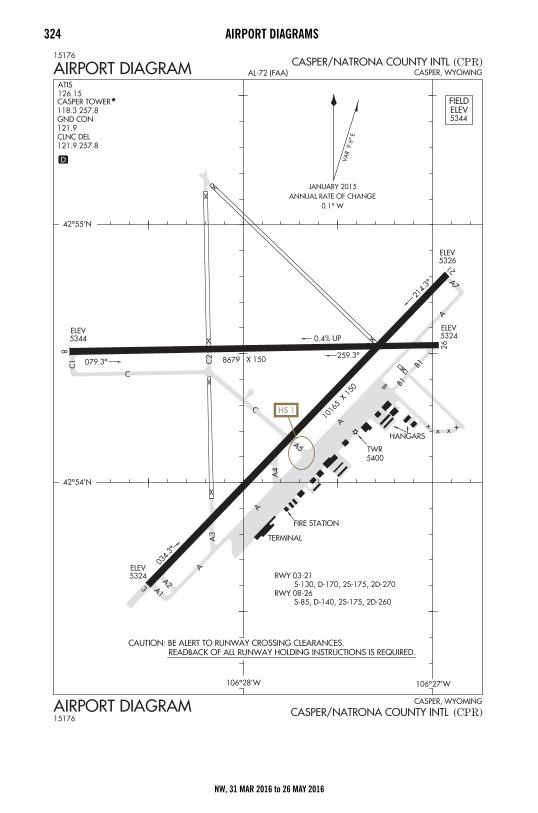
324 AIRPORT DIAGRAMS
NW, 31 MAR 2016 to 26 MAY 2016
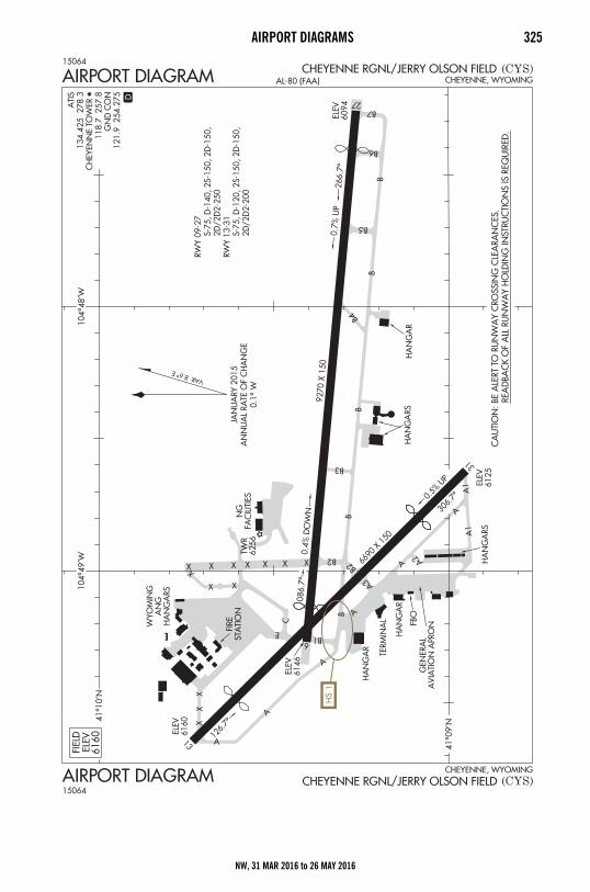
AIRPORT DIAGRAMS 325
NW, 31 MAR 2016 to 26 MAY 2016
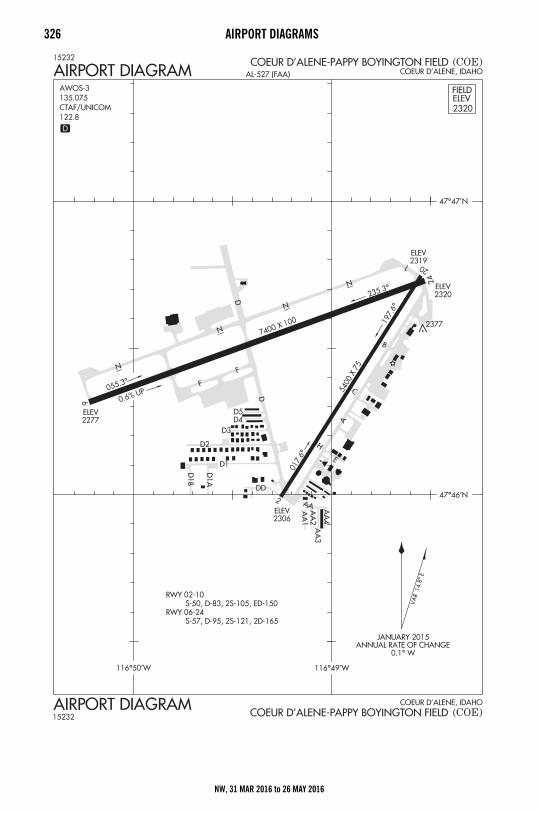
326 AIRPORT DIAGRAMS
NW, 31 MAR 2016 to 26 MAY 2016
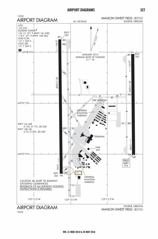
AIRPORT DIAGRAMS 327
NW, 31 MAR 2016 to 26 MAY 2016
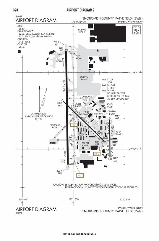
328 AIRPORT DIAGRAMS
NW, 31 MAR 2016 to 26 MAY 2016
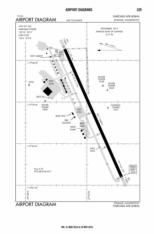
AIRPORT DIAGRAMS 329
NW, 31 MAR 2016 to 26 MAY 2016
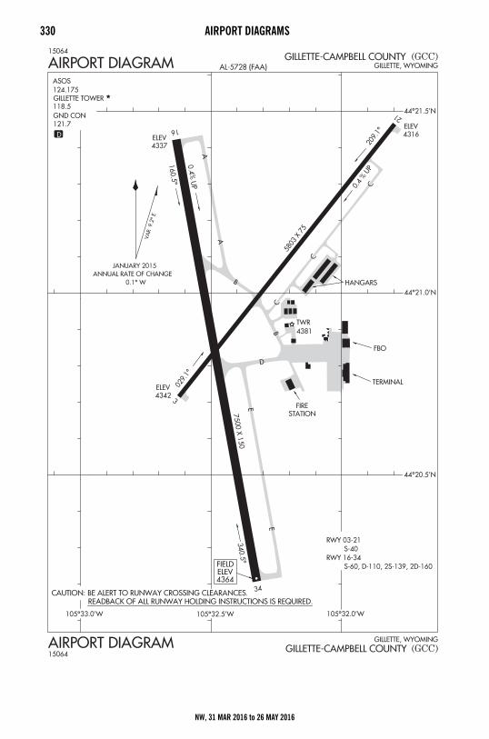
330 AIRPORT DIAGRAMS
NW, 31 MAR 2016 to 26 MAY 2016
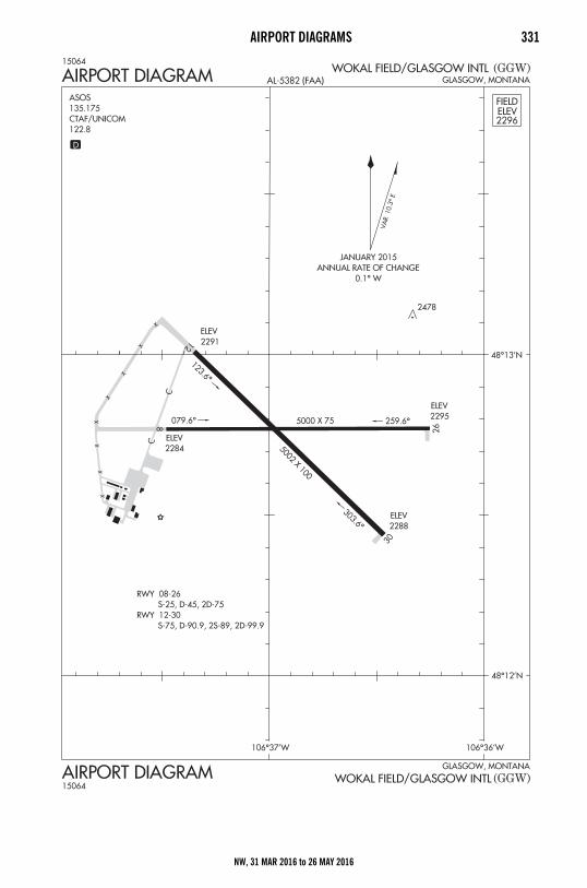
AIRPORT DIAGRAMS 331
NW, 31 MAR 2016 to 26 MAY 2016
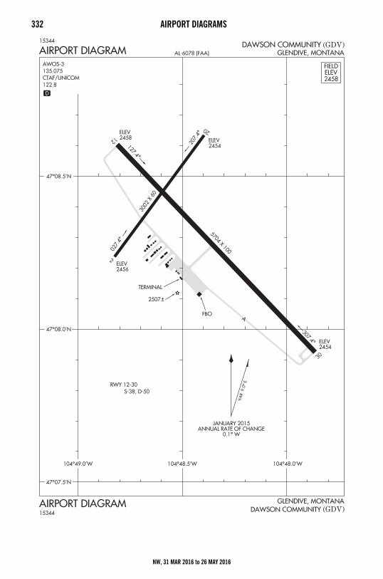
332 AIRPORT DIAGRAMS
NW, 31 MAR 2016 to 26 MAY 2016
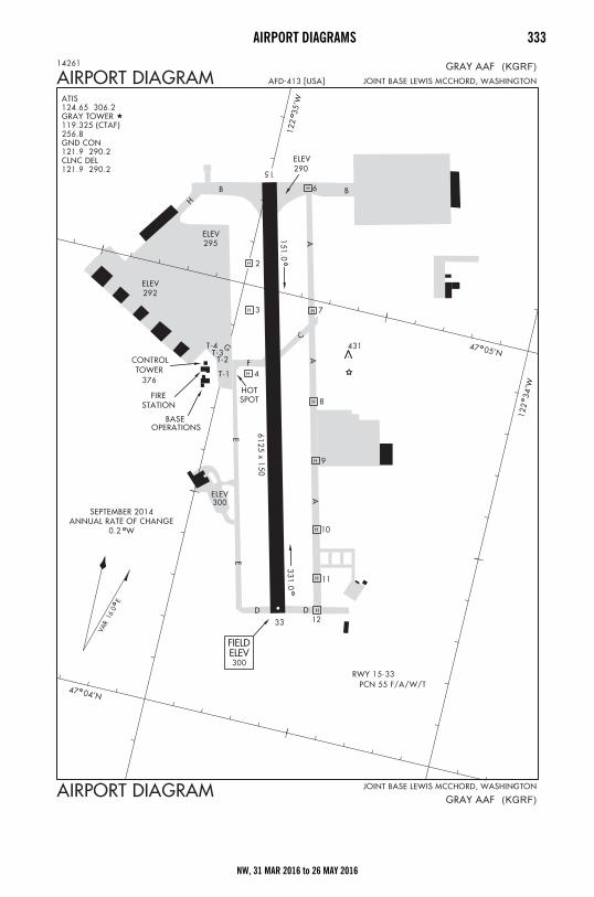
AIRPORT DIAGRAMS 333
NW, 31 MAR 2016 to 26 MAY 2016
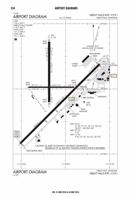
334 AIRPORT DIAGRAMS
NW, 31 MAR 2016 to 26 MAY 2016
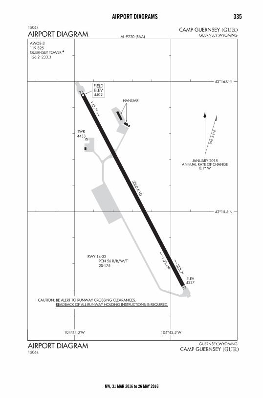
AIRPORT DIAGRAMS 335
NW, 31 MAR 2016 to 26 MAY 2016
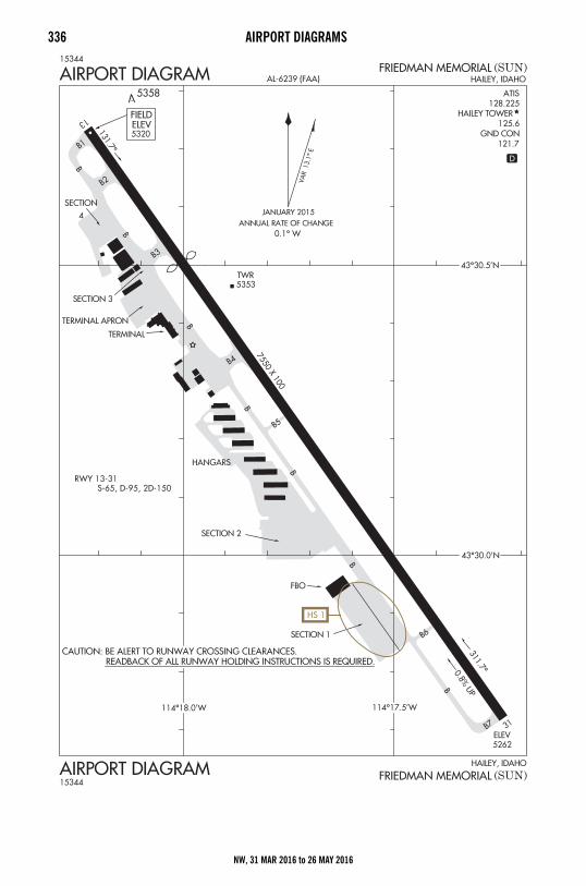
336 AIRPORT DIAGRAMS
NW, 31 MAR 2016 to 26 MAY 2016
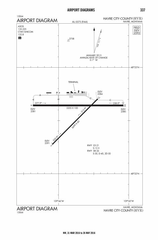
AIRPORT DIAGRAMS 337
NW, 31 MAR 2016 to 26 MAY 2016
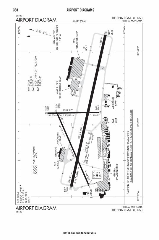
338 AIRPORT DIAGRAMS
NW, 31 MAR 2016 to 26 MAY 2016

AIRPORT DIAGRAMS 339
NW, 31 MAR 2016 to 26 MAY 2016
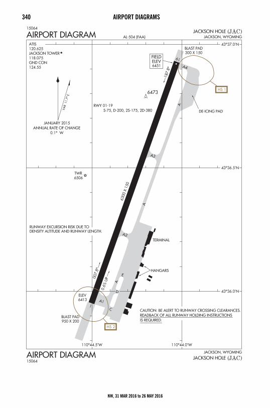
340 AIRPORT DIAGRAMS
NW, 31 MAR 2016 to 26 MAY 2016
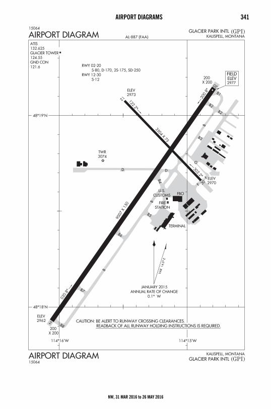
AIRPORT DIAGRAMS 341
NW, 31 MAR 2016 to 26 MAY 2016
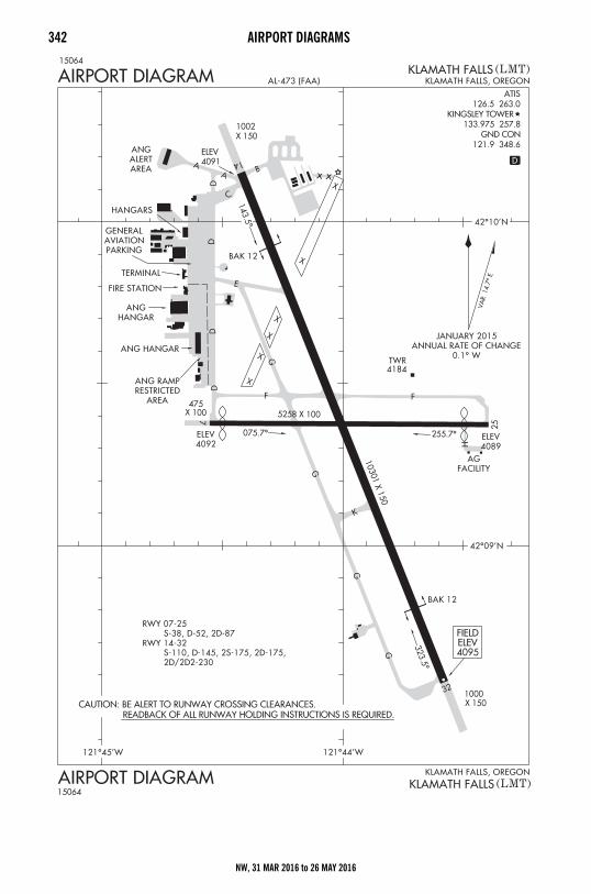
342 AIRPORT DIAGRAMS
NW, 31 MAR 2016 to 26 MAY 2016
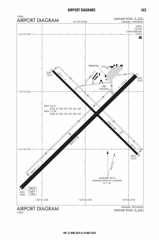
AIRPORT DIAGRAMS 343
NW, 31 MAR 2016 to 26 MAY 2016
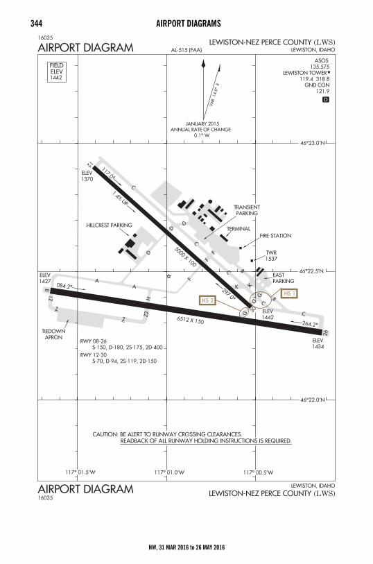
344 AIRPORT DIAGRAMS
NW, 31 MAR 2016 to 26 MAY 2016
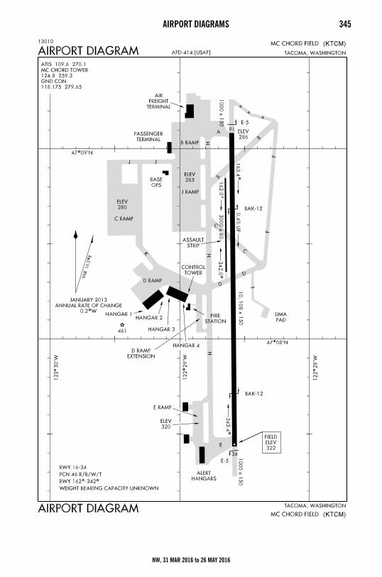
AIRPORT DIAGRAMS 345
NW, 31 MAR 2016 to 26 MAY 2016
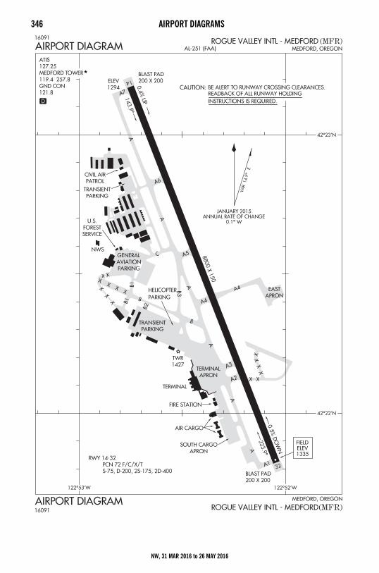
346 AIRPORT DIAGRAMS
NW, 31 MAR 2016 to 26 MAY 2016
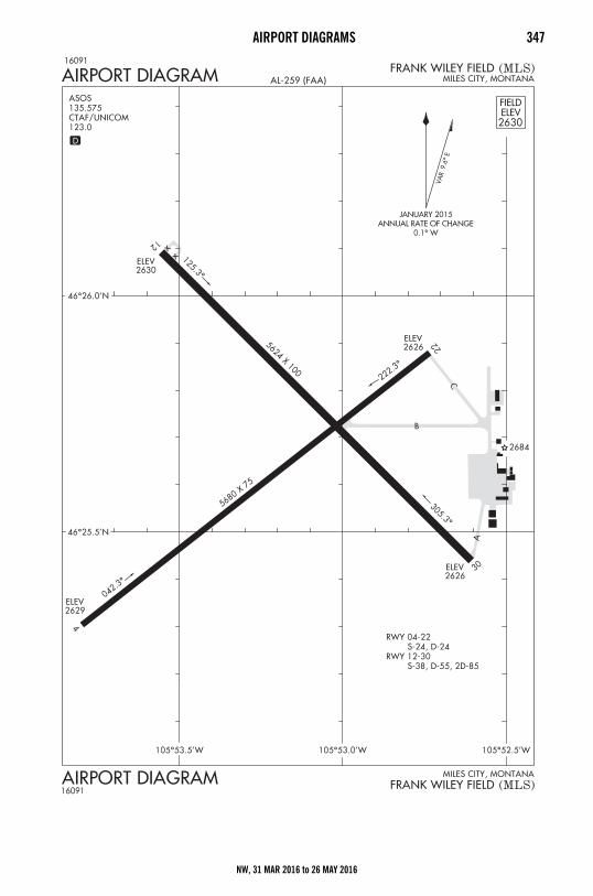
AIRPORT DIAGRAMS 347
NW, 31 MAR 2016 to 26 MAY 2016
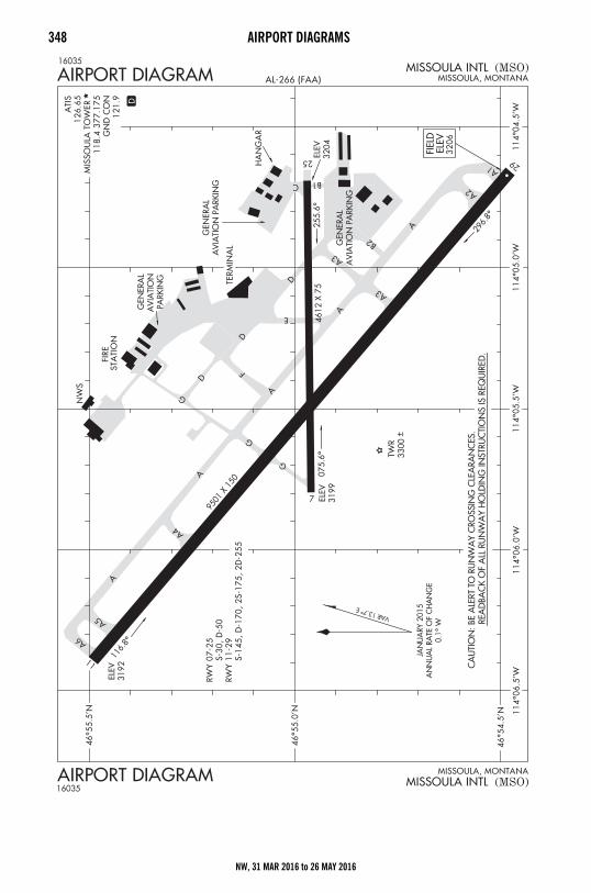
348 AIRPORT DIAGRAMS
NW, 31 MAR 2016 to 26 MAY 2016
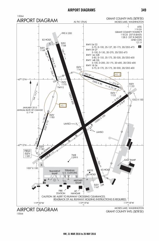
AIRPORT DIAGRAMS 349
NW, 31 MAR 2016 to 26 MAY 2016
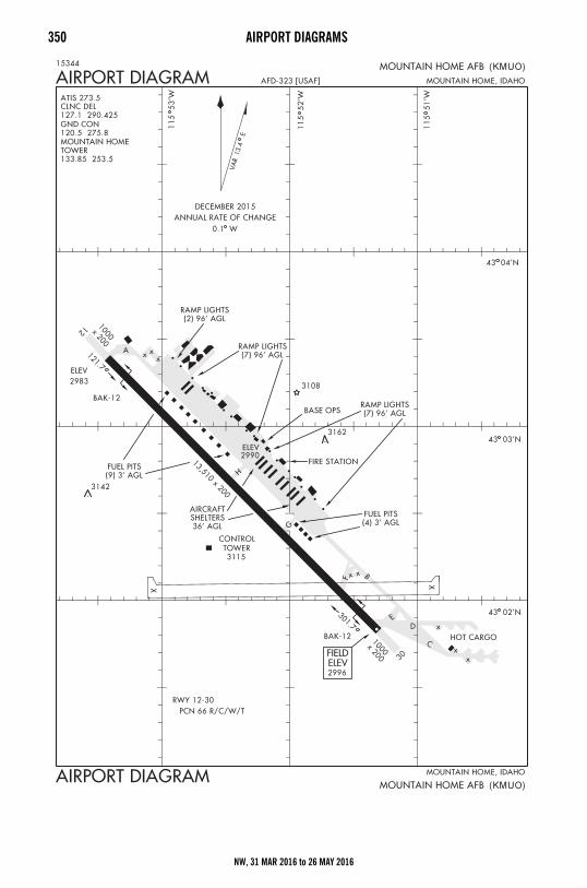
350 AIRPORT DIAGRAMS
NW, 31 MAR 2016 to 26 MAY 2016
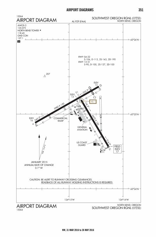
AIRPORT DIAGRAMS 351
NW, 31 MAR 2016 to 26 MAY 2016
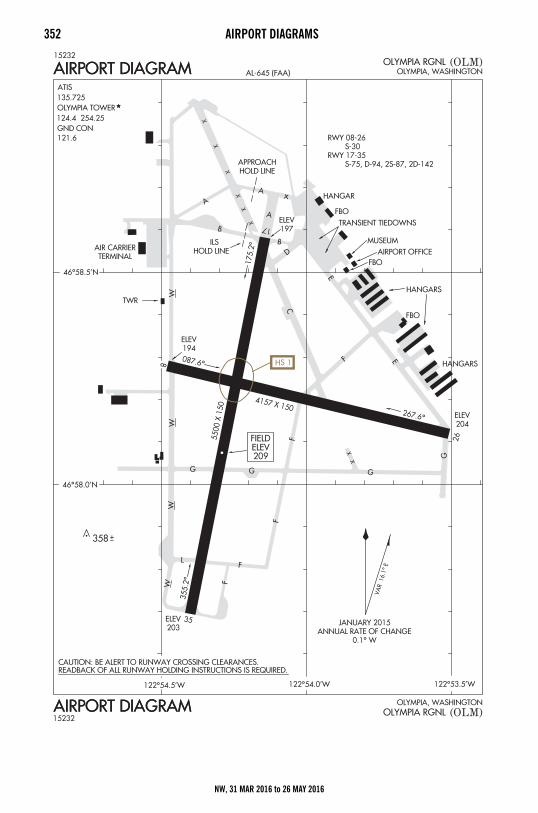
352 AIRPORT DIAGRAMS
NW, 31 MAR 2016 to 26 MAY 2016

AIRPORT DIAGRAMS 353
NW, 31 MAR 2016 to 26 MAY 2016
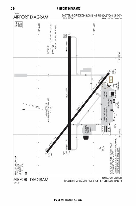
354 AIRPORT DIAGRAMS
NW, 31 MAR 2016 to 26 MAY 2016
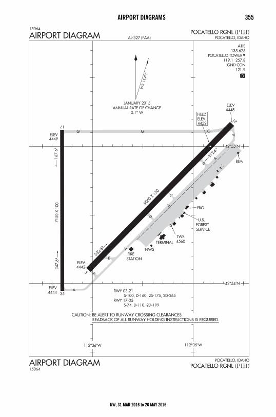
AIRPORT DIAGRAMS 355
NW, 31 MAR 2016 to 26 MAY 2016
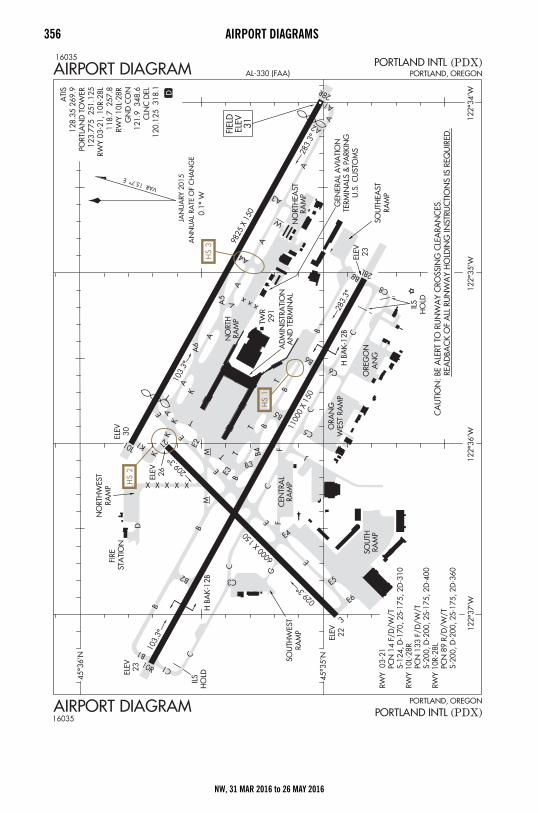
356 AIRPORT DIAGRAMS
NW, 31 MAR 2016 to 26 MAY 2016
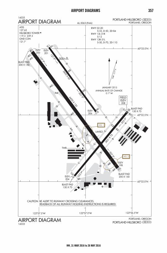
AIRPORT DIAGRAMS 357
NW, 31 MAR 2016 to 26 MAY 2016
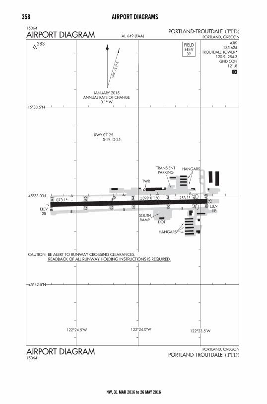
358 AIRPORT DIAGRAMS
NW, 31 MAR 2016 to 26 MAY 2016
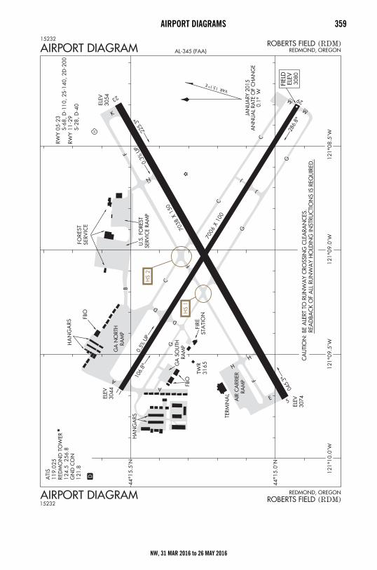
AIRPORT DIAGRAMS 359
NW, 31 MAR 2016 to 26 MAY 2016
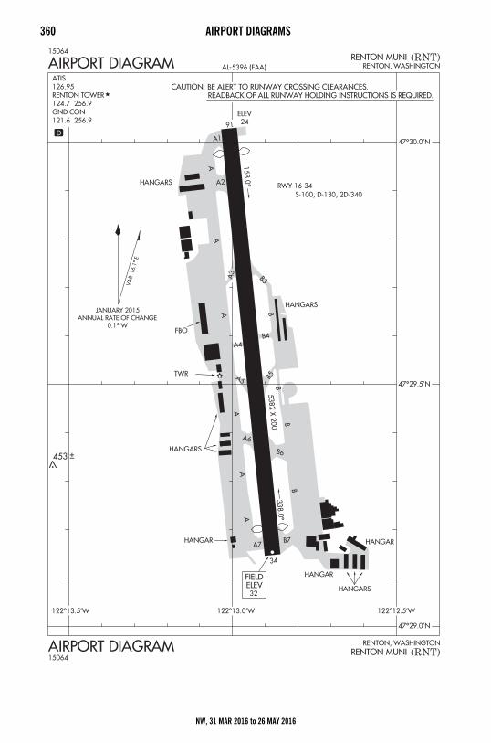
360 AIRPORT DIAGRAMS
NW, 31 MAR 2016 to 26 MAY 2016
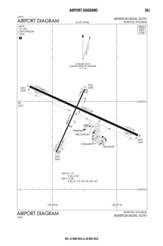
AIRPORT DIAGRAMS 361
NW, 31 MAR 2016 to 26 MAY 2016
362 AIRPORT DIAGRAMS
NW, 31 MAR 2016 to 26 MAY 2016
AIRPORT DIAGRAMS 363
NW, 31 MAR 2016 to 26 MAY 2016
364 AIRPORT DIAGRAMS
NW, 31 MAR 2016 to 26 MAY 2016
AIRPORT DIAGRAMS 365
NW, 31 MAR 2016 to 26 MAY 2016
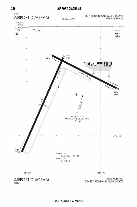
366 AIRPORT DIAGRAMS
NW, 31 MAR 2016 to 26 MAY 2016
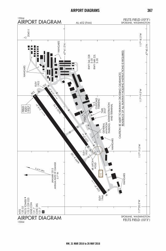
AIRPORT DIAGRAMS 367
NW, 31 MAR 2016 to 26 MAY 2016
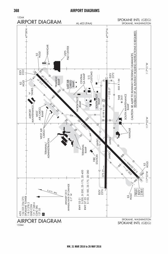
368 AIRPORT DIAGRAMS
NW, 31 MAR 2016 to 26 MAY 2016
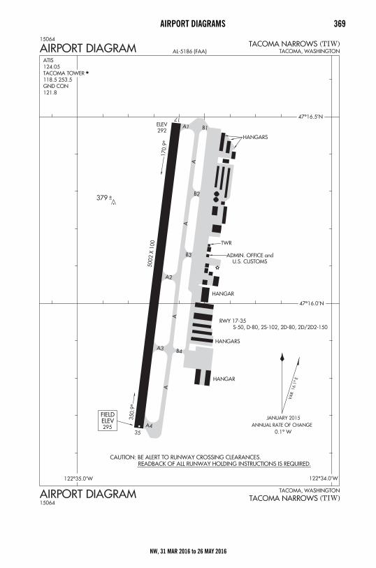
AIRPORT DIAGRAMS 369
NW, 31 MAR 2016 to 26 MAY 2016
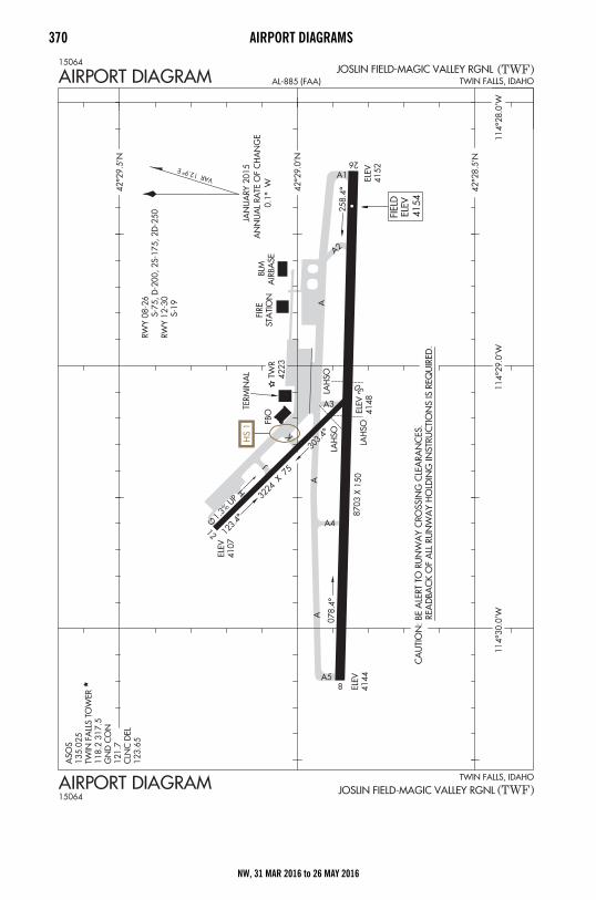
370 AIRPORT DIAGRAMS
NW, 31 MAR 2016 to 26 MAY 2016
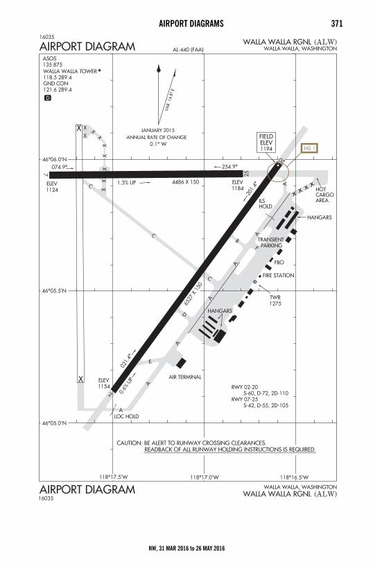
AIRPORT DIAGRAMS 371
NW, 31 MAR 2016 to 26 MAY 2016
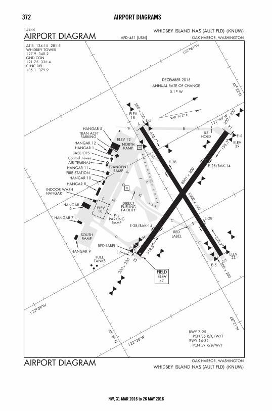
372 AIRPORT DIAGRAMS
NW, 31 MAR 2016 to 26 MAY 2016
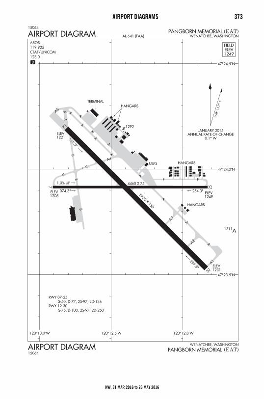
AIRPORT DIAGRAMS 373
NW, 31 MAR 2016 to 26 MAY 2016
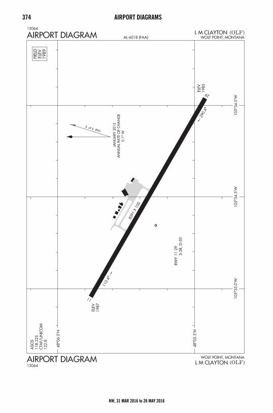
374 AIRPORT DIAGRAMS
NW, 31 MAR 2016 to 26 MAY 2016
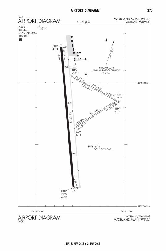
AIRPORT DIAGRAMS 375
NW, 31 MAR 2016 to 26 MAY 2016
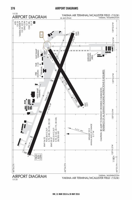
376 AIRPORT DIAGRAMS
NW, 31 MAR 2016 to 26 MAY 2016
AIRPORT DIAGRAMS 377
INTENTIONALLYLEFT
BLANK
NW, 31 MAR 2016 to 26 MAY 2016
378 AIRPORT DIAGRAMS
INTENTIONALLYLEFT
BLANK
NW, 31 MAR 2016 to 26 MAY 2016

AIRPORT DIAGRAMS 379
INTENTIONALLYLEFT
BLANK
NW, 31 MAR 2016 to 26 MAY 2016

380 AIRPORT DIAGRAMS
INTENTIONALLYLEFT
BLANK
NW, 31 MAR 2016 to 26 MAY 2016

AIRPORT DIAGRAMS 381
INTENTIONALLYLEFT
BLANK
NW, 31 MAR 2016 to 26 MAY 2016

382 AIRPORT DIAGRAMS
INTENTIONALLYLEFT
BLANK
NW, 31 MAR 2016 to 26 MAY 2016

AIRPORT DIAGRAMS 383
INTENTIONALLYLEFT
BLANK
NW, 31 MAR 2016 to 26 MAY 2016
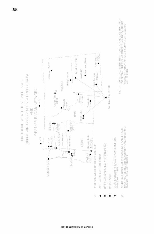
384National Weather Service (NWS) Upper Air Observing Stations
NW, 31 MAR 2016 to 26 MAY 2016
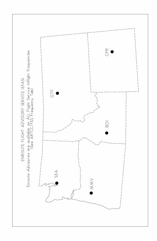
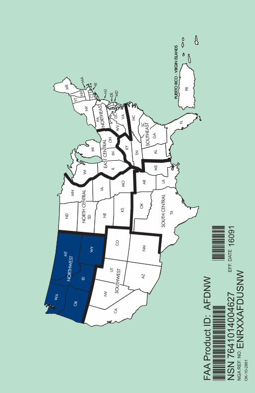
OK
-10-
2861

ID M
T OR
WA W
YN
W31 M
AR
2016 TO 26 M
AY 2016