Embed Size (px)
Citation preview

Geomorphology 108 (2009) 312–320
Contents lists available at ScienceDirect
Geomorphology
j ourna l homepage: www.e lsev ie r.com/ locate /geomorph
Cosmogenic 10Be dating of a sackung and its faulted rock glaciers, in the Alps ofSavoy (France)
Jean-Claude Hippolyte a,⁎, Didier Bourlès a, Régis Braucher a, Julien Carcaillet b, Laëtitia Léanni a,Maurice Arnold a, Georges Aumaitre a
a CEREGE, (Centre Européen de Recherche et d'Enseignement en Géosciences de l'Environnement), UMR-6635 CNRS — Université Aix-Marseille III,BP 80, Europole Méditerranéen de l'Arbois, 13545 Aix en Provence Cedex 4, Franceb LGCA, UMR-5025 CNRS, Maison des geosciences, 1381 rue de la piscine, 38041 Grenoble cedex, France
⁎ Corresponding author. CEREGE, BP 80, Europole Médien Provence Cedex 4, France. Tel.: +33 4 42 97 17 70; fax
E-mail address: [email protected] (J.-C. Hippolyte
0169-555X/$ – see front matter © 2009 Elsevier B.V. Adoi:10.1016/j.geomorph.2009.02.024
a b s t r a c t
a r t i c l e i n f oArticle history:Received 26 August 2008Received in revised form 17 January 2009Accepted 9 February 2009Available online 6 March 2009
Keywords:Cosmic ray exposure datingSackungDeep-seated gravitational deformationRock glacierFault scarpsWestern Alps
Sackungs are the largest gravitational deformation observed in mountains. They are characterized by thelong-term slowness of the movements, but their mechanism is still not well understood. Nowadays cosmicray exposure (CRE) dating methods allow dating the morphologic structures involved in sackung and cancontribute at the understanding of their origin. In the Alps, the 5.3 km long Arcs sackung initiated during theactivity of rock glaciers. Three samples from these faulted rock glaciers provide their first CRE ages and showthat at 2000 m elevation these block accumulations moved during the Younger Dryas and stopped in earlyHolocene. Six 10Be ages of fault scarps show that the Arcs sackung lasted only a few thousand years andstopped at about 8462±432 10Be yr. They also reveal that deformation migrated upslope in agreement witha mechanism of flexural toppling of vertical layers. This unique and long gravitational event, characterized bymigration of the deformation, does not support earthquake shaking as triggering mechanism for individualfaults. It shows that, in the upper Isère valley, slope deformation was delayed of several thousand years afterglacial debuttressing, and is not anymore active despite its fresh morphology.
© 2009 Elsevier B.V. All rights reserved.
1. Introduction
In the French Alps, recent fault scarps, that were previouslyinterpreted as resulting from tectonic activity (e.g. Goguel, 1969;Bordet, 1970), have been interpreted as gravitational faults based onmorphological observations (Hippolyte et al., 2006). In the studiedsites, the faults typically cut and offset, in a normal sense, mountainslopes partially covered by rock glaciers. These faults form swarmsthat follow the crest lines and reveal the deep-seated gravitationalspreading of bedrock ridges. Since Zischinsky (1966, 1969) thisprocess is called “sackung” (e.g. McCalpin and Irvine, 1995).
Themechanism of sackung is still not well understood. Two possiblefactors are often proposed in literature to explain themovement of suchlarge rock masses: glacial debuttressing, and earthquake shaking(McCalpin and Irvine,1995; Smith, 2001, Agliardi et al., 2001;McCalpin,2003; Braathen et al., 2004, Gutiérrez-Santolalla et al., 2005).
To better understand how sackungs formed and what thetriggeringmechanismwas, the determination of their age and climaticperiod of activity is essential. Dating of sackung scarps can indicatewhen the sackung started moving compared to the deglaciation, whatwere its periods of activity, what was its rate of deformation, and if it
terranéen de l'Arbois 13545 Aix: +33 4 42 97 16 58.).
ll rights reserved.
could be still moving. Nowadays, cosmic ray exposure (CRE) datingmethods allow dating rock surfaces like fault scarps and rock glaciers.We chose to date the Arcs sackung (Hippolyte et al., 2006), located inthe inner French Alps (Fig. 1), because of its clear structure and itspossibility of sampling different faults along a cross-section. More-over, in this sackung, the faults cut screes and rock glaciers whosesurface can be used to accurately date the fault activity. The 11processed samples presented here will provide age constraints notonly on the formation of the sackung but also on rock glaciers that arefrequent in the Alps and to our knowledge have not yet been datedwith CRE methods.
2. The Arcs sackung
The Arcs is a ski resort in the northern French Alps, near Bourg StMaurice (Fig. 1). It was built on the slopes of the Aiguille Grive range,in the inner (Briançonnais) Alpine units. This mountain consists ofCarboniferous silts and sandstones overthrusted by a series of Triassicquartzites with locally gneiss at its base (Antoine et al., 1993; Figs. 2and 3).
Linear geomorphic structures observed in this mountain wereinterpreted as the surface expression of a giant gravitational slopedeformation called sackung (Hippolyte et al., 2006). Note that theterm “sackung”, from the German word for sagging (Zischinsky, 1966,1969) refers to the process of deep-seated sagging (or deep-seated

Fig. 1. Hillshaded view of a digital elevation model with location of the Arc sackung in the northern French Alps.
313J.-C. Hippolyte et al. / Geomorphology 108 (2009) 312–320
gravitational slope deformation) while the plural form “sackungs” or“sackungen” refers to the surface forms created by that process (e.g.Savage and Varnes, 1987; McCalpin and Irvine, 1995). At the Arcs wecan observe geomorphic features typical of sackungs (e.g. Paschinger,1928; McCalpin, 2003): anomalous ridge-top troughs, double-crestedridges, uphill-facing fault scarps and open cracks (Fig. 2). Goguel(1969) had interpreted the linear scarp morphologies as recent
Fig. 2. Orthorectified aerial photo of the south of the Arcs sackung (Aiguille Grive range, loexposure (CRE) dating. At the Arcs we can distinguish at least two generations of rock glaciephoto) are located up on the slope and overlies older rock glacier, more vegetated, and appparallel to the main crest line. The rock glaciers are inactive because they did not displace t
extensional tectonic faults. However, these linear structures aregenerally parallel to the subvertical bedding planes (Figs. 2 and 3)and their typology and distribution, described in detail in Hippolyteet al. (2006), show that they result from gravitational deformation.The Aiguille Grive range is cut by about 80 recent scarps on 5.3 km.The open cracks are mainly along the ridge crest in the Triassicquartzites, and the uphill-facing scarps in the quartzites and the
cation in Fig. 1) with mapped geomorphic structures and sites sampled for cosmic rayrs (block accumulations with a lobate structure). The younger rock glaciers (in white onearing in dark on photo. They are cut by fault scarps that are mainly uphill facing andhe fault scarps.

Fig. 3. Block-diagram with geological cross-section showing the topography and structure of the area sampled ( Fig. 2).
314 J.-C. Hippolyte et al. / Geomorphology 108 (2009) 312–320
underlying Carboniferous sandstones (Figs. 3 and 4). They parallel theridge crests and change of strike with it (Fig. 2) attesting for theirgravitational interpretation.
The mechanism of formation of the scarps at the Arcs was describedin Hippolyte et al. (2006). The subsurface geometry of a sackung isgenerally more speculative. In fractured competent rocks, faults mayextend into a zone of rock creep at depths of several hundred meters
Fig. 4. Site B with location of the rock surfaces sa
(Mahr, 1977; Radbruch-Hall, 1978). In rocks with steeply dippingdiscontinuities, sackungen can be the shallow surface manifestations oftoppling (Jahn, 1964; Beck, 1968; Bovis, 1982). At the Arcs sackung, theevolution along the slope of the type of scarp, and the fact that theantislope scarps parallel the subvertical bedding planes, suggest thatdeformation corresponds to the second model (Hippolyte et al., 2006).Thismodel of “flexural toppling” (Goodmanand Bray,1976; Bovis,1982)
mpled for cosmic ray exposure (CRE) dating.

Fig. 5. Site C, fault scarp cutting two superposed rock glaciers: general view, cross-section, and location of the samples. C1, C2, C3 and C4 were sampled on the same profile.
315J.-C. Hippolyte et al. / Geomorphology 108 (2009) 312–320
implies that deformationdonot penetrate to anygreat depth. To confirmand better understand this mechanism, and to understand whattriggered the Arcs sackung, we need age constrains.
3. Geomorphology and sampling strategy
The cosmic ray exposure (CRE) datingmethods allow determinationof the exposure age of rock surfaces. To determine the age and evolution
Fig. 6. Site D with location of the rock surfaces
of sagging at the Arcs we sampled the surface of a rock glacier cut by afault at site A (Fig. 2) and three scarps globally along an E–W cross-section in the southern part of the fault swarm (sites B, C, D, Figs. 2, 4,5, 6). Most of the scarps are present on theWestern flank of the AiguilleGrive range (Fig. 2). Three sites of sampling are on this flank, and one onthe eastern flank. To find rocks that were not exposed before the faultmovement, and to evaluate the denudation rate of the faults, we focusedon the largest faults that show the largest offsets and brought deepest
sampled for cosmic ray exposure dating.

316 J.-C. Hippolyte et al. / Geomorphology 108 (2009) 312–320
rocks to exposure. Sites B, C, and D are located along the longest faultsegments, andmoreover site C is located on a fault that cut both old andrecent rock glaciers (Fig. 2).
To keep a control on the validity of our sampling and agedetermination we sampled two kinds of surfaces: the surfaces thathave been faulted, and the fault scarps. In the Arcs sackung thefaulted surfaces that can be sampled are either rock glaciers or screeslopes (Fig. 2). When cutting scree material, the faults are visible onaerial photos and in the field because they separate a white slope,whose surface is formed by recently broken and fallen debris, from adarker (vegetated) slope, with older debris covered by lichens orgrass (e.g. site D, Fig. 2). The uphill-facing scarp acts as a barrier thatstops the rockfall debris (Fig. 6). Therefore, the lower slope (footwallcompartment) is preserved from accumulation of debris and datingthe surface of blocks in this preserved slope can allow dating of scarpformation.
But at the Arcs sackung, the faults mainly cut post-Würmian blockaccumulations called rock glaciers (Fig. 2). These block accumulations,with their characteristic flow lobes and ridges, generally result fromthe cryogenic movement of the screes (e.g. Todisco et al., 2000;Zurawek, 2002). In the western Alps, in the absence of agedetermination, relict rock glaciers are considered as formed during alate-glacial cold period: the Oldest Dryas, the Younger Dryas or theSubboreal episodes (e.g. Kaiser, 1987). In the Aiguille Grive range weobserve locally two superposed talus-derived rock glaciers suggestingthat there were several periods of rock-glacier activity (Fig. 2). Thelowest and oldest rock glaciers are mostly vegetated and thelandforms appear dark on aerial photos (Fig. 2). The upper andyounger rock glaciers are sparsely vegetated, overly the oldest andhave a lesser downslope extension. This difference in vegetationdensity might signify that the upper rock glaciers are significantlyyounger than the others. However this difference might also resultfrom the size of the clasts. Effectively, the upper rock glaciers aremainly made of large clasts whereas the lower rock glaciers extendover Carboniferous silts and sandstones and contain finer clasts partlyderived from this basement. Upslope, the vegetation of the oldest rockglaciers is only present along strips of finest clasts (Fig. 5) thatrepresent shear zones formed during their large displacement (e.g.Zurawek, 2002). The dating of these successive rock glaciers can showif they formed during a same or different cold periods.
In the Arcs sackung, geomorphologic observations showed that thefaults moved during the end of emplacement of these rock glaciers(Hippolyte et al., 2006). For example, the lower fault on the westernslope of the Aiguille Grive range (Fig. 2) cuts old rock glaciers and hasstopped a younger rock glacier, near its northern tip. Therefore,determining the timing of rock-glacier activity will be important forconstraining the timing of faulting.
Site C is an exceptional outcrop for our CRE sampling. It contains afault scarp that cuts both old and recent rock glaciers (Figs. 2 and 5).The uphill side of the older, vegetated, rock glacier is downthrownvertically by 4.2 m along the fault, and locally, an overlying youngertongue-shaped rock glacier is offset vertically by only 1.5 m (Fig. 5).These crosscutting relationships indicate that faulting occurred beforeand after the emplacement of the younger rock glacier.
The age of the fault movements may also be estimated directly bydetermining the exposure ages on the fault surfaces. The hardquartzite exposed in the Arcs sackung allows the assumption that theerosion of the scarps or block surfaces was low. When sampling afault scarp in the bedrock, we considered the most planar surface asthe best preserved fault surface (e.g. Fig. 6). When sampling a faultscarp in a rock glacier, we choose the largest clasts stuck betweenother clasts to ensure that it might not have fallen or have beenrotated after faulting (cf. sampling locations in Fig. 5). Note that inany casewe did not sample the very top of the scarps because it likelyis partly truncated by erosion, and exposure time would tend to beless.
4. Method of dating
Sackungs are generally present on steep slopes of high mountainswhere bedrock is exposed and the recent deposits are mainly talus androck glaciers with large clasts. Themain numerical methods allowing todate these deposits and the fault scarps are the CRE dating methodsbecause they provide ages of rock surfaces. They allow quantifying theduration of exposure of a surface to cosmic rays through themeasurement of accumulated cosmogenic nuclides. A small proportionof the energetic secondary particles (primarily neutrons) resulting fromcosmic rays entering the Earth's environment interacts with material atthe surface of the planet to produce cosmogenic nuclides within themineral lattices of exposed rock. Because theproduction rates of these insitu-produced cosmogenic nuclides decrease exponentially with sub-surface depth, their concentrations in the rock are indeed directly linkedto the rock history of near-surface exposure (for more details see Gosseand Phillips, 2001). Numerous studies have utilized the build-up ofthese in situ-produced cosmogenic nuclides (including 3He, 10Be, 14C,21Ne, 26Al and 36Cl) for quantification of exposures ages of rock surfacesand for determination of erosion rates of landforms and of river basins(e.g. Gosse and Phillips, 2001, Siame et al., 2006). Depending on themineralogical composition of the studied samples, either 10Be producedin situ by spallation reactions on Si and O in quartz (Lal, 1988) or 36Clproduced in situ by different reactions on Ca, K and Cl in calcite can beused (for details see Stone et al., 1996, 1998).
The abundance of quartz in rocks exposed at the Arcs makes the10Be CRE dating method more suitable. Samples were preparedfollowing chemical procedures adapted from Brown et al. (1991) for10Be. Crushed and sieved (250–1000 µm) samples were selectiveetched in H2SiF6, HCl and HF to eliminate all mineral phases but quartzand potential surface contamination by atmospheric 10Be. Thedecontaminated-quartz minerals were then completely dissolved inHF. After addition of 100 µl of an in-house 3.10−3 g/g 9Be carriersolution and subsequent purification by anion exchange, cationexchange and alkaline precipitations, targets of purified berylliumoxide were prepared for 10Be measurements on the new French AMS(accelerator mass spectrometry) national facility named ASTER(standing for Accelerator for Earth Sciences, Environment and Risks)and located at the CEREGE laboratory (Aix en Provence). Thepresented data were calibrated directly against the National Instituteof Standards and Technology standard reference material 4325 byusing the values recently determined by Nishiizumi et al. (2007)which are a 10Be/9Be ratio of (2.79±0.03)×10−11 and a 10Be half-lifeof (1.36±0.07)×106 years.
In order to determine CRE ages from the 10Be concentrationsmeasured in the quartz fractions, the following equation was used:
C x;e;tð Þ = C0 · e−λt +P · pneΛn
+ λ· e− x
Λn · 1−e− t eΛn
+ λ� �� �
+P · pμse
Λ μ s+ λ
· e− xΛ μ s · 1−e
− t eΛ μ s
+ λ
� �" #
+P · pμfe
Λμf+ λ
· e− x
Λ μ f · 1−e− t e
Λ μ f+ λ
� �" #
where C(x, ε, t) is the 10Be concentration as a function of depth x (g/cm2), ε the erosion rate (g/cm2/yr) and t the exposure time (yr); C0 isthe 10Be inherited concentration prior to exposition at the surface; Λn,Λ μs, and Λ μf are the effective apparent attenuation lengths (g/cm2),for neutrons, slow muons, and fast muons, respectively. pn, pμs, andpμ f are the relative contributions to the 10Be production rate of thethree reactions (pn+pμs+pμf=100%). λ is the radioactive constant.
All calculations were performed using attenuation lengths of 150,1500, and 5300 g/cm2with associated relative contributions to the totalsurface production rate of 97.85%, 1.50%, and 0.65% for neutrons, slowmuons and fast muons, respectively. These values are based on field-
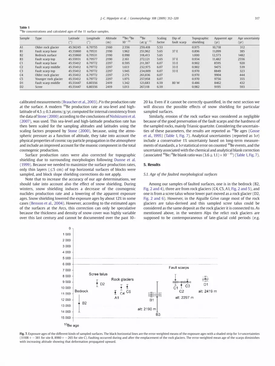
Table 110Be concentrations and calculated ages of the 11 surface samples.
Sample Type Latitude Longitude Altitude 10Be/9Be 10Be Scalingfactor
Dip offault scarp
Topographicshielding
Apparent age Age uncertainty(°) (°) (m) 10−13 (at/g−1) (yr) (yr)
A1 Older rock glacier 45.56245 6.79755 2160 2.556 259,418 5.53 0.975 10,718 312B1 Fault scarp base 45.55860 6.79531 2190 1.962 251,962 5.65 37 E 0.896 11,099 385B2 Bedrock surface 45.55860 6.79531 2190 0.990 318,413 5.65 1.000 12,573 1482B3 Fault scarp top 45.55931 6.79577 2190 2.161 272,121 5.65 37 E 0.934 11,482 2556C1 Fault scarp base 45.55412 6.79772 2297 0.595 211,387 6.07 33 E 0.902 8595 920C2 Fault scarp middle 45.55412 6.79772 2297 1.613 232,975 6.07 33 E 0.902 9475 539C3 Fault scarp top 45.55412 6.79772 2297 1.945 234,009 6.07 33 E 0.970 8849 323C4 Older rock glacier 45.55412 6.79772 2297 2.175 261,836 6.07 0.970 9904 444C5 Younger rock glacier 45.55412 6.79772 2297 1.975 257,958 6.07 0.970 9756 355D1 Fault scarp middle 45.55447 6.80356 2419 1.342 121,683 6.59 80 W 0.486 8462 432D2 Scree 45.55447 6.80356 2419 1.013 267,118 6.59 0.982 9195 593
317J.-C. Hippolyte et al. / Geomorphology 108 (2009) 312–320
calibratedmeasurements (Braucher et al., 2003).P is theproduction rateat the surface. A modern 10Be production rate at sea-level and high-latitudeof 4.5±0.3 atoms/g/yr, computed for internal consistency fromthedata of Stone (2000) according to the conclusions of Nishiizumi et al.(2007), was used. This sea-level and high-latitude production rate hasthen been scaled for the sampling altitudes and latitudes using thescaling factors proposed by Stone (2000), because, using the atmo-spheric pressure as a function of altitude, they take into account thephysical properties of cosmic ray particle propagation in the atmosphereand include an improved account for themuonic component in the totalcosmogenic production.
Surface production rates were also corrected for topographicshielding due to surrounding morphologies following Dunne et al.(1999). Because we needed to maximize the surface production rates,only thin layers (≤5 cm) of top horizontal surfaces of blocks weresampled, and block slope shielding corrections do not apply.
Note that to increase the accuracy of our age determinations, weshould take into account also the effect of snow shielding. Duringwinters, snow shielding induces a decrease of the cosmogenicnuclides production rate and a lowering of the apparent exposureages. Snow shielding lowered the exposure ages by about 12% in somecases (Benson et al., 2004). However, according to the estimated agesof the surfaces at the Arcs, this correction can only be speculativebecause the thickness and density of snow cover was highly variableover this last century and cannot be documented over the past 10–
Fig. 7. Exposure ages of the different kinds of sampled surfaces. The black horizontal lines are(11108+−381 for site B, 8980+−265 for site C). Faulting occurred during and after the emwith increasing altitude showing that deformation propagated upward.
20 ka. Even if it cannot be correctly quantified, in the next section wewill discuss the possible effects of snow shielding for particularsampled surfaces.
Similarly, erosion of the rock surface was considered as negligiblebecause of the good preservation of the fault scarps and the hardness ofthe sampled rocks, mainly Triassic quartzite. Considering the uncertain-ties of these parameters, the results are reported as 10Be ages (Gosseet al., 1995) (Table 1, Fig. 7). Analytical uncertainties (reported as 1σ)include a conservative 1% uncertainty based on long-term measure-ments of standards, a 1σ statistical error on counted 10Be events, and theuncertaintyassociatedwith the chemical and analytical blank correction(associated 10Be/9Be blank ratiowas (3.6±1.1)×10−15) (Table 1, Fig. 7).
5. Results
5.1. Age of the faulted morphological surfaces
Among our samples of faulted surfaces, one is in the bedrock (B2,Fig. 2 and 4), three are from rock glaciers (C4, C5, A1, Fig. 2 and 5), andone is from a scree talus whose lower part moved as a rock glacier (D2,Fig. 2 and 6). However, in the Aiguille Grive range most of the rockglaciers are talus-derived and this sampled scree talus could beconsidered as the same deposit as the rock glacier it is connected to. Asmentioned above, in the western Alps the relict rock glaciers aresupposed to be contemporaneous of late-glacial cold periods (e.g.
the error-weightedmeans of the exposure ages with a shaded strip for 1σ uncertaintiesplacement of the rock glaciers. The error-weighted mean age of the scarps diminishes

318 J.-C. Hippolyte et al. / Geomorphology 108 (2009) 312–320
Kaiser, 1987) but they have not yet been dated with cosmic rayexposure methods. The exposure history of clasts, as they underwenttransport frombedrock to the rock glacier, and during the advance of therock glacier,mayhavebeen complex.However,whatever the late-glacialcold period of glacier activity was, this transfer time can be neglectedrelative to the residual time in the inactive rock glacier. Moreover, thepresence of shear zones within the rock glaciers (vegetated strips inFig. 5) shows that the clasts have rotated during their advance.Considering that we have sampled the upper surface of the largestclasts, our exposure ages should indicate the end of rotation of the clastsin the rock glaciers and therefore its end of activity.
The five exposure ages of the faulted morphological surfaces(bedrock, scree talus and rock glaciers) are shown in Fig. 7. We cannote that the ages are well clustered, spanning from 9195±593 10Beyr (sample D2, Table 1) to 12,573±1482 10Be yr (sample B2). Theoldest age is a bedrock surface, consisting of Carboniferous arkosesand siltites, cropping out between rock glaciers at site B (Fig. 2). Theexposure ages of the rock glaciers span from 9756±355 10Be yr(sample C5) to 10,718±312 10Be yr (sample A1). The older (samplesA1 and C4) and younger (sample C5) rock glaciers have nearlyequivalent CRE ages (Fig. 7) supporting the idea that their differencein vegetation density results less from their different age than fromthe size of the clasts. These ages are at the transition between the LateGlacial and the Holocene, just after the Younger Dryas.
Note, as mentioned above, that to improve our dating we wouldhave need knowledge of the snow thickness (shielding) over the past11 kyr, which is impossible to document. We modeled that a snowthickness of 2 m (with a snow density of 0.28) over 5 months of theyear (which is probably an overestimate for the Arcs) can lower theexposure ages by 16%, which is far enough to shift all the rock-glacierexposure ages in the Younger Dryas cold period (A1: 12,426±36210Be yr; C4: 11,485±515 10Be yr; C5: 11,317±412 10Be yr). Weconclude from the 10Be ages that in the Tarentaise valley, at around2000–2400 m elevation, rock glaciers stopped moving at thebeginning of the Holocene, when climate became warmer. Given theuncertainties due to snow shielding our 10Be ages are compatible withthe Younger Dryas cold period for the main activity of these rockglaciers. Since that time, the morphology of the rock glaciers was notlargelymodified as indicated by the CRE dating of the upper face of theclasts.
5.2. Age of the fault scarps
We have sampled three fault scarps. Along the westernmost andlower fault (Fig. 2) the uphill side of the slope is downthrown by 2 to5.5m. At site B, where the throw is 5.5m, the scarp dips 37° to the east,and the vertical offset is 3.3 m, we took two samples (Fig. 4): B1, 0.4 mabove the base of the scarp, and B3, 1.9 m above (1 m below the top ofthe scarp). We obtained similar ages for these two surfaces of the faultscarp: 11,099±385 10Be yr, and 11,482±2,556 10Be yr respectively.These ages are younger than the faulted bedrock (B2: 12,573±1482,Fig. 4) but similar to the faulted rock glacier (A1: 10,718±312 10Be yr,Fig. 7). These ages indicate that the fault moved during a short periodabout 11 ka ago. Note that the uncertainties do not allow distinction ofthe chronology between the fault at site B and the rock glacier (sampleA1, Fig. 7). As mentioned earlier, it is not possible to quantify theeffects of the snow shielding. However the thickness of snow wasprobably larger on the sub-horizontal surfaces sampled in the rockglaciers, than on the fault scarps, which dip between 33° and 80°(Table 1). Therefore the snow shielding correction for the rock glaciermay be larger than those for the fault scarp, and whatever thecorrection is, the final ages will remain compatible with the relativechronology deduced from geomorphology. We infer that the 10Be agesof the fault scarp at site B, agree well with the geomorphicobservations suggesting that faulting was very close or contempora-neous with the emplacement of the rock glacier (Fig. 7).
We dated another fault scarp at site C located in the slope betweensite B and the crest (Figs. 2 and 5). In the older rock-glacier material wesampled the4.2mhigh fault scarp at its base (sample C1, 4mdown fromthe top), at itsmiddle (sample C2 at 2.5m from the top), and near its top(sample C3, at 0.5m from the top, Fig. 5). The determined exposure agesare again very similar: 8595±920; 9475±539; 8849±323 10Be yr(Figs. 5 and 7, Table 1). In agreementwith the chronology deduced fromthe crosscutting relationships, they are younger than the age of the olderrock-glacier (samples C4, Fig. 7).
Note that these ages of fault scarps also constrain the age of theyounger rock glacier. The old (sample C4; Fig. 7), and the younger(sample C5, Fig. 7) superposed rock glaciers at site C are notsignificantly different in ages. It could be argued that with only onesample, the age of the young rock glacier is not well constrained. Thisage may effectively be biased if sample C5 contains 10Be inheritedfrom its former position in the older rock glacier. However, since theemplacement of the younger rock glacier at site C was contempora-neous of the fault movement (this rock glacier was partly stopped bythe fault scarp but was also faulted, Fig. 5) the ages of C1, C2 and C3 arecompatible with an age of the younger rock glacier around 9000–10,000 10Be yr. Therefore, our age determinations of the fault scarp atsite C also support the idea that the difference in vegetation density ofthe successive rock glaciers (Fig. 2) results less from their different agethan from the size of the clasts. The age determinations and thegeometrical relationships at site C confirm that the faults and the tworock glaciers moved during the same short period of time (the olderrock glaciers may have moved also before).
We dated a third fault scarp close to the crest on the eastern side ofthe Aiguille Grive range (Fig. 2 site D). It is a 4.4 m high uphill-facingscarp in the bedrock of Triassic quartzite (Fig. 6). The fault plane, thatdips 80° to the West, is almost parallel to the bedding planes and isprobably a bedding plane fault. Our sample of quartzite (D1) wasextracted from the best preserved surface, right in the middle of thefault scarp that was not filled by debris slopes at this place (Fig. 6). Itgives the age of 8462±432 10Be yr, which is consistent with the age ofthe faulted scree talus (sample D2 at 9195±593 10Be yr, Fig. 7).
In a first estimate, this exposure age (D1) seems comparable to thoseof the other fault scarps of the Arcs sackung. But while considering theerror-weighted means (black horizontal lines and grey strip in Fig. 7),one can note a decrease of the age of the scarps from the base of thesackung (site B) to its top (site D). The younger age of the upper scarp(site D) cannot result from snow shielding effect because this scarp dips80° (Table 1) and a large thickness of snow cannot stand on it. Thereforewe can conclude that the decrease in ages of the scarps with elevation isa well constrained result that was possible to characterize despite thepossible younging effect of snow shielding on the lower scarps.Effectively, as they only dip 37 to 33° (sites B and C; Table 1), moresnow could stand on these lower scarps which tended to cancel thedifference in age with the upper scarp. This decrease of the age of thescarps with elevation much probably reflects the propagation of thedeformation toward the crest (from elevation 2190m to 2419 m, Figs. 7and 8). This chronologyagreeswith theproposedmechanismofflexuraltoppling. Themigration of the slopedeformation from the valleyflank tothe crest also supports themodel of glacial debuttressing for theorigin ofthe Arcs sackung.
Gravitational deformation resulting from unloading of the valleyare known to occur shortly after glacier withdrawal (e.g. Smith, 2001)or after a delay of several thousand years (McCalpin and Irvine, 1995;Bigot-Cormier et al., 2005; Gutiérrez-Santolalla et al., 2005). At theArcs, the withdrawal of the Würm glaciers certainly induced thedebuttressing of the valley flanks, but the formation of the scarps wasdelayed. That these gravitational scarps formed at the end of, andafter, the emplacement of the rock glaciers suggests that they mayhave also been controlled by the presence of permafrost that likelypersisted into the early Holocene. But, the sackung scarps of the Arcsare confined to the upper 300 m of the range and deformation may

Fig. 8. Deep structure of the Arcs sackung. a) Geological cross-section E–F on the Western flank of the Aiguille Grive range (location of in Fig. 1). b) Detailed profile of the area withfault scarps showing the migration of the deformation (location in a). The ages are the error-weighted means of the exposure ages obtained for each fault scarp (cf. Fig. 7).
319J.-C. Hippolyte et al. / Geomorphology 108 (2009) 312–320
have started downslope before their formation. The 1400 m of slopebelow the study area of the Aiguille Grive range was also debuttressedduring the Late Pleistocene withdrawal of the Isère valley glacier. Wehave previously interpreted the shape of the lower slope as resultingfrom a compressional bulge (Fig. 8, Hippolyte et al., 2006) expected inthe case of a sackung deformation (e.g. Agliardi et al., 2001). Theflexural toppling having propagated upslope, it is possible that thegravitational deformation has started before 10 ka in this bulged areathat we cannot date because it did not create sackung scarps. Wepropose that sometime after the removal of the glacial buttress, thelower slope made of subvertical layers of Carboniferous silts andsandstones began to creep. This plastic deformation propagatedupward until about 8.5 ka. The downslope movement created faultscarps only in the upperslope which is made of massive Carboniferoussandstones and Triassic quartzites that deformed in a brittle fashionthrough flexural toppling.
6. Conclusion
At the Arcs, morphological surfaces and sackung scarps insandstones and quartzites are sufficiently well preserved from erosionfor permitting consistent CRE dating. The 10Be ages obtained fromclasts on rock glaciers or fault scarps are clustered together, and are ingood agreement with the relative chronologies deduced fromgeomorphology. It shows that in the western Alps, at more than2000 m elevation, rock glaciers formed during the Younger Dryas andstopped moving at the very beginning of Holocene. This result isconstrained by the exposure ages of blocks in the rock glaciers and bythe exposure ages of the faults cutting the rock glaciers.
The sackung scarps of the Arcs are contemporaneous with, oryounger than the rock-glacier activity. CRE dating shows that thesackung scarps formed in only a few thousand years (Fig. 7). Theprogression in ages of the three dated fault scarps shows uphillpropagation of the deformation. This migration of the deformationexplains why in some places younger rock glaciers postdate thefaulting (e.g. north of site A, Fig. 2) whereas in other places anotheryounger rock glacier is cut by a fault (site C, Fig. 2). This migration ofthe deformation supports the mechanical model of downslopeflexuring of subvertical layers called flexural toppling.
This model is generally proposed for gravitational deformation ofvalley sides that have undergone glacial debuttressing (e.g. Bovis,1982). Other climate driven processes, like the presence of permafrost,might have contributed to this flexural toppling, but more ages fromother sackung are necessary to conclude for regional factors.
Despite the freshness of the morphology of the fault scarps, thesackung of the Aiguille Grive range is probably inactive because itoccurred rapidly at the transition between the Late Glacial and theHolocene, and no age younger than 8462±432 10Be yr (sample D1)was found. This deformation that was only active over a few thousandyears from the latest Pleistocene to the early Holocene is mostcompatible with debuttressing due to deglaciation, rather than toseismic shaking as triggering mechanisms. We infer that this sackungof flexural toppling did not result from earthquake shaking like wehave supposed for another sackung with another mechanism in theAlps (the Oule, in Hippolyte et al., 2006).
Acknowledgments
This work was supported by the ANR-06-BLAN-0207-01. Thoroughreviews were provided by Frank Lehmkuhl and Larry Smith.
References
Agliardi, F., Crosta, G., Zanchi, A., 2001. Structural constraints on deep-seated slopedeformation kinematics. Engineering Geology 59, 83–102.
Antoine, P., Barféty, J.C., Vivier, G., Gros, Y., Fudral, S., Landry, P., Fabre, J., 1993. Carte géol.France (1/50 000), feuille Bourg-Saint-Maurice (727) -Orléans: BRGM. Noticeexplicative par P. Antoine et al. (1992). 110 pp.
Beck, A.C., 1968. Gravity faulting as a mechanism of topographic adjustment. NewZealand Journal of Geology and Geophysics 11, 191–199.
Benson, L., Madole, R., Phillips, W., Landis, G., Thomas, T., Kubik, P., 2004. The probableimportance of snow and sediment shielding on cosmogenic ages of north-centralColorado Pinedale and pre-Pinedalemoraines. Quaternary Science Reviews 23,193–206.
Bigot-Cormier, F., Braucher, R., Boulès, D., Guglielmi, Y., Dubar, M., Stéphan, J.F., 2005.Chronological constraints on processes leading to large active landslides. Earth andPlanetary Science Letters 235, 141–150.
Bordet, P., 1970. Les failles vivantes du massif des Grands Moulins (Massif cristallinexterne de Belledonne). Géologie Alpine 46, 43–47.
Bovis, M.J., 1982. Uphill-facing (antislope) scarps in the Coast Mountains, southwestBritish Columbia. Geological Society of America Bulletin 93, 804–812.
Braathen, A., Blikra, L.H., Berg, S.S., Karlsen, F., 2004. Rock-slope failures in Norway; type,geometry and hazard. Norwegian Journal of Geology 84, 67–88.

320 J.-C. Hippolyte et al. / Geomorphology 108 (2009) 312–320
Braucher, R., Brown, E.T., Bourlès, D.L., Colin, F., 2003. In situ produced 10Bemeasurements at great depths: implications for production rates by fast muons.Earth and Planetary Science Letters 211, 251–258.
Brown, E.T., Edmond, J.M., Raisbeck, G.M., Yiou, F., Kurz, M.D., Brook, E.J., 1991.Examination of surface exposure ages of antarctic moraines using insitu producedBe-10 and Al-26. Geochimica Et Cosmochimica Acta 55, 2269–2283.
Dunne, J., Elmore, D., Muzikar, P., 1999. Scaling factors for the rates of production ofcosmogenic nuclides for geometric shielding and attenuation at depth on slopedsurfaces. Geomorphology 27, 3–11.
Goguel, J., 1969. Des failles d'âge quaternaire à Peisey (Savoie). Bulletin Société Géologiquede France 7, 35–39.
Goodman, R.E., Bray, J.W., 1976. Toppling of Rock Slopes. Proc. Special Conf. on RockEngineering and foundations & slopes, vol. 2. ASCE, Boulder, Colorado, pp. 201–234.
Gosse, J.C., Klein, E.B., Evenson, B., Lawn, B., Middleton, R., 1995. Beryllium-10 dating of theduration and retreat of the last Pinedale glacial sequence. Science 268, 1329–1333.
Gosse, J.C., Phillips, F.M., 2001. Terrestrial in situ cosmogenic nuclides: theory andapplication. Quaternary Science Reviews 20, 1475–1560.
Gutiérrez-Santolalla, F., Acosta, E., Rìos, S., Guerrero, J., Lucha, P., 2005. Geomorphologyand geochronology of sackung features (uphill-facing scarps) in the CentralSpanish Pyrenees. Geomorphology 69, 298–314.
Hippolyte, J.C., Brocard,G., Tardy,M.,Nicoud,G., Bourlès,D., Braucher,R.,Ménard,G., Souffaché,B., 2006. The recent fault scarps of theWesternAlps (France): tectonic surface ruptures orgravitational sackung scarps? A combined mapping, geomorphic, levelling, and 10Bedating approach. Tectonophysics 418, 255–276. doi:10.1016/j.tecto.2006.02.009.
Jahn, A., 1964. Slope morphological features resulting from gravitation. Zeischr.Geomorphol. Suppl. 5, 59–72.
Kaiser, B., 1987. Les versants de vanoise: enjeux traditionnels de fonctionnementmorphoclimatique. Unpublished PhD. Thesis, University Paris 7, 1088 p.
Lal, D., 1988. In situ-produced cosmogenic isotopes in terrestrial rocks. Annual Reviewof Earth and Planetary Sciences 16, 355–388.
Mahr, T., 1977. Deep-reaching gravitational deformations of high mountain slopes.International Association Engineering Geological Bulletin 16, 121–127.
McCalpin, J.P., 2003. Criteria for determining the seismic significance of sackungen andother scarplike landforms in mountainous regions. In: Hart, E.W. (Ed.), Ridge-TopSpreading in California. California Geological Survey. Open-File Report, 1 CD-ROM.
McCalpin, J.P., Irvine, J.R., 1995. Sackungen at Aspen Highlands Ski Area, Pitkin County,Colorado. Environmental and engineering. Geoscience 1, 277–290.
Nishiizumi, K., Imamura, M., Caffee, M.W., Southon, J.R., Finkel, R.C., McAninch, J., 2007.Absolute Calibration of 10Be AMS Standards. Nuclear Instruments and Methods inPhysics Research Section B. Beam Interactions with Materials and Atoms, vol. 258,pp. 403–413.
Paschinger, V., 1928. Untersuchungen uber Doppelgrate. Z. Geomorph. N.F. 3, 204–236.Radbruch-Hall, D., 1978. Gravitational creep of rock masses on slopes. Chap. 17. In:
Voight, B. (Ed.), Rockslides and Avalanches Natural Phenomenal. Developement inGeotechnical Engineering, vol. 14. Elsevier Sc. Publ. Co., Amsterdam, pp. 608–657.
Savage, W.Z., Varnes, D.J., 1987. Mechanics of gravitational spreading of steep-sidedridges (Sackung). International Association Engineering Geological Bulletin 35,31–36.
Siame, L.L., Bourlès, D.L., Brown, E.T., 2006. “Preface”. In: Siame, L., Bourlès, D.L., Brown,E.T. (Eds.), Situ-Produced Cosmogenic Nuclides and Quantification of GeologicalProcesses. Special Paper, vol. 415. Geological Society of America, pp. 5–7.
Smith, L.N., 2001. Columbia Mountain landslide: late-glacial emplacement and indicationof future failure, Northwestern Montana, USA. Geomorphology, 41, 309–322.
Stone, J.O., 2000. Air pressure and cosmogenic isotope production. Journal ofGeophysical Research-Solid Earth 105, 23753–23759.
Stone, J.O., Allan, G.L., Fifield, L.K., Cresswell, R.G., 1996. Cosmogenic chlorine-36 fromcalcium spallation. Geochimica Et Cosmochimica Acta 60, 679–692.
Stone, J.O., Evans, J.M., Fifield, L.K., Allan, G.L., Cresswell, R.G., 1998. Cosmogenicchlorine-36 production in calcite by muons. Geochimica Et Cosmochimica Acta 62,433–454.
Todisco, D., Bertran, P., Pech, P., 2000. Déplacements superficiels et contrôle climatiquedes coulees à front pierreux de la mortice, haute-ubaye, alpes françaises du sud.Permafrost and Periglacial Processes 11, 97–108.
Zischinsky, U., 1966. On the Deformation of High Slopes. Proc. 1st Conf. Int. Soc. RockMech., Lisbon, Sect., vol. 2, pp. 179–185.
Zischinsky, U., 1969. Über Sackungen. Rock Mechanics 1, 30–52.Zurawek, R., 2002. Internal structure of a relict rock glacier, Sleza Massif, Southwest
Poland. Permafrost and Periglacial Processes 13, 29–42.


