Embed Size (px)
Citation preview

2019 - 2029 COMPREHENSIVE MASTER PLAN
MAY 2019 | FINAL
DEERFIELD PARKS & RECREATION


ACKNOWLEDGMENTSBoard of Trustees
Lelle Lutts Hedding, PresidentKristin MalhotraLonnie Vestal
Fiscal OfficerDan Corey
Deerfield Township Residents, Focus Group Participants, Employees, & Volunteers
Citizen Steering Committee Jonathan Cooper Ken Natorp Lynn Brant Lyle Daily Meredith Raffel Randy Kuvin Shannon Russell Pennington Sheila Murrell Sheldon Davis Sherry Taylor Tim Ackerman Walt Daniels
Deerfield Township Master Planning CommitteeJoel Smiddy, Parks & Recreation Director
Eric Reiners, AdministratorSam Hill, Planning & Zoning Director
Jim Flick, Economic Development Director / Public Information OfficeStephanie Gebele, Recreation Coordinator / Camp Director
ConsultantsWoolpert
Bruce Rankin, Project ManagerChad Adkins, Senior Planner
PROS ConsultingLeon Younger, President
Austin Hochstetler, Senior Project Manager
ETC InstituteJason Morado, Senior Project Manager
Ryan Murray, Project Manager

Fleckenstein Park

COMPREHENSIVE MASTER PLAN
i
CHAPTER ONE: EXECUTIVE SUMMARY ............................................................................ 1–10 1.1 Introduction ............................................................................................................1
1.2 Purpose ...................................................................................................................2
1.3 Vision, Mission, Core Values, & Goals ....................................................................3
1.4 Key Recommendations ..........................................................................................5
CHAPTER TWO: DISCOVERY .......................................................................................... 11-34 2.1 Project Process ..................................................................................................... 11
2.2 Community Engagement & Statistically Valid Survey .......................................... 13
2.3 Site & Facility Assessment ..................................................................................... 16
2.4 Benchmark Analysis .............................................................................................. 24
2.5 Demographic & Recreation Trends Analysis Overview ........................................ 25
2.6 Recreation Program Assessment .......................................................................... 29
2.7 Operations Assessment ........................................................................................ 30
2.8 Needs & Priorities ................................................................................................. 31
CHAPTER THREE: OPPORTUNITIES ................................................................................... 35-56 3.1 Parks Classification ............................................................................................... 35
3.2 Equity Mapping .................................................................................................... 46
3.3 Level of Service Standards ................................................................................... 48
3.4 Funding & Revenue Strategies ............................................................................. 51
CHAPTER 4: IMPLEMENTATION & ACTION PLAN ............................................................. 57-82 4.1 System-Wide Connectivity ................................................................................... 57
4.2 Parks & Facility Conceptual Plans ....................................................................... 59
4.3 Sustainable Design ............................................................................................... 77
4.4 Land Management & Acquisition ........................................................................ 79
4.5 Action Plan Strategy ............................................................................................ 80
4.6 Cost Estimates ...................................................................................................... 84

DEERFIELD TOWNSHIP PARKS & RECREATION
ii
APPENDICES Appendix A - Focus Group Meeting Minutes
Appendix B - Community Workshop Summaries
Appendix C - Statistically Valid Community Survey
Appendix D - Site Assessments
Appendix E - Demographic and Recreation Trends Analysis
Appendix F - Benchmarking
Appendix G - Recreation Program Assessment
Appendix H - Operations Assessment
LIST OF TABLES Table 1 - Facilities & Land Management Action Plan .................................................6
Table 2 - Programming Action Plan .............................................................................7
Table 3 - Operations & Staffing Action Plan ................................................................8
Table 4 - Financing Action Plan ...................................................................................9
Table 5 - Existing Park Facilities .................................................................................. 19
Table 6 - Benchmarking & Full Time Equivalents ........................................................ 24
Table 7 - Benchmarking Overview ............................................................................. 25
Table 8 - Township Demographic Comparison .......................................................... 26
Table 9 - Existing Parks & Open Space Overview ...................................................... 36
Table 10 - Properties Owned By Deerfield Township ................................................. 37
Table 11 - Properties Owned By Other Entities .......................................................... 37
Table 12 - Level of Service Standards ........................................................................ 49
Table 13 - Facilities & Land Management Action Plan ............................................. 81
Table 14 - Programming Action Plan ......................................................................... 82
Table 15 - Operations & Staffing Action Plan ............................................................ 83
Table 16 - Financing Action Plan ............................................................................... 84
Table 17 – Kingwood Signature Park ROM Cost Estimates ........................................ 85
Table 18 - Carter Community Park ROM Cost Estimates ............................................ 87
Table 19 - Cottell Community Park ROM Cost Estimates ........................................... 89
Table 20 – Fleckenstein Community Park ROM Cost Estimates ................................. 91
Table 21 – Landen-Deerfield Community Park ROM Cost Estimates ......................... 93
Table 22 – Roberts Open Space/Natural Area ROM Cost Estimates ......................... 95
Table 23 - Shappacher Neighborhood Park ROM Cost Estimates ............................. 97
Table 24 - Fosters Crossing ROM Cost Estimates ........................................................ 99

COMPREHENSIVE MASTER PLAN
iii
LIST OF FIGURES Figure 1 – Existing Park System ................................................................................... 20
Figure 2 – Existing Park System with Bikeways & Trails ............................................... 21
Figure 3 – Equity Mapping ......................................................................................... 47
Figure 4 – Proposed System-wide Connectivity Map ................................................ 58
Figure 5 – Kingswoods Signature Park Concept Plan ................................................ 61
Figure 6 – Carter Community Park Concept Plan...................................................... 63
Figure 7 – Cottell Community Park Concept Plan ..................................................... 65
Figure 8 – Fleckenstein Community Park Concept Plan ............................................ 67
Figure 9 – Landen-Deerfield Community Park Concept Plan .................................... 69
Figure 10 – Roberts Neighborhood Park Concept Plan ............................................. 71
Figure 11 – Schappacher Neighborhood Park Concept Plan ................................... 73
Figure 12 – Fosters Crossing Open Space/Natural Area Concept Plan .................... 75

Cottell Park

COMPREHENSIVE MASTER PLAN
1
CHAPTER ONE EXECUTIVE SUMMARY
1.1 INTRODUCTION
Deerfield Township has an extensive, and well distributed park and recreation system that is considered well maintained, and successful in meeting many of the community’s desires for recreation. The Township initiated the Parks Master Plan to develop a community-supported comprehensive plan that will focus the community’s vision for its parks and guide future recreation programming and development of the Township’s parks and facilities, trails, and open space. This plan was built on the Township’s Vision for its parks and recreation system, and the needs, demands and opportunities of its constituents, identified through an extensive public process. It also considers existing amenities, commitments, and needs of Deerfield Township neighboring communities, partners and stakeholders including, the City of Mason, Warren County Park District, Kings Local School District, and The Arts Alliance, among others.
The Parks Master Plan sets forth a clear set of goals, policies, and objectives, concluding with a strategic action plan intended to be updated every five years. The Action Plan provides community-backed direction to Township staff and the Board of Trustees for development, re‐development, expansion and enhancement of the Township's parks, trails, recreation facilities, and open spaces.

DEERFIELD TOWNSHIP PARKS & RECREATION
2
1.2 PURPOSE
The parks and recreation master plan is developed to better prepare Deerfield Township to meet the residents’ current and future demands on the parks and recreation department. Through a comprehensive assessment of current demographics, recreational trends and best management practices, coupled with extensive public input, the recommendations of this master plan are aimed to achieve the community’s vision for parks and recreation.
This master plan provides Deerfield Township a long-term vision for the Parks and Recreation Department based on the community’s desires and interests for recreation programs and amenities. The recommendations are aimed to meet current and growing demands for parks and recreation facilities and amenities with enhancements to department operations that optimize efficiency and continue to provide a high-standard. The plan examines existing conditions, demographics and growth projections, trends in parks and recreation, best practices and community desires to understand the future needs of the parks system.
Deerfield Township, the most urbanized of Warren County’s eleven townships, is a growing community north of Cincinnati, Ohio with a population of 39,312 people (U.S. 2017 Census). Geographically, the Township surrounds the City of Mason and there are non-contiguous areas of the Township. Parks-wise, residents rely on Deerfield Township, the City of Mason, Warren County and the State of Ohio for parks, open spaces and community centers.
Paved path and educational signage at Carter Park

COMPREHENSIVE MASTER PLAN
3
1.3 VISION, MISSION, CORE VALUES, & GOALS
The vision statement, coupled with the assessments of the existing park properties, programs and operations, will guide Deerfield Township for the next ten years; however, it should be evaluated and updated as needed. The intent of the vision is to provide a clear direction for the delivery of parks and recreation services in a manner that promotes best practices and supports community initiatives. The vision statement is derived from input received from the survey, focus groups, steering committee members, staff and the public during a series of meetings, interviews and workshops. It is an expression of Deerfield’s values as they relate to parks and recreation.
1.3.1 VISION
1.3.2 MISSION Create community through exceptional parks, programs, facilities, and events.
Connect our growing community with safe places to reflect, gather, and play while promoting healthy active lifestyles, community wellness, and environmental sustainability
Butterfly 5K Race

DEERFIELD TOWNSHIP PARKS & RECREATION
4
1.3.3 CORE VALUES • Communication: Engage in open, honest, and respectful communication both internally and
externally.
• Collaboration: Work together with the community, staff, and external partners to effectively deliver the benefits of park and recreational opportunities and open space.
• Accessibility and Inclusion: Ensure that everyone, regardless of age or ability, has access to the high-quality park and recreational opportunities.
• Health and Wellness: Provide programs, services, and opportunities designed to improve the overall wellness of the Deerfield Township community. Promote connectivity of recreational paths and trails.
• Customer Service: Provide the very best experience to each individual who visits park facilities or participates in programming.
• Environmental Stewardship: Foster the responsible use and protection of the natural environment through education, conservation, and sustainable practices.
• Fiscal Responsibility: Maintain a vision for the future while sustaining a healthy park system and serving as trustworthy stewards of taxpayer dollars.
1.3.4 GOALS Deerfield Township Parks and Recreation Department will achieve the following goals to achieve its vision:
1. Functionally align the Department to best meet community needs
2. Improve marketing and public outreach of parks, amenities, and programming
3. Maintain high quality parks, trails, and open spaces based on adopted Level of Service (LOS) standards and the Township’s overall contribution to the surrounding parks and recreation system
4. Enhance accessibility and connectivity of the parks, trails, and open spaces
5. Right-size parks and amenities based on park classifications
6. Continue to enhance recreational programming to meet residents’ unmet needs
7. Build consensus on future use of Kingswood Park

COMPREHENSIVE MASTER PLAN
5
1.4 KEY RECOMMENDATIONS
The core of the recommendations is a step by step Action Plan (See Chapter 4) to respond to each of the goals identified by the process. The recommendations in the action plan detail specific steps to take over the next 10 years to implement priority park and facility development, land acquisitions, program expansion and enrichment, and the administrative actions to support them. The plan lists specific actions by year and is designed to allow tasks not completed or undertaken to be shifted to the following year, maintaining the sequential order. On the other hand, should grant, partnership or other funding become available for any specific project, that project can be moved forward, and the plan adjusted to redistribute tasks as needed.
This action plan should be updated during year five based on the results of the first four years and any changes in population growth. Tables 1 through 4 identify the recommendations with actions being phased and prioritized. The rankings (1-3) in the phasing columns indicate the priority, with 1 being the highest priority items and 3 being lowest. All actions are a priority for the Township based on the analysis conducted and the public input received.
The Action Plan is broken down into the following four categories:
1. Facilities & Land Management
2. Programming
3. Operations & Staffing
4. Financing

DEERFIELD TOWNSHIP PARKS & RECREATION
6
Table 1- Facilities & Land Management Action Plan
Item Goal Alignment Objective / Action
Short-Term 0 -3
Years
Mid-Term 4 - 7
Years
Long-Term
8+ Years
1 FACILITIES & LAND MANAGEMENT 1.1 4 Develop comprehensive bikeway and pedestrian trail plan 1 1 1
1.2 4 Design/Construct/Implement bikeway and pedestrian trails 1 1 1
1.3 7 Develop & Implement a strategy to protect Kingswood as parkland 1
1.4 1 Establish a Park Zoning District and rezone all park properties 2
1.5 7 Kingswood Park - Develop an integrated park master plan, including Civic Center/Community Program Space and Open Space/Natural Area Park; design phased improvements to the site, and construct phased improvements
2 1 1
1.6 5 Carter Park - Develop a park master plan that enhances connections to the Little Miami River, design and construct improvements
2 2
1.7 5 Explore potential acquisition of Carl A. Rahe State Park 3
1.8 3 Conduct a Feasibility Study to define needs and objectives for a Nature Center 1
1.9 5 Cottell Park - Develop a park master plan; design and construct park improvements 1 1
1.10 3 Explore feasibility of acquiring Jeremiah Morrow Barn 1
1.11 5 Landen-Deerfield Park - Explore the potential of a partnering or acquisition agreement for the park; evaluate the need for a park master plan, explore design improvements, and explore partnership for development
2
1.12 5
Foster's Crossing - Explore feasibility and master planning of a private recreation-oriented destination development with connections to Carl H. Rahe State Park, Loveland Park and the Little Miami River; design and construct public sector park improvements
2
1.13 3 Roberts Park - Develop a park master plan, design and construct park improvements 2
1.14 3 Schappacher Park - Design and construct park improvements 2
1.15 3 Fleckenstein Park - Develop a park master plan; design and construct park improvements 2
1.16 5 Evaluate partnership with North Cincinnati Community Church to master plan park facilities at the corner of Irwin Simpson and Snyder Roads to supplement Cottell Park, and to design and construct park facilities
1
1.17 4 Little Miami Open Space; Loveland Park Open Space - Develop a multi-purpose trail system and connect to the Little Miami River and Trail
1
1.18 4 Explore partnership with ODOT and ODNR to develop trail bridges across the Little Miami River 2
1.19 3 Jeremiah Morrow Barn – Potential property acquisition to preserve the barn and turn into a limited-use facility to support programming as needed.
2

COMPREHENSIVE MASTER PLAN
7
Table 2- Programming Action Plan
Item Goal Alignment Objective / Action
Short-Term 0 -3
Years
Mid-Term 4 - 7
Years
Long-Term
8+ Years
2 PROGRAMMING 2.1 6 Evaluate core program area relevance regularly 1 1 1
2.2 3 Update Programming Policies, such as private contractors utilizing park property, free speech, etc.) 1 2
2.3 6 Enhance evaluations by analyzing lifecycle stages and adopting a program decision-making matrix tool 2
2.4 6 Create mini business plans for all core program areas 3
2.5 6 Create and adopt a program creation worksheet that projects direct and indirect costs, market competition, and suggested program pricing based on classification of program
1
2.6 6 Expand core program areas to include nature programming, adult fitness & wellness programming, and senior fitness & wellness programming
2
2.7 2 Broaden age segment appeal and focus to include seniors and target all-ages programming 3

DEERFIELD TOWNSHIP PARKS & RECREATION
8
Table 3- Operations & Staffing Action Plan
Item Goal Alignment Objective / Action
Short-Term 0 -3
Years
Mid-Term 4 - 7
Years
Long-Term
8+ Years
3 OPERATIONS & STAFFING
3.1 1 Reorganize the Department to be functionally aligned while also calculating the hours required to adequately perform each identified function
1
3.2 2 Begin to track unit costs and create Key Performance Indicators (KPIs) as a result 1
3.3 1 Implement formal tracking of staff time spent assisting other departments, as well as tracking the hours other departments assist Parks
1
3.4 3 Update Park Rules to incorporate drones, AMD, metal detectors, smoking, using parks for personal gain, etc. 1
3.5 3 Classify park services based on essential, important, and value-added 1
3.6 3 Develop a comprehensive land dedication and gift policy for donation of, trees, benches, brick, mass tree donations, and monetary donations.
1
3.7 3 Develop consistent design guidelines for park entrances, signage, and wayfinding 1
3.8 6 Expand cost recovery data practices in terms of data collection and analysis 2
3.9 3 Consolidate Rules and Policies into a policy and procedure handbook, including: Special Event Permitting, Facility Use, Field Use, park rules, gifts, pricing of services, partnerships, marketing and communication,
2
3.10 2 Develop a comprehensive marketing strategy 2
3.11 1 Research cost and benefits of implementing software for Maintenance Management and Work Order Tracking 2
3.12 3 Define maintenance standards/levels for park classifications 2 3.13 3 Build an Operational Budget based on standards 3
3.14 3 Develop a maintenance schedule and budget for ongoing maintenance of existing park facilities 3
3.15 2 Reduce barriers to participation by increasing marketing focus on technology use and integration (e.g., website, apps, social media, etc.)
1
3.16 6 Enhance volunteerism analytics 1 3.17 3 Seek National Recreation Park Association Accreditation 2 1
3.18 6 Incorporate additional pricing tactics as appropriate, such as by location, prime/non-prime time; cost recovery goals, and by customer's ability to pay
2

COMPREHENSIVE MASTER PLAN
9
Table 4- Financing Action Plan
Item Goal Alignment Objective / Action
Short-Term 0 -3
Years
Mid-Term 4 - 7
Years
Long-Term
8+ Years
4 FINANCING 4.1 1 Develop a funding strategy for capital improvements 1
4.2 3 Build a Capital Budget based on standards and Park Master Plans 1
4.3 1 Seek out new partnerships 1 1 1
4.4 4 Identify/Secure funding for park improvements, and bikeway and pedestrian trails, based on project priorities 1 1 1
4.5 3 Secure a Permanent Operation Levy and explore a separate Capital Improvement Levy 1

Carter Park

COMPREHENSIVE MASTER PLAN
11
CHAPTER TWO
DISCOVERY
2.1 PROJECT PROCESS
The master planning process began with hiring of the planning team, led by Woolpert, Inc., with PROS Consulting, and ETC Institute to conduct the process. Concurrently, the township assembled a Citizens Steering Committee (CSC), to work with the Parks Director to review the planning team’s work and advise the Director of community ideas and direction.
With the planning team and CSC in place, the process began with a kick off meeting to establish a schedule and identify Focus Groups for the initial public input, through small group interviews (Appendix A). Following the Focus Group interviews, the planning team began to formulate the agendas and to schedule the Community Workshops (Appendix B). The first community Workshop was used to gauge the commuinity and to help inform the the statistically valid Community Interest and Opinion Survey (Appendix C). These initial public engagement discussions began to establish the initial goals for the plan and began the effort to better define the vision of the Township for its parks system. These goals and vision would later be refined into final form, as the team began developing preliminary recommendations.
Following the kickoff, the planning team proceeded to visit all of the parks and record an inventory of the facilities through a Site Assessment (Appendix D). The assessment rated the condition of the amenities and how well they met functional and recreational needs. Paralleling the Site Assessments was a Demographic Assessment and Recreation Trends Analysis (Appendix E), and Benchmarking (Appendix F) that provides a comparison of Deerfield Township to similar communities.

DEERFIELD TOWNSHIP PARKS & RECREATION
12
The Recreation Program Assessment (Appendix G) analyzed the recreation programs offered by the Township, including management, participation cost and staffing, and cost recovery. The Operations Assessment (Appendix H) focuses on how efficient and effective the organization operates and what opportunities or polices could be instituted that would make the Department more effective.
These assessments were shared and discussed with the community through a series of four public workshops, supported by a project website, www.plandeerfieldparks.com. All reports and meeting notes were posted on the website along with a digital version of the community survey and crowd sourcing section to gather response directly from the website.
• The first workshop began with a brief presentation of the process, and information gathered to date, then proceeded into discussion of concerns, dreams and wishes for the future of the park system.
• The second workshop began with a presentation of the results of the focus groups and benchmarking, and discussion of the survey and desires for individual parks.
• The third workshop began with a presentation of the survey results, and discussion of the positive and negative takeaways from the survey and previous findings, concluding with group discussion of specific desires for individual parks.
• The fourth workshop presented a review of the survey and assessments with an overview of the preliminary plan recommendations, including the vision and goals, followed by illustrated concept plans of the eight major parks. The presentation was concluded with a general discussion of the park concept plans, with focus on the future of Kingswood Park.
With the input from the fourth workshop, the Parks and Recreation staff and the planning team conducted an additional workshop to discuss and prepare the Action Plan. The Action Plan consolidates the plan recommendations into prioritized actions that the Township can follow to implement the Parks and Recreation Master Plan.
Discussions during Workshop #3, October 2018

COMPREHENSIVE MASTER PLAN
13
2.2 COMMUNITY ENGAGEMENT & STATISTICALLY VALID SURVEY
Engagement with Township residents was accomplished in-person, anonymously and electronically to increase the variety and validity of the input the community shared. As a result, common themes were identified early in the process and consistently verified by additional input and review. Focus groups helped establish these themes and provided an initial direction for the plan and survey design. The citizen steering committee was extremely valuable, providing critical discussions, reviews and overall support of the process. Finally, the statistically valid community survey (administered by mail) was a paramount tool (95% confidence level) that confirmed the desires of the community.
The community engagement process included the following tasks to collect as much input as possible:
• 9 Focus Group Interviews
• 12-member Citizen Steering Committee (Five Meetings)
• Four Public Workshops (June, September, October, November 2018)
• Statistically valid community survey (September 2018)
• Online survey (not statistically valid)
• Parks master plan website with meeting minutes, reports and presentations
• Additional input at parks and recreation events
2.2.1 FOCUS GROUPS
Focus Groups were selected to represent a cross section of recreational users in various neighborhoods and demographic groups covering the entire Township. Each group had a focus, such as a specific area of the Township, or a specific demographic (high school students, seniors), which gave the planning team good insights into each group’s interest. These insights contributed greatly to the quality of the Survey and the approach to developing the assessments and recommendations. Interviews were held with nine Focus Groups over a two-day period, and the notes were summarized for use in formulating survey questions and program and facility assessments. The meeting minutes from the Focus Group interviews is provided in Appendix A.
The Focus Groups were:
• One each from four Township Quadrants (Four Focus Group Interviews)
• Government/Business Owners & Stakeholders
• High School Students
• Parents with Young children
• Team Sports
• Township Department Heads
The focus groups were established at the very beginning of the planning process and provided comprehensive insights on how to maintain and improve the parks system. The focus group interviews were conducted prior to the site inventory and assessments and provided valuable thoughts on the current issues, opportunities and strengths of the parks. The focus groups also provided a platform to start getting the word out about the master plan and the upcoming public workshops.

DEERFIELD TOWNSHIP PARKS & RECREATION
14
2.2.2 CITIZEN STEERING COMMITTEE
The Township Board of Trustees and Administration, including the Parks and Recreation Director, identified a group of Citizens who could provide valuable input to the planning process due to their roles in the community and networks that reach as full a spectrum of community residents and interests as possible. Twelve citizens volunteered to serve on the Citizen Steering Committee (CSC). The CSC met with the planning team one week before each public workshop, to review the planning team assessments and findings and recommendations. At a fifth meeting, the CSC evaluated the Draft Master Plan and made recommendations for refinements before presentation to the Board of Trustees.
The CSC’s role was to understand the planning process and comment on it, at key points, working directly with the Parks and Recreation Director, staff and the consultant team. The CSC included:
• Randy Kuvin
• Walt Daniels
• Shannon Russell
• Shelia Murrell
• Lyle Dailey
• Sheldon Davis
• Meredith Raffel, The Arts Alliance – Executive Director
• Lynn Brant, Kings High School - Math Teacher / Cross Country Coach
• Sherry Taylor, MADE Chamber - President/CEO
• Jonathan Cooper, Mason City Schools
• Tim Ackermann, Kings Local Schools – Superintendent
• Ken Natorp, Natorp’s
The CSC proved to be a valuable sounding board to represent a broad range of community interests and provided knowledgeable insight through a thorough review of the plan components, public workshops and overall direction for the recommendations contained within this master plan.
2.2.3 COMMUNITY WORKSHOPS
The Township and the planning team engaged with the community via a series of four public workshops that were designed to collect and share information as the process evolved. The summaries of the Public Workshops is provided in Appendix B.
Workshop #1: June 27, 2018 The first workshop facilitated discussion about what is working, what is not working and what participants would like to see in the future. The team heard about a need for more trees and shade as well as trails to connect parks. Participants articulated a desire for a more sophisticated parks system with an amphitheater, concessions, a permanent structure for a farmer’s market, bathrooms, interactive play spaces such as nature parks or splash pads, and more programming and community events. Participants agreed that Kingswood will benefit from a development plan and that they are often not aware of what is available at Township parks because promotion is not widespread.

COMPREHENSIVE MASTER PLAN
15
Positives:
• Parks are clean, well-maintained and provide great ballfields and amenities
• Program offers are great (Snyder House, 5K Runs, Butterfly Walk, Shakespeare in the Park, etc.)
• Carter Park and Kingswood Part present unique opportunities
Negatives:
• Parks are scattered with logistics problems
• Need more access to the Little Miami River
• There aren’t many rentable facilities or shelters
• Parking is lacking at some parks
• Biking and hiking trails need better maintenance
Workshop #2: September 5, 2018 The second workshop focused on solutions for what is lacking in the Township’s parks system. Similar themes emerged including bathrooms, programming and connectivity between parks. As the workshop location was near Roberts Park, it was well-attended by citizens with an interest in the park, so a group formed specifically to discussion solutions for Roberts Park including a plan for the triangle area and the addition of parking. A discussion group for Kingswood Park identified a wide variety of solutions for the park including a permanent shelter for a farmer’s market, capitalizing on the undeveloped character of the park to preserve some natural areas, and improving the safety of the Innovation Way pedestrian crossing.
Workshop #3: October 11, 2018 The third workshop presented the results of the community survey as well as a concept plan for Kingswood Park. Discussion got specific, focusing on design and development of three particular parks: Kingswood, Landen-Deerfield and Cottell. For Kingswood, participants liked the idea of developing the southern portion (south of Innovation Way) for Township administrative uses and a civic center and developing the northern portion for passive recreation. The farmer’s market, bathrooms and a safe pedestrian crossing of Innovation Way continued to be important themes. Participants would like Landen-Deerfield to have better ingress/egress with a second access point and would like the park maintained to the same standard as Township parks. They thought Cottell could be better connected to the surrounding neighborhoods and would be a good site for a dedicated cricket field. Participants would like to see a permanent cricket field and a disc golf course added to the system.
A final discussion about system-wide ideas brought up better connections north and south of Snider Road at Cottell and better connections from Cottell to Schappacher and Kingswood along Irwin Simpson Road. Connections along Socialville-Fosters Road from Snider to Mason-Montgomery and Arbor Square Park would connect several existing bike paths.
Workshop #4: November 28, 2018 The fourth and final public workshop presented the outcomes of the community survey as well as the draft vision statement, supporting goals and recommendations of the master plan. The planning team also presented concept plans for Roberts Park, Fleckenstein Park, Carter Park, Foster’s Crossing, Landen-Deerfield Park and Kingswood Park. Generally, participants supported the material the team shared.

DEERFIELD TOWNSHIP PARKS & RECREATION
16
2.2.4 STATISTICALLY VALID COMMUNITY SURVEY ETC Institute administered a community interest and opinion survey for the Deerfield Township Parks and Recreation Department during the summer and fall of 2018 (Appendix C). They mailed printed copies of the 27-question survey to 3,000 households. The goal was to obtain completed surveys from at least 300 residents. The goal was exceeded with a total of 458 residents completing the survey. The overall results for the sample of 458 households have a precision of at least +/‐4.6% at the 95% level of confidence. The survey revealed that overall satisfaction with recreation services is high (both maintenance and number of parks as well as quality and number of sports fields) and that the biggest obstacle to usage is a lack of awareness. Most respondents are supportive of exploring the feasibility of a multipurpose community building.
To ensure that the Deerfield Township Parks and Recreation Department continues to meet the needs and expectations of the community, ETC Institute recommends that the Parks and Recreation Department sustain and/or improve the performance in areas that were identified as “high priorities” by the Priority Investment Rating (PIR). The amenities and programs with the highest PIR ratings are listed below.
Amenity Priorities
• Walking trails
• Biking trails
• Greenspace and natural areas
• Nature center
• Sledding hills
• Neighborhood parks that are between 2 to 10 acres
Programming Priorities
• Nature programs
• Adult fitness and wellness programs
• Community special events
• Family programs
• Senior fitness and wellness programs
The survey also asked several questions on Kingswood Park. Residents are very supportive of a permanent structure for the Farmer’s market and improving Kingswood Park as a passive public park. Additionally, residents are not opposed to of using a small portion of Kingswood Park for a new Township Administrative facility with public gathering spaces or community rooms.

COMPREHENSIVE MASTER PLAN
17
2.3 SITE AND FACILITIES ASSESSMENT
The planning team visited and evaluated Deerfield parks and open spaces to capture the existing conditions at each. The assessment gave the team an understanding of both natural and man-made assets, with a specific focus on areas and facilities to consider for changes to improve condition and performance of the amenities, relative to user needs. Facility conditions were benchmarked against other comparable systems and neighboring systems, to identify strengths, weaknesses and opportunities for improvement. Appendix D provides the results of the Site Assessment.
The team used an inventory form to record which amenities were present, how many were available and the quality and condition. Generally, Deerfield Township park and recreation facilities are in good condition both in terms of operations expectations, and user satisfaction. Deerfield Township also provides supporting management and programming for some facilities owned by other entities, such as Ohio DNR, and Warren County; the assessment included those facilities as well.
Combining the findings of the physical assessment of the condition of park amenities and how well they align with programming and use, confirmed by the survey, allowed the planning team to calculate a Priority Investment Rating (PIR), to help guide priorities for investment in facilities. The Priority Investment Rating (PIR) equally weights the importance that residents place on facilities and how many residents have unmet needs for the facility. Unmet needs are those amenities and programs that are desired by citizens but not currently offered through the Parks and Recreation Department.
The PIR ranks the following existing amenities among the most important priorities for investment:
• Walking trails
• Biking trails
• Greenspace and natural areas
• Nature Center
• Sledding Hills
• Neighborhood parks
Facilities at Cottell Park

DEERFIELD TOWNSHIP PARKS & RECREATION
18
2.3.1 EXISTING PARK SYSTEM
The Deerfield Township parks and recreation system provides diverse offerings and experiences that are well-maintained and administered at a very high-level. The Township provides 17 park properties that total approximately 470 acres, with additional partnerships with Warren County on two parks that are located within the Township (Landen-Deerfield and Craig Minard Parks). Table 5 identifies the parks by classification and Figure 1 shows the existing park system, while Figure 2 shows the existing bikeways and trails.
Additionally, the parks system is complimented by the parks in the City of Mason (including an indoor recreation center), Voice of America (VOA) Butler County MetroPark, Ohio Department of Natural Resources (ODNR), the Little Miami Trail and Kings Island amusement park and other commercial fitness providers. The parks system is also served by approximately 15 miles of trails and bikeways, also supplemented by trails and bikeways within the City of Mason.
Generally, Deerfield Township maintains the park and recreation facilities in very good condition both in terms of operations expectations, and user satisfaction. Deerfield Township also provides supporting management and programming for some facilities owned by other entities, such as ODNR, and Warren County.
Deerfield Township Parks were not classified prior to this master plan; however, the existing parks are listed according to the appropriate classifications as determined through this planning process. These classifications are important from an assessment perspective as well as the proposed recommendations which align to the overall performance of the park within the system.
Fleckenstein Park

COMPREHENSIVE MASTER PLAN
19
Archery Range at Carter Park
Table 5: Existing Park Facilities Park Name Classification Acres
Kingswood Park Signature Park 96.44 Total Signature Parks 96.44
Carter Park Community Park 87.81 Cottell Park Community Park 47.37 Fleckenstein Park Community Park 49.75
Total Community Parks 184.93 Roberts Park Neighborhood Park 79.40 Schappacher Park Neighborhood Park 10.10
Total Neighborhood Parks 89.50 20 Mile Stand Park HOA/Plaza Park 4.44 Arbor Square Park HOA/Plaza Park 0.26 Bowen Park HOA/Plaza Park 5.58
Total HOA/Plaza Parks 10.28 Foster’s Crossing Open Space Open Space/Natural Area 5.23 Governor's Point Parcels/Duke Blvd Open Space/Natural Area 7.30 Loveland Park Open Space Open Space/Natural Area 20.94 Shore Little Miami River Open Space Open Space/Natural Area 16.06
Total Open Space/Natural Areas 49.53 Carriage Gate Conservation Land 6.24 Deerfield South Conservation Land 3.60 Duke Boulevard Conservation Land 4.19 Townsley Drive Conservation Land 24.02
Total Conservation Lands 38.05
Total Greenbelt/Trail Miles: 15.10 Total Acreage: 468.73
DEERFIELD TOWNSHIP PARKS & RECREATION
20
–– Figure 1 – Existing Park System
Legend
Deerfield TWP
Deerfield Township Parks
Deerfield TownshipConservation Areas
Warren County Parks
City of Mason Parks
Other Parks
Planned Parks
Surface Water & Wetlands

COMPREHENSIVE MASTER PLAN
21
Figure 2 – Existing Park System with Bikeways and Trails
Legend
Deerfield TWP
Deerfield Township Parks
Planned Parks
Bike Paths
Trails and Paths
Surface Water & Wetlands

DEERFIELD TOWNSHIP PARKS & RECREATION
22
2.3.1 SIGNATURE PARKS
Kingswood Park is a former golf course, with many mature trees, and is primarily undeveloped. Innovation Way transects the property, improving access, but also dividing the park. The public is very interested in this property and programming of this property will be key in addressing the needs and desires of the community. Kingswood Park is currently un-programmed, but is planned to become the Signature Park within the Deerfield Township Parks and Recreation system. More information is provided in Chapters 3 on what creates signature park while Chapter 4 provides a concept plan for Kingswood Park.
2.3.2 COMMUNITY & NEIGHBORHOOD PARKS
Overall, the Township’s community and neighborhood parks are very well maintained and provide a variety of offerings and experiences. Cottell and Fleckenstein Parks provide ballfields, playgrounds, ponds for fishing, etc. and are well connected with internal pathways and trails. Carter Park is very unique (interpretive paved trail, archery range and unpaved hiking trails) and has a lot of potential for expanded offerings, but not active sports.
Schappacher Park is a tremendous neighborhood park with mature trees and a lot of shaded areas, with a playground, dog park and open lawn and wooded areas. This park has potential for increased usage, with potential to provide an additional parking lot and park entrance along Irwin-Simpson Road. Roberts Park is another unique opportunity and is primarily a trail system that connects several park parcels with the surrounding residential development (Roberts Park and Hudson Hills).
Landen-Deerfield and Craig Minard Memorial Parks are Warren County Parks and provide additional offerings, but at a slightly lower quality of playing fields and overall maintenance. These two parks serve Township residents, especially Landen-Deerfield Park which provides the most ball fields of any of the active parks.
Park entrance signage is not consistent throughout the Township’s park system and usually reflects the theme of the surrounding development. Access to the parks is general good, but Carter Park and Landen-Deerfield need improved egress, especially when multiple games end at the same time. Community and Neighorhood Parks include the following:
• Carter Park (Community Park)
• Cottell Park (Community Park)
• Fleckenstein Park (Community Park)
• Roberts Park (Neighborhood Park)
• Schappacher Park (Neighborhood Park)
• Landen-Deerfield (Warren County Community Park)
• Craig Minard Memorial (Warren County Neighborhood Park)

COMPREHENSIVE MASTER PLAN
23
2.3.3 HOA/PLAZA PARKS
The Township’s HOA/Plaza parks are not as easily identifiable as the active parks. They tend to be located in highly visible areas along major transportation corridors. These parks have quality signage, but it is not consistent, and typically reflects the surrounding development. These parks tend to be located near commercial development and provide opportunities for relaxation and walking. Stormwater management ponds are also a theme of these parks.
The District at Deerfield is an undeveloped parcel along Mason Montgomery Road. This parcel is zoned for commercial development and having a Township HOA/plaza park within the development could be beneficial and provide additional offerings. HOA/Plaza Parks include:
• 20 Mile Stand
• Arbor Square
• Bowen Park
• District at Deerfield (Planned Township Park)
2.3.4 OPEN SPACE/NATURAL AREAS
The open spaces/matural areas are undeveloped properties that have potential to expand the Township’s offerings and diversity of experiences. These parks do not have signage and currently appear to be private land due to the lack of signage and public parking.
Foster’s Crossing, Loveland Park, and the Shore Little Miami River are all in the southeastern portion of the Township and along the Little Miami River. These park properties are undeveloped and present tremendous opportunities to connect the Township to the river and Little Miami Trail. Governor’s Point Parcels/Duke Boulevard is a small trail system that surrounds existing businesses along Duke Boulevard. This linear open space is separated from the Duke Boullevard Conservation Land. Open Space/Natural Areas include the following:
• Foster’s Crossing
• Governor’s Point Parcels/Duke Boulevard
• Loveland Park Open Space
• Shore Little Miami River Open Space
2.3.5 CONSERVATION LANDS
Conservation Lands are properties owned by the Township and geared towards natural resource conservation such as water quality and habitat protection. These areas are not considered for recreational purposes and will not include benches or trails. Conservation Lands include the following:
• Carriage Gate
• Deerfield South
• Duke Boulevard
• Townsley Drive

DEERFIELD TOWNSHIP PARKS & RECREATION
24
2.4 BENCHMARK ANALYSIS
The Benchmarking (Appendix F) provides some key insights as to how Deerfield Township’s parks and recreation system compares to its peers and to the national averages.Areas of strength for Department include a strong overall level of service for park acreage, good budget allocation for personnel, and higher participation levels for programs and ballfield use. Areas for improvement that were identified in the study include: limited budget and staffing levels, low per capita spending and revenue generation, minimal cost recovery level, potential overuse of ballfield facilities, and a lack of available indoor recreation space.
Although the Department trails behind the benchmark and national levels for many categories, this can be largely explained by the relatively blank slate of the agency today. In other words, the deficiencies identified in this study should be viewed less as weaknesses, and more as opportunities for the Department to pursue in the near future. Establishing a general philosophy and overall strategic direction for the Department will help prioritize areas of improvement to address, in which key performance indicators can be identified to track over time.
Total FTEs per 10,000 residents is a key performance metric that assesses how well each agency is equipped, in terms of human resources, to serve its jurisdiction. Among peer agencies, Deerfield Township ranks below the median in staffing relative to the population served, with only 2.1 FTEs per 10,000 residents, as shown in Table 6. Deerfield Township’s current staffing level is only 25% of the national median for similar-sized agencies (8.9 FTEs per 10,000).
Table 6: Benchmarking & Full Time Equivalents per 10,000 Residents
Takeaways:
• Highest population density among peers
• Higher participation levels for programs and ballfields
• Strong acres per 1,000 residents
• Personnel costs as percent of budget is in line with best practice
Areas for Improvement:
• Lack of indoor recreation space
• Full-Time Equivalents per 10,000 residents (Insufficient Staffing)
• Low spending on parks and recreation per capita
• Low earned income; consequently, low overall cost recovery
• Potential overuse of ballfields
Agency Population Total FTEsFTEs per 10,000
ResidentsFairfield 42,647 55.0 12.9Anderson 43,550 33.1 7.6Centerville - Washington Twp 58,500 36.6 6.3Deerfield Twp 39,312 8.2 2.1Orange Twp 26,000 3.2 1.2NRPA Median for Agencies Serving 20K-50K Residents = 8.9 FTEs per 10,000 Residents

COMPREHENSIVE MASTER PLAN
25
The Benchmarking overview is provided in Table 7, which lists each benchmark agency included in the study, arranged by population size, and reveals key characteristics of each jurisdiction. The overview also indicates which agencies have achieved CAPRA accreditation or were selected as a Gold Medal finalist through the NRPA, along with the year of origination. All the benchmark agencies selected are local peers from the state of Ohio, including one Gold Medal Finalist (Centerville-Washington) and one CAPRA agency (Fairfield). Deerfield Township ranks below the benchmark median for population size (39,312) and has the smallest service area (16.8 sq. mi), which also makes Deerfield the most densely populated service area (2,340 pop/sq. mi) in the study.
Table 7: Benchmarking Overview
2.5 DEMOGRAPHIC AND RECREATION TRENDS ANALYSIS OVERVIEW
The Demographic Analysis describes the population within Deerfield Township, Ohio. This assessment is reflective of the Township’s total population and its key characteristics such as age segments, income levels, race, and ethnicity. It is important to note that future projections are based on historical patterns and unforeseen circumstances during or after the time of the analysis could have a significant bearing on the validity of the projected figures.
Agency State Population Jurisdiction Size (Sq. Mi.)
Population per Sq. Mi.
NRPA Gold Medal Winner
(Year)
CAPRA Accredited
(Year)
Centerville - Washington Twp OH 58,500 31.20 1,875 Finalist (2018) NoAnderson OH 43,550 31.20 1,396 No NoFairfield OH 42,647 21.10 2,021 No Yes (2014)Deerfield Twp OH 39,312 16.80 2,340 No NoOrange Twp OH 26,000 22.80 1,140 No No
2017 Total Population
39,312
2017 Total Households
14,528 2017 Median Age 37.4
2017 Median Household Income
$87,723 2017 Race
79% White

DEERFIELD TOWNSHIP PARKS & RECREATION
26
2.5.1 TOWNSHIP DEMOGRAPHIC OVERVIEW
The Township’s demographic comparison is provided in Table 8 and more details are provided in Appendix E. These figures are then compared to the state and U.S. populations. This type of analysis allows Deerfield Township to see how their population compares on a local and national scale. The highlighted cells represent key takeaways from the comparison between the Township and the national population.
Key Demographic Findings:
• The Township’s population annual growth rate (1.29%) is significantly higher than both Ohio’s (0.27%) and the U.S.’s (0.87%) growth rates.
• The Township’s average household size (2.70) is larger than both state (2.43) and national (2.59) averages.
• When assessing age segments, the Township’s population is younger than both Ohio’s and the U.S.’s populations.
• The Township’s racial distribution has greater White Alone and Asian populations and slightly smaller Black Alone and Some Other Race populations, when compared to national percentage distribution.
• The Township’s percentage of Hispanic/Latino population (3.6%) is significantly lower than the national average (18.1%).
• The Township’s per capita income ($42,197) and median house income ($87,723) are both significantly higher when compared to Ohio’s ($28,541 & $52,128) and the U.S.’s ($30,820 & $56,124) income characteristics.
Table 8: Township Demographic Comparison

COMPREHENSIVE MASTER PLAN
27
2.5.2 RECREATION TRENDS ANALYSIS
The Trends Analysis (Appendix E) provides an understanding of national, regional, and local recreational trends. This analysis examines participation trends, activity levels, and programming trends. It is important to note that all trends are based on current and/or historical patterns and participation rates.
Overall, the Township demonstrates extremely high Market Potential Index (MPI) numbers. When analyzing the general sports, fitness, and commercial recreation market potential charts, all activities within these categories have MPI scores above the national average (100). In assessing the outdoor activity market potential chart, a majority of activities also have above average scores with only fishing (salt water & fresh water) and horseback riding scoring below the national average.
These overall high MPI scores show that Township residents are very active and have a rather strong participation presence when it comes to recreational activities. This becomes significant when the Township considers starting up new programs or building new facilities, giving them a strong tool to estimate resident attendance and participation.
The following sport and leisure trends are most prevalent for residents within the Township. The activities are listed in descending order, from highest to lowest MPI score. High index numbers (100+) are significant because they demonstrate that there is a greater potential that residents within the service area will actively participate in offerings provided by Deerfield Township.
GENERAL SPORTS MARKET POTENTIAL
The most popular general sports activities amongst Deerfield residents when compared to the national average are:
• Tennis
• Golf
• Soccer
FITNESS MARKET POTENTIAL
The most popular fitness activities amongst Deerfield residents when compared to the national average are:
• Jogging or running
• Yoga
• Pilates
OUTDOOR ACTIVITY MARKET POTENTIAL
The most popular outdoor activities amongst Deerfield residents when compared to the national average are:
• Bicycling (mountain)
• Hiking
• Bicycling (road)

DEERFIELD TOWNSHIP PARKS & RECREATION
28
COMMERCIAL RECREATION MARKET POTENTIAL
The most popular commercial recreation activities amongst Deerfield residents when compared to the nation average are:
• Visiting a theme park in the last 12 months
• Spending $250+ on sports/recreation equipment
• Playing board games
EXPECTED LOCAL PARTICIPATION
The following charts show the expected percentage of resident participants for the Township regarding recreational activities. These percentages are correlated to MPI scores previously introduced, and this serves as another tool for programmatic decision-making that allows Deerfield Township to quantify the expected participants by activity.
2.0%2.1%
3.4%3.5%3.5%3.6%3.8%4.6%4.9%5.2%5.3%5.4%5.4%5.5%
6.4%8.6%
9.9%10.3%10.6%11.1%
12.1%12.9%13.2%
17.9%19.0%
31.7%
0% 5% 10% 15% 20% 25% 30% 35%
Horseback ridingRock Climbing
PilatesSoftball
VolleyballBackpacking
Fishing (salt water)Baseball
TennisBoating (power)
ZumbaSoccer
Bicycling (mountain)Football
Canoeing/kayakingBasketball
YogaAerobics
Fishing (fresh water)Golf
Bicycling (road)Weight lifting
HikingSwimming
Jogging/runningWalking for exercise
% of Deerfield Population
Activ
ities
Deerfield Expected Participation Percentage

COMPREHENSIVE MASTER PLAN
29
2.6 RECREATION PROGRAM ASSESSMENT
The Township manages approximately 469 park acres, many of which fall into the “open space / natural area or conservation lands” designation. There are, however, many community and neighborhood park acres within the system. With no designated indoor recreation facility, the Department focuses on outdoor experiences that includes activities for adults, youth, special interests, and community gathering. Programs provide an opportunity for participants to have fun, learn new skills, and develop friendships and life-long leisure interests.
These existing core program areas provide a generally well-rounded and diverse array of programs that serve the community at present. Based upon the observations found in the Recreation Program Assessment (Appendix G) and demographic and recreation trends information, Deerfield Township staff should evaluate core program areas and individual programs, ideally on an annual basis, to ensure offerings are relevant to evolving demographics and trends in the local community. Implementing additional surveys to program participants and the larger community is a good way to help differentiate between national vs. local trends and ensure the Township’s programs are relevant to the local user.
Top Program Needs & Priorities:
• Nature Programs
• Adult Fitness & Wellness Programs
• Community Special Events
• Family Programs
• Senior Fitness & Wellness Programs
• Youth Sports Programs
In addition to the existing programs offered by the Township, the following programs should be included to meet the community’s desires:
• Nature Programs
• Adult Fitness & Wellness Programs
• Senior Fitness & Wellness Programs
The Township should monitor the need for youth and adult sports and trips to special attractions and events as they are higher “medium” priorities. Based on the Township’s demographics, there will be an aging trend experienced over the next 15 years. It will become more important to transition to older adults being a primary market segment in one or more core program area. Additionally, it is important to examine all ages programming because great park and recreation systems attract new families into the community. Staff should monitor the demand for preschool programming and adjust the focus in this area as necessary/appropriate.
• Broaden age segment appeal and focus
• Enhance evaluations by analyzing lifecycle stage
• Adopt and adhere to a “classification of services” philosophy
• Continue to expand cost recovery data practices
• Incorporate additional pricing tactics as appropriate
• Formalize all partnership agreements
• Enhance volunteerism analytics

DEERFIELD TOWNSHIP PARKS & RECREATION
30
2.7 OPERATIONS ASSESSMENT
The overall process and purpose of doing an Operations Assessment focuses on how efficient and effective the organization operates and what opportunities or polices could be instituted that would make the Department more effective. The Operations Assessment (Appendix H) includes the following:
• Summary of findings
• Recommendations for improvement
• Classification of services
• Operational standards
• Performance measures and indicators
• Information systems and technology
• Organizational design and staffing
• Staffing levels
• Partnership/volunteer support for facilities
The Department lacks an overall management approach to operations as it applies to the following:
• A clear vision of what the Department wants to be known for and how they want to manage all elements of parks, recreation facilities and program services. This includes an operational policy and procedure handbook versus individual policy pieces that lays out all the elements of and effective organizational approach to parks and recreation services. The Department is interested in becoming accredited with NRPA in the future as part of the overall operations to achieve best practices.
• The Department does not have a clear strategy or policy on how to deal with developers working in the Township as it applies to a land dedication ordinance for parks or using impact fees for acquiring park land and developing those lands acquired to support the population growth in the Township.
The Department should consider the following for improvements to operations of the system:
• Seek NRPA Accreditation over the next five years for best practices in parks and recreation management
• Organize the Department staffing needs around standards based on acres to maintain parks, trails, cemeteries, programs, administration, marketing and management of park amenities that are expected by the community.
• Build an operational budget based on the right person doing the right job with the right skill set for the right benefit and pay to the agency. This can be either fulltime, part-time, seasonal or contracted staff.
• Update staffing and organizational structure that aligns with implementing this master plan.
• Create a new organizational structure for the Department as outlined in the Organizational Design and Staffing section of this operational assessment report.
• Manage the park system to performance measures and expected outcomes that can move the department forward through effective data management and operational standards for improving parks, programs, facilities and services.
• Develop a policy and procedure handbook that is updated yearly. Include new polices on ADA compliance on accessing parks and trails, drones in parks, smoking near playgrounds and private contractors using parks for personal gain, gifting of trees, benches, bricks.

COMPREHENSIVE MASTER PLAN
31
• Develop partnership polices for public/public partnerships, public private partnerships and public not for profit partnerships.
• Develop a pricing policy based on a unit cost and classify services as a core essential, important or value-added program.
• Track unit costs to maintain an acre of park property, a mile of park trails, a playground, sports fields, picnic shelter or special use facility.
• Incorporate a land dedication ordinance to acquire park land through development exactions and include impact fees to develop the parks from the type of development to occur around the location of the park.
• Develop a marketing and communication policy.
2.8 NEEDS & PRIORITIES
Combining the findings of the physical assessment of the parks and recreation amenities and how well they align with programming and use, confirmed by the survey, the planning team was able to calculate a Priority Investment Rating (PIR), to help guide priorities for investment in recreational amenities and programs. The PIR equally weighs the importance that residents place on facilities and how many residents have unmet needs for the facility.
The PIR ranks the following amenities among the most important priorities for investment for the Parks and Recreation Department, while the figure below shows the PIR for the 20 amenities that were assessed on the survey:
• Walking Trails
• Biking Trails
• Greenspace and Natural Areas
• Nature Center
• Sledding Hills
• Neighborhood Parks
The PIR also ranks the following programs as the most important priorities for investment for the Parks and Recreation Department, while the figure below shows the PIR for the 19 programs that were rated:
• Nature Programs
• Adult Fitness & Wellness Programs
• Community Special Events
• Family Programs
• Senior Fitness & Wellness Programs

DEERFIELD TOWNSHIP PARKS & RECREATION
32

COMPREHENSIVE MASTER PLAN
33

Veteran’s Memorial at Cottell Park

COMPREHENSIVE MASTER PLAN
35
CHAPTER THREE OPPORTUNITIES
3.1 PARKS CLASSIFICATION
In developing design principles for parks, it is important that each park be programmed, planned, and designed to meet the needs of its service area and classification within the overall park and recreation system. The term programming, when used in the context of planning and developing parkland, refers to a list of uses and facilities and does not always include staff-managed recreation programs. The program for a site can include such elements as ball fields, spray parks, shelters, restrooms, game courts, trails, natural resource stewardship, open meadows, nature preserves, or interpretive areas. These types of amenities are categorized as lead or support amenities. The needs of the population of the park it is intended to serve should be considered and accommodated at each type of park.
Every park, regardless of type, needs to be designed, programmed and managed to meet an established set of needs. Park planners/designers design to those needs, including operational and maintenance costs associated with the design outcomes. When the individual parks perform their specific design functions, the entire parks system works together to meet the needs of the entire community. Table 9 shows the existing parks and open spaces that serve Township residents, including Warren County, ODNR and the Kings School District parks that are supported by the Township. Table 10 shows each park owned by the Township, organized by classification with additional details. Table 11 shows the parks that are supported by the Township.

DEERFIELD TOWNSHIP PARKS & RECREATION
36
Table 9: Existing Parks and Open Space Overview
DEFINITIONS
Land Usage: The percentage of space identified for either passive use or active use in a park. A park master plan should follow land usage recommendations.
Programming: Can include active or passive (i.e., none). Active means it is organized and planned with pre-registration by the user. Examples of active programming include sports leagues, day camps, and aquatics. Passive programming is self-directed by the user at their own pace. Examples of passive programming include playground usage, picnicking, Disc golf, reading, or walking the dog.
Maintenance Standards: Three maintenance levels are generally defined. The difference between levels is frequency of maintenance as determined by funding availability. Maintenance Standards have these general characteristics.
• Level 1 Maintenance – High profile areas where the entire area is visible to foot traffic such as entrances to community centers, signature facilities, and areas where funding permits a higher level of maintenance. Example of maintenance activities include: Mowing and edging twice per week, 95 percent turf coverage at start of season with 5 percent weeds and 0 percent bare area, edging once per week, tree pruning cycle once annually, litter pickup twice per week.
• Level 2 Maintenance – Moderate to heavy use typical of most parks. Example maintenance activities include: Mowing and edging once per week, 88 percent turf coverage at start of season with 8 percent weeds and 4 percent bare area, tree pruning cycle every seven years, litter pickup once per week.
• Level 3 Maintenance – Typical for low usage parks or when funding is limited. Example maintenance activities include: Mowing and edging every 10 days, 80 percent turf coverage at start of season with 20 percent weeds, edging once per week or every 2 weeks in off-season, tree pruning cycle every 10 years, litter pickup every other week.
In areas where turf does not impact quality of experience (i.e., dog parks) or non-landscaped open space areas, demand-based maintenance is provided according to funding availability.
Deerfield Township Parks and Open/Green Space Overview Classification / Main Use Owned by Township Supported Category Total Signature Park 96.44 - 96.44 Community Park 184.93 91.34 276.27 Neighborhood Park 89.50 5.83 95.33 HOA/Plaza Park 10.28 - 10.28 Open Space/Natural Area 49.53 68.97 118.50 Conservation Land 38.05 - 38.05 Greenbelts/Trails 15.10 (Miles) 44.12 (Miles) 59.22 (Miles) Regional Park - - 0.00 Special Use Park/Facility - 3.72 3.72 Sports Complex - - 0.00
Overall Acreage: 468.73 169.86 638.59

COMPREHENSIVE MASTER PLAN
37
Table 10: Properties Owned by Deerfield Township
Table 11: Properties Owned by Other Entities Supported (Owned by Other Entities)
Classification / Main Use Property Owner Acreage Community Park Landen-Deerfield Park Warren County 91.34 Neighborhood Park Craig Minard Memorial Park Warren County 5.83 Open Space/Natural Area Carl Rahe Area - Little Miami State Park ODNR 14.17 Open Space/Natural Area Kings Mills ODNR Property ODNR 54.80 Special Use Park/Facility Kings Mills Baseball Park Kings School District 3.72
Total Acreage: 169.86
3.1.1 SIGNATURE PARK
Signature Parks are viewed by the community as deserving of special recognition due to its design, location, function, features, natural resources, etc. Signature Parks can be small or large and can even be considered “Special Use Parks.” Signature Parks have five defining characteristics:
1. Branded a. Helps define an area or community b. Rally point for community public relations c. Distinguishes agency
2. Impactful a. Expanded offerings b. Adds to quality of life, local pride c. Brings recognition to the community
3. A place-maker a. A central point, beating heart, catalyst for change and growth b. Creates a buzz
Properties Owned by Deerfield Township Classification / Main Use Property Acreage Signature Park Kingswood Park 96.44 Community Park—Trails, archery, fishing Carter Park 87.81 Community Park—Sports fields, game courts, trails, activity/events Cottell Park 47.37 Community Park—Sports fields, game courts, trails, restrooms Fleckenstein Park 49.75 Neighborhood Park—Trails Roberts Park 79.40 Neighborhood Park—Dog Park Schappacher Park 10.10 HOA/Plaza Park—Trails, gazebo 20 Mile Stand Park 4.44 HOA/Plaza Park Arbor Square Park 0.26 HOA/Plaza Park—Trails Bowen Park 5.58 Open Space/Natural Area Foster's Crossing Open Space 5.23 Open Space/Natural Area Governor's Point Parcels 7.30 Open Space/Natural Area Loveland Park Open Space 20.94 Open Space/Natural Area Shore Little Miami River Open Space 16.06 Conservation Land Carriage Gate 6.24 Conservation Land Deerfield South 3.60 Conservation Land Duke Boulevard 4.19 Conservation Land Townsley Drive 24.02
Total Acreage: 468.73

DEERFIELD TOWNSHIP PARKS & RECREATION
38
4. Regional Attraction a. Drives visitation b. Self-promotes through a large audience c. Creates economic benefit through tourism
5. Scalable a. Laser focused niche b. Grassroots advocacy c. Immediately attainable
A Signature Park is unique to the community or region and signifies the best of a parks and recreation system. Signature Parks are typically high revenue generating parks, have high economic value, and people in the community identify the community by the park. These parks service a variety of ages and emphasize family and organized group activities. Signature parks will often have a unique special use facility or single purpose recreational activity, such as a fairground, outdoor theater, or festival area. Signature parks are typically designed for a full-day experience.
• Size of park: Generally greater than 100 acres
• Service radius: Depends upon facilities and activities included but generally serves both a local and regional market
• Site Selection: Given the variety of potential uses, no specific standards are defined for site selection. As with all park types, the site itself should be located where it is appropriate for its use.
• Length of stay: All day experience
• Amenities: Major amenities on-site such as special events areas, active recreation, passive recreation, conservation/open greenspace, along with appropriate support facilities
• Revenue facilities: Signature parks generally generate earned income for the Department, such as through rental facilities
• Land usage: Variable
• Programming: Multiple experiences
• Maintenance Standards: Provide the highest level maintenance with available funding. Seek a goal of Level 1 maintenance standards.
• Parking: Sufficient to support amenities; occupies no more than 10% of the park. Goal is to maximize usable park space. Traffic calming devices encouraged within and next to the park.
• Lighting: Lighting on dual system with 50 percent of lights off at a set time and 50 percent on all night for security
• Signage: Directional signage and facility/amenity regulations to enhance user experience. Interpretive signage for conservation areas. Kiosks should be used at all major park entrances.
• Landscape Design: Appropriate design to enhance the park theme/use/experience. This park should have the highest landscape level of care provided within the system.
• Naming: Consistent with the municipality’s naming right ordinance.
• Other: Integrated color scheme throughout the park; safety design meets established Crime Prevention Through Environmental Design (CPTED) standards. Telephone/Cable TV conduit as appropriate. Signature Parks should utilize multiple partnerships with local (and regional at times) support groups. Generally, system “signature” events take place within Signature Parks.

COMPREHENSIVE MASTER PLAN
39
3.1.2 COMMUNITY PARK
Community parks are intended to be accessible to multiple neighborhoods and should focus on meeting community-based recreational needs, as well as preserving unique landscapes and open spaces. Community parks are generally larger in scale than neighborhood parks (20 to 100 acres), but smaller than regional parks and are designed typically for residents who live within a 1 to 3-mile radius. Community parks contain more recreation amenities than a neighborhood park. When possible, the park may be developed adjacent to a school. Community parks provide recreational opportunities for the entire family and often contain facilities for specific recreational purposes: athletic fields, swimming pool, tennis courts, extreme sports amenity, recreation center, loop trails, picnic areas, reservable picnic shelters, sports courts, permanent restrooms, large turfed and landscaped areas and a playground or spray ground. Passive outdoor recreation activities such as meditation, quiet reflection, and wildlife watching also take place at community parks.
• Size of park: 20 to 60 acres normally. Can be up to 100 acres (usable area measured).
• Service radius: 2-mile radius
• Site Selection: On two collector streets minimum and preferably one arterial street. If near arterial street, provide natural or artificial barrier. Minimal number of residences abutting site. Preference is streets on four sides, or three sides with school or municipal use on fourth side. Encourage trail linkage to other parks
• Length of stay: 2 to 3 hours experience
• Amenities: Four signature amenities at a minimum: (e.g., trails, sports fields, large shelters/ pavilions, community playground for ages 2-5 and 5-12 with some shaded elements, recreation center, pool or family aquatic center, sports courts, water feature); public restrooms, ample parking, and security lighting. Amenities are ADA compliant. Sport fields and sport complexes are typical at this park.
• Revenue facilities: One or more (e.g., pool, sports complex, pavilion)
• Land usage: 65% active and 35% passive
• Programming: Minimum of four essential program services (e.g., sports, day camps, aquatics)
• Maintenance Standards: Provide the highest-level maintenance with available funding. Seek a goal of Level 2 maintenance standards. Some amenities may require Level 1 maintenance
• Parking: Sufficient to support the amenities; occupies no more than 10% of the park. Design should include widened on-street parking area adjacent to park. Goal is to maximize usable park space. Traffic calming devices encouraged within and next to the park
• Lighting: Amenity lighting includes sport field light standards. Security lighting on dual system with 50% of lights off at a set time and 50% on all night for security
• Signage: Directional signage and facility/amenity regulations to enhance user experience. May include kiosks in easily identified areas of the facility
• Landscape Design: Appropriate design to enhance the park theme/use/experience. Enhanced landscaping at park entrances and throughout park
• Naming: Consistent with the municipality’s naming right ordinance, may be named after a prominent or historic person, event, or natural landmark
• Other: Strong appeal to surrounding neighborhoods; integrated color scheme throughout the park; partnerships developed with support groups, schools and other organizations; loop trail connectivity; linked to regional park, trail or recreation facility; safety design meets established CPTED standards. Telephone/Cable TV conduit.

DEERFIELD TOWNSHIP PARKS & RECREATION
40
3.1.3 NEIGHBORHOOD PARK
A neighborhood park should be 3 to 10 acres; however, some neighborhood parks are determined by use and facilities offered and not by size alone. The service radius for a neighborhood park is .5 miles. Neighborhood parks should have safe pedestrian access for surrounding residents; parking may or may not be included, but if included accommodates less than ten cars and provides for Americans with Disabilities Act (ADA) access. Neighborhood parks serve the recreational and social focus of the adjoining neighborhoods and contribute to a distinct neighborhood identity.
• Size of park: 3 to 10 acres (usable area measured). Preferred size is eight acres
• Service radius: 1-mile radius
• Site Selection: On a local or collector street. If near an arterial street, provide natural or artificial barrier. Where possible, next to a school. Encourage location to link subdivisions and linked by trails to other parks
• Length of stay: One-hour experience or less
• Amenities: One signature amenity (e.g., major playground, spray ground, sport court, gazebo); no restrooms unless necessary for signature amenity; may include one non-programmed sports field; playgrounds for ages 2-5 and 5-12 with some shaded elements; no reservable shelters; loop trails; one type of sport court; no non-producing/unused amenities; benches, small picnic shelters next to play areas. Amenities are ADA compliant
• Landscape Design: Appropriate design to enhance the park theme/use/experience
• Revenue facilities: None
• Land usage: 85% active/15% passive
• Programming: Typically, none, but a signature amenity may be included which is programmed
• Maintenance Standards: Provide the highest-level maintenance with available funding. Seek a goal of Level 2 maintenance standards. Some amenities may require Level 1 maintenance
• Signage: Directional signage and facility/amenity regulations to enhance user experience
• Parking: Design should include widened, on-street parking area adjacent to park. Goal is to maximize usable park space. As necessary, provide 5-10 spaces within park including handicap spaces. Traffic calming devices encouraged next to park
• Lighting: Security or amenity only. Lighting on dual system with 50% of lights off at a set time and 50% on all night for security
• Naming: Consistent with the municipality’s ordinances for naming of parks, or may be named after a prominent or historic person, event, or natural landmark
• Other: Customized to demographics of neighborhood; safety design meets established Crime Prevention Through Environmental Design (CPTED) standards; integrated color scheme throughout

COMPREHENSIVE MASTER PLAN
41
3.1.4 HOA/PLAZA PARK
These parks are small outdoor spaces, usually less than 0.25 acres up to 1 acre, most often located in an urban area surrounded by commercial buildings or a residential community. They are small, urban or suburban open spaces that are often zoning required open space dedications that may not be located or designed to be usable for recreation beyond visible green space.
Properly located, they can serve a variety of functions, such as small event space, play areas for children, spaces for relaxing and socializing, taking lunch breaks, etc. Successful HOA/Plaza parks have four key qualities: they are accessible; allow people to engage in activities; are comfortable spaces that are inviting; and are sociable places. In general, they offer minimal amenities on site and are not designed to support programmed activities. The service area for is usually less than a quarter-mile and they are intended for users within close walking distance of the park.
This type of park is not commonly found in a public park system, and is normally designed, constructed and maintained as a common area within a Homeowner’s Association or Planned Commercial Development.
3.1.5 OPEN SPACE/NATURAL AREA
Open space/natural areas are undeveloped but may include natural or paved trails. Grasslands under power line corridors are one example; creek areas are another. Open space contains natural resources that can be managed for recreation and natural resource conservation values such as a desire to protect wildlife habitat, water quality, and endangered species. Open space also can provide opportunities for nature based, unstructured, low-impact recreational opportunities such as walking and nature viewing.
• Amenities: May include paved or natural trails, wildlife viewing areas, mountain biking, disc golf, interpretation, and education facilities
• Maintenance standards: Demand-based maintenance with available funding. Biological management practices observed
• Lighting: None
• Signage: Interpretive kiosks as deemed appropriate
• Landscape Design: Generally, none. Some areas may include landscaping, such as entryways or around buildings. In these situations, sustainable design is appropriate
3.1.6 CONSERVATION LANDS
Conservation Lands have the greatest focus on conservation within the park system. In so doing, these areas typically are associated with the lowest level of access as well. With the very limited public access, Conservation Lands exist solely to preserve or restore natural resources. Conservation Lands are defined by four characteristics:
1. Highly natural 2. Highly ecosystem 3. Fewest amenities per acre 4. Least human activity per acre
Conservation Lands have associated maintenance guidelines and best management practices. In order to preserve Conservation Lands, municipalities should focus on at least the following areas:
• Core deciduous forest

DEERFIELD TOWNSHIP PARKS & RECREATION
42
• Successional landscape • Hayfields and grasslands • Managed meadows • Water resources • Invasive species/exotics • Native species management
The following qualities are associated with Conservation Lands:
• Size of park: Variable
• Service radius: N/A
• Site Selection: Land acquisition should center on already established ecosystems or areas that need to have the ecosystem re-established and maintained.
• Length of stay: N/A
• Amenities: N/A
• Revenue facilities: N/A
• Land usage: Ecosystem management
• Programming: N/A
• Maintenance Standards: Appropriate natural resource management maintenance practices implemented.
• Parking: N/A
• Lighting: N/A
• Signage: Designation signage as appropriate.
• Landscape Design: Maintained natural landscape.
• Naming: Consistent with the municipality’s naming right ordinance.
• Other: N/A
3.1.7 REGIONAL PARK
A regional park serves a large area of several communities, residents within a town, city or county, or across multiple counties. Depending on activities within a regional park, users may travel as many as 60 miles for a visit. Regional parks include recreational opportunities such as soccer, softball, golf, boating, camping, conservation-wildlife viewing and fishing. Although regional parks usually have a combination of passive areas and active facilities, they are likely to be predominantly natural resource-based parks.
A common size for a regional park is 100 to 1,000 acres but some parks can be 2,000 to 5,000 acres in size. A regional park focuses on activities and natural features not included in most types of parks and often based on a specific scenic or recreational opportunity. Facilities could include those found in a community park and have specialized amenities such as an art center, amphitheater, boating facility, golf course, or natural area with interpretive trails. Regional parks can and should promote tourism and economic development. Regional parks can enhance the economic vitality and identity of the entire region.
• Size of park: 100 to 1,000 acres
• Service radius: 3 mile or greater radius

COMPREHENSIVE MASTER PLAN
43
• Site Selection: Prefer location which can preserve natural resources on-site such as wetlands, streams, and other geographic features or sites with significant cultural or historic features. Significantly large parcel of land. Access from public roads capable of handling anticipated traffic.
• Length of stay: All day experience
• Amenities: 10 to 12 amenities to create a signature facility (e.g., golf course, tennis complex, sports complex, lake, regional playground, 3+ reservable picnic shelters, camping, outdoor recreation/extreme sports, recreation center, pool, gardens, trails, zoo, specialty facilities); public restrooms, concessions, restaurant, ample parking, special event site. Sport fields and sport complexes are typical at this park. See details in sport complex classification for more information
• Revenue facilities: More than two; park designed to produce revenue to offset operational costs
• Land usage: Up to 50% active/50% passive
• Programming: More than four recreation experiences per age segment with at least four core programs provided
• Maintenance Standards: Provide the highest-level maintenance with available funding. Seek a goal of Level 2 maintenance standards. Some amenities may require Level 1 maintenance
• Parking: Sufficient for all amenities. Traffic calming devices encouraged within and next to park
• Lighting: Amenity lighting includes sport field light standards. Security lighting on dual system with 50% of lights off at a set time and 50% on all night for security
• Signage: Directional signage and facility/amenity regulations to enhance user experience. May include kiosks in easily identified areas of the facility
• Landscape Design: Appropriate design to enhance the park theme/use/experience. Enhanced landscaping at park entrances and throughout park
• Naming: Consistent with the municipality’s naming ordinance, may be named after a prominent or historic person, event, or natural landmark
• Other: Safety design may meet CPTED safety standards; integrated color scheme throughout the park; linked to major trails systems, public transportation available, concessions, food and retail sales available, dedicated site managers on duty. Telephone/Cable TV conduit.
3.1.8 SPORTS COMPLEX
Sports complexes at community parks, regional parks, and stand-alone sports complexes are developed to provide 4-16 fields or courts in one setting. A sports complex may also support extreme sports facilities, such as BMX and skateboarding. Sports complexes can be single-focused or multi-focused and can include indoor or outdoor facilities to serve the needs of both youth and adults. Outdoor fields should be lighted to maximize value and productivity of the complex. Agencies developing sports complexes focus on meeting the needs of residents while also attracting sport tournaments for economic purposes to the community.
Sport field design includes appropriate field distances for each sport’s governing body and support amenities designed to produce revenue to offset operational costs.
Signature sports complexes include enhanced amenities such as artificial turf, multipurpose field benches and bleachers, scoreboards, amplified sound, scorer’s booths, etc. Enhanced amenities would be identified through discussion between the municipality and school system and/or sports associations and dependent upon adequate funding.

DEERFIELD TOWNSHIP PARKS & RECREATION
44
• Size of park: Preferably 40 or more acres for stand-alone complexes
• Service radius: Determined by community demand
• Site Selection: Stand-alone sports complexes are strategically located on or near arterial streets. Refer to community or regional park sections if sport complex located within a park. Preference is streets on four sides, or three sides with school or municipal use on fourth side.
• Length of stay: 2 to 3 hours experience for single activities. Can be all day for tournaments or special events
• Amenities: Four to sixteen fields or sports courts in one setting; public restrooms, ample parking, turf types appropriate for the facility and anticipated usage, and field lighting. Amenities are ADA compliant.
• Revenue facilities: 4 or more (e.g. fields, concession stand, picnic pavilion)
• Land usage: 95% active and 5% passive
• Programming: Focus on active programming of all amenities
• Maintenance Standards: Provide the highest-level maintenance with available funding. Plan for Level 1 and sometimes 2 level of maintenance standards at signature facility
• Parking: Sufficient to support the amenities. Traffic calming devices encouraged within and next to park
• Lighting: Amenity lighting includes sport field light standards. Security lighting on dual system with 50% of lights off at a set time and 50% on all night for security
• Signage: Directional signage and facility/amenity regulations to enhance user experience. May include kiosks in easily identified areas of the facility
• Landscape Design: Appropriate design to enhance the park theme/use/experience. Enhanced landscaping at entrances and throughout complex
• Naming: Consistent with the municipality’s naming ordinance, may be named after a prominent or historic person, event, or natural landmark
• Other: Integrated color scheme throughout the park; safety design meets established CPTED standards. Telephone/Cable TV conduit

COMPREHENSIVE MASTER PLAN
45
3.1.9 TRAILS
Trails are recognized for their ability to connect people and place and consist of either paved or natural trails. Trails can also be loop trails in parks. Linking neighborhoods, parks, recreation facilities, attractions, and natural areas with a multi-use trail fulfills two guiding principles simultaneously: protecting natural areas along river and open space areas and providing people with a way to access and enjoy them. Multi-use trails also offer a safe, alternative form of transportation; provide substantial health benefits, habitat enhancements for plants and wildlife, and unique opportunities for outdoor education and cultural interpretation.
• Size: Typically, at least 10-foot width for an urban trail to support pedestrian and bicycle uses. In open space areas, trails include 2-feet of decomposed granite on both sides of the trail for walkers and bicyclists. Trails incorporate signage to designate where a user is located and where the trails connect in the community.
• Equestrian uses can occur in both urban and open space settings by adding 10 more feet of space to separate equestrian usage from pedestrian/bike usage. In urban settings, equestrian use includes 5-feet of decomposed granite plus a 5-foot landscaped separation from the pedestrian/bike trail. In open space settings, equestrian use includes 5-feet of harrowed soil plus a 5-foot natural separation from the pedestrian/bike trail.
• Site Selection: Located consistent with an approved Trails Master Plan or Pedestrian Master Plan
• Amenities: Parking and restrooms at major trailheads. May include small parks along the trail
• Maintenance standards: Demand based maintenance with available funding
• Lighting: Security lighting at trailheads and high use areas. Lighting on dual system with 50% of lights off at a set time and 50% on all night for security
• Signage: Mileage markers at half mile intervals. Interpretive kiosks as deemed appropriate
• Landscape Design: Coordinated planting scheme in urban areas. Limited or no planting in open space areas
• Other: Connectivity to parks or other community attractions and facilities is desirable

DEERFIELD TOWNSHIP PARKS & RECREATION
46
3.2 EQUITY MAPPING
Mapping the recommended service areas surrounding the existing park sites in Deerfield Township shows how well the park system currently serves Township residents. Figure 3 illustrates the Equity Mapping and reveals areas of the Township that are served by parks and areas without adequate proximity to parks. It is important to note that Community Parks can be, and generally are, designed to provide both community and neighborhood park amenities and these parks show two service radii.
There are a few areas within the Township that are currently not served by a Neighborhood Park. Although the Township has a good total number of acres of most types of parkland for its population, this distribution-based service gap is one factor that influences the acquisition recommendations for the Township. Additional Neighborhood park facilities are needed in the southwestern quadrant of the Township, as well as the area south of Kings Island. Limited remaining available land in these areas will make acquisition difficult.

COMPREHENSIVE MASTER PLAN
47
Figure 3 – Equity Mapping (Shows service radii based on park classifications)
Legend
Deerfield Township Parks
Planned Parks
Equity Maping
HOA Plaza Parks- 1/4 Mile Radius
Open Spaces- 1/2 Mile Radius
Neighborhood Parks- 1 Mile Radius
Community Parks- 2 Mile Radius
Signature Park- 2 Mile Radius

DEERFIELD TOWNSHIP PARKS & RECREATION
48
3.3 LEVEL OF SERVICE STANDARDS
It will be important for the implementation of this plan to have a clear definition of what each type of park is and how it meets the specific needs and preferences of the Deerfield Township community. Those definitions derive in large part from Level of Service Standards (LOS) for each of the recreation facilities/amenities that the Department is providing to its constituents. The LOS is established for each facility type and the distribution of those facilities is guided by the definitions of the park classifications. Table 12 identifies the LOS with population projections for future program years.
A standard is a statement of desirable practice as set forth by experienced and recognized professionals. These standards are not a qualitative measure of local availability of funds, lands, personnel, etc. but of operational practices which are desirable to provide best practices in park and recreation services and programs for the population served. Standards are not maximal goals, but minimal and should be used as a guide to upgrade desirable best practices.

COMPREHENSIVE MASTER PLAN
49
Table 12: Level of Service Standards 2018 Inventory - Developed Facilities 2018 Facility Standards 2023 Facility Standards 2028 Facility Standards 2033 Facility Standards
Item Deerfield Township Supported* Other** Total
Inventory Current Service Level
Based Upon Population Recommended Service
Levels; Revised for Local Service Area
Meet Standard/ Need Exists
Additional Facilities/ Amenities
Needed
Meet Standard/ Need Exists
Additional Facilities/ Amenities
Needed
Meet Standard/ Need Exists
Additional Facilities/ Amenities
Needed
Meet Standard/ Need Exists
Additional Facilities/ Amenities
Needed PARKLAND
Signature Parks 96.44 - - 96.44 2.45 acres per 1,000 2.45 acres per 1,000 Meets Standard - Acre(s) Need Exists 6 Acre(s) Need Exists 12 Acre(s) Need Exists 18 Acre(s) Community Parks 184.93 91.34 181.00 457.27 11.63 acres per 1,000 11.50 acres per 1,000 Meets Standard - Acre(s) Need Exists 23 Acre(s) Need Exists 50 Acre(s) Need Exists 78 Acre(s) Neighborhood Parks 89.50 5.83 - 95.33 2.42 acres per 1,000 2.50 acres per 1,000 Need Exists 3 Acre(s) Need Exists 9 Acre(s) Need Exists 15 Acre(s) Need Exists 21 Acre(s) HOA/Plaza Parks 10.28 - - 10.28 0.26 acres per 1,000 0.45 acres per 1,000 Need Exists 7 Acre(s) Need Exists 9 Acre(s) Need Exists 10 Acre(s) Need Exists 11 Acre(s) Open Space/Natural Areas 49.53 68.97 - 118.50 3.03 acres per 1,000 3.00 acres per 1,000 Meets Standard - Acre(s) Need Exists 7 Acre(s) Need Exists 14 Acre(s) Need Exists 21 Acre(s) Conservation Land 38.05 - - 38.05 0.97 acres per 1,000 1.00 acres per 1,000 Need Exists 1 Acre(s) Need Exists 4 Acre(s) Need Exists 6 Acre(s) Need Exists 8 Acre(s) Regional Parks - - 435.00 435.00 11.07 acres per 1,000 11.00 acres per 1,000 Meets Standard - Acre(s) Need Exists 25 Acre(s) Need Exists 51 Acre(s) Need Exists 77 Acre(s) Special Use - 3.72 3.00 6.72 0.17 acres per 1,000 0.17 acres per 1,000 Meets Standard - Acre(s) Need Exists 0.38 Acre(s) Need Exists 1 Acre(s) Need Exists 1 Acre(s)
Total Park Acres 468.73 169.86 619.00 1,257.59 31.99 acres per 1,000 32.07 acres per 1,000 Need Exists 11 Acre(s) Need Exists 83 Acre(s) Need Exists 159 Acre(s) Need Exists 235 Acre(s) TRAILS Paved Trails 11.96 41.23 31.00 84.19 2.14 miles per 1,000 2.15 miles per 1,000 Need Exists 0.33 Mile(s) Need Exists 6 Mile(s) Need Exists 11 Mile(s) Need Exists 16 Mile(s) Unpaved Trails 3.14 2.89 6.60 12.63 0.32 miles per 1,000 0.30 miles per 1,000 Meets Standard - Mile(s) Meets Standard - Mile(s) Need Exists 1 Mile(s) Need Exists 1 Mile(s)
Total Trail Miles 15.10 44.12 37.60 96.82 2.46 miles per 1,000 2.45 miles per 1,000 Need Exists 0.33 Mile(s) Need Exists 6 Mile(s) Need Exists 12 Mile(s) Need Exists 17 Mile(s) OUTDOOR FACILITIES
Backstops 7.00 11.00 - 18.00 1 field per 2,184 1 field per 3,000 Meets Standard - Field(s) Meets Standard - Field(s) Meets Standard - Field(s) Meets Standard - Field(s) Baseball Fields 7.00 10.00 14.00 31.00 1 field per 1,268 1 field per 4,000 Meets Standard - Field(s) Meets Standard - Field(s) Meets Standard - Field(s) Meets Standard - Field(s) Basketball Courts 2.00 1.00 2.00 5.00 1 court per 7,862 1 court per 8,000 Meets Standard - Court(s) Meets Standard - Court(s) Need Exists 1 Court(s) Need Exists 1 Court(s) Cricket Fields - - 1.00 1.00 1 court per 39,312 1 court per 39,000 Meets Standard - Court(s) Meets Standard - Field(s) Meets Standard - Court(s) Meets Standard - Court(s) Dog Parks 1.00 - 1.00 2.00 1 site per 19,656 1 site per 35,000 Meets Standard - Site(s) Meets Standard - Site(s) Meets Standard - Site(s) Meets Standard - Site(s) Nature Playgrounds - - - - 1 site per - 1 site per 10,000 Need Exists 4 Site(s) Need Exists 4 Site(s) Need Exists 4 Site(s) Need Exists 5 Site(s) Outdoor Pools - - 1.00 1.00 1 site per 39,312 1 site per 40,000 Meets Standard - Site(s) Meets Standard - Site(s) Meets Standard - Site(s) Meets Standard - Site(s) Picnic Shelters 5.00 4.00 6.00 15.00 1 site per 2,621 1 site per 4,000 Meets Standard - Site(s) Meets Standard - Site(s) Meets Standard - Site(s) Meets Standard - Site(s) Pickleball Courts - - - - 1 court per - 1 court per 7,000 Need Exists 6 Court(s) Need Exists 6 Court(s) Need Exists 6 Court(s) Need Exists 7 Court(s) Playgrounds 5.00 4.00 2.00 11.00 1 site per 3,574 1 site per 3,500 Meets Standard - Site(s) Need Exists 1 Site(s) Need Exists 2 Site(s) Need Exists 2 Site(s) Rectangular Fields 8.00 5.00 40.00 53.00 1 field per 742 1 field per 4,000 Meets Standard - Field(s) Meets Standard - Field(s) Meets Standard - Field(s) Meets Standard - Field(s) Skate Parks - 1.00 - 1.00 1 site per 39,312 1 site per 50,000 Meets Standard - Site(s) Meets Standard - Site(s) Meets Standard - Site(s) Meets Standard - Site(s) Snow Sledding Hills - - 1.00 1.00 1 site per 39,312 1 site per 40,000 Meets Standard - Site(s) Meets Standard - Site(s) Meets Standard - Site(s) Meets Standard - Site(s) Softball Fields - - 4.00 4.00 1 field per 9,828 1 field per 6,500 Need Exists 2 Field(s) Need Exists 2 Field(s) Need Exists 3 Field(s) Need Exists 3 Field(s) Splash Pads - - - - 1 site per - 1 site per 30,000 Need Exists 1 Site(s) Need Exists 1 Site(s) Need Exists 1 Site(s) Need Exists 2 Site(s) Tennis Courts 6.00 2.00 6.00 14.00 1 court per 2,808 1 court per 4,000 Meets Standard - Court(s) Meets Standard - Court(s) Meets Standard - Court(s) Meets Standard - Court(s) Volleyball Courts - - - - 1 court per - 1 court per 15,000 Need Exists 3 Court(s) Need Exists 3 Court(s) Need Exists 3 Court(s) Need Exists 3 Court(s) INDOOR FACILITIES Indoor Pools - - 2.00 2.00 1 site per 19,656 1 site per 40,000 Meets Standard - Site(s) Meets Standard - Site(s) Meets Standard - Site(s) Meets Standard - Site(s) Indoor Recreation - - 63,000 63,000 1.60 SF per person 2.00 SF per person Need Exists 15,624 SF Need Exists 20,590 SF Need Exists 25,290 SF Need Exists 30,062 SF Nature Centers - - - - 1 site per - 1 site per 40,000 Need Exists 1 Site(s) Need Exists 1 Site(s) Need Exists 1 Site(s) Need Exists 1 Site(s) Senior Activity Space - - 2,500 2,500 0.06 SF per person 0.25 SF per person Need Exists 7,328 SF Need Exists 7,949 SF Need Exists 8,536 SF Need Exists 9,133 SF
2018 Estimated Population 39,312
2023 Estimated Population 41,795 2028 Estimated Population 44,145 2033 Estimated Population 46,531 Notes: SF = square feet *In Deerfield owned by others **Not in Deerfield, owned by others

DEERFIELD TOWNSHIP PARKS & RECREATION
50
This page intentionally left blank

COMPREHENSIVE MASTER PLAN
51
3.4 FUNDING AND REVENUE STRATEGIES
This section identifies funding options to help support operational and capital cost. This is provided based on national work with other park systems.
REVENUE AND FUNDING OPTIONS TO CONSIDER FOR PARKS AND RECREATION
The funding opportunities cited below are applicable to organizations and agencies throughout the U.S. that are seeking funding that include Deerfield Township. The most common method for funding parks departments is to combine local, public sector, and private sector funds with funds from state, federal and additional private-sector sources. Many communities involved with park system implementation are choosing to leverage local money as a match for outside funding sources, in essence multiplying their resources.
Deerfield Township should pursue a variety of funding sources for land acquisition, park development, and trail/greenway construction as well as funding opportunities for operations and maintenance costs. Systems that rely on limited funding sources have a greater chance of being affected by economic conditions. The following list of sources is divided into different types of funding sources for review and consideration.
Most importantly, however, Deerfield Township should pursue and create a Funding Sources Overview which outlines all applicable funding sources, account names, and purposes assigned to each individual account. This documentation helps staff to understand the appropriated uses for funding sources.
FEDERAL FUNDING GUIDE FOR TOWNS AND TOWNSHIPS
Rural Business Opportunity Grants (RBOG). The purpose of this program is to promote sustainable economic development in rural communities with exceptional needs. Grant funds must be used for projects in rural areas. Eligible projects include community economic development, technology based economic development, feasibility studies and business plans, leadership and entrepreneur training, rural business incubators, and long term business strategic planning.
Farmers Markets Promotion Program (FMPP). The purpose of this program is to increase domestic consumption of, and access to, locally and regionally produced agricultural products, and to develop new market opportunities for farm and ranch operations serving local markets by developing, improving, expanding, and providing outreach, training, and technical assistance to, or assisting in the development, improvement, and expansion of, domestic farmers markets, roadside stands, community supported agriculture programs, agritourism activities, and other direct producer to consumer market opportunities.
Planning and Local Technical Assistance Program. The purpose of this program is to support the creation of regional economic development plans and increase the capacity of entities to improve regional economic conditions. Planning projects may contribute to the creation and retention of higher skill/higher wage jobs for the nation's most economically distressed regions. In addition, planning projects must engage in the development, implementation, revision, or replacement of Comprehensive Economic Development Strategies (CEDS). Local technical assistance projects must promote effective economic development by conducting feasibility studies, impact analyses, disaster resiliency planning, and project planning.
Clean Water State Revolving Fund (CWSRF). Through the CWSRF program, each state and Puerto Rico maintain revolving loan funds to provide independent and permanent sources of low cost financing

DEERFIELD TOWNSHIP PARKS & RECREATION
52
for a wide range of water quality infrastructure projects. Funds to establish or capitalize the CWSRF programs are provided through federal government grants (federal funding levels) and state matching funds (equal to 20 percent of federal government grants). The CWSRFs fund a wide range of water quality projects including all types of nonpoint source, water shed protection or restoration, and estuary management projects, as well as more traditional municipal wastewater treatment projects.
The Transportation Equity Act for the 21st Century (TEA-21): The primary source of federal funding for greenways is through the Transportation Equity Act for the 21st Century (TEA-21). There are many sections of the Act that support the development of bicycle and pedestrian transportation corridors.
Community Development Block Grant Program (CDBG): The U.S. Department of Housing and Urban Development (HUD) offers financial grants to communities for neighborhood revitalization, economic development, and improvements to community facilities and services, especially in low and moderate-income areas.
Land and Water Conservation Fund (LWCF) Grants: This Federal funding source was established in 1965 to provide “close-to-home” park and recreation opportunities to residents throughout the United States. Money for the fund comes from the sale or lease of nonrenewable resources, primarily federal offshore oil and gas leases and surplus federal land sales. LWCF grants can be used by communities to build a variety of parks and recreation facilities designated for majority outdoor recreation use.
LWCF funds are distributed by the National Park Service to the states annually. Communities must match LWCF grants with 50 percent of the local project costs through in-kind services or cash. All projects funded by LWCF grants must be used exclusively for recreation purposes, in perpetuity.
Conservation Reserve Program: The U. S. Department of Agriculture (USDA), through its Agricultural Stabilization and Conservation Service, provides payments to farm owners and operators to place highly erodible or environmentally sensitive landscapes into a 10-15 year conservation contract. The participant, in return for annual payments during this period, agrees to implement a conservation plan approved by the local conservation district for converting sensitive lands to less intensive uses. Individuals, associations, corporations, estates, trusts, cities, counties and other entities are eligible for this program. Funds from this program can be used to fund the maintenance of open space and non-public-use greenways, along bodies of water and ridgelines.
Wetlands Reserve Program: The U.S. Department of Agriculture provides direct payments to private landowners who agree to place sensitive wetlands under permanent easements. This program can be used to fund the protection of open space and greenways within riparian corridors.
Watershed Protection and Flood Prevention (Small Watersheds) Grants: The USDA Natural Resource Conservation Service (NRCS) provides funding to state and local agencies or nonprofit organizations authorized to carry out, maintain, and operate watershed improvements involving less than 250,000 acres. The NRCS provides financial and technical assistance to eligible projects to improve watershed protection, flood prevention, sedimentation control, public water-based fish and wildlife enhancements, and recreation planning. The NRCS requires a 50 percent local match for public recreation and fish and wildlife projects.
Urban and Community Forestry Assistance Program: The USDA provides small grants of up to $10,000 to communities for the purchase of trees to plant along community streets and for greenways and parks. To qualify for this program, a community must pledge to develop a street-tree inventory, a municipal tree ordinance, a tree commission, committee, or department and an urban forestry-management plan.
Small Business Tree-Planting Program: The Small Business Administration provides small grants of up to $10,000 to purchase trees for planting along streets and within parks or greenways. Grants are used to develop contracts with local businesses for the plantings.

COMPREHENSIVE MASTER PLAN
53
Economic Development Grants for Public Works and Development of Facilities: The U. S. Department of Commerce, Economic Development Administration (EDA), provides grants to states, counties and cities designated as redevelopment areas by EDA for public works projects that can include developing trails and greenway facilities. There is a 30 percent local match required, except in severely distressed areas where federal contribution can reach 80 percent.
National Recreational Trails Program: These grants are available to government and non-profit agencies, for amounts ranging from $5,000 to $50,000, for the building of a trail or piece of a trail. It is a reimbursement grant program (sponsor must fund 100% of the project up front) and requires a 20% local match. This is an annual program, with an application deadline at the end of January. The available funds are split such that 30 percent goes towards motorized trails, 30 percent to non-motorized trails, and 40 percent is discretionary for trail construction.
Design Arts Program: The National Endowment for the Arts provides grants to states and local agencies, individuals, and nonprofit organizations for projects that incorporate urban design, historic preservation, planning, architecture, landscape architecture, and other community improvement activities. Grants to organizations and agencies must be matched by a 50 percent local contribution. Agencies can receive up to $50,000.
LOCAL AND STATE FUNDING SOURCES
Land Leases: Many communities across the United States have allowed land leases for commercial retail operations along trails and around the border of park parcels as a source of funding. The communities that have used land lease look for retail operations that support the needs of recreation users. This includes coffee shops, grills, food concessions and small restaurants, ice cream shops, bicycle shops, farmers markets, and small local business. The land leases provide revenue to maintain the trails/parks and/or to be used for in-kind matching.
Tax Increment Financing (TIF Funds): The concept behind the tax increment financing is that taxes in a designated area are frozen and the redevelopment that occurs in the blighted, conservation or economic development area will increase the assessed valuation of the property and generate new property tax revenues. The increase can be used on an annual basis to retire revenue bonds issued to finance redevelopment costs. A great deal of development is required to generate sufficient revenues to make it work.
Sale of Development Rights below the Ground: Some public agencies have sold their development rights next to greenways/trails below ground for fiber optic lines and utility lines for gas and electric on a lineal foot basis.
Floodway Funding Sources: Many cities and counties have used floodway funding sources to support development and operations of greenways. This funding source is used extensively in Houston, TX and in Cleveland, OH.
Greenway Trust Fund: Another strategy used by several communities is the creation of a trust fund for land acquisition and facility development that is administered by a private greenway advocacy group, or by a local greenway commission. A trust fund can aid in the acquisition of large parcels of high-priority properties that may be lost if not acquired by private sector initiative. Money may be contributed to the trust fund from a variety of sources, including the municipal and county general funds, private grants, and gifts.
Greenways Conservation Groups: Conservation groups adopt green corridors to support the operations and capital costs for specific greenways corridors. These groups raise needed money for designated greenways for capital and operations costs.
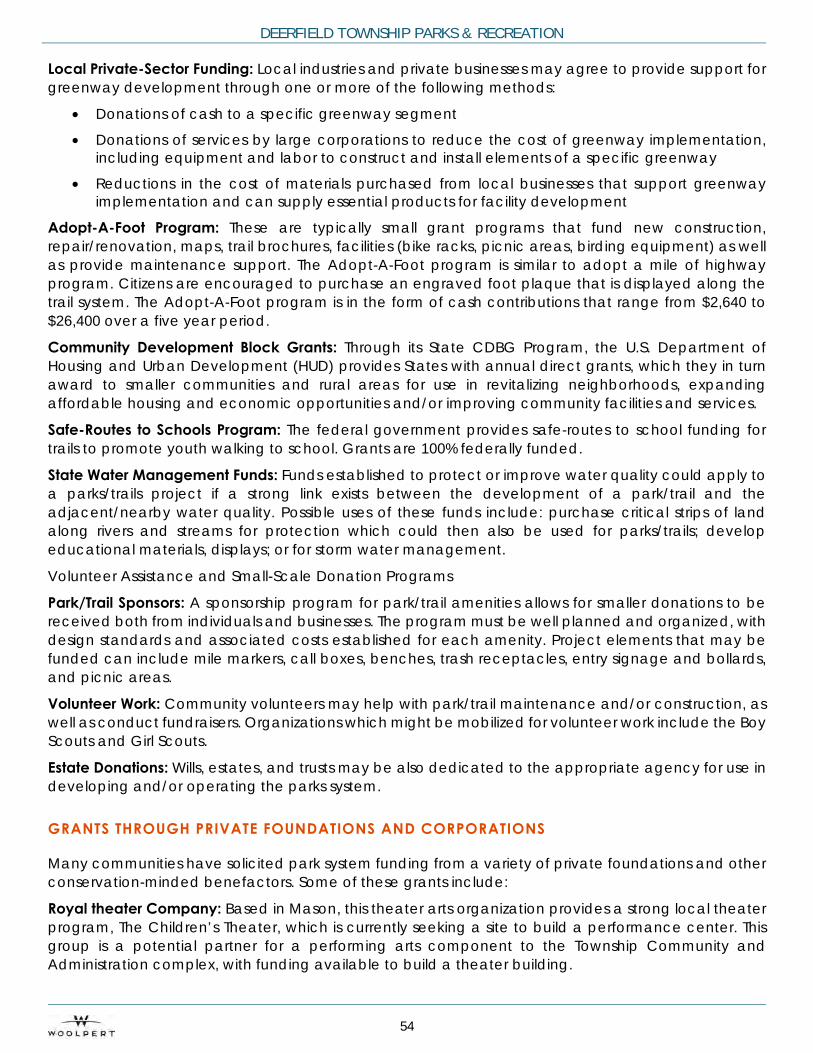
DEERFIELD TOWNSHIP PARKS & RECREATION
54
Local Private-Sector Funding: Local industries and private businesses may agree to provide support for greenway development through one or more of the following methods:
• Donations of cash to a specific greenway segment
• Donations of services by large corporations to reduce the cost of greenway implementation, including equipment and labor to construct and install elements of a specific greenway
• Reductions in the cost of materials purchased from local businesses that support greenway implementation and can supply essential products for facility development
Adopt-A-Foot Program: These are typically small grant programs that fund new construction, repair/renovation, maps, trail brochures, facilities (bike racks, picnic areas, birding equipment) as well as provide maintenance support. The Adopt-A-Foot program is similar to adopt a mile of highway program. Citizens are encouraged to purchase an engraved foot plaque that is displayed along the trail system. The Adopt-A-Foot program is in the form of cash contributions that range from $2,640 to $26,400 over a five year period.
Community Development Block Grants: Through its State CDBG Program, the U.S. Department of Housing and Urban Development (HUD) provides States with annual direct grants, which they in turn award to smaller communities and rural areas for use in revitalizing neighborhoods, expanding affordable housing and economic opportunities and/or improving community facilities and services.
Safe-Routes to Schools Program: The federal government provides safe-routes to school funding for trails to promote youth walking to school. Grants are 100% federally funded.
State Water Management Funds: Funds established to protect or improve water quality could apply to a parks/trails project if a strong link exists between the development of a park/trail and the adjacent/nearby water quality. Possible uses of these funds include: purchase critical strips of land along rivers and streams for protection which could then also be used for parks/trails; develop educational materials, displays; or for storm water management.
Volunteer Assistance and Small-Scale Donation Programs
Park/Trail Sponsors: A sponsorship program for park/trail amenities allows for smaller donations to be received both from individuals and businesses. The program must be well planned and organized, with design standards and associated costs established for each amenity. Project elements that may be funded can include mile markers, call boxes, benches, trash receptacles, entry signage and bollards, and picnic areas.
Volunteer Work: Community volunteers may help with park/trail maintenance and/or construction, as well as conduct fundraisers. Organizations which might be mobilized for volunteer work include the Boy Scouts and Girl Scouts.
Estate Donations: Wills, estates, and trusts may be also dedicated to the appropriate agency for use in developing and/or operating the parks system.
GRANTS THROUGH PRIVATE FOUNDATIONS AND CORPORATIONS
Many communities have solicited park system funding from a variety of private foundations and other conservation-minded benefactors. Some of these grants include:
Royal theater Company: Based in Mason, this theater arts organization provides a strong local theater program, The Children’s Theater, which is currently seeking a site to build a performance center. This group is a potential partner for a performing arts component to the Township Community and Administration complex, with funding available to build a theater building.

COMPREHENSIVE MASTER PLAN
55
American Greenways Eastman Kodak Awards: The Conservation Fund’s American Greenways Program has teamed with the Eastman Kodak Corporation and the National Geographic Society to award small grants ($250 to $2000) to stimulate the planning, design, and development of greenways.
REI Environmental Grants: Recreational Equipment Incorporated awards grants to nonprofit organizations interested in protecting and enhancing natural resources for outdoor recreation. The company calls on its employees to nominate organizations for these grants, ranging from $500 to $8,000, which can be used for the following:
• Protect lands and waterways and make these resources accessible to more people • Better utilize or preserve natural resources for recreation • Increase access to outdoor activities • Encourage involvement in muscle-powered recreation • Promote safe participation in outdoor muscle-powered recreation, and proper care for outdoor
resources Coors Pure Water 2000 Grants: Coors Brewing Company and its affiliated distributors provide funding and in-kind services to grassroots organizations that are working to solve local, regional, and national water-related problems. Coors provides grants, ranging from a few hundred dollars to $50,000, for projects such as river cleanups, aquatic habitat improvements, water quality monitoring, wetlands protection, pollution prevention, water education efforts, groundwater protection, water conservation, and fisheries.
World Wildlife Fund Innovative Grants Program: This organization awards small grants to local, regional, and statewide nonprofit organizations to help implement innovative strategies for the conservation of natural resources. Grants are offered to support projects that accomplish one or more of the following: (1) conserve wetlands; (2) protect endangered species; (3) preserve migratory birds; (4) conserve coastal resources; and (5) establish and sustain protected natural areas.
Innovative grants can help pay for the administrative costs for projects including planning, technical assistance, legal, and other costs to facilitate the acquisition of critical lands; retaining consultants and other experts; and preparing visual presentations and brochures or other conservation activities. The maximum award for a single grant is $10,000.
Bikes Belong: Bikes Belong Coalition is sponsored by members of the American Bicycle Industry. The grant program is a national discretionary program with a small budget, to help communities build TEA-21-funded projects. They like to fund high-profile projects and encourage regional coalitions. An application must be supported by the local bicycle dealers (letters of support should be attached). Bikes Belong also offers advice and information on how to get more people on bikes. Government and non-profit agencies are eligible and no match is required. The maximum amount for a grant proposal is $10,000. Applications may be submitted at any time and are reviewed as they are received.
Steelcase Foundation: Steelcase Foundation grants are restricted to locally sponsored projects in areas where there are Steelcase Inc. manufacturing plants. In general, Steelcase does not wish to be the sole funder supporting a program. Grants are also only made to non-profit organizations. It does support educational and environmental projects, and is particularly interested in helping the disadvantaged; disabled, young, and elderly improve the quality of their lives. Applications may be submitted anytime and are considered by the Trustees four times a year.
Wal-Mart Foundation: This foundation supports local community and environmental activities and educational programs for children (among other things). An organization needs to work with the local store manager to discuss application. Wal-Mart Foundation only funds 501(c)3 organizations.

DEERFIELD TOWNSHIP PARKS & RECREATION
56
OPERATIONAL FUNDING COSTS OPPORTUNITIES
When examining the potential opportunity to introduce new operational funding sources into the system, the following options are common funding sources to explore and evaluate for inclusion.
User fees: User fees to access or use elements of parks could be expanded to include fees to access parks and recreation services such as education programs, a dog park, a skate park, nature center, sport leagues, winter sports area, ice skating, spray ground and golf for green fees, carts, leagues, and lessons (these are example parks and recreation services agencies have assessed fees for in the past). Deerfield Township will need to examine the feasibility of implementing a comprehensive user fee schedule for its amenities as the system expands and grows.
Concessions: Concessions can be leased out to a private operator for a percentage of gross profits. Typically, 15%-18% of gross profits for concessions of a profit operator, or a managing agency over a park site could manage concessions.
Parking Fees: During major special tournaments or events, the Township should consider assessing a $5 parking fee.
Field Permits: Field permits are typically assessed for practice or games. Permits should cover the operational cost of each field and management costs. If a private operator desires to rent the site for a sporting tournament for private gain, the Township should provide a permit fee plus a percentage of gross from the event for the exclusive use of the fields.
Admission Fee: An admission fee to an event in the park can be utilized.
Food and Equipment Sponsors: Official drink and food sponsors can be utilized for the Township. Each official drink and food sponsor pays back to the Township a set percentage of gross. Typically, this is 15%-20% of costs for being the official product and receiving exclusive pouring and food rights to the facility. Likewise official equipment sponsors work well for trucks, mowers, and tractors.
Advertising Revenue: Advertising revenue can come from the sale of ads on banners in the parks. The advertising could include trash cans, trail markers, visitor pull trailers, tee boxes, scorecards, and within restrooms.
Wi-Fi Revenue: The Township can set up a Wi-Fi area whereby a Wi-Fi vendor is able to sell the advertising on the Wi-Fi access banner to local businesses targeting the users of the site. This revenue has amounted to $20,000-$50,000 for parks systems.
Cell Tower: Cell tower leases can be used. This revenue source could support $35,000-$50,000 annually for the site if cell towers are needed within the area.
Program Fees: Program Fees to support existing programs can be employed in the form of lessons, clinics, camps, life skill programs, and wellness and fitness. These program types typically help support the operations of the park and recreation system as a whole and should be assessed based on a classification of services model/philosophy.
Special Event Sponsors: Special events provide a great venue for sponsors as it applies to a concert, stage, entertainment, and safety.
Capital Improvement Fee: A Capital Improvement Fee on all programs and events can be added. A capital asset fee of $2-$3 on each person who participates in a class, event, or program can be incorporated into the cost of the program or event.
Volunteerism: The revenue source is an indirect revenue source in that persons donate time to the Township to assist in providing a product or service on an hourly basis. This reduces the Township’s cost in providing the service plus it builds advocacy for the Township.
Special Fundraiser: Many agencies hold special fundraisers on an annual basis to help cover specific programs and capital projects to be dedicated to a facility or Township as a whole.

COMPREHENSIVE MASTER PLAN
57
CHAPTER FOUR IMPLEMENTATION & ACTION PLAN
4.1 SYSTEM-WIDE CONNECTIVITY
The planning process revealed that connectivity – walkways and multi-use trails - is more relatively important to Deerfield residents than to communities of similar demographics. Therefore connectivity is a key component of the Parks Master Plan recommendations and is illustrated in Figure 4. The presence of regional trails in and near the Township adds to the opportunities offered by developing a well-connected community trail system. The trail system concept for Deerfield Township connects parks, destinations, trails and open spaces locally and regionally, using existing rights of way, and corridors with adequate width to build separated connectors along most of the proposed routes. The plan recommends:
• Up to three direct connections to the Little Miami River Trail, including: Installing a pedestrian suspension bridge under the Route 22 Bridge to the Little Miami Trail
• Improving connections to Mason and Warren County trails
• Connecting each of the parks to the Township trails network
• Establishing a design policy for neighborhood connections to parks
• Acquiring land for additional trail connections
• Establishing a trail along the west bank of the Little Miami River, from Little Miami Open Spaces to Foster’s Crossing
• Creating partnerships to facilitate completion of the Miami to Miami Trail

DEERFIELD TOWNSHIP PARKS & RECREATION
58
Figure 4: Proposed System-wide Connectivity Map
Legend
Deerfield TWP
Deerfield Township Parks
Deerfield TownshipConservation Lands
Planned Parks
Surface Water & Wetlands
Proposed Trail Connectivity
Existing Bike Paths & Trails
Deerfield Proposed Bike &Trail Connections
Other Proposed Bike & TrailConections
kkj Proposed Little MiamiCrossings

COMPREHENSIVE MASTER PLAN
59
4.2 PARKS AND FACILITY CONCEPTUAL PLANS
Many of the park programming and amenity needs identified through the public input process pertain to all the parks, while specific improvements were identified for each park. The conceptual plans illustrate how to expand community offerings as identified through the community needs assessment and Level of Service (LOS) using the existing park land and facilities. The expanded offerings cover a wide range of amenities:
• Provide a Nature Center (High Priority in survey), potentially at Carter Park, Kingswood Park or Little Miami open Spaces
• Expand Community Gardens (Medium Priority in survey)
• Install a Nature Playscape (Medium Priority in survey) potentially at Roberts Park, Carter Park, Kingswood Park, Landen-Deerfield Park or Little Miami Open Spaces Loveland Open Space
• Senior Activity Space (Medium Priority in survey)
• Install Pickleball Courts (Low Priority in survey) at Fleckenstein
• Install Cricket Court (not in survey, but the department receives consistent requests). This need can potentially be met as multi-use turf field at Cottell (between fields 3 and 4), North Cincinnati Community Church (partner), Kingswood (southeast corner)
• Install a Disc Golf Course, Potentially at Little Miami Open Spaces / Loveland Open Spaces, Kingswood Park, or Landen-Deerfield Park
• Install more synthetic fields in all parks for wet-weather play
• There is a desire for general indoor recreation space
• Splash/spray pad
• Outdoor volleyball courts
Concept plans have been prepared for the major parks and are for conceptual use only. These concept plans are based on the findings from this planning process and each park will require a more detailed individual park master plan and design efforts. The Conceptual plans illustrate the Master Plan recommendations for the following parks:
• Kingswood Signature Park
• Carter Community Park • Cottell Community Park
• Fleckenstein Neighborhood Park
• Roberts Neighborhood Park
• Schappacher Neighborhood Park
• Landen-Deerfield Community Park (Warren County)
• Foster’s Crossing Open Space/Natural Area

DEERFIELD TOWNSHIP PARKS & RECREATION
60
4.2.5 KINGSWOOD SIGNATURE PARK CONCEPT PLAN
Kingswood Park is 96 acres and centrally located in the southern portion of the Township on Irwin Simpson Road and long the I-71 corridor. Currently this property is largely unimproved, however the walking paths and Farmers Market are popular. The paths also have been popular for the cyclocross bicycle race, another amenity is a Community Garden. There is strong support for retaining much of the site for trails and natural area, and also support for limited development south of Innovation way for public uses, such as civic space and a permanent multi-purpose community pavilion.
The conceptual development plan for Kingswood Park is shown in Figure 9. Priority improvements recommended for Kingswood Park are:
• Develop a small area south of Innovation Way for a Civic and Community space
• Build a permanent multi-purpose Community Pavilion with sustainable features that, among other uses will house the Farmers Market
• Add a safe pedestrian crossing of Innovation Way
• Add a Nature Playscape
• Add a multi-Use community events field Improve the trail system
• Improve pond access
• Add educational components and signage through the park
• Add a shelter near the pond
• Connect the park to the Township trail network
• Add a disc golf course of at least 18 holes
• Potential site for a Nature Center
• Enhance community gardens south of Innovation Way
Strategies for preserving Kingswood as parkland include utilizing an third-party easement, with an organization that has a strong interest in preserving parkland, such as a Nature Conservancy. The Township should create a park master plan for the property and explore options to ensure the easement meets the vision and goals.
Community Gardens at Kingswood Park

COMPREHENSIVE MASTER PLAN
61
Figure 5: Kingswood Signature Park Concept Plan* (96 Acres) *Plan is conceptual only, based on planning process findings. Each park will require a more detailed individual park Master Plan

DEERFIELD TOWNSHIP PARKS & RECREATION
62
4.2.1 CARTER COMMUNITY PARK CONCEPT PLAN
This largely wooded 88-acre community park is located in the northeast quadrant of Deerfield Township. This park offers a distinctly different set of recreational opportunities than any other park in the Township. It borders the ODNR property on the little Miami River north of Kings Island. A variety of natural features, including a pond and several meadows, with steep topography offer scenic views and an ideal setting for wildlife. Trails and paths throughout the park take advantage of the tree canopy and views. Other features include the “king’s crown” quilt barn, and a wildlife/learning garden with several educational signs.
Carter Park is lightly used, in part due to location, lack of knowledge about the park, and access and parking. The conceptual development plan for Carter Park is shown in Figure 5. Priority improvements recommended for Carter Park include the following:
• Improve access and parking
• Add wayfinding and improved trail signage
• Add a trail head kiosk
• Add a nature playscape
• Potential site for nature center and nature trail
• Expand the community garden
• Convert the green roof building to rest rooms or programmable space
• Connect paths to the Township network and the Miami to Miami trail system
• Add an overlook and bridge across the Little Miami River
• Enhance the pond
• Add shelters
• Add bike-washing stations for mountain bikers
• Replace missing wooden Inter-Urban rail line bridge to increase accessibility
Walking path and interpretive signage at Carter Park

COMPREHENSIVE MASTER PLAN
63
Figure 6: Carter Community Park Concept Plan* (88 Acres) *Plan is conceptual only, based on planning process findings. Each park will require a more detailed individual park master plan

DEERFIELD TOWNSHIP PARKS & RECREATION
64
4.2.2 COTTELL COMMUNITY PARK CONCEPT PLAN
This 47-acre Community Park is also the Township’s Sports Park. located at the intersection of Snider Rd and Irwin-Simpson Rd. The park features soccer fields, tennis courts, baseball fields, basketball courts, and a walking path. The centerpiece of the Cottell Park is the Snyder House, an events facility, which also houses some of the summer camp programs. The park is also home to the Deerfield Honors Veterans Memorial. Additional amenities include a fishing pond, picnic shelters, playgrounds, restroom facilities and the "Circle Game" quilt barn, part of the Township’s quilt barn trail.
Cottell Park is heavily used, overloading the existing parking at times; this park seems to be preferred over others with similar sports fields.
The conceptual development plan for Cottell Park is shown in Figure 6. Priority improvements recommended for Cottell Park are:
• Upgrade Snyder House
• Add synthetic turf multi-use sports field between ballfields on the south side of the park
• Add parking
• Complete the loop drive around the tennis courts
• Extend curb & gutter south on Snider Road to reduce maintenance
• Add a park sign on a new wall at the southwest corner of the park • Consider expansion to neighboring land for added sports fields
Snyder House at Cottell Park

COMPREHENSIVE MASTER PLAN
65
Figure 7: Cottell Community Park Concept Plan* (47 Acres) *Plan is conceptual only, based on planning process findings. Each park will require a more detailed individual park master plan

DEERFIELD TOWNSHIP PARKS & RECREATION
66
4.2.3 FLECKENSTEIN COMMUNITY PARK CONCEPT PLAN
Located in the northern part of the Township, this 50-acre Community Park features soccer fields, baseball fields, tennis courts, a playground, several ponds, and a large picnic shelter with restrooms. Other features are a walking path, playground, multi-purpose fields and one of the three quilt barns on the Township’s quilt barn trail. Fleckenstein Park is not widely known by Township residents and is lightly used.
The conceptual development plan for Fleckenstein Park is shown in Figure 7. Priority improvements recommended for Fleckenstein Park are:
• Add a shelter and drinking fountain near the barn
• Program the barn and upgrade the barn to support the program
• Refine the site plan at the barn to support the program
• Expand Restrooms at the center of the sports fields or at the barn
• Add between 2 and 4 pickleball courts
• Add basketball
Pond and walkway at Fleckenstein Park

COMPREHENSIVE MASTER PLAN
67
Figure 8: Fleckenstein Community Park Concept Plan* (50 Acres) *Plan is conceptual only, based on planning process findings. Each park will require a more detailed individual park master plan

DEERFIELD TOWNSHIP PARKS & RECREATION
68
4.2.6 LANDEN-DEERFIELD COMMUNITY PARK CONCEPT PLAN
The Landen-Deerfield Park is a Warren County Park District Community Park which Deerfield Township partners to support programming. This 91-acre Community Park retains large areas of natural open space, while also providing soccer, baseball, softball and football fields, tennis, basketball and sand volleyball courts, hiking trials, mountain bike trails, fishing, shelters, restrooms, concession stand, picnic tables and grills, and an amphitheater. The active play fields at Landen Park are heavily used for organized team sports and the fields often resulting in traffic backups in the park.
The conceptual development plan for Landen-Deerfield Park is shown in Figure 10. Priority improvements recommended for Landen-Deerfield Park are:
• Improve auto access and egress
• Connect park trails to the Township network
• Features in the park will be ADA compliant
• Add a Nature Playscape
• Upgrade fields and facilities
• Add bike washing facilities for mountain bikers
Pond and open space at Landen Deerfield Park

COMPREHENSIVE MASTER PLAN
69
Figure 9: Landen-Deerfield Community Park Concept Plan* (91 Acres)
*Plan is conceptual only, based on planning process findings. Each park will require a more detailed individual park master plan

DEERFIELD TOWNSHIP PARKS & RECREATION
70
4.2.4 ROBERTS NEIGHBORHOOD PARK CONCEPT PLAN
The 79-acre Roberts Neighborhood Park was donated to the Township with restrictions that require it to remain a natural area, with minimal development. Currently, the park provides extensive walking trails and nature Conservation Lands. Trailhead signs are visible near street parking to identify park walking paths. Roberts Park is lightly used, in part due to lack of parking, playground and shelter.
The conceptual development plan for Roberts Park is shown in Figure 8. Priority improvements recommended for Roberts Park are:
• Add parking in the southwest corner
• Add a raingarden near the new parking
• Add to and complete trails
• Add a Nature Playscape
• Add a picnic shelter
• Add trees/landscape
• Add a park sign along Butler-Warren Road
Path at Roberts Park
COMPREHENSIVE MASTER PLAN
71
Figure 10: Roberts Neighborhood Park Concept Plan* (79 Acres) *Plan is conceptual only, based on planning process findings. Each park will require a more detailed individual park master plan

DEERFIELD TOWNSHIP PARKS & RECREATION
72
4.2.7 SCHAPPACHER NEIGHBORHOOD PARK CONCEPT PLAN
This 10-acre Neighborhood Park along a stream, offers a playground, picnic shelters, restrooms, and parking. The 20,000 plus square foot dog run is surrounded by mature oak trees.
The conceptual development plan for Schappacher Park is shown in Figure 11. Priority improvements for Schappacher Park are:
• Improve and expand the dog park
• Connect the park to the Township trail network
• Add auto access from Irwin-Simpson Road
• Acquire the corner parcel
• Upgrade the play structure and shelter
• Replace the bridge
Dog Park at Shappacher Park

COMPREHENSIVE MASTER PLAN
73
Figure 11: Schappacher Neighborhood Park Concept Plan
*Plan is conceptual only, based on planning process findings. Each park will require a more detailed individual park master plan

DEERFIELD TOWNSHIP PARKS & RECREATION
74
4.2.8 FOSTERS CROSSING OPEN SPACE/NATURAL AREA CONCEPT PLAN
Fosters Crossing is a 5-acre Open Space/Natural Area, largely undeveloped along the Little Miami River. This unique site offers development potential for a recreation-oriented destination, that can connect the Township trail system across the river to the Little Miami bike Trail. It also adjoins Carl A. Rahe State Park (14 acres) which includes a shelter and canoe landing. The Township will seek proposals to create a compatible development on the site.
The conceptual development plan for Fosters Crossing is shown in Figure 12. Priority improvements for Fosters Crossing include:
• Add a trail head at the old 3C bridge
• Explore a potential development opportunity for the site
• Add/improve the canoe launch
• Connect the multi-use trail across the Little Miami River
• Connect a multi-use trail south to Carl A. Rahe State Park and Jeremiah Morrow Barn
• Potential acquisition of Carl A. Rahe State Park
Access drive at Foster’s Crossing
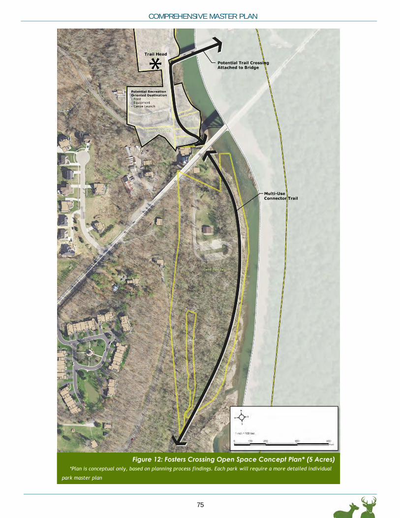
COMPREHENSIVE MASTER PLAN
75
Figure 12: Fosters Crossing Open Space Concept Plan* (5 Acres) *Plan is conceptual only, based on planning process findings. Each park will require a more detailed individual
park master plan

DEERFIELD TOWNSHIP PARKS & RECREATION
76
4.3 SUSTAINABLE DESIGN
As populations continue to grow, public parks face increased use as well as pressure to be both beautiful and sustainable. A sustainable park is designed to preserve natural resources as well as improve quality of life for people who live near the park and who use it. The following are examples of elements that contribute to a park’s sustainability:
• Energy-efficient buildings
• Long-lasting or responsibly-sourced materials
• Conserved and restored natural areas
• Easy-to-maintain plants and landscaping
• Stormwater management
• Waste management that reduces impact on landfills
• ADA accessibility
• Multi-use
• Eco-friendly maintenance practices and standards
The positive effects of sustainably designed parks include but are not limited to reduced flooding and erosion, air pollution filtration, air cooling, protection of biodiversity, and lower maintenance budgets.
4.3.1 SITE SUSTAINABILITY
Since sustainability is an underlying motivation for future improvements throughout Deerfield parks, sustainable solutions should be celebrated in the design, and noted in interpretive signage. Examples may include:
• Bio-swales and rain gardens
• Protected natural areas
• Building orientation and design
• Energy usage
These guidelines provide standards that present a unified vocabulary of design philosophy, character and materials that produces an expression which clearly identifies each park as part of the Deerfield Township system.
4.3.2 LAND PROTECTION
Protect sensitive lands such as wetlands, floodplains and wildlife habitat. Wetlands have a crucial function in the health of both aquatic and terrestrial ecosystems. An environmental field review is needed for each project to identify sensitive areas, in accordance with EPA rules regarding wetlands. In areas located below the 100-year flood elevation, permanent structures should be placed above the 100-year elevation or designed in a way to accommodate flooding. Parks and open spaces are a good way to protect wildlife habitat by enhancing existing habitats and creating new ones. This creates opportunities for wildlife viewing, bird watching and learning about nature.

COMPREHENSIVE MASTER PLAN
77
4.3.3 STORMWATER MANAGEMENT
Stormwater is the water that accumulates from precipitation on land, including run-off from the built environment. Run-off can lead to flooding, which in turn may lead to property damage. The more native vegetation left on-site, the lower the volume of run-off and likelihood of flooding. Stormwater management uses green infrastructure such as bioswales and vegetated detention ponds to regulate both the quantity and the quality of run-off. Best management practices include:
• Preserve the pre-project run-off conditions following construction with no net increase in run-off volume for the two-year, 24-hour storm OR
• Retain and provide on-site infiltration or treatment for a run-off volume of one inch of rain multiplied by the area of impervious surface
• Reduce hard infrastructure and closed systems (pipes)
Green infrastructure and stormwater management practices employed with the primary goal of preserving, restoring or mimicking natural hydrology are preferred and should follow the design guidance in the Ohio Department of Natural Resource’s Rainwater and Land Development Manual.
Example of stormwater management low-impact development

DEERFIELD TOWNSHIP PARKS & RECREATION
78
4.3.4 PARKING LOTS
Green parking lots use stormwater management practices, native vegetation and sustainable paving materials to mitigate adverse environmental impacts of large expanses of paving. They can also use strategies such as energy-efficient lighting, renewable energy sources, and protecting pedestrian circulation. Green parking lots are a significant component of low impact development (LID), which uses or mimics natural processes to protect water quality. They also reduce heat islands and create more attractive places. Common elements include:
• Shading and greening
• Permeable paving
• Light and energy generation
• Naturalized drainage
• Pedestrian connections
• Community character
Minimize non-porous surfaces like roads, parking lots and paved trails. Consider replacing asphalt and concrete with porous pavement, mulch paths, gravel lots and native vegetation. Porous surfaces help to recharge ground water, reduce erosion, lessen flooding events and filter out pollutants.
Common implementation strategies include:
• Solar panels
• Traffic calming strategies
• Rain gardens
• Native plant species
• Energy-efficient lamps
• Grass-block pavers
4.4 LAND MANAGEMENT & ACQUISITION
Having a strategy for managing and acquiring property is very important. The following recommendations are general in nature and should be used to guide future decisions.
• Recommended policy for accepting dedications and recommendations
• Land acquisition should be based on filling gaps in the parks and recreation system, to balance distribution of facilities and to meet growing demand
• Partnering—working with ODNR, Warren County (Landen-Deerfield), City of Mason, and other entities (North Cincinnati Community Church, Common Ground Park) to support desired development in parks that serve Deerfield residents
• To protect park land, the Township should explore options for establishing a park zoning district and rezoning park properties accordingly.

COMPREHENSIVE MASTER PLAN
79
4.5 ACTION PLAN
The core of the recommendations is a step by step action plan to respond to each of the goals identified by the process. The action plan details specific steps to take over the next 10 years to implement priority park and facility development, land acquisitions, program expansion and enrichment, and the administrative actions to support them. The plan lists specific actions by year and is designed to allow tasks not completed or undertaken to be shifted to the following year, maintaining the sequential order. On the other hand, should grant, partnership or other funding become available for any specific project, that project can be moved forward, and the plan adjusted to redistribute tasks as needed.
For the first five years, each year’s actions are listed by year. The years after are listed in more general terms. That portion of the plan should be updated during year five based on the results of the first four years and any changes in population growth. Tables 13-16 identify the action plan strategy with actions being phased and prioritized. The rankings (1-3) in the phasing columns indicate the priority, with 1 being the highest priority items and 3 being lowest. All actions are a priority for the Township based on the analysis conducted and the public input received.
The Action Plan is broken down into the following four categories:
1. Facilities & Land Management (Table 13)
2. Programming (Table 14)
3. Operations & Staffing (Table 15)
4. Financing (Table 16)

DEERFIELD TOWNSHIP PARKS & RECREATION
80
Table 13- Facilities & Land Management Action Plan Table 13- Facilities & Land Management Action Plan
Item Goal Alignment Objective / Action
Short-Term 0 -3
Years
Mid-Term 4 - 7
Years
Long-Term
8+ Years
1 FACILITIES & LAND MANAGEMENT 1.1 4 Develop comprehensive bikeway and pedestrian trail plan 1 1 1
1.2 4 Design/Construct/Implement bikeway and pedestrian trails 1 1 1
1.3 7 Develop & Implement a strategy to protect Kingswood as parkland 1
1.4 1 Establish a Park Zoning District and rezone all park properties 2
1.5 7 Kingswood Park - Develop an integrated park master plan, including Civic Center/Community Program Space and Open Space/Natural Area Park; design phased improvements to the site, and construct phased improvements
2 1 1
1.6 5 Carter Park - Develop a park master plan that enhances connections to the Little Miami River, design and construct improvements
2 2
1.7 5 Explore potential acquisition of Carl A. Rahe State Park 3
1.8 3 Conduct a Feasibility Study to define needs and objectives for a Nature Center 1
1.9 5 Cottell Park - Develop a park master plan; design and construct park improvements 1 1
1.10 3 Explore feasibility of acquiring Jeremiah Morrow Barn 1
1.11 5 Landen-Deerfield Park - Explore the potential of a partnering or acquisition agreement for the park; evaluate the need for a park master plan, explore design improvements, and explore partnership for development
2
1.12 5
Foster's Crossing - Explore feasibility and master planning of a private recreation-oriented destination development with connections to Carl H. Rahe State Park, Loveland Park and the Little Miami River; design and construct public sector park improvements
2
1.13 3 Roberts Park - Develop a park master plan, design and construct park improvements 2
1.14 3 Schappacher Park - Design and construct park improvements 2
1.15 3 Fleckenstein Park - Develop a park master plan; design and construct park improvements 2
1.16 5 Evaluate partnership with North Cincinnati Community Church to master plan park facilities at the corner of Irwin Simpson and Snyder Roads to supplement Cottell Park, and to design and construct park facilities
1
1.17 4 Little Miami Open Space; Loveland Park Open Space - Develop a multi-purpose trail system and connect to the Little Miami River and Trail
1
1.18 4 Explore partnership with ODOT and ODNR to develop trail bridges across the Little Miami River 2
1.19 3 Jeremiah Morrow Barn – Potential property acquisition to preserve the barn and turn into a limited-use facility to support programming as needed.
2
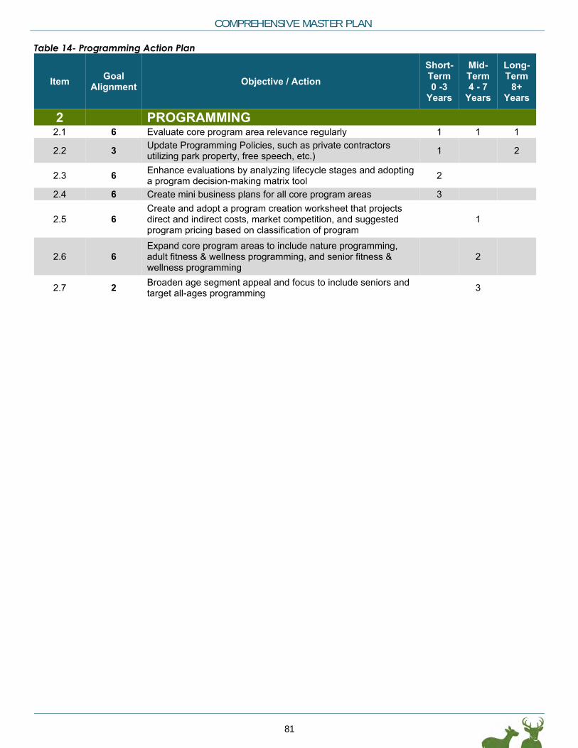
COMPREHENSIVE MASTER PLAN
81
Table 14- Programming Action Plan
Item Goal Alignment Objective / Action
Short-Term 0 -3
Years
Mid-Term 4 - 7
Years
Long-Term
8+ Years
2 PROGRAMMING 2.1 6 Evaluate core program area relevance regularly 1 1 1
2.2 3 Update Programming Policies, such as private contractors utilizing park property, free speech, etc.) 1 2
2.3 6 Enhance evaluations by analyzing lifecycle stages and adopting a program decision-making matrix tool 2
2.4 6 Create mini business plans for all core program areas 3
2.5 6 Create and adopt a program creation worksheet that projects direct and indirect costs, market competition, and suggested program pricing based on classification of program
1
2.6 6 Expand core program areas to include nature programming, adult fitness & wellness programming, and senior fitness & wellness programming
2
2.7 2 Broaden age segment appeal and focus to include seniors and target all-ages programming 3

DEERFIELD TOWNSHIP PARKS & RECREATION
82
Table 15- Operations & Staffing Action Plan Table 15- Operations & Staffing Action Plan
Item Goal Alignment Objective / Action
Short-Term 0 -3
Years
Mid-Term 4 - 7
Years
Long-Term
8+ Years
3 OPERATIONS & STAFFING
3.1 1 Reorganize the Department to be functionally aligned while also calculating the hours required to adequately perform each identified function
1
3.2 2 Begin to track unit costs and create Key Performance Indicators (KPIs) as a result 1
3.3 1 Implement formal tracking of staff time spent assisting other departments, as well as tracking the hours other departments assist Parks
1
3.4 3 Update Park Rules to incorporate drones, AMD, metal detectors, smoking, using parks for personal gain, etc. 1
3.5 3 Classify park services based on essential, important, and value-added 1
3.6 3 Develop a comprehensive land dedication and gift policy for donation of, trees, benches, brick, mass tree donations, and monetary donations.
1
3.7 3 Develop consistent design guidelines for park entrances, signage, and wayfinding 1
3.8 6 Expand cost recovery data practices in terms of data collection and analysis 2
3.9 3 Consolidate Rules and Policies into a policy and procedure handbook, including: Special Event Permitting, Facility Use, Field Use, park rules, gifts, pricing of services, partnerships, marketing and communication,
2
3.10 2 Develop a comprehensive marketing strategy 2
3.11 1 Research cost and benefits of implementing software for Maintenance Management and Work Order Tracking 2
3.12 3 Define maintenance standards/levels for park classifications 2 3.13 3 Build an Operational Budget based on standards 3
3.14 3 Develop a maintenance schedule and budget for ongoing maintenance of existing park facilities 3
3.15 2 Reduce barriers to participation by increasing marketing focus on technology use and integration (e.g., website, apps, social media, etc.)
1
3.16 6 Enhance volunteerism analytics 1 3.17 3 Seek National Recreation Park Association Accreditation 2 1
3.18 6 Incorporate additional pricing tactics as appropriate, such as by location, prime/non-prime time; cost recovery goals, and by customer's ability to pay
2

COMPREHENSIVE MASTER PLAN
83
Table 16- Financing Action Plan
Item Goal Alignment Objective / Action
Short-Term 0 -3
Years
Mid-Term 4 - 7
Years
Long-Term
8+ Years
4 FINANCING 4.1 1 Develop a funding strategy for capital improvements 1
4.2 3 Build a Capital Budget based on standards and Park Master Plans 1
4.3 1 Seek out new partnerships 1 1 1
4.4 4 Identify/Secure funding for park improvements, and bikeway and pedestrian trails, based on project priorities 1 1 1
4.5 3 Secure a Permanent Operation Levy and explore a separate Capital Improvement Levy 1
4.6 COST ESTIMATES
Based on the concept plans developed for the eight parks, as well as improvements to other parks and the bicycle and pedestrian trails connecting the community, the following Rough Order of Magnitude (ROM) costs estimates have been prepared. These ROM costs are provided to begin funding this master plan. A 5-year Capital Improvement Plan (CIP) is critical for any and all capital improvement projects identified. Everything else should be reviewed for private donations, grant monies, operational budget (existing or increase requests) and/or levy justification. The Parks and Recreation Department should be planning this out again in a 5- to 10- year timeframe or as needed for implementation.
The recommendations from the strategy action plan and park concept plans are phased and prioritized based on the input through December 2018 as shown in Tables 17 through 24. This is not an implement everything at once plan and changes to prioritization will occur, therefore it is critical that this plan is evaluated and updated as needed.

DEERFIELD TOWNSHIP PARKS & RECREATION
84
This page is intentionally left blank.

COMPREHENSIVE MASTER PLAN
85
Table 17: Kingwood Signature Park ROM Cost
DESCRIPTION UNITS UNIT UNIT PRICE TOTAL EXHIBITREPAIR/REPLACE/MAINTAIN/NEW PRIORITY TIMELINE CONTACT INFO PROJECT TYPE NOTES/QUESTIONS
Park Master Plan 1 EA 50,000$ 50,000$ New 1 0-2 years Planning
Community Pavilion (Multi-Use & Farmers Market) 8000 SF 120$ 960,000$ Enhancement 1 3-5 years BuildingsUpgrade trails 10000 Lf 10$ 100,000$ Renovate 1 3-5 years Site development 8' paths gravel or natural surfaceUpgrade detention areas to rain gardens 2 EA 5,000$ 10,000$ New 1 3-5 years Site developmentTownship Offices* * EA -$ -$ New 2 3-5 years BuildingsPedestrian tunnel under Innovation Way 1 LS 500,000$ 500,000$ New 2 3-5 years Site developmentImprove Pond Access 1 LS 100,000$ 100,000$ New 2 3-5 years Site developmentPark pavilion 1 EA 150,000$ 150,000$ New 3 3-5 years BuildingsMulti-use Turf events field 4400 SY 85$ 374,000$ New 1 6-10 years Site developmentAdd parking north of Innovation Way 24 EA 5,000$ 120,000$ New 1 6-10 years Site developmentConnect paths to the Township system and Miami-to-Miami network 2000 LF 50$ 100,000$ New 1 6-10 years Site development 12' wide asphalt Nature playscape 1 EA 100,000$ 100,000$ New 1 6-10 years Site developmentPark shelter 1 EA 100,000$ 100,000$ New 2 6-10 years BuildingsDisc golf 1 EA 50,000$ 50,000$ New 2 6-10 years Site developmentUpgrade Service Yard and building 1 EA 500,000$ 500,000$ Renovate 2 6-10 years BuildingsTOTAL SITE 3,214,000$ *Cost to be determined through a planning study for the facility
DESCRIPTION UNITS UNIT UNIT PRICE TOTAL EXHIBITREPAIR/REPLACE/MAINTAIN/NEW PRIORITY TIMELINE CONTACT INFO PROJECT TYPE NOTES/QUESTIONS
PLANNING TOTALS BY TIMELINE0-2 years 50,000$ 3-5 years -$ 6-10 years -$ PLANNING 50,000$
DEVELOPMENT TOTALS BY TIMELINE0-2 years -$ 3-5 years 1,820,000$ 6-10 years 1,344,000$ DEVELOPMENT 3,164,000$
KINGSWOOD SIGNATURE PARK TOTAL 3,214,000$
KINGSWOOD SIGNATURE PARK

DEERFIELD TOWNSHIP PARKS & RECREATION
86
This page intentionally left blank

COMPREHENSIVE MASTER PLAN
87
Table 18: Carter Community Park ROM Cost Estimates
DESCRIPTION UNITS UNIT UNIT PRICE TOTAL EXHIBITREPAIR/REPLACE/MAINTAIN/NEW PRIORITY TIMELINE CONTACT INFO PROJECT TYPE NOTES/QUESTIONS
CARTER COMMUNITY PARK
Park Master Plan 1 EA 40,000$ 40,000$ New 1 0-2 years Planning
Trail head kiosk 1 EA 10,000$ 10,000$ New 1 0-2 years Site developmentExpand the community garden 2000 SY 20$ 40,000$ Enhancement 2 0-2 years Site developmentEnhance the pond 1 LS 20,000$ 20,000$ Enhancement 2 0-2 years Site developmentWayfinding and improved trail signage 20 EA 200$ 4,000$ Enhancement 2 0-2 years Site developmentImprove access 1500 SY 45$ 67,500$ New/renovate 1 3-5 years Site developmentAdd parking 40 EA 5,000$ 200,000$ New/renovate 1 3-5 years Site developmentConvert Green Roof building to RestRooms 1 LS 200,000$ 200,000$ Repurpose 2 3-5 years BuildingsAdd shelters (3) 3 EA 130,000$ 390,000$ New 2 3-5 years BuildingsExtend park trail system 3500 LF 18$ 63,000$ New 3 3-5 years Site development 8' - 10' widegravel - pavedConnect paths to the Township system and Miami-to-Miami network 4200 LF 50$ 210,000$ New 3 3-5 years Site development 12' wide asphalt replacing existing perimeter pathNature playscape 1 EA 100,000$ 100,000$ New 1 6-10 years Site developmentNature Center 1 EA 300,000$ 300,000$ New 2 6-10 years Buildings Assume 1200 SF @ 250/SFNature trail 2800 LF 15$ 42,000$ New/conversion 2 6-10 years Site development 4 - 6' wide gravel or natural surfaceOverlook and bridge across the Little Miami River* 1 LS -$ -$ New 3 6-10 years Site developmentExotic vegetation removal 10 AC 1,750$ 17,500$ Maintain 3 6-10 years Site developmentTOTAL SITE 1,704,000$ *This estimate assumes that the trail addition to the roadway bridge will be included the new Roadway bridge
DESCRIPTION UNITS UNIT UNIT PRICE TOTAL EXHIBITREPAIR/REPLACE/MAINTAIN/NEW PRIORITY TIMELINE CONTACT INFO PROJECT TYPE NOTES/QUESTIONS
PLANNING TOTALS BY TIMELINE0-2 years 40,000$ 3-5 years -$ 6-10 years -$ PLANNING 40,000$
DEVELOPMENT TOTALS BY TIMELINE0-2 years 74,000$ 3-5 years 1,130,500$ 6-10 years 459,500$ DEVELOPMENT 1,664,000$
CARTER COMMUNITY PARK TOTAL 1,704,000$

DEERFIELD TOWNSHIP PARKS & RECREATION
88
This page intentionally left blank

COMPREHENSIVE MASTER PLAN
89
Table 19: Cottell Community Park ROM Cost Estimates
DESCRIPTION UNITS UNIT UNIT PRICE TOTAL EXHIBITREPAIR/REPLACE/MAINTAIN/NEW PRIORITY TIMELINE CONTACT INFO PROJECT TYPE NOTES/QUESTIONS
COTTELL COMMUNITY PARKPark Master Plan 1 EA 40,000$ 40,000$ New 1 3-5 years Planning
Extend curb and gutter and storm drain pipe along Snyder Rd. 400 LF 100$ 40,000$ New 2 0-2 years Site developmentStabilize Island shoreline 1 EA 15,000$ 15,000$ Renovate 2 0-2 years Site developmentUpgrade Snyder House 1 LS 400,000$ 400,000$ Renovate 1 3-5 years BuildingsExpanded parking 100 EA 5,000$ 500,000$ New 1 3-5 years Site developmentDrives to new parking 1100 SY 45$ 49,500$ New 1 3-5 years Site developmentMulti use Turf Sports Field 2000 SY 85$ 170,000$ New 2 3-5 years Site developmentNew Park Sign, retaining wall and pond upgrades 1 LS 75,000$ 75,000$ New 2 3-5 years Site developmentShade topper system for ballfield seating 1 LS 15,000$ 15,000$ New 2 3-5 years Site developmentDrainage Repairs 1 LS 60,000$ 60,000$ Renovate 2 3-5 years BuildingsConcession Stand and Shelter 1 LS 150,000$ 150,000$ New 3 3-5 years BuildingsUpgrade Ballfield fences, backstops, add outfield fences 4200 LF 50$ 210,000$ Renovate 1 6-10 years Site developmentSplash Pad 1 LS 300,000$ 300,000$ New 2 6-10 years Site developmentTOTAL SITE 2,024,500$
DESCRIPTION UNITS UNIT UNIT PRICE TOTAL EXHIBITREPAIR/REPLACE/MAINTAIN/NEW PRIORITY TIMELINE CONTACT INFO PROJECT TYPE NOTES/QUESTIONS
PLANNING TOTALS BY TIMELINE0-2 years 40,000$ 3-5 years -$ 6-10 years -$ PLANNING 40,000$
DEVELOPMENT TOTALS BY TIMELINE0-2 years 55,000$ 3-5 years 1,419,500$ 6-10 years 510,000$ DEVELOPMENT 1,984,500$
COTTELL COMMUNITY PARK TOTAL 2,024,500$

DEERFIELD TOWNSHIP PARKS & RECREATION
90
This page intentionally left blank

COMPREHENSIVE MASTER PLAN
91
Table 20: Fleckenstein Community Park ROM Cost Estimates
DESCRIPTION UNITS UNIT UNIT PRICE TOTAL EXHIBITREPAIR/REPLACE/MAINTAIN/NEW PRIORITY TIMELINE CONTACT INFO PROJECT TYPE NOTES/QUESTIONS
FLECKENSTEIN COMMUNITY PARKPark Master Plan, and Barn Programming 1 EA 20,000$ 20,000$ New 1 3-5 years Planning
Shelter and drinking fountain (near barn) 1 EA 150,000$ 150,000$ New 1 3-5 years BuildingsNew pickleball courts (4) 4 EA 30,000$ 120,000$ New/renovate 1 3-5 years Site developmentNew basketball 1 EA 30,000$ 30,000$ New/renovate 1 3-5 years Site developmentExpand restrooms (at the center of the ballfields or at the barn) 1 LS 100,000$ 100,000$ Enhancement 2 3-5 years BuildingsUpgrade barn to support programming 1 LS 200,000$ 200,000$ Enhancement 1 6-10 years BuildingsRefine the site around the barn to support programming 1 LS 100,000$ 100,000$ Enhancement 2 6-10 years Site developmentTOTAL SITE 720,000$
DESCRIPTION UNITS UNIT UNIT PRICE TOTAL EXHIBITREPAIR/REPLACE/MAINTAIN/NEW PRIORITY TIMELINE CONTACT INFO PROJECT TYPE NOTES/QUESTIONS
PLANNING TOTALS BY TIMELINE0-2 years -$ 3-5 years 20,000$ 6-10 years -$ PLANNING 20,000$
DEVELOPMENT TOTALS BY TIMELINE0-2 years -$ 3-5 years 400,000$ 6-10 years 300,000$ DEVELOPMENT 700,000$
FLECKENSTEIN COMMUNITY PARK TOTAL 720,000$

DEERFIELD TOWNSHIP PARKS & RECREATION
92
This page intentionally left blank

COMPREHENSIVE MASTER PLAN
93
Table 21: Landen-Deerfield Community Park ROM Cost Estimates
DESCRIPTION UNITS UNIT UNIT PRICE TOTAL EXHIBITREPAIR/REPLACE/MAINTAIN/NEW PRIORITY TIMELINE CONTACT INFO PROJECT TYPE NOTES/QUESTIONS
LANDEN-DEERFIELD COMMUNITY PARK
Park Master Plan 1 EA 20,000$ 20,000$ New 1 3-5 years Planning
Upgrade sports fields 1 EA 250,000$ 250,000$ New 1 3-5 years BuildingsNew path through park center 1100 LF 30$ 33,000$ New 2 3-5 years Site developmentUpgrade vehicular ingress/egress 1 LF 100,000$ 100,000$ New 2 3-5 years Site developmentConnect paths to the Township system and Miami-to-Miami network 5600 LF 50$ 280,000$ New 1 6-10 years Site development 12' wide asphalt Nature playscape 1 EA 100,000$ 100,000$ New 1 6-10 years Site developmentUpgrade park buildings 1 LS 180,000$ 180,000$ New 2 6-10 years Site developmentUpgrade park playgrounds 1 LS 100,000$ 100,000$ New 2 6-10 years Site developmentTOTAL SITE 1,063,000$
DESCRIPTION UNITS UNIT UNIT PRICE TOTAL EXHIBIT /REPLACE/MAINTAINPRIORITY TIMELINE CONTACT INFO PROJECT TYPE NOTES/QUESTIONS
PLANNING TOTALS BY TIMELINE0-2 years -$ 3-5 years 20,000$ 6-10 years -$ PLANNING 20,000$
DEVELOPMENT TOTALS BY TIMELINE0-2 years -$ 3-5 years 350,000$ 6-10 years 660,000$ DEVELOPMENT 1,010,000$
LANDEN-DEERFIELD COMMUNITY PARK 1,030,000$

DEERFIELD TOWNSHIP PARKS & RECREATION
94
This page intentionally left blank

COMPREHENSIVE MASTER PLAN
95
Table 22: Roberts Open Space/Natural Area ROM Cost Estimates
DESCRIPTION UNITS UNIT UNIT PRICE TOTAL EXHIBITREPAIR/REPLACE/MAINTAIN/NEW PRIORITY TIMELINE CONTACT INFO PROJECT TYPE NOTES/QUESTIONS
ROBERTS NEIGHBORHOOD PARK
Park Master Plan 1 EA 5,000$ 5,000$ New 1 3-5 years Planning
Parking area and site access 24 EA 5,000$ 120,000$ New 1 0-2 years Site developmentRain garden 700 SY 135$ 94,500$ New 1 0-2 years Site developmentPark sign 1 LS 8,000$ 8,000$ New 2 0-2 years Site developmentPicnic Shelter 1 EA 75,000$ 75,000$ New 1 3-5 years BuildingsTree planting landscape enhancement 200 EA 300$ 60,000$ New/enhancement 1 3-5 years Site developmentExpand trails 3500 LF 20$ 70,000$ Enhancement 2 3-5 years Site developmentNature playscape 1 EA 100,000$ 100,000$ New 2 3-5 years Site developmentConnector trail along Butler-Warren Road 3100 LF 50$ 155,000$ New 2 3-5 years Site developmentMeadow enhancement 40 AC 4,000$ 160,000$ Renovate 1 6-10 years Site developmentTOTAL SITE 847,500$
DESCRIPTION UNITS UNIT UNIT PRICE TOTAL EXHIBITREPAIR/REPLACE/MAINTAIN/NEW PRIORITY TIMELINE CONTACT INFO PROJECT TYPE NOTES/QUESTIONS
PLANNING TOTALS BY TIMELINE0-2 years -$ 3-5 years 5,000$ 6-10 years -$ PLANNING 5,000$
DEVELOPMENT TOTALS BY TIMELINE0-2 years 222,500$ 3-5 years 460,000$ 6-10 years 160,000$ DEVELOPMENT 842,500$
ROBERTS COMMUNITY PARK 847,500$

DEERFIELD TOWNSHIP PARKS & RECREATION
96
This page intentionally left blank

COMPREHENSIVE MASTER PLAN
97
Table 23: Schappacher Neighborhood Park ROM Cost Estimates
DESCRIPTION UNITS UNIT UNIT PRICE TOTAL EXHIBITREPAIR/REPLACE/MAINTAIN/NEW PRIORITY TIMELINE CONTACT INFO PROJECT TYPE NOTES/QUESTIONS
SCHAPPACHER NEIGHBORHOOD PARK
Park Master Plan 1 EA 4,000$ 4,000$ New 1 3-5 years Planning
Acquire corner parcel 1 EA 100,000$ 100,000$ Acquisition 1 1-2 years PropertyImprove and expand dog park 1 LS 100,000$ 100,000$ Enhance 1 3-5 years Site developmentUpgrade park playground 1 LS 100,000$ 100,000$ Renovate 2 3-5 years Site developmentConnect paths to the Township system 120 LF 50$ 6,000$ New 3 3-5 years Site development 12' wide asphalt Auto Access From Irwin-Smpson and parking 18 EA 5,000$ 90,000$ New 3 3-5 years Site developmentUpgrade Shelters,tables and Restroom 1 LS 90,000$ 90,000$ Renovate 1 6-10 years BuildingsReplace Bridge 1 LS 30,000$ 30,000$ Replace 2 6-10 years Site developmentNature trail 2200 LF 30$ 66,000$ New 3 6-10 years Site developmentTOTAL SITE 586,000$
DESCRIPTION UNITS UNIT UNIT PRICE TOTAL EXHIBIT /REPLACE/MAINTAINPRIORITY TIMELINE CONTACT INFO PROJECT TYPE NOTES/QUESTIONS
PLANNING TOTALS BY TIMELINE0-2 years -$ 3-5 years 4,000$ 6-10 years -$ PLANNING 4,000$
DEVELOPMENT TOTALS BY TIMELINE0-2 years 100,000$ 3-5 years 296,000$ 6-10 years 186,000$ DEVELOPMENT 582,000$
SCHAPPACHER NEIGHBORHOOD PARK 586,000$

DEERFIELD TOWNSHIP PARKS & RECREATION
98
This page intentionally left blank

COMPREHENSIVE MASTER PLAN
99
Table 24: Foster Crossing ROM Cost Estimates
DESCRIPTION UNITS UNIT UNIT PRICE TOTAL EXHIBITREPAIR/REPLACE/MAINTAIN/NEW PRIORITY TIMELINE CONTACT INFO PROJECT TYPE NOTES/QUESTIONS
FOSTERS CROSSING
Explore potential development opportunity for the site 1 EA 5,000$ 5,000$ New 1 0-2 years PlanningExplore potential to acquire Carl A. Rahe State Park 1 EA 5,000$ 5,000$ New 1 0-2 years PlanningPark Master Plan 1 EA 5,000$ 5,000$ New 1 3-5 years Planning
Trail head at 3C bridge 1 LS 100,000$ 100,000$ Enhance 1 3-5 years Site developmentAdd/improve canoe launch 1 LS 120,000$ 120,000$ Renovate 2 3-5 years Site developmentConnect the multi-use trail across the river 4400 SF 150$ 660,000$ New 3 3-5 years Site development 12' wide asphalt Connect the multi-use trail through Carl A. Rahe State Park 2000 LF 50$ 100,000$ New 3 3-5 years Site developmentTOTAL SITE 995,000$
DESCRIPTION UNITS UNIT UNIT PRICE TOTAL EXHIBIT /REPLACE/MAINTAINPRIORITY TIMELINE CONTACT INFO PROJECT TYPE NOTES/QUESTIONS
PLANNING TOTALS BY TIMELINE0-2 years 10,000$ 3-5 years 5,000$ 6-10 years -$ PLANNING 15,000$
DEVELOPMENT TOTALS BY TIMELINE0-2 years -$ 3-5 years 980,000$ 6-10 years -DEVELOPMENT 980,000$
FOSTERS CROSSING 995,000$

DEERFIELD TOWNSHIP PARKS & RECREATION
100
This page intentionally left blank


Roberts Park