Embed Size (px)
Citation preview
Journal of Geodynamics 40 (2005) 450–460
Development of a European Combined Geodetic Network (ECGN)
Johannes Ihdea,∗, Trevor Bakerb, Carine Bruyninxc, Olivier Francisd,Martine Amalvicte, Ambrus Kenyeresf, Jaakko Makineng,
Steve Shipmanh, Jaroslav Simeki, Herbert Wilmesa
a Federal Agency for Cartography and Geodesy, BKG, Richard-Strauss-Allee 11, D-60598 Frankfurt am Main, Germanyb Proudman Oceanographic Laboratory, POL, Bidston Observatory, Birkenhead CH43 7RA, UK
c Royal Observatory of Belgium, ROB, Av. Circulaire 3, B-1180 Bruxelles, Belgiumd European Centre for Geodynamics and Seismology, ECGS, 19 Rue Josy Welter, L-7256 Walferdange, Luxembourg
e Ecole et Observatoire des Science de la Terre/Institut de Physique du Globe de Strasbourg, EOST/IPGS,5 rue Rene Descartes, 67084 Strasbourg, France
f FOMI Satellite Geodetic Observatory, P.O. Box 546, H-1373 Budapest, Hungaryg Finnish Geodetic Institute, FGI, Geodeetinrinne 2, FIN-02430 Masala, Finland
h International Hydrographic Bureau, IHB, BP 445, MC-98011 Monaco Cedex, Francei Research Institute of Geodesy, Topography and Cartography, Geodetic observatory Pecny, Ondrejov,
CZ-251 65, Pecny, Czech Republic
Received 1 February 2004; received in revised form 1 January 2005; accepted 21 June 2005
Abstract
To ensure the long-time stability of the terrestrial reference system with an accuracy of 10−9 in the global and continental scale,the interactions between different time-dependent influences of the system Earth to the terrestrial reference system and the relatedobservation has to be considered in the evaluation models. It is proposed to establish a kinematic European Combined GeodeticNetwork (ECGN) and to integrate the spatial and height reference system into the Earth gravity field parameter estimation. This planis in agreement with the foreseen IAG project of an Integrated Global Geodetic Observation System (IGGOS). In selected Europeanstations ECGN will establish the combination of time series of spatial/geometric GNSS observations, precise levelling and tidegauge records with gravity field related observations (gravity, Earth tides). Observations are complemented with meteorologicalparameters, surrounding information of the stations, e.g. eccentricities and ground water level. A first call for participation in theproject was directed to the implementation of the ECGN stations. These stations include the standard observation techniques GNSS(GPS/GLONASS—permanent), gravity (super conducting gravimeter and/or absolute gravimeter—permanent or repeated), levellingconnections to nodal points of the European levelling network (UELN) (repeated) and meteorological parameters (permanent). Abasic constituent of the ECGN stations is a local network for controlling the eccentricities at the 1 mm accuracy level in all threespatial components. For the contributing observation techniques, guidelines have been agreed upon to ensure equal observationprinciples.© 2005 Elsevier Ltd. All rights reserved.
Keywords: GPS; Geodetic reference system; Height reference; Gravity; Tide gauges
∗ Corresponding author. Tel.: +49 69 6333 206; fax: +49 69 6333 425.E-mail address: [email protected] (J. Ihde).
0264-3707/$ – see front matter © 2005 Elsevier Ltd. All rights reserved.doi:10.1016/j.jog.2005.06.008
J. Ihde et al. / Journal of Geodynamics 40 (2005) 450–460 451
1. Introduction
Since the mid-1990s the IAG Subcommission for Europe (EUREF) of the Commission X, Global and RegionalNetworks has worked on the establishment and development of a unified European height system. European heightprojects made good progress thanks to the close cooperation between the National Mapping Agencies (NMA) anduniversities. The European Vertical Reference Network (EUVN) is a successful example for the combination of GPS,levelling, tide gauge, and gravity observations.
Within EUREF, the European Permanent GPS Network (EPN) is in operation since 1996. Experiences with tidegauge observations are available, and EUREF started with the adjustment of repeated levellings. In 2001 EUREFannounced the participation of the EPN stations in the IGS GPS Tide Gauge Benchmark Monitoring Pilot Project(TIGA-PP).
Several absolute gravity projects within Europe in the last 15 years have been carried out: National gravity networks,geodynamic networks (e.g. to monitor the Fennoscandic uplift, or to monitor the rifting of Iceland, and Ardenne andRoer Graben studies), monitoring of sea level changes (e.g. tide gauge stations around U.K., or the SELF project),international gravity networks (campaigns of US-NIMA within Eastern Europe in the 1990s, the UNIGRACE-projectfrom 1997 to 2001) and studies of temporal variations of the gravity field with superconducting gravimeter and absolutegravimeter time series.
A proposal for the development of the European Combined Geodetic Network (ECGN) has been prepared anddiscussed at the EUREF Symposium in Ponta Delgada 2002 (Ihde et al., 2003). The competences of EUREF (now inthe new IAG structure European Sub-Commission (SC) 1.3a of SC1.3 Regional Reference Frames of Commission 1Reference Frames) and IGGC/Europe in such fields as set-up and use of spatially referenced systems, acquisition ofterrestrial gravity data, and gravity field modelling will be of great benefit to the overall realisation of the project.
The ECGN is considered as a European contribution to the Integrated Global Geodetic Observation System(IGGOS)—the central IAG project (Rummel et al., 2000, 2002). It is designed to integrate in a European networktime series of spatial/geometric observations, gravity field related observations and parameters (gravity, tides, oceantides), as well as supplementary information (meteorological parameters, eccentricities and ground water level). Thecombination serves to compare techniques, to investigate influences to the stations in particular and the models of thereference systems.
2. Background and motivation
One of the fundamental development potentials in geodesy at present and for the near future lies in the improve-ment of the accuracy level availability of the gravity field related height component and the gravity field itself.Whereas geometrical positioning made dramatic progress in accuracy and operability during the last 15 years,there was no substantial development in the Earth’s gravity field modelling until the start of the satellite gravitymissions.
GPS has superseded traditional terrestrial methods of positioning in both, science and practical applications. Thepositioning accuracy in the global scale is better than 10−9 with near real time availability. On the other hand, preciseheight determination, which is an integral component of geodetic positioning, continues to be based on classicalterrestrial methods. With its accuracies of 10−6 to 10−7, it falls short of three-dimensional GPS positioning by theorder of two. Since the classical terrestrial methods are restricted to their respective continents, there is no standardizedreference system of heights on the global level.
The renewal cycle of the height reference systems takes about 30 years in Europe. Consequently the height componentfrom levelling for GPS positioning is not adequate in accuracy and operability. This fact does not only considerablyimpair the referencing of geo-information systems through GPS as to their overall efficiency, but also the performanceof scientific kinematic and dynamic studies and investigations of the geosphere.
Absolute gravity time series provide key information for long-time stabilisation of height reference systems. On theother hand gravity time series need precise position information to separate position variations from observed gravityvariations.
Recent works show that the satellite gravity field missions CHAMP, GRACE and GOCE bring considerable improve-ments to the long and medium wavelength of the gravity field. The short-wavelength components of the Earth’s gravityfield, ensuring continuity at the 1 cm accuracy level in the local scale on the long run, needs to be acquired by terrestrial
452 J. Ihde et al. / Journal of Geodynamics 40 (2005) 450–460
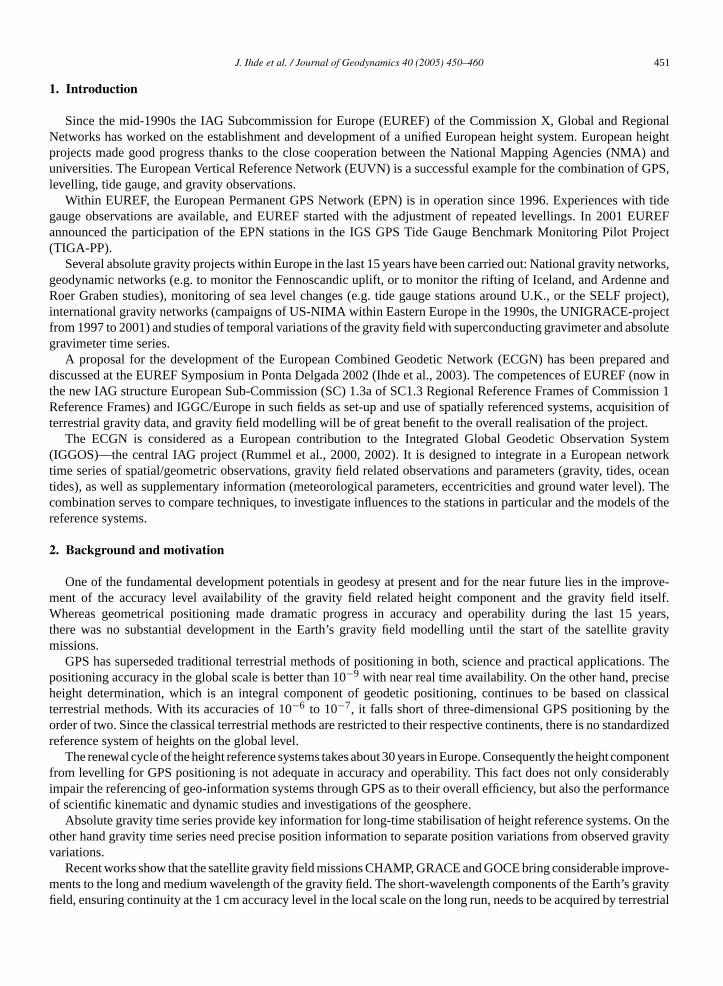
Table 1Components for height parameter combination and their dependence from tidal systems (Ihde and Augath, 2002)
Gravity (g/�g) Geoid (W/N) Levellingheight(�H)
Altimetry (h) Mean sealevel (msl)
Position (X/h)
Mean tidal system, mean/zero crust(stokes is not valid if massesoutside the Earth surface)
�gm Nm �Hm Relation toNm foroceanographicstudies
hmsl
Zero tidal system, zero/mean crust(recommended by IAG Res. No.16, 1983)
�gzStokes−→ Nz
(EGG97)(EVRF2000)
�Hz
Non-tidal system, non-tidal crust(far away from the real earthshape—there is no reason for thenon tidal concept)
�gzStokes−→ Nz
(EGM96)Xn ITRFxxETRS89
gravity data. Therefore, it is necessary to combine the data from satellite gravity field missions with terrestrial gravitydata reduced to a standard height level.
To ensure the long-time stability of the terrestrial reference system with an accuracy of 10−9 in the global scaleand for Europe, a common space/gravity reference system realized by collocation stations for different observationsis required. Today’s results show clearly that, only in conjunction, absolute and superconducting gravimeters time-dependent gravity variations at the�Gal-level. Therefore, they offer a basis for research on secular gravity and heightvariations.
In processing combined networks like ECGN the collocations between techniques are very important. Generally, theECGN sites should deploy multiple techniques sufficiently close to one another that the vectors of their separations canbe very accurately measured. This is absolutely essential for inter-technique combinations. Collocation also ensuresthat external systematic errors are common to the various independent systems. Systematic errors are often poorlycharacterized or quantified, which can lead to precision estimates being mistakenly used for highly optimistic accuracyexpectations. In this way, collocation sites are of worth for studying sources of systematic errors and assessing theirmagnitudes.
The availability of the reference frames for real-time and near-real-time positioning needs a highly sensitive mod-elling of the time dependent phenomena of the solid Earth, the Earth gravity field, the ocean, the atmosphere andthe hydrosphere. The recording of relevant data to describe and model these phenomena is an integrated part of themaintenance of the terrestrial reference system.
The experiences within the European Vertical Reference Network (EUVN) project have shown the practical andmethodological problems with the combination of different geodetic observation techniques, especially geometricalspatial and gravity field related data (Ineichen et al., 1999; Ihde et al., 1999, 2000; Woppelmann et al., 2000).
Furthermore there is no closed reference system for spatial and gravity systems defined at present. For example theUNIGRACE project (Unification of Gravity Systems in Central and Eastern Europe) which evolved from the CERGOPinitiative (Central European Regional Geodynamics Project) followed the purpose to set up a unified gravity referenceframe but was realized without a directly measured connection to a space network (Reinhart et al., 1998).
Table 1 shows the components of an integrated geodetic reference system and their dependency on the tidal systems.It points out that a unique concept for the reduction of observations and related parameters is necessary (Ihde and Augath,2000).
Gravity-related components are given in a zero tidal system, conforming to the IAG Resolution No. 16 adoptedin Hamburg 1983 and to the handling of the gravity data. Contrary to this, the ITRFyy coordinates are given in thenon-tidal system, the same holds for the global geopotential model EGM96. The European geoid was reduced to thezero tidal system. The non-tidal system/crust is far off the real Earth shape—there is no justification for the non-tidalconcept. The Stokes formula is not valid for the mean tidal system, but the mean sea level is reduced to the mean/zerogeoid for oceanic studies.
J. Ihde et al. / Journal of Geodynamics 40 (2005) 450–460 453
3. Objectives
In order to ensure the long-time stability of the terrestrial reference system with an accuracy of 10−9 at both theEuropean and global scale, the interaction between the different time-dependent influences of the system Earth to theterrestrial reference system and the related observations has to be considered in the evaluation models. The strategicobjective of this project is to realise an integrated geodetic reference frame for the entire territory of Europe.
In the context of the ECGN project the height is the most important component of the three-dimensional positionsof the participating stations. However, in the regional or global terrestrial reference system, heights are less accuratelydetermined than the horizontal components. This is due to the geometry and the properties of the (mostly spatial)observations, which are sensitive to various systematic errors. Therefore, improvements can be expected from thecareful combination of different spatial observation techniques (preferably at the observation level), such as GPS andSatellite Laser Ranging (SLR), collocated at the same site, taking into account the strengths (and weaknesses) of eachindividual technique.
The complement of the geometrical positioning with the physical height component of matching accuracy, oper-ability and efficiency needs the gravity and a high-precise geoid in the cm-accuracy range. The project contributes togravity field modelling for the area of Europe and to the generation of the best possible global model.
The planned activities aim at linking the spatial reference system with gravity field related parameters in order tocontribute to a consistent description of the general processes of the system Earth. These processes shall be kinematicallyintegrated into a combined monitoring system of position and gravity. Products of the satellite gravity field missionswill be combined with the data of the integrated geodetic terrestrial reference frame.
It is a matter of course that the European spatial reference system realised by the European GPS Permanent Network(EPN) is based on, resp. contributes to, global systems. Consequently, the entire project must be seen in the globalcontext. The work on the integrated kinematic network must be understood as a European contribution to a globalintegrated geodetic network. This project will support the activities towards an improvement of the European VerticalReference System (EVRS, 2000) for scientific work and for the supply of relevant data to European authorities andinstitutions.
The analysis of GPS time series shows that the height component is not sufficiently verified. The combination withother data with vertical information gives the possibility to stabilize the vertical velocities. The main technologicalaspect is the combination of time series of different techniques.
The proposed ECGN may substantially contribute to meet the geodetic basic needs of the geo-information sectorwithin Europe. Moreover, in the course of the further development of the ECGN, the needs and requirements as well asthe demands made on a DGPS Real-Time positioning service will be allowed for. Additionally ECGN could be a com-ponent of a future European disaster monitoring network. The tasks of relating geodata and geodynamic investigationsrequire a precise spatial reference system in real-time or near real time, which takes the complex interrelationshipsbetween the solid Earth and the ocean, the atmosphere, and the gravity field into account. Establishment of this networkis carried out in accordance with the technological state of the art of positioning by means of satellite navigation systemsand considers the foreseeable developments in the user strategies.
4. The techniques
The ECGN stations have the standard observation techniques GNSS (GPS/GLONASS and in futureGALILEO—permanent), gravity (super conducting gravimeter and/or absolute gravimeter—permanent or repeated),levelling connections to nodal points of the United European Levelling Network (UELN—repeated) and meteorolog-ical parameters (permanent). Standard for the ECGN stations is a local network for the derivation of eccentricities ata 1 mm accuracy level. All ECGN stations are part of the European GPS Permanent Network (EPN). For the obser-vation techniques guidelines have to be fulfilled. This chapter describes the single techniques in relation to the futurecombination in this project as well as the relations to running international projects.
4.1. European Permanent GPS Network (EPN)
The EUREF Permanent Network (EPN) is a network of permanent GPS tracking stations whose weekly computedcoordinates are used by EUREF to realise the European Terrestrial Reference System. Supported by EuroGeographics,
454 J. Ihde et al. / Journal of Geodynamics 40 (2005) 450–460
this reference network forms the backbone for all geographic and geodetic projects on the European territory both onnational as on international level (Habrich, 2003).
Presently, the network consists of more than 150 stations distributed in 32 European countries. The stations providehigh quality GPS data in daily batches. In support of near-real time applications, such as the determination of thetropospheric zenith path delay for numerical weather prediction, 58% of the stations also contribute with hourly data.Real-time applications are supported by the EUREF-IP subnetwork in which the contributing EPN stations distributeRTCM corrections through the Internet.
Sixteen analysis centres guarantee the data analysis of the EPN data. The weekly coordinate solutions they provideare the basis for the unique weekly EPN network solution that delivers precise coordinates for all stations in the EPNto the GPS community. The precision of the computed coordinates is about 2–3 mm for the horizontal componentsand 5–6 mm for the vertical component. The GPS data quality and data flow of all EPN stations is checked on a dailybasis. In addition, weekly updated coordinate time series allow monitoring the influence of equipment changes on thecomputed coordinates.
In summary, next to geodetic applications, the EPN is also valuable for scientific applications such as geodynamics,sea level monitoring and weather prediction (http://www.epncb.oma.be/).
The long-term maintenance implicitly involves the monitoring of the station coordinate time series. This is akey issue in ECGN, where we are primarily interested in the analysis of the height component variation due to real(geo)physical phenomena and we have to separate them from technique-related effects. It is well known that all changesin the observing environment, equipment, and processing mostly affect the height component. These effects appearas sudden variation (jump) in the height component (up to several cm!). In addition outliers in the time series can beobserved, caused by temporal inconsistencies at the specific station. The basic task of the monitoring is the clean-upof the time series with identification, estimation and elimination of outliers and offsets. This step provides a cleaned,bias-free coordinate time series, which may serve as an excellent basis for:
• improved site velocity estimation and• estimation of periodic signals in the time series.
The GPS time series monitoring, cleaning and velocity estimation is being performed at the EPN Special Project for“Time Series Analysis”. The estimation of periodic signals in the time series could be the most relevant contributionof EPN to ECGN, where the different time series (continuous and/or epoch-wise) are handled together and will serveas a basis for the identification and interpretation of geophysical processes of the European continent. The time seriesmonitoring would refer also to the treatment of the continuous superconducting gravity, tide gauge, repeated absolutegravity and levelling observations (Bruyninx et al., 2002, 2003; Kenyeres et al., 2003).
4.2. Absolute gravity
Comparing vertical movements and gravity changes, a relation in the order of 3 mm/1�Gal (free air gradient) to5 mm/1�Gal (tectonic uplift) can be found. It can be concluded that to confirm a station uplift in the order of a few mm(which is realistic with modern geometric geodetic instrumentation) it will be necessary to determine the gravity valueswith an accuracy of 1–2�Gal which corresponds to 1–2× 10⁻⁹. Modern absolute gravimeters have the potential tomeet this requirement.
The present instrumentation for the absolute gravity measurements which represents the state of the art is theFG5 gravimeter produced by the commercial company Micro-g, USA. The instrument development goes back to atechnology transfer in 1990 when the instrument realization at a scientific institute was transferred to a modern industrialproduction and significant improvements were made in the realisation of physical standards, the measurement precision,data evaluation and correction models.
To verify and ensure the stability of the instrument sensor it is necessary to check the physical standards (rubidiumclock and stabilized laser) repeatedly with great care for each individual instrument. Instrument stability and possibleoffsets need to be assessed by repeated observations at stable reference stations, by mutual instrument comparisonsand by the participation in the international comparison of absolute gravimeters organized by the IAG and IGGC
The FG5 absolute gravimeter is an instrument which provides the claimed accuracy under indoor conditions only.Therefore, the absolute gravity stations have to be specially selected under environment aspects and need to be prepared
J. Ihde et al. / Journal of Geodynamics 40 (2005) 450–460 455
for the gravity measurements. Either a stable building foundation or a dedicated pier is required for the instrumentinstallation. Stronger changes in the surrounding, e.g. of groundwater or other mass changes should be avoided or needto be observed and accounted for in the data analysis.
The objectives of the precise absolute gravity measurements can be the establishment of precise national or supra-national gravity networks or profiles providing an optimal reference for various geodetic and geophysical applications.Repeated absolute gravity observations will reveal possible gravity changes at the occupied stations. As describedbefore, the gravity measurement is sensitive to height changes as well as to mass changes in the vicinity. These influ-ences can be caused by geophysical processes and/or environmental influences related to natural or human-inducedeffects. Whereas the vertical component of geometric GPS observation will reflect height variations induced by stationdisplacements and Earth crust deformation and variations of the reference frame for the satellite-based observation,the physical gravity observation reflects the vertical movement of the reference station as well as changes of masses(in quantity and position) acting upon the gravity sensor.
The absolute gravity measurement is carried out typically in single-station occupations. The repetition rate has tobe chosen in agreement with the expected (and observed) gravity variations and is selected between 6 months and 1 or2 years.
The work of this project will start from the realization of the gravity stations in connection with the other sensorswith repeated observations at certain epochs. The reoccupation of the site necessarily includes the observation of thegeometric ties and all environmental parameters. Only the consideration of all influences like ocean and atmosphericloading, mass attraction by groundwater, ocean and atmosphere, etc. will make it possible to correlate the movements ofthe different sensors. The final aim will be a description of the dependencies between the different kind of observationsand the determination of time-dependent station coordinates with an improved accuracy (Wilmes et al., 2002).
4.3. Super-conducting gravimeter measurements
The Global Geodynamics Project (GGP) is to study geodynamical problems through the observation of the variationsof the Earth’s gravity field recorded by the super-conducting gravimeters (SGs) existing in the world. SGs are at themoment the most sensitive gravimeters (nanoGal or 10−9 m s−2). The first period of this program started in July 1997and has been extended in July 2003 at the IUGG meeting held at Sapporo.
There are 20 stations worldwide, 9 of which are located in Europe, 2 stations in North America, 5 in Asia and 1in Spitsbergen and only 3 in the Southern hemisphere. The phenomena studied by the GGP range from the seismicones up to the wobble modes of the Earth and any long-period phenomena. One of the great advantages of the GGPis the homogeneity of the recordings of its network (sampling rate, filters, etc.) which enables to compile the data ofdifferent stations.
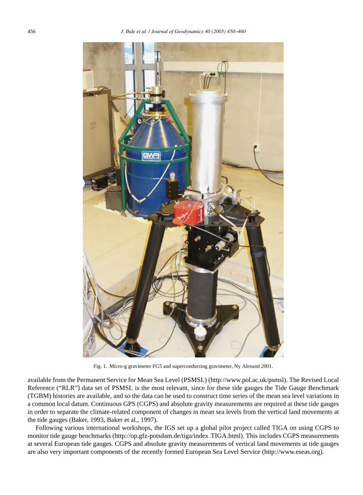
Special importance for the execution of absolute gravity measurements is shown for stations with a superconductinggravimeter (Fig. 1). The absolute gravity measurement is needed to determine the linear drift of the superconductinggravimeter and by the combination of both measurement types detailed investigations about the gravity signal variationsand correlation studies with other environmental parameters on the vertical position, as well as upon the gravity signal,are possible.
The SG’s raw data are regularly sent by the different stations to a common database (hosted by ICET in Brusselsand Geoforschungszentrum Potsdam). The data are immediately available to the participants of the GGP and after 1year they can be distributed to anyone. In addition to SGs the absolute gravimeters (AG) are useful first for a precisecalibration of the SG and second for a confirmation of any trend and/or seasonal variation observed in the long-termgravity changes.
The main fields addressed by GGP are listed as follows on GGP website: Earth tides and the nearly diurnal freewobble, core modes, atmospheric interactions, Earth rotation and polar motion, gravity changes due to tectonic motions,enhancing absolute gravity measurements, seasonal effects, and geodesy (http://www.eas.slu.edu/GGP/ggphome.html).
4.4. Tide gauges
Tide gauges around the European coasts provide an important component of ECGN. The mean sea level at sometide gauges provides the national levelling height datum, e.g. Newlyn and Marseille. Tide gauges which have very longseries of annual mean sea levels (i.e. >50 years) are of particular importance for the ECGN. The mean sea level data are
456 J. Ihde et al. / Journal of Geodynamics 40 (2005) 450–460
Fig. 1. Micro-g gravimeter FG5 and superconducting gravimeter, Ny Alesund 2001.
available from the Permanent Service for Mean Sea Level (PSMSL) (http://www.pol.ac.uk/psmsl). The Revised LocalReference (“RLR”) data set of PSMSL is the most relevant, since for these tide gauges the Tide Gauge Benchmark(TGBM) histories are available, and so the data can be used to construct time series of the mean sea level variations ina common local datum. Continuous GPS (CGPS) and absolute gravity measurements are required at these tide gaugesin order to separate the climate-related component of changes in mean sea levels from the vertical land movements atthe tide gauges (Baker, 1993, Baker et al., 1997).
Following various international workshops, the IGS set up a global pilot project called TIGA on using CGPS tomonitor tide gauge benchmarks (http://op.gfz-potsdam.de/tiga/indexTIGA.html). This includes CGPS measurementsat several European tide gauges. CGPS and absolute gravity measurements of vertical land movements at tide gaugesare also very important components of the recently formed European Sea Level Service (http://www.eseas.org).
J. Ihde et al. / Journal of Geodynamics 40 (2005) 450–460 457
Published results are already available from GPS measurements at European tide gauges (e.g. Teferle et al., 2002and Becker et al., 2002). Results from absolute gravity measurements at tide gauges have also been used to determinethe vertical land movement at the gauges and to test geophysical models of post-glacial rebound (Williams et al., 2001).GPS measurements at tide gauges can also be used for determining mean sea level with respect to the ellipsoid, whichthen provides a valuable test at the centimetre level of available geoid and sea surface topography models (Bingley etal., 2002).
The main objective of the above CGPS and absolute gravity measurements at tide gauges is to determine the verticalland movements to better than 1 mm/year in order to correct the observed secular changes in mean sea levels for verticalland movements. However, as a first step, the CGPS measurements at tide gauges will be extremely valuable for testingthe accuracy of vertical velocities determined from GPS. Due to reference frame uncertainties, the absolute accuracy ofvertical velocities from GPS is presently of the order of±3 mm/year (http://igscb.jpl.nasa.gov/components/prods.html).For tide gauges with more than 50 years of continuous data, the secular change in mean sea level can be determinedto a few tenths of a millimetre per year. The climate related rise in mean sea levels over the past century, determinedby the Intergovernmental Panel on Climate Change (IPCC) is 1.5 mm/year± 0.5 mm/year. The IPCC value can beused to correct the mean sea level trend determined from a tide gauge and hence provide an estimate of the verticalland movement, which can be used to check the accuracy of the vertical velocities determined from CGPS. Similarly,Holocene geological sea level indicators from nearby sites can be used to provide a further test of the vertical velocities.Thus, it can be seen that CGPS measurements at coastal sites will be extremely useful for checking the biases in thevertical velocities in the GPS solutions.
4.5. Levelling
The basis for the gravity field related vertical reference is the existing United European Levelling Network (UELN).After a break of 10 years, the work on the UELN was resumed in 1994 under the name UELN-95. The objectives of theUELN-95 project were to establish a unified height system for Europe at the sub-decimetre level with the simultaneousenlargement of UELN as far as possible to include Central and Eastern European countries and the development of akinematical height network step by step. Starting point for the UELN-95 project has been a repetition of the adjustmentof the UELN-73/86 (Adam et al., 2000).
The adjustment of the UELN-95 is performed in geopotential numbers as nodal point adjustment with variancecomponent estimation for the participating countries and as a free adjustment linked to the reference point of UELN-73(Tide Gauge Amsterdam). The a-posteriori standard deviation referred to the levelling distance of 1 km is 1.1 kgal mm.
At the UELN data and computing centre at the Bundesamt fur Kartographie und Geodasie (BKG) the data handlingand adjustments are carried out (Sacher et al., 2002).
All ECGN points shall be connected by precise levellings to UELN lines to have a common height reference. In theUELN adjustments different observations over a time period of about 50 years are used. With that the UELN is veryinhomogeneous. To overcome this problem a common adjustment of observations of different measurement epochs isnecessary (Sacher et al., 2003).
5. Status of the project
5.1. Call for participation
The call for participation is structured in two stages. The first call is directed to the implementation of the ECGNstations following the concept of the project. In parallel the ECGN working group will prepare the second call foranalysis and investigations. In the first step, the main action of the ECGN working group will be a pilot study of thecombination of the different observations using available collocations at stations, e.g. Medicina, Wettzell, etc. and thisto get experiences in the combination of spatial information with gravity field related data.
5.2. Implementation of the ECGN stations (first call)
This call concerns the establishment of the observation network for ECGN stations. The ECGN stations have thestandard observation techniques
458 J. Ihde et al. / Journal of Geodynamics 40 (2005) 450–460
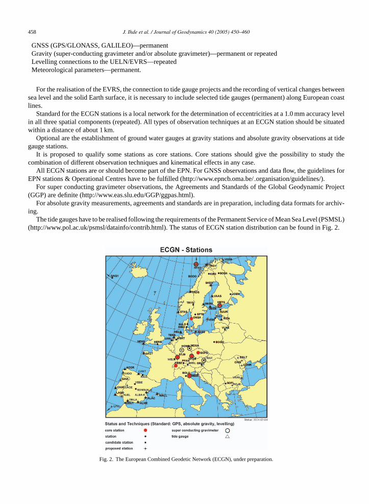
GNSS (GPS/GLONASS, GALILEO)—permanentGravity (super-conducting gravimeter and/or absolute gravimeter)—permanent or repeatedLevelling connections to the UELN/EVRS—repeatedMeteorological parameters—permanent.
For the realisation of the EVRS, the connection to tide gauge projects and the recording of vertical changes betweensea level and the solid Earth surface, it is necessary to include selected tide gauges (permanent) along European coastlines.
Standard for the ECGN stations is a local network for the determination of eccentricities at a 1.0 mm accuracy levelin all three spatial components (repeated). All types of observation techniques at an ECGN station should be situatedwithin a distance of about 1 km.
Optional are the establishment of ground water gauges at gravity stations and absolute gravity observations at tidegauge stations.
It is proposed to qualify some stations as core stations. Core stations should give the possibility to study thecombination of different observation techniques and kinematical effects in any case.
All ECGN stations are or should become part of the EPN. For GNSS observations and data flow, the guidelines forEPN stations & Operational Centres have to be fulfilled (http://www.epncb.oma.be/organisation/guidelines/).
For super conducting gravimeter observations, the Agreements and Standards of the Global Geodynamic Project(GGP) are definite (http://www.eas.slu.edu/GGP/ggpas.html).
For absolute gravity measurements, agreements and standards are in preparation, including data formats for archiv-ing.
The tide gauges have to be realised following the requirements of the Permanent Service of Mean Sea Level (PSMSL)(http://www.pol.ac.uk/psmsl/datainfo/contrib.html). The status of ECGN station distribution can be found in Fig. 2.
Fig. 2. The European Combined Geodetic Network (ECGN), under preparation.
J. Ihde et al. / Journal of Geodynamics 40 (2005) 450–460 459
5.3. Methodology and analysis (second call)
For super conducting gravimeter data, the GGP data centre could be used for data collection. Levelling data of ECGNwill be collected at the UELN/EVRS data centre. Local data centres for absolute gravity data and super conductinggravimeter data should be installed in the first stage by the ECGN working group.
In a second call it could be asked for
• Analysis centres for the combination of time series observations of all ECGN stations.• Combination of space techniques (GPS/GLONASS, GALILEO, VLBI, SLR).• Methodical investigations for the combination of spatial observation data with gravity field-related data.
6. Investigations of combination
In the modelling of a geophysical process, say, of glacial isostatic adjustment (GIA), input data and predictions ongravity change combined with all types of data: 3D, geoid change, etc. A recent discussion of relevant global processescan be found for instance under http://www.iers.org/workshop2002a/program/. However, as a first step, single-stationmulti-technique observation series need to be screened and interpreted for kinematics and dynamics, and then theprimary companion of gravity usually is vertical motion.
For some geophysical phenomena approximate rules of thumb are often used to gauge the relationship between grav-ity changes and vertical movement rates. To take an example about GIA, the−0.2�gal/mm observed in Fennoscandia(Ekman and Makinen, 1996) or the−0.16�gal/mm modelled by Wahr et al. (1995) are frequently applied. For elasticsurface loading, the free-air gradient−0.3�gal/mm is assumed. In the interpretation of observed gravity and height ata single-station a key question often is that gravity is highly sensitive to all density variations in the near field, whetheror not they are associated with the phenomenon being modelled.
The dashed line is the ratio of elastic gravity (i.e. deformation effect only, no Newtonian term) and vertical displace-ment. In the solid line gravity includes the attraction of the load, approximated by a layer at station elevation. This isall right for far zones in flat topography but inappropriate near the station. Gravity is positive down and displacementis positive up. Comments in text.
To illustrate some of the issues involved, consider models of regional surface loading by say, subsurface water. Theratio of the Green’s functions for gravity change and vertical motion is about−0.23�gal/mm when the attraction of theload is not included and around−0.3�gal/mm when it is included. In the centre of a spherical water cap 100 mm thickand 4◦ radius the predicted vertical displacement would be−3 mm and gravity change +0.9�gal. However, locally thesame water storage can produce an additional +4.2�gal (the Bouguer approximation) not included in the prediction.
Thus the joint interpretation of variation in height and gravity has best chances of success when a number ofenvironmental parameters are monitored as well (Zerbini et al., 2001). A monitoring in terms of regional variationsin mass will be provided by the GRACE satellite and will in the future be a key element in the modelling of surfacegravity change too. Note that correlation of time series ultimately cannot replace observation and modelling. In theexample quoted, the local hydrological attraction will usually be coherent with the regional loading, possibly withother seasonal signals, and regression models will produce opaque results.
References
Adam, J., Augath, W., Brouwer, F., Engelhardt, G., Gurtner, W., Harsson, B.G., Ihde, J., Ineichen, D., Lang, H., Luthardt, J., Sacher, M., Schluter, W.,Springer, T., Woppelmann, G., 2000. Status and development of the European height systems. International Association of Geodesy Symposia,vol. 121. Springer, Berlin, Heidelberg, pp. 55–60.
Baker, T.F., 1993. Absolute sea level measurements, climate change and vertical crustal movements. Glob. Planet. Change 8 (3), 149–159.Baker, T.F., Woodworth, P.L., Blewitt, G., Boucher, C., Woppelmann, G., 1997. A European network for sea level and coastal land level monitoring.
J. Marine Syst. 13 (1–4), 163–171.Becker, M., Zerbini, S., Baker, T.F., Burki, B., Galinis, J., Garate, J., Georgiev, I., Kahle, H., Kotzev, V., Lobazov, V., Marson, I., Negusini, M.,
Richter, B., Veis, G., Yuzefovich, P., 2002. Assessment of height variations by GPS at Mediterranean and Black Sea coast tide gauges from theSELF project. Glob. Planet. Change 34, 5–35.
Bingley, R.M., Dodson, A.H., Penna, N.T., Baker, T.F., 2002. Using a ‘GPS/MSL geoid’ to test geoid models in the UK. Vertical Reference Systems.In: Drewes, H. (Ed.), IAG Symposia, vol. 124. Springer-Verlag, pp. 197–202.
460 J. Ihde et al. / Journal of Geodynamics 40 (2005) 450–460
Bruyninx, C., Kenyeres, A., Takacs, B., 2002. EPN data and product analysis for improved velocity estimation: first results. Vistas for Geodesy inthe New Millennium. In: Adam, J., Schwarz, K.-P. (Eds.), International Association of Geodesy Symposia, vol. 125. Springer-Verlag, Berlin-Heidelberg, pp. 47–52.
Bruyninx, C., Carpentier, G., Roosbeek, F., 2003. EPN monitoring: status and plans. Publications of the IAG-Subcommission for Europe (EUREF).Mitteilungen des Bundesamtes fur Kartographie und Geodasie, Frankfurt a.M., Bd. 29, pp. 32–42.
Ekman, M., Makinen, J., 1996. Recent postglacial rebound, gravity change and mantle flow in Fennoscandia. Geophys. J. Int. 126, 229–234.European Vertical Reference System (EVRS), International Association of Geodesy, Section I – Positioning, Commission X – Global and Regional
Networks, Subcommission for Europe (EUREF), 2001. Presented at the EUREF Symposium, Tromsø, June 22–24, 2000. Veroffentlichungender Bayerischen Kommission fur die Internationale Erdmessung. Munchen, Heft Nr. 61.
Habrich H., 2003. EUREF Permanent GPS Network Analysis Update. Publications of the IAG-Subcommission for Europe (EUREF). Mitteilungendes Bundesamtes fur Kartographie und Geodasie, Frankfurt a.M., Bd. 29, pp. 43–48.
Ihde, J., Adam, J., Bruyninx, C., Kenyeres, A., Simek, J., 2003. Proposal for the Development of an European Combined Geodetic Network (ECGN).Publications of the IAG-Subcommission for Europe (EUREF). Mitteilungen des Bundesamtes fur Kartographie und Geodasie, Frankfurt a.M.,Bd. 29, pp. 49–67.
Ihde, J., Adam, J., Gurtner, W., Harsson, B.G., Sacher, M., Schluter, W., Woppelmann, G., 2000. The height solution of the European VerticalReference Network (EUVN). Veroff. Bayer. Komm. Int. Erdmess., Bayer. Akad. d. Wiss., Astron.-geod. Arb., Munchen, H. 61, pp. 132–145.
Ihde, J., Adam, J., Gurtner, W., Harsson, B.G., Schluter, W., Woppelmann, G., 1999. The concept of the European Vertical GPS Reference Network(EUVN). Report on the Symposium of the IAG Subcommission for Europe (EUREF) held in Bad-Neuenahr-Ahrweiler, June 10–13, 1998.Publication No. 7, vol. II, Frankfurt a.M., pp. 11–22.
Ihde, J., Augath, W., 2000. The Vertical Reference System for Europe. Veroff. Bayer. Komm. Int. Erdmess., Bayer. Akad. d. Wiss., Astron.-geod.Arb., Munchen, H. 61, pp. 99–101.
Ihde, J., Augath, W., 2002. The European Vertical Reference System (EVRS) Its relation to a World Height System and to the ITRS. InternationalAssociation of Geodesy Symposia, vol. 125. Springer, Berlin Heidelberg, pp. 78–83.
Ineichen, D., Gurtner, W., Springer, T., Engelhardt, G., Luthardt, J., Ihde, J., 1999. EUVN97-Combined GPS Solution. Presented at the EUREF-Symposium in Bad Neuenahr-Ahrweiler, June 3–5, 1998. Mitteilungen des Bundesamtes fur Kartographie und Geodasie, Band 7, Frankfurt a.M., pp. 23–46.
Kenyeres, A, Bruyninx, C., Carpentier, G., 2003. EPN Special Project on “Time Series Analysis”: Results of the Retrospective Analysis of the EPNTime Series (1996–2001). Publications of the IAG-Subcommission for Europe (EUREF). Mitteilungen des Bundesamtes fur Kartographie undGeodasie, Frankfurt a.M., Bd. 29, p. 72.
Reinhart, E., Richter, B., Wilmes, H., Erker, E., Ruess, D., Kakkuri, J., Makinen, J., Marson, I., Sledzinski, J., 1998. UNIGRACE—a project forthe unification of gravity systems in central Europe. In: Vermeer, M.,Adam, J. (Eds.), Proceedings of the Second Continental Workshop on theGeoid in Europe, Reports of the Finnish Geodetic Institute, vol. 98 (4), Masala, pp. 95–98.
Rummel, R., Drewes, H., Bosch, W., Hornik, H., 2000. Towards an Integrated Global Geodetic Observing System (IGGOS). International Associationof Geodesy Symposia, vol. 120. Springer, Berlin Heidelberg, IAG Section 2 Symposium; 261 p.
Rummel, R., Drewes, H., Beutler, G., 2002. Integrated Global Geodetic Observing System (IGGOS): A Candidate IAG Project. InternationalAssociation of Geodesy Symposia, vol. 125. Springer, Berlin, Heidelberg, pp. 609–614.
Sacher, M., Ihde, J., Marti, U., Schlatter, A., 2003. Status Report of the UELN/EVS Data Base. Publications of the IAG-Subcommission for Europe(EUREF). Mitteilungen des Bundesamtes fur Kartographie und Geodasie, Frankfurt a.M., Bd. 29, pp. 140–146.
Sacher, M., Ihde, J., Parseliunas, E., 2002. Status of the UELN/EVS data base: activities between June 2000 and May 2001 and future plans.Mitteilungen des Bundesamtes fur Kartographie und Geodasie, Frankfurt a.M., Bd. 23, pp. 146–153.
Teferle, F.N., Bingley, R.M., Dodson, A.H., Penna, N.T., Baker, T.F., 2002. Using GPS to separate crustal movements and sea level changes at tidegauges in UK”. Vertical Reference Systems. In: Drewes, H. (Ed.), IAG Symposia, vol. 124. Springer-Verlag, pp. 264–269.
Wahr, J., Han, D., Trupin, A., 1995. Predictions of vertical uplift caused by changing polar ice volumes on a viscoelastic earth. Geophys. Res. Lett.22, 977–980.
Williams, S.D.W., Baker, T.F., Jeffries, G., 2001. Absolute gravity measurements at UK tide gauges. Geophys. Res. Lett. 28 (12), 2317–2320.Wilmes, H., Richter, B., Falk, R., 2002. Absolute gravity measurements: a system by itself. In: Proceedings of the 3rd Meeting of the IGGC—“Gravity
and Geoid 2002”, pp. 19–25.Woppelmann, G., Adam, J., Gurtner, W., Harsson, B.G., Ihde, J., Sacher, M., Schluter, W., 2000. Status report on sea-level data collection and analysis
within the EUVN project. Veroff. Bayer. Komm. Int. Erdmess., Bayer. Akad. d. Wiss., Astron.-geod. Arb., Munchen, H. 61, pp. 146–153.Zerbini, A., Richter, B., Negusinia, M., Romagnoli, C., Simon, D., Domenichinia, F., Schwahn, W., 2001. Height and gravity variations by continuous
GPS, gravity and environmental parameter observations in the southern Po Plain, near Bologna Italy. Earth Planet. Sci. Lett. 192, 267–279.


