Embed Size (px)
Citation preview
___________________________________________________________________________________________________________________________MARYLAND ARCHEOLOGY, Volume 40(1):1-38, March 2004 1
Abstract
The Rosenstock site (18FR18), a Late Woodlandvillage characteristic of the Montgomery Complex, wasexcavated by the Archeological Society of Maryland, Inc.in cooperation with the Maryland State Archeologist’s of-fice in 1979 and 1990-1992. The 1.5-acre site, located ona bluff overlooking the Monocacy River, is roughly circularas indicated by an arcing line of trash-filled pits. No pali-sade has been found at the site despite concerted efforts tolocate such a feature. Likewise, postmold patterns fordomestic structure have yet to be discerned, although somehousehold features point to general house locations. Twosemi-subterranean “keyhole” structures—presumablysweatlodges—have been identified. The artifact assem-blage is predominated by Shepard ware ceramics, as wellas implements of quartz, rhyolite, and bone. Subsistenceevidence includes carbonized corn and beans and faunalremains of mammals, birds, reptiles, and fish. Radiocar-bon dates roughly place the site in the A.D. 1335-1400time period, although the Rosenstock chronology is naggedby vexing questions.
Much of the material recovered from the site re-mains uncataloged and unanalyzed, and the prospects forsuch work being completed soon are dim. As an interimmeasure, the present report is intended to summarize thenature and extent of the work undertaken at Rosenstock,and to offer general observations made during the excava-tions. It is hoped that this will set the basis for future analysisof Rosenstock, and provide some initial comparative datathat would assist researchers working at other Montgom-ery Complex sites in Maryland and Virginia.
Introduction
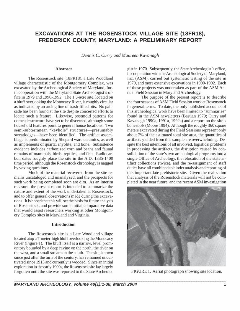
The Rosenstock site is a Late Woodland villagelocated atop a 7-meter-high bluff overlooking the MonocacyRiver (Figure 1). The bluff itself is a narrow, level prom-ontory bounded by a deep ravine on the north, the river onthe west, and a small stream on the south. The site, knownsince just after the turn of the century, has remained uncul-tivated since 1913 and currently is wooded. Since an initialexploration in the early 1900s, the Rosenstock site lay largelyforgotten until the site was reported to the State Archeolo-
gist in 1970. Subsequently, the State Archeologist’s office,in cooperation with the Archeological Society of Maryland,Inc. (ASM), carried out systematic testing of the site in1979, and more extensive excavations in 1990-1992. Eachof these projects was undertaken as part of the ASM An-nual Field Session in Maryland Archeology.
The purpose of the present report is to describethe four seasons of ASM Field Session work at Rosenstockin general terms. To date, the only published accounts ofthis archeological work have been limited to “summaries”found in the ASM newsletters (Bastian 1979; Curry andKavanagh 1990a, 1991a, 1992a) and a report on the site’sbone tools (Moore 1994). Although the roughly 360 squaremeters excavated during the Field Sessions represent onlyabout 7% of the estimated total site area, the quantities ofartifacts yielded from this sample are overwhelming. De-spite the best intentions of all involved, logistical problemsin processing the artifacts, the disruption caused by con-solidation of the state’s two archeological programs into asingle Office of Archeology, the relocation of the state ar-tifact collections (twice), and the re-assignment of staffduties have all combined to hinder analysis and reporting ofthis important late prehistoric site. Given the realizationthat analysis of the Rosenstock materials will not be com-pleted in the near future, and the recent ASM investigation
EXCAVATIONS AT THE ROSENSTOCK VILLAGE SITE (18FR18),FREDERICK COUNTY, MARYLAND: A PRELIMINARY REPORT
Dennis C. Curry and Maureen Kavanagh
FIGURE 1. Aerial photograph showing site location.
2 MARYLAND ARCHEOLOGY
at the Winslow site, another Montgomery Complex village(Dent et al. 2002; Dent 2003a), it was decided to compile adescription of the work carried out at Rosenstock and tosummarize our impressions of what had been learned atthe site. Although this report lacks the benefit of artifactanalysis, we hope that the details provided will aid in thelarger understanding of the Montgomery Complex as awhole.
Site History
The Rosenstock site was discovered by John JacobSnyder on October 15, 1907. Snyder, then a 17-year-old,was “hunting for dogwood” on the Samuel Rosenstockfarm. Snyder (n.d.) relates, “I was keeping to windwardthat was to the east on account of the Dogs [Russian WolfHounds], and hiding behind a shock of fodder saw 3 nicearrows about the shock so it [Snyder’s “Site #1”] was foundby mere coincidence but I never got the dogwood.” At thetime of discovery, the site—having been cleared of timberin 1884—was plowed; cultivation ceased in 1913 (Snydern.d.). Snyder reports finding abundant pottery sherds, tri-angular projectile points, clay, stone, and bone beads,discoidals, shale discs (about 3” in diameter with a holedrilled in the center), celts, and clay and steatite pipes atRosenstock, which he considered the “most outstandingsite” in the Monocacy valley.
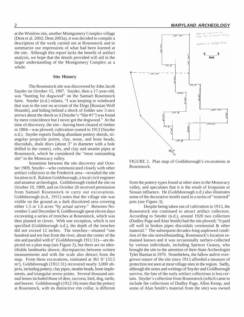
Sometime between the site discovery and Octo-ber 1909, Snyder—who communicated closely with otherartifact collectors in the Frederick area—revealed the sitelocation to E. Ralston Goldsborough, a local civil engineerand amateur archeologist. Goldsborough visited the site onOctober 10, 1909, and on October 26 received permissionfrom Samuel Rosenstock to carry out excavations.Goldsborough (n.d., 1911) notes that the village site wasvisible on the ground as a dark discolored area coveringeither 1.5 or 1.6 acres “by actual survey.” Between No-vember 5 and December 8, Goldborough spent eleven daysexcavating a series of trenches at Rosenstock, which wasthen planted in clover. With one exception, which is notspecified (Goldsborough n.d.), the depth of the trenchesdid not exceed 12 inches. The trenches—situated “onehundred and ten feet from the river, about the center of thesite and parallel with it” (Goldsborough 1911:31)—are de-picted on a plan map (see Figure 2), but there are no iden-tifiable landmarks shown; discrepancies between writtenmeasurements and with the scale also detract from themap. From these excavations, estimated at 361 ft2 (33.5m2), Goldsborough (1911:31) recovered nearly 3,000 ob-jects, including pottery, clay pipes, steatite beads, bone imple-ments, and triangular arrow points. Several thousand ani-mal bones included those of deer, raccoon, bird, dog, turtle,and beaver. Goldsborough (1912:16) notes that the potteryat Rosenstock, with its distinctive rim collar, is different
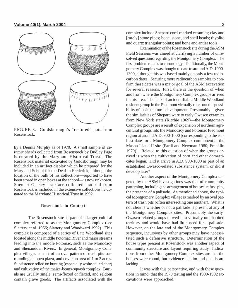
from the pottery types found at other sites in the Monocacyvalley, and speculates that it is the result of Iroquoian orSiouan influence. He (Goldsborough n.d.) also illustratessome of the decorative motifs used in a series of “restored”pots (see Figure 3).
Despite being taken out of cultivation in 1913, theRosenstock site continued to attract artifact collectors.According to Snyder (n.d.), around 1920 two collectors(Dudley Page and Alan Smith) had the site plowed; “it paidoff well in broken pipes discoidals ceremonial & othermaterial.” The subsequent decades-long unplowed condi-tion of the site notwithstanding, Rosenstock’s location re-mained known and it was occasionally surface-collectedby various individuals, including Spencer Geasey, whobrought the site to the attention of then-State ArcheologistTyler Bastian in 1970. Nonetheless, the fallow and/or over-grown nature of the site since 1913 afforded a measure ofprotection not seen at most village sites in the region. Sadly,although the notes and writings of Snyder and Goldboroughsurvive, the fate of the early artifact collections is less cer-tain. Snyder’s collection from Rosenstock (which came toinclude the collections of Dudley Page, Allen Kemp, andsome of Alan Smith’s material from the site) was owned
FIGURE 2. Plan map of Goldsborough’s excavations atRosenstock.
Volume 40(1), March 2004 3
by a Dennis Murphy as of 1979. A small sample of ce-ramic sherds collected from Rosenstock by Dudley Pageis curated by the Maryland Historical Trust. TheRosenstock material excavated by Goldsborough may beincluded in an artifact display which he prepared for theMaryland School for the Deaf in Frederick, although thelocation of the bulk of his collections—reported to havebeen stored in open boxes at the school—is now unknown.Spencer Geasey’s surface-collected material fromRosenstock is included in the extensive collections he do-nated to the Maryland Historical Trust in 1992.
Rosenstock in Context
The Rosenstock site is part of a larger culturalcomplex referred to as the Montgomery Complex (seeSlattery et al. 1966; Slattery and Woodward 1992). Thiscomplex is composed of a series of Late Woodland siteslocated along the middle Potomac River and major streamsfeeding into the middle Potomac, such as the Monocacyand Shenandoah Rivers. In general, Montgomery Com-plex villages consist of an oval pattern of trash pits sur-rounding an open plaza, and cover an area of 1 to 2 acres.Subsistence relied on hunting (especially white-tailed deer)and cultivation of the maize-beans-squash complex. Buri-als are usually single, semi-flexed or flexed, and seldomcontain grave goods. The artifacts associated with the
complex include Shepard cord-marked ceramics; clay and[rarely] stone pipes; bone, stone, and shell beads; rhyoliteand quartz triangular points; and bone and antler tools.
Examination of the Rosenstock site during the ASMField Sessions was aimed at clarifying a number of unre-solved questions regarding the Montgomery Complex. Thefirst problem relates to chronology. Traditionally, the Mont-gomery Complex was thought to date to around A.D. 1000-1300, although this was based mainly on only a few radio-carbon dates. Securing more radiocarbon samples to con-firm these dates was a major goal of the ASM excavationfor several reasons. First, there is the question of whenand from where the Montgomery Complex groups arrivedin this area. The lack of an identifiable Middle Woodlandresident group in the Piedmont virtually rules out the possi-bility of in situ cultural development. Presumably—giventhe similarities of Shepard ware to early Owasco ceramicsfrom New York state (Ritchie 1969)—the MontgomeryComplex groups are a result of expansion of northern agri-cultural groups into the Monocacy and Potomac Piedmontregion at around A.D. 900-1000 [corresponding to the ear-liest date for a Montgomery Complex component at theMason Island II site (Pardi and Newman 1980; Franklin1979)]. Related to this question of when the groups ar-rived is when the cultivation of corn and other domesti-cates began. Did it arrive in A.D. 900-1000 as part of anestablished Owasco-related subsistence system, or did itdevelop later?
Another aspect of the Montgomery Complex tar-geted by the ASM investigations was that of communitypatterning, including the arrangement of houses, refuse pits,the presence of a palisade. As mentioned above, the typi-cal Montgomery Complex village is marked by an oval pat-tern of trash pits (often intersecting one another). What isnot clear is whether or not a palisade is present at any ofthe Montgomery Complex sites. Presumably the early-Owasco-related groups moved into virtually uninhabitedterritory and would have had little need for a palisade.However, on the late end of the Montgomery Complexsequence, incursions by other groups may have necessi-tated such a defensive structure. Determination of thehouse types present at Rosenstock was another aspect ofcommunity structure and layout requiring study. Indica-tions from other Montgomery Complex sites are that thehouses were round, but evidence is slim and details arelacking.
It was with this perspective, and with these ques-tions in mind, that the 1979 testing and the 1990-1992 ex-cavations were approached.
FIGURE 3. Goldsborough’s “restored” pots fromRosenstock.
4 MARYLAND ARCHEOLOGY
ASM ExcavationsArcheological Methods
In general terms, the excavations at the Rosenstocksite focused on determining the site limits, ascertaining com-munity patterns through the locations of features such ashearths, pits, and postmolds, and retrieving floral and fau-nal materials which will allow reconstruction of Late Wood-land dietary patterns. The excavations were also designedto produce a controlled collection of Shepard componentceramic and lithic artifacts to better characterize the mate-rial culture of the Montgomery Complex. To maintain spa-tial control over the data, excavations consisted of a seriesof one-meter squares, or multiples thereof, employing thefollowing general procedures:
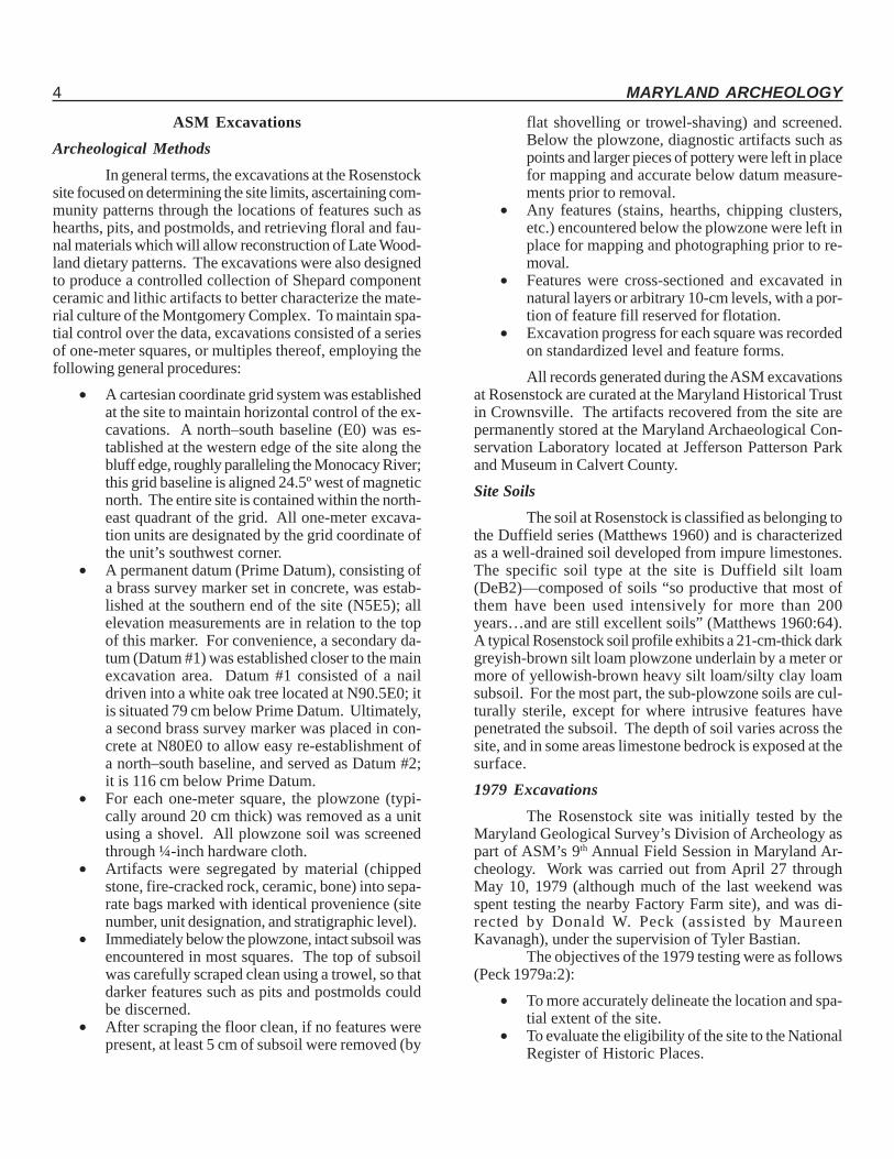
• A cartesian coordinate grid system was establishedat the site to maintain horizontal control of the ex-cavations. A north–south baseline (E0) was es-tablished at the western edge of the site along thebluff edge, roughly paralleling the Monocacy River;this grid baseline is aligned 24.5º west of magneticnorth. The entire site is contained within the north-east quadrant of the grid. All one-meter excava-tion units are designated by the grid coordinate ofthe unit’s southwest corner.
• A permanent datum (Prime Datum), consisting ofa brass survey marker set in concrete, was estab-lished at the southern end of the site (N5E5); allelevation measurements are in relation to the topof this marker. For convenience, a secondary da-tum (Datum #1) was established closer to the mainexcavation area. Datum #1 consisted of a naildriven into a white oak tree located at N90.5E0; itis situated 79 cm below Prime Datum. Ultimately,a second brass survey marker was placed in con-crete at N80E0 to allow easy re-establishment ofa north–south baseline, and served as Datum #2;it is 116 cm below Prime Datum.
• For each one-meter square, the plowzone (typi-cally around 20 cm thick) was removed as a unitusing a shovel. All plowzone soil was screenedthrough ¼-inch hardware cloth.
• Artifacts were segregated by material (chippedstone, fire-cracked rock, ceramic, bone) into sepa-rate bags marked with identical provenience (sitenumber, unit designation, and stratigraphic level).
• Immediately below the plowzone, intact subsoil wasencountered in most squares. The top of subsoilwas carefully scraped clean using a trowel, so thatdarker features such as pits and postmolds couldbe discerned.
• After scraping the floor clean, if no features werepresent, at least 5 cm of subsoil were removed (by
flat shovelling or trowel-shaving) and screened.Below the plowzone, diagnostic artifacts such aspoints and larger pieces of pottery were left in placefor mapping and accurate below datum measure-ments prior to removal.
• Any features (stains, hearths, chipping clusters,etc.) encountered below the plowzone were left inplace for mapping and photographing prior to re-moval.
• Features were cross-sectioned and excavated innatural layers or arbitrary 10-cm levels, with a por-tion of feature fill reserved for flotation.
• Excavation progress for each square was recordedon standardized level and feature forms.All records generated during the ASM excavations
at Rosenstock are curated at the Maryland Historical Trustin Crownsville. The artifacts recovered from the site arepermanently stored at the Maryland Archaeological Con-servation Laboratory located at Jefferson Patterson Parkand Museum in Calvert County.Site Soils
The soil at Rosenstock is classified as belonging tothe Duffield series (Matthews 1960) and is characterizedas a well-drained soil developed from impure limestones.The specific soil type at the site is Duffield silt loam(DeB2)—composed of soils “so productive that most ofthem have been used intensively for more than 200years…and are still excellent soils” (Matthews 1960:64).A typical Rosenstock soil profile exhibits a 21-cm-thick darkgreyish-brown silt loam plowzone underlain by a meter ormore of yellowish-brown heavy silt loam/silty clay loamsubsoil. For the most part, the sub-plowzone soils are cul-turally sterile, except for where intrusive features havepenetrated the subsoil. The depth of soil varies across thesite, and in some areas limestone bedrock is exposed at thesurface.1979 Excavations
The Rosenstock site was initially tested by theMaryland Geological Survey’s Division of Archeology aspart of ASM’s 9th Annual Field Session in Maryland Ar-cheology. Work was carried out from April 27 throughMay 10, 1979 (although much of the last weekend wasspent testing the nearby Factory Farm site), and was di-rected by Donald W. Peck (assisted by MaureenKavanagh), under the supervision of Tyler Bastian.
The objectives of the 1979 testing were as follows(Peck 1979a:2):
• To more accurately delineate the location and spa-tial extent of the site.
• To evaluate the eligibility of the site to the NationalRegister of Historic Places.
Volume 40(1), March 2004 5
• To refine the dating of cultural phases in theMonocacy region through radiocarbon age deter-mination on organic samples (preferably charredwood) associated with pottery.
• To determine if stratigraphy is present at the site.• To refine our understanding of the characteristics
of cultural phases represented at the site.The testing consisted of 23 one-meter squares
spaced in a grid pattern about 12 meters apart (see Figure4; the heavy vegetation at the site necessitated some varia-tion in the square placement), and units were expandedwhen features were encountered to allow definition of fea-ture limits. In all, 35.5 m2 were excavated.
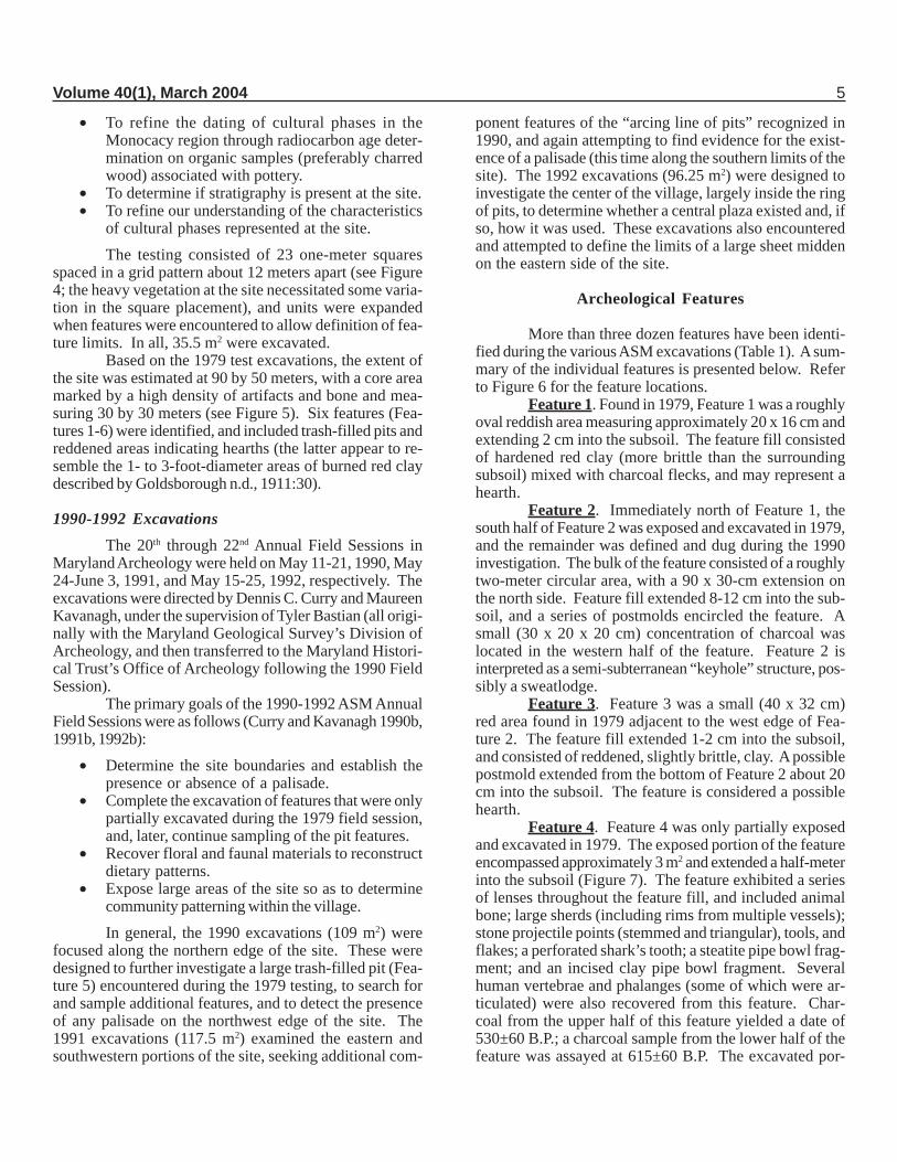
Based on the 1979 test excavations, the extent ofthe site was estimated at 90 by 50 meters, with a core areamarked by a high density of artifacts and bone and mea-suring 30 by 30 meters (see Figure 5). Six features (Fea-tures 1-6) were identified, and included trash-filled pits andreddened areas indicating hearths (the latter appear to re-semble the 1- to 3-foot-diameter areas of burned red claydescribed by Goldsborough n.d., 1911:30).
1990-1992 ExcavationsThe 20th through 22nd Annual Field Sessions in
Maryland Archeology were held on May 11-21, 1990, May24-June 3, 1991, and May 15-25, 1992, respectively. Theexcavations were directed by Dennis C. Curry and MaureenKavanagh, under the supervision of Tyler Bastian (all origi-nally with the Maryland Geological Survey’s Division ofArcheology, and then transferred to the Maryland Histori-cal Trust’s Office of Archeology following the 1990 FieldSession).
The primary goals of the 1990-1992 ASM AnnualField Sessions were as follows (Curry and Kavanagh 1990b,1991b, 1992b):
• Determine the site boundaries and establish thepresence or absence of a palisade.
• Complete the excavation of features that were onlypartially excavated during the 1979 field session,and, later, continue sampling of the pit features.
• Recover floral and faunal materials to reconstructdietary patterns.
• Expose large areas of the site so as to determinecommunity patterning within the village.In general, the 1990 excavations (109 m2) were
focused along the northern edge of the site. These weredesigned to further investigate a large trash-filled pit (Fea-ture 5) encountered during the 1979 testing, to search forand sample additional features, and to detect the presenceof any palisade on the northwest edge of the site. The1991 excavations (117.5 m2) examined the eastern andsouthwestern portions of the site, seeking additional com-
ponent features of the “arcing line of pits” recognized in1990, and again attempting to find evidence for the exist-ence of a palisade (this time along the southern limits of thesite). The 1992 excavations (96.25 m2) were designed toinvestigate the center of the village, largely inside the ringof pits, to determine whether a central plaza existed and, ifso, how it was used. These excavations also encounteredand attempted to define the limits of a large sheet middenon the eastern side of the site.
Archeological Features
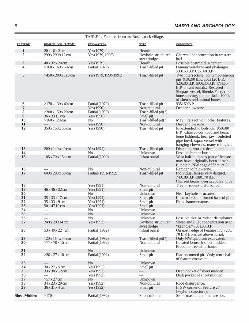
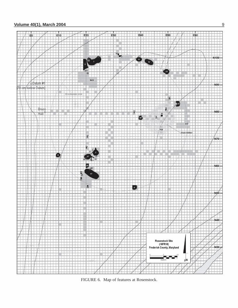
More than three dozen features have been identi-fied during the various ASM excavations (Table 1). A sum-mary of the individual features is presented below. Referto Figure 6 for the feature locations.
Feature 1. Found in 1979, Feature 1 was a roughlyoval reddish area measuring approximately 20 x 16 cm andextending 2 cm into the subsoil. The feature fill consistedof hardened red clay (more brittle than the surroundingsubsoil) mixed with charcoal flecks, and may represent ahearth.
Feature 2. Immediately north of Feature 1, thesouth half of Feature 2 was exposed and excavated in 1979,and the remainder was defined and dug during the 1990investigation. The bulk of the feature consisted of a roughlytwo-meter circular area, with a 90 x 30-cm extension onthe north side. Feature fill extended 8-12 cm into the sub-soil, and a series of postmolds encircled the feature. Asmall (30 x 20 x 20 cm) concentration of charcoal waslocated in the western half of the feature. Feature 2 isinterpreted as a semi-subterranean “keyhole” structure, pos-sibly a sweatlodge.
Feature 3. Feature 3 was a small (40 x 32 cm)red area found in 1979 adjacent to the west edge of Fea-ture 2. The feature fill extended 1-2 cm into the subsoil,and consisted of reddened, slightly brittle, clay. A possiblepostmold extended from the bottom of Feature 2 about 20cm into the subsoil. The feature is considered a possiblehearth.
Feature 4. Feature 4 was only partially exposedand excavated in 1979. The exposed portion of the featureencompassed approximately 3 m2 and extended a half-meterinto the subsoil (Figure 7). The feature exhibited a seriesof lenses throughout the feature fill, and included animalbone; large sherds (including rims from multiple vessels);stone projectile points (stemmed and triangular), tools, andflakes; a perforated shark’s tooth; a steatite pipe bowl frag-ment; and an incised clay pipe bowl fragment. Severalhuman vertebrae and phalanges (some of which were ar-ticulated) were also recovered from this feature. Char-coal from the upper half of this feature yielded a date of530±60 B.P.; a charcoal sample from the lower half of thefeature was assayed at 615±60 B.P. The excavated por-
6 MARYLAND ARCHEOLOGY
FIGURE 4. Map of excavation units: 1979, 1990-1992.
Volume 40(1), March 2004 7
tion of the feature seems to represent a trash-filled pit. Itis also possible that the feature represents two intersecting(and/or disturbed) pits.
Feature 5. Feature 5 was first encountered inN98E22 during the 1979 testing program. Upon removalof the plowzone in that unit, feature fill was revealed acrossthe entire floor of the square. Subsequently, three addi-tional one-meter units were opened in an attempt to dis-cern the limits of the feature. Each unit revealed additionalportions of the feature, but only small segments of thefeature’s edges were exposed. Rather than exploring thehorizontal extent of the feature, the exposed portion of Fea-ture 5 was excavated to obtain a sample of the pit’s con-tents and to determine its nature. These excavations, whichextended as deep as one meter into the subsoil, revealednumerous large ceramic sherds (including the majority of alarge Shepard ware vessel, later reconstructed, and a largerim section of a Shenks Ferry [Heisey 1971] vessel; seeFigures 27 and 29), animal bone, flakes and points, and ashell bead. Radiocarbon samples collected from a thincharcoal lens near the center of the feature (later consid-ered to represent charred bark) and from charcoal foundjust above the base of the feature yielded dates of 475±60and 500±30 B.P., respectively.
FIGURE 5. Artifact density map, 1979 testing.
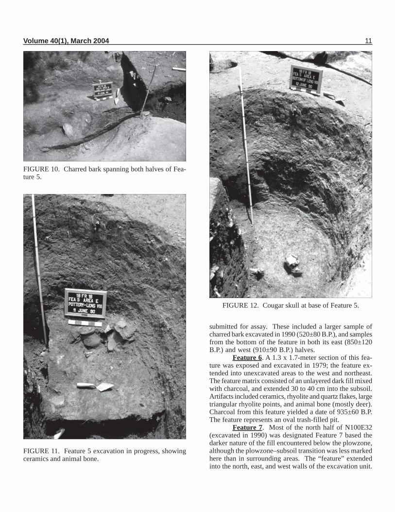
In 1990, excavations were expanded around Fea-ture 5 to expose the entire limits of the feature. It provedto be approximately 5 by 2 meters and protruded up to 1.1m into the subsoil; volume of the feature fill is estimated at12 m3. In order to gain some semblance of control overexcavation of the feature, it was divided into seven sec-tions (A through G, with Section A being that portion exca-vated in 1979; see Figure 8). All sections (except previ-ously excavated Section A and Sections B and D) wereexcavated according to distinguishable lenses within thefeature; Sections B and D were excavated in 10-cm arbi-trary levels and all feature fill from these levels was sub-jected to flotation. Sections B-E and G were excavated in1990; removal of Section F in 1991 completed the three-season excavation of Feature 5.
In terms of pit morphology, Feature 5 should prob-ably be considered two separate, overlapping or intersect-ing pits (Figure 9). It was treated as a single feature, how-ever, because no division between the two pits was distin-guishable in the upper 50 cm of the pit fill. At about 50 cminto the feature near its center, a large hump of subsoil wasencountered, and two separate pit basins were distinguished,each of which continued another 50 cm into subsoil. Inretrospect, treating Feature 5 as a single feature probablymimics the pits’ prehistoric use. Based on the presence ofconjoining pieces of ceramic vessels from the lower levelsof each separate pit basin—and given that the sheet ofcharred bark (mentioned above) extended over the subsoilhump separating the two basins and thereby was found inboth pits (Figure 10)—it is evident that both halves of Fea-ture 5 were open at the same time. The presence of charredbark in the feature led to speculation that it might havebeen used as either a pit cover or lining.
Feature 5 yielded literally tens of thousands offlakes, ceramic sherds, and animal bones (Figure 11), inaddition to large quantities of flotation material that has yetto be sorted or identified. To give some idea of the mate-rial recovered from Feature 5, listed below are a numberof unique or noteworthy artifacts recovered from the fea-ture (in addition to the artifacts from the 1979 testing, men-tioned above):
• A bone carving depicting an apparent squatting,headless human effigy (see Figure 42).
• Unfired lumps of crushed-rock-tempered clay (seeFigure 35).
• Unfired pottery coils apparently pinched off dur-ing vessel manufacture.
• A fired lump of clay bearing impressions as ifsqueezed in one’s hand (see Figure 34). (It is easyto imagine a potter, having just finished building upthe body of a ceramic vessel, squeezing the left-over clay in her hand and tossing it into a nearbycampfire.)
• Elk bones and antler.
8 MARYLAND ARCHEOLOGY
TABLE 1. Features from the Rosenstock village.
FEATURE DIMENSIONS (L/W/D) EXCAVATED? TYPE COMMENTS
1 20 x 16 x 2 cm Yes (1979) Hearth2 290 x 200 x 12 cm Yes (1979, 1990) Keyhole structure/ Charcoal concentration in western
sweatlodge half.3 40 x 32 x 20 cm Yes (1979) Hearth Possible postmold in center.4 >160 x 160 x 50 cm Partial (1979) Trash-filled pit Human vertebrae and phalanges.
530±60 B.P.,615±60 B.P.5 >450 x 200 x 110 cm Yes (1979, 1990-1991) Trash-filled pit Two intersecting, contemporaneous
pits. 910±90 B.P., 850±120 B.P.,520±80 B.P., 500±30 B.P., 475±60B.P. Infant burials. RestoredShepard vessel, Shenks Ferry rim,bone carving, cougar skull, 1000sof sherds and animal bones
6 >170 x 130 x 40 cm Partial (1979) Trash-filled pit 935±60 B.P.7 — Yes (1990) Non-cultural Deeper plowzone8 >300 x 150 x 20 cm Partial (1990) Trash-filled pit(?)9 36 x 33 13 cm Yes (1990) Small pit
10 >160 x 120 cm No Trash-filled pit(?) May intersect with other features.11 — Yes (1990) Non-cultural Deeper plowzone12 350 x 160 x 60 cm Yes (1990) Trash-filled pit Pit extended to bedrock. 860±80
B.P. Charred corn cob and bean,bone fishhook, bear jaw, roulettedpipe bowl, squat vessel withhanging chevrons, many triangles.
13 200 x 140 x 40 cm Yes (1991) Trash-filled pit Discoidal, worked deer antler.14 — No Unknown Possible human burial.15 105 x 70 x 15+ cm Partial (1990) Infant burial West half indicates part of feature
may have originally been a trash-filled pit. NW edge of Feature 5.
16 — No Non-cultural Remnant of plowzone.17 600 x 200 x 60 cm Partial (1991-1992) Trash-filled pit Individual lenses very distinct.
740±80 B.P.; 380±70 B.P.Charred beans, deer scapulae, pipe.
18 — Yes (1991) Non-cultural Tree or rodent disturbance.19 46 x 46 x 32 cm Yes (1991) Small pit20 — No Unknown Near keyhole structures.21 35 x 33 x 17 cm Yes (1991) Small pit Limestone slab formed base of pit.22 35 x 33 x 9 cm Yes (1991) Small pit Pitted hammerstone.23 50 x 47 10 cm Yes (1991) Small pit24 — No Unknown25 — No Unknown26 — No Unknown Possible tree or rodent disturbance.27 240 x 200 14 cm Yes (1992) Keyhole structure/ Sherd and FCR concentration near
sweatlodge “keyhole.” 700±90 B.P.28 53 x 40 x 22+ cm Partial (1992) Infant burial On north edge of Feature 17. 720±
70 B.P. from just above burial.29 120 x 114 x 35 cm Partial (1992) Trash-filled pit(?) Only NW quadrant excavated.30 >77 x 70 x 15 cm Partial (1992) Non-cultural Located beneath sheet midden.
Probable tree disturbance.31 — No Unknown32 >30 x 27 x 10 cm Partial (1992) Small pit Flat-bottomed pit. Only north half
of feature excavated.33 — No Unknown34 30 x 27 x 5 cm Yes (1992) Small pit35 33 x 30 x 12 cm Yes (1992) — Deep pocket of sheet midden.36 — Yes (1992) — Dark pocket of sheet midden.37 >57 x 27 cm No Unknown38 34 x 23 x 29 cm Yes (1992) Non-cultural Root disturbance.39 36 x 31 x 4 cm Yes (1992) Small pit In SW corner of Feature 27
(keyhole structure).Sheet Midden >170 m2 Partial (1992) Sheet midden Stone maskette, miniature pot.
Volume 40(1), March 2004 9
FIGURE 6. Map of features at Rosenstock.
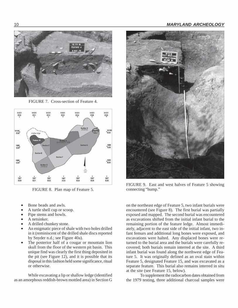
10 MARYLAND ARCHEOLOGY
FIGURE 7. Cross-section of Feature 4.
FIGURE 8. Plan map of Feature 5.FIGURE 9. East and west halves of Feature 5 showingconnecting “hump.”
• Bone beads and awls.• A turtle shell cup or scoop.• Pipe stems and bowls.• A netsinker.• A drilled chunkey stone.• An enigmatic piece of shale with two holes drilled
in it (reminiscent of the drilled shale discs reportedby Snyder n.d.; see Figure 40a).
• The posterior half of a cougar or mountain lionskull from the floor of the western pit basin. Thisunique find was clearly the first thing deposited inthe pit (see Figure 12), and it is possible that itsdisposal in this fashion held some significance, ritualor otherwise.
While excavating a lip or shallow ledge (identifiedas an amorphous reddish-brown mottled area) in Section G
on the northeast edge of Feature 5, two infant burials wereencountered (see Figure 8). The first burial was partiallyexposed and mapped. The second burial was encounteredas excavations shifted from the initial infant burial to theremaining portion of the feature ledge. Almost immedi-ately, adjacent to the east side of the initial infant, two in-fant femurs and additional long bones were exposed, andexcavations were halted. Any displaced bones were re-turned to the burial area and the burials were carefully re-covered; both burials remain interred at the site. A thirdinfant burial was found along the northwest edge of Fea-ture 5. It was originally defined as an oval stain withinFeature 5, designated Feature 15, and was excavated as aseparate feature. This burial also remains interred in situat the site (see Feature 15, below).
To supplement the radiocarbon dates obtained fromthe 1979 testing, three additional charcoal samples were
Volume 40(1), March 2004 11
FIGURE 10. Charred bark spanning both halves of Fea-ture 5.
FIGURE 11. Feature 5 excavation in progress, showingceramics and animal bone.
FIGURE 12. Cougar skull at base of Feature 5.
submitted for assay. These included a larger sample ofcharred bark excavated in 1990 (520±80 B.P.), and samplesfrom the bottom of the feature in both its east (850±120B.P.) and west (910±90 B.P.) halves.
Feature 6. A 1.3 x 1.7-meter section of this fea-ture was exposed and excavated in 1979; the feature ex-tended into unexcavated areas to the west and northeast.The feature matrix consisted of an unlayered dark fill mixedwith charcoal, and extended 30 to 40 cm into the subsoil.Artifacts included ceramics, rhyolite and quartz flakes, largetriangular rhyolite points, and animal bone (mostly deer).Charcoal from this feature yielded a date of 935±60 B.P.The feature represents an oval trash-filled pit.
Feature 7. Most of the north half of N100E32(excavated in 1990) was designated Feature 7 based thedarker nature of the fill encountered below the plowzone,although the plowzone–subsoil transition was less markedhere than in surrounding areas. The “feature” extendedinto the north, east, and west walls of the excavation unit.
12 MARYLAND ARCHEOLOGY
Subsequent excavation to the east and west re-vealed a clearer plowzone–subsoil transition and no evi-dence of a feature. Feature 7 appears to have been merelya slightly deeper area of plowzone.
Feature 8. In 1990, a 3 x 1.5-meter section of alarge feature was exposed just to the west of Feature 5.Feature 8 extended westward into unexcavated areas, andits actual dimensions are unknown. Artifacts visible at thetop of the feature included lithics, ceramics, and bird andmammal bone. Partial excavation of a small section in thesoutheast portion of the exposed feature indicated that thedepth of the feature was increasing towards the northwest.The excavation was terminated at a depth of approximately20 cm, and the feature was backfilled. Feature 8 likelyrepresents a deep trash-filled pit.
Feature 9. Feature 9 was a shallow (13 cm) 36 x33 cm basin-shaped pit feature. Artifacts included ceram-ics, flakes, bone, and a possible ceramic bead.
Feature 10. Feature 10 is a partially exposedfeature measuring in excess of 1.6 by 1.2 meters. Thefeature extends to the northwest into an unexcavated areaof the site, and there was some indication that it may inter-sect with additional features to the north and west. Fea-ture 10, presumably a trash-filled pit, was backfilled andremains unexcavated.
Feature 11. This irregular 40 x 30 cm stain ispresumed to be a slightly deeper pocket of plowzone.
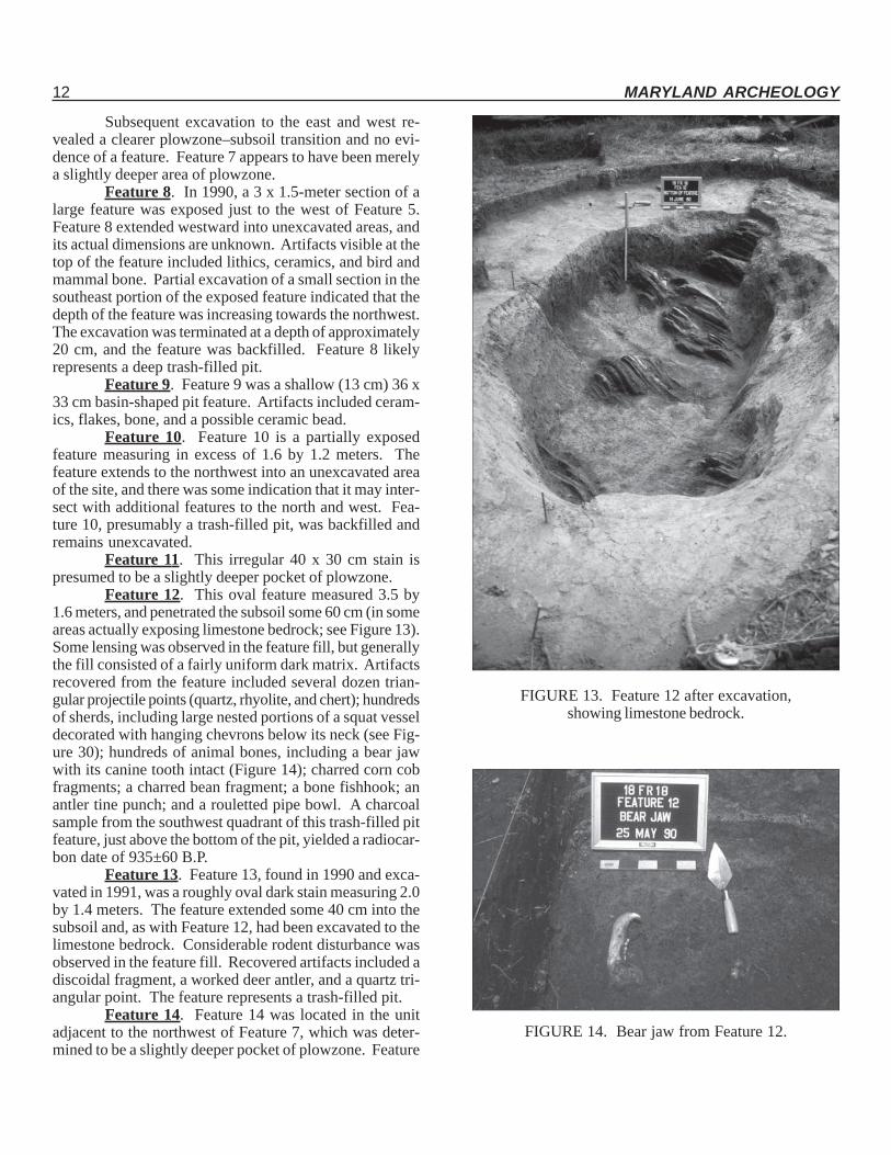
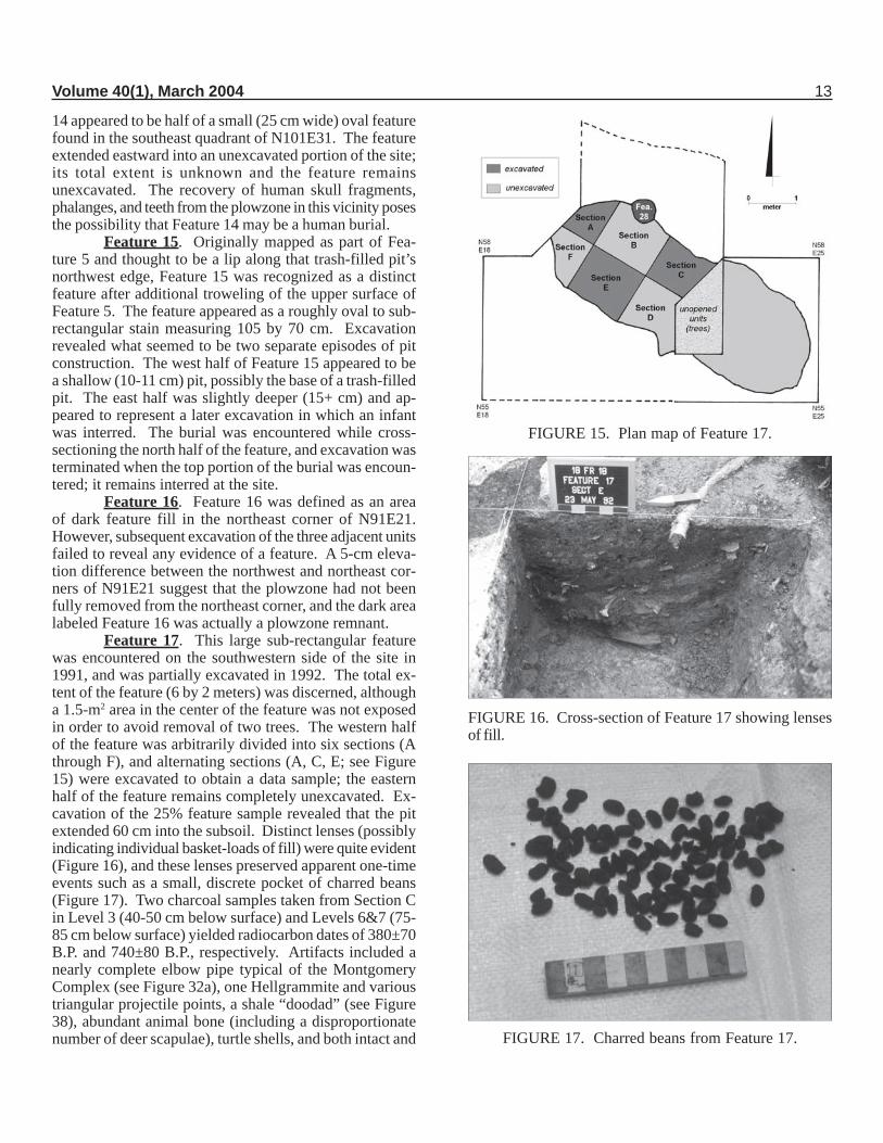
Feature 12. This oval feature measured 3.5 by1.6 meters, and penetrated the subsoil some 60 cm (in someareas actually exposing limestone bedrock; see Figure 13).Some lensing was observed in the feature fill, but generallythe fill consisted of a fairly uniform dark matrix. Artifactsrecovered from the feature included several dozen trian-gular projectile points (quartz, rhyolite, and chert); hundredsof sherds, including large nested portions of a squat vesseldecorated with hanging chevrons below its neck (see Fig-ure 30); hundreds of animal bones, including a bear jawwith its canine tooth intact (Figure 14); charred corn cobfragments; a charred bean fragment; a bone fishhook; anantler tine punch; and a rouletted pipe bowl. A charcoalsample from the southwest quadrant of this trash-filled pitfeature, just above the bottom of the pit, yielded a radiocar-bon date of 935±60 B.P.
Feature 13. Feature 13, found in 1990 and exca-vated in 1991, was a roughly oval dark stain measuring 2.0by 1.4 meters. The feature extended some 40 cm into thesubsoil and, as with Feature 12, had been excavated to thelimestone bedrock. Considerable rodent disturbance wasobserved in the feature fill. Recovered artifacts included adiscoidal fragment, a worked deer antler, and a quartz tri-angular point. The feature represents a trash-filled pit.
Feature 14. Feature 14 was located in the unitadjacent to the northwest of Feature 7, which was deter-mined to be a slightly deeper pocket of plowzone. Feature
FIGURE 13. Feature 12 after excavation,showing limestone bedrock.
FIGURE 14. Bear jaw from Feature 12.
Volume 40(1), March 2004 13
14 appeared to be half of a small (25 cm wide) oval featurefound in the southeast quadrant of N101E31. The featureextended eastward into an unexcavated portion of the site;its total extent is unknown and the feature remainsunexcavated. The recovery of human skull fragments,phalanges, and teeth from the plowzone in this vicinity posesthe possibility that Feature 14 may be a human burial.
Feature 15. Originally mapped as part of Fea-ture 5 and thought to be a lip along that trash-filled pit’snorthwest edge, Feature 15 was recognized as a distinctfeature after additional troweling of the upper surface ofFeature 5. The feature appeared as a roughly oval to sub-rectangular stain measuring 105 by 70 cm. Excavationrevealed what seemed to be two separate episodes of pitconstruction. The west half of Feature 15 appeared to bea shallow (10-11 cm) pit, possibly the base of a trash-filledpit. The east half was slightly deeper (15+ cm) and ap-peared to represent a later excavation in which an infantwas interred. The burial was encountered while cross-sectioning the north half of the feature, and excavation wasterminated when the top portion of the burial was encoun-tered; it remains interred at the site.
Feature 16. Feature 16 was defined as an areaof dark feature fill in the northeast corner of N91E21.However, subsequent excavation of the three adjacent unitsfailed to reveal any evidence of a feature. A 5-cm eleva-tion difference between the northwest and northeast cor-ners of N91E21 suggest that the plowzone had not beenfully removed from the northeast corner, and the dark arealabeled Feature 16 was actually a plowzone remnant.
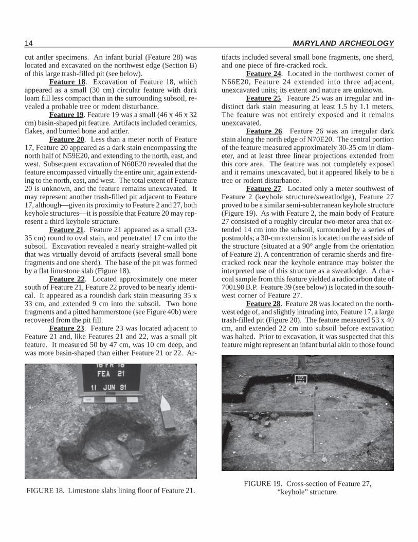
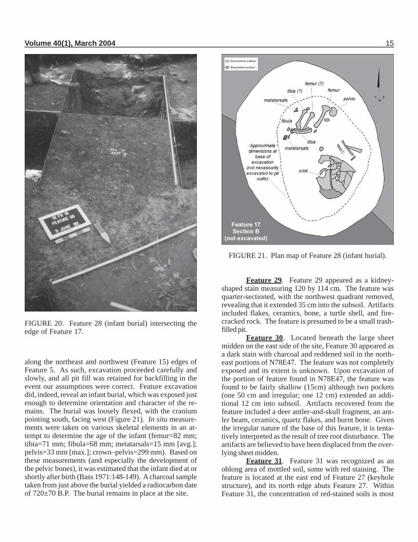
Feature 17. This large sub-rectangular featurewas encountered on the southwestern side of the site in1991, and was partially excavated in 1992. The total ex-tent of the feature (6 by 2 meters) was discerned, althougha 1.5-m2 area in the center of the feature was not exposedin order to avoid removal of two trees. The western halfof the feature was arbitrarily divided into six sections (Athrough F), and alternating sections (A, C, E; see Figure15) were excavated to obtain a data sample; the easternhalf of the feature remains completely unexcavated. Ex-cavation of the 25% feature sample revealed that the pitextended 60 cm into the subsoil. Distinct lenses (possiblyindicating individual basket-loads of fill) were quite evident(Figure 16), and these lenses preserved apparent one-timeevents such as a small, discrete pocket of charred beans(Figure 17). Two charcoal samples taken from Section Cin Level 3 (40-50 cm below surface) and Levels 6&7 (75-85 cm below surface) yielded radiocarbon dates of 380±70B.P. and 740±80 B.P., respectively. Artifacts included anearly complete elbow pipe typical of the MontgomeryComplex (see Figure 32a), one Hellgrammite and varioustriangular projectile points, a shale “doodad” (see Figure38), abundant animal bone (including a disproportionatenumber of deer scapulae), turtle shells, and both intact and
FIGURE 15. Plan map of Feature 17.
FIGURE 16. Cross-section of Feature 17 showing lensesof fill.
FIGURE 17. Charred beans from Feature 17.
14 MARYLAND ARCHEOLOGY
cut antler specimens. An infant burial (Feature 28) waslocated and excavated on the northwest edge (Section B)of this large trash-filled pit (see below).
Feature 18. Excavation of Feature 18, whichappeared as a small (30 cm) circular feature with darkloam fill less compact than in the surrounding subsoil, re-vealed a probable tree or rodent disturbance.
Feature 19. Feature 19 was a small (46 x 46 x 32cm) basin-shaped pit feature. Artifacts included ceramics,flakes, and burned bone and antler.
Feature 20. Less than a meter north of Feature17, Feature 20 appeared as a dark stain encompassing thenorth half of N59E20, and extending to the north, east, andwest. Subsequent excavation of N60E20 revealed that thefeature encompassed virtually the entire unit, again extend-ing to the north, east, and west. The total extent of Feature20 is unknown, and the feature remains unexcavated. Itmay represent another trash-filled pit adjacent to Feature17, although—given its proximity to Feature 2 and 27, bothkeyhole structures—it is possible that Feature 20 may rep-resent a third keyhole structure.
Feature 21. Feature 21 appeared as a small (33-35 cm) round to oval stain, and penetrated 17 cm into thesubsoil. Excavation revealed a nearly straight-walled pitthat was virtually devoid of artifacts (several small bonefragments and one sherd). The base of the pit was formedby a flat limestone slab (Figure 18).
Feature 22. Located approximately one metersouth of Feature 21, Feature 22 proved to be nearly identi-cal. It appeared as a roundish dark stain measuring 35 x33 cm, and extended 9 cm into the subsoil. Two bonefragments and a pitted hammerstone (see Figure 40b) wererecovered from the pit fill.
Feature 23. Feature 23 was located adjacent toFeature 21 and, like Features 21 and 22, was a small pitfeature. It measured 50 by 47 cm, was 10 cm deep, andwas more basin-shaped than either Feature 21 or 22. Ar-
tifacts included several small bone fragments, one sherd,and one piece of fire-cracked rock.
Feature 24. Located in the northwest corner ofN66E20, Feature 24 extended into three adjacent,unexcavated units; its extent and nature are unknown.
Feature 25. Feature 25 was an irregular and in-distinct dark stain measuring at least 1.5 by 1.1 meters.The feature was not entirely exposed and it remainsunexcavated.
Feature 26. Feature 26 was an irregular darkstain along the north edge of N70E20. The central portionof the feature measured approximately 30-35 cm in diam-eter, and at least three linear projections extended fromthis core area. The feature was not completely exposedand it remains unexcavated, but it appeared likely to be atree or rodent disturbance.
Feature 27. Located only a meter southwest ofFeature 2 (keyhole structure/sweatlodge), Feature 27proved to be a similar semi-subterranean keyhole structure(Figure 19). As with Feature 2, the main body of Feature27 consisted of a roughly circular two-meter area that ex-tended 14 cm into the subsoil, surrounded by a series ofpostmolds; a 30-cm extension is located on the east side ofthe structure (situated at a 90° angle from the orientationof Feature 2). A concentration of ceramic sherds and fire-cracked rock near the keyhole entrance may bolster theinterpreted use of this structure as a sweatlodge. A char-coal sample from this feature yielded a radiocarbon date of700±90 B.P. Feature 39 (see below) is located in the south-west corner of Feature 27.
Feature 28. Feature 28 was located on the north-west edge of, and slightly intruding into, Feature 17, a largetrash-filled pit (Figure 20). The feature measured 53 x 40cm, and extended 22 cm into subsoil before excavationwas halted. Prior to excavation, it was suspected that thisfeature might represent an infant burial akin to those found
FIGURE 18. Limestone slabs lining floor of Feature 21.FIGURE 19. Cross-section of Feature 27,
“keyhole” structure.
Volume 40(1), March 2004 15
along the northeast and northwest (Feature 15) edges ofFeature 5. As such, excavation proceeded carefully andslowly, and all pit fill was retained for backfilling in theevent our assumptions were correct. Feature excavationdid, indeed, reveal an infant burial, which was exposed justenough to determine orientation and character of the re-mains. The burial was loosely flexed, with the craniumpointing south, facing west (Figure 21). In situ measure-ments were taken on various skeletal elements in an at-tempt to determine the age of the infant (femur=82 mm;tibia=71 mm; fibula=68 mm; metatarsals=15 mm [avg.];pelvis=33 mm [max.]; crown–pelvis=299 mm). Based onthese measurements (and especially the development ofthe pelvic bones), it was estimated that the infant died at orshortly after birth (Bass 1971:148-149). A charcoal sampletaken from just above the burial yielded a radiocarbon dateof 720±70 B.P. The burial remains in place at the site.
FIGURE 20. Feature 28 (infant burial) intersecting theedge of Feature 17.
FIGURE 21. Plan map of Feature 28 (infant burial).
Feature 29. Feature 29 appeared as a kidney-shaped stain measuring 120 by 114 cm. The feature wasquarter-sectioned, with the northwest quadrant removed,revealing that it extended 35 cm into the subsoil. Artifactsincluded flakes, ceramics, bone, a turtle shell, and fire-cracked rock. The feature is presumed to be a small trash-filled pit.
Feature 30. Located beneath the large sheetmidden on the east side of the site, Feature 30 appeared asa dark stain with charcoal and reddened soil in the north-east portions of N78E47. The feature was not completelyexposed and its extent is unknown. Upon excavation ofthe portion of feature found in N78E47, the feature wasfound to be fairly shallow (15cm) although two pockets(one 50 cm and irregular; one 12 cm) extended an addi-tional 12 cm into subsoil. Artifacts recovered from thefeature included a deer antler-and-skull fragment, an ant-ler beam, ceramics, quartz flakes, and burnt bone. Giventhe irregular nature of the base of this feature, it is tenta-tively interpreted as the result of tree root disturbance. Theartifacts are believed to have been displaced from the over-lying sheet midden.
Feature 31. Feature 31 was recognized as anoblong area of mottled soil, some with red staining. Thefeature is located at the east end of Feature 27 (keyholestructure), and its north edge abuts Feature 27. WithinFeature 31, the concentration of red-stained soils is most
16 MARYLAND ARCHEOLOGY
prominent at its north end (closest to Feature 27). Feature31 was not completely exposed, and neither its extent norfunction is known. It remains unexcavated.
Feature 32. Located about 50 cm east-southeastof the eastern tip of Feature 27 (keyhole structure), Fea-ture 31 was defined as a circular (ca. 30 cm) dark stain.The total extent of the feature is unknown, as it extendssouthward into an unexcavated unit. Cross-sectioning ofthe feature, during which only the north half was removed,revealed a shallow (10 cm) flat-bottomed pit containingceramics, bone, shell, and charcoal. The feature’s func-tion is unknown.
Feature 33. Feature 33 was defined in 1992 asan area of light brown soil located between Features 2 and27 (keyhole structures). The feature appeared to extendto the east, into a unit excavated in 1979, although anyextension was not noticed in 1979. Feature 3, a reddenedpatch of clay excavated on the west edge of Feature 2 in1979, would have been adjacent to Feature 33, and it ispossible that Feature 33 represents plow-smearing of Fea-ture 3. Nonetheless, Feature 33 was not excavated, andits nature and function remain unknown.
Feature 34. Feature 34 is a small (27 by 30 cm),round basin-shaped pit exposed in N79E37. Excavationrevealed the feature to be very shallow (extending only 5cm into subsoil), and contained a few ceramic sherds andsome charcoal. Its function is unknown.
Feature 35. Located beneath the sheet middenon the east side of the site, Feature 35 was originally de-fined as a dark area (33 x 30 cm) with a deer bone andceramic sherd cluster. The bone was found in three clus-ters of one to two bones each, and individual bone weresitting up vertically; within these was noticed a concentra-tion of ceramic sherds. Prior to excavation, it was specu-lated that the bones served as a tripod used to support aceramic vessel. Upon excavation, Feature 35 was foundto be about 10 cm deep, except along its east edge where aroot disturbance extended down an additional 8 cm beforeturning perpendicular. Based on the root disturbance, Fea-ture 35 is considered to be a deep pocket of sheet midden,and the artifacts were displaced from above by root ac-tion.
Feature 36. Also located in the sheet middenarea of the site, Feature 36 was defined as a dark area inthe upper portions of the midden itself in unit N80E49. Thefeature extended to the west, northwest, and north intounexcavated units. Excavation of the feature revealed anirregular shallow basin thought to be a dark pocket of thesheet midden.
Feature 37. Feature 37 is a small (57- by 27-cmsection exposed) stain along the south wall of N85E50.The feature extends southward into an unexcavated unit,and remains unexcavated. Its extent and nature are un-known.
Feature 38. Feature 38 appeared as a very darkstain beneath the sheet midden in the northwest corner ofN73E47. Excavation revealed a deep (29 cm) funnel-shaped cross-section characteristic of a root disturbance.
Feature 39. Located in the southwest corner ofthe floor of Feature 27 (keyhole structure), Feature 39 ap-peared as a sub-rectangular area (36 x 31 cm) of dark soilwith lighter reddish mottles. The feature appeared at thebase of (below the floor of) Feature 27, and extended anadditional 4 cm into the subsoil. Feature 39 abutted thewall of the keyhole structure, and may have intruded 2-3cm into the wall/lip of Feature 27. One bone fragment andtwo quartzite fragments were recovered from this flat-bot-tomed pit feature. The function of Feature 39, other than apossible storage feature associated with the keyhole struc-ture, is unknown.
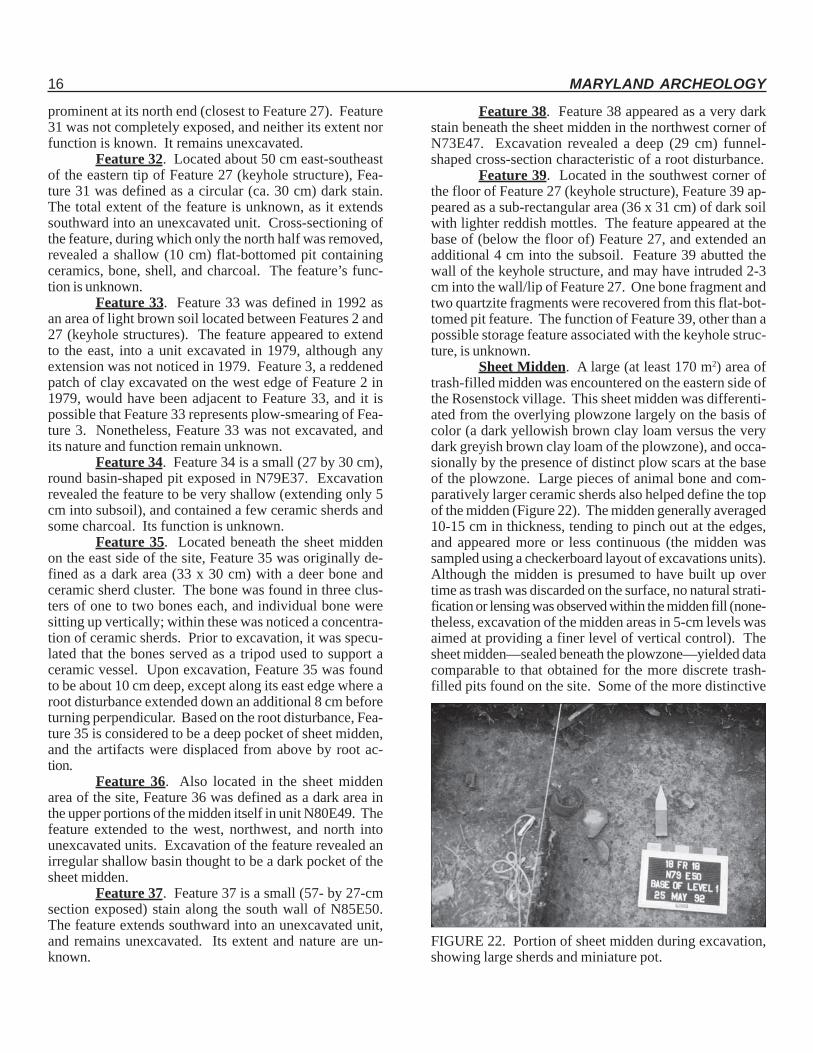
Sheet Midden. A large (at least 170 m2) area oftrash-filled midden was encountered on the eastern side ofthe Rosenstock village. This sheet midden was differenti-ated from the overlying plowzone largely on the basis ofcolor (a dark yellowish brown clay loam versus the verydark greyish brown clay loam of the plowzone), and occa-sionally by the presence of distinct plow scars at the baseof the plowzone. Large pieces of animal bone and com-paratively larger ceramic sherds also helped define the topof the midden (Figure 22). The midden generally averaged10-15 cm in thickness, tending to pinch out at the edges,and appeared more or less continuous (the midden wassampled using a checkerboard layout of excavations units).Although the midden is presumed to have built up overtime as trash was discarded on the surface, no natural strati-fication or lensing was observed within the midden fill (none-theless, excavation of the midden areas in 5-cm levels wasaimed at providing a finer level of vertical control). Thesheet midden—sealed beneath the plowzone—yielded datacomparable to that obtained for the more discrete trash-filled pits found on the site. Some of the more distinctive
FIGURE 22. Portion of sheet midden during excavation,showing large sherds and miniature pot.
Volume 40(1), March 2004 17
artifacts recovered from the sheet midden include a com-plete miniature pot (see Figure 31) from N79E50; a stonemaskette (see Figure 37) from N77E48; numerous pipefragments; bone and shell beads; a piece of worked bone(Figure 41d), possibly used as a shuttle in weaving or bas-ketry; bone awls; several deer antlers; various turtle shells;a limestone disc and a portions of a ceramic and a shelldisc; several chunkey stone fragments; two celt fragments;and numerous triangular projectile points.
ArtifactsCeramic
Ceramic Vessels. The ceramics at theRosenstock site are almost exclusively Shepard Cord-Marked, a type of ceramic first defined by Schmitt (1952).A recent report by Slattery and Woodward (1992) has sum-marized information on the Shepard ceramics found on fourMontgomery Complex villages along the Potomac River,and much of the descriptive material here draws from thatpublication.
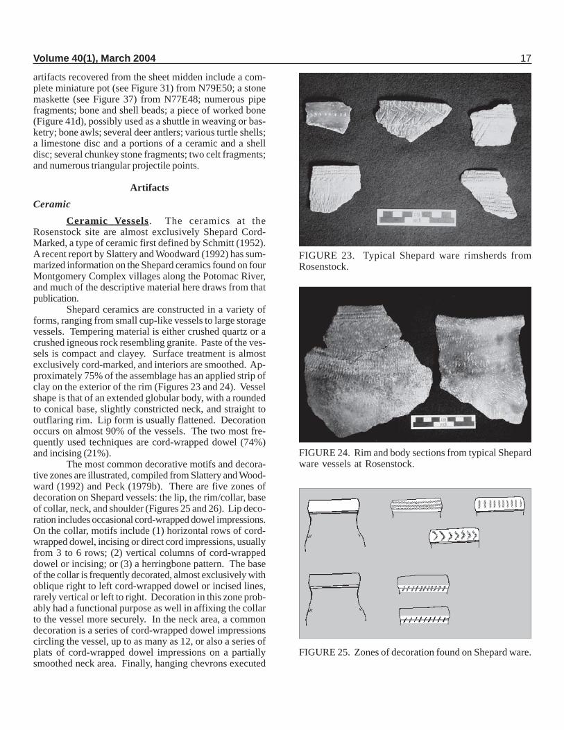
Shepard ceramics are constructed in a variety offorms, ranging from small cup-like vessels to large storagevessels. Tempering material is either crushed quartz or acrushed igneous rock resembling granite. Paste of the ves-sels is compact and clayey. Surface treatment is almostexclusively cord-marked, and interiors are smoothed. Ap-proximately 75% of the assemblage has an applied strip ofclay on the exterior of the rim (Figures 23 and 24). Vesselshape is that of an extended globular body, with a roundedto conical base, slightly constricted neck, and straight tooutflaring rim. Lip form is usually flattened. Decorationoccurs on almost 90% of the vessels. The two most fre-quently used techniques are cord-wrapped dowel (74%)and incising (21%).
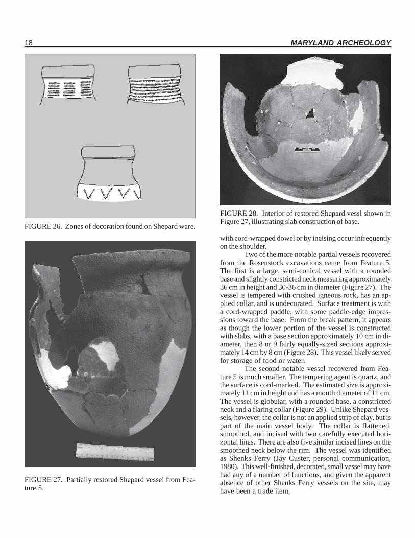
The most common decorative motifs and decora-tive zones are illustrated, compiled from Slattery and Wood-ward (1992) and Peck (1979b). There are five zones ofdecoration on Shepard vessels: the lip, the rim/collar, baseof collar, neck, and shoulder (Figures 25 and 26). Lip deco-ration includes occasional cord-wrapped dowel impressions.On the collar, motifs include (1) horizontal rows of cord-wrapped dowel, incising or direct cord impressions, usuallyfrom 3 to 6 rows; (2) vertical columns of cord-wrappeddowel or incising; or (3) a herringbone pattern. The baseof the collar is frequently decorated, almost exclusively withoblique right to left cord-wrapped dowel or incised lines,rarely vertical or left to right. Decoration in this zone prob-ably had a functional purpose as well in affixing the collarto the vessel more securely. In the neck area, a commondecoration is a series of cord-wrapped dowel impressionscircling the vessel, up to as many as 12, or also a series ofplats of cord-wrapped dowel impressions on a partiallysmoothed neck area. Finally, hanging chevrons executed
FIGURE 23. Typical Shepard ware rimsherds fromRosenstock.
FIGURE 24. Rim and body sections from typical Shepardware vessels at Rosenstock.
FIGURE 25. Zones of decoration found on Shepard ware.
18 MARYLAND ARCHEOLOGY
with cord-wrapped dowel or by incising occur infrequentlyon the shoulder.
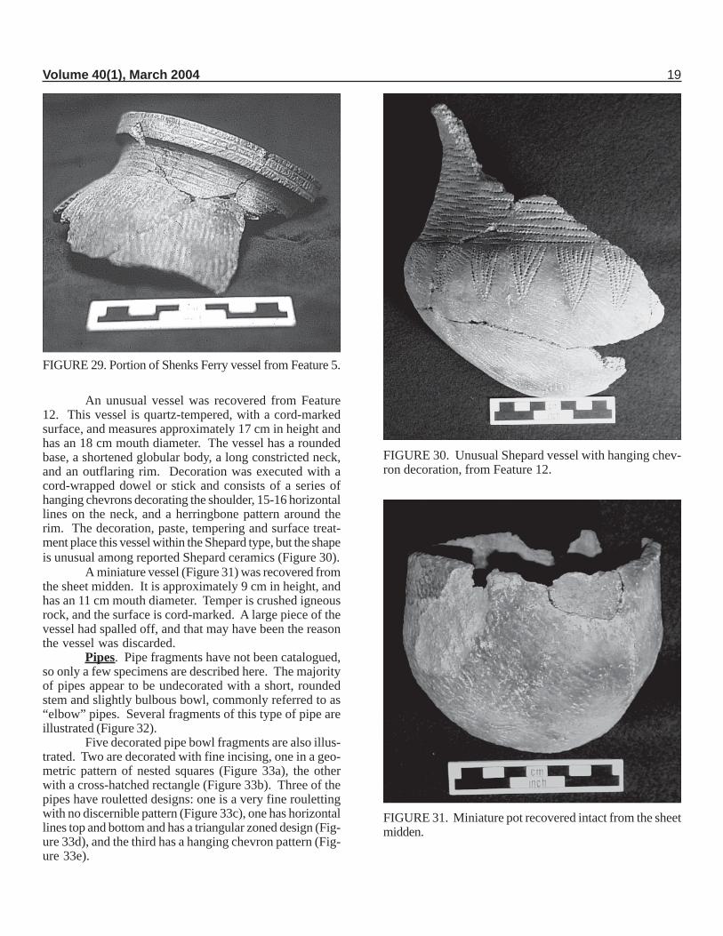
Two of the more notable partial vessels recoveredfrom the Rosenstock excavations came from Feature 5.The first is a large, semi-conical vessel with a roundedbase and slightly constricted neck measuring approximately36 cm in height and 30-36 cm in diameter (Figure 27). Thevessel is tempered with crushed igneous rock, has an ap-plied collar, and is undecorated. Surface treatment is witha cord-wrapped paddle, with some paddle-edge impres-sions toward the base. From the break pattern, it appearsas though the lower portion of the vessel is constructedwith slabs, with a base section approximately 10 cm in di-ameter, then 8 or 9 fairly equally-sized sections approxi-mately 14 cm by 8 cm (Figure 28). This vessel likely servedfor storage of food or water.
The second notable vessel recovered from Fea-ture 5 is much smaller. The tempering agent is quartz, andthe surface is cord-marked. The estimated size is approxi-mately 11 cm in height and has a mouth diameter of 11 cm.The vessel is globular, with a rounded base, a constrictedneck and a flaring collar (Figure 29). Unlike Shepard ves-sels, however, the collar is not an applied strip of clay, but ispart of the main vessel body. The collar is flattened,smoothed, and incised with two carefully executed hori-zontal lines. There are also five similar incised lines on thesmoothed neck below the rim. The vessel was identifiedas Shenks Ferry (Jay Custer, personal communication,1980). This well-finished, decorated, small vessel may havehad any of a number of functions, and given the apparentabsence of other Shenks Ferry vessels on the site, mayhave been a trade item.
FIGURE 26. Zones of decoration found on Shepard ware.
FIGURE 27. Partially restored Shepard vessel from Fea-ture 5.
FIGURE 28. Interior of restored Shepard vessl shown inFigure 27, illustrating slab construction of base.
Volume 40(1), March 2004 19
An unusual vessel was recovered from Feature12. This vessel is quartz-tempered, with a cord-markedsurface, and measures approximately 17 cm in height andhas an 18 cm mouth diameter. The vessel has a roundedbase, a shortened globular body, a long constricted neck,and an outflaring rim. Decoration was executed with acord-wrapped dowel or stick and consists of a series ofhanging chevrons decorating the shoulder, 15-16 horizontallines on the neck, and a herringbone pattern around therim. The decoration, paste, tempering and surface treat-ment place this vessel within the Shepard type, but the shapeis unusual among reported Shepard ceramics (Figure 30).
A miniature vessel (Figure 31) was recovered fromthe sheet midden. It is approximately 9 cm in height, andhas an 11 cm mouth diameter. Temper is crushed igneousrock, and the surface is cord-marked. A large piece of thevessel had spalled off, and that may have been the reasonthe vessel was discarded.
Pipes. Pipe fragments have not been catalogued,so only a few specimens are described here. The majorityof pipes appear to be undecorated with a short, roundedstem and slightly bulbous bowl, commonly referred to as“elbow” pipes. Several fragments of this type of pipe areillustrated (Figure 32).
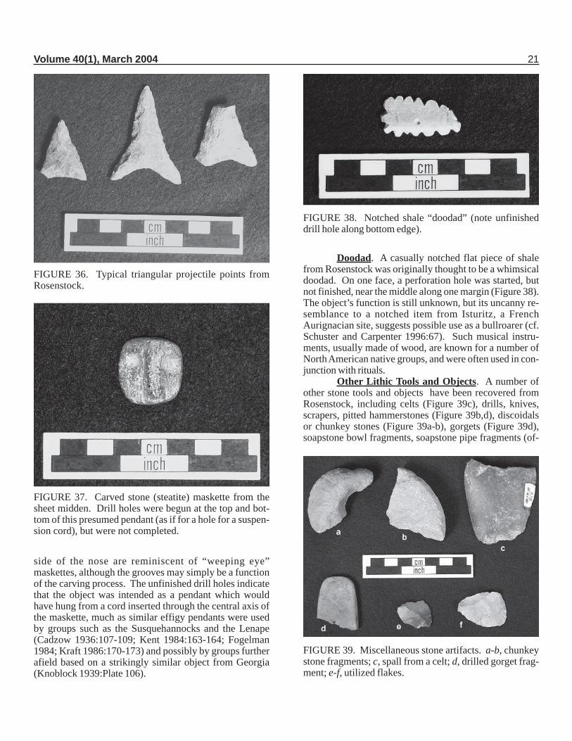
Five decorated pipe bowl fragments are also illus-trated. Two are decorated with fine incising, one in a geo-metric pattern of nested squares (Figure 33a), the otherwith a cross-hatched rectangle (Figure 33b). Three of thepipes have rouletted designs: one is a very fine roulettingwith no discernible pattern (Figure 33c), one has horizontallines top and bottom and has a triangular zoned design (Fig-ure 33d), and the third has a hanging chevron pattern (Fig-ure 33e).
FIGURE 29. Portion of Shenks Ferry vessel from Feature 5.
FIGURE 30. Unusual Shepard vessel with hanging chev-ron decoration, from Feature 12.
FIGURE 31. Miniature pot recovered intact from the sheetmidden.
20 MARYLAND ARCHEOLOGY
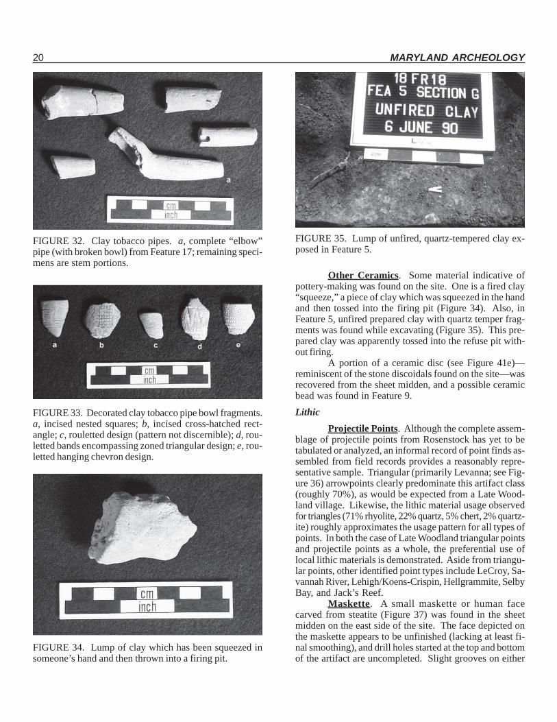
FIGURE 32. Clay tobacco pipes. a, complete “elbow”pipe (with broken bowl) from Feature 17; remaining speci-mens are stem portions.
FIGURE 33. Decorated clay tobacco pipe bowl fragments.a, incised nested squares; b, incised cross-hatched rect-angle; c, rouletted design (pattern not discernible); d, rou-letted bands encompassing zoned triangular design; e, rou-letted hanging chevron design.
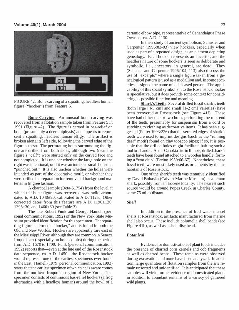
FIGURE 34. Lump of clay which has been squeezed insomeone’s hand and then thrown into a firing pit.
FIGURE 35. Lump of unfired, quartz-tempered clay ex-posed in Feature 5.
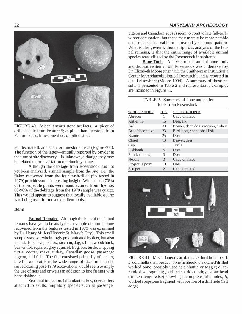
Other Ceramics. Some material indicative ofpottery-making was found on the site. One is a fired clay“squeeze,” a piece of clay which was squeezed in the handand then tossed into the firing pit (Figure 34). Also, inFeature 5, unfired prepared clay with quartz temper frag-ments was found while excavating (Figure 35). This pre-pared clay was apparently tossed into the refuse pit with-out firing.
A portion of a ceramic disc (see Figure 41e)—reminiscent of the stone discoidals found on the site—wasrecovered from the sheet midden, and a possible ceramicbead was found in Feature 9.Lithic
Projectile Points. Although the complete assem-blage of projectile points from Rosenstock has yet to betabulated or analyzed, an informal record of point finds as-sembled from field records provides a reasonably repre-sentative sample. Triangular (primarily Levanna; see Fig-ure 36) arrowpoints clearly predominate this artifact class(roughly 70%), as would be expected from a Late Wood-land village. Likewise, the lithic material usage observedfor triangles (71% rhyolite, 22% quartz, 5% chert, 2% quartz-ite) roughly approximates the usage pattern for all types ofpoints. In both the case of Late Woodland triangular pointsand projectile points as a whole, the preferential use oflocal lithic materials is demonstrated. Aside from triangu-lar points, other identified point types include LeCroy, Sa-vannah River, Lehigh/Koens-Crispin, Hellgrammite, SelbyBay, and Jack’s Reef.
Maskette. A small maskette or human facecarved from steatite (Figure 37) was found in the sheetmidden on the east side of the site. The face depicted onthe maskette appears to be unfinished (lacking at least fi-nal smoothing), and drill holes started at the top and bottomof the artifact are uncompleted. Slight grooves on either
Volume 40(1), March 2004 21
side of the nose are reminiscent of “weeping eye”maskettes, although the grooves may simply be a functionof the carving process. The unfinished drill holes indicatethat the object was intended as a pendant which wouldhave hung from a cord inserted through the central axis ofthe maskette, much as similar effigy pendants were usedby groups such as the Susquehannocks and the Lenape(Cadzow 1936:107-109; Kent 1984:163-164; Fogelman1984; Kraft 1986:170-173) and possibly by groups furtherafield based on a strikingly similar object from Georgia(Knoblock 1939:Plate 106).
Doodad. A casually notched flat piece of shalefrom Rosenstock was originally thought to be a whimsicaldoodad. On one face, a perforation hole was started, butnot finished, near the middle along one margin (Figure 38).The object’s function is still unknown, but its uncanny re-semblance to a notched item from Isturitz, a FrenchAurignacian site, suggests possible use as a bullroarer (cf.Schuster and Carpenter 1996:67). Such musical instru-ments, usually made of wood, are known for a number ofNorth American native groups, and were often used in con-junction with rituals.
Other Lithic Tools and Objects. A number ofother stone tools and objects have been recovered fromRosenstock, including celts (Figure 39c), drills, knives,scrapers, pitted hammerstones (Figure 39b,d), discoidalsor chunkey stones (Figure 39a-b), gorgets (Figure 39d),soapstone bowl fragments, soapstone pipe fragments (of-
FIGURE 36. Typical triangular projectile points fromRosenstock.
FIGURE 37. Carved stone (steatite) maskette from thesheet midden. Drill holes were begun at the top and bot-tom of this presumed pendant (as if for a hole for a suspen-sion cord), but were not completed.
FIGURE 38. Notched shale “doodad” (note unfinisheddrill hole along bottom edge).
FIGURE 39. Miscellaneous stone artifacts. a-b, chunkeystone fragments; c, spall from a celt; d, drilled gorget frag-ment; e-f, utilized flakes.
22 MARYLAND ARCHEOLOGY
ten decorated), and shale or limestone discs (Figure 40c).The function of the latter—initially reported by Snyder atthe time of site discovery—is unknown, although they maybe related to, or a variation of, chunkey stones.
Although the debitage from Rosenstock has notyet been analyzed, a small sample from the site (i.e., theflakes recovered from the four trash-filled pits tested in1979) provides some interesting insight. While most (70%)of the projectile points were manufactured from rhyolite,80-90% of the debitage from the 1979 sample was quartz.This would appear to suggest that locally available quartzwas being used for most expedient tools.
Bone
Faunal Remains. Although the bulk of the faunalremains have yet to be analyzed, a sample of animal bonerecovered from the features tested in 1979 was examinedby Dr. Henry Miller (Historic St. Mary’s City). This smallsample was overwhelmingly predominated by deer, but alsoincluded elk, bear, red fox, raccoon, dog, rabbit, woodchuck,beaver, fox squirrel, grey squirrel, frog, box turtle, snappingturtle, cooter, snake, turkey, Canadian goose, passengerpigeon, and fish. The fish consisted primarily of sucker,bowfin, and catfish; the wide range of sizes of fish ob-served during post-1979 excavations would seem to implythe use of nets and or weirs in addition to line fishing withbone fishhooks.
Seasonal indicators (abundant turkey, deer antlersattached to skulls, migratory species such as passenger
FIGURE 40. Miscellaneous stone artifacts. a, piece ofdrilled shale from Feature 5; b, pitted hammerstone fromFeature 22; c, limestone disc; d, pitted stone.
FIGURE 41. Miscellaneous artifacts. a, bird bone bead;b, columella shell bead; c, bone fishhook; d, notched/drilledworked bone, possibly used as a shuttle or toggle; e, ce-ramic disc fragment; f, drilled shark’s tooth; g, stone bead(broken lengthwise) showing incomplete drill holes; h,worked soapstone fragment with portion of a drill hole (leftedge).
pigeon and Canadian goose) seem to point to late fall/earlywinter occupation, but these may merely be more notableoccurrences observable in an overall year-round pattern.What is clear, even without a rigorous analysis of the fau-nal remains, is that the entire range of available animalspecies was utilized by the Rosenstock inhabitants.
Bone Tools. Analysis of the animal bone toolsand decorative items from Rosenstock was undertaken byDr. Elizabeth Moore (then with the Smithsonian Institution’sCenter for Archaeobiological Research), and is reported indetail elsewhere (Moore 1994). A summary of those re-sults is presented in Table 2 and representative examplesare included in Figure 41.
TABLE 2. Summary of bone and antlertools from Rosenstock.
TOOL FUNCTION QTY SPECIES UTILIZEDAbrader 1 UndeterminedAntler tip 16 Deer, elkAwl 30 Beaver, deer, dog, raccoon, turkeyBead/decorative 23 Bird, deer, shark, shellfishBeamer 25 DeerChisel 13 Beaver, deerCup 1 TurtleFishhook 5 DeerFlintknapping 3 DeerNeedle 2 UndeterminedProjectile point 10 DeerScraper 2 Undetermined
Volume 40(1), March 2004 23
Bone Carving. An unusual bone carving wasrecovered from a flotation sample taken from Feature 5 in1991 (Figure 42). The figure is carved in bas-relief onbone (presumably a deer epiphysis) and appears to repre-sent a squatting, headless human effigy. The artifact isbroken along its left side, following the carved edge of thefigure’s torso. The perforating holes surrounding the fig-ure are drilled from both sides, although two (near thefigure’s “calf”) were started only on the carved face andnot completed. It is unclear whether the large hole on theright was intentional, or if it was an intended small hole that“punched out.” It is also unclear whether the holes wereintended as part of the decorative motif, or whether theywere drilled in preparation for removal of background ma-terial in filigree fashion.
A charcoal sample (Beta-51754) from the level atwhich the bone figure was recovered was radiocarbon-dated to A.D. 1040±90, calibrated to A.D. 1125. Othercorrected dates from this feature are A.D. 1190±120,1395±30, and 1460±60 (see Table 3).
The late Robert Funk and George Hamell (per-sonal communications, 1992) of the New York State Mu-seum provided identification for this specimen. The squat-ting figure is termed a “hocker,” and is found in both theOld and New Worlds. Hockers are apparently rare east ofthe Mississippi River, although they are common in SenecaIroquois art (especially on bone combs) during the periodfrom A.D. 1670 to 1700. Funk (personal communication,1992) reports that—even at the late end of the Rosenstockdate sequence, ca. A.D. 1450—the Rosenstock hockerwould represent one of the earliest specimens ever foundin the East. Hamell (1979; personal communication, 1992)states that the earliest specimen of which he is aware comesfrom the northern Iroquoian region of New York. Thatspecimen consists of continuous bas-relief hockers (a frogalternating with a headless human) around the bowl of a
FIGURE 42. Bone carving of a squatting, headless humanfigure (“hocker”) from Feature 5.
ceramic elbow pipe, representative of Canandaigua PhaseOwasco, ca. A.D. 1130.
In their study of ancient symbolism, Schuster andCarpenter (1996:82-83) view hockers, especially whenused as part of a repeated design, as an element depictinggenealogy. Each hocker represents an ancestor, and theheadless nature of some hockers is seen as deliberate andsymbolic, i.e., ancestors, in general, are dead. They(Schuster and Carpenter 1996:104, 113) also discuss theuse of “excerpts” where a single figure taken from a ge-nealogical pattern is used as a medallion and, in some soci-eties, assigned the name of a deceased person. The appli-cability of this social symbolism to the Rosenstock hockeris speculative, but it does provide some context for consid-ering its possible function and meaning.
Shark’s Teeth. Several drilled fossil shark’s teeth(both large [4-5 cm] and small [1-2 cm] varieties) havebeen recovered at Rosenstock (see Figure 41f). Thesehave had either one or two holes perforating the root endof the teeth, presumably for suspension from a cord orstitching to clothing as decorative items. It has been sug-gested (Potter 1993:226) that the serrated edges of shark’steeth were used to imprint designs (such as the “runningdeer” motif) found on clay tobacco pipes; if so, it is pos-sible that the drilled holes might facilitate hafting such atool to a handle. At the Cahokia site in Illinois, drilled shark’steeth have been found attached to a wooden handle, form-ing a “war club” (Perino 1950:66-67). Nonetheless, thesefossil teeth were most likely used as ornaments by the in-habitants of Rosenstock.
One of the shark’s teeth was tentatively identifiedby David Bohaska (Calvert Marine Museum) as a lemonshark, possibly from an Eocene locality. The nearest suchsource would be around Popes Creek in Charles County,some 75 miles distant.
Shell
In addition to the presence of freshwater musselshells at Rosenstock, artifacts manufactured from marineshell also occur. These include columella shell beads (seeFigure 41b), as well as a shell disc bead.
Botanical
Evidence for domestication of plant foods includesthe presence of charred corn kernels and cob fragmentsas well as charred beans. These remains were observedduring excavation and none have been analyzed. In addi-tion, large quantities of flotation samples from the site re-main unsorted and unidentified. It is anticipated that thesesamples will yield further evidence of domesticated plantsin addition to abundant remains of a variety of gatheredwild plants.
24 MARYLAND ARCHEOLOGY
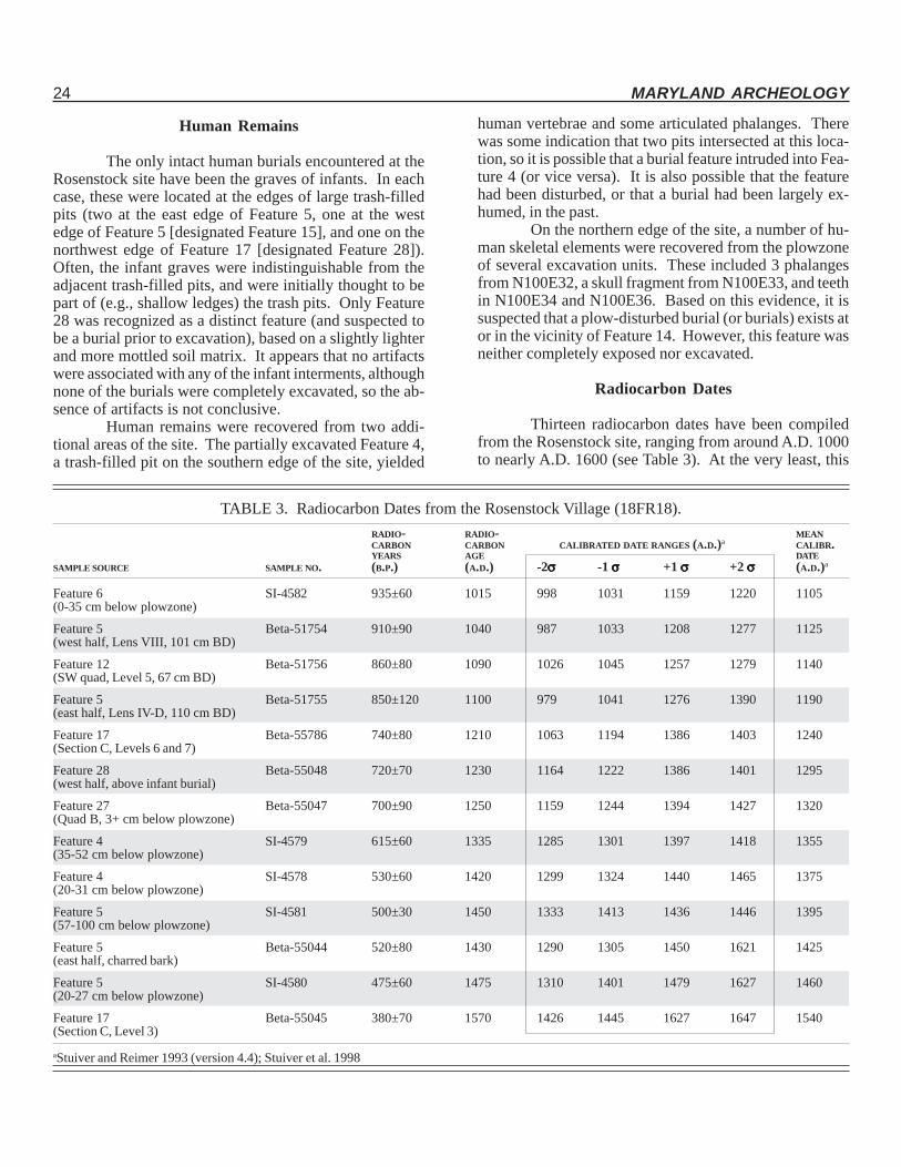
TABLE 3. Radiocarbon Dates from the Rosenstock Village (18FR18).RADIO- RADIO- MEANCARBON CARBON CALIBRATED DATE RANGES (A.D.)a CALIBR.YEARS AGE DATE
SAMPLE SOURCE SAMPLE NO. (B.P.) (A.D.) -2σσσσσ -1 σσσσσ +1 σσσσσ +2 σσσσσ (A.D.)a
Feature 6 SI-4582 935±60 1015 998 1031 1159 1220 1105(0-35 cm below plowzone)
Feature 5 Beta-51754 910±90 1040 987 1033 1208 1277 1125(west half, Lens VIII, 101 cm BD)
Feature 12 Beta-51756 860±80 1090 1026 1045 1257 1279 1140(SW quad, Level 5, 67 cm BD)
Feature 5 Beta-51755 850±120 1100 979 1041 1276 1390 1190(east half, Lens IV-D, 110 cm BD)
Feature 17 Beta-55786 740±80 1210 1063 1194 1386 1403 1240(Section C, Levels 6 and 7)
Feature 28 Beta-55048 720±70 1230 1164 1222 1386 1401 1295(west half, above infant burial)
Feature 27 Beta-55047 700±90 1250 1159 1244 1394 1427 1320(Quad B, 3+ cm below plowzone)
Feature 4 SI-4579 615±60 1335 1285 1301 1397 1418 1355(35-52 cm below plowzone)
Feature 4 SI-4578 530±60 1420 1299 1324 1440 1465 1375(20-31 cm below plowzone)
Feature 5 SI-4581 500±30 1450 1333 1413 1436 1446 1395(57-100 cm below plowzone)
Feature 5 Beta-55044 520±80 1430 1290 1305 1450 1621 1425(east half, charred bark)
Feature 5 SI-4580 475±60 1475 1310 1401 1479 1627 1460(20-27 cm below plowzone)
Feature 17 Beta-55045 380±70 1570 1426 1445 1627 1647 1540(Section C, Level 3)
aStuiver and Reimer 1993 (version 4.4); Stuiver et al. 1998
Human Remains
The only intact human burials encountered at theRosenstock site have been the graves of infants. In eachcase, these were located at the edges of large trash-filledpits (two at the east edge of Feature 5, one at the westedge of Feature 5 [designated Feature 15], and one on thenorthwest edge of Feature 17 [designated Feature 28]).Often, the infant graves were indistinguishable from theadjacent trash-filled pits, and were initially thought to bepart of (e.g., shallow ledges) the trash pits. Only Feature28 was recognized as a distinct feature (and suspected tobe a burial prior to excavation), based on a slightly lighterand more mottled soil matrix. It appears that no artifactswere associated with any of the infant interments, althoughnone of the burials were completely excavated, so the ab-sence of artifacts is not conclusive.
Human remains were recovered from two addi-tional areas of the site. The partially excavated Feature 4,a trash-filled pit on the southern edge of the site, yielded
human vertebrae and some articulated phalanges. Therewas some indication that two pits intersected at this loca-tion, so it is possible that a burial feature intruded into Fea-ture 4 (or vice versa). It is also possible that the featurehad been disturbed, or that a burial had been largely ex-humed, in the past.
On the northern edge of the site, a number of hu-man skeletal elements were recovered from the plowzoneof several excavation units. These included 3 phalangesfrom N100E32, a skull fragment from N100E33, and teethin N100E34 and N100E36. Based on this evidence, it issuspected that a plow-disturbed burial (or burials) exists ator in the vicinity of Feature 14. However, this feature wasneither completely exposed nor excavated.
Radiocarbon Dates
Thirteen radiocarbon dates have been compiledfrom the Rosenstock site, ranging from around A.D. 1000to nearly A.D. 1600 (see Table 3). At the very least, this
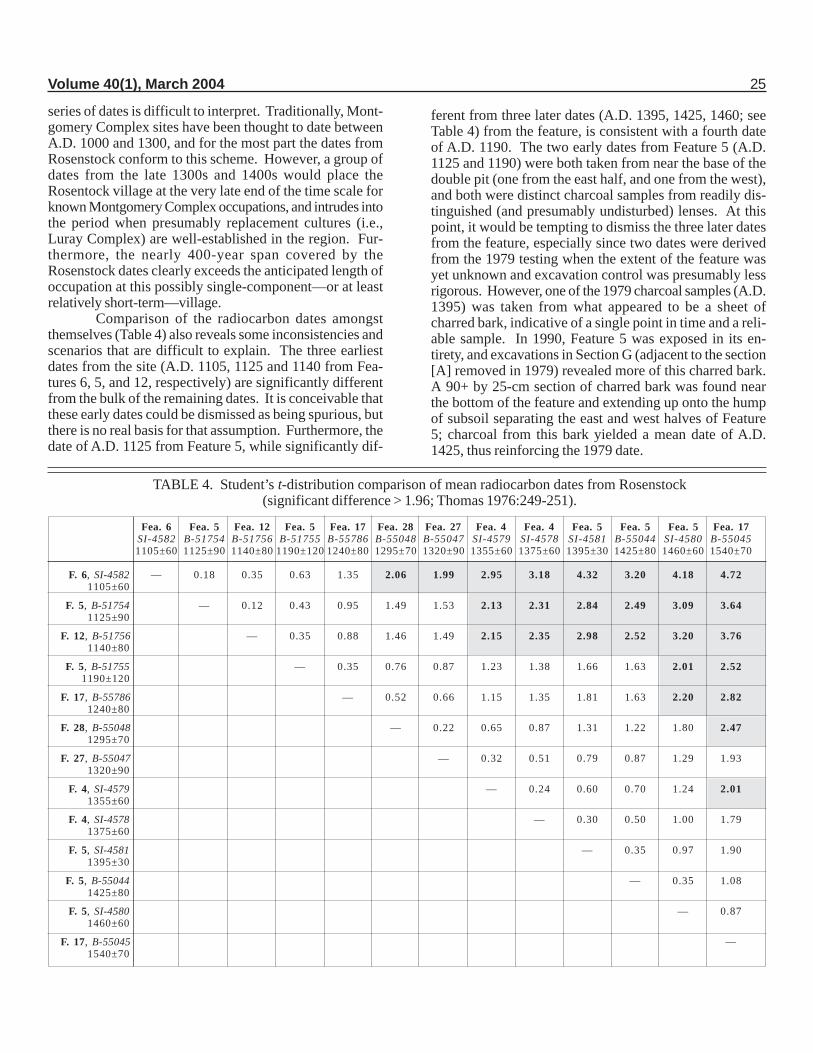
TABLE 4. Student’s t-distribution comparison of mean radiocarbon dates from Rosenstock(significant difference > 1.96; Thomas 1976:249-251).
Fea. 6 Fea. 5 Fea. 12 Fea. 5 Fea. 17 Fea. 28 Fea. 27 Fea. 4 Fea. 4 Fea. 5 Fea. 5 Fea. 5 Fea. 17SI-4582 B-51754 B-51756 B-51755 B-55786 B-55048 B-55047 SI-4579 SI-4578 SI-4581 B-55044 SI-4580 B-550451105±60 1125±90 1140±80 1190±120 1240±80 1295±70 1320±90 1355±60 1375±60 1395±30 1425±80 1460±60 1540±70
F. 6, SI-4582 — 0.18 0.35 0.63 1.35 2.06 1.99 2.95 3.18 4.32 3.20 4.18 4.721105±60
F. 5, B-51754 — 0.12 0.43 0.95 1.49 1.53 2.13 2.31 2.84 2.49 3.09 3.641125±90
F. 12, B-51756 — 0.35 0.88 1.46 1.49 2.15 2.35 2.98 2.52 3.20 3.761140±80
F. 5, B-51755 — 0.35 0.76 0.87 1.23 1.38 1.66 1.63 2.01 2.521190±120
F. 17, B-55786 — 0.52 0.66 1.15 1.35 1.81 1.63 2.20 2.821240±80
F. 28, B-55048 — 0.22 0.65 0.87 1.31 1.22 1.80 2.471295±70
F. 27, B-55047 — 0.32 0.51 0.79 0.87 1.29 1.931320±90
F. 4, SI-4579 — 0.24 0.60 0.70 1.24 2.011355±60
F. 4, SI-4578 — 0.30 0.50 1.00 1.791375±60
F. 5, SI-4581 — 0.35 0.97 1.901395±30
F. 5, B-55044 — 0.35 1.081425±80
F. 5, SI-4580 — 0.871460±60
F. 17, B-55045 —1540±70
Volume 40(1), March 2004 25
series of dates is difficult to interpret. Traditionally, Mont-gomery Complex sites have been thought to date betweenA.D. 1000 and 1300, and for the most part the dates fromRosenstock conform to this scheme. However, a group ofdates from the late 1300s and 1400s would place theRosentock village at the very late end of the time scale forknown Montgomery Complex occupations, and intrudes intothe period when presumably replacement cultures (i.e.,Luray Complex) are well-established in the region. Fur-thermore, the nearly 400-year span covered by theRosenstock dates clearly exceeds the anticipated length ofoccupation at this possibly single-component—or at leastrelatively short-term—village.
Comparison of the radiocarbon dates amongstthemselves (Table 4) also reveals some inconsistencies andscenarios that are difficult to explain. The three earliestdates from the site (A.D. 1105, 1125 and 1140 from Fea-tures 6, 5, and 12, respectively) are significantly differentfrom the bulk of the remaining dates. It is conceivable thatthese early dates could be dismissed as being spurious, butthere is no real basis for that assumption. Furthermore, thedate of A.D. 1125 from Feature 5, while significantly dif-
ferent from three later dates (A.D. 1395, 1425, 1460; seeTable 4) from the feature, is consistent with a fourth dateof A.D. 1190. The two early dates from Feature 5 (A.D.1125 and 1190) were both taken from near the base of thedouble pit (one from the east half, and one from the west),and both were distinct charcoal samples from readily dis-tinguished (and presumably undisturbed) lenses. At thispoint, it would be tempting to dismiss the three later datesfrom the feature, especially since two dates were derivedfrom the 1979 testing when the extent of the feature wasyet unknown and excavation control was presumably lessrigorous. However, one of the 1979 charcoal samples (A.D.1395) was taken from what appeared to be a sheet ofcharred bark, indicative of a single point in time and a reli-able sample. In 1990, Feature 5 was exposed in its en-tirety, and excavations in Section G (adjacent to the section[A] removed in 1979) revealed more of this charred bark.A 90+ by 25-cm section of charred bark was found nearthe bottom of the feature and extending up onto the humpof subsoil separating the east and west halves of Feature5; charcoal from this bark yielded a mean date of A.D.1425, thus reinforcing the 1979 date.
26 MARYLAND ARCHEOLOGY
Feature 17, likewise, presents a conundrum. Thisvery large trash-filled pit exhibited extremely distinct lenses(to the point where individual basket-loads appeared dis-cernible), and seemed to represent a sealed, undisturbedcontext. Two charcoal samples from Feature 17 yieldedmean radiocarbon dates of A.D. 1240 (from near the baseof the pit) and A.D. 1540 (from near the center of the pit).The sample yielding the earlier date was combined fromindividual samples from Levels 6 and 7 in order to providesufficient charcoal for dating. It is possible that this com-bining of samples introduced some margin of error. How-ever, the sample yielding the later date (A.D. 1540) wastaken from a distinct charcoal-rich lens immediately adja-cent to a discrete, undisturbed pocket of charred seeds andbeans. Yet, these two mean dates—from seemingly pris-tine short-term contexts—fail to overlap, even at two stan-dard deviations. And the later date, from an almost certainsingle-episode context, is inconsistent with more than halfof the remaining dates from Rosenstock.
So, where does radiocarbon dating at Rosenstockleave us? One could posit a number of scenarios:
• Rosenstock was occupied sporadically or continu-ously from A.D. 1100 to 1540 (with the possibilityof occupation ranging from A.D. 1000 to 1650 atthe 95% confidence level).
• Two major occupations took place at Rosenstock:around A.D. 1150±50 and around 1400±50.
• There is an unexplained source of contaminationaffecting the Rosenstock dates.Based on apparent contradictory archeological evi-
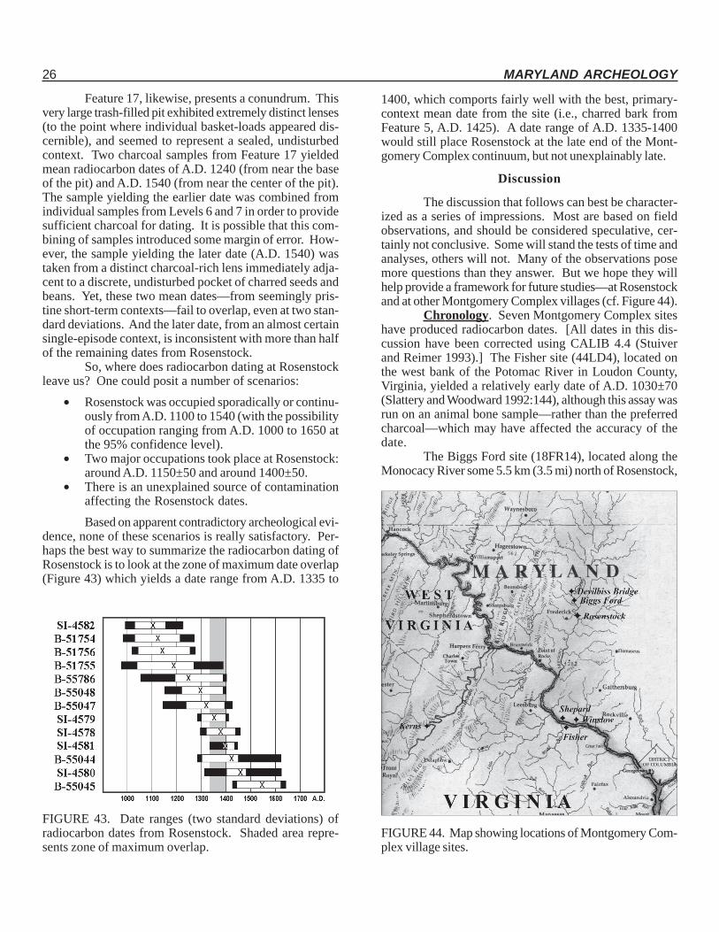
dence, none of these scenarios is really satisfactory. Per-haps the best way to summarize the radiocarbon dating ofRosenstock is to look at the zone of maximum date overlap(Figure 43) which yields a date range from A.D. 1335 to
FIGURE 43. Date ranges (two standard deviations) ofradiocarbon dates from Rosenstock. Shaded area repre-sents zone of maximum overlap.
1400, which comports fairly well with the best, primary-context mean date from the site (i.e., charred bark fromFeature 5, A.D. 1425). A date range of A.D. 1335-1400would still place Rosenstock at the late end of the Mont-gomery Complex continuum, but not unexplainably late.
FIGURE 44. Map showing locations of Montgomery Com-plex village sites.
Discussion
The discussion that follows can best be character-ized as a series of impressions. Most are based on fieldobservations, and should be considered speculative, cer-tainly not conclusive. Some will stand the tests of time andanalyses, others will not. Many of the observations posemore questions than they answer. But we hope they willhelp provide a framework for future studies—at Rosenstockand at other Montgomery Complex villages (cf. Figure 44).
Chronology. Seven Montgomery Complex siteshave produced radiocarbon dates. [All dates in this dis-cussion have been corrected using CALIB 4.4 (Stuiverand Reimer 1993).] The Fisher site (44LD4), located onthe west bank of the Potomac River in Loudon County,Virginia, yielded a relatively early date of A.D. 1030±70(Slattery and Woodward 1992:144), although this assay wasrun on an animal bone sample—rather than the preferredcharcoal—which may have affected the accuracy of thedate.
The Biggs Ford site (18FR14), located along theMonocacy River some 5.5 km (3.5 mi) north of Rosenstock,
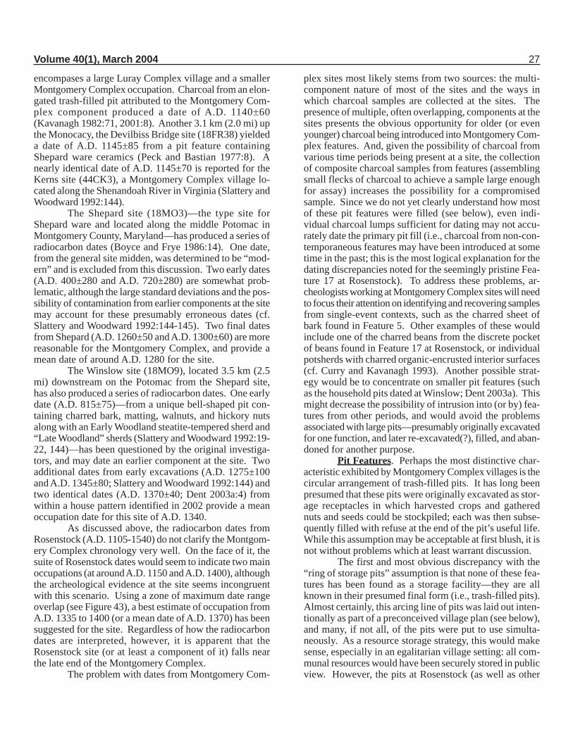
Volume 40(1), March 2004 27
encompases a large Luray Complex village and a smallerMontgomery Complex occupation. Charcoal from an elon-gated trash-filled pit attributed to the Montgomery Com-plex component produced a date of A.D. 1140±60(Kavanagh 1982:71, 2001:8). Another 3.1 km (2.0 mi) upthe Monocacy, the Devilbiss Bridge site (18FR38) yieldeda date of A.D. 1145±85 from a pit feature containingShepard ware ceramics (Peck and Bastian 1977:8). Anearly identical date of A.D. 1145±70 is reported for theKerns site (44CK3), a Montgomery Complex village lo-cated along the Shenandoah River in Virginia (Slattery andWoodward 1992:144).
The Shepard site (18MO3)—the type site forShepard ware and located along the middle Potomac inMontgomery County, Maryland—has produced a series ofradiocarbon dates (Boyce and Frye 1986:14). One date,from the general site midden, was determined to be “mod-ern” and is excluded from this discussion. Two early dates(A.D. 400±280 and A.D. 720±280) are somewhat prob-lematic, although the large standard deviations and the pos-sibility of contamination from earlier components at the sitemay account for these presumably erroneous dates (cf.Slattery and Woodward 1992:144-145). Two final datesfrom Shepard (A.D. 1260±50 and A.D. 1300±60) are morereasonable for the Montgomery Complex, and provide amean date of around A.D. 1280 for the site.
The Winslow site (18MO9), located 3.5 km (2.5mi) downstream on the Potomac from the Shepard site,has also produced a series of radiocarbon dates. One earlydate (A.D. 815±75)—from a unique bell-shaped pit con-taining charred bark, matting, walnuts, and hickory nutsalong with an Early Woodland steatite-tempered sherd and“Late Woodland” sherds (Slattery and Woodward 1992:19-22, 144)—has been questioned by the original investiga-tors, and may date an earlier component at the site. Twoadditional dates from early excavations (A.D. 1275±100and A.D. 1345±80; Slattery and Woodward 1992:144) andtwo identical dates (A.D. 1370±40; Dent 2003a:4) fromwithin a house pattern identified in 2002 provide a meanoccupation date for this site of A.D. 1340.
As discussed above, the radiocarbon dates fromRosenstock (A.D. 1105-1540) do not clarify the Montgom-ery Complex chronology very well. On the face of it, thesuite of Rosenstock dates would seem to indicate two mainoccupations (at around A.D. 1150 and A.D. 1400), althoughthe archeological evidence at the site seems incongruentwith this scenario. Using a zone of maximum date rangeoverlap (see Figure 43), a best estimate of occupation fromA.D. 1335 to 1400 (or a mean date of A.D. 1370) has beensuggested for the site. Regardless of how the radiocarbondates are interpreted, however, it is apparent that theRosenstock site (or at least a component of it) falls nearthe late end of the Montgomery Complex.
The problem with dates from Montgomery Com-
plex sites most likely stems from two sources: the multi-component nature of most of the sites and the ways inwhich charcoal samples are collected at the sites. Thepresence of multiple, often overlapping, components at thesites presents the obvious opportunity for older (or evenyounger) charcoal being introduced into Montgomery Com-plex features. And, given the possibility of charcoal fromvarious time periods being present at a site, the collectionof composite charcoal samples from features (assemblingsmall flecks of charcoal to achieve a sample large enoughfor assay) increases the possibility for a compromisedsample. Since we do not yet clearly understand how mostof these pit features were filled (see below), even indi-vidual charcoal lumps sufficient for dating may not accu-rately date the primary pit fill (i.e., charcoal from non-con-temporaneous features may have been introduced at sometime in the past; this is the most logical explanation for thedating discrepancies noted for the seemingly pristine Fea-ture 17 at Rosenstock). To address these problems, ar-cheologists working at Montgomery Complex sites will needto focus their attention on identifying and recovering samplesfrom single-event contexts, such as the charred sheet ofbark found in Feature 5. Other examples of these wouldinclude one of the charred beans from the discrete pocketof beans found in Feature 17 at Rosenstock, or individualpotsherds with charred organic-encrusted interior surfaces(cf. Curry and Kavanagh 1993). Another possible strat-egy would be to concentrate on smaller pit features (suchas the household pits dated at Winslow; Dent 2003a). Thismight decrease the possibility of intrusion into (or by) fea-tures from other periods, and would avoid the problemsassociated with large pits—presumably originally excavatedfor one function, and later re-excavated(?), filled, and aban-doned for another purpose.
Pit Features. Perhaps the most distinctive char-acteristic exhibited by Montgomery Complex villages is thecircular arrangement of trash-filled pits. It has long beenpresumed that these pits were originally excavated as stor-age receptacles in which harvested crops and gatherednuts and seeds could be stockpiled; each was then subse-quently filled with refuse at the end of the pit’s useful life.While this assumption may be acceptable at first blush, it isnot without problems which at least warrant discussion.
The first and most obvious discrepancy with the“ring of storage pits” assumption is that none of these fea-tures has been found as a storage facility—they are allknown in their presumed final form (i.e., trash-filled pits).Almost certainly, this arcing line of pits was laid out inten-tionally as part of a preconceived village plan (see below),and many, if not all, of the pits were put to use simulta-neously. As a resource storage strategy, this would makesense, especially in an egalitarian village setting: all com-munal resources would have been securely stored in publicview. However, the pits at Rosenstock (as well as other
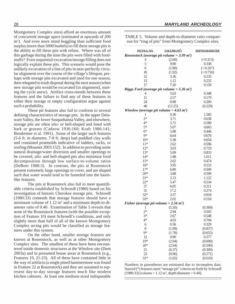
28 MARYLAND ARCHEOLOGY
Montgomery Complex sites) afford an enormous amountof concurrent storage space (estimated at upwards of 200m3). And even more mind boggling than sufficient foodsurplus (more than 5000 bushels) to fill these storage pits isthe ability to fill these pits with refuse. Where was all ofthis garbage during the time the pits were filled with food-stuffs? Even sequential excavation/storage/filling does notlogically explain these pits. This scenario would pose theunlikely excavation of a line of pits in near-perfectly circu-lar alignment over the course of the village’s lifespan, per-haps with storage pits excavated and used for one season,then relegated to trash disposal during the next season (whennew storage pits would be excavated [in alignment], start-ing the cycle anew). Artifact cross-mends between thesefeatures and the failure to find any of these features ineither their storage or empty configuration argue againstsuch a probability.
These pit features also fail to conform to severaldefining characteristics of storage pits. In the upper Dela-ware Valley, the lower Susquehanna Valley, and elsewhere,storage pits are often silo- or bell-shaped and lined withbark or grasses (Cadzow 1936:160; Kraft 1986:141;Bendremer et al. 1991). Some of the larger such features(5-6 ft. in diameter, 7-8 ft. deep) had puddled clay wallsand contained postmolds indicative of ladders, racks, orroofing (Mounier 2003:152). In addition to providing somenatural drainage/water diversion and smaller openings tobe covered, silo- and bell-shaped pits also minimize fooddecomposition through low surface-to-volume ratios(DeBoer 1988:3). In contrast, the pits at Rosenstockpresent extremely large openings to cover, and are shapedsuch that water would tend to be funneled into the basin-like features.
The pits at Rosenstock also fail to meet quantifi-able criteria established by Schroedl (1980) based on hisinvestigation of historic Cherokee storage pits. Schroedl(1980:33) contends that storage features should have aminimum volume of 1.12 m3 and a minimum depth-to-di-ameter ratio of 0.40. Examination of Table 5 reveals thatnone of the Rosenstock features (with the possible excep-tion of Feature 10) meet Schroedl’s conditions, and onlyslightly more than half of all of the known MontgomeryComplex arcing pits would be classified as storage fea-tures under this system.
On the other hand, smaller storage features areknown at Rosenstock, as well as at other MontgomeryComplex sites. The smallest of these have been encoun-tered inside domestic structures at the Winslow site (Dent2003a) and in presumed house areas at Rosenstock (e.g.,Features 19, 21-23). All of these have contained little inthe way of artifacts (a single pitted hammerstone was foundin Feature 22 at Rosenstock) and they are assumed to rep-resent day-to-day storage features much like modernkitchen cabinets. At least one medium-sized indisputable
TABLE 5. Volume and depth-to-diameter ratio compari-son for “ring of pits” from Montgomery Complex sites.
PIT/FEA. NO. VOLUME (M3) DEPTH:DIAMETER
Rosenstock (average pit volume = 3.99 m3)4 (2.60) (<0.313)5 9.90 0.3386 (1.80) (< 0.267)10 (1.92) (< 0.750)12 3.36 0.23513 1.12 0.23517 7.20 0.150
Biggs Ford (average pit volume = 5.36 m3)4 5.63 0.34811 2.57 0.17024 0.98 0.20040 (12.25) (0.229)
Winslow (average pit volume = 4.63 m3)1 0.36 1.585
2* 3.71 0.6384* 3.72 0.5895* 5.07 0.6636* 5.88 0.4469* 6.64 0.67010* 5.38 0.65411* 2.62 0.59612* 3.03 0.71913* 5.09 0.83314* 1.98 1.01115* 2.62 0.47416* 3.95 0.53317* 6.80 0.50020* 3.88 0.59921* 2.13 1.12222* 5.47 0.53427 6.05 0.31131 17.2 0.274
32* 3.57 0.81833* 2.02 0.516
Fisher (average pit volume = 2.56 m3)1 (5.50) (0.369)
2* 2.94 0.5033* 2.67 0.5484* 4.03 0.7046 0.36 0.3298 (1.08) (0.837)
9* (1.78) (0.655)12 0.90 0.377
19* (2.04) (0.600)20* (2.94) (0.500)21 (6.37) (0.300)23 (0.96) (0.271)
31* (1.65) (0.610)
Numbers in parentheses are estimated due to incomplete data.Starred (*) features meet “storage pit” criteria set forth by Schroedl(1980:33) [volume > 1.12 m3, depth:diameter > 0.40].
Volume 40(1), March 2004 29
storage feature has been excavated at Winslow (Slatteryand Woodward 1992:19-22). Here, Feature 25 was foundto be a bell-shaped pit, lined with grass matting and bark,and containing walnuts and hickory nuts. This feature hada depth-to-diameter ratio of 0.636, but its volume was just0.242 m3, thereby failing Schroedl’s (1980) definition. How-ever, Feature 25 is located in an area that almost certainlywas adjacent to a third house at Winslow, the pattern ofwhich eluded early excavators. The significance of thisfeature is that it hints at the presence of individual house-hold storage at Montgomery Complex sites.
In sum, Rosenstock and other Montgomery Com-plex sites exhibit at least three types of pit features: verylarge basin-shaped communal features comprising the “ringof pits,” presumably originally used for some type of stor-age or processing, but eventually filled with refuse; me-dium-sized, silo- or bell-shaped storage pits with grass and/or bark lining and likely serving a single household’s stor-age requirements; and small, in-the-house storage facilitiesdesigned to meet day-to-day needs. Future investigationof these sites should pay particular attention to the varioustypes of pit features, determining their true functions, es-tablishing the relationships among features so as to betterexplicate prehistoric storage technologies, and assessingsettlement/subsistence strategies (e.g., seasonal abandon-ment versus year-round occupation).
Perishable Artifacts. Much is missing from thearcheological record at Rosenstock. Despite the excellentbone and antler preservation at the site, objects made ofwood, fiber, and hide do not survive, although all are knownto have been used. The prehistoric artwork preserved inbone, clay, and stone at Rosenstock must offer just a glimpseof that which must have been carried out in wood. Each ofthe hundreds (perhaps thousands) of arrowpoints manu-factured at Rosenstock required shafts, bows, and quivers.The impressions of cordage preserved on clay vessels onlyhint at a much wider fiber and hide industry (which surelyincluded nets, snares, and traps; basketry and bags; cloth-ing and textiles; and moccasins and sandals). Turtle cara-pace examples of spoons and scoops were likely less com-mon variations of wooden bowls, mortars, and ladles.
Even where rare examples are preserved, theyleave questions unresolved. Remains of cultigens (corn,beans, and squash) and nuts have been noted during exca-vation at Rosenstock and other Montgomery Complex sites,and analysis of flotation samples will likely identify a widerange of gathered plants like chenopodium and amaranth.And yet, all of these remains combined would not fill a fewhands. Why are these so rarely found? Is it a samplingerror? Is it poor preservation? Were these resources ofrelatively low importance? Surely if the Montgomery Com-plex “ring of pits” originated to store crops, many moreexamples of corn and beans should have been found (es-pecially if Kraft [1986:139-141] is correct in assuming that
fires were used to annually “clean” the storage pits).The point here is that archeologists need to care-
fully consider their interpretations, to not be influenced bylong-held assumptions, and to not make generalizationswithout sufficient supporting evidence. Just as the archeo-logical absence of wooden artifacts at Rosenstock doesnot negate their certain use, the recovery of cultigens doesnot confirm a full-blown, settled agricultural community.
Village Layout. Based on the work conducted todate, the generalized layout of the village at Rosenstockappears to be as follows. The core of the village is madeup of a plaza area with little evidence of any specific activ-ity. Presumably this was a common area used for travers-ing the village, possibly a recreational area where villagerscould congregate, relax, and talk, and perhaps an area forceremonies and communal feasting. Further out from thevillage center, but still within the arcing line of pits, at leasttwo keyhole structures (southeast area of the site) and alarge sheet midden (eastern edge of the site) are known.Presumably, the keyhole structures represent sweatlodgesthat were used during purification rites. The sheet middenobviously represents a surface accumulation of refuse builtup over time (although why this method was used as op-posed to the ultimately trash-filled pits—or even simply dis-posing of unwanted material over the riverside bluff—isunclear). Yet further (25 m) from the village center is thearcing line of trash-filled pits. Its alignment forms a nearperfect circle (Feature 17 is off line a few meters), al-though it may not be complete (extensive testing east ofthe sheet midden in the expected path of this arc failed toreveal any pits). Associated with these large trash-filledpits are a number of infant burials. Outside the arcing lineof pits is the probable location of domestic structures. Sup-porting evidence for this are the small household-like fea-tures (Feature 19, 21-3) southeast of Feature 17; unfortu-nately, postmold patterns for such structures have yet to bediscerned at Rosenstock. [Admittedly, during the 1990-1992 excavation seasons, the houses were presumed to belocated inside the line of pits, and excavation strategieswere designed accordingly. When the small domestic fea-tures outside Feature 17 were excavated in 1991, our pre-sumptions were so strong that we actually considered thepossibility of a second occupation in that area. It was notuntil the incontrovertible evidence for house placement atWinslow (Dent 2003a) that we began to recognize the sameprobable pattern at Rosenstock.] Based on the recoveryof stray elements of adult human skeletons (e.g., near Fea-ture 14), it is possible that adult burials are located in ornear the individual houses. No evidence for a palisadeencircling the village has been found. This “absence” of apalisade at Rosenstock could be due to the more limitedsampling in the peripheral areas of the village, or to the factthat a palisade was unnecessary given the site’s topographicsetting atop a high bluff.
30 MARYLAND ARCHEOLOGY
In an attempt to both compare and synthesize thedata from the best known Montgomery Complex sites(Rosenstock, Winslow, Fisher, and Biggs Ford), the site mapsfor each were uniformly scaled and then overlain on a singlemap, using the “center point” of each village’s ring of pitsas the tie-point (see Figure 45). This overall patterningagrees with the generalizations made above, and illustratesthe strong similarities between these sites. Winslow andFisher seem to exhibit a ring of pits with a circa-40-meterdiameter; Rosenstock is slightly larger, with a 50-meter di-ameter; surprisingly, the ring of pits at Biggs Ford mea-sures a meager 25-meter diameter. The house placementfound at Winslow would indicate a comfortable arrange-ment for 8 to 10 structures and yard areas, perhaps asmany as 15 houses, if “crowded;” using the same“crowded” arrangement, a maximum of 20 houses mightbe expected at Rosenstock. Only the Fisher site containsany features (including two burials) in the presumed openplaza area at the village center. And the palisade line con-firmed at Winslow seems to indicate a total village diam-eter of around 70-75 meters. (This would seem to indicatethat any palisade at Rosenstock could have a diameter aslarge as 80-85 meters, an area beyond most of the excava-tions carried out at the site, and beyond the limits of landarea available to the west [bluff] and north [ravine].)
Thus, the pattern that seems to be emerging fromMontgomery Complex villages is one in which both com-munal and individual spaces have been defined (see Figure46). The core of the village is an open plaza presumablydevoted to communal leisure, ritual, and/or feasting, butdevoid of evidence of day-to-day activities. At the periph-ery of the plaza are sweatlodges, again indicating ceremo-nial use of the area. The entire core of the village is cir-cumscribed by the circular alignment of trash-filled pits,the original purpose of which was probably communal stor-age and/or processing of some sort. Outside the commu-nal core of the village lies a series of roughly 8 to 20 indi-vidual household units, each of which consists of an ovaldomestic structure with a surrounding yard area comprisedof family activity areas, short-term household storage fa-cilities, and burial plots (both human and canine). Encir-cling the individual household areas—confirmed in at leastone case and suspected in others—is a simple palisadeconsisting of upright posts that may have been interwovenwith branches. Interestingly, if Montgomery Complex pali-sades serve more to separate the cultural world from thenatural world than to fend off village attackers as positedby Dent et al. (2002:25-27), these features can be viewedas the ultimate communal feature, literally serving to em-brace and define the village community.
Population and Group Dynamics. Estimatingvillage population can be approached using both the size ofindividual houses and the overall size of the village. Kent(1984:361) estimates that 13.2 ft2 of house space is needed
for each individual. Since the Montgomery Complex housesat Winslow average 165 ft2, one could expect each domes-tic structure to house 12.5 people. Carrying this further,the 8 to 20 houses expected in a Montgomery Complexvillage would indicate a total village population of 100-250people. Using total village area (averaging data from theSchultz and Strickler sites in the lower Susquehanna Val-ley), Kent (1984:365) has calculated an average populationdensity of one person per each 147 ft2. This would projectpopulations of 408 (Winslow, ~60,000 ft2) to 531(Rosenstock, ~78,000 ft2) people for Montgomery Com-plex villages. However, Kent’s figures were devised for17th century Susquehannock villages with densely-packedlonghouses, and the scattered oval houses of a Montgom-ery Complex village would suggest lower densities (Dent[2003b:20] estimates 450 ft2 per person, thereby suggest-ing a range of 133-173 individuals). Regardless of themethod employed, it is quite evident that Montgomery Com-plex villages were relatively small, with populations of prob-ably no more than around 200 people, and indicating a totalMontgomery Complex population of only 1000-1500 at anygiven time (assuming the unlikely possibility that all knownvillages were occupied simultaneously).
While village sites have been the traditional focusof Montgomery Complex sites, other types of sites alsorequire consideration. MacCord (1992) has summarizedthe most likely major components known for the Mont-gomery Complex (see Figure 47). These include villagesites, rockshelters, and less well-defined occupations, andcluster in the middle Potomac and Monocacy valleys, rang-ing as far north as the mouth of Conococheague Creekand as far south along the Shenandoah River as Front Royal(and possibly to Harrisonburg). Also expected, however,might be small hamlets and even individual farmsteads scat-tered across the landscape. Using “Shepard ware” as adefining characteristic, a database search of the MarylandArcheological Site Survey files revealed the presence ofsome three dozen (presumably Montgomery Complex)components which may represent these smaller, outlier sites.Future research will need to examine these sites, both inrelation to each other and to the village sites, before wecan understand how Montgomery Complex groups wereorganized.
Also needed is some sense of seriation amongMontgomery Complex sites. We need a better understand-ing of where the various village sites fall along the A.D.1000-1400 timeline if we expect to decipher MontgomeryComplex social development, the comings and goings ofthese people, and their interrelationships with other groupsoccupying the circum-middle-Potomac region. And ulti-mately, the possible relationship of the Piedmont’s Mont-gomery Complex to the Coastal Plain’s subsequent PotomacCreek Complex—first noted by Schmidt (1952:68)—needsto be explicated.
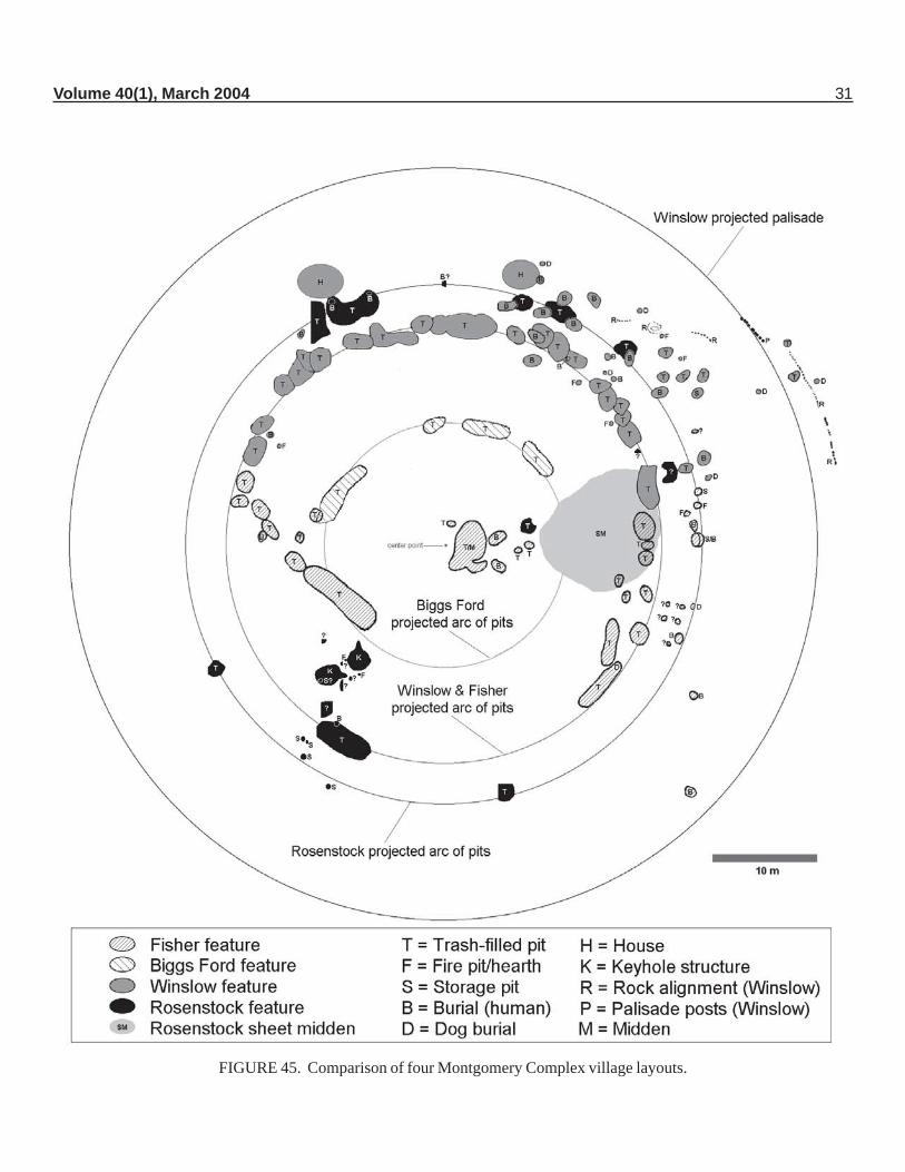
Volume 40(1), March 2004 31
FIGURE 45. Comparison of four Montgomery Complex village layouts.
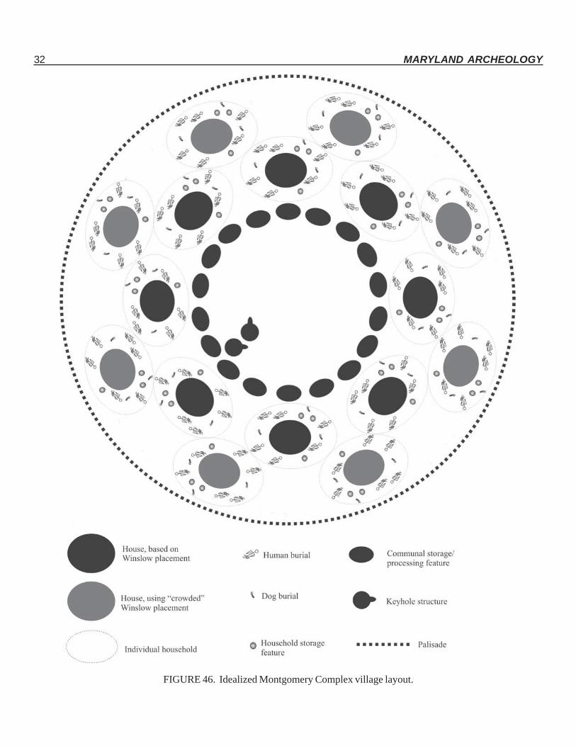
32 MARYLAND ARCHEOLOGY
FIGURE 46. Idealized Montgomery Complex village layout.
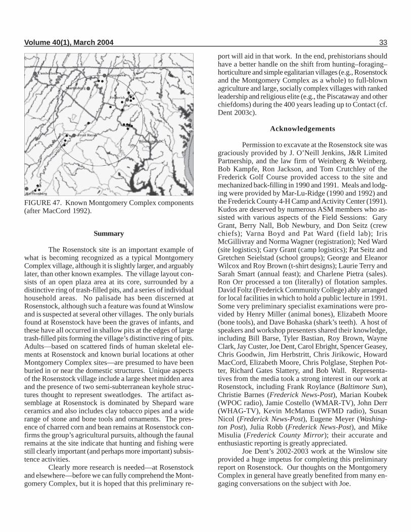
Volume 40(1), March 2004 33
Summary
The Rosenstock site is an important example ofwhat is becoming recognized as a typical MontgomeryComplex village, although it is slightly larger, and arguablylater, than other known examples. The village layout con-sists of an open plaza area at its core, surrounded by adistinctive ring of trash-filled pits, and a series of individualhousehold areas. No palisade has been discerned atRosenstock, although such a feature was found at Winslowand is suspected at several other villages. The only burialsfound at Rosenstock have been the graves of infants, andthese have all occurred in shallow pits at the edges of largetrash-filled pits forming the village’s distinctive ring of pits.Adults—based on scattered finds of human skeletal ele-ments at Rosenstock and known burial locations at otherMontgomery Complex sites—are presumed to have beenburied in or near the domestic structures. Unique aspectsof the Rosenstock village include a large sheet midden areaand the presence of two semi-subterranean keyhole struc-tures thought to represent sweatlodges. The artifact as-semblage at Rosenstock is dominated by Shepard wareceramics and also includes clay tobacco pipes and a widerange of stone and bone tools and ornaments. The pres-ence of charred corn and bean remains at Rosenstock con-firms the group’s agricultural pursuits, although the faunalremains at the site indicate that hunting and fishing werestill clearly important (and perhaps more important) subsis-tence activities.
Clearly more research is needed—at Rosenstockand elsewhere—before we can fully comprehend the Mont-gomery Complex, but it is hoped that this preliminary re-
port will aid in that work. In the end, prehistorians shouldhave a better handle on the shift from hunting–foraging–horticulture and simple egalitarian villages (e.g., Rosenstockand the Montgomery Complex as a whole) to full-blownagriculture and large, socially complex villages with rankedleadership and religious elite (e.g., the Piscataway and otherchiefdoms) during the 400 years leading up to Contact (cf.Dent 2003c).
Acknowledgements
Permission to excavate at the Rosenstock site wasgraciously provided by J. O’Neill Jenkins, J&R LimitedPartnership, and the law firm of Weinberg & Weinberg.Bob Kampfe, Ron Jackson, and Tom Crutchley of theFrederick Golf Course provided access to the site andmechanized back-filling in 1990 and 1991. Meals and lodg-ing were provided by Mar-Lu-Ridge (1990 and 1992) andthe Frederick County 4-H Camp and Activity Center (1991).Kudos are deserved by numerous ASM members who as-sisted with various aspects of the Field Sessions: GaryGrant, Berry Nall, Bob Newbury, and Don Seitz (crewchiefs); Varna Boyd and Pat Ward (field lab); IrisMcGillivray and Norma Wagner (registration); Ned Ward(site logistics); Gary Grant (camp logistics); Pat Seitz andGretchen Seielstad (school groups); George and EleanorWilcox and Roy Brown (t-shirt designs); Laurie Terry andSarah Smart (annual feast); and Charlene Pietra (sales).Ron Orr processed a ton (literally) of flotation samples.David Foltz (Frederick Community College) ably arrangedfor local facilities in which to hold a public lecture in 1991.Some very preliminary specialist examinations were pro-vided by Henry Miller (animal bones), Elizabeth Moore(bone tools), and Dave Bohaska (shark’s teeth). A host ofspeakers and workshop presenters shared their knowledge,including Bill Barse, Tyler Bastian, Roy Brown, WayneClark, Jay Custer, Joe Dent, Carol Ebright, Spencer Geasey,Chris Goodwin, Jim Herbstritt, Chris Jirikowic, HowardMacCord, Elizabeth Moore, Chris Polglase, Stephen Pot-ter, Richard Gates Slattery, and Bob Wall. Representa-tives from the media took a strong interest in our work atRosenstock, including Frank Roylance (Baltimore Sun),Christie Barnes (Frederick News-Post), Marian Koubek(WPOC radio), Jamie Costello (WMAR-TV), John Derr(WHAG-TV), Kevin McManus (WFMD radio), SusanNicol (Frederick News-Post), Eugene Meyer (Washing-ton Post), Julia Robb (Frederick News-Post), and MikeMisulia (Frederick County Mirror); their accurate andenthusiastic reporting is greatly appreciated.
Joe Dent’s 2002-2003 work at the Winslow siteprovided a huge impetus for completing this preliminaryreport on Rosenstock. Our thoughts on the MontgomeryComplex in general have greatly benefited from many en-gaging conversations on the subject with Joe.
FIGURE 47. Known Montgomery Complex components(after MacCord 1992).
34 MARYLAND ARCHEOLOGY
More recently, Kate Dinnel produced the mapshown in Figure 5, and Becky Morehouse arranged accessto the Rosenstock artifacts now curated at the MAC Lab.
Our greatest debt of gratitude, however, is due themany folks who volunteered their time to assist with the
excavations and lab work at Rosenstock. The Rosenstockinvestigations witnessed some of the largest ASM FieldSession crews ever (168 in 1990, 159 in 1991, 157 in 1992),and without these tireless volunteers our research wouldnot have been possible. Our sincere thanks to all of you:
1979 Rosenstock CrewKalpana AhmedLouise AkersonLloyd AndersonSusan AppleKarl BoellnerElizabeth BonifaceMark BreidensteinJulie BrooksNancy CarlileWard ClarkWayne ClarkRosalind ColvinFrank DavisonRodney DeMottKeith DomsJosephine Duffey
Neftali FernendezGordon FineBen FischlerAnne FitzgeraldDick ForrestorMike ForrestorKatherine FranklinSpencer GeaseyClaudia GilDelmas GruverEdward HigginsTheodore HoffmanElaine HueyAnnette HuffGail HurleyStephen Israel
Deborah JohnsonDoris KatzensteinPhyllis KehnemuyiIrene KouroyenEdward KublewiczGreg LangJane LepkowskiMaggie LindtHelene LisyTim LongMary LuckenbaughMuriel LynchWilliam LynchEileen McVittyHenry MillerBrenda Muller
Frank NewtonAmy OllendorfDan OllendorfRenee OppermanBonnie PhelpsLouis PhelpsCharles PoteatCheryl PrandoniDrew PrattCliff ReckleyRobert ReuterMarjorie RichmondBill SierksLibby SmallmanJane SmigockiMarguerite Smith
Dolores SoulHugh StablerDean StaleyTom StaleyVirginia ValakiFaith Van LunenNorma B. WagnerMarty WarnickMartha WarnickAmy WaserBarbara WatsonCarolyn WeaverLynn WernerRandy WhitlockCathy WinterJudy Zagozen
1990 Rosenstock CrewWilbur K. AgeeLouise E. AkersonTina B. AltermanConnie BanesEmily BanesDaniel BanesErin BarkerMike E. BaronBill BarseChris BarseNorma A. B-WagnerMyron BeckensteinJill BerryIra BeckermanJean BerubeChristine BerubeIrene BerzelliniLarry BillerMargaret BillerMary BlockNicole BrewerRichard E. BrockRoy BrownJan BrownCourtney BrownMichelle A. BuccySusan C. BuonocoreNathan BurroughsEileen ButlerKristeena CanuppJacquelyn CarterJessica CarterLauren Carter
Ed ChaneyAdam ClarkSusan ClarkTerry ClarkWilliam Clifford IIMatt ClineJulie CoeCaroline A. ConkoPhilip CrumeWilliam CrumeKevin CunninghamJay CusterHenriette DebruynkopsPim DebruynkopsKate DinnelJohn DomenicJude DrapeauCarol EbrightDorothy Eisenhuth
Richard ErvinKaren ErvinHelen M. FisherHeather GalbraithKathy GalbraithMary GallagherSharon GardinerSpencer O. GeaseyNancy GeaseyScott GeaseyNichole GedeikJay GeorgeEugene V. GoodmanElizabeth GrahamGary W. GrantDelmas I. GruverHolly A. HawkinsAlexis W. HillockTiffany Hoyle
Elaine HueySilas HurryStephen IsraelMichael F. JohnsonDavid F. KingElini Peter LizasCarl LuckhardtKatie LuckhardtKay LuckhardtMary LuckhardtSam LuparelloWilliam R. LynchCharles W. MartinHoward MacCordHeather McDonaldValerie McGlothlinAlice P. McNamaraPreston D. McWhorterMelanie C. Maele
Julie I. MenefeeBarbara G. MertzTheresa T. MichelKate MilesJ. Eric MillerDaniel MillerElisabeth MillerTony MillerMimsi MiltonEdie MiltonEvan MiltonMarilyn MoorsJesse F. MyersBerry NallNorma NallGuy R. NealThomas B. NeffSteve NellRobert A. NewburyDanielle R. NollBonnie NorthNora O’BrienEdward OtterMartha PalmerCharles A. PettitGene PietraCharlene PietraWayne PietraJim PietraAlison J. PooleyCheryl L. PopeDawn H. PopeKristen Pryor
Volume 40(1), March 2004 35
Rosemary PryorDavid QuadeStuart A. ReeveWendy RoeCraig SamoviskiSuzi SchmidtMarc SchweitzerBanner C. SegravesGretchen Seielstad
Pat SeitzDon SeitzLora SeraphinMike SeraphinGary ShafferElie ShartnerJeff ShartnerVirginia ShartnerLynn Sherry
Sarah C. SmartAllyson L. SmithKay SpruellJeff StankoJennifer StankoDeborah SuciuDeVera SteltzJanet L. SullivanK. Laurie Terry
Marilyn D. ThompsonDavid A. TonikCharles J. TonikMatthew Van DykeSharon Van DykeDavid VarrosBob WallNed WardPat Ward
John WardRebecca D. WardBarbara S. WatsonNancy Jean WhiteJennifer WhiteRandy WhitlockRalph C. WickesTeresa WomerColleen Zinter
1991 Rosenstock CrewMary BaldwinConnie BanesDanny BanesEmily BanesBill BarseChris BarseJames BarseJames BartonKatie BartonSandra BauerschmidtMyron BeckensteinLewis BellChristine BerubeJean BerubeGreg BlytheRebecca Anne BooneDorothy BrightDick BrockCourtney BrownJan BrownRoy BrownSusan BuonocoreDaniel Butler Jr.Daniel Butler Sr.Paul ButlerKris BurtonNorma B-WagnerRobert CannedyDon ChrobotStephanie ChrobotSusan ClarkWayne ClarkBeth ColeDarren ConnersDean CooperJennifer CooperJennifer CramerAlan DarbyKathy Darby
Erik DavisPhil DetersKate DinnelGary DonhardtCarol EbrightBenny ErezYogev ErezKaren ErvinRebecca ErvinLaura ErvinRick ErvinPatricia FankhauserBen FischlerDaniel FischlerShannon FormanJimmy FoxDavid FrazierMary GallagherNancy GeaseyScott GeaseySpencer GeaseyJ. Guy GeorgeUri GoldbergApril GorenfloGary GrantMaritta Perry GrauDiana Grillo
Marie GrilloDel GraverKerry HandCharles HedenstadSallie Ann HedenstadMildred HeimerDavid HellmanJim HerbstrittMegan HillardLenore HoltDoe HorchElaine HueyRichard HughesBarbara IsraelSteve IsraelMargreth JennerweinMichael JohnsonDoris KatzensteinBrian KlemKatie KnottsDana KollmannJoAnne KovachBrad KovachJeff KovachMaureen LappCarly LawrenceCathy Lease
Harvey LewisRobert LewisShannon LoweBill LynchIris McGillivrayMichele McKnewAlice McNamaraJoe McNamaraPatrick MageeCharles MartinKatie MatchnerEric MillerMarcia MillerSheri MooresJohn MorrisMarilyn MoorsBerry NallNorma NallBob NewburyGuy NealKaren O’ConnorJesse OsborneEd OtterPaul PattersonStephen PeplinskiCynthia PfanstiehlCharlene Pietra
Gene PietraJim PietraWayne PietraAlison PooleyColbi Gaile RippeonRobin RippeonArtie RosatiBrennan Conklin-RosatiArden RoseFrank RoylanceTyler RoylanceMarc SchweitzerGretchen SeielstadDon SeitzPat SeitzGary ShafferKay SmallSarah SmartDolores SoulTravis StineTim StullNancy Boumer SydnorLaurie TerryDerrick ThompsonMarilyn ThompsonValissa ThompsonCharles TonikDavid TonikTrung VuRon WalkerNed WardPat WardBarbara WatsonEric WhitentonStephanie CoxMatthew WilliamsSusan WiseClint YohoKaren Yoho
1992 Rosenstock CrewCarol AhlumArin Ahlum-HansonPauline K. AplingDavid BackMartha BackJennifer Baclawski
Mr. BaclawskiChristopher M. BakerDan BanesConnie BanesAmanda BeckensteinMyron Beckenstein
Ashley BellesChristine BerubeJean BerubeCosette R. BlackmerJhentey BrashearRichard E. Brock
Courtney BrownRoy BrownJan BrownDonna BurggraffLorraine ClaggettSusan Jane Clark
Wayne E. ClarkBeth ColeDean CooperJennifer CooperRuth CramerAlan Darby
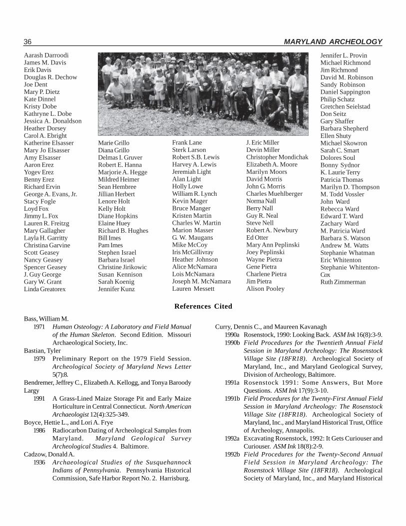
36 MARYLAND ARCHEOLOGY
Aarash DarroodiJames M. DavisErik DavisDouglas R. DechowJoe DentMary P. DietzKate DinnelKristy DobeKathryne L. DobeJessica A. DonaldsonHeather DorseyCarol A. EbrightKatherine ElsasserMary Jo ElsasserAmy ElsasserAaron ErezYogev ErezBenny ErezRichard ErvinGeorge A. Evans, Jr.Stacy FogleLoyd FoxJimmy L. FoxLauren R. FreitzgMary GallagherLayla H. GarrittyChristina GarvineScott GeaseyNancy GeaseySpencer GeaseyJ. Guy GeorgeGary W. GrantLinda Greatorex
Marie GrilloDiana GrilloDelmas I. GruverRobert E. HannaMarjorie A. HeggeMildred HeimerSean HembreeJillian HerbertLenore HoltKelly HoltDiane HopkinsElaine HueyRichard B. HughesBill ImesPam ImesStephen IsraelBarbara IsraelChristine JirikowicSusan KennisonSarah KoenigJennifer Kunz
Frank LaneSterk LarsonRobert S.B. LewisHarvey A. LewisJeremiah LightAlan LightHolly LoweWilliam R. LynchKevin MagerBruce MangerKristen MartinCharles W. MartinMarion MasserG. W. MaugansMike McCoyIris McGillivrayHeather JohnsonAlice McNamaraLois McNamaraJoseph M. McNamaraLauren Messett
J. Eric MillerDevin MillerChristopher MondichakElizabeth A. MooreMarilyn MoorsDavid MorrisJohn G. MorrisCharles MuehlbergerNorma NallBerry NallGuy R. NealSteve NellRobert A. NewburyEd OtterMary Ann PeplinskiJoey PeplinskiWayne PietraGene PietraCharlene PietraJim PietraAlison Pooley
Jennifer L. ProvinMichael RichmondJim RichmondDavid M. RobinsonSandy RobinsonDaniel SappingtonPhilip SchatzGretchen SeielstadDon SeitzGary ShafferBarbara ShepherdEllen ShutyMichael SkowronSarah C. SmartDolores SoulBonny SydnorK. Laurie TerryPatricia ThomasMarilyn D. ThompsonM. Todd VosslerJohn WardRebecca WardEdward T. WardZachary WardM. Patricia WardBarbara S. WatsonAndrew M. WattsStephanie WhatmanEric WhitentonStephanie Whitenton-CoxRuth Zimmerman
References Cited
Bass, William M.1971 Human Osteology: A Laboratory and Field Manual
of the Human Skeleton. Second Edition. MissouriArchaeological Society, Inc.
Bastian, Tyler1979 Preliminary Report on the 1979 Field Session.
Archeological Society of Maryland News Letter5(7):8.
Bendremer, Jeffrey C., Elizabeth A. Kellogg, and Tonya BaroodyLargy
1991 A Grass-Lined Maize Storage Pit and Early MaizeHorticulture in Central Connecticut. North AmericanArchaeologist 12(4):325-349.
Boyce, Hettie L., and Lori A. Frye1986 Radiocarbon Dating of Archeological Samples from
Maryland. Maryland Geological SurveyArcheological Studies 4. Baltimore.
Cadzow, Donald A.1936 Archaeological Studies of the Susquehannock
Indians of Pennsylvania. Pennsylvania HistoricalCommission, Safe Harbor Report No. 2. Harrisburg.
Curry, Dennis C., and Maureen Kavanagh1990a Rosenstock, 1990: Looking Back. ASM Ink 16(8):3-9.1990b Field Procedures for the Twentieth Annual Field
Session in Maryland Archeology: The RosenstockVillage Site (18FR18). Archeological Society ofMaryland, Inc., and Maryland Geological Survey,Division of Archeology, Baltimore.
1991a Rosenstock 1991: Some Answers, But MoreQuestions. ASM Ink 17(9):3-10.
1991b Field Procedures for the Twenty-First Annual FieldSession in Maryland Archeology: The RosenstockVillage Site (18FR18). Archeological Society ofMaryland, Inc., and Maryland Historical Trust, Officeof Archeology, Annapolis.
1992a Excavating Rosenstock, 1992: It Gets Curiouser andCuriouser. ASM Ink 18(8):2-9.
1992b Field Procedures for the Twenty-Second AnnualField Session in Maryland Archeology: TheRosenstock Village Site (18FR18). ArcheologicalSociety of Maryland, Inc., and Maryland Historical
Volume 40(1), March 2004 37
Trust, Office of Archeology, Crownsville.1993 A New Radiocarbon Date for Popes Creek Ware.
Maryland Archaeology 29(1&2):31-42.DeBoer, Warren R.
1988 Subterranean Storage and the Organization of Surplus:The View from Eastern North America. SoutheasternArchaeology 7(1):1-20.
Dent, Richard J.2003a Preliminary Report on the 2003 Excavations at the
Winslow Site (18MO9), Montgomery County,Maryland. Report submitted to the ArcheologicalSociety of Maryland, Inc.
2003b Excavations at a Late Woodland Village in the MiddlePotomac Valley: Theory and Practice at the WinslowSite. Journal of Middle Atlantic Archaeology 19:3-24.
2003c The Post Hunting-and-Foraging World: PotomacValley Experiments. Paper presented at the 2003Eastern States Archeological Federation annualmeeting, Mt. Laurel, New Jersey.
Dent, Richard J., Katherine Clermont, Ali Ghobadi, and KelseyWoodman
2002 Excavations at the Winslow Site (18MO9): PreliminaryReport on the 2002 Field Season. MarylandArcheology 38(2):13-32.
Fogelman, Gary1984 Maskette. Pennsylvania Archaeologist 54(1-2):80.
Franklin, Katherine A.1979 A Late Woodland Occupation on Lower Mason
Island, Montgomery County, Maryland. M.A. thesis,The American University, Washington, D.C.
Goldsborough, E. Ralstonn.d. Exploration of Site #10, Monocacy River, Frederick
County, Maryland. Ms. on file at the MarylandHistorical Trust, Crownsville.
1911 The Archaeology of the Monocacy Valley [Part 1].The Archaeological Bulletin 2(2):28-33.
1912 The Archaeology of the Monocacy Valley [Part 4].The Archaeological Bulletin 3(1):16-19.
Hamell, George R.1979 Of Hockers, Diamonds and Hourglasses: Some
Interpretations of Seneca Archeological Art. Paperpresented at the Iroquois Conference, October 13-15,1979, Albany, NY.
Heisey, Henry1971 An Interpretation of Shenks Ferry Ceramics.
Pennsylvania Archaeologist 41(4):44-70.Kavanagh, Maureen
1982 Archeological Resources of the Monocacy RiverRegion. Maryland Geological Survey, Division ofArcheology, File Report 164. Baltimore.
2001 Late Woodland Settlement in the Monocacy RiverRegion. Maryland Archeology 37(1):1-12.
Kent, Barry C.1984 Susquehanna’s Indians. Pennsylvania Historical and
Museum Commission, Anthropological Series No. 6.Harrisburg.
Knoblock, Byron W.1939 Banner-stones of the North American Indian.
Privately printed, La Grange, Ill.Kraft, Herbert C.
1986 The Lenape: Archaeology, History, and Ethnography.New Jersey Historical Society, Newark.
MacCord, Howard A., Sr.1992 Recent Potomac Valley Archeological Work and Its
Relationships to the Montgomery Focus. In TheMontgomery Focus: A Late Woodland Potomac RiverCulture, by Richard G. Slattery and Douglas R.Woodward, pp. 161-168. Archeological Society ofMaryland, Inc., Bulletin No. 2
Matthews, Earle D.1960 Soil Survey of Frederick County, Maryland. U.S.
Department of Agriculture, Soil Conservation Service,Washington, D.C.
Moore, Elizabeth A.1994 Bone and Antler Tools and Decorative Objects from
the Rosenstock Site (18FR18). Maryland Archeology30(1):17-28.
Mounier, R. Alan2003 Looking Beneath the Surface: The Story of
Archaeology in New Jersey. Rutgers UniversityPress, New Brunswick, New Jersey.
Pardi, Richard and E.R. Newman1980 Queens College Radiocarbon Measurements III.
Radiocarbon 22:1081.Peck, Donald W.
1979a The Ninth Annual Field Session in MarylandArcheology – 1979: Background Information and FieldProcedures. Ms. on file at the Maryland HistoricalTrust, Crownsville.
1979b Archeological Resources Assessment of theMonocacy River Region, Frederick and CarrollCounties, Maryland: Phases I and II (Draft). Reporton file, Maryland Historical Trust, Crownsville.
Peck, Donald W., and Tyler Bastian1977 Test Excavations at the Devilbiss Site, Frederick
County Maryland. Maryland Archeology 13(2):1-10.
Perino, Gregory1950 Cahokia Notes. In Cahokia Brought to Life: An
Artifactual Story of America’s Great Monument,edited by Robert E. Grimm, pp. 61-67. Bulletin of theGreater St. Louis Archaeological Society.
Potter, Stephen R.1993 Commoners, Tribute, and Chiefs: The Development
of Algonquian Culture in the Potomac Valley.University Press of Virginia.
38 MARYLAND ARCHEOLOGY
Ritchie, William A.1969 The Archaeology of New York State. Revised edition.
Natural History Press, Garden City, New York.Schmidt, Karl, Jr.
1952 Archaeological Chronology of the Middle AtlanticStates. In Archeology of the Eastern United States,edited by James B. Griffin, pp. 59-70. University ofChicago.
Schuster, Carl and Edmund Carpenter1996 Patterns That Connect: Social Symbolism in Ancient
& Tribal Art. Harry N. Abrams, Inc., New York.Slattery, Richard G., William A. Tidwell, and Douglas R.Woodward
1966 The Montgomery Focus. Archeological Society ofVirginia Quarterly Bulletin (21)2:49-51.
Slattery, Richard G., and Douglas R. Woodward1992 The Montgomery Focus: A Late Woodland Potomac
River Culture. Archeological Society of Maryland,Inc., Bulletin No. 2.
Snyder, John Jacobn.d. Notebooks on the “Indian Lore of Frederick County.”
Mss. on file at the Maryland Historical Trust,Crownsville.
Stuiver, M., and P.J. Reimer1993 Extended 14C database and revised CALIB
radiocarbon calibration program [version 4.4].Radiocarbon 35:215-230.
Stuiver, M., P.J. Reimer, E. Bard, J.W. Beck, G.S. Burr, K.A. Hughen,B. Kromer, F.G. McCormac, J.v.d. Plicht, and M. Spurk
1998 INTCAL98 Radiocarbon Age Calibration, 24,000 - 0cal BP. Radiocarbon 40:1041-1083.
Thomas, David Hurst1976 Figuring Anthropology: First Principles of
Probability and Statistics. Holt, Rinehart andWinston, New York.
Dennis C. Curry is Senior Archeologist in theArcheological Research Unit of the Maryland HistoricalTrust’s Office of Archeology. He holds a Master of Artsdegree in Anthropology from The Catholic University ofAmerica. His is the editor of Maryland Archeology, aformer editor of Archaeology of Eastern North America,and a past president of the Middle Atlantic ArcheologicalConference. In 1999, he published Feast of the Dead:Aboriginal Ossuaries in Maryland. His researchinterests include environmental archeology, cultural ecology,and Middle Atlantic prehistory. He can be reached at theMaryland Historical Trust, 100 Community Place,Crownsville, Maryland 21032, or by e-mail [email protected].
Maureen Kavanagh is currently the GeographicInformation System Coordinator for the Maryland HistoricalTrust. She holds an M.A. in Anthropology from theUniversity of Wisconsin–Madison, and an M.S. inComputer Science from The Johns Hopkins University.Her research interests include prehistoric settlementmodeling, aboriginal ceramics, and GIS applications. Hermailing address is Division of Historical and CulturalPrograms, 100 Community Place, Crownsville, Maryland21032, or she can be reached by e-mail [email protected].