Embed Size (px)
Citation preview
Geoarchaeological Testing Reportfor the
University of California, BerkeleyStudent Athlete High Performance Center,
Alameda County, California
Prepared for:
University of California, BerkeleyCapital Projects
1936 University AvenueBerkeley, CA 94704
Prepared by:William Self Associates, Inc.
P.O. Box 2192Orinda, CA 94563
(925) 253-9070
December 2008

Geoarchaeological Testing Reportfor the
University of California, BerkeleyStudent Athlete High Performance Center,
Alameda County, California
Prepared By:David Buckley, B.A., Angela Cook, B.A., Allen Estes, Ph.D.,
Paul Farnsworth, Ph.D., and Nazih Fino, M.A.,
Submitted By:James M. Allan, Ph.D.Principal Investigator
Project No. 2008-53Report No. 2008-60
December 2008
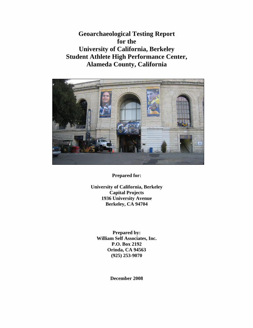
Cover Photo: View of Memorial Stadium from parking lot, view southeast.

i
TABLE OF CONTENTS
1.0 Introduction .................................................................................................................................1
1.1 Project Description .......................................................................................................................1
1.2 Project Location............................................................................................................................1
2.0 Environmental and Cultural Setting ...........................................................................................5
2.1 Natural Setting ..............................................................................................................................5
2.1.1 Existing Environment............................................................................................................5
2.1.2 Geology and Soils .................................................................................................................6
2.1.3 Prehistoric Shoreline, Marshlands, and Creeks....................................................................8
2.2 Cultural Setting.............................................................................................................................8
2.2.1 Prehistory...............................................................................................................................8
2.2.2 Ethnographic Background...................................................................................................21
2.2.3 Local Archaeological Setting..............................................................................................23
2.2.4 History .................................................................................................................................25
3.0 Results of the Records Search ........................................................................................................43
4.0 Other Sources Consulted ................................................................................................................46
4.1 Recent Historical Archaeological Excavations .........................................................................46
4.2 CA-ALA-23................................................................................................................................47
4.3 CA-ALA-308..............................................................................................................................48
4.4 Museum of Anthropology and Storage of Materials from CA-ALA-23 and CA-ALA-308...53
5.0 Native American Heritage Commission Consultation ..................................................................54
6.0 Research Design..............................................................................................................................54
6.1 Site Formation............................................................................................................................55
6.2 Chronology.................................................................................................................................56
6.3 Subsistence and Settlement—Prehistoric Period......................................................................57
6.4 Trade and Exchange—Prehistoric Period .................................................................................58
6.5 Consumer Behavior—Historic Period ......................................................................................58
6.6 Social Status and Ethnicity—Historic Period ...........................................................................59
7.0 Methodology...................................................................................................................................60
8.0 Subsurface Testing Results.............................................................................................................63
8.1 Field Observations......................................................................................................................63
8.2 Geoarchaeological Analysis.......................................................................................................72
8.3 Interpretation of Results .............................................................................................................73
ii
9.0 Summary and Conclusions.............................................................................................................75
10.0 References.....................................................................................................................................77
List of Tables
Table 1 Characteristics of Cultural Periods in Central California ..................................................12Table 2 Recorded Archaeological Sites within Project Area.......................................................43Table 3 Recorded Archaeological Sites within ½ mile of Project Area ......................................43Table 4 Previous Cultural Resource Studies within ½ mile of Project Area ..................................44Table 5 Newspaper Articles Relating to Burials Located within the Vicinity of the Faculty Club,
Faculty Glade, and Memorial Stadium.............................................................................49Table 6 Skeletal Material Held at the Phoebe A. Hearst Museum of Anthropology ......................52Table 7 Summary of Field Crew Observations of Each Bore Location .........................................63
List of Figures
Figure 1 Project Vicinity Map ........................................................................................................2Figure 2 Project Area Map.............................................................................................................3Figure 3 Footprint of SAHPC.........................................................................................................4Figure 4 Cut and Fill Map..............................................................................................................7Figure 5 Soils Map .........................................................................................................................9Figure6 View of the early UC Berkeley campus, circa 1874........................................................28Figure 7 Painting of UC Berkeley from the hills, circa 1890.........................................................29Figure 8 Palmer Houses located on Piedmont Avenue within project area, ca. 1882.....................31Figure 9 Clinton Day House at Bancroft Way and Piedmont Avenue, ca. 1885.........................31Figure 10 1900 Geologic Map of a portion of the Berkeley Hills ...................................................33Figure 11 1911 Sanborn Map with Ownership Data.......................................................................34Figure 12 View of Strawberry Canyon landscape, circa 1914.........................................................35Figure 13 Map showing topography and historic structures surrounding project area .....................37Figure 14 UC Berkeley campus, showing future location of Memorial Stadium, ca. 1920 .............39Figure 15 Early stage of Memorial Stadium under construction, ca. 1923 ......................................39Figure 16 UC Berkeley Memorial Stadium under construction, ca. 1923 .......................................40Figure 17 Steam shovels removing dirt from side of Charter Hill, ca. 1923 ..................................41Figure 18 Completed Memorial Stadium, ca. 1923 .......................................................................41Figure 19 1929 Sanborn Map........................................................................................................42Figure 20 Auger drilling process...................................................................................................60Figure 21` Project Area with Test Bore Locations..........................................................................61Figure 22 Extrapolation of Ab Horizon ......................................................................................74
iii
Appendices
Appendix A: NAHC ConsultationAppendix B: PhotographsAppendix C: Mesa Technical Geoarchaeological Findings

iv
v
Management Summary
The University of California, Berkeley contracted William Self Associates, Inc. (WSA) to conductsubsurface geoarchaeological testing for the University of California, Berkeley, Student AthleteHigh Performance Center (SAHPC) in Berkeley, Alameda County, California, as part of the pre-construction cultural analysis and mitigation process. The proposed SAHPC will be located adjacentto California Memorial Stadium and will provide training and academic resources and facilities toUniversity sports programs.
WSA conducted archival and records research, developed and implemented a subsurface testingplan, and analyzed core samples recovered during testing. The results of this effort are presented inthis Geoarchaeological Testing Report
On behalf of WSA, staff at the California Historical Resources Information System,Northwestern Information Center (NWIC) at Sonoma State University conducted a recordssearch to identify known cultural resources and previous cultural resources studies in or within½-mile of the project area. The search revealed one site within the project area, and 10 within a½-mile radius. No previous studies have been conducted within the project area, and 20 havebeen conducted within a ½-mile radius.
Consultation with the Native American Heritage Commission (NAHC) in Sacramento provided alist of Native American individuals and tribal representatives with potential information on culturalresources in the project area. The NAHC reported that their sacred lands file has no record ofresources in the vicinity of the project. Ohlone tribal representative Ramona Garibay served asNative American monitor for the project and observed the subsurface testing process.
WSA developed and implemented a testing program, including both field observations andgeoarchaeological lab analysis, based on a sampling strategy designed to recover data sufficientto verify the presence or absence of potentially significant cultural resources. The program wasdesigned to determine the areal extent and to characterize the nature and integrity of suchdeposits, if present. The testing program consisted of drilling a total of 31 bore holes using ahollow-stem auger and recovering a series of 3¾ - in. diameter cores in 5-ft.-long segments. Ofthese, 20 bore holes were drilled the anticipated depth of project construction, 35 ft. Anadditional five bore holes were drilled to depths of 50 ft. in areas where excavation for drainagewill reach that depth. Six additional bore holes were drilled to 15 ft. to evaluate the nature of thesubsurface in the alignments of the proposed water lines.
No prehistoric cultural deposits or materials were observed in the 31 core samples. Historic-eramaterials including brick fragments, pieces of charcoal and coal, and ceramic fragments wereobserved in two of the cores. The majority of the 31 cores were characterized by fill material
vi
associated with the construction of Memorial Stadium in 1923, and from later modifications ofthe stadium and alterations of the surrounding grounds.
The geoarchaeological analysis determined that buried former stable land surfaces wereencountered at various depths in at least 11 core samples. These represent developed soils (Abhorizons) with organic matter from roots and decomposing plant material. Although thesubsurface testing and analysis did not identify evidence of prehistoric cultural material, theentire project site should be considered an archaeologically sensitive area based on its proximityto Strawberry Creek and the fact that prehistoric archaeological deposits and features have beenfound along the creek within the vicinity of the project area. Consequently, archaeologicalmonitoring is recommended during all construction and related excavations. WSA has prepared aCultural Resources Monitoring Plan, which has been submitted under separate cover.
Geoarchaeological Testing Report William Self Associates, Inc.SAHPC, University of California, Berkeley 1 December 2008
1.0 Introduction
This report presents the findings of the subsurface archaeological testing along the westernperimeter of the University of California at Berkeley’s Memorial Stadium in the footprint of theproposed Student Athlete High Performance Center (SAHPC). Thirty-one 3¾ inch-diameter coreswere extracted from locations throughout the proposed footprint. The purpose of the subsurfaceinvestigation was to ascertain whether buried archaeological deposits are present beneath theproposed footprint of the SAHPC, to determine the extent of such deposits, to assess their integrity,and to recover data sufficient to provide recommendations about the potential significance of suchdeposits, if present. A geoarchaeological assessment of 15 cores was also conducted to ascertain thegeomorphology of the site area and to assess the area’s potential archaeological sensitivity.
1.1 Project Description
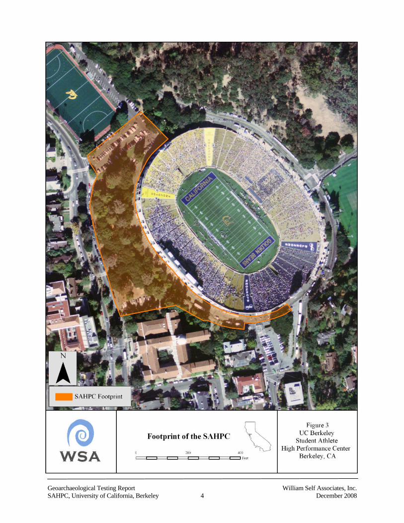
The proposed UC Berkeley SAHPC involves excavation and construction outside the north, westand south perimeter of Memorial Stadium encompassing the current asphalted pedestrian walkwayaround the side of stadium, and the landscaped slope to the southwest towards Piedmont Avenue.The depth of excavation will range from 15 to 50 ft. The 142,000 sq.-ft. SAHPC will provide lockerrooms, meeting rooms, and offices for football and 12 additional University Olympic-level sports. Itwill also house a state-of-the-art training facility and an applied sports science and medicinecomplex for year-round access by approximately 450 student-athletes. In addition, the SAHPC willfeature an academic center where student-athletes will have access to educational resources (UCBerkeley 2008).
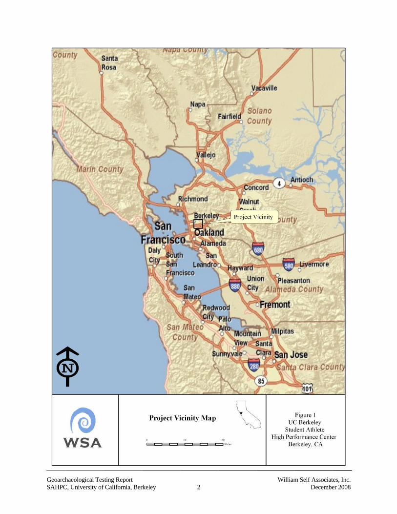
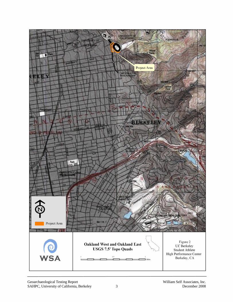
1.2 Project Location
The new SAHPC will be located adjacent to the UC Berkeley’s Memorial Stadium and slightly tothe northeast of Piedmont Avenue. It is within Township 1 South, Range 4 West, Section 1, asdepicted on the Oakland West and Oakland East USGS 7.5-minute topographic quadrangles(Figures 1 and 2). The project area is bounded by International House to the southeast, PiedmontAvenue to the west, Kleeberger Field to the northwest, and Memorial Stadium to the east (Figure 3).The actual project area is larger than the footprint of the SAHPC, as it encompasses drainage, water,and utility lines that extend beyond the structure’s footprint.
Geoarchaeological Testing Report William Self Associates, Inc.SAHPC, University of California, Berkeley 2 December 2008
Geoarchaeological Testing Report William Self Associates, Inc.SAHPC, University of California, Berkeley 3 December 2008
Geoarchaeological Testing Report William Self Associates, Inc.SAHPC, University of California, Berkeley 4 December 2008
Geoarchaeological Testing Report William Self Associates, Inc.SAHPC, University of California, Berkeley 5 December 2008
2.0 Environmental and Cultural Setting
2.1 Natural Setting
2.1.1 Existing Environment
The SAHPC project area is situated east of the San Francisco Bay, the largest estuarine system inCalifornia. The project area, located adjacent to UC Berkeley’s Memorial Stadium, sits at the baseof the Berkeley hills at the mouth of Strawberry Canyon, and at the south fork of Strawberry Creek,which is now channelized. The creek runs underneath the northern section of Memorial Stadium ina southwest direction through the current project area.
At one time, several different habitats surrounded the project area. However, extensive urbansettlement and industrial development in the San Francisco Bay Area has greatly impacted thenatural environment. Beneath the historic fill associated with construction of Memorial Stadium, lieaccumulations of colluvium and alluvium that were once plains replete with grassland vegetationthat included perennial and annual grasses, such as small flowered melica (Melica imperfecta) andrye grass (Elymus glaucus), as well as coastal shrubs, such as coyote brush (Baccaris pilularis), anda range of bulb bearing plants like soap plant (Chlorogalum pomeridianum). Prior to moderndevelopment, extensive oak woodlands including species such as coast live oak (Quercus agrifolia),madrone (Arbutus menziesii), and California bay (Umbellularia californica) extended to the east.
These grasslands and oak woodlands attracted a variety of fauna including brush rabbits,jackrabbits, deer, elk, antelope, fox, coyote, grizzly bears, and black bears. Southwest of the projectarea, closer to the bay, a small freshwater marsh was created by Temescal Creek where itoverflowed its banks before entering the bay. Here one could have seen broad-leafed cattail (Typhalatifolia) and California bulrush (Scirpus californicus). Farther south was a large coastal salt marshthat sustained pacific cordgrass (Spartina foliosa) and perennial pickleweed (Salicornia virginica).The San Francisco Bay, west of the project area, sustained a large population of invertebratesincluding the California oyster (Ostrea lurida), bay mussel (Mytilus edulis), bent-nosed clam(Macoma nasuta), Dungeness crab (Cancer magister), and bay shrimp (Crago spp.) (Broughton1994:22). The landscape of the San Francisco Bay shoreline has changed through time due togeologic events and industrial development. It is estimated that between 1850 and 1950 as much asone third of the bay was filled to accommodate urban development and expansion.
Today, annual precipitation in the bay region varies from 20 to 40 inches with precipitationconcentrated in the fall, winter, and spring months. This climate is much like that found in theMediterranean, with mild, rainy winters, and warm, dry summers. After the first rain at the end ofOctober or early November, the vegetation becomes green, and remains green but not growing untillate February, when the grasses that cover the surrounding Berkeley hills begin to grow rapidly. Byearly May, these have usually changed to a dry, golden-color and remain so until fall (Brown 1985).
Geoarchaeological Testing Report William Self Associates, Inc.SAHPC, University of California, Berkeley 6 December 2008
Due to the cooling effects of the local bay environment, temperatures in the project area are mild inthe summer, usually averaging 55-65 F (Moratto 1984:223). The cold water of the bay also createsfrequent fog, and relative humidity remains high most of the time (Schoenherr 1992:627).
2.1.2 Geology and Soils
The following information on geology and soils in the project area is partially based on the Fault-Rupture Hazard Investigation Report for the Student Athlete High Performance Center (SAHPC)for the University of California, Berkeley (Geomatrix 2006), subsurface exploration andrecommendations about neighboring sites as presented in reports prepared by Treadwell andRollo (1997), The City of Emeryville (1995), Sedway Cooke Associates and The EmeryvilleRedevelopment Agency (1985), the United States Department of Agriculture Soil ConservationService in cooperation with the University of California Agriculture Experiment Station, and onobservations made in the field by WSA during subsurface testing.
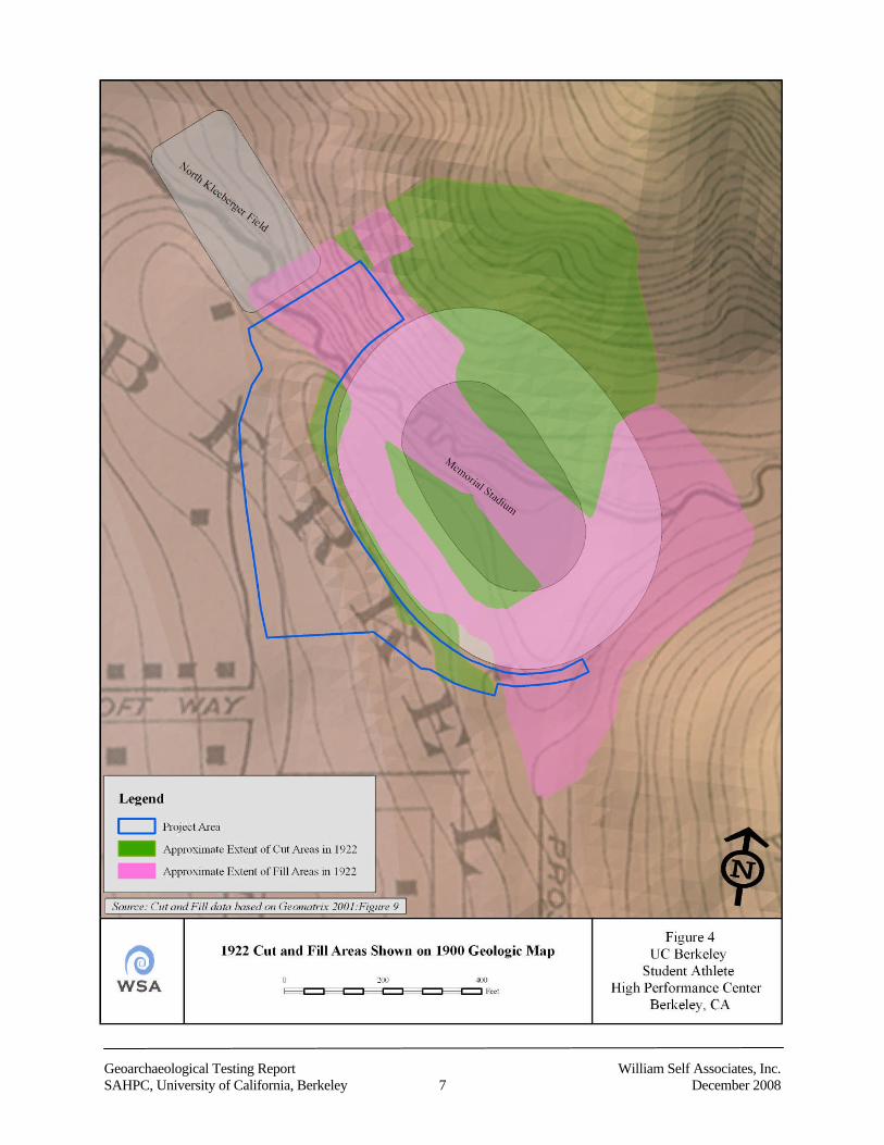
The project is situated within the San Francisco Bay Area, a structural depression between twomountain ranges. Franciscan Complex bedrock underlies the project area. Waterborne andwindblown sediments derived from the local East Bay hills and sediments from the centralCalifornia region transported by the Sacramento and San Joaquin River systems have accumulatedabove the bedrock. Some of these accumulated sediments include unconsolidated clays, silts, sands,and gravels that make up the Alameda and San Antonio Formations. However, the soil directlyunderneath the northeast and southeast ends of the SAHPC footprint (at the north and south ends ofMemorial Stadium) is fill material consisting of sandstone and gravelly clays that was importedfrom Charter Hill during the construction of Memorial Stadium in 1923 (Figure 4, [based onGeomatrix 2001:Figure 9]).
The Hayward fault forms the major structural boundary along the eastern side of the UC Berkeleycampus, bounding rock types of various ages, compositions and tectonic history. These bedrockunits consist of late Cretaceous, 100 to 65 million years ago (Ma), marine siltstone, shale andsandstone, late Jurassic to early Cretaceous (159 to 99 Ma) Knoxville Formation (shale with thinsandstone), and late Jurassic volcanic rocks, including keratophyre, basalt, and diabase, all of theGreat Valley Group (Geomatrix. 2006:7). Younger sediments situated further up in the BerkeleyHills include Miocene sedimentary (Orinda Formation, Claremont Chert, various types ofsandstone) and volcanic rocks (Moraga Formation). The amalgamations of these weathered rocksand formations are the main materials exposed along the hillslopes east of the Hayward fault(Geomatrix 2006:7). West of the Hayward fault, the bedrock consists of Jurassic to Cretaceous (195to 65 Ma) marine sedimentary rocks and various igneous and metamorphic rocks of the FranciscanComplex. The Franciscan Complex consists mostly of greywacke sandstone and inter-bedded shale,with lower amounts of submarine basalt (greenstone), chert, serpentine, and some high-pressuremetamorphic rocks such as blueschist (Geomatrix. 2006:7). Semi-consolidated, older, Pleistocenealluvium and colluvial deposits overlie the bedrock forming the piedmont that underlies the central
Geoarchaeological Testing Report William Self Associates, Inc.SAHPC, University of California, Berkeley 7 December 2008
Geoarchaeological Testing Report William Self Associates, Inc.SAHPC, University of California, Berkeley 8 December 2008
Berkeley campus. Former stream valleys across the campus have been filled by younger, latePleistocene and Holocene alluvium. In addition, colluvium, landslide debris, and proximal alluvialfan deposits of late Pleistocene and Holocene age create a depositional apron along the base of theBerkeley hills (Geomatrix 2006:8).
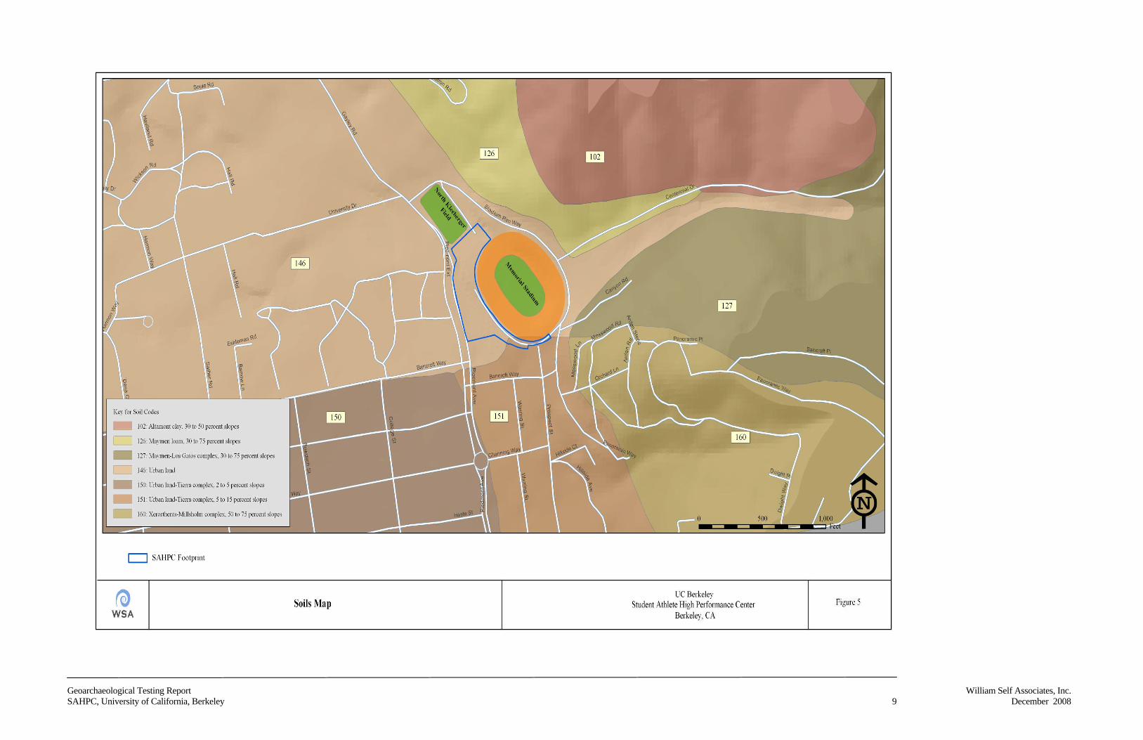
The soil directly associated with the hills to the east of the project area surrounding the MemorialStadium grounds is of the Maymen series. It is a sandy loam that consists of shallow, somewhatexcessively drained soils that formed in material weathered from sandstone, shale and conglomerate(Figure 5). Depth to bedrock along the hillslopes ranges from 10 to 20 in. Local vegetation consistsof open stands of chaparral that include chamise, Manzanita, several species of ceanothus and scruboak, bay, buckeye, and scatters of various other tree species (California Resource Lab 2008).
2.1.3 Prehistoric Shoreline, Marshlands, and Creeks
The locations of the shoreline, marshlands, and creeks within the project vicinity have changed overthe past 6,000 years. In some cases, this was due to sea level change, but during the past century, thecreeks in the urbanized area have been managed and, in some cases, rerouted with culverts, stormdrains, and engineered channels.
In general, the prehistoric archaeological sites of the Bay Area are located close to water (e.g.,creeks, marshes, and the bay shoreline). This relationship has been modeled by Price et al. 2004a ina previous study of the East Bay by plotting the location of known prehistoric archaeological sites inthe watershed and creating a buffer based on the mean distance of these sites to the nearest watersource (e.g., creek, former marsh, or the bayshore). In the project vicinity this mean distance is 623ft. There is a higher probability of finding prehistoric sites within the buffer than outside of it.
2.2 Cultural Setting
2.2.1 Prehistory
REGIONAL ARCHAEOLOGICAL BACKGROUND
Research into local prehistoric cultures began with the investigation of the Emeryville Shellmound,CA-ALA-309, by Dr. Max Uhle and Professor John C. Merriam of the University of California,Berkeley (Uhle 1907). At that time, the Emeryville Shellmound, located within 130 ft. of the bay’shigh-water line, was one of the largest and best-preserved mounds in the region. Shortly thereafterMerriam supervised the work of UC Berkeley archaeologists Nels C. Nelson and A.V. Wepfer whoattempted to verify and supplement the findings of Uhle at the Emeryville Shellmound (Nelson1906). Nelson subsequently conducted an intensive archaeological survey of the San Francisco Bayregion from 1906 to 1908. Nelson documented 425 shellmounds along the bay shoreline andadjacent coast when the bay was still ringed by salt marshes up to 5 miles wide (Nelson 1909:322-
Geoarchaeological Testing Report William Self Associates, Inc.SAHPC, University of California, Berkeley 9 December 2008
Geoarchaeological Testing Report William Self Associates, Inc.SAHPC, University of California, Berkeley 10 December 2008
This page intentionally left blank
Geoarchaeological Testing Report William Self Associates, Inc.SAHPC, University of California, Berkeley 11 December 2008
357). He maintained that the intensive use of shellfish, a subsistence strategy reflected in bothcoastal and bay shoreline middens, indicated a general economic unity in the region duringprehistoric times, and he introduced the idea of a distinct San Francisco Bay archaeological region.
Nels C. Nelson, directed by John C. Merriam, and assisted by A. W. Wepfer, conducted a series ofshort-term investigations at the Ellis Landing shellmound in Richmond, over a period of three years,from 1906 to 1908 (Nelson 1910). This massive mound was of particular interest to Merriam andNelson because it extended at least as far below the marshland as it did above it. The maximumthickness of the mound was estimated at 33 ft., with deposits extending 16 ft. below the early 1900sground surface, and deposits extending 17 ft. above the same ground surface. The UCarchaeologists were anxious to investigate what they reasoned were some of the oldest deposits inthe bay area, assuming that the deposits began to accumulate on what was at one time dry land.Nelson assumed that the ground had somehow subsided over time, whereas we now understand thatthe sea level has gradually risen. Like the Emeryville Shellmound, Ellis Landing was both a burialground and a habitation site. Although Nelson acknowledges evidence of change in material cultureover time in this mound (e.g., increasingly elaborate stone tools), he concludes that the same generaltypes of implements that are found near the top of the mound can also be found at the bottom, andconcludes that the mound was inhabited over perhaps as much as 3,500 years, by the same generaltypes of people, with essentially the same type of culture.
In 1911, Nelson supervised excavations at CA-SFR-7 (the Crocker Mound) near Hunter’s Pointin San Francisco County, a site later dated from 1050 B.C. to A.D. 450. Llewellyn L. Loudidentified archaeological components from this same period in Santa Clara County in 1911 whileexcavating at CA-SCL-1 (the Ponce, Mayfield, or Castro Mound site). Robert J. Drakerecognized them in San Mateo County in 1941–1942 at CA-SMA-23 (Mills Estate) in San Bruno(Moratto 1984:233).
The work of Nelson and Loud in the Bay Area provided the impetus for investigations into theprehistory of central California, which began in earnest in the 1920s. In the early 20th century,Stockton-area amateur archaeologists James A. Barr and Elmer J. Dawson conductedexcavations at sites around Stockton and Lodi, and Dawson was responsible for making asubstantial collection of cultural material. On the basis of artifact comparisons, Barr identifiedwhat he believed were two distinct cultural traditions, an early and a late. Dawson later refinedhis work and classified the Central Valley sites into three “age-groups” (Ragir 1972:2-3;Schenck and Dawson 1929:402).
In the 1930s Jeremiah Lillard and William Purves of Sacramento Junior College formed a fieldschool and conducted excavations throughout the Sacramento Delta area. By seriating artifacts andmortuary traditions, they identified a three-phase sequence similar to Dawson’s, including Early,Intermediate, and Recent cultures (Lillard and Purves 1936). This scheme went through severalpermutations, including Early, Transitional, and Late Periods (Lillard et al. 1939) and Early,
Geoarchaeological Testing Report William Self Associates, Inc.SAHPC, University of California, Berkeley 12 December 2008
Middle, and Late Horizons (Heizer and Fenenga 1939). In 1948 and again in 1954, RichardBeardsley refined this system and extended it to include the region of San Francisco Bay (Beardsley1948, 1954). The resulting scheme came to be known as the Central California Taxonomic System(CCTS) (Fredrickson 1973; Hughes 1994:1). Subsequently, the CCTS system of Early, Middle, andLate Horizons was applied widely to site dating and taxonomy throughout central California. Thissystem focused on the archaeology of the Delta region, with its more established tradition ofarchaeological investigations of rich archaeological sites, to set the standard by which other regionswere assessed. Resulting explanations of regional prehistory and culture change tended to place theDelta as the earlier center for interaction, change, and development, with the bay following on aseparate, somewhat different path.
As more data were acquired through continued fieldwork, local exceptions to the CCTS werediscovered. The accumulation of these exceptions, coupled with the development of radiocarbondating in the 1950s and obsidian hydration in the 1970s, opened up the possibility of datingdeposits more accurately. Much of the subsequent archaeological investigation in centralCalifornia focused on the creation and refinement of local versions of the CCTS.
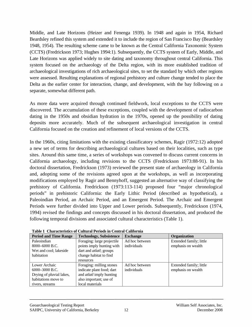
In the 1960s, citing limitations with the existing classificatory schemes, Ragir (1972:12) adopteda new set of terms for describing archaeological cultures based on their localities, such as typesites. Around this same time, a series of workshops was convened to discuss current concerns inCalifornia archaeology, including revisions to the CCTS (Fredrickson 1973:88-91). In hisdoctoral dissertation, Fredrickson (1973) reviewed the present state of archaeology in Californiaand, adopting some of the revisions agreed upon at the workshops, as well as incorporatingmodifications employed by Ragir and Bennyhoff, suggested an alternative way of classifying theprehistory of California. Fredrickson (1973:113-114) proposed four “major chronologicalperiods” in prehistoric California: the Early Lithic Period (described as hypothetical), aPaleoindian Period, an Archaic Period, and an Emergent Period. The Archaic and EmergentPeriods were further divided into Upper and Lower periods. Subsequently, Fredrickson (1974,1994) revised the findings and concepts discussed in his doctoral dissertation, and produced thefollowing temporal divisions and associated cultural characteristics (Table 1).
Table 1 Characteristics of Cultural Periods in Central CaliforniaPeriod and Time Range Technology, Subsistence Exchange OrganizationPaleoindian8000–6000 B.C.Wet and cool; lakesidehabitation
Foraging: large projectilepoints imply hunting withdart and atlatl; groupschange habitat to findresources
Ad hoc betweenindividuals
Extended family; littleemphasis on wealth
Lower Archaic6000–3000 B.C.Drying of pluvial lakes,habitations move torivers, streams
Foraging: milling stonesindicate plant food; dartand atlatl imply huntingalso important; use oflocal materials
Ad hoc betweenindividuals
Extended family; littleemphasis on wealth
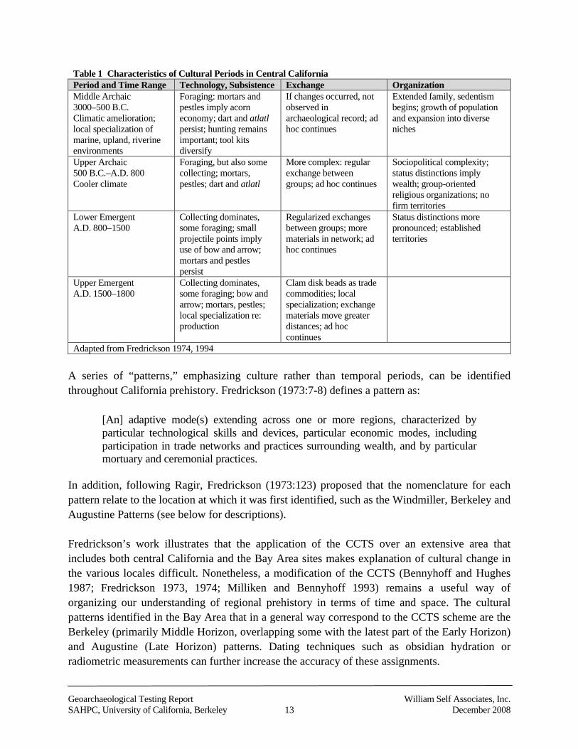
Geoarchaeological Testing Report William Self Associates, Inc.SAHPC, University of California, Berkeley 13 December 2008
Table 1 Characteristics of Cultural Periods in Central CaliforniaPeriod and Time Range Technology, Subsistence Exchange OrganizationMiddle Archaic3000–500 B.C.Climatic amelioration;local specialization ofmarine, upland, riverineenvironments
Foraging: mortars andpestles imply acorneconomy; dart and atlatlpersist; hunting remainsimportant; tool kitsdiversify
If changes occurred, notobserved inarchaeological record; adhoc continues
Extended family, sedentismbegins; growth of populationand expansion into diverseniches
Upper Archaic500 B.C.–A.D. 800Cooler climate
Foraging, but also somecollecting; mortars,pestles; dart and atlatl
More complex: regularexchange betweengroups; ad hoc continues
Sociopolitical complexity;status distinctions implywealth; group-orientedreligious organizations; nofirm territories
Lower EmergentA.D. 800–1500
Collecting dominates,some foraging; smallprojectile points implyuse of bow and arrow;mortars and pestlespersist
Regularized exchangesbetween groups; morematerials in network; adhoc continues
Status distinctions morepronounced; establishedterritories
Upper EmergentA.D. 1500–1800
Collecting dominates,some foraging; bow andarrow; mortars, pestles;local specialization re:production
Clam disk beads as tradecommodities; localspecialization; exchangematerials move greaterdistances; ad hoccontinues
Adapted from Fredrickson 1974, 1994
A series of “patterns,” emphasizing culture rather than temporal periods, can be identifiedthroughout California prehistory. Fredrickson (1973:7-8) defines a pattern as:
[An] adaptive mode(s) extending across one or more regions, characterized byparticular technological skills and devices, particular economic modes, includingparticipation in trade networks and practices surrounding wealth, and by particularmortuary and ceremonial practices.
In addition, following Ragir, Fredrickson (1973:123) proposed that the nomenclature for eachpattern relate to the location at which it was first identified, such as the Windmiller, Berkeley andAugustine Patterns (see below for descriptions).
Fredrickson’s work illustrates that the application of the CCTS over an extensive area thatincludes both central California and the Bay Area sites makes explanation of cultural change inthe various locales difficult. Nonetheless, a modification of the CCTS (Bennyhoff and Hughes1987; Fredrickson 1973, 1974; Milliken and Bennyhoff 1993) remains a useful way oforganizing our understanding of regional prehistory in terms of time and space. The culturalpatterns identified in the Bay Area that in a general way correspond to the CCTS scheme are theBerkeley (primarily Middle Horizon, overlapping some with the latest part of the Early Horizon)and Augustine (Late Horizon) patterns. Dating techniques such as obsidian hydration orradiometric measurements can further increase the accuracy of these assignments.
Geoarchaeological Testing Report William Self Associates, Inc.SAHPC, University of California, Berkeley 14 December 2008
Of some relevance to the project is Scheme B1 of the central California archaeological sequencedeveloped by Bennyhoff and Hughes (1987:149). In general, this scheme includes the followingperiods and chronology:
Early Period, ca. 3000–500 B.C.
Early/Middle Period Transition, ca. 500–200 B.C.
Middle Period, ca. 200 B.C.–A.D. 700
Middle/Late Period Transition, ca. A.D. 700–900
Late Period, ca. A.D. 900–1800
This was later revised by Milliken and Bennyhoff (1993) to include the following periods: Early Period (beginning in the mid-Holocene until ca. 500 B.C.),
Middle Period (500 B.C. to A.D. 700),
Middle-Late Transition Period (A.D. 700 to 1100),
Phase 1 of the Late Period (A.D. 1100 to 1500),
Phase 2 of the Late Period (A.D. 1500 to 1800), and
Historic Period (beginning A.D. 1800) (Hylkema 2002:237, Figure 13.4).
Milliken and Bennyhoff’s Early Period corresponds to Fredrickson’s Windmiller pattern andGerow’s Early Bay pattern (see below). The Middle Period, during which prehistoric peoplesappear to have increased their resource base and formed semisedentary habitation communities,links to Fredrickson’s Berkeley pattern and Bennyhoff’s Meganos culture. The Middle-LateTransition Period, characterized by intensification of socioeconomic systems while retainingMiddle Period artifact traits, and the Late Period, when social structures tended to develop into aform consistent with that recorded during early ethnographic studies, correspond withFredrickson’s Augustine Pattern (Hylkema 2002:237, 241-250).
It was initially thought that a well-developed Early Period prehistoric component was notrepresented within the San Francisco Bay Area. It had been assumed that San Francisco Bay wasa “local marginal and impoverished manifestation of cultural succession or development in theSacramento-San Joaquin Delta region,” where a thriving Windmiller culture had been identified,which was “explainable in terms of local ecological adjustments over a period of three to fourthousand years” (Gerow with Force 1968:10 summarizing Heizer 1964).
However, Bert Gerow of Stanford University, in his work at the University Village in the 1950s,established the idea that the Bay Area represented a separate center of cultural interaction,change, and development in its own right (e.g., Gerow with Force 1968). The work undertakenby Gerow and Force at the University Village site (CA-SMA-77) in San Mateo County indicatedthat a distinct Early Bay culture preceded the arrival of the Middle Horizon Berkeley pattern.
Geoarchaeological Testing Report William Self Associates, Inc.SAHPC, University of California, Berkeley 15 December 2008
This conclusion was supported by radiocarbon dates derived from charcoal found in associationwith burials at the site. The burials were dated from 1500 to 1000 B.C., and were markedly olderthan any other published site in the Bay Area at that time. Obsidian hydration results accordedwith this date range (Gerow with Force 1968:7-8).
Comparing characteristics of the Early Bay period to those of the Windmiller facies andBeardsley’s Sacramento Valley Middle Horizon, Gerow and Force (1968:109-110) noted thefollowing trends. In the Early Bay period, burials tend to be flexed, and there is a lack ofextended burials common at Windmiller sites or patterned orientation or position. There is a highoccurrence of red ochre in relation to ornamental artifacts manufactured of bone, marine shell,and stone. Whole Olivella shell is more common than drilled shell fractions. Quartz crystals,plummet-shaped charmstones and artifacts manufactured from mica or slate are either rare orabsent. “Crude” flaked and core tools are more common than projectile points, which arerelatively rare. Stone net-sinkers are found in this period, and composite fishhooks or fishspearsare rare or absent. There is a relative abundance of bone awls, antler wedges or end-scrapers,scapula and rib side-scrapers, flat-ended pestles and unshaped cobblestone mortars.
Gerow and Force noted that there were similarities between the Early Bay period componentsand those of later periods, but observed that changing trends included more intensive exploitationof food resources, a decrease in the amount of powdered red ochre included in graves, moreelaborate shell, stone and bone artifacts, an increase in the number of obsidian and projectilepoints and concomitant decrease in the number of “crude” flake and core tools, an increase in theamount of cylindrically shaped mortars and longer pestles, a decrease in the number of edge-notched stone sinkers, and an increase in stature and variations in cranial indices (Gerow withForce 1968:124).
According to Breschini (1983), Gerow and Force’s hypotheses were largely ignored by thearchaeological community throughout the next two decades. Alternative explanations havesubsequently been suggested such as Moratto’s (1984:279) hypothesis that the “UniversityVillage complex is an expression of the Sur Pattern strongly influenced by the Berkeley Pattern.”The Berkeley Pattern has been dated from at least 3000 B.C. in the east San Francisco Bay (e.g.Alameda County, where the earliest Early Berkeley sites appear) (Bennyhoff 1994; Hughes1994), with the number of sites increasing through A.D. 1 (Moratto 1984:282). Late BerkeleyPattern (500 B.C.–A.D. 1000) sites are much more common and well documented and, therefore,better understood than the Early Berkeley Pattern sites. Berkeley sites are scattered in morediverse environmental settings, but riverine settings are prevalent.
It is during this period that the Bay Area shellmounds were inhabited (Lightfoot and Luby 2002),and deeply stratified shellmound deposits that developed over generations of occupation arecommon to Berkeley Pattern sites. The typical body position for burials is tightly flexed, with noconsistent orientation. Associated grave goods are much less frequent than is encountered in sites
Geoarchaeological Testing Report William Self Associates, Inc.SAHPC, University of California, Berkeley 16 December 2008
of other periods. The sites contain numerous milling stones for food preparation. Projectilepoints in this pattern become progressively smaller and lighter over time, culminating in theintroduction of the bow and arrow during the Late Period. Wiberg (1997:10) claims that largeobsidian lanceolate projectile points or blades are unique to the Berkeley Pattern. Olivella shellbeads include saddle and saucer types. Haliotis pendants and ornaments are occasionally found.Slate pendants, steatite beads, stone tubes, and ear ornaments are unique to Berkeley Pattern sites(Fredrickson 1973:125–126; Moratto 1984:278–279). Evidence of warfare or interpersonalviolence is present, including cranial trauma, parry fractures, and embedded projectile points(Milliken et al. 2007:113-114).
The Augustine Pattern coincides with the Late Period, ranging from as early as A.D. 700 toabout 1800. Intensive fishing, hunting, and gathering (especially of acorns) typify this period, aswell as a large population increase, expanded trade and exchange networks, increasedceremonialism, and the practice of cremation in addition to flexed burials. Certain artifacts arealso distinctive in this pattern: bone awls used in basketry, small notched and serrated projectilepoints that are indicative of bow-and-arrow usage, clay effigies, bone whistles, stone pipes, andoccasional pottery. Olivella beads and Haliotis ornaments increase in number of types andfrequency of occurrence, sometimes numbering in the hundreds in single burials. Beginning inthe latter half of the 18th century, the Augustine Pattern was disrupted by the Spanish explorersand the mission system (Moratto 1984:283).
These patterns were at one time treated as useful chronological indicators, although the overlapin the Early Bay and Berkeley chronologies has reduced their usefulness in this respect,especially for earlier time periods. A chronology allows archaeologists to explore other kinds ofevidence and research questions that focus on cultural responses to environmental change,settlement and subsistence strategies, trade and exchange routes, population movement, andrelated topics.
Most recently, Milliken et al. (2007:99-123) developed what they term a “hybrid system” for theSan Francisco Bay Area, combining the Early-Middle-Late Period temporal sequence with thepattern-aspect-phase cultural sequence. Following Fredrickson, Milliken et al. (2007:103) definepatterns as “units of culture marked by distinct underlying economic modes, technologicaladaptations, and ceremonial practices.” Aspects are defined as local variations in a majoreconomic pattern, with a sequence of phases within a particular district representing an aspect.Following Willey and Phillips (1958), phases represent the smallest units of related sitecomponents “spatially limited to the order of magnitude of a locality or region andchronologically limited to a relatively brief interval of time” (Milliken et al. 2007:103).
Dating of the cultural patterns, aspects, and phases was based on Dating Scheme D, developedby Groza (2002). Groza directly dated over 100 Olivella shell beads, obtaining a series of AMSradiocarbon dates for individual samples of beads from various shell bead horizons. Groza found
Geoarchaeological Testing Report William Self Associates, Inc.SAHPC, University of California, Berkeley 17 December 2008
that several shell bead horizons occurred as much as 200 years more recently than previouslythought. Milliken et al. (2007:105) use the term bead horizon to represent “the short time periodsmarked by trade of particular bead types across wide areas of central California, in order toclearly separate units of time and units of culture.”
Milliken et al.’s (2007) San Francisco Bay Area Cultural Sequence is divided into the EarlyHolocene (Lower ArchaicF
1F) from 8000 to 3500 B.C., the Early Period (Middle Archaic) from
3500 to 500 B.C., the Lower Middle Period (Initial Upper Archaic) from 500 B.C. to A.D. 430,the Upper Middle Period (Late Upper Archaic) from A.D. 430 to 1050, the Initial Late Period(Lower Emergent) from A.D. 1050 to 1550, and the Terminal Late Period, post-A.D. 1550. Theydo not include a discussion of pre-8000 B.C. as no archaeological evidence dating to this earlytime period has been located in the Bay Area. Milliken et al. posit that this dearth ofarchaeological material may be related to subsequent environmental changes, submerging sitesor burying them beneath alluvial deposits, or destruction through stream erosion. A summary ofMilliken et al.’s findings follows.
A “generalized mobile forager” pattern marked by the use of milling slabs and handstones andthe manufacture of large, wide-stemmed and leaf-shaped projectile points emerged around theperiphery of the Bay Area during the Early Holocene Period (8000 to 3500 B.C.). No occupationsites dating to this early period have been found in the East Bay.
Beginning around 3500 B.C., evidence of sedentism, interpreted to signify a regional symbolicintegration, of peoples, and increased regional trade emerges in the form of new ground stonetechnology and the introduction of cut shell beads into burial contexts (Milliken et al. 2007:114).This Early Period lasted until ca. 500 B.C. The earliest mortar and pestles found so far date topost-4000 B.C., with wooden mortars dating to 3800 B.C. found in the vicinity of the LosVaqueros reservoir. By 1500 B.C., mortars and pestles replaced milling slabs and handstones atsome East Bay sites. Sedentism or semisedentism is in evidence in the East Bay during thisperiod in the form of burial complexes with associated ornamental grave goods, such as werefound at West Berkeley, Ellis Landing, and Pacheco shellmounds, and house floors withpostholes, such as has been found at the Rossmoor site near Walnut Creek (Milliken et al.2007:115; Price et al. 2006).
Milliken et al. (2007:115) identify “a major disruption in symbolic integration systems” circa500 B.C., marking the beginning of the Lower Middle Period (500 B.C. to A.D. 430). Changesincluded the disappearance of rectangular shell beads and introduction of split-beveled and smallsaucer Olivella beads, inferred to represent some of the earliest religious artifacts, appear aroundthe Early/Middle Transition bead horizon. However, spire-lopped Olivella beads continued to be
1 The corresponding periods based on Fredrickson’s Paleoindian, Archaic and Emergent classification system areprovided in parentheses.
Geoarchaeological Testing Report William Self Associates, Inc.SAHPC, University of California, Berkeley 18 December 2008
the most common bead type in mortuary contexts. Bead Horizon M1, dating from 200 B.C. toA.D. 430, is described by Milliken et al. (2007:115) as marking a ‘cultural climax’ within theSan Francisco Bay Area. New developments included the introduction of circular Haliotisornaments and the proliferation of Olivella saucer beads. New bone tools and ornaments are alsomanufactured in this period, such as tubes and whistles, barbless fish spears, and elk femurspatulae. In the Central and North Bay areas, awls of bone with shouldered tips indicate basketrymanufacture. Within the Central Bay, mortars and pestles continued to be used exclusively,while both milling slabs and mortars were used around the margins. Net sinkers ceased to beused at most sites around the Bay (Milliken et al. 2007:115).
The Upper Middle Period (A.D. 430 to 1050) is marked by the collapse of the Olivella saucerbead trade in central California, abandonment of many Bead Horizon M1 sites, an increase in theoccurrence of sea otter bones in those sites that were not abandoned, and the spread of theextended burial mortuary pattern characteristic of the Meganos complex into the interior EastBay. Bead Horizons M2, M3, and M4 were identified within this period (Milliken et al.2007:116). Bead Horizon M2a is marked by the replacement of Olivella saucer beads in burialcontexts with “rough-edged full saddle Olivella beads with remarkably small perforations”(Milliken et al. 2007:116). Bead Horizon M2b is characterized by mixed Olivella saddle beadsdating from A.D. 430 to 600. The Meganos burial pattern continued to spread westward,although did not extend as far as the West or North Bay. Within the Central Bay, artifacts such asextremely well-crafted “show” blades, mica ornaments, fishtail charmstones and a variety ofHaliotis ornament forms appear during Bead Horizons M2a and M2b. During Bead Horizon M3,dating from A.D. 600 to 800, small square saddle Olivella beads appear in mortuary contexts,occasionally with roughly formed Olivella saucer beads, and often in single componentcemeteries located away from the village. Large mortars, ear spools and single-barbed bone fishspears also initially occur during Bead Horizon M3. Wohlgemuth (2004, quoted in Milliken et al.2007:116) also observed an increase in seeds present in midden sites dating to this time. BeadHorizon M4 occurred from A.D. 800 to 1050 and was marked by stylistic changes to Olivellashell beads with various wide and tall bisymmetrical bead forms appearing. Haliotis ornamentsalso develop a distinctive style, described by Milliken et al. (2007:116) as unperforatedrectangles and horizontally perforated half ovals. Few burial sites have been located dating tothis period, with Bead Horizon M4 burials excavated at SCL-131 in the South Bay yielding noassociated grave goods.
The Initial Late Period, dating from A.D. 1050 to 1550, is characterized by increasedmanufacture of status objects. In lowland central California during this period, Fredrickson (1973and 1994, quoted in Milliken et al. 2007:116) noted evidence for increased sedentism, thedevelopment of ceremonial integration, and status ascription. The beginning of the Late Period,ca. A.D. 1000, is marked by the Middle/Late Transition bead horizon. Well fashioned “show”mortars, new Olivella bead forms, and a variety of Haliotis ornaments with multiperforated andbar-scored forms appear during this period. These new artifact forms are reflective of the
Geoarchaeological Testing Report William Self Associates, Inc.SAHPC, University of California, Berkeley 19 December 2008
beginning of the Augustine Pattern, while those features of the classic Augustine Pattern, such asthe arrow, banjo effigy ornaments, the flanged pipe, and callus cup Olivella beads, appear duringBead Horizon L1 (post-A.D. 1250). Coincident with the introduction of the bow and arrow, NapaValley obsidian manufacturing debitage increased markedly in the interior East Bay, while therewas a striking decrease in biface and debitage manufacture at Napa Valley Glass Mountainquarries. In addition, the variety of status goods included in interments and in association withcremations of high-status individuals increased (Milliken et al. 2007:117).
Sequin and cup Olivella beads, characteristic of the L1 Bead Horizon, disappear circa A.D. 1500to 1550, marking the beginning of the Terminal Late Period. Clamshell disk beads, indicative ofthe L2 Bead Horizon, were traded across the North Bay during this period, although there is noevidence that they spread south of the Carquinez Strait at this time. The earliest clamshell diskssouth of the Carquinez Strait date to A.D. 1670 in Contra Costa County. Sometime between A.D.1500 and 1650, fewer beads appear as grave goods, and only lipped and spire-lopped Olivellabeads appear in South Bay and Central Bay interments. Milliken et al. (2007:117) note thatmaterial of the L2 Bead Horizon tends to occur as a thin lens atop rich midden material of the L1Bead Horizon. Other changes occurred around the San Francisco Bay Area during this period.Clamshell disk beads, magnetite tube beads, the toggle harpoon, hopper mortars, plain corner-notched arrow-sized projectile points, and secondary cremation initially appear in the North Bayduring the Terminal Late Period. The hopper mortar did not extend into the Central or SouthBay, although the plain corner-notched projectile points did begin appearing in the Central Bay.
SHELLMOUND RESEARCH AND INTERPRETATION
Recent research in coastal and bay shoreline archaeology highlights the advantages of marineenvironments for prehistoric human adaptation. Coastal and bay shoreline shell midden sites are,or were once, highly visible and, because they occur throughout the world in varying coastalenvironments, provide comparative data for studies focusing on the influence of marineresources on site use, as well as larger cultural processes. The project area falls within the zonebetween the shoreline and the foothills of the San Francisco Bay Area in which Nelsonsystematically identified hundreds of shellmounds in the first decade of the 20th century. AsNelson approached the foothills from the shoreline, he noted that shell mounds located awayfrom the shoreline were most frequently situated adjacent to streams (Nelson 1909). The projectarea, located adjacent to Memorial Stadium, was situated by Strawberry Creek, prior to theconstruction of Memorial Stadium and related channelization of the creek. There is a potentialfor buried cultural remains from the prehistoric period within the project area due to itsproximity to Strawberry Creek, and also a potential that any buried remains may include a shellmidden. Discovery of intact deposits from this site, which is located away from the bayshore,would offer the potential for investigating the relationship of site location to site function.
Geoarchaeological Testing Report William Self Associates, Inc.SAHPC, University of California, Berkeley 20 December 2008
The function of shellmounds in the greater San Francisco Bay has always been a topic of interestto archaeologists, but has never been satisfactorily explained. In recent years, shellmoundfunction has once again become a topic of focused academic discussion (e.g., Lightfoot 1997;Lightfoot and Luby 2002). Lightfoot observed that despite considerable research, archaeologistshave not reached consensus on why hunter-gatherer populations constructed the shellmounds.The role of shellmounds in the subsistence-settlement system most likely changed over time, asevidenced by the variation in location, characteristics, and interrelationships of the shellmounds.The shellmounds have been alternatively interpreted as residential bases, garbage dumps, orspecialized ceremonial sites. Because many of the mounds contain abundant and intermixedevidence of food remains, hearths, house floors, and burials, it is difficult to devise a simple,comprehensive and satisfying explanation for their function. Lightfoot and Luby argue for theceremonial significance of the mounds, partly because the mounds they examined once roseabove the landscape – some as high as three-story buildings – providing impressive visualmarkers that they argue must have had symbolic value (Lightfoot and Luby 2002).
Due to the intensive industrialization and urban development of the greater San Francisco BayArea, most of the 425 mounds that Nelson documented in 1906 have been either completelydestroyed or severely compromised and are no longer visible on the landscape. The EllisLanding Shellmound was leveled in 1907 as Nelson worked on it, and the EmeryvilleShellmound was dismantled by steam shovel in 1924. Other shellmounds suffered similar fates.Archaeological methods have become more sophisticated, and our understanding of theconstruction and chronology of shellmounds, as well as the culture history of the surroundinglandscape, has grown considerably since the mass excavations and destruction of shellmounds inthe first half of the 20th century.
Today most analysis and interpretation of the function of shellmounds relies upon data that wereexcavated from the shellmounds with outdated techniques and incomplete understanding of thecomplexities of chronology and structure. Research questions that drive data collection havechanged over time. Recent construction projects have encountered intact portions of someshellmounds once thought to be completely destroyed. Examples include the EmeryvilleShellmound (CA-ALA-309) and its neighbor, CA-ALA-310, which were exposed during thedevelopment of a large tract in Emeryville (Price et al. 2004b), and CA-ALA-17, which was firstidentified in 1876 and more recently rediscovered in West Oakland (Hylkema 1997; Van Buerenet al. 2002). New discoveries are possible, as evidenced by the discovery of a diminutive shell-rich cultural deposit buried beneath the streets of West Oakland, CA-ALA-604 (Pastron andGottsfield 2003). This relatively small find (less than 20 m in diameter) is of particularsignificance, as the deposit lies approximately 1 m below modern ground surface and is limitedto several species of shell, charcoal, some broken and burned faunal remains, and some fire-affected rock. A few thousand years ago, this concentration of shell and debris from cookingmust have appeared as a very small mound or bump on the landscape. With no evidence ofburials and such a relatively small profile, this site reminds us of the variations in shellmound
Geoarchaeological Testing Report William Self Associates, Inc.SAHPC, University of California, Berkeley 21 December 2008
size, form, and function and, with further discoveries, offers the promise of a more nuanced andsophisticated understanding of shellmound function in prehistory.Observable patterns in the current Bay Area archaeological data indicate that people settled nearmarshes adjacent to the bay shoreline and, at the very least, fished and collected shellfish and otherresources such as reeds and grasses. Local occupants had access to imported materials and sharedvarious regional cultural traits. The level of involvement in exchange of goods and ideas, however,has not been determined. In order to achieve a more sophisticated and satisfying explanation forvariation in shellmounds, Bay Area archaeologists must conduct more comprehensive evaluationsof existing shellmound finds, incorporate new data from investigations at sites other thanshellmounds, and take full advantage of any newly discovered intact shellmound deposits, whetherfrom previously known shellmounds, or from new discoveries.
2.2.2 Ethnographic Background
This section provides a brief summary of the ethnography of the project area within the SanFrancisco Bay Area and is intended to provide a general background only. More extensivereviews of Ohlone ethnography are presented in Bocek (1986), Cambra et al. (1996), Kroeber(1925), Levy (1978), Milliken (1995), and Shoup et al. (1995).
The project area lies within the region occupied by the Ohlone or Costanoan group of NativeAmericans at the time of historic contact with Europeans (Kroeber 1925:462-473). Although theterm Costanoan is derived from the Spanish word Costaños, or “coast people,” its application asa means of identifying this population is based in linguistics. The Costanoans spoke a languagenow considered one of the major subdivisions of the Miwok-Costanoan, which belonged to theUtian family within the Penutian language stock (Shipley 1978:82-84). Costanoan actuallydesignates a family of eight languages.
Tribal groups occupying the area from the Pacific Coast to the Diablo Range and from SanFrancisco to Point Sur spoke the other seven languages of the Costanoan family. Moderndescendants of the Costanoan prefer to be known as Ohlone. The name Ohlone is derived fromthe Oljon group, which occupied the San Gregorio watershed in San Mateo County (Bocek1986:8). The two terms (Costanoan and Ohlone) are used interchangeably in much of theethnographic literature.
On the basis of linguistic evidence, it has been suggested that the ancestors of the Ohlone arrivedin the San Francisco Bay Area about A.D. 500, having moved south and west from theSacramento-San Joaquin Delta. The ancestral Ohlone displaced speakers of a Hokan languageand were probably the producers of the artifact assemblages that constitute the Augustine Patternpreviously described (Levy 1978:486).
Geoarchaeological Testing Report William Self Associates, Inc.SAHPC, University of California, Berkeley 22 December 2008
Although linguistically linked as a family, the eight Costanoan languages comprised a continuumin which neighboring groups could probably understand each other. However, beyondneighborhood boundaries, each group’s language was reportedly unrecognizable to the other.Each of the eight language groups was subdivided into smaller village complexes or tribalgroups. These groups were independent political entities, each occupying specific territoriesdefined by physiographic features. Each group controlled access to the natural resources of itsterritory, which also included one or more permanent villages and numerous smaller campsitesused as needed during a seasonal round of resource exploitation. Chochenyo or East BayCostanoan was the language spoken by the estimated 2,000 people who occupied the “east shoreof San Francisco Bay between Richmond and Mission San Jose, and probably also in theLivermore Valley” (Levy 1978:485). Chochenyo-speaking tribal groups in the project area onthe east side of the bay included the Tuibun and the Alson (Milliken 1995:235,258). Costanoanwas the language spoken by people who occupied the San Francisco Peninsula.
Leadership was provided by a chief, who inherited the position patrilineally and could be either aman or a woman. The chief and a council of elders served mainly as community advisers.Specific responsibility for feeding visitors, providing for the impoverished and directing groupactivities such as ceremonies, hunting, fishing, and gathering fell to the chief. Only duringwarfare was the chief’s role as absolute leader recognized by group members (Levy 1978:487).
Extended families lived in domed structures thatched with tule, grass, wild alfalfa, or ferns (Levy1978:492). Semisubterranean sweathouses were built into pits excavated in stream banks andcovered with a structure against the bank. The tule raft, propelled by double-bladed paddles, wasused to navigate across San Francisco Bay (Kroeber 1925:468).
Shellfish were an important staple in the Ohlone diet, as were acorns of the coast live oak, valleyoak, tanbark oak, and California black oak. Seeds and berries, roots and grasses, and the meat ofdeer, elk, grizzly, rabbit, and squirrel formed the Ohlone diet. Careful management of the landthrough controlled burning served to ensure a plentiful, reliable source of all these foods (Levy1978:491).
As observed by early European visitors, the Ohlone usually cremated a corpse immediately upondeath but, if there were no relatives to gather wood for the funeral pyre, interment occurred.Mortuary goods comprised most of the personal belongings of the deceased (Levy 1978:490).
The arrival of the Spanish in 1775 led to a rapid and major reduction in native Californiapopulations. Diseases, declining birth rates, and the effects of the mission system served tolargely eradicate the aboriginal life ways. Brought into the missions, the surviving Ohlone, alongwith the Esselen, Yokuts, and Miwok, were transformed from hunters and gatherers intoagricultural laborers (Levy 1978; Shoup et al. 1995). With the abandonment of the mission
Geoarchaeological Testing Report William Self Associates, Inc.SAHPC, University of California, Berkeley 23 December 2008
system in the 1830s, numerous ranchos were established. Generally, the few Indians whoremained were then forced by necessity to work on the ranchos.
In the 1990s, some Ohlone groups (e.g., the Muwekma, Amah, and Esselen further south) submittedpetitions for federal recognition (Esselen Nation 2007; Muwekma Ohlone Tribe 2007). ManyOhlone are active in preserving and reviving elements of their traditional culture and are activeparticipants in the monitoring and excavation of archaeological sites.
2.2.3 Local Archaeological Setting
CA-ALA-23, recorded within the current project area, consists of the partial remains of oneindividual discovered during construction of Memorial Stadium in 1923. The burial was uncovered“. . . at the west end of the stadium site. . . about 50 feet from Strawberry Creek,” approximately 2ft. below ground surface “close to a huge tree” (Courier 1925). A coin from the second half of the19th century from Sonora, Mexico was also recovered in proximity. It is unknown, however, if thecoin was associated with the burial. The San Francisco Examiner reported on June 21, 1925, “ThirdSkeleton Found in Grove on U.C. Campus.” The article explained that three burials wereencountered adjacent to Strawberry Creek during construction in the area of the UC BerkeleyFaculty Club. The construction reportedly destroyed the burial site. This article did not provideinformation on the horizontal extent, thickness, or depth of the deposit associated with the burials.According to an interview conducted in 1925 with University of Washington Associate Professor ofAnthropology Leslie Spier, approximately a dozen burials were found between Memorial Stadiumand the Faculty Club. Spier states that these burials were all found within a 1½ to 2 block area justsouth of the south fork of Strawberry Creek.
Outside of the immediate SAHPC project area, but within ¼ mile, several prehistoric archaeologicalsites have been recorded. CA-ALA-308, a burial and habitation site, was discovered in 1907 byworkmen digging a trench on the south bank of Strawberry Creek at the current location of theFaculty Club on the UC Berkeley campus. The site lies approximately 1,600 ft. west of the SAHPCproject area. While digging the trench, the workmen encountered gray to black clay mixed withshells, bone and charcoal. The deposit was one to two ft. thick and extended for 200 ft. along thebank of the creek. Shells from oysters, mussels and clams were reported. A single flexed adultburial was found. Further work recovered a child burial roughly 100 ft. west of the first burial.Artifacts associated with the deposit included mortars, a projectile point, a charmstone, and a pestle.The work was reported by Merriam in 1907 and later recorded on an Archaeological Site SurveyRecord on an unrecorded date by Adolf R. Pilling. Nelson recorded shellmound #308 in 1907 in thegeneral vicinity of the Faculty Club (Nelson 1909). Investigations at this site are more fullydiscussed in section 4.3.
Geoarchaeological Testing Report William Self Associates, Inc.SAHPC, University of California, Berkeley 24 December 2008
In 1959, approximately seven blocks west of the SAHPC project area, a single burial was exposedand recovered during construction at 2138 Kittredge Street. This find has been designated CA-ALA-NL-18.
A prehistoric shellmound located on the north bank of Strawberry Creek, roughly 300 ft. inlandfrom the bayshore of the early 1900s, has been designated CA-ALA-307, and is known as the WestBerkeley Shellmound. The shellmound reportedly stood about 18 ft. high and covered a city block(between 2nd and 3rd streets and University and Hearst Avenues in Berkeley). The earliest depictionof the site is on the 1852 United States Coast Survey Map. Finds from the site are first noted in anewspaper clipping from 1884 (Schwartz 2002). Ten burials and a quantity of petrified wood andshell were recovered during digging at the back of the Franklin House, possibly to connect thehouse to a new sewer system. The Franklin House was located on the northwest corner ofUniversity Avenue between 3rd and 4th streets. The main body of the site was between 2nd and 4th
Street and between Hearst and University Avenue, with the mound feature approximately one blockin extent (CA-ALA-307 Site Card).
The West Berkeley Shellmound site was first excavated by University of California, Berkeleyarchaeologists in 1902. A wide range of materials including faunal and human remains, stone toolsand debitage, and textiles were recovered and accessioned in the Phoebe A. Hearst Museum ofAnthropology at UC Berkeley. A letter dated February 21, 1938 from E.L. Furlong, addressed toMr. Alex D. Krieger, Department of Anthropology, University of Oregon, briefly recounts a fewhazy details about work he had done at an unspecified earlier date on the property. He described itas “a relatively small mound as to height” with many burials in the part that he worked. He couldnot recall artifacts other than ornamental shell and some bone needles (Furlong 1938).
Two site records submitted by Adolf R. Pilling (1949, 1952) are sparse in their information. Pillingreports that the site was destroyed in 1950 and that a single pestle was accessioned to the HearstMuseum of Anthropology. Pilling notes that the West Berkeley Shellmound is crossed by theSouthern Pacific Railroad and that many houses also sit on the site. Wallace and Lathrap (1975)report on excavations of 1950 and 1954 that uncovered hearth, pit and structural features, butprovide very little detailed information.
Dore conducted a subsurface boring program in 2001 for the City of Berkeley limited to streets inthe vicinity of CA-ALA-307 (Dore 2002). The results of the boring program indicate that intactdeposits, some over 3 ft. thick, extend from just west of 2nd Street to east of 4th Street, almost to 5th
Street in Berkeley, and from University Avenue to just north of Hearst Avenue. Radiocarbon testsyielded a range of dates from ca. 3030 BC to AD 780. The site record does not identify the materialsthat were dated or their proveniences. The entire above-ground mound was leveled in the 1950s andit is for this reason that Pilling reported that the site was destroyed. However, Dore has found withhis drilling program that pockets of intact buried deposits remain. Dore describes the site as a
Geoarchaeological Testing Report William Self Associates, Inc.SAHPC, University of California, Berkeley 25 December 2008
substantial habitation site with a mound centered between 2nd and 3rd streets, and a much largerextended site radius based on a sketch map by Nelson produced in 1910.
2.2.4 History
The historic period in the eastern San Francisco Bay region begins with the Fages-Crespi expeditionof 1770. The Fages party explored the eastern shore of San Francisco Bay, eventually reaching thelocation of modern Fremont, where they traded with the local Costanoans. Members of theexpedition eventually sighted the entrance to San Francisco Bay from the Oakland hills. In 1772, asecond Fages expedition traveled from Monterey through what are now Milpitas, San Lorenzo,Oakland, and Berkeley, finally reaching the area of modern-day Pinole on March 28, 1772 (Cook1957:131). From there they traveled through what is now Rodeo and Crockett to Martinez, made abrief foray into the delta region of the Central Valley, and then camped somewhere near modern-day Pittsburg or Antioch. On March 31, the Fages party began the return journey to Monterey. Theytraveled to the area of Walnut Creek, turned south, and then made their way to today’s Danville,where they spent the night. On the first of April they passed through the area of San Ramon, Dublin,and Pleasanton, finally arriving back in the area of Milpitas on the following day.
In 1776, the Anza-Font expedition traveled through the same area and also traded with residents ofnative villages encountered along the way. The significant impact of the European presence on thelocal California natives, however, was not felt until the Spanish missions were established in theregion.
In 1775, Captain Juan Manuel Ayala's expedition studied the San Francisco Bay and ventured upthe Sacramento and San Joaquin Rivers in search of a suitable mission site. The first mission in theregion was established the following year with the completion of Mission San Francisco de Asis(Mission Dolores) in San Francisco. Mission Santa Clara de Asis followed in 1777, and MissionSan Jose in 1797. The ensuing Mission era proved to be the downfall of the native inhabitants of theregion, who were brought to the missions as conscripts for labor under the pretense ofChristianization. The missions became the loci of native missionization, which brought disease,subjugation, and ultimately decimation, to the native Californian groups. It is reported that by 1810,the traditional Costanoan lifestyle ceased to exist (Levy 1978:486). Diseases introduced by the earlyexpeditions and missionaries, and the contagions associated with the forced communal life at themissions, killed a large number of local peoples, exemplified by a mass burial of 18 individualsadjacent to the Hotchkiss Mound site near Oakley (Heizer 1954). On an expedition through theCentral Valley in 1832-1833, Ewing Young observed:
In the Fall of 1832...the banks of the Sacramento River, in its whole course throughthe valley, were studded with Indian villages... On our return, late in the summer of1833, we found the valleys depopulated. From the head of the Sacramento to thegreat bend and slough of the San Joaquin, we did not see more than six or eightIndians; while large numbers of their skulls and dead bodies were to be seen under
Geoarchaeological Testing Report William Self Associates, Inc.SAHPC, University of California, Berkeley 26 December 2008
almost every shade-tree near water, where the uninhabited and deserted villages hadbeen converted into graveyards... (Cook 1957:318).
Cook (1943) estimates that by 1832, the Costanoan population had been reduced from a high ofover 10,000 in 1770 to less than 2,000.
In 1817, Mission Dolores began using what would become the City of Berkeley to graze sheep(Schwartz 2000:1). In 1820, Sergeant Luis Maria Peralta received a grant of 10 square leagues ofland in the East Bay in recognition of his long, faithful military service in California. Peralta namedhis grant Rancho San Antonio. It comprised the land that lay from the water's edge to the crest ofthe Oakland hills between San Leandro Creek in the south and El Cerrito Creek in the north(Hendry and Bowman 1940:585), completely encompassing modern-day Oakland, Berkeley,Emeryville, Piedmont, Albany, Alameda, and a portion of San Leandro (Sher 1994:6).
By 1822, Mexico had become free of Spanish rule, but did not give much attention to its frontierlands, therefore allowing the Alta California culture to develop independently and becomedistinctive. Residents began using the barter system to trade cattle hides and tallow formanufactured goods with foreign trading vessels (Schwartz 2000:1).
In 1842, Peralta formally divided his holdings among his four sons. Vicente Peralta received thearea between Lake Merritt and the southern border of Berkeley. On the north bank of TemescalCreek, in the vicinity of the intersection of Telegraph Avenue, 55th Street, and Highway 24, he builthis home, a chapel, corrals, storerooms, and other buildings (Bowman 1951: 225-226; Hendry andBowman 1940: 589-591; Judd 1984:2). Corrals were also situated along the lower course ofTemescal Creek and two structures stood at its mouth. Hides and tallow from the Peralta cattle herdswere processed at the mouth of the creek and then shipped to San Francisco. Domingo Peralta, thesecond oldest son of Luis Peralta, received the northernmost section of his father’s land thatencompassed Berkeley. He grazed cattle on these lands (Schwartz 2000:2).
Following the U.S. seizure of Alta California from Mexico in 1846, rancho lands were divided upand generally overrun by the Anglo immigration to the area coincident with the land boomfollowing the Gold Rush of 1849. By the beginning of 1850, Vicente Peralta had lost nearly$100,000 in rustled cattle, and squatters were usurping his land (Davis 1967:252). By 1852,Domingo Peralta’s land was also being grabbed up by squatters, and his herds were dwindling dueto poachers (Schwartz 2000:2). Rancho San Antonio suffered the fate of most Mexican land grantsin northern California, with squatters taking quasi-legal title to lands, and the courts denying title tothe original grantees (Hendry and Bowman 1940:585).
In 1853, Domingo Peralta was forced to sell the majority of his estate to several groups of investors.These investors split the property into lots and quickly resold them. Some of the land Peralta sold todevelopers eventually became sites of the state college, numerous farms, and Berkeley’s first freight
Geoarchaeological Testing Report William Self Associates, Inc.SAHPC, University of California, Berkeley 27 December 2008
wharf at the foot of Delaware Street. The previous year in 1852, William Hillegass, James Leonard,Francis Kittredge Shattuck, and Shattuck’s brother-in-law, George Blake, filed claims to a squaremile of land in the central section of what is now Berkeley (Cerny 1994).
THE COLLEGE OF CALIFORNIA
In 1855, the College of California was created and began searching for a new campus location. In1857, Captain Orrin Simmons purchased the land now occupied by the Greek Theater andCalifornia Memorial Stadium from John Bonneron. Simmons offered up his lands for possibleconsideration of the new location of the college, and soon after, in 1860, the trustees of the collegedecided to locate the campus in the hills surrounding Strawberry Creek (Page and Turnbull, Inc.2006). By 1864, the College of California had purchased an area of land from Simmons thatencompassed part of the northern section of what is now Piedmont Avenue and part of the area thatbecame the Berkeley Property Tract. This tract area was highly useful and sought after becausewater rights were built into the stipulations of purchase (Ranney 1990:572).
THE UNIVERSITY OF CALIFORNIA
In the mid-1860’s, California Governor F. F. Low chose Berkeley as the new site for an Agriculture,Mining and Mechanical Arts College, under the 1862 Morrill Land Grant Act. The University wasto be built next to the College of California site (Ferrier 1933:101). In 1867, during the College ofCalifornia commencement, Governor Low proposed to merge the college with the new proposedUniversity. As a result, the college dissolved on October 7, 1867. The assets of the College ofCalifornia were given to the State for the new University with the stipulation that the new schoolinclude a College of Letters for the study of liberal arts and the humanities. Upon agreement withthe State, the University of California was formed on March 23, 1868 by the signing of the OrganicAct by California Governor Henry H. Haight (Page and Turnbull, Inc. 2006).
By 1872, University President Daniel G. Gilman announced that the University was to constructbuildings on the Berkeley campus. Through the summer of 1873, campus buildings wereconstructed (Figure 6) and the University of California officially moved from Oakland to Berkeleyin September 1873 (Page and Turnbull, Inc. 2006).
Because of the lack of transportation, the Berkeley campus was slow to grow. By 1872, only theslow-moving horse-drawn streetcar had been extended to Berkeley from Oakland. However, in1876, the railroad arrived in Berkeley with a station at the intersection of Shattuck Avenue andCenter Street (Page and Turnbull, Inc. 2006). By 1877, trains became connected to San Franciscovia ferry, and, in 1878, cross country trains were connected to the Berkeley station. Due to thearrival of the transcontinental railroad, the small epicenter of Berkley moved from Telegraph
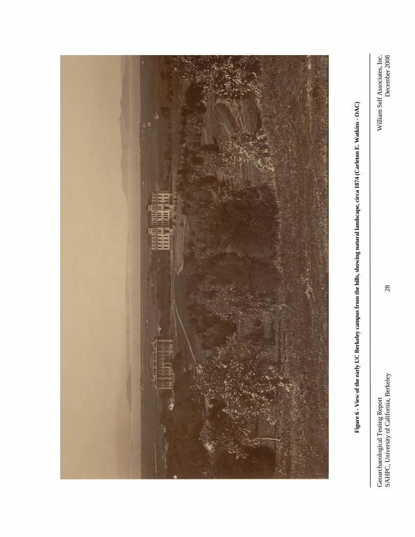
Geo
arch
aeol
ogic
alTe
stin
gR
epor
tW
illia
mSe
lfA
ssoc
iate
s,In
c.SA
HPC
,Uni
vers
ityof
Cal
iforn
ia,B
erke
ley
28D
ecem
ber2
008
Figu
re6
-Vie
wof
the
earl
yU
CB
erke
ley
cam
pusf
rom
the
hills
,sho
win
gna
tura
llan
dsca
pe,c
irca
1874
(Car
leto
nE
.Wat
kins
-OA
C)
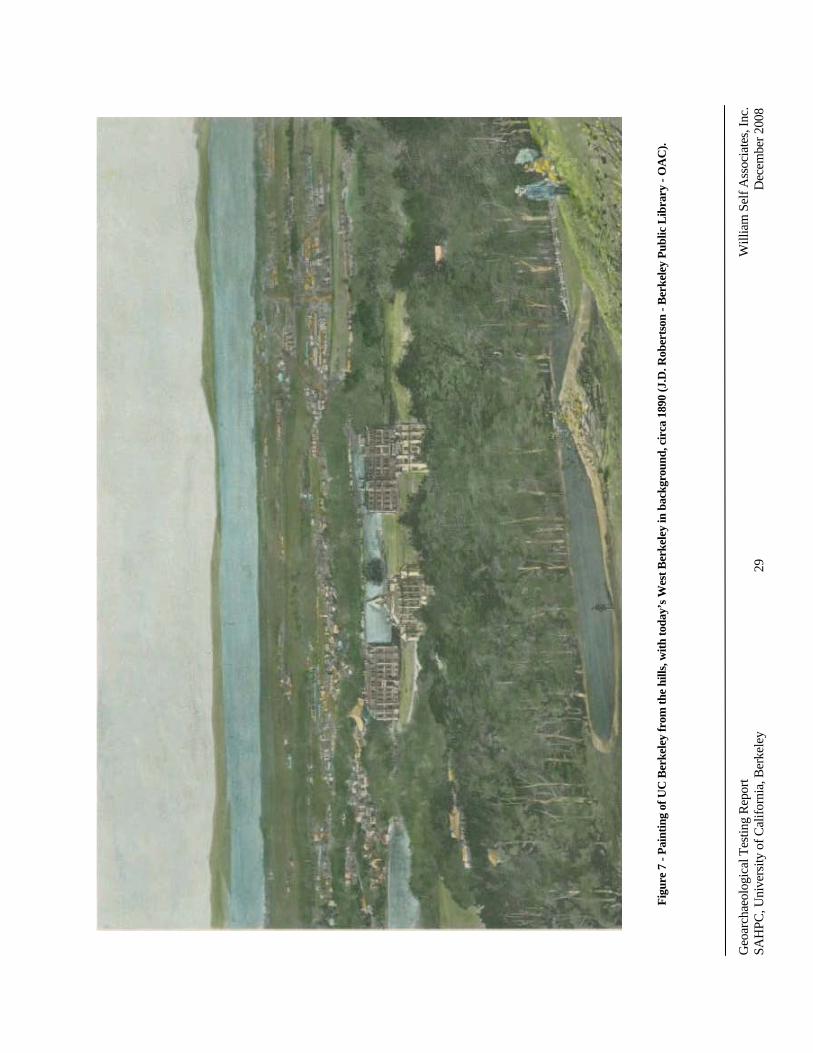
Geo
arch
aeol
ogic
alTe
stin
gR
epor
tW
illia
mSe
lfA
ssoc
iate
s,In
c.SA
HPC
,Uni
vers
ityof
Cal
iforn
ia,B
erke
ley
29D
ecem
ber2
008
Figu
re7
-Pai
ntin
gof
UC
Ber
kele
yfr
omth
ehi
lls,w
ithto
day’
sWes
tBer
kele
yin
back
grou
nd,c
irca
1890
(J.D
.Rob
erts
on-B
erke
ley
Publ
icL
ibra
ry-O
AC
).
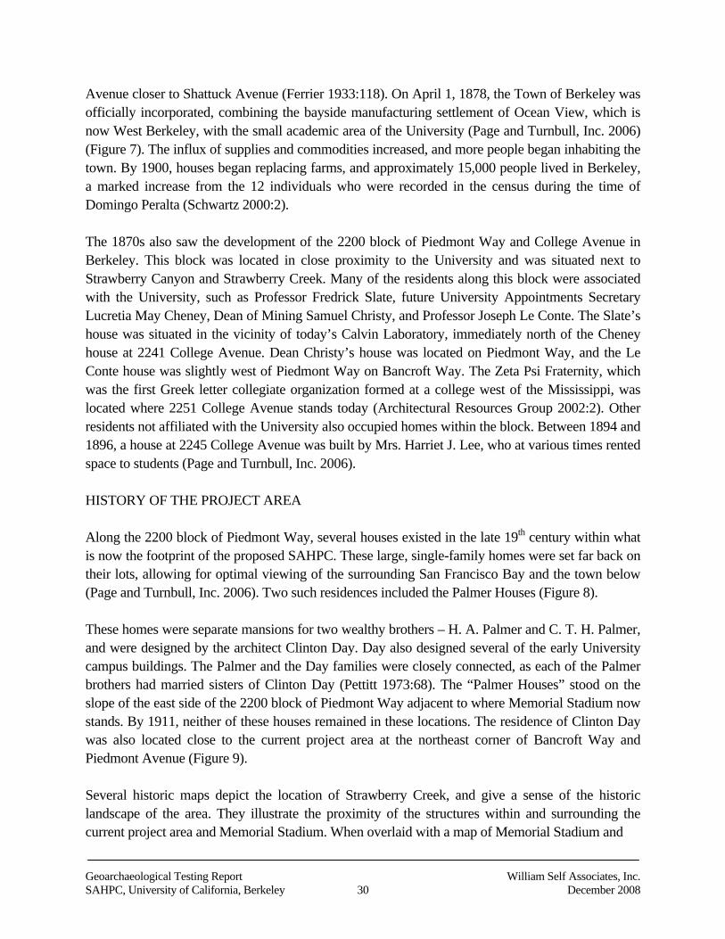
Geoarchaeological Testing Report William Self Associates, Inc.SAHPC, University of California, Berkeley 30 December 2008
Avenue closer to Shattuck Avenue (Ferrier 1933:118). On April 1, 1878, the Town of Berkeley wasofficially incorporated, combining the bayside manufacturing settlement of Ocean View, which isnow West Berkeley, with the small academic area of the University (Page and Turnbull, Inc. 2006)(Figure 7). The influx of supplies and commodities increased, and more people began inhabiting thetown. By 1900, houses began replacing farms, and approximately 15,000 people lived in Berkeley,a marked increase from the 12 individuals who were recorded in the census during the time ofDomingo Peralta (Schwartz 2000:2).
The 1870s also saw the development of the 2200 block of Piedmont Way and College Avenue inBerkeley. This block was located in close proximity to the University and was situated next toStrawberry Canyon and Strawberry Creek. Many of the residents along this block were associatedwith the University, such as Professor Fredrick Slate, future University Appointments SecretaryLucretia May Cheney, Dean of Mining Samuel Christy, and Professor Joseph Le Conte. The Slate’shouse was situated in the vicinity of today’s Calvin Laboratory, immediately north of the Cheneyhouse at 2241 College Avenue. Dean Christy’s house was located on Piedmont Way, and the LeConte house was slightly west of Piedmont Way on Bancroft Way. The Zeta Psi Fraternity, whichwas the first Greek letter collegiate organization formed at a college west of the Mississippi, waslocated where 2251 College Avenue stands today (Architectural Resources Group 2002:2). Otherresidents not affiliated with the University also occupied homes within the block. Between 1894 and1896, a house at 2245 College Avenue was built by Mrs. Harriet J. Lee, who at various times rentedspace to students (Page and Turnbull, Inc. 2006).
HISTORY OF THE PROJECT AREA
Along the 2200 block of Piedmont Way, several houses existed in the late 19th century within whatis now the footprint of the proposed SAHPC. These large, single-family homes were set far back ontheir lots, allowing for optimal viewing of the surrounding San Francisco Bay and the town below(Page and Turnbull, Inc. 2006). Two such residences included the Palmer Houses (Figure 8).
These homes were separate mansions for two wealthy brothers – H. A. Palmer and C. T. H. Palmer,and were designed by the architect Clinton Day. Day also designed several of the early Universitycampus buildings. The Palmer and the Day families were closely connected, as each of the Palmerbrothers had married sisters of Clinton Day (Pettitt 1973:68). The “Palmer Houses” stood on theslope of the east side of the 2200 block of Piedmont Way adjacent to where Memorial Stadium nowstands. By 1911, neither of these houses remained in these locations. The residence of Clinton Daywas also located close to the current project area at the northeast corner of Bancroft Way andPiedmont Avenue (Figure 9).
Several historic maps depict the location of Strawberry Creek, and give a sense of the historiclandscape of the area. They illustrate the proximity of the structures within and surrounding thecurrent project area and Memorial Stadium. When overlaid with a map of Memorial Stadium and
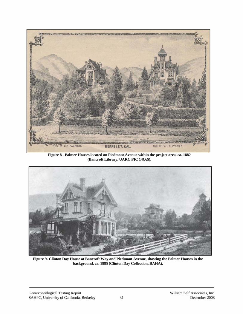
Geoarchaeological Testing Report William Self Associates, Inc.SAHPC, University of California, Berkeley 31 December 2008
Figure 8 - Palmer Houses located on Piedmont Avenue within the project area, ca. 1882(Bancroft Library, UARC PIC 14Q:5).
Figure 9- Clinton Day House at Bancroft Way and Piedmont Avenue, showing the Palmer Houses in thebackground, ca. 1885 (Clinton Day Collection, BAHA).
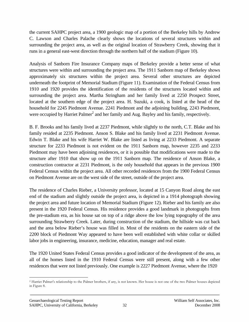
Geoarchaeological Testing Report William Self Associates, Inc.SAHPC, University of California, Berkeley 32 December 2008
the current SAHPC project area, a 1900 geologic map of a portion of the Berkeley hills by AndrewC. Lawson and Charles Palache clearly shows the locations of several structures within andsurrounding the project area, as well as the original location of Strawberry Creek, showing that itruns in a general east-west direction through the northern half of the stadium (Figure 10).
Analysis of Sanborn Fire Insurance Company maps of Berkeley provide a better sense of whatstructures were within and surrounding the project area. The 1911 Sanborn map of Berkeley showsapproximately six structures within the project area. Several other structures are depictedunderneath the footprint of Memorial Stadium (Figure 11). Examination of the Federal Census from1910 and 1920 provides the identification of the residents of the structures located within andsurrounding the project area. Martha Stringham and her family lived at 2250 Prospect Street,located at the southern edge of the project area. H. Suzuki, a cook, is listed at the head of thehousehold for 2245 Piedmont Avenue. 2241 Piedmont and the adjoining building, 2243 Piedmont,were occupied by Harriet Palmer2 and her family and Aug. Bayley and his family, respectively.
B. F. Brooks and his family lived at 2237 Piedmont, while slightly to the north, C.T. Blake and hisfamily resided at 2235 Piedmont. Anson S. Blake and his family lived at 2231 Piedmont Avenue.Edwin T. Blake and his wife Harriet W. Blake are listed as living at 2233 Piedmont. A separatestructure for 2233 Piedmont is not evident on the 1911 Sanborn map, however 2235 and 2233Piedmont may have been adjoining residences, or it is possible that modifications were made to thestructure after 1910 that show up on the 1911 Sanborn map. The residence of Anson Blake, aconstruction contractor at 2231 Piedmont, is the only household that appears in the previous 1900Federal Census within the project area. All other recorded residences from the 1900 Federal Censuson Piedmont Avenue are on the west side of the street, outside of the project area.
The residence of Charles Rieber, a University professor, located at 15 Canyon Road along the eastend of the stadium and slightly outside the project area, is depicted in a 1914 photograph showingthe project area and future location of Memorial Stadium (Figure 12). Rieber and his family are alsopresent in the 1920 Federal Census. His residence provides a good landmark in photographs fromthe pre-stadium era, as his house sat on top of a ridge above the low lying topography of the areasurrounding Strawberry Creek. Later, during construction of the stadium, the hillside was cut backand the area below Rieber’s house was filled in. Most of the residents on the eastern side of the2200 block of Piedmont Way appeared to have been well established with white collar or skilledlabor jobs in engineering, insurance, medicine, education, manager and real estate.
The 1920 United States Federal Census provides a good indicator of the development of the area, asall of the homes listed in the 1910 Federal Census were still present, along with a few otherresidences that were not listed previously. One example is 2227 Piedmont Avenue, where the 1920
2 Harriet Palmer’s relationship to the Palmer brothers, if any, is not known. Her house is not one of the two Palmer houses depictedin Figure 8.
Geoarchaeological Testing Report William Self Associates, Inc.SAHPC, University of California, Berkeley 33 December 2008
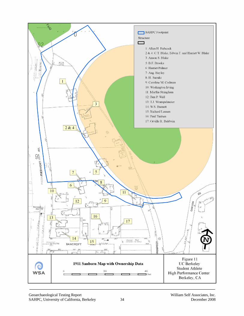
Geoarchaeological Testing Report William Self Associates, Inc.SAHPC, University of California, Berkeley 34 December 2008
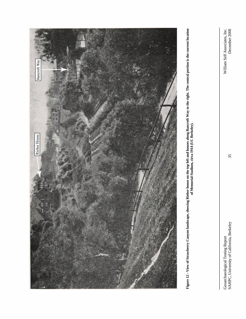
Geo
arch
aeol
ogic
alTe
stin
gR
epor
tW
illia
mSe
lfA
ssoc
iate
s,In
c.SA
HPC
,Uni
vers
ityof
Cal
iforn
ia,B
erke
ley
35D
ecem
ber2
008
Figu
re12
-Vie
wof
Stra
wbe
rry
Can
yon
land
scap
e,sh
owin
gR
iebe
rho
use
onth
eto
ple
ftan
dho
uses
alon
gB
ancr
oftW
ayto
the
righ
t.T
hece
ntra
lpor
tion
isth
ecu
rren
tloc
atio
nof
Mem
oria
lSta
dium
,cir
ca19
14(U
CB
erke
ley)
.
Geoarchaeological Testing Report William Self Associates, Inc.SAHPC, University of California, Berkeley 36 December 2008
Federal Census lists Allen H. Babcock and his family, whereas the 1910 Federal Census did nothave a listing for that address.
As evident from the United States Federal Census by 1930, most of the residents along the easternside of the 2200 block of Piedmont Avenue had either relocated their residence across the street orin the near vicinity, or moved out of the area and Berkeley altogether.
Because the project area changed so much from the late 19th to the early 20th centuries, acomparative map showing the location of structures within the project area from different years(1873, 1874, 1882, 1885, 1897, 1911 and 1914) helps illustrate the historic landscape while at thesame time showing the potential for encountering historical materials during project construction(Figure 13). During the construction, relocation or demolition of these houses there is no mention incontemporary newspapers or reports of any archaeological deposits being encountered. This isnoteworthy in light of the media coverage given to discoveries of human remains during theconstruction of and around the Faculty Club, and the interest that such finds would have generatedin those who lived in the neighborhood, many of whom were associated with the University
The topography also illustrates the natural meander of Strawberry Creek before it was channelized,and that the stadium was constructed in a natural depression. The development of the area and themodifications to the natural environment expanded when the decision to build the football stadiumwas made. Piedmont Way, as it existed at the end of the 1800s and the beginning of the 1900s wasextended to the north and expanded and became Piedmont Avenue. The environments surroundingthe project area were slowly transformed into the UC Berkeley campus we know today.
After the decision was made that a football stadium would be built on campus, several differentlocations were considered for the future Memorial Stadium. Eventually, the Board of Regents chosea site on the southeast side of campus at the mouth of Strawberry Canyon, because the otherproposed locations (the southwest corner of campus where Edwards Stadium stands today, andsouth of University Avenue between California and Sacramento Streets), would have required thepurchase and demolition of private property.
The proposed Strawberry Canyon site location was already partially owned by the Board of Regentsand the University (Figure 14) (Siegel and Strain 1999:13). The stadium grounds consisted ofapproximately 22 acres, 16 of which were already owned by the University (Siegel and Strain1999:25). Before the construction of Memorial Stadium, Strawberry Canyon was primarily a naturalpreserve and was also used for horticulture. The area was described as a “place with paths andbenches placed to enjoy the view of Strawberry Creek, native vegetation including bracken, wildcurrent, oaks, and bay trees, and wildlife such as quail and rabbits” (Smyth 1923:33).
Construction and excavation for Memorial Stadium began in mid-January 1923 (Siegel and Strain1999:15). The houses and most of the trees on the site were removed (Figure 15), and a large
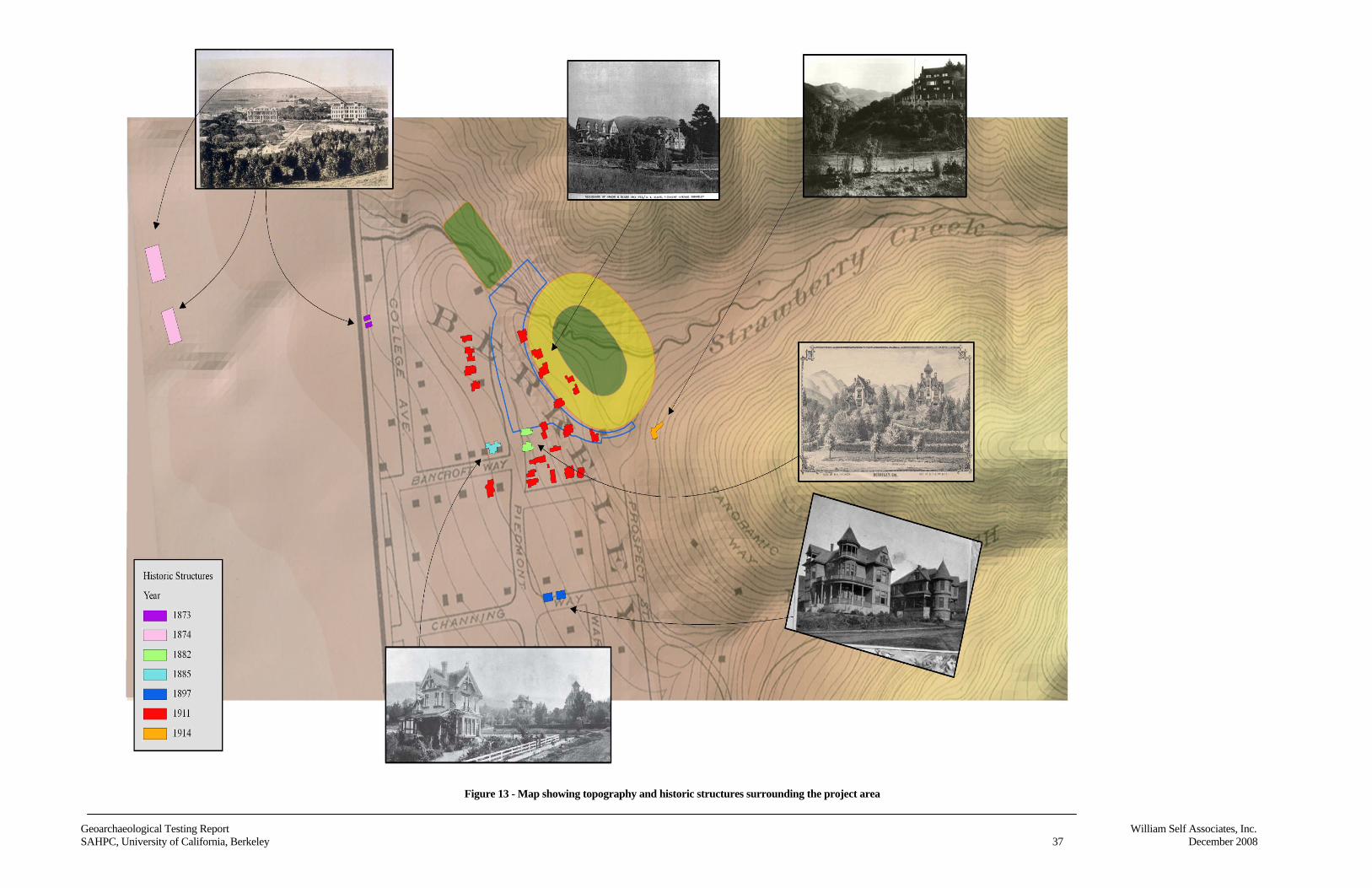
Geoarchaeological Testing Report William Self Associates, Inc.SAHPC, University of California, Berkeley 37 December 2008
Figure 13 - Map showing topography and historic structures surrounding the project area
Geoarchaeological Testing Report William Self Associates, Inc.SAHPC, University of California, Berkeley 38 December 2008
This page intentionally left blank
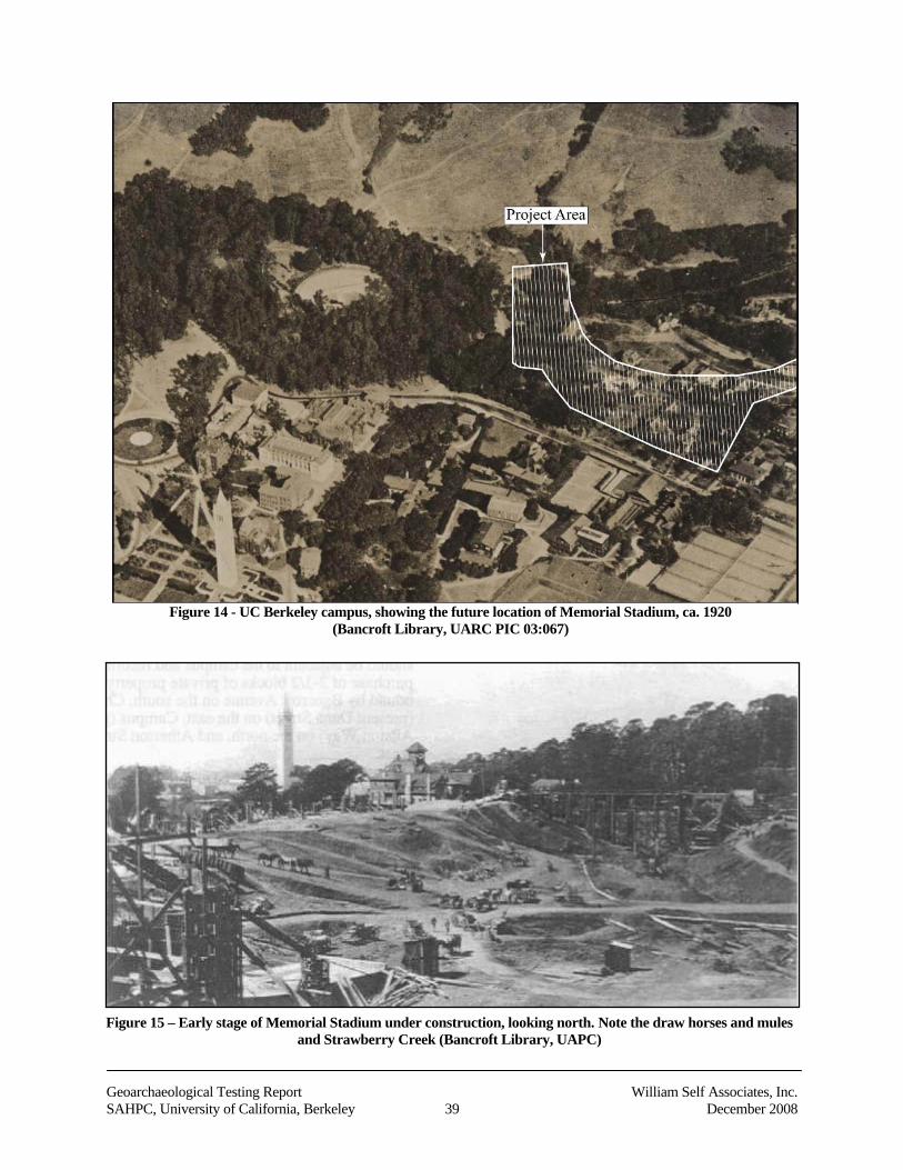
Geoarchaeological Testing Report William Self Associates, Inc.SAHPC, University of California, Berkeley 39 December 2008
Figure 14 - UC Berkeley campus, showing the future location of Memorial Stadium, ca. 1920(Bancroft Library, UARC PIC 03:067)
Figure 15 – Early stage of Memorial Stadium under construction, looking north. Note the draw horses and mulesand Strawberry Creek (Bancroft Library, UAPC)
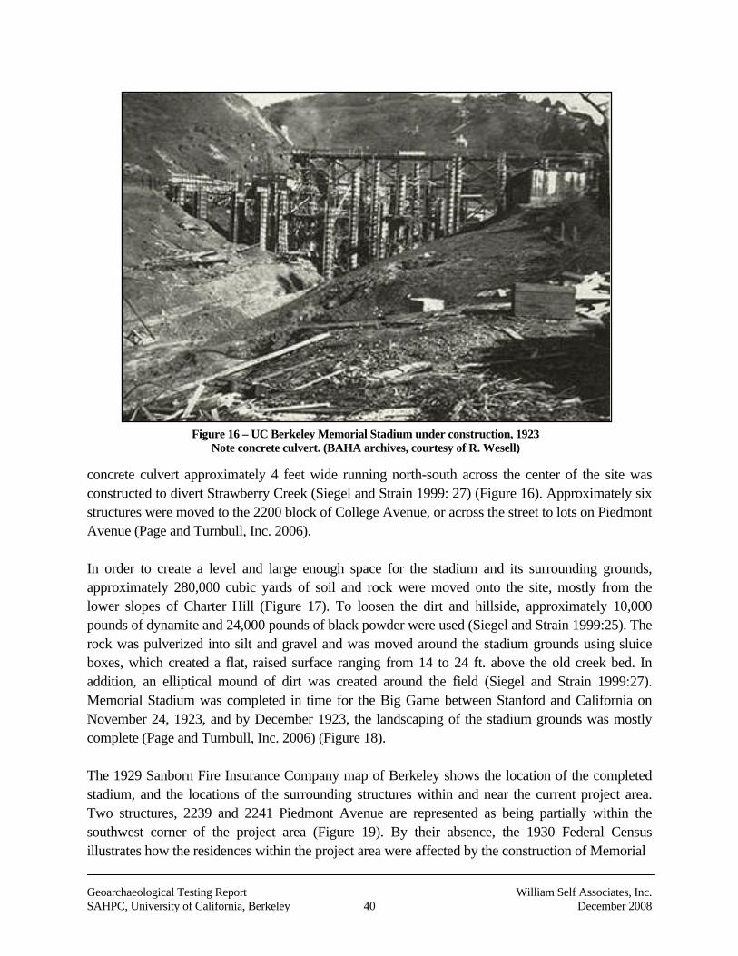
Geoarchaeological Testing Report William Self Associates, Inc.SAHPC, University of California, Berkeley 40 December 2008
concrete culvert approximately 4 feet wide running north-south across the center of the site wasconstructed to divert Strawberry Creek (Siegel and Strain 1999: 27) (Figure 16). Approximately sixstructures were moved to the 2200 block of College Avenue, or across the street to lots on PiedmontAvenue (Page and Turnbull, Inc. 2006).
In order to create a level and large enough space for the stadium and its surrounding grounds,approximately 280,000 cubic yards of soil and rock were moved onto the site, mostly from thelower slopes of Charter Hill (Figure 17). To loosen the dirt and hillside, approximately 10,000pounds of dynamite and 24,000 pounds of black powder were used (Siegel and Strain 1999:25). Therock was pulverized into silt and gravel and was moved around the stadium grounds using sluiceboxes, which created a flat, raised surface ranging from 14 to 24 ft. above the old creek bed. Inaddition, an elliptical mound of dirt was created around the field (Siegel and Strain 1999:27).Memorial Stadium was completed in time for the Big Game between Stanford and California onNovember 24, 1923, and by December 1923, the landscaping of the stadium grounds was mostlycomplete (Page and Turnbull, Inc. 2006) (Figure 18).
The 1929 Sanborn Fire Insurance Company map of Berkeley shows the location of the completedstadium, and the locations of the surrounding structures within and near the current project area.Two structures, 2239 and 2241 Piedmont Avenue are represented as being partially within thesouthwest corner of the project area (Figure 19). By their absence, the 1930 Federal Censusillustrates how the residences within the project area were affected by the construction of Memorial
Figure 16 – UC Berkeley Memorial Stadium under construction, 1923Note concrete culvert. (BAHA archives, courtesy of R. Wesell)
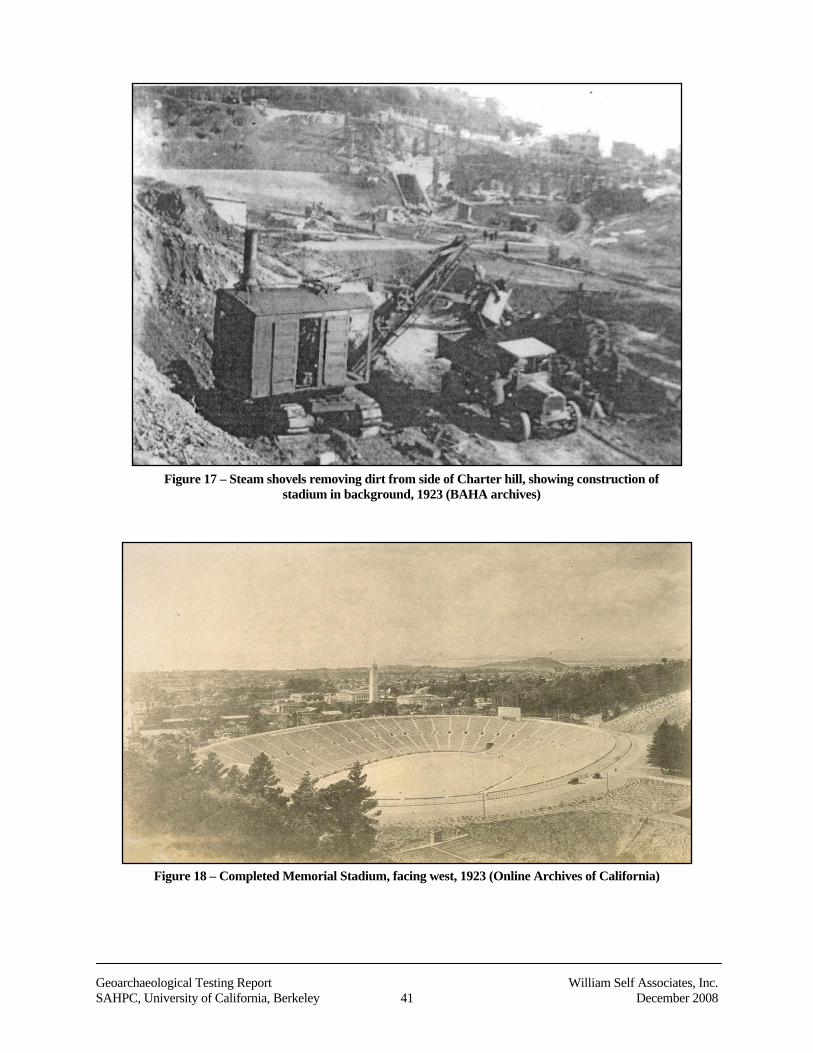
Geoarchaeological Testing Report William Self Associates, Inc.SAHPC, University of California, Berkeley 41 December 2008
Figure 17 – Steam shovels removing dirt from side of Charter hill, showing construction ofstadium in background, 1923 (BAHA archives)
Figure 18 – Completed Memorial Stadium, facing west, 1923 (Online Archives of California)
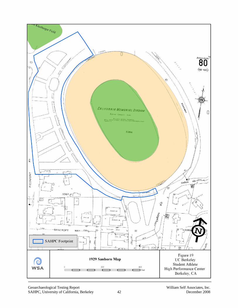
Geoarchaeological Testing Report William Self Associates, Inc.SAHPC, University of California, Berkeley 42 December 2008
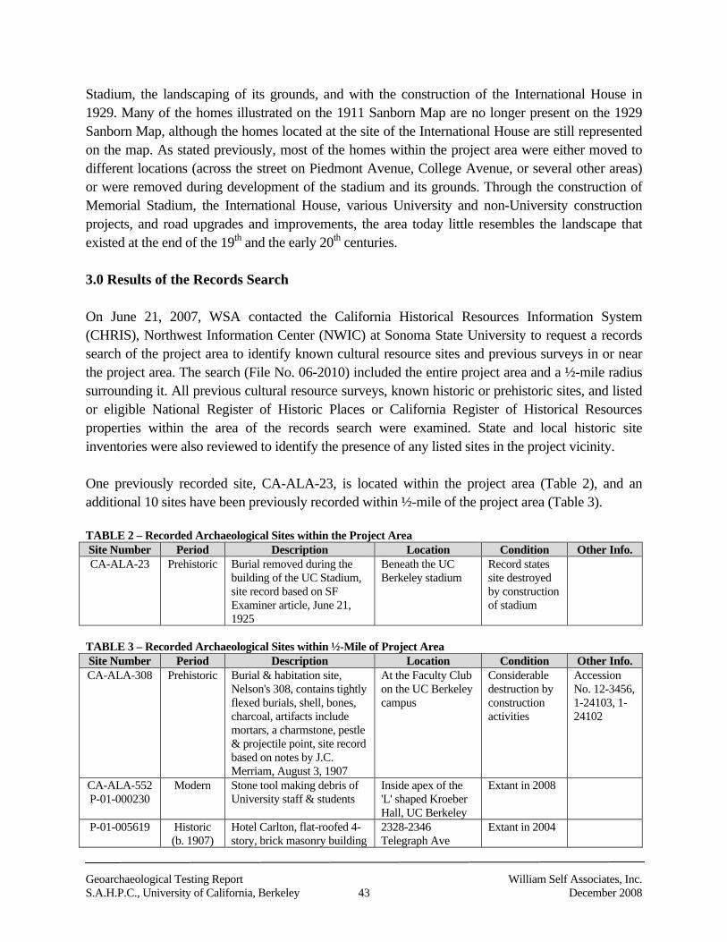
Geoarchaeological Testing Report William Self Associates, Inc.S.A.H.P.C., University of California, Berkeley 43 December 2008
Stadium, the landscaping of its grounds, and with the construction of the International House in1929. Many of the homes illustrated on the 1911 Sanborn Map are no longer present on the 1929Sanborn Map, although the homes located at the site of the International House are still representedon the map. As stated previously, most of the homes within the project area were either moved todifferent locations (across the street on Piedmont Avenue, College Avenue, or several other areas)or were removed during development of the stadium and its grounds. Through the construction ofMemorial Stadium, the International House, various University and non-University constructionprojects, and road upgrades and improvements, the area today little resembles the landscape thatexisted at the end of the 19th and the early 20th centuries.
3.0 Results of the Records Search
On June 21, 2007, WSA contacted the California Historical Resources Information System(CHRIS), Northwest Information Center (NWIC) at Sonoma State University to request a recordssearch of the project area to identify known cultural resource sites and previous surveys in or nearthe project area. The search (File No. 06-2010) included the entire project area and a ½-mile radiussurrounding it. All previous cultural resource surveys, known historic or prehistoric sites, and listedor eligible National Register of Historic Places or California Register of Historical Resourcesproperties within the area of the records search were examined. State and local historic siteinventories were also reviewed to identify the presence of any listed sites in the project vicinity.
One previously recorded site, CA-ALA-23, is located within the project area (Table 2), and anadditional 10 sites have been previously recorded within ½-mile of the project area (Table 3).
TABLE 2 – Recorded Archaeological Sites within the Project AreaSite Number Period Description Location Condition Other Info.CA-ALA-23 Prehistoric Burial removed during the
building of the UC Stadium,site record based on SFExaminer article, June 21,1925
Beneath the UCBerkeley stadium
Record statessite destroyedby constructionof stadium
TABLE 3 – Recorded Archaeological Sites within ½-Mile of Project AreaSite Number Period Description Location Condition Other Info.CA-ALA-308 Prehistoric Burial & habitation site,
Nelson's 308, contains tightlyflexed burials, shell, bones,charcoal, artifacts includemortars, a charmstone, pestle& projectile point, site recordbased on notes by J.C.Merriam, August 3, 1907
At the Faculty Clubon the UC Berkeleycampus
Considerabledestruction byconstructionactivities
AccessionNo. 12-3456,1-24103, 1-24102
CA-ALA-552P-01-000230
Modern Stone tool making debris ofUniversity staff & students
Inside apex of the'L' shaped KroeberHall, UC Berkeley
Extant in 2008
P-01-005619 Historic(b. 1907)
Hotel Carlton, flat-roofed 4-story, brick masonry building
2328-2346Telegraph Ave
Extant in 2004
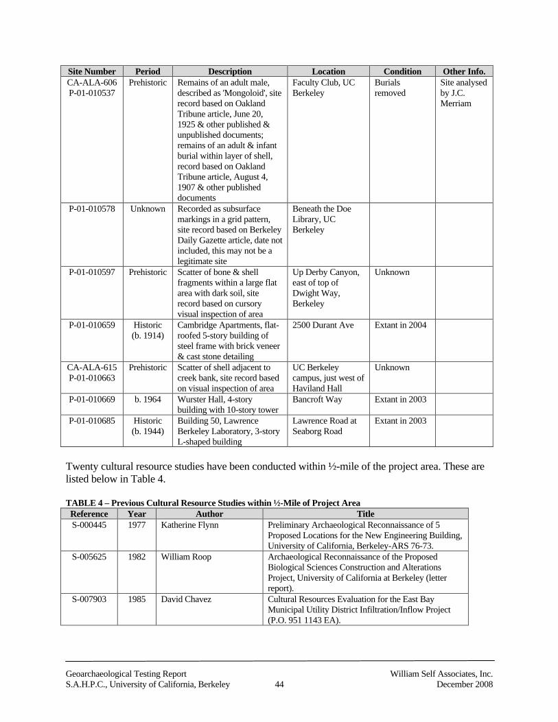
Geoarchaeological Testing Report William Self Associates, Inc.S.A.H.P.C., University of California, Berkeley 44 December 2008
Site Number Period Description Location Condition Other Info.CA-ALA-606P-01-010537
Prehistoric Remains of an adult male,described as 'Mongoloid', siterecord based on OaklandTribune article, June 20,1925 & other published &unpublished documents;remains of an adult & infantburial within layer of shell,record based on OaklandTribune article, August 4,1907 & other publisheddocuments
Faculty Club, UCBerkeley
Burialsremoved
Site analysedby J.C.Merriam
P-01-010578 Unknown Recorded as subsurfacemarkings in a grid pattern,site record based on BerkeleyDaily Gazette article, date notincluded, this may not be alegitimate site
Beneath the DoeLibrary, UCBerkeley
P-01-010597 Prehistoric Scatter of bone & shellfragments within a large flatarea with dark soil, siterecord based on cursoryvisual inspection of area
Up Derby Canyon,east of top ofDwight Way,Berkeley
Unknown
P-01-010659 Historic(b. 1914)
Cambridge Apartments, flat-roofed 5-story building ofsteel frame with brick veneer& cast stone detailing
2500 Durant Ave Extant in 2004
CA-ALA-615P-01-010663
Prehistoric Scatter of shell adjacent tocreek bank, site record basedon visual inspection of area
UC Berkeleycampus, just west ofHaviland Hall
Unknown
P-01-010669 b. 1964 Wurster Hall, 4-storybuilding with 10-story tower
Bancroft Way Extant in 2003
P-01-010685 Historic(b. 1944)
Building 50, LawrenceBerkeley Laboratory, 3-storyL-shaped building
Lawrence Road atSeaborg Road
Extant in 2003
Twenty cultural resource studies have been conducted within ½-mile of the project area. These arelisted below in Table 4.
TABLE 4 – Previous Cultural Resource Studies within ½-Mile of Project AreaReference Year Author TitleS-000445 1977 Katherine Flynn Preliminary Archaeological Reconnaissance of 5
Proposed Locations for the New Engineering Building,University of California, Berkeley-ARS 76-73.
S-005625 1982 William Roop Archaeological Reconnaissance of the ProposedBiological Sciences Construction and AlterationsProject, University of California at Berkeley (letterreport).
S-007903 1985 David Chavez Cultural Resources Evaluation for the East BayMunicipal Utility District Infiltration/Inflow Project(P.O. 951 1143 EA).
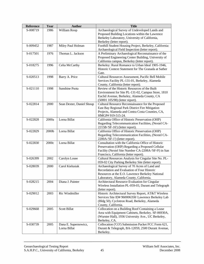
Geoarchaeological Testing Report William Self Associates, Inc.S.A.H.P.C., University of California, Berkeley 45 December 2008
Reference Year Author TitleS-008719 1986 William Roop Archaeological Survey of Undeveloped Lands and
Proposed Building Locations within the LawrenceBerkeley Laboratory, University of California,Berkeley (letter report).
S-009452 1987 Miley Paul Holman Foothill Student Housing Project, Berkeley, California:Archaeological Field Inspection (letter report).
S-017501 1976 Thomas L. Jackson A Preliminary Archaeological Reconnaissance of theProposed Engineering Center Building, University ofCalifornia campus, Berkeley (letter report).
S-018275 1996 Celia McCarthy Berkeley: Rural Romance to Urban Ideal 1905-1946,Historic Context Statement for The Granada at SatherGate.
S-020513 1998 Barry A. Price Cultural Resources Assessment, Pacific Bell MobileServices Facility PL-131-01, Berkeley, AlamedaCounty, California (letter report).
S-021110 1998 Sunshine Psota Review of the Historic Resources of the BuiltEnvironment for Site PL-131-02, Campus Store, 1810Euclid Avenue, Berkeley, Alameda County, CA(50001 105/98) (letter report).
S-022814 2000 Sean Dexter, Daniel Shoup Cultural Resource Reconnaissance for the ProposedEast Bay Regional Park District Fire MitigationProjects, Alameda and Contra Costa Counties, CA,HMGP# 919-515-24.
S-022828 2000a Lorna Billat California Office of Historic Preservation (OHP)Regarding Telecommunication Facilities, (Nextel CA-2215B-'SF-16') (letter report).
S-022829 2000b Lorna Billat California Office of Historic Preservation (OHP)Regarding Telecommunication Facilities, (Nextel CA-2200A-'SF-1') (letter report).
S-022830 2000c Lorna Billat Consultation with the California Office of HistoricPreservation (OHP) Regarding a Proposed CellularFacility (Nextel Site Number CA-2208A-'SF-9') in SanFrancisco, California (letter report).
S-026399 2002 Carolyn Losee Cultural Resources Analysis for Cingular Site No. PL-059-02 City Parking Berkeley Site (letter report).
S-028039 2000 Carol Kielusiak Archaeological Survey of 70 Acres of Land andRecordation and Evaluation of Four HistoricResources at the E.O. Lawrence Berkeley NationalLaboratory, Alameda County, California.
S-028215 2004 Diana J. Painter Architectural Resource Evaluation for CingularWireless Installation PL-059-03, Durant and Telegraph(letter report).
S-029012 2003 Ric Windmiller Historic Architectural Survey Report, AT&T WirelessServices Site ID# 960006358/ Lawrence Berkeley Lab(Bldg 50), Cyclotron Road, Berkeley, AlamedaCounty, California.
S-029668 2005 Scott Billat Collocation on a Building Roof Containing a LeaseArea with Equipment Cabinets, Berkeley. SF-06930A,(Wurster Hall), 1936 University Ave., UC Berkeley,Berkeley, CA.
S-030739 2005 Dana E. Supernowicz,Lorna Billat
Collocation ('CO') Submission Packet FCC Form 621,Durant & Telegraph, BA-12059, 2500 Durant Avenue,Berkeley.
Geoarchaeological Testing Report William Self Associates, Inc.S.A.H.P.C., University of California, Berkeley 46 December 2008
Reference Year Author TitleS-031825 2005 Suzanne Baker Positive Archaeological Survey Report for the
Alameda-Contra Costa Transit District's East Bay BusRapid Transit Project in Berkeley, Oakland, and SanLeandro.
4.0 Other Sources Consulted
A number of sources were consulted to obtain information about other historical archaeologicalresearch, about CA-ALA-23 beneath Memorial Stadium, and about nearby CA-ALA-308 at the siteof the Faculty Club and Faculty Glade. Professor Laurie A. Wilkie of the UC Berkeley, Departmentof Anthropology provided information regarding archaeological research that has been conducted atfour historic sites on the UC campus in conjunction with multiple campus development projects.The information obtained during consultation with Professor Wilkie is presented below in section4.1.
Site cards for CA-ALA-23 and CA-ALA-308 were provided by the NWIC in the results of the siterecords search. WSA staff archaeologist Angela Cook visited the NWIC to determine if additionalmaterial relating to these two sites was available. This search included examination of all reportsrelating to cultural resource investigations within the current project area and within a ¼-mileradius. No additional information was located.
A search of the archives at the Phoebe A. Hearst Museum of Anthropology at UC Berkeley wasalso undertaken by Ms. Cook, with the kind assistance of Ms. Joan Knudsen, museum Registrar.Sources examined included site records, the card catalogs for skeletal material, artifacts, coins,accession records, and manuscript listings. No manuscripts relating to either CA-ALA-23 or CA-ALA-308 were located.
A search of historical newspapers provided on the website Ancestry.com was also conducted usingthe following search terms in various combinations: Memorial Stadium, Faculty Club, FacultyGlade, University of California, Berkeley, Strawberry Creek, Indian burial, Indian bones, Indianskeleton, skeleton, bones, Leslie Spier, stadium construction. The information obtained during thesesearches is summarized below in sections 4.1 through 4.3.
4.1 Recent Historical Archaeological Excavations
The first archaeological research project conducted by Dr. Wilkie on campus focused on the ZetaPsi fraternity located at what was formerly 2225 College Avenue. Excavations began in 2001 inassociation with the earthquake retrofit of the 1911 fraternity building. The archaeologicalexcavations uncovered stratified deposits associated with the building and with the precedingfraternity house that was present at this location from 1876 to 1910 (Wilkie 2008). Portions of the1876 foundation and associated pipe lines were located during the excavation. Artifacts recovered
Geoarchaeological Testing Report William Self Associates, Inc.S.A.H.P.C., University of California, Berkeley 47 December 2008
from the site illustrated the “. . . changing notions of masculinity in American society during the late19th and early 20th centuries” (Wilkie 2008, elec. comm.).
In 2003, archaeological testing was completed at the site of Student’s Observatory which was builtin 1870, as well as the agricultural Conservatory, operational between 1893 and 1924. Testingrevealed that the subsurface remains associated with the observatory had been largely destroyedduring the construction of McCone Hall (Wilkie and Kozakavich 2003). In contrast, testing resultsof the glass Conservatory building revealed well-preserved architectural features and significantdeposits. Due to the future construction of the East Asian Library at this location, excavations ofover 100 sq. m were carried out at the site, revealing features and artifacts related to soil science andvarious agricultural experiments that were conducted in the green houses during their use (Wilkieand Kozakavich 2003).
Archaeological testing in the SAHPC project vicinity was conducted at 2243 College Avenue from2006 to 2007, at the site of the Cheney residence. The extant building was the residence of UCBerkeley alumni May and Warren Cheney from 1883 to 1939 (Wilkie 2008, elec. comm.). MayCheney was significant in campus history not only for her involvement in local women’s rightsmovements of the early 20th century, but also her role in developing the University PlacementCenter. Archaeological excavations conducted within the site revealed garden features, and a rangeof domestic artifacts were recovered (Wilkie 2008, elec. comm.).
4.2 CA-ALA-23
The site record for CA-ALA-23 describes the site component located beneath the southwest edge ofMemorial Stadium, as “Burials removed during the building of the UC stadium.” A coin fromSonora, Mexico, dating to the second quarter of the 19th century was found a month later, though itsassociation with the burial, if any, is not discussed (refer to site card for CA-ALA-23 and skeletalremains card catalog entry). The site was recorded as having been destroyed during construction ofthe stadium. According to the accession record for the remains, which represented one individual,Charles Donald Younger collected and donated the skeletal material to the Museum ofAnthropology in 1923 (see below for discussion of the Museum of Anthropology). Attempts tolocate the correspondence relating to this donation have not been successful.
Attached to the CA-ALA-23 site card located at the Hearst Museum is a copy of a newspaper articlethat appeared in the Berkeley, Cal. Californian on January 17, 1923. The article, entitled “. . .Unearth Bones of Indian Warrior in Strawberry Creek,” states that workmen excavating duringconstruction of Memorial Stadium had found skeletal remains the day prior, approximately 2 ft.below ground surface. The remains were found near the roots of a tree. The bones represented analmost complete skeleton, which Professor A. L. Kroeber and Professor R. H. Lowie identified asthat of an adult male Native American who died sometime between the ages of 25 and 50 years. Thearticle finishes by stating that “It is not likely that any large Indian burial ground will be unearthed,
Geoarchaeological Testing Report William Self Associates, Inc.S.A.H.P.C., University of California, Berkeley 48 December 2008
as the excavation for the stadium progresses, but it is probable that a number of other skeletons willbe discovered near where this first one was found.” It must be noted that it is not specified if theseare the opinions of Kroeber and/or Lowie or if they are those of the unidentified author.
While the site record for CA-ALA-23 states that burials were removed during construction of thestadium, the card catalog entry for skeletal remains for this site is for fragments of a single skeleton.In addition, the aforementioned Berkeley, Cal. Californian newspaper article states that the remainsof only one individual were located beneath the stadium. The skeletal material is in storage in thebasement of the Hearst Gym, and the location of the Mexican coin is unknown.
4.3 CA-ALA-308
CA-ALA-308 is described as a burial and habitation site, and was originally recorded as Nelson'sshellmound 308. This site is located at the site of the Faculty Club, approximately 1,640 ft. west ofCA-ALA-23. Attached to the site card for CA-ALA-308 is a newspaper article that appeared in theSan Francisco Examiner on June 21, 1925, entitled “Third Skeleton Found in Grove on UCCampus.” Information from this article was also used to prepare the site card for CA-ALA-23. Itappears that the Berkeley, Cal. Californian article from January 17, 1923 was not available whenthe site card for CA-ALA-23 was originally prepared.
CA-ALA-308 contained shell within gray-black soil over an area measuring 50 ft. north-south by200 ft. east-west. According to the site card, tightly flexed burials along with mortars, a projectilepoint, a charmstone and a pestle were removed from the site. The site card was prepared by ArnoldPilling based on J.C. Merriam's notes taken in August 1907. Merriam's notes are provided in fullbelow.
In digging a trench along the south side of Strawberry Creek near the Faculty Clubon August 2, 1907, the University workmen cut through a deposit of clay mixedwith sea shells, bones and charcoal, which evidently represented an old Indiancampsite. The shell bed was from one to two feet in thickness and extended for aknown distance of nearly two hundred feet along the bank of Strawberry Creek. Thekind of shell present includes oysters, mussels, clams, all of which were used forfood by some of the aboriginal tribes.
In contact with the upper portion of the shell layer and about one foot below thesurface, one of the workmen uncovered the complete skeleton of an adult lying onits side and with the knees drawn up toward the chest, as in manyknown [sic]shellmound burials.
The thickness of the shelly deposit indicates the occupation of this site as a swelling[the 's' is replaced with a hand-written 'd'] place through a period amounting to manyyears. How long a time has elapsed since the site was occupied can only be
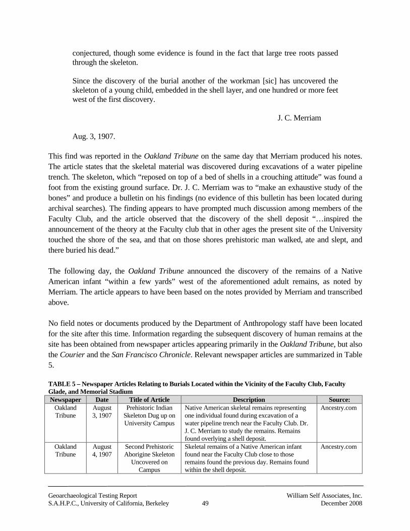
Geoarchaeological Testing Report William Self Associates, Inc.S.A.H.P.C., University of California, Berkeley 49 December 2008
conjectured, though some evidence is found in the fact that large tree roots passedthrough the skeleton.
Since the discovery of the burial another of the workman [sic] has uncovered theskeleton of a young child, embedded in the shell layer, and one hundred or more feetwest of the first discovery.
J. C. Merriam
Aug. 3, 1907.
This find was reported in the Oakland Tribune on the same day that Merriam produced his notes.The article states that the skeletal material was discovered during excavations of a water pipelinetrench. The skeleton, which “reposed on top of a bed of shells in a crouching attitude” was found afoot from the existing ground surface. Dr. J. C. Merriam was to “make an exhaustive study of thebones” and produce a bulletin on his findings (no evidence of this bulletin has been located duringarchival searches). The finding appears to have prompted much discussion among members of theFaculty Club, and the article observed that the discovery of the shell deposit “…inspired theannouncement of the theory at the Faculty club that in other ages the present site of the Universitytouched the shore of the sea, and that on those shores prehistoric man walked, ate and slept, andthere buried his dead.”
The following day, the Oakland Tribune announced the discovery of the remains of a NativeAmerican infant “within a few yards” west of the aforementioned adult remains, as noted byMerriam. The article appears to have been based on the notes provided by Merriam and transcribedabove.
No field notes or documents produced by the Department of Anthropology staff have been locatedfor the site after this time. Information regarding the subsequent discovery of human remains at thesite has been obtained from newspaper articles appearing primarily in the Oakland Tribune, but alsothe Courier and the San Francisco Chronicle. Relevant newspaper articles are summarized in Table5.
TABLE 5 – Newspaper Articles Relating to Burials Located within the Vicinity of the Faculty Club, FacultyGlade, and Memorial StadiumNewspaper Date Title of Article Description Source:
OaklandTribune
August3, 1907
Prehistoric IndianSkeleton Dug up onUniversity Campus
Native American skeletal remains representingone individual found during excavation of awater pipeline trench near the Faculty Club. Dr.J. C. Merriam to study the remains. Remainsfound overlying a shell deposit.
Ancestry.com
OaklandTribune
August4, 1907
Second PrehistoricAborigine Skeleton
Uncovered onCampus
Skeletal remains of a Native American infantfound near the Faculty Club close to thoseremains found the previous day. Remains foundwithin the shell deposit.
Ancestry.com
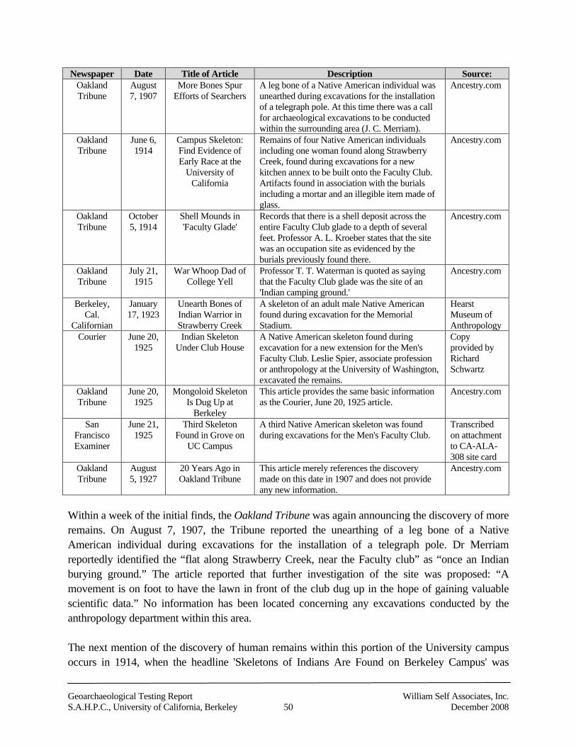
Geoarchaeological Testing Report William Self Associates, Inc.S.A.H.P.C., University of California, Berkeley 50 December 2008
Newspaper Date Title of Article Description Source:OaklandTribune
August7, 1907
More Bones SpurEfforts of Searchers
A leg bone of a Native American individual wasunearthed during excavations for the installationof a telegraph pole. At this time there was a callfor archaeological excavations to be conductedwithin the surrounding area (J. C. Merriam).
Ancestry.com
OaklandTribune
June 6,1914
Campus Skeleton:Find Evidence ofEarly Race at the
University ofCalifornia
Remains of four Native American individualsincluding one woman found along StrawberryCreek, found during excavations for a newkitchen annex to be built onto the Faculty Club.Artifacts found in association with the burialsincluding a mortar and an illegible item made ofglass.
Ancestry.com
OaklandTribune
October5, 1914
Shell Mounds in'Faculty Glade'
Records that there is a shell deposit across theentire Faculty Club glade to a depth of severalfeet. Professor A. L. Kroeber states that the sitewas an occupation site as evidenced by theburials previously found there.
Ancestry.com
OaklandTribune
July 21,1915
War Whoop Dad ofCollege Yell
Professor T. T. Waterman is quoted as sayingthat the Faculty Club glade was the site of an'Indian camping ground.'
Ancestry.com
Berkeley,Cal.
Californian
January17, 1923
Unearth Bones ofIndian Warrior inStrawberry Creek
A skeleton of an adult male Native Americanfound during excavation for the MemorialStadium.
HearstMuseum ofAnthropology
Courier June 20,1925
Indian SkeletonUnder Club House
A Native American skeleton found duringexcavation for a new extension for the Men'sFaculty Club. Leslie Spier, associate professionor anthropology at the University of Washington,excavated the remains.
Copyprovided byRichardSchwartz
OaklandTribune
June 20,1925
Mongoloid SkeletonIs Dug Up at
Berkeley
This article provides the same basic informationas the Courier, June 20, 1925 article.
Ancestry.com
SanFranciscoExaminer
June 21,1925
Third SkeletonFound in Grove on
UC Campus
A third Native American skeleton was foundduring excavations for the Men's Faculty Club.
Transcribedon attachmentto CA-ALA-308 site card
OaklandTribune
August5, 1927
20 Years Ago inOakland Tribune
This article merely references the discoverymade on this date in 1907 and does not provideany new information.
Ancestry.com
Within a week of the initial finds, the Oakland Tribune was again announcing the discovery of moreremains. On August 7, 1907, the Tribune reported the unearthing of a leg bone of a NativeAmerican individual during excavations for the installation of a telegraph pole. Dr Merriamreportedly identified the “flat along Strawberry Creek, near the Faculty club” as “once an Indianburying ground.” The article reported that further investigation of the site was proposed: “Amovement is on foot to have the lawn in front of the club dug up in the hope of gaining valuablescientific data.” No information has been located concerning any excavations conducted by theanthropology department within this area.
The next mention of the discovery of human remains within this portion of the University campusoccurs in 1914, when the headline 'Skeletons of Indians Are Found on Berkeley Campus' was
Geoarchaeological Testing Report William Self Associates, Inc.S.A.H.P.C., University of California, Berkeley 51 December 2008
emblazoned across the front page of the Oakland Tribune. On June 5 and 6, 1914, the remains offour individuals were located during excavation work for the construction of a new kitchen annex tobe built onto the Faculty Club. Artifacts were found in association with the graves. A mortarweighing approximately 100 pounds was located covering the head of a female who had beenburied in a tightly flexed position: “The knees were doubled up against the chin, the arms beingsecured about the legs.” An item measuring three and a half inches in length and manufactured ofglass was reportedly found with one of the individuals but the form of this item is illegible withinthe article. The remains were deposited at the anthropological museum at the affiliated colleges atSan Francisco and excavations at the site were to be “carefully conducted in the hope of discoveringfurther prehistoric ruins.” Again, no information has been located concerning any excavationsconducted by the anthropology department within this area.
By October 1914, it appears that Professor A. L. Kroeber had become more involved with the site.The Oakland Tribune (October 5, 1914) quoted Professor Kroeber's comments as they appeared inthe student newspaper Brass Tacks. In this, Kroeber stated that
There is some shell scattered through all the soil of the Faculty Club glade to a depthof several feet…That this comfortable little hollow, with its growth of live oaks, wasinhabited pretty regularly is shown by the burial of several individuals. Theaborigines would hardly have interred their dead at an overnight camp. Theconvenient combination of acorns, firewood and water in Strawberry creek, which informer times probably had some flow throughout the year, no doubt determined theselection of this site, which could not have been more appropriately chosen…
Based on typological analyses of artifacts found at the shell midden, Kroeber determined that thesite was likely inhabited between 500 and 1,000 years ago.
The following year, Professor T.T. Waterman of the Department of Anthropology concurred withProfessor Kroeber's determination that the Faculty Club glade was once a Native Americanoccupation site. In an article published in the Oakland Tribune on July 21, 1915, Watermandescribes the glade as 'once an Indian camping ground' and that the Faculty Club 'has been builtover an ancient Indian cemetery'. He also observes that until 30 years prior, Strawberry Creek was apermanent watercourse filled with trout.
An article appearing in the Courier, dated June 20, 1925, as well as an article in the OaklandTribune of the same date, recorded that the remains of a single Native American individual wereunearthed during excavations for a new extension to the Men's Faculty Club. The skeletal materialwas excavated by Leslie Spier, associate professor of anthropology at the University of Washington,who was working at the University of California, Berkeley at that time. The article records that theremains “. . . were found partly beneath the north wall of the north dining room, at a depth of two orthree feet below the original surface, lying partially in an undisturbed pocket of shells. The bodywas flexed, and lay with head to the north” (Courier 1925). Dr. Spier identified the fragmentary
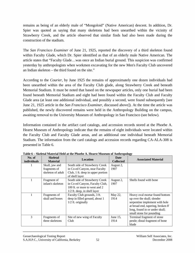
Geoarchaeological Testing Report William Self Associates, Inc.S.A.H.P.C., University of California, Berkeley 52 December 2008
remains as being of an elderly male of “Mongoloid” (Native American) descent. In addition, Dr.Spier was quoted as saying that many skeletons had been unearthed within the vicinity ofStrawberry Creek, and the article observed that similar finds had also been made during theconstruction of the stadium.
The San Francisco Examiner of June 21, 1925, reported the discovery of a third skeleton foundwithin Faculty Glade, which Dr. Spier identified as that of an elderly male Native American. Thearticle states that “Faculty Glade…was once an Indian burial ground. This suspicion was confirmedyesterday by anthropologists when workmen excavating for the new Men's Faculty Club uncoveredan Indian skeleton – the third found on the site.”
According to the Courier, by June 1925 the remains of approximately one dozen individuals hadbeen unearthed within the area of the Faculty Club glade, along Strawberry Creek and beneathMemorial Stadium. It must be noted that based on the newspaper articles, only one burial had beenfound beneath Memorial Stadium and eight had been found within the Faculty Club and FacultyGlade area (at least one additional individual, and possibly a second, were found subsequently [seeJune 21, 1925 article in the San Francisco Examiner, discussed above]). At the time the article waspublished, the newly discovered remains were held in the Anthropology Building on the campus,awaiting removal to the University Museum of Anthropology in San Francisco (see below).
Information contained in the artifact card catalogs, and accession records stored at the Phoebe A.Hearst Museum of Anthropology indicate that the remains of eight individuals were located withinthe Faculty Club and Faculty Glade areas, and an additional one individual beneath MemorialStadium. The information from the card catalogs and accession records regarding CA-ALA-308 ispresented in Table 6.
Table 6 – Skeletal Material Held at the Phoebe A. Hearst Museum of AnthropologyNo. of
individualsSkeletalMaterial Location Date
Collected Associated Material
1 Skull, jaw andfragments ofskeleton of adult
South side of Strawberry Creekin Co-ed Canyon, near FacultyClub, 1 ft. deep in upper portionof shell layer
August 2,1907
1 Fragment ofinfant's skeleton
South side of Strawberry Creekin Co-ed Canyon, Faculty Club,100 ft. or more to west and 21/2 ft. deep, in shell layer
August 2,1907
Shells found with bone
1 Fragments ofskull and bones
Faculty Club grounds, 3 ft.deep in filled ground, about 11/2 ft. originally
May 22,1914
Heavy oval mortar found bottomup over the skull; slenderserpentine implement with holeat broad end, tapering, broken 8'long, found in or under skull;small stone for pounding
3 Fragments ofthree skeletons
Site of new wing of FacultyClub
June 15,1914
Terminal fragment of stonepestle; distal fragment of boneblade
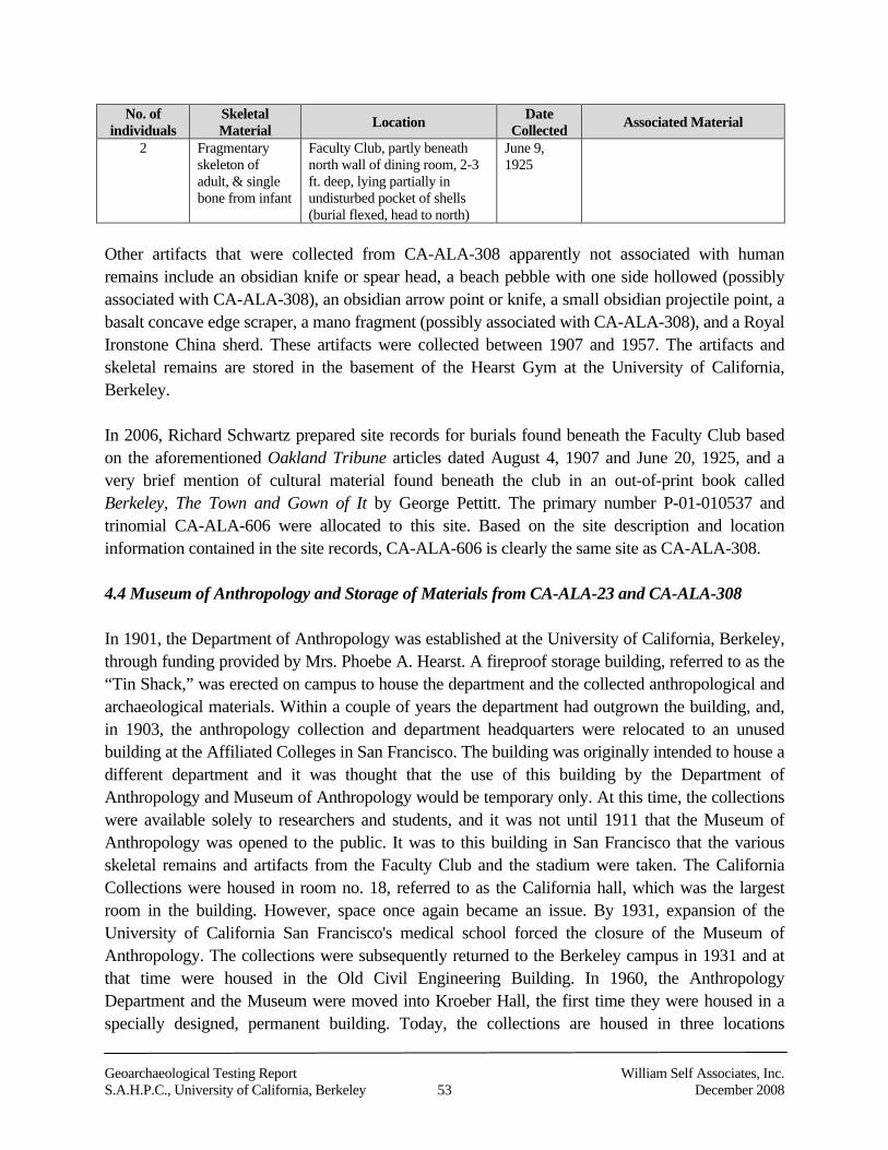
Geoarchaeological Testing Report William Self Associates, Inc.S.A.H.P.C., University of California, Berkeley 53 December 2008
No. ofindividuals
SkeletalMaterial Location Date
Collected Associated Material
2 Fragmentaryskeleton ofadult, & singlebone from infant
Faculty Club, partly beneathnorth wall of dining room, 2-3ft. deep, lying partially inundisturbed pocket of shells(burial flexed, head to north)
June 9,1925
Other artifacts that were collected from CA-ALA-308 apparently not associated with humanremains include an obsidian knife or spear head, a beach pebble with one side hollowed (possiblyassociated with CA-ALA-308), an obsidian arrow point or knife, a small obsidian projectile point, abasalt concave edge scraper, a mano fragment (possibly associated with CA-ALA-308), and a RoyalIronstone China sherd. These artifacts were collected between 1907 and 1957. The artifacts andskeletal remains are stored in the basement of the Hearst Gym at the University of California,Berkeley.
In 2006, Richard Schwartz prepared site records for burials found beneath the Faculty Club basedon the aforementioned Oakland Tribune articles dated August 4, 1907 and June 20, 1925, and avery brief mention of cultural material found beneath the club in an out-of-print book calledBerkeley, The Town and Gown of It by George Pettitt. The primary number P-01-010537 andtrinomial CA-ALA-606 were allocated to this site. Based on the site description and locationinformation contained in the site records, CA-ALA-606 is clearly the same site as CA-ALA-308.
4.4 Museum of Anthropology and Storage of Materials from CA-ALA-23 and CA-ALA-308
In 1901, the Department of Anthropology was established at the University of California, Berkeley,through funding provided by Mrs. Phoebe A. Hearst. A fireproof storage building, referred to as the“Tin Shack,” was erected on campus to house the department and the collected anthropological andarchaeological materials. Within a couple of years the department had outgrown the building, and,in 1903, the anthropology collection and department headquarters were relocated to an unusedbuilding at the Affiliated Colleges in San Francisco. The building was originally intended to house adifferent department and it was thought that the use of this building by the Department ofAnthropology and Museum of Anthropology would be temporary only. At this time, the collectionswere available solely to researchers and students, and it was not until 1911 that the Museum ofAnthropology was opened to the public. It was to this building in San Francisco that the variousskeletal remains and artifacts from the Faculty Club and the stadium were taken. The CaliforniaCollections were housed in room no. 18, referred to as the California hall, which was the largestroom in the building. However, space once again became an issue. By 1931, expansion of theUniversity of California San Francisco's medical school forced the closure of the Museum ofAnthropology. The collections were subsequently returned to the Berkeley campus in 1931 and atthat time were housed in the Old Civil Engineering Building. In 1960, the AnthropologyDepartment and the Museum were moved into Kroeber Hall, the first time they were housed in aspecially designed, permanent building. Today, the collections are housed in three locations
Geoarchaeological Testing Report William Self Associates, Inc.S.A.H.P.C., University of California, Berkeley 54 December 2008
including the basement of Kroeber Hall, the Hearst Gym basement, and a University storage facility(a former factory) a few miles away from the campus (Kell 1997; Phoebe A. Hearst Museum ofAnthropology and the Regents of the University of California 2006; Bancroft Library 2006). Theartifacts and skeletal remains recovered from CA-ALA-23 and CA-ALA-308 are currently stored inthe basement of the Hearst Gym.
5.0 Native American Heritage Commission Consultation
On June 21, 2007, Dr. James Allan of WSA contacted the Native American Heritage Commission(NAHC) by letter to request information on known Native American traditional or culturalproperties within the project area, and to request a listing of individuals or groups with culturalaffiliation to the project area. NAHC staff member Ms. Debbie Pilas-Treadway replied to the WSAletter on June 29, 2007, stating that “a record search of the sacred land file has failed to indicate thepresence of Native American cultural resources in the immediate project area.” Included in theNAHC response was a list of interested Native American contacts, which is appended to this report.Ohlone tribal member Ramona Garibay on that list served as Native American monitor for theproject. See attached Native American Heritage Commission Consultation and List of NativeAmerican Contacts (Appendix A).
6.0 Research Design
The following research design serves a regulatory purpose under CEQA. Should any culturalresources be discovered as a result of the project, their significance would have to be determined inrelation to the criteria for eligibility to the California Register of Historical Resources (CRHR).Should any such discovered resource be determined to be significant, any impacts of the project onthe resource would have to be reduced to a less-than-significant level, if feasible. There are fourcriteria for determining eligibility for listing on the CRHR. Under the fourth criterion, a culturalresource must have the potential to contribute information important to prehistory or history (oftenexpressed as scientific research potential) to be considered for listing on the CRHR. The followingresearch design presents a series of research questions and related data requirements that constitute aframework for assessing the potential significance of a cultural resource under Criterion 4 of theCRHR.
WSA conducted the archaeological subsurface testing program in an effort to recover data sufficientto indicate the presence or absence of potentially significant cultural material in the SAHPC projectarea, as well as to characterize the nature of that cultural material. The testing method is described infurther detail in section 7.0 below. Given the coring technique, retrievable data might range fromprehistoric artifactual materials such as flaked stone artifacts, groundstone implements, shell beads,modified bone, evidence of midden formation, compacted soil layers, concentrations of fire-cracked rock, charcoal, shell or fragmentary skeletal remains; or a wide range of historic artifacts,such as those made from glass, ceramic, metal, and wood (or fragments thereof), to evidence of
Geoarchaeological Testing Report William Self Associates, Inc.S.A.H.P.C., University of California, Berkeley 55 December 2008
buried landscape features that could have supported human activity. In the absence of artifacts,evidence of buried landscape features (for example, terraces above Strawberry Creek) typically usedby humans in the area could be an indicator that buried archaeological deposits are potentiallypresent.
Core samples offer a limited view of buried deposits. However, it is possible for the deposits thatare captured in a core sample to contain important information about the overall buriedarchaeological deposits they might encounter. If sufficient evidence were recovered indicating thatan intact cultural resource is present within the project area, the sampling strategy and methodwould be modified in order to gather additional information to establish the potential significance ofthe find.
6.1 Site Formation
Identifying the processes of site formation is a fundamental objective of archaeological research. Ananalysis of data related to site formation processes can help address the potential integrity ofarchaeological deposits and features, as well as help characterize the context of those deposits as totheir research potential. A variety of post-depositional processes that can disturb and alter theoriginal character of archaeological sites, such as erosion or bioturbation, could be observed in coresamples.
Potential research questions:
What formation processes have been active on the archaeological deposits? Is there evidence of long-term site use, e.g., midden formation, dense concentrations of
habitation debris? Have recent (i.e., construction of California Memorial Stadium) land use activities affected
site integrity? Has alluviation, colluviation, erosion or sheet wash affected site integrity? Is bioturbation a factor in artifact distribution or site integrity?
Required data:
Cultural materials indicative of long-term occupation or short-term usage. For example,dense concentrations of fire-cracked rock and charcoal, compacted layers of shell andorganic material, or evidence of features (e.g., burials), could indicate long-term usage,possibly, habitation. Flaked stone debris on otherwise native surface soils might be anindicator of short-term usage.
Evidence for midden development, such as stratified layers of sediment with highconcentrations of shell and organic debris.
Geoarchaeological Testing Report William Self Associates, Inc.S.A.H.P.C., University of California, Berkeley 56 December 2008
Evidence of trampling, such as highly compressed soils containing cultural materials. Cultural materials found in a context of eroded or bioturbated soils or sediments.
6.2 Chronology
Chronologically relevant data can reasonably be expected to be encountered in core samples.Establishing a firm temporal range for archaeological deposits is one of the foundations ofarchaeological investigation and research. Many of the subsequent research topics in prehistory,such as culture change and adaptation, focus on questions that rely on chronological information.Absolute dating (through radiocarbon or obsidian hydration) of sites would provide valuableinformation on settlement along Strawberry Creek. This technique relies on retrieving appropriatequantities of charcoal, shell or bone. Obsidian hydration may also prove useful, although thedevelopment of accurate results is dependent upon sourcing the material, collection of appropriatequantities of non-biased samples, and application of an acceptable hydration rate, which is fairlywell developed for the Bay Area.
Potential research questions:
What is the temporal range of archaeological deposits? Is there a single period component, or were there discrete periods of site use? How does the site relate to others in the region in terms of age? Does it support the existing
regional chronology?
Required data:
Appropriate materials for absolute dating techniques available in sufficient quantities forradiometric and/or AMS radiocarbon dating. For the latter, charcoal, shell or bone inquantities of 50 mg, 100 mg and 30 gm respectively.
Diagnostic artifact types that have established temporal associations (e.g., shell beads,projectile points, and charmstones for prehistoric sites; makers’ marks on ceramics, glassbottles and their manufacturing process for historic-era sites).
Diagnostic artifacts in stratified sediments or soils. Bone, charcoal, shell in primary context and in association with intact features, may be
difficult to ascertain from core samples. Obsidian artifacts for hydration dating. X-ray diffraction to identify individual obsidian sources, allowing for each obsidian
hydration result to be calibrated.
Geoarchaeological Testing Report William Self Associates, Inc.S.A.H.P.C., University of California, Berkeley 57 December 2008
6.3 Subsistence and Settlement—Prehistoric Period
Settlement and subsistence are intertwined concepts that have to do with how people used naturalresources and the landscape. Use of different locales according to the seasonal availability ofvarious resources is a common occurrence in California prehistory, but there is also evidence of thelong-term occupation of sites along water courses and the bay shoreline. Because the focus of thisresearch is a single locale within Strawberry Canyon and Creek, the study of subsistence andsettlement is necessarily limited.
Preserved floral and faunal remains offer the opportunity to examine subsistence strategies and howthey may have changed over time at the site. The analysis of artifacts used for procurement (e.g.,spear points or harpoons), for manufacture (e.g., obsidian drill or antler pressure flaking tool), or forpreparation (e.g., mortars and pestles) provides clues as to which resources were gathered or huntedand which were prepared and used on-site. Determining the seasonal availability of variousresources provides clues to both subsistence and settlement pattern. Identifying various activitiesthat were carried out more or less contemporaneously also serves to develop a picture of the kind ofsettlement pattern, and how it may have changed over time. If core samples contain evidence usefulin answering such questions, then the research potential of the archaeological deposits sampledwould be considered potentially significant.
Potential research questions:
What floral and faunal species were exploited? Do they change over time? How dosubsistence data compare with other sites in the region?
Is there a shift in the relative degree of exploitation of various plant or animal species overtime? Are mortars and pestles or other grinding implements present? Were acorns or otherplant seeds being transported to the site from outside the area or procured locally?
What types of bone tools and shell artifacts are present (differentiated by species and artifacttype)?
What raw materials are present at the site? Are they available locally or were theytransported to the site (and from where)? Do raw material preferences change over time?
What lithic manufacturing processes are in evidence? Do they change over time? Is there any evidence of unique lithic specialization in tool type or manufacturing technique?
How do the data pertaining to lithic technology compare with other sites in the region?
Required data:
Floral and faunal remains in stratified sediments or soils; such recovery may requireflotation of column samples and identification of macrobotanical and faunal remains inquantities that would not be collected by the core testing alone. Although this was not part ofthe scope of WSA’s testing program; it could factor into any data recovery plans.
Geoarchaeological Testing Report William Self Associates, Inc.S.A.H.P.C., University of California, Berkeley 58 December 2008
Artifacts related to subsistence activities or seasonality (e.g., vegetal processing, hunting,fishing, etc.)
Identifiable stone, bone and shell artifacts in stratified sediments and soils. Flaked-stone tools and associated debitage that can be characterized by material, size, and
flake type. Data from X-ray fluorescence technology for sourcing obsidian artifacts. Raw materials with identifiable sources. Flaked stone tools with evidence of tool reuse or reworking
6.4 Trade and Exchange—Prehistoric Period
Observable patterns of culture contact occurring through processes such as trade and exchange havebeen documented for much of the Bay Area, especially between the coastal and inland regions.Inland inhabitants with access to resources such as high quality obsidian exchanged goods withinhabitants of the San Francisco Bay and coastline who fished, collected shellfish, and hunted seamammals. Interpretation of archaeological evidence show that local Bay Area occupants had accessto imported materials and shared various regional cultural traits. The level of involvement inexchanging goods and ideas, however, changed over time. Distinguishing trade from seasonalmovement in the archaeological record is difficult.
Potential research questions:
What are the sources of the various materials used on site (e.g., Napa Valley and Anadelobsidian)?
Did preferences for specific sources vary over time? Is there evidence of participation in local, regional, or even broader trade networks? How does evidence of trade compare with other sites in the region?
Data required:
Sourceable raw material (e.g., X-ray fluorescence sourcing of obsidian). Nonlocal and local material in stratified sediments and soils. Evidence for manufacture of artifacts on site (e.g., different stages of manufacture present
from raw material to finished product) or evidence of recycling of raw materials.
6.5 Consumer Behavior—Historic Period
Any historic period deposits encountered in the core samples would be potentially valuable asindicators of consumer behavior. The land use during the historic period of the project area is fairlywell documented as being residential. Discarded items may serve to illustrate the fashion and utilityof various items found within the residential neighborhood that occupied the project area.
Geoarchaeological Testing Report William Self Associates, Inc.S.A.H.P.C., University of California, Berkeley 59 December 2008
Comparison with the historic cultural materials found in other 19th century deposits in the areawould be of value in illustrating consumptive patterns among early residents. The association of theresidences with the early days of the University of California may yield deposits associated witheducated and wealthier residents that could be compared with deposits from contemporary, workingclass neighborhoods of Berkeley.
Potential research questions:
Does the historic-era deposit contribute to our knowledge of the various classes or types ofconsumer goods used at this location?
Is there evidence of hand-made materials, mass production, or other types of manufacturingprocesses? Are they intermixed in the deposit?
Are there imported objects?
Data required:
Identifiable artifacts of various types and material. Artifacts with makers’ marks, embossing, or other indications of manufacturer identity.
6.6 Social Status and Ethnicity—Historic Period
A succession of people coming from different geographic and national origins and various ethnicand cultural backgrounds (e.g., Spanish, Mexican, European, Native American, Chinese, andAfrican American) settled in the Bay Area in the latter half of the 19th century. Some were wealthylandowners; others were landless laborers just passing through. Determining the social identity andsocial status of people from artifactual remains is not a straightforward task. Nonetheless, a carefulconsideration of social identity and status indicated by various artifacts found in context couldpotentially complement information derived from historical sources, and could ultimately revealmore about the people who lived in the project area at the turn of the century. Core samples mightcontain artifactual data related to social status and ethnicity that could be compared withdocumentary evidence of the residents of the project neighborhood.
Potential research questions:
Can the class, gender, ethnicity or age of people who lived in the project area bedetermined?
Is there evidence of differential wealth or status in the deposit?
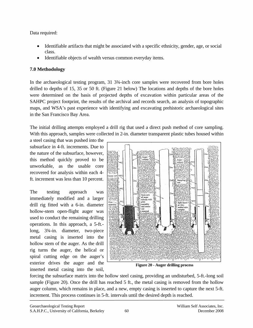
Geoarchaeological Testing Report William Self Associates, Inc.S.A.H.P.C., University of California, Berkeley 60 December 2008
Data required:
Identifiable artifacts that might be associated with a specific ethnicity, gender, age, or socialclass.
Identifiable objects of wealth versus common everyday items.
7.0 Methodology
In the archaeological testing program, 31 3¾-inch core samples were recovered from bore holesdrilled to depths of 15, 35 or 50 ft. (Figure 21 below) The locations and depths of the bore holeswere determined on the basis of projected depths of excavation within particular areas of theSAHPC project footprint, the results of the archival and records search, an analysis of topographicmaps, and WSA’s past experience with identifying and excavating prehistoric archaeological sitesin the San Francisco Bay Area.
The initial drilling attempts employed a drill rig that used a direct push method of core sampling.With this approach, samples were collected in 2-in. diameter transparent plastic tubes housed withina steel casing that was pushed into thesubsurface in 4-ft. increments. Due tothe nature of the subsurface, however,this method quickly proved to beunworkable, as the usable corerecovered for analysis within each 4-ft. increment was less than 10 percent.
The testing approach wasimmediately modified and a largerdrill rig fitted with a 6-in. diameterhollow-stem open-flight auger wasused to conduct the remaining drillingoperations. In this approach, a 5-ft.-long, 3¾-in. diameter, two-piecemetal casing is inserted into thehollow stem of the auger. As the drillrig turns the auger, the helical orspiral cutting edge on the auger’sexterior drives the auger and theinserted metal casing into the soil,forcing the subsurface matrix into the hollow steel casing, providing an undisturbed, 5-ft.-long soilsample (Figure 20). Once the drill has reached 5 ft., the metal casing is removed from the hollowauger column, which remains in place, and a new, empty casing is inserted to capture the next 5-ft.increment. This process continues in 5-ft. intervals until the desired depth is reached.
Figure 20 - Auger drilling process
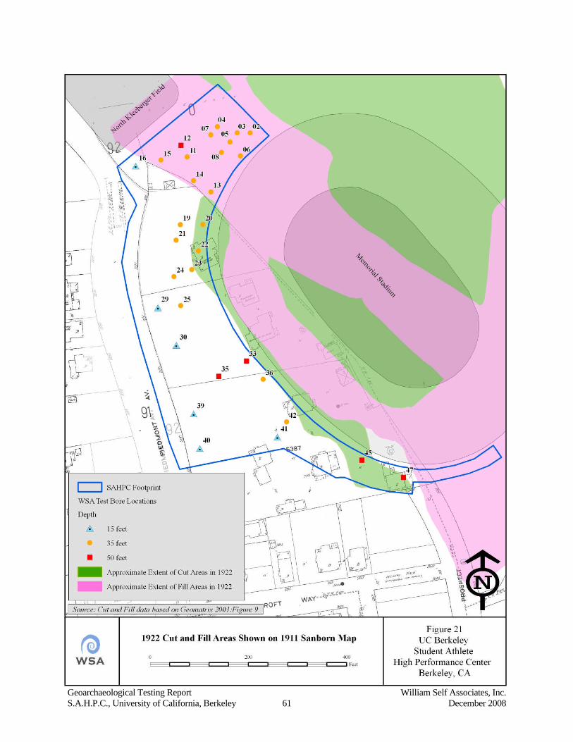
Geoarchaeological Testing Report William Self Associates, Inc.S.A.H.P.C., University of California, Berkeley 61 December 2008
Geoarchaeological Testing Report William Self Associates, Inc.S.A.H.P.C., University of California, Berkeley 62 December 2008
In WSA’s testing program, once the casing was removed from the auger, the bottom attachmentholding the two piece casing together was removed and the metal casing opened to expose thecollected soil core sample. Each core was visually inspected for any evidence of cultural material orchanges in stratification or geomorphology. Each 5-ft.-long soil core was then placed into acardboard core box, which was labeled and stored at the end of each day in a designated room onthe UC campus. Fifteen cores (48.4 percent of the total number of boreholes) were then analyzed byMesa Technical, Inc., to obtain any embedded geoarchaeological information and to helpreconstruct and identify the soil stratification present in each bore location. A letter from MesaTechnical, Inc. summarizing the results of their analysis states that:
…[we examined] fifteen soil cores of the thirty-one obtained by WSA, Inc. fromlocations within the footprint of the proposed Student Athlete High PerformanceCenter, adjacent to the west side of Memorial Stadium. We selected the fifteen coresto provide data from all parts of the footprint.
We were looking in detail at the cores for any evidence of surface or subsurfacearchaeological sites. Archaeological evidence would include both direct evidencesuch as artifacts or midden, or indirect evidence such as compacted layers, firescarred rocks, or concentrations of charcoal. Soil and sediment attributes helpful indeveloping a perspective upon indirect evidence include texture, structure, color,coarse fragments, mottles and gley, HCl reaction, etc. The soil cores were examinedoff site, using accepted field methods. No laboratory analyses were performed (DaveDe Vries 2008, pers. comm.).
These results have been incorporated into the subsurface testing conclusions section below. MesaTechnical’s full report may be found in Appendix C.
The purpose of the subsurface testing was to determine if intact archaeological cultural depositsexist beneath the proposed footprint of the SAHPC; to assess their integrity and potentialsignificance; and to determine whether significant impacts to those deposits may occur as a result ofthe project’s construction. As discussed above, the level of disturbance caused by the constructionof California Memorial Stadium, and the areas of fill can generally be distinguished from areaswhere hillsides were cut and leveled (refer to Figures 4 and 21). The fill areas may potentially coverundisturbed ground surfaces (Ab horizons) that existed in the project area prior to 1923 and mayalso contain subsurface historic features, even in areas cut and leveled during stadium construction,depending on the depths of those disturbances. The analysis of the cores conducted by MesaTechnical, Inc. was designed to help reconstruct the geomorphology of the site area, to assess thepotential archaeological sensitivity of the area and the possibility that pedogenic A horizons areburied in the site area. Ohlone Native American monitor Romana Garibay was on-site and observedall testing operations.
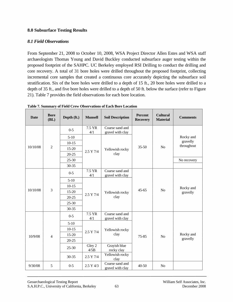
Geoarchaeological Testing Report William Self Associates, Inc.S.A.H.P.C., University of California, Berkeley 63 December 2008
8.0 Subsurface Testing Results
8.1 Field Observations
From September 21, 2008 to October 10, 2008, WSA Project Director Allen Estes and WSA staffarchaeologists Thomas Young and David Buckley conducted subsurface auger testing within theproposed footprint of the SAHPC. UC Berkeley employed RSI Drilling to conduct the drilling andcore recovery. A total of 31 bore holes were drilled throughout the proposed footprint, collectingincremental core samples that created a continuous core accurately depicting the subsurface soilstratification. Six of the bore holes were drilled to a depth of 15 ft., 20 bore holes were drilled to adepth of 35 ft., and five bore holes were drilled to a depth of 50 ft. below the surface (refer to Figure21). Table 7 provides the field observations for each bore location.
Table 7. Summary of Field Crew Observations of Each Bore Location
Date Bore(BL) Depth (ft.) Munsell Soil Description Percent
RecoveryCulturalMaterial Comments
10/10/08 2
0-5 7.5 YR4/1
Coarse sand andgravel with clay
35-50 No
Rocky andgravelly
throughout
5-10
2.5 Y 7/4 Yellowish rockyclay
10-1515-2020-2525-30 No recovery30-35
10/10/08 3
0-5 7.5 YR4/1
Coarse sand andgravel with clay
45-65 No Rocky andgravelly
5-10
2.5 Y 7/4 Yellowish rockyclay
10-1515-2020-2525-3030-35
10/9/08 4
0-5 7.5 YR4/1
Coarse sand andgravel with clay
75-85 No Rocky andgravelly
5-10
2.5 Y 7/4 Yellowish rockyclay
10-1515-2020-25
25-30 Gley 24/5B
Grayish bluerocky clay
30-35 2.5 Y 7/4 Yellowish rockyclay
9/30/08 5 0-5 2.5 Y 4/3 Coarse sand andgravel with clay 40-50 No
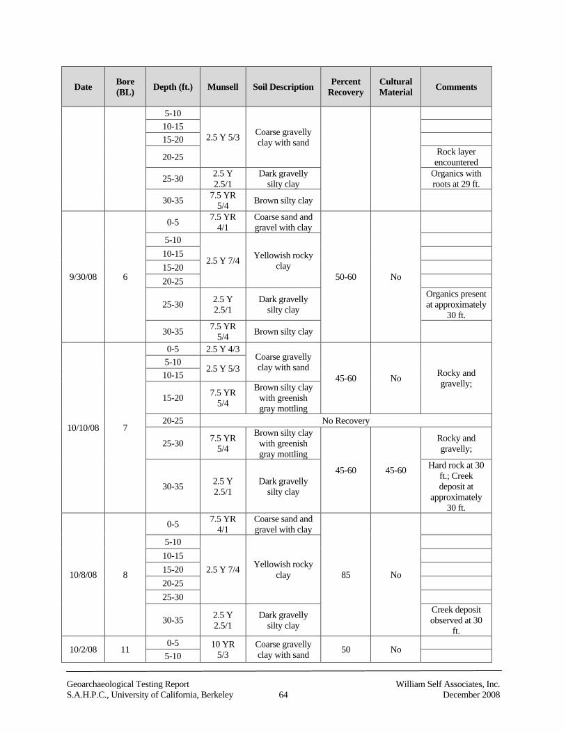
Geoarchaeological Testing Report William Self Associates, Inc.S.A.H.P.C., University of California, Berkeley 64 December 2008
Date Bore(BL) Depth (ft.) Munsell Soil Description Percent
RecoveryCulturalMaterial Comments
5-10
2.5 Y 5/3 Coarse gravellyclay with sand
10-1515-20
20-25 Rock layerencountered
25-30 2.5 Y2.5/1
Dark gravellysilty clay
Organics withroots at 29 ft.
30-35 7.5 YR5/4 Brown silty clay
9/30/08 6
0-5 7.5 YR4/1
Coarse sand andgravel with clay
50-60 No
5-10
2.5 Y 7/4 Yellowish rockyclay
10-1515-2020-25
25-30 2.5 Y2.5/1
Dark gravellysilty clay
Organics presentat approximately
30 ft.
30-35 7.5 YR5/4 Brown silty clay
10/10/08 7
0-5 2.5 Y 4/3Coarse gravellyclay with sand
45-60 No Rocky andgravelly;
5-102.5 Y 5/3
10-15
15-20 7.5 YR5/4
Brown silty claywith greenishgray mottling
20-25 No Recovery
25-30 7.5 YR5/4
Brown silty claywith greenishgray mottling
45-60 45-60
Rocky andgravelly;
30-35 2.5 Y2.5/1
Dark gravellysilty clay
Hard rock at 30ft.; Creekdeposit at
approximately30 ft.
10/8/08 8
0-5 7.5 YR4/1
Coarse sand andgravel with clay
85 No
5-10
2.5 Y 7/4 Yellowish rockyclay
10-1515-2020-2525-30
30-35 2.5 Y2.5/1
Dark gravellysilty clay
Creek depositobserved at 30
ft.
10/2/08 110-5 10 YR
5/3Coarse gravellyclay with sand 50 No
5-10
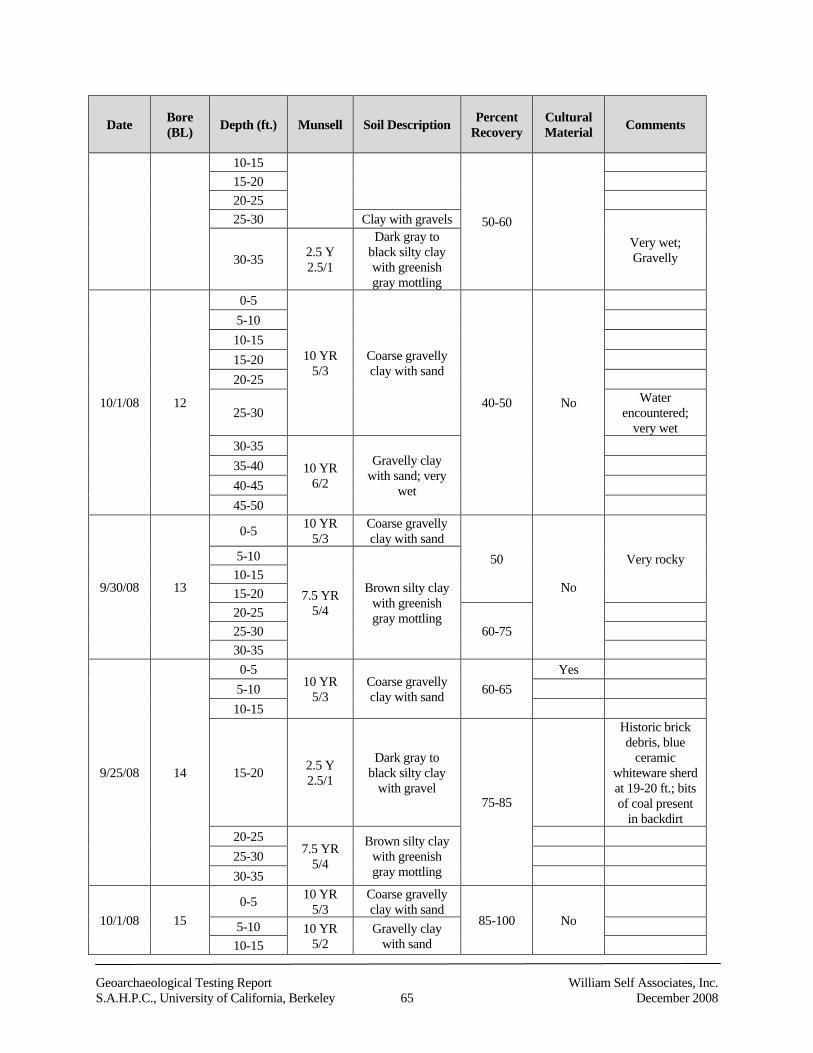
Geoarchaeological Testing Report William Self Associates, Inc.S.A.H.P.C., University of California, Berkeley 65 December 2008
Date Bore(BL) Depth (ft.) Munsell Soil Description Percent
RecoveryCulturalMaterial Comments
10-15
50-60
15-2020-2525-30 Clay with gravels
Very wet;Gravelly30-35 2.5 Y
2.5/1
Dark gray toblack silty claywith greenishgray mottling
10/1/08 12
0-5
10 YR5/3
Coarse gravellyclay with sand
40-50 No
5-1010-1515-2020-25
25-30Water
encountered;very wet
30-35
10 YR6/2
Gravelly claywith sand; very
wet
35-4040-4545-50
9/30/08 13
0-5 10 YR5/3
Coarse gravellyclay with sand
50
No
Very rocky5-10
7.5 YR5/4
Brown silty claywith greenishgray mottling
10-1515-2020-25
60-7525-3030-35
9/25/08 14
0-510 YR
5/3Coarse gravellyclay with sand 60-65
Yes5-1010-15
15-20 2.5 Y2.5/1
Dark gray toblack silty clay
with gravel75-85
Historic brickdebris, blue
ceramicwhiteware sherdat 19-20 ft.; bitsof coal present
in backdirt20-25
7.5 YR5/4
Brown silty claywith greenishgray mottling
25-3030-35
10/1/08 150-5 10 YR
5/3Coarse gravellyclay with sand
85-100 No5-10 10 YR5/2
Gravelly claywith sand10-15
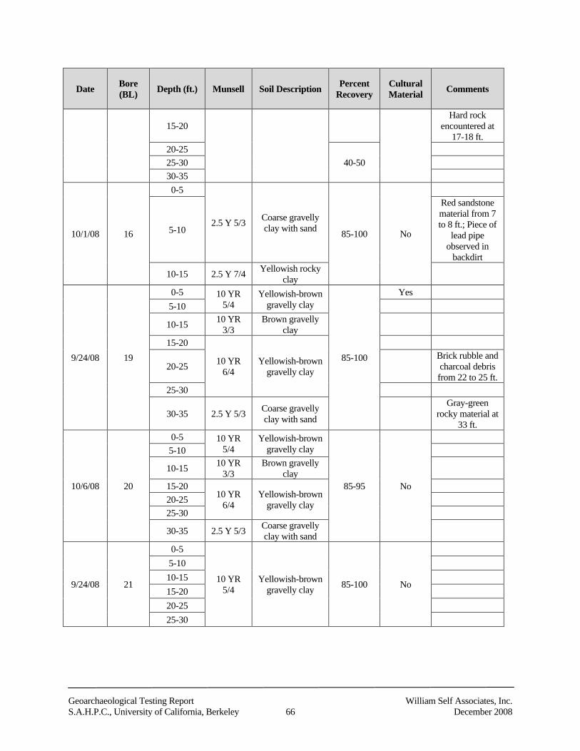
Geoarchaeological Testing Report William Self Associates, Inc.S.A.H.P.C., University of California, Berkeley 66 December 2008
Date Bore(BL) Depth (ft.) Munsell Soil Description Percent
RecoveryCulturalMaterial Comments
15-20Hard rock
encountered at17-18 ft.
20-2540-5025-30
30-35
10/1/08 16
0-5
2.5 Y 5/3 Coarse gravellyclay with sand 85-100 No5-10
Red sandstonematerial from 7to 8 ft.; Piece of
lead pipeobserved in
backdirt
10-15 2.5 Y 7/4 Yellowish rockyclay
9/24/08 19
0-5 10 YR5/4
Yellowish-browngravelly clay
85-100
Yes5-10
10-15 10 YR3/3
Brown gravellyclay
15-20
10 YR6/4
Yellowish-browngravelly clay20-25
Brick rubble andcharcoal debrisfrom 22 to 25 ft.
25-30
30-35 2.5 Y 5/3 Coarse gravellyclay with sand
Gray-greenrocky material at
33 ft.
10/6/08 20
0-5 10 YR5/4
Yellowish-browngravelly clay
85-95 No
5-10
10-15 10 YR3/3
Brown gravellyclay
15-2010 YR
6/4Yellowish-brown
gravelly clay20-2525-30
30-35 2.5 Y 5/3 Coarse gravellyclay with sand
9/24/08 21
0-5
10 YR5/4
Yellowish-browngravelly clay 85-100 No
5-1010-1515-2020-2525-30
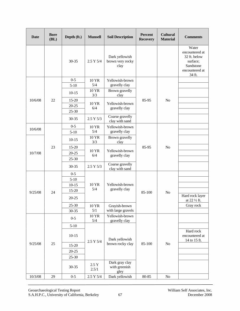
Geoarchaeological Testing Report William Self Associates, Inc.S.A.H.P.C., University of California, Berkeley 67 December 2008
Date Bore(BL) Depth (ft.) Munsell Soil Description Percent
RecoveryCulturalMaterial Comments
30-35 2.5 Y 5/4Dark yellowish
brown very rockyclay
Waterencountered at
32 ft. belowsurface;
Sandstoneencountered at
34 ft.
10/6/08 22
0-5 10 YR5/4
Yellowish-browngravelly clay
85-95 No
5-10
10-15 10 YR3/3
Brown gravellyclay
15-2010 YR
6/4Yellowish-brown
gravelly clay20-2525-30
30-35 2.5 Y 5/3 Coarse gravellyclay with sand
10/6/08
23
0-5 10 YR5/4
Yellowish-browngravelly clay
85-95 No
5-10
10/7/08
10-15 10 YR3/3
Brown gravellyclay
15-2010 YR
6/4Yellowish-brown
gravelly clay20-2525-30
30-35 2.5 Y 5/3 Coarse gravellyclay with sand
9/25/08 24
0-5
10 YR5/4
Yellowish-browngravelly clay
85-100 No
5-1010-1515-20
20-25 Hard rock layerat 22 ½ ft.
25-30 10 YR5/1
Grayish-brownwith large gravels
Gray rock30-35
9/25/08 25
0-5 10 YR5/4
Yellowish-browngravelly clay
85-100 No
5-10
2.5 Y 5/4 Dark yellowishbrown rocky clay
10-15Hard rock
encountered at14 to 15 ft.
15-2020-2525-30
30-35 2.5 Y2.5/1
Dark gray claywith greenish
gley10/3/08 29 0-5 2.5 Y 5/4 Dark yellowish 80-85 No
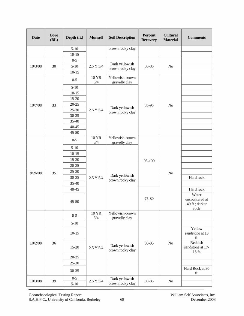
Geoarchaeological Testing Report William Self Associates, Inc.S.A.H.P.C., University of California, Berkeley 68 December 2008
Date Bore(BL) Depth (ft.) Munsell Soil Description Percent
RecoveryCulturalMaterial Comments
5-10 brown rocky clay
10-15
10/3/08 300-5
2.5 Y 5/4 Dark yellowishbrown rocky clay 80-85 No5-10
10-15
10/7/08 33
0-5 10 YR5/4
Yellowish-browngravelly clay
85-95 No
5-10
2.5 Y 5/4 Dark yellowishbrown rocky clay
10-1515-2020-2525-3030-3535-4040-4545-50
9/26/08 35
0-5 10 YR5/4
Yellowish-browngravelly clay
95-100
No
5-10
2.5 Y 5/4 Dark yellowishbrown rocky clay
10-1515-2020-2525-3030-35 Hard rock35-4040-45
75-80
Hard rock
45-50
Waterencountered at49 ft.; darker
rock
10/2/08 36
0-5 10 YR5/4
Yellowish-browngravelly clay
80-85 No
5-10
2.5 Y 5/4 Dark yellowishbrown rocky clay
10-15Yellow
sandstone at 13ft.
15-20Reddish
sandstone at 17-18 ft.
20-2525-30
30-35 Hard Rock at 30ft.
10/3/08 390-5
2.5 Y 5/4 Dark yellowishbrown rocky clay 80-85 No
5-10
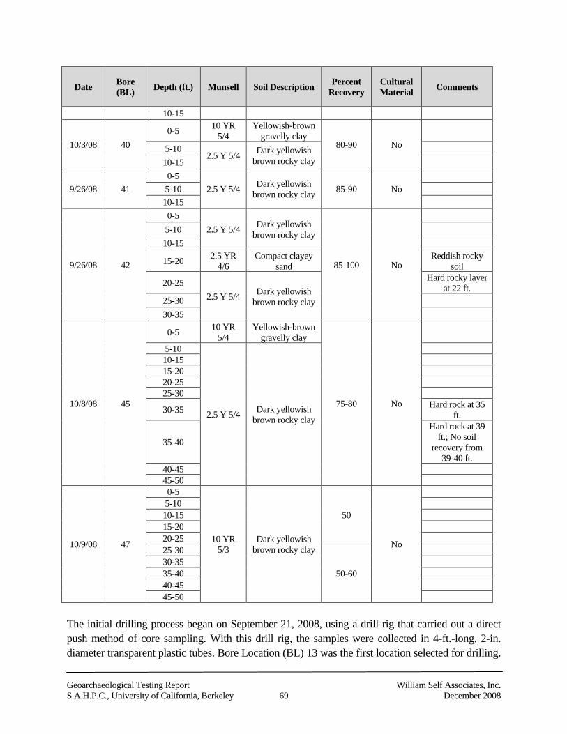
Geoarchaeological Testing Report William Self Associates, Inc.S.A.H.P.C., University of California, Berkeley 69 December 2008
Date Bore(BL) Depth (ft.) Munsell Soil Description Percent
RecoveryCulturalMaterial Comments
10-15
10/3/08 400-5 10 YR
5/4Yellowish-brown
gravelly clay80-90 No5-10
2.5 Y 5/4 Dark yellowishbrown rocky clay10-15
9/26/08 410-5
2.5 Y 5/4 Dark yellowishbrown rocky clay 85-90 No5-10
10-15
9/26/08 42
0-52.5 Y 5/4 Dark yellowish
brown rocky clay
85-100 No
5-1010-15
15-20 2.5 YR4/6
Compact clayeysand
Reddish rockysoil
20-252.5 Y 5/4 Dark yellowish
brown rocky clay
Hard rocky layerat 22 ft.
25-3030-35
10/8/08 45
0-5 10 YR5/4
Yellowish-browngravelly clay
75-80 No
5-10
2.5 Y 5/4 Dark yellowishbrown rocky clay
10-1515-2020-2525-30
30-35 Hard rock at 35ft.
35-40
Hard rock at 39ft.; No soil
recovery from39-40 ft.
40-4545-50
10/9/08 47
0-5
10 YR5/3
Dark yellowishbrown rocky clay
50
No
5-1010-1515-2020-2525-30
50-6030-3535-4040-4545-50
The initial drilling process began on September 21, 2008, using a drill rig that carried out a directpush method of core sampling. With this drill rig, the samples were collected in 4-ft.-long, 2-in.diameter transparent plastic tubes. Bore Location (BL) 13 was the first location selected for drilling.
Geoarchaeological Testing Report William Self Associates, Inc.S.A.H.P.C., University of California, Berkeley 70 December 2008
It is located outside the north end of Memorial Stadium along the asphalted access area thatsurrounds the stadium. The planned final depth of BL 13 was 35 ft. below the surface. Throughoutthe drilling process, soil recovery was very low (0-20 percent). With the soil that was recovered inthe plastic tubes, the sediments had been compacted and heated by the drill rig. From a depth of 16to 24 ft. there was no recovery, and the hole was abandoned after reaching 28 ft. The drillingprocess moved onto location BL 17, followed by BL 20, 22, 23, 23a3, and finally BL 28. All boreholes were planned to a proposed depth of 35 ft., however none of the above bores reached theanticipated depth. This was due to the process of the direct push method of drilling. Because of thehigh gravel and rock content in the soil, the drill rig was not able to push through the subsurfacematrix effectively. Because of the poor quality of the core samples collected using the direct pushmethod, the testing strategy was changed and a hollow-stem auger drill rig with a removableinternal metal casing was employed to collect all subsequent core samples. The six bore holesdrilled with the direct-push method were subsequently re-drilled using the hollow-stem auger, and itis the data collected in those cores that are discussed below.4
The drilling process resumed on September 24, 2008, using this new approach. Drilling operationsbegan with BL 21 to a depth of 35 ft. The original location of the bore hole was movedapproximately 20 ft. to the south off of a dirt mound onto the connecting road in order for the drillrig to access the location. The water table was encountered in BL 21 at a depth of 32 ft. and a hardsandstone rock layer at 34 ft. Fill was noted throughout the recovered cores to a depth ofapproximately 30 to 31 ft. BL 19 was drilled the same day to 35 ft. It is located approximately 35 ft.to the north of BL 21. Brick rubble was identified between 22 and 25 ft. below the surface, and agrayish-green rocky material (Gley 1 4/5GY) noted at approximately 33 ft. followed by yellowish-brown gravelly clay fill.
Bore holes drilled the following day on September 25, 2008, included BL 24, 14 and 25, each ofwhich recovered cores to 35 ft. below the surface. Soil from BL 24 was mostly yellowish-browngravelly and rocky clay (10 YR 5/4) with varying gray rock inclusions. At approximately 25 ft. thesoil was slightly darker brown (10 YR 5/1) in color.
Recovery from BL 14 was slightly less than in previous bore holes (approximately 60 to 65 percentfrom 0 to 15 ft.). Between 19 and 20 ft. below the surface the soil transitioned into a dark gray toblack color (2.5 Y 2.5/1) with small historic ceramic sherds and brick fragments visible. Because ofthese observations, the backdirt from this depth was examined and bits of coal and more brickfragments were noted. No prehistoric material was observed or noted. The location of BL 14 maycoincide with the area surrounding or within the previous location of previous residences or relatesto the construction of Memorial Stadium. BL 14 is approximately 33 ft. east of an out-building and
3 The original location of bore hole 23 was impenetrable so the bore was moved approximately 10 feet southeast and labeled 23a.
4 When these locations were re-drilled with the hollow-stem auger, only bore 23a was re-drilled.
Geoarchaeological Testing Report William Self Associates, Inc.S.A.H.P.C., University of California, Berkeley 71 December 2008
approximately 125 ft. north of the residence of Allen H. Babcock at 2227 Piedmont, depicted on the1911 Sanborn Fire Insurance map. BL 25 contained a hard rock layer from 14 to 15 ft. below thesurface.
On September 26, 2008, BL 35 was drilled to a depth of 50 ft., BL 42 to 35 ft. and BL 41 to 15 ft.below the surface. Hard rocky layers were encountered at depths of 30 and 40 to 45 ft. duringdrilling of BL 35. A water layer and harder rock were also encountered at 49 ft. Recovery was veryhigh (almost 100 percent) down to 40 ft., where it dropped off slightly to 75 to 80 percent thereafter.In BL 42, a very red brick (Munsell: 2.5 YR 4/4) colored sandstone from 15 to down below 20 ft.was encountered. A harder rock layer was hit at 22 ft. BL 41 was drilled to 15 ft. with primarily fillnoted during recovery.
Bore holes drilled on September 30, 2008, include BL 13 to 35 ft. (re-drilled from direct pushmethod drill on September 21, 2008), BL 6 to 35 ft., and BL 5 to 35 ft. Recovery from BL 13 wasapproximately 50 percent for the first 20 ft., and the soil was very gravelly and rocky. BL 6 hadsimilar recovery percentages (50-60 percent) down to 30 ft., where recovery increased and darkgray-to-black gravelly clay soil (2.5 Y 2.5/1) with organics (rootlets, etc.) was encountered. Due tothe close proximity of the diverted Strawberry Creek running beneath the project area, it is believedthis soil is the old creek bed deposit. The result of the drilling of BL 5 closely mirrored that of BL 6,with dark gray/black gravelly clay (2.5 Y 2.5/1) with organics. The creek bed soil was encounteredat 29 ft. below the surface. The soil was also moister at this depth than the fill material recoveredfrom shallower depths. No cultural material was observed or noted within these creek bed soils.
On October 1, 2008, BL 16 was drilled to a depth of 15 ft., BL 15 to a depth of 35 ft. and BL 12 to adepth 50 ft. below the surface. Brick colored (Munsell: 2.5 YR 4/4) sandstone fragments wereobserved at approximately 7-8 ft. for BL 16, and one piece of lead pipe was noted in the backdirtthat wormed out of the hole while the auger was turning. In BL 15, hard rock was encountered at adepth of 17 to 18 ft. that required the drilling crew to add water to the hole to allow them to drilldeeper. The resulting soil cores recovered were very wet because of the added water. BL 12 wasmostly fill (10 YR 5/3) underlain by the same hard rock encountered in BL 15.
Two bore holes (BL 11 and BL 36) were drilled the following day, both to a depth of 35 ft.Recovery for BL 11 was approximately 50 percent from ground surface to a depth of 10 ft. andslightly greater thereafter. The soil was very wet after 28 ft. and consisted of high amounts ofgravels. The drilling of BL 36 encountered several hard rock layers at 13 ft. with yellowishsandstone, at 17 to 18 ft. with reddish colored (Munsell: 2.5 YR 4/3) sandstone and again at 30 ft.
On October 3, 2008, four 15-ft. bore holes (BL 40, 29, 30 and 39) were drilled along the southwestedge of the project area. Most of the soils observed were yellowish-brown gravelly and rocky clays(10 YR 5/4 and 2.5 YR5/4). No cultural material was observed or noted.
Geoarchaeological Testing Report William Self Associates, Inc.S.A.H.P.C., University of California, Berkeley 72 December 2008
On October 6, 2008 BL 20, 22 and part of BL 23 were drilled. All bore holes were to depths of 35ft. The material recovered from these holes consisted mostly of yellowish-brown gravelly rockyclay fill (10 YR 6/4). The first 10 ft. of BL 23 was drilled on October 6th, with the final 15 ft.completed the following morning. BL 33 was also completed on October 7, 2008 to a depth of 50 ft.
BL 45 was drilled on October 8, 2008 to a depth of 50 ft. and BL 8 to a depth of 35 ft. Hard rocklevels were encountered at 35 and 39 ft. in BL 45. Consequently, no soil was recovered from 39 to40 ft. during drilling through the rock level. The soil consisted of mostly naturally depositedmaterial and some fill material near the top of the hole from 0 to 5 ft. of the bore hole. In BL 8, adark gray to black muddy/silty clay level (2.5 Y 2.5/1) was encountered at 30 ft. below the surfacethat is most likely associated with the creek.
On October 9, 2008 BL 47 was drilled to a depth of 50 ft. and BL 4 was drilled to 35 ft. below thesurface. Poor recovery was noted during the first 25 ft. (approximately 50 percent) in BL 47 withrecovery at that level and slightly higher for the remaining 25 ft. (50 to 60 percent). BL 4 hadslightly higher recovery percentages (75-85 percent). Fill material was observed from BL 47 andBL 4 along with naturally deposited soils. A grayish-blue gravelly/rocky clay layer (Gley 2 4/5B)was observed at a depth of approximately 27 to 30 ft. for BL 4.
BL 2, 3 and 7, the final three bore holes, were completed on October 10, 2008. All were to a depthof 35 ft. Poor recovery was noted for all three of the bore locations. Recovery ranged from 25 to 75percent. There was no recovery from 25 to 30 ft. for BL 2, and therefore a slight modification wasmade in the collection of the core sample. Once the auger had drilled down, the casing was pusheddown past the auger column 5 ft. to recover the sample. Recovery improved slightly. It wasdetermined that larger rock fragments had become caught in the auger bit, preventing soil frombeing carried into the casing. Creek deposits were encountered in BL 7 at approximately 30 ft.below the surface (2.5 Y 2.5/1).
8.2 Geoarchaeological Analysis
In additional to WSA’s observations of the soil cores made in the field, David DeVries,geoarchaeologist and owner of Mesa Technical, Inc. analyzed 15 of the 31 soil cores betweenSeptember 29, 2008, and October 31, 2008. In a letter dated November 5, 2008, Mr. DeVries statedthat:
We found no archaeological evidence within the cores, except only a ceramicfragment deep in one core, and some redwood pieces near the surface in another.Both are undoubtedly relics from the time when the stadium was built. We identifiedseveral soil layers which appear to be buried A horizons, now covered either with fillor by natural alluvial or colluvial deposits. Buried A horizons were once at thesurface, for a long enough time that organic matter from roots and decomposingplant material accumulated in the soil. Buried A horizons usually have a darker color
Geoarchaeological Testing Report William Self Associates, Inc.S.A.H.P.C., University of California, Berkeley 73 December 2008
and a granular or prismatic structure, as compared to soil horizons above and below.The buried A horizons we examined showed no evidence of human occupation oruse, and appear to be natural (Dave De Vries 2008, pers. comm.).
The complete results of De Vries’ analysis are provided in Appendix C. They support theconclusion that the former creek alignment and associated former land surfaces, or buried Abhorizons, lie relatively undisturbed beneath the imported fill used in 1923 to create a flatter surfaceupon which to construct Memorial Stadium. The potential for buried archaeological deposits isdirectly related to the presence of these buried land surfaces.
Buried land surfaces (Ab horizons) were encountered in 11 core samples. In four of these, severalAb horizons were encountered within a single core. The presence of multiple Ab horizons is due tothe fact that extant land surfaces were buried during significant colluvial or alluvial depositionalepisodes and new surfaces were created that were then exposed for a sufficient amount of time forsurface soil features to develop, including concentrations of organic materials.
8.3 Interpretation of Results
The original alignment of Strawberry Creek was observed during drilling and lab analysis. BoreLocations 5, 6, 7 and 8, revealed a dark gray-to-black gravelly clay with organics and trace silts,evidence of the former creek bed. Organic material included rootlets, bits of charcoal and othermiscellaneous plant and organic inclusions. The depths at which the former creek alignment wasencountered ranged from 29 to 30 ft. below the surface.
The Ab horizons were identified in 11 of the 15 cores that were subject to geoarchaeologicalanalysis. The cores in which these horizons were identified were taken from across the projectfootprint. An extrapolation of the elevation of the Ab horizons that were identified in the coressuggests that buried land surfaces may lie relatively undisturbed in the vicinity of the former creek,and underneath construction-related fill from 1923 (Figure 22). It is these surfaces that would havethe greatest historic and prehistoric archaeological potential.
Based on background research on the project area, the historic debris observed in the field and notedduring lab analysis is believed to have been associated either with the construction of MemorialStadium in 1923 or with private residences that were, at one time or another, located within andaround the project area. The historic debris observed in BL 19 may be associated with the residenceof Allen H. Babcock at 2227 Piedmont, as the core was taken approximately 41 ft. northwest ofwhere the building once stood. Likewise, as stated previously, BL 14 is located approximately 33 ft.east of an outbuilding and 125 ft. north of 2227 Piedmont, as depicted on the 1911 Sanborn FireInsurance map. The presence of coal and charcoal within core samples is most likely associatedwith the operations of the coal-fired steam/hot water systems at the Stadium, and the charcoal isprobably associated with fires and/or burnt coal from the steam-operated equipment that was usedduring the grading and construction of Memorial Stadium (Siegel and Strain 1996).
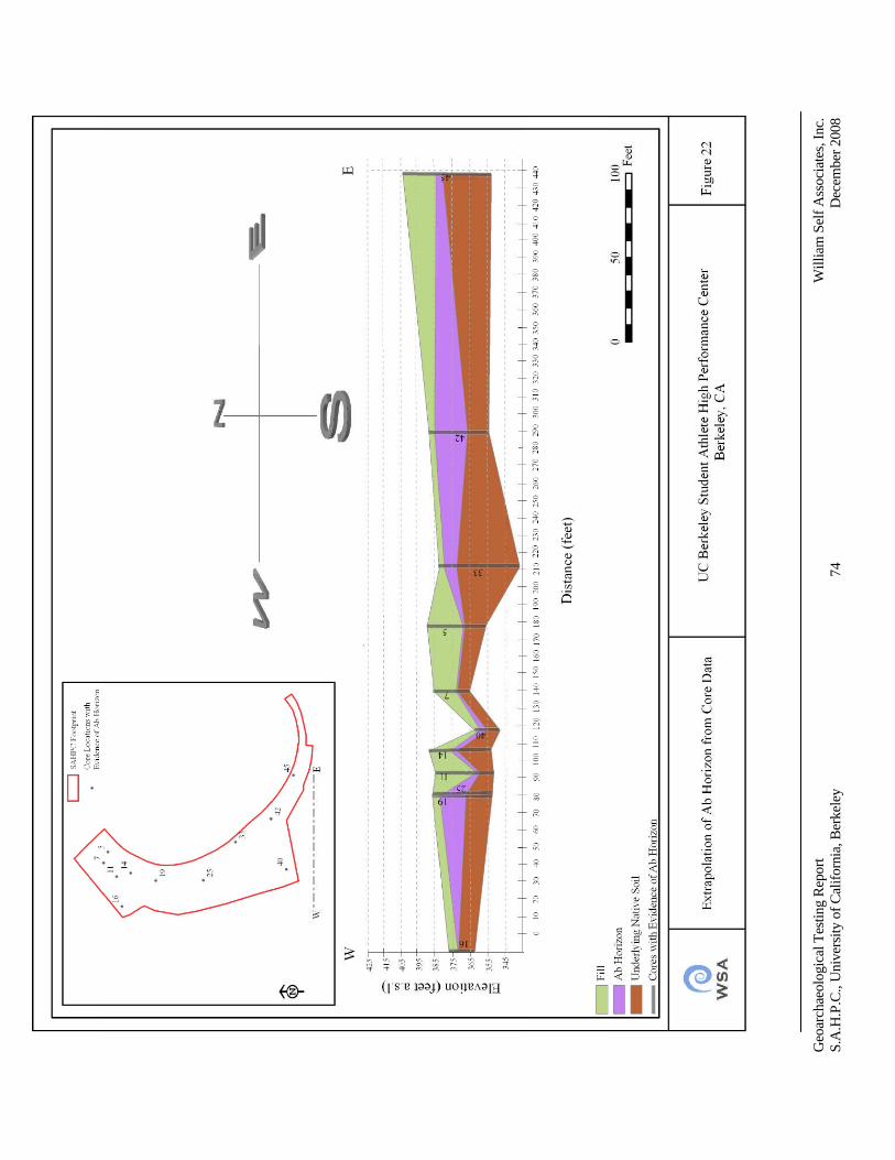
Geo
arch
aeol
ogic
alTe
stin
gR
epor
tW
illia
mSe
lfA
ssoc
iate
s,In
c.S.
A.H
.P.C
.,U
nive
rsity
ofC
alifo
rnia
,Ber
kele
y74
Dec
embe
r200
8
Geoarchaeological Testing Report William Self Associates, Inc.S.A.H.P.C., University of California, Berkeley 75 December 2008
9.0 Summary and Conclusions
No evidence of prehistoric cultural material or prehistoric activity was identified in the 31 coresamples taken throughout the footprint of the SAHPC. Subsequent geoarchaeological lab analysis of15 of these core samples likewise did not identify any prehistoric cultural material or evidence ofprehistoric activity. Historic debris and material were noted in the field in two cores (BL 14 and 19).These materials, including brick fragments, pieces of charcoal and coal, and ceramic sherds, werealso identified in the geoarchaeological analysis conducted by Mesa Technical.
The majority of the 31 core samples (27 out of 31) consisted of fill material that appears to beassociated with the construction of Memorial Stadium in 1923 and from later modifications to thestadium and the surrounding grounds. Based on field observations and subsequentgeoarchaeological analysis, the fill appears to range from 8 to 35 ft. in depth.
Given the proposed depth of construction, and the depths at which the former creek bed and the Abhorizons were identified, there is a potential for encountering prehistoric archaeological resourcesduring project construction. Project plans call for construction-related disturbances to go 15 to 50 ft.below ground surface, with foundation excavations reaching 35 ft. below ground surface. Buriedland surfaces (Ab horizons) were encountered in 11 core samples at various depths reaching to 35 ft.(BL 5, 7, 11, 14, 16, 19, 25, 33, 40, 42, and 45). Buried Ab horizons form when a land surface isstable long enough to accumulate organic matter from roots and decomposing plant material and toundergo soil development. If prehistoric cultural deposits are present within the project area, theywould most likely be found in proximity to the buried Ab horizons, as those represent past livingsurfaces. Because large areas on both sides of the creek were covered with fill, the buried landsurfaces are likely to be found in proximity to the former creek alignment and may be relativelyundisturbed. Based on the geoarchaeological analysis of 15 core samples extracted during WSA’stesting program, the depths of prehistoric archaeological deposits and features, if present, could befound as deep as 35 ft. below ground surface (refer to Figure 22). Prehistoric deposits could includesuch material as charcoal, obsidian or chert debitage and flaked stone tools, grinding bowls andpestles, shell fragments, bone, and pockets of dark, friable soils. Prehistoric features could includeconcentrations of fire-cracked rock, hearths or other fire pits, pithouse depressions, storage pits andburials. Any intact prehistoric archaeological deposits or features would most likely constitute asignificant cultural resource under CEQA.
As stated previously, buildings and structures were removed from the site at the time of theconstruction of the stadium. Any subsurface features, such as privies or trash pits once associatedwith occupation of these buildings would have potential historical significance. The potential forencountering such historic-era features is considered to be moderate.
The entire project site should be considered an archaeologically sensitive area based on thispotential, and on the site’s proximity to Strawberry Creek and the fact that prehistoric
Geoarchaeological Testing Report William Self Associates, Inc.S.A.H.P.C., University of California, Berkeley 76 December 2008
archaeological deposits and features have been found along the creek within the vicinity of theproject area. An archaeologically sensitive area is considered to have a high research potential(significance) and a low likelihood of having been disturbed (integrity). Research potential refers toan archaeological deposit’s potential to yield information important to history or prehistory.
Although the construction of Memorial Stadium involved significant grading and re-contouring ofthe original land surface, which likely would have destroyed any buried historic or prehistoricdeposits or features in the areas subject to that activity, tons of fill were also imported to bring theproject area to grade In these areas, it is also possible that any historic or prehistoric deposits orfeatures that were present would have been buried and preserved, and would likely retain theirintegrity. Consequently, WSA recommends that construction activities within the project areashould be monitored by a qualified archaeologist and a Native American experienced inarchaeological monitoring. An archaeological monitoring plan addressing this recommendation hasbeen prepared and provided under separate cover.
Geoarchaeological Testing Report William Self Associates, Inc.S.A.H.P.C., University of California, Berkeley 77 December 2008
10.0 References
Architectural Resources Group2002 Historic Structure Report: 2251 College Avenue, Berkeley, California.
Architectural Resources Group, San Francisco, CA
Baker, Suzanne2005 Positive Archaeological Survey Report for the Alameda-Contra Costa Transit
District's East Bay Bus Rapid Transit Project in Berkeley, Oakland, and SanLeandro. S-031825. On file, Northwest Information Center, California HistoricalResources Information Center, Sonoma State University, Rohnert Park, CA.
Bancroft Library2006 Foundations of Anthropology at the University of California. Online exhibit at The
Bancroft Library. http://bancroft.berkeley,edu/Exhibits/anthro/2history1.html,Accessed 6/27/2007.
Beardsley, Richard K.1948 Cultural Sequences in Central California Archaeology. American Antiquity 14(1):1–
29.1954 Temporal and Arial Relationships in Central California Archaeology. Reports of the
University of California Archaeological Survey, Dept. of Anthropology, Universityof California, Berkeley.
Bennyhoff, James A.1994 Central California Augustine: Implications for Northern California Archaeology. In
Toward a New Taxonomic Framework for Central California Archaeology. Essaysby James A Bennyhoff and David A. Fredrickson, Richard E. Hughes, editor, pp. 65–74. Contributions of the University of California Archaeological Research Facility52, University of California, Berkeley.
Bennyhoff, James A. and Richard E. Hughes1987 Shell Bead and Ornament Exchange between California and the Western Great
Basin. Anthropological Papers of the American Museum of Natural History, 64(2).New York, NY.
Berkeley, Cal. Californian1923 Unearth Bones of Indian Warrior in Strawberry Creek. Berkeley, Cal. Californian.
January 17, 1923. Berkeley, CA
Geoarchaeological Testing Report William Self Associates, Inc.S.A.H.P.C., University of California, Berkeley 78 December 2008
Bickel, Polly1981 San Francisco Bay Archaeology: Sites Ala-328, Ala-13 and Ala-12. Contributions of
the University of California Archaeological Research Facility, No. 43. University ofCalifornia, Berkeley.
Billat, Lorna2000a California Office of Historic Preservation (OHP) Regarding Telecommunication
Facilities, (Nextel CA-2215B-'SF-16') (letter report). S-022828. On file, NorthwestInformation Center, California Historical Resources Information Center, SonomaState University, Rohnert Park, CA.
2000b California Office of Historic Preservation (OHP) Regarding TelecommunicationFacilities, (Nextel CA-2200A-'SF-1') (letter report). S-022829. On file, NorthwestInformation Center, California Historical Resources Information Center, SonomaState University, Rohnert Park, CA.
2000c Consultation with the California Office of Historic Preservation (OHP) Regarding aProposed Cellular Facility (Nextel Site Number CA-2208A-'SF-9') in San Francisco,California (letter report). S-022830. On file, Northwest Information Center,California Resources Information Center, Sonoma State University, Rohnert Park,CA.
Billat, Scott2005 Collocation on a Building Roof Containing a Lease Area with Equipment Cabinets,
Berkeley. SF-06930A, (Wurster Hall), 1936 University Ave., UC Berkeley,Berkeley, CA. S-029668. On file, Northwest Information Center, CaliforniaResources Information Center, Sonoma State University, Rohnert Park, CA.
Bocek, Barbara1986 Hunter-Gatherer Ecology and Settlement Mobility along San Francisquito Creek.
Doctoral dissertation, Department of Anthropology, Stanford University, Stanford,CA.
Bowman, Jacob N.1951 The Peraltas and their Houses. California Historical Society Quarterly. 30(3).
Breschini, Gary S.1983 Models of Population Movements in Central California Prehistory. Doctoral
dissertation, Department of Anthropology, Washington State University, Pullman.
Geoarchaeological Testing Report William Self Associates, Inc.S.A.H.P.C., University of California, Berkeley 79 December 2008
Broughton, Jack M.1994 Resource Depression and Intensification During the Late Holocene, San Francisco
Bay: Evidence from the Emeryville Shellmound Vertebrate Fauna. University ofCalifornia Anthropological Records 32. University of California, Berkeley.
Brown, Lauren, editor1985 The Audubon Society Nature Guides. Grasslands. Alfred A. Knopf. New York, NY.
California Resource Lab2008 UC Davis Soil Resource Laboratory. Electronic document, http://casoilresource.
lawr.ucdavis.edu/drupal, accessed October 15.
Cambra, Rose Mary, Alan Leventhal, Laura Jones, Julia Hammett, Les Field, Norma Sanchez, andRobert Jurmain
1996 Archaeological Investigations at Kaphan Umux (Three Wolves) Site, CA-SCL-732:A Middle Period Prehistoric Cemetery on Coyote Creek in Southern San Jose, SantaClara County, California. Report on file at Caltrans District 4 Offices, Oakland, CA.
Cerny, Susan Dinkenspiel1994 Berkeley Landmarks. Berkeley Architectural Heritage Association, Berkeley, CA.
Chavez, David1985 Cultural Resources Evaluation for the East Bay Municipal Utility District
Infiltration/Inflow Project (P.O. 951 1143 EA). S-007903. On file, NorthwestInformation Center, California Historical Resources Information Center, SonomaState University, Rohnert Park, CA.
City of Emeryville1995 Chiron Development Plan EIR. City of Emeryville, CA.
Cook, Sherburne F.1943 The Conflict Between the California Indian and White Civilization. Ibero-
Americana, 22. Berkeley, CA.1957 The Aboriginal Populations of Alameda and Contra Costa Counties, California,
University of California Anthropological Records, 16(4). Berkeley, CA.
Courier1925 Indian Skeleton Under Club House. Courier June 20, 1925. Berkeley, CA
Davis, William Heath1967 Seventy-five Years in California. John Howell Books. San Francisco, CA.
Geoarchaeological Testing Report William Self Associates, Inc.S.A.H.P.C., University of California, Berkeley 80 December 2008
Dexter, Sean and Daniel Shoup2000 Cultural Resource Reconnaissance for the Proposed East Bay Regional Park District
Fire Mitigation Projects, Alameda and Contra Costa Counties, CA, HMGP# 919-515-24. S-022814. On file, Northwest Information Center, California HistoricalResources Information Center, Sonoma State University, Rohnert Park, CA.
Dore, Christopher D.2002 Archaeological Site Record for CA-ALA-307. On file, Northwest Information
Center, California Historical Resources Information Center, Sonoma StateUniversity, Rohnert Park, CA.
Dore, Christopher D., Stephen Byrne and James W. Jenks2003 Archaeological Survey Report (positive) Public Improvement Projects and
Maintenance in the West Berkeley Redevelopment Area, City of Berkeley, AlamedaCounty, California. EA 04-923579. On file, California Department of TransportationDistrict 4, Oakland, CA and [City of Berkeley] Planning and DevelopmentDepartment – Redevelopment Division, and Basin Research Associates, SanLeandro.
Esselen Nation2007 The Ohlone/Costanoan Esselen Nation Today. Electronic document,
Hwww.esselennation.com/OCENToday.htmlH, accessed November 29.
Ferrier, William Warren1933 Berkeley, California: The Story Of The Evolution Of A Hamlet Into A City of
Culture and Commerce. William W. Ferrier, Berkeley, CA.
Flynn, Katherine1977 Preliminary Archaeological Reconnaissance of 5 Proposed Locations for the New
Engineering Building, University of California, Berkeley-ARS 76-73. S-000445. Onfile, Northwest Information Center, California Historical Resources InformationCenter, Sonoma State University, Rohnert Park, CA.
Fredrickson, David A.1973 Early Cultures of the North Coast Ranges, California. Doctoral dissertation,
Department of Anthropology, University of California, Davis.1974 Cultural Diversity in Early Central California: A View from the North Coast
Ranges. The Journal of California Anthropology 1(1):41-53.1994 Archaeological Taxonomy in Central California Reconsidered. In Toward a New
Taxonomic Framework for Central California Archaeology. Essays by James ABennyhoff and David A. Fredrickson, Richard E. Hughes, editor, pp. 93-104.
Geoarchaeological Testing Report William Self Associates, Inc.S.A.H.P.C., University of California, Berkeley 81 December 2008
Contributions of the University of California Archaeology Research Facility 52.University of California, Berkeley.
Geomatix Consultants, Inc. (Geomatrix)2006 Geotechnical Investigation, Student Athlete High Performance Center, University of
California, Berkeley. Draft report to Capitol Projects, University of California,Berkeley, and URS Consultants, San Francisco. Geomatrix Consultants, Inc.,Oakland, CA.
Gerow, Bert A., with Roland W. Force1968 An Analysis of the University Village Complex with a Reappraisal of Central
California Archaeology. The Board of Trustees of the Leland Stanford JuniorUniversity, Stanford, CA.
Groza, Randy G.2002 An AMS chronology for central California Olivella shell beads. Master’s thesis.
Department of Anthropology, San Francisco State University, San Francisco, CA.
Heizer, Robert F.1954 The Archaeology of Central California I: The Early Horizon. University of
California Anthropological Records, 12(1):1-84. Berkeley.1964 The Western Coast of North America. In Prehistoric Man in the New World, Jesse
D. Jennings and E. Norbeck, editors, pp.117-48. University of Chicago Press,Chicago, IL.
Heizer, Robert F., and Franklin Fenenga1939 Archaeological Horizons in Central California. American Anthropologist 41:378–
399.
Hendry, George W. and Jacob N. Bowman1940 The Spanish and Mexican adobe and other buildings in the nine San Francisco Bay
Counties, 1776 to about 1850. Ms. on file at the Bancroft Library, University ofCalifornia, Berkeley.
Holman, Miley Paul1987 Foothill Student Housing Project, Berkeley, California: Archaeological Field
Inspection (letter report). S-009452. On file, Northwest Information Center,California Historical Resources Information Center, Sonoma State University,Rohnert Park, CA.
Geoarchaeological Testing Report William Self Associates, Inc.S.A.H.P.C., University of California, Berkeley 82 December 2008
Hughes, Richard E., (editor)1994 Toward a New Taxonomic Framework for Central California Archaeology. Essays
by James A. Bennyhoff and David A. Fredrickson. Contributions of the University ofCalifornia Archaeology Research Facility 52. University of California, Berkeley
Hylkema, Mark G.1997 Archaeological Report of a Prehistoric Burial Find at CA-ALA-17 in the City of
Oakland, Alameda County, California. 4-ALA-880 Cypress Reconstruction Project.Report prepared by the California Department of Transportation, Office ofEnvironmental Planning, South. District 4, Oakland. On file at the NorthwestInformation Center, Sonoma State University, Rohnert Park, CA.
2002 Tidal Marsh, Oak Woodlands, and Cultural Florescence in the Southern SanFrancisco Bay Region. In Catalysts to Complexity: Late Holocene Societies of theCalifornia Coast, Jon M. Erlandson and Terry L. Jones, editors, pp. 233-262.Perspectives in California Archaeology, Vol. 6. Cotsen Institute of Archaeology,University of California, Los Angeles.
Jackson, Thomas L.1976 A Preliminary Archaeological Reconnaissance of the Proposed Engineering Center
Building, University of California campus, Berkeley (letter report). S-017501. Onfile, Northwest Information Center, California Historical Resources InformationCenter, Sonoma State University, Rohnert Park, CA.
Judd, D.R.1984 Early Days in Temescal. Oakland Heritage Alliance Newsletter. 4(1):1-6.
Kell, Gretchen1997 Hidden Treasures. Berkeley Magazine, 2(3). Electronic document, http://www.
berkeley.edu/news/magazine/may_97/, accessed June 26, 2007.
Kielusiak, Carol2000 Archaeological Survey of 70 Acres of Land and Recordation and Evaluation of Four
Historic Resources at the E.O. Lawrence Berkeley National Laboratory, AlamedaCounty, California. S-028039. On file, Northwest Information Center, CaliforniaHistorical Resources Information Center, Sonoma State University, Rohnert Park,CA.
Kroeber, Alfred L.1925 Handbook of the Indians of California. Bureau of American Ethnology of the
Smithsonian Institution. Bulletin 78, Washington, D.C.
Geoarchaeological Testing Report William Self Associates, Inc.S.A.H.P.C., University of California, Berkeley 83 December 2008
Levy, Richard1978 Costanoan. In Handbook of North American Indians, Vol. 8, California, Robert F.
Heizer, editor, pp. 485-495. Smithsonian Institution, Washington, D.C.
Lightfoot, Kent G.1997 Cultural Construction of Coastal Landscapes: A Middle Holocene Perspective from
San Francisco Bay. In Archaeology of the California Coast during the MiddleHolocene, Jon M. Erlandson and Michael A. Glassow, editors, pp. 129-141.Perspectives in California Archaeology, Vol. 4. Cotsen Institute of Archaeology,University of California, Los Angeles.
Lightfoot, Kent G., and Edward M. Luby2002 Late Holocene in the San Francisco Bay Area: Temporal Trends in the Use and
Abandonment of Shell Mounds in the East Bay. In Catalysts to Complexity: LateHolocene Societies of the California Coast, Jon M. Erlandson and Terry L. Jones,editors, pp. 263-281. Perspectives in California Archaeology, Vol. 6. CotsenInstitute of Archaeology, University of California, Los Angeles.
Lillard, Jeremiah B., Robert F. Heizer and Franklin Fenenga1939 An Introduction to the Archaeology of Central California. Sacramento Junior
College Department of Anthropology Bulletin 2. The Sacramento Unified SchoolDistrict, Sacramento, CA.
Lillard, Jeremiah B., and William K. Purves1936 The Archaeology of the Deer Creek-Cosumnes area, Sacramento Co., California.
Sacramento Junior College Department of Anthropology Bulletin 1, TheSacramento Unified School District, Sacramento, CA.
Losee, Carolyn2002 Cultural Resources Analysis for Cingular Site No. PL-059-02 City Parking Berkeley
Site (letter report). S-026399. On file, Northwest Information Center, CaliforniaHistorical Resources Information Center, Sonoma State University, Rohnert Park,CA.
McCarthy, Celia1996 Berkeley: Rural Romance to Urban Ideal 1905-1946, Historic Context Statement for
The Granada at Sather Gate. S-018275. On file, Northwest Information Center,California Historical Resources Information Center, Sonoma State University,Rohnert Park, CA.
Geoarchaeological Testing Report William Self Associates, Inc.S.A.H.P.C., University of California, Berkeley 84 December 2008
Milliken, Randall1995 A Time of Little Choice: The Disintegration of Tribal Culture in the San Francisco
Bay Area 1769-1810. Ballena Press Anthropological Papers No. 43, Menlo Park,CA.
Milliken, Randall, and James A. Bennyhoff1993 Temporal Changes in Beads as Prehistoric Grave Goods. In There Grows a Green
Tree: Papers in Honor of David A. Fredrickson, Greg White, Pat Mikkelsen,William R. Hildebrandt, and Mark E. Basgall, editors, pp. 381-395. Center forArchaeological Research at Davis, Publication 11. University of California, Davis.
Milliken, Randall, Richard T. Fitzgerald, Mark G. Hylkema, Randy Groza, Tom Origer, David G.Bieling, Alan Leventhal, Randy S. Wiberg, Andrew Gottsfield, Donna Gillette, VivianaBellifemine, Eric Strother, Robert Cartier and David A. Fredrickson
2007 Punctuated Culture Change in the San Francisco Bay Area. In California Prehistory:Colonization, Culture, and Complexity, Terry L. Jones and Kathryn A. Klar, editors,pp. 99-123. Altamira Press, Lanham, MD.
Moratto, Michael J.1984 California Archaeology. Academic Press, Orlando, FL.
Muwekma Ohlone Tribe2007 The Muwekma Ohlone Tribe: A Brief History and the Recognition Process.
Electronic document, Hwww.muwekma.org/news/index.htmlH, accessed November29.
Nelson, Nels C.1909 Shellmounds of the San Francisco Bay Region. University of California
Publications in American Archaeology and Ethnology 7(4):310-357. University ofCalifornia, Berkeley.
1910 The Ellis Landing Shellmound. University of California Publications in AmericanArchaeology and Ethnology 7(5):357-426.
Oakland Tribune1907 Prehistoric Indian Skeleton Dug up on University Campus. Oakland Tribune August
3, 1907. Oakland, CA. Downloaded from Ancestry.com. Accessed 6/27/2007.1907 Second Prehistoric Aborigine Skeleton Uncovered on Campus. Oakland Tribune
August 4, 1907. Oakland, CA. Downloaded from Ancestry.com. Accessed6/27/2007.
1907 More Bones Spur Efforts of Searchers. Oakland Tribune August 7, 1907. Oakland,CA. Downloaded from Ancestry.com. Accessed 6/27/2007.
Geoarchaeological Testing Report William Self Associates, Inc.S.A.H.P.C., University of California, Berkeley 85 December 2008
1914 Campus Skeleton: Find Evidence of Early Race at the University of California.Oakland Tribune June 6, 1914. Oakland, CA. Downloaded from Ancestry.com.Accessed 6/27/2007.
1914 Shell Mounds in 'Faculty Glade'. Oakland Tribune October 5, 1914. Oakland, CA.Downloaded from Ancestry.com. Accessed 6/27/2007.
1915 War Whoop Dad of College Yell. Oakland Tribune July 21, 1915. Oakland, CA.Downloaded from Ancestry.com. Accessed 6/27/2007.
1925 Mongoloid Skeleton Is Dug Up at Berkeley. Oakland Tribune June 20, 1925.Oakland, CA. Downloaded from Ancestry.com. Accessed 6/27/2007.
1927 20 Years Ago in Oakland Tribune. Oakland Tribune August 5, 1927. Oakland, CA.Downloaded from Ancestry.com. Accessed 6/27/2007.
Page and Turnbull, Inc.2006 Historic Landscape Report: California Memorial Stadium, Berkeley, CA. Prepared
for the University of California, Berkeley. Page and Turnbull, Inc., San Francisco,CA.
Painter, Diana J.2004 Architectural Resource Evaluation for Cingular Wireless Installation PL-059-03,
Durant and Telegraph (letter report). S-028215. On file, Northwest InformationCenter, California Historical Resources Information Center, Sonoma StateUniversity, Rohnert Park, CA.
Pastron, Allen G., and Andrew Gottsfield2003 Final Archaeological Report: East Block of the Mandela Gateway Project, City of
Oakland, Alameda County, California. Archeo-Tec Consulting Archaeologists. Onfile, Northwest Information Center, California Historical Resources InformationCenter, Sonoma State University, Rohnert Park, CA.
Pettitt, George Albert1973 Berkeley: the Town and Gown of It. Howell-North Books, Berkeley, CA.
Phoebe A. Hearst Museum of Anthropology and the Regents of the University of California2006 Phoebe A. Hearst Museum of Anthropology website. Electronic document,
http://hearstmuseum.berkeley.edu/, accessed 6/27/2007.
Geoarchaeological Testing Report William Self Associates, Inc.S.A.H.P.C., University of California, Berkeley 86 December 2008
Pilling, Arnold R.n.d.b. Archaeological Site Survey Record for CA-ALA-308. On file, Northwest
Information Center, California Historical Resources Information Center, SonomaState University, Rohnert Park, CA.
1949 Archaeological Site Survey Record for CA-ALA-307. On file, NorthwestInformation Center, California Historical Resources Information Center, SonomaState University, Rohnert Park, CA.
1952 Archaeological Site Survey Record for CA-ALA-307. On file, NorthwestInformation Center, California Historical Resources Information Center, SonomaState University, Rohnert Park, CA.
Price, Barry A.1998 Cultural Resources Assessment, Pacific Bell Mobile Services Facility PL-131-01,
Berkeley, Alameda County, California (letter report). S-020513. On file, NorthwestInformation Center, California Historical Resources Information Center, SonomaState University, Rohnert Park, CA.
Price, Heather, Kyle Kearney, and Aimee Arrigoni2004a Archaeological Survey Report, Bart Seismic Retrofit Project, Berkeley Hills Tunnel
to Montgomery Station. Caltrans District 4, Alameda and San Francisco Counties,CA.
Price, Heather, Eric Strother, Jennifer Price, Aimee Arrigoni, Marin Pilloud, Lisa Valkenier, JamesAllan, and William Self
2004b Report on the Madison Marquette Bay Street Project, Burial Removal andConstruction Monitoring, CA-ALA-309 and CA-ALA-310, Emeryville, AlamedaCounty, California. William Self Associates, Inc., Orinda, CA.
Price, Heather, Aimee Arrigoni, Jennifer Price, Eric Strother, and James Allan2006 Rossmoor Basin Archaeological Report: Site CA-CCO-309, Contra Costa County,
California. With contributions by Kenneth Gobalet, Jack Meyer, and EricWohlgemuth. William Self Associates, Inc., Orinda, CA.
Psota, Sunshine1998 Review of the Historic Resources of the Built Environment for Site PL-131-02,
Campus Store, 1810 Euclid Avenue, Berkeley, Alameda County, CA (50001105/98) (letter report). S-021110. On file, Northwest Information Center, CaliforniaHistorical Resources Information Center, Sonoma State University, Rohnert Park,CA.
Geoarchaeological Testing Report William Self Associates, Inc.S.A.H.P.C., University of California, Berkeley 87 December 2008
Ragir, Sonia1972 The Early Horizon in Central California Prehistory. Contributions of the University
of California Archaeological Research Facility 15. University of California,Berkeley.
Ranney, Victoria Post (editor)1990 The Papers of Frederick Law Olmsted: Volume V. The California Frontier, 1863-
1865. Johns Hopkins University Press, Baltimore, MD.
Roop, William1982 Archaeological Reconnaissance of the Proposed Biological Sciences Construction
and Alterations Project, University of California at Berkeley (letter report). S-005625.On file, Northwest Information Center, California Historical ResourcesInformation Center, Sonoma State University, Rohnert Park, CA.
1986 Archaeological Survey of Undeveloped Lands and Proposed Building Locationswithin the Lawrence Berkeley Laboratory, University of California, Berkeley (letterreport). S-008719. On file, Northwest Information Center, California HistoricalResources Information Center, Sonoma State University, Rohnert Park, CA.
San Francisco Examiner1925 Third Skeleton Found in Grove on UC Campus. San Francisco Examiner June 21,
1925. San Francisco, CA
Schenck, W. Egbert, and Elmer J. Dawson1929 Archaeology of the Northern San Joaquin Valley. University of California
Publications in American Archaeology and Ethnology 25(4):289-413. University ofCalifornia, Berkeley.
Schoenherr, Allan A.1992 A Natural History of California. University of California Press, Berkeley.
Schwartz, Richard2000 Berkeley 1900: Daily Life at the Turn of the Century. RSB Books, Berkeley, CA.2002 Archaeological Site Record for CA-ALA-307. On file, Northwest Information
Center, California Historical Resources Information System, Sonoma StateUniversity, Rohnert Park, California.
Sedway Cooke Associates and Emeryville Redevelopment Agency1985 Emeryville Bayfront Specific Plan EIR. Sedway Cooke Associates, San Francisco,
CA.
Geoarchaeological Testing Report William Self Associates, Inc.S.A.H.P.C., University of California, Berkeley 88 December 2008
Sher, Sandra1994 The Native Legacy of Emeryville. The Journal of the Emeryville Historical Society
5(2): 6
Shipley, William F.1978 Native Languages of California. In Handbook of North American Indians, Vol. 8,
California, Robert F. Heizer, editor, pp. 80-90. Smithsonian Institution, Washington,D.C.
Shoup, Laurence, Randall T. Milliken and Alan K. Brown1995 Inigo of Rancho Posolmi: The Life and Times of a Mission Indian and His Land.
Report on file at Woodward Clyde, 500 12th Street, Oakland, CA.
Siegel & Strain1999 Historic Structure Report: University of California Berkeley, California Memorial
Stadium. Report to the University of California Office of Planning, Design, andConstruction. From Siegel & Strain, Architects, Emeryville, CA.
Smyth, William Henry1923 The Story of the Stadium, reprinted from the Berkeley Gazette (articles appeared
September 16, 1922; February 3, 10 and 24, March 24, May 5, July 7, August 4,October 6 and 27, 1923).
Supernowicz, Dana E. and Loma Billat2005 Collocation ('CO') Submission Packet FCC Form 621, Durant & Telegraph, BA-
12059, 2500 Durant Avenue, Berkeley. S-030739. On file, Northwest InformationCenter, California Historical Resources Information Center, Sonoma StateUniversity, Rohnert Park, CA.
Treadwell and Rollo1997 Summary and Preliminary Recommendations, City View Hotel. Treadwell and
Rollo, Oakland, CA.
UC Berkeley2008 The Campaign for Student-Athletes: California Memorial Stadium. Electronic
document, http://stadiumcampaign.berkeley.edu/phase-1/index.cfm, accessedOctober 15.
Geoarchaeological Testing Report William Self Associates, Inc.S.A.H.P.C., University of California, Berkeley 89 December 2008
Uhle, Max1907 The Emeryville Shellmound. University of California Publications. American
Archaeology and Ethnology, Vol. 7, No. 1. Berkeley: The University Press.
Van Bueren, Thad, Jack Meyer, and Brian Ramos2002 Report on Archaeological Testing for the Broadway-Jackson Interchange
Improvement Project in the City of Oakland, California. Report to the Office ofEnvironmental Planning South, District 4, California Department of Transportation,Oakland, CA.
Wallace, William J., and Donald W. Lathrap1975 West Berkeley (CA-ALA-307): A Culturally Stratified Shellmound on the East
Shore of San Francisco Bay. Contributions of the University of CaliforniaArchaeological Research Facility 29. Berkeley.
Wiberg, Randy S.1997 Archaeological Investigations at Site CA-ALA-42, Alameda County, California:
Final Report. Coyote Press, Salinas, CA.
Wilkie, Laurie A. and Stacy Kozakavich2003 2003 Archaeological Field Research at the Conservatory and Observatory Hill Sites.
Report on file, Capital Projects, University of California, Berkeley.
Wilkie, Laurie A.2008 The Lost Boys of Zeta Psi: A Historical Archaeology of Masculinity at a College
Fraternity. University of California Press, Berkeley, in press (2009).
Willey, Gordon R., and Phillip Phillips1958 Method and Theory in American Archaeology. University of Chicago Press,
Chicago, IL.
Windmiller, Ric2003 Historic Architectural Survey Report, AT&T Wireless Services Site ID#
960006358/ Lawrence Berkeley Lab (Bldg 50), Cyclotron Road, Berkeley, AlamedaCounty, California. S-029012. On file, Northwest Information Center, CaliforniaHistorical Resources Information Center, Sonoma State University, Rohnert Park,CA.
Wohlgemuth, Eric2004 The Course of Plant Food Intensification in Native Central California. Doctoral
dissertation, Department of Anthropology, University of California, Davis, CA.


Appendix ANAHC Consultation

William Self Associates, Inc.E-mail: [email protected]
CORPORATE OFFICE: San Francisco Bay AreaPO Box 2192, 61 Avenida de Orinda
Orinda CA 94563Phone: 925-253-9070/ 925-254-3553 fax
WSA Consultants in Archaeology and Historic Preservationwww.williamself.com
June 21, 2007
Native American Heritage Commission915 Capitol Mall, Room 364Sacramento, CA 95814(916) 653-4082; Fax (916) 657-5390
RE: MEMORIAL STADIUM, UC BERKELEY, BERKELEY, CA
Dear Native American Heritage Commission:
William Self Associates, Inc. (WSA) has been contracted to assess potential impacts to cultural resources aspart of the project that will construct the Student-Athlete High Potential Center at UC Berkeley. The Centerwill be built underground and will wrap around the northwest and west side of Memorial Stadium inBerkeley, Alameda County, CA. The project area is located within Township 1 South, Range 4 West inSection 12 and Section 1 as depicted on the Richmond, Briones Valley, Oakland West, and Oakland East 7.5’USGS Topographic Quads (refer to attached map).
We bring this project to the attention of the Native American Heritage Commission with the desire to obtain,from your office, pertinent information regarding prehistoric, historic and/or ethnographic land use and sitesof Native American traditional or cultural value that might be known to exist within the project vicinity, asdepicted in the Sacred Lands database or other files. We would also appreciate obtaining a list of interestedNative American tribal entities or individuals for the project area. We have contacted the NorthwestInformation Center at Sonoma State University, Rohnert Park to review their files as part of the backgroundresearch on the project and will be reviewing files in the archives of the Phoebe Hearst Museum ofAnthropology at UC Berkeley.
We would appreciate a response, at your earliest convenience, should you have information relative to thisrequest.
Thanks again for your assistance.
Sincerely,
WILLIAM SELF ASSOCIATES
James M. Allan, Ph.D., RPAVice-President
Attachment


Appendix BPhotographs

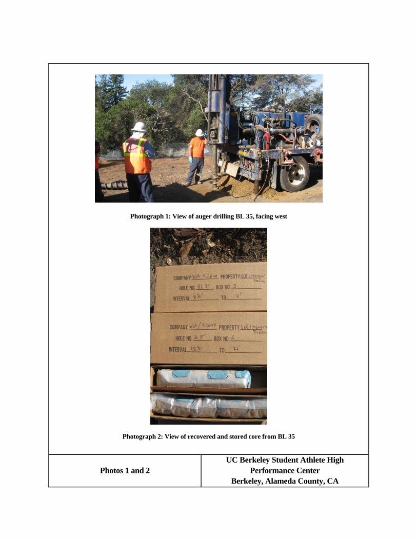
Photograph 1: View of auger drilling BL 35, facing west
Photograph 2: View of recovered and stored core from BL 35
Photos 1 and 2UC Berkeley Student Athlete High
Performance CenterBerkeley, Alameda County, CA
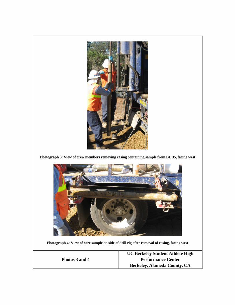
Photograph 3: View of crew members removing casing containing sample from BL 35, facing west
Photograph 4: View of core sample on side of drill rig after removal of casing, facing west
Photos 3 and 4UC Berkeley Student Athlete High
Performance CenterBerkeley, Alameda County, CA
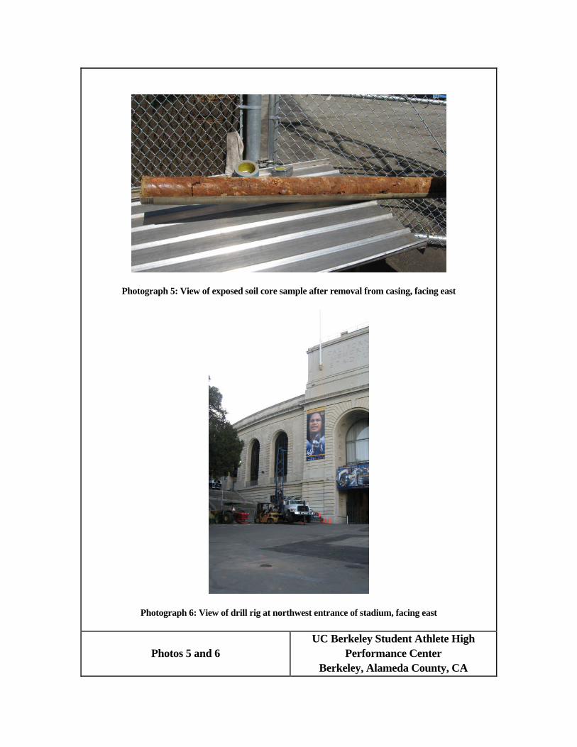
Photograph 5: View of exposed soil core sample after removal from casing, facing east
Photograph 6: View of drill rig at northwest entrance of stadium, facing east
Photos 5 and 6UC Berkeley Student Athlete High
Performance CenterBerkeley, Alameda County, CA

Photograph 7: View of drill rig set up at BL 2 in front of northwest entrance, facing northeast
Photograph 8: View from stairs near northwest entrance showing drilling of BL 2, facing southwest
Photos 7 and 8UC Berkeley Student Athlete High
Performance CenterBerkeley, Alameda County, CA
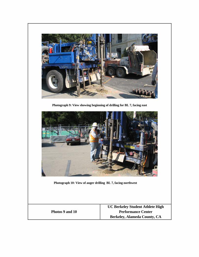
Photograph 9: View showing beginning of drilling for BL 7, facing east
Photograph 10: View of auger drilling BL 7, facing northwest
Photos 9 and 10UC Berkeley Student Athlete High
Performance CenterBerkeley, Alameda County, CA


Appendix CMesa Technical Geoarchaeological Findings

MESA TECHNICAL2630 HILGARD AVENUEBERKELEY, CALIFORNIA 94709-1002 TEL: 510.845.7830
member, American Cultural Resources Association
GEOARCHAEOLOGICAL OBSERVATIONS,AT THE SITE PROPOSED FOR THE STUDENT ATHLETE HIGH PERFORMANCE CENTER,
ADJACENT TO MEMORIAL STADIUM,UNIVERSITY OF CALIFORNIA, BERKELEY, CALIFORNIA
Introduction.
This report presents data obtained from examination of soil andsediment cores drilled at the site of the proposed UC Berkeley studentathlete high performance center, adjacent to the west side of MemorialStadium on the campus. David De Vries, principal and soil scientist,Mesa Technical, examined fifteen cores selected from locations offeringgood geographic coverage over the site, looking in detail at the coresfor any evidence of surface or subsurface archaeological sites.Archaeological evidence would include both positive evidence such asartifacts or midden, and potential evidence such as compacted layers,fire cracked rock, or concentrations of charcoal. Soil and sedimentattributes helpful in developing a perspective upon potential evidenceinclude texture, structure, color, consistence, coarse fragments,mottles and gley, HCl reaction, and the type of lower horizon boundary.
The purpose of the soil examinations was to supplement WSA’s testingprogram with information about the soils and sediments in whicharchaeological evidence might be found. We were interested to knowwhether deeply buried paleosols might be present here, possiblycontaining cultural material. Also, if any cultural remains were to befound, the soils might reveal much about site formation processes andlandscape history.
Methodology:
The core locations were selected by WSA archaeologists. Each core wasdrilled, cut into 2.5 foot lengths to fit the core storage boxes,wrapped in plastic, and delivered to a campus location for examination.We used standard USDA-NRCS field techniques and terminology to describethe horizons within the cores, as detailed below. It is important tonote that no soils or engineering laboratory testing was performed.Thus quantitative characteristics such as texture, percent coarsefragments, and percent gley reported below are estimates rather thanprecise measurements. Likewise, the naming of soil and sedimenthorizons depends upon a consideration and summation of multiplecharacteristics that can be quite subjective. Horizon names reflectthe observer’s interpretation of pedogenic relationships, and that is adifficult thing to know, given the very small sample size availablefrom a core.
MESA TECHNICAL PAGE 2
2630 Hilgard Avenue, Berkeley, California 94709-1002 Tel: 510.845.7830 voice/fax
Soil color was obtained from comparison of a soil sample to the Munsellcharts, and is expressed both as a Munsell name (e.g. “dark grayishbrown”) and as a more precise reference to the hue-value/chroma Munsellcolor chips, for example, “10YR 4/2.” Soil color was observed both dryand wet, where possible, as the difference in Munsell value and chromabetween dry and wet is a useful indicator of organic matter content,and thus in distinguishing A and B horizons. “Moist” color is notedwhen the soil is neither dry nor wet, as when a clay has not yet dried.Texture, plasticity, and stickiness were determined by hand, by rollingor pressing a small soil sample between thumb and forefinger.Stickiness and plasticity are good field indicators of clay content.Texture refers to the overall mix of sand, silt, and clay sized soilparticles. The size and proportional volume of the soil particlesimparts many important physical and chemical properties to the soil.“Sandy loam” and “clay” are examples of two formally defined soiltexture classes having vastly different physical and hydrologicalproperties. Coarse fragments occurring in soil horizons having gravelcontent were estimated by eye, in the case of clay rich horizons, or bythe use of a 2mm screen, in the case of dry, sandy or loamy horizons.
We also have used USDA-NRCS horizon naming conventions, such as “Ab, B,Cg,” etc. in this report. The “A” and “B” designations indicategenetically related surface and subsurface horizons showing evidence ofthe effects of soil forming factors over time. Primarily in these coresthat would be the accumulation of decomposed organic matter and a blackor dark gray color in the “A” horizon, and a higher chroma color, withsimilar or heavier texture in the “B” horizon. The notation “Ab”indicates a former surface horizon that was buried, but is stillevident beneath a younger deposit. Master horizon “C” indicates soilparent material, such as raw sediment, not yet showing discernableevidence of soil formation. The raw alluvium or colluvium fromsuccessive, unrelated depositional events is identified by horizonnames such as “2C”, “3C”, etc., while sucessively deeper buried Ahorizons are noted as “2Ab”, “3Ab”, etc. The suffix “g” as in “Cg”indicates gley, a bluish or greenish cast of the soil matrix caused bysustained, anaerobic, reducing electrochemical conditions. Surfacehorizons named “F,” “F2,” etc. are fill horizons of exotic or off sitematerial, usually high in angular gravel and somewhat alkaline in pHbecause of crushed concrete powder. The words “light” and “heavy”modifying the texture class, as for example, “light clay loam,”indicate less or more clay present than the typical amount upon whichthe texture class is defined, and thus a transitional value to theadjacent coarser or finer textural class.
Augered core samples such as these are subject to mechanical torquethat distorts natural soil structure, and can destroy delicateindicators such as thin lamellae, or weak platy peds. We observed manyinstances of gross spiral fracturing within these core samples, thatresult solely from the augering process, bearing no relationship tonatural soil forming processes. Structure is an important
MESA TECHNICAL PAGE 3
2630 Hilgard Avenue, Berkeley, California 94709-1002 Tel: 510.845.7830 voice/fax
characteristic for interpreting buried surfaces. Nevertheless, we feelthat the distortions of soil structure present in these cores are notso great as to be unable to use structure as an indicator. This isbecause of the cores’ relatively large diameter, as compared to a handauger.
Also, the coring process is fraught with mechanical difficulties,including encountering large buried rocks and perched groundwaterlenses. These difficulties affect our ability to obtain truemeasurements of horizon upper and lower boundaries. There are many“unconformities” in these core samples, reflecting compression of therecord, and sometimes apparent gaps in the record, because of having tochange drill bits or add a new core sleeve. The end result is that thehorizon depths we measured in the lab for this report bear only arather loose conformity to the measurements that might have beenobtained from an undistorted sample such as a trench wall, on site.Nevertheless, though horizons may have been compressed to a largedegree, and small sections may be missing, we believe we have obtainedat least a qualitatively accurate indication of the soils and sedimentspresent.
Core Sample #BL2, examined on 10/14/08.
Location Data: Core #BL2 is in the northwest part of the site. See thedetailed core location map in the primary report.
Profile Data:
F1 0-27 cm. Dark gray (7.5YR 4/1 dry) coarse sand, very darkgray (7.5YR 3/1) wet; structure single grain; consistence:loose, non-sticky, non-plastic; slightly effervescent; coarsefragments: 65% total, 60%< 1 cm sharply angular, 40% 3-6 cmangular; lower boundary clear.
F2 27-129 cm. Brown (7.5YR 4/3 moist) light sandy clay loam, wetcolor not taken; structure strong, fine, subangular blocky;consistence: firm, sticky, plastic; noneffervescent; coarsefragments: 40% total, 1-6 cm sharply angular gravel; mottles:few distinct yellowish red (5YR 5/8) and few distinct paleyellow (2.5Y 7/4); lower boundary clear.
C 129-151 cm. Dark brown (7.5YR 3/2 moist) heavy clay, wetcolor not taken; structure massive; consistence: very firm,sticky, very plastic; noneffervescent; coarse fragments: 1%total, 2-3 mm subangular gravel; mottles: few distinct paleyellow (2.5Y 7/4) and common distinct dark red (2.5YR 4/6);lower boundary abrupt.
2C1 151-187 cm. Dark brown (7.5YR 3/2 moist) clay, wet color not
MESA TECHNICAL PAGE 4
2630 Hilgard Avenue, Berkeley, California 94709-1002 Tel: 510.845.7830 voice/fax
taken; structure weak, very coarse, subangular blocky;consistence: firm, sticky, very plastic; noneffervescent;coarse fragments: none; lower boundary gradual.
2C2 187-242 cm. Brown (7.5YR 4/2 moist) clay, wet color nottaken; structure weak, coarse, angular blocky; consistence:very firm, sticky, very plastic; noneffervescent; coarsefragments: <1%, subrounded; mottles: few distinct pale yellow(2.5Y 7/4); lower boundary gradual.
2C3 242-337 cm. Brown (7.5YR 4/3 moist) heavy clay, wet color nottaken; structure massive; consistence: extremely firm,sticky, very plastic; noneffervescent; coarse fragments:none; mottles: few distinct pale yellow (2.5Y 7/4); lowerboundary not observed.
NOTE: 5 foot gap above horizon 3C, reported on core box.
3C 487-542 cm. Brown (7.5YR 4/3 moist) light sandy clay, wetcolor not taken; structure strong, medium, platy;consistence: firm, sticky, plastic; noneffervescent; coarsefragments: <1%; mottles: few faint pale yellow (2.5Y 7/4);lower boundary gradual.
4C 542-622 cm. Brown (7.5YR 4/2 moist) sandy clay, wet color nottaken; structure massive; consistence: extremely firm,sticky, very plastic; noneffervescent; coarse fragments: 15%total, 2-4 mm subangular gravel; mottles: many distinct paleyellow (2.5Y 7/4) and yellowish red (5YR 5/8); lower boundarynot observed.
Profile comment: Core #BL2 shows two fill horizons with a highpercentage of fresh looking angular gravel and a high sandcontent, lying atop a series of four sediment horizons. Fillhorizons often effervesce with 1N HCl, because of crushedconcrete content, or from calcareous gravel or sand withinthe aggregate. The west side of the Berkeley hills receivesenough leaching precipitation that it would be unlikely forany natural nonagricultural soil to contain carbonate nearthe surface. The clay horizons, by contrast, are heavytextured, mottled, with almost no gravel, and that fine andsubrounded. The lack of gravel and fine texture suggestoverbank deposits of Strawberry Creek. No cultural materialwas observed in this profile.
Core Sample #BL5 examined on 10/03/08.
Location Data: Core #BL5 is in the northwest part of the site. See the
MESA TECHNICAL PAGE 5
2630 Hilgard Avenue, Berkeley, California 94709-1002 Tel: 510.845.7830 voice/fax
detailed core location map in the primary report.
Profile Data:
F1 0-18 cm. Olive brown (2.5Y 4/3 dry) sand, wet color nottaken; structure not taken; consistence: not taken; Note:Horizon consists of asphalt pieces and angular subbase gravelabout 3 cm diameter.
F2 18-60 cm. Very dark grayish brown (10YR 3/2 dry) sandy clayloam, Very dark grayish brown (2.5Y 3/2) wet; structure nottaken; consistence: sticky, plastic; slightly effervescentin places. Note: buried nail at 42 cm.
B 60-125 cm. Dark yellowish brown (10YR 4/4 dry) sandy clayloam, Brown (10YR 4/3) wet; structure weak, medium, granularnear the top, strong, medium, subangular near the bottom;consistence: sticky, slightly plastic; noneffervescent;coarse fragments: 50% total, 2-4 cm subrounded gravel; lowerboundary clear. Note: redwood bark found at 80 cm.
C 125-650 cm. Olive brown (2.5YR 4/4 wet) sandy clay loam,structure weak, coarse, blocky; consistence: sticky,plastic; noneffervescent; coarse fragments: 70% total, 2-4 cmsharply angular fragments of decomposing sandstone; lowerboundary clear.
Ab 650-682 cm. Black (2.5Y 2.5/1 moist) silty clay loam, alsoblack (2.5Y 2.5/1) wet; structure weak, medium, blocky;consistence: slightly sticky, plastic; noneffervescent;coarse fragments: none; mottles: rare distinct lightyellowish brown (2.5Y 6/4) not larger than 2 mm; lowerboundary irregular. Horizon is relatively rich in organicmatter.
2C1 682-802 cm. Very dark grayish brown (2.5Y 3/2 moist) sandyclay loam, also very dark grayish brown (2.5Y 3/2) wet;structure weak, medium, prismatic; consistence: very firm,sticky, plastic; noneffervescent; coarse fragments: 20%total, 3 mm rounded gravel; mottles: rare distinct lightyellowish brown (2.5Y 6/4) not larger than 2 mm; gleyedmatrix is about 50% by volume, dark greenish gray (10GY 4/1);lower boundary gradual.
2C2 802-872+ cm. Brown (7.5Y 4/3 moist) heavy clay, wet color nottaken; structure massive; consistence: very firm, verysticky, very plastic; noneffervescent; coarse fragments: 20%total, 3 mm rounded gravel; mottles: rare distinct lightyellowish brown (2.5Y 6/4) not larger than 2 mm and fewdistinct olive yellow (2.5Y 6/6); lower boundary notobserved.
MESA TECHNICAL PAGE 6
2630 Hilgard Avenue, Berkeley, California 94709-1002 Tel: 510.845.7830 voice/fax
Profile comment: Core #BL5 shows two fill horizons lying atop whatappears to be the B and C horizons of a truncated naturalsoil. Below lies a silty buried A horizon, black and stillshowing some evidence of plant material. This horizon had nogreasy consistence, no smell, no abrupt internal changes instructure or texture that might indicate midden. Below the Ahorizon are two alluvial horizons containing rounded finegravel, a good indicator of stream laid origins. No culturalmaterial was observed in this profile.
Core Sample #BL7 examined on 10/14/08.
Location Data: Core #BL7 is in the northwest part of the site. See thedetailed core location map in the primary report.
Profile Data:
F1 0-16 cm. Brown (10YR 4/3 dry) loamy sand, wet color nottaken; structure single grain; consistence: non sticky, nonplastic; slightly effervescent; coarse fragments: 65% total,sharply angular gravel, 50% 2-5 mm size, 50% 1-3 cm size;boundary abrupt.
F2 16-395 cm. Dark yellowish brown (10YR 4/4 moist) sandy clayloam, wet color not taken; structure moderate, coarse,blocky; consistence: firm, sticky, plastic; non effervescent;coarse fragments: <20%, 2-5 cm angular gravel; mottles: fewdistinct light yellowish brown (2.5Y 6/4); boundary abrupt.
Ab 395-420 cm. Bluish black (5PB 2.5/1 moist) clay loam; colorin uppermost part of horizon is dark greenish gray (10BG4/1); structure weak, medium, blocky; consistence: friable,slightly sticky, very plastic; non effervescent; coarsefragments: 1% rounded 3 mm gravel; mottles: few distinctreddish brown (5YR 4/4); boundary abrupt. Consistence notgreasy; no abrupt texture or structure changes.
Cg 420-480+ cm. Dark greenish gray (5GY 3/1 moist) light sandyclay loam, wet color not taken; structure weak, medium,blocky; consistence: friable, sticky, plastic; noneffervescent; coarse fragments: 20% total, subrounded gravel1-3 cm in size; mottles: common distinct light yellowishbrown (2.5Y 6/4) and few faint reddish brown (5YR 4/4);boundary not observed.
Profile comment: Core #BL7 shows two fill horizons lying atop a buriedA horizon, as indicated by the very dark color, friable
MESA TECHNICAL PAGE 7
2630 Hilgard Avenue, Berkeley, California 94709-1002 Tel: 510.845.7830 voice/fax
consistence, and rounded gravel content. Below the A horizonis a C horizon of parent material, gleyed. No culturalmaterial was observed in this profile.
Core Sample #BL11 examined on 10/14/08.
Location Data: Core #BL11 is in the northwest part of the site. Seethe detailed core location map in the primary report.
Profile Data:
F1 0-26 cm. Brown (10YR 4/3 dry) loamy sand, brown (10YR 4/3)wet; structure single grain; consistence: loose, non sticky,non plastic; slightly effervescent; coarse fragments: 65%total, 40% asphalt pieces 1-4 cm; boundary abrupt.
F2 26-92 cm. Gray (10YR 5/1 dry) sandy clay loam; very dark gray10YR 3/1) wet; structure strong, medium, blocky; consistence:moderately hard, slightly sticky, slightly plastic; stronglyeffervescent; coarse fragments: 65% total, sharply angular 2-3 cm; boundary abrupt.
F3 92-157 cm. Brown (10YR 4/3 dry) sandy clay loam; dark gray10YR 4/1) wet; structure weak, fine, blocky; consistence:firm, sticky, plastic; non effervescent; coarse fragments:30% total, 1 cm angular gravel; mottles: few distinctyellowish red (5YR 5/6); boundary abrupt.
F4 157-200 cm. Brown (10YR 4/3 moist at top of horizon) sandyclay loam; dark gray (10YR 4/1) moist at bottom of horizon;structure strong, medium, blocky; consistence: firm, sticky,plastic; slightly effervescent; coarse fragments: 80% total,sharply angular 5-8 cm in size; mottles: common distinctreddish yellow (5YR 6/8) and olive yellow (2.5Y 6/6);boundary abrupt.
F5 200-701 cm. Dark grayish brown (10YR 4/2 moist) sandy clayloam; wet color not taken; structure weak, fine, subangular,blocky; consistence: firm, slightly sticky, plastic; noneffervescent; coarse fragments: 40% total, sharply angular 3-5 cm in size, also some subrounded fragments in lower part;mottles: common weak light yellowish brown (2.5Y 6/4) andrare dark red (2.5YR 4/6); boundary not observed. Note: Wirefragment at 260 cm. At 606 cm coarse fragments increase to65% and ground water appears.
F6 701-751 cm. Light olive brown (2.5Y 5/3 dry) clay; darkgrayish brown (2.5Y 4/2) wet; structure massive; consistence:sticky, very plastic; non effervescent; coarse fragments: 20%
MESA TECHNICAL PAGE 8
2630 Hilgard Avenue, Berkeley, California 94709-1002 Tel: 510.845.7830 voice/fax
total, sharply angular 1-8 cm in size; mottles: few distinctlight yellowish brown (2.5Y 6/4); boundary clear.
Abg 751-801+ cm. Greenish black (10Y 2.5/1 moist, matrix) heavysandy loam; greenish gray gley (10BG 5/1) moist; structureweak, coarse, blocky; consistence: very firm, slightlysticky, slightly plastic; non effervescent; coarse fragments:20% total, 10% < 2 cm subrounded and 90% sharply angular atextreme lower part of horizon; mottles: few distinct lightyellowish brown (2.5Y 6/4) and rare distinct dark red (2.5YR4/6); 50% gleyed by volume; boundary not observed.
Profile comment: Core #BL11 was drilled in an area of deep fill. Thereare six horizons of fill, 7.5 or more meters deep, lying atopa dark, gleyed, buried A horizon. The A horizon is lighter intexture and much darker in value than horizons above. Also,the angular rock fragments at 8 meters are natural fracturedsandstone rather than aggregate gravel. No cultural materialwas observed in this profile.
Core Sample #BL14 examined on 10/02/08.
Location Data: Core #BL14 is in the northwest part of the site. Seethe detailed core location map in the primary report.
Profile Data:
F1 0-50 cm. Brown (10YR 4/3 dry) clay loam, dark grayish brown(10YR 4/2) wet; structure strong, coarse, granular;consistence: slightly hard, non sticky, plastic; noneffervescent; coarse fragments: 40% total, sharply angular >2cm in size; boundary gradual.
F2 50-100 cm. Brown (10YR 4/3 dry) silty clay loam, also (10YR4/3) wet; structure massive breaking to weak, coarse, blocky;consistence: very hard, sticky, slightly plastic; slightlyeffervescent; coarse fragments: 10% total, sharply angularaveraging 4 cm in size; boundary clear. Note: Horizoncontains subbase aggregate throughout, also with small piecesof brick.
F3g 100-138 cm. Brown (10YR 4/3 dry, matrix, 20%), dark greenishgray (10BG 3/1 dry, gley, 80%) heavy clay loam, dark greenishgray (10GY 4/1) gley wet; structure massive breaking to weak,coarse, blocky; consistence: hard, slightly sticky, plastic;slightly effervescent; coarse fragments: 10% total, sharplyangular 4 cm in size; boundary clear.
F4 138-198 cm. Brown (10YR 4/3 dry) light sandy clay loam, dark
MESA TECHNICAL PAGE 9
2630 Hilgard Avenue, Berkeley, California 94709-1002 Tel: 510.845.7830 voice/fax
grayish brown (10YR 4/2) wet; structure strong, coarse,granular in top 20 cm, massive below; consistence: slightlysticky, plastic; non effervescent; coarse fragments: 10%total, sharply angular 4 cm in size; boundary not observed.
F5 198-248 cm. Dark grayish brown (10YR 4/2 dry) sandy clayloam, also dark grayish brown (10YR 4/2) wet; structurestrong, medium granular, and coarse granular; consistence:friable, sticky, plastic; non effervescent; coarse fragments:25% total, not greater than 3-4 cm in size; boundary notobserved.
F6 248-346 cm. Brown (10YR 4/3 moist) heavy sandy loam, alsobrown (10YR 4/3) wet; structure weak, coarse, blocky;consistence: hard, slightly sticky, slightly plastic; noneffervescent; coarse fragments: 70% total, 4-6 cm encased inclay; boundary not observed.
F7 346-378 cm. Yellowish brown (10YR 5/4 moist) light sandyclay, dark yellowish brown (10YR 4/4) wet; structure massive;consistence: slightly sticky, plastic; non effervescent;coarse fragments: 20% total, 4-6 cm in size encased in clay;boundary abrupt. Note: charcoal at top of horizon andfragment of glazed blue and white patterned potsherd at 378cm.
Abg 378-510 cm. Dark greenish gray (5G 3/1 moist, top 5 cm,bluish black 5B 2.5/1, below) clay, black (N 2.5/-) wet;structure massive; consistence: sticky, plastic; noneffervescent; coarse fragments: <5% increasing with depth to20%; roots present; mottles: few distinct dusky red (2.5YR3/3) and few distinct light olive brown (2.5Y 5/4); boundaryabrupt.
C1g 510-654 cm. Brown (10YR 5/3 moist) heavy clay, wet color ofmatrix not taken; gley color: dark bluish gray (10B 4/1);structure massive; consistence: sticky, very plastic; noneffervescent; coarse fragments: <1%; roots present; mottles:few distinct dusky red (2.5YR 3/3); boundary clear. Note:There is a concentration of charcoal 35 cm below top ofhorizon.
C2g 654-764 cm. Yellowish brown (10YR 5/4 dry) sandy clay, darkgrayish brown (10YR 4/2) wet; gleyed soil 20% by volume darkgreenish gray (10GY 4/1); structure weak, coarse, subangularblocky; consistence: friable, slightly sticky, plastic; noneffervescent; coarse fragments: 25% total, rounded gravel;mottles: few distinct dusky red (2.5YR 3/3); boundarygradual.
C3 764-796+ cm. Light yellowish brown (2.5Y 6/4 dry) sandy clay,
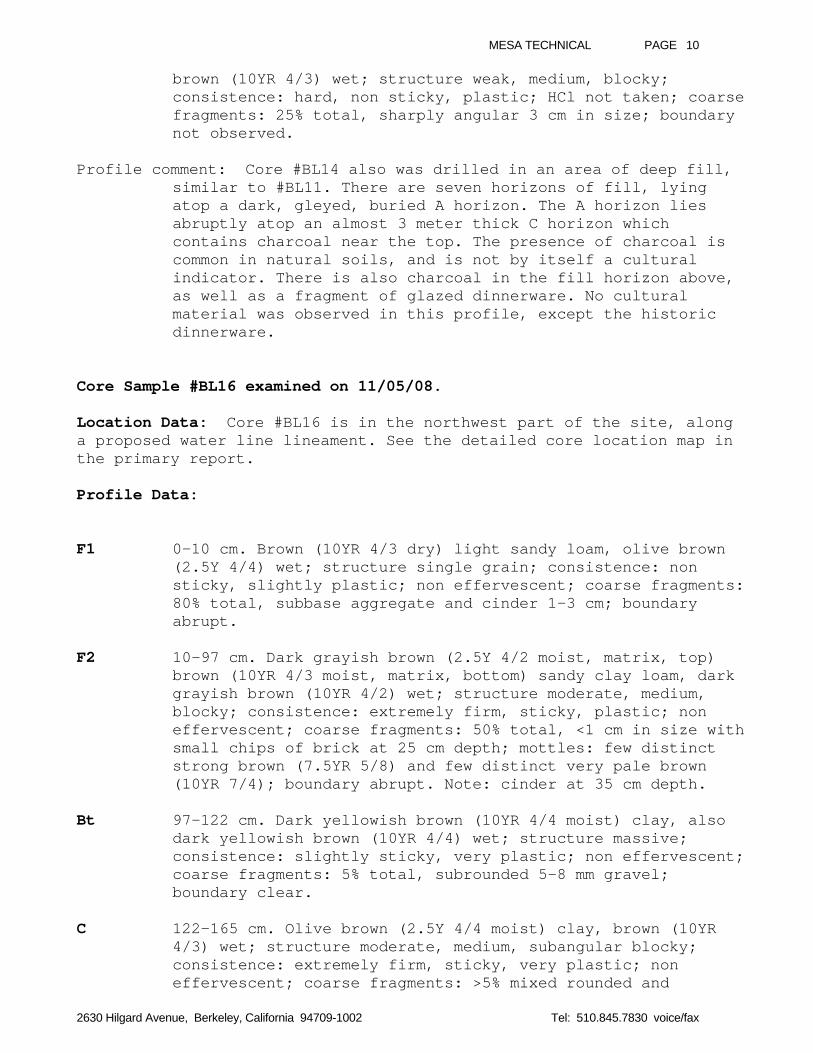
MESA TECHNICAL PAGE 10
2630 Hilgard Avenue, Berkeley, California 94709-1002 Tel: 510.845.7830 voice/fax
brown (10YR 4/3) wet; structure weak, medium, blocky;consistence: hard, non sticky, plastic; HCl not taken; coarsefragments: 25% total, sharply angular 3 cm in size; boundarynot observed.
Profile comment: Core #BL14 also was drilled in an area of deep fill,similar to #BL11. There are seven horizons of fill, lyingatop a dark, gleyed, buried A horizon. The A horizon liesabruptly atop an almost 3 meter thick C horizon whichcontains charcoal near the top. The presence of charcoal iscommon in natural soils, and is not by itself a culturalindicator. There is also charcoal in the fill horizon above,as well as a fragment of glazed dinnerware. No culturalmaterial was observed in this profile, except the historicdinnerware.
Core Sample #BL16 examined on 11/05/08.
Location Data: Core #BL16 is in the northwest part of the site, alonga proposed water line lineament. See the detailed core location map inthe primary report.
Profile Data:
F1 0-10 cm. Brown (10YR 4/3 dry) light sandy loam, olive brown(2.5Y 4/4) wet; structure single grain; consistence: nonsticky, slightly plastic; non effervescent; coarse fragments:80% total, subbase aggregate and cinder 1-3 cm; boundaryabrupt.
F2 10-97 cm. Dark grayish brown (2.5Y 4/2 moist, matrix, top)brown (10YR 4/3 moist, matrix, bottom) sandy clay loam, darkgrayish brown (10YR 4/2) wet; structure moderate, medium,blocky; consistence: extremely firm, sticky, plastic; noneffervescent; coarse fragments: 50% total, <1 cm in size withsmall chips of brick at 25 cm depth; mottles: few distinctstrong brown (7.5YR 5/8) and few distinct very pale brown(10YR 7/4); boundary abrupt. Note: cinder at 35 cm depth.
Bt 97-122 cm. Dark yellowish brown (10YR 4/4 moist) clay, alsodark yellowish brown (10YR 4/4) wet; structure massive;consistence: slightly sticky, very plastic; non effervescent;coarse fragments: 5% total, subrounded 5-8 mm gravel;boundary clear.
C 122-165 cm. Olive brown (2.5Y 4/4 moist) clay, brown (10YR4/3) wet; structure moderate, medium, subangular blocky;consistence: extremely firm, sticky, very plastic; noneffervescent; coarse fragments: >5% mixed rounded and
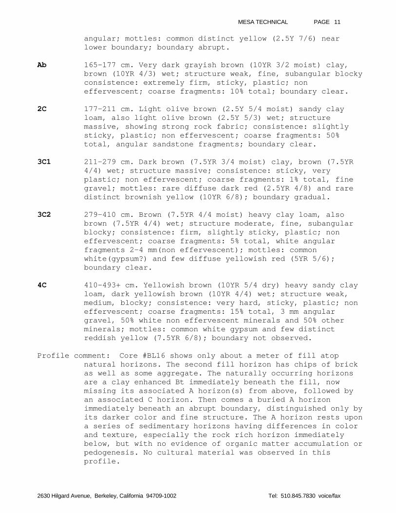
MESA TECHNICAL PAGE 11
2630 Hilgard Avenue, Berkeley, California 94709-1002 Tel: 510.845.7830 voice/fax
angular; mottles: common distinct yellow (2.5Y 7/6) nearlower boundary; boundary abrupt.
Ab 165-177 cm. Very dark grayish brown (10YR 3/2 moist) clay,brown (10YR 4/3) wet; structure weak, fine, subangular blockyconsistence: extremely firm, sticky, plastic; noneffervescent; coarse fragments: 10% total; boundary clear.
2C 177-211 cm. Light olive brown (2.5Y 5/4 moist) sandy clayloam, also light olive brown (2.5Y 5/3) wet; structuremassive, showing strong rock fabric; consistence: slightlysticky, plastic; non effervescent; coarse fragments: 50%total, angular sandstone fragments; boundary clear.
3C1 211-279 cm. Dark brown (7.5YR 3/4 moist) clay, brown (7.5YR4/4) wet; structure massive; consistence: sticky, veryplastic; non effervescent; coarse fragments: 1% total, finegravel; mottles: rare diffuse dark red (2.5YR 4/8) and raredistinct brownish yellow (10YR 6/8); boundary gradual.
3C2 279-410 cm. Brown (7.5YR 4/4 moist) heavy clay loam, alsobrown (7.5YR 4/4) wet; structure moderate, fine, subangularblocky; consistence: firm, slightly sticky, plastic; noneffervescent; coarse fragments: 5% total, white angularfragments 2-4 mm(non effervescent); mottles: commonwhite(gypsum?) and few diffuse yellowish red (5YR 5/6);boundary clear.
4C 410-493+ cm. Yellowish brown (10YR 5/4 dry) heavy sandy clayloam, dark yellowish brown (10YR 4/4) wet; structure weak,medium, blocky; consistence: very hard, sticky, plastic; noneffervescent; coarse fragments: 15% total, 3 mm angulargravel, 50% white non effervescent minerals and 50% otherminerals; mottles: common white gypsum and few distinctreddish yellow (7.5YR 6/8); boundary not observed.
Profile comment: Core #BL16 shows only about a meter of fill atopnatural horizons. The second fill horizon has chips of brickas well as some aggregate. The naturally occurring horizonsare a clay enhanced Bt immediately beneath the fill, nowmissing its associated A horizon(s) from above, followed byan associated C horizon. Then comes a buried A horizonimmediately beneath an abrupt boundary, distinguished only byits darker color and fine structure. The A horizon rests upona series of sedimentary horizons having differences in colorand texture, especially the rock rich horizon immediatelybelow, but with no evidence of organic matter accumulation orpedogenesis. No cultural material was observed in thisprofile.
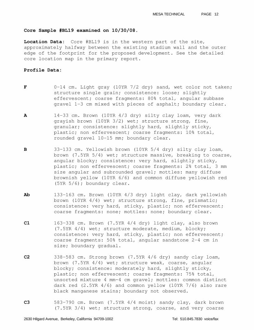
MESA TECHNICAL PAGE 12
2630 Hilgard Avenue, Berkeley, California 94709-1002 Tel: 510.845.7830 voice/fax
Core Sample #BL19 examined on 10/30/08.
Location Data: Core #BL19 is in the western part of the site,approximately halfway between the existing stadium wall and the outeredge of the footprint for the proposed development. See the detailedcore location map in the primary report.
Profile Data:
F 0-14 cm. Light gray (10YR 7/2 dry) sand, wet color not taken;structure single grain; consistence: loose; slightlyeffervescent; coarse fragments: 80% total, angular subbasegravel 1-3 cm mixed with pieces of asphalt; boundary clear.
A 14-33 cm. Brown (10YR 4/3 dry) silty clay loam, very darkgrayish brown (10YR 3/2) wet; structure strong, fine,granular; consistence: slightly hard, slightly sticky,plastic; non effervescent; coarse fragments: 10% total,rounded gravel 10-15 mm; boundary clear.
B 33-133 cm. Yellowish brown (10YR 5/4 dry) silty clay loam,brown (7.5YR 5/4) wet; structure massive, breaking to coarse,angular blocky; consistence: very hard, slightly sticky,plastic; non effervescent; coarse fragments: 2% total, 3 mmsize angular and subrounded gravel; mottles: many diffusebrownish yellow (10YR 6/6) and common diffuse yellowish red(5YR 5/6); boundary clear.
Ab 133-163 cm. Brown (10YR 4/3 dry) light clay, dark yellowishbrown (10YR 4/4) wet; structure strong, fine, prismatic;consistence: very hard, sticky, plastic; non effervescent;coarse fragments: none; mottles: none; boundary clear.
C1 163-338 cm. Brown (7.5YR 4/4 dry) light clay, also brown(7.5YR 4/4) wet; structure moderate, medium, blocky;consistence: very hard, sticky, plastic; non effervescent;coarse fragments: 50% total, angular sandstone 2-4 cm insize; boundary gradual.
C2 338-583 cm. Strong brown (7.5YR 4/6 dry) sandy clay loam,brown (7.5YR 4/4) wet; structure weak, coarse, angularblocky; consistence: moderately hard, slightly sticky,plastic; non effervescent; coarse fragments: 75% total,unsorted mixture 4 mm-4 cm gravel; mottles: common distinctdark red (2.5YR 4/6) and common yellow (10YR 7/6) also rareblack manganese stains; boundary not observed.
C3 583-790 cm. Brown (7.5YR 4/4 moist) sandy clay, dark brown(7.5YR 3/4) wet; structure strong, coarse, and very coarse
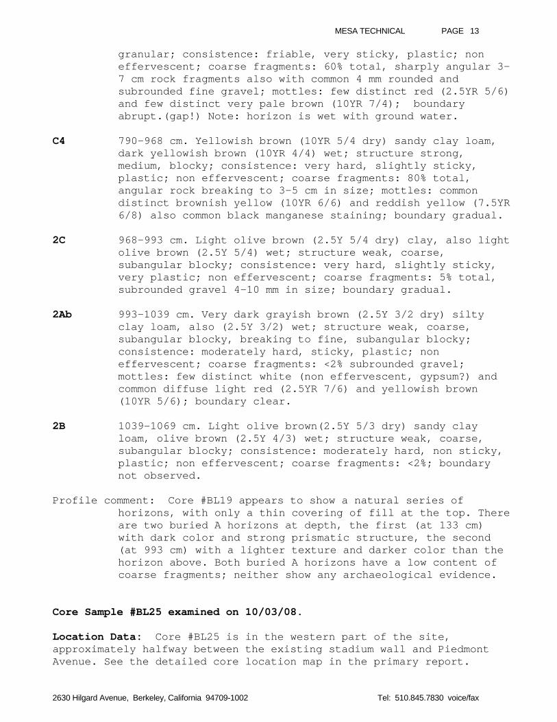
MESA TECHNICAL PAGE 13
2630 Hilgard Avenue, Berkeley, California 94709-1002 Tel: 510.845.7830 voice/fax
granular; consistence: friable, very sticky, plastic; noneffervescent; coarse fragments: 60% total, sharply angular 3-7 cm rock fragments also with common 4 mm rounded andsubrounded fine gravel; mottles: few distinct red (2.5YR 5/6)and few distinct very pale brown (10YR 7/4); boundaryabrupt.(gap!) Note: horizon is wet with ground water.
C4 790-968 cm. Yellowish brown (10YR 5/4 dry) sandy clay loam,dark yellowish brown (10YR 4/4) wet; structure strong,medium, blocky; consistence: very hard, slightly sticky,plastic; non effervescent; coarse fragments: 80% total,angular rock breaking to 3-5 cm in size; mottles: commondistinct brownish yellow (10YR 6/6) and reddish yellow (7.5YR6/8) also common black manganese staining; boundary gradual.
2C 968-993 cm. Light olive brown (2.5Y 5/4 dry) clay, also lightolive brown (2.5Y 5/4) wet; structure weak, coarse,subangular blocky; consistence: very hard, slightly sticky,very plastic; non effervescent; coarse fragments: 5% total,subrounded gravel 4-10 mm in size; boundary gradual.
2Ab 993-1039 cm. Very dark grayish brown (2.5Y 3/2 dry) siltyclay loam, also (2.5Y 3/2) wet; structure weak, coarse,subangular blocky, breaking to fine, subangular blocky;consistence: moderately hard, sticky, plastic; noneffervescent; coarse fragments: <2% subrounded gravel;mottles: few distinct white (non effervescent, gypsum?) andcommon diffuse light red (2.5YR 7/6) and yellowish brown(10YR 5/6); boundary clear.
2B 1039-1069 cm. Light olive brown(2.5Y 5/3 dry) sandy clayloam, olive brown (2.5Y 4/3) wet; structure weak, coarse,subangular blocky; consistence: moderately hard, non sticky,plastic; non effervescent; coarse fragments: <2%; boundarynot observed.
Profile comment: Core #BL19 appears to show a natural series ofhorizons, with only a thin covering of fill at the top. Thereare two buried A horizons at depth, the first (at 133 cm)with dark color and strong prismatic structure, the second(at 993 cm) with a lighter texture and darker color than thehorizon above. Both buried A horizons have a low content ofcoarse fragments; neither show any archaeological evidence.
Core Sample #BL25 examined on 10/03/08.
Location Data: Core #BL25 is in the western part of the site,approximately halfway between the existing stadium wall and PiedmontAvenue. See the detailed core location map in the primary report.
MESA TECHNICAL PAGE 14
2630 Hilgard Avenue, Berkeley, California 94709-1002 Tel: 510.845.7830 voice/fax
Profile Data:
F 0-36 cm. Brown (10YR 4/3 dry) light clay loam, dark brown(10YR 3/3) wet; structure single grain; consistence: slightlysticky, slightly plastic; non effervescent; coarse fragments:40% total, sharply angular 2 cm mixed with rounded 3 mmgravel; boundary clear.
A 36-72 cm. Dark grayish brown (10YR 4/2 dry) sandy loam, verydark grayish brown (10YR 3/2) wet; structure strong, fine,granular; consistence: slightly hard, non sticky, slightlyplastic; non effervescent; coarse fragments: 15% total, bothangular and rounded, rounded gravel coated with organicmatter; roots present; boundary gradual.
Bt 72-153 cm. Brown (10YR 4/3 dry) light silty clay loam, alsobrown (10YR 4/3) wet; structure strong, medium, angularblocky; consistence: very hard, sticky, plastic; noneffervescent; coarse fragments: 1% total; boundary abrupt.
C1 153-196 cm. Dark yellowish brown (10YR 4/4 dry) clay, wetcolor not taken; structure massive; consistence: very hard,very sticky, very plastic; non effervescent; coarsefragments: 2% total, rounded gravel 3-5 mm coated withorganic matter; mottles: few distinct black manganesemottles, also common fine roots; boundary gradual.
C2 196-321 cm. Dark yellowish brown (10YR 4/4 dry) sandy clay,also dark yellowish brown (10YR 4/4) wet; structure weak,medium, blocky; consistence: very hard, sticky, very plastic;non effervescent; coarse fragments: few rounded pebbles;mottles: few distinct yellowish red (5YR 5/6); boundaryclear. Note: at 281 cm charcoal and rounded pebbles.
Ab 321-365 cm. Brown (7.5YR 4/3 moist) heavy clay loam, alsobrown (7.5YR 4/3) wet; structure moderate, medium, prismatic,breaking to strong, medium, blocky; consistence: very firm,sticky, plastic; non effervescent; coarse fragments: none;mottles: common manganese staining, common root casts andpossible charcoal; boundary clear.
2Bt 365-445 cm. Dark yellowish brown (10YR 4/4 moist) clay,yellowish brown (10YR 5/4) wet, crushed; structure moderate,medium, prismatic, breaking to medium, blocky; consistence:firm, slightly sticky, very plastic; non effervescent; coarsefragments: none; mottles: common distinct yellow (10YR 7/6)about 30% by volume, also few distinct yellowish red (5YR5/6) about 5% by volume, also greenish gray gley (10Y 6/1)about 10% by volume; boundary gradual.
MESA TECHNICAL PAGE 15
2630 Hilgard Avenue, Berkeley, California 94709-1002 Tel: 510.845.7830 voice/fax
2C 445-510 cm. Yellowish brown (10YR 5/6 dry) sandy loam, no wetcolor taken; structure not taken; consistence: slightlysticky, plastic; non effervescent; coarse fragments: 40%sandstone fragments; boundary gradual.
R 510-845 cm. Yellowish brown (10YR 5/6 dry) weatheredsandstone; non effervescent; boundary gradual.
2Ab 845-990+ cm. Greenish black (10BG 2.5/1 moist) clay, alsogreenish black (10Y 2.5/-) wet; structure massive;consistence: extremely firm, slightly sticky, very plastic;slightly effervescent; coarse fragments: 10% total, 1-4 cmmixed angular and subrounded gravel; mottles: diffuse lightolive brown (2.5Y 5/6); boundary not observed.
Profile comment: Like core #BL19, Core #BL25 appears to show a naturalseries of horizons, with only a thin covering of fill at thetop. There are two complete A-B-C soils beneath the fill, andthe buried A horizon of a third soil just beneath a rocklayer which may represent a landslide deposit. The topmost Ahorizon contains roots and has a typical granular structure;the second A horizon has a prismatic structure and a lightertexture than horizons above and below; while the lower Ahorizon has a black color and contains some subroundedgravel. This lowest A horizon, a massive black clay, isreminiscent of basin rim black soils such as the Clear Lakeseries or the Pescadero series. No cultural material wasobserved in this profile.
Core Sample #BL30 examined on 11/03/08.
Location Data: Core #BL30 is in the western part of the site, on aproposed water line location near Piedmont Avenue. See the detailedcore location map in the primary report.
Profile Data:
A 0-15 cm. Dark grayish brown (10YR 4/2 dry) loam, very darkbrown (10YR 2/2) wet; structure moderate, very fine, andmedium granular; consistence: slightly hard, non sticky,slightly plastic; non effervescent; coarse fragments: 30%total, 3-10 mm subrounded and rounded gravel, also withglass, leaves and woodchips; boundary clear.
AB 15-60 cm. Brown (10YR 4/3 dry) light clay loam, dark brown(10YR 3/3) wet; structure moderate, medium, subangularblocky; consistence: moderately hard, slightly sticky,plastic; non effervescent; coarse fragments: 10% total, 3-5mm subrounded gravel; boundary gradual.
MESA TECHNICAL PAGE 16
2630 Hilgard Avenue, Berkeley, California 94709-1002 Tel: 510.845.7830 voice/fax
Bt1 60-117 cm. Brown (10YR 4/3 dry) clay, also brown (10YR 5/3)wet; structure weak, medium, blocky; consistence: very hard,sticky, very plastic; non effervescent; coarse fragments: 15%total, sharply angular 3-5 cm in size; mottles: few diffusered (2.5YR 5/6) and common diffuse very pale brown (10YR7/4); boundary clear.
Bt2 117-175 cm. Brown (7.5YR 4/4 wet, matrix) clay, with brown(7.5YR 4/3, dry) clay films coating ped faces; structuremassive and weak, medium, prismatic; consistence: very hard,sticky, plastic; non effervescent; coarse fragments: 20%total, 3 mm to 2 cm angular gravel; mottles: common blackmanganese stains in pores and on ped faces, also common thickreddish clay films on ped faces, also few distinct red (2.5YR5/6) and few distinct very pale brown (10YR 7/4); boundaryabrupt.
BC 175-223 cm. Light yellowish brown (10YR 6/4 dry) sandy clayloam, dark yellowish brown (10YR 4/4) wet; structure strong,fine, blocky; consistence: hard, very sticky, plastic; noneffervescent; coarse fragments: 80% total, yellowishsandstone 2-7 cm angular fragments; mottles: common diffusevery pale brown (10YR 7/4); boundary clear.
C1 223-393 cm. Brown (7.5YR 4/4 dry) sandy clay loam, darkyellowish brown (10YR 4/4) wet; structure strong, fine,subangular blocky; consistence: moderately hard, sticky,plastic; non effervescent; coarse fragments: 50% total,sharply angular sandstone, 4 mm–7 cm, unsorted; mottles: fewyellow (10YR 7/8) near bottom of horizon, also no clay films;boundary clear. Note: horizon contains a thin (7 cm) lens ofgravel.
C2 393-431 cm. Light yellowish brown (10YR 6/4 dry) light sandyclay loam, dark yellowish brown (10YR 4/4) wet; structureweak, coarse, granular; consistence: moderately hard, sticky,plastic; non effervescent; coarse fragments: 70% total, wellsorted, rounded, 3-5 mm gravel; mottles: few distinct red(2.5YR 5/6); boundary clear.
2C 431-471+ cm. Brown (10YR 5/3 dry) light clay, yellowish brown(10YR 5/4) wet; structure weak, medium, prismatic;consistence: hard and very hard, very sticky, plastic; noneffervescent; coarse fragments: 10% total, sharply angularsandstone 3 cm in size; mottles: few distinct red (2.5YR 5/6)and few distinct reddish yellow (7.5YR 7/8) and 50% greenishgray gley (10Y 6/1) by volume; clay films thick brown (7.5YR5/4) coating ped faces near top of horizon; boundary clear.
Profile comment: Core #BL30 shows a natural series of horizons, withno evidence of fill at the top. This is consistent with the
MESA TECHNICAL PAGE 17
2630 Hilgard Avenue, Berkeley, California 94709-1002 Tel: 510.845.7830 voice/fax
cut and fill map for the stadium plans. There is a darksurface horizon with granular structure and loamy texture,transitioning into a deep, clay rich textural B horizon. TwoC horizons containing a high percentage of angular sandstonefragments lie beneath, then an alluvial lens of rounded finegravel, and finally a gleyed reddish clay. No culturalmaterial was observed in this profile.
Core Sample #BL33 examined on 10/28/08.
Location Data: Core #BL33 was obtained from the western part of thesite, close to the southwest wall of Memorial Stadium, at a stormdrainage line. See the detailed core location map in the primaryreport.Profile Data:
F1 0-10 cm. Dark gray (N 4/1 dry) texture not taken, wet colornot taken; structure single grain; very slightlyeffervescent; coarse fragments: 95% total, asphalt; boundaryabrupt.
F2 10-90 cm. Yellowish brown (10YR 5/4 dry) sandy clay loam,brown (10YR 4/3) wet; structure strong, medium, blocky tomassive at bottom of horizon; consistence: very hard,slightly sticky, plastic; slightly effervescent; coarsefragments: 50% total, angular sandstone 1-3 cm in size;mottles: rare distinct dark red (2.5YR 4/6) and rare distinctwhite masses of calcium carbonate 3-5 mm; boundary clear.
Ab 90-120 cm. Brown (10YR 4/3 dry) silt loam, dark brown (10YR3/3) wet; structure massive; consistence: very hard, slightlysticky, plastic; non effervescent; coarse fragments: <1%total, rounded, fine gravel; mottles: none; boundary clear.
C 120-248 cm. Brown (7.5YR 5/4 dry) clay, also brown (7.5YR5/4) wet; structure weak, fine, blocky; consistence: veryhard, sticky, very plastic; non effervescent; coarsefragments: <1% total, rounded, fine gravel; mottles: none;boundary clear.
2Ab 248-308 cm. Brown (10YR 4/3 dry) light sandy clay, yellowishbrown (10YR 5/4) wet; structure moderate, medium, prismatic;consistence: hard, sticky, plastic; non effervescent; coarsefragments: ~2% total, rounded, sandstone gravel; mottles: fewdistinct olive yellow (2.5Y 6/6) and prominent linear blackmanganese deposits along pores and few prominent white(gypsum?) masses; boundary gradual.
B 308-378 cm. Yellowish brown (10YR 5/4 dry) clay, darkyellowish brown (10YR 4/4) wet; structure moderate, fine,
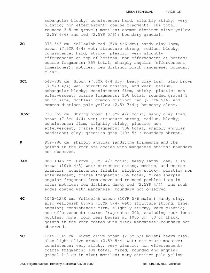
MESA TECHNICAL PAGE 18
2630 Hilgard Avenue, Berkeley, California 94709-1002 Tel: 510.845.7830 voice/fax
subangular blocky; consistence: hard, slightly sticky, veryplastic; non effervescent; coarse fragments: 10% total,rounded 3-5 mm gravel; mottles: common distinct olive yellow(2.5Y 6/6) and red (2.5YR 5/6); boundary gradual.
2C 378-543 cm. Yellowish red (5YR 4/6 dry) sandy clay loam,brown (7.5YR 4/4) wet; structure strong, medium, blocky;consistence: hard, sticky, plastic; very slightlyeffervescent at top of horizon, non effervescent at bottom;coarse fragments: 35% total, sharply angular (effervescent,limestone?); mottles: few distinct black manganese; boundaryclear.
3C1 543-738 cm. Brown (7.5YR 4/4 dry) heavy clay loam, also brown(7.5YR 4/4) wet; structure massive, and weak, medium,subangular blocky; consistence: firm, sticky, plastic; noneffervescent; coarse fragments: 10% total, rounded gravel 3mm in size; mottles: common distinct red (2.5YR 5/6) andcommon distinct pale yellow (2.5Y 7/4); boundary clear.
3C2g 738-952 cm. Strong brown (7.5YR 4/6 moist) sandy clay loam,brown (7.5YR 4/4) wet; structure strong, medium, blocky;consistence: firm, slightly sticky, plastic; noneffervescent; coarse fragments: 50% total, sharply angularsandstone; gley: greenish gray (10Y 5/1; boundary abrupt.
R 952-980 cm. sharply angular sandstone fragments and thejoints in the rock are coated with manganese stains; boundarynot observed.
3Ab 980-1045 cm. Brown (10YR 4/3 moist) heavy sandy loam, alsobrown (10YR 4/3) wet; structure strong, medium, and coarsegranular; consistence: friable, slightly sticky, plastic; noneffervescent; coarse fragments: 65% total, mixed sharplyangular fragments from above and rounded pebbles 1 cm insize; mottles: few distinct dusky red (2.5YR 4/4), and rockedges coated with manganese; boundary not observed.
4C 1045-1240 cm. Yellowish brown (10YR 5/6 moist) sandy clay,also yellowish brown (10YR 5/4) wet; structure strong, fine,angular; consistence: firm, slightly sticky, very plastic;non effervescent; coarse fragments: 20%, excluding rock lens;mottles: none; rock lens begins at 1065 cm, 60 cm thick,joints in the rock coated with black manganese; boundary notobserved.
5C 1245-1349 cm. Light olive brown (2.5Y 5/4 moist) heavy clay,also light olive brown (2.5Y 5/4) wet; structure massive;consistence: very sticky, very plastic; non effervescent;coarse fragments: 10% total, mixed, rounded and angulargravel 1-2 cm in size; mottles: many distinct pale yellow
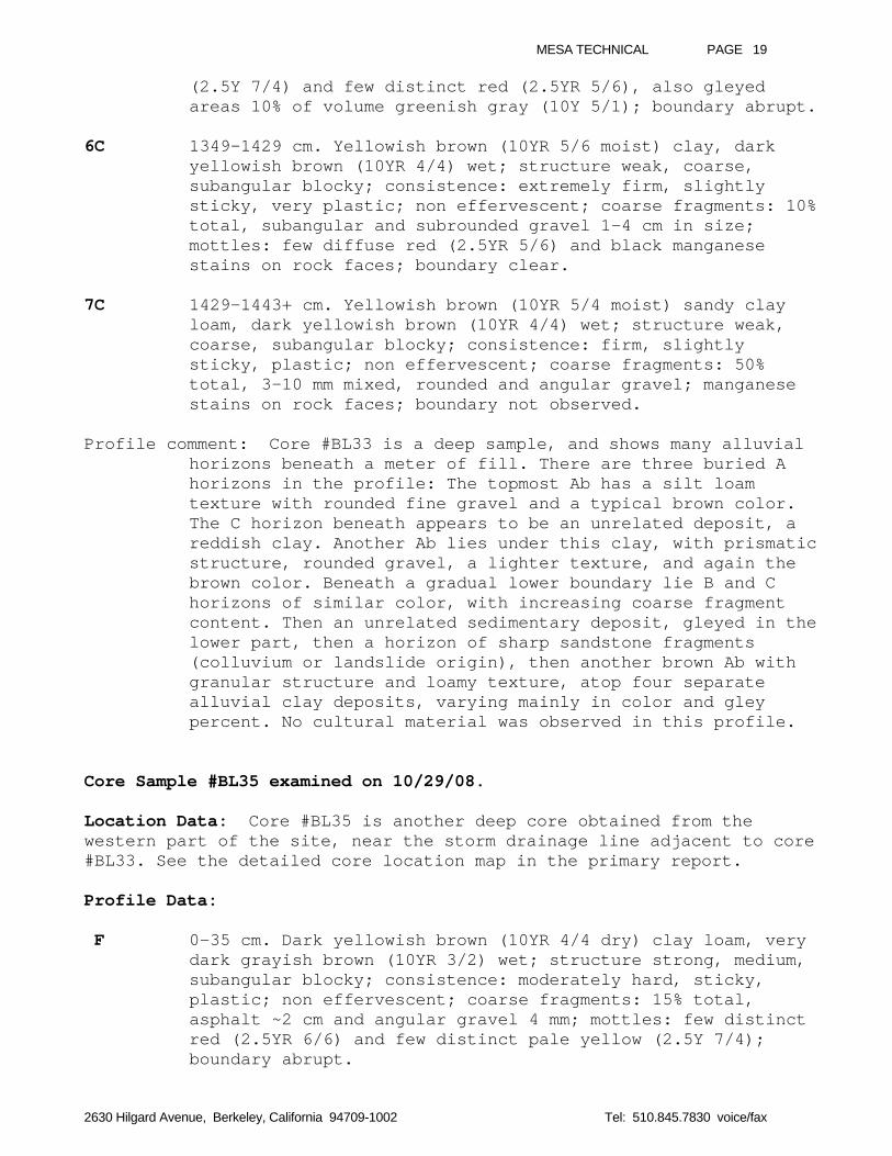
MESA TECHNICAL PAGE 19
2630 Hilgard Avenue, Berkeley, California 94709-1002 Tel: 510.845.7830 voice/fax
(2.5Y 7/4) and few distinct red (2.5YR 5/6), also gleyedareas 10% of volume greenish gray (10Y 5/1); boundary abrupt.
6C 1349-1429 cm. Yellowish brown (10YR 5/6 moist) clay, darkyellowish brown (10YR 4/4) wet; structure weak, coarse,subangular blocky; consistence: extremely firm, slightlysticky, very plastic; non effervescent; coarse fragments: 10%total, subangular and subrounded gravel 1-4 cm in size;mottles: few diffuse red (2.5YR 5/6) and black manganesestains on rock faces; boundary clear.
7C 1429-1443+ cm. Yellowish brown (10YR 5/4 moist) sandy clayloam, dark yellowish brown (10YR 4/4) wet; structure weak,coarse, subangular blocky; consistence: firm, slightlysticky, plastic; non effervescent; coarse fragments: 50%total, 3-10 mm mixed, rounded and angular gravel; manganesestains on rock faces; boundary not observed.
Profile comment: Core #BL33 is a deep sample, and shows many alluvialhorizons beneath a meter of fill. There are three buried Ahorizons in the profile: The topmost Ab has a silt loamtexture with rounded fine gravel and a typical brown color.The C horizon beneath appears to be an unrelated deposit, areddish clay. Another Ab lies under this clay, with prismaticstructure, rounded gravel, a lighter texture, and again thebrown color. Beneath a gradual lower boundary lie B and Chorizons of similar color, with increasing coarse fragmentcontent. Then an unrelated sedimentary deposit, gleyed in thelower part, then a horizon of sharp sandstone fragments(colluvium or landslide origin), then another brown Ab withgranular structure and loamy texture, atop four separatealluvial clay deposits, varying mainly in color and gleypercent. No cultural material was observed in this profile.
Core Sample #BL35 examined on 10/29/08.
Location Data: Core #BL35 is another deep core obtained from thewestern part of the site, near the storm drainage line adjacent to core#BL33. See the detailed core location map in the primary report.
Profile Data:
F 0-35 cm. Dark yellowish brown (10YR 4/4 dry) clay loam, verydark grayish brown (10YR 3/2) wet; structure strong, medium,subangular blocky; consistence: moderately hard, sticky,plastic; non effervescent; coarse fragments: 15% total,asphalt ~2 cm and angular gravel 4 mm; mottles: few distinctred (2.5YR 6/6) and few distinct pale yellow (2.5Y 7/4);boundary abrupt.
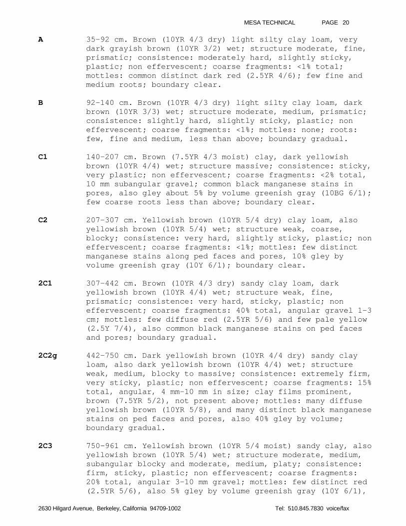
MESA TECHNICAL PAGE 20
2630 Hilgard Avenue, Berkeley, California 94709-1002 Tel: 510.845.7830 voice/fax
A 35-92 cm. Brown (10YR 4/3 dry) light silty clay loam, verydark grayish brown (10YR 3/2) wet; structure moderate, fine,prismatic; consistence: moderately hard, slightly sticky,plastic; non effervescent; coarse fragments: <1% total;mottles: common distinct dark red (2.5YR 4/6); few fine andmedium roots; boundary clear.
B 92-140 cm. Brown (10YR 4/3 dry) light silty clay loam, darkbrown (10YR 3/3) wet; structure moderate, medium, prismatic;consistence: slightly hard, slightly sticky, plastic; noneffervescent; coarse fragments: <1%; mottles: none; roots:few, fine and medium, less than above; boundary gradual.
C1 140-207 cm. Brown (7.5YR 4/3 moist) clay, dark yellowishbrown (10YR 4/4) wet; structure massive; consistence: sticky,very plastic; non effervescent; coarse fragments: <2% total,10 mm subangular gravel; common black manganese stains inpores, also gley about 5% by volume greenish gray (10BG 6/1);few coarse roots less than above; boundary clear.
C2 207-307 cm. Yellowish brown (10YR 5/4 dry) clay loam, alsoyellowish brown (10YR 5/4) wet; structure weak, coarse,blocky; consistence: very hard, slightly sticky, plastic; noneffervescent; coarse fragments: <1%; mottles: few distinctmanganese stains along ped faces and pores, 10% gley byvolume greenish gray (10Y 6/1); boundary clear.
2C1 307-442 cm. Brown (10YR 4/3 dry) sandy clay loam, darkyellowish brown (10YR 4/4) wet; structure weak, fine,prismatic; consistence: very hard, sticky, plastic; noneffervescent; coarse fragments: 40% total, angular gravel 1-3cm; mottles: few diffuse red (2.5YR 5/6) and few pale yellow(2.5Y 7/4), also common black manganese stains on ped facesand pores; boundary gradual.
2C2g 442-750 cm. Dark yellowish brown (10YR 4/4 dry) sandy clayloam, also dark yellowish brown (10YR 4/4) wet; structureweak, medium, blocky to massive; consistence: extremely firm,very sticky, plastic; non effervescent; coarse fragments: 15%total, angular, 4 mm-10 mm in size; clay films prominent,brown (7.5YR 5/2), not present above; mottles: many diffuseyellowish brown (10YR 5/8), and many distinct black manganesestains on ped faces and pores, also 40% gley by volume;boundary gradual.
2C3 750-961 cm. Yellowish brown (10YR 5/4 moist) sandy clay, alsoyellowish brown (10YR 5/4) wet; structure moderate, medium,subangular blocky and moderate, medium, platy; consistence:firm, sticky, plastic; non effervescent; coarse fragments:20% total, angular 3-10 mm gravel; mottles: few distinct red(2.5YR 5/6), also 5% gley by volume greenish gray (10Y 6/1),
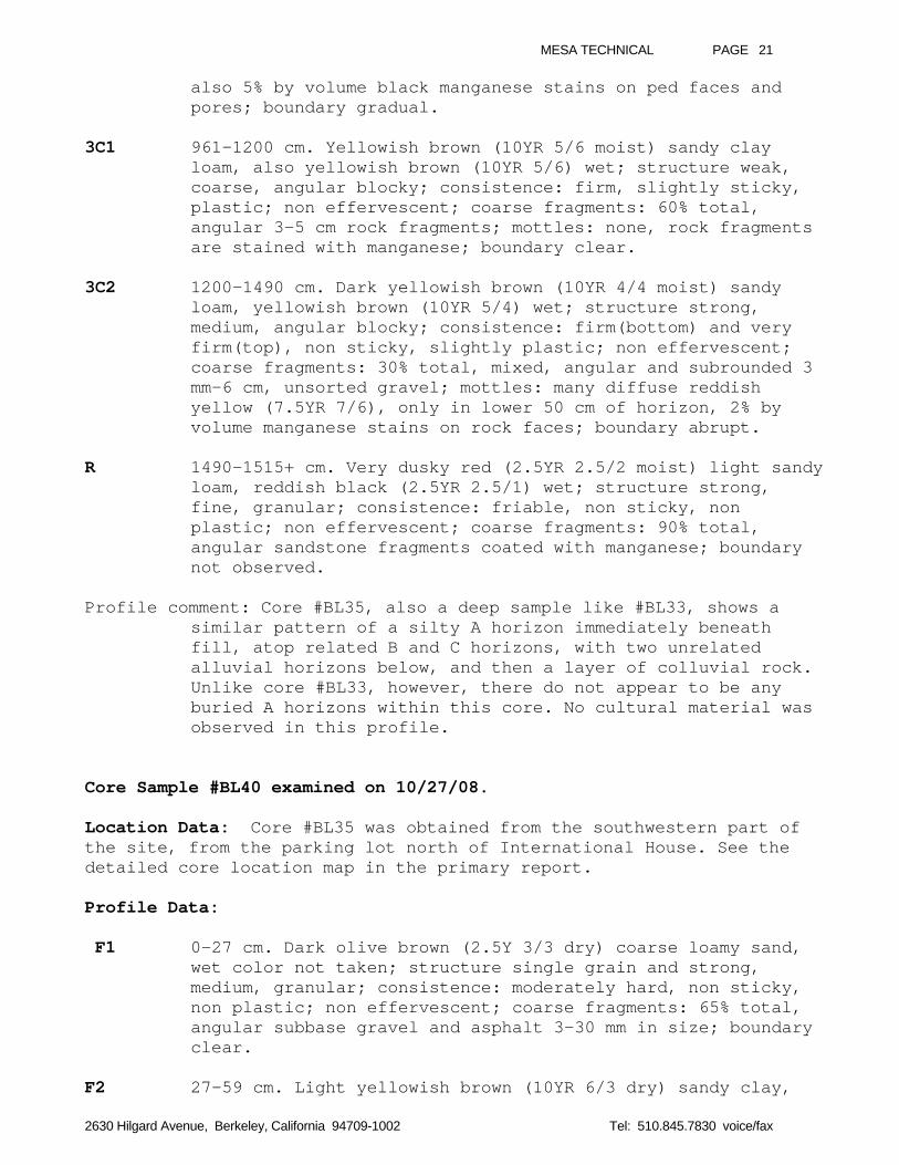
MESA TECHNICAL PAGE 21
2630 Hilgard Avenue, Berkeley, California 94709-1002 Tel: 510.845.7830 voice/fax
also 5% by volume black manganese stains on ped faces andpores; boundary gradual.
3C1 961-1200 cm. Yellowish brown (10YR 5/6 moist) sandy clayloam, also yellowish brown (10YR 5/6) wet; structure weak,coarse, angular blocky; consistence: firm, slightly sticky,plastic; non effervescent; coarse fragments: 60% total,angular 3-5 cm rock fragments; mottles: none, rock fragmentsare stained with manganese; boundary clear.
3C2 1200-1490 cm. Dark yellowish brown (10YR 4/4 moist) sandyloam, yellowish brown (10YR 5/4) wet; structure strong,medium, angular blocky; consistence: firm(bottom) and veryfirm(top), non sticky, slightly plastic; non effervescent;coarse fragments: 30% total, mixed, angular and subrounded 3mm-6 cm, unsorted gravel; mottles: many diffuse reddishyellow (7.5YR 7/6), only in lower 50 cm of horizon, 2% byvolume manganese stains on rock faces; boundary abrupt.
R 1490-1515+ cm. Very dusky red (2.5YR 2.5/2 moist) light sandyloam, reddish black (2.5YR 2.5/1) wet; structure strong,fine, granular; consistence: friable, non sticky, nonplastic; non effervescent; coarse fragments: 90% total,angular sandstone fragments coated with manganese; boundarynot observed.
Profile comment: Core #BL35, also a deep sample like #BL33, shows asimilar pattern of a silty A horizon immediately beneathfill, atop related B and C horizons, with two unrelatedalluvial horizons below, and then a layer of colluvial rock.Unlike core #BL33, however, there do not appear to be anyburied A horizons within this core. No cultural material wasobserved in this profile.
Core Sample #BL40 examined on 10/27/08.
Location Data: Core #BL35 was obtained from the southwestern part ofthe site, from the parking lot north of International House. See thedetailed core location map in the primary report.
Profile Data:
F1 0-27 cm. Dark olive brown (2.5Y 3/3 dry) coarse loamy sand,wet color not taken; structure single grain and strong,medium, granular; consistence: moderately hard, non sticky,non plastic; non effervescent; coarse fragments: 65% total,angular subbase gravel and asphalt 3-30 mm in size; boundaryclear.
F2 27-59 cm. Light yellowish brown (10YR 6/3 dry) sandy clay,
MESA TECHNICAL PAGE 22
2630 Hilgard Avenue, Berkeley, California 94709-1002 Tel: 510.845.7830 voice/fax
dark yellowish brown (10YR 4/4) wet; structure weak, coarse,blocky; consistence: very hard, sticky, very plastic; noneffervescent; coarse fragments: 10% total, angular sandstone10 mm in size; mottles: common distinct strong brown (7.5YR5/6) and black (7.5 2.5/1); boundary abrupt.
C1 59-95 cm. Dark brown (7.5Y 3/2 wet, upper part) clay,yellowish brown (10YR 5/4 wet, lower part); structuremassive; consistence: not taken; non effervescent; coarsefragments: <2% total; mottles: common distinct linear darkred (2.5YR 4/8); boundary clear.
C2g 95-136 cm. Dark yellowish brown (10YR 4/4 moist) light clay,brown (10YR 4/3) wet; structure moderate, medium, platy;consistence: firm, sticky, very plastic; non effervescent;coarse fragments: <2% total; gleyed matrix 10% by volumegreenish gray (5G 5/1); boundary clear.
Ab 136-172 cm. Dark yellowish brown (10YR 4/4 moist) light clay,also dark yellowish brown (10YR 4/4) wet; structure strong,medium, prismatic; consistence: extremely firm, very sticky,plastic; non effervescent; coarse fragments: 5% total, 3-10mm subrounded gravel; mottles: common black (10YR 2/1)manganese stains; boundary gradual.
B 172-220 cm. Reddish yellow (7.5YR 7/6 moist) heavy sandy clayloam, strong brown (7.5YR 4/6) wet; structure strong, medium,and coarse granular; consistence: firm, sticky, plastic; noneffervescent; coarse fragments: none; no mottles, no gley;boundary not observed.
2C 220- 274+ cm. Light yellowish brown (10YR 6/4 dry) sandyclay, brown (7.5YR 4/3) wet; structure massive; consistence:very sticky, very plastic; non effervescent; coarsefragments: 5% total, 3 mm size subrounded gravel and angularsandstone pieces; mottles: many distinct pale red (2.5YR 7/4)and dark red (2.5YR 4/6) and brownish yellow (10YR 6/8);boundary not observed.
Profile comment: Core #BL40 shows two horizons of fill material over atruncated natural soil, only the C horizon now present.Beneath the C2g is a buried A horizon with strong prismaticstructure and subrounded gravel present. No cultural materialwas observed in this profile.
Core Sample #BL42 examined on 10/01/08.
Location Data: Core #BL42 was obtained from the southwestern part ofthe site, approximately 30 meters north of International House’s northwing. See the detailed core location map in the primary report.
MESA TECHNICAL PAGE 23
2630 Hilgard Avenue, Berkeley, California 94709-1002 Tel: 510.845.7830 voice/fax
Profile Data:
F 0-18 cm. Dark yellowish brown (10YR 4/4 dry) light clay loam,dark grayish brown (10YR 4/2) wet; structure weak, fine,granular; consistence: slightly sticky, plastic; noneffervescent; coarse fragments: 65% total, subangularaggregate base gravel, also flower pot fragments; boundaryclear.
Bt1 18-82 cm. Dark brown (10YR 3/3 dry) clay loam, very darkgrayish brown (10YR 3/2) wet; structure moderate, medium,prismatic; consistence: hard, sticky, plastic; noneffervescent; coarse fragments: 5% total, sandstonefragments; mottles: none; boundary clear.
Bt2 82-103 cm. Yellowish brown (10YR 5/6 dry, sandy coating onpeds), dark yellowish brown (10YR 4/4 dry, ped interiors),clay, brown (10YR 4/3) wet, crushed; structure weak, coarse,angular blocky; consistence: very hard, sticky, very plastic;non effervescent; coarse fragments: none; mottles: reddishyellow (7.5YR 6/8 dry, mineral rind); boundary abrupt.
Ab 103-163 cm. Dark brown (10YR 3/3 dry) clay loam, very darkbrown (10YR 2/2) wet; structure weak, coarse, angular blocky;consistence: very hard, slightly sticky, plastic; noneffervescent; coarse fragments: none; mottles: none; boundarygradual.
C 163-285 cm. Yellowish brown (10YR 5/4 dry) heavy clay, darkyellowish brown (10YR 4/4) wet; structure massive;consistence: not taken; non effervescent; coarse fragments:1% total, 2-4 mm rounded; mottles: none; gley: 10% by volumegreenish gray (5G 6/1) dry; boundary abrupt.
2C 285-390 cm. Yellowish brown (10YR 5/4 dry) light clay, alsoyellowish brown (10YR 5/4) wet; structure moderate, medium,subangular blocky; consistence: hard, slightly sticky,plastic; non effervescent; coarse fragments: 1% total, 2-3 mmrounded gravel; mottles: none; gley: 2% by volume greenishgray (10Y 5/1) dry; boundary gradual.
3C1 390-425 cm. Dusky red (2.5YR 4/4 dry) clay, also dusky red(2.5YR 3/4) wet and reddish brown (5YR 4/4) wet; structuremassive; consistence: sticky, very plastic; non effervescent;coarse fragments: none; mottles: common brownish yellow (10YR6/6) and few dark red (2.5YR 4/8); boundary clear.
3C2 425-595 cm. Dusky red (2.5YR 4/4 dry) sandy clay loam, alsodusky red (2.5YR 3/4) wet; structure strong, moderate,prismatic, breaking to strong, coarse, angular blocky;
MESA TECHNICAL PAGE 24
2630 Hilgard Avenue, Berkeley, California 94709-1002 Tel: 510.845.7830 voice/fax
consistence: hard, sticky, plastic; effervescent not taken;coarse fragments: 10% total, 2-5 mm angular white gravel;mottles: few distinct black manganese masses 1 mm diameter;boundary clear.
2Ab 595-692 cm. Dark yellowish brown (10YR 4/4 dry) extremelygravelly heavy sandy loam, very dark grayish brown (10YR 3/2)wet; structure strong, medium, blocky; consistence: friable,slightly sticky, plastic; non effervescent; coarse fragments:60% total, sharply angular 1-5 cm sandstone; mottles: fewdistinct black manganese masses 1-2 mm size; boundarygradual.
C 692-760 cm. Dark yellowish brown (10YR 4/4 dry) loamy sand,also dark yellowish brown (10YR 4/4) wet; structure singlegrain; consistence: non sticky, non plastic; noneffervescent; coarse fragments: 20% total, sharply angular 5-10 mm; mottles: rare black manganese masses; boundary abrupt.
3Ab 760-885 cm. Strong brown (7.5YR 4/6 dry) extremely gravellyheavy sandy loam. Note: other properties very similar tohorizon 2Ab above.
3Bt 885-970 cm. Yellowish brown (10YR 5/6 dry) clay loam, darkyellowish brown (10YR 4/4) wet; structure massive;consistence: slightly sticky, plastic; non effervescent;coarse fragments: <2% total; mottles: none; boundary clear.
4Abg 970-1055+ cm. Brown (7.5YR 5/4 dry) loam (near top) and verygravelly loam (near bottom), wet color not taken; structureweak, medium, prismatic, grading to moderate, medium, blocky;consistence: not taken; effervescence not taken; coarsefragments: increase from 10% to 50% with depth, coated withclay films and manganese; mottles: common black manganesestains on coarse fragment surfaces; gleyed matrix darkgreenish gray (10Y 4/1) in last 25 cm depth; boundary notobserved.
Profile comment: Core #BL42 shows a thin horizon of fill over atruncated natural soil, only the Bt horizon now present.Buried beneath the Bt2 is a dark colored A horizon with agradual boundary into its related parent material. Thenfollows an abrupt transition to a yellowish brown clay withmoderate structure, then a transition to a red clay. Weintrepret the brown clay and the red clay as two separatealluvial deposits. Beneath are two buried A horizons, orperhaps one thick horizon which includes a 70cm sand lens.However, the lower 3Ab has a more reddish color than the 2Ab,so it is probably older or has developed in parent materialof slightly redder hue. A Bt of heavier texture lies beneaththe lower member, and finally, a buried A showing prismatic
MESA TECHNICAL PAGE 25
2630 Hilgard Avenue, Berkeley, California 94709-1002 Tel: 510.845.7830 voice/fax
structure and a lighter texture. No cultural material wasobserved in this profile.
Core Sample #BL45 examined on 11/04/08.
Location Data: Core #BL45 was obtained from the southwestern part ofthe site, close to the stadium wall. See the detailed core location mapin the primary report.
Profile Data:
F1 0-11 cm. Olive brown (2.5Y 4/3 dry) texture not taken, wetcolor not taken; structure single grain and strong, fine,granular; consistence: slightly hard; non effervescent;coarse fragments: 80% total, subbase aggregate 2-4 cm;boundary clear.
F2 11-52 cm. Olive brown (2.5Y 4/3 dry) sandy clay, light olivebrown (2.5Y 5/3) wet; structure massive; consistence: verysticky, plastic; non effervescent; coarse fragments: 50%total, angular sybbase gravel 4-10 mm size; mottles: none;boundary abrupt.
C 52-396 cm. Light olive brown (2.5Y 5/4 dry) clay, also lightolive brown (2.5Y 5/4) wet; structure moderate, medium,subangular blocky; consistence: very hard, sticky, veryplastic; non effervescent; coarse fragments: 5% total,angular gravel 3-10 mm; mottles: rare distinct yellowish red(5YR 4/6) and common diffuse pale yellow (2.5Y 7/4); boundarygradual.
2C 396-603 cm. Brown (7.5YR 4/3 dry) light clay, wet color nottaken; structure weak, medium, subangular blocky;consistence: hard, sticky, plastic; non effervescent; coarsefragments: 2% total, angular gravel 3-10 mm; mottles: raredistinct yellowish red (5YR 4/6); boundary gradual.
Abg 603-715 cm. Dark yellowish brown (10YR 4/4 moist) sandy clayloam, brown (10YR 4/3) wet; structure strong, coarse,subangular blocky, breaking to fine, subangular blocky;consistence: friable, sticky, plastic; non effervescent;coarse fragments: 20% total, rounded gravel 5-15 mm; mottles:few diffuse weak red (2.5YR 5/4); gley: greenish gray (10GY5/1); boundary clear.
3C 715-910 cm. Strong brown (7.5YR 5/6 dry) heavy sandy clayloam, brown (7.5YR 4/4) wet; structure weak, medium, blocky;consistence: very hard, sticky, plastic; non effervescent;coarse fragments: 40% total, angular gravel 10 mm size;mottles: common distinct yellow (10YR 7/6) and common diffuse
MESA TECHNICAL PAGE 26
2630 Hilgard Avenue, Berkeley, California 94709-1002 Tel: 510.845.7830 voice/fax
red (2.5YR 5/6); gley: none; boundary clear.
4C 910-1122 cm. Yellowish brown (10YR 5/4 moist) heavy sandyloam, also yellowish brown (10YR 5/4) wet; structure weak,medium, blocky; consistence: extremely firm, non sticky,slightly plastic; non effervescent; coarse fragments: 30%total, angular sandstone pieces 9-10 cm; mottles: none; gley:none; boundary clear.
5C 1122-1237 cm. Dark reddish brown (5YR 3/3 moist) clay, brown(7.5YR 4/4) wet; structure strong, fine, angular blocky;consistence: extremely firm, sticky, very plastic; noneffervescent; coarse fragments: 10% total, angular 4-10 mm;mottles: common diffuse red (2.5YR 5/6) and black manganesstain on faces of coarse fragments; gley: 10% by volume darkgreenish gray (10Y 4/1); boundary clear.
6C 1237-1252+ cm. Dark yellowish brown (10YR 4/4 moist) clay,yellowish brown (10YR 5/4) wet; structure massive;consistence: sticky, very plastic; non effervescent; coarsefragments: 5% total, subrounded; mottles: none; gley: none;boundary not observed.
Profile comment: Core #BL45 again shows a thin veneer of fill over atruncated natural soil, abruptly covering the topmost Chorizon. Buried beneath the olive brown clay C is a morereddish 2C of lighter texture. Just below is a gleyed Abgwith strong structure, friable consistence, lighter texture,and rounded gravel, unlike horizons above and below. Belowthe Abg are four sedimentary horizons with mostly angularcoarse fragments, still unrounded by stream transport, andvarying degrees of high value and chroma, indicating noaccumulation of surface organic matter. The 5C horizon comesclose to approximating another buried A horizon, but weinterpret it as having too heavy a texture and too firm amoist consistence to be a buried A. No cultural material wasobserved in this profile.
Core Sample #BL47 examined on 10/16/08.
Location Data: Core #BL47 was obtained from the southwestern part ofthe site, again fairly close to the stadium wall. See the detailed corelocation map in the primary report.
Profile Data:
F 0-15 cm. Very dark grayish brown (10YR 3/2 moist) coarsesand, wet color not taken; structure single grain;consistence: non sticky, non plastic; slightly effervescent;coarse fragments: 85% total, angular gravel 4 cm, also 30%
MESA TECHNICAL PAGE 27
2630 Hilgard Avenue, Berkeley, California 94709-1002 Tel: 510.845.7830 voice/fax
cinder; boundary clear.
Bt 15-85 cm. Dark yellowish brown (10YR 4/4 dry) sandy clay,brown (10YR 4/3) wet; structure massive; consistence: sticky,very plastic; non effervescent; coarse fragments: 10% total,3-5 mm subrounded fine gravel; mottles: few distinct dark red(2.5YR 4/6) and few distinct reddish yellow (5YR 6/8); gley:in top 12 cm of horizon, no gley in rest; boundary gradual.
C1 85-190 cm. Yellowish brown (10YR 5/4 dry) heavy sandy clayloam, dark yellowish brown (10YR 4/4) wet; structure weak,medium, blocky; consistence: sticky, plastic; noneffervescent; coarse fragments: 10% total, 3-5 mm subroundedgravel; mottles: common weak olive yellow (2.5Y 6/6) and raredistinct yellowish red (5YR 4/6); gley: none; boundary clear.
C2g 190-245 cm. Yellowish brown (10YR 5/4 dry) texture not taken,light olive brown (2.5Y 5/4) wet; structure moderate, medium,prismatic; consistence: moderately hard, very sticky,plastic; non effervescent; coarse fragments: none; mottles:none; gley: 40% by volume, dark greenish gray (10Y 4/1);boundary clear.
C3 245-417 cm. Yellowish brown (10YR 5/4 dry) clay, darkyellowish brown (10YR 4/4) wet; structure weak, coarse,blocky; consistence: hard, sticky, plastic; non effervescent;coarse fragments: 2% total, 4 mm mixed subrounded and angulargravel; mottles: few distinct olive yellow (2.5Y 6/6); gley:none; boundary clear.
2C 417-492 cm. Dark yellowish brown (10YR 4/4 moist) silty clayloam, also dark yellowish brown (10YR 4/4) wet; structuremoderate, medium, blocky; consistence: firm, slightly sticky,plastic; non effervescent; coarse fragments: 60% total,mixed, rounded and sharply angular, greater than 9 cm size;mottles: few distinct olive yellow (2.5Y 6/6) and raredistinct yellowish red (5YR 4/6); gley: none; boundary clear.
3C 492-550 cm. Dark yellowish brown (10YR 4/4 moist) clay, alsodark yellowish brown (10YR 4/4) wet; structure massive;consistence: very sticky, plastic; non effervescent; coarsefragments: 1% total, angular 1 cm maximum size; mottles: raredistinct brown (7.5YR 4/3) and rare distinct strong brown(7.5YR 5/8); gley: none; boundary clear.
4C 550-670 cm. Dark yellowish brown (10YR 4/4 moist) sandy clayloam, also dark yellowish brown (10YR 4/4) wet; structuremoderate, medium, subangular blocky; consistence: firm,sticky, plastic; non effervescent; coarse fragments: 50%total, mixed, rounded and angular 7 cm maximum size; mottles:few distinct pale yellow (2.5Y 8/3); boundary clear. Note:
MESA TECHNICAL PAGE 28
2630 Hilgard Avenue, Berkeley, California 94709-1002 Tel: 510.845.7830 voice/fax
horizon contains a 22 cm thick clay lens at 48 cm depth; claycolor is strong brown (7.5YR 5/6) moist; lens coarsefragments: 15%; lens mottles: many distinct light yellowishbrown (2.5Y 6/4) and yellowish red (5YR 4/6).
5C 670-807 cm. Strong brown (7.5YR 4/6 moist) sandy loam, alsostrong brown (7.5YR 4/6) wet; structure strong, medium,subangular blocky; consistence: friable, slightly sticky,plastic; non effervescent; coarse fragments: 10% total, 5 mm-3 cm subrounded gravel; mottles: none; gley: none; boundaryabrupt.
6C1 807-842 cm. Yellowish brown (10YR 5/6 dry) sandy clay loam,also yellowish brown (10YR 5/4) wet; structure strong, fine,blocky; consistence: slightly sticky, plastic; noneffervescent; coarse fragments: 90% total, angular sandstonepieces as large as 8 cm diameter; mottles: rare distinctreddish brown (5YR 4/4); gley: none; boundary clear.
6C2 842-907+ cm. Dark yellowish brown (10YR 4/4 moist) sandy clayloam, yellowish brown (10YR 5/4) wet; structure strong, fine,subangular blocky, and strong, coarse, granular; consistence:sticky, plastic; non effervescent; coarse fragments: 50%total, angular sandstone pieces 2-5 cm; mottles: few distinctdark reddish gray (5YR 4/2); boundary not observed.
Profile comment: Core #BL47, like #BL45, was drilled on the location ofthe Piedmont Plaza cut, and shows a thin veneer of sandy fillover a truncated clayey natural soil. Buried beneath thesandy clay Bt is a thick C horizon subdivided into threeparts, the middle one (C2g) gleyed because of groundwaterperching for long periods atop the more heavy textured C3.Below are alternating horizons with more or less gravelcontent, but none showing evidence of organic matterenrichment that might indicate an Ab. No cultural materialwas observed in this profile.