Embed Size (px)
Citation preview
Guide to the Geology of the Columbiaand Waterloo Area, Monroe County, Illinois
/
|;
Field Trip Guidebook 1997AApril 19, 1997
jjDepartment of Natural Resources « ,°
I ILLINOIS STATE GEOLOGICAL SURVEY
••

Digitized by the Internet Archive
in 2012 with funding from
University of Illinois Urbana-Champaign
http://archive.org/details/guidetogeolo1997an
Guide to the Geology of the Columbia andWaterloo Area, Monroe County, Illinois
W.T. Frankie, D.A. Grimley, R.J. Jacobson,
R.D. Norby, S.V. Panno, and M.A. Phillips
Illinois State Geological Survey
J.E. Hofmann and M.R. Jeffords
Illinois Natural History Survey
with contributions by C.P. Weibel and Z. LasemiIllinois State Geological Survey
Field Trip Guidebook 1997AApril 19, 1997
Department of Natural Resources
ILLINOIS STATE GEOLOGICAL SURVEYNatural Resources Building
615 E. Peabody Drive
Champaign, IL 61820-6964
Cover photo Exposure of Ordovician strata in the bluff face at the Valmeyer quarry at stop 4 (photo by
Wayne T. Frankie).
Six USGS 7.5-Minute Quadrangle Maps (Columbia, Oakville, Paderborn, Renault, Valmeyer, and
Waterloo) provide coverage for this field trip area.
GeollogieaS Science Field Trips The Educational Extension Unit of the Illinois State Geological
Survey (ISGS) conducts four free tours each year to acquaint the public with the rocks, mineral re-
sources, and landscapes of various regions of the state and the geological processes that have led
to their origin. Each trip is an all-day excursion through one or more Illinois counties. Frequent stops
are made to explore interesting phenomena, explain the processes that shape our environment, dis-
cuss principles of earth science, and collect rocks and fossils. People of all ages and interests are
welcome. The trips are especially helpful to teachers who prepare earth science units. Grade school
students are welcome, but each must be accompanied by a parent or guardian. High school science
classes should be supervised by at least one adult for each ten students.
A list of guidebooks of earlier field trips for planning class tours and private outings may be obtained
by contacting the Educational Extension Unit, Illinois State Geological Survey, Natural Resources
Building, 615 East Peabody Drive, Champaign, IL 61820. Telephone: (217) 244-2427 or 333-4747.
Editorial Board
Jonathan H. Goodwin, Chair
Michael L. Barnhardt David R. Larson
Heinz H. Damberger Donald G. Mikulic
Anne L Erdmann William R. RoyC. Pius Weibel
ILLINOIS
°' f' 1"""" 1
NATURALRESOURCES
Q? printed with soybean ink on recycled paper
Printed by authority of the State of Illinois/1997/600
CONTENTS
COLUMBIA AND WATERLOO AREA 1
Geologic Framework 1
Precambrian Era 1
Paleozoic Era 1
Structural and Depositional History 2
Paleozoic and Mesozoic Eras 2
Structural Features 7
Cenozoic Era: Glacial history 10
Geomorphology 13
Karst Landscape 1
3
Karstification 1
4
Sinkholes 16
Sinkhole formation 16
Ponded sinkholes 18
Sinking streams 18
Springs 18
Groundwater Contamination in Karst Landscapes 18
Natural Resources . 19
Mineral production 19
Groundwater 20
GUIDE TO THE ROUTE 21
STOP DESCRIPTIONS 41
1 Peoria Loess and Overview of the Mississippi River Valley 41
2 Levee along the Mississippi River 453 Terry Spring 534 Valmeyer Quarry 53
5 Vandeventer Boy Scout Camp: Lunch 576 Waterloo Quarry 607 Illinois Caverns 61
REFERENCES 72
GLOSSARY 74
SUPPLEMENTARY READING
EraPeriod or System
and Thickness
\Holocene
Age
(years ago)General Types of Rocks
or
oMo*in x>
Quaternary0-500'
0. O
^ 10.000Recent — alluvium in river valleys
Glociol till, glaciol outwosh, gravel, sand, silt,
loke deposits of clay and silt, loess and
sand dunes ; covers nearly all of stole
e»cepl northwest corner and southern tip
Pliocene
Tertiary
0-500'
16 mr 5.3 m t
L 36.6 m -
Chert gravel, present in northern, southern,ond western Illinois
&Paleocene
Cretaceous
0-300'
Pennsylvanian
0-3.000'
("Cool Measures")
Mississippian
0-3,500"
Devonian
0-I.500"
Silurian
0-1,000'
Ordovician
500-2,000'
Cambrian
,500-3,000'
Precambrian
57.8 m
66.4 m
144 m- 286 m
- 320 m. -
- 408 m
360 m
438 m
505 m
570 m.
Mostly micaceous sand with some silt and clay,
present only in southern Illinois
Mostly clay, little sand^present only in southernIllinois
Mostly sand, some thin beds of day and, locally,
grovel; present only in southern Illinois
Lorgely shale ond sandstone with beds of coal,
limestone, and clay
Black and gray shale ot base; middle zone of
thick limestone that grades to siltstone,
chert, and shole, upper zone of interbedded
sandstone, shale, ond limestone
Thick limestone, minor sandstones and shales,
largely chert and cherty limestone in southern
Illinois, black shale ot top
Principally dolomite ond limestone
Largely dolomite ond limestone but contains
sandstone, shale, ond siltstone formations
Chiefly sandstones with some dolomite ond shale,
exposed only in small areas in north-central
Illinois
Igneous ond melomorphic rocks, known in
Illinois only from deep wells
I.I
'. / / .// / /
I I
Generalized geologic column showing succession of rocks in Illinois.
COLUMBIA AND WATERLOO AREA
The Columbia and Waterloo area geologic science field trip will acquaint you with the geology*,
landscape, and mineral resources for part of Monroe County, Illinois. Columbia is located in south-
western Illinois on top of the eastern bluffs of the Mississippi River Valley. It is approximately
310 miles southwest of Chicago, 110 miles southwest of Springfield, 15 miles south of East
St. Louis, and 140 miles northwest of Cairo.
This upland region adjacent to the Mississippi River basin is often called the "sinkhole plain" because
of its great number of sinkholes. This sinkhole plain includes, from north to south, southern St. Clair,
most of Monroe, and northern Randolph Counties.
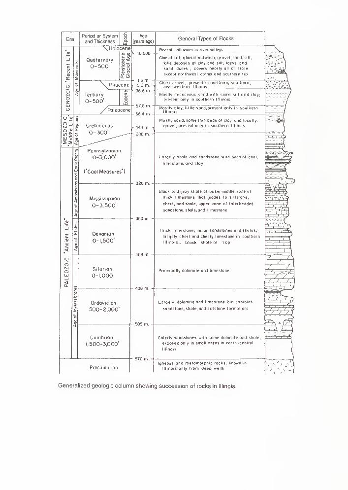
GEOLOGIC FRAMEWORKPrecambrian Era Through several billion years of geologic time, Monroe County and surrounding
areas have undergone many changes (see the rock succession column, facing page). The oldest
rocks beneath the field trip area belong to the ancient Precambrian basement complex. We know
relatively little about these rocks from direct observations because they are not exposed at the sur-
face anywhere in Illinois. Only about 35 drill holes have reached deep enough for geologists to col-
lect samples from Precambrian rocks of Illinois. From these samples, however, we know that these
ancient rocks consist mostly of granitic and rhyolitic igneous, and possibly metamorphic, crystalline
rocks formed about 1.5 to 1 billion years ago. From about 1 billion to about 0.6 billion years ago,
these Precambrian rocks were exposed at the surface. During this long period, the rocks were deeply
weathered and eroded, and formed a landscape that was probably quite similar to that of the present
Missouri Ozarks. We have no rock record in Illinois for the long interval of weathering and erosion
that lasted from the time the Precambrian rocks were formed until the first Cambrian-age sediments
accumulated, but that interval is almost as long as the time from the beginning of the Cambrian
Period to the present.
Because geologists cannot see the Precambrian basement rocks in Illinois except as cuttings and
cores from boreholes, they must use other various techniques, such as measurements of Earth's
gravitational and magnetic fields, and seismic exploration, to map out the regional characteristics of
the basement complex. The evidence indicates that in southernmost Illinois, near what is now the
historic Kentucky-Illinois Fluorspar Mining District, rift valleys like those in east Africa formed as move-
ment of crustal plates (plate tectonics) began to rip apart the Precambrian North American continent.
These rift valleys in the midcontinent region are referred to as the Rough Creek Graben and the
Reelfoot Rift (fig. 1).
Paleozoic Era After the beginning of the Paleozoic Era, about 520 million years ago in the late Cam-brian Period, the rifting stopped and the broad hilly Precambrian region began to sink slowly, allow-
ing the invasion of a shallow sea from the south and southwest. During the several hundred million
years of the Paleozoic Era, the area that is now called the Illinois Basin continued to accumulate sedi-
ments deposited in the shallow seas that repeatedly covered it. The region continued to sink until at
least 15,000 feet of sedimentary strata were deposited. At times during this era, the seas withdrew
and deposits were weathered and eroded. As a result, there are some gaps in the sedimentary
record in Illinois.
In the field trip area, bedrock strata range from more than 520 million years (the Cambrian Period)
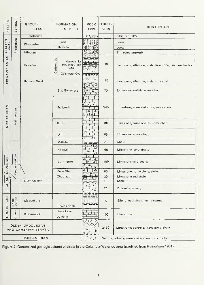
to less than 290 million years old (the Pennsylvanian Period). Figure 2 shows the succession of rock
strata a drill bit would penetrate in this area if the rock record were complete and all the formations
were present.
'Words in italics are defined in the glossary at the back of the guidebook. Also please note: although all present
localities have only recently appeared within the geologic time frame, we use the present names of places andgeologic features because they provide clear reference points for describing the ancient landscape.
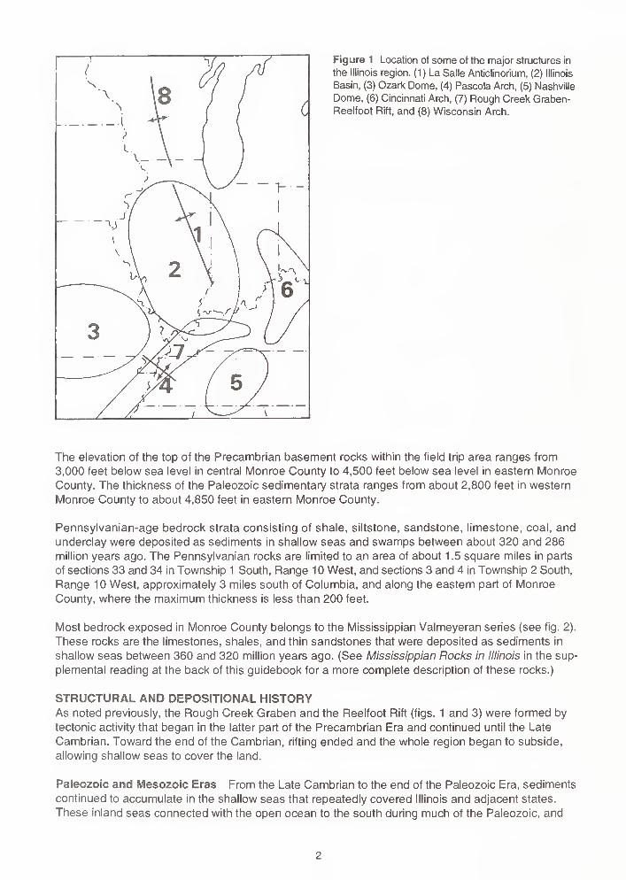
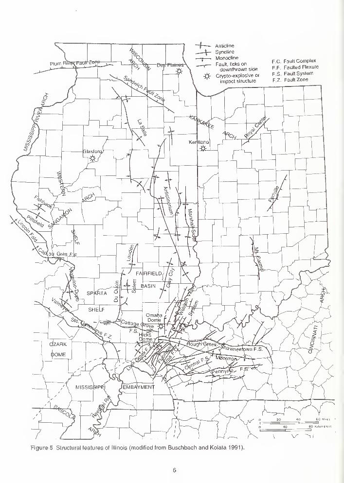
Figure 1 Location of some of the major structures in
the Illinois region. (1) La Salle Anticlinorium, (2) Illinois
Basin, (3) Ozark Dome, (4) Pascola Arch, (5) Nashville
Dome, (6) Cincinnati Arch, (7) Rough Creek Graben-
Reelfoot Rift, and (8) Wisconsin Arch.
The elevation of the top of the Precambrian basement rocks within the field trip area ranges from
3,000 feet below sea level in central Monroe County to 4,500 feet below sea level in eastern Monroe
County. The thickness of the Paleozoic sedimentary strata ranges from about 2,800 feet in western
Monroe County to about 4,850 feet in eastern Monroe County.
Pennsylvanian-age bedrock strata consisting of shale, siltstone, sandstone, limestone, coal, and
underclay were deposited as sediments in shallow seas and swamps between about 320 and 286
million years ago. The Pennsylvanian rocks are limited to an area of about 1 .5 square miles in parts
of sections 33 and 34 in Township 1 South, Range 10 West, and sections 3 and 4 in Township 2 South,
Range 10 West, approximately 3 miles south of Columbia, and along the eastern part of Monroe
County, where the maximum thickness is less than 200 feet.
Most bedrock exposed in Monroe County belongs to the Mississippian Valmeyeran series (see fig. 2).
These rocks are the limestones, shales, and thin sandstones that were deposited as sediments in
shallow seas between 360 and 320 million years ago. (See Mississippian Rocks in Illinois in the sup-
plemental reading at the back of this guidebook for a more complete description of these rocks.)
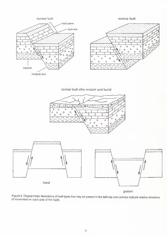
STRUCTURAL AND DEPOSITIONAL HISTORYAs noted previously, the Rough Creek Graben and the Reelfoot Rift (figs. 1 and 3) were formed by
tectonic activity that began in the latter part of the Precambrian Era and continued until the Late
Cambrian. Toward the end of the Cambrian, rifting ended and the whole region began to subside,
allowing shallow seas to cover the land.
Paleozoic and Mesozoic Eras From the Late Cambrian to the end of the Paleozoic Era, sediments
continued to accumulate in the shallow seas that repeatedly covered Illinois and adjacent states.
These inland seas connected with the open ocean to the south during much of the Paleozoic, and
ccHICO
GROUP,
STAGE
FORMATION,
MEMBERROCKTYPE
THICK-
NESSDESCRIPTION
Holocene Sand, silt, clay
w >h- CC<<a
Wisconsinan
lllinoian
Kewanee
Peoria mm Loess
Roxana MMa 4"r»:/i'M*
Loess
<X'°Z01 Till, some outwash
o
Hanover Ls
Houchin CreekCoal
Colchester Coal
'ill)40 Sandstone; siltstone; shale; limestone; coal; underclay
- IT \ I J.
JxtwrMT*
zo>111
Ul Q
Raccoon Creek 25 Sandstone; siltstone; shale; thin coal
Ste. Genevieve£PKun 700\ o
I
I I.I
Limestone, oolitic, some chert
rrrrSt. Louis ffi* 245 Limestone, some dolomite, some chert
4 I A
Salem i rja 80 Limestone, some oolites, some chert
111
Ullin farS 65 Limestone, some chert
Warsaw 25 Shale
LUjKeokuk tUljM
17T~T 60 Limestone, very cherty
Burlington 100 Limestone very cherty
ssFern Glen
Chouteau ss 60 Limestone, some chert; shale
S 30 Limestone and shale
New AlbanyT*~T~y
15 Shale
Maquoketa
1^11 i
I , /75 Dolomite, cherty
I I I I 150 Siltstone; shale; some limestone
Scales Shale
KimmswickCJ
Wise Lake
Dunleith
i , I . i
W=^T 100 Limestone
<^?OLDER ORDOVICIAN
AND CAMBRIAN STRATA
PRECAMBRIAN
2450 Limestone; dolomite; sandstone; shale
Granite; other igneous and metamorphic rocks
Figure 2 Generalized geologic column of strata in the Columbia-Waterloo area (modified from Reinertsen 1981).
normal fault reverse fault
fault plane
fault line
footwall
hanging wall
normal fault after erosion and burial
horst
graben
Figure 3 Diagrammatic illustrations of fault types that may be present in the field trip area (arrows indicate relative directionsof movement on each side of the fault).
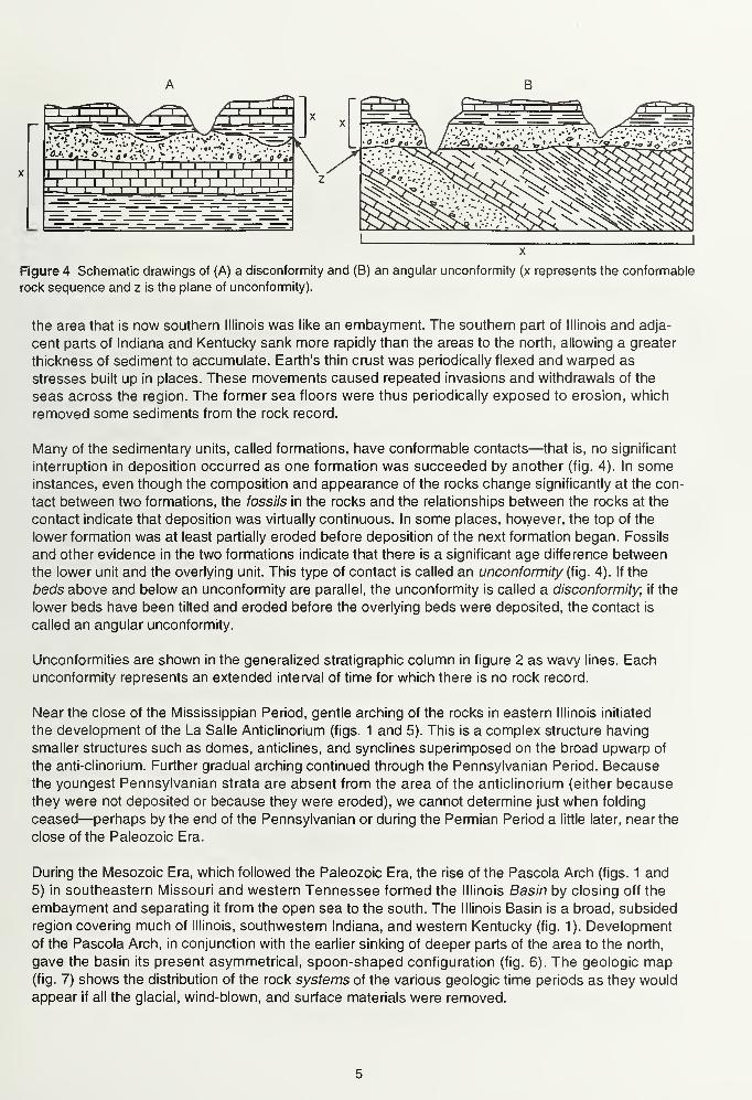
r=n ass^sFigure 4 Schematic drawings of (A) a disconformity and (B) an angular unconformity (x represents the conformable
rock sequence and z is the plane of unconformity).
the area that is now southern Illinois was like an embayment. The southern part of Illinois and adja-
cent parts of Indiana and Kentucky sank more rapidly than the areas to the north, allowing a greater
thickness of sediment to accumulate. Earth's thin crust was periodically flexed and warped as
stresses built up in places. These movements caused repeated invasions and withdrawals of the
seas across the region. The former sea floors were thus periodically exposed to erosion, which
removed some sediments from the rock record.
Many of the sedimentary units, called formations, have conformable contacts—that is, no significant
interruption in deposition occurred as one formation was succeeded by another (fig. 4). In someinstances, even though the composition and appearance of the rocks change significantly at the con-
tact between two formations, the fossils in the rocks and the relationships between the rocks at the
contact indicate that deposition was virtually continuous. In some places, however, the top of the
lower formation was at least partially eroded before deposition of the next formation began. Fossils
and other evidence in the two formations indicate that there is a significant age difference between
the lower unit and the overlying unit. This type of contact is called an unconformity (fig. 4). If the
beds above and below an unconformity are parallel, the unconformity is called a disconformity, if the
lower beds have been tilted and eroded before the overlying beds were deposited, the contact is
called an angular unconformity.
Unconformities are shown in the generalized stratigraphic column in figure 2 as wavy lines. Each
unconformity represents an extended interval of time for which there is no rock record.
Near the close of the Mississippian Period, gentle arching of the rocks in eastern Illinois initiated
the development of the La Salle Anticlinohum (figs. 1 and 5). This is a complex structure having
smaller structures such as domes, anticlines, and synclines superimposed on the broad upwarp of
the anti-clinorium. Further gradual arching continued through the Pennsylvanian Period. Because
the youngest Pennsylvanian strata are absent from the area of the anticlinorium (either because
they were not deposited or because they were eroded), we cannot determine just when folding
ceased—perhaps by the end of the Pennsylvanian or during the Permian Period a little later, near the
close of the Paleozoic Era.
During the Mesozoic Era, which followed the Paleozoic Era, the rise of the Pascola Arch (figs. 1 and
5) in southeastern Missouri and western Tennessee formed the Illinois Basin by closing off the
embayment and separating it from the open sea to the south. The Illinois Basin is a broad, subsided
region covering much of Illinois, southwestern Indiana, and western Kentucky (fig. 1). Development
of the Pascola Arch, in conjunction with the earlier sinking of deeper parts of the area to the north,
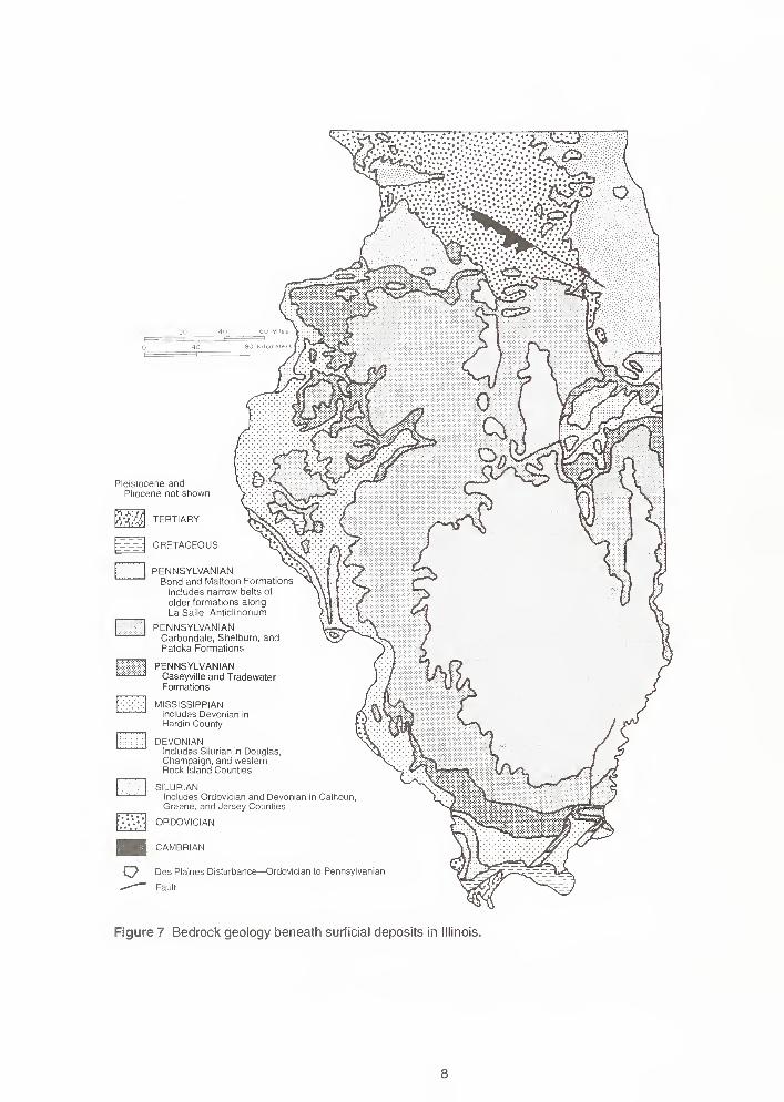
gave the basin its present asymmetrical, spoon-shaped configuration (fig. 6). The geologic map(fig. 7) shows the distribution of the rock systems of the various geologic time periods as they would
appear if all the glacial, wind-blown, and surface materials were removed.
Anticline
Syncline
Monocline
Fault, ticks on
downthrown side
-$- Crypto-explosive or
impact structure
F.C. Fault Complex
F.F. Faulted Flexure
F.S. Fault System
F.Z. Fault Zone
Figure 5 Structural features of Illinois (modified from Buschbach and Kolata 1991).
Chicago
Rockford
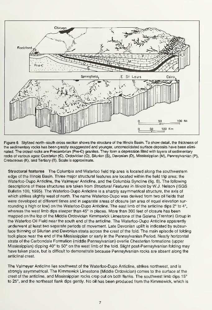
Figure 6 Stylized north-south cross section shows the structure of the Illinois Basin. To show detail, the thickness of
the sedimentary rocks has been greatly exaggerated and younger, unconsolidated surface deposits have been elimi-
nated. The oldest rocks are Precambrian (Pre-G) granites. They form a depression filled with layers of sedimentary
rocks of various ages: Cambrian (€), Ordovician (O), Silurian (S), Devonian (D), Mississippian (M), Pennsylvanian (P),
Cretaceous (K), and Tertiary (T). Scale is approximate.
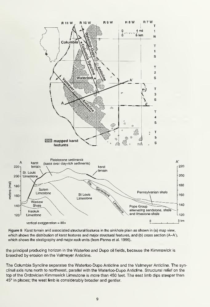
Structural features The Columbia and Waterloo field trip area is located along the southwestern
edge of the Illinois Basin. Three major structural features are located within the field trip area: the
Waterloo-Dupo Anticline, the Valmeyer Anticline, and the Columbia Syncline (fig. 8). The following
descriptions of these structures are taken from Structural Features in Illinois by W.J. Nelson (ISGS
Bulletin 100, 1995). The Waterloo-Dupo Anticline is a sharply asymmetrical structure, the axis of
which strikes slightly west of north. The name Waterloo-Dupo was derived from two oil fields that
were developed at different times and in separate areas of closure (an area of equal elevation sur-
rounding a high or low) on the Waterloo-Dupo Anticline. The east limb of the anticline dips 2° to 4°,
whereas the west limb dips steeper than 45° in places. More than 300 feet of closure has been
mapped on the top of the Middle Ordovician Kimmswick Limestone of the Galena (Trenton) Group in
the Waterloo Oil Field near the south end of the anticline. The Waterloo-Dupo Anticline apparently
underwent at least two separate periods of movement. Late Devonian uplift is indicated by subsur-
face thinning of Silurian and Devonian strata across the crest of the fold. The main episode of folding
took place near the end of the Mississippian or early in the Pennsylvanian Period. Nearly horizontal
strata of the Carbondale Formation (middle Pennsylvanian) overlie Chesterian formations (upper
Mississippian) dipping 40° to 50° on the west limb of the fold. Slight post-Pennsylvanian folding mayhave taken place, but is difficult to demonstrate because Pennsylvanian rocks are absent along the
anticlinal crest.
The Valmeyer Anticline lies southwest of the Waterloo-Dupo Anticline, strikes northwest, and is
strongly asymmetrical. The Kimmswick Limestone (Middle Ordovician) comes to the surface at the
crest of the anticline, and Mississippian rocks crop out on both flanks. The southwest limb dips 15°
to 25°, and the northeast flank dips gently. No oil has been produced from the Kimmswick, which is
Pleistocene andPliocene not shown
Pp
mTERTIARY
CRETACEOUS
PENNSYLVANIANBond and Mattoon Formations
includes narrow belts of
older formations along
La Salle Anticlinorium
PENNSYLVANIANCarbondale, Shelburn, andPatoka Formations
PENNSYLVANIANCaseyville and TradewaterFormations
MISSISSIPPIANincludes Devonian in
Hardin County
DEVONIANIncludes Silurian in Douglas,Champaign, and westernRock Island Counties
SILURIANIncludes Ordovician and Devonian in CalhounGreene, and Jersey Counties
ORDOVICIAN
H CAMBRIAN
^^ Des Plaines Disturbance—Ordovician to Pennsylvanian
-*-"— Fault
Figure 7 Bedrock geology beneath surficial deposits in Illinois.
R 11 W R 10W R9W R8 W 7 W
mapped karst
features
Pleistocene sedimentskarst (loess over clay-rich sediments)
220
1
terrain \
St. Louis \y»r\~~—""'
200- Limestonev^
E 180-
m / Salem \.
&%E
160-/ Limestone \
St Louis
\ Limestone
^j Warsaw \140-^^JShalts \
Keokuk \ \120- Limestone \
vertical exaggeration = 80x
karst
-terrain
Pennsylvanian shale
Pope Groupalternating sandstone, shale^
and limestone-shale
Figure 8 Karst terrain and associated structural features in the sinkhole plain as shown in (a) map view,
which shows the distribution of karst features and major structural features, and (b) cross section (A-A'),
which shows the stratigraphy and major rock units (from Panno et al. 1996).
the principal producing horizon in the Waterloo and Dupo oil fields, because the Kimmswick is
breached by erosion on the Valmeyer Anticline.
The Columbia Syncline separates the Waterloo-Dupo Anticline and the Valmeyer Anticline. The syn-
clinal axis runs north to northwest, parallel with the Waterloo-Dupo Anticline. Structural relief on the
top of the Ordovician Kimmswick Limestone is more than 450 feet. The east limb dips steeper than
45° in places; the west limb is considerably broader and gentler.
Pennsylvanian-age bedrock occurs on the east flank of the Waterloo-Dupo Anticline, and in a small
1 .5-square-mile area along the axis of the Columbia Syncline approximately 3 miles south of Colum-
bia. The Pennsylvanian rocks are exposed along the Kaskaskia River and many of its smaller tribu-
taries in eastern Monroe County. Younger rocks of the latest Pennsylvanian and perhaps the
Permian (the youngest rock systems of the Paleozoic) may have at one time covered the area of
Monroe County. Mesozoic and Cenozoic rocks (see the generalized geologic column) could also
possibly have been present here. Indirect evidence, based on the stage of development (rank) of
coal deposits and the generation and maturation of petroleum from source rocks (Damberger 1 971 ),
indicates that perhaps as much as 8,000 feet of latest Pennsylvanian and younger rocks once cov-
ered southern Illinois. However, during the more than 240 million years since the end of the Paleo-
zoic Era (and before the onset of glaciation 1 to 2 million years ago), several thousands of feet of
strata may have been eroded. Nearly all traces of any post-Pennsylvanian bedrock that may have
been present in Illinois were removed. During this extended period of erosion, deep valleys were
carved into the gently tilted bedrock formations (fig. 9). Later, the topographic relief produced by the
preglacial erosion was reduced by repeated advances and melting back of continental glaciers that
scoured and scraped the bedrock surface. This glacial erosion affected all the formations exposed at
the bedrock surface in Illinois. The final melting of the last glaciers about 13,500 years ago left behind
the non-lithified deposits in which our Modern Soil has developed.
Cenozoic Era: Glacial history A brief general history of glaciation in North America and a descrip-
tion of the deposits commonly left by glaciers may be found in Pleistocene Glaciations in Illinois at
the back of this guidebook.
As stated above, erosion that took place long before the glaciers advanced across the state left a
network of deep valleys carved into the bedrock surface (fig. 9). Prior to glaciation, a large part of
eastern Monroe County was drained by an ancient northeast-southwest bedrock valley called the
Kaskaskia Bedrock Valley. The Kaskaskia Bedrock Valley begins in northeastern Shelby County
and extends southwestward to its junction with the Mississippi River near Fort Kaskaskia in Randolph
County. The lllinoian glacial drift in the Kaskaskia Bedrock Valley is about 100 feet thick from the
mouth of the valley to the east boundary of Monroe County. The modern Kaskaskia River follows the
same course as the ancient Kaskaskia Bedrock Valley. Because of the irregular bedrock surface
and erosion, glacial drift is unevenly distributed across Monroe County.
During the Pleistocene Epoch, beginning about 1 .6 million years ago, massive sheets of ice (called
continental glaciers), thousands of feet thick, accumulated and flowed slowly southward from Canada.
The last of these glaciers melted from northeastern Illinois about 13,500 years before the present
(B.P.). During the lllinoian glacial episode, which began around 300,000 years B.P., North American
continental glaciers reached their southernmost position, approximately 95 miles southeast of here,
in the northern part of Johnson County (fig. 10). The maximum thickness of the later Wisconsin
Episode glacier was about 2,000 feet in the Lake Michigan Basin, but only about 700 feet over most
of Illinois (Clark et al. 1988). Monroe County is too far south to have been covered by the Wisconsin
Episode glaciation.
The topography of the bedrock surface throughout much of Illinois is largely hidden from view by
thick glacial deposits, except along the major streams. In Monroe County, however, the buried bed-
rock surface elevation is highly variable because of structural warping of the crust, and was only
slightly modified and covered by a relatively thin layer of drift deposited during and after the Illinois
glacial episode.
Although lllinoian glaciers probably built moraine ridges similar to those left by the later Wisconsinanglaciers, lllinoian glacial features generally are not as conspicuous as the younger Wisconsinan fea-
tures because lllinoian moraines have been exposed to weathering and erosion for hundreds of thou-
sands of years longer than their younger Wisconsinan counterparts.
10
lukegon
Michigan
iCHICAGO
Axis of present valley £
Axis of bedrock valley^
(I
Present river valley\
KoskosMia r. -and bedrock valley (if
present) roughly conform
kempton v -Bedrock valley, largely buried >sy
Figure 9 Bedrock valleys of Illinois (modified
from Bristol and Buschbach 1973).
11
HOLOCENE AND WISCONSINAN
Alluvium, sand dunes,
and gravel terraces
WISCONSINAN
Lake deposits
WOODFORDIAN
Moraine
Front of moramic system
Groundmorame
ALTONIAN
Till plain
ILLINOIAN
ES Groundmoraine
LLINOIAN
Till plain
DRIFTLESS
Moraine and ridged drift
Figure 10 Generalized map of glacial deposits in Illinois (modified from Willman and Frye 1970).
12
Overlying the lllinoian Episode deposits in Monroe County is a thin cover of sediments called the
Peoria Loess (pronounced "luss"). These sediments, deposited as wind-blown silts during the Wood-fordian Subage, which began about 22,000 years B.P., cover the glacial drift throughout the field trip
area (see Ancient Dust Storms in Illinois, Geogram 5, at the back of this guidebook.) In Monroe County,
the loess deposits are thickest near the Mississippi River Valley, where they are thicker than 25 feet,
but they thin to generally less than 6 feet in eastern Monroe County. This fine grained dust, which
covers most of Illinois outside the area of Wisconsinan glaciation, commonly reaches thicknesses
exceeding 25 feet along the east edges of both the Mississippi and Illinois River Valleys. Soils in
this area have developed in the loess, in the underlying weathered silty, clayey lllinoian till, and in
the alluvium that fills the valleys. Some thin soils have developed in exposed bedrock.
In the field trip area, glacial drift ranges in thickness from less than 25 feet, in the central part of the
county, to slightly more than 100 feet, in the eastern and northwestern parts of the county along the
Kaskaskia Bedrock Valley and the Mississippi River Valley.
The highest land surface on the field trip route is along IL Route 156 at the intersection with the road
to the new Village of Valmeyer, where the surface elevation is 733 feet above mean sea level (msl).
The lowest elevation is about 400 feet above msl at stop 2, below the levee at the surface of the flood
plain. The total relief of the field trip route, calculated as the difference between the highest and low-
est elevations, is 333 feet. The local relief \n the field trip area is most pronounced near the bluffs of
the Mississippi River, where local relief ranges from 100 feet at stop 1 , near Columbia, to 430 feet
just north of stop 4, near Valmeyer.
GEOMORPHOLOGYThe Columbia-Waterloo area is in the Salem Plateau physiographic division, and is often called the
"sinkhole plain" (figs. 11, and 12). The area received this name because it contains approximately
10,000 sinkholes, three-quarters of which are in Monroe County (Panno 1996). These sinkholes are,
as they say, only the tip of the iceberg. Below the surface are many hundreds of miles of underground
drainageways and caves. In Illinois Caverns alone, approximately 6 miles of underground passageshave been mapped.
Bedrock in the sinkhole plain is mostly Mississippian-age limestone (see description of the Paleozoic
Era above). These rocks were originally deposited as layers of calcareous mud and fossils in a marine
environment between about 360 and 320 million years ago. The environment of deposition was prob-
ably similar to the shallow-water environment that surrounds the modern Bahama Islands. After these
layers of mud and fossils were buried and solidified into rock, tectonic stresses folded the bedrockand formed anticlines and synclines (fig. 8). Folding resulted in the fracturing (jointing) of these rocks.
The fractures are important in the karstification process because they allow surface and ground-water to move vertically into the bedrock through the fractures and then into the more permeablehorizontal bedding planes within the layers of rock.
The western margin of the sinkhole plain offers scenic limestone bluffs that tower 300 feet or moreabove the floodplain of the Mississippi River. The valley is the site of the catastrophic Great Flood
of 1993 that caused widespread damage and property loss and forced the relocation of the town of
Valmeyer. The town now occupies a site in the karstified upland area overlooking the abandonedsite on the floodplain below.
KARST LANDSCAPEKarst topography is characterized by sinkholes, rolling surfaces, caves, underground drainage sys-
tems, and springs. Most karst landscapes occur over limestone or dolomite bedrock. An areacontaining numerous karst features is called a karst plain.
13
WISCONSIN j JILL PLAINSIFTLESS/
GREAT LAKESECTION
Chicago
\ Lake"\ Plain
SHAWNEE,NTE R'0R
ILLS SECTION LOWPLATEAUS
COASTAL^ PROVINCE
PLAIN PROVINCE
Figure 1 1 Physiographic divisions of Illinois.
Karstification Karstification is the process by which karst features (such as sinkholes and caves)
are created by the combined processes of the dissolving action of naturally acidic water and the
mechanical action of water flowing through limestone, dolomite, or gypsum bedrock.
Water and carbon dioxide are the two main components necessary for dissolving limestone. Carbon
dioxide gas, both atmospheric and that generated by bacterial activities in the soil, dissolves in rain-
water or snow melt seeping through the soil to form relatively small amounts of carbonic acid. This
weak acid mixes with water and migrates through fractures and along bedding planes and, over
thousands of years, dissolves significant amounts of limestone and dolomite. As the fractures in the
surface of the bedrock enlarge, they allow water and soil to seep deeper into bedrock. Conduits
formed along bedding planes provide lateral routes for discharge of the infiltrating water at springs.
In southern Illinois, sinkholes act as natural drains that funnel rainfall and snow melt into the subter-
ranean streams and conduits beneath the karst landscape.
14
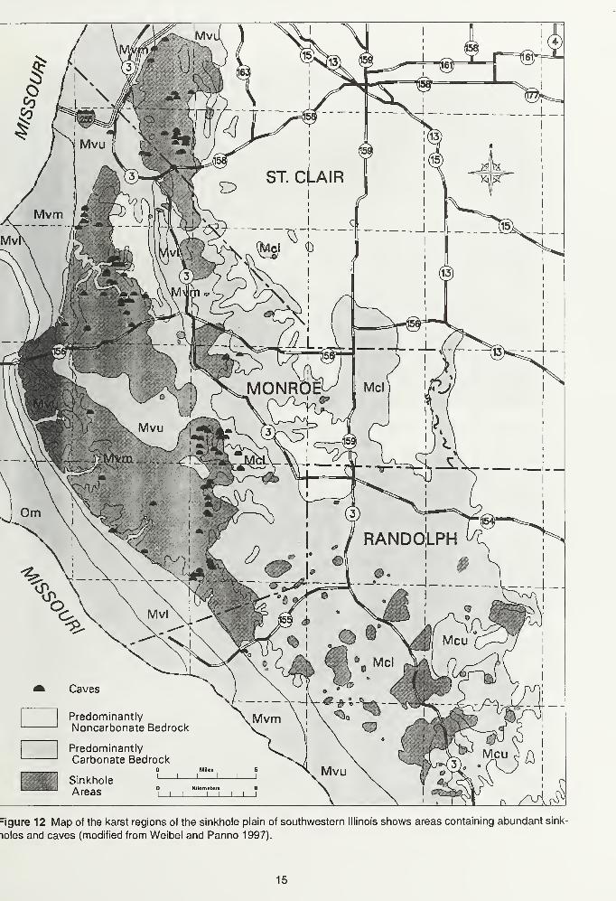
=igure 12 Map of the karst regions of the sinkhole plain of southwestern Illinois shows areas containing abundant sink-
loles and caves (modified from Weibel and Panno 1997).
15
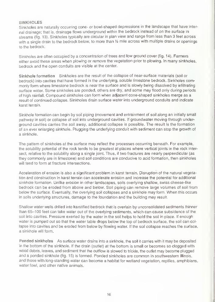
SINKHOLESSinkholes are naturally occurring cone- or bowl-shaped depressions in the landscape that have inter-
nal drainage; that is, drainage flows underground within the bedrock instead of on the surface in
streams (fig. 13). Sinkholes typically are circular in plan view and range from less than 3 feet across
with a single drain to the bedrock below, to more than V2 mile across with multiple drains or openings
to the bedrock.
Sinkholes are often occupied by a concentration of trees and low ground cover (fig. 14). Farmers
either avoid these areas when plowing or remove the vegetation prior to plowing. In many sinkholes,
bedrock and the open conduits are visible at the center.
Sinkhole formation Sinkholes are the result of the collapse of near-surface materials (soil or
bedrock) into cavities that have formed in the underlying, soluble limestone bedrock. Sinkholes com-
monly form where limestone bedrock is near the surface and is slowly being dissolved by infiltrating
surface water. Seme sinkholes are ponded, others are dry, and some may flood only during periods
of high rainfall. Compound sinkholes can form when adjacent cone-shaped sinkholes merge as a
result of continued collapse. Sinkholes drain surface water into underground conduits and indicate
karst terrain.
Sinkhole formation can begin by soil piping (movement and entrainment of soil along an initially small
pathway in soil) or collapse of soil into underground cavities. If groundwater moving through under-
ground cavities carries the soil away, additional collapse is possible. The result is the formation
of an ever enlarging sinkhole. Plugging the underlying conduit with sediment can stop the growth of
a sinkhole.
The pattern of sinkholes at the surface may reflect the processes occurring beneath. For example,
the solubility potential of the rock tends to be greatest at places where vertical joints in the rock inter-
sect, relative to the solubility along a single joint. Thus, if two fractures are nearly perpendicular (as
they commonly are in limestone) and soil conditions are conducive to acid formation, then sinkholes
will tend to form at fracture intersections.
Acceleration of erosion is also a significant problem in karst terrain. Disruption of the natural vegeta-
tion and construction in karst terrain can accelerate erosion and increase the potential for additional
sinkhole formation. Unlike erosion in other landscapes, soils overlying shallow, swiss cheese-like
bedrock can be eroded from above and below. Soil piping can remove large volumes of soil from
below the surface. Eventually, the overlying soil collapses and a sinkhole may form. When this occurs
in soils underlying structures, damage to the foundation and the building may result.
Shallow water wells drilled into karstified bedrock that is overlain by unconsolidated sediments thinner
than 65-100 feet can take water out of the overlying sediments, which can cause subsidence of the
soil into cavities. Pressure exerted by the water in the soil helps to hold the soil in place. If enough
water is pumped out so that the water table drops below the top of bedrock surface, the soil can col-
lapse into cavities and be eroded from below by flowing water. If the soil collapse reaches the surface,
a sinkhole will form.
Ponded sinkholes As surface water drains into a sinkhole, the soil it carries with it may be deposited
in the bottom of the sinkhole. If the drain (outlet) at the bottom is small or becomes so clogged with
wood debris, leaves, and sediment that the outflow is slowed to trickle, the outlet may become plugged
and a ponded sinkhole (fig. 15) is formed. Ponded sinkholes are common in southwestern Illinois,
and those with long-standing water can become a habitat for wetland vegetation, reptiles, amphibians,
water fowl, and other native animals.
1
6
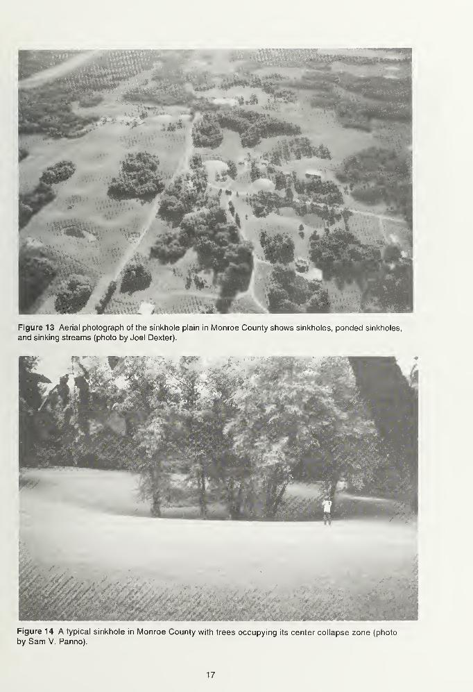
Figure 13 Aerial photograph of the sinkhole plain in Monroe County shows sinkholes, ponded sinkholes,
and sinking streams (photo by Joel Dexter).
Figure 14 A typical sinkhole in Monroe County with trees occupying its center collapse zone (photo
by Sam V. Panno).
17
Figure 15 A ponded sinkhole in Monroe County shows the characteristic circular shape of sinkholes
(photo by Sam V. Panno).
Sinking streams Long stream valleys are common only in areas where sinkholes are rare or
absent. If a surface stream flows into a karst landscape, the stream generally will flow into a sinkhole
(known as a swallow hole) and enter the underground conduit system of the shallow karst aquifer.
The stream will then flow underground to a point of discharge such as a cave spring. Only in karst
landscapes are there true underground "rivers."
Springs Natural springs and cave springs are common in karst landscapes. The springs are the
discharge points for rainwater, snow melt, and groundwater that have entered and flowed through
the bedrock. Water emerging at springs in such areas may have been at the surface only a few
hours before it exits at the spring. The potential for contamination of spring water is extremely high,
and its use for drinking without treatment is strongly discouraged.
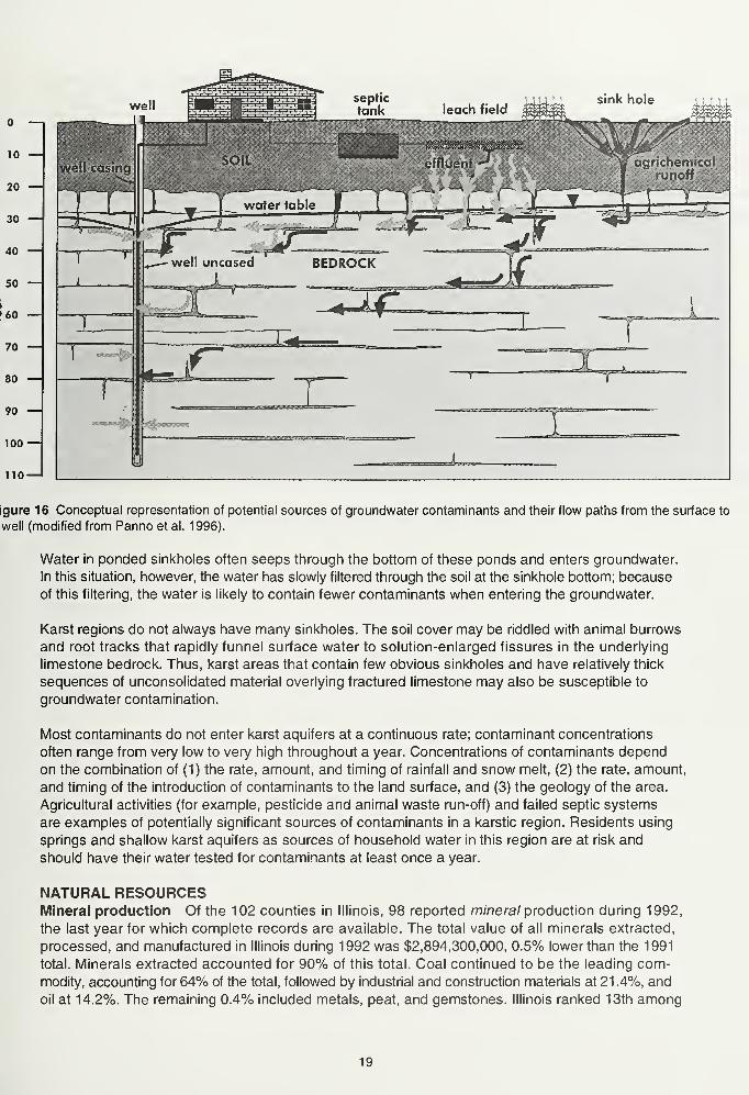
GROUNDWATER CONTAMINATION IN KARST LANDSCAPESGroundwater in karst landscapes is particularly susceptible to contamination (fig. 16). Because of
the extensive system of conduits in the limestone bedrock, shallow groundwater in karst landscapes
does not have the benefit of the slow filtering that occurs when water seeps through thick sequences
of clay-rich glacial till or low-permeability bedrock in other landscapes. Recharge and movement of
water within karst aquifers is very rapid (in seconds to minutes), often comparable to the flow rates
of surface streams. Suspended sediment particles, dissolved contaminants, and bacteria are readily
carried into shallow karst aquifers. Groundwater in karst areas may have relatively high concentra-
tions of nitrate, bacteria, inorganic ions, and organic chemicals, such as pesticides.
Sinkholes have always been tempting places to dispose of trash. However, household garbage, old
appliances, dead animals, and old cars and trucks generally contain contaminants such as oil, gaso-
line, bacteria, toxic chemicals from home cleaners, and pesticides that can pollute the groundwater.
Septic systems that drain directly into sinkholes often introduce sewage (human effluent) into the
groundwater. In addition, large objects thrown into sinkholes can plug the sinkhole and alter the
established drainage pattern, causing localized flooding and accelerated erosion.
18
10 —
20
30
40
50 —!
•60 —
70 —
80 •
90 —
|
100-
110-
igure 16 Conceptual representation of potential sources of groundwater contaminants and their flow paths from the surface to
well (modified from Panno et al. 1996).
Water in ponded sinkholes often seeps through the bottom of these ponds and enters groundwater.
In this situation, however, the water has slowly filtered through the soil at the sinkhole bottom; because
of this filtering, the water is likely to contain fewer contaminants when entering the groundwater.
Karst regions do not always have many sinkholes. The soil cover may be riddled with animal burrows
and root tracks that rapidly funnel surface water to solution-enlarged fissures in the underlying
limestone bedrock. Thus, karst areas that contain few obvious sinkholes and have relatively thick
sequences of unconsolidated material overlying fractured limestone may also be susceptible to
groundwater contamination.
Most contaminants do not enter karst aquifers at a continuous rate; contaminant concentrations
often range from very low to very high throughout a year. Concentrations of contaminants depend
on the combination of (1) the rate, amount, and timing of rainfall and snow melt, (2) the rate, amount,
and timing of the introduction of contaminants to the land surface, and (3) the geology of the area.
Agricultural activities (for example, pesticide and animal waste run-off) and failed septic systems
are examples of potentially significant sources of contaminants in a karstic region. Residents using
springs and shallow karst aquifers as sources of household water in this region are at risk and
should have their water tested for contaminants at least once a year.
NATURAL RESOURCESMineral production Of the 102 counties in Illinois, 98 reported mineral production during 1992,
the last year for which complete records are available. The total value of all minerals extracted,
processed, and manufactured in Illinois during 1992 was $2,894,300,000, 0.5% lower than the 1991
total. Minerals extracted accounted for 90% of this total. Coal continued to be the leading com-modity, accounting for 64% of the total, followed by industrial and construction materials at 21.4%, and
oil at 14.2%. The remaining 0.4% included metals, peat, and gemstones. Illinois ranked 13th among
19
the 31 oil-producing states in 1992 and 16th among the 50 states in total production of nonfuel miner-
als, but continues to lead all other states in production of fluorspar, industrial sand, and tripoli. How-
ever, the last operating fluorspar mine closed in December 1995.
Monroe County ranked 81st among all Illinois counties in 1992 on the basis of the value of all miner-
als extracted, processed, and manufactured. Economic minerals currently mined in Monroe County
include stone and oil.
Of the 39 counties reporting oil production in 1992, Monroe county ranked 34th with 23,000 barrels
of oil, which equals 0.1% of the state's total production. More than 405,000 barrels of oil have been
produced from the Kimmswick Limestone (Ordovician) in the Waterloo Oil Field, which was discov-
ered in 1920. A portion of the oil field was converted to a gas storage field in 1951 by the Mississippi
River Transmission Corporation, but the storage field was abandoned in 1973.
Groundwater Groundwater is a mineral resource frequently overlooked in assessments of an area's
natural resource potential. Groundwater availability is essential for orderly economic and community
development. More than 35% of the state's 1 1 .5 million citizens and 97% of those who live in rural
areas depend on groundwater for their water supply. Groundwater is derived from underground forma-
tions called aquifers. The water-yielding capacity of an aquifer can only be evaluated by constructing
wells into it. After construction, the wells are pumped to determine the quality and quantity of ground-
water available for use.
20
GUIDE TO THE ROUTE
Assemble at the parking lot on the west side of Turner Hall, 21 1 East Cherry Street, Columbia (NE SWSW, Sec. 15, T1S, R10W, 3rd P.M., Monroe County, Columbia 7.5-Minute Quadrangle).
You must travel in the caravan. Please drive with headlights on while in the caravan. Drive safely
but stay as close as you can to the car in front of you. Please obey all traffic signs. If the road cross-
ing is protected by an Illinois State Geological Survey (ISGS) vehicle with flashing lights and flags,
please obey the signals of the ISGS staff directing traffic. When we stop, park as close as possible
to the car in front of you and turn off your lights.
Private property Some stops on the field trip are on private property. The owners have graciously
given us permission to visit on the day of the field trip only. Please conduct yourselves as guests
and obey all instructions from the trip leaders. So that we may be welcome to return on future field
trips, follow these simple rules of courtesy:
Do not litter the area.
Do not climb on fences.
Leave all gates as you found them.
Treat public property as if you were the owner—which you are!
When using this booklet for another field trip with your students, a youth group, or family, rememberthat you must get permission from property owners or their agents before entering private property.
No trespassing please.
Six USGS 7.5-Minute Quadrangle Maps (Columbia, Oakville, Paderborn, Renault, Valmeyer, and
Waterloo) provide coverage for this field trip area.
Miles Miles
to next from
point start
0.0 0.0 Assemble at the parking lot on the west side of Turner Hall. Exit the parking lot
and turn right onto East Cherry Street.
0.5 0.5 STOP (4-way). Intersection of 200 East Cherry and 200 South Metter. CONTINUEAHEAD.
0.5 0.1 STOP (2-way). Intersection of 100 East Cherry and 200 South Main. TURNRIGHT onto Main Street. NOTE: Follow Main Street to the intersection with
IL Route 3. As you drive along main street, notice that several homes and build-
ings are made from the native limestone, which is light tan in color.
1 .55 1 .65 Stoplight. Intersection of North Main Street and IL Route 3. CONTINUE AHEAD.NOTE: As you cross Route 3, the road is now called Sand Bank Road.
0.3 1 .95 Stop 1 . Entrance to Luhr Brothers Construction Company, on left side of road.
On the day of the field trip, we will be using the large parking lot in front of the
main building. Assemble near the small Caterpillar tractor display on the west
side of the property.
21
0.45 2.75
0.1 2.85
0.1 2.95
1.05 4.0
STOP 1 Peoria Loess and Overview of the Mississippi River Valley We will discuss and view
the Mississippi River valley "American Bottoms" and loess exposure along Sand Bank Road.
0.0 1 .95 Leave Stop 1 . From the parking lot, TURN LEFT onto Sand Bank Road. As you
leave stop 1, you will descend the bluffs and enter onto the flood plain of the
Mississippi River.
0.05 2.0 STOP (T-intersection, DD Road/2620N and Bluff Road). TURN RIGHT onto
Bluff Road. Note: Sand Bank Road is marked as DD Road at the base of the
bluff.
0.1 2.1 CAUTION: Road makes a 90° turn to the left. Note: The road is now called
DD road.
0.2 2.3 T-intersection (Palmer Road) from the right. CONTINUE AHEAD. To the right is
Palmer Creek; on each side of the creek is a small set of levees.
CAUTION: Road makes a 90° turn to the left, then a 90° turn back to the right.
CAUTION: Cross double set of railroad tracks (Union Pacific Railroad). Guarded
crossing with lights and guard gates.
T-intersection (Ramsey Road) from the right. CONTINUE AHEAD.
Road curves 45° to the left. To the right is the main levee along the Mississippi
River.
0.5 4.5 To the left and straight ahead is a view of the levees along Carr Creek. The
levees along Carr Creek are higher than the levees along Palmer Creek. Thelevees along Palmer Creeek are lower because the drainage from Palmer Creek
is pumped over the main levee along the Mississippi River, whereas the drain-
age from Carr Creek empties directly into the Mississippi River. Therefore, the
elevation of the levees along Carr Creek must equal the elevation of the levees
along the Mississippi River.
0.4 4.9 T-intersection (at the top of the levee on the north side of Carr Creek). TURNRIGHT.
0.2 5.1 On the left side of the levee is a flood control gate with a date of 1 958 on the
top. To your right in the bottom lands, next to the base of the levee, are several
round corrugated sheet metal structures approximately 4' high. These structures
are drainpipe inlets; they drain the low area on the right into a pipe that flows
toward the flood control gate on the left. When the water level is low in Carr Creek
and high in the field to your right, the flood control gate is opened and water drains
from the lowlands to your right into Carr Creek on your left.
0.2 5.3 T-intersection. Main levee road curves to the right. TURN LEFT onto road descend-
ing the levee. After making the turn, to the right are the river loading docks of
Luhr Brothers Construction Company. Notice the bluffs to the right on the Missouri
side of the Mississippi River.
22
0.4 5.7 T-intersection from the right (entrance to Luhr Brothers Construction Companydock). CONTINUE AHEAD and cross bridge over Carr Creek.
0.1 5.8 STOP (1-way). Intersection of Bottom Road/2000 and Levee Road/10400.
CONTINUE AHEAD. From the top of Levee Road, to your far right, you can see
the Mississippi River. Notice the smaller levee between the main levee and the
Mississippi River. This smaller secondary levee partially protects the farmland
between the Mississippi River and the main levee. Also notice the large numberof dead trees along the west side of the levee. These trees were killed by the
Great Flood of 1993 when they were under water for an extended period of time;
the trees were, in effect, drowned.
0.7 6.5 Road passes under high-power transmission lines. To your left is a good view
of the bluffs on the Illinois side of the river.
0.3 6.8 T-intersection to farm buildings from the right. During the Great Flood of 1993,
the main break in the levee system along this portion of the Mississippi river
occurred just south of these buildings and extended to a point just north of the
curve in the road that is visible to the south along the base of the levee. The low
area to your immediate right is where a large scour hole was formed by the
water rushing through the broken levee.
0.15 6.95 T-intersection (Taake Road/2380N) from the right. TURN RIGHT. After making
the turn, notice that the road ahead of you dips. This dip marks the location of a
former large scour hole (see route map for location of the scour hole). To the
left in the field is a large ridge of sand which was scraped from the field andpiled up.
0.25 7.2 Another large pile of sand to the right of the road.
0.1 7.3 Stop 2. Road curves 90° to the left.
STOP 2 Levee along the Mississippi River We will discuss the failure of the levee during the
Great Flood of 1993, and what decision was made to protect Prairie du Rocherfrom the same fate
that struck the village of Valmeyer.
This stop gives you a good view of the bluffs on the Illinois and Missouri sides of the Mississippi
River valley. Looking west from the top of the levee you see the Mississippi River. Notice the small
private levee that was built to protect the farmland located between the main levee and the Missis-
sippi River. Note again the large number of dead trees. Many of these trees snapped off where they
rotted just below the water line of the Great Flood of 1 993.
0.0 7.3 Leave Stop 2. CONTINUE AHEAD on the road at the base of the levee.
0.7 8.0 Levee entrance road on the right side of the road. CONTINUE AHEAD.
0.2 8.2 Road ascends to the top of the levee. Drive onto the top of the levee.
0.8 9.0 T-intersection from the left (exit road from the levee). TURN LEFT, then LEFTonto the road at the base of the levee.
23
0.3 10.8
0.1 10.9
0.3 11.2
0.6 11.8
0.6 9.6 T-intersection (Levee Road/9300 and B Road/9200). TURN LEFT onto Levee
Road/9300.
0.9 10.5 Y-intersection (Levee Road/9600 and Steppig Road/2000). BEAR RIGHT and
continue on Steppig Road. Note: View of eroded valley to the right in the bluffs
on the Illinois side. This valley is Long Slash Hollow, which was carved by Long
Slash Creek. In the early spring and possibly late fall when leaves are off the
trees, you can trace a single distinctive limestone bed in the bluffs. Following
this single bed from north to south, you can detect a slight rise in the strata to
the south. This structural rise of the strata highlights the low-angle dip of the
Mississippian St.Louis Limestone beds on the northeast flank of the Valmeyer
Anticline.
Cross Little Carr Creek.
Road curves 90° to the left.
Road curves 90° to the right.
CAUTION: Cross dual set of railroad tracks. Guarded crossing with signal lights
and guard gates. This is the Union Pacific Railroad. To the right is Long Slash
Hollow.
Good view of the bluffs; note the houses dotted along the top of the bluffs.
Road curves 90° to the left.
Road curves 90° to the right.
STOP (1-way). T-intersection (Steppig Road/2700 and Bluff Road/5900). TURNRIGHT onto Bluff Road. To the left is the valley cut by Little Carr Creek.
T-intersection from the left. CONTINUE AHEAD.
Stop 3. Terry Spring. Pull over to the right side of the road and stop.
STOP 3 Terry Spring We will discuss the development of Terry Spring, located on the left side of
the road.
Above Terry Spring at the top of the bluff are several sinkholes (shown on the route map). Several of
these large sinkholes are generally filled with water.
The opening to Terry Spring is about 80" wide and 40" tall. This opening goes back into the bluff at
least several tens of feet (actual distance was not confirmed). Also near the base of the spring is a
shale layer within the limestone beds; the shale layer is probably the flow path that started Terry Spring.
Several additional signs of springs occur in the talus slope along the base of the bluff. A V-shaped
erosional cut into the talus slope indicates that water has been flowing from the bluffs and eroding
and carrying away some of the sediments. A large opening in the bluffs is located just south of Terry
Spring.
0.2 12.0
0.2 12.2
0.1 12.3
0.35 12.65
0.2 12.85
0.55 13.4
24
0.0 13.4
0.4 13.8
0.3 14.1
Leave Stop 3. CONTINUE AHEAD.
Cross Long Slash Creek; note the valley to the left.
Large overhang in the bluffs on your left. This may have been the site of an old
spring. Several springs and small caves are located along this stretch of the
bluff.
0.9 15.0 Crossroad Intersection. (Hanover Road and Bluff Road). CONTINUE AHEADon Bluff Road. This intersection is known as Fountain Gap. Cross Fountain
Creek just past intersection. CAUTION: This road is heavily used by bicyclists.
1.5 16.5 Y-intersection. BEAR RIGHT. CAUTION: Approaching second Y-intersection at
the top of the levee.
0.10 16.6 Y-intersection on top of the levee (Bluff Road and HH Road). TURN RIGHTonto Bluff Road.
1 .0 17.6 T-intersection (Fountain Road/1900 and Bluff Road/9200). TURN LEFT onto
Bluff Road. The community of Fountain lies directly west of this intersection.
0.4 18.0 Concrete marker on the right side of road. (Bond, James? No! Bond, Shadrach).
The marker reads:
Shadrach Bond, Sr., a soldier of the Revolutionary War and the
Army of George Rogers Clark. Settled about 1/3 mile east of this
marker in 1782. His nephew, Shadrach Bond, the first governor
of the State of Illinois, 1818-1822, moved here from Maryland in
1794 and lived with him until 1810. He purchased land near More-
dock Lake where he lived until 1814. He died in Kaskaskia in 1832.
Erected by the Monroe County Historical Society, 1974.
Center-pivot irrigation system on the left side of the road.
Another center-pivot irrigation system on left side of the road.
T-intersection (Herpst Road/1900) from the right. CONTINUE AHEAD on Bluff
Road/8800.
0.2 18.9 View of the bluffs directly ahead. The bluff projects westward at this point. This
westward projection of the bluffs outlines an ancient course of the Mississippi
River, which was diverted westward at this point because of the Valmeyer
Anticline (see route map).
0.5 1 9.4 T-intersection (Ziebold Road/1 950) from the right. CONTINUE AHEAD on Bluff
Road.
0.3 1 9.7 T-intersection (Trout Road/2000) from the left. CONTINUE AHEAD and cross
Trout Creek. The valley carved by Trout Creek is called Trout Hollow. The large
new slump to the left near the base of the bluff was caused by removal of material
at the toe of the talus slope.
0.15 18.15
0.3 18.45
0.25 18.7
25
0.7 20.4 Moredock Lake to the right. Moredock Lake occupies an old abandoned meander
of the Mississippi River (see route map). Note the number of duck blinds out in
the lake.
0.3 20.7 Cross small creek. The unique pillar-shaped limestone formation in the bluff to
the left is an example of karstic erosion, which is a common feature in this area.
0.9 21.6 CAUTION: Cross dual set of Union Pacific Railroad tracks. Guarded crossing
with signal lights and guard gates.
0.1 21 .7 Road curves 90° to the left.
0.1 21 .8 To the left in the bluffs, you can see the openings of the old underground room-
and-pillar Valmeyer Quarry.
1.1 22.9 Road curves to the left. In the bluff to the left, you can see the openings in the
abandoned Valmeyer Quarry extending for over a mile along the limestone bluff.
The mining operation was following a particular bed in the Ordovician limestone.
By visually following the openings, you will notice the dip to the south. The Bluffs
at Valmeyer consist of two distinct vertical limestone bluff faces; there is a talus
slope at the base of the lower face and a second talus slope between the lower
and upper bluff faces. The upper talus slope marks the position of a less resis-
tant bed of shale.
Cross small creek and prepare to TURN LEFT.
T-intersection from the left. TURN LEFT toward the abandoned quarry.
CAUTION: Cross dual set of Union Pacific Railroad tracks. Guarded crossing
with signal lights and guard gates.
Pass between two old quarry buildings.
Stop 4. Abandoned Valmeyer limestone quarry. Pull over to the right side of the
road and stop. Do not block the T-intersection from the right or the barricade
directly ahead blocking the entrance to old quarry road. Note the old native lime-
stone building to your left.
STOP 4 Valmeyer Quarry We will discuss the history of the mining and other operations of the
abandoned Valmeyer limestone quarry.
Leave stop 4. Retrace route back towards the railroad tracks. Heading west.
CAUTION: Recross railroad tracks.
T-intersection. TURN LEFT.
Cross small creek flowing into Moredock Lake.
Cross small creek. Entering the old Village of Valmeyer.
26
0.2 23.1
0.05 23.15
0.05 23.2
0.1 23.3
0.1 23.4
0.0 23.4
0.2 23.6
0.05 23.65
0.05 23.7
0.3 24.0
0.3 24.3 STOP (1-way). Crossroad intersection. TURN LEFT onto IL Route 156.
0.1 24.4 CAUTION: Cross dual set of railroad tracks. Guarded crossing with signal lights
and guard gates.
0.15 24.55 T-intersection from the right. CONTINUE AHEAD on IL Route 156. The road to
the right is Bluff Road; it leads to the community of Fults.
0.25 24.8 Cross creek just prior to St. Johns Cemetery on the left side of road. Roadstarts to ascend to the top of the bluffs. You are entering Dennis Hollow. Note
the dipping beds on the right side of the road.
1.8 26.6 Crossroad intersection (C Road). CONTINUE AHEAD. The new Village of
Valmeyer is to the left.
The farm house on the right side of the road is built from native limestone.
Road descends into the valley eroded by Bond Creek. Prepare to turn left.
T-intersection (D Road/6300 and IL Route 156/2400) to the left. TURN LEFTonto D Road. Cross Bond Creek just before the T-intersection.
Road follows the valley eroded by Bond Creek.
Cross Bond Creek.
Road curves 90° to the left and then back 90° to the right as it ascends out of
the valley cut by Bond Creek.
0.75 28.7 Y-intersection (Trout Road/2300 and D Road/6750). TURN RIGHT onto Trout
Road. Note the large sink hole to the left after making the turn.
0.3 29.0 Sinkholes on either side of the road commonly are filled with water just after a
rain. The water is reddish brown, the same color as the loess.
0.4 29.4 Descend the valley cut by Bond Creek. CAUTION: One lane bridge ahead.
0.2 29.6 Cross Bond Creek. To the left before you cross the bridge is an exposure
of loess.
0.35 29.95 T-intersection (Deer Hill Road/6800 and Trout Camp Road/2700). TURN LEFTonto Deer Hill Road. Note: Deer Hill Road and Trout Camp Road follow the
same course for the next 0.65 miles.
0.65 30.6 Y-intersection (Deer Hill Road/7000) from the left. CONTINUE AHEAD on Trout
Camp Road. Road starts to curve to the right.
0.05 30.65 Pass Deer Hill Cemetery on the left.
0.35 31 .0 View of the village of Waterloo directly ahead. You can see the water tower in
the distance.
0.4 27.0
0.4 27.4
0.2 27.6
0.1 27.7
0.2 27.9
0.05 27.95
27
1 .2 32.2 T-intersection (Camp Vandeventer Road from the left). TURN LEFT. CAUTION:the narrow road leading to the Boy Scout camp winds back and forth across the
countryside between numerous sinkholes.
0.8 33.0 Apache campsite and picnic area with fitness area to the left. To the right is a
karst window.
0.1 33.1 Entrance to the Boy Scout camp. Drive through the Paul Hodson Gateway.
Road to the left leads to the ranger's house. Road straight ahead is the entrance
to the parking lot. Note: Just before the gate, a large sinkhole has developed
along the right side of road.
0.05 33.15 Stop 5. Camp Vandeventer Boy Scout Camp
STOP 5 Camp Vandeventer Boy Scout Camp: LUNCH We will view and discuss some of the
unique geological features located within the scout camp. When leaving stop 5, retrace route to the
T-intersection of Camp Vandeventer Road and Trout Camp Road. Reset odometer to 0.0.
Miles Miles
to next from
point start
0.0 0.0 STOP (1-way). Intersection of Camp Vandeventer Road and Trout Camp Road.
TURN LEFT onto Trout Camp Road.
Kinzinger Landscaping Material company on the left.
T-intersection (Fountain Oaks Lane from the left). CONTINUE AHEAD.
Prepare to stop.
STOP (1-way). Intersection (Trout Camp Road and IL Route 156/3700). TURNRIGHT onto Route 156.
0.45 1 .0 T-intersections (Lee Drive) and (Old Orchard Lane) on the left. CONTINUEAHEAD. Note the sinkholes on the right and left sides of the road at the curve.
T-intersection (David Scott Drive) on the right. CONTINUE AHEAD.
Road makes a sharp turn to the right.
T-intersection (Old Baum Church Road/6500 and Route 156/1620N) from the
left. TURN LEFT onto Old Baum Church Road.
0.95 2.75 T-intersection from the left. CONTINUE AHEAD. Along this stretch of the
route are heavily wooded lots of oaks; many of the sinkholes have trees grow-
ing in them.
0.75 3.5 Ostrich farm on the right.
0.1 0.1
0.2 0.3
0.15 0.45
0.1 0.55
0.2 1.2
0.5 1.7
0.10 1.8
28
0.2 3.7 Abandoned Salem Baum Evangelical Church on the right, and cemetery on the
left. This church was built in 1883, using native limestone from the area. The
only thing that remains of this beautiful church today is the masonry itself.
Plaque on the door reads:
On May 11, 1845, a German-speaking Protestant congregation
was organized at the Phillip Baum residence near here. That sameyear a log church was erected and a cemetery was opened on six
acres immediately north of the spot which was donated by Henrick
Mueller and Phillip Hochman. In 1883 a stone church with steepled
bell and rooster was built on this % acre plot which was donated by
Anton Sparwasser. The stone masons were llchner and Neumann.
The congregation belonged to the German Evangelical Synod of
North America which later became the United Church of Christ. In
1938 the congregation disbanded. The church was closed and the
bell was placed in the Trinity United Church of Christ in Belleville.
This plaque was placed by the Salem Baum Cemetery Association
in 1979.
0.3 4.0 CAUTION: STOP (1-Way, sign missing). T-intersection (Ahne Road/3500 and
Old Baum Church Road/5700). TURN LEFT onto Ahne Road.
0.4 4.4 View of the water tower at Waterloo to the far northeast, and the Holy Cross
Church steeple at Wartburg to the right.
0.8 5.2 Entering the community of Wartburg.
0.25 5.45 STOP (1-way). T-intersection (Ahne Road/4060 and Maeystown Road/5800).
TURN LEFT onto Maeystown Road.
0.45 5.9 T-intersection (JJ Road/3800) from the right. TURN RIGHT onto JJ Road.
0.75 6.65 Cross buried pipeline under the road.
0.15 6.8 Cross Fountain Creek. The creek flows to the left. This is a good fossil collect-
ing spot; several types of limestone layers outcrop along the creek, including a
cherty zone that contains well-preserved fossils. Many karst solution features
occur on some of the bedding plains and are exposed both at creek-level and
just above the creek. These features indicate there were old flow pathways of
underground streams before the present stream incised this particular outcrop.
The exposure of limestone continues upstream in a small cut sto the south and
west of the creek. Fossils include large horn corals, bryozoans, and brachiopods.
After crossing the bridge, the road takes a sharp 90° turn to the right and follows
upstream along Fountain Creek. The small valley we are in was carved out by
Fountain Creek.
0.3 7.1 The road ascends out of Fountain Creek valley.
0.2 7.3 Road makes another sharp 90° curve to the right.
0.05 7.35 Another 90° curve back to the left.
29
0.15 7.5
0.25 7.75
0.15 7.9
0.1 8.0
The road flattens out, and we are back on top of the bluffs.
Loess is exposed on both sides of the road.
T-intersection (Lemen Road/6000) from the right. CONTINUE AHEAD.
Road makes a sharp 90° turn to the left and a second sharp 90° turn to the
right. The section of road between Fountain Creek and Route 3 generally lacks
sinkholes. The landscape is still rolling topography, but the sinkholes are not as
prevalent in this portion of the field trip.
0.75 8.75 STOP (1 -way). T-intersection (JJ Road/4800 and Old Route 3/6500). TURNRIGHT onto Old Route 3.
0.25 9.0 STOP (1-way). T-intersection (Old Route 3 and new Route 3). TURN RIGHTonto new Route 3. CAUTION: Fast moving traffic from the left.
0.4 9.4 T-intersection (Kaskaskia Road) from the left. CONTINUE AHEAD, and
PREPARE TO TURN LEFT at quarry entrance road.
0.1 9.5 T-intersection (Old Redbud Road/5100) from the left. TURN LEFT onto Old
Redbud Road. Note: The Ranch House Eatery and Spirits is on the southeast
side of the intersection.
T-intersection from the left. CONTINUE AHEAD.
T-intersection from the left. CONTINUE AHEAD.
Road makes a 90° turn to the left and enters the quarry.
Stop 6 Waterloo Quarry. Enter the quarry and follow the main road back to the pit.
STOP 6 Waterloo Quarry We will discuss the limestone deposits and quarrying operations at the
Waterloo Quarry. This is a fossil collecting stop. Retrace route back to the quarry entrance. Reset
your odometer to 0.0 at the main gate as you exit.
0.4 9.9
0.2 10.1
0.2 10.3
0.1 10.4
Miles Miles
to next from
point start
0.0 0.0
0.2 0.2
0.2 0.4
0.35 0.75
Leave stop 6.
T-intersection from the right. CONTINUE AHEAD.
T-intersection from the right. CONTINUE AHEAD.
T-intersection (Old Redbud Road/5100 and Route 3/6150). TURN LEFT onto
Route 3. CAUTION: Fast moving traffic from both directions.
0.15 0.9 Large red transmitting tower to the southwest.
30
0.5 1.4 Cross Rockhouse Creek.
0.35 1 .75 T-intersection (Sportsman Road/5400) from the right. TURN RIGHT onto Sports-
man Road. Note: Sign indicates St. Patrick's Church, Tipton.
0.45 2.2 T-intersection (entrance to Grand Terrace housing development) on the right.
CONTINUE AHEAD.
0.35 2.55 T-intersection (KK Road and Sportsman Road/6625) from the left. CONTINUEAHEAD.
0.15 2.7 This is the community of Burksville.
0.05 2.75 T-intersection (KK Road/5400) to the right. TURN RIGHT onto KK Road.
0.6 3.35 Monument made from Mississippian limestone on the right. The plaque reads:
On this site in the year 1783 stood the first English-speaking public
school in the State of Illinois. It was taught by Samuel J. Seely. Theschool was an abandoned squatters cabin located on a tract of land
known as the James Lemon Grant, later the Varnham Homestead.
Plaque donated by the 233rd Woodmen of the World, Waterloo,
Illinois.
0.15 3.5 T-intersection (G Road/5200 and KK Road/5400) from the left. TURN LEFTonto G Road. Heading South. Note: Sign points to Illinois Caverns State
Natural Area.
Road starts to descend into a low area.
Ostrich farm to the right.
Road makes another sharp descent into a small karsted valley. Sinkhole on
the left.
Road ascends out of the small shallow valley to the top of the bluff.
T-lntersection (entrance to Illinois Caverns from the right). TURN RIGHT. Hours
of Illinois Caverns: Summer—8:30 am to 7:30 pm; winter—8:30 am to 3:30 pm.
Two sinkholes on the left side of the road. The first one is filled with water.
Stop 7. Entrance to parking lot of Illinois Caverns. The office is on the right side
of the road opposite the gate to the parking lot.
STOP 7 Illinois Caverns We will discuss the development of Illinois Caverns and the biologic diver-
sity of the cave, and venture down into the darkness.
End of Field Trip. The total mileage of the field trip is 49.25 miles. Use the following road log to guide
you back to IL Route 3. Reset odometer to 0.0
0.6 4.1
0.15 4.25
0.25 4.5
0.7 5.2
0.3 5.5
0.15 5.65
0.05 5.7
31

0.0 0.0
2.05 2.05
0.80 2.85
0.10 2.95
0.80 3.75
Exit Illinois Caverns. TURN LEFT onto G Road.
T-intersection (G Road and KK Road). TURN RIGHT.
STOP (1-way). T-intersection with Sportsman Road. TURN LEFT.
T-intersection (KK Road/4500) from the right. CONTINUE AHEAD.
Stop (1-way). T-intersection (Sportsman Road/5400 and Route 3/5560). TURNLEFT. This road will take you back to the city of Waterloo, population 5,100.
Note: This portion of Route 3 is part of the Great River Road system.
32
i^
t1
n•'(7^
33
34
35
36
37
1 'K\i
.
i
-"A
III
^
..='- o '•
.-> ! J
K
| pj
£
i
X^-v.
Vajv^~v,
C
fWMr i
;
2K$$
,w._„
p*
,
JS. i
iX imm
- -,
u *
1
<?"^'"
£t
5$5£V3 ':
1 o'C-V° °o ?X <
;
,^kp, £ \l30 ?' V—
-&& * r^]d ',-d • -A s
•,
-ci^' -^"• a -' "
,
1
rk
&?
|
:
Q:^e?
f-
.
10
Wo^l
i•: s
£S y;mm
/,.," I0i i!i':'0 *<-^C
'
r
\
^ \
X
T"r"V, .«
9,'
'
Jr-., !i?"3
38
*"'
39
V2 1
570 000 FEET
40
STOP DESCRIPTIONS
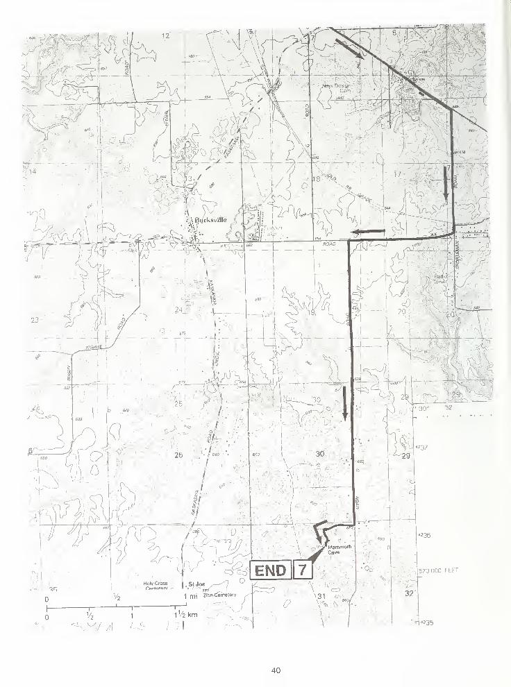
STOP 1 Peoria Loess and Overview of the Mississippi River Valley (NW SE SE, Sec. 8, T1 S,
R10W, 3rd P.M., Monroe County, Columbia 7.5-Minute Quadrangle)
Peoria Loess and Roxana Silt
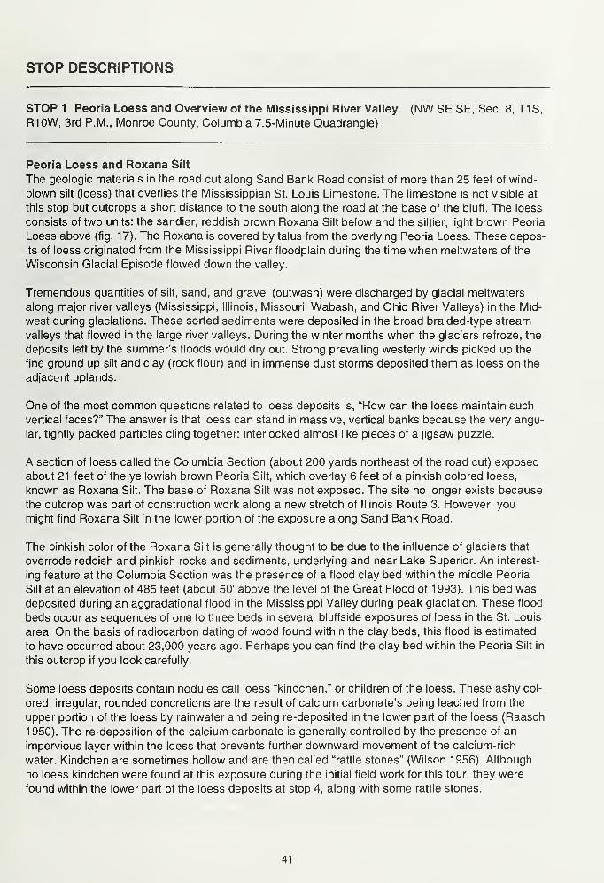
The geologic materials in the road cut along Sand Bank Road consist of more than 25 feet of wind-
blown silt (loess) that overlies the Mississippian St. Louis Limestone. The limestone is not visible at
this stop but outcrops a short distance to the south along the road at the base of the bluff. The loess
consists of two units: the sandier, reddish brown Roxana Silt below and the siltier, light brown Peoria
Loess above (fig. 17). The Roxana is covered by talus from the overlying Peoria Loess. These depos-
its of loess originated from the Mississippi River floodplain during the time when meltwaters of the
Wisconsin Glacial Episode flowed down the valley.
Tremendous quantities of silt, sand, and gravel (outwash) were discharged by glacial meltwaters
along major river valleys (Mississippi, Illinois, Missouri, Wabash, and Ohio River Valleys) in the Mid-
west during glaciations. These sorted sediments were deposited in the broad braided-type stream
valleys that flowed in the large river valleys. During the winter months when the glaciers refroze, the
deposits left by the summer's floods would dry out. Strong prevailing westerly winds picked up the
fine ground up silt and clay (rock flour) and in immense dust storms deposited them as loess on the
adjacent uplands.
One of the most common questions related to loess deposits is, "How can the loess maintain such
vertical faces?" The answer is that loess can stand in massive, vertical banks because the very angu-
lar, tightly packed particles cling together: interlocked almost like pieces of a jigsaw puzzle.
A section of loess called the Columbia Section (about 200 yards northeast of the road cut) exposed
about 21 feet of the yellowish brown Peoria Silt, which overlay 6 feet of a pinkish colored loess,
known as Roxana Silt. The base of Roxana Silt was not exposed. The site no longer exists because
the outcrop was part of construction work along a new stretch of Illinois Route 3. However, you
might find Roxana Silt in the lower portion of the exposure along Sand Bank Road.
The pinkish color of the Roxana Silt is generally thought to be due to the influence of glaciers that
overrode reddish and pinkish rocks and sediments, underlying and near Lake Superior. An interest-
ing feature at the Columbia Section was the presence of a flood clay bed within the middle Peoria
Silt at an elevation of 485 feet (about 50' above the level of the Great Flood of 1993). This bed wasdeposited during an aggradational flood in the Mississippi Valley during peak glaciation. These flood
beds occur as sequences of one to three beds in several bluffside exposures of loess in the St. Louis
area. On the basis of radiocarbon dating of wood found within the clay beds, this flood is estimated
to have occurred about 23,000 years ago. Perhaps you can find the clay bed within the Peoria Silt in
this outcrop if you look carefully.
Some loess deposits contain nodules call loess "kindchen," or children of the loess. These ashy col-
ored, irregular, rounded concretions are the result of calcium carbonate's being leached from the
upper portion of the loess by rainwater and being re-deposited in the lower part of the loess (Raasch
1950). The re-deposition of the calcium carbonate is generally controlled by the presence of an
impervious layer within the loess that prevents further downward movement of the calcium-rich
water. Kindchen are sometimes hollow and are then called "rattle stones" (Wilson 1956). Although
no loess kindchen were found at this exposure during the initial field work for this tour, they were
found within the lower part of the loess deposits at stop 4, along with some rattle stones.
41
1
1
Figure 17 A vertical bank and slumping of Peoria Loess in the south-facing road cut at stop 1 (photo by
Wayne T. Frankie).
Mississippi River Valley
This stop affords an excellent view of the Mississippi River Valley. The deposits within the valley near
Columbia consist of up to 100 feet of mixed, poorly sorted sand, silt, clay, and abundant lenses of
sandy gravel. These river deposits have been mapped by geologists and are called the Cahokia Allu-
vium and the Henry Formation. The Cahokia Alluvium is younger and overlies the Henry Formation.
The Mississippi River Valley is 3.3 miles wide at this point near Columbia, and gradually widens south-
ward to 5.5 miles, just north of Valmeyer where the Valmeyer Anticline juts out into the valley. South
of the influence of the Valmeyer Anticline, the Mississippi River Valley narrows to about 3.8 miles.
The widest portion of the valley is located to the north, between Alton and Dupo, where it is approxi-
mately 11 miles wide.
This broad floodplain, which is almost entirely located on the Illinois side of the Mississippi River Valley,
extends from Alton, Illinois (to the north), to just south of the mouth of the Kaskaskia River near Chester
(to the south), a distance of approximately 95 miles. This extensive floodplain with its many lakes
and wetlands is known as the American Bottoms, a name derived from the early American settlers.
Locally, parts of the Mississippi River Valley are quite old and probably formed during the Mesozoic
Era or, at the very latest, during the Tertiary Period of the Cenozoic Era. While the river has main-
tained its course along the eastern edge of the Ozark uplift, it has eroded a broad valley in the bed-
rock up to 300 or more feet below the surrounding uplands. The bluffs along the Mississippi River
consist of Ordovician, Mississippian, and Pennsylvanian rocks. Along the bluffs, hard Mississippian
limestones outcrop north of Alton and south of Dupo. Between them are the bluffs formed of the softer
Pennsylvanian shales, sandstones, and coals. In this area, therefore, the Mississippi River was able
to cut a wider floodplain than it could both upstream and downstream against the harder limestones .
42
The widening and deepening of the American Bottoms portion of the Mississippi River Valley, espe-
cially in the northern part, is primarily the result of the scouring action of postglacial flood meltwaters
that merged together at the confluence of the Mississippi and Missouri Rivers, just south of Alton.
Later, as the amount of melt water from the receding glaciers diminished and the river valley filled
with deposits of silt, sand and clay, the river took a meandering course, changing its route manytimes, swinging from east to west across the valley.
Ronald E. Yarbrough, of Illinois Natural Heritage, has described the history of glacial deposition in
the American Bottoms:
The Wisconsinan glaciers approached the field trip area from the
northwest, but stopped some 95 miles to the north. However, these
ice sheets had a major impact on the American Bottoms because the
Mississippi, as well as the Missouri and the Illinois Rivers, were major
drainage ways for the heavily-laden melt waters. The river began to
aggrade to a level of at least 445 feet in elevation, which is 47 feet
higher than the present river level. Today, the valley fill averages
120 feet in thickness and in places as much 160 feet of alluvial mate-
rial lies in the old bedrock valley of the Mississippi. Heavy deflation
took place during the Wisconsinan winters when westerly winds blew
across the exposed rock flour outwash. The lighter particles were
deposited on the upland as loess, attaining a thickness of 50 feet in
places adjacent to the floodplain but with a progressive decline in thick-
ness going eastward. As the Wisconsinan glaciers retreated from
Illinois, the river again began to degrade and remove the valley fill of
Pleistocene times.
Today, the floodplain is filled with alluvial materials that vary in thick-
ness from a few feet to over 150 feet. The alluvium may be divided
into two formations; the Henry of Wisconsinan age and the Cahokia
Alluvium of Wisconsinan and Holocene (Recent) ages. The Henry for-
mation overlies bedrock throughout most of the Bottoms and appears
on the surface only in the northern portion as distinct terraces. The
material consists dominantly of sand and gravel from glacial outwash.
The formation, because of its coarseness, is the primary source of
groundwater in the floodplain. Overlying the Henry formation is the
Cahokia Alluvium, consisting of silts, clays, and reworked Henry sands.
The silts and clays are derived from outwash, loess and till upstream.
The formation consists largely of silt-sized particles; where sand lenses
do occur, they contain large amounts of soil.
The Cahokia Alluvium on the American Bottoms varies in thickness
from to over 50 feet. The variability in thickness is due to recent cut-
and-fill processes on the Henry sands and gravels. It is known that the
Mississippi has scoured its bed over 50 feet during periods of high
water or when ice packs in winter cause the river to deepen its chan-
nel to flow under the ice. Thus, the many migrations of the channel
across the floodplain has created valleys in the underlying sands and
gravels and has replaced the valley train with thick deposits of Holo-
cene materials. (Adapted from Yarbrough 1974)
43
William R. Iseminger, of the Illinois State Museum, has described the formation and natural features
of the American Bottoms:
As former meanders were cut off from the main channel they
became lakes, sloughs and marshes; streams draining the uplands
captured other old meanders (see route maps). These various fluvial
features formed an interconnected "inland waterway" beyond the east-
ern banks of the Mississippi. They also provided a superb resource
base of fish, waterfowl and aquatic plants. Periodic flooding of the re-
gion also deposited fertile soils across the ridge and swale terrain of
the American Bottoms.
There were scattered woodlands concentrated around these aquatic
sources consisting primarily of cottonwood, willow, sycamore, maple
and hackberry, surrounded by large areas of prairie. Bluff crests often
were topped with hillside prairies and cedar; denser hardwood forests,
primarily oaks and hickories, were concentrated along the bluff slopes
and adjacent dissected uplands, and tallgrass prairies dominated the
interior uplands.
These various environmental zones would have provided a stable set
of floral and faunal resources within less than a day's walk from any
settlement in the American Bottom, and ethnobotanical evidence
from archaeological sites show that all zones were being exploited,
although in varying degrees in different time periods. However, the sta-
bility of these resources would be impacted by increased and even
over-exploitation, especially as population densities and distributions
increased through time.
Archaeologists recognize several prehistoric cultural traditions in this
region. In turn, most of these traditions are seen to have had several
sub-phases of cultural development and change. Paleo Indian is gen-
erally believed to have ranged from 9500 to 8000 B.C.; Archaic from
8000 to 600 B.C.; Woodland from 600 B.C. to A.D. 800; Emergent
Mississippian from A.D. 800 to 1000; Mississippian from A.D. 1000 to
1450; and Oneota from A.D. 1450 to 1550. Actually, the beginning and
ending "dates" for these traditions are imprecise and would vary from
region to region, but they represent the generally accepted time frames
recognized in the American Bottom area. The sub-phases and their
durations are constantly undergoing revision and refinement as newdata accumulates from ongoing research. (Adapted from Iseminger
1996)
Discontinuities and Interruptions in the Land Grid System in Illinois
Notice on the 7.5-minute quadrangle map (see route map) that the land grid system in this area is
divided into an irregular rectangular grid system that trends NE-SW. This land grid is part of the origi-
nal French Land Grants. These land grants date from the early French colonization and from old
Indian treaty boundaries that were honored when the grid system was established. The old land
grants are found mainly along the Wabash and Mississippi Rivers in southern Illinois because these
rivers were the main travel and trade routes along which settlement first occurred.
44
STOP 2 Levee along the Mississippi River (NE NW NE, Sec. 26, T1S, R11W, 3rd P.M., MonroeCounty, Oakville 7.5-Minute Quadrangle)
From the top of the levee, there is a good view of the Mississippi River and the Mississippian lime-
stone bluffs on both sides of the river. Notice the smaller levee between the main levee and the
Mississippi River. This secondary levee partially protects the farmland between the Mississippi River
and the main levee. Along the west side of the levee are a large number of dead trees. These trees
were killed by the Great Flood of 1 993 when they were under water for an extended period of time;
the trees essentially drowned.
During the Great Flood of 1993, a large break in the levee system along this portion of the Mississippi
River occurred. It began at a point just north of the bend in the road at the base of the levee, and
extended northward to a point just south of the farm buildings located to the north. The low area immedi-
ately east of the levee shows where a large scour hole formed when the levee was breached (see
route map and fig. 18). In the field to the southeast is a large ridge of sand that was scraped from
the field by bulldozers. Up to 8 feet of sand were deposited over the fields by the Mississippi River
when it breached the levee (fig. 18). Much of this sand probably came from the floodplain deposits
that were eroded out of the scour hole by the flood waters passing through the break in the levee.
Flooding
Some rainfall that reaches the ground soaks into the ground (infiltration), and some may flow across
the ground surface and into streams (runoff). Runoff occurs when the rate of rainfall exceeds the rate
at which water can infiltrate the soil. The amount of runoff is affected by many features of the drain-
age basin, including the permeability of the soil, the vegetation, density of streams in the basin, and
the saturation of the soil in the basin by earlier rainfall. Runoff in stream channels is measured in two
ways: by the stage height (depth of the water) or by the rate of discharge (the volume of water per
unit of time). The discharge rate is more commonly used by geologists and can be determined from
the stage height at a gauging station. During a flood, the flood crest is the stage height that occurs
during the peak discharge. The peak discharge may last for several hours or days.
A flood occurs when the capacity of the stream channel is exceeded by the volume of runoff, and
the water flows out of the channel and onto adjacent land (or the floodplain). Rivers carry sediment
in suspension, and during a flood when the water leaves the channel and spreads out, the river quickly
loses energy and first drops coarse grained sediments (sand and gravel). These materials create a
natural levee at the top of the bank along the normal channel. Farther out on the floodplain, the water
moves very slowly, and the fine grained sediments (silt and clay) are deposited over large areas and
build up the floodplain's level. The floodplain also serves as a storage area for flood water, which is
not released until the flood recedes.
Small streams have flash floods that occur shortly after heavy rainfalls and may only last for several
hours. Flash flooding is hard to predict because rainfall can vary widely during a single storm. TheNational Weather Service, which now uses Doppler radar to estimate the total rainfall in an area, can
predict flash flooding up to several hours before it occurs. Floods along large rivers, like the Missis-
sippi and Ohio, are caused by large amounts of rain falling over several days or even weeks. Because
it can take days or weeks for the water to move downstream, the National Weather Service, the U.S.
Army Corps of Engineers, and the U.S. Geological Survey can forecast with fairly high accuracy the
crests of these large floods several days before they occur. These forecasts allow residents time to
prepare.
45
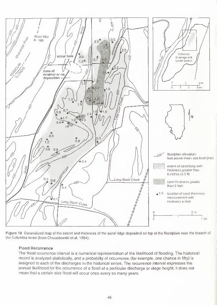
aOO floodplain elevation;
feet above mean sea level (msl)
extent ot sand body with
thickness greater than
6 inches (0.5 ft)
sand thickness greater
than 3 feet
« 1 6 location of sand thickness
measurement with
thickness in feet
Figure 18 Generalized map of the extent and thickness of the sand ridge deposited on top of the floodplain near the breach of
the Columbia levee (from Chrzastowski et al. 1994).
Flood Recurrence
The flood recurrence interval is a numerical representation of the likelihood of flooding. The historical
record is analyzed statistically, and a probabilty of occurrence (for example, one chance in fifty) is
assigned to each of the discharges in the historical series. The recurrence interval expresses the
annual likelihood for the occurrence of a flood at a particular discharge or stage height; it does not
mean that a certain size flood will occur once every so many years.
46
The recurrence intervals are only as reliable as the data used to calculate them. Most streams in Illinois
have been monitored for fewer than 100 years, so the recurrence intervals for large floods are not
well supported by the data available. The effect of this data gap can be minimized by examining
floodplain deposits and by estimating possible rainfalls and associated runoff. A larger problem with
the data may be that the geological environment that produces the floods has been drastically altered
by humans over the past 200 years. Alterations to drainage basins and river channels allow runoff to
enter the rivers and flow downstream more quickly. The effects of these changes on flood recurrence
are difficult to determine because man is constantly altering drainage basins by, for example, build-
ing new levees, adding drainage tiles, and digging new channels.
Responses to Flood Hazards
The flood crest stages associated with the 100-year and 500-year recurrence intervals are commonlyused when planning land use on the flood plane. Zoning laws can be used to restrict development in
flood-prone areas: for example, homes may have to be built on stilts or on hills that are above the
100-year flood stage. Levees may be built to withstand small or large floods depending on the land
use to be protected. Construction and maintenance of the levees are paid for by those protected.
Flood insurance can be purchased through the federal government to provide relief after a flood.
Insurance rates are based on the flood hazard, and flood insurance rate maps are distributed to librar-
ies and local government agencies.
During a flood, the predicted crest and the condition of the levees are constantly monitored. Unpro-
tected areas are evacuated, as are areas threatened by levee failure. The Coast Guard, the Corps
of Engineers, and the National Guard assist local governments in evacuation and rescue efforts. Boat
traffic is restricted due to the effects of wakes on levees and other structures.
After a flood, residents, business owners, and local governments are responsible for clean up. If the
state and federal governments declare a disaster area, monetary assistance is provided; otherwise,
money for recovery may be very limited. Insured homes whose damage is greater than half of their
value must be rebuilt away from the flood zone. Homes repaired using federal disaster assistance
must be insured against floods to receive future disaster assistance.
Levees
Levees are an important part of the flood protection system along the Mississippi River. Two types
of levees are present in this area. (1) Most levees along the floodplains in Illinois are agricultural
levees. Built by farmers to protect farm land outside of the federally built levees that protect towns,
these levees usually hold back 1- to 10-year floods. (2) Urban levees are higher and broader struc-
tures that protect cities. Built by the U.S. Army Corps of Engineers to withstand the 100- or 500-year
floods, urban levees are paid for and maintained by a local levee district that collects property taxes
on protected land and buildings. The levees are inspected regularly by the Corps of Engineers.
In order to be effective, the levee must surround the protected area or connect to points of high eleva-
tion such as bluffs. Rainfall within the protected area must be pumped out or held until the river level
falls and drains may be opened. Major tributaries to the Mississippi must be allowed to flow past the
leveed area, or the area would quickly fill with water. The levees must extend along the tributaries to
prevent backwater flooding.
Flood Control
There are two basic approaches to flood control. One is to minimize the extent of flooding by building
dams, reservoirs, levees, and other manmade structures. The other is to minimize floods by conser-
vation practices designed to hold the water where it falls in the drainage basin, or watershed.
During periods of high flow, a levee confines the water within a narrow band; this confinement raises
the peak stage height of flood waters upstream and downstream. Once construction of levees begins,
47
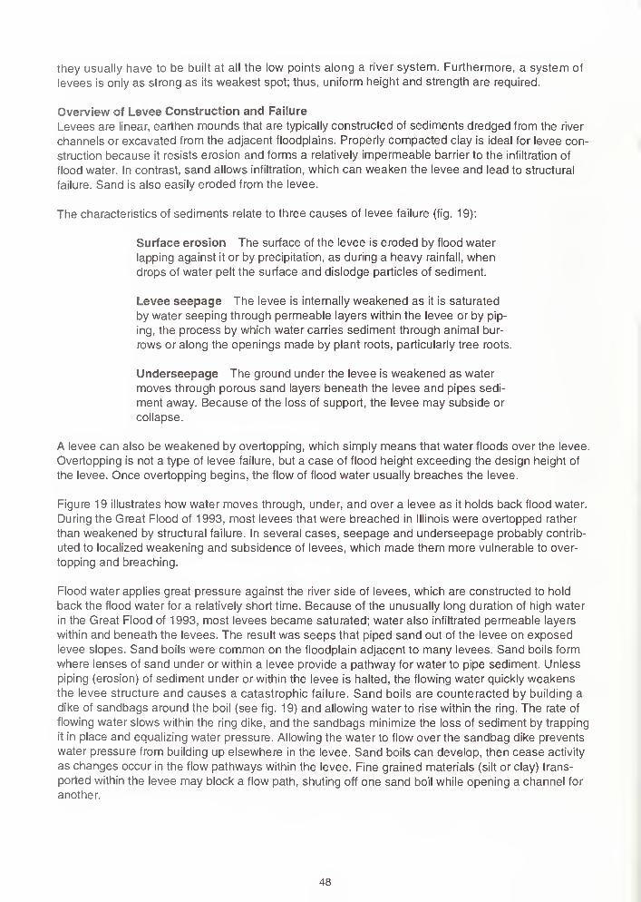
they usually have to be built at all the low points along a river system. Furthermore, a system of
levees is only as strong as its weakest spot; thus, uniform height and strength are required.
Overview of Levee Construction and Failure
Levees are linear, earthen mounds that are typically constructed of sediments dredged from the river
channels or excavated from the adjacent floodplains. Properly compacted clay is ideal for levee con-
struction because it resists erosion and forms a relatively impermeable barrier to the infiltration of
flood water. In contrast, sand allows infiltration, which can weaken the levee and lead to structural
failure. Sand is also easily eroded from the levee.
The characteristics of sediments relate to three causes of levee failure (fig. 19):
Surface erosion The surface of the levee is eroded by flood water
lapping against it or by precipitation, as during a heavy rainfall, whendrops of water pelt the surface and dislodge particles of sediment.
Levee seepage The levee is internally weakened as it is saturated
by water seeping through permeable layers within the levee or by pip-
ing, the process by which water carries sediment through animal bur-
rows or along the openings made by plant roots, particularly tree roots.
Underseepage The ground under the levee is weakened as water
moves through porous sand layers beneath the levee and pipes sedi-
ment away. Because of the loss of support, the levee may subside or
collapse.
A levee can also be weakened by overtopping, which simply means that water floods over the levee.
Overtopping is not a type of levee failure, but a case of flood height exceeding the design height of
the levee. Once overtopping begins, the flow of flood water usually breaches the levee.
Figure 19 illustrates how water moves through, under, and over a levee as it holds back flood water.
During the Great Flood of 1993, most levees that were breached in Illinois were overtopped rather
than weakened by structural failure. In several cases, seepage and underseepage probably contrib-
uted to localized weakening and subsidence of levees, which made them more vulnerable to over-
topping and breaching.
Flood water applies great pressure against the river side of levees, which are constructed to hold
back the flood water for a relatively short time. Because of the unusually long duration of high water
in the Great Flood of 1993, most levees became saturated; water also infiltrated permeable layers
within and beneath the levees. The result was seeps that piped sand out of the levee on exposed
levee slopes. Sand boils were common on the floodplain adjacent to many levees. Sand boils form
where lenses of sand under or within a levee provide a pathway for water to pipe sediment. Unless
piping (erosion) of sediment under or within the levee is halted, the flowing water quickly weakensthe levee structure and causes a catastrophic failure. Sand boils are counteracted by building a
dike of sandbags around the boil (see fig. 19) and allowing water to rise within the ring. The rate of
flowing water slows within the ring dike, and the sandbags minimize the loss of sediment by trapping
it in place and equalizing water pressure. Allowing the water to flow over the sandbag dike prevents
water pressure from building up elsewhere in the levee. Sand boils can develop, then cease activity
as changes occur in the flow pathways within the levee. Fine grained materials (silt or clay) trans-
ported within the levee may block a flow path, shuting off one sand boil while opening a channel for
another.
48
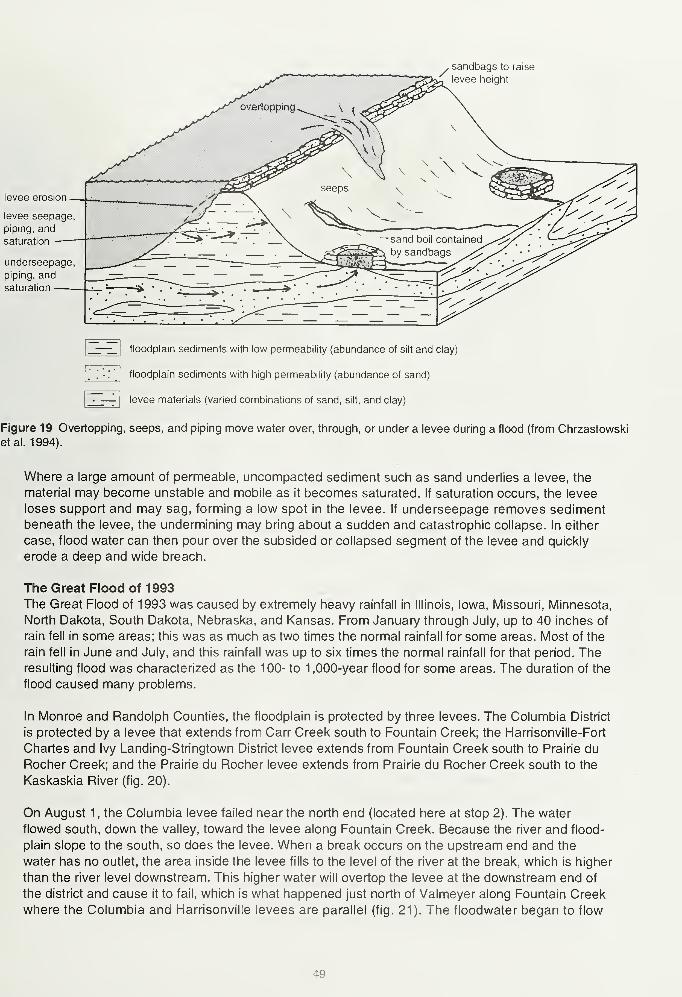
sandbags to raise
levee height
levee erosion
levee seepage
piping, and
saturation
underseepage
piping, and
saturation
floodplain sediments with low permeability (abundance of silt and clay)
floodplain sediments with high permeability (abundance of sand)
levee materials (varied combinations of sand, silt, and clay)
Figure 19 Overtopping, seeps, and piping move water over, through, or under a levee during a flood (from Chrzastowski
etal. 1994).
Where a large amount of permeable, uncompacted sediment such as sand underlies a levee, the
material may become unstable and mobile as it becomes saturated. If saturation occurs, the levee
loses support and may sag, forming a low spot in the levee. If underseepage removes sediment
beneath the levee, the undermining may bring about a sudden and catastrophic collapse. In either
case, flood water can then pour over the subsided or collapsed segment of the levee and quickly
erode a deep and wide breach.
The Great Flood of 1993
The Great Flood of 1993 was caused by extremely heavy rainfall in Illinois, Iowa, Missouri, Minnesota,
North Dakota, South Dakota, Nebraska, and Kansas. From January through July, up to 40 inches of
rain fell in some areas; this was as much as two times the normal rainfall for some areas. Most of the
rain fell in June and July, and this rainfall was up to six times the normal rainfall for that period. Theresulting flood was characterized as the 100- to 1 ,000-year flood for some areas. The duration of the
flood caused many problems.
In Monroe and Randolph Counties, the floodplain is protected by three levees. The Columbia District
is protected by a levee that extends from Carr Creek south to Fountain Creek; the Harrisonville-Fort
Charles and Ivy Landing-Stringtown District levee extends from Fountain Creek south to Prairie du
Rocher Creek; and the Prairie du Rocher levee extends from Prairie du Rocher Creek south to the
Kaskaskia River (fig. 20).
On August 1 , the Columbia levee failed near the north end (located here at stop 2). The water
flowed south, down the valley, toward the levee along Fountain Creek. Because the river and flood-
plain slope to the south, so does the levee. When a break occurs on the upstream end and the
water has no outlet, the area inside the levee fills to the level of the river at the break, which is higher
than the river level downstream. This higher water will overtop the levee at the downstream end of
the district and cause it to fail, which is what happened just north of Valmeyer along Fountain Creek
where the Columbia and Harrisonville levees are parallel (fig. 21). The floodwater began to flow
49
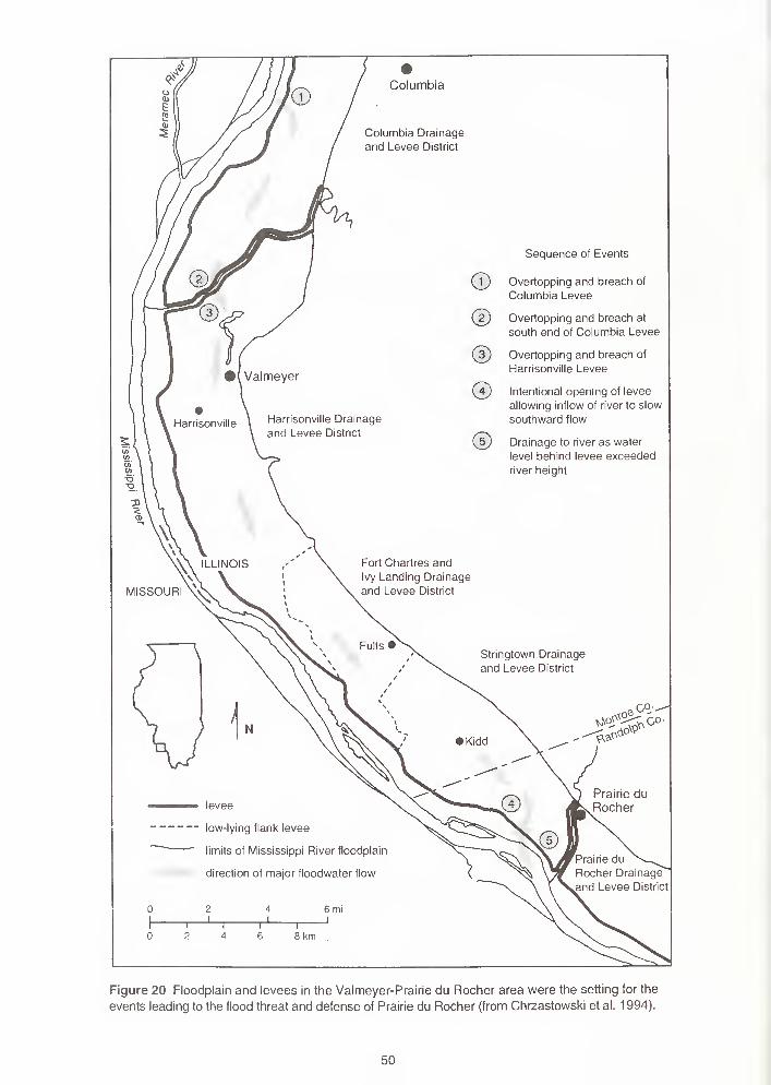
Columbia
Columbia Drainage
and Levee District
Sequence of Events
Overtopping and breach of
Columbia Levee
Overtopping and breach at
south end of Columbia Levee
Overtopping and breach of
Harrisonville Levee
Intentional opening of levee
allowing inflow of river to slow
southward flow
Drainage to river as water
level behind levee exceeded
river height
Figure 20 Floodplain and levees in the Valmeyer-Prairie du Rocher area were the setting for the
events leading to the flood threat and defense of Prairie du Rocher (from Chrzastowski et al. 1 994).
50
,
"•---- -I
i for Valmeyeri
1
relocation '
levee
location of breach
probable former river channels (letters
indicate relative age from oldest (A) to
youngest (E)
primary flow paths across districts
gure 21 Floodplain north of Valmeyer. Four breaches occurred where the levees crossed former river channels. Saturation
the sands in these channels may have reduced support for the levee on the north side of Fountain Creek. Once the levee
igged, it was quickly overtopped and breached in three locations. Water surging through the two southern breaks overtopped
id breached the levee on the south side of Fountain Creek and flooded the Harrisonville Drainage and Levee District. The>oding damaged Valmeyer so severely that the town relocated to the top of nearby bluffs (from Chrzastowski et al. 1994).
into and fill the Harrisonville-Fort Charles and Ivy Landing-Stringtown District levee to that higher,
upstream level.
On August 2, the U.S. Army Corps of Engineers decided to break the Stringtown levee near Fort
Chartres. This may seem like a strange thing to do, but this action probably saved the town of Prairie
du Rocher. By breaking the Stringtown levee in several places at the south end, the Corps provided
a drain that prevented the water from overtopping the levees paralleling Prairie du Rocher Creek—thus
saving the town of Prairie du Rocher.
The flood caused extensive damage, of which only a little evidence remains. The levees have been
completely repaired, and the areas that failed must be pointed out by local residents. Large scour
holes that formed inside the levee at the break have been filled with the sediment that covered neigh-
boring fields. Damaged homes have been removed or repaired. Wells contaminated by flood water
51
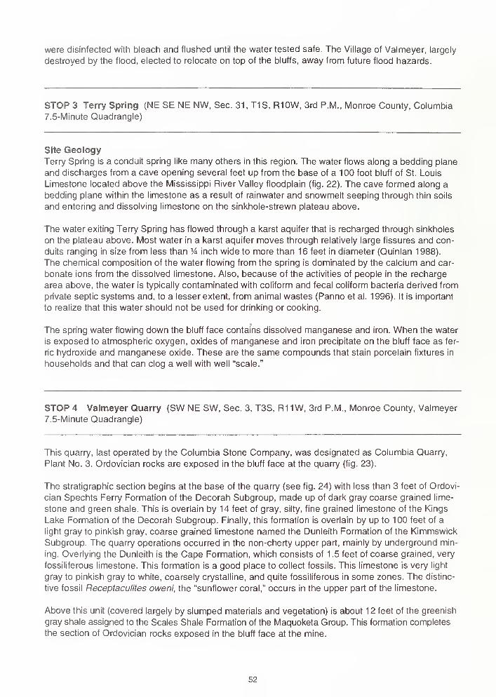
were disinfected with bleach and flushed until the water tested safe. The Village of Valmeyer, largely
destroyed by the flood, elected to relocate on top of the bluffs, away from future flood hazards.
STOP 3 Terry Spring (NE SE NE NW, Sec. 31, T1S, R10W, 3rd P.M., Monroe County, Columbia
7.5-Minute Quadrangle)
Site GeologyTerry Spring is a conduit spring like many others in this region. The water flows along a bedding plane
and discharges from a cave opening several feet up from the base of a 100 foot bluff of St. Louis
Limestone located above the Mississippi River Valley floodplain (fig. 22). The cave formed along a
bedding plane within the limestone as a result of rainwater and snowmelt seeping through thin soils
and entering and dissolving limestone on the sinkhole-strewn plateau above.
The water exiting Terry Spring has flowed through a karst aquifer that is recharged through sinkholes
on the plateau above. Most water in a karst aquifer moves through relatively large fissures and con-
duits ranging in size from less than % inch wide to more than 16 feet in diameter (Quinlan 1988).
The chemical composition of the water flowing from the spring is dominated by the calcium and car-
bonate ions from the dissolved limestone. Also, because of the activities of people in the recharge
area above, the water is typically contaminated with coliform and fecal coliform bacteria derived from
private septic systems and, to a lesser extent, from animal wastes (Panno et al. 1996). It is important
to realize that this water should not be used for drinking or cooking.
The spring water flowing down the bluff face contains dissolved manganese and iron. When the water
is exposed to atmospheric oxygen, oxides of manganese and iron precipitate on the bluff face as fer-
ric hydroxide and manganese oxide. These are the same compounds that stain porcelain fixtures in
households and that can clog a well with well "scale."
STOP 4 Valmeyer Quarry (SW NE SW, Sec. 3, T3S, R1 1 W, 3rd P.M., Monroe County, Valmeyer
7.5-Minute Quadrangle)
This quarry, last operated by the Columbia Stone Company, was designated as Columbia Quarry,
Plant No. 3. Qrdovician rocks are exposed in the bluff face at the quarry (fig. 23).
The stratigraphic section begins at the base of the quarry (see fig. 24) with less than 3 feet of Ordovi-
cian Spechts Ferry Formation of the Decorah Subgroup, made up of dark gray coarse grained lime-
stone and green shale. This is overlain by 14 feet of gray, silty, fine grained limestone of the Kings
Lake Formation of the Decorah Subgroup. Finally, this formation is overlain by up to 100 feet of a
light gray to pinkish gray, coarse grained limestone named the Dunleith Formation of the Kimmswick
Subgroup. The quarry operations occurred in the non-cherty upper part, mainly by underground min-
ing. Overlying the Dunleith is the Cape Formation, which consists of 1.5 feet of coarse grained, very
fossiliferous limestone. This formation is a good place to collect fossils. This limestone is very light
gray to pinkish gray to white, coarsely crystalline, and quite fossiliferous in some zones. The distinc-
tive fossil Receptaculites oweni, the "sunflower coral," occurs in the upper part of the limestone.
Above this unit (covered largely by slumped materials and vegetation) is about 12 feet of the greenish
gray shale assigned to the Scales Shale Formation of the Maquoketa Group. This formation completes
the section of Qrdovician rocks exposed in the bluff face at the mine.
52
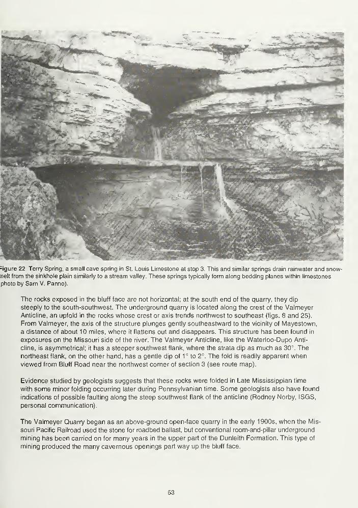
=igure 22 Terry Spring, a small cave spring in St. Louis Limestone at stop 3. This and similar springs drain rainwater and snow-
nelt from the sinkhole plain similarly to a stream valley. These springs typically form along bedding planes within limestones
photo by Sam V. Panno).
The rocks exposed in the bluff face are not horizontal; at the south end of the quarry, they dip
steeply to the south-southwest. The underground quarry is located along the crest of the Valmeyer
Anticline, an upfold in the rocks whose crest or axis trends northwest to southeast (figs. 8 and 25).
From Valmeyer, the axis of the structure plunges gently southeastward to the vicinity of Mayestown,
a distance of about 10 miles, where it flattens out and disappears. This structure has been found in
exposures on the Missouri side of the river. The Valmeyer Anticline, like the Waterloo-Dupo Anti-
cline, is asymmetrical; it has a steeper southwest flank, where the strata dip as much as 30°. The
northeast flank, on the other hand, has a gentle dip of 1° to 2°. The fold is readily apparent whenviewed from Bluff Road near the northwest corner of section 3 (see route map).
Evidence studied by geologists suggests that these rocks were folded in Late Mississippian time
with some minor folding occurring later during Pennsylvanian time. Some geologists also have found
indications of possible faulting along the steep southwest flank of the anticline (Rodney Norby, ISGS,
personal communication).
The Valmeyer Quarry began as an above-ground open-face quarry in the early 1900s, when the Mis-
souri Pacific Railroad used the stone for roadbed ballast, but conventional room-and-pillar underground
mining has been carried on for many years in the upper part of the Dunleith Formation. This type of
mining produced the many cavernous openings part way up the bluff face.
53
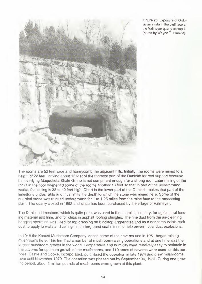
Figure 23 Exposure of Ordo-
vician strata in the bluff face at
the Valmeyer quarry at stop 4
(photo by Wayne T. Frankie).
The rooms are 52 feet wide and honeycomb the adjacent hills. Initially, the rooms were mined to a
height of 22 feet, leaving about 12 feet of the topmost part of the Dunleith for roof support because
the overlying Maquoketa Shale Group is not competent enough for a strong roof. Later mining of the
rocks in the floor deepened some of the rooms another 18 feet so that in part of the underground
works, the ceiling is 38 to 40 feet high. Chert in the lower part of the Dunleith makes that part of the
limestone undesirable and thus limits the depth to which the stone was mined here. Some of the
quarried stone was trucked underground for 1 to 1 .25 miles from the mine face to the processing
plant. The quarry closed in 1992 and since has been purchased by the village of Valmeyer.
The Dunleith Limestone, which is quite pure, was used in the chemical industry, for agricultural feed-
ing material and lime, and for chips in asphalt roofing shingles. The fine dust from the air-cleaning
bagging operation was used for top dressing on blacktop aggregates and as a noncombustible rock
dust to apply to walls and ceilings in underground coal mines to help prevent coal dust explosions.
In 1948 the Knaust Mushroom Company leased some of the caverns and in 1951 began raising
mushrooms here. This firm had a number of mushroom-raising operations and at one time was the
largest mushroom grower in the world. Temperature and humidity were relatively easy to maintain in
the caverns for optimum growth of the mushrooms, and 110 acres of caverns were used for this pur-
pose. Castle and Cooke, Incorporated, purchased the operation in late 1974 and grew mushroomshere until November 1979. The operation was phased out by September 30, 1981. During one grow-
ing period, about 2 million pounds of mushrooms were grown at this plant.
54
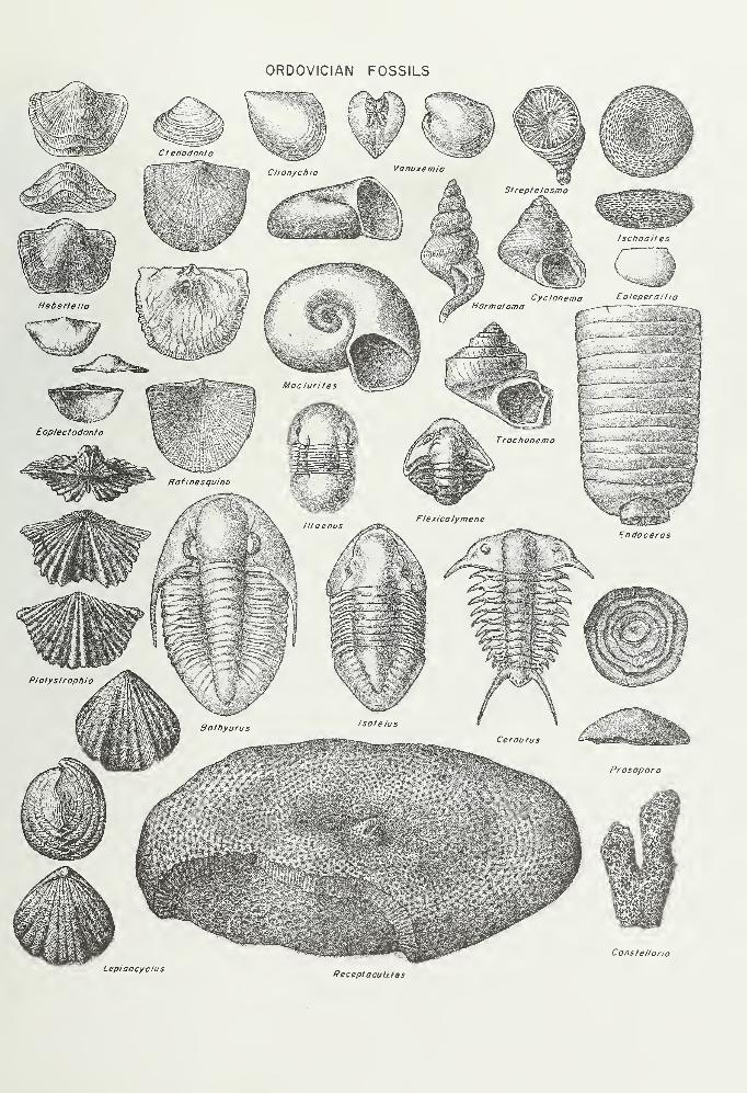
ORDOVICIAN FOSSILS
LepidocyclusReceptacuUJts
Constellario

WARSAW SHALEShale, buff to light brown, calcareous, fossiliferous with bryozoans abundant,especially on discontinuous light brown coarse-grained limestone beds; somelimestone at top and bottom of unit.
KEOKUK LIMESTONELimestone, buff, light gray to very light gray, coarse- to fine-grained; buff tolight gray chert abundant; corals and spiriferid brachiopods common near base.
BURLINGTON LIMESTONELimestone, light gray to buff, fine-grained with some coarser beds, dolomiticin places; white, buff, or gray chert beds and irregular masses form as much as
50% of unit; pelmatozoan remains abundant.
FERN GLEN LIMESTONELimestone, red, ranging to light gray and buff, fine- to coarse grained, argilla-
ceous; some shale beds; chert near top; pelmatozoan remains common.
CHOUTEAU LIMESTONELimestone, light gray, fine-grained; thin shale beds.
HANNIBAL SHALEShale, greenish gray.
SCALES SHALEShale, greenish gray; contains beds of siltstone, fine-grained sandstone and phos-
phatic nodules; phosphatic pebbles and fossils near top.
CAPE LIMESTONELimestone, coarse-grained, very fossiliferous.
DUNLEITH FORMATIONLimestone, brownish gray, ranges to pink and buff in some members, fine- to
very coarse-grained, generally massive; fossiliferous, bryozoans abundant. Be-
ceptaculites abundant in upper 0.7 m (2.0 ft); some chert bands present in lower
part.
KINGS LAKE FORMATIONLimestone, gray, fine-grained, argillaceous, silty.
SPECHTS FERRY FORMATIONLimestone, dark gray, calcarenitic; several centimeters of green shale exposed
below limestone.
Figure 24 Generalized stratigraphic column of rocks exposed on the Valmeyer Anticline (from Norby 1987).
55
C/>
<s
Ci<
./ /
ggi ainoy
I I
E J=
,eM
wnio
to_J
im» II.CD
w
>- to
£ T?"•"^
TOco" tr
EX
CD
Eoto
o ~ T3Q. CD i—
Q. >TO ^Z -CT
T3 trC CD
DO TO COCL
CDCDo>TO
E
c Xto N
ro CD CO> W co
TOCD x: >s
E TO 3 -QoL.
UCO
oCO o
TOo•tr
2toTO
-IT
h-Eo
.C CD
3o
>CD
ETO XT
CO SZ CD 3
c!^oo
h-
CO
co
TOoCO
1
x:tro
CD o C cC OT3
CO C
ooE
< CDC CO
co
cocr:1_
£
Ooto
CDc "to
TO5
TO 3> Q. O
Ox:troc
T3 TO
CcooCDCO
COCOo
C O
XT
TO
C
TOClQ-ro
xj
oCO
COco
ou
o CO
CJ>~ .c
CO
TO
EETO
TOCD "o
trTOQ.
CO
'xj
CD
-Co
inCM
>"o
x:tro
uccoTO
01c
CDco
CO3
3 CO TO
en E TOX
Oil T- -Q
56
Other parts of the mined-out areas have at one time been used for warehousing, and the mine wasdesignated the largest Civil Defense Shelter in Illinois. The varied uses of this property are an excel-
lent example of multiple land use. Easy access to the main line of the Union Pacific Railroad in con-
junction with the short distance to the St. Louis metropolitan area may encourage renewed interest
in this property for storage and manufacturing purposes.
After leaving this stop, our route will follow Illinois Route 156 (which goes up through Dennis Hollow).
As you drive up Dennis Hollow, note the rocks exposed along the highway, especially at the base of
the bluff, where rocks with some of the steepest dips associated with the Valmeyer Anticline can beseen. These are primarily the Mississippian rocks which unconformably overlie the Ordovician rocks
on the anticline (figs. 24 and 25). This exposure near the base of the bluff is considered one of the
most completely exposed geologic sections in the state. The following description was provided by
ISGS geologist L.E. Workman in 1949:
Mississippian System
Warsaw Formation
5. Shale, calcareous, yellowish to grey; limestone lenses;
fossiliferous 13 ft
Keokuk Formation
4. Limestone, shaly, cherry, glauconitic, light greenish gray 16 ft
3. Limestone, cherty, gray, crinoidal 3 ft
2. Shale 2 ft
Burlington Formation
1. Limestone, cherty, light gray, coarse 3 ft
Total thickness 37 ft
STOP 5 Camp Vandeventer: Lunch (SW SE SE, Sec. 21 , T2S, R10W, 3rd P.M., Monroe
County, Waterloo 7.5-Minute Quadrangle)
Site GeologyThe camp, which lies near the southern end of the Columbia Syncline, contains numerous sinkholes,
caves, springs, and steep limestone bluffs formed in the St. Louis Limestone. The camp facilities
overlook Fountain Creek, which dissects the plateau. Springs that drain runoff from rainfall and snow-
melt on the plateau are numerous along the base of the bluffs that bound Fountain Creek.
Stop 5a: Karst Window (see route map)The large, steep sided sinkhole across the road from the Apache Camp Site along the entrance road
of Camp Vandeventer is a feature called a "karst window" (fig. 26). A karst window is a special type
of sinkhole that results from the collapse of the roof of a cave system. The water flowing through the
opening in the bottom of this karst window continues as an underground stream that discharges at
the base of the bluff just below the Fountain Creek Lodge at Camp Vandeventer. Note the outcrop of
bedded limestone within the sinkhole. During periods of high water, following rainfall and snowmelt,
the water flowing through the bottom of the sinkhole rises and overflows into a small surface stream
that flows under the road and cascades down a ravine toward Fountain Creek.
Stop 5b: Boy Scout Camp Spring (see route map)The Boy Scout Camp Spring at Camp Vandeventer discharges from a small cave at the base of a 40-
to 45-foot-high bluff in the upper St. Louis Limestone (fig. 27). The spring flows directly into Fountain
Creek through an entrenched channel. A smaller cave spring is located just to the west of this spring
along the same bluff. Discharge from this spring is almost negligible during the drier summer months.
57
Figure 26 A "karst window" at the base of a sinkhole at Camp Van-
deventer at stop 5a. This sinkhole formed when part of an under-
ground cave collapsed, thus exposing the cave stream (photo by
Sam V. Panno).
However, during periods of storm runoff, it acts as an overflow for the Boy Scout Camp Spring. Dis-
charge from both springs is a high-energy, turbulent flow following large, springtime rainfalls.
As with most springs in the sinkhole plain, the water that discharges from the Boy Scout Camp Spring
is contaminated with fecal coliform bacteria from private septic systems. In fact, this is one of the most
severely contaminated springs in Monroe County, and contact with the water should be avoided.
Outcrops of St. Louis Limestone at Camp Vandeventer The exposure of limestone shows karst
features. The layered nature of this limestone allows surface-derived water to enter along fissures
and flow along bedding planes (fig. 28). Solution of the limestone along one of these layers has
slowly enlarged the water's pathways, forming small conduits. With time, the pathways will enlarge
downward to form small caves.
58
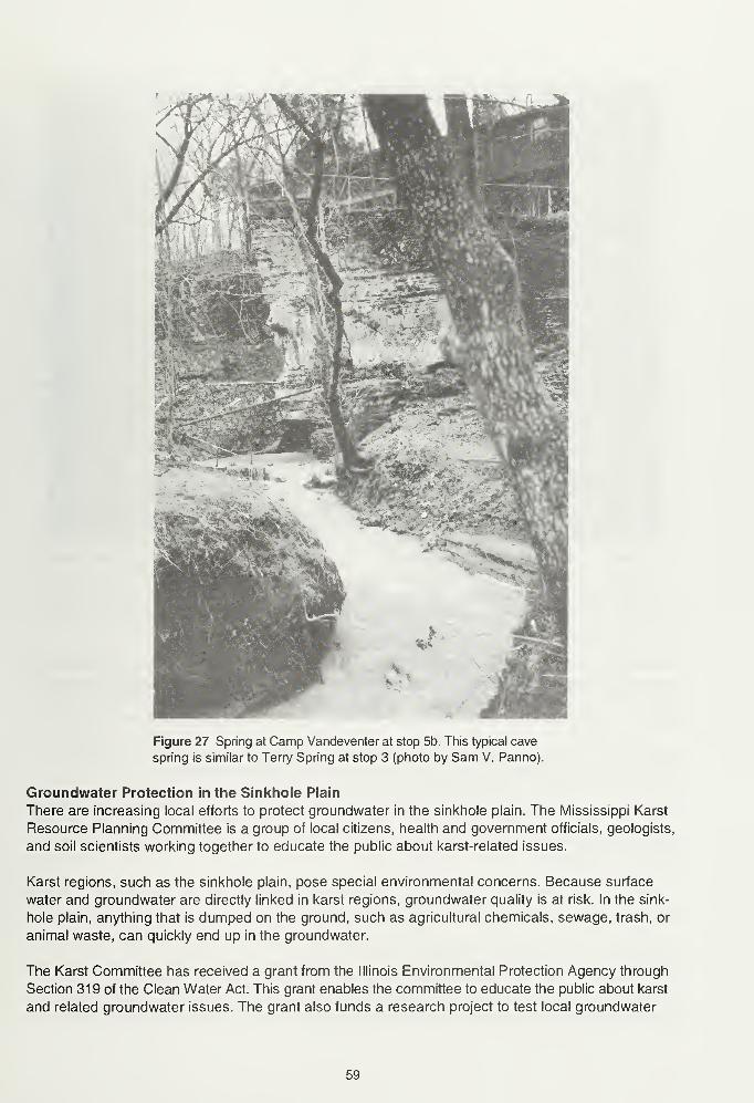
Figure 27 Spring at Camp Vandeventer at stop 5b. This typical cave
spring is similar to Terry Spring at stop 3 (photo by Sam V. Panno).
Groundwater Protection in the Sinkhole Plain
There are increasing local efforts to protect groundwater in the sinkhole plain. The Mississippi Karst
Resource Planning Committee is a group of local citizens, health and government officials, geologists,
and soil scientists working together to educate the public about karst-related issues.
Karst regions, such as the sinkhole plain, pose special environmental concerns. Because surface
water and groundwater are directly linked in karst regions, groundwater quality is at risk. In the sink-
hole plain, anything that is dumped on the ground, such as agricultural chemicals, sewage, trash, or
animal waste, can quickly end up in the groundwater.
The Karst Committee has received a grant from the Illinois Environmental Protection Agency through
Section 319 of the Clean Water Act. This grant enables the committee to educate the public about karst
and related groundwater issues. The grant also funds a research project to test local groundwater
59

Figure 28 Bedding and solution features in St. Louis Limestone in a bluff along Fountain Creek at CampVandeventer at stop 5b (photo by Sam V. Panno).
for several contaminants and to trace the rate and direction of groundwater flow in the karst region
with a dye tracing method.
Educational projects of the grant include brochures, a Best Management Practices Manual, a curriculum
guide for local schools, newsletters, and a newspaper pull-out describing and explaining groundwater
and karst issues. The committee also co-sponsors tours such as today's field trip, informational meet-
ings, and a conference for residents of the karst region and other interested individuals.
More information about the Section 319 Grant and the committee are available from the Karst Edu-
cator's office. Kris Ahrens-Voelker, the karst educator, can be reached at (618) 939-3871.
STOP 6 Waterloo Quarry (NW & NE NE, Sec. 8, T3S, R9W, 3rd P.M., Monroe County, Paderborn
7.5-Minute Quadrangle)
Columbia Quarry Company's Waterloo Quarry (Plant No. 7)
The Waterloo Quarry, originally opened in 1971 by the Quality Stone Company, was purchased by
Columbia Quarry Company in February 1996. The Quarry is now designated as Columbia Quarry
Plant No. 7. The mining operation at this quarry produces approximately Vi million tons of limestone
per year; based on the current rate of production and the amount of land currently owned, an esti-
mated 100 to 150 years of resources remain. Total production to date from this quarry is 9 million
60
tons. The stone produced from the Waterloo Quarry is primarily sold as road aggregate and is
shipped by truck; however, the company also produces 15 different products ranging from lime dust
to 400-pound rip rap.
This quarry exposes a section of middle Mississippian rocks (Valmeyeran Series) that includes morethan 40 feet of Salem Limestone and about 150 feet of St. Louis Limestone (fig. 29). The Salem is
known to be more than 100 feet thick, so only the upper one-third to one-half of the formation is
exposed here. Most of the St. Louis appears to be present, but up to 50 feet of St. Louis may be
missing—eroded from the top since the end of the Paleozoic Era.
The.Salem, presently exposed in the lowest level of the northwest corner of the quarry, contains two
thin sedimentary cycles and the top of a third cycle. Each cycle represents a shoaling environment
of deposition within the zone of wave action that became progressively shallower with time. The lower
part of the cycle consists of a limestone that is moderately coarse grained (grainstone), closely com-pacted with well sorted grains (all of about the same size) and very little or no argillaceous sediments
("clean"). Sediments from similar environments are often oolitic, but oolites are uncommon in these
particular cycles. As the sea became shallower (regresssed), a lagoonal or tidal flat environment domi-
nated by finer carbonate and argillaceous sediments became prevalent. Laminated beds of fossilized
algae, oncolites (spheres of fossilized algae), and fenestrae structures (possibly representing "fossil-
ized" gas bubbles that formed small openings within the tidal flat sediments) are common in the upper
part of the cycle. The cycles may be the result of broad, uniform changes in sea level, caused either
by glaciation elsewhere in the world that tied up ocean water as ice, or by actual vertical movementsof the sea floor and continents, called "eustasy."
The rocks of the St. Louis Limestone were also deposited in very shallow water environments that
included some of the same ones as the Salem, although shallow subtidal, lagoonal, tidal flat, and
evaporitic conditions seem to have prevailed. These environments are indicated by the very fine
grained ("sublithographic") lime mudstones, limestone breccias, dolomites, and cherty limestones
characteristic of the St. Louis. Grainstones representing possible shoaling conditions are also
present, particularly at this quarry, but their grain size is generally finer than the ones in the Salem.
The sedimentary cycles that are a common feature of the Salem are not present in the St. Louis.
Marine fossils are common throughout the St. Louis and include corals (both colonial and solitary),
bryozoans, brachiopods, and echinoderms. The fossils are remarkably abundant in some beds near
the top of the St. Louis and are especially well preserved along bedding planes where shale partings
interrupt the limestone. The shale, originally deposited as mud, covered and protected a number of
delicate fossil forms such as bryozoans and crinoids. These shale zones are excellent places to col-
lect fossils.
The upper portion of the quarry provides an excellent exposure of solution-enlarged cavities within
the St. Louis Limestone (fig. 30). Soil and rock debris now partially fill these cavities. These cavities
offer a cross section view of the inside of sinkholes like those that dot the upland surface beyond the
top of the quarry walls.
STOP 7 Illinois Caverns (SW NW NE, Sec. 31 , T3S, R9W, 3rd P.M., Monroe County, Renault
7.5-Minute Quadrangle)
Site History
Three of the largest known caves in Illinois are in Monroe County. Illinois Caverns, the second largest
cave in the state and the only cave in Illinois ever to have been commercially developed, lies near the
geographic center of the county. The cave was a tour stop of the 1904 St. Louis Exposition and was
61
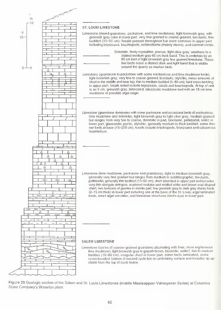
ST. LOUIS LIMESTONE
Limestone (mixed grainstone, packstone, and lime mudstone), light brownish gray, with
greenish gray color in lower part, very fine grained to coarse grained, bioclastic, thin
bedded (10-50 cm); fossils present throughout but more common in upper part
including bryozoans, brachiopods, echinoderms (mainly stems), and colonial corals.
Dolomite, finely crystalline, porous, light olive gray, weathers to adistinct medium gray 65 cm thick band. This is underlain by an80 cm bed of light brownish gray fine grained limestone. Thesetwo beds make a distinct dark and light band that is visible
around the quarry as marker beds.
Limestone (grainstone to packstone with some wackestone and lime mudstone beds),
light brownish gray, very fine to coarse grained, bioclastic, stylolitic, minor amounts of
chert in the middle and near top, thin to medium bedded (5-80 cm); faint cross-bedding
in upper part; fossils noted include bryozoans, corals and brachiopods. At top of unit
is an 5 cm, greenish gray, laminated, siliciclastic mudstone bed with an 18 cm lime
mudstone of possible algal origin.
Limestone (grainstone dominates with some packstone and occasional beds of wackestone,
lime mudstone and dolomite), light brownish gray to light olive gray, medium grained
but ranges from very fine to coarse, dolomitic in part, bioclastic, pelletoidal, oolitic in
lower part, glauconitic, pyritic, stylolitic, generally medium to thick bedded, some thin-
ner beds at base (15-200 cm); fossils include brachiopods, bryozoans and calcareous
foraminifers.
Limestone (lime mudstone, packstone and grainstone), light to medium brownish gray,
generally very fine grained but ranges from medium to sublithographic, bioclastic,
pelletoidal, generally thin bedded (10-50 cm); chert abundant in upper part and includes
very thin elongate stringers, scattered nodules and mottled white and brown oval-shaped
chert; two horizons of geodes in middle part; five greenish gray to dark gray shaley beds(2-15 cm thick) in lower part including one at the base of the St. Louis; algal laminated
beds, small algal oncolites, and fenestrae structures (bird's-eye) in lower part.
SALEM LIMESTONE
Limestone (cycles of coarser grained grainstone alternating with finer, more argillaceous
lime mudstone), light brownish gray to grayish brown, bioclastic, oolitic?, thin to mediumbedded (10-80 cm), irregular chert in lower part, some beds laminated, somecross-bedded; bottom of second cycle lies on undulating surface and includes rip-up
clasts from the top of cycle below.
Figure 29 Geologic section of the Salem and St. Louis Limestones (middle Mississippian Valmeyeran Series) at ColumbiaStone Company's Waterloo plant.
62
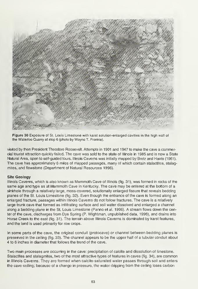
:<" ,
Figure 30 Exposure of St. Louis Limestone with karst solution-enlarged cavities in the high wall of
the Waterloo Quarry at stop 6 (photo by Wayne T. Frankie).
visited by then President Theodore Roosevelt. Attempts in 1901 and 1947 to make the cave a commer-cial tourist attraction quickly failed. The cave was sold to the state of Illinois in 1985 and is now a State
Natural Area, open to self-guided tours. Illinois Caverns was initially mapped by Bretz and Harris (1961).
The cave has approximately 6 miles of mapped passages, many of which contain stalactites, stalag-
mites, and flowstone (Department of Natural Resources 1996).
Site GeologyIllinois Caverns, which is also known as Mammoth Cave of Illinois (fig. 31), was formed in rocks of the
same age and type as at Mammoth Cave in Kentucky. The cave may be entered at the bottom of a
sinkhole through a relatively large, moss-covered, solutionally enlarged fissure that reveals bedding
planes of the St. Louis Limestone (fig. 32). Even though the entrance of the cave is formed along an
enlarged fracture, passages within Illinois Caverns do not follow fractures. The cave is a relatively
large trunk cave that formed as infiltrating surface and soil water dissolved and enlarged a channel
along a bedding plane in the St. Louis Limestone (Panno et al. 1996). A stream flows down the cen-
ter of the cave, discharges from Dye Spring (P. Wightman, unpublished data, 1996), and drains into
Horse Creek to the east (fig. 31). The terrain above Illinois Caverns is dominated by karst features,
and the land is used primarily for row crops.
In some parts of the cave, the original conduit (protocave) or channel between bedding planes is
preserved in the ceiling (fig. 33). The channel appears to be the upper half of a tubular conduit about
4 to 6 inches in diameter that follows the trend of the cave.
Two main processes are occurring in the cave: precipitation of calcite and dissolution of limestone.
Stalactites and stalagmites, two of the most attractive types of features in caves (fig. 34), are commonin Illinois Caverns. They are formed when calcite-saturated water passes through soil and enters
the cave ceiling; because of a change in pressure, the water dripping from the ceiling loses carbon
63
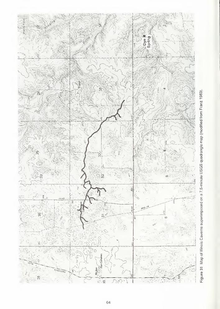
CO00O)
Ncco
Eo
o
Q.A3
E_QJC
to
o-
coCDCO3
3cEuS
i^
CO
co-o<x>
to
oQ.
C
>
O
oQ.
0)
k.
64
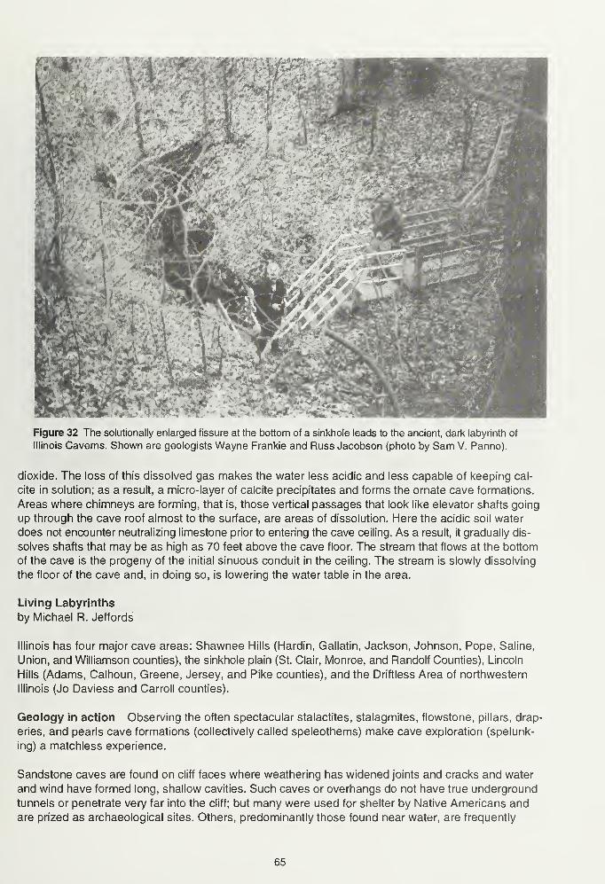
'ilf^jP^P* f#^a^
Figure 32 The solutionally enlarged fissure at the bottom of a sinkhole leads to the ancient, dark labyrinth of
Illinois Caverns. Shown are geologists Wayne Frankie and Russ Jacobson (photo by Sam V. Panno).
dioxide. The loss of this dissolved gas makes the water less acidic and less capable of keeping cal-
cite in solution; as a result, a micro-layer of calcite precipitates and forms the ornate cave formations.
Areas where chimneys are forming, that is, those vertical passages that look like elevator shafts going
up through the cave roof almost to the surface, are areas of dissolution. Here the acidic soil water
does not encounter neutralizing limestone prior to entering the cave ceiling. As a result, it gradually dis-
solves shafts that may be as high as 70 feet above the cave floor. The stream that flows at the bottom
of the cave is the progeny of the initial sinuous conduit in the ceiling. The stream is slowly dissolving
the floor of the cave and, in doing so, is lowering the water table in the area.
Living Labyrinths
by Michael R. Jeffords
Illinois has four major cave areas: Shawnee Hills (Hardin, Gallatin, Jackson, Johnson, Pope, Saline,
Union, and Williamson counties), the sinkhole plain (St. Clair, Monroe, and Randolf Counties), Lincoln
Hills (Adams, Calhoun, Greene, Jersey, and Pike counties), and the Driftless Area of northwestern
Illinois (Jo Daviess and Carroll counties).
Geology in action Observing the often spectacular stalactites, stalagmites, flowstone, pillars, drap-
eries, and pearls cave formations (collectively called speleothems) make cave exploration (spelunk-
ing) a matchless experience.
Sandstone caves are found on cliff faces where weathering has widened joints and cracks and water
and wind have formed long, shallow cavities. Such caves or overhangs do not have true underground
tunnels or penetrate very far into the cliff; but many were used for shelter by Native Americans and
are prized as archaeological sites. Others, predominantly those found near water, are frequently
65
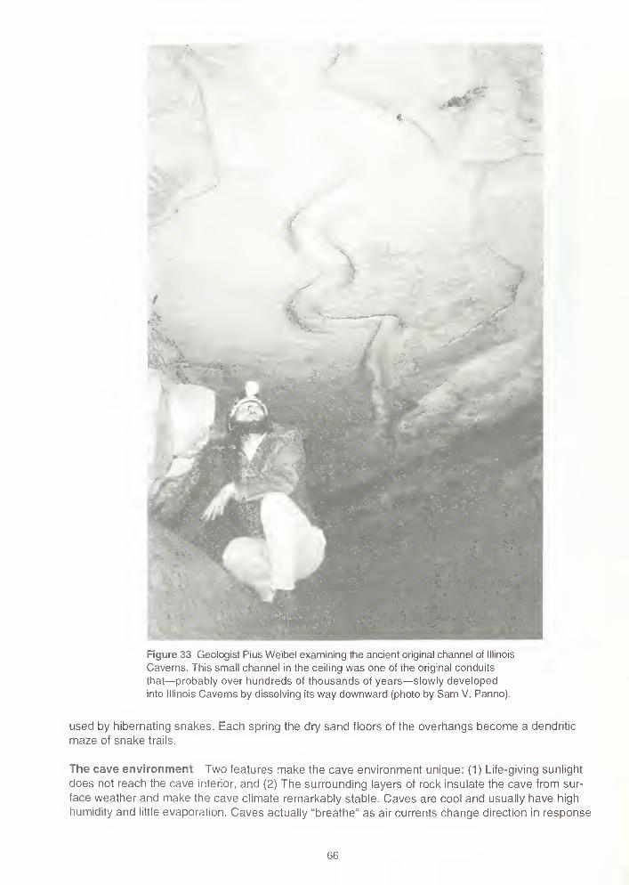
Figure 33 Geologist Pius Weibel examining the ancient original channel of Illinois
Caverns. This small channel in the ceiling was one of the original conduits
that—probably over hundreds of thousands of years—slowly developed
into Illinois Caverns by dissolving its way downward (photo by Sam V. Panno).
used by hibernating snakes. Each spring the dry sand floors of the overhangs become a dendritic
maze of snake trails.
The cave environment Two features make the cave environment unique: (1) Life-giving sunlight
does not reach the cave interior, and (2) The surrounding layers of rock insulate the cave from sur-
face weather and make the cave climate remarkably stable. Caves are cool and usually have high
humidity and little evaporation. Caves actually "breathe" as air currents change direction in response
66
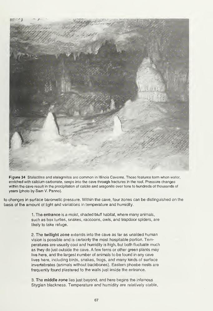
Figure 34 Stalactites and stalagmites are common in Illinois Caverns. These features form when water,
enriched with calcium carbonate, seeps into the cave through fractures in the roof. Pressure changes
within the cave result in the precipitation of calcite and aragonite over tens to hundreds of thousands of
years (photo by Sam V. Panno).
to changes in surface barometic pressure. Within the cave, four zones can be distinguished on the
basis of the amount of light and variations in temperature and humidity.
1. The entrance is a moist, shaded bluff habitat, where many animals,
such as box turtles, snakes, raccoons, owls, and trapdoor spiders, are
likely to take refuge.
2. The twilight zone extends into the cave as far as unaided humanvision is possible and is certainly the most hospitable portion. Tem-
peratures are usually cool and humidity is high, but both fluctuate much
as they do just outside the cave. A few ferns or other green plants maylive here, and the largest number of animals to be found in any cave
lives here, including birds, snakes, frogs, and many kinds of surface
invertebrates (animals without backbones). Eastern phoebe nests are
frequently found plastered to the walls just inside the entrance.
3. The middle zone lies just beyond, and here begins the infamous
Stygian blackness. Temperature and humidity are relatively stable,
67
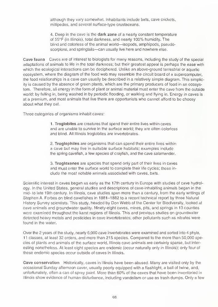
although they vary somewhat. Inhabitants include bats, cave crickets,
millipedes, and several surface-type crustaceans.
4. Deep in the cave is the dark zone of a nearly constant temperature
of 55°F (in Illinois), total darkness, and nearly 100% humidity. Theblind and colorless of the animal world—isopods, amphipods, pseudo-
scorpions, and springtails—can usually live here and nowhere else.
Cave fauna Caves are of interest to biologists for many reasons, including the study of the special
adaptations of animals to life in the total darkness; but their greatest appeal is perhaps the ease with
which the ecological interactions can be deciphered. Unlike an above-ground terrestrial or aquatic
ecosystem, where the diagram of the food web may resemble the circuit board of a supercomputer,
the food relationships in a cave can usually be described in a relatively simple diagram. This simplic-
ity is caused by the absence of green plants, which are the primary producers of food in an ecosys-
tem. Therefore, all energy in the form of plant or animal material must enter the cave from the outside
world: by falling in, being washed in by periodic flooding, or walking and flying in. Energy in caves is
at a premium, and most animals that live there are opportunists who cannot afford to be choosy
about what they eat.
Three categories of organisms inhabit caves:
1 . Troglobites are creatures that spend their entire lives within caves
and are unable to survive in the surface world; they are often colorless
and blind. All Illinois troglobites are invertebrates.
2. Troglophiles are organisms that can spend their entire lives within
a cave but may live in suitable surface habitats; examples include
the spring cavefish, a few species of crayfish, and the cave salamander.
3. Trogloxenes are species that spend only part of their lives in caves
and must enter the surface world to complete their life cycles; these in-
clude the most notable animals associated with caves, bats.
Scientific interest in caves began as early as the 17th century in Europe with studies of cave hydrol-
ogy. In the United States, general studies and descriptions of cave-inhabiting animals began in the
mid- to late 19th century. In Illinois, cave studies span more than a century, from the early writings of
Stephen A. Forbes on blind cavefishes in 1881-1882 to a recent technical report by three Natural
History Survey scientists. This study, headed by Don Webb of the Center for Biodiversity, looked at
cave animals and groundwater quality. Ninety-eight caves, mines, pits, and springs in 13 counties
were examined throughout the karst regions of Illinois. This and previous studies on groundwater
detected heavy metals and pesticides in cave invertebrates; other pollutants such as nitrates were
found in the water.
Over the 2 years of the study, nearly 6,000 cave invertebrates were examined and sorted into 4 phyla,
11 classes, at least 32 orders, and more than 215 species. Compared to the more than 50,000 spe-
cies of plants and animals of the surface world, Illinois cave animals are certainly sparse, but inter-
esting nonetheless. At least eight species are endemic (occur naturally only in Illinois); only four of
these endemic species occur outside of caves in Illinois.
Cave conservation Historically, caves in Illinois have been abused. Many are visited only by the
occasional Sunday afternoon caver, usually poorly equipped with a flashlight, a ball of twine, and,
unfortunately, often a can of spray paint. More than 60% of the caves that have been inventoried in
Illinois show evidence of human disturbance, including vandalism or use as trash dumps. Only a few
68
caves have been protected in Illinois. In response to this neglect, the legislature passed the CaveProtection Act in 1985 to help preserve the natural and cultural resources of Illinois caves.
As a result of efforts by the Illinois Department of Conservation, several caves are included in the
Illinois Natural Areas Inventory (a listing of sites in the state that have significant natural features).
Others are designated as Illinois Natural Heritage Landmarks. One cave, with at least 12 miles of
passageways, was purchased and dedicated as an Illinois Nature Preserve to protect a population
of hibernating Indiana bats, a federally endangered species. Illinois Caverns (originally called Mam-moth Cave of Illinois and the only cave to be operated commercially in Illinois around the turn of the
century and again following World War II) was also purchased and declared an Illinois Natural Area.
Currently, approximately 6 miles of passages are open to the public for exploration, but a permit is
required to enter (this regulation helps to protect the cave environment). Explorers are required to carry
three dependable sources of light and to wear protective clothing. In addition, they are warned to
plan on getting their feet wet!
The caves of Illinois have intrinsic, aesthetic, cultural, recreational, and scientific value. Gene Gardner,
former Illinois Natural History Survey scientist, writes, "Caves are a viable link in the great environ-
mental chain that binds our planet together. [In addition] caves, like pages in a history book, provide
information on past climate, paleontology, and archaeology. Anyone who meets the challenge of explor-
ing dark passageways rarely or never seen will have a memorable and deeply moving experience."
Such habitats speak to the Tom Sawyer in each of us. They are an irreplaceable natural resource
that must be protected for future generations.
Bats and Cavesby Joyce E. Hofmann, Mammalogist, Illinois Natural History Survey, Center for Biodiversity
Most of the twelve species of bats that occur in Illinois live in caves or abandoned mines for at least
part of the year. During the summer, some Illinois bats use caves or abandoned mines as daytime
roosts, but most roost at a variety of other sites, including trees, buildings, bridges, and culverts. Caves
play a much more essential role for bats during the winter; nine species have been found hibernating
in Illinois caves and mines. During the autumn, the bats accumulate large amounts of body fat that
represents their energy reserves for the winter and migrate from their summer ranges to a hibernation
site. Thousands or hundreds of thousands of bats may gather in the same cave every winter; such a
cave is called a hibernaculum (plural = hibernacula). Caves are good places for hibernation because
temperatures underground remain fairly constant and they can provide protection from predators. Not
all caves are suitable as hibernation sites. Each species has specific requirements for temperature,
humidity, and airflow. For example, the little brown bat (Myotis lucifugus) requires stable tempera-
tures above freezing and high humidity, but the big brown bat (Eptesicus fuscus) can tolerate tem-
peratures below freezing in sites with low humidity. Microclimates within a cave vary, so different
species can hibernate in the same cave. Members of some species hibernate singly or in small groups
on cave ceilings or walls, whereas other species form dense clusters that contain up to 300 individu-
als per square foot. During hibernation, a bat's metabolic rate is drastically lowered and its body tempera-
ture drops to near the ambient temperature. Bats hibernate for up to 7 months, although they wake
occasionally to drink. Caves in the sinkhole plain of Monroe and St. Clair counties are used as hiber-
nation sites by the little brown bat, big brown bat, eastern pipistrelle (Pipistrellus subflavus) (fig. 35),
Indiana bat (M. sodalis) (fig. 36), and probably by the northern long-eared bat {M. septentrionalis).
Because of their habit of congregating in caves, some bats are subject to natural disasters such as
ceiling collapse or flooding. More seriously, they are also vulnerable to human actions. Quarrying,
sealing entrances, alteration of microclimates, and commercialization can make caves no longer
available to or suitable for bats. Large numbers of cave-dwelling bats have been victims of vandal-
ism. Disturbance of bats during hibernation can cause them to arouse and dangerously deplete
69
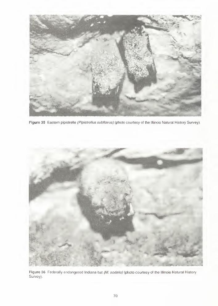
Figure 35 Eastern pipistrelle (Pipistrellus subflavus) (photo courtesy of the Illinois Natural History Survey).
Figure 36 Federally endangered Indiana bat (M. sodalis) (photo courtesy of the Illinois Natural History
Survey).
70
their energy reserves. Disturbance of maternity colonies (females and their offspring) during the sum-
mer may result in the death of young pups that fall to the cave floor or cause the colony to abandon
the cave. Serious cavers (spelunkers) are careful to avoid disturbing bats, and the National Speleologi-
cal Society and its local grottoes (caving clubs) have played an important role in bat conservation.
Metal gates have been installed in the entrances of many important bat caves, including Fogelpole
Cave in Monroe County, to prevent unauthorized access by humans while allowing passage by bats.
Among the Illinois bats that depend on caves are the state's four endangered bat species. The Indiana
bat, which is also federally endangered, hibernates in caves and mines. Maternity colonies roost in
trees, but some adult males and nonreproductive females occupy caves during the summer as well.
A large portion of this species congregates in caves and mines in southern Indiana, Kentucky, and
Missouri for hibernation, but there are three important Indiana bat hibernacula in Illinois, including
Fogelpole Cave. The federally endangered gray bat (M. grisescens) uses caves year-round, but occu-
pies different caves during winter and summer. A maternity colony of gray bats occurs in southern
Illinois, although its actual roost site is unknown. Most gray bats that spend the summer in southern
Illinois are thought to hibernate in Kentucky. There are also a few records of migrating gray bats occupy-
ing caves in counties along the Mississippi River in western Illinois. The state-endangered southeast-
ern bat {M. austroriparius) and Rafinesque's big-eared bat (Plecotus rafinesquii) occur only in south-
ern Illinois, where they hibernate in caves and abandoned mines. Big-eared bats spend the summerin dilapidated buildings and other manmade structures. In other states maternity colonies of southastern
bats occupy caves, but the only maternity roost that has been found in Illinois was a hollow tree.
71
REFERENCES
Baxter, J.W., 1960, Salem Limestone in Southwestern Illinois: Illinois State Geological Survey Circu-
lar 284, 32 p.
Bretz, J.H., and S.E. Harris, Jr., 1961, Caves of Illinois: Illinois State Geological Survey, Report of
Investigations 215, 87 p.
Buschbach, T.C., and D.C. Bond, 1974, Underground Storage of Natural Gas in Illinois—1973: Illinois
State Geological Survey, Illinois Petroleum 101, 71 p.
Buschbach, T.C., and D.R. Kolata, 1991, Regional setting of the Illinois Basin, in M.W. Leighton,
D.R. Kolata, D.F. Oltz, and J.J. Eidel, editors, Interior Cratonic Basins: American Association of
Petroleum Geologists, Memoir 51, p. 29-55.
Chrzastowski, M.J., M.M. Killey, R.A. Bauer, P.B DuMontelle, A.L Erdmann, B.L Herzog, J.M. Masters,
and L.R. Smith, 1994, The Great Flood of 1993: Illinois State Geological Survey, Special Report 2,
45 p.
Clark, P.U., M.R. Greek, and M.J. Schneider, 1988, Surface morphology of the southern margin of
the Laurentide ice sheet from Illinois to Montana (abst.), in Program and Abstracts of the Tenth
Biennial Meeting, American Quaternary Association, University of Massachusetts, Amherst, p. 60.
Clark, S.K., and J.S. Royds, 1948, Structural trends and fault systems in Eastern Interior Basin:
American Association of Petroleum Geologists Bulletin, v. 32, no. 9, p. 1728-1749.
Damberger, H.H., 1971, Coalification pattern of the Illinois Basin: Economic Geology, v. 66, no. 3,
p. 488-494.
Department of Natural Resources, 1996, Illinois Caverns, State Natural Area: Illinois Department of
Natural Resources brochure.
Ferguson, J.A., and M.D. Wiant, 1995, Historic human impact on the landscape of west-central
Illinois—Archaeological and geological assessment of two proposed lakes in the Site M conser-
vation area, Cass County, Illinois (draft): Illinois State Museum Quaternary Studies Program
Technical Report No. 95-894-1.
Frasz, G.B., 1983. Twenty miles under Illinois—The land and the caves: National Speleological Society
News, p. 72-76.
Herzog, B.L., B.J. Stiff, C.A Chenoweth, K.L. Warner, J.B. Sieverling, and C. Avery, 1994, Buried
Bedrock Surface of Illinois: Illinois State Geological Survey, Illinois Map 5; scale, 1:500,000;
size, 33.25" x 60.75".
Horberg, C.L., 1950, Bedrock Topography of Illinois: Illinois State Geological Survey, Bulletin 73, 111 p.
Iseminger, W.R., 1996, Prehistoric cultural and environmental interaction in the American Bottom:
Paper presented at the I.S.M. Teachers Wetland Conference, August 1996.
Keller, E.A., 1992, Environmental Geology, 6th ed., Macmillan, New York, 521 p.
Leighton, M.M., G.E. Ekblaw, and C.L. Horberg, 1948, Physiographic Divisions of Illinois: Illinois
State Geological Survey, Report of Investigations 129, 19 p.
Lineback, J.A., et al., 1979, Quaternary Deposits of Illinois: Illinois State Geological Survey Map;
scale, 1:500,000; size, 40" x 60"; color.
Nelson, J.W., 1995, Structural Features in Illinois: Illinois State Geological Survey, Bulletin 100, 144 p.
Odum, I.E., G.M. Wilson, and G. Dow, 1961, Valmeyer Area: Illinois State Geological Survey, Geo-logical Science Field Trip Guide Leaflet 1961-F, 19 p.
72
Palmer, A.N., 1991, Origin and morphology of limestone caves: Geological Society of America Bulletin,
v. 103, p. 1-21.
Panno, S.V., 1996, Water quality in karst terrain: The Karst Window, v. 2, no. 2, p. 2-4.
Panno, S.V., I.G. Krapac, C.P. Weibel, and J.D. Bade, 1996, Groundwater Contamination in Karst
Terrain of Southwestern Illinois: Illinois State Geological Survey, Environmental Geology 151, 43 p.
Panno, S.V., and C.P. Weibel, 1997, Karst Regions of Illinois: Illinois State Geological Survey OpenFile Series 1997-2, 42 p.
Piskin, K., and R.E. Bergstrom, 1975, Glacial Drift in Illinois: Illinois State Geological Survey,
Circular 490, 35 p.
Pontius, F.W., 1992, A current look at the federal drinking water regulations: Journal of the American
Water Works Association, v. 84, no. 3, p. 36-50.
Quinlan, J.F., 1988, Protocol for reliable monitoring of groundwater quality in karst terrains: Proceed-
ings from the International Association of Hydrologists 21st Congress, Guilin, China, p. 888-893.
Raasch, G.O., 1950, Waterloo Area: Illinois State Geological Survey, Geological Science Field Trip
Guide leaflet 1950-F, 11 p.
Reinertsen, D.L., 1981, A Guide to the Geology of the Waterloo-Valmeyer Area: Illinois State Geo-
logical Survey, Geological Science Field Trip Guide Book 1981D, 20 p., plus attachments.
Ritter, D.F., R.C. Kochel, and J.R. Miller, 1995, Process Geomorphology, 3rd ed.: Wm. C. Brown,
Dubuque, 546 p.
Samson, I.E., 1994, Illinois Mineral Industry in 1992 and Review of Preliminary Mineral Production
Data for 1993: Illinois State Geological Sun/ey, Illinois Mineral Notes 1 12, 43 p.
Smith, W.H., 1958, Strippable Coal reserves of Illinois, Part 2—Jackson, Monroe, Perry, Randolf,
and St. Clair Counties: Illinois State Geological Survey, Circular 260, 35 p.
U.S. Army Corps of Engineers, 1978, Design and Construction of Levees: Department of the Army,
Office of the Chief of Engineers, Washington, D.C., 175 p.
Weller, S., and J.M. Weller, 1939, Preliminary Geological Maps of the Pre-Pennsylvanian Forma-
tions in Part of Southwestern Illinois: Illinois State Geological Survey, Report of Investigations 59,
15 p.
Wightman, P., 1967. Monroe County's Cellar, in Arrowheads to Aerojets, H.R. Klein, ed.: Myron Roever
and Associates, Valmeyer, IL, p. 71-73.
Willman, H.B., and J.C. Frye, 1970, Pleistocene Stratigraphy of Illinois: Illinois State Geological Survey,
Bulletin 94, 204 p.
Willma.i, H.B., et al., 1967, Geologic Map of Illinois: Illinois State Geological Survey Map; scale,
1:500,000; size, 40" x 56"; color.
Willman, H.B., J.A. Simon, B.M. Lynch, and V.A. Langenheim, 1968, Bibliography and Index of Illinois
Geology through 1965: Illinois State Geological Survey, Bulletin 92, 373 p.
Willman, H.B., E. Atherton, T.C. Buschbach, C. Collinson, J.C. Frye, M.E. Hopkins, J.A. Lineback,
and J.A. Simon, 1975, Handbook of Illinois Stratigraphy: Illinois State Geological Survey,
Bulletin 95, 261 p.
Yarbrough, R.E., 1974, The Physiography of Metro East: Illinois Geographical Society Bulletin, vol. 16,
no. 1, p. 12-28.
73
GLOSSARY
The following definitions are from several sources in total or in part, but the main reference is: Bates,
R.L, and J.A. Jackson, editors, 1987, Glossary of Geology: American Geological Institute, Alexandria,
VA, 3rd edition, 788 p.
Ablation Separation and removal of rock material and formation of deposits, especially by wind
action or the washing away of loose and soluble materials.
Age An interval of geologic time; a division of an epoch.
Aggrading stream One that is actively building up its channel or floodplain by being supplied with
more load than it can transport.
Alluviated valley One that has been at least partially filled with sand, silt, and mud by flowing water.
Alluvium A general term for clay, silt, sand, gravel, or similar unconsolidated detrital material depos-
ited during comparatively recent time by a stream or other body of running water as a sorted or
semisorted sediment in the bed of a stream or on its floodplain or delta, etc.
Anticline A convex upward rock fold in which strata have been bent into an arch; the strata on each
side of the core of the arch are inclined in opposite directions away from the axis or crest; the
core contains older rocks than does the perimeter of the structure.
Aquifer A body of rock or sediment that will yield water of useable quantity to a well or spring. Aquifers
act as conduits bounded by less permeable materials.
Argillaceous Largely composed of clay-sized particles or clay minerals.
Arenite A relatively clean quartz sandstone that is well sorted and contains less than 10% argillaceous
material.
Base level Lowest limit of subaerial erosion by running water, controlled locally and temporarily by
water level at stream mouths into lakes or more generally and semipermanently into the ocean
(mean sea level).
Basement complex Largely crystalline igneous and/or metamorphic rocks of complex structure
and distribution that underlie a sedimentary sequence.
Basin A topographic or structural low area that generally receives thicker deposits of sediments
than adjacent areas; the low areas tend to sink more readily, partly because of the weight of the
thicker sediments; this also denotes an area of deeper water than found in adjacent shelf areas.
Bed A naturally occurring layer of Earth material of relatively greater horizontal than vertical extent
that is characterized by a change in physical properties from those overlying and underlying
materials. It also is the ground upon which any body of water rests or has rested, or the land
covered by the waters of a stream, lake, or ocean; the bottom of a watercourse or of a stream
channel.
Bedrock The solid rock underlying the unconsolidated (non-indurated) surface materials, such as,
soil, sand, gravel, glacial till, etc.
Bedrock valley A drainageway eroded into the solid bedrock beneath the surface materials. It maybe completely filled with unconsolidated (non-indurated) materials and hidden from view.
Braided stream A low gradient, low volume stream flowing through an intricate network of interlacing
shallow channels that repeatedly merge and divide, and are separated from each other by branch
islands or channel bars. Such a stream may be incapable of carrying all of its load.
Calcarenite Limestone composed of sand-sized grains consisting of more or less worn shell fragments
or pieces of older limestone; a clastic limestone.
Calcareous Containing calcium carbonate (CaC03); limy.
Calcined The heating of limestone to its temperature of dissociation so that it loses its water of crys-
talization.
74
Calcite A common rock-forming mineral consisting of CaC03; it may be white, colorless, or pale
shades of gray, yellow, and blue; it has perfect rhombohedral cleavage, appears vitreous, andhas a hardness of 3 on Mohs' scale; it effervesces (fizzes) readily in cold dilute hydrochloric
acid. It is the principal constituent of limestone.
Cave A cavity in the earth large enough for a human to enter. Caves can form as a result of
physical and chemical weathering of rock. Physical weathering usually produces shelter-type
caves that extend into the rock for only a few feet. Chemical weathering of rock can producecaves (solution channels along fractures and bedding planes) that extend for many miles into
the rock.
Chert Silicon dioxide (SiCte); a compact, massive rock composed of minute particles of quartz and/or
chalcedony; it is similar to flint but lighter in color.
Clastic Fragmental rock composed of detritus, including broken organic hard parts as well as rock
substances of any sort.
Closed depression A low, roughly concave topographic feature in a landscape. Rain falling within
the boundaries of the depression would be channeled toward its lowest part (usually near its
center).
Closure The difference in altitude between the crest of a dome or anticline and the lowest contour
that completely surrounds it.
Columnar section A graphic representation in a vertical column of the sequence and stratigraphic
relations of the rock units in a region.
Conformable Layers of strata deposited one upon another without interruption in accumulation of
sediment; beds parallel.
Delta A low, nearly flat, alluvial land deposited at or near the mouth of a river where it enters a body
of standing water; commonly a triangular or fan-shaped plain sometimes extending beyond the
general trend of the coastline.
Detritus Material produced by mechanical disintegration.
Disconformity An unconformity marked by a distinct erosion-produced, irregular, uneven surface
of appreciable relief between parallel strata below and above the break; sometimes represents a
considerable interval of nondeposition.
Dolomite A mineral, calcium-magnesium carbonate (Ca,Mg[C03]2); applied to those sedimentary
rocks that are composed largely of the mineral dolomite; it also is precipitated directly from
seawater. It is white, colorless, or tinged yellow, brown, pink, or gray; has perfect rhombohedral
cleavage; appears pearly to vitreous; effervesces feebly in cold dilute hydrochloric acid.
Drift All rock material transported by a glacier and deposited either directly by the ice or reworked
and deposited by meltwater streams and/or the wind.
Driftless Area A 10,000-square-mile area in northeastern Iowa, southwestern Wisconsin, and
northwestern Illinois where the absence of glacial drift suggests that the area may not have
been glaciated.
End moraine A ridge-like or series of ridge-like accumulations of drift built along the margin of an
actively flowing glacier at any given time; a moraine that has been deposited at the lower or
outer end of a glacier.
Epoch An interval of geologic time; a division of a period.
Era A unit of geologic time that is next in magnitude beneath an eon; consists of two or more periods.
Escarpment A long, more or less continuous cliff or steep slope facing in one general direction,
generally marking the outcrop of a resistant layer of rocks.
Fault A fracture surface or zone in Earth materials along which there has been vertical and/or hori-
zontal displacement or movement of the strata on both sides relative to one another.
75
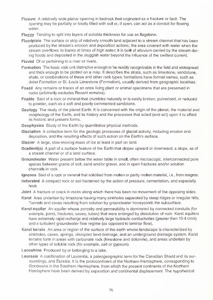
Fissure A relatively wide planar opening in bedrock that originated as a fracture or fault. Theopening may be partially or totally filled with soil or, if open, can act as a conduit for flowing
water.
Flaggy Tending to split into layers of suitable thickness for use as flagstone.
Floodplain The surface or strip of relatively smooth land adjacent to a stream channel that has been
produced by the stream's erosion and deposition actions; the area covered with water when the
stream overflows its banks at times of high water; it is built of alluvium carried by the stream dur-
ing floods and deposited in the sluggish water beyond the influence of the swiftest current.
Fluvia! Of or pertaining to a river or rivers.
Formation The basic rock unit distinctive enough to be readily recognizable in the field and widespread
and thick enough to be plotted on a map. It describes the strata, such as limestone, sandstone,
shale, or combinations of these and other rock types; formations have formal names, such as
Joliet Formation or St. Louis Limestone (Formation), usually derived from geographic localities.
Fossil Any remains or traces of an once living plant or animal specimens that are preserved in
rocks (arbitrarily excludes Recent remains).
Friable Said of a rock or mineral that crumbles naturally or is easily broken, pulverized, or reduced
to powder, such as a soft and poorly cemmented sandstone.
Geology The study of the planet Earth. It is concerned with the origin of the planet, the material and
morphology of the Earth, and its history and the processes that acted (and act) upon it to affect
its historic and present forms.
Geophysics Study of the Earth by quantitative physical methods.
Glaciation A collective term for the geologic processes of glacial activity, including erosion and
deposition, and the resulting effects of such action on the Earth's surface.
Glacier A large, slow-moving mass of ice at least in part on land.
Gradient(s) A part of a surface feature of the Earth that slopes upward or downward; a slope, as of
a stream channel or of a land surface.
Groundwater Water present below the water table in small, often microscopic, interconnected pore
spaces between grains of soil, sand and/or gravel, and in open fractures and/or solution
channels in rock.
Igneous Said of a rock or mineral that solidified from molten or partly molten material, i.e., from magma.
Indurated A compact rock or soil hardened by the action of pressure, cementation, and especially
heat.
Joint A fracture or crack in rocks along which there has been no movement of the opposing sides.
Karst Area underlain by limestone having many sinkholes separated by steep ridges or irregular hills.
Tunnels and caves resulting from solution by groundwater honeycomb the subsurface.
Karst aquifer An aquifer whose porosity and permeability is dominated by connected conduits (for
example, joints, fractures, caves, tubes) that were enlarged by dissolution of rock. Karst aquifers
have extremely rapid recharge and relatively large hydraulic conductivities (greater than 10-4 cm/s)
and a turbulent groundwater flow regime (as opposed to laminar flow).
Karst terrain An area or region of the surface of the earth whose landscape is characterized by
sinkholes, caves, springs, disrupted land drainage, and an underground drainage system. Karst
terrains form in areas with carbonate rock (limestone and dolomite), and areas underlain by
other types of soluble rock (for example, salt or gypsum).
Lacustrine Produced by or belonging to a lake.
Laurasia A combination of Laurentia, a paleogeographic term for the Canadian Shield and its sur-
roundings, and Eurasia. It is the protocontinent of the Northern Hemisphere, corresponding to
Gondwana in the Southern Hemisphere, from which the present continents of the Northern
Hemisphere have been derived by separation and continental displacement. The hypothetical
76
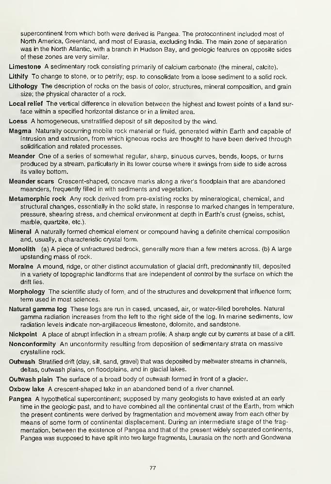
supercontinent from which both were derived is Pangea. The protocontinent included most of
North America, Greenland, and most of Eurasia, excluding India. The main zone of separation
was in the North Atlantic, with a branch in Hudson Bay, and geologic features on opposite sides
of these zones are very similar.
Limestone A sedimentary rock consisting primarily of calcium carbonate (the mineral, calcite).
Lithify To change to stone, or to petrify; esp. to consolidate from a loose sediment to a solid rock.
Lithology The description of rocks on the basis of color, structures, mineral composition, and grain
size; the physical character of a rock.
Local relief The vertical difference in elevation between the highest and lowest points of a land sur-
face within a specified horizontal distance or in a limited area.
Loess A homogeneous, unstratified deposit of silt deposited by the wind.
Magma Naturally occurring mobile rock material or fluid, generated within Earth and capable of
intrusion and extrusion, from which igneous rocks are thought to have been derived through
solidification and related processes.
Meander One of a series of somewhat regular, sharp, sinuous curves, bends, loops, or turns
produced by a stream, particularly in its lower course where it swings from side to side across
its valley bottom.
Meander scars Crescent-shaped, concave marks along a river's floodplain that are abandonedmeanders, frequently filled in with sediments and vegetation.
Metamorphic rock Any rock derived from pre-existing rocks by mineralogical, chemical, andstructural changes, essentially in the solid state, in response to marked changes in temperature,
pressure, shearing stress, and chemical environment at depth in Earth's crust (gneiss, schist,
marble, quartzite, etc.).
Mineral A naturally formed chemical element or compound having a definite chemical composition
and, usually, a characteristic crystal form.
Monolith (a) A piece of unfractured bedrock, generally more than a few meters across, (b) A large
upstanding mass of rock.
Moraine A mound, ridge, or other distinct accumulation of glacial drift, predominantly till, deposited
in a variety of topographic landforms that are independent of control by the surface on which the
drift lies.
Morphology The scientific study of form, and of the structures and development that influence form;
term used in most sciences.
Natural gamma log These logs are run in cased, uncased, air, or water-filled boreholes. Natural
gamma radiation increases from the left to the right side of the log. In marine sediments, low
radiation levels indicate non-argillaceous limestone, dolomite, and sandstone.
Nickpoint A place of abrupt inflection in a stream profile; A sharp angle cut by currents at base of a cliff.
Nonconformity An unconformity resulting from deposition of sedimentary strata on massive
crystalline rock.
Outwash Stratified drift (clay, silt, sand, gravel) that was deposited by meltwater streams in channels,
deltas, outwash plains, on floodplains, and in glacial lakes.
Outwash plain The surface of a broad body of outwash formed in front of a glacier.
Oxbow lake A crescent-shaped lake in an abandoned bend of a river channel.
Pangea A hypothetical supercontinent; supposed by many geologists to have existed at an early
time in the geologic past, and to have combined all the continental crust of the Earth, from which
the present continents were derived by fragmentation and movement away from each other by
means of some form of continental displacement. During an intermediate stage of the frag-
mentation, between the existence of Pangea and that of the present widely separated continents,
Pangea was supposed to have split into two large fragments, Laurasia on the north and Gondwana
77
Ped A naturally formed unit of soil structure, e.g., granule, block, crumb, or aggregate.
Peneplain A land surface of regional proportions worn down by erosion to a nearly flat or broadly
undulating plain.
Period An interval of geologic time; a division of an era.
Physiography The study and classification of the surface features of Earth on the basis of similarities
in geologic strucure and the history of geologic changes.
Physiographic province (or division) (a) A region, all parts of which are similar in geologic struc-
ture and climate and which has consequently had a unified geologic history, (b) A region whose pat-
tern of relief features or landforms differs significantly from that of adjacent regions.
Point bar A low arcuate ridge of sand and gravel developed on the inside of a stream meander by
slow accumulation of sediment as the stream channel migrates toward the outer bank.
Radioactivity logs Logs of bore holes obtained through the use of gamma logging, neutron logging,
or combinations of the several radioactivity logging methods.
Relief (a) A term used loosely for the actual physical shape, configuration, or general unevenness
of a part of Earth's surface, considered with reference to variations of height and slope or to irregu-
larities of the land surface; the elevations or differences in elevation, considered collectively, of a
land surface (frequently confused with topography), (b) The vertical difference in elevation between
the hilltops or mountain summits and the lowlands or valleys of a given region; "high relief" has
great variation; "low relief" has little variation.
Sediment Solid fragmental material, either inorganic or organic, that originates from weathering of
rocks and is transported by, suspended in, or deposited by air, water, or ice, or that is accumu-
lated by other natural agents, such as chemical precipitation from solution or secretion from organ-
isms, and that forms in layers on Earth's surface at ordinary temperatures in a loose,
unconsolidated form; e.g, sand, gravel, silt, mud, till, loess, alluvium.
Sedimentary rock A rock resulting from the consolidation of loose sediment that has accumulated
in layers (e.g., sandstone, siltstone, limestone).
Shoaling The effect of a near-costal sea bottom on wave height; it describes the alteration of a waveas it proceeds from deep water into shallow water. The wave height increases as the wave arrives
on shore.
Sinkholes Any closed depression in the land surface formed as a result of collapse of underlying
soil or bedrock. Sinkholes are usually found in areas where bedrock is near the surface and are
susceptible to dissolution by infiltrating surface water. Sinkhole is synonymous with "doline,"
which is used extensively in Europe. Sinkhole formation is usually initiated by soil piping or col-
lapse of a subsurface cavity in bedrock. The essential component of a hydrologically active sink-
hole is a drain that takes away water that flows into the sinkhole and, presumably, into a conduit.
Slip-off slope Long, low, gentle slope on the inside of a stream meander.
Soil piping The movement and entrainment of soil along an initially small pathway in the soil. As
water moves along the pathway, the pathway enlarges and the velocity of the flow may increase
proportionally, thus, entraining more soil. The result is the formation of an ever enlarging cavity
along the flow path. At some point, structural support may be lost and the ground surface or
structures on the surface may collapse into the cavity.
Stage, substage Geologic time-rock units; the strata formed during an age or subage, respectively.
Stratigraphy The study, definition, and description of major and minor natural divisions of rocks,
especially the study of the form, arrangement, geographic distribution, chronologic succession,
classification, correlation, and mutual relationships of rock strata.
Stratigraphic unit A stratum or body of strata recognized as a unit in the classification of the rocks
of Earth's crust with respect to any specific rock character, property, or attribute or for any purpose
such as description, mapping, and correlation.
78
Stratigraphy The study, definition, and description of major and minor natural divisions of rocks,
especially the study of the form, arrangement, geographic distribution, chronologic succession,
classification, correlation, and mutual relationships of rock strata.
Stratigraphic unit A stratum or body of strata recognized as a unit in the classification of the rocks
of Earth's crust with respect to any specific rock character, property, or attribute or for any purpose
such as description, mapping, and correlation.
Stratum A tabular or sheet-like mass, or a single and distinct layer, of homogeneous or gradational
sedimentary material of any thickness, visually separable from other layers above and below by
a discrete change in character of the material deposited or by a sharp physical break in deposi-
tion, or by both; a sedimentary bed.
Subage An interval of geologic time; a division of an age.
Syncline A downfold of strata which dip inward from the sides toward the axis; youngest rocks
along the axis; the opposite of anticline.
System The largest and fundamental geologic time-rock unit; the strata of a system were deposited
during a period of geologic time.
Tectonic Pertaining to the global forces involved in, or the resulting structures or features of Earth's
movements.
Tectonics The branch of geology dealing with the broad architecture of the upper (outer) part of
Earth's crust; a regional assembling of structural or deformational features, their origins, historical
evolution, and mutual relations.
Temperature-resistance log This log, run only in water, portrays the earth's temperature and the
quality of groundwater in the well.
Terrace An abandoned floodplain formed when a stream flowed at a level above the level of its
present channel and floodplain.
Till Unconsolidated, nonsorted, unstratified drift deposited by and underneath a glacier and consist-
ing of a heterogenous mixture of different sizes and kinds of rock fragments.
Till plain The undulating surface of low relief in the area underlain by ground moraine.
Topography The natural or physical surface features of a region, considered collectively as to form;
the features revealed by the contour lines of a map.
Unconformable Having the relation of an unconformity to underlying rocks and separated from them
by an interruption in sedimentation, with or without any accompanying erosion of older rocks.
Unconformity A surface of erosion or nondeposition that separates younger strata from older
strata; most unconformities indicate intervals of time when former areas of the sea bottom were
temporarily raised above sea level.
Valley trains The accumulations of outwash deposited by rivers in their valleys downstream from a
glacier.
Water table That point in a shallow well or opening in the earth where groundwater begins.
Weathering The group of processes, chemical and physical, whereby rocks on exposure to the
weather change in character, decay, and finally crumble into soil.
79

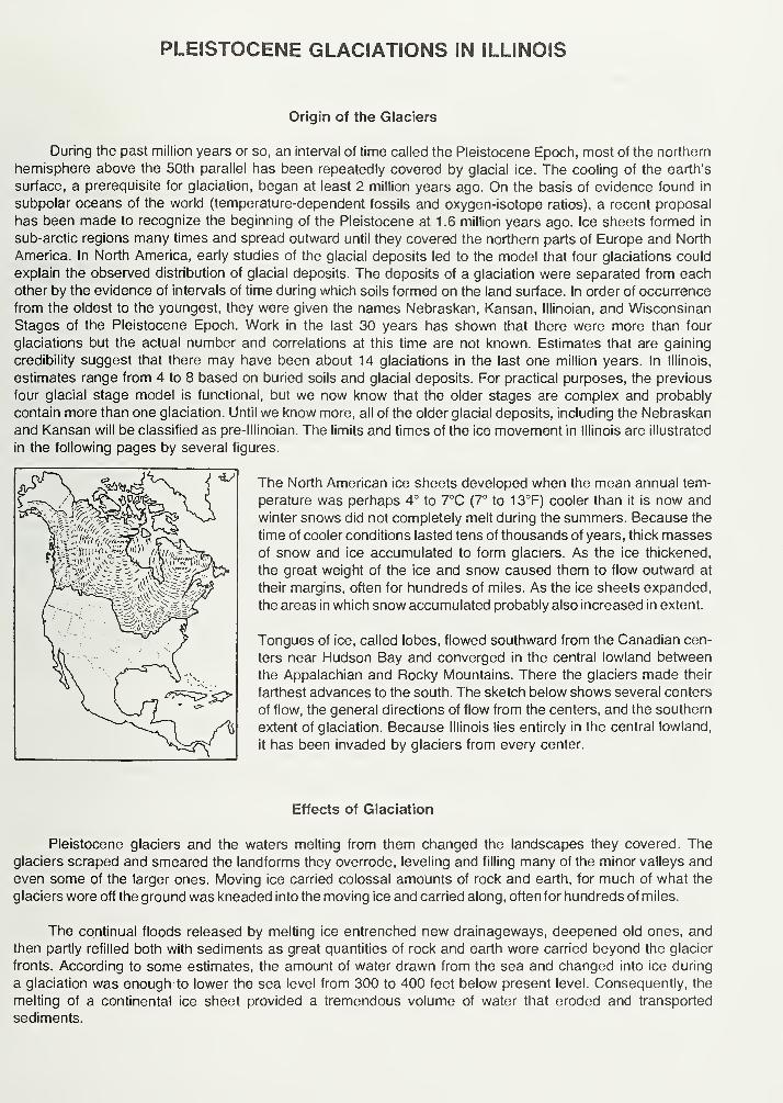
PLEISTOCENE GLACIATIONS IN ILLINOIS
Origin of the Glaciers
During the past million years or so, an interval of time called the Pleistocene Epoch, most of the northern
hemisphere above the 50th parallel has been repeatedly covered by glacial ice. The cooling of the earth's
surface, a prerequisite for glaciation, began at least 2 million years ago. On the basis of evidence found in
subpolar oceans of the world (temperature-dependent fossils and oxygen-isotope ratios), a recent proposal
has been made to recognize the beginning of the Pleistocene at 1 .6 million years ago. Ice sheets formed in
sub-arctic regions many times and spread outward until they covered the northern parts of Europe and North
America. In North America, early studies of the glacial deposits led to the model that four glaciations could
explain the observed distribution of glacial deposits. The deposits of a glaciation were separated from each
other by the evidence of intervals of time during which soils formed on the land surface. In order of occurrence
from the oldest to the youngest, they were given the names Nebraskan, Kansan, Illinoian, and Wisconsinan
Stages of the Pleistocene Epoch. Work in the last 30 years has shown that there were more than four
glaciations but the actual number and correlations at this time are not known. Estimates that are gaining
credibility suggest that there may have been about 14 glaciations in the last one million years. In Illinois,
estimates range from 4 to 8 based on buried soils and glacial deposits. For practical purposes, the previous
four glacial stage model is functional, but we now know that the older stages are complex and probably
contain more than one glaciation. Until we know more, all of the older glacial deposits, including the Nebraskan
and Kansan will be classified as pre-lllinoian. The limits and times of the ice movement in Illinois are illustrated
in the following pages by several figures.
The North American ice sheets developed when the mean annual tem-
perature was perhaps 4° to 7°C (7° to 13°F) cooler than it is now and
winter snows did not completely melt during the summers. Because the
time of cooler conditions lasted tens of thousands of years, thick massesof snow and ice accumulated to form glaciers. As the ice thickened,
the great weight of the ice and snow caused them to flow outward at
their margins, often for hundreds of miles. As the ice sheets expanded,
the areas in which snow accumulated probably also increased in extent.
Tongues of ice, called lobes, flowed southward from the Canadian cen-
ters near Hudson Bay and converged in the central lowland between
the Appalachian and Rocky Mountains. There the glaciers made their
farthest advances to the south. The sketch below shows several centers
of flow, the general directions of flow from the centers, and the southern
extent of glaciation. Because Illinois lies entirely in the central lowland,
it has been invaded by glaciers from every center.
Effects of Glaciation
Pleistocene glaciers and the waters melting from them changed the landscapes they covered. Theglaciers scraped and smeared the landforms they overrode, leveling and filling many of the minor valleys and
even some of the larger ones. Moving ice carried colossal amounts of rock and earth, for much of what the
glaciers wore off the ground was kneaded into the moving ice and carried along, often for hundreds of miles.
The continual floods released by melting ice entrenched new drainageways, deepened old ones, and
then partly refilled both with sediments as great quantities of rock and earth were carried beyond the glacier
fronts. According to some estimates, the amount of water drawn from the sea and changed into ice during
a glaciation was enough to lower the sea level from 300 to 400 feet below present level. Consequently, the
melting of a continental ice sheet provided a tremendous volume of water that eroded and transported
sediments.
In most of Illinois, then, glacial and meltwater deposits buried the old rock-ribbed, low, hill-and-valley
terrain and created the flatter landforms of our prairies. The mantle of soil material and the buried deposits
of gravel, sand, and clay left by the glaciers over about 90 percent of the state have been of incalculable
value to Illinois residents.
Glacial Deposits
The deposits of earth and rock materials moved by a glacier and deposited in the area once covered
by the glacier are collectively called drift. Drift that is ice-laid is called till. Water-laid drift is called outwash.
Till is deposited when a glacier melts and the rock material it carries is dropped. Because this sediment
is not moved much by water, a till is unsorted, containing particles of different sizes and compositions. It is
also stratified (unlayered). A till may contain materials ranging in size from microscopic clay particles to large
boulders. Most tills in Illinois are pebbly clays with only a few boulders. For descriptive purposes, a mixture
of clay, silt, sand and boulders is called diamicton. This is a term used to describe a deposit that could be
interpreted as till or a mass wasting product.
Tills may be deposited as end moraines, the arc-shaped ridges that pile up along the glacier edges
where the flowing ice is melting as fast as it moves forward. Till also may be deposited as ground moraines,
or till plains, which are gently undulating sheets deposited when the ice front melts back, or retreats. Deposits
of till identify areas once covered by glaciers. Northeastern Illinois has many alternating ridges and plains,
which are the succession of end moraines and till plains deposited by the Wisconsinan glacier.
Sorted and stratified sediment deposited by water melting from the glacier is called outwash. Outwashis bedded, or layered, because the flow of water that deposited it varied in gradient, volume, velocity, anddirection. As a meltwater stream washes the rock materials along, it sorts them by size—the fine sands, silts,
and clays are carried farther downstream than the coarser gravels and cobbles. Typical Pleistocene outwashin Illinois is in multilayered beds of clays, silts, sands, and gravels that look much like modern stream deposits
in some places. In general, outwash tends to be coarser and less weathered, and alluvium is most often finer
than medium sand and contains variable amounts of weathered material.
Outwash deposits are found not only in the area covered by the ice field but sometimes far beyond it.
Meltwater streams ran off the top of the glacier, in crevices in the ice, and under the ice. In some places, the
cobble-gravel-sand filling of the bed of a stream that flowed in the ice is preserved as a sinuous ridge called
an esker. Some eskers in Illinois are made up of sandy to silty deposits and contain mass wasted diamicton
material. Cone-shaped mounds of coarse outwash, called kames, were formed where meltwater plunged
through crevasses in the ice or into ponds on the glacier.
The finest outwash sediments, the clays and silts, formed bedded deposits in the ponds and lakes that
filled glacier-dammed stream valleys, the sags of the till plains, and some low, moraine-diked till plains.
Meltwater streams that entered a lake rapidly lost speed and also quickly dropped the sands and gravels
they carried, forming deltas at the edge of the lake. Very fine sand and silts were commonly redistributed onthe lake bottom by wind-generated currents, and the clays, which stayed in suspension longest, slowly settled
out and accumulated with them.
Along the ice front, meltwater ran off in innumerable shifting and short-lived streams that laid down a
broad, flat blanket of outwash that formed an outwash plain. Outwash was also carried away from the glacier
in valleys cut by floods of meltwater. The Mississiippi, Illinois, and Ohio Rivers occupy valleys that were major
channels for meltwaters and were greatly widened and deepened during times of the greatest meltwater
floods. When the floods waned, these valleys were partly filled with outwash far beyond the ice margins.
Such outwash deposits, largely sand and gravel, are known as valley trains. Valley train deposits may beboth extensive and thick. For instance, the long valley train of the Mississippi Valley is locally as much as200 feet thick.
Loess, Eolian Sand and Soils
One of the most widespread sediments resulting from glaciation was carried not by ice or water but by
wind. Loess is the name given to windblown deposits dominated by silt. Most of the silt was derived from
wind erosion of the valley trains. Wind action also sorted out eolian sand which commonly formed sanddunes on the valley trains or on the adjacent uplands. In places, sand dunes have migrated up to 10 miles
away from the principle source of sand. Flat areas between dunes are generally underlain by eolian sheet
sand that is commonly reworked by water action. On uplands along the major valley trains, loess and eolian
sand are commonly interbedded. With increasing distance from the valleys, the eolian sand pinches out, often
within one mile.
Eolian deposition occurred when certain climatic conditions were met, probably in a seasonal pattern.
Deposition could have occurred in the fall, winter or spring season when low precipitation rates and low
temperatures caused meltwater floods to abate, exposing the surfaces of the valley trains and permitting
them to dry out. During Pleistocene time, as now, west winds prevailed, and the loess deposits are thickest
on the east sides of the source valleys. The loess thins rapidly away from the valleys but extends over almost
all the state.
Each Pleistocene glaciation was followed by an interglacial stage that began when the climate warmedenough to melt the glaciers and their snowfields. During these warmer intervals, when the climate was similar
to that of today, drift and loess surfaces were exposed to weather and the activities of living things. Con-
sequently, over most of the glaciated terrain, soils developed on the Pleistocene deposits and altered their
composition, color, and texture. Such soils were generally destroyed by later glacial advances, but somewere buried. Those that survive serve as "key beds," or stratigraphic markers, and are evidence of the passageof a long interval of time.
Glaciation in a Small Illinois Region
The following diagrams show how a continental ice sheet might have looked at various stages as it
moved across a small region in Illinois. They illustrate how it could change the old terrain and create a
landscape like the one we live on. To visualize how these glaciers looked, geologists study the landforms
and materials left in the glaciated regions and also the present-day mountain glaciers and polar ice caps.
The block of land in the diagrams is several miles wide and about 10 miles long. The vertical scale is
exaggerated—layers of material are drawn thicker and landforms higher than they ought to be so that they
can be easily seen.
1 . The Region Before Glaciation — Like most of Illinois, the region illustrated is underlain by almost flat-lying beds of
sedimentary rocks—layers of sandstone (••-••.• ) limestone (
' ' ). and shale ( ==-^i ). Millions of years of erosion
have planed down the bedrock (BR), creating a terrain of low uplands and shallow valleys. A residual soil weathered
from local rock debris covers the area but is too thin to be shown in the drawing. The streams illustrated here flow
westward and the one on the right flows into the other at a point beyond the diagram.
2. The Glacier Advances Southward — As the Glacier (G) spreads out from its ice snowfield accumulation center, it
scours (SC) the soil and rock surface and quarries (Q)—pushes and plucks up—chunks of bedrock. The materials are
mixed into the ice and make up the glacier's "load." Where roughnesses in the terrain slow or stop flow (F), the ice
"current" slides up over the blocked ice on innumerable shear planes (S). Shearing mixes the load very thoroughly. As
the glacier spreads, long cracks called "crevasses" (C) open parallel to the direction of ice flow. The glacier melts as it
flows forward, and its meltwater erodes the terrain in front of the ice, deepening (D) some old valleys before ice covers
them. Meltwater washes away some of the load freed by melting and deposits it on the outwash plain (OP). The advancing
glacier overrides its outwash and in places scours much of it up again. The glacier may be 5000 or so feet thick, and
tapers to the margin, which was probably in the range of several hundred feet above the old terrain. The ice front advances
perhaps as much as a third of a mile per year.
3. The Glacier Deposits an End Moraine — After the glacier advances across the area, the climate warms and the
ice begins to melt as fast as it advances. The ice front (IF) is now stationary, or fluctuating in a narrow area, and the
glacier is depositing an end moraine.
As the top of the glacier melts, some of the sediment that is mixed in the ice accumulates on top of the glacier.
Some is carried by meltwater onto the sloping ice front (IF) and out onto the plain beyond. Some of the debris slips downthe ice front in a mudflow (FL). Meltwater runs through the ice in a crevasse (C). A supraglacial stream (SS) drains the
top of the ice, forming an outwash fan (OF). Moving ice has overridden an immobile part of the front on a shear plane
(S). All but the top of a block of ice (B) is buried by outwash (O).
Sediment from the melted ice of the previous advance (figure 2) remains as a till layer (T), part of which forms the
till plain (TP). A shallow, marshy lake (L) fills a low place in the plain. Although largely filled with drift, the valley (V)
remains a low spot in the terrain. As soon as the ice cover melts, meltwater drains down the valley, cutting it deeper.
Later, outwash partly refills the valley: the outwash deposit is called a valley train (VT). Wind blows dust (DT) off the dry
floodplain. The dust will form a loess deposit when it settles. Sand dunes (D) form on the south and east sides of streams.
I ,i ,- i:
\' i ' i
-L77
J777*~i=^-T-^=r:i=7 c^j- ; .iT1
. ,.',
.
',.i4l', .'.
.' 7TTi. i .
». ' i;
4. The Region after Glaciation — As the climate warms further, the whole ice sheet melts, and glaciation ends. Theend moraine (EM) is a low, broad ridge between the outwash plain (OP) and till plains (TP). Run-off from rains cuts
stream valleys into its slopes. A stream goes through the end moraine along the channel cut by the meltwater that ran
out of the crevasse in the glacier.
Slopewash and vegetation are filling the shallow lake. The collapse of outwash into the cavity left by the ice block's
melting has made a kettle (K). The outwash that filled a tunnel draining under the glacier is preserved in an esker (E).
The hill of outwash left where meltwater dumped sand and gravel into a crevasse or other depression in the glacier or
at its edge is a kame (KM). A few feet of loess covers the entire area but cannot be shown at this scale.
TIME TABLE OF PLEISTOCENE GLACIATION
STAGE SUBSTAGE NATURE OF DEPOSITS SPECIAL FEATURES
cc
<
z
cc
UJ
<
o
HOLOCENE(interglacial)
WISCONSINAN(glacial)
SANGAMONIAN(interglacial)
ILLINOIAN(glacial)
YARMOUTHIAN(interglacial)
KANSAN*(glacial)
AFTONIAN*(interglacial)
NEBRASKAN'(glacial)
Years
Before Present
10,000
Valderan
1 1 ,000
Twocreekan
- 12,500 -
Woodfordian
- 25,000
Farmdalian
28,000 -
Altonian
75,000
125,000
Jubileean
Monican
Liman
300,000?
500,000?
700,000?
900,000?
1 ,600,000 or more
Soil, youthful profile
of weathering, lake
and river deposits,
dunes, peat
Outwash, lake deposits
Peat and alluvium
Drift, loess, dunes,
lake deposits
Soil, silt, and peat
Drift, loess
Soil, mature profile
of weathering
Drift, loess, outwash
Drift, loess, outwash
Drift, loess, outwash
Soil, mature profile
of weathering
Drift, loess
Soil, mature profile
of weathering
Drift (little known)
Outwash along
Mississippi Valley
Ice withdrawal, erosion
Glaciation; building of
many moraines as far
south as Shelbyville;
extensive valley trains,
outwash plains, and lakes
Ice withdrawal, weathering,
and erosion
Glaciation in Great Lakesarea, valley trains
along major rivers
Important stratigraphic marker
Glaciers from northeast
at maximum reachedMississippi River andnearly to southern tip
of Illinois
Important stratigraphic marker
Glaciers from northeast
and northwest covered
much of state
(hypothetical)
Glaciers from northwest
invaded western Illinois
"Old oversimplified concepts, now known to represent a series of glacial cycles.
linois State Geological Survey, 1973)
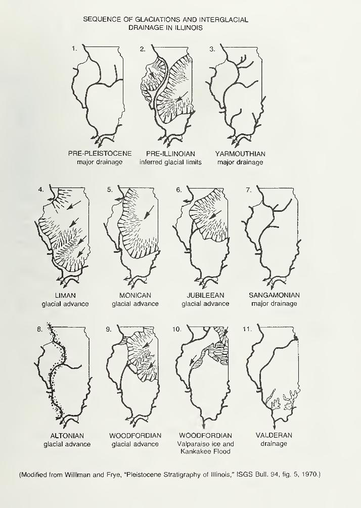
SEQUENCE OF GLACIATIONS AND INTERGLACIALDRAINAGE IN ILLINOIS
PRE-PLEISTOCENE PRE-ILLINOIAN YARMOUTHIANmajor drainage inferred glacial limits major drainage
LIMANglacial advance
MONICANglacial advance
JUBILEEANglacial advance
SANGAMON IAN
major drainage
ALTONIANglacial advance
WOODFORDIANglacial advance
WOODFORDIANValparaiso ice andKankakee Flood
VALDERANdrainage
(Modified from Willlman and Frye, "Pleistocene Stratigraphy of Illinois," ISGS Bull. 94, fig. 5, 1970.
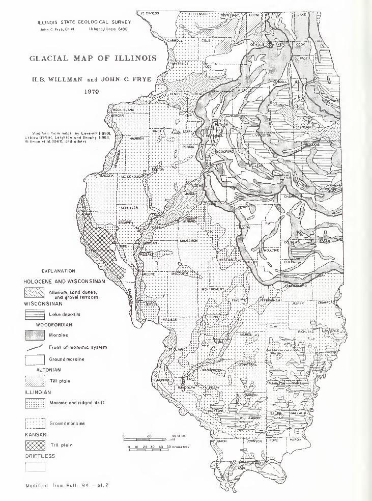
ILLINOIS STATE GEOLOGICAL SURVEY
John C Frye, Chief Urbono, Illinois 61801
GLACIAL MAP OF ILLINOIS
H.B. WILLMAN and JOHN C. FRYE £.£
jC^VL:'HENRY •'•.'•.£ BUREAlWSlr
• •i
1970
Modified from mops by Leveret! (1899), \iV:
Ekblow (1959), Leighton and Brophy (1961)
Willmon el ol.(l967), and others
Alluvium, sand dunes,
and gravel terraces
WISCONSINAN
Lake deposits
WOODFORDIAN
Moraine
Front of morainic system
Ground moraine
ALTONIAN
Till plain
ILLINOIAN
Groundmoraine
KANSAN
Till plain
DRIFTLESS
Modified from Bull- 94 —pi.
2
EXPLANATION
HOLOCENE ANO WISCONSINAN >£&- 1,,
Moraine and ridged drift
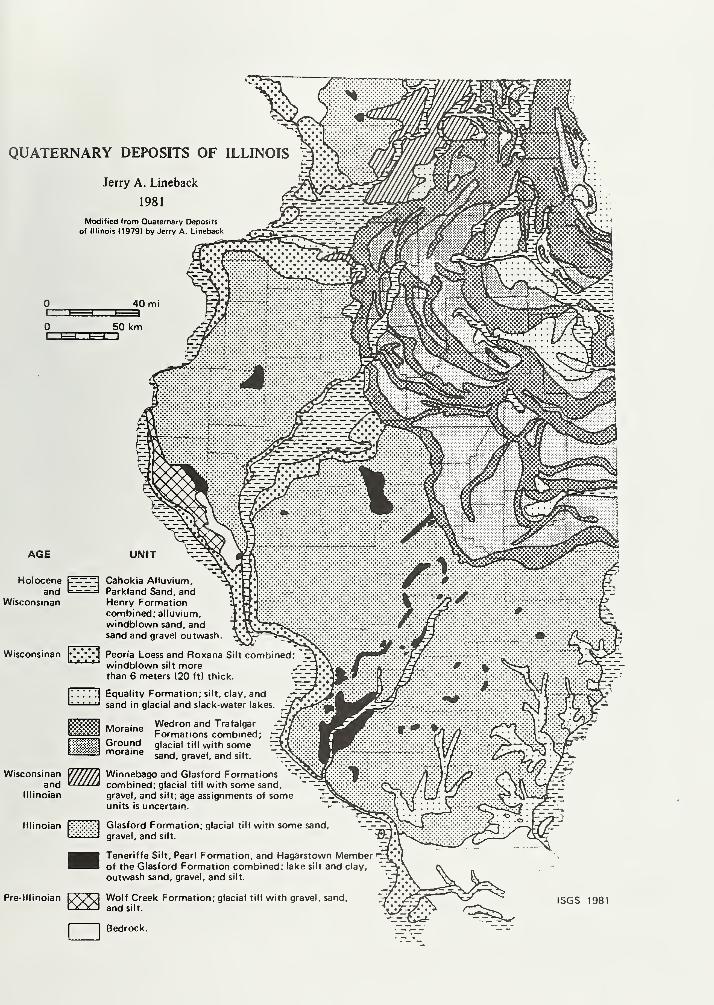
QUATERNARY DEPOSITS OF ILLINOIS
Jerry A. Lineback
1981
Modified from Quaternary Deposits
of Illinois (1979) by Jerry A. Lineback
AGE
Holocene
Wisconsinan
Wisconsinan
Wisconsinanand
lllinoian
Pre-lllinoiar
-~^r_-. Cahokia Alluviumand i 1 Parkland Sand, and
Henry Formationcombined; alluvium,
windblown sand, andsand and gravel outwash.
Peoria Loess and Ftoxana Silt combinedwindblown silt morethan 6 meters (20 ft) thick.
Equality Formation; silt, clay, andsand in glacial and slack-water lakes.
., • Wedron and TrafalgarMoraine _ . _ _
Formations combined; .—
Groundmoraine
glacial till with somesand, gravel, and silt.
Winnebago and Glasford Formations *-t^combined; glacial till with some sand,
gravel, and silt; age assignments of someunits is uncertain.
lllinoian Ix^xT!] Glasford Formation; glacial till with some sand.Iv .
'
iv ivi gravel, and silt.
Teneriffe Silt, Pearl Formation, and Hagarstown Member i
of the Glasford Formation combined; lake silt and clay,
outwash sand, gravel, and silt.
Wolf Creek Formation; glacial till with gravel, sand,
and silt.
ISGS 1981
Bedrock.
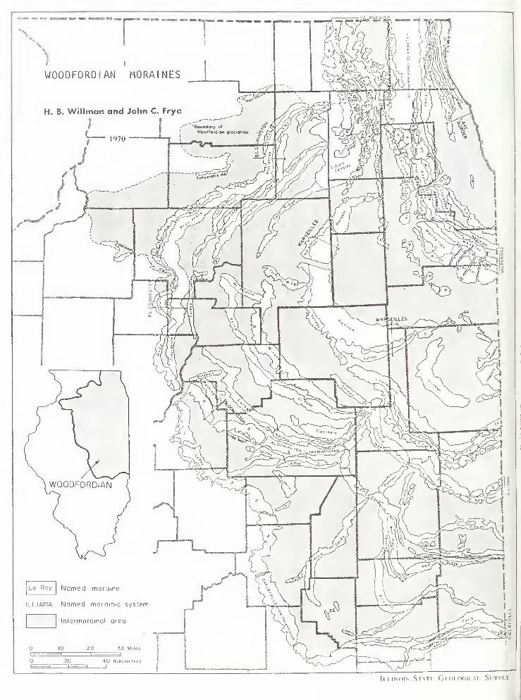
Il.llNOIS STATI. GpOI.OGICAI SURVhY
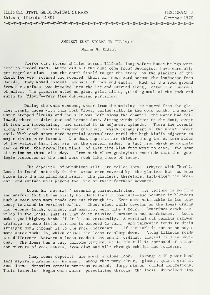
[LLINOIS STATE GEOLOGICAL SURVEY GEOGRAM 5
Urbana, Illinois 61801 October 1975
ANCIENT DUST STORMS IN ILLINOIS
Myrna M. Killey
Fierce dust storms whirled across Illinois long before human beings werehere to record them. Where did all the dust come from? Geologists have carefullyput together clues from the earth itself to get the story. As the glaciers of theGreat Ice Age scraped and scoured their way southward across the landscape fromCanada, they moved colossal amounts of rock and earth. Much of the rock groundfrom the surface was kneaded into the ice and carried along, often for hundredsof miles. The glaciers acted as giant grist mills, grinding much of the rock andearth to "flour"—very fine dust-sized particles.
During the warm seasons, water from the melting ice poured from the gla-cier front, laden with this rock flour, called silt. In the cold months the melt-water stopped flowing and the silt was left along the channels the water had fol-lowed, where it dried out and became dust. Strong winds picked up the dust, sweptit from the floodplains , and carried it to adjacent uplands. There the forestsalong the river valleys trapped the dust, which became part of the moist forestsoil. With each storm more material accumulated until the high bluffs adjacent to
major rivers were formed. The dust deposits are thicker along the eastern sidesof the valleys than they are on the western sides, a fact from which geologistsdeduce that the prevailing winds of that time blew from west to east, the same
direction as those of today. From such clues geologists conclude that the geo-
logic processes of the past were much like those of today.
The deposits of windblown silt are called loess (rhymes with "bus").
Loess is found not only in the areas once covered by the glaciers but has beenblown into the nonglaciated areas. The glaciers, therefore, influenced the pres-
ent land surface well beyond the line of their farthest advance.
Loess has several interesting characteristics. Its texture is so fine
and uniform that it can easily be identified in roadcuts— and because it blanketssuch a vast area many roads are cut through it. Even more noticeable is its ten-
dency to stand in vertical walls. These steep walls develop as the loess drains
and becomes tough, compact, and massive, much like a rock. Sometimes cracks de-
velop in the loess, just as they do in massive limestones and sandstones. Loess
makes good highway banks if it is cut vertically. A vertical cut permits maximum
drainage because little surface is exposed to rain, and rainwater tends to drain
straight down through it to the rock underneath. If the bank is cut at an angle
more water soaks in, which causes the loess to slump down. Along Illinois roads
the difference between a loess roadcut and one in ordinary glacial till is obvi-
ous. The loess has a very uniform texture, while the till is composed of a ran-
dom mixture of rock debris, from clay and silt through cobbles and boulders.
Many loess deposits are worth a close look. Through a 10-power hand
lens separate grains can be seen, among them many clear, glassy, quartz grains.
Some loess deposits contain numerous rounded, lumpy stones called concretions.
Their formation began when water percolating through the loess dissolved tiny
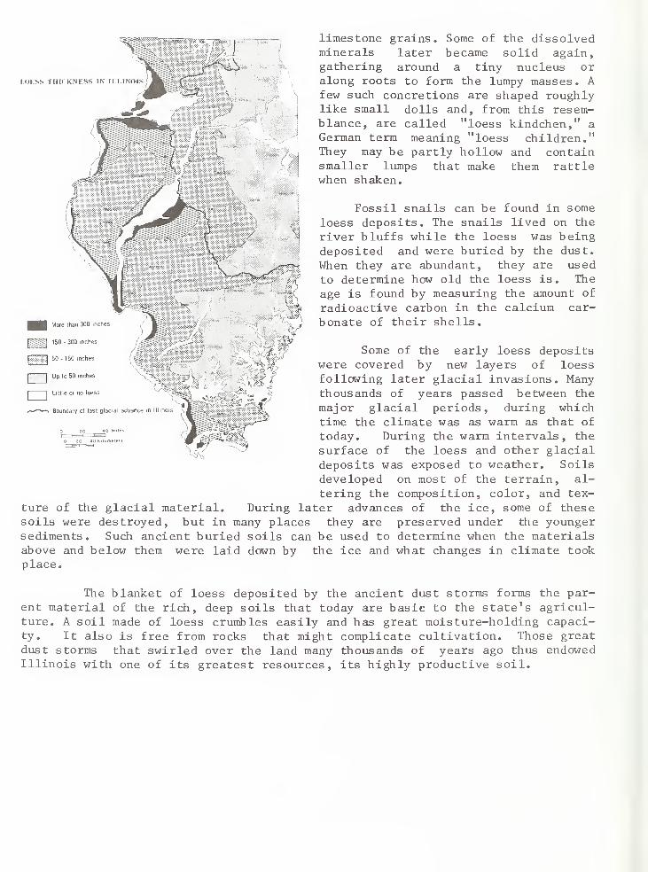
I.OKSS THICKNKSS IN ILLINOIS
More than 300 inches
150 • 300 inches
60-150 inches
limestone grains. Some of the dissolvedminerals later became solid again,gathering around a tiny nucleus oralong roots to form the lumpy masses. Afew such concretions are shaped roughlylike small dolls and, from this resem-blance, are called "loess kindchen," a
German term meaning "loess children."They may be partly hollow and containsmaller lumps that make them rattlewhen shaken.
Fossil snails can be found in some
loess deposits. The snails lived on the
river bluffs while the loess was beingdeposited and were buried by the dust.
When they are abundant, they are usedto determine how old the loess is. The
age is found by measuring the amount of
radioactive carbon in the calcium car-
bonate of their shells.
r"" ,n'| Up to 50 inches
"I Little or no loess
*—*"^—* Boundary of last glacial advance in Illinois
Some of the early loess depositswere covered by new layers of loessfollowing later glacial invasions. Manythousands of years passed between the
major glacial periods, during whichtime the climate was as warm as that of
today. During the warm intervals, the
surface of the loess and other glacialdeposits was exposed to weather. Soils
developed on most of the terrain, al-
tering the composition, color, and tex-
During later advances of the ice, some of thesesoils were destroyed, but in many places they are preserved under the youngersediments. Such ancient buried soils can be used to determine when the materialsabove and below them were laid down by the ice and what changes in climate tookplace.
ture of the glacial material,
The blanket of loess deposited by the ancient dust storms forms the par-ent material of the rich, deep soils that today are basic to the state's agricul-ture. A soil made of loess crumbles easily and has great moisture-holding capaci-ty. It also is free from rocks that might complicate cultivation. Those greatdust storms that swirled over the land many thousands of years ago thus endowedIllinois with one of its greatest resources, its highly productive soil.
MISSISSIPPIAN ROCKS IN ILLINOIS
Janis D. Treworgy1997
AGE AND DISTRIBUTION
The Mississippian Period is the interval of earth's geologic history that lasted from about 360 to 320 million years
ago (fig. 1). The term Mississippian System refers to the layers of sediment that were deposited during this
period. Today, Mississippian-age rocks are present in the southern two-thirds of Illinois where they are
over 3,200 feet thick (fig. 2). These rocks were more widely distributed over the midcontinent but were removedin places by erosion. Although these layers of rock were originally horizontal deposits, they were warpeddownward into the shape of a shallow basin because of stresses in the earth's crust. This large downwarpeddepression is called the Illinois Basin. At the deepest part of the basin in southeastern Illinois, the Missis-
sippian rocks are as deep as 5,000 feet. In western and southernmost Illinois, Mississippian rocks are
shallow and exposed at the surface around the edge of the the basin (see outcrop areas in fig. 2).
ECONOMIC SIGNIFICANCE
Mississippian rock resources have been important to the mineral industries and economy of Illinois since the
early 1800s.
• Nearly 80% of the oil produced in Illinois has been pumped from Mississippian rocks (Howard 1 991 ).
This crude oil is refined to produce gasoline, fuel oil, asphalt, road oil, lubricants, and other petroleum
products, including petrochemicals.
• Fluorite (fluorspar), sphalerite (zinc ore), and galena (lead ore) were mined from major mineral
deposits in heavily faulted Mississippian rocks in Hardin and Pope Counties, southernmost Illinois,
from the early 1800s until the last mine closed in 1995. Mining ceased because of cheaper sources
from other countries, primarily China and Mexico. Additional research on the Mississippian rocks in
southernmost Illinois may lead to the discovery of new economically minable fluorite or other mineral
deposits.
Fluorite (calcium fluoride), Illinois' state mineral, is used in a variety of manufacturing processes,
for example, as a flux in refining iron ore to steel. Fluorite is primarily used to make hydrogen
fluoride (hydrofluoric acid) and fluorine gas, an ingredient in making refrigerants, solvents, lubricants,
and toothpaste.
• About one-third of the limestone and dolomite for crushed stone in Illinois is quarried from Mississip-
pian rocks. Crushed stone, also called construction aggregate, is used for road construction, concrete
structures, agricultural lime, sulfur-dioxide removal from coal-burning power plant flues, and production
of Portland cement and various chemicals. Some Mississippian-age limestone was quarried as a
building and decorative stone in southern Illinois until the 1 960s. It is similar to the "Indiana Limestone,"
a building stone used nationwide that is quarried in south-central Indiana.
PALEOGEOGRAPHY
Continental plate movement Paleogeography means "ancient" geography. During the Mississippian, the area
now called Illinois was located south of the equator (fig. 3). The equator has not moved during the history
of the earth, but the "plates" that make up the earth's crust have slowly moved around during earth's life of
4.6 billion years. During the 40 million years of the Mississippian Period, what is now Illinois moved slowly
northward from near 30° south latitude to just north of 10° south latitude. About 100 million years later, all
the continental plates drifted together and formed the supercontinent Pangea. Since then, the continental
plates have been slowly drifting apart.
ERA PERIOD
MILLIONSOF YEARSAGO
ooNo
Quaternary
1.6
O Tertiary
Cretaceous
o 144
Noin
Jurassic
2082
Triassic
Permian
286
Pennsylvanian
o
320
Mississippian:
oDevonian
03408
Q.Silurian
438
Ordovician
505
Cambrian
Precc mbrian
sandstone
TILT"] siltstone
~L~~ shale
I
'|limestone
a cherty
o oolitic
rrco Octlu > a. LUQ_ If) LLI If) NW
FORMATION,SE GROUP, MEMBER
GROVE CHURCH
KINKAID
DEGONIA
CLORE
PALESTINE
MENARD
WALTERSBURGVIENNA
TAR SPRINGS
GLEN DEAN
HARDINSBURG
HANEY
FRAILEYS
BEECH CREEK (BARLOW )
CYPRESS
RIDENHOWERBETHELDOWNEYS BLUFFYANKEETOWW
RENAULTAUX VASES
STE. GENEVIEVE
ST. LOUIS
SALEM
ULLSN
FORT PAYNE
— ( SPRINGVILLE
CHOUTEAU
NEW ALBANY GROUP
Figure 1 Mississippian rock units in Illinois. Units that have produced oil are shown in bold type. Thebase of the Fort Payne is approximately equivalent in time to the base of the Keokuk (dashed line).
Dev = Devonian, UD = Upper Devonian, and K = Kinderhookian.
Figure 2 Distribution and thickness of the Mississippian rocks in Illinois. Thickness contours are
shown where upper Chesterian rocks are present (modified from Atherton et al. 1975).
Figure 3 Position of much of the United States and general paleogeography during the Mississippian Period,
approximately 350 million years ago.
Ancient seas Illinois and surrounding areas of the midcontinent were covered by a warm, shallow inland
sea that extended inland from the deep ocean at the edge of the continental plate (fig. 3). During the early
part of the Mississippian, this inland sea covered most of the midcontinent and was up to several hundred
feet deep in the southern Illinois area. During the later part of the Mississippian, sea level dropped and
exposed more land. As a result, the sea became shallower, just a few tens of feet deep in the Illinois Basin.
Geologists can tell relative water depths from the type of sea life preserved as fossils in the rocks (plates A and
B) and from sedimentary patterns or structures, such as ripple marks, that were formed in the sediment by
currents generated by tides and waves.
COMMON MISSISSIPPIAN ROCKS
Common rocks of Mississippian age found in the Illinois area formed at the bottom of the shallow inland sea.
Rivers and streams eroded sand, silt, and clay from the surrounding land and carried them into the sea where
they were deposited on the bottom. Shale forms when mud (a mixture of fine clay and silt) collects at the
bottom of the sea and is buried and compacted (lithified, or made rock-like). Sandstone and siltstone form
similarly, but from coarser sand and silt particles.
Limestone, the most abundant Mississippian rock type in Illinois, formed differently. Limestone is primarily
calcium carbonate (calcite, or CaC03) and can form in several ways. One of the most common ways begins
with sea animals (such as crinoids, brachiopods, bryozoans, and molluscs) that secrete calcium carbonate to
form their protective shells. When these animals die, their shells collect on the sea floor. Often the shells are
broken by strong currents (due to storms and tides) near shore and carried seaward. When these shells
become compacted and cemented on the sea floor (by calcite that precipitates from the sea water), limestone
forms. Calcite-secreting animals are most abundant and prolific in clear, warm, relatively shallow water
where there is little mud coming into the sea. Because these animals feed by filtering tiny floating plants and
animals from the sea water, mud would choke them. Some limestones (for example, oolitic limestone) are a
chemical precipitate from the sea water. Others (for example, micrite) form in part through precipitation caused
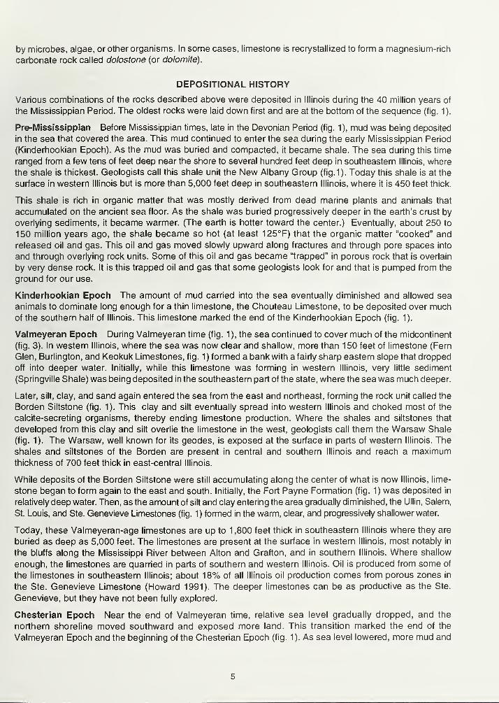
by microbes, algae, or other organisms. In some cases, limestone is recrystallized to form a magnesium-rich
carbonate rock called dolostone (or dolomite).
DEPOSITIONAL HISTORY
Various combinations of the rocks described above were deposited in Illinois during the 40 million years of
the Mississippian Period. The oldest rocks were laid down first and are at the bottom of the sequence (fig. 1).
Pre-Mississippian Before Mississippian times, late in the Devonian Period (fig. 1), mud was being deposited
in the sea that covered the area. This mud continued to enter the sea during the early Mississippian Period
(Kinderhookian Epoch). As the mud was buried and compacted, it became shale. The sea during this time
ranged from a few tens of feet deep near the shore to several hundred feet deep in southeastern Illinois, where
the shale is thickest. Geologists call this shale unit the New Albany Group (fig.1). Today this shale is at the
surface in western Illinois but is more than 5,000 feet deep in southeastern Illinois, where it is 450 feet thick.
This shale is rich in organic matter that was mostly derived from dead marine plants and animals that
accumulated on the ancient sea floor. As the shale was buried progressively deeper in the earth's crust by
overlying sediments, it became warmer. (The earth is hotter toward the center.) Eventually, about 250 to
150 million years ago, the shale became so hot (at least 125°F) that the organic matter "cooked" and
released oil and gas. This oil and gas moved slowly upward along fractures and through pore spaces into
and through overlying rock units. Some of this oil and gas became "trapped" in porous rock that is overlain
by very dense rock. It is this trapped oil and gas that some geologists look for and that is pumped from the
ground for our use.
Kinderhookian Epoch The amount of mud carried into the sea eventually diminished and allowed sea
animals to dominate long enough for a thin limestone, the Chouteau Limestone, to be deposited over muchof the southern half of Illinois. This limestone marked the end of the Kinderhookian Epoch (fig. 1).
Valmeyeran Epoch During Valmeyeran time (fig. 1 ), the sea continued to cover much of the midcontinent
(fig. 3). In western Illinois, where the sea was now clear and shallow, more than 150 feet of limestone (Fern
Glen, Burlington, and Keokuk Limestones, fig. 1 ) formed a bank with a fairly sharp eastern slope that dropped
off into deeper water. Initially, while this limestone was forming in western Illinois, very little sediment
(Springville Shale) was being deposited in the southeastern part of the state, where the sea was much deeper.
Later, silt, clay, and sand again entered the sea from the east and northeast, forming the rock unit called the
Borden Siltstone (fig. 1). This clay and silt eventually spread into western Illinois and choked most of the
calcite-secreting organisms, thereby ending limestone production. Where the shales and siltstones that
developed from this clay and silt overlie the limestone in the west, geologists call them the Warsaw Shale
(fig. 1). The Warsaw, well known for its geodes, is exposed at the surface in parts of western Illinois. The
shales and siltstones of the Borden are present in central and southern Illinois and reach a maximumthickness of 700 feet thick in east-central Illinois.
While deposits of the Borden Siltstone were still accumulating along the center of what is now Illinois, lime-
stone began to form again to the east and south. Initially, the Fort Payne Formation (fig. 1) was deposited in
relatively deep water. Then, as the amount of silt and clay entering the area gradually diminished, the Ullin, Salem,
St. Louis, and Ste. Genevieve Limestones (fig. 1) formed in the warm, clear, and progressively shallower water.
Today, these Valmeyeran-age limestones are up to 1,800 feet thick in southeastern Illinois where they are
buried as deep as 5,000 feet. The limestones are present at the surface in western Illinois, most notably in
the bluffs along the Mississippi River between Alton and Grafton, and in southern Illinois. Where shallow
enough, the limestones are quarried in parts of southern and western Illinois. Oil is produced from some of
the limestones in southeastern Illinois; about 18% of all Illinois oil production comes from porous zones in
the Ste. Genevieve Limestone (Howard 1991). The deeper limestones can be as productive as the Ste.
Genevieve, but they have not been fully explored.
Chesterian Epoch Near the end of Valmeyeran time, relative sea level gradually dropped, and the
northern shoreline moved southward and exposed more land. This transition marked the end of the
Valmeyeran Epoch and the beginning of the Chesterian Epoch (fig. 1). As sea level lowered, more mud and
sand were carried by ancient rivers and streams from land areas to the north, northeast, and northwest
into the sea in the Illinois area. The mud and sand carried into the sea were reworked by tidal currents
and distributed over large areas of the sea floor, where they were buried and eventually formed shale
and sandstone. Shell-forming organisms were relatively less common during Chesterian time because
they were choked by this mud and sand in the water. Periodically during the Chesterian, the sea withdrew
entirely from the area of Illinois for a time and then returned. Paleosols (ancient soils) and deeply eroded
valleys that have since been filled with sediment are evidence of these periods of dry or exposed land.
Periodically, sea level rose, and the quantities of mud and sand flowing into the sea were reduced. During
these times, shell-forming organisms prospered once again, and thin limestones formed in this inland sea.
These limestones are commonly only 10 to 30 feet thick, unlike the thicker ones of Valmeyeran age.
These fluctuations in sea level during the Chesterian resulted in deposition of alternating units of shale,
sandstone, and limestone, which geologists refer to as cyclic sedimentation.
Chesterian rocks are present in the southern half of Illinois. Although the rocks are at the land surface in parts
of southwestern and southernmost Illinois, in southeastern Illinois they are as deep as 3,000 feet. They are as
thick as 1,400 feet in southernmost Illinois. Sandstones of Chesterian age have produced about 60% of the
oil found in Illinois (Howard 1991).
The Chesterian, the last epoch of the Mississippian Period, was a time of transition from the Valmeyeran
Epoch, when the seas were clear and thick limestones formed, to the subsequent Pennsylvanian Period,
when the seas shallowed and disappeared for longer periods of time, and shale, siltstone, sandstone, and
coal were the major deposits formed.
REFERENCES
Atherton, E., C. Collinson, and J.A. Lineback, 1 975, Mississippian System, in H.B. Willman et al., Handbookof Illinois Stratigraphy: Illinois State Geological Survey Bulletin 95, p. 123-163.
Howard, R.H., 1991, Hydrocarbon reservoir distribution in the Illinois Basin, in M.W. Leighton, D.R. Kolata,
D.F. Oltz, and J.J. Eidel, editors, Interior Cratonic Basins: American Association of Petroleum Geologists
Memoir 51, p. 299-327.
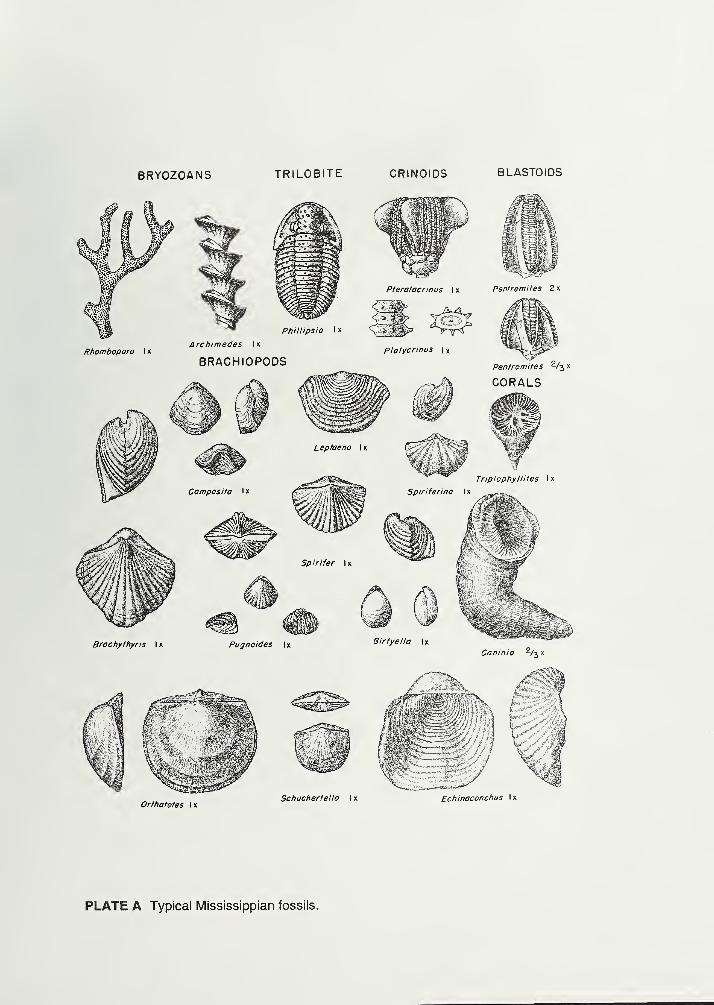
BRYOZOANS TRILOBITE CRINOIDS BLASTOIDS
Brachythyris I x Pugnoides I
x
Girtyella I x
Caninio 2/^
.
gfl
i£^Orthotetes I x
Schuchertella I x Echinoconchus Ix
PLATE A Typical Mississippian fossils.
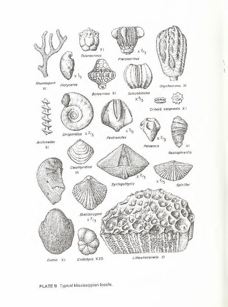
I
Ovatia XI Endothyra X20 Lithostrotionella XI
PLATE B Typical Mississippian fossils.