Embed Size (px)
Citation preview

99Inventory of Rock Slope DeformationsAffecting Folded Sedimentary Layersin Moderate Relief Context: The Caseof the Livingstone Range Anticlinorium,AB, Canada
F. Humair, J.-L. Epard, M.-H. Derron, M. Jaboyedoff, D. Pana, C. Froese,and A. Pedrazzini
AbstractThis contribution investigates the distribution of rock slope deformations (RSD) and theirrelationships with tectonic structures, lithological and topographic contexts. This is performed ina moderate relief context (1,100–2,500 masl.) affected by thin-skin tectonic. The proposedinventory, along the Livingstone range anticlinorium (LRA), contains 160 gravitational eventsthat are spatially clustered in four areas. The thrust-folds properties (density, geometry andlithology) and the local relief appear to primary influence the development ofRSD in this context.
KeywordsThin skin tectonic � Sedimentary layers � Rock slope deformations � Inventory
99.1 Objectives and Context
Different predisposing (structural settings, rock mass qualitycharacteristics, lithology, slope geometry, groundwater…),preparatory (glaciation/deglaciation, uplift rate and differ-ential uplift, local relief, modification of the slope geome-try…) and triggering (seismic shaking, climate…) factors arefrequently associated with the spatial and temporal evolutionof rock slope deformations (RSD) in different mountain belts(Schmidt and Montgomery 1995; Hermanns et al. 2001;Agliardi et al. 2009; Antinao and Gosse 2009; Clarke andBurbank 2010; Crosta et al. 2013). However, most of thestudies focus in high relief mountain ranges and the devel-opment of RSD in fold and thrust belts in moderate relieftopography is still poorly documented. The purpose of this
contribution is to propose an inventory of RSD types in sucha context in order to investigate the spatial relationshipsbetween this process and the structural / lithological char-acteristics. Our investigations are carried out along the Liv-ingstone Range anticlinorium (LRA), in southwesternAlberta, Canada. This 80 km long slightly arcuate mountainrange constitutes the easternmost part of the Canadian RockyMountain fold-and-thrust belt, and consists of flexural-slipthrust propagation folds affecting Devonian to Jurassic car-bonates and clastic rocks (Cooley et al. 2011; McMehan andStockmal 2013).
99.2 Methods and Approach
RSD are mapped and documented at the scale of the entireLRA (*1,490 km2) using High Resolution Digital ElevationModel (cell size 1 m) and Google Earth™. As proposed byPedrazzini et al. (submitted), the RSD have been classifiedbased on a simplification of Hutchinson (1998): rockslide androck-avalanche (RRA), roto-translational slides (RTS) anddeep-seated gravitational slope deformations (DSGSD). Thespatial relationship between RSD has been estimated using aderivative of the Ripley’s K-function (Ripley 1977), namelythe L-function (Besag 1977) to test whether the events areclustered or randomly distributed (Tonini et al. 2013, Ped-razzini et al. submitted). Plotted against the search radius (r),
F. Humair (&) � J.-L. Epard � M.-H. Derron � M. JaboyedoffISTE, University of Lausanne, Lausanne, Switzerlande-mail: [email protected]
D. PanaAlberta Geological Survey, Edmonton, Canada
C. FroeseAlberta Energy Regulator, Calgary, Canada
A. PedrazziniOffice de l’environnement, St-Ursanne, Canton du Jura,Switzerland
G. Lollino et al. (eds.), Engineering Geology for Society and Territory – Volume 2,DOI: 10.1007/978-3-319-09057-3_99, © Springer International Publishing Switzerland 2015
599

L(r) displays a value of zero for randomness, positive andnegative values for respectively clustered or dispersed datastructure. The maximal value was then used as researchradius to map the spatial density of the detected RSD. Thisstep was performed using a Kernel density function (Silver-man 1986) in a GIS environment. The local relief has beencalculated by subtracting the minimum elevation within acircular window of 3 km radius from the maximum elevation.Compared to other studies (Khueni and Pfiffner 2001;Montgomery and Brandon 2002; Pedrazzini et al. submitted),a smaller radius is selected as the width of this particularvalley is significantly smaller than in higher mountain belts.
In addition, the influence of the regional scale structuralsetting was investigated considering two parameters: thedistance of the RSD events to the anticline axial traces andfaults (euclidian distance) and the topographic / bedding-plane intersection angle (TOBIA) as proposed by Meenten-meyer and Moody (2000). The TOBIA model discriminatesthe slopes in three classes: anaclinal (bedding dips in thedirection opposite to the slope), cataclinal (bedding dips inthe same direction) and orthoclinal (dip direction of thebedding perpendicular to the dip direction of the slope).Ordinary kriging was used to interpolate dip and dip directionfrom the punctual information (2,676 data).
Fig. 99.1 a Northward Google Earth™ view of the southern part ofthe LRA (bedding in black and thrusts in blue). b Location of the studyarea. c Simplified stratigraphic log with the five lithological groups
attributed in the present study (limestone, dolostone, sandstone, shale).d Simplified fracturing pattern affecting the LRA summarized in fivejoint sets plus the bedding (plotted for the western fold limbs)
600 F. Humair et al.

Fig. 99.2 a LRA RSD inventory distribution displayed on the localrelief map obtained by the HRDEM (cell size 10 m). The kernel densitycontours of 0.5 and 1 RSD/km2 calculated for the whole RSD datasetare shown. b and c Close up on the main RSD cluster (cluster 1).
b Tectonic map (anticlines, main thrusts). c Detailed TOBIA modelclassification dividing the slope-bedding intersection in seven differentclasses (see Meentenmeyer and Moody 2000 for more details)
99 Inventory of Rock Slope Deformations 601

99.3 Rock Slope Deformations InventoryAlong the LRA
The rock slope deformations (RSD) database comprises 160events: 44 RRA, 101 RTS and 15 DSGSD. The spatialdistribution of the RSD categories under study shows thatthey are spatially clustered in a range of 0 to 6 km with amaximal value at approximately 2,050 m, aside from theDSGSD’s event that are comprised within the error envelope(Fig. 99.3b). The number of events inside a circle of about2 km is therefore higher than expected for a random distri-bution process. Figure 99.2 shows the spatial distribution ofthe RSD by categories and the contours of the RSD density(0.5 and 1 RSD/km2), highlighting 4 main zones of clus-tering. RRA are almost all (69 %) distributed in the south ofthe LRA (cluster 1), whereas RTS are located from themiddle to the northern part (clusters 2 and 3). Cluster 4contains all types of RSD. The local relief map (Fig. 99.2a)
highlights that the relief is higher around cluster zones 1 and4 compared to the whole study area, reflecting an associationbetween RRA and local relief. Less influence of local reliefon RTS and DSGSD is observed as their values are in therange of the study area (Fig. 99.3c). A comparison betweenthe lithologies affected by the failure surfaces and the cate-gories of RSD reveals that 85 % of the RRA failure surfacesare concentrated in competent carbonate lithologies (strati-fied and massive limestone and dolostone) whereas morethan 95 % of the RTS are linked with less competent in-terlayered clastic lithologies comprising shale, sandstone andthin bedded dolostone (Fig. 99.3d). On the other side,DSGSD affect all lithological groups. Even if a general trendemerges, a clear linkage cannot be assessed since the litho-logical repartition among the study area has not been per-formed. Nonetheless, the investigations of the mainstructural settings’ influence show that 28 % of the RSDintersect an anticline axial trace and 53 % are located within
Fig. 99.3 Analysis of RSD inventory. a RSD frequency-area distri-bution. b Ripley’s L-function for the GSD. Horizontal red linerepresents the theoretical L-function and vertical red line correspondsto the L(r) maximum value (i.e. the optimal distance of clustering)which is used as the search radius for the Kernel density calculation(Fig. 99.2a). c Comparison between local relief distribution in the entire
study area and the distribution within the RDS areas. d RSD frequency-lithological groups (Fig. 99.1c). e RSD frequency—distance toanticline/thrusts. f RSD frequency-attitude of the bedding (TOBIAmodel). ANA = anaclinal, ANA1 and ANA2 = anaclinal subgroup 1 and2, ORTHO = orthoclinal, CATA = cataclinal, COMPLEX = complexRSD
602 F. Humair et al.
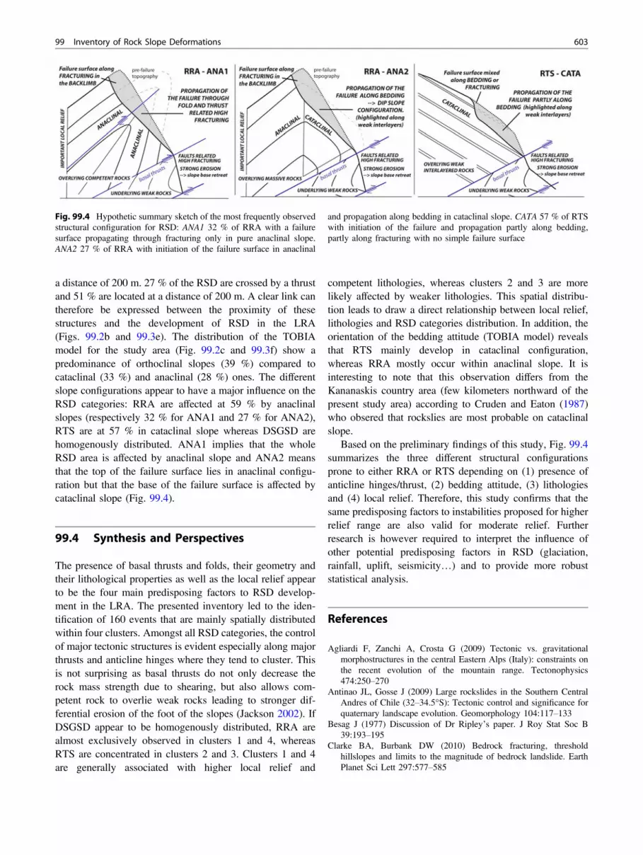
a distance of 200 m. 27 % of the RSD are crossed by a thrustand 51 % are located at a distance of 200 m. A clear link cantherefore be expressed between the proximity of thesestructures and the development of RSD in the LRA(Figs. 99.2b and 99.3e). The distribution of the TOBIAmodel for the study area (Fig. 99.2c and 99.3f) show apredominance of orthoclinal slopes (39 %) compared tocataclinal (33 %) and anaclinal (28 %) ones. The differentslope configurations appear to have a major influence on theRSD categories: RRA are affected at 59 % by anaclinalslopes (respectively 32 % for ANA1 and 27 % for ANA2),RTS are at 57 % in cataclinal slope whereas DSGSD arehomogenously distributed. ANA1 implies that the wholeRSD area is affected by anaclinal slope and ANA2 meansthat the top of the failure surface lies in anaclinal configu-ration but that the base of the failure surface is affected bycataclinal slope (Fig. 99.4).
99.4 Synthesis and Perspectives
The presence of basal thrusts and folds, their geometry andtheir lithological properties as well as the local relief appearto be the four main predisposing factors to RSD develop-ment in the LRA. The presented inventory led to the iden-tification of 160 events that are mainly spatially distributedwithin four clusters. Amongst all RSD categories, the controlof major tectonic structures is evident especially along majorthrusts and anticline hinges where they tend to cluster. Thisis not surprising as basal thrusts do not only decrease therock mass strength due to shearing, but also allows com-petent rock to overlie weak rocks leading to stronger dif-ferential erosion of the foot of the slopes (Jackson 2002). IfDSGSD appear to be homogenously distributed, RRA arealmost exclusively observed in clusters 1 and 4, whereasRTS are concentrated in clusters 2 and 3. Clusters 1 and 4are generally associated with higher local relief and
competent lithologies, whereas clusters 2 and 3 are morelikely affected by weaker lithologies. This spatial distribu-tion leads to draw a direct relationship between local relief,lithologies and RSD categories distribution. In addition, theorientation of the bedding attitude (TOBIA model) revealsthat RTS mainly develop in cataclinal configuration,whereas RRA mostly occur within anaclinal slope. It isinteresting to note that this observation differs from theKananaskis country area (few kilometers northward of thepresent study area) according to Cruden and Eaton (1987)who obsered that rockslies are most probable on cataclinalslope.
Based on the preliminary findings of this study, Fig. 99.4summarizes the three different structural configurationsprone to either RRA or RTS depending on (1) presence ofanticline hinges/thrust, (2) bedding attitude, (3) lithologiesand (4) local relief. Therefore, this study confirms that thesame predisposing factors to instabilities proposed for higherrelief range are also valid for moderate relief. Furtherresearch is however required to interpret the influence ofother potential predisposing factors in RSD (glaciation,rainfall, uplift, seismicity…) and to provide more robuststatistical analysis.
References
Agliardi F, Zanchi A, Crosta G (2009) Tectonic vs. gravitationalmorphostructures in the central Eastern Alps (Italy): constraints onthe recent evolution of the mountain range. Tectonophysics474:250–270
Antinao JL, Gosse J (2009) Large rockslides in the Southern CentralAndres of Chile (32–34.5°S): Tectonic control and significance forquaternary landscape evolution. Geomorphology 104:117–133
Besag J (1977) Discussion of Dr Ripley’s paper. J Roy Stat Soc B39:193–195
Clarke BA, Burbank DW (2010) Bedrock fracturing, thresholdhillslopes and limits to the magnitude of bedrock landslide. EarthPlanet Sci Lett 297:577–585
Fig. 99.4 Hypothetic summary sketch of the most frequently observedstructural configuration for RSD: ANA1 32 % of RRA with a failuresurface propagating through fracturing only in pure anaclinal slope.ANA2 27 % of RRA with initiation of the failure surface in anaclinal
and propagation along bedding in cataclinal slope. CATA 57 % of RTSwith initiation of the failure and propagation partly along bedding,partly along fracturing with no simple failure surface
99 Inventory of Rock Slope Deformations 603

Cooley MA, Price RA, Dixon JM, Kurtis Kyser T (2011) Along-strikevariations and internal details of chevron-style, flexural-slip thrust-propagation folds within the southern Livingstone Range anticli-norium, a paleohydrocarbon reservoir in southern Alberta Foothills,Canada. AAPG Bulletin 95(11):1821–1849
Crosta GB, Frattini P, Agliardi F (2013) Deep-seated gravitational slopedeformations in the European Alps. Tectonophysics 605:13–33
Cruden DM, Eaton TM (1987) Reconnaissance of rockslide hazards inKananaskis Country, Alberta. Can Geotech J 24:414–429
Hermanns RL, Niedermann S, Villanueva Garcia A, Sosa Gomez J,Strecker MR (2001) Neotectonics and catastrophic failure ofmountain fronts in the southern intra-Andean Puna Plateau,Argentina. Geology 29:619–623
Hutchinson JN (1988) General report: morphological and geotechnicalparameters of landslides in relation to geology and hydrogeology.In: Bonnard C (ed) Proceedings of the fifth international symposiumon landslides, Balkema, Rotterdam, pp 3–35
Jackson L (2002) Landslides and landscape evolution in the rockymountains and adjacent Foothills area, southwestern Alberta,Canada. Geol Soc Am Rev Eng Geol 15:325–344
Kühni A, Pfiffner OA (2001) The relief of the Swiss Alps and adjacentareas and its relation to lithology and structure: topographic analysisfrom a 250 m DEM. Geomorphology 41:285–307
McMehan ME, Stockmal GS (2013) Geology, Maycroft, Alberta,geological survey of Canada, Canadian Geoscience Map 25, scale1:50000. doi:10.4095/289711
Meentemeyer RK, Moody A (2000) Automated mapping of alignmentbetween topography and geologic bedding planes. Comput Geosci26:815–829
Montgomery DR, Brandon MT (2002) Topographic controls on erosionrates in tectonically active mountain ranges, Earth Plan. Sci Lett201:481–489
Norris DK (1955) Blairmore, Alberta. Canadian Geoloigcal Survey,55–18
Pedrazzini A, Humair F, Jaboyedoff M, Tonini M (submitted)Characterization and spatial distribution of gravitational slopedeformations in the upper Rhone catchment (Western Swiss Alps)
Ripley BD (1977) Modelling spatial patterns (with discussion). J RoyStat Soc B 39:172–212
Schmidt KM, Montgomery DR (1995) Limits to relief. Science70:617–620
Silverman BW (1986) Density estimation for statistics and dataanalysis. Chapman and Hall, New York
Tonini M, Pedrazzini A, Penna I, Jabyodedoff M (2013) Spatial patternof landslides in Swiss Rhone Valley, Natural Hazards. doi:10.1007/s11069-012-0522-9
604 F. Humair et al.


