Embed Size (px)
Citation preview
Quaternary International 184 (2008) 94–108
Late Holocene vegetation changes and human impact in the ChangbaiMountains area, Northeast China
Miroslaw Makohonienkoa,b,�, Hiroyuki Kitagawac, Toshiyuki Fujikid, Xin Liue,Yoshinori Yasudab, Huaining Yine
aInstitute of Quaternary Research and Geoecology, A. Mickiewicz University, Poznan, PolandbInternational Research Center for Japanese Studies, Kyoto, Japan
cInstitute for Hydrospheric Atmospheric Sciences, Nagoya University, JapandGraduate School of Environmental Studies, Nagoya University, Nagoya, Japan
eGeographical Department, Liaoning Normal University, Dalian, China
Available online 8 September 2007
Abstract
Pollen analytical data from Jinchuan site in the Changbai Mountains, located within the mixed temperate broadleaved forest zone of
Northeast China, were used for the reconstruction of vegetation changes and dynamics of human habitation activities in the last 6000 cal.
years in the periphery to the Chinese civilization areas of former Manchuria. The beginning of the present type of vegetation dominated
by mixed forests with the characteristic tree species Korean pine (Pinus koraiensis Siebold & Zuccarini) was dated to 3100 cal. BC.
Expansion of Korean pine occurred in two steps. The second phase of enhanced expansion of pine along with other coniferous taxa of
higher altitudes such as Abies and Picea was dated to around 70 AD. The pattern of Late Holocene spread of coniferous elements
(P. koraiensis, Picea, Abies) and retreat of deciduous oaks was associated with phases of climatic cooling and presumably changes in
effective precipitation.
The oldest record of habitation processes identified in pollen assemblages from Jinchuan was dated to around 140 AD. The buckwheat
(Fagopyrum esculentum) cultivation was documented since the first half of the 9th century AD. The 18th century immigration of the
Chinese population of Han ethnicity was reflected in the fossil archive, due to economic activities of the settlers connected with
exploitation of forest resources through cutting of pine trees, protection of walnut stands, and cultivation of Hordeum/Triticum cereals.
r 2007 Elsevier Ltd and INQUA. All rights reserved.
1. Introduction
The vegetation changes for the Changbai Mountain
region in eastern Manchuria have been previously studied
by Liu (1989), Mingram et al. (2004a, b), Sun et al. (1991),
Sun and Yuan (1990), Sun and Weng (1992), and Yuan
and Sun (1990). The longest sequences covering the Late
Glacial and the Holocene were presented from Gushantun
and Jinchuan sites (Liu, 1989; Sun et al., 1991), subse-
quently used for the regional synthesis in China (Sun and
Chen, 1991; Ren and Zhang, 1998; Yu et al., 2000; Ren and
Beug, 2002). These studies, however, concentrated on main
vegetation changes, forest taxa and selected herbaceous
components with restricted analyses of anthropogenic
factors. Timing and scale of human interferences during
the Holocene, perceived as the Anthropogenic Era (Ruddi-
man, 2003), and especially during its later part of
increasing human impact, is of great importance for
palaeoenvironmental reconstructions. The role of anthro-
pogenic factors in vegetation dynamics is still poorly
documented by palynological data in China (Ren, 2000).
This paper presents new results of pollen analytical studies
of the sediments from Jinchuan site providing a well-dated
scheme of vegetation changes in the forest zone of north-
eastern China in the Late Holocene. High-resolution data
and the use of indicative herbaceous taxa of human impact
allowed an attempt to separate climatic and anthropogenic
signals in the fossil pollen record, and a more detailed
ARTICLE IN PRESS
1040-6182/$ - see front matter r 2007 Elsevier Ltd and INQUA. All rights reserved.
doi:10.1016/j.quaint.2007.09.010
�Corresponding author. Institute of Quaternary Research and Geoe-
cology, A. Mickiewicz University, Poznan, Poland.
E-mail address: [email protected] (M. Makohonienko).

reference to habitation processes within the broadleaved
deciduous forest zone of Northeast China during the last
6000 years.
Peat sediments of the Jinchuan site have been previously
studied in relation to changes in oxygen isotope ratios
(d18O) and stable carbon isotopic composition (d13C). The
analysis carried out on the remains of plant cellulose
deposited in Jinchaun peat have been used for assessment
of climatic response to solar forcing in a high time-
resolution scale, and for reconstruction of changes in
drought and precipitation in Northeast China (Hong et al.,
2000, 2001). The results provoked vivid debate with the
main question focused on precision of timing of the
discussed geological record (see Fairbridge, 2001; Hong,
2001; Oldfield, 2001). The reconstructed climatic para-
meters presented by Hong et al. (2000, 2001) were used in
this study for inferences on vegetation changes.
2. Regional and local environmental settings
The Jinchuan site is located in the eastern part of
Dongbei (Northeast China), also known as Manchuria, in
the Changbain Mountains region (Fig. 1A and B) within
the biome of East Asiatic temperate (evergreen coniferous
and deciduous broadleaved) mixed forests, which extends
from the northern part of the Korean Peninsula through
Northeast China to the Amur region of the Russian Far
East (Yim, 1977; Wu, 1983; Krestov, 2003). In Northeast
China this is the largest forest region including such
mountain ranges as the north Xiao Hinggan Ling (Lesser
Hingan), and further to the south Wanda Shan, Zhang-
guangcai Ling, Liaoye Ling, Changbai Shan, Longang
Shan, Hada Ling, and Qian Shan (Qian et al., 2003). The
climatic conditions of the region are determined by the
monsoon system of East Asia. Seasonal changes in
ARTICLE IN PRESS
Fig. 1. Study area in Northeast China (Dongbei). (A) Administrative division and main cities in Dongbei with location of the Jinchuan site in southern
part of Jilin Province (marked by asterisk). (B) Mean annual precipitation in Northeast China and indicated approximate limit of East Asian summer
monsoon reaching the Greater Hingan mountain range in western part of Dongbei (after Geographical atlas of China, Zuixin Shiyong Zhongguo Dituce,
1997). Major mountain ranges in Northeast China are labelled. (C) Seasonal changes in temperature and precipitation in Jilin Province, Changchun
station (from Wu, 1983).
M. Makohonienko et al. / Quaternary International 184 (2008) 94–108 95
temperature and precipitation (Fig. 1C) are connected with
activity of the summer and winter monsoon. The summer
southeast monsoon, with air masses from the subtropical
anticyclone in the Northwest Pacific, brings most of the
annual precipitation, around 70–80%, which falls from
June to August (Domros and Peng, 1988; Zhang and Lin,
1992). Distribution of annual precipitation in Northeast
China shows a gradual decrease from the south-east (with
precipitation of 600 to around 1300mm in Changbai
Mountains) to 300–400mm in the north-west (in the Great
Hingan Mountains area, where the summer monsoon
reaches its limit) (Fig. 1B). Siberian high-pressure systems
prevailing in winter bring in turn cold and dry air masses
from the interior of the continent. The winters are clear,
windy and with little snowfall. The mean temperature for
the warmest month (July) in the almost entire Northeast is
above 20 1C. The mean air temperatures of the coldest
month (January) in the Changbai Mountains range
between �10 and �20 1C depending on elevation (Zhang
and Lin, 1992; Liu, 1998).
The short duration of the summer monsoon as well as
long, cold and dry winters are assumed to be the main
natural climatic factors responsible for vegetation distribu-
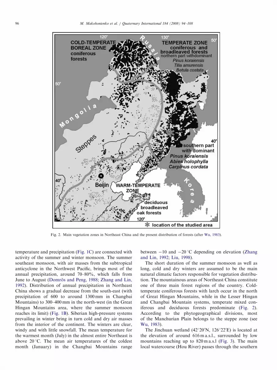
tion. The mountainous areas of Northeast China constitute
one of three main forest regions of the country. Cold-
temperate coniferous forests with larch occur in the north
of Great Hingan Mountains, while in the Lesser Hingan
and Changbai Mountain systems, temperate mixed con-
iferous and deciduous forests predominate (Fig. 2).
According to the phytogeographical divisions, most
of the Manchurian Plain belongs to the steppe zone (see
Wu, 1983).
The Jinchuan wetland (421200N, 1261220E) is located at
the elevation of around 616ma.s.l., surrounded by low
mountains reaching up to 820ma.s.l (Fig. 3). The main
local watercourse (Hou River) passes through the southern
ARTICLE IN PRESS
Fig. 2. Main vegetation zones in Northeast China and the present distribution of forests (after Wu, 1983).
M. Makohonienko et al. / Quaternary International 184 (2008) 94–10896

margins of the swamp at a distance of about 700m from
the drilling point. The nearest settlement, Jinchuan, is
located only 1 km east of the swamp at the foot of the maar
lake Dalongwan. Cultivated fields (mainly with Sorghum
sp. and Zea mays) and ruderal vegetation is common at
low elevations. The surrounding mountains are covered
with mixed conifer and deciduous broadleaf forests. This
type of vegetation occupies areas between 500 and 1100m
in the Changbai Mountains (Chou, 1997; Zhu, 1999; Qian
et al., 2003; Zhu et al., 2003). Conifers include Korean pine
(Pinus koraiensis Siebold & Zuccarini), fir (Abies holophylla
(Maximowicz), red pine (Pinus densiflora Siebold &
Zuccarini) and Japanese yew (Taxus cuspidata Siebold &
Zuccarini), and deciduous broadleaf trees include Mon-
golian oak (Quercus mongolica Fischer ex Ledebour), Tilia
amurensis Ruprecht, Ulmus, ash (Fraxinus mandschurica
Ruprecht) and Manchurian walnut (Juglans mandshurica
Maximowicz). Higher elevated areas between 1100 and
1900ma.s.l. support dark conifer forests with spruce
(Picea jezoensis Siebold & Zuccarini and P. obovata
Ledebour), fir (Abies nephrolepis (Trautvetter ex Maximo-
wicz) Maximowicz), and larch (Larix olgensis Miller) and
in subcanopy with maple, birch, mountain ash and poplar.
The alpine zone, above 1900ma.s.l., consists of meadow
vegetation and shrubby communities with Salix spp.,
Vaccinium spp., Rhododendron spp. and dwarf rock birch
(Betula ermannii Chamisso).
3. Field and laboratory methods
The core for palaeoenvironmental studies was taken with
a piston sampler with the tube of 5 cm diameter, from the
central part of the Jinchuan swamp at a distance of about
350m from its northern margin at 665ma.s.l. (Fig. 3). Sub-
sampling was done on the fresh sediments. The samples for
pollen analyses were prepared with the use of heavy liquid
(polytungstate) to separate mineral components (Nakaga-
wa et al., 1998). For each sample 600–1000 pollen grains of
terrestrial plants were counted. Percentages were calculated
according to the pollen sum of all terrestrial plants,
AP+NAP ¼ 100% (Berglund and Ralska-Jasiewiczowa,
1986). To avoid an effect of over-representation by local
components, telmatophytes, including Cyperaceae, and
limnophytes were excluded from the calculation sum.
Calculations, zonation of the pollen sequences and
construction of the diagrams were performed with the use
of Tilia and TiliaGraph programs (Grimm, 1987,
1991–1993). The amount of charcoal particles and some
non-pollen microfossils as such Cyanobacteria was also
counted. Nomenclature of pollen type classes followed
Moore et al. (1991) in general. Chinese and Japanese pollen
morphological publications were used for taxonomical
identifications (Shimakura, 1973; Nakamura, 1980a, b;
Nasu and Seto, 1986a, b; Wang et al., 1995). Cultivated
plants such as Fagopyrum, Cerealia undiff., have been used
ARTICLE IN PRESS
Fig. 3. Simplified topographic map of the Jinchuan area, Huinan County, Jilin Province, Northeastern China.
M. Makohonienko et al. / Quaternary International 184 (2008) 94–108 97

as direct indicators of human activity. The other herbac-
eous taxa, which occupy synanthropic habitats such as
Chenopodiaceae, Xanthium, Humulus type, were selected as
potential supporting evidence of habitation phases.
4. Sediment stratigraphy and chronology
The sediment stratigraphy of the Jinchuan profile used
for palynological procedures is illustrated in Fig. 4. The
550 cm long sequence represents sediment accumulation
during the last 6000 cal. years. The chronology of the
profile was established with 7 AMS measurements. Radio-
carbon dates were subsequently calibrated to calendar
years using the CALIB ver. 5.0 program (Stuiver and
Reimer, 1993). The radiocarbon dates and calibration
results are listed in Table 1.
The drillings did not reach the bottom of the accumula-
tion basin. The lowermost part of the core represents
limnic accumulation (sandy clay), which ended at the depth
of 470 cm, dated to ca. 5200–5300 cal. BP. At the depth of
470–510 cm, a layer of sand and gravel occurred. The
stratum may represent fluvial deposition due to changes in
channel of the water course passing through the former
lake or plausibly it reflects a short-term deposition of
coarse mineral material during extreme conditions such as
a flood event. The top of the sand layer can be dated
between 5400 and 5600 cal. BP.
The upper part of the sequence from the depth 470 cm
contains telmatic sediments composed of sedge peat.
Sedimentation rate (SR), calculated on the basis of
calibrated radiocarbon years for the seven time-windows
showed values that varied from 0.033 to 0.211 cm/year
(Fig. 4) with the mean sedimentation rate of 0.088 cm/year
(calculated for the 447.5 cm long peat sequence dated using
radiocarbon). The lowest SR was recorded between levels
dated to 1410 BC and 70 cal. AD, and between 840 and
1630 cal. AD. The highest sedimentation rate occurred
between levels dated to 70–840 AD. Then, the most
remarkable shift in sedimentation rate occurred at the
level dated to around 70 cal. AD. It should, however, be
stressed that the SR simplified curve represents only
changes between the levels used for radiocarbon dates,
and the real levels of shift in sedimentation rate may differ
from that presented in the chart.
The depth-age model constructed for the peat sediments
of the Jinchuan site with 7 AMS measurements presented
ARTICLE IN PRESS
Fig. 4. Lithology and age-depth model of the Jinchuan core (421200N, 1261220E). Age model based on 7 calibrated radiocarbon dates (see Table 1 for
details). Horizontal bars indicate calibrated age ranges calculated from probability distribution for 2s (95.4% confidence). Changes in sedimentation rate
(SR) in the seven intervals between levels dated with radiocarbon dating have been measured and indicated by simplified chart. Mean sedimentation rate
calculated for the 447.5 cm long section of the sediment sequence dated with AMS was 0.088 cm/year.
M. Makohonienko et al. / Quaternary International 184 (2008) 94–10898

in this paper (Fig. 4), did not show a linear trend. A linear
trend was established with 5 radiocarbon dates by Hong et
al. (2000) for a core of peat sediments taken from the same
swamp, and used for correlations of climatic changes and
solar forcing. This has been discussed by Fairbridge (2001)
and critically evaluated in relation to the issue of
chronology and time-resolution by Oldfield (2001) (with
response of Hong, 2001).
5. Results and interpretation
5.1. Natural vegetation changes and climatic implications
In the pollen sequence of the 550 cm profile from
Jinchuan swamp (Figs. 5–7), four local pollen assemblage
zones (L PAZ) reflecting main phases in vegetation
development during the last 6000 cal. year were delimited
with the assistance of the statistical program CONISS
incorporated in Tilia/TiliaGraph.
5.1.1. Phase of broadleaved deciduous forests-
Quercus–Juglans L PAZ (prior to 3100 cal. BC)
In the earliest phase of the stratigraphic sequence, prior
to 3100 cal. BC (5050 cal. BP) delimited as Quercus–Juglans
L PAZ, fossil pollen spectra showed predominance of
deciduous tree taxa including oaks (Quercus—max. to 35%
of calculation sum AP+NAP), walnut (Juglans—max.
16%), Ulmus (max. 14%), Fraxinus (8%), Carpinus (5%),
and Tilia (3.5%). Alnus, Salix and Corylus were recorded in
small quantities. Occurrence of pollen grains of Acer,
though low, may indicate its significant admixture in the
local deciduous forests. Pollen grains of the Amur corktree
(Phellodendron amurense Ruprecht) were also recorded.
Low occurrences of high-pollen producing taxa such as
Betula (up to 3%) and Pinus (up to 7.6%) reflect their very
restricted role in vegetation cover of the region. Pollen
grains of Ephedra, representing far-distant aerial transport,
were regularly found in that zone. Single grains of Castanea
may also reflect an influx from remote areas.
In the Quercus–Juglans pollen assemblage zone, arboreal
pollen (AP) comprises from 81% to only 40% of the total
sum of AP and NAP. Representation of herbaceous plants
(NAP) from 19% to 60% was relatively high. Such a high
amount of NAP resulted mainly from the content of
Poaceae pollen grains. Changes in lithology in this part of
the core indicate a transition from lacustrine to mire
environment, suggesting that the high content of Poaceae
can be linked with pollen grains of common reed-forming
Phragmites communities. Numerous macroscopic remains
of Phragmites in the sediments of Jinchuan at the relevant
depth were reported by Hong et al. (2000). Thus, the
Poaceae pollen type, though included in the group of
terrestrial herbaceous plants, originates from the species
Phragmites australis growing in shallow waters, forming a
belt of emergent aquatic macrophytes along the former
lake shores. The appearance of wet habitats in closer
proximity to the sampling site is confirmed by temporal
high representation of such taxa of wet habitats as
Lythrum, Mentha and Apiaceae. This episode indicates
lowering of the water level of the Jinchuan paleolake.
The highest amount of Cyperaceae (224% of AP and
NAP, Cyperaceae excluded from calculation sum) was
recorded in the very beginning of peat accumulation dated
to ca. 5300 cal. BP (3350 BC), followed by a phase of fern
expansion (Polypodiaceae). In the fossil samples, pollen
grains of Cyperaceae were encountered in conglomerates,
which indicate their local origin. In the last sample prior to
the transition from lacustrine to swamp environment,
marked by a sediment change, very high amounts of
Artemisia pollen occurred reaching 46% (in the sample at
the depth 478 cm). The genus Artemisia is characteristic of
open habitats. It is a common component of steppe
vegetation, and may appear in a forested landscape due
to disturbances of vegetation cover. However, as the level
of high pollen frequency of Artemisia contained conglom-
erates of numerous pollen grains, it can be assumed that
the high content of mugwort resulted from an occasional
inwash of material from a terrestrial habitat, and the taxon
was overrepresented. A high overrepresentation of Ulmus
ARTICLE IN PRESS
Table 1
Radiocarbon dates of the Jinchuan profile dated with the AMS method
Laboratory code Sample
depth
(cm)
Age 14C (year
BP)
Calibrated 14C
age ranges (year
BP), 2s ranges
Cal. 14C age
(year BP) (round
to decade)
Calibrated 14C
age ranges (year
AD/BC), 2s
ranges
Cal. 14C age
(year AD/BC)
(round to
decade)
Material
dated
GrA-15820 45–50 280750 150–485BP 310BP 1465–1800 AD 1630 AD Seeds
GrA-15824 90–95 1170760 961–1258BP 1110BP 692–989 AD 840 AD Seeds, Carex
GrA-15823 185–190 1680750 1418–1710BP 1560BP 240–532 AD 390 AD Seeds, Carex
GrA-15821 245–250 1950750 1739–2030BP 1880BP 81BC–211AD 70 AD Unidentified
GrA-15825 295–300 3150750 3256–3470BP 3360BP 1521–1307 BC 1410 BC Seeds, Carex
GrA-15826 395–400 4060750 4421–4809BP 4620BP 2860–2472 BC 2670 BC Seeds, Carex
GrA-15822 445–450 4370750 4839–5261BP 5050BP 3312–2890 BC 3100 BC Ephiderma
Calibration with the use of CALIB ver. 5.0 program (Stuiver and Reimer, 1993). Calibrated (BP and AD/BC) age ranges calculated from probability
distribution for 2s (95.4% confidence), Calibration data set: intcal04.14C (Reimer et al., 2004).
M. Makohonienko et al. / Quaternary International 184 (2008) 94–108 99

pollen grains was recorded in the same lithological strata of
Jinchuan sediments analyzed by Sun et al. (1991). The
evidences of inwash of pollen from terrestrial habitats
would additionally suggest significant water level fluctua-
tions or intensified fluvial activity at that time.
5.1.2. Expansion of Korean pine—earlier phase of mixed
forests Quercus–Pinus L PAZ (3100 BC–70 cal. AD)
The fossil pollen record reveals that the expansion of
Korean pine, a characteristic tree species of the present day
regional vegetation, occurred around the site shortly after
the changes from lake to mire ecosystem, reflected in the
lithology of the studied core as well as in pollen
assemblages showing development of swamp vegetation
with Cyperaceae, Polypodiaceae and other taxa of telmatic
habitats such as Thalictrum, Lythrum, Apiacae, Mentha
type or possibly Aster type.
The pollen spectra showed reverse trends in representa-
tion of Pinus and Ephedra. The pollen grains of Ephedra
discovered at Jinchuan originate from beyond the Chang-
bai region, representing far-distant pollen transport from
semi-desert and desert areas in northern China, west of the
forested areas of Dongbei. The Ephedra had higher and
more regular occurrences during the preceding phase of
deciduous forests dominated by oaks, and it declined after
3000 cal. BC, during the subsequent phase of P. koraiensis
expansion. The retreat of Ephedra in desert areas, and of
oak-dominated forest communities in favor of mixed forest
in the Changbai Mountains seem to reflect a common
response to the Late Holocene climate change in the two
ecologically differing areas.
Expansion of Korean pine, which is a mountainous
species associated with cooler conditions, occurred mainly
at the expense of deciduous oaks (Quercus). The second
deciduous tree affected negatively at the time of spread of
Korean pine was Tilia. The other deciduous taxa, e.g.,
Carpinus and Acer, showed their decline later, around 1800
BC. Between around 800 (700) BC and 70 AD, the pollen
profile showed a second phase of development of wet
meadows richer in such herbaceous taxa as Sanguisorba
officinalis, Thalictrum, Aster type, Poaceae and Cyperaceae
as well as increase of light-demanding forest fern Pteridium
ARTICLE IN PRESS
Fig. 5. Jinchuan site-pollen percentage diagram for arboreal taxa (AP). Percentages values for the individual taxa based on pollen sum of all terrestrial
plants, AP+NAP ¼ 100% (excluding telmatophytes and limnophytes). Lithology as in Fig. 4. Magnification by 10 is used to show minor percentage
values. For very rare taxa, dots were used to indicate presence of single pollen grains in the stratigraphic record. L PAZ—local pollen assemblage zones—
delimited with assistance of CONISS procedure.
M. Makohonienko et al. / Quaternary International 184 (2008) 94–108100

aquilinum combined with pine decline and episodic rise of
Betula in the final phase. A slight rise in Artemisia pollen
content has been recorded as well. These vegetation
changes correspond with decrease of Cyanobacteria
remains in the sediments, however, still with a presence
of specimens of green alga of Scenedesmus and Botryoco-
cus. The lowest sedimentation rate in the sequence was
recorded in that phase indicating restricted organic
deposition or higher decomposition of organic matter due
to aeration of the surface sediments. Climatic parameters
reconstructed on the basis of the isotope studies (Dd18O
and Dd13C) of peat cellulose from Jinchuan swamp,
indicate in that period a decrease in mean air temperatures
and frequent fluctuations in soil moisture/precipitation
(Hong et al., 2000, 2001).
5.1.3. The second phase of expansion and dominance of
mixed forests with Korean pine Pinus L PAZ (70 cal. AD—
ca. 1630 AD)
The following phase showed the second stage of Korean
pine expansion along with other mountain arboreal taxa
such as Abies and Picea—reflecting their migration to
lower elevations. Relative frequency of Pinus pollen grains
increased above 50%. The onset of that event was dated in
the profile to around 70–100 AD. In the lithological
sequence, the layer between ca. 70 AD and ca. 800 AD is
characterized by the highest accumulation rate of peat, up
to 0.21 cm/year, which may broadly reflect optimal,
sufficient supply of moisture during the vegetative season
for the growth of sedge communities, and for the formation
and preservation of peat. A drier event, reflected in
minimal Cyperaceae and a drop in pine pollen, was dated
according to the calculated calibrated time scale, to around
350–370 AD. At the level dated to around 140 AD, the
Jinchuan palynological record revealed the first evidence of
human interference in the forest environment, inferred
from the presence of Xanthium pollen.
In the level dated to around 850 AD, the first pollen
grain of cultivated species Fagopyrum esculentum was
recorded. In the subsequent sample, representation of pine
pollen decreased while the amount of Betula and herbs of
open habitats such as Artemisia increased, suggesting a
phase of a more open landscape. Between 840 and
1630 cal. BP, the sedimentation rate of peat was low. The
last evidence of presence of aquatic organisms such as
Diatomae and Spongia corresponded with the maximum of
Cyperaceae, and was dated to ca. 1200 AD.
5.1.4. The phase of local expansion of Ericaceae L PAZ
(1630 AD—present)
Since around 1630 AD, pollen spectra reflect a spread of
Ericaceae, probably from local mire communities at the
site. A short dry climate episode is indicated by minima
of Cyperaceae, Polypodiaceae and Sphagnum. This is
ARTICLE IN PRESS
Fig. 6. Jinchuan site-pollen percentage diagram for terrestrial herbaceous plants (NAP). All percentages values are based on pollen sum of all terrestrial
plants, AP+NAP ¼ 100% (excluding telmatophytes and limnophytes). Lithology as in Fig. 4. Magnification by 10 is used to show minor percentage
values. Dots were used to indicate presence of pollen conglomerates.
M. Makohonienko et al. / Quaternary International 184 (2008) 94–108 101

recorded at 35 cm depth, dated 1730–40 AD. This level
corresponds well to the historically documented droughts
in China, which triggered the immigration of Chinese
peasants into Manchuria, the province formerly closed to
settlement by Chinese farmers (Sun and Yuan, 1990). Since
that time, a permanent cultivation of cereals and utilization
of forest resources has been recorded.
5.2. Human impact in Changbai Mountains—reconstructed
from the pollen record of the Jinchuan site
The pollen diagram from Jinchuan provided a record of
human impact on the natural environment in the Changbai
Mountains area, within the broadleaved deciduous forest
zone. For detecting human-induced changes in vegetation,
pollen analysis uses direct and indirect evidence (Iversen,
1949; Behre, 1981, 1986; Berglund and Ralska-Jasiewiczo-
wa, 1986; Birks et al., 1988). The direct evidence refers to
presence of cultivated plants or synanthropic taxa originat-
ing from weeds and anthropogenic ruderal flora. The
indirect evidence may be deduced from changes in AP/
NAP ratio, appearance and increase in representation of
apophytes, appearance and increase of amount of charcoal
dust particles related potentially to anthropogenic fires,
palynodiversity (palynorichness) as well as from non-pollen
microfossils, e.g., algae remains, parasites and others
associated with human interferences of aquatic and
terrestrial ecosystems.
The best and direct evidence of human activity in the
past is the presence of introduced cultivated plants. From
that group, two pollen taxa were identified in Jinchuan:
Cerealia type (including pollen grains of Triticum,
Hordeum, Avena) and F. esculentum. These cultivated
plants appeared relatively late. The pollen grains of
Cerealia-type were recorded for the first time after the
described evidence of historical drought dated in the profile
to 1730–1740 AD. The cultivation of these cereals was
initiated by the settlers of Han (Chinese) ethnicity
mentioned in historical records. Palynological data showed
that this most recent phase of settlement activity, lasting
for the last 270 years, resulted in selective destruction of
mixed forest by cutting out the Korean pine, which
declined in pollen spectra from average values of 50% to
around 23%.
As a result of human impact, some tree taxa (especially
Betula as a pioneer) increased their representation in the
landscape. An unusual percentage increase in pollen
assemblages for the last 50–60 years has been walnut,
represented in the region by Juglans mandschurica
(Manchurian walnut). Its pollen grains reached the
ARTICLE IN PRESS
Fig. 7. Jinchuan site—summary pollen percentage diagram for selected trees (A), terrestrial herbaceous plants (B)—mainly indicators of human impact,
content of charcoal particles, selected telmatophytes (C) and some additional non-pollen microfossils such as Diatoms, Spongia, Cyanobacteria and
Chlorophyta). Dots indicate presence of the taxon. All percentages values for the individual taxa based on pollen sum of terrestrial plants,
AP+NAP ¼ 100% (excluding telmatophytes and limnophytes). Lithology as in Fig. 4. Magnification by 10 is used to show minor percentage values.
M. Makohonienko et al. / Quaternary International 184 (2008) 94–108102

maximum value for the whole sequence of 18.3% of the
calculated sum of AP+NAP. This phenomenon seems to
be associated with purposeful economic protection of
walnut stands in the local forests as the source of nuts.
Large amounts of gathered nuts were observed during the
field expedition in the nearby Jinchuan settlement. A very
recent phenomenon is the appearance of Populus pollen
grains, which reflect planting of the poplar trees in the
cultural landscape around the settlements during the last
50–60 years. Pollen grains of seabuckthorn (Hippophae
rhamnoides) most probably reflect recent planting of this
shrub for the control of soil erosion, stabilization of slopes
and improvement of soil properties of mountainous
wastelands. Single pollen grains of hemlock (Tsuga) may
be connected with introduction of the tree in the forestry in
the region.
The observed changes in forest composition were
accompanied by increases of herbaceous plants, indicating
development of open habitats of synanthropic character.
Due to the proximity of the drilling site to the forest edge,
the representation of herbaceous component (NAP) was
not high even in surface samples, reaching only around
15% of the total AP+NAP sum. For the most recent
historical phase, higher amounts of Artemisia and Cheno-
podiaceae, as well as Poaceae, can be attributed to
terrestrial habitats and regarded as general apophytes.
The other synanthropic taxa were Xanthium—represented
in present ruderal habitats of the region and in the fields by
the species Xanthium strumarium L. and Humulus type—
represented in the region by the weedy species Humulus
scandens (Louriero.) Merrill. The other single pollen grains
belonging to Rumex acetosa-acetosella type and Plantago
(Plantago asiatica type) may also originate from anthro-
pogenic communities. The presence of P. aquilinum spores
is regarded as an indicator of the opening of the forest
canopy—possibly connected with human activity. Higher
representation of microscopic charcoal in the sediments
was associated with palynological indicators of human
activity and can be linked during that phase with the
intentional use of fire in settlement activity, e.g., burning
dry vegetation of grasslands or plant remains in fields, or
using fire in households.
Episodic, significant increases of charcoal particles
deposited in sediments have been encountered in older
phases of the analyzed sequence. The earlier three maxima
of charcoal content were correlated with the presence of
cultivated F. esculentum or pollen grains of Xanthium. The
previous maximum at depth 95 cm was dated to ca. 820 AD
and coincided with the evidence of Fagopyrum cultivation
along with episodic increase of P. aquilinum. At the depth
of 185 cm (dated to ca. 420 AD) a very high amount of
charcoal particles (260% of AP and NAP sum) was
recorded along with pollen grains of Xanthium, Plantago
and increase of Chenopodiaceae. The earlier record of
higher charcoal content at the depth 225 cm occurred in a
subsequent sample just after the appearance of Xanthium
and maximum of Chenopodiaceae pollen dated to ca. 140
AD. These two earliest mentioned anthropogenic phases
(dated respectively to around 420 AD and 140 AD)
occurred during periods of somewhat wetter conditions,
deduced from the occurrence of indicators of water
habitats, e.g., remains of Spongia, Diatomae, green algae
Mougeotia or blue–green algae Gloeotrichia.
The pollen record of the anthropogenic phase dated to
around 820 AD did not reveal forest clearings, which
would be reflected in decline of the AP curve. In contrast,
the indicated level showed the absolute maximum of pine
pollen content in the whole analyzed sequence, over 72%.
The minima of Quercus and Juglans pollen frequencies
might suggest some cuttings of deciduous species, which
would cause openings of the canopy and stimulate pollen
production of pine trees. Representation of P. aquilinum, a
light-demanding forest fern species, argues for opening of
the canopy. The scale of deforestation due to farming
activities was too low to be reflected in a decline of the AP
curve. This settlement phase followed by a remarkable
decrease of pine, coincided with birch expansion and
minima of telmatic taxa such as Cyperaceae and Poly-
podiaceae. The pronounced minima both for sedges and
ferns, similar to those correlated with 18th century
drought, may suggest a climatic dry event (culminating
around 1050BP). The subsequent changes showed an
increase in open habitats in the landscape with Artemisia,
Poaceae, Chenopodiaceae and Xanthium coinciding with
recurrence of wetter conditions at the Jinchuan swamp—
deduced from an increase in telmatic taxa and appearance
of Spongia remains. This settlement phase was dated to
around 1200–1300 AD.
5.3. Palynodiversity and environmental changes
Fossil data from the Jinchuan site were used to illustrate
changes in palynodiversity, which can be attributed the
history of floristic diversity in the region for the last 6000
years (Fig. 7). The data showed that the floristic diversity in
the region was positively stimulated by moderate human
impact. The highest numbers of plant taxa were recorded in
the sediments of the Jinchuan site, during the period of
intensification of anthropogenic activities from the 17th to
19th century AD. In very recent times this diminished due
to a decreased number of herbaceous taxa both of
terrestrial and telmatic habitats. Relatively high floristic
diversity occurred during the early stage of formation of
mixed forest with P. koraiensis. The second stage of
expansion of Korean pine and its predominance in forest
phytocoenosis resulted in reduction of floristic diversity
between the 1st and 17th century AD.
6. Discussion
The palynological record from the Jinchuan site provides
a high-resolution sequence of vegetation changes in the
Changbai Mountains region with reference to human
impact. The most essential event in the Late Holocene
ARTICLE IN PRESS
M. Makohonienko et al. / Quaternary International 184 (2008) 94–108 103

vegetation changes in the forest zone of northeastern China
was expansion of Korean pine, which shaped the present-
day biome of the area. The regional scale of pine expansion
is illustrated by the isopollen maps for China, constructed
for 2000-year time intervals (Ren and Zhang, 1998; Ren
and Beug, 2002). The spread of pine (shown for the
4000BP time horizon) occurred in the mountainous areas
of eastern Manchuria, corresponding broadly with the
present-day distribution of temperate mixed broadleaved
forests with Korean pine. The Jinchuan profile revealed
that the formation of the mixed forest phytocoenosis
occurred in two stages. The beginning of that process was
dated to 3100 cal. BC (4370 cal. BP). The lack of palynolo-
gical evidence of human interference in the vegetation
cover at the time of the Korean pine expansion, suggests
that its spread was caused by natural factors. Climatic
cooling is considered the most likely phenomenon respon-
sible for the expansion of P. koraiensis in broader areas of
lower mountainous elevations (Ren and Zhang, 1998; Wu
and Raven, 1999). Air temperature values reconstructed by
Hong et al. (2000) for the last 6000 years showed significant
fluctuations in the time preceding the pine expansion
(Fig. 8). The data indicate a phase of cooler air
temperatures between 3600 and 3300 BC, followed by
shorter warmer period dated to around 3300–3050 BC. The
second reconstructed colder phase, dated in the profile
studied by Hong et al. (2000) to ca. 3050 BC directly
initiated the spread of pine. The onset of pine expansion
was dated in the profile to 31007210 BC. The apparent
differences in timing seem to result from the radiocarbon
dating procedure, as do the broad calibrated age ranges.
This second cooler phase lasted till around 2600/2500 BC.
The transition from lake to swamp environment
recorded in the lithology of our core and dated to ca.
3250 BC, corresponded with the period of higher air
temperatures (between 3300 and 3050 BC) and lower
ARTICLE IN PRESS
Fig. 8. Jinchuan site-changes in relative pollen frequency for Pinus (A) and reconstructed climatic parameters by Hong et al. (2000, 2001) for the last 6000
years. (B) Air temperature index based on the peat cellulose d18O values. (C) Soil moisture/precipitation index based on the peat cellulose d
13C values.
M. Makohonienko et al. / Quaternary International 184 (2008) 94–108104

values of soil moisture/precipitation index (Fig. 8). This
suggests that the final change from lake to swamp
environment in Jinchuan occurred due to water level
lowering in response to climatic changes. The evidence of
Late Holocene low lake water levels and vegetation
changes in continental East Asia was mainly attributed to
the weakening of the Pacific Monsoon, which brings
moisture during the summer season (see Jarvis, 1993;
Gasse et al., 1996; Chen et al., 1999; Enzel et al., 1999;
Tarasov et al., 2000, 2004). However, it could be connected
also with changes in precipitation during winter season,
i.e., activity of winter monsoon. In temperate climatic
zones, according to model simulations, lake water levels
depend on the amount of snow accumulated through the
winter season and associated spring runoff (Harrison and
Digerfeldt, 1993; Vassiljev et al., 1998). The lake level
lowering, and expansion of swamp vegetation in Jinchuan,
could thus indicate a phase of lower mean annual
precipitation values, and most probably decrease in
amount of snowfall. Presently, the lowest monthly average
precipitation in the Changbai Mountains comes in the
period December–February with monthly sums below
20mm.
The pollen record revealed that the spread of Korean
pine was associated with retreat of deciduous oaks,
represented presently in the area by Q. mongolica.
Distribution of major tree species in the mixed forests
with Korean pine according to the soil moisture gradient,
shows that Q. mongolica can be associated with xeric
habitats, and P. koraiensis with mesic soil conditions (after
Okitsu, 2002). Geographical distribution of Korean pine in
northeastern China is restricted to mountainous areas of
eastern and northern Manchuria characterized by higher
mean annual precipitation and higher moisture index
(defined as annual precipitation divided by annual poten-
tial evapotranspiration) (Box and Choi, 2003). Mongolian
oak has a broader geographical distribution, occurring also
in western and southern Manchuria, in the areas char-
acterized by lower moisture index. It would indicate that
the phases of climatic cooling that stimulated development
of P. koraiensis were probably associated with some
changes in soil moisture. The years with lower summer
temperatures probably decreased the rate of evaporation
providing somewhat wetter habitat conditions during the
vegetative season, suitable for Korean pine.
The suggested trend toward somewhat cooler summer
temperatures, which would have influenced the decrease of
evaporation during the summer season, may in turn
explain a general tendency to more extensive paludification
in Northeast China during the Late Holocene as broadly
expressed by the Peat Study Group (1983) and supported
by evidence from Muchang and Dahuofang sites located in
western Manchurian Plain (Makohonienko et al., 2004).
The beginning of peat accumulation on mineral substrate
was initiated in the Muchang site around 3120 BC
(calibrated time scale) and in the Dahuofang site, around
2520 BC (1910 BC). The Late Holocene trend in peatland
development has been documented in other temperate
areas of the Northern Hemisphere and is connected mainly
with climatic cooling, changes in soil conditions as well as
sometimes with human impact (Griffin, 1975; Lamb, 1980;
O’Connell, 1986; Bell and Walker, 1992).
The second phase of expansion of Korean pine occurred
during the 1st century AD, along with another montane
taxon, Abies. Pollen spectra did not record for that time a
human impact on vegetation. The expansion of coniferous
taxa correlated with the beginning of a period of higher
rates of sediment accumulation. This suggested optimal
hydrological conditions for the growth and preservation of
sedge peat at the Jinchuan site. The second stage of pine
and fir expansion also corresponds with a period of lower
air temperatures, reconstructed by Hong et al. (2000) on
the base of peat cellulose d18O values from Jinchuan. The
palynological record, supported by the results of stable
isotopes (d18O), indicates that the Late Holocene two-
phase development of mixed forests with Korean pine in
the Changbai region of northeastern China was a response
to climatic factors.
A regression of Korean pine stands, dated to around 370
AD and accompanied in the fossil record by a minimum of
Cyperaceae pollen, can be also interpreted in climatic
terms. This pine decline corresponds with a drop in
precipitation reconstructed by Hong et al. (2001) for the
Jinchuan site, showing at 350 AD the highest drought
index in the analyzed sequence for the last 3000 years. The
reconstructed curve of air temperatures showed at that
time the highest values (Hong et al., 2000). A period of
severe droughts in China during the 4th and 5th centuries
AD was suggested by Gong and Hameed (1991) on the
base of historical documents. The lowest moisture indices
calculated by these authors for the last 2000 years of
Chinese history were recorded for 350 AD (Gong and
Hameed, 1991). Similarly, a short-lasting but well-marked
decline of pine accompanied by minima of telmatic plants,
dated to the first half of 18th century AD was correlated
with historical droughts.
Habitation activities in the mountainous forest regions
of eastern Manchuria detectable in pollen fossil archives
were dated to the last two millennia. Human impact did
not result in a remarkable deforestation of the area. Forests
were only partly cleared in valleys, while the surrounding
mountains remained unaffected by man. The first evidence
of human impact on vegetation detectable in the
pollen assemblages from Jinchuan were found in the
level dated to ca. 140 AD. The human activity was inferred
from the appearance of pollen grains of Xanthium.
The genus is commonly represented in the region by
synanthropic species X. strumarium L. (syn. X. sibiricum
Patrin ex Widder, X. japonicumWidder). It grows in segetal
and ruderal habitats, in roadsides and riverbanks. In
China, the species is classified primarily as a weed of
cultivated fields (Zhang and Hirota, 2000). In the past, the
cocklebur was utilized in China as a leafy vegetable and it
was intentionally planted (Li, 1969). Northern areas of
ARTICLE IN PRESS
M. Makohonienko et al. / Quaternary International 184 (2008) 94–108 105

China are supposed to be the origin of its cultivation (Li,
1970).
This first occurrence of Xanthium pollen in the Jinchuan
profile broadly correlated with the first pollen grains of the
species recorded in the Manchurian Plain at the Dahuo-
fang site, dated in a range of calibrated scale between ca. 80
BC and 70 AD (Makohonienko et al., 2004) and
corresponding to the protohistoric times when the terri-
tories of present Northeast China were inhabited by tribal
unions, located south of the Changbai Mountains area,
around the Gulf of Bohai (Janhunen, 1996). In the history
of China, this period corresponds with the time of the Han
Dynasty (dated to 206 BC–220 AD). The evidence of the
Late Holocene spread of Xanthium in the landscape of
Manchuria may reflect an intensification of human
activities or changes in land-use. Presumably, it could have
been indirectly connected with an increase in cultivated
land in the region. The role of Xanthium as indicator of
cultural landscape development also was indicated also
from western Eurasia (Brande, 1976). Pollen grains of the
cocklebur were found in south-eastern Europe, in sedi-
ments dated to the Last Glacial, indicating that the taxon is
an apophyte, i.e., a synanthropic plant of native origin.
A regular reoccurrence of Xanthium in the Holocene was
not recorded until the 4th millennium BP. Its increase in
representation occurred especially since the time of the
Roman Empire, ca. 2000 BP.
The first palynological evidence of cultivation in the
Jinchuan area was documented by presence of Fagopyrum
pollen. The beginning of buckwheat cultivation was dated
to the first half of the 9th century AD. Cultivation of other
crops such as millets, though probably practised in the
region, was not detected in palynological spectra. Pollen
grains of small-seeded annual grasses, broomcorn millet
Panicum milliaceum or foxtail millet Setaria italica,
cultivated as grain crops in northern China and Manchur-
ia, are very difficult to separate from pollen grains of wild
grasses and could have been identified as Poaceae type.
Though China is considered to be the center of common
buckwheat and tatary buckwheat domestication, which
presumably occurred already 5000 years ago (Ohnishi,
1998), Fagopyrum pollen grains are, so far, very seldom
identified in fossil pollen records. Manchuria is located
peripherally to the suggested center of domestication in
Yunnan and Sichuan (Ohnishi, 1998). Presently available
pollen sequences document the beginnings of Fagopyrum
cultivation in Manchuria to medieval times. The first
palynological evidence of Fagopyrum from two sites in the
Manchurian Plain was dated to 900 AD (Muchang site)
and to 1200 AD (Dahufang site) (Makohonienko et al.,
2004). The pollen profile from Sihailongwan lake in the
Changbai Shan region, near Jinchuan site, dated the first
pollen grains of the Fagopyrum type to 13–14 cal. AD
(Mingram et al., 2004a, b).
A more regular occurrence of Xanthium pollen grains in
the Jinchuan profile dated to the 17th century AD, and
corresponded with times of consolidation of Jurchen tribes
with a center of political activity between the eastern fringe
of the Liao River Basin and the Changbai Mountains
(Elliott, 2001). The traditional way of life of Jurchen tribes,
known later as Manchu people, was partly sedentary and
nomadic. Important roles were played by hunting, fishing,
limited pastoralism and agriculture. The palynological
data, showing a limited scale of deforestation, correspond
to that kind of economy. The oldest evidence of cultivation
of wheat/barley in Jinchuan, identified as Cerealia type and
dated to the 18th century AD, was connected with
migration of the Han Chinese population into mountai-
nous areas of eastern Manchuria. Introduction of these
crops, selective cutting of pine and protection of walnut
stands in forests to increase production of nuts, indicate
essential changes in economy of the new settlers.
7. Conclusions
The Late Holocene spread of the montane species P.
koraiensis shaped the present day forests of the Changbai
region in northeastern China. The beginnings of pine
expansion were dated to ca. 3100 cal. BC. Its regional
expansion occurred during the period of climate instability
(between 3600 and 2500 BC), characterized by subsequent
cold, warm and cold oscillations. The phase of warmer and
drier climate reconstructed by Hong et al. (2000, 2001) and
dated to 3300–3050 BC, preceded the spread of pine. This
warmer phase resulted in lake water level lowering and
development of swamp in Jinchuan. The spread of pine
from restricted refugia into lower mountainous areas was
directly triggered by the cooling phase indicated in the
studies of Hong et al. (2000) and dated between around
3050 and 2500 BC. The second stage of expansion of
Korean pine, along with other montane conifers, was dated
to the 1st century AD and correlated with beginnings of a
cooling phase. Predominance of oaks in deciduous forest of
the region prior to 3100 BC, and their reduction as a result
of pine expansion, also may reflect changes in soil
moisture. Ecological characteristics of these two main
species of the region, Korean pine and Mongolian oak,
would most probably suggest somewhat wetter soil
conditions during the vegetative season, in the periods of
Korean pine expansion. Changes in soil moisture could
have been associated with the inferred decrease in
temperatures. Cooler summers would influence the moist-
ure increase, due to a lower rate of evapotranspiration.
Cooler summers and lower evapotranspiration could also
stimulate the process of paludification during the Late
Holocene in northeastern China.
The use of indicative species of synanthropic habitats
and analyses of charcoal content allowed for the first time a
more reliable distinction between natural and anthropo-
genic vegetation changes in the region during the Late
Holocene. Palynological analyses showed, however, a
relatively low degree of human interference in the
mountainous forest environment of Changbai region in
the last 6000 years. This is in general agreement with the
ARTICLE IN PRESS
M. Makohonienko et al. / Quaternary International 184 (2008) 94–108106

available historical data on the economy of the tribes that
inhabited the areas of eastern Manchuria, which was based
on hunting, gathering, restricted pastoralism and cultiva-
tion. The first palynological evidence of human impact on
the landscape was dated to the 2nd century AD. Phases of
anthropogenic activity occurred also around 420 AD, 820
AD and 1200–1300 AD. The first evidence of cultivation,
detectable by pollen analyses, was buckwheat cultivation.
The available palynological records of F. esculentum in the
Changbai region and in the Manchurian Plain, document
the appearance of buckwheat in northeastern areas of
China since the 9th century AD. The pollen record from
Jinchuan indicated some intensification of human impact
on the landscape during the times of unification of the
Jurchen tribes in 17th century. The essential changes in
agricultural activity and forest economy were evident for
the last ca. 270 years, and were associated with the
migration of Chinese settlers into eastern Manchuria. To
better understand the background of environmental
changes in northeastern areas of China, analyses of human
impact on vegetation needs further studies. So far, only a
few available pollen profiles refer to documented evidence
of human activity such as the presence of cultivated species,
weeds, plants of ruderal habitats, or charcoal content.
Broader reconstruction of cultural processes and distinc-
tion between natural and anthropogenic factors in paly-
nological sequences in this region is still required.
References
Behre, K.E., 1981. The interpretation of anthropogenic indicators in
pollen diagrams. Pollen et Spores 23, 225–245.
Behre, K.E. (Ed.), 1986. Anthropogenic Indicators in Pollen Diagrams.
A.A. Balkema, Rotterdam, 232pp.
Bell, M., Walker, M.J.C., 1992. Late Quaternary Environmental Change:
Physical and Human Perspective. Wiley, New York, 273pp.
Berglund, B.E., Ralska-Jasiewiczowa, M., 1986. Pollen analysis and pollen
diagrams. In: Berglund, B.E. (Ed.), Handbook of Holocene Palaeoe-
cology and Palaeohydrology. Wiley, Chichester, pp. 455–484.
Birks, H.H., Birks, H.J.B., Kaland, P.E., Moe, D. (Eds.), 1988. The
cultural Landscape—Past, Present and Future. Cambridge University
Press, Cambridge, MA, pp. 1–521.
Box, E.O., Choi, J., 2003. Climate of Northeast Asia. In: Kolbek, J.,
Srutek, M., Box, E.O. (Eds.), Forest Vegetation of Northeast Asia.
Kluwer Academic Publishers, Dodrecht, Boston, London, pp. 5–31.
Brande, A., 1976. Zur Ausbreitungsgeschichte von Xanthium in sudostli-
chen Europa. Botanische Jahrbucher fur Systematik 95, 406–410.
Chen, F.H., Shi, Q., Wang, J.M., 1999. Environmental changes
documented by sedimentation in Lake Yiema in arid China since the
late glaciation. Journal of Paleolimnology 22, 159–169.
Chou, Y.L., 1997. Geography of the Vegetation in Northeast China.
Science Press, Beijing (in Chinese).
Domros, M., Peng, G., 1988. The Climate of China. Springer, Berlin,
361pp.
Elliott, M.C., 2001. The Manchu Way: The Eight Banners and Ethnic
Identity in Late Imperial China. Stanford University Press, Stanford,
580pp.
Enzel, Y., Ely, L.L., Mishra, S., Ramesh, R., Amit, R., Lazar, B.,
Rajaguru, S.N., Baker, V.R., Sandler, A., 1999. High-resolution
Holocene environmental changes in the Thar Desert, northwestern
India. Science 284, 125–128.
Fairbridge, R.W., 2001. Six millennia in Chinese peats, relating to
planetary–solar–luniterrestrial periodicities: a comment on Hong,
Jiang, Liu, Zhou, Beer, Li Leng, Hong and Qin. Holocene comments
and reply. The Holocene 11 (1), 121–122.
Gasse, F., Fontes, J.C., Van Campo, E., Wei, K., 1996. Holocene
environmental changes in Bangong Co basin (Western Tibet). Part 4.
Discussion and conclusions. Palaeogeography, Palaeoclimatology,
Palaeoecology 120, 79–92.
Gong, G., Hameed, S., 1991. The variation of moisture conditions in
China during the last 2000 years. International Journal of Climatology
11, 271–283.
Griffin, K.O., 1975. Vegetation studies and modern pollen spectra from
Red Lake peatland, northern Minnesota. Ecology 56, 531–546.
Grimm, E., 1987. CONISS: a Fortran 77 program for stratigraphically
constrained cluster analyses by the method of incremental sum of
squares. Computer and Geosciences 13, 13–35.
Grimm, E., 1991–1993. Tilia 2.0, TiliaGraph 1.25. Illinois State Museum,
Research and Collection Center, Springfield, IL.
Harrison, S.P., Digerfeldt, G., 1993. European lakes as palaeohydrologi-
cal and palaeoclimatic indicators. Quaternary Science Reviews 12,
233–248.
Hong, Y.T., 2001. A question of timing: a reply to Oldfield. Holocene
comments and reply. The Holocene 11, 124–125.
Hong, Y.T., Jiang, H.B., Liu, T.S., Zhou, L.P., Beer, J., Li, H.D., Leng,
X.T., Hong, B., Qin, X.G., 2000. Response of climate to solar forcing
recorded in a 6000-year d13O time-series of Chinese peat cellulose. The
Holocene 10, 1–7.
Hong, Y.T., Wang, Z.G., Jiang, H.B., Lin, Q.H., Hong, B., Zhu, Y.X.,
Wang, Y., Xu, L.S., Leng, X.T., Li, H.D., 2001. A 6000-year record of
changes in drought and precipitation in northeastern China based on a
d13C time series from peat cellulose. Earth and Planetary Science
Letters 185, 111–119.
Iversen, J., 1949. The influence of prehistoric man on vegetation.
Danmarks Geologiske Undersøgelse IV. Raekke Bd. 3, pp. 6.
Janhunen, J., 1996. Manchuria. An ethnic history. Memoires de la Societe
Finno-Ougrienne, vol. 222, Helsinki, pp. 1–335.
Jarvis, D.I., 1993. Pollen evidence of changing Holocene monsoon climate
in Sichuan Province, China. Quaternary Research 39, 325–337.
Krestov, P.V., 2003. Forest vegetation of easternmost Russia (Russian Far
East). In: Kolbek, J., Srutek, M., Box, E.O. (Eds.), Forest Vegetation
of Northeast Asia. Kluwer Academic Publishers, Dodrecht, pp.
93–180.
Lamb, H.F., 1980. Late Quaternary vegetation history of southeastern
Labrador. Arctic and Alpine Research 12, 117–135.
Li, H.L., 1969. The vegetables of ancient China. Economic Botany 23,
253–260.
Li, H.L., 1970. The origin of cultivated plants in southeast Asia. Economic
Botany 24, 3–19.
Liu, J., 1989. Vegetation and climatic changes at Gushantun Bog in
Jilin, NE China since 13,000 yrBP. Acta Palaeontologica Sinica 28,
495–509.
Liu, M.G. (Ed.), 1998. Atlas of Physical Geography of China, second ed.
China Cartographic Publisher, Beijing, p. 252.
Makohonienko, M., Kitagawa, H., Naruse, T., Nasu, H., Momohara, A.,
Okuno, M., Fujiki, T., Liu, X., Yasuda, Y., Yin, H., 2004. Late-
Holocene natural and anthropogenic vegetation changes in the
Dongbei Pingyuan (Manchurian Plain), northeastern China. Quatern-
ary International 123–125, 71–88.
Mingram, J., Schettler, G., Allen, J.R.M., Bruchmann, C., Luo, X., Liu,
J., Nowaczyk, N., Negendank, J.F.W., 2004a. Maar and crater lakes
of the Longwan Volcanic Field (Northeast China) and their potential
for palaeoclimatic studies. In: Yasuda, Y., Shinde, V. (Eds.), Monsoon
and Civilization. Roli Books, New Delhi, pp. 63–72.
Mingram, J., Allen, J.R.M., Bruchmann, C., Liu, J., Luo, X., Negendank,
J.F.W., Nowaczyk, N., Schettler, G., 2004b. Maar- and crater lakes of
the Long Gang Volcanic Field (N.E. China)—overview, laminated
sediments, and vegetation history of the last 900 years. Quaternary
International 123–125, 135–147.
ARTICLE IN PRESS
M. Makohonienko et al. / Quaternary International 184 (2008) 94–108 107
Moore, P.H., Webb, J.A., Collinson, M.E., 1991. Pollen Analysis.
Blackwell Scientific Publications, Oxford, 216pp.
Nakagawa, T., Brugiapaglia, E., Digerfeldt, G., Reille, M., Beaulie, J.-L.,
de Yasuda, Y., 1998. Dense-media separation as a more efficient pollen
extraction method for use with organic sediment/deposit samples:
comparison with the conventional method. Boreas 27, 15–24.
Nakamura, J., 1980a. Diagnostic characters of pollen grains of Japan.
Part I. Special Publications from the Osaka Museum of Natural
History 13, 1–91 (in Japanese).
Nakamura, J., 1980b. Diagnostic characters of pollen grains of Japan.
Part II. Special Publications from the Osaka Museum of Natural
History 12, 157 plates.
Nasu, T., Seto, K., 1986a. Spore morphology of Japanese pteridophytes.
Part I (plates). Special Publications from the Osaka Museum of
Natural History 16–17, 174 plates.
Nasu, T., Seto, K., 1986b. Spore morphology of Japanese pteridophytes.
Part I. Special Publications from the Osaka Museum of Natural
History 18, 1–42.
O’Connell, M., 1986. Reconstruction of local landscape development in
the post Atlantic based on palaeoecological investigations at Carrow-
naglogh prehistoric field system, County Mayo, Ireland. Review of
Palaeobotany and Palynology 49, 117–176.
Oldfield, F., 2001. A question of timing: a comment on Hong, Jiang, Lui,
Zhou, Beer, Li, Leng, Hong and Qin. Holocene comments and reply.
The Holocene 11, 123–124.
Okitsu, S., 2002. Ecology of Boreal Vegetation of North-Eastern Eurasia.
Koko Shoin Ltd., Tokyo, 212pp. (in Japanese).
Ohnishi, O., 1998. Search for the wild ancestor of buckwheat. III. The wild
ancestor of cultivated common buckwheat, and of tatary buckwheat.
Economic Botany 52, 123–133.
Peat Study Group, 1983. Peat resource in Jilin Province. Scientia
Geographica Sinica 8, 241–252.
Qian, H., Yuan, X.Y., Chou, Y.L., 2003. Forest vegetation of Northeast
China. In: Kolbek, J., Srutek, M., Box, E.O. (Eds.), Forest Vegetation
of Northeast Asia. Kluwer Academic Publishers, Dodrecht, pp.
181–230.
Reimer, P.J., Baillie, M.G.L., Bard, E., Bayliss, A., Beck, J.W., Bertrand,
C.J.H., Blackwell, P.G., Buck, C.E., Burr, G.S., Cutler, K.B., Damon,
P.E., Edwards, R.L., Fairbanks, R.G., Friedrich, M., Guilderson,
T.P., Hogg, A.G., Hughen, K.A., Kromer, B., McCormac, F.G.,
Manning, S.W., Ramsey, C.B., Reimer, R.W., Remmele, S., Southon,
J.R., Stuiver, M., Talamo, S., Taylor, F.W., van der Plicht, J.,
Weyhenmeyer, C.E., 2004. IntCal04 terrestrial radiocarbon age
calibration, 26–0 kaBP. Radiocarbon 46, 1029–1058.
Ren, G., 2000. Decline of the Mid- to Late Holocene forests in China:
climatic change or human impact? Journal of Quaternary Science 15,
273–278.
Ren, G., Beug, H.J., 2002. Mapping Holocene pollen data and vegetation
of China. Quaternary Science Reviews 21, 1395–1422.
Ren, G., Zhang, L., 1998. A preliminary mapped summary of Holocene
pollen data for Northeast China. Quaternary Science Reviews 17,
669–688.
Ruddiman, W.F., 2003. The anthropogenic greenhouse era began
thousands of years ago. Climatic Change 61, 427–434.
Shimakura, M., 1973. Palynomorphs of Japanese plants. Special Publica-
tions from the Osaka Museum of Natural History 5, 1–60 with 122
plates (in Japanese).
Stuiver, M., Reimer, P.J., 1993. Extended 14C database and revised
CALIB radiocarbon calibration program. Radiocarbon 35, 215–230.
Sun, X., Chen, Y., 1991. Palynological records of the last 11,000 years in
China. Quaternary Science Review 10, 537–544.
Sun, X.J., Weng, C.Y., 1992. Pollen records on the history of mixed
conifer and hardwood forest in Northeast China. Acta Botanica Sinica
34, 394–401.
Sun, X., Yuan, S., 1990. The pollen data and vegetation evolution during
the 10,000 years in Jinchuan area, Jilin Province. In: Liu, T. (Ed.),
Quaternary Geology and Global Change, Part 2. Science Press,
Beijing, pp. 46–57.
Sun, X.J., Yuan, S.M., Liu, J.L., Tang, L.Y., 1991. The vegetation history
of mixed Korean pine and deciduous forests in Changbai Mt. area,
Jilin Province, Northeastern China during the last 13000 years.
Chinese Journal of Botany 3, 47–61.
Tarasov, P., Dorofeyuk, N., Metel’tseva, E., 2000. Holocene vegetation
and climate changes in Hoton-Nur basin, northwest Mongolia. Boreas
29, 117–126.
Tarasov, P.E., Dorofeyuk, N.I., Sokolovskaya, V.T., Nakagawa, T.,
Makohonienko, M., 2004. Late Glacial and Holocene vegetation
changes recorded in the pollen data from Hangai mountains (central
Mongolia). In: Yasuda, Y., Shinde, V. (Eds.), Monsoon and
Civilization. Roli Books Pvt. Ltd., Singapore, pp. 23–50.
Vassiljev, J., Harrison, S.P., Guiot, J., 1998. Simulating the Holocene lake-level
record of Lake Bysjon, Southern Sweden. Quaternary Research 49, 62–71.
Wang, F., Chien, N., Zhang, Y., Yang, H., 1995. Pollen Flora of China,
second ed. Science Press, Beijing, 461pp.
Wu, Z.Y., 1983. Vegetation of China. Science Press, Beijing, 1382pp (in
Chinese).
Wu, Z.Y., Raven, P.H., (Eds.), 1999. Flora of China. Cycadaceae through
Fagaceae, vol.4. Science Press, Beijing and Missouri Botanical Garden
Press, St. Louis, pp. 1–453.
Yim, Y., 1977. Distribution of forest vegetation and climate in the Korean
Peninsula. Japanese Journal of Ecology 27, 269–278.
Yu, G., Chen, X., Ni, J., Cheddadi, R., Guiot, J., Han, H., Harrison, S.P.,
Huang, C., Ke, M., Kong, Z., Li, S., Li, W., Liew, P., Liu, G., Liu, J.,
Liu, Q., Liu, K.-B., Prentice, I.C., Qui, W., Ren, G., Song, C., Sugita,
S., Sun, X., Tang, L., Van Campo, E., Xia, Y., Xu, Q., Yan, S., Yang,
X., Zhao, J., Zheng, Z., 2000. Palaeovegetation of China: a pollen
data-based synthesis for the Mid-Holocene and Last Glacial Max-
imum. Journal of Biogeography 27, 635–664.
Yuan, S.M., Sun, X.J., 1990. The vegetational and environmental history
of the west foot of Changbai Mountain, Northeast China during the
last 10,000 years. Acta Botanica Sinica 32, 558–567.
Zhang, J.C., Lin, Z.G., 1992. Climate of China. Wiley, New York, 367pp.
Zhang, Z., Hirota, N. (Eds.), 2000. Chinese Colored wee Illustrated Book.
Association for Agriculture Education in Japan, Tokyo, 424pp.
Zhu, T. (Ed.), 1999. Alpine plants of the Changbaishan Massif of China.
Science Press, Beijing, New York, 202pp.
Zhu, T., Yan, Z., Zhou, S. (Eds.), 2003. The Plants of the Changbaishan
Massif of China. Beijing Science and Technology Press, Beijing, 559pp.
ARTICLE IN PRESS
M. Makohonienko et al. / Quaternary International 184 (2008) 94–108108


