Embed Size (px)
Citation preview
Marine megavertebrates of Cornwall and theIsles of Scilly: relative abundance anddistribution
ruth h. leeney1,2
, matthew j. witt1
, annette c. broderick1
, john buchanan3
,
daniel s. jarvis4
, peter b. richardson1,5
and brendan j. godley1
1Centre for Ecology & Conservation, University of Exeter, Tremough Campus, Penryn, Cornwall, TR10 9EZ, UK, 2ProvincetownCenter for Coastal Studies, 5 Holway Avenue, MA 02657, USA, 3Candida Cottage, Higher Sheffield, Paul, Penzance, Cornwall,TR19 6UW, UK, 434 Amal-an-Avon, Hayle, Cornwall, TR27 4QD, UK, 5Marine Conservation Society, Unit 3, Wolf Business Park,Alton Road, Ross on Wye, Herefordshire, HR9 5NB, UK
We document patterns of distribution and relative abundance of marine megavertebrate fauna around Cornwall and the Islesof Scilly from a combination of aerial and boat-based surveying. Between January 2006 and November 2007, 20 aerial surveyswere undertaken, comprising over 40 hours of on-effort flying time. In April to October of these years, 27 effort-corrected ferrysurveys were also conducted from a passenger ferry travelling between Cornwall and the Isles of Scilly. Opportunistic sightingswere also logged by the crew members of the ferry and another vessel travelling regularly along the same route on 155 days.Ten megavertebrate species were sighted: basking sharks Cetorhinus maximus, sunfish Mola mola, common dolphinsDelphinus delphis, harbour porpoise Phocoena phocoena, grey seals Halichoerus grypus, Risso’s dolphins Grampusgriseus, bottlenose dolphins Tursiops truncatus, minke whales Balaenoptera acutorostrata, long-finned pilot whalesGlobicephala melas and killer whale Orcinus orca. During aerial surveys, 206 sighting events of seven species were made,compared with 145 sighting events of eight species during ferry surveys and 293 sighting events of 10 species from opportunisticship-board data collection efforts. Seasonal and spatial patterns in species occurrence were evident. Basking sharks were themost commonly-sighted species in the region and were relatively abundant throughout the estimated 5 km-wide strip ofcoastal waters covered by the aerial surveys, during spring and summer. Ferry surveys and opportunistic vessel-based sightingsdata confirmed that the distribution of surface-feeding aggregations of this species was largely around the coasts. Despite thelimited scope of this study, it has provided valuable baseline data, and possible insights into the marine biodiversity of the region.
Keywords: basking shark, harbour porpoise, common dolphin, bottlenose dolphin, grey seal, sun fish, Risso’s dolphin, aerial survey,Celtic Sea
Submitted 12 January 2011; accepted 22 July 2011
I N T R O D U C T I O N
A diversity of marine megavertebrate species inhabits UK coastalwaters either year-round or seasonally. Those that can beobserved at the surface include numerous species of cetaceans(Reid et al., 2003), seals (e.g. SCOS, 2008), marine turtles(Houghton et al., 2006a; Witt et al., 2007a, b) and at least twolarge fish species: the basking shark Cetorhinus maximus(Bloomfield & Solandt, 2007) and the sunfish Mola mola (Sims& Southall, 2002; Houghton et al., 2006b). Knowledge aboutthe ecology and distribution of these species varies by taxon.
Distribution and abundance of coastal cetaceans are welldocumented in some regions of specific interest around theUK, especially Scottish waters (e.g. Tregenza, 1992; Leaperet al., 1997; Evans et al., 2003; Hastie et al., 2003; MacLeodet al., 2008; Pierpoint, 2008; Weir et al., 2008; Simon et al.,2010). The SCANS and SCANS II surveys documented cetacean
abundance throughout UK waters (Hammond et al., 2002;Hammond, 2006). Additionally, strandings records have pro-vided recent insight into the cetacean species present in UKwaters and the threats they may face (MacLeod et al., 2005;Leeney et al., 2008). The seas around Cornwall appear to hostregionally important habitat for cetaceans, as well as significantfishery activity (Witt & Godley, 2007), but there is a lack of under-standing of the spatio-temporal habitat use by various species,although analysis of public sightings data is affording preliminaryinsights (Pikesley et al., 2011). Cetaceans strand more commonlyon the coasts of Cornwall than anywhere else in England andWales (2257 individuals between 1911 and 2006, comprising16 species; Jepson, 2005; Leeney et al., 2008) and high levels ofporpoise and common dolphin mortality have been documentedfrom fisheries in the Celtic Sea, the English Channel and the IrishSea (Northridge et al., 2007). Tregenza (1992), using a quantitat-ive retrospective survey method, estimated a 90% decline in thenumber of small cetaceans sighted from the Cornish coastbetween the 1940s and the 1990s.
Representing over half of the world’s population, grey sealsin the UK have been, and continue to be well documented (e.g.SCOS, 2008). The grey seal is the most commonly-sighted
Corresponding author:R.H. LeeneyEmail: [email protected]
1
Journal of the Marine Biological Association of the United Kingdom, page 1 of 11. # Marine Biological Association of the United Kingdom, 2011doi:10.1017/S002531541100155X
marine mammal in Cornwall and the Isles of Scilly, from land,and is a year-round resident in these waters (e.g. Summers,1974; Leeney et al., 2010).
The basking shark is the world’s second largest fish. It is ahighly migratory species, exhibiting seasonal peaks in abun-dance at least in parts of its range; however, the localized move-ments of basking shark populations are still poorly understood.Basking shark stocks have been depleted in the past by fisheriesexploitation (e.g. Kunzlik, 1988) and the International Union forthe Conservation of Nature (IUCN) lists basking sharks as glob-ally ‘vulnerable’ and the north-east Atlantic sub-populations as‘endangered’ (IUCN, 2011). Despite these concerns, the status ofthis species, both worldwide and at a national level in the UK, ispoorly described due to a lack of reliable estimates of populationsize and distribution (Southall et al., 2005). The north-eastAtlantic provides both feeding and overwintering habitats forbasking sharks (Sims et al., 2003). Most studies of baskingsharks to date, both in the UK and overseas, have focused onthe tagging and tracking of individual sharks (Southall et al.,2006; Gore et al., 2008; Skomal et al., 2009). Sightings of thisspecies during aerial surveys for other species have led to abun-dance estimates for Atlantic Canada (Campana et al., 2008) andthe coast of California (Squire, 1990), but this has not yet beenundertaken around the UK. The south-west peninsula of theUK, including Cornwall and the Isles of Scilly, is known tohost seasonal aggregations of basking sharks (Southall et al.,2005), although the relative importance of the stocks in thisregion is difficult to assess given the lack of both local andglobal population estimates (Skomal et al., 2009).
There is a lack of information relating to the biology and be-haviour of sunfish (Cartamil & Lowe, 2004; Sims et al., 2009),although they are known to occur as by-catch at relativelyhigh levels in some commercial fisheries targeting otherspecies (e.g. Silvani et al., 1999). Sunfish inhabit subtropical totemperate pelagic waters throughout the world (Wheeler,1969), and are most commonly sighted in UK waters in thesummer months (Sims & Southall, 2002; Houghton et al.,2006b). Of the marine turtle species, leatherbacks(Dermochelys coriacea) occur regularly, whilst loggerheads(Caretta caretta) and Kemp’s ridleys (Lepidochelys kempii) areoccasionally recorded in the region (Witt et al., 2007a, b).
Data on the spatial ecology of all of these species in UKwaters are limited, particularly for the south-west. Given con-cerns regarding the effects of industrial (Silvani et al., 1999;Lewison et al., 2004; Petersen, 2005) and artisanal (Soykanet al., 2008) fisheries by-catch on marine megavertebrates,potential climate change impacts (e.g. MacLeod et al., 2005;Perry et al., 2005; Hawkes et al., 2009; MacLeod, 2009; Wittet al., 2010) and emerging issues such as industrial develop-ment of marine areas for renewable energy generation(Inger et al., 2009), baseline data at a local level are needed.This study documents species occurrence and phenology inthe region’s inshore waters (,50 km from the coast) over atwo year period and describes important baseline data formarine megavertebrates in the south-west of the UK.
M A T E R I A L S A N D M E T H O D S
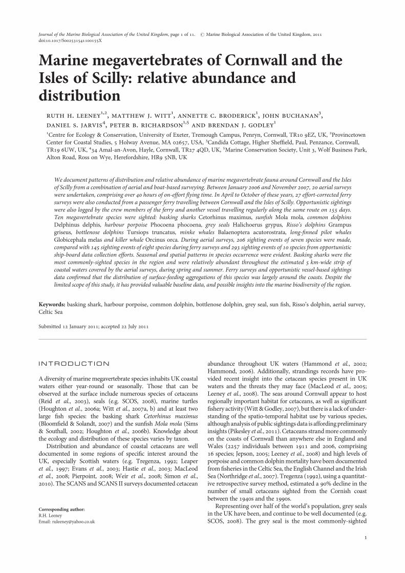
Aerial surveysThe study area of Cornwall and the Isles of Scilly (IoS) arefound at the south-westernmost point of the UK (Figure 1).
Aerial surveys were flown around the western coast ofCornwall, on a near-monthly frequency (N ¼ 20) in 2006and 2007. Surveys were carried out from a Britten-NormanIslander (BN2 Islander) twin-engine aircraft with high-wingconfiguration. Survey legs were flown at approximately200 m above sea level, at an average speed of 175 km.h21
(94 knots) and surveys were only carried out in sea states ofBeaufort 4 or less, with visibility of at least 10 km. Two sur-veyors in the front passenger seats recorded sea state andenvironmental conditions for each leg and reported any sight-ings to a scribe seated behind them. The aircraft was notequipped with bubble windows, thus each observer scannedan arc of approximately 908, centred perpendicular to thetrack line, and focused their attention to within severalhundred metres of the track line. Sightings were made withthe naked eye only. For each sighting, time, position, speciesand number of individuals were recorded. The onshore–off-shore survey route comprised 31 survey legs (Figure 1).These were flown starting offshore from Land’s End (due tothe proximity to the air field), surveying 11 legs along thenorth coast of Cornwall, then crossing the CornishPeninsula and surveying a further 20 legs (and one transitleg). Each leg was approximately 6 km long, covering asurvey area from the coast to roughly 5 km offshore.On-effort distance covered per flight was 187.6 km. Onesurvey (September 2007) was only partly completed due tolow visibility in parts of the study region.
Vessel surveys‘Constant effort’ surveys, where observers were on watch forthe whole route (64.1 km route with a journey time of �2hours 45 minutes each way), were undertaken twice amonth, if conditions were suitable, on-board the ‘ScillonianIII’, a passenger ferry which travels between Penzance, onthe mainland, and the island of St Mary’s, part of the IoS.This ferry operates between April and October only. One
Fig. 1. Survey routes. Inset map of UK highlights study region; study areashown in detail. Aerial survey transect lines (dashed line) and ferry/cargoship route (solid line) are shown.
2 ruth h. leeney et al.
surveyor was stationed on each side of the bridge, 9 m abovesea level. Observers scanned the area ahead and to 908 to theside of the vessel, scanning to the horizon but focusing on thearea of water within 1 km of the vessel. Observers used thenaked eye to scan and binoculars to confirm sightings andto aid species identification. Species and number of individ-uals were recorded for each sighting. At 15 minute intervals,the ship’s position was noted. A similar route was followedby the vessel in both directions (and also by a secondvessel—see below). Environmental data (sea state, swellheight, precipitation and visibility) were also recorded. A com-plete ferry survey involved the recording of sightings on boththe outward and returning legs, which always occurred onthe same day (the east-to-west journey took place in themorning and the return trip in the afternoon). Most of thevessel surveys were carried out by the same two observers(R.H.L. & D.J.), with several surveys involving one of theseobservers and a trained volunteer.
Simple recording forms were also provided to the crew ofthe ‘Scillonian III’ and the cargo ship supplying the IoS, the‘Gry Maritha’ (bridge height 7 m). No effort or environmentaldata were recorded, so these data provide only an overview ofthe seasonal and spatial patterns in diversity of species presentand an approximate index of the frequency with which sight-ings occur. The majority of the sightings were made andlogged by the officers on the bridge and one crew member(J.B.), all of whom had experience in identifying marine mega-vertebrates; a simple species identification guide and severalreference books were also provided to them. This dataset,whilst not collected using constant effort methodology, none-theless provides valuable and reliable additional data onspecies presence, particularly for the winter months whenthe passenger ferry (‘Scillionian III’) does not run.
Data analysisAll sightings were included in the distribution maps, regard-less of whether they were made on-track (sightings madefrom transect lines) or not and in all sea states. Althoughsurveys were always planned for days with calm sea conditions(sea state , Beaufort 3), during several of the aerial surveys,sea state and visibility conditions deteriorated to less thanfavourable. Sightings rates for small cetaceans such as the
harbour porpoise have been shown to decrease dramaticallyin conditions above Beaufort sea state 2 (Palka, 1995;Teilmann, 1995); however, our dataset proved too limited toremove data collected in Beaufort 3 or above, thus wepresent all data here with the caveat that variability in sight-ings rates will be a result of other factors as well as seasonality.On-track, effort-corrected seasonal patterns in species abun-dance were investigated for the aerial survey dataset.
The constant-watch ferry survey dataset was too limited toallow robust analysis of phenology for many species (sightingsrates graphs for basking shark, harbour porpoise and commondolphin have been included, for comparison). The larger,‘opportunistic’ dataset from the ferry and cargo vessels(which could not be corrected for sea state since these datawere not available) was corrected for effort using a simplemeasure of effort we have termed ‘vessel days’—any dayfrom which there was at least one sighting report from the‘Scillonian III’ or the ‘Gry Maritha’. Days when crew fromboth vessels recorded opportunistic sightings were consideredseparately, as the vessels usually travelled at different times.
R E S U L T S
A total of 19 complete and one incomplete aerial survey wereflown between February 2006 and November 2007, represent-ing 3697.1 km of survey effort (Table 1; SupplementaryTable 2). Twenty-seven ferry surveys were carried outbetween April 2006 and October 2007, representing3461.4 km of survey distance (Supplementary Table 3a). Atotal of 199 sighting events of seven species (plus seven sight-ing events of unidentified dolphins) were made on aerialsurveys, 145 sighting events of eight species were madeduring ferry surveys and additionally, 293 sighting eventscomprising 10 species were recorded opportunistically bythe crews of the vessels of opportunity on 155 vessel days(Supplementary Table 3b).
Cetaceans
harbour porpoises
Sightings of porpoises during aerial surveys occurred almostexclusively along the south coast of Cornwall, around the
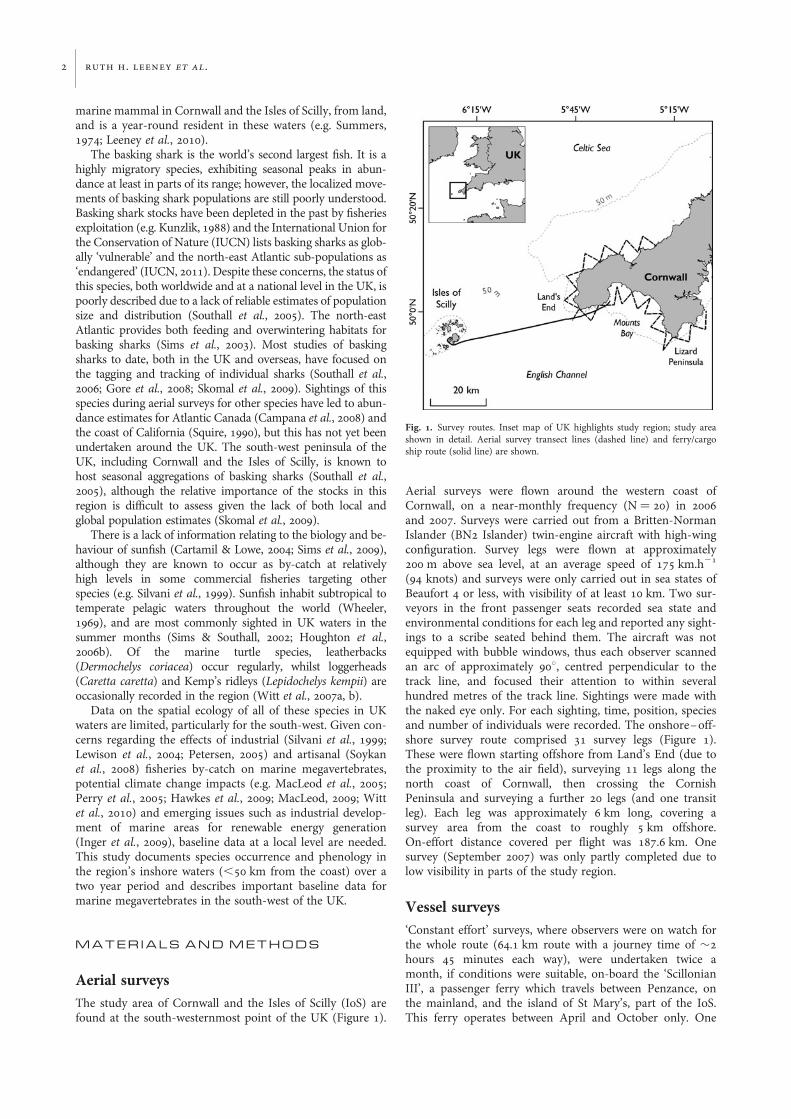
Table 1. Number of sighting events of each species (and number of individuals in parentheses) from the three platform types—aerial surveys (includingsightings made ‘off-track’), ferry surveys (both uncorrected for sea state) and vessels of opportunity (VO). Numbers of off-track aerial sightings are shown
in square brackets.
Species Aerial sightings(19 full and 1 partial surveys)
Ferry sightings(27 surveys)
VO sightings(155 ‘vessel days’)
Total sightings
Basking shark 120 (194) [12] 30 (36) 79 (395) 228 (625)Harbour porpoise 16 (19) 51 (106) 69 (245) 136 (370)Common dolphin 13 (49) [1] 23 (186) 65 (793) 101 (1028)Grey seal 15 (29) 20 (37) 5 (11) 41 (77)Sunfish 27 (27) [1] 11 (11) 19 (21) 57 (59)Risso’s dolphin 6 (47) [1] 0 8 (26) 13 (73)Bottlenose dolphin 2 (13) 1 (2) 18 (106) 21 (121)Minke whale 0 1 (1) 25 (27) 26 (28)Pilot whale 0 1 (1) 2 (2) 3 (3)Killer whale 0 0 2 (2) 2 (2)Unidentified dolphin 7 (9) [1] 7 (15) 1 (1) 8 (16)Total 206 [16] 145 293 630
marine megavertebrates of cornwall and scilly 3
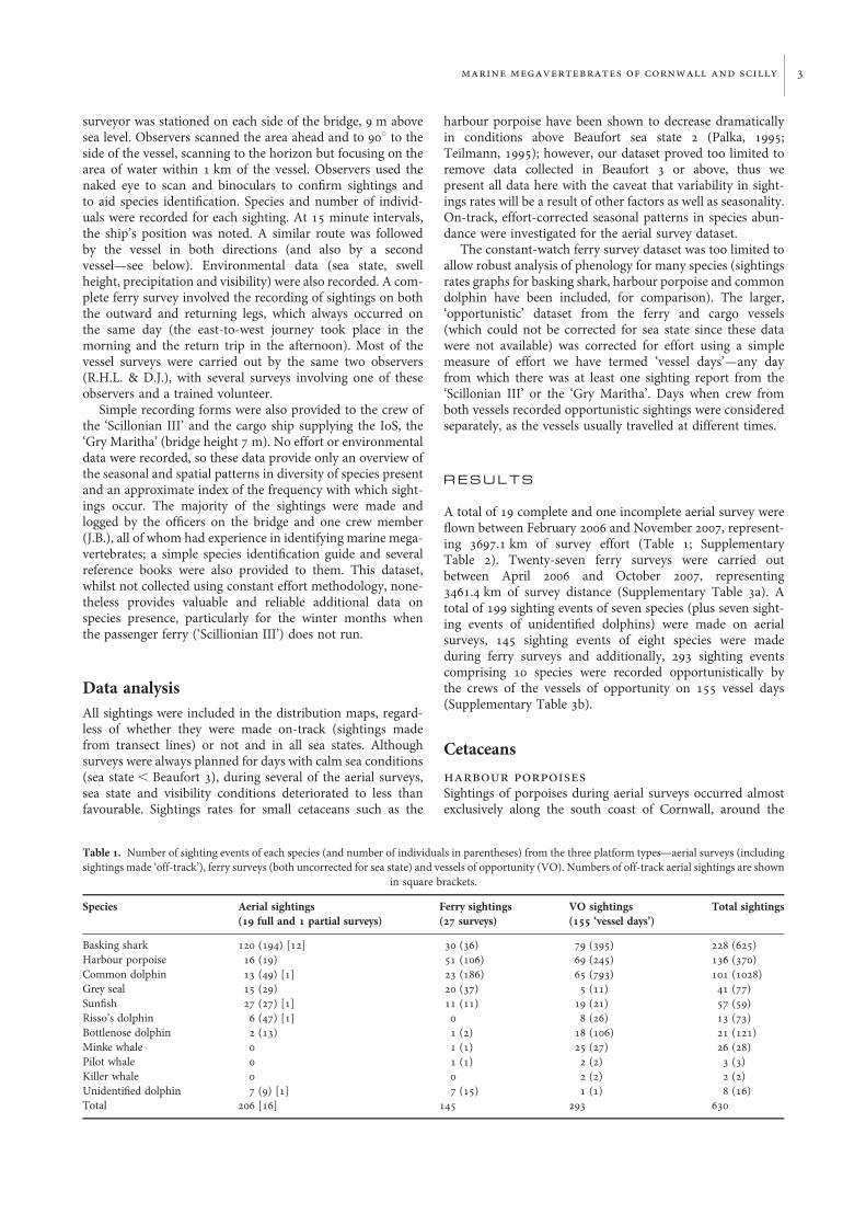
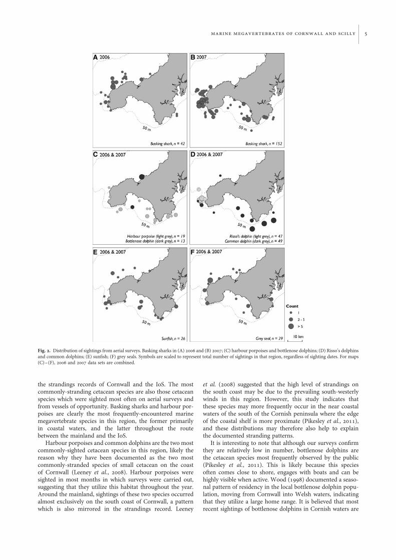
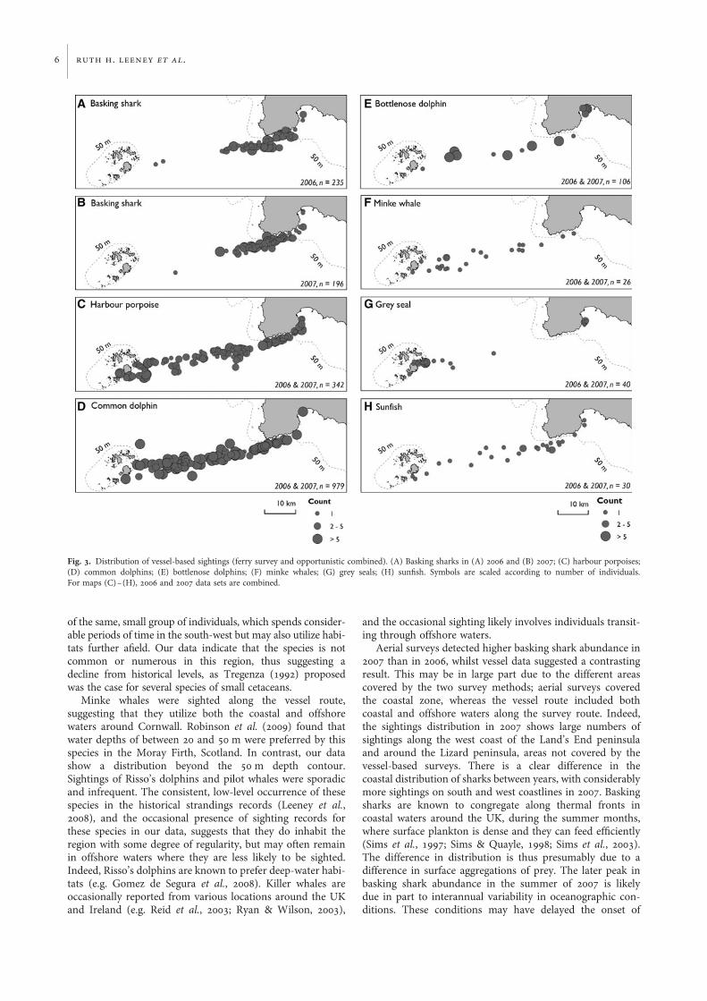
Lizard peninsula and around Mount’s Bay (Figure 2C). Thisspecies was sighted all along the vessel route, and was mostnumerous both along the south coast of Land’s End andwithin a few kilometres of the IoS (Figure 3C). During aerialsurveys, porpoises were sighted in April and from July toNovember (Supplementary Table 2). Sightings were alwaysof individuals or pairs. Harbour porpoises were the mostcommonly-sighted species on the vessel route, with sightingsoccurring in most months, but particularly in late summerand autumn (Table 1; Supplementary Figures 5B & 7A). 3sightings of 8 individuals (ferry surveys) and 3 sightings of 6individuals (aerial) occurred in sea state 3, of a total of 106and 19 individuals on ferry and aerial surveys respectively.There were no sightings in higher sea states.
common dolphins
Aerial survey sightings of common dolphins were morenumerous along the south coast of Cornwall, especiallyaround the Lizard peninsula (Figure 2D). This species wassighted all along the vessel route in most months of the year(Figure 3D). Opportunistic sightings rates were highest inautumn and winter months (Supplementary Figures 5C &7B). Few common dolphin sightings were made during ferrysurveys.
other marine mammals
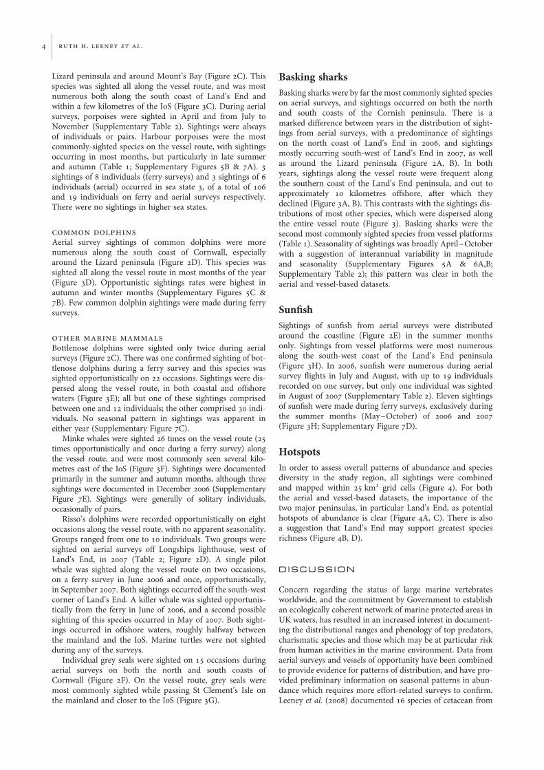
Bottlenose dolphins were sighted only twice during aerialsurveys (Figure 2C). There was one confirmed sighting of bot-tlenose dolphins during a ferry survey and this species wassighted opportunistically on 22 occasions. Sightings were dis-persed along the vessel route, in both coastal and offshorewaters (Figure 3E); all but one of these sightings comprisedbetween one and 12 individuals; the other comprised 30 indi-viduals. No seasonal pattern in sightings was apparent ineither year (Supplementary Figure 7C).
Minke whales were sighted 26 times on the vessel route (25times opportunistically and once during a ferry survey) alongthe vessel route, and were most commonly seen several kilo-metres east of the IoS (Figure 3F). Sightings were documentedprimarily in the summer and autumn months, although threesightings were documented in December 2006 (SupplementaryFigure 7E). Sightings were generally of solitary individuals,occasionally of pairs.
Risso’s dolphins were recorded opportunistically on eightoccasions along the vessel route, with no apparent seasonality.Groups ranged from one to 10 individuals. Two groups weresighted on aerial surveys off Longships lighthouse, west ofLand’s End, in 2007 (Table 2; Figure 2D). A single pilotwhale was sighted along the vessel route on two occasions,on a ferry survey in June 2006 and once, opportunistically,in September 2007. Both sightings occurred off the south-westcorner of Land’s End. A killer whale was sighted opportunis-tically from the ferry in June of 2006, and a second possiblesighting of this species occurred in May of 2007. Both sight-ings occurred in offshore waters, roughly halfway betweenthe mainland and the IoS. Marine turtles were not sightedduring any of the surveys.
Individual grey seals were sighted on 15 occasions duringaerial surveys on both the north and south coasts ofCornwall (Figure 2F). On the vessel route, grey seals weremost commonly sighted while passing St Clement’s Isle onthe mainland and closer to the IoS (Figure 3G).
Basking sharksBasking sharks were by far the most commonly sighted specieson aerial surveys, and sightings occurred on both the northand south coasts of the Cornish peninsula. There is amarked difference between years in the distribution of sight-ings from aerial surveys, with a predominance of sightingson the north coast of Land’s End in 2006, and sightingsmostly occurring south-west of Land’s End in 2007, as wellas around the Lizard peninsula (Figure 2A, B). In bothyears, sightings along the vessel route were frequent alongthe southern coast of the Land’s End peninsula, and out toapproximately 10 kilometres offshore, after which theydeclined (Figure 3A, B). This contrasts with the sightings dis-tributions of most other species, which were dispersed alongthe entire vessel route (Figure 3). Basking sharks were thesecond most commonly sighted species from vessel platforms(Table 1). Seasonality of sightings was broadly April –Octoberwith a suggestion of interannual variability in magnitudeand seasonality (Supplementary Figures 5A & 6A,B;Supplementary Table 2); this pattern was clear in both theaerial and vessel-based datasets.
SunfishSightings of sunfish from aerial surveys were distributedaround the coastline (Figure 2E) in the summer monthsonly. Sightings from vessel platforms were most numerousalong the south-west coast of the Land’s End peninsula(Figure 3H). In 2006, sunfish were numerous during aerialsurvey flights in July and August, with up to 19 individualsrecorded on one survey, but only one individual was sightedin August of 2007 (Supplementary Table 2). Eleven sightingsof sunfish were made during ferry surveys, exclusively duringthe summer months (May–October) of 2006 and 2007(Figure 3H; Supplementary Figure 7D).
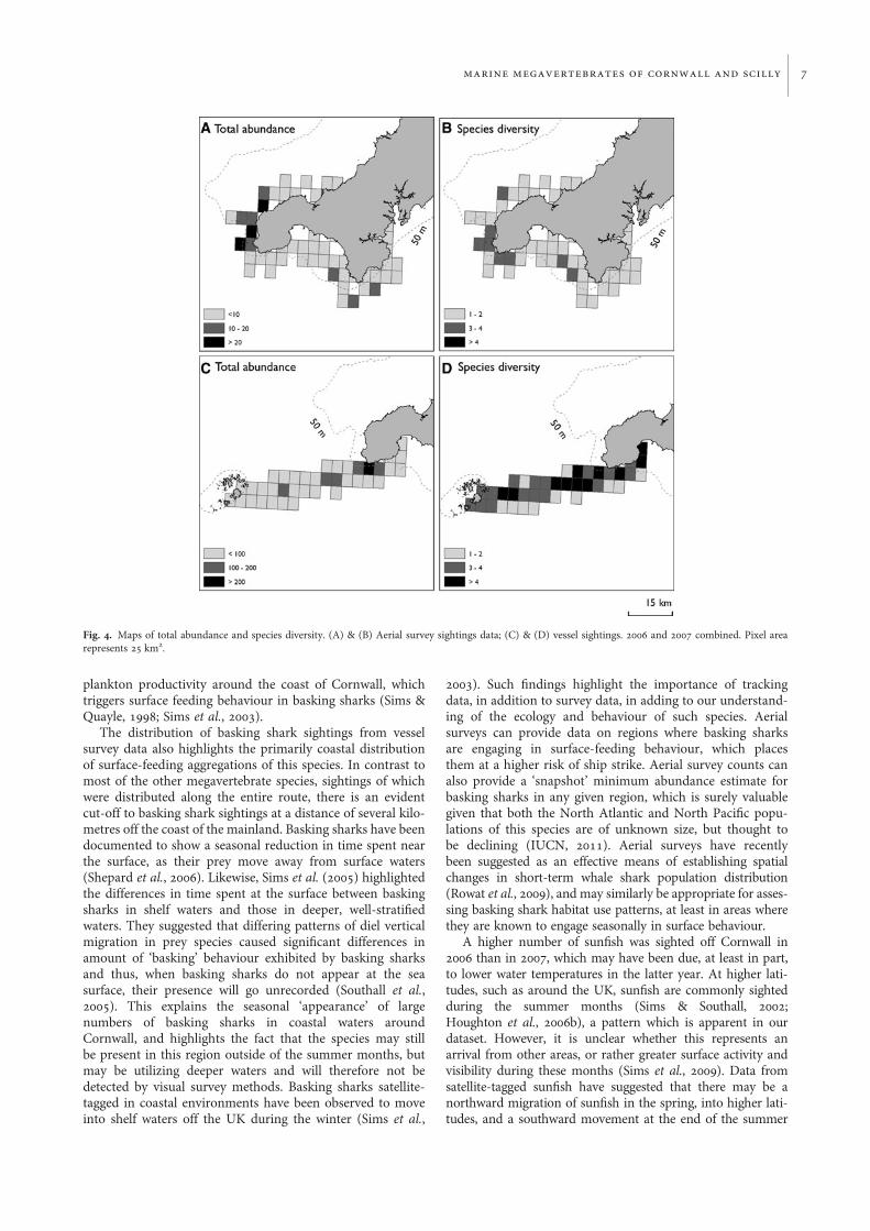
HotspotsIn order to assess overall patterns of abundance and speciesdiversity in the study region, all sightings were combinedand mapped within 25 km2 grid cells (Figure 4). For boththe aerial and vessel-based datasets, the importance of thetwo major peninsulas, in particular Land’s End, as potentialhotspots of abundance is clear (Figure 4A, C). There is alsoa suggestion that Land’s End may support greatest speciesrichness (Figure 4B, D).
D I S C U S S I O N
Concern regarding the status of large marine vertebratesworldwide, and the commitment by Government to establishan ecologically coherent network of marine protected areas inUK waters, has resulted in an increased interest in document-ing the distributional ranges and phenology of top predators,charismatic species and those which may be at particular riskfrom human activities in the marine environment. Data fromaerial surveys and vessels of opportunity have been combinedto provide evidence for patterns of distribution, and have pro-vided preliminary information on seasonal patterns in abun-dance which requires more effort-related surveys to confirm.Leeney et al. (2008) documented 16 species of cetacean from
4 ruth h. leeney et al.
the strandings records of Cornwall and the IoS. The mostcommonly-stranding cetacean species are also those cetaceanspecies which were sighted most often on aerial surveys andfrom vessels of opportunity. Basking sharks and harbour por-poises are clearly the most frequently-encountered marinemegavertebrate species in this region, the former primarilyin coastal waters, and the latter throughout the routebetween the mainland and the IoS.
Harbour porpoises and common dolphins are the two mostcommonly-sighted cetacean species in this region, likely thereason why they have been documented as the two mostcommonly-stranded species of small cetacean on the coastof Cornwall (Leeney et al., 2008). Harbour porpoises weresighted in most months in which surveys were carried out,suggesting that they utilize this habitat throughout the year.Around the mainland, sightings of these two species occurredalmost exclusively on the south coast of Cornwall, a patternwhich is also mirrored in the strandings record. Leeney
et al. (2008) suggested that the high level of strandings onthe south coast may be due to the prevailing south-westerlywinds in this region. However, this study indicates thatthese species may more frequently occur in the near coastalwaters of the south of the Cornish peninsula where the edgeof the coastal shelf is more proximate (Pikesley et al., 2011),and these distributions may therefore also help to explainthe documented stranding patterns.
It is interesting to note that although our surveys confirmthey are relatively low in number, bottlenose dolphins arethe cetacean species most frequently observed by the public(Pikesley et al., 2011). This is likely because this speciesoften comes close to shore, engages with boats and can behighly visible when active. Wood (1998) documented a seaso-nal pattern of residency in the local bottlenose dolphin popu-lation, moving from Cornwall into Welsh waters, indicatingthat they utilize a large home range. It is believed that mostrecent sightings of bottlenose dolphins in Cornish waters are
Fig. 2. Distribution of sightings from aerial surveys. Basking sharks in (A) 2006 and (B) 2007; (C) harbour porpoises and bottlenose dolphins; (D) Risso’s dolphinsand common dolphins; (E) sunfish; (F) grey seals. Symbols are scaled to represent total number of sightings in that region, regardless of sighting dates. For maps(C)–(F), 2006 and 2007 data sets are combined.
marine megavertebrates of cornwall and scilly 5
of the same, small group of individuals, which spends consider-able periods of time in the south-west but may also utilize habi-tats further afield. Our data indicate that the species is notcommon or numerous in this region, thus suggesting adecline from historical levels, as Tregenza (1992) proposedwas the case for several species of small cetaceans.
Minke whales were sighted along the vessel route,suggesting that they utilize both the coastal and offshorewaters around Cornwall. Robinson et al. (2009) found thatwater depths of between 20 and 50 m were preferred by thisspecies in the Moray Firth, Scotland. In contrast, our datashow a distribution beyond the 50 m depth contour.Sightings of Risso’s dolphins and pilot whales were sporadicand infrequent. The consistent, low-level occurrence of thesespecies in the historical strandings records (Leeney et al.,2008), and the occasional presence of sighting records forthese species in our data, suggests that they do inhabit theregion with some degree of regularity, but may often remainin offshore waters where they are less likely to be sighted.Indeed, Risso’s dolphins are known to prefer deep-water habi-tats (e.g. Gomez de Segura et al., 2008). Killer whales areoccasionally reported from various locations around the UKand Ireland (e.g. Reid et al., 2003; Ryan & Wilson, 2003),
and the occasional sighting likely involves individuals transit-ing through offshore waters.
Aerial surveys detected higher basking shark abundance in2007 than in 2006, whilst vessel data suggested a contrastingresult. This may be in large part due to the different areascovered by the two survey methods; aerial surveys coveredthe coastal zone, whereas the vessel route included bothcoastal and offshore waters along the survey route. Indeed,the sightings distribution in 2007 shows large numbers ofsightings along the west coast of the Land’s End peninsulaand around the Lizard peninsula, areas not covered by thevessel-based surveys. There is a clear difference in thecoastal distribution of sharks between years, with considerablymore sightings on south and west coastlines in 2007. Baskingsharks are known to congregate along thermal fronts incoastal waters around the UK, during the summer months,where surface plankton is dense and they can feed efficiently(Sims et al., 1997; Sims & Quayle, 1998; Sims et al., 2003).The difference in distribution is thus presumably due to adifference in surface aggregations of prey. The later peak inbasking shark abundance in the summer of 2007 is likelydue in part to interannual variability in oceanographic con-ditions. These conditions may have delayed the onset of
Fig. 3. Distribution of vessel-based sightings (ferry survey and opportunistic combined). (A) Basking sharks in (A) 2006 and (B) 2007; (C) harbour porpoises;(D) common dolphins; (E) bottlenose dolphins; (F) minke whales; (G) grey seals; (H) sunfish. Symbols are scaled according to number of individuals.For maps (C)–(H), 2006 and 2007 data sets are combined.
6 ruth h. leeney et al.
plankton productivity around the coast of Cornwall, whichtriggers surface feeding behaviour in basking sharks (Sims &Quayle, 1998; Sims et al., 2003).
The distribution of basking shark sightings from vesselsurvey data also highlights the primarily coastal distributionof surface-feeding aggregations of this species. In contrast tomost of the other megavertebrate species, sightings of whichwere distributed along the entire route, there is an evidentcut-off to basking shark sightings at a distance of several kilo-metres off the coast of the mainland. Basking sharks have beendocumented to show a seasonal reduction in time spent nearthe surface, as their prey move away from surface waters(Shepard et al., 2006). Likewise, Sims et al. (2005) highlightedthe differences in time spent at the surface between baskingsharks in shelf waters and those in deeper, well-stratifiedwaters. They suggested that differing patterns of diel verticalmigration in prey species caused significant differences inamount of ‘basking’ behaviour exhibited by basking sharksand thus, when basking sharks do not appear at the seasurface, their presence will go unrecorded (Southall et al.,2005). This explains the seasonal ‘appearance’ of largenumbers of basking sharks in coastal waters aroundCornwall, and highlights the fact that the species may stillbe present in this region outside of the summer months, butmay be utilizing deeper waters and will therefore not bedetected by visual survey methods. Basking sharks satellite-tagged in coastal environments have been observed to moveinto shelf waters off the UK during the winter (Sims et al.,
2003). Such findings highlight the importance of trackingdata, in addition to survey data, in adding to our understand-ing of the ecology and behaviour of such species. Aerialsurveys can provide data on regions where basking sharksare engaging in surface-feeding behaviour, which placesthem at a higher risk of ship strike. Aerial survey counts canalso provide a ‘snapshot’ minimum abundance estimate forbasking sharks in any given region, which is surely valuablegiven that both the North Atlantic and North Pacific popu-lations of this species are of unknown size, but thought tobe declining (IUCN, 2011). Aerial surveys have recentlybeen suggested as an effective means of establishing spatialchanges in short-term whale shark population distribution(Rowat et al., 2009), and may similarly be appropriate for asses-sing basking shark habitat use patterns, at least in areas wherethey are known to engage seasonally in surface behaviour.
A higher number of sunfish was sighted off Cornwall in2006 than in 2007, which may have been due, at least in part,to lower water temperatures in the latter year. At higher lati-tudes, such as around the UK, sunfish are commonly sightedduring the summer months (Sims & Southall, 2002;Houghton et al., 2006b), a pattern which is apparent in ourdataset. However, it is unclear whether this represents anarrival from other areas, or rather greater surface activity andvisibility during these months (Sims et al., 2009). Data fromsatellite-tagged sunfish have suggested that there may be anorthward migration of sunfish in the spring, into higher lati-tudes, and a southward movement at the end of the summer
Fig. 4. Maps of total abundance and species diversity. (A) & (B) Aerial survey sightings data; (C) & (D) vessel sightings. 2006 and 2007 combined. Pixel arearepresents 25 km2.
marine megavertebrates of cornwall and scilly 7
(Sims et al., 2009), perhaps as a result of the higher planktonproductivity in these regions in the spring and summer.
Many studies have investigated the relationship betweenpatterns of abundance and distribution of large marine ver-tebrates, such as cetaceans, and environmental features suchas primary productivity, bathymetry and ocean fronts (e.g.Mendes et al., 2002; MacLeod et al., 2004; Pierpoint, 2008;Tetley et al., 2008; Bost et al., 2009; Robinson et al., 2009).Our study area having largely been constrained within thecoastal zone, bathymetry did not vary enough to warrant ananalysis of its effect. Given that the data remain uncorrectedfor sea state and that sightings rates for most species are low,no detailed analysis of the effects of environmental factors onsightings rates was carried out, and we simply present thedata as a baseline description for the region, from whichfuture, more focused research questions can be developed forspecies of interest or concern. A long-term land-based studyat Gwennap Head, at the southern point of Land’s End(Wynn et al., 2010), is examining the importance of bathymetryand tidal features in the abundance and distribution of variousmarine megavertebrate species. Findings from this study alsosupport our suggestion that Land’s End represents an impor-tant area for both density and diversity of species.
Although small numbers of live leatherback, loggerheadand unidentified species of marine turtles were recorded atsea within, or proximate to the study area during 2006 and2007 (Penrose & Gander, 2007, 2008), no marine turtleswere sighted during this study. However, aerial surveys areregularly used for detecting marine turtles at sea (e.g. Marsh& Saalfeld, 1989; Roos et al., 2005), and thus it is likely thatthe methodologies used were suitable but that turtle abun-dance was very low in the study area. No sightings of aggrega-tions of jellyfish such as barrel jellyfish Rhizostoma octopus, akey prey species for leatherback turtles, were made duringsurveys, which may explain the absence of turtles in theregion (Houghton et al., 2006a). Finally, the small numberof seals sighted at-sea has been reported for completeness,but the methodologies used in this study were not entirelyappropriate for assessing true seal abundance in the region.Leeney et al. (2010) describe a boat-based method for count-ing seals at haul-out sites, which has provided a better estimateof grey seal abundance and haul-out distribution along thecoasts of Cornwall and the IoS.
C O N C L U S I O N S
From the two years of data presented here, it is evident thatbasking sharks and harbour porpoises are relatively numerousin the waters around the Cornish coast, and that the Land’sEnd peninsula appears to be a hotspot for marine megaverte-brate abundance. The vessel route revealed that many speciesof marine megafauna utilize both coastal and offshore watersbetween Cornwall and the IoS. Compared with 15 species ofcetaceans recorded over a 20-year period, in a considerablylarger region north and west of Scotland (Weir et al., 2001),the reporting during this study of seven species from mainlycoastal waters indicates that this area does provide importanthabitat, particularly for small cetacean species. Cetaceanstrandings around these coasts most commonly occurbetween December and April; this peak is most obvious forcommon dolphins, harbour porpoises and pilot whales(Leeney et al., 2008). However, the ferry does not run
between November and April, and aerial surveys were less fre-quent over the winter months. Future surveys should take thisinto account and every attempt should be made to collect dataover the winter. Future studies should also attempt to cover agreater proportion of offshore waters, in order to assesswhether the waters off Cornwall and the IoS provide impor-tant habitat for deep-water cetacean species.
The combination of data from aerial and vessel platforms hasprovided insight into the spatial and temporal patterns of distri-bution and abundance of many species, both in coastal and off-shore waters at the south-western tip of the UK. Aerial surveysproved a time-efficient, if relatively costly, means of document-ing these data for most species, but should be carried out morefrequently if they are to document seasonal and inter-annualpatterns. Basking sharks are not always detectable from vesselsas they do not always break the water surface, thus aerial survey-ing appears to be an efficient means of surveying for this speciesin areas where they are utilizing near-surface waters. Using theships travelling between Cornwall and the IoS as platforms ofopportunity has proved an ideal means of collecting largevolumes of data from this route, incorporating both coastaland offshore waters, and there is clearly power in this approachwhen data from multiple routes are integrated (e.g. MacLeodet al., 2005).Whilst the data presented are in large part descrip-tive, they form a first step towards understanding the relativeimportance of Cornwall and the IoS for marine megaverte-brates, and provide information which will feed into the plan-ning of Marine Protected Areas in the UK. It will be essentialto continue effort-based surveys in the region in order todetect future trends in abundance and distribution for speciesof interest.
A C K N O W L E D G E M E N T S
Many thanks to our volunteer surveyors: J. Doyle and staff fromCornwall Wildlife Trust and the Marine Conservation Society,N. Davison, L. Hawkes, E, Ferguson, L. Jarvis, J. Tomas,N. Tregenza; thanks also to D. and H. Jones of MarineDiscovery Penzance, and K. Keen. We are grateful toR. Ashby, S. Brint, M. Hillier, P. Hughes, P. Keen, M. Vigar,B. Woodward and the rest of the staff at Skybus. Manythanks to: D. Pascoe, P. Crawford, M. Wheeler and M. Still ofthe ‘Scillonian III’ and the crew of the ‘Gry Maritha’ for theirinvolvement with data collection. The manuscript wasimproved considerably by the input of Russell Wynn and twoanonymous referees. This work was funded by the EuropeanSocial Fund. M.J.W. was supported by a NaturalEnvironment Research Council PhD studentship (NER/S/A/2004/12980) and is now funded by the Peninsula ResearchInstitute for Marine Renewable Energy. B.J.G. was funded bythe European Union through its European RegionalDevelopment Fund (CHARM III project (No. 4037) withinthe scope of the INTERREG IV A France (Channel)–England cross-border European cooperation programme. Thetravel of researchers on the ‘Scillonian III’ was sponsored byJ. Marston/Isles of Scilly Travel and PADI Project AWARE.
Supplementary materials and methodsThe supplementary material referred to in this article can befound online at journals.cambridge.org/mbi
8 ruth h. leeney et al.
R E F E R E N C E S
Bloomfield A. and Solandt J.-L. (2007) The Marine Conservation SocietyBasking Shark Watch 20-year report (1987–2006). Ross-on-Wye, UK:Marine Conservation Society, 67 pp.
Bost C.A., Cotte C., Bailleul F., Cherel Y., Charrassin J.B., Guinet C.,Ainley D.G. and Weimerskirch H. (2009) The importance of oceano-graphic fronts to marine birds and mammals of the southern oceans.Journal of Marine Systems 78, 363–376.
Campana S.E., Gibson J., Brazner J., Marks L., Joyce W., Gosselin J.-F.and Kenney R.D. (2008) Status of basking sharks in Atlantic Canada.Canadian Science Advisory Secretariat Research Document 2008/004,http://www.marinebiodiversity.ca/shark/english/document/basking%20shark%20Res%20Doc%202008_004_e.pdf
Cartamil D.P. and Lowe C.G. (2004) Diel movement patterns of oceansunfish Mola mola off southern California. Marine Ecology ProgressSeries 266, 245–253.
Evans P.G.H., Anderwald P. and Baines M.E. (2003) UK Cetacean StatusReview. English Nature, Countryside Council for Wales and Sea WatchFoundation: Oxford, 160 pp.
Gomez de Segura A., Hammond P.S. and Raga J.A. (2008) Influence ofenvironmental factors on small cetacean distribution in the SpanishMediterranean. Journal of the Marine Biological Association of theUnited Kingdom 88, 1185–1192.
Gore M.A., Rowat D., Hall J., Gell F.R. and Ormond R.F. (2008)Transatlantic migration and deep mid-ocean diving by baskingshark. Biology Letters 4, 395–398.
Hammond P.S., Berggren P., Benke H., Borchers D.L., Collet A.,Heide-Jørgensen M.P., Heimlich S., Hiby A.R., Leopold M.F. andØien N. (2002) Abundance of harbour porpoise and other cetaceans inthe North Sea and adjacent waters. Journal of Applied Ecology 39, 361–376.
Hammond P.S. (2006) Small cetaceans in the European Atlantic andNorth Sea (SCANS-II) Final Report. LIFE04NAT/GB/000245, 54 pp.http://biology.st-andrews.ac.uk/scans2/documents/final/SCANS-II_final_report.pdf
Hastie G.D., Barton T.R., Grellier K., Hammond P.S., Swift R.J.,Thompson P.M. and Wilson B. (2003) Distribution of small ceta-ceans within a candidate Special Area of Conservation; implicationsfor management. Journal of Cetacean Research and Management 5,261–266.
Hawkes L.A., Broderick A.C., Godfrey M.H. and Godley B.J. (2009)Review: climate change and marine turtles. Endangered SpeciesResearch 7, 137–154.
Houghton J.D.R., Doyle T.K., Davenport J. and Hays G.C. (2006a)Jellyfish aggregations and leatherback turtle foraging patterns in a tem-perate coastal environment. Ecology 87, 1967–1972.
Houghton J.D.R., Doyle T.K., Davenport J. and Hays G.C. (2006b) Theocean sunfish Mola mola: insights into distribution, abundance andbehaviour in the Irish and Celtic Seas. Journal of the MarineBiological Association of the United Kingdom 86, 1237–1243.
Inger R.I., Attrill M.J., Bearhop S., Broderick A.C., Grecian W.J.,Hodgson D.J., Mills C., Sheehan E., Votier S.C., Witt M.J. andGodley B.J. (2009) Marine renewable energy: potential benefits to bio-diversity? An urgent call for research. Journal of Applied Ecology 46,1145–1153.
IUCN (2011) IUCN Red List of Threatened Species. Version 2011.1. www.iucnredlist.org
Jepson P.D. (ed.) (2005) Cetacean strandings investigation andco-ordination in the UK. Report to DEFRA for the period 1st January2000–31st December 2004. NHM consulting, Environment: coastaland marine sector.
Kunzlik P. (1988) The basking shark. Aberdeen, UK: Department ofAgriculture and Fisheries for Scotland.
Leaper R., Fairbairns R., Gordon J., Hiby A., Lovell P. and PapastavrouV. (1997) Analysis of data collected from a whalewatching operation toassess relative abundance and distribution of the minke whale(Balaenoptera acutorostrata) around the Isle of Mull, Scotland.Reports of the International Whaling Commission 47, 505–511.
Leeney R.H., Amies R., Broderieck A., Doyle J., Loveridge J., Witt M.J.and Godley B.J. (2008) Spatio-temporal patterns of cetacean strandingsin a fisheries hotspot. Biodiversity and Conservation 17, 2323–2338.
Leeney R.H., Broderick A.C., Mills C., Sayer S., Witt M.J. and GodleyB.J. (2010) Abundance, site fidelity and haul-out behaviour of greyseals (Halichoerus grypus) in Cornwall and the Isles of Scilly, UK.Journal of the Marine Biological Association of the United Kingdom90, 1033–1040. doi:10.1017/S0025315409991512
Lewison R.L., Crowder L.B., Read A.J. and Freeman S.A. (2004)Understanding impacts of fisheries bycatch on marine megafauna.Trends in Ecology and Evolution 19, 598–604.
MacLeod C.D. (2009) Global climate change, range changes and potentialimplications for the conservation of marine cetaceans: a review andsynthesis. Endangered Species Research 7, 125–136.
MacLeod C.D., Bannon S.M., Pierce G.J., Schweder C., Learmonth J.A.,Herman J.S. and Reid R.J. (2005) Climate change and the cetaceancommunity of north-west Scotland. Biological Conservation 124,477–483.
MacLeod C.D., Weir C.R., Begona Santos M. and Dunn T.E. (2008)Temperature-based summer habitat partitioning between white-beaked and common dolphins around the United Kingdom andRepublic of Ireland. Journal of the Marine Biological Association ofthe United Kingdom 88, 1193–1198.
MacLeod K., Fairbairns R., Gill A., Fairbairns B., Gordon J.,Blair-Myers C. and Parsons E.C.M. (2004) Seasonal distribution ofminke whales Balaenoptera acutorostrata in relation to physiographyand prey off the Isle of Mull, Scotland. Marine Ecology ProgressSeries 277, 263–274.
Marsh H. and Saalfeld W.K. (1989) Aerial surveys of sea turtles in theNorthern Great Barrier Reef Marine Park. Australian WildlifeResearch 16, 239–249.
Mendes S., Turrell W., Lutkebohle T. and Thompson P. (2002)Influence of the tidal cycle and a tidal intrusion front on the spatio-temporal distribution of coastal bottlenose dolphins. Marine EcologyProgress Series 239, 221–229.
Northridge S., Kingston A., Thomas L. and Mackay A. (2007) Secondannual report on the UK cetacean bycatch monitoring scheme.Contract report to DEFRA on the work conducted 2005–2006. SeaMammal Research Unit, June 2007.
Palka D. (1995) Effects of Beaufort sea state on the sightability of harborporpoise in the Gulf of Maine. Report from the International WhalingCommission 56, 575–582.
Penrose R.S. and Gander L.R. (2007) UK & Republic of Ireland MarineTurtle Strandings & Sightings—Annual Report 2006. Report compiledby Marine Environmental Monitoring, Wales, UK, 27 pp.
Penrose R.S. and Gander L.R. (2008) UK & Republic of Ireland MarineTurtle Strandings & Sightings—Annual Report 2007. Report compiledby Marine Environmental Monitoring, Wales, UK, 26 pp.
Perry A.L., Low P.J., Ellis J.R. and Reynolds J.D. (2005) Climate changeand distribution shifts in marine fishes. Science 308, 1912–1915.
Petersen S. (2005) Initial bycatch assessment: South Africa’s domestic long-line fishery, 2000–2003. Domestic pelagic longline fishery: BycatchReport 2000–2003, BirdLife South Africa, 45 pp.
marine megavertebrates of cornwall and scilly 9
Pierpoint C. (2008) Harbour porpoise (Phocoena phocoena) foragingstrategy at a high energy, near-shore site in south-west Wales, UK.Journal of the Marine Biological Association of the United Kingdom88, 1167–1173.
Pikesley S.K., Witt M.J., Hardy T., Loveridge J., Loveridge J., WilliamsR. and Godley B.J. (2011) Cetacean sightings and strandings:evidence for spatial and temporal trends? Journal of the MarineBiological Association of the United Kingdom. doi: 10.1017/S0025315411000464.
Reid J.B., Evans P.G.H. and Northridge S.P. (2003) Atlas of cetacean dis-tribution in north-west European waters. Peterborough: Joint NatureConservation Committee, 75 pp.
Robinson K.P., Tetley M.J. and Mitchelson-Jacob E.G. (2009) Thedistribution and habitat preference of coastally occurring minkewhales (Balaenoptera acutorostrata) in the outer southern MorayFirth, northeast Scotland. Journal of Coastal Conservation 13, 39–48
Roos D., Pelletier D., Ciccione S., Taquet M. and Hughes G. (2005)Aerial and snorkelling census techniques for estimating green turtleabundance on foraging areas: a pilot study in Mayotte Island(Indian Ocean). Aquatic Living Resources 18, 193–198.
Rowat D., Gore M., Meekan M.G., Lawler I.R. and Bradshaw C.J.A.(2009) Aerial survey as a tool to estimate whale sharkabundance trends. Journal of Experimental Marine Biology andEcology 368, 1–8.
Ryan C. and Wilson P. (2003) Observations on the behaviour of a pod ofkiller whales Orcinus orca L. that visited Cork Harbour in 2001. IrishNaturalists’ Journal 27, 187–191.
SCOS (Special Committee on Seals) (2008) Scientific ddvice on mattersrelated to the management of seal populations. St Andrews: SeaMammal Research Unit, 98 pp.
Shepard E.L.C., Ahmed M.Z., Southall E.J., Witt M.J., Metcalfe J.D. andSims D.W. (2006) Diel and tidal rhythms in diving behaviour ofpelagic sharks identified by signal processing of archival taggingdata. Marine Ecology Progress Series 328, 205–213.
Silvani L., Gazo M. and Aguilar A. (1999) Spanish driftnet fishing andincidental catches in the western Mediterranean. BiologicalConservation 90, 79–85.
Simon M., Nuuttila H., Reyes-Zamudio M.M., Ugarte F., Verfub U.and Evans P.G.H. (2010) Passive acoustic monitoring of bottlenosedolphin and harbour porpoise, in Cardigan Bay, Wales, with impli-cations for habitat use and partitioning. Journal of the MarineBiological Association of the United Kingdom 90, 1539–1545.doi:10.1017/S0025315409991226
Sims D.W., Fox A.M. and Merrett D.A. (1997) Basking shark occurrenceoff south-west England in relation to zooplankton abundance. Journalof Fisheries Biology 61, 436–440.
Sims D.W. and Quayle V.A. (1998) Selective foraging behaviour ofbasking sharks on zooplankton in a small-scale front. Nature 393,460–464.
Sims D.W., Queiroz N., Doyle T.K., Houghton J.D.R. and Hays G.C.(2009) Satellite tracking of the World’s largest bony fish, the oceansunfish (Mola mola L.) in the North East Atlantic. Journal ofExperimental Marine Biology and Ecology 370, 127–133.
Sims D.W. and Southall E.J. (2002) Occurrence of ocean sunfish, Molamola near fronts in the western English Channel. Journal of theMarine Biological Association of the United Kingdom 82, 927–928.
Sims D.W., Southall E.J., Richardson A.J., Reid P.C. and Metcalfe J.D.(2003) Seasonal movements and behaviour of basking sharks fromarchival tagging: no evidence of winter hibernation. Marine EcologyProgress Series 248, 187–196.
Sims D.W., Southall E.J., Tarling G.A. and Metcalfe J.D. (2005)Habitat-specific normal and reverse diel vertical migration in theplankton-feeding basking shark. Journal of Animal Ecology 74, 755–761.
Skomal G.B., Zeeman S.I., Chisholm J.H., Summers E.L., Walsh H.J.,McMahon K.W. and Thorrold S.R. (2009) Transequatorialmigrations by basking sharks in the Western Atlantic Ocean.Current Biology 19, 1019–1022.
Soykan C.U., Moore J.E., Zydelis R., Crowder L.B., Safina C. andLewison R.L. (2008) Why study bycatch? An introduction to theTheme Section on fisheries bycatch. Endangered Species Research 5,91–102.
Southall E.J., Sims D.W., Metcalfe J.D., Doyle J.I., Fanshawe P.S., LaceyC., Shrimpton J., Solandt J.-L. and Speedie C.D. (2005) Spatial dis-tribution patterns of basking sharks on the European shelf: prelimi-nary comparison of satellite-tag geolocation, survey and publicsightings data. Journal of the Marine Biological Association of theUnited Kingdom 85, 1083–1088.
Southall E.J., Sims D.W., Witt M.J. and Metcalfe J.D. (2006) Seasonalspace-use estimates of basking sharks in relation to protection and pol-itical–economic zones in the North-east Atlantic. BiologicalConservation 132, 33–39.
Squire J.L. Jr (1990) Distribution and apparent abundance of the baskingshark, Cetorhinus maximus, off the central and southern Californiacoast, 1962–85. Marine Fisheries Review 52, 8–11.
Summers C.F. (1974) The grey seal (Halichoerus grypus) in Cornwall andthe Isles of Scilly. Biological Conservation 6, 285–291.
Teilmann J. (1995) Influence of seastate on abundance estimates ofharbour porpoise (Phocoena phocoena). Report to the InternationalWhaling Commission SC/47/SM45.
Tetley M.J., Mitchelson-Jacob E.G. and Robinson K.P. (2008) Thesummer distribution of coastal minke whales (Balaenopteraacutorostrata) in the southern Moray Firth, NE Scotland, inrelation to co-occurring meso-scale oceanographic features. RemoteSensing of Environment 112, 3449–3454. DOI:10.1016/j.rse.2007.10.015
Tregenza N.J.C. (1992) Fifty years of cetacean sightings from the Cornishcoast, SW England. Biological Conservation 59, 65–70.
Weir C., Canning S., Hepworth K., Sim I. and Stockin K.A. (2008) Along-term opportunistic photo-identification study of bottlenose dol-phins (Tursiops truncatus) off Aberdeen, United Kingdom: conserva-tion value and limitations. Aquatic Mammals 34, 436–447. DOI10.1578/AM.34.4.2008.436
Weir C.R., Pollock C., Cronin C. and Taylor S. (2001) Cetaceans of theAtlantic Frontier, north and west of Scotland. Continental ShelfResearch 21, 1047–1071.
Wheeler A. (1969) The fishes of the British Isles and northwest Europe.London: Macmillan.
Witt M.J. and Godley B.J. (2007) A step towards seascape scale conserva-tion: using vessel monitoring systems (VMS) to map fishing activity.PLoS One 2, e1111. doi:10.1371/journal.pone.0001111.
Witt M.J., Broderick A.C., Johns D.J., Martin C., Penrose R.,Hoogemoed M.S. and Godley B.J. (2007a) Prey landscapes helpidentify potential foraging habitats for leatherback turtles in the NEAtlantic. Marine Ecology Progress Series 337, 231–243.
Witt M.J., Hawkes L.A., Godfrey M.H., Godley B.J. and Godley B.J.(2010) Predicting the impacts of climate change on a globally distrib-uted species: the case of the loggerhead turtle. Journal of ExperimentalBiology 213, 901–911.
10 ruth h. leeney et al.

Witt M.J., Penrose R. and Godley B.J. (2007b) Spatio-temporal patternsof juvenile marine turtle occurrence in waters of the European conti-nental shelf. Marine Biology 151, 873–885.
Wood C.J. (1998) Movement of bottlenose dolphins around the south-west coast of Britain. Journal of Zoology 246, 155–163.
and
Wynn R.B., Brereton T.M., Jones A.R. and Lewis K.M. (2010) SeaWatchSW Annual Report 2009. Southampton: National Oceanography
Centre, 118 pp. Available at http://www.seawatch-sw.org/downloads/SWSW_AR2009_long.pdf
Correspondence should be addressed to:R.H. LeeneySchool of Marine Science & EngineeringUniversity of PlymouthDrake Circus, Plymouth, Devon PL4 8AA, UKemail: [email protected]
marine megavertebrates of cornwall and scilly 11


