Embed Size (px)
Citation preview

Srivastava, S. P., Arthur, M., Clement, B., et al., 1989 Proceedings of the Ocean Drilling Program, Scientific Results, Vol. 105
30. LITHOSTRATIGRAPHY, BIOSTRATIGRAPHY, AND STABLE-ISOTOPE STRATIGRAPHY OF CORES FROM ODP LEG 105 SITE SURVEYS, LABRADOR SEA AND BAFFIN BAY1
D. B. Scott,2 P. J. Mudie,3 A. de Vernal,4 C. Hillaire-Marcel, V. Baki,4 K. D. MacKinnon,2 F. S. Medioli,2 and L. Mayer5
ABSTRACT
Trigger weight (TWC) and piston (PC) cores obtained from surveys of the three sites drilled during Ocean Drilling Program (ODP) Leg 105 were studied in detail for benthic foraminiferal assemblages, total carbonate (all sites), planktonic foraminiferal abundances (Sites 645 and 647), and stable isotopes (Sites 646 and 647). These high-resolution data provide the link between modern environmental conditions represented by the sediment in the TWC and the uppermost cores of the ODP holes. This link provides essential control data for interpretating late Pleistocene paleoceanographic records from these core holes. At Site 645 in Baffin Bay, local correlation is difficult because the area is dominated by ice-rafted deposits and by debris flows and/or turbidite sedimentation. At the two Labrador Sea sites (646 and 647), the survey cores and uppermost ODP cores can be correlated. High-resolution data from the site survey cores also provide biostratigraphic data that refine the interpretations compiled from core-catcher samples at each ODP site.
INTRODUCTION
The Labrador Sea is the main corridor linking the subarctic waters of the northwest Atlantic Ocean and the eastern Canadian Arctic seaways (Fig.l). At present, surface currents in the eastern Labrador Sea are the primary source of heat transport to Baffin Bay and West Greenland, while the western Labrador Sea is the main conduit for overflow of cold water from the western Arctic Ocean (Aksu and Mudie, 1985; Andrews et al., 1985). During Pleistocene glacial stages, therefore, surface water conditions in the Labrador Sea and Baffin Bay would have played a major role in the local and meridional transport of moisture to North American and Greenland ice sheets, the distribution and thickness of sea-ice cover, and the formation of bottom water in the western North Atlantic.
Previous studies produced conflicting interpretations of Late Pleistocene paleoenvironmental conditions in the Labrador Sea. Studies of deep-sea cores from the North Atlantic near the southern end of the Labrador Sea (CLIMAP, 1981) and derived global circulation models (Gates, 1976) suggest that the entire Labrador Sea was filled with polar water and sea ice during the late Wisconsinan to early Holocene period. Denton and Hughes (1981) concluded that glacial and thick sea ice filled the region between eastern Canada and Greenland during the Wisconsinan. In contrast, paleoceanographic studies of cores from the continental slope in the northeastern Labrador Sea (Fillon and Duplessy, 1980), from Davis Strait (Mudie and Aksu, 1984; Aksu and Mudie, 1985), and Baffin Bay (Aksu, 1983; Mudie and Short, 1985; Andrews et al., 1985) indicate that subarctic water continued to penetrate into Baffin Bay during most of the Wisconsinan. Fillon et al. (1981) also found an inverse relationship between intervals of ice-transported sand influx to the Labrador Sea and the subpolar central North Atlantic Ocean; this
1 Srivastava, S. P., Arthur, M., Clement, B., et al., 1989. Proc. ODP, Sci. Results, 105: College Station, TX (Ocean Drilling Program).
2 Centre for Marine Geology, Dalhousie University, Halifax, Nova Scotia B3H 3J5, Canada.
3 Geological Survey of Canada, Atlantic Geoscience Centre, Box 1006, Dartmouth, Nova Scotia B2Y 4A2, Canada.
4 GEOTOP, Universite de Quebec a Montreal, Quebec H3C 3P8, Canada. 5 Department of Oceanography, Dalhousie University, Halifax, Nova Scotia
B3H 3J5, Canada.
relationship implies that histories of ice-sheet expansion and sea-surface temperature are significantly different for the northern and southern regions of the Northwest Atlantic Ocean.
To resolve these apparent contradictions and to establish a detailed paleoceanographic history for the Labrador Sea-Baffin Bay region, Pliocene-Pleistocene sediments at two sites in the Labrador Sea and one site in Baffin Bay were cored continuously during Leg 105 of the Ocean Drilling Program (Srivastava, Arthur, et al., 1987). Two of the sites (Sites 646 and 647) lie on a north-south transect in the Labrador Sea, within the area presently dominated by warm surface currents. Site 647 is at the same latitude as DSDP Leg 94, Site 611, drilled on the east flank of the Reykjanes Ridge (Fig. 1). Together these sites provide an east-west profile linking the western and central North Atlantic subarctic regions. Site 646 at 58°N occupies a position intermediate between the subarctic North Atlantic and the arctic Baffin Bay Site 645 at about 70° N.
Here, we describe the results of detailed studies conducted on cores obtained during surveys of the proposed drill sites by Hudson cruises 84-030 and 85-027. During these surveys, piston and gravity cores were obtained in conjunction with high-resolution (Huntec Deep-Tow, 3.5 kHz) and 12-kHz echosounder profiles of the surficial sediments. These data are used to interpret and correlate regional acoustic and lithostratigraphic units and to establish high-resolution biostratigraphic and stable-isotope profiles for late Quaternary sediments at these ODP drill sites.
METHODS Microfossil samples (15 cm3 volume) were taken from 1-2-cm-long
intervals spaced approximately every 5 to 10 cm downcore. The samples were washed through a 63-/xm sieve mesh; planktonic foraminifers for isotopic studies were selected from the 212-250-/«n size fraction.
Neogloboquadrina pachyderma (left coiling) was used to obtain 180/160 a n d 13C/12C isotopic ratios for Cores 84-030-01 and -04 TWC and PC. Measurements were performed using a Micromass 602D system at Dalhousie University (DAL). All samples contained more than 150 specimens. Details of the methods used are given by Scott et al. (1986). Duplicate analyses of the laboratory standards (Carrera marble at DAL; UQ2 at UQAM ) and selected samples show that reproducibility lies in the range of ± 0.05 to ± 0.06%o. The isotopic ratios are expressed as per mil (%o) difference from the Chicago PDB standard.
Carbonate analysis was perfomed with the "Karbonat-Bombe" method of Muller and Gastner (1971). The bombe was calibrated with mix-
561

D. B. SCOTT ET AL.
Figure 1. Location map for Baffin Bay and Labrador Sea showing the DSDP (circled dots), ODP sites (solid circles), and Hudson cores (solid squares) discussed by Fillon et al. (1981).
tures of pure carbonate to obtain linear curves to which unknown samples (1 g dry weight) were compared. Accuracy was ±5%.
BOTTOM TOPOGRAPHY A N D LITHOFACIES CORRELATION
Site 647 is on the southern margin of the Gloria Drift, about 20 km east of the NAMOC (North Atlantic Mid-Ocean Channel) levee (Fig. 1). Echo profiles for this area show that below the 3900-m isobath, surficial sediments are mostly flat-lying and have acoustic features similar to levee overspill turbidites
(Type IB-1 of Chough et al., 1985). Cores 84-030-001, -002, and -003 are from the center of the survey area, in a water depth of between 3800 and 3770 m. Surficial sediments here have acoustic features typical of low-energy contourites (Type IB-4, Chough et al., 1985), interfingered with pelagic and hemipelagic sediment. At core Sites 84-030-001 and -002, bottom topography is slightly undulating and has sediment waves less than 1 m high, spaced more than 2 km apart. Core 84-030-003 is from a drift crest about 10 m upslope; here, crests are typically 20 m high and traces of climbing waves are evident. North and east of the ODP core sites and DSDP Site 112, large-scale climbing waves
562

LITHOSTRATIGRAPHY, BIOSTRATIGRAPHY AND STABLE-ISOTOPE STRATIGRAPHY
and dunes with crests of about 100 m and wavelengths of about 3 km occur in areas above the 3600-m isobath. Cores V27-20 and V23-23, cited as reference sections for the western North Atlantic (Ruddiman and Mclntyre, 1981; 1984), are located in this area of large-scale drift topography (Fig. 1).
Site 646 is located on the western flank of the Eirik Ridge, about 30 km north of DSDP Site 113 (Fig. 1). Echo profiles throughout the survey area show smooth, rolling bottom waves, with crest heights decreasing from about 15 m above the 3300-m isobath (Core 84-030-004) to 10 m or less at 3400 m. The surficial sediments in this area have acoustic features similar to the low-energy contourites at Site 647 (Chough et al., 1985). The more widely spaced crest and "softer" surface characteristics, however, suggest a lower energy environment, presumably due to the location of Site 646 in the lee of the Eirik Ridge. Sediment draping may also result from sporadic downslope transport from slump blocks observed on profiles above the 3150-m isobath, near the location of Cores HU-75-30 and -31, which were used as standard references by Fillon and Duplessy (1980). Core HU-75-37 (Fillon and Duplessy, 1980; de Vernal and Hil-laire-Marcel, 1987a) from a water depth of 3208 m north of Site 646, however, appears to be similar to Cores 84-030-004 and 84-030-006 (Aksu et al., in press). Cores 84-030-004 and -006 contain more gravel in the glacial unit, however, which suggests a more proximal ice position or greater meltout of ice-rafted debris (IRD) in the site survey area.
Site 645 (about 1630 m water depth) and the site-survey Core 85-027-016 (2091 m) are located at the base of the steep-sided continental slope of central western Baffin Bay (Fig. 1). High-resolution Huntec acoustic profiles show that surface sediments (0-20 m) below the 2000-m isobath are flat-lying and have strong continuous parallel sub-bottom reflectors and occasional packages of transparent sediments at apparent depths of - 5 - 1 0 mbsf (Fig. 2). Echo profiles show surficial sediments with acoustic characteristics of distal turbidites in the vicinity of Core 85-027-016 (2091 m water depth), and slump deposits just above Site 645 (-1630 m water depth). Large-scale scour and slump features are evident between the 1560- and 600-m isobaths. Shallower slope areas (from 602 to 135 m water depth) show hummocky ice scour features and ice debris deposits.
Figure 3 summarizes the lithofacies distribution and correlation between the cores from the subarctic Labrador Sea, Sites 646 and 647. Facies C (Fig. 3) consists of brown (10 YR 6/4) or grayish brown (2.5 YR 5/2) calcareous hemipelagic muds (sub-facies C2 in Figs. 4 and 5) and thin (< 20 cm) beds of muddy foraminiferal ooze (subfacies Cl). The brown carbonate lithofacies alternate with thick beds ( -100 cm) of olive gray to dark gray (5 Y 5/2-5/1) or greenish gray (5GY 4/1) mud that comprise lithofacies B and D. These grayish sediments contain variable amounts of detrital and biogenic carbonate. Facies D is a greenish to olive gray mud (5GY 4/2) having more than 20% biogenic carbonate. At Site 646, this lithofacies also contains abundant biosiliceous sediments (diatoms and radiolarians). The gray facies B contains about 5%-20% biogenic carbonate and often includes abundant coarse-grained ice-rafted detritus (sand/gravel). Occasional thin beds of reddish brown (10 YR 6/3 to 7.5 YR 5/2) silty mud can be correlated among the cores (lithofacies A) at Site 647; these red sediments may be correlated with facies group A red terrigenous sediments found in cores from the Newfoundland Basin and Grand Banks (Alam and Piper, 1981; Alam et al., 1983). The cores at Sites 646 and 645 also contain conspicuous thin (< 1 cm) white bands (Unit F) that correspond to detrital carbonate layers.
Figure 4 shows the lithology of Core 85-027-016 from 2091 m on the western Baffin Bay Rise near Site 645. Sediments throughout this core are dominated by deposits of coarse-grained IRD that are typical of all glacial marine environments in Arctic
regions, regardless of the extent and thickness of sea ice. Thus, these glacial marine deposits cannot be correlated easily with sediments from the subarctic waters of the Labrador Sea, including Davis Strait (Aksu and Mudie, 1985). Lithofacies in 26 cores from the northern slope and central basin of Baffin Bay, however, are defined and correlated stratigraphically (Aksu, 1985), and this system is used here to delineate sediment units in Cores 85-027-016 TWC and PC.
The glaciomarine sediment facies A and B (Fig. 4) are predominantly hemipelagic muds that contain large amounts of IRD and little biogenic sediment and lack bioturbation structures. Facies A consists of yellowish brown gravelly/sandy muds having a high (20%-60%) detrital carbonate content. Pebble petrology, clay mineralogy (Aksu, 1985), and reworked palynomorphs (Mudie and Short, 1985) indicate that the main sources of IRD in Facies A are Paleozoic limestones and dolostones of the eastern Canadian Arctic Islands. Subfacies A2 consists of massive (10-60 cm) gravelly muds that fine upward to sandy or muddy beds with pebbles. Subfacies A4 includes sand/silt laminae that often grade to olive gray mud bands. Facies B consists of reddish, gravelly, sandy muds having a relatively low detrital carbonate content; the detrital component is mainly derived from Mesozoic-Paleogene siliclastic rocks in the Lancaster Sound-By-lot Island area. Subfacies B2 is a grayish red graded mud; subfacies B3 is a sandy mud containing grayish brown mud clasts; and subfacies B4 is a dark red mud with light and dark brown mud clasts.
Facies C, D, and F of the Baffin Bay series are primarily gravity flow deposits. Facies C is a dark olive, blackish, gravelly, sandy mud having a low detrital and biogenic carbonate content, which probably represents proximal turbidite beds. Subfacies Dl consists of olive gray muds containing well-graded sand and silt couplets that are probably turbidite deposits. Subfacies F5 is a brownish mud with chaotic bedding and is typically deposited from debris flows. Facies E consists of bioturbated hemipelagic muds having a relatively high biogenic content and usually containing <20% IRD. Subfacies El is a brown diatom-rich mud; E2 is an olive gray to dark greenish gray mud with a relatively high foraminiferal content.
RESULTS
Core 85-027-16 TWC and PC (Site 645, Baffin Bay)
Total Carbonate This appears to be the most useful parameter for correlation
of cores in Baffin Bay. Large-scale cyclical fluctuations (5% to 90% total carbonate) are evident (Fig. 4). Intervals of low carbonate are generally dominated by dolomite, while large carbonate peaks are mostly calcite. Dolomite content is relatively high throughout this core (5%-20%), compared to typical North Atlantic deep-sea cores, which usually contain less than 5% (see Sites 646 and 647). Carbonate records in the TWC and PC cannot be matched exactly but the bottom of the TWC appears to approach the top of the PC, i.e., the surface 1.5 m is missing from the piston core. Thus, the total section recovered is about 10.30 m. Two 14C dates were obtained: one at 55 cm in the TWC (10,590 ±1590, RIDDL 638) and one at 63 cm in the PC (16,300 ± 1260, Beta 15493). These dates were taken only on separated foraminifers to avoid contamination by paleozoic carbonates.
Stable Isotopes Isotopic values were obtained from this core on the p l ank
tonic foraminiferal species, N. pachyderma^), and data are reported in Hillaire-Marcel et al. (this volume). This record is discontinuous because of the intervals lacking calcareous foramini-
563

D. B. SCOTT ET AL.
Figure 2. High-resolution Huntec seismic-reflection profile for Baffin Bay margin, showing the location of Core 85-027-016 and main lithostratigraphic features.
bers are usually associated with peak carbonate values, with highest numbers just above peak carbonate levels, where carbonate is still relatively high because the detrital carbonate of the debris flow has not been buried yet. One sees these changes with difficulty in Figure 4 because the scale of the change is so small. Table 1 has more precise information. One notable exception to this is at 303 cm, where the highest carbonate value as well as the highest numbers of foraminifers are recorded (Table 1 and Fig. 4).
The relative abundances of dominant species change throughout the core. Stetsonia horvathi most often predominates, but large peaks of Cassidulina laevigata, Buliminella hensoni, Islandiella terestis, Triloculina trihedra, and Cassidulina reniforme also occur. Agglutinated species dominate the intervals that lack calcite (e.g., Fig. 5, surface, 334 cm, 461 cm). A typical cycle in this core sequence occurs as follows: intervals of peak carbonate, few or no foraminifers (e.g., at 501 cm), are succeeded by slightly lower carbonate and high numbers of calcareous foraminifers (481 cm), followed by an interval of low total carbonate, high percentage of dolomite, and a peak in agglutinated foraminifers (461 cm). This type of cycle occurs in whole or in part throughout the core. The high carbonate sequence with sparse faunas almost always contains reworked shallow-water forms (Cassidulina reniforme); the high numbers of faunas are usually dominated by S. horvathi or B. hensoni, and the agglutinated sequences contain inner linings of Rhizam-mina algaeformis.
564
fers. Values throughout the core range from + 1.24 to +4.18%o, with lightest values in the upper 30 cm and a range from +2.25 to 4.18%o in the rest of the core. This isotope curve cannot be compared directly with other deep-sea records, but the base of the core may include the upper part of isotope stage 5, based on the stable isotopes and the planktonic/benthic (P/B) ratios.
13C/12C ratios vary between -1 .17 and +0.57%o. The carbon curve roughly follows the oxygen curve, with lighter oxygen values generally corresponding to more negative 13C/12C values.
Planktonic Foraminifers These were not differentiated quantitatively on the basis of
species, but the assemblages were almost all dominated by Neogloboquadrina pachyderma (s). The most conspicuous aspect of the planktonic foraminifers was the fluctuation in total numbers (Fig. 4). Unlike hemipelagic sediments at most deep-sea sites, the P/B ratio is low, usually about 1:1, in the upper 6 m of the PC and in all of the TWC. Below 6 m there are some intervals where the P/B ratio exceeds 5:1, but it never reaches the values of North Atlantic deep-sea sediments. P /B ratios of about 1:1, however, are typically found in Arctic Ocean sediments (Scott et al., 1988).
Benthic Foraminifers Benthic foraminifers occur in cycles that closely correlate
with the carbonate fluctuations. Total numbers of specimens/ 10 cm3 vary from 0 to 10,640 (Table 1 and Fig. 5). Lowest num-

LITHOSTRATIGRAPHY, BIOSTRATIGRAPHY AND STABLE-ISOTOPE STRATIGRAPHY
8 4 - 0 3 0 - 0 0 1 TWC PC
8 4 - 0 3 0 - 0 0 2 TWC PC
8 4 - 0 3 0 - 0 0 3 TWC PC
8 4 - 0 3 0 - 0 0 PC
M m W
m wi
liii a a u a a a a a w
B 3
B 2
B 3
B 3
B 3
100
200
300
400
500
600
700
800
900
■ ppiaczD A F G H B-|
Figure 3. Correlative lithology chart for trigger weight (TWC) and piston Cores (PC) 84-030-1, -2, -3, and -4 from the Labrador Sea. TWC for -004 is the same as the PC -004 (0-138 cm). Lithological units: Unit C, pale brown muddy foram ooze; Unit B2, gray or dark olive gray silty mud; Unit D, grayish mud with horizontal burrows/streaks; Unit B3, olive gray mud w/silt sand laminae; Unit A, red mud; Unit F, detrital carbonate layers; Unit Bl, gray mud; Unit H, brownish mud; Unit G, dark gray mud.
Core 84-030-004 TWC and PC (Site 646, Labrador Sea)
Total Carbonate Total carbonate is high (10%-40%) throughout most of the
TWC and in the upper 60 cm of the PC (Fig. 6). Dolomite is generally low (<5%) throughout. The carbonate maximum at the top of the cores (0-150 cm) probably corresponds to isotope stage 1, and a rise in total carbonate at the base of the piston core may indicate the top of isotope stage 5. This interpretation is supported by stable-isotopic data from Core 84-030-006 (Aksu et al., in press) which is lithologically similar to Core 84-030-004. Apparently, there is no missing interval at the top of the piston core from Site 646.
Stable Isotopes The curve of the 5180 values from this core follows the car
bonate curve closely in trends (Fig. 6). High-carbonate/light-oxygen values correspond to the late interglacial interval (stage 1, 0-100 cm in both the TWC and PC), with the glacial and inter-stadial intervals corresponding to low-carbonate/heavier-oxy
gen values (stage 2, 100-150 cm in TWC, 100-200 cm in PC; stage 3, 200-500 cm in PC). The stage 3 interval is more detectable from the isotope record than from the carbonate record. Interglacial oxygen isotope values range from 2.5-2.8%o, with glacial values ranging from 4.0-5.0%o. Interstadial values are heavier than interglacial (usually around 4.0%o).
Benthic Foraminifers High diversity and high numbers of specimens correspond to
most of the carbonate peaks in the TWC and PC. Numbers throughout the core range from 0 to 8000/10 cm3. Epistomi-nella exigua, Eponides bradyi, Fursenkoina fusiformis and Pul-lenia spp. dominate the Holocene interglacial sediments at the tops of the cores (Table 2 and Fig. 7). Intervals with low numbers of foraminifers are dominated by Uvigerina peregrina, Cassidulina spp., Nonion barleeanum, and Pullenia spp. From 300 cm to the base of the PC, the fauna is locally dominated by S. horvathi, Triloculina spp., or Cassidulina spp. This fauna shows some resemblance to that at Site 645, and it appears to characterize the early Wisconsinan glacial interval as deter-
565

Figure 4. Lithofacies, total carbonate, and total numbers of planktonic and benthic foraminifers from Baffin Bay Core 85-027-016 TWC and PC. Stippled area on the carbonate curve is dolomite. Lithologic facies from text: Facies A, yellowish brown sandy/gravelly muds with detrital carbonate IRD; Facies B, reddish gravelly sandy muds with siliclastic IRD; Facies C, dark olive/blackish gravelly/sandy turbidites; Facies D, brown muddy turbidites; Facies E, bioturbated hemipelagic muds; Facies F, brownish debris flow deposits. These facies are listed with the following lithologic symbols for reference to the figure. Lithologic symbols: 1) fine gravel-A; 2) clay-E; 3) silt-A; 4) sand-fine gravel-gravel-C; 5) gravel-B; 6) sand-B; 7) sand-A; 8) sand-silt-A; 9) sand-silt-D; 10) AW-carbonate; 11) pebbles-C; 12) sand-silt-fine gravel-D; 13) gravel-A-B; 14) sand-gravel-A; 15) fine gravel-sand-A; 16) sand-mud-B; and 17) clayey mud-F.
a 85-027-16 Carbonate [%) Total benthic ind./i0cm3 Total planktonic ind./10cm3 P
P w TWC TWC 8 1 " ° 25 50 75 100 2000 4000 6000 8000 6000 12000 18000 H
0 0 Ky_L ' ' ' ■ ■ ' & ' ' ' " ' ' ' ' I ' ' " ' ' ■ " ' ' ■ * '"'
§ o W^>" C14 10S9° i l3° ^-" 7~ > :::;::::-: " §<C RIODL 638 55» \ r-1
£ 100 _ £ i i i £ 100 -2k^> ^ p •
200 J 200 J
PC PC
fcUIIIIII *os \ *****E ^^
? g £ §5 ~ J > C14 16300 ±260 I 100 ~ S i r ¥ /~C^^ BETA 15493 ' \
BEEO K V / ^ *
I "IS W^^ ^==="— nnnn S y -~, ( — nnnn K$ ^ _ — '
700 _i nnnn 700 . ̂ -"5^= .̂ ~ n n n n C ^C 7 ~-~----,
BSfta SSaSi^^ k
900 J 9 0 ° -1

LITHOSTRATIGRAPHY, BIOSTRATIGRAPHY AND STABLE-ISOTOPE STRATIGRAPHY
mined from 180/160 and palynological data from Core 84-030-006 (Aksu et al., in press) at Site 646 and Core HU-75-37 north of the site survey area (de Vernal, 1986). Core 84-030-001 TWC and PC (Site 647, Labrador Sea) Total Carbonate
The carbonate curve (Fig. 8) shows a classic profile for North Atlantic deep-sea sediments, with high CaCOs marking interglacial intervals and low CaC03 in glacial stages. Dolomite is low throughout (<5%). The CaC03 fluctuations closely follow the oxygen isotope curve and are usually inversely related to 613C values (Fig. 8). The surface of the PC appears to be the same as as about 1 m in the TWC, i.e., the Holocene and late Wisconsinan sediments are not recorded in the PC. Stable Isotopes
This oxygen-isotope curve is similar to the one from Core 84-030-003 (de Vernal and Hillaire-Marcel, 1987b) and can be compared directly with other North Atlantic sites (Figs. 8 and 9). The isotope curve closely follows the total carbonate curve with stage 1 (0-25 cm in the TWC), stage 2 (25-100 cm in the TWC), stage 3 (100-153 cm in the TWC, 0-150 cm in the PC), stage 4 (150-190 cm in PC), stage 5 (190-460 cm), stage 6 (460-700 cm), and stage 7 (700-860 cm). The magnitude of change and shape of the curve is similar to the Site 646 values and other North Atlantic records; most of the substages within stages 5 and 7 are evident (Fig. 8). Planktonic Foraminifers
Because this site was deemed of highest importance from the standpoint of paleoceanography, we also studied the planktonic foraminiferal assemblages in Core 84-030-001 (Fig. 8), although only N. pachyderma (sinistral and dextral) and subarctic species as a group are differentiated. As expected, peak abundances of subarctic species occur in stage 1 (0-20 cm, TWC), stage 5a (200-210 cm), stage 5e (400-450 cm), stage 7a (750-775 cm), and stage 7c (825-850 cm). These occurrences of warm-water indicators confirm our interpretation of the isotopic curve; they are further supported by palynological data (de Vernal, 1986; Aksu et al., in press). Benthic Foraminifers
Total numbers in this core vary (21-1930/10 cm3) and show the same correlation with carbonate as those observed at Site 646, with high numbers corresponding to carbonate peaks.
The surface assemblage (0-20 cm, TWC) is co-dominated by Nuttallides umbonifera and Epistominella exigua. In the interval (21-51 cm) below this, numbers of foraminifers decrease and Uvigerina peregrina together with Pullenia subcarinata dominates (Table 3, back-pocket foldout, and Fig. 5). At about 60 cm (TWC), Triloculina trihedra also becomes common, and variations of this assemblage occur down to 260 cm, where N. umbonifera again becomes prominent. At 280 cm Stetsonia horvathi becomes common and persists to 390 cm. The faunas at 60-390 cm correspond to isotopic stages 2 through 4. From 390 to 460 cm the surface (Holocene) assemblage reoccurs, and numbers of foraminifers are higher. This interval corresponds to isotopic stage 5. The glacial/interstadial stages 2 through 4 assemblages do not reoccur below stage 5 (i.e., no U. peregrina zones), and N. umbonifera and E. exigua are replaced by lower numbers of P. subcarinata and T. trihedra. Stetsonia horvathi is common throughout the lower part of the core.
DISCUSSION
General The most obvious characteristic that emerges from both the
piston cores and the ODP holes (Kaminski et al., this volume) is
that none of the benthic faunas at the three Leg 105 sites are closely comparable. The two Labrador Sea sites record differences in the interglacial bottom-water masses, which probably reflect the different water depths at the two sites. The carbonate record for the Labrador Sea sites is similar, however, suggesting closely related histories of plankton productivity and detrital carbonate influx, but Site 646 lacks the distinctive lower Pleistocene planktonic marker species that are prominent in Site 647 (Kaminski et al., this volume). The paleoecological record for Baffin Bay (Site 645, Core 85-027-16 TWC and PC) does not compare closely to that in cores from outside the central Baffin Bay basin (see also de Vernal et al., 1987; de Vernal and Mudie, this volume). Sedimentation at Site 645 appears to be dominated by episodic events, not paleoceanographic changes. This contrasts with previous reports of a compressed late Quaternary isotopic record in the central, deep basin of Baffin Bay (e.g., Aksu, 1983, 1985). Based on high-resolution seismics from the 85-027 cruise, most probably no compressed Quaternary record occurs anywhere in the central basin of Baffin Bay.
Total Carbonate Total carbonate for the two Labrador Sea piston cores fol
lows a typical deep-sea pattern, with high biogenic carbonate during interglacials and lower carbonate (i.e., lower productivity) during glacial cycles. In Cores 84-030-01 and -04, the carbonate and oxygen-isotope records are almost interchangeable. There is also an almost continuous low influx of dolomite, which suggests low influx of ice-rafted or turbidite sediments during both glacial and interglacial intervals.
In contrast, the Baffin Bay core contains a total carbonate record that is almost inversely related to that found in most North Atlantic Ocean areas. Either low or no calcitic carbonate was observed in the Holocene sediments, and a series of high-carbonate layers, representing ice-rafted detritus and debris flows, characterize the last glaciation. In central Baffin Bay, the high-carbonate layers are largely of detrital origin and are derived from the Paleozoic carbonates on Baffin Island (Jacobs et al., 1985), in contrast to the biogenic carbonate that dominates in the Labrador Sea and North Atlantic records. The high sedimentation rates resulting from these ice-rafted detritus and debris flows are reflected in the low numbers of foraminifers in peak carbonate intervals (Fig. 4 and Table 1). The only interval that can be clearly identified as an interglacial event is the surface 20 cm of the TWC where calcitic carbonate is absent and only agglutinated benthic foraminifers resistant to dissolution are present (Figs. 4 and 5). Apparently, the modern bottom water in Baffin Bay is too corrosive to allow carbonate preservation without the massive influxes of detrital carbonate that occurred during glacial intervals. Also during glaciations, when Baffin Bay was presumably covered with perennial sea ice, there may have been bottom water generation similar to that in the modern Arctic Ocean, where high-salinity water is produced on the arctic continental shelves and sinks into the deep arctic basins (Aagaard et al., 1985). Today's Arctic Ocean has noncorro-sive bottom water.
Stable Isotopes Stable-isotope data presented here are from Cores 84-030-
001 (near Site 647) and -004 (near Site 646), and isotopic data are reported for the Baffin Bay core discussed by Hillaire-Marcel et al. (this volume). However, Core 84-030-001 (near Site 647) is the only one of these that extended past stage 5. The data from Core 84-030-001 link the high-resolution stratigraphy from Pleistocene sediments in Hole 647B with the recent sediments recovered at the surface of Core 84-030-001 TWC. Given that the Holocene sediment is only 20 cm thick in the TWC, it probably was not recovered by the hydraulic piston corer. In fact, our preliminary examination of high-resolution samples from Hole
567

D. B. SCOTT ET AL.
Carbonate Number of species (BENTHIC)
Agglutinated species Triloculina trihedra
10 IS SO 25 50 75 100 25 50 75 100
C14 16300 ♦ 260 BETA 15493
Figure 5. Total carbonate vs. percentage occurrences of various benthic foraminifers in Baffin Bay Core 85-027-016 TWC and PC.
647B indicates that the top of Hole 647B corresponds to isotope stage 2 or 3. Hence, the site-survey core data provide an essential link required to interpret completely the high-resolution record from Hole 647B.
Interpretation of the stable-isotope record from Baffin Bay (Hillaire-Marcel et al., this volume) is interesting because the lightest oxygen-isotope values appear to correspond with high detrital carbonate layers, which suggests meltwater events in the surface water and subsequent meltout of IRD derived from northern Baffin Bay. Precise correlation is not possible because many of the high carbonate layers contain insufficient foraminifers for isotopic analysis. Note, however, that no oxygen-isotope values lower than + 1.00%o were found, in contrast to negative values reported by Aksu (1983) for the same species in a neighboring core (HU-75-040). Clearly, the isotope curves from cores in central Baffin Bay cannot be correlated simply with cores from outside the confines of Baffin Basin.
Benthic Foraminifers Assemblages of benthic foraminifers are different at all three
sites. The difference between the faunas at the two Labrador Sea sites probably reflects the fact that the boundary between the Western Boundary Undercurrent (WBU) and the top of the North Atlantic Bottom Water (NABW) occurs in the water depth range that separates Sites 646 and 647. This is clearly evident in the different Holocene faunas at the two sites, with Epistominella exigua dominating at Site 646 under the WBU and Nuttallides umbonifera dominating at Site 647 under the NABW.
In central Baffin Bay, the late Holocene fauna is similar to some abyssal faunas observed to the south on the Scotian Slope and Rise in water depths greater than 4500 m (e.g., Schroeder, 1986). However, the water depth at Site 645 is only 2000 m; thus, the fauna clearly is not depth dependent. Studies of
planktonic foraminifers in Baffin Bay show productivety to be high (Stehman, 1972), thus the Carbonate-free environment reflects an unusually shallow carbonate compensation depth. Clearly, this condition does not persist throughout the late Quaternary because low carbonate units are relatively rare in Core 85-027-016. The calcareous fauna that occupies some segments of the core has direct affinities to Arctic Ocean modern faunas, which also have large populations of Stetsonia horvathi and Buliminella hensoni (Lagoe, 1977), together with low P/B ratios (Scott et al., 1988). The cycle of foraminiferal faunas described here is complex and depends on sedimentation rates, local bottom water production, and timing of low sedimentation intervals. During periods of seasonal ice cover, such as the present, no high-salinity local bottom water is produced, and the shallow sill (<900 m) at Davis Strait prevents North Atlantic deep water from entering Baffin Bay. Hence, the bottom water in Baffin Bay becomes corrosive and only agglutinated faunas occur, similar to the shallower parts of the Fram Basin in the Arctic Ocean (Scott et al., 1988). During periods of perennial ice cover, there is episodic glacial influx of carbonates; these carbonate peaks are low in foraminifers, but biogenic carbonate (i.e., benthic and planktonic foraminifers) forms just above these layers before the carbonate is buried by hemipelagic sedimentation. In addition, the high-salinity bottom water generated on the shelf during periods of perennial ice cover, similar to the present day Arctic Ocean, may promote carbonate preservation. The similarity to Arctic Ocean bottom water is supported by the Stetsonia faunas that are identical to Arctic Ocean faunas (Scott et al., 1988).
SUMMARY The primary objective for studying these three site-survey
piston cores was to provide a high-resolution framework to help
568

LITHOSTRATIGRAPHY, BIOSTRATIGRAPHY AND STABLE-ISOTOPE STRATIGRAPHY
Stetsonia horvathi Cassidulina reniforme Cassidulina laevigata Buliminella hensoni Islandiella teretis 25 50 75 100 25 50 75 100 25 50 75 100 25 50 75 100 25 50 75 100
Figure 5 (continued).
interpret the ODP holes where high-resolution studies are sometimes impossible owing to limited sediment recovery by the HPC. These site-survey piston/trigger weight core combinations supply us with the true sediment/water interface sample that is usually not recovered, even with the advanced HPC.
The high resolution provided by the site-survey piston cores also illustrates that most of the changes observed from the low-resolution samples (Kaminski et al., this volume) in the Quaternary ODP sections are a function of the portion of a glacial/interglacial sequence from which the shipboard samples were taken, rather than having a definite biostratigraphic implication in terms of presence or absence of guide fossils.
ACKNOWLEDGMENTS C. D. Younger, S. Walker, and L. Gajewska performed some of the
selection and machine operation required for isotope results. F. Bulca did much of the drafting. J. Dabros and C. Schroeder assisted in collecting and describing some of the cores. The co-chief scientists of the two Hudson cruises, S. Srivastava and B. MacLean, kindly provided us access to the cores. Thanks also to the officers and crew of the Hudson for their assistance. Funding was provided by Natural Sciences and Engineering Research Council (NSERC, Canada) operating grants to Scott and Medioli, an NSERC Strategic grant to Scott, Mudie, Mayer, and Medioli, and support from the Geological Survey of Canada for Project 820044 (Mudie).
REFERENCES Aagaard, K., Swift, J. H., and Carmack, E. C , 1985. Thermohaline
circulation in the Arctic Mediterranean seas. / . Geophys. Res., 90(C3):4833-4846.
Aksu, A. E., 1983. Holocene and Pleistocene dissolution cycles in deep-sea cores of Baffin Bay and Davis Strait: paleoceanographic implications. Mar. Geol., 53:331-348.
, 1985. Climatic and oceanographic changes over the past 400,000 years: evidence from deep-sea cores on Baffin Bay and
Davis Strait. In Andrews, J. T. (Ed.), Quaternary Environments, Eastern Canadian Arctic, Baffin Bay and Western Greenland: Boston (Allen and Unwin), 181-209.
Aksu, A. E., and Mudie, P. J., 1985. Late Quaternary stratigraphy and Paleoecology of northwest Labrador Sea. Mar. Micropaleontol., 9: 537-557.
Aksu. A. E., Mudie, P. J., Macko, S. S., and de Vernal, A., in press. Upper Cenozoic history of the Labrador Sea, Baffin Bay and the Arctic Ocean: a paleoclimatic and paleoceanographic summary. Paleoceanography.
Alam, M., and Piper, D.J.W., 1981. Detrital mineralogy and petrology of deep-water continental margin sediments off Newfoundland. Can. J. Earth Sci., 18:1336-1345.
Alam, M., Piper, D.J.W., and Cooke, H.B.S., 1983. Late Quaternary stratigraphy and paleoceanography of the Grand Banks continental margin, eastern Canada. Boreas, 12:253-261.
Andrews, J. T, Aksu, A., Kelly, M., Klassen, R., Miller, G. H., Mode, W. N., and Mudie P., 1985. Land/ocean correlations during the last interglacial/glacial transition, Baffin Bay, Northwestern North Atlantic: a review. Quat. Sci. Rev., 4:333-355.
Chough, S. K., Mosher, D. C , and Srivastava, S. P., 1985. Ocean Drilling Program (ODP) site survey (Hudson 84-030) in the Labrador Sea: 3.5 kHz profiles. Geol. Surv. Can. Pap., 85-lB:33-41.
CLIMAP Project members, 1981. Seasonal recontructions of the Earth's surface at the last glacial maximum. Geol. Soc. Am. Map and Chart Series, MC-36:1-18.
Denton, G. H., and Hughes, T. J.(Eds.), 1981. The Last Great Ice Sheets: New York (John Wiley & Sons).
de Vernal, A., 1986. Analyses palynologiques et isotopiques de sediments de la mer du Labrador et de la baie de Baffin: elements d'une climatostratigraphie du Quaternaire superieur dans Test du Canada [Ph.D. dissert.]. Universite de Montreal.
de Vernal, A., and Hillaire-Marcel, C , 1987a. Marginal paleoenviron-ments of the eastern Laurentide ice sheet and timing of the last ice maximum and retreat. Geograph. Phys. Quat., 41:265-277.
, 1987b, Elements d'une climatostraigraphie du Pleistocene moyen et superieur dans Test du Canada par l'analyse palynologi-
569

D. B. SCOTT ET AL.
que et isotopique du forage 84-030-003, mer du Labrador. Can. J. Earth Sci., 24:1886-1902.
de Vernal, A., Hillaire-Marcel, C , Aksu, A. E., and Mudie, P. J., 1987. Palynostratigraphy and chronostratigraphy of Baffin Bay deep-sea cores: climatostratigraphic implications. Palaeogeogr., Palaeoclimatol., Palaeoecol., 61:97-105.
Fillon, R. H., and Duplessy, J - C , 1980. Labrador Sea bio-, tephro-, oxygen isotope stratigraphy and late Quaternary paleographic trends. Can. J. Earth Sci., 17:831-854.
Fillon, R. H., Miller, G. H., and Andrews, J. T , 1981. Terrigenous sand in Labrador Sea hemipelagic sediments and paleoglacial events on Baffin Island over the last 100,000 years. Boreas, 10:107-124.
Gates, W. L., 1976. The numerical simulation of ice age climate with a global general circulation model. J. Atmos.. Sci., 33:1844-1873.
Jacobs, J. D., Andrews, J. T., and Funder, S., 1985. Environmental background. In Andrews, J. T. (Ed.), Quaternary Environments, Eastern Canadian Arctic, Baffin Bay and Western Greenland: Boston (Allen and Unwin), 26-68.
Lagoe, M. B., 1977. Recent benthic foraminifera from the central Arctic Ocean. / . Foramininiferal. Res., 7(2): 106-129.
Mudie, P. J., and Aksu, A. E., 1984. Palaeoclimate of Baffin Bay from 300,000 yr record of foraminifera, dinflagellates, and pollen. Nature, 312(5995):630-634.
Mudie, P. J., and Short, S. K., 1985. Marine palynology of Baffin Bay. In Andrews, J. T. (Ed.), Quaternary Environments, Eastern Canadian Arctic, Baffin Bay and Western Greenland: Boston (Allen and Unwin), 263-308.
Mudie, P. J., Piper, D.J.W., Rideout, K., Robertson, K. R., Schafer, C. T , Vilks, G., and Hardy, I. A., 1984. Standard methods for col
lecting, describing and sampling Quaternary sediments at the Atlantic Geoscience Centre. Geol. Surv. Can. Open File, 1044:1-46.
Muller, G., and Gastner, M., 1971. The "Karbonate-Bombe," a simple device for the determination of the carbonate content in sediments, soils, and other materials. Neues Jahrb. Miner. Monatsh., 10:466-469.
Ruddiman, W. F., and Mclntyre, A., 1981. The North Atlantic Ocean during the lastdeglaciation. Palaeogeogr., Palaeoclimatol., Palaeoecol., 35:145-214.
, 1984. Ice-age thermal response and climatic role of the surface Atlantic Ocean, 40°N to 63°N. Geol. Soc. Am. Bull., 95:381-396.
Scott, D. B., Baki, V , Younger, C. D., Medioli, F. S., and Stehman, C , 1986. Empirical method for measuring seasonality in deep-sea cores. Geology, 14:643-646.
Scott, D. B., Mudie, P. J., Baki, V , MacKinnon, K. D., and Cole, F. E., 1989. Biostratigraphic and late Cenozoic paleoceanography in the Arctic Ocean: foraminiferal, lithostratigraphic, and isotopic evidence. Geol. Soc. Am. Bull., 101:260-277.
Schroeder, C. J., 1986. Deep-water arenaceous foraminifera in the northwest Atlantic Ocean. Can. Tech. Rept. Hydrogr. Ocean Sci., 71:1-190.
Svrivastava, S. P., Arthur, M., et al., 1987. Proc. ODP, Init. Repts., 105: College Station, TX (Ocean Drilling Program).
Stehman, C F , 1972. Planktonic foraminifera in Baffin Bay, Davis Strait and Labrador Sea. Marit. Sediments., 8(1):13-19.
Date of initial receipt: 27 May 1987 Date of acceptance: 24 May 1988 Ms B105-169
B4-030-004 Carbonate [%)
1 80 ( 7 . o ) 'C(°/oo)
PC
5 300
Wk
I I I I I I
, 1 1 p
111
111
W i i i 1 ' ', , i i i
m
TWC 28 B0 76 100
PC
- 2 - 1 0 1 2
Figure 6. Lithofacies, stable isotopes, and total carbonate in Labrador Sea Core 84-030-04 TWC and PC. Note that the top of the TWC and PC are identical. Stippled area on carbonate curve is dolomite.
570
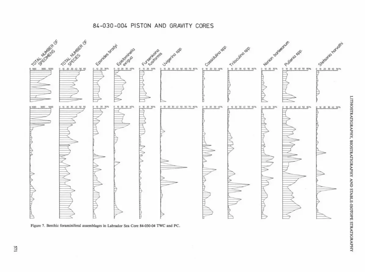
Figure 7. Benthic foraminiferal assemblages in Labrador Sea Core 84-030-04 TWC and PC.
84-030-004 PISTON AND GRAVITY CORES
0 1000 3000 5000 0 10 20 30 40 50 60 0 10 20 30% 0 10 20 30 40% 0 10 20 30% 0 10 20 30 40 50 60 70 80% 0 10 20 30 40% 0 10 20 30 40 50 60% 0 10 20 30% 0 10 20 30 40 50 60% 0 10 20 30 40 50%
) 1000 3000 5000 0 10 20 30 40 50 60 0 10 20 30% 0 10 20 30 40% 0 10 20 30% 0 10 20 30 40 50 60 70 80% 0 10 20 30 40% 0 10 20 30 40 50 60% p 10 20 30% 0 10 20 30 40 50 60% 0 10 20 30 40 50%

D. B. SCOTT ET AL.
Table 1. Percentage occurrences of benthic foraminifers in Core 85-027-016 TWC and PC (X < l°7o)
Deoth (a ) Total nuaber of Species Total no of Indi./lOcc XIO Adercotryma qlomeratiu Ammobaculites foliaceous AstraMina rara Astrononion gallowayi Bolivina arctica B. spathulata Brizalina pseudopunctata Buccella friqida Bulimina marginata Buliminella hensoni Cassidulina laeviqata C. reniforme C. subqlobosua Cibicides lobatulus CribrostoBoides subqlobosuit Dentalina spp. Dendrophyra arborscens Eqqerella advena Elphidium bartletti E. excavatum f. davata E. subarcticum Eoeponides pulchella Epistominella takayanagii Fissurina spp. Fursenkoina fusiformis F. pauciloculata 61obobulimina auriculata Haynesina orbiculare Hyperammina elongata Islandiella islandica I. teretis Larvnqosiqsa hyalascidia Lagena spp. Lenticulina spp. Miliolina subrotunda Nonion barleeanum Nonionella labradorica Nuttallides umbonifera Oolina hexagona Oridorsalis umbonatus Patellina corrugata Planulina wuellerstorfi Psammosphaera fusca Pseudopolymorphina novangliae Pullenia subcarinata Pyrgo williamsoni Quinqueloculina arctica Q. cultrata 0. seminulum B. stalkeri Recurvoides scitulum Reophax arctica R. scotti i Rhadamsina agqiutissima Rhizammina algaeformis Saccammina diffluqiformis Stetsonia horvathi Textularia weisneri Triloculina trihedra Trochammina gioberinitormis Uvigerina peregrina Valvulineria arctica V. laevigata Pianktonics Agglutinated fragments
7 16 26 35 44 53 55 59 67 74 83 94 103 114 123 134 143 152 7 3 6 5 8 8 9 10 8 4 5 9 7 12 6 9 8 8
32 8 12 7 3 57 248 113 40 45 80 6 3 9 8 15 32 4 1
3 3
8 1
X 1 3
X 1 6 1 84 3 1 39 3 26 IB 20
10 7 10 15 4 15 X X 46 41 6 2 2 46 46 1
1 X X 5 10
1 X
X
7 4 X 1 17 5 1 3 5 1
1 1 1 5 X X 3 1 3
2 X X 7 1 5 2
6 33 2 4 X 17 57 1 26
1 2 X X
1
X
1
2
23 1 8 3
72 97 48
1 1 B 60 27 47 61 24 47 89 14 29 10 21 6 66 8
13 1 1 67 27 7 9 15 34 45 9 3 3 1 32 28 2 3
1 3 1
0 0 6 0 2 336 1394 776 432 34 540 490 21 223 5 53 500 65 26 1 0 0 4 0 0 0 0 0 6 0 0 8 0 0 0 0
572

LITHOSTRATIGRAPHY, BIOSTRATIGRAPHY AND STABLE-ISOTOPE STRATIGRAPHY
Table 1 (continued).
P I S T O N (6 - 2 8 6 c m )
6 14 26 38 48 55 64 76 85 101 112 122 133 144 155 164 175 184 195 204 215 224 235 246 255 264 273 2B6 5 15 9 6 5 8 5 6 7 15 11 8 10 8 9 8 12 8 5 8 3 3 5 5 0 1 1 0 3 42 16 1 65 265 22 7 23 13 9 4 4 7 4 4 8 3 0 .2
4 X X 2 7
3 5 3 2
1 2 5
28 13 8 2 5 2 7 1 1 1 5 0 3 6 39 50 44 38 49 50 33 53 71 62 25 12
3 3
4 4 2 8 X 1 1 10 7 29 5 4 6 12 7 17 33 16 19 31 38 3 1
2 2 7 11
9 8 5 3 3
1 52 12 44 17 17 22 2 4 X 7 4 16 16 13 3 11
2 7
1 16 1 1
100 100
41 33 8 25 46 71 41 56 14 3 3 19 3 29 5 10 13 73
23 11 55 24 24 51 40 4 7 3
43 28 22 1 892 3000 466 107 117 193 31 32 514 18 7 64 2 1 34 0 2 16 0 0 0 0 0 0 0 0 0 0 0
573

D. B. SCOTT ET AL.
Table 1 (continued).
Depth (ca) Total nuaber of Species Total no of Indi./lOcc X10 Adercotryaa qloaeratut Aaaobaculites foliaceous Astraaaina rara Astrononion qallowayi Bolivina arctica 6. spathulata Brizalina pseudopunctata Buccella friqida Bulitina aarqinata Buliainella hensoni Cassidulina laeviqata C. reniforae C. subqlobosua Cihicides lobatulus Cribrostoaoides subqlobosua Dentalina SOP. Dendroohyra arborscens Eqqerella advena Elphidiua bartletti E. excavatua f. clavata E. subarcticua Eoeponides pulchella Epistosinella takayanaqii Fissurina sop. Fursenkoina fusiforais F. pauclloculata Slobobuliiina auriculata Haynesina orbicuiare Hyperaatina elonqata Islandiella islandlca I . teretis Larynqosiqaa hyalascidia Laqena spp. Lenticulina spp. Hiliolina subrotunda Nonion barleeanui Nonionella labradorica Nuttallides uibonifera Dolina hexaoona Oridorsal is uabonatus Patellina corruqata F'lanulina Muellerstorfi PsaMosohaera fusca Pseudooolyaorphina novanqliae Pullenia subcarinata Pyrqo trilliatsoni Quinqueloculina arctica Q. cultrata Q. seainulua S. stalkeri Recurvoides scitulua Reophax arctica R. scottii Rhadaatina aqqlutissiaa Rhizaaaina alqaeforais Saccaaaina diffluqiforais Stetsonia horvathi Textularia weisneri Triloculina trihedra Trochaaaina qloberiniforais Uviqerina pereqrina Valvulineria arctica V. laevioata Planktonics Aaolutinated franaents
292 303 314 323 334 345 354 365 390 401 410 420 430 440 450 461 470 481 490 501 510 521 532 541 550 561 1 5 7 1 1 8 6 11 9 4 9 12 6 0 1 3 2 7 4 4 6 1 9 3 12 8
.2 1064 4 .3 63 242 22 54 7 .9 13 14 19 0 .6 16 198 396 .8 2 3 .1 40 .7 11 7 12 2
6 2 1 1
100 11 X 13 6 1
11 3 24 78 53 1 6 3 I X 7 3 14 8 3 X 2
20 26 31 5 28 66 67 55 25 6 1 38 59 38 100 12 45 58
2 1 1 1
X 17 X 1 15 11 24 1 1 X 25 29 17 3 14 20 24 X 2 2
1 X 23 1 2 1
1 1 4 3 5 4
1 1 6 7
3 3 9 X 1 8 11 4 4 2 1 X 7 1 5 6
1
1 1
1
1 1
11
100 100 5 11 6 100 99
68 17 38 5 7 12 57 74 99 98 25 24 76 71 8 3
1 2 1 X X
X 2 1
0 3168 0 0 215808 89 3944 1 1 6 42 706 0 0 0 2712 6496 3 3 1 1 890 315 8 5 0 0 0 2 0 0 0 0 0 0 0 0 0 0 0 0 0 0 0 0 0 0 0 0 0 0
574

LITHOSTRATIGRAPHY, BIOSTRATIGRAPHY AND STABLE-ISOTOPE STRATIGRAPHY
Table 1 (continued).
570 5B1 590 601 610 621 630 641 650 661 670 681 690 700 710 720 730 740 752 761 772 780 791 800 BU 820 931 840 551 874 880 16 8 9 1 0 7 8 6 8 14 7 6 4 4 2 12 13 9 14 12 12 13 6 10 9 9 15 1 5 Q 1 27 2 9 .2 0 702 97 166 64 25 3 11 1 18 1 I 47 _J6__ 22 401 16 11 .8 0 19
J X
6 71 13 7 56 67 32 18 1 11 10
48 39 8 2 6 6 1 6 13 4 17 J3 29 10 14 9 1 50 4 41 47
_16 9 X 1 4 2 2 16 14 ii _ 4 _ J X 15 1 1 15 15
1 4 4 X X X J 15 6 5 1 1 1 5
9 9 3 8 1 _J 1 1
X 3
8 22 8 X 1 2 1 8 3 3 24 9 1 10 2 11 4
J_ X
13 X
J: 1
100 100 100
7 9 74 96 87 82 6 30 30 38 9 14 19 65 33 65 64 15 34 12 4 J7.
1 4 3 1 40 1 3 4 1 I 1
33 4 151 0 012112 556 1016 26 3984 20 157 2 1 0 2954 206 130 3748 498 620 14272 226912 2892 299 51 0 0 0 0 0 0 0 0 0 0 Q Q Q Q Q Q Q Q Q Q Q Q Q Q Q 0 0 0 0 0 0 0 0 0 0
575

Table 2. Percentage occurrences of benthic foraminifers in Core 84-030-04 TWC and PC (X<1%).
T.W.C. (0 - 148cm) PISTON (0 - 254cm) Depth (n ) Total number of Species Total no of Indi./lOcc X10 Adercotryma alomeratum Astracoius crepidulus A. insolitus Astrononion qallowavi Bolivina arctica B, pseudoplicata B. robusta B. spathulata B. subsoinescens Brizalina oseudopunctata Buccella friqida Bulimina ex i l i s B. oibba B. notovata Buliiinella hensoni Carterina soiculotesta Cassidulina reniforme C. subqlobosua Cassidulinoides bradyi Cibicides lobatulus C. Dseudounqerianus C. robertsonianus C. subhaidinqerii Cribrostoaoides crassmarqo C. subqlobosua Dentalina spp. DiscDpulvinullna spp. Discorbis SPP. Elphidium bartletti E. excavatum E. excavatum forma davata E. excavatun forma excavata E. incertum E. subarcticui E. ustalatui Eqqerella advena Eqqerella bradyi Epistominella exiqua Eponides bradyi E. tumidulus Fissurina spp. Fursenkoina fusiformis Globobulimina auriculata Globobulimina spp. Glomospira qordialis Guttulina spp. Gyroidina soldani Haynesina orbiculare Hoeglundina eleaans Hyalinea balthica Hyper awina subnodosa Hyperatmina SPP. Islandiella teretis Karriella apicularis K, bradyi
0 51
750
B 44
B79
IB 47
516
2B 40
404
38 38
344
48 43
230
5B 31
154
48 38
488
78 24 49
88 42
388
98 44
941
108 42
744
118 29
163
128 25
138
135 54
971
139 148 45 20
335 44 3 1 1 X
X 1 X X
X X X X X X 3 1 1 1 2 X X X X X X 1 1
X X 1 X X X X
X X X X X 2 1 1 X X 1 X X X 2 X
X
X X X X X I 1 1 X X 2 X
2 1
2 1
2 1
1 X
4 1
1 X
1 X
1 1
4 X
1 X
2 X
1 X
2 2
1 2 1
2 2 1 1
X X X X X X 1 X X
X
X I X X X
2 X
1 1 2
X X 2
1 X 1
X 1
1 1 1
X
1
1 X X
X
X X 1
X 1 1
1
X
1
X
1 X
X X 1
X 1 X X
2 2 4 2 3 3 4 2 2 1 2 2 1 1 3 3 X
1
11 14 1 1 6
9 21 1 2
11
1 21 1 X
11
14 24 1 1 7
15 19 X 1 7
25 13 1 1
10
78 9 1 1 4
20 12 1 2
12
21 14 2 1 7
23 15 1 1
10
14 15 1 1
11
18 11 1 1
17
13 12 X 1
13
3 14 1 1
24
12 20 2 1
11
18 2 12 10 1 1 X
12 13 X X X I X
1 1 1 X X X X 1
X X X 1 2 2 X X 4 2 2 1 3 1 1 3 4
X X X X 1 1 2 2 X X 3 X 2
1 1 1 1 1 X 1 X 1 X 3 X X X X X 1 X X
0 59
531
10 57
618
17 50
833
28 41
475
38 42
391
48 29 2R
58 34
506
48 39
493
71 24 44
78 32
348
88 21 79
98 108 19 24 47 20
118 128 138 148 158 170 174 178 188 25 18 24 32 45 20 24 21 21 24 23 51 29 48 9 10 7 28
198 27 72
208 26 25
218 222 228 21 13 3 68 16 1
238 248 254 17 7 6 9 2 .7
1 1 X X
X X X X 1 2 X
X 1 X 1 1 1 1 X X X X
1 X X
X 1
X X X
X X
X X
X 1 X X
1 1 1
X 1 3 X 3 3 11
2 1 ? 1 3
2 14
1 X
X X X X X X 1 1 1 1 1 X
2 1
2 1
2 X
1 1
1 1
2 3
1 1
X 1 1 2
2 2 5 3 5 2 5 4 18 1 9 2 2 2 3 4 1 4
20 11
1 4
8 5 15 15 5 13
X X X
1 1 1 2 3 2 1 X 2 X
1 1
X X X 1 1
X X
1 X X
X X X 1 1 1 1 X 1 1 4 1
3 1 2 X 2 2 2 1 3
1 X X X X 1 1 1 1 1 1 1 1 X I
2 X 1 1
3 3 3 2 3 1 3 3 1 2 2 2 3 3 4 3 7 2 3 1 1 2
X
X
14 14 1 1 5
X
10 17 1 1
12
11 23 1 1
11
15 20 2 1 9
21 14 2 1
11 X
21 4 2 2
15 2
IB 14 2 1
12
20 12 2 X
14 X
38 B 2
8 2
34 4 2 1 8
23 8 2 1 9 1
1 3
X 5 8 10 2 2 1
12 14
X
3 3 9 8 4 1 12 2 2 1 2 1 3 4 4 4 1 1
7 3 2 3 4 4 12 3 2 4 2 5 14 4 2 3 X X 2
2 2 1 4
?
1
1 2
4 i
15 1
6 13 23 5 1 4 8
2 14 2 1
2 13
1
2
2 X 1
X
1 2 2 1 1 3 1 X 1 1 4 4 7 X I 3
X 1 X X 1 X X 1 X 1 1 1 2 1
X X X
1 1 X 1
X X
X X
X X X X 1 2 X 1 1 1 3

Table 2 (continued).
Laqena SDD. Lenticulina spp. niliolina spp. Nodosaria lamulifera N. SDD. Nonion barleeanua Nonionella turqida Nutlalides iiabonifera Qolina spp. OpthalitiidiiM acutiiarao Oridorsalis uibonatus Patellina corruqata Planulina twellerstorfi Planulina SDD. PsaMosphaera fusca Pseudopolyaorphina novanqliae Pullenia bulloides P. subcarinata Pyrqo Killiansoni Pyrulina qutta Quinqueloculina aqglutinans Q. cultrata fi. sminului Reophax bacillaris R. scorDiurus Rhizamina alqaefornis R. spp. Robertinoides charlottensis Saccawina diffluqiforais S. sphaera Siqwilopsis schluuberqeri Sphaeroidina bulloides Spiroplectamina biforiis Stetsonia horvathi Siphotextularia rolshauseni Tosaia hanzawai Trifarina fluens Triloculina arctica T. trihedra Trocha«niina nana T. pacifica Trochawtina spp. Trochaaninella atlantica Uviqerina asperula U. oereqrina V'alvulineria arctica
X 2 2 X
1 1 2 X
2 3 2 3 2 X
X X
1 1
1 2 1 X
2 X
X X
?
1 1 2
1 4 X
4 X
3 X
6 X
3 1
13 6 2 X
6 X
9 3 2 X
5 X
15
X X X X 5
4 X 2
X X 2 X 2 X 1
X X 3 X 7
2
X X 7
6
1 X 8
7 X
1
6 I 4
1
12
3
3 X 4
4
2
X X 4 X 5 X X
1 X h X 4 X
1
3 X 3 X
1
7
2
X X 3 X
1 5 X 1
1 X 7 X 6 X
1
1
3
X 2
11 X
1 6
3 9 X
4 6 X
1 B X
1 6 X
3 13 1
2 8 X
3 7
1 7 X
1 5 X
1 8 X
3 2 21 32 7
X
2 10 X
X 29
X X X X X X I 1 X X 1 1 X X X
X X X
X 1
X 1 X
1 X
X X 1 X X X
X X
1
X 2 X X X X
X X X X X
2 2 1 1 X
2
2 6 X
X X 2
i 4
X 1 X 2
1 X
! 1 2
?
X
1 X 2
x 3 1
X i 2
1 1
2 2
3 X
X 6
X
3
X 2 1
X 1
X 7 X X
1 5
7 X X
X 5
X
X
X
1 2 X X
X 2
X 2 X X
X 7
X X
X 1 3 X 5 3 6 i
1 12 1 X
1 10
2 5
1 4 6
X 5
2 1
1 8
1 1
2 3
1 8
1 5
X X
1 B
X 4
2
X X
1 X
2 X
2 X
2 1 1 X
3 1 1 1 1
3 1 X
1 X
2 2 1
1 2 2 2 1 14
1
3 X X 1 X 7 X 5
1 X
1 X 3 X 5 X
2 X
1 X 3 X 5 X
5
1 X
10 X B X
4 X
1 X 5 X 3
10 1
2
4 X 3
6 X X X
3
4
7
X 1
2 X 2 X
12
1 1
2
4
B
2 1
2
1
9 13
1
i 6
IB
1 1
1
3
4
1 3
7
7
17
5
2
2
6
4
X 5
1
1
5
X 2 2 2
8
8
5
2
4
2 1 1
8
9
4
1
7
4
1
6
6
2
1
2
6
2
1
11
11 21 23
1
1
1 3
27 13 29
1
1 14
1
1 1 X
2 9 1
3 6 X
2 5 1
3 4 X
2 6 X
4 14
2 7
3 6
3 5
2 1 10 25 31
1 22 26 10
7
2 14 3
7 34 X
3 13 2
6 25 5
7 18
7 16 4
6 13 6
4 15
2 B
2 5 33 18 B
3 13 45 25 14
X 1 1
X X 1
X 1 X
1 1 X
1 1 X
1 X
X X
X 1 1 1 3
6 3 3 1 X
1 2
1 4 2 2
4 1 X 1 X X X X X
1 1 1 X X 1 X 1
3 1 X
5 X X
2 X X
7, X
X 1
2 X
4 1 X
X 2
6
X
3 2
1
2 1
3
2 8 6
3 5
6 1 4
2 1 5 1
4 7
4 1 6
6 1 9
24 2
1 1 1
1 1
1 X 3
X 4
X 2
3 X X
I 2
X 1 X
X 3 1 1 6 7
5 6
1 2
3 9
2 11
2 4 7
6 9
1 8
1 2
X X 1 X
1 X 1 4 X 1 4
2
2 _I_
I 2 8
X 1 5
1 8
1 \
1 7
1 4
1 1
1 1
1 2 1 1
2
11 2 3
3
X X X
1 1 1
13 1 13

Table 2 (continued).
Depth (cffl) Total nuiber of Species Total no of Indi./lOcc X10
270 21 12
278 13 8
288 16 9
298 19 8
308 26
112
318 14 3
328 8 ?
338 27 72
348 13 9
358 13 5
368 27 61
378 26 91
388 38
147
398 25 63
408 28 56
418 26 32
428 31 56
438 32 48
448 28 46
458 25 23
468 20 18
478 29 29
488 32 39
49B 37 33
508 24 S3
518 30 95
Adercotryaa qlomeratua Astracolus crepidulus A. insolitus Astrononion qallowayi
X X X X X X
X 1
I
Bolivina arctica B. pseudoplicata B. robusta B. spathulata B. subspinescens Brizalina pseudopunctata Buccella friqida
1 1
1 X X X
X X
1 1 X
X X
1 X
1
i X X X
Bulisiina exilis B. qibba B. notovata Buliiinella hensoni I X Carterina spiculotesta Cassidulina reniforine C. subqlobosui Cassidulinoides bradyi Cibicides lobatulus
n 1 <j
32
1
17 4
8 5 3
5 4 4 X
1 1
1
' ;■
3 3
4 1
L
X
X
16 x
I
15 4
1
11 9
X
5 1
4 2
X
2 1
5 c ■J
1
2 2
L
8 7 L
1
11 7
1
16 9
1
j
i
j
I
C, pseudounqerianus C. robertsonianus C. subhaidinqerii 1
X X I
Cribrostoaoides crassisarqo C. subqloboBuot Dentalina spp. 1 X 1 n X 1 1 X X 2 1 1 X 1 1 1 X X Discooulvinulina spp. Discorbis spp. Elphidiuin bartletti
1 X Y
X X X X
E. excavatuia E. excavatum forma davata n 21 X X <j 1 X X X X X 1 1 1 X E. excavatuffl forua excavata E. incertum E. subarcticui E. ustalatun
X 1
1 I X X 1 1 X X
Eaaereila advena Eoqerella bradyi Epistosinella exiqua 2 L 1 1 3 1 1 2 2 7 5 1
?
1 1 1
1 1 2
1 0 L
X 5 7
X 12 21 7 1
I 1

Table 2 (continued).
Eponides bradyi E. tumidulus Fissurina spp. Fursenkoina fusiformis Globobulimina auriculata
13
5 2
1 20 2
2
5
4
3 X
2
7
3 40
10
5
9 1
3
16
10
34
2
4 1
3
n
X X 1
3
2 2
15
1 6
14 X 1 3
16 X 1 3
9 1 1 3
5 X X 7 0
8 1 1 2
11
1 3
9
3
2
X 2
1 1 1 5 1
4 X 2 3
6 1 1 4 X
7 X 1 3 X
Globobulimina spp. Glomospira gordialis Guttulina spp. Gyroidina soldani Haynesina orbiculare Hoeglundina elegans Hyalinea balthica
i 1
1
X X
X X
1 n X 1 X X
X 1 1 X
1 X
X
X 2
Hyperammina subnodosa Hyperammina spp. Islandiella teretis 1 T
■J X 1 X 1 Karriella apicularis K. bradyi Lagena spp. 3 1 3 X ■J 3 V X 1 1 4 1 3 7 2 2 L 1
X 1 1 1
i.
Lenticulina spp. Mi Hoi ma spp. X X X Nodosaria lamnulifera N. spp. Nonion barleeanum Nonionella turqida Nutlalides umbonifera Oolina spp. Opthalmidium acutimargo Oridorsalis umbonatus
21
1 1 i
4
1
1
17
1
1
1
6 i
3
3
29 11
1 i
X
17
1
17
f
4
1 1
5
¥
1
7
X 1 X x
11
1
X
14
X X 2
14
1
1
7
X 1 X 1
4
X ^ X
7
1 9
X X
9
2
1
5
13
2
c ■J
12 1
1
9
14 ?
X
x 3
X 5 2
14
X
j
P.
1
Patellina corrugata Planulina wuellerstorfi 9 7 7 5 6 5 4 6 2 3 5 5 6 7 4 0 4 3 7 7
•J / Planulina spp. Psammosphaera fusca Pseudopolymorphina novangliae Pullenia bulloides Pi subcarinata Pyrgo williamsoni
3 12
1 11
1 10 l
i 1 i
7 ■J
16 1
3 53
14 24
3 31
8 7
6 h
2 9
2 12
4 15
1 i
1 24 X
1 20
1 27
3 16 2
3 23 1
4 27 1
4 36 X
7 37 1
6 23 1
7 0
17 1
1 7
x 19 2
1 14 X
Pyrulina gutta Quinqueloculina agglutinans Q. cultrata Q. seminulum
i 1 L 1 i 1 X
X X 1 1 1 1 X 1
Reophax bacillaris

Table 2 (continued).
Depth (cm) 270 278 288 298 308 318 328 338 Total number of Species 21 13 16 19 26 14 8 27 Total no of Indi./lQcc X10 12 8 9 8 112 3 2 72 R. scorpiurus Rhuaiinriina alqaeforiais R. spp. Robert inoi des- charlottensis -Saccaffifflina diffluoifarsis S. sphaera Siqaoiiopsis schlumbergeri Sphaeroidina bulloides SpiroplectaiMtina biforniis Stetsonia horvathi 1 13 20 4 Siphotextularia rolshauseni 1 1_ Tosaia hanzawai 2 3 1 3 2 Trifarina fluens Triloculina arctica 1 3 X. T. trihedra 2 1 12 17 3 9 Trochaaffiina nana T. pacifica TrochaBHfiina spp. 1 Trochannmnella atlantica Uvigerina asperula 22 31 X_ U. peregrina 15 43 1 10 1 2:
348 358 368 378 388 398 408 418 428 438 448 458 468 478 488 498 508 518 13 13 27 26 38 25 28 26 31 32 28 25 20 29 32 37 24 30 9 5 61 91 147 63 56 32 56 48 46 23 18 29 59 33 83 95
16 48 U 3 1 1 3 B 2 1 4 3 17 22 56 1 X 1 X X 1 3 1 4 2 2 X 1 1 2 4 7 1 1 5 3 2 1 1 2 2
L_J 1 I L.J 1 L 2 33 8 32 1 X 5 32 22 21 1 1 6 2 4 12 12
6 X 1 1 3 5 1 1 X 1 X 1 8 X 15 1 1 2 1 1
Valvulineria arctica 1 3 2 X

LITHOSTRATIGRAPHY, BIOSTRATIGRAPHY AND STABLE-ISOTOPE STRATIGRAPHY
< * ■
^ ^
^ <£ &
0% 10 20 30 1.0 50 60 70 80 90 100
Figure 8. Planktonic assemblages vs. total carbonate and stable isotopes for Labrador Sea Core 84-030-01 TWC and PC. Stippled area on carbonate curve is dolomite.
581

D. B. SCOTT ET AL.
? \o
rS>
5.0 4.0 3.0 2D .7,0 .5.0 .30 .10 -.1.0
0 % 25 50 75 Piston 5,0 4 £ 3,0 2,0 ■7,0 ,5Q .3,0 ,1Q -,1Q
Figure 8 (continued).
582


![org [ODP] and Evaluation WikiFlow](https://img.pdfslide.net/doc/110x75/63317afa576b626f850cf590/-org-odp-and-evaluation-wikiflow.jpg)


