Embed Size (px)
Citation preview

MaitlandLocalStrategicPlanning Statement 2040+THE CITY'S LAND USE VISION TO 2040+

Maitland City Council2
Acknowledgement
MAITLAND CITY COUNCIL - JUNE 2020
Maitland City Council acknowledges the Wonnarua People as the Traditional Owners and Custodians of the land within the Maitland Local Government Area and pays respect to all Aboriginal Elders, past, present and future with a spiritual connection to our lands.

3
1. INTRODUCTION 4
2. MAITLAND’S PAST, PRESENT AND FUTURE 11
3. STRATEGIC CONTEXT 16 4. VISION 22
5. LOCAL PLANNING PRIORITIES 32 6. IMPLEMENTATION AND MONITORING 58
ABBREVIATION:CSP Community Strategic PlanDCP Development Control PlanDMP Destination Management PlanDPI&E NSW Department of Planning, Industry and EnvironmentEDS Economic Development StrategyEP&A Act Environmental Planning and Assessment Act 1979GNMP Greater Newcastle Metropolitan Plan 2036HNEH NSW Hunter New England HealthHCCDC Hunter and Central Coast Development CorporationHJO Hunter Joint Organisation of CouncilsHRP Hunter Regional Plan 2036LALC Local Aboriginal Land CouncilLEP Local Environmental PlanLG Act Local Government Act 1993LGA Local Government AreaLLS NSW Local Land ServicesLSPS Local Strategic Planning StatementMCC Maitland City CouncilMILUTS Maitland Integrated Land Use and Transport StudyMUSS Maitland Urban Settlement StrategyRFS NSW Rural Fire ServiceSES NSW State Emergency ServiceSEPP State Environmental Planning PolicyTfNSW Transport for New South Wales
CONTENTS
Maitland Local Strategic Planning Statement 2040+

Maitland City Council4
1.2
PURPOSE OF THIS STATEMENT
1.1
ABOUT THIS STATEMENT
The Greater Newcastle metropolitan area is home to around 576,000 people and is expected to grow by 116,000 people by 2036, resulting in a total population of 692,000 people¹. Maitland has already experienced significant growth over the past two decades and will continue to grow along with the rest of the Greater Newcastle metropolitan area.
This increase in population will drive growth in the local economy, creating new and diverse employment opportunities. As the population
grows, it needs to be supported by adequate infrastructure, services and amenities. If not, this growth can lead to pressure on existing infrastructure, services, housing and the environment.
The Maitland LSPS sets out a 20 year plan integrating land use, transport and infrastructure planning for the future of our city. It outlines how we manage growth sustainably over this period, and has been informed by the community and other stakeholders.
Maitland is growing and will continue to grow. Our ambition is to ensure that it grows in a sustainable way – socially, economically and environmentally. The Maitland Local Strategic Planning Statement (LSPS) sets out a 20 year land use vision for the Maitland Local Government Area (LGA) and outlines how this growth and change will be sustainably managed into the future.
This Statement has been prepared in accordance with the Section 3.9 of the Environmental Planning & Assessment Act 1979 (the Act) which requires for an LSPS to identify:
(a) Context - the basis for strategic planning in the area, having regard to economic, social and environmental matters,
(b) Planning Priorities - the planning priorities for the area that are consistent with any strategic plan applying to the area and any applicable community strategic plan under the Local Government Act 1993,
(c) Actions - the actions required for achieving those planning priorities,
(d) Implementation - the basis on which the council is to monitor and report on the implementation of those actions.
¹ GNMP 2036
1.0 Introduction

5Maitland Local Strategic Planning Statement 2040+
The Maitland LSPS is consistent with the NSW Government’s Greater Newcastle Metropolitan Plan 2036 (GNMP) and Hunter Regional Plan (HRP) 2036. It draws together strategic planning priorities of the State, Hunter Region and Greater Newcastle metropolitan area, and our own local priorities articulated in the Maitland 10+ Community Strategic Plan 2018-2028 and explains how these priorities are to be delivered and implemented at local level. The relationship between these plans is illustrated in Figure 1.
• Set out a 20 year land use vision for the Maitland Local Government Area• Guide how future growth and change will be managed• Localise and give effect to the higher level planning priorities in HRP 2036 and GNMP 2036• Inform changes to local planning framework, infrastructure planning and service delivery• Identify the local planning priorities• Provide more certainty about Council’s future land use intentions• Identify areas for further planning and investigation
MAITLAND LSPS WILL:
Figure 1:Relationship between regional, metropolitan and local plans
Hunter Regional Plan
2036
Greater Newcastle Metropolitan
Plan 2036
Maitland Local Environmental
Plan 2011
Maitland +10 Community
Strategic Plan
Maitland DevelopmentControl Plan
2011
Maitland Local Strategic Planning
Statement 2040+
Source: NSW Planning, Industry and Environment

Maitland City Council6
METROPOLITAN CONTEXT: MAITLAND IN GREATER NEWCASTLE
The Greater Newcastle Metropolitan Plan 2036 (GNMP) draws a vision for Greater Newcastle to become Australia’s newest and emerging economic and lifestyle city, connected with northern NSW. The aim of the plan is to create a city on a global stage through:
• a dynamic and entrepreneurial city with a globally competitive economy.
• great and diverse lifestyles.
• a national leader in the new economy, with smarter cities, carbon neutral initiatives and collaborative governance.
This Plan aligns with the vision and goals of the HRP 2036 and it translates these goals into local level actions and provides a coordinated 20 year framework for land use planning within the metropolitan area. Maitland is located within the ‘Metro Frame’ element of the Plan and is described as follows:
'It is also home to Central Maitland – a growing administrative and civic centre for the metro frame, and East Maitland – an emerging health and retail service centre. These strategic centres are some of the fastest growing in regional NSW that will continue to provide housing, jobs and services for communities across the metro frame’.
MAITLAND +10 COMMUNITY STRATEGIC PLAN 2018 - 2028
Maitland +10 Community Strategic Plan captures our community’s vision and aspirations. It outlines what our community would like for our city over the next 10 years, consistent with the State and local policy frameworks. It informs Council’s Delivery Program, Resourcing Strategy and associated annual Operational Plan and budget.
1.3
POLICY CONTEXTREGIONAL CONTEXT: MAITLAND IN HUNTER REGION
The Hunter Regional Plan 2036 (HRP) is a 20 year blueprint for the future of the Hunter and sets a vision for the Hunter Region to be the leading regional economy in Australia, with a vibrant metropolitan city at its heart. The Plan will deliver this vision through four goals:
• a leading regional economy in Australia
• a biodiversity rich natural environment
• thriving communities
• greater housing choice and jobs
The HRP 2036 guides the NSW Government’s land use planning priorities and decisions between now and 2036. Priorities for Maitland LGA are set out in the Plan in the form of a Local Government Narrative:
'The Maitland LGA contains a high growth metropolitan area that includes strategic centres servicing the hinterland and rural areas of Dungog and the Upper Hunter area. It includes a number of urban release areas that are contributing to significant greenfield housing supply for the region, as well as centres undergoing revitalisation, and historic rural villages. Maitland will continue to supply housing, connect its settlements and offer civic, health and educational services'.

7Maitland Local Strategic Planning Statement 2040+
Greater Newcastle Vision 2036Metro Frame
Metro Core
Strategic Centre
Centre
Newcastle Port (Global Gateway)
Airport (Global Gateway)
University
Health Precinct
Trading Hub
Vineyard District
Housing Release Area
Newcastle Cruise Terminal
Sports and Entertainment Facility
Strategic Transport Junction
Environmental
Waterway
Connectivity
Improved Future Connectivity
Biodiversity Corridor
Strategic Centre
Centre
Indicative Greater Newcastle Metropolitan Area
Newcastle Airport - Global Gateway
Port of Newcastle - Global Gateway
Railway
Inter-regional Road
Major Road
Inter-regional Connection
Growth Area
Biodiversity Corridor
National Park and Reserve /State Forest
Residential and Employment Land
Waterway
Hunter 2036
KEY

Maitland City Council8
1.4
ENGAGEMENTCouncil conducted extensive community and stakeholder engagement between September to December 2019 to inform its first LSPS. The findings of this engagement has been used to develop a land use vision and local planning priorities. The draft LSPS was exhibited from 30 March to 3 May 2020 in accordance with the EP&A Act requirements.
8,277 PEOPLE reached across all channels
895RESPONSES to Mentimeter survey
1,199ACTIVE STAKEHOLDERS participated in activities
1,226 INTERACTIONS on LGA maps
496COMMENTS on Social Pinpoint
1,909 REACTIONS to comments on Social Pinpoint
HOW WE ENGAGED:
For further information on our engagement process and feedback, please see the Maitland Local Strategic Planning Statement 2040+ Community and Stakeholder Engagement Report.

9Maitland Local Strategic Planning Statement 2040+
Infrastructure
The community want to see infrastructure that keeps pace with growth and to have existing infrastructure issues resolved. Importantly the community want infrastructure that connects people and places through active transport options such as pedestrian paths and cycleways.
Environment
Sustainability, climate change, water security and loss of biodiversity were all important issues identified by the community. The community want more trees to cool their suburbs and to get people outside, and also used to add to the unique character of our neighbourhoods.
Employment
The community identified agriculture, heritage and tourism as being important future economic drivers in Maitland. The community also want to see more opportunities for nightlife and retail experiences as the city grows.
Open space
The riverside was recognised as one of the communities most valued assets. The community want to see more opportunity to connect with the river, and for more passive and active recreation in general across the LGA. The community want to see existing sporting and community facilities upgraded, and for more opportunities to be active and healthy.
Residential
The community want to see residential growth that does not compromise the rural or cultural identity of the LGA. The community want to see housing kept affordable with diverse options available to meet different needs of people at different stages of life. Urban sprawl is of key concern to the community.
OUR COMMUNITY’S KEY PRIORITIES ARE:

Maitland City Council10

11Maitland Local Strategic Planning Statement 2040+
2.0 Maitland's past, present and future
The Wonnarua people – the 'people of the hills and the plains', are the First Peoples and traditional custodians of the lands within the Maitland LGA. Wonnarua people have been living in the Hunter Valley for tens of thousands of years and have maintained a strong sense of cultural identity despite the impact of colonisation on their traditional lands and culture.
Maitland, first settled by Europeans in approximately 1818, was central to trade and the growth of the Hunter Region. Over time, the town grew steadily, and it became an important regional centre in the colony. Its rich history and prosperity is reflected in the many civic, commercial and residential historic buildings built in the mid 1800s.
At the heart of our city is Central Maitland. It had evolved in an organic manner with a fine grained, informal city structure, shared with only the very oldest urban areas in Australia. Central Maitland is enriched with buildings and structures that represent eras across the past two centuries, representing the Georgian, Victorian and Federation periods through to the 20th Century. Together they form one of the richest and most complete pictures of our city history and gives contemporary Maitland a unique character and significant European cultural heritage.
Today, our city is one of the fastest growing inland cities in Australia with an annual growth rate consistently above 2%. The current estimated population is 83,200² residents and is expected to be over 110,600³ residents by 2040.
Scenic beauty, unique heritage, rural landscape, welcoming people, an attractive lifestyle and convenient location are some of the factors that have led to our city being one of the fastest growing cities in Australia.
From a lifestyle perspective, the city offers many advantages including, good local services, natural amenities within the city and in surrounding regions, relatively affordable housing and diverse employment opportunities.
Maitland is also home to fast growing, regionally significant strategic centres, which service the hinterland and rural areas (Central Maitland, East Maitland), regionally significant employment clusters (Thornton, Rutherford) and new urban release areas (Thornton North, Aberglasslyn, Lochinvar, Farley, Anambah, Gillieston Heights), which are significant contributors to the supply of greenfield housing for the Greater Newcastle area.
² REMPLAN Community Profile ³ REMPLAN MCC Population Forecast (The population and dwelling projections in the Maitland LSPS are a higher growth scenario compared to the NSW Government’s population projections)

Maitland City Council12
Our economy is thriving with recent urban renewal and catalyst infrastructure investments across the city. These include the transformation of High Street’s mall into the vibrant ‘Levee’ lifestyle, retail and entertainment precinct with the iconic Riverlink building, expansion of Stockland’s Greenhills into a modern retail and entertainment precinct, development of the Maitland Regional Sporting Precinct, and upgrade of Central Maitland rail and bus transport interchange.
Furthermore, the coming years will see significant investments in the new Maitland Hospital, Council’s Administration Centre and the new Mount Vincent Road Waste Transfer and Recycling Facility. This, together with record high housing approvals will continue to support the growing economy and fuel a strong construction industry.
Historically, our economy has been underpinned by agriculture, manufacturing and extractive industries. It has since diversified and transitioned into a largely service based economy. Health and social assistance is one of the strongest and fastest growing sectors in our economy. An aging population and increased life expectancy will increase demand in this sector.
Our visitor economy is an important contributor to the local economy. It mainly builds on local attractions, flagship events and our built and natural heritage. Central Maitland and historic villages such as Morpeth and Lorn, are part of Greater Newcastle’s tourism network. Cultural assets such as Maitland Regional Art Gallery, Maitland Gaol, Walka Water Works along with its annual flagship events are increasing Maitland’s attraction to residents and visitors.
Maitland is a regional destination for education and is home to a renowned agricultural training and education facility, Tocal College, the Hunter Institute of Technology (TAFE) Maitland Campus and the Hunter Valley Training Company (privately owned and Australia’s largest group trainer) offering a range of skills and training to the local workforce.
By 2040, the city will be home to an additional 27,400⁴ residents, requiring an additional 12,6005 homes and 6,500 jobs. Future planning needs to ensure that the potential of our growing population can be achieved without losing the liveability, amenity or housing affordability that current residents enjoy and appreciate.
Like many other Australian regional cities, Maitland is characterised by a dispersed settlement pattern, resulting in a high reliance on private cars. Improving integration of land use planning and transport planning around our centres, transport nodes and in areas of high amenity, will improve connectivity. It will enhance the connectivity between our centres and suburbs, reduce the dependency on cars and create opportunities to invest in public and active transport infrastructure.
Urban growth needs to be balanced against the natural constraints of flooding and bushfire, and the agricultural and environmental values of our rural land. Well managed growth will lead our city to be a more resilient, productive, liveable and sustainable place where all our residents can thrive.
⁴ REMPLAN MCC Population Forecast5 DPIE HRP 2036

13Maitland Local Strategic Planning Statement 2040+
Maitland’s role for urban development is influenced by the GNMP 2036 and HRP 2036. Our city is well positioned to build upon existing strengths and capitalise on new opportunities. In doing so, we can aim to provide diverse affordable housing, planning and delivery of infrastructure, enhancement of our environment, protection of our unique heritage and local character and respond to climate change.
Good planning and urban design will help to guide the growth and renewal of our centres and neighbourhoods, while ensuring their sense of identity and community values are protected.
Our growing population brings both opportunities and challenges. It places pressure on the environment, transport corridors and on a range of services and amenities. A strategy to identify, prioritise and deliver infrastructure and services of the city is fundamental to fully capture its population growth potential, and is critical for liveability and economic resilience.

Maitland City Council14
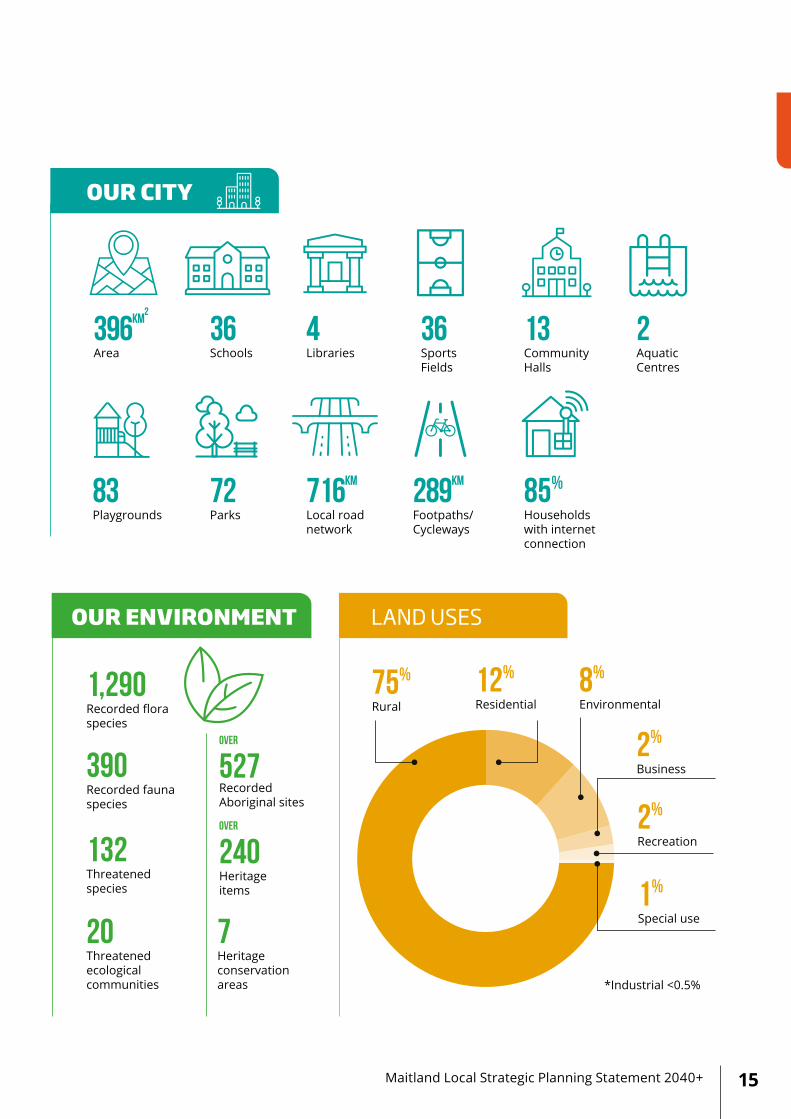
OUR CITY PROFILE
OUR ENVIRONMENT LAND USES
DEMOGRAPHICS
KEY INDUSTRIES
OUR CITYOUR POPULATION
1,290Recorded floraspecies
390Recorded faunaspecies
75%
Rural8%
Environmental 12%
Residential
2%
Business
2%
Recreation
1%
Special use
*Industrial <0.5%
132Threatenedspecies
20Threatenedecologicalcommunities
7Heritageconservationareas
OVER
240Heritageitems
OVER
527RecordedAboriginal sites
36SportsFields
4Libraries
2AquaticCentres
716km
Local roadnetwork
36Schools
396km2
Area
9%
Speak another language other than English at home
9.4 BILLION
72Parks
83Playgrounds
85%
Householdswith internetconnection
289km
Footpaths/Cycleways
13CommunityHalls
5.3%
Of populationidentify asAboriginal andTorres StraitIslander people
4,650Healthcare and social assistance
3,750Retail trade
2,700Educationand training
3,250Construction
13%
Born overseas
83,200
110,600Population increase by 33% between now and 2040
86%
$480,000
HOUSING TYPES HOUSING TENURE (2016)
HOUSING OUR ECONOMY
+12,600
+27,400
2016 31,700
2040
2018
2040
44,300
4.5 BILLION
28,300
53% 47%
8 in 10 17KM
22%
+12,600 dwellings to be provided between now and 2040Currently Newcastle Metropolitan Plan 2036 housing targets are 40% greenfield and 60% infill by 2036 (currently greenfield 94% and infill 6% in Maitland).
Median age
Average householdsize
Families withchildren
Couples withoutchildren
Lone persons
Populationaged 65and over
20402016
35YRS
2.66
46%
26%
21%
14%
38YRS
2.74
45%
26%
22%
18%
Economicoutput
Value addition
Total employment
Live and workin Maitland
32% Certificate or diploma level of qualification
4.9% Unemploment rate
5,750Registered business
Work in Maitland and live elsewhere
Used cars to get to work
Median distance to work
Have a bachelor’s degree or higher education qualifications
Single detacheddwellings
12% Medium densitydwellings
Median houseprice
$380PW
Medianrent
$1,413Median household income PW
86%
of householdsown two ormore vehicles
2.7People perdwelling
3.3Average number of bedrooms per dwelling
28% Ownedoutright
28% Renting
37% Owned with a mortgage
$AUD $AUD
The population and dwelling projections in the Maitland LSPS are a higher growth scenario compared to the NSW Government’s population projections.
15Maitland Local Strategic Planning Statement 2040+
OUR ENVIRONMENT LAND USES
DEMOGRAPHICS
KEY INDUSTRIES
OUR CITYOUR POPULATION
1,290Recorded floraspecies
390Recorded faunaspecies
75%
Rural8%
Environmental 12%
Residential
2%
Business
2%
Recreation
1%
Special use
*Industrial <0.5%
132Threatenedspecies
20Threatenedecologicalcommunities
7Heritageconservationareas
OVER
240Heritageitems
OVER
527RecordedAboriginal sites
36SportsFields
4Libraries
2AquaticCentres
716km
Local roadnetwork
36Schools
396km2
Area
9%
Speak another language other than English at home
9.4 BILLION
72Parks
83Playgrounds
85%
Householdswith internetconnection
289km
Footpaths/Cycleways
13CommunityHalls
5.3%
Of populationidentify asAboriginal andTorres StraitIslander people
4,650Healthcare and social assistance
3,750Retail trade
2,700Educationand training
3,250Construction
13%
Born overseas
83,200
110,600Population increase by 33% between now and 2040
86%
$480,000
HOUSING TYPES HOUSING TENURE (2016)
HOUSING OUR ECONOMY
+12,600
+27,400
2016 31,700
2040
2018
2040
44,300
4.5 BILLION
28,300
53% 47%
8 in 10 17KM
22%
+12,600 dwellings to be provided between now and 2040Currently Newcastle Metropolitan Plan 2036 housing targets are 40% greenfield and 60% infill by 2036 (currently greenfield 94% and infill 6% in Maitland).
Median age
Average householdsize
Families withchildren
Couples withoutchildren
Lone persons
Populationaged 65and over
20402016
35YRS
2.66
46%
26%
21%
14%
38YRS
2.74
45%
26%
22%
18%
Economicoutput
Value addition
Total employment
Live and workin Maitland
32% Certificate or diploma level of qualification
4.9% Unemploment rate
5,750Registered business
Work in Maitland and live elsewhere
Used cars to get to work
Median distance to work
Have a bachelor’s degree or higher education qualifications
Single detacheddwellings
12% Medium densitydwellings
Median houseprice
$380PW
Medianrent
$1,413Median household income PW
86%
of householdsown two ormore vehicles
2.7People perdwelling
3.3Average number of bedrooms per dwelling
28% Ownedoutright
28% Renting
37% Owned with a mortgage
$AUD $AUD

Maitland City Council16
SEVEN PATTERNS OF GLOBAL CHANGE THAT WILL SHAPE OUR FUTURE ARE:
More from less The earth has limited supplies of natural resources essential for human survival including water, forestry, fishery and minerals. As demand for natural resources increases, pressure on diminishing reserves will continue to increase.
Going, going... gone? Valuable ecosystems are under pressure from urban expansion, agricultural clearing and the effects of changing climate. There is a limited window of opportunity to protect biodiversity, habitats and the global climate.
The Silk Highway Rapid economic growth and urbanisation in the developing world, is restructuring the global economy and shifting it towards Asia.
Forever young An aging population, increased life expectancy and changing retirement patterns will have implications for the size of the workforce, economic growth, government revenue and healthcare expenditure.
Virtually here Extraordinary technological changes are transforming how people live, work and communicate. Digital technology is reshaping retail and office precincts, city design and the function of labour markets.
Great expectations Rising societal and consumer expectations for services, experiences and social interaction.
The innovation imperative The world is becoming more connected. Technological advancement is accelerating, and it is creating new markets and extinguishing existing ones.
Source: Global Megatrends, Hajkowicz Stefan 2019, CSIRO
GLOBAL MEGATRENDS
We are living in an interconnected world and our future is inextricably linked to the wider world. The Commonwealth Scientific and Industrial Research Organisation (CSIRO) has identified seven social, economic and environmental megatrends that will have a major impact on Australia over the next 20 years.
The global trends such as technological advancements, automation and artificial intelligence are changing the way we work, travel, communicate and are having broader impacts on our jobs. Trends such as changing demographics and an aging population, shifting consumer behaviour, and the sharing economy are also influencing the way we live and work. The impacts of changing climate will intensify the frequency and severity of climatic events at local level. Altogether, these will influence how we plan our cities.
These unprecedented trends represent key opportunities and challenges for Maitland. This requires careful and long term planning to ensure the protection of the local environment, retention and enhancement of our lifestyle, the creation of new and diverse jobs and the provision of adequate amenities, services and infrastructure to support growth. A strategic led, outcomes focused local planning framework will enable us to identify and respond to future opportunities and challenges.
3.0 Strategic context

17Maitland Local Strategic Planning Statement 2040+
OUR PLACE
The Wonnarua people are the First Peoples and traditional custodians of the land and waterways of our city. One Dreaming story from the Wonnarua People explains how the hills and rivers in the Hunter Valley were created by the Creator Spirit ‘Biame’ – the creator of all things and the keeper of the Valley. Before this, there was nothing, everything was sleeping. Then the spirit awoke and created everything, the mountains, plains, rivers and living creatures. Biame created the languages and the Lore and taught all people how to live with these before re-entering the sky⁵.
Maitland is one of the oldest regional centres in Australia. It has evolved from a cedar getters settlement in the early 1800s to one of the largest settlements in NSW during the mid-nineteenth century and to a robust regional centre in the twenty first century.
Our city is located at the geographical centre of the Hunter Region, approximately 32 kilometres north west of Newcastle and 163 kilometres north of Sydney. It covers a relatively small geographical area and has a total area of 396 km2, from Woodberry in the east to Lochinvar in the west, Mindaribba in the north and Gillieston Heights in the south.
The Hunter River meanders through our urban and rural areas and adds a unique character to our city and sets out a scenic backdrop to our everyday lives. The River and its extensive floodplain provides a natural boundary for urban growth and urban development potential is generally limited to areas south of the Hunter River.
Maitland has a diverse range of places from urban centres and suburban areas through to rural communities. Its unique heritage, villages and rural landscape, welcoming people, an attractive lifestyle and convenient location are valued by the community and have led our city to become one of the fastest growing cities in Australia.
The growth of our city has been driven by its locational advantages, its road and rail connections to Newcastle, Sydney and the broader Hunter Region, its access to the Hunter River and its proximity to both Newcastle and the mining activities further north in the Hunter Region.
As a high growth metropolitan area, it continues to attract residents and businesses to the city. The growing population and economy will further reinforce its role as a major regional centre, servicing the hinterland and rural areas of the Hunter Region and beyond.
⁵ http://www.wonnarua.org.au/history.html

Maitland City Council18
OUR PEOPLE
Maitland is home to approximately 83,200⁶ residents. Between 2008 - 2018, our population has grown by 26% and is forecast to grow a further 33% to over 110,600 residents by 2040⁷.
Maitland has a relatively young population with the median age of residents being 35 years. Families with children, living in detached dwellings, represent 45% of total households.
In Maitland, 5.3% of the population identifies as Aboriginal or Torres Strait Islander, compared to 2.9% in NSW.
13% of Maitland population have attained Bachelor Degree qualification or higher, compared to 23% in NSW.
The demographic characteristics of our population are forecast to significantly change over the next 20 years. The number of residents aged 65 years and over is expected to increase an additional 8,950 from 10,850 in 2016 to 19,800 by 2040⁸. Lone person and other family households are forecast to increase by over 44% between now and 2040, reflecting aging in place and changing lifestyle choices.
The city’s housing stock is currently dominated by low density freestanding houses, representing 86% of total dwellings. The average number of bedrooms per dwelling is 3.4 while the average household size is 2.7 people.
Although, there is a limited diversity in terms of housing types across the city, the LGA does contain a diverse range of residential contexts, ranging from conventional suburban areas, rural lifestyle living, rural villages and vibrant city.
The Metropolitan Plan estimates that Maitland will deliver approximately 21% of the total dwelling projection for Greater Newcastle. This will require an additional 12,600 new dwellings, with an average of 630 new dwellings needing to be provided each year between now and 2036.
The city has a healthy supply of residential greenfield land to accommodate forecast growth over next 20 year period. Some lands are already zoned for residential purposes and some are planned or under investigations to determine best land use planning outcomes.
There is limited potential for future residential greenfield development beyond the areas identified in the existing strategies due to significant land use, infrastructure and environmental constraints including floods, bushfire, mine subsidence, buffers for key infrastructure assets.
Providing a range of diverse housing types will contribute to meeting the needs of many different people. This will allow Maitland to remain an attractive place to live and to raise a family.
⁶ REMPLAN Community Profile⁷ REMPLAN MCC population forecast⁸ DPIE 2019 Population Projections

19Maitland Local Strategic Planning Statement 2040+
OUR ECONOMY
Maitland has a diverse and prosperous local economy, built upon continued population growth and leveraging off its locational advantages. Maitland is an emerging destination for regional education, health, tourism, bulky goods and entertainment.
Our economy has transformed into a largely service based economy. It generates an estimated at $9.4 billion in output and represents 9% of the Hunter Region’s economy. The total value add of the Maitland local economy is estimated at $4.5 billion⁹. The construction industry makes the greatest contribution to economic output in the city, which at $1.7 billion accounts for 18% of total output. In 2018, there were 5,750 local businesses within the city.
The Maitland economy supports 28,300 jobs, representing 10% of the people working in the Hunter Region. The health care and social assistance sector is the largest employment sector and generates 4,655 jobs, representing 16% of total employment. This is followed up by the retail trade, construction and education sectors.
The city’s location close to the Pacific, New England, Golden Highways and Hunter Expressway means that our industries and businesses have access to resource regions, the major metropolitan markets of Newcastle and Sydney and economic infrastructure such as the Port of Newcastle and Newcastle Airport. These areas are also linked to Maitland via the rail line.
The city’s continued population growth is an important strength for the local economy. It enables industries and businesses access to broad workforces within our city and draws from the neighbouring areas due to its central location in the region. Growth, coupled with the lifestyle benefits of our city, attract and retain workforces to support the key industries that drive our economy.
The visitor economy is an important contributor to our local economy. Maitland attracts over 678,000¹⁰ visitors annually, supports over 1,300 jobs and tourism spending injects over $96 million to our local economy.
The growing strategic centres of Central Maitland and East Maitland have the potential to accommodate significant growth in the economy and become important residential, employment and entertainment precincts.
Maitland is home to substantial metropolitan employment lands including two large industrial clusters at Thornton and Rutherford, which accommodate a diverse range of jobs and services. The city has a total of 608 hectares of industrially zoned land, 251 hectares of which is currently undeveloped for future supply over the next 20 years.
⁹ REMPLAN Economic Profile10 Tourism Research Australia LGA Profile 2018

Maitland City Council20
OUR ENVIRONMENT
Maitland is home to over 390 fauna and 1,290 flora species. Of these species, 132 are listed as threatened species and 20 threatened ecological communities.
Over the years, the city’s natural ecosystem has changed significantly due to land clearing for timber, agriculture and urbanisation. Less than 7% of our remnant native bushland remains within the city. During engagement, the community identified protection and enhancement of the environment as a key priority.
Maitland has been built on the banks of the Hunter River and has a long history of destructive flood events. The 1955 flood reminds us of the devastating cost of flooding to the local community and economy. However, the same river system responsible for the floods also has a significant benefit to our natural environment, including delivery of water to flood dependent ecosystems and improving soil nutrients for agricultural land.
Our urban waterways form a part of our city’s landscape and include the Hunter River, Paterson River and Lochinvar, Wallis, Swamp-Fishery, Stony and Mile creeks.
Maitland is home to significant wetland habitats including Tenambit, Woodberry, Wentworth and Dagworth swamps. The Woodberry Swamp is classified as a State Environmental Planning Policy (SEPP) Coastal Management 2018 as 'Coastal Wetland' in recognition of its environmental importance to the region.
Our established residential suburbs have mature trees with high level of urban canopy cover, which contributes to their local character and amenity. However, many newly developed suburbs have a low level of tree coverage and are particularly vulnerable to the urban heat island effect.
The urban heat island effect is where urban lands trend toward being hotter than surrounding rural or forested land. This is due to increased exposure to the sun and heat reflective surfaces like pavements and buildings. The urban heat island effect can be mitigated through planting trees to provide shade and heat absorption.
Urban growth has continued to occur through progressively converting rural land at the urban fringe. Council acknowledges the fragmented nature of vegetation in our city and is focused on protecting existing vegetation, whilst rehabilitating and restoring wetlands, riparian and biodiversity corridors.

21Maitland Local Strategic Planning Statement 2040+
OUR INFRASTRUCTURE
Infrastructure to service a growing population can pose significant challenges. Growth can lead to pressure on existing infrastructure and services such as increasing demand for active open spaces and local roads becoming more congested.
Our road, rail, water, wastewater and energy infrastructure underpin services that support the productivity and enjoyment of our city. Community infrastructure such as schools, hospitals, emergency services, community and sport facilities support our community wellbeing. Cultural infrastructure such as community halls, libraries, art galleries, public art and heritage buildings are the places where the community comes together to celebrate and share our culture as a part of our everyday lives.
Maitland is serviced by a bus network and a heavy rail line. The bus network provides access to locations within Maitland, while the train is the primary public transport mode into Newcastle and further up the Valley. The city is located on both the North Coast and Hunter rail lines.
Like many other regional cities in Australia, the majority of travel is by private car. Maitland has 28,300 workers and approximately 82% of workers travel by car, travelling an average distance of 17km¹¹. This poses two problems, road congestion and greenhouse gas emission.
The existing local road network relies heavily on the New England Highway and is under significant pressure from traffic growth from new urban development in and around Maitland.
The majority of our new residential areas are located away from the existing public transport options such as railway stations and bus interchanges and therefore have a heavy reliance on private vehicles.
Local roads provide access within residential areas, however access and connectivity between our suburbs is further constrained by the existing rail corridor, river and floodplains. As a result, our residents drive in towards the New England Highway and then travel along the highway in order to reach their destination.
In addition to local road infrastructure, Council provides a range of community facilities and services within the city including sports fields, aquatic centres, parks and libraries to meet our community needs. As our population grows, the demand on the existing facilities and services are increasing.
Within the community, there is a widespread perception that the provision of infrastructure has not kept pace with the rate of development in some areas. Despite the current Council budget and development contributions, there is a shortfall between the infrastructure needs, and what can be provided by Council.
With our growing population, our existing community infrastructure is reaching its capacity. Our Western Precinct is generally lacking in community facilities, recreational opportunities and open space. Central and Eastern Precincts are at or near capacity with limited space to grow, and our libraries are relatively small to their population catchment basis.
¹¹ ABS, Census 2016
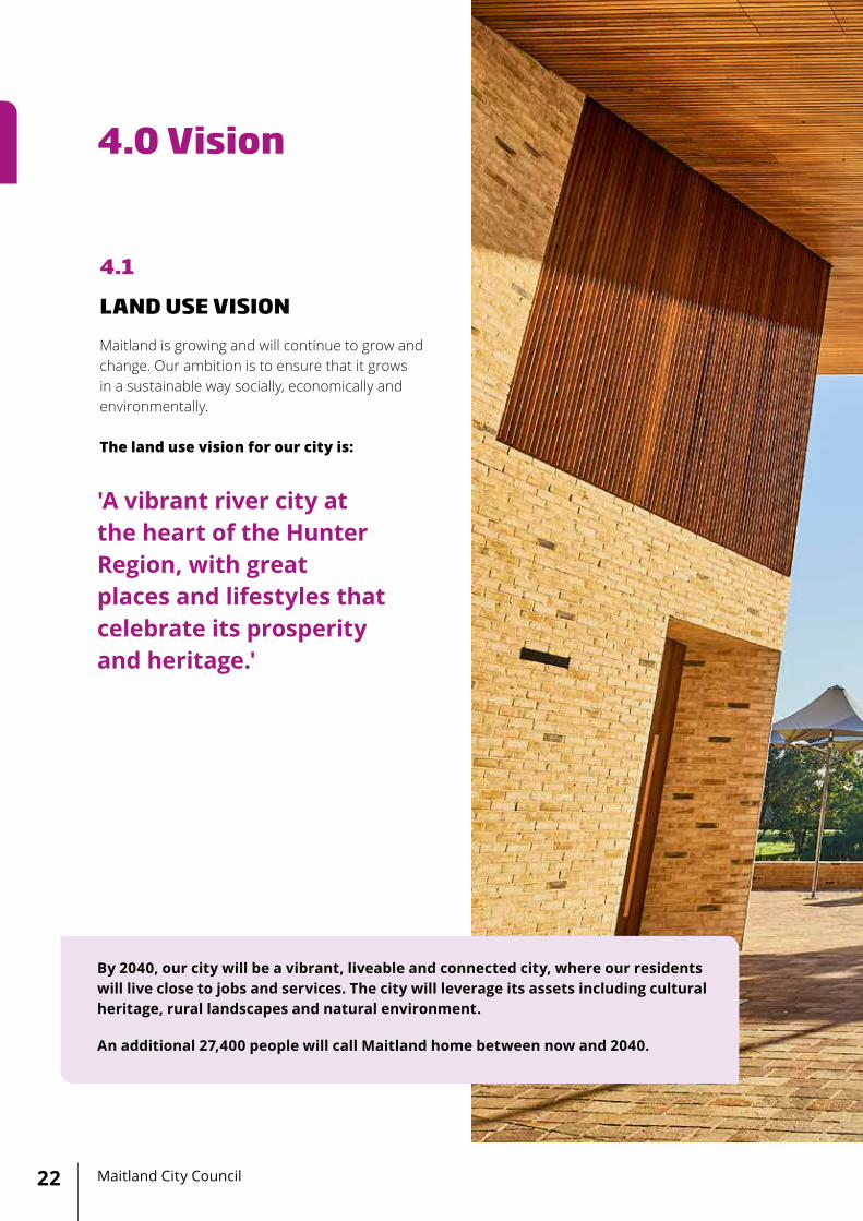
4.0 Vision
Maitland City Council22
By 2040, our city will be a vibrant, liveable and connected city, where our residents will live close to jobs and services. The city will leverage its assets including cultural heritage, rural landscapes and natural environment.
An additional 27,400 people will call Maitland home between now and 2040.
4.1
LAND USE VISION Maitland is growing and will continue to grow and change. Our ambition is to ensure that it grows in a sustainable way socially, economically and environmentally. The land use vision for our city is:
'A vibrant river city at the heart of the Hunter Region, with great places and lifestyles that celebrate its prosperity and heritage.'

23Maitland Local Strategic Planning Statement 2040+

CentralMaitland
Lorn
Rutherford
Telarah
Largs
Morpeth
Tenambit
East Maitland
Metford
Thornton
Woodberry
Chisholm
Gillieston Heights
Aberglasslyn
Hunter River
Hunter River
New England Highway
New England HighwayHunter Expressway
Lochinvar
ToCessnock To Newcastle
To UpperHunter
Kilometres
0 2.5
Maitland City Council24
4.2
STRUCTURE PLAN
CentralMaitland
Lorn
Rutherford
Telarah
Largs
Morpeth
Tenambit
East Maitland
Metford
Thornton
Woodberry
Chisholm
Gillieston Heights
Aberglasslyn
Hunter River
Hunter River
New England Highway
NewEngland HighwayHunter Expressway
Lochinvar
ToCessnock To Newcastle
To UpperHunter
Kilometres
0 2.5
Maitland City Council24
4.2
STRUCTURE PLAN

CentralMaitland
Lorn
Rutherford
Telarah
Largs
Morpeth
Tenambit
East Maitland
Metford
Thornton
Woodberry
Chisholm
Gillieston Heights
Aberglasslyn
Hunter River
Hunter River
New England Highway
New England HighwayHunter Expressway
Lochinvar
ToCessnock To Newcastle
To UpperHunter
Kilometres
0 2.5
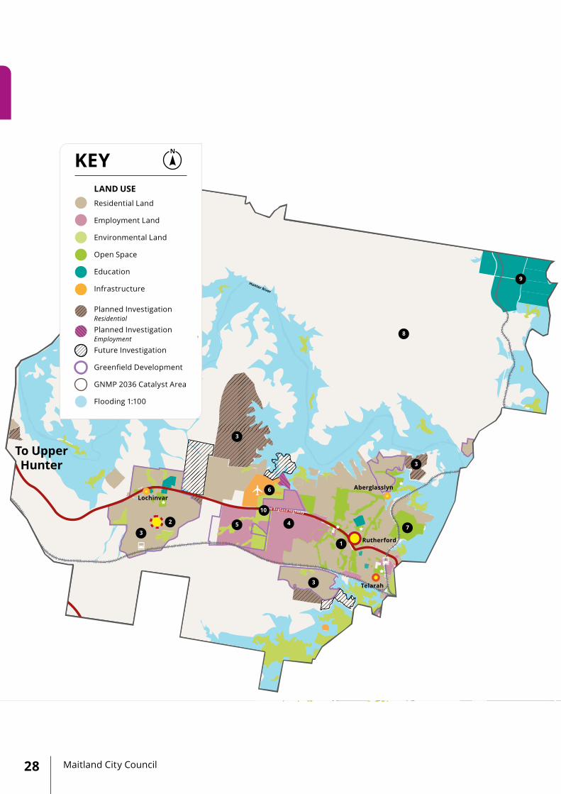
KEY
Kilometres
0 2.5
Residential Land
Employment Land
Environmental Land
Open Space
Education
Infrastructure
Planned Investigation Residential
Planned Investigation Employment
Future Investigation
Greenfield Development
GNMP 2036 Catalyst Area
Flooding 1:100
Strategic Centre
Town Centre
Local Centre
Neighbourhood CentreTown Centre (planned)
LGA Precincts
Highway
Major Road
Railway
Waterways
View Corridor
Biodiversity Corridor
Railway Station
Sports Facility
Airport
Hospital
LAND USE CENTRES
25Maitland Local Strategic Planning Statement 2040+
CentralMaitland
Lorn
Rutherford
Telarah
Largs
Morpeth
Tenambit
East Maitland
Metford
Thornton
Woodberry
Chisholm
Gillieston Heights
Aberglasslyn
Hunter River
Hunter River
New England Highway
NewEngland HighwayHunter Expressway
Lochinvar
ToCessnock To Newcastle
To UpperHunter
Kilometres
0 2.5
Maitland City Council24
CentralMaitland
Lorn
Rutherford
Telarah
Largs
Morpeth
Tenambit
East Maitland
Metford
Thornton
Woodberry
Chisholm
Gillieston Heights
Aberglasslyn
Hunter River
Hunter River
New England Highway
New England HighwayHunter Expressway
Lochinvar
ToCessnock To Newcastle
To UpperHunter
Kilometres
0 2.5
KEY
Kilometres
0 2.5
Residential Land
Employment Land
Environmental Land
Open Space
Education
Infrastructure
Planned Investigation Residential
Planned Investigation Employment
Future Investigation
Greenfield Development
GNMP 2036 Catalyst Area
Flooding 1:100
Strategic Centre
Town Centre
Local Centre
Neighbourhood CentreTown Centre (planned)
LGA Precincts
Highway
Major Road
Railway
Waterways
View Corridor
Biodiversity Corridor
Railway Station
Sports Facility
Airport
Hospital
LAND USE CENTRES
25Maitland Local Strategic Planning Statement 2040+

Maitland City Council26
4.3
CENTRAL PRECINCT
The Central Precinct is home to approximately 13,400 residents and is expected to grow to over 21,000 residents, with an additional 7,600 residents between now and 2040.
The Central Precinct includes Central Maitland Strategic Centre, the historical villages of Lorn and Bolwarra and the Gillieston Heights urban release area. This Precinct provides critical links with Cessnock to the south and the Dungog Paterson region to the north.
Central Maitland is at the core of this precinct and provides a mix of civic, retail, professional, educational and residential uses. It has undergone major transformations and infrastructure investment over the past decade with the completion of The Levee and The Riverlink building, opening of the Maitland Regional Art Gallery, upgrading of the Central Maitland transport interchange, No. 1 Sports Ground, and major road upgrades including Athel D’Ombrain Drive and Allan Walsh Drive.
The Levee – the city’s premier lifestyle precinct is one of the best examples of a mixed traffic shopping mall in the region. Priority is given to pedestrians, with vehicles travelling slowly on the street as shoppers are on foot.
One of the key constraints to residential development in Central Maitland is the risk of flooding from the Hunter River which creates significant evacuation challenges. Resolving a flood evacuation route will support the residential densification within Central Maitland, which is needed to sustain its economic growth. Furthermore, the ongoing and future investments in the Council’s new Administration Centre, Maitland Regional Sportsground Precinct, together with improved public transport and parking will continue to support the growth of this precinct.
Key projects and initiatives within the precinct are:
1. Central Maitland Strategic Centre - a growing administrative, retail and civic centre in the Hunter Region, that will continue to capitalise on its strategic location and rich heritage.
2. ‘The Levee’ Precinct - a transformational project to revitalise the traditional main street into a premier lifestyle and entertainment space.
3. Maitland Regional Sportsground Precinct – a destination for regional and state sporting competitions, delivering modern sporting facilities to the growing community.
4. New Maitland Administration Centre - a catalyst project in the civic precinct, enabling integration of Town Hall and Town Hall Café. This will allow Council to grow with the community.
5. Maitland Regional Art Gallery - a key piece of cultural infrastructure, contributing to community enrichment and supporting the visitor economy.
6. High level Flood Evacuation Route - Not mapped, will improve evacuation for larger floods and support an increased residential density in Central Maitland.
7. Athel D’Ombrain Drive - an alternative inner city route to High Street and Central Maitland transport interchange, enabling development in Central Maitland.
8. Maitland Park - a city wide open space, offering Victorian period landscapes and architecture amongst modern day recreational facilities.
9. Lorn - a focal point for visitors and residents alike with a strong identity and sense of community. Lorn will continue to capitalise on its history and connection to the Hunter River.
10. Gillieston Heights - greenfield development at the mature stage, providing a variety of convenience retail, community and recreation facilities for existing and future residents.
11. Hydro Planned Residential Area - a transformation of former Hydro Aluminium Smelter land enabling significant employment, residential, rural and environmental outcomes.
12. New England Highway Corridor - an integrated approach to corridor planning to manage through and local traffic for the benefit of the local community, now and into the future.

CentralMaitland
Lorn
Rutherford
Telarah
Largs
Morpeth
Tenambit
East Maitland
Metford
Thornton
Woodberry
Chisholm
Gillieston Heights
Aberglasslyn
Hunter River
Hunter River
New England Highway
New England HighwayHunter Expressway
Lochinvar
ToCessnock To Newcastle
To UpperHunter
Kilometres
0 2.5
KEY
Residential Land
Employment Land
Environmental Land
Open Space
Education
Infrastructure
Planned Investigation Residential
Planned Investigation Employment
Future Investigation
Greenfield Development
GNMP 2036 Catalyst Area
Flooding 1:100
LAND USE
27Maitland Local Strategic Planning Statement 2040+
1
2
3
4 7
8
10
11
12
9
5
CentralMaitland
Lorn
Rutherford
Telarah
Largs
Morpeth
Tenambit
East Maitland
Metford
Thornton
Woodberry
Chisholm
Gillieston Heights
Aberglasslyn
Hunter River
Hunter River
New England Highway
New England HighwayHunter Expressway
Lochinvar
ToCessnock To Newcastle
To UpperHunter
Kilometres
0 2.5
KEY
Residential Land
Employment Land
Environmental Land
Open Space
Education
Infrastructure
Planned Investigation Residential
Planned Investigation Employment
Future Investigation
Greenfield Development
GNMP 2036 Catalyst Area
Flooding 1:100
LAND USE
Maitland City Council28
1
4
10
6
5 2
3
3
3
3
8
9
7

CentralMaitland
Lorn
Rutherford
Telarah
Largs
Morpeth
Tenambit
East Maitland
Metford
Thornton
Woodberry
Chisholm
Gillieston Heights
Aberglasslyn
Hunter River
Hunter River
New England Highway
New England HighwayHunter Expressway
Lochinvar
ToCessnock To Newcastle
To UpperHunter
Kilometres
0 2.5
29Maitland Local Strategic Planning Statement 2040+
4.4
WESTERN PRECINCT
The Western Precinct contains established communities including Rutherford and Telarah, existing urban release areas such as Aberglasslyn and future urban release areas at Lochinvar, Anambah and Farley. The precinct has a significant area of industrial and bulky goods land uses located along the New England Highway at Rutherford.
This Precinct is home to around 23,000 residents and is expected to grow to over 40,700 residents, with an additional 17,700 residents between now and 2040.
The Rutherford Town Centre offers retail, health and community services. The Centre has significant potential to be a vibrant centre, servicing the Western Precinct of the LGA and supporting the forecast residential growth over the next 20 years.
Rutherford Town Centre, together with the proposed Local Centre at Lochinvar, and the future employment and residential lands in the Western Precinct will form a strong relationship with Maitland’s rural areas, the Upper Hunter Region and beyond.
It is proposed to develop a precinct plan to set a framework to manage and revitalise residential and commercial activities within and around the town centre, plan and deliver infrastructure, and establish key principles that set the desired future character of the growing communities within the precinct.
Key projects and initiatives within the precinct are:
1. Rutherford Town Centre - significant potential to be a vibrant centre, providing retail, community, recreational and other supporting land uses to support forecast residential growth in the Western Precinct over the next 20 years.
2. Lochinvar Town Centre (planned) - a new town centre to support the significant planned growth within the Lochinvar urban release area.
3. Greenfield Residential Areas – priority housing release areas within the Western Precinct including Lochinvar, Anambah, Farley and Aberglasslyn to accommodate future growing population.
4. Rutherford Employment Land - a regionally significant industrial and bulky goods business cluster will continue to evolve and adopt to support new economies and create jobs for a growing community.
5. Rutherford Park Freight and Business Centre (proposed) - will attract new investments and businesses, creating jobs to support forecast growth within the Western Precinct.
6. Rutherford Aerodrome - privately owned facility that offers pilot training for recreational, private and commercial flights and will need protection from future land use conflicts.
7. Walka Recreation and Wildlife Reserve - a regional recreational space, offering parkland, bushland, and a lake surrounding the historic Walka Water Works, with significant opportunity for the visitor economy.
8. Rural Land - will continue to provide local fresh produce to the community and protect cultural, landscape, tourist and recreational values for future generations.
9. Tocal Agricultural Centre - a Centre of Excellence within the NSW Department of Primary Industries offering training to grow the capacity and productivity of the agricultural workforce to meet the needs of a changing agricultural sector.
10. New England Highway Corridor - an integrated approach to corridor planning to manage through and local traffic for the benefit of the local community, now and into the future.

Maitland City Council30
4.5
EASTERN PRECINCT
The Eastern Precinct is home to the East Maitland Strategic Centre, Thornton and East Maitland Town Centres and the regionally significant Thornton industrial and employment land cluster. It contains established neighbourhoods in Thornton, Ashtonfield, Metford, Tenambit and Raworth, the picturesque heritage village of Morpeth and urban release areas in Chisholm and Thornton North. This Precinct is well positioned to strengthen the city’s connectivity with the Greater Newcastle metropolitan area.
This Precinct is home to around 42,700 residents and is expected to grow to over 48,800 residents, with an additional 6,100 residents between now and 2040.
East Maitland has been identified as an emerging strategic centre for health and retail in the Hunter Region and will accommodate significant growth in the economy and become an important residential, employment and entertainment precinct.
Council is currently working in collaboration with the NSW Government and key stakeholders to ensure that planning of the East Maitland Catalyst Area is carried out in a coordinated way and the New Maitland Hospital is delivered alongside supporting infrastructure.
Key projects and initiatives within the precinct are:
1. East Maitland Strategic Centre - an emerging health and retail service centre, will provide housing, jobs and services for communities across the metro region and beyond.
2. East Maitland Health Precinct - will facilitate modern healthcare facilities, together with the new Maitland Hospital and Maitland Private Hospital and complementary land use to meet the needs of the growing local and regional communities.
3. Greenhills Precinct - a major regional shopping precinct to provide modern retail, dining and entertainment, together with diverse housing options around it.
4. East Maitland Town Centre - an established centre, providing a range of community, retail and professional services for the local community with a strong identity and rich heritage.
5. Thornton Town Centre - will continue to provide the necessary commercial, retail and community facilities to support the growing local community.
6. Morpeth - a renowned regional tourist destination and will continue to capitalise on its significant historic assets and connections to the Hunter River.
7. Thornton North - significant greenfield development fronts, together with Chisholm local centre, will continue to supply residential land to accommodate the growing population.
8. Thornton Employment Land – regionally significant industrial and business cluster that will continue to provide jobs in metro region.
9. Thornton North Employment Land Investigation Area - opportunities to create new jobs and support the growing economy.
10. Melbourne Street Mixed Use Precinct - will continue to provide a mix of employment, commercial and industrial enterprises coupled with urban support uses.
11. Proposed Waste Transfer and Recycling Facility - will extend the life of the existing Mt Vincent Waste Management Centre and increase waste segregation and recycling.
12. Hunter Institute of Technology (TAFE) Maitland Campus - a purpose built facility that will continue to offer a range of skills and training to the local workforce.
13. Maitland Gaol - an iconic and unique tourism attraction in NSW which will provide opportunities to look back in time and explore the Maitland of yesteryear.
14. Bakers Brickyard - Raworth District Play Space delivers modern sporting facilities to the Eastern Precinct.
15. New England Highway Corridor - an integrated approach to corridor planning to manage through and local traffic for the benefit of the local community, now and into the future.

CentralMaitland
Lorn
Rutherford
Telarah
Largs
Morpeth
Tenambit
East Maitland
Metford
Thornton
Woodberry
Chisholm
Gillieston Heights
Aberglasslyn
Hunter River
Hunter River
New England Highway
New England HighwayHunter Expressway
Lochinvar
ToCessnock To Newcastle
To UpperHunter
Kilometres
0 2.5
1215
KEY
Residential Land
Employment Land
Environmental Land
Open Space
Education
Infrastructure
Planned Investigation Residential
Planned Investigation Employment
Future Investigation
Greenfield Development
GNMP 2036 Catalyst Area
Flooding 1:100
LAND USE
31Maitland Local Strategic Planning Statement 2040+
1
3
2
4
10
11
13
14
6
7
9
5
8
Maitland City Council32
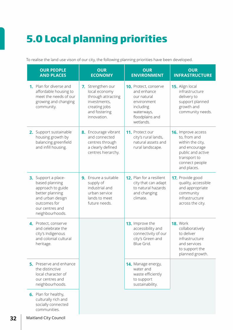
To realise the land use vison of our city, the following planning priorities have been developed.
OUR PEOPLE AND PLACES
OUR ECONOMY
OUR ENVIRONMENT
OUR INFRASTRUCTURE
1. Plan for diverse and affordable housing to meet the needs of our growing and changing community.
7. Strengthen our local economy through attracting investments, creating jobs and fostering innovation.
10. Protect, conserve and enhance our natural environment including waterways, floodplains and wetlands.
15. Align local infrastructure delivery to support planned growth and community needs.
2. Support sustainable housing growth by balancing greenfield and infill housing.
8. Encourage vibrant and connected centres through a clearly defined centres hierarchy.
11. Protect our city’s rural lands, natural assets and rural landscape.
16. Improve access to, from and within the city, and encourage public and active transport to connect people and places.
3. Support a place-based planning approach to guide better planning and urban design outcomes for our centres and neighbourhoods.
9. Ensure a suitable supply of industrial and urban service lands to meet future needs.
12. Plan for a resilient city that can adapt to natural hazards and changing climate.
17. Provide good quality, accessible and appropriate community infrastructure across the city.
4. Protect, conserve and celebrate the city’s Indigenous and colonial cultural heritage.
13. Improve the accessibility and connectivity of our city’s Green and Blue Grid.
18. Work collaboratively to deliver infrastructure and services to support the planned growth.
5. Preserve and enhance the distinctive local character of our centres and neighbourhoods.
14. Manage energy, water and waste efficiently to support sustainability.
6. Plan for healthy, culturally rich and socially connected communities.
5.0 Local planning priorities
33Maitland Local Strategic Planning Statement 2040+
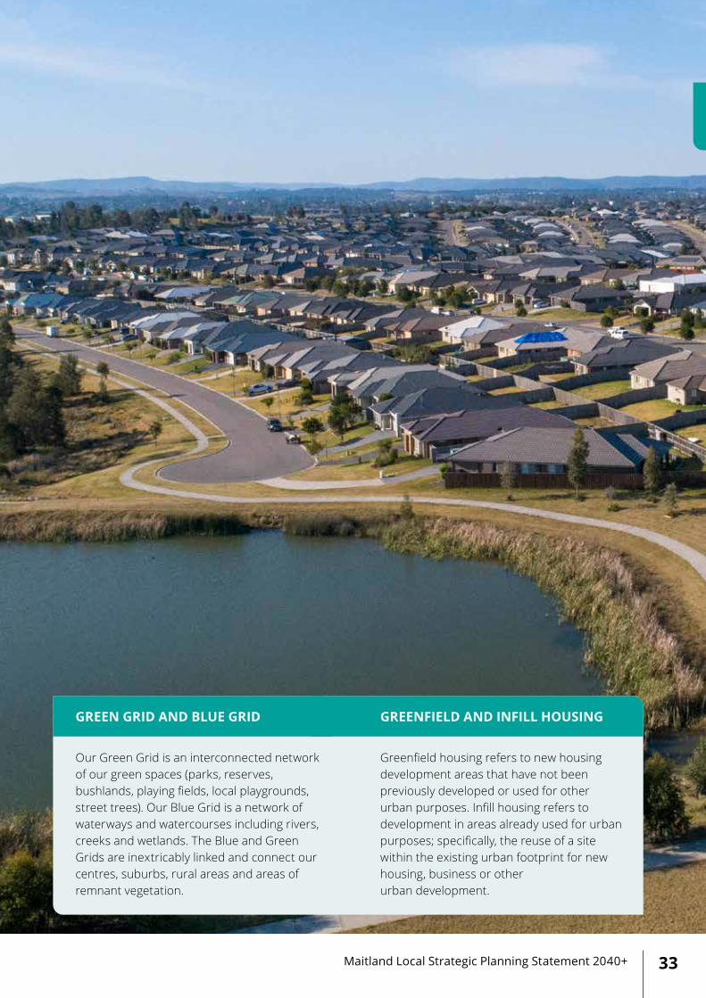
Our Green Grid is an interconnected network of our green spaces (parks, reserves, bushlands, playing fields, local playgrounds, street trees). Our Blue Grid is a network of waterways and watercourses including rivers, creeks and wetlands. The Blue and Green Grids are inextricably linked and connect our centres, suburbs, rural areas and areas of remnant vegetation.
Greenfield housing refers to new housing development areas that have not been previously developed or used for other urban purposes. Infill housing refers to development in areas already used for urban purposes; specifically, the reuse of a site within the existing urban footprint for new housing, business or other urban development.
GREEN GRID AND BLUE GRID GREENFIELD AND INFILL HOUSING
Maitland City Council34
Our people and places CREATING A VIBRANT AND LIVEABLE CITY
LOCAL PLANNING PRIORITY - 01 PLAN FOR DIVERSE AND AFFORDABLE HOUSING TO MEET THE NEEDS OF OUR GROWING AND CHANGING COMMUNITY
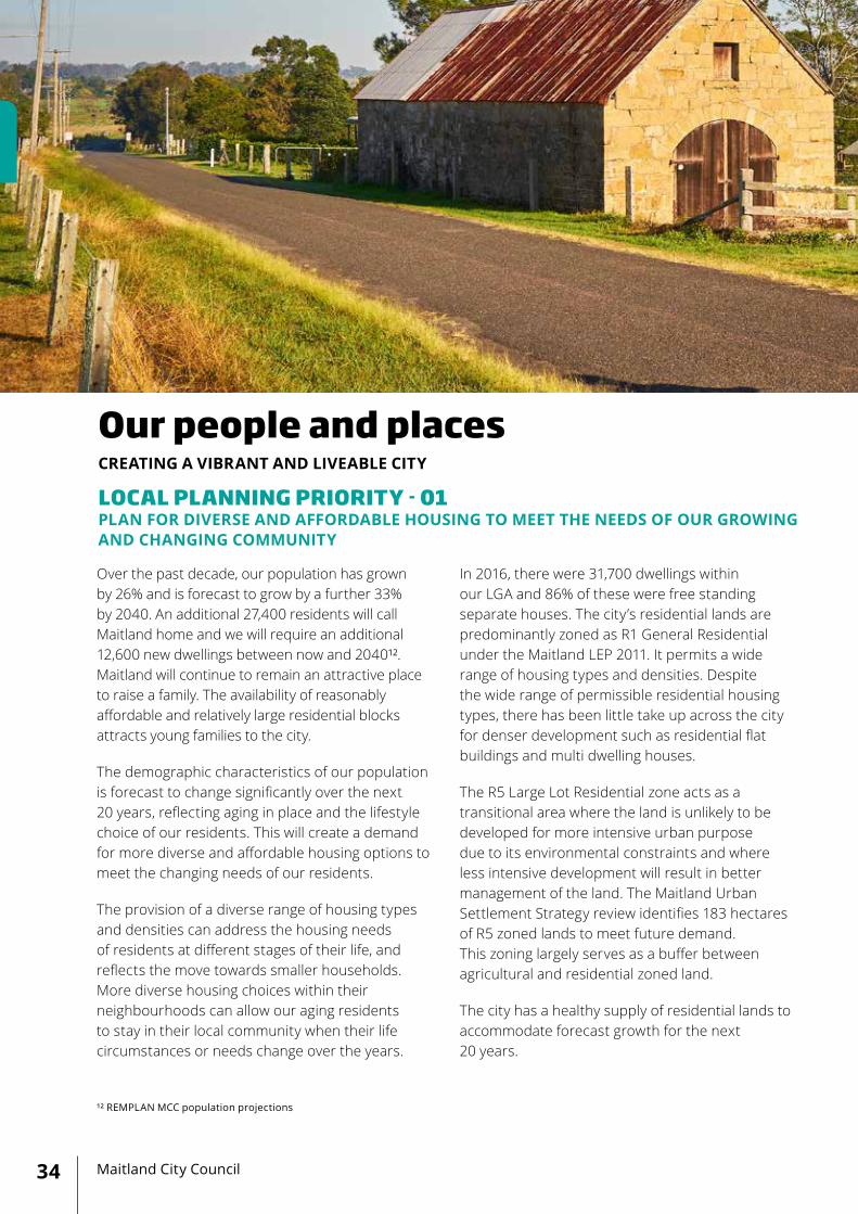
Over the past decade, our population has grown by 26% and is forecast to grow by a further 33% by 2040. An additional 27,400 residents will call Maitland home and we will require an additional 12,600 new dwellings between now and 2040¹². Maitland will continue to remain an attractive place to raise a family. The availability of reasonably affordable and relatively large residential blocks attracts young families to the city.
The demographic characteristics of our population is forecast to change significantly over the next 20 years, reflecting aging in place and the lifestyle choice of our residents. This will create a demand for more diverse and affordable housing options to meet the changing needs of our residents.
The provision of a diverse range of housing types and densities can address the housing needs of residents at different stages of their life, and reflects the move towards smaller households. More diverse housing choices within their neighbourhoods can allow our aging residents to stay in their local community when their life circumstances or needs change over the years.
In 2016, there were 31,700 dwellings within our LGA and 86% of these were free standing separate houses. The city’s residential lands are predominantly zoned as R1 General Residential under the Maitland LEP 2011. It permits a wide range of housing types and densities. Despite the wide range of permissible residential housing types, there has been little take up across the city for denser development such as residential flat buildings and multi dwelling houses.
The R5 Large Lot Residential zone acts as a transitional area where the land is unlikely to be developed for more intensive urban purpose due to its environmental constraints and where less intensive development will result in better management of the land. The Maitland Urban Settlement Strategy review identifies 183 hectares of R5 zoned lands to meet future demand. This zoning largely serves as a buffer between agricultural and residential zoned land.
The city has a healthy supply of residential lands to accommodate forecast growth for the next 20 years.
¹² REMPLAN MCC population projections

35Maitland Local Strategic Planning Statement 2040+
The GNMP 2036 sets a target for greenfield residential areas to achieve a minimum residential density of 15 dwellings per hectare with 25% of these being small lots. This will increase housing diversity and choices and improve affordability within the city.
Council supports infill housing opportunities within existing urban areas to encourage more efficient use of land with greater accessibility to public transport, community facilities and centres. Such developments need to respond to the existing local and neighbourhood character.
Over the past years, Council has observed that senior housing development proposals (under the Seniors Housing SEPP) within the urban rural interface, undermine the value and character of this interface. Council recognises that seniors housing is an important housing option for our aging population and encourages that they be located within existing urban areas or new release areas to encourage more efficient use of land with greater accessibility to public transport, community facilities, amenities and infrastructure. This also limits the amount of productive agricultural land which is lost to urban development without forming part of
Councils strategic vision for the city.
Council will prepare a Local Housing Strategy, which ties Council’s vision for diverse and affordable housing with the HRP 2036 and GNMP 2036. The proposed strategy will investigate and respond to housing diversity and choice, housing affordability, seniors housing, priority infill development areas and will include a strategic review of current residential zones and development standards in the LEP. The Strategy will outline where our future growth will occur, in what form and recommend changes to local plans to provide greater directions and certainty on future housing.
ACTIONS:
• Council will prepare a Local Housing Strategy.
• Council will continue to monitor residential land supply.
• Council will participate in the Hunter Urban Development Program.

Maitland City Council36
LOCAL PLANNING PRIORITY - 02 SUPPORT SUSTAINABLE HOUSING GROWTH BY BALANCING GREENFIELD AND INFILL HOUSING
The Maitland Urban Settlement Strategy (MUSS) 2012 manages urban growth in the city and controls urban land release through prioritisation of land for rezoning.
The recent review of the MUSS identifies that there is an estimated 20 years supply of residential zoned and planned land within the LGA. The MUSS recognises that there is limited potential for future residential greenfield development beyond the areas identified in the existing MUSS due to significant land use, infrastructure and environmental constraints.
Urban growth has continued through the progressive conversion of land along the rural fringe to urban purposes. This approach is not sustainable in the long term. Identification of urban growth boundaries and strategies to protect and manage land on the urban-rural interface will enable our community to continue to enjoy its scenic, cultural and environmental values for years to come. It will provide certainty to rural land uses while avoiding any potential land use conflicts.
In coming years, most of our growth is expected to occur in planned growth areas. Multiple and dispersed development fronts place concurrent demands on Council, NSW Government and service providers to expand urban infrastructure networks. This will result in increased infrastructure servicing costs and has a considerable impact on travel patterns and demand.
The estimated supply of greenfield residential lands, including those already zoned and planned, are providing an assurance to sustain our growth for the next 20 years. However, when viewed in conjunction with the desired outcome for increased densities on existing identified residential areas, there is the ability to expand the current 20 year dwelling supply well beyond 2040.
Recent developments have demonstrated a trend toward a greater proportion of infill housing types. Infill housing development typically increases demand on existing services and infrastructure, whereas greenfield development requires the delivery of new services and infrastructure.
Infill and urban renewal development will play a key role in facilitating our future growth. Infill will assist to diversify our housing stock and integrate housing with our centres, employment clusters or transport nodes and maximise access to existing infrastructure and services. It will support a more sustainable urban form that is less reliant on cars and provide for more walkable neighbourhoods, where active transportation links can be provided.
The city has a network of aging infrastructure within the established urban areas that needs to be maintained and upgraded to keep up with population growth. The capacity and reliability of these aging infrastructure assets limit the potential for infill development opportunities. It is necessary to better understand those limitations at the early stage in developing a new Local Housing Strategy to determine where our future infill development will occur and in what form.
Infill development needs to ensure that it positively contributes to local character, responds to its surrounding context, has quality design outcomes and provides a high level of amenities for future and current residents.
Increasing density around existing rail interchanges will make public transport more sustainable, housing more affordable and reduce carbon emissions through less vehicle usage.
ACTIONS:
• Council will prepare a Local Housing Strategy.

37Maitland Local Strategic Planning Statement 2040+
LOCAL PLANNING PRIORITY - 03 SUPPORT A PLACE BASED PLANNING APPROACH TO GUIDE BETTER PLANNING AND URBAN DESIGN OUTCOMES FOR OUR CENTRES AND NEIGHBOURHOODS
Maitland has a diverse range of places – from urban centres and suburban areas through to rural communities. Our community has expressed a strong desire to create vibrant places that celebrate the great lifestyle of Maitland.
Like many other regional cities in Australia, the private car became central to our city planning and neighbourhood design. As our city grows, it is necessary to find better ways to reduce car dependency while enhancing liveability and connectivity of our neighbourhoods.
Our future neighbourhoods need to be designed to encourage walking, cycling and access to public transport, with parks, neighbourhood shops, schools and our future local streets designed to connect these places.
To plan and manage future growth within our city, three distinctive local planning precincts have been identified:
• Central Maitland
• East Maitland
• West Maitland
The local precinct approach will be guided by walkable neighbourhood principles where our residents can access most of their daily needs locally, without using a car.
Our plan will focus on creating well connected and walkable neighbourhoods to build a more liveable and sustainable city. This approach aims to gradually shift away from a continuously expanding urban footprint to a focus on revitalising our existing centres and neighbourhoods. This will support jobs and services in accessible locations, support mixed use precincts and provide more housing options closer to public transport.
Planning for these precincts will be undertaken
using a place based planning approach. This approach enables local councils, state government departments and service providers to focus on the outcomes of a place rather than an individual project or a service. It leads to a more inclusive dialog about the future of a place and ensures that community priorities are reflected in future infrastructure and service delivery.
A place based planning approach will provide a targeted response to address spatial variations in socio-economic circumstances, particularly in neighbourhoods that experience greater disadvantages, by creating inclusive, welcoming and equitable environments. This approach will ensure these communities will have good access to public transport, jobs, community facilities and open spaces and provide a more cohesive neighbourhood.
ACTIONS:
• Council will prepare a report card of activities undertaken under the Central Maitland Structure Plan 2009.
• Council will prepare a Precinct Plan for West Maitland.
• Council will work in collaboration with the relevant NSW Government agencies including Hunter and Central Coast Development Corporation and Hunter New England Health for planning and development of East Maitland Catalyst Area.

Maitland City Council38
LOCAL PLANNING PRIORITY - 04 PROTECT, CONSERVE AND CELEBRATE THE CITY’S INDIGENOUS AND COLONIAL CULTURAL HERITAGE
Our community are proud of Maitland’s unique history and heritage. Our ambition is to conserve and enhance areas, buildings and natural features of architectural, historical and cultural values for our future generations. Council recognises that Aboriginal people have a spiritual and cultural connection with their lands and waters. Indigenous cultural heritage consists of places, traditions, beliefs, customs, values and objects that represent the living history of past generations and are of important cultural heritage.
As our city grows, heritage identification, management and interpretation are important to protect them from the potential impacts of future development. Council works together with local communities to protect and celebrate our city’s Indigenous and colonial cultural value.
Our civic history is reflected in the many historic buildings built in the mid-1800s, using local sandstone and cedar; and many of the original buildings are still standing. Council acts as a custodian of some of the city’s most significant places and buildings such as Maitland Gaol, Maitland Regional Art Gallery, Walka Water Works, Morpeth Museum, Morpeth Queens Wharf and the city’s historic Glebe and Jewish cemeteries.
In recognition and protection of heritage places, the Maitland LEP 2011 identifies over 240 heritage items and seven conservation areas. The LEP provides conservation incentives for the use of a heritage item or the land, to encourage adaptive reuse of heritage building and places. This enables private investments while protecting the integrity of the city’s heritage.
Maitland has over 527 recorded Aboriginal sites. Council recognises the important of our local Aboriginal community having a voice in the planning and decision making at the local level. In response to this, Council has recently established an Aboriginal Reference Group to enable effective and sustainable communication between
Council and the local Aboriginal community. The Aboriginal Reference Group provide input in to planning, development and implementation of Council policies, strategies and projects relating to Aboriginal cultural, community and heritage.
Due to resourcing and available expertise, the recent focus for heritage within the LGA has been on the urban built environment. However, Council is now proposing to undertake a review of non-urban zoned lands, to form the basis of a combined Rural Heritage and Aboriginal Heritage Study. This joint approach has been developed in conjunction with the Local Aboriginal Land Council. The outcomes of these studies will inform future changes to the local planning framework, as necessary.
Council will work with the Mindaribba Local Aboriginal Land Council to facilitate the implementation of its Community Land and Business Plan and help them to identify how their landholdings can be best planned, managed and developed.
ACTIONS:
• Council will undertake an LGA wide Aboriginal and Rural Heritage Study, in partnership with the Mindaribba Local Aboriginal Land Council.
• Council will review and update its heritage items and conservation areas listed in the Maitland LEP 2011.
• Council will prepare a Development Control Plan (DCP) on adaptive reuse of Central Maitland, as a part of the new State-wide DCP template.
• Council will continue to support revitalisation and adaptive reuse of heritage assets.

39Maitland Local Strategic Planning Statement 2040+
Maitland has diverse places with unique local character which significantly contribute to the amenity and liveability of the city and are highly valued by our community and visitors.
Future planning needs to maintain and enhance the local character by protecting heritage buildings, streetscapes, views, and other key tangible and intangible qualities of place and by encouraging future development to respect the scale, character and heritage of the area.
Council is committed to preserve and enhance the distinctive character of our centres and neighbourhoods by protecting historical suburbs, improving public domain and guiding reuse of historical buildings.
Council will ensure that our local planning framework is capable of retaining and enhancing the unique character and identity of places while managing future growth and change. This will be identified within a Local Character Study.
These Local Character Studies will look at areas that have a desirable character that should be maintained and protected, such as Morpeth and Lorn, a desirable character that can be built on and improved, such as Maitland and East Maitland, as well as those areas where a desirable and attractive character can be built upon, such as Telarah and Thornton.
It is vital to create a future character for our new centres and growing residential areas, drawn from its history, landscape and surroundings. Once they are developed and communities have been established, the character of these areas will evolve and adopt progressively over time in response to interactions and activities of the people who use them.
LOCAL PLANNING PRIORITY - 05 PRESERVE AND ENHANCE THE DISTINCTIVE LOCAL CHARACTER OF OUR CENTRES AND NEIGHBOURHOODS
WHAT IS LOCAL CHARACTER? WHAT IS PLACE?
Character is what makes a neighbourhood distinctive and it is the identity of a place. It encompasses the way a place looks and feels. It is created by a combination or land, people, built environment, history, culture and tradition, both Indigenous and non-indigenous, and it looks at how they interact to create an area’s character.
Place is the layout, division and form of environments, its patterns, landscape, density, development, land use and mix. These aspects set the groundwork for places to flourish.
(DPIE 2019, Local Character and Place Collection).
(DPIE 2019, Local Character and Place Collection).
ACTIONS:
• Council will prepare a Local Character Study and Local Character Statement.

Maitland City Council40
LOCAL PLANNING PRIORITY - 06 PLAN FOR HEALTHY, CULTURALLY RICH AND SOCIALLY CONNECTED COMMUNITIES
The built environment plays a key role in supporting active and healthy lifestyles. The planning and designing of our places and neighbourhoods need to provide direct, accessible and safe pedestrian and cycle ways. These can connect homes to schools, neighbourhood centres, and recreational and community facilities to encourage greater physical activity.
Our city’s cultural diversity is growing, with 13% of our residents born overseas and 9% speaking a language other than English at home. Council recognises cultural diversity as one of the city’s strengths and supports it through a wide variety of avenues and mechanisms outlined in the Maitland Cultural Plan 2016.
Council’s annual flagship events provide an opportunity to connect and celebrate our cultural diversity. Maitland Riverlights Multicultural Festival is a dynamic and colourful celebration of over 21 cultures through interactive stalls, dance, food, music and arts.
The city’s Aboriginal people and their connections to land make a valuable contribution to the city’s heritage and culture richness. In 2016, 4,100 residents identified as Aboriginal and/or Torres Strait Islander, which represents 5.3% of the population. This is significantly higher when compared to the NSW average of 2.9%. Council continues to work with local Aboriginal communities to strengthen and celebrate their culture and identity.
Socially connected communities are stronger, more resilient and share local values. As our city grows and changes, it is necessary to strengthen social connections within and between our diverse communities to build resilience through understanding and trust.
The place based precinct planning approach will build on the city’s cultural richness and diversity,
will support strong social connections and will give identity and distinctive character to our neighbourhoods and centres.
Skin cancer is the most common cancer in Australia and caused by overexposure to UV radiation from the sun. Across NSW, Ultra Violet (UV) radiation levels are high enough to damage unprotected skin for at least 10 months of a year. Well designed and correctly positioned shade, from both built structures and natural vegetation can reduce exposure to UV radiation. Council will assist in the provision of shade throughout its public and open spaces and will encourage for its provision in private development. Shade contributes to people feeling more comfortable in being outside and encourages walking and cycling while protects them from UV radiation.
The recently released NSW Government’s ‘Better Placed’ policy provides guidance for good design for built environments to ensure our cities are healthy, responsive, integrated, equitable and resilient. Council will review its DCP to incorporate this policy and will use it as a guiding document to inform Precinct Plans.
ACTIONS:
• Council will review its DCP provisions to implement the Design Objectives outlined in the Better Placed Policy, as a part of new State wide DCP template.
• Council will plan for healthy, culturally rich and socially connected communities through place based precinct planning.
• Council will review and update its DCP to enable effective consideration of well designed built and natural shades, consistent with the best practice.

41Maitland Local Strategic Planning Statement 2040+
Maitland City Council42
LOCAL PLANNING PRIORITY - 07 STRENGTHEN OUR LOCAL ECONOMY THROUGH ATTRACTING INVESTMENTS, CREATING JOBS AND FOSTERING INNOVATION
Maitland is a high growth metropolitan area and will be amongst the fastest growing centres in NSW over the next decade. Our city has a combination of strategic advantages in terms of population size and growth, accessibility to major markets, economic infrastructure and multiple freight corridors, which provide opportunities for further diversification of the local economy and for long term growth.
Health and social assistance is one of the strongest and fastest growing sectors in our economy. An aging population and increase in life expectancy will place more demand on this sector. Maitland is an emerging destination for regional education and is home to primary, secondary and tertiary education facilities including the Tocal College, the Hunter Institute of Technology (TAFE) and the Hunter Valley Training Company (privately owned and Australia’s largest group trainer).
Employment trends indicate that these sectors will continue to grow and provide jobs to our growing community.
The visitor economy is an important contributor to our local economy. There are opportunities to grow and diversify the visitor economy, as a consequence of the improved connectivity with Sydney, Newcastle and beyond to the emerging Asian tourism economy.
The growing visitor economy needs to be supported by developing new tourism products which offer a diverse range of experiences to visitors, including agri-tourism and quality short term accommodation within the city.
Council is currently developing a Destination Management Plan (DMP) as a collaborative roadmap for building and managing Maitland’s
visitor economy and taking a more holistic and integrated approach to the visitor economy.
Council proposes to develop an Economic Development Strategy (EDS) to capitalise on its existing strengths and new opportunities in the region, including its competitive advantages as outlined in the Hunter Regional Economic Development Strategy 2018-2022, GNMP 2036 and HRP 2036. In addition, it will identify opportunities for our city to invest in smart city, innovation and night time economy as a part of the strategy.
Council will continue to facilitate our city economy through developing partnerships and opportunities that enhance and strengthen iconic events, distinct local attractions and the use of major venues.
Economic development and jobs growth in our city will be underpinned by planning frameworks that deliver certainty of land use for industry investment. The proposed EDS and DMP will explore future prospects and consider planning and regulatory impediments to economic development.
ACTIONS:
• Council will prepare an Economic Development Strategy.
• Council will prepare a Destination Management Plan.
• Council will continue to implement its annual flagship events, in partnership with other stakeholders.
Our economyCREATING AN INNOVATIVE AND PROSPEROUS CITY

43Maitland Local Strategic Planning Statement 2040+
OUR EXISTING CENTRES HIERARCHY:
Strategic Centre: Central Maitland, East Maitland
Town Centre: East Maitland, Lochinvar, Rutherford, Thornton
Local Centre: Chisholm, Lorn, Morpeth, Telarah, Gillieston Heights
Neighbourhood Centre: Largs, Lochinvar, Metford, Tenambit, Woodberry, Farley, Anambah
LOCAL PLANNING PRIORITY - 08 ENCOURAGE VIBRANT AND CONNECTED CENTRES THROUGH A CLEARLY DEFINED CENTRES HIERARCHY
Our city has a network of centres which provide local jobs and services for our growing population. It is important to retain and promote the key role, functions and character of our centres for the of benefit our growing community and economy.
In 2010, Council adopted the Activity Centres and Employment Clusters Strategy 2010 which provides a logical hierarchy of activity centre and guides future land use and development decisions. An initial review of this 2010 Strategy was undertaken in 2016 and it reveals that the centre hierarchy and its recommendations broadly remain relevant to date.
The GNMP 2036 identifies Central Maitland and East Maitland as the fastest growing regional strategic centres in NSW. Both of these centres have the potential to accommodate significant growth in the economy and become important residential, employment and entertainment precincts.
Each centre will have their own distinctive character and will be easily accessed by walking, cycling and public transport.
Our centres have evolved over time in response to changing retail experience with online shopping and changing consumer preferences. They will continue to evolve into the future with the new economy, leveraging the existing strengths of each centre.
Council will undertake a strategic review of its Centres Strategy and evaluate the centre hierarchy (established, emerging and planned), including its role, function, capacity and viability of our centres.
ACTIONS:
• Council will review its Activity Centres and Employment Clusters Strategy 2010 and prepare a new Centres Strategy.

Maitland City Council44

45Maitland Local Strategic Planning Statement 2040+
Maitland has a total of 608 hectares of zoned employment lands, 251 hectares of this is currently zoned and undeveloped¹². Council’s MUSS 2012 identifies some additional lands for future needs which are currently under investigation. The accessibility for multiple freight corridors continues to generate a high level of demand for urban and industrial land use activities to support the city’s growing economy.
Thornton and Rutherford are major industrial clusters located within our city. Anambah Business Park and Racecourse Business Park at Rutherford have a substantial amount of established industrial land that are predominantly used for transport, manufacturing and mining support and heavy industries. Thornton Industrial Estate is home to large manufacturing, freight, and warehouse businesses.
The proposed Rutherford Park Freight and Business Centre, near Rutherford aerodrome will attract new investments and businesses and will create jobs to support forecast growth within the Western Precinct. It is well located with good potential links to both the New England Highway and the Hunter railway line.
Our industrial areas are home to a number of businesses that support the mining industry in the Hunter Coalfield. Given broader market trends, it is anticipated that the coal industry will undergo some significant changes, and our local economy will need to develop a transition strategy to cater to new business models that that emerge from an energy transition.
Our existing industries will change and adopt to new technologies and processes to support new economies and create new jobs for our growing community.
Council will undertake an Industrial Land Audit to thoroughly understand current land use activities within our industrial areas. This audit will inform the proposed Industrial and Employment Lands Strategy which will provide a framework to retain the economic viability of our industrial and employment lands and will guide future land use changes.
LOCAL PLANNING PRIORITY - 09 ENSURE A SUITABLE SUPPLY OF INDUSTRIAL AND URBAN SERVICE LANDS TO MEET FUTURE NEEDS
ACTIONS:
• Council will undertake an Industrial Land Audit.
• Council will prepare an Industrial and Employment Lands Strategy.
• Council will protect the existing and future industrial and urban services lands from encroachment by sensitive land uses.
¹² DPIE's Employment Lands Development Monitor.

Maitland City Council46
LOCAL PLANNING PRIORITY - 10 PROTECT, CONSERVE AND ENHANCE OUR NATURAL ENVIRONMENT INCLUDING WATERWAYS, FLOODPLAINS AND WETLANDS
Our city’s natural environment has changed significantly since colonial settlement, now less than 7% of our remnant native bushland remains within the city.
The Maitland Greening Plan, adopted in 2002, acknowledges the fragmented nature of vegetation in the Maitland LGA and focuses on protecting existing vegetation, whilst rehabilitating and restoring wetlands, riparian and biodiversity corridors. Since its implementation, over 250,000 native seedlings have been planted within the city.
The Hunter River is one of Maitland’s greatest natural assets and its extensive floodplain provides a natural boundary for urban growth. Floods have a significant benefit to our natural environment, including delivery of water to flood dependent ecosystems and improving soil nutrients for agricultural land on the floodplain. The alluvial soils of the city’s floodplain and related land uses will need to be protected for the future as our city grows.
The Hunter River, Paterson River and Lochinvar, Wallis, Swamp-Fishery, Stony, Mile Creeks are our key urban waterways and form a part of city’s landscape. Maitland retains a variety of significant wetland habitats including Tenambit, Woodberry, Wentworth and Dagworth Swamps. The Woodberry Swamp is classified as a SEPP (Coastal Management) 2018 wetland in recognition of its environmental significance to the region.
As our city grows, so does the area of hard surfaces
and urban stormwater runoff which can impact on our waterway health. Council will continue to encourage a Water Sensitive Urban Design approach to urban stormwater management to capture and treat stormwater before it reaches our waterways.
Our waterways and wetlands extend beyond our LGA boundary and require a catchment wide approach to protect and improve their health. Council will work with the relevant regional alliances, adjoining local councils and other stakeholders to improve the health of waterways.
Council proposes to develop an overarching Environmental Strategy, incorporating our 2002 Greening Plan to protect, conserve and enhance our natural environment.
ACTIONS:
• Council will develop an Environmental Strategy to protect, conserve and enhance our natural environment.
• Council will review its DCP provisions to enhance water quality and waterway health to achieve ecological sustainable outcomes and water sensitive urban design principles.
• Council will continue to work with the adjoining local councils to improve the health of waterways and wetlands which extend beyond the Maitland LGA.
Our environmentCREATING A RESILIENT AND SUSTAINABLE CITY

47Maitland Local Strategic Planning Statement 2040+
LOCAL PLANNING PRIORITY - 11 PROTECT OUR CITY’S RURAL LANDS, NATURAL ASSETS AND RURAL LANDSCAPE
Maitland's rural land is important, providing local fresh produce and employment to our local community. The city’s iconic rural landscape has strong cultural, historical, recreational and aesthetic connections for the local community.
Maitland Rural Lands Strategy 2005 aims to maintain the economic viability of agriculture and to protect the natural, ecological and scenic quality of the rural environment.
Rural lands are predominantly zoned as RU1 Primary Production zone and RU2 Rural Landscape zone which are aimed to utilise the natural resource base in a sustainable manner. Both these zones promote and complement a stronger agriculture sector by permitting a range of niche commercial, tourist and recreation activities.
For the great part of our city history, Maitland has been recognised for its agricultural and natural resources. Our rural land has evolved and will continue to evolve with technological advancements, diminishing of natural resources and changing climate.
Long term planning for our city will need to protect our rural land to provide food and water security and ensure our natural resources are managed sustainably for our current and future generations.
The view corridors (outlined in the Structure Plan) form a part of the city’s extensive floodplain which provides a natural boundary for urban growth and unique character to the city. The preservation of these view corridors within the city and rural landscape has become increasingly important, as our city grows.
Council proposes to review and update its 2005 Strategy. The new strategy will create a framework to protect and manage rural lands with its scenic, cultural and environmental values for years to come. It will support to create a productive rural economy, optimise the future economic development opportunities and provide certainty to rural land uses while avoiding any potential land use conflicts.
Tocal College, a renowned agricultural training and education facility is located within the Maitland LGA and aims to grow the capacity and productivity of the agricultural workforce to meet the needs of a changing agricultural sector. Council will work with the Tocal College to optimise its future prospects within the region and to support our economy and workforce.
ACTIONS:
• Council will review its Maitland Rural Land Strategy 2005 and prepare a new Rural Lands Strategy.
• Council will work with the Tocal College to implement their future plans.

Maitland City Council48
LOCAL PLANNING PRIORITY - 12 PLAN FOR A RESILIENT CITY THAT CAN ADAPT TO NATURAL HAZARDS AND CHANGING CLIMATE
Our climate is changing. Climate related impacts are already being observed on our community, environment and economy. These include increased threats from natural hazards such as flooding, bushfire, droughts and storms with high winds. More frequent and more extreme climatic events are likely.
Minimisation of risk exposure and improved resilience to natural hazards are fundamental objectives of our local plans. A proactive approach to address climate change with minimal disruption to lives, infrastructure and economy will enable our built environment to respond and be resilient during natural hazard events, and ultimately reduce recovery cost from the event.
Climate change has the potential to damage assets and disrupt service delivery. Council will continue to adopt policies and practices in relation to climate change mitigation and adaptation, targeting both council operations and services to the community. This will enable our communities to be better prepared and more resilient.
Council will work with the NSW Government to achieve its net zero emission target by 2050 to make NSW more resilient to a changing climate. Council is actively participating in regional climate change initiatives and programs undertaken by the Hunter Joint Organisation in building awareness of climate change risk and responding to it at both regional and local scales.
In developing an overarching Environmental Strategy, Council will undertake a review of local plans, strategies and initiatives related to climate change. Further consideration will be given to emerging policy settings and actions to address climate change to maximise the economic, social and environmental wellbeing of the city.
Floods
Development in the floodplain needs to be carefully managed, now and into the future. We need to take account of the cumulative impacts of growth across the floodplain. Our city has a unique flood risk; therefore a bespoke risk based approach needs to be considered taking into account the largest possible flood, flood height, evacuation capacity and ability to recover from a flood event. This approach can result in an adaptive growing community that is more resilient to flooding.
Maitland LEP 2011 and DCP identify controls for managing the development of flood prone land. Decisions on where and how to develop a floodplain are important. Once a decision has been made to develop an area of the floodplain, applying development controls has only a limited ability to manage growth in flood risk. Considering flood related constraints early in the strategic planning process can encourage development on land that is less exposed to flooding and where flood risk is more easily managed.
Council has completed the Hunter River Flood Study 2010, Floodplain Risk Management Study and Plan 2015, Paterson River Flood Study 2017, Wallis and Swamp-Fishery Creeks Flood Study 2019 and Lochinvar Creek Flood Study 2019. These studies provide a strong evidence base to inform decision making.
Bushfire
The Maitland DCP 2011 seeks to minimise the risk to people and properties from bushfire by minimising any increased densities on land identified as bushfire prone.
Council’s bushfire prone mapping dates back to 2006. The RFS has recently released an updated guideline on ‘Planning for Bushfire Protection 2019’. The key changes are a stronger emphasis on strategic planning with a focus on human life as well as property protection. Council will review and update its bushfire prone land mapping.

ACTIONS:
• Council will continue to undertake local catchment flood studies in a timely manner and update relevant planning controls.
• Council will review and update its DCP to enable effective consideration of natural hazards, impacts of changing climate, adaptable and resilient buildings consistent with best practice.
• Council will update its bushfire prone land mapping in accordance with the NSW RFS ‘Guide for Bushfire Prone Land Mapping 2015'.
• Council will work with the State Government to contribute to their stated goal of net zero carbon emissions by 2050, through the preparation of our Environmental Strategy.
• Council will continue to participate in regional climate change initiatives and programs undertaken by the Hunter Joint Organisation.
49Maitland Local Strategic Planning Statement 2040+

ACTIONS:• Council will undertake an assessment
of local Blue and Green Grids.
• Council will continue to implement adopted 2017 Masterplan and Plan of Management for Queens Wharf.
• Council will finalise and implement the Lorn Riverbank Masterplan.
• Council will protect and enhance biodiversity corridors identified in Council’s Greening Plan and LSPS in future planning of greenfield development and investigation areas.
Maitland City Council50
LOCAL PLANNING PRIORITY - 13 IMPROVE THE ACCESSIBILITY AND CONNECTIVITY OF OUR CITY’S GREEN AND BLUE GRID
The Green and Blue Grid is an interconnected network of 'Green' spaces including local parks, playgrounds, playing fields and 'Blue' spaces including wetlands, rivers and creeks. Well integrated and connected grids improve liveability and sustainability by protecting biodiversity, improving waterway health and help communities adapt to climate change.
The Blue and Green Grid promotes walking and cycling by connecting our centres, employment clusters and residential areas and links them to our recreation areas, parks, schools and waterways.
The Hunter River is one of Maitland’s greatest natural and recreational assets. In 2014, Council identified the Lorn Riverbank and Morpeth Queens Wharf as potential sites for access to the Hunter River for recreational purposes.
Morpeth’s Queens Wharf was an important river port during the early colonial settlement. In 2017, Council adopted a Masterplan and Plan of Management for Queens Wharf, which provides a strategic framework for conserving the site’s historical heritage and cultural values while promoting public recreation aspects.
Finalisation and implementation of the Lorn Riverbank Masterplan is a key priority identified in the Council’s Delivery Program 2018-2021 to provide a vision for the long term development and management of the Hunter Riverbank.
The Central Maitland Structure Plan 2009 proposes to enhance the connection to the Hunter River introducing the ‘River Walk’ in Central Maitland and Lorn, with a staged extension to Morpeth. The recently, completed Riverlink Building connects The Levee precinct to the riverbank, enabling our community to connect with the waterfront.
Urban trees contribute to local character and amenity of the area and form a part of our broader Green Grid. There are some established residential suburbs that have mature trees with a high level of urban canopy cover, which contributes to their local
character and amenity. These trees provide urban cooling and encourage people to be more active outside in their neighbourhoods.
However, many newly developed suburbs have low level of trees and are particularly vulnerable to the urban heat island effect. New urban residential growth areas need to retain existing mature trees, where possible and plant more native trees within the new areas. Established areas need to maintain existing trees and plant more trees to connect to our broader Green Grid.
Tree planting in both the public and private realm is important to improve the liveability and appearance of our city and makes our community more resilient to extreme weather events.
The Great Eastern Ranges is an important regional fauna and flora habitat and movement corridor along the east coast of Australia. In the Hunter Valley region, and Maitland in particular, the corridor is narrower and lower than in other parts of the corridor, forming a unique ‘gap’. Therefore, our local habitat corridors should be retained, and prioritised for investing in conservation to sustain habitat connectivity and linkages.

51Maitland Local Strategic Planning Statement 2040+
LOCAL PLANNING PRIORITY - 14 MANAGE ENERGY, WATER AND WASTE EFFICIENTLY TO SUPPORT SUSTAINABILITY
As our city grows, so too does the demand for water and energy. A growing population and increasing individual consumption means that the amount of waste we generate is also increasing.
The Maitland DCP 2011 establishes a framework for facilitating effective waste minimisation and waste management from development in a manner consistent with the principles of Ecological Sustainable Development.
Council’s Integrated Resource Recovery and Waste Management Strategy 2005 provides a direction for waste management into the future and acknowledges the ever changing nature of waste management.
Council is a stakeholder in the Hunter Joint Organisation of Council’s Waste Avoidance and Resource Recovery Strategy 2017. Council is working together with other local councils to reduce waste generation and improve waste diversion.
Reuse, recycling and recovery of waste will improve sustainability in resource use and reduce the environmental impacts of waste. Council is proposing to develop a new waste transfer and recycling facility to extend the limited life of the existing Mount Vincent Waste Management Centre. This facility will enable Council to increase waste segregation and recycling which in turn will reduce the amount of waste requiring transportation and landfill disposal.
Waste outcomes that are safe, efficient, cost effective, maximise resource recovery, encourage waste avoidance, and that contribute to the built form and liveability of the community are desirable. This can be provided by well-planned waste and circular economy infrastructure that is responsive to future needs, and provides equitable access to waste, reuse, sharing and recycling services.
ACTIONS:
• Council will review its Integrated Resource Recovery and Waste Management Strategy 2005 and other initiatives as a part of the proposed Environmental Strategy.
• Council will advocate for long term planning for water security to ensure a sustainable water supply.
• Council will advocate for long term planning for energy security to support our growing city economy.
• Council will construct and operate the new waste transfer and recycling facility.
• Council will continue to support the circular economy, together with other stakeholders.
• Council will review its DCP to implement best practice approaches to support efficient energy, water and waste systems in new developments.

As our population grows, it requires additional new infrastructure and upgrading of existing infrastructure to enable our city to be liveable and productive.
Infrastructure is one of the key priorities for our community. Infrastructure planning and delivery needs collaboration between all levels of government, service providers, private sector and community.
In coming years, most of our city’s growth is expected to occur in planned growth areas, across multiple development fronts. This places concurrent demand to expand urban infrastructure and makes servicing these areas more complex.
In our Western Precinct, the population is projected to double within the next 20 years. Rapid population growth creates challenges that are already clear to the existing residents in the Western Precinct. Rising traffic congestion, lack of open space, sportsground and community facilities have already emerged as key issues during engagement with the community.
The provision of open space for our community is integral to the health and wellbeing outcomes of our residents. Council manages a range of active and passive open spaces across the city and most of these open spaces play a region wide role and are at or near capacity with limited space for growth.
There is currently a shortfall in infrastructure provision which is not matching the existing population growth in the city. The current Council budget and development contributions are not keeping pace with the infrastructure needs of the growing population in some areas.
A long term strategy to manage and provide infrastructure and services to the city is fundamental to fully capture its population growth potential and is critical to its economic future and resilience.
Road Network Our local roads need to be a safe, efficient and reliable network for supporting growth in population and employment. The forecast growth presents a challenge to the local road network.
The existing road network relies heavily on the New England Highway and is under significant pressure from traffic growth from new urban development in and around Maitland. The majority of our new residential areas are located away from the existing public or active transport options such as railway stations, bus interchanges or cycleways and therefore, there is a heavy reliance on private vehicles. These areas rely on direct access to the New England Highway to connect to the wider area.
Local roads provide access within residential areas, however access and connectivity between our suburbs, is further constrained by the existing rail corridor, river and floodplains. As a result, our residents drive in towards the highway and then travel along the highway in order to reach their destination.
The increasing traffic congestion along the New England Highway is of key concern to our community. As our population grows, we need to improve our road corridors to meet future transport and traffic demand.
The Maitland Integrated Land Use and Transport Study 2008 (MILUTS) provides a strategic road and transport framework to accommodate the city’s expected population growth with consideration of land uses and urban characteristics. The southern bypass road was one of the recommendations in the MILUTS to relieve traffic on the New England Highway.
Maitland City Council52
LOCAL PLANNING PRIORITY - 15 ALIGN LOCAL INFRASTRUCTURE DELIVERY TO SUPPORT PLANNED GROWTH AND COMMUNITY NEEDS
Our infrastructurePLANNING FOR INFRASTRUCTURE TO SUPPORT A LIVEABLE, PRODUCTIVE AND SUSTAINABLE CITY
In 2018, Transport for New South Wales (TfNSW) prepared the Maitland Network Strategy 2018 in partnership with Council to develop a holistic network plan to enable future transport connectivity, efficiency and safety for the Maitland road network. This plan also emphasised the need for alternative local roads for local trips.
Further investigations are required to determine the need for the southern bypass road or alternative local roads to improve access from our western suburbs to the eastern suburbs for local trips to reduce reliance on the New England Highway. Studies would need to consider forecast population growth at precinct level, optimal connectivity between suburbs, improving pedestrian and cycling connections to centres, suburbs, schools, employment clusters, and minimisation of congestion and constraints to the national road network.
The form of our vehicles and the way we use them are changing. Our future vehicles will be autonomous, electric, connected or shared, and we need to ensure that our local road network can be adapted to support this transition and create great places for our community.
Education
Maitland is home to 36 schools and major training and education facilities such as the Tocal College, the Hunter Institute of Technology (TAFE) Maitland Campus and the Hunter Valley Training Company.
With the continued growth of our population, there will be an increasing demand on our local schools. There is a need for new educational facilities and the upgrading of existing facilities to continue to provide quality education to our community.
Council will work with the NSW Government to ensure that our existing educational facilities are expanded, and new facilities are constructed in a timely manner to meet the demand.
Health
Health and social assistance is one of the largest and fastest growing sectors in our LGA, supporting
4,650 jobs. Health facilities and services are needed in response to our growing and aging population.
The NSW Government is investing in the new Maitland Hospital and it is now under construction. The emerging East Maitland health precinct around the new Maitland Hospital, together with the Maitland Private Hospital will provide contemporary healthcare facilities to meet the needs of the growing local and regional communities well into the future.
Energy, water, wastewater and telecommunication infrastructure The delivery of new and upgraded essential infrastructure and services such as energy, water, wastewater and telecommunication are required to support our growing population.
Council will continue to work with the relevant NSW Government’s agencies, Hunter Water and other service providers to ensure the timely delivery of enabling infrastructure and services.
53Maitland Local Strategic Planning Statement 2040+
ACTIONS:• Council will work with the NSW
Government to ensure the new Maitland Hospital is delivered alongside with the supporting infrastructure.
• Council will work with the NSW Government to ensure that our existing educational facilities are expanded, and new facilities are constructed in a timely manner to support planned growth.
• Council will work with Transport for NSW to address the increasing traffic congestion along the New England Highway corridor and investigate the need for the southern bypass road.
• Council will work with relevant stakeholders to ensure the timely delivery of enabling infrastructure and services.
• Council will review and update its development contribution plans.

Maitland City Council54
Transport infrastructure is critical to retain the liveability and productivity of our city. It is fundamental that our transport infrastructure is planned and delivered in a timely manner to ensure connections within our city, metro region and beyond.
Public transport reduces the need for our residents to drive, and together with pedestrian and cycling connections to our centres, suburbs, employment clusters and schools, will support more sustainable travel options.
Maitland is serviced by a local bus network and a heavy rail line. The new housing release areas have been located away from the existing railway stations and bus interchanges and significantly rely on private vehicles due to the distance from public transport options.
Public transport provision has not kept pace with the city’s growth. Like many other regional cities in Australia, the majority of travel is by private car, which accounts for 82% of all journeys to work in Maitland.
There are significant opportunities to improve our public transport options, building on the existing rail infrastructure which provides good coverage within the Maitland LGA. Increased residential densities around existing railway stations within the urban centres will support in reducing car dependency and contribute to a more sustainable city. Faster and more frequent train services, together with commuter car parking at railway stations will significantly improve the use of the railway to travel to Newcastle and Sydney.
It is important to plan for future public transport options for the Western Precinct which will accommodate the majority of our future growth over the next 20 years. There are opportunities to take advantage of existing railway infrastructure at Aberglasslyn and Rutherford.
Council will continue to support potential integrated and modern transport solution for the city including on demand transport, shuttle bus services, ride sharing, autonomous vehicles, combined with bus and rail networks.
LOCAL PLANNING PRIORITY - 16 IMPROVE ACCESS TO, FROM AND WITHIN THE CITY, AND ENCOURAGE PUBLIC AND ACTIVE TRANSPORT TO CONNECT PEOPLE AND PLACES

Well connected active transport networks support healthy lifestyles of our residents. Council will continue to extend walking and cycling pathways, connecting our centres, employment clusters and open spaces.
The Maitland Bicycle Plan and Strategy 2014 aims to provide a safe and appropriate bicycle network that connects the community with employment clusters, shops, schools, services and amenities. The plan is currently under review.
Council is currently working in partnership with TfNSW to develop a 'Maitland Place Plan', building on the Movement and Place Framework to improve the functions of our transport corridors and to enhance the amenity of our places. It acknowledges that our street environment needs to provide different functions such as moving people and goods while also being destinations for people.
This plan will develop a shared vision and outcomes, including an integrated transport network to improve access to – from and within key centres and precincts by all modes.
This framework includes developing active transport network and initiatives for behaviour
changes for sustainable travel, identifying deficits and designing tools to support growth and travel demand.
The Movement and Place Framework assists in guiding the development of Place Plans to achieve a shared vision across the stakeholders.
ACTIONS:
• Council will work with TfNSW and other stakeholders to develop a Place Plan for Maitland LGA, focusing on the Eastern, Western and Central Precincts.
• Council will review its Maitland Bicycle Plan and Strategy 2014.
• Council will advocate for electrification of the Hunter Line to Telarah.
• Council will advocate for more reliable, frequent and connected public transport services.
• Council will review MILUTS 2008, following the completion of Maitland Place Plans.
55Maitland Local Strategic Planning Statement 2040+

Maitland City Council56
Our community infrastructure provides space and opportunity for our community to come together to share, learn and celebrate. Access to good quality and adequate community infrastructure is key to the health and wellbeing of our residents.
Council provides a range of community facilities and services across the city including sporting fields, aquatic centres, parks and libraries to meet our community needs.
As our population grows, there will be increased demand on existing facilities and services and, additional infrastructure will be required to meet the needs of our community and to enhance the liveability of our city.
Council manages a diverse range of public parks and reserves across the city. Most of these open spaces play a region wide role and are at or near capacity with limited space for growth. A well connected network of open space contributes to liveability and the amenity of our city.
Council is currently reviewing its 2004 Recreation and Open Space Strategy and 2012 Maitland Community Facilities and Services Strategy. Council proposes to develop a new Community Infrastructure Strategy to provide the evidence base for future planning of community infrastructure to meet the needs of our changing and growing community.
The proposed strategy will investigate opportunities to enhance the use of existing open space and will plan and deliver new community infrastructure in strategic locations through collaboration and partnerships. The strategy will also consider the potential for a ‘community hub’, an integrated and multi-purpose facility that offers a range of co-located services within a single facility.
In future planning of our community infrastructure, it is necessary to consider our city’s role as a regional centre and its wider catchment beyond our LGA, to be able to maximise the potential use of such facilities. The proposed strategy will establish a hierarchy for community infrastructure across the city, local, district and city wide.
LOCAL PLANNING PRIORITY - 17 PROVIDE GOOD QUALITY, ACCESSIBLE AND APPROPRIATE COMMUNITY INFRASTRUCTURE ACROSS THE CITY
ACTIONS:
• Council will prepare and implement a new Community Infrastructure Strategy.

LOCAL PLANNING PRIORITY - 18 WORK COLLABORATELY TO DELIVER INFRASTRUCTURE AND SERVICES TO SUPPORT PLANNED GROWTH
Our community welcomes growth and change and has identified infrastructure as a key priority. Infrastructure is essential for the liveability and productivity of our city. Infrastructure underpins services that support the productivity of our city and supports our community wellbeing.
Infrastructure planning and delivery needs to be a collaborative process between all levels of government, service providers, the private sector and community.
Council will continue to work with NSW Government agencies and other stakeholders to ensure that our residents will have appropriate levels of infrastructure and services to meet their needs.
Within the community, there is a widespread perception that the provision of infrastructure has not kept pace with the rate of development in some areas. Despite the current Council budget and developer contributions, there is a shortfall between the infrastructure needs and what can be provided by Council.
The provision of open space for our community is integral to health and wellbeing outcomes of our residents. Council manages a range of active and passive open spaces across the city and most of these open spaces play a region wide role and are at or near capacity with limited space for growth.
As an example, our Western Precinct's population is projected to double within the next 20 years. Rapid population growth creates challenges that are already clear to the existing residents. Rising traffic congestion, lack of open space, sportsgrounds and community facilities have already emerged as key issues during engagement with the community.
Council is continuing to focus on increasing grant revenue, taking opportunities where practical and possible to secure grant funds to enable the delivery of key infrastructure.
The existing four libraries within the city are relatively small when compared to their respective population catchment basis. There is a 60% shortfall in total floor space. Council will continue to advocate for the NSW Government to address the growing backlog in our facilities such as libraries and schools.
ACTIONS:
• Council will continue to work with the NSW Government’s agencies, developers and other stakeholders to ensure that our residents will have appropriate levels of infrastructure and services to meet their needs.
• Council will continue to apply for grant funds to enable the delivery of key community infrastructure.
• Council will continue to advocate for the NSW Government to address the growing backlog in our facilities such as libraries and schools.
57Maitland Local Strategic Planning Statement 2040+

Maitland City Council58
The Maitland LSPS 2040+ sets a framework for our growth and change over the next 20 years. It outlines the transformation of our city and ensures that it will continue to grow sustainably, socially, economically and environmentally.
The Statement identifies 18 local planning priorities and 54 actions. The actions outlined in this Statement require a significant level of collaboration and partnership with local and state governments, community, service providers and businesses.
In addition, the Statement requires a coordinated and a whole of organisation approach within the Council to deliver the above actions.
Council has identified the following timeframe for the actions outlined in the Maitland LSPS 2040+.
• Immediate (2020-2022)
• Short term (2020-2025)
• Medium term (2025-2030)
• Ongoing
6.0 Implementation and monitoring
LOCAL PLANNING PRIORITIES ACTIONS TIMEFRAME RESPONSIBILITY
OUR PEOPLE AND PLACES
1. Plan for diverse and affordable housing to meet the needs of our growing and changing community.
a. Prepare a Local Housing Strategy.
b. Monitor residential land supply.
c. Participate in the Hunter Urban Development Program.
Immediate
Ongoing
Ongoing
MCC
MCC
DPI&E, MCC
2. Support sustainable housing growth by balancing greenfield and infill housing.
a. Prepare a Local Housing Strategy. Immediate MCC
3. Support a place based planning approach to guide better planning and urban design outcomes for our centres and neighbourhoods.
a. Prepare a report card of activities undertaken under the Central Maitland Structure Plan 2009.
b. Prepare a Precinct Plan for West Maitland.
c. Work in collaboration with the relevant NSW Government agencies for planning and development of East Maitland Catalyst Area.
Short term
Short term
Short term
MCC
MCC
HCCDC, HNEH, DPI&E, TfNSW, MCC

59Maitland Local Strategic Planning Statement 2040+
4. Protect, conserve and celebrate the city’s Indigenous and colonial cultural heritage.
a. Undertake an LGA wide Aboriginal and Rural Heritage Study, in partnership with the Mindaribba LALC
b. Review and update heritage items and conservation areas listed in the Maitland LEP 2011.
c. Prepare a DCP on adaptive reuse of Central Maitland, as a part of the new state wide DCP template.
d. Continue to support revitalisation and adaptive reuse of heritage assets.
Short term
Short term
Short term
Ongoing
MCC, Mindaribba LALC
MCC
MCC
MCC
5. Preserve and enhance the distinctive local character of our centres and neighbourhoods.
a. Prepare a Local Character Study and Local Character Statement.
Short term MCC
6. Plan for healthy, culturally rich and socially connected communities.
a. Review DCP provisions to implement the Design Objectives outlined in the Better Placed Policy, as a part of new state wide DCP template.
b. Plan for healthy, culturally rich and socially connected communities through place based precinct planning.
c. Review and update DCP to enable effective consideration of well-designed built and natural shades, consistent with the best practice.
Short term
Ongoing
Short term
MCC
MCC
MCC
OUR ECONOMY
7. Strengthen our local economy through attracting investments, creating jobs and fostering innovation.
a. Prepare an Economic Development Strategy.
b. Prepare a Destination Management Plan.
c. Continue to implement MCC annual flagship events, in partnership with the other stakeholders.
Immediate
Immediate
Ongoing
MCC, Local businesses
MCC, Destination NSW, Tourism industryMCC, Local businesses
8. Encourage vibrant and connected centres through a clearly defined centres hierarchy.
a. Review Activity Centres and Employment Clusters Strategy 2010 and prepare a new Centre Strategy.
Short term MCC
9. Ensure a suitable supply of industrial and urban service lands to meet future needs.
a. Undertake an Industrial Land Audit.
b. Prepare an Industrial and Employment Lands Strategy.
c. Protect the existing and future industrial and urban services lands from encroachment by sensitive land uses.
Short term
Short term
Ongoing
MCC
MCC
MCC
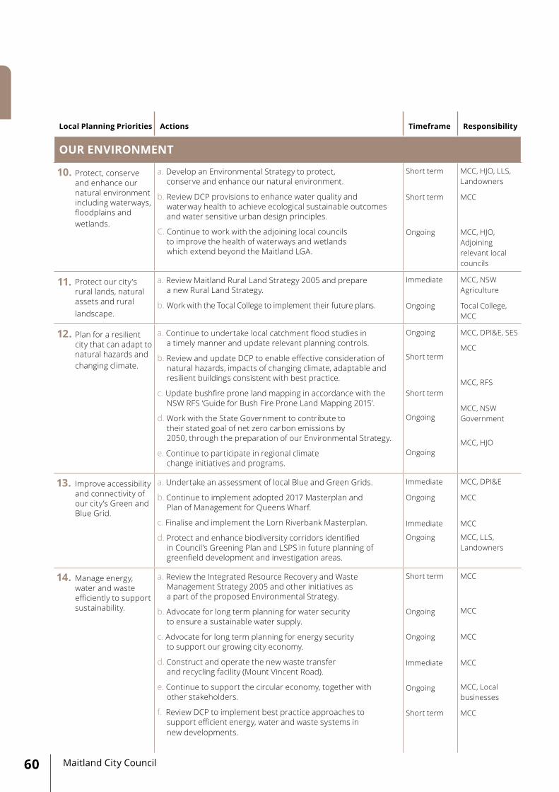
Maitland City Council60
Local Planning Priorities Actions Timeframe Responsibility
OUR ENVIRONMENT
10. Protect, conserve and enhance our natural environment including waterways, floodplains and wetlands.
a. Develop an Environmental Strategy to protect, conserve and enhance our natural environment.
b. Review DCP provisions to enhance water quality and waterway health to achieve ecological sustainable outcomes and water sensitive urban design principles.
C. Continue to work with the adjoining local councils to improve the health of waterways and wetlands which extend beyond the Maitland LGA.
Short term
Short term
Ongoing
MCC, HJO, LLS, Landowners
MCC
MCC, HJO, Adjoining relevant local councils
11. Protect our city's rural lands, natural assets and rural landscape.
a. Review Maitland Rural Land Strategy 2005 and prepare a new Rural Land Strategy.
b. Work with the Tocal College to implement their future plans.
Immediate
Ongoing
MCC, NSW Agriculture
Tocal College, MCC
12. Plan for a resilient city that can adapt to natural hazards and changing climate.
a. Continue to undertake local catchment flood studies in a timely manner and update relevant planning controls.
b. Review and update DCP to enable effective consideration of natural hazards, impacts of changing climate, adaptable and resilient buildings consistent with best practice.
c. Update bushfire prone land mapping in accordance with the NSW RFS ‘Guide for Bush Fire Prone Land Mapping 2015'.
d. Work with the State Government to contribute to their stated goal of net zero carbon emissions by 2050, through the preparation of our Environmental Strategy.
e. Continue to participate in regional climate change initiatives and programs.
Ongoing
Short term
Short term
Ongoing
Ongoing
MCC, DPI&E, SES
MCC
MCC, RFS
MCC, NSW Government
MCC, HJO
13. Improve accessibility and connectivity of our city’s Green and Blue Grid.
a. Undertake an assessment of local Blue and Green Grids.
b. Continue to implement adopted 2017 Masterplan and Plan of Management for Queens Wharf.
c. Finalise and implement the Lorn Riverbank Masterplan.
d. Protect and enhance biodiversity corridors identified in Council’s Greening Plan and LSPS in future planning of greenfield development and investigation areas.
Immediate
Ongoing
Immediate
Ongoing
MCC, DPI&E
MCC
MCC
MCC, LLS, Landowners
14. Manage energy, water and waste efficiently to support sustainability.
a. Review the Integrated Resource Recovery and Waste Management Strategy 2005 and other initiatives as a part of the proposed Environmental Strategy.
b. Advocate for long term planning for water security to ensure a sustainable water supply.
c. Advocate for long term planning for energy security to support our growing city economy.
d. Construct and operate the new waste transfer and recycling facility (Mount Vincent Road).
e. Continue to support the circular economy, together with other stakeholders.
f. Review DCP to implement best practice approaches to support efficient energy, water and waste systems in new developments.
Short term
Ongoing
Ongoing
Immediate
Ongoing
Short term
MCC
MCC
MCC
MCC
MCC, Local businesses
MCC

61Maitland Local Strategic Planning Statement 2040+
Local Planning Priorities Actions Timeframe Responsibility
OUR INFRASTRUCTURE
15. Align local infrastructure delivery to support planned growth and community needs.
a. Work with the NSW Government to ensure the new Maitland Hospital is delivered alongside with the supporting infrastructure.
Short term HNEH, HCCDC, DPI&E, TfNSW, MCC
b. Work with the NSW Government to ensure that our existing educational facilities are expanded, and new facilities are constructed in a timely manner to support planned growth.
Ongoing NSW Department of Education, MCC
c. Work with Transport for NSW to address the increasing traffic congestion along the New England Highway corridor and investigate the need for the southern bypass road.
Ongoing TfNSW, MCC
d. Work with relevant stakeholders to ensure the timely delivery of enabling infrastructure and services.
Ongoing TfNSW, Hunter Water, NBN, Ausgrid, NSW Government, MCC
e. Review and update MCC development contribution plans.
Medium term MCC
16. Improve access to, from and within the city, and encourage public and active transport to connect people and places.
a. Work with TfNSW and other stakeholders to develop a Place Plan for Maitland LGA, focusing on the Eastern, Western and Central Precincts.
Immediate TfNSW, MCC
b. Review Maitland Bicycle Plan and Strategy 2014. Immediate MCC
c. Advocate for electrification of the Hunter Line to Telarah.
Ongoing MCC
d. Advocate for more reliable, frequent and connected public transport services.
Ongoing MCC
e. Review Maitland Integrated Land Use and Transport Study 2008, following the completion of Maitland Place Plans.
Short/ Medium term
MCC, TfNSW
17. Provide good quality, accessible and appropriate community infrastructure across the city.
a. Prepare and implement a new Community Infrastructure Strategy.
Immediate MCC, NSW Govern-ment
18. Work collaboratively to deliver infrastructure and services to support planned growth.
a. Continue to work with the NSW Government agencies, developers and other stakeholders to ensure that our residents will have appropriate levels of infrastructure and services to meet their needs.
Ongoing MCC, NSW Govern-ment, Developers, Service providers
b. Continue to apply for grant funds to enable the delivery of key community infrastructure.
Ongoing MCC
c. Advocate for the NSW Government to address the growing backlog in our facilities such as libraries and schools.
Ongoing MCC

To realise our 20 year vision, amendments to our local planning framework and other Council plans will be required. Council proposes a multi year approach due to the resourcing, financing and staged nature of the works.
The LSPS identifies a number of areas where current plans and strategies are required to be reviewed and updated. This is in order to better reflect what is happening in the Maitland LGA as well as the broader Greater Newcastle Metropolitan Area and Hunter Region, and to better respond to a changing population, economy, social need and land use. The outcomes of the above strategic work will underpin amendments to the Maitland LEP and DCP.
Following the completion of the above studies and investigations, Maitland LSPS 2040+ will be reviewed and updated to reflect the outcomes and recommendations.
Our local planning priorities will need to be progressively reviewed and updated. Council will utilise its existing Integrated Planning & Reporting Framework under the Local Government Act 1993 for the purpose of monitoring implementation of the LSPS.
Maitland City Council62

GLOSSARY
REFERENCES
A new housing development area that has not been previously developed or used for other urban purposes.
Development in areas already used for urban purposes. Specifically, the re-use of a site within the existing urban footprint for new housing, businesses or other urban development.
The ‘planned investigation’ category included land that has been identified in the Maitland Urban Settlement Strategy as ‘category 1’ investigation area for future residential or employment purposes.
The ‘future investigation’ category included land that has been identified in the Maitland Urban Settlement Strategy as ‘category 2’ investigation areas where detailed studies and investigations are required to confirm their suitability for future development and this land would logically be developed after ‘category 1’ lands.
Centres of strategic importance within the Greater Newcastle area (as identified in the Hunter Regional Plan 2036). These Centers are some of the fastest growing in regional NSW that will continue to provide housing, jobs and services for communities across their metropolitan area.
Catalyst areas are places of metropolitan significance where a planned approach will drive the transformation.
The Green Grid is an interconnected network of green spaces including parks, reserves, bushlands, playing fields, local playgrounds and street trees.
The Blue Grid is a network of waterways and watercourses including rivers, creeks and wetlands.
Greenfield Housing
Infill Housing
Planned Investigation Area
Future Investigation Area
Strategic Centres
Catalyst Areas
Green Grid
Blue Grid
63Maitland Local Strategic Planning Statement 2040+
• Activity Centres and Employment Cluster Strategy 2010. MCC. • Central Maitland Structure Plan 2009, MCC. • Community Facilities and Services Strategy 2012, MCC. • Greater Newcastle Future Transport Plan 2018, TfNSW.• Greater Newcastle Metropolitan Plan 2036, DPI&E. • Hunter Regional Plan 2036, DPI&E. • Hunter Expressway Land Use Strategy 2018, DPI&E. • Integrated Land Use & Transport Strategy 2008, MCC. • Local Strategic Planning Statements, Guideline for local councils 2018, DPI&E. • Maitland Community Facilities and Services Strategy 2012, MCC. • Maitland 10+ Community Strategic Plan 2018-2028, MCC. • Maitland Affordable and Adaptable Housing Action Plan 2013, MCC. • Maitland Bicycle Plan and Strategy 2014, MCC. • Maitland Centres Study 2009, MCC. • Maitland Centres Study Review 2016, MCC. • Maitland Cultural Plan 2016-2019, MCC. • Maitland Development Control Plan 2011, MCC. • Maitland Greening Plan 2002, MCC. • Maitland Network Strategy 2018 (draft), TfNSW • Maitland Local Environmental Plan 2011. • Maitland Place Activation Strategy 2016, MCC. • Maitland Recreation and Open Space Strategy 2004, MCC. • Maitland Rural Lands Strategy 2005, MCC. • Maitland Urban Settlement Strategy 2012, MCC. • Global Megatrends, Seven patterns of change shaping our future 2019, Stefan Hajkowicz, CSIRO.

For more information about theMaitland Local Strategic Planning Statement 2040+
maitland.nsw.gov.au [email protected] t 02 4934 9700 285–287 High Street, Maitland PO Box 220, Maitland NSW 2320


