Embed Size (px)
Citation preview
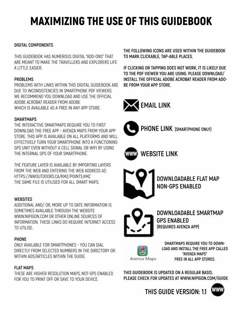
MAXIMIZING THE USE OF THIS GUIDEBOOK
DIGITAL COMPONENTS THIS GUIDEBOOK HAS NUMEROUS DIGITAL “ADD-ONS” THAT ARE MEANT TO MAKE THE TRAVELLERS AND EXPLORERS LIFE A LITTLE EASIER. PROBLEMS PROBLEMS WITH LINKS WITHIN THIS DIGITAL GUIDEBOOK ARE DUE TO INCONSISTENCIES IN SMARTPHONE PDF VIEWERS. WE RECOMMEND YOU DOWNLOAD AND USE THE OFFICIAL ADOBE ACROBAT READER FROM ADOBE WHICH IS AVAILABLE AS A FREE IN ANY APP STORE. SMARTMAPS THE INTERACTIVE SMARTMAPS REQUIRE YOU TO FIRST DOWNLOAD THE FREE APP - AVENZA MAPS FROM YOUR APP STORE. THIS APP IS AVAILABLE ON ALL PLATFORMS AND WILL EFFECTIVELY TURN YOUR SMARTPHONE INTO A FUNCTIONING GPS UNIT EVEN WITHOUT A CELL SIGNAL OR WIFI BY USING THE INTERNAL GPS OF YOUR SMARTPHONE. THE FEATURE LAYER IS AVAILABLE BY IMPORTING LAYERS FROM THE WEB AND ENTERING THE WEB ADDRESS AS: HTTPS://NWOUTDOORS.CA/KMZ/POINTS.KMZ THE SAME FILE IS UTILISED FOR ALL SMART MAPS. WEBSITES ADDITIONAL AND/ OR, MORE UP TO DATE INFORMATION IS SOMETIMES AVAILABLE THROUGH THE WEBSITE WWW.NIPIGON.COM OR OTHER ONLINE SOURCES OF INFORMATION. THESE LINKS DO REQUIRE INTERNET ACCESS TO UTILISE. PHONE ONLY AVAILABLE FOR SMARTPHONES - YOU CAN DIAL DIRECTLY FROM SELECTED NUMBERS IN THE DIRECTORY OR WITHIN ADS/ARTICLES WITHIN THE GUIDE. FLAT MAPS THESE ARE HIGHER RESOLUTION MAPS, NOT-GPS ENABLED FOR YOU TO PRINT OFF OR SAVE TO YOUR DEVICE.
EMAIL LINK
PHONE LINK (SMARTPHONE ONLY)
WEBSITE LINK
DOWNLOADABLE FLAT MAPNON-GPS ENABLED
DOWNLOADABLE SMARTMAPGPS ENABLED(REQUIRES AVENZA APP)
THE FOLLOWING ICONS ARE USED WITHIN THE GUIDEBOOK TO MARK CLICKABLE, TAP-ABLE PLACES. IF CLICKING OR TAPPING DOES NOT WORK, IT IS LIKELY DUE TO THE PDF VIEWER YOU ARE USING. PLEASE DOWNLOAD/INSTALL THE OFFICIAL ADOBE ACROBAT READER FROM ADO-BE FROM YOUR APP STORE.
THIS GUIDEBOOK IS UPDATED ON A REGULAR BASIS. PLEASE CHECK FOR UPDATES AT WWW.NIPIGON.COM/GUIDE
THIS GUIDE VERSION: 1.1
SMARTMAPS REQUIRE YOU TO DOWN-LOAD AND INSTALL THE FREE APP CALLED
"AVENZA MAPS"FREE IN ALL APP STORES.
r e s o u r c e s | P a g e - 3
This guidebook is a guide. Additional and more up to date information provided at nipigon.com. All information in this handbook or on nipigon.com may change without notice. We will try to keep it up to date however it is not always possible.
VISIT: NIPIGON.COM
This guidebook provided as is and GH Services cannot be held liable for any errors/omissions or hardships due to information presented herein.
Disclaimer:
The information and maps in this guidebook and joined website contains data from digital databases provided by the Government of Canada as well as generated data from GH Services and personal information collected through working in the tourism industry.
GH Services cannot accept any responsibility for errors, omissions, or positional accuracy. Not all roads or trails mentioned may be safe for all users. There are no warranties, expressed or implied, including the warranty of merchantability or fitness for a purpose accompanying this product. However, notification of any errors will be appreciated.
Compiled, written, published and edited by
GH Creative Services 807.889.0707Compiled by Glenn HartEmail [email protected]
With assistance fromKirsten HartGlena Clearwaterand the people of the area.
Pictures supplied byGlenn HartKirsten HartGlena ClearwaterIlona DrummNipigon MuseumJim McCullough
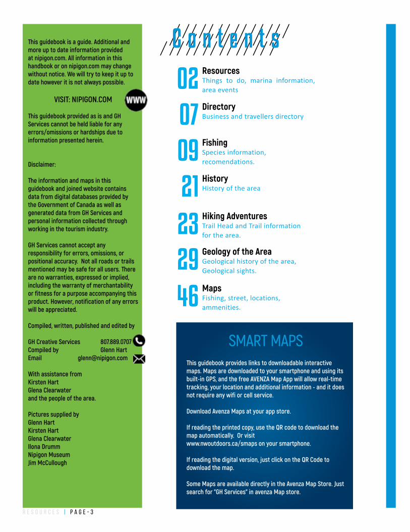
ResourcesThings to do, marina information, area events02DirectoryBusiness and travellers directory07FishingSpecies information, recomendations.09HistoryHistory of the area21
C o n t e n t s
Hiking AdventuresTrail Head and Trail information for the area.23
This guidebook provides links to downloadable interactive maps. Maps are downloaded to your smartphone and using its built-in GPS, and the free AVENZA Map App will allow real-time tracking, your location and additional information - and it does not require any wifi or cell service.
Download Avenza Maps at your app store.
If reading the printed copy, use the QR code to download the map automatically. Or visitwww.nwoutdoors.ca/smaps on your smartphone.
If reading the digital version, just click on the QR Code to download the map.
Some Maps are available directly in the Avenza Map Store. Just search for "GH Services" in avenza Map store.
SMART MAPS
Geology of the AreaGeological history of the area, Geological sights. 29MapsFishing, street, locations, ammenities.46
r e s o u r c e s | P a g e - 4
ESSENTIAL S
NIPIGON
RED ROCK
SCHREIBERTERRACE BAYROSSPORT
ROCKY BAY FN
BEARDMORE
HURKETT
DORION
PEARL
PASS LAKE
BLACK BAY
NIPIGON BAY
LAKE SUPERIOR
SLATE ISLANDS
IGNACE ISLAND
KAMA BAY
LAKENIPIGON
PAYS PLAT FN
LAKE HELEN FN
TERRACE BAY BATHOLITH
Rainbow FallsProvincial Park
Granodiorite/Granite
Sibley GroupSedimentary
Mafic to Intermediate Metavolcanics
Mafic to Ultramafic
Alkalicintrusive suite
NeysProvincial Park
Ruby LakeProvincial Park
Ouimet CanyonProvincial Park
Sleeping GiantProvincial Park
Prairie River MouthProvincial Nature Reserve
0 10 20 30 405Kilometers
0 10 20 30 405Miles
!
!!!
!!
!
!
! ! ! !
!! ! ! !!!
D
E
C B
I B
R
F
A9A8A7A6A5
A4A3A2A1
A11A10 !
!
!
!
!
!
!
!
!
!
!
! !
!
!
!
!
!
!
!
!
!
!
!
! !
8
7
2
3
4
5
9
6
1211
10
17
13
14
!
!
!
!
!!
!
!
!
!
!
!
!
!
! !
!
!
! !
!
!
!
!
!
!
!
!
9
8
7
64
4
3
2
1
29
28
27
26
25
24
23
22
2120
19
18
1716
15
14
12
11
10
!13
!!"
"
"
"
"
"
"
"
"
"
"
!
!
"
!
!
"
"
"
" "
"!
!!"
!
!
"
"
"
!
"
"
!
!
!
6
9
8
5
2
1
7
3
40
39
38
37
12
36
3534
33
32
31
3029
28
27
26
25
24
23
22
21
20
19
10
11
18
17
16
15
14
13
Tent Camping
Golf Course
Marina
Boat Launch
Canoe Access
Medical Clinic
Hospital
Playground
Information Centre
Groceries
Camper Camping
Post O�ce
Library
Mechanical services
Kennel
Look o� Tower
Hiking Trail
Gas
ATM/Bank
Hotel/Motel
Dining
Laundromat
Museum
Roadside rest area
Cross Country Skiing
Ice/Rock Climbing
Pump Out Station
Scenic View
Souvenir Shop
Provincial Park
First Nation
"6
"9"8
"5
!2!1
!
"7
!3
!40!39!38"37
!12
!36"35!34!33!32"31"30"29"28"27"26!25"24!23!22"21"20"19
"10
"11
"18"17"16"15"14!13
"
Red Rock MarinaStillwater CreekNipigon River below BridgeNipigon MarinaNipigon River Below Alexander DamJesse LakeJesse Lake NarrowsJesse Lake East BayNipigon River Split RockNipigon River below Pine PortageCox LakeLittle FraserNipigon LagoonNipigon River Back ChannelNipigon River - Lake HelenNipigon River Mouth Drop o�Fraser LakeElizabeth LakeOskaweSouth Bay Lake NipigonBlack Sturgeon LakeHurkett DockWolf RiverBlack BayBlack Sturgeon RiverNipigon BayNipigon BayNipigon BayKama PointKama BayMazukama BayOzone CreekJackpine RiverJackpine river mouth areaKama BayBlack Sturgeon Below DamRossport - IslandsCypress RiverLittle Gravel RiverSteel River
Shor
eBo
at
!4
!9!8!7!6!5!4!3!2!1
!29!28!27!26!25!24!23!22!21!20!19!18!17!16!15!14
!12!11!10
!13
Ouimet Canyon
Amethyst Mines of Pearl
Dorion Fish Hatchery Tours
Hurkett Cove Conservation area
Red Rock Marina
View from the Nipigon River Recreational Trail
Nipigon Marina
Nipigon River Suspension Bridge
Ruby Lake Marble Quary
The Cli�s of Kama
Kama Bay Looko�
Rossport Beach and Islands
Schreiber Beach
Train Museum
Terrace Bay Beach
Terrace Bay Lighthouse Observation Tower
Ghost Town of Jack�sh
Alexander Dam and Looko�
Cameron Falls
Pine Portage Dam, Lake Forgan
The Palisades
Orient Bay
Beardmore Snowman
Beach at Polar Lodge - Lake Nipigon
High Hill Harbour
Saint Sylvesters Church
Lake Helen Rest Area
Hugfe 1993 Forest Fire aftermath
Abandoned Train Tunnel - Jumbo Cove
Aguasabon Falls and Gorge!30
!30
!!8!!7
!!2!!3!!4!!!!!5
!!!9
!6
!12!!11!10
!!17
!13
!!14
Roadcut - contact/unconformity
Amythest Mines of Pearl
Ouiment Canyon
Red Rock Mountain
Nipigon Glacial Deposits
Cuestas
Nipigon River Gorge
Nipigon Road Cut - Basement Rocks
Kama Cli�s Layering - Red Rocks
Ruby Lake Marble
Jackpine River Glacial Deposits
Lake Superior
Terrace Bay Beaches
Slate Islands
!D!E
!C
!I
!B
!R
!F
!A9!A8!A7
!A6!A5!A4!A3!A2!A1
!A11
!A10
Nipgion River Recreational Trail
Red Rock Mountain Trail
Kama Cli�s Trail
Mazukama Falls Trail
Deer Lake Mountain
Bald Spot Trail
Rendevous Ski Trails
The Casque Isles Trail is a recreational hiking trail along the North Shore of Lake Superior. The Trail is classi�ed as Di�cult, but there are many sections that are considered as Moderate between the more technical sections.
www.nipigon.com/geology www.nipigon.com/trailswww.nipigon.com/fishing www.nipigon.com/visit
For more and additional information on the points, trails, access and things to do represented in this map please visit www.nipigon.com and download the Land of Nipigon Adventure Guide for FREE. This map is also available as a FREE Smartphone Map to track your journey. www.nipigon.com/travelmap
This map and all others generated by GH Services are for recreational purposes only. There are no warranties, expressed or implied, including the warranty of merchantability or �tness for a particular purpose, accompanying this product. However, noti�cation of any errors will be
appreciated.
Base topographic features, roads, lakes, rivers, and general topographic information on these maps are from digital databases provided by the Government of Canada and the Government of
Ontario. GH Services makes no warranties towards its accuracy or merchantability of these layers.
Trail data supplied by the organisations responsible for those trails and collected/modi�ed for display by GH Services. GH Services cannot accept any responsibility for errors, omissions, or
positional accuracy as these maps are for recreation only and are only a guide. Not all roads or trails may be shown or named. Some roads or trails may be private or incomplete. Trails and roads
may or may not be traversable due to the season, local conditions or general deterioration.
THESE MAPS ARE NOT FOR NAVIGATION AND ARE NOT A SUBSTITUTE FOR COMMON SENSE. WHEN IN DOUBT, BE AWARE OF YOUR OWN OBSERVATIONS AND LIMITATIONS.
Quarry Island
Healy Island
Wilson Island
Want to visit the Slate Islands?Multiple charter boats are available from Terrace Bay to shuttle you, camping equipment, kayaks and sightseers to the island.
Witness the unique Geology of this ancient meteorite impact remnant. Campers can enjoy regular sightings of the woodland Caribou which inhabit the islands. Kayakers can explore the inner islands, protected from the full force of Lake Superior.
Boswells Point
Cat Islands
AbyondLookout
!!
!!
!!
!!
!!
!!
!!
!!
!!
!!
!!
!!
!!
!!
!!
!!
! ! ! ! ! ! ! ! ! ! ! ! ! ! ! ! ! !!
!!
!!
!!
!!
!!
!!
!!
!!
!!
!!
!!
!!
!!
!!
!!
!!
!!
!!
!!
!!
!!
!!
!!
!!
!!
!!
!!
!! !
!!
!!
!!
!!
!!
!!
!!
!!
!!
!!
!!
!!
!! ! ! ! ! ! ! ! ! ! ! ! ! ! ! ! ! ! ! ! ! ! ! ! ! ! ! ! ! ! ! ! ! ! ! ! ! ! ! ! ! !
! !
!!!!!!
!!!!
!!!
!!!!
!!
!
!
!
!
!
!
!
!
!
!
!!
!
!
!
!
!
!
!
!
!
!
!!!!!!!!!!!
!!
!
!!
!!
!!
!!
!
!
!
!
!
!
!
!
!
!
!
!
!
!
!
!
!
!
!
!
!
!
!
!
!
!
!
!
!
!
!
!
!
!
!
!
!
!
!
!
!
!
!
!
!
!
!
!
!
!
!
!
!
!!
!!
!!
!!
!!
!!
!!
!!
!!
!!
!!
!!
!!
!!
!!
!!
!!
!!
!!
!!
!!
!!
!
!!
!!!!!!!!!!!!!!!!!!!!!!!!!!!!
!
!
!
!
!
!
!
!
!!
!!
!!
!!
!!
!!
!!
!!
!!
!
!
!
!!
!
!!
!!
!
!
!
!
McLean’s Segment
Schreiber Channel Segment
Death Valley Segment
Mount Gwynne Segment
Lyda Bay Segment
ROSSPORT
SCHREIBER
TERRACE BAY
LAKE SUPERIOR NATIONAL MARINE CONSERVATION AREA
RAINBOW FALLSPROVINCIAL PARKWHITESAND LAKE
TERRACE BAY BEACH
Aguasabon falls
AguasabonGolf Course
PUMPHOUSE BEACH
SCHREIBER BEACH
RAINBOW FALLSPROVINCIAL PARKLAKE SUPERIOR
ROSSPORT BEACH
TERRACE BAY
LYDA BAY
DANNY’S COVE
WORTHINGTON BAY
NONAME BAY
KELLYHARBOUR
Hays Lake
Schreiber Channel
Collingwood Bay
Copper Island
This map and all others generated by GH Services are for recreational purposes only. There are no warranties, expressed or implied, including the warranty of merchantability or �tness for a particular purpose, accompanying this product. However, noti�cation of any errors will be appreciated.
Base topographic features, roads, lakes, rivers, and general topographic information on these maps are from digital databases provided by the Government of Canada and the Government of Ontario. GH Services makes no warranties towards its accuracy or merchantability of these layers.
Trail data supplied by the organisations responsible for those trails and collected/-modi�ed for display by GH Services. GH Services cannot accept any responsibility for errors, omissions, or positional accuracy as these maps are for recreation only and are only a guide. Not all roads or trails may be shown or named. Some roads or trails may be private or incomplete. Trails and roads may or may not be traversable due to the season, local conditions or general deterioration.
THESE MAPS ARE NOT FOR NAVIGATION AND ARE NOT A SUBSTITUTE FOR COMMON SENSE. WHEN IN DOUBT, BE AWARE OF YOUR OWN OBSERVATIONS AND LIMITATIONS.
!
!
!
!
!
!
!
!
"
!
! !!
!
!
!!
!
!
!
A9
A8
A7
A6
A5
A4
A3A2
A1
A11
A10
17
13
14
16
15
14
13
12
37
The Slate Islands Provincial Park
Channel Island
The Casque Isles Trail is a signed and groomed recreationalhiking trail that offers scenic vistas to the visitors who wish toshare in Lake Superior’s majestic and rugged beauty inOntario, Canada. Beginning in Rossport, passing throughSchreiber and ending in Terrace Bay, the total length of theTrail is 53 km. For those who do not wish to attempt theentire trek, the Trail is divided into 5 Segments; each with it’sown Access point from Hwy 17 and each presenting it’s ownunique wilderness experience. These Segments vary in lengthand difficulty so that both the advanced and the beginnerhiker can enjoy the North Shore.If you enjoy hiking and wish to support its continued development, consider a membership in the Voyageur Trail Association.
Do not hike alone. Let people know the section of Trail that youare hiking. If you don’t know anyone in the area leave notes atyour vehicle, or message us on Facebook.Cell phone coverage is sporadic on the Trail. Climbing a nearby hillshould give you better coverage if needed.For emergency call 1-888-310-1122 or 911.Wear proper footwear and dress for the conditions.Firearms are prohibited.You may have to wade streams.There are unmaintained campsites on the Trail. Campsites areavailable at Rainbow Falls Prov. Park.PLEASE PACK OUT WHAT YOU PACK IN!A1 Access East Rossport turnoff to km 4 and south on A2 toHwy 17. Requires shuttle ride back to Rossport.
Get more information at;www.hikesuperior.ca
If you enjoy hiking and wish to support its continued development, consider a
membership in the Voyageur Trail Association.www.voyageurtrail.ca
The Casque Isles Trail is a recreational hiking trail along the North Shore of Lake Superior. The Trail is classified as Difficult, but there are many sections that are considered as Moderate between the more technical sections.
Mclean's Segment - Accessed by A1, A2, A3 and A4, this segment goes from Rossport to Rainbow Falls Prov Park, Whitesand Campground. Ancient beaches, incredible vistas from the lookouts. Follows the boardwalk along Rainbow Falls. Camping available in Rainbow Falls Prov Park. (14km)
Schreiber Channel Segment - Accessed by A4 and A5, this segment goes from Rainbow Falls Prov Park to Schreiber Beach. Views of Lake Superior from lookouts, follows the shoreline for 2 km. Camping available at Rainbow Falls Prov Park, Twin Harbours and Schreiber Beach. (13km)
Mount Gwynne Segment - Accessed by A5, A6 and A7, this segment goes from Schreiber Beach to Worthington Bay. Pretty walk along Cooks Creek, Picnic Table Lookout, Mount Gwynne Lookout and Worthington Bay Beach. From Mount Gwynne Lookout you can see for 80 km in 360 degrees. Camping available at Schreiber Beach, Fourth Lake and Worthington Bay Beach. (7km)
Death Valley Segment - Accessed by A7, A8 and A9, this segment goes from Worthington Bay to Hydro Bay. The longest, most difficult segment. Follows the shoreline of Lake Superior, spectacular lookouts along the trail. Camping available at Worthington Bay Beach and Les Petits Ecrits. (10km)
Lyda Bay Segment - Accessed by A9, A10 and A11, this segment goes from Hydro Bay to Terrace Bay. The property is called the Terrace Bay Nature Reserve, owned by the Thunder Bay Field Naturalists. Warm, shallow bays for wading in Lake Superior. Aguasabon Falls and Terrace Bay Beach in Terrace Bay. (6km)
Selim
LYNE LAKE
BEWS LAKE
JASON LAKE
RONGIE LAKE
MINNOW LAKE
LAMONT LAKE
ASHMORE LAKE
SPECTACLE LAKE
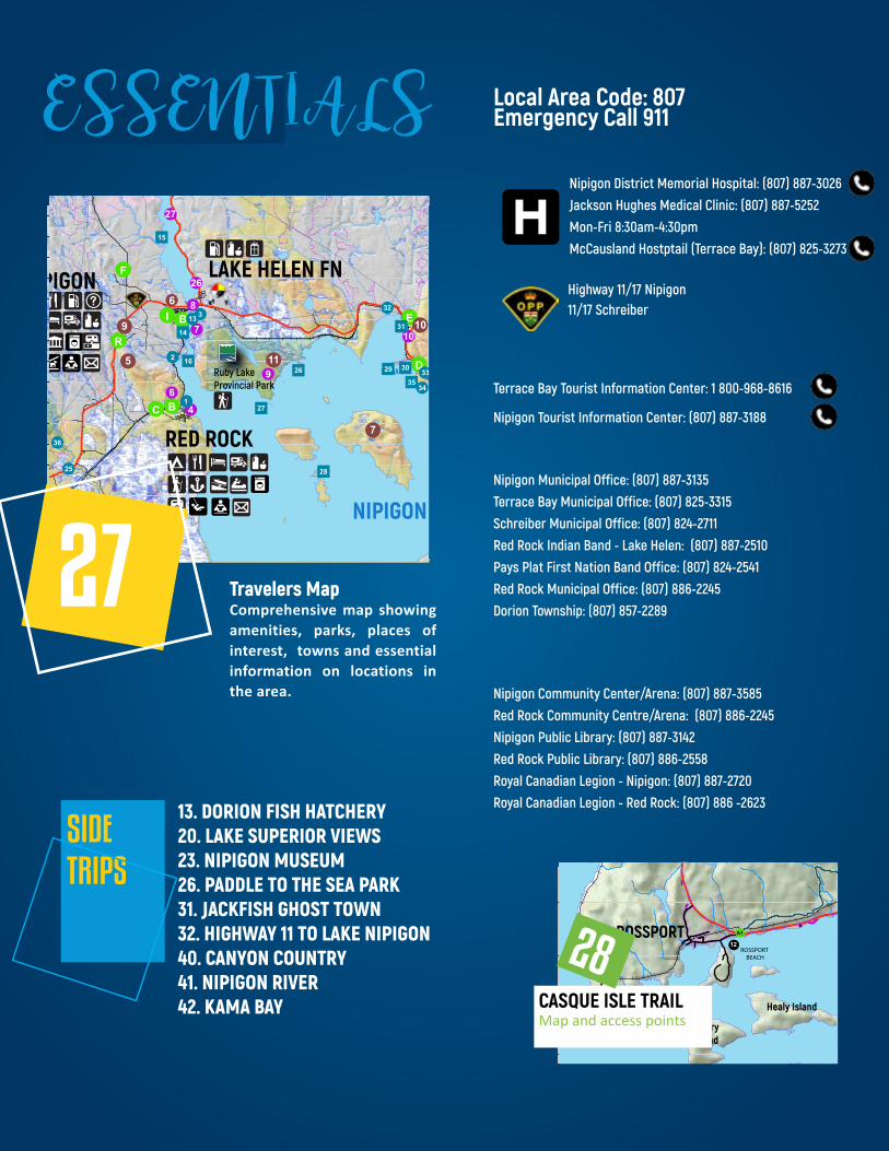
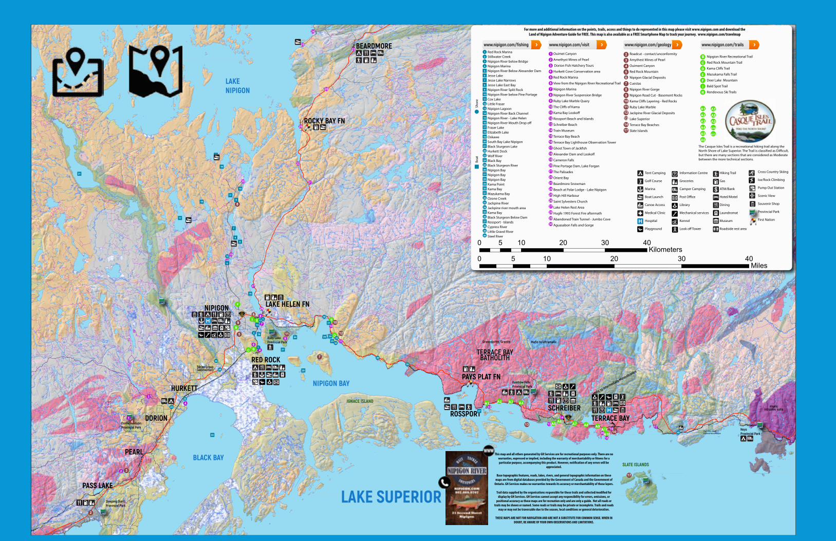
27 Travelers MapComprehensive map showing amenities, parks, places of interest, towns and essential information on locations in the area.
Map and access pointsCASQUE ISLE TRAIL
28
Local Area Code: 807Emergency Call 911
Nipigon District Memorial Hospital: (807) 887-3026 Jackson Hughes Medical Clinic: (807) 887-5252 Mon-Fri 8:30am-4:30pm McCausland Hostptail (Terrace Bay): (807) 825-3273
Highway 11/17 Nipigon11/17 Schreiber
Terrace Bay Tourist Information Center: 1 800-968-8616
Nipigon Tourist Information Center: (807) 887-3188
Nipigon Municipal Office: (807) 887-3135 Terrace Bay Municipal Office: (807) 825-3315Schreiber Municipal Office: (807) 824-2711 Red Rock Indian Band - Lake Helen: (807) 887-2510Pays Plat First Nation Band Office: (807) 824-2541Red Rock Municipal Office: (807) 886-2245Dorion Township: (807) 857-2289
Nipigon Community Center/Arena: (807) 887-3585Red Rock Community Centre/Arena: (807) 886-2245Nipigon Public Library: (807) 887-3142Red Rock Public Library: (807) 886-2558Royal Canadian Legion - Nipigon: (807) 887-2720Royal Canadian Legion - Red Rock: (807) 886 -2623
SIDETRIPS
13. DORION FISH HATCHERY20. LAKE SUPERIOR VIEWS23. NIPIGON MUSEUM26. PADDLE TO THE SEA PARK31. JACKFISH GHOST TOWN32. HIGHWAY 11 TO LAKE NIPIGON40. CANYON COUNTRY41. NIPIGON RIVER42. KAMA BAY
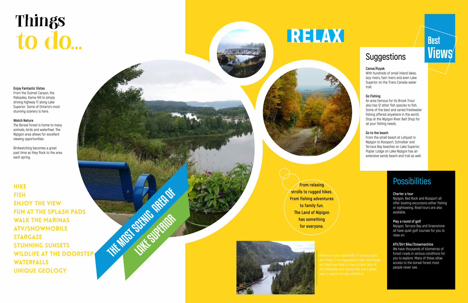
From relaxingstrolls to rugged hikes.
From fishing adventuresto family fun.
The Land of Nipigon has somethingfor everyone.
Canoe/KayakWith hundreds of small inland lakes, lazy rivers, fast rivers and even Lake Superior on the Trans Canada water trail.
Go FishingAn area famous for its Brook Trout also has 12 other fish species to fish. Some of the best and varied freshwater fishing offered anywhere in the world. Stop at the Nipigon River Bait Shop for all your fishing needs.
Go to the beachFrom the small beach at Lofquist in Nipigon to Rossport, Schreiber and Terrace Bay beaches on Lake Superior. Poplar Lodge on Lake Nipigon has an extensive sandy beach and trail as well.
Charter a tourNipigon, Red Rock and Rossport all offer boating excursions either fishing or sightseeing. Road tours are also available.
Play a round of golfNipigon, Terrace Bay and Greenstone all have quiet golf courses for you to relax on.
ATV/Dirt Bike/SnowmachineWe have thousands of kilometres of forest roads in various conditions for you to explore. Many of these allow access to the boreal forest most people never see.
Possibilities
Best
ViewsSuggestions
Home to many waterfalls of various sizes and flows. From Aguasabon Falls and Gorge and Rainbow Falls to the multiple falls of the Palisades and Kama Falls are a great way to spend the day exploring.
RELAXThings
to do...
Enjoy Fantastic VistasFrom the Ouimet Canyon, the Palisades, Kama Hill to simply driving highway 17 along Lake Superior. Some of Ontario's most stunning scenery is here.
Watch NatureThe Boreal forest is home to many animals, birds and waterfowl. The Nipigon area allows for excellent viewing opportunities.
Birdwatching becomes a great past time as they flock to the area each spring.
HIKEFISHENJOY THE VIEWFun at the splash padswalk the marinasATV/Snowmobile stargazestunning sunsetswildlife at the doorstepWaterfallsUnique Geology
THE MOST S
CENIC AREA OF
LAKE S
UPERIOR
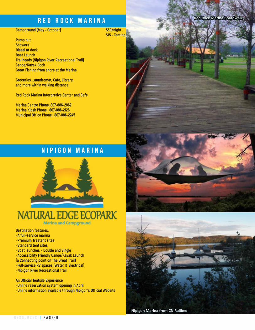
r e s o u r c e s | P a g e - 6
Destination features:• A full-service marina• Premium Treetent sites• Standard tent sites• Boat launches – Double and Single• Accessibility Friendly Canoe/Kayak Launch (a Connecting point on The Great Trail) • Full-service RV spaces (Water & Electrical)• Nipigon River Recreational Trail
An Official Tentsile Experience • Online reservation system opening in April• Online information available through Nipigon’s Official Website
Campground (May - October) $30/night $15 - TentingPump out ShowersDiesel at dockBoat LaunchTrailheads (Nipigon River Recreational Trail)Canoe/Kayak DockGreat Fishing from shore at the Marina
Groceries, Laundromat, Cafe, Library, and more within walking distance.
Red Rock Marina Interpretive Center and Cafe
Marina Centre Phone: 807-886-2862Marina Kiosk Phone: 807-886-2126 Municipal Office Phone: 807-886-2245
Red Rock Marina Boardwalk
Nipigon Marina from CN Railbed
R E D R O C K M A R I N A
N I P I G O N M A R I N A
r e s o u r c e s | P a g e - 7
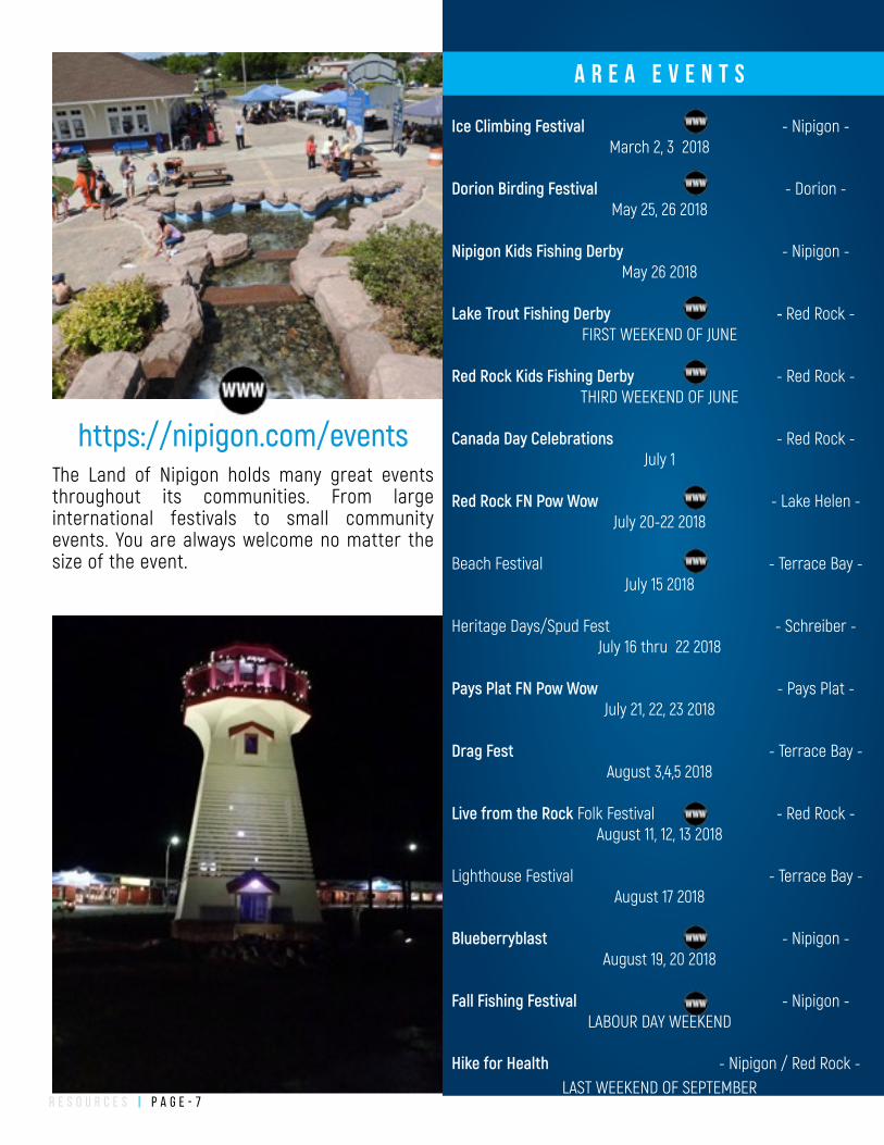
The Land of Nipigon holds many great events throughout its communities. From large international festivals to small community events. You are always welcome no matter the size of the event.
https://nipigon.com/events
A R E A E V E N T S
Ice Climbing Festival - Nipigon - March 2, 3 2018
Dorion Birding Festival - Dorion - May 25, 26 2018
Nipigon Kids Fishing Derby - Nipigon - May 26 2018
Lake Trout Fishing Derby - Red Rock - FIRST WEEKEND OF JUNE
Red Rock Kids Fishing Derby - Red Rock - THIRD WEEKEND OF JUNE
Canada Day Celebrations - Red Rock - July 1
Red Rock FN Pow Wow - Lake Helen - July 20-22 2018
Beach Festival - Terrace Bay -July 15 2018
Heritage Days/Spud Fest - Schreiber -July 16 thru 22 2018
Pays Plat FN Pow Wow - Pays Plat - July 21, 22, 23 2018
Drag Fest - Terrace Bay - August 3,4,5 2018
Live from the Rock Folk Festival - Red Rock - August 11, 12, 13 2018
Lighthouse Festival - Terrace Bay -August 17 2018
Blueberryblast - Nipigon - August 19, 20 2018
Fall Fishing Festival - Nipigon - LABOUR DAY WEEKEND
Hike for Health - Nipigon / Red Rock - LAST WEEKEND OF SEPTEMBER
r e s o u r c e s | P a g e - 8
NipigonSKANDIA HOUSE B&B 807.887.3133Birchville Motel 807.887.3141The Beaver Motel 807.887.3132Town and Country Motel 807.887.2382Locking Horns Motel 807.887.1750Northland Motel 807.887.2032Pinecrest Motel 807.887.28138th Street B&B 807.887.2962Sunnyside Cabins 807.887.1049Stillwater Campground 807.887.3701Nipigon Marina Campground 807.887. 3040
Red RockQuebec Lodge 807.886.2603Lal and Cal's B&B 807.886.2542Red Rock Marina Camp. 807.886.2126Red Rock Inn 807.886.2111
BeardmoreRoxy Place Motel 807.875.1037
RossportB & B ON THE BEACH 807.824.2155Island Shores B&B 807.824.1182Serendipity Gardens Guest House 807.824.2890The Willows B&B 807.824.3389Rossport Inn and Cabins 807.824.3213Rainbow Falls Provincial Park 807.824.2298
SchreiberCosianna Inn 807.824.2782Nor-West Motel 807.824.2501Sunset Motel 807.824.2850Rongie Lake Motel 807.824.2000Villa Bianca Inn 807.824.2172
Terrace BayRed Dog Inn 807.825.3285Drifters Motel and Restaurant 807.825.3226Norwood Motel 807.825.3282Neys Provincial Park 807.825.3403
NipigonTHE EDGEVIEW 807.887.5739CRABBY'S ARENA CANTEEN 807.889.1488Husky Travel Center Restaurant 807.887.2197
Esso Restaurant 807.887.3706
Tim Hortons 807.887.5595
Robins Donuts 807.887.3706
China Gardens 807.887.3208
Sue Chef at Crossroads 807.887.3915
La Luna Cafe 807.889.1537
Petro-Canada Lounge 807.887.3646
Red RockMarina Restaurant (Summer) 807.886.2862Cuesta Cafe (Rec Center - October to May)
BeardmoreAnnes Diner 807.875.1200
RossportSerendipity Gardens Cafe 807.824.2890
SchreiberThe Golden Rail 807.823.0257Breeze Bakery 807.824.2233Hungry Moose 807.824.2000Robins Donuts,Pizza Hut,KFC EX. 807.824.1111
Terrace BayDrifters Motel and Restaurant 807.825.3226Subway 807.825.3304Wahs Restaurant 807.825.1881Red Dog Inn 807.825.3285Nels Pub and Grill 807.825.1303Moe and Jo's 807.825.1313
PLA
CES
TO
STA
YP
LAC
ES TO
EAT
r e s o u r c e s | P a g e - 9
Get GasNipigon, Lake Helen, Pays Plat, Schreiber, Terrace Bay
Get PropaneRefills - Nipigon HuskyExchange - Canadian Tire, Pelletiers Gas Bar, Red Rock Marina
Get GroceriesZechner's (Nipigon) 807.887.2910Saunders (Red Rock) 807.886.2630Costa Foodateria (Schreiber) 807.824.2311Costa's Food Market (Terrace bBay) 807.825.4501The Bargain Shop (Nipigon) 807.887.1333
RV DumpingStillwater Campground 807.887.3701Nipigon Marina Campground 807.887.3040Red Rock Marina Campground 807.886.2126
Buy Beer/LiquorBeer Store (Nipigon) 807.887.2913LCBO (Nipigon) 807.887.2630LCBO (Red Rock) 807.886.2516LCBO (Schreiber) 807.824.2473LBCO (Terrace Bay) 807.825.3223
Kennel a DogGemline Canine Care (Nipigon) 807.889.0827
Rent a Canoe/KayakQuebec Lodge/Nipigon River Adventures 807.886.2603North Superior Charters and Lodge 807.857.1396 Get a car repairedCanadian Tire (Nipigon) 807.887.3131Allans AutoPro 807.887.2440Gerlach's Garage 807.887.3526Brennen's 807.887.2034Narvi's Auto 807.887.2517
Late Night SnacksHusky Travel Center (24 hours) 807.887.2197Tim Hortons (24 Hours) 807.887.5595Petro Canada (24 Hours) 807.887.3646Mac's Convenience Store (till 12) 807.887.2212
Rent Fishing GearNipigon Public Library 807.887.3142
Where to...WHERE TO...
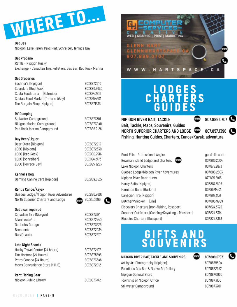
NIPIGON RIVER BAIT, TACKLE 807.889.0707Bait, Tackle, Maps, Souvenirs, GuidesNORTH SUPERIOR CHARTERS AND LODGE 807.857.1396 Fishing, Hunting Guides, Charters, Canoe/Kayak, adventure
Gord Ellis - Professional Angler gordellis.com
Bowman Island Lodge and charters 807.886.2504
Lake Nipigon Charters 807.875.2873
Quebec Lodge/Nipigon River Adventures 807.886.2603
Nipigon River Bear Hunts 877.825.2813
Hardy Baits (Nipigon) 807.887.2306
Hamilton Baits (Hurkett) 807.857.1462
Canadian Tire (Nipigon) 807.887.3131
Butcher/Smoker (Jim) 807.886.9989
Discovery Charters (non-fishing, Rossport) 807.824.3323
Superior Outfitters (Canoing/Kayaking - Rossport) 807.824.3314
Bluebird Charters (Rossport) 807.824.3353
L O D G E SC H A R T E R S
G U I D E S
NIPIGON RIVER BAIT, TACKLE AND SOUVENIRS 807.889.0707Art by Art Photography (Nipigon) 807.887.5304
Pelletier's Gas Bar & Native Art Gallery 807.887.2952
Nipigon General Store 807.887.0006
Township of Nipigon Office 807.887.3135
Stillwater Campground 807.887.3701
G I F T S A N DS O U V E N I R S
f i s h i n g | P a g e - 1 0
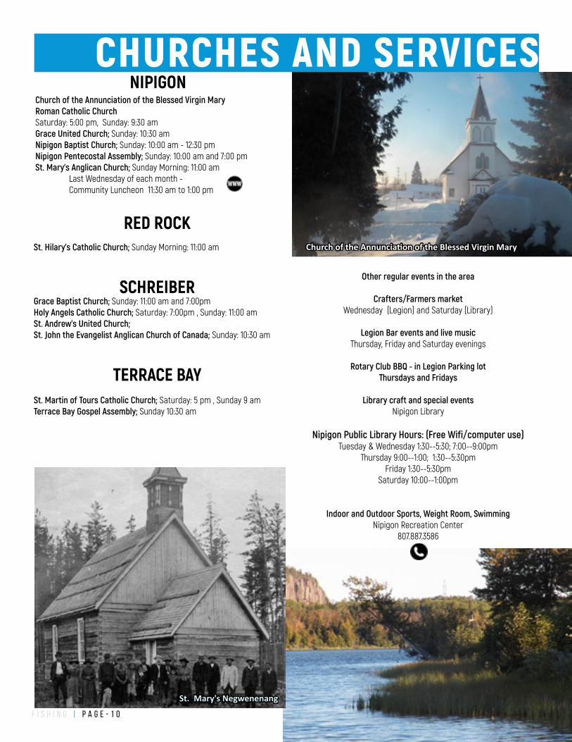
Church of the Annunciation of the Blessed Virgin Mary Roman Catholic ChurchSaturday: 5:00 pm, Sunday: 9:30 amGrace United Church; Sunday: 10:30 amNipigon Baptist Church; Sunday: 10:00 am - 12:30 pmNipigon Pentecostal Assembly; Sunday: 10:00 am and 7:00 pmSt. Mary's Anglican Church; Sunday Morning: 11:00 am Last Wednesday of each month - Community Luncheon 11:30 am to 1:00 pm
St. Mary's Negwenenang
Church of the Annunciation of the Blessed Virgin Mary
NIPIGON
RED ROCKSt. Hilary's Catholic Church; Sunday Morning: 11:00 am
SCHREIBERGrace Baptist Church; Sunday: 11:00 am and 7:00pm Holy Angels Catholic Church; Saturday: 7:00pm , Sunday: 11:00 amSt. Andrew’s United Church; St. John the Evangelist Anglican Church of Canada; Sunday: 10:30 am
TERRACE BAYSt. Martin of Tours Catholic Church; Saturday: 5 pm , Sunday 9 amTerrace Bay Gospel Assembly; Sunday 10:30 am
CHURCHES AND SERVICES
Other regular events in the area
Crafters/Farmers marketWednesday (Legion) and Saturday (Library)
Legion Bar events and live musicThursday, Friday and Saturday evenings
Rotary Club BBQ - in Legion Parking lotThursdays and Fridays
Library craft and special eventsNipigon Library
Nipigon Public Library Hours: (Free Wifi/computer use)
Tuesday & Wednesday 1:30--5:30; 7:00--9:00pmThursday 9:00--1:00; 1:30--5:30pm
Friday 1:30--5:30pmSaturday 10:00--1:00pm
Indoor and Outdoor Sports, Weight Room, SwimmingNipigon Recreation Center
807.887.3586
f i s h i n g | P a g e - 1 2
Fishing Licenses
Fishing licenses in Ontario come in two categories, sports and conservation. Conservation licenses have a reduced possession limit however they do cost less as well.
An outdoors card is separate from the fishing license and in some cases is needed in addition to the original fishing license.
Where to buy outdoors cards/licenses
Online: https://www.ontario.ca/page/get-outdoors-card
Ministry of Natural Resource Nipigon for questions and concerns: 807.887.5000
In Nipigon:Service Ontario - 5 Wadsworth Dr, Nipigon; 807-887-3230Canadian Tire - Corner 1St & 5Th Streets, Nipigon; 807.887.3131Stillwater RV and Campground; 807.887.3701
In Terrace Bay:Service Ontario - 1004 Highway 17, Terrace Bay; 807-825-2765
Stocked Lake Brook Trout
FISHING ESSENTIALS
WHAT TO BRING
Choices of tackle and fishing techniques are endless considering the number of different species in the area. This section is a guide to the necessities and most common tackle and techniques used in the
Nipigon Area.
VISIT WWW.NIPIGON.COM FOR DETAILED INFORMATIONAND SUGGESTIONS!
License and Outdoors CardCopy of the Fishing Regulations
Fishing NetMedium action 6'-7' Spinning rod/reel comboBasic Hooks/sinkers/floats at general tackle
Hook Remover - Big Fish = Big TeethA good Knife (Fillet/Hunting)
CameraPlastic Bags
BootsMap
Ziploc Bags
VISIT: WWW.NIPIGON.COM/FISHING
D & RSPORTING GOODS
W W W.DANDRSPORTS.CA807.345.3323
f i s h i n g | P a g e - 1 3
Stocked lakes are designed as put and take lakes. They stock them with the assumption fisherpeople will come, catch their fish and maybe have a nice meal without risking “natural” populations.
Some stocked lakes are easy to get to, some you can drive to. Others may require a short walk on a trail/old logging road. Still, other lakes may be nearly inaccessible at certain times of the year.The easier a lake is to get to, the more likely you are competing with others.
Nightcrawlers, spinners and floats are a necessity for shore fishing.Most of the lakes can be fished from shore; however, if you can get a boat/canoe in, the fishing can heat up.Two to five-pound trout are not uncommon.Take a net. No really take a net.
Locally stocked fish are raised in the Dorion fish hatchery located in Dorion just west of Nipigon, on Fish Hatchery Road (go figure).
Stockings typically take place in spring or late fall (or both) with fingerling sized fish. Some lakes are stocked with much larger broodstock in the 2-5lb range.
A fingerling Brook Trout has a lifespan of approximately seven years when they can reach weights in the 7-10lb range (splake grow faster reaching this size in 4-5 years). Always keep this in mind when looking at stockings as the stockings from 3-5 years ago provide the best angling opportunities.
DORION FISH HATCHERY
SIDE
TRIP
800 Fish Hatchery Rd, Dorion, Ontario P0T 1K0, Canada
Tours available weekdays, call ahead of time @ (807) 857-2322. Plan on spending a couple of hours in the area.
See all aspects of The Dorion Fish Culture Station and all stages of the 600,000+ fish the station stocks in local lakes every year, from eggs to large adult fish. See all life stages of Lake Trout, Brook Trout and more.
How to get there.33km west of Nipigon along Highway 11/17. Turn North onto Fish Hatchery Road. Travel for 6.5km. There will be signs.
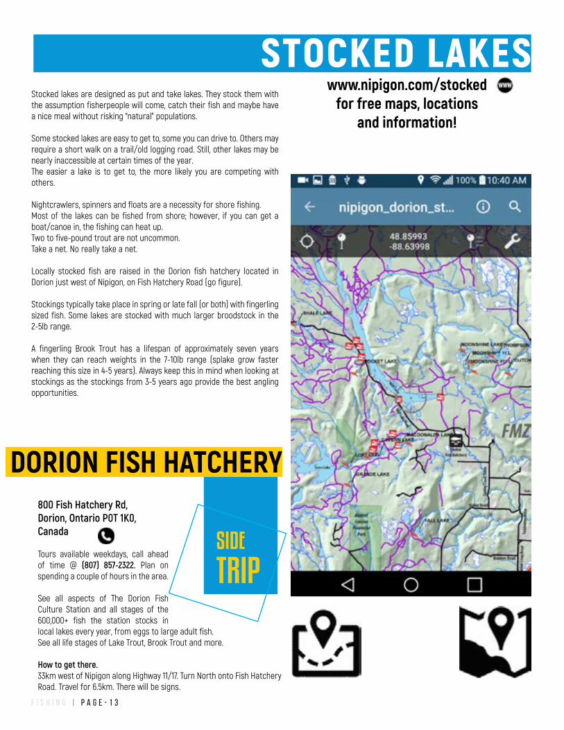
www.nipigon.com/stockedfor free maps, locations
and information!
STOCKED LAKES
f i s h i n g | P a g e - 1 4
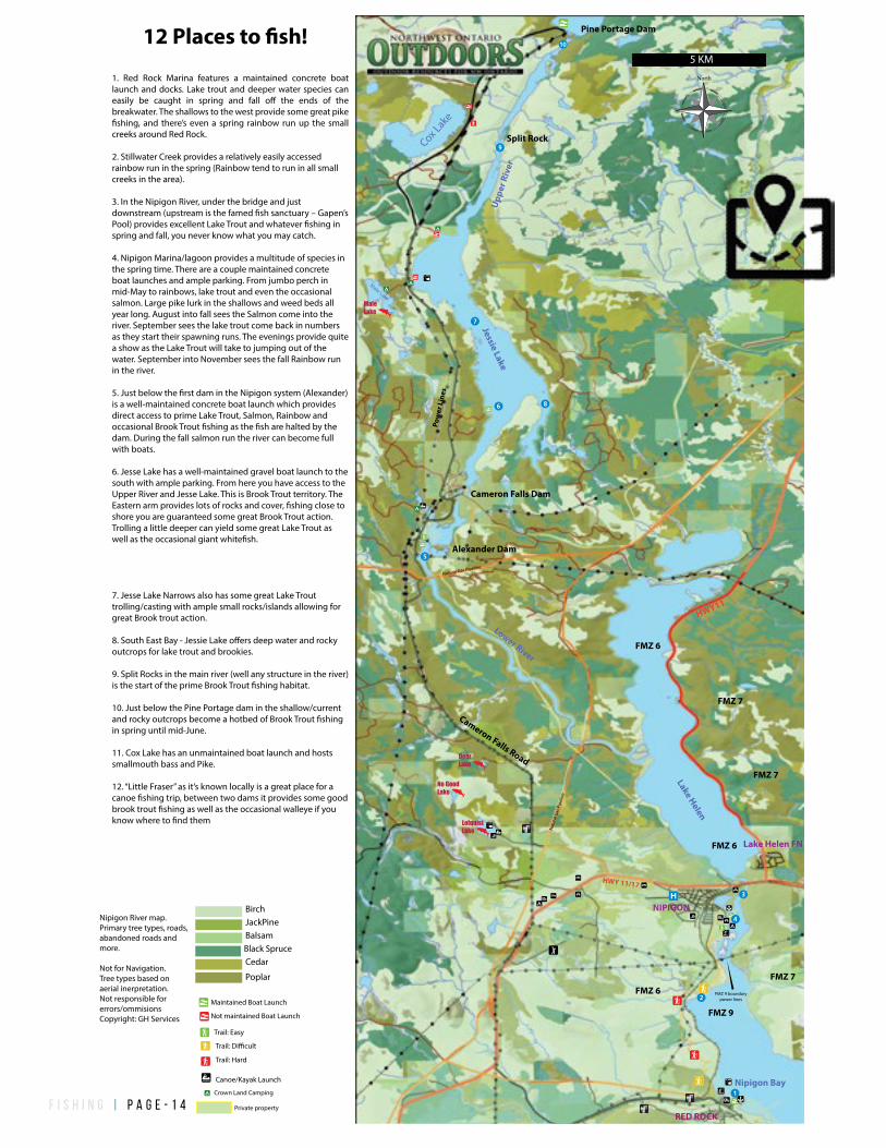
1. Red Rock Marina features a maintained concrete boat launch and docks. Lake trout and deeper water species can easily be caught in spring and fall o� the ends of the breakwater. The shallows to the west provide some great pike �shing, and there’s even a spring rainbow run up the small creeks around Red Rock.
2. Stillwater Creek provides a relatively easily accessed rainbow run in the spring (Rainbow tend to run in all small creeks in the area).
3. In the Nipigon River, under the bridge and just downstream (upstream is the famed �sh sanctuary – Gapen’s Pool) provides excellent Lake Trout and whatever �shing in spring and fall, you never know what you may catch.
4. Nipigon Marina/lagoon provides a multitude of species in the spring time. There are a couple maintained concrete boat launches and ample parking. From jumbo perch in mid-May to rainbows, lake trout and even the occasional salmon. Large pike lurk in the shallows and weed beds all year long. August into fall sees the Salmon come into the river. September sees the lake trout come back in numbers as they start their spawning runs. The evenings provide quite a show as the Lake Trout will take to jumping out of the water. September into November sees the fall Rainbow run in the river.
5. Just below the �rst dam in the Nipigon system (Alexander) is a well-maintained concrete boat launch which provides direct access to prime Lake Trout, Salmon, Rainbow and occasional Brook Trout �shing as the �sh are halted by the dam. During the fall salmon run the river can become full with boats.
6. Jesse Lake has a well-maintained gravel boat launch to the south with ample parking. From here you have access to the Upper River and Jesse Lake. This is Brook Trout territory. The Eastern arm provides lots of rocks and cover, �shing close to shore you are guaranteed some great Brook Trout action. Trolling a little deeper can yield some great Lake Trout as well as the occasional giant white�sh.
7. Jesse Lake Narrows also has some great Lake Trout trolling/casting with ample small rocks/islands allowing for great Brook trout action.
8. South East Bay - Jessie Lake o�ers deep water and rocky outcrops for lake trout and brookies.
9. Split Rocks in the main river (well any structure in the river) is the start of the prime Brook Trout �shing habitat.
10. Just below the Pine Portage dam in the shallow/current and rocky outcrops become a hotbed of Brook Trout �shing in spring until mid-June.
11. Cox Lake has an unmaintained boat launch and hosts smallmouth bass and Pike.
12. “Little Fraser” as it’s known locally is a great place for a canoe �shing trip, between two dams it provides some good brook trout �shing as well as the occasional walleye if you know where to �nd them
No GoodLake
LofquistLake
DeerLake
MaleLake
Pow
er L
ines
North
Nipigon River map. Primary tree types, roads, abandoned roads and more.
Not for Navigation. Tree types based on aerial inerpretation.Not responsible for errors/ommisionsCopyright: GH Services
Jessie Lake
Lake Helen
Nipigon Bay
Cox Lake
Cameron Falls Road
FMZ 9
Upp
er R
iver
Lower River
Male Lake
Split Rock
Pine Portage Dam
FMZ 6
FMZ 7
HWY11
HWY 11/17
Pipeline
FMZ 7FMZ 6
NIPIGON
RED ROCK
5 KM
Cameron Falls Dam
Alexander Dam
12 Places to �sh!
FMZ 6
FMZ 7
FMZ 9 boundarypower lines
Lake Helen FN
Nat
ural
Gas
Pip
elin
e
Natural Gas Pipeline
Crown Land Camping
Trail: Easy
Trail: Di�cult
Trail: Hard
Canoe/Kayak Launch
Maintained Boat Launch
Not maintained Boat Launch
Private property
Birch
BalsamJackPine
Black SpruceCedar
Poplar
f i s h i n g | P a g e - 1 5
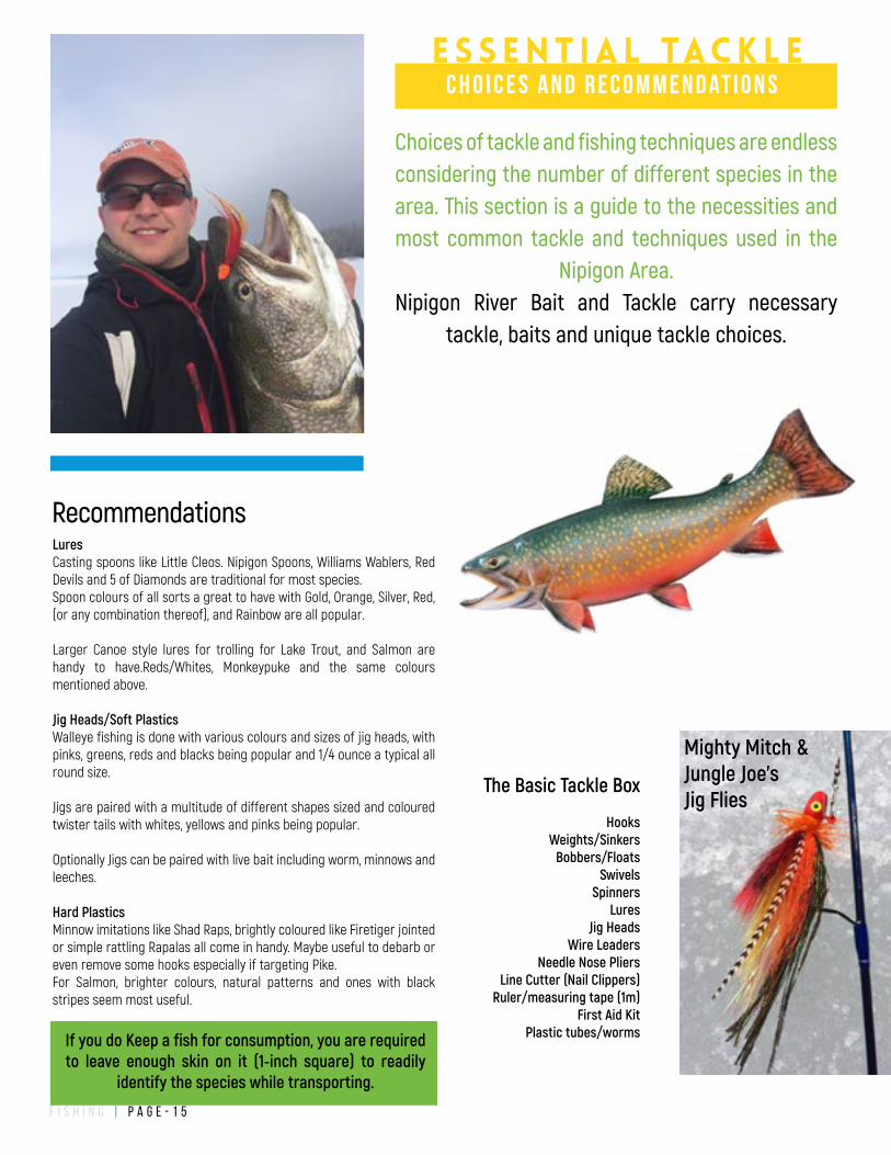
The Basic Tackle Box
HooksWeights/Sinkers
Bobbers/FloatsSwivels
SpinnersLures
Jig HeadsWire Leaders
Needle Nose PliersLine Cutter (Nail Clippers)
Ruler/measuring tape (1m)First Aid Kit
Plastic tubes/worms
LuresCasting spoons like Little Cleos. Nipigon Spoons, Williams Wablers, Red Devils and 5 of Diamonds are traditional for most species. Spoon colours of all sorts a great to have with Gold, Orange, Silver, Red, (or any combination thereof), and Rainbow are all popular.
Larger Canoe style lures for trolling for Lake Trout, and Salmon are handy to have.Reds/Whites, Monkeypuke and the same colours mentioned above.
Jig Heads/Soft PlasticsWalleye fishing is done with various colours and sizes of jig heads, with pinks, greens, reds and blacks being popular and 1/4 ounce a typical all round size.
Jigs are paired with a multitude of different shapes sized and coloured twister tails with whites, yellows and pinks being popular.
Optionally Jigs can be paired with live bait including worm, minnows and leeches.
Hard PlasticsMinnow imitations like Shad Raps, brightly coloured like Firetiger jointed or simple rattling Rapalas all come in handy. Maybe useful to debarb or even remove some hooks especially if targeting Pike. For Salmon, brighter colours, natural patterns and ones with black stripes seem most useful.
If you do Keep a fish for consumption, you are required to leave enough skin on it (1-inch square) to readily
identify the species while transporting.
Recommendations
Choices of tackle and fishing techniques are endless considering the number of different species in the area. This section is a guide to the necessities and most common tackle and techniques used in the
Nipigon Area. Nipigon River Bait and Tackle carry necessary
tackle, baits and unique tackle choices.
e s s e n t i a l tac k l ec h o i c e s a n d r e c o m m e n d at i o n s
Mighty Mitch & Jungle Joe's Jig Flies
f i s h i n g | P a g e - 1 6
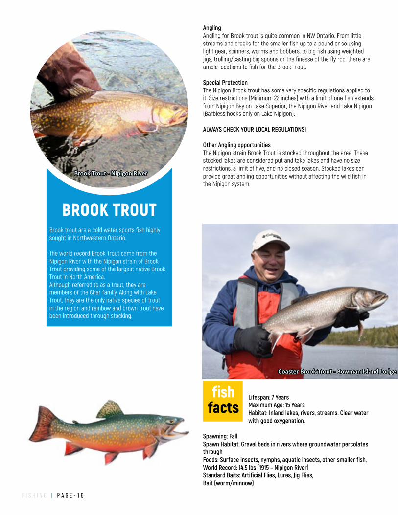
Lifespan: 7 YearsMaximum Age: 15 YearsHabitat: Inland lakes, rivers, streams. Clear water with good oxygenation.
Spawning: Fall Spawn Habitat: Gravel beds in rivers where groundwater percolates throughFoods: Surface insects, nymphs, aquatic insects, other smaller fish, World Record: 14.5 lbs (1915 – Nipigon River)Standard Baits: Artificial Flies, Lures, Jig Flies, Bait (worm/minnow)
Angling Angling for Brook trout is quite common in NW Ontario. From little streams and creeks for the smaller fish up to a pound or so using light gear, spinners, worms and bobbers, to big fish using weighted jigs, trolling/casting big spoons or the finesse of the fly rod, there are ample locations to fish for the Brook Trout.
Special ProtectionThe Nipigon Brook trout has some very specific regulations applied to it. Size restrictions (Minimum 22 inches) with a limit of one fish extends from Nipigon Bay on Lake Superior, the Nipigon River and Lake Nipigon (Barbless hooks only on Lake Nipigon).
ALWAYS CHECK YOUR LOCAL REGULATIONS!
Other Angling opportunitiesThe Nipigon strain Brook Trout is stocked throughout the area. These stocked lakes are considered put and take lakes and have no size restrictions, a limit of five, and no closed season. Stocked lakes can provide great angling opportunities without affecting the wild fish in the Nipigon system.
Coaster Brook Trout - Bowman Island Lodge
BROOK TROUTBrook trout are a cold water sports fish highly sought in Northwestern Ontario.
The world record Brook Trout came from the Nipigon River with the Nipigon strain of Brook Trout providing some of the largest native Brook Trout in North America. Although referred to as a trout, they are members of the Char family. Along with Lake Trout, they are the only native species of trout in the region and rainbow and brown trout have been introduced through stocking.
fishfacts
Brook Trout - Nipigon River
f i s h i n g | P a g e - 1 7
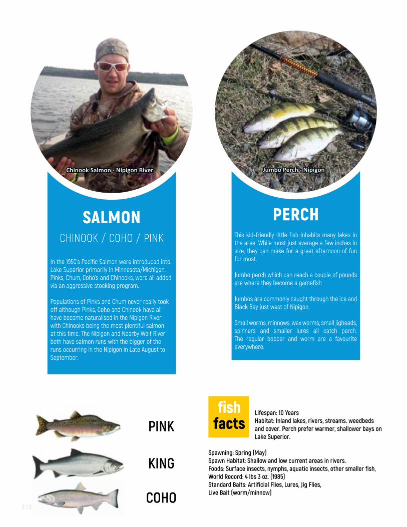
PERCHThis kid-friendly little fish inhabits many lakes in the area. While most just average a few inches in size, they can make for a great afternoon of fun for most.
Jumbo perch which can reach a couple of pounds are where they become a gamefish
Jumbos are commonly caught through the ice and Black Bay just west of Nipigon.
Small worms, minnows, wax worms, small jigheads, spinners and smaller lures all catch perch. The regular bobber and worm are a favourite everywhere.
Jumbo Perch - Nipigon
Lifespan: 10 YearsHabitat: Inland lakes, rivers, streams. weedbeds and cover. Perch prefer warmer, shallower bays on Lake Superior.
Spawning: Spring (May)Spawn Habitat: Shallow and low current areas in rivers. Foods: Surface insects, nymphs, aquatic insects, other smaller fish, World Record: 4 lbs 3 oz. (1985)Standard Baits: Artificial Flies, Lures, Jig Flies, Live Bait (worm/minnow)
fishfacts
SALMONCHINOOK / COHO / PINK
In the 1950’s Pacific Salmon were introduced into Lake Superior primarily in Minnesota/Michigan. Pinks, Chum, Coho’s and Chinooks, were all added via an aggressive stocking program.
Populations of Pinks and Chum never really took off although Pinks, Coho and Chinook have all have become naturalised in the Nipigon River with Chinooks being the most plentiful salmon at this time. The Nipigon and Nearby Wolf River both have salmon runs with the bigger of the runs occurring in the Nipigon in Late August to September.
Chinook Salmon - Nipigon River
PINK
KING
COHO
f i s h i n g | P a g e - 1 8
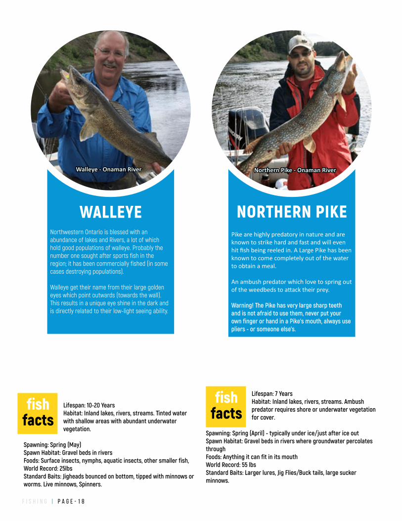
WALLEYENorthwestern Ontario is blessed with an abundance of lakes and Rivers, a lot of which hold good populations of walleye. Probably the number one sought after sports fish in the region; it has been commercially fished (in some cases destroying populations).
Walleye get their name from their large golden eyes which point outwards (towards the wall). This results in a unique eye shine in the dark and is directly related to their low-light seeing ability.
Lifespan: 7 YearsHabitat: Inland lakes, rivers, streams. Ambush predator requires shore or underwater vegetation for cover.
Spawning: Spring (April) - typically under ice/just after ice outSpawn Habitat: Gravel beds in rivers where groundwater percolates throughFoods: Anything it can fit in its mouthWorld Record: 55 lbsStandard Baits: Larger lures, Jig Flies/Buck tails, large sucker minnows.
fishfacts
NORTHERN PIKEPike are highly predatory in nature and are known to strike hard and fast and will even hit fish being reeled in. A Large Pike has been known to come completely out of the water to obtain a meal.
An ambush predator which love to spring out of the weedbeds to attack their prey.
Warning! The Pike has very large sharp teeth and is not afraid to use them, never put your own finger or hand in a Pike's mouth, always use pliers - or someone else's.
Lifespan: 10-20 YearsHabitat: Inland lakes, rivers, streams. Tinted water with shallow areas with abundant underwater vegetation.
Spawning: Spring (May)Spawn Habitat: Gravel beds in rivers Foods: Surface insects, nymphs, aquatic insects, other smaller fish, World Record: 25lbsStandard Baits: Jigheads bounced on bottom, tipped with minnows or worms. Live minnows, Spinners.
fishfacts
Northern Pike - Onaman RiverWalleye - Onaman River
f i s h i n g | P a g e - 1 9
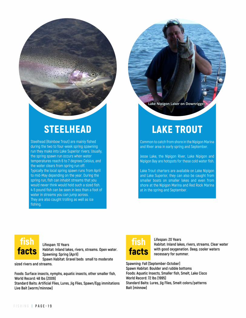
LAKE TROUTCommon to catch from shore in the Nipigon Marina and River area in early spring and September.
Jesse Lake, the Nipigon River, Lake Nipigon and Nipigon Bay are hotspots for these cold water fish.
Lake Trout charters are available on Lake Nipigon and Lake Superior, they can also be caught from smaller boats on smaller lakes and even from shore at the Nipigon Marina and Red Rock Marina at in the spring and September.
Lake Nipigon Laker on Downrigger
Lifespan: 20 YearsHabitat: Inland lakes, rivers, streams. Clear water with good oxygenation. Deep, cooler waters necessary for summer.
Spawning: Fall (September-October)Spawn Habitat: Boulder and rubble bottomsFoods: Aquatic Insects, Smaller fish, Smelt, Lake CiscoWorld Record: 72 lbs (1995)Standard Baits: Lures, Jig Flies, Smelt colors/patternsBait (minnow)
fishfacts
STEELHEADSteelhead (Rainbow Trout) are mainly fished during the two to four-week spring spawning run they make into Lake Superior rivers. Usually, the spring spawn run occurs when water temperatures reach 6 to 7 degrees Celsius, and the water clears from spring run off. Typically the local spring spawn runs from April to mid-May depending on the year. During the spring run, fish can inhabit streams that you would never think would hold such a sized fish. 4-5 pound fish can be seen in less than a foot of water in streams you can jump across.They are also caught trolling as well as ice fishing.
Lifespan: 10 YearsHabitat: Inland lakes, rivers, streams. Open water.Spawning: Spring (April)Spawn Habitat: Gravel beds small to moderate
sized rivers and streams.
Foods: Surface insects, nymphs, aquatic insects, other smaller fish, World Record: 48 lbs (2009)Standard Baits: Artificial Flies, Lures, Jig Flies, Spawn/Egg immitationsLive Bait (worm/minnow)
fishfacts
f i s h i n g | P a g e - 2 0
LAKE SUPERIOR VIEWS
SIDE
TRIP
Rossport, Schreiber, Terrace BayHighway 17 from Nipigon travels east along the rugged coastline of Lake Superior. Some of the best views of Superior are from this section of highway featuring imposing clifftops overlooking Nipigon Bay.
Your first stop will be at Kama Hill, as you rise to overlook Kama Bay on the north side of the highway you will see well layered red rocks interlain with darker layers. These are remnants of an ancient desert which periodically flooded. Just a short distance past Kama hill you will start up another larger hill - with a small park on the right-hand side with a fantastic view of Lake Superior and Kama.
Continuing on your journey, you will cross many rivers which hold springtime spawning steelhead, around the shores of Lake Superior.
Casque Isles Trail's western most end starts at Rossport and will travel another 53km along Lake Superior to Terrace Bay.
Pays Plat First NationThis small First Nation community on the shores of Lake Superior. It hosts its annual Pow Wow celebration near the end of July every year.
RossportApproximately an hours drive east of Nipigon you will come down a large hill where the highway seems to run right into the lake. Nestled at the base of the hill is the tiny hamlet of Rossport. With bed and breakfasts, guided boat tours, kayaking and a relaxing cafe Rossport gives you a great vantage point for the islands of Nipigon Bay. Rossport even has a beautiful sandy beach to relax on.
SchreiberA Train Town with a train museum. Visit the Rail Array Museum. Also, hosts a Trailhead to join into the Casque Isles Trail.
Terrace BayAgusasobon Falls and Gorge, large sandy beach, quality golf course and gateway to the Slate Islands Provincial Park - site of an ancient meteorite impact.
As you drive down to the beach, you are driving down the terraces which mark different waterlevels on Lake Superior over time.
Nestled in the heart of NW Ontario lies the Nipigon River which flows from Lake Nipigon to the Northern most tip of Lake Superior. Here the Brook Trout are records.
The Story of the world record brook trout
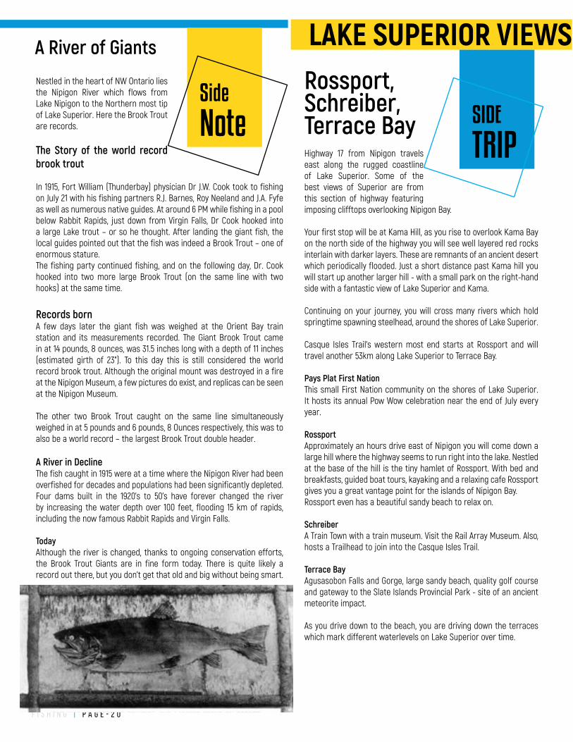
In 1915, Fort William (Thunderbay) physician Dr J.W. Cook took to fishing on July 21 with his fishing partners R.J. Barnes, Roy Neeland and J.A. Fyfe as well as numerous native guides. At around 6 PM while fishing in a pool below Rabbit Rapids, just down from Virgin Falls, Dr Cook hooked into a large Lake trout – or so he thought. After landing the giant fish, the local guides pointed out that the fish was indeed a Brook Trout – one of enormous stature.The fishing party continued fishing, and on the following day, Dr. Cook hooked into two more large Brook Trout (on the same line with two hooks) at the same time.
Records bornA few days later the giant fish was weighed at the Orient Bay train station and its measurements recorded. The Giant Brook Trout came in at 14 pounds, 8 ounces, was 31.5 inches long with a depth of 11 inches (estimated girth of 23”). To this day this is still considered the world record brook trout. Although the original mount was destroyed in a fire at the Nipigon Museum, a few pictures do exist, and replicas can be seen at the Nipigon Museum.
The other two Brook Trout caught on the same line simultaneously weighed in at 5 pounds and 6 pounds, 8 Ounces respectively, this was to also be a world record – the largest Brook Trout double header.
A River in DeclineThe fish caught in 1915 were at a time where the Nipigon River had been overfished for decades and populations had been significantly depleted.Four dams built in the 1920’s to 50’s have forever changed the river by increasing the water depth over 100 feet, flooding 15 km of rapids, including the now famous Rabbit Rapids and Virgin Falls.
TodayAlthough the river is changed, thanks to ongoing conservation efforts, the Brook Trout Giants are in fine form today. There is quite likely a record out there, but you don’t get that old and big without being smart.
Side
Note
A River of Giants
H I S T O R Y | P a g e - 2 2
The Aboriginal people who lived in the area before European contact and the establishment of the fur trade are believed to have first arrived in the Nipigon area roughly 9,000 years ago. It is possible that they survived off of big game hunting and came into the area while following the caribou herds. There are rock paintings near the mouth of the Nipigon River which predate European contact by several thousand years.
The fur trade was first established in the area in 1665 when it was leased by the Company of 100 Associates. It wasn’t until 1679 though when the first permanent fur trade post was established by Claude Greysolon Dulhut. LaVerendrye, a French explorer known for his attempts to find the “Western Sea” took command of Fort Ste Ann at the mouth of the Nipigon River. He moved on from the Fort two years later in 1729. The last fur trade post located at what would soon be the Nipigon waterfront was Red Rock House. It was built in 1859 by the Hudson’s Bay Company and burned down in 1891.
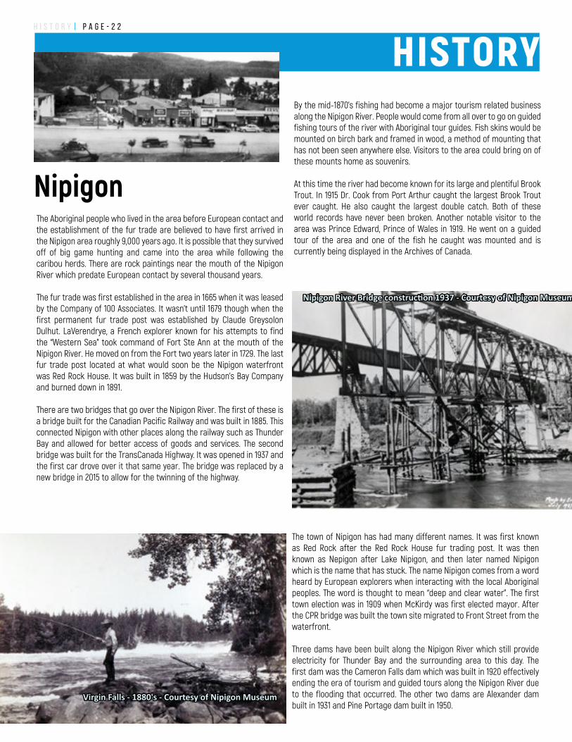
There are two bridges that go over the Nipigon River. The first of these is a bridge built for the Canadian Pacific Railway and was built in 1885. This connected Nipigon with other places along the railway such as Thunder Bay and allowed for better access of goods and services. The second bridge was built for the TransCanada Highway. It was opened in 1937 and the first car drove over it that same year. The bridge was replaced by a new bridge in 2015 to allow for the twinning of the highway.
By the mid-1870’s fishing had become a major tourism related business along the Nipigon River. People would come from all over to go on guided fishing tours of the river with Aboriginal tour guides. Fish skins would be mounted on birch bark and framed in wood, a method of mounting that has not been seen anywhere else. Visitors to the area could bring on of these mounts home as souvenirs.
At this time the river had become known for its large and plentiful Brook Trout. In 1915 Dr. Cook from Port Arthur caught the largest Brook Trout ever caught. He also caught the largest double catch. Both of these world records have never been broken. Another notable visitor to the area was Prince Edward, Prince of Wales in 1919. He went on a guided tour of the area and one of the fish he caught was mounted and is currently being displayed in the Archives of Canada.
Nipigon River Bridge construction 1937 - Courtesy of Nipigon Museum
Virgin Falls - 1880's - Courtesy of Nipigon Museum
HISTORY
The town of Nipigon has had many different names. It was first known as Red Rock after the Red Rock House fur trading post. It was then known as Nepigon after Lake Nipigon, and then later named Nipigon which is the name that has stuck. The name Nipigon comes from a word heard by European explorers when interacting with the local Aboriginal peoples. The word is thought to mean “deep and clear water”. The first town election was in 1909 when McKirdy was first elected mayor. After the CPR bridge was built the town site migrated to Front Street from the waterfront.
Three dams have been built along the Nipigon River which still provide electricity for Thunder Bay and the surrounding area to this day. The first dam was the Cameron Falls dam which was built in 1920 effectively ending the era of tourism and guided tours along the Nipigon River due to the flooding that occurred. The other two dams are Alexander dam built in 1931 and Pine Portage dam built in 1950.
Nipigon
H I S T O R Y | P a g e - 2 3
Located on Front Street by the Library and Town office. The buildings exterior has a mural depicting the history of Nipigon with an additional historical mural located at the Tourist Information Center.
Although the orgiginal world record Brook Trout was burned in the fire there are still remnants and replicas at the Museum.
The Museum holds many artifacts from the different stages in Nipigon and the areas development. Displays are changed from time to time.
The museum is open summer months daily from 11am to 8pm. during non-open times tours can be arranged by [email protected].
Visit: http://nipigonmuseumtheblog.blogspot.ca/
SIDE
TRIP
Nipigon MuseumSchreiber
Terrace Bay
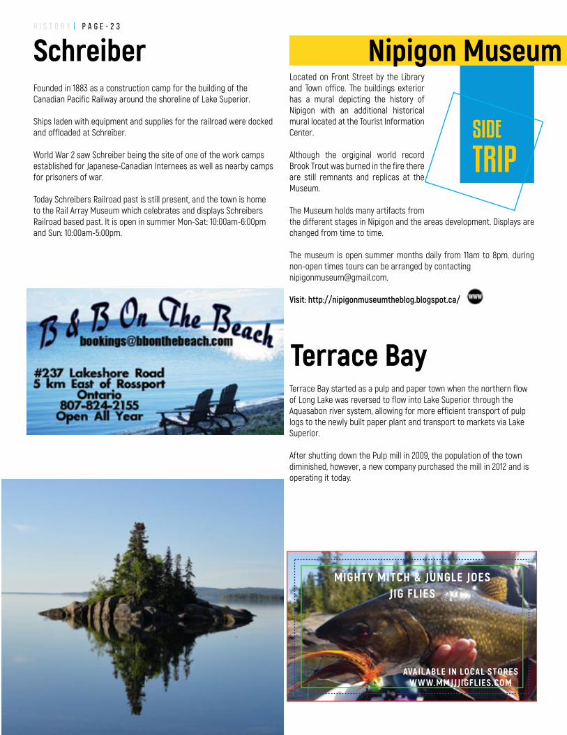
Founded in 1883 as a construction camp for the building of the Canadian Pacific Railway around the shoreline of Lake Superior.
Ships laden with equipment and supplies for the railroad were docked and offloaded at Schreiber.
World War 2 saw Schreiber being the site of one of the work camps established for Japanese-Canadian Internees as well as nearby camps for prisoners of war.
Today Schreibers Railroad past is still present, and the town is home to the Rail Array Museum which celebrates and displays Schreibers Railroad based past. It is open in summer Mon-Sat: 10:00am-6:00pm and Sun: 10:00am-5:00pm.
Terrace Bay started as a pulp and paper town when the northern flow of Long Lake was reversed to flow into Lake Superior through the Aquasabon river system, allowing for more efficient transport of pulp logs to the newly built paper plant and transport to markets via Lake Superior.
After shutting down the Pulp mill in 2009, the population of the town diminished, however, a new company purchased the mill in 2012 and is operating it today.
MIGHTY MITCH & JUNGLE JOESJIG FLIES
AVAIL ABLE IN LOCAL STORESW W W.MMJJJIGFLIES.COM
h i k i n g | P a g e - 2 4
Nipigon River Recreation Trail - Nipigon Trail Head6.3 km in Red Rock Road (Highway 628) on the north side of the highway. Red Rock end of the trail starts uphill to scenic views.Trailhead Coordinates: 48.947555°, -88.268346°
Nipigon River Recreation Trail – Nipigon Trail Head Nipigon Marina - South end. Nipigon end of the trail is flat and follows the Nipigon River. Nipigon Marina also has varied length attached trails around the marina.Trailhead Coordinates: 49.008073°, -88.257402°
Red Rock Mountain Trail5. 8 km red rock road, south side of the highway. 0.25km in the Red Rock Road #1 (gravel). A new trail up the Red Rock Mountain.Trailhead Coordinates: 48.944474°, -88.285542°
Kama Cliffs Trail23km east of Nipigon along Highway 17 to just before Jackpine River there is a pull off/parking area on the North side of the road. Walk along highway on trail going west to trailhead approximately 300m.Trailhead coordinates: 48.971791°, -88.001027°
Mazukama Falls19 km east of Highway 11 turnoff along Highway 17, north onto gravel road camp 81 for 0.5km, just before power lines. Waterfalls and great views of Lake Superior.Trailhead Coordinates: 49.014496°, -88.014209°
Trail maps and additional information are available online atnipigon.com/trails
Try our Smartmaps with real time GPS tracking on your smartphone - no cell signal required!
NOW available for FREE in
Avenza Map Store
Hiking Trails Adventure Awaits
nipigon.com/trails
h i k i n g | P a g e - 2 5
Deer Lake Mountain TrailTurn north onto Highway 585 (Cameron falls road) at Petro Canada station in Nipigon. 3.5 km on the west side of the road. A well marked, Scenic trail with great views of Lake Helen, The Bridge/Nipigon River and the Nipigon Bay.Trailhead Coordinates: 49.042364°, -88.323143°
Lake Nipigon Shoreline Trail5km trail along the beaches at Poplar Point in Beardmore. Follows Lake Nipigon shoreline with stunning views from two lookout stations near High Hill Harbour.Trailhead Coordinates: 49.632566°, -88.089474°
Palisades Trail36 km north of Highway 11 turnoff along Highway 11. Turn east onto the small gravel road for 0.6km.A well-marked trail starts with steps and then along the cliff edges around the Palisades with great views of Orient Bay.Trailhead Coordinates: 49.310172°, -88.102114°
Bald Spot TrailNipigon from First Street, turn west onto Wadsworth continue up the hill to stop sign. Turn righ. A short, simple trail to an overlook with great views of Nipigon and the new bridge.Trailhead Coordinates: 49.009581°, -88.274852°
Hurkett Cove Conservation Trail30 km west of Nipigon on Highway 11/17. Turn east onto Black Bay Road for 3.2km. A simple sometimes overgrown trail into the sand/marsh of Hurkett Cove Conservation area.Trailhead Coordinates: 48.825215°, -88.487786°
Casques Isles Trail systemCasques Isles Trail: 53 km of trail from Rossport to Terrace Bay with multiple points of entrance, access through Rainbow Falls Provincial Park And a great trail to spend a couple of days backpacking on.
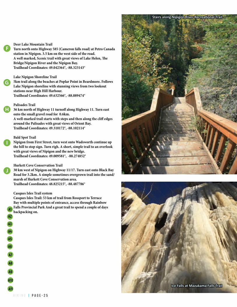
Stairs along Nipigon River Recreational Trail
Ice Falls at Mazukama Falls Trail
A1
A3
A4
A5
A6
A2
A7
A8
A9
A10
A11
h i k i n g | P a g e - 2 6
Experience the adventure of rock and ice climbing in Northwest Ontario by booking a guided excursion with Aric Fishman of Outdoor Skills And Thrills - www.outdoorskillsandthrills.comFishman is also the head of the Nipigon Ice Climbing Festival Committee, and the author of the latest comprehensive rock climbing guidebook for the region 'Thunder Bay Climbing - A Guide to Northwestern Ontario's Best Kept Secret'.Facebook @OutdoorSkillsAndThrills Instagram: @Outdoor_Skills
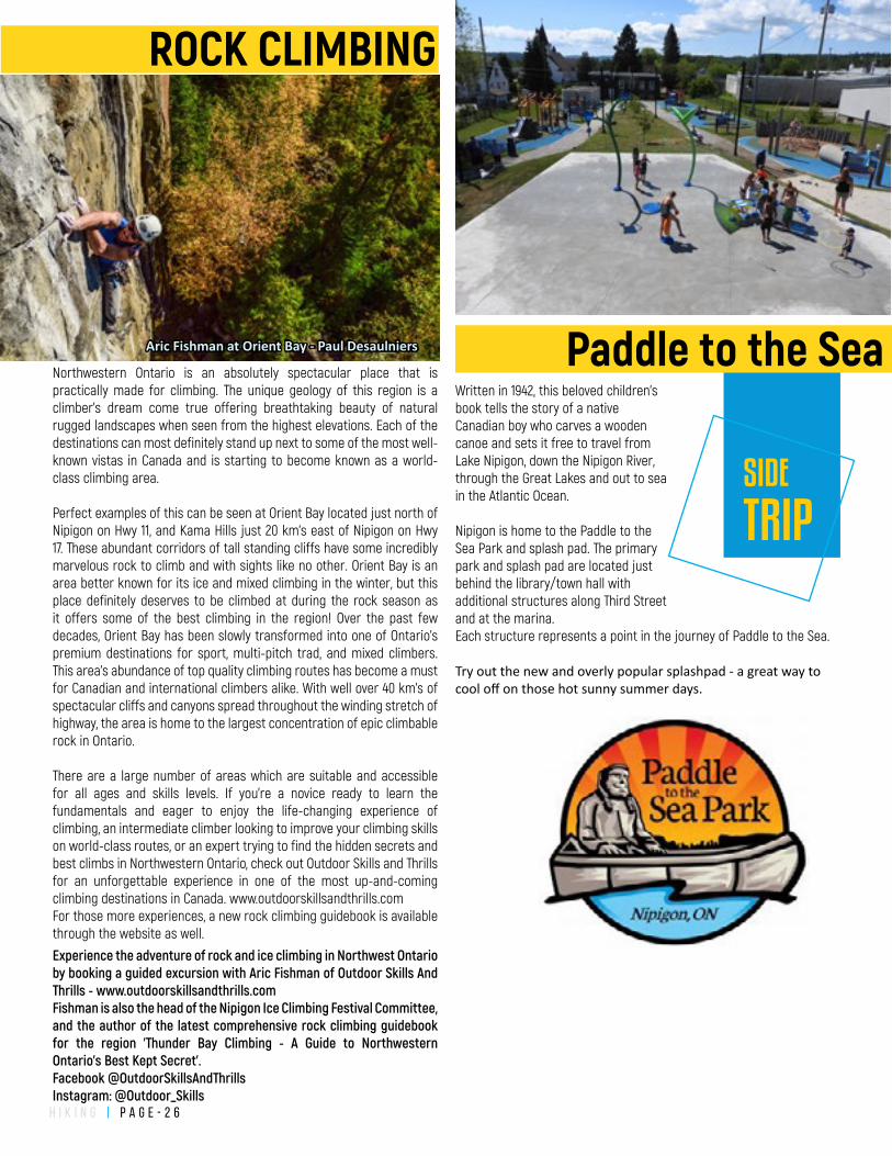
Northwestern Ontario is an absolutely spectacular place that is practically made for climbing. The unique geology of this region is a climber’s dream come true offering breathtaking beauty of natural rugged landscapes when seen from the highest elevations. Each of the destinations can most definitely stand up next to some of the most well-known vistas in Canada and is starting to become known as a world-class climbing area.
Perfect examples of this can be seen at Orient Bay located just north of Nipigon on Hwy 11, and Kama Hills just 20 km's east of Nipigon on Hwy 17. These abundant corridors of tall standing cliffs have some incredibly marvelous rock to climb and with sights like no other. Orient Bay is an area better known for its ice and mixed climbing in the winter, but this place definitely deserves to be climbed at during the rock season as it offers some of the best climbing in the region! Over the past few decades, Orient Bay has been slowly transformed into one of Ontario’s premium destinations for sport, multi-pitch trad, and mixed climbers. This area's abundance of top quality climbing routes has become a must for Canadian and international climbers alike. With well over 40 km’s of spectacular cliffs and canyons spread throughout the winding stretch of highway, the area is home to the largest concentration of epic climbable rock in Ontario.
There are a large number of areas which are suitable and accessible for all ages and skills levels. If you’re a novice ready to learn the fundamentals and eager to enjoy the life-changing experience of climbing, an intermediate climber looking to improve your climbing skills on world-class routes, or an expert trying to find the hidden secrets and best climbs in Northwestern Ontario, check out Outdoor Skills and Thrills for an unforgettable experience in one of the most up-and-coming climbing destinations in Canada. www.outdoorskillsandthrills.comFor those more experiences, a new rock climbing guidebook is available through the website as well.
Aric Fishman at Orient Bay - Paul Desaulniers
ROCK CLIMBING
Written in 1942, this beloved children's book tells the story of a native Canadian boy who carves a wooden canoe and sets it free to travel from Lake Nipigon, down the Nipigon River, through the Great Lakes and out to sea in the Atlantic Ocean.
Nipigon is home to the Paddle to the Sea Park and splash pad. The primary park and splash pad are located just behind the library/town hall with additional structures along Third Street and at the marina. Each structure represents a point in the journey of Paddle to the Sea.
Try out the new and overly popular splashpad - a great way to cool off on those hot sunny summer days.
SIDE
TRIP
Paddle to the Sea
h i k i n g | P a g e - 2 7
! ! ! ! ! ! ! ! ! ! ! ! ! ! ! ! ! ! ! ! ! ! ! ! ! ! ! ! ! ! ! ! ! ! ! ! ! ! ! ! ! ! ! ! ! ! ! ! ! ! ! ! ! !!
!
!
!
!
!
!
!
!
!
!
!
!
!
!
!
!
!
!
!
!
!
!
!
!
!
!
!
!
!
!
!
!
!
!
!
!
!
!
!
!
!
!
!
!
!
!
!
!
!
!
!
!
!
!
!
!
!
!
!
!
!
!
!
!
!
!
!
!
!
!
!
!
!
!
!
!
!
!
!
!
!
!
!
!
!
!
!
!
!
!
!
!
!
!
!
!
!
!
!
!
!
!
!
!
!
!
!
!
!
!
!
!
!
!
!
!
!
!
!
!
!
!
!
!
!
!
!
!
!
!
!
!
!
!
!
!
!
!
!
!
!
!
!
!
!
!
!
!
!
!
!
!
!
!
!
!
!
!
!
!
!!
!!
!!
!!
!!
!!
!!
!
!!
!!
!
!!
!!
!!
!!
!!
!!
!!
!
!
!
!
!
!
!
!
!
!
!
!
!
!
!
!
!
!
!
!
!
!
!
!
!
!
!
!
!
!
!
!
!
!
!
!
!
!
!
!
!
!
!
!
!
!
!
!
!
!
!
!
!
!
35
34
33
32
31
30
29
0 10.5Miles
0 0.5 10.25Kilometers
KAMA BAY
MAZUKAMA BAY
JACKPINERIVER
OZONECREEK
MAZUKAMA CREEK
FMZ 7
FMZ 9North
WingtipLookout
WMU 21A<< 18KM TO NIPIGON
Take my Breath AwayLookout
Kama Lookout
!
!
"
!
"
"
!
"
!
!
!
!
!
1031
33
34
30
28
29
3222
13
E
D
!7
!7
12
!
!
MAINTAINED TRAILS
"
BOAT FISHING
!SHORE FISHING
GEOLOGY
Scenic Looko�
Waterfall
Trailhead Sign
Parking Area
Ice Fishing
This map and all others generated by GH Services are for recreational purposes only. There are no warranties, expressed or implied, including the warranty of merchant-ability or �tness for a particular purpose, accompanying this product. However, noti�cation of any errors will be appreciated.
Base topographic features, roads, lakes, rivers, and general topographic information on these maps are from digital databases provided by the Government of Canada and the Government of Ontario. GH Services makes no warranties towards its accuracy or merchantability of these layers.
Trail data supplied by the organisations responsible for those trails and collected/modi�ed for display by GH Services. GH Services cannot accept any responsibility for errors, omissions, or positional accuracy as these maps are for recreation only and are only a guide. Not all roads or trails may be shown or named. Some roads or trails may be private or incomplete. Trails and roads may or may not be traversable due to the season, local conditions or general deterioration.
THESE MAPS ARE NOT FOR NAVIGATION AND ARE NOT A SUBSTITUTE FOR COMMON SENSE. WHEN IN DOUBT, BE AWARE OF YOUR OWN OBSERVATIONS AND LIMITATIONS.
CAM
P 81
ROA
D
The smallest provincial park in Ontario?100m by 100m Kama Hills Provincial Park
Great Blueberry Pickingon Camp 81 roadwww.nipigon.com/blueberriesfor maps and blueberryinformation
Mazukama Falls
MishomisFalls
300m
1100m
900m
1800m
500m
Kama HillsPP
Stairway of the Saints
Year round �shing for manydi�erent species. Steelhead, Coaster Brook trout, Lake TroutWhite�sh, Northern Pike,Lake Cisco and Smelt to name a few.www.nipiugon.com/�shfor more information and locations.
More Trails with more great views?visit www.nipigon.com/trails
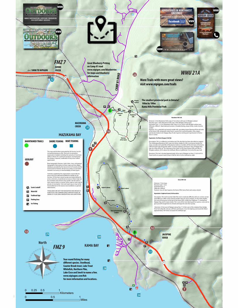
Mazukama Falls Trail
Distance: 3.1km Mazukama Falls Loop, 6.7 km return with spur to Wingtip LookoutElevation Gain: 120m Mazukama Falls Loop, 250m Wingtip Lookout spurEstimated Time: 1.5-2 hrs Mazukama Falls Loop, 4-5 hrs return with Wingtip Lookout spurDi�culty: Di�cult - black diamond sections. Unstable footing, steep climbs, creeks must be waded.Features: 25 m. waterfalls and several smaller falls, cascading stream �owing o� the red rocks of the Kama Cli�s, old growth cedar forest, massive fern covered boulders, talus slopes, spectacular lookout over Nipigon Bay of Lake Superior and beyond. Spectacular ice forma-tions in winter.
Organization: Nor'Wester Voyageur Trail Club
Description: This is a wilderness recreation trail. This day hike has been described as magical. The challenging Mazukama Falls Loop trail climbs steeply for 500 m and passes beside the many cascades and waterfalls of Mazukama Creek as it tumbles o� the red rocks of the Kama Cli�s through huge old growth cedars. For those seeking a panoramic view of Nipigon Bay, take the steep climb up “The Stairwayz of the Saints” to the top of Kama Cli�s and hike to Wingtip Lookout, 250 m above the trailhead. Allow an additional 2 hrs to do this spur trail.
Directions: This trail is located approximately 20 km east of Nipigon on Hwy 17 at km 677.4. Travel north on a gravel road (Camp 81 Rd) for 200 m to the trailhead on right.
Kama Cli�s Trail
Distance: 7.3 km loopElevation Gain: 152mEstimated Time: XDi�culty: Di�cultFeatures: view of Lake Superior, the Kama Cli�s, Kama Point and various islands
Organization: Singletrack Society Trail Association
Description: This trail mountain bike/hike trail is moderate di�culty with one section consid-ered di�cult. It o�ers some natural wonders that are sure to impress. As the name implies, this trail will bring you to the top of the Kama Cli�s, visible from Highway 17, overlooking Nipigon Bay and its many islands. This is one of the most ideal spots for a picnic, so be sure to give yourself enough time to sit back and enjoy the view from up top.
Directions: 25 km east of Nipigon along Hwy 17, 0.5km west of the Jackpine River bridge. Enter Kama Bay Rd. and you will �nd a parking lot. Cross the highway and travel left (West) approximately 100 metres to locate the trailhead sign.
Pocket LookoutBigford Lookout
NIPIGON
RED ROCK
SCHREIBERTERRACE BAYROSSPORT
ROCKY BAY FN
BEARDMORE
HURKETT
DORION
PEARL
PASS LAKE
BLACK BAY
NIPIGON BAY
LAKE SUPERIOR
SLATE ISLANDS
IGNACE ISLAND
KAMA BAY
LAKENIPIGON
PAYS PLAT FN
LAKE HELEN FN
TERRACE BAY BATHOLITH
Rainbow FallsProvincial Park
Granodiorite/Granite
Sibley GroupSedimentary
Mafic to Intermediate Metavolcanics
Mafic to Ultramafic
Alkalicintrusive suite
NeysProvincial Park
Ruby LakeProvincial Park
Ouimet CanyonProvincial Park
Sleeping GiantProvincial Park
Prairie River MouthProvincial Nature Reserve
0 10 20 30 405Kilometers
0 10 20 30 405Miles
!
!!!
!!
!
!
! ! ! !
!! ! ! !!!
D
E
C B
I B
R
F
A9A8A7A6A5
A4A3A2A1
A11A10 !
!
!
!
!
!
!
!
!
!
!
! !
!
!
!
!
!
!
!
!
!
!
!
! !
8
7
2
3
4
5
9
6
1211
10
17
13
14
!
!
!
!
!!
!
!
!
!
!
!
!
!
! !
!
!
! !
!
!
!
!
!
!
!
!
9
8
7
64
4
3
2
1
29
28
27
26
25
24
23
22
2120
19
18
1716
15
14
12
11
10
!13
!!"
"
"
"
"
"
"
"
"
"
"
!
!
"
!
!
"
"
"
" "
"!
!!"
!
!
"
"
"
!
"
"
!
!
!
6
9
8
5
2
1
7
3
40
39
38
37
12
36
3534
33
32
31
3029
28
27
26
25
24
23
22
21
20
19
10
11
18
17
16
15
14
13
Tent Camping
Golf Course
Marina
Boat Launch
Canoe Access
Medical Clinic
Hospital
Playground
Information Centre
Groceries
Camper Camping
Post O�ce
Library
Mechanical services
Kennel
Look o� Tower
Hiking Trail
Gas
ATM/Bank
Hotel/Motel
Dining
Laundromat
Museum
Roadside rest area
Cross Country Skiing
Ice/Rock Climbing
Pump Out Station
Scenic View
Souvenir Shop
Provincial Park
First Nation
"6
"9"8
"5
!2!1
!
"7
!3
!40!39!38"37
!12
!36"35!34!33!32"31"30"29"28"27"26!25"24!23!22"21"20"19
"10
"11
"18"17"16"15"14!13
"
Red Rock MarinaStillwater CreekNipigon River below BridgeNipigon MarinaNipigon River Below Alexander DamJesse LakeJesse Lake NarrowsJesse Lake East BayNipigon River Split RockNipigon River below Pine PortageCox LakeLittle FraserNipigon LagoonNipigon River Back ChannelNipigon River - Lake HelenNipigon River Mouth Drop o�Fraser LakeElizabeth LakeOskaweSouth Bay Lake NipigonBlack Sturgeon LakeHurkett DockWolf RiverBlack BayBlack Sturgeon RiverNipigon BayNipigon BayNipigon BayKama PointKama BayMazukama BayOzone CreekJackpine RiverJackpine river mouth areaKama BayBlack Sturgeon Below DamRossport - IslandsCypress RiverLittle Gravel RiverSteel River
Shor
eBo
at
!4
!9!8!7!6!5!4!3!2!1
!29!28!27!26!25!24!23!22!21!20!19!18!17!16!15!14
!12!11!10
!13
Ouimet Canyon
Amethyst Mines of Pearl
Dorion Fish Hatchery Tours
Hurkett Cove Conservation area
Red Rock Marina
View from the Nipigon River Recreational Trail
Nipigon Marina
Nipigon River Suspension Bridge
Ruby Lake Marble Quary
The Cli�s of Kama
Kama Bay Looko�
Rossport Beach and Islands
Schreiber Beach
Train Museum
Terrace Bay Beach
Terrace Bay Lighthouse Observation Tower
Ghost Town of Jack�sh
Alexander Dam and Looko�
Cameron Falls
Pine Portage Dam, Lake Forgan
The Palisades
Orient Bay
Beardmore Snowman
Beach at Polar Lodge - Lake Nipigon
High Hill Harbour
Saint Sylvesters Church
Lake Helen Rest Area
Hugfe 1993 Forest Fire aftermath
Abandoned Train Tunnel - Jumbo Cove
Aguasabon Falls and Gorge!30
!30
!!8!!7
!!2!!3!!4!!!!!5
!!!9
!6
!12!!11!10
!!17
!13
!!14
Roadcut - contact/unconformity
Amythest Mines of Pearl
Ouiment Canyon
Red Rock Mountain
Nipigon Glacial Deposits
Cuestas
Nipigon River Gorge
Nipigon Road Cut - Basement Rocks
Kama Cli�s Layering - Red Rocks
Ruby Lake Marble
Jackpine River Glacial Deposits
Lake Superior
Terrace Bay Beaches
Slate Islands
!D!E
!C
!I
!B
!R
!F
!A9!A8!A7
!A6!A5!A4!A3!A2!A1
!A11
!A10
Nipgion River Recreational Trail
Red Rock Mountain Trail
Kama Cli�s Trail
Mazukama Falls Trail
Deer Lake Mountain
Bald Spot Trail
Rendevous Ski Trails
The Casque Isles Trail is a recreational hiking trail along the North Shore of Lake Superior. The Trail is classi�ed as Di�cult, but there are many sections that are considered as Moderate between the more technical sections.
www.nipigon.com/geology www.nipigon.com/trailswww.nipigon.com/fishing www.nipigon.com/visit
For more and additional information on the points, trails, access and things to do represented in this map please visit www.nipigon.com and download the Land of Nipigon Adventure Guide for FREE. This map is also available as a FREE Smartphone Map to track your journey. www.nipigon.com/travelmap
This map and all others generated by GH Services are for recreational purposes only. There are no warranties, expressed or implied, including the warranty of merchantability or �tness for a particular purpose, accompanying this product. However, noti�cation of any errors will be
appreciated.
Base topographic features, roads, lakes, rivers, and general topographic information on these maps are from digital databases provided by the Government of Canada and the Government of
Ontario. GH Services makes no warranties towards its accuracy or merchantability of these layers.
Trail data supplied by the organisations responsible for those trails and collected/modi�ed for display by GH Services. GH Services cannot accept any responsibility for errors, omissions, or
positional accuracy as these maps are for recreation only and are only a guide. Not all roads or trails may be shown or named. Some roads or trails may be private or incomplete. Trails and roads
may or may not be traversable due to the season, local conditions or general deterioration.
THESE MAPS ARE NOT FOR NAVIGATION AND ARE NOT A SUBSTITUTE FOR COMMON SENSE. WHEN IN DOUBT, BE AWARE OF YOUR OWN OBSERVATIONS AND LIMITATIONS.
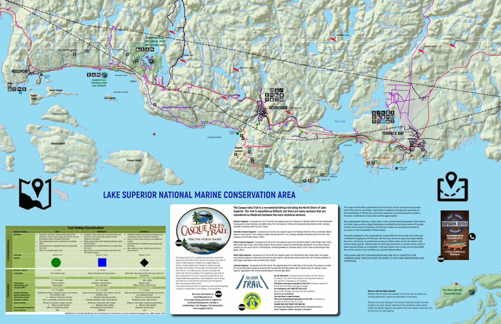
Quarry Island
Healy Island
Wilson Island
Want to visit the Slate Islands?Multiple charter boats are available from Terrace Bay to shuttle you, camping equipment, kayaks and sightseers to the island.
Witness the unique Geology of this ancient meteorite impact remnant. Campers can enjoy regular sightings of the woodland Caribou which inhabit the islands. Kayakers can explore the inner islands, protected from the full force of Lake Superior.
Boswells Point
Cat Islands
AbyondLookout
!!
!!
!!
!!
!!
!!
!!
!!
!!
!!
!!
!!
!!
!!
!!
!!
! ! ! ! ! ! ! ! ! ! ! ! ! ! ! ! ! !!
!!
!!
!!
!!
!!
!!
!!
!!
!!
!!
!!
!!
!!
!!
!!
!!
!!
!!
!!
!!
!!
!!
!!
!!
!!
!!
!!
!! !
!!
!!
!!
!!
!!
!!
!!
!!
!!
!!
!!
!!
!! ! ! ! ! ! ! ! ! ! ! ! ! ! ! ! ! ! ! ! ! ! ! ! ! ! ! ! ! ! ! ! ! ! ! ! ! ! ! ! ! !
! !
!!!!!!
!!!!
!!!
!!!!
!!
!
!
!
!
!
!
!
!
!
!
!!
!
!
!
!
!
!
!
!
!
!
!!!!!!!!!!!
!!
!
!!
!!
!!
!!
!
!
!
!
!
!
!
!
!
!
!
!
!
!
!
!
!
!
!
!
!
!
!
!
!
!
!
!
!
!
!
!
!
!
!
!
!
!
!
!
!
!
!
!
!
!
!
!
!
!
!
!
!
!!
!!
!!
!!
!!
!!
!!
!!
!!
!!
!!
!!
!!
!!
!!
!!
!!
!!
!!
!!
!!
!!
!
!!
!!!!!!!!!!!!!!!!!!!!!!!!!!!!
!
!
!
!
!
!
!
!
!!
!!
!!
!!
!!
!!
!!
!!
!!
!
!
!
!!
!
!!
!!
!
!
!
!
McLean’s Segment
Schreiber Channel Segment
Death Valley Segment
Mount Gwynne Segment
Lyda Bay Segment
ROSSPORT
SCHREIBER
TERRACE BAY
LAKE SUPERIOR NATIONAL MARINE CONSERVATION AREA
RAINBOW FALLSPROVINCIAL PARKWHITESAND LAKE
TERRACE BAY BEACH
Aguasabon falls
AguasabonGolf Course
PUMPHOUSE BEACH
SCHREIBER BEACH
RAINBOW FALLSPROVINCIAL PARKLAKE SUPERIOR
ROSSPORT BEACH
TERRACE BAY
LYDA BAY
DANNY’S COVE
WORTHINGTON BAY
NONAME BAY
KELLYHARBOUR
Hays Lake
Schreiber Channel
Collingwood Bay
Copper Island
This map and all others generated by GH Services are for recreational purposes only. There are no warranties, expressed or implied, including the warranty of merchantability or �tness for a particular purpose, accompanying this product. However, noti�cation of any errors will be appreciated.
Base topographic features, roads, lakes, rivers, and general topographic information on these maps are from digital databases provided by the Government of Canada and the Government of Ontario. GH Services makes no warranties towards its accuracy or merchantability of these layers.
Trail data supplied by the organisations responsible for those trails and collected/-modi�ed for display by GH Services. GH Services cannot accept any responsibility for errors, omissions, or positional accuracy as these maps are for recreation only and are only a guide. Not all roads or trails may be shown or named. Some roads or trails may be private or incomplete. Trails and roads may or may not be traversable due to the season, local conditions or general deterioration.
THESE MAPS ARE NOT FOR NAVIGATION AND ARE NOT A SUBSTITUTE FOR COMMON SENSE. WHEN IN DOUBT, BE AWARE OF YOUR OWN OBSERVATIONS AND LIMITATIONS.
!
!
!
!
!
!
!
!
"
!
! !!
!
!
!!
!
!
!
A9
A8
A7
A6
A5
A4
A3A2
A1
A11
A10
17
13
14
16
15
14
13
12
37
The Slate Islands Provincial Park
Channel Island
The Casque Isles Trail is a signed and groomed recreationalhiking trail that offers scenic vistas to the visitors who wish toshare in Lake Superior’s majestic and rugged beauty inOntario, Canada. Beginning in Rossport, passing throughSchreiber and ending in Terrace Bay, the total length of theTrail is 53 km. For those who do not wish to attempt theentire trek, the Trail is divided into 5 Segments; each with it’sown Access point from Hwy 17 and each presenting it’s ownunique wilderness experience. These Segments vary in lengthand difficulty so that both the advanced and the beginnerhiker can enjoy the North Shore.If you enjoy hiking and wish to support its continued development, consider a membership in the Voyageur Trail Association.
Do not hike alone. Let people know the section of Trail that youare hiking. If you don’t know anyone in the area leave notes atyour vehicle, or message us on Facebook.Cell phone coverage is sporadic on the Trail. Climbing a nearby hillshould give you better coverage if needed.For emergency call 1-888-310-1122 or 911.Wear proper footwear and dress for the conditions.Firearms are prohibited.You may have to wade streams.There are unmaintained campsites on the Trail. Campsites areavailable at Rainbow Falls Prov. Park.PLEASE PACK OUT WHAT YOU PACK IN!A1 Access East Rossport turnoff to km 4 and south on A2 toHwy 17. Requires shuttle ride back to Rossport.
Get more information at;www.hikesuperior.ca
If you enjoy hiking and wish to support its continued development, consider a
membership in the Voyageur Trail Association.www.voyageurtrail.ca
The Casque Isles Trail is a recreational hiking trail along the North Shore of Lake Superior. The Trail is classified as Difficult, but there are many sections that are considered as Moderate between the more technical sections.
Mclean's Segment - Accessed by A1, A2, A3 and A4, this segment goes from Rossport to Rainbow Falls Prov Park, Whitesand Campground. Ancient beaches, incredible vistas from the lookouts. Follows the boardwalk along Rainbow Falls. Camping available in Rainbow Falls Prov Park. (14km)
Schreiber Channel Segment - Accessed by A4 and A5, this segment goes from Rainbow Falls Prov Park to Schreiber Beach. Views of Lake Superior from lookouts, follows the shoreline for 2 km. Camping available at Rainbow Falls Prov Park, Twin Harbours and Schreiber Beach. (13km)
Mount Gwynne Segment - Accessed by A5, A6 and A7, this segment goes from Schreiber Beach to Worthington Bay. Pretty walk along Cooks Creek, Picnic Table Lookout, Mount Gwynne Lookout and Worthington Bay Beach. From Mount Gwynne Lookout you can see for 80 km in 360 degrees. Camping available at Schreiber Beach, Fourth Lake and Worthington Bay Beach. (7km)
Death Valley Segment - Accessed by A7, A8 and A9, this segment goes from Worthington Bay to Hydro Bay. The longest, most difficult segment. Follows the shoreline of Lake Superior, spectacular lookouts along the trail. Camping available at Worthington Bay Beach and Les Petits Ecrits. (10km)
Lyda Bay Segment - Accessed by A9, A10 and A11, this segment goes from Hydro Bay to Terrace Bay. The property is called the Terrace Bay Nature Reserve, owned by the Thunder Bay Field Naturalists. Warm, shallow bays for wading in Lake Superior. Aguasabon Falls and Terrace Bay Beach in Terrace Bay. (6km)
Selim
LYNE LAKE
BEWS LAKE
JASON LAKE
RONGIE LAKE
MINNOW LAKE
LAMONT LAKE
ASHMORE LAKE
SPECTACLE LAKE
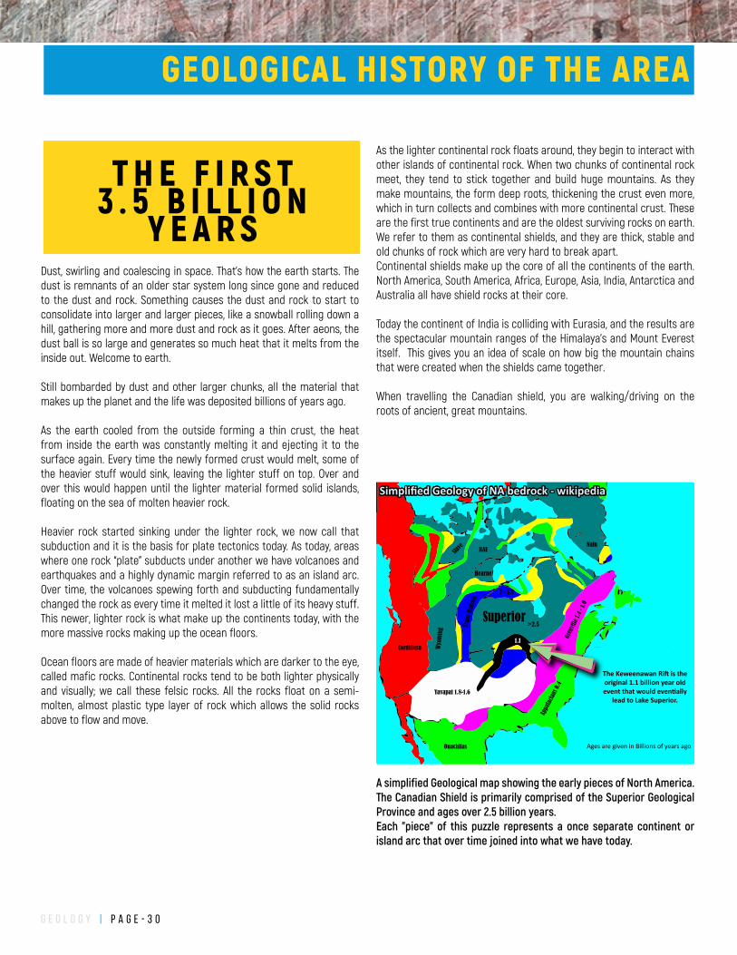
g e o l o g y | P a g e - 3 0
As the lighter continental rock floats around, they begin to interact with other islands of continental rock. When two chunks of continental rock meet, they tend to stick together and build huge mountains. As they make mountains, the form deep roots, thickening the crust even more, which in turn collects and combines with more continental crust. These are the first true continents and are the oldest surviving rocks on earth. We refer to them as continental shields, and they are thick, stable and old chunks of rock which are very hard to break apart.Continental shields make up the core of all the continents of the earth. North America, South America, Africa, Europe, Asia, India, Antarctica and Australia all have shield rocks at their core.
Today the continent of India is colliding with Eurasia, and the results are the spectacular mountain ranges of the Himalaya’s and Mount Everest itself. This gives you an idea of scale on how big the mountain chains that were created when the shields came together.
When travelling the Canadian shield, you are walking/driving on the roots of ancient, great mountains.
Dust, swirling and coalescing in space. That’s how the earth starts. The dust is remnants of an older star system long since gone and reduced to the dust and rock. Something causes the dust and rock to start to consolidate into larger and larger pieces, like a snowball rolling down a hill, gathering more and more dust and rock as it goes. After aeons, the dust ball is so large and generates so much heat that it melts from the inside out. Welcome to earth.
Still bombarded by dust and other larger chunks, all the material that makes up the planet and the life was deposited billions of years ago.
As the earth cooled from the outside forming a thin crust, the heat from inside the earth was constantly melting it and ejecting it to the surface again. Every time the newly formed crust would melt, some of the heavier stuff would sink, leaving the lighter stuff on top. Over and over this would happen until the lighter material formed solid islands, floating on the sea of molten heavier rock.
Heavier rock started sinking under the lighter rock, we now call that subduction and it is the basis for plate tectonics today. As today, areas where one rock “plate” subducts under another we have volcanoes and earthquakes and a highly dynamic margin referred to as an island arc. Over time, the volcanoes spewing forth and subducting fundamentally changed the rock as every time it melted it lost a little of its heavy stuff. This newer, lighter rock is what make up the continents today, with the more massive rocks making up the ocean floors.
Ocean floors are made of heavier materials which are darker to the eye, called mafic rocks. Continental rocks tend to be both lighter physically and visually; we call these felsic rocks. All the rocks float on a semi-molten, almost plastic type layer of rock which allows the solid rocks above to flow and move.
A simplified Geological map showing the early pieces of North America. The Canadian Shield is primarily comprised of the Superior Geological Province and ages over 2.5 billion years. Each "piece" of this puzzle represents a once separate continent or island arc that over time joined into what we have today.
Keweenawan RiftGrenville
Superior>2.5
Gren
ville
1.4
- 1.0
1.1
Yavapai 1.8-1.6
Tran
s-Hu
dson
Wyo
min
g
Cordillera
Appa
lacia
ns 0
.4RAE
Ouachitas
Slave
Hearne
Nain
2 - 1.8
Ages are given in Billions of years ago
The Keweenawan Ri� is the original 1.1 billion year old event that would even�ally
lead to Lake Superior.
Simplified Geology of NA bedrock - wikipedia
GEOLOGICAL HISTORY OF THE AREA
T H E F I R S T3 . 5 B I L L I O N
Y E A R S
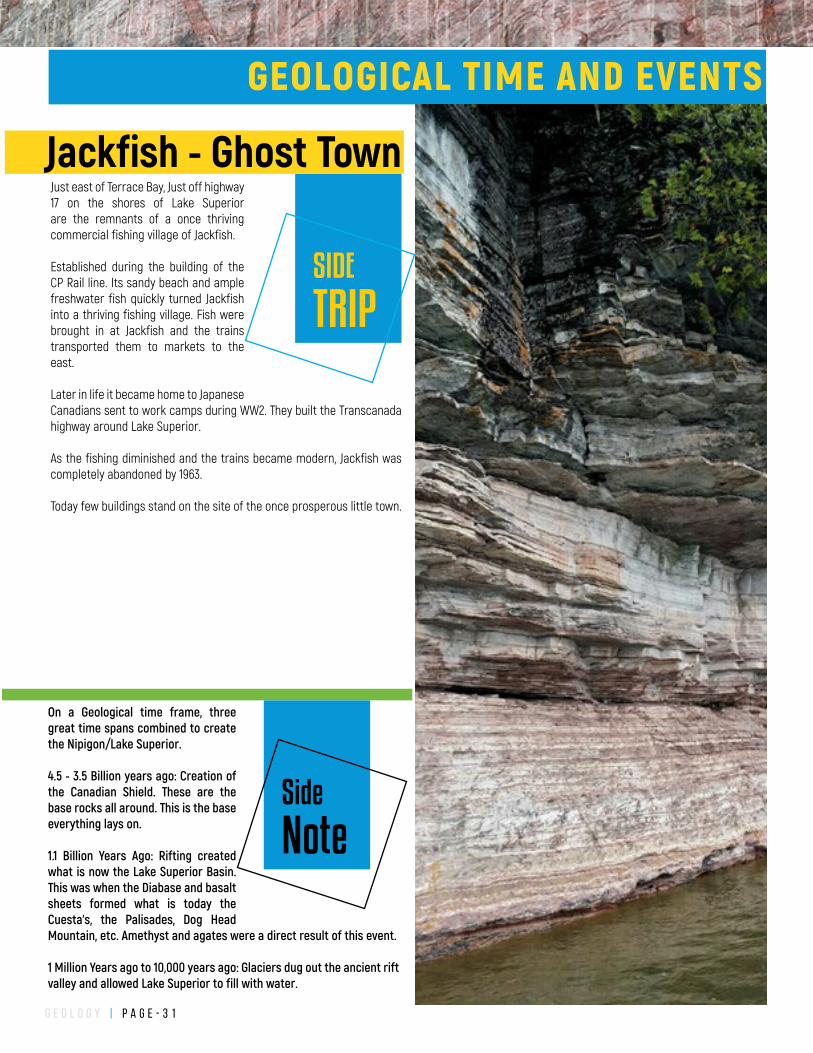
g e o l o g y | P a g e - 3 1
On a Geological time frame, three great time spans combined to create the Nipigon/Lake Superior.
4.5 - 3.5 Billion years ago: Creation of the Canadian Shield. These are the base rocks all around. This is the base everything lays on.
1.1 Billion Years Ago: Rifting created what is now the Lake Superior Basin. This was when the Diabase and basalt sheets formed what is today the Cuesta's, the Palisades, Dog Head Mountain, etc. Amethyst and agates were a direct result of this event.
1 Million Years ago to 10,000 years ago: Glaciers dug out the ancient rift valley and allowed Lake Superior to fill with water.
GEOLOGICAL TIME AND EVENTS
Side
Note
SIDE
TRIP
Jackfish - Ghost TownJust east of Terrace Bay, Just off highway 17 on the shores of Lake Superior are the remnants of a once thriving commercial fishing village of Jackfish.
Established during the building of the CP Rail line. Its sandy beach and ample freshwater fish quickly turned Jackfish into a thriving fishing village. Fish were brought in at Jackfish and the trains transported them to markets to the east.
Later in life it became home to Japanese Canadians sent to work camps during WW2. They built the Transcanada highway around Lake Superior.
As the fishing diminished and the trains became modern, Jackfish was completely abandoned by 1963.
Today few buildings stand on the site of the once prosperous little town.
g e o l o g y | P a g e - 3 2
Welcome to the Superior Province
The Superior province is the geological name of the primary rock units that make up the majority of the Canadian Shield. With a thickness of over 250km, the Superior Province came together 3 billion years ago to 2.7 billion years ago as Wabigoon, Quetico and Wawa subprovinces (island arcs) welded together to form the nucleus of the Canadian Shield, which in turn helped form one of the first supercontinents – Columbia. Like the more recent Pangea, it developed in the northern hemisphere and included all the present day continents in one vast continent the Canadian Shield occupying the north-west corner of the combined continent. Columbia lasted from 2.5 billion years ago to 1.6 billion years ago (give or take a few hundred million years)The Canadian Shield has remained intact since its initial formation, forces have tried tearing it apart including freezing, flooding, baking and impacts from space.
After the creation of the Canadian shield, the laws of erosion took hold, weathering the giant mountains and filling the valleys and flat lands with sand and gravel. Approximately 1.8 billion years ago, the relative peace of the Canadian shield was quite literally shattered by a 16km wide visitor from space. Where Sudbury exists now was ground zero for the impact which generated a 160km wide crater and ejected material kilometres into the sky. The impact was so great that debris rained down in Thunderbay and around Lake Superior, as far west as 800km from the impact. The resulting fireball, air blast and tsunamis would have instantly changed the landscape for thousands of kilometers around the impact. This wasn’t the last time we were visited from space.
SUPERIOR PROVINCE
SIDE
TRIP
Highway 11 Lake NipigonHighway 11 north to Beardmore offers up some great scenery and wildlife viewing.
Lake HelenStarting at the south end of Lake Helen, eagles love sitting on the cliffs to swoop down onto the lake for a meal. Ducks, Cranes and even pelicans love the shallow waters along the edge of the lake.
The PalisadesJust 40km (30 minutes) North of Nipigon is
an area of multiple waterfalls falling from many diabase plateaus at Orient Bay, the southernmost point of Lake Nipigon. Wintertime brings ice climbers due to the abundance of frozen waterfalls. Visiting during or after a good rain is recommended. The Palisades hiking trail will take you up to the top of the cliffs for breathtaking views.
Beardmore and Lake NipigonBeardmore, once a thriving mining town provides one of two official access points for Lake Nipigon. Be sure to visit the Beardmore snowman.
Just outside Beardmore to the North is highway 580 to Poplar Point, the eastern access to Lake Nipigon. On the drive out you will pass the site of the Leitch Gold Mine, which was the highest grade gold mine in Canada for its operation. The road you are driving on used waste rock from the mine site and does contain the occasional piece of gold.
Poplar Point is a municipal park/campground with a long sandy beach and playground for your enjoyment. A trip south along the gravel High Hill Harbour Road takes you to the new marina at High Hill. A beautiful look off is available via a short trail just off of High Hill Harbour. The breakwater at High Hill Harbour was also built with waste rock from the Leitch Goldmine and does potentially contain gold.
As you travel on Highway 11 between MacDairmid and Beardmore, you will witness the result of an enormous forest fire from 1999 which burned over 50,000 hectares.
CHALTREK
W W W.CHALTREK.COM1-888-316-7350
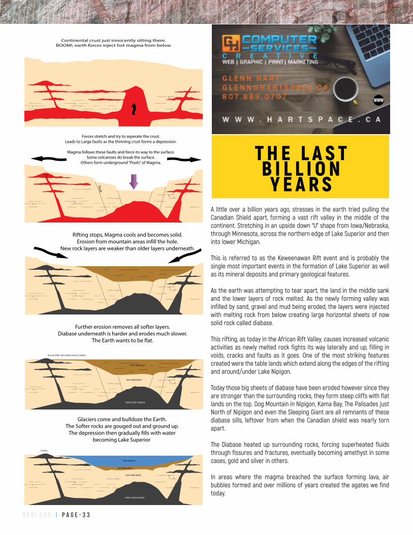
g e o l o g y | P a g e - 3 3
A little over a billion years ago, stresses in the earth tried pulling the Canadian Shield apart, forming a vast rift valley in the middle of the continent. Stretching in an upside down “U” shape from Iowa/Nebraska, through Minnesota, across the northern edge of Lake Superior and then into lower Michigan.
This is referred to as the Keweenawan Rift event and is probably the single most important events in the formation of Lake Superior as well as its mineral deposits and primary geological features.
As the earth was attempting to tear apart, the land in the middle sank and the lower layers of rock melted. As the newly forming valley was infilled by sand, gravel and mud being eroded, the layers were injected with melting rock from below creating large horizontal sheets of now solid rock called diabase.
This rifting, as today in the African Rift Valley, causes increased volcanic activities as newly melted rock fights its way laterally and up, filling in voids, cracks and faults as it goes. One of the most striking features created were the table lands which extend along the edges of the rifting and around/under Lake Nipigon.
Today those big sheets of diabase have been eroded however since they are stronger than the surrounding rocks, they form steep cliffs with flat lands on the top. Dog Mountain in Nipigon, Kama Bay, The Palisades just North of Nipigon and even the Sleeping Giant are all remnants of these diabase sills, leftover from when the Canadian shield was nearly torn apart.
The Diabase heated up surrounding rocks, forcing superheated fluids through fissures and fractures, eventually becoming amethyst in some cases, gold and silver in others.
In areas where the magma breached the surface forming lava, air bubbles formed and over millions of years created the agates we find today.
Forces stretch and try to seperate the crust.Leads to Large faults as the thinning crust forms a depression.
Magma follows these faults and force its way to the surface.Some volcanoes do break the surface.
Others form underground “Pools” of Magma.
Fault
Magma Pool
Rifting stops, Magma cools and becomes solid. Erosion from mountain areas in�ll the hole.
New rock layers are weaker than older layers underneath.
Further erosion removes all softer layers.Diabase underneath is harder and erodes much slower.
The Earth wants to be �at.
Area of softer rock erodes around Diabase
SOFT NEW ROCK
OlOLD HARD ROCK
HARD HARD DIABASE
Glaciers come and bulldoze the Earth.The Softer rocks are gouged out and ground up.
The depression then gradually �lls with waterbecoming Lake Superior
Cuestas
SOFT NEW ROCK
Ol
Lake Superior
OLD HARD ROCK
HARD HARD DIABASE
Continental crust just innocently sitting there.BOOM!, earth forces inject hot magma from below
T H E L A S TB I L L I O N
Y E A R S
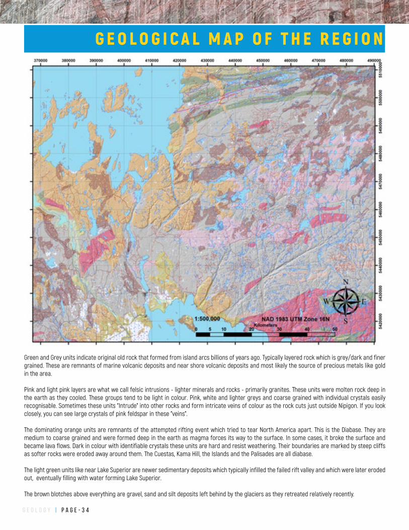
g e o l o g y | P a g e - 3 4
Green and Grey units indicate original old rock that formed from island arcs billions of years ago. Typically layered rock which is grey/dark and finer grained. These are remnants of marine volcanic deposits and near shore volcanic deposits and most likely the source of precious metals like gold in the area.
Pink and light pink layers are what we call felsic intrusions - lighter minerals and rocks - primarily granites. These units were molten rock deep in the earth as they cooled. These groups tend to be light in colour. Pink, white and lighter greys and coarse grained with individual crystals easily recognisable. Sometimes these units "Intrude" into other rocks and form intricate veins of colour as the rock cuts just outside Nipigon. If you look closely, you can see large crystals of pink feldspar in these "veins".
The dominating orange units are remnants of the attempted rifting event which tried to tear North America apart. This is the Diabase. They are medium to coarse grained and were formed deep in the earth as magma forces its way to the surface. In some cases, it broke the surface and became lava flows. Dark in colour with identifiable crystals these units are hard and resist weathering. Their boundaries are marked by steep cliffs as softer rocks were eroded away around them. The Cuestas, Kama Hill, the Islands and the Palisades are all diabase.
The light green units like near Lake Superior are newer sedimentary deposits which typically infilled the failed rift valley and which were later eroded out, eventually filling with water forming Lake Superior.
The brown blotches above everything are gravel, sand and silt deposits left behind by the glaciers as they retreated relatively recently.
G E O L O G I C A L M A P O F T H E R E G I O N
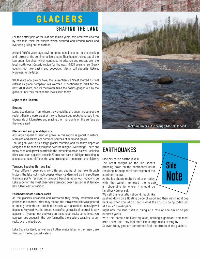
g e o l o g y | P a g e - 3 5
For the better part of the last two million years, this area was covered by two-mile thick ice sheets which scoured and eroded rocks and everything living on the surface.
Around 20,000 years ago environmental conditions led to the breakup and retreat of the continental ice sheets. Thus began the retreat of the Laurentian ice sheet which continued to advance and retreat over the local north-west Ontario region for the next 10,000 years or so. Slowly gouging out lake basins and depositing glacial soil deposits (Eskers, Moraines, kettle lakes).
9,000 years ago, give or take, the Laurentian Ice Sheet started its final retreat as global temperatures warmed. It continued to melt for the next 5,000 years, and its meltwater filled the basins gouged out by the glaciers until they reached the levels seen today.
Signs of the Glaciers
ErraticsLarge boulders far from where they should be are seen throughout the region. Glaciers were great at moving house sized rocks hundreds if not thousands of kilometres and placing them randomly on the surface as they retreated.
Glacial sand and gravel depositsAny large deposit of sand or gravel in this region is glacial in nature. Moraines and eskers are common sources of sand and gravel. The Nipigon River cuts a large glacial moraine, and its sandy slopes at Nipigon can be seen as you pass over the Nipigon River Bridge. There are many sand and gravel quarries in the immediate areas as well. Jackpine River also cuts a glacial deposit 20 minutes east of Nipigon resulting in spectacular sand cliffs on the western edge are seen from the highway.
Terraced Beaches (Terrace Bay)These different beaches show different depths of the lake through history. The lake got much deeper when ice dammed up the southern drainage points resulting in terraced beaches at various locations on Lake Superior. The most observable terraced beach system is at Terrace Bay, 100km east of Nipigon.
Polished/smooth surface rocksAs the glaciers advanced and retreated they slowly smoothed and polished the bedrock. After they melted, the terrain would have appeared as mostly smooth and polished bedrock with occasional sand/gravel deposits. As you drive, the smoothness of large tracks of bedrock is very apparent. If you get out and walk on the smooth rocks sometimes, you can even see gouges in the rock formed by the glaciers scraping harder rocks over the bedrock.
Lake Superior itself, as well as all other major lakes in the region, are filled with melted glacial waters.
Jackpine River cuts through Glacial Deposits
Side
Note
Glaciers cause earthquakes! The Great weight of the ice sheets pressing down on the continental crust resulting in the general depression of the continent below it. As the ice sheets melted and even today, with the weight removed the crust is rebounding to where it should be (another 40m or so). We call this isostatic rebound, much like pushing down on a floating piece of wood and then watching it pop back up when you let go, that is what the crust is doing today just at a much slower pace. Right now the land itself is rising at a rate of one cm or so per hundred years. With this come small earthquakes, nothing significant and most aren’t even felt. They feel more like a large truck driving by. So even today you can sometimes feel the effects of the glaciers.
EARTHQUAKES
S H A P I N G T H E L A N D
G L A C I E R S
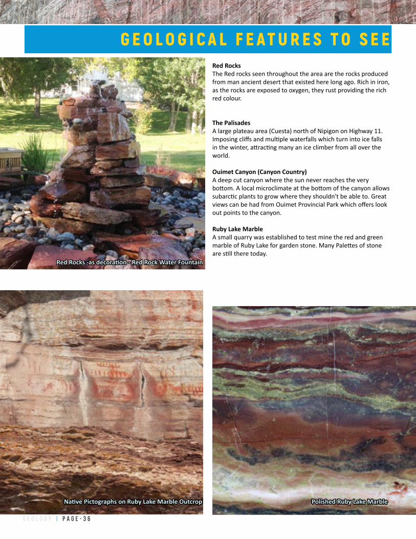
g e o l o g y | P a g e - 3 6
Red RocksThe Red rocks seen throughout the area are the rocks produced from man ancient desert that existed here long ago. Rich in iron, as the rocks are exposed to oxygen, they rust providing the rich red colour.
The PalisadesA large plateau area (Cuesta) north of Nipigon on Highway 11. Imposing cliffs and multiple waterfalls which turn into ice falls in the winter, attracting many an ice climber from all over the world.
Ouimet Canyon (Canyon Country)A deep cut canyon where the sun never reaches the very bottom. A local microclimate at the bottom of the canyon allows subarctic plants to grow where they shouldn't be able to. Great views can be had from Ouimet Provincial Park which offers look out points to the canyon.
Ruby Lake MarbleA small quarry was established to test mine the red and green marble of Ruby Lake for garden stone. Many Palettes of stone are still there today.
Native Pictographs on Ruby Lake Marble Outcrop
Red Rocks -as decoration - Red Rock Water Fountain
Polished Ruby Lake Marble
G E O L O G I C A L F E A T U R E S T O S E E
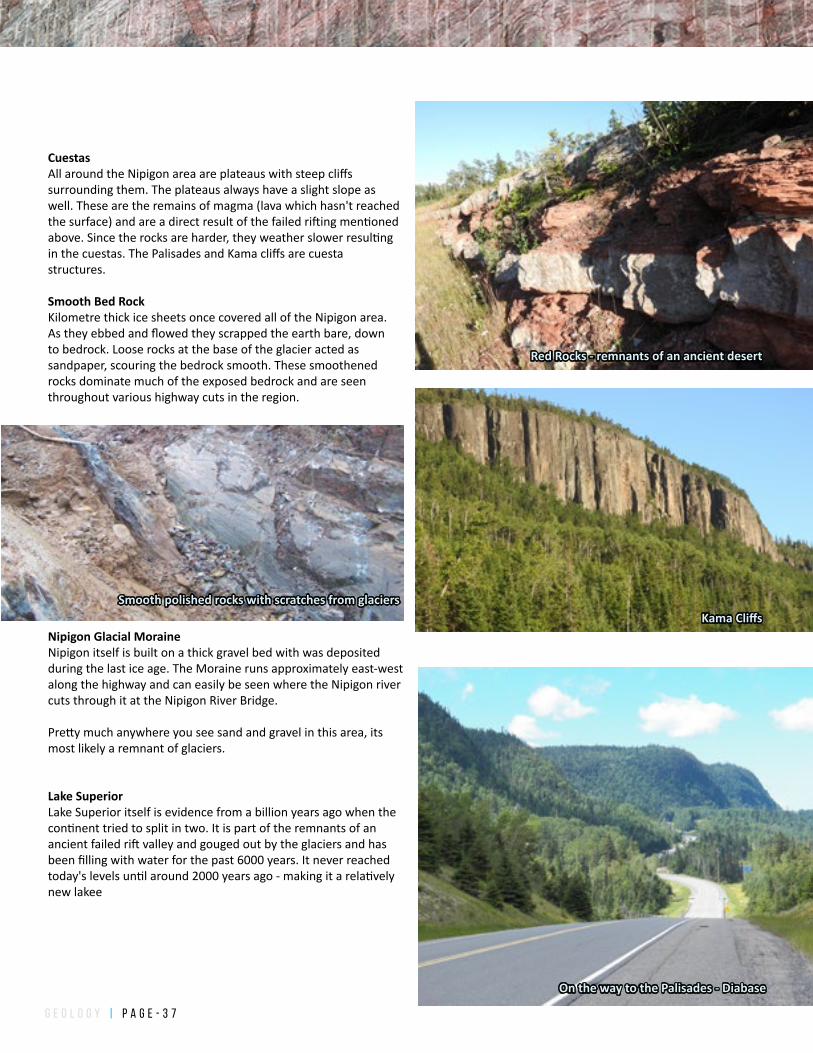
g e o l o g y | P a g e - 3 7
Red Rocks - remnants of an ancient desert
Kama Cliffs
On the way to the Palisades - Diabase
CuestasAll around the Nipigon area are plateaus with steep cliffs surrounding them. The plateaus always have a slight slope as well. These are the remains of magma (lava which hasn't reached the surface) and are a direct result of the failed rifting mentioned above. Since the rocks are harder, they weather slower resulting in the cuestas. The Palisades and Kama cliffs are cuesta structures.
Smooth Bed RockKilometre thick ice sheets once covered all of the Nipigon area. As they ebbed and flowed they scrapped the earth bare, down to bedrock. Loose rocks at the base of the glacier acted as sandpaper, scouring the bedrock smooth. These smoothened rocks dominate much of the exposed bedrock and are seen throughout various highway cuts in the region.
Nipigon Glacial MoraineNipigon itself is built on a thick gravel bed with was deposited during the last ice age. The Moraine runs approximately east-west along the highway and can easily be seen where the Nipigon river cuts through it at the Nipigon River Bridge.
Pretty much anywhere you see sand and gravel in this area, its most likely a remnant of glaciers.
Lake SuperiorLake Superior itself is evidence from a billion years ago when the continent tried to split in two. It is part of the remnants of an ancient failed rift valley and gouged out by the glaciers and has been filling with water for the past 6000 years. It never reached today's levels until around 2000 years ago - making it a relatively new lakee
Smooth polished rocks with scratches from glaciers
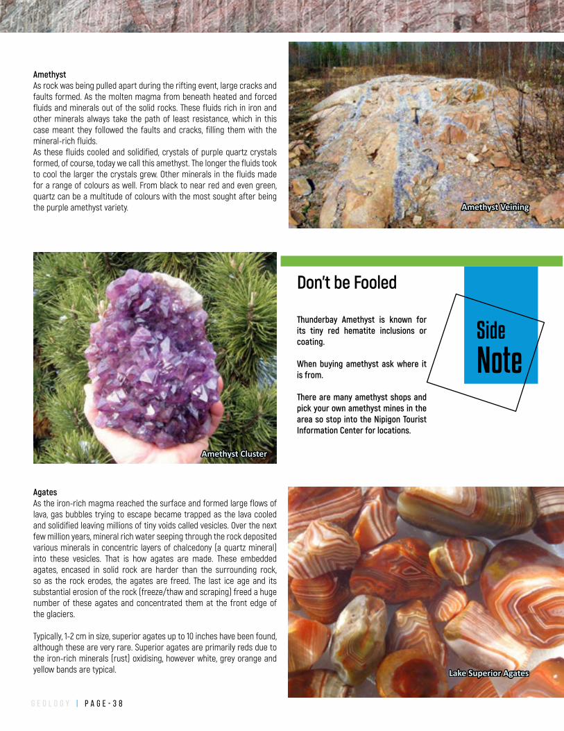
g e o l o g y | P a g e - 3 8
AmethystAs rock was being pulled apart during the rifting event, large cracks and faults formed. As the molten magma from beneath heated and forced fluids and minerals out of the solid rocks. These fluids rich in iron and other minerals always take the path of least resistance, which in this case meant they followed the faults and cracks, filling them with the mineral-rich fluids.As these fluids cooled and solidified, crystals of purple quartz crystals formed, of course, today we call this amethyst. The longer the fluids took to cool the larger the crystals grew. Other minerals in the fluids made for a range of colours as well. From black to near red and even green, quartz can be a multitude of colours with the most sought after being the purple amethyst variety.
AgatesAs the iron-rich magma reached the surface and formed large flows of lava, gas bubbles trying to escape became trapped as the lava cooled and solidified leaving millions of tiny voids called vesicles. Over the next few million years, mineral rich water seeping through the rock deposited various minerals in concentric layers of chalcedony (a quartz mineral) into these vesicles. That is how agates are made. These embedded agates, encased in solid rock are harder than the surrounding rock, so as the rock erodes, the agates are freed. The last ice age and its substantial erosion of the rock (freeze/thaw and scraping) freed a huge number of these agates and concentrated them at the front edge of the glaciers.
Typically, 1-2 cm in size, superior agates up to 10 inches have been found, although these are very rare. Superior agates are primarily reds due to the iron-rich minerals (rust) oxidising, however white, grey orange and yellow bands are typical.
Amethyst Veining
Amethyst Cluster
Lake Superior Agates
Side
Note
Thunderbay Amethyst is known for its tiny red hematite inclusions or coating.
When buying amethyst ask where it is from.
There are many amethyst shops and pick your own amethyst mines in the area so stop into the Nipigon Tourist Information Center for locations.
Don't be Fooled
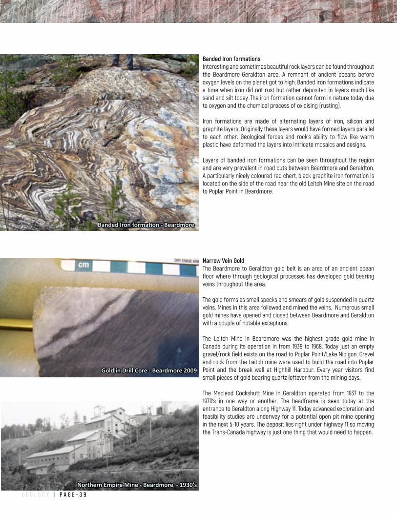
g e o l o g y | P a g e - 3 9
Banded Iron formationsInteresting and sometimes beautiful rock layers can be found throughout the Beardmore-Geraldton area. A remnant of ancient oceans before oxygen levels on the planet got to high; Banded iron formations indicate a time when iron did not rust but rather deposited in layers much like sand and silt today. The iron formation cannot form in nature today due to oxygen and the chemical process of oxidising (rusting).
Iron formations are made of alternating layers of iron, silicon and graphite layers. Originally these layers would have formed layers parallel to each other. Geological forces and rock's ability to flow like warm plastic have deformed the layers into intricate mosaics and designs.
Layers of banded iron formations can be seen throughout the region and are very prevalent in road cuts between Beardmore and Geraldton. A particularly nicely coloured red chert, black graphite iron formation is located on the side of the road near the old Leitch Mine site on the road to Poplar Point in Beardmore.
Banded Iron formation - Beardmore
Narrow Vein GoldThe Beardmore to Geraldton gold belt is an area of an ancient ocean floor where through geological processes has developed gold bearing veins throughout the area.
The gold forms as small specks and smears of gold suspended in quartz veins. Mines in this area followed and mined the veins. Numerous small gold mines have opened and closed between Beardmore and Geraldton with a couple of notable exceptions.
The Leitch Mine in Beardmore was the highest grade gold mine in Canada during its operation in from 1938 to 1968. Today just an empty gravel/rock field exists on the road to Poplar Point/Lake Nipigon. Gravel and rock from the Leitch mine were used to build the road into Poplar Point and the break wall at Highhill Harbour. Every year visitors find small pieces of gold bearing quartz leftover from the mining days.
The Macleod Cockshutt Mine in Geraldton operated from 1937 to the 1970's in one way or another. The headframe is seen today at the entrance to Geraldton along Highway 11. Today advanced exploration and feasibility studies are underway for a potential open pit mine opening in the next 5-10 years. The deposit lies right under highway 11 so moving the Trans-Canada highway is just one thing that would need to happen.
Gold in Drill Core - Beardmore 2009
Northern Empire Mine - Beardmore - 1930's
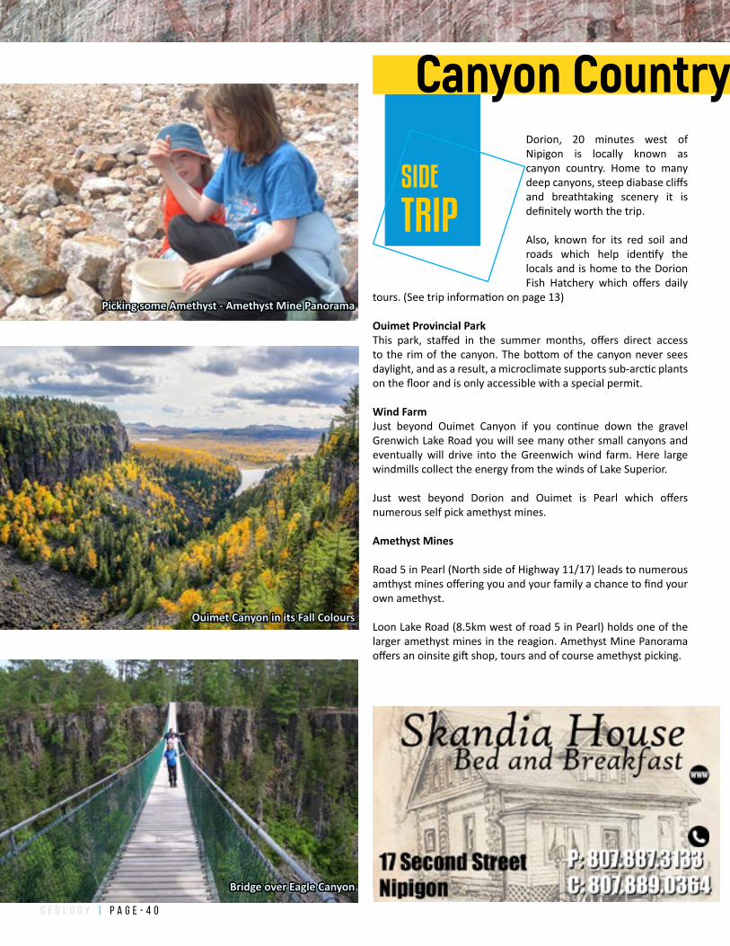
g e o l o g y | P a g e - 4 0
Ouimet Canyon in its Fall Colours
Bridge over Eagle Canyon
Picking some Amethyst - Amethyst Mine Panorama
SIDE
TRIP
Canyon CountryDorion, 20 minutes west of Nipigon is locally known as canyon country. Home to many deep canyons, steep diabase cliffs and breathtaking scenery it is definitely worth the trip.
Also, known for its red soil and roads which help identify the locals and is home to the Dorion Fish Hatchery which offers daily
tours. (See trip information on page 13)
Ouimet Provincial ParkThis park, staffed in the summer months, offers direct access to the rim of the canyon. The bottom of the canyon never sees daylight, and as a result, a microclimate supports sub-arctic plants on the floor and is only accessible with a special permit.
Wind FarmJust beyond Ouimet Canyon if you continue down the gravel Grenwich Lake Road you will see many other small canyons and eventually will drive into the Greenwich wind farm. Here large windmills collect the energy from the winds of Lake Superior.
Just west beyond Dorion and Ouimet is Pearl which offers numerous self pick amethyst mines.
Amethyst Mines
Road 5 in Pearl (North side of Highway 11/17) leads to numerous amthyst mines offering you and your family a chance to find your own amethyst.
Loon Lake Road (8.5km west of road 5 in Pearl) holds one of the larger amethyst mines in the reagion. Amethyst Mine Panorama offers an oinsite gift shop, tours and of course amethyst picking.
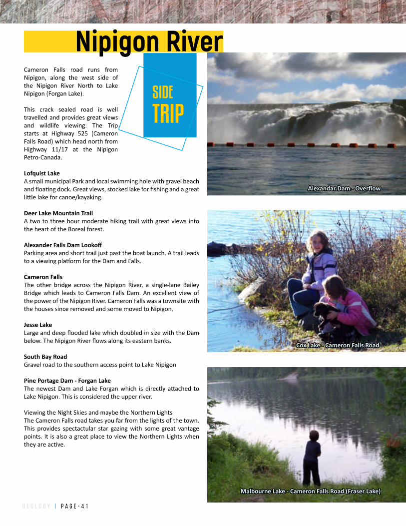
g e o l o g y | P a g e - 4 1
Alexandar Dam - Overflow
Cox Lake - Cameron Falls Road
Malbourne Lake - Cameron Falls Road (Fraser Lake)
Nipigon River
SIDE
TRIP
Cameron Falls road runs from Nipigon, along the west side of the Nipigon River North to Lake Nipigon (Forgan Lake).
This crack sealed road is well travelled and provides great views and wildlife viewing. The Trip starts at Highway 525 (Cameron Falls Road) which head north from Highway 11/17 at the Nipigon Petro-Canada.
Lofquist LakeA small municipal Park and local swimming hole with gravel beach and floating dock. Great views, stocked lake for fishing and a great little lake for canoe/kayaking.
Deer Lake Mountain TrailA two to three hour moderate hiking trail with great views into the heart of the Boreal forest.
Alexander Falls Dam LookoffParking area and short trail just past the boat launch. A trail leads to a viewing platform for the Dam and Falls.
Cameron Falls The other bridge across the Nipigon River, a single-lane Bailey Bridge which leads to Cameron Falls Dam. An excellent view of the power of the Nipigon River. Cameron Falls was a townsite with the houses since removed and some moved to Nipigon.
Jesse LakeLarge and deep flooded lake which doubled in size with the Dam below. The Nipigon River flows along its eastern banks.
South Bay RoadGravel road to the southern access point to Lake Nipigon
Pine Portage Dam - Forgan LakeThe newest Dam and Lake Forgan which is directly attached to Lake Nipigon. This is considered the upper river.
Viewing the Night Skies and maybe the Northern LightsThe Cameron Falls road takes you far from the lights of the town. This provides spectactular star gazing with some great vantage points. It is also a great place to view the Northern Lights when they are active.
g e o l o g y | P a g e - 4 2
SIDE
TRIP
Kama Bay ViewKama Hill 20km (16 minutes) east of Nipigon and an even grander view from the next hill, 28km (20 minutes) along Highway 17 provide some of the best views of Lake Superior in the region.
Kama Hill shows some great geology on the north road cut and fantastic views of Kama Point, Kama Bay, the Kama Cliffs
and Vert Island. Kama Hill Trail can be accessed on the north side of Highway 17 approximately 300m west of the Jackpine River pull off area.
Continue up the hill on highway 17 to a small picnic park on the Lake side for more fantastic views onto Lake Superior.
To access Lake Superior at the mouth of the Jackpine River pull off onto Kama Road (gravel road) 25.9 km from Nipigon, look for yellow newspaper boxes.
Park at the parking lot across from the gravel pit and walk for 350m crossing the railroad tracks. Keep walking to the south along a single lane gravel road for another kilometre and a half to the Lake. A 4x4 or vehicle with ground clearance can drive the entire way in. Walk along the large cobblestone beach around Lake Superior.
The Jackpine River is an established Steelheading river as well. To access the River itself you can continue to the Bridge on Highway 11/17 turn south onto the access road. The old road is in bad shape and unless you have a 4wheel drive, you should walk. Just follow the road to the east down to the river.
There are a few crown land camping locations on and near the River and on Lake Superior.
Lake/River access and rails are available on a map located on Page 29.
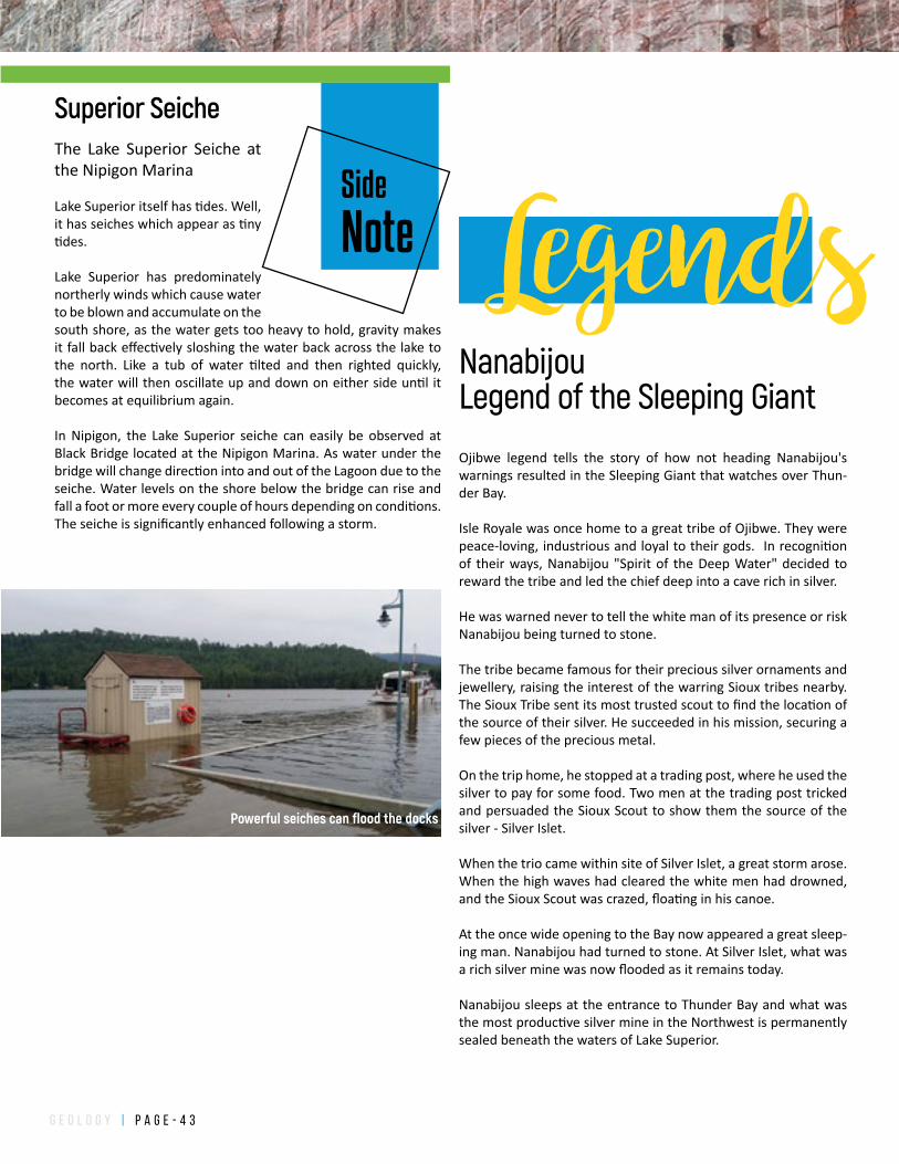
g e o l o g y | P a g e - 4 3
Side
Note
The Lake Superior Seiche at the Nipigon Marina
Lake Superior itself has tides. Well, it has seiches which appear as tiny tides.
Lake Superior has predominately northerly winds which cause water to be blown and accumulate on the south shore, as the water gets too heavy to hold, gravity makes it fall back effectively sloshing the water back across the lake to the north. Like a tub of water tilted and then righted quickly, the water will then oscillate up and down on either side until it becomes at equilibrium again.
In Nipigon, the Lake Superior seiche can easily be observed at Black Bridge located at the Nipigon Marina. As water under the bridge will change direction into and out of the Lagoon due to the seiche. Water levels on the shore below the bridge can rise and fall a foot or more every couple of hours depending on conditions. The seiche is significantly enhanced following a storm.
Superior Seiche
LegendsNanabijouLegend of the Sleeping Giant
Ojibwe legend tells the story of how not heading Nanabijou's warnings resulted in the Sleeping Giant that watches over Thun-der Bay.
Isle Royale was once home to a great tribe of Ojibwe. They were peace-loving, industrious and loyal to their gods. In recognition of their ways, Nanabijou "Spirit of the Deep Water" decided to reward the tribe and led the chief deep into a cave rich in silver.
He was warned never to tell the white man of its presence or risk Nanabijou being turned to stone.
The tribe became famous for their precious silver ornaments and jewellery, raising the interest of the warring Sioux tribes nearby. The Sioux Tribe sent its most trusted scout to find the location of the source of their silver. He succeeded in his mission, securing a few pieces of the precious metal.
On the trip home, he stopped at a trading post, where he used the silver to pay for some food. Two men at the trading post tricked and persuaded the Sioux Scout to show them the source of the silver - Silver Islet.
When the trio came within site of Silver Islet, a great storm arose. When the high waves had cleared the white men had drowned, and the Sioux Scout was crazed, floating in his canoe.
At the once wide opening to the Bay now appeared a great sleep-ing man. Nanabijou had turned to stone. At Silver Islet, what was a rich silver mine was now flooded as it remains today.
Nanabijou sleeps at the entrance to Thunder Bay and what was the most productive silver mine in the Northwest is permanently sealed beneath the waters of Lake Superior.
Powerful seiches can flood the docks
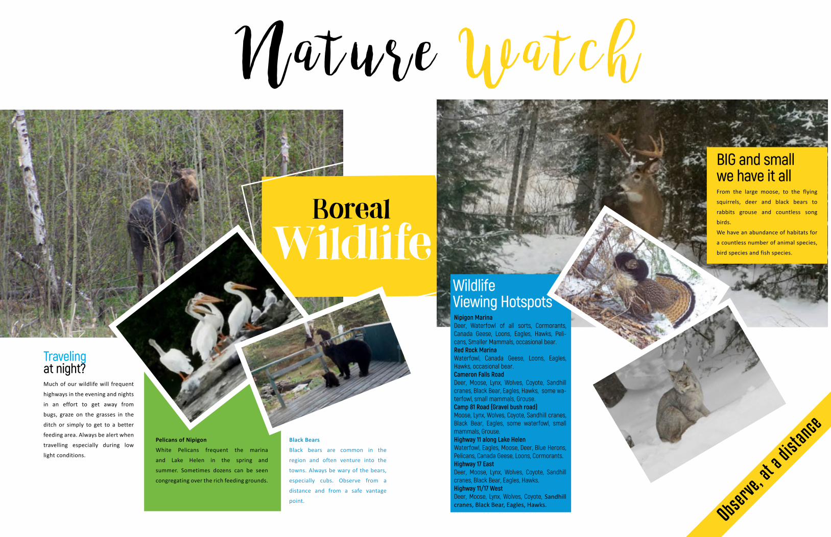
Boreal
Wildlife
Travelingat night?Much of our wildlife will frequent
highways in the evening and nights
in an effort to get away from
bugs, graze on the grasses in the
ditch or simply to get to a better
feeding area. Always be alert when
travelling especially during low
light conditions.
Pelicans of Nipigon
White Pelicans frequent the marina
and Lake Helen in the spring and
summer. Sometimes dozens can be seen
congregating over the rich feeding grounds.
Black Bears
Black bears are common in the
region and often venture into the
towns. Always be wary of the bears,
especially cubs. Observe from a
distance and from a safe vantage
point.
From the large moose, to the flying
squirrels, deer and black bears to
rabbits grouse and countless song
birds.
We have an abundance of habitats for
a countless number of animal species,
bird species and fish species.
BIG and smallwe have it all
Nipigon MarinaDeer, Waterfowl of all sorts, Cormorants, Canada Geese, Loons, Eagles, Hawks, Peli-cans, Smaller Mammals, occasional bear.Red Rock MarinaWaterfowl, Canada Geese, Loons, Eagles, Hawks, occasional bear.Cameron Falls RoadDeer, Moose, Lynx, Wolves, Coyote, Sandhill cranes, Black Bear, Eagles, Hawks, some wa-terfowl, small mammals, Grouse.Camp 81 Road (Gravel bush road)Moose, Lynx, Wolves, Coyote, Sandhill cranes, Black Bear, Eagles, some waterfowl, small mammals, Grouse.Highway 11 along Lake HelenWaterfowl, Eagles, Moose, Deer, Blue Herons, Pelicans, Canada Geese, Loons, Cormorants.Highway 17 EastDeer, Moose, Lynx, Wolves, Coyote, Sandhill cranes, Black Bear, Eagles, Hawks.Highway 11/17 WestDeer, Moose, Lynx, Wolves, Coyote, Sandhill cranes, Black Bear, Eagles, Hawks.
N a t u r e W a t c h
Wildlife Viewing Hotspots
Observe, at a
distance
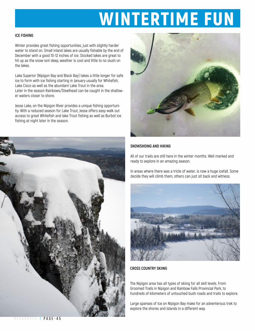
r e s o u r c e s | P a g e - 4 5
WINTERTIME FUNICE FISHING
Winter provides great fishing opportunities, just with slightly harder water to stand on. Small inland lakes are usually fishable by the end of December with a good 10-12 inches of ice. Stocked lakes are great to hit up as the snow isnt deep, weather is cool and little to no slush on the lakes.
Lake Superior (Nipigon Bay and Black Bay) takes a little longer for safe ice to form with ice fishing starting in January usually for Whitefish, Lake Cisco as well as the abundant Lake Trout in the area.Later in the season Rainbows/Steelhead can be caught in the shallow-er waters closer to shore.
Jesse Lake, on the Nipigon River provides a unique fishing opportuni-tiy. With a reduced season for Lake Trout, Jesse offers easy walk out access to great Whitefish and lake Trout fishing as well as Burbot ice fishing at night later in the season.
SNOWSHOING AND HIKING
All of our trails are still here in the winter months. Well marked and ready to explore in an amazing season.
In areas where there was a tricle of water, is now a huge icefall. Some decide they will climb them, others can just sit back and witness.
CROSS COUNTRY SKIING
The Nipigon area has all types of skiing for all skill levels. From Groomed Trails in Nipigon and Rainbow Falls Provincial Park, to hundreds of kilometers of untouched bush roads and trails to explore.
Large spanses of Ice on Nipigon Bay make for an adventerous trek to explore the shores and islands in a different way.
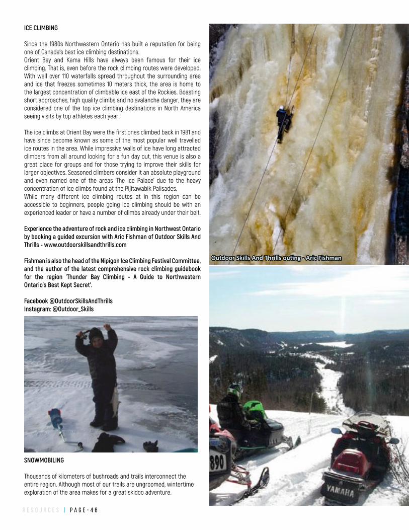
r e s o u r c e s | P a g e - 4 6
SNOWMOBILING
Thousands of kilometers of bushroads and trails interconnect the entire region. Although most of our trails are ungroomed, wintertime exploration of the area makes for a great skidoo adventure.
ICE CLIMBING
Since the 1980s Northwestern Ontario has built a reputation for being one of Canada's best ice climbing destinations.Orient Bay and Kama Hills have always been famous for their ice climbing. That is, even before the rock climbing routes were developed. With well over 110 waterfalls spread throughout the surrounding area and ice that freezes sometimes 10 meters thick, the area is home to the largest concentration of climbable ice east of the Rockies. Boasting short approaches, high quality climbs and no avalanche danger, they are considered one of the top ice climbing destinations in North America seeing visits by top athletes each year.
The ice climbs at Orient Bay were the first ones climbed back in 1981 and have since become known as some of the most popular well travelled ice routes in the area. While impressive walls of ice have long attracted climbers from all around looking for a fun day out, this venue is also a great place for groups and for those trying to improve their skills for larger objectives. Seasoned climbers consider it an absolute playground and even named one of the areas ‘The Ice Palace’ due to the heavy concentration of ice climbs found at the Pijitawabik Palisades.While many different ice climbing routes at in this region can be accessible to beginners, people going ice climbing should be with an experienced leader or have a number of climbs already under their belt.
Experience the adventure of rock and ice climbing in Northwest Ontario by booking a guided excursion with Aric Fishman of Outdoor Skills And Thrills - www.outdoorskillsandthrills.com
Fishman is also the head of the Nipigon Ice Climbing Festival Committee, and the author of the latest comprehensive rock climbing guidebook for the region 'Thunder Bay Climbing - A Guide to Northwestern Ontario's Best Kept Secret'.
Facebook @OutdoorSkillsAndThrills Instagram: @Outdoor_Skills
Outdoor Skills And Thrills outing - Aric Fishman
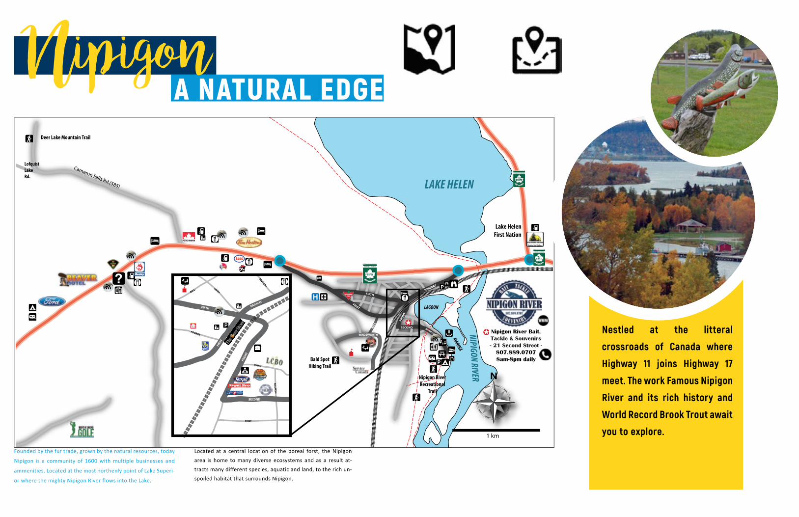
LAKE HELEN
NIPIGON RIVER
MARINA
LAGOON
BELL
WADSWORTH
Lake HelenFirst Nation
RIVERVIEW
A Bald SpotHiking Trail
Deer Lake Mountain Trail
N
1 km
Nipigon River Bait,Tackle & Souvenirs - 21 Second Street -
807.889.07078am-8pm daily
Cameron Falls Rd.(585)
LofquistLake Rd.
Nipigon RiverRecreational
Trail
RAILWAY
FIRST
FIFTH
FRO
NT
SECOND
FIRST
FIFTH
BELL
RAILWAY
FRO
NT
SECOND
NEW
TON
THIRD
FIRST
FOURTH
SIXTH
SEVENTH
NipigonA NATURAL EDGE
Located at a central location of the boreal forst, the Nipigon area is home to many diverse ecosystems and as a result at-tracts many different species, aquatic and land, to the rich un-spoiled habitat that surrounds Nipigon.
Founded by the fur trade, grown by the natural resources, today
Nipigon is a community of 1600 with multiple businesses and
ammenities. Located at the most northenly point of Lake Superi-
or where the mighty Nipigon River flows into the Lake.
Nestled at the litteral
crossroads of Canada where
Highway 11 joins Highway 17
meet. The work Famous Nipigon
River and its rich history and
World Record Brook Trout await
you to explore.
h i k i n g | P a g e - 4 8
N
1 km
Nipigon RiverRecreationTrail
Red Rock MountainTrail
Red Rock Road #1
QUEBECLODGE
MARINAINTERPRETIVE
CENTRE
RED ROCKRECREATIONCENTRE
MarinaAmenities
<< Highway 11/17 8km
A SUPERIOR TREASURERed Rock
Schreiber
0 0.5 10.25 Kilometers
0 0.5 10.25 Miles
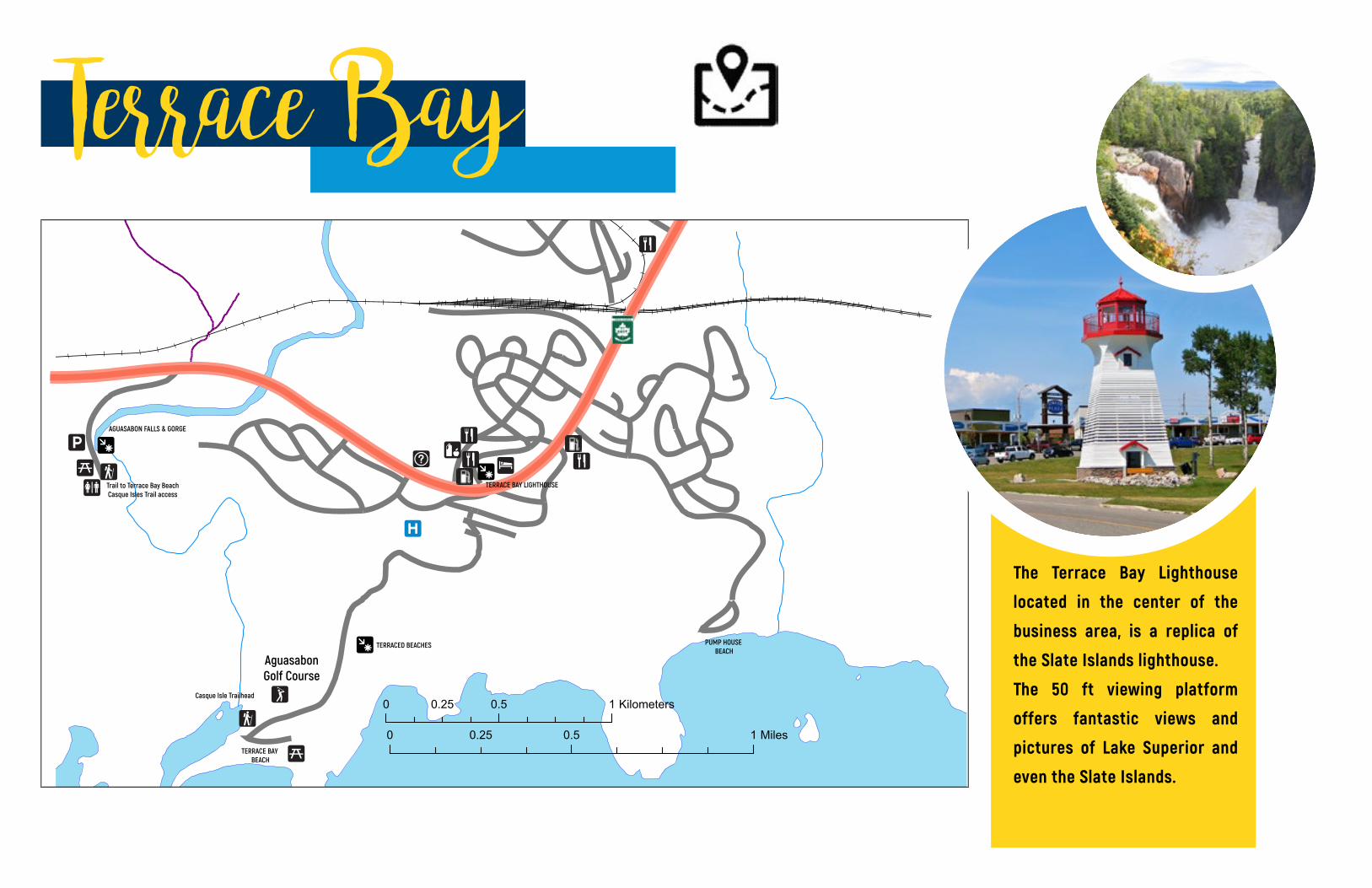
0 0.5 10.25 Kilometers
0 0.5 10.25 MilesTERRACE BAY
BEACH
AguasabonGolf Course
PUMP HOUSE BEACH
Casque Isle Trailhead
AGUASABON FALLS & GORGE
Trail to Terrace Bay BeachCasque Isles Trail access
TERRACE BAY LIGHTHOUSE
TERRACED BEACHES
Terrace Bay
The Terrace Bay Lighthouse
located in the center of the
business area, is a replica of
the Slate Islands lighthouse.
The 50 ft viewing platform
offers fantastic views and
pictures of Lake Superior and
even the Slate Islands.