Embed Size (px)
Citation preview

1SUO 58(1), 2007© Suoseura — Finnish Peatland Society ISSN 0039-5471Helsinki 2007 Suo 58(1): 1–26
Mire systems in Finland — special view to aapamires and their water-flow patternSuomen suosysteemit — erityistarkastelussa aapasuot ja niidenvedenvirtauskuviointi
Jarmo Laitinen, Sakari Rehell, Antti Huttunen, Teemu Tahvanainen,Raimo Heikkilä & Tapio Lindholm
Laitinen, Jarmo, University of Oulu, Department of Biology, Botany, P.O.Box 3000,FI-90014, Finland, e-mail: [email protected], Sakari, Metsähallitus, Natural Heritage Services Pohjanmaa, Veteraanikatu 5,90101 Oulu, Finland.Huttunen, Antti, University of Oulu, Department of Biology, Botany. P.O. Box 3000,FI-90014, Finland.Tahvanainen, Teemu, Faculty of Biosciences, University of Joensuu. P.O. Box 111. FI-80101 Joensuu, Finland.Heikkilä, Raimo, Friendship Park Research Centre, Lentiirantie 342 B, FI-88900Kuhmo, Finland.Lindholm, Tapio. Finnish Environment Institute, P.O. Box 140 FIN-00251 Helsinki,Finland.
An attempt is made in this paper to create two consistent mire typologies, i.e. 1) theCombined Finnish Mire Typology covering all possible mire areas in Finland and 2)the Mire Water Flow Typology for boreal, zonal mire systems, i.e. aapa mires andraised bogs. Furthermore, larger groundwater recharge-discharge patterns concerningmires and the biological significance of morphologic and hydrologic mire classifica-tions are discussed. Zonal mire systems from raised bogs to aapa mires are described asa dominance-based continuum. Local mire systems are subdivided according to factorsthat impede the formation of mire massifs, which are the essential morphological unitsof zonal mire systems. Smaller-scale mire units for aapa mires and the acrotelmic flowpattern are presented on the basis of a typical mid-boreal aapa mire system with araised bog, based on the aerial photograph interpretation. The discussion of thegroundwater recharge-discharge pattern and the biological significance of morphologicand hydrologic mire classifications is based on literature.
Key words: aapa mire, raised bog, groundwater, mire classification, mire hydrology,aerial photograph interpretation, peatland morphology, slope fen

2 Laitinen et al.
Introduction
The idea of classifying mire areas, alongside withvegetation, was initially introduced in Finland byA.K. Cajander (1913), who described three mirecomplex types: the raised bog (Typus desHochmoorkomplexes), the Carelian mire complextype (Die Moorkomplexe des Karelischen Typus)and the aapa mire (Typus des Aapamoor-Komplexes). In addition, he referred to still an-other mire complex type, the palsa mire (Torf-hügelmoor, Hügelmoor), but he was not abso-lutely sure about its position among the mire com-plex types. Auer (1923) regarded the slope fen asthe fifth mire complex type. Later such typologi-cally oriented research strongly concentrated onthe largest, climatic mire complexes accordingto the concept of Ruuhijärvi (1960), Havas(1961), Eurola (1962) and Tolonen (1967). Theyregarded the slope fen as a topographic variantof aapa mires, and the Carelian mire complex typewas no longer considered a mire complex type,as the concept was exclusively reserved for zonal,climatic mire complexes. The opinions of theauthors slightly differed in that Ruuhijärvi (1960)regarded the palsa mire as a separate mire com-plex type, while Eurola et al. (1984, 1995) com-bined it with aapa mires on vegetation-ecologi-cal grounds. Thus, the number of the main mirecomplex types referred to by the Finnish conceptwas reduced to two ones (the aapa mire and raisedbog). Later, Tolonen (1967) additionally proposedthat the combination of raised bogs and aapamires (Mischkomplex) is still another mire com-plex type.
Research on mire complex types has been veryclosely linked with phytogeography and vegeta-tion ecology in Finland (Ruuhijärvi 1960, Eurola1962). The subtypes of raised bogs and aapa mireshave been described on the basis of the morphol-ogy of their central parts (originally Ruuhijärvi1960, Eurola 1962). The regionality of thosesubtypes essentially reflects the general vegeta-tion zonality (see Eurola & Vorren 1980 andVorren et al. 1999 for the treatment of NorthernFennoscandia). Eurola & Huttunen (1984), in-stead, consider that certain characteristicvegetational features of some slope fens in North-eastern Finland (Riisitunturi area) more have todo with sectional variation than corresponding
zonal variation. The zonal subtypes of raised bogs(Eurola 1962) and aapa mires (Ruuhijärvi 1960)are poorly known outside Finland and the Finn-ish aapa mire concept as described by Ruuhijärvi(1960) is not established there (see Pakarinen2001).
There is some deficiency in the present Finn-ish mire complex classification, however, in thatnarrow, treed mire chains and networks of theinland, e.g., the Carelian mire complex type ofCajander (1913) etc., are not included in the cur-rent typology (see Kokko et al. 2005). The sameconcerns some minor swamp wetland entities,minor spring and spring fen entities and youngmire entities of the land uplift coast in Finland(Rehell 2006ab). Morphologic typology includ-ing total mire systems and not only the centralparts is lacking for aapa mires (Seppä 1996,Laitinen et al. 2005a). Large mire entities withvarying proportions of raised bog and aapa mireparts have proved to be more common in West-ern and Northern Finland than was previouslycommonly thought (Heikkilä et al. 2006). Theirsystematic classification deserves more attention(see Tolonen 1967, Heikkilä et al. 2001). Theposition of slope fens should be re-evaluated bytaking into consideration that they often occur inconnection with flat, valley-bottom aapa mires.Earlier, the water flow patterns of mires have beenclassified in Russia (Ivanov 1981), but in Fin-land any general terminology and typology hasnot yet been established. Furthermore, ground-water flow patterns in deeper soil layers, whichoccur as a part of the total flow pattern withinlarge mire entities and their surroundings, havebeen discussed only little in Finland (but seeLahermo 1973, Lahermo et al. 1984, Heikkilä etal. 2001).
The aim of this article is to supplement andrevise the current Finnish mire complex classifi-cation. Two concurrent typologies are proposed:(1) the Combined Finnish Mire Typology(CFMT), which is a rough division for all kindsof mire areas in Finland, and (2) the Mire WaterFlow Typology (MWFT) of boreal, zonal miresystems, based on the ideas of Ivanov (1981).Thirdly, the hydrogeologic flow patterns withinand between mire systems, and the biological sig-nificance of morphologic and hydrologic mireclassifications, are discussed. The discussion of

3SUO 58(1), 2007
the morphology and water flow pattern of zonalmire systems is based on a case study of a typicalmid-boreal mire system (Hoikkasuo).
Material and methods
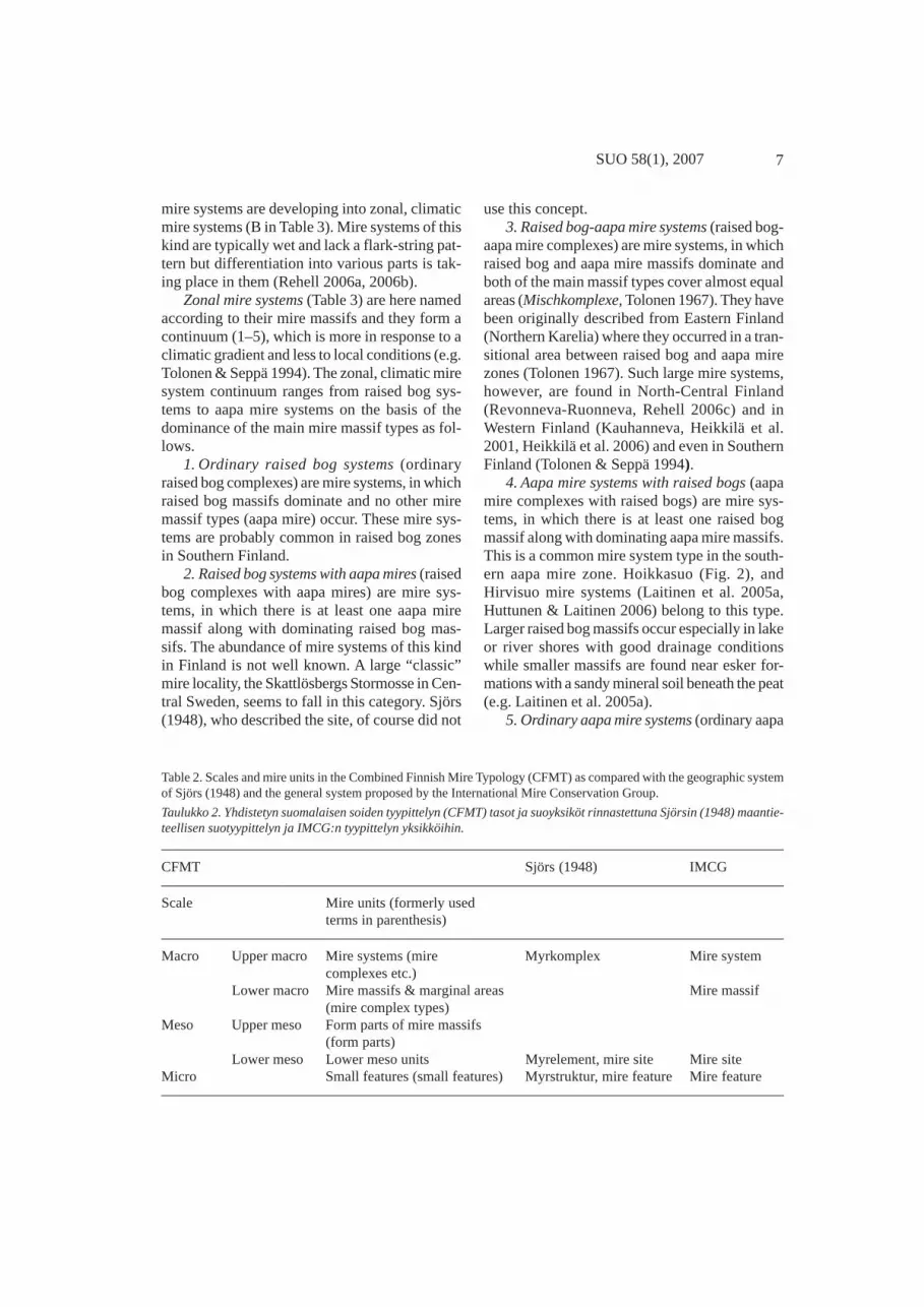
The aerial photograph interpretation was the mainresearch method in this investigation. The Com-bined Finnish Mire Typology was drawn up as acombination of a literature survey and our ownresearch. For testing the typology, we carried outan aerial photo interpretation on the morphologyof the Hoikkasuo mire system in Simo (Figs. 1and 2). The mire system is situated in the centralto northern part of a southern aapa mire zone(Ruuhijärvi 1983), where the morphological di-versity of larger mire systems is often high, asthe mire systems have characteristics from boththe aapa mires and raised bogs. For this reason,such mire systems can serve as a case study for amore general typology of zonal mire systems. Themorphology of the Hoikkasuo mire system wascompared with the morphology of the Hirvisuomire system situated a little more south in thesame mire zone (Laitinen et al. 2005a).
The Mire Water Flow Typology for boreal,zonal mire systems was compiled on the basis ofthe interpretation of an aerial photograph (theHoikkasuo mire system, Fig. 3) and Ivanov’s(1981) flow line model. Flow lines were drawnon the basis of the morphological pattern visiblein the aerial photograph. The starting points ofthe flow lines were placed at even intervals andaccordingly each flow line shows the annual run-off from a certain area, which in the case ofHoikkasuo was of size 250 m x 250 m. The closereach other the flow lines are situated, the higherthe flow rate through the surface layer is, pro-vided that the structure of the surficial peat layeris similar in all parts of the mire and the waterflows entirely in the acrotelm.
Hydrogeological flow patterns within andbetween mire systems were described on the ba-sis of previous studies, especially the inventoriesmade in the Kälväsvaara – Olvassuo area inNorth-Central Finland (Heikkilä, H. et al. 2001).The biological significance of morphological andhydrological mire classifications, i.e. the depend-ency of species richness and its maintenance over
time on environmental heterogeneity, was dis-cussed on the basis of some recently published,repeated mire system inventories made in Swe-den (e.g. Gunnarsson et al. 2000). The results ofour investigation and the previous classificationbasis for Finnish mires and water-flow patternswill be presented as a synthetic description in thenext main chapter.
Fig. 1. Mire zones of Finland and the location of theHoikkasuo mire system presented in Figs. 2 and 3. Mirezones according to Ruuhijärvi & Hosiaisluoma (1988): 1:plateau bogs, 2: concentric bogs, 3: eccentric bogs, 4: south-ern aapa mires, 5: main aapa mire zone, 6: northern aapamires, 7: palsa mires.
Kuva 1. Suomen suovyöhykkeet ja kuvissa 2 ja 3 esitetynsuosysteemin (Hoikkasuo) sijainti. Suovyöhykkeet Ruuhi-järven & Hosiaisluoman (1988) mukaan: 1: laakiokeitaat,2: konsentriset kermikeitaat, 3: eksentriset keitaat, 4: ete-läiset aapasuot, 5: aapasoiden päävyöhyke, 6: pohjoisetaapasuot, 7: palsasuot.

4 Laitinen et al.
Synthesis of Finnish mire and waterflow classifications
Basic concepts
In this article, mire morphology means forms ofany size of the mire surface, beginning from hum-mocks and hollows and continuing up to largemire units detectable from aerial photos. It mainlyappears as various mire surface levels, whichoccur as patterns of various forms and sizes. Weuse three mire surface levels, the hummock level,the lawn and the flark level. Of these, the lawncorresponds to the intermediate level by Eurolaet al. (1984, 1995) and the flark level to mud bot-tom (Moosarme Rimpigesellschaften, Ruuhijärvi1960) and the bulk of carpet (MoosreicheRimpigesellschaften, Ruuhijärvi 1960) by Sjörs(1948). For spruce mires (Bruchmoore) of mo-saic type (e.g. for herb and grass birch-sprucemires, Eurola et al. 1995) the term mosaic levelis used. It refers to a mire surface level in whichall the three levels or some of them are mixed ina very small (ca 1 m²) scale.
Threshold is a morphologic micro-scale ormeso-scale mire part, in which the gradient ofthe water table is steeper than in the part situatedin the upflow direction from it. The water con-ductivity of the surface parts of the threshold islower than in the reservoir. Narrow, sandy raisedbeach ridges may exceptionally act as similarthresholds in certain mire systems. Reservoir is amorphological micro-scale or meso-scale mirepart with a plain or relatively plain water table.The water body in the peat of the reservoir isdammed by a threshold.
Surface water (limnogenic water) refers towater in lakes, rivers and brooks (Eurola et al.1984, 1995). Geological groundwater (generalgroundwater) in this article means the water be-neath the groundwater table in any soil (see Freeze& Cherry 1979). Mire water is the part of thegeological groundwater in peat soil, also includ-ing the floodwater on the mire surface. Miregroundwater (specific groundwater) is water thatflows directly from the mineral soil to peat soilor onto the mire (see Eurola et al. 1984, 1995).Groundwater flow pattern (hydrogeologic flowpattern) is the flow pattern formed by the recharge
and discharge of geological groundwater (e.g.Freeze & Cherry 1979). Groundwater rechargearea is an area in which the water table in deeppiezometers is below the water table of shallowwells, and the saturated flow takes place down-wards. Groundwater discharge area is an area inwhich the saturated flow takes place upwards,towards the water table in shallow wells (e.g.Freeze & Cherry 1979).
Mire water flow is any water flow in the peatlayers or above the peat surface in mire systemsor in parts of mire systems. The flow may cat-egorically take place either
(a) laterally in the porous surface peat(acrotelm) in diplotelmic mires (Ingram 1978,Ivanov 1981)
(b) laterally through the whole peat col-umn in percolation mires (Succow & Joosten2001) or
(c) vertically from the mire surfacethrough the peat to deeper layers, mainly withinhabitats with considerable water level fluctuations(Laitinen et al., in press).
Water flow rate through the mire surface layeris a function of water input and hence can beevaluated with the help of the catchment area,surface flow pattern (flow lines, see Fig. 3),groundwater recharge-discharge pattern and re-gional climatic data. The flow rate at each pointcan be quantified as a specific discharge of thesurface layer (m³ m–² a–¹). This discharge is de-pendent on water supply and is regulated by thegradient of the slope and the hydraulic conduc-tivity of the surface layer at each point of the mire.
Supplementary vs. inherent nutrient effect(Eurola et al. 1984, 1995, Eurola & Huttunen2006) is a vegetation-ecological concept used inFinland. It is originally derived and revised fromthe concept mire margin vs. mire expanse by Sjörs(1948). The latter terms were also used e.g. byRuuhijärvi & Lindholm (2006). It is question hereof vegetation gradients defined in accordance withwhether the surface peat is constantly being sup-plied with additional nutrients other than thosealready present in the peat or supplied by rain-water (Eurola et al. 1984). Mire vegetation ex-hibiting a supplementary nutrient effect is con-stantly receiving additional nutrients from vari-ous sources, and mire vegetation exhibiting an

5SUO 58(1), 2007
inherent nutrient effect relies entirely on nutri-ents already present in the peat or supplied byrainwater. A supplementary nutrient effect appearsin three forms, which are briefly listed below (forcomprehensive descriptions, see Eurola et al.1984, 1995).
1. Surface water influence. Additional nutri-ents are received from moving surface water, es-pecially from river and lake water (limnogenicwater) or they occur as the “remnants” of nutri-ents derived directly from the sea flooding inyoung mire systems close to the Bothnian Bay.
2. Groudwater influence. Additional nutrientsto the mire system are received from movinggroundwater derived from mineral soil (specificground water).
3. Mineral soil influence (spruce mire influ-ence, Eurola et al. 1984, 1995). Additional nutri-ents are received mainly from the mineral soilthrough a relatively thin peat layer.
Mire site type (mire type) is a basic vegeta-tion unit used in the Finnish mire site type classi-fication (Cajander 1913, Ruuhijärvi 1960, Eurola1962, Eurola et al. 1984, 1995). It falls betweenthe micro scale (small features) and the meso scale(form parts and small meso units) as comparedwith the scales of the Combined Finnish MireTypology. “Mire site” (myrelement) of Sjörs(1948), instead, is a “geographical unit” and cor-responds to the meso-scale mire units of the Com-bined Finnish Mire Typology. Main mire vegeta-tion units (six units) and the mire site types (about80) in the mire site type classification have beenrelated to the major mire gradients by Eurola etal. (1984, 1995)(cf. Økland et al. 2001), i.e. tothe trophic status (poor-rich gradient, Tahva-nainen 2004), to water level (water level catego-ries, Laitinen et al. (in press), mire surface levels(in this article)) and to the supplementary vs. in-herent nutrient influence.
Aapa mire is defined by Eurola et al. (1995)as a mire complex (system) type whose centralparts are characterised by minerotrophy and near-to mire inherent influence and which may receivesupplementary nutrients to its central parts —besides marginal parts and brooksides — alsothrough snow-melt water from the surroundings(Eurola et al. 1995). The definition is vegetation-ecological and largely accepted and used in Fin-
land, but poorly known elsewhere (see Pakarinen2000). Aapa mires are morphologically variable,which is schematically shown in table 1 (includ-ing a comparison with a Swedish and a Norwe-gian system).
Combined Finnish Mire Typology (CFMT)
The Combined Finnish Mire Typology (CFMT)presented here attempts to classify all the mires(within a certain area) in Finland. The treatmentof large, zonal mires systems (mire complexesby Ruuhijärvi 1960 etc.) is based on the princi-ples of Ruuhijärvi (1960), Eurola (1962), Tolonen(1967), Eurola & Vorren (1980) and Vorren et al.(1999). The idea of local systems, instead, stemsfrom Cajander (1913). “Zonal” refers here to lati-tudinal mire zones, which were defined in Fin-land on the basis of the main distribution areasof different mire complex types (Ruuhijärvi 1960,Eurola 1962, Ruuhijärvi 1983, Ruuhijärvi &Hosiaisluoma 1988). Zonal mire systems are cli-matic formations composed of mire massifs andmarginal areas. Of these, the marginal areas aremostly treed while the massifs are usually tree-less. “Local” refers here to morphologic featuresother than those formed by latitudinal zonality inlarge mire systems. Mire massifs are lacking orcover very small areas in the local mire system,and a transition from mires to other wetlands oc-curs within them.
The CFMT prevalently operates with miresurface levels visible in aerial photographs andthe system is mainly morphological. Especiallythe mire massif types typical of zonal mire sys-tems and the subunits of mire massifs are identi-fied with mire surface levels. In addition, the de-velopmental stage of the mire system must betaken into consideration. The identification oflocal mire systems presupposes further scrutinywith certain topographic, climatic and hydrologicfeatures of those mire systems.
Mire units of three scales (macro, meso, mi-cro) are included in CFMT (Table 2). The macroand meso scales are additionally divided into cor-responding upper and lower subscales. The up-per macro scale is represented by mire systemsand the lower macro scale by mire massifs andtheir marginal areas. The mire massifs (the lower

6 Laitinen et al.
macro scale) do not occur in all mire systems,and in such cases the subdivision into the upperand lower subscale is not applied. The meso scalecalls for a corresponding scrutiny: the upper mesoscale (form parts of mire massifs) only occurs inmire systems with mire massifs (zonal mire sys-tems) and even then not in all of them. The smallfeatures of mires represent the micro scale.
Mire systems
Mire systems form the largest scale units withinthe CFMT (Table 3). By our definition, a miresystem is any uniform mire area surrounded bymineral soil areas or watercourses. In the case ofuniform, large branching network-like mire ar-eas, one system can be practically separated, ifnecessary, by the narrowest points of the mirebranches. Accordingly, the mire systems rangefrom large mire entities with several mire mas-sifs to small mire patches surrounded by mineralsoil and without any mire massifs. In Russiantypologies, however, the mire system means acomplex structure always consisting of mire mas-
sifs (e.g. Yurkovskaya 1995). Mire massif, by ourdefinition, is a uniform peatland block with aconvex, concave or sloping gross profile. In Fin-land, where there are no extremely oceanic ar-eas, mire massifs only include various raised bogmassifs and various aapa mire massifs.
Mire basin is a primary, concave topographicform on which the mire system is forming or hasformed. The form of mire basins, i.e. the originaltopography of the ground surface, affects the typeof forming mire systems while the geological ageof the mire system affects their succession stage.Mire systems may even cover larger areas thanthe primary mire basins in geologically older ar-eas in Finland, if the topography is not very dis-sected and the valley sides are not too steep andhigh. In geologically young areas, e.g. in the landuplift coast of the Gulf of Bothnia, mires justcover the bottoms of mire basins (Rehell 2006a,2006b).
Young mire systems (Table 3) denoted hereare mire systems in the immediate vicinity of thecoast, where the land uplift phenomenon affectsthe succession of all the vegetation. Parts of these
Table 1. Zonal, eco-climatic mire complex types by Eurola & Kaakinen (1979). Mire type classifications of Malmer(1985) and Moen (1985) elucidate the differing concepts in Scandinavian typologies as compared with the Finnish typol-ogy.
Taulukko 1. Vyöhykkeelliset, ekoklimaattiset suokompleksityypit Eurolan & Kaakisen (1979) mukaan. Vertailuna Malm-erin (1985) ja Moenin (1985) skandinaaviset luokitusjärjestelmät.
––––––––––––––––––––––––––––––––––––––––––––––––––––––––––––––––––––––––––––––––I. Zonal, eco-climatic mire II. Hydrotopographic mire III. Hydromorphologicalcomplex types1 – from about types (Malmer 1985) mire types in Norwaysubtropic to arctic zones (Moen 1985)––––––––––––––––––––––––––––––––––––––––––––––––––––––––––––––––––––––––––––––––
1. Limnogenic mire complex type 1. Bog mire complexes 1. Typical raised bogs2. Raised bogs (of various types) – Blanket bog complexes 2. Atlantic raised bogs3. Aapa mires – Raised bog complexes 3. Plane bogs– flark-string aapa mires (eccentric or concentric) 4. Blanket bogs– lawn (intermediate level) – Flat bog complexes 5. Mixed miresaapa mires 2. Fen mire complexes – string mixed mires– slope mires – Aapa fen complexes – island mixed mires– palsa mires (string mires, patterned mires) – palsa mires4. Arctic mires – Topogenous fen complexes 6. Minerotrophic mires
(horizontal) – flat fen– Soligenous fen complexes – sloping fen(sloping, incl. spring fens) – flark fen– Palsa mires
––––––––––––––––––––––––––––––––––––––––––––––––––––––––––––––––––––––––––––––––1(Eurola & Kaakinen 1979)
7SUO 58(1), 2007
mire systems are developing into zonal, climaticmire systems (B in Table 3). Mire systems of thiskind are typically wet and lack a flark-string pat-tern but differentiation into various parts is tak-ing place in them (Rehell 2006a, 2006b).
Zonal mire systems (Table 3) are here namedaccording to their mire massifs and they form acontinuum (1–5), which is more in response to aclimatic gradient and less to local conditions (e.g.Tolonen & Seppä 1994). The zonal, climatic miresystem continuum ranges from raised bog sys-tems to aapa mire systems on the basis of thedominance of the main mire massif types as fol-lows.
1. Ordinary raised bog systems (ordinaryraised bog complexes) are mire systems, in whichraised bog massifs dominate and no other miremassif types (aapa mire) occur. These mire sys-tems are probably common in raised bog zonesin Southern Finland.
2. Raised bog systems with aapa mires (raisedbog complexes with aapa mires) are mire sys-tems, in which there is at least one aapa miremassif along with dominating raised bog mas-sifs. The abundance of mire systems of this kindin Finland is not well known. A large “classic”mire locality, the Skattlösbergs Stormosse in Cen-tral Sweden, seems to fall in this category. Sjörs(1948), who described the site, of course did not
use this concept.3. Raised bog-aapa mire systems (raised bog-
aapa mire complexes) are mire systems, in whichraised bog and aapa mire massifs dominate andboth of the main massif types cover almost equalareas (Mischkomplexe, Tolonen 1967). They havebeen originally described from Eastern Finland(Northern Karelia) where they occurred in a tran-sitional area between raised bog and aapa mirezones (Tolonen 1967). Such large mire systems,however, are found in North-Central Finland(Revonneva-Ruonneva, Rehell 2006c) and inWestern Finland (Kauhanneva, Heikkilä et al.2001, Heikkilä et al. 2006) and even in SouthernFinland (Tolonen & Seppä 1994).
4. Aapa mire systems with raised bogs (aapamire complexes with raised bogs) are mire sys-tems, in which there is at least one raised bogmassif along with dominating aapa mire massifs.This is a common mire system type in the south-ern aapa mire zone. Hoikkasuo (Fig. 2), andHirvisuo mire systems (Laitinen et al. 2005a,Huttunen & Laitinen 2006) belong to this type.Larger raised bog massifs occur especially in lakeor river shores with good drainage conditionswhile smaller massifs are found near esker for-mations with a sandy mineral soil beneath the peat(e.g. Laitinen et al. 2005a).
5. Ordinary aapa mire systems (ordinary aapa
Table 2. Scales and mire units in the Combined Finnish Mire Typology (CFMT) as compared with the geographic systemof Sjörs (1948) and the general system proposed by the International Mire Conservation Group.
Taulukko 2. Yhdistetyn suomalaisen soiden tyypittelyn (CFMT) tasot ja suoyksiköt rinnastettuna Sjörsin (1948) maantie-teellisen suotyypittelyn ja IMCG:n tyypittelyn yksikköihin.
––––––––––––––––––––––––––––––––––––––––––––––––––––––––––––––––––––––––––––––––CFMT Sjörs (1948) IMCG––––––––––––––––––––––––––––––––––––––––––––––––––––––––––––––––––––––––––––––––Scale Mire units (formerly used
terms in parenthesis)––––––––––––––––––––––––––––––––––––––––––––––––––––––––––––––––––––––––––––––––Macro Upper macro Mire systems (mire Myrkomplex Mire system
complexes etc.)Lower macro Mire massifs & marginal areas Mire massif
(mire complex types)Meso Upper meso Form parts of mire massifs
(form parts)Lower meso Lower meso units Myrelement, mire site Mire site
Micro Small features (small features) Myrstruktur, mire feature Mire feature––––––––––––––––––––––––––––––––––––––––––––––––––––––––––––––––––––––––––––––––

8 Laitinen et al.
mire complexes) are mire systems, in which aapamire massifs dominate and no raised bog mas-sifs occur. Ordinary aapa mire systems probablyoccur in the southern aapa mire zone mainly asrelatively small, unbranched mire systems butmay occur in more northern aapa mire zones alsoas large, branched mire systems. Sphagnum
fuscum bogs of aapa mire margins (Tolonen 1967,Tolonen & Seppä 1994, Laitinen et al. 2005a)commonly occur in connection with peripherallobes (see chapter Lower meso units). They arenot regarded as raised bog massifs.
Local mire systems (C inTable 3) are mire (tomire-like wetland) systems in which mire mas-
Table 3. Mire systems and mire massifs in the Combined Finnish Mire Typology (CFMT). Upper macro scale refers tomire systems and lower macro scale to mire massifs and the marginal areas of mire massifs. For the meso-scales andmicro-scales of zonal mire systems, see Table 4.
Taulukko 3. Suosystemit ja suomassiivit yhdistetyn suomalaisen soiden tyypittelyn (CFMT) mukaan. Yläsuurtaso tarkoit-taa suosysteemejä ja alasuurtaso suomassiiveja ja suomassiivien marginaalialueita. Vyöhykkeellisten suosysteemien keski-ja pientason tyypittely on esitetty taulukossa 4.
––––––––––––––––––––––––––––––––––––––––––––––––––––––––––––––––––––––––––––––––1. Mire systems – Upper macroscale
A Young mire systems: mire massifs (raised bog massifs, aapa mire massifs) are not yet formed
B Zonal mire systems (mire complexes): climatic mire systems in which raised bog and/ or aapa mire massifs occur
- ordinary raised bog systems: only raised bog massifs occur
- raised bog systems with aapa mires: raised bog massifs dominate, aapa mire massifs occur
- raised bog-aapa mire systems: raised bog massifs and aapa mire massifs with about equal proportions
- aapa mire systems with raised bogs: aapa mire massifs dominate, raised bog massifs occur
- ordinary aapa mire systems: only aapa mire massifs occur
C Local mire systems: mire systems strongly affected by local climatic, local topographic or local hydrologicconditions and thus raised bog or aapa mire massifs do not occur or only minor and poorly delimited mire massifsmay occur; transition appears from mire systems to other wetland systems
a. Local, topographic-climatic mire systems: local climate caused by high elevations and hilly topographysuppress the occurrence of raised bog and aapa mire massifs
- ordinary slope fen systems and aapa mire-slope fen systems
b. Local, topographic mire systems: local topography in itself does not allow the formation of mire massifs
- paludified areas on rock surfaces
- small depression mires (incl. e.g. such mires in morainic topography and kettle hole mires)
- depression-network mire systems
c. Local, hydrogenetic wetland systems: local hydrology does not allow the formation of mire massifs; transitionappears from mire systems to other wetlands
- spring & spring fen systems: abundant groundwater discharge prevents the formation of mire massifs
- swamp wetland systems: abundant surface water influence prevents the formation of mire massifs
- aro wetland systems and mire-aro wetland systems: large fluctuations in water table level in aro wetlandsprevent the formation of mire massifs and the peat layer proper
2. Mire massifs and marginal areas (Mire complex types) – Lower macroscale
Mire massif types
- raised bog massif
- aapa mire massif: lawn aapa mire massif, lawn-flark aapa mire massif, flark aapa mire massifs
Marginal areas of zonal mire systems
- laggs (in raised bog systems)
- various forest mires (in aapa mire systems)
––––––––––––––––––––––––––––––––––––––––––––––––––––––––––––––––––––––––––––––––

9SUO 58(1), 2007
sifs (lower macro scale) are lacking or are verysmall-sized and only cover a small proportion ofthe whole mire system. They are divided here intothree groups. (a) In local, topographic-climaticmire systems the formation of raised bog or aapamire massifs is prevented by a hilly topographyand the oceanic local climate caused by high alti-tudes. (b) In local, topographic mire systems, lo-cal topography (narrow and steep-sided mire ba-sins etc.) prevents the formation of mire massifsand (c) in local, hydrogenetic wetland systems,the formation of mire massifs is prevented bylocal hydrology.
a. Local, topographic-climatic mire systemsinclude ordinary slope fen systems. These areseparate slope fen systems, which do not directlycombine with more flat aapa mires. Instead, aapamire-slope fen systems are combinations of slopefens and more flat aapa mires. In Finland, slopefens may be regarded “local” and they occur hereand there in mid-boreal and north-boreal zonesin the eastern (Havas 1961) and northern parts ofthe country. When the whole Fennoscandia isconsidered, their specific zonal and especiallysectional distribution becomes more evident(Eurola & Vorren 1980, Vorren et al. 1999, Moen1999). Slope fens are very rare in Finland, butmore common and abundant in those parts inmountaneous Scandinavia where climatic condi-tions are suitable. Slope fens have been mainlyregarded as a topographic variant of aapa miresin Finland (Ruuhijärvi 1960, Havas 1961, Eurola& Kaakinen 1979, Eurola et al. 1984, 1995). Inthis connection slope fen merely denotes middleor northern boreal (see e.g. Havas 1961, Dierssen1996, Moen 1999) slope fens (slope angle morethan 3 degrees), which are essentially lawn fenswith no or very scattered strings and flarks. Thusthe principal morphological features of the slopefens denoted here are the considerable slope andthe occurrence of lawn (for peat characteristics,see Auer 1923, for climatic presupposes, seeEurola & Vorren 1980 and Eurola & Huttunen1984). Spruce mire (Bruchmoor) chains on slopeswith no lawn fen do not belong to the slope fensdenoted here. Most slope fens in Finland prob-ably occur as combination mire systems with aapamires, while ordinary slope fen systems may bevery rare.
b. Local, topographic mire systems denotedhere form a collective, heterogeneous group forall those mire systems, in which the local topog-raphy of bedrock or mineral soil has preventedthe formation of zonal mire systems, but whichare not bound to specific, local climatic condi-tions. These mire systems are mainly composedof pine mires (Reisermoore, Ruuhijärvi 1960) andspruce mires (Bruchmoore, Tuomikoski 1942,Ruuhijärvi 1960) like the marginal areas of cli-matic mire systems, but may include treeless orsparsely treed mire parts (Weissmoore orBraunmoore, Ruuhijärvi 1960 etc.).
1. Paludified areas on rock surfaces are typi-cally small-sized and broken mire systems in ar-eas where outcrops occur abundantly, but are lack-ing in areas where outcrops do not occur. Out-crops as a whole are convex or sloping forma-tions. Paludified patches and areas on them mostoften occur in small depressions but also on aneven or sloping rock-substratum.
2. Small depression mires occur in a separatedepression whose breadth reaches from somemeters or some tens of meters to some hundredsof meters. Such small mires may occur every-where, e.g. in monrainic or glaciofluvial topog-raphy. In the latter case more or less round kettlehole mires are typical. In some cases even smallkettle hole mires may have features of mire mas-sifs, e.g. features of raised bog massifs (Reini-kainen et al. 1984).
3. Depression-network mire systems are amire system type typical of large areas inFennoscandia with highly broken bedrock andsmall-scaled topography. In those regions the mirebasins are branching and form networks. Theyare, however, so narrow and steep-sided that pro-nounced raised bog or aapa mire massifs cannotbe formed. Minor mire massifs or massif-likesites, instead, may occur especially at the cross-ing points of the mire networks (see Cajander1913). It may be difficult to identify a mire mas-sif from the rest of the mire area in these miresystems. The Carelian mire complex type ofCajander (1913) roughly corresponds to this type.According to Cajander (1913), that type is themost common mire complex type of all in largeareas in Southern and Eastern Finland.

10 Laitinen et al.
c. Local, hydrogenetic wetland systems de-noted here form a collective group of mires andwetlands, in which the conditions in water flowor in fluctuations of the water table level are suchthat raised bogs or aapa mire massifs cannot beformed. Three subgroups of this group also rep-resent the extreme ends of three mire ecologicalgradients i.e. the gradient of groundwater influ-ence (Eurola et. al. 1984, 1995), the gradient ofsurface water influence (Eurola et al. 1984, 1995)and the gradient in fluctuations of water tablelevel (Laitinen et al., in press).
1. Spring & spring fen systems are aquatic,wetland or mire systems, in which the dischargeof specific groundwater and the small size of thetopograhic basin prevent the formation of miremassifs. They are very rare as individual wetlandsystems in Finland (Repo 1955, Ulvinen 1961),because most springs and spring fens occur inconnection with zonal mire systems etc.
2. Swamp wetland systems are wetland or miresystems in which surface water influence (Eurolaet al. 1984, 1995), i.e. the influence of limnogenicwater (river water, lake water etc.) or otherwisevery moving water in the mire, continuouslykeeps the wetland system devoid of typical miremassif features. These systems occur in the cli-matic area typical of Finland usually in connec-tion with other mire system types, but may formexceptionally distinct small swamp wetland sys-tems (Mäkinen 1978, 1979). Zonal swamps(limnmogenic mire complex type, Table 1), ac-cording to Eurola & Kaakinen (1979) and Eurolaet al. (1984), occur south of the zones of variousbogs far south from Finland in an area where theformation of mire-like vegetation is restricted tonear watercourses.
3. Aro wetland systems are temporary wet-lands (Gopal et al. 1990), in which large fluctua-tions in water table level and seasonal droughtprevent the formation of a peat layer proper, andhence also mire massifs do not occur (Laitinen etal. 2005b). They occur outside permanent water-courses in sites where flood water can penetrateinto the mineral ground or evaporate during dryseasons in summer. Aro wetlands occur either asseparate wetland systems or as combinations withmires. Individual aro wetland systems are verysmall, ranging from some acres to some hectares
in size. In North Central Finland, where the arowetlands are most abundant and largest, they areusually combined with zonal mire systems (mire-aro wetland systems).
Mire massifs and marginal areas
Mire massif is a large, morphologic mire unit witha convex, plain, sloping or concave gross profileand with one to several microtopographicallyuniform sub-areas (meso units) usually situatedregularly in relation to each other (Table 3). Miremassifs are always real peatlands and form the“main peatland blocks” of mire systems. Miremassifs at first attract attention when large mireareas are viewed in aerial photographs. The for-mation of a mire massif always takes a certaintime; in quite young mire systems, typical miremassifs are not yet formed. Yurkovskaya (1995)uses the mire massif as a synonym for the mirecomplex type used by Cajander (1913). We ap-ply it for raised bogs so that the lagg is left out ofthe massif to the marginal area. This is due tosimple morphologic reasons: uniform, convex toplain to sloping raised bog massif formation es-sentially makes up the central plain and the mar-ginal slope only, the lagg is evidently “somethingelse” in the morphological sense.
Main mire massif types include the raised bogand the aapa mire massif. Micro-scale and meso-scale morphological patterning in mire massifsis typical of climatic mire zones in Finland(Ruuhijärvi 1960, Eurola 1962, Ruuhijärvi 1983,Ruuhijärvi & Hosiaisluoma 1986). The main miremassif types are briefly characterised below.
1. Raised bog massif is a zonal (climatic) miremassif type of boreal and temperate zones. Itsvegetation is ombrotrophic and the gross profileis convex to plain to slightly sloping.
2. Aapa mire massif is a zonal mire massiftype of the boreal zone. Its central parts haveminerotrophic vegetation of a mire expanse char-acter. The gross profile is typically concave. Themost characteristic feature of aapa mire massifsin aerial photos is the definite patterning of wetareas (flark level) in relation to lawn and hum-mock-level areas. This shows as a transversal,micro-scale flark-string pattern or as a longitudi-nal, meso-scale soak-lobe pattern. Aapa mires are

11SUO 58(1), 2007
practically flat or considerably sloping eitherpartly or totally, which can even be seen by theeye, as is sometimes the case in a hilly terrain inNorth-Eastern and Northern Finland and e.g. innorthern Dalarna in Central Sweden (see e.g.Sjörs 1973, Rydin et al.1999).
Subtypes of raised bog and aapa mire mas-sifs correspond to the climatic mire zones in thelowland-dominated Finland (Fig. 1). Accordingto Ruuhijärvi & Hosiaisluoma (1984), thesubtypes of raised bog massifs, with small addi-tions, include (1) the plateau bog (Hummock pla-teau bog & Hummock-hollow plateau bog), (2)Concentric domed bog, (3) patterned eccentricbog and (4) unpatterned eccentric bog (Fuscumbog & Forest bog). In aapa mires we separate threesubtypes of massifs, which include (1) lawn aapamire (predominantly in the southern part of thesouthern aapa mire zone), (2) lawn-flark aapamire (predominantly in the northern part of thesouthern aapa mire zone) and (3) flark aapa mire(predominantly in the main aapa mire zone andnorth of it). In addition to those mentioned above,there are at least two intermediate massif typesof aapa mires and raised bogs: 1) an aapa mire -raised bog intermediate type with the morphol-ogy of hummock-ridged raised bogs but withminerotrophic vegetation in the hollows/flarks(Laitinen et al. 2005a) and 2) an aapa mire - raisedbog intermediate type with the morphology re-sembling that of lawn aapa mires but having to-tally ombrotrophic vegetation within lawns(Sallinen 2005). Brief descriptions of aapa miremassif types are given below.
1. Lawn aapa mire massif is an aapa miremassif, in which lawn dominates but flark level(mostly carpet) often occurs in the form of longi-tudinal soaks. Soaks may lack in some cases orthe longitudinal lobe-soak pattern is visible inaerial photos but hardly detectable in the field.
2. Lawn-flark aapa mire massif is an aapamire massif, in which peripheral lobes and vari-ous flark fens (string flark fens, unoriented flarkfens, flark outlets) dominate. It seems to be a verywidely spread mire massif type but has not beenspecifically termed before in Finland. The maindistribution is in the southern aapa mire zone,especially in the northern half of it (Ruuhijärvi1983).
3. Flark aapa mire massif is an aapa miremassif overwhelmingly dominated by the flarklevel. Flark aapa mires dominate in the centraland northern parts of the whole aapa mire zone.
Marginal areas of zonal mire systems includethe laggs of raised bogs and various forest miresof aapa mires. Marginal areas are not divided hereinto meso-scale units as are the mire massifs.
1. Laggs are narrow, minerotrophic forma-tions at the boundary between the raised bogmassif and the mineral soil. They are minero-trophic and do no belong to raised bog massifsmorphologically but rather form an entity of theirown (cf. concept raised bog complex, e.g. Eurola1962). Laggs may be treeless fens, treed fens orforest mires (densily treed mires, which are nottreed fens).
2. Various forest mires are typical of the mar-ginal areas of aapa mire systems. They includemany kinds of densely forested mires, which donot belong to the peripheral parts of aapa miremassifs. There is no natural boundary betweenthe peripheral parts of the aapa mire massifs andthe forest mires in the marginal areas of aapa miresystems: the boundary is in most cases fully con-ventional.
Form parts of mire massifs
The gross profiles of aapa mires are typicallyconcave, whereas those of raised bogs are typi-cally convex (e.g. Seppä 1996). Accordingly, onemay expect that in both the main mire massif typessome kind of a morphological centre vs. periph-ery differentiation can be found. These parts havebeen called form parts (Formenteile) in the caseof raised bogs (Aario 1932 etc.) and they includethe central plain and the marginal slope (Table4). In connection with aapa mires such morphol-ogy has not been discussed, but corresponding“dual morphology” has been found in the aapamire massifs of the Hoikkasuo (Fig. 2) and theHirvisuo mire systems (Laitinen et al. 2005a). Inthose cases the central basin is formed by differ-ent flark fens, which are surrounded by the pe-ripheral parts of aapa mire massifs. These arecomposed of various treeless or treed lawn fensor hummock-level areas. The same dual form-part-pattern evidently reappears in most but not

12 Laitinen et al.
in all aapa mire massifs, e.g. in typical flark aapamire massifs of the main aapa mire zone. Therethe difference in wetness and morphology be-tween the large central basin and the narrow pe-ripheral part (peripheral fringe) may be even moreevident than the corresponding difference in thesouthern aapa mire zone (see the transitional bor-der between the central basin and the peripheralpart of the aapa mire massif in the eastern part ofthe Hoikkasuo mire system, Fig. 2).
Lower meso units
Lower meso units are mire parts in which two ormore mire surface levels alternate regularly, ormire parts in which either the flark level or thelawn and hummock level or hummock leveldominates. Units have a typical flow pattern.Lower meso units for aapa mire massifs with
well-developed form parts (Fig. 2, Table 4) willbe briefly described below.
The central basins of aapa mire massifs mayinclude the following lower meso units.
1. String flark fens have a parallel-orientedflark-string pattern (Fig. 2: pattern 4). Strings areeither lawn strings or Sphagnum fuscum strings.The latter refers to string-mixed mires as knownin the Scandinavian classifications. Flarks aremainly composed of a mud bottom, in marginalparts also of carpet. This is the most importantmire unit in the aapa mires of the main aapa mirezone (Ruuhijärvi 1983) but it is also abundant inthe southern aapa mire zone of Finland. The typecorresponds to parallel-patterned fens of Laitinenet al. 2005a. Parallel flow (Cajander 1913) is acharacteristic feature (Fig. 3).
2. Unoriented flark fens are plain flark levelareas with or without scattered strings and with adivergent flow pattern. They include stringlesscentral flark fens and reservoir-infiltration basinsof Laitinen et al. (2005a). (a) Stringless centralflark fens (Fig. 2: pattern 5) are wet flarks sur-rounded by string flark fens and occasionally bya small raised bog massif from one side (Laitinenet al. 2005a). The occurrence of this unit togetherwith small raised bog massifs suggests the com-plexity of the morphological response to a diver-gent flow pattern in the central basins of aapamire massifs in the southern aapa mire zone. Thetransition from this unit to string flark fens isgradual. The unit corresponds to flark crosses andflark triangles of Sjörs (1973, 1983) and is verycommon in flark and lawn-flark aapa miresthroughout Finland. In the classic Finnish aapamire site, the Heikinjärvenneva mire, for instance,there is a stringless central flark fen of consider-able size as compared with the size of the miremassif (Cajander 1913, Tahvanainen 2006). (b)Reservoir-infiltration basins in flark fens haveonly been described from the Hirvisuo mire sys-tem (Laitinen et al. 2005a) in the southern aapamire zone. There they only occur in mire areaswith a very thin peat layer and sand beneath it. Inmire-aro wetland systems they are more numer-ous in Northern Ostrobothnia.
3. Outlet fens are typically narrower placesbordered by mineral soil from two sides in themiddle of chain-like mire systems (Fig. 2: pat-tern 6). The sites are characterised by a conver-
Table 4. Form parts (upper meso scale) in raised bog andaapa mire massifs, lower meso units in aapa mire massifsand the most important micro-scale units in raised bogsand aapa mires. For the macro scale of CFMT, see table 3.
Taulukko 4. Keidas- ja aapasuomassiivien muoto-osat (ylä-keskitaso), aapasuomassiivien alakeskitason yksiköt sekäkeidas- ja aapasuomassiivien tärkeimmät pientason yksi-köt. CFMT:n suurtason yksiköt esitetään taulukossa 3.
––––––––––––––––––––––––––––––––––––––––––––––––––––––––––––––––––––––––––––––––1. Form parts in mire massifs – Upper mesoscale
a. Centre- central plain (in raised bog massifs)- central basin (in aapa mire massifs)
b. Periphery- peripheral (marginal) slope (in raised bogmassifs)- peripheral part (in aapa mire massifs)
2. Lower meso units in aapa mire massifs – Lowermesoscale
a. In central basins:- string flark fens- unoriented flark fens: stringless central flarkfens, reservoir-infiltration basins- outlet fens
b. In peripheral parts- peripheral lobes and fringes- interlobate soaks
3. Small features – Microscalea. In raised bog massifs: hummock ridges, hollowsetc.b. In aapa mire massifs: strings, flarks (rimpis) etc.
––––––––––––––––––––––––––––––––––––––––––––––––––––––––––––––––––––––––––––––––

13SUO 58(1), 2007
gent flow pattern (Fig. 3) and abundant flow. Theymay be accompanied by weak groundwater dis-charge from the underlying mineral soil. The con-cept outlet fen denoted here does not refer to e.g.densely treed birch-spruce mires at the outletbrooks of mire systems, but exclusively to fensites visible as fen units of their own in aerialphotos, either dominated by flark level or lawn.Flark level outlet fens mostly occur at narrowerplaces in the middle of flark-level entities in aapamires (see Fig. 2). They are only slightly slopingbut more sloping than the string flark fens on theirproximal and distal sides. The form of the pat-tern (area) may be slightly funnel-shaped. In flarklevel outlets the transversal flark-string patterntypical of aapa mires turns into a pattern in whichthe strings are situated very close to each otherand can only be separated with difficulty fromeach other in aerial photos, or even into almost alongitudinal pattern. Exceptionally, the outlet fensof this kind almost completely occupy the cen-tral parts of certain aapa mire massifs. This typeof aapa mire has some similarities in peat struc-ture and in water permeability to the “percola-tion mire” described in Central Europe (Succov& Joosten 2001). The morphology, hydrology andvegetation of mires of this type were studied byRehell (1985) in Pilpasuo, although the conceptsoutlet fen or percolation mire were not used orreferred to. Olvassuo mire system has a very largeoutlet fen (see Heikkilä et al. 2001, Rehell &Tahvanainen 2006). Lindholm & Heikkilä (2006)call those mire parts percolation mires, statingthat percolation mires differ from true aapa miresin terms of their structure and vegetation. Lawnlevel outlet fens are more sloping than flark leveloutlet fens. Small mud-bottom like water tracks(small seasonal rivulets) may occur. Seasonaldrought and partly seasonal flood are typical andtransitions from lawn level outlet fens to smallslope fens may occur. These outlet fens deviateabruptly from percolation-fen-like outlet fens interms of their peat structure (see Auer 1922) andhydraulic conductivity of the peat.
The peripheral parts of aapa mire massifs mayinclude the following lower meso units.
1. Peripheral lobes and fringes form a clearlyvisible zone between marginal areas and variousflark fens in aapa mires. Peripheral lobes (Fig. 2:pattern 3) are broad, include large lawn fen and
treed lawn fen (even small Sphagnum fuscumbog) areas and constitute essential parts in thelawn-flark aapa mire massifs of the southern aapamire zone (Ruuhijärvi 1983). Peripheral fringesare narrow and typically occur in flark aapa miremassifs in the main aapa mire zone in Finland(Ruuhijärvi 1983). This unit is characterised by adivergent (to parallel) flow pattern (Fig. 3).
2. Interlobate soaks are long, narrow andband-like moister areas between peripheral lobesin aapa mire massifs (Laitinen et al. 2005a) (Fig.2: narrow patterns within patterns 3). Interlobatesoaks in the aapa mire massifs combine with cen-tral basins at their distal ends. In raised bog sys-tems or in raised bog-aapa mire systems, as inthe Revonneva-Ruonneva mire system south ofOulu, there are soaks that do not combine withthe central basins of aapa mire massifs but fadeinto the bog (Rehell 2006c). There may furtherbe soaks between various raised bog massifs inraised bog-aapa mire systems or in raised bogsystems with aapa mires, e.g. as in the case of theSkattlösbergs Stormosse in Central Sweden (seeSjörs 1948). Although the soaks in all cases rep-resent sites with a more pronounced possibilityof water movement in comparison with their sur-roundings (more wet surface than in their sur-roundings), there is, however, considerable vari-ation within the ecohydrology of soaks betweendifferent mire systems in that soaks range frompoor Sphagnum-dominated carpet soaks (e.g. inHirvisuo, Laitinen et al. 2005a) to soaks origi-nating from springs at mineral-soil edges andhence representing routes through whichgroundwater discharges to mire systems. This isthe case e.g. in the Skattlösbergs Stormosse (Sjörs1948, Gunnarsson et al. 2000).
Small features
Small features (small parts, small forms) or themicrotopography of mires includes the hummockbanks and hollows of raised bogs and flarks,strings, pounus and palsas of aapa mires (Table4). These features are out of the scope of this ar-ticle; they have been much discussed in mire lit-erature (e.g. Foster & King 1984, Seppälä &Koutaniemi 1985, Foster & Fritz 1987, Seppä1994, Oksanen 2005, Seppälä 2005).

14 Laitinen et al.
Fig. 2. The CFMT applied for the Hoikkasuo mire (65º 42' N, 25º 1' E, c. 70 m a.s.l., see Fig. 1), an aapa mire system with araised bog. The mire system has marginal areas (1) around mire massifs, a patterned eccentric bog massif (2) and a lawn-flarkaapa mire massif in the N-S direction. In the aapa mire massif, there are peripheral lobes (3) interrupted by soaks, string flarkfens (4), stringless central flark fens (5) and outlet fens (6). Unit 3 (with soaks) forms the peripheral part and units 4–6 thecentral basin of the aapa mire massif. The patterns have been drawn on the basis of aerial photograph interpretation.
Kuva 2. CFMT sovellettuna Simon Hoikkasuon (65º 42' N, 25º 18' E, c. 70 m a.s.l., ks. kuva 1) muodostamaan keidasaa-pasuosysteemiin. Suosysteemissä on massiiveja ympäröivien marginaalialueiden (1) lisäksi kermikeidassuomassiivi (2)ja etelä-pohjoissuuntainen väli-rimpipinta-aapasuomassiivi, jossa syrjälohkot (3) osittain juottien katkomina, jänne-rimpinevat (4), jänteettömät keskusrimpinevat (5) ja purkusuot (6). Syrjälohkot juottien kera muodostavat aapasuomas-siivin syrjäosan ja yksiköt 4–6 sen keskusaltaan. Kuviot on piirretty ilmakuvatulkinnan avulla.

15SUO 58(1), 2007
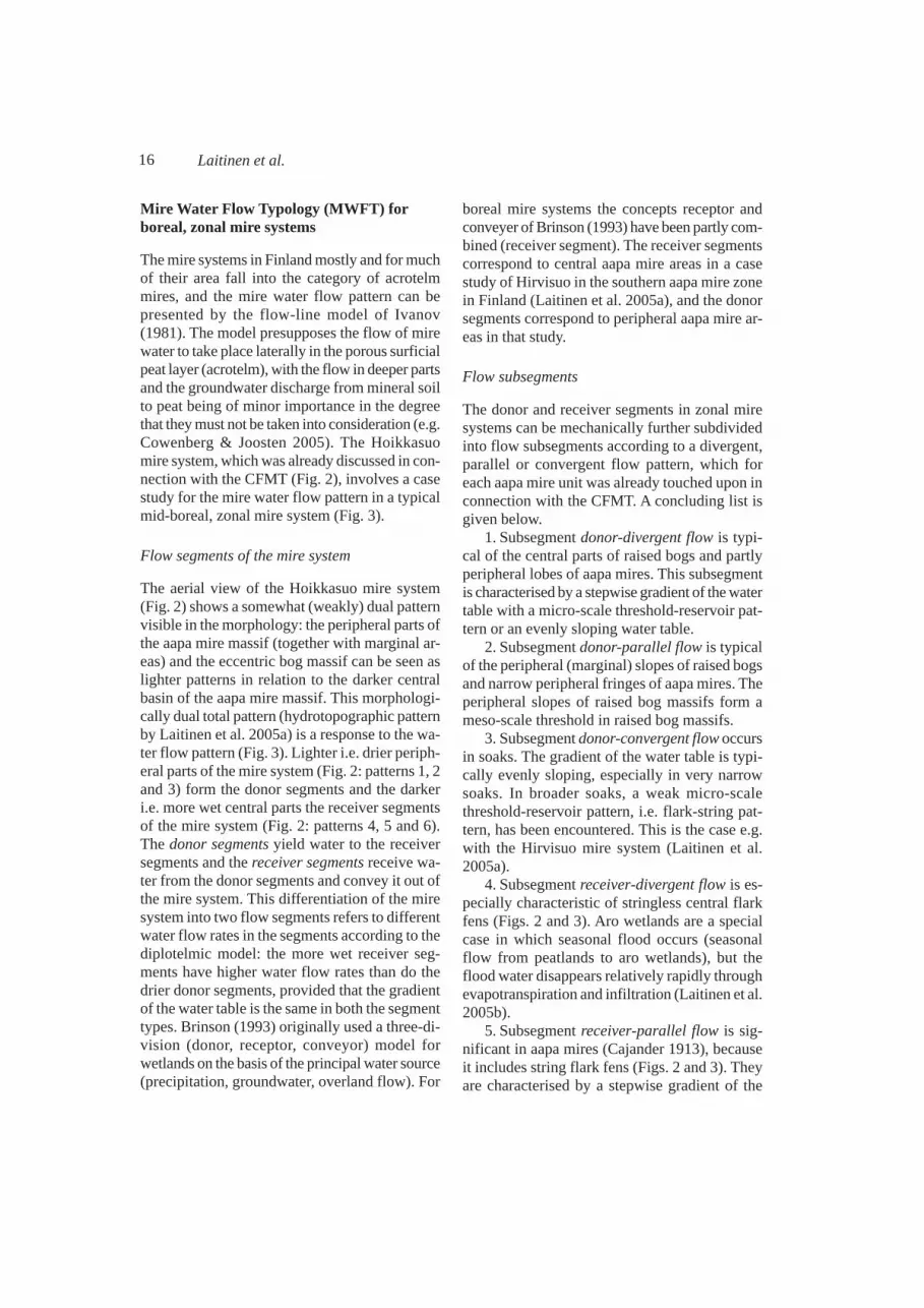
Fig. 3. Mire water flow pattern according to the MWFT applied for the mire system presented in Fig. 2. The flow lines ofIvanov (1981) with a donor-receiver pattern are presented: the light blue parts of the lines refer to waterflow within donorsegments and dark blue lines to flow within receiver segments. The dark continuous line shows the border of the mineralsoil areas.
Kuva 3. Kuvassa 2 esitetyn suosysteemin suoveden virtauskuviointi MWFT:n mukaan. Ivanovin (1981) virtausviivojenavulla esitetty myös luovuttaja-vastaanottajakuvionti: vaaleansiniset viivanosat tarkoittavat virtausta luovuttajaosanalueella, tummansiniset virtausta vastaanottajaosan alueella. Tumma kokoviiva on mineraalimaa-alueiden raja.
16 Laitinen et al.
Mire Water Flow Typology (MWFT) forboreal, zonal mire systems
The mire systems in Finland mostly and for muchof their area fall into the category of acrotelmmires, and the mire water flow pattern can bepresented by the flow-line model of Ivanov(1981). The model presupposes the flow of mirewater to take place laterally in the porous surficialpeat layer (acrotelm), with the flow in deeper partsand the groundwater discharge from mineral soilto peat being of minor importance in the degreethat they must not be taken into consideration (e.g.Cowenberg & Joosten 2005). The Hoikkasuomire system, which was already discussed in con-nection with the CFMT (Fig. 2), involves a casestudy for the mire water flow pattern in a typicalmid-boreal, zonal mire system (Fig. 3).
Flow segments of the mire system
The aerial view of the Hoikkasuo mire system(Fig. 2) shows a somewhat (weakly) dual patternvisible in the morphology: the peripheral parts ofthe aapa mire massif (together with marginal ar-eas) and the eccentric bog massif can be seen aslighter patterns in relation to the darker centralbasin of the aapa mire massif. This morphologi-cally dual total pattern (hydrotopographic patternby Laitinen et al. 2005a) is a response to the wa-ter flow pattern (Fig. 3). Lighter i.e. drier periph-eral parts of the mire system (Fig. 2: patterns 1, 2and 3) form the donor segments and the darkeri.e. more wet central parts the receiver segmentsof the mire system (Fig. 2: patterns 4, 5 and 6).The donor segments yield water to the receiversegments and the receiver segments receive wa-ter from the donor segments and convey it out ofthe mire system. This differentiation of the miresystem into two flow segments refers to differentwater flow rates in the segments according to thediplotelmic model: the more wet receiver seg-ments have higher water flow rates than do thedrier donor segments, provided that the gradientof the water table is the same in both the segmenttypes. Brinson (1993) originally used a three-di-vision (donor, receptor, conveyor) model forwetlands on the basis of the principal water source(precipitation, groundwater, overland flow). For
boreal mire systems the concepts receptor andconveyer of Brinson (1993) have been partly com-bined (receiver segment). The receiver segmentscorrespond to central aapa mire areas in a casestudy of Hirvisuo in the southern aapa mire zonein Finland (Laitinen et al. 2005a), and the donorsegments correspond to peripheral aapa mire ar-eas in that study.
Flow subsegments
The donor and receiver segments in zonal miresystems can be mechanically further subdividedinto flow subsegments according to a divergent,parallel or convergent flow pattern, which foreach aapa mire unit was already touched upon inconnection with the CFMT. A concluding list isgiven below.
1. Subsegment donor-divergent flow is typi-cal of the central parts of raised bogs and partlyperipheral lobes of aapa mires. This subsegmentis characterised by a stepwise gradient of the watertable with a micro-scale threshold-reservoir pat-tern or an evenly sloping water table.
2. Subsegment donor-parallel flow is typicalof the peripheral (marginal) slopes of raised bogsand narrow peripheral fringes of aapa mires. Theperipheral slopes of raised bog massifs form ameso-scale threshold in raised bog massifs.
3. Subsegment donor-convergent flow occursin soaks. The gradient of the water table is typi-cally evenly sloping, especially in very narrowsoaks. In broader soaks, a weak micro-scalethreshold-reservoir pattern, i.e. flark-string pat-tern, has been encountered. This is the case e.g.with the Hirvisuo mire system (Laitinen et al.2005a).
4. Subsegment receiver-divergent flow is es-pecially characteristic of stringless central flarkfens (Figs. 2 and 3). Aro wetlands are a specialcase in which seasonal flood occurs (seasonalflow from peatlands to aro wetlands), but theflood water disappears relatively rapidly throughevapotranspiration and infiltration (Laitinen et al.2005b).
5. Subsegment receiver-parallel flow is sig-nificant in aapa mires (Cajander 1913), becauseit includes string flark fens (Figs. 2 and 3). Theyare characterised by a stepwise gradient of the

17SUO 58(1), 2007
water table with a micro-scale threshold-reser-voir pattern.
6. Subsegment receiver-convergent flow isbest characterized by outlet fens, which form ameso-scale threshold where the gradient of thewater table is steeper than in the proximally anddistally situated string flark fens on its both sides(see the situation in Hoikkasuo, Figs. 2 and 3).The laggs of raised bogs also belong to thissubsegment or to the subsegment receiver-paral-lel flow.
Hydrogeological flow patterns within andbetween mire systems
The groundwater recharge-discharge pattern com-pletes the mire water flow pattern by taking intoaccount the vertical movements of water betweenthe peat layers and underlying mineral soils. Ifthere are considerable vertical movements, theacrotelmic and surficial flow pattern does not in-dicate the total (hydrogeologic) flow pattern. Thequestion of groundwater recharge and dischargein relation to mires is very complicated and it isimpossible to provide any simple classification
comparable to the MWFT. However, some gen-eral guidelines can be presented.
Groundwater recharge-discharge patterns canbe reliably assessed through piezometric meas-urements, though their influence can also be seenin vegetation and morphology within single miresystems. The parts of mire systems situated ingroundwater recharge areas typically have veg-etation indicating unstable surface moisture con-ditions or bogs (Laitinen et al., in press). The partsof the mire systems situated in the groundwaterdischarge area, instead, can contain mire vegeta-tion with groundwater influence. Groundwaterdischarge may occur in the centre of mires alsoin the form of spring mounds, which in CentralLapland (Lahermo 1973, Lahermo et al. 1984)are visible as drier islands in aerial photos. Theyare round or elongated in the direction of waterflow and sometimes surrounded by a horseshoe-form more wet surface. There may be activegroundwater discharge in some of them (seepsor springs occur), whereas others show no vis-ible discharge (e.g. Heikkilä et al. 2001a).
Aquifer-connected mire groups may beformed by separate mire systems having a hy-
Fig. 4. Schematic presentation ofgroundwater recharge-discharge pat-terns within mire systems and aquifer-connected mire groups. Model A rep-resents a common case of relativelythin, permeable mineral soil layer, andB of thick permeable layer, respec-tively. 1 = direction of water flow inthe soil, 2 = peat, 3 = permeable min-eral soil, 4 = impermeable boundary,5 = piezometric groundwater level ofthe deepest, permeable horizon.
Kuva 4. Kaavamainen esitys pohja-veden muodostumis- ja purkautumis-kuvioinneista suosysteemeissä ja ak-viferin yhdistämissä suoryhmissä.Malli A edustaa yleistä tapausta, jos-sa läpäisevä mineraalimaakerros onmelko ohut, B edustaa tapausta, jos-sa läpäisevä kerros on paksu. 1 =pohjaveden virtaus, 2 = turve, 3 =läpäisevä mineraalimaa, 4 = läpäi-semätön kerros, 5 = pohjaveden piet-sometrinen taso syvimmässä hyvinvettä läpäisevässä kerroksessa.

18 Laitinen et al.
draulic connection because of a well-permeablemineral soil. The groups fall in the category ofmire supertopes in the IMCG-classification.These groups may be accompanied by local andintermediate-regional groundwater recharge-dis-charge patterns. A group of mires accompaniedby a large glaciofluvial formation has been de-scribed in the Olvassuo area (Kälväsvaara). Thereare small separate mires on the glaciofluvial for-mation and two large aapa mire systems on itsboth sides (Heikkilä et al. 2001a). The Kälväs-vaara formation with its small separate mires andsmall mires between sandy raised beach ridgesaround it acts as a groundwater recharge area ofa regional and intermediate scale (cf. Heikkilä etal. 2001a). The small mires in this area are bogs,poor fens fed by local groundwater and season-ally dry mires accompanied by aro wetlands.Groundwater discharge mainly takes place in in-termediate or rich fens in the centre of large aapamire systems 1–3 km from the glaciofluvial for-mation.
The geological situation influences thegroundwater recharge-discharge pattern withinmire systems and aquifer-connected mire groups.A schematic cross-profile model is presented inFig 4 for various situations, which are simplifi-cations from the Kälväsvaara area (Heikkilä etal. 2001). In the case with a thin, permeable layerof mineral soil, groundwater discharge largelytakes place at the margin of the aapa mire sys-tem, and the groundwater discharging into themire is of local origin (Fig. 4a). As far as the casewith a thicker, permeable layer of mineral soil isconcerned, the groundwater discharges in thecentral parts of the large aapa mire system, partlycausing the occurrence of an exceptionally largeoutlet fen pattern (Fig. 4b, see also Table 4). Thisgroundwater discharge pattern is an indication ofgroundwater flow systems of a larger scale. Lo-cal flow systems also occur: groundwater isyielded into small mires in the recharge areas ofa larger-scale flow system (Fig. 4b). Accordingly,the groundwater flow of the local scale in thiscase makes up a kind of a superimposed systemon the larger-scale flow system. The mineral soillayer on the bedrock is mostly thin in Finland:the mean thickness of Quaternary soil layers is6.7 m and the median only 3–4 metres (Rankama
1964). It thus seems that the geological situationoften resembles that in Fig. 4a. This also indi-rectly refers to the fact that the mire water flowpattern in the acrotelm and on the mire surface(surface flow) (Fig. 3) quite satisfactorily indi-cates the overall water flow pattern of most miresystems in Finland. Areas with thick mineral-soillayers, large aquifers and hence large regional andintermediate groundwater recharge-dischargepatterns, however, are encountered especially inlarge marginal formations (Salpausselkä) inSouthern Finland, in sandy lowlands in NorthernOstrobothnia and around the ancient ice dividearea in Central Lapland (Lahermo 1973, Hyyppä1983). Permeable sedimentary rocks, which pos-sibly affect groundwater flow, are exceptional inFinland (Muhos formation in Northern Ostro-bothnia, Lauhanvuori in Southern Ostrobothnia).
Biological significance of morphologicand hydrologic mire classifications
The most important biological topic when con-sidering the significance of various morphologicand water-flow classifications for mires is thedependency of species richness and its mainte-nance over time on environmental heterogene-ity: the reduction in environmental heterogene-ity generally reduces species richness (Ricklefs1977). Major agents for this environmental het-erogeneity in mire systems are specifically thediversity in peatland morphology of differentscales (the occurrence of various microhabitatsin relation to e.g. water level) and the diversity inecohydrology of those microhabitats. Several re-peated, relatively recent inventories of boreo-nemoral and boreal mire systems covering a pe-riod of 60 years or shorter have shown that suchpH and vegetation changes, from which it is notalways easy to state, if they are mainly natural(autogenic succession) or enhanced by man, havetaken place during relatively short periods. In abog- dominated mire system in Southern Swe-den, the vegetation changes after 40 years showa drier mire surface and the increased availabil-ity of nitrogen. Most of decreased species werelow-grown vascular plants of wet microhabitats(Gunnarsson et al. 2002). It has also been sug-

19SUO 58(1), 2007
gested that the lowered regional groundwaterlevel might be a reason for the reduced Sphag-num cover in southern Swedish bogs (Malmer &Wallen 1999). Instead, small changes were ob-served in a bog and poor fen site in boreal Cen-tral Sweden after a period of 60 years (Backeus1972), but in a classic central Swedish mire sys-tem Skattlösbergs Stormosse, which representsan almost untouched site with prevailing bogmassifs and smaller aapa-like mire massifs(judged by the maps of Sjörs 1948), pH and spe-cies richness had decreased after 50 years in thericher parts of the mire system, but not in thepoorer parts (Gunnarsson et al. 2000). Aboreonemoral, southern Swedish rich fen siteexperienced a drastic change from a rich fen toSphagnum-dominated poor fen with scattered richfen patches (Hedenäs & Kooijman 1996). Acid-ity of the peat is a key mechanism in the vegeta-tion changes. This is as expected, because strongcorrelation of pH, among all water chemical vari-ables, was found with the main vegetation gradi-ent and plant species richness (Tahvanainen2004). Mire water pH reflects the reaction ofwater to the ionic balance that is locally regu-lated by hydrology.
Most of the aforementioned studies presentshowever, raised bogs and separate small rich fens,which are located in more southern areas com-pared to the location of the aapa mire zones ofFinland. In those areas, some considerable hu-man impacts (e.g. atmospheric pollution) havebeen exercising an influence longer than in themore northern areas, but several kinds of humanimpacts cannot be excluded in the northern aapamire zones of Europe either. In Finland, there maybe several environmental factors, which makeaapa mires drier and poorer, perhaps involvedwith the increasing proportion of Sphagnumdominance in the naturally Sphagnum-poor re-ceiver segments of aapa mires. Decreasing pro-portions of some low-grown and rare fen vascu-lar species (e.g. Carex heleonastes) and interme-diate and rich fen mosses can also be expected.The factors may be, e.g., the climate change, thewater table drawdown, abundant occurrence ofolder marginal ditches around pristine aapa miresystems, acidification through atmospheric depo-sition and partly the ceased mowing in parts of
aapa mires (see Aune et al. 1996, Moen et al.1999). Thus, several open questions concerningthe short-term vegetation dynamics and possibleenvironmental changes in the aapa mire systemsof the northernmost parts of Europe: (1) are thepossible changes similar and do they occurequally fast in the mire systems of different aapamire zones?, (2) what kind of vegetation changestake place in the donor and receiver segments ofthe various aapa mire systems undergoing i.e.what is the internal dynamics of aapa mires?, and(3) how the short-term dynamics of rich-fen aapamires and poor-fen aapa mires differ between eachother?
Conclusions
The Combined Finnish Mire Typology (CFMT)summarizes the principles of the Finnish mirecomplex classification by considering the earlystarting point with several mire complex types(Cajander 1916) and the subsequent developmentof the typology with a minimum of two main mirecomplex types i.e. aapa mires and raised bogs(Eurola et al. 1984, 1995). The revised typologyis intended to elucidate the idea of the Finnishmire typology during the decades and to act as abasis for the further development of the systemfor practical purposes.
The CFMT operates mainly with the miremorphology of various scales (zonal mire sys-tems), aided by the consideration of the time-fac-tor (young mire systems), the elevation and thegradient of the mire surface (slope fen systems),the topography of the environment of the mire(various local, topographic mire systems) andlocal hydrology (spring, swamp and aro wetlandsystems). Especially the accurate morphology ofthe lawn aapa mire massifs and correspondingmire systems as a whole deserves additional re-search. This may be difficult because of the dis-appearance of total mire systems in the southernpart of the southern aapa mire zone in Finland.Aapa mire systems with palsas, and other north-ernmost aapa mires, should also be subjected toa morphological analysis from the point of viewof the whole mire systems. The typology of thelocal mire systems has not yet been tested in the

20 Laitinen et al.
field and thus lower-scale units have not beenpresented for them. The distribution of ordinaryslope fen systems and aapa mire-slope fen sys-tems deserves additional inventories throughoutNorthern Finland (cf. Havas 1961)
The Mire Water Flow Typology (MWFT) sug-gests a dual (donor-receiver) morphological struc-ture for a zonal mire system (Hoikkasuo) in rela-tion to the acrotelmic water flow pattern. Thisdual structure seemingly reappears in most zonalmire systems in the boreal zone. The typologyroughly elucidates the water flow rates in differ-ent parts of mire systems and may be applicablefor mire restoration in zonal mire systems. In lo-cal mire systems the donor-receiver pattern hasnot been tested, and evidently the flow rates inthose mire systems partly resemble those of do-nor segments (more low flow rates) and partlythose of receiver segments (higher flow rates).
Hydrogeological flow pattern i.e. groundwaterflow pattern must be taken into considerationespecially in cases where the mire water flow inthe mire system or in its parts does not mainlyoccur in permeable surface peat (acrotelmic flow).Piezometric studies would be needed for miresystems with floristic groundwater influence, in-dications of seasonal drought (possible ground-water recharge at times) and in the mires com-bined by aquifers.
Acknowledgements
We sincerely thank Prof. emeritus Seppo Eurola,Prof. Asbjørn Moen , Dr. Tatjana Yurkovskaya,Olga Galanina, Ph.D and an anonym reviewer forcomments on the manuscript. Thanks are also dueto Antti Rönkkö, M.A., for revising the Englishlanguage of this study.
References
Aario, L. 1932. Pflanzentopographische und paläogeogra-phische Mooruntersuchungen in N-Satakunta. Fennia55: 1–179.
Auer, V. 1923. Suotutkimuksia Kuusamon ja Kuolajärvenvaara-alueilla. (Referat: Mooruntersuchungen in denVaaragebieten von Kuusamo und Kuolajärvi). Comm.Inst. Quaest. Forest. Finl. 6(1): 1–368.
Aune, E.I., Kubícek, F., Moen, A & Øien, D.-I. 1996. Above
and below-ground biomass of boreal outlying hay-landsat the Sølendet nature reserve, Central Norway. Nor-wegian Journal of Agricultural Sciences 10: 125–152.
Backéus, I. 1972. Bog vegetation re-mapped after sixtyyears. Studies on Skagerhultamossen, central Sweden.Oikos 23: 384–393.
Brinson, M.M. 1993. Changes in the functioning of wet-lands along environmental gradients. Wetlands 13(2):65–74.
Cajander, A. K. 1913. Studien über die Moore Finnlands.Acta Forestalia Fennica 2(3): 1–208.
Couwenberg, J. & Joosten, H. 2005. Self-organization inraised bog patterning: the origin of microtope zona-tion and mesotope diversity. Journal of Ecology 93:1238–1248.
Dierssen, K. 1996. Vegetation Nordeuropas. Eugen UlmerVerlag. Stuttgart. 837 pp.
Eurola, S. 1962. Über die regionale Einteilung der süd-finnischen Moore. Annales Botanici Societatis Zoolog-icae Botanicae Fennicae ´Vanamo´ 33(2): 1–243.
Eurola, S., Hicks, S. & Kaakinen, E. 1984. Key to FinnishMire Types. In: Moore, P. (ed.). European mires: 11–117. Academic Press, London.
Eurola, S., Huttunen, A. & Kukko-oja, K. 1995. Suokas-villisuusopas. [Mire vegetation guide] Oulanka Reports14: 1–85.
Eurola, S. & Kaakinen, E. 1979. Ecological criteria of peat-land zonation and the Finnish mire site type system.In: Kivinen, E., Heikurainen, L & Pakarinen, P. (eds.).Classification of peat and peatlands: 29–32. Interna-tional Peat Society, Hyytiälä.
Eurola, S. & Huttunen, A. 1984. Riisitunturi. Oulanka re-ports 5: 65–67.
Eurola, S. & Huttunen, A. 2006. Mire plant species andtheir ecology in Finland. In: Lindholm, T. & Heikkilä,R. (eds.) Finland — land of mires. The Finnish Envi-ronment 23/2006: 127–144.
Eurola, S. & Vorren, K.-D. 1980. Mire zones and sectionsin North Fennoscandia. Aquilo Ser. Bot. 17: 39–56.
Foster, D. & Fritz, S. 1987. Mire development, pool for-mation and landscape processes on patterned fens inDalarna, central Sweden. Journal of Ecology 75: 409–537.
Foster, D. & King, G. 1984. Landscape feature, vegetationand developmental history of a patterned fen, south-east Labrador, Canada. Journal of Ecology. 72: 115–143.
Freeze R.A., Cherry J.A.1979. Ground-water. Prentice Hall.Gopal, B., Kvet, J., Loffler, V. & Pattern, B. 1990. Defini-
tion and classification. In: Patten, B.C. (ed.) Wetlandsand Shallow Continental Water Bodies. Vol. 1. Natu-ral and Human Relationships: 9–15. The Hague, TheNetherlands: SPB Academic Publishing.
Gunnarsson, U., Malmer, N. & Rydin, H. 2002. Dynamicsor constancy in Sphagnum dominated mire ecosystems.Ecography 25: 685–704.
Gunnarsson, U., Rydin, H. & Sjörs, H. 2000. Diversity andpH changes after 50 years on the boreal mire Skattlös-

21SUO 58(1), 2007
bergs Stormosse, Central Sweden. Journal of Vegeta-tion Science 11: 277–286.
Havas, P. 1961. Vegetation und Ökologie der ostfinnischenHangmoore. Annales Botanici Societatis ZoologicaeBotanicae Fennicae ´Vanamo´ 31: 1–188.
Hedenäs, L & Kooijman, A.M. 1996. Forändringar irikkärrsvegetationen SV om Mellansjön i Västergöt-land. [Changes in rich fen vegetation SW of Lake Mel-lansjön in Västergötland county.] Svensk Botanisk Tid-skrift 90: 113–121.
Heikkilä, H., Kukko-oja, K., Laitinen, J., Rehell, S. & Sal-lantaus, T. 2001. Arvio Viinivaaran pohjavedenotto-hankkeen vaikutuksesta Olvassuon Natura 2000 -alueenluontoon. [Evaluation of the influence of groundwateruptake from Viinivaara on the nature of Olvassuo Nat-ura 2000 area.] Metsäntutkimuslaitoksen tiedonantoja799. 55 pp.
Heikkilä, R., Lindholm, T. & Tahvanainen, T. 2006 (eds.).Mires of Finland — Daughters of the Baltic Sea. TheFinnish Environment 28/2006: 1–166.
Heikkilä, R., Kuznetsov, O., Lindholm, T., Aapala, K.,Antipin, V., Djatshkova, T. & Shevelin P. 2001. Com-plexes, vegetation, flora and dynamics of Kauhanevamire system, western Finland. The Finnish Environ-ment 489: 1–97.
Huttunen, A. & Laitinen, J. 2006. Hirvisuo — a southernaapa mire system. In: Heikkilä, R., Lindholm, T. &Tahvanainen, T. (eds.). Mires of Finland — Daughtersof the Baltic Sea. The Finnish Environment 28/2006:41–50.
Hyyppä J.1983. Suomen kallioperän preglasiaalisesta ra-pautumisesta. (Summary: Preglacial weathering ofprekambrian rocks in Finland.) Papers of engineering.15(2): 1–17. Geological Society of Finland.
Ingram, H.A.P. 1978. Soil layers in mires: function and ter-minology. Journal of Soil Science 29: 224–227.
Ivanov, K.E. 1981. Water Movement in Mirelands. Aca-demic press. London. New York. Toronto. Sydney. SanFrancisco. 276 pp.
Kokko, A., Kaakinen, E., Aapala, K., Eurola, S., Heikkilä,R., Hotanen, J.-P., Kalpio. S., Kondelin, H., Linholm,T., Nousiainen, H., Ruuhijärvi, R., Salminen, P., Va-sander. H. & Virtanen, K: Soiden luontotyypit ja luonto-tyyppiyhdistelmät. [Mire habitats and complexes.] In:Kontula, T. & Raunio, A. (eds.) 2005. Luontotyyppienuhanalaisuuden arviointi — menetelmä ja luontotyyp-pien luokittelu. (Abstract: Assessment of threatenedhabitat types — method and classification of habitattypes.) The Finnish Environment 765: 71–79.
Lahermo P. 1973. The ground water of Central and WestLapland interpreted on the basis of black and whiteaerial photographs. Geological Survey of Finland.Bulletin 262: 1–48.
Lahermo P., Valovirta V., Särkioja A. 1984. The geobotan-ical development of spring-fed mires in Finnish Lap-land. Geological Survey of Finland. Bulletin 28: 1–44.
Laitinen, J., Rehell, S. & Huttunen, A. 2005a. Vegetation-related hydrotopographic and hydrologic classification
for aapa mires (Hirvisuo, Finland). Annales BotaniciFennici 42: 107–121.
Laitinen, J., Rehell, S., Huttunen, A. & Eurola, S. 2005b.Arokosteikot: ekologia, esiintyminen ja suojelutilannePohjois-Pohjanmaalla ja Kainuussa. (Summary: Arowetlands: ecology, occurrence and conservation innorth-central Finland.) Suo 56: 1–17.
Laitinen, J., Rehell, S. & Oksanen, J. 2007. Communityand species responses to water level fluctuations withreference to soil layers in different habitats of mid-bo-real mire complexes. Plant Ecology (in press).
Lindholm, T. & Heikkilä, R. 2006. Geobotany of Finnishforests and mires: the Finnish approach. In: Lindholm,T. & Heikkilä, R. (eds.). Finland — land of mires. TheFinnish Environment 23/2006: 95–103.
Malmer, N. 1985. Remarks to the classification of miresand mire vegetation — Scandinavian arguments. Aq-uilo Ser. Botanica 21: 9–17.
Malmer, N. & Wallen, B. 1999. The dynamics of peat ac-cumulation on bogs: mass balance of hummocks andhollows and its variation throughout a millennium.Ecography 22: 736–750.
Mäkinen, A. 1978. Tervalepän kasvupaikoista ja ekologia-sta Suomessa. (Summary: The habitats and ecology ofblack alder (Alnus glutinosa) in Finland). Dendrolo-gian Seuran Tiedotuksia 9: 6–17.
Mäkinen, A. 1979. Peat quality and peat formation in Finn-ish alder swamps. In: Kivinen, E., Heikurainen, L. &Pakarinen, P. (eds.), Classification of peat and peat-lands. Proceedings of the International Symposium heldin Hyytiälä, Finland, September 17–21, 1979: 171–183.International Peat Society. Helsinki.
Moen, A. 1985. Classification of mires for conservationpurposes in Norway. Aquilo Ser. Botanica 21: 95–100.
Moen, A. 1999. National Atlas of Norway: Vegetation.Norwegian Mapping Authority, Hønefoss. 200 pp.
Moen, A., Nilsen, L.S., Øien, D-I. & Arnesen, T. 1999.Outlying haymaking lands at Sølendet, central Norway:effects of scything and grazing. Norsk GeografiskTidsskrift 53: 93–102.
Økland, R.H., Økland, T. & Rydgren K. (2001). A Scandi-navian perspective on ecological gradients in north-west European mires: reply to Wheeler and Proctor.Journal of Ecology 89: 481–486.
Oksanen, P. 2005. Development of palsa mires on the north-ern European continent in relation to Holocene climat-ic and environmental changes Acta Universitatis Oulu-ensis, Scientiae Rerum Naturalium A 446: 1–50.
Pakarinen, P. 2001. Aapa mires of northern Europe andNorth America: notes on ecological terminology andconservation needs. Botanical Electronic News 263.h t tp : / /www.ou . edu /cas /bo t any -mic ro /ben /ben263.HMTl
Rankama K. 1964 (ed.). Suomen geologia.[Geology of Fin-land], Kirjayhtymä Helsinki, 414 pp.
Rehell, S. 1985. Oulun Pilpasuon ja sen ympäristön vesita-loudesta ja turpeen ominaisuuksista. [Hydrology andpeat characteristics of Pilpasuo mire and its surround-

22 Laitinen et al.
ings in Oulu.] M.Sc. thesis, Oulu University, Depart-ment of Geology. 108.pp.
Rehell, S. 2006a. Land uplift phenomenon and its effectson mire vegetation. In: Lindholm, T. & Heikkilä, R.(eds.). Finland — land of mires. The Finnish Environ-ment 23/2006: 145–154.
Rehell, S. 2006b. Ryöskäri - Ihanalampi area — land upliftsuccession of aapamires. In: Heikkilä, R., Lindholm,T. & Tahvanainen, T. (eds.). Mires of Finland — Daugh-ters of the Baltic Sea. The Finnish Environment 28/2006: 31–39.
Rehell, S. 2006c. Revonneva-Ruonneva, a combination ofaapamires and ombrotrophic bogs. In: Heikkilä, R.,Lindholm, T. & Tahvanainen, T. (eds.). Mires of Fin-land — Daughters of the Baltic Sea. The Finnish Envi-ronment 28/2006: 72–73.
Rehell, S. & Tahvanainen, T. 2006. Olvassuo. In: Heikkilä,R., Lindholm, T. & Tahvanainen, T. (eds.). Mires ofFinland — Daughters of the Baltic Sea. The FinnishEnvironment 28/2006: 49–55.
Reinikainen, A. & Lindholm, T. & Vasander, H. 1984. Ec-ological variation of mire site types in the small kettle-hole mire Heinisuo, southern Finland. Annales. Bot-anici. Fennici 21: 79–101.
Repo, R. 1955. Piirteitä Jaamankankaan kasvimaantieteel-lisestä merkityksestä. (Referat: Über die geobotanischeBedeutung der Randmoräne Jaamankangas in Nord-karelien, Ostfinnland.) Archivum Societatis Zoologi-cae Botanicae Fennicae ́ Vanamo‘9 (suppl.): 288–313.
Ricklefs, R.E. 1977. Environmental heterogeneity and plantspecies diversity: a hypothesis. American Naturalist111: 377–384.
Ruuhijärvi, R. 1960. Über die regionale Einteilung der nor-dfinnischen Moore. Annales Botanici Societatis Zoo-logicae Botanicae Fennicae ´Vanamo´ 31(1): 1–360.
Ruuhijärvi, R. 1983: The Finnish mire types and their re-gional distribution. In Gore, A.J.P. (ed.). Ecosystemsof the World, 4 B. Mires: swamp, bog, fen and moor.Regional studies: 47–67. Elsevier, Amsterdam–Ox-ford–New York.
Ruuhijärvi, R. & Hosiaisluoma, V. 1988. Mires 1: 1000000.In: Atlas of Finland. Folio 141–143. Map Appendix 2.National Board of Survey & Geographical Society ofFinland, Helsinki.
Rydin, H., Sjörs, H. & Löfroth, M. 1999. Mires. Acta Phy-togeographica Suecica 84: 91–112.
Sallinen, A. 2005. Kokonaisten suoalueiden luokittelu es-imerkkinä Jämäsjoen valuma-alueen suot. [Classifica-tion of mire systems with the mires of the drainage basinof the river Jämäsjoki as an example.] M.Sc. thesis,Helsinki University, Department of Geography. 100 pp.
Seppä. H. 1994. Keidassoiden pienmuodot — kasvitiedet-tä vai geomorfologiaa (Abstract: The hummock andhollow patterns of the peat bogs). Terra 106: 193–203.
Seppä, H. 1996: The morphologic features of the Finnishpeatlands. In: Vasander. H. (ed.). Peatlands in Finland:27–33. Finnish Peatland Society. Helsinki.
Seppälä, M. 2005. Dating of palsas. Geological Survey ofFinland, Special Paper 40: 79–84.
Seppälä, M. & Koutaniemi, L. 1985. Formation of a stringand pool topography as expressed by morphology,stratigraphy and current processes on a mire in Kuusa-mo, Finland. Boreas 14: 287–309.
Sjörs, H. 1948. Myrvegetation i Bergslagen. (Summary:Mire vegetation in Bergslagen, Sweden.) Acta Phyto-geographica Suecica 21: 1–299.
Sjörs, H. 1973. Mires considered for protection in Kop-parberg County (prov. Dalarna), central Sweden. Väx-tekologiska Studier 3: 1–116. [In Swedish with Eng-lish summary].
Sjörs, H. 1983. Mires of Sweden. In: Gore, A.J.P. (ed.).Ecosystems of the world, 4B. Mires: swamp, bog, fenand moor. Regional studies, 64–94.Elsevier, Amstre-dam–Oxford–New York.
Succow, M. & Joosten, H. 2001. LandschaftökologischeMoorkunde, 2. völlig neu bearbeitete Auflage. E. Sch-weizerbartsche Verlagsbucchandlung. Stuttgart. 622 pp.
Tahvanainen, T. 2004. Water chemistry of mires in relationto the poor-rich vegetation gradient and contrasting ge-ochemical zones of the north-eastern FennoscandianShield. Folia Geobotanica 39: 353–369.
Tahvanainen, T. 2006. Locus Classicus site of the Finnishaapamire concept. In: Heikkilä, R., Lindholm, T. & Tah-vanainen, T. (eds.). Mires of Finland — Daughters ofthe Baltic Sea. The Finnish Environment 28/2006: 77–80.
Tolonen, K. 1967. Über die Entwicklung der Moore infinnnischen Nordkarelien. Annales Botanici Fennici 4:219–416.
Tolonen, K. & Seppä, H. 1994. Pyhtään suursoiden kasvil-lisuudesta, morfologiasta ja kehityspiirteistä (Abstract:On the vegetation, morphology and natural history ofthe large mire complexes in Pyhtää, southeastern Fin-land). Terra 106: 216–225.
Tuomikoski, R. 1942. Untersuchungen über die Vegetationder Bruchmoore in Ostfinnland. I. Zur Methodik derpflanzensoziologischen Systematik. Annales BotaniciSocietatis Zoologicae Botanicae Fennicae ´Vanamo´17(1): 1–203.
Ulvinen, T. 1961. Tuoksumaratti ja Pohjanperä. (Abstract:Galium odoratum and the extreme North .) SuomenLuonto 20: 100–107.
Vorren, K.-D., Eurola, S. & Tveraabak, U. 1999. The low-land terrestrial mire vegetation about 69°N lat. in north-ern Norway. Tromura. Naturvitenskap 84: 1–90.
Yurkovskaya, T. 1995: Mire system typology for use invegetation mapping. Gunneria 70: 73–82.

23SUO 58(1), 2007
Appendix 1. Present terminology of the article in English and in Finnish. The concepts are about in the order of the textand tables.
––––––––––––––––––––––––––––––––––––––––––––––––––––––––––––––––––––––––––––––––Introduction
Combined Finnish Mire Typology yhdistetty suomalainen soiden luokitteluMire Water Flow Typology for boreal, zonal boreaalisten, vyöhykkeellisen suosysteemien suovedenmire systems virtausluokittelu
Material and methodsSynthesis of Finnish mire and water-flow classificationsBasic concepts
Mire morphology suomorfologiaMire surface levels suonpinnan tasotHummock level mätäspintaLawn välipintaFlark level rimpipintaMosaic level mosaikkipintaThreshold kynnysReservoir varasto (vesivarasto)Surface water pintavesiGeological groundwater (general g.) geologinen pohjavesi (yleinen pohjavesi)Mire water suovesiMire groundwater (specific g.) suopohjavesiGroundwater flow pattern pohjaveden virtauskuviointiGroundwater recharge area pohjaveden muodostumisalueGroundwater discharge area pohjaveden purkautumisalueMire water flow suoveden virtausDiplotelmic mire, acrotelm mire akrotelmasuoPercolation mire läpivirtaussuo, suotosuoWater-flow rate vedenvirtauksen määräSpecific discharge of the surface layer pintakerroksen ominaisvirtaamaSupplementary nutrient effect reunavaikutus (lisäravinnevaikutus)Inherent nutrient effect keskustavaikutusSurface water influence luhtaisuus (pintavesivaikutus)Groundwater influence lähteisyys (pohjavesivaikutus)Mineral soil influence (spruce mire i.) mineraalimaavaikutus (korpisuus)Mire site type (mire type) suotyyppiMain mire vegetation unit suokasvillisuuden päätyyppiryhmäAapa mire aapasuoBog ombrotrofinen suoFen minerotrofinen suoMixed mire yhdistelmäsuo; suo, jossa ombro- ja minerotrofia erottuuvat
pienpiirteiden (mikropografian) mukaan
Combined Finnish Mire Typology
Zonal vyöhykkeellinen (ilmastovyöhykkeellinen)Local paikallinenMire unit suoyksikköMacro scale suurtasoMeso scale keskitasoMicro scale pientasoUpper macro scale yläsuurtasoLower macro scale alasuurtasoUpper meso scale yläkeskitaso––––––––––––––––––––––––––––––––––––––––––––––––––––––––––––––––––––––––––––––––
continues next page

24 Laitinen et al.
App. 1 continues...
––––––––––––––––––––––––––––––––––––––––––––––––––––––––––––––––––––––––––––––––Lower meso scale alakeskitasoMire system suosysteemiMire basin suoallasYoung mire system nuori suosysteemiZonal mire system vyöhykkeellinen suosysteemi (ilmastovyöhykkeellinen s.)Ordinary raised bog system varsinainen keidassuosysteemiRaised bog system with aapa mires aapakeidassuo, aapakeidassuosysteemiRaised bog-aapa mire system keidas-aapasuo, keidassuo-aapasuosysteemiAapa mire system with raised bogs keidasaapasuo, keidasaapasuosysteemiOrdinary aapa mire system varsinainen aapasuo, varsinainen aapasuosysteemiLocal mire system paikallinen eli piensuosysteemiLocal, topographic-climatic mire s. paikallistopografiset ja -ilmastolliset suosysteemitLocal, topographic mire systems paikallistopografiset suosysteemitLocal, hydrogenetic wetland systems paikallishydrologiset suosysteemitOrdinary slope fen system varsinainen rinnesuosysteemiAapa mire-slope fen system aapasuo-rinnesuo, aapasuo-rinnesuosysteemiPaludified areas on rock surfaces kalliosoistumatSmall depression mires pienpainannesuotDepression-network mire systems painanneverkostosuosysteeemitSpring & spring fen systems lähde- ja lähdesuosysteemitSwamp wetland systems luhtasuosysteemitAro wetland systems arokosteikkosysteemitMire-aro wetland systems suo-arosysteemit (suo-arokompleksit)Mire massif suomassiiviMarginal area reuna-alueMain mire massif types suomassiivien päätyypitRaised bog massif keidassuomassiiviAapa mire massif aapasuomassiiviPlateau bog laakiokeidasConcentric domed bog konsentrinen kermikeidas, kilpikermikeidasPatterned eccentric bog eksentrinen kermikeidas, viettokermikeidasUnpatterned eccentric bog eksentrinen keidas, mätäsviettokeidasFuscum bog Fuscum keidas, rahkakeidasForest bog metsäkeidasLawn aapa mire välipinta-aapaLawn-flark aapa mire väli-rimpipinta-aapaFlark aapa mire rimpipinta-aapaLagg laideForm parts of mire massifs suomassiivien muoto-osatCentral plain (keidassuomassiivin) keskustasanneMarginal slope (peripheral slope) reunaluisuCentral basin (aapasuomassiivin) keskusallasPeripheral part (aapasuomassiivin) syrjäosaLower meso units alakeskitason yksikötString flark fens jännerimpinevatUnoriented flark fens suuntautumattomat rimpinevatStringless central flark fens jänteettömät keskusrimpinevatReservoi-infiltration basins varasto-suotoaltaat (varasto-imeytymisaltaat)Outlet fens purkusuotPeripheral lobes and fringes (aapasuomassiivin) syrjälohkot ja –saumatInterlobate soaks (aapasuomassiivin) syrjälohkojen väliset juotitSmall features pienpiirteet
Flow typology of mire water for zonal mire systems
Flow segment virtauskuvioinnin pääosaDonor segment luovuttajaosa, vedenluovuttajaosa––––––––––––––––––––––––––––––––––––––––––––––––––––––––––––––––––––––––––––––––

25SUO 58(1), 2007
––––––––––––––––––––––––––––––––––––––––––––––––––––––––––––––––––––––––––––––––Receiver segment vastaanottajaosa, veden vastaanottajaosaFlow subsegment virtauskuvioinnin pienalueDivergent flow hajaantumavirtausParallel flow yhdensuuntaisvirtausConvergent flow kokoomavirtausSubsegment donor-divergent flow luovuttajaosan hajaantumavirtausalueSubsegment donor-parallel flow luovuttajaosan yhdensuuntaisvirtausalueSubsegment donor-convergent flow luovuttajaosan kokoomavirtausalueSubssegment receiver-divergent flow vastaanottajaosan hajaantumavirtrausalueSubsegment receiver-parallel flow vastaanottajaosan yhdensuuntaisvirtausalueSubsegment receiver-convergent flow vastaanottajaosan kokoomavirtausalue
Hydrogeologic flow patterns within mire systems and between mire systems
Aquifer-connected mire group akviferin yhdistämä suoryhmäSpring mound lähdekumpu––––––––––––––––––––––––––––––––––––––––––––––––––––––––––––––––––––––––––––––––
Received 5.5.2006, Accepted 3.4.2007

26 Laitinen et al.
Tiivistelmä: Suomen suosysteemit — erityistarkastelussa aapasuot ja niiden vedenvirtaus-kuviointi
Artikkelissa esitetään kaksi rinnasteista soiden luokitusjärjestelmää: (1) ‘Yhdistetty suomalainen soidenluokittelu‘ (Combined Finnish Mire Typology — CFMT) yhdistää Cajanderin vanhan laajan suo-kompleksikäsitteen ja nykyisen suppeamman ilmastollisen ja vyöhykkeellisen suokompleksikäsit-teen. Järjestelmässä pyritään luokittelemaan kaikki erilaiset maastossa tavatut suoalueet —‘suosys-teemit‘— pääosin ilmakuvia hyödyntäen. (2) ‘Boreaalisten, vyöhykkeellisten suosysteemien veden-virtaustyypittelyssä (Mire Water Flow Typology for boreal, zonal mire systems), oletetaan ko. suo-systeemien suurelta osin olevan sellaisia soita, joissa vedenvirtaus pääosin tapahtuu suon huokoises-sa pintakerroksessa, jolloin Ivanovin vedenvirtauskuviontimenetelmää käyttämällä voidaan melkohyvin havainnollistaa ko. suosysteemien vedenvirtauskuviointia. Artikkelissa käsitellään lisäksi laa-jempia pohjaveden muodostumis- ja purkautumisjärjestelmiä ja pohditaan yleisemmin morfologis-ten ja hydrologisten suoluokitusten biologista merkitystä. Vyöhykkeelliset suosysteemit esitetään suo-massiiviensa (aapasuo, keidassuo) vallitsevuuden mukaisena jatkumona. Paikallisten suosysteemienalajako tehdään suomassiivien syntyä ehkäisevien seikkojen perusteella. Aapasoiden ns. keskitasonsuoyksiköt ja vedenvirtauskuvionti on esitetty tyypillisen keskiboreaalisen suosysteemin (Simon Hoik-kasuo) ilmakuvatarkastelun pohjalta. Soiden pohjaveden muodostumis- ja purkautumiskuviointia sekämorfologisten ja hydrologisten suoluokittelujärjestelmien biologisia perusteita on pohdittu kirjalli-suuden avulla.


