Embed Size (px)
Citation preview

Technical Letter
Monitoring Coastal Erosion in Red River Delta,Vietnam - A Contribution from Remote Sensing Data
Tran Van Dien, Tran Due Thanh and Nguyen Van ThaoHai Phong Institute of Oceanology246 Danang Street, Haiphong City, VietnamTel: +84-31-564892 Fax: +84-31-761521 E-mail: [email protected]
Abstract
This paper presents a case study using remotely sensed data in recent years in combining with traditional topographicmaps and field survey data to monitor coastal erosion in Red River Delta during last. 70 years. Method of coastlineidentification from satellite data was used and GIS overlay function was applied to assess coastline changes. For processingthe satellite data, the shoreline was defined as the mean sea level on the muddy coast where the tide is a dominantdynamical factor and as mean high sea level on the sandy coast where the wave is a dominant dynamical factor Itwas observed that the coastal erosion in Red River Delta show a rather complicated history in most parts. During thethree periods from 1930-1965, 1965-1990 and 1990 to present, coastline length and coastal erosion rate have beendetermined as 46.4 km. and 7.0m/year; 59 km and 8.1m/year; and 23.7 km and 1l.0m/year respectively. The northcoastal part has decreased in erosion extent and intensity obviously from 1930 to present. The south coastal part hasdecreased in erosion scale a little, but increased in erosion rate in the last 70 years. Four development tendencies oferoded sites were discovered: 1) lasting coastal erosion for the last 70 years; 2) changing accretion into erosion; 3)changing erosion into accretion; and 4) interchanging between erosion and accretion for the short durations.
1. Introduction
Stretching from Do Son to Lach Truong, Red RiverDelta (RRD) coastal zone houses many important socio-economic and residential areas. Most of these populatedzones are lowland areas and protected by sea-dykesystems. During recent decades, the coastal erosion in thiszone has occurred in very complicated manner. Coastalerosion can cause sea dyke to be broken and bring aboutterrible disaster for populous residential areas. Monitoringis extremely necessary for predicting and preventing thecoastal erosion of RRD.
Assessment and monitoring of the coastal erosion inRed River Delta are difficult tasks and has been studiedin different details (Cu et al., 1993; Huy et al., 1999; Ninhet al., 2000; Thanh et al., 1998). However, because of alimitation in data, the existing assessment results wereneither systematic nor reliable. Remote sensing satellite,with capability of providing near real-time data, and con-tinuous revisit, can be effectively used to monitor coast-line changes.
This paper presents the initial results of case studyusing remotely sensed data of recent years along withtraditional topographic maps and field survey data in GIS
Asian Journal of Geoinformatics, Vol. 3, No.3, March 2003Published by ARSRIN, PO. Box 4, Klong Luang, Pathumthani 12120, Thailand.
environment to monitor the coastal erosion in Red RiverDelta for last 70 years.
2. Methodology
2.1 Data UsedThis study used field survey data from many projects
since 1990, especially data from general field survey onthe present status of coastal erosion in North Vietnam inthe early 2000. Maps at the scale 1:250,000 (1930) and1:50,000 (1965) were utilized.
The satellite data used for this study were SPOT XSacquired on 18th May 1995 (Figure 1) and MOS-lMESSR satellite data acquired on 25th October 1991 ofThanh Hoa-Nam Dinh provinces. SPOT XS satellite dataacquired on 21st December 1998 (Figure 2) and MOS-lMESSR satellite data acquired on 27th November 1990of Thai Binh - Nam Dinh provinces were also used.
2.2 MethodologyField survey data, existing documents was collected.
Digital image processing, image interpretation and GISchange analysis methods were used (Figure 3).
73

Technical Letter: Monitoring Coastal Erosion in Red River Delta, Vietnam
Figure 1: False color composite of SPOT XS satellite image(18th May 1995) of Ba Lat - Lach Truong coastal area
Topographical maps Satllite images - Field surveydata
- Exitingdocumen
Image to mapgeometric
Linear stretchingimaoe enhancement
False color
Coastline
Figure 3: Flowchart of general method for coastal erosionmonitoring in Red River Delta
The ground truth was defined as observation, measure-ment and collection of information about the actual con-dition on the ground in order to determine the relationshipbetween color, shape, tone of remote sensing data andsurface objects to be identified. The field surveys providean overview of coastal erosion as a basis of ground-truthverification for remote sensing interpretation.
Common digital image processing methods such asgeometric correction to rectify image to geographiccoordinate system, image enhancement, and color com-posite were implemented (Jensen, 1996; Dien, 1999).
Coastline identification was defined by combining oftidal data and satellite image acquired date to identify
74
Figure 2: False color composite of SPOT XS satellite image(21 st December 1998) of Do Son - Ba Lat coastal area
tidal level when images were acquired. Coastline wasdefined as mean sea level line. However, this taskbecomes very complicated when identifying coastlinefrom satellite data. So, coastline identification interpretedfrom satellite image must be combined both imageinterpretation ability and data related to coastal dynamics.At the areas of strong erosion such as Van Ly, Cat Hai,specified by cliffs and beaches, the coastline was definedas a coincidence with highest tidal level. The erosion clifffoots coincide with the high tidal level in horizontalprojection. These coastlines can be easily interpreted fromsatellite data and the coastline change can be observedclearly at these areas. In muddy accreted areas, coastlinewas identified as boundary of mangrove forest.
After mapping coastline, the GIS overlay procedureswere applied to assess coastline changes. The coastlinechange at specific coastal section was measured, calculatedwith mean erosion rate, and erosion length during a specifictime period.
SPOT multi-spectral satellite image with 3 spectralchannels, and 20m spatial resolution, and MOS-l MESSRsatellite image with 4 spectral channel, and Sam spatialresolution was enhanced, geometrically rectified togeographic coordinate and false color composite imagewere generated and used for identifying coastline. Thecoastline was identified and converted to vector formatand coastline maps were incorporated in GIS database.Overlay analysis was adopted using GIS database toassess coastline changes in RRD.
The coastal erosion in RRD was classified accordingto scale and intensity of erosion as follows:

IntensityWeak
MediumStrongVery strong
Erosion rate (m/year)0-2.52.5 -55 -10> 10
ScaleSmallMediumLargeVery large
Erosion length (km)<0.50.5 -22-5>5
3. Results and Discussions
3.1 Coastal Erosion in Do Son - Ba Lat Coastal PartThe coastal erosion of Do Son - Ba Lat coastal part was
assessed by map data scale of 1:250,000 made in 1930,UTM maps scale of 1:50,000 made in 1965, SPOT XSsatellite image in 1998 and MOS-l MESSR satellite imagein 1990.
During 1930-1965, strong intensity erosion coast wasof 60% and very strong was 40% of total length of erosioncoasts. The highest erosion rate was recorded at ThuyTruong coastal section with 17.1 m per year. As regard toerosion scale, large scale occupied 60% and very largescale was of 40% of total length of erosion coasts.
During 1965-1990, medium intensity erosion coastoccupied 25%, strong intensity was of 50% and very strongintensity was of 25% of total length of erosion coasts. Thehighest erosion rate was recorded at Bang La coastalsection with 13.2 m per year. As regard to erosion scale, smallto medium scale occupied 36%, large scale occupied 34%and very large scale was 30% of total length of erosioncoasts.
During 1990-1998, coastline of this region was rela-tively stable and accretion predominated. Only Thuy Xuancoastal section was still eroding with very strong intensity
Asian Journal of Geoinformatics, Vol. 3, No.3, March 2003
(10 mJyear), but on a local scale (1800 m).Thus, from 1930 to present, scale and intensity of coastal
erosion in this region has been decreased and general trendis gradually stable and accretion.
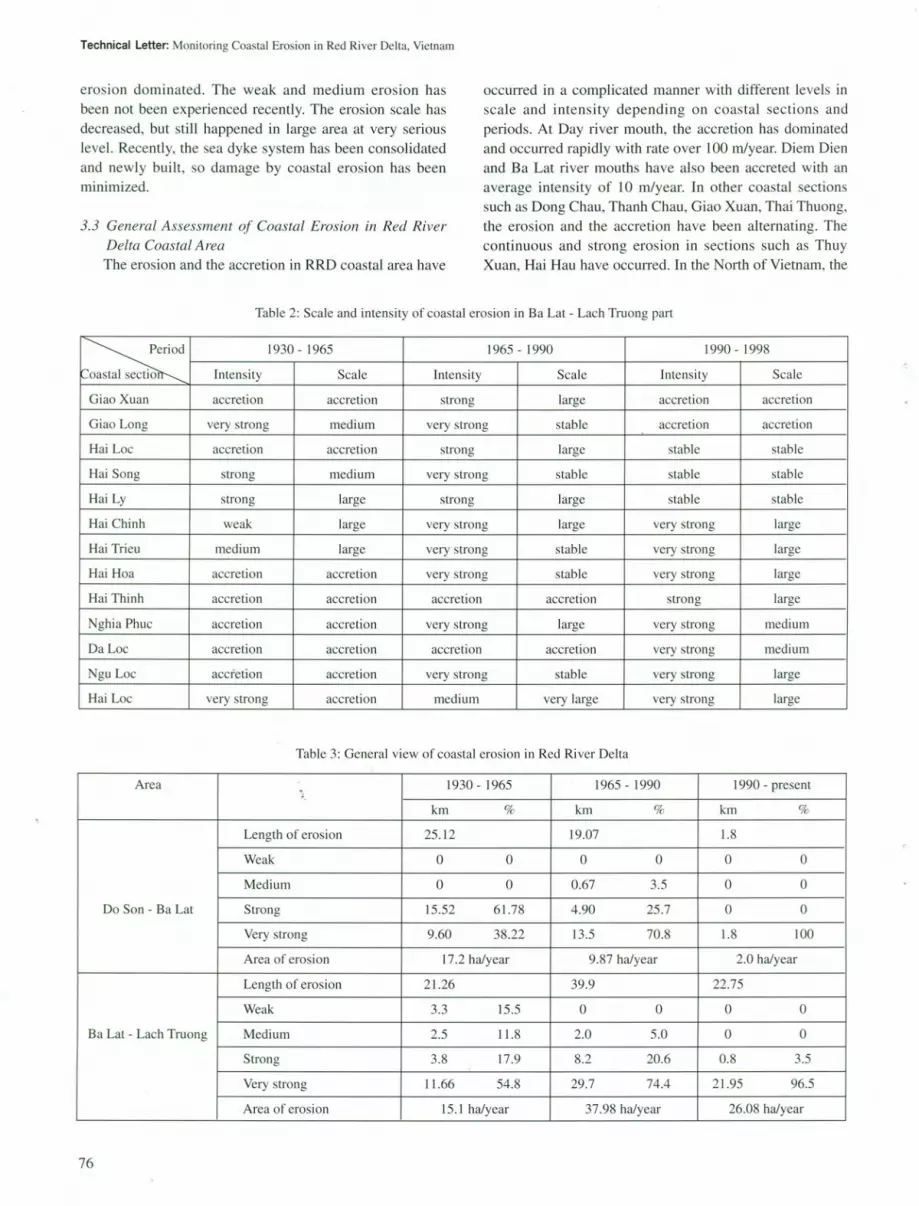
3.2 Coastal Erosion in Ba Lat - Lach Truong Coastal PartThe coastal erosion of Ba Lat - Lach Truong coastal
part was assessed by map data scale of 1:250,000 madein 1930, UTM maps scale of 1:50,000 made in 1965,SPOT XS satellite image in 1995 and MOS-l MESSRsatellite image in 1991.
During 1930-1956, weak intensity erosion coastsoccupied 12.5%, medium intensity - 12.5%, strong erosion-25%, and very strong erosion - 50% oftotallength of erosioncoastal sections. The highest erosion rate was recordedat Giao Long coastal section (19.4 m/year). As regard toerosion scale, medium scale occupied 25%, large scaleoccupied 62.5% and very large scale - 12.5% of totallength of erosion coastal sections.
During 1965-1991, medium intensity erosion coastoccupied 9%, strong erosion - 45.5% and very strongerosion - 45.5% total length of erosion coastal sections.The highest erosion rate was recorded at Giao Long coastalsection (20.4 mJyear). As regard to erosion scale, the largescale occupied 45.5% and very large scale - 54.5% of totallength of eroding coastal sections.
During 1991-1995, strong intensity erosion coastoccupied 12.5%, and very strong erosion - 87.5% of totallength of erosion coastal sections. The highest erosion ratewas recorded at Hai Hoa coastal section (20.5 m/year). Asregard to erosion scale, the medium scale occupied 25%, andlarge scale - 75% of total length of erosion coastal sections.In Hai Hau area, the intensity of erosion was rapidly in-creasing and the erosion boundary was moving southwardto Hai Thinh.
During period from 1930 to 1995, the erosion intensitywas gradually increasing. Up to 1995, the very strong
Table l: Scale and intensity of coastal erosion in Do Son - Ba Lat coastal part
~
1930 - 1965 1965 - 1990 1990 - 1998
Coastal section Intensity Scale Intensity Scale Intensity Scale
Bang La very strong very large very strong very large unchanged unchanged
Vinh Quang strong very large very strong very large accretion accretion
Thuy Truong very strong large accretion medium accretion accretion
Thuy Xuan accretion accretion strong large very strong medium
Diem Dien strong large accretion accretion accretion accretion
Thai Hoa strong large accretion accretion accretion accretion
Dong Long accretion accretion medium accretion accretion accretion
Dong Chau accretion accretion strong large accretion accretion
75
Technical Letter: Monitoring Coastal Erosion in Red River Delta, Vietnam
erosion dominated. The weak and medium erosion hasbeen not been experienced recently. The erosion scale hasdecreased, but still happened in large area at very seriouslevel. Recently, the sea dyke system has been consolidatedand newly built, so damage by coastal erosion has beenminimized.
3.3 General Assessment of Coastal Erosion in Red RiverDelta Coastal AreaThe erosion and the accretion in RRD coastal area have
occurred in a complicated manner with different levels inscale and intensity depending on coastal sections andperiods. At Day river mouth, the accretion has dominatedand occurred rapidly with rate over 100 mlyear. Diem Dienand Ba Lat river mouths have also been accreted with anaverage intensity of 10 m/year. In other coastal sectionssuch as Dong Chau, Thanh Chau, Giao Xuan, Thai Thuong,the erosion and the accretion have been alternating. Thecontinuous and strong erosion in sections such as ThuyXuan, Hai Hau have occurred. In the North of Vietnam, the
Table 2: Scale and intensity of coastal erosion in Ba Lat - Lach Truong part
~
1930 - 1965 1965 - 1990 1990 - J 998
Coastal sectio Intensity Scale Intensity Scale Intensity Scale
Giao Xu an accretion accretion strong large accretion accretion
Giao Long very strong medium very strong stable accretion accretion
Hai Loc accretion accretion strong large stable stable
Hai Song strong medium very strong stable stable stable
Hai Ly strong large strong large stable stable
Hai Chinh weak large very strong large very strong large
Hai Trieu medium large very strong stable very strong large
Hai Hoa accretion accretion very strong stable very strong large
Hai Thinh accretion accretion accretion accretion strong large
Nghia Phuc accretion accretion very strong large very strong medium
DaLoc accretion accretion accretion accretion very strong medium
Ngu Loc accretion accretion very strong stable very strong large
Hai Loc very strong accretion medium very large very strong large
Table 3: General view of coastal erosion in Red River Delta
Area 1930 - 1965 1965 - 1990 1990 - present,km % km % km %
Length of erosion 25.12 19.07 1.8
Weak 0 0 0 0 0 0
Medium 0 0 0.67 3.5 0 0
Do Son - Ba Lat Strong 15.52 61.78 4.90 25.7 0 0
Very strong 9.60 38.22 13.5 70.8 1.8 100
Area of erosion 17.2 ha/year 9.87 ha/year 2.0 ha/year
Length of erosion 21.26 39.9 22.75
Weak 3.3 15.5 0 0 0 0
Ba Lat - Lach Truong Medium 2.5 11.8 2.0 5.0 0 0
Strong 3.8 17.9 8.2 20.6 0.8 3.5
Very strong 11.66 54.8 29.7 74.4 21.95 96.5
Area of erosion 15.1 ha/year 37.98 ha/year 26.08 ha/year
76

LegendSymbol
I • Position of eroded coastal section
4!.2d.= Numbclros~on rate (m/year)7200 Erosion length (m)A Erodedcoaslalseclion
~ 10 K,Io.>nI<!"'" J. NE Vinh Quang 4. Hili Huu ~~~ --'--="'" 2. Thuy Xuan 5. Nghia PhueL-~~ ~~ ~~J~.~~"~g~~"~g__ ~6~N~g~"L~OC~~
00סס60 640000 680000
Figure 4: Position of important erosion sites inRed River Delta coastal zone
strong coastal erosion has been concentrated to Red RiverDelta coastal area, which is also one of the most seriouserosion areas in Vietnam (Figures 4 and 5).
The coastal erosion in RRD depends on coastal structureand dynamics. The erosion has been experienced in longcoastal sections lying between accretion sections nearriver mouths. In all coasts from Do Son to Lach Truong,6 coastal sections have been eroded for long time, since1930 to present. They are Bang La, Thuy Xuan, Dong Long,Giao Long, Hai Hau, Hau Loc. Among these, Hai Hauhas been eroded at strongest level.
Van Ly - Hai Thinh coast (Hai Hau section) has beeneroding since early years of 20th century. In early yearsof 20th century, this area was natural eroded with rate of5-10 mlyear. Recently, some coastal sites at Van Ly have beenembanked by stones, so erosion rate has decreased. Thecoastal section from Hai Trieu to Hai Thinh has still naturallyeroded with very strong rate, reaching 20 to 30 m per year atsome sites.
The erosion at of Hau Loc coastal section hashappened since 1930. From 1991-1995, it happened withstronger intensity and larger scale in comparison withprevious periods. Recently, although this coastal sectionhas been embanked by stones, but the erosion have beenstill happening.
The other strongly eroded areas such as Bang La, ThuyXuan, Dong Long, Giao Long happened in scale smallerthan areas such as Hai Hau and Hau Loc, their erosionintensity and scale have been decreasing.
At river mouths, such as Ba Lat, Tra Ly, Day, accretionhave been continuously strong. Especially at Day rivermouth, accreted rate was over 100 mlyear seaward. Meanwhile Hau Hau area has been continuously eroded withincreased .intensity, Xuan Thuy coast was eroded in widthof 1000 m during 1965-1990. Presently, the erosion
Asian Journal of Geoinformatics, Vol. 3, No.3, March 2003
HalDon~
:'H"ILy
v"",o-i,(160m) ,
N
A~.
legend
- Coastline in 1995 and 1998
Coastline in 1990Coastline in 1965
Coastline in 1930
(300m) Landward restreated distance 1965-1995
Figure 5: Coastline change map of Hai Hau coastal sectionand Red River Delta
appears to have ceased and some sites have even startedexperiencing accretion. Other coastal sections such as BangLa, Tien Lang, Thuy Xuan, Ngoai Chau have been erodedduring 1965-1990. Presently erosion rate has decreasedand some areas have started to accrete.
4. Conclusions
Remote sensing data interpretation and GIS analysisin combination with survey data have enabled to monitorcoastal erosion in RRD in three periods 1930-1965, 1965-1990 and 1990 to present. The results of erosion assessmentshow that erosion has occurred in complicatedly mannerby place and time. First period, the erosion happened on46.6 km, with average rate of 7 mlyear; second period, theerosion occurred on 59 km coast, with average rate of8.1 mlyear; and third period, erosion happened on 23.7 kmcoast, with average rate of 11 mlyear. Thus, at recently generaltrend of erosion has decreased in scale (may due to bettercoastal protection or fewer typhoon), but increased inintensity. The north coastal part has decreased in erosionscale and intensity obvious Iy from 1930 to present. The southcoastal part has decreased in erosion scale a little, butincreased in erosion rate during the last 70 years. Fourdevelopment tendencies of eroded sites were discovered:1) lasting coastal erosion for the last 70 years (Hai Hau, HallLoc); 2) changing from accretion into erosion (Thuy Xuan,Hai Thinh, Da Loc); 3) changing from erosion into accretion
77

Technical Letter: Monitoring Coastal Erosion in Red River Delta, Vietnam
(Bang La, Vinh Quang, Giao Thuy); and 4) interchangingbetween erosion and accretion over short duration (DiemDien, Dong Chau, Dong Long).
Remote sensing data and GIS have presented usefulinformation on coastal erosion in RRD. In this study, coastwas defined as mean sea level at mud-sandy coast, wheretidal dynamics dominated, and as high sea level in sandycoast, where wave dynamics dominate. Regular monitoringcoastal erosion by remote sensing and GIS is an importanttask that needs to be done for better management of thecoastal environment.
References
Cu, N.D., Hoi, N.C., Thanh, T. D. and Lan, T.D., 1993, Tidalwetland inventory in the coastal zone of Red RiverDelta. Project report reserved at Haiphong Institute ofOceanology.
Dien, T.V, 1999, Impact of urbanization on marine waterquality of Ha Long coastal area, Vietnam: A remotesensing and GIS approach. AIT unpublished thesis.
Huy, D.V, 1999, Morphological dynamic characteristicsand sustainable development orientation for Hai PhongHa Long coastal zone. Marine Environment andResources, Tom VI (Vietnam Science & TechnologyPublish House).
Jensen, J.R., 1996, Introduction digital image processing,A remote sensing perspective. 2nd edition (Prentice-Hall, Inst. USA).
Ninh, P.V and Hong, L.X., 2000, Status of coastline erosionin Vietnam. Presented paper at technical workshop onerosion and sedimentation in Vietnam coastal zone,Hanoi, May 2000.
Thanh, T.D., Cu, N.D. and Hoi, N.C., 1998, Coastlinedeformation characteristics and solution for preventingcoastal erosion in Cat Hai island, Vietnam. MarineEnvironment and Resources, Tom IV (Vietnam Science& Technology Publish House).
78
Tran Van Dien received Master degreein Remote Sensing and GIS from AsianInstitute of Technology in 1999. Heworks as Associate Researcher atDepartment of Marine Database andRemote Sensing, Hai Phong Instituteof Oceanology, Vietnam. His researchfield is GIS and Remote Sensing
Applications for Coastal Zone Planing and Management,and Ocean Color Remote Sensing
Tran Due Thanh received his Ph.D.and works at Hai Phong Institute ofOceanology (HIO), Vietnam as SeniorResearcher in Marine and CoastalGeology and Geomorphology, ViceDirector of HIO and Head of MarineGee-environment Department, HIO.He also is a member of Steering Com-
mittee Member of EALOICZ (East Asia Land-OceanInteraction in the Coastal Zone), Steering Committee ofVietnam Geographical Association and Vietnam NationalCommittee of IGCP.
Nguyen Van Thao received Bachelordegree in Geophysics from University ofMining and Geology, Vietnam in 1997.Now, he is studying Master degree inRemote Sensing and GIS at AsianInstitute of Technology, Thailand. Healso works as Assistant Researcher atDepartment of Marine Database and
Remote Sensing, Hai Phong Institute of Oceanology,Vietnam. His research field is GIS and Remote SensingApplications for Coastel Management.

Volume 3, No.3, March 2003 ISSN 1513-6728
Asian Journal of
FO ATIC

ASIAN JOURNAL of
GEOINFORMATICSVolume 3 Number 3 March 2003
From Guest Editors .
From Editor-in-Chief 2
Geo-Environmental Research for Can Gio Mangrove Forest, VietnamHuynh Thi Minh Hang, Kazuyo Hirose, Do Van Quy, Tran Triet, Nguyen Hoang Anh,Yuichi Maruyama and Yuichi Shiokawa 3
Satellite Imagery in the Study of Natural Resources and Environment of the Red River Delta, VietnamNguyen Dinh Minh 13
Mineralogical Mapping by ASTER in Cuprite, Nevada, USAYasushi Yamaguchi and Ippei Takeda : 17
DEM Generation using JERS-1 SAR Interferometry for Kagoshima Area, Kyushu, JapanAlaa Masoud, Venkatesh Raghavan, Shinji Masumoto, and Kiyoji Shiono 25
Flood Warning and Evacuation System using MIKE 11 and GIS r
Farah Aziz, Nitin Kumar Tripathi, Ole Mark and Michiro Kusanagi :.................................................... 31
Impact of DEM Horizontal Resolution in Flood Inundation ModelingDushmanta Dutta, Srikantha Herath and Sohan Wijesekera 41
Using Fractals in Space-time Scaling of RainfallAssela Pathirana, Srikantha Herath and Tadashi Yamada : 49
A Multilayer Algorithm for Discovering Clusters in Large Spatial Databases and its ApplicationLe Si Quang, Huynh Thi Thanh Binh and Luong Chi Mai 57
Dissemination of Spatial Data using InternetDang Van Due and Le Quoc Hung...................................................................................................................................... 63
Technical LetterA Study on Urban Growth of Hanoi using Multi-temporal and Multi-sensor Remote Sensing DataNguyen Dinh Duong, Le Kim Thoa, Nguyen Thanh Hoan, Tran Anh Than, Ho Le Thu and Karen C. Seto 69
Monitoring Coastal Erosion in Red River Delta, Vietnam - A Contribution from Remote Sensing DataTran Van Dien, Tran Due Thanh and Nguyen Van Thao 73
Utilization of ASTER Data for Wetland Mapping of Kushiro Mire and Iriomote Island, JapanToshiya Sonobe, Yoshifumi Yasuoka, Masayuki Tamura and Masato Hayashi 79
Activities of Earth Remote Sensing Data Analysis Center (ERSDAC) in Southeast AsiaToshiya Sonobe and Yuichi Maruyama....................................................................................................................... 85
Research Paper Not Presented in GIS IDEASLand Evaluation for Economic Crops of Lam Phra Phloeng Watershed in Thailand using GIS ModelingThongchai Charuppat and Charat Mongkolsawat 89
List of Member........................................................................................................................ 12
Author Information................................................................................................................... 40
Membership Information........................................................................................................................ 62
Forthcoming Papers.......................................................................................................................... 84
Highlights 99
News and Events 101


![HERITAGE ROAD & PARADISE OF CENTRAL VIETNAM Vietnam Tourism VITOURS JSC., VIETNAM DISCOVER [2014-2015 EDITION] Vietnam Tourism VITOURS Top Ten Travel Agents in Vietnam Page 2 INTINERARY](https://img.pdfslide.net/doc/110x75/631aea28d43f4e176304a8e9/heritage-road-paradise-of-central-vietnam-vietnam-tourism-vitours-jsc-vietnam.jpg)


