Embed Size (px)
Citation preview
AN NUAL REVI EW PRE-APPLICATION
Applicant:Gramor Development/Howsley
Project:Ward 162nd LLC
Applicant's Representative:Jordan Ramis, PC
Jamie Howsleyja mie.howsley@jorda n ra m is.com(360) s67-3913
Request:Annual Review Application
Presented To:Clark County Development Services
Submitted:January 23,2018
OI(I)ANRAM I\,.
503 598'7070 Portland I 360.567.3900 vancouoer I 888.598.7070 rorrr,ee I www.jordanramis.com
TABLE OF CONTBNTS
Ward l62d LLC - Annual Review Annlication
Proiect Address: NE l62dApplicant's Rep. Address: 1499 SE Tech Center Place , Suite 380, Vancouver
1. Application Form
2. Application Fee
3. Full Legal Desøiption
4. Pre-Application Report
5. GIS Packet
6. SEPA
7. Narrative
8. Special Reports - Traffrc
9. Market Studies

Lond Usc Rr,"¡te'¡u
Development Appl lcatlon
AuthorizationThe undersigned hereby certifies that this application has been made with the consent of thelawful property owner(s) and that all information submitted with this application is completeand correct. False statements, errors, and/or omissions may be sufficient cause for denial ofthe request. This a consent to the to enter listed above.
Date Dateal
Proiect name! Ward 162nd LLC
Type(s) ofapplication (see reverse side):AnnualReview
Description of proposal:Comprehensive Plan Map change from Commercialwith Community Commercial zoning toUrban Low Density Residentialwith R1-6 zoning.
Applicant name:Jamie Howsley
Address:1499 SE Tech Center Pl, Ste 380, Vanc WA 98683
E-mail address:jamie. howsley@ordanramis. com
Phone and fax:360-567-391 3
Property owner narne (list multiple ownerson a separate sheet):
Ward 162nd LLC; GC Capital, LLC
Address:
19767 SW 72nd Ave, Ste 100, Tualatin, OR 97062
E-mail address:Please contact Applicant
Phone and fax:Please contact Applicant
Contact person name (list if not same asapplicant):
Applicant, Jamie Howsley
Address:
1499 SE Tech Center Pl, Ste 380, Vanc WA 98683
E-mail address:Jam ie. howsley@jordan ram is. com
Phone and fax:360-567-391 3
Project site information:Site address:
8715 NE Ward Road, Vanc, WA 98682
Comp plan designation:
Commercial
Cross street:NE 162nd
Zoning:Community Commercial
Parcel numbers:104130000, 104143000
Overlay zonesNone
Legal: #1 Lot2; #1 Lot 3
ELAINE PARK #2 LOT 1;
Acreage of original parcels:8.26
Township: 2N Range: 2E V¿ of section: SE
l¡sc Case n orkRevised 6/1,4/L2
Community Development13oo Franklin Street, Vancouver, WashingtonPhone: (S6o) 997-2875 Far (36o) gg7-2otLrwvw.clark.wa. gov/development
For an alternate format,contact the Clark CountyADA Compliance Ofñce.Phone: (g6o)997-z3zzRelay:7u or (8oo) 8$-6384E-mail: [email protected]
E
Development application
Appllcatlon typesIf you have any questions regarding the type of application being requested, our PermitTechnicians will be happyto assistyou.
Land Use Review
3 Annual Reviewtr Appealú Boundary Line Adjustment and Lot
Reconfigurationfl Conditional Use
Environmental/Critical AreasÍ Critical Aquifer Recharge Area
(CARA)tr Columbia River GorgeD Forestry + (Moratorium Waiver,
Moratorium Removal, Class I, ClassIVG or COHP)
D FloodplainD Geologicalt Habitatfl Habitat MonitoringD HistoricD SEPAtr ShorelineD WetlandD Wetland Monitoring
Land DivisionO Binding Site Planfl Final PlatD PlatAlterationt Short Plat (- Infill)D Subdivision (- Infill)
Miscellaneousfl Addressingfl AccessoryDwellingú CovenantReleaseÍ Home BusinessO Legal Lot Determination and
Innocent Purchasers DeterminationD Non-Conforming Use DeterminationD SewerWaivertr Shooting Rangefl Sign
Planning Director ReviewD Post Decisionfl Pre-Application Conference0 Pre-Application WaiverD Public Interest ExceptionD Similar Usefl Temporary Useñ Planned Unit Develop/Master PlanD Road Modificationú Site PlanD Varianceú ZoneChange
Revised 6/L4/L2 Pa$e 2 ot 2

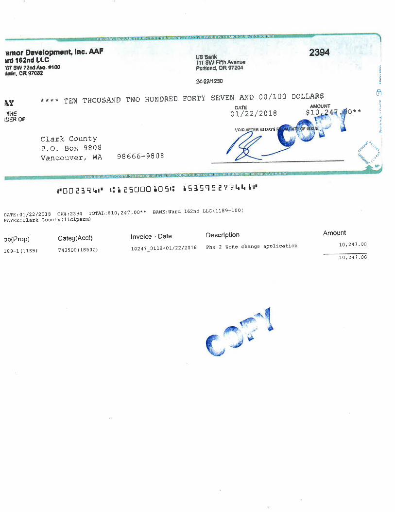
amor Devclopment, lnc. AAFrrd l62nd LLC"t7 S!/V 72fld46. #'100¡letin" 0R 9706!
[rTÞ{E
iüËR OF
US Esnkill SW FifrhAvonuePortland. OR s7204
2394
0û Þ0LLARSAMOUNT
324-2U1234
**** TËN TE.IOUSAhID TTüO H{JNDREÐ FORTY SEVEN ANÐ ÛOI1üÄTË
tLl22l2aL8
volÞ gú oAYg
Clark CountYP"O. Box 98Ü8Vancouver, VüA 98666-9808
ê #ð
1t s**
ÂUI
¿ç
2
è
.-"..- %
'u,.*
lrOO l ilgrrrrr ¡! t t SOOO tO 5r: l5l5q 5 ¿ ? ll¡h ltt¡
DA,!E;or/22/2018 cR#:2394 TorAL: s|e,24'7.00*' BANK:ward 162ncl LLC(1189-100)
PAYEE : Clark County ( 11clperm)
ob(Prop)
189-1 (1189)
Categ(Acct)
743500 (18500)
lnvoice - Date
L024'7 01"L8-0t /22 /2018
Description
Phs 2 zoûe change aPPlícation
Amount
Lo,24'l .00
L0 ¡ 247 ,80
4Ê\d¡ft,' ' .n'
ÇJ"{,b

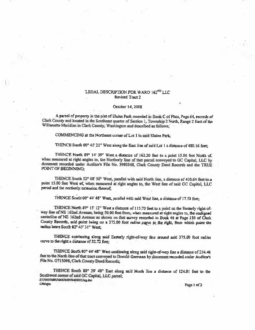
T,EGAT" DESCRIP.TION FOR WARD 16ZND LLC. ßevised T¡¡st ?
i
Octoher 14" 2008
A parcel of property in ttie plat of Etaine. Fark ree.ord€d fur Bsok C of Plars; Page 64, racords ofClark Cornrty md located in tfie Soutlrmst guarrer of gection.1, Torvnshjp 2 Norlh, Rañge 2 Eû:jtof thetû/lllameme Meridian in. clark :counú¡r, lvashington and desc¡ibcd. as fctllows;
COMTffiNCING.äI the Northeâsr comer of Lot I insaid Elâinc Fa:tc;
TIIENCE Sorrth 00" 49 21' lVesr alohg rfre East line of.said tot I a.il¡stance of 4g0. f6 fe€t
II{ENCE North 89o 14' 3gP' Wes¡.a disance of 16?.20 feef to a point 15.00 feet Nor,th of,w'hcn rneasured at rþht angles to, the Northerty line of that parcel. oonveyø ro OC Capital, LLC bydocumerf, recor.de¡l uuder Auditofs File l¡io. 9980368, Clarfr Co¡urty Deed Records and t¡e TRUEPOTNI.OFEEGINNING;
THENCE $outh 52" 08'50'¡' rvVcsÇ pamllet wiúh.said.North [ine, a diatancc of 410.6-f feettoapoint 15.00 feet lilest o( when rneasurcd at rigft angies !o, tüe ìtrest line.of saiil GC .Oapital, LLCparrel and the northorþextension tñereof;
ffff¡¡Cf Somtr OO' 44' 48" 'l[/est .parallet wÍth said lVeet fine, a disancedf I7Sg fssg
TÉ{ENCE ¡{orth 89o I 5' l? " lVest a distance of I 1 5 ,70'fcet.to a point on the Essterþ right-of-way liné of,NE l62nd ¿{venre being f0.00 .fect,from" when measured aC right angles to" lhel reJignedrynterJþ ofNE l62rrd AvBnue es itrown .on that ei¡r1rlêy ¡esgÍded, in Bool. a6 ¿i Fagp r30 cf C{ãkCounty ReoordS, .saíd pbint. being orr a 37I.00.foot .radius,sry.e.fa.;üg. üght frorn iltriclr peint ttreadius b6sr€ Soütb'82û 4.1' 3 f "''lV,€s.ç
TI{EN.CE ooàtiuuing along said Easterly right+f-way ltuie'¡äromd said 375"90 foot radfuscuwe ro theright a d¡Etsnc€-of 52.7,2feeç;
THBIÍCE $süth00' 44'48" llt¡e$.continuing alongsaid ríght-of"way line a distarcE of 254.6.feot to tlre'No,rft,line.oËth¿t hacÊconyë)¡ctl to Dornüà eûnnanrr by-doernrert r¡eorde4.utldsr Audito¡rsFllp No: G7! 50g8r Clark.County,Decd'.Records;
ÏI{ENCE $outh 88o 29' 48" East along saiil North line a distånce of t24.01 feet to tfteSquthwest.rorncr oFsaid GC Cgp¡tâl, J"tr Cparuel;Z:\700o\?6ô0l?fi OnfiOUe¡oOO:UrClhu
-
.C.IMþim page I of2
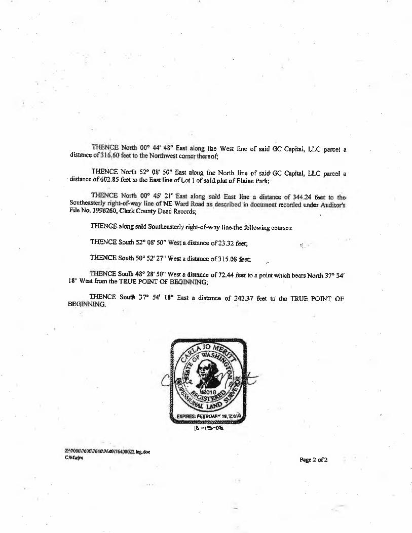
THENCE North 00o 44'48" Eæt along the West line of said GC Capital, LLC parcel adistancç of 31 6.60 feet to thç Northwest co;rue¡ ttrãreog
YAr'"."
THENCË North 52o 08' 50" East along the NortJr line of said, GC Capital, LLC pareel adisi¡nce of60?.85 feot to.the East line oflot 1 of saíd.prar.of Elaine park;
THENCE North 00ê 45' 27' East along .s¡Ìd East line a distüËe of 344"24 feet to theSouthøæterly right-oÊw4y liræ of NE Ward Rsad as.desc¡ibed in docu¡nçut recorded under Auditot sFile No: 39Ðó?õ0,,ClarkCounty Deed Røcords;
rrlgwce dong said southeasûerþ rigþr-of-way r iue the following coursos:
THEhICÊ South 5?ô 08'50,' West a.disrancc of?3.32 feet; :j:. .
THElgCe South 50o 52,27" West a distance of 315.0g feeq
TIIENCE Sþdft 48o 28'50" West a distance af 72.44feet ro.a pointwhích bearsl+Iorth 37o y+ÌI8" ïVest from theTH.UË POINTOF BEGIIIÀI$¡G;
TIIENCÞ Soufi 37o 54' 1,8" F¿st a distance oî 242.1T feet to ihn TRUE PO.INT OFBEGINNTü¡G.
tS-tB'6
ã:V00tv6dt?6il0u6r0r?6400ti23. tog;docCJfh{ojm
EXPËi¡ FEBRTIÀßv 19.
Fagc 2 of2

OU NI
2o
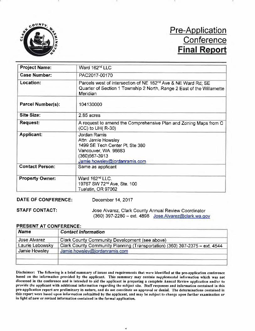
Pre- licationConference
Final Report
Project Name: Ward 162nd LLC
Case Number: PAC2017-00170
Location Parcels west of intersection of NE 162nd Ave & NE Ward Rd; SEQuarter of Section 1 Township 2 North, Range 2 East of the WillametteMeridian
Parcel Number(s): 1 041 30000
Site Size: 2.85 acres
Request: A request to amend the Comprehensive Plan and Zoning Maps from C(CC) to UH( R-30)
Applicant: Jordan RamisAttn: Jamie Howsley1499 SE Tech Center Pl, Ste 380Vancouver, WA 98683(360)567-3913Jam ie. hows lev(Ði orda n ram is. com
Contact Person: Same as applicant
Property Owner: Ward 162nd LLC.19767 SW 72nd Ave, Ste. 100Tualatin, OR 97062
DATE OF CONFERENCE: December 14,2017
STAFF CONTAGT: Jose Alvarez, Clark County Annual Review Coordinator(360) 397-2280 - ext. 4898 [email protected]
PRESENT AT CONFERENGE:
Disclaimer: The following is a brief summary of issues and requirements that were identilied at the pre-application conferencebased on the information provided by the applicant. This summâry may contain supplemental information which was notdiscussed in the conference and is intended to aid the applicant in preparing a complete Annual Review application and/or toprovide the applicant with additional information regarding the subject site. Staff responses and information contained in thispre-application report are preliminary in nature, and do not constitute an approval or denial. The determinations contained inthis report were based upon information submitted by the applicant, and may be subject to change upon further examination orin light of new or revised information contained in the formal application.
Name Contact lnformation
Jose Alvarez Clark County Communitv Development (see above)Laurie Lebowskv Clark County Community Planning (Transportation) (360) 397-2375 - ext.4544Jamie Howsley J am ie. h owslev@iorda nram is. com
4
APPLICATIONS REQUIRED
The requested Comprehensive Plan map and concurrent zone map amendments require anAnnual RevieMZone Change Application to be completed. The application will be processedthrough the Type lV Review process. A SEPA checklist is required to be completed as a part ofthe Annual Review application.
Estimated fees:*Combined An nual Review/Re zoÍrêt.lssuance Fee...
Environmental Checklist Review (SEPA)lssuance Fee...
.....$8,119.00.....$94.00
$1,987.00.$53.00
*Fees cited are estimated and based upon the fee schedule in effect at the time of pre-application conference and are subiect to chanqe.
APPLICABLE POLICIES, CODES and CRITERIA
The following list is not exhaustive of all county, state or federal regulations that may governdevelopment of the site, but is inclusive of those addressed by the county in this comprehensiveplan/zone amendment review process.
a
a
wAc 365-196-300
Clark County 20Year Comprehensive Growth Management Plan Policies
o Chapter 1 - Land Use Elemento Chapter2-Housingo Chapter 9 - Economic Development
Clark County Unified Development Codea
o Title 40:
' Section 40.220 (Urban Residential Districts). Section 40.500.010 (Procedures). Section 40.560.010 (Plan Amendment Procedures). Section 40.570 (SEPA)
Clark County Criteria for Map Changes (found within the text of this report)
Section 40.560.010G (Criteria for all Map Changes)Section 40.560.020 (Changes to Districts, Amendments, and Alterations)Section 40.560.020G (Approval Criteria)¡
ô
Gomprehensive Plan Designation Map Change Griteria
Comprehensive plan designation changes may only be approved if all the following criteria aremet (40.560.010G):
1 The proponent shall demonstrate that the proposed amendment is consistent with theGrovvth Management Act and requirements, the Countywide Ptanning Policies, theCommunity Framework Plan, the Comprehensive Growth Management PIan, appticable citycomprehensive Plans, and including applicable capital facilities plans and official poputationgrovvth forecasts; and
The proponent shall demonstrate that the designation is in conformance with the appropriatelocation criteria identified in the plan; and
The map amendment or site is suitable for the proposed designation and there is a tack ofappropriately designated alternative sites within the vicinity; and
The plan map amendment either: (a) responds fo a substantiat change in conditionsapplicable to the area within which the subject propeñy lies; (b) befter implements applicabteComprehensive Plan policies than the current map designation; or (c) corrects an obviousmapping enor; and
Where applicable, the proponent shall demonstrate that the fult range of urban pubticfacilities and seruices can be adequately provided in an efficient and timely manner to seruethe proposed designation. Such seruices may include water, sewage, storm drainage,transportation, fire protection and schools. Adequacy of seryr'ces applies onty to the specificchange site.
2.
3.
4.
5.
Zone Ghange Criteria
The concurrent zone change may only be approved if all the following criteria are met(40.560.020G):
1. Requested zone change rs consrstent with the comprehensive plan map designation.
2. The requested zone change rs consrsfe nt with the plan policies and location criteria and thepurpose statement of the zoning district.
3. The zone change either:a. Responds to a substantial change in conditions appticable to the area within which the
subject property lies;b. Better implements applicable comprehensive plan policies than the current map
designation; orc. Corrects an obvious mapping error.
4. There are adequate public facilities and services fo serye the requested zone change.
SUBMITTED MATERIALS REVIEWED
The following materials were provided by the applicant and were reviewed by Clark County staffin advance of the pre-application conference:
Application formsNarrativeGIS Packet
a
o
o
¿t
BACKGROUND
The applicant proposes to amend the comprehensive plan and rezone approximately 2.85 acresfrom Commercialwith Community Commercial zoning to Urban High with R-30 zoning.
SUMMARY
The following comments and issues were discussed or identified during the pre-applicationmeeting held on December 14, 2017.
Land Use
Comments provided by Clark County Long Range Planning, Jose Alvarez:Staff noted that a brief overview of how the pre-application conference would beconducted and a summary of what information would be covered was provided to theapplicant. Staff also provided lnformation regarding Clark County's obligation to planunder the State's Growth Management Act and the long-range, comprehensive planningexercise that concluded in 1994 with the adoption of the 20-Year ComprehensiveGrowth Management Plan and corresponding zone map. ln 2016, the County adoptedan updated 29-Year Comprehensive Plan and zone map.
Specific to this application, staff stated that the assumption is that the currentcomprehensive plan and zone designation (Commercial, Community Commercial) wasstill applicable to this area and that the applicant will need to demonstrate that a changeto a residential R-30 zone is appropriate and consistent with the County's GrowthManagement Plan and Unified Development Code. Staff said that the proposal tochange the designation will need to be consistent with the Growth Management Act andthe county-wide planning policies. Staff proceeded to discuss with the applicant theComprehensive Plan Designation Map Change Criteria that the applicant will need toaddress in an application.
Staff emphasized that an Annual Review Application for a change in land usedesignation to residential will need to show how the proposed change is compatible withthe neighborhood and surrounding area. A legal lot determination will be required withthe application. The applicant should address why the abutting property was notincluded in this proposal and how this proposal would not be a spot zone. Staff alsorequested additional quantitative data regarding the market changes in relation tocommercial land, anecdotally mentioned in the narrative.
Transportation
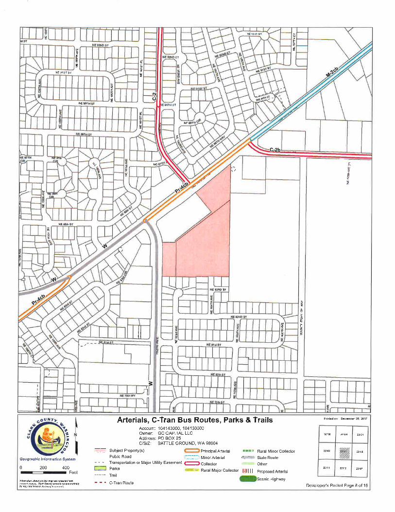
Comments provided hy Clark County Long Range Planning , Laurie Lebowsky:NE 162nd Avenue in this section is a Washington Department of Transportation facilityWSDOT). And WSDOT has jurisdiction over access and improvements along the site'sfrontage. NE Ward Road is classífied as a four-lane Principal Arterial with center turn-lane andbike lane (PR-4cb).
Staff reviewed the six-year Transportation lmprovement Program and found no projects thatwould impact area immediately around the site of the proposed comprehensive planamendment and zone change.
^
The approval criteria require that the applicant demonstrate that adequate transportationfacilities can be provided to serve the proposed designation. This can be accomplished bysubmitting a traffic analysis which compares a reasonable build-out scenario under the existingand proposed designations. lt is recommended that the study horizon be 2037 or an equivaleñtyear representing build out of the adopted urban area. Network improvements should include allthose projects that are in the financially constraíned RegionalTransportation System Plan.
NEIGHBORHOOD ASSOCIATION CONTACT
While not required of a complete application for a comprehensive plan amendment, staffrecommended that the applicant talk to the neighborhood association chair for their area. TheHeritage Neighborhood Association Chair is Christie BrownSilva at (360) 326-4353heritaseneighborhood(Agmail.com Staff also encouraged the applicant to discuss theproposed land use designation change with neighbors.
TIME FRAMES
Januarv 1 throuqh January 31 - submit FinalAnnual Review Apprication
Februarv 1 throuqh to April 1 - Clark County staff will review and prepare a recommendation tothe Planning Commission (this period may be extended depending on staff work load)
Eourth.Quarter or sooner - Planning Commission will approve or deny request. lf the PlanningCommission approves the Board of Commissioners will review and make a final determination.lf the Planning Commission denies the request, the applicant needs to appeal the denial. lnpractice staff fonruards all recommendations to the Board of Commissioners for final resolutionof the requests.
ADDITIONAL MATERIALS
A complete list of required documentsCompleted SEPA checklist is requiredsummarv with vour final application.
is contained in the Annual Review application packet. Afor the final application NOTE: Submit a of this
H:\LONG RANGE PLANNING\PROGRAMS\AR-DOCKETS\ANNUAL REV& DOCKET FORMS\Pre-App\PreApp_Urban_Rpt.doc
t

DEVELOPER'SPACKET
Produced By:
Clark County Geographic lnformation System (GlS)
Geographic Inf ormat¡on System
For:Jordan Ramis PC
503-598-7070
Subject Property Account Number(s) :
104143000104130000
PDF # 1 93459
Printed: December 26, 2017Expires: December 26,2018
Tãble of Gontents
General Location
Property lnformation Fact Sheet
Elevation Contours
201 6 Aerial Photography
2016 Aerial Photography with Elevation Contours
Zoning Designations
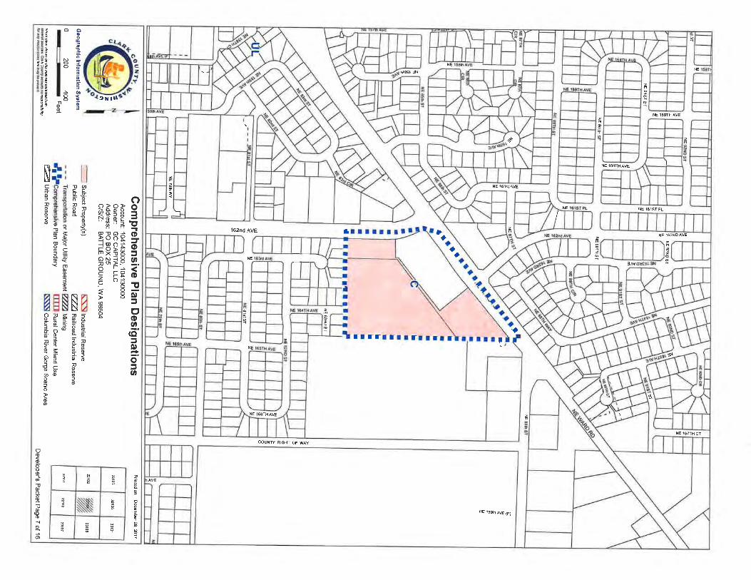
Comprehensive Plan Designations
Arterials, C-Tran Bus Routes, Parks & Trails
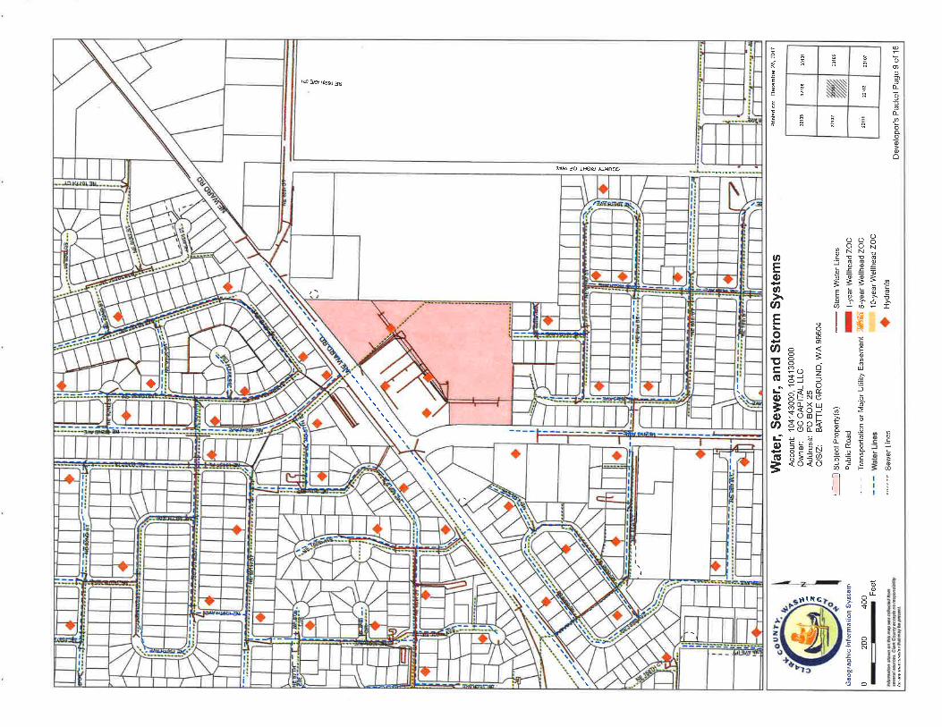
Water, Sewer, and Storm Systems
Water Systems
Hydrant Fire Flow Details
Soil Types
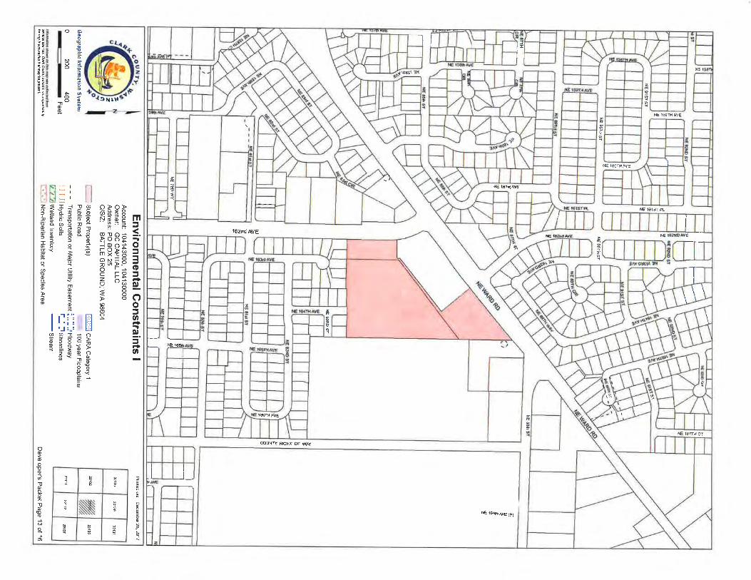
Environmental Constraints I
Environmental Constraints ll
Adjacent Development
Quarter Section Parcels
1
2
3
4
5
6
7
II
10
11
12
13
14
15
16
Clark County GIS
\\1-c!-g
o
o b
^r99-:
.lz
r09
35
1-00
31
WM
rËb
E¡>I
Ç6
TU
It.:^3
S¡Íon>El
t
IM¡ddle Sd
12
SIFTON I'
VANCOUVER
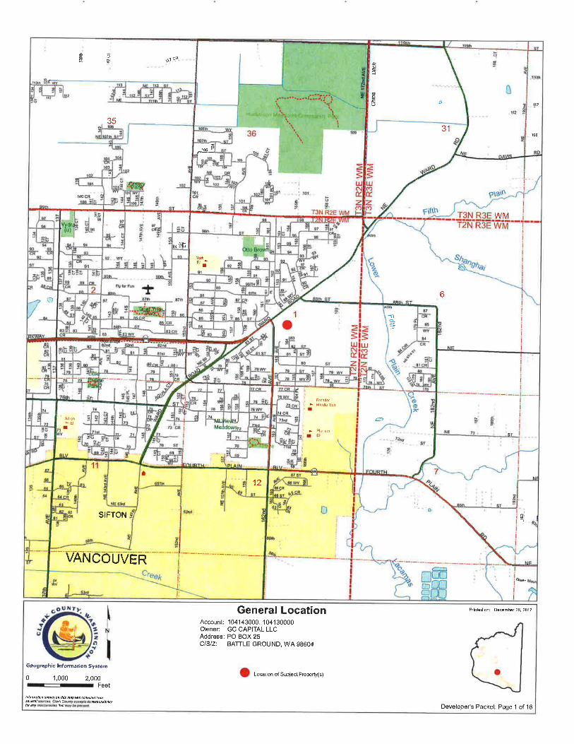
General LocationAccount: 104143000, 104130000Owner: GC CAPITAL LLCAddress: PO BOX 25CISIZ: BATTLE GROUND, WA 98604
Pdnled on: D6cemb6r 26, 2017
Ge ogtaphic l¡rf onatío¡ Syrt€m
0 I,000 2,000
--
Feet
tuoñatþñ úoø on hß Np Bs @Itøtud tuû*@1 eutæs. Cla* Coùnu acc.þß no û'pØgþtilùht âny hacctt.d.s ths¡ ñoy be pBwt.
o Loætion oi Subject Property(s)
Developer's Packeti Page 1 of 16
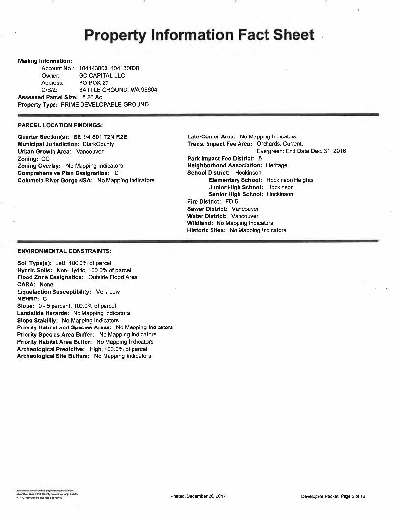
Property lnformation Fact Sheet
Mailing lnformation:Account No.: 104143000, 104130000Owner: GC CAPITAL LLCAddress: PO BOX 25CISIZ: BATTLE GROUND, WA 98604
Assessed Parcel Size: 8.26 AcProperty Type: PRIME DEVELOPABLE GROUND
PARCEL LOCATION FINDINGS:
Quarter Section(s): SE 1/4,S01,T2N,R2EMunicipal Jurisdiction: ClarkCountyUrban Growth Area: VancouverZoning: CCZoning Overlay: No Mapping lndicatorsComprehensive Plan Designation: CColumbia River Gorge NSA: No Mapping lndicators
Late-Comer Area: No Mapping lndicatorsTrans. lmpect Fee Area: Orchards: Current,
Evergreen: End Date Dec.31,2016Park lmpact Fee District 5Neighborhood Association: HeritageSchoolDistrict Hockinson
Elementary School: Hockinson HeightsJunior High School: HockinsonSenior High School: Hockinson
Fire District FD 5SewerDistrict: VancouverWaterDistrict: VancouverWildland: No Mapping lndicatorsHistoric Sites: No Mapping lndicators
ENVIRONMENTAL CONSTRAINTS:
Soil Type(s): LeB, 100.0% ofparcelHydric Soils: Non-Hydric, 100.0% of parcelFlood Zone Designation: Outside Flood AreaCARA: NoneLiquefaction Susceptibility: Very LowNEHRP: CSlope: 0 - 5 percent, 100.0o/o of parcelLandslide Hazards: No Mapping lndicatorsSlope Stability: No Mapping lndicatorsPriority Hab¡tat and Species Areas: No Mapping lndicatorsPriority Species Area Buffer: No Mapping lndicatorsPriority Habitat Area Buffer: No Mapping lndicatorsArcheological Predictive: High, 100.0% of parcelArcheological Site Buffers: No Mapping lndicators
d.nl euG. Cl¡* øo¡y a6pb m dpon.¡bltyþr ary lnâæ!ñcb lht ffiy b€ pcænl. Pr¡nted: December 26, 2017 Developers Packet, Page 2 of 16
sã
NE I67TH CT
NÊ
re ftl.+4 avE
1.lE
q
¡
4
4+
G i69úi AVF (P)
rõ)i.r Õ
I
F)'q
RIGHI OF WAY
ÁvE
1"
t6?nd AVE
ß18
\)t}}rÕl)
i'.
,¿,¡p.1
o>o>ò3=8ñõ d P'' ø f,
=
qss* tl@()A
-=Q>õ O
9E;F ò=i-u _ì rrc i-H oÉ.Ê=ã 8c)å -g@JQ.+xo
C.lø
6
o
3
l'åll JttN
l.åJqO3
¡ r I illlrllN)::{!ø)m_9+=g Fg áÈä.õ3ã;5 õ 9P ¡^ ¡ õ *ÈôO-Y
Ëõ<9--coòo
çqmoofoa*
N.N
iõ9RÊsÊà33e:ô1¡
r!.;ìè*Ë6ñ3A
tå
s
oooooo
'llooo-Ito
@o
o
o
201 6 Aerial Photography Pdnted o[ D6c€mb€r26. 2017
Account: 104143000, 104130000Owner: GC CAPITAL LLCAddress: PO BOX 25CISIZ: BATTLE GROUND, WA 98604
C6ogrsphta lntomätlon Syllåm
0 200 400r-Feet
E
32135 32136 33131
2102 ,ry2310ô
22112 22107
hîomdtu stuM on lhls tupßs úMtus.ffil þu.6' qatu CoØty ø@.ils no ßqûdbttvtu .ny ¡nñu¡adas ùat nay bø Wsênl,
Sub¡ect Property(s)
Developefs Packet: Page 4 of 16
2016 Aerial Photography with Elevation Contours Pr¡nted on: December 26, 2017
Account: 104143000, 104130000Owner: GC CAPITAL LLCAddress: PO BOX 25CISIZ: BATTLE GROUND, WA 98604
32135 32136 33131
22102 24y//l 23106
22112
gsogrsphia tnformâf lon SyrtamlEl suo¡ect eroperty(s)0 100 200
--r
Feet
hloñahn showû ok lhls nqp ws d|ëtud tuñsft, slr.os C,¿d êoú¡t ac.êÞts no ûqonsbilVht ¿ny ina.Nãctøs lhøt ùoy bø pÉ.øn¿
: 2'Elevat¡on Contours
Developer's Packet: Page 5 of 16
ft
î
t
NE 83RD ST
ST
92ND ST
o
ç
tI a
R1-7.5
1,NE 92ND ST
NE SOTH SI
o)'
o¡
I
ìIt!
,
z
)
z
e)
¡llI¡ltIt
NE 9lSTST
NE
1,
I
q )5 ctz
ç
1,
I at
82NO ST
.)a1,))
3
o
oú
o
NE gOTH ST
,'ô
q
INE 89fÈ
a.a\{-
t¡
o
¡¡tta.
oÇçç
tut
NE 79h W
NE
III¡IT
:tII
u
N
a
a)5
|l
Zoning Designations Printêd on: December 26. 2017
Account: 104143000, 104130000Owner: GC CAPITAL LLCAddress: PO BOX 25CISIZ: BATTLE GROUND, WA 98604
Geographlc Inlo¡mat¡on $y3t€m l:: subject Property(s) N Urban Hotding - 10 (UH-10)
Public Road fT4urban Hotding - 20 (UH-20)
- - - Transportation or Maior Ut¡lity Easement 7: Urban Holding - 40 (UH-40)¡ r-r! lrZoning Boundary N\l Surface M¡n¡ng Overlay Distr¡ct
0 200 400r-Feet
1213s 32136 33131
% 23106
22112
lnloñalbn shøwn on hts ñaþ ßs .d|êtu tusøvøt.l sources. daù coúñty sccepts ão @spanstbltùb¡ an! lnêccuøctøs hat nev be þßssnt. Developeis Packet Page 6 of 16
NE l69lhAVE (P)
I
I
I
I
NE 167TH CT
utaç! 3NNE
âè
2
3rI z
al r ¡ I I ¡ I tl l a NE l62NOAVE
NE l59THAVE
â¡
O
z
z
NE NE 151SIPL
NE 16OTHAVE
NE 1661HAVE
z
tÉ
NE 161stAVE
z
tt 9
162nd AVE z
rtfrlr¡'rftlftf r¡t¡f
at
NE
¡I
COUNTY RIGHT OF WAY
NE
NÊ
I
oo=ttoo¡Vt
o!o¡
oo9.
GI
='¡!no5Q
õ'
io
3
5ilrrl
3ä?äñõ ã P"øf=
q¡e*-.1@c)ifi9ìEoN=PÐq>-"o ,-- -ôÉ c,ô<o<o>oEoo
l" gtt ?ll 3ll* r
[åÕ¡JqO5
aØ66o'3ot*õ-E o
f
NZT-qõ-
õço6'?a=o9öÉß7oo?o
g€i
ÈÉ 3eB-9ùarFI:3çr:qÈ':BÉÈg s!ãts
àP
€s
m,it I
N+.,COJasõo5fiÞ12P9s5qõ'a;ã
Trd<rg.ol 9cCo€qm
o@3o
ØEÑô¡<
5_@6 ('o'g4dQ?o*'9öA-oùtød
oõ'
õo
trooö-!o
1tooo-ooaono
o
N
eñocta FoF
¿
v
à
aË
v
001H 51
v
gAiÉ tìsY sT
NE
à
F
N8 åôlH
ilE
¿ê ¿-
E
*
r¡Ë
v
â
s
s
{öE
Èt_2
I
rt
Arterials, C-Tran Bus Routes, Parks & Trails
'')' Rural MajorCo¡lector llllll proposedArteriat
lscenicHigh*ay
Printed on: Oecember 26. 2017
Developer's Packet Page I of 16
2et
Account: 104143000,'104130000Owner: GC CAP¡TAL LLCAddress: PO BOX 25CISIZ: BATTLE GROUND, WA 98604
-- SuþJectPropeny(s) L;;JPrincipalArterialPublic Road (,-ffi; MinorArleriatTransportation or Major Utility Easement CÐ Collector
ffi parks
------ Trail
- - - C-TranRoute
arae Rural lvl¡nor Collector. - 'StateRoute
Otherçeogrâphic lnlormållon €yrtom
0 200 400
-.-.
.
-
Feet
liloñalþn ùown Òn th¡s ñap @s @ilødød tuñ5øvè6t þùt@s. C|Ê* ùuhy a@þts no Nqônstþ¡ryht ary lnaccuþdþs lhêl ñay he pßtdnt-
32135 32136
,ry,23106
22111 22112 23101
@
ooooofLoooù@ooooô
3
s
.s
è
(-)oN!oo€
=,
t
ocfo3@ø
ì.**N
()ooo3NNcÞÞfçq.99ãooËÈ=Fdõb 9.Eõ-ró
llf;coEo6
UJ
.à5o'õ'
ã>€oocRo.9Ed6ÀoË-É. ao_-o
õíÈTl ,
IrLl r
õoIo
:l
"l
Ê
Ë
e
I@@o
o<8=ô-o,. o+J =oJ 4(J
3ÉñÜEtðsè()d¡l-
ËABß
3 Þ PN3;Ea<o<o
E
o
ØEoan
at,
EoØt¡(It
oìoØ¡ioñ3
$IR G
I II I
II
I
Il
{} *
^Vü S trÞÞ UÐOæ
I
lÐ3^v*s &
II
I?
li
I
fra-.t
I
!u
NE 88h ST
II
KMfg
Ë
I
r'
!-t6'!+
NE 92NO ST
.f;so?.r s4r ,
119
ré
I
!
il$ry
61 CI93
tr
H
N tt3
g
z
ô
IIIIII
"t0
l
ìofI
o
tt r\r I
çßogt Aphlc rrl aßn attan Sy steß
0 200 400r.zFeet
*2o
Water SystemsAccount: 104143000, 104130000Owner: GC CAPITAL LLCAddress: PO BOX 25CISIZ: BAITLE GROUND, WA 98604
:--l Subject Property(s) - - 10-20" Water Line çPublic Road - r > 20" Wâter Line {Þ
ElWaterD¡str¡ctBoundary 1¡ NoFtowDataHydrant ÕÉ& Ê Unknown S¡ze Wâter Line .' O - ¿gS cpM at 20 psl** <10"WaterLlne "*" SOO_999cpMat20psl
> 1000 - 1749 GPN4 at 20 PSI
> 1750 GPM at 20 PSI
Hydrant > 500'from parcel(s)
Prinladon: Decemkr26. 2017
Developer's Packet: Page 10 of 16lnloñ¿lbn shoû on hls ñap Æs @tø¿¡ñ hûsêv.r¿l soùt@s. Clatu County accêp¡s ño ÊspoÌslb¡l¡ùbt any h.æurades lhal mq ba pßsen¿
32136 33131
22102
% 231ffi
22111 23107
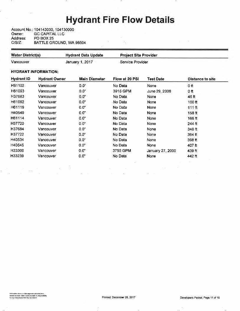
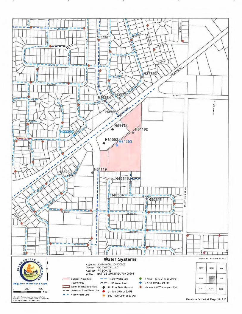
Hydrant Fire Flow DetailsAccount No.: 104143000, 104130000Owner: GC CAPITAL LLCAddress: PO BOX 25CISIZ: BATTLE GROUND, WA 98604
Water District(s) Hvdrant Data Update Project Site Provider
Vancouver
HYDRANT INFORMATION:
Hydrant lD Hydrant Owner
Service Provider
Main Diameter Flow at 20 PSI Test Date
January 1,2017
Distance to site
H61102
H61 093
H37683
H6r 092
H61119
H40549
H61114
H37720H37ô84
H37722H40534
H40545H33300
H33239
VancouverVancouver
VancouverVancouver
Vancouver
VancouverVancouverVancouver
VancouverVancouverVancouverVancouverVancouverVancouver
No Data
3915 GPM
No Data
No Data
No Data
No Data
No Data
No Data
No Data
No Data
No Data
No Data
3755 GPM
No Data
0ft0ft46ft100 fr't11ft158 ft166 ft244ft348 ft364 ft398 ft407 ft439 ft442ft
0.0"
0.0"
0.0"
0.0"
0.0'0.0'0.0"
0.0"
0.0'0.0"
0.0*
0.0"
0.0"
0.0"
None
June 29, 2006None
None
None
None
None
None
None
None
None
None
January 27,2000None
lúmüd tuonlhh Fg.m.øtlådd tuñsêd *ffi. chú øhly añp$ m Esondbltilybr ¡ry ¡ñrcuud$ lh{ my b p€d. Pr¡nted: Decembet 26, 2017 Developers Packet, Page 1 I of 16

NE øND CIR
I
z
S1
sf
87TH
ST
zNE
NE SOTHSf
ST
z
NÈ 91ST SI
NE 85lh
zNE 90il ST
+^
c\êNÉ
NE
NE 79h W
NE
u
EN
oIs
zÈø
NE
NE A1
ST
IIo
o-f,o
z
15
U¡l Soil Types Pdnlod on: December 26. 2017
Account: 104143000, 104130000Owner: GC CAPITAL LLCAddress: PO BOX 25CISIZ: BATTLE GROUND, WA 98604
321X6 33131
22102 ,ry, 2316
22111 22112 23107
çe çgr aphts lnl ot mallon Syãt6m
0 200 400
-nFeethlõñalþû shÒwn on úls ñøp ßs conêdad hûsvørct eurces. Cteû counV accoÞts no ûsponstut¡Vbr ¿ny ¡nøæu.ac¡øs kdtnsy bep@sên|
II subject Property(s)
Public Road
- - - Transportation or l/ajor Utility Easementñ_.._l--l $orl lype Boundary
Developer's Packet Page 12 of 16
\
\
I:E
I
I
flÉ l€ñdc¡
\9
g
irlll
]l
lL
G tôq
f'
NE
E læR ÀVE
€ le{srÊ
r€
zI{
Ng 10cfr AVe
:I
z
*
(Ê
â*
+è
M lofsÀw
I
q*[ r(
!
G6TH ÀVE
æW?l reFr æ W4Y
{62nd AVE
z
z
çÍ
t
I
III
RÊ fcftAw(PJ
Snlrr
i¡
¡
ût
l'll*
t:ðoo
!9eۓ;P3SU
3;i
$!
teeõðI
s
oooõ-Þo
1loo-o!soo
o
ó
o>o>>o<ôñãàF m_ øf
= ra=J
s¿gå Í.f,oof Oñ9*Ë f--:Y q
iüEÏ ãX ro -4
^: Q
-o "tq Q,<õ-Í 8oeOñ=EO
Flìg.JÉ!
i.'ìñil I i-'l
"1 ñL.t ' li
tñg' liz51i-oØ
+O i.Ø = o45r/E\¿ôþdøoA'-iãådF3f o o -õJrO#q s ëg< : G
ØCo=
B'rIEo¡oõ
=I tli'i Fìl| '¡1..i lJØoa)oõdRõà3 d ãã Ë- ã'e E PØ AÃaöåsõ<c-
J
¡
I
o
3N
w0râ
t
ã
TH
--l ItglJ e'l
I l- ^-----1 : I
z
öz
¿
ñgúolB6f
f
v
ilE 82tiô sT
NE $rs3f
ñÉ c6ù er
It
zNÊ OOIH èT
,tê
|¡Ë
g
g
t
HË
l!àÞ
2
6
v
qE g
*
f(,úII
¡n
Geograph¡ç lnlormatíon Sy¡t€m
0 200 400
-zFeet
Public Road
- - - Transportat¡on or Major Utility Easemenl
N stopes > 15%
F-.-ìl Potentially Unstable Slope
[-1.] Historic ornct¡ve Landslide
f ccHn H¡stor¡c S¡te
I runnP Historic site
A INV Historic site
Printsd oû Oecember 26. 2017
Developefs Packet Page '14 of 16
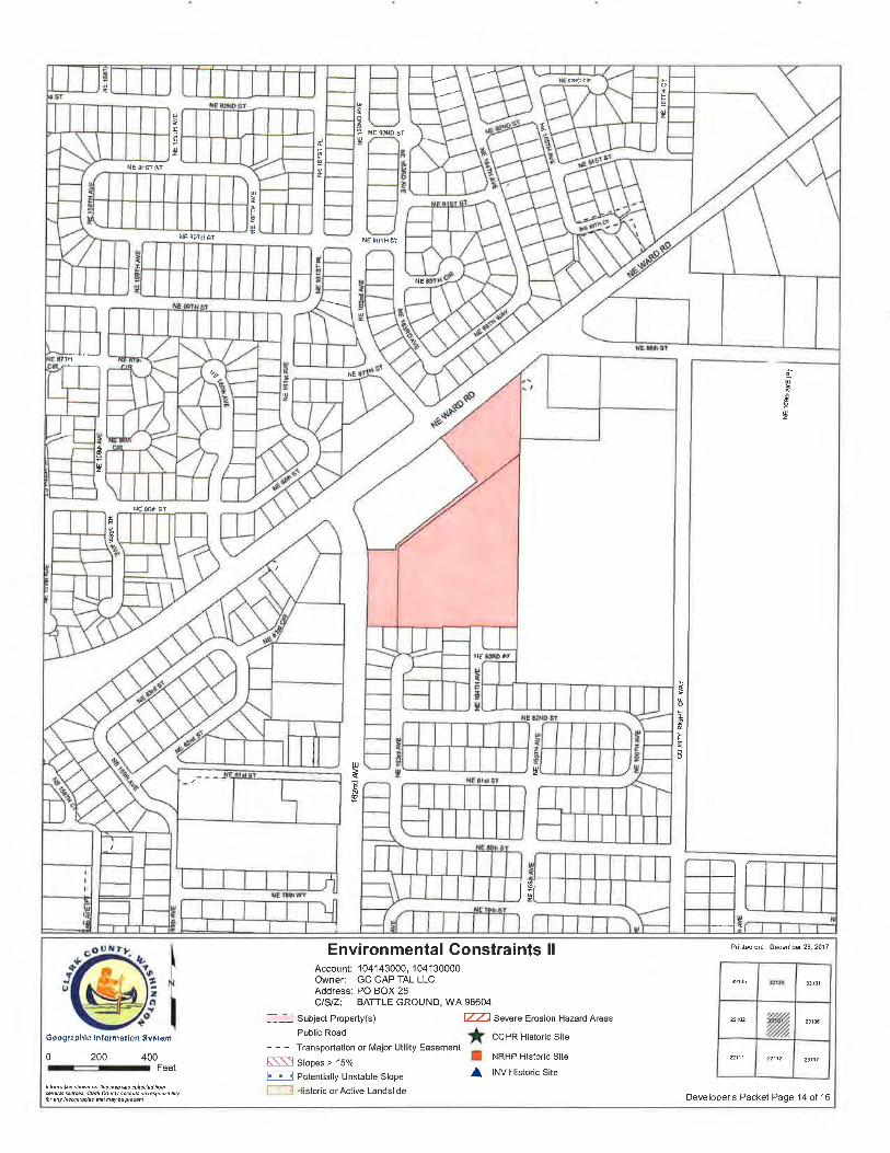
Environmental Constraints llAccount: 104143000, 104130000Owner: GC CAPITAL LLCAddress: PO BOX 25CISIZ: BAT-|LE GRoUND, WA 98604
--: Subject Property(s) f- Severe Erosion Hazard Areas
hloña¡bn sho*ã on thts ñoþ ßs cøiløcbd tunsèeê.èl sout..s. C¡a* Cou¡ry accepls no þsponsibilitlor any hqúúradas thEI ñey be pþsøn|
32135
T,23106
22112 23107
zts
sf
ÍNE 92ND 51
ts2
NE SlST S1u 6¡0001
PARK SUB
IF9z
NE gOIH SI NE gOTH SI
È
NE 89îs
zN
NE 88h ST
4êROZANN
NE o I€
zèø o
& RETAIL
oSQÙARE PH I
ÑE
PLD20l 6{0014ADAMS GLEN
PH oo
214
PARK
38NE 83RO ST
2 14 LOTS
LOTS
l'o
oú
o
82NDSI"öi""F
+ê U
!
6
NE 79h WY Uz
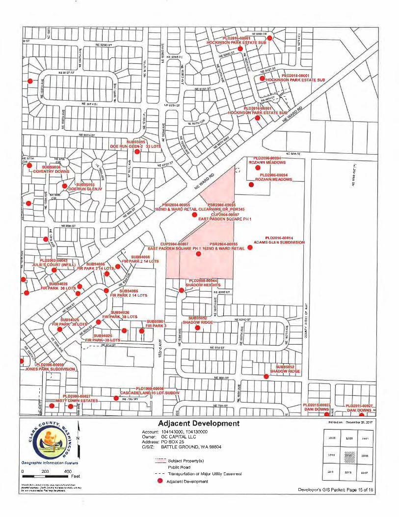
Adjacent Development Pdnl€d on: December 26, 2017
zt
Account: 104143000, 104130000Owner: GC CAPITAL LLCAddress: PO BOX 25CISIZ: BATTLE GROUND, WA 98604
32135 32136 3313r
22102 'ry22111 22112 23101
Goographlc lnformaríon Syrloñ i---l Subject Property(s)
Public Road
- - - Transportation or Major Utility Easement
(D AdjacentDevelopment
0 200 400ru Feet
lilôñahn stuM or lh¡s ûaþ ßs @ilødod tuñæwßt úutæ' c¡øtu couity acÓpts tu ßqØsbil¡ytu ary l¡aæúødas lhàt n ay bè Þß t il Developer's GIS Packet: Page 15 of 16
-o92 456r30
4-267
22-27868
136 67-134
ADJ 254A
-096346140 443
-Ì04438-094 Irg l4
5-2 6824
-04849-098454
126
9
97194
20-27672
-14471142l 50
100453124 7
-27073-t46
22044
9t| 5401 4
95190
92ì84
300-048
74t48 21
-0421-oo2
299-046
94-l 88 75
150
ßI s3969
20-0402
-004
89178
l9-038
76l0"284
lt474I t8
-036
80
u
=tsoUz
NE gOTH ST
JcÞv)@
t!z
891 54012
295-038
90ì s40¡ 3
104
3lI 53954
't5
1641so2
f5-02 I27
-554- 588
NE gOTH ST
NE 89TH
Pm
.\e
zfî
-504-578-590
506,576
-02211
22544 24
-549l9 -59410
-020-508
lt5r04t 50
100200
2t5I 04t 60
-574
¿c
m
U
Uz
5-510
22
-572-600 l9
-53 3/5,6104 164
8-570 l8
-P,u-5r26
24602
7
- 568 5l
TTA-202
17-534
-604-s66
t8
52015
027-608
5-564
4-562 14
l312
230
43-560
2922
z2
1t11041 42
3-0r 63l
-61 -556
25880 33
-620
l5
32-61
l3 14
,M,
r2-0t 4
$X4-0t I
21t04tJ0
1t2t04t43
{i
311 4"o
,a-96
47-94
49-98
5-02046,92 6
-07
-0
158-318
2-4
4'la2
I0l 6 159
-320å 50
t00r8
94I S40l 7
160-322
770
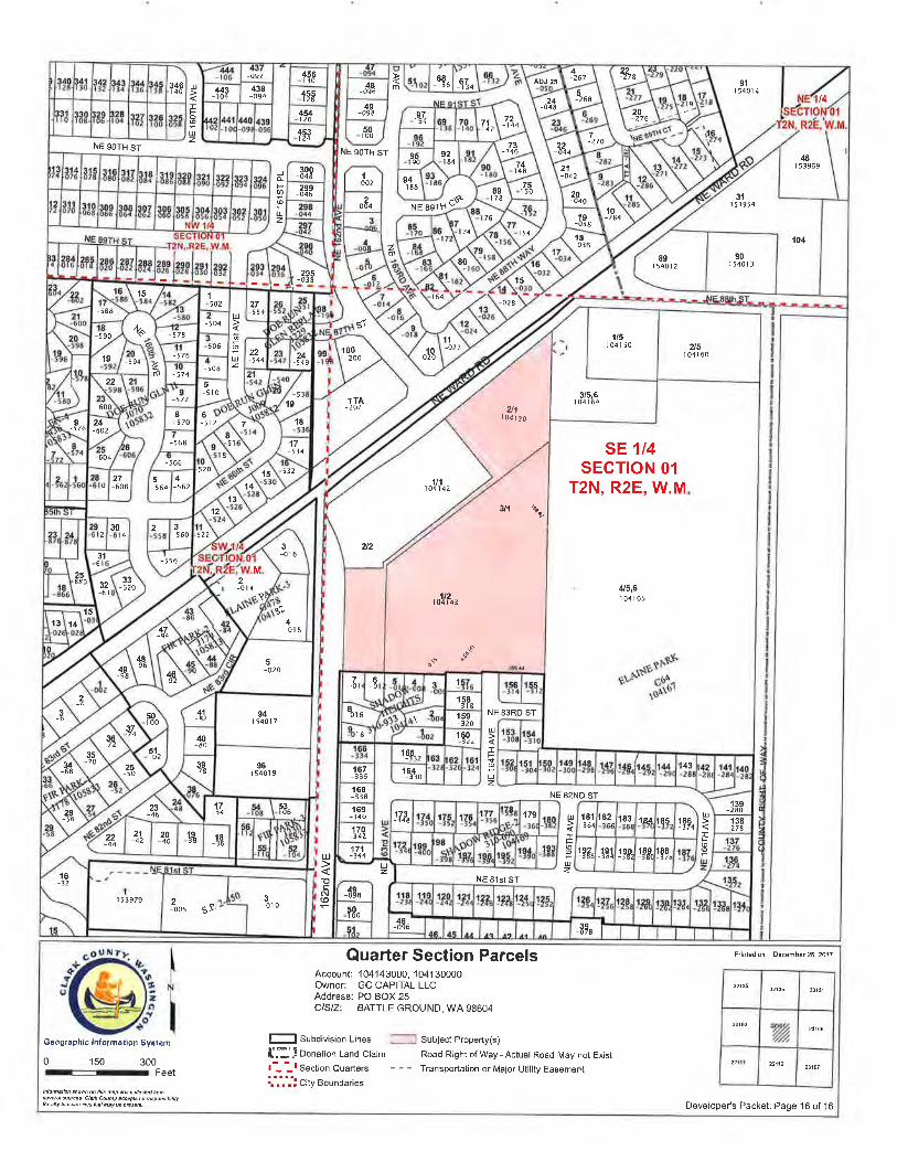
SE 1/4SECTION 01
T2N, R2E, W.M
1041654/5,6
-{-...199b*gvn" ¿bf"
\oÀ\(r '
480
36-72
1-6f'5lr0235
"70167
-3 36164j3lo
u-68
4325-50
39-74
96ì 5401 9
168-338
f39-28053
t0623-46
169-340 173
-348 1 138278
28-56 179
170-34222
-4421-42
20-40
l9-38 l8
-36
17-14
171-344
-áE'
l6-32
18.f'3641
182 1 83 r¿4 105- 186374
192-
l
lqx 19p,
l
189380
188-378
NE 83RD ST
u
-FUz
NE 82ND ST
u
Tts
NE 8'lst Sf
U
Its
Uz
50ì00
r 53979
48,oc6
'oo, ss'3-010
ul
!cN(0
Uz
39-078
Quarter Section ParcelsAccount: 104143000,'l 041 30000Owner: GC CAPITAL LLCAddress: PO BOX 25CISIZ: BATTLE GROUND, WA 98604
Prinled on: December 26, 2017
Oeographic hlorilat¡gn Syrtem l_l Subd¡v¡s¡on Lines
{"1} Donation Land Clajm
t-- --l Section Quarters
i.',',i'¡ city Boundaries
JI Subject Propety(s)
Road R¡ght of Way - Actual Road May not Exist
- - - Transportat¡on o¡ Major Util¡ty Easement
3213532136 33r31
22102
ry,22111 221120 150 300r-Feet
¡nloñalbn shov/ñ on his ñbp ßs eohcEd tuñ.6ee/a1 æú¿ês- Cl¿A CÒunty ë.cøpts no bspons¡b¡¡¡ùlat ¿iy ¡n¿ccutèdes that nay bd ñso¡L Developer's Packet: Page 16 of 16
SEPA ENVIRoNMENTAL cHECKLIST
Purpose of checklist:
Governmental agencies use this checklist to help determine whether the environmental impacts of yourproposal are significant. This information is also helpful to determine if available avoidance,minimization or compensatory mitigation measures will address the probable significant impacts or if anenvironmental impact statement will be prepared to further analyze the proposal.
I n stru ctio ns fo r a pp I i c a nts :
This environmental checklist asks you to describe some basic information about your proposal. Pleaseanswer each question accurately and carefully, to the best of your knowledge. You may need toconsult with an agency specialist or private consultant for some questions. You mav use "not
le" "does not a 'on whenanswer is unknown. You may also attach or incorporate by reference additional studies reports.Complete and accurate answers to these questions often avoid delays with the SEPA process as wellas later in the decision-making process.
The checklist questions apply to all parts of vour proposal, even if you plan to do them over a period oftime or on different parcels of land. Attach any additional information that will help describe yourproposal or its environmental effects. The agency to which you submit this checklist may ask you toexplain your answers or provide additional information reasonably related to determining if there maybe significant adverse impact.
lnstructions for Lead Agencies:
Please adjust the format of this template as needed. Additional information may be necessary toevaluate the existing environment, all interrelated aspects of the proposal and an analysis of adverseimpacts. The checklist is considered the first but not necessarily the only source of information neededto make an adequate threshold determination. Once a threshold determination is made, the leadagency is responsible for the completeness and accuracy of the checklist and other supportingdocuments.
Use of checklist for nonproject proposa/s; lhelpl
For nonproject proposals (such as ordinances, regulations, plans and programs), complete theapplicable parts of sections A and B plus the supplrl,rrNrnl sHrrr ron ruonpno¡rcr Rclorus (part D).Please completely answer all questions that apply and note that the words "project," "applicant," and
SEPA Env¡ronmental checklist (WAC 197-11-960) July 2016 Page 1 of 19
"property or site" should be read as "proposal," "proponent," and "affected geographic area,"respectively. The lead agency may exclude (for non-projects) questions in Part B - EnvironmentalElements -that do not contribute meaningfully to the analysis of the proposal.
A. Background thetpl
1. Name of proposed project, if applicable: Ward Annual Review
2. Name of applicant: Jordan Ramis, PC; Attn Jamie Howsley
3. Address and phone number of applicant and contact person:
1499 SE Tech Center Pl, Suite 380, Vancouver, WA 98683; 360 567-3913
4. Date checklist prepared
March 13,2018
5. Agency requesting checklist:
Clark County, WA
6. Proposed timing or schedule (including phasing, if applicable)
This is an annual review application. lf approved, the comprehensive plan and zone changewill be implemented in the fall of 2018. Land use applications to develop the property pursuantto the new zoning will require another SEPA review and could potentially be submitted in2019.
7. Do you have any plansforfuture additions, expansion, orfurtheractivity related to orconnected with this proposal? lf yes, explain.
The properties are currently undeveloped, and if the zone changes are approved, they wouldlikely be developed pursuant to the new zoning.
8. List any environmental information you know about that has been prepared, or will beprepared, directly related to this proposal.
SEPA Environmental checkl¡st (WAC 197-11-960) July 2016 Page 2 of 19
None
9. Do you know whether applications are pending for governmental approvals of otherproposals directly affecting the property covered by your proposal? lf yes, explain.
None
10. List any government approvals or permits that will be needed for your proposal, if known
The annual review is a stand alone approval, and no other permits or approvals are requiredat this time. lf it is approved, then land use and related development applications could be
submitted in 2019.
11. Give brief, complete description of your proposal, including the proposed uses and thesize of the project and site. There are several questions later in this checklist that ask you to
describe certain aspects of your proposal. You do not need to repeat those answers on thispage. (Lead agencies may modify this form to include additional specific information onproject description.)
We propose to change the current comprehensive plan designation of Commercial with
Community Commercial zoning for two parcels comprising 8.26 acres to a comprehensiveplan designation of High Density Residential with R-30 zoning.
12. Location of the proposal. Give sufficient information for a person to understand theprecise location of your proposed project, including a street address, if any, and section,township, and range, if known. lf a proposal would occur over a range of area, provide therange or boundaries of the site(s). Provide a legal description, site plan, vicinity map, and
topógraphic map, if reasonably available. While you should submit any plans required by the
agency, you are not required to duplicate maps or detailed plans submitted with any permit
applications related to this checklist. thelpl
The parcels are located near the southeast quadarant of the intersection of NE Ward Rd and
NE 162nd Ave. The APNs are 104130000 (2.85 acres) and 104143000 (5.41 acres). Thelegal descriptions are attached to this SEPA checklist as Exhibit A.
Several maps are included in the county GIS packet that is submitted with this checklist
B, Environmental Elements thelpl
SEPA Environmental checkl¡st (WAC 197-1 l-960) July 2016 Page 3 of 19
1. Earth [helpl
a General description of the site: [helpl
(circle one): @, rolling, hilly, steep slopes, mountainous, other
b. What is the steepest slope on the site (approximate percent slope)?
None
c. What general types of soils are found on the site (for example, clay, sand, gravel, peat,
muck)? lf you know the classification of agricultural soils, specify them and note anyagricultural land of longterm commercial significance and whether the proposal results in
removing any of these soils. Ihelpl
The 1972 soil survey of Clark County published by USDA, SCS shows the site is underlain by
Sifton gravelly loam classified by AASHTO as A-2 soils for 0-16 inches deep, and A-1 soilsbetween 16 and 60 inches deep. Sifton soils are designated as hydrologic group B. These
soils are suitable for infiltration.
d. Are there surface indications or history of unstable soils in the immediate vicinity? lf so,
describe.
None
e. Describe the purpose, type, total area, and approximate quantities and total affected area
of any filling, excavation, and grading proposed. lndicate source of fill.
None, because this is a non-project action
f. Could erosion occur as a result of clearing, construction, or use? lf so, generally describe
None because this is a non-project action
g About what percent of the site will be covered with impervious surfaces after projectconstruction (for example, asphalt or buildings)? thelpl
SEPA Env¡ronmental checklist (WAC 197-f 1-960) July 2016 Page 4 of 19
None, because this is a non-project action
h. Proposed measures to reduce or control erosion, or other impacts to the earth, if any:
lhelpl
None because this is a non-project action
2. Air [helpl
a What types of emissions to the air would result from the proposal during construction.operation, and maintenance when the project is completed? lf any, generally describe andgive approximate quantities if known. thelpl
None, because this is a non-project action
b. Are there any off-site sources of emissions or odor that may affect your proposal? lf so,generally describe. [helpl
None because this is a non-project action
c Proposed measures to reduce or control emissions or other impacts to air, if any: lhelpl
None, because this is a non-project action
3. Water lhelp]
a. Surface Water:
1) ls there any surface water body on or in the immediate vicinity of the site (includingyear-round and seasonal streams, saltwater, lakes, ponds, wetlands)? lf yes, describetype and provide names. lf appropriate, state what stream or river it flows into. [helpl
None
2) Will the project require any work over, in, or adjacent to (within 200 feet) the describedwaters? lf yes, please describe and attach available plans. fhelpl
SEPA Environmental checkl¡st (WAC 197-11-960) July 2016 Page 5 of 19
None
3) Estimate the amount of fill and dredge material that would be placed in or removedfrom surface water or wetlands and indicate the area of the site that would be affectedlndicate the source of fill material. thelpl
None
4) Will the proposal require surface water withdrawals or diversions? Give general
description, purpose, and approximate quantities if known. lhelpl
None
5) Does the proposal lie within a 1O0-year floodplain? lf so, note location on the site plan
thelpl
The site is not in the floodplain.
6) Does the proposal involve any discharges of waste materials to surface waters? lf so,
describe the type of waste and anticipated volume of discharge. [help]
None
b. Ground Water:
1) W¡ll groundwater be withdrawn from a well for drinking water or other purposes? lf so,
give a general description of the well, proposed uses and approximate quantities
withdrawn from the well. Willwater be discharged to groundwater? Give generaldescription, purpose, and approximate quantities if known. lhelpl
None
None
c. Water runoff (including stormwater)
2) Describe waste material that will be discharged into the ground from septic tanks orother sources, if any (for example: Domestic sewage; industrial, containing thefollowing chemicals. . . ; agricultural; etc.). Describe the general size of the system, thenumber of such systems, the number of houses to be served (if applicable), or thenumber of animals or humans the system(s) are expected to serve. lhelpl
SEPA Environmental checkl¡st (WAC 197-l l-960) July 2016 Page 6 of 19
1) Describe the source of runoff (including storm water) and method of collectionand disposal, if any (include quantities, if known). Where will this water flow?Will this water flow into other waters? lf so, describe. lhelpl
None, because this is a non-project action
2) Could waste materials enter ground or surface waters? lf so, generally describe. [help]
None, because this is a non-project action
3) Does the proposal alter or otherwise affect drainage patterns in the vicinity of the site? lfso, describe. lhelpl
None, because this is a non-project action.
d. Proposed measures to reduce or control surface, ground, and runoff water, and drainagepattern impacts, if any: fhelpl
None, because this is a non-project action.
4. Plants thelpl
a. Check the types of vegetation found on the site: [helpì
-deciduous
tree: alder, maple, aspen, other
evergreen tree: fir, cedar, pine, other
_shrubsX grass
_pasture_crop or grain
_ Orchards, vineyards or other permanent crops.
_ wet soil plants: cattail, buttercup, bullrush, skunk cabbage, other
water plants: water lily, eelgrass, milfoil, other
_other types of vegetation
sEPA Env¡ronmental checklist (wAc 197-11-960) July 2016 Page 7 of 19
b. What kind and amount of vegetation will be removed or altered? [helpl
None, because this is a non-project action
c. List threatened and endangered species known to be on or near the site. lhelpl
None
d. Proposed landscaping, use of native plants, or other measures to preserve or enhancevegetation on the site, if any: lhelpl
None
e. List all noxious weeds and invasive species known to be on or near the site. thelpl
None
5. Animals fhelpl
a. List any birds and other animals which have been observed on or near the site or areknown to be on or near the site. fhelpl
Examples include
birds: hawk, heron, eagle, songbirds, other:
mammals: deer, bear, elk, beaver, other:
fish: bass, salmon, trout, herring, shellfish, other
Field mice, and occasionally neighborhood cats pursuing them
b. List any threatened and endangered species known to be on or near the site. lhelpl
None
c. ls the site part of a migration route? lf so, explain. [helpl
SEPA Environmental checkl¡st (WAC 197-ll-960) July 2016 Page I of 19
Pacific Flyway
d. Proposed measures to preserve or enhance wildlife, if any: fhelpl
None
e. List any invasive animal species known to be on or near the site. [helpl
None
6. Energy and Natural Resources lhelpl
a. What kinds of energy (electric, natural gas, oil, wood stove, solar) will be used to meet
the completed project's energy needs? Describe whether it will be used for heating,manufacturing, etc. lhelpl
None, because this is a non-project action
b. Would your project affect the potential use of solar energy by adjacent properties?
lf so, generally describe. lhelPì
No, because this is a non-project action
c What kinds of energy conservation features are included in the plans of this proposal?
List other proposed measures to reduce or control energy impacts, if any: thelpl
None, because this is a non-project action
7. Environmental Health thelpl
a. Are there any environmental health hazards, including exposure to toxic chemicals, riskof fire and explosion, spill, or hazardous waste, that could occur as a result of thisproposal?lf so, describe. lhelpl
None, because this is a non-project action
SEPA Environmental checklist (WAC 197-11-960) July 2016 Page 9 of 19
1) Describe any known or possible contamination at the site from present or past usesthelpl
None
2) Describe existing hazardous chemicals/conditions that might affect projectdevelopment and design. This includes underground hazardous liquid and gastransmission pipelines located within the project area and in the vicinity. thelpl
None
3) Describe any toxic or hazardous chemicals that might be stored, used, or producedduring the project's development or construction, or at any time during the operatinglife of the project. fhelpl
None, because this is a non-project action
4) Describe special emergency services that might be required. lhelpl
None, because this is a non-project action
5) Proposed measures to reduce or control environmental health hazards, if any: thelpl
None, because this is a non-project action.
b. /Voise thelpl
1) What types of noise exist in the area which may affect your project (for exampletraffic, equipment, operation, other)? thelpl
None
2) What types and levels of noise would be created by or associated with the project on ashort{erm or a long-term basis (for example: traffic, construction, operation, other)? lndi-cate what hours noise would come from the site. lhelpl
None, because this is a non-project action
3) Proposed measures to reduce or control noise impacts, if any: lhelpl
None, because this is a non-project action.
SEPA Env¡ronmental checkl¡st (WAC 197-11-960) July 2016 Page 10 of 19
8. Land and Shoreline Use lhelpl
a, What is the current use of the site and adjacent properties? Will the proposal affect currentland uses on nearby or adjacent properties? lf so, describe. thelpl
Land use is commercial to the north and west, and othenruise single family residential. Theproposal is to rezone the site from commercial to multifamily residential, which would generate
less traffic than commercial development.
b. Has the project site been used as working farmlands or working forest lands? lf so,
describe. How much agricultural or forest land of long-term commercial significance will be
converted to other uses as a result of the proposal, if any? lf resource lands have not beendesignated, how many acres in farmland or forest land tax status will be converted tononfarm or nonforest use? thelpl
The site is urban and has not been used for agriculture or forestry.
1) Will the proposal affect or be affected by surrounding working farm or forest land normalbusiness operations, such as oversize equipment access, the application of pesticides,
tilling, and harvesting? lf so, how: thelpl
There are no farm or forest operations surrounding the site
c. Describe any structures on the site. lhelpl
None
d. Will any structures be demolished? lf so, what? lhelpl
None
e What is the current zoning classification of the site? [helpl
Community Commercial
f. What is the current comprehensive plan designation of the site? lhelpì
Commercial
SEPA Environmental checkl¡st (WAC f 97-11-960) July 2016 Page 11 of 19
g. lf applicable, what is the current shoreline master program designation of the site? [helpl
Not applicable
h. Has any part of the site been classified as a critical area by the city or county? lf so,specify. Ihelpl
None
i. Approximately how many people would reside or work in the completed project? lhelp]
None, because this is a non-project action. At full build out, perhaps 400 people might livethere.
j. Approximately how many people would the completed project displace? Lhelpl
None
k. Proposed measures to avoid or reduce displacement impacts, if any: thelpl
None
r. Proposed measures to ensure the proposal is compatible with existing and projected land
uses and plans, if any: thelpl
This application will change the land use plans, and then future development would beconsistent with the new plans.
m. Proposed measures to reduce or control impacts to agricultural and forest lands of long-term commercial significance, if any: [helpl
Not applicable
9" Housing fhelpl
SEPA Env¡ronmental checklist (WAC'197-11-960) July 2016 Page 12 of 19
a. Approximately how many units would be provided, if any? lndicate whether high, mid-dle, or low-income housing. lhelpl
None, because this a non-project action. lf approved, potentially about 200 middle incomehousing units could be provided.
b. Approximately how many units, if any, would be eliminated? lndicate whether high,
middle, or low-income housing. [helpl
None
c Proposed measures to reduce or control housing impacts, if any: helpl
Not applicable
10. Aestheúics thelpl
a. What is the tallest height of any proposed structure(s), not including antennas; what isthe principal exterior building material(s) proposed? lhelpl
None, because this is a non-project action
b. What views in the immediate vicinity would be altered or obstructed? lhelpl
None, because this is a non-project action
c. Proposed measures to reduce or control aesthetic impacts, if any: thelpl
None, because this is a non-project action
11. Light and Glare fhelpl
a. What type of light or glare will the proposal produce? What time of day would it mainlyoccur? [helpl
None, because this is a non-project action.
SEPA Env¡ronmental checkl¡st (WAc 197-11-960) July 2016 Page 13 of 19
b. Could light or glare from the finished project be a safety hazard or interfere with views?fhelpl
None, because this is a non-project action
c What existing off-site sources of light or glare may affect your proposal? [helpl
None, because this is a non-project action
d. Proposed measures to reduce or control light and glare impacts, if any: lhelpl
None, because this is a non-project action
12. Recreation lhelp]
a. What designated and informal recreational opportunities are in the immediate vicinity?fhelpl
There are sports fields and playground equipment at the Frontier Middle School and PioneerElementary School located on NE 166th Ave.
b. Would the proposed project displace any existing recreational uses? lf so, describe. lhelpl
It would not
c. Proposed measures to reduce or control impacts on recreation, including recreationopportunities to be provided by the project or applicant, if any: [helpl
None
13. Historic and cultural preservaúíon thelpl
SEPA Environmental checkl¡st (WAC 197-ll-960) July 2016 Page 14 of 19
a. Are there any buildings, structures, or sites, located on or near the site that are over 45years old listed in or eligible for listing in national, state, or local preservation registers? lfso, specifically describe. lhelp'l
None
b. Are there any landmarks, features, or other evidence of lndian or historic use oroccupation? This may include human burials or old cemeteries. Are there any materialevidence, artifacts, or areas of cultural importance on or near the site? Please list anyprofessional studies conducted at the site to identify such resources. [help]
None
c. Describe the methods used to assess the potential impacts to cultural and historicresources on or near the project site. Examples include consultation with tribes and thedepartment of archeology and historic preservation, archaeological surveys, historic maps,GIS data, etc. lhelpl
None, because this is a non-project action
d. Proposed measures to avoid, minimize, or compensate for loss, changes to, anddisturbance to resources. Please include plans for the above and any permits that may berequired. thelpl
None, because this is a non-project action
14. Transportaúion thelpl
a. ldentify public streets and highways serving the site or affected geographic area anddescribe proposed access to the existing street system. Show on site plans, if any. fhelpl
NE 162nd Ave provides access on the east, and NE Ward Rd provides access on the northThese accesses are already fully improved.
b. ls the site or affected geographic area currently served by public transit? lf so, generallydescribe. lf not, what is the approximate distance to the nearest transit stop? Ihelpl
Yes. The number 74 bus stops at the intersection of NE 162nd Ave and NE Ward Rd
c. How many additional parking spaces would the completed project or non-project proposalhave? How many would the project or proposal eliminate? lhelp]
SEPA Environmental checkl¡st (WAC 197-11-960) July 2016 Page 15 of 19
Approximately 200 new parking spaces would be added. None would be eliminated.
d. Will the proposal require any new or improvements to existing roads, streets, pedestrian,bicycle or state transportation facilities, not including driveways? lf so, generally describe(indicate whether public or private) lhelpl
Ïhe adjacent street frontages are fully improved, and the proposal will reduce potential futuretraffic. Therefore additional right-of-way improvements are not required.
e. Willthe project or proposal use (or occur in the immediate vicinity of) water, rail, or airtransportation? lf so, generally describe. lhelp]
None
f. How many vehicular trips per day would be generated by the completed project orproposal? lf known, indicate when peak volumes would occur and what percentage of thevolume would be trucks (such as commercial and nonpassenger vehicles). What data ortransportation models were used to make these estimates? thelpl
ïhe maximum theoretical trip generation would be 1642 daily trips with 153 of those tripsoccurring during the pm peak hour. The transportation model used for this purpose is the ITETrip Generation Manual, Land Use Code 220 Aparlments, and an assumed maximumpotential density of 247 dwelling units.
g. Will the proposal interfere with, affect or be affected by the movement of agricultural andforest products on roads or streets in the area? lf so, generally describe. lhelpl
This is an urban area, and therefore the movement of agricultural and forest products will notbe affected.
h. Proposed measures to reduce or control transportation impacts, if any: fhelpì
None, because this is a non-project action. Regarding future development, the streetfrontages and the intersection of NE Ward Rd and NE 162nd Ave were designed andconstructed to accommodate more traffic than will be generated by the multifamilydesignation. Because these improvements are already constructed, no further measures areproposed. See the traffic letter for further details.
15. Public Services thelpl
SEPA Environmental checklist (WAC 197-f f -960) July 2016 Page 16 of 19
a. Would the project result in an increased need for public services (for example: fireprotection, police protection, public transit, health care, schools, other)? lf so, generallydescribe. thelpl
None, because this is a non-project action
b. Proposed measures to reduce or control direct impacts on public services, if any. lhelpl
None, because this is a non-project action
16. Utilities lhelpl
a Circle utilities currently available at the site: fhelpl
@,@,@, @@ÞÞre, @r, septic system,
other
b. Descriþe the utilities that are proposed for the project, the utility providing the service,and the general construction activities on the site or in the immediate vicinity which mightbe needed. lhelp]
None, because this is a non-project action
C. Signaturê thetpl
The above answers are true and complete to the best of my knowledge. I understand that thelead agency is relying on them to make its decision.
Signature:
Name of sig e Howsley
Position and an ion: Attorney, Jo PC
Date Submitted
D. Supplementalsheeú for nonproject actions thetpt
f, )atr
SEPA Environmental checklist (WAC 197-11-960) July 2016 Page 17 of 19
(lT lS NOT NECESSARY to use this sheet for project actions)
Because these questions are very general, it may be helpful to read them inconjunction with the list of the elements of the environment.
When answering these questions, be aware of the extent the proposal, or the types ofactivities likely to result from the proposal, would affect the item at a greater intensityor at a faster rate than if the proposal were not implemented. Respond briefly and ingeneral terms.
1. How would the proposal be likely to increase discharge to water; emissions to air; pro-duction, storage, or release of toxic or hazardous substances; or production of noise?
The change from commercial to single family zoning is likely to reduce environmental risks for severalreasons. Regarding discharge to water, residential use will result in less impervious surface andstormwater generation from active parking lots; in addition, there is less risk of discharges due tocommercial activity, such as a quick lube business.
For air emissions, the traffic letter confirms the residential use will generate fewer vehicle trips whichwill reduce air emissions. Production, storage and release of toxic materials is less likely to occur inresidential use than for commercial use as well. Noise production will likely be reduced by residentialuse as well due to the reduction in vehicle trips; especially the lack of regular need for truck trips thatwould occur with commercial deliveries.
Proposed measures to avoid or reduce such increases are:
None
2. How would the proposal be likely to affect plants, animals, fish, or marine life?
This is a vacant urban site designated for urban development. Because residential use will have morelandscaping than commercial use, the proposal offers better opportunities for plants and animals.
Proposed measures to protect or conserve plants, animals, fish, or marine life are
None
3. How would the proposal be likely to deplete energy or natural resources?
There are no identified natural resources on the site, so no resources will be depleted. Because theproposal will generate less traffic, energy consumption for vehicle use will be reduced.
Proposed measures to protect or conserve energy and natural resources are:
None, because this is a non-project action.
4. How would the proposal be likely to use or affect environmentally sensitive areas orareas designated (or eligible or under study) for governmental protection; such as parks,wilderness, wild and scenic rivers, threatened or endangered species habitat, historic or
SEPA Environmental checkl¡st (WAC 197-11-960) July 2016 Page lB of 19
cultural sites, wetlands, floodplains, or prime farmlands?
There are no existing or proposed environmentally sensitive areas, or historic or cultural areas, on thesite.
Proposed measures to protect such resources or to avoid or reduce impacts are:
None.
5. How would the proposal be likely to affect land and shoreline use, including whether itwould allow or encourage land or shoreline uses incompatible with existing plans?
This site is miles away from the shoreline and will not affect it. The change from commercial toresidential use is not compatible with existing plans, which is why the annual review for the rezone isbeing done.
Proposed measures to avoid or reduce shoreline and land use impacts are:
None
6. How would the proposal be likely to increase demands on transportation or publicservices and utilities?
This proposal substantially reduces the traffic that could be generated by development of the site undercurrent zoning, and reduces the demand for public services such as water, sewer and other utilities.
Proposed measures to reduce or respond to such demand(s) are:
See the application narrative which explains why this site is appropriate for the proposed zoning.
7. ldentify, if possible, whether the proposal may conflict with local, state, or federal laws orrequirements for the protection of the environment.
Development of much needed housing on a site with no critical environmental areas does not conflictwith environmental laws.
SEPA Env¡ronmental checklist (WAC 197-11-960) July 2016 Page 19 of 19
I^/ KITTELSONl' -\ &ASSOCTATES
¿i5i S\1v'6th ÂVf NtlË. SLiliE 6COPOR''LAND, OR 972O4F 503.228.5250 F 503.273.81.ì9
February 26,2018 Project #:22512
Laurie LebowskyClark County Community Planning
1-300 Franklin Street, 3'd FloorVancouver, WA 98660
RE: 762nd & Ward Rezone Trdnsportdtion Assessment
Dear Joseph,
This letter provides an assessment of comparative trip generation and traffic capacity impacts associated
with the proposed 162nd & Ward rezone located south of Ward Road and east of 162nd Avenue. Gramor
Development is requesting to change the zoning of two parcels totaling 8.26-acres from Community
Commercial (CC) to Residential District (R-30). This letter documents that 1) development of the site to a
reasonable "worst case" development intensity under the proposed R-30 zoning would result in fewer
trips than developing the site under the current CC zoning 2) the signalized NE l-62nd Avenue (north
leC)/NE Ward Road intersection (herein referred to as the NE l-62nd Avenue/NE Ward Road intersection)
would operate better in the near-term and the long-term if the propertywere developed in accordance
with the proposed zoning ratherthan the existing zoning, and 3)the signalized NE 162"d Avenue/NE Ward
Road intersection has adequate capacity under its existing configuration to accommodate site
development under either zoning designation.
BACKGROUND
The proposed rezone site is part of a larger property approved for commercial development circa 2004
that has since partially developedl. A transportation impact analysis (TlA) was prepared for the site
development that assumed construction of an 8-fueling position gas station with convenience market
and up to 105,000 square feet of shopping center space2. The TIA recommended construction of several
transportation infrastructure improvements in conjunction with site development including:
. Provision of an eastbound right-turn pocket on NE Ward Road at the NE L62nd Avenue
intersection (which has been since constructed).
. Signalization of the NE Ward Road/NE L62nd Avenue intersection (since constructed).
1 The overall site includes three assessor parcels; parcel numbers 104130000 and 104143000 are both proposed to be
rezoned R-30 while parcel number 1,04142000 is currently developed (existing retail site) and will retain CC zoning.
2 Source: 762'd/Ward Retqil CenterTronsportotion lmpact Anoþrs prepared in August 2004.
FILENAME: H:122122512 - 162ND & WARD REZONEIREPORTIFINAL\Z2Sí2 REPI.DOCY
Wdrd & 762nd Rezone
Februory 26,2078Project #: 22572
Poge: 2
Complete site frontage ímprovements and transition the two eastbound through lanes
along NE Ward Road transition to a single through lane and a right-turn drop lane at NE 88th
Street (frontage improvements constructed but transition striped differently).
Provide a median storage area on NE Ward Road west of NE 88th Street to accommodatetwo-stage gap acceptance for northbound left-turns on NE 88th Street (since constructed).
Since 2004, a portion of the site has been developed with retail uses and an animal hospital (parcel
IO414ZOOO\ and the recommended improvements listed above were implemented as noted. ln addition,
the frontage of all three parcels comprising the overall site was designed and constructed in accordance
with the prior land use approval (CUP2004-00007). The site ís currently accessible via a northern right-
in/right-out only driveway on NE L62nd Avenue (south leg), a southern left-out/right-in/right-out
driveway on NE L62nd Avenue (south leg) and the signalized NE L62nd Avenue (north)/NE Ward Road main
access.
Development on-site (parcel 1041,42000l'currently includes approximately 27,420 square feet of building
space(roughly26%ofthepreviouslyproposedbuildingtotal area). Neitherthegasolinestationnoritsconvenience store was constructed. The applicant is proposing to rezone the two of the three parcels
originally approved for commercial development to enable the construction of medium-density
residential uses on the undeveloped portion of the overall site.
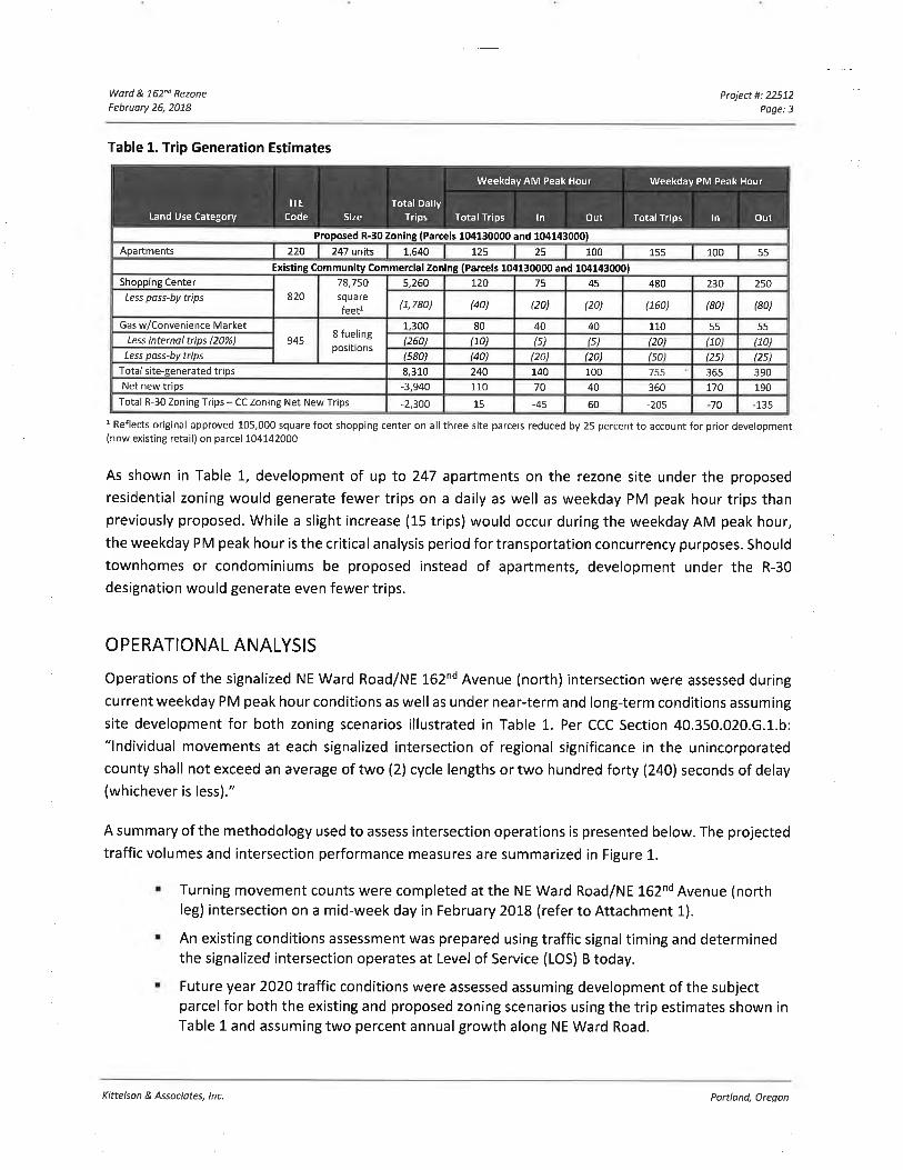
TRI P G EN ERATION COM PARISON
Daily, weekday AM and PM peak hour trip generation estimates for reasonable "worst case" site
development for the two parcels proposed for rezoning were prepared assuming both the existing CC
and proposed R-30 zoning. This comparison is shown in Table 1 (daily trips rounded to the nearest 10,
peak hour to the nearest 5) and excludes the existing developed commercial area (parcel 104142000).
The trip generation estimates for the CC zoning were obtained from the 2004 TIA prepared for the site
and the shopping center trip generation was reduced by 25 percent to reflect the existing constructed
commercial area on parcel 1O4I42OOO.
Per Table 40.220.020-2 of the Clark County Unified Development Code, Title 40, R-30 zoning allows formultifamily uses with a density of 18 - 30 dwelling units per acre. As such, the 8.26-acre parcel could
yield up To 247 housing units. Per Table 40.220.02O-'J., apartments, condominiums or townhouses would
be permissible the proposed R-30 zoning. Of these uses, apartments represent the "worse case" scenario
for trip generation. As such, trip estimates for apartments were calculated using trip rates from Trip
Generotion, gth Edition as published by the lnstitute of Transportation Engineers3. This is shown in Table
1..
3 Fortrip est¡mation purposes, condominiums and townhomes have a lowertrip rate per unit compared to apartments
so apartments were assumed in this analysis.
Kittelson & Associotes, lnc. Portland, Oregon
Wørd & 762nd Rezone
Februory 26,2018Project #: 22512
Poge:3
Proposed R-30 Zoning (Parcels 104130000 and 1041430001
Apartments 220 247 units L,640 rzs 25 100 155 100 55
Ex¡sting Community Commercial Zon¡ng (Parcels 1041300æ and 1041430001Shopping Center 5,260 720 75 45 480 230 250
Less poss-by trips 82078,750squarefeetl
(1,780) (40) (20) (20) (160) (80) (80)
Gas w/Convenience Market 1,300 80 40 40 110 55 55Less internal trips (20%) (260) H0) (s) ß) 120) 170) t70)
Less poss-bv trips
9458 fuelingpos¡tions
(s80) (40) (20) (20) (s0) (25) 125)
Total s¡te-senerated tr¡os 8.310 240 I40 100 755 36s 390Net new trips -3,940 110 70 40 360 170 190
Total R-30 Zonlng Trips - CC Zoning Net New Tr¡ps -2,300 15 -45 60 -205 70 -135
Total Da¡lyTrips
Weekday AM Peak Hour Weekday PM Peak Hour
Land Use CategorytïE
Code Size OutTotal Trips ln Out Total Tr¡ps ln
Table 1. Trip Generation Estimates
1 Reflects original approved 105,000 square foot shopping center on all three site parcels reduced by 25 percent to account for prior development(now existing retail) on parcel 104142000
As shown in Table L, development of up to 247 apartments on the rezone site under the proposed
res¡dential zoning would generate fewer trips on a daily as well as weekday PM peak hour trips thanpreviously proposed. While a slight increase (15 trips) would occur during the weekday AM peak hour,
the weekday PM peak hour is the critical analysis period for transportation concurrency purposes. Should
townhomes or condominiums be proposed instead of apartments, development under the R-30
designation would generate even fewer trips.
OPERATIONAL ANALYSIS
Operations of the signalized NE Ward Road/NE l-62nd Avenue (north) intersection were assessed duringcurrent weekday PM peak hour conditions as well as under near-term and long-term conditions assuming
site development for both zoning scenarios illustrated in Table L. Per CCC Section 40.350.020.G.1.b:
"lndividual movements at each signalized intersection of regional significance in the unincorporatedcounty shall not exceed an average of two (2) cycle lengths or two hundred forty (240) seconds of delay(whichever is less)."
A summary of the methodology used to assess intersection operations is presented below. The projected
traffic volumes and intersection performance measures are summarized in Figure 1-.
r Turning movement counts were completed at the NE Ward Road/NE 162nd Avenue (northleg) intersection on a mid-week day in February 2018 (refer to Attachment 1).
I An existing cond¡tions assessment was prepared using traffic signal timing and determinedthe signalized intersection operates at Level of Service (LOS) B today.
r Future year 2020 traffic conditions were assessed assuming development of the subjectparcel for both the existing and proposed zoning scenarios using the trip estimates shown inTable 1 and assuming two percent annual growth along NE Ward Road.
Kittelson & Associates, lnc. Portland, Oregon
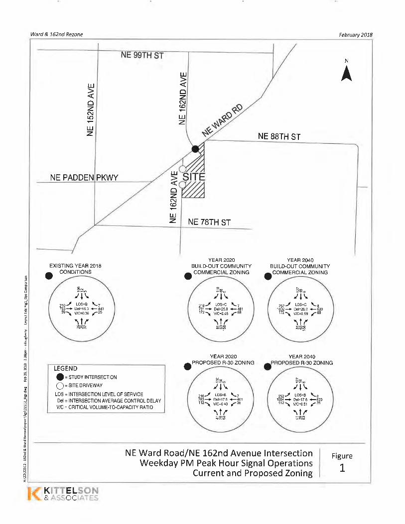
Ward & 162nd Rezone February 2018
.9
E
oI
ts
t
E
e
ì.g
I
Ë
E
3
I
N
AIJJ
ozNt¡.)
I,IJz NE BSTH ST
NE PADDEN
NE TBTH ST
EXISTING YEAR 2018YEAR 2O2O
BUILD-OUT COMMUNITYYEAB 2O4O
BUILD.OUT COMMUNITY
o CONDITIONS o COMMERCIAL ZONING oCOMMERCIAL ZONING
YEAR 2O2O
PROPOSED R-30 ZONINGYEAR 2O4O
o R-30 ZONINGLEGEND
f = SrUov INTERSECTION
Q = Sre DRIVEWAY
LOS = INTERSECTION LEVEL OF SERVICEDel = INTERSECTION AVERAGE CONTROL DELAY
V/C = CRITICAL VOLUME-TO-CAPACITY RATIO
NE Ward Road/NE 162nd Avenue lntersectionWeekday PM Peak Hour Signal Operations
Current and Proposed Zoning
Figure
L
PKWY
uJ
ozc\(O
I.JJz
IU
oz.c\(o
I.JJz.
8-/l\
-.¡r l-os=e
\1/\7+443a25
21075359
+ Det=16.3
\ V/c=0.36
-s6/l\216-l los=c \7731+ Pe¡=25.9 ¡46',1721 vlc=o.na ¡68
\1¡çO€@@o
ñ-/l\
-.¡r t-os=c+ Del=28,3
\ V/c=0.58
\1/
\8+620a68
1002172
/l\216-l t-os=a \7783+ Del=17.5 +4611121 vlc=o.lo ¡35
\1/-@ó
F:-/+\LOS=B \
Del=17.8 +vtc=0.51 f\1/
I620
zszJ1054+1121
KTKT-T,!åru
Ward & 762nd Rezone
Februory 26,2078Project #: 22572
Poge:5
' Site-generated commercial trips were assigned to the access based on the tripdistribution pattern in the 2004 TlA.
' Site-generated residential trips were assigned to the access based on turningmovement patterns on the north approach of the signalized intersection as this legprovides access to several existing residential neighborhoods today.
' The 2020 analysis found:
' Signalized intersection operations are projected to be acceptable under eitherzoning scenario (LOS C or better).
' Signalized intersection operations experience less delay under the proposedresidential zoning due to the fewer number of trips generated by the site.
' Future year 2O4O traffic conditions were assessed assuming development of the site forboth the existing and proposed zoning scenarios using the trip estimates shown in Table L
and assuming two percent annual growth along NE Ward Road.
. The 2040 analysis found:
' Signalized intersection operations are projected to be acceptable under eitherzoning scenario (LOS C or better).
' Signalized intersection operations experience less delay under the proposedresidential zoning due to the fewer number of trips generated by the site.
Attachment #2 includes the capacity analysis worksheets which are predicated in part on existing trafficsignal timing data provided by the Clark County Department of Public Works.
CONCLUSIONS
Based on the analysis presented in this letter, we conclude that the local transportation system is
sufficient to accommodate site development under either the existing or proposed zoning designation.
Reasonable worst-case site development under the proposed residential zoning would generate fewertrips on a daily as well as weekday PM peak hour basis compared to development under the existing
commercial zoning. While further analysis may be required for a formal transportation concurrencyreview in conjunction with site plan application, the analysis presented in this report documents that theproposed rezone would not warrant additional transportation system mitigations.
Please contact us at 503-228-5230 if you need additional information or if you have questions
Sincerely,KITTELSON & ASSOCIATES, INC.
eM..- aL_Chris Brehmer, P.E.
Senior Principal Engineer
Cc: Joseph Schaefer, Jordan Ramis5[ß.l.l{ô
3t5'l
K¡ttelson & Associates, lnc.
,.'2çr'&Portlond, Oregon

Appendix 1 Traffic Cou nt Data
LOGATION: NE 162nd Ave - NE Ward RdCITY/STATE: Vancouver, WA
QC JOB #: 14623901DATE: Tue. Feb 13 2018
23 242Ir0612 5
.r+\
Peak-Hour: 4:55 PM - 5:55 PMPeak l5-Min: 5:15 PM - 5:30 PM
__l L _l'1.6 0.8tt1.9 0.0 0.0
.rtrr Lstaa xot
--^ a 0.94
I tj¿zsJ ¿¿s
€ zsÒ atI't.c
j t.o t
z.q )
z.o t o.o a-l/4. t o.ot r.s(itÞ- ,o\c/ c ^^+ ^^rr t iþ¿¿
oo o.o o.oIr rl0.0 0.0
rozzt sg a-l n29
t96
t It
25 57
t Quatity Counts111 i r,1 i'.1, r¡' i -li -.1 t,ir: ,i,
i '.r,t tli , iì', ::tiliirr,: rr,
--J.;L,l@l ,-lî[ll rl
l, ï "l_
_l 000.r.}r) L
tt @
tt
û Jl' ü o'l-l__l
€oIL
tlôÊ
001.-
__J++---ì
NA
¿| t+t t
+
1 @llr'NA
It
ttarunr. I {r * J 7=.t
,^t[:T-¡ l-r.J
-l
t aIroI
t* t'r¡
îNA
+-l5-M¡n Count
PeriodBeo¡nnino Al
NE 162nd Ave(Northbound)
NE t6znd Avê(Southbound)
NE Ward Rd(Eastbound)
NE Ward Rd(Westbound)
Total HourlyTotals
lôfr Thr" P¡dhf il Left Thru R¡dhf 1l I êff Thrr Ridh+ loft Thrrr F¡ ¡d hl lt4:00 PM4:05 PM4:10 PM4:15 PM4:20 PM4:25 PM4:30 PM4:35 PM4:40 PM4:45 PM4:50 PM
22443421
200
2J
'l
'l
221
01
24
6642625
Ã
5
0000n
U
000no
1
01
2001
1
1
0
01
U
1
01
01
1
00
7144
131211
1215
o
o
0000000000U
129
17171319
o
18IJ
Il5
4476535557724858497166
J
0521
1
0U
U
00000U
00
2J
021
4
0
41
51474035JÞ
38514422
31
001
1
002
o000000000t,
128150150
142150't't6136144147120
4:55 PM5:OO PM5:05 PM5:10 PMffi5:30 PM5:35 PM5:40 PM5:45 PM5.5n PM
235
41
2
334
000
541
31
02421
2II4¿
0000ô
1
02,|
o00012
1
000
201
0
10I
1210
0000
1719
575767
51
21
000
20 6118 5817 77't7 61
47À
3
0000
4I1
403640
U
0
00
1
1
1
61
3424293831
0022ô
0000n
145128153"t39K140'131
1571464?,,1
't661
166116641653K17131708172117204714
5:55 PM 0 0 60 o o 11 0 15 45 r 0 227 00 107 16935-Min
Left Thru R¡dhf tl I êft Thfl¡ F¡¡dhf Left Thru R¡ohf ll TôfâlAll Vehicles
Heavy TrucksPedestrians
BicyclesRailroad
Slooned Ruses
20 2A 52000
0001
120 0
00
116 0U
n 0
160 17224
00
960
00
U 0
ó¿
0544
4n
0
40
0
n 0
18442801
Comments:
Type of peak hour being reported: lntersection Peak Method for determining peak hour: Total Entering Volume
Report generated on 211512018 11:53 AM SOURCE: Quality Counts, LLC (http://www.qualitycounts.nel) 1-877-580-2212
Appendix 2 Capacity Analysis Worksheets
HCM Sign alized lntersection Capacity Analysis1:
22512 - 162nd & Ward RezoneYear 2018 Existing Conditions
{\EBREBT
j +ttWBR NBL
Ir\BT NBR SBL
I ¿SBR
Lane Configurations
Traffic Volume (vph)
Future Volume (vph)
ldeal Flow (vphpl)
Total Lost time (s)
Lane Util. Factor
Frt
Flt Protected
Satd. Flow (prot)
Flt Permitted
Satd. Flow (perm)
210
2101 900
6.1
1.00
1.00
0.95
1770
0.48
892
753
753
1 900
5,7
0.95
1.00
1.00
3539
1.00
3539
59
59
1 900
5.7
1.00
0.85
1.00
1 583
1.00
1 583
WBL
25
25
1 900
5.6
1.00
1,00
0.95
1770
0.35
650
443
443
1 900
5.8
0.95
1,00
1.00
3531
1.00
3531
7
7
1 900
¿1
25
25
I 900
6.7
1.00
1.00
0.97
1814
0.57
1 063
57
57
1 900
6.7'1.00
0.85
1.00
1 583
1.00
1 583
I5
5
1 900
6,7
1.00
1.00
0.95
1770
0.72
1 340
1r
12
12
1 900
6.7
1.00
0.87
1,00
1612
1.00
1612
29
29
1 900
106
106
1 900
Peak-hourfactor, PHF
Adj. Flow (vph)
RTOR Reduction (vph)
Lane Group Flow (vph)
0.94
63
19
44
0.94
471
1
477
0.94
31
0ô
0.94
223
0
223
0.94
801
0
801
0.94
ilJ
U
U
0.94
5
0
5
0.94
61
55
b
0.94
27
0
58
0,94
7
0il
0.94
27
0
27
0.94
13
103
¿ó
Turn Type
Protected Phases
Permitted Phases
Actuated Green, G (s)
Effective Green, g (s)
Actuaied g/C Ratio
Clearance Time (s)
Vehicle Extension (s)
custom custom
65136
104.7 93.9
104.7 93.9
0.70 0.63
5.7 5,6
2.0 2.0
custom
1
2
98.1
98,1
0.65
6.1
2.0
NA
613
110.4
110.4
0.74
NA
29Perm PermPermNA
INA
4
I13.9
13.9
0.09
6.7
2.0
I13.9
13.9
0.09
6.7
2.0
4
13.9
13.9
0.09
6.7
2.0
13,9
13.9
0.09
6.7
2.0
97.9
97.9
0.65
Lane Grp Cap (vph)
v/s Raiio Prot
v/s Ratio Perm
v/c Ratio
Uniform Delay, d1
Progression Factor
lncremental Delay, d2
Delay (s)
Level of Service
Approach Delay (s)
Approach LOS
lntersection Summary
698
c0.04
0.17
0.32
12.0
1.00
0.1
12,1
B
2604c0.23
0.31
6.8
1.00
0.0
6.8
7.9
A
1 165
0.02
0.01
0.04
7.0
1.00
0.0
7.0
A
464
U.UU
0,03
0.06
10.9
1.00
0.0
11.0
B
2304
0.14
0.21
10.5
1.00
0.0
10,5
B
10.5
B
c0.05
0.59
65.3
1,00
6,2
/ t.oE
66.7
E
0.00
0.04
62.0
1.00
0.0
62.0
E
0,00
0,04
62.0
1.00
0.0
62.0
E
149
0.01
0.16
62.7
1.00
0.2
62.8
E
62.8
E
98 146 124
HCM 2000 Control Delay
HCM 2000 Volume to Capacity ratio
Actuated Cycle Length (s)
lntersection Capacity Utilization
Analysis Period (min)
c Critical Lane Group
16.3
0.36
150.0
49.6Y0
15
HCM 2000 Level of Service
Sum of lost time (s)
ICU Level of Service
B
24.4
Kittelson and Associates, lnc.
02t23t2018Synchro 10 Report
Page 2
HCM Signalized lntersection Capacity Analysis4:
22512 - 162nd & Ward RezoneYear 2020 Total Traffic Apartment Zoning
j \ t +.a I t L I JMOvEMent EBL EBT EBR WBL WBT WBR NBL NBT NBR SBL SBT SBR
LaneConfigurations Ì ++ Í I +1, -1 | Ì 1'
112 35 461 7 41 26 63 5 14 110
112 35 461 7 41 26 63 5 14 110
1900 1900 1900 1900 1900 1900 1900 1900 1900 1900
5.7 5,6 5.8 6.7 6.7 6.7 6.7
1.00 1.00 0.95 1,00 1,00 1.00 1.00
0.85 1.00 1.00 1.00 0.85 1.00 0,871.00 0.95 1.00 0.97 1.00 0.95 1.00
1583 1770 3532 1B0B 1583 1770 1615
1.00 0.34 1.00 0.56 1.00 0.71 1.00
1583 630 3532 1036 1583 1323 1615
Traffic Volume (vph) 218 783
Future Volume (vph) 218 783
ldeal Flow (vphpl) 1900 1900
Total Lost time (s) 6,1 5.7
Lane Util. Factor 1.00 0.95Frt 1.00 1.00
Flt Protected 0,95 1.00
Satd. Flow (prot) 1770 3539
Flt Permitted 0.47 1.00
Satd. Flow loerm) 876 3539
Peak-hourfactor, PHF
Adj. Flow (vph)
RTOR Reduction (vph)
Lane Grouo Flow lvoh)
U0.94
¿J¿
0
232
0.94
833
0
833
0.94
119
31
88
0.94
15
105
27
0.94
490
1
496
0.94
37
0
37
94
7
n
0
0.94
28
0
72
0.94
44
0
U
0 94
67
60
7
0.940 94
5
0
5
17
U
il
Turn Type
Protected Phases
Permitted Phases
Actuated Green, G (s)
Effective Green, g (s)
Actuated g/C Ratio
Clearance Time (s)
Vehicle Extension (s)
NA custom custom
613 6 5
13 6
106.6 1 00.9 89,7
106.6 100,9 89,7
0.71 0.67 0.60
5.7 5.6
2.0 2,0
NA
4
PermPermNA
IPermcustom
96.5
96.5
0.64
NA
29I'¿
95.6
95.6
0.64
6.1
2.0
I15.9
15.9
0.1 1
6.7
2.0
I15.9
15.9
0.1 1
6.7
2.0
4
15.9
15,9
0.11
6.7
2.0
15.9
15.9
0.1 1
6.7
2,0
Lane Grp Cap (vph)
v/s Ratio Prot
v/s Ratio Perm
v/c Ratio
Uniform Delay, d1
Progression Factor
lncremental Delay, d2
Delay (s)
Level of Service
Approach Delay (s)
Approach LOS
Intersection Summary
671
c0.04
0.18
0,35
13.4
1.00
0.1
13.5
B
2515c0.24
1124
0.04
0.01
0.08
8.5
1.00
0.0
8.5
A
448
0.01
0,04
0.08
12,9
1.00
0.0
12.9
B
2272
0.14
0.22
11.1
1.00
0.0
11.1
B
11.2
B
109 167 140
c0.07
0.66
64.5
1.00
1 1.0
75.5
E
68.1
E
171
0.02
0.16
61,0
1.00
0.2
61 .1
E
61 .1
E
0.00
0.04
60.2
1.00
0,0
60.2
E
0.00
0.04
60.2
1.00
0.0
60.3
E
0.33
8,2
1.00
0.0
8,2
A9.3
A
HCM 2000 Control Delay
HCM 2000 Volume to Capacity ratio
Actuated Cycle Length (s)
lntersection Capacity Utilization
Analysis Period (min)
c Critical Lane Group
17.5
0.40
150.0
58,1%
15
HCM 2000 Level of Service
Sum of lost time (s)
ICU Level of Service
B
24.4
B
Kittelson and Associates, lnc.
0212312018
Synchro 10 Report
Page 2
HCM Signalized lntersection Capacity Analysis2.
22512 - 162nd & Ward RezoneYear 2020 Total Traffic Commercial Zoning
Movement
\EBREBT
ìEBL
( \\ I t L I JWBL WBT WBR NBL NBT NBR SBL SBT SBR
Lane Configurations
Traffic Volume (vph)
Future Volume (vph)
ldeal Flow (vphpl)
Total Lost time (s)
Lane Util. Factor
Frt
Flt Protected
Satd. Flow (prot)
Flt Permitted
Satd. Flow (perm)
Ì218218
1 900
6.1
1.00
1.00
0.95
1770
0.47
876
++731
731
1 900
5,7
0.95
1,00
1.00
3539
1.00
3539
I172
172'1900
5.7
1.00
0.85
1.00
1 583
1.00
1 583
ì68
68
1 900
5.6
1.00
1.00
0.95
1770
0.36
665
+1'
461
461
1 900
5.8
0.95
1.00
1.00
3532
1.00
3532
7
7
1 900
-1
63
63
1 900
6.7
1.00
1.00
0.97
1812
0,61'1 138
I158
158
1 900
6,7
1.00
0.85
1.00
1 583
1.00
1 583
I5
5
1 900
6.7
1.00
1.00
0.95
1770
0.57
1 061
1r
46
4b
1 900
6.7
1.00
0.89
1.00
1 666
1.00
I 666
B1
81
1 900
110
110
1 900
Peak-hourfactor, PHF
Adj. Flow (vph)
RTOR Reduction (vph)
0.94
232
U
232
0.94
7780
778
0.94
183
69
114
0.94
49
54
112
0. 94
72
0
72
0.94
490
1
496
0.94
67
0
153
0.94
168
133
35
0.94
117
0
0
00 0.94
B6
0
0
94
7
0
U
94
5
0
5Lane G Flow
Turn Type
Proiected Phases
Permitted Phases
Actuated Green, G (s)
Effective Green, g (s)
Actuated g/C Ratio
Clearance Time (s)
Vehicle Extension (s)
customcustom NA
613custom
6
13
84.0
84.0
0.56
5.7
2.0
NA
29
82.7
82.7
0.55
Perm
I
NA
I
31,5
31.5
0.21
6.7
2.0
Perm
I31.5
31.5
0.21
6.7
2.0
Perm
4
31.5
31.5
0.21
6,7
2.0
NA
4
31,5
31.5
0.21
6,7
2.0
1
2
78.3
78.3
0.52
6.1
2.0
5
6
72.7
72.7
0.48
5.6
2.0
89.7
89.7
0.60
Lane Grp Cap (vph)
v/s Ratio Prot
v/s Ratio Perm
v/c Ratio
Uniform Delay, d1
Progression Factor
lncremental Delay, d2
Delay (s)
Level of Service
Approach Delay (s)
Approach LOS
lntersection Summarv
559
c0.05
c0.17
0.42
23.3
1.00
0.2
23.5
c
2116c0.22
0.37
15.5
1.00
0.0
15.6
B
17.1
B
946
0.05
0.02
0.12
15.6
1.00
0.0
15.6
B
401
0.01
0.07
0.18
22.3
1,00
0.1
22.4
c
1947
0.14
0.25
17.6
1.00
0.0
17,6
B
18.2
B
c0.1 3
0.64
54.1
1.00
4.4
58.5
E
53.0
D
0,02
0.11
47.9
1.00
0.1
47.g
D
0.00
0.02
47.0
1.00
0.0
47.0
D
349
0.07
0.32
54.2
1.00
0.2
50.4
D
50,3
D
238 332 222
HCM 2000 Control Delay
HCM 2000 Volume to Capacity ratio
Actuated Cycle Length (s)
lntersection Capacity Utilization
Analysis Period (min)
c Critical Lane Group
25,0
0.48
150.0
63,1%
15
HCM 2000 Level of Service
Sum of lost time (s)
ICU Level of Service
c
24.4
B
Kittelson and Associates, lnc.
0212312018
Synchro 10 Report
Page2
HCM Signalized lntersection Capacity Analysis5:
22512 - 162nd & Ward RezoneYear 2040 Total Traffic Apartment Zoning
Movement
¿SBR
IÌEBT
ìEBL
\t\EBR WBL WBT WBR
\NBL
I \NBT NBR SBL SBT
Lane Configurations
Traffic Volume (vph)
Future Volume (vph)
ldeal Flow (vphpl)
Total Lost time (s)
Lane Util. Factor
Frt
Flt Protected
Satd. Flow (prot)
Flt Permitted
Satd. Flow (perm)
Ì252252
1 900
6.1
1.00
1,00
0.95
1770
0.40
740
++
1 054
1 054
1 900
5.7
0.95
1.00
1.00
3539
1.00
3539
I112
112
1 900
5,7
1.00
0.85
1.00
1 583
1,00
I 583
I35
35
1 900
5.6
1.00
1.00
0.95
1770
0.25
473
+ß620
620
1 900
5,8
0.95
1.00
1.00
J3J¿
1.00
3532
-1
26
26
1900
6.7
1.00
1.00
0.97
1 808
0.49
909
I63
63
1 900
6.7
1.00
0.85
1.00
1 583
1.00
1 583
I6
6
1 900
6.7
1.00
1,00
0.95
1770
0.71
1323
1"
14
14
1 900
6,7
1.00
0,86
1,00
1611
1.00
1611
II
1 900
41
41
1 900
127
127
I 900
0.94
135
0
0
0.94
6
0
o
0.94
1121
0
1121
0.94
15
120
30
94
67
60
7
000 94
28
0
72
0.94
44
0
0
940
0
U
00.94
660
1
668
94
37
0
37
0.94
119
23
96
0.94
268
0
268
Peak-hourfactor, PHF
Adj. Flow (vph)
RTOR Reduction (vph)
Lane Group Flow (vph)
Turn Type
Protected Phases
Permitted Phases
Actuated Green, G (s)
Effective Green, g (s)
Actuated g/C Ratio
Clearance Time (s)
Vehicle Extension (s)
custom custom
6513 6
102,0 82.2
102.0 82.2
0.68 0.55
5.7 5.6
2.0 2.0
custom
1
2
90.1
90.1
0.60
6.1
2,0
NA
otJ
107,7
107,7
0.72
NA
29
93,9
93.9
0.63
NA
4
PermPermNA
8
Perm
I'16.5
16.5
0.11
6.7
2.0
B
16.5
16.5
0,11
6.7
2.0
4
16.5
16.5
0.11
6.7
2.0
16,5
16.5
0.11
6,7
2,0
Lane Grp Cap (vph)
v/s Ratio Prot
v/s Ratio Perm
v/c Ratio
Uniform Delay, d1
Progression Factor
lncremental Delay, d2
Delay (s)
Level of Service
Approach Delay (s)
Approach LOS
intersection Summary
588
c0.06
0.21
0.46
18,7
1.00
0,2
19.0
B
2541
c0.32
0.44
8.7
1.00
0.0
B.B
A
10.5
B
1 136
0.04
0.02
0.08
8.1
1.00
0.0
8.2
A
326
0.0'1
0,06
0.11
16.6
1.00
0.1
16.7
B
2211
0.1 I
0.30
12.9
1.00
0.0
13.0
B
13.2
B
c0.08
0.73
64.6
1.00
20.0
84.6
F
72.6
E
0.00
0.04
59.7
1,00
0.0
59.7
E
0.00
0.04
59.7
1.00
0.0
59.7
E
177
0.02
0.17
60.5
1.00
0.2
60.7
E
60,7
E
99 174 145
HCM 2000 Control Delay
HCM 2000 Volume to Capacity ratio
Actuated Cycle Length (s)
lntersection Capacity Utilization
Analysis Period (min)
c Critical Lane Group
17.8
0.51
150.0
66.6%
15
HCM 2000 Level of Service
Sum of lost time (s)
ICU Level of Service
B
24.4
Kittelson and Associates, lnc,
02t23t2018
Synchro 10 Report
Page2
HCM Signalized lntersection Capacity Analysis3:
22512 - 162nd & Ward RezoneYear 2040 Total Traffic Commercial Zoning
j \ t \a I t \ [ ¿EBL EBT EBR WBL WBT WBR NBL NBT NBR SBL SBT SBRMovement
Lane Configurations
Traffic Volume (vph)
Future Volume (vph)
ldeal Flow (vphpl)
Toial Lost time (s)
Lane Util. Factor
Frt
Flt Protected
Satd. Flow (prot)
Flt Permitted
Satd. Flow (oerm)
l++fÌ+Þ-1 il11'252252
1 900
6.1
1.00
1.00
0.95
1770
0.40
740
1002
1002
1900
5.7
0.95
1,00
1.00
3539
1.00
3539
172
1721 900
5.7
1.00
0.85
1,00
1 583
1.00
1 583
68
68
1 900
5.6
1.00
1.00
0.95
1770
0.27
500
620
6201 900
5.8
0.95
1.00
1.00
3532
1.00
3532
63
63
1 900
6.7
1.00
1,00
0.97
1812
0.61
1 135
158
158
1 900
6.7
1.00
0.85
1.00
1 583
1.00
I 583
o
6
1 900
6.7
1.00
1,00
0.95
1770
0.59
1107
46
46
1 900
6.7
1.00
0.89
1.00
1 658
1.00
1 658
II
1 900
B1
81
1 900
127
127
1 900
Peak-hourfactor, PHF
Adj. Flow (vph)
RTOR Reduction (vph)
Lane Grouo Flow lvoh)
0.94
268
0
268
0.94
1 066
U
1 066
0.94
183
55
128
0.94
168
126
42
0.94
49
58
126
94
B6
0
0
0.940
0
0
0.94
72
0
72
0.94
660
I668
0 0.94 0.94
6
0
6
67
0.94
135
0
0
0
153
Turn Type custom NA custom custom NA Perm NA Perm Perm NA
ProtectedPhases 1 613 6 5 29 B 4
PermittedPhases 2 13 6 8 8 4
Actuated Green, G (s) 65.1 83,6 77.9 56.6 73.1 37.7 37.7 37.7 37.7
Effective Green, g (s) 65.1 83.6 77.9 56.6 73.1 37.7 37.7 37.7 37.7
Actuated g/C Ratio 0.43 0.56 0.52 0.38 0.49 0.25 0.25 0.25 0.25Clearance Time (s) 6.1 5.7 5.6 6.7 6.7 6.7 6.7
Vehicle Extension (s) 2.0 2.0 2.0 2,0 2.0 2,0 2,0
Lane Grp Cap (vph) 462 1972 882 279 1721 285 397 278 416v/s Ratio Prot c0.08 c0,30 0.04 0.02 0.19 0.08v/s Ratio Perm 0.17 0.04 0.08 c0.13 0.03 0.01
v/c Ratio 0.58 0.54 0.15 0.26 0.39 0.54 0.11 0.02 0.30
Uniform Delay, d1 36.8 21.0 18.7 34.0 24.3 48.6 43.2 42.3 45.5
Progression Factor 1.00 1.00 1.00 1,00 1.00 1.00 1.00 1.00 1.00
lncrementalDelay, d2 1.2 0.2 0.0 0.2 0,1 1.0 0.0 0.0 0.1
Delay (s) 38.0 21.2 1B.B 34.2 24.4 49.6 43.2 42.3 45.6
LevelofService D C B C C D D D D
Approach Delay (s) 233 25.3 46.3 45.5ApproachLOS C C D D
lntersection Summary
HCM 2000 Conkol Delay
HCM 2000 Volume to Capacity ratio
Actuated Cycle Length (s)
lntersection Capacity Utilization
Analysis Period (min)
c Critical Lane Group
28.3
0.58
150.0
70.5%
15
HCM 2000 Level of Service
Sum of lost time (s)
ICU Level of Service
c
24,4
0212312018
Kittelson and Associates, lnc
Synchro 10 Report
Page 2
Our office represents Ward l62nd, LLC and GC Capital,LLC which are affiliated with GramorDevelopmertt, a leading developer of neighborhood commercial projects. They owns APN104130000 (2.85 acres) and APN 104143000 (5.41 acres) near the intersection of l62nd Ave andNE Ward Rd, which are currently zoned Community Commercial. This property has remainedvacant despite many attempts to develop them in accordance with the current zone.
This area is near the 57-aqe Germann UGA expansion which occurred in2004. At that time, e-
coÍrmerce was relatively new, and planners presumed the acreage required for neighborhoodretail uses would be consistent with past experience. In the interim, bricks and mortar shoppinghas declined, and the demand for new retail space has fallen off accordingly. Many retailproperties - both developed and undeveloped - are suffering in this market and it is appropriateto adjust the land supply to this accelerating trend.
The property owners have been unable to attract interest, and their marketing efforts revealcommon themes about why the site is not suitable for that use. First, the property lacks goodvisibility due to the skewed angle of the intersection of 162"d Ave and NE V/ard Rd. The effectof the unusual intersection is that the available building sites are more difficult to see fromvehicles passing through the intersection, and travelers on NE Ward Rd are unable to see the NEI62nd Ave portion of the property, and vice versa. The poor visibility is a constraint that manypotential users raise, and it is not feasible to improve visibility by making alterations to theintersection alignment.
A second site constraint is the location at the far edge of the urban growth area, which limits themarket area for retail and also discourages destination commercial uses, such as a medicaloffice. fn sum, the site is not sufficiently convenient to most Clark County residents. There is alarge commercial node nearby on 162"d and Fourth Plain Blvd.
While not successful for commercial development, the parcel has many attractive features formultifamily development. It can serve as a soft buffer between the primary streets and thecommercial uses to the west and north and the single family residential neighborhoods to thesouth and east. There is a dearth of multifamily housing in this area of the county. There is oneR-12 property approximately a quarter mile to the northeast, and in other directions it is muchfurther to the nearest multifamily property. Due to the increasing population and a minimum ofchoices in this northeast portion of the UGA, we are confident there is a need for higher densityhousing, such as apartments and townhouses.
The frontage on NE V/ard Rd and NE 162nd Ave creates an opportunity for a UH - Urban HighDensity Residential designation, with R-30 zoning. Torvnhouses fill the need for starter homesand for home buyers who prefer to forgo the yard work and share common maintenance andapartments could provide additional affordable housing. This is a prime location for that sector.
The owners have a great deal of experience in developing small commercial projects throughoutthe metropolitan area, and site and market factors demonstrate that this site is not viable forcommercial use. We therefore request a comprehensive plan and zoningmap change to UH andR-30 in the Annual Review process. This area of the county can benefit from town houses, and
benefit from town houses, and the site can serve as an appropriate buffer between the
commercial use at the intersection and the single family uses to the east and south.
The request complies with the applicable policies and criteria as follows.
I. The proponent shall demonstrate that the proposed amendment is consistent with the GrowthManagement Act and requirements, the countywide planning policies, the CommunityFramework Plan, the Comprehensive Plan, applicable city comprehensive plans, applicablecapital facilities plans and fficial population growthforecasts; and
The GMA requires this annual review process be available for suggested plan amendments, as
described in RCW 36.70A.410(2), consistent with the procedures in RCW 36.70A.130. Theproposed urban zoning is consistent with the GMA requirement for development within the
UGA. This proposal requests infill housing, consistent with Countywide Planning Policies 2.1.6
and2.l.7.
The Community Framework Plan requires that the Vancouver UGA have a full range of uses and
public facilities. This parcel has all necessary public services available, and is adjacent to the
commercial property at the intersection, consistent with this plan.
The Land Use Element of the Comprehensive Plan also promotes infill; as does the Vancouver
UGA (Land Use Element Policy 1.3). The necessary capital facilities are all in place, With the
2.85 acre parcel size, approximately fifty new townhouse lots or apartment units can be created,
so the future additional population is within existing population forecasts.
2. The proponent shall demonstrate that the designation is in conformance with the appropriatelocational criteria identified in the plan; and
The Land Use Element of the Comprehensive Plan describes the UH designation as "the highest
density housing in the urban area with [up to] 43 units per gross acre." The R-30 zone is the
least dense of the two residential zones consistent with this designation (Table 1.6), and is
consistent with this policy.
3. The map amendment or site is suitable for the proposed designation qnd there is a løck ofappropriately designated alternative sites within the vicinity; and
The development of the adjacent arterials and the adjacent commercial property are keylocational factors which make this site suitable. There is a dearth of multifamily housing in this
area of the county. There is one R-12 property approximately a quarter mile to the northeast, and
in other directions it is much further to the nearest multifamily property. Due to the increasingpopulation and a minimum of housing choices in this northeast portion of the UGA, we are
confident there is a need for higher density housing, such as townhouses or apartments.
4. The plan map amendment either: (a) responds to a substantial change in conditionsapplicable to the area within which the subject property l¡es; (b) better implements applicablecomprehensive plan policies than the current møp designation; or (c) coruects an obviousmapping error; and
This amendment responds to a substantial change in conditions, which is the lack of marketdemand for the small scale commercial uses previously planned for this parcel. Therefore,instead of the land lying vacarú, it should be developed with infill housing to complete the buildout of this area.
The reduced demand for retail space is a growing trend that results from the rise of ecommerce.This trend was just beginning when the site was designated for Community Commercialfollowing the2004 UGA expansion. As noted by the US Census Bureau, in 2005 ecommercewas only 8% of retail sales. By 2016, it was up to 12.9o/o, a 6IYo increase in just I I years. Thisis an international trend, and its effects are being felt in Clark County as well.
Included with the application is a chart of that census data and several articles from leadingbusiness publications describing this trend. The April 6,2017 Credit Suisse research report,Domestic Retail Store Closings at Record Pace,remarked that *2017 total square footagereductions could meet 147 million square feet." Credit Suisse projected 8,640 retail storeclosures for 2017, and that online clothing sales will rise from the currently 17% to 35% of allclothing sales by 2030.
The May 31,2017 FORTI-INE article, Major l4/all Street Firm Expects 25oÁ of U.S. Malls toClose by 2022, summarizes the Credit Suisse research and remarks that "there is no doubt thereis too much retail space in the U.S. and that a contraction has long been coming."
The October 26,2017 FORTUNE article, A Record Amount of Brick and Mortar Stores WillClose in 2017, concludes that 2017 "is going to go down as the worst year on record for brickand mortar retaill' and "online shopping and fast fashion have made inroads nearly everywhere inthe sector."
The November 24,2017 Boston Globe article, This year høs seen the most retqil store closingssince 2000, notes fhat2017 store closings were more than triple the total for 2016. On October25,2017 CNN reported that 2017 had already set the record for most store closings, with morethan two months remaining in the year.
This industry literature is substantial and uncontroverted evidence that the demand for brick andmortar retail stores is declining sharply. This is a dramatic change in conditions since 2004 thatis applicable to Clark County, and compels rezoning of this vacant land.
5. Were applicable, the proponent shall demonstrate that the full range of urbøn publíc
facilities and services can be adequately provided in an efficient and timely manner to serve theproposed designation. Such services may include water, sewage, storm drainage, transportation,
fire protection and schools. Adequacy of services applies only to the speciJìc change site.
There are existing public water, sewer, transportation, fire protection and school servicesavailable in this urbanized area. Private stormwater systems can serve the townhouses.
Zone changes may be approved only when all of the þllowing are met
L Requested zone change is consistent with the comprehensive plan map designation,
The requested R-30 zone is consistent with the UH designation, as shown on Table 1.6.
2. The requested zone change is consistent with plan policies, locational criteria, and the
purpose statement of the zoning district.
The Land Use Element of the Comprehensive Plan describes the UH designation asoothe highest
density housing in the urban area with [up to] 43 units per gross acre." The R-30 zone is
consistent with this policy.
The locational criteria for the R-30 district are: "Proximity to major streets and the available
capacity of these streets, adequacy of public water and sewer, vehicular and pedestrian trafficcirculation in the area, proximity to commercial services and proximity to public open space and
recreation opportunities." (Section 40.220.020.A.1.b) The parcel is adjacent to both NE Ward
Rd, an Urban Principal Arterial; and NE l62nd Ave, an Urban Arterial. These streets extend to
the nearby edge of the UGA and have surplus capacity. Public water and sewer are available inthese rights-of-way. Commercial services are adjacent right at the intersection. Public open
space and recreation opportunities are available to the north at the Hockinson Meadows
Community Park.
The purpose of the R-30 district is o'to provide for medium and higher density residential
development based upon consistency with the comprehensive plan and compatibility withsurrounding land uses." (Section 40.220.020.4.1) This zone change is consistent with thispurpose because it will facilitate townhouses or apartments and the full range of services and
facilities are present.
3. The zone change either.
. Responds to a substantial change in conditions øpplicable to the area within which fhe subject
property lies;or
This zone change responds to a substantial change in conditions, which is the lack of market
demand for the small scale commercial uses previously planned for these parcels. Therefore,
instead of the land lying vacant, it should be developed with infill housing to complete the buildout of this area.
. Better implements applicable comprehensive plan policies than the current map designation;
or
Not applicable.
4. There are adequate publicfacilities and services to serve the requested zone change.
There are existing public water, sewer, transportation, fire protection and school services
available in this urbanized area. A private stormwater system can serve the parcel.

The request satisfies the applicable policies and criteria for an annual review comprehensive planmap and zone change. Thank you for your consideration.
Lisa McKee
From:Sent:To:Cc:
Subject:Attachments:
joseph Schaefer
Tuesday, January 2,2018 3:58 PM
' lau rie.lebowsky@ clark.wa.gov'
Jamie HowsleyWard Annual Review - Traffic lssue
Transportation I m pact Analysis August 2004-reduced. pdf
Laurie
Thanks for speaking with me today on the county's request for a traffic study on the effect of the requested zone change
from Community Commercial to R30. Because these two parcels and the frontage streets were designed and built in
accordance with a prior land use approval to serve commercial uses that generate much more traffic than R30, the
streets have surplus capacity for residential development.
These properties were approved for retail in case file CUP2004-00007, and the street frontages were designed and built
to accommodate site traffic. The proposed R-30 zoning has lower trip generation than the approved retail uses, as
follows. Table 4 of the traffic study (attached) detailed the trip generation for 105,000 sf of traditional retail, plus a
gasoline station with a convenience store. Only about 27,420 sf of retail has been constructed, just over 26% of theplanned total. Neither the gasoline stat¡on nor its convenience store were built. Table 4 shows the retail trip generation
(as distinguished from the gas station and convenience store) as 70L0 daily trips, with 2380 pass-by trips, leaving a net of
4630 new daily trips. For the pm peak hour, the reta¡l generated 645 trips, of which 220 were pass-by, for a net of 425
new trips. Because only 26% of the reta¡l space was constructed, only 1203 of the daily trips and 110 of the pm peak
hour trips have been consumed. The remaining3427 daily retail trips plus the 460 new daily trips for the gas station
equals 3887 available new daily trips. For the pm peak hour, the remaining 3L5 retail trips plus the 40 for the gas station
equals 355 available new pm peak hour trips.
For comparison with the new zoning, R-30 allows a variety of multifamily housing types. Apartments (lTE Land Use Code
220) generate 6.65 daily trips per unit, and .62 pm peak hour trips per unit. W¡th 8.26 gross acres, and assuming a
maximum density of 30 units per acre, that yields 247 apartments. The corresponding trip generation is t642 daily trips,
and 153 pm peak hour trips, well below the vested numbers of 3887 and 355. Another housing type is condominiums or
townhouses. The trip generation for these (lTE Land Use Code 230) is 5.8L daily trips per unit, and .52 pm peak hour
trips per unit. With the maximu m 247 dwellings, the result is L435 daily trips, and 128 pm peak hour trips. These
numbers are even further below the vested numbers of 3887 and 355. Regardless of the housing type selected, the R-30
designation will generate less than half of the traffic than completing the buildout under the current zoning.
Because the R-30 trip generation is less than half of what the frontage and access points were built for, this annual
review change will not adversely affect future traffic conditions. We therefore ask the county to accept this ITE data as
sufficient to demonstrate that adequate public facilities are available, and will be in the future, without the need for a
costly, special study to analyze the stra¡ghtforward data.
please give this some consideration, and we look forward to working with you on a practical solution that minimizes the
cost ofthe proposed housing. Thanks.
JOSEPH SCHAEFER Land Use Planner
Jordan Ramis PC I Attorneys at Law
Direct: 503 598-5584 Main: 503 598-7070Cell: 503 819-4764
1

A Record Amount of Brick-and-Mortar Stores Will Shut in 2017 | Fortune
t0RTuilE
A Record Amount of Brick and Mortar Stores W¡ll Close in2017
By KESHIA HANNAM October 26,20L7
This year is going to go down as the worst year on record for brick-and-mortar retail.
Retailers have announced plans to shutter more than 6,700 stores across the U.S. thisyear, CNN cited retail think-tank Fung Global Retail & Technology as saying. Thatbeats the previous all-time high of 6,163 store closings that occurred during the 2008
financial meltdown (according to estimates by Credit Suisse).
The trend gathered pace again Wednesday as Walgreens' (WBA, -0.17y") revealed itintends to close about 600 locations. The drug store chain recently struck a deal toacquire 1,932 Rite Aid (RAD, +2.24"t") stores and as a result, those Rite Aid locationsnearest to already-existing stores have become redundant.
Online shopping and fast fashion have made inroads nearly everywhere in the sector.
The Wall Street lournal reported Nike (NIKE) as telling investors Wednesday that itexpects more of its sales to move online, saying that "undifferentiated, mediocreretail won't survive. Department store Nordstrom (JWN, +1"65%), meanwhile, said
earlier this week it expected half of its sales to be online within five years. And whiledepartment stores have been especially hard hit (Sears and Kmart being primeexamples), the trend has also hit more specialized retailers from The Limited to Gap
and Foot Locker.
Analysts have approached the end of 20L7 with a bleak outlook, expecting the year's
final total of store closures to be woefully high. Back in April, Credit Suisse releaseda report proiecting figures as high as 8,600 store closures by the year's end. That'saround 147 million square feet of retail space.
More than 500 retailers had filed for bankruptcy as of fune this year, according todata from BankruptcyData. com.
1t17t2018
http://fortune.coml2O17llOl26la-record-amount-of-brick-and-mortar-stores-will-close-in-2017/ 1t2
1t17t2018 A Record Amount of Brick-and-Mortar Stores Will Shut in 2017 | Fortune
http://fortune.coml2017l1Ol26la-record-amount-of-brick-and-mortar-stores-will-close-in-20'17/ 212
1/17t2018 Credit Suisse Expects Up to 25% of U.S. Malls to Close by 2022 | Fortune
TORÏU1{E
Maior Wall Street Firm Expects2s% of U.S. Malls to Close by 2022
By PHIL WAHBA May 31, 2017
The current rash of bankruptcies and stores closings as well as the rise of e-
commerce and discount chains means that as many as 25%" of U.S. malls will close by
2022, Credit Suisse predicted in a new research note issued this week.
That translates to some 275 shopping centers in the next flve years. Since the start ofthe year, the drumbeat of store closing announcements and bankruptcies has seemed
unending. On Wednesday, Michael Kors (K0RS, +1.74%) said it would close as many as
125 of its stores.
Other mall-based retailers to have announced store shutterings this year include
department stores J.C. Penney (JCP, +1.81%), Sears (SH[-D, -0,857.) and Macy's ([/1,
+1.47oto), as well as the likes of Abercrombie & Fitch. (ANF, +û.75?").
The department stores most exposed to malls' problems are Penney and Macy's,
which have 1.2% and ll% respectively at weak malls, according to U.S.-based analysts
at Credit Suisse, while Nordstrom (.,lWN, +1.47"aj and Macy's upscale sister chain
Bloomindale's have far less exposure
Indeed, the expected rash of closings is much more likely to hit low end malls than
high end ones, or at least those that are well maintained. Simon Property Group
(SPG, +1.15%i and General Growth Properties (GGB +0.39%), the two largest mall
developers who years ago shed their weakest properties, are at 96%o+þlus occupancy.
And Bloomberg Intelligence analyst feffrey Langbaum said in a note on Wednesday
that the department store closings are an opportunity "to replace weak department
stores with stronger, higher paying tenants."
http ://fortune. c om I 201 7 I 05131/mal ls-retail-stores-closin g/ 1t2
111712018 Credit Suisse Expects Up lo 25o/o of U.S. Malls to Close by 2022 | Fortune
Still, there is no doubt there is too much retail space in the U.S. and that a
contraction has long been coming: there are 2,353 square feet of space of shopping
centers in the U.S. for every 100 Americans, compared with 1,636 in Canada and 458
in Britain, according to recent data from CoStar Realty Information.
What's more, the fastest growing retailers, like Ulta Beauty (ULTA, +0.78%), TJX Cos'
(TAX, -0.43%) T.J. Maxx and The Home Depot are primarily away from malls, meaning
the developers will have to find other avenues of growth than retail.
Source: Credit Suisse
Credit Suisse proiects about 8,640 U.S. stores across retail will close by the end of
year, a far greater number than any year in memory, and worse than at the height of
the 2008-09 financial crisis. What's more, physical stores will likely face new
pressure from e-commerce, which Credit Suisse expects will rise ta 35% of clothing
sales by 2030 from 1.7% now.
http://fortune. c oml 2017 I O5l3 1/mal ls-retail-stores-closing/ 2t2
1117t2018 This year has seen the most retail store closings since 2000 - The Boston Globe
:w'lr
Metro
This year has seen the most retail store
closings since 2000
The closings arent no-narne stores, but are ratlrer a whoos who of once-dominant retail chains.
ByMatt Rocheleau
GLOBE STAFF NOVEMBER e4, 2oLT
If your local mall or shopping plazafeels a little emptier this Black Friday compared with a
year ago, it's not just because more people are shopping online. There are also simply fewer
brick-and-mortar retail stores.
So far in zot7, major retailers have closed or announced plans to shutter 6,879 stores
nationwide, according to figures released Friday by industry think tank Fung Global Retail &
Technology.
https://www.bostonglobe.com lmetrol2}17l11/24lstores-are.dropping-because-one-shopping-person/rVxStREADeRmKLucNg5VkO/story.html 1t2
111712018 This year has seen the most retail store closings since 2000 - The Boston Globe
That is the highest total since at least 2ooo, according to figures tracked by financial services
company Credit Suisse.
The previous record was the 6,t6g retail store closures in zooS during the Great Recession.
The closings aren't no-name stores, either, but are rather a who's who of once-dominant
retail chains, such as Radioshack, Payiess shoesource, sears, Kmart, JCPenney, and Macy's
The dire picture this year is dramatically different from just a year ago.
In zot6, only about 2,1oo retail closures were announced, and that figure was actually offset
by a higher number of store openings - about 2,goo.
But this year, the number of announced closings is already more than triple last year's total,
and those closings aren't being offset by openings or expansions from other brands. Only
about 3,4oo openings have been announced this year,less than half the total number ofclosures.
The list of retailers who opened new stores this year is dominated by a pair of discount-
specialty rivals: Dollar General and Dollar Tree.
But just because brick-and-mortar stores are closing doesn't mean US consumers have
stopped shopping and spending. Retail sales have actuaþ risen steadily since the depths of¡L^ -^^^^^:^-:- ^--:I ^-J ^-^ -^-.- ^& ^ -^^^-l L:-L r'a^-_^-_^ J^¡^ ^ì-^___
@ 2OL7 Boston Globe Media Partners, LLC
https://www.bostonglobe.com lmetrol2117t11/24lstores-are-dropping-because-one-shopping-person/rVxStREADeRmKLucNgsVkO/story.html 2t2
1117t2018 2017 just set the all-time record for store closings - Oct. 25, 2017
by Jackie Wattles @jackiewattlesOctober 25, 2O17: 5:2O PM ET
irrese re'railers filed fcr ÐankrljpTcy ij--ìís :veaì'
More store closings have been announced in2Ot7 than any other year on record
Since January 1, retailers have announced plans to shutter more than 6,700 stores in the U.S.,according to Fung Global Reta¡l & Technology, a retail think tank.
That beats the previous all-time high of 6,163 store closings, which hit in 2008 amid the financialmeltdown, according to Credit Suisse (CS).
2017 just set the all-time record for storeclosings
R"co¡¡rìend 5.6K N(iri
Pôì¡,ôf^d hw qtrrrr¡cêãr ^ñft
What Will Your 2OI7,."u Bill L.ookJ=i(e?
Walgreens helped vault this year's tally to a new highwhen it said Wednesday that it plans to close about 600locations.
Adw¡tisment
MortgaEe & Savings
Mortgage Personal Loans Crer
Loan Type Rate
3o-yrfixed 3.63%
1s-yrfixed 2,8a%
5/1ARM 2.5To
Loan Amount APR
s225.OOO lsl1' 3.7ø/"ARM)
s350.000 t5l1'- 3.72% (ARM)
Gel. Peisonalizeç Raies
? Ie¡ms&C¿. 1...)1' .'..,,.t'.,"1
ihe Motley FÕ01 pi
You Can Still Buy This "Million
Bitcoin Up 30,000X -- Here'sBackdoor ln
Motley Fool lssues Rare ïripleAlert
This Stock Could Be Like BuyAmazon for $3.19
0:00
RBffiaffi"y9ffEs fr1g8 dyÈ*ñr¡"ffglar Finance s*"rru#e[rlü?f k stocr ticre,s
JN Your 2017 incometaxes will be The drug store chain recently struck a deal to purchase
1,932 Rite Aid stores, and a Walgreens (WnR)spokesperson said most of the shuttered stores will be
SMARTASSET.COM
Rite A¡d locations within close proximity to existing stores.
Other chains that have announced big batches of store closings this year include Kmart, Sears,JCPenney, Ann Taylor, Gap, Banana Republic, Gymboree, Têavana, Michael Kors, Bebe,Perfumania, The Limited, and Staples.
http://money.cnn.coml2017l1012Slnews/economy/store'closings-2017/index.html 'lt4
1t17t20',t8 2Q17 jus't. set the all-time record for store closings - Ocf.25,2017
Related: 200 Gap and Banana Republ¡c stores closing
By and large, analysts expect this year's final total to be dismal. As many as 8,600 brick-and-mortar stores are expected to close this year, Credit Suisse said in an April research report.
lf that p@ection is correct, that means America will lose more than 147 million square feet ofretailspace.
At least 300 retailers have filed for bankruptcy so far this year, accord¡ng to figures released byBankruptcyData.com in June.
-CNNMoney's Chris lsidore contributed to th¡s report.
CNNMoney (New York)First published October 25, ?OI7'.5:2O PM ET
Pairi Conient Re¿orìneírded ût
More CNllMonelr video
Says About Yo
Retirement: F¡Fisher lrìr,estments
Porüand, OregBrilliant, NewCompany 1s...EverQuote
Save Big onMediterranearfor a Limited TYahoo! Search
You Should Ne
Shop on Ama;Without UsingHoney
Uber Exec: We
women at Ub€
Uber exec: Kalwas'desperat'wanted to hell
The Netherlancontinuous figagainst floods
Uber Exec Boz
Saint John: 'l fhustler'
ïhis App Applies Every Coupon onthe lnternet to Your Cart - and lt'sAwesomeHoney
lf You Own A Home ln Oregon YouCan Now Claim Your $4,264BenefitThe Better Finance
Portland, Oregon: This Brill¡antCompany ls Disrupting a $200Billion lndustrvEverQuote
Landline Companles Are VeryAngry People Know About ThisExpert Market
mæ
9 Reasons This ElectricToothbrush is Worth All The Hype.quip
The New Gold Rush is Green andSaavy lnvestors are Rushing toStake The¡r ClaimWallstreet News
Lendií1gTíêe
Pêid Cçnteni
Absolutely the Best Sheets You'll Ever Sleep inBusiness Insider
Something Mysterious is Happening in the DesertOutside Phoenix The Mottey Fool
Your $20 Bottle of Wine is Worth $3 r¡rsuear
ls it Ïme to RelÍe? Fisher tnvestments
More frcm ti\N Money
Apple CEO ïm Cook now takes private planes only
17 cool gadgets that tease the future
NFL cancels Sunday Night Football this week
Couple arrested after daughter dies in room she waslocked in for 15 years
R€commended by
,*,.i\ -
t**t
****
** *
t
* :'. -\* *
UtsEts
d
-/^.) \.1 I ,nÃ
http://money.cnn.coml20'l7l'10/25lnews/economy/store-closings-2017/index.html 2t4
Cneprr Su'rrJ^6 April 2017
Americas/United StatesEquity Research
Retailing
Retailin
Domestic Retail Store Closings At RecordPaceBarely a quarter inlo 2O17, year-to-date retail store closings have alreadysurpassed those of 2008. This suggests that the industry is beginning to adaptto the secular challenge of increasing online penetration and declining four-wall productivity of brick-and-mortar stores.
On a units basis, approximately 2,880 store closings were announced YTD,compared to 1,153 at this time in 2016. Historically, roughly 600/o of storeclosure announcements occur in the first five months of the year. Byextrapolating the year-te'date announcements, we estimate that there couldbe more than 8,640 store closings this year, which will be higher than thehistorical 2008 peak of approximately 6,200 store closings (data collectedsince 2000).
On a square footage basis, approximately 49M SF of retail space has closedYTD. Should this pace persist, 2017 lotal square footage reductions couldreach 147M square feet, surpassing the historical peak of 1 'l 5M in 2001 .
For a more detailed analysis on the need for structural change in the retailenvironment, see our most recent industry note: The Four Kevs for BroadlinesSurvival: Real Estate Reduction. eCommerce. Speed. Brands.
Figure 1: Retail Store Closings By Unit- Only Second To 2015 StoreGlosures YTD: Gould Be The New Hiqhest Closinqs For Full Year
Research Analysts
Christ¡an BuEs2'12 325 9667
christ¡[email protected]
Sara Shuler21232s7æ3
Pallavi Bakshi2125388/.3/.
pallavi.bakshi@crêdit-suisse.com
Ghristlne Lee212 538 8120
christine.lee@cred¡t-suisse.com
9,000
8,000
7,000
6,000
5,000
4,000
3,000
2,000
1,000
0
8,640
6,1 63
an
=çl
4,475
3,081 2,645 2,795'l,975 2,003 7QA
1,343
72,480
2,1401,766
5,077
3,0842,056
'00 '01 '02 '03 '04 '05 '06 '07 '08 '09 '10 '11 '12'13'14'15'16'17r Unit Closings (Full Year) øUnit Closings (YTD)
Source: Company datâ, N6ß artid€s, Crgdit Suisse ætimat€B
DISCLOSURE APPENDIX AT THE BACK OF THIS REPORT CONTAINS IMPORTANT DISCLOSURES, ANALYSTCERTIFICATIONS, LEGAL ENTITY DISCLOSURE AND THE STATUS OF NON-US ANALYSTS. US Disclosure: CreditSuisse does and seeks to do business with companies covered in its research reports. As a result, investors should be awarethat the Firm may have a conflict of interest that could affect the objectivity of this report. lnvestors should consider this reportas only a single factor in making their investment decision.
QUARTERLY
O
^\UREDIT5UISSE 6 April 2017
Figure 2: Retail Store Closings by Square Footage (mn) - 2017 GouldBe The New Peak With The Current Run Rate
43
73
3321
3l2627
5544
ø.õ 120
g loo
åroFuoË¿o8zo
160
140
0
147
rf5102
9082
6660
35 34
'00 '01 '02 '03 '04 '05 '06 '07 '08 '09 '10 '11 '12'13',14 '15'16 '17
I Square Footage Closed (Full Year) (mn's)
nSquare Footage Closed (YTD) (mn's) - compares with '17 to date
Sourcs: Company data, News arliclês, Credit Suisse æt¡matss
2Rotaillng
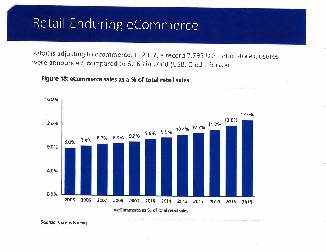
Retail Enduring eCommerce
Retail is adjusting to ecc¡mrnerce" In 2û17{ ð record 7,7g5 {."},S" retail stnne closureswtre ünnounced, cornpäred tn 6,1"63 in 2CI08 (u58, cnedüt Surisse).
Figure '18: ecommerce sales as a g6 of total retail sales
16^e%o
12.9%
1?..svâ13".AVq
10.4% 1A.V%11"2Vø
8.VaYû 8.gVî 9"2%g"6vs 9.9%
e^$Vo 8.4%
&.0%
4.ç%
A"0q/ø
2W5 2W6 28AV 20s8 2as9 2CI10 2011 a}l¿ 2ri|3 2Aß 2Aß 2.Aß
reeomnnerce as % of total retailsales
Source; eensus Bureau
-092 456-r 30 P
m68
-r 36 -ÎEo
66-1 72 ADJ 25
1-267
344136
346t40 ul
IFo(oulz
443104
438¡18
-096-05 5
-26 8-094 1rã 24-048
I l449
-098
9
6-269
20-276454
-l 26327102
50-t00
I I 453-124
722-o44
-270NE gOTH ST NE gOTH ST
a2
300-048
2'lIJ
ILt-Ú)
(o
uJz
1002
-042 12-28
299-046
6
2-004 O\S
20-040
31
1170
NE 89THr s3954
306060
298-Q44 19
038
10-284
1 297-042
SE 18-036
10,tzfn 17
-03 4 89540 r
90286020
5--01 0
'I 2 I 5401 3
295-03 I
-o32 a
\f
-0 r6 15030
16 l5 1
-507
1 2 27-55
¡ -01 -02 8
-s88 It6
1
21-600
-580 2-5
tU
a(o
lrJz
€r-0
18- 590
4/ôo4 I
0t812-024
-578 N11 1t5
ì 041 50 2t5104'l 601 5 06 100
-200l0
-02 0
-02220 22
-54423
-54724
- 549l9 -576-594 v<
fn
-l508
21-57422 21 542598
5-5',t 0 5 3/5,6
10416423 -572 19 TTA-202
8 618-53
u1104130
24 -570 -51 2 7-602 I -514
-5689
5t 17-534 SE 1/4
sEcïoN 01T2N, R2E, W.M.
-604 5
- s66 1s20
15 -53228 27 4 1t1
1 041 426r0 -608 -564 -562 14
13
12s26 3t1
29-612
30 2 3- 5604 522
3-0r6
a231
-556-6tw.M.
232-6'i
33 a 4/5,61
-8-620 l -0ì4 t 1t2
r 04t4l ì 04ì 65
15 43-86
$1
13 14 42-84
4-0r I
43--vb
\<:
,ò\
ù? ..tÞßSg1,Þ\$" ¿b*"
\0À\b '
9' 185.&49-98 46
-92-020
,|
002
7-01
6-0ì 13lu 156
-3t41qq
24 I
-0
158-3r8
3-b 5{)
-r 0041-82
941 5401 7
'i 6 159-320
NE 83RD ST$
37-74
I_U l8 -[0, 160-322
ul
IF*(o¡.!z
t5336
-7240-80
0
35-70
51102
1-6f'63 62
326l 1 119 143u
-68 25-50
39-78
96540 I 167
-336164-330
2 1,| 12 14'l
I 9 -28
26-5 2 't68
tia NE 82ND ST
23-46
17-34
ilr08
53'I 06 '169
-340
't39-2 80
28-56 I
III
173-348 1 1
773s6
179 TJJ
TFtf)(o
IUz
IIJ
I¡-(o(o
UJz
138-278
170-342
u
Eo(o
-3
22-44
21-42
20-40
19-38 l8
36 198 137
-27652r04
171-344 1 1
1 1t3tu
Ecc{(o
tilz136-274
l6-32
NE 81st ST \11,,|
1 53979 3-01 0
-tE' 1 1 tlq 'l 12 1
-00 5 s3 50- t00
-lBu 39-078
77-154
89-1 78
71142I
92-184
(stI -194
96192
9519O ,z
186-374
83r81-3
UN Quarter Section ParcelsAccount: 1 04143000, 104130000Owner: GC CAPITAL LLCAddress: PO BOX 25ÇlSlZ: BATTLE GROUND, WA 98604
Printed on: December 26,2017
zrì
33131
23106
23107
32136
zz)9tt'///l///L
22112
32135
2210?
22111
Geographic lnformation Systsm f]l] sunoivision Lines L-- --l Subject Property(s)
L-"flJ Oonation Land Claim Road Right of Way - Actual Road May not Exist
t-- --l Section Quarters - - - Transportation or Major Utility Easement
i.'.Ï citv Boundaries
0 150 300
--n Feet
lnfomal¡on shown on this map ws collecþd frcmseveþl soutæs. Cla* County acæpts no rcspons¡bililyfor êny ikaccuracios lhal may be prcsen| Developer's Packet: Page'16 of 16
ÀITORNÉVS ÂÌ LAW
ORDANRAMIS,,.
Lake Oswego
Two Centerpointe Dr., 6th Floor
Lake Oswego, OR 97035
503-598-7070
www.jordanramis.com
Vancouver
1 499 SE Tech Center Pl., #380
Vancouver, WA 98683
360-567-3900
Bend
360 SW Bond St., Suite 51 0
Bend, OR 97702
541 -550-7900
Re
Via E-MailSharon. [email protected]. gov
March 13,2018
Sharon LumbantobingClark County Planning1300 Franklin StreetPO Box 5000Vancouver WA 98666-5000
Gramor/Ward - Annual Review - Legal Lot AnalysisAPN 10413000 and APN 104143000
Dear Sharon:
Thank you for accepting the annual review application for the Ward Ave properties, which will changethe zoning to R-30 to accommodate the growing need for housing. This letter is to provide the legal lotdetermination, in order to explain how the underlying historic lots from the plat of Elaine Park, recordedin 1910, have evolved into the current parcel configuration.
The annual review properties, APNs 104130000 and 104143000, are part of a larger plannedcommercial development that also includes APN 104142000. Those three parcels comprise the wholeof Lot 1 and the northerly portion Lot 2 of Elaine Park. The current Community Commercial zoningdoes not have minimum lot size requirements, and therefore the prior boundary line adjustments did notneed to comply with a minimum size standard.
APN 104130000
The current configuration of APN 104130000 was established in the boundary line adjustment deedrecorded on October 28,2009 as document number 4614455 BLA. The adjustment was done tofacilitate development of APN 104142000 with Walgreens and other retailers. Prior to that time, thelegal description of APN 104130000 was as shown in Exhibit B to 4614455 BLA.
That configuration in turn was created in 2005, following site plan approval for the Walgreensdevelopment, when a Quit Claim Deed was recorded, as document 3996290 on June 1, 2006, forwidening of NE 162nd Ave and NE Ward Ave. That document is eight pages, with page 5 showing theNE 162nd Ave dedication and page I showing the NE Ward Ave dedication. More importantly, thosetwo pages utilize an older tax parcel map showing the prior configuration of the three parcels thatcomprised the site. Page 5 is attached, and labels the three parcels and the year of their creation.
400 59-00 40 5 29 3 5 496'/ \M B/
Ig"*PSIJ RAMlspc
Sharon LumbantobingMarch 13,2018Page 2
Parcel 1 was created at least by 1926, because it is a remainder parcelfrom the last deed included inthe chain. lt is also described in the attached deeds from 1968 (699015), 1970 (758660), 1980(8006270092) and 1 995 (9502030228).
Parcel 2 is first described in the attached deed from 1926 and also appears in a deed from 1995(9502030227). Parcel 3 is first described in the attached deed from 1995 (9502030228).
The three parcels existing on this prior tax map were correctly adjusted with the newer deeds, andno new parcels were created from them. The boundaries were adjusted on April 29,2005 by the deedsrecorded as 3980367 and 3980365, which changed the boundaries that were previously establishedfollowing the street dedication deed of May 26, 2000, recorded as number 3221772, for a strip alongNE Ward Ave.
These adjustments were exempt from county land use review under RCW 58.17.040(6), which confirmsthat land division regulations do not apply to: "[a] division made for the purpose of alteration byadjusting boundary lines, þetween platted or unplatted lots or both, which does not create anyadditional lot, tract, parcel, site, or division nor create any lot, tract, parcel, site, or division whichcontains insufficient area and dimension to meet minimum requirements for width and area for abuilding site."
Therefore, APN 104130000 is a lawfully established parcel.
APN 104143000
This parcel includes the southeast portion of Lot 1 of Elaine Park, and a portion of the northeasterlyarea of Lot 2, The current configuration of APN 104143000 was established in the boundary lineadjustment recorded on April 29, 2005 as document number 3980368, and the legal description of thisparcel after the adjustment begins on page 6 of that document. The adjustment was done to facilitatedevelopment of APN 104142000 with Walgreens and other retailers. Prior to that time, the legaldescription of APN 104143000 included portions of the three parcels shown on the attached historicparcel map, as described in the 1995 deeds, recorded as 9502030228 (most of the current APN104143000); and 9502030227 (a triangular area of the north portion of the current APN 104143000);and a 1980 deed recorded as 8006270092 (a triangular area at the northern tip of the current APN1 04143000).
Parcel 1 was created at least by 1926, because it is a remainder parcel from the last deed included inthe chain. lt is also described in the attached deeds from 1968 (699015), 1970 (758660), 1980(8006270092) and 1995 (9502030228). Parcel 2 is first described in the attached deed from 1926 andalso appears in a deed from 1995 (9502030227). Parcel 3 is first described in the attached deed from1995 (9502030228).
The three parcels existing on this prior tax map were correctly adjusted with the newer deeds, and nonew parcels were created from them. These adjustments were exempt from county land use reviewunder RCW 58.17.040(6), which confirms that land division regulations do not apply to: "[a] divisionmade for the purpose of alteration by adjusting boundary lines, between platted or unplatted lots orboth, which does not create any additional lot, tract, parcel, site, or division nor create any lot, tract,
40059-00405 2935496 1\MB/
Jg."*P+lJ RAMISpc
Sharon LumbantobingMarch 13,2018Page 3
parcel, site, or division which contains insufficient area and dimension to meet minimum requirementsfor width and area for a building site."
Therefore, APN 104143000 is a lawfully established parcel
Thank you for your courtesies for this annual review application, and let us know if there are anyquestions regarding these properties.
Very truly yours,
JORDAN RAMIS PC
D. Howsleyin Oregon and Washington
james. [email protected] Direct Dial(360) 567-3913
40059-00405 2935496 1\MB/
_]1
Sales filis'toryI 041 X 3 O000-corneatedl
I lark Cn'"tr]lfl*
GIS
@titew Search Clark County Property InforrnationAccount Summary
Page 1 of2
Web Ve.rsicrn fJr-**-tuprW
Property ldentification Number: 104130000 lutaosQdine &Property Type: RealProperty Status! Active Tax Status: Regularsite Address: 8715 NE WARD RD, vANcouvER, 98682 (situs Adcrresses)Abbreviated Legar Description: ELAINE PARK #2 lor r'z¡slõñr
Property OwnerWARD 162ND LLC
Owner Mailing AddressL9767 SW 72ND AVE STE lOO
USïIN OR ,97Q62
Property Location Address8715 NE WARD RD, VANCOUVER,98682Gooqle .Maps StteetJ¡rì,{
Administrative Data InFo,* Assessment Data2Ol7 Values for 2Ol8 Taxe6Market Value as of January 1,2077
2016 Values for 2tï17 TðxesMarket Value as of January 1,2016
$ J ,005, 300.00Totai
Taxable Value
Taxable Value
$946/150,00$0,00
$946,150,00
Land Value
Buildlng Value
Total Property
Land Vaiue
Building Value
Total Property
$1,005,300,00$0.00
$1f005f300.00
Zonlng Designation- Çg,cles
Zoning Overlay(s)ComprehensÌve Plan
Comp, Plan Overlay(s)
Census TractJurlsdlctionFire DistrictPark District
Urban Growth AreaC-Tran Benefit AreaSchool Impact Fee
TransportationImpact Fee
TransportationAnalysis ZoneWaste ConneclionsGarbage CollectionDay
Last StreetSweeping
CPU Lighting UtilityD¡strict
Monday
nitycc)
none
C
none
Orchards
s58
CommuCommercial (
School DistrictElementaryMiddle SchoolHigh School
Sewer DístrictWater DistrictNeighborhoodSection-Township-Range
n/a
0
No
No
Dlstrict 4
Dlstrict 4
Burning AllowedWildflre Danger AreaPubllc Health FoodInspector DistrictPublic Health WRAPInspector D¡strict
406.04Clark County
FD5Distr¡ct 5
HocklnsonHocl<inson
HeightsHocklnsohHockinson
VancouVer
Vancouver
Heritage
SE1/4,S01,T2N,R2E
image: *eÞEVancouver
Yes
Hockinson
Clad( Countv Road AtlãsApproximate Area l¡þ.*
Land Data
Sales H¡story
$0,00
$0,00
04/2s/200s
$560,000.00
Subdlvislon
Survey
Sale Date
Document TypeExclse NumberDocument NumberSale Amount
ro/ts/2OO9BLA
64448646L4455
$o,oo
Sale DateDocument Type
Excise NumberDocument NumberSale Amount
04/26/200sD-QCD
56s2t2
Sale Date
Document Type
Excise NumberDocument NumberSale Amount
Sale Date
Document Type
Excise NumberDocument NumberSale Amount
05/r0/2oo0DEED
464077
page 19
L24,L46sq. ft,
2,85 acresq.LArN!
PARI(
05_5084
DEED
565215
Totãl
GeneralRe-valuation CycleAssessor Nelghborhood
$946,150,00
95604
http://gis'clark.wa.gov/gishome/Property/?pid=ACCOUNT&account=104130000&print'Ve. I/10/2018
-036
-ì5880
-16089
1 5401 26-032
6i 2
l5-030
-02 B
-55427
Il3-026
N -02412
11-022
22*544 23
54724*549
1t51041 50
100-200
21-542
-s3819
l8-53
7-5r 4
17-534
1-532
-530l5
-52814
3-01 6
1r$s
2-0ì4
@
wseù
@
d\q'\
z1I 041 3o
\?)q'185-44
311 4n
{,üùIchUL
1t2ì04143
,ò\6u-
61
5-020
4-01 8
$rî,
156-31 4
155-3,|0I
158-3 r8
r59-320
o--ol8 -to, r60
-322
941 5401 7
1 53308 -3,¡0
54
166-324 19.ft,
1
i,
ef
- -----' ,!, ..¡.AES
2,!51 041 60
N5,6104165
/
/
4Í
I
III
I
I
I
I
I
I
I
I
""*"lr\0Ño'
I 1
[!ìTt-\+(o
t"u
1616263
NE 83RD ST
t5l 12
4896
I 540ì I 167- 1?6
164-? cn
32 3 -32 -3 t8 -2 144-29
143-28 -2
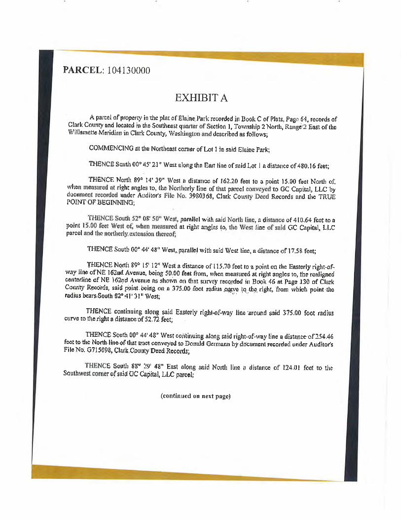
PARCEL i 104130000
EXHIBITA
. ^ A parcel of propçrÐ' in thc plat of Ëlajne.I'ark recordcd ilr Book C of' Ptars, Pagr. 64, records of
Clark County and loeatcd in ¡he Southeost guarrer of Seclion ì, Torvnship ? North, Raigirz Eastof thcwlllamette MeridÌan in clarli couns, wasirington and dcscribed as fcillóws;
ÇOMMENCING ¡t the Norrhe¿ut conler of Lot I in snid Elains park;
T$ENCE South 00" 45' 3l' West along the Enst line of said.Lot I a rlistancc of 480.16 feet;
'IHENCF. North 890 14' 39" lVesl q distancü tf t6?,.20 fucr to a point 15,00 feet Nortl¡ ofì$'hen msíNured nt right angtes 1o, the Northertv line of that pôrcct eonveyådrto 6C Capital, LLC bydoetmenf recorded under Afiditot's Filc No. i980368, Clarii Cour¡ty Dcecl Records on¿ tli" TRUEPO¡NT,OFBECINNING;
THSNCE South J?" 08'50^ Wcst, pnrallel with sajd No¡th line, a dísanco of 410.64 fcct.to ¡poine 15'00 feet Wes{ of, rvhen measu¡ed år rfgrt anglus to, ilre West line of said 6C Capital, Lt.Cparcet and lhc norlherly. sxtensior¡. thercof;
TI{ENCE Sourb'00o 44' 4t" Wesr,.p4naltef rvíth srid Weer line, â distí¡ncs of I ?.S$ feet;
, TIIENCE North 89o l5' l2n West a distance of I 15,70'feet.ro'¿ point on rha Eastsrly riglu-of-rvay line of NE l62ud Avenue, bcing 50.00,feet f'rom, rvhen mçasured ai right auglcs ro, thJrcniigneclcenüedinc of NE l6?nd ¿lvenrre Rs shov¡n on thnt sorvey recorded ¡n BocI 46 ;t p¿gc ¡30 of C¡å*Corrnq' Rcoords, said pgiut.beirtg on s 3?5.00foot rrdius.cuçve l'e r¡s-right, from ihictr point.tlroradius benro,South 'B2o d l ' 3 [', llrcst
TTIENCE continuing aloltg s¿icl Eastorþ rip¡lrtøf-rvay lirre'¡round said 3?5.00 foot radiuscurve ro ttrerighr a disrance.of 5? ,72 Íeet;
TI{ENCE $þuth 00" 44'48r' IVest continuing nlong said right-of.*ay line a dísranccof :s¡i.46fca¡ to thc Nortl¡.line.of that trast corveyctl ro Dorralã €crñ¡nn by?octment reco¡desl undor Audiro¡,sFilo No, G7 I 5098, Claik.C.ounry ÞeEd,Rccords;
ÏHü,NCË Soutl¡ üt" 29' 48" Ëast ntong sâid North linc ir dist*nce of ll4.0l fc{* ro tlpSeulhlvest corncr ofsaid GC Capital, ttC pûrcÈ¡;
(continued on next page)
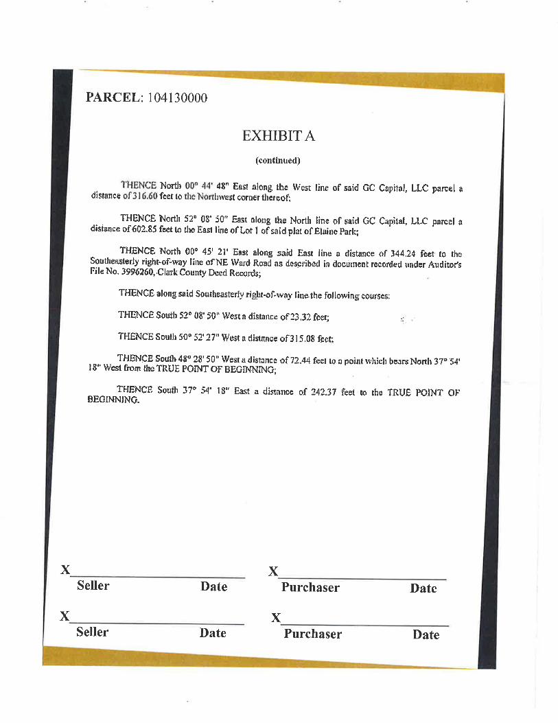
X
PARCEL: 104130000
EXHIBITA(contÍnued)
THENCE North 00q 44' 48' East along thc lVest line of said GC Capital, L[,C parcel adisance of 3l 6.60 fcet to tl¡ç'lrlorthrrest corr¡er thãreof;
THENCÊ North 53ô 08' 50" East nlong the North line of ,caid (iC Capiral, LLC parccl adisiance of60?.85 fçer tn rhe Eaer line ofLot I of snicl.plat of Eluitc padtl
Tj{gNCE North 00o 45' 21' East along s¡ricl East ltne a dist¿nce of 344.2d fcer ro rhcSoutheæterly right-of'rvay line of NE Ward Rqnd as dcscribcd in docuneut recorded under Audito¡,sFilc No- 3996260,.CkrrkCounty Decd Rccords;
THgNcË along said southeasterly rigrrt-of-way linethç following courses:
THENCÊ South 5?t 08. St" lVesin distancc of33,3? fcer; :r, .
THËNCE South 50o 52, Z?" Wcst a rlisfnnce of3 tf ,0E fect;
THËNCE Souflr 48ç ?B' 50n lVest a distuncc of 72.44 f{ret r0 â point rvhiclr bcars Norrh 37" 54.I 8' lvest frrom the TRUE POINT OF BECINNINû;
IFIENCF. South 3?P 54' 18u .üast a distirr:ce of 34?.37 feet ro rhp ÏRUE POINT OFBEGINNING
xSeller Date Purchaser Date
XSeller Date
xPurchaser Date
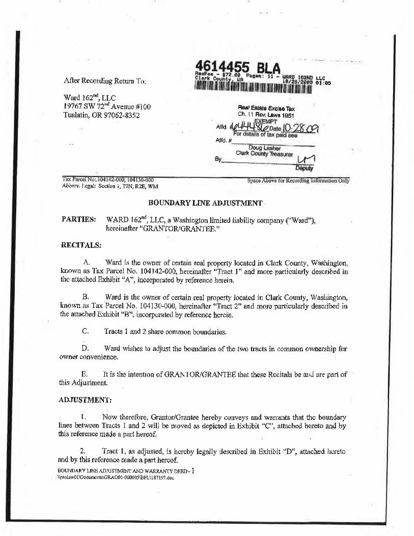
IAfter R.ecol'ding Rehrn To:
\V'ard 162nd, LLC19767 S'ïV'72"d Avenue #100'lualatin, OR 97062-835?
LLCOl:OA
Fleal Ëstats ËXöt¡eTbxCh, 11 Rôv, l¡wa tg$l
Affd.
Affd,ffi#
Glark
imAbbrev. Legall Section 1r TzN, RzE, IVM
BOUNDARY LINE ADJUSTMENT
PARTIEs: TI¡ARD l62"d,LLC,a ï[ashingtonlimired liability company ('ward'),hereinafter "GRANTOIVGRANTËE. "
RECITALS:
A' Ward is the owuer of certain real property located in Clark Clounty, rù/ashingfon,
known as Tax Parcel No. 104142-00Q hereinalter "Tract l" and more particular{y desuibed íutlre al"tached Exhibit "A"o inco¡porated by reference herein,
B. Ward is the owner of ceûain real property located in Clmk County, lVaslúngton,known as Tax Parcel No, 104130-000, hereinafter'lfract 2'o and more particularly descrÌ¡õ¿ nthe attachcd Exhibit ooB", incorporatecl by reference herein,
C. Tracts t and 2 share çommon bounclaries.
D. Ward wishes to adjustthe boundaries of the two traots in commort ownership forowner convenience.
E. It is the intention of GRANTOR/GR ¿r.NTBE that these Recitals be md are pafi ofthis Adjustrnent.
.{DJUSTMENT¡
t. Now therefore, Grantor/Gräntee hereby Õonveys and war:rants that fhe boundarylines between Trâcts I and? witl be moved as depictecl in Exhibit "C", attached hereto and bythis refercnce madc a part hereof.
2. Tract l, as adjusted, is hereby legaliy described in Exhibit ÍDoo, aflached heretoand by tlris reference made a part hereof.
BouNDARy LtNp ADJUSTMENT AND w*r{n-ANty pnsn - 1
\þroluwÛ l\Docurùc'lrs\Gp"{O0t-000f.t05\tspL\1 87 l9?,<toc
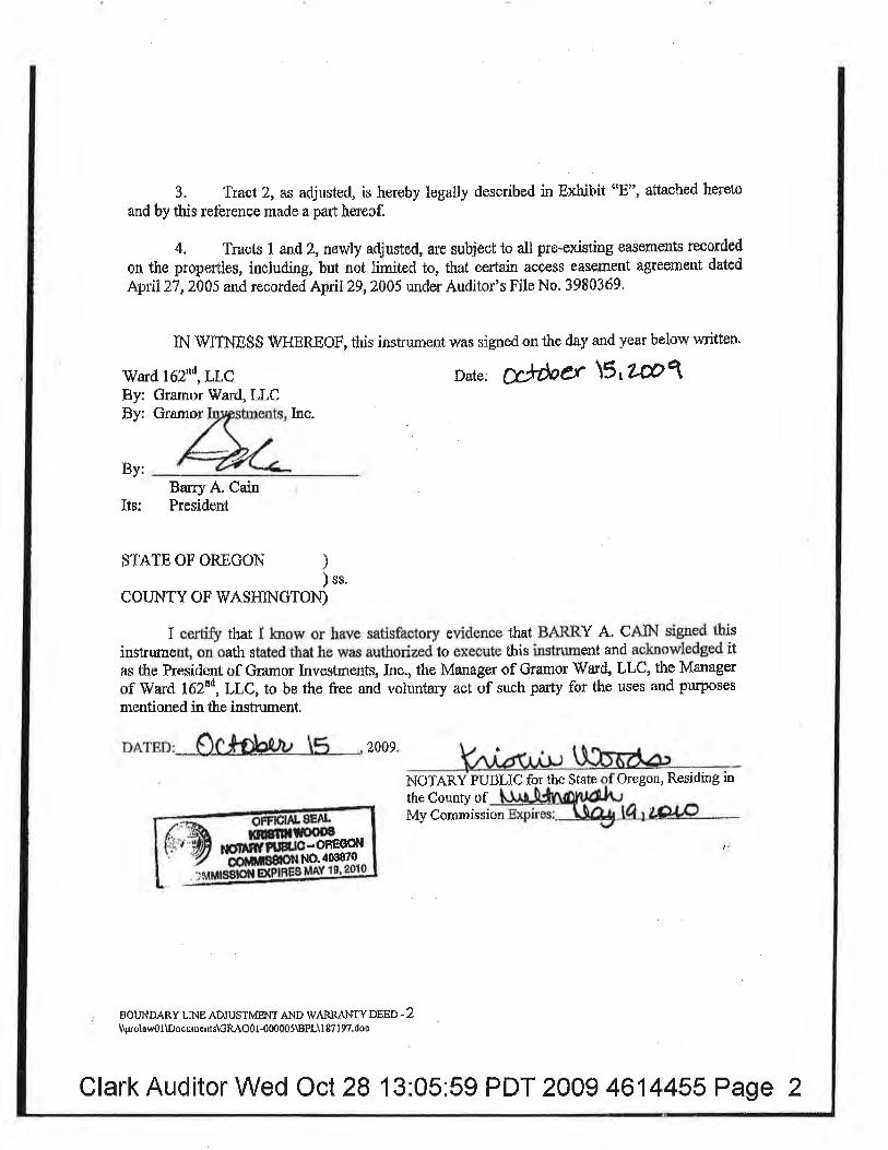
3. Tract 2, as adjusted, is hereby legally desmibed in Exhibit "8", âttached hereto
and by this reference made a part hereof.
4, Tmcts 1 and 2, newly adjusted, are subject to all pro-existing easements recorded
on the properties, inoluding, but not limited to, that oertain acge$s easement agreement dated
Apri|Z7,2005 and recorded April29, 2005 under Auditor's File No. 3980369.
IN WITNESS V/HEREOF, this instrument was signed on thc day and year below written,
Ward l62nÛ, LLcBy: Gramor l[Iard, LLCBy: Gramor lne.
By:
Its:Barry A. CainPresident
s'rATE OF OREGON )) ss.
corJNTY 0F TVASHINCTON)
I certify that I know or have satisfactory eviclçnse that BARRY A, CAIN signed this
instrünËnt, on oath stated that he was authorized to execute this instnment ând acknowledged itas the President of Gramor Investments, Inc., the Manager of Gramor Ward, LLC, the Manager
of Warcl l62"d"LLC, to be the free and voluntary act of suchparfy f:or the uses and purposes
mentioned in the instrument.
2009
Ðate: üj',ùaf \5,eæî
NOTARYthe Couuty ofMy Cornmission
FUBLIC for the State Oregon, Residing in
-ofiEffif{Nö,d038?0
BoTJNDARy LINE ADJUsTMENT AND wARRANTy prnn - 2\þrolow0l\Docunrcnts\OR"A.O01-00000í\BPL\I 8? l97.doc
{,w
Clark Auditor Wed Oct 28 13:05:59 PDT 2009 4614455 Page 2
I:NGINEEP'.$rN6J,VÊEFINË JA/C.
ËXHIBIT "A'' (360) 69s-r385IIII ßroadwøyVancolner,'!l/¡l
98660
LEGAL DESCRIPTION FOR WARD 162NDLLCTract I
April 7,2005
A paroel of property in the Plat of Elaine Park recorded in Book C of lrlats, Page 64,records of Clark County and located ìn the Southeast quarter of Section 1, Township 2 North,Range 2 East of ihe Willamette Meridian in Clark County, Washington and describerl as
follows;
COMMENCING at the Northeast corner of Lot I in saíd Elaine Park;
TIIENCE South 00o 45' 2l " West along the East line of said Lot I a distance <¡f623.60 feet to the Southeast comer thereof;
THENCE North 42o 0ç' 02" Ty'est along the Southwesterþ line of that tracl r.ronveyed
by deed to Rose Lawhead recorderÌ under Auditor's File No. D17100, records of Clark County198.82 feet to the TI{UË I'OINT OF BEGINNING;
THENCË $outh 52o t8'.50" West 430,12 feet;
THENCE South 00o 44' 48'West 316.60 feet to the North line of that hact conveyedb5, deed to Donald Germann recorded under Auditor's File No, G715098 records of ClatlcCounty;
THENCE'North 88" 2þ' 48" West along the North line of said lract i24.01 feet to apoint 50.00 feet Easterly of, when me¿sured at right angles to, centerline of said NE 162nd
Ave. as shown on that Reeord of Survey reoolded in Book 46, pago 1 30, records of ClarkCounty;
THENCE North 00o 44' 48" East parallel with said centerline 254,46 fset to a point on
a 375.00 foot radius curve to the left;
IHENCE alound saicl 375,00 foot radius curve to the left and parallel with said NEl 62n'l Ave,.centerline 1 82.39 feet;
C¡Urs\lfiAppD¡l¿\Loc¡l\Micro¡of(\Wiudow¡\TçDporiry lrrqret [ilcs\Conrül.Oudo0lVr?Q82CWÇ\?ó4ttr003 leg,doc
Page I of2
Clark Auditor Wed Oct 28 13:05:59 PDT 2009 4614455 Page 3
ENGI FÊFt^/6 /NC,
(360) óer-r38sllll BroadwayVancower, llA
98660
TI.IENCË Nordr Z7o 07, I 1', TVest 43.23 feet;
TlfËNCE North 12" 30' 50" East 31.89 feet to a point 62.00 feet Southerly of whenmea$uÍed at right angles to, the centerJine of Ward Road;
TI{ENCE North 52o 08' 50" East parallel with sairl centerline of Ward Road 60.38 feetto the West line of Lot i in said Plat of Elaine park;
TI{ENCE Nprth 00o 44' 48" East alorrg said West line 6,40 feet to a point 57.00 feeÍSoutheasterly of, when measured at right anglãs to, said centerline of ''vVard iioad;
THENCE North 520 08' 50" East paraller with said centerrine g3.90 feet;
THENCE Nofth 56" I8r 25r' Ëast I 17,18 feet to a point 65.5.0 fee t Southeaste.rly of,when measured at right angles to, saicl centcrline of TVarclRoad,
TFIENCE North 52o 08' 50" East paraller with said centerline gg,z3'Êeet;
THENCE North 48o 28'50" East 64.87 feet to the Southwesterly line of that tmctconveyed by deed to Rose Lawhead recorded under Auditoi's File No. DlTt 00, records ofClark County;
THËNCE South 42o 00'02" East along said Southwestedy line 258.32 feet to theTRUE POTNT OII BBGINNING,
Cr\Urcß\lrßAppDrtn\LMrl{icruofllwlndou\Tcil¡ponr, Jnftû}èt filð\Conlêdr,outlæk\D?eB2cwõV64000of tog.doc
Page 2 of2
Clark Auditor Wed oct 28 13:05:59 PDT 2009 4614485 page 4
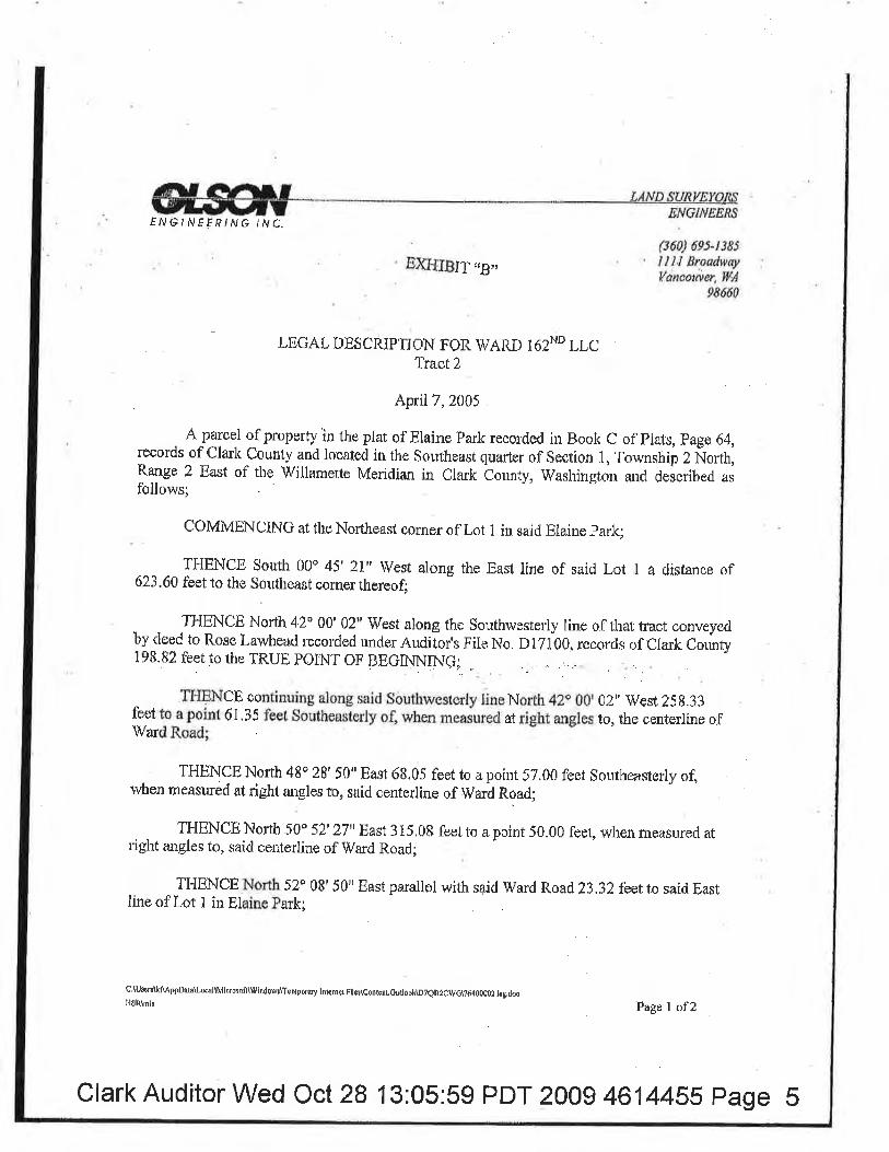
ËN6/NÃFFtNô /Nf.
EXI-ITBIT'ß,,(360) 6e5-t385I I I.l ßroadwryVancotuer, llÌ,4
98660
LEGAL DEsüRrprr?iå?- WARD 162ND r.Lc
April7,200j .
. A-pglcel of property in theplat of Elaine Park recorded iu Book C of Plirl¡, Fage 64,records of Clark County and located in the Southeast quarter of Section 1, Township 2 Ñorth,Range 2 East of the TVillamette Mericlian in Clark bounty, 'Washingtori and described asfollows;
coMMENCINt at the Northeast corner of Lot 1 in said Eiaine park;
THENCB South 00o 45' z!'West along the East line of said Lot I a distånce of623.60 feet to the Southeast corner thereof;
THENCE North 42o 00'02" West along the Southwesterly line of that tract conveyedby deed to Rose Lawhead recorded uncler Auditor's File No. DlZl00, recorrls of Clarlc County198.82 felrto the TRUE POINT OF BEGINNTNCi .
. TI-IEÏ'{CE continuing along said Sòuthwesterly line North 42o 00,02,, 'West ?58.33
f.eet to a poinf 61,35 feet Southeasterly of, when measured at right angies to, the centerline of
V/ard Road;
THËNCE North 48o 28' 50" East 68,05 feet to a point 57.00 feet Southeasterly of,when measuréd at right angles to, said centerline of Ward Road;
TFIENCE North 50' 52' zluEast 315.08 feet to a point 50.00 feet, when mçasured atright angles to, said centerline of lVard Road;
TFIENCE North 52o 08' 50" East parallel with said S/arcl Road 23.32 feetto said Eastline of Lot 1 ìn Eiaine Park;
ctuscrulftAAppDeta\Lul\Microrolt\'¡vindowÈ\TeNpomy totcmuFllc!\cortcsr,ouüôDh\D?efilcwç\?ó4û0002 leg.dæ!l$R\mh Fage I of2
Clark Auditor Wed Oct 28 13:05:59 PDT 2009 461445s page s
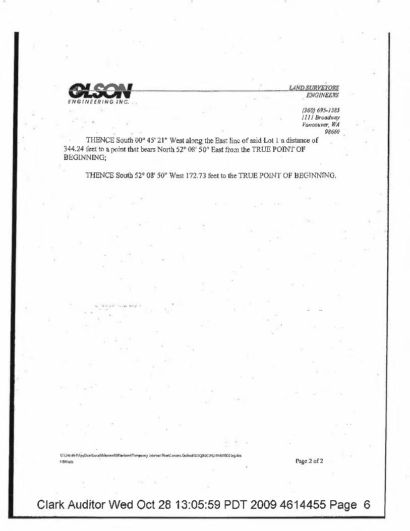
ãY Grllrt LÁNDÅUMWAßS
f ¡VG/NÊÊßI N6 INC,ENGINEERS
(360) 6es-1385IIll Broadv,çlVancouver, lU'4
98660
TI'iENCE Squth 00o 45' 21" West along the East liue of said'Lot I a distance Ef344.24 feet to a point that bcars North 52' 08' 50" East from the TRUE POINT OFBEGINNING;
THENCE South 52o 08'50" West 172.73 feet to the TRUE POINT OF BEüINNINü,
ClUsrilkll ppDsl0\Loøl\Mic¡onll\Wlndorv¡\Tõnporâry lotffiet lìl.$C¿nb¡tOulðk\DtQÉ2ÇìV6\?640m02 llg.dos
H$l(\mls PageZ afZ
Clark Auditor Wed Oct 28 't3:05:59 PDT 2009 4614,455 Page 6
EXNSITSKETCTT TO ÁCCAMPÅM T,Ë6AT ÐESCfrTPWON
rO& EOUNÐANY I,TNE ÁDXUSTMENT
F''Xfi[B11etç*ffi. toÍ \
¿tfltF Fnx
'i' .,.
'i¡i'),:l'r
I
s lf
t
tiil:i':
l¡
!t
I
lljlT:r,!
LANÐ s[/FtrgyÐRs
l.l l:l .lf¡ .s.8rüd
i
I
ilq
tf
ii!J!ì.J'
ill:ill¡I
¡
II
I
ff'I
I
I
í
l,¡
i.ì.,i,-i.i.., '
iiriirtiirt'riÍ
IL i
J
zRACT T# afrtÁL uêlÍl ß&J6s
l'ì 1,"i'.1 .'1,'il'T'i'í'i',
; liiiïí i ll
iiiii iî;i..ì;
Clark Auditor Wed Oct 28 13:05:59 PDT 2009 4614455 Page 7
! /^JEFfING 'NC,
ENEINEEITE
EXHIBIT "I)''(3'60) õ9.5-t385Illl BroaútayVancotwer, llÅ
0866ü
LEOAT" DESÇRTPTION FO.R WARD T62I'D LLCRcvlsed T*ct I
October'14, ?008
. .'ÂpartelofpropertyintheplntofF.lainePnrkrecorcledir¡Book0oflll¡its,Page64,rscor(isofCladt Cotrnty and Iosntcd in the Southenst gùârtor ol'8eçtion l, Townshþ ?Norlh, Range 2 En.st of thoTfillamefte Meridian in clzulc county, TÍn'shington anrl descrdbed osrfollóws;
COMMENCINfi at the Nonfiet$r cornçr oFLo¿ I in snid Elnine p¡¡rkl
THENCE. $çuth 00Õ 45' ?l'i Vy'est nlong the Enst IinB of snid ,Lçt l. û distance of 48ü.16, feutl
TÍ:IENCE Nsrlh 89' l4'3;9" \lssf a dis¿enbe of 162.?0 fec ro.apoinï 15,00 fcet Nsrûh df,whÈn msasured af right auglcs to" the lt¡r,rther'fy line,of that ¡rarcol convcyecl to GC Capital LLC hyd(rcumenf rEço¡.ded rulder Á.ttd.itor'u File No, jg¡1CI3.69, Clark Counly Docd Rucords anrl tlre ,fRUÊ
IIOINT O,I.. BËüTTiINÍNG ;
'IHENCË Ûouth 52' 081 50" Wost, parallol wifh snid:Norrh lino, a distarice pf 410.64feot tf) rìpnint 15'00 feet.Vússt o{ u¡hen.rnpasured at righi anglas to, tlrc West line of sair{ GC Çapital, LLÇpäfcal flnd iho norrhørly exfcnsion tlereof;
T:HËN0E SoÍfir 00o 44'48" Wesf" pnrêllel w,ith Onirl Wsst lins, â distancedf 1?;58 firct;
T}TENCEiNorth 89o l5' 12" Wont n rlismnce ôf I I5..?0 feçt fO.a pointonthe Ens¡eriyrighîtof,-way lìne oflNE il 6?nd.Avenue, being 50"00 foet frorn, when measurcd at.riglrt angles to¡ rJre realignedcçítedirw of"NË 162nd A,vsnue ¡s,slrÐrvrr on thøf suryqy reeorded in Þo'ok 46 at p.age ljO,,Cla{kCourity rtcnrds, salid point beiug on a 375.0.0 foot ¡:adiun ouryc r0 lhe lëft, flom which.'point,thc rad,iusbesrs Soulh 82.ó 4Ì' j L" V/est;
ÏI{ENCE alung said Eæler'þrighl.of"way line around saí.|3"15.0ú foot ¡'sdius ûulvÊ fo the ls.ftr¡ d6tnnce of l?9,67 fcct;
TII.ËNCË Nortb2:lþ'07' Ll u West:çoulinr¿iug along said right+Ëwny line a rlist¡ncç oÍ 41.2I
2I7000\7ii(¡l¡76{{t?(irl0\?(r4000ü I,lcgdocCiM\qim Fâgs t <rf2
feet;
Clark Auditor Wed Oct 28 13:05:59 PDT 2009 4614455 Page I
FËBBUÀRt'1,0.
,i'l?ÅT:-i:iå
(ancoaver, WA
TlIlîNcn Nor.th t2o 30' s0' Enst alorrg said righr.of:way line n distance "r
r.,,* ,-r:|]lpoiJtl.on the soutlr.erly right-oÍlway lino of NE frarcl Roñd, u*¡ng"ez.éo fest sourh of, r,vhen meazure¡iatrþht ang.lcs to, the.ccntsdine thtlroo$
ElìlË/rVeËP c.ßMC,r-T¿'¿/ig
ÏËIfiNCÊ osntinuiüg along said fioutlrerþ riglf-nf:way line the fullowing courses:
TFIENCE Nor.ih 5?û 0B' 50".East a clisranoe of 6Q.3g fcet;
THüNCE North 00o 44',48,, Ëast a clisrance.,of 6.40 feet;
TI{ËNCE North 52o 081 5.t" Enstn dlìsrance of g3;g0 fee[
T|IBNCE North S6p l$,ZSr, Easta rlisr¿nce of ll7.lg leçt
TIIENOI|.Nu¡'tb 5Zo (]B' 50'' Easra distance,of gg,l3 feet;
TIIH'NCE No¡tlt 48o 2$ 50" .Easf a dísf¿¡nce of.60,47 feçt to n point which bears Norfh 37' 54,I B" West,from the TftUË POINT OF BEGINNßI¡(];
THENCË Soulh 37û $4' Ì8'r East a cfistarlco of 242,37,fcer to rhs T'RUE, PÕINT OFßECINNINC.
rCI.*15-eF
u i700ür7600\761ft?óttlt7ff 00(D t. ics,dovçIvAqlrÌr
Page â of2
Clark Auditor Wed Oct 28 13.05:59 PDT 2009 4614455 Page I
ENGTNÊERSENG lNrgf Èr^rç N,C
EXHIBJT:'E''(i'601 69s.r i8:I IJ I Sroadivtr.yVancower, I4t¿!
986:6t)
LßOAT" ÞNSCRI.P1TON :FOR WARD 16ZND L:[Ct(evisod Tract 2
Öcúoher 14,2008'
A palcel of propcrrlr in tliri plat of Elaine..Fark recoïdßËl i¡r üosk C o1 plats, page 64,,records 0fClarJs Corrn6r nnd looarcd ìn ths Southeû$t qu¿rter sf Section 1, Tçrvnshjp 2 North, R¡:ñge 2 Enst of the'Willo¡nêtte
Mnrielian'in Clark,Counfi Wushirrgton and described.as foilûws;
COII4MßNCING.áf fhe ,NofthÊâsr sorimr of Lot I in sqid Etaine. Fryk;
TI'lE'hÍCß $outh 00o 45' 21u West along th:e Ësst line o.f saicl..Lorr I a dista¡rce of 4Bü.1.6 f.het;
'fl{ENCü Norfh.Bgo 14'39" \tVost,adisranse of 16?.20 f'epl to a point 15.0t feot NortÌ oflwJ¡en mcr¡sured a( r'iglrt anglos to, tho Norlherly line of that paæol. converyeít:h fiC Õapital, LLC bydoprtnteff rccor.ded untlcr Auditols File No.3980368, CtarÈ tourty Deod.Rçcords andtl¡c TRIJEPÛINT'OF.BEGINNINü;
THENCE üouth 52" 08'50"' lVcrt, parallol wilh sairl.Nor-,th line, a diclarc.e of 4l0.641bEtto.apoínt 15'00 fpet Wcst ot, when measurcd at üght anglos to, fhc'Vr/est l;ine of snicl GC Oapital, LLCpÁrcêf ând the northerþ. extensiori thercof;
TJ'IËNCE Sorrth 00' 44' 48" ìVcct,.p4r¿llol wltl¡ s¿id \ileot [nc, n dist¿nce of 17.58 feet;
THENCE Nortll tgo 15' 1,?" West a dístance of I 15,70 feot.to:a point on the, E¡sterþ right-of-way line ofNE 16?nrt i4venue; heing 90.00 fect,flor¡t, when mçasured ai rlght angles to, the r,ealigrrodconteditts of NË l63nd Avenue Rs shown on ,úhnt eirvey ¡csordÞdr in Esqk 46 at Fagq ,t30 of Cku'k .
Ço'unt¡,'.¡qu*"*s, saírl poiut buing orr a 375.00 -,foof r4¡1i1¡5.çWïg {q lùp, righf fror,n whicl.r point.rlro.r,edius ber¡rs South 'B2o 4l:' 3 l '' ïVes!;
TI'IEN.ûË {oatif,r¡¡ng along suid Easterþ riç¡ht.of-way lirie'¡t¡'ound $aid 375..0Ð foot r¡rdfuscurve to flre right a distanre çrf 5? ,'î,2 tleal;
TI{BNCE S'ourll00" 44'48o West coi¡tinuing along s.ui<l rigtrr-of-way tine a dlsranoe of ?54.46.feet to t-ho'biforth,liue of;thnt tra$t çonve)red to'Donald .Gsnnann bydocurnerrl rçcorrlerl.urder ¡ludllor'sFÌlo ÌÌ{o. G7 l 5098,.Clark Cjci¡rnty'Decd,Rocor<,ls;
TI"IEhICË $outl¡ 88o 2,9' ¿18" Easl along said Ïrlbrth line 0 distance of l?4,01 Ëcçt to fhe$quthlvest;sor¡or..of saÍd CC Çâpiø!, LLC,parcol;,zAz000\7600\?6c 0\?640ri6+oo{r2z.lcg.rtuc'cfM\qim Fage I uf ?
Clark Auditor Wed Oct 28 13:05:59 PDT 2009 4614455 Page 10
EXPIHñ$: ,ø,
Fl^,G/.lv',ög,f IM .lN
(36V) ó95-r3,85llJ'l Broødwtçlatrcouter, !Y'A
. 9866t)
THENCE Nordr 00o 44' 48n East along thc Vy'est line cf $rid GC Cnpital, LLC parcel a<list$nsp of 3 16.60 feet ro the Northwesr oorüsr therçofl
THEI{CE North 5?u 08' 50" Ëasr ulong rhn Norih line ol'said, (ìC Capital, L[.C parccl adislnnce of602.85fcet.t'o.tlreFasrlineof Lot l of snid.plntof ÉluinellaÈk;
THËNCE North 00Ò 45' ?.l''East atong said. Ëast lüne a dïstånce uf 144.24 fost to thoSouth$fl$terly right-oËw4y line of NE Ward trsad as,deç-r)ribed in docù¡nsûÌ legoriterl uuder ¿luditor'sFile No' l9Ëd260,,Clsrk Counfy Dscd Røcordt;
TLInNcË alorrg said soucheasferþ dghr-oÊway li¿re;the following cour,sosr
ll-IENCË Soulh 52o 08'$0' Wrest n disfance of 13.32 feet; ¡r.
THËNCE South 50o 5¡2'21" \ilssf a distance of3l5.0g fecf;
TIIENCE Sotifh 48o ?8' S0" lVcst u eli$tanc t of 72.44.fee1 ïo.¿t point whíclr bears l.forth |i, 34iI8" West fÌom the Tll,ttË FöINT OF ÊEßlNNtNc;
TFIFNCP south f7" 54' 1:8" ßast a <lisrance of !42.37 fr:et to tfrc '|RUE polNî oFBEGil\N{JNG
ls-rb-Òt.
r,*zú ooveos\zr{0ì764017640002?. t0g.doc
CJnilcjrn Pngc 2 of?
Clark Auditor Wed Oct 28 13:05.59 PDT 2009 4614455 Page 11
1ruilil1lilfl ütilillillllililÍilff ilillilIiltåi,.i:_1i3,,,0O¡llluNITY DEVELOPÍ1ÊNT D ø,øø Ciari countv, un
Rdurnto:
llgk Counry Connunity DwelopmeutP.O. Box 9810Vancouver, V¡A 98666-9S l0 Reel
ch.1Tâ¡(
1 I
Afr. 7
Afrd. #of
Dor¡{ låFh6tClark Cou-nty lreasurer (V
Se¡inl # 104142-000; 104130-0@; ffrd 104I43-000lgsll lrcrcrtption: ph TqþSilli 2/t; t/2;ín sE eTR Sec,l, TZN, RzE, lVMRlght of _Wsy lledtcaüon¡ : Nü/ I 62rù Av; anåffi wu¿ nnProJect; Ëast Pa¡lden SsuuçSITD pLAN; #pSR200¡_00055 / FSR2005.00010
QUITCIIUMIIEEDThe GRAltlroR' WARD t6¡üd LLc' a \ilrrhington ltmlted llablllty comprn¡ for and in considerntiø ofvaluable considerations ås- 11 9ol ltt'p"t úrroù o*uoyt and suit;üims to CLARK couNry, a poriricalsubdivision of rtrc St¡ro,of ïrashingron, ir, nJäJ,*_O .:rrgd-tdã¡ñ*lrg desffibod røl esrate siruated jn tleCounty of Cluk, State of washingto;, oi¡.tn* .,ñr,
aU ,fr"ñ;u¡irädiïfît¡u cr*tor(s) thereín:
sEE LEçAL IrESCRIprroN aTTÂCrrED *RETO, \ilEiCEBy IHs atFDnENCE, IS trìICORPORATüD EEREINN0TE: It is tmdtrstood a¡d.arcod thst tho dolivery of this dc€d is hcreby tendøed and üe terms and obligationsäiH*ffi :iJtråî"1i,X#m,Hl,ffi ltff .'r'åffi ;ililräh;;;o,¡*;dä"unäìpp,o,øuy
ctark counly by accopting and recording this d€€d hrcty ag¡€ßF to tho below urittsr couditions ard cousideratisrs,No condition or considerctíon mt urÍtifl trt"* ùüïå ffiä.d t"däücounty. If rhere are no condirio's srconside¿ations, so st'te, uJ vr'rrÁ
C0NSIDERATT()NS: site ptan Reviow Requiromfrr #psR2004-000is / FsR200i_000r0
DAr EÞ rüis fiffiy of $çn"_Q.____- zoos
lVard 162"dBy: tramorBy.
BnrryA,
LLQ manager/mmbarInc. managaáuunbcr
theon bdhalfofClark County
of CCC 2.33,095,
Petu CapellDÍrætor of,Puùlic Worls
lflfl lüilüilil lIillIilililil ililil ililil/ililI ililcofifluN¡îy bEUELOÞnqNT D ü,øo
NOTÅRIAL ATTACHMPNTTo QUIT cLArM DEED DATED ûflåJ aF __, roos
ts996260Pagc: 2 of 6ø6/øt/Zøøa 0t r3spC¡årk County, llA
Grantor¡Granteelüeri¿l #Legal:ProJectl
STATE OF OREGON
COUNTY OF \4/ASTTINGTON
êS, Zl¡die
Y-ry{192j1!rC, n \üashùrgron ümtted tabiliry companyCLARK couNTy a porfflcil subdtvrsr'n of the st¿tu'oriry"chrngton10414209Ð9; 104130-000 nnd I 0414g-000
ïh. Tt Loús I/t; Zfl; UZi in SE eTR Sec 11 ïtN; R2E rtrMEast Padden Square
on thi$ day penonally appeared before me BARRY ^4. cAlN to me known to be the presidffit ofGramor Investmentc, .Fo * Orcgon coqporation,- *m*uger of 6r.amor W.ard LLC,. awashington limited liability *.",rpqy; as rnanqger of ït¡ard 162ND LLC, a w'æhiugton tirnitedliabitity compa¡ry, and acknowl"¡.Êiruiá insturnent to be the free and voluntary act and deed ofsaid corporation' 4.5 nurnflger of arã on bohalf of crârnor w*¿-l,Lc, as rurmg€r of and on behalf ofward l62ND LLC, for.the uses and purposes tù;i" *ttd;d, and on oath stated that he wasauthorized to e:<ecute said insftument.
j
Notary Public in and ths Stare of ORrcsíding atMy cornmiseion orçires
@ xmnuüsoosNOÎAFTR ËlJC-Oñffi{coMMtSsot{ hro.AsHüe
MY I
lruru ffi il Itüil
ilill lÍill lil ililt ilil lill ffi3,?TÍ*col'll.luNlTY DEVEL0PñENT a ø.øø c¡åFk county, t{Ê
TEGAL DESCRIPTION FOR 1VARD I62Od LLCNE l62m Ave. Deroriptíon
May24,2A0S
A parccl ofproporty in the southeast quâlter of $ection l, Toumship 2 North, Range 2East of the lvillamettomeridian in Cluk County, Wurhiogrãnl¿escribe¿ as follows:
coMMENcING at the Southwest oorner of Lot I of Elaine park as rccorded inVolume C at Page 64, of Clnrk County plat records;
TIIENCE South 00o 44'48t' lVest along the lVost line of Lot 2 ofElains p¡rk adist¿nce of 103'56 fee,t to a pointio.oo ã.t tir, ru otr**u ut right angles to, thé rcalignedcentorline of NE ló2nd Aveñuc as shown onllrar !r*iv *õøJ tfi*kîäuü,ü.'igo, orclark county reoords, sai!-noint bcing on a 3?5.00 rou:t rnous cu"s to the loftwió rtangentlglqinlo thç curve at this point ofñofth l2o 30' f3', lvest and rhe TRUE poINT oFBEGINNING;
TÏ{ENCE conlinuing-al9ng said lVest line of Lot 2 in Elaine park South 0o 44, 4gulvcst 340.35 feet to the Norttr liniof that nact conveyed by deed to Donald Germannrecorded under Auditor's Fflc No. G7r50gg records drcrahc co*ty;Tr{ENcE South 88o 29'48" East along said No¡tr linc 10,00 feet to a point f0.00 feetEast o4, when measured er right angres to, rheîcntertir, ;ñiiñËi;äi;;#¡'r +'v'r
gfVOTwEEPtÀt€ /rrtc.
zt?000\7dûq?fl 01?ó.ol?6a0o0r t.lr*dü
ENGNEERS
(360) 6eÍ-r385IIII BroddwøyYancotnør, WÅ
98660
xsnu¡Pago I of2
lffitï|l,{/l[.tü!flit/ililt{ilililil//ilil//iltå,äËîi*
f ,\¡ GrivË EPING INC,
Zr\?O00\7600\76401?d1{À?64000t r.t.;,doô
98ö60Tr{ENcE North 00o 44' 48"-East panrllcl with said centerli no 2l4.46feer to a point on said375'00 tbot radius cu¡ve to the left as showr on oratsurvoy t ."t¿.,i*ät +cä,äe.'ilo;TÏ{BNCE around satd 375.00 foot radius ourve to the lçft and parallel with said NEl62nd Ave, conterlfne 86.80 feet to uraTRuE poINT oF BEGINNING.
ENGINEERS
(360) 695-1385I IIl BroadwryYancowet, VA
5þ!toa
HSR\mlr
JLtc4,4mü
Pago 2 of2
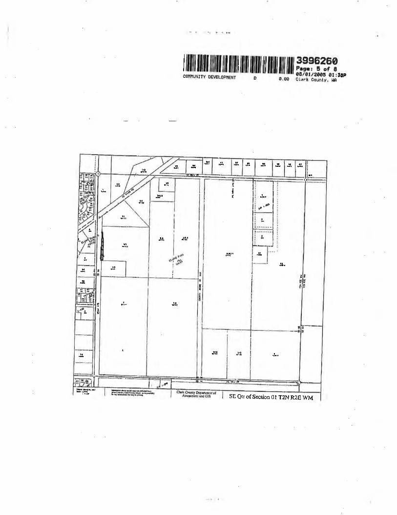
ffi illlll[!ilil|iluilrrl|ilril'ltilfl ilf i';.:,:!3T3..,
tlt
r¡J
It
il
t
I'r{À
u
I
t
f
üt
IJ
¡
ll
É
TI
I
!
la
I
I
! l,
Itr¡a
å
hñ.É-btukrrñß*.q*.r.i*rrhhrtrË
SE, Qtr of Seoion 0l T2N R2E WM
iru ruü|||l lll llllll llll llllll lll lllll lill llll'l#i3ii,,,coltltuNlly oEvËLõþllËNT D ø.øø ðliri countv, un
Fl',CrlVE Êt ê ,rtrC,
Z:\?000\?d00\zó{orzó40\?ó{0000?.trg, doc
LEGÁL DESCRIPTION FOR \ryARD I62Nd LLCWard Road Dedication
ENGINËENg
66q 6e5-rt85IlllBroadwdyYøncouvel, Wl
98660
irprtl7,2004
 parcel of pmperty ín Lot I of tho Ptat of Elaine Pmk recorded in Book C of plats,Page 64, rçcords of clark counry, t*"*9 iT-lhe ioüh;;tq"*t , of section r, Township 2Ig.tttt'Range 2East of the Mllamctte Meridian ¡n cl*[-cä*ty, lvnshington, deecribed asfollows:
BEGINNING at the Northeast cofire¡ of Lot r in said Elaine park;
ÏI{ENCE South 00o 45'21tr 1V'est along the East line of said Lot I ¿ distance of ZS.S9S¡t t"o-a point 50,00 feet southeästorly of, *rrJ" mrur*ø;i t{gt anglos to, the ccnterline ofWard Road; -¡Þrvu *v' u¡e w¡r¡
TTIENCE South 52o 08' 50" West panllel to said centerline of Ward Road 23.32 feet;
THENCE South 50o 52r 27" west.3l5.0s lggt to n point 52.00 feet Southensterly of,when measured at right angles to, said centeriine;iwil Rär4"
Tr{ENcE sout}r 48o 28' 50" lVest l32.gl _tgl tq 9 point di.s0 feet Southeasrerly of,when rueasurçd at rigrrt angres to, said centerríne orw*ã Rð;il vv'sv ruve pvsuer*'
THËNCE South 52o 08'50" lVestparallel to said conterlÍne of Ward Road 9g.23 fcet;
Tr{ENcE sourh i6o rg' 2i" west l lJ.rs ^ryf to a point 52,00 feet southeastorþ ogwhen measued at right angles to, said centerline of Ward Rå;i
TIßNCB soutlr 52" 08' 50t' West na¡allel to said centerline.of Ward Road g3.90 feetto a point on the West line of çaid Lot I of'Elaine park;
¡IgnfdrPage I of2
lffiÍ.|T|lruffil ffir ryr
il ilür fl ilil riiä;ï,T*,
EN6/TVEFP' tNc,
ztl000\7600\7640\7ú400007.tÊ¡dæ
98660THENCE North 00" 44' 48n East along said lVest line 34.iS feet to a point on t¡esouth riqhrof-|aY line of said ward no1{, í,aia p"ilï0"0ð feet southeasrerly of; whenmeasured at right angles to, centerline of saíd War¿ nouO; - -- -
THENCE North 52' 08' 50" East along said south right-of-way lrÏle i|4,3gfeet to theTRUE POINT OF BEGINNING, E --'-_
EXCEPT that portion conveyed to Clark Counry under Auditor,s Fils No. 32zlTTZrecords of Clark County,
Ê,NG]NEE,RS
(360) 69s-rJ85llll BroadwoyVancouve4 lillA
I'SRVDIg
JtåIarru
4hla6
Page 2 of2
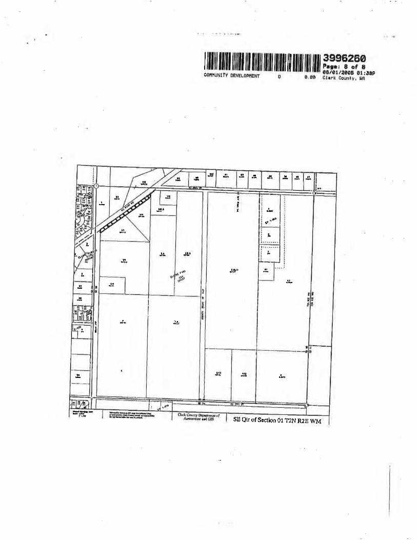
lflil rlll illililüruil ilil ltilt ilt ililt illl lill åi.1i3i3,,,col¡luNlÌy DEvELOFfiEitT D ø.06 clrrk cþunty, fln
T!
g at ¡la
i¡
ttI
Í¡ I
ll
I
,¡$fl
t.F.t
M' qJLr
I
t at
I
gtaj
II
NW -"-Ì€:.Jvcft*.á-Ê-¡EiE*Ëftr..;11* ùl
fil SE Qtr of Scctlon 0l T?N RZE WM
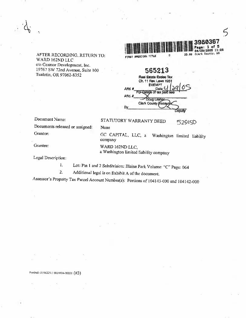
4 5
AFTER RECORDING. RE]'URN TO:WARD I62ND LLCclo Grantor Developmenf, Inc.19767 SW 72nd Avenue. Suite 100Tualati¡r, OR 97 062-83 52
Document Name:
Documents released or assigned
Grantor:
Grantee:
I il1il illll ffi ffi illlll ill illll Ïl llil tü l|ü r,#,"ï,1,Ï,,FIRãT Rr.tERlcnN TITLE
- ";- a3'øs clark 0ountv' t'lA
565e13Feâf Edâle Exolno Ta¡<
Ch,ll Fw, LawsÊXEMPT
Aftd, IAffd. #
Claú County
srAruToRY wARn¿{NrY DEED 5zglsDNone
GC CAPITAL, LLC, A
company
WARD I62ND LLC,
Washington timited liability
dtåx
a lVashington lirnited liability companyLegal Descríption:
l. Lot: plrr l and 2 subdivision: Eraine park volume: ,.c,'page: 064
2. Additional logal is on Exhibit A of the rlocument,Assessor's Property Tax Parcel Account Number(s): Portions of 104143-000 and t04t42-000
Ponlnd l-2 t942?e. t Ooz.roz+.OoOtr (#3)
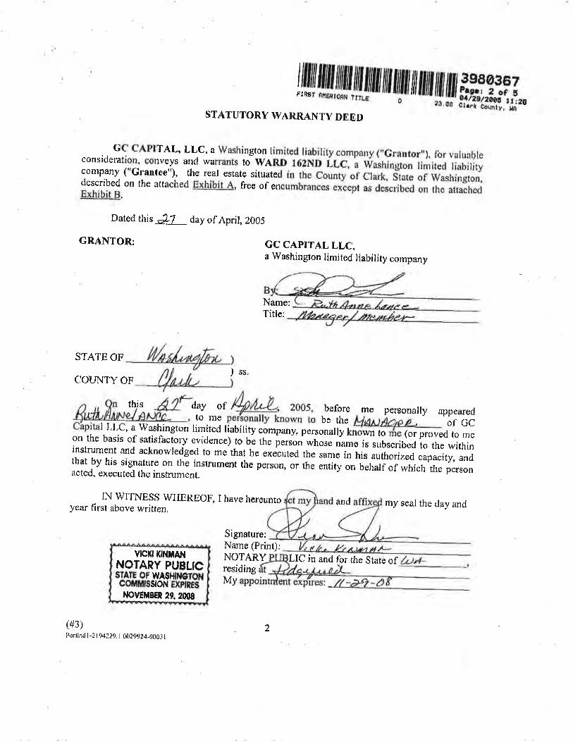
Gc CAPITAL, LL_c, a Washíngton limited liabitity cÕmpany (',crântor,'), for valuaþleconsidemtion. conveys ancl warrants tiwnRn t6zNt iic, r washingron limited liabitirycompany ("G*ntce"), the real estate situated in rhe county of clark, itate of wasrríngton,described on the attached Exhihit A, free of encumbrances elept as described on the attachedExhil¡it 4.
Dared this &7 day of April,Z00j.
cRANTOR: cC CAPITAL LLCa Washingron iimite; liability company
Name:Title:
STATE OF
COLTNTY OF) ss.
lilülliltil,fl fllJll,tjilil/tiililililt/il//tfl ilt/Í#iff i,,i.STATUTORY WARRANTY DE ED
{fl,rt L, 2oos,per"sonally known to
this day of before me personally appearedto mç be thc of GCI LLC, a'Washington limited liabi lity company: personally known lo (or proved to meon the bas is of satisflactory evidence) to be the person whose name is subscribed to the withininstrument and acknowledged to me that he executed the same in his authorized capacity, andthat by his signature on the instrurnent the person, or the entity on behalf of ivhich the personacted. exccuted the instrument.
IN WITNËSS WI-IEREOF.,year first above written,
I have hereunto and rny seal the day and
(#3)t $rtlnúl-21 q4229. I 002992!t-00ôi I
Signature:Name (Prinr);NOTARY LIÇ in and for the State ofresidingMy
vtcKt tffitAt{NOTARY PUBLICSÏAÍE OT WASHNETOHcoiltfiilsstoN ExPtßEs-ltovÉt$BEn 29.200s
2
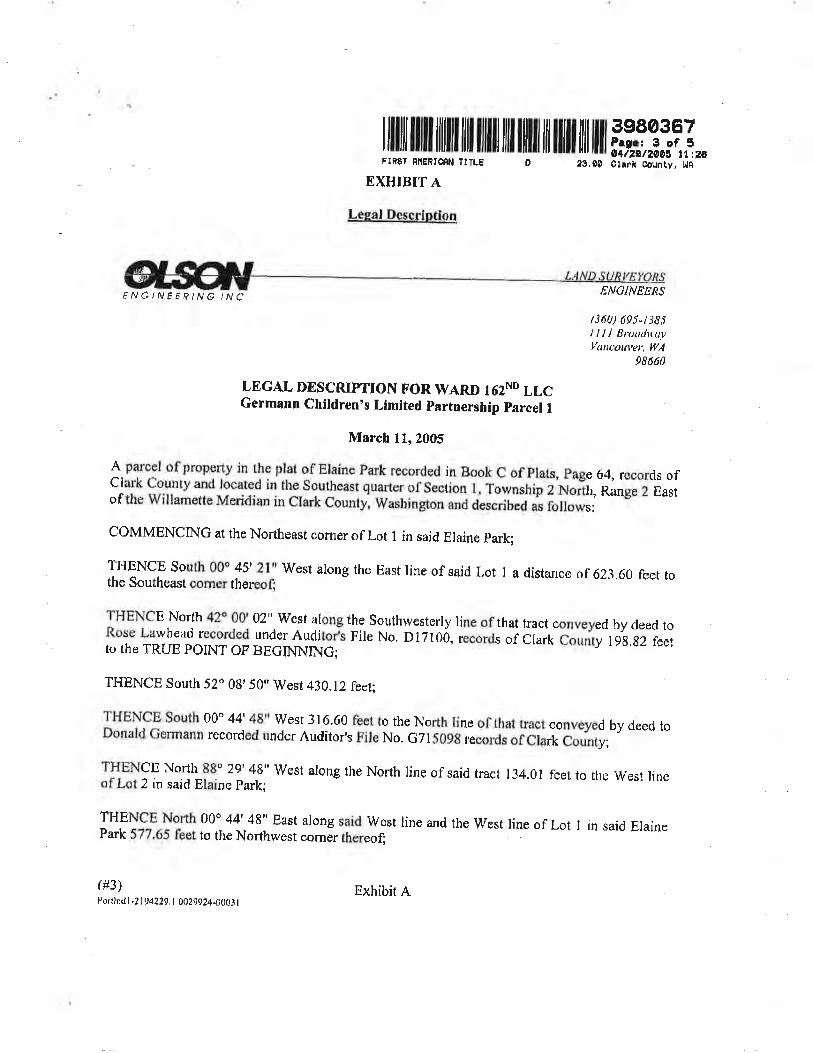
I lllill uil ilililt ilil ililll tilt llilt til ilil ilil lllt398036?Prgc 3 of 5ø1t2øt2øø4 tt,2a
FIR$Ï RilENTCRI{ fTTLE
EXTTTBIT A
Leg,al DeEcrÍptioCI,
â9,90 C¡àrk Couñty, l.lAD
FNGINËERING INC
(#3)l)ortlndl -? | 94229, I 002t024-000i I
ENCINEERS
(360) 695-t s8lllll lJruuilu.vVaucout,er, Il/A
98ó6ü
LEGAL DESCRIPTTON FOR WARD T62ND LLCGermann Children's Llmlted partnership parcel I
March ll,2005
*.pTTl of property in the plat of Elaine Park recorded in Book C of plats, page 64, records ofclark County and located in the Southeast quafier of section l, Township i Ñoñ¡,ïun gez Eastof the Willamette Meridian in Clark County, Washington and dlscribed as fi¡llows:
CÖMMENCING at the Northcast comer of Lot I in said Elaine park;
ITIENCE South 00o 45'21" lVest along the East line of said Lot I a distance of 623.60 feet tothe Southeast oomer lhereot
THENCE North 42o 00' 02"-West along the. Southwesterly line of that tract conveyed by deed toRose l-awhead recorded underAuclitort rile No, D1710ó, records of Clark County-lgg,g2 feetto the TRUE POINT OF BEGINNING;
THENCE South 52o 08,50" West 4i0.12 feet;
THENCE South 00o 44' 48u West 316.60 feet to the North line of that tracr conveyed by deed toDonald Germann recorcled under Auditor's File No. G7li09B records of Clark C"untv,
THENCE North 88Ô 22' 4!" lVest along the North linc of said tract 134.01 feet to rhc west lineof Lot 2 in said Elaine Park;
THENCE North 00o 44'-48" East along said West line and the Wesr line of Lot I in said ElainePark 577.65 fcet to the Northwest corner thereof;
Exhibit A
I lllll lllll llilll llll llllll lil llllll lil llill llil tlll ffi3-1T1,,FTRËT ÈTIERICNN TTTLE 2f,00 Clrrk CountY, l{â
D
THENCE North 52o 0q' 59" East along said North líne 34g.gz feet to the sourhwesrerly tine ofth¿t tract conveyed by deed to Rose tarihead recorded under Àuditor,s File No. D17100, recordsof Clark County;
THENCE south 42o 00'02" East along s¿ici southwcsrerty line 289.75 feet to the ïRUE porNTOF BECINNINC.
(#3)t\¡rtlndl -2 1 t) 42Zt). I (r{t?gg24.0003 I
Exhibir A
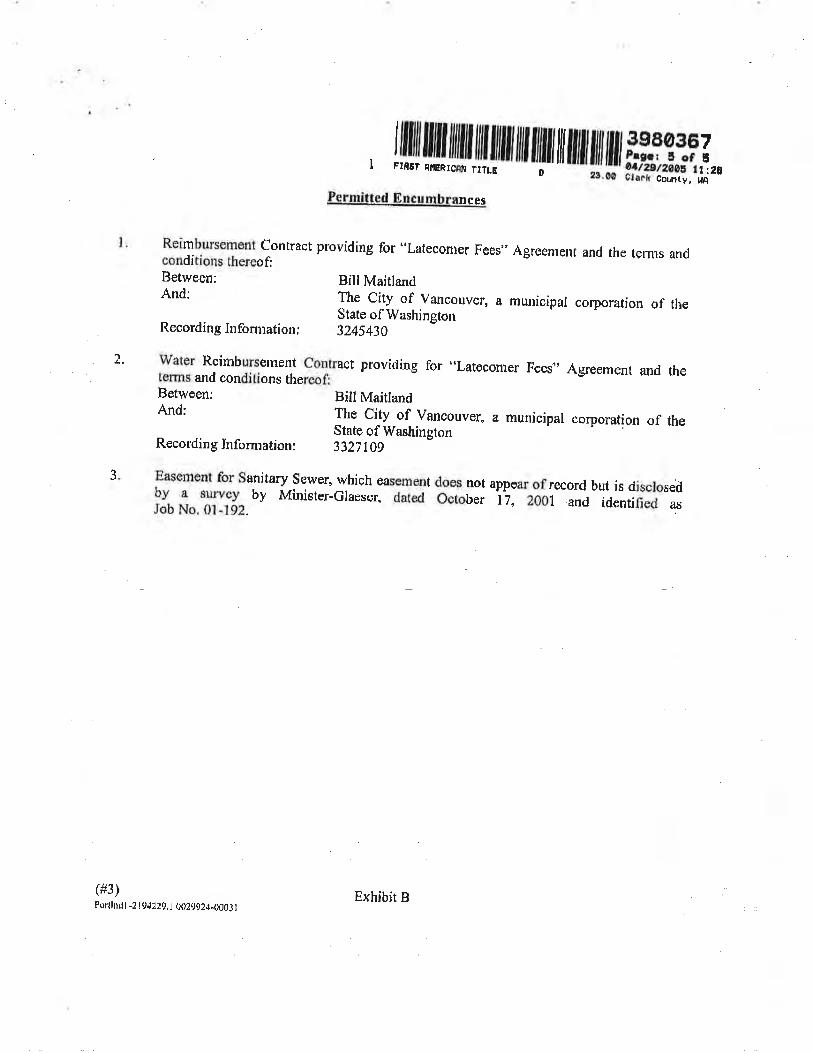
2.
J
, /lililIillil1ilililIlililIililIilÍlilIlilililtfl ilt i#ffiîl.
PFrmi(,te4 Encumbrances
Reimbursernent contract providing for "Lateconler Fees" Agreenrent and the terms andconditions thereof,Between: BillMaitlandAnd: The city of vancouver, a municipar corporation of the
State of WashingtonRecording Information: 3245430
water Reinrburselnent contract providing for -'Latecomer Fees"n Agreement and theterms and conditions thereof,
Between; Bill MaitlandAnd: The city of Vancouver, a rnunicipar corpomtion <¡f theState of Washington
Recordinglnformation: 33}7l0g
Eascrnent for sanitary sewer, which eâsemÊnt does not appear of record but is disclosed9v. -t rpr.y by Ã,tini*t"t-Grærur, áoì"d october 17, zo0r and idenrified asJob No. 01,192. - ''
(#3)Portlnd I -2 I 942¿9. I 002q92,t-000i I
Exhibit B
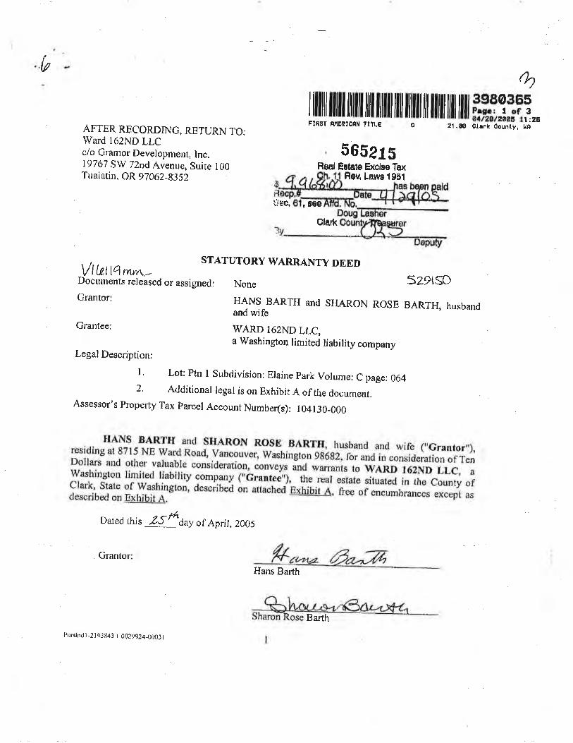
(/
Ø
ruü il!!üfiliilt il|il ill ililt til ilIil ilil illl r#i:,ql,FIBST ÊüãñtcßN T¡TLE i z1.oo cri* counri,-¡À--AFTER RHCORDING, RETURN TCI:
Ward 162ND LLCc/o Cranror Developnrent, Inc.19767 SW 72nd Avenue, Suite 100Tualatin. OR 97062-83iz
Granlor
ã65215Heal Ertate Exolse Tax
Feu Lawe 1981
ùTþC, ,8Ðê
Olark
vt r.etlï wwn_ ST.A,TUTORY WARRANTY DEED
Dbcñmenis rcleäsea or assignedr None SZPISOGranto* HANS BARTH and sHARoN RosE BARTH, husband
and wifeGrantee: WARD l62ND LLC,
a Washington limited liability companyLegal l)escription:
r. Lot: ptrr r subdivision: Eraine park vorume: c page: 064z' Acrditionar regar is on Exhibit A of trre documenr.
Assessor's Property Tax parcer Account Number(s): r04130-000
rlANs BA'RTH and sHARoN RosE BARïII; husband and wirÞ (,,Grånúor,,),resicling at 8715 NE ward Road, vanÇouver, washington ga:6az,for and in consideration of renDollars and other va.luab-le consideration, conveys ind warrants ro WARD l6zñD LLC, ãwashington limited liability company ("ilrante6"¡, the rliestat" situat"ã ¡n l¡e countv orfJ]ihi,iiîïïffiT*ton, desciiteä àn anact'"0"e*r,iúii Ã,
-r.ee or *r"Ãui"""Js except as
Dared this ,Z{frdu1of Aprit,2005
Hans Barth
f¡ortlntl I -2 i i}J tì43 .t \t)ZggZ4-ÐUtJt
Bar-th
ru ru,llilïl,L{illl ffi ffi ilt ililt
{ll Ht H,å#_iqi,,
on this dav persr:naily appeared before me Hans Barth, to mç known tô be theindividual or inclividuäls descriúed'iñïtiãïrtá rirruiJ¿ ìir!'*ifii" and foregoing insrrunrenr, a'.acknowledged that he signed tne same as hñ fËänä;;l#rüü acr and deed, fbr rhe uses andpurposes mentioned.
Given under my hand and offÌciar seal this -zsft^yof Aprir, 200s.
STATE OF WASHTNGTON
I'OUì\JTY OI.- CLARK
STATE OF WASHINGTON
COTINTY OF CLARK
))ss,
)
Signature:
Name (Print):
Name
the S
))ss.)
i"dinid,glJl'ii$T,JT'J'-"ffi':"ååå.,fl#rråff"Ë:fi3iîf;îJlffåiiä.k,:îäïi,:ffi"ï,i:_1,1,;
;i,Yd#1"*åiiiå1fJh" sisaed th" ffiä. ü' rd;*ã ili,;iö acr and <iêed, ror trrc uses and
ci'en urrder my hand and officiar sear trris d{ourof Aprir, ?00s.
S
VPUtjilü
¡,t( tA
2Por(lrìd I -2 ¡ 03 84J. I 1,029924_000J I
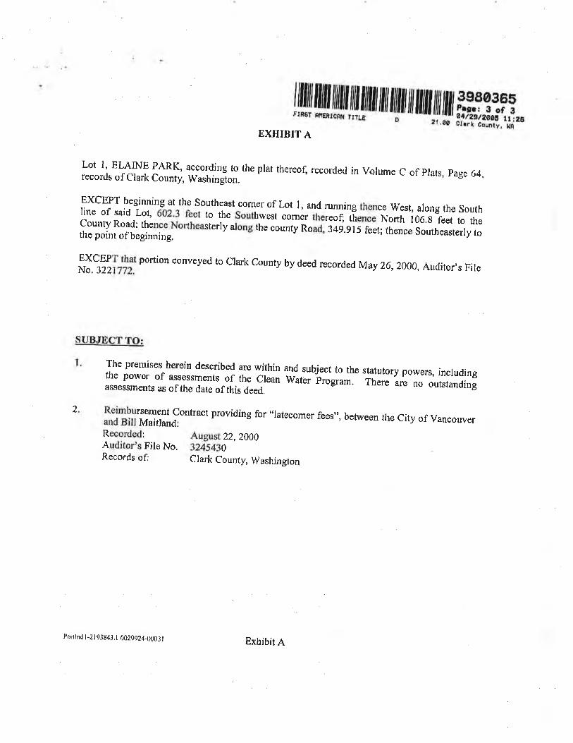
l ru fiu,ffil{tilJilil /ililllililil ililtfl fli fi,äîffiäEXHIBIT A
Lot l' ELAINE PARK, according to the plat thereofl recorrlccl in Volume C of plats, page 64.records of Clark County, Washington. --' ---v'$Yr'
EXCEPT beginning at the southeâst comer of Lor l, and running thence ït/est. along the southIine of said Lot, 602'3 fect to the southwest comer thereof; thence North 106.g feet to thecounty Road: thence Nonheasterly along the courrty n"rà,'i¿ö.g 15 feet; thence so*t.urtrrty tothe poínr of beginning.
EXCEPT that portion conveyed to clark county by deed recorded lvray 26,2000, Auclitor,s FileNo.3221772.
SUBJItrCT TO:
The prernises herein described are within and subject to the stâtutory powers, includingthe power of assessments of the crean water þr"gr;;:- "it
r* are nö outstandingassess¡nenfs as of the date of this deed.
Reimbursement contract providÍng for "latecornÇr fees", between the city of vancouverand BillMaitland:Recorded: August ZZ, Z00OAudiror's File No. 32rii43tRecords of: Clark County, Washington
.|
Porlh.I I -2 I 9384,r. I 0029924-0003 ¡ Exhibit e
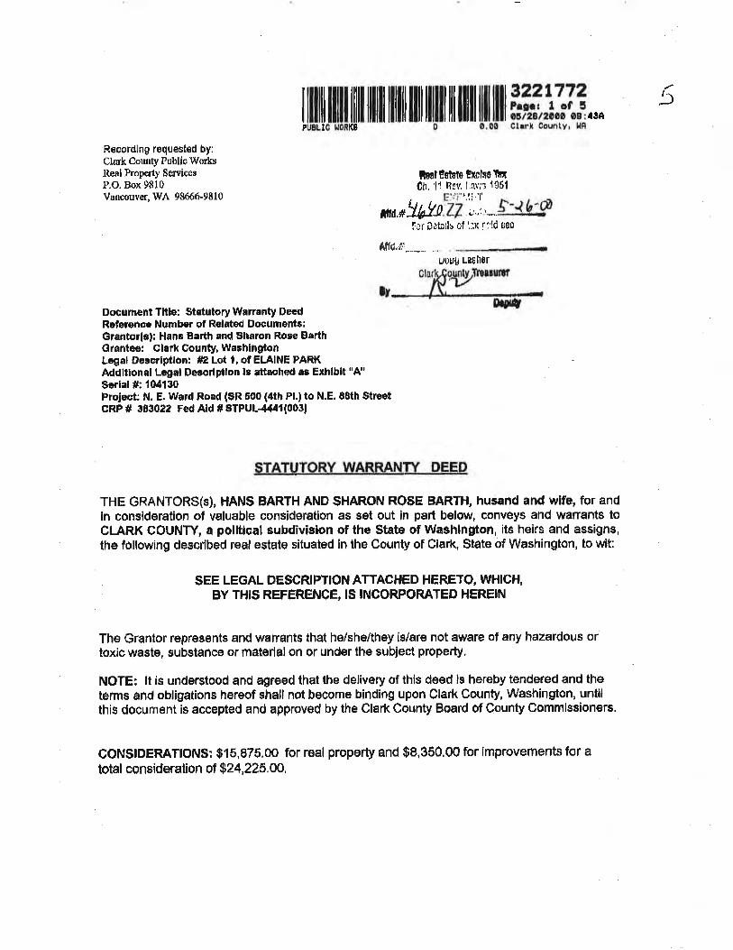
tffiililllül lllill llilll llil llilll lil lll ililr #ffiåiii.,.5
Racordlng requested by:Clûrk Couttty tlublíc Workulleal Property Serviccs
P.O. Box 9810Vuncouver,\tr 98666-9810
toal Ëilalo Exolso llnch,11 Rev,1.rv;i 1û51
l_.,,ï.r ri.,f.
ñd.*wnzz )""--t-l-g/flr пta¡lu of t:x f:ld seo
Affd'¡i;*-.--. ..uouu ta$hor
IT
Documênt Tltle: $tatutory Wnnanty DeedReferçncc Number of Rolated Documente:Grantor(*f: H¡n¡ B¡rth and $haron Ro¡e BerthGrantee: Clarl County, WashlngtonLcgal Descriptlon: #2 Lot I, of EIAINE PARKAddlt¡onâl Lcgal Darcrlptlon ls attnahcd ¡s Exhlblt "A"Serlal #: t04130ProJect: N. E. Wa¡d Road ($R 500 (4th Pl.) to N.E. 88th $tr€ËtcR.P # 383022 Fed Ald ¡ glpu¡444r(003|
$TATUTORY WAnRANIY. pEEp
THE GRANTCIRS($), HANS BARTH AND $HARON ROSE BARTH, husand and ïv¡fë, for andin consideration of valuable consideråtion as sêt out ¡n part b€low, convêys and wanant$ toCI-ARK COUNTY, a polltlcal subdivislon of thê State of Washington, its helrs ånd ass¡gns,the following described r€al estate situated in the Çounty of Clark, State of Washington, to vvit:
sEE LEGAL OESCRIPTION ATTACHED HERETO, WÞllGH,BY THIS REFERENCE, IS INCORFORATET} HEREIN
The Grantor represËnts and werrants thal he/she/they is/are not awäre of any hazardous ortoxic waste, substånce or matÞr1âl on or under the suþiect properly,
NOTE: lt is understood and agreed that the delivery of this deed is hereby têndered and theterms and obligat¡ons hereof shall not become binding upon Clårk County, Washington, untilthis document iÊ accêpted and approvod by the Clark County Board of County Commistioners.
CONSTDERATTON$: $15,875.00 for real property and $8,350.00 for improvements for atotaf consíderat¡on o'f 824,225.00,
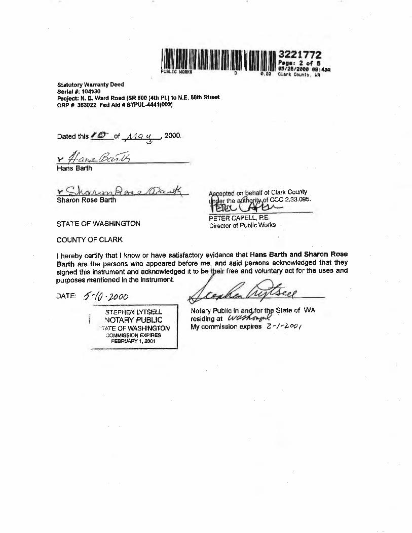
lffiffil|lilil ltilÍ ililil ilil ltilil lil illil iltilil #i #rär_Statutory WarrantY Deed$erlal #: 104130Pfojsat; N, E, Ward Roed (SR 500 (4th Pl.¡ to ¡¡.8' s0th $treetCRp # 3830¿2 Fed Ald il STPUL-4¡l4ll003l
Dated tils {"Ð- çr 4&--*-, 2ooo
v4n ßrr#,Hans Barth
on of Õlark County$haron Rose Barth the ccc 2,33.095.
STATE OF WASI.IINGTONPETER CAPELL, PE.Oireotor of Public Works
COUNTY OF CLARK
I hereby certify that I know or have satisfactory evidencö thåt Hans Barth and $haron RoseBarth are the Persons who aPPeared before me, and said persons acknowledged that theyslgned thie instrument and acknowledged it lo be free and voluntaly act for the uses andpurpos€s mentioned in the instrument.
DArE: f '/0 .200ö
Notary Puþlic in an{,for 1þ Slale of WAresiding al L+/ú%'*1AJ(My commission expires Z'/'Lots ¡
3TEPHEN IYT$ËLLI-IOTARY PUBLIC
1þTË OFWA$HINGTONüOMMI8SION ÊXPIRËS
ËEBRUARY 1.2OO1
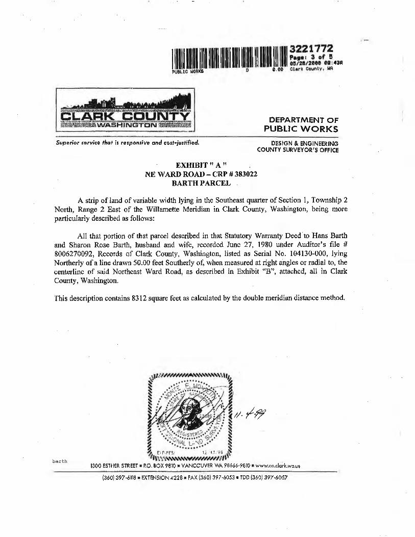
ilil ilffi lill lllll llllil llil llil lil llll ilil ll Ffiilifi .'.ÞUBL!0 l¡onKB
DEPI\RTMENT OFPUBTIC W()RKS
Superíor rervic€ lhof k reeponsive ond cö6t-iurtíf¡êd. ÞESICN & ENGINEERINGCOUNTY SURVEYOR'S OFFICE
. EX[ilBlTilAilN$ WARI} ROAD - CRP #383022
BARTH PARCEL
A strip of land of variable width lying in the Southeast quarter of Section l, Towrtship 2
Nofth, Range 2 East of the Willamette Meridian in Clark County, \ilashington, being moreparticularly described as follows:
All that portion Õf that parcel desmibed in that Statutory Warranty Doed to Hans Balthand Sharon Rose Barth, husbzurd and wife, recorded June 27, 1980 under Auditor's file #
8006270A92, Records of Clark County, Washington, listed as Serial No, 104130;000, lyingNortherly of a line drawn 50.00 feet Southerly of, when measured at right angles or radial to, thecer¡terline of said Northeast Ward Road, as dcscribed in Exhibit o'8", attachedo all in ClarkCounty, Vy'ashington.
This description contains 8312 square fcct a-s c¿lculated by the double meridian distancc ntcthod.
// /"fy
E) FIÊF9 12 . 13.: -û9
lO00 ESTHER STREEI ¡ PO, BOX 9810 ¡ V,ANCOUVER WA 9€óó6.t810 ¡ wwwco.clork.wo.usbäxth
{3ó0}397-óllå r EXTENSION 4228:FAX (3ó0)397-ó053 r TDD (3ó0) 397'â057
1ffiruililü/ilililililililtil1tililil1iltililüililå,1'?ffi Tår,^
ÞEP.A,RTN\ËNT OFPUBLIC WC}RKS
$uperior reryícè ffiof .ís re sponslve ond cosl-iusfífíed, DËSIGN & ËNGINEERINGçOUNTY SURVEYOR'5 OFFICE
, nxHjgyy upn
NORTHEAS'T \ryÄRD ROAD CANTERLINtr TJISCRIPITON
r\ strip of'land of varying wiclth in Northeast 1/4 of Section I l, the Northwest 1/4 of'Section 12,
and the Southwest l/4, the Southeaet l/4, and the Northeasl ti4 of section 1, 'fownship 2 North,Range 2 East, of the Willamctte Meríclizur, Clalk Corurty, Washinglon, being rnore parlicularlyclescribed as follows:
Begiuning at a point in the ccntcr of Northeà$ Fotrrth Plairr Road, said poi,nt bears. South
3000'20.| West I848.46 feet hom a concrete monunrent marking the Northeast corner of the.lohnCalcler D.L,C. #44, said point being designatecl Engineer's station l+41.41; thenss North23"48'17" riast 2205,63 feet; tfience along tlre arc of a 817,80 foot radius ourve right through acer¡tral angle of 29'33'45 a distancc of 421,95 feet; thence North 5322'02u East 1498.41 feet;
tlrence Norlh 52o44'02* East 2140.26 feet; thence North 52l09'02ba$ 9A3.22 feet; thence North5229't2u East 737,11 fee{ to a point which hears South 33o38'15" West 2565.84 foet frorn abrass cap rnarking the Northeast corner of saicl Section 1, being designated as Engineer's station
80+50.00, and there terminatiug, all in Clark County, Wasliington.
Bearings hereon uso âre Lrased on the TVashington State Plane Coordinaie System, Soutlt
Zone, NAIJ S3/91. Corrtrol schente is on file at the County Suveyor's office.
// ,/,r,;
1300 ESTllElt STRFET r P.O. BôX 9Bl0 r VANCOUVER WA 9Bóóó-9810 r www.co.clork.vo.us
1:.,'1 5¡ ç9Ë): PtRËS I
ward l3ó0) 3t7-óItB r EXTENSION 4228 r FAX (3ó0)397-ó0s3 r TDD (3ó0) 3e7.6057
r ilrilt ililt ilil| iltill illlil llil ilfil ril ililr ril lllpu8l¡c ltoRt(B 0 0,00
s22t772Pr¡rr ã cf ã0átæ1200O 0e:4AnChrk County' l,lR
Clork County Public WorksVoncouvei, Woshlnqton
DES/6IV Ec ENCINEERIN9 ÐlWSloNOFFICE OF IUE COUNTy SURVErOR
SW 1 1
T2 RzE, W.M,
SKTTçH TO ACCOMPANYLEGAL DESCRIPflAN
5CÁ¿E DRAWN 8YDATE
ocT 1999 NONE DDC
EXHIBIT UCN
SíRAL No. t)4t30
SERIAL No.:t53976
SERIAL No.:1540J5
ilE
SERIAL No.:'t04142
SERIAL No,:104130 SËRIAL No,:
t04t 64
NAT TO SCALE
/#EXPIREST t2/ 1J/Ss
j r.i!!, ..-_ _.4 . ." .
í¡1
1'l
,t:l
î..
'"ji"t.,tl;l.'l1l
;il".:
l::l
í)l.,'ll'l
I
l
AFTÉR RECOR0IIIG RÊrURN TO:Katey A, Schoertfeldclo The Bessen Law F¡rlh, P.C.
^*,37ffi$T. àÉ:?ihr dct¡rb ofI¡X 0ãld sse
806 Broadway,VÊncouver, WA
ÐAiEDI
ËROM.
TO:
STÀTË OF WASHINGTON
COUNW OF CI}RK
LCIRI A. PnSlJlY
sfñE 0íNiOTARY
l,t Coiliilssron
$5020;J0128
ss.
änd for the
R¿¡l ¡ôbþ !)cise tilCh,11 Rev, lan l95f
IreÀîunl
S¿¡lto 7359866û
siATurcRY eulrctittJt DEED Alrd
This lL -day of Norrember, 1994
Albert and Lena R, Germann, husband and wife
The Germann Children's Limited Partnership, a Vüashington limitedpartnorship ("Grantee")
For love and affocticn, Graniors convey and quitclairn to Grantee, subiect to all
liene and encumbrancBs norry oi record, all of their right, title and interast in and to th€
foliowing desr;rihed real propolry, situafod in the County of Clark, State of Washlngton:
Lot 2, EtÂlNE PARK, accorqing to the Plat thereof recorded
in Volutne'C" of Plats, at page 64, records of Clark County,
\'Vashington.
EXCEPT, beginning at the $outhv¡est corner of sald Lot 2,
ihence Eâst, aiong the South line thereof, 3'i2 feet; thenceNorth 208 lset; thence West 312 íeet to the West line of saÌd
Lci 2i thence South, arong said West line,208 feet to thepoint of beginning
GR,A¡\TORS:ALBËRT GERMANN
LENÂ R, GERMANN
On this day peßonally appeared before me ALBERT GERMANN ancl LENA R. GERI4ANN, tome known to be the lndlvidualB described in and who excouted the foregoing lrls',rumenl, Ènd
acknovrledgod the said irlslrument lo bg lhoir free ând voluntsry âc{ ãnd deed, fof lhs uses End purposos
lhsreín menllon€d.
GIVEN undsr my hand and oflcltl seal thls f994.
euz¿åT?l,ilnruce
OIþ
lg.ruú\dâêor\çhr¡ dp'/, t\ / I I 9rl
"l ;i
. rl
ÂFTêR RËcoRúlN$ RËTURN iOrKatoyA, SohcenlbldcJo Tls e€sûert Law Flm, P,C.005 B;oadway, Sulte 7õ6V'r¡roóuvor, WA 9ô6e0
ÐATEO:
FRGM:
TO:
1,Íi02030i.ii-:'7Roal tshþ E$r$ l¡rCh. 11 8gv, Lav's'1951
o*,oJ:ff[,,,T-Uf
For iove and affoctlon, Grantors convey rnd guitclaim to Grantee, subjeat to allliens and encu¡îìbrsncoo now of rêcord, all of their right, title and lnterest in alld to thefollowing descrlbed real prvperty, situated in the county of clark, slate of washlngton;
That portion of Lot 1, EI-AINE pARK, according iv iiu platthereof recorded ln Volume ,'C,' of plats, at page 64, recordsof Cla¡k Oounty, \flashington, C-scrib*d as fi¡llows:
ftí detlls ol h)( patd seo
STATUTÛRY QUITôÍ.AIM ÐEËD0otrg l¡sher
This /Á day ofNovember,1994Trea$Jßf
Albert and Lena R. Germann, husband and wife
ïhe.GErmann Chilciren's Llmited Partnershlp, a Washington llmitedPartnerehlP (,Grantee',)
Bøglnning at the Southeast corner of said Lot 1, thencel /est, along the Soufh line thereof, 602.3 feet to theSoulhwest côrner theroof; Thence North, âlong the West lineof said Lot 1, a distance of 106.8 feet to the Norlhwestcorner thereof; thence No:'th 49"33, Èast, along lhe Northorlyline of eaid Loî 1, a dlstance of g4g,g1S fbeti thenceSoutheastrrly, in a slraight lino, to the point of beginning,
ALBERï GERMANN
LENA R. GËRMANN
GRAN*IORS:
STATE OF WASI.IINGTON
GiVËñ undor ny hand sñd oíÍc¡äl ôèal thle lþtla^y or
LORI A, FROI.ITI
sIATr or ll/¡'sl.llN(ìT0N I
Nf,'!RÌ. Pl,;8t.rc i rosidnrg atlr'ry ðommission
couNrY cF crARK i 'u' Efreaf!|¡;a
. on this d6y persùnaily ¿ppearod befoíe ñe ALBERï GERMANN and LÊNA R. GERMANi,iro¿ucfme kriown tc be the l¡cllvldualc descr¡bed in 6nd who Executed tho loregoing instrument,
"r,0"-
' " " '
âoknowiÉdged tlte eqid instrument to De their frÊe end voluntary act anddeã¿, lor t¡e usêJãnd pu,nposesthürelfl nontíon€d.
,1994. 614
,lrl,v fomrr+trr i¡tftr¡ I '
.../J4p
{gc&ntr\d."de\childp¡I. tf /¡/9a)
for thê
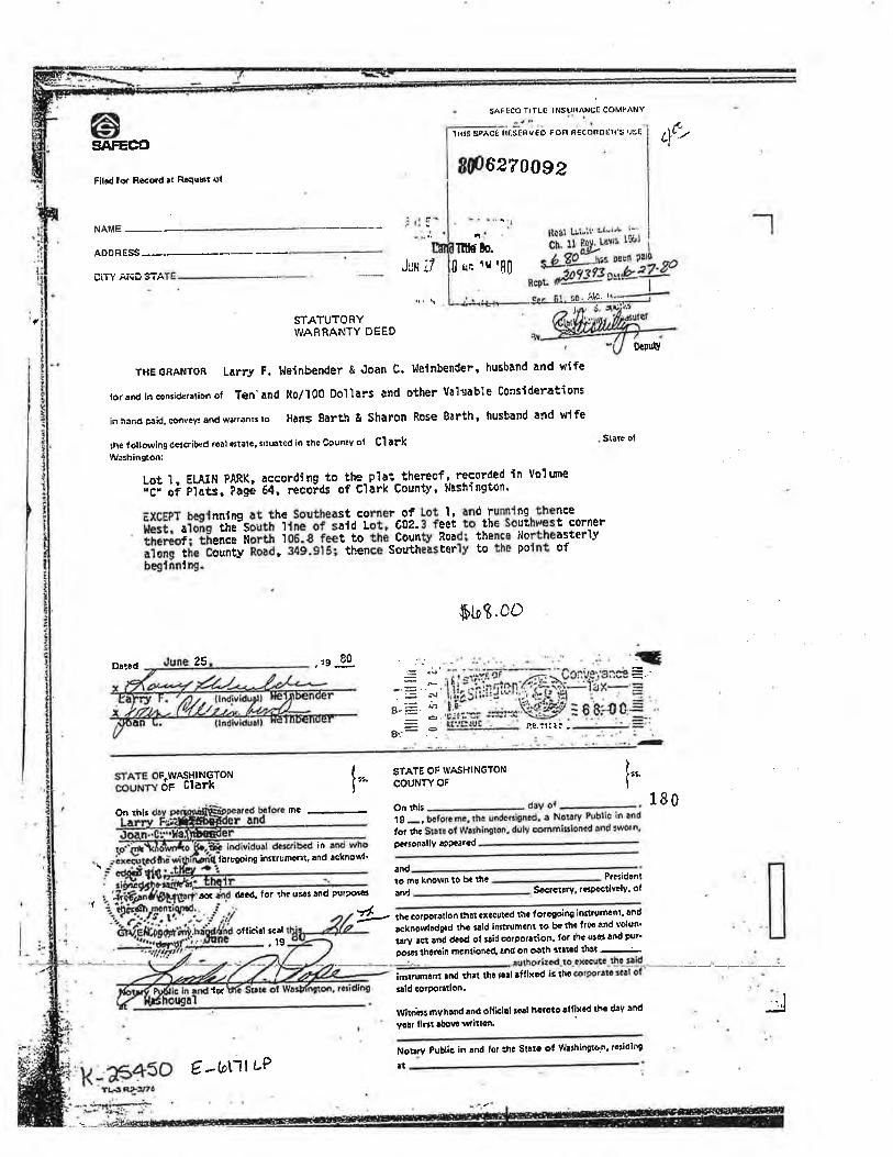
êSAFË@
SAFICO TIÏLG lNSun^NC[ CoMl'^NY
Ìilr5 SpÀC€ HÍ,SE¡IV€O fon nEcoRDen's usE Lf/gp62?00e2
F¡lôd for Ro€ord ¡t Rôqú¡rt ol
ADORESS -*-_-*UllY åll¡JùrA
Dåtèd 25 .'g9
,i r: : ...,...'
ntls'to.Jl,lH r/ (J qc tr'80
i{c. I
f STATUTORYWARRANTY DEÊD
THEGnA|{TOR Larry F. },leinbender & Joan c. }lelnbender, hueband and wlfe
lor¡¡rdincon¡ider¡¡ionoJTen..andNo/l0oDoì.larsandotherVa.l'¡ableConsiderations
inhandprid.crîvlysandwarranr¡¡o Hans 8ðrth & Sharon Rose Barth, husband and wlfe
rh¿ lottowing delcriþ{d rôôl etlatc, ¡lrutted ¡ô th. Counrv of Ç'l ¡"¡W¡rhin!ßoni
o{puv
Stårð ol
Lot l. ELAIN PARK, according to the-pìåt,thereof,. recorded in Volme;ð; å¡ pl¿il,'iiüé È¡: recoids of cìark Countv, Nashinston.
EXCTPT beglnnllg at the Southeast corner-of Lot l, and running.thence
Ëii,-aiõñS ihe-South ltñÁ-oi-sat¿ Lot, 002.3 feet to the southu'est c¡rner;ñtË.tì;-ãñ-ñäõ Ñàru¡ iòË-¿-iuãi'io-iñé countv Road¡ thence l'lortheasterìv;ffi;-il.-ö;ü;lt'ilã' ilg.glsi thence southeâsterìv to the polnt ofbeglnnlng.
STATE OF.WASHINGTONcou¡ry ôp Clark
Þt¡9. cO
STATË OF WASHINGÍONcouNw oF
t:g <s
a-=:. -'
g..': .Ì
ÍÌ¡.(I
If'*
Oa rhl¡ mê-
in
tôf bgp¡ng ¡rìttrumar¡L ¡nd acknowl.
åût rtecd, lor tho u¡¿¡ ¡nd purpo¡c¡ art)
ofl¡clâl ¡câl.t9
{ol
onrhh dayor- . 180'¡9
-, bcfolc me. thê uodÊr3igncd. a Noltry Public in ¡nd
lor rhc Sutc ol Warh¡nglon. duly commi¡¡ioncd and ¡wotn,
'{
prr:orrlly¿tPcarco
-
¡ndto ñû knowô to ba thc Prøidenr
SGcrcr!ry, rc¡Pcct¡vûly. ol
Ð thc corpotålion thlt ôxccutGd r¡ìc loragoiôg ¡ñfitumcnt. ond
rckôowþdgtd thc t¿id ¡nrtrumcnl ro bG th! frso ând volun'
rrry rgr ônd dâld ol tlid corporrt¡on. lor rhû utÊ3 lod Þur'
porât ihorôin ücñr¡onôd, ¡nd on oåth ¡tllcd ¡hâf --¿
inrtrumûnf tnd th¡t¡¡id corponrlon.
tho ¡t¡l ¡lllxod i¡ rho
Wirrit¡¡ myhrnd ¡nd ollicì¡l ¡o¡l horoto ¡lllxcd thc d¡y ¿nd
yôlr llÉ! abovo wllntrì'
Nor.ry Publ¡c in ¡nd lor :ht StrlË ot W¡'hin$on. tÛtidl¡R
l(-aE+sorþ6 ¡â-:/tó
€. -tol1l t-P rt
_!
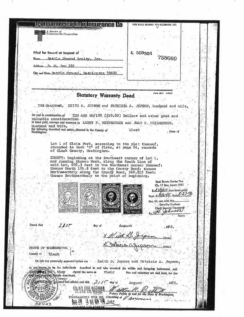
lHlS SPACI ¡!S¡RV[0 tOn l[COnDtl'S USGI
G õti$gz¿ ¡t5CI6co
lr t
.:.
:i;:
li
llfi t,ri:;:;ii,:,,i1,,,, I iu r t,n,
Dåted this Å'l¡r ¡luguet
|brm l0'l- ,l.tlttv
)uÍl0,
ftctutorq lVarrgnfy" Dged
, .THEGRÀNTORS'. l$1Tl'l G. JäFSON qnd FATRICI¡\, r1,, Jll'5011¡ huelr.and and trífo,.-'....1 .,i :.., "í :
for¡r¡¡t in co¡¡ldffntlon.of .Ip¡i ,\l.tD tco/tOO ($10.00) Doltars änd otheú 6bocl encl .yqli.rgtilocónstcloratfon. -, ','., : ...: . j ,
lri hnrrdpirld,convcylandw¡rrûnr¡to.ful"PEY r'. $ur¡v¡ntrogg arlcl .Jp¡lN c,.['/EII.IDENDER, :
ItueLr€tnd ancl rvifa. " . :
iltttlf*ï ¿'o]'*r¡iirï'li,ntó,.srtuntcu ln the county or ' .. ctarlc , srite orI
Lôt I of illcin Paf,li, accorclLng to tho Þlqt thoreof ,rocorcJocl ln Boolc rtçtì og Platsl at p¡rgo-64, recordã'of CLErh Counryr I'faahingt-on
iilt0h'ÌìT¡ bogLn¡rlne aü Lùo Souüiroaet cotrnor of, fuot Lrarrd runnlirg thonco l¡c6tr, elong the SoutLr lLlre ofcaíd'Lou, 602,3 f@et .to the Sõuthrvost corncir Lhôroof,¡thonce l'þrth 106.8'faot to ttlo Coudl:i, Roacl¡ thoncoI\'orfheastörly along tho Coun.tjr Road, 349r9"15 foorithênco Southoqstorty to .tho polnt.of .boginning.
heql È¡lqlo'Ëxclee Tox .
; Ch,ll Rev.lawa l95l '
'' s "Zy'o/' o:1^"" bosri Prildi.
n"rl. + 1.&.4*o;ia41,?ì Su.. ólr ¡ee Ald, No,' ,: .'ÞorolhYCorlton
ilork Çounlv Troosurg{ '
';rW
STATD OF. WÂSHINCTON,", . .. ," i" l¡s' '
Countyof j Ctarlc' .l ..
dry of
.rigned the samo as thefr
.; ,.
'r: .'.,..,.i.... . : |
:. .. , .,,
Orthlsdaypersonatþ,appóarerlþefoiämc . .:.tfulth GJ Jopåo¡'ariö Fatrtcla ¿\., .Jopeonr'.,be.the indlvidlab de¡crlbsd ln nnd who 'e¡æuted'the wtilln and
, foregolng _lnstrunent; . sdd
voluntary act aird.dced, foi tbo:" ' :,mentloned.
l.
.li¿e ¡nd
/,ff dov'9r ' Àtr¡lust
Nolary.Ctasldìng aì fu.*.q
tts7q.ti.t,L tiff''iL;iil
rúNsuvt¡:uct
['tft40 $ 'l,Fae\'<-¿rlr'te tNs.
$1 {lA 1l$
l)01,1,¡11ìs 1\(0 il0t.t./lllli
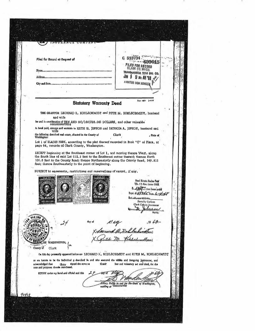
Fllod for Rocord cl,Roquorl of
Stqtutory Tllsr¡qnly DeedFom,li?. I.REV
flü cnANTon tEoNAnD R. KofllsoHMIDT and ¡gg¡¡ M. KoHLgcHMID , huoband
. and wlfefor and rn corutdoralgr ot
ÏåHTAND NO/t00(910,00) DOLLAR0, and other valuabte'
lu ùnnd pold, convoys ¡nd rÍrr¡¡rrE to KEITIÍ G, JEPSON and PATRIOIA À. IEPßON, husband andwlfs
lho followhs dos0dbcd rcûl oltûte, sltuntcd ln tht frunty of Olark, , Strto olWû$hln8loot
l,ot t qt ELAIND PARK, aooordlng to the plat thoreof reoorded ln Book rrOrr of llate, atpâgê 64. reoord¡ of Olark Oounty, Waahington.
nXCEPf beglnnlng st the Southeast oom€r of Lot l, and runnlng thenoo West, alongthe South llno of sald Lot 602.3 foot to tho Southwost oornêr thereofi th€noo North106.SfsettothoOountyRoad¡thenoeNorthoaeterlyalongthoOountyRoad, S49.9lsfoot; thenoe Southeasterly to the polnt of boglnnlng,
SUBIECT to €ag€msnts, restrlotlonF and reservatlons of reoord, !f aúy,
Rool E¡lqts Êxcho Ìdth, ¡ t Rov, tqw¡ l9ô,l.
$ 4fip!1.rro,boen'pcdþcþt.#úîty'*{blnJ,-#(
J/ dnyor /iltf.
Ùe¿"{{l¡cortf#}t".Dorothy Corl¡oh
Clark C{intyr[roosurer
lv==-¡øL )6,4il444d44-/ t¡r,ulti
,ts /ê.*4,
i
wtSHINCTON,
f*Clark
0n tblo doy peroonalþ appeared boforc rno TEONARD R. KOI{ßOfiMIDT and RUT}I M. KOHL8CHMIDT
to mo koosn lo bo the lndlvldual g dêrcr¡bed ln utd wüo eræutcd lùc rllblo and loregoirg
acluowledgpd tt¡t they slgncd lùô r¡ns {r thetr lrê! ¡nd volutrtary acluso¿ ûd Þurpos{¡ lùoroln mcnüon¿d'
Jrytrunont, ardud dced, lor thc
GM0N uurlor ¡¡y lanrl ¡nrl ofñclrl ssl lhfu f
aiillng at
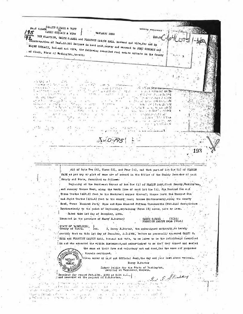
Ío.C 6,*oÍo_r- cr;rr.l r rrr!t¡æ cgË¡_= ¿ z¡rc
)
Ilîs%,
rf¡F¡¡rr Dlso:cl. o¿¡:frrs, Êåë! o-r.rr. rÞd ¡TOi3,CS ¡f¡f:I E¡¡¡, t",
&rsl fg¡¡:, ¡¿i*€.a¡ qá
ld,a¡:a¡¿¿¡ gi !d¡¡9.gçr¡ lo¡ lüfr 1å huû þa¡ôroo¡¡r¡y a¡d
ot ú¿¿¡t, sta¡e cÍ t¡t:!.1a1 tho lol¡o',r8 óo¡orf¡oal aoÉl*,f:¡¡s, ìô-rlt I
Ibrnd ¿í¡a
narraat
o¡t¿t! s¡!5Äïô 14 t&c CôE¡ty
I
t'
1!1 ". r I Ír i.ìh -_
:, rl i
i,, t;j çr¡ iqìg.Jfi: -¡. ì ri'j,þ):t¡t Ãt
, ií' :. .'r '¡ ' ,' .- , c ír. .,^.s4: -... ,. ' û', ,r -'rii x .' r.';'.19.jl . .:i t-,ir -'re lrr..r:.;dlc
.'t i f.t z-'j,,'t{l-. 'j: ".¡: r.i ."!l LC
. '31, h: r': - . 'l::td'Ê t
i:
l.ia.
,r$u'O;ÞSl t.¡r.
193
¡¡18 êa lar ñtp o¡ p.lat ol o¿:o ¿On of rôoôilt,oo'+ty and gtsir, .dGEcrlì,ot as l¿llorü¡j 3o6l&alng s? tho 8otrti:.Bst gora€r of úot 0:c'(ll ot 5r.Å¡¡tû ¡.¡ilx)0lÉr¡r.Courty,rè*¡Ë{'?or.
¿""¿ l* ,tr¿'
,[i.!co îrst¡a (603i3) lost..,ô Uio go¡lhrôct co¡j16r tlisrdoÍi tho¡co liorÈt"-0+d tlrl4òrå¿t 3!¡:i aaó 9lfht !o¡'ùt (10ó.8¡. f6ot to tha oou¡tr.'. rôaô¡ i¡1ono. ¡¡orthoÀotoÍii.a¡o'ù ti:c ùo'tr¡ïEoaÀ. throo üu¡à¡o¡ ?orti¿ IÌLr.o ¡:il lll¡s ¡¡uÂ^irôal ¡lttcob thorrsônútho {ã4t.9161 teôi¡!-;;3eo
'.9oqthsÂstorl/ to '"1:o Foþù oi'b0Flnr,l,¡ëroo:liatntng ïnreo lõf ocr"o, E.úÍo or ¡nos.'. I t'
I . Our"o f,ht6 tai cri of Deco¡ï.rr l9zo. -. ,: :
'!!:o.û¿ioÄ la .tt:r proaoeso ol Sarri' ì.tghtorl . c¿d¡ c.E¡I,i (siÅl,lr ' rilon:icB ËÂllPl E¡'t¿¡' lslt¡eli s:¡:g o¡ 'ú¡ssr::o:o:¡- ). :.
'CoBnty of Clartr ' ' iog. t. Xarrt ¡.iorto¡, tho, usilerclgn6d autliolftírdo h.rrb¡¡
';.oortll7 tllrt or .t¡-10 lqt rtoy -of loco:'óo¡, á.!.tt¿6: bciorg oo porôo¿alti s-cr,saro¡t C¡f.F 't.
ir;¡r¿ "i¿
r¡,o]ti:cs r1liT:ï ¡I¡¡¡r b:8rrj:a ù1d -1å?e. r¿ ':o
::ab!ú to l,c t¡.r lnôr1ååudrË ¿oar:í¿"¿4
I l¡ ead riho otoout'ed ?¡.o çltblt¡ ¡srilt¡3êir:aôåd ,ßcläo*¡,g¡lccô lo a0' th¿',' t\oy elsJ:o(t êad ¡ètle¿
tlc 6ê:¡e ao thoft Iroe rrÁ rott:.ltÂr7'tot aI¡Â il6€drfor t¡¡ô o8ôB ûr¿'ptr¡?olsã
tlorôL, Á?3ifo:ôr.gfien o¿dor âj L,* md ofitcta¡ soal¡tho d6f a4d:'irr r"¡t.o¡oto "t¡::i=.
i
8êrr.¡t 3,lort6r
¡ll oí L9',ô lro lljr lirroo l3l. rl¡¡l 3ou! ( tl, anà lr:ot t)ô¡t,ol t¡o! o¡,er { I I ct SL¡I:B
fr tLo oltlcr of tt¡. Const:.' :loooralor o: !e1¡
:o¡sl; ¡u.,uo'r€slêlåâ Ei
Aácrlyoi ior rÖcêril P.b.¡i!¡. lt|, et 8:c1 t.i:.,1tsA roqoFrltd ¡t t"b.. roqrcct o! li.ã.lortcr¡ . I
j'"q..', t.,.. , _\ , {-.. ." | ¡ !r. ,,'.i
lot lrt ltåto oJ i'laõhln8iq¡l,Tatcouver, thr¡e1¡¡
¡"'. 'Jri :..
. '/f'
r'l0TAhY
...i)^,,î 4*l

Sales filf,storyI 04 X 4l- 3 O00-eorreeûed
I
tr,jl
-ri
t1
I C""ryTLþlark
GIS
Land Value
Building Value
Total Property
Taxable ValueI Otat
GeneralRe-valuation Cycle
Assessor Neighborhoorl
Page I of2
Web Vqrþion ÇPaqe to ,PÞF EÐ
$ 1,13 1,1 50,00
$0,00$1,131,150,00
$1,131 150,00
9560
ew search CIark County Property TnformationAccount Summary
04143000 Mapsonline &lProperty ldentification Number: 1
Property Type: RealProperty Status! Active Tax Statusl RegularSite Address: (situs Addressgg)Abbreviated Legal Description: ELAINE PARK #1 LOT 2 #3 LOT 1 5,414
4
Property OwnerGC CAPITAL LLC
Owner Mailing AddressPO BOX 25BATTLE GROUND WA, 98604US
Property Location Address
Ggoqlcl!-aps Str eçt y¡ewBinq Maps Birds Eve
Assessment Data2O17 Values for 2Ol8 TaxesMarket Value as of January l,20L7
2016 Values for 20I7 TaxesMarket Value as of January 1,20L6
$1,201,900.00Total
Taxable Value
$ 1,20 1,900,00
$0.00$1,201,900.00
Land Value
Bullding Value
Total Property
lldministrative DataZonlng Des¡gnation- Cocles
Zoning Overlay(s)Comprehensive Plan
Comp, Plan Overlay(s)
Census TractJ u risdictionF¡re DistrictPark District
406,04Clark County
FD5Distr¡ct 5
HbcklnsonHockinson
HeightsHockinsonHocklnson
VancouverVancouver
Heritage
SE1/4,S0 1,T2N, R2E
image: ,PDF
VancouverUrban Growth Area
C-ïran Benefit Area
School Impact Fee
Tra nsportationImpact Fee
TransportationAnalysis Zone
Waste Connect¡onsGarbage CollectionDay
Last StreetSweeping
CPU Lighting UtilityDistrictBurning AllowedWlldfire Danger Area
Public Health FoodInspector District
Public Health WRAPInspector District
none
orchãrds
35B
Monday
4/12/2017
0
No
No
Dlstrict 4
Dlstrict 4
CommunltyCommercial (CC)
noneI
School DistrictElementaryMiddle SchoolHiqh School
Sewer DistrlctWater Distr¡ct
Neighborhood
Sect¡on-Townsh¡p-Range
Yes
Hockinson
Clark Coutv Ro¿d AtlasApproximate Area Info...
Land Data
$0,00
$0.00
$0.00
Subdlvision
Survey
Sales History04/28/200s
D-QCD
5652t4
Sale Date
Document Type
Excise NumberDocument NumberSale Arnount
a4/26/2005D-QCD
5652L2
Sale Date
Document Type
Excise NumberDocument NumberSaie Amount
rL/16/t994D-QCD
378410
page 19
235,660sq, ft,
5.41 acres
ESINEPARK
No Records
Sale Date
Document Type
Excise NumberDocument NumberSale Amount
htþ://gis,clark.wa.gov/gishome/Propertyl?pid:ACCOLINT&account:104143000&print\¡e... 1/1012018
-03679-t5880
-160 t 5401 289
16-032
61 2
l5-030
164-02 I
-55427 I
1
13-026
N12-024
11-022
22-544 547
23 24-549
1t5I 04t 50
100-200
-s4221
-5 3819
t8-53
7-51 4
17-534
1-53215
-s30
-52814
3-01 6
-o142
trsl'g
4-0r I
$$? @
d\q'\
@
wseù
a1104',t 30
\(¡q'
3t1
UL
185.44
1t21 041 43
.oPü'@
'ò\6l'-
6
5-020
5-0 156
-31 4155-31 2
I158-31 I159-320
_90, , -Lo, r60-322
s4| 5401 7
1 5330 -3r 0
54
166-334 19fr,
/,1,
Ir
s1
----.. ,, ., ..AE*
2151 04r 60
N5,6'I 04t65
/
/r',/
/
4
""*.^Ë
I 63 161
NE 83RD ST
151 143
IU
à:EF-s(o[u
21
I 1481
16796r 5401 9 -1 36
64-3 3n
3262
32 -30 t8 49-2 144
-29 2 -2
PARCEL: 104143000
EXHIBITAA parcel of property in the plat of El¡ine Park recorded in Book C of Plats, Pnge ó4, records ofClark Çounty and locatcd in the Southeæt quârler of Section l, Township 2 North, Ilange 2 East
of the Willamette Merirlian in Clark County, Washington and described as follows;
COMMENCING at the Northcast cornerof Lot I in said Elaine Park;
THENCE South 00o 45' 21" l{est along tho Eâst line of said Lot I ¿ dislancc of 623.60 feet tothe Southeast corner thcreof;
THENCE North 42o 00' 02u Wcst along the Southwesterly line of that lrâct convcycd by deed toRose Larvhead recorded under Auditor's File No. D17100, reeords of Clark County 198.82 feetto the TRUE POINT OF BEGINNING;
THËNCE South 52o 08' 50" Vfest 430.12 feel;
THËNCE South 00o 44' 48" West 316.60 feet to the North line of that lract convcyed by deed toDonald E. termann recorded under Auditor's File No. G715098 records of Clark County;
THENCE South 88ô 29' 48" East along s¡id North lino 178.03 feet to the Northcast comerthereof;
TI{ENCE North 00o 44' 50" East along the West line of thc plat of Shadow Ridgc Phaso IIrcconled in Book 310, Page 690, records of Clark County 9.15 feet to the Nlorthwest çornerthereof;
'|HENCE South 88o 29' 48 East along the North line of said plat 107.34 feet to an angle point:
TI-IENCE North 00Õ l2' 56 East along said North line 4.54 feet to an angle point;
(continued next page)
X
PARCEL: 104143000
EXHIBITA(continued)
THENCE Souttr 89o 4?' Q4" East along said North line 50.00 feet ro an angle point: --e'¡v
THENCE South 88o l6'08" Eastalong said North line 135.46 feet to thc Eåst line of Lot 2 insuid Eluins Park;
THE),ICE North 00" 47' 42" Ëast 430.S7 feet to the Northeåst corner thereof:
Tl-IENCE North 00" 45'21" East along the East line of Lot I in said Elaine Park 253.77 feet to a
point that bears Norttr 52o 08'50" East from the TRUE POINT OF BEGINNING;
THENCE South 52o 08'50" Wcst 172.13 feet to the TRUE POINT OF BEGI¡INING.
XSeller Date Purchaser Date
XSeller Date
XPurchaser Date
4{
lru ruü|lljül il|il ililt Íill lll illll ilil lilt åffi;qi"FtR8l AitERtcRr'¡ rrTLE D 2a,øø ði;;l county, t{AAFTER RECORDING, RETURN TO:CC Capiral, LLCPO Box 25Ba¡tle Crourrd, WA 98ó04
RealCh.11 Rw.l-ñts 19õt
EXETPT
tax 8€0
Clårk County
Document Title:
Documents released or assigned
Grantor: WARD I62ND LLC,a Washington timited liability compâny
GC CAPITAL,LLC,a ïVashington limited liability company
Legal Description;
l. Lot: Ptn I Subdivision; Elaine park Volurne; ,,Cnn page: 0642, Additional lcgal is on Exhibit A of the document,
Assessor's Property Tax parcel Account Number(s)r portion of 104130_000
s6521¿EêtatÊ E¡GlseTa¡(
Atü.
Atñ.
Q"ô
5ZçtSOSTATUTORY WARRÂNTY DEED
None
Grantee:
Ponlnd I -2 I 94230,t Oozotz+.oOott (#4)
l fl{l iltil,ll{flJll,Íilil ilIu ililil/l fliil l[ [l/ å,äffi îî,,
STATUTORY WARRANTY DEED
\ryARD l62ND LLC, a Washington limited liability compâny ("Grântor"), for valuableconsideration, conveys and warrants to GC CAPITAL, LLC, a Washington limited liabilitycorltpât1y ("Grântee"J, the real estate situated in the County of Clark, State of Washington,described on the attached Elþihit. A, lree of encumbrances excepf as described ôn the attachedExhibit B. *GC capfrar, LîjC successor ro
This deed is given to adjust the bourrdary line between (a) the propeúy conveyed toGrantor by Hans Barth and Sharon Rose Barth pursuant to the Deed rccorded on this same date(prior to the recording of this Deed) in the Records of Clark County, Washington (the *'Ward
Property"), and (b) tbe properly described as Parcel 2 in the deed from*the Germann Children'sLimited Parlnership to Grantee recorded on this same date (prior to the recording of this Deed) inthe Records of Clark County, Washington (the "GC Capital Property") by adding the portionof the Ward Property that is described on attached Exhibit 4 to the GC Capital Property, A legaldescription of the parcel owned by Grantee and rçsulting from the consolidation of the GCCapital Property and the property described on attached Exhibit A is set forth on the attachedExhihit C. A legal description of the portion of the Ward Property that remains ownecl byGrantor after the conveyance by Grantor to Grantee of the property described on attachedExhibit A is set forth on the attached Exhibit D.
Dated this äftu dayof April,2005
GRANTOR, \ryARD I62ND LLC,a Washington limited liability conlpâny
By: Gramor Ward LLC, a Washington limitedliability Çompany, as Manager
By: Gramor I Inc,,as Manager
By:Bany A. Cain, President
2lìrrtìncl I -2 I 94231r.1 0ô2992440011
ruüru,üüJlÍ1.Í/tilil/il{il/t//il/ryüilllí#äïT,i*STATE OF
COUNTY OF \tJCrtV.r'-r,kar,ss.
On this ã\[" day of 0-4pà-0r, 2005, before me personally appeared Barry A, Cain, tonlÊ personally kããffi to'be tËEõ-ident of Granror Invéstrncnts,'lnc., as Manager of GramorWard LLC, a lV'ashington limited liability company, as Manager of Ward l62ND LLC, a
Washington lirnited liability compåny, personally known to me (or proved to nre on the basis ofsatisfaçtory eviclence) to be the person whose name is subscribed to the rvithi¡r instrument andacknowledged to me that he executed the same in his authorized capacity, and lhat by hissignature on the instrument the person, or the entity on behatf of which the person acted,executçd the instrument.
IN WITn-ESS WHEREOF, I have hereunto set my hand and affixed my seal the day andyear frrst abovç written.
Signature: Yâ^rãt' uOo-s¿oName (Print): tá-) bcltNOTARYresiding at
PUBLIC in and for the State of-ægö.ì--*,My appointment expires;
(#4>I'orrl nd ¡ -2 I 9'12J0 .l 0029924-OO0J|
3
@ mñtwoilNOr^Ff Flru0-0f,8ffi1{mMrrH$Oilt$'âñaÜtl
lrAY 200ôMYCOMMISSIOÌ,1
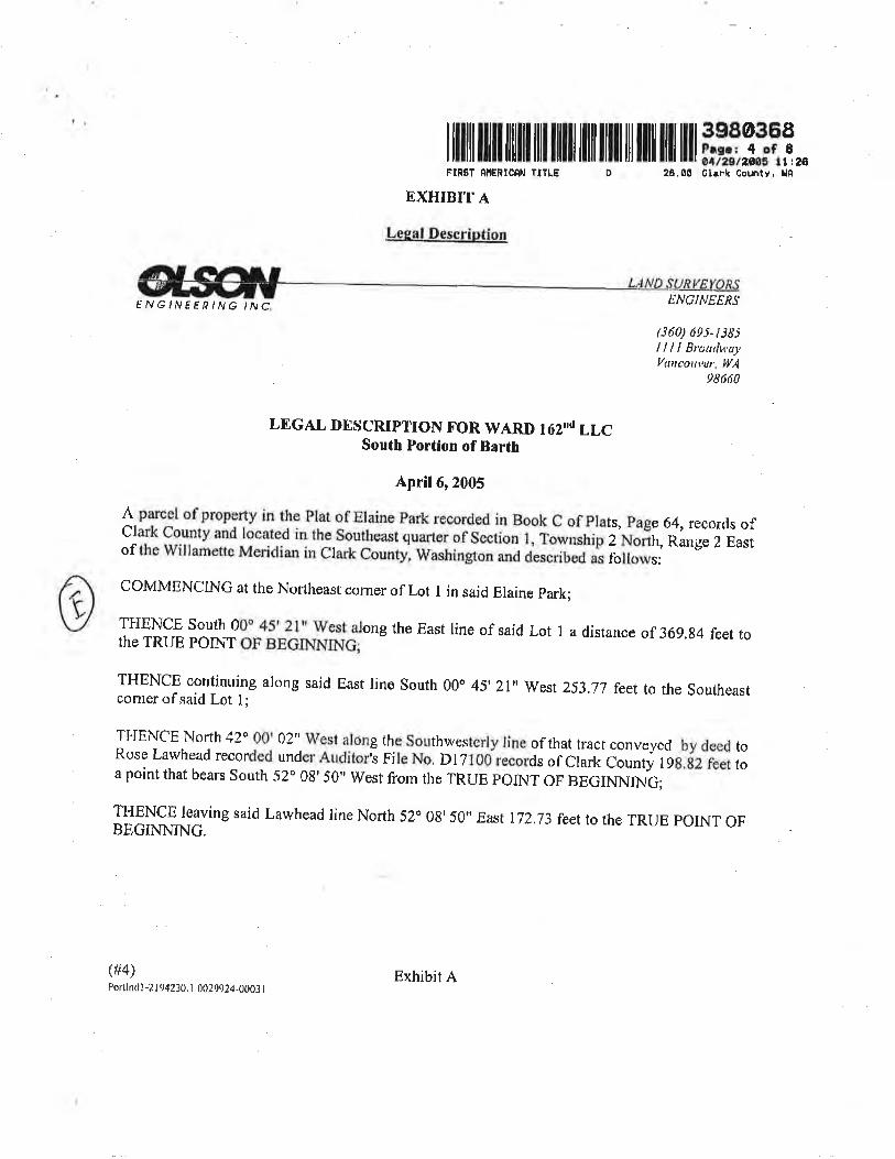
I illlil ililt til]t ill| ]ll] llil tilll til ililt til ilt tffi3:,Tï..FlnST nñEn¡CnN T¡TIE þ 2ð.00 Gtrrk County, Un
EXHIBIT A
Lesal.DesçriptÍon
ËNGINEEÍ?ING INC
(ft4)Portlnd l-2 ¡ 94230, I 002q924-000J I
ENCINEERS
(J60) 695-t385llllBroudu'a¡'Vn¡cout,cr, WA
98660
LEGAL DESCRIPTION FOR WARI} IózNd LLCSouth Portion of Barth
A,pril6,2005
1.pitt:l of property in the Plat of Elaine Park recorded in Book C of plats, page 64,records ofClark County and located in the Southeast quarter of Section l, Township 2 North, Range 2 Eastof the Willamette Mericlian in Clark Count¡ Washíngton and described as follows:
COMMENCING at the No$heast corner of Lot I in said Elaine park;
THENCE south 00"1:'31 West along the East line of said Lot I ¿ distance of 369.g4 feer rothE TRUE POINT OF BEGINNiNG;
THENCE continuing along said East line South 00o 45'21" West 253.77 feetto the Southe¿stcornerof said Lot l;
THENCE NoÍh 42o 00' 02" Wesl along the S,o_uthwesterly line of that tract conveyed by deed toRose Lawhead recorded under Auclitorh File No, D I 7 t 00 records of Clark counrj 1ga,gz feet toa point that bears sourh 52o 0g's0" west from the TRUE poINT oF BEGINNING;
]fry!! lqaving saícl Lawhead line North 52o 08' 50" East t72.73 feer ro rhe TRUE pOINT OFBECINNTNG.
Exhibit A
I ililt tilt tililt illl llll] llil llu til illl llll llll tff 33ii,.FIRST AfiEN¡CNN lITLE
EXHIBIT B
26.6Ø Cl¡rk 0ounty, l,lÊD
2
Permitted Encumbrances
The prenrises herein described are within and subject to the statutory pôwers, includingthe power of assessments of the Clean Water Program. There are no outstanding
assessments as of the date of this deed.
Reimbursement Contract providing for "latecomer fees", bctween the City of Vancouverand Bill Maitland:Recorded; August 22,2040Auditor's File No. 3245430Records of; Clark County, Washington
(#4)Portlndl -21 94230.1 0029924-0003 I
Exhibit B
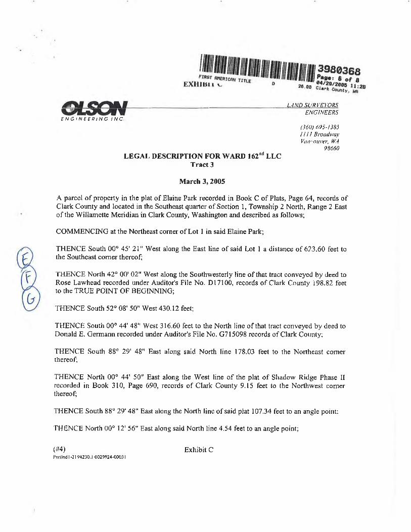
".1/lü/l^fl1,üÍtlil//fl WWåï,1_,*;i,,1
Átt G^rf LlND St.!Rr'ÊyORSlflrJl¿'rENGIN f FPING INC.
(360) 695-t385l l ll Btowlru-r'I,'uttt'outer, ll,4
98ó60
LEGAL DESCRIPTION FOR WARD I62Nd LLCTract 3
March 3,2005
A parce I of property in the plat of Elaine Pa¡k recorded in Book C of Plats, Page 64, records ofClark County and located in the Southeast quarter of Section l, Township 2 North, R.ange 2 Eastof the Willamette Meridian in Clark County, Washington and described as follows;
COMMENCING at the Northeast corner of Lot I in said Elaine Park;
THENCE South 00o 45'21" West along the East line of said Lot I a distance of 623.60 feet tothe Southeast comer thereof;
THENCE North 42o 00'02" West along the Southwesterly line of that tract conveyed by deed toRose Lawhead recorded under Auditor's File No. Dl7100, records of Clark County i98.82 feetto the TRUE POINT OF BEGINNING;
THENCE South 52o 08' 50" West 430.12 feet;
THENCE South 0Ao 44'48" West 316.60 feet to the Norrh line of that tract conveyed by deed toDonald E. Germann recorded under Auditor's File No. G715098 records of Clark County;
THENCE South 88o 29' 48" East along said North line 178.03 feet to the Norrheast cornerthereof;
THENCE North 00o 44' 50" East along the West line of the plat of Shadow Ridge Phase IIrecorded in Book 310, Page 690, records of Clark County 9.15 feet to the Northwest cornerthereof;
THENCE South 88o 29'48" East along the North line of said plat 107.34 feet to an angle point:
THENCE North 00" 12'56" East along said North line 4.54 feet to an angle point;
(#4)Ponhd 1.21,)4230. I 0029924-0001 I
ENGI,VEERS
Exhibit C
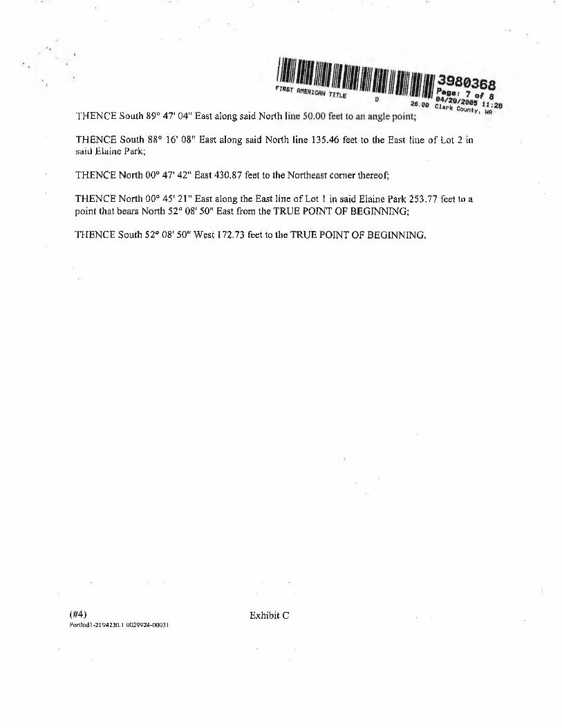
tI4lpp!trililililWfrif,'iJf,#,,
THENCE South 89" 47'04" East along said North line 50.00 feet to an angle point;
THËNCE South 88o l6'08" East along said North line 135.46 feet to the East line of Lot 2 insaid Elaine P¿rk;
THENCE North 00" 47'42" Ëast 430.87 feet to the Northeast corner thereof;
THENCE North 00o 45'21" East along the East line of Lot I in said Elaine Park253.77 feet to apoint that bears North 52" 08'50" East from the TRUE POINT OF BEGINNING;
THENCE South 52ð 08'50" West l?213 feet to the TRUE POINT OF BEGINNINO.
(#4)Portlnd I -2 I 94230. I 002t924-0003 |
Exhibit C
I illlil tilt ililllt illl lllllt llilt llilt til ilft llil lt] ñi'iffiff .,F¡RET flERICNN TITLE
EXHIBIT DD 26.00 Cl¡rk County, Hâ
ENGINEERSFNG/NÃEPING ¡NC.
(360) 695- t 385llll Broudvatl'uncotn't:t', IllÅ
98660LEGAL DESCRTPTION FOR WARD I62ND LLC
Tract2
April T,2005
A parcel of property in the plat of Elaine Park recorded in Book C of Plats, page 64, records ofClark County and located in the Southeast quarter of Section 1, Township z Noñh, Range 2 Eastof the lVillamette Meridian in Clark County, Washington and described as followsl
COMMENCING at the Northeast corner of Lot t in said Elaine park;
THENCE South 00o 45'21" West along the East line of said Lot I a distance of 62J.60 feet tothe Southeast comer thereof;
THENCE North 42o 00'02" tilest along the Southweste¡ly line of that tract conveyed by deett toRose Lawhead recorded under Auditor's File No. Dl7100, records of Clark County 198.g2 feetto the TRUE POINT OF BEGINNING;
THENCE continuing along said Southwesterly line North 42 0A' 02" West 258,33 feet to a pointól '35 feet Southeasterly of, when measured at right angles to, the centerline of Ward Road;
THENCE North 48 28'50" East 68,05 feet to a point 57.00 feet Southeasrerly of, whenmeasured at right angles to. said centerline of Ward Road;
THENCE North 50" 52' 27" East 315.08 feet fo a point 50.00 feet, when measured at right anglesto. said centerline of Ward Road;
THENCE North 52o 08'50" East parallel with said Ward Road 23.32 feetto said Easr line of LotI in Elaine Park;
THENCE South 00o 45' 2l " West along the East line of said Lot I a distance of 344.24 fêer to apoint that bears North 52o 08'50" Easr from rhe TRUE poINT oF BEGINNING;
THENCE south 52o 08'50" wesr 172.73 feer ro the TRUE porNT oF BEGINNING$4t Exhibit DPonlntl I -2 I 94230 .i QO29924-g0AJt

(/:Ø
I ilil|ll|!| lilf iltilt lililt ilil ililÍ ilt ililt til ilf ffi.i,i:,q 1,,FIRSÌ AñÊRICAN TttLE D 21.ü0 clr¡k 0ounty, ùA
,5s5215Real E¡lete Exolse Tax
AFTER RECORDTNC, RETURN TOWard l62ND LLCc/o Cranlor Developmenl., Inc,I97ó7 SW 72nd Avenr¡e, Suire 100Tualatin. OR 97062-83S2
Grantor:
Fev, Laws 1951
I'l'er0' 6 r Bee
Clark
Vtr.,elLe nm- srATuroRv *ARRANTV DEED
D;¿ñ;;nil Ëiöeo or assigned: None SZ9{SO
Grantor: HANS BARTH anrt sHARoN RosE BARTH, husbandand wife
Grantee: WARD l62ND LLC,a Washington limited liability company
Legal Description:
l. Lor; ptn I Subdivision: Elaine park Volum e: C page: 0642. Addirjonal legal is on Exhibit A of ihe documenr.
Assessor's Property'l'ax parcel Account Number(s): r04130-000
HANS BARTH and SHARON RosE tsA,RTH, husband and wife (',Gråntor,,),residing at 8715 NE ward Road, Vancouver, washington 98'682, for and in consideration of Te'Dollars and other vllu3þte consideration, conveys ànd warrants ro WARD l6?ND LLc, awashingtotr limited liability company ("Grantee"), thc real estate situâted in the county ofclarl<, state of washington, described on attached'Exhibit Á, free of encumbrances except asdescribed on Exhibit A.
Dated this Z5:traayof April,2005
k ",* üãffiHans Barth
Pr)rtfnd I -2 ¡ (r-1841 .t ()02t)921-t)003
I
Barlh
STATE OF WASHINGTON )
t'Ouì\i"t\'trF cLARK ltt
ru{ flilllljlJll|Jilil ilil ililil il"lilil
fl |lJ íi,i.,3.ffii;,,
on this dav perscttally appeared before me Hans Barth, to me known to be theindividual or indiviäuäls descLi6ed'iiiiì¿ïrto .*r.ùìro ìñ*'*itäin and foregoing insrrunlenr, andacknowledged that he signed the same-ãs rr¡s n:ee-anl;;iñö act ând deed, for rhe uses andpurposes mentioned. -'-)
Given undermy hand a'd of'ficiar searthis z-sltuvof Aprir, 2005.
Signature;
Name (Print)
NOTARY PUBLIC in and theof Washington, residingMy appointment expires
ât
STATE OF WASHINGTON
COLINTY OF CLARK
))ss,)
on this dav uersonally.appeared before me sharon Rose Barth, to me known to be theindividual or individuals ¿eschuää il;d *h";;;;"t;JìË rìîrri" and foregoing insrrumenr, and
ffiff1;l'Í-'*1,åT,To:h' signed trre iame ãs rre' rr'" ãnJ ;;r;;äv acr and d;d:ril;ilc uses and
ci'en under nry hand and officiar sear this a*ourof Aprir, 2005,
M ,q tut 1,.[:FlNO ïAt{ 8t_tüYÈU
STÂïÊ 0F YtrA ]n¡lfjH'N{TlÕ¡\{ [:Xpt rTi:, )
IA llY ?00
Signâture
Name (Prin
NOTARY PUBLIC in andof Wash ington, residingMy apporntment expires
tL.
2,'orr,nd I .2 lqJ 8,tJ .l 0O2q()24-Aûæt
lfl{liltil,ffiryIilililllil/t{ilt/ilililt#lJ, i,îi,,,î,î,
BXHIBIT A
<\-\tr\ül' z *lhp^,'YLot l, ELATNE PARK, according to the plat thereof, recorded in Volume C of plats, page 64,records of Clark County, Washington.
EXCEPT begínning at the Southeâst comer of Lot l, ¿nd running thence west, along the Southline of said Lot, 6a23 feet to the southwest corner thereof; thence North 106,g feet to thecounty Roadr thence Northeasterry arong the county noacr. ¡¿õ.gr5 feet; thence southeasterry tothe poinr of beginning,
EXCEPT that portion conveyed to clark county by deed rEcorded May 26,2000, Auditor,s FileNo,3221772.
SUBJECT TO:
The prcrnises herein described are within and subject to the statutory powers, includingthe power of assessments of the clean water Þrogrur. -fhrrc
are no outstarrdingâssessmenfs as of the date of this deed.
Reimbursement Contract providing for "latecomgr fees", between the Cíty of Vancouverand Bill Maitland:Recordedr August 22,2000Auditor's File No. 3Z4S4i0Records of: Clark County, Washington
)
Portlnd l-¿ ¡ 9l 84J .t 002q924-00Õ3t Exhibit A
a\'. ..
'':t.'-1- -':' . ." ,
.:li;lr.J
iì.3
',ji"t
;!''lrl'i'.i
:l'l.r./l.:.-lll't
I.l
j'I' i
tlt.,1
:i..1"t",trjlrl
.:'
"i,:l'. I,.1
i'
.""1
.t:tl."t:lr:ll^l
.tì,. I.i"'".1!
i..lt..,.t'.,|.'l,. 1
I",t j:'
':.:j'i
.,,ì
.: .,
AFTËR RECORÐlhlG RETURI'I TO:l<ûrey A, Schoerlfelddo The Bessen Law Fim, P,C'806 Broâdway, Sr¡lts 735Väncouver, vt'A 9686t
DATEÐ:
FROI\4,
TO:
9TATÈ OF WASHINGTON
COUNry OF CLAFK
LORI A, PNOU]Y
SIAîI 0F t¡,Â3¡lll{GTCN
r,iOTÅRY 'r " PtJtsLlC
il1t Conrínrsslon &?,?;
fJ50i¡0íJ0i.}i8
gïATUTORY OUITCLÂITJ¡ DEED
rn¡s ,/É -, day of Novembe¡, 1994
Albe¡t and Lena R, Germann, husband a¡rd wife
LENA R. GERMANN
EXEMÈi -t n, t.3 J !..1 / ù_0,þil:75
rot dcl¡rh 0l tox p¡¡d $9s
R¿al bþte ixc¡se ffiClt f fiev, tan'1951
nlü
The Germann Children's Lirnited Partnersh¡p, a VVãshington limitedpârtnership ("Grantee")
For love âncl affectlon, Grantors convey ând quitclaim to Grantee, subjeot to alllient anC encumbrancÊs now of record, all of thoir right, title and lnterest ln and to thefcllowlng descrihed real property, sitlrated in the County of Clark, State of Washington:
Lot 2, ÉLÂlNÉ PARK, according to the Plat thereof recordedin Volume "C" of Plats, ai pãge 64, records of Clark County,\üashington.
EXCEPT, beglnning ãt the South\i/est corner of sâid Lot 2,
ihence East, along the South line thereof, 3'i2 feeti thenceNorth 208 feef; thence ìÂ/c"st 312 feet to the West line of saldLot 2; thence Sauth, arong sald West llne, 208 feet to thepo¡nt of þeginning.
GRAi{ÏORS:ALBERÏ GERMANN
lt5'$5
,¡1U]llïûÌELIZA8ëTf Á tucF
o¿b
ss.
On thís day personally appoered before rÍe ÂLBERT GERMANN ancl LENA R. GERI4ANN, tome known to be thÉ ¡ndividual5 deBoribed in ãnd v',ho excouted lhe foregolng lrìstrumont, ândaeknayrledged tho said irrstrument to be their fiee and voluntâry act ând deed, fof the uses and purposeslhe¡êin mentioned.
OIVEN under my hand and offcial seai this day of , f994.
and for lhê Stateât
My
,' 1.ììlgeft d\dêcqû\ch¡ ! èps/, r\ / I / I a t
{,*"*:*:;':jì:-{:
,. .,,
a'.'li -
tl)È
:)
a'i. ' ,.
..,i;
hí dei".ils ol la.r paú s€o
STATUTORY QUIT'CLAIM DËED åId,lloüg l,iasher
DATEÐ: This -/Á day ofNcvember, 1994chlk freasurot
FRCM: Aibert end Lena R, Germann, husband and wife
TO: The Geimann Chilciren's Limited Partnership, a Waehington lfmitedpavtnerehip ("Grantee")
For lova and affoction, Grantors convey and quitclaim to Grantee, subject to allliEns and enourlbrances now of record, all of their right, lltle and interest in and to thefollowing described real pruperty, situated in the County of Clark, State of Washington:
Thet portion of Lot I, ELAINE PARK, accordiog tú iii¿ Platthereof reccrded in Volume "C" of Plats, at page 64, reoordsof Claik Coun$, Washington, C-scribr¡d as fr¡llows
Boginníng at the Southeastcorner ofsaid Lot 1, thenceItVest, along the South line thereol 602,3 feet to theSouihwesi corner theroof; Thence North, aiong the West lineof said Lot 1, a distance of 106.8 feet to the Northwestcorner thereof; thence North 49"3:¡'Eâst, along the Northorlyline of eaid Lo¡ 1, a dist¿nce of 349,915 feet; thenceEoutheasteily, in a otraight line, to the point of beginning,
GRANTORS:ALBERT GERMANN
hFTER RECORfrlf¿S RErU,?N'iO:l(aroyc/o Tf
A, Schsenlbids Aosûsrt Law Firm, P,C, *åfff[,,,2 3'!'{
rtL
t, t_
+5
E'LIZAItltTa.4
005 B,?ùdway,Vrtncou.¡el, WA
Suite 755sô6e0
SIATS 0f l/i.sl{lN0'l0N I
N{-'Åîl . PU'll.¡C i
1iÍi020íx)2ii'7
LÈNA F.. GERMANN
s9,
l.¡oiaryrosidmg at
Rmll$tt lE$o wCh,l1 Rw, lalr/s 195|
r-,A,l
STÁTE OF WAS:IINGTON
COUNTY OF C!"ARK
LoRt A, pRol"lfi
rì
On lhls day personälly ¿ppêarcd befoie me AL8ËRTGERMANN and LÊNA R. GERMANN, IOmÈ kr¡own lD be the lnd¡vlduals descrrb€d in 6nd who exeouted lhe foregolng instrurnent, andaÖknowledgad lle said ¡nstrumen! to Þr their Í'êe and voluntäry âct snd deed, fôr the uses and purpos€sthereln ploniioned.
G}VEN under rrìy hsnd a¡rd oi,4oial seal lhls /.0,"aav ot 1S94.
fit.lLUC E
614I'
'r 1..- l
'ì4îomrr;.ltvt!¡tr¡. '' Ìtiy
.../Jtp
(g¿runô\dèrdr\ch¿tdDÉr. 1 I/S/tr )
!..rl
t,
for the
" ï,:'f:
F¡l.d ld F@d d BG{Èl oa
NAME .--
ADDRESS
i'r1Eq
J* i/CITY AND STATE L
¡:
STATUTORYWARFANTY DÊED
THEcRANToñ Larry F. I{elnbender û 'loan C' llelnbender' husb¡nd ¡nd ¡lf¡
roiardinconi¡derôriono{ 'len ônd ilo/¡00 0ollars ¡nd other V¡'lu¡ble Cons{deratlon¡
:"r;;;.:.,.""r,.ndw¡rr¡nritotH¡ns ¡¡rth & sh¡ron Rose Bôrthr trusbana aná wlfeft
th¿lollow¡ngdesdib€dre¿lBlate,litutredintheCpuntYol Cltfk 's1¡þof
Wriåinqtm:
/ tot t ELA!il PARK, accordlng to the_plät-thereof,,,_recorded ln voìu¡¿
' ''ð'i åi Pî;Ë, P;só oq,'i'ãiöi¡i-oi cl¡rk countv' lr¡shlnston'
tXCtPT beglnnlng ¡t the southeôst corner-of Lot ì' and runnlnE thencl
llest. alons the south irìË"åi'iiì¿-itt''só¿'¡ reet to the southwest corncr
thereofi thence llorth ióä:8"i;;';;iñó ðóuntv Ro¡d: thence Northe¡ster'ìv
aìons the countv Ro¿¿,'ãiö'siiì-tñã"ãä-souineister'ìv to thê polnt of
beg{nnlng' -
',Þto1,cO
06ûit
q',.' ''-,.o j1 .,'l¿;--' -
D¡r¿d Junc -99't -'¡" tli
-: 'i. i i ¡trr'' /'j. Al Ir;2,r¡. L
s .È - J.ll., ..,r,,..,t,.,.'..i
= .., ',J..:i:,.Jj_-,,,- r: ':i:8,
:"i7 :08.0c=
SfATE OF WASHING'ÍON
coulry or Cì¡rk
th¡t
r.o.¡;r
t¡.
¡ndívid!al de3q
ihc loregoiñg ìô¡lrúmenl, ¡nd .cknowl'4
ad úd
olf¡cirl rcãl
lor St¡t
SÍATE OF WASHIN6T0NCOUNTY OË
l*.I
tB0CÇ¿\9
(o@(3
On thi¡ daY ol 'ü
' : ;r*, t^. unde rt¡qôed, ¡ Nolarv Publ¡¡ iñ ¿nd
lqì¡sStare ol Wa¡hinglon, dulv commiitiontd ¡nd tworñ'
Ë.þôallY apP¿¡red
d€ed, lo. the uF and Purpotð .nd
¡odPrerident
l9 me lñown lo be lhcS¿cretârY. làPadivelY,
t- tha corporåt¡on th¡t cxæuled lh' loregoint inrtr!ment, ¡nd
¡aknowlcdged the tôìd inltum¿nt to bê lha kÉ ônd Yoluñ'
æt ônd deed ol F¡d corpot¡lion, lor lha u¡¿t ¡îd Pur
potal there¡n mêntioôed, ¡ñd on o¡lh rt¡led¡ulhori¡ed lo a¡æull lh. eid
¡ô9truméñl âñd th¡l tha É,1 ¡lf¡¡ed it lhc corportt' ¡e¡l ol
r¡¡d corpor¿lioñ.
wirñe!t my hând ând ollici.l t.!l hdtro ¡llrr'd lht day ¡ñd
y.¡r lirl ¡tþva ühlcn.
th¡t
Not..y pub¡¡c ¡n lnd ld thc Sl¿l' ol Wðhin$on' ,ðidirR
r980
gæ62700e2
ur rH rfil)h.
ì:. iÍ r1t1
K-.æ,1,?o É-totrtt-P
t9
reridrô0
¡l
JUN 27
0
IIt d
g
¿
v
?
$
*, ji .
1 i 1i ;.Lr *_
i_j:,_:jLIr¡r;, ^.
':Y'r'r:l lP¡a ----t\i!¡i, rL tir,, ,":s!r,:rr, l,r";r,i:,,r1,
r,,.. ,r.,0, f ,¡ruir rU îlt,ti ,tCï.!nt:,
t
Imnsnmsnica l¡tle lns¡¡nancs to
îFf,frïi#t co"poto*ot
Fll¡d lor Rcæ¡d.ol Rcquarl of
rHtS 9^C¡ ESIMO rd E@rrl &.' 'i'
G 559SZ.l758660x.* Fáùfl ñ êrôrrñä nôÂl tu. fññ.
l¡Á- Þ- ô- Dav ?Át
ctr &d s¡rô-EatlLe-Cfound,*tle¡blns.çilLig.6!4-
fq ud l¡ æroldcnrim olvaluble conslderab t¡¡d psld, convqy¡ ud ra¡mt! to IÁ.P.RY ¡. I6Ii{B:iifÐ;.1. and JO¡lll .C. IIEI!¡B:¡Ð¿R,
Slqtutory TÍqrrqnly Deed
rlEEcR.{.\To¡6, l(nlTt¡ c. JEPsoi{ and F¡\TRlcI¡\ Â. JEPsoll! husband a¡d wlfe,
TXlr ¡llID lo/f00 ($10.00) Dollars and orher Eood andtion
husbandtlc lolloil¡gWshh3ioD:
and vl,fer .
d*äbcd ¡øl ët.t!, r¡ùust.d iu tbc Couty of Clarlc
I¡t 1 of Elaln Parl!, accordl-ng to thô plåt thoreo:,recordod ln Book rrc'l of, Plãts, ár poge 64r rocordsof, Clarh County, f,lashj.ngton.
EXCEPT, bêglnålng at th6 sor¡thêasE cornef, of L¡rt I,anil ¡:rlming thonco l,ios!, along the South llne ofsald lót; 60213 feet to tho Southúrost corncr thêrsfttha¡ce l.þrth 106.8 feet tÕ rh6 County noadt thGnceIqorÈheâsrerly alon8 the @unty Road, 349,9L5 foctttheæo SouÈhotÈtorly to thê polnÈ of bogLnningo
, S¡t! d
bol trtot¡ E¡cl¡o lo¡Clr. lt Rcv. I'ow¡ l95l
lÅ-Ø-Q-horh"on Polé
t"er.¡ l&!ß-o"r'&f1aoryo'-Co¡l¡on
clorl countv Tf.orÙrql
À,_&*Mry-__
5ôo ó1, þ Âf¿.DtrolhY
Dûd ù¡ ll¡r
sr^TE oF s'ÄsED,¡cTON,
Cdetyof .Glark
th€g dgacd tlc rru u lheirroüo¿d.
,lfg 0,
rltlln ud lo¡qoi¡d lsbl¡@t, Ddlu ud w¡utrry &{ üd dæ4 t6 t¡.
dry ol A¡rBust
Ë
et&rdrypcrmly¡ppðrdb.lorÊnc Kotth C. Jôpson snd Pafrlcla ¿t, Jopson,
þ bc lå. hdlv¡du8 dslbcd In r¡d rto aatcd rb¿
I
I
io Ea
ofrcl¡l srl thh 2 / Íf d.! at ,lurguer ,tîlo,
t
TRANS.A.MFIRICA -l ¡ !-Þe''¡NSURANCI COIIIPANY
.tj .' Fll¡d fø Ræoril ol Roquclt of
t.
; -..-l.i. /,i_(-
- c^515?34 ' "6990t"5rllqq.tg¡ Rqclno
'rn^Ns^M¡rtc i¡rú lxs, co.ß¡ j S zu ÃH'gg ¡f7Â,r0tI0¡l U0N g,,o-¡Efl il
1
r_/
Ol¡udStru
Slqlutory Wc¡nantY Deed
: tse crursmx LEoNARDR. KoHtscHMIDT and RurH M' KoHLSoHMIDT' husband
r* -a ío -*iaïÌpli,l*""t No/10 0 ( $ I 0 . 0 0) DoLLARs, and other val uable- conËlderatlons
¡! h.!d Þard, æ¡vtys and r¡lnnl¡ lo KEITH G' JEÞSON ând PATRICTA À' IEPSON' husband and' wlfothc follo#og dcsrlbcd ralJst¡t?, sltut.d tr ú¿ Couuty -of Clark. '
Sl¡tr of 'WshlnEt6;
lotlofsLAlNEPARK,accordingtotheptatthereofreõordedinBook''c'.ofPlats,atp"S" Oa. rêcords'of óIark County, Washington'
ËXCneT begfnning at the Southêðst corner of Í,ot l, ðnd runnlng lhence West' along
tl," sàrth line ol-sald Lot 602,3 feet to the southwe6t cofner the¡eofi thence North
fòg.g teet to the County Road; thence Northeasterly along the County Roãd' 349'915
i""t; ,tt"n". Southeadterly to the point of beqlnnlng'
SUBIECT to eðsements, res't¡lctlons and reservatlons of record' 1f any"
^.J'
;
''¡¡i---{-.*cL:-r:ttL:J'-_ "r- . i. ,
=! '?,,.ú'
1*+n¡', S-i.. .,r
! -j...-:.1:J
ilêû: l3rêiê Fx.l3o toXCh. I I tev. t¡ws l95l' r ryé\ñ hr, tuen pold
r,p. + J!2 1 s- r.r o ¿ - y'-¿.(se¿-óI¡--+*-¡.
uú:,r: ..i,.,t.iJrClo;i t :iü
t
-¿Fdry of ¿/ *f ,ß /g-
Õomty of
WASHINGÍON,
Cla¡k'
O(üf dâypcffitlyapperud b.rs.m LËONARD R' KOHLSCHMIDT and RUTH M' KOFÍLSCHMIDT
))c
h.d ol
l*
ro m lem to bc tbc i¡dlvidùll s dsríb¿d lo od rho qæutcd thc lithl¡ ud fo¡Ê8oi¡t íst¡umcnt' a¡dt
. . ."fr-,¡t O tn" thei dg¡cd th' ff' s '' thef r Íre ud voluþ¡y rat ud dÉ4 for thc
u ild PurPø licrcin m?ntloncd'
Ço(t9
taìdh¿ ot
ilIïNF r oRn;
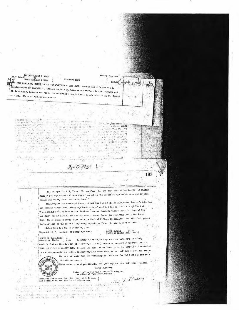
¡o.c e¡oeJq_É3 c-g¡r¡ & ,r"3 ,
lr¡ -i¡eo-iY.-¡¿ro' I
Fz¡ ?E o3¡J-:(,3, .'-Yq o.Eru â¡d
; lo¡sl¿ûÞ¿to¡ ol :qlrto.co, ¡ol¡or¡: ¡f,:E CSA¿.'¡. h;€¡ ed dl.. tho
eoø?.¡qu¡ùs.. r-:
o! ¡JlqZ, sþ!6 c: IÁ*1t:¡o¡,to_njt,
lut=¿t¡"f DsBt)
f¿oitSJCA Ìør:¡y g¡¡J¿. hûsb¡Þd @d :d.í€,to! qd 1t1¡ hqrl palrt.oowgy qd m¡r¿¿t to JCE. Ctr:d!¡¡i¡l øifel.l,oFlÃ8 dlsolfbod roql ostEtû 81.::sìo l4 t\,
::-,.t,riii¡:.3tü,- ;;-Ì i..,:j _:ì r:'.:i ¡!.í:¡fi4
, ;r: .-,:; :.ri;iii.: - ,:;:1 -' i,:. - :,!r r '..i i.i
i,-.-ì: i i .:,,. :::';¡ r
.1 :.,|;,. ..:.\ .',- :. :!ii.-.,
,,... r,',!irì..i1j(ii3!,¡:¡fgI : \ :t-1:;..-. -¡i. :t,¡ ir ¡:¡',*¡:. : .: ,t it- ' .:-.'i t'ir:jJirr,::';¡{J
r i r :: r:i 11.\:r !r: f.r;r.rti: a.l:3i !l,t, : '-- .
'..'' ]: .'..::;': :- ::-'!'
:. -. .t::: ":'
.-,ì .;:i.. r..
, -t; ; ,, ,
| "! i,.r'- .:r: '
'i .i':i ,- I .:'. J--i -i¿'
-l: :-! :l : :.i:1 ir i ':Â. r r a .-;:;¡:i ::-1- :lt:'l
i:.._ .¿-:':-!::ì'1i:
¡ll, ot Litô tro (¿1. throo l3l¡ Md Four (/=l' ênn 'ùût l)¿¡t'o! ¡';t olo (1) oJ
P¡¡A ot ro;órd 1¡¡ t¡o Oflico of thÛ goulty :Ì€oo-'dorsg pa t ñû¡) 0. Plôt ol 8eo r.on
ioouiy osd 9ìûi., .d.¿ari¡od ¡e fo:.lonl
i ¡ì081ru¡¡na at tho souÈ::âaot co¡oor ot ¡'ot 0rß f1' ol sr¡¡IiiE ?'iaK'cl'cri:, courtyill6E!'li!'¡{3'.
. *a .*1o¡ thonoo FoBt, ¡¡oie tå! sost¡ l1ûo o! ssld ¡'ot ollo {1)' 51: EEd!âd !Ñ B'-¿ ..
-
throo lortl¡¡ (6ó2¡sl iost t¡ t!.e Soutlrtoct oor'rer tìioroof¡ th'o¡oo iiortt'.ocó llu¡drld slr
I *u ,Un, !oatì.¡ {10ó.c'). f€at h tt4 oourt:'. toûd: thonoo ¡lorthoast€rft'¿f;^¿ t}'o dout;.
rt¡andtho ( 34С916) tasi; !heiooBoaa, lluoo uNdrod ¡'orúj n14o sra uiÊ€ ßuûirôa Flltoon 1¡0"--""'-
'Soqthotrslotly to tllo ¡ol¡t of b¿å-tu,'!e'm,ataluing lhroo l3l ooroo' Ec'ô o5 loog' - , 1
Ii ¡uto¿ tJìf0 lst dÂy of Doooah€f, ¡320.
¡:¡ooutod 1rt.tlo !r.õ0r36 ot AÃrl}'¡.!gilo¡).$-"åå, 3¿1å1, p, ,,li'i åÀ, I
|ãil|roår'llTiiÎ=pt' l;". r. t1a*¡ il.lorroi, rhô.utûor¡trlnsd rut¡¡orrti',d! hórôb7
.oorttfy tlat os tll! lqt doy ol DooorÈer, ¡'D'!t26;'bofo¡p no }erEotdlli -:t::":i i:::: ,
Sj¡¿ u;d f¡,ori::oi r,,l':Y ,,¡11,' bra'Àl¡ Ha tl:oi eÁ do :¡nitq to ì'o t']'' rtrdlvlöuolË eo8:t'':ol
,,a À:rd rrlo orooutãd iìio f¡¡ihl¡ l¡e'vN3e¡aq¡ed.sokno'rlot¡où to n¡ thtt ¡Jrð¡/ !1860d ed at¡:o¿
tho ôFo s6 t¿olr {ro€ an¿-rolbtarir'dot ond dood.lor the us'o ð¡4 pB?Fosea
tco¡ûta ¡nÊatloao¿l. :
udor r¡7 È,:l @d OJil clÂt ô€oL ' tho aay üd :le¿r rêtt obolo sl ::s='
' fú¡ry e,!o.tor
::otÉ¡r' ¡u"lto lor ti.s 3iåtâ ot iI4sLIuEì9Á,' ¡¡-cl¿l¡¡ at Vancouv€r| tÌ.arol¡.
äco.lvoi :or rooord fob'lith, rJz? st 8lc4 ¡'ì:"úil rooortlod of tJ¡c ¡sCuoct ot Ë..ì.!ort€r..
...i.t.1 ';, i
, J.. -. ':'- - -" i¡r ::.i,
.. iij.-.,:1
.: :r¡i ,'
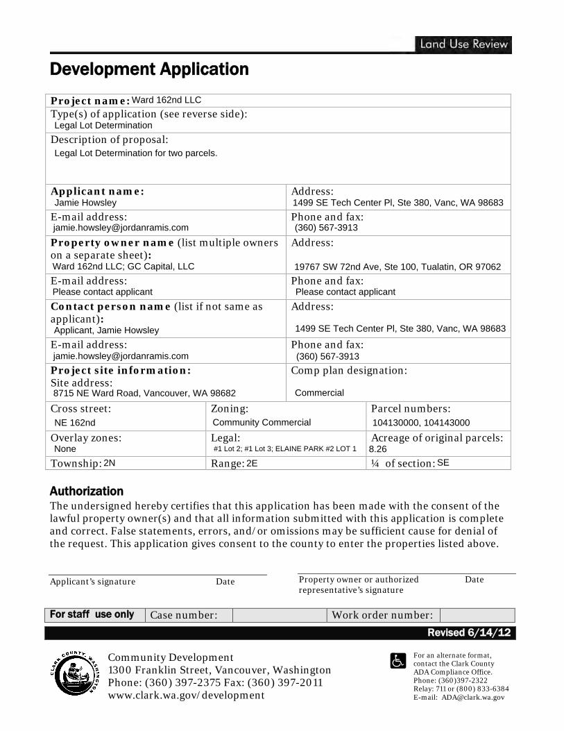
Development Application
Revised 6/14/12 Community Development 1300 Franklin Street, Vancouver, Washington Phone: (360) 397-2375 Fax: (360) 397-2011 www.clark.wa.gov/development
For an alternate format, contact the Clark County ADA Compliance Office. Phone: (360)397-2322 Relay: 711 or (800) 833-6384 E-mail: [email protected]
Project name: Type(s) of application (see reverse side): Description of proposal:
Applicant name:
Address:
E-mail address:
Phone and fax:
Property owner name (list multiple owners on a separate sheet):
Address:
E-mail address:
Phone and fax:
Contact person name (list if not same as applicant):
Address:
E-mail address:
Phone and fax:
Project site information: Site address:
Comp plan designation:
Cross street: Zoning: Parcel numbers:
Overlay zones:
Legal: Acreage of original parcels:
Township: Range: ¼ of section: Authorization The undersigned hereby certifies that this application has been made with the consent of the lawful property owner(s) and that all information submitted with this application is complete and correct. False statements, errors, and/or omissions may be sufficient cause for denial of the request. This application gives consent to the county to enter the properties listed above. Applicant’s signature Date
Property owner or authorized Date representative’s signature
For staff use only Case number: Work order number:
Ward 162nd LLC
Legal Lot Determination
Legal Lot Determination for two parcels.
Jamie Howsley 1499 SE Tech Center Pl, Ste 380, Vanc, WA 98683
[email protected] (360) 567-3913
Ward 162nd LLC; GC Capital, LLC 19767 SW 72nd Ave, Ste 100, Tualatin, OR 97062
Please contact applicant Please contact applicant
Applicant, Jamie Howsley 1499 SE Tech Center Pl, Ste 380, Vanc, WA 98683
[email protected] (360) 567-3913
8715 NE Ward Road, Vancouver, WA 98682 Commercial
NE 162nd Community Commercial 104130000, 104143000
None #1 Lot 2; #1 Lot 3; ELAINE PARK #2 LOT 1 8.262N 2E SE
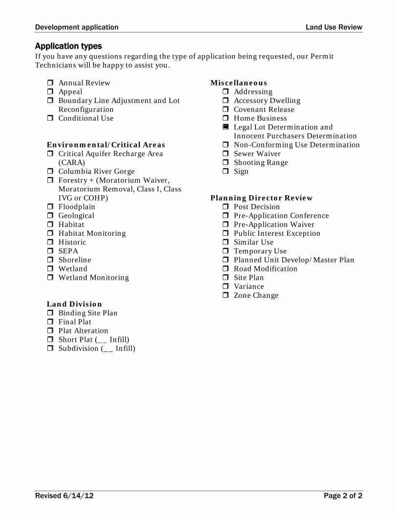
Development application Land Use Review
Revised 6/14/12 Page 2 of 2
Application types If you have any questions regarding the type of application being requested, our Permit Technicians will be happy to assist you. Annual Review Appeal Boundary Line Adjustment and Lot
Reconfiguration Conditional Use
Environmental/Critical Areas Critical Aquifer Recharge Area
(CARA) Columbia River Gorge Forestry + (Moratorium Waiver,
Moratorium Removal, Class I, Class IVG or COHP)
Floodplain Geological Habitat Habitat Monitoring Historic SEPA Shoreline Wetland Wetland Monitoring
Land Division Binding Site Plan Final Plat Plat Alteration Short Plat (__ Infill) Subdivision (__ Infill)
Miscellaneous Addressing Accessory Dwelling Covenant Release Home Business Legal Lot Determination and
Innocent Purchasers Determination Non-Conforming Use Determination Sewer Waiver Shooting Range Sign
Planning Director Review Post Decision Pre-Application Conference Pre-Application Waiver Public Interest Exception Similar Use Temporary Use Planned Unit Develop/Master Plan Road Modification Site Plan Variance Zone Change
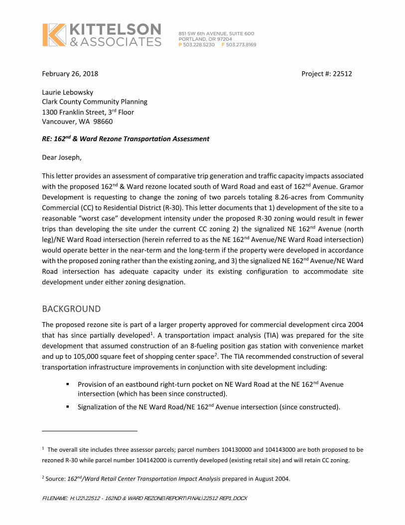
FILENAME: H:\22\22512 - 162ND & WARD REZONE\REPORT\FINAL\22512 REP1.DOCX
February 26, 2018 Project #: 22512 Laurie Lebowsky Clark County Community Planning
1300 Franklin Street, 3rd Floor Vancouver, WA 98660
RE: 162nd & Ward Rezone Transportation Assessment
Dear Joseph,
This letter provides an assessment of comparative trip generation and traffic capacity impacts associated
with the proposed 162nd & Ward rezone located south of Ward Road and east of 162nd Avenue. Gramor
Development is requesting to change the zoning of two parcels totaling 8.26-acres from Community
Commercial (CC) to Residential District (R-30). This letter documents that 1) development of the site to a
reasonable “worst case” development intensity under the proposed R-30 zoning would result in fewer
trips than developing the site under the current CC zoning 2) the signalized NE 162nd Avenue (north
leg)/NE Ward Road intersection (herein referred to as the NE 162nd Avenue/NE Ward Road intersection)
would operate better in the near-term and the long-term if the property were developed in accordance
with the proposed zoning rather than the existing zoning, and 3) the signalized NE 162nd Avenue/NE Ward
Road intersection has adequate capacity under its existing configuration to accommodate site
development under either zoning designation.
BACKGROUND
The proposed rezone site is part of a larger property approved for commercial development circa 2004
that has since partially developed1. A transportation impact analysis (TIA) was prepared for the site
development that assumed construction of an 8-fueling position gas station with convenience market
and up to 105,000 square feet of shopping center space2. The TIA recommended construction of several
transportation infrastructure improvements in conjunction with site development including:
▪ Provision of an eastbound right-turn pocket on NE Ward Road at the NE 162nd Avenue intersection (which has been since constructed).
▪ Signalization of the NE Ward Road/NE 162nd Avenue intersection (since constructed).
1 The overall site includes three assessor parcels; parcel numbers 104130000 and 104143000 are both proposed to be
rezoned R-30 while parcel number 104142000 is currently developed (existing retail site) and will retain CC zoning.
2 Source: 162nd/Ward Retail Center Transportation Impact Analysis prepared in August 2004.
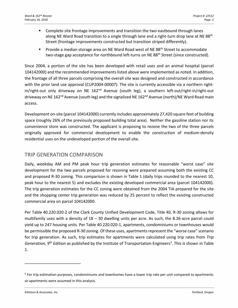
Ward & 162nd Rezone Project #: 22512 February 26, 2018 Page: 2
Kittelson & Associates, Inc. Portland, Oregon
▪ Complete site frontage improvements and transition the two eastbound through lanes along NE Ward Road transition to a single through lane and a right-turn drop lane at NE 88th Street (frontage improvements constructed but transition striped differently).
▪ Provide a median storage area on NE Ward Road west of NE 88th Street to accommodate two-stage gap acceptance for northbound left-turns on NE 88th Street (since constructed).
Since 2004, a portion of the site has been developed with retail uses and an animal hospital (parcel
104142000) and the recommended improvements listed above were implemented as noted. In addition,
the frontage of all three parcels comprising the overall site was designed and constructed in accordance
with the prior land use approval (CUP2004-00007). The site is currently accessible via a northern right-
in/right-out only driveway on NE 162nd Avenue (south leg), a southern left-out/right-in/right-out
driveway on NE 162nd Avenue (south leg) and the signalized NE 162nd Avenue (north)/NE Ward Road main
access.
Development on-site (parcel 104142000) currently includes approximately 27,420 square feet of building
space (roughly 26% of the previously proposed building total area). Neither the gasoline station nor its
convenience store was constructed. The applicant is proposing to rezone the two of the three parcels
originally approved for commercial development to enable the construction of medium-density
residential uses on the undeveloped portion of the overall site.
TRIP GENERATION COMPARISON
Daily, weekday AM and PM peak hour trip generation estimates for reasonable “worst case” site
development for the two parcels proposed for rezoning were prepared assuming both the existing CC
and proposed R-30 zoning. This comparison is shown in Table 1 (daily trips rounded to the nearest 10,
peak hour to the nearest 5) and excludes the existing developed commercial area (parcel 104142000).
The trip generation estimates for the CC zoning were obtained from the 2004 TIA prepared for the site
and the shopping center trip generation was reduced by 25 percent to reflect the existing constructed
commercial area on parcel 104142000.
Per Table 40.220.020-2 of the Clark County Unified Development Code, Title 40, R-30 zoning allows for
multifamily uses with a density of 18 – 30 dwelling units per acre. As such, the 8.26-acre parcel could
yield up to 247 housing units. Per Table 40.220.020-1, apartments, condominiums or townhouses would
be permissible the proposed R-30 zoning. Of these uses, apartments represent the “worse case” scenario
for trip generation. As such, trip estimates for apartments were calculated using trip rates from Trip
Generation, 9th Edition as published by the Institute of Transportation Engineers3. This is shown in Table
1.
3 For trip estimation purposes, condominiums and townhomes have a lower trip rate per unit compared to apartments
so apartments were assumed in this analysis.
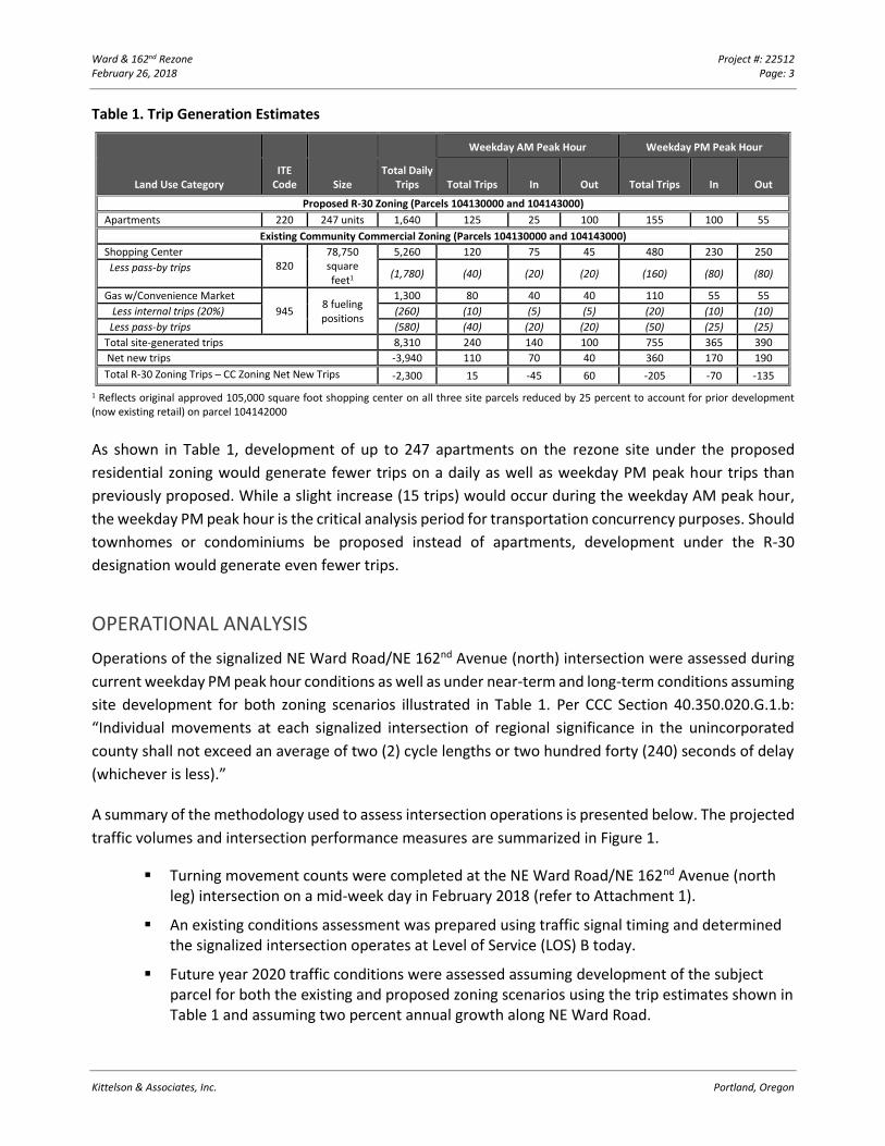
Ward & 162nd Rezone Project #: 22512 February 26, 2018 Page: 3
Kittelson & Associates, Inc. Portland, Oregon
Table 1. Trip Generation Estimates
Land Use Category ITE
Code Size Total Daily
Trips
Weekday AM Peak Hour Weekday PM Peak Hour
Total Trips In Out Total Trips In Out
Proposed R-30 Zoning (Parcels 104130000 and 104143000)
Apartments 220 247 units 1,640 125 25 100 155 100 55
Existing Community Commercial Zoning (Parcels 104130000 and 104143000)
Shopping Center 820
78,750 square feet1
5,260 120 75 45 480 230 250
Less pass-by trips (1,780) (40) (20) (20) (160) (80) (80)
Gas w/Convenience Market
945 8 fueling positions
1,300 80 40 40 110 55 55
Less internal trips (20%) (260) (10) (5) (5) (20) (10) (10)
Less pass-by trips (580) (40) (20) (20) (50) (25) (25)
Total site-generated trips 8,310 240 140 100 755 365 390
Net new trips -3,940 110 70 40 360 170 190
Total R-30 Zoning Trips – CC Zoning Net New Trips -2,300 15 -45 60 -205 -70 -135
1 Reflects original approved 105,000 square foot shopping center on all three site parcels reduced by 25 percent to account for prior development (now existing retail) on parcel 104142000
As shown in Table 1, development of up to 247 apartments on the rezone site under the proposed
residential zoning would generate fewer trips on a daily as well as weekday PM peak hour trips than
previously proposed. While a slight increase (15 trips) would occur during the weekday AM peak hour,
the weekday PM peak hour is the critical analysis period for transportation concurrency purposes. Should
townhomes or condominiums be proposed instead of apartments, development under the R-30
designation would generate even fewer trips.
OPERATIONAL ANALYSIS
Operations of the signalized NE Ward Road/NE 162nd Avenue (north) intersection were assessed during
current weekday PM peak hour conditions as well as under near-term and long-term conditions assuming
site development for both zoning scenarios illustrated in Table 1. Per CCC Section 40.350.020.G.1.b:
“Individual movements at each signalized intersection of regional significance in the unincorporated
county shall not exceed an average of two (2) cycle lengths or two hundred forty (240) seconds of delay
(whichever is less).”
A summary of the methodology used to assess intersection operations is presented below. The projected
traffic volumes and intersection performance measures are summarized in Figure 1.
▪ Turning movement counts were completed at the NE Ward Road/NE 162nd Avenue (north leg) intersection on a mid-week day in February 2018 (refer to Attachment 1).
▪ An existing conditions assessment was prepared using traffic signal timing and determined the signalized intersection operates at Level of Service (LOS) B today.
▪ Future year 2020 traffic conditions were assessed assuming development of the subject parcel for both the existing and proposed zoning scenarios using the trip estimates shown in Table 1 and assuming two percent annual growth along NE Ward Road.
H:\2
2\22
512
- 162
nd &
War
d Re
zone
\rep
ort\
figs\
2251
2_Fi
gs.d
wg
F
eb 2
6, 2
018
- 2:3
8pm
- c
doug
hert
y
Lay
out T
ab: F
ig1_
Ops
Com
paris
on
NE Ward Road/NE 162nd Avenue IntersectionWeekday PM Peak Hour Signal Operations
Current and Proposed Zoning 1Figure
LEGEND
Ward & 162nd Rezone Project #: 22512 February 26, 2018 Page: 5
Kittelson & Associates, Inc. Portland, Oregon
Site-generated commercial trips were assigned to the access based on the trip distribution pattern in the 2004 TIA.
Site-generated residential trips were assigned to the access based on turning movement patterns on the north approach of the signalized intersection as this leg provides access to several existing residential neighborhoods today.
▪ The 2020 analysis found:
Signalized intersection operations are projected to be acceptable under either zoning scenario (LOS C or better).
Signalized intersection operations experience less delay under the proposed residential zoning due to the fewer number of trips generated by the site.
▪ Future year 2040 traffic conditions were assessed assuming development of the site for both the existing and proposed zoning scenarios using the trip estimates shown in Table 1 and assuming two percent annual growth along NE Ward Road.
▪ The 2040 analysis found:
Signalized intersection operations are projected to be acceptable under either zoning scenario (LOS C or better).
Signalized intersection operations experience less delay under the proposed residential zoning due to the fewer number of trips generated by the site.
Attachment #2 includes the capacity analysis worksheets which are predicated in part on existing traffic
signal timing data provided by the Clark County Department of Public Works.
CONCLUSIONS
Based on the analysis presented in this letter, we conclude that the local transportation system is
sufficient to accommodate site development under either the existing or proposed zoning designation.
Reasonable worst-case site development under the proposed residential zoning would generate fewer
trips on a daily as well as weekday PM peak hour basis compared to development under the existing
commercial zoning. While further analysis may be required for a formal transportation concurrency
review in conjunction with site plan application, the analysis presented in this report documents that the
proposed rezone would not warrant additional transportation system mitigations.
Please contact us at 503-228-5230 if you need additional information or if you have questions.
Sincerely, KITTELSON & ASSOCIATES, INC.
Chris Brehmer, P.E. Senior Principal Engineer
Cc: Joseph Schaefer, Jordan Ramis

Appendix 1 Traffic Count Data
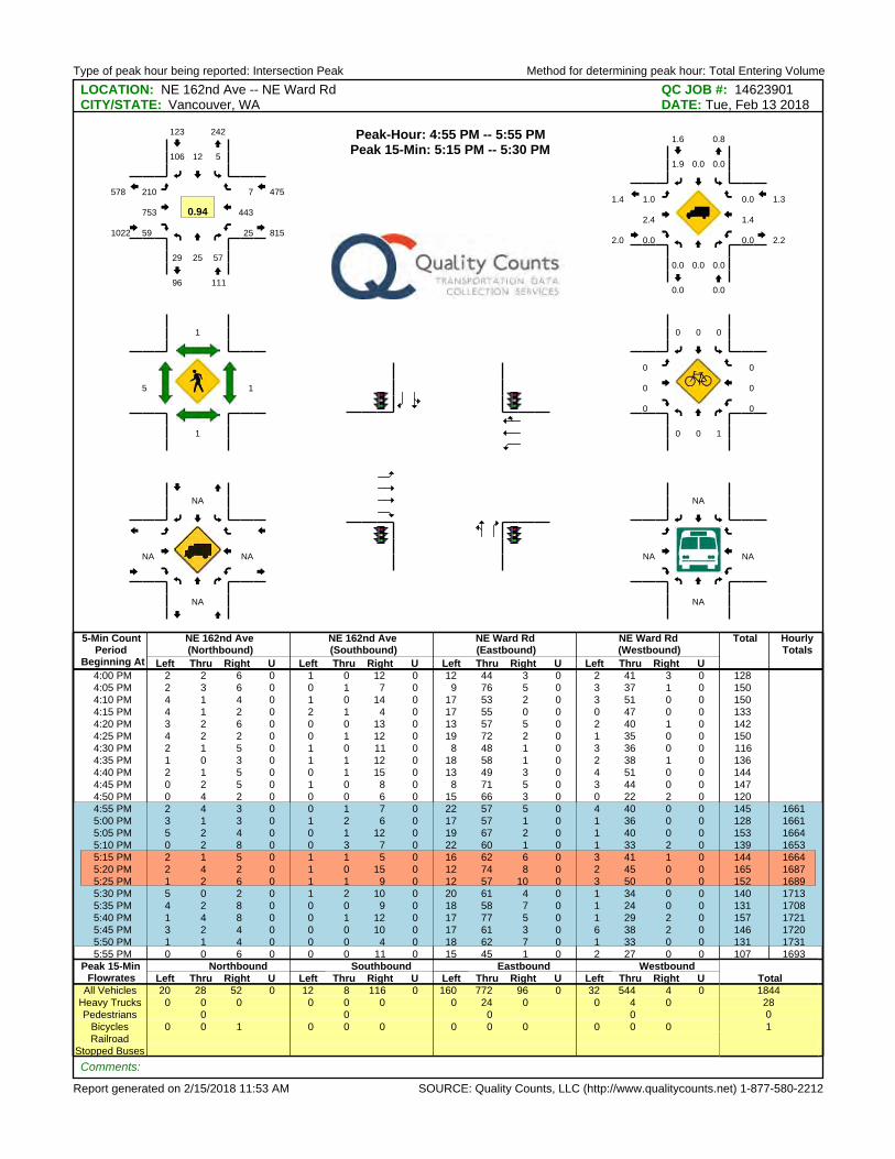
Type of peak hour being reported: Intersection Peak Method for determining peak hour: Total Entering Volume
Report generated on 2/15/2018 11:53 AM SOURCE: Quality Counts, LLC (http://www.qualitycounts.net) 1-877-580-2212
LOCATION: NE 162nd Ave -- NE Ward Rd QC JOB #: 14623901CITY/STATE: Vancouver, WA DATE: Tue, Feb 13 2018
5-Min CountPeriod
Beginning At
NE 162nd Ave(Northbound)
NE 162nd Ave(Southbound)
NE Ward Rd(Eastbound)
NE Ward Rd(Westbound)
Total HourlyTotals
Left Thru Right U Left Thru Right U Left Thru Right U Left Thru Right U4:00 PM 2 2 6 0 1 0 12 0 12 44 3 0 2 41 3 0 1284:05 PM 2 3 6 0 0 1 7 0 9 76 5 0 3 37 1 0 1504:10 PM 4 1 4 0 1 0 14 0 17 53 2 0 3 51 0 0 1504:15 PM 4 1 2 0 2 1 4 0 17 55 0 0 0 47 0 0 1334:20 PM 3 2 6 0 0 0 13 0 13 57 5 0 2 40 1 0 1424:25 PM 4 2 2 0 0 1 12 0 19 72 2 0 1 35 0 0 1504:30 PM 2 1 5 0 1 0 11 0 8 48 1 0 3 36 0 0 1164:35 PM 1 0 3 0 1 1 12 0 18 58 1 0 2 38 1 0 1364:40 PM 2 1 5 0 0 1 15 0 13 49 3 0 4 51 0 0 1444:45 PM 0 2 5 0 1 0 8 0 8 71 5 0 3 44 0 0 1474:50 PM 0 4 2 0 0 0 6 0 15 66 3 0 0 22 2 0 120
4:55 PM 2 4 3 0 0 1 7 0 22 57 5 0 4 40 0 0 145 16615:00 PM 3 1 3 0 1 2 6 0 17 57 1 0 1 36 0 0 128 16615:05 PM 5 2 4 0 0 1 12 0 19 67 2 0 1 40 0 0 153 16645:10 PM 0 2 8 0 0 3 7 0 22 60 1 0 1 33 2 0 139 1653
5:15 PM 2 1 5 0 1 1 5 0 16 62 6 0 3 41 1 0 144 16645:20 PM 2 4 2 0 1 0 15 0 12 74 8 0 2 45 0 0 165 16875:25 PM 1 2 6 0 1 1 9 0 12 57 10 0 3 50 0 0 152 16895:30 PM 5 0 2 0 1 2 10 0 20 61 4 0 1 34 0 0 140 17135:35 PM 4 2 8 0 0 0 9 0 18 58 7 0 1 24 0 0 131 17085:40 PM 1 4 8 0 0 1 12 0 17 77 5 0 1 29 2 0 157 17215:45 PM 3 2 4 0 0 0 10 0 17 61 3 0 6 38 2 0 146 17205:50 PM 1 1 4 0 0 0 4 0 18 62 7 0 1 33 0 0 131 17315:55 PM 0 0 6 0 0 0 11 0 15 45 1 0 2 27 0 0 107 1693
Peak 15-Min Northbound Southbound Eastbound WestboundTotalFlowrates Left Thru Right U Left Thru Right U Left Thru Right U Left Thru Right U
All Vehicles 20 28 52 0 12 8 116 0 160 772 96 0 32 544 4 0 1844Heavy Trucks 0 0 0 0 0 0 0 24 0 0 4 0 28Pedestrians 0 0 0 0 0
Bicycles 0 0 1 0 0 0 0 0 0 0 0 0 1Railroad
Stopped Buses
Comments:
Peak-Hour: 4:55 PM -- 5:55 PMPeak 15-Min: 5:15 PM -- 5:30 PM
29 25 57
512106
210
753
59 25
443
7
111
123
1022
475
242
96
815
578
0.94
0.0 0.0 0.0
0.00.01.9
1.0
2.4
0.0 0.0
1.4
0.0
0.0
1.6
2.0
1.3
0.8
0.0
2.2
1.4
1
1
5 1
0 0 1
000
0
0
0 0
0
0
NA
NA
NA NA
NA
NA
NA NA

Appendix 2 Capacity Analysis Worksheets
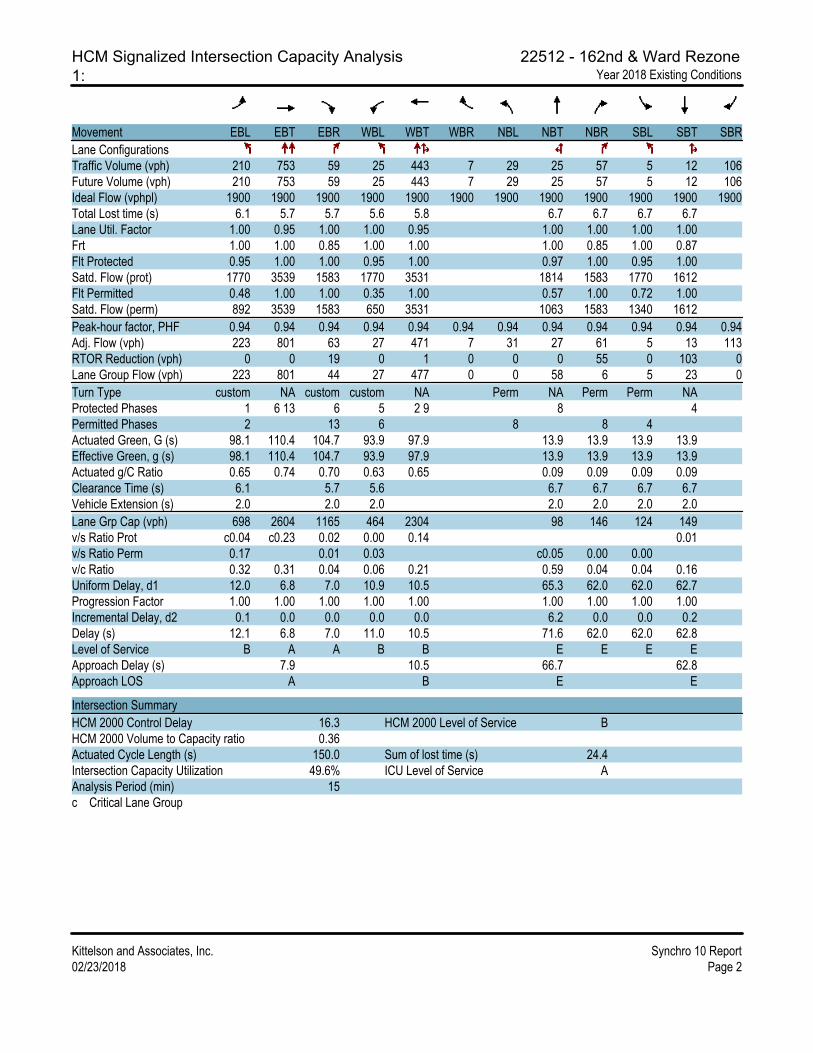
HCM Signalized Intersection Capacity Analysis 22512 - 162nd & Ward Rezone
1: Year 2018 Existing Conditions
Kittelson and Associates, Inc. Synchro 10 Report
02/23/2018 Page 2
Movement EBL EBT EBR WBL WBT WBR NBL NBT NBR SBL SBT SBR
Lane Configurations
Traffic Volume (vph) 210 753 59 25 443 7 29 25 57 5 12 106
Future Volume (vph) 210 753 59 25 443 7 29 25 57 5 12 106
Ideal Flow (vphpl) 1900 1900 1900 1900 1900 1900 1900 1900 1900 1900 1900 1900
Total Lost time (s) 6.1 5.7 5.7 5.6 5.8 6.7 6.7 6.7 6.7
Lane Util. Factor 1.00 0.95 1.00 1.00 0.95 1.00 1.00 1.00 1.00
Frt 1.00 1.00 0.85 1.00 1.00 1.00 0.85 1.00 0.87
Flt Protected 0.95 1.00 1.00 0.95 1.00 0.97 1.00 0.95 1.00
Satd. Flow (prot) 1770 3539 1583 1770 3531 1814 1583 1770 1612
Flt Permitted 0.48 1.00 1.00 0.35 1.00 0.57 1.00 0.72 1.00
Satd. Flow (perm) 892 3539 1583 650 3531 1063 1583 1340 1612
Peak-hour factor, PHF 0.94 0.94 0.94 0.94 0.94 0.94 0.94 0.94 0.94 0.94 0.94 0.94
Adj. Flow (vph) 223 801 63 27 471 7 31 27 61 5 13 113
RTOR Reduction (vph) 0 0 19 0 1 0 0 0 55 0 103 0
Lane Group Flow (vph) 223 801 44 27 477 0 0 58 6 5 23 0
Turn Type custom NA custom custom NA Perm NA Perm Perm NA
Protected Phases 1 6 13 6 5 2 9 8 4
Permitted Phases 2 13 6 8 8 4
Actuated Green, G (s) 98.1 110.4 104.7 93.9 97.9 13.9 13.9 13.9 13.9
Effective Green, g (s) 98.1 110.4 104.7 93.9 97.9 13.9 13.9 13.9 13.9
Actuated g/C Ratio 0.65 0.74 0.70 0.63 0.65 0.09 0.09 0.09 0.09
Clearance Time (s) 6.1 5.7 5.6 6.7 6.7 6.7 6.7
Vehicle Extension (s) 2.0 2.0 2.0 2.0 2.0 2.0 2.0
Lane Grp Cap (vph) 698 2604 1165 464 2304 98 146 124 149
v/s Ratio Prot c0.04 c0.23 0.02 0.00 0.14 0.01
v/s Ratio Perm 0.17 0.01 0.03 c0.05 0.00 0.00
v/c Ratio 0.32 0.31 0.04 0.06 0.21 0.59 0.04 0.04 0.16
Uniform Delay, d1 12.0 6.8 7.0 10.9 10.5 65.3 62.0 62.0 62.7
Progression Factor 1.00 1.00 1.00 1.00 1.00 1.00 1.00 1.00 1.00
Incremental Delay, d2 0.1 0.0 0.0 0.0 0.0 6.2 0.0 0.0 0.2
Delay (s) 12.1 6.8 7.0 11.0 10.5 71.6 62.0 62.0 62.8
Level of Service B A A B B E E E E
Approach Delay (s) 7.9 10.5 66.7 62.8
Approach LOS A B E E
Intersection Summary
HCM 2000 Control Delay 16.3 HCM 2000 Level of Service B
HCM 2000 Volume to Capacity ratio 0.36
Actuated Cycle Length (s) 150.0 Sum of lost time (s) 24.4
Intersection Capacity Utilization 49.6% ICU Level of Service A
Analysis Period (min) 15
c Critical Lane Group
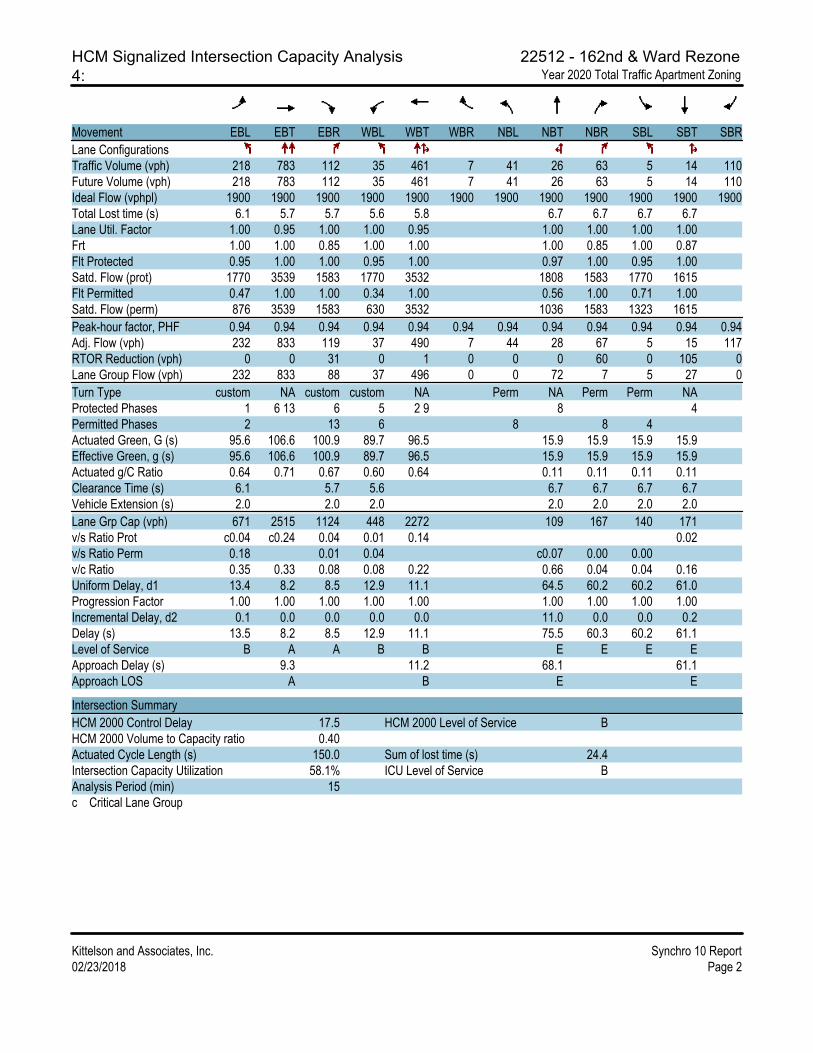
HCM Signalized Intersection Capacity Analysis 22512 - 162nd & Ward Rezone
4: Year 2020 Total Traffic Apartment Zoning
Kittelson and Associates, Inc. Synchro 10 Report
02/23/2018 Page 2
Movement EBL EBT EBR WBL WBT WBR NBL NBT NBR SBL SBT SBR
Lane Configurations
Traffic Volume (vph) 218 783 112 35 461 7 41 26 63 5 14 110
Future Volume (vph) 218 783 112 35 461 7 41 26 63 5 14 110
Ideal Flow (vphpl) 1900 1900 1900 1900 1900 1900 1900 1900 1900 1900 1900 1900
Total Lost time (s) 6.1 5.7 5.7 5.6 5.8 6.7 6.7 6.7 6.7
Lane Util. Factor 1.00 0.95 1.00 1.00 0.95 1.00 1.00 1.00 1.00
Frt 1.00 1.00 0.85 1.00 1.00 1.00 0.85 1.00 0.87
Flt Protected 0.95 1.00 1.00 0.95 1.00 0.97 1.00 0.95 1.00
Satd. Flow (prot) 1770 3539 1583 1770 3532 1808 1583 1770 1615
Flt Permitted 0.47 1.00 1.00 0.34 1.00 0.56 1.00 0.71 1.00
Satd. Flow (perm) 876 3539 1583 630 3532 1036 1583 1323 1615
Peak-hour factor, PHF 0.94 0.94 0.94 0.94 0.94 0.94 0.94 0.94 0.94 0.94 0.94 0.94
Adj. Flow (vph) 232 833 119 37 490 7 44 28 67 5 15 117
RTOR Reduction (vph) 0 0 31 0 1 0 0 0 60 0 105 0
Lane Group Flow (vph) 232 833 88 37 496 0 0 72 7 5 27 0
Turn Type custom NA custom custom NA Perm NA Perm Perm NA
Protected Phases 1 6 13 6 5 2 9 8 4
Permitted Phases 2 13 6 8 8 4
Actuated Green, G (s) 95.6 106.6 100.9 89.7 96.5 15.9 15.9 15.9 15.9
Effective Green, g (s) 95.6 106.6 100.9 89.7 96.5 15.9 15.9 15.9 15.9
Actuated g/C Ratio 0.64 0.71 0.67 0.60 0.64 0.11 0.11 0.11 0.11
Clearance Time (s) 6.1 5.7 5.6 6.7 6.7 6.7 6.7
Vehicle Extension (s) 2.0 2.0 2.0 2.0 2.0 2.0 2.0
Lane Grp Cap (vph) 671 2515 1124 448 2272 109 167 140 171
v/s Ratio Prot c0.04 c0.24 0.04 0.01 0.14 0.02
v/s Ratio Perm 0.18 0.01 0.04 c0.07 0.00 0.00
v/c Ratio 0.35 0.33 0.08 0.08 0.22 0.66 0.04 0.04 0.16
Uniform Delay, d1 13.4 8.2 8.5 12.9 11.1 64.5 60.2 60.2 61.0
Progression Factor 1.00 1.00 1.00 1.00 1.00 1.00 1.00 1.00 1.00
Incremental Delay, d2 0.1 0.0 0.0 0.0 0.0 11.0 0.0 0.0 0.2
Delay (s) 13.5 8.2 8.5 12.9 11.1 75.5 60.3 60.2 61.1
Level of Service B A A B B E E E E
Approach Delay (s) 9.3 11.2 68.1 61.1
Approach LOS A B E E
Intersection Summary
HCM 2000 Control Delay 17.5 HCM 2000 Level of Service B
HCM 2000 Volume to Capacity ratio 0.40
Actuated Cycle Length (s) 150.0 Sum of lost time (s) 24.4
Intersection Capacity Utilization 58.1% ICU Level of Service B
Analysis Period (min) 15
c Critical Lane Group

HCM Signalized Intersection Capacity Analysis 22512 - 162nd & Ward Rezone
2: Year 2020 Total Traffic Commercial Zoning
Kittelson and Associates, Inc. Synchro 10 Report
02/23/2018 Page 2
Movement EBL EBT EBR WBL WBT WBR NBL NBT NBR SBL SBT SBR
Lane Configurations
Traffic Volume (vph) 218 731 172 68 461 7 81 63 158 5 46 110
Future Volume (vph) 218 731 172 68 461 7 81 63 158 5 46 110
Ideal Flow (vphpl) 1900 1900 1900 1900 1900 1900 1900 1900 1900 1900 1900 1900
Total Lost time (s) 6.1 5.7 5.7 5.6 5.8 6.7 6.7 6.7 6.7
Lane Util. Factor 1.00 0.95 1.00 1.00 0.95 1.00 1.00 1.00 1.00
Frt 1.00 1.00 0.85 1.00 1.00 1.00 0.85 1.00 0.89
Flt Protected 0.95 1.00 1.00 0.95 1.00 0.97 1.00 0.95 1.00
Satd. Flow (prot) 1770 3539 1583 1770 3532 1812 1583 1770 1666
Flt Permitted 0.47 1.00 1.00 0.36 1.00 0.61 1.00 0.57 1.00
Satd. Flow (perm) 876 3539 1583 665 3532 1138 1583 1061 1666
Peak-hour factor, PHF 0.94 0.94 0.94 0.94 0.94 0.94 0.94 0.94 0.94 0.94 0.94 0.94
Adj. Flow (vph) 232 778 183 72 490 7 86 67 168 5 49 117
RTOR Reduction (vph) 0 0 69 0 1 0 0 0 133 0 54 0
Lane Group Flow (vph) 232 778 114 72 496 0 0 153 35 5 112 0
Turn Type custom NA custom custom NA Perm NA Perm Perm NA
Protected Phases 1 6 13 6 5 2 9 8 4
Permitted Phases 2 13 6 8 8 4
Actuated Green, G (s) 78.3 89.7 84.0 72.7 82.7 31.5 31.5 31.5 31.5
Effective Green, g (s) 78.3 89.7 84.0 72.7 82.7 31.5 31.5 31.5 31.5
Actuated g/C Ratio 0.52 0.60 0.56 0.48 0.55 0.21 0.21 0.21 0.21
Clearance Time (s) 6.1 5.7 5.6 6.7 6.7 6.7 6.7
Vehicle Extension (s) 2.0 2.0 2.0 2.0 2.0 2.0 2.0
Lane Grp Cap (vph) 559 2116 946 401 1947 238 332 222 349
v/s Ratio Prot c0.05 c0.22 0.05 0.01 0.14 0.07
v/s Ratio Perm c0.17 0.02 0.07 c0.13 0.02 0.00
v/c Ratio 0.42 0.37 0.12 0.18 0.25 0.64 0.11 0.02 0.32
Uniform Delay, d1 23.3 15.5 15.6 22.3 17.6 54.1 47.9 47.0 50.2
Progression Factor 1.00 1.00 1.00 1.00 1.00 1.00 1.00 1.00 1.00
Incremental Delay, d2 0.2 0.0 0.0 0.1 0.0 4.4 0.1 0.0 0.2
Delay (s) 23.5 15.6 15.6 22.4 17.6 58.5 47.9 47.0 50.4
Level of Service C B B C B E D D D
Approach Delay (s) 17.1 18.2 53.0 50.3
Approach LOS B B D D
Intersection Summary
HCM 2000 Control Delay 25.0 HCM 2000 Level of Service C
HCM 2000 Volume to Capacity ratio 0.48
Actuated Cycle Length (s) 150.0 Sum of lost time (s) 24.4
Intersection Capacity Utilization 63.1% ICU Level of Service B
Analysis Period (min) 15
c Critical Lane Group

HCM Signalized Intersection Capacity Analysis 22512 - 162nd & Ward Rezone
5: Year 2040 Total Traffic Apartment Zoning
Kittelson and Associates, Inc. Synchro 10 Report
02/23/2018 Page 2
Movement EBL EBT EBR WBL WBT WBR NBL NBT NBR SBL SBT SBR
Lane Configurations
Traffic Volume (vph) 252 1054 112 35 620 8 41 26 63 6 14 127
Future Volume (vph) 252 1054 112 35 620 8 41 26 63 6 14 127
Ideal Flow (vphpl) 1900 1900 1900 1900 1900 1900 1900 1900 1900 1900 1900 1900
Total Lost time (s) 6.1 5.7 5.7 5.6 5.8 6.7 6.7 6.7 6.7
Lane Util. Factor 1.00 0.95 1.00 1.00 0.95 1.00 1.00 1.00 1.00
Frt 1.00 1.00 0.85 1.00 1.00 1.00 0.85 1.00 0.86
Flt Protected 0.95 1.00 1.00 0.95 1.00 0.97 1.00 0.95 1.00
Satd. Flow (prot) 1770 3539 1583 1770 3532 1808 1583 1770 1611
Flt Permitted 0.40 1.00 1.00 0.25 1.00 0.49 1.00 0.71 1.00
Satd. Flow (perm) 740 3539 1583 473 3532 909 1583 1323 1611
Peak-hour factor, PHF 0.94 0.94 0.94 0.94 0.94 0.94 0.94 0.94 0.94 0.94 0.94 0.94
Adj. Flow (vph) 268 1121 119 37 660 9 44 28 67 6 15 135
RTOR Reduction (vph) 0 0 23 0 1 0 0 0 60 0 120 0
Lane Group Flow (vph) 268 1121 96 37 668 0 0 72 7 6 30 0
Turn Type custom NA custom custom NA Perm NA Perm Perm NA
Protected Phases 1 6 13 6 5 2 9 8 4
Permitted Phases 2 13 6 8 8 4
Actuated Green, G (s) 90.1 107.7 102.0 82.2 93.9 16.5 16.5 16.5 16.5
Effective Green, g (s) 90.1 107.7 102.0 82.2 93.9 16.5 16.5 16.5 16.5
Actuated g/C Ratio 0.60 0.72 0.68 0.55 0.63 0.11 0.11 0.11 0.11
Clearance Time (s) 6.1 5.7 5.6 6.7 6.7 6.7 6.7
Vehicle Extension (s) 2.0 2.0 2.0 2.0 2.0 2.0 2.0
Lane Grp Cap (vph) 588 2541 1136 326 2211 99 174 145 177
v/s Ratio Prot c0.06 c0.32 0.04 0.01 0.19 0.02
v/s Ratio Perm 0.21 0.02 0.06 c0.08 0.00 0.00
v/c Ratio 0.46 0.44 0.08 0.11 0.30 0.73 0.04 0.04 0.17
Uniform Delay, d1 18.7 8.7 8.1 16.6 12.9 64.6 59.7 59.7 60.5
Progression Factor 1.00 1.00 1.00 1.00 1.00 1.00 1.00 1.00 1.00
Incremental Delay, d2 0.2 0.0 0.0 0.1 0.0 20.0 0.0 0.0 0.2
Delay (s) 19.0 8.8 8.2 16.7 13.0 84.6 59.7 59.7 60.7
Level of Service B A A B B F E E E
Approach Delay (s) 10.5 13.2 72.6 60.7
Approach LOS B B E E
Intersection Summary
HCM 2000 Control Delay 17.8 HCM 2000 Level of Service B
HCM 2000 Volume to Capacity ratio 0.51
Actuated Cycle Length (s) 150.0 Sum of lost time (s) 24.4
Intersection Capacity Utilization 66.6% ICU Level of Service C
Analysis Period (min) 15
c Critical Lane Group

HCM Signalized Intersection Capacity Analysis 22512 - 162nd & Ward Rezone
3: Year 2040 Total Traffic Commercial Zoning
02/23/2018 Synchro 10 Report
Kittelson and Associates, Inc. Page 2
Movement EBL EBT EBR WBL WBT WBR NBL NBT NBR SBL SBT SBR
Lane Configurations
Traffic Volume (vph) 252 1002 172 68 620 8 81 63 158 6 46 127
Future Volume (vph) 252 1002 172 68 620 8 81 63 158 6 46 127
Ideal Flow (vphpl) 1900 1900 1900 1900 1900 1900 1900 1900 1900 1900 1900 1900
Total Lost time (s) 6.1 5.7 5.7 5.6 5.8 6.7 6.7 6.7 6.7
Lane Util. Factor 1.00 0.95 1.00 1.00 0.95 1.00 1.00 1.00 1.00
Frt 1.00 1.00 0.85 1.00 1.00 1.00 0.85 1.00 0.89
Flt Protected 0.95 1.00 1.00 0.95 1.00 0.97 1.00 0.95 1.00
Satd. Flow (prot) 1770 3539 1583 1770 3532 1812 1583 1770 1658
Flt Permitted 0.40 1.00 1.00 0.27 1.00 0.61 1.00 0.59 1.00
Satd. Flow (perm) 740 3539 1583 500 3532 1135 1583 1107 1658
Peak-hour factor, PHF 0.94 0.94 0.94 0.94 0.94 0.94 0.94 0.94 0.94 0.94 0.94 0.94
Adj. Flow (vph) 268 1066 183 72 660 9 86 67 168 6 49 135
RTOR Reduction (vph) 0 0 55 0 1 0 0 0 126 0 58 0
Lane Group Flow (vph) 268 1066 128 72 668 0 0 153 42 6 126 0
Turn Type custom NA custom custom NA Perm NA Perm Perm NA
Protected Phases 1 6 13 6 5 2 9 8 4
Permitted Phases 2 13 6 8 8 4
Actuated Green, G (s) 65.1 83.6 77.9 56.6 73.1 37.7 37.7 37.7 37.7
Effective Green, g (s) 65.1 83.6 77.9 56.6 73.1 37.7 37.7 37.7 37.7
Actuated g/C Ratio 0.43 0.56 0.52 0.38 0.49 0.25 0.25 0.25 0.25
Clearance Time (s) 6.1 5.7 5.6 6.7 6.7 6.7 6.7
Vehicle Extension (s) 2.0 2.0 2.0 2.0 2.0 2.0 2.0
Lane Grp Cap (vph) 462 1972 882 279 1721 285 397 278 416
v/s Ratio Prot c0.08 c0.30 0.04 0.02 0.19 0.08
v/s Ratio Perm 0.17 0.04 0.08 c0.13 0.03 0.01
v/c Ratio 0.58 0.54 0.15 0.26 0.39 0.54 0.11 0.02 0.30
Uniform Delay, d1 36.8 21.0 18.7 34.0 24.3 48.6 43.2 42.3 45.5
Progression Factor 1.00 1.00 1.00 1.00 1.00 1.00 1.00 1.00 1.00
Incremental Delay, d2 1.2 0.2 0.0 0.2 0.1 1.0 0.0 0.0 0.1
Delay (s) 38.0 21.2 18.8 34.2 24.4 49.6 43.2 42.3 45.6
Level of Service D C B C C D D D D
Approach Delay (s) 23.9 25.3 46.3 45.5
Approach LOS C C D D
Intersection Summary
HCM 2000 Control Delay 28.3 HCM 2000 Level of Service C
HCM 2000 Volume to Capacity ratio 0.58
Actuated Cycle Length (s) 150.0 Sum of lost time (s) 24.4
Intersection Capacity Utilization 70.5% ICU Level of Service C
Analysis Period (min) 15
c Critical Lane Group


