Embed Size (px)
Citation preview
OVERVIEW: LEWlS AND CLARK COUNTY COMPREHENSIVE PLAN PROCESS ENVIRONMENTAL QUALITY COUNCIL PRESENTATION December 2,1399
WHAT IS THE COST TO DEVELOP THE PLAN AND WHAT WERE THE SOURCES OF FUNDING?
The estimated costs of the Plan Update are as follows: - $1 85,000 Consultant Fees - $ 10,000 Meeting related Expenses (including public meeting
and citizen advisory meeting expenses, copying charges
- $30,000 Estimated Staff Time
Sources of Funding - All Purpose Mill Levy - Planning Levy
WHAT ARE THE PLANNING DISTRICTS AND WHAT IS THE PURPOSE OF DIVIDING THE COUNTY INTO PLANNING DISTRICTS?
There are five new planning districts with the Plan: Helena Valley; Canyon CreekIMarysville; Canyon Ferry; Wolf CreeWCraig; and Augusta ('The Lincoln Area completed a Comprehensive Plan three years ago and that will be incorporated into this plan. That effort was partially funded through the US Forest Service)
The planning area concept was initially introduced in our old plan. Although we have new planning areas, the concept was carried forward because the land use and other issues are so different in each planning area (ie the land use conflicts, need for capital facilities, environmental issues)
It has helped each area develop an ownership in the plan
PROCESS
The Board of County Commissioners let an RFP for the Plan and appointed the Citizen Advisory Group (CAG) to help guide the process The CAG has been working the County Staff and the Consultants on Draft Goals and Policies for the Plan County staff has also been working with Area representatives in drafting area sections and working with the Consultants in drafting Natural Environment, Transportation, Housing, Capital Facilities, Population and Demographics, etc Several series of public meetings have been held to identify community issues,
Land UseIEnvironmental Trends Subcommittee December 2, 1999
Exhibit 1
review draft goals, and to provide public education Other public education tools included: County newsletter, County radio show, presentations to different groups, news releases Remaining Process will involve CAG final recommendation, Planning Board review and recommendation, and Board of County Commission hearing process
WHAT WAS THE MOTIVATION FOR THE PLAN?
Our Comprehensive Plan had not been reviewed and updated in its entirety since 1983 (There was a minor update in 1989)
The Helena Valley had seen dramatic changes since that time period. Other changes were also occurring in the other planning areas
We wanted to have a stronglrealistic capital improvements plan that was tied to comprehensive land use plan
WHAT ARE THE EFFECTS OF SENATE BILL 97
All of the elements outlined in the growth policy legislation were included in the original contract with the consultant
The implementation strategy we are c~~rrently working on will have to be further defined to meet the criteria set forth in the legislation, including a specific timetable
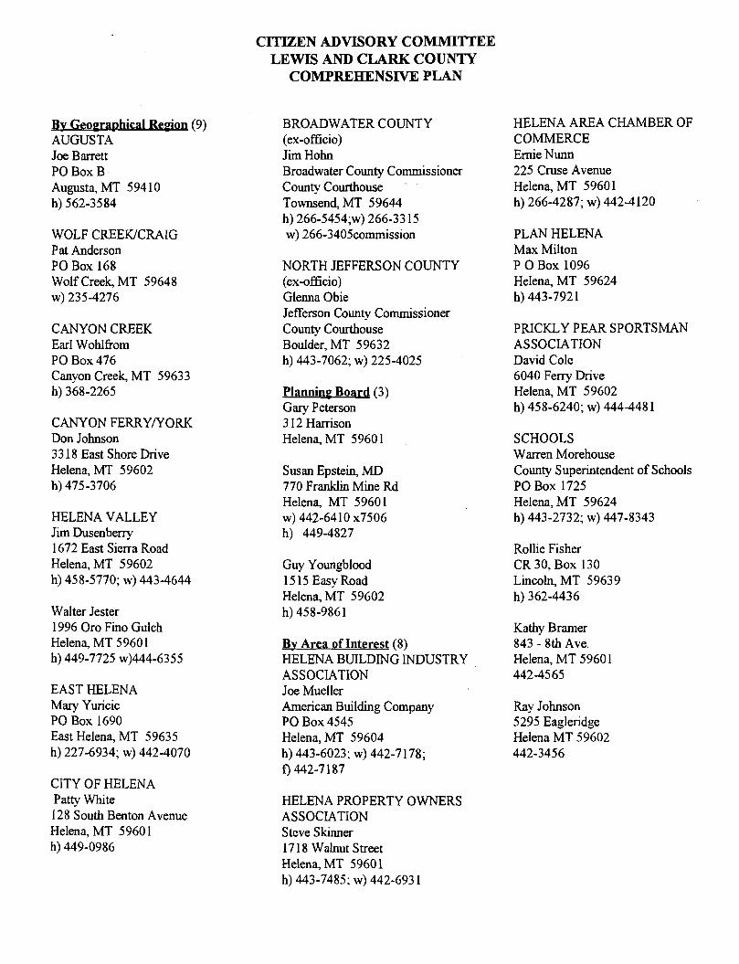
CITIZEN ADVISORY COMMITTEE LEWIS AND CLARK COUNTY
COMPREHENSIVE PLAN
B v G e o g r a D h i c a l ( 9 ) AUGUSTA Joe Barrett PO Box B Augusta, MT 594 10 h) 562-3584
WOLF CREEWCRAIG Pat Anderson PO Box 168 Wolf Creek, MT 59648 W) 235-4276
CANYON CREEK Earl Wohlfrom PO Box 476 Canyon Creek, MT 59633 h) 368-2265
CANYON FERRYNORK Don Johnson 33 18 East Shore Drive Helena, MT 59602 h) 475-3706
HELENA VALLEY Jim Dusenbeny 1672 East Sierra Road Helena, MT 59602 h) 458-5770; W) 443-4644
Walter Jester 1996 Oro Fino Gulch Helena, MT 5 960 1 h) 449-7725 ~)444-6355
EAST HELENA Mary Yuricic PO Box 1690 East Helena, MT 59635 h) 227-6934; W) 442-4070
CITY OF HELENA Patty White 128 South Benton Avenue Helena, MT 5960 1 h) 449-0986
BROADWATER COUNTY (ex-officio) Jim Hohn Broadwater County Commissioner County Courthouse Townsend, MT 59644 h) 266-5454;~) 266-33 15 w) 266-3405commission
NORTH JEFFERSON COUNTY (ex-officio) Glenna Obie Jefferson County Commissioner County Courthouse Boulder, MT 59632 h) 443-7062; W) 225-4025
Planning Board (3) Gary Peterson 3 12 Hanison Helena, MT 5960 1
Susan Epstein, MD 770 Franklin Mine Rd Helena, MT 59601 W) 442-6410 ~ 7 5 0 6 h) 449-4827
Guy Youngblood 15 15 Easy Road Helena, MT 59602 h) 458-986 1
Bv Area of Interest (8) HELENA BUILDING INDUSTRY ASSOCIATION Joe Mueller American Building Company PO Box 4545 Helena, MT 59604 h) 443-6023; W) 442-7 178; f) 442-7 187
HELENA PROPERTY OWNERS ASSOCIATION Steve Skinner 17 18 Walnut Street Helena, MT 5960 1 h) 443-7485; W) 442-693 1
HELENA AREA CHAMBER OF COMMERCE Ernie Nunn 225 Cruse Avenue Helena, MT 5960 1 h) 266-4287; W) 442-4120
PLAN HELENA Max Milton P 0 Box 1096 Helena, MT 59624 h) 443-792 1
PRICKLY PEAR SPORTSMAN ASSOCLATION David Cole 6040 Feny Drive Helena, MT 59602 h) 458-6240; W) 444-448 1
SCHOOLS Warren Morehouse County Superintendent of Schools PO Box 1725 Helena, MT 59624 h) 443-2732; W) 447-8343
Rollie Fisher CR 30, Box 130 Lincoln, MT 5963 9 h) 362-4436
Kathy Bramer 843 - 8th Ave. Helena, MT 5960 1 442-45 65
Ray Johnson 5295 Eagleridge Helena MT 59602 442-3456
Canyon CreeWMarysville Planning Area DRAFT 12/98
1. Introduction Canyon Creek or Canon Creek as it is spelled on early maps, is a very old settlement on the travel route of the Piegan Indians fiom the plains area to the Blackfoot River Valley. The trails in this area were g e d by the early trappers, followed by fur companies and were later surveyed for wagons roads-and ra&oa&. The area was first settled in the 1840's by men with Blood or Piegan wives with fiendly w ~ w t i o n s ? o x ~ ~ x x ~ y = ~ . ~ ~ . . ~ ~ . ~ the Blackfoot
* .7 " . x . ~ ~ "
Indians. The valley of the Little Prickly Pear had all the elements foq~c~mfor t a l i l " e~g . ~ ~ . T = s ~ x s ~ z x x ~ for the early settlers. " A " <xEk
The cottonwood bottoms provided shelter and fuel for heat along an abunda@@c&ddlife 2y x ~ ~ ~ x x x x x ~ for food and ; furs. The grassy windswept hills and hilltops provided plenty ofiEea for livestock ~ ~ g ~ i ~ & i p y ~A...sA..2x-- xx * - of the ,: “ early settlers became hunters who supplied meat or woodchop@$ who provi&d heating@eI:@.t@e ~ .= y z d trafdg ,. F,xx
posts and stage stops which sprang up in the area. In the 1860fd;ff&er sx..'x. A sxa gol&%as &scovereii~@hiil$d~f A *,* .- Silver Creek, placer mining brought thousands of men to the ark: i i ;~g?; i~ely * q A ssxxv x-x --, camp called Sil$k$%Iity sprang up. In 1864, Silver City became the county seat of Edgerton Co%i~,~r;i'hk~later became Lewis and Clark
h x >" " ~ " ~ ~ ~ ~ ~ x x x x
County. During that same time, Canyon Creek had settled into a { E r a i : f 6 g x7sav.. 'y xxxx community consisting of . = .7x"**~x.-T.,
stockmen, farmers and several businesses includmg a blacksmith; sevei;dl.stores, a saloon and a Catholic Church at the head of Little Prickly Pear Creek. By 1865, S i l x p ~ Lxxx yb City and'8el&&&j-becorne rivals and both wanted the county seat. The dispute was settled when Colhn&&!gF. Sanders r d k t ~ s l v e r City stole the
~ % " " " ' a , ."">,yxx">xx "
county records and spirited them back to Helena. Th8&&r~Rel&a.became ,~ .he& x, =~". the kounty seat and Silver City %xx hx
remained little more than a supply point and stage,.&%on for,@@~aqgyille . x x x x A x E sx ~xxAA-.,.... mining district and the Fort Benton to Helena segment of the Mullan m rail+!& 1866, a,&atei?j:h~;Zdjj;~~~fijithe placer miners and the settlers of the valley began. The communitie$Gf ~ e o r ~ e p b n , ~&@.%ci""Silver City, that once had thriving businesses, folded up. Trinity was the firit@ = ..brx.riux go, but:itit.left the Little Prickly Pear Valley with a public
.hx=x*#, ="
school - the Trinity School, District #4,@@5nyon ~ & e k . The T&ity School is the oldest school building still in use in the State of Montana; itl&8been .a‘ " capt&ally usd.%r over 100 years.
. ,-%
, . '.~ 7 .. "- <.A
-7 > ' A %"
,""vv ".. A "
A% . '-." x.> . - < *%*%
><"" "a ."- . .' " x"" " <= **%.." xs.." a. % z >*> x"".
xxx xL".r. ==... .x,."x z%"", xx ... " " %
After Thom&@hse v =zxx.... s7,.xv u n c o v e 5 ~ ~ & kade gold ai.e:iiEiKs~Dnunlummon mine and other rich lodes like "x%""xsz x" .... "". "" xx x.%sxxx""~""=
"s.na.%".**x%" . Gloster, Be@&a#3gll % . .x.zxxxx, Boy YiiX&a~@pb#te were of%ried, Marysville blossomed into a prosperous settlement
" ~ ..hxx.s .* x" ~ ~ x ~ x ~ " " x ~ ~ ~ ~ ~ x ~ . " . ~ A ~
with a p o p u ~ a t i ~ g ~ ~ ~ f 0 ~ . ~ ~ x ~ x x x ~ x .h , *vArxx. D~+%#@iili&day , . . ~ x s - - h it supported four churches and hvo newspapers. But according v
to local h i s t o r i ~ , ~ ~ ~ Z & & "= a T7x e - D d a g @ m ceased operation in 19 10, "the down went downhill fast". =x = x> x *"<dv
Today, the commuiiiti&~6fiQanyon . . . x x ~ ~ ~ ~ ~ ~ ~ x ~ x z z T ~ E CrkeQMgrysville and Silver City have return for the most part to the pre- ' . -% 7 <'d,z.xxx " " A s " x %
xx ,."" .x.
gold boom = xx. c h ~ ~ ~ a ~ 6 ~ ~ ~ & , e 8 t , ".. ...... xx b*=xxx. zx7 excep@or the Marysville town site, is scattered and ma1 in character. '" 2
,,z,x.. x >**%x**" "Ada
< =" ., >." x"L .* .,.d".
xxzx -=% xL= . " .-*..
xx, A Lx?xxx "shx <=>*.. ,
" x ~ x x " % " " s z .sx.~".~'.. .-zxxx>"""."" .......
' x L ~ ~ " s z*7 .X<XY , . . x x x x s " L ~ L a L A > z = . " " ~ " x . ~ . . Existing Conditiofi~l kil~~@if,::< 2 >..~. . ...., ex-
x "~,b.."" ,<.%<-
=.=a ."... ..,.. %"zxx"
.x.".. . ... . ' s7<.
.z-xv ..'., < ,
>=x..- ,", 7 L"",
x..... . 2.
,,".% x7-
2.l;:i:i:: Physical Conditio$i Tbeganyon c r e e ~ ~ a r y s d i e planning area consists of approximately 298 square miles located in the west ~e iE&~or t ion y,%*u.,7 of ~ewis;@d Clark County. The planning area boundaries generally correspond with the Cdii@i@tal Divide o@@e north and the west; the Wolf CreeWCraig planning area on the northeast; the
xx"x" xh. " . ~e~ei%iilr~ep~@@&~ x x x.-as.. . a Lx, xyx x-xx x area on the southeast and south; and the Powell County line on the west.
2- .xx - . . s.7"*x>. ,,= ..., a . " . ".< ' "?*. %- "sz". 7- I '5'*""XX "%s. ." d. . ""
a. = * =< =" " ..., . .- ' . ".
Lvf "
Topoaap y The topography of the Canyon Creekh4arysville Planning Area is vanable and typically rugged. Slopes range fiom the gently eastward sloping Silver Valley floor, 4,380 to 4,340 feet in elevation to, the rolling h~lls found in the eastern portion of the planning area; to the peaks and passes located along the Continental
Divide, 7,33 1 - 6,13 1 feet in elevation. Prominent landmarks and elevations include Mount Behont (7,33 l'), Bald Butte (7,052'), Edward Mountain (6,713'), Stemple Pass (6,376'), Flesher Pass (6,13 l'), Marysville townsite (5,4001), Gravelly Range Lake (4,904'), Canyon Creek Community (4,380') and Silver City (4,347').
Climate
Canadian fronts. Wind are predominantly out of the northwest m.p.h. Average precipitation varies according to elevation, wi Divide receiving 25 to 30 inches per year and the Silver Valle
area. The Little Prickly Pear Creek has it's headwaters in
lude: Lost Horse Creek,
s southward until it drains into the
ars Creek. The watershed drains
arysville Planning Area contains a diversity of geologcal units. The dominant geologic feature of the area adjacent to the Continental Divine is a Tertiary stock and its surrounding metarnorphlc zone. The intrusive has been called quartz diorite or granohorite. The rock is medium grained and consists of plagoclase, quartz, orthoclase, hornblende and biotite; it has a h!pidiomorphic granular texture. The
width of the contact metamorphic zone suggests that the size of the intrusive increase downward. Several textural and mineralogic varieties of dikes related to the granodiorite also occur. These intrusives cut through Empire Shale and Helena Dolomite of the Belt Supergroup. Other Belt Units include the Spokane Shale, Marsh formation and the Missoula Group. Outside the metamorphic circles, the Empire Shale consists of pale-green and deep-red argillite, and fine grained quartzite. The Empire Shale is about 1,000 feet thick in some areas. Within metamorphic zones, the formations are dark cordierite hornfels with interbeds of white calcic hornfels. The Helena Dolomite is described as a buff-weathering, dark-gray Dolomite. >--s%s, Within the "..--? contact zones, the Helena Dolomite is light-colored diopside and tremolite-bearing,skam. -e5 ,,&IF'
xx% %" ssz <*xzxh
"x<zx"s >xzxx ,<-% ~ - "
.""3zx."A -*.*. ' >*?s"x% A 'xx..>e>x"x* .=-. x* .
In the areas that have rolling hills, such as those surrounding the Cang~n ~reek.dii"&ll~F.?=~alle~ ~ ~ . ~ ~ . x ~ ~ x ~ s ~ ~ ~ ~ x ~ ~ A x + areas, the ".%."xx""AA "*Ax" .x..
predominant geology consists of Pre-Tertiary rocks including ~ rec~&&in x x x s x ~ x x 2 to ~ ~ ~ ~ ~ ~ ~ e n t a r y rocks ":\", < x"""w> .- ' .L. x."""v."""x "s"'x<.-%
~ % " . x ~ " " x - , " ~ " . % ~ . = ~ . ~ " " ~ ~ ~ " ~ " " < " " " x % ~ x ,.= .=".xc ....,"s% ." xxx"" Lss-= and Cretaceous plutonic and volcanic rocks . ,=. %=.. x> 7v"" L.. .
x7xx . ' . .x~xxxxzr -= .. . h x%x... * xx < s z , " * " x x ~ " - ~ , - x Lxs = s<" x#.=xx~xxz-==. . .
."%- . xxx. ", . . ~ ~ % x x ~ ~ " x - ~ " . . . x=x* " s ~ " """.., xxAx" d " x s ~ ~ < x , % " ~ x ~ * . . . " .... %
%x .>,, y7v=%-.*" ... s %<... ".." - xxxrx .xx"
szxx vXZ . x x ~ . " " . - - ~ ~ ~ ~ x = x ~ ~ ~ "::::::Y:::::::.X::. = . s"x
< ."x, "Axx" " ~ , - " ~ ~ ~ ~ x x ~ ~ x x x ~
. % <"." = < %.
",x"." xz=x * = x s , % ~ 2 x h x ~ .".*.ss z. <Y.
In the Silver Valley and along most of the larger water courses,$he xxsm,xs,d% can findZ%olocene t e ~ i ~ g d i s t i e s i n - ""=s"%,.x'"
~~%x%"" .x . -~xx .7"~ . . ..*" z*~xxhx""".s."...-..".."
channel deposits, and alluvial plain deposits. These deposits aiggil?q&8i ,xxsx .s=xxxzs ."=... of gray to browiii:@.@$e~sandy to cobble gravels. The degree of sorting and rounding of clasts an3g&E,ic ~ x x ~ x ~ ~ x x ~ ~ ~ x ~ . ~ . ..x,d forms vary wideFdepending
" " ~ A ~ " x " ~ ~ ~ x ~ ~ x ~ x ~ . ' . ~ . upon the size and the volume of discharge in the particular d r a i n ~ ~ ~ ~ e g 3 ~ I i ~ s A
Ax"hz" ~ x ~ x ~ ~ ~ ~ x x . " " " s x ~ " ~ . . s ~ ~ h "x"z=. ~ ~ " ~ " " " " % r x x s " x x=.<?*xh ; . .X."".I.X"X-X*'.".<~%~~>
.x%x'" '%A"x""
? ~ . . = " ~ ~ ~ ~ ~ ~ ~ " % . ~ ~ ~ x x " " m ~ . . x ~ " ~ > ~ w < . ~ = = " ~ x x x . . ~ x ~ ~ " ~ " " ~ x ~ ~ ~ x ~ " ~ ~ " > ~ " "X
s="*=%x*xxxxx"=.&. '""=
The Canyon Creek/Marysville Planning Area is located withi7he I n t e d 6 i ~ ~ i s m i c x x E x 7bL.. s x ~ x x x . x z A s Belt, a seismically active zone associated with major fault structures. A mgjoii@&&he Pld#&$@tocated in Seismic Risk
" " " ~ ~ " > ~ ~ " x . ~ ~ . . ~ . " " x ~ " x x. hxx"z-- x.x"
Zone 2. (see m a p . F. Naeher, 1994). Major faulf:J@@id@mgd in the aS23clude: the Bald Butte fault (strike-slip fault), Helena Valley Fault (strike-slipbrfi%.fi) x x A x 7 an8~f?~$idi l ley-~yonh ~ x x ~ ~ x x x ~ ~ ~ x x ~ x ~ ~ ~ ~,...s .*.= Thrust Fault (see figure 3, pg
x""-x ,<zxx " ",x, , x""x"x""x%,.. z*xs..
14, U.S.G.S Professional Paper 13 16). <"., " 5 ~ x x % * % x > x x " ~..~x.~."~s,s... " 7 v
'" . ~ x * " x x y x x x " A xe..%xs'"'"
x <. ",, . ? xAr.vv %%" x~x"x .z .'xvx.,
x< <= *>* %& ~ ~ " % x ~ ~ x ~ - x . " x x % % &=
2zxxs x ~ ~ " s s " ~ " ~ , ~ . ~ x ~ x " " ~ % . % ~ .
*xx" 7 % s " L""x? xs%x"xA xx2"
d"xx" " % % "
... %XS ." ~ x x x " x "
' *s" ?" . " % " x ~ x ~ ~ % ~ ~ . " ~ " " ~ % ~ x x
<*" ", sTx x " S x " % = .,x.6""%x" " ....sxx"
Tzz"##xv .'. % d x x x x " x . ~ ' *
The Bald Butte Fault is named for Bald ~ u d f ' a ~ A x . . ~ x ~ x - prom@&t peak l h d ~ t ~ d along the Continental Divide .xx....xs""
southwest of Marysville. This fault seeh&@have b&6 the locus,&many small earthquakes in 1973 and maybe the most seismically active fr&&gin the i&$! The faul$!ends southeasterly through the Birdseye area, north of Fort Harrison. 'x..xx. .=. ~h~fa@a~~arentl@$~~&~~&~$~ vhx= x x ~ x ~ z z ~ z ~ , y = .%. =,.. the southern margin of the Helena Valley and joins anog~r fault along ~ ~ x x ~ ~ ~ . . . . = . ~ ~ x ~ ~ = - thelridrtlkrn front of:f@&Emim ~ ~ ~ ~ = ~ ~ ~ ~ ~ ~ ~ ~ ~ ~ x x x x x x x ~ Mountains. The fault extends northwesterly across the,a&{&!&tal ~ i ~ i d e E @ ? & ~ ~ the n o w { g o r d e r of the Avon Valley. The fault then joins a
~ H" xz""A. " " ""x"L"x>- " - r 7
major no&w~s~&e&g =xxs.. -...".. f iaciene~&:~eYada Lake in Powell County. xL'>x *%". -".x .s=xv. ~".*" <".."".. . "-s*aA. =-="x"=..,= ..xd*xs %.x.
".> . . "% " z % x s A x >
~-x*s...r ~=.s """ % x x % s ~ > . x ~ x , ~ x ~ " x " x ~ . .~ .=x~-x~~x<"z . ,xx . ""
v . .* x""-x""xx.* "r " .=%=" ." '" .--
= ."L~ . .x"Tx '<~zx%"
ss.s ", ".. " "X 7 %.."'>*s<x%" "
*-- x.".%.".-xx .7 7xz == -.*>. - . x " . . " ~ x x " x ~ x= ===", ~.<.x. xxx "" .>
The Helena Vall+PiiiffBF$Ixell x x ~ ~ z x . ~ ~ ~ x ~ x x xx xxxx e x p o s ~ ~ ~ ~ f h e ~ ~ ~ x ~ x ~ ~ ~ ~ s x ~ . ~ northwest margins of the Helena Valley and in the low range of hills betd$&B&ie$$na x ~ ~ ~ ~ ~ x x ~ x ~ x x ~ ~ x ~ ~ ~ z ~ x ~ ~ ~ ...x.x.7=~= sxxa.=. ~ a l l e j & H & e Silver Valley. The fault extends along the northwestern
> " * .,- ~ ~ " ~ . % ~ x . . ~ . % " . x " ~ x . .
margin of t.:&lver ViU&gi@&qthe x -, . ~ . r . x s ~ x x ~ = , ~ - ar=i northwest of the community of Canyon Creek and continues to the ~ont.$eital Divide nea?~~@~ilk:~ass. .. ~ . . ~ z ~ x ~ ~ ~ ~ . x ~ x ~ . 7 The epicenter of the main shock of the Helena earthquake of 1935 and thx$$picenters of s e v e r a ~ ~ j ~ W q u a k e s recorded in 1973 lie near the trace of the Helena Valley fault. It seems likely that this fad@ xy-s sm undergoing intermittent mavement and may be considered an active
<*=
bre&i ..* x.. ."..
.."A.x "> % %,'" '.A .
% x . .* >"," ' *.. a . \X& x
",. x*xL x
%.".
.z<zx"=.x "- x % x "
-<" ~ "x".
'I@ xx9xx E@ey-Lyons . . ,' x s t Fault originates in the area of the Lyons Creek headwaters and trends in a southeiriIydirection;&&til x x ,. ..%,"A , ", ~ x~ - <. ". it intersects the Helena Valley Fault northeast of Silver City. It appears it may con&ut$~@&g@til s .?. <. A, A,.~.*,x2ys.a, it connects with the Silver Creek Fault in the Helena Valley. Thrust faults, in general, are si6dea'iii"the Montana disturbed belt, a broad zone of intricately folded and faulted rocks that extend from the Canadian border southward along the eastern front of the northern Rocky Mountains. These types of faults are generally considered inactive.
Several smaller faults such as the Beartrap, North Fork , Granite Butte, Marsh Creek and Prickly Pear faults have also been identified in the planning area. (see mapJ.
Groundwater The groundwater resources of the Canyon CreekIMarysville Planning Area have not been well studied. Most of the information available concerning groundwater in the Planning Area is a result of well logs and anecdotal reference. It appears th productivity and quality of water to recharge rates, subsurface ge high degree of fracturing, the gr conduits for contaminants, such as wastewater efnuent and the groundwater. The fractures also provide an avenue for and irrigation.
In areas in which the subsurface materials have a high percent the groundwater. Ingesting water containing radon is consider by aeration or the use of granul
Vegetation Vegetation types in the area v planning area to riparian areas along the numerous planning area.
Wildlife and Habitat The planning area provides by a diverse group of nongame and big game species. Big Other species include red and lynx along-the Cont sharp tailed graise , c.-x,x,x. and H
~"s .""xx%zx ~ ~ ~ ~ . . s x " x s , x ~ ',.",=," ...x".% ,, ..,.., "".,, ," and a variet$ti~@ls , . . ~ ~ x x ~ c A x 2 ~ x x L and ~dodpecKei%~~,Thirty-&6's'~cies classified as Species of Special Interest or of
... ... . ..r,*y<xx ' xxx .A ,,...'~..s .<"",< .
Special ~ d k r & i j % ; i ~ t h ~ ~ ~ t a t e ,. .."%..A. .. x.rz,L,.L, lifM3j<i%j&qccur -, yx~.,Lx..~. -,.. ,,.., within the planning area. Species included as sensitive according to th e;Ena$?Zgered . .,xx.v ,,,,. ~-.,, S p e c i ~ ~ c ~ & a ~ o c c u r .-< .... ~ ..,,. A.,. . in the area include the fermginous hawk, lynx, wolverine, flarnmGlatedioW1;~and = x x . , . ~ ~ ~ . s x..z..z boreZtl:kj%Li:Xhe Continental Divide area provides critical habitat and
,vz'. .... ,... .x,.hx.". ..-.~..', ",,..',
movement corriddB:fotiiii'G$+ecies ~ x ~ x x , - 7 x d x ~ = ~ . . , . . ~ , '~ s-x, %%%-, . ,-%. [email protected] Little Prickly Pear Creek area to Glacier National Park.
. x x x > x ~ ~ ~ ~ . ".~.~s.Tx., b ~ < ~ " < . ' % x " x x . " ~ <.="xx? . .."7s>%\,.""%~s"x'*..".,
. x E ~ .
, .x,.v ~ ~ x " . ~ % x x x ~ " ? ' A ~ A = % . . . ~ . . .,,.''. .". ~- v,.. .
. x y . x<xx .xA"~ , " ,~ . . . .., ~ x ~ , 7 x x " " ~ . z ~ = " " ~ . x . < ~ . ~
~ . ~ ~ x x x ~ s = ~ ~ , . ' . ~ . ~ ~ <. ,, ..hxxx""."~,x..~.. . . ,,.
2.2. l$;ulation and $i.%i~ti@;$rends . .xv"v.-..,A.h .. . \ x y " . z " . . , . . . ~X ., (to be<ipleted later) j g ~ j ~ ; ; ; >
~ . ~ Y Y X %,, ;;
x*.. ,>x . . .7". . "
" .. x %,
2.3" ',= Land Ownership. Apptoximately 52 percent br 99,538 acres of land within the planning area is in private ownership. These pn?at6'lands are loca@$within the eastern two-thirds of the planning area. A majority of the private lands a-held 'x , sxd .% bxg$ecqk$ous s7 moderate to large sized ranches. The US Forest Service owns approximately 36 per%f'orc68;333 acres in the western third of the area, adjacent to the Continental Divide. The Bureau of ~kd-I%Zagment owns approximately 9 percent or 16,296 acres concentrated in the Marysville and Mount Belmont area.
2.1. Area economy
The planning areas economy is dependent upon employment opportunities in Helena. Most area residents commute to Helena on a daily basis. While a majority of the land use in the area is agricultural, most of the agricultural operators are dependent upon other nonagricultural employment to supplement their income. Limited service sector income is generated fiom the operation of the barfrestaurant at Silver City, the barfrestaurant in Marysville and seasonally at the Great Divide Ski area. Limited industrial sector income is generated by sand and gravel operations, logging and the operation of the sawmill at Silver City.
1 Stemple Pass Road 1 Lewis and Clark Countv I rural minor collector I gravel I
.-. .<..
.--%& . ' ye" , .. <<"" ..... 2.5. Transportation .. s<..=7 .. x>..>..
:xx"x"x
Lincoln Road, West (279) is the main travel corridor through the planning area. ,s&roadg~nnects ..&=.. A.=...x. .xxxh the Helena Valley with Highway 200 east of Lincoln. The road has a chip sealed s&si:&@Wil ......................... is maintained by ...................... Lewis and Clark County. The segment of Lincoln road fiom ~ l e s h ~ ~ ~ s s to St'emgleaa$$&oad ..................... was ,x. ,
improved and resurfaced in the summer of 1997. The segment o f : c o l n RoadBfr8i%&&m~l&$'ass .......................... Road t& 7,x.,7
the Interstate 15 Interchange is scheduled for improvements andF&urfacin *.A.Z.. e suZEe&!i%i:19i9S. ......................AX.......X....... "Ax:,:, ;$" ..................................... .....a. xx%x"r ~ x x s x .
,x" =*.,= % = " " ~ .,yxz. x.,x"h
\"x,.., ...... ........ ."ssy, .................................. ............................ "s,x.",. <xx"."".. ,A*<."
.. ~ . ~ x ~ . ' % ~ x ~ ~ ~ ~ x . x ~ . . ~ . ~ % ~ .. '..X.A%
,>""." ..... ........................... *. .v .......... \ ~ . ~ x ~ ~ ~ . ~ . ~ ~ x . ~ ~ x x x ~ ~ ........... <xx%"."s., . yxx"Axr
Table . identifies roads within the planning area which $ = ~ & & f [ d ....................... ...a..X............ by Lewis and @@@JJgaty .......... or ....... ....................... ....................... ............. ........................ some other government agency. ..whe#w.x. ........................ ......................... ........................ ......................... ........................ ......................... ............................ ............................ ............................... ............................... ............................... ............................... ......................... ...... .=..... ........................
. L A Y ....... ...................... ..................... ..................... ..................... ......................... ......................... ...................... Table - -,i ........................... ........................... publicly Maintained Roads in Canyqn:,~~#~k/MarYSVilf~~f~~i~~ Area ................... ..............
I Silver Station- Willow Creek Road I Lewis and Clark Countv 1 rural minor collector 1 gravel I
ROAD SURFACE
chip-sealed
gravel
gravel
gravel
gravel
gravel
gravel
gravel
gravel
gravel
.......................... ................. . ~ . " ~ . " ' ~ % x s : ~ ~ x ~ c . , ."AV\> ............. ............................. ............. ............................... ................................... ........ T%xxh,"a.%. ............................... sxxL, a.
ROAD NAME
Duffy Lane
................... .................. .................. ..X.Xi.*\"l..<
.:x"" h""""
, :Bajor collector a . ' : i ,
rural minor collector
rural minor collector
logginglrecreational
logginglrecreation
logginglrecreational
rural minor collector
rural minor collector
local
local
Lincoln Road -West (279)
< = < ~ . ,". "x"s<x ..xx* '. ........ ........ Marysville Road ... ,vL..w ...Ex ....... >x ......... .,. ..'"". .... ............"." .'\ x.x. ,%"L. .". ~-, * s ~ % A % x . x " . A%s'.
.~XX.X.X~.XXX . ,.. ...................... ............. ........................ ............... ..z.xx*. >=%=*..xx ......................... ........................... B l o s s b u r g , R g ~ ~ & i : ~ ~ ~ ~ ~ L ~ . x ~ ~ ~ ~ ~ . . ~ ~ ~ s x ~ x x x ~ s ............................ .......................... ............. .. ~ . . ~ . ~ . ~ ~ . . x x x x ~ ~ x x . x . ........................... ....................... .......................... ...................... .......................... ........................ .......................... ............................ .......................... ......................... ...z5:z:::::r2:2;:6 ......................
..xx.ilx.ixlv .AX..=. ..,ZX ............. **.A\\... ......................... ..xx.L..rA<.. ........ .... G"~rG"Ls""x ............. Hope Creek Road m & i ! : i g & k ~ ...........
""x*wAA', -.r.;lr:. .I ............... ........................ ..................%..A.
=as- ,,,"" -.-, ""*". "'""., ..<"~ ,x'"" ."x
-* \>" ~"'," .", *%x*x> . .?"
'< %-.~""x> .......... ............. ; $ - M s and c ~ ~ g ~ o u n t ~
7@D FAS):<y+B$1 .. . .~. ~x ,y""x
, ....
" ........ ~ " > .,%~". x . ?,c
Lewis andE&k Co"n&.i:l2" . .a.xA<..\a'. .............. (FED .......................... . . . . . . . . . ...................... .................. ~ ~ ~ . x x % . ~ ~ . ~ . x . ~ ~ \ ~ . ~ .
Lewis an'd:%laili"County .<;,(qot on regular basis)
,. "x"''cAx" .......... :;Gg;s:*:Forest Service c"'IXII(XIII'I. .................... ...............
Lewis and Clark County
.......................... @hir Creek Roadl;:kP~~~~;~~~~i$;~;~;gg~k;:c. !
..... . . . . . . ::::::::;:;::;::2::;;::rr2::5;c5kvs. " . ........ ....=..................... ......................... ........................... Beartrap RP$iyv f'XXXX.. .'.X... "." <,.. <.s"-.%~"", .. x%x~x .%.x .~ .
:T::::::::::::::::::::;:. .......................... ........... ~,"., ........................ ........................ ........................ ~ i t t l ~ & & l ~ Pear Creek Road i.jilfPiiii8rjliji:' ............... . ",. ...... .>, dCreek Road .">,, <k:y ."".. .. "
.5'1?11.? ... . .* .> '. <"
,,,, ......... ........ ,L"x" ,..? ..... .... .:g&n$ion Creek - Gould Road!@ .............. ...... ................ ..-.. ................
..Axxxxr~~...~.'. ..... 'I"-IX""'.'..."," ................. ......a.
,...., ........ ..................... =..%....= ...................... .......... .................~........ ............ ' ~ ~ ~ f ~ i ( : ~ @ & ~ & ~ ~ & i R o a d ................................. xLhxxxr "*< ....................................... ...................................... ................................... ..z.xx . . E ~ x . x ~ x ~ r x . . A % ~ ~ . ~ . ~ . . ~ ~ ' .
..x? .<,xx%xA,xy ................................. ...... ......... . . . . . . - -.. *, .~ ,=. . ,.
rural minor collector
............ ~@:3:Torest Service
U.S. Forest Service
Lewis and Clark County
U.S. Forest Service
Lewis and Clark County (not on regular basis)
Lewis and Clark County (not on regular basis)
gravel
In the spring and summer of 1997, the County Public Works Department and their consulting engineer conducted an inventory of all bridges and culverts greater than five (5) feet in diameter locatedpn County roads. Of the 179 structures inventoried, three (3) are located within the planning.gea. ~he~&%ctures located on Empire Creek Road and Sieben Canyon Road crossing Little Prickly ~i&,&reei?were zxx~sxz . . ~ s x s xxvhx. identified as being in critical condition. The structure on Little Prickly Pear Road flossing $~#i~g@on ditch was
" " ~ x . x % ~ ~ . % ~ x ~ . "%A"'x"
identified as being in poor condition. By definition, the critical rate@$hctur68""~~~fl~~.1:eP1aced or b x x y < -7
undergo major repairs within one (1) to two (2) years and the poog$$&ctures wjt l j%fi~~~&~&egrs. - xxxhv v r ~ . x x x s x %. The xx.A $" 7%-"
x%x> estimated total cost of replacement or repair for the three struct$fs , xx, would b s E i @ ~ 9 , ~ ~ 0 ~ ~ ~ ~ ~ g k ~ E k L - .~ $4 xxxx> ""xx"x"
s%x"x. =7,x. % ".. * x " x ~ ~ " s " . z , ' ~ ~ ~ x " " x ~ z ~ " . . < V . ~ . " 7 x"
.*~h"x"L.""~hLm x, " - <9,>' * -%,%,
'* , .""*"""'xxb7%dxx~""A . ='x""zx. **s.
*'="L""4 x 2 . " ~ " ~ x " " , x ~ A ~ " "
" x " " " x ~ x ~ x . .<*. =%"%%.".. ,s""~xxx%"s'zL"a..
xx " zxx". . . ,xzh".xxx." . x
~ . x x " x ~ x ~ " x ~ > " >..
x"xx" .~ .= .x.>xx~.7 " ~ Y X
"sx""~>"'"%"xx . **%- ?
.?== , ,.... %." x%x , Z"
. . ~ ~ " r % ~ x x . x ~ ~ ~ s " " ~ ~ x ~ "
% * .,% ."*. ?" v 2.6. Public facilities and services ~ s ~ ~ ~ x x x ~ x ~ ~ ~ ~ xMMxwv
"". '.. ,- .xxx . , x " . ~ " ~ \ ~ ~ x x x x ~ ~ ~ x ~ " "
-~ .......* . ~ x " x ~ " ~ " " " ~ ~ " ~ ~ . x ~ ~ ~ x ~
- '. x x s xxx"
x x ~ ~ s z x xs "rr<x=%e*y
.' .zx"""
xxxxLz~ . . "x x<4<%v- ?"
" . e x "
"=x"."==".z~. x A x % s x ~ ~ ~ z " " . x ~ ~ . " ~ ~ ~ x x ~ x x ~ x <" * ,."xAxL%xxx , x""
~ ~ ~ . . , . " ~ ~ , ~ ~ x ~ ~ x x ~ x ~ % .... . . , x ~ ~ x x x ~ x " ~ ~ x ~ " " * ~x "-. xx% .xxxx
Law Enforcement ~~ 'x'""x "x"xx"% = =z x " ""x xx "xx" *x% Z~ ~ = ' % %A>"xzxxx
X." r z " , ~ x x x x x ~ ~ x x ~ ~ " ~ ~ " x x x =".% . .." x " " ~ " x " ~ " s ~ ~ ~ z x x ~ ~ ~ .
x A x * yxxxx"%xLh
Law enforcement within the Canyon CreekfMarysville ~lanningfkea isa*&i&@ative s.xx * x x x A xxx .," effort of three agencies: . '* ** rv ) * rx r rx
the Lewis and Clark County Sheriffs Department, who has prikary respon$jkjdlty;';thp yxxx...s... .rxqTT sv - Montana Highway Patrol, who is responsible for law enforcement on ~ i n c o , l ~ 1 ; ~ 5 & d ~ ~ , ~ d ~ s w x s ~ ~ ~ ~ ... = '4 MontGaQ~@hent .x,. . z x h A A x 7
of Fish, Wildlife and Parks game wardens whose primary responsibili@g)rla$irf@(&fish and g%@iiegulations and to assist . 7xb"=7 ~ > x ~ x , ~ ~ x ~ ~ x x ~ x " " " x % " ,=
other law enforcement official as needed; and U.S.:.Forest SE$ft$~~li"b is respdnsible for law enforcement on -4.x*xa%,x%s .". .2"."'""xxv>
national forest land. Response times by the ~ e & & n d ~ l a r k . ~ ~ @ f f $ j ~ e p @ & e n t ..-~ h~ . xxsxxLAh v"xxr vary fiom moderate to long, due to the areas distance fiom Helena, v s a b l e ,""" weaglr conditio$,gi.ibstandard roads and lack of
" >" ~< ~ " % < " >
A " >
""" . . =?"
posted addresses. x x x x x ~ ~ x x .
" x,xx"""x""
*%x.
" x x " x ~ z x " ~ "-ss " ~ " ~ x ~ x .'. sxv, ." X X X X X X %"
x x A
..%. x x x x d * ~ " . xxxx
*"*"'""xxx%x xv%
x>">xxx" ""z" A'%
xx*"s"x"x"r *.".. ~ x . " " x x ~ x
s*"%""x"" ' .. x' A X
sxq"
>"<s*z"" " 'xL7
xx>x
xx*ss""" . <..# %"*%"
Fire Protection 7qxxxxsx x ~ x x x x x . ~ s x , x . d x xx7sx
zx%=s *xxx x? dxxx*"
The Canyon Creek Volunteer ~ i g g gent p&$~$s;bet&$~ctural ". . xq x T x x ~ x x . y L 9 ' 7 and wildland fire protection for approximate1$~0= ~ ~ ~ x ~ ~ s , . ~ . . ~ square mile,Ef%heilanning s ~ ~ ~ x ~ ~ z y x x . , x .... aiei"@Ei$%bit . fire district map. The district's
x z x x " . ~ x ~ . x ~ . " ." z.x. %"a ~ " X ~ ~ . " ~ .%." L"xx"",""" = "-. < ?
equipmentai#ficju.$ed x . ~ . h 7 ~ ~ = ~ x ~ x ~ , ~ x . . ~ ~ ~ ..% on p r i v i p f m uasxx . x.xx . . approxiihateFyi.5 miles north east of the Canyon Creek Store on the
dz*yxx ." z.% x%LA '.A west side dfl#38@&ad. -:;gG:::i;::;a;g:;egGGik .<..'""=xvK% h s " , ~ s x = z ~
xx "xx"""". v
. ~ x < < ~ ~ ~ z ' K , A ~ % " ~ x x ~ x s % . . A<.,x."""""s"." v.%%xAx=,
"#x%%x,%~z=* .
~"..s","x.x".x~..x"~~"%"
~ ~ x ~ ~ x " ~ ~ ~ ~ % x ~ " " ~ " ~ ~ x ~ . . x""",zs"""%. . % " " ~ ~ x ~ ~ x . ~ .
">xxxxx x " ~ " x x x " x " " x . x ~ . "" x,x""~x.,"".~"~"sh -=.
~ ~ ~ ~ ~ x x ~ " ~ x ~ " ~ " x x ~ ~ s"zh - " " . % . x ~ x . ~ ~ , . > " " ~ ~ " . e s ~ ~
" " ~ " x ~ " " ~ ~ ~ x ~ x x . x ~ . ~ ~ . ~ " . ~ ~ b " ~ ~ " ~ . ~ % " " % x " x ~ ~ x ~ x ~ x .
x ~ x " " " ~ ~ x . ~ x " ~ " " . . ~ ~ ~ . ~ . " ~ ~ . . . x ~ ~ x x ~ z x x x ~ x x ~ d"" ~ . x ~ x ~ x " % ~ " " " % " " , " x ~ ~ ~ " " " "
~ % ~ " " " ~ x ~ " x x ~ x ~ , . "," -. Structural fire pr6fSfi53~%thin ~ x ~ x x x x x x ssxsx zxx,,.. the M~i$iNetownsite is provided by Marysville Volunteer Fire
x ~ " " x x " x " < x>x zx , ~ ~ ~ ~ ~ ~ " x x . x ~ . . .
Department. V~1~~i3~:961:&i&h.of . . ~ x ~ ~ x x ~ ~ . ~ x ~ x x ~ ~ ~ ~ , x xx- . w ~ x s . . , z x x ~ = ~ ~ . the d:if&teer fire departments are contacted by the Support Service Division iu?h:rz<e a p;z-.~ma case zi fire.
xvzx xx- &h ..a=="A. xxsxx xxzx
, $ " z*Ax. " x ~ , ~ A x ~ x " .
" s x ' " x * x % ~ x x x . ~ x x x ~ . .
,,x ~ " " " ~ ~ X ~ ~ ~ " x x x x x ~ x , , ~ ~ x . ""-="==.=' ~ ~ x x x " x ~ ~ ~ =xx"
as.xs=x%" " " ~ z x ~ " ~ x z " ~ ~ ~ , -"%-XwA"' ."=Lxdx""x.," "~~~.~~.r.'~~"xx~""."
The C$?on Creek and Mar$m@Yblunteer Fire Departments are funded by a tax assessed on all properties w i w h e x7 . respective district@ '=sx k8ditional monies are generated by fund raisers and private donations.
, " %.. .- . x%x
s.".s % a "x"
?..h s~ x..x "".""
&$geutside s ~ ~ A ~ A x x x x the canyod:&eek and Marysville Fire Districts fall within the jurisdiction of the Lewis and Gliiiii:iBoOunty . s x d ~ . x z . ~ ,. ~ o l u n t e c c ~ i r e Department, which is housed on the Lewis and Clark County shop complex on
% " x x s=%y=-.=x xx
~o6hi~~rjjv4, in~@4"~a. ~h > xx x ~ ~ x x x ~ ~ . ~ ~ s . ~ ~ . . ~ ~ x ~ x ~ x x x x ~ ~ By Montana statute, the Lewis and Clark County Volunteer Fire Department is od$$i@gi$i@@fighting .. ,.."... . x A x c x A s r wildland fires. In practice, the department will attempt to suppress structural fires and priieiit;ihem fiom becoming wildland fires. In addition to the County volunteer fire department, wildland fire protection is provided by an interagency team consisting of personnel fiom the U.S. Forest Service, Department Natural Resources and Conservation, and Bureau of Land Management, and the local volunteer fire departments. Equipment and personnel fiom the various federal and state agencies are
gravel
gravel
rural minor collector
rural minor Collector
Empire Creek Road
Long Gulch Road
Lewis and Clark County
Lewis and Clark County
dispatched from the Interagency Fire Center located at the Helena Regional Airport and local volunteer fire department are dispatched by the Support Services Division. Depending upon fire conditions and severity of the fire, response time can vary from five minutes by helicopter to thuty minutes by fire engine. Wildland fire protection is funded by a tax levied on all property and improvements.
At the present time both the Canyon Creek and Marysville fire districts are considering expanding their boundaries. In the Canyon Creek fire district, possible areas of annexation include Stemple Pigs Road to the Continental Divide and the Flesher Acres area. Marysville is considering annexation of the<:@k?at Divide Ski area and along the Marysville Road east to the boundary with the Canyon Creek Fji&@ist#ct: The Canyon
x"" .s* %xx.
Creek Fire District is also considering the possibility of locating an additional a x -. s ~ & : W $ i e .................... .................. south eastern ...... "sxx"= rx.%
........................ ....................... ........... . "A.~" "'"s". ........... portion of the district in the Birdseye RoadJSilver City area. ........... Ax.. ". xx >vxx>xx
"x
"xxzx. %" x 'xxxxx. . ,=- -<"xxx s 4 x x Ax" x"v" . xxx%2"x ' T. ....................
" S > zz ................ x<"x ......................... . .xx z"x#s d% ,.
'"xs"s ......................... .<sxx> *= 2 ............................. ..-". "xx%x" ..x"xx> = XhX .....
Solid Wast <sxAs. x"x="z -.=" "xxx7,
""xd ~ . ~ x * x x ' % ~ x ~ "" - s * ' z . x s x ~ % x " " %..~h.L < x x x ~ ~ ~ " x x ~ < ~ ~ ~ s z. ."xx. ........................ A x
. ~ x " x x '"xx'xx
% . ...... *xxx = .................=...... ...... ." . ' ~ " x x 7
"xxx. s -xx A," ".-" " >s. s.xxx "" .............................. The planni& area is located within the Scratchgravel Landfill dib-ict. . x.-x~xx. Th~$%unty operdkqRB6lr"$&Btk .......................... ..................... collection station approximately one-half mile south of ~ i n c o l n ? & @ & ~ ~ ~ & . ~ a=.xxxx.. % .. =.xxxxvh Marysville Roaii@&@Ei~sidents are assessed a tax to operate the collection station in addition t~'~~g$s;;l&~Scratchgravel assesshent. ................. ...................... ....................... -". ". . v ~ x ~ x ~ = x x % i::"lg:':-;';$:$.:<;;cz;2;= ;, ......................... ...................... .................... Water Supplv .........................
sxhs. ..................... -*., =". <xx.x,=."x<% , z".y". .....=........ *-7>~s%" ................... *z&x5z% .== ==.=- % ~'.
There are no public community water systems operating with2the plWg"'*aif%ater ................... users are dependent upon individual water wells. Well depths vary greatly &pe$8krtAupon ................. 1 o c i t i o ~ R ~ ~ l o p m e n t adjacent to the numerous creeks and water courses are served by ........................ , w ~ U s ' . w ~ c t i i ~ shallow yields. As the ..................... distance increases from the water courses, well dep@S'*mcresde~~~d~olumes ..... r . ~ ......... : ....... and water quality decrease. In the eastern portion of the planning area, north o f ~ k c o l n x ~dE<'il@:Qi$i&iif &er has high mineral and iron ... , . ................. -=a' ." "s*." - =--.&,
=*.. A ". -"nsh .... content. =xs= .............. .xx% " x x x x A -,."-
%SES. .x" ' ~. """"xx.x,-
x""L "s"" . "s<"x"
" xxx." ". . " x'"
'A%xx " " x *.% ,x*x, ......... "" ."%, . . 's"., zx*, .." xxx.%..
A Sewage Disposal " ............ . s x x " vx%x.7. --, -- sxe* -%,
Sewage disposal within the planing a$$":; provide&y individq$on-site wastewater treatment systems. Constraints for the installation a& s a t i o n of $~fesyst,e&? ..................... include shallow depth to ground water along water c o ~ r s e s ~ ~ ~ o r v A x z .== xx*yx%. percolatiu..$o&$ the easte@f&j@jiJo"f the planning area , slopes and depth to bedrock
."x ' "..xzx""x" z> ..................... in the west6EFijCi~ns ..................... andthii9aEFiB:adequate ........................ replaeient areas due to small parcel size or lot ................. c ~ n f i g u r a ' t ' i o ~ ~ ~ ~ d ~ M ~ ~ s v i l l e ' ~ ~ ~ ~ ~ ~ & ~ m ~ l e ....................... ..Ax...............x. Pass Road. In Marysville, because of the age of many of the existing s y s t e ~ ~ s ~ l ( ? f , s i z e s .................. aii'44ac@of&1developed ................. space, a community wastewater treatment system will need to be coniider&b ................ t,he neai"fut\iiiBZ:, ................ ....................... ...................... y"""xxx h..x.x" ............................... %= "" xxy . .-,.-. > x ~ % x ~ x % x ~ ~ x , ~ - x . x..
............................. " =x *x".. %"-?
' ..z.xx. ~%x .x%xxxy ..', = .=. %%&= T ................................. hx". ..= .? .................. ".".,
x"*." .z"xx= xx xx ?". ....................... Education ::i:.:.:' ". , s-wx ................. .. s-. xdzx. .. *" " b""xxa xx z. .
~ ? x x"s%" "7
The canyo& Creek/MarysviMe$li&$g area and the Birdseye and Austin areas are located within District #4, ' =,.= " %
TrinitgElementary School Distcf:rThe District also includes portions of the Birdseye area located to the sou@;f the planning area. The'sihool building is located on Lane, approximately one-half mile east of Li$@b Road in Canyon ~.c$k. Enrollment at the school varies from year to year, but averages a dozen s&dents. ............ Parents who liYe&ore than three miles from the school and who are not provided transportation by tije-?$k as.xax ~*..%. xx* district, canc,ii'oose to enroll their chlldren in the adjacent school district, if space is available. M%Jc#xsii'ents .. =z..x.. -- in .=- the school district have elected to enroll the children m School District # 1 in Helena. The
=;:,. ""*'""A""- s"'r." ".. recei~~qgistncfreceives , ..".
xys ..vxrx x a tuition payment from District #4. Placement of the tuition students is at the recefiing ifistiicts discretion, but usually District #4 students are placed in Broadwater or Hawthorne Elementary Schools. High school students from the planning area attend Capital High in Helena.
Utilities
Electrical power is currently provided to the planning area by Montana Power Company. Telephone service in the eastern portion of the planning area is provided by US West. In the Canyon Creek area, telephone service is provide by the Lincoln Telephone Company.
3. Analysis of Existing Land Use
3.1 Residential development patterns Within the Canyon Creek/Marysville Planning Area it is estimated that there are 246 residept%hwellings. Approximately 20 percent of the these dwelling are used on a seasonal basis. w i g h e xx x s A v s dvys e ~ $ ~ i i o n <'... of the Marysville townsite, most of the residential development is scatteredaand rural . ~ ~ x ~ ~ ~ ~ x x ~ x ~ A ~ x z x ~ . ~ ~ ~ ~ i @ ~ K i t e r . Much of the area east of Silver City and near the intersection of Birdseye Road witk.J$@h Rdziij@@!$&k~~bdivided ~ . ~ . ~ . . ~ ~ ~ x ~ x x x ~ ~ ~ ~ x . 7 ~ into 20 ,AX
acre parcels. Development of these parcels has been slow due toys$Fcost of e x t e & i i G ~ ~ ~ i s , m d .- . ~ x x x ~ x x x ~ x ~ ~ s ~ ~ ~ ~ ~ concem~:;?' about long term water availability. However, the pace of devel~zfient has p6crgd up ~ ~ ~ @ 4 a y ~ . g s . < A A - x z x ~ ~ ~ . ~ 7 s w . ".. .x. . xxxLz ~ & i ' " A
of the more recent residential development throughout the remiEder sxsx.x,sb of thgpTaining area EiiWmtlEg. x . ~ x x = % 7- ,= xx ' =x,
dx"x* %%=, ". 7
yxLxx < X"K .=a ...= . ,n"r " ss'x "s ~" ,
xx x**%%x"* "-" " . adjacent to Canyon Creek or Little Prickly Pear Creek. ..zxA . , d.*rvyv',A
7" %-*? " z .-. x"
"'" .. x*.>.. .<. xxx "x .
~ ~ ~ ~ ~ % " ~ x s x ~ ~ " x
"L ."a <""
? * x A % s % x . ~ . . " . ~
,~"..=.=%~x"sx
""d" % % xxxv =.. .. 7=&7?* ""x
" A z x ~ ~ % s 3 . x x z " "
."xwx" " -. -.: * * X * X X *"' ' X X X "'" x ~ x x x *" . " x s ~ x " ~ z ~ ~ ' ~ ~ ~ ~ " x ~ . "..'xxx" x x ~ . ! x ~ ~ x ~ " \ h ' .<.xrx"L""=-v %X<A?X..
In Marysville, there are approximately 73 existing structures, ap~r$w@&]j;gne-quarter of these are .=xh x x x x x x " " x x x ~ ~ % " ~ ~ ~ . ,
unoccupied due to their deteriorated condition. According to s&dents~~6~$1"~;~~~roximatel~ ~ ~ x x ~ ~ ~ ~ ~ ~ ~ ~ ~ ~ ~ ~ ~ ~ ="A 56 fill time residents in Marysville. Future development in Marysville wili'be "a"L c o n s t r ~ ~ & ~ ~ @ ~ . ~ e lack of adequate
~ xx=* *x""% ". A <sz.x"" %xxxxy. . "",
**x*h"x x " A
~.h ." % h % x x " A % z ~ .
area for drainfield replacement. xxxyxxx ~ ~ ~ x A ~ ~ ~
=', *,% y x x x x " "% . .... ~ ~ ~ x x x x x x ~ """"
.~""s% *%""x"*x.
"" x ~ x x x x x x " ~ ~ x " .%s z H ~ . x ~ x x > x x .
s L ~ ~ x ~ x x x x x ~ ~ " . " ~ " " >. " ~ " A . x x x " x x ~ % ~ ~ . . . s 2%" ~ z ~ " x x v x x x " % 7 \"
"x v*"zxx"* . "~ x ~ ~ ' x ~ x x ~ x x x x " \- v x .
" x ? x x x x A L ' , >% x . " x x x x ~ ~ ? x A x rss<
*" h x x x " x " " . v
"x xx%.xx%" "zA x x " x b x x.. ""sx>sx ? yxxxx" ,
x"" *x"xhx" "'.x. x ~ ~ z A s % x " %""zsx%
x x x " ~ x " ~
=xxA.L . x ~ & x ~ ~ x ~ " " ~ ~ v " ~ " \ xx .xxxxx"7
x>?x"""x"" .%, %, " x" x 7 z * x ~ xxv.
xxx zxx- " 3.2 Commercial and industrial development pattern^^^^$^;^^^^ , % der xyxxh sxxx xxh x x ~
There is limited commercial and industrial actiY~$within thk'pla&$f~@a;j~he x x x x x x v - 3 A ." Canyon Creek Store operates as a gas station, convenience store an-fpost offit$: West of@&Gfjacent x s x " % x7 to the store is a five unit trailer court. A restauranthar is located at&Z intersectf6n of BirdsLe Road with Lincoln Road. The
"- '. "s-. Marysville House Restaurant and Bar isi&~nly 4 x x x x x ~ x 2 ~ codercia1 acti$@ within the townsite.
,,"x2xx 4 xxxxxA.x "=%
" x x x x " x " ~ sx . x*-*xh dx%xxx
. , " ~ x x x x ~ ~ xxxxxx"" ,*xxxxx xxxx "x ' . 7
" =.
The Great Divide Slu area is x x x x y ~ "A , the,~~~~tcommercf~&@pn~&thin yx . xAs the planning area. The ski area operates a lodgedrestaurant, .. - ~ . ~ ~ ~ ~ z ~ ~ ~ sK.xx ~ x x ~ ~ x ~ ~ ~ . x w x ~ w ~ ~ , slclliib2@d a p p r o ~ e ~ ~ ~ ~ t i a i l s for downhill skiing and snowboarding on
*"" % % x x x x " . ~ E ~ x "..A
private andBWiu;of -, ...,.x A , c x x = x v x . s x ~ % Land M&i@mbnt p r o p e r ~ ~ . : ~ e o p e r a t o r s of the ski area have submitted a proposal ..'" xxxx'" x..x"K xx*"*<, " , x *xx"T" z.,A ,.
to BLM to"kikj'$@@@q,ski x ~ h x ~ x , ~ ~ x x x ~ 7 ",.* areanzE'$%ed " . ~ % , . x, = .AxzAx expansion would include approximately 700 acres, one half would be on B B ~ ~ i s ) i P , e ~ ~ L L ss.A Exvbxxhxs and ofiiV-@l$:@tipyivate A , -".. ~
property. Proposed improvements include additional ski trails and lifts, h o r i i ~ ~ i ' ~ ~ ~ ~ n d o m E ~ 5 ~ ~ ~ d ".== , s x x ~ ~ x Svernight lodging facilities.
. " ~ ~ ~ ~ x x % % \ ~ x x ~ " 2 x " ~ x ~ " ~ 7 *.," .... vs=xx" y s 4 x 2 . ~ A "
y x > " ."".~ "A<- ... x ~ . " ~ ~ " ~ s x . ~ x s -= "'*,%.'
x x s , . . .-.. "" rxyx<s*% s % z x x z ~ *.'2s As
xx3v " " . '"'".7. ~ ~ " < ~ ~ x ~ x ~ ~ x % ~ % % z % A x ~ 9 ' " . a
""h .~" ~ ~ " ~ x ~ " x x x % " ~ " " % ~ " x " ~ ~ , ~ , " ~ . .
" "%<
>'X" .... x " " 7 " ~ % ~ " x ~ ~ ~ x x " . . " . ~ ~ " ~ " . ~ ~ .. .. ., . Industrial de$8fopmeitB:#Ei@ljg , rr xxx ~ ~ x ~ x A ~ x ~ ~ , ~ ~ x . area is limited to a sawmill which is located north of Lincoln Road and east of ~ k d s e y e Road at Sfi$#g#fW: .""
? ,
~ ~ ~ ~ ~ , ~ ~ x " ~ " ~ " . ~ " x ~
*A,
-..% %"*%' .,*"" ~ .'<x=z"xxx x % s x x x % , ' " " ~ x x x * ~ " " s % A " .
5 " " ?<> ''xx""x"""
. * x xx,x, *.s'".' "
~P . < " ~ x " " w v " *.x% x?%"
3 . 3 . , ~ Public or governmental'uses orit^ it^ of the western g&ion of the planning area is managed by the US Forest Service. The area is I?&&ly ~ ~ ~ ~ ~ ~ ~ s x . . . z , managed for rb&eation, wildlife, timber production and summer livestock grazing. BLM holdings
" x"x%s, .. , argr@$$.managed for,#$%ame purposes, plus occasional mineral exploration or mining. The only County l i d l & @ & i t . . i n ~ & d ~ ~ ~ ~ x A ,== rs.. .- .% x m x x= area are a sand shed located west of Lincoln Road on Stemple Pass Road o p 6 $ ~ ~ b ~ t . $ h & s . A xx . and Clark County Public Works Department and the Marysville solid waste collection
-A 7- v 7 7
station. -..-
3.4. Parks and open space The Lewis and Clark County Comprehensive Parks, Recreation and Open Space Plan, adopted in January,
1998, does not identify any parkland or proposed acquisition or improvements within the planning area.
Because of the areas m a 1 character and the large amount of public lands in the planning area, individual recreational activities abound. The US Forest Service maintains the Continental Divide Trail along the western boundary of the planning area. The trail provides opportunities for hiking and mountain biking in the summer and cross country skiing and snowmobiling in the winter. Trailheads and facilities are maintained at Sternple Pass and Flesher Pass. .:, Gb- d.,
, ",."". A"s""". \ ". <z ,
x,""'x, .. =.... ".%",".
The numerous creeks found throughout the Little Prickly Pear drainage provide dle oppb&ty for fishing.
.%"xA~sax,.'.. .xx."? ... ~ % x ~ . ~ x ~ ~ " ~ ~ . . . " ~ x ~ . ~
."..x . . ~ x " x % x z x x ~ . z"=z.A"%
~x"""s. , . ~ " " . x ~ x x x ~ ~ " . ~ ~ " . ~ "
~x,xss"x. . ' . . x " " ~ x x x x ~ ~ , ~ . ~ ~ ' ~
, ~ ~ < " ~ % " . ,
. ~ x . " x " x " x x x ~ ~ ~ ~ : ' ~ ~ ~ ~
' x " ~ ~ x " ~ " . " . . . : . h ~ x " ~ ~ " x x x ~ x ~ z ~ % " ~ ~ .
. """sxx~xx?x . " ~ . ~ ~ ~ " " x x x x " x ~ ~ " = ~ ~ ~ ~ ~..
. s " " ~ x z x x " ~ " . . . ~ ~ . " x x x " x x x ~ ~ - ~ m s ' ~ . . " ,
.=.<*", "xxx.. . A . " . ~ x x x ~ ~ " x z ~ ~ ~ . ' . XS..,
."",xx."."."r ' A . " ~ ~ ~ ~ x x x ~ x ~ " " . ' . . ~ . . " .
. . ,x*"xxxy . ~ . . % x " ~ . " x x ~ ~ z x > . % . . ~ . x ~ . .=,*,"".<x~xx.".",\ ' . x " ~ " " x x x x " , . x ~ ~ x ~ " ~ " " x . ' .... "".
....x <=", " ~ ~ " x ~ " ' ' ~ - " ~ x ~ h x ~ ~ ~ x ~ % x " x "'"
."%.".ys"" ~ * . ' ~ x , < . ~ ' < x x x , ~ " " > . : x < ~ " s ..".
3.5 Agricultural uses ,rxxex. 2ze.xAr +.xsx,. cxH="....~. ~ x . x ~ ~ x x x . . ~ . . ~ ~ ~ ~ , x x x x . x ~ ~ ~ x ~ . ~ xsbx ..xb ". . X X X ~
"ddx%"=- ..x*x.. ,.,".."xxxz%..,=~~x'" .x,z. .v%x %-%.
~ x ~ ~ : : ~ A .Axxxxx, . " ~ ~ " x ~ x " . ~ x . ~ ~ ~ . . . ~ ~ x x L .=xx"
~"'~~xxx"."~=s....~,xx"x> .%*"= ~. h**, ==&<?
.<=,%-
Livestock grazing and hay production have historically been-thgBjor land g& thepSSg:&rga. h.;i@ ,...x.=-z"x*s"""~x"""."*x ...>. >%%...Lr . , x *~ .xz"xx ~ x " , . ~ . " . " . . " ~ ~ " " " z ~ ~ z . ~ " ~ Recently, development pressures for retirement or seasonal ho$@:bas bedsgen in the a r m i l a l B i g i E m e G .
'%%.,='.x". ,""....*s""s """... =. <." .<ws" ..<. "2x". "-%.~.
, . ~x%,x~~s" .s '7 .".z~s*"Lx
.""x" "."*%%" .%%-%.
~ " % A , . x " . , , ~ . ~ . . ~ ~ > " s < <
" x . ~ x . = . ~ ~ ~ ~ s ~ " ~ ~ ~ " ~ " ~ x . .2"y~\%x=..A" ,..".?,
, " x " . ~ . ' " % ~ x ~ < ~ ~ ~ ~ ~ . . A . " "x"s.%%".%4%"s"%~ ..
x x " x % ~ . % K > 2 * ~ % q r < x % * " "
.".".x"%?x,z-x...x
< x " ~ " " x " . % % x ~ ~ ~ ' < . ~ ~ ~ ~ ~ . ~ " . x x x ~ x " ~ " x ~ . ~
,xx%Axx ...,,. s...x~xxr~. " x x ~ , z x " ~ , x r
."x""%xAy
4. ..%""
Population Growth and Future Land Use Needs ::mjiilillll[$@3c, <~,."" ..... x . x 4 x ~ . ~ A " , " ~ .
(to be completed later) " " . . ~ ~ " A ~ ~ z x x " ~ ~ " z*.xs. ~~sx"s ." ' zxx ." xx,= ",A%x"
.#AA"xxAA.s%x"T xxm, * * * & & % ~ ~
;::::::::::::::::::;:;b:$::::s ,.s"xx. zx"s-x.y..h .-.,= sx"*x**A .".".=" " ~ ~ x " . " . . . " . ~ ~ " " " x x x z ~ x s ..~""".? %"X ...,- ~ ~ " " % x " . < " x x " x " , .
LA..., ~ x ~ x ~ x ~ ~ , . % ~ ~ ~ , ~ x ~ x ~ ~ ~ ~ ~ .xa%-.,
..xy".- .x"Asx-
. A ~ . " ~ x " " " " ~ ~ " , ~ ~ x x " x ~ =%.
xx".. c..sx" , " ~ % < ~ s " " x ~ ~ " ~ ~ x x ~ ~ ~ x ~ " . " . ~ s . ~ , " x x ~ x ~ ~ z x ~ . . . ' ~ % . ' " ~ % " ~ " ~ s ~ " " x ~ ~ ~ , ~ .
' . . - . ~ ~ " ~ " " ~ ~ ~ L x x . x . . ' ~ . . ~..s ,.., , , ~ ? " x > . " ~ v . - ~ " ..
.r~%*x,A,$",<"x.A..~x.. , .~
.,"%."""x'"~s,~.<.x~ .. ~.", ,xxx .... ....~v="x"xs..~ "~
, x ~ z x z ~ % ~ " . ~ . ~ ~ . . . x s " ~ ' " s ~ ~ x ' " x , " , x "
" " " 6 " A x x ~ x A = = <
xx."...".xz~.~x"'",.. ~ x s .
x""s""~"xx.<.<s. ."S.."?. .xx"hzx- -.<... .==.
."""x."A.'..r"...m. ~".""rx"'xxx~\.A... ..?,"
"xx%?7xxx%<.,.. ..ex%% . 7 . . . ~ x x x x x x h < . ~ . ~ . .,"
x ~ ~ ~ x x x x . , ~ = . . . h . , ~ ~ .
I :::::::::::i:::::;P2::" . ~ ~ " " ~ x x . ~ ~ ~ x > =
" . " " - . = ' ~ = . ~ ~ . . " ~ . x . . - " ~ ~ % ~ ~ ' r x ~ x x x x x x x ~ % , .
SV,. .'<.,~".A""%sL,Gy.x*,,..
. x " x s h x x ~ x ~ y > . .
" x ~ ~ ~ , x < \ . x ~ . ~ . ~ , . . x x " . x ~ ~ ~ x x ~ ~ . . "e=>=T,"xxx,
"~xzx"T'x"=.y."=' .... " . " " " ~ x " x ~ ~ , x . < . " ' .~xs> ' , . " .
" ~ ~ " " " " ~ ~ x x ~ ~ x x ~ ~ " ~ ~ . . . . . ~ x ~ x x x x x x x ~ ... "<.%~ ,
" ,-hx., ~ x " % " ~ ~ " ~ s x " ~ ~ ~ . ~ . ~ . * ~ x s ~ x * x " x x ",."x. .
! 'AZ, .%*.~, . ' y.<hxxxh~ % ~ ~ x ~ x ~ x % ~ x x x ". ..,",.,, <A"Z"""%, x . d ~ < x x x ~ x * ~ xxxx "<7" . ,
..... <,". , x ,as",*- - . ~ x ~ ~ % ~ x % z ~ ~ x ~ . . . . x ~ ~ ' . ~ ~ x x = . ~ ~ . ~ ~ ~ x x x ~ ~ x " ~ . . ' , _ 4 "
..xx% % - " ~ * ~ ~ " ~ " ' ~ ~ ~ " x x ~ " . > x ~ " , " ~ ". .7c. ."==.7.~%xx<x"," xh""" -=,
."., '*.".".<. '.v-."~"."".".""">"""~"~-..=",.~
~ , z x % s ="<
rs.. .,-
.h""x. '-""" ".x"..=...",a%%..\;.%"xxz ,~*%,
..".,", .x"..L .-...* " . . ~ " " " " ~ ~ ~ x s ~ ~ " ~ x - - . , . " , " x ~ ~
x""x. <*"> ... "...r.'~"""rA'~%xx.',",.".''"
A,,",
%xx" .. ~ " * . . ~ , " , " \ . % ~ " , x x x x ~ x - . . . ,~ ... A . ~
%"- ~ - x " " . . . x " x " x % < ' ~ x>.'\ ",~~,,, '>?.
.=".. ~ ~ ~ " ~ ~ ~ . " ~ ' ~ ~ " .x..\,.>x ~., 'x=L
.-.. .." .'x., ","""\.-..d-".\~x"...s...
,""=. .<-xx X,""~. . . ."~"EAxv%xx"
;xxxz ,z""" "%s"". .~ .""s,~dxxx
,.."., x's- -",x,A\"".,
xy.,
.x*",x,..,.r::..:::'
xx.x ."A"xx"~.. . .""s .
. ..%x" .".." .,x-xs".. ..z.
.%. "..%*, ."A= ...."x ,xx,
"."" , ~ ~ " ~ x . . v x . . ~ ' " %
*.%"
~?#-""="sx .*-"
. ~ - ~ x " , . ~ " s .,;;, .x*"
~.m...".~x*" %... ..z.zs."..>%%x ..~ . . ~ - = >
....."~."&r*x" ..*, . ..~%.
. ~ < ~ . ~ . . . ' % s x % ,<=,.. -%" .... "=*- %.=."
, ~ 7
, , .xx%~".~x, ,,.x, ," ,,'., >~"""...x, ".x"."
.==, ".<*."... .,..".' . ,xx*
.x.=,... x"-sL*. .>xxx
Lxx~y..A A.s"<" ?xvx7
"x"b""x. *"...xxx ,Ax>".
~s""xx., . x x " ~ x 7 x " .yxLx
"x"xsxr 2"=*".xzA
,xxx?,
"xxxzx. "xxx%,<"x .,"xzx-
,. "x"x". ~xxxxx%. . " . .=-"%xx
,y*xxxx ~ % ~ x ~ x ~ x ~ - ' -""xxx
' . . x ~ ~ ~ ~ ~ x x ..*,"*"" ~.%-.%"
.=. 'c:;;k, x:<::::;;:::: $$.." ...x;"E y;::;:' "rx. *=s:<"
sx.%""=x xxs"r ."r"."xx.. .xx"""
, ~ X X ~ ~ % ~ Y ~ ~ ~ ~ " ~ ~ . .x.,.x"~"ss~%.
'.."%xx.x... :xxx%, ~"~x""xyxx<..x .,.,. ". ..s" xsx=c
x*s".,x . x x " ~ ~ ~ ~ x ~ ~ % " . : x x ~ x , ~ ~ ~ " x ~ x ~ ' " . " ~ = , ~ , ~ ~ ~ s " cA"xz%"r~Ex"" ...- "."x*"""r"x,
.,r"xd"s" ~ " " " . x . " s " z ~ ~ x ~ x x ~ , .".x"%*"zx" .... x % ~ x . ~ " " x x ~ " x x ~ " h " ~ ~ " " " ~ A . ~ ~ " . " . . . ~ " s ~ ~ < " " ~ "
*"-.%"...."x. . . .x"..".~~x~"xx"x"~., ~ " " " " . " ~ " ~ x ' " ~ ~ . ~ ~ ~ . s s % " "
~.C.VZ ... <. ~ . . " x . " ~ ~ ~ ~ " " ~ * ~ x x " , ~ , ...~."sx.Lx~",=# ==%& "x""
'"..s==.""."..z%r, ."""*="%.=,..""x""~x ~ ~ " ~ x ~ " " . " . ~ ~ ~ ~ " ~ x " ~ " " " .
. ~ ~ " . . " x " x x ~ ~ x ~ . ~ ~ . . ~ " "
~ " ~ " % ~ x % " ~ " x " x ~ ~ ~ " x " " x . , " , I-I... . ,
A ~ % " x " - . . . ~ ~ . h ~ x x s x " h ~ " ~ h " x ~ " x " % . ~ ~ ~ " ~ x x x x " ~ ~ ~ ~ " \ " " ~ x " x " x " ~ ~ z ~ ~ " ' .
~ ~ " " " ~ ~ x . ~ , . ~ - s " x ~ % x = " " . ~ ~ ~ ~ " x " ~ z . ~ . . ~ ~ x x " x " x ~ x " ~ ~ . " ~ x x x % " " G . '.""".
;w"w'~.x .-..,. %xh"="**x". ~ ~ % ~ " ~ " = = " . ~ . x ~ K " " " " s " " " x " . ~ ~ , x " x x x x ~ ~ " \ -
.<<AZX.dX% .... , ~ " , , % ~ x " ~ ~ % . , ~ ~ ~ ~ " ~ ~ . " . ~ x " ~ " " ~ ~ " x " x " ~ ~ . ~ ~ ~ x x ~ . ~ x " " x " . ~ ~ . ~ , " . < ~ ~ " " ~ .
. ~ - ~ . . - ~ - ~ x % ~ ~ " % x ~ ~ xas*.<,>
. ~ x , . x ' x x ~ ~ ~ , x x " . ~ ~ . ~ ~ x x x . .=.x., .... " . x " . . ~ " ~ ~ " " x " ~
. . . v " ~ ~ x ~ ~ ~ " x x ~ =xxs" Exxx "&
. ~ . " . . . ~ ~ x " . ~ ' ~ , ~ " ~ ~ " ~ " % .
. , .~x"""~x""*"" q%x,. *"">". z- .=-. ".~,.s."..%x*s"~%x.
~-'X"IX"I.XX..." "=- ..=..... " . " ~ " s ~ ~ ' ~ " " ~ " ~ ~ ~
< x ~ ~ A x x x ~ ~ ~ ~ % " , A x x x ~ r ~ x . A. 7.X.X.. . ~ s ~ " " " " x ~ 2 ~ ~ " ,
<-.x.-*".-"% ...=. ~ ..><.- ,a"=. ' ~ x " x . ~ " x " ~ ~ x ~ % ~ " ~ .
~ x . " ~ ~ ~ x . ~ ~ = . ~ . " x " ~ ~ ' * ~ x . = " = a = s x ~ " ~ " = . ~ " s ~ " x " x " " ,
:'::::::;:':;:;:;:::;:B =x"%".~%."""%""~%x".""" ....
~ X X X " " xxx.~%x=.,x. ".."... ~-=w"'"."...~".".s...-.~"
,"",",'.x" -%=, "'>7.s ...= % . . ~ ~ . ~ . % . . . " " . ~ " - ~ ~ x x & , " %
.dx""A zxxx ""','A'">.' .>-<..
"X%Z.".'SX* .r.,.x=z.x=.. ""ss"x- <"..~~h""~=%=."...
-=.A."...n="..=x.,As'<"". -L-"<xs ......... ,... ..........................
':;i::<::::"".~".a's%b
. ~ " " ~ ' . . . " ~ x . x ~ - ~ ~ ~ ~ ' .... , " ~ ~ , . z z = x ~ , 7 z ~ < x r . .,..
.~ixxxx..:::::::::::tz;z ' ~ , .<.x?"r,x,<%.~... '
' " x % x . " ~ ~ . , . " ~ ~ ~ ~ x ' ~ ~ ~ x .. "%sy~h"x.=xx". ..
~""x-*",""xx<*h ~~. ..;;::::r::::::.::z:z$:z::::. . " " x ~ " , ~ ~ ~ x x x " . . -
" ~ " " . % . ~ = ~ ~ . . . . - . . x ~ x s ~ s % ~ " ~ . ~ x . ..x,.=.-xxx"'..
~;:5::::::::::::::::2;:$:;%:$:::$:;j. ,."% ....... .x.
< ..... ".x.'.
-xx=..e ' ' x x . " ~ x " x ~ s x ~ . ~ . " zxx-x ""xz""".%. %?"...".,
,~~:::~>:::X.. I . .XXxx"x="%7~x.~xx."x7""E~"~"~ '"...-..
" . . ~ - ~ " " . " " s " " " ~ % ~ z " " 2 " . % ..--"=r, - " ~ ~ % x ~ - ~ " ~ ~ ~ x " " " x z " " ~ . ~ ~ ~ .....
."s<xxz, . ~ ~ " " ~ . , " x x . . , ~ " ~ ~ " 7 x = ~ " " ...
.-\"?". ,=='.-. ~ - x X z .
~ x x " x ~ . ~ ~ , . . " 7 x ~ x x = ~ ~ ~ . . .
".xx, .s.*, ...,. ",x#.=<x<.x%.,.
"z"<" .,x ......, ""%x<xx.A.>~%',. """~"...*xx".'x,.%~~,~".. ~ " ~ x ~ . . . z ~ x x ~ ~ ~ ~ . ~ ~ " z x " ~ . .
2:::: ..~"".."~~~.x~~xx"","~."."
.-xxx. " ~ " Z % . ~ % ~ . . X ~ . . X X ~ ~ .....ax.
*xxx" ~ . " " . " . x ~ " . ~ ~ " ~ x = " " x ..,"..,
< x x x " x . . ~ ~ " . ~ ~ , " ~ . = ~ " " " z ~ " ....
..=""" s"x%z%% ,,. . , .~..~x~xx~~,
xxx" * r ~ L s x ~ ~ x , " , " . x x x ~ x x x % ~
~ " x " * , " ~ . " " ~ " . . ~ , . . ~ z ~ ~ x " x "
2.<.x.
" x % " x ~ % " ~ . " x ~ . z x x ~ " "
<x".,. . ~xxx .%~. . . " ,~"~"""
.x*%xx. .X"%X% ~ . ~ ~ ~ " x x x x "
as%.. .xsxx, ...".xxz. .=-.=. <*xz., . .s.%x""
===.,. .""A. .... =.
.,=%"..
~..=' ---, . .""= .. a<=",..
'"", ~
..x".x, rxx%, '...,~..> .,.==
...=.z"" ' '"xx
....x*~. '..">
.'.;-x,s" ""xs "....*"=. ..... . .<~,'.. z.x. ..... ~ < % .
.h.. ~.~-=. . ,.""" k.s."-x"s"
"""x"
<Y.zs*<".x"% ""&x"
z * ~ ~ " % x x x " " , .r-x?
x%xs".%7"... , .<A>=. ,.., -..,* ..*"=r% mx,z.,.,
~ * r x s "
;%"=x'.=s," .... s7xzx.
" ~ ~ x ~ ~ x " x ~ x ~ . ~ . . Tzz=z
.ds*x.%%"x~r<""xs .sx=%*
~ ~ % = ~ . x " x . " . ~ ~ . " , ;x=..x, .... x.z>=."T."".s,.
<%x=.s.
=*.xx~~A""s.",<x.~. c.x"*s.
. - . < x = ~ ~ ~ . = . " ~ ~ , x ~ % x , ""?x"*.
. ~ . ~ . . x ' ~ x x ~ " " x % ,""".-" <x"%A"xxx
.."..."x.x~~xx,,xE~"."\ ~ x x x x " " " *
~ s 2 x * > . " , w . . -...x..n.rx .>.,,. r"."ri. ..rr.<?::::?:::::" ,I-. ^.I.."".XXIXXxII...~XXXX.X"XIXX~XX...XXX"
.:::::::::$::::::::;><~:;:$<;;;:$;~;:;;.:A"X, ~*I(IrIxX""IJXXXXXX%.~ ...xhxx ~,.~~, . '~~
. " . z ~ ~ ~ . ~ x ~ x x ~ x r . ~ " \ . " x . " ~ ~ " " ~ " " x " " ~ , , ~..x..-.x-x-zxx .."%...x.xxxx"~x"rc".
\ x . x x " ~ , ~ ~ ' ' . x . " ~ . . ~ " ~ x " , x x ~ x x x ~ , " . ~ ~ " . " ~ ~ x z ~ x x x ~ . . ~ . " ' " ~ ~ x " ~ x ~ " ~ " ~ "
xz ..... ".."~" as^ ..,dL*, "" xx*% "" =% ... < '".d""L"," x x x < "%xz"
~ % ~ ~ % ~ ~ " ~ x . ~ ~ ~ " < " . z x ~ ' ." .x-,. ..,xx=A ."xxxs...
-"x '%&%" ,=%~ .=, . ~ x x A ~ ,
Lewis and Clark County Comprehensive Plan
Canyon CreeWMarysville Area Advisory Committee, Planning Priorities
The following is a suggested set of planning priorities and potential action items to implement the planning priorities. The Canyon CreeW Marysville Area Advisory Committee may wish to review this suggested organization, and approve or modify it for incorporation into the Lewis and Clark County Comprehensive Plan.
Recommended Planning Priorities
Citizens of the Canyon CreekLWarysville planning area feel that the issues that most need to be addressed in the short term are a continued and increased focus on the provision of basic services, maintaining agricultural lands, and reducing conflicts between residential and agricultural uses. In the one to jve year period, Lewis and Clark County should focus on the following planning priorities in the Canyon Creekhfarysville Planning Area.
A. Maintain and improve the existing transportation system.
Action Items
Encourage improvements to Highway 279 to improve the overall safety of the highway (focus on widening and mailbox turnouts).
Make necessary improvements on Marysville & Stemple Pass Roads to ensure the overall safety of the residents, with emphasis on maintaining culverts, turnouts and moving cattle safely
Support improvements to the existing roads, bridges, and culverts
Keep existing county roads in the Stemple Pass area open
B. Provide adequate fire protection.
Action Items
Expand the Canyon Creek Fire District by annexing areas adjacent to main thoroughfares, such as Marysville, Stemple and Fletcher.
Address the need for better equipment andlor additional training for volunteer fire fighters.
Address the need for fire apparatus in remote and other vicinities
Canyon Creek Planning Area Priorities RE VISED DRAFT
C. Provide adequate police protection.
Action Items
Work with the Lewis and Clark County Sheriffs office to ensure that the Canyon CreekMqsville area has adequate police protection.
D. Preserve agricultural lands and minimize conflicts between agricultural and residential uses.
Action ltems
New residential uses should be required to provide buffers between themselves and established agricultural uses.
Further explore the advantages of "cluster development" to protect the quality of life in the community.
Consider appointing a " Agricultural Representative" to the Planning Board.
Encourage adherence to the Wildland-Residential Interface Guidelines
E. Implement a strategy for controlling the spread and eradication of noxious weeds in the area.
Action Items
Educate citizens about the importance of noxious weed management and means to eradicating preventing the spread of infestation of noxious weeds.
Work to enforce existing weed abatement regulations.
F Require new development within the Canyon CreeWMarysville Planning Area to meet minimum design guidelines and criteria.
Action ltems
Develop on existing lots or parcels
a. Establish minimum design standards and criteria for new development w i h the planning area.
Included as part of these design standards would be the following:
1. Ensure that the cost of developing and maintaining roads to serve new developments is covered by the developerlnew homeowners.
2. Require roads to be constructed prior to subdivision.
3. Require minimum standards to meet fire access requirements.
4. New development should preserve and protect water quality, aesthetics, vnldlife and environmental concerns of the area
5 . Establish impact fees or "pay as you go fees" for services necessary to support new development.
6. Maintain the aesthetics of the community rather than encourage development
Canyon Creek Planning Area Priorities REKWED DRAFT
0 . Discourage "temporary housing" developments of more than 5 units within the planning area.
H. Preserve and enhance the natural environment within the planning area.
Action Items
0 . Encourage "natural buffer zones or setbacks" fiom drainage ways.
. Preserve water quality.
0 . Preserve the natural visual integrity of the planning area
0 . Encourage wildlife conservation and habitat protection
0 . Encourage a level of logging practices that best suits the community.
Logging should follow the DNRC "Best Management Practices" with an emphasis on maintaining the visual integrity of the timbered areas.
L Monitor the impact of the proposed mine near Lincoln to identify possible implications for the Canyon CreeWMarysville Area.
J. Address concerns regarding areas of possible "community decay" and mechanisms available to eliminate o r limit such development.
K. Support efforts for rural addressing in process
L. Support mine reclamation
Sub Area Concerns
Promote a feasibility study and pursue grant money for a centralized water and sewer system
Implement design or performance standards to keep residential development standards hgh and to maintain the current character of the neighborhood.
Encourage the post office to remain in the townsite and be kept sufticiently staffed and in good condition so that it can handle the needs of the community.
Preserve the natural visual integrity of the surrounding scenery
Canyon Creek Planning Area Priorities RE VISED DRAFT
Expand the "dog Ordinance" area to include the town site of Marysville
Preserve cattle grazing rights
v Encourage annexation of neighboring fire districts with a request to have some fire apparatus in place in the vicinity
Support the rural addressing system in process now
Support mine reclamation
This area will be the most severely impacted by increases in traffic and development along the Highway 279 corridor. Impact fees or other mechanism should be put in place to help mitigate these impacts if the proposed mine in Lincoln is established
Future development needs to address water quality, access of emergency vehicles, and new roads detracting from the aesthetic value of the area
Silver (JJY
The existing "junkyard" in the area is a concern and should be addressed through existing ordinances and through zoning or performance standards to limit this type of development
Commercial development may be best suited at the intersection of Highway 279 and Birdseye Road
v Water "quantity" is a concern in the area
Thls is an area for potential development. Many parts of the area are subdivided into 20-acre tracts and other landowners have expressed an interest in subdividing other portions.
Many of the roads in this area are impacted by loggingmining equipment and fall hunting traffic. Because of ths, speed and maintenance are constant issues.
Canyon Creek Planning Area Priorities REVISED DRAFT
Rural addressing would enhance the delivery of emergency services
Preserve existing development density patterns whle keeping an agricultural aspect
Maintain aesthetics of the area rather than encourage development.
Canyon Creek Planning Area Priorities
RE VISED DRAFT
HELENA VALLEY PLANNING AREA DRAFT #1
1. Introduction The first exploration by white men in the Helena Valle~r or the "Valley of the Prickly Pex" was recorded in the journals of Lewis and Clark. The party of explorers passed through the Gates of the Mountain are3 in July, 1805. Their journals reported sighting antelope. deer, elk and goats in the area. They also reported being troubled by mosquitos and pric!dy pear cactus as they worked their way up river towards the three forks of the Missouri River.
During the period behveen the Lewis and Clark Expedition and white visitors to the are3 were fur trappers and traders. Prior t controlled primarily by the Blackfoot Indians. who were noted incursions into their territory.
From 1858 to 1860, Lt. John Mullan of the U.S. Army directe &om Fort Benton, at the head of navigation on the Missouri to Washington. The road passed through the canyon of Little Prickly Pear Creek north o Continental Divide at Mullan Pass. The greatest use of the road came scovery of gold in Montana in 1862. The eastern segment of the Mullan Road w traveled after the discovery of gold in Last Chance Gulch in 1864.
The first record of prospecting a c t i v i ~ in the area dates f?om 1862, when gold \vas reported to have been found along Prickly P e x Creek near the later site of the mining camp called Montana City, about four miles above the present site of East Helena. In June, 1862, Captain James Fisk led a government sponsored wagon train from Minnesota to the gold fields of Montana dong the Mullan Road. According to historical records. the Fisk Expedition consisting of 123 persons camp on the future site in of Montana City. They reportedly encountered a miner named "Gold Tom7' living in a tepe who was placer mining along Prickly Pear Creek. About one-half of Fisk's party wintered in the area to search for gold. They were apparently unsuccessful, since major mining development in the Helena ValIe]s area had to wait until the Last Chance discovery by the
-
legendary Four Georgians in July, 1864. News of thea s t d e spread and by fall of that year tents and cabins had sprung up along the ,dch. Within one year, the rmning camp had over one hundred cabins
T'he gold depositsin Last Chance Gulch and other rich mineral hscoveries in the area spurred the growth of the City of Helena and other communities like W. Unionville and East Helena. By 1867, a number of stone buildings had been erected and a land office opened in Helena. The Fort Benton to Helena stage logged 2,500 passengers between May and October, 1866, with the passengers stopping at stage stops at Silver City, Three-Mile Creek, Seven MiIe Creek and Tenmile Creek. Helena flourished not only as a mining camp. but also as a trade center for other camps in the region. He!ena situated on the trade route between Fort Benton and Bannack and Vir,oinia City, rapidly developed into "one of the leading commercial emporiums of the mountain c o u n ~ " . By 1873, Helena had eclipsed Virgiia City in size. population and ~nfluence and was voted the Territory's capital.
The Town of Rirmni was once a trade center for a mine district. whlch produced gold. silver and lead. The town was ori_einally named Young Ireland, but was rcnamed in the 1880's by the citizens after they had seen the drama. Francrsca do Riminl. The tonn to whch a branch of the Northern Pacific railroad was built behveen 1885 and 1900. consisted of one long street nith false-f?onted frame buildings. which included at one time fourteen saloons, several hotels and sporti in^ houses". A second street parallel to and behind it. was filled with houses and cabins. escept where minc dumps crowd close against them. At the end of the
street rises Red Mountain. Red Mountain is probably one of the oldest lead-zinc mines in Montana, with patent survey Nos. 3 ,4 and 5. Lee Mountain, located to the west of the towvnsite, has survey No. 13 and was discovered in 1864. Lode mining on Red Mountain such as, the Nelly Granr General Granc Good Friday and Little Jenny lodes began before 1870 and was active!y pursued until the late 1920's. In addition to lode mining, placer mining above the Rimini townsite continued on a large scde basis fiom the 1870's until the early 1900's. -
In the 1880's James J. Hill, president of the Great Northern Railroad, founded the Red Mountain Consolidated Mining Company. Hill had hoped to build a branch of his railroad.ulto.Rimini, so shipments kom the area's mines could be sent directly to the Helena and Liv' smelter, located in East Helena. The project was started to be c Lead Company. The attempt to cross tunnel through Red Mo 4,000 feet into the mountain because the City of Helena Wat . . . . . . . . . . . . . ..... near Rimtri, refused to permit the erection of a concentratin es. From:.'that: t:@e:jqn,. . .+. .
additional large scale mining development in the area stoppe . . .
The real impetus to the develop the community of East Helena was the construction of the Helena and Livingston Smelter, now ASARCO, in 1888. Prior to the development of the smelter, the area around East Helena was developed as homesteads and a way~tation on the stagecoach route betwezn Helena and the gold camps in the Big Belt Mountains. The Northern Pacific Railroad which had reached Helena in 1883, had its original station, named Prickly Pear Station, located at the railroad's crossing of PricUy Pear Creek. About the same time the smelter property was purchased, several ldcal land owners subdivided portions of their property into a townsite. Local newspapers touted the new commllnity as "the place to invest in real estate for quick returns". The town quickly became the homes of many of the plant empioyees. Many of the smelter's early employees came fiom the mounding mining camps, later employets were recruited from the immigrant populations. The plant not only.provided the primarypayroll, but also played a critical role in the sociai, recreational, cultural and educational lives of the community. East Helena has survived its share of disaster, as have many other Montana communities: The Flood of 1908, which covered several block in the center of town, filled cellars with water, tore out bridges and floated houses off foundations; the fire of 19 19, which destroyed the town's business district; and the infamous earthquake of 1935. The City of East Helena incorporated in August, 1927, and the following year installed a community water system.-Today the City of East Helena remains a cohesive, independent, industrial community.
Another notable development, which has had a great influence on the character and the economy of the Helena Valley was the construction of Fort Harrison, approximately six miles west of the City of Helena. Fort William Henry Harrison was authorized by an act of Congress in 1892. The Fort was on--ally named Fort Benjamin Harrison in compliment to the then President. The name was changed in 1906 to eliminate duplication with a fort in Indiana. The military reservation was acquired by donations through the efforts of Col. C.A. Broadwater, who owned the adjoining Broadwater Hotel and Natatorium; the local Optimist Club and interested private parties. The Fort was built from 1894 to 1896. In 1895, a detachment of the Hosp~tal Corp from the Fort Assinboine ID Havre and several small military posts, whch were scheduled to close m the Dakotas, began training at the post. The Montana Nat~onal Guard began utllizin~ Fort Hamson for training in 191 1, after abandoning Fort Ellis near Bozeman. Fort Harrison was abandoned and left in the charge of a caretaker by the US Army in 1913. The Montana Nat~onal Guard occupied the Fort in September, 19 15, beginning the development of the militaq post we see today. In June, 1916. the Montana Nat~onal guard was not~fied by the War Department to mobilize to guard the US/Mexican border The Guard was agam Pam and mobilized m 19 17 to protect major railroad and mdustnal fac~lltles. untll they could they were chspatch to eastern camps and eventually overseas. After World War I, the Fort became a Publlc Health Semice Hospltal and eventually a Veterans Adrmrzlstration medical facility (No. 72). During the f i s t years, it was des~gnated as a tuberculous hospital and expanded to 300 beds. In 1925, the designation was changed
to a general medical and surgical hospital. After the October, 1935 earthquake which rocked the Helena area. the hospital facility was closed and the patients transferred to facilities in Washington and Oregon. The Hospital facility was reopened in 1937. The Guard continued to use the reservation for training after the earthquake. During the Second World War the Fort, the US Army assumed control of the facility and used it for very new and distinctive military units. These included the First Special Service Force, the 474th Quartermaster Truck Regiment and the War Dog Training Center (Camp Rimini). Since 1947, the Fort has been used for training by numerous active and inactive combat. support and combat service support units. In 1999, numerous major improvements and increased training facilities are being planned for Fort Hamson.
1. Existing Conditions
1.1. Physical Conditions ...... .. .
The Helena Valley Planning Area is located in the southern partiof ,:...:..:>:. Lewi area contains approximately 400 square miles east of the Contmentali:Di Marysville-Canyon Creek Planning Area on the northwest, the ~&tlrWl Canyon Ferry Planning Area), the Missouri River, Hauser Lake, and the S$g .he Hills on the east (boundary with the Canyon Ferry-York Planning Area), the County Line with ~ e f f & s o , n i d Broadwater Counties on the south, and the Continental Divide on the west. The incorporated City of ~ e l e n i is.:the County seat and is located in the south-central part of the Planning Area. The Cityjof East Helenzcisthe only other incorporated municipality in the County A d is also located in the southern part of the Planning Area.
Tooog.raphv The topography of the Helena Valley Planning Area varies from the broad very gently sloping floor of the Helena Valley at elevations of 3650-4000 feet and containing about 75 square miles. to the mountains along the Continental Divide at elevations of -6000-8000 feet. The North Hills form a drainage divide (-4700-5200') at the northern edge of the Area. A si_olificant topographic feature of the Area includes the Missouri River canyon below Hauser Dam, the Missouri River valley inundated by Hauser Lake, and Devil's Elbow a feature dong the Missouri River described in the Journals of Lewis and Clark. Rolling Eulls and bench lmds are present in the eastern part of the Area, culminating in the Spokane Hills (-4600-5600'). The South Hills (the majority of which is in Jefferson County) bound the south edge of the Area and blend into the Contmental Divide Ranze to the west: principal peaks and their elevations are Mount Ascension (536j1), Skihl Peak (6583'), Black Mountain (7149'), Colorado Mountain (72 17') and Red Mountain (8 130'). The Scratchgravel Hills cover about IS square miles in the central part of the Area and rise above the Valley floor to an elevation of 5253 feet. The narrow valley of the Tenmile Creek drainage extends westward to the . divide. The Seven Mile Creek drainage extends to the northwest through rolling terrain.
Climate Due to topographic conditions, climatic conditions vary across the Planning Area. The western portion of the.study area along the Continental Divide receives 20-30 inches of average annual precipitation, the majority as snowfall during the winter. The northeast Helena Valley behveen Lclkeside and the Causeway is the dnest part of the Area receiving about 10 inches of average annual precipitation, the majority as ra~nfall in the spring. The annual range of air temperatures at the Helena Regonal A~rport is -35 to 100 F, with mean monthly temperatures ran-$ng fiom 18 F in January to 68 F in July. Winds are senerally westerly to northwesterly; the area experiences c h o o k winds that are associated with the east side of the Rocky Mountains. The Helena Valley is an intermontane basin subject to air inversions in the winter months.
Engineered and constructed water bodies make up approximately 2% of the Helena Valley Planning Area (see Figure ??). The major lakes are Lake Helena (located in the northezt comer of the Valley floor and covering about 3 square miles) and Hauser Lake (forming a portion of the Area's east boundary); both these lakes were established in 19 11 by the construction of Hauser Dam on the Missouri River. Another significant lake is the Helena Valley Regulating Reservoir (-1 square miie), established in 1958 for the purpose providing irrization water (Missouri River) to the Helena Valley floor and drinking water to the City of Helena Chessman and Scott Reservoirs are storage facilities for the City of Helena drinking water supply, located in the southwest comer of t h e , p S W g Area; Chessman Reservoir (-100 acres) was constructed at the turn of the ~entukandre~Woished ..... -.... . in the early 1990's and Scott Reservoir (-25 acres) was constructed in the eari$.::1960's. . . . . . . . Sprins Meadow Lake is a small lake (-10 acres) just west of Hele activities. Two small private recreation lakes (-25 Valley floor, established in 1990. Two water bodies facility at East Helena; a reservoir contains about 12 contains about 5.5 acres. Seven wastewater treatmen providing a total coverage of about ?? acres. Several minor irrigation purposes.
Several major stream networks cross the Planning Spokane Creek (located in the southeast comer of. terrain on the west side of the Spokane Hills..-:$This irrization. The 100-year floodplain has been appr
Prickly Pear Creek has its headwaters in northern Jefferson County, enters the Plaming Area south of East Helena and drains northward to Lake Helena. This is a major perennial stream with a total watershed of approximately square miles, The stream has been significantly utilized for irrigatlon in the He!ena Valley, although the extent of such applications is declining with the conversion of agricultural lands to other uses. The 100-year and 500-year floodplain boundaries have been mapped by FEMA (1985). The stream morphology and water quality has been adversely affected by past mining activities in the upstream reaches, industrial activities (smelting and municipal wastewater dscharges), urban development. and agncuitural practices.
The Tenmile Creek watershed includes the southwest portlon of the Plammg Area and drains northeashvard toward Lake Helena. This is another major perennial stream with a total watershed of approximate!y square rmles. The' 100-year and 500-year floodplain boundaries have been mapped by F E W f 1985) downstream of the Rumxu RoadIHighway 12 intersecuon: another secuon of floodplain has been mapped at a reconnaissance level in the vicinity of the Rimini townsite. This strem has also been significantly utllized for irrigatlon in the Helena Valley; the extent of such applicat~ons 1s d e c l h g w~th the conversion of apncuitural lands to other uses. but the volume of dvers~on may not decrease proportionately as other appropnated water rights are more fully utllized. The stream morphology and water quality has been adversely affected by past mining actlvlt~es in the upstream reaches, highway construction urban development. munic~pal water diversions, and agricultural practices.
Tributary to Tenmile Creek is Seven Mile Creek, a perentllal stream with a watershed area of approximately square miles whch drains the northwestern portion of the Planning Area. The o d v section of the stream whlch~has been mapped for the 100-year floodplain ( F E U , 1985) is hvo miles above its confluence with Tenmile Creek. Some irrigation diversions are utilized in the lower reaches of the stream. The stream morphology and water quality has been adverselv affected by past mining activities in some reaches. railroad construction. and agicuitural practices.
The headwaters of Silver Creek are located in the Marysville-Canyon Creek Planning Area; the lower sections of the stream drain eastward across the Helena Valley floor toward Lake Helena. Silver Creek is intermittent due to the porous nature of the Valley floor, limited precipitation in the watershed, and irrigation diversions. Approximately square miles of the watershed are located within the Helena Valley Planning Area. The stream reach east of Green Meadow Drive has been mapped for the 100-year and 500-year floodplains (FEMA, 1985); the 100-year floodplain boundaries have been approximated for an additional five miles of stream section west of Green Meadow Drive, but not formally mapped by FEMA. The stream morphology and water quality has been adversely affected by past mining activities in the upstream reaches, railroad and highway construction, urban development, and agricultural practices.
The Helena Valley Irrigation District operates a maj Helena Valley floor, providing irrigation water fiom f agricultural land.
The Water Quality Protection District is charged with education on the surface water systems. The District activities are funded by fees on each property within and S2.50 in the municipalities) and by grants. The extent of
Geolow The Helena Valley Planning Area contains a dforms. Vey old. dense. fractured sedimentary rocks are found across pally along the northern and eastern boundaries and in the western portion. The no of the Boulder Batholith is found in the south part of the Area; much of-the mineral development in the region is associated with h s igneous body. The Scratchgave1 Hills are also an igneous intrusion. The repion was the subject of sigmficant crustal deformationestablisfiirrg the Overthrust Belt; due to the rock ppes involved, some potential for oil and gas resources exists. The Helena Valley is a fault-bounded structural basin that is filled with younger sedimentary units eroded fiom the surrounding mountains or deposited as a result of nearby volcanic activity. The youngest sediments are found on the floor of the Helena Valley. During the last glacial period, the Missoun River was dammed by the continental ice sheet. creating a Iarge lalie that extended into the Helena Valley area; related deposits are observed near Whte Sandy.
The Helena Val1ey.i~ located within the Intermountain Seismic Belt, a seismically active zone associated with major-geologic fault structures. The Valley is located at the north end of Seismic Zone 3. The Helemares has a long history of seismic activity; the earliest recorded earthquake was in 1869, and the most severe recorded earthquakes occurred in 1935 (measuring up to 6.3 hchter). Geoloplc investigations conducted by the MT Bureau of Mines and Geology (198 1, 1988) indicate that a probable ed-iquake of magmtude 7.5 Richter could occur, subjecting the Helena Valley to severe ground shaking and liquefaction. A geologic map indicates the general location of potentially active faults. based upon available geologic data; other faults may exist, but theu locations are speculative at this time. A large part of the Valley floor is underlain with partially consolidated sedunents saturated with groundwater which are susceptible to liquefaction. Such conditions affect the probability and magmtude of ground failure and structural damage in a seismic event. In 1993. the County participated with the Bureau and MT State University to further evaluate the risk for liquefaction in the Valley. Based upon the physical characteristics of geologic materials and degee of saturation. a map of liquefaction potentiai was developed. Areas were classified with very low to hlgh susceptibility for liquefaction: development in these areas should provide for appropriate mit~gation measures to reduce the associated risks.
Some rock types in the Area contain minerals subject to radioactive decay and the production of radon gas. The MT Occupational Health Bureau has collected data in the Area for the last ten years which indicates a potential for radon gas the Helena Valley Planning Area. Currently there is not enough statisticd data to define more specific a r e s of concern. Some uranium leasing and exploration has occurred in the Helena Vallev, but no development or exYaction has taken place.
-
There do not appear to be si&cmt a r e s of unstable slopes re!ated to particular geologic rock types within the Helena Valley Planning Area; however, several erosive soil types have been characterized. Expansive soils are not common, but some bentonitic materials are present in some ares .
Groundwater The groundwater resources of the Helena Valley Planning Area understood at thls time. However, considerable research has be characterize the aquifer systems. A major alluvial aquifer unde supplies drinking water for most of the population outside the productive aquifer system, but is vulnerable to contamination. The remainder of the Planning Area contains bedrock aquifer syste,m with varying characteristics; in some areas these systems have limited production and recharge and are also vulnerable to contamination, which are cons~aints to development. Continued urban development in the Planning Area could result in additional contaminant load to parts of these aquifer systems from wastewater treafment, indushal discharges, stormwater runoff, and accidental spills.
The Helena Valley-fill alluvial aquifer system has been the subject of research for many years; the most recent and most comprehensive study was completed in 1992. The Valley-fill aquifer covers about 65 square miles and is sustained by stream infiltration ( l j%), irrigation infil~ation (39%), and bedrock groundwater conhibutions (46%). It provides the sole source of drinking water for more than 13,000 residents relying upon individual and community wells. Many of these wells are less than 70 feet deep and seasonal fluctuations in static water levels have been observed in these shallow wells. The upper portion ofthe sedimentary fifl is fine- to coarse-grained sediments that are not laterally continuous. ?his allows for both vertical and horizontal movement of groundwater ifithe system. Groundwater flow is gaerally from the mar,* of the Valley toward Lake He!ena where the system discharges its flow. Water quality analyses indicate that the overall condition of the groundwater is good. None of the sampling for hydrocarbons or pesticides indicated any si-gificant contamination by organic compounds; removal of underground storage tanks continues and sites are remedated andlor monitored. Nitrate analyses (conducted in three studies of the alluvial-fill aquifer) identified several a r m where levels were sli&tly elevated. There appears to be an association between the age and density of septic systems and maate levels in the shallow groundwater.
In I995 the City of Helena was granted a s~_&cant groundwater reservation in the Valley-fill alluvlal aquifer for future municipal water supply. This reservation was based upon deep dnlling of the aqulfer and the identified potential of substantial amounts of unappropriated groundwater. The City's Water Master Plan was updated m 1997; a pmclpal duectlon of the Plan was to investigate the development of thls groundwater reservation. Thls was d e t e m e d to be a more cost-efficient optlon for meetlng the projected needs of the municipality; the other principal option was reconsmctlon of the lMissouri fiver Water Treatment Plant and contmued use of surface water. The first phase o f h s effort has been mtlated and test wells have b c n dnlled Results of b s analysls w11 be available by m d - 1998. The demand projectlons are based on mcreased population md some expansion of the City water servlce area. resulting m a maximum day demand of 18 rngd in year 2020.
The bedrock aquifer systems are complex, due to the variety of rock types and the degree of fiacture and faulting. In general, groundwater flow is more restricted and the well yields are not as productive as the alluvial a q d e r system. Recharge is more dependent upon precipitation and there is a higher potential for over withdralval of groundwater. The Couny is presently cooperating with the US Geolopicai S w e y on an evaluation of the bedrock aquifers surrounding the Helena Valley; results of this study should be available in the Fall of 1998.
- . .
The Water Quality Protection District is charged with on-going education on the aquifer systems. The District is governed by an a are funded by fees on each property within the District (SS/year in S2.30 in the municipalities) and by grants. The extent of the Dis
Vegetation Vegetation in the planning area consists of several vegetative clqse e predominant in the northern, eastern and western portions:@:thei~lanning ............. :.
throughout the Area. Shrublands are found in foothill aks3r@.$tional . . . . . . . . . ............ between gas vegetation and forest vegetation and along drainages, though no,t~:kessarily . . . . . . . . . . . riparian in nature. Coniferous forest is predominant in the western half of the P r a g i - A r e a . and includes pine and fir types. Forest is also present in the Scratchgravel Hills and a l ~ n ~ : t h e ' e ~ . t @ ~ m . . . . . . . . . . . . . . . . . . . . . . . . . . . . . . . . . .................. boundary of the Area; these are principally pine types. Riparian vegeta~o&k:found adjacintto@any water courses in the area including Sevenmile Creek T e ~ d e Cree& ~ r d d y P eek S6&k&e Creek and silver Creek. S i e d c m t riparian zonesexist around andic$hth ~ e l ~ n a ; portions of these zones are intluenced by irrization activities and naturally ... occ~&%~ dwater conditions.
. . .:..
Agiculturd land vegetation types include dryland grainfieids and improved pasture. predominant in the eastern part of the k e a . Irrigated ant on the Helena Valley floor and associated with pereMia1 swe
. . . . . Wildlife and Habitat. ' . ... -.----. - . . ..2..---.w.-:. * -...3.,3..:.: .;. . . ,:. ...... x..~.,. .,nw'"zS.- -c.*tz.:--. . I~c., . I .~I~.i"*,- .:+,q.;, -- .*;.:"s.w-""'c*.' -"'.r.y". -'-"
Th<~e~~&~a~~~,~~~g:~.ea.mcudes;h&~tatlfor;:a ..-...--.. ..:.:. ..: -..:.:.,:,, ,,.. ,::..I .... *... ..... -: ,...... ". ....- .. ....... . .- .: ,..; p..:.z:,: - - b~~ad;~s~f~%?.&fe~specleclq;~~@e::&.zl:i< & ;Gr. ....... .., ... >.. ........ ,.*. ..> ...... .....+ *::.? - ,-... .&...... ".: ......
l o c a t e d . a l o n , g - a e ~ j o r ~ . N o ' ~ ~ ~ e n c ~ ~ f l ~ ~ f o r r r ~ g n ~ r y ~ ~ ~ , ~ f i ~ t i j ~ ~ ~ ~ ~ ~ ~ a a ~ ~ ~ o w ~ ; ~ ~ ~ ~ .<, . . -- .. .-; ---*., . . .. ....*+.. .--..... ..-.:*. also .; ?-. ,$d-Rffi:'the jq6itheni R&,.~~;M~~~~~;~.$.~~~
......A*... _ ._ ................... =%....i.,4__ ............. _*. ...._..._...._... '* ...... - - .
..--,.- ..~>.." ..=,.:. ..........- .:$-~ ,,..?.. ..-%m-.-.-7. .. ...........- .. --.--,--;-.. ..... . . . . . ... .....-.. .... .-I.... 7. %C.?-mX. ?. ..
Coyote . . ( . :... rii+:r$nge ...;.. .................... throughout ..r ........ the ,:, .:. Pleh&&ke$ ..u-.u bu~~eneiilly:'do~~ot~~abit.~~e~~d~~~~deVei'oped ................................ = . .- ..... --..*,.L5=.'r.: ..... .'...,,.. ... -... ... .....iC... .... .. 6;' . .
po-fiogi .-.--.. .... of .-...-...-?. &el&e&::F.os; ............... ,. sp%ies .... c.. ................ can .dsij'be n3z--.. fo~d-&~&~o\itOuthe~&~e&3ev@ L.*L--c:.., :.. ijix&:%eaSastdf :;,--,TL.-< ?. "= ---- ?"--. : . ..-.-.......... ....... ... . . ..-.. .?.
hqbita<cl&e . . . . . . . . . . . . . . . . . . . . . . . . . . . . . . . . . . . . . ~~biiYdeielopirierit.,T:Gr~ WOK k:~dangere&q~les;.$~:be*m&s~edjjlit~the . . . . . . . . .................. .\ ..* wejie-m p o ~ . o p ...................... of the ,&ea, along t&.Cori.~e~tal.Divide~~this pop.yla~@ & a . r e s . d ~ ~ o f ~ n . & ~ ~
..-. - . . . . . . e~ni.&Jon o f , ~ . s p ~ i e s . h t o u].e,&ion :t?o.m.canad<
2.2. Population and Population Trends
2.3.
prise approximately 66% of the Helena Valley Planning Area Some of this private lind is held in moderate to large size ranches and farms, including Sziben, Running W, McMaster, Diehl, and RV ranches. Numerous ranchettes (5-23 acres) have been established in the areas af Birdseye, Sweeney Creek, Colorado Guich, the Helena Valley, North Hill, and the Spokane Bench. Smaller private parcels have been created throughout the Area, but concentrations of higher density development (outside of municipalities) are principally found on the west side - of Helena, fhe west Helena Valley, and the southest Helena Valley.
Publicly owned lands comprise approximately 3 1% of the land area in this planning area. which constitutes a smaller percentage of public land than is found in the other rural areas of the County The U.S. Forest Service (Helena National Forest) manages 22% of the land area which is located m the southwest and western pomons of the Area. These lands are the headwaters of the Tenrmle, Sevenmile, and Threemile Creek drainages, generally located north of the dramage &vide with Jefferson County and dong the egtern slopes of the Continental D~vide. These lands are generally managed for grazing, timber production recreation, wildlife. and watershed resources.
The U.S. Bureau of Land Management (Headwaters Resource Area) manages approsimately 7% of the land area made of several parcels scattered w i h the Planning Area. The largest block of BLM ownership is in the Scratchgravel Hills and south of Austin Road in the Budseye area. Other blocks
of ownership are located in the North Hills east of Interstate 15 and in the vicinity of Hauser Lake. BLM lands are generally managed for grazing, timber production, recreation, wildlife, and mineral resources.
The State of Montana oversees about 2.4 % of the Planning Area. The State controls a number of parcels scattered throughout the Area some of which are school trust lands. The primary uses of these lands are livestock grazing and wildlife habitat
Public lands along the Missouri River comdor are prim based recreation activities.
The remaining 2% of the area within the Planning
2.4 Area Economy
2.5. Transportation
Interstate 15, the major north-south hghway through west central Montana, passes through the center of the Helena Valley Planning Area and serves as the primary link between Great Falls and Butte. It is functionally classified as an interstate, is part of the National Highway System and is maintained by the MT Department of Transportation. Two interchanges (Capitol and Cedar Street) serve the urban area and one interchange (Lincoln Road) serves the north part of the Area. A fourth interchange (Forestvale) is scheduled for construction in the cenkal Valley h 2000.
Highway 12, the major east-west route through the central part of the state, traverses across the southern part of the A r a and serves as the primary link to Missoula. It is functionally classified as an arterial highway, is part of the National Highway System and is maintained by the MT Department of Transportation. i t is a hvo-lane highway east of East Helena. and a four-lane hghway westward to MacDonald Pass on the Continental Divide.
North Montana Avenue is a north-south arterial road that is the principal conduit for traffic behveen the City of Helena and the Valley. The Frontage Road (east of the Interstate) is another north-south collector road providin_g access to the Valley. Both these roads are maintained by the MT Department of Transportation.
Other malor collector roads within the Helena Valley Planning Area include Lincoln Road York Road, Canyon Ferry Road. Birdseye Road Green Meadow Dnve, and Spokane Creek Road. All these roads (with the exception of Birdseye Road) are part of the State Secondary Roads system and are eligible for fundu~g fiom State and Federal sources. These roads are maintained by the County Public Works D e p m e n t .
Minor collector roads include Head Lane. h/LcHugh Lane. Applegate Dnve, Flo~veree Drive. Wvlie Drive, Valley Drive and Lake Helena Drive. John G. Mine Road. Sierra Road Forestvale Road Mill Road and Franklin Mine Road. Some of these road se-ments have bituminous surfaces and some have gravel surfaces. These roads are all maintained by the County Public Works Department.
Local roads in the Planning Ares range fiom asphalt surfaced urban sections with curb and gutter to gravel surfaced rural sections with borrow ditches. ~a in tenanceof these roads may be performed through the County Public Works Depamnent, Rural Improvement Districts (administered through the County), privace homeowner associations, or in some cases, private individuals.
Lewis and Clark County, the City of He!ena, and the MT Department of Transportation -
cooperatively developed the Helena Area Transportation Plan Update in 1993. This document provides guidance for addressing the &ansportation needs of the urban/suburban pqrtiin of the Planning Area. Major improvements within the Urban Limits are c o o r h k d and:i$rioritized by the Transportation Coordmating Committee, a body represen ~ i t y ; ; ~ o G t y , , ~ . . . . . . . . . . . . . . . . . . . . . . . . . . tate, and Federal . . . . . . . . . . . ............. m p o r t a t i o n entities, and includes local citizen members ... . . . . . . . . . . . . . . . . . . . . . . . . . .
. . . . . . . . . . . . . . . . . . . . . . . . . . . . . . . . . . . .....
Current major projects within the P l u g Area include: the C M ~ O ~ F & ~oad:&f&~roject . . . . .
(between York Road and Prickly Pear Creek east of Helena); the North Main recO:&m<tibniand ........................ ...........
widening project (bebveen Lyndale Avenue and NorhMontana-Avenue in Helena).;ih=.Eeclid Avenue overlay project (between Williams Street and D e a r b o ~ ~ t r e t .............. .............. on the westside'of Helena);
...............
and the I-15/ForestvaIe interchange in the central Valley]-:~Du+:isoIj,~efficiencies . . . . . . . . . . . . . . . . . . . . . . associated with the Forestvale~hterchange project, a package of more eff<&e d t e n i & ~ $ ~ ~ o j e c t s (based on the Transportation Plan) was developed by technical stafT(during 19.95) ~ d : ~ u ~ ~ o r t e d . . . . . . . . . . . . by the City of Helena and Lewis and Clark County. The Montana Transportation Commi'iiibn denied this alternatives package and the interchange project is proceeding at t h~s time.
The Helena Area Regonal Au-port is located w i h the C i p of Helena in the south-central part of the Planning Area Passenger service is currently provided by one major airline (Delta) and two reyonal airlines (Horizon S 'q West). Air passenger and air freight tra£tic have been steadiiy increasing for several years. The Pilrport property also contains a National Guard helicopter battalion, a fire baining facility, a Gre dispatch facility, some Federal offices, and facilities for private planes. The Airport is governed by the Airport Authority Board, an autonomous board of members appointed by the City of Helena and Le~vIs and Clark County governing bodies. Noise ~ d u e n c e area
Two railroad lmes cross the Pl&g Area, providing freight services to the Helena area. A major east-west line rou-dy parallels Highway 12 (but crosses the Continental D~vide at the Muilan Tunnel) and is operated by Montana Rail Lmk. Current ra11 traffic on h s line is about ?? trainslday A north-south line extends northward to Great Falls and is operated by Burlin_mon Northern Santa Fe. Current rail traffic on this line is about ? ? trainslday.
2.6 Public Facilities and Services
Law Enforcement Law enforcement w i t h the Helena Valley Planning Area is provided by several agencies. The municipalities of Helena and East Helena maintain theu own police forces that respond within those jurisdctions. The Lesvis and Clark County Sheriffs Office provides services to the unincorporated portions of the Area. The Montana Highway Patrol provides law enforcement on Interstate 15 and U.S. Highway 12. Game wardens for the Montana ~ e ~ a r t m e n t of Fish Wildlife and Parks enforce fish, game and boating regulations and assist other law enforcement officials as needed. Law enforcement on Federal lands is provided by personnel from the US Forest Service. the US Bureau of Land M a n a g e a e n ~ or the US Bureau of Reclamation. The County Shenffs Department maintains a force of ? ? patrol officers and ?? suppon staff Law enforcement services are greatly enhanced by the Sheriffs Reserve, a body of ?? voluntetr deputies that assist oi5cers. Dispatch of emergency service providers is conducted by the Support Services D~vision a cooperative tffon behveen the
City of Helena and Lewis and Clark County. A 9 1 1.dispatch system was implemented in 19??; initial planning and preparations are now being conducted to implement an Enhanced 91 1 progam.
The Law Enforcement Center is located in the City of Helena in the south-central part of the Planning Area. Due to distances across the Area response times can vary, depending upon the location of patrols at the time of dispatch. Response times are also affected by the number of available patrol officers, substandard road conditions. and incomplete posting of road names and addresses in the rural a res .
. .
The expansion of rural-suburban residential development within the ~i,jm$ig::Area . . . . . . over the past 20 years has led to incresing constraints on the provision of lawi.enforcement:se~ices. The increasing population results in a proportionate demand for servicesl.however, this,.% composded . . . by the rural distribution and physical location of residences. The tGi ..... spent per response has:&cre+ed, . . . . . . . . . . . , . . . . . . . thus. reducing the overall level of service in the Area limited the ability to maintain the same level of s
Fire Protection Fire protection services are provided by several City of Helena has a paid professional fire dep City of East Helena has a volunteer force that Planning Area are served by rural volunteer Service Areas, and Lewis and Clark County; these entities -also provide respons
A unique organization of local body provides for inter-jurisdicti'ij&a~ comrnuizication, coordination of training opportunities, and other activities. The Councilaiso provides:i:a focus for h e mutual-aid agreements that have been developed between the participating fircp~o~ectionentities. These agreements have proven essential to incrking the 1evel:iofservice . . . . . . . . . .. . , provided'to~the:&riitituents of the area. The mutual-aid structure provide<for assistariCe:b2twien fire departments, thus expanding the equipment and personnel resources. available to respond to an incident. Ths mechanism allows for increased utilization of the expensive capital equipment that is necessary for fire protection service and achleves a higher level of service in theplanning Area thm'could be acheved by any one fire protection entity.
. . . .. . . . . . . . . .
The Westside Fire Service Area is located on the northwest edge of the City of Helena and contams about 3 square miles. Properties withm the Service Area are presently assessed an annual fee ($variable) for services. These services are provided by the City of Helena Fire D e p m e n t under a contractual agreement with the Service Area.
The Bayendale Fire Disb-ict is provides structural and wildland fire protection to about 9 1 square miles in the southwest portion of the Area. Propert~es within the Dlstrict are assessed a ~ L K l e~? (34.91 milk) for services. The District has one statlon centrally located at the intersection of Blue CIoud Road and Highway 12 West; it has recently been negotlatlng for addtlonal ground to expand its station and related facilities. -
The Birdseye Fire Disirict provides structural and wildfire protection to about 26 square miles In the northwest portion of the Planning Area. Properties ~vivltlun the Distnct are assessed a tax lev? (9.38 mills) for services. The District has one station centrally located near the intersection of Eagle hdge Road and the Birdseye Road. In recent the District has requested voter approval for temporary assessment increases for specific proposes.
The West Helena Valley Fire District ~rovides structural and wildfire protection to about 38 square miles in the west-central portion of the Planning Area. Properties within the District are presently assessed a tau levy (16.70 mills) for services. The District presently maintains two stations, one near the intersection of Forestvale Road and North Montana Avenue and one at the intersection of Valley View Road and North Montana Avenue. Voters approved a tax increase in 1996 to provide funds for consrmction of a new Valley station to replace the present one; property on Forestvale Road has been acquired and construction is planned in 1998. Several neighborhoods (about 10 square rnilesj adjacent to the District are in the process of petitioning for annexation.
The East Valley Fire District provides structural and wildfire protect' 55 square miles) of the Planning Area. Properties levy (25.36 mills) for services. The Dismct has o Tizer Drive and Old York Road. Several neighbo fire protecfion services.
The Lakeside Fire Service Area provides structural of the eastern portion of the Plannins Area. Propert~es an annual fee ($9 1.20) for services. The Service ee stations, one near the intersection of Lincoln Road East and Hauser and one south of the intersection of Canyon Ferry Road and Spokane Creek Road. T annexed into the Service Area for fire protection services.
The Eastgate Fire District provides structural fire protection to a six square mile area in the southeast portion of the Planning Area. Properties within the District are presently assessed a tau levy (42.56 mills) for services. The District has one station centrally located in the Eastgate Subdivision. Several neighborhoods were recently annexed into the District for fire protection services.
The Fort Harrison Veterans Administration facility maintains a small paid professional fire department that responds to incidents at the VA hospitai and on the military reservation. There is current discussion about a cooperative agreement between the Fort and the County relating to coverage on the reservation and in the vicinity.
The Lewis and Clark County Volunteer Fire Department is charged with responding to w-ildland fires on pnvate lands in those portlons of the County not w i h a formal fire distnct or servlce area It has limited ability to respond to structural fires due to msufficient equipment and personnel u a m g The Depamnent houses its equipment at the County Shop complex on Cooney Drive.
Fire response on rural Federal and State lands is coordinated through the Interagency Fire Dispatch Center, located at the Helena Regonal Aqor t . This is a cooperative effort involving the US Forest Service. US Bureau of Land Management, and the MT Deparfment of Natural Resources and Conservation. Response may lnclude personnel and equipment from these agencies. as well as the Lzw~s and Clark County Volunteer Fire Department and the local volunteer fire departments.
The Helena Regional Airport has specially pained personnel and special foaming equipment used in response to aircraft accidents. A t r a k g facility was recently constructed on the A q o r t property.
In the past 15 years, the Helena area has wimessed a number of w-ildfires that have destroyed propep? and affected wildlife habitaf scenic resources, and air quality. The most dramatic of these Gres were in the North f i l l s (1984), Squaw Gulch (1988), and the Spokane Bench area (199??). The Tri-County Fire Group wzs established. in 198?? for the purposes of research and public education
about residentidwildland interface ares. The Group has sponsored public displays, lectures. and workshops on the subject. A recent product is the creation of fire hazard rating maps which classify the susceptibility of an area to wildfire hazard, based upon slope and vegetative fuel conditions. Most of the Helena Valley Planning Area has bee3 mapped, with the exception of the western 1/3 of the Area. High fire hazard areas exist in several a res including the South Hills. the Scratchgravel Hills. the North Hills. and the Spokane Hills. Any development in these areas should provide for mitigation measures to reduce the associated risks.
Emergencv Medical Services In 1998 the Board of County Commissioners established a Counipwide Ambulance Disbict to address the coordinated provision of such service in the C o u p ; the County will authorize an ambulance service provider in the near future. Presently, ambulance service in the Helena Valley Planning Ares is provided from Saint Peter's Hospital and Ambulance Service, located on the southeast side of Helena. Due to distances across the Area response times can vary. Response times are also affected by traffic congestion in the vicinity of the hospital. substandard road conditions in some areas, and incomplete posting of road names and a
Emergency medical response is available from most of the 1 component of the West Helena Valley Fire Dept. dispat fke companies \with the ability to be fkst responders are Bayendale. East Valley, Lakeside. Eastgate. E s t Helena. and Helena. These companies can respond and provide ernergen7 medical service on- site, but they are not authorized to trimport victims. Due to distanc: fiorn the hospital and access conditions, such service by the fire companies is essential to improve response time and the associated level of service.
Water Supplv Outside the municipal water s as of Helexa and East Helew the population of the Planning Area relies upon groundwater as a d d i ~ g water supply. The major source of goundwarer in the Helena Valley is the Valley-fill alluvial aquifer; beyond the limits of this aquifer, water supplies are obtained from more limited bedrock aquifer syste;ns or small alluvial aquifer ?sterns associated wth sweam courses.
There are over 50 public or community water facllltles located in the Planning Area. The major facilities are the Cities of Helena and East Helena which serve about 60?6 of the population. Other systems serve the major subdivision areas of Treasure State Acres. Tenmile Creek Estates. Pleasant Valley, Foreshale North and South, Ranchview Estates, Tomnview Estates. Mountain Heritage, Leisure Village. Homestead Valley, Eastgate Village. and La Casa Grande: several smaller subdivisions and mobile home parks are also sened by central system. These subdivision systems are governed by some local body such as a homeonners association water users association. or water district. The bff Dept. of Envuonmennl Quality has regulatory controi over the systems and requires periodic sampling and reportmg. The provision of central water systems can provlde opportunities for h&er dens]? land use patterns Wellhead protection for these water supplies is also an issue of concern.
Water supply for the lower density suburban and rural de-;e!oprnent is generall!. provided by in&vidual on-site wells. Current des ig standards require minimum \veil depths. well production. and separations. However, there is no analysis of cumulative effects of deve!opment on the quantity or qualie of the water supply. There are several locations in the West Helena Valley where older subdivision development provided for individual wells analor individual wasteivater treatment systems on small lots. wnere tve!ls are located in a shallow aquifer zone. and where soils have some
constraints for treatment of efnuent. These locations may have a higher potential for contamination of water supplies fkom domesuc uses; increased nitrate levels have been measured and monitoring continues by the Water Qualip Protection District.
The City of Helena utilizes several water resources to supply the daily needs of the community. The principal resource is the Teamile Creek watershed, Chessman and Scott Reservoirs. and the Tenrmle Water Treatment Plant (located about 8 miles west of the City); this system produces 8 rngd or about 90% of the average daily use and 60% of the maximum daily use. The other principal resource is the Missouri River whicn is used to meet p e k demands in the summer. The ~Missouri River Water Treatment Plant processes 4 mgd, or about 30% of the maximum daily use; however, this facility is in poor condition. The City of Helena Water Master Plan was updated in 1997. The demand projections are based on increased population and some expansion of the City water service area, resulting in a maximum day demand of 18 mgd in year 2020. A principal direction of this plan was to investigate the deve!opment of the City's groundwater~eservation of the Helena ValIey-fill alIuvial aquifer. This was determined to be a more cost-efficient option for meeting the projected needs of the municipality; the other principal option was reconstruction of the Missouri River Water Treatment Plant and continued use of surface water. The fxst phase of this effort has been initiated and one test well has been drilled. Results of this investigation will be available in the spring of 1998. Other aspects of the Plan include improvements in the distribution system, a water conservation element, and construction of an eastside reservoir (4 mg) which would expand the potential service area on the east side of the community.
The City of East Helena utilizes two sources of water to meet its needs. A collection gallery located on ~McClellan Creck (about 3 miles south of the City) captures surfacelgroundwater that is piped lnto the community system; this systemmeets 100% of the average daily demand (0.62 mgd) of the community. A well field located north of the City along Wylie Drive produces groundwater from the Valley-fill alluvial aquifer; this system provides supplemental water to meet the maximum daliy demand of 1.43 mgd. The City completed a Water Master Plan in 1995 which identified storage capacity constraints (related to maintaining f ~ e flaws) that limit its ability to expand its water service area. n e City is currentiy considering replacement, relocation. and expansion of its storage facilih to meet community needs. The City is also examining options for metenng wak: use.
Sewage Dts~osal Wastewater treatment in the Planning Area is prov~ded by central treatment systems and mdvidual on-site treatment systems. The City of Helena operates a mechanical treatment plant located at the north edge of the City, whichtreats the municipal wastewater, about 60% of the Area's wastewater There are 7 lagoon systems located in the Helena Valley whch treat about 10% of the wastewater generated in the Area. The remaining 30% of wastewater IS treated through igdv~dual on-site treatment systems. Lewis and Clark County adopted the Helena Area Wastewater Treatment Facl l i~ Plan in 1998, which addresses wastewater Issues m the Helena Valley (thls study is adjunct to the City of Helena Wastewater Facility Plan). The Plan recommends continued goundwater momtonng to identify contamination related to wastewater, upgrades or replacement of poorly perfonrung treaiment systems (lagoons and individual systems), and development or expansion of central systems (where feasible) to accommodate additional development
The City of Helena updated its Wastewater Treatment Facility Plan in 1997. A component of this study was an analysis of regonal wastewater treatment alternatives. The Plan recommends improvements at the existing treatment plant in order to provide capaclty to meet projected demands and to operate in compliance with regulatory standards (the plant discharges into Prickly Pear Creek). The demand projections are based on increased population and some expansion of the City
wastewater service area, resulting in a maximum daily flow of 5 mgd in year 2020. The Plan also identifies other improvements in the collection system to improve efficiency in the system. A portion of the Custer Avenue interceptor line is near capacity; expansion may be necessary to accommodate additional development on the westside of Helena.
The City of East Helena operates a central collection system and a 3-cell aerated lagoon facility located about 114 mile north of the City. The treatment facility was constructed in 1982, has a design capacity of 0.63 mgd, is in good condition. and has a permit for discharge into Prickly Pear Creek. Operational improvements are being pursued.
Fort Hanison operates a 2-cell lagoon facilit), located on Head Lane facilit), appears to have leakage problems and the Fort is investiga its wastewater. One option under consideration is ex sizing this line could influence development patterns development on the westside of Helena.
Areas of higher density development served by individ water treatment systems include: Forestvale Subdivision, Big Shy Subdivision, H ubdivision, Sunny Lane Subdivision, La Casa Grande Subdivision, Motsiff Road, and westside of Helena.
Solid Waste The majority of the Helena Valley Planning Area is included in Scmtchpravel Landfill District. The purpose of the District is to provide for landfill facilities for disposal of solid waste. The District operates a Class 2 landfill located in the northeast Helena Valley. This faciliQ was licensed in 1994 and has an available life of 47 years, based upon projections. The landfill is operated by the Count), Public Works Department, overseen by the Scratchgravel Solid Waste Board and is governed by the Board of County Commissioners. The landfill also serves as the repository for solid waste for the City of Helena and the City of East Helena, pursuant to interlocal agreements. The landfill is not open to the public; all local waste received at the landfill is routed throuph the City of Helena transfer station for the purpose of controlling the d-gosit of hazardous or other wastes that do not conform with the Class 2 license and to reduce traffic to the landfiil. All real property w t h improvements valued over $5,000 and all mobile homes \ v i h the D~strict are assessed an annual fee. The current assessment is %8 1.601 year for the transfer station and landfill services. A partial fee may be assessed for properties documented as seasonal occupancies; commercial rates are currently under consideration. The landfill is also permitted to receive regonal waste from Broadwater and Jefferson Counties; currently, only waste from northern Jefferson County is received on a contractual basis.
There is no governmental colfection of solid waste outside of the hvo municipalities in the Planning Area. Landowners either haul their own waste to the bansfer station, or contract with a local collection firm for such service.
Recycling is conducted throu_eh a partnership between the City of Helena and Lewis and Clark County. Each ton of waste received at the Transfer Station is assessed a surcharge ($4.62) to fund a recycling program. Cornmodties accepted for recycling include aluminum and steel cans. glass. certain plastics. newsprint, rnasazines. corrugated cardboard. whte goods, tires batteries. waste oil. antifreeze. and yard and wood wastes. There were 4,116 tons of such materials hverted from the landfill in FY-97, constituting approximately 10% of the total waste stream. Most commodities are processed through local private sector revelers: glass is processed at a local cement company and waste oil is used as heating he1 at the City Shop.
Municipal and County green waste composting has been available since 1994 through a private contractor. Such wastes may be separated at the transfer station and transported to the compost facility near the landfill. The City of Helena will soon issue a request for proposals to address bio- composting of green waste and municipal sewage sludge (which is currently landfiiled).
There is a need for a Class 3 or Class 4 landfill in the Planning Area. Due to the lack of such a facility, demolition, consh-uction, and other qualifying wastes are disposed of at the Scratchgravel Class 2 site, thereby reducing its capacity and life. Such a facility would also provide a more economical means for disposal of such wastes.
Utilities . . . . . . . . . . . .
Electrical power is generated and distributed in the ~1anningArea by Montqa!hyr . . . . . . . . . . Company (h4PC). Hauser Dam, located on the Missouri k v e r irr.;the northeast:Soker 6fthe::Aren;:was constructed in 19 11. This is a run-of-the-river hydropow ........... faciIityXAth a gener&g:.ca$:+ity of 16.5 MW; flows are governed by operations at Canyon Feq..Dam,phich . . . . . . . . . . . ......... is controlled b$.th&.lJS'~ureau of Reclamation. The FERC license (50 years) for the ~ ~ ~ ~ ~ ~ a r n , f a c i l i t y . . . . . . . . . . . . . is up for renewal and
. . . . . . . . . . . . . .
MPC has applied for a new license. Currently, MPC is p [ ~ g t o i s e l l all its generating facilities, but retain its distribution system. The City of Helena+id ~e$i;and::~l ,~k . . . . . . County are investigating the potential for purchase of this and other hydropower facilities onithe.Missouri . . . . . . . . . . . . . . . . . . . . . . River proposed for sale. The electrical demands of the Area exceed the'available locallf~gerierated capacity; additional power resources are imported from BPA and other sources.
Several major transmission lines cross the eastern half of the Area. These range from 69- 100 KV and are operated by MPC or WAPA. The remamder of the electrical distribution system is operated by MPC. Generally, there are no major capaclty constraints in the system: however. some rural locations may have specdic distniution ts. The recent prowth in the 1990's and re!ated demand has been accommodated by the extensions for new services can get backlogged at times.
Telephone services in the Area are provi number of entitles. US West has historically been the principal provider, and maintains a network of lines (principally underground). The recent erowth in the 1990's and related demand has been accommodated by the system; however, US West - experienced sigmflcant delays in providing estenslons for new servrces. Smce dereaation of the mdustry and advancements in fiber optic and ceflular communications technology, other prov~ders are also providing services in the Area. Several cornmurucations towers have been sited in the Area. some of whch havebeen controversial due to visual and/or other impacts.
.Natural gas is also distributed in the Planning Area by Montana Power Company. The estent of the distribution system is generally confined to the Helena Valley. Some major supply lines and pump stations were installed in the Valley in 1990's to increase the service area and the capacity of the distnbution system.
The Yellowstone Pipeline maintains three major petroleum product transmission lines in the Plannin_e Area These are related to the bulk storage facility located at the east edge of the City of Helena. A rupture and spill occurred in the East Valley in the 1970's. the effects of whch have been mitigated.
Education There are four e lementa~ school d~stncts wirh~.~~ the Planning Area: Distnct # 1 (Helena), Distnct $2 (Kessler), District f 4 (Canyon Creek), and District #9 (East Helena). All these Districts are included in the He!ena High School Dismct.
District #1 has the largest student population (5,156) of all the elementary districts in the County. It serves the majority of the City of Helena and the majority of the Helena Valley. It operates 12 e!ementa.ry schools, each providing Kindergarten through 5th Grade curricula. Three schools are located in the Helena Valley: Warren School is centrally located in the Valley and has a current census of 270 students; Jim Darcy School is located in the northwest Valley and has a current census of 260 students: Rossiter School is located in the west Valley and has a current census of 450 students. The District also operates bvo middle schools, both of which are located in the City of Helena. These schools provide Grades 6th-8th curricula and currently serve 1,926 students.
. . . . ....... ... . . . . . . . .
District f 2 is located in the southwest part of the Area and operates t h e K ~ ~ ~ l $ ~ ~ l e r n e n t a l i School, located on the west edge of the Hele 6th Grade curricula and currently serv school in District #1 on a tuition basi consideration is being given to annex the 1980's led to the annexation of a suburban school flexibility in the use of facilities.
The southern portion of District #4 i The District operates the Canyon Creek Sch students at this time. The students fiom the on a tuition basis.
District #9 operates two elementary e East Helena area. Eastgate School is located in the County and The District recently purchased a site east of and adjacent to East Helena and has requested annexation of the site for nxmj~ipa~~service~. . . . . . . . . . . . . . .
. . . ............. . . . . . . . . ..... . . . .
The high school district of t #1 covers the entire Planing Area; it operates 2 high schools in Helena which presently provide 9th- 12th Grade curricula and serve about 3,000 students. Each school is undergoing expansion to accommodate ant~cipated student population.
School transportation is an important factor m the Planning Area. State statutes requre districts to provide transportation for any students located more than three miles fiom a school facility. Ths policy was established in the 1920's in an effort to provide equal educational opportunities for agricultural-based students- The suburban land use patterns established in the Planning Area dunnz the last three decades has created an increased transportation burden. Where local elementary facilities reach capacity, additional students are bused into schools that are below capacie.
annexation issue??
3. Analysis of Existing Land Use
3.1 Residentiai Development Patterns
.. s. ..:. :<. ?r< -.x...- --..... -- -;".-"- .?qna;"n-~T*;g,~r:i.h.,-r.:<.P *> I$ lw 'nr*i. ....?<&.._i"i . :* ........... >;. 7. 1. . ::, "' ........-Xi e! .. *, .;;,3~.,,G ..,., ::, -q.,. . n e . t o ~ ~ x t ~ r o f ~ ~ ~ o ~ f ~ ~ ~ k ~ . ~ ~ ~ ~ ~ ~ ~ ~ g , ~ , ~ e ~ ~ e ~ c o n c e n ~ a h o ~ o f : ~ s i ~ e n t i ~ ~ ~ e ~ o ~ , m e n t .... ....... ....-% I......,. ..Y..rlyrr ..................................... ........................... m, a ' m ~ e e of
e - ' z ': ......... &. ..... ......... ho.&Gg styles ....... -.-. j@om;m~~;1e~omes.i@:-site~b~uilt ........ .-.- --.*-.-- ... zd6r, w -,.i>*:.; .- ..s5<!.-:...c........ c q ~ ~ c t ~ o . ~ . . M o ' s t _ r e s i d e ~ t i ~ .......... .. ....wi-,.2 ..rr... . . . . . . . developmeit cdrisiiti. . . . . . . . . . . . of skigle- f ~ ~ d i v e f l ~ ~ s c C 0 u t s ~ d e ~ o f ....................................... ~e.to~~~tes; .Es~&~alidevelopment tendsto b e l ' s a l ZhQtui'e. Wlth the
....., . ;.-;+;:' ......... ; ',h-./ -.< . . . . . . . . . . . ; -..' .c. +.+;.>. "".' . .. - . . .... .. 3..
e s ~ p t i o n ~ : o ~ ~ i ~ I ~ s s o ~ ; f 4 ~ e ~ j ~ o P m d o r ; ~ r e s ~ d ~ ~ e s ~ ~ t e n d ' d ' ~ , b e . ._ . sfireid out 'the.n&i&ous' ; &h~& . - . ...,.. that G m ~ i i e . t h e $&:be foGd in.the]Lyons
.. ..- .. ..,.. - ~ ~ y & y , ~ ~ ' ~ " " . ...... L.U....".."y+. ,yW....,.rx,u..~..>.- .... !,?..I:rC;.- .... .... ;;=,. .... ..,%%.-... .,v.--- !"z*-P-',- ....."..yfl. w../... pff ijlf C''&=G?&&zn ~ e , . f i ~ m ~ i + e I . I . ~ r a C t s ; - ~ & f ~ & e E ~ ~ ~ & ~ ~ & o f c~.k@?mB9.e:so_utti~!!X-+: --.--- d..------.----.3.-~ .-
- -.,:7-.- 5 ~ , F F ; 7 - X o P T ; ~ + I ~ w O ~ - - - & ~ A V I ~ , -., F . ' , T > - F C m < ; 7 . - 3 : w T * - - 7 -..... --.-
3- chi. -.v$,~---".- ewe. Hoit . er,L& i~eco~~!~~~~~~.w~.~,e.~.qna!..h~!.m~~~e!~~.me.~.conc.en~.f!~,.~~are~.~~~n~~the~~~ss~,un~.&~~~ -.cbiiid ..... . ...-..... ............ ......+.....,. ....... >. :.- . (S..4y.u ...-........ - ...... :5'.:A.U.; ..:.. ..,?... ........ ..---- or mcludinn~~th.'se~bnal~ iiidyiir-romd~eiidjk<t
3.2 Commercial Development Patterns
3.5 Parks and Open Spaces
3.6 Agricultural Uses
4. Population Growth and Future Land Use Needs
Helena Valley Planning Area Priorities
The following planning priorines have been ident5ed through the stakeholder intervie-ws, public workshops, and the work of the Lewis and Clark County Comprehensive Plan Citizens Advisory Group. They represent the issues that have been emphasized in these forums and therefore have been idendied as priorities in the short term (five years). The focus on these issues is not intended to exclude the broader framework of the Countywide goals and policies. Rather they are intended to focus the effort of Lewis and Clark County in the Helena Valley Planning -4rea.
Planning Priorities
The Helena Valley is facinp: considerable growth and development pressure. Cirizens of the Helena Valley planning area have many separate and interconnected concerns related to land use, ~anqor ta t ion and the natural environment. In the Helena Valley Planning Area Lewis and Clark Collnty should focus irs resources on the action items outlined below:
A. Opportunities for all types of development must be made available, while at the same time assuring that adverse impacts related to this development is minimized. - . . - , *c.*,J
ldenbfying those areas where growth will occur can he!p to direct the location and design of new developmen< to create a more cohesive community, and to minimize initial and future costs to taxpayers is a way to address these growth related issues.
Action Items:
Identify areas that mav be classfied as the followinq , - . , LC. C I C.
using the following criteria:
1 Areas already developins in an urban pattern and that have existing public facilities and service capacities,; and
2 Areas already_charact&ed by an urban pattern that d be served efiicientlv by public facilities in the near future (five years) should to be designated as Urban Growrh Areas; and
3. Areas that wdl be served efficientlv by public facilities in the five to twenty year period.
*. New development should be encouraged to connect to public services whenever practical and provide the future opportunity for connections when not.
* . New deveiopment should be encouraged to be contiguous to existing development in order to avoid the long t e A cost to tax payers of providing services to an inefficient development pattern.
. Encourage subdivision design in the preferred development areas in a fashon that can be convened to hi&er densities if urban services become avdable, including cluster desig.
B. Develowment should be encouraged m areas without environmental restraints
Action Items
* . Allow development in areas that do not have deveiopment c o n s m t s . such as areas with stee? slopes,
Helena Valley Plannlng .Area Prlorlrles D W
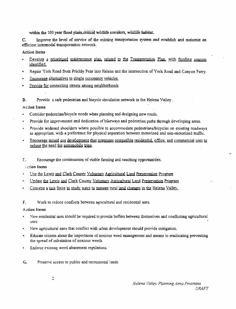
within the 100 y m flood plain&tid wildlife corridors, wildlife habitat.
C. Improve the le-.re! of service of the existing tramportation system and establish and maintain an eEcient intermodal transportation network.
Aczion Items -
Develou 2 prioririzecj maintenance g1an related to the Trans~ortation Plan with funding sources identified.
Repair York Road from Prickly Pear into Helena and the intersection of York Road and Canyon Ferry.
Encourane alternarives to single occu~ancv vehicles.
-- ?yovide for connecting s u e t s among nei&borhoods
D. Provide a safe pedestrian and bicycle circdation network in the Helena Valley .
.4 c:ion Items
Consider pedestrianhicycle needs when pianning and desiging new roads.
Provide for improvement and dedication of bikeways and pedestrian - paths through developing areas.
Provide widened shoulders where possible to accommodate pedestriand~icycles on existing roadways as appropriate, wirh a preference for physical separation between motorized and non-motorized uafiic.
Encourage mixed use development that inresates comuatible residential. office, commercial uses to reduce the need for automobile &.
. Encourage the continuation of viable fanning and ranching opportunities.
'. x ion Items
Use the Lewis and Clark Countv Voluntarv Aericultural Land Preservation P r o m
* . Uudate the Lewis and Clark Countv Voluntary A=..cdturaI Land Preservation Proaam
Convene a task force to studv wavs to manage rural land changes in the Helena Vallev.
F. Work to reduce conflicts between agriculturai and residential uses.
Action Items
New residential uses should be required to provide buffers between themselves and conflicting a_ericultural -
uses.
. New agricuiturd uses that conflict with urban development should provide mitigation.
a . Educate citizens about the importance of noxious weed management and means to eradicating preventing the spread of Infestation of noxious weeds
8 . Enforce exisnng weed abatement regulations.
G. Reserve access to public and recreanond lands
Helena Vailey Plannrng Area Prroriries DRAFT
Action ltems
a. Use the Lewis and Clark Countv Comurehensive Paris. Recreation and @en Soace Plan to guide the siring of new facilities.
a . Identify, and when appropriate purchase, righn-of-way providing access to key public and recreational lands. -
*. Abandonment ofuublic ri&t of wavs should be prohibited unless 5hown to be in the uublic interest.
H. -- Protect and +rove water aualitv and uuantitv ofthe Helena Vallev watersheds.
Action Items
*. Adout the recommendation$ of the Helena Are4 Wasteq.vater Studv.
. Protect and improve water quality and quantity along Ten Mile Creek.
a . Consider e x t e n d q the water quality district to include the Spokane Bench and Lakeside area.
. Make information about water quality and quantity avadable, particularly to prospective land buyers.
I. With increasing population Gowth, the air quality of the Helena V d e y is threatened.
Action Items
Encourage activities that ensure that Countv and Federal air aualitv standards are uuheld.
. ---- Design and locate new development in wavs that minimize additional automobile trai5c.
a . Encourage the use of alternative cleaner b u m fuels.
. Work to mitigate dust fiom traffic on din and gavel roads.
. Develou and im~lement TDM strateries pursuant to the Transuortation Develoument Plan.
. Examine onnortunities for transit car uooling and other transoortation mawement st rate^-es. -
. -- Promote an i n t e ~ a t e d street nerwork. a . Conduct pubAic education on what individuals can do to ureserve ~ o o d air aualitv.
J. Coordination between the County, Cities of Helena and East Helena in Lewis and Clark County is necessary in order to ensure that land use goals are reached.
Action items
.. Establish an ageement berween Lewis and Clark County, Jeffmon Countv and the cities of Helena and East Helena for better coordination of growth in preferred development areas.
a . Define areas of "city influence" to contain the immechate five year growth projections and negotiate inter-local agreements with the cities of Helena and East Helena for development review.
. W i h the inter-local agreements with the cities of Helena and East and Helena establish common development standards, coordinated land use planning urban service boundary areas and service area amendment processes.
Helena Yailey Planning Area Prloriries DRAFT
K. Planning and design can assist in the development of a sense of community in existing settlement and developing areas of the Helena Valley.
Action ltems
*. Encourage the preservation and protection of existing residential areas and plan future development in a manner which promotes neighborhood settings and environments.
*. Provide land use buffers between residential nei@borhoods and incompatible land uses.
8. Minimize the encroachment of business andlor industrial development on existing neighborhoods.
*. Design subdivisions, planned residential developments, multifamily units or other residenual projects in a marmex which emourages neighborhood environments.
*. Provide for in temtios f individual subdivisions throueh transportation linka,oes.L
*. Encourage preservation enhancement Qfneiehborhoodg existing residential areas.
. - Plan future develooment which eromotes neiehborhood cohesion pedestrian-6iendlv environments.
*. Encourage mixed use develoument that inteaates compatibie residential. office, gnJ commercial uses to reduce need automobile triDs. --- -
L. Adequate opportunity for commercial growth and development in the Helena Valley needs to be maintained to meet the needs of a growing population and market place demands.
Action ltems
. Encourage commercial and office development to locate in cities and wittun preferred development areas whenever possible.
*. Encourage commerciai development, such as neighborhood commercial services, in areas that are currently under serviced, when adequate market area population is present.
*. Encourage mixed use development that intemtes comuatible residential, office. and commercial uses to reduce need for automobile musL
. Encourage cluster commercial development over strip commercial development.
* . Large commercial and office developments should be encouraged only in areas served by a major sneer and where adequate public services can be provided.
M. Ensure that a i l parts of the Helena Valley have adequate fire protection.
Action Items
*. Ensure that roads can accommodate fire trucks.
*. Develop a process to amact more volunteers
Helena Valley Plannrng Area Prlonrles DRAFT