Embed Size (px)
Citation preview
lable at ScienceDirect
Quaternary Geochronology 5 (2010) 181–186
Contents lists avai
Quaternary Geochronology
journal homepage: www.elsevier .com/locate/quageo
Research Paper
Optically stimulated luminescence dating of sediments from the Yellow Riverterraces in Lanzhou: Tectonic and climatic implications
Ping Wang a,*, Hanchao Jiang a, Daoyang Yuan b, Xingwang Liu b, Bin Zhang a,c
a State Key Laboratory of Earthquake Dynamics, Institute of Geology, China Earthquake Administration, P.O. Box 9803, Beijing 100029, Chinab Lanzhou Institute of Seismology, China Earthquake Administration, Lanzhou 730000, Chinac School of Earth Science and Mineral Resources, China University of Geosciences, Beijing 100083, China
a r t i c l e i n f o
Article history:Received 19 October 2008Received in revised form14 May 2009Accepted 21 May 2009Available online 28 May 2009
Keywords:Yellow River terraceOSL datingTibetan PlateauTectonic movementClimatic change
* Corresponding author. Tel.: þ86 01062009038; faE-mail address: [email protected] (P. W
1871-1014/$ – see front matter � 2009 Elsevier B.V. Adoi:10.1016/j.quageo.2009.05.009
a b s t r a c t
The stratigraphic chronology of Yellow River terraces was investigated and studied in Lanzhou Basin,western Chinese Loess Plateau. The optically stimulated luminescence (OSL) dating results show thatterraces T1, T2 and T3 formed at 8 ka, 20 ka and 70 ka, respectively. Lateral accretion of the riverbed faciesgravel sediments occurred during interglacial periods while vertical aggradations of the terrace sedi-ments deposited predominantly under cold and dry glacial period. A thick layer of aeolian loess witha basal age about 35 ka indicates a remarkable drop of air temperature and a dry, cold climate. Thetemporal correlation between terrace formation and tectonic movement has not yet been established inthis research, but the stratigraphic chronology of the terrace sections provides the timing of the terraceformation, the incision rate of the Yellow River, and the slip rate of the fault horizon.
� 2009 Elsevier B.V. All rights reserved.
1. Introduction
In order to understand the relationship between climate change,surface processes and tectonic movement, an increasing number ofstudies has paid attention to the age of river terrace formation andthe degree of tectonic deformation (Bull, 1990; Pazzaglia et al.,1998; Maddy et al., 2000; Willett et al., 2006; Whittaker et al.,2007). Previous studies showed a close correlation of the fluvialdeposits and incision with climatic fluctuations in northwestEurope, where tectonic movements remained relatively weak(Fuller et al., 1998; Mol et al., 2000). In the Lanzhou area, more than9 widespread terrace surfaces, referred to as the Lanzhou Terrace,have been used to reconstruct tectonic movements (Li, 1991; Panet al., 2007). In the intensely uplifting Tibetan Plateau, river terraceswere usually regarded as topographic evidence for crustal move-ment. Li (1991) divided the late Cenozoic uplift of the northeastmargin of the Tibetan Plateau into three stages based on theformation of a series of terraces in Lanzhou Basin. The terrace ageswere determined by palaeomagnetic dating of the overlying loessand based on the assumption that the loess accumulation startedonce the terrace formed. In other words, the top of alluvial faciesdeposit and the bottom of loess accumulation had the same age.
x: þ86 01062009190.ang).
ll rights reserved.
As the OSL techniques developed (Porat et al., 1996; Zhang et al.,2003), systemic dating has become possible to reconstruct theaccumulation and formation process, and to understand the originof the terrace sediments. In this paper, we report the preliminaryresults of investigation on the terraces T1, T2 and T3 in LanzhouBasin, mainly including particle size analysis and OSL dating. Achronostratigraphic framework for three terraces is established,and the correlation between tectonic movements and climaticchange is also briefly discussed.
2. Geological settings and terrace sections
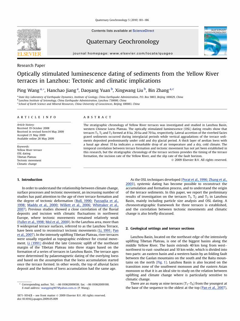
Lanzhou Basin, located on the northeast edge of the intensivelyuplifting Tibetan Plateau, is one of the biggest basins along themiddle Yellow River. The basin extends 40 km long from west–northwest to east–southeast and 10 km wide, which is divided intotwo parts: an eastern basin and a western basin by an folding faultbetween the Gaolan mountains on the south and the Baita moun-tains on the north (Fig. 1). Lanzhou Basin is also located on thetransition zone of the southwest monsoon and the eastern Asianmonsoon so that it is an ideal site to study on the relation betweenuplifting and climate change where is particularly sensitive toclimatic change.
There are as many as nine terraces (T1–T9) from the youngest atthe base of the sequence to the oldest at the top (Pan et al., 2007),
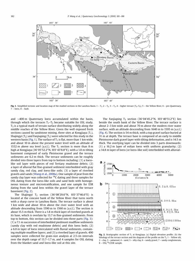
Fig. 1. Simplified tectonic and location map of the studied sections in the Lanzhou Basin. 1 – T1, 2 – T2, 3 – T3, 4 – higher terrace (T4–T9), 5 – the Yellow River, 6 – pre-Quaternary,7 – loess, 8 – fault.
Fig. 2. Stratigraphic section of T1 at Kongjiaya. (a) Digital elevation profile; (b) thelithology of the terrace section and the diagram of the profile on the T1. 1 – Yellow silt,2 – clay, 3 – palaeosol, 4 – sand, 5 – silty clay, 6 – sandy gravel, 7 – sandy conglomerate,8 – OSL/14C/ESR sample.
P. Wang et al. / Quaternary Geochronology 5 (2010) 181–186182
and >400 m Quaternary loess accumulated within the basin,through which the terraces T1–T3 became suitable for OSL study.T3 is a typical mark of terrain surface distributing widely along themiddle reaches of the Yellow River. Given the well exposed freshsections caused by sandstone mining, three sites at Kongjiaya (T1),Shajingyi (T2) and Fanjiaping (T3) were selected for this study in thewestern basin (Fig. 1). The surface of T1 is flat, more than 1 km wide,and about 10 m above the present water level with an altitude of1532 m above sea level (a.s.l.). The T1 section is more than 8 mhigh at Kongjiaya (36�05052.200N, 103�4308.800E), with a 1.8 m tiltingbasement composed of early Pleistocene gravel and the terracesediments are 6.2 m thick. The terrace sediments can be roughlydivided into three layers from top to bottom including: (1) a loess-like soil layer with pieces of red Tertiary mudstone debris; (2)a layer of alluvial flat fine-grained sediment interbedded with graysandy clay, red clay, and loess-like soils; (3) a layer of riverbedgravels and sands (Wang et al., 2008a). One sample of peat from thesandy clay layer was collected for 14C dating and three samples forOSL dating from the loess-like soils and sand beds with homoge-neous texture and microstratification, and one sample for ESRdating from the sand lens within the gravel layer of the terracebasement (Fig. 2).
The Shajingyi T2 section (36�08029.600N, 103�37046.600E) islocated at the concave bank of the Yellow River that turns northwith a sharp curve in Lanzhou Basin. The terrace surface is about1 km wide and about 30 m above the river water level with analtitude descending from 1590 m to 1560 m (a.s.l.). The section isabout 15.5 m thick. There is a 1.8 m thick layer of riverbed gravels atits base, which is overlain by 13.7 m fine-grained sediments. Fromtop to bottom, this section can be divided into three parts (Fig. 3):(1) a 7.1 m succession of interbedded piedmont mudflow sediments(sandy clay with red mudstone debris) and thin loess beds; (2)a 6.0 m layer of loess intercalated with fluvial sediments, contain-ing multiple mudflow layers; and (3) a riverbed layer of gravels. 490samples were collected for grain-size analysis at 2.5 cm intervalsover the depth range of 13.7–1.7 m, and 4 samples for OSL datingfrom the blanket sand and loess-like soil at this site.
The Fanjiaping T3 section (36�04045.200N, 103�40051.200E) liesbeside the south bank of the Yellow River. The terrace surface isabout 2–3 km wide and about 70 m above the modern river watersurface, with an altitude descending from 1640 m to 1595 m (a.s.l.)(Fig. 4). The section is 54 m thick, with a top gravel surface buried at31 m at depth. The terrace base is composed of an early to middlePleistocene dark gravel layer with tilting deformation, and is 14.5 mthick. The overlying layer can be divided into 3 parts downwards:(1) a 16.2 m layer of eolian loess with uniform granularity; (2)a 14.8 m layer of loess (or loess-like soil) interbedded with alluvial–
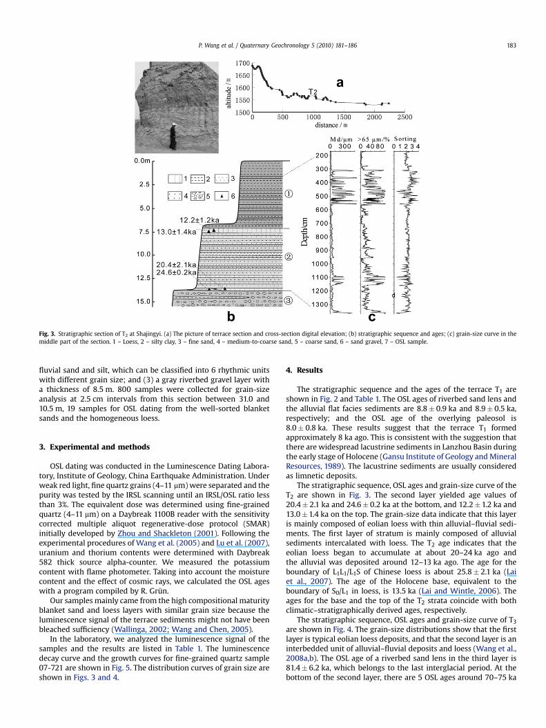
Fig. 3. Stratigraphic section of T2 at Shajingyi. (a) The picture of terrace section and cross-section digital elevation; (b) stratigraphic sequence and ages; (c) grain-size curve in themiddle part of the section. 1 – Loess, 2 – silty clay, 3 – fine sand, 4 – medium-to-coarse sand, 5 – coarse sand, 6 – sand gravel, 7 – OSL sample.
P. Wang et al. / Quaternary Geochronology 5 (2010) 181–186 183
fluvial sand and silt, which can be classified into 6 rhythmic unitswith different grain size; and (3) a gray riverbed gravel layer witha thickness of 8.5 m. 800 samples were collected for grain-sizeanalysis at 2.5 cm intervals from this section between 31.0 and10.5 m, 19 samples for OSL dating from the well-sorted blanketsands and the homogeneous loess.
3. Experimental and methods
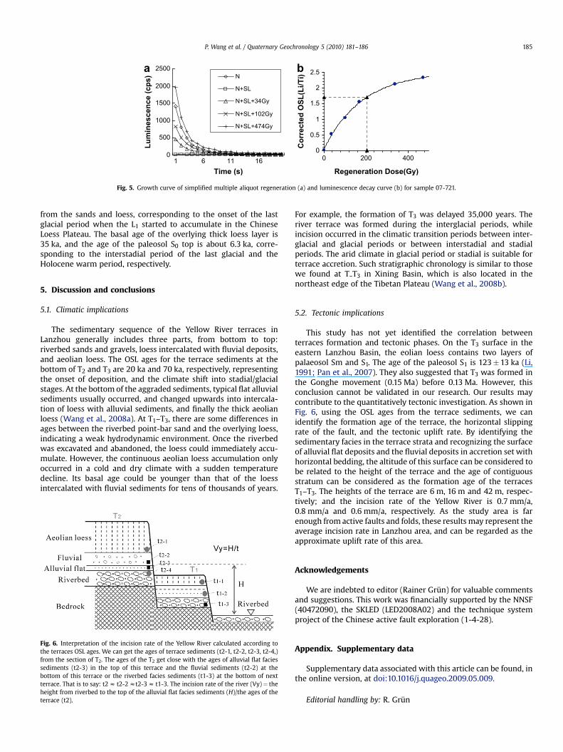
OSL dating was conducted in the Luminescence Dating Labora-tory, Institute of Geology, China Earthquake Administration. Underweak red light, fine quartz grains (4–11 mm) were separated and thepurity was tested by the IRSL scanning until an IRSL/OSL ratio lessthan 3%. The equivalent dose was determined using fine-grainedquartz (4–11 mm) on a Daybreak 1100B reader with the sensitivitycorrected multiple aliquot regenerative-dose protocol (SMAR)initially developed by Zhou and Shackleton (2001). Following theexperimental procedures of Wang et al. (2005) and Lu et al. (2007),uranium and thorium contents were determined with Daybreak582 thick source alpha-counter. We measured the potassiumcontent with flame photometer. Taking into account the moisturecontent and the effect of cosmic rays, we calculated the OSL ageswith a program compiled by R. Grun.
Our samples mainly came from the high compositional maturityblanket sand and loess layers with similar grain size because theluminescence signal of the terrace sediments might not have beenbleached sufficiency (Wallinga, 2002; Wang and Chen, 2005).
In the laboratory, we analyzed the luminescence signal of thesamples and the results are listed in Table 1. The luminescencedecay curve and the growth curves for fine-grained quartz sample07-721 are shown in Fig. 5. The distribution curves of grain size areshown in Figs. 3 and 4.
4. Results
The stratigraphic sequence and the ages of the terrace T1 areshown in Fig. 2 and Table 1. The OSL ages of riverbed sand lens andthe alluvial flat facies sediments are 8.8� 0.9 ka and 8.9� 0.5 ka,respectively; and the OSL age of the overlying paleosol is8.0� 0.8 ka. These results suggest that the terrace T1 formedapproximately 8 ka ago. This is consistent with the suggestion thatthere are widespread lacustrine sediments in Lanzhou Basin duringthe early stage of Holocene (Gansu Institute of Geology and MineralResources, 1989). The lacustrine sediments are usually consideredas limnetic deposits.
The stratigraphic sequence, OSL ages and grain-size curve of theT2 are shown in Fig. 3. The second layer yielded age values of20.4� 2.1 ka and 24.6� 0.2 ka at the bottom, and 12.2�1.2 ka and13.0�1.4 ka on the top. The grain-size data indicate that this layeris mainly composed of eolian loess with thin alluvial–fluvial sedi-ments. The first layer of stratum is mainly composed of alluvialsediments intercalated with loess. The T2 age indicates that theeolian loess began to accumulate at about 20–24 ka ago andthe alluvial was deposited around 12–13 ka ago. The age for theboundary of L1L1/L1S of Chinese loess is about 25.8� 2.1 ka (Laiet al., 2007). The age of the Holocene base, equivalent to theboundary of S0/L1 in loess, is 13.5 ka (Lai and Wintle, 2006). Theages for the base and the top of the T2 strata coincide with bothclimatic–stratigraphically derived ages, respectively.
The stratigraphic sequence, OSL ages and grain-size curve of T3
are shown in Fig. 4. The grain-size distributions show that the firstlayer is typical eolian loess deposits, and that the second layer is aninterbedded unit of alluvial–fluvial deposits and loess (Wang et al.,2008a,b). The OSL age of a riverbed sand lens in the third layer is81.4� 6.2 ka, which belongs to the last interglacial period. At thebottom of the second layer, there are 5 OSL ages around 70–75 ka
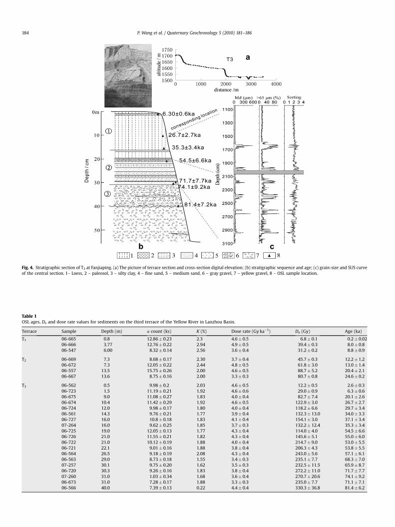
Table 1OSL ages, De and dose rate values for sediments on the third terrace of the Yellow River in Lanzhou Basin.
Terrace Sample Depth (m) a count (ks) K (%) Dose rate (Gy ka�1) De (Gy) Age (ka)
T1 06-665 0.8 12.86� 0.23 2.3 4.6� 0.5 6.8� 0.1 0.2� 0.0206-666 3.77 12.76� 0.22 2.94 4.9� 0.5 39.4� 0.3 8.0� 0.806-547 6.00 8.32� 0.14 2.56 3.6� 0.4 31.2� 0.2 8.8� 0.9
T2 06-669 7.3 8.68� 0.17 2.30 3.7� 0.4 45.7� 0.3 12.2� 1.206-672 7.3 12.05� 0.22 2.44 4.8� 0.5 61.8� 3.0 13.0� 1.406-557 13.5 15.75� 0.26 2.00 4.6� 0.5 88.7� 5.2 20.4� 2.106-667 13.6 8.75� 0.16 2.00 3.3� 0.3 80.7� 0.8 24.6� 0.2
T3 06-562 0.5 9.98� 0.2 2.03 4.6� 0.5 12.2� 0.5 2.6� 0.306-723 1.5 11.19� 0.21 1.92 4.6� 0.6 29.0� 0.9 6.3� 0.606-675 9.0 11.08� 0.27 1.83 4.0� 0.4 82.7� 7.4 20.1� 2.606-674 10.4 11.42� 0.29 1.92 4.6� 0.5 122.9� 3.0 26.7� 2.706-724 12.0 9.98� 0.17 1.80 4.0� 0.4 118.2� 6.6 29.7� 3.406-561 14.3 9.76� 0.21 1.77 3.9� 0.4 132.3� 13.0 34.0� 3.306-727 16.0 10.8� 0.18 1.83 4.1� 0.4 154.1� 3.0 37.1� 3.407-264 16.0 9.62� 0.25 1.85 3.7� 0.3 132.2� 12.4 35.3� 3.406-725 19.0 12.05� 0.13 1.77 4.3� 0.4 114.0� 4.0 54.5� 6.606-726 21.0 11.55� 0.21 1.82 4.3� 0.4 145.6� 5.1 55.0� 6.006-722 21.0 10.12� 0.19 1.88 4.0� 0.4 214.7� 9.0 53.0� 5.506-721 22.1 9.01� 0.16 1.88 3.8� 0.4 206.3� 4.3 53.8� 5.506-564 26.5 9.18� 0.19 2.08 4.3� 0.4 243.0� 5.6 57.1� 6.106-563 29.0 8.73� 0.18 1.55 3.4� 0.3 235.1� 7.7 68.3� 7.007-257 30.1 9.75� 0.20 1.62 3.5� 0.3 232.5� 11.5 65.9� 8.706-720 30.3 9.26� 0.16 1.83 3.8� 0.4 272.2� 11.0 71.7� 7.707-260 31.0 1.03� 0.34 1.68 3.6� 0.4 270.7� 20.6 74.1� 9.206-673 31.0 7.28� 0.17 1.88 3.3� 0.3 235.0� 7.7 71.1� 7.106-566 40.0 7.39� 0.13 0.22 4.4� 0.4 330.3� 36.8 81.4� 6.2
Fig. 4. Stratigraphic section of T3 at Fanjiaping. (a) The picture of terrace section and cross-section digital elevation; (b) stratigraphic sequence and age; (c) grain-size and SUS curveof the central section. 1– Loess, 2 – paleosol, 3 – silty clay, 4 – fine sand, 5 – medium sand, 6 – gray gravel, 7 – yellow gravel, 8 – OSL sample location.
P. Wang et al. / Quaternary Geochronology 5 (2010) 181–186184
0
0.5
1
1.5
2
2.5
0 200 400
Regeneration Dose(Gy)
Co
rrected
O
SL
(L
i/T
i)
0
500
1000
1500
2000
2500
1 6 11 16Time (s)
Lu
min
escen
ce (cp
s) N
N+SL
N+SL+34Gy
N+SL+102Gy
N+SL+474Gy
a b
Fig. 5. Growth curve of simplified multiple aliquot regeneration (a) and luminescence decay curve (b) for sample 07-721.
P. Wang et al. / Quaternary Geochronology 5 (2010) 181–186 185
from the sands and loess, corresponding to the onset of the lastglacial period when the L1 started to accumulate in the ChineseLoess Plateau. The basal age of the overlying thick loess layer is35 ka, and the age of the paleosol S0 top is about 6.3 ka, corre-sponding to the interstadial period of the last glacial and theHolocene warm period, respectively.
5. Discussion and conclusions
5.1. Climatic implications
The sedimentary sequence of the Yellow River terraces inLanzhou generally includes three parts, from bottom to top:riverbed sands and gravels, loess intercalated with fluvial deposits,and aeolian loess. The OSL ages for the terrace sediments at thebottom of T2 and T3 are 20 ka and 70 ka, respectively, representingthe onset of deposition, and the climate shift into stadial/glacialstages. At the bottom of the aggraded sediments, typical flat alluvialsediments usually occurred, and changed upwards into intercala-tion of loess with alluvial sediments, and finally the thick aeolianloess (Wang et al., 2008a). At T1–T3, there are some differences inages between the riverbed point-bar sand and the overlying loess,indicating a weak hydrodynamic environment. Once the riverbedwas excavated and abandoned, the loess could immediately accu-mulate. However, the continuous aeolian loess accumulation onlyoccurred in a cold and dry climate with a sudden temperaturedecline. Its basal age could be younger than that of the loessintercalated with fluvial sediments for tens of thousands of years.
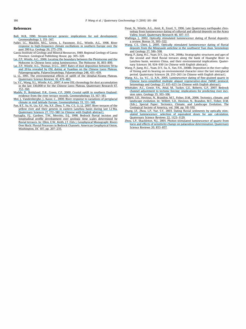
Fig. 6. Interpretation of the incision rate of the Yellow River calculated according tothe terraces OSL ages. We can get the ages of terrace sediments (t2-1, t2-2, t2-3, t2-4,)from the section of T2. The ages of the T2 get close with the ages of alluvial flat faciessediments (t2-3) in the top of this terrace and the fluvial sediments (t2-2) at thebottom of this terrace or the riverbed facies sediments (t1-3) at the bottom of nextterrace. That is to say: t2 z t2-2 zt2-3 z t1-3. The incision rate of the river (Vy)¼ theheight from riverbed to the top of the alluvial flat facies sediments (H)/the ages of theterrace (t2).
For example, the formation of T3 was delayed 35,000 years. Theriver terrace was formed during the interglacial periods, whileincision occurred in the climatic transition periods between inter-glacial and glacial periods or between interstadial and stadialperiods. The arid climate in glacial period or stadial is suitable forterrace accretion. Such stratigraphic chronology is similar to thosewe found at T–T3 in Xining Basin, which is also located in thenortheast edge of the Tibetan Plateau (Wang et al., 2008b).
5.2. Tectonic implications
This study has not yet identified the correlation betweenterraces formation and tectonic phases. On the T3 surface in theeastern Lanzhou Basin, the eolian loess contains two layers ofpalaeosol Sm and S1. The age of the paleosol S1 is 123�13 ka (Li,1991; Pan et al., 2007). They also suggested that T3 was formed inthe Gonghe movement (0.15 Ma) before 0.13 Ma. However, thisconclusion cannot be validated in our research. Our results maycontribute to the quantitatively tectonic investigation. As shown inFig. 6, using the OSL ages from the terrace sediments, we canidentify the formation age of the terrace, the horizontal slippingrate of the fault, and the tectonic uplift rate. By identifying thesedimentary facies in the terrace strata and recognizing the surfaceof alluvial flat deposits and the fluvial deposits in accretion set withhorizontal bedding, the altitude of this surface can be considered tobe related to the height of the terrace and the age of contiguousstratum can be considered as the formation age of the terracesT1–T3. The heights of the terrace are 6 m, 16 m and 42 m, respec-tively; and the incision rate of the Yellow River is 0.7 mm/a,0.8 mm/a and 0.6 mm/a, respectively. As the study area is farenough from active faults and folds, these results may represent theaverage incision rate in Lanzhou area, and can be regarded as theapproximate uplift rate of this area.
Acknowledgements
We are indebted to editor (Rainer Grun) for valuable commentsand suggestions. This work was financially supported by the NNSF(40472090), the SKLED (LED2008A02) and the technique systemproject of the Chinese active fault exploration (1-4-28).
Appendix. Supplementary data
Supplementary data associated with this article can be found, inthe online version, at doi:10.1016/j.quageo.2009.05.009.
Editorial handling by: R. Grun
P. Wang et al. / Quaternary Geochronology 5 (2010) 181–186186
References
Bull, W.B., 1990. Stream-terrace genesis: implications for soil development.Geomorphology 3, 351–367.
Fuller, I.C., Macklin, M.G., Lewin, J., Passmore, D.G., Wintle, A.G., 1998. Riverresponse to high-frequency climate oscillations in southern Europe over thepast 200 k.y. Geology 26, 275–278.
Gansu Institute of Geology and Mineral Resources, 1989. Regional Geology of GansuProvince. Geological Publishing House, pp. 305–320.
Lai, Z.P., Wintle, A.G., 2006. Locating the boundary between the Pleistocene and theHolocene in Chinese loess using luminescence. The Holocene 16, 893–899.
Lai, Z.P., Wintle, A.G., Thomas, D.S.G., 2007. Rates of dust deposition between 50 kaand 20 ka revealed by OSL dating at Yuanbao on the Chinese Loess Plateau.Palaeogeography, Palaeoclimatology, Palaeoecology 248, 431–439.
Li, J.J., 1991. The environmental effects of uplift of the Qinghai-Xizang Plateau.Quaternary Science Reviews 10, 479–483.
Lu, Y.C., Wang, X.L., Wintle, A.G., 2007. A new OSL chronology for dust accumulationin the last 130,000 yr for the Chinese Loess Plateau. Quaternary Research 67,152–160.
Maddy, D., Bridgland, D.R., Green, C.P., 2000. Crustal uplift in southern England:evidence from the river terrace records. Geomorphology 33, 167–181.
Mol, J., Vandenberghe, J., Kasse, C., 2000. River response to variations of periglacialclimate in mid latitude Europe. Geomorphology 33, 131–148.
Pan, B.T., Su, H., Liu, X.F., Hu, X.F., Zhou, T., Hu, C.S., Li, J.J., 2007. River terraces of theyellow river and their genesis in eastern Lanzhou basin during last l.2 Ma.Quaternary Sciences 27, 172–180 (in Chinese with English abstract).
Pazzaglia, F.J., Gardner, T.W., Merritts, D.J., 1998. Bedrock fluvial incision andlongitudinal profile development over geologic time scales determined byfluvial terraces. In: Ellen, E.W., Keith, J.T. (Eds.), Geophysical Monograph: RiversOver Rock: Fluvial Processes in Bedrock Channels. American Geophysical Union,Washington, DC 107, pp. 207–235.
Porat, N., Wintle, A.G., Amit, R., Enzel, Y., 1996. Late Quaternary earthquake chro-nology from luminescence dating of colluvial and alluvial deposits on the AravaValley, Israel. Quaternary Research 46, 107–117.
Wallinga, J., 2002. Optically stimulated luminescence dating of fluvial deposits:a review. Boreas 31, 303–322.
Wang, C.S., Chen, J., 2005. Optically stimulated luminescence dating of fluvialdeposits from the Mingyaole anticline in the southwest Tian shan. Seismologyand Geology 27, 586–598.
Wang, P., Jiang, H.C., Yuan, D.Y., Liu, X.W., 2008a. Stratigraphic structures and ages ofthe second and third fluvial terraces along the bank of Huanghe River inLanzhou basin, western China, and their environmental implications. Quater-nary Sciences 30, 924–930 (in Chinese with English abstract).
Wang, P., Jiang, H.C., Yuan, D.Y., Su, X., Yan, F.H., 2008b. Deposition in the river valleyof Xining and its bearing on environmental character since the last interglacialperiod. Quaternary Sciences 28, 253–263 (in Chinese with English abstract).
Wang, X.L., Lu, Y.C., Li, X.N., 2005. Luminescence dating of fine-grained quartz inChinese loess-simplified multiple aliquot regenerative-dose (MAR) protocol.Seismology and Geology 27, 615–623 (in Chinese with English abstract).
Whittaker, A.C., Cowie, P.A., Attal, M., Tucker, G.E., Roberts, G.P., 2007. Bedrockchannel adjustment to tectonic forcing: implications for predicting river inci-sion rates. Geology 35, 103–106.
Willett, S.D., Hovious, N., Brandon, M.T., Fisher, D.M., 2006. Tectonics, climate, andlandscape evolution. In: Willett, S.D., Hovious, N., Brandon, M.T., Fisher, D.M.(Eds.), Special Paper: Tectonics, Climate, and Landscape Evolution. TheGeological Society of America, vol. 398, pp. VII–VXI.
Zhang, J.F., Zhou, L.P., Yue, S.Y., 2003. Dating fluvial sediments by optically stim-ulated luminescence: selection of equivalent doses for age calculation.Quaternary Science Reviews 22, 1123–1129.
Zhou, L.P., Shackleton, N.J., 2001. Photon-stimulated luminescence of quartz fromloess and effects of sensitivity change on palaeodose determination. QuaternaryScience Reviews 20, 853–857.


![Loess is [almost totally formed by] the accumulation of dust](https://img.pdfslide.net/doc/110x75/6337e9dc6df3aaa1250e9d85/loess-is-almost-totally-formed-by-the-accumulation-of-dust.jpg)


