Embed Size (px)
Citation preview
Resource Protection & Conservation' Benefits for Canadians etection et conservation des ressources .. Benefices aux Canadiens
PACIFIC REGION
1993 MANAGEl\1ENT PLAN
INTERTIDAL CLAM
,heries P~ches j Oceans et Oceans Canada


"
)
- 1 -
CONTACTS FOR FURTHER INFORMATION
SheUf"lSh flshea Officers
Scotty A. Roxburgh, Fishery Officer Department of Fisheries and Oceans 610 Derwent Way, Annacis Island New Westminster, B.C. V3M 5P8 Telephone: 666-0814
Cindy Harlow, Fishery Officer Department of Fisheries and Oceans #304 - 60 Front Street Nanaimo, B.C. V9R 5H7 Telephone: 754-0233
Local District Offices
District 6 District 3 District 4 District 5 District 2
Frances Dickson Shellfish Coordinator
Victoria Nanaimo Port Alberni Campbell River New Westminster
Department of Fisheries and Oceans Suite 420 - 555 West Hastings St. Vancouver, B.C. V6B 5G3 Telephone: 666-0519
RickHarbo Department of Fisheries and Oceans 3225 Stephenson Point Road Nanaimo, B.C. V9T 110 Telephone: 756-7268
Randy Webb, Fishery Officer Department of Fisheries and Oceans 457 E. Stanford Ave. Parksville, B.C. V6P IV7 Telephone: 248-5188
Brian Lunn, Fishery Officer Department of Fisheries and Oceans 3019 - 4th Avenue Port Alberni, B.C. V9Y 2B8 Telephone: 723-2612
363-3252 754-0235 723-4524 287-2102 666-2618
Rudy Chiang Shellfish Inspection Specialist Fish Inspection Branch Department of Fisheries and Oceans 2250 South Boundary Road Burnaby, B.C. VSM 4L9 Telephone: 666-3150
)
- 2-
CONTENTS
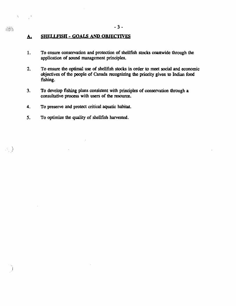
A. Shellfish Goals and Objectives .................................. 3
B. History ........................................... ..... 4
C. Regulations ............................................. 5
D. Fisher Responsibility ................................... . . . . 7
E. Coastwide Closures ........................................ 7
F. FISHING PLANS - MANILA AND LITTLENECK CLAMS .......... . .. 8 Area B - Johnstone Strait .................................... 9 Area C - Sunshine Coast ................................... 11 Area D - Upper Strait of Georgia .............................. 15 Area E - Lower Strait of Georgia .............................. 19 Area F - West Coast of Vancouver Island ......................... 25 Area G - Queen Charlotte Sound .............................. 30
G. FISHING PLANS - BUTIER CLAMS .......................... 31
H. FISHING PLANS - RAZOR CLAMS ........................... 31 Area A - Queen Charlotte Islands .............................. 31
I. Inspection Guidelines ..................................... 33
Intertidal Sectoral Committee ................................... 36
Attachment I - Minimum Size Limits - Molluscs
Attachment IT - Map of Commetcial Clam Licence Areas
Attachment ill - Manila Clam Fact Sheet
Attachment IV - Oyster I Clam Tenure Markers
)
- 3 -
SHELLFISH - GOALS AND ORIECTIVES
1. To ensure conservation and protection of shellfish stocks coastwide through the application of sound management principles.
2. To ensure the optimal use of shellfish stocks in order to meet social and economic objectives of the people of Canada recognizing the priority given to Indian food fishing.
3. To develop fishing plans consistent with principles of conservation through a consultative process with users of the resource.
4. To preserve and protect critical aquatic habitat.
5. To optimize the quality of shellfish harvested.
- 4 -
HISTORY
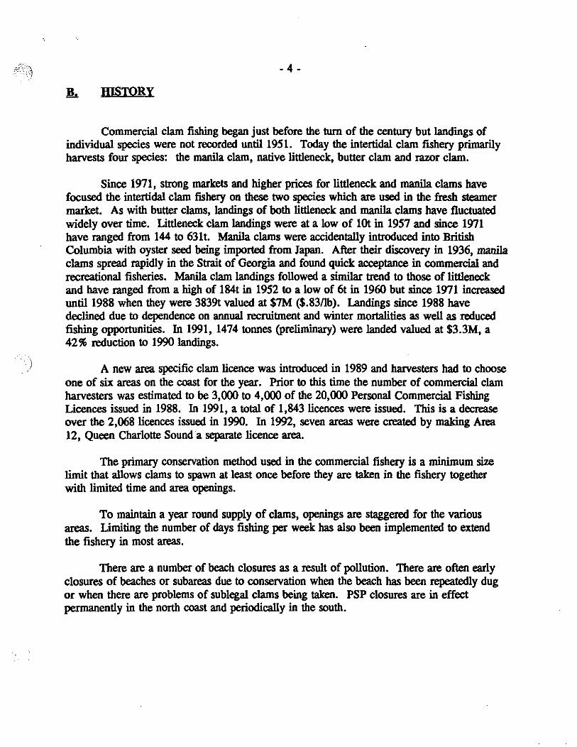
Commercial clam fishing began just before the tum of the century but landings of individual species were not recorded until 1951. Today the intertidal clam fishery primarily harvests four species: the manila clam, native littleneck, butter clam and razor clam.
Since 1971, strong markets and higher prices for littleneck and manila clams have focused the intertidal clam fishery on these two species which are used in the fresh steamer market. As with butter clams, landings of both littleneck and manila clams have fluctuated widely over time. Littleneck clam landings were at a low of lOt in 1957 and since 1971 have ranged from 144 to 63lt. Manila clams were accidentally introduced into British Columbia with oyster seed being imported from Japan. After their discovery in 1936, manila clams spread rapidly in the Strait of Georgia and found quick acceptance in commercial and recreational fisheries. Manila clam landings followed a similar trend to those of littleneck and have ranged from a high of 184t in 1952 to a low of 6t in 1960 but since 1971 increased until 1988 when they were 3839t valued at $7M ($.83/lb). Landings since 1988 have declined due to dependence on annual recruitment and winter mortalities as well as reduced fishing opportunities. In 1991, 1474 tonnes (preliminary) were landed valued at $3.3M, a 42% reduction to 1990 landings.
A new area specific clam licence was introduced in 1989 and harvesters had to choose one of six areas on the coast for the year. Prior to this time the number of commercial clam harvesters was estimated to be 3,000 to 4,000 of the 20,000 Personal Commercial Fishing Licences issued in 1988. In 1991, a total of 1,843 licences were issued. This is a decrease over the 2,068 licences issued in 1990. In 1992, seven areas were created by making Area 12, Queen Charlotte Sound a separate licence area.
The primary conservation method used in the commercial fishery is a minimum size limit that allows clams to spawn at least once before they are taken in the fishery together with limited time and area openings.
To maintain a year round supply of clams, openings are staggered for the various areas. Limiting the number of days fishing per week has also been implemented to extend the fishery in most areas.
There are a number of beach closures as a result of pollution. There are often early closures of beaches or subareas due to conservation when the beach has been repeatedly dug or when there are problems of sublegal clams being taken. PSP closures are in effect permanently in the north coast and periodically in the south.
)
- 5 -
~. REGULATIONS
1. SIZE LIMITS
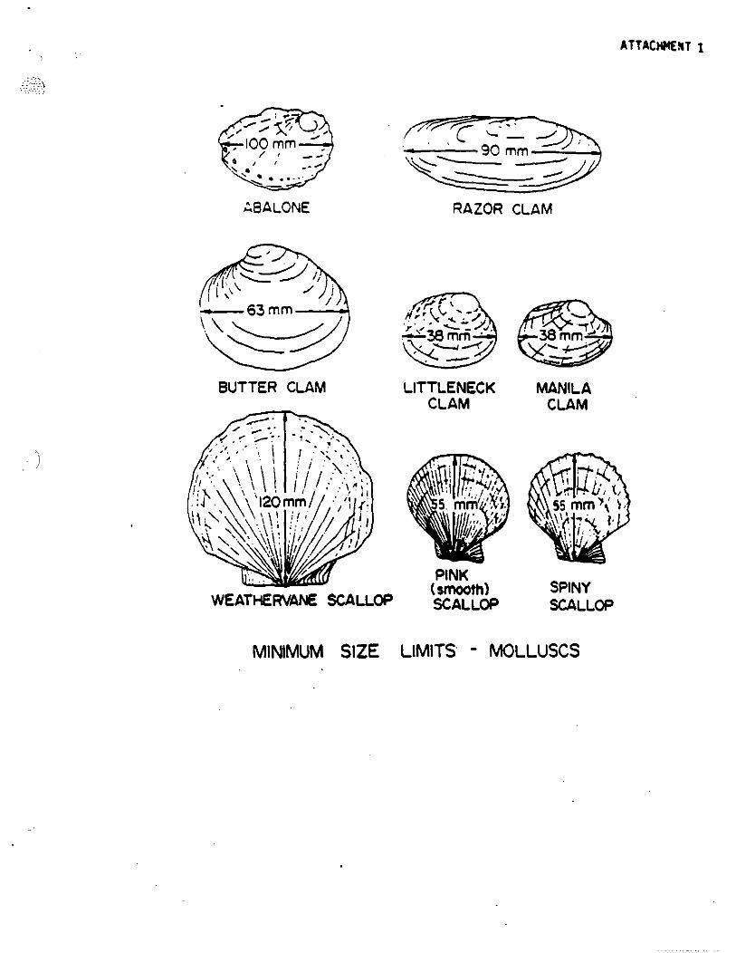
No person shall harvest clams that measure less than the following lengths through the longest diameter of the shell: (See drawing - Attachment I)
Littlenecks Manilas Butters Razor
-38 mm -38 mm -63 mm -90 mm
2. 1993 COMMERCIAL CLAM HARVESTING UCENCE REQUIREMENTS
All persons commercially harvesting intertidal clams will be required to be in possession of an area specific clam licence (Category Z) which will entitle them to fish only one of seven areas in British Columbia during 1993. Area licencing will provide for a more controlled and orderly harvest of clams.
Each clam harvester will be pennitted to apply for only one licence in 1993. The licence is not transferable from person to person or from area to area. Each clam harvester can be licenced to fish in only one clam fishing area in 1993. The clam licence must be carried at all times by the licence holder when harvesting clams and must be produced upon demand by a Fishery Officer or guardian.
Clam Licence Areas (See map - Attachment TI)
A. North Coast (Subarea 1-5 razor clams only) B. Johnstone Strait (Area 13 and all of Cortes Island and Twin Islands) C. Sunshine Coast (Areas 15 [excepting Cortes Island and Twin Islands], 16
[excepting 16-19 + 16-20],28 and 29-1, 29-2, 29-3) D. Upper Strait of Georgia (Areas 14, 16-19 and 16-20) E. Lower Strait of Georgia (Areas 17, 18 19,20 and 29-5) F. West Coast of Vancouver Island (Areas 23 to 27) G. Queen Charlotte Sound (Areas 11 and 12)
Licence Requirements
The 1993 licence fee is $10.00. A category Z clam licence is required in addition to a Personal Commercial Fishing Licence. Clam licences will also be required to harvest wild clams on oyster tenures.
)
-6-
All clam harvesters will be required to be in possession of recent photo identification when harvesting clams in addition to their clam licence and P.C.F.L. For example:
5 Year Personal Commercial Fishing Licence Canadian Driver's Licence Canadian Passport Canadian Citizenship Card B.C. I.D. Card Student Photo 1.0.
Clam licences must be applied for in person from the following Departmental offices:
Vancouver Masset Queen Charlotte City Prince Rupert Campbell River Port Hardy Alert Bay Nanaimo Powell River - 8:30 am to 12:30 pm Victoria Port Albemi Tofino - 8:00 a.m. to 12:00 noon Tahsis - 8:00 a.m. to 12:00 noon
3. TAGGING OF CLAM PRODUCT CONTAINERS OR SACKS
4.
All sacks or containers of clams must have attached to the sack or container, a visible waterproof tag which identifies the name of the clam digger, the clam harvester's licence number, the beach location, statistical area and date of harvest. This tag must be attached to the sack or container by the digger at the time of harvest. Prior to leaving the harvest site, all containers shall be tagged.
CATCH STATISTICS
Catch statistics must be provided by completion and submission of Department of Fisheries and Oceans approved clam sales slip at the time and date of sale. The clam harvesting licence number and name of the licenced clam digger must be
)
- 7-
recorded on all sales slips. All clams must be processed in a federally registered shellfish plant.
n. FISHER RESPQNSmIT.IT¥
1. Sewage. garbage and debris control Although most diggers have shown over the years a responsible approach toward keeping beaches clean and free from garbage and other pollution, recently an increasing number of complaints have been received from local residents and others about garbage spread by diggers on beaches. The Department asks that diggers take care and remove all garbage from the harvest site; violators are subject to prosecution under the provincial Litter Act. Harvesters are encouraged to maintain garbage cans on vessels and to refrain from anchoring vessels for lengthy periods near clam or oyster beds in order to prevent sewage contamination of shellfish on these beaches. Clam diggers are also requested to stop using the beaches as personal toilets again due to contamination reasons.
2. Digging Operations The reason for size limits on clam harvest is to leave behind a spawning population of clams. Diggers should not dig in an area on beaches where a high number of small clams are found. The minimum size limit has been set so that clams will spawn once or twice before reaching legal size. (See Attachment Ill). Diggers should take all efforts to rebury all undersized clams. Diggers should avoid leaving holes in the beach.
E.. COASTWIDE CWSURES
1. Paralytic Shellf'lSh Poison (Red Tide) and Amnesic Shellf'1Sh Poison (ASP)
Due to the risk of toxic shellfish blooms, the entire North Coast, Statistical Areas 1 to II inclusive, is closed for the harvest of intertidal clams except razor clams in Subarea 1-5. Additional closures may be invoked at any time in any area of the coast.
2. Contaminated Areas
All clam digging is prohibited in all contaminated areas, new closures may be added throughout the season. Contaminated areas are listed in the fishing plan for each area.
)
- 8-
Pennanent closures to bivalve harvesting are in place in any Canadian rlSheries waters of the Pacific Ocean within 125 metres of:
a) any wharf, dock, platfonn or other structure used for vessel moorage: or
b) any pennanently anchored floating structure, including float homes, barges, platforms and vessels.
3. Oyster and Clam Tenures
All clam digging is prohibited on all marked oyster tenures except with permission of oyster tenure holder and during open times for that statistical area as per clam harvesting schedules; all clam and oyster tenures are marked with red dyed concrete markers. (Attachment IV). Harvesting on clam tenures is strictly controlled by the tenure holder.
F. FISHING PLANS - MANILA AND L1TILENECK CLAMS
The following areas will be open to commercial clam harvesting during the designated time periods. It should be noted that these projected ®enin" may vary or not occur subject to contamination.cODSTfation or other reasons in accordance with anplicable rlSheries regulations. All rlShennen should check with local Fishery Offices to commn opening times. In order to rlSh butter clams, please contact local Fisheries Offices for open times.
ALL OPENINGS SHALL COMMENCE AT 00:01 HOURS; ALL CWSURFS WILL END AT 23:59 HRS. UNLESS OTHERWISE SPECIF'lED BY PUBLIC NOTICE. ALL TIMES ARE LOCAL TIMES.
- 9-
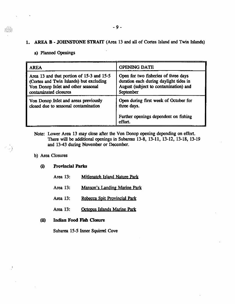
1. AREA B - JOHNSTONE STRAIT (Area 13 and all of Cortes Island and Twin Islands)
a) Planned Openings
AREA OPENING DATE
Area 13 and that portion of 15-3 and 15-5 Open for two fisheries of three days (Cortes and Twin Islands) but excluding duration each during daylight tides in Von Donop Inlet and other seasonal August (subject to contamination) and contaminated closures September
Von Donop.Inlet and areas previously Open during first week of October for closed due to seasonal contamination three days.
Further openings dependent on fishing effort.
Note: Lower Area 13 may close after the Von Donop opening depending on effort. There will be additional openings in Subareas 13-8, 13-11, 13-12, 13-18, 13-19 and 13-43 during November or December.
b) Area Closures
(i) Provincial Parks
Area 13: Mit1enatch Island Nature Park
Area 13: Manson's landing Marine Park
Area 13: Rebecca Spit Provincial Park
Area 13: Q;twus Islands Marine Park
(h1 Indian Food Fhh Closure
Subarea 15-5 Inner Squirrel Cove

)
- 10-
(iii) Contaminated Area Closures
Area 13
The waters and foreBhore of Quatbiaski Cove, Quadta Island, including Grouse Island, lying inside a straight line drawn across the mouth of the cove.
The waters and foreBhore of Mansons Landing, Cortes Island, lying within 900 m of the government dock, but not including Manson Lagoon, during the period from May 31 to September 30.
The waters and foreBhore of Von Donop Inlet, Cortes Island, during the period from May 31 to Septembec 30.
The waters and foreshore of Heriot Bay, Quadta Island, lying within 250 m of the government float and the ferry wharf.
That portion of the foreshore from Middle Point, north of Duncan Bay, to a point on the foreshore midway between Pinecrest and Evergreen roads, Campbell RiVet.
The waleta and foreBhore of Drew Harbour, Quadta Island lying inside a straight line drawn from the northernmost tip of Rebecca Spit across the ... trance of Drew Harbour to its western headland, during the period from May 31 to September 30.
That portion of the foreshore of Gorge Harbour, Cortes Jsland, lying between a point on shore 300 m west of the Gorgeview Marina and a point on shore 300 m east of the government wharf, during the period from May 31 to Septembec 30. .
The foreshore lying 1000 m northward and SOO m southward from the mouth of Simms Creek.
The waters lying within a 300 m radius of the mouth of Willow Creek.
The waters and foreshore of Big Bay, Stuart Island lying inside a straight line drawn from Hesler Point to Whirlpool Point.
The waters and foreBhore of Kelsey Bay and Salmon Bay lying inside a straight line drawn from the northern headland of Brasseau Bay through the Peteraon Islet navigation beacon to the shore of Vancouver Island.
The waters and foreBhore of Loughborough Inlet lying inside a line drawn between the two headlanda of the unnamed bay at the mouth of Grassy Creek.
The foreshore at the head of Forward Harbour.
The waters and foreBhore at the head of Whaletown Bay, Cortes Jsland lying inside a line drawn from the north shore at a latitude of SO"06.61'N and a longitude of 125'U2.82'W thence south to latitude SO"06.S6'N and longitude 125'U2.82'W.
Area IS
The waleta and foreBhore of Squirrel Cove, Cortes Island, lying inside a line drawn along the shortest distance from the western shore of Protection Island to Cortes Island and inside a line drawn along the shortest distance from the eastern shore of Protection Island to Cortes Jsland, during the period from May 31 to September 30.
The waters and foreshore of Cortes Bay, Cortes Island, lying inside a line drawn across the entrance to the bay, during the period from May 31 to September 30.
- 11 -
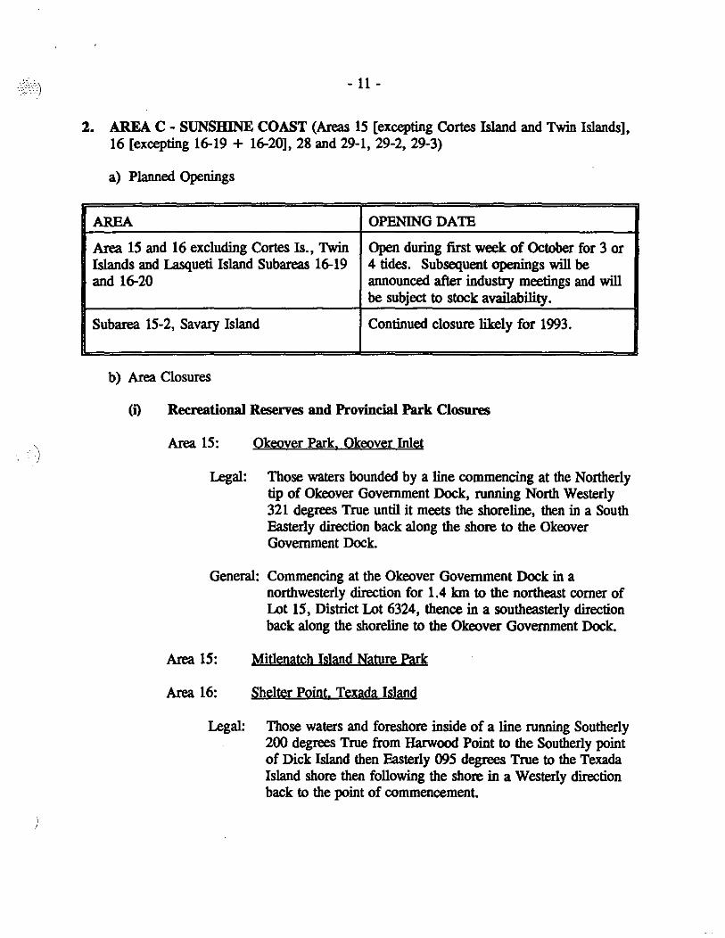
2. AREA C - SUNSHINE COAST (Areas 15 [excepting Cortes Island and Twin Islands], 16 [excepting 16-19 + 16-20],28 and 29-1, 29-2, 29-3)
a) Planned Openings
AREA OPENING DATE
Area 15 and 16 excluding Cortes Is., Twin Open during first week of October for 3 or Islands and Lasqueti Island Subareas 16-19 4 tides. Subsequent openings will be and 16-20 announced after industry meetings and will
be subject to stock availability.
Subarea 15-2, Savary Island Continued closure likely for 1993.
b) Area Closures
(i) Recreational Reserves and Provincial Park Closures
Area 15: Okeover Park. Okeover Inlet
Legal: Those waters bounded by a line commencing at the Northerly tip of Okeover Government Dock, running North Westerly 321 degrees True until it meets the shoreline, then in a South Easterly direction back along the shore to the Okeover Government Dock.
General: Commencing at the Okeover Government Dock in a northwesterly direction for 1.4 km to the northeast comer of Lot 15, District Lot 6324, thence in a southeasterly direction back along the shoreline to the Okeover Government Dock.
Area 15: Mitlenatch Island Nature Park
Area 16: Shelter Point. Texada Island
Legal: Those waters and foreshore inside of a line running Southerly 200 degrees True from Harwood Point to the Southerly point of Dick Island then Easterly 095 degrees True to the Texada Island shore then following the shore in a Westerly direction back to the point of commencement.

Area IS
- 12 -
General: Those waters and foreshore of Harwood Point Park on the South side of Harwood Point for a distance of about 215 metres.
(iO Contaminated Area Closures
The foreshore of Malaspina Strait lying between the southern headland of Scuttle Bay and Myrtle Point.
The foreshore at the head of Theodosia Inlet lying inside a line drawn &om the Percy Logging Company dock on the south side of the inlet 10 the small peninsula directly across on the north.
The foreshore at the head of Thors Cove, Lancelot Inlet.
The waters and foreshore at the head of Freke Anchorsge, Okeover Inlet, lying inside a line drawn from the south end of the bluffs located on the north shore at 49" SS.IS'N and 124° 4O.64'W 10 the north end of the shoals on the south shore at 49" SS.03'N and 124° 41.00'W.
The waters and foreshore of Lund Harbour lying inside a line drawn from the peninsula at the northern end of the harbour entrsnce 10 the point of land at the southern entrsnce 10 the government wharf.
The waters and foreshore of the area known as Prideaux Haven, including Melanie Cove and Laura Cove, bounded on the west by a line drawn along the shortest distance from Eveleigh Island 10 the shore of the mainland and on the north by a line drawn from Lucy Point on Eveleigh Is1and 10 the westernmost lip of Scobell Island and thence from the easternmost lip of Scobell Island 10 Coppleslone Point, during the period from May 31 10 September 30.
The waters and foreshore of Tenedos Bay lying inside a line drawn from the eastern lip of Bold Head northeast 10 the southern headland of the easternmost bsy of Tenedos Bay, from May 31 10 September 30.
The waters and foreshore lying between Allies Island and West Redonda Island, from May 31 10 September 30.
The waters and foreshore of Roscoe Bay, West Redonda Island, from May 31 10 September 30.
The waters and foreshore of Refuge Cove, West Redonda Is1and lying inside a line drawn across the head of the cove, from a point on the north foreshore 400 m from the centre of the bulk oil storage tank situated near the head of the cove, 10 a point on the south foreshore 275 m from the centre of the bulk oil storsge tank.
The waters and foreshore of Grace Harbour lying inside a line drawn from Moss Point 10 Scott Point, during the period from May 31 10 September 30.
The waters and foreshore of Lang Bay lying within a ISO m radius of the mouth of Whittall Creek.
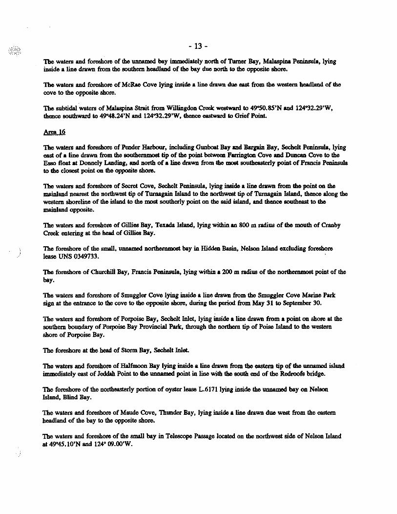
- 13 -
The waters and foreshore of the "nn.rnM bay irnrnMiately north of Turner Bay, Malaspina Peninsula, lying inside a line drawn from the southern headland of the bay due north 10 the opposite shore.
The waters and foreshore of McRae Cove lying inside a line drawn due east from the western headland of the cove 10 the opposite shore.
The subtidal waters of Malaspina Strait from Willingdoo Creek westward 10 49"S0.SS'N and 124"32.29'W, thence southward 10 49"48.24'N and 124"32.29'W, thence eastward 10 Grief Point.
Area 16
The waters and foreshote of Pender Harbour, including Gunboat Bay and Barpin Bay, Sechelt Peninsula, lying east of a line drawn from the aouthemmost tip of the point between Forrington Cove and Duncan Cove 10 the Esso float at Donnely Landing, and north of. line drawn from the moot southeasterly point of Francis PeninauIa 10 the closest point on the opposite shore.
The waters and foreshore of Secret Cove, Sechelt PeninauIa, lying inside a line drawn from the point OIl the mainland nearest the northwest tip of Turnagain Island to the northwest tip of Turnagain Island, thence along the western shoreline of the island 10 the most southerly point OIl the said is1and, and thence aoutheast 10 the mainland opposite.
The waters and foreshore of Gillies Bay, Texada Island, lying within an 800 m radius of the mouth of Cranby Creek entering at the head of Gillies Bay.
The foreshore of the small, ,mnarnM northernmost bay in Hidden Basin, Nelson Island excluding foreshore lease UNS 0349733. .
The foreshore of Churclilli Bay, Francis Peninaula, lying within • 200 m radius of the northernmost point of the bay.
The waters and foreshore of Smuggler Cove lying inside a line drawn from the Smuggler Cove Marine Parle sign at the entrance 10 the cove to the opposite shore, during the period from May 31 10 September 30.
The waters and foreshore of POIpoise Bay, Sechelt Inlet, lying inside • line drawn from a point on shore at the southern boundary of Porpoise Bay Provincial Parle, through the northern tip of Poise Is1and to the western shore of Porpoise Bay.
The foreshore at the head of Storm Bay, Sechelt Inlet.
The waters and foreshore of Halfmoon Bay lying inside a line drawn from the eastern tip of the "nn.rnM island immediately east of Jeddsh Point to the ,mn.rnM point in line with the south end of the Redroofs bridge.
The foreshore of the northeasterly portion of oyster lease L.6171lying inside the unnArnM bay on Nelson Island, Blind Bay.
The waters and foreshore of Maude Cove, Thunder Bay, lying inside a line drawn due west from the esstern headland of the bay 10 the opposite shore.
The waters and foreshore of the small bay in Telescope Passage located OIl the northwest side of Nelson Island at 49"4S.10'N and 124° 09.00'W.

)
- 14 -
Area 28
The waters and foreshore of Burrard Inlet, Indian Arm and Vanoouver Harbour lying inside, that is easterly and northerly, of a line drawn from the western end of the Fraser River North Arm Jetty to Point Atkinson.
That portion of Horseshoe Bay, lying inside a line drawn due east from the northern tip of Tyee Point to the opposite shore of Horseshoe Bay.
The foreshore of Plumper Cove, Keats Is1and, lying within • 300 m radius of the Provincial Parle wharf, during the period from May 31 to September 30.
The foreshore from Gower Point to Soames Point, Giboons Landing.
The foreBhore at the head of Port Graves, Gambier Island.
The foreBhore lying within a 200 m radius of the Camp Fircom sewage outfall, Halkett Bay, Gambier Island.
That portion of the foreshore known as McNab Creek.
The foreBhore lying 200 m to the west and 400 m to the east of the mouth of Potlatch Creek.
The foreBhore of Deep Bay, Bowen Island, lying inside a line drawn from the red navigation beacon on the south shore of Deep Bay to the foot of Ocean View Road.
The foreBhore at the mouth of Grafton Creek, Grafton Bay, Bowen Island.
Area 29
The foreshore from the mouth of Chaster Creek to Gower Point.
The waters and foreshore of Boundary Bay, Mud Bay and Semiabmoo Bay, lying inside, that is northerly of the International Boundary line.
The waters and foreBhore in the Strait of Georgia, lying inside a line drawn from the International Boundary through the westerly end of Tsawwassen Causeway to the light at Sand Heads and thence to the western end of the Fraser River North Arm Jetty.
That portion of Sargeant Bay, &chelt Peninsula, within a 300 m radius of the mouth of the unnamed creek entering the northernmost area of the bay. .
- 15 -
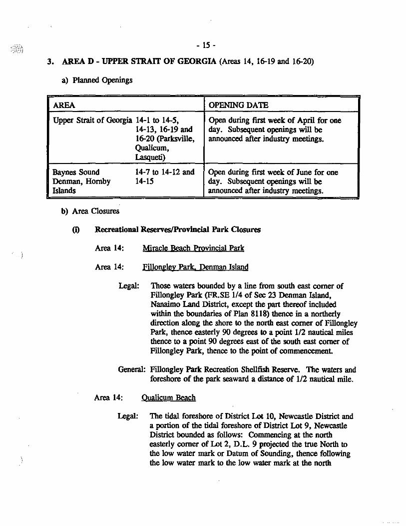
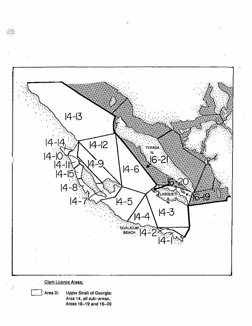
3. AREA D - UPPER STRAIT OF GEORGIA (Areas 14, 16-19 and 16-20)
a) Planned Openings
AREA OPENING DATE
Upper Strait of Georgia 14-1 to 14-5, Open during first week of April for one 14-13, 16-19 and day. Subsequent openings will be 16-20 (Parksville, announced after industry meetings. Qualicum, Lasqueti)
Baynes Sound 14-7 to 14-12 and Open during first week of June for one Denman, Hornby 14-15 day. Subsequent openings will be Islands announced after industry meetings.
b) Area Closures
(i) Recreational ReservesiProvincial Park Closures
Area 14: Miracle Reach Provincial Park
Area 14: Fillongle.y Park. Denman Island
Legal: Those waters bounded by a line from south east corner of Fillongiey Park (ER.SE 114 of Sec 23 Denman Island, Nanaimo Land District, except the part thereof included within the boundaries of Plan 8118) thence in a northerly direction along the shore to the north east corner of Fillongley Park, thence easterly 90 degrees to a point 1/2 nautical miles thence to a point 90 degrees east of the south east corner of Fillongley Park, thence to the point of commencement
General: Fillongiey Park Recreation Shellfish Reserve. The waters and foreshore of the park seaward a distance of 112 nautical mile.
Area 14: Onalicum Beach
Legal: The tidal foreshore of District Lot 10, Newcastle District and a portion of the tidal foreshore of District Lot 9, Newcastle District bounded as follows: Commencing at the north easterly corner of Lot 2, D.L. 9 projected the true North to the low water mark or Datum of Sounding, thence follOwing the low water mark to the low water mark at the north
- 16-
easterly comer of the Town of Qualicum Beach, thence from the low water mark at the north westerly comer of the Town of Qualicum Beach to the high water mark at north westerly comer of the Town of Qualicum Beach thence following the high water mark along the foreshore of District Lot 9 and District Lot 10 to the point of origin.
General: That portion of the tidal foreshore between the high water mark and the low water mark immediately north of the Town of Qualicum Beach from the foot of Seacroft Road to the easterly foot of Surfside Drive.
Area 14: Parksyille Bra"" Legal: That portion of Parksville Bay bounded as follows: From the
southeasterly comer of Lot 1, Plan 8484, District Lot 70, Nanoose District, a straight line projected true north to the point of intersection with the City of Parksville Boundary (B.C. Gazette, may 1, 1986) thence following the City of Parksville Boundary in an easterly direction to a point true North of the High water mark on the Coast Guard Hovercraft Ramp situated on part of Part "B" (D.D. 34903-1) of District Lot 13, Nanoose District, thence to the high water mark on the Coast Guard Hovercraft Ramp situated on part of Part "B" (D.D. 34903-1) of District Lot 13, Nanoose District.
General: That portion of Parksville Beach from the Coast Guard Hovercraft Ramp to the foot of Bay Avenue.
Area 14: Rathtrevor Provincial Park
Area 14: Kye Bay
Legal: Those waters bounded by a line from the light on Cape lazo, thence northeasterly 45 degrees true for a distance of 112 nautical mile, thence north westerly 293 degrees to a point of land at the most north east tip of the boat ramp at Air Force Beach. Thence southerly along the shore to the point of commencement.
General: The waters of Kye Bay from Cape lazo light to the boat ramp at Air Force Beach.

Area 14
- 17-
Area 14: Baynes Sound Recreational Reserve
Legal: Those waters bounded by a line commencing from a point at the North East comer of Block 149 Lot 48, thence along the Northern Boundary of Block 149 Lot 48 to the North West comer, thence along the shore in a northerly direction to the South West comer of Block 149 Lot 49 thence along the Southern border of the Block 149 Lot 49 thence along the Southern border of the Block 149 Lot 49 to the South East comer, thence in an easterly direction 90 degrees to a point 112 nautical miles, thence to a point 112 nautical miles 90 degrees east of the North East comer of Block 149 Lot 48, thence to the point of commencement.
General: Baynes Sound Recreational Shellfish Reserve. The waters and foreshore of the area from a point 112 mile North of Garvin Road to a point 112 mile south of Garvin Road.
(ij) CODtamjoated Area Closures
The waters and foreshore of Comox Harbour and surrounding areas lying inside • line drawn from Gartley Point to the Comox Bar bell buoy (PS4) and thence to a point on land 250 m east of the Point Holmes boat ramp.
The waters and foreshore of Comox Harbour and surrounding areas lying inside • line drawn from Gartley Point to the Comox Bar bell buoy (PS4) and thence to the southern headland of the .mnamed bay south of Gartley Point, during the period from August 31 to June 30.
The waters and foreshore of Deep Bay, Baynes Sound, lying within 300 m of the government wharf.
The foreshore of Union Bay, Baynes Sound, lying between the southern hesdland of Union Bay and the foot of Tipton Road.
The waters and foreshore of Baynes Sound lying inside a line drawn from a point on shore 125 m north of the Bucldey Bay ferry dock to the green navigation buoy (P43) in Baynes Sound, and thence through the northern headland at the mouth of the Tsable RiVel" to the shore sao m south of the Mac'. Oyster Company plant.
That portion of the foreshore on the west side of Denman Island from Denman Point approximstely 700 m to the southern boundary of Lot 245, Lesse 950, ref. LD 026853, Nanaimo Land District, during the period from August 31 to November 30.
The waters and foreshore lying within a 300 m radius of the drainage ditch enl«ing at the foot of Y ambwy Road, Eaglecrest.
The waters and foreshore of Qualicum Besch lying within an 800 m radius of the mouth of Grandon Creek, and a 500 m radius of the mouth of Besch Creek.
The waters and foreshore of Kye Bay lying within a 500 m radius of the foot of Lazo Road.
)
- 18 -
The waters and foreshore of Saratoga Beach, from the north side of Oyster River at • point at Jalitude 49052.3SN and longitude 125006.92W and thence east to a point approximat1ey 1.9 Ian at Jalitude 49051.52N and longitude 125006.33W.
The waters and foreshore of Wall Beach, lying inside a line drawn from a point at Jalitude 49018.13N and longitude 124013.33W thence southerly to a point at Jalitude 49018.21N and longitude 124013.03W.
The waters and foreshore of the Englishman River, l'IrlcsviIle from a point at Jalitude 49019.91N and longitude 124017.23W thence southwesterly to a point at latitude 49019.79N and longitude 124017.9SW.
The waters and foreshore of Mud Bay, Lasqueti Island lying inside • line drawn from the south-.n lip of the headland at Jalitude 49029.60'N and longitude 124020.96'W thence northerly to a point on the opposite shore at Jalitude 49029.70'N and longitude 124020.99'W.
Area 16
The waters and foreshore of the DI1II8IIIed bay, loca\Iy known as Long Bay, immediately east of Potter Point, Tucker Bay, UisqueIi Island.
The waters and foreshore of Scottie Bay lying within a 100 m radius of the unnamed creek located at 49" 30.72'N and 124° 2O.6S'W, south of Undbergh Island.
)
- 19 -
4. AREA E - LOWER STRAIT OF GEORGIA (Areas 17, 18, 19,20 and 29-5)
a) Planned Openings
AREA OPENING DATE
Lower Strait of Georgia Open in January for one or two days. Subareas 17-1 to 17-6, 17-8 to 17-10, Subsequent openings will be announced
17-12 to 17-13, 17-15 to 17-19, after industry meetings. 18-1 to 18-7, 18-9 to 18-11, 19-4 to 19-11,20-1 to 20-5 and 29-5 Openings will be coordinated with the West
Coast of Vancouver Island.
b) Area Closures
(i) Recreational Resenes and Provincial Parks
Area 17: Nanoose Bay
Legal: A 600 meter portion of Subarea 17-20 described as those waters directly across from the Department of ffighways Rest stop bounded on either side by Recreational Reserve Signs.
Area 17: Yellow Point
Legal: A portion of Subarea 17-4 commencing at Flewett Point on Vancouver Island and running in a southeasterly direction to Yellow Point.
Area 17: Sandwell Provincial Park
Area 17: Gabriola Island Sites
Legal: A portion of Subarea 17-10, the waters and tidal foreshore of Drumbeg Provincial Park, Gabriola Island; a portion of Subarea 17-12, the waters and tidal foreshore of Pilot Bay, Gabriola Island; a portion of Subarea 17-16, the waters and tidal foreshore of Gabriola Island bounded on the east by the Subarea 17-16, boundary, thence in a westerly direction 400 meters to a fishing boundary marker on Gabriola Island.
General: Three smaIl reserves on Gabriola Island.
,
Area 17
- 20-
Area 19: Verdier Point. Saanich Inlet
Legal: Those waters bounded by a line from Verdier Point, thence northeasterly 45 degrees true for a distance of 1/4 nautical mile, thence northwesterly 315 degrees true for a distance of 112 nautical mile, thence 225 degrees true for a distance of 114 nautical mile, thence southeasterly 135 degrees true for a distance of 1/2 nautical mile along the shore to the point of commencement.
General: The waters of Saanich Inlet from Verdier Point northeasterly to the foot of Noowick Road.
("O) Contaminated Area Closures
The waters and foreshore of Ladysmith Harbour lying inside a line drawn from Sharpe Point to Boulder Point.
The waters and foreshore of Oiemainus Bay lying inside • line drawn from Bare Point light through Hospital Rock to the mouth of Askew Creek.
) The waters and foreshore lying inside • line drawn from the old wharf located about 600 m west of Sherard Point to the North Reef light, theoce to tho northern tip of Willy Island, and thence through tho northern tip of Mainguy Island to the eastern shore of Vancouvec Island.
The waters and foreshore of Nanaimo Harbour, Newcastle Island Passage lying inside • line drawn from Jad< Point to Gallows Point on Protection Island, thence along the western shoreline to Bachelor Point, thence northwesterly to the entrance of a small lagoon at 49"11.1S'N and 123OSS.3S'W on NewcastIe Island and thence along the southwestern shoreline to Nares Point, including the waters south of a line drawn from Shaft Point to Pimbury Point on Vancouvec Island.
The waters and foreshore of Departure Bay from Pimbury Point to HOISWeil Bluff at 49"12.76'N and 123OS6.36'W. The waters and foreshore of Degnen Bay, Gabriola Island, lying inside of • line cbawn from the beach access at the foot of Gray Road on the west shore to the Imnanwl point irnnwliately opposite on the east shore, northwest of Josef Point.
The waters and foreshore of Silva Bay, Gabriola Island lying within. line drawn from the southern tip of Law Point to the northwestern tip of Sear Island and thence southwesterly to the shoreline of Gabriola Island.
The waters and foreshore of Montague Harbour, Galiano Island, lying inside a line drawn from the eastern tip of Gray Peninsula to Winstanley PoinL
The foreshore of Gabriola Island lying between the unnamed point 350 m southeast of the foot of Shaw Road, and a point on land 200 m northeast of the said Imnanwl poinL
)
- 21 -
The foreshore of Walker Hook, SaItspring Island, lying oouth of a line drawn from a point at 4S"S3.37'N and 123"30.00'W 10 a point at 4S"S3.5S'N and 123"29.6S'W, within the hook fonoed by the spit and the shoreline of SaItspring Island.
The waters and foreshore on the northwest side of N~ Harbour, lying within a 30 m radius of the unnamed creek located at 49"16.41 'N and 124°10.30'W.
The waters and foreshore of Clam Bay and Telegraph Harbour, including the boat passage betw-. Thetis and Kuper Is1ands, lying between, that is west, of a line drawn near the foot of Clam Bay Wharf Road at 48"S9.34'N and 123'39.0S'W 10 the opposite shore at 4S"SS.9S'N and 123"39.0S'W, and a line drawn from Donckele Point on Kuper Island 10 Foster Point on Thetis Island.
The foreshore of SaItspring Island lying IS00 m northwest and SOO m southeaat of the Malaview Estates """"'I!e treatment plant outfall sign, southeaat of Fernwood Point.
The waters and foreshore lying within a 4S0 m radius of the .mnamed creek entering Housloun Passage, near the northern terminus of North End Road, SaItspring Island, 2.4 km northwest of the Fernwood Point Dock.
The waters and foreshore of Hammond Bay, Nanaimo lying inside a line drawn from the headland on the north side at latitude 49014.03N and longitude 123oS7.6SW thence southeasterly to Lagoon Head at latitude 490 13.74N and longitude 123oS6.SSW.
The waters and foreshore of the large bay on the west side of Tent Island, during the period from May 3110 September 30.
The waters of Clad: Bay, GabrioIa Island, lying inside a line drawn from the northeastern tip 10 the northwestern tip of the land enclosing the bay.
The waters and foreshore of Taylor Bay, Gabriola Island, lying within a 400 m radius of the most northeastern point of Taylor Bay.
The waters and foreshore of Descanso Bay, GabrioIa Island, lying within a 70 m radius of the culvert entering the southern end of the bay.
The waters and foreshore of Pirates Cove, De Courcy Island, during the period from May 31 10 September 30.
The foreshore of Lantzville, from Peterson Road eastward 10 a point 50 m east of the boat ramp at the Shoregrove Resort.
The waters and foreshore of Duck Bay, SaItspring Island, lying inside, that is eastward, of a line drawn due north from the first headland on the south side of Dock Point 10 the opposite shore.
The watera and foreshore of the northern shore of Vesuvius Bay, SaItspring Island, from a point on the shore 150 m north of the ferry slip 10 a point on the shore SOO m southeast of the ferry terminal.
The foreshore of Booth Bay, SaItspring Island, lying east of 123"33.S7'W, and the waters and foreshore of Booth lnlet (also known as Booth Lagoon ).
The watera and foreshore lying within a 400 m radius of the mouth of Porter Creek, Stuart Channel.
- 22 -
1be waters and foreshore of the small,mn8meA bay located It 48'S6.00'N and 123"3S.7S'W, on the northwest side of Saltspring Island.
1be waters and foreshore of NIIIIOM8 Harbour, located It a point at latitude 49"IS.21N and longitude l24"OS.69W to a point approximately 340 m east at latitude 49°1S.1SN and longitude 124"OS.49W, approximately 1 k:m west of Fleet PoinL
1be waters and foreshore of Descano Bay, Gabriola Island from the point of land OIl the north side of the bay It latitude 49010.7S'N longitude 123oS1.61'W thence west to. point on the opposite shore at latitude 490 10. 8O'N and 123oS1.67'W to a point latitude 4901S.21N and longitude 12400S.69W.
Area IS
1be waters and foreshore of Cowicban Bay, including Genoa Bay and Boatswam Bank, lying inside a line drawn from Separation Point to Hatch Point;
1be waters and foreshore of Long Harbour, Saltspring Island, lying within a 30S m ndius of the ferry slip.
1be waters and foreshore at the head of Fulford Harbour, Saltspring Island, lying inside, that is northward, of. straight line drawn from a point at 123 '27'IS"W; 48· 4S'SS"N on the western shore, to a point at 123·26'n"W; 48'46'04"N OIl the eastern shore.
1be waters and foreshore of Ganges Harbour, Saltspring Island, including WalB Bay lying inside or northwest of a straight line drawn from the western tip of Waller Bay Spit to the west end of Goat Island and thence
) westerly to the shore of Saltspring Island.
-'I
1be waters and foreshore at the head of Burgoyne Bay, Saltspring Island, lying inside of a line drawn from 48"47'22"N and 123"31'24"W to 48"47'43"N and 123"30'39"W.
The waters and foreshore of Thieves Bay, North Pender Is1and.
The waters and foreshore of Bedwell Harbour, lying inside a line drawn from the Skull Islet reef to Hay Point, South Pender Island.
1be waters and foreshore of Hope Bay, North Pender Island, lying inside, that is south of, a line drawn from the land end of the government dock to Auchterlonie Point on the opposite side.
1be waters and foreshore of Birds Eye Cove, Maple Bay, lying inside a line drawn from a point on the western shoreline located 115 m north of the Maple Bay Yacht Club wharf true east to the eastern shore.
1be waters and foreshore of Horton Bay, Mayne Island, lying inside a line drawn from Aitken Point to the most westerly point of Curlew Island, thence southward to a point on Mayne Island 115 m east of the public wharf.
1be foreshore of Village Bay, Mayne Island, lying inside a line drawn from a point on land 115 m north of the ferry dock to Crane Point;
The foreshore of North Pender Island, including Boat Nook, between Thieves Bay and Oaks Bluff.
The waters and foreshore of Selby Cove, Prevost Island, lying inside a line drawn across the entrance to the cove, during the period from May 31 to September 30.
)
- 23 -
The waters and foreshore of Annette Inlet, Prevost Island, lying inside a line drawn across the narrow\l8t point of the inlet, approximately midpoint of the inlet.
The foreshore at the head of Boot Cove, Satuma IsIaod, lying inside a line drawn northwest from the northern tip of the smaU hook of land on the eastern shore of the cove to the opposite shore.
The foreshore of Saanich PeninBu1a, from the Saanich Peninsula-Piers Island cable marlcer to Curteis Point.
The waters and foreshore at the head of Long Harbour, Saltsprina lslaod lying inside a line drawn from the north side at latitude 4SoS1.73N aod longitude 123027.SSW to the opposite shore at latitude 4SoS1.77N and longitude 12302S.00W.
The waters and foreshore of Reef Harbour, lying inside • line drawn from the northeastern tip of Tumbo Island at 48" 47.90'N and 123'04.4S'W to Cabbage Js1and thence along the northern shoreline of Cabbage Js1and to a point at 4so48.00'N aod 123° OS.25'W, aod thence southward to a point on Tumbo Island at 48"47.7S'N and 123"OS.25'W. May 31 to September 30.
The waters and foreshore of the ,moamed bay at the north side of Ganges Harbour, Saltspring Islaod, lying inside a line drawn from the isthmus at 48"S1.3S'N aod 123"29.IO'W to the opposite shore at 48"Sl.SO'N and 123"29.10'W.
Area 19
The waters and foreshore of Vancouver Island, lying inside a line drawn from the southernmost end of Coburg Peninsula (Esquimalt Lagoon) at latitude 48"2S.10'N aod longitude 123"2S.29'W, thence southeasterly to Racon bouy at latitude 4S"2.2.S3'N aod longitude 123"23.s0'W, thence northeasterly to a point of land west of Gonzales Point at latitude 48"24.SS'N aod longitude 123°1S.14'W, thence the foreshore to a point on shore, at latitude 4S"32.20'N and longitude 123"2l.S2'W, parallel with the northern end of Plilker Road, Cordova Bay.
The foreshore of Saanich Peninsula, from Curteis Point southward to a point 1000 m south of the boat launching ramp at Island View Beach.
The waters and foreshore of Saanich Inlet including Mill Bay, extending from Hatch Point southward to the foot of Noowick Road.
The waters and foreshore of Deep Cove, Saanich Inlet, lying inside of aline drawn from Moaes Point to Coal Point.
The waters and foreshore of Patricia Bay, Saanich Inlet, lying inside a line drawn from Warrior Point to a point on the opposite shore 125 m south of the InstiIUte of Ocean Sciences dock.
The waters and foreshore of Thomson Cove, Saanich Inlet, lying inside a line drawn from the northern headland of Thomson Cove to Henderson Point.
The waters and foreshore of Brentwood Bay, Saanich Inlet lying inside a line drawn from Henden;on Point at latitude 4S03S.S9N and longitude 1230 2S.79W south to Willis Point at latitude 4S034.6SN and longitude 123029. 13W.
The waters and foreshore of Finlayson Arm, Saanich Inlet, lying south of the power cables crossing the southern tip of Sawluctus Js1and.
)
)
- 24 -
The waters and foreshore of Coles Bay, Saanich Inlet, lying inside a line drawn from Yarrow Point 10 • point 011 the eastern shore of the bay 125 m 80IIIh of the .mnamed creek ... tering at 8600 Kleewyck Road.
The foreshore of Saanich Inlet, from McPhail Point 10 the Bamberton Cement Company dock.
The waters and foreshore of Quarantine Cove lying inside a line drawn from William Head 10 the southern ... d of Weir Beach.
The subtidal waters on the east side of Sannich Peninsula lying inside a line drawn from Cordova Spit 80IIIheast 10 the southemmost tip of James Islaud, thence 80IIIhwest 10 the boat launching ramp at Island View Beach.
The waters and foreshore of Towner Bay , Sannich Inlet, lying inside a line drawn from the 80IIIheast shore at 48" 4O.01'N and 123° 28.38'W thence 10 the northwest shore art 40" 4O.11'N and 123° 28.S7'W.
Area 20
The waters and foreshore of Sooke Harbour and Sooke Basin, lying inside a line drawn from the eastern tip of Wbiffin Spit due east 10 • point on the opposite shore, thence along the shoreline 10 Company Point
The waters and foreshore of Pedder Bay lying inside a line drawn from Cape Calv .... 10 William Head.
Area 29
The waters and foreshore of Whaler Bay, Ga1iano Island, lying inside, that is "",.thesst of a line drawn 265' True from Cain Point 10 the western shore of Ga1iano Island.

)
- 25 -
3. AREA F - WEST COAST OF VANCOUVER ISLAND (Areas 23 to 27)
a) Planned Openings
AREA OPENING DATE
23,24 and 25 Jan./Feb.lMarch openings subject to stock assessment and following Local Consultation following 1992 Fishery. Further openings subject to stock assessment and consultation. Mary Basin (Subarea 25-14) will open in January for a very limited harvest opportunity.
26 and 27 Closed for conservation and biological assessment.
b) Area Closures
(i) Recreational ReserveslIndian Food Fish Reserves. Maps are available Cor these closures in the Port AIberni Office
Area 23: Santa Maria Island. Numukarnis Bay Beaches
General A portion of Subarea 234 described as those waters being marked on the north by a point of land fronting the Sarita River Indian Reserve thence in a southerly direction to a point of land on northern comer of Christie Bay and all those waters surrounding Santa Maria Island.
Subarea 23-8 Pacific Rim National Park - Broken Island Group
Area 24: Whiskey Jenny Beach. <Shelter weO
General: A portion of Subarea 24-3 described as those waters bounded on the east by a point of land located eight cables west of Dixon Point in Shelter Inlet and bounded on the west to a point of land located 1.6 miles from Dixon Point. This beach is locally known as Whiskey Jenny Beach.

)
- 26-
Area 24: Bawden Bay
General: A portion of Subarea 24-4 described as those waters inside a line drawn from Bawden Point to Clifford Point.
Area 24: Whitepine Cove
General: A portion of Subarea 24-5 described as those waters lying inside a line drawn from Bawden Point to the most southern tip of Binns Island, thence due east to a point of land located on the beach of Vancouver Island.
Area 25: Head of Espinosa Inlet
General: A portion of Subarea 25-11 described as being those waters located at the head of Espinosa Inlet fronting the Indian reserve.
Area 25: Oueens Cove
General: A portion of Subarea 25-12 described as being those waters lying inside a line drawn from a point of land located 4 cables southerly of Saddle Point at the N.W. comer to the entrance of Queens Cove, thence following that line bearing 1360 true to a point of land on the opposite shore. This area would encompass Queen Cove entirely.
Area 26: Tashish River Provincial Park
Area 26: Aktis island
General: A portion of Subarea 26-1 described as being those waters encompassing the tidal foreshore completely around Aktis Island.
Area 26: Oanninick Cove
General: A portion of Subarea 26-6 described as being those waters lying inside a line drawn between the two headlands located on either shore at the entrance to Oanninick Cove.
- 27 -
(ii) Contamjnated Area Closures
Area 23
The waters and foreshore of Bamfield Inlet and Gnppler Inlet lyine inside • line drawn from Aeullar Point lieht to the barbour limit on the opposite shore.
The waters and foreshore of Ucluelet Inlet lying inside • line drawn from the tip of the southern b ... dl.nd of Spring Cove on Ucluth Peninsula to the tip of the southern headl.nd of Stuart Bay on the opposite side of the iDlet.
The waters and foreshore of Cigarette Cove, Entrance Inlet, lying inside of. line drawn across the entrance to the cove at its narrowest point.
The waters and foreshore of the small .mnamed bay immediately northeast of CoDgreve Island, lying inside • line drawn from the westernmost point of the southern headland of the bay due DOrth to the opposite shore.
The foreshore of Albemi Inlet from River Point to • point 480 m south.
That portion of Useless Inlet, Barkley Sound, lying within a ISO m radius of the mouth of the unamed creek, entering the north side of the iDlet, at 48" S9.S9N' and 115° 03.4S'W.
Area 24
) The foreshore at the eastern end of Bottleneck Cove, located immediately north of Young Bay at the entrance to Holmes Inlet, Clayoquot Sound.
The waters and foreshore of Van Nevel Channel and Duffin Passage bounded by • line from Grice Point to the western tip of Storkbam Island, thence to the moot southern tip of Stubbs Island.thence south to the green navigation buoy, and thence directly east to the shore of Esowista Penin""l.
Area 15
The waters and foreshore of Friendly Cove, lying inside a line drawn from Yuqnol Point to the navigation light on San Rafael Island and thence due north to Nootka Island.
The waters and foreshore of Valdes Bay, Hisnit Inlet, Nootka Sound, lying inside. line drawn from the southern headland of Valdes Bay to the northwest tip of the .mnamed island in the bay, thence due east to. point on shore of Valdes Bay.
The waters and foreshore of Kendrick Inlet, Nootka Island, within • 300 m radins of the Onion Lake Logging Company dock.
The waters and foreshore at the head of TIupana Inlet, Nootka Sound, inside • line drawn from the .mnamed point on the east side of the iDlet immedi.tely northwest of Perpendiculat Bluff, due west to the opposite shore.
The waters and foreshore at the head of of Inner Basin, Nootka Island lying inside • line drawn from the headland on the north side at a latitode of 490 48.10'N and • longitude of 1260 47.06'W thence south to a point on land at a latitude of 490 47.76'N and a longitude of 1260 47.06'W.
- 28 -
The waters and foreshore at the head of Port Eliza, Espetanza Inlet, lying inside • line cUawn from the southern tip of the small ,mnamOO peninsula 00 the western shore of Port Eliza due east to the opposite shore.
Area 26
The foreshore at the head of Yaku Bay, Tahsish Inlet, Kyuquot Sound.
The foreshore at the head of Hankin Cove, Kashutl Inlet.
The foreshore at the bead of McKay Covo, Kyuquot Sound.
The waters and foreshore of Wallen Cove, Kyuquot Sound, lying inside a 1ino chawn from the western headland of Walters Cove to the Gaywud Rock light, thence to the eastern tip of Rolston Island, thence to the western headland at the entrance of McKay Cove.
The foreshore at the bead of Ma1ksope Inlet.
The waters and foreshore at the head of Ououkinsh Inlet, north of an east-west line cUawn through the northern tip of the southemmost Hi.snit Islands.
The waters and foreshore of Kashutl Inlet lying within. 900 m radius of Cbamjss Point.
All that portioo of the intertidal area of Kashutl Inlet from a point 00 land at latitude SOo OS.7S'N and loogitude 127016.74'W thence essterIy to the western tip of an IInnamOO island at latitude SOoOS.43'N and loogitude 127016.26'W thence northerly to the end of an unnamed peninsnla at latitude SOoOS.6I'N and loogitude 127016.0S'W.
The waters and foreshore of the 'mnamOO bay in Kashutl Inlet, lying inside a line cUawn from a point 00 land at latitide SOoOS.91'N and longitude 127016.80'W thence southeasterly to a point OIl shore at latitude SOoOS.67'N and longitude 127016.70'W.
AreaP
The waters and foreshore of the bay at the mouth of C1eagh Creek, Quatsino Sound, lying inside a line cUawn from the eastern headland to the western headland of the bay.
The waters and foreshore lying within an 800 m radius of the creek entering at the settlement of Mshatta River, Quatsino Sound.
The waters and foreshore of Koprino Harbour, Quatsino Sound, lying inside a line at SO·30' North latitude cUawn from the entrance to Spencer Cove through Schloss Island to the opposite shore.
The waters and foreshore of Winter Harbour, lying north of a line cUawn from Greenwood Point to the mouth of Quashtin Creek, and west and south of a 1ino cUawn from the mouth of Denad Creek through the western tip of Wedel Island to the opposite shore of Winter Harbour.
The foreshore at the bead of Holberg Inlet.
The waters and foreshore of Hecate Cove, Quatsino Sound, lying inside a 1ino chawn from the eastern shore at a latitude of SOO 32.70'N and a longitude of 1270 .3S.4S'W thence west to a point OIl land at latitude SOO 32.70'N and longitude 1270 3S.S9'W.
- 29 -
The waIetB and foreshore of KoIcwina Cove, QuaIsino Sound lying inside a line drawn from a point of land on the western entrance at latitude S0031.SO'N """longitude 127034.61'W thence to the east to a point on shore at latitude S0031.S0'N """ longitude 127034.33'W.
- 30-
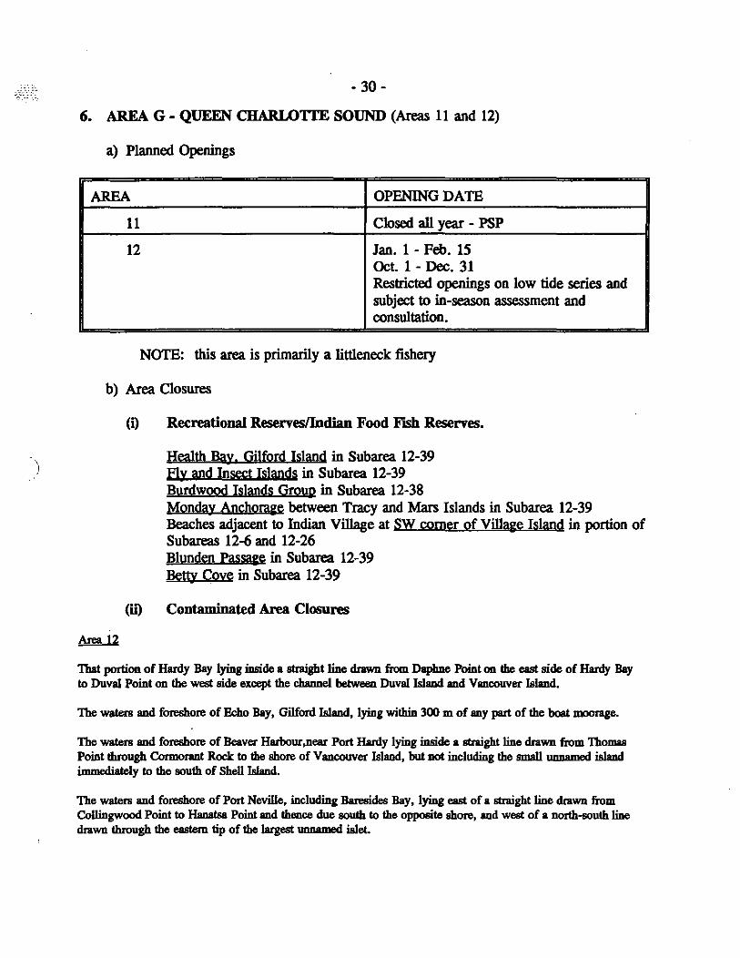
6_ AREA G - QUEEN CHARLOTfE SOUND (Areas 11 and 12)
a) Planned Openings
AREA OPENING DATE
11 Closed all year - PSP
12 Jan. 1 - Feb. 15 Oct. 1 - Dec. 31 Restricted openings on low tide series and subject to in-season assessment and consultation.
NOTE: this area is primarily a littleneck fishery
b) Area Closures
(i)
(0")
Area 12
Recreational ReservesJlndiao Food Fish Reserves.
Health Bay. Gilford Island in Subarea 12-39 Fly and Insect Islands in Subarea 12-39 Burdwood Islands Groyp in Subarea 12-38 Monday Anchora~e between Tracy and Mars Islands in Subarea 12-39 Beaches adjacent to Indian Village at SW comer of Village Island in portion of Subareas 12-6 and 12-26 Blunden Passa&e in Subarea 12-39 Betty Cove in Subarea 12-39
Contamjnated Area Closures
That portion of Hardy Bay lying inside a straight line drawn from Daphne Point 011 the east side of Hardy Bay 10 Duval Point on the west side except the channel between Duval Is1and and Vancouver Island.
The watera and foreshore of Echo Bay, Gilford Is1and, lying within 300 m of any part of the boat moorage.
The watera and foreshore of Beaver Harbour ,near Port Hardy lying inside a straight line drawn from Thomas Point through Cormorant Rock 10 the shore of Vanoouver Island, but not including the small unnamed island immediately 10 the south of Shell Island.
The watera and foreshore of Port Neville, including Baresides Bay, lying east of a straight line drawn from Collingwood Point 10 Hanatsa Point and thence due south 10 the opposite shore, and west of a north-south line drawn through the eastern tip of the largest ,mnamed iBlet.
- 31 -
The waters and foreshore of Hopetown Passage, Watson Island, lying inside a tiDe drawn from HopeIOwn Point due east to the nearest point of land.
The waters and foreshore of Macgowan Bay, Drury Inlet, lying inside a tiDe drawn from a point on shore at 50" 54.82'N and 1270 OS.62'W, thence southeasterly to 50" S4.6S'N and 1270 OS.40'W on the opposite shore.
The waters and foreshore of a small Imnamed bay, immediately west of the Everud IsIets,Drury Inlet, lying inside a line drawn from a point on shore at SO" 53.3S'N and 1270 02.73'W, tbeace easterly to a point on shore at SO" 53.36'N and 127°02.47'W.
The waters and foreshore of Shoal Harbour, Gilford Island, lying inside a tiDe drawn from a point on the west shore at SOo 44.59'N and 1260 30. 18'W thence easterly to a point on shore at SOo 44.59'N and 1260 29.9S'W.
The waters and foreshore of Cohoe Bay, BIunden Harbour, lying inside a tiDe drawn from a point of land on the north shore at 500 54.00'N and 1270 14.64'W thence south to a point on shore at 500 53.S3'N and 1270 14.2S'W.
G. FlSH1NG PLANS - BUtTER CLAMS
Butter clams chronically retain paralytic shellfish poison (PSP). Openings will be announced on request as non-toxic butter clams are found in selected areas. Area licencing provisions apply for this fishery. Contaminated closures listed in Manila and littleneck fishing plans apply to these fisheries.
H. FlSH1NG PLANS - RAZOR CLAMS
a) Planned Openings
AREA A - STATISTICAL SUBAREA 1-5, QUEEN CHARLOTTE ISLANDS (HAIDAGWAII)
This area is open to razor clam harvesting from Ianuary 1 to December 31. This fishery will be managed cooperatively with the Council of the Haida Nation including implementation of a joint management plan through a joint technical committee.
A. Haida Participation will include:
a) monitor Haida fishing activities; b) enforce the joint razor clam management plan for the fisheries on Haida
Gwaii; c) review processing plant deliveries, log books and other records to compile
statistics on razor clam fishing catch and effort; d) provide the Ioint Technical Committee with information required for review
of management of razor clam fisheries on Haida Gwaii; e) regularly collect razor clam samples for PSP testing;
f\,~ '-'
- 32 -
f) survey the recreational fishery to assess razor clam fishing catch and effort; g) collect a nominal fee from Haida clam diggers to recover cost of processing
identification documents and log books; h) conduct other projects as identified and priorized by the Joint Technical
Committee.
B. Non-Haida fishery - licenced and managed by DFO
b) Area Closure - CODtamjoated area closures
'The waters IIIICi tidal foreshore of Mamim Bay, Juskatla Inlet and Graham Island.
'The waters IIIICi tidal foreshore of Masse! Sound, Graham Island, lying south of a line drawn between Westacolt Point IIIICi Entry Point, and north of. line drawn between Crowell PoinlllllCi Camp Point.
The waters IIIICi tidal foreshore of Dinan Bay and McClinton Bay, Masse! Inlet, lying inside a line drawn from the northern headland of Awun Bay to the nearest point on the northern shore of MIISIiet Inlet.
'The waters IIIICi tidal foreshore of Port Clements, Masse! Inlet, lying inside a line drawn from the southern point I at the entrance to KumdisBay to Martin Point on Kumdis Island, thence southward to a point 125 metrea south
j of the Port Clements jettiea.
'The waters IIIICi tidal foreshore of Bearskin Bay, Moresby Island, lying inside a line drawn from Beattie Point to Belle Point on Maude Island and thence to Raida PoinL
'The waters and tidal foreshore of Dolphin Island, lying within a 1400 m radius of the ID08I northerly point of land at the Idtkatla Indian Village.
'The waters and tidal foreshore of Kitimat Ann, lying inside a line drawn between Raley Point IIIICi a point 400 metres north of the mouth of Dish Creek.
'The waters IIIICi tidal foreshore of Trout Bay, K1emtu, lying inside a line drawn from Klemm Point to the northern headland of the bay.
'The waters and tidal foreshore of Bella Bella, lying south of a line drawn from the western headland of Cavin Cove to the northern tip of Spirit Island thence to Robins Point, and north of a line drawn from the northern headland of McLoughlin Bay due east to the shore of Denny Island.
- 33 -
I. INSPECTION G!T11lEI.INFS
BIVALVE MOLLUSCS:
Shellfish with two valves (or shells), such as clams, mussels, oysters and scallops.
FUTER FEEDING:
Bivalve molluscs obtain their food by filtering out tiny food particles and microscopic organisms (such as planktons, algae and bacteria) in the water.
ACCUMULATION:
Disease causing bacteria, viruses, toxic planktons and other contaminants could be concentrated to high levels in the digestive tract of the shellfish.
ILLNESS:
When humans consume clams, mussels, oysters or scallops harvested in contaminated or . toxic areas, illnesses and death may result. There are many recorded cases of hepatitis, cholera, gastroenteritis, paralytic shellfish poisoning (pSP or commonly known as red tide) and amnesic shellfish poisoning (ASP, domoic acid) from people eating contaminated or toxic bivalve shellfish.
REGULATORY COMPLIANCES:
It is important to comply with the following requirements as a condition of the commercial harvest licence:
(1) OPEN AREAS:
- harvest in open areas ONLY;
- it is important to check with a federally registered shellfish plant prior to digging. Processors are I'eQ!1ired to verify the digging on-site. They are not allowed to buy products sight unseen at the door;
- it is illegal to harvest in areas that are closed for reasons of contamination (e.g. sewage), toxicity (e.g. PSP or ASP), or conservation;
- a list of sewage contaminated closure is provided under the appropriate Area Ucence (Le. A, B, C, D, E, F and G) at the preceding sections;
)
- 34-
- except for Subarea 1-5 where razor clams may be harvested, the entire North Coast of British Columbia from the Canada-Alaska border to Cape Caution is permanently closed for reasons of toxicity and water quality survey.
- always check with the nearest Department of Fisheries and Oceans fisheries officer for any changes in closures prior to harvesting.
(2) LABELLING:
It is important to maintain accurate harvest information.
All sacks or containers of clams must have attached to the sack or container, a visible water resistant tag which· identifies the name of the clam digger, the clam harvesting Z licence number, the beach location, statistical area and sub-area, date of harvest and the type or species harvested (e.g. manila, littlenecks, etc.). This tag must be attached to the sack or container at the time of harvest. Prior to leaving the harvest site all containers must be tagged.
Please note that it is unacceptable to report a generalized location of harvest such as Sunshine Coast, Quadra Is., Cortes Is., Barkley Sound, etc. The location of harvest must be specific (e.g. Sutil Pt., Lasqueti Is., etc.).
(3) PRODUCT HANDLING & TRANSPORTATION:
Care must be exercised to protect the bivalves from contamination and exposure to the sun, weather, temperature and other abuses.
- Do not litter at or near the harvest site;
- Do not bring pets to the harvest site because defecation will render the beach contaminated;
- Do not rinse the shellstock at dockside or any area other than at the harvest site;
- Do not sort i.e. separate clams by species at the buy site or any other location other than the harvest site or federally registered shellfish plant.
Please note that it is permissible to rinse the shellstock at the harvest site and 2!!lx at the time of harvest. This is part of the harvesting practice to remove excess mud or sand. It is not considered as part of processing. All processing must be done at a federally registered shellfish processing plant.
)
- 35 -
(4) WEI' STORAGE:
Wet storage of shellstock on the beach, alongside of a boat, unapproved live tanks, or any body of water is not allowed. Such practices may expose the shellfish to contamination. Wet storage of shellfish on approved leases must have prior written approval.
(5) SALES OF COMMERCIALLY HARVESTED CLAMS:
Under the Provincial Fish Inspection Act. Section 12 (1.1), "No person shall sell or attempt to sell any harvested bivalve molluscs unless the molluscs were, before the sale or attempted sale, processed in an establishment that at the time of processing held a valid certificate of registration issued by the Department of Fisheries and Oceans (Canada). "
Clam diggers may sell their clams to a duly licensed fish buyer.
PLEASE ADVISE THE PROCESSOR TO WHOM YOU WllL BE SEJJJNG YOUR CLAMS, THE INTENDED WCATION OF YOUR HARVEST AT LEAST 24 HOURS PRIOR TO DIGGING.
For further information please contact the following Fish Inspection Offices at:
12700 Trites Road Richmond, B.C. V7E3R8
Phone: 666-4432
4520 Commerce Circle Victoria, B. C. V8Z4M2
Phone: 363-3455
417-2nd Avenue W. Room 224 Prince Rupert, B.C. VSJ 1G8
Phone: 624-0435

)
Chairperson:
ORGlUiIZATION
- 36-
INTERTIDAL SBCTORAL COMMITTBB
Frances Dickson, Shellfish Coordinator Department of Fisherie. and Oceans 555 west Hasting. Street Vancouver, B.C. V6B 5G3 Tel: 666-0519
ADDRBSS
Native Brotherhood of B.C.
Peter Scow 1755 E. Hastings st Vancouver, B.C.
Alternate: John Macko
V5L 1T1 Tel: 255-3137
2518 Avebury Avenue Victoria, 'B.C. V8R 3V9 Tel: 595-8585
B.C. Intertidal Clam Gordon McLellan Mac's Oysters Processors Association site 7, C2
Fanny Bay, B.C. VOR 1WO Tel: 335-2233/335-2129 Fax: 335-2065
Clam Harvesters Assn. Roy Harcus Clam Diggers Assoc. Area 15 C-50
Malispina Road Powell River, B.C. V8A 4Z3 Tel: 334-7292
Alternate: Grant Keays R. R. #2 Craig Road
courtenay Clam Harvesters
west Coast Clam Harvesters Association
Bao Ly
Ian Nadeau
Box 14 Powell River, B.C. V8A 4Z3 Tel: 483-2303
1767 Fitzgerald Ave Courtenay, B.C. V9N 2S6 Tel: 338-8193
c/o P.O. Box 3823 Courtenay, B.C. V9N 7P2 Tel: 338-1778
- 37-
united Fishermen and Kevin Vautier Allied Workers Union
3064 Grafton Ave. Qualicum Beach, B.C. V9K 1W7 Tel: 752-3362
Musgamagw Tribal Council Kelly Tuttle Box 90
Alternate: Guy Scharf
Alert Bay, B.C. VON lAO Tel: 974-5516 Fax: 974-5466
Nuu-chah-nulth Tribal Reg Sutherland Council
General Delivery Ahoushat, B.C. VOR lAO
B.C. Shellfish Growers Association
Alternate:
Sport Fish Advisory Board
Alternate:
Tel: 670-9563 (Office)
Dave Mitchell P.O. Box 3056 Parksville, B.C. V04 2S0 Tel: 248-6609
Glen Hadden Box 209 Union Bay, B.C. VOR 3BO Tel: 335-0125 Fax: 335-1211
Stan Derkson Site 660-C31, R.R. #6 Courtenay, B.C. V9N 8H9 Tel: 335-1193
Ralph Shaw Suite 310, RR#3 Courtenay, BC V9N 5M8 Tel: 338-0839
Ministry of Agriculture Gary Caine and Fisheries
Access Centre 2500 Cliffe Avenue Courtenay, B.C. V9N 5M6
Environment Canada Bert Kooi
Tel: 334-1403 Fax: 334-1209
1801 Welch st. North Vancouver, B.C. V7P 1B7 Tel: 666-6047
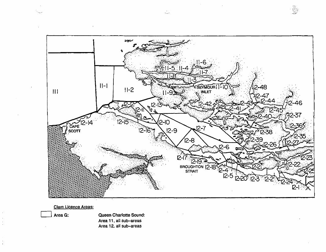
Clam Licence Areas:
o Area G: Queen Charlotte Sound: Area 11, all sub-areas Area 12, all sub-areas

I , .
17-1/
Clam Licence Areas:
o Area E Lower Georgia Strait (PART 1): Area 17 Area 18 Area 19 Area 20 Area 29-5 (ONLy)
.. 14-13
14- I~:
14-1 14-
14-14-
Clam Licence Areas:
D' Area 0: Upper Strait of Georgia: Area 14, all sub-areas, Areas 16-19 and 16-20
.' . " " ..
, .
/:.. ..,
)
Clam Licence Areas:
D Area C (PART 2):
28-29-3
Sunshine Coast (PART 2): Area 28, all sub-areas, Areas 29-1 , 29-2 and 29-3
14 \-~-13
'f~r , J-12
II . <~.
Clam Licence Areas:
o Area C (PART 1): Sunshine Coast (PART 1): Area 15 (NOT including Cortes Island and Twin Islands). Area 16 (NOT including sub-areas 16-19 and 16-20)
-/4
\ /
~::.:.:: ... : ... :; . :
.. ': . . ... . . ' .'
-43 CHANNEL . . . .
-24
3
Clam licence Areas:
o Area B: Johnstone Strait: Area 13, all sub-areas, Portions of Area 15-3 (including all of Cortes Island and Twin Islands).
)
.+. Flshertes and Ocellll
I'tdIoI - NgIon ~ I'II:IIqA PIke 400 - 555 rue ~ OUMI _(c.-a.) vea SG3
NOTICE TO COMMERCIAL CLAM HARVESTERS
ATTACHMENT IV
VANCOUVER -- Commercial clam harvesters, wishing to dig on B.C. oyster farms this year, must first obtain permission from oyster farm operators, the Department of Fisheries and Oceans announced today.
The new regulation, to take effect immediately, is designed to protect fragile oyster beds which will be clearly identified by a series of red-dyed concrete markers on beaches.
OFO reminds clam harvesters that in order to harvest clams commercially in B.C., it is necessary to be in possession of a valid perspnal commercial fishing licence.
Clam beds are subject to closures on short notice because of paralytic shellfish poison (PSP) or sewage contamination and harvesters are advised to chec~ conditions at" the nearest DFO office. .
Recreational harvesters must first obtain permission as well.
Standard Oyster Tenure Markers
FOR MORE INFORMATION: Frances Dickson Fisheries and Oceans 555 W. Hastings Street Vancouver, B.C. V6B 563 666-0519
Canada
....-.=,,;' ' •• aI~",., __ .. _101.........,.
I
-_ .. Iio.-pGOdd_ --"'a"'a14i111C1'.--111 __ .... -_ .. IIO_1n1M .-..... 110._
'-_(100"_
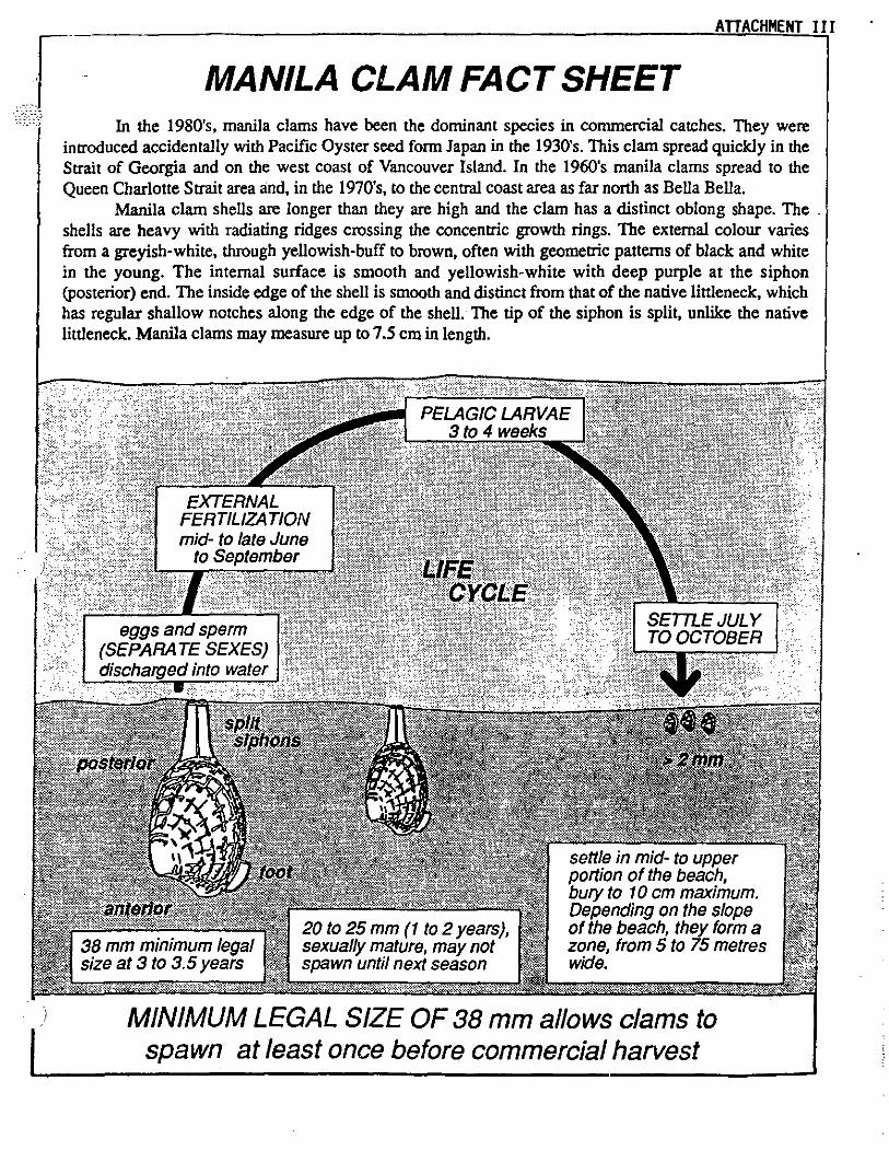
MANILA CLAM FACT SHEET In the 1980's, manila clams have been the dominant species in commercial catches. They were
introduced accidentally with Pacific Oyster seed form Japan in the 1930's. This clam spread quickly in the Strait of Georgia and on the west coast of Vancouver Island. In the 1960's manila clams spread to the Queen Charlotte Strait area and, in the 1970's, to the central coast area as far north as Bella Bella.
Manila clam shells are longer than they are high and the clam has a distinct oblong shape. The . shells are heavy with radiating ridges crossing the concentric growth rings. The external colour varies from a greyish-white, through yellowish-buff to brown, often with geometric patterns of black and white in the young. The internal surface is smooth and yellowish-white with deep purple at the siphon (posterior) end. The inside edge of the shell is smooth and distinct from that of the native littleneck, which has regular shallow notches along the edge of the shell. The tip of the siphon is split, unlike the native littleneck. Manila clams may measure up to 7.5 cm in length.
38 mm minimum legal size at 3 to 3.5 years
20 to 25 mm (1 to 2 years), sexually mature, may not spawn until next season
settle in mid- to upper portion of the beach. bury to 10 cm maximum. Depending on the slope of the beach. they form a zone, from 5 to 75 metres wide.
MINIMUM LEGAL SIZE OF 38 mm allows clams to spawn at least once before commercial harvest

',-_.-
-
AREA F
AREA A
\
Commercial Clam Harvesting - Ucence Areas
A: North Coast B: Johnstone Strait C: Sunshine Coast 0: Upper Strait of Georgia E: Lower Strait of Georgia F: West Coast of Vancouver Island G: Queen Charlotte Sound
",,-~,
• • • .,. . • ... -, ...
f 1 ,e,107 ___ .1\11
~
T
:)i>. 0'
~ ~ Z -t ...... ......
)
":'SALONE
BUTTER CLAM
WEATHERVANE SCALLOP
RAZOR CLAM
LITTLENECK CLAM
PINK (smooth) SCALLOP
MANILA CLAM
SPINY SCALLOP
MINIMUM SIZE LIMITS - MOLLUSCS
ATTACHf4ENT 1


