Embed Size (px)
Citation preview
1 23
Natural HazardsJournal of the International Societyfor the Prevention and Mitigation ofNatural Hazards ISSN 0921-030XVolume 61Number 2 Nat Hazards (2012) 61:337-349DOI 10.1007/s11069-011-9917-2
Paleoseismicity and seismic hazard insouthern Patagonia (Argentina-Chile;50°–55°S) and the role of the Magallanes-Fagnano transform fault
Gustavo González Bonorino, VíctorRinaldi, Liliana del Valle Abascal,Patricia Alvarado, Gustavo G. Bujalesky& Arturo Güell

1 23
Your article is protected by copyright and
all rights are held exclusively by Springer
Science+Business Media B.V.. This e-offprint
is for personal use only and shall not be self-
archived in electronic repositories. If you
wish to self-archive your work, please use the
accepted author’s version for posting to your
own website or your institution’s repository.
You may further deposit the accepted author’s
version on a funder’s repository at a funder’s
request, provided it is not made publicly
available until 12 months after publication.
ORI GIN AL PA PER
Paleoseismicity and seismic hazard in southern Patagonia(Argentina-Chile; 50�–55�S) and the roleof the Magallanes-Fagnano transform fault
Gustavo Gonzalez Bonorino • Vıctor Rinaldi • Liliana del Valle Abascal •
Patricia Alvarado • Gustavo G. Bujalesky • Arturo Guell
Received: 21 July 2010 / Accepted: 25 July 2011 / Published online: 12 August 2011� Springer Science+Business Media B.V. 2011
Abstract Patagonia, including the island of Tierra del Fuego, lies in southernmost South
America at the junction of the South American, Antarctic, and Scotia tectonic plates.
Historical and instrumental records have documented several local earthquakes of dam-
aging magnitude, posing a threat to the rapidly growing population of 300,000 and the
expanding industrial and service infrastructure. Short and inaccurate instrumental records
of local seismic events and a diffuse epicenter distribution not clearly related to the
recognized seismogenic structures have hindered an adequate evaluation of the seismic
hazard for this region. To improve this situation, a paleoseismological study was carried
out on two gravelly strandplains on the Atlantic coast of Patagonia. Surveying combined
ground-probing radar, vertical electric sounding, and seismic refraction. Coseismic normal
faults buried beneath the strandplain bodies were revealed and related to the morphology of
the strandplains. The faults have probable ages between 0.9 and 6.4 kyr BP and a recur-
rence rate of about 1 kyr. The more likely source for these structures is the Magallanes-
Fagnano fault, a continental transform fault that crosses Tierra del Fuego. The distance of
more than 300 km from the buried coseismic structures to the trace of the Magallanes-
Fagnano fault argues for high-magnitude earthquake activity on this fault throughout the
Holocene. Urban development on soft glacial and alluvial substrates increases the hazard.
G. G. Bonorino (&) � G. G. BujaleskyCONICET-CADIC, B Houssay 200, CP9410 Ushuaia, Argentinae-mail: [email protected]
V. RinaldiFacultad de Ciencias Exactas, Universidad Nacional de Cordoba, Av. Velez Sarsfield 1601,CP5000 Cordoba, Argentina
L. del Valle AbascalUTN-FRRG, Islas Malvinas 1650, CP9420 Rio Grande, Argentina
P. Alvarado � A. GuellCONICET-Departamento de Geofisica y Astronomıa, Universidad Nacional de San Juan,Meglioli 1160, CP5406 San Juan, Argentina
123
Nat Hazards (2012) 61:337–349DOI 10.1007/s11069-011-9917-2
Author's personal copy
Keywords Paleoseismology � Seismic hazard � Tierra del Fuego � South America �Coseismic deformation
1 Introduction
Patagonia designates territory in southernmost South America shared by Argentina and
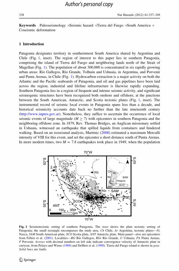
Chile (Fig. 1, inset). The region of interest to this paper lies in southern Patagonia,
comprising the island of Tierra del Fuego and neighboring lands north of the Strait of
Magellan (Fig. 1). The population of about 300,000 is concentrated in six rapidly growing
urban areas: Rıo Gallegos, Rıo Grande, Tolhuin and Ushuaia, in Argentina, and Porvenir
and Punta Arenas, in Chile (Fig. 1). Hydrocarbon extraction is a major activity on both the
Atlantic and the Pacific seaboards of Patagonia, and oil and gas pipelines have been laid
across the region; industrial and lifeline infrastructure is likewise rapidly expanding.
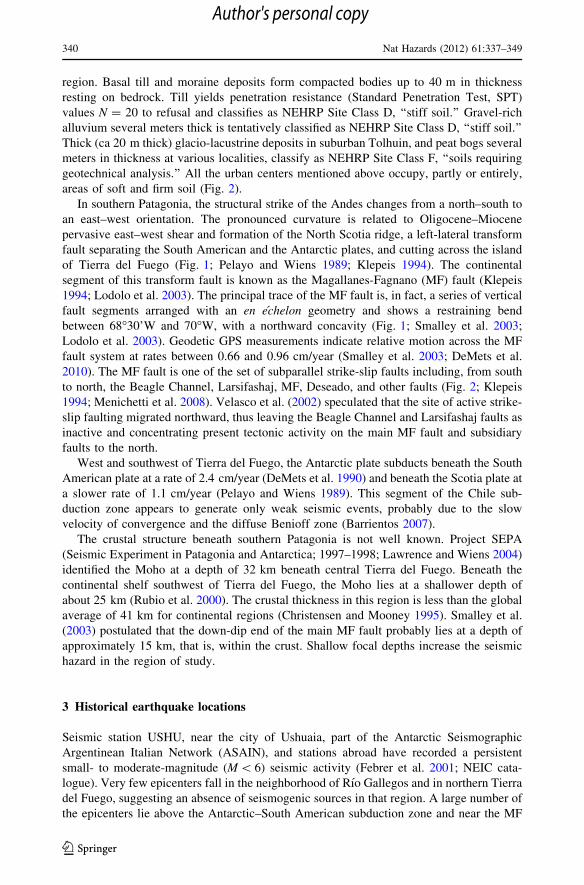
Southern Patagonia lies in a region of frequent and intense seismic activity, and significant
seismogenic structures have been recognized both onshore and offshore, at the junctions
between the South American, Antarctic, and Scotia tectonic plates (Fig. 1, inset). The
instrumental record of seismic local events in Patagonia spans less than a decade, and
historical seismicity accounts date back no further than the late nineteenth century
(http://www.inpres.gov.ar). Nonetheless, they suffice to ascertain the occurrence of local
seismic events of large magnitude (M C 7) with epicenters in southern Patagonia and the
neighboring offshore zone. In 1879, Rev. Thomas Bridges, an Anglican missionary settled
in Ushuaia, witnessed an earthquake that spilled liquids from containers and hindered
walking. Based on an isoseismal analysis, Martinic (2008) estimated a maximum Mercalli
intensity of VIII for this event, and set the epicenter a short distance south of Punta Arenas.
In more modern times, two M = 7.8 earthquakes took place in 1949, when the population
Fig. 1 Seismotectonic setting of southern Patagonia. The inset shows the plate tectonic setting ofPatagonia; the small rectangle encompasses the study area. Ch Chile, Ar Argentina, tectonic plates—NzNazca, SAM South American plate, SCO Scotia plate, ANT Antarctic plate. Main panel—dots are epicentersfrom Febrer et al. (2001). Localities—RG Rıo Gallegos, RGr Rıo Grande, U Ushuaia, PA Punta Arenas,P Porvenir. Arrows with decimal numbers on left side indicate convergence velocity of Antarctic plate incm/year, from Pelayo and Wiens (1989) and DeMets et al. (1990). Tierra del Fuego island is shown in gray.Solid lines are faults
338 Nat Hazards (2012) 61:337–349
123
Author's personal copy
in southern Patagonia was one-twentieth of that at present, and industrial and lifeline
infrastructure was virtually non-existent. Thus, despite the high energy released by these
crustal earthquakes, only moderate damage and minor human casualties were observed. At
present, a similar magnitude earthquake could result in severe consequences if an adequate
earthquake hazard evaluation is not considered in engineering designs.
In view of the shortage of information on the seismic nature of southern Patagonia,
paleoseismology is an appealing resource for improving the estimate of the local seismic
hazard (Abascal and Gonzalez-Bonorino 2008). This paper gives evidence for coseismic
faulting in southern Patagonia and relates it to seismic hazard in the island of Tierra del
Fuego. Exploration for coseismic structures centers on two strandplains on the Atlantic
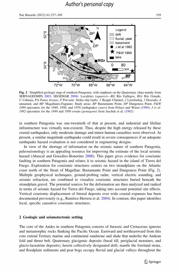
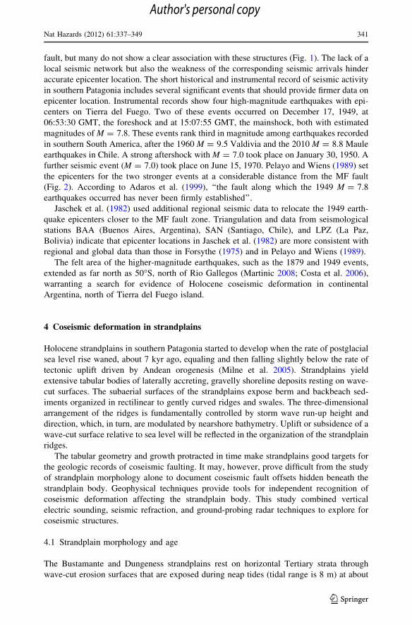
coast north of the Strait of Magellan: Bustamante Point and Dungeness Point (Fig. 2).
Multiple geophysical techniques, ground-probing radar, vertical electric sounding, and
seismic refraction, are combined to visualize coseismic structures buried beneath the
strandplain gravel. The potential sources for the deformation are then analyzed and ranked
in terms of seismic hazard for Tierra del Fuego, taking into account potential site effects.
Vertical coseismic displacement of littoral deposits over wide coastal expanses has been
documented previously (e.g., Ramırez-Herrera et al. 2004). In contrast, this paper identifies
local, specific causative coseismic structures.
2 Geologic and seismotectonic setting
The core of the Andes in southern Patagonia consists of Jurassic and Cretaceous igneous
and metamorphic rocks flanking the Pacific Ocean. Eastward and northeastward from this
core extend Tertiary marine and continental sandstone and shale that underlie the Andean
fold and thrust belt. Quaternary glacigenic deposits (basal till, periglacial moraines, and
glacio-lacustrine deposits), herein collectively designated drift, mantle the foreland strata,
and floodplain sediments and peat bogs occupy fluvial and glacial valleys throughout the
Fig. 2 Simplified geologic map of southern Patagonia, with emphasis on the Quaternary (data mainly fromSERNAGEOMIN 2003; SEGEMAR 2004). Localities (squares)—RG Rıo Gallegos, RGr Rıo Grande,U Ushuaia, PA Punta Arenas, P Porvenir. Strike-slip faults: 1 Beagle Channel, 2 Larsifashaj, 3 Deseado, 4unnamed, and MF Magallanes-Fagnano. Study areas: BP Bustamante Point, DP Dungeness Point. P&W1989 epicenters for the 1949, 1950, and 1970 earthquakes (stars) from Pelayo and Wiens (1989); J et al.1982 epicenters for the 1949 and 1950 events (pentagons) from Jaschek et al. (1982)
Nat Hazards (2012) 61:337–349 339
123
Author's personal copy
region. Basal till and moraine deposits form compacted bodies up to 40 m in thickness
resting on bedrock. Till yields penetration resistance (Standard Penetration Test, SPT)
values N = 20 to refusal and classifies as NEHRP Site Class D, ‘‘stiff soil.’’ Gravel-rich
alluvium several meters thick is tentatively classified as NEHRP Site Class D, ‘‘stiff soil.’’
Thick (ca 20 m thick) glacio-lacustrine deposits in suburban Tolhuin, and peat bogs several
meters in thickness at various localities, classify as NEHRP Site Class F, ‘‘soils requiring
geotechnical analysis.’’ All the urban centers mentioned above occupy, partly or entirely,
areas of soft and firm soil (Fig. 2).
In southern Patagonia, the structural strike of the Andes changes from a north–south to
an east–west orientation. The pronounced curvature is related to Oligocene–Miocene
pervasive east–west shear and formation of the North Scotia ridge, a left-lateral transform
fault separating the South American and the Antarctic plates, and cutting across the island
of Tierra del Fuego (Fig. 1; Pelayo and Wiens 1989; Klepeis 1994). The continental
segment of this transform fault is known as the Magallanes-Fagnano (MF) fault (Klepeis
1994; Lodolo et al. 2003). The principal trace of the MF fault is, in fact, a series of vertical
fault segments arranged with an en echelon geometry and shows a restraining bend
between 68�30’W and 70�W, with a northward concavity (Fig. 1; Smalley et al. 2003;
Lodolo et al. 2003). Geodetic GPS measurements indicate relative motion across the MF
fault system at rates between 0.66 and 0.96 cm/year (Smalley et al. 2003; DeMets et al.
2010). The MF fault is one of the set of subparallel strike-slip faults including, from south
to north, the Beagle Channel, Larsifashaj, MF, Deseado, and other faults (Fig. 2; Klepeis
1994; Menichetti et al. 2008). Velasco et al. (2002) speculated that the site of active strike-
slip faulting migrated northward, thus leaving the Beagle Channel and Larsifashaj faults as
inactive and concentrating present tectonic activity on the main MF fault and subsidiary
faults to the north.
West and southwest of Tierra del Fuego, the Antarctic plate subducts beneath the South
American plate at a rate of 2.4 cm/year (DeMets et al. 1990) and beneath the Scotia plate at
a slower rate of 1.1 cm/year (Pelayo and Wiens 1989). This segment of the Chile sub-
duction zone appears to generate only weak seismic events, probably due to the slow
velocity of convergence and the diffuse Benioff zone (Barrientos 2007).
The crustal structure beneath southern Patagonia is not well known. Project SEPA
(Seismic Experiment in Patagonia and Antarctica; 1997–1998; Lawrence and Wiens 2004)
identified the Moho at a depth of 32 km beneath central Tierra del Fuego. Beneath the
continental shelf southwest of Tierra del Fuego, the Moho lies at a shallower depth of
about 25 km (Rubio et al. 2000). The crustal thickness in this region is less than the global
average of 41 km for continental regions (Christensen and Mooney 1995). Smalley et al.
(2003) postulated that the down-dip end of the main MF fault probably lies at a depth of
approximately 15 km, that is, within the crust. Shallow focal depths increase the seismic
hazard in the region of study.
3 Historical earthquake locations
Seismic station USHU, near the city of Ushuaia, part of the Antarctic Seismographic
Argentinean Italian Network (ASAIN), and stations abroad have recorded a persistent
small- to moderate-magnitude (M \ 6) seismic activity (Febrer et al. 2001; NEIC cata-
logue). Very few epicenters fall in the neighborhood of Rıo Gallegos and in northern Tierra
del Fuego, suggesting an absence of seismogenic sources in that region. A large number of
the epicenters lie above the Antarctic–South American subduction zone and near the MF
340 Nat Hazards (2012) 61:337–349
123
Author's personal copy
fault, but many do not show a clear association with these structures (Fig. 1). The lack of a
local seismic network but also the weakness of the corresponding seismic arrivals hinder
accurate epicenter location. The short historical and instrumental record of seismic activity
in southern Patagonia includes several significant events that should provide firmer data on
epicenter location. Instrumental records show four high-magnitude earthquakes with epi-
centers on Tierra del Fuego. Two of these events occurred on December 17, 1949, at
06:53:30 GMT, the foreshock and at 15:07:55 GMT, the mainshock, both with estimated
magnitudes of M = 7.8. These events rank third in magnitude among earthquakes recorded
in southern South America, after the 1960 M = 9.5 Valdivia and the 2010 M = 8.8 Maule
earthquakes in Chile. A strong aftershock with M = 7.0 took place on January 30, 1950. A
further seismic event (M = 7.0) took place on June 15, 1970. Pelayo and Wiens (1989) set
the epicenters for the two stronger events at a considerable distance from the MF fault
(Fig. 2). According to Adaros et al. (1999), ‘‘the fault along which the 1949 M = 7.8
earthquakes occurred has never been firmly established’’.
Jaschek et al. (1982) used additional regional seismic data to relocate the 1949 earth-
quake epicenters closer to the MF fault zone. Triangulation and data from seismological
stations BAA (Buenos Aires, Argentina), SAN (Santiago, Chile), and LPZ (La Paz,
Bolivia) indicate that epicenter locations in Jaschek et al. (1982) are more consistent with
regional and global data than those in Forsythe (1975) and in Pelayo and Wiens (1989).
The felt area of the higher-magnitude earthquakes, such as the 1879 and 1949 events,
extended as far north as 50�S, north of Rio Gallegos (Martinic 2008; Costa et al. 2006),
warranting a search for evidence of Holocene coseismic deformation in continental
Argentina, north of Tierra del Fuego island.
4 Coseismic deformation in strandplains
Holocene strandplains in southern Patagonia started to develop when the rate of postglacial
sea level rise waned, about 7 kyr ago, equaling and then falling slightly below the rate of
tectonic uplift driven by Andean orogenesis (Milne et al. 2005). Strandplains yield
extensive tabular bodies of laterally accreting, gravelly shoreline deposits resting on wave-
cut surfaces. The subaerial surfaces of the strandplains expose berm and backbeach sed-
iments organized in rectilinear to gently curved ridges and swales. The three-dimensional
arrangement of the ridges is fundamentally controlled by storm wave run-up height and
direction, which, in turn, are modulated by nearshore bathymetry. Uplift or subsidence of a
wave-cut surface relative to sea level will be reflected in the organization of the strandplain
ridges.
The tabular geometry and growth protracted in time make strandplains good targets for
the geologic records of coseismic faulting. It may, however, prove difficult from the study
of strandplain morphology alone to document coseismic fault offsets hidden beneath the
strandplain body. Geophysical techniques provide tools for independent recognition of
coseismic deformation affecting the strandplain body. This study combined vertical
electric sounding, seismic refraction, and ground-probing radar techniques to explore for
coseismic structures.
4.1 Strandplain morphology and age
The Bustamante and Dungeness strandplains rest on horizontal Tertiary strata through
wave-cut erosion surfaces that are exposed during neap tides (tidal range is 8 m) at about
Nat Hazards (2012) 61:337–349 341
123
Author's personal copy
12–13 m below the top of the strandplains (Gonzalez Bonorino et al. 1999). Both
strandplains are attached to paleocliffs carved in Quaternary glacial drift and Tertiary
shallow marine deposits and show a consistent drop in average elevation by about 3–4 m,
in the younging direction, reflecting a fall in relative sea level attributed to Andean tec-
tonics (Bujalesky 2007).
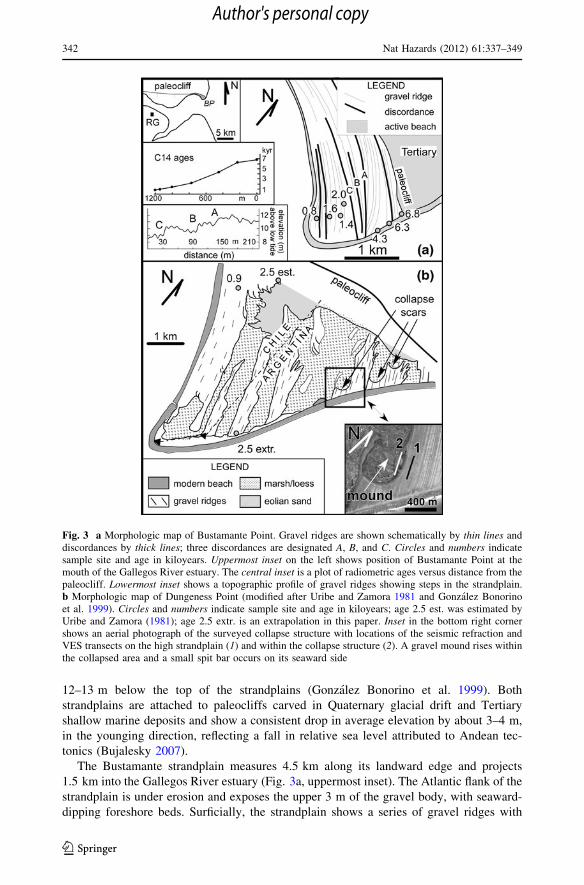
The Bustamante strandplain measures 4.5 km along its landward edge and projects
1.5 km into the Gallegos River estuary (Fig. 3a, uppermost inset). The Atlantic flank of the
strandplain is under erosion and exposes the upper 3 m of the gravel body, with seaward-
dipping foreshore beds. Surficially, the strandplain shows a series of gravel ridges with
Fig. 3 a Morphologic map of Bustamante Point. Gravel ridges are shown schematically by thin lines anddiscordances by thick lines; three discordances are designated A, B, and C. Circles and numbers indicatesample site and age in kiloyears. Uppermost inset on the left shows position of Bustamante Point at themouth of the Gallegos River estuary. The central inset is a plot of radiometric ages versus distance from thepaleocliff. Lowermost inset shows a topographic profile of gravel ridges showing steps in the strandplain.b Morphologic map of Dungeness Point (modified after Uribe and Zamora 1981 and Gonzalez Bonorinoet al. 1999). Circles and numbers indicate sample site and age in kiloyears; age 2.5 est. was estimated byUribe and Zamora (1981); age 2.5 extr. is an extrapolation in this paper. Inset in the bottom right cornershows an aerial photograph of the surveyed collapse structure with locations of the seismic refraction andVES transects on the high strandplain (1) and within the collapse structure (2). A gravel mound rises withinthe collapsed area and a small spit bar occurs on its seaward side
342 Nat Hazards (2012) 61:337–349
123
Author's personal copy
mean amplitude of 0.26 cm (crest to trough) organized in about half-dozen bundles sep-
arated by discordances, or abrupt changes in average crest trend in plan view. These
discordances reflect major hydraulic reorganizations. In most cases, discordances are
associated with marked drops in elevation of the gravel platform by 0.5–0.7 m, that is,
more than twice the average ridge amplitude, with the younger ridges on the downthrown
side (Fig. 3a, lowermost inset). Radiocarbon ages were obtained from fossil shelly fauna
(Mytilus sp.; mussel) buried in the strandplain gravel. The reservoir effect was partially
compensated for by analyzing the carbon content in living Mytilus sp. The ages indicate
that growth of the platform started at about 7 kyr BP and progressed to the present with
an approximately linear trend (Fig. 3a, central inset; E. Linares 1996; written
communication).
Dungeness Point (so named by eighteenth century sailors to acknowledge morpholog-
ical similarities with Dungeness Spit in England) measures 8 km along the landward side
and projects 7 km into the Strait of Magellan (Fig. 3b). The strandplain shows bundles of
gravel ridges separated by intercalations of marsh deposits (Fig. 3b; Uribe and Zamora
1981). Semicircular scars dissect several of the older gravel bundles (Fig. 3b, inset;
Gonzalez Bonorino et al. 1999). Across each scar, the ground falls abruptly by several
meters and then rises into a central mound whose summit lies below the top of the
strandplain. The low ground between the high strandplain and the mound is filled with
marsh deposits; the mound crest consists of gravel finer than that in the ridge crests in the
strandplain. From the Chilean sector of Dungeness Point, Uribe and Zamora (1981)
reported a radiocarbon age of 0.9 kyr BP on cetacean remains and estimated an age of
2.5 kyr BP for the oldest beach ridges (Fig. 3b). Herein, this age was visually extrapolated
to the Argentine sector (Fig. 3b).
4.2 Geophysical surveys
Geophysical work was carried out at two sites: (a) a prominent discordance (discordance A
in Fig. 3a) and associated drop in strandplain elevation at Bustamante Point and (b) a
collapse structure at Dungeness Point (Fig. 3b). Shallow seismic refraction was performed
using a 12-geophone line connected to a Geometrics seismograph. Seismic energy was
generated by the impact of a 7-kilogram hammer. The low energy applied limited the
length of the line deployment to 50 m and, accordingly, the investigation depth. No
explosives were allowed due to environmental concerns. Data interpretation was per-
formed following the simple reciprocal method (Palmer 1980). The vertical electrical
soundings (VES) were performed by the means of a 300 W MP Argentine resistivity
meter. Current electrodes (AB) were opened up to a maximum of one hundred meters. The
Schlumberger configuration was used in conjunction with specific software for electrical
data interpretation. A detailed description of the method can be found elsewhere (e.g.,
Sharma 1986; US Army Corps of Engineers 1995). Finally, the subsurface interface radar
system SIR2000, manufactured by Geophysical Survey System Inc (GSSI) was used with a
shielded antenna having a central frequency of 200 MHz. Procedures for the design of the
GPR survey and data processing can be found in Annan (1992).
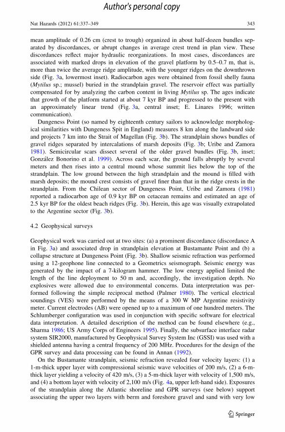
On the Bustamante strandplain, seismic refraction revealed four velocity layers: (1) a
1-m-thick upper layer with compressional seismic wave velocities of 200 m/s, (2) a 6-m-
thick layer yielding a velocity of 420 m/s, (3) a 5-m-thick layer with velocity of 1,500 m/s,
and (4) a bottom layer with velocity of 2,100 m/s (Fig. 4a, upper left-hand side). Exposures
of the strandplain along the Atlantic shoreline and GPR surveys (see below) support
associating the upper two layers with berm and foreshore gravel and sand with very low
Nat Hazards (2012) 61:337–349 343
123
Author's personal copy
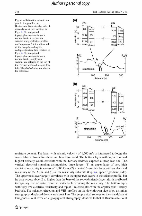
moisture content. The layer with seismic velocity of 1,500 m/s is interpreted to lodge the
water table in lower foreshore and beach toe sand. The bottom layer with top at 0 m and
highest velocity would correlate with the Tertiary bedrock exposed at neap low tide. The
vertical electrical sounding distinguished three layers: (1) an upper layer of very high
electrical resistivity in excess of 1,000 X-m, (2) a central 5-m-thick layer with an electrical
resistivity of 550 X-m, and (3) a low resistivity substrate (Fig. 4a, upper right-hand side).
The uppermost layer largely correlates with the upper two layers in the seismic profile, but
its base occurs about 2 m higher than the base of the second seismic layer; this is attributed
to capillary rise of water from the water table reducing the resistivity. The bottom layer
with very low electrical resistivity and top at 0 m correlates with the argillaceous Tertiary
bedrock. The seismic refraction and VES profiles on the downthrown side show a similar
stratigraphy, displaced downward about 1 m. The geophysical surveys on the strandplain at
Dungeness Point revealed a geophysical stratigraphy identical to that at Bustamante Point
Fig. 4 a Refraction seismic andgeoelectric profiles onBustamante Point at either side ofdiscordance A (see location inFigs. 2, 3). Interpretedtopographic section shows anormal fault. b Refractionseismic and geoelectric profileson Dungeness Point at either sideof the scarp bounding thecollapse structure (see location inFigs. 2, 3). Interpretedtopographic section shows anormal fault. Geophysicalsections are referred to the top ofthe Tertiary exposed at neap lowtide. The dashed lines are drawnfor reference
344 Nat Hazards (2012) 61:337–349
123
Author's personal copy
and are similarly interpreted (Fig. 4b). On the downthrown side, the seismic refraction and
VES profiles suggest downward displacement by about 4 m.
The GPR surveys transverse to ridge crests at Bustamante Point and at Dungeness Point
away from the circular collapse structure show the typical rhythmic foreset architecture of
foreshore facies. At Dungeness Point, two perpendicular GPR profiles were surveyed
across the gravel mound within the collapse structure to determine if the mound is a
displaced, unbroken fragment of the strandplain. The profiles show horizontal instead of
inclined beach foreset layering, suggesting that the gravel underlying the central mounds
has been completely reworked by wave action from slumped strandplain gravel. The depth
of penetration of radar signals was limited to the top of the water table, that is, about
4–5 m, and thus did not reach the top of the Tertiary deposits.
5 Discussion
5.1 Coseismic deformation
The apparent absence of major seismogenic sources in northern Tierra del Fuego and lands
immediately north of the Strait of Magellan, and the relocation of the epicenters for the
1,949 events along the MF fault system allow the inference that this was the more likely
source for the large-magnitude seismic events recorded in the study area. This conclusion
resolves the doubts posed by Adaros et al. (1999) regarding the dominant seismogenic
structure.
The structures affecting the Tertiary substrate at Bustamante and Dungeness Points are
interpreted as normal faults. At Bustamante Point, the downstepping of the strandplain is
linked indirectly to coseismic faulting of the Tertiary substrate. Faulting must have pre-
ceded strandplain accretion over that site. This conclusion is based on two observations.
One is that faulting through an overlying strandplain would have truncated some of the
curved ridges. The second is that the discordance associated with the fault shows a
southwestward concavity roughly parallel to all the ridges and that it dies out inland, which
suggests that it developed under the influence of wave action. It is uncertain, however, how
much earlier faulting was relative to the discordance. The high-energy wave regime and
heavy sand/gravel bedload give rise to strongly abrasive littoral currents. A 10-year control
on cliff recession at Dungeness Point indicated an average rate of cliff retreat of 1 m/year.
For Bustamante Point, a similar long-term value can be obtained from the 5- to 7-km cliff
retreat in, approximately, the past 7 ka. A submerged fault scarp in Tertiary beds subjected
to such hydraulic conditions probably would be beveled in a few decades. Mathematical
modeling by Trenhaile (2000) showed that intertidal topographic ledges in wave-cut
platforms tend to be planed out by wave action.
The collapse structure surveyed at Dungeness Point is associated with a 4 m downthrow
of the top of the Tertiary substrate. Seismic shaking could have mobilized saturated
strandplain sand and gravel resting on the Tertiary substrate (Fig. 3b), but such movement
would not have affected the Tertiary basement significantly. It is inferred from this that
collapse occurred in response to deep-seated faulting.
5.2 Recurrence interval
Arguments above suggest that the age of the fault beneath discordance A at Bustamante
Point is similar to the age of the ridges that cover it, that is, approximately 3.9 kyr BP
Nat Hazards (2012) 61:337–349 345
123
Author's personal copy
(Fig. 3a, linear interpolation). Assuming that the other five discordances are underlain by
faults and assigning approximate ages to these faults on the basis of overlying ridge ages,
the Tertiary substrate at Bustamante Point would have been affected by faulting a mini-
mum of six times, with approximate ages of 0.9, 1.3, 2.4, 3.0, 3.9, and 6.4 kyr BP, giving
an average recurrence interval of about 0.9 kyr.
At Dungeness Point, three collapse structures affect the strandplain deposits with ages
between, approximately, 7 and 5 kyr BP (Fig. 3b, linear interpolation), with average
recurrence rate of 0.7 kyr. These estimates agree with recurrence intervals of damaging
earthquakes along the MF fault. Smalley et al. (2003) estimated a recurrence period of
750 years for a M = 7.8 earthquake, based on the slip rate of the MF fault, and Waldmann
(2008) estimated a recurrence rate of 800–1,000 years for slumps in Lake Fagnano, which
he attributed to high-intensity seismic activity on the MF fault system.
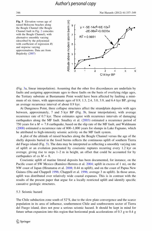
A plot of the altitude of raised beaches along the Beagle Channel versus the age of the
shelly deposits buried in the fossil berms reflects the continuous uplift of southern Tierra
del Fuego island (Fig. 5). The data may be interpreted as reflecting a smoothly varying rate
of uplift or an evolution punctuated by coseismic ruptures recurring every 1.2 kyr on
average, giving rise to steps 1–2 m in height, an offset that could be accounted for by
earthquakes of ca M = 8.
Coseismic uplift of marine littoral deposits has been documented, for instance, on the
Pacific coast of SW Mexico (Ramırez-Herrera et al. 2004; uplift in excess of 1 m), on the
NW coast of Japan (Hiramatsu et al. 2008; 0.44 m uplift), and on the coast of Papua New
Guinea (Ota and Chappell 1996; Chappell et al. 1996; average 3 m uplift). In those areas,
uplift was distributed over relatively wide coastal expanses. This is in contrast with the
results of the present paper that argue for a locally restricted uplift and identify specific
causative geologic structures.
5.3 Seismic hazard
The Chile subduction zone south of 52�S, due to the slow plate convergence and the scarce
population in its area of influence, southernmost Chile and southwestern sector of Tierra
del Fuego island, does not pose a serious seismic hazard. It should be kept in mind for
future urban expansion into this region that horizontal peak accelerations of 0.3 g to 0.4 g
Fig. 5 Elevation versus age ofraised Holocene beaches alongthe Beagle Channel (the BeagleChannel fault in Fig. 2 coincideswith the Beagle Channel), withalternative smoothly varying(described by the polynomialwith coefficient of regression R)and stepwise varyingapproximations. Data are fromBujalesky (2007)
346 Nat Hazards (2012) 61:337–349
123
Author's personal copy
have a 10% probability of being exceeded in 50 years (Martin 1990; Algermissen et al.
1992).
The 1949 and 1950 seismic events occurred sequentially from ESE to WNW, sug-
gesting fracture propagation in the sense of relative movement of the South American
plate. The epicenters for the 1949 mainshock and foreshock lay about 130 km apart, and
those for the 1950 and the 1949 mainshock lay about 230 km apart. The distance between
epicenters may reflect segmentation of the main MF fault. Assuming that each epicenter
marks the beginning of an asymmetric rupture zone with rupture lengths comparable to
epicenter separation, empirical seismic parameter relationships by Wells and Coppersmith
(1994) indicate that the estimated rupture lengths could have been associated with mag-
nitude 7.5–8.0 earthquakes, in agreement with earthquake magnitudes recorded for the MF
fault system. Coseismic faulting at distances of 300–400 km from the MF fault suggests
the occurrence of earthquakes with magnitudes close to 8 along the MF fault in the
Holocene. The 1949 and 1950 seismic events originated along the restraining bend of the
MF fault, allowing the inference that this segment poses the higher threat to the population
of Tierra del Fuego.
The minimum distances between the MF fault and the urban centers of interest to this
paper range from less than 1 km (Tolhuin) to almost 100 km (Porvenir). Depending on the
chosen attenuation relationship, a magnitude M = 8 seismic event would cause a hori-
zontal PGA of approximately 0.3 g (Martin 1990) or 0.11 g (Campbell 1997), at 100 km
from the epicenter. The effect may be enhanced by the fact that hypocenters are mainly
shallow (Smalley et al. 2003; Buffoni et al. 2009) and also by site amplification of seismic
vibrations in areas of soft substrate, particularly in view that all urban centers in Tierra del
Fuego have developed, at least in part, on drift and alluvial sediments. Modeling with
EERA (Equivalent-linear Earthquake site Response Analyses of Layered Soil Deposits;
Bardet et al. 2000) software was carried out on the glacial substrate of Tolhuin urbani-
zation. A 15-m-thick lacustrine clay interval showed potential to amplify seismic waves by
a factor of 1.5 (shear modulus and damping for intermediate plasticity clay were
stipulated).
6 Conclusions
The epicenters for the four major (M C 7) instrumentally recorded earthquakes in Tierra
del Fuego occurred on the MF fault, or nearby associated faults, indicating that this is the
main seismogenic source in Tierra del Fuego. In the absence of a known seismogenic
structure closer to the Bustamante and Dungeness Points, it is herein assumed that faults
affecting those strandplains resulted from seismic events along the MF fault. A Holocene
recurrence interval of about 1,000 years for damaging earthquakes on the MF fault
appears well supported by data in this paper and in previous publications. This is in
agreement with observations from Costa et al. (2006) showing that the MF fault system
was active during the growth of the Bustamante and Dungeness strandplains in the late
Holocene. Thus, the MF fault system shows an historic and a prehistoric record of
potentially damaging earthquakes that make it the main source of seismic hazard for
Tierra del Fuego. Our work provides a framework for progress in estimating the dis-
tribution of hazard along the trace of the MF fault. Further geophysical and seismo-
logical work is needed for a better characterization of the historical and modern seismic
sources.
Nat Hazards (2012) 61:337–349 347
123
Author's personal copy
Acknowledgments This work was funded by the Spanish Ministry of Education and the ‘‘Programa deCooperacion con Iberoamerica’’ of the ‘‘Grup de Qualitat de la Generalitat de Catalunya (GRQ94-1048)’’,Spain, and by the Ministry of Science of Argentina (PICT 32793). Radiocarbon analyses were carried out atthe INGEIS-UBA-CONICET laboratory. We acknowledge helpful revisions by reviewers for the Journal.
References
Abascal L del V, Gonzalez-Bonorino G (2008) Seismic risk associated with the Magallanes-Fagnanocontinental transform fault, Tierra del Fuego, Southern Argentina. 7th International Symposium onAndean geodynamics (ISAG 2008, Nice), Extended Abstracts, pp 13–16
Adaros RE, Wiens DA, Vera EE, Shore PJ (1999) Seismicity and tectonics of southern Patagonia from alocal deployment of seismographs: preliminary results. AEO, 80, Fall Meeting, Suppl, AbstractA52A-05
Algermissen ST, Kausel E, Hanson S, Thenhaus PC (1992) Earthquake hazard in Chile. Revista Geofisica37:195–218
Annan AP (1992) Ground penetrating radar. Workshop Notes Sensors & Software, Mississauga, p 135Bardet JP, Ichii K, Lin CH (2000) EERA—a computer program for equivalent-linear earthquake site
response analyses of layered soil deposits. Department of Civil Engineering, University of California,California
Barrientos SE (2007) Earthquakes in Chile. In: Moreno T, Gibbons W (eds) The geology of Chile. TheGeological Society of London, London, pp 263–289
Buffoni C, Sabbione NC, Connon G, Hormaechea JL (2009) Localizacion de hipocentros y determinacionde su magnitud en Tierra del Fuego y zonas aledanas. Geoacta 34:75–86 Buenos Aires
Bujalesky GG (2007) Coastal geomorphology and evolution of Tierra del Fuego (southern Argentina).Geologica Acta 5:337–362
Campbell KW (1997) Empirical near-source attenuation relationships for horizontal and vertical compo-nents of peak ground acceleration, peak ground velocity, and pseudo-absolute acceleration responsespectra. Seismological Res Lett 68:154–189
Chappell J, Ota Y, Berryman K (1996) Late quaternary coseismic uplift history of Huon Peninsula, PapuaNew Guinea. Quat Sci Rev 15:7–22
Christensen N, Mooney W (1995) Seismic velocity structure and composition of the continental crust: aglobal view. J Geophys Res 100(B7):9761–9788
Costa CH, Smalley R, Schwartz D, Stenner H, Ellis M, Ahumada E, Velasco M-S (2006) Paleoseismicobservations of an onshore transform boundary: the Magallanes-Fagnano fault, Tierra del Fuego,Argentina. Rev Asoc Geol Argent 61:647–657
DeMets C, Gordon RG, Argus DF, Stein S (1990) Current plate motions. Geophys J Int 10:425–478DeMets C, Gordon RG, Argus DF (2010) Geologically current plate motions. Geophys J Int 181:1–80. doi:
10.1111/j.1365-246X.2009.04491.xFebrer JM, Plasencia MP, Sabbione NC (2001) Local and regional seismicity from Ushuaia broadband
station observations (Tierra del Fuego). Terra Antartica 8:35–40Forsythe DW (1975) Fault plane solutions and tectonics of the South Atlantic and Scotia Sea. J Geophys Res
80:1429–1443Gonzalez Bonorino G, Bujalesky G, Colombo F, Ferrero M (1999) Holocene coastal paleoenvironments in
Atlantic Patagonia, Argentina. J South Am Earth Sci 12:325–331Hiramatsu Y, Moriya K, Kamiya T, Kato M, Nishimura T (2008) Fault model of the 2007 Noto Hanto
earthquake estimated from coseismic deformation obtained by the distribution of littoral organisms andGPS: implication for neotectonics in the northwestern Noto Peninsula. Earth Planet Space 60:903–913
Jaschek E, Sabbione N, Sierra P (1982) Reubicacion de sismos localizados en territorio argentino(1920–1963). Observatorio Astronomico de la Universidad Nacional de La Plata Serie Geofısica,Tomo XI, No 1
Klepeis K (1994) The Magallanes and Deseado fault zones: major segments of the South American-Scotiatransform plate boundary in southernmost South America, Tierra del Fuego. J Geophys Res99:22001–22014
Lawrence JF, Wiens DA (2004) Combined receiver-function and surface wave phase-velocity inversionusing a niching genetic algorithm: application to patagonia. Bull Seismol Soc Am 94:977–987
Lodolo E, Menichetti M, Bartole R, Ben-Avraham Z, Tassone A, Lippai H (2003) Magallanes-Fagnanocontinental transform fault (Tierra del Fuego, southernmost South America). Tectonics 22:15-1-15-26.doi:10.1029/2003TC0901500
348 Nat Hazards (2012) 61:337–349
123
Author's personal copy
Martin A (1990) Hacia una regionalizacion y calculo de peligro sısmico en Chile. Dissertation, Universidadde Chile, Santiago
Martinic M (2008) Registro historico de antecedentes volcanicos y sısmicos en la Patagonia austral y laTierra del Fuego. Magallania 36:5–18
Menichetti M, Lodolo E, Tassone A (2008) Structural geology of the Fueguian Andes and Magallanes fold-and-thrust belt–Tierra del Fuego island. Geologica Acta 6:19–42
Milne GA, Antony J, Long AJ, Bassett SE (2005) Modelling Holocene relative sea-level observations fromthe Caribbean and South America. Quat Sci Rev 24:1183–1202
Ota Y, Chappell J (1996) Late quaternary coseismic uplift events on the Huon Peninsula, Papua NewGuinea, deduced from coral terrace data. J Geophys Res 101(B3):6071–6082
Palmer D (1980) The generalized reciprocal method of seismic refraction interpretation. Society ofExploration Geophysics, Tulsa, p 104
Pelayo A, Wiens D (1989) Seismotectonics and relative plate motions in the Scotia sea region. J GeophysRes 94:7293–7320
Ramırez-Herrera MT, Kostoglodov V, Urrutia-Fucugauchi J (2004) Holocene-emerged notches and tectonicuplift along the Jalisco coast, Southwest Mexico. Geomorphology 58:291–304
Rubio E, Torne M, Vera E, Dıaz A (2000) Crustal structure of the southernmost Chilean margin fromseismic and gravity data. Tectonophysics 323:39–60
SEGEMAR (2004) Mapa Geologico de Tierra del Fuego. Servicio Geologico-Minero de Argentina, BuenosAires Unpublished
SERNAGEOMIN (2003) Mapa Geologico de Chile. Servicio Nacional de Geologıa y Minerıa de Chile,Santiago, Publicacion Geologica Digital, no 3
Sharma PV (1986) Geophysical methods in geology, 2nd edn. Elsevier, NYSmalley R Jr, Kendrick E, Bevis M, Dalziel I, Taylor F, Laurıa E, Barriga R, Casassa G, Olivero E, Piana E
(2003) Geodetic determination of relative plate motion and crustal deformation across the Scotia-SouthAmerica plate boundary in eastern Tierra del Fuego. Geochem Geophy Geosyst 4:1070. doi:101029/2002GC000446
Trenhaile AS (2000) Modeling the development of wave-cut shore platforms. Marine Geol 166:163–178Uribe P, Zamora E (1981) Origen y geomorfologıa de la Punta Dungeness, Patagonia. Anales Inst de la
Patagonia 12:143–158 Punta ArenasUS Army Corps of Engineers (1995) Geophysical exploration for engineering and environmental investi-
gations. Em 1110-1-1802, Washington, DCVelasco MS, Ellis M, Smalley R Jr (2002) Active faulting in southern Tierra del Fuego. Seismol Res Lett
73:419Waldmann N (2008) Late Quaternary environmental changes in Lago Fagnano, Tierra del Fuego (54�S):
reconstructing sedimentary processes, natural hazards and paleoclimate. Universite de Geneve, TheseNo 4044, p 149
Wells DL, Coppersmith KJ (1994) New empirical relationships among magnitude, rupture length, rupturewidth, rupture area, and surface displacement. Bull Seismol Soc Am 84:974–1002
Nat Hazards (2012) 61:337–349 349
123
Author's personal copy


