Embed Size (px)
Citation preview
ELSEVIER Tectonophysics 308 (1999) 23–35www.elsevier.com/locate/tecto
Neotectonic and paleoseismicity studies on the Urumaco Fault,northern Falcon Basin, northwestern Venezuela
Franck A. Audemard a,Ł, Jean-Claude Bousquet b, Jose A. Rodrıguez c,1
a Funvisis, Apartado postal 76880, Caracas 1070-A, Venezuelab Laboratoire de Tectonophysique, Universite Montpellier II, Montpellier, cedex 5, France
c Litos C.A., Caracas, Venezuela
Received 10 March 1998; accepted 2 December 1998
Abstract
The northern Falcon Basin in northwestern Venezuela is affected by several small active faults, subordinated tothe major right-lateral east–west-trending Oca–Ancon Fault System. A set of prominent NW–SE right-lateral faults —synthetic shears — such as the Urumaco, Rıo Seco, Lagarto and La Soledad faults, stands out among those. The UrumacoFault, located between the Lagarto and Mitare rivers (in the Urumaco Trough, west of Coro), presents a rather complexactive fault trace that comprises two NW–SE fault segments linked by an ENE–WSW reverse echelon, all showing arestraining stepover geometry. Its western segment seems to continue to the north at sea. Conversely, the eastern one diesout on land and its northern tip ends in a transtensive horse-tail structure, that disrupts an Early Pleistocene conglomerate.This same unit is flexed and upheaved some 30 m at the restraining overlap. The kinematics and present stress tensor,the latest activity and the seismogenic potential of the eastern segment of the Urumaco Fault, have been assessed at a setof three river cuts of an ephemeral tributary stream of the Urumaco River, 3 km north of the Urumaco village, wherethe Urumaco Formation is truncated by a Late Pleistocene terrace (14C date of 20; 700 š 950 yr BP at the base) of theUrumaco River. On the one hand, one of these outcrops features the Urumaco Fault affecting the Late Miocene UrumacoFormation, which comprises two prominent fault planes disposed as a wedge. The southwestern bounding plane juxtaposestwo different sequences whereas the northeastern one does not, implying different slip behavior. In fact, the northeasternplane shows oblique-slip striations (29ºN, normal-dextral), whereas the other one shows perfectly horizontal striations(right-lateral). On the other hand, both updip plane prolongations in the overlying alluvial unit are not so sharp, if the17-cm throw of the erosive bottom of such terrace measured at the lowermost part of the southwestern plane is regarded asan artifact. However, a mudflat deposit within this unit is bent with a 14-cm throw right above the northeastern fault planeclearly affecting the underlying Miocene unit. The estimated total offset per event allows to infer the occurrence of twoindividual events of magnitude ranging between Ms 5.8 and 6.4 on this strand of the eastern segment of the Urumaco Faultin the last 20,000 yr. 1999 Elsevier Science B.V. All rights reserved.
Keywords: active tectonics; paleoseismology; seismic potential; Urumaco Fault; northwestern Venezuela
Ł Corresponding author. Fax: C58-2-257-9977; E-mail: [email protected] Formerly at Funvisis.
0040-1951/99/$ – see front matter 1999 Elsevier Science B.V. All rights reserved.PII: S 0 0 4 0 - 1 9 5 1 ( 9 9 ) 0 0 0 8 1 - 5
24 F.A. Audemard et al. / Tectonophysics 308 (1999) 23–35
F.A. Audemard et al. / Tectonophysics 308 (1999) 23–35 25
1. Introduction
Northern Venezuela lies within the interactionzone between the Caribbean and South Americanplates (Fig. 1 inset). Although a general consensusexists about the eastward motion of the Caribbeanwith respect to South America (i.e., Hess andMaxwell, 1953; Bell, 1972; Malfait and Dinkelman,1972; Jordan, 1975; Pindell and Dewey, 1982; Sykeset al., 1982; Wadge and Burke, 1983; Rosencrantzet al., 1988; Calais et al., 1989), this plate boundaryis not of the simple right-lateral type. Instead, thisis an over-100-km-wide active deformation zone, re-sulting from a long-lasting oblique-collision (Aude-mard, 1993a, 1995; Audemard and Giraldo, 1997).This implies that most of the southern Caribbeanboundary has been mainly affected by transpressionduring the Tertiary, which is consistent with platemotion vectors proposed very early by Jordan (1975)and Minster and Jordan (1978), and later confirmedby recent GPS geodetic measurements (Freymuelleret al., 1993; Lundgren and Russo, 1997).
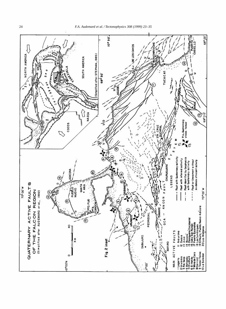
The most conspicuous tectonic feature of the Fal-con region in northwestern Venezuela is the east–west, right-lateral Oca–Ancon Fault System, that ex-tends for about 650 km from the Colombian villageof Santa Marta to the town of Boca de Aroa, locatedon the eastern coast of the Falcon State (Audemard,1993a,b, 1994b, 1996c; Audemard et al., 1994). Thisfault system crosses the Goajira Peninsula, the outletof Lake Maracaibo, the coastal plains of Buchivacoa(northwestern Falcon State) and the central FalconRange (Fig. 1). It sharply truncates the northern termi-nations of the Santa Marta Block (northern Colombia)and Perija Range (its summits constitute the Colom-bian–Venezuelan border). The Oca–Ancon Systemmerges with the Bocono–San Sebastian–El PilarSystem, considered by many workers as the majorsouthern boundary of the Caribbean Plate (Hess andMaxwell, 1953; Rod, 1956; Molnar and Sykes, 1969;Minster and Jordan, 1978; Perez and Aggarwal, 1981;Stephan, 1982; Aggarwal, 1983; Schubert, 1984;Soulas, 1986, 1989; Beltran and Giraldo, 1989; amongothers), at the Aroa–Golfo Triste depression (Fig. 1).
Fig. 1. Quaternary active faults of the Falcon region in northwestern Venezuela (simplified after Audemard et al., 1992). Small inset atupper right corner shows relative location at plate tectonics scale. The relative location of Fig. 2 is also shown.
Nevertheless, several secondary small activefaults, subordinated to the Oca–Ancon Fault System,are also affecting the northern Falcon region (Au-demard, 1993a, 1994a, 1997; Audemard and Singer,1996). Among those, a set of prominent NW–SEright-lateral faults — synthetic Riedel shears —stands out southwest of Coro (in an area named asthe Urumaco Trough by petroleum geologists), suchas the Urumaco, Rıo Seco and Lagarto faults (Fig. 1).
The seismic hazard of the Falcon region has beenbasically assessed by a conventional neotectoniccharacterization. However, when possible, it has alsobeen approached through paleoseismic studies, suchas for (a) the Urumaco Fault, whose seismic poten-tial is to be presented herein, and (b) the Oca–AnconFault System (Audemard, 1994b, 1996c). This seis-mic hazard assessment has not only focused on thecontribution of each fault to the regional seismic haz-ard of a given site, but also on the associated grounddeformations that these faults could generate.
2. Geological setting
The Tertiary Falcon Basin outcrops for some36,000 km2, comprising several states of northwest-ern Venezuela: the whole of Falcon and parts ofZulia, Lara and Yaracuy. Its sedimentary record isalmost continuous since Late Eocene time, exceptfor three angular and=or erosional unconformitiesof some regional extent, but not always widespreadthroughout the entire basin such as in the UrumacoTrough or in its eastern deep sea side (Audemard,1993a). Thus, this region is exceptionally helpful forthe understanding of the tectonic evolution of thispart of the southern Caribbean Plate boundary.
The marine Oligo–Miocene Falcon Basin used tobe the west end of the still active Bonaire Basin,which runs offshore along the Venezuelan CoastRange, until it was intensively folded and tectoni-cally inverted by a NW–SE compression in Middleand Late Miocene times, then becoming an ENE–WSW elongated anticlinorium (Audemard, 1993a).Besides, sedimentation in this region since then has
26 F.A. Audemard et al. / Tectonophysics 308 (1999) 23–35
been restricted exclusively to the north flank of theFalcon Anticlinorium and sedimentary sequenceshave progressively become less marine and morecontinental. This inversion has been active until atleast the Early Pleistocene based on the followingfacts (Audemard, 1993a): (1) the Pliocene La VelaFormation (shallow marine sequence) is in perfectupright position along the north limb of La VelaAnticline; (2) the Plio–Pleistocene Coro Formation,mainly composed of fan-conglomerates, dips 65ºN;(3) the existence of two younger unconformities(Pliocene and Pleistocene in age). Moreover, thistectonic inversion must be still active as suggested bysome local uplifted marine features (i.e., beachrocks,staircased marine terraces, etc.) along the northerncoast of this region (Audemard, 1996a,b; Audemardet al., 1997).
3. Neotectonic setting
The recognition and latter evaluation of both brit-tle and ductile deformations affecting the Plioceneand Pleistocene formations that outcrop in the north-ern Falcon Basin, and particularly in the UrumacoTrough (southwest of Coro) where at various placesseveral microtectonic stations were made, have al-lowed to establish that this region is undergoing aregionally consistent stress tensor characterized bya NNW–SSE to N–S maximum horizontal stressand an ENE–WSW minimum (or intermediate) hor-izontal stress (Audemard et al., 1992; Audemard,1993a, 1997; Fig. 1). Reliable fault-plane kinematicindicators (steps, strilolites, recrystallizations, Riedelshears, stylolitic peaks, tool marks) and=or gypsumfiber growth in some cases, were used to fix thesense of motion for each single fault plane. Thetiming of this ongoing compressional phase is cer-tainly younger than the progressive tilting of thewell-packed Late Pliocene–Early Pleistocene fan-glomerates of the Coro Formation, that is to say,Quaternary in age (Audemard, 1993a, 1997).
The present fault and fold spatial configuration atregional scale, local folding and minor geneticallyassociated tectonic structures at fault terminations,such as horse-tail splays and pop-up at restrainingstepovers, are in perfect agreement with kinematicindicators observed at microtectonic scale on fault
planes cutting Pliocene and Quaternary sedimentaryunits of the Falcon Basin. Therefore, the stress tensorcalculated by means of the method by Etchecopar etal. (1981) well represents the stress field for thepresent-day kinematics of five sets of active faults(Fig. 1) in this region (Audemard, 1993a, 1994a,1997; Audemard and Singer, 1996): (1) E–W right-lateral faults (Oca–Ancon Fault System, AdıcoraFault); (2) NW–SE right-lateral faults, synthetic tothe E–W faults (Urumaco, Rıo Seco, Lagarto andLa Soledad faults); (3) NNW–SSE normal faults(western Paraguana, Cabo San Roman, Puerto Es-condido and Los Medanos faults); (4) N–S to NNE–SSW left-lateral faults, antithetic to the E–W faults(Carrizal, El Hatillo and other minor faults); and(5) ENE–WSW reverse faults, parallel to foldingaxis (Araurima, Taima-taima, Chuchure and Mata-palo faults).
4. The Urumaco Fault
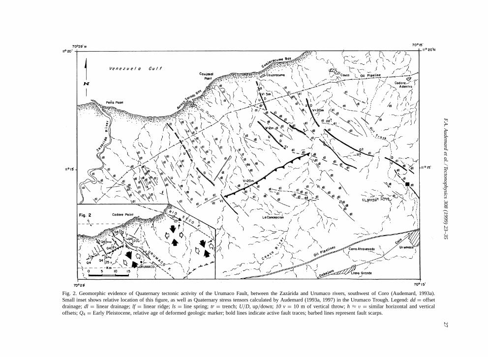
The Urumaco Fault roughly strikes NW–SE. Itsright-lateral sense of motion has been establishedby geomorphic evidence (i.e., right-laterally offsetdrainages; Fig. 2), offset Neogene beds and severalconsistent-and-persistent microtectonic indicators onfault planes observed at three river cuts: two on anephemeral creek that pours into the Urumaco River(black square on east edge of Fig. 2) and one onthe Urumaco River itself, near the confluence of theMamon Creek.
The Urumaco Fault has been mapped for over30 km in length, affecting sedimentary rocks of theUrumaco Trough of Late Miocene age and younger,a sub-basin of the Tertiary Falcon Basin. In fact, itstrace is not simple and presents two distinct 10-km-apart segments, linked by an ENE–WSW reversefault (Fig. 2 inset), all disposed as a restrainingstepover (Audemard, 1993a).
The eastern segment of the Urumaco Fault on landis the longest one, thus it is considered the main seg-ment. It is composed of two, and occasionally three,subparallel strands and extends for 30 km from theCuajaracume Bay to the Mosqueda Range, locatedeast-southeast of the Urumaco village. Near the coast(Fig. 2), this main fault segment seems to become atranstensive horse-tail structure, since the early Qua-
F.A.A
udemard
etal./Tectonophysics
308(1999)
23–3527
Fig. 2. Geomorphic evidence of Quaternary tectonic activity of the Urumaco Fault, between the Zazarida and Urumaco rivers, southwest of Coro (Audemard, 1993a).Small inset shows relative location of this figure, as well as Quaternary stress tensors calculated by Audemard (1993a, 1997) in the Urumaco Trough. Legend: dd D offsetdrainage; dl D linear drainage; lf D linear ridge; ls D line spring; tr D trench; U=D, up=down; 10 v D 10 m of vertical throw; h ³ v D similar horizontal and verticaloffsets; Q4 D Early Pleistocene, relative age of deformed geologic marker; bold lines indicate active fault traces; barbed lines represent fault scarps.
28 F.A. Audemard et al. / Tectonophysics 308 (1999) 23–35
ternary (Q4) cobble-sized alluvial pediments, whichare truncating the Neogene sequence, are verticallyoffset between 2 and 20 m by a set of N160º-strikingnormal faults, whose scarps mainly face east (Fig. 2).The spatial disposition of these minor Quaternarynormal faults confirm that (1) the post-early Qua-ternary slip of the Urumaco Fault is right-lateral,and (2) this eastern (main) segment does not con-tinue farther northwest into the Venezuela Gulf shelf.Nearby Urumaco, this segment offsets Late Mioceneand Pliocene beds less than 30 m right laterally. Thisevidence is not reliable for estimating a long-termslip rate, since this fault has had opposite senses ofmotion as suggested by the occurrence of apparentleft-lateral offsets along subparallel minor faults tothe Urumaco trend, like near the Mamon Creek, 3km north of the Urumaco village (Fig. 2).
The second segment of the Urumaco Fault runsparallel to the main one, some 10 km west of it,closer to the Zazarida River (Fig. 2). This segmenthas only been mapped near the coast and showsa magnificent east-looking scarp affecting the sameearly Quaternary alluvial pediment as the main seg-ment. This segment may continue offshore on theVenezuela Gulf shelf based on available seismic pro-filing of the shelf.
Both segments are kinematically connected bya reverse fault that strikes N065º, whose surfaceexpression is a flexural scarp preserved in the Q4
alluvial pediment. This alluvial unit truncates mostof this area between the Zazarida and Cauca rivers(Graf, 1969). This configuration, made of two sub-parallel segments linked by an orthogonal reversefault, suggests an overall restraining stepover geom-etry, which is coherent with the right-lateral slip ofthe Urumaco Fault (Fig. 2). The Quaternary verticalthrow of this reverse fault is estimated between 20and 25 m, measured across the present flexural scarptopography.
5. Paleoseismic assessment of the Urumaco Fault
The three studied outcrops expose only one of thetwo-to-three strands of the main (eastern) segmentof the Urumaco Fault that extends between the coast— Cuajaracume Bay — and the Mosqueda Range.These outcrops correspond to natural river cuts: one
belonging to the Urumaco River and the two othersto a small ephemeral tributary, near the confluenceof the Mamon Creek, located some 3 km north of theUrumaco village (black square on Fig. 2). The threeoutcrops are less than 250 m apart and only one wasstudied for paleoseismic purposes. No trenching wasrequired during this study, although the conventionaltechniques in paleoseismic studies were applied.
5.1. Stratigraphy and structures
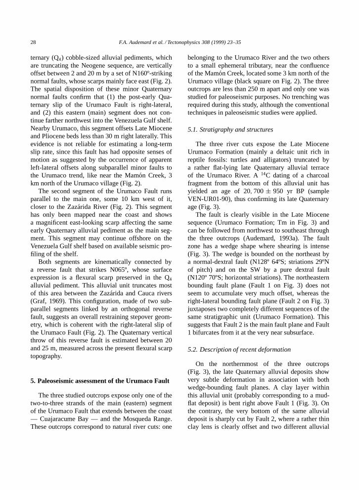
The three river cuts expose the Late MioceneUrumaco Formation (mainly a deltaic unit rich inreptile fossils: turtles and alligators) truncated bya rather flat-lying late Quaternary alluvial terraceof the Urumaco River. A 14C dating of a charcoalfragment from the bottom of this alluvial unit hasyielded an age of 20; 700 š 950 yr BP (sampleVEN-UR01-90), thus confirming its late Quaternaryage (Fig. 3).
The fault is clearly visible in the Late Miocenesequence (Urumaco Formation; Tm in Fig. 3) andcan be followed from northwest to southeast throughthe three outcrops (Audemard, 1993a). The faultzone has a wedge shape where shearing is intense(Fig. 3). The wedge is bounded on the northeast bya normal-dextral fault (N128º 64ºS; striations 29ºNof pitch) and on the SW by a pure dextral fault(N120º 70ºS; horizontal striations). The northeasternbounding fault plane (Fault 1 on Fig. 3) does notseem to accumulate very much offset, whereas theright-lateral bounding fault plane (Fault 2 on Fig. 3)juxtaposes two completely different sequences of thesame stratigraphic unit (Urumaco Formation). Thissuggests that Fault 2 is the main fault plane and Fault1 bifurcates from it at the very near subsurface.
5.2. Description of recent deformation
On the northernmost of the three outcrops(Fig. 3), the late Quaternary alluvial deposits showvery subtle deformation in association with bothwedge-bounding fault planes. A clay layer withinthis alluvial unit (probably corresponding to a mud-flat deposit) is bent right above Fault 1 (Fig. 3). Onthe contrary, the very bottom of the same alluvialdeposit is sharply cut by Fault 2, where a rather thinclay lens is clearly offset and two different alluvial
F.A.A
udemard
etal./Tectonophysics
308(1999)
23–3529
Fig. 3. Log of river cut near confluence of the Mamon Creek and Urumaco River, exposing an active strand of the eastern segment of the Urumaco Fault, that is composedof two wedge-bounding fault planes (after Audemard, 1993a). Location is indicated by a black square on the east edge of Fig. 2.
30 F.A. Audemard et al. / Tectonophysics 308 (1999) 23–35
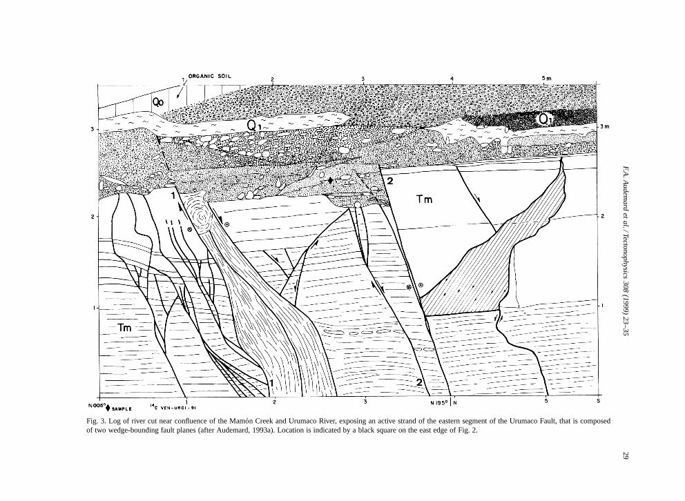
Fig. 4. Reconstruction of the last two events on one strand of the eastern segment of the Urumaco Fault (after Audemard, 1993a).
facies are juxtaposed; all been drowned by youngerand coarser undeformed alluvial facies (Fig. 3). Thevertical offset of the erosive bottom of the allu-vial terrace on Fault 2 is an artifact, produced andmagnified by differential erosion of the underlyingUrumaco Formation because of intense fracturingconcentrated in the fault-bounded wedge. This al-luvial unit, as mentioned earlier, has been dated atabout 20,000 yr BP, implying that this UrumacoFault strand has been activated at least twice duringsuch time span.
5.3. Paleoearthquake recognition
To decipher the number and size of paleoearth-quakes that have occurred on this strand, a paleo-reconstruction has been achieved (Fig. 4).
(1) A first event on Fault 2, to which an appar-ent vertical throw of 17 cm, measured on the ero-sional unconformity between the Quaternary and Late
Miocene sedimentary units, could be assigned (frame2 of Fig. 4). However, this is an artifact as explainedearlier. In fact, fault slip juxtaposes two different fa-cies at the bottom of the late Quaternary alluvial ter-race.
(2) A second younger earthquake on the otherwedge-bounding fault (Fault 1), that bends the in-terbedded mudflat deposit within the late Quaternaryalluvial unit of 14 cm vertically (frame 4 of Fig. 4).Fault 2 did not move at this time since the coarseralluvial deposit equivalent to the mudflat deposit isnot disrupted above it.
These young — both brittle first and ductile later— deformations are sealed partially by a Holoceneorganic-poor soil, implying that this fault strand hasmoved in Late Pleistocene times and probably duringthe early Holocene as well.
Accordingly, these two wedge-bounding faultshave moved independently and alternately: a firstevent on Fault 2 and a younger shock on Fault 1,
F.A. Audemard et al. / Tectonophysics 308 (1999) 23–35 31
although it could have been expected that both faultswould move simultaneously because they branch offfrom a single fault plane at very shallow depth.
5.4. Earthquake magnitude and slip rate
The penultimate event magnitude (frame 2 ofFig. 4) is hard to characterize since the verticalthrow (17 cm) measured at the top of the LateMiocene unit is simply an artifact that results fromthe superposition of the following two processes. (a)Previous differential erosion of the underlying Uru-maco Formation during alluvial terrace deposition.(b) The later right-lateral offset (east block movingsoutheast) of a gently north-dipping erosional un-conformity between the overlying Late Pleistocenealluvial terrace and the underlying Miocene Uru-maco Formation. However, the coseismic slip shouldbe considered larger than the apparent vertical throwsince striations on that fault plane are perfectly hor-izontal. Audemard (1993a), using the methodologydescribed in Audemard and Singer (1996) — basedon empirical relationships that correlate earthquakemagnitude and coseismic slip with rupture area onfault plane — has estimated a magnitude Ms 6.4 forthe eastern segment of the Urumaco Fault, based on arupture length of some 22 km, to which correspondsa coseismic slip of some 60 cm. This figure seemscompatible with a 17-cm apparent vertical throw ob-served on the studied river cut, although that throwcannot be used for earthquake magnitude estimatesbecause it is not possible to know how much of thethrow is actually due to erosion during deposition ofthe Quaternary alluvial terrace and prior to fault slipassociated to the earthquake (Fig. 3).
On the other hand, the latest event is associatedto a 14-cm vertical throw. This vertical offset cor-responds to a total coseismic slip of 30 cm, takinginto account that slip has to occur along striations of29ºN of pitch. Following the methodology of Aude-mard and Singer (1996), such coseismic slip couldbe related to earthquakes of magnitude Ms 5.8.
Timing of these two events cannot be better con-strained since no sufficient datable materials werefound, except for the only sample collected at thebottom of the Late Pleistocene alluvial unit, thatdates the occurrence of both events within the last20,000 yr. Moreover, only a maximum slip rate can
be calculated for this strand of the eastern seg-ment of the Urumaco Fault. Considering that thisstrand has accumulated 90 cm of slip in the last20; 700 š 950 yr, a maximized slip rate for thisstrand of 0:044 š 0:002 mm=yr is estimated. Never-theless, this value could only be part of the UrumacoFault slip rate since it may comprise two slightlyoverlapped strands in the area of confluence of theMamon Creek with the Urumaco River (Fig. 2).
Taking into account the overall restrainingstepover geometry of the Urumaco Fault, anotherway of estimating its slip rate could be based onthe Quaternary (post-Q4) vertical throw of some 25m of the flexural scarp. Assuming that such scarpis produced by a blind reverse fault plane dipping30º in the last 1.5 m.y. (estimated age of the Q4
alluvial pediment), a long-term shortening slip rateof the restraining stepover of about 0.033 mm=yr iscalculated; a rate that needs to be shared betweenthe two NW–SE parallel segments that are dying outat the stepover. Nevertheless, it may represent theoverall slip rate of the Urumaco Fault. This secondvalue is very similar to the previous one calculatedfrom cumulative coseismic slip.
Soulas et al. (1987) have estimated the UrumacoFault slip rate at 0.1 mm=yr based on a 2-km offsetof the Lower Pliocene Codore beds. Besides, theythink that this rate may be higher since the fault hasmoved in opposite directions during Pliocene andQuaternary times. However, in their offset estimate,they neglect two negative facts: (a) the possibility ofoccurrence of oblique slip on this fault, combinedwith (b) a gentle (10º–30ºN) dip of the Neogenesequence that exaggerates the magnitude of apparenthorizontal offsets. Therefore, a more reliable esti-mate of the slip rate for the Urumaco Fault is muchless than 0.1 mm=yr and should be around 0.04 and0.05 mm=yr. This would imply that the return periodof earthquakes of magnitude Ms 6.4 on the easternsegment of the Urumaco Fault should be 12,000 to15,000 yr, and half this recurrence if both segmentsof the fault happen to be similar in total length.
6. Discussion
The seismic hazard assessment of any given re-gion in a complex active plate boundary zone, such
32 F.A. Audemard et al. / Tectonophysics 308 (1999) 23–35
as northern Venezuela, needs to rely on a thor-ough neotectonic characterization of every single ac-tive tectonic feature. This should be complemented,when possible, with a paleoseismic evaluation oftheir seismic potential, because contemporary seis-micity may not be easily ascribed to a particularactive tectonic feature due to regional tectonic com-plexity, thus making inaccurate any seismologicalapproach for linear seismic sources based only onGutenberg–Richter law. Moreover, the technique ofcharacterizing paleo-earthquakes by trenching hasproved worldwide to be a powerful tool in ar-eas where the instrumental and historical seismicityrecord are too short or incomplete basically becauserecurrence of moderate-to-large earthquakes is muchlonger than the written tradition of the region orcountry. This is mainly applicable to Africa, Amer-ica and Australia, but also to some regions of Europe(i.e., France, Spain). The Urumaco Fault shows aseismic behavior that seems to fall into this type,since it is characterized by moderate earthquakes(events of magnitude ranging between Ms 5.8 and6.4) with a very long return period (6000 to 7500yr on any segment of the fault), as suggested bythis study. On the other hand, when compared withthe over-650-km-long dextral Oca–Ancon Fault Sys-tem, the contribution of the Urumaco Fault to theseismic hazard of northwestern Venezuela is small,because its maximum credible earthquake is aboutone order of magnitude smaller than the one on theOca–Ancon Fault System (Ms 6.6 against 7.5) andits return period is at least twice longer (Audemardand Singer, 1996). Despite all the facts mentionedabove, on the one hand the occurrence of an eventof magnitude ½ 6 on the Urumaco Fault cannot beneglected, because of the associated risk for rathersmall neighboring settlements and their inhabitants(i.e., Urumaco, Llano Grande, Cauca, Codore Aden-tro, Sabaneta and Pedregal) and even larger townslocated some 60 to 70 km away, such as Coro andDabajuro (Figs. 1 and 2), when the type of housingis considered. Most dwellings in this area are madeof ‘Bahareque’ (sugar cane-framed walls, plasteredwith a mud and grass mixture) with heavy tile roofs.The very recent (January 25, 1999) widespread hous-ing collapse that occurred in the Colombian town ofArmenia due to a shallow (35 km deep) moder-ate (mb 5.9) local earthquake is an excellent proof
of this. On the other hand, in terms of nationalconcern with regard to environmental impact andeconomic loss, permanent ground deformations as-sociated to an Ms ½ 6 event could damage several oilpipelines of two of the major Venezuelan refineries,that are crossed by this secondary Riedel shear tothe Oca–Ancon Fault System (Fig. 2). Both refiner-ies are located at Punto Fijo (Judibana) and PuntaCardon (Fig. 1). In terms of ground deformations,the pipelines during their service life might undergoimportant concentration of stress at several placesdue to coseismic slip along the Urumaco Fault ofseveral to about 60 cm (maximum horizontal slipestimated in this study), depending on which faulttrace would slip. For instance, the northern pipelinecould be subjected to the maximum estimated hori-zontal slip if the western segment behaves similarlyto the eastern one (the segment paleoseismically as-sessed herein) and both segments of the UrumacoFault are to generate earthquakes of the same magni-tude (Fig. 2). On the contrary, the transtensive horsetail at the northern tip of the eastern segment couldaffect the northern pipeline in a distributed man-ner where several minor normal faults would showvertical throws of several centimeters (Fig. 2).
Let us point out that any active fault, regardlessof its length and=or its seismic potential, should notbe neglected in any seismic hazard assessment. Forinstance, loss related to the 1995 Hyogoken-Nanbu(Kobe) earthquake might have been minimized if theNojima Fault had been better known, even thoughsuch fault is small with respect to the Pacific Sub-duction in terms of seismic potential. In that sense,a thorough neotectonic study is fundamental, eventhough the fault may not be paleoseismically as-sessed for countless reasons.
7. Conclusions
The Urumaco Fault is an active right-lateralstrike-slip feature that cuts across sedimentary rocksof Late Miocene and younger age of the UrumacoTrough in the northern Falcon region, northwest-ern Venezuela. Its present sense of motion has beenestablished from (1) geomorphic evidence of Qua-ternary activity, (2) kinematic indicators observed onfault plane (microtectonics) in Neogene and younger
F.A. Audemard et al. / Tectonophysics 308 (1999) 23–35 33
rocks, and (3) folding and minor genetically associ-ated tectonic structures at fault terminations affectinglate Quaternary alluvial units, such as transtensivehorse-tail splays and compressive features at re-straining stepovers. It represents a synthetic Riedelshear to the major right-lateral, east–west-trendingOca–Ancon Fault System.
The active trace of the Urumaco Fault, which hasbeen mapped for over 30 km in length on land, isnot simple and comprises two distinct 10-km-apartsegments, linked by an ENE–WSW reverse fault,showing an overall restraining stepover geometry.The eastern segment, the longest on land (about 22km long), damps in a transtensive horse-tail splayto the north, suggesting that it does not continueoffshore. The fault trace jumps 10 km sideward to amore western position. This western segment is onlypresent by the coast and seems to prolong offshoreto the north. The reverse fault is evidenced by amagnificent 25-m-high, north-facing flexural scarp.
Although a thorough neotectonic–paleoseismicevaluation has been performed on the UrumacoFault, the seismic potential of this fault should beregarded in a probabilistic manner (maximum credi-ble earthquakes of magnitude 6.4 should repeat every6000 to 7500 yr on the entire fault) since it has notbeen possible to better constrain both the occurrenceof past earthquakes (two events have been identifiedin the last 20,000 yr) and the forthcoming event,because the precise age of the last event is unknownand a rough return period has just been estimated(12,000 to 15,000 yr for Ms 6.4 earthquakes on theeastern segment of the fault). Besides, it has not beenpossible to conclude about either the eventual inter-action between major and secondary active faults (inthis case, between the Oca–Ancon Fault System andthe Urumaco Fault) or the triggering effects inducedby slip along a fault on the activation of a neighbor-ing one. Nevertheless, the slip rate of this fault hasbeen estimated at 0.04 to 0.05 mm=yr, based on acumulative coseismic slip (about 90 cm accumulatedduring two unequal events) in the last 20,000 yr.
An important contribution of this paleoseismic as-sessment on the Urumaco Fault refers to the mobilityof surface rupture along this secondary fault. If twoconsecutive events on a fault strand have occurredon two different fault planes (just a couple of metersapart) in the very shallow subsurface, as demon-
strated through this study, we should expect that thesame process would happen among several strandsof a fault, such as those composing the eastern seg-ment of this fault, that are connected in depth. Onlyconclusive paleoseismic studies could verify this hy-pothesis but no suitable trenching sites had beenlocated on the other strands and=or segments mainlybecause of aridity of the area and scarce distributionof Holocene deposits. Paleoseismic trenching wouldhave also helped solving whether (a) the westernsegment moves independently, (b) motion on onesegment promotes slip on the other one, or (c) thereverse fault at the restraining stepover would bethe eventual locus of a much larger earthquake thatwould incorporate both contiguous segments.
From the seismic hazard viewpoint, the UrumacoFault is not comparable to the Oca–Ancon FaultSystem since it may generate maximum credibleearthquakes of one order of magnitude smaller, thatwould repeat twice less. However, a local Ms ½ 6earthquake in a sparsely populated area where mostdwellings are made of ‘Bahareque’ (low-resistantmaterials) with heavy tile roofs might be highlydevastating. Moreover, a surface rupture along theUrumaco Fault with coseismic slip of some tens ofcentimeters (up to 0.60 m) might produce severedamage to oil facilities — mainly pipelines — thatin turn might represent a significant negative impacton the Gross National Product. As a concludingremark, let us stress that no active fault, regardless ofits length and=or its seismic potential, deserves to beneglected in any seismic hazard assessment.
Acknowledgements
This research was funded by Intevep, S.A. andMaraven, S.A. between 1990 and 1992, to which weare deeply indebted. We wish to thank our colleaguesof the Earth Sciences Department of Funvisis, whohelped during the field work, and the ILP II-3 andILP II-5 colleagues: Daniela Pantosti and SpyrosPavlides, who encouraged this contribution. We arealso grateful to the former Laboratoire de GeologieStructurale of the Universite de Montpellier II whereall the microtectonic analyses were carried out, andwe particularly desire to acknowledge Drs. AlfredoTaboada Hoyos, Jean-Francois Ritz and Samira Re-
34 F.A. Audemard et al. / Tectonophysics 308 (1999) 23–35
baı for their constant support and fruitful discussions.Part of this work would not have been possible with-out the wonderful drafting of Marina Pena (Funvisis)and Jojo Garcia (Montpellier II). This contributionwas greatly improved by suggestions made by thereviewers Drs. Eutizio Vittori from ANPA, Italy, andMichel Sebrier from Universite de Paris-sud, France.
References
Aggarwal, Y., 1983. Neotectonics of the Southern Caribbean:recent data, new ideas (abstr.) Acta Cient. Venez. 34 (1), 17.
Audemard, F.A., 1993a. Neotectonique, Sismotectonique et AleaSismique du Nord-ouest du Venezuela (systeme de faillesd’Oca–Ancon). Ph.D. Thesis, Universite Montpellier II, 369pp.
Audemard, F.A., 1993b. Trench investigation across the Oca–Ancon fault system, Northwestern Venezuela (extended abstr.).2nd Int. Symp. Andean Geodynamics, Oxford, England, pp.51–54.
Audemard, F.A., 1994a. Neotectonics of the Falcon Basin, North-western Venezuela (abstr.). Bull INQUA Neotectonics Com-mission 17, p. 74.
Audemard, F.A., 1994b. Oca–Ancon Fault System: active traceand seismogenic characterization (northwestern Venezuela)(abstr.) EOS 75 (44), 611.
Audemard, F.A., 1995. Geodynamic evolution of the SouthernCaribbean: constraints from the geological history of the Fal-con Basin, Venezuela. 14th Caribbean Geological Conf., Portof Spain, Trinidad and Tobago, pp. 11–12. Reprinted in Bull.INQUA N.C. 18, 49 (abstr.; paper in press).
Audemard, F.A., 1996a. Field-trip guidebook to ‘The late Qua-ternary marine deposits of the Paraguana peninsula and Corosurroundings’. Ed. Funvisis, Caracas, 57 pp.
Audemard, F.A., 1996b. Late Quaternary marine deposits of theParaguana peninsula, state of Falcon, northwestern Venezuela:preliminary geological observations and neotectonic implica-tions. Quat. Int. 31, 5–11.
Audemard, F.A., 1996c. Paleoseismicity studies on the Oca–Ancon fault system, northwestern Venezuela. Tectonophysics259, 67–80.
Audemard, F.A., 1997. Tectonica activa de la region septentrionalde la cuenca invertida de Falcon, Venezuela occidental. 8thCongreso Geologico Venezolano, Porlamar, Venezuela 1, pp.93–100.
Audemard, F.A., Giraldo, C., 1997. Desplazamientos dextrales alo largo de la frontera meridional de la placa Caribe, Venezuelaseptentrional. 8th Congr. Geologico Venezolano, Porlamar,Venezuela 1, pp. 101–108.
Audemard, F.A., Singer, A., 1996. Active fault recognition innorthwestern Venezuela and its seismogenic characterization:neotectonic and paleoseismic approach. Geofıs. Int. Mex. 35(3) (Suppl.), 245–255.
Audemard, F.A., Singer, A., Beltran, C., Rodrıguez, J.A., Lugo,
M., Chacın, C., Adrianza, A., Mendoza, J., Ramos, C., 1992.Actividad tectonica cuaternaria y caracterısticas sismogenicasde los sistemas de fallas de Oca–Ancon (Tramo Oriental), dela Penınsula de Paraguana y region de Coro y de la costanororiental de Falcon. Funvisis’ unpubl. rep. for Intevep, 2Vols.: 245 pp. (Vol. I), C 54 pp (Vol. II) C 4 appendices.
Audemard, F.A., Singer, A., Rodrıguez, J.A., Beltran, C., 1994.Definicion de la traza activa del sistema de fallas de Oca–Ancon, Noroccidente de Venezuela. VII Congr. VenezolanoGeofısica, Caracas, Venezuela, pp. 43–51.
Audemard, F.A., Rodrıguez, J., Bousquet, J.-C., 1997. Evidenceof Holocene tectonic uplift of the La Vela anticline relatedto the activity of the Guadalupe Thrust, northern Falcon State(Venezuela). In: Meco, J., Petit-Maire, N. (Eds.), Proc. IVCLIP Meeting 1995. Servicio de Publicaciones, Univ. de LasPalmas de Gran Canaria, pp. 13–27.
Bell, J., 1972. Geotectonic evolution of the southern Caribbeanarea. Geol. Soc. Am. Mem. 132, 369–386.
Beltran, C., Giraldo, C., 1989. Aspectos neotectonicos de laregion nororiental de Venezuela. VII Congr. Geologico Vene-zolano, Barquisimeto 3, pp. 1000–1021.
Calais, E., Stephan, J.-F., Beck, C., Carfantan, J.-C., Tardy, M.,Thery, J.-M., Olivet, J.-M., Bouysse, P., Mercier de Lepinay,B., Tournon, J., Vila, J.-M., Mauffret, A., Blanchet, R., Bour-gois, J., Dercourt, J., 1989. Evolution paleogeographique etstructurale du domaine caraıbe du Lias a l’Actuel: 14 etapespour 3 grandes periodes. C. R. Acad. Sci. Paris, 309, 1437–1444.
Etchecopar, A., Vasseur, G., Daignieres, M., 1981. An inverseproblem in microtectonics for the determination of stress ten-sor form fault striation analysis. J. Struct. Geol. 3 (1), 51–65.
Freymueller, J.T., Kellogg, J.N., Vega, V., 1993. Plate motions inthe north Andean region. J. Geophys. Res. 98, 21853–21863.
Graf, C., 1969. Estratigrafıa cuaternaria del noroeste deVenezuela. Bol. Inf. Asoc. Venez. Geol., Min. Pet. 12 (11),393–416.
Hess, H., Maxwell, J., 1953. Caribbean Research Project. Bull.Geol. Soc. Am. 64 (1), 1–6.
Jordan, T., 1975. The present-day motion of the Caribbean plate.J. Geophys. Res. 80 (32), 4433–4439.
Lundgren, P., Russo, R., 1997. Crustal motions in the southernCaribbean and northern Andes region (pre-print). J. Geophys.Res., 25 pp.
Malfait, B., Dinkelman, M., 1972. Circum-Caribbean tectonicand igneous activity and the evolution of the Caribbean plate.Bull. Geol. Soc. Am. 83 (2), 251–272.
Minster, J., Jordan, T., 1978. Present-day plate motions. J. Geo-phys. Res. 83, 5331–5354.
Molnar, P., Sykes, L., 1969. Tectonics of the Caribbean and Mid-dle America regions from focal mechanisms and seismicity.Bull. Geol. Soc. Am. 80, 1639–1684.
Perez, O., Aggarwal, Y., 1981. Present-day tectonics of south-eastern Caribbean and northeastern Venezuela. J. Geophys.Res. 86, 10791–10805.
Pindell, J., Dewey, J., 1982. Permo-Triassic reconstruction
F.A. Audemard et al. / Tectonophysics 308 (1999) 23–35 35
of western Pangea and the evolution of the Gulf ofMexico=Caribbean region. Tectonics 1 (2), 179–211.
Rod, E., 1956. Strike-slip faults of northern Venezuela. Bull.Am. Assoc. Pet. Geol. 40 (3), 457–476.
Rosencrantz, E., Ross, M., Sclater, J., 1988. Age and spreadinghistory of the Cayman Trough as determined from depth, heatflow, and magnetics anomalies. J. Geophys. Res. 93 (3), 2141–2157.
Schubert, C., 1984. Basin formation along Bocono–Moron–ElPilar fault system, Venezuela. J. Geophys. Res. 89, 5711–5718.
Soulas, J.-P., 1986. Neotectonica y tectonica activa en Venezuelay regiones vecinas. VI Congr. Geologico Venezolano, Caracas10, pp. 6639–6656.
Soulas, J.-P., 1989. Definition de l’actuelle limite sud de laPlaque Caraibe (abstr.). Eur. Geophys. Soc., 14th GeneralAssembly Symp. S1.2, Barcelona.
Soulas, J.-P., Giraldo, C., Bonnot, D., Lugo, M., 1987. Actividadcuaternaria y caracterısticas sismogenicas del sistema de fallasOca–Ancon y de las fallas de Lagarto, Urumaco, Rıo Secoy Pedregal. Afinamiento de las caracterısticas sismogenicasde las fallas de Mene Grande y Valera (Proyecto COLM).Funvisis’ unpubl. rep. for Intevep. 69 pp. C appendices.
Stephan, J.-F., 1982. Evolution geodynamique du domaineCaraıbe, Andes et chaine Caraibe sur la transversale de Bar-quisimeto (Venezuela). These d’Etat, Univ. Paris, 512 pp.
Sykes, L., McCann, W., Kafka, A., 1982. Motion of CaribbeanPlate during last 7 million years and implications for earlierCenozoic movements. J. Geophys. Res. 87 (B13), 10656–10676.
Wadge, G., Burke, K., 1983. Neogene Caribbean plate rotationand associated central American tectonic evolution. Tectonics2 (6), 633–643.


