Embed Size (px)
Citation preview
PAPER IX:
WATER USE MANAGEMENT
FINAL REPORT
MARCH 2004
WUP-JICA TEAM
Vol. II: Supporting Report, Paper IX: Water Use ManagementWUP-JICA, March 2004
TABLE OF CONTENTS
SUMMARY................................................................................................................. IX-1
CHAPTER 1: INTRODUCTION.............................................................................. IX-10
CHAPTER 2: RIVER WATER USE MANAGEMENT IN JAPAN ..................... IX-11
1. EXISTING WATER USE AND RIVER FLOW REGIME....................... IX-11
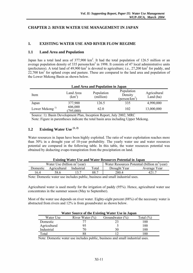
1.1 Land Area and Population ..................................................................... IX-11
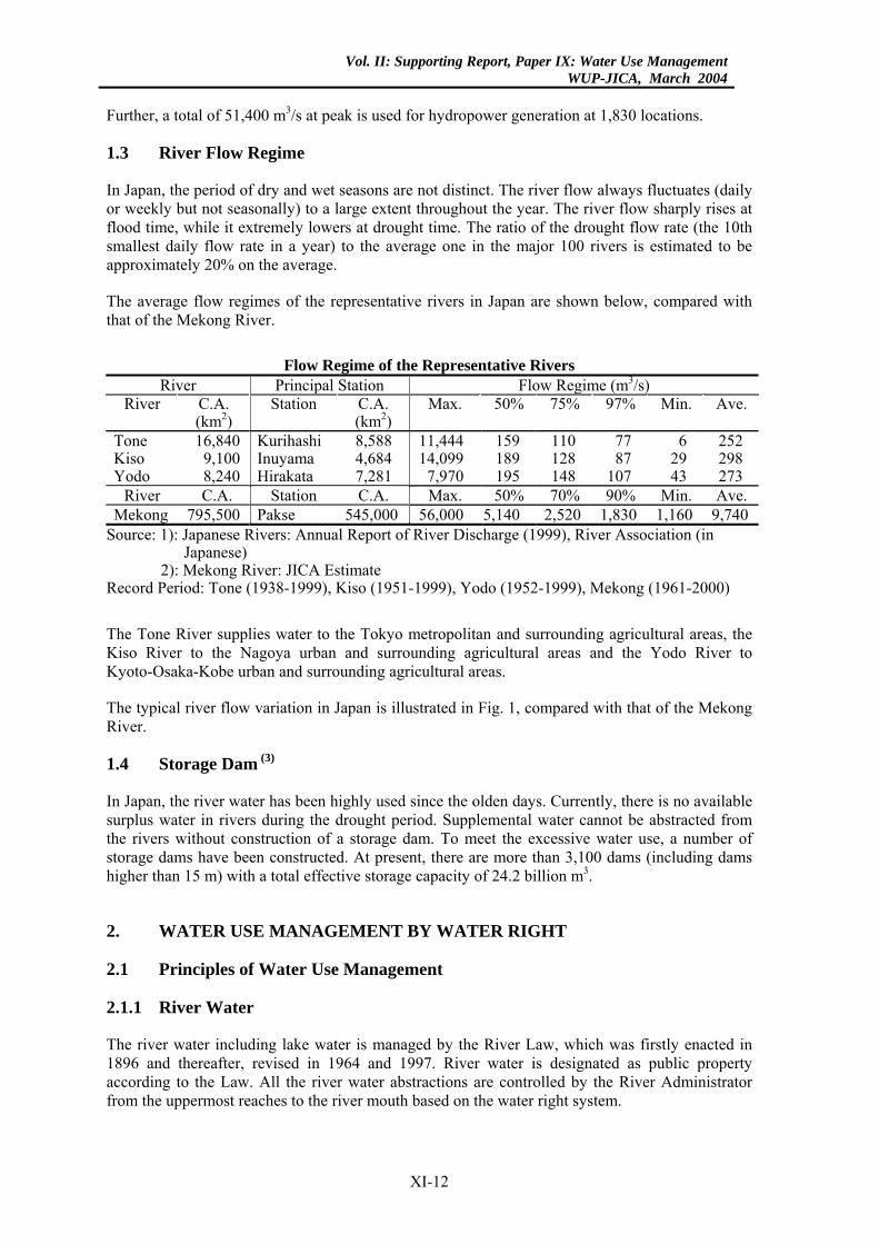
1.2 Existing Water Use................................................................................ IX-11
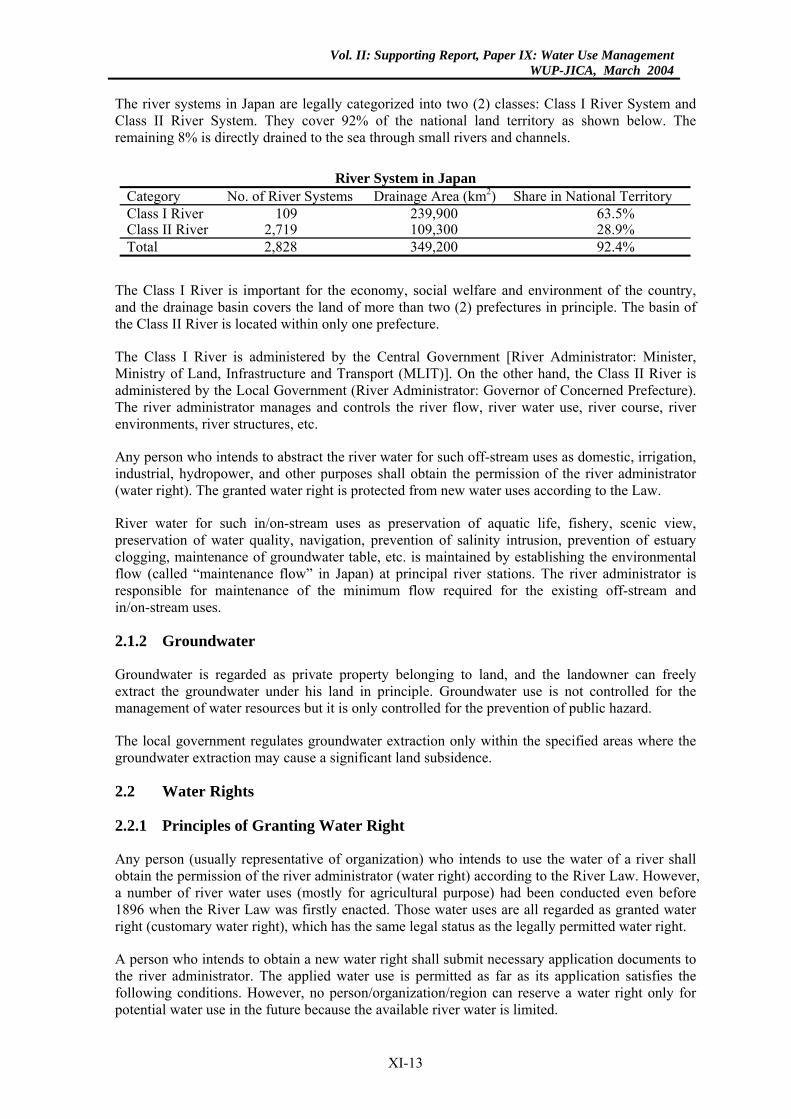
1.3 River Flow Regime................................................................................ IX-12
1.4 Storage Dam .......................................................................................... IX-12
2. WATER USE MANAGEMENT BY WATER RIGHT.............................. IX-12
2.1 Principles of Water Use Management ................................................... IX-12
2.1.1 River Water............................................................................... IX-12
2.1.2 Groundwater ............................................................................. IX-13
2.2 Water Rights .......................................................................................... IX-13
2.2.1 Principles of Granting Water Right .......................................... IX-13
2.2.2 Necessary Consultation and Coordination prior to Granting Water Right............................................................................... IX-14
2.2.3 Priority Order............................................................................ IX-15
2.2.4 Term of Validity ....................................................................... IX-15
2.2.5 Existing Water Rights............................................................... IX-15
3. DESIGN RIVER FLOW FOR WATER USE MANAGEMENT.............. IX-16
3.1 General .................................................................................................. IX-16
3.2 Natural Flow.......................................................................................... IX-16
3.3 Design Low Flow .................................................................................. IX-16
3.3.1 Probability of Design Low Flow .............................................. IX-17
3.3.2 Preparation of Design Flow Regime (Hydrograph).................. IX-17
3.3.3 Estimation ofr Future Design Low Flow .................................. IX-18
3.4 Required Minimum Flow ...................................................................... IX-19
3.4.1 Objectives and Functions of the Flow ...................................... IX-19
3.4.2 Seasonal Variation of Flow....................................................... IX-19
3.4.3 Reliability of Flow.................................................................... IX-19
4. WATER RESOURCES DEVELOPMENT................................................. IX-21
4.1 Water Conflicts...................................................................................... IX-21
IX-S1
Vol. II: Supporting Report, Paper IX: Water Use ManagementWUP-JICA, March 2004
4.1.1 General ...................................................................................... IX-21
4.1.2 Inter-basin Water Diversion...................................................... IX-21
4.2 Principles and Policy of Water Resources Development....................... IX-21
4.2.1 Maintenance of Required Minimum Flow................................ IX-21
4.2.2 New Water Development.......................................................... IX-22
4.2.3 Long-Term Water Resources Development Plan ..................... IX-22
4.2.4 Optimum and Equitable Water Resources Development.......... IX-23
4.3 Inter-basin Water Diversion of Yoshino River (Example) .................... IX-23
4.3.1 General Description of the Basin .............................................. IX-23
4.3.2 Old Inter-basin Diversion.......................................................... IX-24
4.3.3 New Inter-basin Diversion ........................................................ IX-24
5. WATER USE COORDINATION AND MONITORING .......................... IX-27
5.1 Water Use Restriction in Drought Time ................................................ IX-27
5.1.1 General ...................................................................................... IX-27
5.1.2 Processes of Water Use Restriction .......................................... IX-27
5.2 Water Use Monitoring ........................................................................... IX-28
5.2.1 Necessity of Water Use Monitoring.......................................... IX-28
5.2.2 Water Use Monitoring System.................................................. IX-28
5.3 Water Use Coordination and Monitoring in Tone River (Example) ..... IX-29
5.3.1 Main Features of the River Basin ............................................. IX-29
5.3.2 Water Use Monitoring .............................................................. IX-30
5.3.3 Low Flow Control..................................................................... IX-31
5.3.4 Reasons for Good Performance of Water Use Monitoring ....... IX-33
6. HOW TO ESTABLISH THE REQUIRED MINIMUM FLOW............... IX-35
6.1 General................................................................................................... IX-35
6.2 Procedure to Establish the Required Minimum Flow............................ IX-35
6.2.1 Basic Assumption ..................................................................... IX-35
6.2.2 Methodology ............................................................................. IX-36
6.2.3 Estimation Method of Environmental Flow.............................. IX-37
6.3 Establishment of Required Minimum Flow in Shinano River (Example)..................................................................................... IX-41
6.3.1 General ...................................................................................... IX-41
6.3.2 Water Balance along the Mainstream ....................................... IX-42
6.3.3 Estimation of Required Environmental Flow ........................... IX-43
6.3.4 Establishment of Required Minimum Flow.............................. IX-45
6.3.5 Further Study ............................................................................ IX-45
6.4 Retrieval of River Valley Environments................................................ IX-45
IX-ii
Vol. II: Supporting Report, Paper IX: Water Use ManagementWUP-JICA, March 2004
6.4.1 General...................................................................................... IX-45
6.4.2 Environmental Water Release of Saga Hydropower Dam (Example)......................................................................... IX-46
6.5 Control of Salinity Intrusion.................................................................. IX-49
6.5.1 General...................................................................................... IX-49
6.5.2 Control of Salinity Intrusion in the Tone River (Example) ...... IX-49
CHAPTER 2: WATER USE MANAGEMENT IN LOWER MEKONG ............. IX-55
1. DISCUSSIONS ON ACCEPTABLE MINIMUM MONTHLY NATURAL FLOW ........................................................................................ IX-55
1.1 General .................................................................................................. IX-55
1.2 Purpose of Establishment of the AMMNF ............................................ IX-55
1.3 Protection of the Existing Water Uses................................................... IX-57
1.3.1 General...................................................................................... IX-57
1.3.2 Water Right System in the Riparian States............................... IX-57
1.3.3 Water Management Rules for International Rivers .................. IX-60
1.3.4 Preliminary Conclusions........................................................... IX-60
1.4 Design Probability of AMMNF............................................................. IX-61
1.5 Definition of Natural Flow .................................................................... IX-62
1.6 Quantity of Existing Water Use on the Mainstream.............................. IX-66
1.6.1 General...................................................................................... IX-66
1.6.2 Water Use in the Upstream and Middle Reaches ..................... IX-66
1.6.3 Water Use in the Mekong Delta ............................................... IX-67
1.6.4 Comments on Surplus Water on the Mainstream ..................... IX-67
1.7 How to Increase Water Utilization Rate................................................ IX-69
2. DISCUSSIONS ON WATER USE MONITORING................................... IX-70
2.1 General .................................................................................................. IX-70
2.2 Necessity of Water Use Monitoring ...................................................... IX-70
2.2.1 Monitoring Necessity at National Level ................................... IX-70
2.2.2 Monitoring Necessity at Regional Level .................................. IX-71
2.2.3 Necessity of Integrated Monitoring of River Flow and Water Use ................................................................................. IX-72
2.3 Discussions on Water Use Management of the Mainstream ................. IX-72
2.3.1 How to Manage Water use on the Mainstream......................... IX-72
2.3.2 How to Coordinate Water Use in Severe Drought.................... IX-73
2.4 Discussions on Water Use Monitoring System ..................................... IX-74
IX-iii
Vol. II: Supporting Report, Paper IX: Water Use ManagementWUP-JICA, March 2004
2.4.1 Kinds of Groundwater Use Monitoring .................................... IX-74
2.4.2 How to Monitor Existing Irrigation Water Use ........................ IX-74
2.4.3 How to Monitor Existing Urban Water Use ............................. IX-79
2.4.4 How to Monitor Existing Hydropower Use and Dam Operation................................................................................... IX-79
2.4.5 How to Monitor Propose Water Use......................................... IX-80
2.4.6 How Often will Water Use be Monitored ................................. IX-80
2.4.7 How to Secure Transparency of Monitoring Data .................... IX-81
2.4.8 Recommendation ...................................................................... IX-81
REFERENCES............................................................................................................ IX-82
IX-iv
Vol. II: Supporting Report, Paper IX: Water Use ManagementWUP-JICA, March 2004
LIST OF FIGURES
Fig. 1 Typical River Flow Variation ............................................................. IX-83 Fig. 2 River Water Utilization in Japan......................................................... IX-84 Fig. 3 Abstraction and Return of Irrigation Water ........................................ IX-85 Fig. 4 Yoshino River Water Resources Development................................... IX-86 Fig. 5 Major Storage Dam and Intake Sites in Tone River Basin ................. IX-87 Fig. 6 Major Water Supply and Intake System of Tone River ...................... IX-88 Fig. 7 Representative Fishes.......................................................................... IX-89 Fig. 8 Location of Shinano River Basin ........................................................ IX-90 Fig. 9 Water Balance of Shinano Mainstream............................................... IX-91 Fig. 10 Drought River Flow and Required Environmental Flow of
Shinano Mainstream ........................................................................... IX-93 Fig. 11 Dam and River Conditions of Shinano Mainstream ........................... IX-94 Fig. 12 Location of Shimanto River Basin and Saga Dam.............................. IX-95 Fig. 13 River Flow Change Corresponding to Dam Water Release................ IX-96 Fig. 14 Relationship among River Flow, Moon Age and Salinity Content
at the Representative Station ............................................................. IX-97 Fig. 15 Tone River Estuary Barrage................................................................ IX-98
LIST OF TABLES
Table 1(1) Irrigation Area and Water Sources (Mekong Mainstream) of Laos ................................................................................................ IX-99
Table 1(2) Irrigation Area and Water Sources (Tributaries) of Laos ................... IX-102 Table 2 Irrigation Area and Water Sources (Total) of Thailand ...................... IX-112 Table 3(1) Irrigation Area and Water Sources (Mekong Mainstream)
of Cambodia........................................................................................ IX-138 Table 3(2) Irrigation Area and Water Sources (Tributaries) of Cambodia........... IX-139 Table 4 Irrigation Area and Water Sources (Delta) of Vietnam ...................... IX-145
IX-v
Vol. II: Supporting Report, Paper IX: Water Use ManagementWUP-JICA, March 2004
SUMMARY
1. INTRODUCTION
(1) The water use of the Lower Mekong Basin (LMB) shall be managed in a reasonable and equitable manner according to the principal policies in the 1995 Mekong Agreement (Agreement). The Agreement mandates the Joint Committee in the Mekong River Commission to prepare the water utilization rules among which the establishment of the acceptable minimum monthly flow (AMMNF) and water use monitoring system is technically the most important.
(2) The AMMNF is considered similar to or the same as the required minimum flow in Japan. Further, the rivers in Japan are provided with detailed and sophisticated monitoring systems. Hence, the water use management system of Japan is considered useful for developing the discussions on the water utilisation rules in the LMB.
(3) Paper IX presents the policies and experiences on water use management in Japan in Part I and discusses how to establish the AMMNF and monitoring system of the LMB in Part II, referring to the experiences in Japan.
2. WATER USE MANAGEMENT IN JAPAN
2.1 Water Use Management by Water Right
The river water is managed by the River Law, which was firstly enacted in 1896 and thereafter, revised in 1964 and 1997.
River systems in Japan are legally categorized into two (2) classes: Class I and Class II. The Class I River is important for the country, and the drainage basin covers the land of more than two (2) prefectures in principle. The basin of the Class II River is located within only one (1) prefecture.
The Class I River is administered by the Central Government [river administrator: Minister, Ministry of Land, Infrastructure and Transport (MLIT)]. The Class II River is administered by the Local Government (river administrator: Governor of Concerned Prefecture). The river administrator manages and controls the river flow, river water use, river course, river environments, river structures, etc. All the river water abstractions are controlled by the river administrator based on the water right system.
Any person who intends to abstract the river water for such off-stream uses as domestic, irrigation, industrial, hydropower, and other purposes shall obtain the permission of the river administrator. The granted water right is protected from new water uses according to the Law.
River water for such in/on-stream uses as preservation of aquatic life, fishery, scenic view, preservation of water quality, navigation, prevention of salinity intrusion, prevention of estuary clogging, maintenance of groundwater table, etc. is maintained by establishing the necessary flow at principal river stations. The river administrator is responsible for maintenance of the minimum flow required for the existing off-stream and in/on-stream uses.
XI-1
Vol. II: Supporting Report, Paper IX: Water Use ManagementWUP-JICA, March 2004
2.2 Design River Flow for Water Use Management
River water use is legally managed through the water right system. New water use is allowed only within the surplus natural flow at the design drought. Such a structure as storage dam is necessary to increase the design low flow in case that the new water use exceeds the available surplus natural flow.
Technically, the water use is managed by assuming natural flow; design low flow and required minimum flow to satisfy the existing water uses in the downstream.
(1) Natural Flow
River flow regime has historically changed according to the water use development in the past. However, the existing water uses are managed based on the current flow regime. New water uses shall be planned not to infringe on the existing water uses. Hence, the river flow under the existing water use conditions should be defined as natural flow when a new water development is discussed unless the existing water uses are revised.
However, the flow records during a certain period in the past are necessary for planning of a new water use. If the flow records during some period in the past are not significantly disturbed by the water use developments of the basin, they are usually employed as the natural flow.
(2) Design Low Flow
The river flow widely fluctuates throughout the year, and wet and dry seasons are not distinct. No available surplus natural flow is remained at the design drought time in most of the rivers and construction of storage dams is necessary to meet proposed new water uses. Usually, the flow regime of the typical drought year with a 10-year probability is assumed as the design flow regime based on the actual flow records in the past. All the water uses in any category are ensured to the extent of a 10-year drought. This simple static approach is employed for the planning of new water development for practical purpose.
It is because:
(a) A number of people, communities, central/local government, NGO, water users, relevant experts are involved in the planning of new water development.
(b) If the planning criteria are not fixed and have a certain range, the exploitable water quantity will vary within a certain range. It will cause many severe trade-off water conflicts among the concerned people and organizations.
(c) Hence, the proposed plan must be well understood and accepted by all the concerned people and organizations. The planning methodology must be simple, practical and easy to understand as far as technically and scientifically allowable.
(3) Required Minimum Flow
The required minimum flow is designed to satisfy both existing reasonable off-stream and in/on-stream uses in each river section. The flow required for in/on-stream uses is called environmental flow. Any new water use must be developed in an appropriate manner that does not infringe on the required minimum flow. The reliability of all the off-water uses is determined to meet a 10-year drought probability.
XI-2
Vol. II: Supporting Report, Paper IX: Water Use ManagementWUP-JICA, March 2004
The river environment, especially ecological environment, varies throughout the year corresponding to the flow variation of river. Theoretically, the environmental flow should be dynamically determined to meet the varying environmental requirement corresponding to the variation of river flow. However, this dynamic approach is not yet applied due to the following reasons.
(a) Impacts of the flow variation on ecology are not yet clear.
(b) Adoption of different reliabilities between off-stream and in/on-stream uses will make the water use management more complicated and difficult.
(c) The river flow fluctuates to a large extent throughout the year. A spell of drought is severe in quantity but not so long in time. Hence, river flow of nearly natural pattern is usually expected except in drought time unless a large regulating reservoir is provided on the mainstream.
The required minimum environmental flow is statistically determined so that it can meet the in/on-stream uses in a 10-year drought in the same way as off-stream uses for practical purposes.
2.3 Water Resources Development
(1) Water Conflicts of Inter-basin Diversion
There is no available surplus water in most of the rivers. New water use can be realized only by constructing storage dams and related diversion facilities. However, the storage dam sites and exploitable water resources are limited. Hence, many and complicated conflicts occur among water use sectors as well as water use regions concerning the allocation of water resources.
Especially, severe conflicts have occurred between the downstream and diversion areas in case of inter-basin diversion. The government has coordinated the conflicts based on the following principal policies.
(a) The water resources development is planned to produce beneficial effects on both diversion and downstream areas. For this purpose, construction of multipurpose dams is essentially necessary.
(b) The dams are planned to ensure the required minimum flow in the downstream, to meet the future water use in the downstream area as well as in the diversion area and to mitigate flooding problems in the downstream as required.
(2) Principles and Policy of Water Resources Development
The general principles for new water development are summarized below.
(a) The maintenance of required minimum flow is prerequisite for the new water development.
(b) New water will be developed in an appropriate manner that may not affect the required minimum flow at each principal station.
(c) New water will be developed and allocated for users based on an integrated long-term water resources development and use plan of the river basin.
XI-3
Vol. II: Supporting Report, Paper IX: Water Use ManagementWUP-JICA, March 2004
(d) The new water development and use will be coordinated through consultation with
the concerned organizations based on the related laws/regulations/rules.
(e) No one/sector/region can reserve river water only for their future potential use when they have no concrete water use plan.
(3) Long-Term Water Resources Development Plan
The Water Resources Development Promotion Law was enacted in 1961 to promote the water utilization of the important major river basins. According to the Law, a long-term integrated water resources development and use plan has been prepared for each of the seven (7) major river basins, and a number of storage dams and diversion facilities have been implemented within the frame of the Plan.
The seven (7) objective river basins cover a total drainage area of 44,500 km2, serving a total population of 62.0 million or approximately 50% of the national population (126.5 million).
(4) Optimum and Equitable Water Resources Development
The water resources development should be planned to produce equitable benefits on all the concerned sectors and regions in the river basins. Further, it should be planned to make the optimum use of the limited water resources and potential dam sites. Multipurpose dam is usually the key project to attain the optimum and equitable water resources development of the river basin.
The equitable water resources development of the river basin is difficult. Usually, the project mostly benefits the downstream areas. The upstream areas are submerged by the construction of proposed storage dam, causing serious problems of resettlements.
For coordination of these conflicts, a special law was enacted in 1973. This special law aims to promote the regional development for the surrounding areas of the proposed reservoir along with the ordinary compensation for the resettlement with the special financial assistances of central government, concerned local government and beneficiaries in the downstream. This coordination system has been applied for approximately 70 major dam projects since 1973.
2.4 Water Use Coordination and Monitoring
(1) Water Use Restriction in Drought Time
The river water use is ensured to the extent of a 10-year drought. The water uses shall be partly cut when the river flow lowers than the design one. According to the River Law, such water use reduction shall be determined through the consultation among the concerned water users in principle. For this purpose, a drought coordination committee has been established for each river basin. The river administrator shall provide necessary data for the coordination and can arbitrate among the users when requested.
In the drought coordination committee, the river administrator and water users will provide or exchange the following information.
XI-4
Vol. II: Supporting Report, Paper IX: Water Use ManagementWUP-JICA, March 2004
Concerned Person Information
River Administrator • River flow, water storage in dam and river water quality • Necessary rate of water use restriction based on the
forecasting of future river flow and dam storage Water Users • Expected damages due to water use restriction
• Dissemination of necessity of water use saving
During the period of water use restriction, the river administrator and the water users will perform the following activities.
Concerned Person Activities
River Administrator • Dam operation based on the water use restriction program • River flow monitoring and forecasting
Water Users • Performance of water use restriction • Monitoring of damages
(2) Water Use Monitoring
(a) According to the River Law, every water user shall monitor the water abstraction at intake by automatic gauge every day and report the data to the river administrator by the end of the year or month. When the user has a storage dam, he shall also monitor operation data of the dam. The user shall bear the cost of the above monitoring.
(b) The river administrator shall evaluate the reported data and file them. He shall check the monitoring system and equipment once a year.
(c) The river administrator himself has multipurpose dams, and rain and water gauging stations for river water management. He also monitors rainfall, river water level (discharge), and dam operation every day. He also monitors river water quality as required.
(d) The data on rainfall, river water level (discharge), river water quality, river water abstraction and dam operation filed by the river administrator shall be open to any concerned water users and organizations for mutual understanding on water use and for smooth coordination of water conflicts in drought time. All the monitoring data shall be open also to the public according to the Information Publicity Law when requested.
(e) The following real time data are accessible through Internet in all the Class I rivers: (i) rainfall/water level at principal stations, (ii) dam operation, (iii) drought management, and (iv) flood forecasting/warning.
3. WATER USE MANAGEMENT IN LOWER MEKONG BASIN
3.1 Discussions on Acceptable Minimum Monthly Natural Flow
(1) Purpose of Establishing the Acceptable Minimum Monthly Natural Flow
According to Article 6 of the Mekong Agreement of 5 April 1995, the flow on the mainstream shall be not less than the acceptable minimum monthly natural flow (AMMNF) during each month of the dry season except in cases of historically severe droughts.
XI-5
Vol. II: Supporting Report, Paper IX: Water Use ManagementWUP-JICA, March 2004
The AMMNF is considered to give the criterion to coordinate the conflicts between the existing and proposed water uses, and to evaluate the surplus water that can be allocated for the proposed water use.
(2) Protection of Existing Water Uses
(a) According to the water laws of all the riparian states, the existing water uses will be protected as far as they are reasonable according to the water right system.
(b) Both water law of each riparian state and the Agreement shall manage the proposed water uses on the mainstream. Hence, the Agreement should be interpreted consistently with the water law of each riparian state.
(c) It is generally recognized in the water use management rules of international rivers that the existing water uses will be protected as far as they are reasonable.
From the above, it is considered natural to conclude that the existing water uses on the mainstream will be protected as far as they are reasonable by maintaining the AMMNF. Then, surplus water exceeding the AMMNF can be allocated for newly proposed water uses.
(3) Design Probability of AMMNF
The design probability of the AMMNF will be estimated in consideration of the following conditions:
(a) If the design probability is set at 5-year drought, water use coordination will become necessary between the upstream and downstream users so often.
(b) The AMMNF shall be maintained except in the cases of historically severe droughts. The probability of the AMMNF should be definitely larger than five (5) years.
(c) If different design probabilities are adopted in the estimation of the AMMNF and surplus water, the existing and proposed water uses on the mainstream cannot be managed in a unified manner in the future. The management may be very complicated and difficult.
(d) Waters of the LMB shall be developed in a sustainable manner according to the Agreement. Excessive water uses should not be planned. Hence, new water uses should be planned with sufficient reliability.
(4) Definition of Natural Flow
In the LMB, the natural flow should be defined in consideration of the following:
(a) The natural flow is necessary to determine the AMMNF and evaluate the available surplus water on the mainstream.
(b) The Agreement will not manage the existing water uses in the tributaries at all. Even the proposed water uses will be only subject to notification to the Joint Committee. The water uses in the tributaries will be independently managed by the water right system of each riparian state. Hence, all the existing water uses in the tributaries should be accepted by the riparian states.
XI-6
Vol. II: Supporting Report, Paper IX: Water Use ManagementWUP-JICA, March 2004
(c) If the existing water uses on the mainstream are protected by the AMMNF, the
proposed water uses on the mainstream will be planned not to infringe on the existing water uses in the downstream as in the case of Japan.
(d) In this case, the river flow under the existing water uses can be defined as natural flow when a new water development is discussed unless the existing water uses are changed.
(e) However, the actual flow data during a certain period in the past are necessary for planning a new water development. The impact of the water use development of the basin in the past on the mainstream flow must be checked prior to using the data. If the impact is small, the data can be dealt as natural flow. When the impact is significant, imaginary flow under the existing water use conditions should be reproduced.
(f) In this Study, a preliminary assessment was made concerning the impact of the historical water use development of the basin on the mainstream flow. It is preliminarily concluded that the water use development during the recent 40 years has caused no significant impact on the flow of the mainstream. Hence, the available flow data on the mainstream during the recent 40 years are all regarded as natural flow.
(5) Quantity of Existing Water Uses on the Mainstream
The major existing off-stream use on the mainstream is irrigation. The quantity of urban water use is negligible compared to the irrigation use. There is no hydropower use on the mainstream. The major in/on-stream uses are presumably salinity repulsion, fishery and navigation.
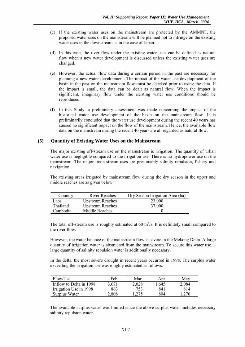
The existing areas irrigated by mainstream flow during the dry season in the upper and middle reaches are as given below.
Country River Reaches Dry Season Irrigation Area (ha)
Laos Upstream Reaches 23,000 Thailand Upstream Reaches 37,000 Cambodia Middle Reaches 0
The total off-stream use is roughly estimated at 60 m3/s. It is definitely small compared to the river flow.
However, the water balance of the mainstream flow is severe in the Mekong Delta. A large quantity of irrigation water is abstracted from the mainstream. To secure this water use, a large quantity of salinity repulsion water is additionally necessary.
In the delta, the most severe drought in recent years occurred in 1998. The surplus water exceeding the irrigation use was roughly estimated as follows:
Flow/Use Feb. Mar. Apr. May Inflow to Delta in 1998 3,671 2,028 1,645 2,084 Irrigation Use in 1998 863 753 841 814 Surplus Water 2,808 1,275 804 1,270
The available surplus water was limited since the above surplus water includes necessary salinity repulsion water.
XI-7
Vol. II: Supporting Report, Paper IX: Water Use ManagementWUP-JICA, March 2004
3.2 Discussions on the Water Use Monitoring System
(1) Necessity of Water Use Monitoring
Article 26 of the Agreement stipulates: (i) improving upon the mechanism to monitor intra-basin use, and (ii) setting up a mechanism to monitor inter-basin diversions from the mainstream.
The water use monitoring may be necessary at both national and regional level for the purposes of: (i) estimating the existing water uses, (ii) checking compliance of proposed water uses with the water use conditions, and (iii) coordinating the water uses in severe droughts, and (iv) sharing data of the existing water uses in the basin with one another.
Sharing of the water use data is essentially necessary for cooperation in the water use management of the LMB.
(2) Necessity of Integrated Monitoring of River Flow and Water Use
The river flow at the principal stations shall be monitored along with the water uses on the mainstream for the well-coordinated water use management. However, the flow regime of the mainstream may be changed by the proposed water uses in the tributaries. Hence, inflow from the major tributaries, mainstream flow at principal stations and water uses in the basin shall be monitored in an integrated manner.
(3) Kind of Water Use Monitored
The off-stream uses of irrigation, urban and hydropower purposes are to be monitored together with the related dam operation. The off-stream uses of domestic, industrial, fishpond and other uses in rural areas are to be omitted since their impact on the river flow is considered small.
(4) Technical Possibility of Water Use Monitoring
(a) Irrigation Water Use
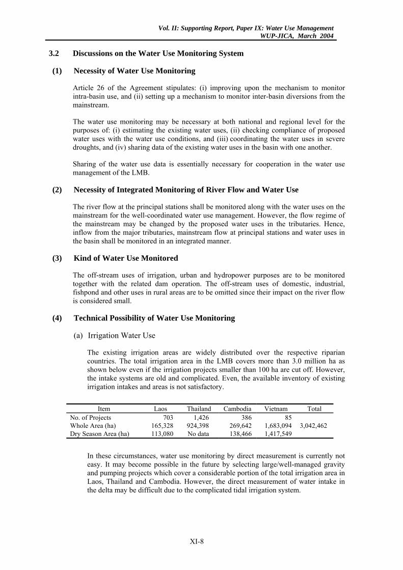
The existing irrigation areas are widely distributed over the respective riparian countries. The total irrigation area in the LMB covers more than 3.0 million ha as shown below even if the irrigation projects smaller than 100 ha are cut off. However, the intake systems are old and complicated. Even, the available inventory of existing irrigation intakes and areas is not satisfactory.
Item Laos Thailand Cambodia Vietnam Total
No. of Projects 703 1,426 386 85 Whole Area (ha) 165,328 924,398 269,642 1,683,094 3,042,462 Dry Season Area (ha) 113,080 No data 138,466 1,417,549
In these circumstances, water use monitoring by direct measurement is currently not easy. It may become possible in the future by selecting large/well-managed gravity and pumping projects which cover a considerable portion of the total irrigation area in Laos, Thailand and Cambodia. However, the direct measurement of water intake in the delta may be difficult due to the complicated tidal irrigation system.
XI-8
Vol. II: Supporting Report, Paper IX: Water Use ManagementWUP-JICA, March 2004
In the LMB, when direct measurement is difficult, irrigation water use has to be estimated by monitoring the irrigation area and cropping pattern. Remote sensing by satellite may be one of the indirect monitoring methods.
(b) Urban Water Use
Monitoring will be limited to Vientiane, Phnom Penh and several urban centres in the delta. Monitoring of the water intake is not difficult.
(c) Dam Operation including Hydropower Use
There are a number of large and small storage dams. Inventories are available for only limited large storage dams. No data is available for the others. However, operation of the selected large dams is currently being monitored on daily basis. Monitoring will be developed for the other dams in the future.
(5) Transparency of Data Monitoring
Ensuring the transparency of monitoring is essential. An effective monitoring mechanism to ensure the transparency shall be established, especially for the projects of inter-basin diversion and large intra-basin water use. The possible mechanism will include a system of periodical field check by MRC and installation of real-time remote monitoring system in which data are accessible from MRC on real time.
(6) Necessary Immediate Actions
The above-discussed monitoring system of the LMB will be developed in stages. However, the inventory of existing irrigation projects by MRC, which was preliminarily finalized in February 2002, should be completed as early as possible. Inventory of the existing storage dams also should be done together with this work. These inventories will give the basis to develop a practical monitoring system.
XI-9
Vol. II: Supporting Report, Paper IX: Water Use ManagementWUP-JICA, March 2004
CHAPTER 1: INTRODUCTION
The water use management system of the Lower Mekong Basin (LMB) should be established based on the 1995 Mekong Agreement (the Agreement). The following three (3) Articles in the Agreement are technically considered as the most important ones for establishing the management system.
Article 5: Reasonable and Equitable Utilization
Article 6: Maintenance of Flows on the Mainstream
Article 26: Rules for Water Utilization and Inter-Basin Diversions
In these Articles, there are many technical issues to be concluded. Among them, the following issues are considered to be the most basic ones.
(1) Procedure to establish the acceptable minimum monthly natural flow on the mainstream.
(2) Procedure to prepare the policies/guidelines for arriving at an agreement of proposed intra-basin use during the dry season and inter-basin diversion on the mainstream.
(3) Procedure to manage the mainstream flow, especially, in severe drought including establishment of water use monitoring system.
This Paper IX consists of two (2) parts. In Part I, the water use management system of Japan is presented to give some materials/guidelines/suggestions necessary or useful for developing the above issues. In Part II, discussed are how to establish the acceptable minimum monthly natural flow and water use monitoring system in the Lower Mekong Basin (LMB), referring to the policies and experiences of water use management in Japan.
XI-10
Vol. II: Supporting Report, Paper IX: Water Use ManagementWUP-JICA, March 2004
CHAPTER 2: RIVER WATER USE MANAGEMENT IN JAPAN
1. EXISTING WATER USE AND RIVER FLOW REGIME
1.1 Land Area and Population
Japan has a total land area of 377,900 km2. It had the total population of 126.5 million or an average population density of 335 persons/km2 in 1998. It consists of 47 local administrative units (prefectures). A total land of 49,900 km2 is devoted to agriculture; i.e., 27,200 km2 for paddy, and 22,700 km2 for upland crops and pasture. These are compared to the land area and population of the Lower Mekong Basin as shown below.
Land Area and Population in Japan
Item Land Area (km2)
Population (million)
Population Density
(person/km2) Agricultural Land (ha)
Japan 377,900 126.5 335 4,990,000 Lower Mekong 1) 606,000
(795,000) 62.0 102 13,000,000
Source: 1): Basin Development Plan, Inception Report, July 2002, MRC Note: Figure in parentheses indicate the total basin area including Upper Mekong.
1.2 Existing Water Use (1, 2)
Water resources in Japan have been highly exploited. The ratio of water exploitation reaches more than 30% in a drought year of 10-year probability. The yearly water use and water resources potential are compared in the following table. In this table, the water resources potential was obtained by deducting evapo-transpiration from the precipitation on land.
Existing Water Use and Water Resources Potential in Japan
Water Use (billion m3/year) Water Resources Potential (billion m3/year)Domestic Agricultural Industrial Total Drought Year Average Year
16.4 58.6 13.7 88.7 280.4 421.7 Note: Domestic water use includes public, business and small industrial uses.
Agricultural water is used mostly for the irrigation of paddy (95%). Hence, agricultural water use concentrates in the summer season (May to September).
Most of the water use depends on river water. Eighty-eight percent (88%) of the necessary water is abstracted from rivers and 12% is from groundwater as shown below.
Water Source of the Existing Water Use in Japan
Water Use River Water (%) Groundwater (%) Total (%) Domestic 77 23 100 Agricultural 95 5 100 Industrial 70 30 100 Total 88 12 100
Note: Domestic water use includes public, business and small industrial uses.
XI-11
Vol. II: Supporting Report, Paper IX: Water Use ManagementWUP-JICA, March 2004
Further, a total of 51,400 m3/s at peak is used for hydropower generation at 1,830 locations.
1.3 River Flow Regime
In Japan, the period of dry and wet seasons are not distinct. The river flow always fluctuates (daily or weekly but not seasonally) to a large extent throughout the year. The river flow sharply rises at flood time, while it extremely lowers at drought time. The ratio of the drought flow rate (the 10th smallest daily flow rate in a year) to the average one in the major 100 rivers is estimated to be approximately 20% on the average.
The average flow regimes of the representative rivers in Japan are shown below, compared with that of the Mekong River.
Flow Regime of the Representative Rivers
River Principal Station Flow Regime (m3/s) River C.A.
(km2) Station C.A.
(km2) Max. 50% 75% 97% Min. Ave.
Tone 16,840 Kurihashi 8,588 11,444 159 110 77 6 252 Kiso 9,100 Inuyama 4,684 14,099 189 128 87 29 298 Yodo 8,240 Hirakata 7,281 7,970 195 148 107 43 273
River C.A. Station C.A. Max. 50% 70% 90% Min. Ave.Mekong 795,500 Pakse 545,000 56,000 5,140 2,520 1,830 1,160 9,740
Source: 1): Japanese Rivers: Annual Report of River Discharge (1999), River Association (in Japanese)
2): Mekong River: JICA Estimate Record Period: Tone (1938-1999), Kiso (1951-1999), Yodo (1952-1999), Mekong (1961-2000)
The Tone River supplies water to the Tokyo metropolitan and surrounding agricultural areas, the Kiso River to the Nagoya urban and surrounding agricultural areas and the Yodo River to Kyoto-Osaka-Kobe urban and surrounding agricultural areas.
The typical river flow variation in Japan is illustrated in Fig. 1, compared with that of the Mekong River.
1.4 Storage Dam (3)
In Japan, the river water has been highly used since the olden days. Currently, there is no available surplus water in rivers during the drought period. Supplemental water cannot be abstracted from the rivers without construction of a storage dam. To meet the excessive water use, a number of storage dams have been constructed. At present, there are more than 3,100 dams (including dams higher than 15 m) with a total effective storage capacity of 24.2 billion m3.
2. WATER USE MANAGEMENT BY WATER RIGHT
2.1 Principles of Water Use Management
2.1.1 River Water
The river water including lake water is managed by the River Law, which was firstly enacted in 1896 and thereafter, revised in 1964 and 1997. River water is designated as public property according to the Law. All the river water abstractions are controlled by the River Administrator from the uppermost reaches to the river mouth based on the water right system.
XI-12
Vol. II: Supporting Report, Paper IX: Water Use ManagementWUP-JICA, March 2004
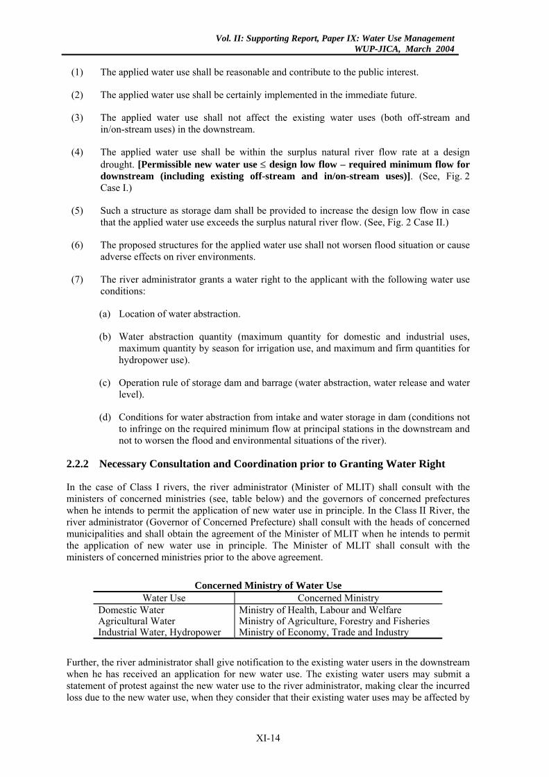
The river systems in Japan are legally categorized into two (2) classes: Class I River System and Class II River System. They cover 92% of the national land territory as shown below. The remaining 8% is directly drained to the sea through small rivers and channels.
River System in Japan
Category No. of River Systems Drainage Area (km2) Share in National Territory Class I River 109 239,900 63.5% Class II River 2,719 109,300 28.9% Total 2,828 349,200 92.4%
The Class I River is important for the economy, social welfare and environment of the country, and the drainage basin covers the land of more than two (2) prefectures in principle. The basin of the Class II River is located within only one prefecture.
The Class I River is administered by the Central Government [River Administrator: Minister, Ministry of Land, Infrastructure and Transport (MLIT)]. On the other hand, the Class II River is administered by the Local Government (River Administrator: Governor of Concerned Prefecture). The river administrator manages and controls the river flow, river water use, river course, river environments, river structures, etc.
Any person who intends to abstract the river water for such off-stream uses as domestic, irrigation, industrial, hydropower, and other purposes shall obtain the permission of the river administrator (water right). The granted water right is protected from new water uses according to the Law.
River water for such in/on-stream uses as preservation of aquatic life, fishery, scenic view, preservation of water quality, navigation, prevention of salinity intrusion, prevention of estuary clogging, maintenance of groundwater table, etc. is maintained by establishing the environmental flow (called “maintenance flow” in Japan) at principal river stations. The river administrator is responsible for maintenance of the minimum flow required for the existing off-stream and in/on-stream uses.
2.1.2 Groundwater
Groundwater is regarded as private property belonging to land, and the landowner can freely extract the groundwater under his land in principle. Groundwater use is not controlled for the management of water resources but it is only controlled for the prevention of public hazard.
The local government regulates groundwater extraction only within the specified areas where the groundwater extraction may cause a significant land subsidence.
2.2 Water Rights
2.2.1 Principles of Granting Water Right
Any person (usually representative of organization) who intends to use the water of a river shall obtain the permission of the river administrator (water right) according to the River Law. However, a number of river water uses (mostly for agricultural purpose) had been conducted even before 1896 when the River Law was firstly enacted. Those water uses are all regarded as granted water right (customary water right), which has the same legal status as the legally permitted water right.
A person who intends to obtain a new water right shall submit necessary application documents to the river administrator. The applied water use is permitted as far as its application satisfies the following conditions. However, no person/organization/region can reserve a water right only for potential water use in the future because the available river water is limited.
XI-13
Vol. II: Supporting Report, Paper IX: Water Use ManagementWUP-JICA, March 2004
(1) The applied water use shall be reasonable and contribute to the public interest.
(2) The applied water use shall be certainly implemented in the immediate future.
(3) The applied water use shall not affect the existing water uses (both off-stream and in/on-stream uses) in the downstream.
(4) The applied water use shall be within the surplus natural river flow rate at a design drought. [Permissible new water use ≤ design low flow – required minimum flow for downstream (including existing off-stream and in/on-stream uses)]. (See, Fig. 2 Case I.)
(5) Such a structure as storage dam shall be provided to increase the design low flow in case that the applied water use exceeds the surplus natural river flow. (See, Fig. 2 Case II.)
(6) The proposed structures for the applied water use shall not worsen flood situation or cause adverse effects on river environments.
(7) The river administrator grants a water right to the applicant with the following water use conditions:
(a) Location of water abstraction.
(b) Water abstraction quantity (maximum quantity for domestic and industrial uses, maximum quantity by season for irrigation use, and maximum and firm quantities for hydropower use).
(c) Operation rule of storage dam and barrage (water abstraction, water release and water level).
(d) Conditions for water abstraction from intake and water storage in dam (conditions not to infringe on the required minimum flow at principal stations in the downstream and not to worsen the flood and environmental situations of the river).
2.2.2 Necessary Consultation and Coordination prior to Granting Water Right
In the case of Class I rivers, the river administrator (Minister of MLIT) shall consult with the ministers of concerned ministries (see, table below) and the governors of concerned prefectures when he intends to permit the application of new water use in principle. In the Class II River, the river administrator (Governor of Concerned Prefecture) shall consult with the heads of concerned municipalities and shall obtain the agreement of the Minister of MLIT when he intends to permit the application of new water use in principle. The Minister of MLIT shall consult with the ministers of concerned ministries prior to the above agreement.
Concerned Ministry of Water Use
Water Use Concerned Ministry Domestic Water Ministry of Health, Labour and Welfare Agricultural Water Ministry of Agriculture, Forestry and Fisheries Industrial Water, Hydropower Ministry of Economy, Trade and Industry
Further, the river administrator shall give notification to the existing water users in the downstream when he has received an application for new water use. The existing water users may submit a statement of protest against the new water use to the river administrator, making clear the incurred loss due to the new water use, when they consider that their existing water uses may be affected by
XI-14
Vol. II: Supporting Report, Paper IX: Water Use ManagementWUP-JICA, March 2004
the new water use. The river administrator shall not grant permission when the existing water uses are affected by the new water use in principle.
2.2.3 Priority Order
It is generally recognized that higher priority is given to old water right than new water right (first in time first in right) according to the instruction of the river administrator on the above-mentioned water use conditions. Domestic water is not always given the top priority.
However, the River Law says that in a severe drought exceeding the design drought, the quantity of each water abstraction shall be cut more or less through the consultation among the related users. When the consultation ends in failure, the river administrator can arbitrate among the users in response to their request. For this purpose, the water use coordination committee consisting of river administrator, water users and concerned organizations have been established in most of the major river basins.
2.2.4 Term of Validity
The water right is usually valid for approximately 30 years for hydropower use and about 10 years for other water uses. The original water use quantity, pattern and location may change in the future according to the socio-economic development of the river basin and hence, the contents of the water right needs to be reviewed in every certain period. However, the term of validity is renewed in every 10 or 30 years in principle as far as the water use is necessary and active, and no vital change occurs in the original water use plan.
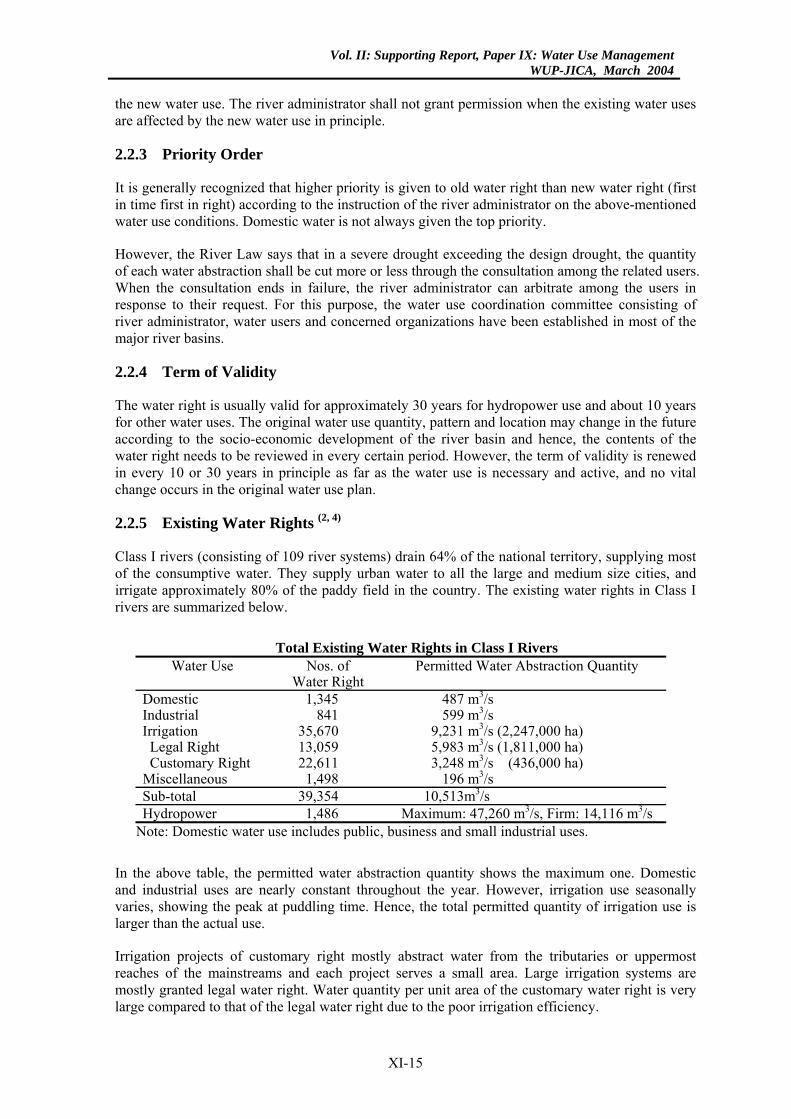
2.2.5 Existing Water Rights (2, 4)
Class I rivers (consisting of 109 river systems) drain 64% of the national territory, supplying most of the consumptive water. They supply urban water to all the large and medium size cities, and irrigate approximately 80% of the paddy field in the country. The existing water rights in Class I rivers are summarized below.
Total Existing Water Rights in Class I Rivers
Water Use Nos. of Water Right
Permitted Water Abstraction Quantity
Domestic 1,345 487 m3/s Industrial 841 599 m3/s Irrigation 35,670 9,231 m3/s (2,247,000 ha)
Legal Right 13,059 5,983 m3/s (1,811,000 ha) Customary Right 22,611 3,248 m3/s (436,000 ha)
Miscellaneous 1,498 196 m3/s Sub-total 39,354 10,513m3/s Hydropower 1,486 Maximum: 47,260 m3/s, Firm: 14,116 m3/s
Note: Domestic water use includes public, business and small industrial uses.
In the above table, the permitted water abstraction quantity shows the maximum one. Domestic and industrial uses are nearly constant throughout the year. However, irrigation use seasonally varies, showing the peak at puddling time. Hence, the total permitted quantity of irrigation use is larger than the actual use.
Irrigation projects of customary right mostly abstract water from the tributaries or uppermost reaches of the mainstreams and each project serves a small area. Large irrigation systems are mostly granted legal water right. Water quantity per unit area of the customary water right is very large compared to that of the legal water right due to the poor irrigation efficiency.
XI-15
Vol. II: Supporting Report, Paper IX: Water Use ManagementWUP-JICA, March 2004
3. DESIGN RIVER FLOW FOR WATER USE MANAGEMENT
3.1 General
As mentioned before, river water use in Japan is legally managed through the water right system. New water use is allowed only within the surplus natural flow at the design drought. Such a structure as storage dam is necessary to increase the design low flow in case that the new water use exceeds the available surplus natural flow. (See, Fig. 2.)
Technically, this water use management is performed by assuming natural flow; design low flow and required minimum flow for the downstream. Definition, criteria, contents and estimation method of these river flows are described below.
3.2 Natural Flow
The river water has continuously been developed since the olden days to meet the increasing water requirement of the river basin. Hence, the flow regime has historically changed according to the water use development.
Even in the past, new water uses (including storage/release of dam and abstraction from river) were planned based on actual flow regime at that time. The proposed new water uses were implemented by coordinating them with the water uses that had already existed.
At present, the existing water uses are managed based on the current flow regime. New water uses are planned and implemented not to infringe upon the existing water uses. Hence, it is considered impractical or unnecessary to reproduce the imaginary natural flow regime in the past days by removing the existing water uses when a new water use plan is prepared.
From the above considerations, the river flow under the existing water use conditions (including water abstraction and water storage/release of dam) should be defined as natural flow when a new water development is discussed unless the existing water uses are revised.
Usually, the flow records during a certain period in the past are necessary for planning of a new water use. However, they are employed for the analysis of flow characteristics, assessment of hydrological probability and preparation of the operation rule of the new water use. Accordingly, imaginary natural flow needs to be reproduced only when the flow regime has been largely disturbed by the water use development in the past. If the disturbance is not significant, the flow records in the past can be used as the natural flow under the existing water use conditions.
In most of the rivers in Japan, the natural flow has been almost all abstracted at drought time since the olden days. However, the river flow had not been regulated by large storage dam until the end of the World War II (1945). The large-scale water resources development of the major river basins (including large-scale storage dam and water diversion) started around 1955 – 1960. Those water resources development plans were prepared based on the observed flow regime during a certain period before 1955-1960 since the flow records were scarcely disturbed during the above period.
3.3 Design Low Flow
The design low flow is determined to evaluate the available surplus natural flow. It is defined as the minimum rate of the natural flow regime (hydrograph) in the design drought. However, it is determined by each season when the water use seasonally varies.
XI-16
Vol. II: Supporting Report, Paper IX: Water Use ManagementWUP-JICA, March 2004
3.3.1 Probability of Design Low Flow
The design low flow varies depending on its hydrological probability. If the design probability (safety factor) is set lower, a larger design low flow may be estimated and, as a result, more new water abstraction can be permitted. In this case, however, the reliability of water use becomes lower. In the inverse case, the permissible new water use is limited and more river water will be wasted to the sea although the reliability of water use becomes higher.
In Japan, the design low flow is determined for the natural flow regime of a 10-year drought probability. All the water uses in any category are ensured to the extent of a 10-year drought. This design reliability of water use is considered higher than that in the Southeast Asian region. It is because:
(1) A large quantity of river water is used for domestic and industrial purposes in the urban areas; and
(2) A high reliability is required for such water uses since lack of water supply may cause vital damages on the urban and industrial activities in the country.
3.3.2 Preparation of Design Flow Regime (Hydrograph)
(1) Design Flow Pattern
The river flow widely fluctuates throughout the year as shown in Fig. 1. Wet and dry seasons are not distinct. It is different from the Lower Mekong Basin.
As mentioned before, no available surplus natural flow is remained at the design drought time in most of the rivers. It is usually necessary to construct a storage dam to meet proposed new water uses.
A storage dam stores water at rain time and supplement water at drought time. Operation of the dam is more complicated than in the Lower Mekong Basin. The dam repeats water storage and release throughout the year according to the river flow and water requirement at the principal stations in the downstream. The operation must been done to cover the water requirement at all the principal stations.
Usually, the flow regime (flow hydrograph) of the typical drought year with a 10-year probability is assumed as the design flow regime based on the actual flow records in the past. For this design flow regime, the water balance at the principal stations is calculated and the required water supply from dam is estimated. (See, Fig. 2). This simple static approach is employed for the planning of new water development for practical purpose.
It is because:
(a) A number of people, communities, central/local government, NGO, water users, relevant experts and others are involved in the planning of new water development.
(b) Many people/organizations may benefit from the proposed development; however, some people/organizations may be affected by it.
(c) In Japan, a large amount of cost is required to develop 1.0 m3/s of new water use due to the densely populated land use. Usually, the cost will be born by the central/local government, municipalities and water users (citizens, farmers and private enterprises).
XI-17
Vol. II: Supporting Report, Paper IX: Water Use ManagementWUP-JICA, March 2004
(d) If the planning criteria are not fixed and have a certain range, the exploitable water
quantity will sometimes vary to a considerable extent. It will cause many severe trade-off conflicts among the concerned people and organizations.
(e) Hence, the proposed plan must be well understood and accepted by all the concerned people and organizations. The planning methodology must be simple, practical and easy to understand as far as technically/scientifically allowable.
(2) Database of Flow Regime
The river flow always fluctuates (daily or weekly but not seasonally) widely throughout the year because the dry and wet seasons are not distinct. Hence, the river flow regime is usually established based on the 5-day average flow rate.
3.3.3 Estimation of Future Design Low Flow
In the future, the design low flow in the downstream will change due to the effects of water development and use in the upstream. This change needs to be considered in planning the future river water use in the downstream if it is significant. The following effects should be considered besides river water abstraction.
(1) Return of Abstracted Water
In Japan, most of the domestic and industrial waters are used in the urban areas developed in coastal regions and little water is returned to the original river. Hence, the return of abstracted water is discussed mainly in relation to irrigation water.
A considerable portion of the irrigation water abstracted from a river will return to the downstream river sections. The irrigation water used in the areas near the river may immediately return to the river. However, the irrigation water on areas distant from the river may have a long time lag before returning to the river. An inter-basin diversion completely consumes the abstracted river water. On the other hand, the irrigation water in the alluvial plains or delta areas usually disperses in a wide direction and not all of it returns to the original river. The return flow mechanism is not always clear.
The observed river flow in a recent certain period (defined as natural flow) already includes the actually returned flow from the existing irrigation areas in the upstream. Hence, only the return of additional water abstraction in the future needs to be estimated for the determination of future design low flow in the downstream.
In Japan, however, all the return of additionally abstracted river water is not always taken into consideration in planning the water resources development projects in a river basin. Usually, the return rate is conservatively estimated to maintain a sufficient reliability of water use.
In most of the river basins, it is mainly considered in planning the water utilization projects in the river valleys where the return flow mechanism is clear. Consideration in the lower alluvial plains including delta areas is limited.
For the return flow model of a river basin, see Fig. 3.
(2) Effect on Flow Regime of Hydropower Dam
A storage dam for water supply intentionally increases the design low flow to meet the required new water use. On the other hand, a hydropower dam with a large storage
XI-18
Vol. II: Supporting Report, Paper IX: Water Use ManagementWUP-JICA, March 2004
capacity coincidentally increases the low flow in the downstream. This effect should be considered in the estimation of future design low flow in the downstream if it is significant.
In Japan, hydropower dams with large storage capacities were mostly constructed in the river basins where the natural flow is abundant enough to meet the water use in the downstream. In these days, hydropower is generally developed as part of a multipurpose dam, but little or no exclusive storage capacity for hydropower generation is allocated and generation is mostly performed following the dam operation rule for the other purposes at drought time. Hence, the increase of low flow by hydropower dam is not usually considered in the estimation of future design low flow in the downstream to maintain a sufficient reliability of water use.
3.4 Required Minimum Flow
3.4.1 Objectives and Functions of the Flow
The river administrator must establish the minimum flow required for the maintenance of desirable river water functions in each river section according to the River Law. This flow is usually called “maintenance flow of normal river water function” in Japan, however, it is called “required minimum flow” in this Paper to avoid misunderstanding of the technical term. This flow is considered to be similar to or the same as the “acceptable minimum monthly natural flow” in the 1995 Mekong Agreement. Any new water use must be developed in an appropriate manner that does not infringe on the required minimum flow.
The required minimum flow is designed to satisfy both existing reasonable off-stream and in/on-stream uses in each river section. The off-stream use includes domestic, agricultural, industrial, hydropower and other off-stream uses. The in/on-stream water use covers preservation of aquatic life, fishery, scenic view, preservation of water quality, navigation, prevention of salinity intrusion, prevention of estuary clogging, maintenance of groundwater table, etc. The flow required for in/on-stream uses is usually called “river maintenance flow” in Japan, however, it is called “environmental flow” in this Paper to avoid misunderstanding of the technical term.
The policies and guidelines on how to establish the required minimum flow are presented in detail in Chapter 6.
3.4.2 Seasonal Variation of Flow
In Japan, the domestic and industrial water uses are nearly constant throughout the year. The agricultural water is used mostly for the irrigation of paddy. Paddy is cropped once a year during the summer season (May to September) and hence, the target irrigation area is fixed. The agricultural water use seasonally varies in pattern and is roughly divided into three (3) seasons: puddling season (May), growing season (June to September) and non-irrigation season (for miscellaneous uses).
The in/on-stream water uses also vary in time, according to the seasonal variation of their requirements. Hence, the required minimum flow is determined by season.
3.4.3 Reliability of Flow
The reliability of all the off-stream water uses in Japan is determined to meet a 10-year drought probability. Theoretically, however, the reliability of in/on-stream water use should be different by purpose and by river section.
XI-19

Vol. II: Supporting Report, Paper IX: Water Use ManagementWUP-JICA, March 2004
Nevertheless, the same reliability is applied for both off-stream and in/on-stream water uses from the viewpoint of practical water management at present. Hence, the required minimum flow shall be maintained throughout the year with a 10-year probability in principle.
XI-20
Vol. II: Supporting Report, Paper IX: Water Use ManagementWUP-JICA, March 2004
4. WATER RESOURCES DEVELOPMENT
4.1 Water Conflicts
4.1.1 General
There is no available surplus water in most of the rivers. New water use can be realized only by constructing storage dams and related diversion facilities. However, the storage dam sites and exploitable water resources are limited. Hence, many and complicated conflicts occur among water use sectors as well as water use regions concerning the allocation of water resources. Especially, severe conflicts occur between the downstream and diversion areas in case of inter-basin water diversion.
4.1.2 Inter-basin Water Diversion
A number of inter-basin water diversion projects have been implemented in Japan. Usually, the people and local governments in the downstream have made a protest against the diversion mainly due to the following reasons:
(1) The diversion may possibly affect the required minimum flow (which satisfies both existing off-stream and in/on-stream uses) in the downstream in a severe drought exceeding the design one. In fact, the diversion of water cannot be completely stopped even in an abnormal drought time.
(2) The diversion will decrease the water resources potential in the downstream, resulting in making it difficult more or less to promote the water resources development for the downstream.
(3) The people in the downstream seek an equitable allocation of the benefits of water resources development in the river basin. They always say that “the downstream area receives the benefits of water use but suffers from flood damages, on the other hand, the diversion area only enjoys the benefits of water use.”
All the major inter-basin water diversion projects have been implemented by the central government for smooth coordination between the concerned areas. The government has coordinated the conflicts based on the following principal policies:
(1) The water resources development is planned to produce beneficial effects on both diversion and downstream areas. For this purpose, construction of multipurpose dams is essentially necessary.
(2) The dams are planned to ensure the required minimum flow in the downstream, to meet the future water use in the downstream area as well as in the diversion area and to mitigate flooding problems in the downstream as required.
4.2 Principles and Policy of Water Resources Development
4.2.1 Maintenance of Required Minimum Flow
The maintenance of required minimum flow is prerequisite for the new water development. However, the existing design low flow (design low flow before construction of new storage dam) does not always cover the required minimum flow to meet the existing off-stream uses (water rights) and in/on-stream uses. It is because:
XI-21
Vol. II: Supporting Report, Paper IX: Water Use ManagementWUP-JICA, March 2004
(1) A number of customary water rights were granted in the olden days and the reliability of
their water uses is mostly low.
(2) The target reliability of water use has been raised up according to the socio-economic development of the country.
(3) Necessity of river environmental improvement has increased in these days, resulting in increase of the required flow for in/on-stream use.
The river administrator is responsible for the maintenance of required minimum flow as well as flood control. He usually constructs multipurpose dams including new water uses (domestic, industrial, irrigation, hydropower) in addition to flood control and maintenance of required minimum flow. In this case, the multipurpose dams are designed to have necessary additional storage capacity to maintain the required minimum flow.
The river administrator bears the costs for flood control and maintenance of required minimum flow; whereas the new water users bear the remaining cost. As a result, the reliability of both required minimum flow and new water use is ensured as designed. (See, Fig. 2, Case II.)
However, when a new water user constructs a single purpose dam for his specific purpose, the dam does not need to supply water to maintain the required minimum flow. In this case, the required minimum flow is left as insufficient; however, the dam operation (water storage by dam) is restricted not to infringe on the existing off-stream and in/on-stream uses in the downstream.
4.2.2 New Water Development
The general principles for new water development are summarized below.
(1) New water will be developed in an appropriate manner that may not affect the required minimum flow at each principal station.
(2) New water will be developed and allocated for users based on an integrated long-term water resources development and use plan of the river basin.
(3) The new water development and use will be coordinated through consultation with the concerned organizations based on the related laws/regulations/rules.
(4) No one/sector/region can reserve river water only for their future potential use when they have no concrete water use plan.
4.2.3 Long-Term Water Resources Development Plan
To resolve the water conflicts and then, to promote the water utilization, a long-term integrated plan of water resources development and use is essentially necessary for each river basin.
For this purpose, the Water Resources Development Promotion Law was enacted in 1961. The Minister of MLIT shall designate the objective river basins, and prepare a long-term integrated water resources development and use plan for each objective basin in consultation with the ministers of the concerned ministries according to the Law.
A long-term integrated water resources development and use plan has been prepared for each of the seven (7) major river basins, and a number of storage dams and diversion facilities have been implemented within the frame of the Plan. The seven (7) objective river basins cover a total drainage area of 44,500 km2, serving a total population of 62.0 million or approximately 50% of the national population (126.5 million).
XI-22
Vol. II: Supporting Report, Paper IX: Water Use ManagementWUP-JICA, March 2004
The Plan includes: (i) projection of water demand and supply balance in the future; and, (ii) water resources development facilities (such as storage dam, intake and diversion channel) necessary to meet the water requirement.
The Plan is prepared targeting 15-20 years after at the farthest since the projection of water requirement in the far future is difficult. The Plan has been revised several times, extending the target year according to the increase of the water requirement in the objective region.
4.2.4 Optimum and Equitable Water Resources Development
The water resources development should be planned to produce equitable benefits (or allocated benefits that can be agreed upon) on all the concerned sectors and regions in the river basins. Further, it should be planned to make the optimum use of the limited water resources and potential dam sites.
Multipurpose dam is usually the key project to attain the optimum and equitable water resources development of the river basin. The dam will include the following purposes: maintenance of required minimum flow, new water supply, flood control and hydropower generation.
The equitable water resources development of the river basin is difficult. Usually, the project mostly benefits the downstream areas. The upstream areas are submerged by the construction of proposed storage dam, causing serious problems of resettlements. The conflicts are especially severe when the prefectures that receive water benefits and suffer from the resettlements are different.
For coordination of these conflicts, a special law was enacted in 1973. This special law aims to promote the regional development for the surrounding areas of the proposed reservoir along with the ordinary compensation for the resettlement with the special financial assistances of the Central Government, concerned local government and beneficiaries in the downstream (local governments and water users). This coordination system has been applied for approximately 70 major dam projects since 1973.
4.3 Inter-basin Water Diversion of Yoshino River (Example) (1, 5)
4.3.1 General Description of the Basin
The Yoshino River drains a total area of 3,750 km2 with a trunk river length of 194 km, covering part of four (4) prefectures: Tokushima, Kouchi, Ehime and Kagawa. The catchment area covered by each prefecture is given below. Tokushima Prefecture covers the lower part of the basin, while the other three (3) prefectures occupy only the upstream watersheds. (See, Fig. 4.)
Catchment Area of Prefectures Concerned in YoshinoRiver
Prefecture Catchment Area (km2) Share (%) Tokushima 2,260 60 Kouchi 1,070 28 Ehime 400 11 Kagawa 20 1 Total 3,750 100
Nearly 90% of the basin is covered by forest and only 10% is developed for urban and agricultural uses. The developed 10% area is mostly located in the lower sub-basin belonging to Tokushima Prefecture. Hence, the river water had been used for a long time only for domestic, agricultural and industrial purposes in Tokushima Prefecture.
XI-23
Vol. II: Supporting Report, Paper IX: Water Use ManagementWUP-JICA, March 2004
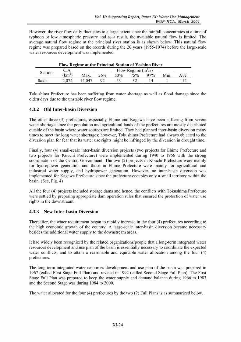
However, the river flow daily fluctuates to a large extent since the rainfall concentrates at a time of typhoon or low atmospheric pressure and as a result, the available natural flow is limited. The average natural flow regime at the principal river station is as shown below. This natural flow regime was prepared based on the records during the 20 years (1955-1974) before the large-scale water resources development was implemented.
Flow Regime at the Principal Station of Yoshino River
Flow Regime (m3/s) Station C.A. (km2) Max. 26% 50% 75% 97% Min. Ave.
Ikeda 2,074 14,047 92 53 32 14 1 112
Tokushima Prefecture has been suffering from water shortage as well as flood damage since the olden days due to the unstable river flow regime.
4.3.2 Old Inter-basin Diversion
The other three (3) prefectures, especially Ehime and Kagawa have been suffering from severe water shortage since the population and agricultural lands of the prefectures are mostly distributed outside of the basin where water sources are limited. They had planned inter-basin diversion many times to meet the long water shortages; however, Tokushima Prefecture had always objected to the diversion plan for fear that its water use rights might be infringed by the diversion in drought time.
Finally, four (4) small-scale inter-basin diversion projects (two projects for Ehime Prefecture and two projects for Kouchi Prefecture) were implemented during 1940 to 1966 with the strong coordination of the Central Government. The two (2) projects in Kouchi Prefecture were mainly for hydropower generation and those in Ehime Prefecture were mainly for agricultural and industrial water supply, and hydropower generation. However, no inter-basin diversion was implemented for Kagawa Prefecture since the prefecture occupies only a small territory within the basin. (See, Fig. 4)
All the four (4) projects included storage dams and hence, the conflicts with Tokushima Prefecture were settled by preparing appropriate dam operation rules that ensured the protection of water use rights in the downstream.
4.3.3 New Inter-basin Diversion
Thereafter, the water requirement began to rapidly increase in the four (4) prefectures according to the high economic growth of the country. A large-scale inter-basin diversion became necessary besides the additional water supply to the downstream areas.
It had widely been recognized by the related organizations/people that a long-term integrated water resources development and use plan of the basin is essentially necessary to coordinate the expected water conflicts, and to attain a reasonable and equitable water allocation among the four (4) prefectures.
The long-term integrated water resources development and use plan of the basin was prepared in 1967 (called First Stage Full Plan) and revised in 1992 (called Second Stage Full Plan). The First Stage Full Plan was prepared to keep the water supply and demand balance during 1966 to 1983 and the Second Stage was during 1984 to 2000.
The water allocated for the four (4) prefectures by the two (2) Full Plans is as summarized below.
XI-24
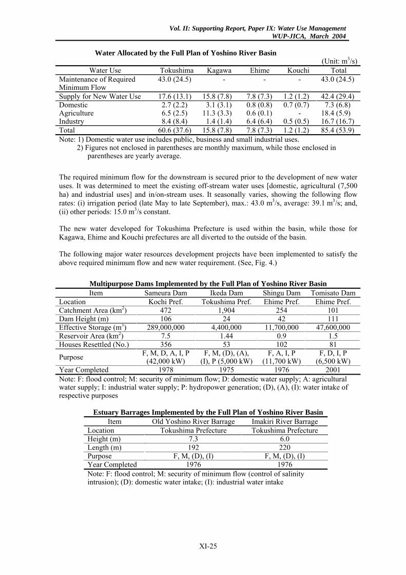
Vol. II: Supporting Report, Paper IX: Water Use ManagementWUP-JICA, March 2004
Water Allocated by the Full Plan of Yoshino River Basin
(Unit: m3/s)Water Use Tokushima Kagawa Ehime Kouchi Total
Maintenance of Required Minimum Flow
43.0 (24.5) - - - 43.0 (24.5)
Supply for New Water Use 17.6 (13.1) 15.8 (7.8) 7.8 (7.3) 1.2 (1.2) 42.4 (29.4) Domestic 2.7 (2.2) 3.1 (3.1) 0.8 (0.8) 0.7 (0.7) 7.3 (6.8) Agriculture 6.5 (2.5) 11.3 (3.3) 0.6 (0.1) - 18.4 (5.9) Industry 8.4 (8.4) 1.4 (1.4) 6.4 (6.4) 0.5 (0.5) 16.7 (16.7) Total 60.6 (37.6) 15.8 (7.8) 7.8 (7.3) 1.2 (1.2) 85.4 (53.9) Note: 1) Domestic water use includes public, business and small industrial uses.
2) Figures not enclosed in parentheses are monthly maximum, while those enclosed in parentheses are yearly average.
The required minimum flow for the downstream is secured prior to the development of new water uses. It was determined to meet the existing off-stream water uses [domestic, agricultural (7,500 ha) and industrial uses] and in/on-stream uses. It seasonally varies, showing the following flow rates: (i) irrigation period (late May to late September), max.: 43.0 m3/s, average: 39.1 m3/s; and, (ii) other periods: 15.0 m3/s constant.
The new water developed for Tokushima Prefecture is used within the basin, while those for Kagawa, Ehime and Kouchi prefectures are all diverted to the outside of the basin.
The following major water resources development projects have been implemented to satisfy the above required minimum flow and new water requirement. (See, Fig. 4.)
Multipurpose Dams Implemented by the Full Plan of Yoshino River Basin Item Sameura Dam Ikeda Dam Shingu Dam Tomisato Dam
Location Kochi Pref. Tokushima Pref. Ehime Pref. Ehime Pref. Catchment Area (km2) 472 1,904 254 101 Dam Height (m) 106 24 42 111 Effective Storage (m3) 289,000,000 4,400,000 11,700,000 47,600,000 Reservoir Area (km2) 7.5 1.44 0.9 1.5 Houses Resettled (No.) 356 53 102 81
Purpose F, M, D, A, I, P(42,000 kW)
F, M, (D), (A), (I), P (5,000 kW)
F, A, I, P (11,700 kW)
F, D, I, P (6,500 kW)
Year Completed 1978 1975 1976 2001 Note: F: flood control; M: security of minimum flow; D: domestic water supply; A: agricultural water supply; I: industrial water supply; P: hydropower generation; (D), (A), (I): water intake of respective purposes
Estuary Barrages Implemented by the Full Plan of Yoshino River Basin Item Old Yoshino River Barrage Imakiri River Barrage
Location Tokushima Prefecture Tokushima Prefecture Height (m) 7.3 6.0 Length (m) 192 220 Purpose F, M, (D), (I) F, M, (D), (I) Year Completed 1976 1976 Note: F: flood control; M: security of minimum flow (control of salinity intrusion); (D): domestic water intake; (I): industrial water intake
XI-25
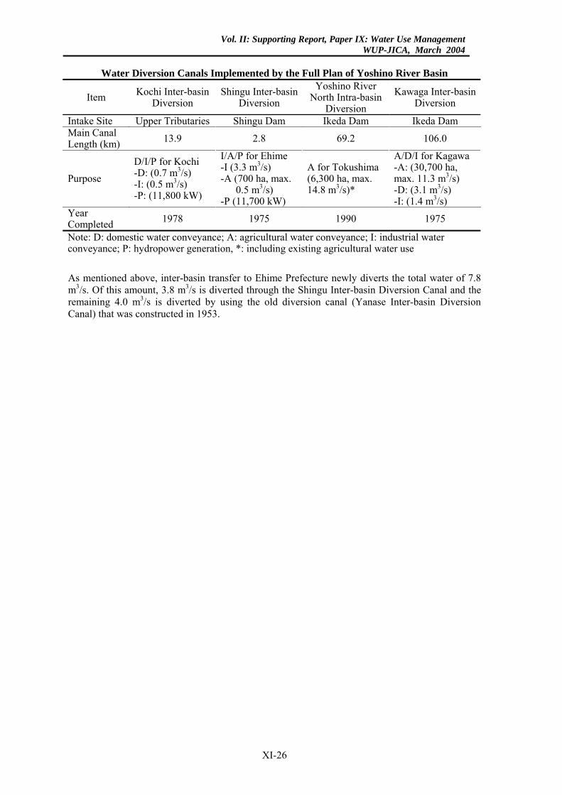
Vol. II: Supporting Report, Paper IX: Water Use ManagementWUP-JICA, March 2004
Water Diversion Canals Implemented by the Full Plan of Yoshino River Basin
Item Kochi Inter-basin Diversion
Shingu Inter-basin Diversion
Yoshino River North Intra-basin
Diversion Kawaga Inter-basin
Diversion
Intake Site Upper Tributaries Shingu Dam Ikeda Dam Ikeda Dam Main Canal Length (km) 13.9 2.8 69.2 106.0
Purpose D/I/P for Kochi -D: (0.7 m3/s) -I: (0.5 m3/s) -P: (11,800 kW)
I/A/P for Ehime -I (3.3 m3/s) -A (700 ha, max.
0.5 m3/s) -P (11,700 kW)
A for Tokushima (6,300 ha, max. 14.8 m3/s)*
A/D/I for Kagawa -A: (30,700 ha, max. 11.3 m3/s) -D: (3.1 m3/s) -I: (1.4 m3/s)
Year Completed 1978 1975 1990 1975
Note: D: domestic water conveyance; A: agricultural water conveyance; I: industrial water conveyance; P: hydropower generation, *: including existing agricultural water use
As mentioned above, inter-basin transfer to Ehime Prefecture newly diverts the total water of 7.8 m3/s. Of this amount, 3.8 m3/s is diverted through the Shingu Inter-basin Diversion Canal and the remaining 4.0 m3/s is diverted by using the old diversion canal (Yanase Inter-basin Diversion Canal) that was constructed in 1953.
XI-26
Vol. II: Supporting Report, Paper IX: Water Use ManagementWUP-JICA, March 2004
5. WATER USE COORDINATION AND MONITORING
5.1 Water Use Restriction in Drought Time
5.1.1 General
The water right is ensured for the design low flow with a certain probability (generally, 10-year drought). The water uses shall be partly cut when the river flow lowers than the design one. According to the River Law, such water use reduction shall be determined through the coordination among the concerned water users in principle. The river administrator shall provide necessary data for the coordination and can arbitrate among the users when requested.
For this purpose, 99 drought coordination committees have been established in 68 river basins among the 109 Class I river basins as of 1999. The committee consists of river administrator, water users, concerned ministries of central government and concerned local governments.
5.1.2 Processes of Water Use Restriction
The water use is usually restricted through the following processes in a severe drought time by each river basin.
Step I: Start of Drought Management
The drought management will start when:
(1) River flow lowers to a certain level.
(2) Remaining water storage in dam lowers to a certain level.
(3) It is forecast that the water right may not be satisfied in the near future.
Step II: Holding of Drought Coordination Committee Meeting
In the Drought Coordination Committee, the river administrator and water users (mostly represented by the concerned divisions of local governments) will provide or exchange the following information.
Information Exchanged in Drought Coordination Committee
Concerned Person Information River Administrator • River flow quantity, water storage in dam and river water quality
• Necessary rate of water use restriction based on the forecasting of future river flow and dam storage
Water Users • Expected damages due to water use restriction • Dissemination of necessity of water use saving
Step III: Decision of Water Use Restriction
The water use restriction program (restriction rate of each water use and date of commencement) will be determined through the coordination among the water users.
XI-27
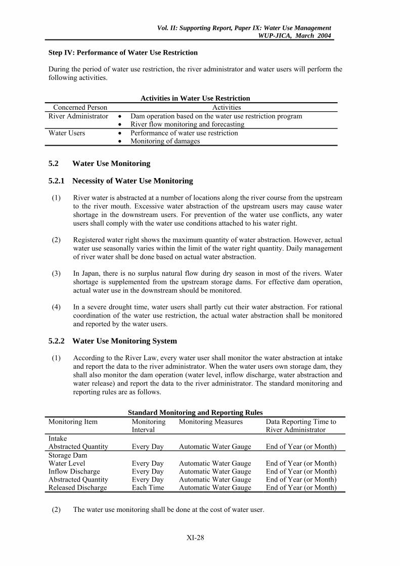
Vol. II: Supporting Report, Paper IX: Water Use ManagementWUP-JICA, March 2004
Step IV: Performance of Water Use Restriction
During the period of water use restriction, the river administrator and water users will perform the following activities.
Activities in Water Use Restriction
Concerned Person Activities River Administrator • Dam operation based on the water use restriction program
• River flow monitoring and forecasting Water Users • Performance of water use restriction
• Monitoring of damages
5.2 Water Use Monitoring
5.2.1 Necessity of Water Use Monitoring
(1) River water is abstracted at a number of locations along the river course from the upstream to the river mouth. Excessive water abstraction of the upstream users may cause water shortage in the downstream users. For prevention of the water use conflicts, any water users shall comply with the water use conditions attached to his water right.
(2) Registered water right shows the maximum quantity of water abstraction. However, actual water use seasonally varies within the limit of the water right quantity. Daily management of river water shall be done based on actual water abstraction.
(3) In Japan, there is no surplus natural flow during dry season in most of the rivers. Water shortage is supplemented from the upstream storage dams. For effective dam operation, actual water use in the downstream should be monitored.
(4) In a severe drought time, water users shall partly cut their water abstraction. For rational coordination of the water use restriction, the actual water abstraction shall be monitored and reported by the water users.
5.2.2 Water Use Monitoring System
(1) According to the River Law, every water user shall monitor the water abstraction at intake and report the data to the river administrator. When the water users own storage dam, they shall also monitor the dam operation (water level, inflow discharge, water abstraction and water release) and report the data to the river administrator. The standard monitoring and reporting rules are as follows.
Standard Monitoring and Reporting Rules
Monitoring Item Monitoring Interval
Monitoring Measures Data Reporting Time to River Administrator
Intake Abstracted Quantity Every Day Automatic Water Gauge End of Year (or Month) Storage Dam Water Level Every Day Automatic Water Gauge End of Year (or Month) Inflow Discharge Every Day Automatic Water Gauge End of Year (or Month) Abstracted Quantity Every Day Automatic Water Gauge End of Year (or Month) Released Discharge Each Time Automatic Water Gauge End of Year (or Month)
(2) The water use monitoring shall be done at the cost of water user.
XI-28
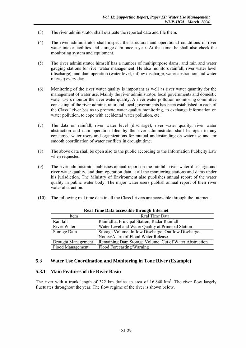
Vol. II: Supporting Report, Paper IX: Water Use ManagementWUP-JICA, March 2004
(3) The river administrator shall evaluate the reported data and file them.
(4) The river administrator shall inspect the structural and operational conditions of river water intake facilities and storage dam once a year. At that time, he shall also check the monitoring system and equipment.
(5) The river administrator himself has a number of multipurpose dams, and rain and water gauging stations for river water management. He also monitors rainfall, river water level (discharge), and dam operation (water level, inflow discharge, water abstraction and water release) every day.
(6) Monitoring of the river water quality is important as well as river water quantity for the management of water use. Mainly the river administrator, local governments and domestic water users monitor the river water quality. A river water pollution monitoring committee consisting of the river administrator and local governments has been established in each of the Class I river basins to promote water quality monitoring, to exchange information on water pollution, to cope with accidental water pollution, etc.
(7) The data on rainfall, river water level (discharge), river water quality, river water abstraction and dam operation filed by the river administrator shall be open to any concerned water users and organizations for mutual understanding on water use and for smooth coordination of water conflicts in drought time.
(8) The above data shall be open also to the public according to the Information Publicity Law when requested.
(9) The river administrator publishes annual report on the rainfall, river water discharge and river water quality, and dam operation data at all the monitoring stations and dams under his jurisdiction. The Ministry of Environment also publishes annual report of the water quality in public water body. The major water users publish annual report of their river water abstraction.
(10) The following real time data in all the Class I rivers are accessible through the Internet.
Real Time Data accessible through Internet
Item Real Time Data Rainfall Rainfall at Principal Station, Radar Rainfall River Water Water Level and Water Quality at Principal Station Storage Dam Storage Volume, Inflow Discharge, Outflow Discharge,
Notice/Alarm of Flood Water Release Drought Management Remaining Dam Storage Volume, Cut of Water Abstraction Flood Management Flood Forecasting/Warning
5.3 Water Use Coordination and Monitoring in Tone River (Example)
5.3.1 Main Features of the River Basin
The river with a trunk length of 322 km drains an area of 16,840 km2. The river flow largely fluctuates throughout the year. The flow regime of the river is shown below.
XI-29
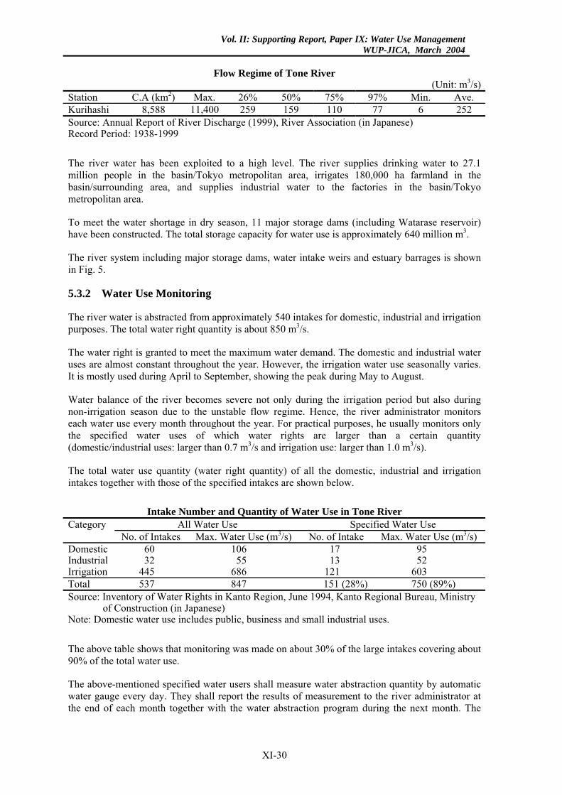
Vol. II: Supporting Report, Paper IX: Water Use ManagementWUP-JICA, March 2004
Flow Regime of Tone River
(Unit: m3/s) Station C.A (km2) Max. 26% 50% 75% 97% Min. Ave. Kurihashi 8,588 11,400 259 159 110 77 6 252 Source: Annual Report of River Discharge (1999), River Association (in Japanese) Record Period: 1938-1999
The river water has been exploited to a high level. The river supplies drinking water to 27.1 million people in the basin/Tokyo metropolitan area, irrigates 180,000 ha farmland in the basin/surrounding area, and supplies industrial water to the factories in the basin/Tokyo metropolitan area.
To meet the water shortage in dry season, 11 major storage dams (including Watarase reservoir) have been constructed. The total storage capacity for water use is approximately 640 million m3.
The river system including major storage dams, water intake weirs and estuary barrages is shown in Fig. 5.
5.3.2 Water Use Monitoring
The river water is abstracted from approximately 540 intakes for domestic, industrial and irrigation purposes. The total water right quantity is about 850 m3/s.
The water right is granted to meet the maximum water demand. The domestic and industrial water uses are almost constant throughout the year. However, the irrigation water use seasonally varies. It is mostly used during April to September, showing the peak during May to August.
Water balance of the river becomes severe not only during the irrigation period but also during non-irrigation season due to the unstable flow regime. Hence, the river administrator monitors each water use every month throughout the year. For practical purposes, he usually monitors only the specified water uses of which water rights are larger than a certain quantity (domestic/industrial uses: larger than 0.7 m3/s and irrigation use: larger than 1.0 m3/s).
The total water use quantity (water right quantity) of all the domestic, industrial and irrigation intakes together with those of the specified intakes are shown below.
Intake Number and Quantity of Water Use in Tone River
Category All Water Use Specified Water Use No. of Intakes Max. Water Use (m3/s) No. of Intake Max. Water Use (m3/s)Domestic 60 106 17 95 Industrial 32 55 13 52 Irrigation 445 686 121 603 Total 537 847 151 (28%) 750 (89%) Source: Inventory of Water Rights in Kanto Region, June 1994, Kanto Regional Bureau, Ministry
of Construction (in Japanese) Note: Domestic water use includes public, business and small industrial uses.
The above table shows that monitoring was made on about 30% of the large intakes covering about 90% of the total water use.
The above-mentioned specified water users shall measure water abstraction quantity by automatic water gauge every day. They shall report the results of measurement to the river administrator at the end of each month together with the water abstraction program during the next month. The
XI-30
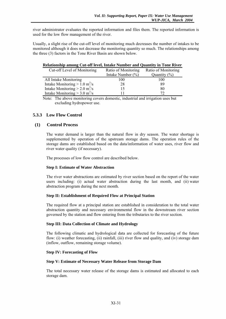
Vol. II: Supporting Report, Paper IX: Water Use ManagementWUP-JICA, March 2004
river administrator evaluates the reported information and files them. The reported information is used for the low flow management of the river.
Usually, a slight rise of the cut-off level of monitoring much decreases the number of intakes to be monitored although it does not decrease the monitoring quantity so much. The relationships among the three (3) factors in the Tone River Basin are shown below.
Relationship among Cut-off level, Intake Number and Quantity in Tone River
Cut-off Level of Monitoring Ratio of Monitoring Intake Number (%)
Ratio of Monitoring Quantity (%)
All Intake Monitoring 100 100 Intake Monitoring > 1.0 m3/s 28 89 Intake Monitoring > 2.0 m3/s 15 80 Intake Monitoring > 3.0 m3/s 11 72
Note: The above monitoring covers domestic, industrial and irrigation uses but excluding hydropower use.
5.3.3 Low Flow Control
(1) Control Process
The water demand is larger than the natural flow in dry season. The water shortage is supplemented by operation of the upstream storage dams. The operation rules of the storage dams are established based on the data/information of water uses, river flow and river water quality (if necessary).
The processes of low flow control are described below.
Step I: Estimate of Water Abstraction
The river water abstractions are estimated by river section based on the report of the water users including: (i) actual water abstraction during the last month, and (ii) water abstraction program during the next month.
Step II: Establishment of Required Flow at Principal Station
The required flow at a principal station are established in consideration to the total water abstraction quantity and necessary environmental flow in the downstream river section governed by the station and flow entering from the tributaries to the river section.
Step III: Data Collection of Climate and Hydrology
The following climatic and hydrological data are collected for forecasting of the future flow: (i) weather forecasting, (ii) rainfall, (iii) river flow and quality, and (iv) storage dam (inflow, outflow, remaining storage volume).
Step IV: Forecasting of Flow
Step V: Estimate of Necessary Water Release from Storage Dam
The total necessary water release of the storage dams is estimated and allocated to each storage dam.
XI-31
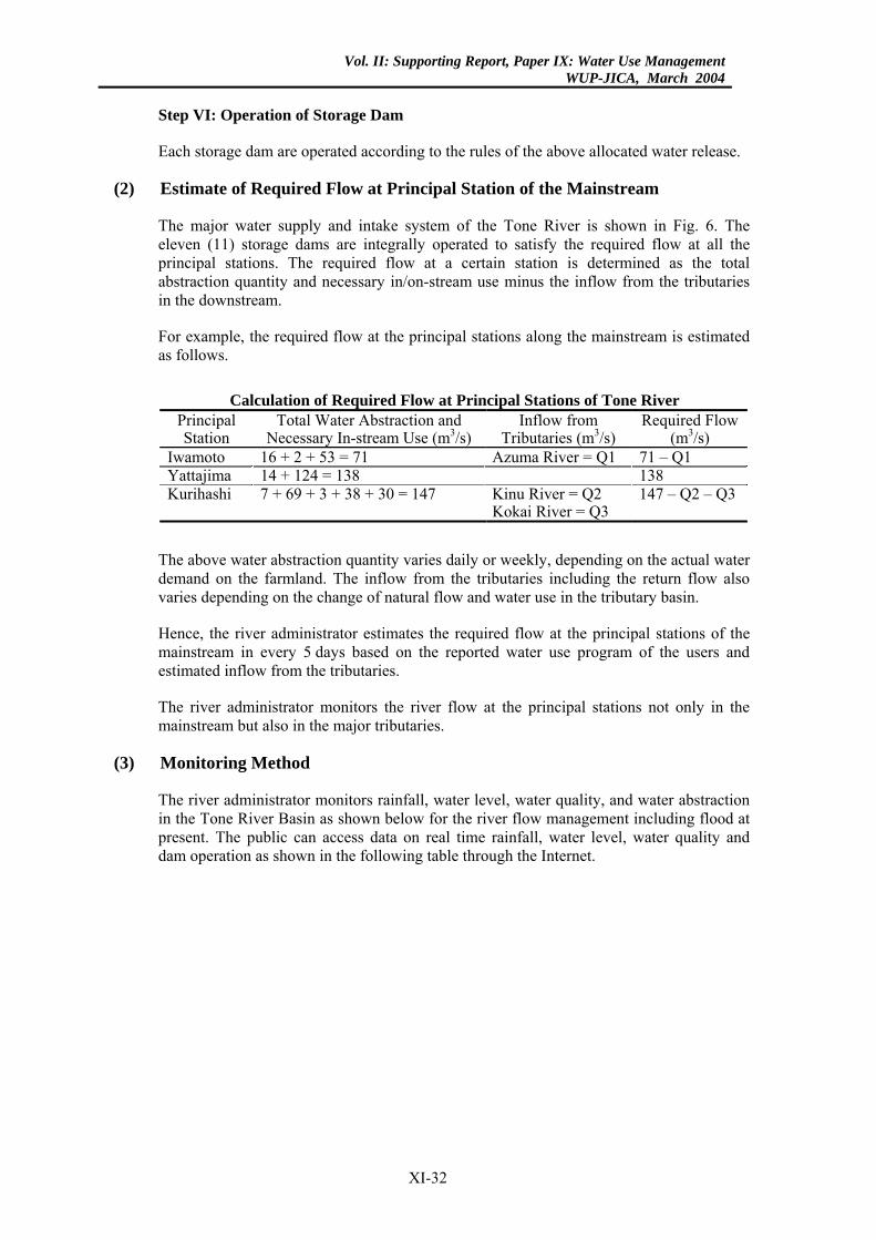
Vol. II: Supporting Report, Paper IX: Water Use ManagementWUP-JICA, March 2004
Step VI: Operation of Storage Dam
Each storage dam are operated according to the rules of the above allocated water release.
(2) Estimate of Required Flow at Principal Station of the Mainstream
The major water supply and intake system of the Tone River is shown in Fig. 6. The eleven (11) storage dams are integrally operated to satisfy the required flow at all the principal stations. The required flow at a certain station is determined as the total abstraction quantity and necessary in/on-stream use minus the inflow from the tributaries in the downstream.
For example, the required flow at the principal stations along the mainstream is estimated as follows.
Calculation of Required Flow at Principal Stations of Tone River
Principal Station
Total Water Abstraction and Necessary In-stream Use (m3/s)
Inflow from Tributaries (m3/s)
Required Flow (m3/s)
Iwamoto 16 + 2 + 53 = 71 Azuma River = Q1 71 – Q1 Yattajima 14 + 124 = 138 138 Kurihashi 7 + 69 + 3 + 38 + 30 = 147 Kinu River = Q2
Kokai River = Q3 147 – Q2 – Q3
The above water abstraction quantity varies daily or weekly, depending on the actual water demand on the farmland. The inflow from the tributaries including the return flow also varies depending on the change of natural flow and water use in the tributary basin.
Hence, the river administrator estimates the required flow at the principal stations of the mainstream in every 5 days based on the reported water use program of the users and estimated inflow from the tributaries.
The river administrator monitors the river flow at the principal stations not only in the mainstream but also in the major tributaries.
(3) Monitoring Method
The river administrator monitors rainfall, water level, water quality, and water abstraction in the Tone River Basin as shown below for the river flow management including flood at present. The public can access data on real time rainfall, water level, water quality and dam operation as shown in the following table through the Internet.
XI-32
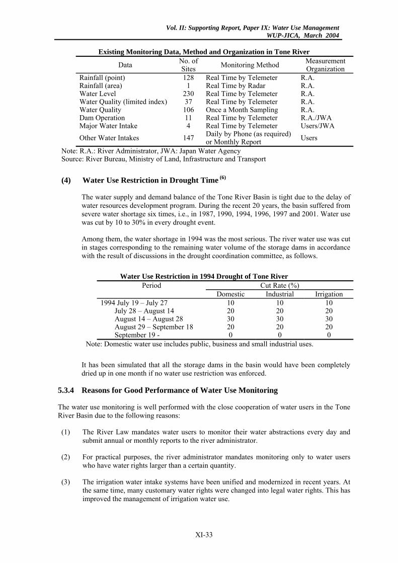
Vol. II: Supporting Report, Paper IX: Water Use ManagementWUP-JICA, March 2004
Existing Monitoring Data, Method and Organization in Tone River
Data No. of Sites Monitoring Method Measurement
Organization Rainfall (point) 128 Real Time by Telemeter R.A. Rainfall (area) 1 Real Time by Radar R.A. Water Level 230 Real Time by Telemeter R.A. Water Quality (limited index) 37 Real Time by Telemeter R.A. Water Quality 106 Once a Month Sampling R.A. Dam Operation 11 Real Time by Telemeter R.A./JWA Major Water Intake 4 Real Time by Telemeter Users/JWA Other Water Intakes 147 Daily by Phone (as required)
or Monthly Report Users
Note: R.A.: River Administrator, JWA: Japan Water Agency Source: River Bureau, Ministry of Land, Infrastructure and Transport
(4) Water Use Restriction in Drought Time (6)
The water supply and demand balance of the Tone River Basin is tight due to the delay of water resources development program. During the recent 20 years, the basin suffered from severe water shortage six times, i.e., in 1987, 1990, 1994, 1996, 1997 and 2001. Water use was cut by 10 to 30% in every drought event.
Among them, the water shortage in 1994 was the most serious. The river water use was cut in stages corresponding to the remaining water volume of the storage dams in accordance with the result of discussions in the drought coordination committee, as follows.
Water Use Restriction in 1994 Drought of Tone River
Period Cut Rate (%) Domestic Industrial Irrigation
1994 July 19 – July 27 10 10 10 July 28 – August 14 20 20 20 August 14 – August 28 30 30 30 August 29 – September 18 20 20 20 September 19 - 0 0 0
Note: Domestic water use includes public, business and small industrial uses.
It has been simulated that all the storage dams in the basin would have been completely dried up in one month if no water use restriction was enforced.
5.3.4 Reasons for Good Performance of Water Use Monitoring
The water use monitoring is well performed with the close cooperation of water users in the Tone River Basin due to the following reasons:
(1) The River Law mandates water users to monitor their water abstractions every day and submit annual or monthly reports to the river administrator.
(2) For practical purposes, the river administrator mandates monitoring only to water users who have water rights larger than a certain quantity.
(3) The irrigation water intake systems have been unified and modernized in recent years. At the same time, many customary water rights were changed into legal water rights. This has improved the management of irrigation water use.
XI-33

Vol. II: Supporting Report, Paper IX: Water Use ManagementWUP-JICA, March 2004
(4) Each of the large intakes are provided with a control office, which have good monitoring
systems.
(5) The water users have suffered from water shortage many times. From these experiences, they have learned the importance of optimum operation of storage dams to prevent vital drought damage. They have also recognized that optimum dam operation can be attained based on the data of correct water use monitoring.
(6) The river administrator checks the data of water use monitoring and provides them to the drought coordination committee. Opening of the data may force the water users to conduct correct monitoring and reporting.
XI-34
Vol. II: Supporting Report, Paper IX: Water Use ManagementWUP-JICA, March 2004
6. HOW TO ESTABLISH THE REQUIRED MINIMUM FLOW
6.1 General
As mentioned in Chapter 3, the river administrator must establish the required minimum flow in each river section according to the River Law. The required minimum flow is designed to satisfy both existing reasonable off-stream and in/on-stream uses in each river section. The flow required for in/on-stream uses is called environmental flow.
The off-stream uses cover domestic, agricultural, industrial, hydropower and others that are permitted by water right. The in/on-stream uses include preservation of aquatic life, fishery, scenic view, preservation of water quality, navigation, prevention of salinity intrusion, prevention of estuary clogging, maintenance of groundwater table, etc. These in/on-stream uses are maintained by the environmental flow.
The required minimum flow has been proposed in nearly 50% of rivers among the total 109 Class I rivers since 1964 when its establishment was stipulated in the River Law (the existing New River Law was enacted in 1964). The proposed required minimum flow fully covers the off-stream uses in every river because the water right quantity of all the existing off-stream uses are registered in the office of the river administrator. However, coverage of the environmental flow in these rivers is not always satisfactory since estimation of the environmental flow has been difficult.
In 1997, the Government revised the River Law to include the preservation/recovery of river environment in addition to the conventional management of river including water use control, flood/drought control, and river space/course/structure management. The river administrator must prepare the environmental improvement plan to preserve/recover/improve the river environment and implement the plan in cooperation with the concerned governmental/non-governmental organizations, disciplinary experts and citizens.
In these circumstances, the River Bureau, Ministry of Land, Infrastructure and Transport (MLIT) has surveyed the existing ecological conditions of river and riverside areas of all the Class I rivers. This is called the “national river ecology census”. The objective ecologies include riverside plants, aquatic plants, fishes, birds, animals, insects, benthos and others.
Further, the River Bureau, MLIT has developed the technical guidelines for establishing the required minimum flow including environmental flow. Based on the guidelines, the required minimum flow of all the Class I rivers have been studied. Among them, the flow has already been authorized in approximately 20 rivers, while it is still under discussion in the remaining rivers.
6.2 Procedure to Establish the Required Minimum Flow (7)
The procedure to establish the required minimum flow is described below according to the technical guidelines proposed by the MLIT.
6.2.1 Basic Assumption
The river environment, especially ecological environment, varies throughout the year corresponding to the flow variation of river. Theoretically, the environmental flow should be dynamically determined to meet the varying environmental requirements corresponding to the variation of river flow. However, this dynamic approach has not yet been applied due to the following reasons. For practical purposes, the required minimum environmental flow is statistically determined to meet the in/on-stream uses in a design drought (usually, 10-year
XI-35
Vol. II: Supporting Report, Paper IX: Water Use ManagementWUP-JICA, March 2004
drought) in the same way as off-stream uses. Environmental flow management by the dynamic approach has been deferred the further study.
(1) Impacts of the flow variation on ecology are not yet clear.
(2) Adoption of different reliabilities between off-stream and in/on-stream uses will make the water use management more complicated and difficult. For example, if design environmental flow yearly changes, operation (especially water storage) of upstream storage dams may be restricted for ecological uses in the downstream even at water abundant time. It may reduce the benefits of the storage dam.
(3) In Japan, the wet and dry seasons are not distinct. The river flow fluctuates to a large extent throughout the year. A spell of drought is severe in quantity but not so long in time. Hence, river flow of nearly natural pattern is usually expected except in drought time unless a large regulating reservoir is provided on the mainstream. At present, flow regulation capacity of the existing storage dams is limited since they are mostly installed in the uppermost reaches.
Generally, the controlled river flow regime of the mainstream in the major rivers is not so much different from the natural pattern except in drought time and in some specific locations.
6.2.2 Methodology
(1) Division of River Course
The river course is divided into several river sections. The required minimum flow is set to satisfy all the permitted off-stream uses and required environmental flow in every river section. The division is made in due consideration to the following factors.
(a) Inflow of tributary: divided at a location immediately upstream of the confluence of major tributaries.
(b) Topographic conditions: divided so that topographic conditions of river course (slope, width, etc.) may not largely change within a river section.
(c) Environmental conditions: divided so that environmental conditions (aquatic life, water quality, etc.) may not largely change within a river section.
(d) Water balance: river flow changes in longitudinal direction due to water abstraction, return and tributary inflow. The river is divided in consideration to the water balance.
(e) Tidal reach: tidal reach (especially, brackish water zone) is separated from the upstream fresh water reach since the relationships between environmental characteristics and hydrological indexes are different.
(2) Estimation of Off-stream Uses
The objective off-stream uses are those registered with the office of the river administrator. The registered water rights are employed to estimate the off-stream water uses in principle. Sometimes, however, the water right quantity is larger than the actual use. They are checked and revised based on the result of a field survey as required.
Agricultural water use seasonally changes. It is set by season, at least, by irrigation and non-irrigation periods.
XI-36
Vol. II: Supporting Report, Paper IX: Water Use ManagementWUP-JICA, March 2004
Finally, water intake location and quantity of all the off-stream uses is set by season.
(3) Estimation of Environmental Flow
Environmental flow is set to satisfy all the existing in/on-stream uses in each river section. The environmental flow is also set according to season to meet the seasonal changes of the in/on-stream use requirements.
The estimation method for environmental flow is described according to each in/on-stream use in the following Subsection 6.2.3.
(4) Estimation of Water Balance
Intake quantity of the off-stream uses is estimated as described above. However, a considerable portion of the abstracted water returns to the downstream of the river through drainage channels. Usually, the return flow of agricultural water use is significant and it cannot be neglected. This return flow quantity and location is estimated based on the result of a field survey.
Further, the river receives inflow of tributaries at many locations. The tributary inflow at a design drought is estimated.
Finally, water balance among the intake quantity, return flow and tributary inflow is calculated to estimate the net off-stream use requirement to be supplied from the main river. This water balance is calculated along the main river from upstream to downstream.
(5) Establishment of Required Minimum Flow
The required minimum flow to satisfy both off-stream uses and environmental flow is estimated for each river section and season. This flow is maintained at the upper end of each river section.
Actually, the required minimum flow is established at one to several principal river stations selected since it is too complicated to establish the required minimum flow at the upper boundary of each river section. Each selected principal station governs several river sections in the downstream.
The required minimum flow at each principal station is determined to satisfy all the required minimum flows in the governed river sections.
6.2.3 Estimation Method of Environmental Flow
(1) Aquatic Life and Fishery
(a) General
Fish is adopted as the representative index of the aquatic lives in the rivers. Water depth and velocity larger than a certain value are necessary for the spawning, growing and moving of fishes. For sustainable fishing activities, the river must maintain also water width/area larger than a certain value so that the objective fishes can spawn, stay and move in groups with sufficient population density. The estimation method of the required minimum environmental flow for fish is described below.
XI-37
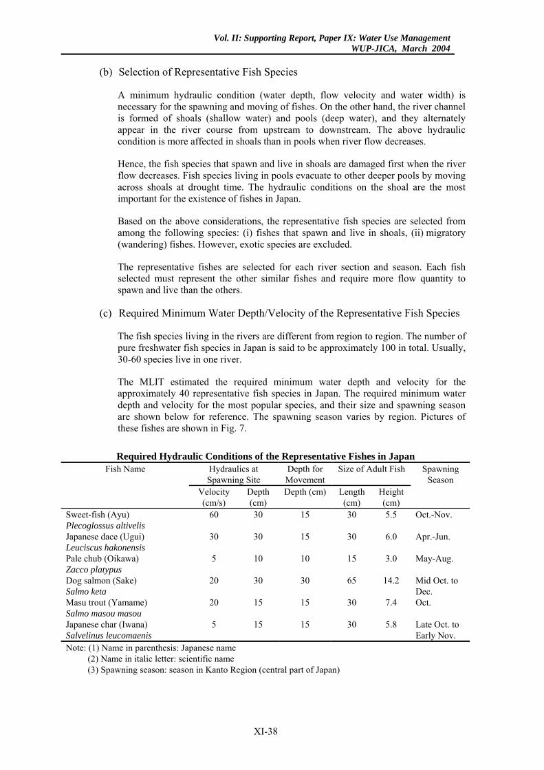
Vol. II: Supporting Report, Paper IX: Water Use ManagementWUP-JICA, March 2004
(b) Selection of Representative Fish Species
A minimum hydraulic condition (water depth, flow velocity and water width) is necessary for the spawning and moving of fishes. On the other hand, the river channel is formed of shoals (shallow water) and pools (deep water), and they alternately appear in the river course from upstream to downstream. The above hydraulic condition is more affected in shoals than in pools when river flow decreases.
Hence, the fish species that spawn and live in shoals are damaged first when the river flow decreases. Fish species living in pools evacuate to other deeper pools by moving across shoals at drought time. The hydraulic conditions on the shoal are the most important for the existence of fishes in Japan.
Based on the above considerations, the representative fish species are selected from among the following species: (i) fishes that spawn and live in shoals, (ii) migratory (wandering) fishes. However, exotic species are excluded.
The representative fishes are selected for each river section and season. Each fish selected must represent the other similar fishes and require more flow quantity to spawn and live than the others.
(c) Required Minimum Water Depth/Velocity of the Representative Fish Species
The fish species living in the rivers are different from region to region. The number of pure freshwater fish species in Japan is said to be approximately 100 in total. Usually, 30-60 species live in one river.
The MLIT estimated the required minimum water depth and velocity for the approximately 40 representative fish species in Japan. The required minimum water depth and velocity for the most popular species, and their size and spawning season are shown below for reference. The spawning season varies by region. Pictures of these fishes are shown in Fig. 7.
Required Hydraulic Conditions of the Representative Fishes in Japan
Hydraulics at Spawning Site
Depth for Movement
Size of Adult Fish Fish Name
Velocity (cm/s)
Depth(cm)
Depth (cm) Length (cm)
Height (cm)
Spawning Season
Sweet-fish (Ayu) Plecoglossus altivelis
60 30 15 30 5.5 Oct.-Nov.
Japanese dace (Ugui) Leuciscus hakonensis
30 30 15 30 6.0 Apr.-Jun.
Pale chub (Oikawa) Zacco platypus
5 10 10 15 3.0 May-Aug.
Dog salmon (Sake) Salmo keta
20 30 30 65 14.2 Mid Oct. to Dec.
Masu trout (Yamame) Salmo masou masou
20 15 15 30 7.4 Oct.
Japanese char (Iwana) Salvelinus leucomaenis
5 15 15 30 5.8 Late Oct. to Early Nov.
Note: (1) Name in parenthesis: Japanese name (2) Name in italic letter: scientific name (3) Spawning season: season in Kanto Region (central part of Japan)
XI-38
Vol. II: Supporting Report, Paper IX: Water Use ManagementWUP-JICA, March 2004
(d) Required Environmental Flow of the Representative Fish Species
As mentioned above, the most critical conditions of fishes for spawning, living and moving appear on the shoals in each river section. Hence, the required minimum environmental flow for the representative fishes is estimated by calculating the curves of flow rate-velocity–depth on the critical shoals.
On the other hand, fishes live in groups. Accordingly, a certain water width is necessary for the fishes to live in groups on the shoals. The above estimated minimum environmental flow is thus checked for the required water width.
(2) Scenic View
(a) General
Maintenance of beautiful scenic view is desired for river sections where people gather (scenic spots, resort area, riverside parks, etc.). River flow is one of the important factors that may govern the scenic view of rivers, especially in the middle reaches. The necessary river flow to maintain a satisfactory scenic view in the middle reaches is estimated as follows.
(b) Standard Evaluation Method of Scenic View
For example, when people see the river from a bridge, they may feel a satisfactory scenic view in cases where the ratio of water width (W) and river width (B) is above a certain level.
The MLIT made a questionnaire survey on the scenic views of 38 representative rivers in Japan. According to the above survey, a satisfactory scenic view is obtained when W/B is more than 0.2.
(c) Required Environmental Flow
The required environmental flow is estimated by calculating the curves of flow rate (Q) - ratio (W/B). The required ratio (W/B) is estimated based on the data of interview survey by each river. When no sufficient data are available, the above standard value (W/B=0.2) is employed.
(3) Preservation of Water Quality
(a) General
The standard (target) water quality of river has already been set for each river section of all the major rivers based on the water pollution control law. The standard water quality is set corresponding to the existing off and in/on-stream uses as shown below. These standards are to be attained for low flows with 75% exceedance probability.
XI-39
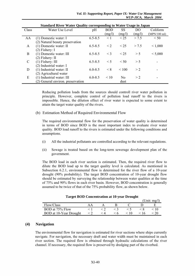
Vol. II: Supporting Report, Paper IX: Water Use ManagementWUP-JICA, March 2004
Standard River Water Quality corresponding to Water Usage in Japan
Class Water Use Level pH BOD (mg/l)
SS (mg/l)
DO (mg/l)
Coliform (MPN/100 ml)
AA (1) Domestic water: I (2) Natural beauty preservation
6.5-8.5 < 1 < 25 > 7.5 < 50
A (1) Domestic water: II (2) Fishery: I
6.5-8.5 < 2 < 25 > 7.5 < 1,000
B (1) Domestic water: III (2) Fishery: II
6.5-8.5 < 3 < 25 > 5 < 5,000
C (1) Fishery: III (2) Industrial water: I
6.5-8.5 < 5 < 50 > 5 -
D (1) Industrial water: II (2) Agricultural water
6.0-8.5 < 8 < 100 > 2 -
E (1) Industrial water: III (2) General environ. preservation
6.0-8.5 < 10 No dust
> 2 -
Reducing pollution loads from the sources should controll river water pollution in principle. However, complete control of pollution load runoff to the rivers is impossible. Hence, the dilution effect of river water is expected to some extent to attain the target water quality of the rivers.
(b) Estimation Method of Required Environmental Flow
The required environmental flow for the preservation of water quality is determined in terms of BOD since BOD is the most important index to evaluate river water quality. BOD load runoff to the rivers is estimated under the following conditions and assumptions.
(i) All the industrial pollutants are controlled according to the relevant regulations.
(ii) Sewage is treated based on the long-term sewerage development plan of the government.
The BOD load in each river section is estimated. Then, the required river flow to dilute the BOD load up to the target quality level is calculated. As mentioned in Subsection 6.2.1, environmental flow is determined for the river flow of a 10-year drought (90% probability). The target BOD concentration of 10-year drought flow should be estimated by surveying the relationship between water qualities at the time of 75% and 90% flows in each river basin. However, BOD concentration is generally assumed to be twice of that of the 75% probability flow, as shown below.
Target BOD Concentration at 10-year Drought
(Unit: mg/l) Flow/Class AA A B C D E BOD at 75% Flow < 1 < 2 < 3 < 5 < 8 < 10 BOD at 10-Year Drought < 2 < 4 < 6 < 10 < 16 < 20
(4) Navigation
The environmental flow for navigation is estimated for river sections where ships currently navigate. For navigation, the necessary draft and water width must be maintained in each river section. The required flow is obtained through hydraulic calculations of the river channel. If necessary, the required flow is preserved by dredging part of the riverbed.
XI-40
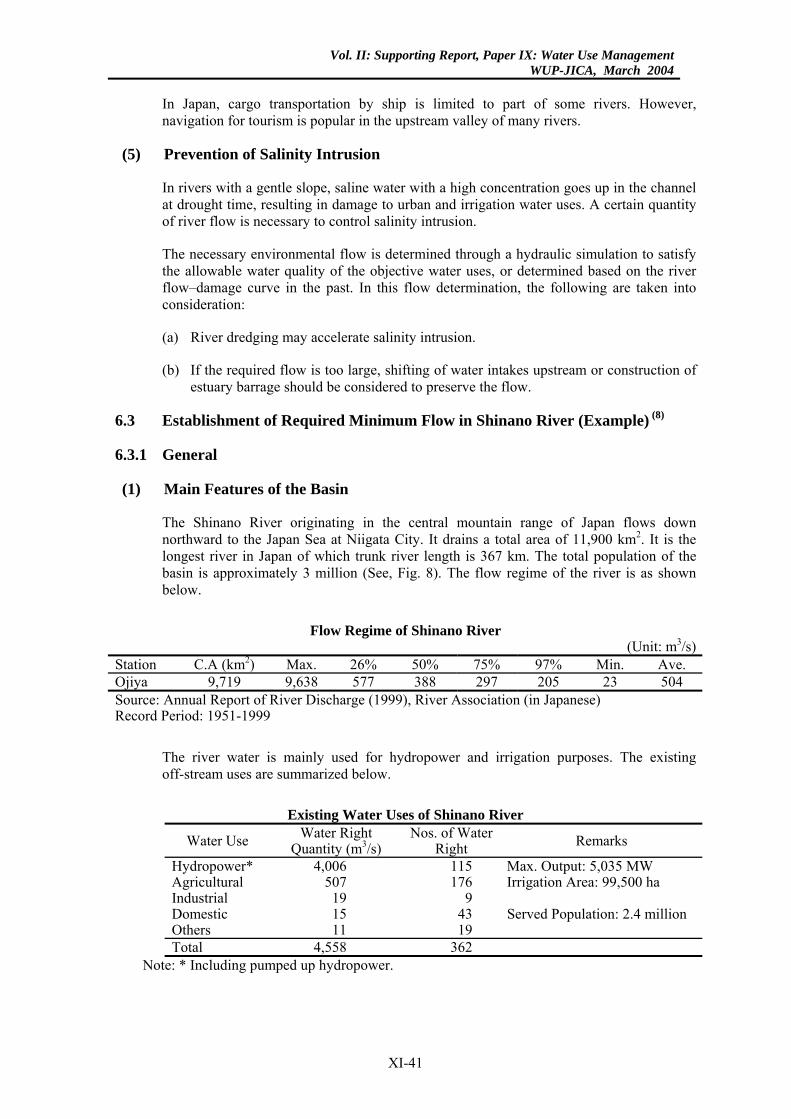
Vol. II: Supporting Report, Paper IX: Water Use ManagementWUP-JICA, March 2004
In Japan, cargo transportation by ship is limited to part of some rivers. However, navigation for tourism is popular in the upstream valley of many rivers.
(5) Prevention of Salinity Intrusion
In rivers with a gentle slope, saline water with a high concentration goes up in the channel at drought time, resulting in damage to urban and irrigation water uses. A certain quantity of river flow is necessary to control salinity intrusion.
The necessary environmental flow is determined through a hydraulic simulation to satisfy the allowable water quality of the objective water uses, or determined based on the river flow–damage curve in the past. In this flow determination, the following are taken into consideration:
(a) River dredging may accelerate salinity intrusion.
(b) If the required flow is too large, shifting of water intakes upstream or construction of estuary barrage should be considered to preserve the flow.
6.3 Establishment of Required Minimum Flow in Shinano River (Example) (8)
6.3.1 General
(1) Main Features of the Basin
The Shinano River originating in the central mountain range of Japan flows down northward to the Japan Sea at Niigata City. It drains a total area of 11,900 km2. It is the longest river in Japan of which trunk river length is 367 km. The total population of the basin is approximately 3 million (See, Fig. 8). The flow regime of the river is as shown below.
Flow Regime of Shinano River
(Unit: m3/s) Station C.A (km2) Max. 26% 50% 75% 97% Min. Ave. Ojiya 9,719 9,638 577 388 297 205 23 504 Source: Annual Report of River Discharge (1999), River Association (in Japanese) Record Period: 1951-1999
The river water is mainly used for hydropower and irrigation purposes. The existing off-stream uses are summarized below.
Existing Water Uses of Shinano River
Water Use Water Right Quantity (m3/s)
Nos. of Water Right Remarks
Hydropower* 4,006 115 Max. Output: 5,035 MW Agricultural 507 176 Irrigation Area: 99,500 ha Industrial 19 9 Domestic 15 43 Served Population: 2.4 million Others 11 19 Total 4,558 362
Note: * Including pumped up hydropower.
XI-41
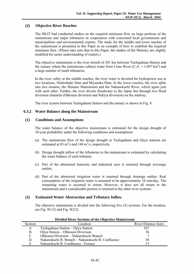
Vol. II: Supporting Report, Paper IX: Water Use ManagementWUP-JICA, March 2004
(2) Objective River Reaches
The MLIT had conducted studies on the required minimum flow on large portions of the mainstream and major tributaries in cooperation with concerned local governments and municipalities and environmental experts. The study for the middle and lower reaches of the mainstream is presented in this Paper as an example of how to establish the required minimum flow. (Please take note that in this Paper, the studies of the Ministry are slightly modified for easier understanding of readers.)
The objective mainstream is the river stretch of 201 km between Tachigahana Station and the estuary where the mainstream collects water from Uono River (C.A. = 1,497 km2) and a large number of small tributaries.
In the river valley at the middle reaches, the river water is diverted for hydropower use at two locations, Nishiohtaki Dam and Miyanaka Dam. In the lower reaches, the river splits into two streams, the Shinano Mainstream and the Nakanokuchi River, which again join with each other. Further, the river diverts floodwater to the Japan Sea through two flood diversion channels (Ohkouzu diversion and Sekiya diversion) on the midway.
The river system between Tachigahana Station and the estuary is shown in Fig. 8.
6.3.2 Water Balance along the Mainstream
(1) Conditions and Assumptions
The water balance of the objective mainstream is estimated for the design drought of 10-year probability under the following conditions and assumptions:
(a) The mainstream flow of the design drought at Tachigahana and Ojiya stations are estimated at 83 m3/s and 148 m3/s, respectively.
(b) Design drought inflow of the tributaries to the mainstream is estimated by calculating the water balance of each tributary.
(c) Part of the abstracted domestic and industrial uses is returned through sewerage outlets.
(d) Part of the abstracted irrigation water is returned through drainage outlets. Real consumption of the irrigation water is assumed to be approximately 10 mm/day. The remaining water is assumed to return. However, it does not all return to the mainstream and a considerable portion is returned to the other river systems.
(2) Estimated Water Abstraction and Tributary Inflow
The objective mainstream is divided into the following five (5) sections. For the location, see Fig. 9(1/2) and Fig. 9(2/2).
Divided River Sections of the Objective Mainstream
Section Location River Distance (km) A Tachigahana Station – Ojiya Station 107 B Ojiya Station – Ohkouzu Diversion 36 C Ohkouzu Diversion – Nakanokuchi Branch 7 D Nakanokuchi R. Branch – Nakanokuchi R. Confluence 38 E Nakanokuchi R. Confluence - Estuary 13
XI-42
Vol. II: Supporting Report, Paper IX: Water Use ManagementWUP-JICA, March 2004
The water abstraction and tributary inflow from/to each river section is summarized below.
Water Abstraction and Tributary Inflow in Each River Section
Water Abstraction Urban Irrigation Hydropower
Tributary Inflow Section
No. Q (m3/s) No. Q
(m3/s)Area (ha) No. Q (m3/s) Max. Output
(MW) No. Q (m3/s)
A 2 1 31 6 3,000 2 172 (488) 285 79 68 B 8 3 9 66 27,200 - - - 11 17 C 2 1 8 8 1,600 - - - 3 6 D 4 1 22 41 11,300 - - - 8 14 E 6 22 1 1 100 - - - 1 4
Total 22 28 71 122 43,200 2 172 (488) 285 102 109 Note: (1) Urban: domestic and industrial uses
(2) Hydropower Q: outside of parenthesis is abstraction at design drought and inside of parenthesis is maximum quantity.
(3) Estimated Water Balance
The water balance of each river section during the irrigation period at the design drought is shown in Fig. 9 (1/2) and Fig. 9 (2/2). Further, a longitudinal variation of the mainstream flow during the irrigation period at the design drought is obtained by calculating the water balance at each river distance. It is shown in Fig. 10.
6.3.3 Estimation of Required Environmental Flow
(1) Preservation of Aquatic Life and Fishery
In Shinano River, approximately 50 fish species have been identified by a recent survey. From them, the following six (6) fish species were selected to estimate the minimum environmental flow for the preservation of aquatic life and fishery.
(i) Sweet-fish, (ii) Japanese dace, (iii) Pale chub, (iv) Dog salmon, (v) Masu trout and (vi) Japanese char. For pictures of the fishes, see Fig. 7.
Among the above fishes, Japanese char lives only in the watershed areas. Sweet-fish, Dog salmon and Masu trout do not live in the lower reaches of the mainstream. They only pass through the reaches and river flow is large enough for their passing. Hence, the required minimum environmental flows of the lower and middle reaches were calculated for the following representative fishes. The required minimum velocity and depth for their preservation are presented in Section 6.2.3.
Representative Fishes of the Objective Mainstream
Reaches River Section Representative Fishes for Study Lowe Reaches Estuary (0.0 km) – Ohkouzu
Diversion (58 km) Japanese dace and Pale chub
Middle Reaches Ohkouzu Diversion (58 km) – Tachigahana St. (201 km)
Sweet-fish, Japanese dace, Pale chub, Dog salmon and Masu trout
The required minimum environmental flow rates at the critical river sections (river distance) were calculated as shown in Fig. 10.
XI-43
Vol. II: Supporting Report, Paper IX: Water Use ManagementWUP-JICA, March 2004
(2) Scenic View
As mentioned before, the ratio between water width (W) and river width (B) shall be larger than 0.2 to maintain a satisfactory scenic view of the river. People usually enjoy the scenic view of the river on bridges. The river flow necessary to maintain the ratio (W/B) more than 0.2 was calculated at the representative bridge sites. These are presented in Fig. 10.
(3) Preservation of Water Quality
Based on the water quality standards of the Shinano River, those of the objective mainstreams are shown below. These quality values are set for the low river flow with 75% probability.
Standard River Water Quality of the Objective Mainstream in Shinanao River
River Section Class pH BOD (mg/l)
SS (mg/l)
DO (mg/l)
Coliform (MPN/100 ml)
Tachigahana St. (201 km) - Nakanokuchi R. Confluence (14 km)
A 6.5-8.5 < 2 < 25 > 7.5 < 1,000
Estuary (0.0 km) – Nakanokuchi R. Confluence (14 km)
B 6.5-8.5 < 3 < 25 > 5 < 5,000
In this study, BOD is selected as the representative water quality index. The target BOD values at the design drought are assumed as twice of the above standard values as follows.
Target BOD Concentration of the Objective Mainstream at the Design Drought
River Section Class BOD (mg/l) Tachigahana St. (201 km) - Nakanokuchi R. Confluence (14 km) A < 4 Estuary (0.0 km) - Nakanokuchi R. Confluence (14 km) B < 6
The required minimum environmental flow for the preservation of river water quality was estimated at the representative stations as shown in Fig. 10 by simulating pollution load runoff to the river.
(4) Navigation
The mainstream is used for navigation in the middle/lower reaches for tourism and sand/gravel transportation as shown in the following table. The draft of ships is also shown below.
Existing Navigation in the Objective Mainstream
River Section Purpose Draft of Ship (m) Uono R. Confluence (101 km) - Ojiya St. (94 km) Tourism 0.7 Ohkouzu Diversion (58 km) – Estuary (0.0 km) Sand/Gravel Transport 1.6
The required minimum environmental flow has been calculated as shown in Fig. 10.
(5) Others
There are no salinity intrusion problems in the lower reaches. It is because the mainstream is provided with a control gate immediately downstream of the Sekiya flood diversion site (8.5 km). In addition, the Sekiya flood diversion is also provided with a gate at the river mouth.
XI-44
Vol. II: Supporting Report, Paper IX: Water Use ManagementWUP-JICA, March 2004
The riverine area has not experienced the lowering of groundwater table even in the driest year in the past. No estuary clogging has occurred in the past.
6.3.4 Establishment of Required Minimum Flow
From the above studies, the present water use situations of the objective mainstream are assessed as follows for the design low flow of 10-year drought.
(1) Necessary flow for the existing off-stream uses will be secured through the entire objective river reaches.
(2) The fishes will be preserved enough except in the river valley between the Uono River confluence (101 km distance) and Nishiohtaki Dam (162 km distance). The river flow is too small for the preservation of fishes in this river section of approximately 60 km. It is due to the insufficient water release of the two dams, Nishiohtaki Dam and Miyanaka Dam. This problem may be mitigated or solved if the water release of the dams is increased.
(3) Satisfactory scenic view will be maintained except at some locations of the above river valley. The scenic view in the river valley will improve if the water release of the dams is increased.
(4) The river water quality will be preserved through the entire river reaches.
(5) The navigation will be obstructed at a few locations of the lower reaches. Dredging the riverbed will solve this problem since the required dredging volume is not large.
(6) For the other river environments (saline water intrusion, groundwater and estuary clogging), no problems will occur.
From the above assessment, the required minimum flow is set at 83 m3/s for Tachigahana Station and 148 m3/s for Ojiya Atation. The required minimum flow is secured for a 10-year drought.
6.3.5 Further Study
As mentioned above, the river flow is very small in the river valley of 60 km distance between the Uono River confluence and the Nishiohtaki Dam due to the insufficient water release of the two dams. The water release of the dams must be increased to retrieve the habitats of fish and the scenic view in this river valley. For the dam and river conditions in the river valley, see Fig. 11.
The two dams were constructed in 1939. Under the existing water rights of the dams, Nishiohtaki Dam and Miyanaka Dam are obligated to release the minimum environmental flow of 0.3 m3/s and 7.0 m3/s respectively.
The MLIT is conducting a study on the retrieval of the river environments in cooperation with the local governments, municipalities, power companies and environmental experts. Increase of water release will improve the environmental conditions, but reduce the production of electric energy. Hence, the optimum operation rules of the dams shall be established based on the ongoing environmental studies.
6.4 Retrieval of River Valley Environments
6.4.1 General
In Japan, the existing hydropower stations were mostly constructed before World War II or at the latest in 1960-1965. They are located in the river valleys of the uppermost reaches. Usually, there
XI-45
Vol. II: Supporting Report, Paper IX: Water Use ManagementWUP-JICA, March 2004
are no or little off-stream water uses for domestic/industrial and irrigation purposes in such river valleys. Hence, the obligated water release of the hydropower dams was set to be very small to maximize the power generation when the water right was granted.
However, maintenance of good river environments has become more important in the recent years. The people in many river basins have strongly requested retrieval of the river environments in such valleys. In these circumstances, the MLIT decided in 1988 to review and change (as required) the existing obligated water release of hydropower dams when the current water rights are renewed. In general, the validity of water rights for hydropower is approximately 30 years.
Change of the water release is studied, based on the following guidelines.
(1) Change of the obligated water release (release of environmental flow) is made in the following cases:
(a) Inter-basin diversion.
(b) A significant water reduction occurs over a distance of more than 10 km with either of the following conditions: (i) drainage area of the dam is larger than 200 km2, (ii) the objective river section is located within a natural park, (iii) the objective river section is attractive for tourism, and (iv) others.
(c) Water of the objective river section does not satisfy the standard quality in drought time.
(2) Quantity of the obligated water release is determined by the river administrator in due consideration of water width, water depth, water quality and aquatic life in the affected river section.
(3) Increase of the obligated water release is limited to a certain extent since it reduces power generation. Standard quantity of the minimum water release is assumed to be 0.1 – 0.3 m3/s per 100 km2 for the drainage area of dam throughout the year.
6.4.2 Environmental Water Release of Saga Hydropower Dam (Example) (9)
(1) General
The Saga hydropower dam is located at a river valley in the upper reaches of the Shimanto River, which is located in Shikoku Island, as shown in Fig. 12. The drainage area and trunk length of the river is 2,270 km2 and 196 km, respectively.
The dam is located at 110 km upstream from the river mouth and covers a drainage area of 378 km2. The water extracted by the dam is diverted into the Iyoki River for hydropower generation (inter-basin diversion) [See, Fig. 12]. The dam was constructed in 1937. Its water right has been renewed two times since 1937. The second water right is supposed to have expired in April 2001. The salient features of the hydropower dam permitted by the water right are as below.
XI-46
Vol. II: Supporting Report, Paper IX: Water Use ManagementWUP-JICA, March 2004
Salient Features of Saga Hydropower Dam
Item Quantity Remarks Maximum Water Use (m3/s) 12.5 Maximum Output (kW) 15,000 Yearly Generated Energy (MWH) 93,000 Average of recent 10 years Dam Height (m) 8.0 Effective Dam storage (million m3) 0.7 Minimum Water Release (m3/s) 1.0
0.0 Fishing season (Mar. – Oct.) Other season (Nov – Feb.)
The average river flow regime during the recent 10 years (1985–1994) at Saga Dam is summarized below.
Flow Regime at Saga Hydropower Dam Site
Flow Rate Fishing Season (Mar. – Oct.) Other Season (Nov. – Feb.) Inflow (m3/s) Release (m3/s) Inflow (m3/s) Release (m3/s)
26% Probability 34.4 23.2 11.1 6.3 50% Probability 16.7 4.8 5.4 0.2 75% Probability 9.9 1.0 4.0 0.0 97% Probability 4.4 1.0 2.7 0.0 Minimum 3.4 1.0 2.4 0.0 Average 38.6 29.4 10.1 6.1
The Shimanto River is one of the most famous rivers in the fishery and sport fishing of Sweet-fish. In the recent years, people of the basin have claimed that the water diversion has caused damage on the production of sweet-fishe, scenic view and other environments of the river.
Before the renewal of the water right scheduled in April 2001, the river administrator (Minister of MLIT) made a study on the required minimum water release of the dam in cooperation with the local governments, municipalities, the power company and environmental experts to retrieve the river environments in the downstream of the dam. Based on the study, the current minimum water release of the dam was revised in the new water right.
The study results on environmental flow are described below.
(2) Objective River Section of the Study
The river flow is much reduced by the diversion for an approximately 20 km distance between Saga dam and Tsuga hydropower station. In the downstream of Tsuga hydropower station, the impact of the diversion is mitigated by the discharge of Tsuga hydropower station. Accordingly; the study had concentrated on this river section. For location of the objective river section, see Fig. 12.
(3) Screening of the Environmental Factors
(a) There are no off-stream and navigation uses in the objective river section.
(b) There is no groundwater use in the riverine area of the objective river section.
(c) The existing water quality of the objective river section satisfies the water quality standard for Class AA (see, Subsection 6.2.3). No problem is seen on this matter.
XI-47
Vol. II: Supporting Report, Paper IX: Water Use ManagementWUP-JICA, March 2004
(d) The water diversion may affect fish life and scenic view.
(e) There are 12 representative fishes in the Shimanto River of which sweet-fish is the most important and popular one. Sweet-fish requires a larger flow velocity and water depth than the other 11 fishes. The places where sweet-fish can live are considered also suitable for living of the other 11 fishes. Hence, sweet-fish was selected for the study.
(f) From the above considerations, the preservation of sweet-fish and the scenic view was studied.
(4) Study Results
The study was conducted based on the observed data in the past and the data obtained from the experiment that actually varied the water release quantity of the dam. The study results and recommendations are summarized below.
(a) Ratio (W/B) of the water width (W) and river width (B) shall be maintained to be 0.2 at least to preserve the scenic view of the objective river section. For this purpose, water more than 1.13 m3/s (0.3 m3/s/100 km2) shall be released from the dam throughout the year.
(b) Sweet-fish requires water depth of more than 30 cm and flow velocity of more than 40 cm/s for spawning and water depth of more than 15 cm for movement. These hydraulic conditions shall be maintained at all the shoals (shallows) of the objective river section. For this purpose, water more than 1.13 m3/s (0.3 m3/s/100 km2) shall be released from the dam throughout the year.
(c) No water release of the dam may cause an extreme lowering of water temperature in winter season. It may affect the living of fish and other aquatic lives. Such problems will be solved if water of 1.13 m3/s (0.3 m3/s/100 km2) is released from the dam.
(d) For the growth of sweet-fish, sufficient water surface area is necessary. The water surface area of the objective river section increases at a high rate until the dam water release of 1.89 m3/s (0.5 m3/s/100 km2) and thereafter, does not increase so much. Hence, water more than 1.89 m3/s (0.5 m3/s/100 km2) shall be released from the dam during the growing season of sweet-fish (March–September).
(e) Population density of sweet-fish decreases when the water release becomes less than 1.89 m3/s (0.5 m3/s/100 km2). Hence, water more than 1.89 m3/s (0.5 m3/s/100 km2) shall be released from the dam during the growing season of sweet fish (March–September).
(f) Too high water temperature in hot summer season may cause damage on Algae on the riverbed, resulting in the shortage of sweet-fish’s bait. To solve this problem, water more than 2.65–3.4 m3/s (0.7–0.9 m3/s/100 km2) shall be released from the dam during July to mid-September.
(g) The above-mentioned water release of the dam will decrease the existing water use for hydropower by nearly 10%. However, the reduction of hydropower water use (reduction of inter-basin diversion) will not affect the existing water uses in the Iyoki River (receiving river of the diverted water).
XI-48
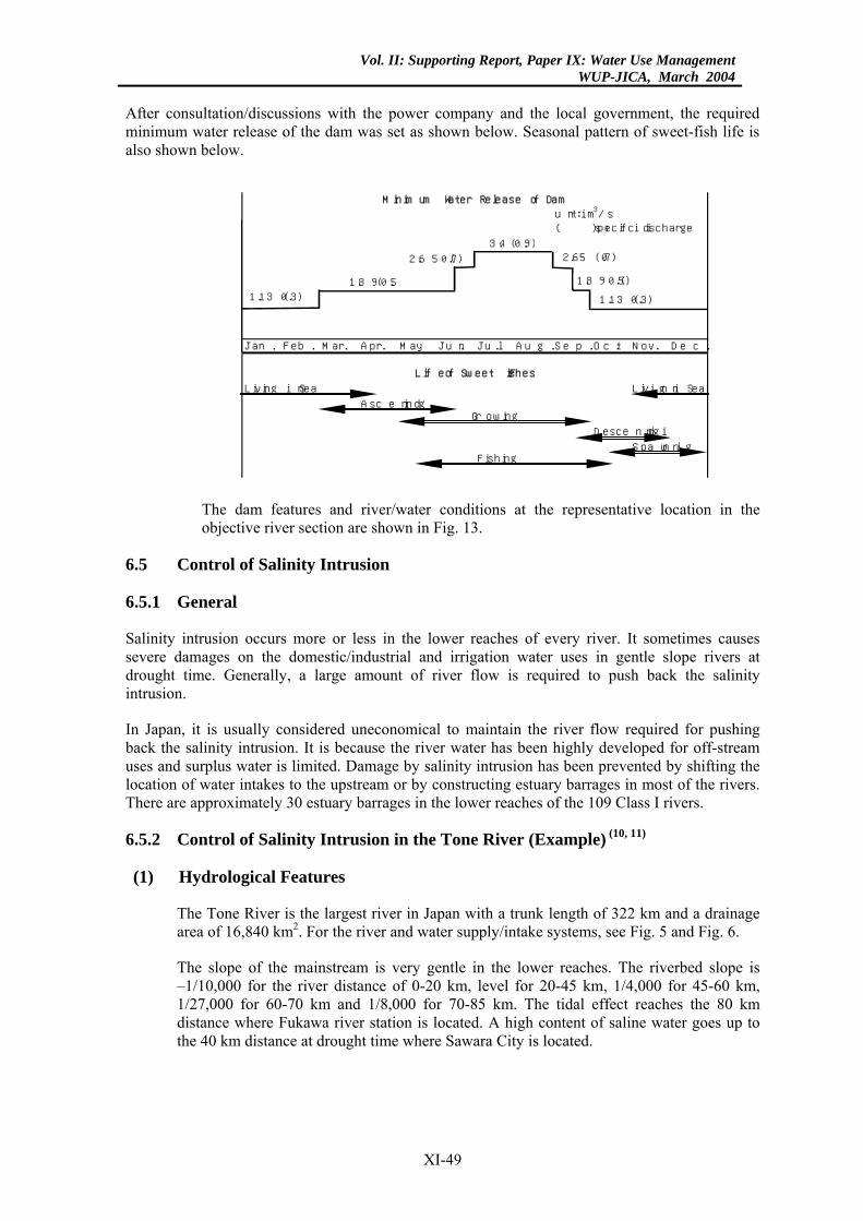
Vol. II: Supporting Report, Paper IX: Water Use ManagementWUP-JICA, March 2004
After consultation/discussions with the power company and the local government, the required minimum water release of the dam was set as shown below. Seasonal pattern of sweet-fish life is also shown below.
Jan. Feb. Mar. Apr. May Jun. Jul. Aug. Sep. Oct. Nov. Dec.
Living in Sea Living in Sea
Ascending
Descending
SpawningFishing
M inimum Water Release of Dam
Growing
L ife of Sweet F ishes
unit: m 3/s( ): specific discharge
1.13 (0.3)1.89 (0.5)
2.65 (0.7)
3.4 (0.9)2.65 (0.7)
1.89 (0.5)
1.13 (0.3)
The dam features and river/water conditions at the representative location in the objective river section are shown in Fig. 13.
6.5 Control of Salinity Intrusion
6.5.1 General
Salinity intrusion occurs more or less in the lower reaches of every river. It sometimes causes severe damages on the domestic/industrial and irrigation water uses in gentle slope rivers at drought time. Generally, a large amount of river flow is required to push back the salinity intrusion.
In Japan, it is usually considered uneconomical to maintain the river flow required for pushing back the salinity intrusion. It is because the river water has been highly developed for off-stream uses and surplus water is limited. Damage by salinity intrusion has been prevented by shifting the location of water intakes to the upstream or by constructing estuary barrages in most of the rivers. There are approximately 30 estuary barrages in the lower reaches of the 109 Class I rivers.
6.5.2 Control of Salinity Intrusion in the Tone River (Example) (10, 11)
(1) Hydrological Features
The Tone River is the largest river in Japan with a trunk length of 322 km and a drainage area of 16,840 km2. For the river and water supply/intake systems, see Fig. 5 and Fig. 6.
The slope of the mainstream is very gentle in the lower reaches. The riverbed slope is –1/10,000 for the river distance of 0-20 km, level for 20-45 km, 1/4,000 for 45-60 km, 1/27,000 for 60-70 km and 1/8,000 for 70-85 km. The tidal effect reaches the 80 km distance where Fukawa river station is located. A high content of saline water goes up to the 40 km distance at drought time where Sawara City is located.
XI-49

Vol. II: Supporting Report, Paper IX: Water Use ManagementWUP-JICA, March 2004
The mean sea water level at the river mouth is – 0.14 m. The tidal variation is as follows. Note: water level is measured based on the topographic benchmark of Japan (datum line: mean sea level of Tokyo Bay).
Tidal Variation at the River Mouth of Tone River Tide Mean High Water Mean Low Water
Spring Tide (m) 0.66 - 0.99 Neap Tide (m) - 0.04 - 0.44
The large-scale integrated water resources development of the Tone river basin was started in 1955–1960 to meet the increasing water demand of the basin and Tokyo metropolitan area. However, the existing water uses in the basin had frequently suffered from water shortage. Hence, the development plan was proposed firstly to solve the water shortage of the existing users and then, to supply water to the new users.
In the development plan, the required minimum flow at Fukawa station during irrigation season (April–August) was assumed at 90 m3/s to satisfy the following existing off-stream and in/on-stream uses. The required minimum flow at Sawara station (upper end of salinity intrusion) comes to 80 m3/s as shown below, taking into account the water abstraction between the Fukawa and Sawara stations.
Required Minimum Flow in the Lower Reaches of Tone River
Water Use Required Mini. Flow at Fukawa (m3/s)
Required Mini. Flow at Sawara (m3/s)
Domestic/Industrial 2 Small Irrigation 36 28 Salinity Repulsion 50 50 Total 88 ≈ 90 78 ≈ 80
The water required for salinity repulsion (50 m3/s) was assumed based on the experiences in the past.
The required minimum flow in the lower reaches of the river is illustrated below.
10 m3/s 30 m3/s
50 m3/s80 m3/s90 m3/sFukawa St. Sawara St.
80 km 40km
Pac
ific O
cean
Required Minimum Flow Distribution in the Original Plan
XI-50
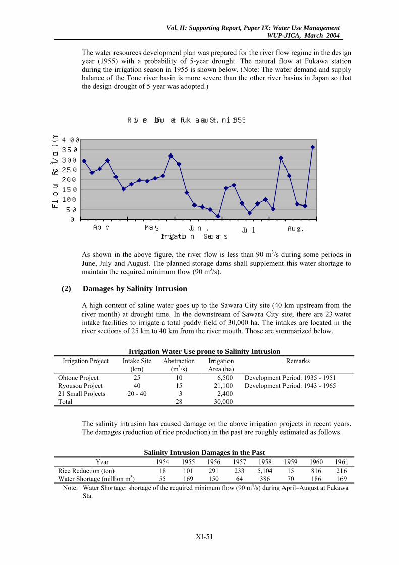
Vol. II: Supporting Report, Paper IX: Water Use ManagementWUP-JICA, March 2004
The water resources development plan was prepared for the river flow regime in the design year (1955) with a probability of 5-year drought. The natural flow at Fukawa station during the irrigation season in 1955 is shown below. (Note: The water demand and supply balance of the Tone river basin is more severe than the other river basins in Japan so that the design drought of 5-year was adopted.)
River Flow at Fukawa St. in 1955
050
100150200
250300
350400
Flo
w R
ate (m
3/s)
May Jun. Jul. Aug.Apr.Irrigation Season
As shown in the above figure, the river flow is less than 90 m3/s during some periods in June, July and August. The planned storage dams shall supplement this water shortage to maintain the required minimum flow (90 m3/s).
(2) Damages by Salinity Intrusion
A high content of saline water goes up to the Sawara City site (40 km upstream from the river month) at drought time. In the downstream of Sawara City site, there are 23 water intake facilities to irrigate a total paddy field of 30,000 ha. The intakes are located in the river sections of 25 km to 40 km from the river mouth. Those are summarized below.
Irrigation Water Use prone to Salinity Intrusion
Irrigation Project Intake Site (km)
Abstraction (m3/s)
Irrigation Area (ha)
Remarks
Ohtone Project 25 10 6,500 Development Period: 1935 - 1951 Ryousou Project 40 15 21,100 Development Period: 1943 - 1965 21 Small Projects 20 - 40 3 2,400 Total 28 30,000
The salinity intrusion has caused damage on the above irrigation projects in recent years. The damages (reduction of rice production) in the past are roughly estimated as follows.
Salinity Intrusion Damages in the Past
Year 1954 1955 1956 1957 1958 1959 1960 1961Rice Reduction (ton) 18 101 291 233 5,104 15 816 216 Water Shortage (million m3) 55 169 150 64 386 70 186 169
Note: Water Shortage: shortage of the required minimum flow (90 m3/s) during April–August at Fukawa Sta.
XI-51
Vol. II: Supporting Report, Paper IX: Water Use ManagementWUP-JICA, March 2004
(3) Causes of Damage
Rice crops have been damaged more or less every year. The most serious drought occurred in 1958 and it affected not only the rice crop of 21,000 ha but also the drinking water of more than 34,000 people.
The major causes of the above damages may be as follows:
(a) A high content of salinity intruded upward due to the shortage of river flow during the irrigation season. Especially, the river flow decreased to a large extent in 1958. The shortage in volume of the required minimum flow during April to August is shown in the above table.
(b) The water resources development plan of the basin was prepared to secure the required minimum flow (90 m3/s) at Fukawa station by constructing new storage dams in the upstream watershed areas. However, this flow had not been secured until 1961 since the construction of new dams just started.
(c) A large-scale river dredging started in 1949 to mitigate flood damage in the lower reaches. However, it accelerated the salinity intrusion. About 30 million m3 was dredged by 1961.
(d) The large irrigation developments in the recent years increased the damage potential of salinity.
(4) Hydraulic Analysis of Salinity Intrusion
In consideration of the frequent salinity damages in the recent years, the required minimum flow for the control of salinity intrusion was reviewed.
The salinity concentration at a certain river distance varies according to the river flow and age of the moon. A high concentration of salinity occurs around full moon or the new moon. The relationship among (i) river flow at Fukawa station, (ii) age of the moon, and (iii) salinity concentration was simulated for the representative river distances based on the continuous observation of salinity intrusion in the past.
As mentioned before, the river section prone to salinity intrusion is 0–40 km of which the existing water intakes are located in the river section of 25–40 km. Hence the Ichinobunme station located at 31 km river distance was selected as the representative station for the evaluation of the salinity intrusion.
The relationship among the river flow rate (at Fukawa station), age of the moon and salinity content (at surface) at Ichinobunme station is shown in Fig. 14. As shown in the figure, the existing required minimum flow of 90m3/s is considered insufficient to completely control the salinity intrusion if the allowable salinity content (Cl) for rice crops is assumed at 1,000 mg/l.
(5) Control Project of Salinity Intrusion
To control the salinity intrusion in a satisfactory manner, construction of an estuary barrage was considered necessary. On the other hand, enlargement of the original water resources development plan was considered necessary to meet the highly increasing water demand of Tokyo metropolitan area.
XI-52

Vol. II: Supporting Report, Paper IX: Water Use ManagementWUP-JICA, March 2004
An estuary barrage was proposed at 18.5 km distance to control the salinity intrusion. The project can save the existing salinity repulsion water of 50 m3/s and then, allocate the saved water for new water uses.
However, the barrage needs to be completely closed for a long period at drought time if all the existing salinity repulsion water is allocated for new water uses. In this case, water in the upstream of the barrage will be stagnant and lacking in dissolved oxygen. On the other hand, water in the downstream will increase the salinity content to the level of seawater. These phenomena will cause severe damages on aquatic life, especially fishes and shells in both upstream and downstream of the barrage.
Finally, the existing salinity repulsion water of 50 m3/s was reduced to 30 m3/s, and 20 m3/s was allocated for new water uses as shown below.
XI-53
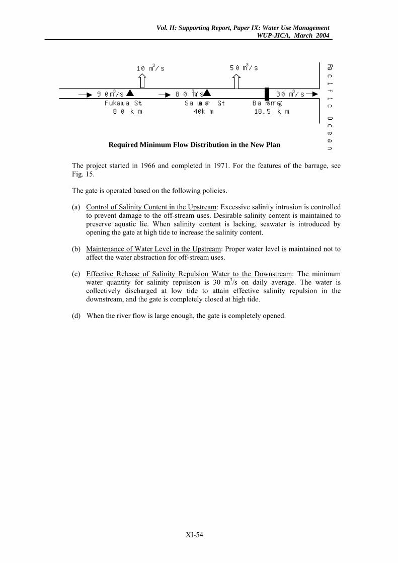
Vol. II: Supporting Report, Paper IX: Water Use ManagementWUP-JICA, March 2004
10 m3/s
Fukawa St. Sawara St. Barrarge80 km 40km 18.5 km
50 m3/s
90 m3/s 80 m
3/s 30 m
3/s
Pac
ific O
cean
Required Minimum Flow Distribution in the New Plan
The project started in 1966 and completed in 1971. For the features of the barrage, see Fig. 15.
The gate is operated based on the following policies.
(a) Control of Salinity Content in the Upstream: Excessive salinity intrusion is controlled to prevent damage to the off-stream uses. Desirable salinity content is maintained to preserve aquatic lie. When salinity content is lacking, seawater is introduced by opening the gate at high tide to increase the salinity content.
(b) Maintenance of Water Level in the Upstream: Proper water level is maintained not to affect the water abstraction for off-stream uses.
(c) Effective Release of Salinity Repulsion Water to the Downstream: The minimum water quantity for salinity repulsion is 30 m3/s on daily average. The water is collectively discharged at low tide to attain effective salinity repulsion in the downstream, and the gate is completely closed at high tide.
(d) When the river flow is large enough, the gate is completely opened.
XI-54
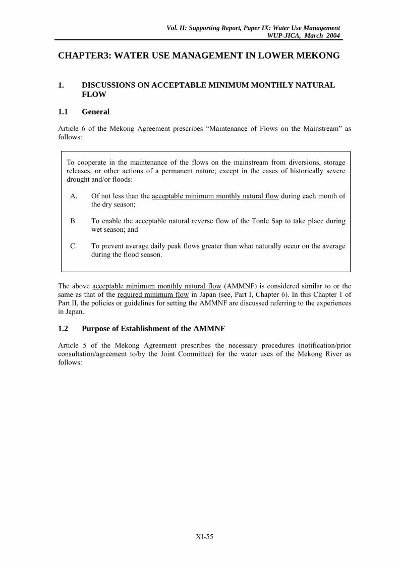
Vol. II: Supporting Report, Paper IX: Water Use ManagementWUP-JICA, March 2004
CHAPTER3: WATER USE MANAGEMENT IN LOWER MEKONG
1. DISCUSSIONS ON ACCEPTABLE MINIMUM MONTHLY NATURAL FLOW
1.1 General
Article 6 of the Mekong Agreement prescribes “Maintenance of Flows on the Mainstream” as follows:
To cooperate in the maintenance of the flows on the mainstream from diversions, storagereleases, or other actions of a permanent nature; except in the cases of historically severedrought and/or floods:
A. Of not less than the acceptable minimum monthly natural flow during each month ofthe dry season;
B. To enable the acceptable natural reverse flow of the Tonle Sap to take place duringwet season; and
C. To prevent average daily peak flows greater than what naturally occur on the averageduring the flood season.
The above acceptable minimum monthly natural flow (AMMNF) is considered similar to or the same as that of the required minimum flow in Japan (see, Part I, Chapter 6). In this Chapter 1 of Part II, the policies or guidelines for setting the AMMNF are discussed referring to the experiences in Japan.
1.2 Purpose of Establishment of the AMMNF
Article 5 of the Mekong Agreement prescribes the necessary procedures (notification/prior consultation/agreement to/by the Joint Committee) for the water uses of the Mekong River as follows:
XI-55
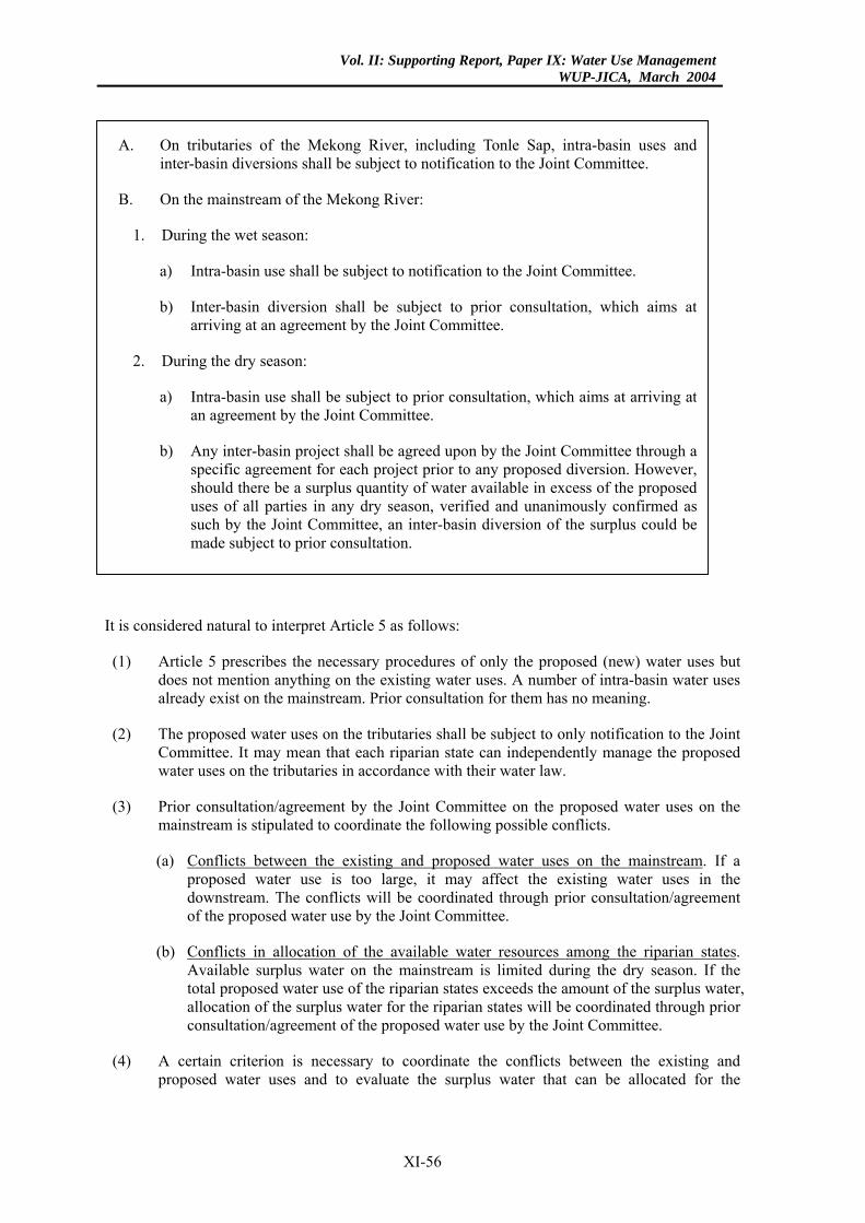
Vol. II: Supporting Report, Paper IX: Water Use ManagementWUP-JICA, March 2004
A. On tributaries of the Mekong River, including Tonle Sap, intra-basin uses andinter-basin diversions shall be subject to notification to the Joint Committee.
B. On the mainstream of the Mekong River:
1. During the wet season:
a) Intra-basin use shall be subject to notification to the Joint Committee.
b) Inter-basin diversion shall be subject to prior consultation, which aims atarriving at an agreement by the Joint Committee.
2. During the dry season:
a) Intra-basin use shall be subject to prior consultation, which aims at arriving atan agreement by the Joint Committee.
b) Any inter-basin project shall be agreed upon by the Joint Committee through aspecific agreement for each project prior to any proposed diversion. However,should there be a surplus quantity of water available in excess of the proposeduses of all parties in any dry season, verified and unanimously confirmed assuch by the Joint Committee, an inter-basin diversion of the surplus could bemade subject to prior consultation.
It is considered natural to interpret Article 5 as follows:
(1) Article 5 prescribes the necessary procedures of only the proposed (new) water uses but does not mention anything on the existing water uses. A number of intra-basin water uses already exist on the mainstream. Prior consultation for them has no meaning.
(2) The proposed water uses on the tributaries shall be subject to only notification to the Joint Committee. It may mean that each riparian state can independently manage the proposed water uses on the tributaries in accordance with their water law.
(3) Prior consultation/agreement by the Joint Committee on the proposed water uses on the mainstream is stipulated to coordinate the following possible conflicts.
(a) Conflicts between the existing and proposed water uses on the mainstream. If a proposed water use is too large, it may affect the existing water uses in the downstream. The conflicts will be coordinated through prior consultation/agreement of the proposed water use by the Joint Committee.
(b) Conflicts in allocation of the available water resources among the riparian states. Available surplus water on the mainstream is limited during the dry season. If the total proposed water use of the riparian states exceeds the amount of the surplus water, allocation of the surplus water for the riparian states will be coordinated through prior consultation/agreement of the proposed water use by the Joint Committee.
(4) A certain criterion is necessary to coordinate the conflicts between the existing and proposed water uses and to evaluate the surplus water that can be allocated for the
XI-56
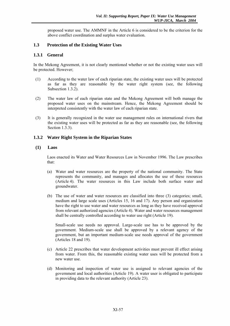
Vol. II: Supporting Report, Paper IX: Water Use ManagementWUP-JICA, March 2004
proposed water use. The AMMNF in the Article 6 is considered to be the criterion for the above conflict coordination and surplus water evaluation.
1.3 Protection of the Existing Water Uses
1.3.1 General
In the Mekong Agreement, it is not clearly mentioned whether or not the existing water uses will be protected. However;
(1) According to the water law of each riparian state, the existing water uses will be protected as far as they are reasonable by the water right system (see, the following Subsection 1.3.2).
(2) The water law of each riparian state and the Mekong Agreement will both manage the proposed water uses on the mainstream. Hence, the Mekong Agreement should be interpreted consistently with the water law of each riparian state.
(3) It is generally recognized in the water use management rules on international rivers that the existing water uses will be protected as far as they are reasonable (see, the following Section 1.3.3).
1.3.2 Water Right System in the Riparian States
(1) Laos
Laos enacted its Water and Water Resources Law in November 1996. The Law prescribes that:
(a) Water and water resources are the property of the national community. The State represents the community, and manages and allocates the use of these resources (Article 4). The water resources in this Law include both surface water and groundwater.
(b) The use of water and water resources are classified into three (3) categories; small, medium and large scale uses (Articles 15, 16 and 17). Any person and organization have the right to use water and water resources as long as they have received approval from relevant authorized agencies (Article 4). Water and water resources management shall be centrally controlled according to water use right (Article 19).
Small-scale use needs no approval. Large-scale use has to be approved by the government. Medium-scale use shall be approved by a relevant agency of the government, but an important medium-scale use needs approval of the government (Articles 18 and 19).
(c) Article 22 prescribes that water development activities must prevent ill effect arising from water. From this, the reasonable existing water uses will be protected from a new water use.
(d) Monitoring and inspection of water use is assigned to relevant agencies of the government and local authorities (Article 19). A water user is obligated to participate in providing data to the relevant authority (Article 23).
XI-57
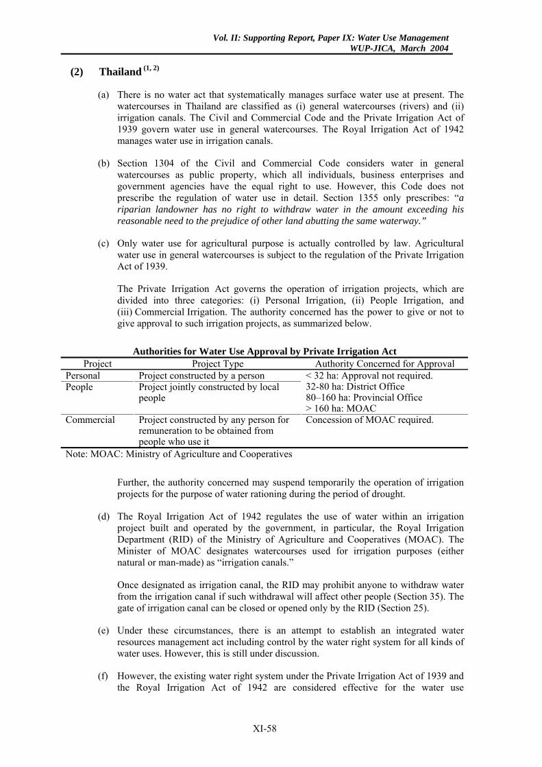
Vol. II: Supporting Report, Paper IX: Water Use ManagementWUP-JICA, March 2004
(2) Thailand (1, 2)
(a) There is no water act that systematically manages surface water use at present. The watercourses in Thailand are classified as (i) general watercourses (rivers) and (ii) irrigation canals. The Civil and Commercial Code and the Private Irrigation Act of 1939 govern water use in general watercourses. The Royal Irrigation Act of 1942 manages water use in irrigation canals.
(b) Section 1304 of the Civil and Commercial Code considers water in general watercourses as public property, which all individuals, business enterprises and government agencies have the equal right to use. However, this Code does not prescribe the regulation of water use in detail. Section 1355 only prescribes: “a riparian landowner has no right to withdraw water in the amount exceeding his reasonable need to the prejudice of other land abutting the same waterway.”
(c) Only water use for agricultural purpose is actually controlled by law. Agricultural water use in general watercourses is subject to the regulation of the Private Irrigation Act of 1939.
The Private Irrigation Act governs the operation of irrigation projects, which are divided into three categories: (i) Personal Irrigation, (ii) People Irrigation, and (iii) Commercial Irrigation. The authority concerned has the power to give or not to give approval to such irrigation projects, as summarized below.
Authorities for Water Use Approval by Private Irrigation Act
Project Project Type Authority Concerned for Approval Personal Project constructed by a person People Project jointly constructed by local
people
< 32 ha: Approval not required. 32-80 ha: District Office 80–160 ha: Provincial Office > 160 ha: MOAC
Commercial Project constructed by any person for remuneration to be obtained from people who use it
Concession of MOAC required.
Note: MOAC: Ministry of Agriculture and Cooperatives
Further, the authority concerned may suspend temporarily the operation of irrigation projects for the purpose of water rationing during the period of drought.
(d) The Royal Irrigation Act of 1942 regulates the use of water within an irrigation project built and operated by the government, in particular, the Royal Irrigation Department (RID) of the Ministry of Agriculture and Cooperatives (MOAC). The Minister of MOAC designates watercourses used for irrigation purposes (either natural or man-made) as “irrigation canals.”
Once designated as irrigation canal, the RID may prohibit anyone to withdraw water from the irrigation canal if such withdrawal will affect other people (Section 35). The gate of irrigation canal can be closed or opened only by the RID (Section 25).
(e) Under these circumstances, there is an attempt to establish an integrated water resources management act including control by the water right system for all kinds of water uses. However, this is still under discussion.
(f) However, the existing water right system under the Private Irrigation Act of 1939 and the Royal Irrigation Act of 1942 are considered effective for the water use
XI-58
Vol. II: Supporting Report, Paper IX: Water Use ManagementWUP-JICA, March 2004
management of the Mekong River Basin in the Thailand territory where water is used mostly for irrigation purposes.
(3) Cambodia
There is no water act that systematically manages river water use at present. However, a draft of the Law on Water Resources Management of the Kingdom of Cambodia was submitted to the Council of Ministers in March 2001. The draft Law prescribes that:
(a) All water and water resources, rivers, canals, lakes and reservoirs are owned by the State (Article 3).
(b) The Government shall control the use of water by means of licensing. All water uses except minor ones need approval of the government (Articles 9 and 10). The Ministry of Water Resources and Meteorology (MOWRAM) are responsible for the issuance of water use licenses (Article 4). Before granting a water use licence to a person, the MOWRAM shall consult with the other agencies concerned on such applied water use (Article 11). From Article 11, it may be interpreted that a new water use shall not cause damage on the existing water uses.
(c) The MOWRAM shall keep a centralized database of the water resources of the country. Data collected by the other governmental agencies and local authorities shall be submitted to the MOWRAM. The above data may be provided to any person requesting them, subject to the payment of fees.
(4) Vietnam
Vietnam enacted the Law on Water Resources in May 1998. The Law prescribes that:
(a) Ownership of water resources belongs to the entire population under the unified management of the State (Article 1). Further, Articles 57 and 58 prescribe that the responsibility to manage the water resources is laid on the State. The water resources in this Law include both surface water and groundwater.
(b) Water users shall obtain licenses for water use from the State or the Provincial People’s Committee, depending on the scale of water use scheme except small-scale water use for households/others (Article 24). The responsible agency of the State is the Ministry of Agriculture and Rural Development (MARD). The MARD issues licenses for large-scale water uses, while the Provincial People’s Committee grants licenses for the remaining water uses as shown below.
Authorities for Water Use Approval
Water Abstraction MARD PPC Important State Project Approved by Prime Minister All Projects - Groundwater for Concentrated Water Supply Project >1,000 m3/d <1,000 m3/d Surface Water for Agricultural/Industrial/Mining/Domestic Use >2 m3/s <2 m3/s Surface Water for Hydropower >500 kW <500 kW Note: PPC: Provincial People’s Committee Source: Documents in the national workshop training on water allocation, January 2001
(c) Water users that exploit and use water resources shall not cause obstruction or damage on the legitimate exploitation and use of water resources of other users. Further, the water users shall comply with the terms attached to the license (Article
XI-59
Vol. II: Supporting Report, Paper IX: Water Use ManagementWUP-JICA, March 2004
23). From this, the reasonable existing water uses will be protected from a new water use.
(d) The MARD shall assess the water resources and build the database on water resources with cooperation of other ministries/agencies of the government, and the people’s committees of provinces and specified cities (Article 60).
On the other hand, water users that exploit and use water resources shall supply information with a view to inventorying and evaluating water resources when requested (Article 23).
1.3.3 Water Management Rules for International Rivers
Article 8 of the Helsinki Rules on the Uses of the Waters of International Rivers, 1966 (Helsinki Rules) prescribes that, “an existing reasonable use may continue in operation unless the factors justifying its continuance are outweighed by other factors leading to the conclusion that it be modified or terminated so as to accommodate a competing incompatible use.”
Article 7 of the Convention on the Law of the Non-Navigational Uses of International Watercourses, 1997 (Non-Navigational Use Law) also prescribes that “watercourse States shall, in utilizing an international watercourse in their territories, take all appropriate measures to prevent the causing of significant harm to other watercourse States.”
1.3.4 Preliminary Conclusions
From the above discussions, it is considered natural to conclude that:
(1) The existing water uses on the mainstream will be protected as far as they are reasonable by maintaining the AMMNF. Then, surplus water exceeding the AMMNF can be allocated for proposed (new) water uses
(2) The AMMNF at a principal river station shall be determined with a certain reliability (hydrological probability) to satisfy the reasonable existing water uses including off-stream and in/on-stream uses in the downstream.
(3) It may be difficult to rationally determine the AMMNF only from the river flow regime. The AMMNF of larger flow rate is more desirable for the downstream regions, while a smaller one is more desirable for the upstream regions.
(4) According to Article 5, the waters of the Mekong River system shall be used in a reasonable and equitable manner in their respective territories. According to the Helsinki Rules on the Uses of the Waters of International Rivers, 1966, the major factors to be considered in a reasonable and equitable share of the waters among the riparian states are as listed below.
(a) Extent of drainage area in the territory of each riparian state
(b) Contribution of water by each riparian state
(c) Existing water use of each riparian state
(e) Economic and social needs of each riparian state
(f) Population dependent on the waters of the basin in each riparian state
XI-60
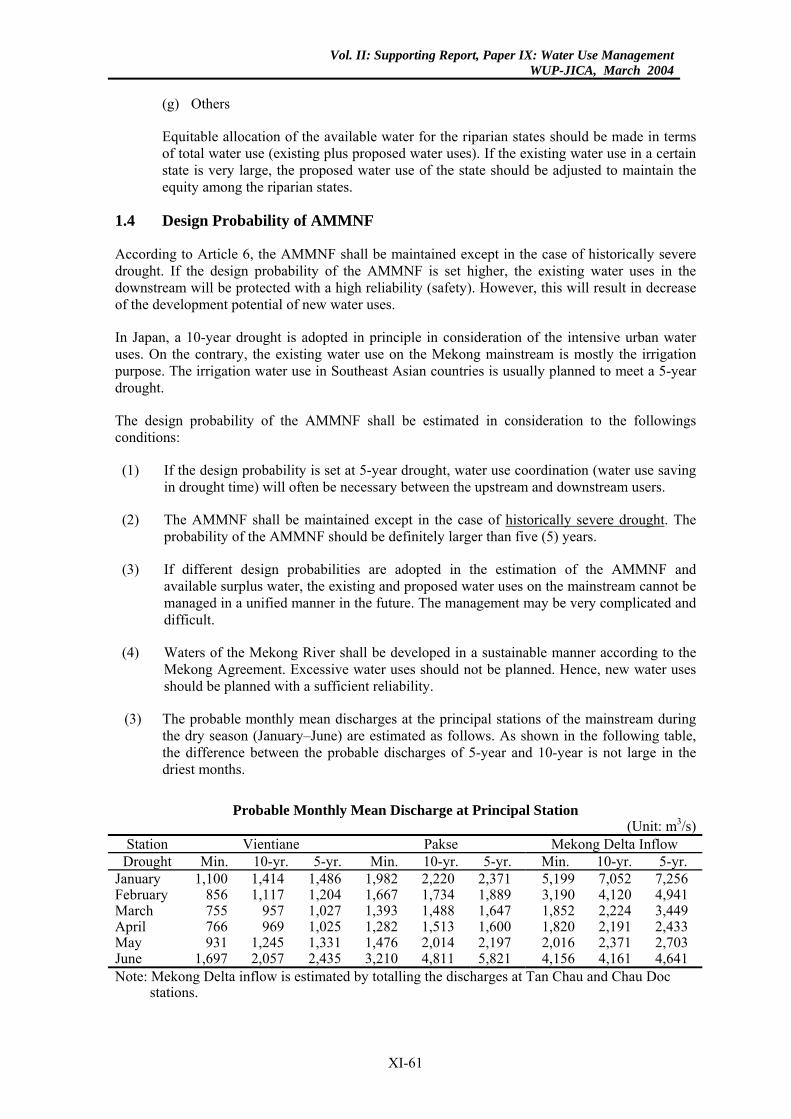
Vol. II: Supporting Report, Paper IX: Water Use ManagementWUP-JICA, March 2004
(g) Others
Equitable allocation of the available water for the riparian states should be made in terms of total water use (existing plus proposed water uses). If the existing water use in a certain state is very large, the proposed water use of the state should be adjusted to maintain the equity among the riparian states.
1.4 Design Probability of AMMNF
According to Article 6, the AMMNF shall be maintained except in the case of historically severe drought. If the design probability of the AMMNF is set higher, the existing water uses in the downstream will be protected with a high reliability (safety). However, this will result in decrease of the development potential of new water uses.
In Japan, a 10-year drought is adopted in principle in consideration of the intensive urban water uses. On the contrary, the existing water use on the Mekong mainstream is mostly the irrigation purpose. The irrigation water use in Southeast Asian countries is usually planned to meet a 5-year drought.
The design probability of the AMMNF shall be estimated in consideration to the followings conditions:
(1) If the design probability is set at 5-year drought, water use coordination (water use saving in drought time) will often be necessary between the upstream and downstream users.
(2) The AMMNF shall be maintained except in the case of historically severe drought. The probability of the AMMNF should be definitely larger than five (5) years.
(3) If different design probabilities are adopted in the estimation of the AMMNF and available surplus water, the existing and proposed water uses on the mainstream cannot be managed in a unified manner in the future. The management may be very complicated and difficult.
(4) Waters of the Mekong River shall be developed in a sustainable manner according to the Mekong Agreement. Excessive water uses should not be planned. Hence, new water uses should be planned with a sufficient reliability.
(3) The probable monthly mean discharges at the principal stations of the mainstream during the dry season (January–June) are estimated as follows. As shown in the following table, the difference between the probable discharges of 5-year and 10-year is not large in the driest months.
Probable Monthly Mean Discharge at Principal Station
(Unit: m3/s) Station Vientiane Pakse Mekong Delta Inflow
Drought Min. 10-yr. 5-yr. Min. 10-yr. 5-yr. Min. 10-yr. 5-yr. January 1,100 1,414 1,486 1,982 2,220 2,371 5,199 7,052 7,256 February 856 1,117 1,204 1,667 1,734 1,889 3,190 4,120 4,941 March 755 957 1,027 1,393 1,488 1,647 1,852 2,224 3,449 April 766 969 1,025 1,282 1,513 1,600 1,820 2,191 2,433 May 931 1,245 1,331 1,476 2,014 2,197 2,016 2,371 2,703 June 1,697 2,057 2,435 3,210 4,811 5,821 4,156 4,161 4,641 Note: Mekong Delta inflow is estimated by totalling the discharges at Tan Chau and Chau Doc
stations.
XI-61
Vol. II: Supporting Report, Paper IX: Water Use ManagementWUP-JICA, March 2004
1.5 Definition of Natural Flow
The technical term “natural flow” is employed in Article 6 of the Mekong Agreement. However, it is not defined in detail. What is the natural flow? The actual flow data at a principal station of the mainstream are those affected by the water use developments in the past. Is it necessary to reproduce an imaginary natural flow regime to establish the AMMNF?
In Japan, the natural flow is generally defined as follows:
(1) The river water has continuously been developed since the olden days to meet the increasing water requirement of the river basin. Hence, the flow regime has historically changed according to the water use development.
(2) However, the existing water uses are managed based on the current flow regime. New water uses are planned and implemented not to infringe upon the existing water uses. Hence, the river flow under the existing water use conditions (including water abstraction and water storage/release of dam) should be defined as natural flow when a new water development is discussed unless the existing water uses are revised.
(3) Usually, the flow records during a certain period in the past are necessary for planning of a new water use. However, they are employed only for the analysis of flow characteristics, assessment of hydrological probability and preparation of the operation rule of the new water use. Accordingly, imaginary natural flow needs to be reproduced only when the flow regime has been largely disturbed by the water use development in the past. If the disturbance is not significant, the flow records in the past can be used as the natural flow under the existing water use conditions.
In the Lower Mekong Basin (LMB), the natural flow should be defined in consideration of the following:
(1) The natural flow is necessary to determine the AMMNF and evaluate the available surplus water on the mainstream.
(2) The Mekong Agreement will not manage the existing water uses in the tributaries at all. Even the proposed water uses will be only subject to notification to the Joint Committee. The water uses in the tributaries will be independently managed by the water right system of each riparian state. Hence, all the existing water uses in the tributaries should be accepted by all the riparian states.
(3) If the existing water uses on the mainstream are protected by the AMMNF, the proposed water uses on the mainstream will be planned not to infringe on the existing water uses in the downstream as in the case of Japan.
(4) In this case, the river flow under the existing water uses can be defined as natural river flow when a new water development is discussed unless the existing water uses are changed.
(5) However, the actual flow data during a certain period in the past are necessary for planning a new water development. The impact of the water use development of the basin in the past on the mainstream flow must be checked prior to using the data. If the impact is small, the data can be dealt as natural flow. When the impact is significant, imaginary flow under the existing water use conditions should be reproduced.
XI-62
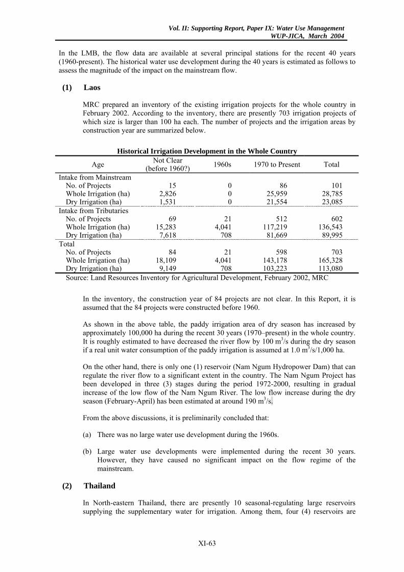
Vol. II: Supporting Report, Paper IX: Water Use ManagementWUP-JICA, March 2004
In the LMB, the flow data are available at several principal stations for the recent 40 years (1960-present). The historical water use development during the 40 years is estimated as follows to assess the magnitude of the impact on the mainstream flow.
(1) Laos
MRC prepared an inventory of the existing irrigation projects for the whole country in February 2002. According to the inventory, there are presently 703 irrigation projects of which size is larger than 100 ha each. The number of projects and the irrigation areas by construction year are summarized below.
Historical Irrigation Development in the Whole Country
Age Not Clear (before 1960?) 1960s 1970 to Present Total
Intake from Mainstream No. of Projects 15 0 86 101 Whole Irrigation (ha) 2,826 0 25,959 28,785 Dry Irrigation (ha) 1,531 0 21,554 23,085
Intake from Tributaries No. of Projects 69 21 512 602 Whole Irrigation (ha) 15,283 4,041 117,219 136,543 Dry Irrigation (ha) 7,618 708 81,669 89,995
Total No. of Projects 84 21 598 703 Whole Irrigation (ha) 18,109 4,041 143,178 165,328 Dry Irrigation (ha) 9,149 708 103,223 113,080 Source: Land Resources Inventory for Agricultural Development, February 2002, MRC
In the inventory, the construction year of 84 projects are not clear. In this Report, it is assumed that the 84 projects were constructed before 1960.
As shown in the above table, the paddy irrigation area of dry season has increased by approximately 100,000 ha during the recent 30 years (1970–present) in the whole country. It is roughly estimated to have decreased the river flow by 100 m3/s during the dry season if a real unit water consumption of the paddy irrigation is assumed at 1.0 m3/s/1,000 ha.
On the other hand, there is only one (1) reservoir (Nam Ngum Hydropower Dam) that can regulate the river flow to a significant extent in the country. The Nam Ngum Project has been developed in three (3) stages during the period 1972-2000, resulting in gradual increase of the low flow of the Nam Ngum River. The low flow increase during the dry season (February-April) has been estimated at around 190 m3/s.
From the above discussions, it is preliminarily concluded that:
(a) There was no large water use development during the 1960s.
(b) Large water use developments were implemented during the recent 30 years. However, they have caused no significant impact on the flow regime of the mainstream.
(2) Thailand
In North-eastern Thailand, there are presently 10 seasonal-regulating large reservoirs supplying the supplementary water for irrigation. Among them, four (4) reservoirs are
XI-63
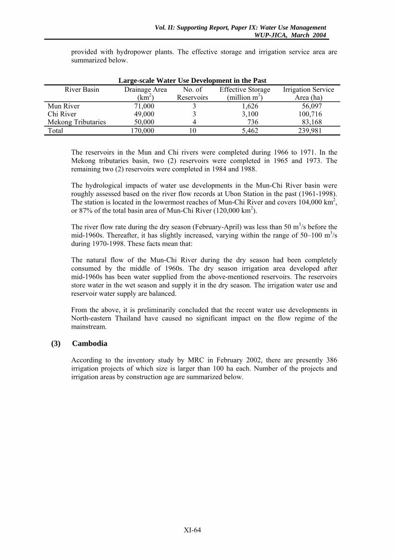
Vol. II: Supporting Report, Paper IX: Water Use ManagementWUP-JICA, March 2004
provided with hydropower plants. The effective storage and irrigation service area are summarized below.
Large-scale Water Use Development in the Past
River Basin Drainage Area (km2)
No. of Reservoirs
Effective Storage (million m3)
Irrigation Service Area (ha)
Mun River 71,000 3 1,626 56,097 Chi River 49,000 3 3,100 100,716 Mekong Tributaries 50,000 4 736 83,168 Total 170,000 10 5,462 239,981
The reservoirs in the Mun and Chi rivers were completed during 1966 to 1971. In the Mekong tributaries basin, two (2) reservoirs were completed in 1965 and 1973. The remaining two (2) reservoirs were completed in 1984 and 1988.
The hydrological impacts of water use developments in the Mun-Chi River basin were roughly assessed based on the river flow records at Ubon Station in the past (1961-1998). The station is located in the lowermost reaches of Mun-Chi River and covers 104,000 km2, or 87% of the total basin area of Mun-Chi River (120,000 km2).
The river flow rate during the dry season (February-April) was less than 50 m3/s before the mid-1960s. Thereafter, it has slightly increased, varying within the range of 50–100 m3/s during 1970-1998. These facts mean that:
The natural flow of the Mun-Chi River during the dry season had been completely consumed by the middle of 1960s. The dry season irrigation area developed after mid-1960s has been water supplied from the above-mentioned reservoirs. The reservoirs store water in the wet season and supply it in the dry season. The irrigation water use and reservoir water supply are balanced.
From the above, it is preliminarily concluded that the recent water use developments in North-eastern Thailand have caused no significant impact on the flow regime of the mainstream.
(3) Cambodia
According to the inventory study by MRC in February 2002, there are presently 386 irrigation projects of which size is larger than 100 ha each. Number of the projects and irrigation areas by construction age are summarized below.
XI-64
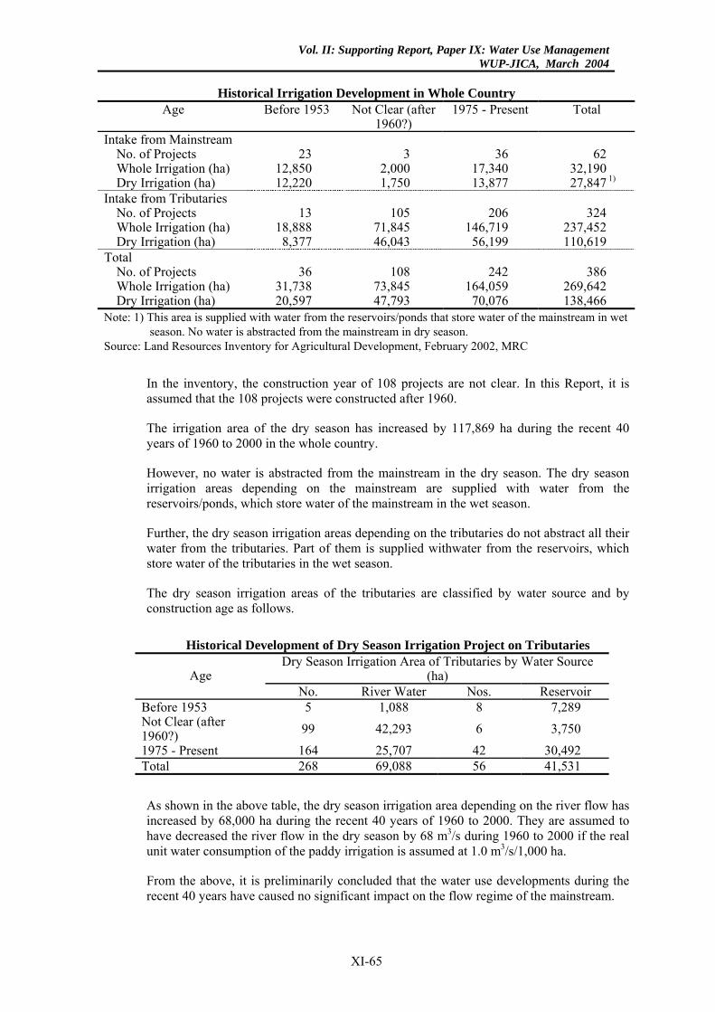
Vol. II: Supporting Report, Paper IX: Water Use ManagementWUP-JICA, March 2004
Historical Irrigation Development in Whole Country
Age Before 1953 Not Clear (after 1960?)
1975 - Present Total
Intake from Mainstream No. of Projects 23 3 36 62 Whole Irrigation (ha) 12,850 2,000 17,340 32,190 Dry Irrigation (ha) 12,220 1,750 13,877 27,847 1)
Intake from Tributaries No. of Projects 13 105 206 324 Whole Irrigation (ha) 18,888 71,845 146,719 237,452 Dry Irrigation (ha) 8,377 46,043 56,199 110,619
Total No. of Projects 36 108 242 386 Whole Irrigation (ha) 31,738 73,845 164,059 269,642 Dry Irrigation (ha) 20,597 47,793 70,076 138,466
Note: 1) This area is supplied with water from the reservoirs/ponds that store water of the mainstream in wet season. No water is abstracted from the mainstream in dry season.
Source: Land Resources Inventory for Agricultural Development, February 2002, MRC
In the inventory, the construction year of 108 projects are not clear. In this Report, it is assumed that the 108 projects were constructed after 1960.
The irrigation area of the dry season has increased by 117,869 ha during the recent 40 years of 1960 to 2000 in the whole country.
However, no water is abstracted from the mainstream in the dry season. The dry season irrigation areas depending on the mainstream are supplied with water from the reservoirs/ponds, which store water of the mainstream in the wet season.
Further, the dry season irrigation areas depending on the tributaries do not abstract all their water from the tributaries. Part of them is supplied withwater from the reservoirs, which store water of the tributaries in the wet season.
The dry season irrigation areas of the tributaries are classified by water source and by construction age as follows.
Historical Development of Dry Season Irrigation Project on Tributaries
Dry Season Irrigation Area of Tributaries by Water Source (ha) Age
No. River Water Nos. Reservoir Before 1953 5 1,088 8 7,289 Not Clear (after 1960?) 99 42,293 6 3,750 1975 - Present 164 25,707 42 30,492 Total 268 69,088 56 41,531
As shown in the above table, the dry season irrigation area depending on the river flow has increased by 68,000 ha during the recent 40 years of 1960 to 2000. They are assumed to have decreased the river flow in the dry season by 68 m3/s during 1960 to 2000 if the real unit water consumption of the paddy irrigation is assumed at 1.0 m3/s/1,000 ha.
From the above, it is preliminarily concluded that the water use developments during the recent 40 years have caused no significant impact on the flow regime of the mainstream.
XI-65
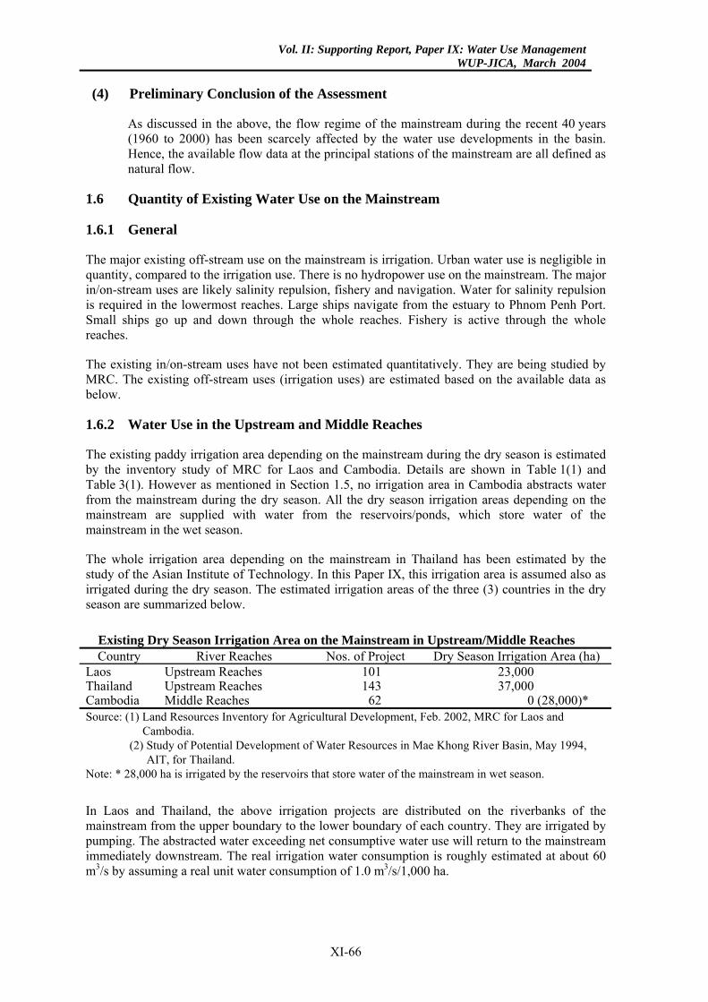
Vol. II: Supporting Report, Paper IX: Water Use ManagementWUP-JICA, March 2004
(4) Preliminary Conclusion of the Assessment
As discussed in the above, the flow regime of the mainstream during the recent 40 years (1960 to 2000) has been scarcely affected by the water use developments in the basin. Hence, the available flow data at the principal stations of the mainstream are all defined as natural flow.
1.6 Quantity of Existing Water Use on the Mainstream
1.6.1 General
The major existing off-stream use on the mainstream is irrigation. Urban water use is negligible in quantity, compared to the irrigation use. There is no hydropower use on the mainstream. The major in/on-stream uses are likely salinity repulsion, fishery and navigation. Water for salinity repulsion is required in the lowermost reaches. Large ships navigate from the estuary to Phnom Penh Port. Small ships go up and down through the whole reaches. Fishery is active through the whole reaches.
The existing in/on-stream uses have not been estimated quantitatively. They are being studied by MRC. The existing off-stream uses (irrigation uses) are estimated based on the available data as below.
1.6.2 Water Use in the Upstream and Middle Reaches
The existing paddy irrigation area depending on the mainstream during the dry season is estimated by the inventory study of MRC for Laos and Cambodia. Details are shown in Table 1(1) and Table 3(1). However as mentioned in Section 1.5, no irrigation area in Cambodia abstracts water from the mainstream during the dry season. All the dry season irrigation areas depending on the mainstream are supplied with water from the reservoirs/ponds, which store water of the mainstream in the wet season.
The whole irrigation area depending on the mainstream in Thailand has been estimated by the study of the Asian Institute of Technology. In this Paper IX, this irrigation area is assumed also as irrigated during the dry season. The estimated irrigation areas of the three (3) countries in the dry season are summarized below.
Existing Dry Season Irrigation Area on the Mainstream in Upstream/Middle Reaches Country River Reaches Nos. of Project Dry Season Irrigation Area (ha)
Laos Upstream Reaches 101 23,000 Thailand Upstream Reaches 143 37,000 Cambodia Middle Reaches 62 0 (28,000)* Source: (1) Land Resources Inventory for Agricultural Development, Feb. 2002, MRC for Laos and
Cambodia. (2) Study of Potential Development of Water Resources in Mae Khong River Basin, May 1994,
AIT, for Thailand. Note: * 28,000 ha is irrigated by the reservoirs that store water of the mainstream in wet season.
In Laos and Thailand, the above irrigation projects are distributed on the riverbanks of the mainstream from the upper boundary to the lower boundary of each country. They are irrigated by pumping. The abstracted water exceeding net consumptive water use will return to the mainstream immediately downstream. The real irrigation water consumption is roughly estimated at about 60 m3/s by assuming a real unit water consumption of 1.0 m3/s/1,000 ha.
XI-66
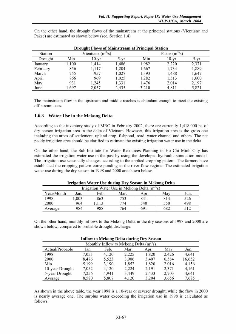
Vol. II: Supporting Report, Paper IX: Water Use ManagementWUP-JICA, March 2004
On the other hand, the drought flows of the mainstream at the principal stations (Vientiane and Pakse) are estimated as shown below (see, Section 1.4).
Drought Flows of Mainstream at Principal Station
Station Vientiane (m3/s) Pakse (m3/s) Drought Min. 10-yr. 5-yr. Min. 10-yr. 5-yr.
January 1,100 1,414 1,486 1,982 2,220 2,371 February 856 1,117 1,204 1,667 1,734 1,889 March 755 957 1,027 1,393 1,488 1,647 April 766 969 1,025 1,282 1,513 1,600 May 931 1,245 1,331 1,476 2,014 2,197 June 1,697 2,057 2,435 3,210 4,811 5,821
The mainstream flow in the upstream and middle reaches is abundant enough to meet the existing off-stream uses.
1.6.3 Water Use in the Mekong Delta
According to the inventory study of MRC in February 2002, there are currently 1,418,000 ha of dry season irrigation area in the delta of Vietnam. However, this irrigation area is the gross one including the areas of settlement, upland crop, fishpond, road, water channel and others. The net paddy irrigation area should be clarified to estimate the existing irrigation water use in the delta.
On the other hand, the Sub-Institute for Water Resources Planning in Ho Chi Minh City has estimated the irrigation water use in the past by using the developed hydraulic simulation model. The irrigation use seasonally changes according to the applied cropping pattern. The farmers have established the cropping pattern corresponding to the river flow regime. The estimated irrigation water use during the dry season in 1998 and 2000 are shown below.
Irrigation Water Use during Dry Season in Mekong Delta
Irrigation Water Use in Mekong Delta (m3/s) Year/Month Jan. Feb. Mar. Apr. May Jun. 1998 1,003 863 753 841 814 526 2000 964 1,113 774 540 550 498 Average 984 988 764 691 682 512
On the other hand, monthly inflows to the Mekong Delta in the dry seasons of 1998 and 2000 are shown below, compared to probable drought discharge.
Inflow to Mekong Delta during Dry Season
Monthly Inflow to Mekong Delta (m3/s) Actual/Probable Jan. Feb. Mar. Apr. May Jun. 1998 7,053 4,120 2,225 1,820 2,426 4,641 2000 8,476 5,523 3,906 3,407 6,584 16,652 Min. 5,199 3,190 1,852 1,820 2,016 4,156 10-year Drought 7,052 4,120 2,224 2,191 2,371 4,161 5-year Drought 7,256 4,941 3,449 2,433 2,703 4,641 Average 8,580 5,807 4,120 3,204 3,656 7,685
As shown in the above table, the year 1998 is a 10-year or severer drought, while the flow in 2000 is nearly average one. The surplus water exceeding the irrigation use in 1998 is calculated as follows.
XI-67
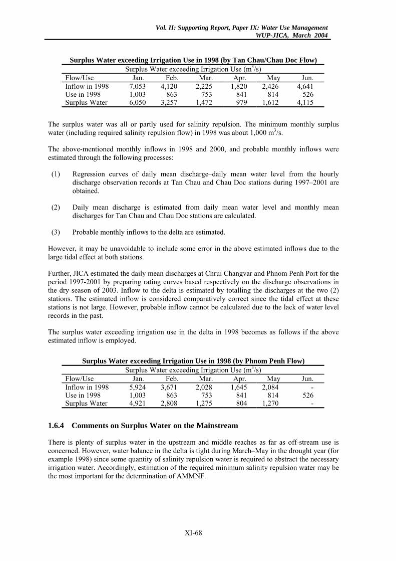
Vol. II: Supporting Report, Paper IX: Water Use ManagementWUP-JICA, March 2004
Surplus Water exceeding Irrigation Use in 1998 (by Tan Chau/Chau Doc Flow) Surplus Water exceeding Irrigation Use (m3/s)
Flow/Use Jan. Feb. Mar. Apr. May Jun. Inflow in 1998 7,053 4,120 2,225 1,820 2,426 4,641 Use in 1998 1,003 863 753 841 814 526 Surplus Water 6,050 3,257 1,472 979 1,612 4,115
The surplus water was all or partly used for salinity repulsion. The minimum monthly surplus water (including required salinity repulsion flow) in 1998 was about 1,000 m3/s.
The above-mentioned monthly inflows in 1998 and 2000, and probable monthly inflows were estimated through the following processes:
(1) Regression curves of daily mean discharge–daily mean water level from the hourly discharge observation records at Tan Chau and Chau Doc stations during 1997–2001 are obtained.
(2) Daily mean discharge is estimated from daily mean water level and monthly mean discharges for Tan Chau and Chau Doc stations are calculated.
(3) Probable monthly inflows to the delta are estimated.
However, it may be unavoidable to include some error in the above estimated inflows due to the large tidal effect at both stations.
Further, JICA estimated the daily mean discharges at Chrui Changvar and Phnom Penh Port for the period 1997-2001 by preparing rating curves based respectively on the discharge observations in the dry season of 2003. Inflow to the delta is estimated by totalling the discharges at the two (2) stations. The estimated inflow is considered comparatively correct since the tidal effect at these stations is not large. However, probable inflow cannot be calculated due to the lack of water level records in the past.
The surplus water exceeding irrigation use in the delta in 1998 becomes as follows if the above estimated inflow is employed.
Surplus Water exceeding Irrigation Use in 1998 (by Phnom Penh Flow)
Surplus Water exceeding Irrigation Use (m3/s) Flow/Use Jan. Feb. Mar. Apr. May Jun. Inflow in 1998 5,924 3,671 2,028 1,645 2,084 - Use in 1998 1,003 863 753 841 814 526 Surplus Water 4,921 2,808 1,275 804 1,270 -
1.6.4 Comments on Surplus Water on the Mainstream
There is plenty of surplus water in the upstream and middle reaches as far as off-stream use is concerned. However, water balance in the delta is tight during March–May in the drought year (for example 1998) since some quantity of salinity repulsion water is required to abstract the necessary irrigation water. Accordingly, estimation of the required minimum salinity repulsion water may be the most important for the determination of AMMNF.
XI-68
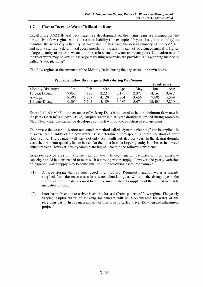
Vol. II: Supporting Report, Paper IX: Water Use ManagementWUP-JICA, March 2004
1.7 How to Increase Water Utilization Rate
Usually, the AMMNF and new water use development on the mainstream are planned for the design river flow regime with a certain probability (for example, 10-year drought probability) to maintain the necessary reliability of water use. In this case, the design quantity of the AMMNF and new water use is determined every month, but the quantity cannot be changed annually. Hence, a large quantity of water is wasted to the sea in normal or water abundant years. Utilization rate of the river water may be low unless large regulating reservoirs are provided. This planning method is called “static planning”.
The flow regime at the entrance of the Mekong Delta during the dry season is shown below.
Probable Inflow Discharge to Delta during Dry Season
(Unit: m3/s) Monthly Discharge Jan. Feb. Mar. Apr. May Jun. Ave. 10-year Drought 7,052 4,120 2,224 2,191 2,371 4,161 3,687 Average 8,580 5,807 4,120 3,204 3,656 7,685 5,509 1.1-year Drought 9,801 7,104 5,189 3,689 5,074 12,405 7,210
Even if the AMMNF at the entrance of Mekong Delta is assumed to be the minimum flow rate in the past (1,820 m3/s in April, 1998), surplus water in a 10-year drought is limited during March to May. New water use cannot be developed so much without construction of storage dams.
To increase the water utilization rate, another method called “dynamic planning” can be applied. In this case, the quantity of the new water use is determined corresponding to the variation of river flow regime. The quantity will vary not only per month but also per year. In the design drought year, the minimum quantity has to be set. On the other hand, a larger quantity is to be set in a water abundant year. However, this dynamic planning will contain the following problems.
Irrigation service area will change year by year. Hence, irrigation facilities with an excessive capacity should be constructed to meet such a varying water supply. However, the yearly variation of irrigation water supply may become smaller in the following cases, for example.
(1) A large storage dam is constructed in a tributary. Required irrigation water is mainly supplied from the mainstream in a water abundant year, while in the drought year, the stored water of the dam is used to the maximum extent to supplement the limited available mainstream water.
(2) Inter-basin diversion to a river basin that has a different pattern of flow regime. The yearly varying surplus water of Mekong mainstream will be supplemented by water of the receiving basin. In Japan, a project of this type is called “river flow regime adjustment project”
XI-69
Vol. II: Supporting Report, Paper IX: Water Use ManagementWUP-JICA, March 2004
2. DISCUSSIONS ON WATER USE MONITORING
2.1 General
Article 26 of the Mekong Agreement mandates the Joint Committee to prepare and propose the “Rules for Water Utilization and Inter-Basin Diversions” including water use monitoring as below.
Article 26 Rules for Water Utilization and Inter-Basin Diversions
The Joint Committee shall prepare and propose for approval of the Council, inter alia, Rules for Water Utilization and Inter-Basin Diversions pursuant to Article 5 and 6,including but not limited to; (1) Establishing the time frame for the wet and dry seasons,
(2) Establishing the location of hydrological stations, and determining and maintainingflow level requirements at each station,
(3) Setting out criteria for determining surplus quantities of water during the dry season onthe mainstream,
(4) Improving upon the mechanism to monitor intra-basin use,
(5) Setting up a mechanism to monitor inter-basin diversions from the mainstream.
This chapter identifies the necessities and problems of water use monitoring. It further gives some discussions and suggestions on the monitoring system based on the experiences in Japan, and available data of the existing water uses and river flow in the LMB.
2.2 Necessity of Water Use Monitoring
The water use in the LMB is to be managed based on the water right system at the national level. On the other hand, it is to be managed in accordance with the 1995 Mekong Agreement at the regional level. For proper management of the water uses in the LMB, water use monitoring is necessary at both national and regional levels as described below.
2.2.1 Monitoring Necessity at National Level
As mentioned before, the river water uses in the riparian states will be managed based on their own water right systems. In all their systems, the existing reasonable water use shall be protected and only surplus water (available river water exceeding the existing reasonable water uses) will be allocated for proposed water uses (new water uses). For promotion of the water use management by the water right system, periodical monitoring of all the existing and proposed water uses except minor ones will be necessary. For the water right systems of the four (4) riparian states, see Subsection 1.3.2 of Chapter 1.
(1) For Estimate of Existing Water Uses
Firstly, the existing reasonable water uses shall be identified and quantified, and registered to protect them. Then, water use license (or customary right) shall be given to these water
XI-70
Vol. II: Supporting Report, Paper IX: Water Use ManagementWUP-JICA, March 2004
uses and once granted a license, even the existing users shall comply with the conditions of the water use licenses. Compliance with the conditions shall be monitored.
(2) For Compliance with the Conditions of Proposed Water Uses
A proposed water use shall need permit of the concerned authority and the water user shall comply with the conditions attached to his permit. Compliance with the conditions of the proposed water use shall also be monitored.
(3) For Water Use Coordination in Severe Drought
The permitted water uses are ensured with a certain hydrological probability. Hence, the water uses of a river basin shall be restricted or redistributed during droughts more severe than the design one.
The above water use restriction or redistribution cannot be coordinated without the monitoring data of actual water use together with river flow and dam operation.
2.2.2 Monitoring Necessity at Regional Level
(1) For Sharing Existing Water Use Data
For implementation and promotion of the water use management in the LMB, data of the existing water uses in each river section of the mainstream and each tributary basin are necessary. However, they are only partly available. Even, the inventory of existing irrigation areas has not yet been completed.
Sharing of water use data with a sufficient transparency is essentially necessary for cooperation in the water use management of the LMB.
(2) For Compliance with the Conditions of Proposed Water Uses
Any proposed water use in the LMB shall be subject to notification to or prior consultation with or specific agreement by the Joint Committee pursuant to Article 5 of the Mekong Agreement, as summarized below.
Necessary Procedures of Proposed Water Uses
River Season Water Use Type Necessary Procedures Tributaries Any Season Intra-basin Use Notification to the Joint Committee Inter-basin Diversion Notification to the Joint Committee Mainstream Wet Season Intra-basin Use Notification to the Joint Committee Inter-basin Diversion Prior consultation which aims at arriving at an
agreement by the Joint Committee Dry Season Intra-basin Use Prior consultation which aims at arriving at an
agreement by the Joint Committee Inter-basin Diversion Agreed upon by the Joint Committee through
a specific agreement for each project
The above notification, consultation and agreement shall contain the water use conditions such as intake location, service area, intake quantity, intake/dam structures, dam operation rules, etc. Compliance with these conditions shall be confirmed through the water use monitoring.
XI-71
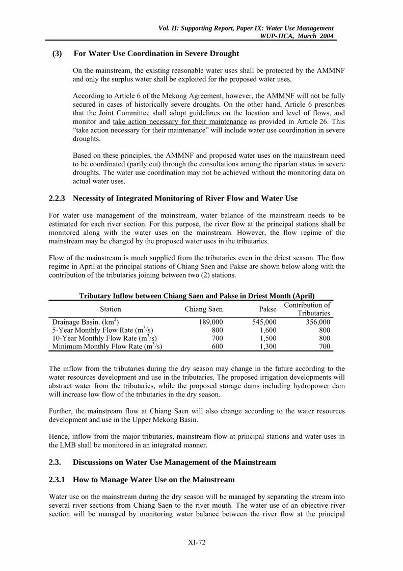
Vol. II: Supporting Report, Paper IX: Water Use ManagementWUP-JICA, March 2004
(3) For Water Use Coordination in Severe Drought
On the mainstream, the existing reasonable water uses shall be protected by the AMMNF and only the surplus water shall be exploited for the proposed water uses.
According to Article 6 of the Mekong Agreement, however, the AMMNF will not be fully secured in cases of historically severe droughts. On the other hand, Article 6 prescribes that the Joint Committee shall adopt guidelines on the location and level of flows, and monitor and take action necessary for their maintenance as provided in Article 26. This “take action necessary for their maintenance” will include water use coordination in severe droughts.
Based on these principles, the AMMNF and proposed water uses on the mainstream need to be coordinated (partly cut) through the consultations among the riparian states in severe droughts. The water use coordination may not be achieved without the monitoring data on actual water uses.
2.2.3 Necessity of Integrated Monitoring of River Flow and Water Use
For water use management of the mainstream, water balance of the mainstream needs to be estimated for each river section. For this purpose, the river flow at the principal stations shall be monitored along with the water uses on the mainstream. However, the flow regime of the mainstream may be changed by the proposed water uses in the tributaries.
Flow of the mainstream is much supplied from the tributaries even in the driest season. The flow regime in April at the principal stations of Chiang Saen and Pakse are shown below along with the contribution of the tributaries joining between two (2) stations.
Tributary Inflow between Chiang Saen and Pakse in Driest Month (April)
Station Chiang Saen Pakse Contribution of Tributaries
Drainage Basin. (km2) 189,000 545,000 356,000 5-Year Monthly Flow Rate (m3/s) 800 1,600 800 10-Year Monthly Flow Rate (m3/s) 700 1,500 800 Minimum Monthly Flow Rate (m3/s) 600 1,300 700
The inflow from the tributaries during the dry season may change in the future according to the water resources development and use in the tributaries. The proposed irrigation developments will abstract water from the tributaries, while the proposed storage dams including hydropower dam will increase low flow of the tributaries in the dry season.
Further, the mainstream flow at Chiang Saen will also change according to the water resources development and use in the Upper Mekong Basin.
Hence, inflow from the major tributaries, mainstream flow at principal stations and water uses in the LMB shall be monitored in an integrated manner.
2.3. Discussions on Water Use Management of the Mainstream
2.3.1 How to Manage Water Use on the Mainstream
Water use on the mainstream during the dry season will be managed by separating the stream into several river sections from Chiang Saen to the river mouth. The water use of an objective river section will be managed by monitoring water balance between the river flow at the principal
XI-72
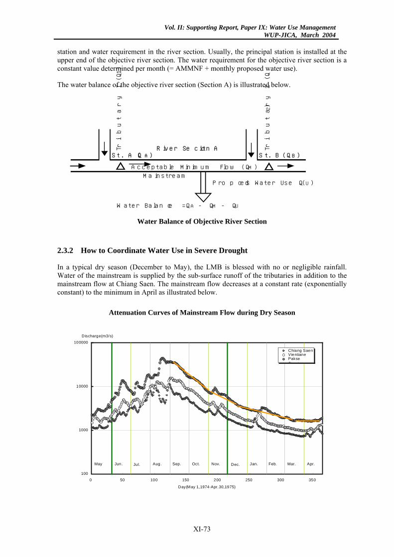
Vol. II: Supporting Report, Paper IX: Water Use ManagementWUP-JICA, March 2004
station and water requirement in the river section. Usually, the principal station is installed at the upper end of the objective river section. The water requirement for the objective river section is a constant value determined per month (= AMMNF + monthly proposed water use).
The water balance of the objective river section (Section A) is illustrated below.
M a in s t re a m
Tribu
tary
I (
Q1)
R iv e r S e c t io n A
W a te r B a la n c e = Q A - Q M - Q U
S t . A (Q A ) S t . B (Q B )
A c c e p ta b le M in im u m F lo w (Q M )
P ro p o s e d W a te r U s e (Q U )
Tribu
tary
2 (
Q2)
Water Balance of Objective River Section
2.3.2 How to Coordinate Water Use in Severe Drought
In a typical dry season (December to May), the LMB is blessed with no or negligible rainfall. Water of the mainstream is supplied by the sub-surface runoff of the tributaries in addition to the mainstream flow at Chiang Saen. The mainstream flow decreases at a constant rate (exponentially constant) to the minimum in April as illustrated below.
Attenuation Curves of Mainstream Flow during Dry Season
100
1000
10000
100000
0 50 100 150 200 250 300 350
Day(May 1,1974-Apr.30,1975)
Discharge(m3/s)
Chiang SaenVientianePakse系 4
Dec.Jun. Jul. Aug. Sep. Oct. Nov.May Jan. Feb. Mar. Apr.
XI-73
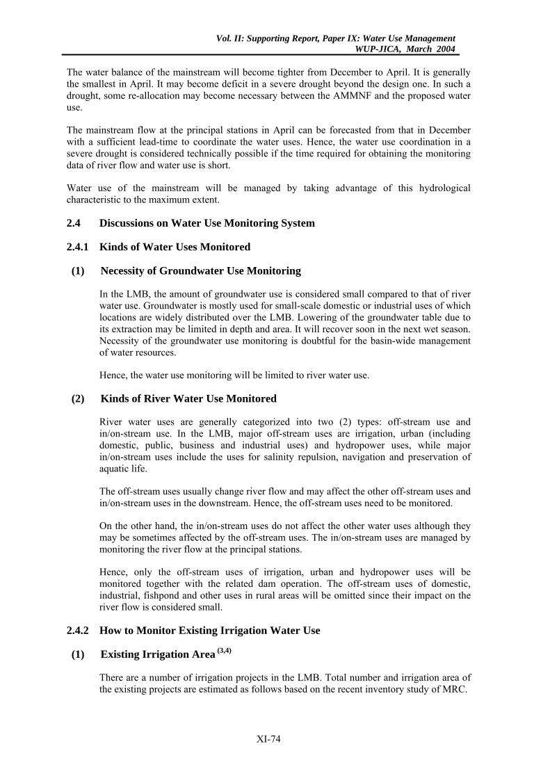
Vol. II: Supporting Report, Paper IX: Water Use ManagementWUP-JICA, March 2004
The water balance of the mainstream will become tighter from December to April. It is generally the smallest in April. It may become deficit in a severe drought beyond the design one. In such a drought, some re-allocation may become necessary between the AMMNF and the proposed water use.
The mainstream flow at the principal stations in April can be forecasted from that in December with a sufficient lead-time to coordinate the water uses. Hence, the water use coordination in a severe drought is considered technically possible if the time required for obtaining the monitoring data of river flow and water use is short.
Water use of the mainstream will be managed by taking advantage of this hydrological characteristic to the maximum extent.
2.4 Discussions on Water Use Monitoring System
2.4.1 Kinds of Water Uses Monitored
(1) Necessity of Groundwater Use Monitoring
In the LMB, the amount of groundwater use is considered small compared to that of river water use. Groundwater is mostly used for small-scale domestic or industrial uses of which locations are widely distributed over the LMB. Lowering of the groundwater table due to its extraction may be limited in depth and area. It will recover soon in the next wet season. Necessity of the groundwater use monitoring is doubtful for the basin-wide management of water resources.
Hence, the water use monitoring will be limited to river water use.
(2) Kinds of River Water Use Monitored
River water uses are generally categorized into two (2) types: off-stream use and in/on-stream use. In the LMB, major off-stream uses are irrigation, urban (including domestic, public, business and industrial uses) and hydropower uses, while major in/on-stream uses include the uses for salinity repulsion, navigation and preservation of aquatic life.
The off-stream uses usually change river flow and may affect the other off-stream uses and in/on-stream uses in the downstream. Hence, the off-stream uses need to be monitored.
On the other hand, the in/on-stream uses do not affect the other water uses although they may be sometimes affected by the off-stream uses. The in/on-stream uses are managed by monitoring the river flow at the principal stations.
Hence, only the off-stream uses of irrigation, urban and hydropower uses will be monitored together with the related dam operation. The off-stream uses of domestic, industrial, fishpond and other uses in rural areas will be omitted since their impact on the river flow is considered small.
2.4.2 How to Monitor Existing Irrigation Water Use
(1) Existing Irrigation Area (3,4)
There are a number of irrigation projects in the LMB. Total number and irrigation area of the existing projects are estimated as follows based on the recent inventory study of MRC.
XI-74
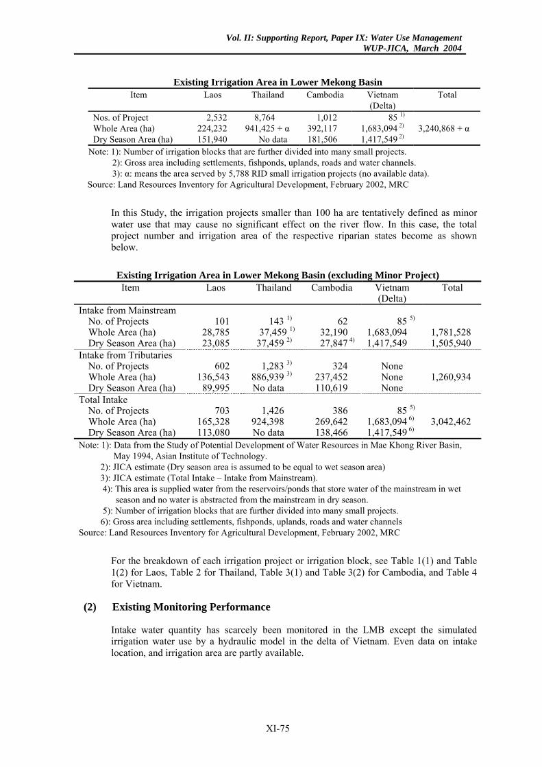
Vol. II: Supporting Report, Paper IX: Water Use ManagementWUP-JICA, March 2004
Existing Irrigation Area in Lower Mekong Basin Item Laos Thailand Cambodia Vietnam
(Delta) Total
Nos. of Project 2,532 8,764 1,012 85 1) Whole Area (ha) 224,232 941,425 + α 392,117 1,683,094 2) 3,240,868 + α Dry Season Area (ha) 151,940 No data 181,506 1,417,549 2)
Note: 1): Number of irrigation blocks that are further divided into many small projects. 2): Gross area including settlements, fishponds, uplands, roads and water channels. 3): α: means the area served by 5,788 RID small irrigation projects (no available data).
Source: Land Resources Inventory for Agricultural Development, February 2002, MRC
In this Study, the irrigation projects smaller than 100 ha are tentatively defined as minor water use that may cause no significant effect on the river flow. In this case, the total project number and irrigation area of the respective riparian states become as shown below.
Existing Irrigation Area in Lower Mekong Basin (excluding Minor Project) Item Laos Thailand Cambodia Vietnam
(Delta) Total
Intake from Mainstream No. of Projects 101 143 1) 62 85 5) Whole Area (ha) 28,785 37,459 1) 32,190 1,683,094 1,781,528 Dry Season Area (ha) 23,085 37,459 2) 27,847 4) 1,417,549 1,505,940
Intake from Tributaries No. of Projects 602 1,283 3) 324 None Whole Area (ha) 136,543 886,939 3) 237,452 None 1,260,934 Dry Season Area (ha) 89,995 No data 110,619 None
Total Intake No. of Projects 703 1,426 386 85 5) Whole Area (ha) 165,328 924,398 269,642 1,683,094 6) 3,042,462 Dry Season Area (ha) 113,080 No data 138,466 1,417,549 6)
Note: 1): Data from the Study of Potential Development of Water Resources in Mae Khong River Basin, May 1994, Asian Institute of Technology.
2): JICA estimate (Dry season area is assumed to be equal to wet season area) 3): JICA estimate (Total Intake – Intake from Mainstream). 4): This area is supplied water from the reservoirs/ponds that store water of the mainstream in wet
season and no water is abstracted from the mainstream in dry season. 5): Number of irrigation blocks that are further divided into many small projects. 6): Gross area including settlements, fishponds, uplands, roads and water channels
Source: Land Resources Inventory for Agricultural Development, February 2002, MRC
For the breakdown of each irrigation project or irrigation block, see Table 1(1) and Table 1(2) for Laos, Table 2 for Thailand, Table 3(1) and Table 3(2) for Cambodia, and Table 4 for Vietnam.
(2) Existing Monitoring Performance
Intake water quantity has scarcely been monitored in the LMB except the simulated irrigation water use by a hydraulic model in the delta of Vietnam. Even data on intake location, and irrigation area are partly available.
XI-75
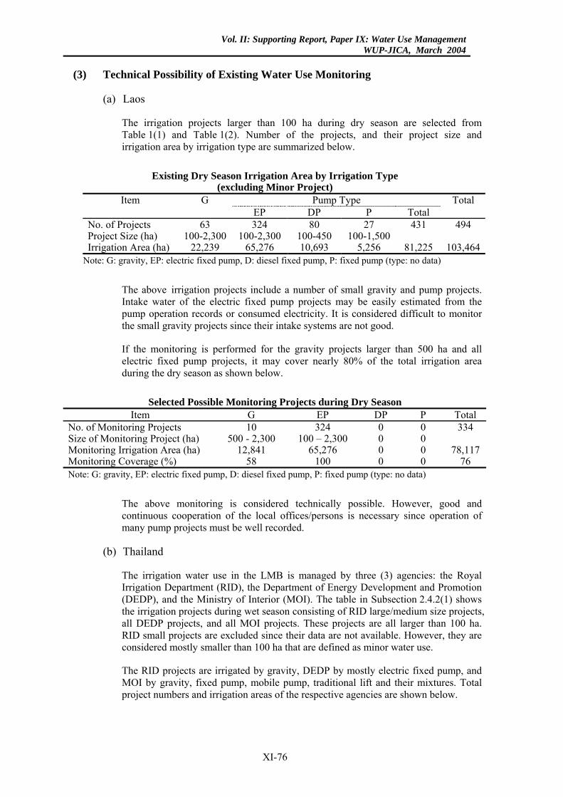
Vol. II: Supporting Report, Paper IX: Water Use ManagementWUP-JICA, March 2004
(3) Technical Possibility of Existing Water Use Monitoring
(a) Laos
The irrigation projects larger than 100 ha during dry season are selected from Table 1(1) and Table 1(2). Number of the projects, and their project size and irrigation area by irrigation type are summarized below.
Existing Dry Season Irrigation Area by Irrigation Type
(excluding Minor Project) Pump Type Item G
EP DP P Total Total
No. of Projects 63 324 80 27 431 494 Project Size (ha) 100-2,300 100-2,300 100-450 100-1,500 Irrigation Area (ha) 22,239 65,276 10,693 5,256 81,225 103,464
Note: G: gravity, EP: electric fixed pump, D: diesel fixed pump, P: fixed pump (type: no data)
The above irrigation projects include a number of small gravity and pump projects. Intake water of the electric fixed pump projects may be easily estimated from the pump operation records or consumed electricity. It is considered difficult to monitor the small gravity projects since their intake systems are not good.
If the monitoring is performed for the gravity projects larger than 500 ha and all electric fixed pump projects, it may cover nearly 80% of the total irrigation area during the dry season as shown below.
Selected Possible Monitoring Projects during Dry Season
Item G EP DP P Total No. of Monitoring Projects 10 324 0 0 334 Size of Monitoring Project (ha) 500 - 2,300 100 – 2,300 0 0 Monitoring Irrigation Area (ha) 12,841 65,276 0 0 78,117Monitoring Coverage (%) 58 100 0 0 76 Note: G: gravity, EP: electric fixed pump, D: diesel fixed pump, P: fixed pump (type: no data)
The above monitoring is considered technically possible. However, good and continuous cooperation of the local offices/persons is necessary since operation of many pump projects must be well recorded.
(b) Thailand
The irrigation water use in the LMB is managed by three (3) agencies: the Royal Irrigation Department (RID), the Department of Energy Development and Promotion (DEDP), and the Ministry of Interior (MOI). The table in Subsection 2.4.2(1) shows the irrigation projects during wet season consisting of RID large/medium size projects, all DEDP projects, and all MOI projects. These projects are all larger than 100 ha. RID small projects are excluded since their data are not available. However, they are considered mostly smaller than 100 ha that are defined as minor water use.
The RID projects are irrigated by gravity, DEDP by mostly electric fixed pump, and MOI by gravity, fixed pump, mobile pump, traditional lift and their mixtures. Total project numbers and irrigation areas of the respective agencies are shown below.
XI-76
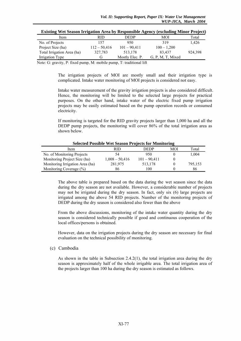
Vol. II: Supporting Report, Paper IX: Water Use ManagementWUP-JICA, March 2004
Existing Wet Season Irrigation Area by Responsible Agency (excluding Minor Project)
Item RID DEDP MOI Total No. of Projects 157 950 319 1,426 Project Size (ha) 112 – 50,416 101 – 90,411 100 – 1,200 Total Irrigation Area (ha) 327,783 513,178 83,437 924,398 Irrigation Type G Mostly Elec. P. G, P, M, T, Mixed
Note: G: gravity, P: fixed pump, M: mobile pump, T: traditional lift
The irrigation projects of MOI are mostly small and their irrigation type is complicated. Intake water monitoring of MOI projects is considered not easy.
Intake water measurement of the gravity irrigation projects is also considered difficult. Hence, the monitoring will be limited to the selected large projects for practical purposes. On the other hand, intake water of the electric fixed pump irrigation projects may be easily estimated based on the pump operation records or consumed electricity.
If monitoring is targeted for the RID gravity projects larger than 1,000 ha and all the DEDP pump projects, the monitoring will cover 86% of the total irrigation area as shown below.
Selected Possible Wet Season Projects for Monitoring
Item RID DEDP MOI Total No. of Monitoring Projects 54 950 0 1,004 Monitoring Project Size (ha) 1,008 – 50,416 101 – 90,411 0 Monitoring Irrigation Area (ha) 281,975 513,178 0 795,153 Monitoring Coverage (%) 86 100 0 86
The above table is prepared based on the data during the wet season since the data during the dry season are not available. However, a considerable number of projects may not be irrigated during the dry season. In fact, only six (6) large projects are irrigated among the above 54 RID projects. Number of the monitoring projects of DEDP during the dry season is considered also fewer than the above
From the above discussions, monitoring of the intake water quantity during the dry season is considered technically possible if good and continuous cooperation of the local offices/persons is obtained.
However, data on the irrigation projects during the dry season are necessary for final evaluation on the technical possibility of monitoring.
(c) Cambodia
As shown in the table in Subsection 2.4.2(1), the total irrigation area during the dry season is approximately half of the whole irrigable area. The total irrigation area of the projects larger than 100 ha during the dry season is estimated as follows.
XI-77
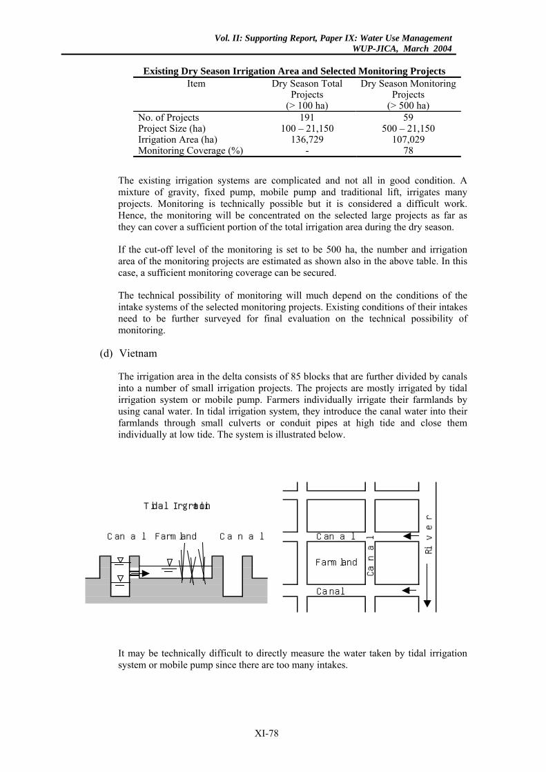
Vol. II: Supporting Report, Paper IX: Water Use ManagementWUP-JICA, March 2004
Existing Dry Season Irrigation Area and Selected Monitoring Projects
Item Dry Season Total Projects
(> 100 ha)
Dry Season Monitoring Projects
(> 500 ha) No. of Projects 191 59 Project Size (ha) 100 – 21,150 500 – 21,150 Irrigation Area (ha) 136,729 107,029 Monitoring Coverage (%) - 78
The existing irrigation systems are complicated and not all in good condition. A mixture of gravity, fixed pump, mobile pump and traditional lift, irrigates many projects. Monitoring is technically possible but it is considered a difficult work. Hence, the monitoring will be concentrated on the selected large projects as far as they can cover a sufficient portion of the total irrigation area during the dry season.
If the cut-off level of the monitoring is set to be 500 ha, the number and irrigation area of the monitoring projects are estimated as shown also in the above table. In this case, a sufficient monitoring coverage can be secured.
The technical possibility of monitoring will much depend on the conditions of the intake systems of the selected monitoring projects. Existing conditions of their intakes need to be further surveyed for final evaluation on the technical possibility of monitoring.
(d) Vietnam
The irrigation area in the delta consists of 85 blocks that are further divided by canals into a number of small irrigation projects. The projects are mostly irrigated by tidal irrigation system or mobile pump. Farmers individually irrigate their farmlands by using canal water. In tidal irrigation system, they introduce the canal water into their farmlands through small culverts or conduit pipes at high tide and close them individually at low tide. The system is illustrated below.
Riv
erFarmlandCanal Canal Canal
Tidal Irrigation
Canal
Can
al
Farmland
It may be technically difficult to directly measure the water taken by tidal irrigation system or mobile pump since there are too many intakes.
XI-78
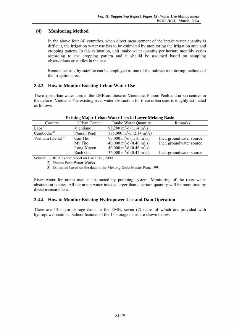
Vol. II: Supporting Report, Paper IX: Water Use ManagementWUP-JICA, March 2004
(4) Monitoring Method
In the above four (4) countries, when direct measurement of the intake water quantity is difficult, the irrigation water use has to be estimated by monitoring the irrigation area and cropping pattern. In this estimation, unit intake water quantity per hectare monthly varies according to the cropping pattern and it should be assumed based on sampling observations or studies in the past.
Remote sensing by satellite can be employed as one of the indirect monitoring methods of the irrigation area.
2.4.3 How to Monitor Existing Urban Water Use
The major urban water uses in the LMB are those of Vientiane, Phnom Penh and urban centres in the delta of Vietnam. The existing river water abstraction for these urban uses is roughly estimated as follows.
Existing Major Urban Water Uses in Lower Mekong Basin
Country Urban Center Intake Water Quantity Remarks Laos 1) Vientiane 98,280 m3/d (1.14 m3/s) Cambodia 2) Phnom Penh 185,000 m3/d (2.14 m3/s) Vietnam (Delta) 3) Can Tho 95,000 m3/d (1.10 m3/s) Incl. groundwater source My Tho 40,000 m3/d (0.46 m3/s) Incl. groundwater source Long Xuyen 40,000 m3/d (0.46 m3/s) Rach Gia 36,000 m3/d (0.42 m3/s) Incl. groundwater source Source: 1): JICA expert report on Lao PDR, 2000
2): Phnom Penh Water Works 3): Estimated based on the data in the Mekong Delta Master Plan, 1991
River water for urban uses is abstracted by pumping system. Monitoring of the river water abstraction is easy. All the urban water intakes larger than a certain quantity will be monitored by direct measurement.
2.4.4 How to Monitor Existing Hydropower Use and Dam Operation
There are 13 major storage dams in the LMB, seven (7) dams of which are provided with hydropower stations. Salient features of the 13 storage dams are shown below.
XI-79
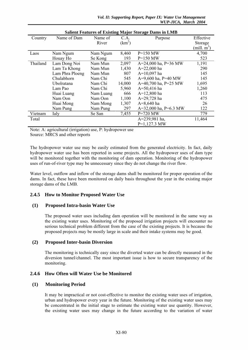
Vol. II: Supporting Report, Paper IX: Water Use ManagementWUP-JICA, March 2004
Salient Features of Existing Major Storage Dams in LMB
Country Name of Dam Name of River
C.A. (km2)
Purpose Effective Storage
(mill. m3)Laos Nam Ngum Nam Ngum 8,460 P=150 MW 4,700 Houay Ho Se Kong 193 P=150 MW 523 Thailand Lam Dong Noi Nam Mun 2,097 A=24,000 ha, P=36 MW 1,191 Lam Ta Khong Nam Mun 1,430 A=22,000 ha 290 Lam Phra Ploeng Nam Mun 807 A=10,097 ha 145 Chulabhorn Nam Chi 545 A=9,600 ha, P=40 MW 145 Ubolratana Nam Chi 14,000 A=40,700 ha, P=25 MW 1,695 Lam Pao Nam Chi 5,960 A=50,416 ha 1,260 Huai Luang Nam Luang 666 A=12,800 ha 113 Nam Oon Nam Oon 1,100 A=29,728 ha 475 Huai Mong Nam Mong 1,307 A=8,640 ha 26 Nam Pung Nam Pung 297 A=32,000 ha, P=6.3 MW 122 Vietnam Ialy Se San 7,455 P=720 MW 779 Total A=239,981 ha,
P=1,127.3 MW 11,464
Note: A: agricultural (irrigation) use, P: hydropower use Source: MRCS and other reports
The hydropower water use may be easily estimated from the generated electricity. In fact, daily hydropower water use has been reported in some projects. All the hydropower uses of dam type will be monitored together with the monitoring of dam operation. Monitoring of the hydropower uses of run-of-river type may be unnecessary since they do not change the river flow.
Water level, outflow and inflow of the storage dams shall be monitored for proper operation of the dams. In fact, these have been monitored on daily basis throughout the year in the existing major storage dams of the LMB.
2.4.5 How to Monitor Proposed Water Use
(1) Proposed Intra-basin Water Use
The proposed water uses including dam operation will be monitored in the same way as the existing water uses. Monitoring of the proposed irrigation projects will encounter no serious technical problem different from the case of the existing projects. It is because the proposed projects may be mostly large in scale and their intake systems may be good.
(2) Proposed Inter-basin Diversion
The monitoring is technically easy since the diverted water can be directly measured in the diversion tunnel/channel. The most important issue is how to secure transparency of the monitoring.
2.4.6 How Often will Water Use be Monitored
(1) Monitoring Period
It may be impractical or not cost-effective to monitor the existing water uses of irrigation, urban and hydropower every year in the future. Monitoring of the existing water uses may be concentrated in the initial stage to estimate the existing water use quantity. However, the existing water uses may change in the future according to the variation of water
XI-80
Vol. II: Supporting Report, Paper IX: Water Use ManagementWUP-JICA, March 2004
requirement. The monitoring will be done to check the change of water use conditions (location, pattern, served area/population and quantity) once in several years in the future.
The proposed irrigation, urban and hydropower projects required for the notification, consultation or agreement of the Joint Committee would be limited to the major projects that may cause significant impacts on the existing water uses in the LMB. These proposed water uses will be regularly monitored to comply with the conditions of the notification, consultation or agreement.
Intra-basin water uses of irrigation, urban and hydropower will be monitored during the dry season. However, inter-basin diversion will be monitored throughout the year in view of its importance.
Operation of the major storage dams will be monitored throughout the year since their impacts on the river flow are large. Even during rainy season, the dam operation will be monitored to avoid or minimize the harmful effects on the downstream as currently being monitored in the large storage dams.
(2) Monitoring Frequency
Irrigation, urban and hydropower uses will be monitored at a proper interval to correctly estimate their average monthly water uses. Dam operation will be monitored at a proper interval to correctly estimate the effects on the river flow in the downstream.
2.4.7 How to Secure Transparency of Monitoring Data
An effective monitoring mechanism to secure the transparency will be established, especially for the projects of inter-basin diversion and large intra-basin water use. The possible mechanism will include a periodical field check system by MRC and installation of real-time remote monitoring system in which data are accessible from MRC on real time.
2.4.8 Recommendation
The above-discussed monitoring system of the LMB could be developed in stages. However, the inventorying of the existing irrigation projects by MRC, which was preliminarily finalized in February 2002, should be completed as early as possible. Inventorying of the existing storage dams also should be done together with this work. These inventories will give the basis to develop the practical monitoring system.
XI-81
Vol. II: Supporting Report, Paper IX: Water Use ManagementWUP-JICA, March 2004
REFERENCES
(1) Bureau of Land and Water Resources, Ministry of Land, Infrastructure and Transport: Water Resources in Japan, 2001 (in Japanese)
(2) River Bureau, Ministry of Construction: Statistics of River Management, 1998 (in Japanese)
(4) Water Resources Association: Water Resources Statistical Book, 1996 (in Japanese) River Association: River Statistical Book, 2000 (in Japanese)
(5) Shikoku Regional Construction Bureau, Ministry of Construction: Yoshino River, 1987 (in Japanese)
(6) Infrastructure Development Institute - Japan: Drought Conciliation and Water Rights (IDI Water Series No. 1), 1997 (in English)
(7) River Bureau, Ministry of Land, Infrastructure and Transport: Technical Guidelines for Estimation of Required Minimum Flow, 2001 (in Japanese)
(8) Foundation of River and Watershed Environment Management: Study on the Water Environmental Management of Shinano River, 1994 (in Japanese)
(9) Shikoku Regional Bureau, Ministry of Land, Infrastructure and Transport: Study on the Environmental Flow Release of Saga Hydropower Dam, 2001 (in Japanese)
(10) Kanto Regional Bureau, Ministry of Construction: Study on the Salinity Damages of Tone River, 1993 (in Japanese)
(11) Kanto Regional Bureau, Ministry of Construction: Study on the Estuary Barrage of Tone River, 1966 (in Japanese)
(12) Water Resources Series No. 80, United Nations: Principles and Practices of Water Allocation among Water Use Sectors, 2000
(13) Chaiyuth Sukhsri, Chulalongkorn University: Water Resources in Thailand, March 1999
(14) MRC: Land Resources Inventory for Agricultural Development, February 2002
(15) Asian Institute of Technology: Study of Potential Development of Water Resources in Mae Khong River Basin, May 1994
XI-82
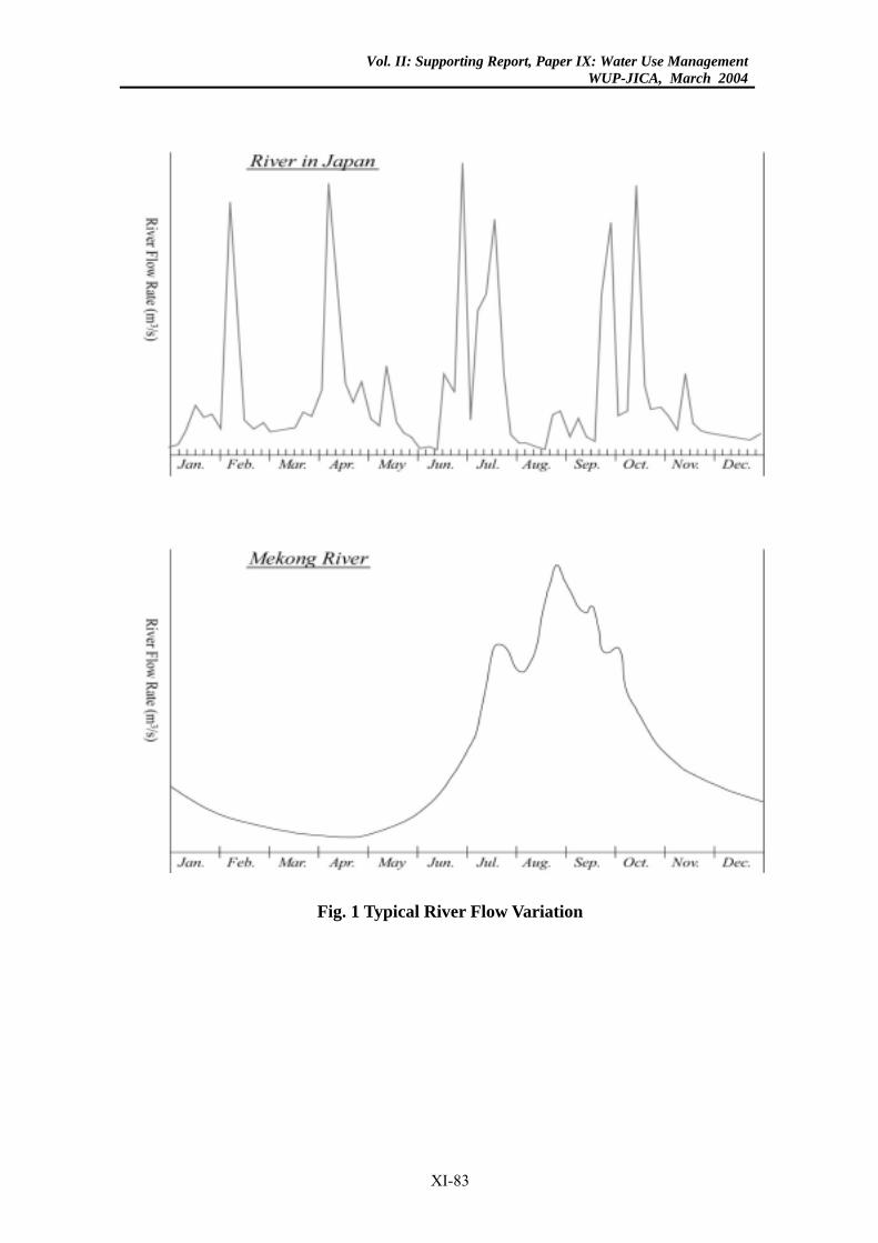
Vol. II: Supporting Report, Paper IX: Water Use ManagementWUP-JICA, March 2004
Fig. 1 Typical River Flow Variation
XI-83
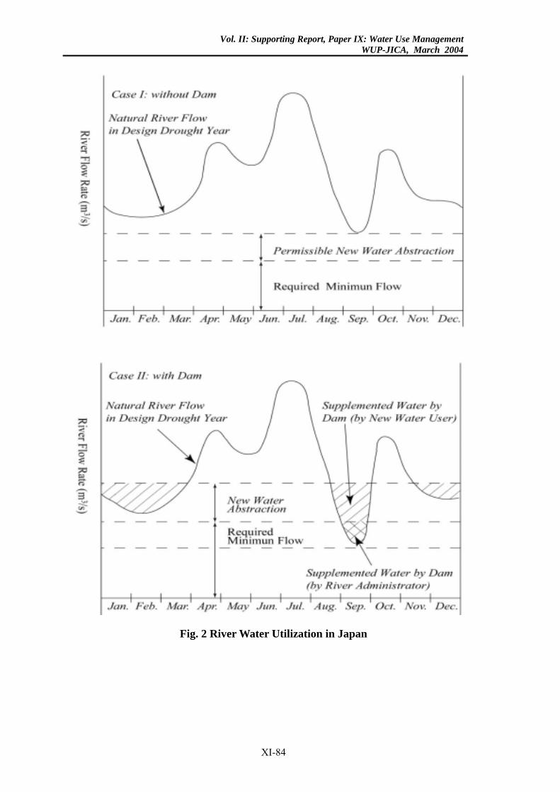
Vol. II: Supporting Report, Paper IX: Water Use ManagementWUP-JICA, March 2004
Fig. 2 River Water Utilization in Japan
XI-84
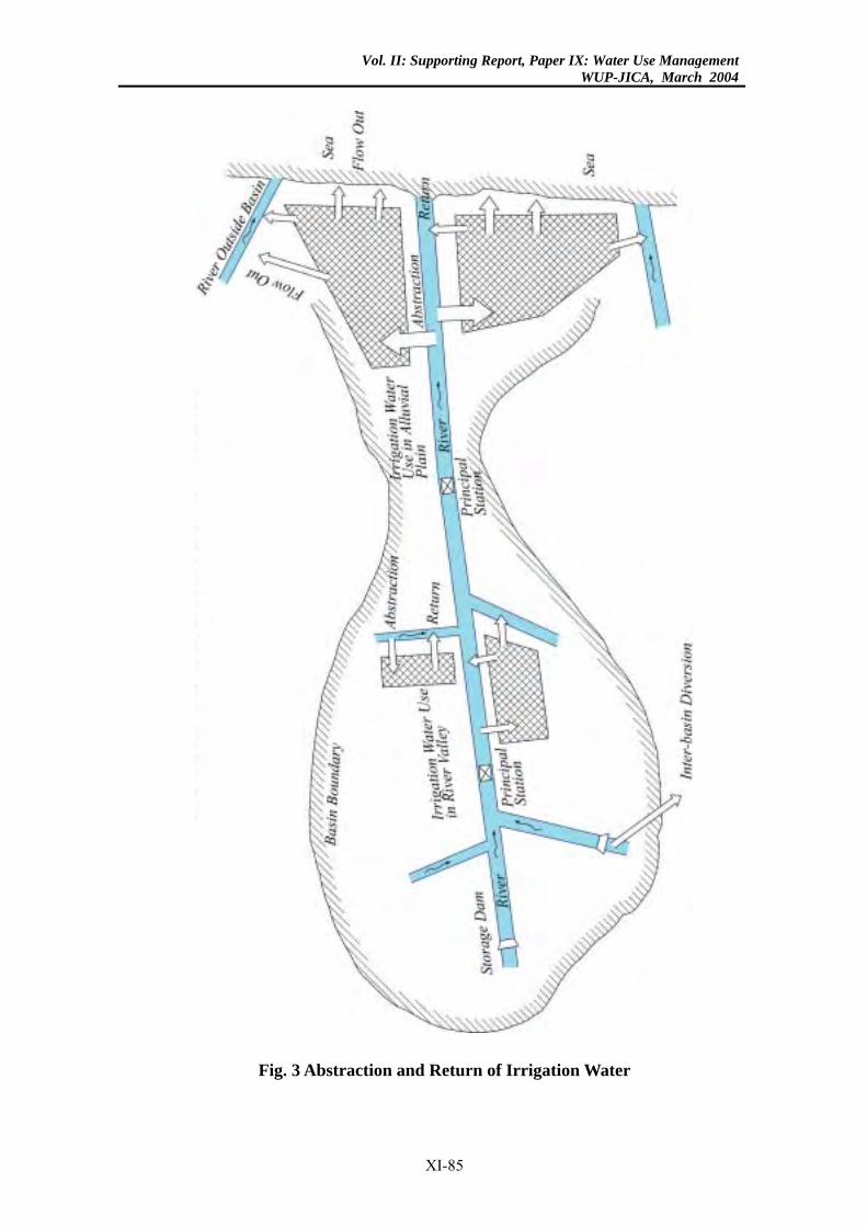
Vol. II: Supporting Report, Paper IX: Water Use ManagementWUP-JICA, March 2004
Fig. 3 Abstraction and Return of Irrigation Water
XI-85

Vol. II: Supporting Report, Paper IX: Water Use ManagementWUP-JICA, March 2004
Fig. 4 Yoshino River Water Resources Development
XI-86
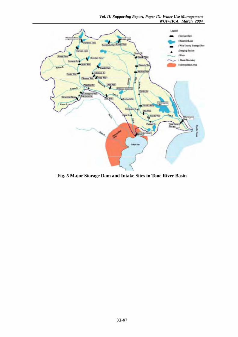
Vol. II: Supporting Report, Paper IX: Water Use ManagementWUP-JICA, March 2004
Fig. 5 Major Storage Dam and Intake Sites in Tone River Basin
XI-87
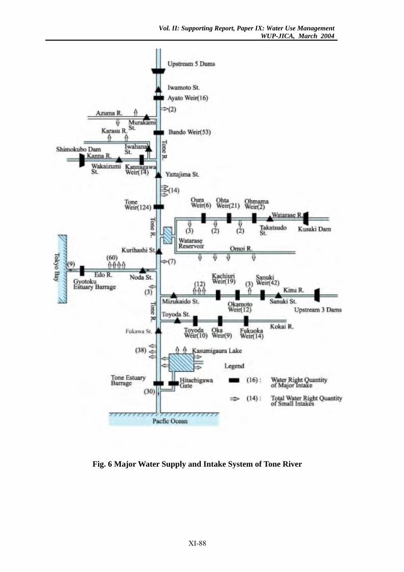
Vol. II: Supporting Report, Paper IX: Water Use ManagementWUP-JICA, March 2004
Fig. 6 Major Water Supply and Intake System of Tone River
XI-88
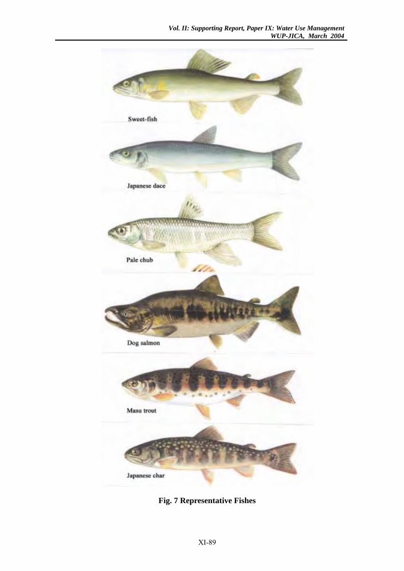
Vol. II: Supporting Report, Paper IX: Water Use ManagementWUP-JICA, March 2004
Fig. 7 Representative Fishes
XI-89
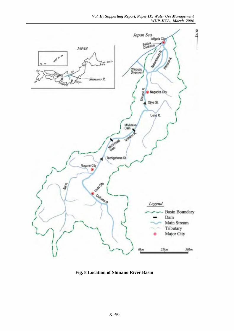
Vol. II: Supporting Report, Paper IX: Water Use ManagementWUP-JICA, March 2004
Fig. 8 Location of Shinano River Basin
XI-90
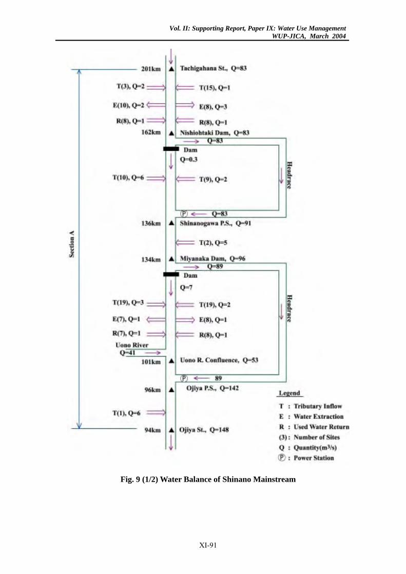
Vol. II: Supporting Report, Paper IX: Water Use ManagementWUP-JICA, March 2004
Fig. 9 (1/2) Water Balance of Shinano Mainstream
XI-91
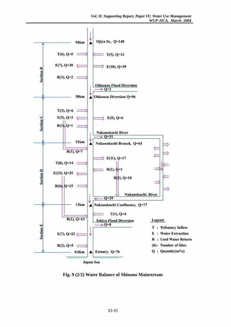
Vol. II: Supporting Report, Paper IX: Water Use ManagementWUP-JICA, March 2004
Fig. 9 (2/2) Water Balance of Shinano Mainstream
XI-92
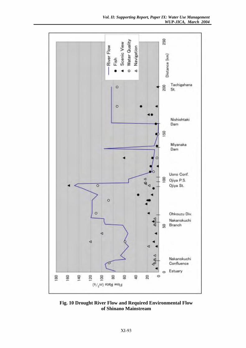
Vol. II: Supporting Report, Paper IX: Water Use ManagementWUP-JICA, March 2004
Fig. 10 Drought River Flow and Required Environmental Flow of Shinano Mainstream
XI-93
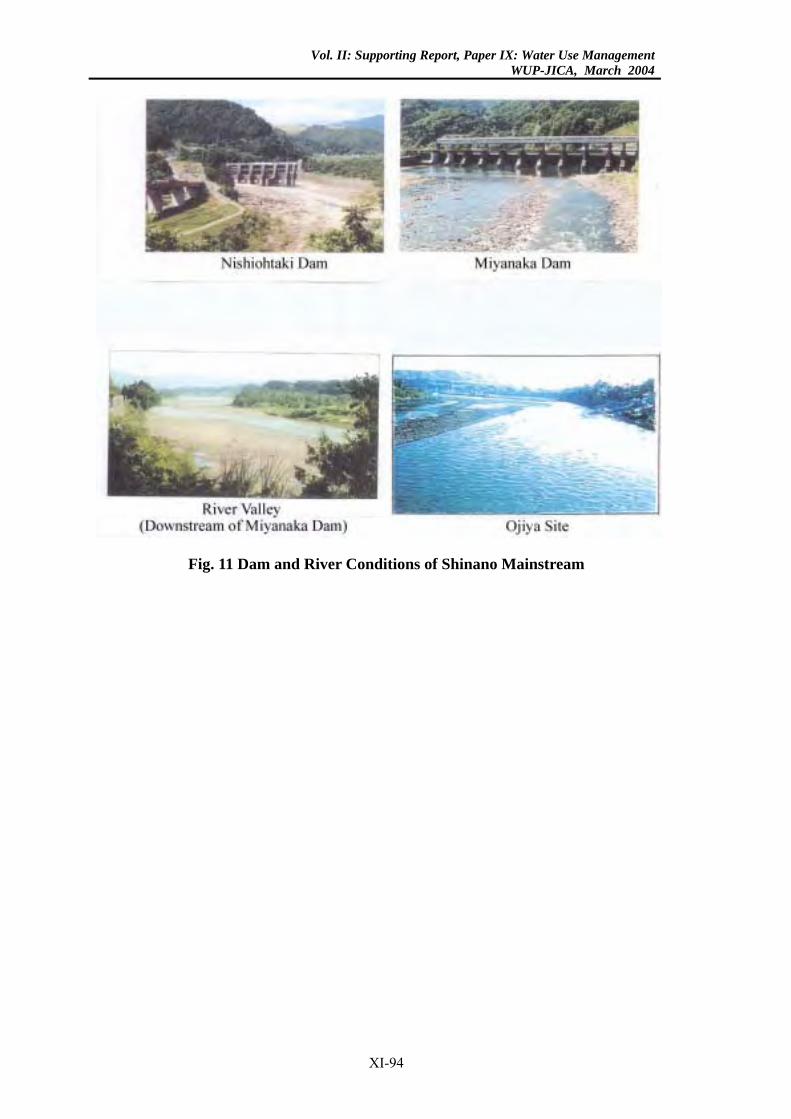
Vol. II: Supporting Report, Paper IX: Water Use ManagementWUP-JICA, March 2004
Fig. 11 Dam and River Conditions of Shinano Mainstream
XI-94
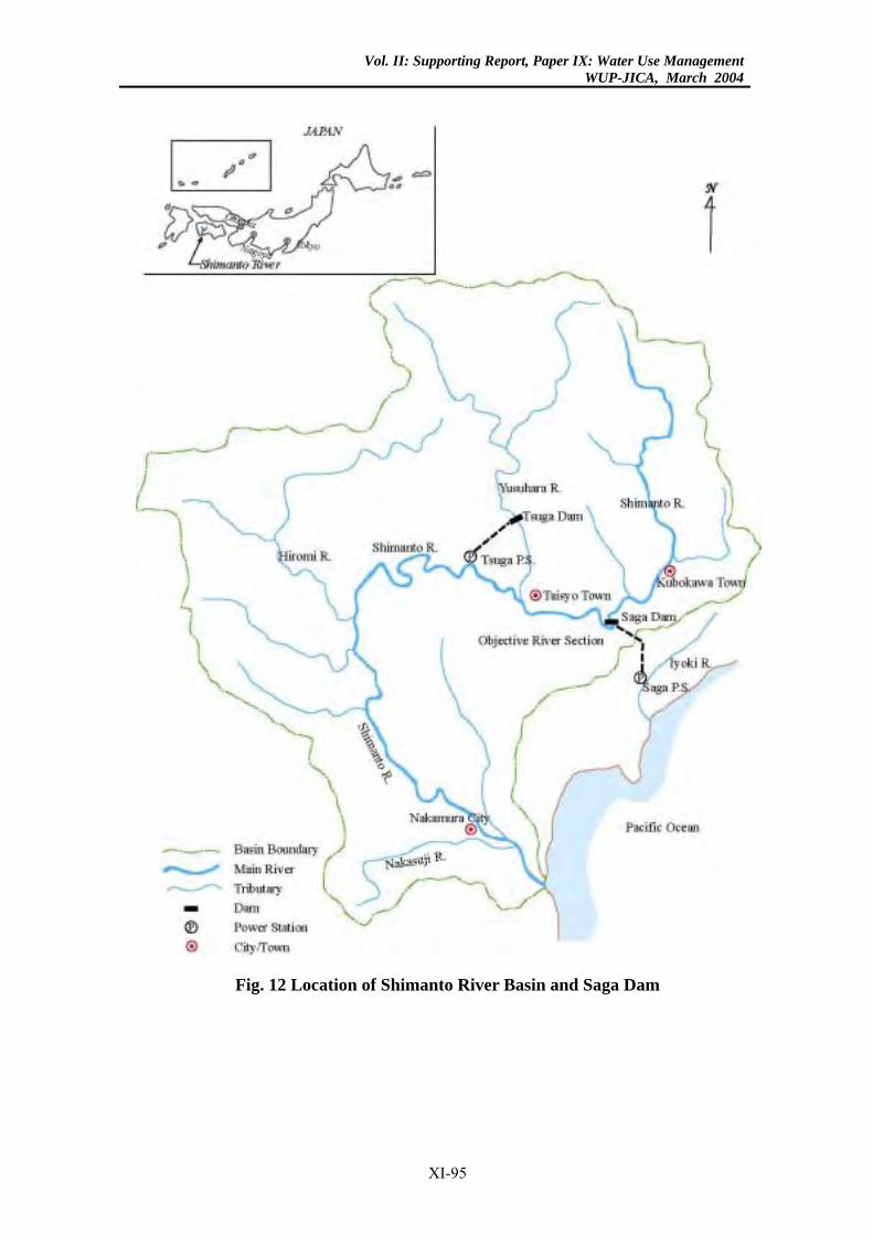
Vol. II: Supporting Report, Paper IX: Water Use ManagementWUP-JICA, March 2004
Fig. 12 Location of Shimanto River Basin and Saga Dam
XI-95
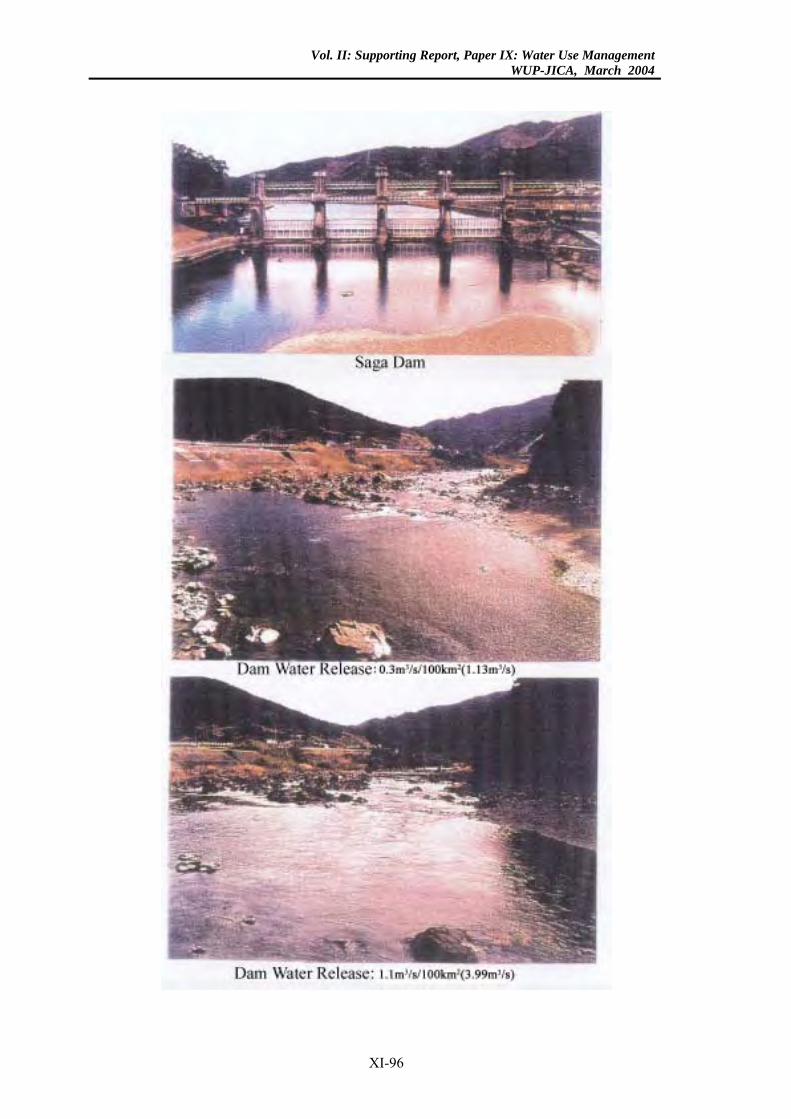
Vol. II: Supporting Report, Paper IX: Water Use ManagementWUP-JICA, March 2004
XI-96
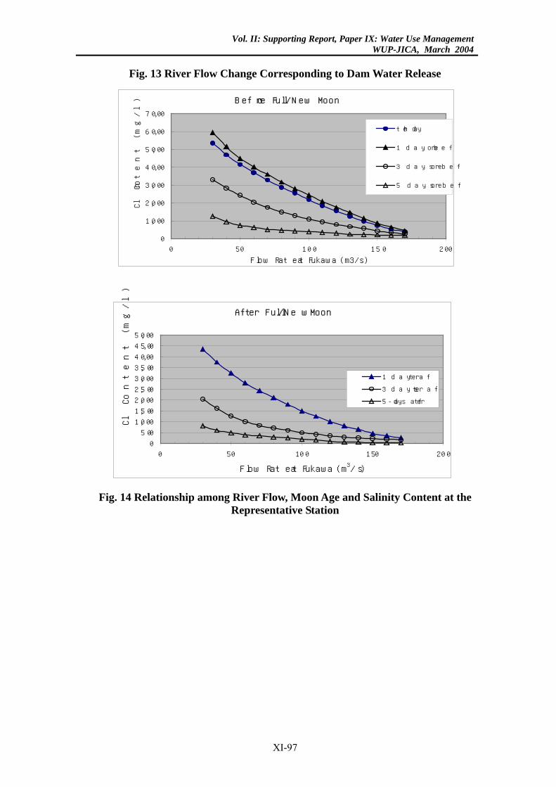
Vol. II: Supporting Report, Paper IX: Water Use ManagementWUP-JICA, March 2004
Fig. 13 River Flow Change Corresponding to Dam Water Release
Before Full/New Moon
0
1,000
2,000
3,000
4,000
5,000
6,000
7,000
0 50 100 150 200
Flow Rate at Fukawa (m3/s)
Cl C
onte
nt
(mg/
l)the day
1 day before
3 days before
5 days before
After Full/New Moon
0
500
1,000
1,500
2,000
2,500
3,000
3,500
4,000
4,500
5,000
0 50 100 150 200
Flow Rate at Fukawa (m3/s)
Cl C
onte
nt
(mg/
l)
1 day after
3 days after
5-days after
Fig. 14 Relationship among River Flow, Moon Age and Salinity Content at the
Representative Station
XI-97
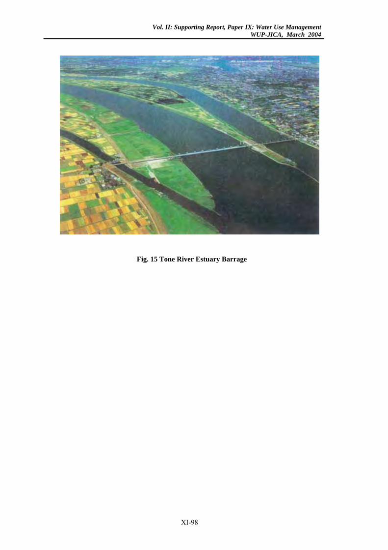
Vol. II: Supporting Report, Paper IX: Water Use ManagementWUP-JICA, March 2004
Fig. 15 Tone River Estuary Barrage
XI-98
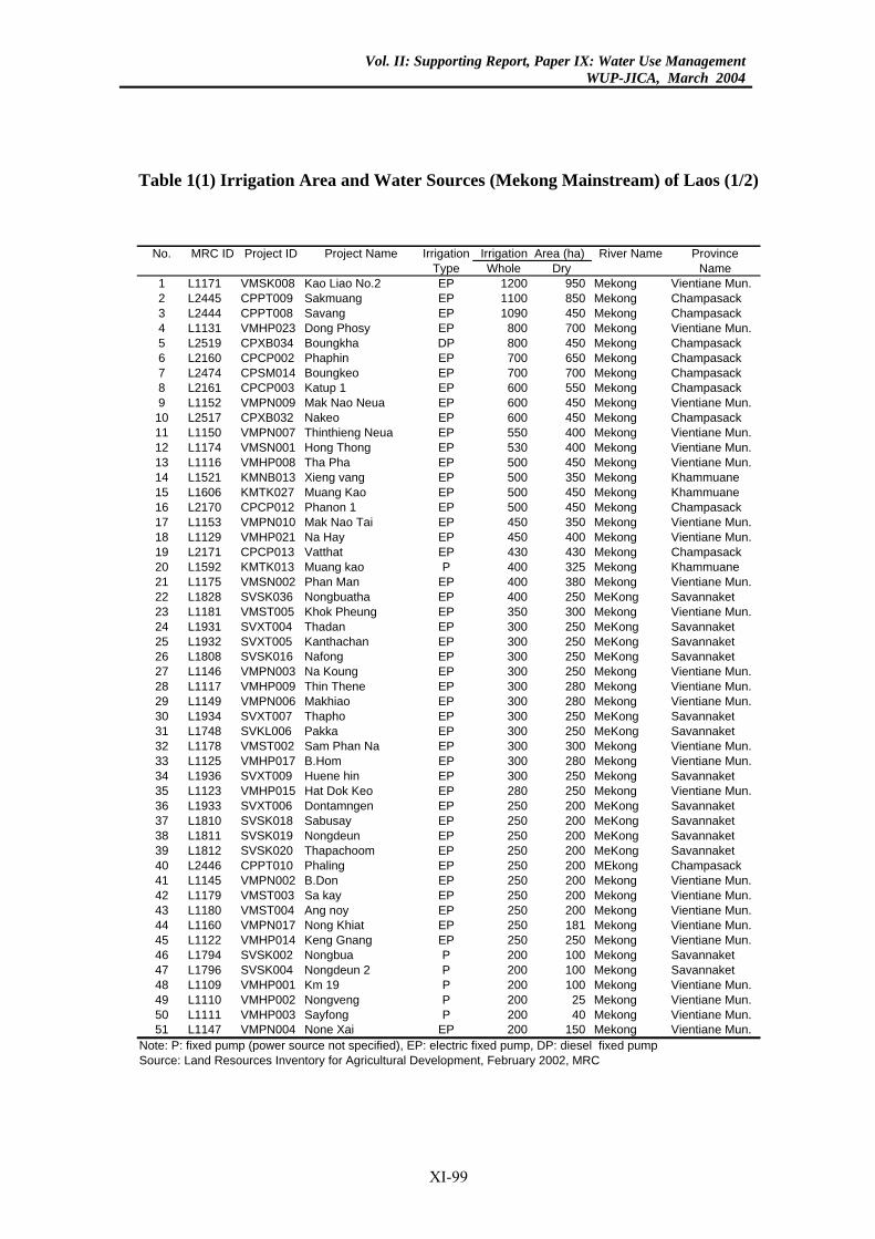
Vol. II: Supporting Report, Paper IX: Water Use ManagementWUP-JICA, March 2004
Table 1(1) Irrigation Area and Water Sources (Mekong Mainstream) of Laos (1/2)
No. MRC ID Project ID Project Name Irrigation River Name ProvinceType Whole Dry Name
1 L1171 VMSK008 Kao Liao No.2 EP 1200 950 Mekong Vientiane Mun.2 L2445 CPPT009 Sakmuang EP 1100 850 Mekong Champasack3 L2444 CPPT008 Savang EP 1090 450 Mekong Champasack4 L1131 VMHP023 Dong Phosy EP 800 700 Mekong Vientiane Mun.5 L2519 CPXB034 Boungkha DP 800 450 Mekong Champasack6 L2160 CPCP002 Phaphin EP 700 650 Mekong Champasack7 L2474 CPSM014 Boungkeo EP 700 700 Mekong Champasack8 L2161 CPCP003 Katup 1 EP 600 550 Mekong Champasack9 L1152 VMPN009 Mak Nao Neua EP 600 450 Mekong Vientiane Mun.
10 L2517 CPXB032 Nakeo EP 600 450 Mekong Champasack11 L1150 VMPN007 Thinthieng Neua EP 550 400 Mekong Vientiane Mun.12 L1174 VMSN001 Hong Thong EP 530 400 Mekong Vientiane Mun.13 L1116 VMHP008 Tha Pha EP 500 450 Mekong Vientiane Mun.14 L1521 KMNB013 Xieng vang EP 500 350 Mekong Khammuane15 L1606 KMTK027 Muang Kao EP 500 450 Mekong Khammuane16 L2170 CPCP012 Phanon 1 EP 500 450 Mekong Champasack17 L1153 VMPN010 Mak Nao Tai EP 450 350 Mekong Vientiane Mun.18 L1129 VMHP021 Na Hay EP 450 400 Mekong Vientiane Mun.19 L2171 CPCP013 Vatthat EP 430 430 Mekong Champasack20 L1592 KMTK013 Muang kao P 400 325 Mekong Khammuane21 L1175 VMSN002 Phan Man EP 400 380 Mekong Vientiane Mun.22 L1828 SVSK036 Nongbuatha EP 400 250 MeKong Savannaket23 L1181 VMST005 Khok Pheung EP 350 300 Mekong Vientiane Mun.24 L1931 SVXT004 Thadan EP 300 250 MeKong Savannaket25 L1932 SVXT005 Kanthachan EP 300 250 MeKong Savannaket26 L1808 SVSK016 Nafong EP 300 250 MeKong Savannaket27 L1146 VMPN003 Na Koung EP 300 250 Mekong Vientiane Mun.28 L1117 VMHP009 Thin Thene EP 300 280 Mekong Vientiane Mun.29 L1149 VMPN006 Makhiao EP 300 280 Mekong Vientiane Mun.30 L1934 SVXT007 Thapho EP 300 250 MeKong Savannaket31 L1748 SVKL006 Pakka EP 300 250 MeKong Savannaket32 L1178 VMST002 Sam Phan Na EP 300 300 Mekong Vientiane Mun.33 L1125 VMHP017 B.Hom EP 300 280 Mekong Vientiane Mun.34 L1936 SVXT009 Huene hin EP 300 250 Mekong Savannaket35 L1123 VMHP015 Hat Dok Keo EP 280 250 Mekong Vientiane Mun.36 L1933 SVXT006 Dontamngen EP 250 200 MeKong Savannaket37 L1810 SVSK018 Sabusay EP 250 200 MeKong Savannaket38 L1811 SVSK019 Nongdeun EP 250 200 MeKong Savannaket39 L1812 SVSK020 Thapachoom EP 250 200 MeKong Savannaket40 L2446 CPPT010 Phaling EP 250 200 MEkong Champasack41 L1145 VMPN002 B.Don EP 250 200 Mekong Vientiane Mun.42 L1179 VMST003 Sa kay EP 250 200 Mekong Vientiane Mun.43 L1180 VMST004 Ang noy EP 250 200 Mekong Vientiane Mun.44 L1160 VMPN017 Nong Khiat EP 250 181 Mekong Vientiane Mun.45 L1122 VMHP014 Keng Gnang EP 250 250 Mekong Vientiane Mun.46 L1794 SVSK002 Nongbua P 200 100 Mekong Savannaket47 L1796 SVSK004 Nongdeun 2 P 200 100 Mekong Savannaket48 L1109 VMHP001 Km 19 P 200 100 Mekong Vientiane Mun.49 L1110 VMHP002 Nongveng P 200 25 Mekong Vientiane Mun.50 L1111 VMHP003 Sayfong P 200 40 Mekong Vientiane Mun.51 L1147 VMPN004 None Xai EP 200 150 Mekong Vientiane Mun.
Note: P: fixed pump (power source not specified), EP: electric fixed pump, DP: diesel fixed pumpSource: Land Resources Inventory for Agricultural Development, February 2002, MRC
Irrigation Area (ha)
XI-99
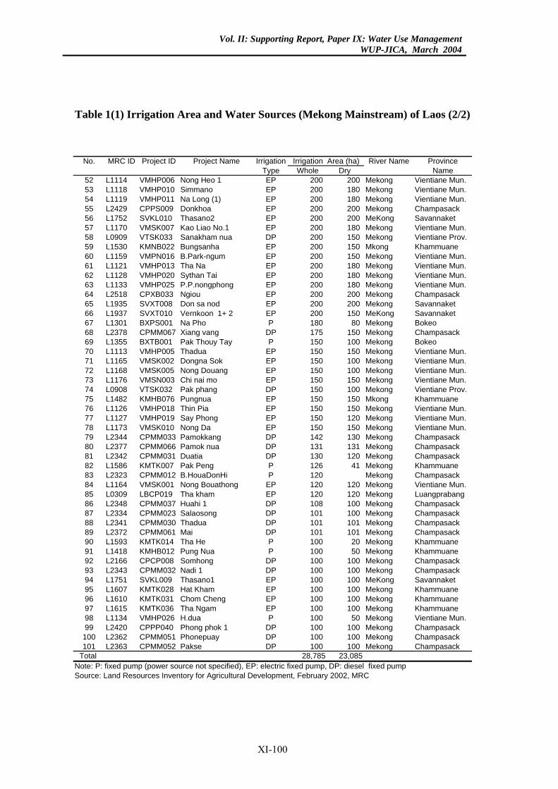
Vol. II: Supporting Report, Paper IX: Water Use ManagementWUP-JICA, March 2004
Table 1(1) Irrigation Area and Water Sources (Mekong Mainstream) of Laos (2/2)
Irrigation River Name ProvinceType Whole Dry Name
P 200 200 Mekong Vientiane Mun.P 200 180 Mekong Vientiane Mun.P 200 180 Mekong Vientiane Mun.P 200 200 Mekong Champasack
EP 200 200 MeKong SavannaketEP 200 180 Mekong Vientiane Mun.
P 200 150 Mekong Vientiane Prov.P 200 150 Mkong KhammuaneP 200 150 Mekong Vientiane Mun.
EP 200 180 Mekong Vientiane Mun.P 200 180 Mekong Vientiane Mun.
EP 200 180 Mekong Vientiane Mun.P 200 200 Mekong Champasack
EP 200 200 Mekong SavannaketP 200 150 MeKong Savannaket
P 180 80 Mekong BokeoDP 175 150 Mekong ChampasackP 150 100 Mekong Bokeo
EP 150 150 Mekong Vientiane Mun.P 150 100 Mekong Vientiane Mun.
EP 150 100 Mekong Vientiane Mun.EP 150 150 Mekong Vientiane Mun.
P 150 100 Mekong Vientiane Prov.P 150 150 Mkong KhammuaneP 150 150 Mekong Vientiane Mun.P 150 120 Mekong Vientiane Mun.
EP 150 150 Mekong Vientiane Mun.P 142 130 Mekong ChampasackP 131 131 Mekong Champasack
DP 130 120 Mekong ChampasackP 126 41 Mekong KhammuaneP 120 Mekong ChampasackP 120 120 Mekong Vientiane Mun.
EP 120 120 Mekong LuangprabangP 108 100 Mekong Champasack
DP 101 100 Mekong ChampasackDP 101 101 Mekong Champasack
P 101 101 Mekong ChampasackP 100 20 Mekong KhammuaneP 100 50 Mekong Khammuane
DP 100 100 Mekong ChampasackP 100 100 Mekong Champasack
EP 100 100 MeKong SavannaketEP 100 100 Mekong Khammuane
P 100 100 Mekong KhammuaneEP 100 100 Mekong KhammuaneP 100 50 Mekong Vientiane Mun.P 100 100 Mekong Champasack
DP 100 100 Mekong ChampasackP 100 100 Mekong Champasack
5 23,085
Irrigation Area (ha)No. MRC ID Project ID Project Name
52 L1114 VMHP006 Nong Heo 1 E53 L1118 VMHP010 Simmano E54 L1119 VMHP011 Na Long (1) E55 L2429 CPPS009 Donkhoa E56 L1752 SVKL010 Thasano257 L1170 VMSK007 Kao Liao No.158 L0909 VTSK033 Sanakham nua D59 L1530 KMNB022 Bungsanha E60 L1159 VMPN016 B.Park-ngum E61 L1121 VMHP013 Tha Na62 L1128 VMHP020 Sythan Tai E63 L1133 VMHP025 P.P.nongphong64 L2518 CPXB033 Ngiou E65 L1935 SVXT008 Don sa nod66 L1937 SVXT010 Vernkoon 1+ 2 E67 L1301 BXPS001 Na Pho68 L2378 CPMM067 Xiang vang69 L1355 BXTB001 Pak Thouy Tay70 L1113 VMHP005 Thadua71 L1165 VMSK002 Dongna Sok E72 L1168 VMSK005 Nong Douang73 L1176 VMSN003 Chi nai mo74 L0908 VTSK032 Pak phang D75 L1482 KMHB076 Pungnua E76 L1126 VMHP018 Thin Pia E77 L1127 VMHP019 Say Phong E78 L1173 VMSK010 Nong Da79 L2344 CPMM033 Pamokkang D80 L2377 CPMM066 Pamok nua D81 L2342 CPMM031 Duatia82 L1586 KMTK007 Pak Peng83 L2323 CPMM012 B.HouaDonHi84 L1164 VMSK001 Nong Bouathong E85 L0309 LBCP019 Tha kham86 L2348 CPMM037 Huahi 1 D87 L2334 CPMM023 Salaosong88 L2341 CPMM030 Thadua89 L2372 CPMM061 Mai D90 L1593 KMTK014 Tha He91 L1418 KMHB012 Pung Nua92 L2166 CPCP008 Somhong93 L2343 CPMM032 Nadi 1 D94 L1751 SVKL009 Thasano195 L1607 KMTK028 Hat Kham96 L1610 KMTK031 Chom Cheng E97 L1615 KMTK036 Tha Ngam98 L1134 VMHP026 H.dua99 L2420 CPPP040 Phong phok 1 D100 L2362 CPMM051 Phonepuay101 L2363 CPMM052 Pakse D
Total 28,78Note: P: fixed pump (power source not specified), EP: electric fixed pump, DP: diesel fixed pumpSource: Land Resources Inventory for Agricultural Development, February 2002, MRC
XI-100
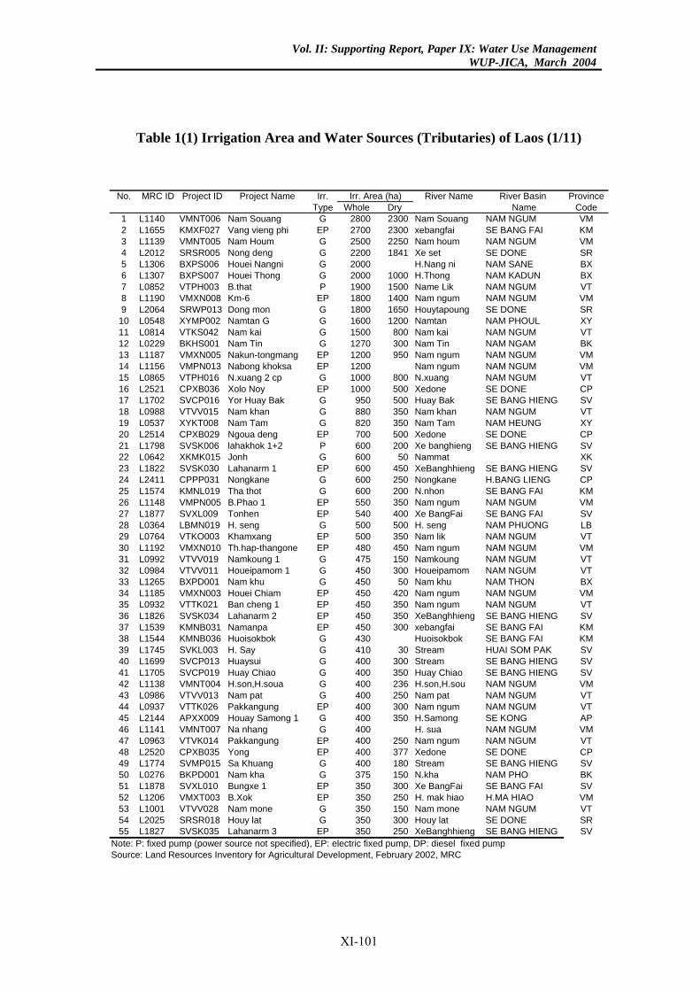
Vol. II: Supporting Report, Paper IX: Water Use ManagementWUP-JICA, March 2004
Table 1(1) Irrigation Area and Water Sources (Tributaries) of Laos (1/11)
No. MRC ID Project ID Project Name Irr. River Name River Basin ProvinceType Whole Dry Name Code
1 L1140 VMNT006 Nam Souang G 2800 2300 Nam Souang NAM NGUM VM2 L1655 KMXF027 Vang vieng phi EP 2700 2300 xebangfai SE BANG FAI KM3 L1139 VMNT005 Nam Houm G 2500 2250 Nam houm NAM NGUM VM4 L2012 SRSR005 Nong deng G 2200 1841 Xe set SE DONE SR5 L1306 BXPS006 Houei Nangni G 2000 H.Nang ni NAM SANE BX6 L1307 BXPS007 Houei Thong G 2000 1000 H.Thong NAM KADUN BX7 L0852 VTPH003 B.that P 1900 1500 Name Lik NAM NGUM VT8 L1190 VMXN008 Km-6 EP 1800 1400 Nam ngum NAM NGUM VM9 L2064 SRWP013 Dong mon G 1800 1650 Houytapoung SE DONE SR
10 L0548 XYMP002 Namtan G G 1600 1200 Namtan NAM PHOUL XY11 L0814 VTKS042 Nam kai G 1500 800 Nam kai NAM NGUM VT12 L0229 BKHS001 Nam Tin G 1270 300 Nam Tin NAM NGAM BK13 L1187 VMXN005 Nakun-tongmang EP 1200 950 Nam ngum NAM NGUM VM14 L1156 VMPN013 Nabong khoksa EP 1200 Nam ngum NAM NGUM VM15 L0865 VTPH016 N.xuang 2 cp G 1000 800 N.xuang NAM NGUM VT16 L2521 CPXB036 Xolo Noy EP 1000 500 Xedone SE DONE CP17 L1702 SVCP016 Yor Huay Bak G 950 500 Huay Bak SE BANG HIENG SV18 L0988 VTVV015 Nam khan G 880 350 Nam khan NAM NGUM VT19 L0537 XYKT008 Nam Tam G 820 350 Nam Tam NAM HEUNG XY20 L2514 CPXB029 Ngoua deng EP 700 500 Xedone SE DONE CP21 L1798 SVSK006 lahakhok 1+2 P 600 200 Xe banghieng SE BANG HIENG SV22 L0642 XKMK015 Jonh G 600 50 Nammat XK23 L1822 SVSK030 Lahanarm 1 EP 600 450 XeBanghhieng SE BANG HIENG SV24 L2411 CPPP031 Nongkane G 600 250 Nongkane H.BANG LIENG CP25 L1574 KMNL019 Tha thot G 600 200 N.nhon SE BANG FAI KM26 L1148 VMPN005 B.Phao 1 EP 550 350 Nam ngum NAM NGUM VM27 L1877 SVXL009 Tonhen EP 540 400 Xe BangFai SE BANG FAI SV28 L0364 LBMN019 H. seng G 500 500 H. seng NAM PHUONG LB29 L0764 VTKO003 Khamxang EP 500 350 Nam lik NAM NGUM VT30 L1192 VMXN010 Th.hap-thangone EP 480 450 Nam ngum NAM NGUM VM31 L0992 VTVV019 Namkoung 1 G 475 150 Namkoung NAM NGUM VT32 L0984 VTVV011 Houeipamom 1 G 450 300 Houeipamom NAM NGUM VT33 L1265 BXPD001 Nam khu G 450 50 Nam khu NAM THON BX34 L1185 VMXN003 Houei Chiam EP 450 420 Nam ngum NAM NGUM VM35 L0932 VTTK021 Ban cheng 1 EP 450 350 Nam ngum NAM NGUM VT36 L1826 SVSK034 Lahanarm 2 EP 450 350 XeBanghhieng SE BANG HIENG SV37 L1539 KMNB031 Namanpa EP 450 300 xebangfai SE BANG FAI KM38 L1544 KMNB036 Huoisokbok G 430 Huoisokbok SE BANG FAI KM39 L1745 SVKL003 H. Say G 410 30 Stream HUAI SOM PAK SV40 L1699 SVCP013 Huaysui G 400 300 Stream SE BANG HIENG SV41 L1705 SVCP019 Huay Chiao G 400 350 Huay Chiao SE BANG HIENG SV42 L1138 VMNT004 H.son,H.soua G 400 236 H.son,H.sou NAM NGUM VM43 L0986 VTVV013 Nam pat G 400 250 Nam pat NAM NGUM VT44 L0937 VTTK026 Pakkangung EP 400 300 Nam ngum NAM NGUM VT45 L2144 APXX009 Houay Samong 1 G 400 350 H.Samong SE KONG AP46 L1141 VMNT007 Na nhang G 400 H. sua NAM NGUM VM47 L0963 VTVK014 Pakkangung EP 400 250 Nam ngum NAM NGUM VT48 L2520 CPXB035 Yong EP 400 377 Xedone SE DONE CP49 L1774 SVMP015 Sa Khuang G 400 180 Stream SE BANG HIENG SV50 L0276 BKPD001 Nam kha G 375 150 N.kha NAM PHO BK51 L1878 SVXL010 Bungxe 1 EP 350 300 Xe BangFai SE BANG FAI SV52 L1206 VMXT003 B.Xok EP 350 250 H. mak hiao H.MA HIAO VM53 L1001 VTVV028 Nam mone G 350 150 Nam mone NAM NGUM VT54 L2025 SRSR018 Houy lat G 350 300 Houy lat SE DONE SR55 L1827 SVSK035 Lahanarm 3 EP 350 250 XeBanghhieng SE BANG HIENG SV
Note: P: fixed pump (power source not specified), EP: electric fixed pump, DP: diesel fixed pumpSource: Land Resources Inventory for Agricultural Development, February 2002, MRC
Irr. Area (ha)
XI-101
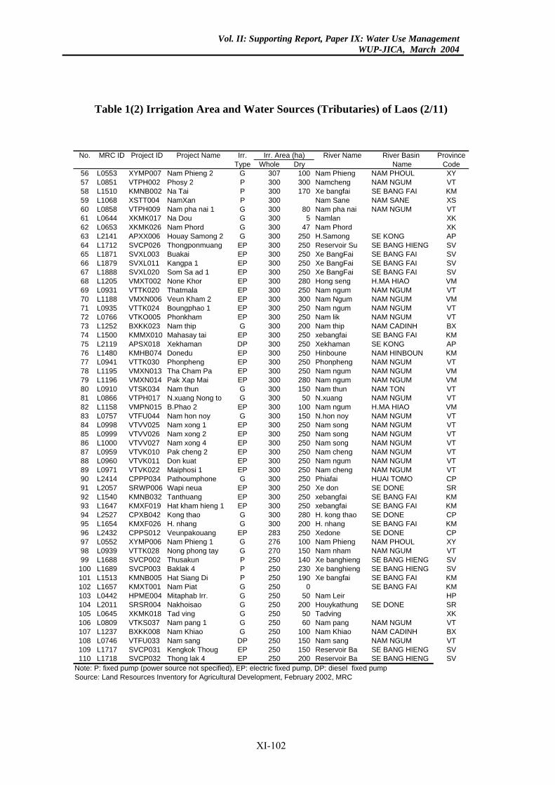
Vol. II: Supporting Report, Paper IX: Water Use ManagementWUP-JICA, March 2004
Table 1(2) Irrigation Area and Water Sources (Tributaries) of Laos (2/11)
River Name River Basin Provincehole Dry Name Code307 100 Nam Phieng NAM PHOUL XY300 300 Namcheng NAM NGUM VT300 170 Xe bangfai SE BANG FAI KM300 Nam Sane NAM SANE XS300 80 Nam pha nai NAM NGUM VT300 5 Namlan XK300 47 Nam Phord XK300 250 H.Samong SE KONG AP300 250 Reservoir Su SE BANG HIENG SV300 250 Xe BangFai SE BANG FAI SV300 250 Xe BangFai SE BANG FAI SV300 250 Xe BangFai SE BANG FAI SV300 280 Hong seng H.MA HIAO VM300 250 Nam ngum NAM NGUM VT300 300 Nam Ngum NAM NGUM VM300 250 Nam ngum NAM NGUM VT300 250 Nam lik NAM NGUM VT300 200 Nam thip NAM CADINH BX300 250 xebangfai SE BANG FAI KM300 250 Xekhaman SE KONG AP300 250 Hinboune NAM HINBOUN KM300 250 Phonpheng NAM NGUM VT300 250 Nam ngum NAM NGUM VM300 280 Nam ngum NAM NGUM VM300 150 Nam thun NAM TON VT300 50 N.xuang NAM NGUM VT300 100 Nam ngum H.MA HIAO VM300 150 N.hon noy NAM NGUM VT300 250 Nam song NAM NGUM VT300 250 Nam song NAM NGUM VT300 250 Nam song NAM NGUM VT300 250 Nam cheng NAM NGUM VT300 250 Nam ngum NAM NGUM VT300 250 Nam cheng NAM NGUM VT300 250 Phiafai HUAI TOMO CP300 250 Xe don SE DONE SR300 250 xebangfai SE BANG FAI KM300 250 xebangfai SE BANG FAI KM300 280 H. kong thao SE DONE CP300 200 H. nhang SE BANG FAI KM283 250 Xedone SE DONE CP276 100 Nam Phieng NAM PHOUL XY270 150 Nam nham NAM NGUM VT250 140 Xe banghieng SE BANG HIENG SV250 230 Xe banghieng SE BANG HIENG SV250 190 Xe bangfai SE BANG FAI KM250 0 SE BANG FAI KM250 50 Nam Leir HP250 200 Houykathung SE DONE SR250 50 Tadving XK250 60 Nam pang NAM NGUM VT250 100 Nam Khiao NAM CADINH BX250 150 Nam sang NAM NGUM VT250 150 Reservoir Ba SE BANG HIENG SV250 200 Reservoir Ba SE BANG HIENG SV
. Area (ha)No. MRC ID Project ID Project Name Irr.Type W
56 L0553 XYMP007 Nam Phieng 2 G57 L0851 VTPH002 Phosy 2 P58 L1510 KMNB002 Na Tai P59 L1068 XSTT004 NamXan P60 L0858 VTPH009 Nam pha nai 1 G61 L0644 XKMK017 Na Dou G62 L0653 XKMK026 Nam Phord G63 L2141 APXX006 Houay Samong 2 G64 L1712 SVCP026 Thongponmuang EP65 L1871 SVXL003 Buakai EP66 L1879 SVXL011 Kangpa 1 EP67 L1888 SVXL020 Som Sa ad 1 EP68 L1205 VMXT002 None Khor EP69 L0931 VTTK020 Thatmala EP70 L1188 VMXN006 Veun Kham 2 EP71 L0935 VTTK024 Boungphao 1 EP72 L0766 VTKO005 Phonkham EP73 L1252 BXKK023 Nam thip G74 L1500 KMMX010 Mahasay tai EP75 L2119 APSX018 Xekhaman DP76 L1480 KMHB074 Donedu EP77 L0941 VTTK030 Phonpheng EP78 L1195 VMXN013 Tha Cham Pa EP79 L1196 VMXN014 Pak Xap Mai EP80 L0910 VTSK034 Nam thun G81 L0866 VTPH017 N.xuang Nong to G82 L1158 VMPN015 B.Phao 2 EP83 L0757 VTFU044 Nam hon noy G84 L0998 VTVV025 Nam xong 1 EP85 L0999 VTVV026 Nam xong 2 EP86 L1000 VTVV027 Nam xong 4 EP87 L0959 VTVK010 Pak cheng 2 EP88 L0960 VTVK011 Don kuat EP89 L0971 VTVK022 Maiphosi 1 EP90 L2414 CPPP034 Pathoumphone G91 L2057 SRWP006 Wapi neua EP92 L1540 KMNB032 Tanthuang EP93 L1647 KMXF019 Hat kham hieng 1 EP94 L2527 CPXB042 Kong thao G95 L1654 KMXF026 H. nhang G96 L2432 CPPS012 Veunpakouang EP97 L0552 XYMP006 Nam Phieng 1 G98 L0939 VTTK028 Nong phong tay G99 L1688 SVCP002 Thusakun P100 L1689 SVCP003 Baklak 4 P101 L1513 KMNB005 Hat Siang Di P102 L1657 KMXT001 Nam Piat G103 L0442 HPME004 Mitaphab Irr. G104 L2011 SRSR004 Nakhoisao G105 L0645 XKMK018 Tad ving G106 L0809 VTKS037 Nam pang 1 G107 L1237 BXKK008 Nam Khiao G108 L0746 VTFU033 Nam sang DP109 L1717 SVCP031 Kengkok Thoug EP110 L1718 SVCP032 Thong lak 4 EP
Note: P: fixed pump (power source not specified), EP: electric fixed pump, DP: diesel fixed pumpSource: Land Resources Inventory for Agricultural Development, February 2002, MRC
Irr
XI-102
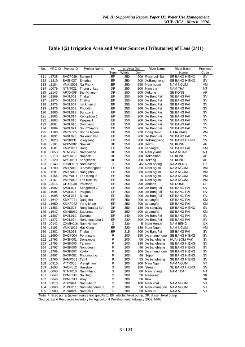
Vol. II: Supporting Report, Paper IX: Water Use ManagementWUP-JICA, March 2004
Table 1(2) Irrigation Area and Water Sources (Tributaries) of Laos (3/11)
River Name River Basin Provincehole Dry Name Code250 200 Reservoir Su SE BANG HIENG SV250 200 XeBanghieng SE BANG HIENG SV250 250 Nam ngum NAM NGUM VM250 100 Nam tha NAM THA NT250 200 Xekong SE KONG AP250 200 Xe BangFai SE BANG FAI SV250 200 Xe BangFai SE BANG FAI SV250 200 Xe BangFai SE BANG FAI SV250 200 Xe BangFai SE BANG FAI SV250 200 Xe BangFai SE BANG FAI SV250 200 Xe BangFai SE BANG FAI SV250 200 Xe BangFai SE BANG FAI SV250 200 Xe BangFai SE BANG FAI SV250 200 Xe BangFai SE BANG FAI SV250 220 Hong Deng H.MA HIAO VM250 200 Xe BangFai SE BANG FAI SV250 200 XeBanghieng SE BANG HIENG SV250 200 Xexou SE KONG AP250 200 xebangfai SE BANG FAI KM250 50 Nam yuane NAM NUAO NT250 200 Xekhaman SE KONG AP250 200 Xekong SE KONG AP250 45 Nam haeng NAM BENG OX250 250 Nam ngum NAM NGUM VM250 250 Nam ngum NAM NGUM VM250 5 Nam ngum NAM NGUM VM250 10 Nam ngum NAM NGUM VM250 200 Xedone SE DONE CP250 200 Xe BangFai SE BANG FAI SV250 200 Xe BangFai SE BANG FAI SV250 200 Xe BangFai SE BANG FAI SV250 200 xebangfai SE BANG FAI KM250 200 xebangfai SE BANG FAI KM250 180 Xe xangXoy SE BANG HIENG SV250 200 xebangfai SE BANG FAI KM240 200 Xe BangFai SE BANG FAI SV230 200 Xe BangFai SE BANG FAI SV230 5 Nam Hence NAM BENG OX220 180 Nam Ngum NAM NGUM VM215 200 Xe BangFai SE BANG FAI SV200 150 Xe champhone SE BANG HIENG SV200 50 Xe banghieng HUAI SOM PAK SV200 140 Xe banghieng SE BANG HIENG SV200 90 Xe banghieng SE BANG HIENG SV200 100 Xe champhone SE BANG HIENG SV200 90 Sepon SE BANG HIENG SV200 55 Xe banghieng SE BANG HIENG SV200 200 Nam Ngum NAM NGUM VT200 180 Stream SE BANG HIENG SV200 80 Nam nhang NAM THA NT200 20 Nampiew XK200 50 Kua XK200 100 Nam khat NAM NGUM VT200 50 Nam khaneune NAM NGUM VT200 50 Nam mi NAM MI VT
. Area (ha)No. MRC ID Project ID Project Name Irr.Type W
111 L1725 SVCP039 Sa kun 1 EP112 L1819 SVSK027 Singtha EP113 L1184 VMXN002 Na Phork EP114 L0079 NTNT021 Thong di kao DP115 L2143 APXX008 Ban Khang DP116 L1869 SVXL001 Thakam EP117 L1870 SVXL002 ThaKor EP118 L1875 SVXL007 hat kham di EP119 L1876 SVXL008 Phoudin EP120 L1880 SVXL012 Bungxe 2 EP121 L1882 SVXL014 Kengphosi 1 EP122 L1883 SVXL015 Pakpua 1 EP123 L1884 SVXL016 Dongyang EP124 L1889 SVXL021 SoumSaad 2 EP125 L1108 VMCL005 Bor na Ngoua EP126 L1891 SVXL023 Na xiang kan EP127 L1823 SVSK031 Vixaysong EP128 L2101 APPV002 Naxuak DP129 L1501 KMMX011 Dang EP130 L0053 NTMS023 Nam yuane DP131 L2118 APSX017 Naphok DP132 L2120 APSX019 Kengkham DP133 L0145 OXMH019 Nam haeng G134 L1200 VMXN018 B.haythangone EP135 L1201 VMXN019 Nong pho EP136 L1154 VMPN011 Tha xieng le EP137 L1161 VMPN018 Tha Kok Hai EP138 L2515 CPXB030 Pakxone EP139 L1902 SVXL034 Kengphosi 2 EP140 L1904 SVXL036 Pakpua 2 EP141 L1905 SVXL037 B. lau EP142 L1649 KMXF021 Dang tha EP143 L1650 KMXF022 Yang kham EP144 L1853 SVSL023 Nong bua(sa ke) DP145 L1547 KMNB039 Sadunua EP146 L1887 SVXL019 Sakong EP147 L1872 SVXL004 Nonghuathong 1 EP148 L0142 OXMH016 Nam Hence G149 L1193 VMXN011 Hat Kieng EP150 L1881 SVXL013 Thabo EP151 L1690 SVCP004 Ponmuang P152 L1793 SVSK001 Donsanote P153 L1795 SVSK003 Tannon P154 L1797 SVSK005 Nongdeun P155 L1799 SVSK007 Koklor P156 L1907 SVXP001 Phoumoung P157 L1760 SVMP001 Tamli P158 L0916 VTTK005 Viengkham P159 L1698 SVCP012 Huaybak G160 L0068 NTNT010 Nam nhang G161 L0643 XKMK016 Na Ung G162 L0646 XKMK019 khay G163 L0813 VTKS041 Nam khat 2 G164 L0860 VTPH011 Nam khaneune 2 G165 L0900 VTSK024 Nam mi 4 G
Note: P: fixed pump (power source not specified), EP: electric fixed pump, DP: diesel fixed pumpSource: Land Resources Inventory for Agricultural Development, February 2002, MRC
Irr
XI-103
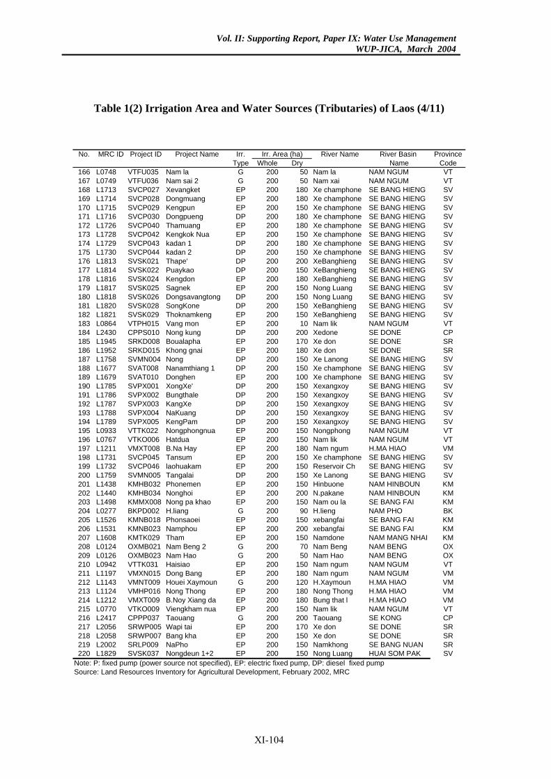
Vol. II: Supporting Report, Paper IX: Water Use ManagementWUP-JICA, March 2004
Table 1(2) Irrigation Area and Water Sources (Tributaries) of Laos (4/11)
River Name River Basin Provincehole Dry Name Code200 50 Nam la NAM NGUM VT200 50 Nam xai NAM NGUM VT200 180 Xe champhone SE BANG HIENG SV200 180 Xe champhone SE BANG HIENG SV200 150 Xe champhone SE BANG HIENG SV200 180 Xe champhone SE BANG HIENG SV200 180 Xe champhone SE BANG HIENG SV200 150 Xe champhone SE BANG HIENG SV200 180 Xe champhone SE BANG HIENG SV200 150 Xe champhone SE BANG HIENG SV200 200 XeBanghieng SE BANG HIENG SV200 150 XeBanghieng SE BANG HIENG SV200 180 XeBanghieng SE BANG HIENG SV200 150 Nong Luang SE BANG HIENG SV200 150 Nong Luang SE BANG HIENG SV200 150 XeBanghieng SE BANG HIENG SV200 150 XeBanghieng SE BANG HIENG SV200 10 Nam lik NAM NGUM VT200 200 Xedone SE DONE CP200 170 Xe don SE DONE SR200 180 Xe don SE DONE SR200 150 Xe Lanong SE BANG HIENG SV200 150 Xe champhone SE BANG HIENG SV200 100 Xe champhone SE BANG HIENG SV200 150 Xexangxoy SE BANG HIENG SV200 150 Xexangxoy SE BANG HIENG SV200 150 Xexangxoy SE BANG HIENG SV200 150 Xexangxoy SE BANG HIENG SV200 150 Xexangxoy SE BANG HIENG SV200 150 Nongphong NAM NGUM VT200 150 Nam lik NAM NGUM VT200 180 Nam ngum H.MA HIAO VM200 150 Xe champhone SE BANG HIENG SV200 150 Reservoir Ch SE BANG HIENG SV200 150 Xe Lanong SE BANG HIENG SV200 150 Hinbuone NAM HINBOUN KM200 200 N.pakane NAM HINBOUN KM200 150 Nam ou la SE BANG FAI KM200 90 H.lieng NAM PHO BK200 150 xebangfai SE BANG FAI KM200 200 xebangfai SE BANG FAI KM200 150 Namdone NAM MANG NHAI KM200 70 Nam Beng NAM BENG OX200 50 Nam Hao NAM BENG OX200 150 Nam ngum NAM NGUM VT200 180 Nam ngum NAM NGUM VM200 120 H.Xaymoun H.MA HIAO VM200 180 Nong Thong H.MA HIAO VM200 180 Bung that l H.MA HIAO VM200 150 Nam lik NAM NGUM VT200 200 Taouang SE KONG CP200 170 Xe don SE DONE SR200 150 Xe don SE DONE SR200 150 Namkhong SE BANG NUAN SR200 150 Nong Luang HUAI SOM PAK SV
. Area (ha)No. MRC ID Project ID Project Name Irr.Type W
166 L0748 VTFU035 Nam la G167 L0749 VTFU036 Nam sai 2 G168 L1713 SVCP027 Xevangket EP169 L1714 SVCP028 Dongmuang EP170 L1715 SVCP029 Kengpun EP171 L1716 SVCP030 Dongpueng DP172 L1726 SVCP040 Thamuang EP173 L1728 SVCP042 Kengkok Nua EP174 L1729 SVCP043 kadan 1 DP175 L1730 SVCP044 kadan 2 DP176 L1813 SVSK021 Thape' DP177 L1814 SVSK022 Puaykao DP178 L1816 SVSK024 Kengdon EP179 L1817 SVSK025 Sagnek EP180 L1818 SVSK026 Dongsavangtong DP181 L1820 SVSK028 SongKone DP182 L1821 SVSK029 Thoknamkeng EP183 L0864 VTPH015 Vang mon EP184 L2430 CPPS010 Nong kung DP185 L1945 SRKD008 Boualapha EP186 L1952 SRKD015 Khong gnai EP187 L1758 SVMN004 Nong DP188 L1677 SVAT008 Nanamthiang 1 DP189 L1679 SVAT010 Donghen EP190 L1785 SVPX001 XongXe' DP191 L1786 SVPX002 Bungthale DP192 L1787 SVPX003 KangXe DP193 L1788 SVPX004 NaKuang DP194 L1789 SVPX005 KengPam DP195 L0933 VTTK022 Nongphongnua EP196 L0767 VTKO006 Hatdua EP197 L1211 VMXT008 B.Na Hay EP198 L1731 SVCP045 Tansum EP199 L1732 SVCP046 laohuakam EP200 L1759 SVMN005 Tangalai DP201 L1438 KMHB032 Phonemen EP202 L1440 KMHB034 Nonghoi EP203 L1498 KMMX008 Nong pa khao EP204 L0277 BKPD002 H.liang G205 L1526 KMNB018 Phonsaoei EP206 L1531 KMNB023 Namphou EP207 L1608 KMTK029 Tham EP208 L0124 OXMB021 Nam Beng 2 G209 L0126 OXMB023 Nam Hao G210 L0942 VTTK031 Haisiao EP211 L1197 VMXN015 Dong Bang EP212 L1143 VMNT009 Houei Xaymoun G213 L1124 VMHP016 Nong Thong EP214 L1212 VMXT009 B.Noy Xiang da EP215 L0770 VTKO009 Viengkham nua EP216 L2417 CPPP037 Taouang G217 L2056 SRWP005 Wapi tai EP218 L2058 SRWP007 Bang kha EP219 L2002 SRLP009 NaPho EP220 L1829 SVSK037 Nongdeun 1+2 EP
Note: P: fixed pump (power source not specified), EP: electric fixed pump, DP: diesel fixed pumpSource: Land Resources Inventory for Agricultural Development, February 2002, MRC
Irr
XI-104
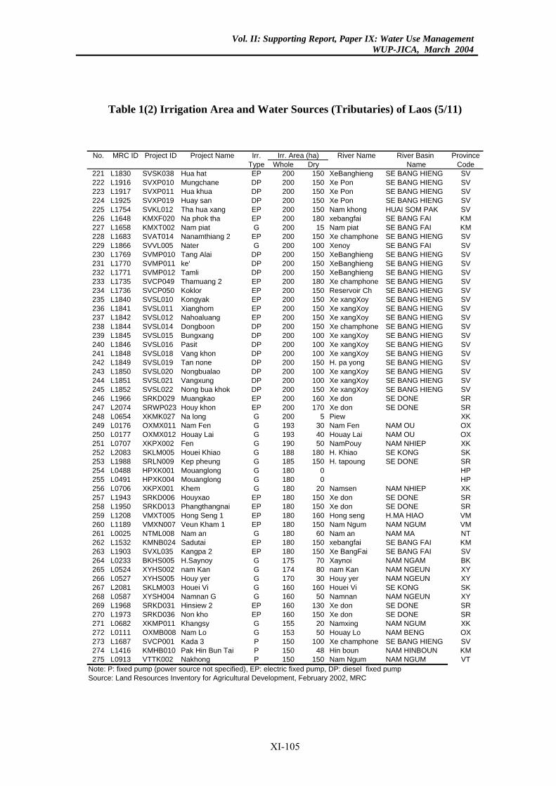
Vol. II: Supporting Report, Paper IX: Water Use ManagementWUP-JICA, March 2004
Table 1(2) Irrigation Area and Water Sources (Tributaries) of Laos (5/11)
River Name River Basin Provincehole Dry Name Code200 150 XeBanghieng SE BANG HIENG SV200 150 Xe Pon SE BANG HIENG SV200 150 Xe Pon SE BANG HIENG SV200 150 Xe Pon SE BANG HIENG SV200 150 Nam khong HUAI SOM PAK SV200 180 xebangfai SE BANG FAI KM200 15 Nam piat SE BANG FAI KM200 150 Xe champhone SE BANG HIENG SV200 100 Xenoy SE BANG FAI SV200 150 XeBanghieng SE BANG HIENG SV200 150 XeBanghieng SE BANG HIENG SV200 150 XeBanghieng SE BANG HIENG SV200 180 Xe champhone SE BANG HIENG SV200 150 Reservoir Ch SE BANG HIENG SV200 150 Xe xangXoy SE BANG HIENG SV200 150 Xe xangXoy SE BANG HIENG SV200 150 Xe xangXoy SE BANG HIENG SV200 150 Xe champhone SE BANG HIENG SV200 100 Xe xangXoy SE BANG HIENG SV200 100 Xe xangXoy SE BANG HIENG SV200 100 Xe xangXoy SE BANG HIENG SV200 150 H. pa yong SE BANG HIENG SV200 100 Xe xangXoy SE BANG HIENG SV200 100 Xe xangXoy SE BANG HIENG SV200 150 Xe xangXoy SE BANG HIENG SV200 160 Xe don SE DONE SR200 170 Xe don SE DONE SR200 5 Piew XK193 30 Nam Fen NAM OU OX193 40 Houay Lai NAM OU OX190 50 NamPouy NAM NHIEP XK188 180 H. Khiao SE KONG SK185 150 H. tapoung SE DONE SR180 0 HP180 0 HP180 20 Namsen NAM NHIEP XK180 150 Xe don SE DONE SR180 150 Xe don SE DONE SR180 160 Hong seng H.MA HIAO VM180 150 Nam Ngum NAM NGUM VM180 60 Nam an NAM MA NT180 150 xebangfai SE BANG FAI KM180 150 Xe BangFai SE BANG FAI SV175 70 Xaynoi NAM NGAM BK174 80 nam Kan NAM NGEUN XY170 30 Houy yer NAM NGEUN XY160 160 Houei Vi SE KONG SK160 50 Namnan NAM NGEUN XY160 130 Xe don SE DONE SR160 150 Xe don SE DONE SR155 20 Namxing NAM NGUM XK153 50 Houay Lo NAM BENG OX150 100 Xe champhone SE BANG HIENG SV150 48 Hin boun NAM HINBOUN KM150 150 Nam Ngum NAM NGUM VT
. Area (ha)No. MRC ID Project ID Project Name Irr.Type W
221 L1830 SVSK038 Hua hat EP222 L1916 SVXP010 Mungchane DP223 L1917 SVXP011 Hua khua DP224 L1925 SVXP019 Huay san DP225 L1754 SVKL012 Tha hua xang EP226 L1648 KMXF020 Na phok tha EP227 L1658 KMXT002 Nam piat G228 L1683 SVAT014 Nanamthiang 2 EP229 L1866 SVVL005 Nater G230 L1769 SVMP010 Tang Alai DP231 L1770 SVMP011 ke' DP232 L1771 SVMP012 Tamli DP233 L1735 SVCP049 Thamuang 2 EP234 L1736 SVCP050 Koklor EP235 L1840 SVSL010 Kongyak EP236 L1841 SVSL011 Xianghom EP237 L1842 SVSL012 Nahoaluang EP238 L1844 SVSL014 Dongboon DP239 L1845 SVSL015 Bungxang DP240 L1846 SVSL016 Pasit DP241 L1848 SVSL018 Vang khon DP242 L1849 SVSL019 Tan none DP243 L1850 SVSL020 Nongbualao DP244 L1851 SVSL021 Vangxung DP245 L1852 SVSL022 Nong bua khok DP246 L1966 SRKD029 Muangkao EP247 L2074 SRWP023 Houy khon EP248 L0654 XKMK027 Na long G249 L0176 OXMX011 Nam Fen G250 L0177 OXMX012 Houay Lai G251 L0707 XKPX002 Fen G252 L2083 SKLM005 Houei Khiao G253 L1988 SRLN009 Kep pheung G254 L0488 HPXK001 Mouanglong G255 L0491 HPXK004 Mouanglong G256 L0706 XKPX001 Khem G257 L1943 SRKD006 Houyxao EP258 L1950 SRKD013 Phangthangnai EP259 L1208 VMXT005 Hong Seng 1 EP260 L1189 VMXN007 Veun Kham 1 EP261 L0025 NTML008 Nam an G262 L1532 KMNB024 Sadutai EP263 L1903 SVXL035 Kangpa 2 EP264 L0233 BKHS005 H.Saynoy G265 L0524 XYHS002 nam Kan G266 L0527 XYHS005 Houy yer G267 L2081 SKLM003 Houei Vi G268 L0587 XYSH004 Namnan G G269 L1968 SRKD031 Hinsiew 2 EP270 L1973 SRKD036 Non kho EP271 L0682 XKMP011 Khangsy G272 L0111 OXMB008 Nam Lo G273 L1687 SVCP001 Kada 3 P274 L1416 KMHB010 Pak Hin Bun Tai P275 L0913 VTTK002 Nakhong P
Note: P: fixed pump (power source not specified), EP: electric fixed pump, DP: diesel fixed pumpSource: Land Resources Inventory for Agricultural Development, February 2002, MRC
Irr
XI-105
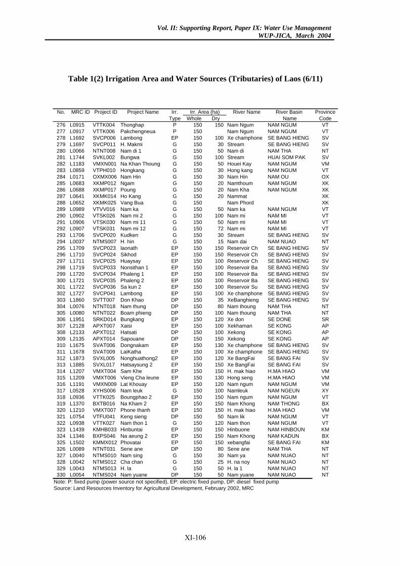
Vol. II: Supporting Report, Paper IX: Water Use ManagementWUP-JICA, March 2004
Table 1(2) Irrigation Area and Water Sources (Tributaries) of Laos (6/11)
River Name River Basin Provincehole Dry Name Code150 150 Nam Ngum NAM NGUM VT150 Nam Ngum NAM NGUM VT150 100 Xe champhone SE BANG HIENG SV150 30 Stream SE BANG HIENG SV150 50 Nam di NAM THA NT150 100 Stream HUAI SOM PAK SV150 50 Houei Kay NAM NGUM VM150 30 Hong kang NAM NGUM VT150 30 Nam Hin NAM OU OX150 20 Namthoum NAM NGUM XK150 20 Nam Kha NAM NGUM XK150 20 Nammat XK150 Nam Phord XK150 50 Nam ka NAM NGUM VT150 100 Nam mi NAM MI VT150 50 Nam mi NAM MI VT150 72 Nam mi NAM MI VT150 30 Stream SE BANG HIENG SV150 15 Nam dai NAM NUAO NT150 150 Reservoir Ch SE BANG HIENG SV150 150 Reservoir Ch SE BANG HIENG SV150 100 Reservoir Ch SE BANG HIENG SV150 100 Reservoir Ba SE BANG HIENG SV150 100 Reservoir Ba SE BANG HIENG SV150 100 Reservoir Ba SE BANG HIENG SV150 100 Reservoir Su SE BANG HIENG SV150 100 Xe champhone SE BANG HIENG SV150 35 XeBanghieng SE BANG HIENG SV150 80 Nam thoung NAM THA NT150 100 Nam thoung NAM THA NT150 120 Xe don SE DONE SR150 100 Xekhaman SE KONG AP150 100 Xekong SE KONG AP150 150 Xekong SE KONG AP150 130 Xe champhone SE BANG HIENG SV150 100 Xe champhone SE BANG HIENG SV150 120 Xe BangFai SE BANG FAI SV150 150 Xe BangFai SE BANG FAI SV150 150 H. mak hiao H.MA HIAO VM150 130 Hong seng H.MA HIAO VM150 120 Nam ngum NAM NGUM VM150 100 Namleuk NAM NGEUN XY150 150 Nam ngum NAM NGUM VT150 150 Nam Khong NAM THONG BX150 150 H. mak hiao H.MA HIAO VM150 50 Nam lik NAM NGUM VT150 120 Nam thon NAM NGUM VT150 150 Hinbuone NAM HINBOUN KM150 150 Nam Khong NAM KADUN BX150 150 xebangfai SE BANG FAI KM150 80 Sene ane NAM THA NT150 30 Nam ya NAM NUAO NT150 25 H. na noy NAM NUAO NT150 50 H. la 1 NAM NUAO NT150 50 Nam yuane NAM NUAO NT
. Area (ha)No. MRC ID Project ID Project Name Irr.Type W
276 L0915 VTTK004 Thonghap P277 L0917 VTTK006 Pakchengneua P278 L1692 SVCP006 Lambong EP279 L1697 SVCP011 H. Makmi G280 L0066 NTNT008 Nam di 1 G281 L1744 SVKL002 Bungwa G282 L1183 VMXN001 Na Khan Thoung G283 L0859 VTPH010 Hongkang G284 L0171 OXMX006 Nam Hin G285 L0683 XKMP012 Ngam G286 L0688 XKMP017 Poung G287 L0641 XKMK014 Ho Kang G288 L0652 XKMK025 Vang Bua G289 L0989 VTVV016 Nam ka G290 L0902 VTSK026 Nam mi 2 G291 L0906 VTSK030 Nam mi 11 G292 L0907 VTSK031 Nam mi 12 G293 L1706 SVCP020 Kudken G294 L0037 NTMS007 H. hin G295 L1709 SVCP023 laonath EP296 L1710 SVCP024 Sikhod EP297 L1711 SVCP025 Huaysay EP298 L1719 SVCP033 Nonsithan 1 EP299 L1720 SVCP034 Phaleng 1 EP300 L1721 SVCP035 Phaleng 2 EP301 L1722 SVCP036 Sa kun 2 EP302 L1727 SVCP041 Lambong EP303 L1860 SVTT007 Don Khao DP304 L0076 NTNT018 Nam thung DP305 L0080 NTNT022 Boam phieng DP306 L1951 SRKD014 Bungkang EP307 L2128 APXT007 Xaisi EP308 L2133 APXT012 Hatsati DP309 L2135 APXT014 Sapouane DP310 L1675 SVAT006 Dongnakam EP311 L1678 SVAT009 LaiKatha EP312 L1873 SVXL005 Nonghuathong2 EP313 L1885 SVXL017 Hatsaysung 2 EP314 L1207 VMXT004 Sam Khe EP315 L1209 VMXT006 Vieng Cha leune EP316 L1191 VMXN009 Lat Khouay EP317 L0528 XYHS006 Nam leuk G318 L0936 VTTK025 Boungphao 2 EP319 L1370 BXTB016 Na Kham 2 EP320 L1210 VMXT007 Phone thanh EP321 L0754 VTFU041 Keng sieng DP322 L0938 VTTK027 Nam thon 1 G323 L1439 KMHB033 Hinbuntai EP324 L1346 BXPS046 Na aeung 2 EP325 L1502 KMMX012 Phovatai EP326 L0089 NTNT031 Sene ane DP327 L0040 NTMS010 Nam sing G328 L0042 NTMS012 Cha chan G329 L0043 NTMS013 H. la G330 L0054 NTMS024 Nam yuane DP
Note: P: fixed pump (power source not specified), EP: electric fixed pump, DP: diesel fixed pumpSource: Land Resources Inventory for Agricultural Development, February 2002, MRC
Irr
XI-106
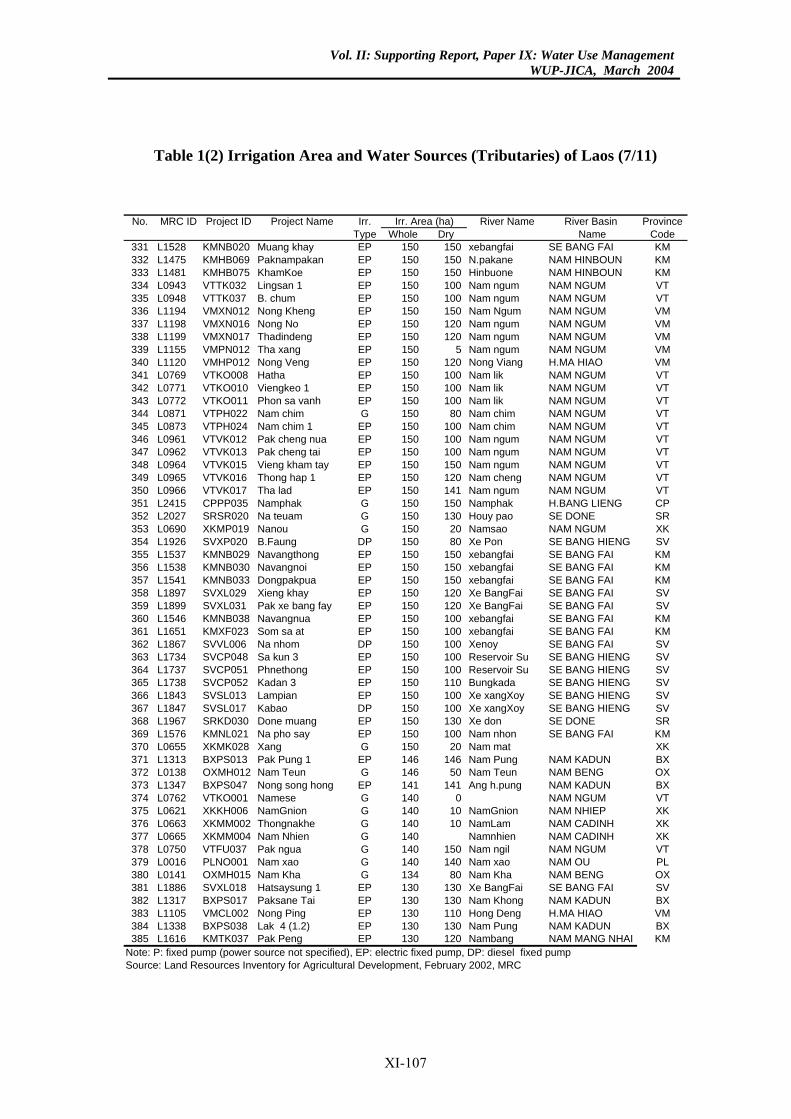
Vol. II: Supporting Report, Paper IX: Water Use ManagementWUP-JICA, March 2004
Table 1(2) Irrigation Area and Water Sources (Tributaries) of Laos (7/11)
No. MRC ID Project ID Project Name Irr. River Name River Basin ProvinceType Whole Dry Name Code
331 L1528 KMNB020 Muang khay EP 150 150 xebangfai SE BANG FAI KM332 L1475 KMHB069 Paknampakan EP 150 150 N.pakane NAM HINBOUN KM333 L1481 KMHB075 KhamKoe EP 150 150 Hinbuone NAM HINBOUN KM334 L0943 VTTK032 Lingsan 1 EP 150 100 Nam ngum NAM NGUM VT335 L0948 VTTK037 B. chum EP 150 100 Nam ngum NAM NGUM VT336 L1194 VMXN012 Nong Kheng EP 150 150 Nam Ngum NAM NGUM VM337 L1198 VMXN016 Nong No EP 150 120 Nam ngum NAM NGUM VM338 L1199 VMXN017 Thadindeng EP 150 120 Nam ngum NAM NGUM VM339 L1155 VMPN012 Tha xang EP 150 5 Nam ngum NAM NGUM VM340 L1120 VMHP012 Nong Veng EP 150 120 Nong Viang H.MA HIAO VM341 L0769 VTKO008 Hatha EP 150 100 Nam lik NAM NGUM VT342 L0771 VTKO010 Viengkeo 1 EP 150 100 Nam lik NAM NGUM VT343 L0772 VTKO011 Phon sa vanh EP 150 100 Nam lik NAM NGUM VT344 L0871 VTPH022 Nam chim G 150 80 Nam chim NAM NGUM VT345 L0873 VTPH024 Nam chim 1 EP 150 100 Nam chim NAM NGUM VT346 L0961 VTVK012 Pak cheng nua EP 150 100 Nam ngum NAM NGUM VT347 L0962 VTVK013 Pak cheng tai EP 150 100 Nam ngum NAM NGUM VT348 L0964 VTVK015 Vieng kham tay EP 150 150 Nam ngum NAM NGUM VT349 L0965 VTVK016 Thong hap 1 EP 150 120 Nam cheng NAM NGUM VT350 L0966 VTVK017 Tha lad EP 150 141 Nam ngum NAM NGUM VT351 L2415 CPPP035 Namphak G 150 150 Namphak H.BANG LIENG CP352 L2027 SRSR020 Na teuam G 150 130 Houy pao SE DONE SR353 L0690 XKMP019 Nanou G 150 20 Namsao NAM NGUM XK354 L1926 SVXP020 B.Faung DP 150 80 Xe Pon SE BANG HIENG SV355 L1537 KMNB029 Navangthong EP 150 150 xebangfai SE BANG FAI KM356 L1538 KMNB030 Navangnoi EP 150 150 xebangfai SE BANG FAI KM357 L1541 KMNB033 Dongpakpua EP 150 150 xebangfai SE BANG FAI KM358 L1897 SVXL029 Xieng khay EP 150 120 Xe BangFai SE BANG FAI SV359 L1899 SVXL031 Pak xe bang fay EP 150 120 Xe BangFai SE BANG FAI SV360 L1546 KMNB038 Navangnua EP 150 100 xebangfai SE BANG FAI KM361 L1651 KMXF023 Som sa at EP 150 100 xebangfai SE BANG FAI KM362 L1867 SVVL006 Na nhom DP 150 100 Xenoy SE BANG FAI SV363 L1734 SVCP048 Sa kun 3 EP 150 100 Reservoir Su SE BANG HIENG SV364 L1737 SVCP051 Phnethong EP 150 100 Reservoir Su SE BANG HIENG SV365 L1738 SVCP052 Kadan 3 EP 150 110 Bungkada SE BANG HIENG SV366 L1843 SVSL013 Lampian EP 150 100 Xe xangXoy SE BANG HIENG SV367 L1847 SVSL017 Kabao DP 150 100 Xe xangXoy SE BANG HIENG SV368 L1967 SRKD030 Done muang EP 150 130 Xe don SE DONE SR369 L1576 KMNL021 Na pho say EP 150 100 Nam nhon SE BANG FAI KM370 L0655 XKMK028 Xang G 150 20 Nam mat XK371 L1313 BXPS013 Pak Pung 1 EP 146 146 Nam Pung NAM KADUN BX372 L0138 OXMH012 Nam Teun G 146 50 Nam Teun NAM BENG OX373 L1347 BXPS047 Nong song hong EP 141 141 Ang h.pung NAM KADUN BX374 L0762 VTKO001 Namese G 140 0 NAM NGUM VT375 L0621 XKKH006 NamGnion G 140 10 NamGnion NAM NHIEP XK376 L0663 XKMM002 Thongnakhe G 140 10 NamLam NAM CADINH XK377 L0665 XKMM004 Nam Nhien G 140 Namnhien NAM CADINH XK378 L0750 VTFU037 Pak ngua G 140 150 Nam ngil NAM NGUM VT379 L0016 PLNO001 Nam xao G 140 140 Nam xao NAM OU PL380 L0141 OXMH015 Nam Kha G 134 80 Nam Kha NAM BENG OX381 L1886 SVXL018 Hatsaysung 1 EP 130 130 Xe BangFai SE BANG FAI SV382 L1317 BXPS017 Paksane Tai EP 130 130 Nam Khong NAM KADUN BX383 L1105 VMCL002 Nong Ping EP 130 110 Hong Deng H.MA HIAO VM384 L1338 BXPS038 Lak 4 (1.2) EP 130 130 Nam Pung NAM KADUN BX385 L1616 KMTK037 Pak Peng EP 130 120 Nambang NAM MANG NHAI KM
Note: P: fixed pump (power source not specified), EP: electric fixed pump, DP: diesel fixed pumpSource: Land Resources Inventory for Agricultural Development, February 2002, MRC
Irr. Area (ha)
XI-107
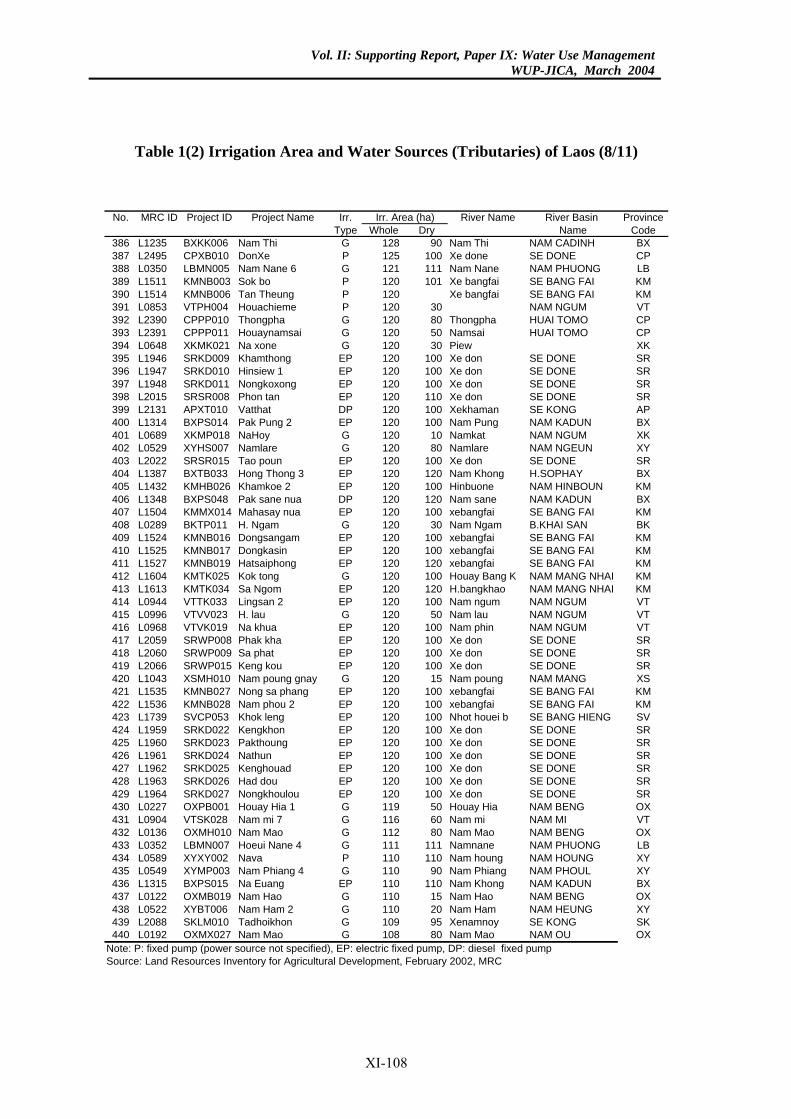
Vol. II: Supporting Report, Paper IX: Water Use ManagementWUP-JICA, March 2004
Table 1(2) Irrigation Area and Water Sources (Tributaries) of Laos (8/11)
No. MRC ID Project ID Project Name Irr. River Name River Basin ProvinceType Whole Dry Name Code
386 L1235 BXKK006 Nam Thi G 128 90 Nam Thi NAM CADINH BX387 L2495 CPXB010 DonXe P 125 100 Xe done SE DONE CP388 L0350 LBMN005 Nam Nane 6 G 121 111 Nam Nane NAM PHUONG LB389 L1511 KMNB003 Sok bo P 120 101 Xe bangfai SE BANG FAI KM390 L1514 KMNB006 Tan Theung P 120 Xe bangfai SE BANG FAI KM391 L0853 VTPH004 Houachieme P 120 30 NAM NGUM VT392 L2390 CPPP010 Thongpha G 120 80 Thongpha HUAI TOMO CP393 L2391 CPPP011 Houaynamsai G 120 50 Namsai HUAI TOMO CP394 L0648 XKMK021 Na xone G 120 30 Piew XK395 L1946 SRKD009 Khamthong EP 120 100 Xe don SE DONE SR396 L1947 SRKD010 Hinsiew 1 EP 120 100 Xe don SE DONE SR397 L1948 SRKD011 Nongkoxong EP 120 100 Xe don SE DONE SR398 L2015 SRSR008 Phon tan EP 120 110 Xe don SE DONE SR399 L2131 APXT010 Vatthat DP 120 100 Xekhaman SE KONG AP400 L1314 BXPS014 Pak Pung 2 EP 120 100 Nam Pung NAM KADUN BX401 L0689 XKMP018 NaHoy G 120 10 Namkat NAM NGUM XK402 L0529 XYHS007 Namlare G 120 80 Namlare NAM NGEUN XY403 L2022 SRSR015 Tao poun EP 120 100 Xe don SE DONE SR404 L1387 BXTB033 Hong Thong 3 EP 120 120 Nam Khong H.SOPHAY BX405 L1432 KMHB026 Khamkoe 2 EP 120 100 Hinbuone NAM HINBOUN KM406 L1348 BXPS048 Pak sane nua DP 120 120 Nam sane NAM KADUN BX407 L1504 KMMX014 Mahasay nua EP 120 100 xebangfai SE BANG FAI KM408 L0289 BKTP011 H. Ngam G 120 30 Nam Ngam B.KHAI SAN BK409 L1524 KMNB016 Dongsangam EP 120 100 xebangfai SE BANG FAI KM410 L1525 KMNB017 Dongkasin EP 120 100 xebangfai SE BANG FAI KM411 L1527 KMNB019 Hatsaiphong EP 120 120 xebangfai SE BANG FAI KM412 L1604 KMTK025 Kok tong G 120 100 Houay Bang K NAM MANG NHAI KM413 L1613 KMTK034 Sa Ngom EP 120 120 H.bangkhao NAM MANG NHAI KM414 L0944 VTTK033 Lingsan 2 EP 120 100 Nam ngum NAM NGUM VT415 L0996 VTVV023 H. lau G 120 50 Nam lau NAM NGUM VT416 L0968 VTVK019 Na khua EP 120 100 Nam phin NAM NGUM VT417 L2059 SRWP008 Phak kha EP 120 100 Xe don SE DONE SR418 L2060 SRWP009 Sa phat EP 120 100 Xe don SE DONE SR419 L2066 SRWP015 Keng kou EP 120 100 Xe don SE DONE SR420 L1043 XSMH010 Nam poung gnay G 120 15 Nam poung NAM MANG XS421 L1535 KMNB027 Nong sa phang EP 120 100 xebangfai SE BANG FAI KM422 L1536 KMNB028 Nam phou 2 EP 120 100 xebangfai SE BANG FAI KM423 L1739 SVCP053 Khok leng EP 120 100 Nhot houei b SE BANG HIENG SV424 L1959 SRKD022 Kengkhon EP 120 100 Xe don SE DONE SR425 L1960 SRKD023 Pakthoung EP 120 100 Xe don SE DONE SR426 L1961 SRKD024 Nathun EP 120 100 Xe don SE DONE SR427 L1962 SRKD025 Kenghouad EP 120 100 Xe don SE DONE SR428 L1963 SRKD026 Had dou EP 120 100 Xe don SE DONE SR429 L1964 SRKD027 Nongkhoulou EP 120 100 Xe don SE DONE SR430 L0227 OXPB001 Houay Hia 1 G 119 50 Houay Hia NAM BENG OX431 L0904 VTSK028 Nam mi 7 G 116 60 Nam mi NAM MI VT432 L0136 OXMH010 Nam Mao G 112 80 Nam Mao NAM BENG OX433 L0352 LBMN007 Hoeui Nane 4 G 111 111 Namnane NAM PHUONG LB434 L0589 XYXY002 Nava P 110 110 Nam houng NAM HOUNG XY435 L0549 XYMP003 Nam Phiang 4 G 110 90 Nam Phiang NAM PHOUL XY436 L1315 BXPS015 Na Euang EP 110 110 Nam Khong NAM KADUN BX437 L0122 OXMB019 Nam Hao G 110 15 Nam Hao NAM BENG OX438 L0522 XYBT006 Nam Ham 2 G 110 20 Nam Ham NAM HEUNG XY439 L2088 SKLM010 Tadhoikhon G 109 95 Xenamnoy SE KONG SK440 L0192 OXMX027 Nam Mao G 108 80 Nam Mao NAM OU OX
Note: P: fixed pump (power source not specified), EP: electric fixed pump, DP: diesel fixed pumpSource: Land Resources Inventory for Agricultural Development, February 2002, MRC
Irr. Area (ha)
XI-108
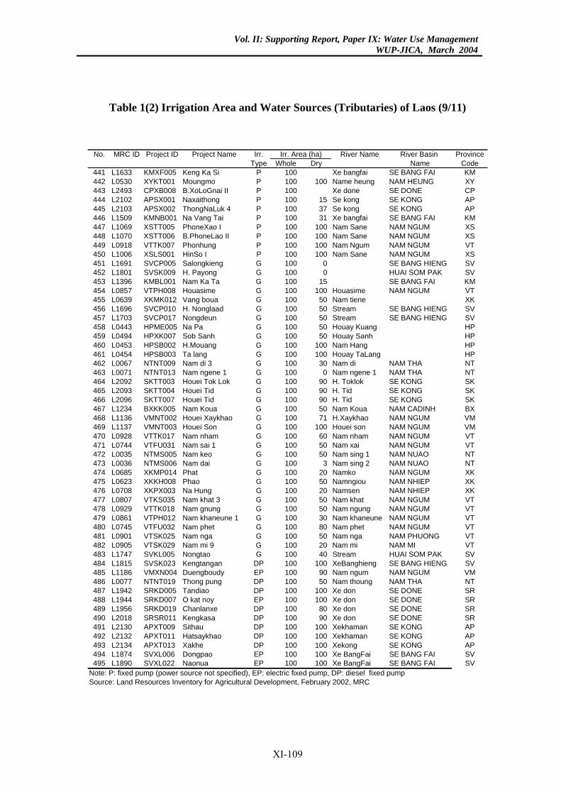
Vol. II: Supporting Report, Paper IX: Water Use ManagementWUP-JICA, March 2004
Table 1(2) Irrigation Area and Water Sources (Tributaries) of Laos (9/11)
No. MRC ID Project ID Project Name Irr. River Name River Basin ProvinceType Whole Dry Name Code
441 L1633 KMXF005 Keng Ka Si P 100 Xe bangfai SE BANG FAI KM442 L0530 XYKT001 Moungmo P 100 100 Name heung NAM HEUNG XY443 L2493 CPXB008 B.XoLoGnai II P 100 Xe done SE DONE CP444 L2102 APSX001 Naxaithong P 100 15 Se kong SE KONG AP445 L2103 APSX002 ThongNaLuk 4 P 100 37 Se kong SE KONG AP446 L1509 KMNB001 Na Vang Tai P 100 31 Xe bangfai SE BANG FAI KM447 L1069 XSTT005 PhoneXao I P 100 100 Nam Sane NAM NGUM XS448 L1070 XSTT006 B.PhoneLao II P 100 100 Nam Sane NAM NGUM XS449 L0918 VTTK007 Phonhung P 100 100 Nam Ngum NAM NGUM VT450 L1006 XSLS001 HinSo I P 100 100 Nam Sane NAM NGUM XS451 L1691 SVCP005 Salongkieng G 100 0 SE BANG HIENG SV452 L1801 SVSK009 H. Payong G 100 0 HUAI SOM PAK SV453 L1396 KMBL001 Nam Ka Ta G 100 15 SE BANG FAI KM454 L0857 VTPH008 Houasime G 100 100 Houasime NAM NGUM VT455 L0639 XKMK012 Vang boua G 100 50 Nam tiene XK456 L1696 SVCP010 H. Nonglaad G 100 50 Stream SE BANG HIENG SV457 L1703 SVCP017 Nongdeun G 100 50 Stream SE BANG HIENG SV458 L0443 HPME005 Na Pa G 100 50 Houay Kuang HP459 L0494 HPXK007 Sob Sanh G 100 50 Houay Sanh HP460 L0453 HPSB002 H.Mouang G 100 100 Nam Hang HP461 L0454 HPSB003 Ta lang G 100 100 Houay TaLang HP462 L0067 NTNT009 Nam di 3 G 100 30 Nam di NAM THA NT463 L0071 NTNT013 Nam ngene 1 G 100 0 Nam ngene 1 NAM THA NT464 L2092 SKTT003 Houei Tok Lok G 100 90 H. Toklok SE KONG SK465 L2093 SKTT004 Houei Tid G 100 90 H. Tid SE KONG SK466 L2096 SKTT007 Houei Tid G 100 90 H. Tid SE KONG SK467 L1234 BXKK005 Nam Koua G 100 50 Nam Koua NAM CADINH BX468 L1136 VMNT002 Houei Xaykhao G 100 71 H.Xaykhao NAM NGUM VM469 L1137 VMNT003 Houei Son G 100 100 Houei son NAM NGUM VM470 L0928 VTTK017 Nam nham G 100 60 Nam nham NAM NGUM VT471 L0744 VTFU031 Nam sai 1 G 100 50 Nam xai NAM NGUM VT472 L0035 NTMS005 Nam keo G 100 50 Nam sing 1 NAM NUAO NT473 L0036 NTMS006 Nam dai G 100 3 Nam sing 2 NAM NUAO NT474 L0685 XKMP014 Phat G 100 20 Namko NAM NGUM XK475 L0623 XKKH008 Phao G 100 50 Namngiou NAM NHIEP XK476 L0708 XKPX003 Na Hung G 100 20 Namsen NAM NHIEP XK477 L0807 VTKS035 Nam khat 3 G 100 50 Nam khat NAM NGUM VT478 L0929 VTTK018 Nam gnung G 100 50 Nam ngung NAM NGUM VT479 L0861 VTPH012 Nam khaneune 1 G 100 30 Nam khaneune NAM NGUM VT480 L0745 VTFU032 Nam phet G 100 80 Nam phet NAM NGUM VT481 L0901 VTSK025 Nam nga G 100 50 Nam nga NAM PHUONG VT482 L0905 VTSK029 Nam mi 9 G 100 20 Nam mi NAM MI VT483 L1747 SVKL005 Nongtao G 100 40 Stream HUAI SOM PAK SV484 L1815 SVSK023 Kengtangan DP 100 100 XeBanghieng SE BANG HIENG SV485 L1186 VMXN004 Duengboudy EP 100 90 Nam ngum NAM NGUM VM486 L0077 NTNT019 Thong pung DP 100 50 Nam thoung NAM THA NT487 L1942 SRKD005 Tandiao DP 100 100 Xe don SE DONE SR488 L1944 SRKD007 O kat noy EP 100 100 Xe don SE DONE SR489 L1956 SRKD019 Chanlanxe DP 100 80 Xe don SE DONE SR490 L2018 SRSR011 Kengkasa DP 100 90 Xe don SE DONE SR491 L2130 APXT009 Sithau DP 100 100 Xekhaman SE KONG AP492 L2132 APXT011 Hatsaykhao DP 100 100 Xekhaman SE KONG AP493 L2134 APXT013 Xakhe DP 100 100 Xekong SE KONG AP494 L1874 SVXL006 Dongpao EP 100 100 Xe BangFai SE BANG FAI SV495 L1890 SVXL022 Naonua EP 100 100 Xe BangFai SE BANG FAI SV
Note: P: fixed pump (power source not specified), EP: electric fixed pump, DP: diesel fixed pumpSource: Land Resources Inventory for Agricultural Development, February 2002, MRC
Irr. Area (ha)
XI-109
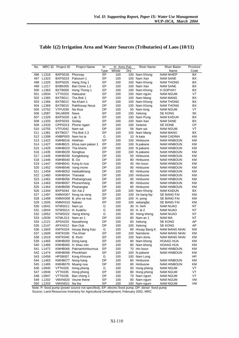
Vol. II: Supporting Report, Paper IX: Water Use ManagementWUP-JICA, March 2004
Table 1(2) Irrigation Area and Water Sources (Tributaries) of Laos (10/11)
No. MRC ID Project ID Project Name Irr. River Name River Basin ProvinceType Whole Dry Name Code
496 L1318 BXPS018 Phonxay EP 100 100 Nam Khong NAM NHIEP BX497 L1323 BXPS023 Patxoum 1 EP 100 100 Nam Xan NAM SANE BX498 L1325 BXPS025 Hang Xing 1 EP 100 100 Nam Khong NAM THONG BX499 L1217 BXBK005 Ban Done 1.2 EP 100 100 Nam Xan NAM SANE BX500 L1363 BXTB009 Hong Thong 1 EP 100 100 Nam Khong H.SOPHAY BX501 L0934 VTTK023 Hatsuane EP 100 100 Nam ngum NAM NGUM VT502 L1365 BXTB011 Tha Bok 1 EP 100 100 Nam Mang NAM MANG BX503 L1366 BXTB012 Na Kham 1 EP 100 100 Nam Khong NAM THONG BX504 L1369 BXTB015 Pakthouay Neua DP 100 100 Nam Khong NAM THONG BX505 L0752 VTFU039 Na thua DP 100 50 Nam tong NAM NGUM VT506 L2087 SKLM009 Nava EP 100 100 Xekong SE KONG SK507 L1329 BXPS029 Lak 5 EP 100 100 Nam Pung NAM KADUN BX508 L1333 BXPS033 Sivilay EP 100 100 Nam Xan NAM SANE BX509 L2433 CPPS013 Phone ngam EP 100 100 Xedone SE DONE CP510 L0755 VTFU042 Nam sai DP 100 56 Nam sai NAM NGUM VT511 L1381 BXTB027 Tha Bok 2,3 EP 100 100 Nam Mang NAM MANG BX512 L1399 KMBP003 Nam ka ta G 100 10 N.kata NAM CADINH KM513 L1422 KMHB016 Hinkhan EP 100 100 Hinboune NAM HINBOUN KM514 L1427 KMHB021 Khoa nam pakan 1 EP 100 100 N.pakane NAM HINBOUN KM515 L1429 KMHB023 Tha khene DP 100 100 N.pakane NAM HINBOUN KM516 L1435 KMHB029 Nongbua EP 100 100 N.pakane NAM HINBOUN KM517 L1445 KMHB039 Konglokang DP 100 50 Hinbuone NAM HINBOUN KM518 L1446 KMHB040 B. Oo DP 100 80 Hinbuone NAM HINBOUN KM519 L1447 KMHB041 Kong lo nua DP 100 40 Hin boun NAM HINBOUN KM520 L1452 KMHB046 Vang mone DP 100 90 Hinbuone NAM HINBOUN KM521 L1459 KMHB053 Hadsaikhang DP 100 80 Hinbuone NAM HINBOUN KM522 L1460 KMHB054 Thanatai DP 100 100 Hinbuone NAM HINBOUN KM523 L1462 KMHB056 Phahangnuaa DP 100 90 Hinbuone NAM HINBOUN KM524 L1463 KMHB057 Phonenhang DP 100 80 Hinbuone NAM HINBOUN KM525 L1464 KMHB058 Phahangtai DP 100 80 Hinbuone NAM HINBOUN KM526 L1344 BXPS044 Sin Xai 2 EP 100 100 Nam Khong NAM KADUN BX527 L1497 KMMX007 Keng sa vang EP 100 100 Xe bang fay SE BANG FAI KM528 L1499 KMMX009 B. pho va nua EP 100 100 H. pong SE BANG FAI KM529 L1505 KMMX015 Nakaio EP 100 100 xebangfai SE BANG FAI KM530 L0041 NTMS011 Nam ya G 100 30 H. hinh NAM NUAO NT531 L0044 NTMS014 H. buakhu G 100 50 H. la 2 NAM NUAO NT532 L0052 NTMS022 Xieng kheng G 100 50 Xieng kheng NAM NUAO NT533 L0030 NTML013 Nam an 1 DP 100 80 Nam an 1 NAM MA NT534 L2121 APSX020 Naxaithong DP 100 60 Xekong SE KONG AP535 L2147 APXX012 Ban Ouk DP 100 100 Xekong SE KONG AP536 L1603 KMTK024 Houay Bang Kao G 100 80 Houay Bang K NAM MANG NHAI KM537 L1609 KMTK030 Tha Khair EP 100 100 Namdone NAM MANG NHAI KM538 L1619 KMTK040 B. thum EP 100 100 Nam done NAM MANG NHAI KM539 L1465 KMHB059 Dong kang EP 100 80 Nam khong HOAAG HUA KM540 L1466 KMHB060 H. khau min EP 100 80 Nam khong HOAAG HUA KM541 L1472 KMHB066 Paknamhinbunnua EP 100 70 Hin boun NAM HINBOUN KM542 L1474 KMHB068 Phonkham EP 100 100 N.pakane NAM HINBOUN KM543 L0458 HPSB007 Kong Khoune G 100 100 Nam Long HP544 L1483 KMHB077 Nong hang DP 100 80 Hinbuone NAM HINBOUN KM545 L1485 KMHB079 Muang nua DP 100 90 Hinbuone NAM HINBOUN KM546 L0940 VTTK029 Hong pheng G 100 50 Hong pheng NAM NGUM VT547 L0946 VTTK035 Hong pheng EP 100 80 Hong pheng NAM NGUM VT548 L0947 VTTK036 Ban cheng 2 DP 100 70 Nam ngum NAM NGUM VT549 L1202 VMXN020 Veune thene EP 100 80 Nam ngum NAM NGUM VM550 L1203 VMXN021 Na the EP 100 100 Nam ngum NAM NGUM VM
Note: P: fixed pump (power source not specified), EP: electric fixed pump, DP: diesel fixed pumpSource: Land Resources Inventory for Agricultural Development, February 2002, MRC
Irr. Area (ha)
XI-110
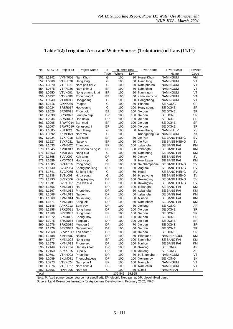
Vol. II: Supporting Report, Paper IX: Water Use ManagementWUP-JICA, March 2004
Table 1(2) Irrigation Area and Water Sources (Tributaries) of Laos (11/11)
River Name River Basin Provinceole Dry Name Code100 30 Houei Khon NAM NGUM VM100 50 Hang long NAM NGUM VT100 50 Nam pha nai NAM NGUM VT100 80 Nam chim NAM NGUM VT100 50 Nam ngum NAM NGUM VT100 50 canal namche NAM NGUM VT100 50 Hongphang NAM NGUM VT100 30 Phapho SE KONG CP100 100 Houy soung SE DONE SR100 100 Xe don SE DONE SR100 100 Xe don SE DONE SR100 100 Xe don SE DONE SR100 100 Xe don SE DONE SR100 100 Xe don SE DONE SR100 0 Nam theng NAM NHIEP XS100 KhangnongLua NAM NGUM XK100 80 Xe Pon SE BANG HIENG SV100 80 Xe Pon SE BANG HIENG SV100 100 xebangfai SE BANG FAI KM100 80 xebangfai SE BANG FAI KM100 70 Nam bung SE BANG FAI KM100 80 Xenoy SE BANG FAI SV100 5 Huoi ka po SE BANG FAI KM100 100 Xe champhone SE BANG HIENG SV100 50 Ang bak SE BANG HIENG SV100 60 Houei SE BANG HIENG SV100 50 H. pa yong SE BANG HIENG SV100 100 Xexangxoy SE BANG HIENG SV100 100 Xexangxoy SE BANG HIENG SV100 100 xebangfai SE BANG FAI KM100 50 xebangfai SE BANG FAI KM100 50 xebangfai SE BANG FAI KM100 50 N.nhon SE BANG FAI KM100 50 Nam nhom SE BANG FAI KM100 80 Xekong SE KONG AP100 100 Xe don SE DONE SR100 100 Xe don SE DONE SR100 100 Xe don SE DONE SR100 100 Xe don SE DONE SR100 70 Xe don SE DONE SR100 60 Xe don SE DONE SR100 70 Xe don SE DONE SR100 50 Hinbuone NAM HINBOUN KM100 100 Nam nhon SE BANG FAI KM100 100 N.nhon SE BANG FAI KM100 50 Xekong SE KONG AP100 100 Xekong SE KONG AP100 80 H. khumphun NAM NGUM VT100 100 Xenamnoy SE KONG SK100 100 Nam phin NAM NGUM VT100 80 Nam chim NAM NGUM VT100 50 N.cad NAM KHAN HP543 89,995
. Area (ha)No. MRC ID Project ID Project Name Irr.Type Wh
551 L1142 VMNT008 Nam Khon G552 L0869 VTPH020 Hang long G553 L0870 VTPH021 Nam pha nai 2 G554 L0875 VTPH026 Nam chim 3 EP555 L0950 VTVK001 Nong o nong khai EP556 L0957 VTVK008 Phon hang 2 EP557 L0949 VTTK038 Hongphang G558 L2416 CPPP036 Phapho G559 L2024 SRSR017 Houysoung G560 L2028 SRSR021 Phon bok EP561 L2030 SRSR023 Leun pa oup DP562 L2034 SRSR027 Dan nava DP563 L2065 SRWP014 Ban med EP564 L2067 SRWP016 Kengsoutthi EP565 L1085 XSTT021 Nam theng G566 L0692 XKMP021 Nam You G567 L1924 SVXP018 Sob nam EP568 L1927 SVXP021 Na song EP569 L1533 KMNB025 Thamuong EP570 L1645 KMXF017 Hat kham hieng 2 EP571 L1653 KMXF025 Nong bua G572 L1868 SVVL007 Kok tong DP573 L1659 KMXT003 Huoi ka po G574 L1685 SVAT016 Pong dong EP575 L1740 SVCP054 Khong pha leng DP576 L1741 SVCP055 Sa long khien G577 L1838 SVSL008 H. pa yong G578 L1790 SVPX006 Keng say noy DP579 L1791 SVPX007 Pha lan nua DP580 L1566 KMNL011 Hai DP581 L1567 KMNL012 Phone keo DP582 L1568 KMNL013 Na den DP583 L1569 KMNL014 Na ka tang DP584 L1571 KMNL016 Keng lek DP585 L2148 APXX013 Som poy DP586 L1958 SRKD021 Nong heng DP587 L1969 SRKD032 Bungmane EP588 L1972 SRKD035 Khong noy EP589 L1975 SRKD038 Tanpiao 2 DP590 L1976 SRKD039 Munpou 2 DP591 L1979 SRKD042 Nahouabung DP592 L2068 SRWP017 Tan soum 1 DP593 L1488 KMHB082 Nakhok DP594 L1577 KMNL022 Nong ping EP595 L1578 KMNL023 Phone set DP596 L2149 APXX014 Hat say kham DP597 L2150 APXX015 B. pouy DP598 L0761 VTHH002 Phonkham DP599 L2089 SKLM011 Thongphabeue DP600 L0973 VTVK024 Nam phin 1 EP601 L0876 VTPH027 Nam chim 4 EP602 L0465 HPVT006 Nam sat G
Total 136,Note: P: fixed pump (power source not specified), EP: electric fixed pump, DP: diesel fixed pumpSource: Land Resources Inventory for Agricultural Development, February 2002, MRC
Irr
XI-111
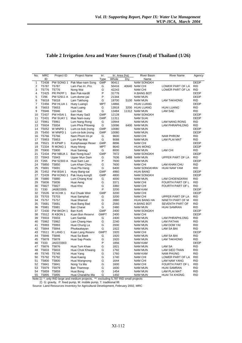
Vol. II: Supporting Report, Paper IX: Water Use ManagementWUP-JICA, March 2004
Table 2 Irrigation Area and Water Sources (Total) of Thailand (1/26)
No. MRC Project ID Project Name Irr. River Basin River Name AgencyID Type Whole Dry Name
1 T2438 PW SONG 1 Pak Mae-nam Song GMP 90411 NAM SONGKH DEDP2 T5787 T5787 Lam Pao Irr. Pro G 50416 40640 NAM CHI LOWER PART OF LA RID3 T5776 T5776 Nong Wai G 42243 NAM CHI LOWER PART OF LA RID4 T2425 PR PKPP 1 Ban Pak-kard8 P 31776 H.BANG BOT DEDP5 T296 PW 52911 A Lum-dome-yai P 21344 NAM MUN DEDP6 T6018 T6018 Lam Takhong G 19700 5100 NAM MUN LAM TAKHONG RID7 T2456 PW HLUA 1 Huey Luang1 MPT 14866 HUAI LUANG DEDP8 T5653 T5653 Huai Luang G 13918 3200 HUAI LUANG HUAI LUANG RID9 T5946 T5946 Lam Sae G 13484 11312 NAM MUN LAM SAE RID
10 T2437 PW HSAI 1 Ban Huey Sai3 GMP 12128 NAM SONGKH DEDP11 T2431 PW SUAY 1 Mae Nam-suey GMP 11311 NAM SUAI DEDP12 T5961 T5961 Lum Nang Rong G 10944 NAM MUN LAM NANG RONG RID13 T5934 T5934 Lum Phra Phloeng G 10096 6400 NAM MUN LAM PHRAPHLONG RID14 T5052 W MNPD 1 Lum-ce-bok (nong GMP 10080 NAM MUN DEDP15 T5450 W MNPD 1 Lum-ce-bok (nong GMP 10080 NAM MUN DEDP16 T5766 T5766 Nam Phom Irri.pr G 9600 NAM CHI NAM PHROM RID17 T5953 T5953 Lum Plai Mat G 9088 NAM MUN LAM PLAI MAT RID18 T5521 R KPWP 1 Kumphawapi Reser GMP 8896 NAM CHI DEDP19 T2334 R MONG 1 Huey Mong MPT 8640 HUAI MONG DEDP20 T5900 T5900 Huai Saneag G 8000 NAM MUN LAM CHI RID21 T2434 PW NBUA 1 Ban Nong-bua7 GMP 7872 NAM SONGKH DEDP22 T5943 T5943 Upper Mun Dam G 7636 5488 NAM MUN UPPER PART OF LA RID23 T265 PW 52303 A Huai Sam Lan P 7600 NAM MUN DEDP24 T5850 T5850 Lum Khan Choo G 7600 NAM CHI LAM KHAN CHU RID25 T5691 T5691 Huai Pla Hang G 6400 NAM SONGKHRA HUAI NAM YAM RID26 T2452 PW BSAI 1 Huey Bang-sai GMP 4960 HUAI BANG DEDP27 T2439 PW KONG 1 Pak Huey-kong5 GMP 4800 NAM SONGKH DEDP28 T5880 T5880 Lum Chiang Krai G 4000 NAM MUN LAM CHOENGKRAI RID29 T5836 T5836 Huai Aeng G 3371 NAM CHI FOURTH PART OF L RID30 T5827 T5827 Huai Kho G 3360 NAM CHI FOURTH PART OF L RID31 T330 JA0823305 P 3200 NAM KAM DEDP32 T5535 W KCHK 1 Kui Chuak Weir GMP 3200 NAM CHI DEDP33 T5703 T5703 Huai Samphat G 3200 NAM CHI UPPER PART OF LA RID34 T5757 T5757 Huai Shanod G 2880 HUAI BANG HA NINETH PART OF M RID35 T5681 T5681 Huai Bang Bad G 2560 H.BANG BOT SEVENTH PART OF RID36 T5981 T5981 Ban Charat G 2480 NAM MUN HUAI SAMRAN RID37 T2430 PW BKOH 1 Ban Kor6 GMP 2400 NAM SONGKH DEDP38 T5512 R KBON 1 Kuan Bon Reservi GMPT 2400 NAM CHI DEDP39 T5933 T5933 Lam Samlai G 2400 NAM MUN LAM PHRAPHLONG RID40 T5962 T5962 Lam Chang Han G 2240 NAM MUN LAM PATHAI RID41 T5993 T5993 Huai Chung La G 2000 NAM MUN LAM DOM YAI RID42 T5844 T5844 Phuttauttayan G 1922 NAM MUN LAM SA BAI RID43 T5511 R LANG 1 Kuan Lang Reserv GMPT 1920 NAM CHI DEDP44 T5846 T5846 Huai Sa Baek G 1920 NAM MUN LAM SA BAI RID45 T5878 T5878 Huai Sap Pradu G 1920 NAM MUN LAM TAKHONG RID46 T333 JA0223303 P 1856 NAM KAM DEDP47 T5876 T5876 Huai Tum Khae G 1821 NAM MUN LAM SA RID48 T5833 T5833 Huai Chok Khwang G 1792 NAM MUN LAM SIEO THAN RID49 T5745 T5745 Huai Yang G 1760 NAM KAM NAM PHUNG RID50 T5792 T5792 Huai Kaeng G 1740 NAM CHI LOWER PART OF LA RID51 T5800 T5800 Huai Wangnong G 1644 NAM CHI LAM NAM YANG RID52 T5841 T5841 Nong Ya Ma G 1600 NAM CHI FOURTH PART OF L RID53 T5979 T5979 Ban Thamnop G 1600 NAM MUN HUAI SAMRAN RID54 T5859 T5859 Huai Bong G 1454 NAM MUN LAM PLAI MAT RID55 T5895 T5895 Huai Charakhe Ma G 1450 NAM MUN HUAI TA KHONG RID
Note:1): *: only RID large and medium projects, **: excluding 5,787 RID small projects :2) G: gravity, P: fixed pump, M: mobile pump, T: traditional liftSource: Land Resources Inventory for Agricultural Development, February 2002, MRC
Irr. Area (ha)
XI-112
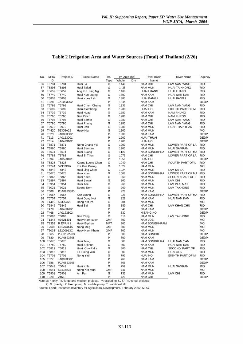
Vol. II: Supporting Report, Paper IX: Water Use ManagementWUP-JICA, March 2004
Table 2 Irrigation Area and Water Sources (Total) of Thailand (2/26)
River Basin River Name Agencye Dry Name0 NAM CHI LAM NAM YANG RID8 NAM MUN HUAI TA KHONG RID8 HUAI LUANG HUAI LUANG RID2 NAM KAM HUAI NAM KAM RID0 HUAI BANG I HUAI BANG I RID4 NAM KAM DEDP3 NAM CHI LAM NAM YANG RID0 HUAI HO EIGHTH PART OF M RID
NAM KAM NAM PHUNG RIDNAM CHI NAM PHROM RID
0 NAM CHI LAM NAM YANG RID0 NAM CHI LAM NAM YANG RID0 NAM MUN HUAI THAP THAN RID0 NAM MUN MOI0 NAM KAM DEDP0 HUAI THUAI DEDP0 HUAI HO DEDP0 NAM MUN LOWER PART OF LA RID0 NAM MUN HUAI SAMRAN RID0 NAM SONGKHRA LOWER PART OF MA RID3 NAM CHI LOWER PART OF LA RID6 HUAI HO DEDP0 NAM CHI FOURTH PART OF L RID4 NAM MUN MOI4 NAM MUN LAM SA BAI RID8 NAM SONGKHRA LOWER PART OF MA RID
60 NAM MUN SECOND PART OF L RID0 NAM MUN LAM CHI RID
60 NAM MUN LAM PLAI MAT RID60 NAM MUN LAM TAKHONG RID8 NAM KAM DEDP8 NAM SONGKHRA LOWER PART OF MA RID8 NAM KAM HUAI NAM KAM RID4 NAM MUN MOI0 NAM CHI LAM KHAN CHU RID0 NAM KAM DEDP2 H.BANG KOI DEDP
16 NAM MUN LAM TAKHONG RID0 NAM LOEI MOI0 NAM SONGKHRAM MOI0 NAM MUN MOI0 NAM MUN MOI
00 NAM SONGKH DEDP0 NAM KAM DEDP0 NAM SONGKHRA HUAI NAM YAM RID0 NAM KAM HUAI NAM KAM RID
00 NAM CHI SECOND PART OF RID0 NAM MUN HUAI AEK RID2 HUAI HO EIGHTH PART OF M RID8 NAM KAM DEDP8 NAM KAM DEDP2 NAM MUN HUAI SAMRAN RID1 NAM MUN MOI6 NAM MUN LAM CHI RID0 NAM CHI DEDP7 RID small projects
rea (ha)No. MRC Project ID Project Name Irr.ID Type Whol
56 T5794 T5794 Huai Fa G 14457 T5896 T5896 Huai Talad G 14358 T5659 T5659 Ang Kut Ling Ng G 14059 T5749 T5749 Huai Kan Lueng G 13960 T5803 T5803 Huai Khee Lek G 13861 T328 JA1023302 P 13462 T5798 T5798 Huai Chum Chang G 13363 T5699 T5699 Hiaui Somhong G 12864 T5739 T5739 Huai Huad G 128065 T5765 T5765 Ban Petch G 128066 T5793 T5793 Huai Sathot G 12867 T5795 T5795 Huai Phung G 12868 T5975 T5975 Huai Dan G 12869 T4420 52305A29 Huey Kla G 12070 T329 JA0823302 P 12071 T613 JA0123001 P 12072 T614 JA0423102 P 12073 T5871 T5871 Nong Chang Yai G 12074 T5980 T5980 Huai Samran G 12075 T5674 T5674 Huai Suang G 11276 T5788 T5788 Huai Si Thon G 10777 T594 JA0523101 P 10578 T5828 T5828 Kaeng Loeng Chan G 10479 T4244 52302D07 Kra Bue Pueng G 10280 T5842 T5842 Huai Ling Chon G 10281 T5675 T5675 Huia Kum G 10082 T5865 T5865 Huai Kaeo G 983 T5897 T5897 Huai Sawai G 9684 T5954 T5954 Huai Toei G 985 T6021 T6021 Soong Nern G 986 T688 PJA0923305 P 9287 T5667 T5667 Kan Luang G 9288 T5754 T5754 Huai Dong Noi G 9289 T4419 52305A28 Rong Kra Po G 9090 T5849 T5849 Huai Sai G 8891 T470 JA0423202 P 8492 T468 JA0123802 P 8393 T5883 T5883 Ban Yang G 894 T1344 A0621401 Huey Nam-suey GMP 8095 T2353 R EPAN 1 Huey E-phun MPT 8096 T2608 L5120344A Nong Meg GMP 8097 T3033 L5200913C Huey Nam Khem GMP 8098 T665 PJC0122903 P 899 T680 PJA0623305 P 80
100 T5676 T5676 Huai Tong G 80101 T5750 T5750 Huai Srikhun G 80102 T5811 T5811 Huai Cho Raka G 8103 T5816 T5816 La Lueng Wai G 80104 T5701 T5701 Nong Yati G 79105 T327 JA0923302 P 76106 T686 PJA0823305 P 76107 T6042 T6042 Huai Khla G 75108 T4541 52402A34 Nong Kra Mun GMP 74109 T5901 T5901 Am Pun G 73110 T928 246E P 72
Note:1): *: only RID large and medium projects, **: excluding 5,78 :2) G: gravity, P: fixed pump, M: mobile pump, T: traditional liftSource: Land Resources Inventory for Agricultural Development, February 2002, MRC
Irr. A
XI-113
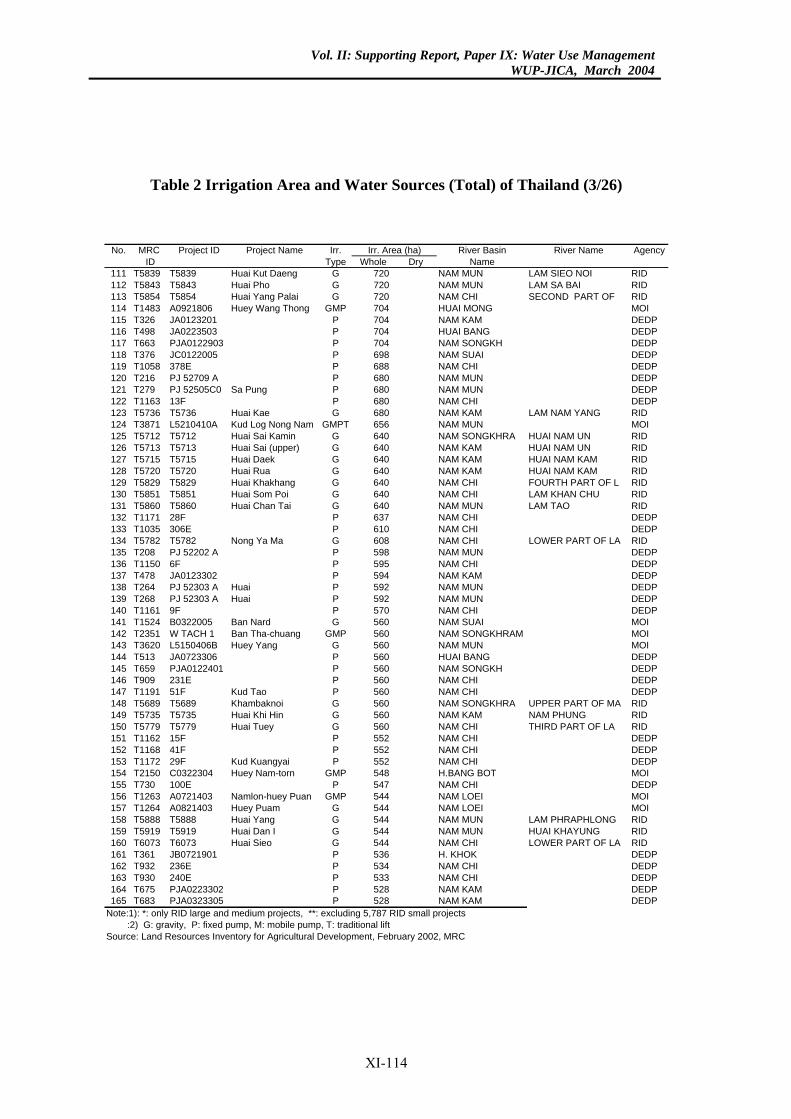
Vol. II: Supporting Report, Paper IX: Water Use ManagementWUP-JICA, March 2004
Table 2 Irrigation Area and Water Sources (Total) of Thailand (3/26)
River Basin River Name Agencye Dry Name0 NAM MUN LAM SIEO NOI RID0 NAM MUN LAM SA BAI RID0 NAM CHI SECOND PART OF RID4 HUAI MONG MOI4 NAM KAM DEDP4 HUAI BANG DEDP4 NAM SONGKH DEDP8 NAM SUAI DEDP8 NAM CHI DEDP0 NAM MUN DEDP0 NAM MUN DEDP0 NAM CHI DEDP0 NAM KAM LAM NAM YANG RID6 NAM MUN MOI0 NAM SONGKHRA HUAI NAM UN RID0 NAM KAM HUAI NAM UN RID0 NAM KAM HUAI NAM KAM RID0 NAM KAM HUAI NAM KAM RID0 NAM CHI FOURTH PART OF L RID0 NAM CHI LAM KHAN CHU RID0 NAM MUN LAM TAO RID7 NAM CHI DEDP0 NAM CHI DEDP8 NAM CHI LOWER PART OF LA RID8 NAM MUN DEDP
95 NAM CHI DEDP4 NAM KAM DEDP2 NAM MUN DEDP2 NAM MUN DEDP
70 NAM CHI DEDP0 NAM SUAI MOI0 NAM SONGKHRAM MOI0 NAM MUN MOI0 HUAI BANG DEDP0 NAM SONGKH DEDP0 NAM CHI DEDP0 NAM CHI DEDP0 NAM SONGKHRA UPPER PART OF MA RID
NAM KAM NAM PHUNG RID0 NAM CHI THIRD PART OF LA RID2 NAM CHI DEDP2 NAM CHI DEDP
52 NAM CHI DEDP8 H.BANG BOT MOI7 NAM CHI DEDP
44 NAM LOEI MOI4 NAM LOEI MOI4 NAM MUN LAM PHRAPHLONG RID4 NAM MUN HUAI KHAYUNG RID4 NAM CHI LOWER PART OF LA RID6 H. KHOK DEDP4 NAM CHI DEDP3 NAM CHI DEDP8 NAM KAM DEDP8 NAM KAM DEDP7 RID small projects
rea (ha)No. MRC Project ID Project Name Irr.ID Type Whol
111 T5839 T5839 Huai Kut Daeng G 72112 T5843 T5843 Huai Pho G 72113 T5854 T5854 Huai Yang Palai G 72114 T1483 A0921806 Huey Wang Thong GMP 70115 T326 JA0123201 P 70116 T498 JA0223503 P 70117 T663 PJA0122903 P 70118 T376 JC0122005 P 69119 T1058 378E P 68120 T216 PJ 52709 A P 68121 T279 PJ 52505C0 Sa Pung P 68122 T1163 13F P 68123 T5736 T5736 Huai Kae G 68124 T3871 L5210410A Kud Log Nong Nam GMPT 65125 T5712 T5712 Huai Sai Kamin G 64126 T5713 T5713 Huai Sai (upper) G 64127 T5715 T5715 Huai Daek G 64128 T5720 T5720 Huai Rua G 64129 T5829 T5829 Huai Khakhang G 64130 T5851 T5851 Huai Som Poi G 64131 T5860 T5860 Huai Chan Tai G 64132 T1171 28F P 63133 T1035 306E P 61134 T5782 T5782 Nong Ya Ma G 60135 T208 PJ 52202 A P 59136 T1150 6F P 5137 T478 JA0123302 P 59138 T264 PJ 52303 A Huai P 59139 T268 PJ 52303 A Huai P 59140 T1161 9F P 5141 T1524 B0322005 Ban Nard G 56142 T2351 W TACH 1 Ban Tha-chuang GMP 56143 T3620 L5150406B Huey Yang G 56144 T513 JA0723306 P 56145 T659 PJA0122401 P 56146 T909 231E P 56147 T1191 51F Kud Tao P 56148 T5689 T5689 Khambaknoi G 56149 T5735 T5735 Huai Khi Hin G 560150 T5779 T5779 Huai Tuey G 56151 T1162 15F P 55152 T1168 41F P 55153 T1172 29F Kud Kuangyai P 5154 T2150 C0322304 Huey Nam-torn GMP 54155 T730 100E P 54156 T1263 A0721403 Namlon-huey Puan GMP 5157 T1264 A0821403 Huey Puam G 54158 T5888 T5888 Huai Yang G 54159 T5919 T5919 Huai Dan I G 54160 T6073 T6073 Huai Sieo G 54161 T361 JB0721901 P 53162 T932 236E P 53163 T930 240E P 53164 T675 PJA0223302 P 52165 T683 PJA0323305 P 52
Note:1): *: only RID large and medium projects, **: excluding 5,78 :2) G: gravity, P: fixed pump, M: mobile pump, T: traditional liftSource: Land Resources Inventory for Agricultural Development, February 2002, MRC
Irr. A
XI-114
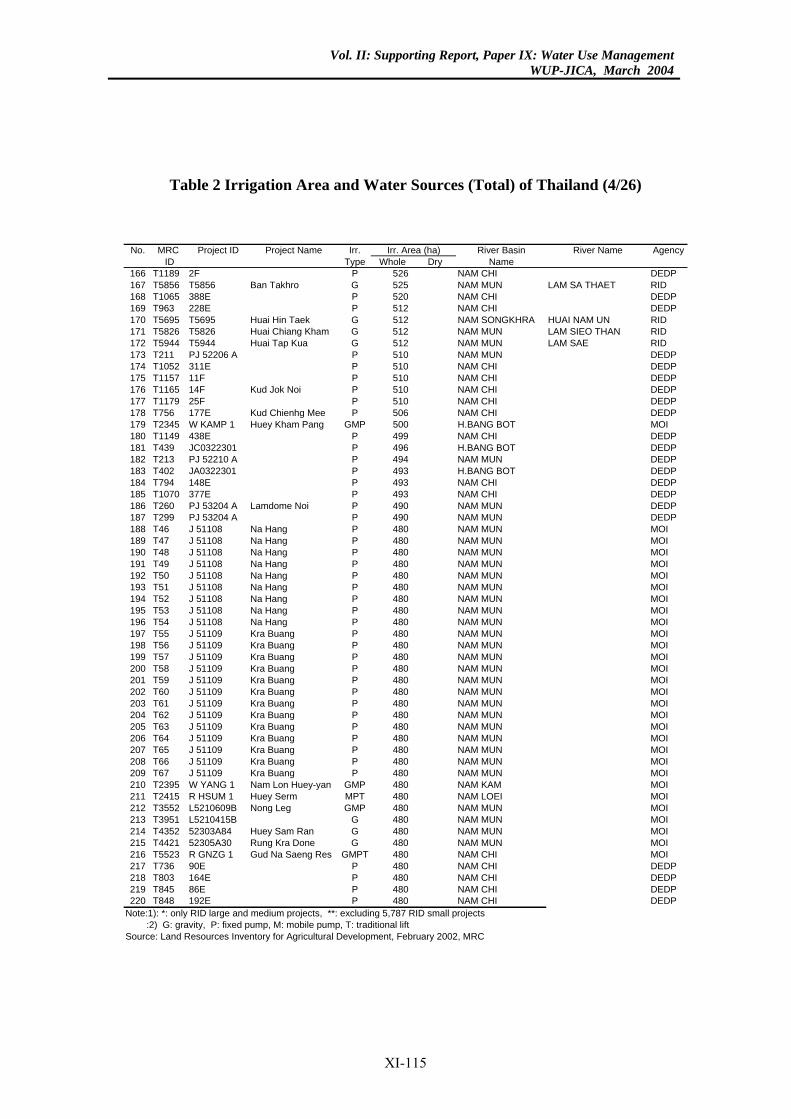
Vol. II: Supporting Report, Paper IX: Water Use ManagementWUP-JICA, March 2004
Table 2 Irrigation Area and Water Sources (Total) of Thailand (4/26)
River Basin River Name Agencye Dry Name26 NAM CHI DEDP5 NAM MUN LAM SA THAET RID0 NAM CHI DEDP2 NAM CHI DEDP
12 NAM SONGKHRA HUAI NAM UN RID2 NAM MUN LAM SIEO THAN RID2 NAM MUN LAM SAE RID0 NAM MUN DEDP0 NAM CHI DEDP0 NAM CHI DEDP0 NAM CHI DEDP0 NAM CHI DEDP6 NAM CHI DEDP0 H.BANG BOT MOI9 NAM CHI DEDP6 H.BANG BOT DEDP4 NAM MUN DEDP3 H.BANG BOT DEDP3 NAM CHI DEDP3 NAM CHI DEDP0 NAM MUN DEDP0 NAM MUN DEDP
80 NAM MUN MOI80 NAM MUN MOI80 NAM MUN MOI80 NAM MUN MOI80 NAM MUN MOI80 NAM MUN MOI80 NAM MUN MOI80 NAM MUN MOI80 NAM MUN MOI0 NAM MUN MOI0 NAM MUN MOI0 NAM MUN MOI0 NAM MUN MOI0 NAM MUN MOI0 NAM MUN MOI0 NAM MUN MOI0 NAM MUN MOI0 NAM MUN MOI0 NAM MUN MOI0 NAM MUN MOI0 NAM MUN MOI0 NAM MUN MOI0 NAM KAM MOI0 NAM LOEI MOI0 NAM MUN MOI0 NAM MUN MOI0 NAM MUN MOI0 NAM MUN MOI
80 NAM CHI MOI80 NAM CHI DEDP0 NAM CHI DEDP
80 NAM CHI DEDP0 NAM CHI DEDP7 RID small projects
rea (ha)No. MRC Project ID Project Name Irr.ID Type Whol
166 T1189 2F P 5167 T5856 T5856 Ban Takhro G 52168 T1065 388E P 52169 T963 228E P 51170 T5695 T5695 Huai Hin Taek G 5171 T5826 T5826 Huai Chiang Kham G 51172 T5944 T5944 Huai Tap Kua G 51173 T211 PJ 52206 A P 51174 T1052 311E P 51175 T1157 11F P 51176 T1165 14F Kud Jok Noi P 51177 T1179 25F P 51178 T756 177E Kud Chienhg Mee P 50179 T2345 W KAMP 1 Huey Kham Pang GMP 50180 T1149 438E P 49181 T439 JC0322301 P 49182 T213 PJ 52210 A P 49183 T402 JA0322301 P 49184 T794 148E P 49185 T1070 377E P 49186 T260 PJ 53204 A Lamdome Noi P 49187 T299 PJ 53204 A P 49188 T46 J 51108 Na Hang P 4189 T47 J 51108 Na Hang P 4190 T48 J 51108 Na Hang P 4191 T49 J 51108 Na Hang P 4192 T50 J 51108 Na Hang P 4193 T51 J 51108 Na Hang P 4194 T52 J 51108 Na Hang P 4195 T53 J 51108 Na Hang P 4196 T54 J 51108 Na Hang P 4197 T55 J 51109 Kra Buang P 48198 T56 J 51109 Kra Buang P 48199 T57 J 51109 Kra Buang P 48200 T58 J 51109 Kra Buang P 48201 T59 J 51109 Kra Buang P 48202 T60 J 51109 Kra Buang P 48203 T61 J 51109 Kra Buang P 48204 T62 J 51109 Kra Buang P 48205 T63 J 51109 Kra Buang P 48206 T64 J 51109 Kra Buang P 48207 T65 J 51109 Kra Buang P 48208 T66 J 51109 Kra Buang P 48209 T67 J 51109 Kra Buang P 48210 T2395 W YANG 1 Nam Lon Huey-yan GMP 48211 T2415 R HSUM 1 Huey Serm MPT 48212 T3552 L5210609B Nong Leg GMP 48213 T3951 L5210415B G 48214 T4352 52303A84 Huey Sam Ran G 48215 T4421 52305A30 Rung Kra Done G 48216 T5523 R GNZG 1 Gud Na Saeng Res GMPT 4217 T736 90E P 4218 T803 164E P 48219 T845 86E P 4220 T848 192E P 48
Note:1): *: only RID large and medium projects, **: excluding 5,78 :2) G: gravity, P: fixed pump, M: mobile pump, T: traditional liftSource: Land Resources Inventory for Agricultural Development, February 2002, MRC
Irr. A
XI-115
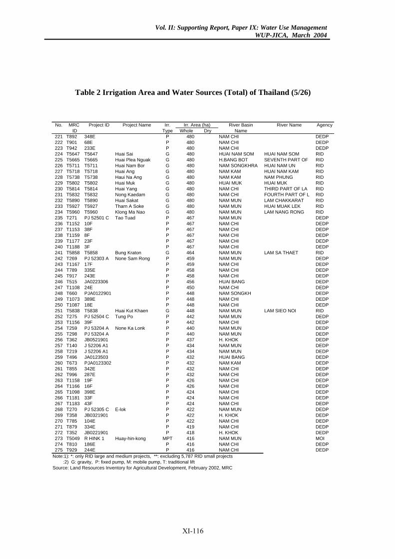
Vol. II: Supporting Report, Paper IX: Water Use ManagementWUP-JICA, March 2004
Table 2 Irrigation Area and Water Sources (Total) of Thailand (5/26)
River Basin River Name AgencyDry Name
80 NAM CHI DEDP80 NAM CHI DEDP80 NAM CHI DEDP
0 HUAI NAM SOM HUAI NAM SOM RID80 H.BANG BOT SEVENTH PART OF RID
0 NAM SONGKHRA HUAI NAM UN RID0 NAM KAM HUAI NAM KAM RID
NAM KAM NAM PHUNG RID0 HUAI MUK HUAI MUK RID
80 NAM CHI THIRD PART OF LA RID80 NAM CHI FOURTH PART OF L RID
0 NAM MUN LAM CHAKKARAT RID80 NAM MUN HUAI MUAK LEK RID0 NAM MUN LAM NANG RONG RID
67 NAM MUN DEDP67 NAM CHI DEDP67 NAM CHI DEDP
NAM CHI DEDP67 NAM CHI DEDP
NAM CHI DEDP64 NAM MUN LAM SA THAET RID59 NAM MUN DEDP59 NAM CHI DEDP58 NAM CHI DEDP58 NAM CHI DEDP56 HUAI BANG DEDP50 NAM CHI DEDP
8 NAM SONGKH DEDP48 NAM CHI DEDP48 NAM CHI DEDP
8 NAM MUN LAM SIEO NOI RID42 NAM MUN DEDP42 NAM CHI DEDP40 NAM MUN DEDP
0 NAM MUN DEDP37 H. KHOK DEDP34 NAM MUN DEDP34 NAM MUN DEDP32 HUAI BANG DEDP
2 NAM KAM DEDP32 NAM CHI DEDP32 NAM CHI DEDP26 NAM CHI DEDP26 NAM CHI DEDP24 NAM CHI DEDP24 NAM CHI DEDP24 NAM CHI DEDP22 NAM MUN DEDP22 H. KHOK DEDP22 NAM CHI DEDP19 NAM CHI DEDP18 H. KHOK DEDP16 NAM MUN MOI16 NAM CHI DEDP16 NAM CHI DEDP7 RID small projects
rea (ha)No. MRC Project ID Project Name Irr.ID Type Whole
221 T892 348E P 4222 T901 68E P 4223 T942 233E P 4224 T5647 T5647 Huai Sai G 48225 T5665 T5665 Huai Plea Nguak G 4226 T5711 T5711 Huai Nam Bor G 48227 T5718 T5718 Huai Ang G 48228 T5738 T5738 Haui Na Ang G 480229 T5802 T5802 Huai Muk G 48230 T5814 T5814 Huai Yang G 4231 T5832 T5832 Nong Kaedam G 4232 T5890 T5890 Huai Sakat G 48233 T5927 T5927 Tharn A Soke G 4234 T5960 T5960 Klong Ma Nao G 48235 T271 PJ 52501 C Tao Tuad P 4236 T1152 10F P 4237 T1153 38F P 4238 T1159 8F P 467239 T1177 23F P 4240 T1188 3F P 467241 T5858 T5858 Bung Kraton G 4242 T269 PJ 52303 A None Sam Rong P 4243 T1167 17F P 4244 T789 335E P 4245 T917 243E P 4246 T515 JA0223306 P 4247 T1108 24E P 4248 T660 PJA0122901 P 44249 T1073 389E P 4250 T1087 18E P 4251 T5838 T5838 Huai Kut Khaen G 44252 T275 PJ 52504 C Tung Po P 4253 T1156 39F P 4254 T259 PJ 53204 A None Ka Lonk P 4255 T298 PJ 53204 A P 44256 T362 JB0521901 P 4257 T140 J 52206 A1 P 4258 T219 J 52206 A1 P 4259 T496 JA0123503 P 4260 T673 PJA0123302 P 43261 T855 342E P 4262 T996 287E P 4263 T1158 19F P 4264 T1166 16F P 4265 T1098 398E P 4266 T1181 33F P 4267 T1183 43F P 4268 T270 PJ 52305 C E-lok P 4269 T358 JB0321901 P 4270 T785 104E P 4271 T879 334E P 4272 T352 JB0221901 P 4273 T5049 R HINK 1 Huay-hin-kong MPT 4274 T810 186E P 4275 T929 244E P 4
Note:1): *: only RID large and medium projects, **: excluding 5,78 :2) G: gravity, P: fixed pump, M: mobile pump, T: traditional liftSource: Land Resources Inventory for Agricultural Development, February 2002, MRC
Irr. A
XI-116
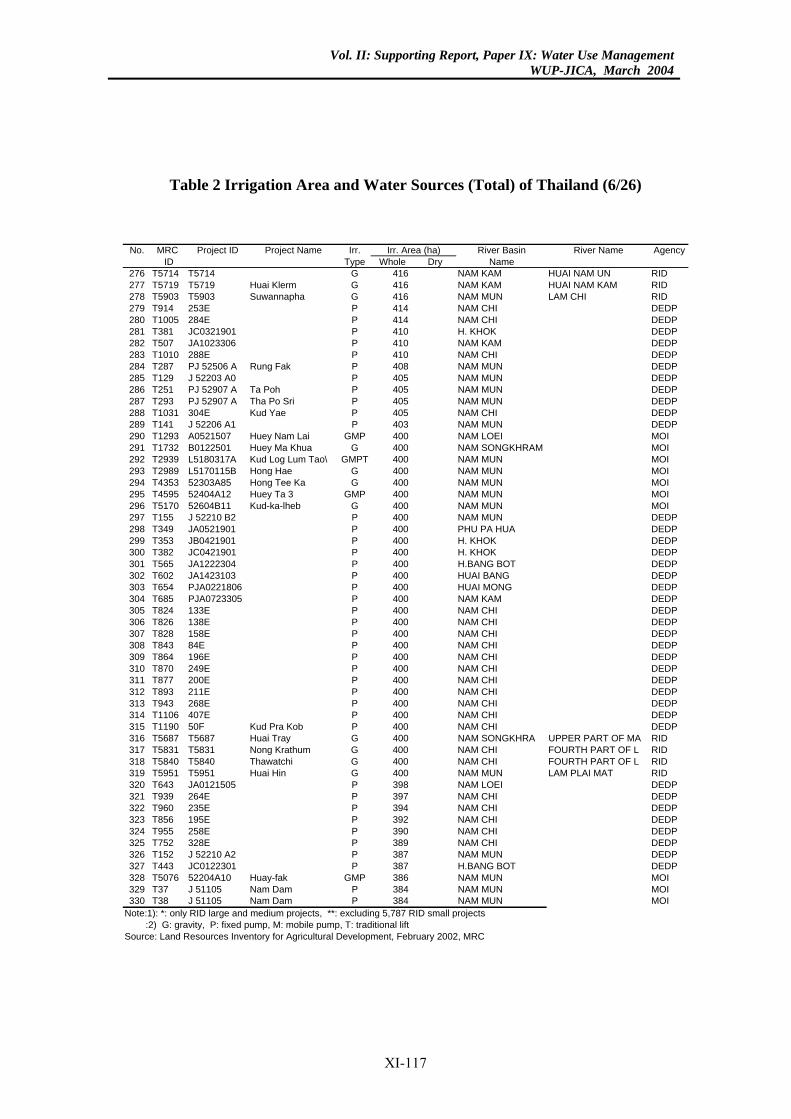
Vol. II: Supporting Report, Paper IX: Water Use ManagementWUP-JICA, March 2004
Table 2 Irrigation Area and Water Sources (Total) of Thailand (6/26)
River Basin River Name AgencyDry Name
16 NAM KAM HUAI NAM UN RID6 NAM KAM HUAI NAM KAM RID
16 NAM MUN LAM CHI RID14 NAM CHI DEDP14 NAM CHI DEDP
0 H. KHOK DEDP10 NAM KAM DEDP10 NAM CHI DEDP
8 NAM MUN DEDP05 NAM MUN DEDP
5 NAM MUN DEDP5 NAM MUN DEDP5 NAM CHI DEDP
03 NAM MUN DEDP00 NAM LOEI MOI00 NAM SONGKHRAM MOI
0 NAM MUN MOI0 NAM MUN MOI
00 NAM MUN MOI0 NAM MUN MOI0 NAM MUN MOI
00 NAM MUN DEDP00 PHU PA HUA DEDP00 H. KHOK DEDP
0 H. KHOK DEDP00 H.BANG BOT DEDP00 HUAI BANG DEDP
0 HUAI MONG DEDP0 NAM KAM DEDP
00 NAM CHI DEDP00 NAM CHI DEDP00 NAM CHI DEDP00 NAM CHI DEDP00 NAM CHI DEDP00 NAM CHI DEDP00 NAM CHI DEDP00 NAM CHI DEDP00 NAM CHI DEDP00 NAM CHI DEDP
0 NAM CHI DEDP00 NAM SONGKHRA UPPER PART OF MA RID00 NAM CHI FOURTH PART OF L RID
0 NAM CHI FOURTH PART OF L RID0 NAM MUN LAM PLAI MAT RID
98 NAM LOEI DEDP97 NAM CHI DEDP94 NAM CHI DEDP92 NAM CHI DEDP90 NAM CHI DEDP89 NAM CHI DEDP87 NAM MUN DEDP
7 H.BANG BOT DEDP86 NAM MUN MOI
4 NAM MUN MOI4 NAM MUN MOI7 RID small projects
rea (ha)No. MRC Project ID Project Name Irr.ID Type Whole
276 T5714 T5714 G 4277 T5719 T5719 Huai Klerm G 41278 T5903 T5903 Suwannapha G 4279 T914 253E P 4280 T1005 284E P 4281 T381 JC0321901 P 41282 T507 JA1023306 P 4283 T1010 288E P 4284 T287 PJ 52506 A Rung Fak P 40285 T129 J 52203 A0 P 4286 T251 PJ 52907 A Ta Poh P 40287 T293 PJ 52907 A Tha Po Sri P 40288 T1031 304E Kud Yae P 40289 T141 J 52206 A1 P 4290 T1293 A0521507 Huey Nam Lai GMP 4291 T1732 B0122501 Huey Ma Khua G 4292 T2939 L5180317A Kud Log Lum Tao\ GMPT 40293 T2989 L5170115B Hong Hae G 40294 T4353 52303A85 Hong Tee Ka G 4295 T4595 52404A12 Huey Ta 3 GMP 40296 T5170 52604B11 Kud-ka-lheb G 40297 T155 J 52210 B2 P 4298 T349 JA0521901 P 4299 T353 JB0421901 P 4300 T382 JC0421901 P 40301 T565 JA1222304 P 4302 T602 JA1423103 P 4303 T654 PJA0221806 P 40304 T685 PJA0723305 P 40305 T824 133E P 4306 T826 138E P 4307 T828 158E P 4308 T843 84E P 4309 T864 196E P 4310 T870 249E P 4311 T877 200E P 4312 T893 211E P 4313 T943 268E P 4314 T1106 407E P 4315 T1190 50F Kud Pra Kob P 40316 T5687 T5687 Huai Tray G 4317 T5831 T5831 Nong Krathum G 4318 T5840 T5840 Thawatchi G 40319 T5951 T5951 Huai Hin G 40320 T643 JA0121505 P 3321 T939 264E P 3322 T960 235E P 3323 T856 195E P 3324 T955 258E P 3325 T752 328E P 3326 T152 J 52210 A2 P 3327 T443 JC0122301 P 38328 T5076 52204A10 Huay-fak GMP 3329 T37 J 51105 Nam Dam P 38330 T38 J 51105 Nam Dam P 38
Note:1): *: only RID large and medium projects, **: excluding 5,78 :2) G: gravity, P: fixed pump, M: mobile pump, T: traditional liftSource: Land Resources Inventory for Agricultural Development, February 2002, MRC
Irr. A
XI-117
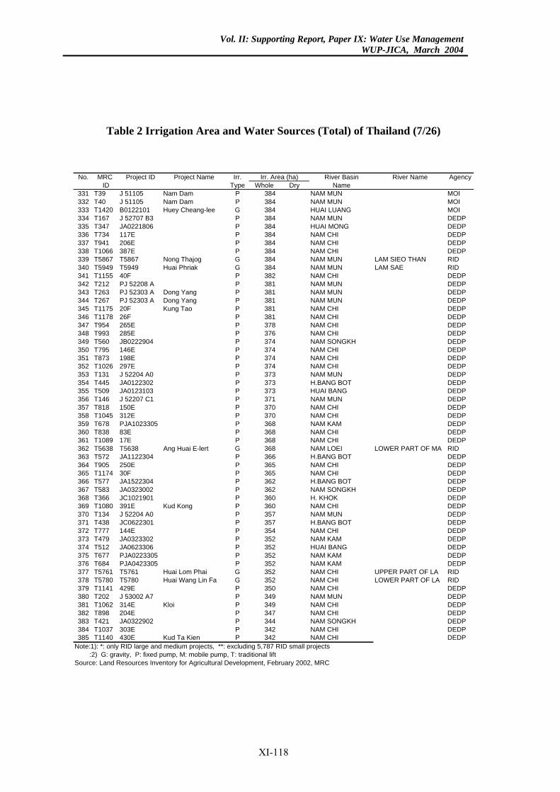
Vol. II: Supporting Report, Paper IX: Water Use ManagementWUP-JICA, March 2004
Table 2 Irrigation Area and Water Sources (Total) of Thailand (7/26)
River Basin River Name AgencyDry Name
4 NAM MUN MOI4 NAM MUN MOI4 HUAI LUANG MOI
84 NAM MUN DEDP84 HUAI MONG DEDP84 NAM CHI DEDP84 NAM CHI DEDP84 NAM CHI DEDP84 NAM MUN LAM SIEO THAN RID84 NAM MUN LAM SAE RID82 NAM CHI DEDP
1 NAM MUN DEDP81 NAM MUN DEDP81 NAM MUN DEDP
NAM CHI DEDP81 NAM CHI DEDP78 NAM CHI DEDP76 NAM CHI DEDP74 NAM SONGKH DEDP74 NAM CHI DEDP74 NAM CHI DEDP74 NAM CHI DEDP73 NAM MUN DEDP73 H.BANG BOT DEDP73 HUAI BANG DEDP71 NAM MUN DEDP70 NAM CHI DEDP70 NAM CHI DEDP
8 NAM KAM DEDP68 NAM CHI DEDP68 NAM CHI DEDP68 NAM LOEI LOWER PART OF MA RID66 H.BANG BOT DEDP65 NAM CHI DEDP65 NAM CHI DEDP62 H.BANG BOT DEDP62 NAM SONGKH DEDP
0 H. KHOK DEDP60 NAM CHI DEDP57 NAM MUN DEDP
7 H.BANG BOT DEDP54 NAM CHI DEDP52 NAM KAM DEDP52 HUAI BANG DEDP
2 NAM KAM DEDP2 NAM KAM DEDP
52 NAM CHI UPPER PART OF LA RID52 NAM CHI LOWER PART OF LA RID50 NAM CHI DEDP49 NAM MUN DEDP49 NAM CHI DEDP47 NAM CHI DEDP44 NAM SONGKH DEDP42 NAM CHI DEDP42 NAM CHI DEDP7 RID small projects
rea (ha)No. MRC Project ID Project Name Irr.ID Type Whole
331 T39 J 51105 Nam Dam P 38332 T40 J 51105 Nam Dam P 38333 T1420 B0122101 Huey Cheang-lee G 38334 T167 J 52707 B3 P 3335 T347 JA0221806 P 3336 T734 117E P 3337 T941 206E P 3338 T1066 387E P 3339 T5867 T5867 Nong Thajog G 3340 T5949 T5949 Huai Phriak G 3341 T1155 40F P 3342 T212 PJ 52208 A P 38343 T263 PJ 52303 A Dong Yang P 3344 T267 PJ 52303 A Dong Yang P 3345 T1175 20F Kung Tao P 381346 T1178 26F P 3347 T954 265E P 3348 T993 285E P 3349 T560 JB0222904 P 3350 T795 146E P 3351 T873 198E P 3352 T1026 297E P 3353 T131 J 52204 A0 P 3354 T445 JA0122302 P 3355 T509 JA0123103 P 3356 T146 J 52207 C1 P 3357 T818 150E P 3358 T1045 312E P 3359 T678 PJA1023305 P 36360 T838 83E P 3361 T1089 17E P 3362 T5638 T5638 Ang Huai E-lert G 3363 T572 JA1122304 P 3364 T905 250E P 3365 T1174 30F P 3366 T577 JA1522304 P 3367 T583 JA0323002 P 3368 T366 JC1021901 P 36369 T1080 391E Kud Kong P 3370 T134 J 52204 A0 P 3371 T438 JC0622301 P 35372 T777 144E P 3373 T479 JA0323302 P 3374 T512 JA0623306 P 3375 T677 PJA0223305 P 35376 T684 PJA0423305 P 35377 T5761 T5761 Huai Lom Phai G 3378 T5780 T5780 Huai Wang Lin Fa G 3379 T1141 429E P 3380 T202 J 53002 A7 P 3381 T1062 314E Kloi P 3382 T898 204E P 3383 T421 JA0322902 P 3384 T1037 303E P 3385 T1140 430E Kud Ta Kien P 3
Note:1): *: only RID large and medium projects, **: excluding 5,78 :2) G: gravity, P: fixed pump, M: mobile pump, T: traditional liftSource: Land Resources Inventory for Agricultural Development, February 2002, MRC
Irr. A
XI-118
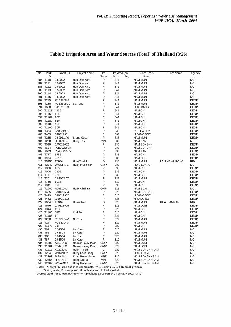
Vol. II: Supporting Report, Paper IX: Water Use ManagementWUP-JICA, March 2004
Table 2 Irrigation Area and Water Sources (Total) of Thailand (8/26)
River Basin River Name AgencyDry Name
41 NAM MUN MOI41 NAM MUN MOI41 NAM MUN MOI41 NAM MUN MOI41 NAM MUN MOI41 NAM MUN MOI
1 NAM MUN DEDP41 NAM MUN DEDP41 HUAI BANG DEDP41 NAM CHI DEDP41 NAM CHI DEDP41 NAM CHI DEDP41 NAM CHI DEDP41 NAM CHI DEDP41 NAM CHI DEDP39 PHU PA HUA DEDP39 H.BANG BOT DEDP38 NAM MUN DEDP
6 NAM KAM MOI36 NAM SONGKH DEDP
6 NAM SONGKH DEDP6 NAM KAM DEDP
36 NAM CHI DEDP36 NAM CHI DEDP36 NAM MUN LAM NANG RONG RID
3 HUAI LUANG MOI33 NAM CHI DEDP33 NAM CHI DEDP33 NAM CHI DEDP31 NAM MUN DEDP30 NAM CHI DEDP30 NAM CHI DEDP29 NAM SUAI MOI26 NAM SONGKH DEDP26 H.BANG BOT DEDP25 H.BANG BOT DEDP25 NAM MUN HUAI SAMRAN RID23 NAM LOEI DEDP23 NAM CHI DEDP
NAM CHI DEDPNAM CHI DEDP
2 NAM MUN DEDP2 NAM MUN DEDP
22 NAM CHI DEDP20 NAM MUN MOI20 NAM MUN MOI20 NAM MUN MOI20 NAM MUN MOI20 NAM LOEI MOI20 NAM LOEI MOI
0 NAM SONGKHRAM MOI20 HUAI LUANG MOI20 NAM SONGKHRAM MOI
0 NAM SONGKHRAM MOI0 NAM SONGKHRAM MOI7 RID small projects
rea (ha)No. MRC Project ID Project Name Irr.ID Type Whole
386 T110 J 52002 Hua Don Kard P 3387 T111 J 52002 Hua Don Kard P 3388 T112 J 52002 Hua Don Kard P 3389 T113 J 52002 Hua Don Kard P 3390 T114 J 52002 Hua Don Kard P 3391 T115 J 52002 Hua Don Kard P 3392 T215 PJ 52708 A P 34393 T280 PJ 52505C0 Sa Teng P 3394 T608 JA1523103 P 3395 T1129 412E P 3396 T1160 12F P 3397 T1164 18F P 3398 T1180 31F P 3399 T1182 42F P 3400 T1186 35F P 3401 T354 JA0321901 P 3402 T429 JA0222301 P 3403 T255 J 52911 A0 Srang Kaeo P 3404 T2385 R HTAO 4 Huey Tao MPT 33405 T589 JA0623002 P 3406 T664 PJB0122903 P 33407 T679 PJA0123305 P 33408 T757 175E P 3409 T924 251E P 3410 T5956 T5956 Huai Thalok G 3411 T2342 W SORN 1 Huey Muen-son GMP 33412 T806 166E P 3413 T906 219E P 3414 T1112 26E P 3415 T201 J 53002 A7 P 3416 T786 191E P 3417 T841 82E P 3418 T1505 A0822002 Huey Chai Ya GMP 3419 T425 JA0122504 P 3420 T449 JA0522302 P 3421 T453 JA0722302 P 3422 T6046 T6046 Huai Chan G 3423 T646 JA0321505 P 3424 T844 193E P 3425 T1185 34F Kud Tom P 323426 T1187 1F P 323427 T258 PJ 53204 A Na Ten P 32428 T297 PJ 53204 A P 32429 T1173 21F P 3430 T84 J 51504 La Kore P 3431 T85 J 51504 La Kore P 3432 T86 J 51504 La Kore P 3433 T87 J 51504 La Kore P 3434 T1200 A1121402 Namlon-huey Puan GMP 3435 T1361 E0421402 Namlon-huey Puan GMP 3436 T1818 A0222903 Huey Tid-tai G 32437 T2343 W KANL 2 Huey Karn-luang GMP 3438 T2363 R RKAM 1 Kood Ruae Kham MPT 3439 T2365 R SRAI 3 Nong Sa Rai MPT 32440 T2369 W YARM 1 Huey Nong Yam GMP 32
Note:1): *: only RID large and medium projects, **: excluding 5,78 :2) G: gravity, P: fixed pump, M: mobile pump, T: traditional liftSource: Land Resources Inventory for Agricultural Development, February 2002, MRC
Irr. A
XI-119
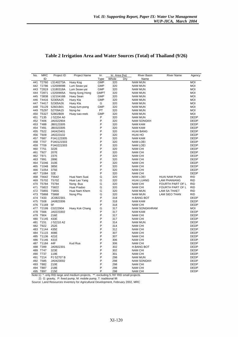
Vol. II: Supporting Report, Paper IX: Water Use ManagementWUP-JICA, March 2004
Table 2 Irrigation Area and Water Sources (Total) of Thailand (9/26)
River Basin River Name AgencyDry Name
0 NAM MUN MOI20 NAM MUN MOI20 NAM MUN MOI
0 NAM MUN MOI20 NAM MUN MOI
0 NAM MUN MOI0 NAM MUN MOI
20 NAM MUN MOI0 NAM MUN MOI
20 NAM MUN MOI20 NAM MUN DEDP20 NAM SONGKH DEDP20 NAM KAM DEDP20 NAM KAM DEDP20 HUAI BANG DEDP20 HUAI HO DEDP
0 NAM KAM DEDP0 NAM LOEI DEDP0 NAM LOEI DEDP
20 NAM CHI DEDP20 NAM CHI DEDP20 NAM CHI DEDP20 NAM CHI DEDP20 NAM CHI DEDP20 NAM CHI DEDP20 NAM CHI DEDP20 NAM CHI DEDP20 NAM LOEI HUAI NAM PUAN RID20 HUAI LUANG LAM PHANIANG RID
0 NAM CHI FOURTH PART OF L RID0 NAM CHI FOURTH PART OF L RID
20 NAM MUN LAM SA THAET RID0 NAM MUN LAM SIEO THAN RID8 H.BANG BOT DEDP
18 NAM KAM DEDPNAM CHI DEDP
7 NAM SONGKHRAM MOI17 NAM KAM DEDP17 NAM CHI DEDP17 NAM CHI DEDP14 NAM MUN DEDP14 NAM CHI DEDP12 NAM CHI DEDP07 NAM CHI DEDP07 NAM CHI DEDP06 NAM CHI DEDP
NAM CHI DEDP02 H.BANG BOT DEDP02 NAM CHI DEDP01 NAM CHI DEDP
8 NAM MUN DEDP98 NAM SONGKH DEDP98 NAM CHI DEDP98 NAM CHI DEDP98 NAM CHI DEDP7 RID small projects
rea (ha)No. MRC Project ID Project Name Irr.ID Type Whole
441 T2760 L5140273A Huey Kog GMP 32442 T2786 L5200909B Lum Seaw-yai GMP 3443 T2819 L5180318A Lum Seaw-yai GMP 3444 T2871 L5200905A Nong Song Hong GMPT 32445 T3838 L5210416B Huey Sean GMP 3446 T4416 52305A25 Huey Kla GMP 32447 T4417 52305A26 Huey Kla G 32448 T5129 52601B01 Huay-lum-pong GMP 3449 T5297 52709A15 Nong-he PT 32450 T5327 52802B09 Huay-sao-reek GMP 3451 T135 J 52204 A0 P 3452 T406 JA0322904 P 3453 T488 JB0123305 P 3454 T491 JB0323305 P 3455 T522 JA0423401 P 3456 T609 JA0223102 P 3457 T687 PJA1123305 P 32458 T707 PJA0121503 P 32459 T709 PJA0221503 P 32460 T751 322E P 3461 T927 207E P 3462 T971 237E P 3463 T991 289E P 3464 T1046 310E P 3465 T1048 385E P 3466 T1054 375E P 3467 T1084 32E P 3468 T5642 T5642 Huai Nam Suai G 3469 T5702 T5702 Huai Lao Yang G 3470 T5784 T5784 Nong Bua G 32471 T5822 T5822 Huai Pradoo G 32472 T5855 T5855 Huai Nam Khem G 3473 T5868 T5868 Nong Phu G 32474 T433 JC0822301 P 31475 T508 JA0823306 P 3476 T1169 5F P 318477 T2199 C0222904 Huey Kok Chang G 31478 T566 JA0223302 P 3479 T904 216E P 3480 T1145 433E P 3481 T151 J 52210 A2 P 3482 T922 252E P 3483 T1144 435E P 3484 T1115 408E P 3485 T1136 421E P 3486 T1146 431E P 3487 T1184 44F Kud Rua P 306488 T399 JA0922301 P 3489 T747 323E P 3490 T737 119E P 3491 T214 PJ 52707 B P 29492 T585 JA0423002 P 2493 T882 210E P 2494 T887 218E P 2495 T897 215E P 2
Note:1): *: only RID large and medium projects, **: excluding 5,78 :2) G: gravity, P: fixed pump, M: mobile pump, T: traditional liftSource: Land Resources Inventory for Agricultural Development, February 2002, MRC
Irr. A
XI-120
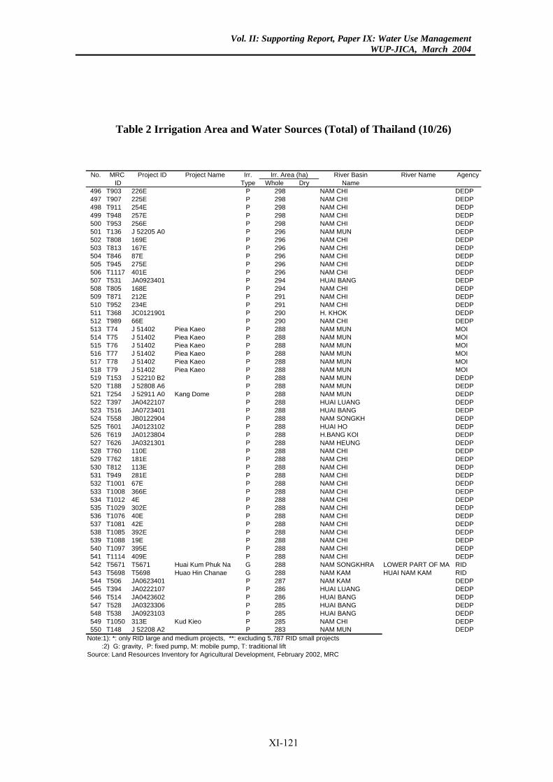
Vol. II: Supporting Report, Paper IX: Water Use ManagementWUP-JICA, March 2004
Table 2 Irrigation Area and Water Sources (Total) of Thailand (10/26)
River Basin River Name AgencyDry Name
98 NAM CHI DEDP98 NAM CHI DEDP98 NAM CHI DEDP98 NAM CHI DEDP98 NAM CHI DEDP96 NAM MUN DEDP96 NAM CHI DEDP96 NAM CHI DEDP96 NAM CHI DEDP96 NAM CHI DEDP96 NAM CHI DEDP94 HUAI BANG DEDP94 NAM CHI DEDP91 NAM CHI DEDP91 NAM CHI DEDP
0 H. KHOK DEDP90 NAM CHI DEDP88 NAM MUN MOI88 NAM MUN MOI88 NAM MUN MOI88 NAM MUN MOI88 NAM MUN MOI88 NAM MUN MOI88 NAM MUN DEDP88 NAM MUN DEDP88 NAM MUN DEDP88 HUAI LUANG DEDP88 HUAI BANG DEDP88 NAM SONGKH DEDP88 HUAI HO DEDP88 H.BANG KOI DEDP88 NAM HEUNG DEDP88 NAM CHI DEDP88 NAM CHI DEDP88 NAM CHI DEDP88 NAM CHI DEDP88 NAM CHI DEDP88 NAM CHI DEDP
NAM CHI DEDP88 NAM CHI DEDP88 NAM CHI DEDP88 NAM CHI DEDP88 NAM CHI DEDP88 NAM CHI DEDP88 NAM CHI DEDP88 NAM CHI DEDP88 NAM SONGKHRA LOWER PART OF MA RID88 NAM KAM HUAI NAM KAM RID87 NAM KAM DEDP86 HUAI LUANG DEDP86 HUAI BANG DEDP85 HUAI BANG DEDP85 HUAI BANG DEDP85 NAM CHI DEDP83 NAM MUN DEDP7 RID small projects
rea (ha)No. MRC Project ID Project Name Irr.ID Type Whole
496 T903 226E P 2497 T907 225E P 2498 T911 254E P 2499 T948 257E P 2500 T953 256E P 2501 T136 J 52205 A0 P 2502 T808 169E P 2503 T813 167E P 2504 T846 87E P 2505 T945 275E P 2506 T1117 401E P 2507 T531 JA0923401 P 2508 T805 168E P 2509 T871 212E P 2510 T952 234E P 2511 T368 JC0121901 P 29512 T989 66E P 2513 T74 J 51402 Piea Kaeo P 2514 T75 J 51402 Piea Kaeo P 2515 T76 J 51402 Piea Kaeo P 2516 T77 J 51402 Piea Kaeo P 2517 T78 J 51402 Piea Kaeo P 2518 T79 J 51402 Piea Kaeo P 2519 T153 J 52210 B2 P 2520 T188 J 52808 A6 P 2521 T254 J 52911 A0 Kang Dome P 2522 T397 JA0422107 P 2523 T516 JA0723401 P 2524 T558 JB0122904 P 2525 T601 JA0123102 P 2526 T619 JA0123804 P 2527 T626 JA0321301 P 2528 T760 110E P 2529 T762 181E P 2530 T812 113E P 2531 T949 281E P 2532 T1001 67E P 2533 T1008 366E P 2534 T1012 4E P 288535 T1029 302E P 2536 T1076 40E P 2537 T1081 42E P 2538 T1085 392E P 2539 T1088 19E P 2540 T1097 395E P 2541 T1114 409E P 2542 T5671 T5671 Huai Kum Phuk Na G 2543 T5698 T5698 Huao Hin Chanae G 2544 T506 JA0623401 P 2545 T394 JA0222107 P 2546 T514 JA0423602 P 2547 T528 JA0323306 P 2548 T538 JA0923103 P 2549 T1050 313E Kud Kieo P 2550 T148 J 52208 A2 P 2
Note:1): *: only RID large and medium projects, **: excluding 5,78 :2) G: gravity, P: fixed pump, M: mobile pump, T: traditional liftSource: Land Resources Inventory for Agricultural Development, February 2002, MRC
Irr. A
XI-121
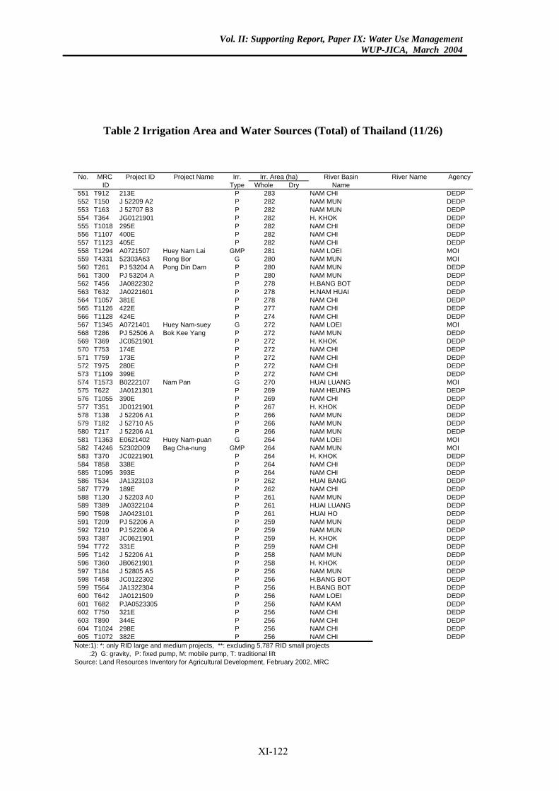
Vol. II: Supporting Report, Paper IX: Water Use ManagementWUP-JICA, March 2004
Table 2 Irrigation Area and Water Sources (Total) of Thailand (11/26)
River Basin River Name AgencyDry Name
83 NAM CHI DEDP82 NAM MUN DEDP82 NAM MUN DEDP82 H. KHOK DEDP82 NAM CHI DEDP82 NAM CHI DEDP82 NAM CHI DEDP81 NAM LOEI MOI
0 NAM MUN MOI0 NAM MUN DEDP0 NAM MUN DEDP
78 H.BANG BOT DEDP78 H.NAM HUAI DEDP78 NAM CHI DEDP77 NAM CHI DEDP74 NAM CHI DEDP72 NAM LOEI MOI72 NAM MUN DEDP
2 H. KHOK DEDP72 NAM CHI DEDP72 NAM CHI DEDP72 NAM CHI DEDP72 NAM CHI DEDP
0 HUAI LUANG MOI69 NAM HEUNG DEDP69 NAM CHI DEDP
7 H. KHOK DEDP66 NAM MUN DEDP66 NAM MUN DEDP66 NAM MUN DEDP64 NAM LOEI MOI
4 NAM MUN MOI4 H. KHOK DEDP
64 NAM CHI DEDP64 NAM CHI DEDP62 HUAI BANG DEDP62 NAM CHI DEDP61 NAM MUN DEDP61 HUAI LUANG DEDP61 HUAI HO DEDP
9 NAM MUN DEDP9 NAM MUN DEDP9 H. KHOK DEDP
59 NAM CHI DEDP58 NAM MUN DEDP58 H. KHOK DEDP56 NAM MUN DEDP
6 H.BANG BOT DEDP56 H.BANG BOT DEDP56 NAM LOEI DEDP
6 NAM KAM DEDP56 NAM CHI DEDP56 NAM CHI DEDP56 NAM CHI DEDP56 NAM CHI DEDP7 RID small projects
rea (ha)No. MRC Project ID Project Name Irr.ID Type Whole
551 T912 213E P 2552 T150 J 52209 A2 P 2553 T163 J 52707 B3 P 2554 T364 JG0121901 P 2555 T1018 295E P 2556 T1107 400E P 2557 T1123 405E P 2558 T1294 A0721507 Huey Nam Lai GMP 2559 T4331 52303A63 Rong Bor G 28560 T261 PJ 53204 A Pong Din Dam P 28561 T300 PJ 53204 A P 28562 T456 JA0822302 P 2563 T632 JA0221601 P 2564 T1057 381E P 2565 T1126 422E P 2566 T1128 424E P 2567 T1345 A0721401 Huey Nam-suey G 2568 T286 PJ 52506 A Bok Kee Yang P 2569 T369 JC0521901 P 27570 T753 174E P 2571 T759 173E P 2572 T975 280E P 2573 T1109 399E P 2574 T1573 B0222107 Nam Pan G 27575 T622 JA0121301 P 2576 T1055 390E P 2577 T351 JD0121901 P 26578 T138 J 52206 A1 P 2579 T182 J 52710 A5 P 2580 T217 J 52206 A1 P 2581 T1363 E0621402 Huey Nam-puan G 2582 T4246 52302D09 Bag Cha-nung GMP 26583 T370 JC0221901 P 26584 T858 338E P 2585 T1095 393E P 2586 T534 JA1323103 P 2587 T779 189E P 2588 T130 J 52203 A0 P 2589 T389 JA0322104 P 2590 T598 JA0423101 P 2591 T209 PJ 52206 A P 25592 T210 PJ 52206 A P 25593 T387 JC0621901 P 25594 T772 331E P 2595 T142 J 52206 A1 P 2596 T360 JB0621901 P 2597 T184 J 52805 A5 P 2598 T458 JC0122302 P 25599 T564 JA1322304 P 2600 T642 JA0121509 P 2601 T682 PJA0523305 P 25602 T750 321E P 2603 T890 344E P 2604 T1024 298E P 2605 T1072 382E P 2
Note:1): *: only RID large and medium projects, **: excluding 5,78 :2) G: gravity, P: fixed pump, M: mobile pump, T: traditional liftSource: Land Resources Inventory for Agricultural Development, February 2002, MRC
Irr. A
XI-122
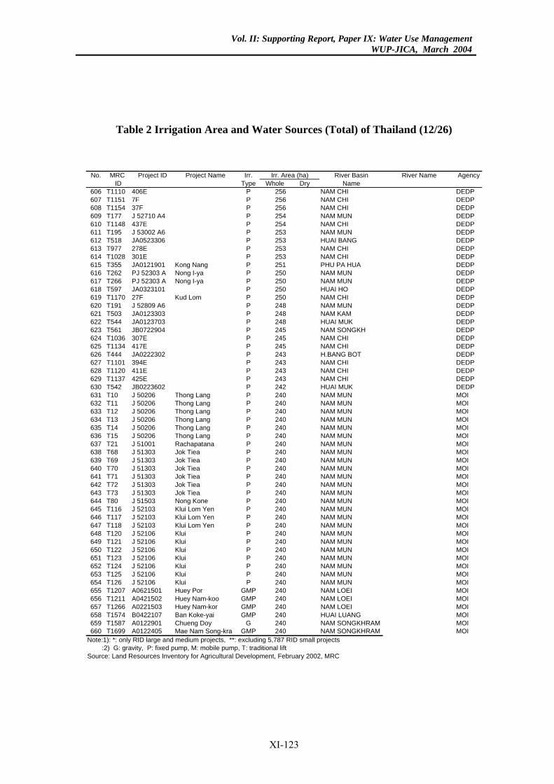
Vol. II: Supporting Report, Paper IX: Water Use ManagementWUP-JICA, March 2004
Table 2 Irrigation Area and Water Sources (Total) of Thailand (12/26)
River Basin River Name AgencyDry Name
56 NAM CHI DEDPNAM CHI DEDP
56 NAM CHI DEDP54 NAM MUN DEDP54 NAM CHI DEDP53 NAM MUN DEDP53 HUAI BANG DEDP53 NAM CHI DEDP53 NAM CHI DEDP51 PHU PA HUA DEDP50 NAM MUN DEDP50 NAM MUN DEDP50 HUAI HO DEDP50 NAM CHI DEDP48 NAM MUN DEDP48 NAM KAM DEDP48 HUAI MUK DEDP45 NAM SONGKH DEDP45 NAM CHI DEDP45 NAM CHI DEDP43 H.BANG BOT DEDP43 NAM CHI DEDP43 NAM CHI DEDP43 NAM CHI DEDP42 HUAI MUK DEDP40 NAM MUN MOI40 NAM MUN MOI40 NAM MUN MOI40 NAM MUN MOI40 NAM MUN MOI40 NAM MUN MOI40 NAM MUN MOI40 NAM MUN MOI40 NAM MUN MOI40 NAM MUN MOI40 NAM MUN MOI40 NAM MUN MOI40 NAM MUN MOI40 NAM MUN MOI
0 NAM MUN MOI0 NAM MUN MOI0 NAM MUN MOI
40 NAM MUN MOI40 NAM MUN MOI40 NAM MUN MOI40 NAM MUN MOI40 NAM MUN MOI40 NAM MUN MOI40 NAM MUN MOI
0 NAM LOEI MOI0 NAM LOEI MOI0 NAM LOEI MOI
40 HUAI LUANG MOI0 NAM SONGKHRAM MOI
40 NAM SONGKHRAM MOI7 RID small projects
rea (ha)No. MRC Project ID Project Name Irr.ID Type Whole
606 T1110 406E P 2607 T1151 7F P 256608 T1154 37F P 2609 T177 J 52710 A4 P 2610 T1148 437E P 2611 T195 J 53002 A6 P 2612 T518 JA0523306 P 2613 T977 278E P 2614 T1028 301E P 2615 T355 JA0121901 Kong Nang P 2616 T262 PJ 52303 A Nong I-ya P 2617 T266 PJ 52303 A Nong I-ya P 2618 T597 JA0323101 P 2619 T1170 27F Kud Lom P 2620 T191 J 52809 A6 P 2621 T503 JA0123303 P 2622 T544 JA0123703 P 2623 T561 JB0722904 P 2624 T1036 307E P 2625 T1134 417E P 2626 T444 JA0222302 P 2627 T1101 394E P 2628 T1120 411E P 2629 T1137 425E P 2630 T542 JB0223602 P 2631 T10 J 50206 Thong Lang P 2632 T11 J 50206 Thong Lang P 2633 T12 J 50206 Thong Lang P 2634 T13 J 50206 Thong Lang P 2635 T14 J 50206 Thong Lang P 2636 T15 J 50206 Thong Lang P 2637 T21 J 51001 Rachapatana P 2638 T68 J 51303 Jok Tiea P 2639 T69 J 51303 Jok Tiea P 2640 T70 J 51303 Jok Tiea P 2641 T71 J 51303 Jok Tiea P 2642 T72 J 51303 Jok Tiea P 2643 T73 J 51303 Jok Tiea P 2644 T80 J 51503 Nong Kone P 2645 T116 J 52103 Klui Lom Yen P 24646 T117 J 52103 Klui Lom Yen P 24647 T118 J 52103 Klui Lom Yen P 24648 T120 J 52106 Klui P 2649 T121 J 52106 Klui P 2650 T122 J 52106 Klui P 2651 T123 J 52106 Klui P 2652 T124 J 52106 Klui P 2653 T125 J 52106 Klui P 2654 T126 J 52106 Klui P 2655 T1207 A0621501 Huey Por GMP 24656 T1211 A0421502 Huey Nam-koo GMP 24657 T1266 A0221503 Huey Nam-kor GMP 24658 T1574 B0422107 Ban Koke-yai GMP 2659 T1587 A0122901 Chueng Doy G 24660 T1699 A0122405 Mae Nam Song-kra GMP 2
Note:1): *: only RID large and medium projects, **: excluding 5,78 :2) G: gravity, P: fixed pump, M: mobile pump, T: traditional liftSource: Land Resources Inventory for Agricultural Development, February 2002, MRC
Irr. A
XI-123
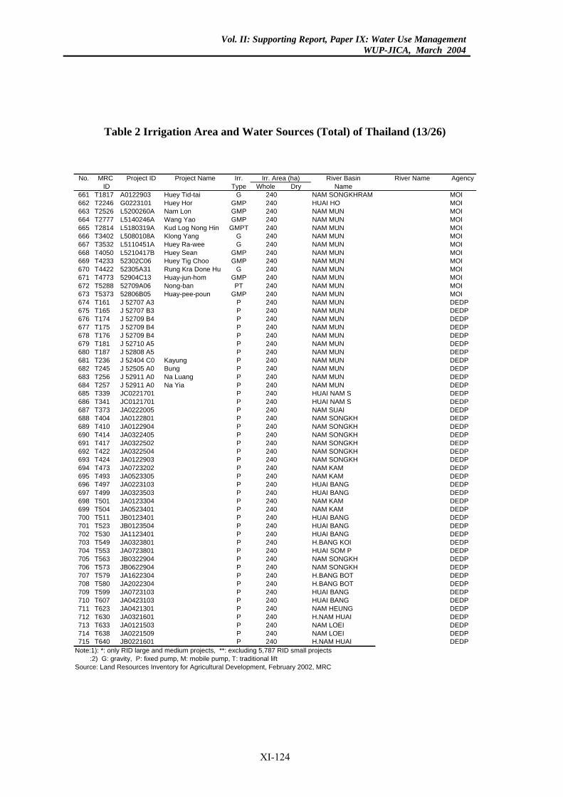
Vol. II: Supporting Report, Paper IX: Water Use ManagementWUP-JICA, March 2004
Table 2 Irrigation Area and Water Sources (Total) of Thailand (13/26)
River Basin River Name AgencyDry Name
0 NAM SONGKHRAM MOI0 HUAI HO MOI0 NAM MUN MOI0 NAM MUN MOI
40 NAM MUN MOI40 NAM MUN MOI40 NAM MUN MOI40 NAM MUN MOI40 NAM MUN MOI40 NAM MUN MOI40 NAM MUN MOI40 NAM MUN MOI40 NAM MUN MOI40 NAM MUN DEDP40 NAM MUN DEDP40 NAM MUN DEDP40 NAM MUN DEDP40 NAM MUN DEDP40 NAM MUN DEDP40 NAM MUN DEDP40 NAM MUN DEDP40 NAM MUN DEDP40 NAM MUN DEDP
0 NAM MUN DEDP0 HUAI NAM S DEDP0 HUAI NAM S DEDP
40 NAM SUAI DEDP40 NAM SONGKH DEDP40 NAM SONGKH DEDP40 NAM SONGKH DEDP40 NAM SONGKH DEDP40 NAM SONGKH DEDP40 NAM SONGKH DEDP40 NAM KAM DEDP40 NAM KAM DEDP40 HUAI BANG DEDP40 HUAI BANG DEDP40 NAM KAM DEDP40 NAM KAM DEDP40 HUAI BANG DEDP40 HUAI BANG DEDP40 HUAI BANG DEDP40 H.BANG KOI DEDP40 HUAI SOM P DEDP40 NAM SONGKH DEDP40 NAM SONGKH DEDP40 H.BANG BOT DEDP40 H.BANG BOT DEDP40 HUAI BANG DEDP40 HUAI BANG DEDP40 NAM HEUNG DEDP40 H.NAM HUAI DEDP40 NAM LOEI DEDP40 NAM LOEI DEDP40 H.NAM HUAI DEDP7 RID small projects
rea (ha)No. MRC Project ID Project Name Irr.ID Type Whole
661 T1817 A0122903 Huey Tid-tai G 24662 T2246 G0223101 Huey Hor GMP 24663 T2526 L5200260A Nam Lon GMP 24664 T2777 L5140246A Wang Yao GMP 24665 T2814 L5180319A Kud Log Nong Hin GMPT 2666 T3402 L5080108A Klong Yang G 2667 T3532 L5110451A Huey Ra-wee G 2668 T4050 L5210417B Huey Sean GMP 2669 T4233 52302C06 Huey Tig Choo GMP 2670 T4422 52305A31 Rung Kra Done Hu G 2671 T4773 52904C13 Huay-jun-hom GMP 2672 T5288 52709A06 Nong-ban PT 2673 T5373 52806B05 Huay-pee-poun GMP 2674 T161 J 52707 A3 P 2675 T165 J 52707 B3 P 2676 T174 J 52709 B4 P 2677 T175 J 52709 B4 P 2678 T176 J 52709 B4 P 2679 T181 J 52710 A5 P 2680 T187 J 52808 A5 P 2681 T236 J 52404 C0 Kayung P 2682 T245 J 52505 A0 Bung P 2683 T256 J 52911 A0 Na Luang P 2684 T257 J 52911 A0 Na Yia P 24685 T339 JC0221701 P 24686 T341 JC0121701 P 24687 T373 JA0222005 P 2688 T404 JA0122801 P 2689 T410 JA0122904 P 2690 T414 JA0322405 P 2691 T417 JA0322502 P 2692 T422 JA0322504 P 2693 T424 JA0122903 P 2694 T473 JA0723202 P 2695 T493 JA0523305 P 2696 T497 JA0223103 P 2697 T499 JA0323503 P 2698 T501 JA0123304 P 2699 T504 JA0523401 P 2700 T511 JB0123401 P 2701 T523 JB0123504 P 2702 T530 JA1123401 P 2703 T549 JA0323801 P 2704 T553 JA0723801 P 2705 T563 JB0322904 P 2706 T573 JB0622904 P 2707 T579 JA1622304 P 2708 T580 JA2022304 P 2709 T599 JA0723103 P 2710 T607 JA0423103 P 2711 T623 JA0421301 P 2712 T630 JA0321601 P 2713 T633 JA0121503 P 2714 T638 JA0221509 P 2715 T640 JB0221601 P 2
Note:1): *: only RID large and medium projects, **: excluding 5,78 :2) G: gravity, P: fixed pump, M: mobile pump, T: traditional liftSource: Land Resources Inventory for Agricultural Development, February 2002, MRC
Irr. A
XI-124

Vol. II: Supporting Report, Paper IX: Water Use ManagementWUP-JICA, March 2004
Table 2 Irrigation Area and Water Sources (Total) of Thailand (14/26)
River Basin River Name AgencyDry Name
40 NAM LOEI DEDP40 H.NAM HUAI DEDP40 NAM LOEI DEDP40 NAM LOEI DEDP0 HUAI MONG DEDP0 NAM SONGKH DEDP0 NAM LOEI DEDP0 NAM LOEI DEDP0 NAM LOEI DEDP0 NAM LOEI DEDP
40 NAM CHI DEDP40 NAM CHI DEDP40 NAM CHI DEDP40 NAM CHI DEDP40 NAM CHI DEDP40 NAM CHI DEDP40 NAM CHI DEDP40 NAM CHI DEDP40 NAM CHI DEDP40 NAM CHI DEDP40 NAM CHI DEDP40 NAM CHI DEDP40 NAM CHI DEDP40 NAM CHI DEDP40 NAM CHI DEDP40 NAM CHI DEDP40 NAM CHI DEDP
0 NAM CHI DEDP40 NAM CHI DEDP40 NAM CHI DEDP40 NAM CHI DEDP40 NAM CHI DEDP40 NAM CHI DEDP40 NAM CHI DEDP40 NAM CHI DEDP40 NAM CHI DEDP40 NAM CHI DEDP40 NAM CHI DEDP40 NAM CHI DEDP40 NAM CHI DEDP40 NAM CHI DEDP40 NAM CHI DEDP40 NAM CHI DEDP40 NAM CHI DEDP40 NAM CHI DEDP40 NAM CHI DEDP40 NAM CHI DEDP40 NAM CHI DEDP40 NAM CHI DEDP40 NAM CHI DEDP40 NAM CHI DEDP40 NAM CHI DEDP40 NAM CHI DEDP40 NAM CHI DEDP40 NAM CHI DEDP7 RID small projects
rea (ha)No. MRC Project ID Project Name Irr.ID Type Whole
716 T641 JA0321509 P 2717 T645 JB0321601 P 2718 T647 JA0221505 P 2719 T649 JA0121401 P 2720 T655 PJA0121806 P 24721 T692 PJA0122904 P 24722 T698 PJA0321501 P 24723 T699 PJA0221501 P 24724 T701 PJA0121506 P 24725 T704 PJA0121505 P 24726 T713 127E P 2727 T714 126E P 2728 T729 116E P 2729 T741 120E P 2730 T742 118E P 2731 T744 97E P 2732 T748 109E P 2733 T755 111E P 2734 T767 105E P 2735 T773 141E P 2736 T782 325E P 2737 T783 332E P 2738 T791 185E P 2739 T798 184E P 2740 T804 151E P 2741 T815 155E P 2742 T822 161E P 2743 T823 159E Kud Kuang P 24744 T830 355E P 2745 T833 132E P 2746 T836 157E P 2747 T837 356E P 2748 T850 88E P 2749 T857 339E P 2750 T866 230E P 2751 T867 199E P 2752 T878 222E P 2753 T881 78E P 2754 T886 221E P 2755 T888 203E P 2756 T900 223E P 2757 T910 347E P 2758 T915 217E P 2759 T918 224E P 2760 T920 227E P 2761 T925 232E P 2762 T931 247E P 2763 T938 255E P 2764 T944 239E Kud Chum P 2765 T946 65E P 2766 T961 242E P 2767 T964 261E P 2768 T978 62E P 2769 T994 58E P 2770 T1002 56E P 2
Note:1): *: only RID large and medium projects, **: excluding 5,78 :2) G: gravity, P: fixed pump, M: mobile pump, T: traditional liftSource: Land Resources Inventory for Agricultural Development, February 2002, MRC
Irr. A
XI-125
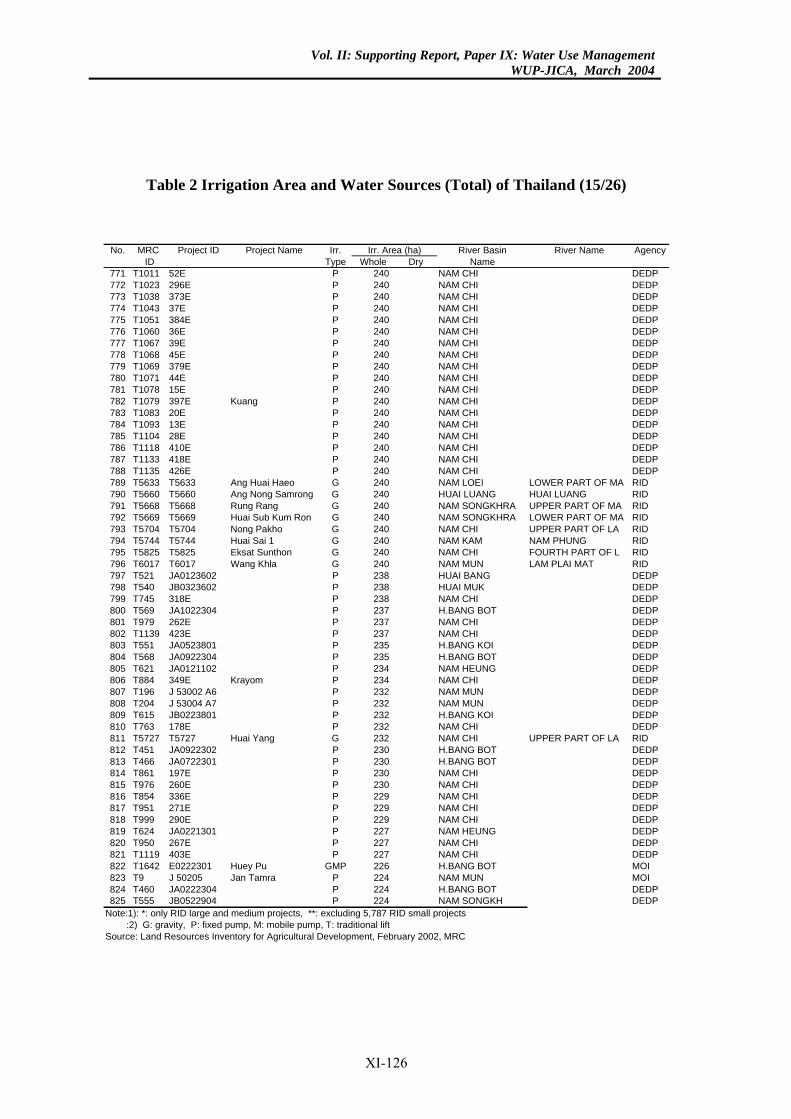
Vol. II: Supporting Report, Paper IX: Water Use ManagementWUP-JICA, March 2004
Table 2 Irrigation Area and Water Sources (Total) of Thailand (15/26)
River Basin River Name AgencyDry Name
40 NAM CHI DEDP40 NAM CHI DEDP40 NAM CHI DEDP40 NAM CHI DEDP40 NAM CHI DEDP40 NAM CHI DEDP40 NAM CHI DEDP40 NAM CHI DEDP40 NAM CHI DEDP40 NAM CHI DEDP40 NAM CHI DEDP0 NAM CHI DEDP
40 NAM CHI DEDP40 NAM CHI DEDP40 NAM CHI DEDP40 NAM CHI DEDP40 NAM CHI DEDP40 NAM CHI DEDP40 NAM LOEI LOWER PART OF MA RID40 HUAI LUANG HUAI LUANG RID40 NAM SONGKHRA UPPER PART OF MA RID
0 NAM SONGKHRA LOWER PART OF MA RID0 NAM CHI UPPER PART OF LA RID
NAM KAM NAM PHUNG RID40 NAM CHI FOURTH PART OF L RID40 NAM MUN LAM PLAI MAT RID38 HUAI BANG DEDP38 HUAI MUK DEDP38 NAM CHI DEDP37 H.BANG BOT DEDP37 NAM CHI DEDP37 NAM CHI DEDP35 H.BANG KOI DEDP35 H.BANG BOT DEDP34 NAM HEUNG DEDP34 NAM CHI DEDP32 NAM MUN DEDP32 NAM MUN DEDP32 H.BANG KOI DEDP32 NAM CHI DEDP32 NAM CHI UPPER PART OF LA RID30 H.BANG BOT DEDP30 H.BANG BOT DEDP30 NAM CHI DEDP30 NAM CHI DEDP29 NAM CHI DEDP29 NAM CHI DEDP29 NAM CHI DEDP27 NAM HEUNG DEDP27 NAM CHI DEDP27 NAM CHI DEDP26 H.BANG BOT MOI
4 NAM MUN MOI24 H.BANG BOT DEDP24 NAM SONGKH DEDP7 RID small projects
rea (ha)No. MRC Project ID Project Name Irr.ID Type Whole
771 T1011 52E P 2772 T1023 296E P 2773 T1038 373E P 2774 T1043 37E P 2775 T1051 384E P 2776 T1060 36E P 2777 T1067 39E P 2778 T1068 45E P 2779 T1069 379E P 2780 T1071 44E P 2781 T1078 15E P 2782 T1079 397E Kuang P 24783 T1083 20E P 2784 T1093 13E P 2785 T1104 28E P 2786 T1118 410E P 2787 T1133 418E P 2788 T1135 426E P 2789 T5633 T5633 Ang Huai Haeo G 2790 T5660 T5660 Ang Nong Samrong G 2791 T5668 T5668 Rung Rang G 2792 T5669 T5669 Huai Sub Kum Ron G 24793 T5704 T5704 Nong Pakho G 24794 T5744 T5744 Huai Sai 1 G 240795 T5825 T5825 Eksat Sunthon G 2796 T6017 T6017 Wang Khla G 2797 T521 JA0123602 P 2798 T540 JB0323602 P 2799 T745 318E P 2800 T569 JA1022304 P 2801 T979 262E P 2802 T1139 423E P 2803 T551 JA0523801 P 2804 T568 JA0922304 P 2805 T621 JA0121102 P 2806 T884 349E Krayom P 2807 T196 J 53002 A6 P 2808 T204 J 53004 A7 P 2809 T615 JB0223801 P 2810 T763 178E P 2811 T5727 T5727 Huai Yang G 2812 T451 JA0922302 P 2813 T466 JA0722301 P 2814 T861 197E P 2815 T976 260E P 2816 T854 336E P 2817 T951 271E P 2818 T999 290E P 2819 T624 JA0221301 P 2820 T950 267E P 2821 T1119 403E P 2822 T1642 E0222301 Huey Pu GMP 2823 T9 J 50205 Jan Tamra P 22824 T460 JA0222304 P 2825 T555 JB0522904 P 2
Note:1): *: only RID large and medium projects, **: excluding 5,78 :2) G: gravity, P: fixed pump, M: mobile pump, T: traditional liftSource: Land Resources Inventory for Agricultural Development, February 2002, MRC
Irr. A
XI-126
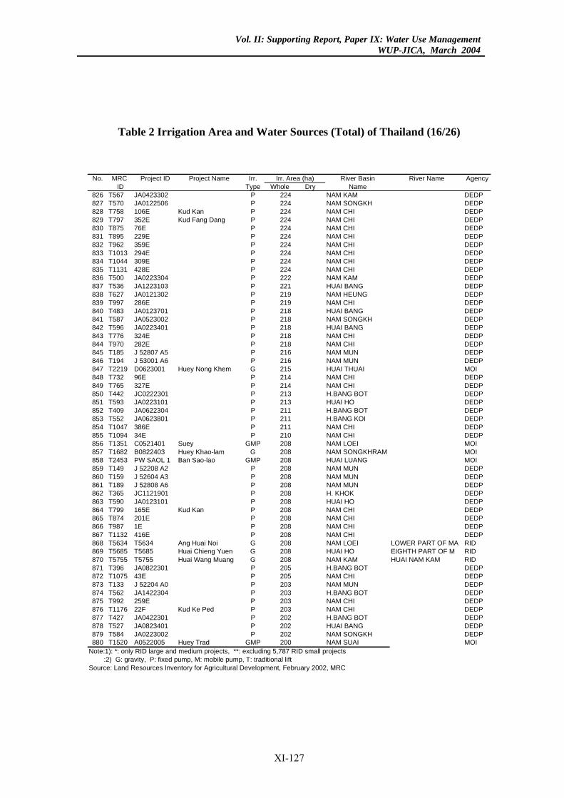
Vol. II: Supporting Report, Paper IX: Water Use ManagementWUP-JICA, March 2004
Table 2 Irrigation Area and Water Sources (Total) of Thailand (16/26)
River Basin River Name AgencyDry Name
24 NAM KAM DEDP24 NAM SONGKH DEDP4 NAM CHI DEDP
24 NAM CHI DEDP24 NAM CHI DEDP24 NAM CHI DEDP24 NAM CHI DEDP24 NAM CHI DEDP24 NAM CHI DEDP24 NAM CHI DEDP22 NAM KAM DEDP21 HUAI BANG DEDP19 NAM HEUNG DEDP19 NAM CHI DEDP18 HUAI BANG DEDP18 NAM SONGKH DEDP18 HUAI BANG DEDP18 NAM CHI DEDP18 NAM CHI DEDP16 NAM MUN DEDP16 NAM MUN DEDP15 HUAI THUAI MOI14 NAM CHI DEDP14 NAM CHI DEDP
3 H.BANG BOT DEDP13 HUAI HO DEDP11 H.BANG BOT DEDP11 H.BANG KOI DEDP11 NAM CHI DEDP10 NAM CHI DEDP08 NAM LOEI MOI08 NAM SONGKHRAM MOI
8 HUAI LUANG MOI08 NAM MUN DEDP08 NAM MUN DEDP08 NAM MUN DEDP8 H. KHOK DEDP
08 HUAI HO DEDP8 NAM CHI DEDP
08 NAM CHI DEDP08 NAM CHI DEDP08 NAM CHI DEDP
8 NAM LOEI LOWER PART OF MA RID08 HUAI HO EIGHTH PART OF M RID08 NAM KAM HUAI NAM KAM RID05 H.BANG BOT DEDP05 NAM CHI DEDP03 NAM MUN DEDP03 H.BANG BOT DEDP03 NAM CHI DEDP
NAM CHI DEDP02 H.BANG BOT DEDP02 HUAI BANG DEDP02 NAM SONGKH DEDP00 NAM SUAI MOI7 RID small projects
rea (ha)No. MRC Project ID Project Name Irr.ID Type Whole
826 T567 JA0423302 P 2827 T570 JA0122506 P 2828 T758 106E Kud Kan P 22829 T797 352E Kud Fang Dang P 2830 T875 76E P 2831 T895 229E P 2832 T962 359E P 2833 T1013 294E P 2834 T1044 309E P 2835 T1131 428E P 2836 T500 JA0223304 P 2837 T536 JA1223103 P 2838 T627 JA0121302 P 2839 T997 286E P 2840 T483 JA0123701 P 2841 T587 JA0523002 P 2842 T596 JA0223401 P 2843 T776 324E P 2844 T970 282E P 2845 T185 J 52807 A5 P 2846 T194 J 53001 A6 P 2847 T2219 D0623001 Huey Nong Khem G 2848 T732 96E P 2849 T765 327E P 2850 T442 JC0222301 P 21851 T593 JA0223101 P 2852 T409 JA0622304 P 2853 T552 JA0623801 P 2854 T1047 386E P 2855 T1094 34E P 2856 T1351 C0521401 Suey GMP 2857 T1682 B0822403 Huey Khao-lam G 2858 T2453 PW SAOL 1 Ban Sao-lao GMP 20859 T149 J 52208 A2 P 2860 T159 J 52604 A3 P 2861 T189 J 52808 A6 P 2862 T365 JC1121901 P 20863 T590 JA0123101 P 2864 T799 165E Kud Kan P 20865 T874 201E P 2866 T987 1E P 2867 T1132 416E P 2868 T5634 T5634 Ang Huai Noi G 20869 T5685 T5685 Huai Chieng Yuen G 2870 T5755 T5755 Huai Wang Muang G 2871 T396 JA0822301 P 2872 T1075 43E P 2873 T133 J 52204 A0 P 2874 T562 JA1422304 P 2875 T992 259E P 2876 T1176 22F Kud Ke Ped P 203877 T427 JA0422301 P 2878 T527 JA0823401 P 2879 T584 JA0223002 P 2880 T1520 A0522005 Huey Trad GMP 2
Note:1): *: only RID large and medium projects, **: excluding 5,78 :2) G: gravity, P: fixed pump, M: mobile pump, T: traditional liftSource: Land Resources Inventory for Agricultural Development, February 2002, MRC
Irr. A
XI-127
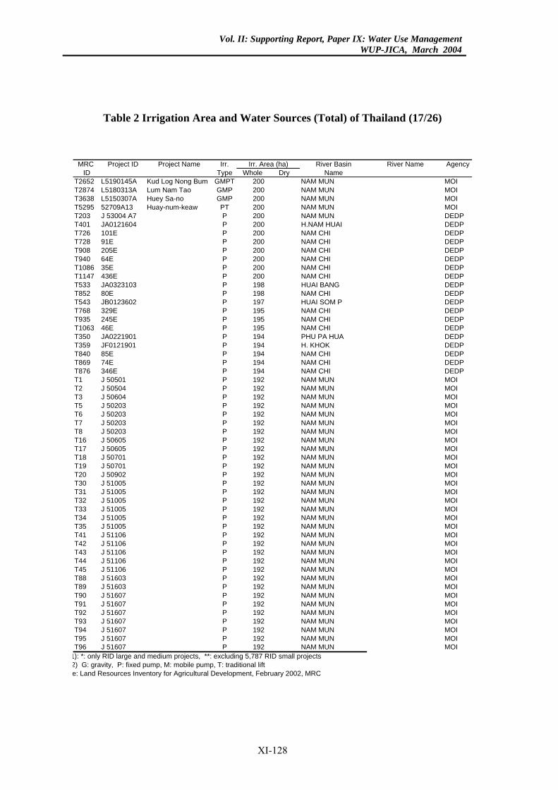
Vol. II: Supporting Report, Paper IX: Water Use ManagementWUP-JICA, March 2004
Table 2 Irrigation Area and Water Sources (Total) of Thailand (17/26)
River Basin River Name AgencyDry Name
NAM MUN MOINAM MUN MOINAM MUN MOINAM MUN MOINAM MUN DEDPH.NAM HUAI DEDPNAM CHI DEDPNAM CHI DEDPNAM CHI DEDPNAM CHI DEDPNAM CHI DEDPNAM CHI DEDPHUAI BANG DEDPNAM CHI DEDPHUAI SOM P DEDPNAM CHI DEDPNAM CHI DEDPNAM CHI DEDPPHU PA HUA DEDPH. KHOK DEDPNAM CHI DEDPNAM CHI DEDPNAM CHI DEDPNAM MUN MOINAM MUN MOINAM MUN MOINAM MUN MOINAM MUN MOINAM MUN MOINAM MUN MOINAM MUN MOINAM MUN MOINAM MUN MOINAM MUN MOINAM MUN MOINAM MUN MOINAM MUN MOINAM MUN MOINAM MUN MOINAM MUN MOINAM MUN MOINAM MUN MOINAM MUN MOINAM MUN MOINAM MUN MOINAM MUN MOINAM MUN MOINAM MUN MOINAM MUN MOINAM MUN MOINAM MUN MOINAM MUN MOINAM MUN MOINAM MUN MOINAM MUN MOI
projects
Area (ha)MRC Project ID Project Name Irr.ID Type Whole
T2652 L5190145A Kud Log Nong Bum GMPT 200T2874 L5180313A Lum Nam Tao GMP 200T3638 L5150307A Huey Sa-no GMP 200T5295 52709A13 Huay-num-keaw PT 200T203 J 53004 A7 P 200T401 JA0121604 P 200T726 101E P 200T728 91E P 200T908 205E P 200T940 64E P 200T1086 35E P 200T1147 436E P 200T533 JA0323103 P 198T852 80E P 198T543 JB0123602 P 197T768 329E P 195T935 245E P 195T1063 46E P 195T350 JA0221901 P 194T359 JF0121901 P 194T840 85E P 194T869 74E P 194T876 346E P 194T1 J 50501 P 192T2 J 50504 P 192T3 J 50604 P 192T5 J 50203 P 192T6 J 50203 P 192T7 J 50203 P 192T8 J 50203 P 192T16 J 50605 P 192T17 J 50605 P 192T18 J 50701 P 192T19 J 50701 P 192T20 J 50902 P 192T30 J 51005 P 192T31 J 51005 P 192T32 J 51005 P 192T33 J 51005 P 192T34 J 51005 P 192T35 J 51005 P 192T41 J 51106 P 192T42 J 51106 P 192T43 J 51106 P 192T44 J 51106 P 192T45 J 51106 P 192T88 J 51603 P 192T89 J 51603 P 192T90 J 51607 P 192T91 J 51607 P 192T92 J 51607 P 192T93 J 51607 P 192T94 J 51607 P 192T95 J 51607 P 192T96 J 51607 P 192
1): *: only RID large and medium projects, **: excluding 5,787 RID small 2) G: gravity, P: fixed pump, M: mobile pump, T: traditional lifte: Land Resources Inventory for Agricultural Development, February 2002, MRC
Irr.
XI-128
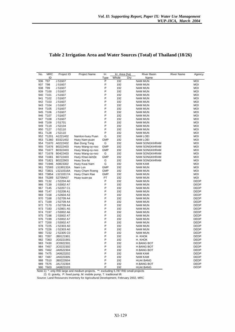
Vol. II: Supporting Report, Paper IX: Water Use ManagementWUP-JICA, March 2004
Table 2 Irrigation Area and Water Sources (Total) of Thailand (18/26)
River Basin River Name AgencyDry Name
92 NAM MUN MOI92 NAM MUN MOI92 NAM MUN MOI92 NAM MUN MOI92 NAM MUN MOI92 NAM MUN MOI92 NAM MUN MOI92 NAM MUN MOI92 NAM MUN MOI92 NAM MUN MOI92 NAM MUN MOI92 NAM MUN MOI92 NAM MUN MOI92 NAM MUN MOI92 NAM MUN MOI92 NAM MUN MOI92 NAM LOEI MOI92 NAM LOEI MOI92 NAM SONGKHRAM MOI92 NAM SONGKHRAM MOI92 NAM SONGKHRAM MOI92 NAM SONGKHRAM MOI
2 NAM SONGKHRAM MOI2 NAM SONGKHRAM MOI2 NAM KAM MOI2 NAM MUN MOI2 NAM MUN MOI2 NAM MUN MOI
92 NAM MUN MOI92 NAM MUN DEDP92 NAM MUN DEDP92 NAM MUN DEDP92 NAM MUN DEDP92 NAM MUN DEDP92 NAM MUN DEDP92 NAM MUN DEDP92 NAM MUN DEDP92 NAM MUN DEDP92 NAM MUN DEDP92 NAM MUN DEDP92 NAM MUN DEDP92 NAM MUN DEDP92 NAM MUN DEDP92 NAM MUN DEDP92 NAM MUN DEDP92 H. KHOK DEDP92 H. KHOK DEDP
2 H.BANG BOT DEDP2 H.BANG BOT DEDP
92 H.BANG BOT DEDP92 NAM KAM DEDP92 NAM KAM DEDP92 HUAI BANG DEDP92 H.BANG BOT DEDP92 HUAI BANG DEDP7 RID small projects
rea (ha)No. MRC Project ID Project Name Irr.ID Type Whole
936 T97 J 51607 P 1937 T98 J 51607 P 1938 T99 J 51607 P 1939 T100 J 51607 P 1940 T101 J 51607 P 1941 T102 J 51607 P 1942 T103 J 51607 P 1943 T104 J 51607 P 1944 T105 J 51607 P 1945 T106 J 51607 P 1946 T107 J 51607 P 1947 T108 J 51607 P 1948 T109 J 51701 P 1949 T119 J 52104 P 1950 T127 J 52110 P 1951 T128 J 52110 P 1952 T1201 A1221402 Namlon-huey Puan G 1953 T1360 E0321402 Huey Nam-puan GMP 1954 T1670 A0222402 Ban Dong Tong G 1955 T1676 B0222403 Huey Wang-oy-noo GMP 1956 T1677 B0322403 Huey Wang-oy-noo GMP 1957 T1678 B0422403 Huey Wang-oy-noo G 1958 T1681 B0722403 Huey Khao-lam(le GMP 19959 T1821 B0222903 Huey Sra-fai G 19960 T1946 A0823302 Huey Kwai Nam G 19961 T2593 L5190132A Nam Lon GMP 19962 T3831 L5210316A Huey Cham Roeng GMP 19963 T3854 L5210317A Huey Cham Rae GMP 19964 T5289 52709A07 Huay-suan-pa PT 1965 T132 J 52204 A0 P 1966 T139 J 53002 A7 P 1967 T145 J 52207 C1 P 1968 T147 J 52208 A1 P 1969 T158 J 52604 A3 P 1970 T168 J 52709 A4 P 1971 T169 J 52709 A4 P 1972 T170 J 52709 A4 P 1973 T183 J 52801 A5 P 1974 T197 J 53002 A6 P 1975 T198 J 53002 A7 P 1976 T199 J 53002 A7 P 1977 T200 J 53002 A7 P 1978 T225 J 52303 A0 P 1979 T226 J 52303 A0 P 1980 T232 J 52305 C0 P 1981 T357 JB0121901 P 1982 T363 JG0221901 P 1983 T430 JC0922301 P 19984 T457 JC0222302 P 19985 T462 JA0522304 P 1986 T475 JA0623202 P 1987 T487 JA0223305 P 1988 T510 JB0223504 P 1989 T575 JA1722304 P 1990 T603 JA0823103 P 1
Note:1): *: only RID large and medium projects, **: excluding 5,78 :2) G: gravity, P: fixed pump, M: mobile pump, T: traditional liftSource: Land Resources Inventory for Agricultural Development, February 2002, MRC
Irr. A
XI-129
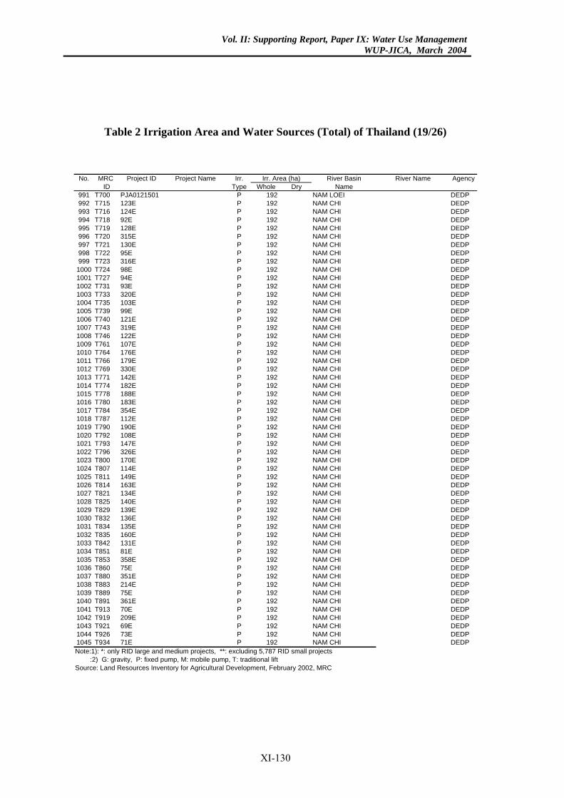
Vol. II: Supporting Report, Paper IX: Water Use ManagementWUP-JICA, March 2004
Table 2 Irrigation Area and Water Sources (Total) of Thailand (19/26)
River Basin River Name AgencyDry Name
2 NAM LOEI DEDP92 NAM CHI DEDP92 NAM CHI DEDP92 NAM CHI DEDP92 NAM CHI DEDP92 NAM CHI DEDP92 NAM CHI DEDP92 NAM CHI DEDP92 NAM CHI DEDP92 NAM CHI DEDP92 NAM CHI DEDP92 NAM CHI DEDP92 NAM CHI DEDP92 NAM CHI DEDP92 NAM CHI DEDP92 NAM CHI DEDP92 NAM CHI DEDP92 NAM CHI DEDP92 NAM CHI DEDP92 NAM CHI DEDP92 NAM CHI DEDP92 NAM CHI DEDP92 NAM CHI DEDP92 NAM CHI DEDP92 NAM CHI DEDP92 NAM CHI DEDP92 NAM CHI DEDP92 NAM CHI DEDP92 NAM CHI DEDP92 NAM CHI DEDP92 NAM CHI DEDP92 NAM CHI DEDP92 NAM CHI DEDP92 NAM CHI DEDP92 NAM CHI DEDP92 NAM CHI DEDP92 NAM CHI DEDP92 NAM CHI DEDP92 NAM CHI DEDP92 NAM CHI DEDP92 NAM CHI DEDP92 NAM CHI DEDP92 NAM CHI DEDP92 NAM CHI DEDP92 NAM CHI DEDP92 NAM CHI DEDP92 NAM CHI DEDP92 NAM CHI DEDP92 NAM CHI DEDP92 NAM CHI DEDP92 NAM CHI DEDP92 NAM CHI DEDP92 NAM CHI DEDP92 NAM CHI DEDP92 NAM CHI DEDP7 RID small projects
rea (ha)No. MRC Project ID Project Name Irr.ID Type Whole
991 T700 PJA0121501 P 19992 T715 123E P 1993 T716 124E P 1994 T718 92E P 1995 T719 128E P 1996 T720 315E P 1997 T721 130E P 1998 T722 95E P 1999 T723 316E P 11000 T724 98E P 11001 T727 94E P 11002 T731 93E P 11003 T733 320E P 11004 T735 103E P 11005 T739 99E P 11006 T740 121E P 11007 T743 319E P 11008 T746 122E P 11009 T761 107E P 11010 T764 176E P 11011 T766 179E P 11012 T769 330E P 11013 T771 142E P 11014 T774 182E P 11015 T778 188E P 11016 T780 183E P 11017 T784 354E P 11018 T787 112E P 11019 T790 190E P 11020 T792 108E P 11021 T793 147E P 11022 T796 326E P 11023 T800 170E P 11024 T807 114E P 11025 T811 149E P 11026 T814 163E P 11027 T821 134E P 11028 T825 140E P 11029 T829 139E P 11030 T832 136E P 11031 T834 135E P 11032 T835 160E P 11033 T842 131E P 11034 T851 81E P 11035 T853 358E P 11036 T860 75E P 11037 T880 351E P 11038 T883 214E P 11039 T889 75E P 11040 T891 361E P 11041 T913 70E P 11042 T919 209E P 11043 T921 69E P 11044 T926 73E P 11045 T934 71E P 1Note:1): *: only RID large and medium projects, **: excluding 5,78 :2) G: gravity, P: fixed pump, M: mobile pump, T: traditional liftSource: Land Resources Inventory for Agricultural Development, February 2002, MRC
Irr. A
XI-130
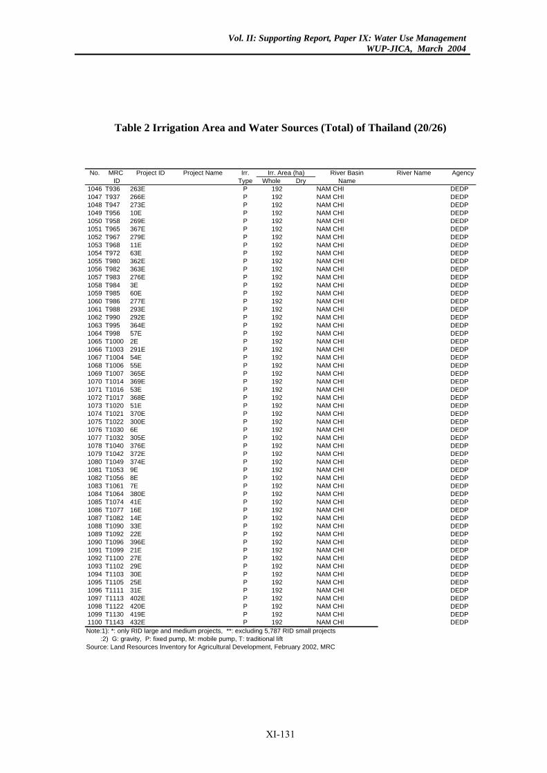
Vol. II: Supporting Report, Paper IX: Water Use ManagementWUP-JICA, March 2004
Table 2 Irrigation Area and Water Sources (Total) of Thailand (20/26)
River Basin River Name AgencyDry Name
92 NAM CHI DEDP92 NAM CHI DEDP92 NAM CHI DEDP92 NAM CHI DEDP92 NAM CHI DEDP92 NAM CHI DEDP92 NAM CHI DEDP92 NAM CHI DEDP92 NAM CHI DEDP92 NAM CHI DEDP92 NAM CHI DEDP92 NAM CHI DEDP92 NAM CHI DEDP92 NAM CHI DEDP92 NAM CHI DEDP92 NAM CHI DEDP92 NAM CHI DEDP92 NAM CHI DEDP92 NAM CHI DEDP
NAM CHI DEDP92 NAM CHI DEDP92 NAM CHI DEDP92 NAM CHI DEDP92 NAM CHI DEDP92 NAM CHI DEDP92 NAM CHI DEDP92 NAM CHI DEDP92 NAM CHI DEDP92 NAM CHI DEDP92 NAM CHI DEDP
NAM CHI DEDP92 NAM CHI DEDP92 NAM CHI DEDP92 NAM CHI DEDP92 NAM CHI DEDP
NAM CHI DEDPNAM CHI DEDPNAM CHI DEDP
92 NAM CHI DEDP92 NAM CHI DEDP92 NAM CHI DEDP92 NAM CHI DEDP92 NAM CHI DEDP92 NAM CHI DEDP92 NAM CHI DEDP92 NAM CHI DEDP92 NAM CHI DEDP92 NAM CHI DEDP92 NAM CHI DEDP92 NAM CHI DEDP92 NAM CHI DEDP92 NAM CHI DEDP92 NAM CHI DEDP92 NAM CHI DEDP92 NAM CHI DEDP7 RID small projects
rea (ha)No. MRC Project ID Project Name Irr.ID Type Whole
1046 T936 263E P 11047 T937 266E P 11048 T947 273E P 11049 T956 10E P 11050 T958 269E P 11051 T965 367E P 11052 T967 279E P 11053 T968 11E P 11054 T972 63E P 11055 T980 362E P 11056 T982 363E P 11057 T983 276E P 11058 T984 3E P 11059 T985 60E P 11060 T986 277E P 11061 T988 293E P 11062 T990 292E P 11063 T995 364E P 11064 T998 57E P 11065 T1000 2E P 1921066 T1003 291E P 11067 T1004 54E P 11068 T1006 55E P 11069 T1007 365E P 11070 T1014 369E P 11071 T1016 53E P 11072 T1017 368E P 11073 T1020 51E P 11074 T1021 370E P 11075 T1022 300E P 11076 T1030 6E P 1921077 T1032 305E P 11078 T1040 376E P 11079 T1042 372E P 11080 T1049 374E P 11081 T1053 9E P 1921082 T1056 8E P 1921083 T1061 7E P 1921084 T1064 380E P 11085 T1074 41E P 11086 T1077 16E P 11087 T1082 14E P 11088 T1090 33E P 11089 T1092 22E P 11090 T1096 396E P 11091 T1099 21E P 11092 T1100 27E P 11093 T1102 29E P 11094 T1103 30E P 11095 T1105 25E P 11096 T1111 31E P 11097 T1113 402E P 11098 T1122 420E P 11099 T1130 419E P 11100 T1143 432E P 1Note:1): *: only RID large and medium projects, **: excluding 5,78 :2) G: gravity, P: fixed pump, M: mobile pump, T: traditional liftSource: Land Resources Inventory for Agricultural Development, February 2002, MRC
Irr. A
XI-131
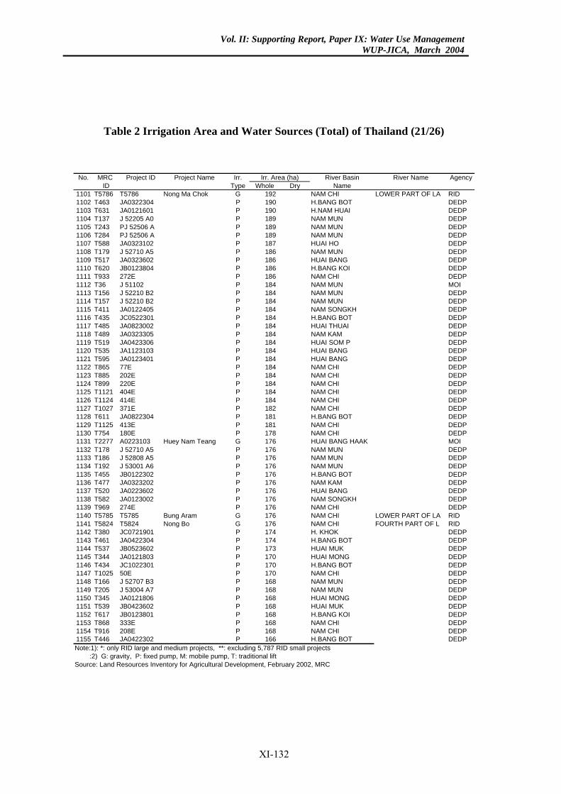
Vol. II: Supporting Report, Paper IX: Water Use ManagementWUP-JICA, March 2004
Table 2 Irrigation Area and Water Sources (Total) of Thailand (21/26)
River Basin River Name AgencyDry Name
92 NAM CHI LOWER PART OF LA RID90 H.BANG BOT DEDP90 H.NAM HUAI DEDP89 NAM MUN DEDP
9 NAM MUN DEDP9 NAM MUN DEDP
87 HUAI HO DEDP86 NAM MUN DEDP86 HUAI BANG DEDP86 H.BANG KOI DEDP86 NAM CHI DEDP84 NAM MUN MOI84 NAM MUN DEDP84 NAM MUN DEDP84 NAM SONGKH DEDP
4 H.BANG BOT DEDP84 HUAI THUAI DEDP84 NAM KAM DEDP84 HUAI SOM P DEDP84 HUAI BANG DEDP84 HUAI BANG DEDP84 NAM CHI DEDP84 NAM CHI DEDP84 NAM CHI DEDP84 NAM CHI DEDP84 NAM CHI DEDP82 NAM CHI DEDP81 H.BANG BOT DEDP81 NAM CHI DEDP78 NAM CHI DEDP
6 HUAI BANG HAAK MOI76 NAM MUN DEDP76 NAM MUN DEDP76 NAM MUN DEDP76 H.BANG BOT DEDP76 NAM KAM DEDP76 HUAI BANG DEDP76 NAM SONGKH DEDP76 NAM CHI DEDP76 NAM CHI LOWER PART OF LA RID76 NAM CHI FOURTH PART OF L RID
4 H. KHOK DEDP74 H.BANG BOT DEDP73 HUAI MUK DEDP70 HUAI MONG DEDP
0 H.BANG BOT DEDP70 NAM CHI DEDP68 NAM MUN DEDP68 NAM MUN DEDP68 HUAI MONG DEDP68 HUAI MUK DEDP68 H.BANG KOI DEDP68 NAM CHI DEDP68 NAM CHI DEDP66 H.BANG BOT DEDP7 RID small projects
rea (ha)No. MRC Project ID Project Name Irr.ID Type Whole
1101 T5786 T5786 Nong Ma Chok G 11102 T463 JA0322304 P 11103 T631 JA0121601 P 11104 T137 J 52205 A0 P 11105 T243 PJ 52506 A P 181106 T284 PJ 52506 A P 181107 T588 JA0323102 P 11108 T179 J 52710 A5 P 11109 T517 JA0323602 P 11110 T620 JB0123804 P 11111 T933 272E P 11112 T36 J 51102 P 11113 T156 J 52210 B2 P 11114 T157 J 52210 B2 P 11115 T411 JA0122405 P 11116 T435 JC0522301 P 181117 T485 JA0823002 P 11118 T489 JA0323305 P 11119 T519 JA0423306 P 11120 T535 JA1123103 P 11121 T595 JA0123401 P 11122 T865 77E P 11123 T885 202E P 11124 T899 220E P 11125 T1121 404E P 11126 T1124 414E P 11127 T1027 371E P 11128 T611 JA0822304 P 11129 T1125 413E P 11130 T754 180E P 11131 T2277 A0223103 Huey Nam Teang G 171132 T178 J 52710 A5 P 11133 T186 J 52808 A5 P 11134 T192 J 53001 A6 P 11135 T455 JB0122302 P 11136 T477 JA0323202 P 11137 T520 JA0223602 P 11138 T582 JA0123002 P 11139 T969 274E P 11140 T5785 T5785 Bung Aram G 11141 T5824 T5824 Nong Bo G 11142 T380 JC0721901 P 171143 T461 JA0422304 P 11144 T537 JB0523602 P 11145 T344 JA0121803 P 11146 T434 JC1022301 P 171147 T1025 50E P 11148 T166 J 52707 B3 P 11149 T205 J 53004 A7 P 11150 T345 JA0121806 P 11151 T539 JB0423602 P 11152 T617 JB0123801 P 11153 T868 333E P 11154 T916 208E P 11155 T446 JA0422302 P 1Note:1): *: only RID large and medium projects, **: excluding 5,78 :2) G: gravity, P: fixed pump, M: mobile pump, T: traditional liftSource: Land Resources Inventory for Agricultural Development, February 2002, MRC
Irr. A
XI-132
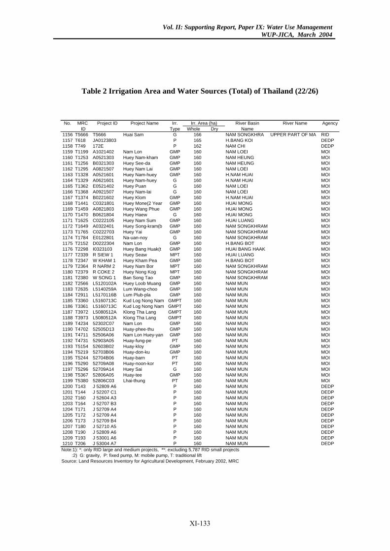
Vol. II: Supporting Report, Paper IX: Water Use ManagementWUP-JICA, March 2004
Table 2 Irrigation Area and Water Sources (Total) of Thailand (22/26)
River Basin River Name AgencyDry Name
6 NAM SONGKHRA UPPER PART OF MA RID65 H.BANG KOI DEDP62 NAM CHI DEDP
0 NAM LOEI MOI60 NAM HEUNG MOI60 NAM HEUNG MOI60 NAM LOEI MOI60 H.NAM HUAI MOI60 H.NAM HUAI MOI60 NAM LOEI MOI
0 NAM LOEI MOI60 H.NAM HUAI MOI60 HUAI MONG MOI60 HUAI MONG MOI60 HUAI MONG MOI
0 HUAI LUANG MOI0 NAM SONGKHRAM MOI0 NAM SONGKHRAM MOI0 NAM SONGKHRAM MOI0 H.BANG BOT MOI
60 HUAI BANG HAAK MOI60 HUAI LUANG MOI
0 H.BANG BOT MOI0 NAM SONGKHRAM MOI0 NAM SONGKHRAM MOI0 NAM SONGKHRAM MOI0 NAM MUN MOI0 NAM MUN MOI
60 NAM MUN MOI60 NAM MUN MOI60 NAM MUN MOI60 NAM MUN MOI60 NAM MUN MOI
0 NAM MUN MOI0 NAM MUN MOI
60 NAM MUN MOI0 NAM MUN MOI0 NAM MUN MOI0 NAM MUN MOI
60 NAM MUN MOI60 NAM MUN MOI
0 NAM MUN MOI60 NAM MUN MOI60 NAM MUN MOI60 NAM MUN DEDP60 NAM MUN DEDP60 NAM MUN DEDP60 NAM MUN DEDP60 NAM MUN DEDP60 NAM MUN DEDP60 NAM MUN DEDP60 NAM MUN DEDP60 NAM MUN DEDP60 NAM MUN DEDP60 NAM MUN DEDP7 RID small projects
rea (ha)No. MRC Project ID Project Name Irr.ID Type Whole
1156 T5666 T5666 Huai Sam G 161157 T618 JA0123803 P 11158 T749 172E P 11159 T1199 A1021402 Nam Lon GMP 161160 T1253 A0521303 Huey Nam-kham GMP 11161 T1256 B0321303 Huey See-da GMP 11162 T1295 A0821507 Huey Nam Lai GMP 11163 T1328 A0521601 Huey Nam-huey GMP 11164 T1329 A0621601 Huey Nam-huey G 11165 T1362 E0521402 Huey Puan G 11166 T1368 A0921507 Huey Nam-lai G 161167 T1374 B0221602 Huey Klom GMP 11168 T1441 C0321801 Huey Mone(2 Year GMP 11169 T1459 A0821803 Huey Wang Phue GMP 11170 T1470 B0621804 Huey Haew G 11171 T1625 C0222105 Huey Nam Sum GMP 161172 T1649 A0322401 Huey Song-kram(b GMP 161173 T1765 C0222703 Huey Yai GMP 161174 T1784 E0122801 Na-uan-noy G 161175 T2152 D0222304 Nam Lon GMP 161176 T2298 I0323103 Huey Bang Huak(t GMP 11177 T2339 R SIEW 1 Huey Seaw MPT 11178 T2347 W KHAM 1 Huey Kham Pea GMP 161179 T2364 R NARM 2 Huey Nam Bor MPT 161180 T2379 R COKE 2 Huey Nong Kog MPT 161181 T2380 W SONG 1 Ban Song Tao GMP 161182 T2566 L5120102A Huey Loob Muang GMP 161183 T2635 L5140259A Lum Wang-choo GMP 161184 T2911 L5170116B Lum Plub-pla GMP 11185 T3360 L5160713C Kud Log Nong Nam GMPT 11186 T3361 L5160713C Kud Log Nong Nam GMPT 11187 T3972 L5080512A Klong Tha Lang GMPT 11188 T3973 L5080512A Klong Tha Lang GMPT 11189 T4234 52302C07 Nam Lon GMP 161190 T4702 52505D13 Huay-phee-thu GMP 161191 T4711 52506A06 Nam Lon Huey-yan GMP 11192 T4731 52903A05 Huay-fung-pe PT 161193 T5154 52603B02 Huay-kloy GMP 161194 T5219 52703B06 Huay-don-ku GMP 161195 T5244 52704B06 Huay-barn PT 11196 T5290 52709A08 Huay-noon-kor PT 11197 T5296 52709A14 Huey Sai G 161198 T5367 52806A05 Huay-tee GMP 11199 T5380 52806C03 Lhai-thung PT 11200 T143 J 52809 A6 P 11201 T144 J 52207 C1 P 11202 T160 J 52604 A3 P 11203 T164 J 52707 B3 P 11204 T171 J 52709 A4 P 11205 T172 J 52709 A4 P 11206 T173 J 52709 B4 P 11207 T180 J 52710 A5 P 11208 T190 J 52809 A6 P 11209 T193 J 53001 A6 P 11210 T206 J 53004 A7 P 1Note:1): *: only RID large and medium projects, **: excluding 5,78 :2) G: gravity, P: fixed pump, M: mobile pump, T: traditional liftSource: Land Resources Inventory for Agricultural Development, February 2002, MRC
Irr. A
XI-133
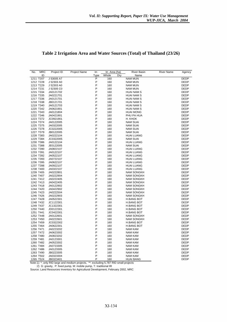
Vol. II: Supporting Report, Paper IX: Water Use ManagementWUP-JICA, March 2004
Table 2 Irrigation Area and Water Sources (Total) of Thailand (23/26)
River Basin River Name AgencyDry Name
60 NAM MUN DEDP60 NAM MUN DEDP60 NAM MUN DEDP60 NAM MUN DEDP60 HUAI NAM S DEDP60 HUAI NAM S DEDP60 HUAI NAM S DEDP60 HUAI NAM S DEDP60 HUAI NAM S DEDP60 HUAI NAM S DEDP60 HUAI MONG DEDP60 PHU PA HUA DEDP
0 H. KHOK DEDP60 NAM SUAI DEDP60 NAM SUAI DEDP
0 NAM SUAI DEDP60 NAM SUAI DEDP60 HUAI LUANG DEDP
0 NAM SUAI DEDP60 HUAI LUANG DEDP60 NAM SUAI DEDP60 HUAI LUANG DEDP60 HUAI LUANG DEDP60 HUAI LUANG DEDP60 HUAI LUANG DEDP60 HUAI LUANG DEDP60 HUAI LUANG DEDP60 HUAI LUANG DEDP60 NAM SONGKH DEDP60 NAM SONGKH DEDP60 NAM SONGKH DEDP60 NAM SONGKH DEDP60 NAM SONGKH DEDP60 NAM SONGKH DEDP60 NAM SONGKH DEDP60 NAM SONGKH DEDP60 H.BANG BOT DEDP
0 H.BANG BOT DEDP0 H.BANG BOT DEDP0 H.BANG BOT DEDP0 H.BANG BOT DEDP
60 NAM SONGKH DEDP60 NAM SONGKH DEDP
0 H.BANG BOT DEDP60 H.BANG BOT DEDP60 NAM KAM DEDP60 NAM KAM DEDP60 NAM KAM DEDP60 NAM KAM DEDP60 NAM KAM DEDP60 NAM KAM DEDP60 NAM KAM DEDP60 NAM KAM DEDP60 NAM KAM DEDP60 HUAI BANG DEDP7 RID small projects
rea (ha)No. MRC Project ID Project Name Irr.ID Type Whole
1211 T207 J 53005 A7 P 11212 T228 J 52303 A0 P 11213 T229 J 52303 A0 P 11214 T231 J 52305 C0 P 11215 T334 JA0121702 P 11216 T335 JA0221701 P 11217 T336 JA0121701 P 11218 T338 JB0121701 P 11219 T340 JA0121703 P 11220 T342 JA0621901 P 11221 T343 JA0121804 P 11222 T346 JA0421901 P 11223 T372 JC0921901 P 161224 T374 JA0122005 P 11225 T375 JA0322005 P 11226 T378 JC0222005 P 161227 T379 JB0122005 P 11228 T383 JA0222104 P 11229 T384 JC0322005 P 161230 T386 JA0122104 P 11231 T388 JE0122005 P 11232 T390 JA0822107 P 11233 T391 JA0122107 P 11234 T392 JA0522107 P 11235 T393 JA0722107 P 11236 T395 JA0622107 P 11237 T398 JA0922107 P 11238 T400 JA0322107 P 11239 T405 JA0222801 P 11240 T407 JA0222904 P 11241 T412 JA0222405 P 11242 T413 JA0422405 P 11243 T418 JA0122902 P 11244 T420 JA0422902 P 11245 T423 JA0222504 P 11246 T426 JA0222903 P 11247 T428 JA0522301 P 11248 T432 JC1122301 P 161249 T437 JC1322301 P 161250 T440 JD0122301 P 161251 T441 JC0422301 P 161252 T448 JA0122601 P 11253 T450 JA0222601 P 11254 T459 JC0322302 P 161255 T464 JA0622301 P 11256 T471 JA0223202 P 11257 T472 JA0623302 P 11258 T480 JA0823202 P 11259 T481 JA0123301 P 11260 T482 JA0523302 P 11261 T484 JA0723305 P 11262 T486 JA0123305 P 11263 T490 JB0223305 P 11264 T502 JA0323304 P 11265 T524 JB0323401 P 1Note:1): *: only RID large and medium projects, **: excluding 5,78 :2) G: gravity, P: fixed pump, M: mobile pump, T: traditional liftSource: Land Resources Inventory for Agricultural Development, February 2002, MRC
Irr. A
XI-134
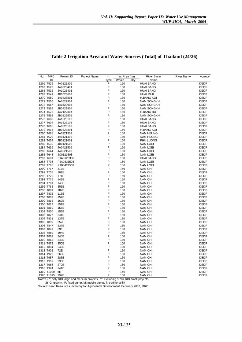
Vol. II: Supporting Report, Paper IX: Water Use ManagementWUP-JICA, March 2004
Table 2 Irrigation Area and Water Sources (Total) of Thailand (24/26)
River Basin River Name AgencyDry Name
60 HUAI BANG DEDP60 HUAI BANG DEDP60 HUAI BANG DEDP60 HUAI MUK DEDP60 H.BANG KOI DEDP60 NAM SONGKH DEDP60 NAM SONGKH DEDP60 NAM SONGKH DEDP60 H.BANG BOT DEDP60 NAM SONGKH DEDP60 HUAI BANG DEDP60 HUAI BANG DEDP60 HUAI BANG DEDP60 H.BANG KOI DEDP60 NAM HEUNG DEDP60 NAM HEUNG DEDP60 PHU LUONG DEDP60 NAM LOEI DEDP60 NAM LOEI DEDP60 NAM LOEI DEDP
0 NAM LOEI DEDP0 HUAI BANG DEDP0 NAM LOEI DEDP0 NAM LOEI DEDP
60 NAM CHI DEDP60 NAM CHI DEDP60 NAM CHI DEDP60 NAM CHI DEDP60 NAM CHI DEDP60 NAM CHI DEDP60 NAM CHI DEDP60 NAM CHI DEDP60 NAM CHI DEDP60 NAM CHI DEDP60 NAM CHI DEDP60 NAM CHI DEDP60 NAM CHI DEDP60 NAM CHI DEDP60 NAM CHI DEDP60 NAM CHI DEDP60 NAM CHI DEDP60 NAM CHI DEDP60 NAM CHI DEDP60 NAM CHI DEDP60 NAM CHI DEDP60 NAM CHI DEDP60 NAM CHI DEDP60 NAM CHI DEDP60 NAM CHI DEDP60 NAM CHI DEDP60 NAM CHI DEDP60 NAM CHI DEDP60 NAM CHI DEDP
NAM CHI DEDP60 NAM CHI DEDP7 RID small projects
rea (ha)No. MRC Project ID Project Name Irr.ID Type Whole
1266 T525 JA0123306 P 11267 T529 JA0323401 P 11268 T532 JA1023401 P 11269 T541 JB0623602 P 11270 T550 JA0423801 P 11271 T556 JA0522904 P 11272 T557 JA0422904 P 11273 T559 JB0422904 P 11274 T576 JA2122304 P 11275 T592 JB0122502 P 11276 T600 JA1023103 P 11277 T604 JA1623103 P 11278 T606 JA0523103 P 11279 T616 JB0323801 P 11280 T628 JA0221302 P 11281 T629 JA0121303 P 11282 T634 JB0121601 P 11283 T635 JB0121503 P 11284 T639 JA0421509 P 11285 T644 JA0521509 P 11286 T648 JC0121503 P 161287 T691 PJA0123306 P 161288 T705 PJA0321503 P 161289 T706 PJB0421503 P 161290 T717 317E P 11291 T738 102E P 11292 T770 171E P 11293 T775 143E P 11294 T781 145E P 11295 T788 353E P 11296 T801 187E P 11297 T802 115E P 11298 T809 154E P 11299 T816 162E P 11300 T817 152E P 11301 T819 156E P 11302 T820 153E P 11303 T827 341E P 11304 T831 137E P 11305 T839 357E P 11306 T847 337E P 11307 T849 89E P 11308 T859 194E P 11309 T862 340E P 11310 T863 343E P 11311 T872 350E P 11312 T894 248E P 11313 T902 72E P 11314 T923 360E P 11315 T957 283E P 11316 T959 238E P 11317 T966 270E P 11318 T974 241E P 11319 T1009 5E P 1601320 T1015 299E P 1Note:1): *: only RID large and medium projects, **: excluding 5,78 :2) G: gravity, P: fixed pump, M: mobile pump, T: traditional liftSource: Land Resources Inventory for Agricultural Development, February 2002, MRC
Irr. A
XI-135
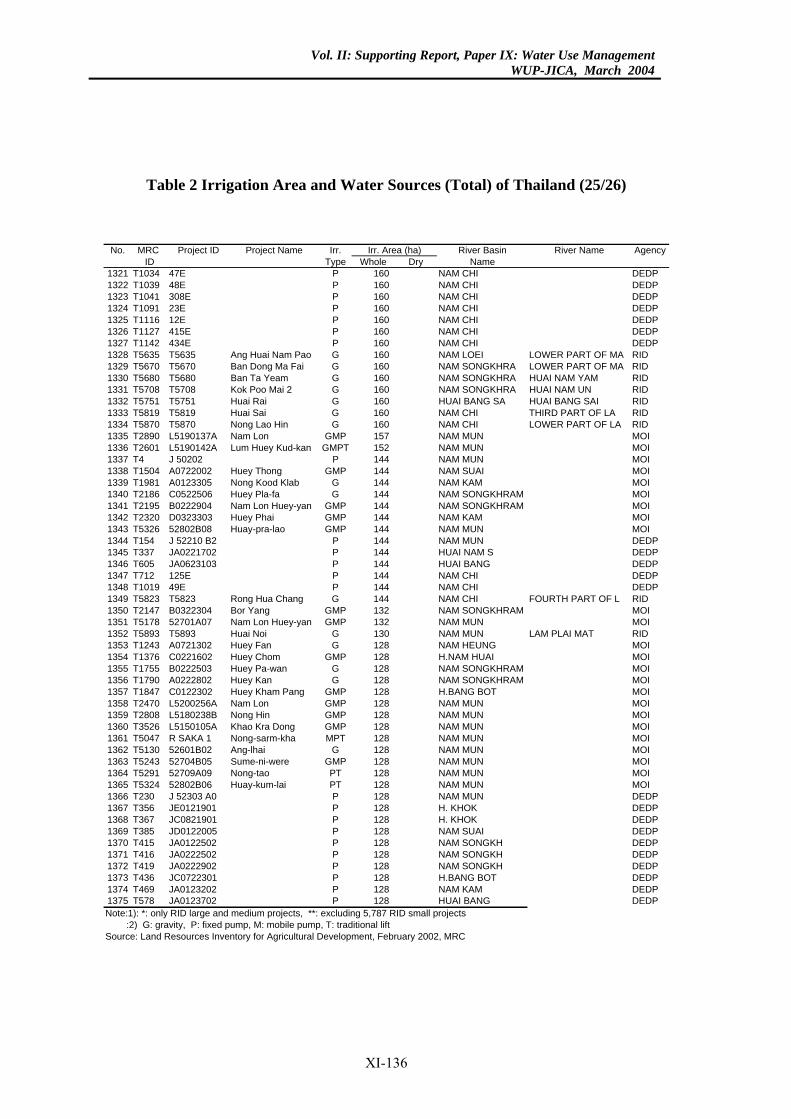
Vol. II: Supporting Report, Paper IX: Water Use ManagementWUP-JICA, March 2004
Table 2 Irrigation Area and Water Sources (Total) of Thailand (25/26)
River Basin River Name AgencyDry Name
60 NAM CHI DEDP60 NAM CHI DEDP60 NAM CHI DEDP60 NAM CHI DEDP60 NAM CHI DEDP60 NAM CHI DEDP60 NAM CHI DEDP
0 NAM LOEI LOWER PART OF MA RID0 NAM SONGKHRA LOWER PART OF MA RID
60 NAM SONGKHRA HUAI NAM YAM RID0 NAM SONGKHRA HUAI NAM UN RID0 HUAI BANG SA HUAI BANG SAI RID0 NAM CHI THIRD PART OF LA RID0 NAM CHI LOWER PART OF LA RID7 NAM MUN MOI
52 NAM MUN MOI44 NAM MUN MOI44 NAM SUAI MOI44 NAM KAM MOI44 NAM SONGKHRAM MOI44 NAM SONGKHRAM MOI44 NAM KAM MOI44 NAM MUN MOI44 NAM MUN DEDP44 HUAI NAM S DEDP44 HUAI BANG DEDP44 NAM CHI DEDP44 NAM CHI DEDP4 NAM CHI FOURTH PART OF L RID
32 NAM SONGKHRAM MOI32 NAM MUN MOI
0 NAM MUN LAM PLAI MAT RID8 NAM HEUNG MOI
28 H.NAM HUAI MOI28 NAM SONGKHRAM MOI
8 NAM SONGKHRAM MOI28 H.BANG BOT MOI8 NAM MUN MOI8 NAM MUN MOI
28 NAM MUN MOI28 NAM MUN MOI28 NAM MUN MOI28 NAM MUN MOI28 NAM MUN MOI
8 NAM MUN MOI28 NAM MUN DEDP28 H. KHOK DEDP
8 H. KHOK DEDP8 NAM SUAI DEDP
28 NAM SONGKH DEDP28 NAM SONGKH DEDP28 NAM SONGKH DEDP
8 H.BANG BOT DEDP28 NAM KAM DEDP28 HUAI BANG DEDP7 RID small projects
rea (ha)No. MRC Project ID Project Name Irr.ID Type Whole
1321 T1034 47E P 11322 T1039 48E P 11323 T1041 308E P 11324 T1091 23E P 11325 T1116 12E P 11326 T1127 415E P 11327 T1142 434E P 11328 T5635 T5635 Ang Huai Nam Pao G 161329 T5670 T5670 Ban Dong Ma Fai G 161330 T5680 T5680 Ban Ta Yeam G 11331 T5708 T5708 Kok Poo Mai 2 G 161332 T5751 T5751 Huai Rai G 161333 T5819 T5819 Huai Sai G 161334 T5870 T5870 Nong Lao Hin G 161335 T2890 L5190137A Nam Lon GMP 151336 T2601 L5190142A Lum Huey Kud-kan GMPT 11337 T4 J 50202 P 11338 T1504 A0722002 Huey Thong GMP 11339 T1981 A0123305 Nong Kood Klab G 11340 T2186 C0522506 Huey Pla-fa G 11341 T2195 B0222904 Nam Lon Huey-yan GMP 11342 T2320 D0323303 Huey Phai GMP 11343 T5326 52802B08 Huay-pra-lao GMP 11344 T154 J 52210 B2 P 11345 T337 JA0221702 P 11346 T605 JA0623103 P 11347 T712 125E P 11348 T1019 49E P 11349 T5823 T5823 Rong Hua Chang G 141350 T2147 B0322304 Bor Yang GMP 11351 T5178 52701A07 Nam Lon Huey-yan GMP 11352 T5893 T5893 Huai Noi G 131353 T1243 A0721302 Huey Fan G 121354 T1376 C0221602 Huey Chom GMP 11355 T1755 B0222503 Huey Pa-wan G 11356 T1790 A0222802 Huey Kan G 121357 T1847 C0122302 Huey Kham Pang GMP 11358 T2470 L5200256A Nam Lon GMP 121359 T2808 L5180238B Nong Hin GMP 121360 T3526 L5150105A Khao Kra Dong GMP 11361 T5047 R SAKA 1 Nong-sarm-kha MPT 11362 T5130 52601B02 Ang-lhai G 11363 T5243 52704B05 Sume-ni-were GMP 11364 T5291 52709A09 Nong-tao PT 11365 T5324 52802B06 Huay-kum-lai PT 121366 T230 J 52303 A0 P 11367 T356 JE0121901 P 11368 T367 JC0821901 P 121369 T385 JD0122005 P 121370 T415 JA0122502 P 11371 T416 JA0222502 P 11372 T419 JA0222902 P 11373 T436 JC0722301 P 121374 T469 JA0123202 P 11375 T578 JA0123702 P 1Note:1): *: only RID large and medium projects, **: excluding 5,78 :2) G: gravity, P: fixed pump, M: mobile pump, T: traditional liftSource: Land Resources Inventory for Agricultural Development, February 2002, MRC
Irr. A
XI-136
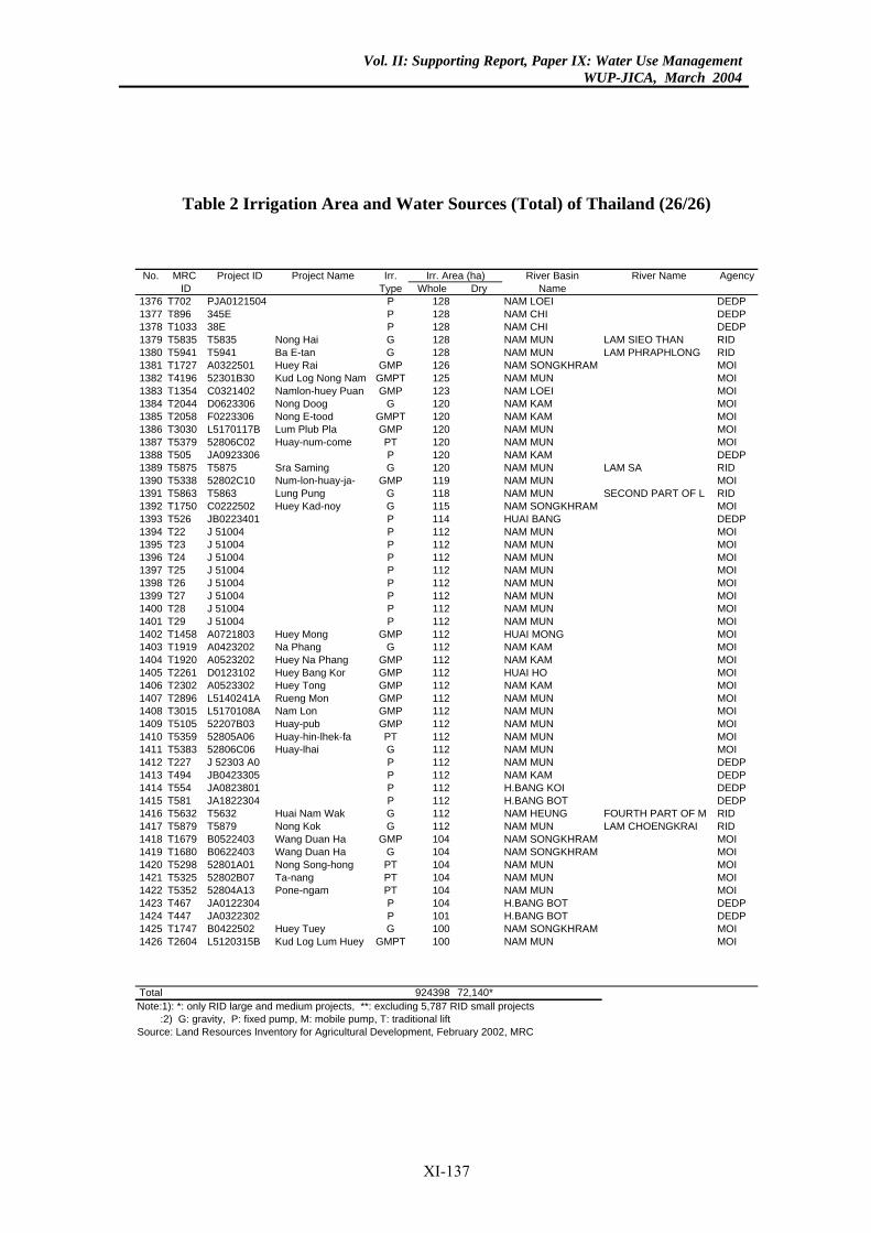
Vol. II: Supporting Report, Paper IX: Water Use ManagementWUP-JICA, March 2004
Table 2 Irrigation Area and Water Sources (Total) of Thailand (26/26)
River Basin River Name AgencyDry Name
8 NAM LOEI DEDP28 NAM CHI DEDP28 NAM CHI DEDP
8 NAM MUN LAM SIEO THAN RID8 NAM MUN LAM PHRAPHLONG RID6 NAM SONGKHRAM MOI
25 NAM MUN MOI23 NAM LOEI MOI20 NAM KAM MOI
0 NAM KAM MOI0 NAM MUN MOI
20 NAM MUN MOI20 NAM KAM DEDP20 NAM MUN LAM SA RID19 NAM MUN MOI18 NAM MUN SECOND PART OF L RID
5 NAM SONGKHRAM MOI14 HUAI BANG DEDP12 NAM MUN MOI12 NAM MUN MOI12 NAM MUN MOI12 NAM MUN MOI12 NAM MUN MOI12 NAM MUN MOI12 NAM MUN MOI12 NAM MUN MOI12 HUAI MONG MOI12 NAM KAM MOI12 NAM KAM MOI2 HUAI HO MOI
12 NAM KAM MOI2 NAM MUN MOI2 NAM MUN MOI
12 NAM MUN MOI12 NAM MUN MOI12 NAM MUN MOI12 NAM MUN DEDP12 NAM KAM DEDP12 H.BANG KOI DEDP12 H.BANG BOT DEDP
2 NAM HEUNG FOURTH PART OF M RID2 NAM MUN LAM CHOENGKRAI RID
04 NAM SONGKHRAM MOI04 NAM SONGKHRAM MOI
4 NAM MUN MOI4 NAM MUN MOI4 NAM MUN MOI
04 H.BANG BOT DEDP01 H.BANG BOT DEDP00 NAM SONGKHRAM MOI
0 NAM MUN MOI
98 72,140*7 RID small projects
rea (ha)No. MRC Project ID Project Name Irr.ID Type Whole
1376 T702 PJA0121504 P 121377 T896 345E P 11378 T1033 38E P 11379 T5835 T5835 Nong Hai G 121380 T5941 T5941 Ba E-tan G 121381 T1727 A0322501 Huey Rai GMP 121382 T4196 52301B30 Kud Log Nong Nam GMPT 11383 T1354 C0321402 Namlon-huey Puan GMP 11384 T2044 D0623306 Nong Doog G 11385 T2058 F0223306 Nong E-tood GMPT 121386 T3030 L5170117B Lum Plub Pla GMP 121387 T5379 52806C02 Huay-num-come PT 11388 T505 JA0923306 P 11389 T5875 T5875 Sra Saming G 11390 T5338 52802C10 Num-lon-huay-ja- GMP 11391 T5863 T5863 Lung Pung G 11392 T1750 C0222502 Huey Kad-noy G 111393 T526 JB0223401 P 11394 T22 J 51004 P 11395 T23 J 51004 P 11396 T24 J 51004 P 11397 T25 J 51004 P 11398 T26 J 51004 P 11399 T27 J 51004 P 11400 T28 J 51004 P 11401 T29 J 51004 P 11402 T1458 A0721803 Huey Mong GMP 11403 T1919 A0423202 Na Phang G 11404 T1920 A0523202 Huey Na Phang GMP 11405 T2261 D0123102 Huey Bang Kor GMP 111406 T2302 A0523302 Huey Tong GMP 11407 T2896 L5140241A Rueng Mon GMP 111408 T3015 L5170108A Nam Lon GMP 111409 T5105 52207B03 Huay-pub GMP 11410 T5359 52805A06 Huay-hin-lhek-fa PT 11411 T5383 52806C06 Huay-lhai G 11412 T227 J 52303 A0 P 11413 T494 JB0423305 P 11414 T554 JA0823801 P 11415 T581 JA1822304 P 11416 T5632 T5632 Huai Nam Wak G 111417 T5879 T5879 Nong Kok G 111418 T1679 B0522403 Wang Duan Ha GMP 11419 T1680 B0622403 Wang Duan Ha G 11420 T5298 52801A01 Nong Song-hong PT 101421 T5325 52802B07 Ta-nang PT 101422 T5352 52804A13 Pone-ngam PT 101423 T467 JA0122304 P 11424 T447 JA0322302 P 11425 T1747 B0422502 Huey Tuey G 11426 T2604 L5120315B Kud Log Lum Huey GMPT 10
Total 9243Note:1): *: only RID large and medium projects, **: excluding 5,78 :2) G: gravity, P: fixed pump, M: mobile pump, T: traditional liftSource: Land Resources Inventory for Agricultural Development, February 2002, MRC
Irr. A
XI-137
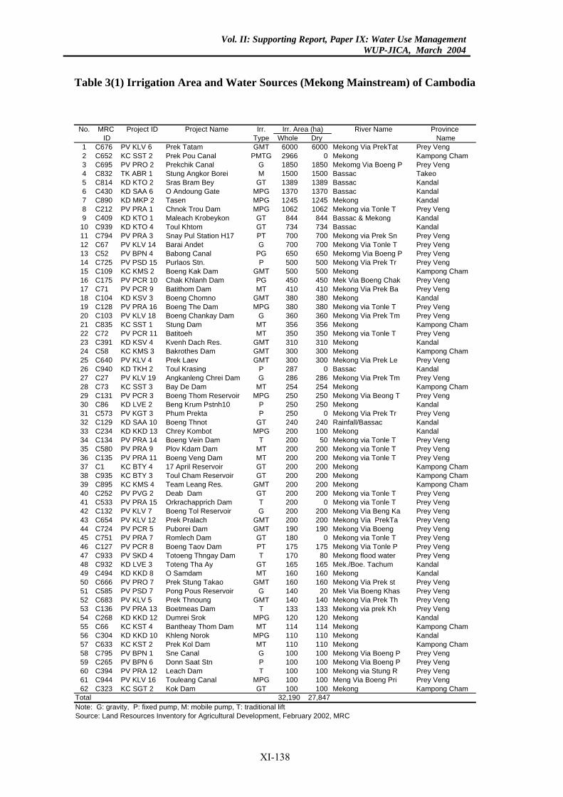
Vol. II: Supporting Report, Paper IX: Water Use ManagementWUP-JICA, March 2004
Table 3(1) Irrigation Area and Water Sources (Mekong Mainstream) of Cambodia
River Name Province Whole Dry Name
6000 6000 Mekong Via PrekTat Prey Veng2966 0 Mekong Kampong Cham1850 1850 Mekomg Via Boeng P Prey Veng1500 1500 Bassac Takeo1389 1389 Bassac Kandal1370 1370 Bassac Kandal1245 1245 Mekong Kandal1062 1062 Mekong via Tonle T Prey Veng
844 844 Bassac & Mekong Kandal734 734 Bassac Kandal700 700 Mekong via Prek Sn Prey Veng700 700 Mekong Via Tonle T Prey Veng650 650 Mekomg Via Boeng P Prey Veng500 500 Mekong Via Prek Tr Prey Veng500 500 Mekong Kampong Cham450 450 Mek Via Boeng Chak Prey Veng410 410 Mekong Via Prek Ba Prey Veng380 380 Mekong Kandal380 380 Mekong via Tonle T Prey Veng360 360 Mekong Via Prek Tm Prey Veng356 356 Mekong Kampong Cham350 350 Mekong via Tonle T Prey Veng310 310 Mekong Kandal300 300 Mekong Kampong Cham300 300 Mekong Via Prek Le Prey Veng287 0 Bassac Kandal286 286 Mekong Via Prek Tm Prey Veng254 254 Mekong Kampong Cham250 250 Mekong Via Beong T Prey Veng250 250 Mekong Kandal250 0 Mekong Via Prek Tr Prey Veng240 240 Rainfall/Bassac Kandal200 100 Mekong Kandal200 50 Mekong via Tonle T Prey Veng200 200 Mekong via Tonle T Prey Veng200 200 Mekong via Tonle T Prey Veng200 200 Mekong Kampong Cham200 200 Mekong Kampong Cham200 200 Mekong Kampong Cham200 200 Mekong via Tonle T Prey Veng200 0 Mekong via Tonle T Prey Veng200 200 Mekong Via Beng Ka Prey Veng200 200 Mekong Via PrekTa Prey Veng190 190 Mekong Via Boeng Prey Veng180 0 Mekong via Tonle T Prey Veng175 175 Mekong Via Tonle P Prey Veng170 80 Mekong flood water Prey Veng165 165 Mek./Boe. Tachum Kandal160 160 Mekong Kandal160 160 Mekong Via Prek st Prey Veng140 20 Mek Via Boeng Khas Prey Veng140 140 Mekong Via Prek Th Prey Veng133 133 Mekong via prek Kh Prey Veng120 120 Mekong Kandal114 114 Mekong Kampong Cham110 110 Mekong Kandal110 110 Mekong Kampong Cham100 100 Mekong Via Boeng P Prey Veng100 100 Mekong Via Boeng P Prey Veng100 100 Mekong via Stung R Prey Veng100 100 Meng Via Boeng Pri Prey Veng100 100 Mekong Kampong Cham,190 27,847
Irr. Area (ha)No. MRC Project ID Project Name Irr.ID Type
1 C676 PV KLV 6 Prek Tatam GMT2 C652 KC SST 2 Prek Pou Canal PMTG3 C695 PV PRO 2 Prekchik Canal G4 C832 TK ABR 1 Stung Angkor Borei M5 C814 KD KTO 2 Sras Bram Bey GT6 C430 KD SAA 6 O Andoung Gate MPG7 C890 KD MKP 2 Tasen MPG8 C212 PV PRA 1 Chnok Trou Dam MPG9 C409 KD KTO 1 Maleach Krobeykon GT10 C939 KD KTO 4 Toul Khtom GT11 C794 PV PRA 3 Snay Pul Station H17 PT12 C67 PV KLV 14 Barai Andet G13 C52 PV BPN 4 Babong Canal PG14 C725 PV PSD 15 Purlaos Stn. P15 C109 KC KMS 2 Boeng Kak Dam GMT16 C175 PV PCR 10 Chak Khlanh Dam PG17 C71 PV PCR 9 Batithom Dam MT18 C104 KD KSV 3 Boeng Chomno GMT19 C128 PV PRA 16 Boeng The Dam MPG20 C103 PV KLV 18 Boeng Chankay Dam G21 C835 KC SST 1 Stung Dam MT22 C72 PV PCR 11 Batitoeh MT23 C391 KD KSV 4 Kvenh Dach Res. GMT24 C58 KC KMS 3 Bakrothes Dam GMT25 C640 PV KLV 4 Prek Laev GMT26 C940 KD TKH 2 Toul Krasing P27 C27 PV KLV 19 Angkanleng Chrei Dam G28 C73 KC SST 3 Bay De Dam MT29 C131 PV PCR 3 Boeng Thom Reservoir MPG30 C86 KD LVE 2 Beng Krum Pstnh10 P31 C573 PV KGT 3 Phum Prekta P32 C129 KD SAA 10 Boeng Thnot GT33 C234 KD KKD 13 Chrey Kombot MPG34 C134 PV PRA 14 Boeng Vein Dam T35 C580 PV PRA 9 Plov Kdam Dam MT36 C135 PV PRA 11 Boeng Veng Dam MT37 C1 KC BTY 4 17 April Reservoir GT38 C935 KC BTY 3 Toul Cham Reservoir GT39 C895 KC KMS 4 Team Leang Res. GMT40 C252 PV PVG 2 Deab Dam GT41 C533 PV PRA 15 Orkrachapprich Dam T42 C132 PV KLV 7 Boeng Tol Reservoir G43 C654 PV KLV 12 Prek Pralach GMT44 C724 PV PCR 5 Puborei Dam GMT45 C751 PV PRA 7 Romlech Dam GT46 C127 PV PCR 8 Boeng Taov Dam PT47 C933 PV SKD 4 Totoeng Thngay Dam T48 C932 KD LVE 3 Toteng Tha Ay GT49 C494 KD KKD 8 O Samdam MT50 C666 PV PRO 7 Prek Stung Takao GMT51 C585 PV PSD 7 Pong Pous Reservoir G52 C683 PV KLV 5 Prek Thnoung GMT53 C136 PV PRA 13 Boetmeas Dam T54 C268 KD KKD 12 Dumrei Srok MPG55 C66 KC KST 4 Bantheay Thom Dam MT56 C304 KD KKD 10 Khleng Norok MPG57 C633 KC KST 2 Prek Kol Dam MT58 C795 PV BPN 1 Sne Canal G59 C265 PV BPN 6 Donn Saat Stn P60 C394 PV PRA 12 Leach Dam T61 C944 PV KLV 16 Touleang Canal MPG62 C323 KC SGT 2 Kok Dam GT
Total 32Note: G: gravity, P: fixed pump, M: mobile pump, T: traditional liftSource: Land Resources Inventory for Agricultural Development, February 2002, MRC
XI-138
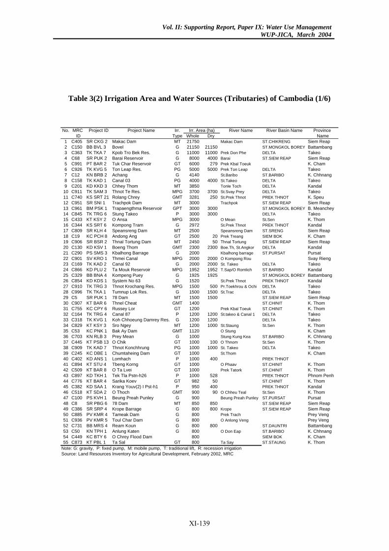
Vol. II: Supporting Report, Paper IX: Water Use ManagementWUP-JICA, March 2004
Table 3(2) Irrigation Area and Water Sources (Tributaries) of Cambodia (1/6)
No. MRC Project ID Project Name Irr. River Name River Basin Name Province ID Type Whole Dry Name
1 C405 SR CKG 2 Makac Dam MT 21750 Makac Dam ST.CHIKRENG Siem Reap2 C150 BB BVL 3 Bovel G 21150 21150 ST.MONGKOL BOREY Battambang3 C363 TK TKA 7 Kpob Tro Bek Res. G 11000 11000 Prek Don Phe DELTA Takeo4 C68 SR PUK 2 Barai Reservoir G 8000 4000 Barai ST.SIEM REAP Siem Reap5 C991 PT BAR 2 Tuk Char Reservoir GT 6000 279 Prek Kbal Toeuk K. Cham6 C926 TK KVG 5 Ton Leap Res. PG 5000 5000 Prek Ton Leap DELTA Takeo7 C12 KN BRB 2 Achang G 4140 St.Baribo ST.BARIBO K. Chhnang8 C158 TK KAD 1 Canal 03 PG 4000 4000 St.Takeo DELTA Takeo9 C201 KD KKD 3 Chhey Thom MT 3850 Tonle Toch DELTA Kandal
10 C911 TK SAM 3 Thnot Te Res. MPG 3700 3700 St.Svay Prey DELTA Takeo11 C740 KS SRT 21 Rolang Chrey GMT 3281 250 St.Prek Thnot PREK THNOT K. Speu12 C951 SR SNI 1 Trachpok Dam MT 3000 Trachpok ST.SIEM REAP Siem Reap13 C961 BM PSK 1 Trapaengthma Reservoir GPT 3000 3000 ST.MONGKOL BOREY B. Meanchey14 C845 TK TRG 6 Stung Takeo P 3000 3000 DELTA Takeo15 C433 KT KSY 2 O Ansa MPG 3000 O Mean St.Sen K. Thom16 C344 KS SRT 6 Kompong Tram G 2972 St.Prek Thnot PREK THNOT Kandal17 C809 SR KLH 4 Speansreng Dam MT 2500 Speansreng Dam ST.SRENG Siem Reap18 C19 KC PCH 8 Andong Ang GT 2500 20 Prek Treang SIEM BOK K. Cham19 C906 SR BSR 2 Thnal Tortung Dam MT 2450 50 Thnal Tortung ST.SIEM REAP Siem Reap20 C130 KD KSV 1 Boeng Thom GMT 2300 2300 Boe.Th, St.Angkor DELTA Kandal21 C290 PS SMS 3 Kbalhong Barrage G 2000 Kbalhong barrage ST.PURSAT Pursat22 C901 SV KRO 1 Thmei Canal MPG 2000 2000 O Kompong Rou Svay Rieng23 C169 TK KAD 2 Canal 92 G 2000 2000 St. Takeo DELTA Takeo24 C866 KD PLU 2 Ta Mouk Reservoir MPG 1952 1952 T.Sap/O Romlich ST.BARIBO Kandal25 C329 BB BNA 4 Kompeng Puey G 1925 1925 ST.MONGKOL BOREY Battambang26 C854 KD KDS 1 System No 63 G 1520 St.Prek Thnot PREK THNOT Kandal27 C910 TK TRG 3 Thnot Krochang Res. MPG 1500 500 Pr.Toekhrou & Ochi DELTA Takeo28 C996 TK TKA 1 Tumnup Lok Res. G 1500 1500 St.Trac DELTA Takeo29 C5 SR PUK 1 78 Dam MT 1500 1500 ST.SIEM REAP Siem Reap30 C907 KT BAR 6 Thnel Cheat GMT 1400 ST.CHINIT K. Thom31 C755 KC CPY 6 Russey Lor GT 1200 Prek Kbal Toeuk ST.CHINIT K. Thom32 C164 TK TRG 4 Canal 87 P 1200 1200 St.takeo & Canal 1 DELTA Takeo33 C318 TK KVG 1 Koh Chhoeung Damrey Res. G 1200 1200 DELTA Takeo34 C829 KT KSY 3 Sro Ngey MT 1200 1000 St.Staung St.Sen K. Thom35 C53 KC PNK 1 Bak Ay Dam GMT 1120 O Stung K. Cham36 C703 KN RLB 3 Prey Mean G 1000 Stung Kung Kea ST.BARIBO K. Chhnang37 C445 KT PSB 13 O Chik GT 1000 100 O Thnom St.Sen K. Thom38 C909 TK KAD 7 Thnot Konchhrung PG 1000 1000 St. Takeo DELTA Takeo39 C245 KC DBE 1 Chumtaheing Dam GT 1000 St.Thom K. Cham40 C402 KD ANS 1 Lomhach P 1000 400 PREK THNOT41 C894 KT STU 4 Tbeng Korng GT 1000 O Phaav ST.CHINIT K. Thom42 C509 KT BAR 8 O Ta Lvei GT 1000 Prek Tatork ST.CHINIT K. Thom43 C897 KD TKH 1 Tek Tla Pstn-h26 P 1000 528 PREK THNOT Phnom Penh44 C776 KT BAR 4 Sarika Koev GT 982 50 ST.CHINIT K. Thom45 C382 KD SAA 1 Krang Youv(2) I Pst-h1 P 950 400 PREK THNOT Kandal46 C518 KT SDA 2 O Thoch GMT 900 90 O Chheu Teal St.Sen K. Thom47 C100 PS KVH 1 Beung Preah Punley G 900 Beung Preah Punley ST.PURSAT Pursat48 C8 SR PBG 6 78 Dam MT 850 850 ST.SIEM REAP Siem Reap49 C386 SR SRP 4 Krope Barrage G 800 800 Krope ST.SIEM REAP Siem Reap50 C885 PV KMR 4 Tameak Dam G 800 Prek Trach Prey Veng51 C936 PV KMR 5 Toul Char Dam G 800 O Anlong Veng Prey Veng52 C731 BB MRS 4 Ream Koun G 800 800 ST.DAUNTRI Battambang53 C50 KN TPH 1 Anlung Katen G 800 O Don Eap ST.BARIBO K. Chhnang54 C449 KC BTY 6 O Chrey Flood Dam 800 SIEM BOK K. Cham55 C873 KT PBL 1 Ta Sal GT 800 Ta Say ST.STAUNG K. Thom
Note: G: gravity, P: fixed pump, M: mobile pump, T: traditional lift, R: recession irrigationSource: Land Resources Inventory for Agricultural Development, February 2002, MRC
Irr. Area (ha)
XI-139
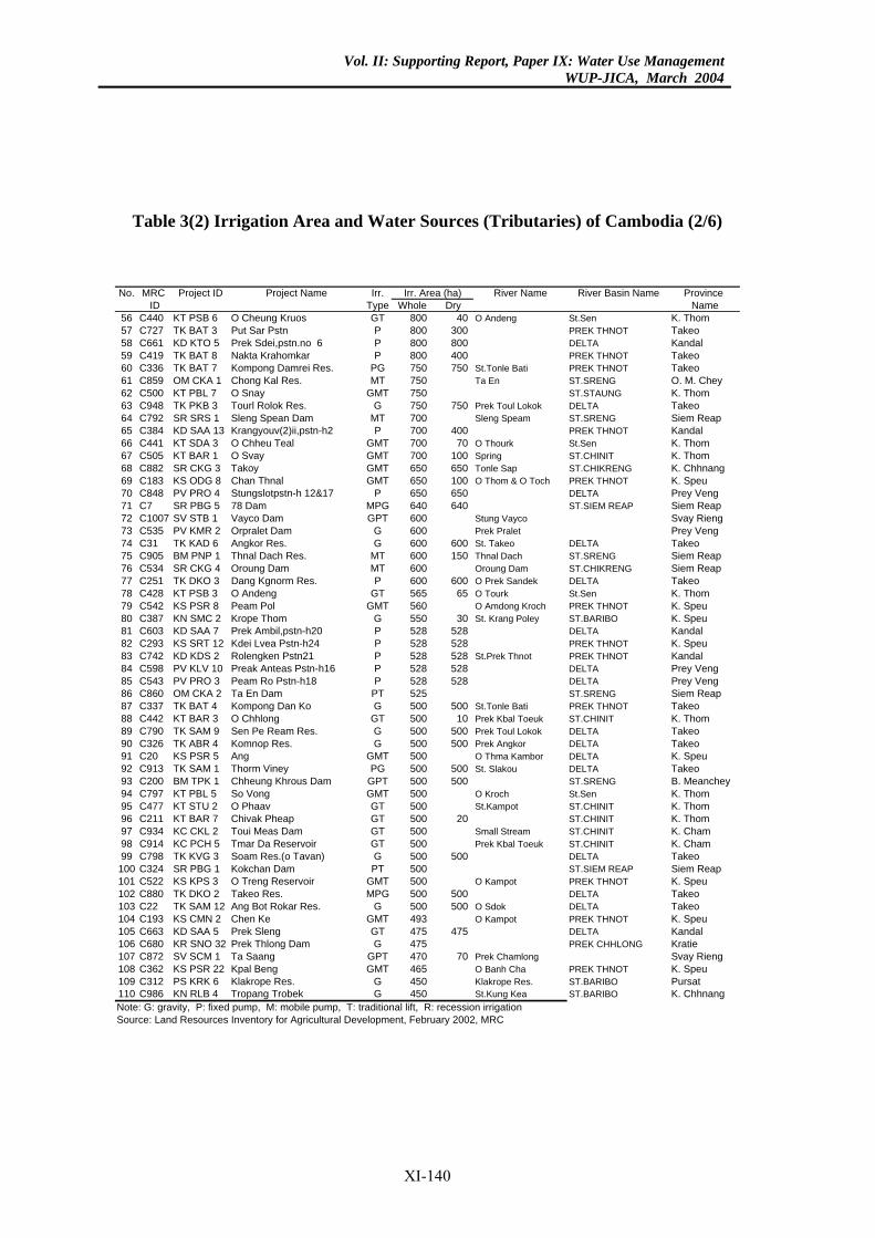
Vol. II: Supporting Report, Paper IX: Water Use ManagementWUP-JICA, March 2004
Table 3(2) Irrigation Area and Water Sources (Tributaries) of Cambodia (2/6)
River Name River Basin Name Province Dry Name
40 O Andeng St.Sen K. Thom300 PREK THNOT Takeo800 DELTA Kandal400 PREK THNOT Takeo750 St.Tonle Bati PREK THNOT Takeo
Ta En ST.SRENG O. M. CheyST.STAUNG K. Thom
750 Prek Toul Lokok DELTA TakeoSleng Speam ST.SRENG Siem Reap
400 PREK THNOT Kandal70 O Thourk St.Sen K. Thom
100 Spring ST.CHINIT K. Thom650 Tonle Sap ST.CHIKRENG K. Chhnang100 O Thom & O Toch PREK THNOT K. Speu650 DELTA Prey Veng640 ST.SIEM REAP Siem Reap
Stung Vayco Svay RiengPrek Pralet Prey Veng
600 St. Takeo DELTA Takeo150 Thnal Dach ST.SRENG Siem Reap
Oroung Dam ST.CHIKRENG Siem Reap600 O Prek Sandek DELTA Takeo65 O Tourk St.Sen K. Thom
O Amdong Kroch PREK THNOT K. Speu30 St. Krang Poley ST.BARIBO K. Speu
528 DELTA Kandal528 PREK THNOT K. Speu528 St.Prek Thnot PREK THNOT Kandal528 DELTA Prey Veng528 DELTA Prey Veng
ST.SRENG Siem Reap500 St.Tonle Bati PREK THNOT Takeo
10 Prek Kbal Toeuk ST.CHINIT K. Thom500 Prek Toul Lokok DELTA Takeo500 Prek Angkor DELTA Takeo
O Thma Kambor DELTA K. Speu500 St. Slakou DELTA Takeo500 ST.SRENG B. Meanchey
O Kroch St.Sen K. ThomSt.Kampot ST.CHINIT K. Thom
20 ST.CHINIT K. ThomSmall Stream ST.CHINIT K. ChamPrek Kbal Toeuk ST.CHINIT K. Cham
500 DELTA TakeoST.SIEM REAP Siem Reap
O Kampot PREK THNOT K. Speu500 DELTA Takeo500 O Sdok DELTA Takeo
O Kampot PREK THNOT K. Speu475 DELTA Kandal
PREK CHHLONG Kratie70 Prek Chamlong Svay Rieng
O Banh Cha PREK THNOT K. SpeuKlakrope Res. ST.BARIBO PursatSt.Kung Kea ST.BARIBO K. Chhnang
Irr. Area (ha)No. MRC Project ID Project Name Irr.ID Type Whole
56 C440 KT PSB 6 O Cheung Kruos GT 80057 C727 TK BAT 3 Put Sar Pstn P 80058 C661 KD KTO 5 Prek Sdei,pstn.no 6 P 80059 C419 TK BAT 8 Nakta Krahomkar P 80060 C336 TK BAT 7 Kompong Damrei Res. PG 75061 C859 OM CKA 1 Chong Kal Res. MT 75062 C500 KT PBL 7 O Snay GMT 75063 C948 TK PKB 3 Tourl Rolok Res. G 75064 C792 SR SRS 1 Sleng Spean Dam MT 70065 C384 KD SAA 13 Krangyouv(2)ii,pstn-h2 P 70066 C441 KT SDA 3 O Chheu Teal GMT 70067 C505 KT BAR 1 O Svay GMT 70068 C882 SR CKG 3 Takoy GMT 65069 C183 KS ODG 8 Chan Thnal GMT 65070 C848 PV PRO 4 Stungslotpstn-h 12&17 P 65071 C7 SR PBG 5 78 Dam MPG 64072 C1007 SV STB 1 Vayco Dam GPT 60073 C535 PV KMR 2 Orpralet Dam G 60074 C31 TK KAD 6 Angkor Res. G 60075 C905 BM PNP 1 Thnal Dach Res. MT 60076 C534 SR CKG 4 Oroung Dam MT 60077 C251 TK DKO 3 Dang Kgnorm Res. P 60078 C428 KT PSB 3 O Andeng GT 56579 C542 KS PSR 8 Peam Pol GMT 56080 C387 KN SMC 2 Krope Thom G 55081 C603 KD SAA 7 Prek Ambil,pstn-h20 P 52882 C293 KS SRT 12 Kdei Lvea Pstn-h24 P 52883 C742 KD KDS 2 Rolengken Pstn21 P 52884 C598 PV KLV 10 Preak Anteas Pstn-h16 P 52885 C543 PV PRO 3 Peam Ro Pstn-h18 P 52886 C860 OM CKA 2 Ta En Dam PT 52587 C337 TK BAT 4 Kompong Dan Ko G 50088 C442 KT BAR 3 O Chhlong GT 50089 C790 TK SAM 9 Sen Pe Ream Res. G 50090 C326 TK ABR 4 Komnop Res. G 50091 C20 KS PSR 5 Ang GMT 50092 C913 TK SAM 1 Thorm Viney PG 50093 C200 BM TPK 1 Chheung Khrous Dam GPT 50094 C797 KT PBL 5 So Vong GMT 50095 C477 KT STU 2 O Phaav GT 50096 C211 KT BAR 7 Chivak Pheap GT 50097 C934 KC CKL 2 Toui Meas Dam GT 50098 C914 KC PCH 5 Tmar Da Reservoir GT 50099 C798 TK KVG 3 Soam Res.(o Tavan) G 500
100 C324 SR PBG 1 Kokchan Dam PT 500101 C522 KS KPS 3 O Treng Reservoir GMT 500102 C880 TK DKO 2 Takeo Res. MPG 500103 C22 TK SAM 12 Ang Bot Rokar Res. G 500104 C193 KS CMN 2 Chen Ke GMT 493105 C663 KD SAA 5 Prek Sleng GT 475106 C680 KR SNO 32 Prek Thlong Dam G 475107 C872 SV SCM 1 Ta Saang GPT 470108 C362 KS PSR 22 Kpal Beng GMT 465109 C312 PS KRK 6 Klakrope Res. G 450110 C986 KN RLB 4 Tropang Trobek G 450Note: G: gravity, P: fixed pump, M: mobile pump, T: traditional lift, R: recession irrigationSource: Land Resources Inventory for Agricultural Development, February 2002, MRC
XI-140
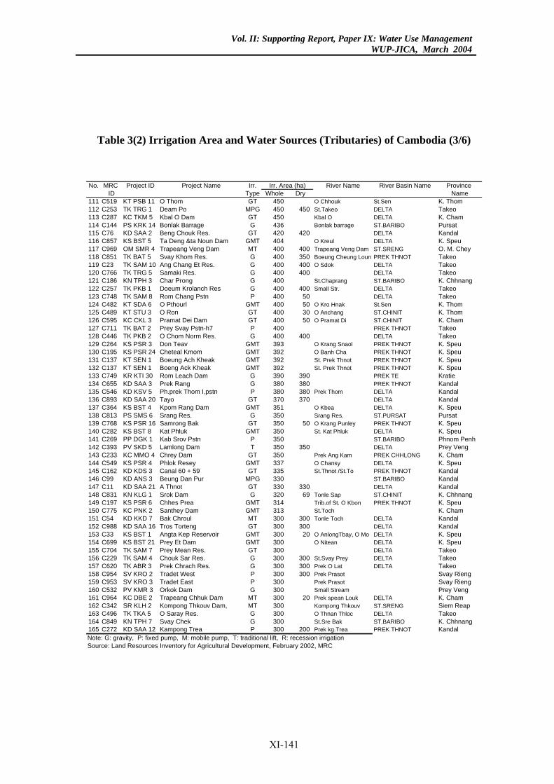
Vol. II: Supporting Report, Paper IX: Water Use ManagementWUP-JICA, March 2004
Table 3(2) Irrigation Area and Water Sources (Tributaries) of Cambodia (3/6)
River Name River Basin Name Province Dry Name
O Chhouk St.Sen K. Thom450 St.Takeo DELTA Takeo
Kbal O DELTA K. ChamBonlak barrage ST.BARIBO Pursat
420 DELTA KandalO Kreul DELTA K. Speu
400 Trapeang Veng Dam ST.SRENG O. M. Chey350 Boeung Cheung Loun PREK THNOT Takeo400 O Sdok DELTA Takeo400 DELTA Takeo
St.Chaprang ST.BARIBO K. Chhnang400 Small Str. DELTA Takeo
50 DELTA Takeo50 O Kro Hnak St.Sen K. Thom30 O Anchang ST.CHINIT K. Thom50 O Pramat Di ST.CHINIT K. Cham
PREK THNOT Takeo400 DELTA Takeo
O Krang Snaol PREK THNOT K. SpeuO Banh Cha PREK THNOT K. SpeuSt. Prek Thnot PREK THNOT K. SpeuSt. Prek Thnot PREK THNOT K. Speu
390 PREK TE Kratie380 PREK THNOT Kandal380 Prek Thom DELTA Kandal370 DELTA Kandal
O Kbea DELTA K. SpeuSrang Res. ST.PURSAT Pursat
50 O Krang Punley PREK THNOT K. SpeuSt. Kat Phluk DELTA K. Speu
ST.BARIBO Phnom Penh350 DELTA Prey Veng
Prek Ang Kam PREK CHHLONG K. ChamO Chansy DELTA K. SpeuSt.Thnot /St.To PREK THNOT Kandal
ST.BARIBO Kandal330 DELTA Kandal69 Tonle Sap ST.CHINIT K. Chhnang
Trib.of St. O Kbon PREK THNOT K. SpeuSt.Toch K. Cham
300 Tonle Toch DELTA Kandal300 DELTA Kandal
20 O AnlongTbay, O Mo DELTA K. SpeuO Nitean DELTA K. Speu
DELTA Takeo300 St.Svay Prey DELTA Takeo300 Prek O Lat DELTA Takeo300 Prek Prasot Svay Rieng
Prek Prasot Svay RiengSmall Stream Prey Veng
20 Prek spean Louk DELTA K. ChamKompong Thkouv ST.SRENG Siem ReapO Thnan Thloc DELTA TakeoSt.Sre Bak ST.BARIBO K. Chhnang
200 Prek kg.Trea PREK THNOT Kandal
Irr. Area (ha)No. MRC Project ID Project Name Irr.ID Type Whole
111 C519 KT PSB 11 O Thom GT 450112 C253 TK TRG 1 Deam Po MPG 450113 C287 KC TKM 5 Kbal O Dam GT 450114 C144 PS KRK 14 Bonlak Barrage G 436115 C76 KD SAA 2 Beng Chouk Res. GT 420116 C857 KS BST 5 Ta Deng &ta Noun Dam GMT 404117 C969 OM SMR 4 Trapeang Veng Dam MT 400118 C851 TK BAT 5 Svay Khom Res. G 400119 C23 TK SAM 10 Ang Chang Et Res. G 400120 C766 TK TRG 5 Samaki Res. G 400121 C186 KN TPH 3 Char Prong G 400122 C257 TK PKB 1 Doeum Krolanch Res G 400123 C748 TK SAM 8 Rom Chang Pstn P 400124 C482 KT SDA 6 O Pthourl GMT 400125 C489 KT STU 3 O Ron GT 400126 C595 KC CKL 3 Pramat Dei Dam GT 400127 C711 TK BAT 2 Prey Svay Pstn-h7 P 400128 C446 TK PKB 2 O Chom Norm Res. G 400129 C264 KS PSR 3 Don Teav GMT 393130 C195 KS PSR 24 Cheteal Kmom GMT 392131 C137 KT SEN 1 Boeung Ach Kheak GMT 392132 C137 KT SEN 1 Boeng Ack Kheak GMT 392133 C749 KR KTI 30 Rom Leach Dam G 390134 C655 KD SAA 3 Prek Rang G 380135 C546 KD KSV 5 Ph.prek Thom I,pstn P 380136 C893 KD SAA 20 Tayo GT 370137 C364 KS BST 4 Kpom Rang Dam GMT 351138 C813 PS SMS 6 Srang Res. G 350139 C768 KS PSR 16 Samrong Bak GT 350140 C282 KS BST 8 Kat Phluk GMT 350141 C269 PP DGK 1 Kab Srov Pstn P 350142 C393 PV SKD 5 Lamlong Dam T 350143 C233 KC MMO 4 Chrey Dam GT 350144 C549 KS PSR 4 Phlok Resey GMT 337145 C162 KD KDS 3 Canal 60 + 59 GT 335146 C99 KD ANS 3 Beung Dan Pur MPG 330147 C11 KD SAA 21 A Thnot GT 330148 C831 KN KLG 1 Srok Dam G 320149 C197 KS PSR 6 Chhes Prea GMT 314150 C775 KC PNK 2 Santhey Dam GMT 313151 C54 KD KKD 7 Bak Chroul MT 300152 C988 KD SAA 16 Tros Torteng GT 300153 C33 KS BST 1 Angta Kep Reservoir GMT 300154 C699 KS BST 21 Prey Et Dam GMT 300155 C704 TK SAM 7 Prey Mean Res. GT 300156 C229 TK SAM 4 Chouk Sar Res. G 300157 C620 TK ABR 3 Prek Chrach Res. G 300158 C954 SV KRO 2 Tradet West P 300159 C953 SV KRO 3 Tradet East P 300160 C532 PV KMR 3 Orkok Dam G 300161 C964 KC DBE 2 Trapeang Chhuk Dam MT 300162 C342 SR KLH 2 Kompong Thkouv Dam, MT 300163 C496 TK TKA 5 O Saray Res. G 300164 C849 KN TPH 7 Svay Chek G 300165 C272 KD SAA 12 Kampong Trea P 300Note: G: gravity, P: fixed pump, M: mobile pump, T: traditional lift, R: recession irrigationSource: Land Resources Inventory for Agricultural Development, February 2002, MRC
XI-141
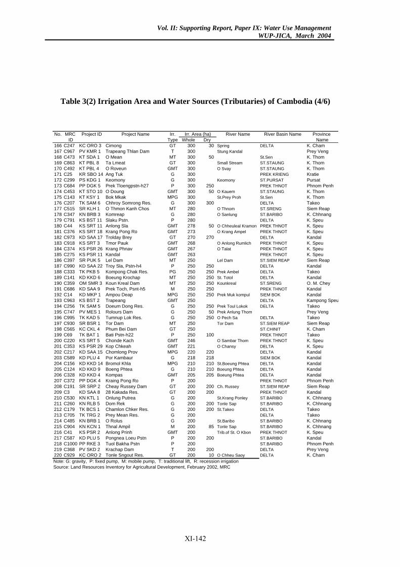
Vol. II: Supporting Report, Paper IX: Water Use ManagementWUP-JICA, March 2004
Table 3(2) Irrigation Area and Water Sources (Tributaries) of Cambodia (4/6)
River Name River Basin Name Province Dry Name
30 Spring DELTA K. ChamStung Kandal Prey Veng
50 St.Sen K. ThomSmall Stream ST.STAUNG K. ThomO Svay ST.STAUNG K. Thom
PREK KRIENG KratieKeomony ST.PURSAT Pursat
250 PREK THNOT Phnom Penh50 O Kauem ST.STAUNG K. Thom
St.Prey Proh St.Sen K. Thom300 DELTA Takeo
O Thnom ST.SRENG Siem ReapO Sanlung ST.BARIBO K. Chhnang
DELTA K. Speu50 O Chheuleal Kramon PREK THNOT K. Speu
O Krang Ampel PREK THNOT K. Speu270 DELTA Kandal
O Anlong Rumlich PREK THNOT K. SpeuO Talat PREK THNOT K. Speu
PREK THNOT K. SpeuLel Dam ST.SIEM REAP Siem Reap
250 DELTA Kandal250 Prek Ambel DELTA Takeo250 St. Totol DELTA Kandal250 Kounkreal ST.SRENG O. M. Chey250 PREK THNOT Kandal250 Prek Muk kompul SIEM BOK Kandal
DELTA Kampong Speu250 Prek Toul Lokok DELTA Takeo
50 Prek Anlung Thom Prey Veng250 O Pech Sa DELTA Takeo
Tor Dam ST.SIEM REAP Siem ReapST.CHINIT K. Cham
100 PREK THNOT TakeoO Sambar Thom PREK THNOT K. SpeuO Chansy DELTA K. Speu
220 DELTA Kandal218 SIEM BOK Kandal210 St.Boeung Phtea DELTA Kandal210 Boeung Phtea DELTA Kandal205 Boeung Phtea DELTA Kandal
PREK THNOT Phnom Penh200 Ch. Russey ST.SIEM REAP Siem Reap200 PREK THNOT Kandal
St.Krang Ponley ST.BARIBO K. Chhnang200 Tonle Sap ST.BARIBO K. Chhnang200 St.Takeo DELTA Takeo
DELTA TakeoSt.Baribo ST.BARIBO K. Chhnang
85 Tonle Sap ST.BARIBO K. ChhnangTrib.of St. O Kbon PREK THNOT K. Speu
200 ST.BARIBO KandalST.BARIBO Phnom Penh
200 DELTA Prey Veng10 O Chheu Saoy DELTA K. Cham
Irr. Area (ha)No. MRC Project ID Project Name Irr.ID Type Whole
166 C247 KC ORO 3 Cimong GT 300167 C967 PV KMR 1 Trapeang Thlan Dam T 300168 C473 KT SDA 1 O Mean MT 300169 C863 KT PBL 8 Ta Lmeat GT 300170 C492 KT PBL 4 O Roveun GMT 300171 C25 KR SBO 14 Ang Tuk G 300172 C299 PS KDG 1 Keomony G 300173 C684 PP DGK 5 Prek Tloengpstn-h27 P 300174 C453 KT STO 10 O Doung GMT 300175 C143 KT KSY 1 Bok Mkak MPG 300176 C207 TK SAM 6 Chhroy Somrong Res. G 300177 C515 SR KLH 1 O Thmon Kanh Chos MT 280178 C347 KN BRB 3 Komreap G 280179 C791 KS BST 11 Slaku Pstn. P 280180 C44 KS SRT 11 Anlong Sla GMT 278181 C376 KS SRT 18 Krang Pong Ro GMT 273182 C973 KD SAA 17 Trolday Brey GT 270183 C918 KS SRT 3 Tmor Pauk GMT 268184 C374 KS PSR 26 Krang Phnav GMT 267185 C275 KS PSR 11 Kandal GMT 263186 C397 SR PUK 5 Lel Dam MT 250187 C990 KD SAA 22 Troy Sla, Pstn-h4 P 250188 C333 TK PKB 5 Kompong Chak Res. PG 250189 C141 KD KKD 6 Boeung Krochap MT 250190 C359 OM SMR 3 Koun Kreal Dam MT 250191 C686 KD SAA 9 Prek Toch, Psnt-h5 M 250192 C14 KD MKP 1 Ampou Deap MPG 250193 C963 KS BST 2 Trapeang GMT 250194 C256 TK SAM 5 Doeum Dong Res. G 250195 C747 PV MES 1 Rolours Dam G 250196 C995 TK KAD 5 Tumnup Lok Res. G 250197 C930 SR BSR 1 Tor Dam MT 250198 C565 KC CKL 4 Phum Bei Dam GT 250199 C69 TK BAT 1 Bati Pstn-h22 P 250200 C220 KS SRT 5 Chonde Kach GMT 246201 C353 KS PSR 29 Kop Chkeah GMT 221202 C217 KD SAA 15 Chomlong Prov MPG 220203 C589 KD PLU 4 Por Kambaur G 218204 C156 KD KKD 14 Bromol Khla MPG 210205 C124 KD KKD 9 Boeng Phtea G 210206 C328 KD KKD 4 Kompas GMT 205207 C372 PP DGK 4 Kraing Pong Ro P 200208 C191 SR SRP 2 Cheay Russey Dam GT 200209 C3 KD SAA 8 28 Kakada Res. GT 200210 C530 KN KTL 1 Onlung Putrea G 200211 C260 KN RLB 5 Dom Rek G 200212 C179 TK BCS 1 Chamlon Chker Res. G 200213 C705 TK TRG 2 Prey Mean Res. G 200214 C485 KN BRB 1 O Rolus G 200215 C904 KN KCN 1 Thnal Ampil M 200216 C41 KS PSR 2 Anlong Prinh GMT 200217 C587 KD PLU 5 Pongnea Loeu Pstn P 200218 C1000 PP RKE 3 Tuol Bakha Pstn P 200219 C368 PV SKD 2 Krachap Dam T 200220 C929 KC ORO 2 Tonle Sngout Res. GT 200Note: G: gravity, P: fixed pump, M: mobile pump, T: traditional lift, R: recession irrigationSource: Land Resources Inventory for Agricultural Development, February 2002, MRC
XI-142
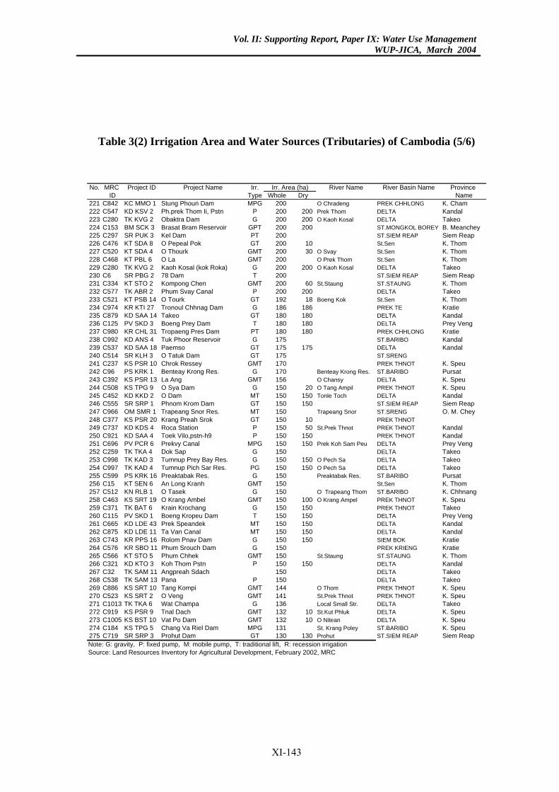
Vol. II: Supporting Report, Paper IX: Water Use ManagementWUP-JICA, March 2004
Table 3(2) Irrigation Area and Water Sources (Tributaries) of Cambodia (5/6)
River Name River Basin Name Province Dry Name
O Chradeng PREK CHHLONG K. Cham200 Prek Thom DELTA Kandal200 O Kaoh Kosal DELTA Takeo200 ST.MONGKOL BOREY B. Meanchey
ST.SIEM REAP Siem Reap10 St.Sen K. Thom30 O Svay St.Sen K. Thom
O Prek Thom St.Sen K. Thom200 O Kaoh Kosal DELTA Takeo
ST.SIEM REAP Siem Reap60 St.Staung ST.STAUNG K. Thom
200 DELTA Takeo18 Boeng Kok St.Sen K. Thom
186 PREK TE Kratie180 DELTA Kandal180 DELTA Prey Veng180 PREK CHHLONG Kratie
ST.BARIBO Kandal175 DELTA Kandal
ST.SRENGPREK THNOT K. Speu
Benteay Krong Res. ST.BARIBO PursatO Chansy DELTA K. Speu
20 O Tang Ampil PREK THNOT K. Speu150 Tonle Toch DELTA Kandal150 ST.SIEM REAP Siem Reap
Trapeang Snor ST.SRENG O. M. Chey10 PREK THNOT50 St.Prek Thnot PREK THNOT Kandal
150 PREK THNOT Kandal150 Prek Koh Sam Peu DELTA Prey Veng
DELTA Takeo150 O Pech Sa DELTA Takeo150 O Pech Sa DELTA Takeo
Preaktabak Res. ST.BARIBO PursatSt.Sen K. Thom
O Trapeang Thom ST.BARIBO K. Chhnang100 O Krang Ampel PREK THNOT K. Speu150 PREK THNOT Takeo150 DELTA Prey Veng150 DELTA Kandal150 DELTA Kandal150 SIEM BOK Kratie
PREK KRIENG KratieSt.Staung ST.STAUNG K. Thom
150 DELTA KandalDELTA TakeoDELTA Takeo
O Thom PREK THNOT K. SpeuSt.Prek Thnot PREK THNOT K. SpeuLocal Small Str. DELTA Takeo
10 St.Kut Phluk DELTA K. Speu10 O Nitean DELTA K. Speu
St. Krang Poley ST.BARIBO K. Speu130 Prohut ST.SIEM REAP Siem Reap
Irr. Area (ha)No. MRC Project ID Project Name Irr.ID Type Whole
221 C842 KC MMO 1 Stung Phoun Dam MPG 200222 C547 KD KSV 2 Ph.prek Thom Ii, Pstn P 200223 C280 TK KVG 2 Obaktra Dam G 200224 C153 BM SCK 3 Brasat Bram Reservoir GPT 200225 C297 SR PUK 3 Kel Dam PT 200226 C476 KT SDA 8 O Pepeal Pok GT 200227 C520 KT SDA 4 O Thourk GMT 200228 C468 KT PBL 6 O La GMT 200229 C280 TK KVG 2 Kaoh Kosal (kok Roka) G 200230 C6 SR PBG 2 78 Dam T 200231 C334 KT STO 2 Kompong Chen GMT 200232 C577 TK ABR 2 Phum Svay Canal P 200233 C521 KT PSB 14 O Tourk GT 192234 C974 KR KTI 27 Tronoul Chhnag Dam G 186235 C879 KD SAA 14 Takeo GT 180236 C125 PV SKD 3 Boeng Prey Dam T 180237 C980 KR CHL 31 Tropaeng Pres Dam PT 180238 C992 KD ANS 4 Tuk Phoor Reservoir G 175239 C537 KD SAA 18 Paemso GT 175240 C514 SR KLH 3 O Tatuk Dam GT 175241 C237 KS PSR 10 Chrok Ressey GMT 170242 C96 PS KRK 1 Benteay Krong Res. G 170243 C392 KS PSR 13 La Ang GMT 156244 C508 KS TPG 9 O Sya Dam G 150245 C452 KD KKD 2 O Dam MT 150246 C555 SR SRP 1 Phnom Krom Dam GT 150247 C966 OM SMR 1 Trapeang Snor Res. MT 150248 C377 KS PSR 20 Krang Preah Srok GT 150249 C737 KD KDS 4 Roca Station P 150250 C921 KD SAA 4 Toek Vilo,pstn-h9 P 150251 C696 PV PCR 6 Prekvy Canal MPG 150252 C259 TK TKA 4 Dok Sap G 150253 C998 TK KAD 3 Tumnup Prey Bay Res. G 150254 C997 TK KAD 4 Tumnup Pich Sar Res. PG 150255 C599 PS KRK 16 Preaktabak Res. G 150256 C15 KT SEN 6 An Long Kranh GMT 150257 C512 KN RLB 1 O Tasek G 150258 C463 KS SRT 19 O Krang Ambel GMT 150259 C371 TK BAT 6 Krain Krochang G 150260 C115 PV SKD 1 Boeng Kropeu Dam T 150261 C665 KD LDE 43 Prek Speandek MT 150262 C875 KD LDE 11 Ta Van Canal MT 150263 C743 KR PPS 16 Rolom Pnav Dam G 150264 C576 KR SBO 11 Phum Srouch Dam G 150265 C566 KT STO 5 Phum Chhek GMT 150266 C321 KD KTO 3 Koh Thom Pstn P 150267 C32 TK SAM 11 Angpreah Sdach 150268 C538 TK SAM 13 Pana P 150269 C886 KS SRT 10 Tang Kompi GMT 144270 C523 KS SRT 2 O Veng GMT 141271 C1013 TK TKA 6 Wat Champa G 136272 C919 KS PSR 9 Tnal Dach GMT 132273 C1005 KS BST 10 Vat Po Dam GMT 132274 C184 KS TPG 5 Chang Va Riel Dam MPG 131275 C719 SR SRP 3 Prohut Dam GT 130Note: G: gravity, P: fixed pump, M: mobile pump, T: traditional lift, R: recession irrigationSource: Land Resources Inventory for Agricultural Development, February 2002, MRC
XI-143
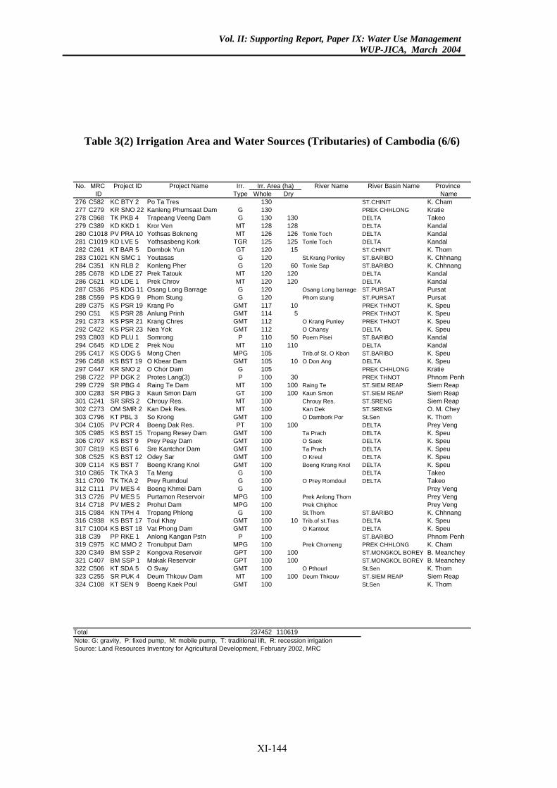
Vol. II: Supporting Report, Paper IX: Water Use ManagementWUP-JICA, March 2004
Table 3(2) Irrigation Area and Water Sources (Tributaries) of Cambodia (6/6)
River Name River Basin Name Province Dry Name
ST.CHINIT K. ChamPREK CHHLONG Kratie
130 DELTA Takeo128 DELTA Kandal126 Tonle Toch DELTA Kandal125 Tonle Toch DELTA Kandal
15 ST.CHINIT K. ThomSt.Krang Ponley ST.BARIBO K. Chhnang
60 Tonle Sap ST.BARIBO K. Chhnang120 DELTA Kandal120 DELTA Kandal
Osang Long barrage ST.PURSAT PursatPhom stung ST.PURSAT Pursat
10 PREK THNOT K. Speu5 PREK THNOT K. Speu
O Krang Punley PREK THNOT K. SpeuO Chansy DELTA K. Speu
50 Poem Pisei ST.BARIBO Kandal110 DELTA Kandal
Trib.of St. O Kbon ST.BARIBO K. Speu10 O Don Ang DELTA K. Speu
PREK CHHLONG Kratie30 PREK THNOT Phnom Penh
100 Raing Te ST.SIEM REAP Siem Reap100 Kaun Smon ST.SIEM REAP Siem Reap
Chrouy Res. ST.SRENG Siem ReapKan Dek ST.SRENG O. M. CheyO Dambork Por St.Sen K. Thom
100 DELTA Prey VengTa Prach DELTA K. SpeuO Saok DELTA K. SpeuTa Prach DELTA K. SpeuO Kreul DELTA K. SpeuBoeng Krang Knol DELTA K. Speu
DELTA TakeoO Prey Romdoul DELTA Takeo
Prey VengPrek Anlong Thom Prey VengPrek Chiphoc Prey VengSt.Thom ST.BARIBO K. Chhnang
10 Trib.of st.Tras DELTA K. SpeuO Kantout DELTA K. Speu
ST.BARIBO Phnom PenhPrek Chomeng PREK CHHLONG K. Cham
100 ST.MONGKOL BOREY B. Meanchey100 ST.MONGKOL BOREY B. Meanchey
O Pthourl St.Sen K. Thom100 Deum Thkouv ST.SIEM REAP Siem Reap
St.Sen K. Thom
110619
Irr. Area (ha)No. MRC Project ID Project Name Irr.ID Type Whole
276 C582 KC BTY 2 Po Ta Tres 130277 C279 KR SNO 22 Kanleng Phumsaat Dam G 130278 C968 TK PKB 4 Trapeang Veeng Dam G 130279 C389 KD KKD 1 Kror Ven MT 128280 C1018 PV PRA 10 Yothsas Bokneng MT 126281 C1019 KD LVE 5 Yothsasbeng Kork TGR 125282 C261 KT BAR 5 Dombok Yun GT 120283 C1021 KN SMC 1 Youtasas G 120284 C351 KN RLB 2 Konleng Pher G 120285 C678 KD LDE 27 Prek Tatouk MT 120286 C621 KD LDE 1 Prek Chrov MT 120287 C536 PS KDG 11 Osang Long Barrage G 120288 C559 PS KDG 9 Phom Stung G 120289 C375 KS PSR 19 Krang Po GMT 117290 C51 KS PSR 28 Anlung Prinh GMT 114291 C373 KS PSR 21 Krang Chres GMT 112292 C422 KS PSR 23 Nea Yok GMT 112293 C803 KD PLU 1 Somrong P 110294 C645 KD LDE 2 Prek Nou MT 110295 C417 KS ODG 5 Mong Chen MPG 105296 C458 KS BST 19 O Kbear Dam GMT 105297 C447 KR SNO 2 O Chor Dam G 105298 C722 PP DGK 2 Protes Lang(3) P 100299 C729 SR PBG 4 Raing Te Dam MT 100300 C283 SR PBG 3 Kaun Smon Dam GT 100301 C241 SR SRS 2 Chrouy Res. MT 100302 C273 OM SMR 2 Kan Dek Res. MT 100303 C796 KT PBL 3 So Krong GMT 100304 C105 PV PCR 4 Boeng Dak Res. PT 100305 C985 KS BST 15 Tropang Resey Dam GMT 100306 C707 KS BST 9 Prey Peay Dam GMT 100307 C819 KS BST 6 Sre Kantchor Dam GMT 100308 C525 KS BST 12 Odey Sar GMT 100309 C114 KS BST 7 Boeng Krang Knol GMT 100310 C865 TK TKA 3 Ta Meng G 100311 C709 TK TKA 2 Prey Rumdoul G 100312 C111 PV MES 4 Boeng Khmei Dam G 100313 C726 PV MES 5 Purtamon Reservoir MPG 100314 C718 PV MES 2 Prohut Dam MPG 100315 C984 KN TPH 4 Tropang Phlong G 100316 C938 KS BST 17 Toul Khay GMT 100317 C1004 KS BST 18 Vat Phong Dam GMT 100318 C39 PP RKE 1 Anlong Kangan Pstn P 100319 C975 KC MMO 2 Tronubput Dam MPG 100320 C349 BM SSP 2 Kongova Reservoir GPT 100321 C407 BM SSP 1 Makak Reservoir GPT 100322 C506 KT SDA 5 O Svay GMT 100323 C255 SR PUK 4 Deum Thkouv Dam MT 100324 C108 KT SEN 9 Boeng Kaek Poul GMT 100
Total 237452Note: G: gravity, P: fixed pump, M: mobile pump, T: traditional lift, R: recession irrigationSource: Land Resources Inventory for Agricultural Development, February 2002, MRC
XI-144
Vol. II: Supporting Report, Paper IX: Water Use ManagementWUP-JICA, March 2004
Table 4 Irrigation Area and Water Sources (Delta) of Vietnam (1/2)
River Name River Basin Dry 3RD Name
173 3853 0 Delta Canal DELTA044 4358 0 Delta Canal DELTA924 4763 0 Delta Canal DELTA369 15116 0 Delta Canal DELTA693 3438 0 Delta Canal DELTA897 3361 0 Delta Canal DELTA659 19537 959 Delta Canal DELTA953 39721 2184 Delta Canal DELTA010 69503 235 Delta Canal DELTA512 53016 522 Delta Canal DELTA892 9630 0 Delta Canal DELTA697 67666 13342 Delta Canal DELTA355 68416 25190 Delta Canal DELTA994 33682 25483 Delta Canal DELTA639 16639 15799 Delta Canal DELTA056 17056 12030 Delta Canal DELTA778 13778 7821 Delta Canal DELTA223 31223 20839 Delta Canal DELTA084 26846 6579 Delta Canal DELTA669 1165 0 Delta Canal DELTA182 32015 835 Delta Canal DELTA743 29759 1567 Delta Canal DELTA850 9709 0 Delta Canal DELTA463 21296 0 Delta Canal DELTA451 23826 0 Delta Canal DELTA277 9832 0 Delta Canal DELTA491 7288 0 Delta Canal DELTA280 7426 0 Delta Canal DELTA884 5132 0 Delta Canal DELTA994 3154 0 Delta Canal DELTA710 667 0 Delta Canal DELTA783 1056 0 Delta Canal DELTA395 1018 0 Delta Canal DELTA
22 48 0 Delta Canal DELTA217 14805 0 Delta Canal DELTA772 7672 0 Delta Canal DELTA841 11841 208 Delta Canal DELTA719 3719 81 Delta Canal DELTA110 25110 0 Delta Canal DELTA723 1323 28 Delta Canal DELTA087 3587 68 Delta Canal DELTA399 5399 566 Delta Canal DELTA788 9788 987 Delta Canal DELTA
Irrigation Area (ha)No. MRC Project Project Irr.ID ID Name Type Wet
1 VDE3 VT3 LXQ/3 M 72 VDE4 VT4 LXQ/4 M 53 VDE5 VT5 LXQ/5 M 44 VDE8 VT8 LXQ/8 M 235 VDE9 VT9 LXQ/9 M 56 VDE10 VT10 LXQ/10 M 37 VDE11 VT11 LXQ/11 M 278 VDE12 VT12 LXQ/12 M 459 VDE13 VT13 LXQ/13 M 71
10 VDE14 VT14 LXQ/14 M 5311 VDE15 VT15 LXQ/15 M 1012 VDE16 VT16 WB/16 M 6813 VDE17 VT17 WB/17 M 7314 VDE18 VT18 WB/18 M 3315 VDE19 VT19 WB/19 ML 1616 VDE20 VT20 WB/20 M 1717 VDE21 VT21 WB/21 M 1318 VDE22 VT22 WB/22 M 3119 VDE23 VT23 KS/23 ML 2720 VDE24 VT24 TN/24 M 1021 VDE25 VT25 TN/25 ML 3322 VDE26 VT26 BRL/26 ML 3123 VDE27 VT27 QLPH/27 M 924 VDE28 VT28 QLPH/28 M 2225 VDE29 VT29 QLPH/29 M 2726 VDE31 VT31 QLPH/31 M 1627 VDE32 VT32 QLPH/32 M 1428 VDE36 VT36 QLPH/36 M 1029 VDE37 VT37 QLPH/37 M 830 VDE38 VT38 QLPH/38 M 731 VDE39 VT39 QLPH/39 M 232 VDE40 VT40 QLPH/40 M 333 VDE42 VT42 QLPH/42 M 134 VDE51 VT51 UMT/51 M 835 VDE52 VT52 UMT/52 M 3236 VDE67 VT67 NMT/67 M 837 VDE68 VT68 NMT/68 M 1238 VDE69 VT69 NMT/69 M 339 VDE70 VT70 NMT/70 M 2540 VDE71 VT71 NMT/71 M 141 VDE72 VT72 NMT/72 M 442 VDE73 VT73 NMT/73 M 543 VDE74 VT74 NMT/74 M 9
Note: M: mobile pump, L: tidal irrigationSource: Land Resources Inventory for Agricultural Development, February 2002, MRC
XI-145
Vol. II: Supporting Report, Paper IX: Water Use ManagementWUP-JICA, March 2004
Table 4 Irrigation Area and Water Sources (Delta) of Vietnam (2/2)
River Name River Basin Dry 3RD Name
174 11174 1126 Delta Canal DELTA442 3442 347 Delta Canal DELTA722 14722 4204 Delta Canal DELTA056 17056 4979 Delta Canal DELTA131 30124 27317 Delta Canal DELTA197 29575 25805 Delta Canal DELTA599 26249 18673 Delta Canal DELTA387 21651 7990 Delta Canal DELTA522 17020 250 Delta Canal DELTA952 14794 67 Delta Canal DELTA327 18168 681 Delta Canal DELTA785 1165 0 Delta Canal DELTA135 3135 1641 Delta Canal DELTA363 3363 2004 Delta Canal DELTA274 1007 0 Delta Canal DELTA462 4462 2524 Delta Canal DELTA422 15314 3717 Delta Canal DELTA714 3089 0 Delta Canal DELTA422 1478 0 Delta Canal DELTA552 26895 18255 Delta Canal DELTA962 28230 22972 Delta Canal DELTA373 15373 14643 Delta Canal DELTA764 14764 14764 Delta Canal DELTA656 11656 11656 Delta Canal DELTA212 3212 2350 Delta Canal DELTA213 31213 7936 Delta Canal DELTA347 42996 4245 Delta Canal DELTA531 21864 8866 Delta Canal DELTA550 8190 1148 Delta Canal DELTA 169 39436 1676 Delta Canal DELTA 158 37008 0 Delta Canal DELTA336 13636 1109 Delta Canal DELTA273 21738 208 Delta Canal DELTA012 7912 0 Delta Canal DELTA037 10437 314 Delta Canal DELTA708 21427 0 Delta Canal DELTA581 33951 0 Delta Canal DELTA 177 15216 2659 Delta Canal DELTA 604 11337 1679 Delta Canal DELTA 879 9371 278 Delta Canal DELTA 717 16022 100 Delta Canal DELTA 595 440 0 Delta Canal DELTA
4 1,417,549 351,506
Irrigation Area (ha)No. MRC Project Project Irr.ID ID Name Type Wet
44 VDE75 VT75 NMT/75 M 1145 VDE76 VT76 NMT/76 M 346 VDE77 VT77 NMT/77 M 1447 VDE78 VT78 NMT/78 M 1748 VDE79 VT79 NMT/79 M 3149 VDE80 VT80 NMT/80 ML 3050 VDE81 VT81 SMT/81 ML 2651 VDE82 VT82 SMT/82 ML 2252 VDE83 VT83 SMT/83 ML 2053 VDE84 VT84 SMT/84 ML 2954 VDE85 VT85 SMT/85 ML 4155 VDE87 VT87 SMT/87 M 556 VDE88 VT88 BT/88 M 357 VDE89 VT89 BT/89 ML 358 VDE90 VT90 BT/90 ML 1459 VDE92 VT92 BL/92 M 460 VDE93 VT93 BL/93 ML 2161 VDE94 VT94 BL/94 ML 1062 VDE96 VT96 GC/96 ML 563 VDE97 VT97 GC/97 ML 3164 VDE98 VT98 TA/98 M 3165 VDE99 VT99 PR/99 M 1566 VDE100 VT100 PR/100 M 1467 VDE101 VT101 PR/101 M 1168 VDE102 VT102 PR/102 M 369 VDE103 VT103 PR/103 M 3170 VDE104 VT104 PR/104 M 4371 VDE105 VT105 PR/105 M 2672 VDE106 VT106 PR/106 M 2373 VDE107 VT107 PR/107 M 4674 VDE108 VT108 PR/108 M 3875 VDE109 VT109 PR/109 M 1476 VDE110 VT110 PR/110 M 2377 VDE111 VT111 PR/111 M 878 VDE112 VT112 PR/112 M 1179 VDE113 VT113 PR/113 M 2280 VDE114 VT114 WEVC/114 M 3981 VDE115 VT115 WEVC/115 M 1882 VDE116 VT116 WEVC/116 M 1683 VDE117 VT117 WEVC/117 M 1184 VDE118 VT118 CD/118 M 2885 VDE120 VT120 CD/120 ML 7
Total 1,683,09Note: M: mobile pump, L: tidal irrigationSource: Land Resources Inventory for Agricultural Development, February 2002, MRC
XI-146