Embed Size (px)
Citation preview

949
Ethiopian Journal of Environmental Studies & Management 8(Suppl. 2): 949 – 965, 2015.
ISSN:1998-0507 doi: http://dx.doi.org/10.4314/ejesm.v8i2.9S Submitted: July 31, 2015 Accepted: November 13, 2015
RETRIEVAL OF AEROSOL OPTICAL DEPTH OVER ECOLOGICALLY STRESSED EAST
AFRICAN LAND SURFACES FROM TOP OF ATMOSPHERE RADIANCE UTILIZING THE
AEROSOL FREE VEGETATION INDEX
*MAKOKHA, J.W.,1,2 ANGEYO, H.K.1 AND MUTHAMA, J.N.3 1Department of Physics, University of Nairobi, P.O. Box 30197-00100, Nairobi, Kenya
2Department of Physical Sciences, University of Kabianga, P.O. Box 2030-20200, Kericho,
Kenya 3Department of Meteorology, University of Nairobi, P.O. Box 30197-00100, Nairobi, Kenya
Abstract
Traditional satellite based AOD retrieval techniques with a coarse resolution such as
collection 5 hardly provides a high spatial detail suitable for accurate AOD retrieval
particularly over the ecologically stressed sites of East Africa. Furthermore, AOD retrievals
from Moderate Resolution Imaging Spectroradiometer (MODIS-collection 5) require a linear
mixing model that utilizes the normalized difference vegetation index (NDVI) to calculate
surface reflectance. Since NDVI is affected by the presence of aerosols in the atmosphere, an
empirical linear relationship between short wave infrared (SWIR) and visible reflectance were
estimated in order to calculate a modified aerosol free vegetation index (AFRI). Based on
AFRI and the minimum reflectance technique (MRT), an improved linear mixing model was
developed. Calculated Vis/SWIR ratio diverges from the one used in the hypothetical model
for AOD retrieval. Likewise, the regression coefficients between retrieved AOD for the
developed algorithm and AERONET were higher as compared to that of MODIS collection 5
and AERONET. These emphasize the need of using AFRI plus accurate selection of surface
characteristics and aerosol type for accurate AOD retrieval over East Africa that is addressed
by the developed algorithm. At low AERONET AOD values, the two algorithms i.e. MODIS and
developed agree but as the AERONET AOD value increases, a discrepancy is noted between
the two as a result of usingNDVI and AFRIin the MODIS and developed algorithms
respectively.
Key Words: Atmospheric aerosol, Optical depth, Remote sensing, Reflectance, East Africa
Introduction
Atmospheric aerosols are the most
abundant and variable component of the
Earth’s atmosphere (IPCC, 2007). The
main types of aerosol over Africa are
desert dust and biomass burning aerosols
which are UV-absorbing. In particular,
Western Sahara is a major source for dust
(Prospero et al., 2002; Reid et al., 2003;
Kaufman et al., 2005) that is normally
transported to the tropical North-Atlantic
Ocean and the Mediterranean Sea yearly
(D'Almeida, 1986; Prospero et al., 1996;
Engelstaedter et al., 2006).This makesthe
continent an appropriate place to study
aerosol impact on both local and global
climate.As well, during the local dry
period, smoke and other biomass burning
*Corresponding author: Makokha, J.W.
Email: [email protected]

950
aerosols areproduced by annually recurring
Savanna fires in all vegetated parts of
Africa. These aerosols are known to be
chemically active with their internal
physico-chemical properties changing
rapidly in a few hours to days after their
release (Reid et al., 2005).
De Graaf et al. (2010) established that
Absorbing Aerosol Index (AAI) and
residues data are related to monthly mean
precipitation data and they show Monsoon
controlled aerosol loadings. Seasonal
variation in the aerosol distribution was
clearly linked to the seasonal cycle of the
Monsoonal wet and dry periods over East
and West Africa. The residue varies freely
due to aerosol emissions from deserts and
biomass burning events during dry period
while on contrary; they depend linearly on
the amount of precipitation as a result of
scavenging of aerosols and prevention of
aerosol emissions from the wet surface
during wet period. This is most clear over
East Africa, where the sources and sinks of
atmospheric aerosols are controlled
directly by the local climate, i.e.
Monsoonal precipitation.
Understanding the influence of
aerosols on climate howeverrequires
identification of aerosol properties i.e.
sources, size, sinks and type which can be
retrieved from ground-based instruments
(AErosol RObotic NETwork (AERONET)
(Holben et al., 1998) and Multi-axis
Differential Optical Absorption
Spectroscopy (MAX-DOAS) (Wittrock et
al., 2004). Alternatively, these properties
may also be derived from satellite-based
spectroscopic sensorslike theModerate
Resolution Imaging Spectrometer
(MODIS) (Salomonson et al., 1989). In
general, satellite-borne aerosol
observations have an advantage over
ground-based measurements since they
have a large spatial coverage even though
only taking one or two observations in a
given day and position.
Aerosol properties retrieval over ocean
surfacesfrom satellite-based measurements
utilizes the Near Infra-Red (NIR) channels
(Von Hoyningen-Huene et al., 2003). This
is because the ocean surfaces experiences
relatively low spectral surface reflectance
which can be ignored in the process of
aerosol retrieval (Geogdzhayev et al.,
2002). Conversely, retrieval of aerosol
properties over land is complex, requiring
several model assumptions (Torres et al.,
1998; 2002). The procedure for a nadir
retrieval of AOD for instance fails in NIR
due to high surface reflectance and its
variability over bright surfaces. However,
in the visible regime i.e. 0.4 μm <λ< 0.67
µm (with the exception of snow and desert
ground) the spectral surface reflectance has
values in the range ≤ 0.05 that decrease
with decreasing wavelength. Therefore,
retrieval of aerosol properties over land
requires separation techniques to consider
the variable contribution of surface
reflectance.
Kaufman and Tanre (1998) proposed
the dense dark vegetation (DDV) method
using the multiband algorithm from
MODIS satellite images (collection 4). It
was later noted that this technique works
efficiently over vegetation areas
characterized by low surface reflectance
but for bright surfaces such as deserts,
coastal, arid and urban areas (main sources
of anthropogenic aerosols), it fails. This is
because the DDV method makes
assumption that the vegetation is
sufficiently dark and the ratio between the
bottom of atmosphere (BOA) and top of
atmosphere (TOA) reflectance at different
wavelengths is constant (Gillingham et al.,
2012). Additionally, Chu et al. (2002)
showed that the MODIS collection 4
algorithm has a positive bias when
compared to data retrieved from the
AERONET sunphotometer while Levy et
al. (2004) and Remer et al. (2005) reported
Retrieval of Aerosol Optical Depth over Ecologically Stressed East African................MAKOKHA et al.

951
some inherent problems in using the DDV
algorithm.
The contribution of surface reflectance
on AOD retrieval is well documented (Von
Hoyningen-Huene et al., 2003; Lee et al.,
2006; Guo et al., 2009; Wong et al., 2010).
Any attempt to retrieve aerosol
characteristics from a satellite image
depends on the method of decoupling both
surface and aerosol reflectance and its
subsequent modeling using a radiative
transfer model (RTM). Levy et al. (2007)
modified the surface reflectance
determination in the MODIS aerosol
retrieval algorithm (known as collection 5)
by considering NDVI for dark pixel
screening, as well as the scattering angle. It
was later discovered that NDVI over
estimates the surface reflectance and
consequently underestimating aerosol
reflectance of a given pixel if there is a
strong aerosol influence in the presence of
satellite scene. Since retrieval of aerosol
reflectance over bright surfaces is a
challenge due to the complexity in
decoupling both surface and aerosol
reflectance, Hsu et al. (2004; 2006)
developed a deep blue algorithm for
aerosol retrieval over bright surfaces using
MODIS imagesmakes use of the blue
wavelengths where the surface reflectances
are bright in the red region and darker in
the blue region.
The region’s vegetation cover, aerosols
sources and sinks affect the decoupling
process of both surface and aerosol
reflectance. In order to retrieve and map
AOD distributions over theregion with an
improved accuracy, a newMODIS (500m)
AOD retrieval algorithm was developed.
This algorithm utilizes the modified MRT
technique and AFRI to decouple surface
and aerosol reflectances. This is because
AFRI is known to assess the vegetation
index in the presence of smoke,
anthropogenic natural aerosol sources that
dominate the region.
Rapid urbanization (Nairobi),
monsoonal influence (Malindi), biomass
burning and land cover change (Mbita) and
deforestation (around Mount Kilimanjaro)
in the last 30 years necessitates the need to
retrieve and improve on the understanding
of aerosol contribution on the climate
change (Höller et al., 2005) in the region.
This understanding should be with
appreciable accuracy and confidence since
aerosol properties are highly variable. This
paper presents results of a newly
developed algorithm that utilizes MODIS
radiance measurements with AFRI and
MRT for AOD retrieval over the
ecologically stressed regions of East
Africa.
Area of Study
The study was undertaken over
selected AERONET sites in the two East
African countries i.e. Kenya and Tanzania
so that results from satellite measurements
can more easily be ground-referenced
shown in Figure 1. Additionally, the
selection was also based on physical
features known to profoundly modify
aerosol characteristics in the immediate
atmosphere.
Nairobi Nairobi is a fast expanding metropolis
in East African region with a tropical high
altitude (1798 m) and is situated at 1°S,
36°E. The city is strongly impacted on by
local urban pollution attributable to its high
populace (about 3.1 million), industrial
activities, and smoke aerosols from refuse
burning, transport of air masses from
biomass burning regions adjacent to it and
vehicular emissions characterized by early
morning and late evening rush hour.
Mbita Mbita is a rural site in South Western
Kenya, on the shores of Lake Victoria
situated at 0°S, 34°E with an altitude of
1125 mand a population of 46,223. Other
than farming, fishing, biomass burning and
farm clearance for cultivation activities
Ethiopian Journal of Environmental Studies and Management Vol. 8 (Suppl. 2) 2015

952
that dominate the site, the region also
experiences the Lake-terrestrial air mass
exchange due to its nearness to Lake
Victoria.
Malindi Malindi is a town located at 2°S,
40°Ewith an altitude of 12 m, lying on the
Indian Ocean coast of Kenya. It is 120
kilometers northeast of Mombasa City
with a population of 1.1 million.The site is
dominated by maritime conditions
associated with sea salt and sea spray
aerosols that are known to dominate the λ = 0.44 μm atmospheric window. Unique to
the site is the significance of long distance
transport of coarse aerosols from the
Arabian Peninsula desert via Monsoon
winds (Makokha and Angeyo, 2013).
Mount Kilimanjaro Mount Kilimanjaro, located at 3°S,
37°E, is the highest mountain in Africa,
and the highest free-standing mountain in
the world at 5895 metres above sea level
with an area of approximately 75 km x75
km. The disappearance of the mountain’s
glaciers is associated to deforestation
activities going on around it in the adjacent
Kilimanjaro National Park (Fairman et al.,
2011).
Figure 1: Map indicating the selected sites of study in the East African region.
Materials and Methods
Spectral Imaging Acquisition of data from satellite
imaging sensor utilizes various techniques
among them is the push-broom imaging
technique (Shaw and Burke, 2003). In this
spectral imaging format, the cross track-
line of spatial pixels are decomposed into
three spectral bands via diffraction grating
and wedge filter mechanisms (Seery et al.,
1996). On the other hand, Principal
Component Analysis (PCA) was utilized in
reduction ofdata dimensionality while
preserving essential information in the
spectral data cube (Hsu and Burke, 2003).
For MODIS L1B data pre-processing
procedures i.e. georeferencing, bow tie
correction (overlap effect of consecutive
scans) and subset (images created for a
specific area of the globe) were achieved
Retrieval of Aerosol Optical Depth over Ecologically Stressed East African................MAKOKHA et al.

953
via MODIS TOOL in ENVI 4.0 over each
pixel on the ground. Details of various
equations used to derive reflectances from
MODIS L1B data are discussed elsewhere
(Kaufman et al., 1997; Von Hoyningen-
Huene et al., 2007).
Cloud Masking Procedure Aerosol properties retrievals depend on
accurate cloud masking algorithms that
utilizes a combination of different
wavelengths (Ackerman et al., 1998). In
the present case, the absence of the high
resolution thermal band in the
MOD02Hkm (500m) data necessitated the
development of a tailor-made cloud
masking algorithm. This masking
algorithm reflectance threshold at 550 nm
was based on clear sky conditions on 30th
January 2003who’sRGB and gray scale
images are shown in Figure 2 for MODIS
Terra. The thresholds for aerosol retrieval
in each pixel for the channels of interest
were set i.e. reflectances >0.2 or AFRI<-
0.5 were all masked for each pixel over the
specifiedstudy sites.Additionally, the
minimum reflectance technique (MRT)
which involves a procedure to find the
clearest pixels (i.e. with the lowest
reflectance) daily for the period of study
was applied.
Figure 2: Clear sky RGB (a) and grey scale (b) images from MODIS Terra over the study
sites
Decoupling of Modified Reflectance from
TOA reflectance
Rayleigh Path Reflectance
The modified reflectance ( ) is
obtained by subtracting the Rayleigh path
reflectance from the TOA reflectance for
each illumination and observation
geometry. Based on digital elevation
model (DEM) in the MOD03 geolocation
data, height and pressure of each pixel was
determined following Wong et al.
(2010).Furthermore, determination of
Rayleigh path reflectance was based on its
dependence on Rayleigh optical depth
(ROD) and phase function as described in
both Bucholtz (1995) and Wong et al.
(2010).
Surface Reflectance Kaufman et al. (1997) shows the
process of decoupling . Based on
this procedure, a linear relationship
between short wave infrared (SWIR) and
visible channel reflectance was calculated
(Table 1). Thisrelation depends highly on
Ethiopian Journal of Environmental Studies and Management Vol. 8 (Suppl. 2) 2015
954
land cover type and temporal variation in
vegetation index as indicated by Karnieli et
al. (2001), hence the need to establish that
which fits each study siteis of necessity.
AFRI was adopted according to equation 1
with the constant ( ) depending on the
linear relationship between SWIR and Vis
reflectance over each study site to aid in
cloud masking as detailed in Table 1.
(1)
Satellite Signal in the Solar Spectrum
(6S) radiative transfer model The 6S radiative transfer model
permits calculations of near-nadir aircraft
observations, accounting for target
elevation, non lambertian/anisotropic
surface conditions, and new absorbing
species in the atmosphere.The 6S code
computational accuracy for Rayleigh and
aerosol scattering effects has been
improved by the use of state of the art
approximations, improved spectral
integration to 2.5 nm and implementation
of the successive orderscattering (SOS)
algorithm. A detailed description of the
methods may be found in Vermote et al.
(2006). In this study, the 6S code is meant
for calculation of look up table (LUT)
necessary for AOD retrieval.
Retrieval of Aerosol Reflectance TOA reflectance was limited to within
±30 minutes of MODIS overpass time
AERONET measurement for easy ground
referencing. The daily calibrated
reflectances were first cloud masked
andthen grouped into their respective
seasons i.e. those corresponding to dry
season (December to February) and Wet
season (inclusive of both short and long
rains i.e. March to November) (Kaufman et
al., 1997). The MRT was used in
identifying pixels with TOA reflectance
values ≤ 0.2 after which Rayleigh
scattering effects were corrected as
discussed in a section on Rayleigh path
reflectance. Surface and aerosol
reflectances were decoupled using the
AFRI as detailed in the surface reflectance
section.
The scheme in Figure 3 runs on
Ubuntu Linux with a pre-installed Python
2.7.X version. Python modules i.e. Numpy,
Scipy, Matplotlib, Python-dateutil, Pysolar
and Pandas were downloaded from their
respective repositories and installed in the
respective order. Py6S, an interface to the
6S atmospheric RTM through the Python
programming language was utilized in the
retrieval of AOD.
Retrieval of Aerosol Optical Depth over Ecologically Stressed East African................MAKOKHA et al.

955
Figure 3: The schematic diagram for the developed aerosol optical depth retrieval algorithm
Retrieval of Aerosol Optical Depth Inputs to the 6S comprise of geometric
conditions (solar zenith angle, solar
azimuth angle, sensor zenithal angle and
sensor azimuthal angle), atmospherical
model (tropical), aerosol models (biomass
burning, urban and maritime) and a
homogeneous surface were utilized. A
comprehensive LUT was constructed using
the 6S code for calculating aerosol
reflectance as a function of AOD under
various sun viewing geometries (only nadir
images with satellite viewing angle <35º)
based onaccurate optimal spectral shape
fitting according to Wong et al. (2010).
For the purpose of validation, only AOD
values at 550 nm were determined here
since MODIS collection 5 end products are
only at this wavelength and then compared
to AERONET ground measurements.
Results and Discussions
Relationship between the visible and
SWIR bands The surface reflectance ratio between
the Vis and SWIR radiation is animportant
quantity for AOD retrieval from MODIS
Terra. Based on empiricallydetermined
Vis/SWIR ratios, AOD retrievaluses the
surface reflectance in the SWIR band
(2100 nm), where the interaction between
solar radiation and the aerosollayer is
small, to predict the visible reflectances in
the 550 nm band. Figure 5 shows
Vis/SWIR ratios over each study site
during dry and wet seasons from February
2000 to December 2013. Basically, other
than the criterion set in the algorithm
(Figure 3), the choice of MODIS Terra
Rayleigh corrected reflectance to be used
in the determination of the Vis/SWIR
ratios over each study site was limited to:
1. A complete monthly data set is
composed of more than 50 %
qualified daily reflectances in each of
the two spectral bands.
2. The SWIR reflectance was limited to
a value less or equal to 0.15 as per
the criterion given by MRT.
Thus, based on the stated criterion,
Vis/SWIR ratios were plotted as shown in
Figure 4 over each study site.
Ethiopian Journal of Environmental Studies and Management Vol. 8 (Suppl. 2) 2015

956
.

957
Figure 4: Relation between the Rayleigh corrected visible (550 nm) and SWIR spectral bands (2100 nm) reflectances averaged fordry
season (Column 1) and wet season (Column 2) over each study site from February 2000 to December 2013.

958
The Vis/SWIR ratio over each study
site differs from the one proposed for AOD
retrieval in the hypothetical model
(Kaufman et al., 1997; Karnieli et al.,
2001). The variation is more significant
during the dry season as compared to the
wet season since this ratio is highly
depended on land cover type and temporal
variation of vegetation. Figure 4 clearly
shows that the use of hypothetical model
values proposed by Kaufman et al. (1997)
in the retrieval of AOD over the East
African atmosphere will be inaccurate.
Therefore, the hypothetical model values
cannot always be used to calculate surface
reflectance for aerosol retrieval over the
study sites. The slope and intercept of
atmospheric corrected reflectance over
each site of study were as shown in the
Table 1.
Table 1: The slope and intercept (in bracket) of atmospheric corrected reflectances at 550 nm
verses 2100 nm ( ) spectral bands from February 2000 to December 2013. Site of Study Dry Season Wet Season Hypothetical model proposed by
Kaufman et al., 1997
Nairobi 0.36 (0.036) 0.38 (0.032) 0.33
Mbita 0.34 (0.037) 0.34 (0.029)
Malindi 0.38 (0.035) 0.35 (0.023)
Mount Kilimanjaro 0.40 (0.038) 0.35 (0.038)
Aerosol Optical Depth Retrieval and
validation We note the variation in the Vis/SWIR
ratios used in the hypothetical model and
those derived for AOD retrieval. This
variation leads to either an overestimation
or underestimation of surface reflectance,
hence impacting negatively on aerosol
reflectance that is necessary for accurate
AOD retrieval over the region. Thus to
increase the level of confidence in the
derived aerosol products, a comprehensive
validation process of the retrieved AOD
must be effected. Here, the retrieved AOD
at 550 nm wavelength from Level-3
MODIS gridded atmosphere monthly
global product and that derived from the
developed algorithm was implemented via
AERONET AOD (Level 1.5-cloud
screened) but limited to within ±30
minutes of MODIS Terra overpass time.
Correlation between (MODIS, developed
algorithm) and AERONET retrieved AOD
in each season and study site for the stated
period except Mount Kilimanjaro are
shown in Figure 5.
Ethiopian Journal of Environmental Studies and Management Vol. 8 (Suppl. 2) 2015

959

960
Figure 5: Correlations between (MODIS, developed algorithm) and AERONET retrieved AOD for dry season (Column 1) and wet
season (Column 2) except Mount Kilimanjaro
961
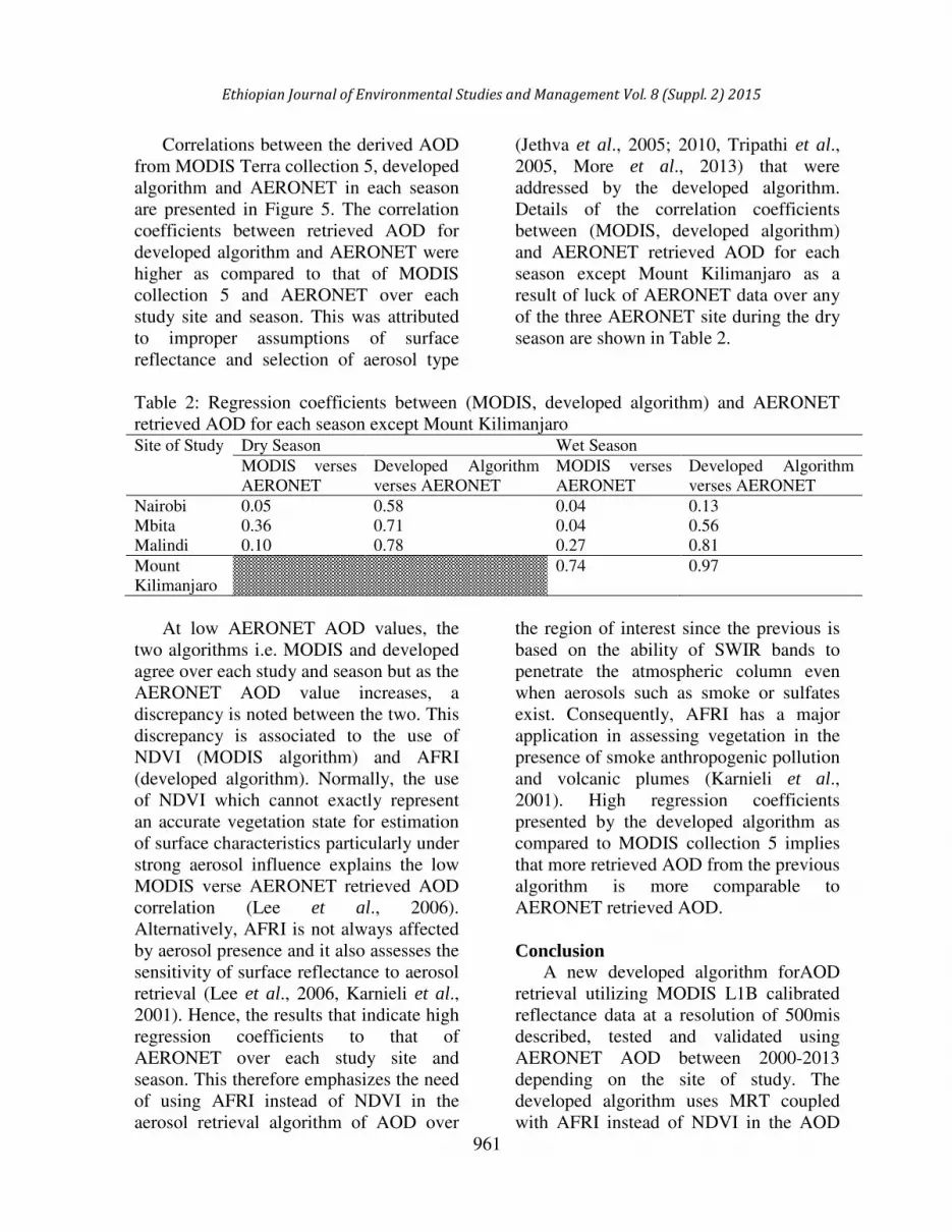
Correlations between the derived AOD
from MODIS Terra collection 5, developed
algorithm and AERONET in each season
are presented in Figure 5. The correlation
coefficients between retrieved AOD for
developed algorithm and AERONET were
higher as compared to that of MODIS
collection 5 and AERONET over each
study site and season. This was attributed
to improper assumptions of surface
reflectance and selection of aerosol type
(Jethva et al., 2005; 2010, Tripathi et al.,
2005, More et al., 2013) that were
addressed by the developed algorithm.
Details of the correlation coefficients
between (MODIS, developed algorithm)
and AERONET retrieved AOD for each
season except Mount Kilimanjaro as a
result of luck of AERONET data over any
of the three AERONET site during the dry
season are shown in Table 2.
Table 2: Regression coefficients between (MODIS, developed algorithm) and AERONET
retrieved AOD for each season except Mount Kilimanjaro Site of Study Dry Season Wet Season
MODIS verses
AERONET
Developed Algorithm
verses AERONET
MODIS verses
AERONET
Developed Algorithm
verses AERONET
Nairobi 0.05 0.58 0.04 0.13
Mbita 0.36 0.71 0.04 0.56
Malindi 0.10 0.78 0.27 0.81
Mount
Kilimanjaro
0.74 0.97
At low AERONET AOD values, the
two algorithms i.e. MODIS and developed
agree over each study and season but as the
AERONET AOD value increases, a
discrepancy is noted between the two. This
discrepancy is associated to the use of
NDVI (MODIS algorithm) and AFRI
(developed algorithm). Normally, the use
of NDVI which cannot exactly represent
an accurate vegetation state for estimation
of surface characteristics particularly under
strong aerosol influence explains the low
MODIS verse AERONET retrieved AOD
correlation (Lee et al., 2006).
Alternatively, AFRI is not always affected
by aerosol presence and it also assesses the
sensitivity of surface reflectance to aerosol
retrieval (Lee et al., 2006, Karnieli et al.,
2001). Hence, the results that indicate high
regression coefficients to that of
AERONET over each study site and
season. This therefore emphasizes the need
of using AFRI instead of NDVI in the
aerosol retrieval algorithm of AOD over
the region of interest since the previous is
based on the ability of SWIR bands to
penetrate the atmospheric column even
when aerosols such as smoke or sulfates
exist. Consequently, AFRI has a major
application in assessing vegetation in the
presence of smoke anthropogenic pollution
and volcanic plumes (Karnieli et al.,
2001). High regression coefficients
presented by the developed algorithm as
compared to MODIS collection 5 implies
that more retrieved AOD from the previous
algorithm is more comparable to
AERONET retrieved AOD.
Conclusion
A new developed algorithm forAOD
retrieval utilizing MODIS L1B calibrated
reflectance data at a resolution of 500mis
described, tested and validated using
AERONET AOD between 2000-2013
depending on the site of study. The
developed algorithm uses MRT coupled
with AFRI instead of NDVI in the AOD
Ethiopian Journal of Environmental Studies and Management Vol. 8 (Suppl. 2) 2015

962
retrieval over various land surfaces in the
region. The Vis/SWIR ratio differs from
the one proposed for AOD retrieval in the
hypothetical model, this implies that the
hypothetical model cannot always be used
to accurately calculate surface reflectance
for aerosol retrieval over East Africa.
Results indicate that retrieved AOD from
the developed algorithm are more
consistent with that of AERONET over
each study site and season as compared to
that of MODIS collection 5. This then
emphasizes the need of using AFRI plus
accurate selection of surface characteristics
and aerosol type for accurate AOD
retrieval over East Africa, hence increasing
the confidence in exploiting remotely
sensed data over the region.
Acknowledgement
This work wassupported by the
National Council for Science and
Technology Grant funded by the
Government of Kenya
(NCST/ST&I/RCD/4TH
call PhD/201).The
authors wish to thank the NASA Goddard
Earth Science Distributed Active Archive
for MODIS Level 1B and level 3 data.
Brent Holben and the group are
acknowledged for installing, maintaining
and allowing the use of the optical data
derived from AERONET sun photometers.
References
Ackerman, S.A., Strabala, K., Menzel, P.,
Frey, R., Moeller, C., Gumley, L.,
Baum, B., Seeman, S.W. and Zhang,
H. (1998). Discriminating
clearskyfrom cloud with MODIS.
Algorithm theoretical basis document
(MOD35). J. Geophys. Res., 103:
32141–32157.
Bucholtz, A. (1995). Rayleigh-scattering
calculations for the
terrestrialatmosphere. Appl. Opt., 34:
2765–2773.
Chu, A., Kaufman, Y.J., Ichoku, C.,
Remer, L.A., Tanré, D. and Holben,
B.N. (2002). Validation of MODIS
aerosol optical depth retrieval over
land.Geophys. Res. Lett., 29(12): 1–
4.
D'Almeida, G.A., (1986). A model for
Saharan dust transport, J. Clin. Appl.
Meteorol., 24: 903–916.
De Graaf, M., Tilstra, L.G., Aben, I. and
Stammes, P. (2010). Satellite
observations of the seasonal cycles of
absorbing aerosols in Africa related
to the monsoon rainfall, 1995-2008,
Atmos. Environ., 44:1274-1284.
Engelstaedter, S., Tegen, I., and
Washington, R. (2006). North
African dust emissions and transport.
Earth Sci. Rev., 79(1-2): 73-100.
Fairman, J.G., Nair, U.S., Christopher,
S.A. and Mölg, T. (2011). Land use
change impacts on regional climate
over Kilimanjaro. J. Geophys.
Res.,116:(D03110) Doi:
10.1029/2010JD014712.
Geogdzhayev, I.V., Mishchenko, M.I.,
Rossow, W.B., Cairns, B. and Lacis,
A.A. (2002). Global two-channels
AVHRR retrievals of aerosol
properties over oceans for the period
of NOAA-9 observations and
preliminary retrievals using NOAA-7
and NOAA-11 data, J. Atmos. Sci.,
59:262-278.
Gillingham, S.S., Flood, N., Gill, T.K. and
Mitchell, R.M. (2012). Limitations of
the dense dark vegetation method for
aerosol retrieval under Australian
conditions. Remote Sensing Letters,
31: 67-76.
Guo, J., Xiao, H., Xue, Y., Che, H.,
Xiaoye, Z., Cao, C., Jie, G. and Hao,
Z. (2009). A new method to retrieve
aerosol optical thickness from
satellite images on a parallel system,
Particuology, 7: 392-398.
Retrieval of Aerosol Optical Depth over Ecologically Stressed East African................MAKOKHA et al.

963
Holben, B.N., Eck, T.F., Slutsker, I.,
Tanre, D., Buis, J.P., Setzer, A.,
Vermote, E., Reagan, J.A., Kaufman,
Y.J., Nakajima, T., Lavenu, F.,
Jankowiak, I. and Smirnov, A.
(1998). AERONET-A federated
instrument network and data archive
for aerosol characterization, Remote
Sens. Environ. 66:1-16.
Höller, R., Nagl, C., Haubold, H., Fanton
D'Andon, O. and Garnesson, P.
(2005). Evaluation of MERIS aerosol
products for national and regional air
quality in Austria. ESA Proceedings,
MERIS/(A) ATSR Workshop,
ESRIN, Frascati, Italy.
Hsu, N.C., Tsay, S.C., King, M.D. and
Herman, J.R. (2004). Aerosol
properties over bright-reflecting
source regions, IEEE Trans. Geosci.
Remote Sens., 42(3): 557–569.
Hsu, M.S. and Burke, H.K. (2003).
Multisensor fussion with
hyperspectral imaging data:
Detection and classification, Lincoln
Laboratory Journal, 14:145-159.
Hsu, N.C., Tsay, S.C., King, M.D. and
Herman, J.R. (2006). Deep blue
retrievals of Asian aerosol properties
during ACE-Asia, IEEE Trans.
Geosci. Remote Sens., 44(11): 3180–
3195.
Intergovernmental Panel on Climate
Change (IPCC) (2007). Climate
change 2007: The physical science
basis. Contribution of working group
I to the fourth assessment report of
the intergovernmental panel on
climate change. In: Solomon, S., Qin,
D., Manning, M., Chen, Z., Marquis,
M., Averyt, K.B.,Tignor, M., and
Miller, H.L. (eds), Cambridge
University Press, Cambridge, UK
and New York, USA.
Jethva, H., Satheesh, S.K. and Srinivasan,
J. (2005). Seasonal Variabilities over
the Indo-Gangatic Basin. J.
Geophys. Res., 110: (D21204), Doi:
10.1029/2005JD005938.
Jethva, H., Satheesh, S.K., Shrinivasan, J.
and Levy, R.C. (2010). Improved
Retrievals of Aerosol Size-Resolved
Properties from Moderate Resolution
Imaging Spectroradiometer over
India: Role of Aerosol Model and
Surface Reflectance. J. Geophys.
Res. 115: D18213, Doi:
10.1029/2009JD013218.
Kaufman, Y.J., Tanré, D., Gordon, H.R.,
Nakajima, T., Lenoble, J., Frouin, R.,
Grassl, H., Herman, B.M., King,
M.D. and Teillet, P.M. (1997).
Passiveremote sensing of
tropospheric aerosol and atmospheric
correction for the aerosol effect, J.
Geophys. Res., 102(D14): 16815-
16830.
Kaufman, Y.J. and Tanre, D. (1998).
Algorithm for Remote Sensing of
Tropospheric Aerosol from MODIS,
1998. NASA MOD04 product
ATBDreport.
Kaufman, Y.J., Koren, I., Remer, L.A.,
Tanré, D., Ginoux, P. and Fan, S.
(2005). Dust trans- port and
deposition observed from the Terra-
Moderate Resolution Imaging
Spectroradiometer (MODIS)
spacecraft over the Atlantic Ocean. J.
Geophys. Res. 110, (D10S12).Doi:
10.1029/2003JD004436.
Karnieli, A., Kaufman, Y.J., Remer, L.A.
and Ward, A. (2001). AFRI-Aerosol
free vegetation index. Remote Sens.
Environ., 77: 10–21.
Lee, K.H., Kim, Y.J., von Hoyningen-
Huene, W. and Burrow, J.P. (2006).
Influence of land surfaceeffects on
MODIS aerosol retrieval usingthe
BAER method over Korea. Int. J.
Remote Sens., 27: 2813–2830.
Ethiopian Journal of Environmental Studies and Management Vol. 8 (Suppl. 2) 2015

964
Levy, R.C., Remer, L.A., Martins, J.V.,
Kaufman, Y.J., Plana-fattori, A.,
Redemann, J. and Wenny, B. (2004).
Evaluation of the MODIS aerosol
retrievals over ocean and land during
CLAMS, J. Atmos. Sci., 62(4):974–
992.
Levy, R.C., Remer, L.A., Mattoo, S.,
Vermote, E.F. and Kaufman, Y.J.
(2007). Second-generation
operational algorithm: retrieval of
aerosol properties over land from
inversion of moderate resolution
imaging Spectroradiometer spectral
reflectance. J. Geophys. Res. 112,
(D13211). Doi:
10.1029/2006JD007811.
Makokha, J.W. and Angeyo, H.K. (2013).
Investigation of Radiative
Characteristics of the Kenyan
Atmosphere due to Aerosols Using
Sun Spectrophotometry
Measurements and the COART
Model, Aerosol and Air Quality
Research.,13:201-208.
More, S., Pradeep Kumar, P., Pawan, G.,
Devara, P.C.S. and Aher, G.R.
(2013). Comparison of aerosol
Products Retrieved from AERONET,
MICROTOPS and MODIS over a
Tropical Urban city, Pune, India,
Aerosol and Air Quality Research,13:
107-121.
Prospero, J.M., Barrett, K., Church, T.,
Dentener, F., Duce, R.A., Galloway,
H., Levy II, H., Moody, J. and Quinn,
P. (1996). Atmospheric deposition of
nutrients to the North Atlantic basin.
Biogeochemistry 35: 27-73.
Prospero, J., Ginoux, P., Torres, O. and
Nicholson, S.E. (2002).
Environmental Characterization of
Global sources of atmospheric soil
dust derived from the NIMBUS-7
TOMS absorbing aerosol product,
Rev. Geophys., 40(1), 1002, doi:
10.1029/20000GR000095.
Reid, J.S., Kinney, J.E., Westphal, D.L.,
Holben, B.N., Ellsworth, J.W., Si-
Chee, T., Danniel, P.E., Campell,
J.R., Sandar, A.C., Colarco, P.R.,
Haflidi, H.J., John, M.L., Hal, B.M.,
Michael, M.L., Peter, P., Joseph,
M.P., Elizabeth, A.R., Lorraine,
A.R., Russell, P.B., Dennis, L.S.,
Alexander, S. and Didier, T. (2003).
Analysis of measurements of Saharan
dust by airborne and ground-based
remote sensing methods during the
Puerto Rico Dust Experiment
(PRIDE). J. Geophys. Res. 108
(D19). Doi: 10.1029/2002JD002493.
Reid, J.S., Koppmann, R., Eck, T.F. and
Eleuterio, D.P. (2005). A review of
biomass burningemissions part II:
intensive physical properties of
biomass burning particles. Atmos.
Chem. Phys. 5:799-825.
doi:10.5194/acp-5-799-2005
Remer, L.A., Kaufman, Y.J., Tanré, D.,
Mattoo, S., Chu, D.A., Martins, J.V.,
Li, R.R., Ichoku, C., Levy, R.C.,
Kleidman, R.G., Eck, T.F., Vermote,
E. and Holben, B.N. (2005). The
MODIS aerosol algorithm, products,
and validation, J. Atmos. Sci., 62(4):
947–973.
Salomonson, V.V., Barnes, W.L.,
Maymon, P.W., Montgomery, H.E.
and Ostrow, H. (1989). "MODIS:
Advanced Facility Instrument for
Studies of the Earth as a System."
IEEE Trans. Geosci. Remote
Sensing., 27: 145-153.
Seery, B.D., Cramer, D.B., Stevens, C and
Lencioni, D. (1996). EO1: NASA’s
First New Millennium Earth Orbiting
Mission,”SPIE, 2810, 4–10.
Shaw, G.A and Burke, H.K. (2003).
Spectral imaging for remote sensing.
Lincoln Laboratory Journal, 14:3-28.
Retrieval of Aerosol Optical Depth over Ecologically Stressed East African................MAKOKHA et al.

965
Torres, O., Bhartia, P. K., Herman, J. R.,
Ahmed, Z. and Gleason, J. (1998).
Derivationof aerosol properties from
satellite measurements of
backscatteredultraviolet radiation:
Theoretical basis, J. Geophys. Res.,
103: 17,099 –17,110
Torres, O., Bhartia, P. K., Herman, J. R.,
Sinyuk, A., Ginoux, P. andHolben,
B. (2002). A long-term record of
aerosol optical depth from
TOMSobservations and comparisons
to AERONET measurements, J.
Atmos. Sci., 59: 398– 413.
Tripathi, S.N., Dey, S., Chandel, A.,
Srivastava, S., Singh, R.P. and
Holben, B.N. (2005). Comparison of
MODIS and AERONET Derived
Aerosol Optical Depth overGanga
Basin, India. Ann. Geophys., 23:
1093–1101.
Vermote, E.F., Tanre, D., Deuze, J.L.,
Morcrette, J.J., Herman, M. and
Kotchenova, S.Y (2006). “Second
simulation of the satellite signal in
the solar spectrum-vector: User
Guide manual,” University of
Maryland/Laboratoired’OptiqueAtm
ospherique.
Von Hoyningen-Huene, W., Freitag, M.,
and Burrows, J.B. (2003). Retrieval
ofaerosol optical thickness over land
surfaces from top-of-atmosphere
radiance. J. Geophys. Res. 108(D9):
4260. Doi: 10.1029/2001JD002018.
Von Hoyningen-Huene, W., Kokhanovsk,
A.A., Wuttke, A.A., Buchwitz, M.,
Noël, S., Gerilowski, K., Burrows,
J.B., Latter, B., Siddans, R. and
Kerridge, B.J. (2007). Validation of
SCIAMACHY top-of-atmosphere
reflectance for aerosol remote
sensing using MERIS L1 data,
Atmos. Chem. Phys., 7: 97-106.
Wittrock, F., Oetjen, H., Richter, A.,
Fietkau, S., Medeke, T., Rozanov, A.
and Burows, J.P. (2004). MAX-
DOAS measurements of atmospheric
trace gases in Ny-Ǻlesund-Radiative
transfer studies and their application,
Atmos. Chem. Phys., 4: 955-966.
Wong, M. S., Lee, K. H., Nichol, E.J. and
Li, Z. (2010). Retrieval of Aerosol
Optical Thickness using MODIS
500×500 m2, a study in Hong Kong
and the Pearl River Delta region,
IEEE Trans. Geosci. Remote Sens.,
48(8): 3318–3327.
Ethiopian Journal of Environmental Studies and Management Vol. 8 (Suppl. 2) 2015


