Embed Size (px)
Citation preview
Western Michigan University Western Michigan University
ScholarWorks at WMU ScholarWorks at WMU
Reports of Investigations Intercultural and Anthropological Studies
1985
68-An Assessment of the Archaeological Resources of the 68-An Assessment of the Archaeological Resources of the
Morrow Lake Wellfield, City of Kalamazoo, Kalamazoo County, Morrow Lake Wellfield, City of Kalamazoo, Kalamazoo County,
Michigan Michigan
William M. Cremin Western Michigan University
Follow this and additional works at: https://scholarworks.wmich.edu/
archaeology_reports_of_investigations
Part of the Archaeological Anthropology Commons
WMU ScholarWorks Citation WMU ScholarWorks Citation Cremin, William M., "68-An Assessment of the Archaeological Resources of the Morrow Lake Wellfield, City of Kalamazoo, Kalamazoo County, Michigan" (1985). Reports of Investigations. 46. https://scholarworks.wmich.edu/archaeology_reports_of_investigations/46
This Report is brought to you for free and open access by the Intercultural and Anthropological Studies at ScholarWorks at WMU. It has been accepted for inclusion in Reports of Investigations by an authorized administrator of ScholarWorks at WMU. For more information, please contact [email protected].
DEPARTMENT OF ANTHROPOLOGY
WESTERN MICHIGAN UNIVERSITY
REPORT OF INVESTIGATIONS NO. 68
1985
AN ASSESSMENT OF THE ARCHAEOLOGICAL RESOURCES OF THE MORROW
LAKE WELLFIELD, CITY OF KALAMAZOO, KALAMAZOO COUNTY, MICHIGAN
William M. Cremin
Prepared for:
Department of Public Utilities Orlin K. Loen, P.E., Director
City of Kalamazoo, MI 49001-2898
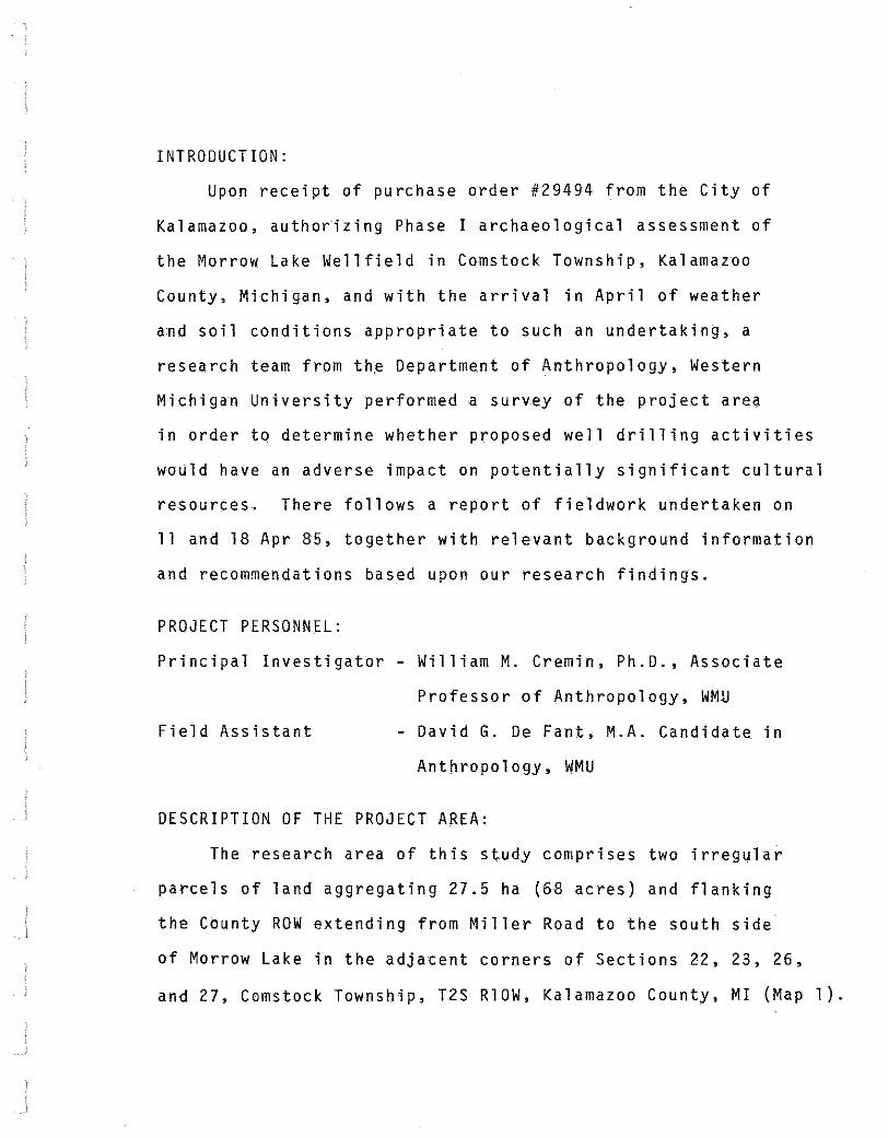
INTRODUCTION:
Upon receipt of purchase order #29494 from the City of
Kalamazoo, authorizing Phase I archaeological assessment of
the Morrow Lake Wellfield in Comstock Township, Kalamazoo
County, Michigan, and with the arrival in April of weather
and soil conditions appropriate to such an undertaking, a
research team from th~ Department of Anthropology, Western
Michigan University performed a survey of the project area
in order to determine whether proposed well drilling activities
would have an adverse impact on potentially significant cultural
resources. There follows a report of fieldwork undertaken on
11 and 18 Apr 85, together with relevant background information
and recommendations based upon our research findings.
PROJECT PERSONNEL:
Principal Investigator- William M. Cremin, Ph.D., Associate
Professor of Anthropology, WMU
Field Assistant David G. De Fant, M.A. Candidate in
Anthropology, WMU
DESCRIPTION OF THE PROJECT AREA:
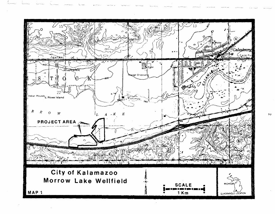
The research area of this study comprises two irregular
parcels of land aggregating 27.5 ha (68 acres) and flanking
the County ROW extending from Miller Road to the south side
of Morrow Lake in the adjacent corners of Sections 22, 23, 26,
and 27, Comstock Township, T2S RlOW, Kalamazoo County, MI (Map 1).
Ot<;posa
lndtan Mounds<l Rowe Island '~ .·,·., I
__ .k.CoJ.iri'1-,· · ·-~-..., . D -- -,' 0.: lnfHmol!.¥. _ i
n ' --- -·. • ·7>so
I! I! 0 w ~K E
PROJECT AREA ~ lj--- -· -·-- . ·- ---- __ ,_ ·-
.. 5 .. ?!'!
City of Kalamazoo Morrow Lake Wellfield t
-N-
MAP 1 ~ • SCALE • 1-·-·-·-·-·-1 • 1 Km •
N
"
-~ QU-'DR"NGLE LOC ... TION
3
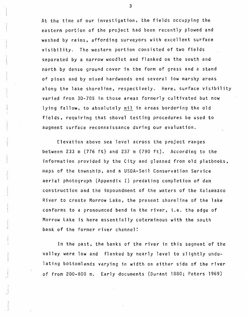
At the time of our investigation, the fields occupying the
eastern portion of the project had been recently plowed and
washed by rains, affording surveyors with excellent surface
visibility. The western portion consisted of two fields
separated by a narrow woodlot and flanked on the south and
north by dense ground cover in the form of grass and a stand
of pines and by mixed hardwoods and several low marshy a~eas
along the lake shoreline, respectively. Here, surface visibility
varied from 30-70% in those areas formerly cultivated but now
lying fallow, to absolutely nil in areas bordering the old
fields, requiring that shovel testing procedures be used to
augment surface reconnaissance during our evaluation.
Elevation above sea level across the project ranges
between 233 m (776 ft) and 237 m (790 ft). According to the
information provided by the City and gleaned from old platbooks,
maps of the township, and a USDA-Soil Conservation Service
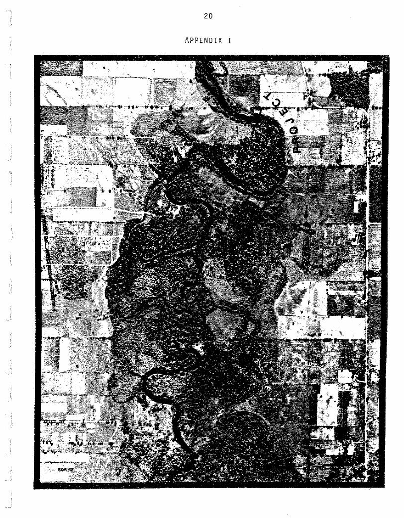
aerial photograph (Appendix I) predating completion of dam
construction and the impoundment of the waters of the Kalamazoo
River to create Morrow Lake, the present shoreline of the lake
conforms to a pronounced bend in the river, i.e. the edge of
Morrow Lake is here essentially coterminous with the south
bank of the former river channel!
In the past, the banks of the river in this segment of the
valley were low and flanked by nearly level to slightly undu
lating bottomlands varying in width on either side of the river
of from 200-800 m. Early documents (Durant 1880; Peters 1969)
4
and presettlement vegetational maps derived from the fieldnotes
and plats of the original land survey conducted in 1827 (Brewer
1979; Hadler et al. 1981) indicate that the flood bottoms were
heavily wooded and characterized by dense undergrowth. The
immediate area of this project supported a forest community
dominated by American or slippery elm, silver maple, and red
maple, but with some black ash, beech, sycamore, black walnut,
butternut, cottonwood, hackberry, basswood, black maple, honey
locust, and sugar maple being present. The uplands behind and
to the south of the project area supported climax beech-maple
forest. In addition to the beech and sugar maple, common to
this community were white ash, basswood, ironwood, tulip tree,
and bitternut and shagbark hickory.
In marked contrast to the tree species dominating where
mesic conditions prevailed on uplands behind and to the south
of the project, upland areas across the river featured oak
forest. In this community the dominant species everywhere was
the white oak. However, red, black, bur, and yellow oak were
also present and, in addition to the oaks, this plant association
also evidenced small numbers of pignut and shagbark hickory.
Finally, important from the perspective of Euro-American
settlement of Comstock Township, this last community also had
some small restricted areas of oak savanna or "barrens'', where
the bur oak tended to occur in almost pure stands and, on one
occasion, fringed dry prairieland. Toland's Prairie, a grass
land of about 200 ha located near the present town of Galesburg
in Section 13, was a magnet attracting easterners to the area
5
in the 1820s.
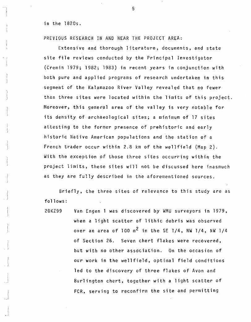
PREVIOUS RESEARCH IN AND NEAR THE PROJECT AREA:
Extensive and thorough literature, documents, and state
site file reviews conducted by the Principal Investigator
(Cremin 1979; 1982; 1983) in recent years in conjunction with
both pure and applied programs of research undertaken in this
segment of the Kalamazoo River Valley revealed that no fewer
than three sites were located within the limits of this project.
Moreover, this general area of the valley is very notable for
its density of archaeological sites; a minimum of 17 sites
attesting to the former presence of prehistoric and early
historic Native American populations and the station of a
French trader occur within 2.8 km of the wellfield (Map 2).
With the exception of those three sites occurring within the
project limits, these sites will not be discussed here inasmuch
as they are fully described in the aforementioned sources.
Briefly, the three sites of relevance to this study are as
follows:
20KZ99 Van Engen 1 was discovered by WMU surveyors in 1979,
when a light scatter of lithic debris was observed
over an area of 100 m2 in the SE l/4, NW l/4, NW 1/4
of Section 26, Seven chert flakes were recovered,
but with no other association. On the occasion of
our work in the wellfield, optimal field conditions
led to the discovery of three flakes of Avon and
Burlington chert, together with a light scatter of
FCR, serving to reconfirm the site and permitting
lnd1an Mound®owe Island
44
II II 0 w
MAP 2
City of Kalamazoo Morrow Lake Wellfield
(Previously Known Sites)
~ -N-
~ • SCALE •
·-·-·-·-·-· ... • 1 Km •
, ~·
~'c"'o'G QUADRANGLE LOCATION
0">
20KZ100
20KZ118
7
refinement of both its location and spatial extent.
Van Engen 1 occupies 2400 m2 in the SW l/4, NW 1/4,
SE l/4 and the SE l/4, NE l/4, SW 1/4· of the NW l/4,
NW l/4 of Section 26.
Tulip, also recorded in 1979, represents the locus
of an undiagnostic biface and a flake of chert in
the NW l/4, NW l/4, NW 1/4 of Section 26. During
this Phase I study, the site was relocated on the
basis of three additional flakes and a moderate
scatter of FCR over an area of some 4200 m2 in the
NE l/4, NW l/4, NW l/4, NW 1/4 of Section 26.
This site, reported in Durant (1880), is an historic
Indian cemetery located hard against the south bank
of the Kalamazoo River on the Ford Farm in the NE l/4,
NE l/4 of Section 27. Here, early area residents
found 30 Indian graves, lying side by side, and
including a small log enclosure with an Indian in a
sitting position wrapped in a blanket. Also found
in this burial ground was the grave of an old Frenchman
(possibly the individual associated with site 20KZ119,
a trading post formerly located on the south bank of
the river in theSE l/4 of Section 24), at the head of
which was placed a crude cross of wood. Firming up
the temporal placement is the fact that some of the
graves, when opened, produced grave goods of silver
and copper, and a tin or copper pail was observed
to occur in nearly every one of them (Durant 1880:
3 76).
8
Although our intensive shovel testing and probing
with a soil coring device along the margins of a
750 m2 irregular, partially backfilled depression
yielded no solid evidence in the form of cultural
material or fragments of bone that this location
represented the 19th century excavation of the
Indian burial ground, we are reasonably confident
that we have relocated this site in the bank over
looking Morrow Lake in the Center, N l/2, SW l/4,
NE l/4, NE l/4 of Section 27.
SURVEY FIELD PROCEDURES:
In the eastern portion of the project the survey team
encountered two recently plowed and rain washed fields, pro
viding absolutely excellent conditions for surface reconnais
sance. Here, we spaced ourselves 20 m apart and walked the
fields from north to south in zig-zag fashion, while carefully
scanning the surface for indications of human activity in the
form of fire-cracked rock, lithic debris, and other sorts of
material culture remains that might signal the presence of an
archaeological site.
Elsewhere, surface visibility was more restricted, neces
sitating that we systematically traverse the area from east to
west along transects and place shovel tests at selected intervals
along each line of survey. Initially, the interval between
transects and shovel tests was 20 m. But as we approached to
within 50 m of the lake, this was reduced to 10 m or even less.
Where ground cover tended to thin in the centers of two long
9
worked but now fallow fields in the western portion of the
project, providing visibility ranging between 30-70%, surface
reconnaissance procedures were employed to augment our program
of shovel testing.
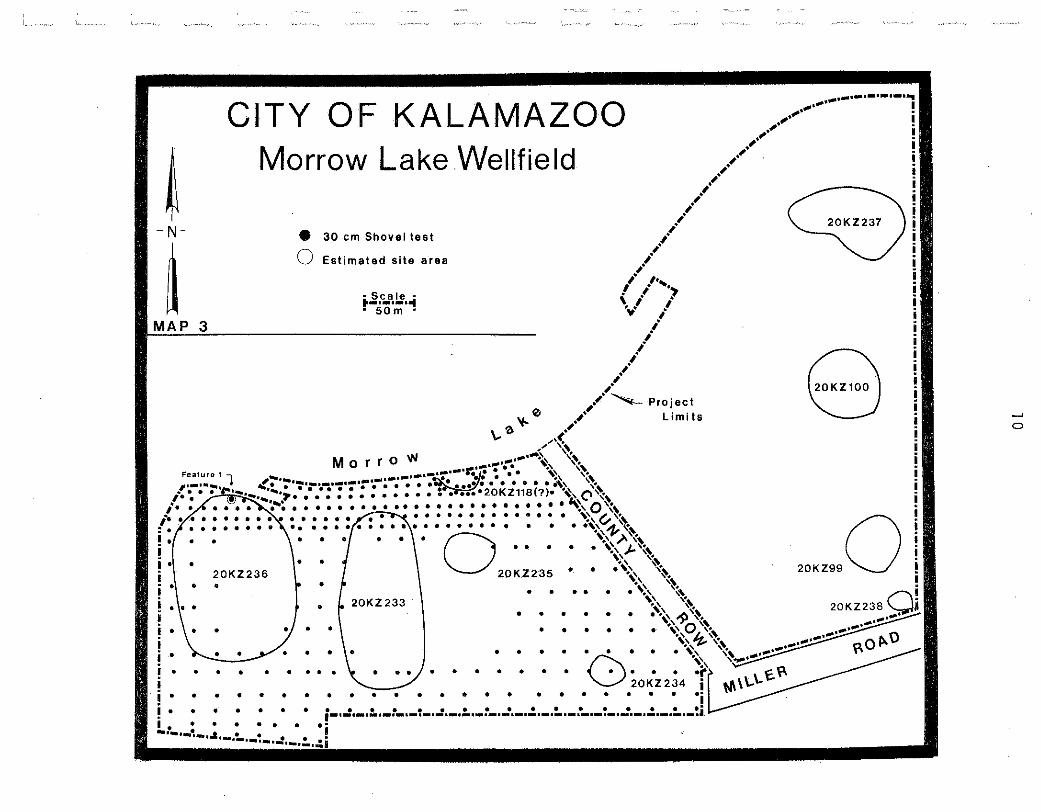
Map 3 shows the approximate locations of 354 shovel tests
excavated in the western portion of the wellfield. Shovel
testing routinely involved exposing the soil profile to a
depth of 40-50 em, or to a depth determined to be consistent
with the post-Pleistocene development of local floodplain
soils. Given our familiarity with the depositional history
of local soils, derived from prior research involving a program
of deep testing at the nearby Galesburg Rest Area (Cremin 1982),
we are certain that shovel tests excavated to the depth indicated
above are more than adequate to ensure that any potential culture
bearing deposit in the sandy alluvium beneath the modern surface
would have been exposed to view.
RESULTS OF THE SURVEY:
Surface and subsurface finds of prehistoric lithic material,
fragments of fire-cracked rock, and the discovery of one cultural
feature are indicative of the presence of archaeological sites.
Moreover, a long time area resident, Mr. Bert Van Engen, has
informed us that he frequently observed "points" while working
the fields in the project, and that in recent years an unnamed
artifact collector has found historic Indian artifacts in the
lake only a few meters from that location on the bank where we
defined and tentatively identified an old excavation as 20KZ118
(Maps 2 and 3).
CITY OF KALAMAZOO
~ Morrow Lake Wellfield
- N-
~ MAP
•
20KZ236 •
• ~ • • • • •
! • • • I • • i • • • • • • • • • !.t-·-'-·"'*·-·~·-~-
.
•
e 30 em Shovel test
0 Estimated site area
~scale~ ·-·-·-· .. • 50m •
MorroW
0
'-""..,.
\ . ... y.· . '"'!\" ......... ·~ .{ .. :.: .(. o.::~,~
• ~
.. I 20KZ 233
I • • • • • • ~ .. ) . • • •
• • • • • • • • • •
• • • • • • • • • • •
• • • •
• • • • • •
•
• • • •
• •
Project Limits 8 ~
0
20KZ990
11
Fire-cracked rock is sparsely distributed over virtually
the entire 27.5 ha surveyed, albeit most commonly encountered
in association with cultural items in those areas delimited as
sites on Map 3. The only really dense concentrations of FCR
noted in the project occur within the limits of 20KZ236, where
densities of 10 pieces of FCR per m2 were recorded on a number
of occasions. In all probability, such FCR densities point to
the presence of subsurface features not unlike the pit recorded
as Feature 1 near the northern limits of 20KZ236 (Map 3). This
observation will be discussed in more detail below.
In addition to the three previously recorded sites, on-site
evaluation of the Morrow Lake Wellfield in April suggests the
presence of an additional six previously unrecorded sites (Map
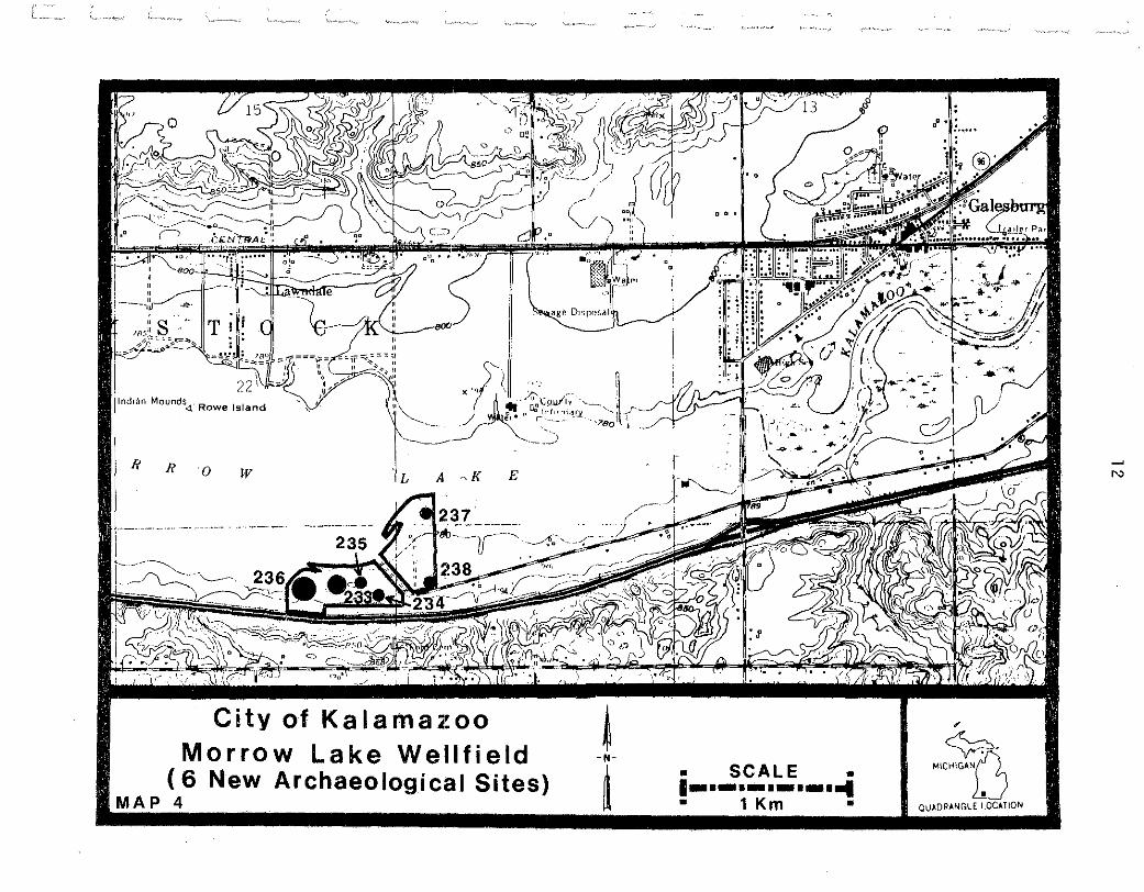
4). These are:
20KZ233
20KZ234
Wellfield #1 is a light scatter of lithic debris and
FCR encompassing about 1.4 ha in theW l/2, SW l/4,
NE 1/4, NE l/4 of Section 27, Comstock Township,
T2S RlOW, Kalamazoo County, Michigan. The presence
of a biface of Bayport chert that is like the Steuben
type of the Middle Woodland Hopewell tradition and a
flake of Upper Mercer chert argue for a Middle Woodland
temporal placement.
-1 pr~ectile point of Bayport chert (Figure 1) -1 flake of Upper Mercer chert -1 flake of heat treated Burlington chert -2 flakes -3 fragments of quartzite
Wellfield #2 is represented by three crude flakes and
a very diffuse scatter of FCR over an area of about
800 m2 in the SW 1/4, SE 1/4, SE 1/4, NE l/4, NE 1/4
'.' ;
1'
. x,--.Cql,IJI'i~- ·-..~, ___ . lndtan Mounds<! Rowe Island o.i't~fnm,1_r.i'. J " (- .___ ___ ··?eo t
-, --~-
II II 0 W E
City of Kalamazoo Morrow Lake Wellfield
( 6 New Archaeological Sites) MAP 4
~ -N-
~ • SCALE •
·-·-·-·-·-·-1 • 1 Km •
" ~-MICHIGAn
QU~DR~NGLE LOC~TION
~
N
20KZ235
20KZ236
13
of Section 27, Comstock Township, T2S RlOW, Kalamazoo
County, Michigan. The items recovered are not diag
nostic, and the cultural affiliation and/or temporal
placement of this site cannot at this time be deter-
mined.
-2 flakes of an unidentified chert (probably from a local till source)
-1 flake of argillite, possibly evidencing use-wear in the form of nibbling on one margin
Wellfield #3 yielded three flakes and is further
characterized by a light scatter of FCR over an area
of approximately 1600 m2 in the Center, S l/2, NE 1/4,
NE l/4 of Section 27, Comstock Township, T2S RlOW,
Kalamazoo County, Michigan. Again, the cultural
material from this site does not evidence any diagnostic
items, and the temporal placement and/or cultural
affiliation of this site are not known.
-2 bifacial thinning flakes, one of Flint Ridge chert -1 flake of rose quartzite
Wellfield #4 covers an area of about 4.0 ha in the
Center, SE l/4, NW 1/4, NE l/4 of Section 27, Comstock
Township, T2S RlOW, Kalamazoo County, Michigan. While
exhibiting a light scatter of lithic debris and FCR
over the entire estimated site area, 20KZ236 is notable
for several very dense concentrations of FCR and one
cultural feature that was encountered during shovel
testing.
Feature 1 is a shallow basin-shaped pit, 1.3 min
diameter and 37 em in depth. The most interesting
aspect of this feature is the blackish fuel lens that
20 KZ23 7
20KZ238
14
commences at a depth of 20 em below the modern surface
and extends to the base of the pit. This soil zone
contained charcoal, one specimen of which permitted
identification of the source as belonging to the white
oak group, fragments of FCR, three flakes of chert,
and a fragment of a pitted cobble. Unfortunately,
nothing from this feature or, for that matter, the
site is diagnostic with respect to either temporal
placement or cultural affiliation.
-1 bifacial thinning flake of Burlington chert -2 resharpening flakes -1 decortication flake -2 probable flakes -1 fist-size cobble with a pitted surface -1 pitted cobble fragment
Wellfield #5 encompasses approximately 6000 m2 in the
NE l/4, SE l/4, SW 1/4, SW l/4, SW l/4 of Section 23,
Comstock Township, T2S RlOW, Kalamazoo County, Michigan.
Here, surveyors observed a very light and at times
discontinuous scatter of FCR and two undiagnostic
cultural items. The cultural affiliation and temporal
placement of this site are not known.
-1 blade-like flake of an unidentified chert showing steep marginal retouch on one lateral edge and usewear in the form of nibbling on the other
-1 bifacial thinning flake
Wellfield #6 is confined to an area of about 400m2
in the Center, S 1/2, NW l/4, NW 1/4 of Section 26,
Comstock Township, T2S RlOW, Kalamazoo County, Michigan.
The site yielded a very light scatter of FCR, one
bifacial thinning flake, and a Gibson point fabricated
on an unidentified chert. The projectile point from
this site argues for a Middle Woodland temporal
1 5
placement.
-1 projectile point of the Gibson type (Figure 2) -1 bifacial thinning flake
SIGNIFICANCE OF OBSERVATIONS:
Our fieldwork and information derived from the background
study clearly establish the presence of at least nine archaeo
logical sites in the area of the Morrow Lake Wellfield. The
cultural remains of prehistoric occupation are quite sparse in
their distribution across the 27.5 ha surveyed, suggesting an
extensive rather than intensive use of this area along the
Kalamazoo River by Native American groups. This observation
is not unanticipated, given our familiarity with the archaeo-
logical resource base in this segment of the valley. In fact,
the results of this Phase I assessment are exceedingly redundant
when compared with recent investigations at the Galesburg Rest
Area (Cremin 1982; 1983) located a few hundred meters to the
east and upstream from the wellfield project. This previous
study and the results derived from both Phase I and Phase II
research programs are very influencial with respect to the
recommendations which follow.
RECOMMENDATIONS:
On the basis of a systematic and intensive on-site study
of the 27.5 ha project designated as the Morrow Lake Wellfield,
together with a thorough examination of the relevant literature
and documents, especially as these pertain to our work at the
rest area, it is proposed that sites located and reported above
will not require Phase II test excavation to determine their
eligibility for listing on the National Register of Historic
16
Places. Sites 20KZ233, 234, 235, 237, and 238 might most
appropriately be regarded as "surface sites", with the
probability being quite low that subsurface features providing
some measure of archaeological context even·exist. Together
with previously recorded sites 20KZ99 and 100, these are not
to be considered potentially significant sites within the
existing data set for this segment of the Kalamazoo River
Valley.
With respect to the site recorded as 20KZll8, an early
19th century Indian burial ground that had been ravaged by
area residents more than a century ago, our on-site study
has revealed nothing to indicate that the site has not already
been thoroughly destroyed. While we believe that the excavation
found on the shore of the lake does accurately locate the
former site, our careful examination of the margins of the
depression yielded no information potentially useful in asses
sing it. No further evaluation of 20KZll8 would appear to be
warranted.
The ''class'' of the population of sites located in the
Morrow Lake Wellfield project is 20KZ236. Here, over an area
of some 4.0 ha, surveyors observed FCR, lithic debris, and
through shovel testing exposed a cultural feature. Given the
occurrences of several dense concentrations of FCR within the
limits of this site, it is probable that subsurface features
do or have existed. However, little can be said with respect
to their present condition of preservation in this context of
intensive cultivation for more than a century. Feature 1
17
occurred near the northern limits of the site in close proximity
to the lake shoreline. This is an area of the site evidencing
little if any disturbance attributable to cultivation. Intact
cultural features may not exist throughout most of the estimated
site area due to years of farming activity.
Perhaps more critical in making a case for or against a
Phase II assessment of this site is our recent experience at
the Galesburg Rest Area. Here, Phase I evaluation produced
evidence for the presence of cultural features, but subsequent
Phase II test excavation hardly increased our knowledge of
the nature of human activity associated with the prehistoric
occupation of the sites tested--let alone provide evidence
of potential significance in terms of National Register criteria.
Therefore, in light of our current knowledge of the archaeology
of the Middle Kalamazoo Valley and our recent experience in
test excavating sites that on the basis of Phase I assessment
are markedly similar to 20KZ236, it is our recommendation that
Phase II test excavation of this site will not be necessary.
In conclusion, it is our contention that the archaeological
remains occurring in the Morrow Lake Wellfield are not of great
enoush value to either require additional study or delay the
commencement of well drilling activities proposed by the City
of Kalamazoo. In the event that work in the wellfield does
result in the exposing of subsurface archaeological remains,
the Principal Investigator will make himself available to the
City to assist in the assessment and proper disposition of
any materials discovered.
18
REFERENCES CITED:
Brewer, R., compiler 1979 Vegetation Qf southwestern Michigan ~!he time of
settlement. Department of Biology, Western Michigan University.
Cremin, W.M. 1979 An archaeological survey of Kalamazoo County, Michigan:
1979 multiple transect survey in the middle Kalamazoo river valley. Department of Anthropology, Western Michigan University, Archaeological Report 5.
1982 An archaeological survey of the expanded Galesburg rest area, Comstock Township, Kalamazoo County, Michigan. Department of Anthropology, Western Michigan University, Technical Report 8.
1983 Archaeological test excavations at the Galesburg rest area, Comstock Township, Kalamazoo County, Michigan. Department of Anthropology, Western Michigan University, Technical Report 11.
Durant, S.W. 1880 History of Kalamazoo County, Michigan. Everts and
Abbott, Philadelphia.
Hadler, 1981
Peters, 1969
T.W., R. Brewer, L.G. Brewer, and H.A. Raup, compilers Presettlement vegetation of Kalamazoo County, Michigan. Department of Geography, Western Michigan University.
B.C. Early American impressions and evaluations of the landscape of inner Michigan with emphasis ~ Kalamazoo County. University Microfilms, Ann Arbor.
1 9
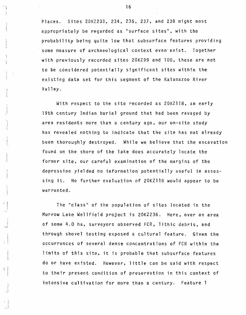
Figure 1: Hafted biface from Wellfield #1, 20KZ233. This specimen is of Bayport chert.
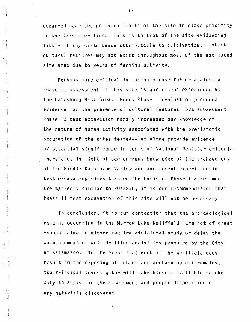
Figure 2: Hafted biface from Wellfield #6, 20KZ238. This specimen is of an unidentified, probably local, till chert.
(ACTUAL SIZE)
I XIGN3dd\l
oz


![truly and more strange| [Short stories] - ScholarWorks at](https://img.pdfslide.net/doc/110x75/6319dd7b4cd7b344240937ae/truly-and-more-strange-short-stories-scholarworks-at-.jpg)
![Violent mercy| [Poems] - ScholarWorks at University of Montana](https://img.pdfslide.net/doc/110x75/63211d28b71aaa142a04186a/violent-mercy-poems-scholarworks-at-university-of-montana.jpg)