Embed Size (px)
Citation preview
lable at ScienceDirect
Quaternary International 326-327 (2014) 6e19
Contents lists avai
Quaternary International
journal homepage: www.elsevier .com/locate/quaint
Sediments of Bi�snik Cave (Poland): Lithology and stratigraphy of theMiddle Palaeolithic site
Maciej T. Krajcarz a,*, Pavel Bosák b, Stanislav �Slechta b, Petr Pruner b, Maryna Komar c,d,Justyna Dresler e, Teresa Madeyska a
a Institute of Geological Sciences, Polish Academy of Sciences, Research Centre in Warsaw, Twarda St. 51/55, PL-00818 Warszawa, Polandb Institute of Geology, Academy of Sciences of the Czech Republic, v. v. i., Rozvojová 269, 165 00 Praha 6-Lysolaje, Czech RepubliccNational Museum of Natural History at the National Academy of Sciences of Ukraine, Bohdan Khmelnitsky St. 15, 01601 Kiev, Ukrained Institute of Geological Sciences, National Academy of Sciences of Ukraine, O.Gonchar St. 55-b, 01054 Kiev, Ukrainee Faculty of Earth Sciences and Spatial Management, University of Maria Curie-Skłodowska, Kra�snicka St. 2cd, 20-718 Lublin, Poland
a r t i c l e i n f o
Article history:Available online 22 October 2013
* Corresponding author.E-mail addresses: [email protected] (M.T
(P. Bosák), [email protected] (S. �Slechta), [email protected] (M. Komar), [email protected] (T. Madeyska).
1040-6182/$ e see front matter � 2013 Elsevier Ltd ahttp://dx.doi.org/10.1016/j.quaint.2013.10.017
a b s t r a c t
Bi�snik Cave is an important Palaeolithic site located in the Kraków-Czestochowa Upland. The cave fill is acomplex well-stratified sequence composed of 35 layers/sublayers interrupted by number of hiatusesand ranging from Pliocene till modern times. Fifteen Middle Palaeolithic horizons, some of them amongthe oldest in Poland, represent the most important part of the sequence from an archaeological point ofview. The sedimentary sequences in particular parts of the cave have been studied for more than 20 yearsto investigate the chronostratigraphy and palaeoenvironment. The recent multi-proxy study is based onthe application of new methods for the site: analysis of sedimentary and post-sedimentary structures,and weathering stage of limestone rubble and fossil bones, pollen analysis, molecular biomarkers,palaeomagnetic analysis and radiometric dating. Results indicated a more intensive role of re-workingand re-deposition in the cave. Older sediments were transported into some stratigraphic horizonsfrom sources within the cave itself as well as from outside, including palaeontological and archaeologicalmaterials. Some the detected layers therefore represent a mix derived from different sources. A record oftwo interglacials (Eemian Interglacial, MIS 5e and Penultimate Interglacial, MIS 7) was established inlayers Nos. 15e14e13ae13 and 19ae19, respectively. MiddleeUpper Pleistocene sedimentary units wereidentified with MIS 3eMIS 7/8, instead of previous interpretation to MIS 4eMIS 9. The age of the basalvario-colored complex, previously interpreted mostly as pre-Pleistocene, was newly correlated with MIS7/8 and Early Pleistocene/Pliocene.
� 2013 Elsevier Ltd and INQUA. All rights reserved.
1. Introduction
The stratigraphic sequence recorded in sediments inBi�snikCave isthe longest one among cave Palaeolithic sites inPoland. In a 7-m thickset of sediments, fifteen Middle Palaeolithic horizons were distin-guished (Cyrek et al., 2010) below the Upper Palaeolithic, Neolithicand younger ones. The aim of the detailed study of the lithology andsediments stratigraphy is to solve the problem of the chronology ofthe Middle Palaeolithic settlement and cultural differentiation, aswell as to clarify the environmental conditions of individual
. Krajcarz), [email protected] (P. Pruner), [email protected] (J. Dresler), tmadeysk@
nd INQUA. All rights reserved.
settlementphases. The geological investigation of Bi�snik Cave startedover 20 years ago (Miros1aw-Grabowska, 1998, 2002a,b; Cyrek et al.,2009, 2010; Krajcarz, 2009; Krajcarz et al., 2010; Krajcarz and Cyrek,2011; Krajcarz and Madeyska, 2012). New results are presented hereincluding geological and geochemical methods not used in Bi�snikCave in the past. Archaeological and palaeontological results arepresented separately in this issue.
2. Geological setting
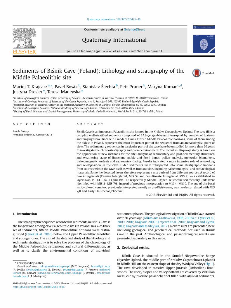
Bi�snik Cave is situated in the Smole�n-Niegowonice Range(Ryczów Upland, the middle part of Kraków-Czestochowa Upland)in Bi�snik Hill, on the eastern slope of the dryWodaca Valley (Fig. 1).The cave developed in massive Upper Jurassic (Oxfordian) lime-stones. The rocky slopes and valley bottom are covered by Vistulianloess, cut by riverine palaeochannel filled with alluvial sediments.
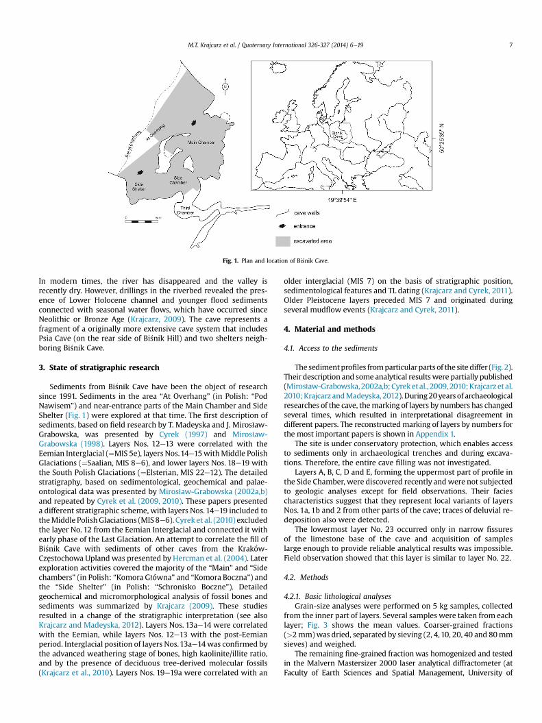
Fig. 1. Plan and location of Bi�snik Cave.
M.T. Krajcarz et al. / Quaternary International 326-327 (2014) 6e19 7
In modern times, the river has disappeared and the valley isrecently dry. However, drillings in the riverbed revealed the pres-ence of Lower Holocene channel and younger flood sedimentsconnected with seasonal water flows, which have occurred sinceNeolithic or Bronze Age (Krajcarz, 2009). The cave represents afragment of a originally more extensive cave system that includesPsia Cave (on the rear side of Bi�snik Hill) and two shelters neigh-boring Bi�snik Cave.
3. State of stratigraphic research
Sediments from Bi�snik Cave have been the object of researchsince 1991. Sediments in the area “At Overhang” (in Polish: “PodNawisem”) and near-entrance parts of the Main Chamber and SideShelter (Fig. 1) were explored at that time. The first description ofsediments, based on field research by T. Madeyska and J. Miros1aw-Grabowska, was presented by Cyrek (1997) and Miros1aw-Grabowska (1998). Layers Nos. 12e13 were correlated with theEemian Interglacial (¼MIS 5e), layers Nos.14e15withMiddle PolishGlaciations (¼Saalian, MIS 8e6), and lower layers Nos. 18e19 withthe South Polish Glaciations (¼Elsterian, MIS 22e12). The detailedstratigraphy, based on sedimentological, geochemical and palae-ontological data was presented by Miros1aw-Grabowska (2002a,b)and repeated by Cyrek et al. (2009, 2010). These papers presenteda different stratigraphic scheme, with layers Nos.14e19 included totheMiddle PolishGlaciations (MIS 8e6). Cyrek et al. (2010) excludedthe layer No. 12 from the Eemian Interglacial and connected it withearly phase of the Last Glaciation. An attempt to correlate the fill ofBi�snik Cave with sediments of other caves from the Kraków-Czestochowa Upland was presented by Hercman et al. (2004). Laterexploration activities covered the majority of the “Main” and “Sidechambers” (in Polish: “Komora G1ówna” and “Komora Boczna”) andthe “Side Shelter” (in Polish: “Schronisko Boczne”). Detailedgeochemical and micromorphological analysis of fossil bones andsediments was summarized by Krajcarz (2009). These studiesresulted in a change of the stratigraphic interpretation (see alsoKrajcarz and Madeyska, 2012). Layers Nos. 13ae14 were correlatedwith the Eemian, while layers Nos. 12e13 with the post-Eemianperiod. Interglacial position of layers Nos.13ae14was confirmed bythe advanced weathering stage of bones, high kaolinite/illite ratio,and by the presence of deciduous tree-derived molecular fossils(Krajcarz et al., 2010). Layers Nos. 19e19a were correlated with an
older interglacial (MIS 7) on the basis of stratigraphic position,sedimentological features and TL dating (Krajcarz and Cyrek, 2011).Older Pleistocene layers preceded MIS 7 and originated duringseveral mudflow events (Krajcarz and Cyrek, 2011).
4. Material and methods
4.1. Access to the sediments
Thesedimentprofiles fromparticularparts of thesite differ (Fig. 2).Their description and some analytical resultswere partially published(Miros1aw-Grabowska,2002a,b;Cyreketal., 2009,2010;Krajcarzetal.2010;Krajcarz andMadeyska, 2012).During20yearsof archaeologicalresearches of the cave, themarking of layers by numbers has changedseveral times, which resulted in interpretational disagreement indifferent papers. The reconstructedmarking of layers by numbers forthe most important papers is shown in Appendix 1.
The site is under conservatory protection, which enables accessto sediments only in archaeological trenches and during excava-tions. Therefore, the entire cave filling was not investigated.
Layers A, B, C, D and E, forming the uppermost part of profile inthe Side Chamber, were discovered recently andwere not subjectedto geologic analyses except for field observations. Their faciescharacteristics suggest that they represent local variants of layersNos. 1a, 1b and 2 from other parts of the cave; traces of deluvial re-deposition also were detected.
The lowermost layer No. 23 occurred only in narrow fissuresof the limestone base of the cave and acquisition of sampleslarge enough to provide reliable analytical results was impossible.Field observation showed that this layer is similar to layer No. 22.
4.2. Methods
4.2.1. Basic lithological analysesGrain-size analyses were performed on 5 kg samples, collected
from the inner part of layers. Several samples were taken from eachlayer; Fig. 3 shows the mean values. Coarser-grained fractions(>2mm)was dried, separated by sieving (2, 4,10, 20, 40 and 80mmsieves) and weighed.
The remaining fine-grained fractionwas homogenized and testedin the Malvern Mastersizer 2000 laser analytical diffractometer (atFaculty of Earth Sciences and Spatial Management, University of
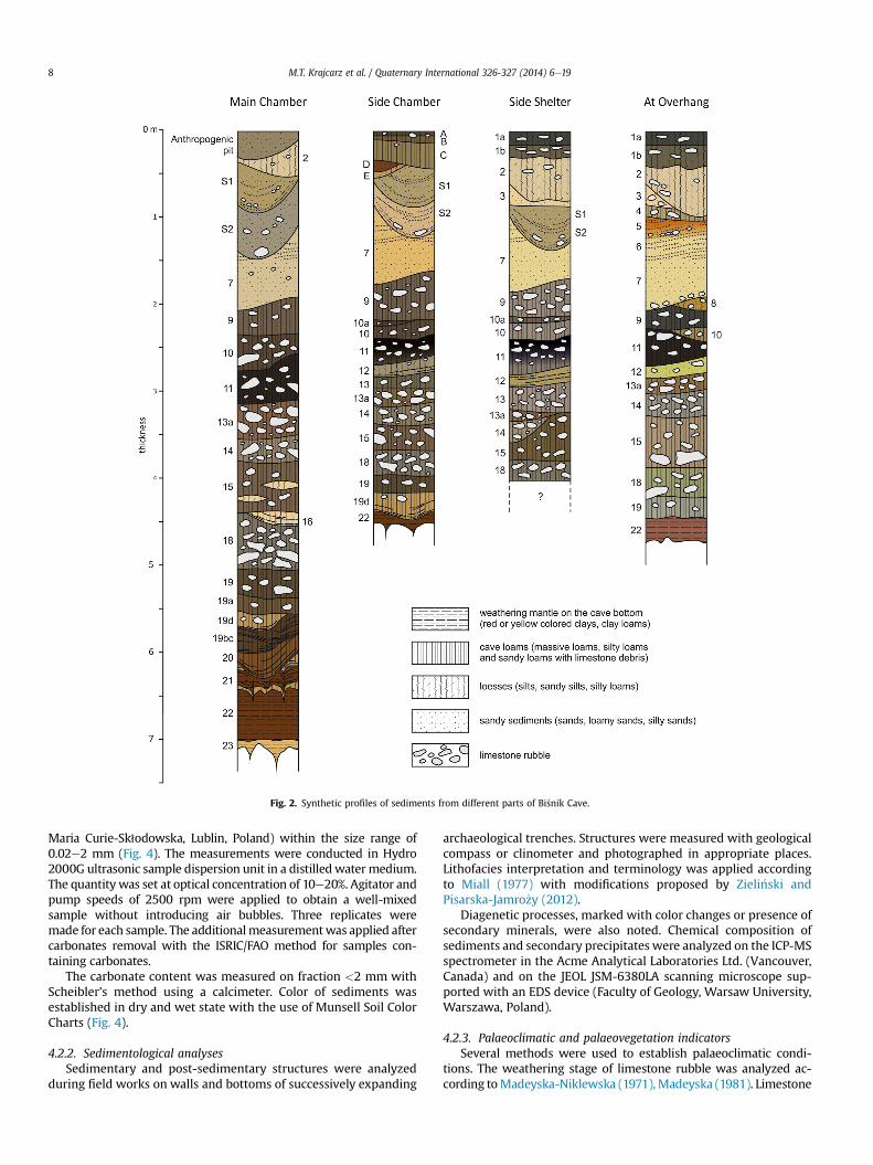
Fig. 2. Synthetic profiles of sediments from different parts of Bi�snik Cave.
M.T. Krajcarz et al. / Quaternary International 326-327 (2014) 6e198
Maria Curie-Sk1odowska, Lublin, Poland) within the size range of0.02e2 mm (Fig. 4). The measurements were conducted in Hydro2000G ultrasonic sample dispersion unit in a distilledwatermedium.The quantity was set at optical concentration of 10e20%. Agitator andpump speeds of 2500 rpm were applied to obtain a well-mixedsample without introducing air bubbles. Three replicates weremade for each sample. The additionalmeasurementwas applied aftercarbonates removal with the ISRIC/FAO method for samples con-taining carbonates.
The carbonate content was measured on fraction <2 mm withScheibler’s method using a calcimeter. Color of sediments wasestablished in dry and wet state with the use of Munsell Soil ColorCharts (Fig. 4).
4.2.2. Sedimentological analysesSedimentary and post-sedimentary structures were analyzed
during field works on walls and bottoms of successively expanding
archaeological trenches. Structures were measured with geologicalcompass or clinometer and photographed in appropriate places.Lithofacies interpretation and terminology was applied accordingto Miall (1977) with modifications proposed by Zieli�nski andPisarska-Jamro _zy (2012).
Diagenetic processes, marked with color changes or presence ofsecondary minerals, were also noted. Chemical composition ofsediments and secondary precipitates were analyzed on the ICP-MSspectrometer in the Acme Analytical Laboratories Ltd. (Vancouver,Canada) and on the JEOL JSM-6380LA scanning microscope sup-ported with an EDS device (Faculty of Geology, Warsaw University,Warszawa, Poland).
4.2.3. Palaeoclimatic and palaeovegetation indicatorsSeveral methods were used to establish palaeoclimatic condi-
tions. The weathering stage of limestone rubble was analyzed ac-cording toMadeyska-Niklewska (1971),Madeyska (1981). Limestone
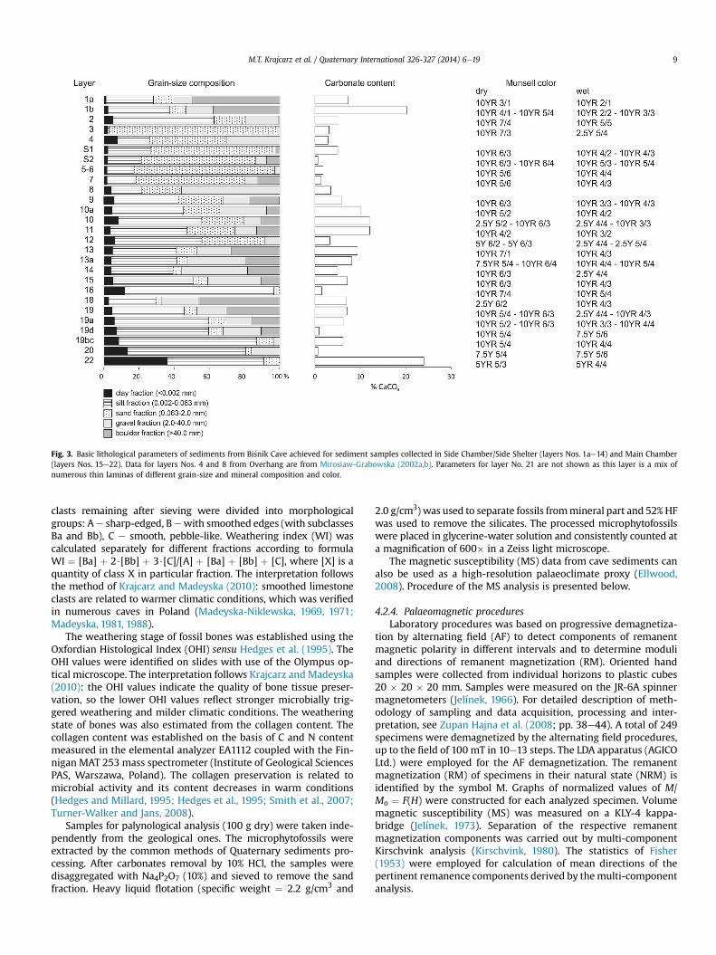
Fig. 3. Basic lithological parameters of sediments from Bi�snik Cave achieved for sediment samples collected in Side Chamber/Side Shelter (layers Nos. 1ae14) and Main Chamber(layers Nos. 15e22). Data for layers Nos. 4 and 8 from Overhang are from Miros1aw-Grabowska (2002a,b). Parameters for layer No. 21 are not shown as this layer is a mix ofnumerous thin laminas of different grain-size and mineral composition and color.
M.T. Krajcarz et al. / Quaternary International 326-327 (2014) 6e19 9
clasts remaining after sieving were divided into morphologicalgroups: Ae sharp-edged, Bewith smoothed edges (with subclassesBa and Bb), C e smooth, pebble-like. Weathering index (WI) wascalculated separately for different fractions according to formulaWI ¼ [Ba] þ 2$[Bb] þ 3$[C]/[A] þ [Ba] þ [Bb] þ [C], where [X] is aquantity of class X in particular fraction. The interpretation followsthe method of Krajcarz and Madeyska (2010): smoothed limestoneclasts are related to warmer climatic conditions, which was verifiedin numerous caves in Poland (Madeyska-Niklewska, 1969, 1971;Madeyska, 1981, 1988).
The weathering stage of fossil bones was established using theOxfordian Histological Index (OHI) sensu Hedges et al. (1995). TheOHI values were identified on slides with use of the Olympus op-tical microscope. The interpretation follows Krajcarz and Madeyska(2010): the OHI values indicate the quality of bone tissue preser-vation, so the lower OHI values reflect stronger microbially trig-gered weathering and milder climatic conditions. The weatheringstate of bones was also estimated from the collagen content. Thecollagen content was established on the basis of C and N contentmeasured in the elemental analyzer EA1112 coupled with the Fin-nigan MAT 253 mass spectrometer (Institute of Geological SciencesPAS, Warszawa, Poland). The collagen preservation is related tomicrobial activity and its content decreases in warm conditions(Hedges and Millard, 1995; Hedges et al., 1995; Smith et al., 2007;Turner-Walker and Jans, 2008).
Samples for palynological analysis (100 g dry) were taken inde-pendently from the geological ones. The microphytofossils wereextracted by the common methods of Quaternary sediments pro-cessing. After carbonates removal by 10% HCl, the samples weredisaggregated with Na4P2O7 (10%) and sieved to remove the sandfraction. Heavy liquid flotation (specific weight ¼ 2.2 g/cm3 and
2.0 g/cm3) was used to separate fossils frommineral part and 52% HFwas used to remove the silicates. The processed microphytofossilswere placed in glycerine-water solution and consistently counted ata magnification of 600� in a Zeiss light microscope.
The magnetic susceptibility (MS) data from cave sediments canalso be used as a high-resolution palaeoclimate proxy (Ellwood,2008). Procedure of the MS analysis is presented below.
4.2.4. Palaeomagnetic proceduresLaboratory procedures was based on progressive demagnetiza-
tion by alternating field (AF) to detect components of remanentmagnetic polarity in different intervals and to determine moduliand directions of remanent magnetization (RM). Oriented handsamples were collected from individual horizons to plastic cubes20 � 20 � 20 mm. Samples were measured on the JR-6A spinnermagnetometers (Jelínek, 1966). For detailed description of meth-odology of sampling and data acquisition, processing and inter-pretation, see Zupan Hajna et al. (2008; pp. 38e44). A total of 249specimens were demagnetized by the alternating field procedures,up to the field of 100 mT in 10e13 steps. The LDA apparatus (AGICOLtd.) were employed for the AF demagnetization. The remanentmagnetization (RM) of specimens in their natural state (NRM) isidentified by the symbol M. Graphs of normalized values of M/Mo ¼ F(H) were constructed for each analyzed specimen. Volumemagnetic susceptibility (MS) was measured on a KLY-4 kappa-bridge (Jelínek, 1973). Separation of the respective remanentmagnetization components was carried out by multi-componentKirschvink analysis (Kirschvink, 1980). The statistics of Fisher(1953) were employed for calculation of mean directions of thepertinent remanence components derived by themulti-componentanalysis.
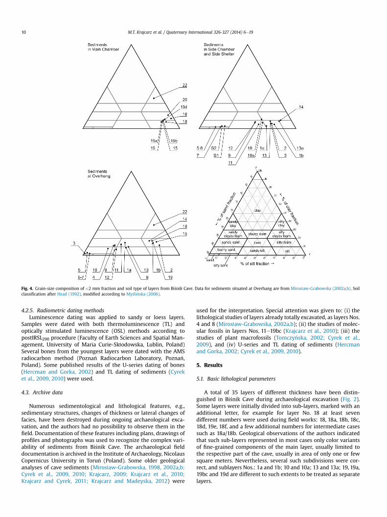
Fig. 4. Grain-size composition of <2 mm fraction and soil type of layers from Bi�snik Cave. Data for sediments situated at Overhang are from Miros1aw-Grabowska (2002a,b). Soilclassification after Head (1992), modified according to My�sli�nska (2006).
M.T. Krajcarz et al. / Quaternary International 326-327 (2014) 6e1910
4.2.5. Radiometric dating methodsLuminescence dating was applied to sandy or loess layers.
Samples were dated with both thermoluminescence (TL) andoptically stimulated luminescence (OSL) methods according topostIRSL290 procedure (Faculty of Earth Sciences and Spatial Man-agement, University of Maria Curie-Sk1odowska, Lublin, Poland)Several bones from the youngest layers were dated with the AMSradiocarbon method (Pozna�n Radiocarbon Laboratory, Pozna�n,Poland). Some published results of the U-series dating of bones(Hercman and Gorka, 2002) and TL dating of sediments (Cyreket al., 2009, 2010) were used.
4.3. Archive data
Numerous sedimentological and lithological features, e.g.,sedimentary structures, changes of thickness or lateral changes offacies, have been destroyed during ongoing archaeological exca-vation, and the authors had no possibility to observe them in thefield. Documentation of these features including plans, drawings ofprofiles and photographs was used to recognize the complex vari-ability of sediments from Bi�snik Cave. The archaeological fielddocumentation is archived in the Institute of Archaeology, NicolausCopernicus University in Toru�n (Poland). Some older geologicalanalyses of cave sediments (Miros1aw-Grabowska, 1998, 2002a,b;Cyrek et al., 2009, 2010; Krajcarz, 2009; Krajcarz et al., 2010;Krajcarz and Cyrek, 2011; Krajcarz and Madeyska, 2012) were
used for the interpretation. Special attention was given to: (i) thelithological studies of layers already totally excavated, as layers Nos.4 and 8 (Miros1aw-Grabowska, 2002a,b); (ii) the studies of molec-ular fossils in layers Nos. 11e19bc (Krajcarz et al., 2010); (iii) thestudies of plant macrofossils (Tomczy�nska, 2002; Cyrek et al.,2009), and (iv) U-series and TL dating of sediments (Hercmanand Gorka, 2002; Cyrek et al., 2009, 2010).
5. Results
5.1. Basic lithological parameters
A total of 35 layers of different thickness have been distin-guished in Bi�snik Cave during archaeological excavation (Fig. 2).Some layers were initially divided into sub-layers, marked with anadditional letter, for example for layer No. 18 at least sevendifferent numbers were used during field works: 18, 18a, 18b, 18c,18d, 19e, 18f, and a few additional numbers for intermediate casessuch as 18a/18b. Geological observations of the authors indicatedthat such sub-layers represented in most cases only color variantsof fine-grained components of the main layer, usually limited tothe respective part of the cave, usually in area of only one or fewsquare meters. Nevertheless, several such subdivisions were cor-rect, and sublayers Nos.: 1a and 1b; 10 and 10a; 13 and 13a; 19, 19a,19bc and 19d are different to such extents to be treated as separatelayers.
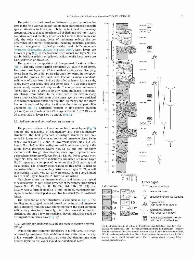
Fig. 5. Lithofacies profile of sediments from Bi�snik Cave. Lithofacies code key: DFm e
massive fine diamictons, DFh e horizontally laminated fine diamictons, Fm e massivefines, Fd e deformed fines, Fe e fines in erosional scour fill, Ff e flaser-laminated fines,FSf e flaser-laminated sandy fines, SDe e diamictic sands in erosional scour fill, SDl elow-angle cross-bedded diamictic sands, SDm e massive diamictis sands, GDm e
massive diamictic gravel.
M.T. Krajcarz et al. / Quaternary International 326-327 (2014) 6e19 11
The principal criteria used to distinguish layers by archaeolo-gists in the field were as follows: color; grain-size compositionwithspecial attention to limestone rubble content; and sedimentarystructures. Due to that approach not all of distinguished inter-layersboundaries are sedimentary structures, but some of them representonly the color changes. Color of sediments reflects the co-occurrence of different compounds, including hematite, goethite,humus, manganese oxides/hydroxides and Fe2þcompounds(Miros1aw-Grabowska, 2002b; Krajcarz, 2009). Most layers arebrown or gray (Fig. 3). The lowermost sediments and layer No. 13aexhibit brilliant reddish or yellowish colors, while loess layers arepale, yellowish or brownish.
The grain-size composition of fine-grained fractions differs(Fig. 4). The silty-sized fraction dominates, 20e80% in most layers.The lowermost layer No. 22 is classified as silty clay. Overlyinglayers from No. 20 to No. 14 are silts and silty loams. In the upperpart of the profiles, the sand-sized fraction is more abundant;sediments of layers Nos. 13e8 are classified as loams, loamy sands,sandy loams and sandy silts, and layers Nos. 7e3 as sands, loamysands, sandy loams and silty sands. The uppermost sediments(layers Nos. 2, 1b, 1a) are silts to silty loams and loams. The grain-size change from outside to the inner part of the cave in manylayers is noticeable. Sediments of the same layer are more enrichedin sand fraction in the outside part (at the Overhang), and the sandyfraction is replaced by silty fraction in the internal part (SideChamber; Fig. 4). Carbonate content in fine-grained fraction(<2 mm) varies from less than 2% in layers Nos. S2, 5, 6, 7, 19bc and20 to over 20% in layers Nos. 1b and 22 (Fig. 3).
5.2. Sedimentary and post-sedimentary structures
The presence of coarse limestone rubble in most layers (Fig. 3)hinders the readability of sedimentary and post-sedimentarystructures. The best preserved intra-layer structures are pre-served in layers with low or no content of limestone clasts, i.e. insandy layers Nos. S1e7 and in lowermost layers Nos. 19de23.Layers Nos. 5e7 exhibit well-preserved lamination, clearly indi-cating fluvial processes. Layers Nos. S1eS2 and 19de20 showmedium-scale trough stratification; each layer represents onepalaeochannel (in case of layers Nos. S1, S2, 19d, 20) or several ones(layer No. 19bc) filled with indistinctly laminated sediment. LayerNo. 21 represents a complex of numerous thin (1e2 cm) clay andloess bands. The primary stratification of this layer is hard toreconstruct due to the secondary disturbances. Layer No. 21, as wellas lowermost layers Nos. 22e23, were excavated in a very limitedarea of 3 m2. Layers Nos. 22e23 have no lamination.
Phosphate crusts on limestone clasts and bones are typicalof several layers, as well as the presence of manganese precipitates(layers Nos. 13, 13a, 14, 18, 19, 19a, 19d, 19bc, 22, 23) thatusually have a form of small (2e3 mm) nodules. Manganese pre-cipitates are best developed in layer No.14 as thick (5e15 cm) blacklenses.
The presence of other structures is compiled in Fig. 5. Thebending and mixing of material caused by the impact of limestoneclasts dropping from the cave ceiling represent the most commonsedimentary structure. Probably, each clast caused an impactstructure, but only a few are readable. Eleven lithofacies could bedistinguished in Bi�snik Cave (Fig. 5):
5.2.1. Massive fine diamictons (DFm) and massive diamictic gravels(GDm)
DFm is the most common lithofacies in Bi�snik Cave. It is char-acterized by limestone clasts of different size scattered in the siltyor loamy matrix. Limestone clasts are more abundant in some loamor loess layers so the layers should be classified as GDm.
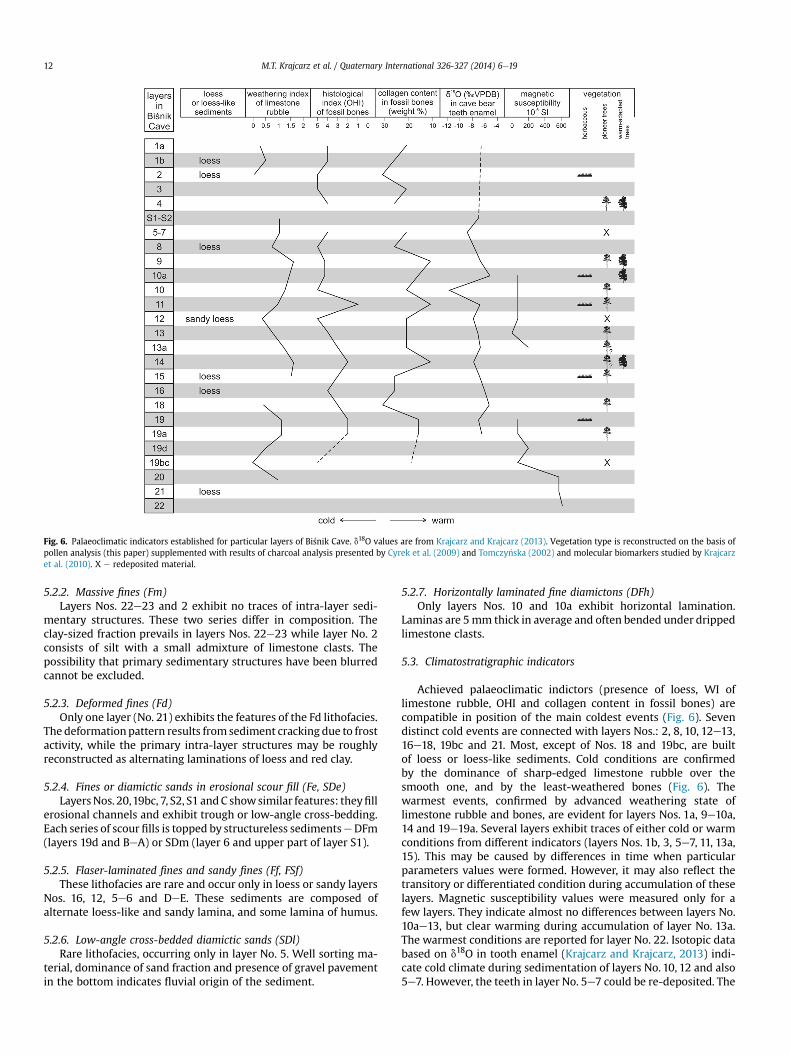
Fig. 6. Palaeoclimatic indicators established for particular layers of Bi�snik Cave. d18O values are from Krajcarz and Krajcarz (2013). Vegetation type is reconstructed on the basis ofpollen analysis (this paper) supplemented with results of charcoal analysis presented by Cyrek et al. (2009) and Tomczy�nska (2002) and molecular biomarkers studied by Krajcarzet al. (2010). X e redeposited material.
M.T. Krajcarz et al. / Quaternary International 326-327 (2014) 6e1912
5.2.2. Massive fines (Fm)Layers Nos. 22e23 and 2 exhibit no traces of intra-layer sedi-
mentary structures. These two series differ in composition. Theclay-sized fraction prevails in layers Nos. 22e23 while layer No. 2consists of silt with a small admixture of limestone clasts. Thepossibility that primary sedimentary structures have been blurredcannot be excluded.
5.2.3. Deformed fines (Fd)Only one layer (No. 21) exhibits the features of the Fd lithofacies.
The deformationpattern results from sediment cracking due to frostactivity, while the primary intra-layer structures may be roughlyreconstructed as alternating laminations of loess and red clay.
5.2.4. Fines or diamictic sands in erosional scour fill (Fe, SDe)LayersNos. 20,19bc, 7, S2, S1 andC showsimilar features: theyfill
erosional channels and exhibit trough or low-angle cross-bedding.Each series of scour fills is topped by structureless sedimentseDFm(layers 19d and BeA) or SDm (layer 6 and upper part of layer S1).
5.2.5. Flaser-laminated fines and sandy fines (Ff, FSf)These lithofacies are rare and occur only in loess or sandy layers
Nos. 16, 12, 5e6 and DeE. These sediments are composed ofalternate loess-like and sandy lamina, and some lamina of humus.
5.2.6. Low-angle cross-bedded diamictic sands (SDl)Rare lithofacies, occurring only in layer No. 5. Well sorting ma-
terial, dominance of sand fraction and presence of gravel pavementin the bottom indicates fluvial origin of the sediment.
5.2.7. Horizontally laminated fine diamictons (DFh)Only layers Nos. 10 and 10a exhibit horizontal lamination.
Laminas are 5mm thick in average and often bended under drippedlimestone clasts.
5.3. Climatostratigraphic indicators
Achieved palaeoclimatic indictors (presence of loess, WI oflimestone rubble, OHI and collagen content in fossil bones) arecompatible in position of the main coldest events (Fig. 6). Sevendistinct cold events are connected with layers Nos.: 2, 8, 10, 12e13,16e18, 19bc and 21. Most, except of Nos. 18 and 19bc, are builtof loess or loess-like sediments. Cold conditions are confirmedby the dominance of sharp-edged limestone rubble over thesmooth one, and by the least-weathered bones (Fig. 6). Thewarmest events, confirmed by advanced weathering state oflimestone rubble and bones, are evident for layers Nos. 1a, 9e10a,14 and 19e19a. Several layers exhibit traces of either cold or warmconditions from different indicators (layers Nos. 1b, 3, 5e7, 11, 13a,15). This may be caused by differences in time when particularparameters values were formed. However, it may also reflect thetransitory or differentiated condition during accumulation of theselayers. Magnetic susceptibility values were measured only for afew layers. They indicate almost no differences between layers No.10ae13, but clear warming during accumulation of layer No. 13a.The warmest conditions are reported for layer No. 22. Isotopic databased on d18O in tooth enamel (Krajcarz and Krajcarz, 2013) indi-cate cold climate during sedimentation of layers No. 10, 12 and also5e7. However, the teeth in layer No. 5e7 could be re-deposited. The
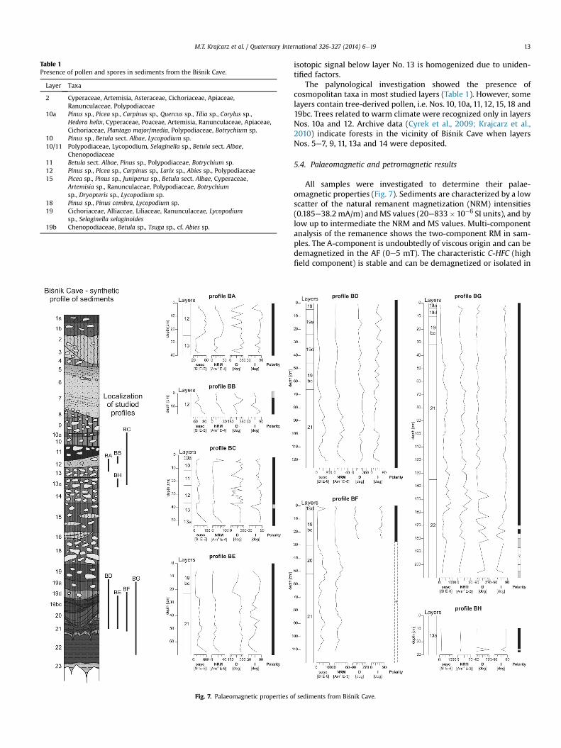
Table 1Presence of pollen and spores in sediments from the Bi�snik Cave.
Layer Taxa
2 Cyperaceae, Artemisia, Asteraceae, Cichoriaceae, Apiaceae,Ranunculaceae, Polypodiaceae
10a Pinus sp., Picea sp., Carpinus sp., Quercus sp., Tilia sp., Corylus sp.,Hedera helix, Cyperaceae, Poaceae, Artemisia, Ranunculaceae, Apiaceae,Cichoriaceae, Plantago major/media, Polypodiaceae, Botrychium sp.
10 Pinus sp., Betula sect. Albae, Lycopodium sp.10/11 Polypodiaceae, Lycopodium, Selaginella sp., Betula sect. Albae,
Chenopodiaceae11 Betula sect. Albae, Pinus sp., Polypodiaceae, Botrychium sp.12 Pinus sp., Picea sp., Carpinus sp., Larix sp., Abies sp., Polypodiaceae15 Picea sp., Pinus sp., Juniperus sp., Betula sect. Albae, Cyperaceae,
Artemisia sp., Ranunculaceae, Polypodiaceae, Botrychiumsp., Dryopteris sp., Lycopodium sp.
18 Pinus sp., Pinus cembra, Lycopodium sp.19 Cichoriaceae, Alliaceae, Liliaceae, Ranunculaceae, Lycopodium
sp., Selaginella selaginoides19b Chenopodiaceae, Betula sp., Tsuga sp., cf. Abies sp.
Fig. 7. Palaeomagnetic properties o
M.T. Krajcarz et al. / Quaternary International 326-327 (2014) 6e19 13
isotopic signal below layer No. 13 is homogenized due to uniden-tified factors.
The palynological investigation showed the presence ofcosmopolitan taxa in most studied layers (Table 1). However, somelayers contain tree-derived pollen, i.e. Nos. 10, 10a, 11, 12, 15, 18 and19bc. Trees related to warm climate were recognized only in layersNos. 10a and 12. Archive data (Cyrek et al., 2009; Krajcarz et al.,2010) indicate forests in the vicinity of Bi�snik Cave when layersNos. 5e7, 9, 11, 13a and 14 were deposited.
5.4. Palaeomagnetic and petromagnetic results
All samples were investigated to determine their palae-omagnetic properties (Fig. 7). Sediments are characterized by a lowscatter of the natural remanent magnetization (NRM) intensities(0.185e38.2 mA/m) andMS values (20e833� 10�6 SI units), and bylow up to intermediate the NRM and MS values. Multi-componentanalysis of the remanence shows the two-component RM in sam-ples. The A-component is undoubtedly of viscous origin and can bedemagnetized in the AF (0e5 mT). The characteristic C-HFC (highfield component) is stable and can be demagnetized or isolated in
f sediments from Bi�snik Cave.
M.T. Krajcarz et al. / Quaternary International 326-327 (2014) 6e1914
the AF (w10e40 to 100 mT). The measurements of the anisotropyof the low-field magnetic susceptibility (AMS) were performed(AGICO KLY-4S Kappabridge with an alternating field intensity of300 A/m and operating frequency of 875 Hz) on samples from thesection BG. No distinct preferred orientation of magnetic lineationwithin the bedding plane was observed. The declination andinclination values in the lower part of the profile BF could not becalculated due to disturbed palaeomagnetic data.
5.5. Chronostratigraphic data
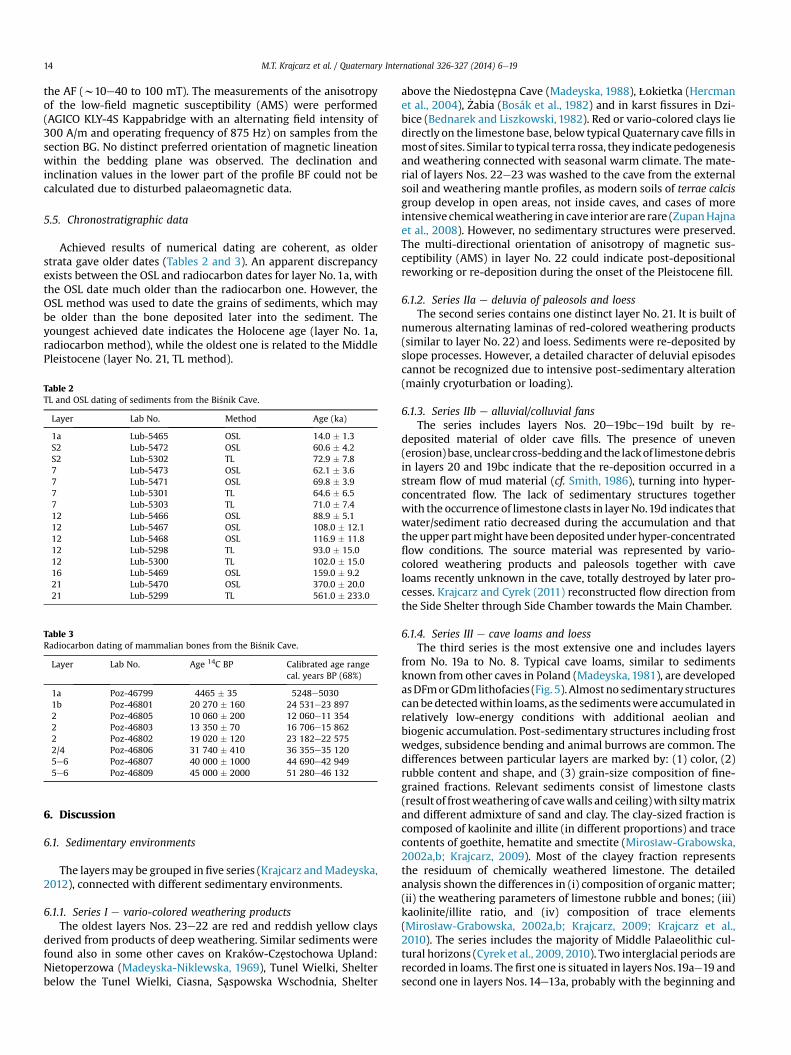
Achieved results of numerical dating are coherent, as olderstrata gave older dates (Tables 2 and 3). An apparent discrepancyexists between the OSL and radiocarbon dates for layer No. 1a, withthe OSL date much older than the radiocarbon one. However, theOSL method was used to date the grains of sediments, which maybe older than the bone deposited later into the sediment. Theyoungest achieved date indicates the Holocene age (layer No. 1a,radiocarbon method), while the oldest one is related to the MiddlePleistocene (layer No. 21, TL method).
Table 2TL and OSL dating of sediments from the Bi�snik Cave.
Layer Lab No. Method Age (ka)
1a Lub-5465 OSL 14.0 � 1.3S2 Lub-5472 OSL 60.6 � 4.2S2 Lub-5302 TL 72.9 � 7.87 Lub-5473 OSL 62.1 � 3.67 Lub-5471 OSL 69.8 � 3.97 Lub-5301 TL 64.6 � 6.57 Lub-5303 TL 71.0 � 7.412 Lub-5466 OSL 88.9 � 5.112 Lub-5467 OSL 108.0 � 12.112 Lub-5468 OSL 116.9 � 11.812 Lub-5298 TL 93.0 � 15.012 Lub-5300 TL 102.0 � 15.016 Lub-5469 OSL 159.0 � 9.221 Lub-5470 OSL 370.0 � 20.021 Lub-5299 TL 561.0 � 233.0
Table 3Radiocarbon dating of mammalian bones from the Bi�snik Cave.
Layer Lab No. Age 14C BP Calibrated age rangecal. years BP (68%)
1a Poz-46799 4465 � 35 5248e50301b Poz-46801 20 270 � 160 24 531e23 8972 Poz-46805 10 060 � 200 12 060e11 3542 Poz-46803 13 350 � 70 16 706e15 8622 Poz-46802 19 020 � 120 23 182e22 5752/4 Poz-46806 31 740 � 410 36 355e35 1205e6 Poz-46807 40 000 � 1000 44 690e42 9495e6 Poz-46809 45 000 � 2000 51 280e46 132
6. Discussion
6.1. Sedimentary environments
The layersmay be grouped in five series (Krajcarz andMadeyska,2012), connected with different sedimentary environments.
6.1.1. Series I e vario-colored weathering productsThe oldest layers Nos. 23e22 are red and reddish yellow clays
derived from products of deep weathering. Similar sediments werefound also in some other caves on Kraków-Czestochowa Upland:Nietoperzowa (Madeyska-Niklewska, 1969), Tunel Wielki, Shelterbelow the Tunel Wielki, Ciasna, Saspowska Wschodnia, Shelter
above the Niedostepna Cave (Madeyska, 1988), qokietka (Hercmanet al., 2004), _Zabia (Bosák et al., 1982) and in karst fissures in Dzi-bice (Bednarek and Liszkowski, 1982). Red or vario-colored clays liedirectly on the limestone base, below typical Quaternary cave fills inmost of sites. Similar to typical terra rossa, they indicatepedogenesisand weathering connected with seasonal warm climate. The mate-rial of layers Nos. 22e23 was washed to the cave from the externalsoil and weathering mantle profiles, as modern soils of terrae calcisgroup develop in open areas, not inside caves, and cases of moreintensive chemicalweathering in cave interiorare rare (ZupanHajnaet al., 2008). However, no sedimentary structures were preserved.The multi-directional orientation of anisotropy of magnetic sus-ceptibility (AMS) in layer No. 22 could indicate post-depositionalreworking or re-deposition during the onset of the Pleistocene fill.
6.1.2. Series IIa e deluvia of paleosols and loessThe second series contains one distinct layer No. 21. It is built of
numerous alternating laminas of red-colored weathering products(similar to layer No. 22) and loess. Sediments were re-deposited byslope processes. However, a detailed character of deluvial episodescannot be recognized due to intensive post-sedimentary alteration(mainly cryoturbation or loading).
6.1.3. Series IIb e alluvial/colluvial fansThe series includes layers Nos. 20e19bce19d built by re-
deposited material of older cave fills. The presence of uneven(erosion)base, unclearcross-beddingandthe lackof limestonedebrisin layers 20 and 19bc indicate that the re-deposition occurred in astream flow of mud material (cf. Smith, 1986), turning into hyper-concentrated flow. The lack of sedimentary structures togetherwith the occurrence of limestone clasts in layerNo.19d indicates thatwater/sediment ratio decreased during the accumulation and thatthe upper partmight have beendepositedunderhyper-concentratedflow conditions. The source material was represented by vario-colored weathering products and paleosols together with caveloams recently unknown in the cave, totally destroyed by later pro-cesses. Krajcarz and Cyrek (2011) reconstructed flow direction fromthe Side Shelter through Side Chamber towards the Main Chamber.
6.1.4. Series III e cave loams and loessThe third series is the most extensive one and includes layers
from No. 19a to No. 8. Typical cave loams, similar to sedimentsknown from other caves in Poland (Madeyska, 1981), are developedasDFmorGDmlithofacies (Fig. 5). Almostno sedimentarystructurescanbedetectedwithin loams, as the sedimentswere accumulated inrelatively low-energy conditions with additional aeolian andbiogenic accumulation. Post-sedimentary structures including frostwedges, subsidence bending and animal burrows are common. Thedifferences between particular layers are marked by: (1) color, (2)rubble content and shape, and (3) grain-size composition of fine-grained fractions. Relevant sediments consist of limestone clasts(result of frostweatheringof cavewalls and ceiling)with siltymatrixand different admixture of sand and clay. The clay-sized fraction iscomposed of kaolinite and illite (in different proportions) and tracecontents of goethite, hematite and smectite (Miros1aw-Grabowska,2002a,b; Krajcarz, 2009). Most of the clayey fraction representsthe residuum of chemically weathered limestone. The detailedanalysis shown the differences in (i) composition of organic matter;(ii) the weathering parameters of limestone rubble and bones; (iii)kaolinite/illite ratio, and (iv) composition of trace elements(Miros1aw-Grabowska, 2002a,b; Krajcarz, 2009; Krajcarz et al.,2010). The series includes the majority of Middle Palaeolithic cul-tural horizons (Cyrek et al., 2009, 2010). Two interglacial periods arerecorded in loams. The first one is situated in layers Nos.19ae19 andsecond one in layers Nos. 14e13a, probably with the beginning and
M.T. Krajcarz et al. / Quaternary International 326-327 (2014) 6e19 15
final parts recorded in layers Nos.15 and 13 respectively. The secondinterglacial was warmer, and layers Nos. 14e13a represent thewarmest condition recorded in the whole profile, except for basallayers Nos. 23e22. The only sedimentary structures in sediments ofthis series are connected with the re-deposition of loess by soli-fluction processes (layers Nos. 16, 15, 12 and 8) and fine horizontallamination occurring in layers Nos. 10e10a, probably as a result ofsedimentation in shallow water puddles. The presence of manga-nese nodules and lenses may indicate moist conditions and gleying.The intensively moist conditions are related to accumulations inlayers Nos.19bce19de19ae19e18 and 14e13ae13 according to theoccurrence of manganese precipitates.
6.1.5. Series IV e alluvial sandsThe fourth series consists of fluvial sediments, connected with
inflow of surficial water to the cave (Miros1aw-Grabowska,2002a,b). Layers Nos. 7e6e5 and 3 exhibit traces of normalstream flow: well-sortedmaterial, sharp erosion base, planar cross-bedding, inclined stratification, and lack of limestone debris. LayersNos. S1eS2 fill a palaeochannel cut by stream flow. However, sed-iments exhibit traces of hyper-concentrated flow or even debrisflow (lithofacies SDm), especially in their upper part. Layer No. 4was described as cave loam (Miros1aw-Grabowska, 1998, 2002a,b).Unfortunately the layer was accessible only during the first years ofexcavation and become totally excavated later. It is possible thatlayer No. 4 represents a lateral variety of layers Nos. S1eS2.
6.1.6. Series V e loess and topsoilThe youngest series consists of loess (layer No. 2). The Holocene
humus (layer No. 1a) and illuvial horizon (layer No. 1b) developedon the loess substratum. Layers Nos. from E to A in the SideChamber are composed of deluvium of both loess and Holocenesediments, accumulated by stream flow gradually replaced byhyper-concentrated flow and debris flow.
6.2. Age of sediments
6.2.1. Reliability of radiometric datingFifteen U-series dates exist from Bi�snik Cave, but not all of them
are reliable according to the criteria of Hercman and Gorka (2002).
Fig. 8. Radiometric dating of sediments from Bi�snik Cave. Apart from new data all known daet al., 2009, 2010; one radiocarbon date about 38 000 BP for layer 2/4 according to A. Nadachwere erroneously assigned to layers e here the assignment is corrected after field and labo
Especially, dates from layers Nos. 2, 9, 12, 14 and 15 fit neither otherdates nor to correlated-ages based on climatostratigraphy. Datingof bones was not a well-established dating method and faced manydifficulties (Van Calsteren and Thomas, 2006). Published TL dates(Cyrek et al., 2009, 2010) correspond well with the new dating andclimatostratigraphic scheme, except for the oldest ones given byCyrek et al. (2010) for layers Nos. 15 and 19, which seem to berelatively too old and with high standard deviation (Fig. 8).
6.2.2. Distinguishing the Pleistocene and pre-PleistoceneAccording to palaeomagnetic results (prevailing normal/N/po-
larization) and parameters (profile BA, BB, BD and BF), the depo-sition of sediments above layer No. 22 took place within theBrunhes chron (<780 ka), i.e. Middle and Upper Pleistocene andHolocene. Narrow reverse (R) and N polarized magnetozonesdetected in profile BG (layer No. 22) indicate pre-Pleistocene age ofthose vario-colored strata. The greatest stratigraphic gap in Bi�snikCave exists between layers Nos. 22 and 21.
6.2.3. Holocene (MIS 1)Undoubtedly, a Holocene agemay be attributed to layer No.1a. It
is confirmed by radiocarbon dating and palaeoclimatic indicators,as well as the presence of Neolithic and younger, including MiddleAges, artifacts (Cyrek, 2002; Cyrek et al., 2010). Some older loess(es)and loessic sediments were incorporated during its origin (pedo-genesis), suggested by OSL date of silt matrix of this layer. Layer No.1b, although correlated with the Holocene in earlier papers(Miros1aw-Grabowska, 2002a,b; Cyrek et al., 2010), should beattributed to Late Pleistocene, MIS 2 in the light of radiocarbondating. Layers Nos. from A to E from the Side Shelter should beattributed also to the Holocene.
6.2.4. Late Pleistocene e the Last Glaciation (MIS 5deMIS 2)The Last Glaciation is recorded within a greatest part of sedi-
ment fill, including the sequence of layers fromNo.12 to No.1b. TheLate Pleistocene sequence started with loess-like layer No. 12. Thissediment should be correlated with the cold period at the begin-ning of the Vistulian (¼Weichselian) Glaciation, about 110e90 ka(OSL and TL dates), i.e. MIS 5d. Few dates are available for sequenceof layers Nos. 11e10e10ae9e8. The dating of both overlying and
tes are also included (U-series after Hercman and Gorka, 2002; TL partially after Cyrekowski, pers. comm.). In original publications (Cyrek et al., 2009, 2010) some of TL datesratory documentation.
M.T. Krajcarz et al. / Quaternary International 326-327 (2014) 6e1916
underlying layers indicates that this series can be dated to about90e70 ka. Layers Nos. 11 and 10ae9 exhibit characteristics of warmclimate, correlatedwith the Brørup and Odderade interstadials, MIS5c andMIS 5a. Layer No.10 therefore relates to MIS 5b and layer No.8 to MIS 4. Sandy layers Nos. 7e6e5 were accumulated about 70e40 ka (final part of MIS 4 and MIS 3), most probably in severalphases. Layer No.7 is related to about 70e60 ka BP, and layers Nos.5e6 to about 50e40 ka. Layers Nos. 3 and 4 are related to the finalpart of MIS 3, about 40e25 ka. Loess layers Nos. 2 and 1b wereaccumulated during the Last Glacial Maximum, MIS 2, about 25e15 ka, and may be correlated with the so-called Younger UpperLoess sensu Maruszczak (2001) or L1 sensu Boguckyj and qanczont(2002). It is difficult to date colluvial layers Nos. S1eS2, as theirsediments were re-deposited without the neutralization of the TL/OSL signal. These sediments are undoubtedly younger than layerNo. 5 and older than layer No. 2. The relation to layers Nos. 3 and 4is unclear.
6.2.5. Late Pleistocene e Eemian Interglacial (MIS 5e)The position of Eemian-aged deposits in Bi�snik Cave repre-
sented a highly disputed problem (Cyrek et al., 2010; Krajcarz et al.,2010; Krajcarz and Madeyska, 2012). New data, especially radio-metric dating, palaeomagnetic properties and palaeoclimatic in-dicators, explain that problem. Two short changes ofpalaeomagnetic inclination were interpreted in profiles BC and BH(in layers Nos. 13 and 13a). This could represent R polarizedexcursion, most probably, according to the stratigraphic context,the Blake excursion (sensu Smith and Foster, 1969). The age of thatbipartite palaeomagnetic event is established to: 117.1e111.8 ka(Zhu et al., 1999), 119.97e114.47 ka (Fang et al., 1997), or 114e108 ka(Smith and Foster, 1969). Although there are some differences, alldating of the Blake event consequently relates to late MIS 5e or thevicinity of the MIS 5e/5d boundary. The position of the R excursionin layers Nos. 13ae13 dates layer No. 13a to the middle part of MIS5e. Layer No.13 is therefore related to the final part of MIS 5e or MIS5d, and layer No. 14 to the early part of MIS 5e. Palaeoclimaticinterpretation, especially weathering intensity of limestone rubble,indicates that uppermost part of layer No. 15 could accumulateduring the beginning of the Eemian Interglacial.
Some previous reports situated layers Nos. 13 and 12 in a posi-tion equivalent to Eemian (Miros1aw-Grabowska, 1998, 2002a,b;Cyrek, 2002; Wiszniowska et al., 2002; Cyrek et al., 2010). Thismisinterpretationwas caused by the fact that layers Nos.13 and 13awere not distinguished during field work (see Appendix 1). Theevidence of warm climate found in layer No. 12 by previous re-searchers, mainly the remains of forest fauna and chemicallyweathered limestone clasts, is related to the deluvial character ofthat layer. Animal remains, limestone clasts, and phytofossils(Table 1) in layer No. 12 were re-deposited from older sediments,most probably from layers Nos. 13 or 13a.
The MS reaches the highest values in layer No. 13a (Fig. 7),except for the pre-Pleistocene layer No. 22 and re-deposited ma-terial derived from layer No. 22 into layers Nos. 19d, 20, 21. The MSvalues confirm advanced weathering and indicate warm climateduring accumulation of layer No. 13a. Other palaeoclimatic in-dicators also confirm warm interglacial climate during depositionof layers Nos. 13ae14: dominance of kaolinite over illite (Krajcarz,2009); dominance of tree-derived n-alkanes and the most inten-sive weathering of n-alkanes in relation to other layers (Krajcarzet al., 2010); and advanced weathering state of limestone rubblesand bones (Fig. 6).
6.2.6. Middle Pleistocene e Penultimate Glaciation (MIS 6)Layers Nos. 15 (its lower part), 16 and 18 originated during the
Penultimate Glaciation (Saalian; Odranian sensu e.g., Lindner et al.,
2006 or Lindner and Marks, 2012). The age of the sequence isconfirmed by OSL and TL dating to about 200e130 ka, by clima-tostratigraphy and numerical dating of overlying and underlyingsediments. Published results of both TL and U-series dating of layerNo. 15 (Hercman and Gorka, 2002; Cyrek et al., 2010) are not reli-able in the light of new dating results (Fig. 8) and the stratigraphicposition of the layer.
6.2.7. Middle Pleistocene e Penultimate Interglacial (MIS 7)The climatostratigraphic scheme places layers Nos.19 and 19a in
the position of MIS 7, as the layers exhibit high weathering pa-rameters (Fig. 6), typical for an interglacial period. The age of sed-iments below (layers Nos. 19de19bce20) was established byKrajcarz and Cyrek (2011) to either the final part of MIS 8 or thebeginning of MIS 7. The palaeomagnetic analysis did not indicateany R excursion (i.e. Chegan) in the mentioned layers; it cannot beexcluded that all described sediments are younger than about280 ka or the character of deposition did not favor the record ofpalaeomagnetic polarity changes.
6.2.8. Middle Pleistocene e older than MIS 7Layer No. 21 consists of deluvially re-deposited sediments of
different age. The age of deluvial accumulation is difficult toestablish. An OSL date indicates that re-deposited loess materialwas originally accumulated at about 370 ka, and therefore thedeluvial accumulation had to represent younger episode at about370e280 (�250?) ka. Nevertheless, the re-deposited sedimentscould be also much older according to (i) the occurrence of Tsuga,surviving in Central Europe until the Cromerian (Knipping, 2008),(ii) the TL dating of burned chert artifact (>500 ka, see Krajcarz andCyrek, 2011), and (iii) the presence of ancient fauna (Marciszaket al., 2011).
6.3. Disturbances of archaeological and palaeontological material
The issue of in situ preservation of biological and anthropogenicmaterial in cave sediments is a valid question of palaeontology (cf.Moldovan et al., 2011) and archaeology (cf. Reynolds et al., 2007).Sedimentary and post-sedimentary structures in Bi�snik Cave fill canindicate that the layers may contain a material re-deposited byfluvial, deluvial or colluvial processes into the cave. It may be amaterial primary deposited (i) within the cave interior or (ii) in theentrance. This is the case of layers Nos. A, B, C, D, E, S1, S2, 12, 15, 16,19bc, 19d, 20 and 21. Another situation is represented by typicalalluvial sediments, washed into the cave from its surroundings, i.e.layers Nos. 5, 6 and 7. All layers may contain, except for in situarchaeological or palaeontological material (deposited during thelayer accumulation), admixtures of material older than the layeritself. The sequence of sediments in Bi�snik Cave is not continuous aswas previously mentioned (e.g. Tomek et al., 2012), but is inter-rupted by numerous stratigraphical gaps (Fig. 5).
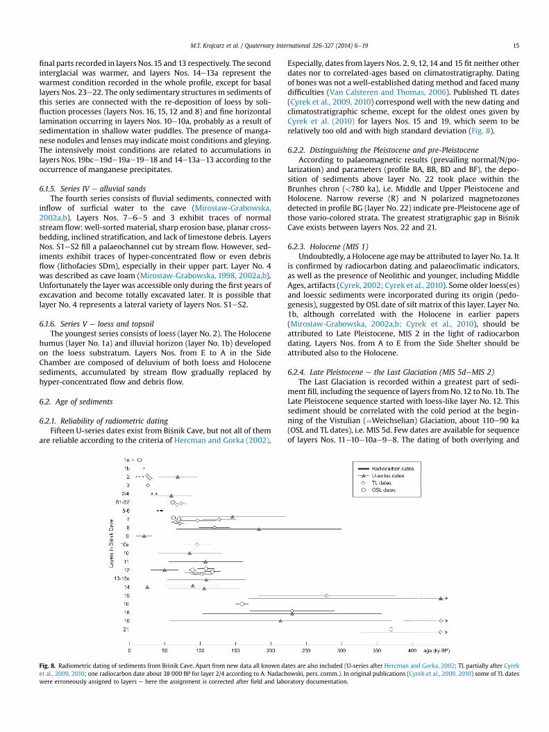
6.4. Correlation with other European cave sites
The long sequence of Quaternary sediments in the Bi�snik Cave isan unique situation in Poland. The second site with a long profile isin the Nietoperzowa Cave (Madeyska-Niklewska, 1969; Krajcarzand Madeyska, 2010), situated about 50 km to the south. Depositsrepresenting MIS 6e4 show similar developments in both caves(Fig. 9), starting with gray silty loams and loess, superseded inupper part by brown and reddish loams with smoothed andcorroded limestone rubble and humic loams, and surmounted bythe Pleniglacial loess. Analogous facies of MIS 5e4 are known alsofrom other caves from Poland (i.e. Wylotne Shelter, Koziarnia Cave,Tunel Wielki Cave, Komarowa Cave e Madeyska, 1981, 1988;
Fig. 9. Correlation of the sediment sequences of the Bi�snik Cave and selected European caves with long sediment profiles. Lithostratigraphical profiles are after: Nietoperzowa Cavee Madeyska-Niklewska (1969), Krajcarz and Madeyska (2010); K�ulna Cave e Valoch (1988, 2011); Sesselfelsgrotte e Rots (2009), Freund (1968), Richter (2001); Ramesch-Kno-chenhöhle e Hille and Rabeder (1986); Scladina and Walou Caves e Pirson et al. (2012); Vaufrey Cave e Kervazo and Laville (1988).
M.T. Krajcarz et al. / Quaternary International 326-327 (2014) 6e19 17
Nadachowski et al., 2009). The lowermost deposits from the Bi�snikCave have no equivalent in other Polish caves. Also the alluvialdeposits (layers Nos. 5e6e7) are not known from other caves andlikely are attributed to local geological processes.
The K�ulna Cave (Moravia, Czech Republic), Sesselfelsgrotte(Bavaria, Germany) and Ramesch-Knochenhöhle (Eastern Alps,Austria) present themost similar sequence ofMIS 1e5 sediments tothe Bi�snik Cave. However the riverine activity caused thatnumerous parts of the K�ulna Cave profile and the lower part of theRamesch-Knochenhöhle profile are dominated by alluvial facies. Adirect lithostratigraphic correlation of the sediments from theBi�snik Cave with the fills of West European caves is weak (Fig. 9),due to different geographical settings and climatic differences. Themain lithological differences are expressed in more complex se-quences of MIS 3 andMIS 4 inWest European sites in relation to theBi�snik Cave and other Polish caves.
7. Conclusions
Pleistocene to Holocene stratigraphy and palaeoenvironmentalchanges are recorded in a complex sequence of sediments in Bi�snikCave. The cave fill is well-stratified and composed of 35 layers/sublayers with number of hiatuses. In some horizons, the deposi-tional dynamics is reflected in re-working and re-deposition of
older sediments from sources within the cave itself as well as fromoutside, including palaeontological and archaeological material.Some of detected layers therefore represent a mix derived fromdifferent alimentary sources. It may be amaterial primary deposited(i) within cave interior or (ii) in cave entrance. This is the case forlayers Nos. A, B, C, D, E, S1, S2,12,15,16,19bc,19d, 20 and 21. Anothersituation is represented by typical alluvial sediments, washed intothe cave from its surroundings, i.e. layers Nos. 5, 6 and 7.
The multi-proxy study was based on the application of numberof new methods for the site: study of sedimentary and post-depositional structures, weathering stage of limestone rubble andfossil bones, pollen analysis, molecular biomarkers study, palae-omagnetic analysis, as well as a new series of radiometric dating.Seven distinct cold periods (recorded in layers Nos.: 2, 8, 10, 12e13,16e18, 19bc and 21) alternating with warm interglacial-like in-tervals (recorded in layers Nos.: 1a, 9e10a, 13ae14, 19e19a and 22)were indicated in the profile. The warmest conditions are recordedin layer No. 22.
New age interpretations and palaeoenvironmental data havecontributed to a more precise stratigraphic model for (i) the ma-jority of MiddleeUpper Pleistocene sedimentary units as comparedwith previous interpretations (e.g., Miros1aw-Grabowska, 2002a;Cyrek et al., 2010), and (ii) Early Pleistocene/Pliocene basal vario-colored complex. The principal changes are as follows:
M.T. Krajcarz et al. / Quaternary International 326-327 (2014) 6e1918
(1) layers Nos. 5, 6 and 7 are related toMIS 3 and the basal part oflayer No. 7 to the MIS 4 according to radiocarbon, TL and OSLdating; the earlier interpretation attributed them to MIS 4;
(2) layers Nos. 13, 13a, 14 and 15 (13 and 15 at least partially) arerelated to MIS 5e, i.e. Eemian Interglacial, according to the TLand OSL dating, palaeomagnetic and palaeoclimatic data; theearlier interpretation attributed only layer No. 13 to MIS 5a,and layer No. 14 to MIS 6 and layer No. 15 to MIS 7;
(3) layers Nos. 15, 16 and 18 (15 partially) are related to MIS 6according to the TL and OSL dating and palaeoclimatic data;the earlier interpretation attributed them toMIS 7 andMIS 8;
(4) layers Nos.19 and 19a are related toMIS 7 according to the TLand OSL dating and palaeoclimatic data; the earlier inter-pretation attributed them to MIS 8 or even MIS 9;
(5) layers Nos. 19bc and 19d are related to MIS 7/8 according tothe TL and OSL dating, sedimentological and palaeoclimaticdata; the earlier interpretation attributed them to MIS 9;
(6) layers Nos. 20e23 are equivalent of the former layer No. 20.Recent layer No. 20 should be attributed to MIS 7/8, layer No.21 represents the early Middle Pleistocene according to theOSL dating, and layers Nos. 22e23 represent Early Pleisto-cene or older age according to palaeomagnetic data.
Acknowledgements
The authors acknowledge the permission of the archaeologicalteam from the Nicolaus Copernicus University in Toru�n, especiallyto Krzysztof Cyrek, to perform systematic sedimentological andstratigraphic studies during archaeological excavations. Sedimen-tological, palaeoenvironmental and chronostratigraphic studieswere financed by Polish Ministry of Science and Higher Education,grant number N N109 318237. Palaeomagnetic studies were sup-ported by the project of the Grant Agency of the Academy of Sci-ences of the Czech Republic No. IAA300130701 and the InstitutionalResearch Plan granted to the Institute of Geology AS CR, v. v. i. PrahaNo. AV0Z30130516. Laboratory analyses were partially supportedby Polish Ministry of Science and Higher Education, grant number691-N/2010/0-Ukraina, Polish National Centre for Science, grantnumber N N307 061540, and Institute of Geological Sciences, PolishAcademy of Sciences, internal project “Jaskinie”.
Appendix 1. Supplementary data
Supplementary data related to this article can be found at http://dx.doi.org/10.1016/j.quaint.2013.10.017.
References
Bednarek, J., Liszkowski, J., 1982. The section of fossil weathering covers at Dzibice.Biuletyn Geologiczny Uniwersytetu Warszawskiego 26, 89e106 (in Polish withEnglish summary).
Boguckyj, A., qanczont, M., 2002. Loess stratigraphy in the Haly�c Prydniestrov’jaregion. Studia Geologica Polonica 119, 315e327.
Bosák, P., G1azek, J., Horá�cek, I., Szynkiewicz, A., 1982. New locality of Early Pleis-tocene vertebrates e _Zabia Cave at Podlesice, Central Poland. Acta GeologicaPolonica 32, 217e226.
Cyrek, K., 1997. Results of the interdisciplinary excavation in Bi�snik Cave, katowickievoivodship (Wyniki interdyscyplinarnych bada�n wykopaliskowych w schro-nisku skalnym Bi�snik w Strzegowej, województwo katowickie). In: Badaniaarcheologiczne na Górnym �Slasku i ziemiach pogranicznych w roku 1994.Centrum Dziedzictwa Kulturowego Górnego �Slaska, Katowice, pp. 21e35 (inPolish).
Cyrek, K., 2002. Reconstruction of settlement in Bi�snik Cave (Rekonstrukcjazasiedlenia Jaskini Bi�snik). In: Cyrek, K. (Ed.), Jaskinia Bi�snik. RekonstrukcjaZasiedlenia Jaskini Na Tle Zmian �Srodowiska Przyrodniczego. WydawnictwoUMK, Toru�n, pp. 9e132 (in Polish with English summary).
Cyrek, K., Miros1aw-Grabowska, J., Stefaniak, K., Socha, P., 2009. Archaeology, stra-tigraphy and palaeoecology of Bi�snik Cave. In: Stefaniak, K., Tyc, A., Socha, P.(Eds.), Karst of the Czestochowa Upland and of the Eastern Sudetes:
Palaeoenvironments and Protection. Studies of the Faculty of Earth Sciences,University of Silesia, No. 56, Sosnowiec e Wroc1aw, pp. 191e214.
Cyrek, K., Socha, P., Stefaniak, K., Madeyska, T., Miros1aw-Grabowska, J., Sudo1, M.,Czy _zewski, q., 2010. The Palaeolithic of Bi�snik Cave (Southern Poland) againstthe environmental background. Quaternary International 220, 5e30.
Ellwood, B.B., 2008. Paleoclimate delineation Using Magnetic Susceptibility Data.In: Chase, P.G., Debénath, A., Dibble, H.L., McPherron, S.P. (Eds.), The Cave ofFontéchevade. Recent Excavations and Their Paleoanthropological Implications.Cambridge University Press, Cambridge, pp. 87e94.
Fang, X.-M., Li, J.-J., Van der Voo, R., Mac Niocaill, C., Dai, X.-R., Kemp, R.A.,Derbyshire, E., Cao, J.-X., Wang, J.-M., Wang, G., 1997. A record of the Blake Eventduring the last interglacial paleosol in the western Loess Plateau of China. Earthand Planetary Science Letters 146, 73e82.
Fisher, R., 1953. Dispersion on a sphere. Proceedings of the Royal Society A 217,295e305.
Freund, G., 1968. Mikrolithen aus dem Mittelpaläolithikum der Sesselfelsgrotte imunteren Altmühltal, Ldkr. Kelheim. Quartär 19, 133e154 (in German).
Head, K.H., 1992. Manual of Soil Laboratory Testing. In: Soil Classification andCompaction Tests, vol. 1. Pentech Press, London.
Hedges, R.E.M., Millard, A.R., 1995. Bones and groundwater: towards the modellingof diagenetic processes. Journal of Archaeological Science 22, 155e164.
Hedges, R.E.M., Millard, A.R., Pike, A.W.G., 1995. Measurements and relationships ofdiagenetic alteration of bone from three archaeological sites. Journal ofArchaeological Science 22, 201e209.
Hercman, H., Gorka, P., 2002. Analyses of fossil bones from Bi�snik Cave with ura-niumethorium method (Analizy metoda uranowo-torowa ko�sci kopalnych zJaskini Bi�snik). In: Cyrek, K. (Ed.), Jaskinia Bi�snik. Rekonstrukcja zasiedleniajaskini na tle zmian �srodowiska przyrodniczego. Wydawnictwo UMK, Toru�n,pp. 181e192 (in Polish with English summary).
Hercman, H., Miros1aw-Grabowska, J., Madeyska, T., 2004. Record of the environ-ment changes during the last 150 000 years in cave sediments of the Kraków-Czestochowa Upland. In: Partyka, J. (Ed.), Zró _znicowanie i przemiany�srodowiska przyrodniczo-kulturowego Wy _zyny Krakowsko-Czestochowskiej,Tom I Przyroda. Wydawnictwo Ojcowski Park Narodowy, Ojców, pp. 83e88 (inPolish with English summary).
Hille, P., Rabeder, G., 1986. Die Ramesch-Knochenhöhle. In: Mitteilungen DerKommission Für Quartärforschung, Österreichische Akademie der Wissen-schaften, vol. 5, pp. 1e79 (in German).
Jelínek, V., 1966. A high sensitivity spinner magnetometer. Studia Geophysica etGeodaetica 10, 58e78.
Jelínek, V., 1973. Precision A.C. bridge set for measuring magnetic susceptibility andits anisotropy. Studia Geophysica et Geodaetica 17, 36e48.
Kervazo, B., Laville, H., 1988. Caracteristiques physic-chimiques d’une sequencesedimentaire en milieu karstique et signification e exemple de la Grotte Vau-frey. Annales de la Société géologique de Belgique 111, 41e49 (in French withEnglish summary).
Kirschvink, J.L., 1980. The least-squares line and plane and the analysis of palae-omagnetic data. Geophysical Journal of the Royal Astronomical Society 62,699e718.
Knipping, M., 2008. Early and Middle Pleistocene pollen assemblages of deep coredrillings in the northern Upper Rhine Graben, Germany. Netherlands Journal ofGeosciences d Geologie en Mijnbouw 87 (1), 51e65.
Krajcarz, M.T., 2009. Reconstruction of sedimentary environment and diagenesis ofthe Pleistocene sediments and bone remains from Bi�snik Cave (Polish Jura) onthe basis of geochemical studies (Rekonstrukcja �srodowiska sedymentacji idiagenezy plejstoce�nskich osadów i szczatków kostnych z Jaskini Bi�snik (JuraPolska) na podstawie bada�n geochemicznych). Ph.D. thesis. Faculty of Geology,Warsaw University, Warszawa, Poland (in Polish).
Krajcarz, M.T., Cyrek, K., 2011. The age of the oldest Paleolithic assemblages fromBi�snik Cave (southern Poland) in the light of geological data. Przeglad Arche-ologiczny 59, 55e74.
Krajcarz, M.T., Krajcarz, M., 2013. The 200 000 year long record of stable isotopes(d18O, d13C) from cave bear (Ursus spelaeus) teeth from Bi�snik Cave, Poland.Quaternary International. (in press).
Krajcarz, M.T., Madeyska, T., 2010. Application of the weathering parameters ofbones to stratigraphical interpretation of the sediments from two caves(Deszczowa Cave and Nietoperzowa Cave, Kraków-Czestochowa Upland,Poland). Studia Quaternaria 27, 43e54.
Krajcarz, M.T., Madeyska, T., 2012. Geology and chronostratigraphy of sedimentsfrom Bi�snik Cave. In: International Conference European Middle Palaeolithicduring MIS 8 e MIS 3: Cultures e Environment e Chronology. Wolbrom,Poland, pp. 56e58.
Krajcarz, M.T., Gola, M.R., Cyrek, K., 2010. Preliminary suggestions on the Pleistocenepalaeovegetation around Bi�snik Cave (Czestochowa Upland, Poland) based onstudies of molecular fossils from cave sediments. Studia Quaternaria 27, 55e61.
Lindner, L., Marks, L., 2012. Climatostratigraphic subdivision of the PleistoceneMiddle Polish Complex in Poland. Przeglad Geologiczny 60 (1), 36e45.
Lindner, L., Boguckyj, A., Gozhik, P., Marks, L., qanczont, M., Wojtanowicz, J., 2006.Correlation of Pleistocene deposits in the area from the Baltic Sea to the BlackSea, central Europe. Geological Quarterly 50 (1), 195e210.
Madeyska, T., 1981. Le milieu naturel de l’homme du Paleolithique moyen etsuperieur en Pologne a la lumiere des recherches geologiques. Studia GeologicaPolonica 69, 1e124 (in Polish with French summary).
Madeyska, T., 1988. Deposits of caves in the Saspowska Valley. In: Chmielewski, W.(Ed.), Jaskinie Doliny Saspowskiej. T1o przyrodnicze osadnictwa pradziejowego.
M.T. Krajcarz et al. / Quaternary International 326-327 (2014) 6e19 19
Wydawnictwo Instytutu Archeologii UW, Warszawa, pp. 77e173 (in Polish withEnglish summary).
Madeyska-Niklewska, T., 1969. Upper Pleistocene deposits in caves of the CracovUpland. Acta Geologica Polonica 19 (2), 341e392.
Madeyska-Niklewska, T., 1971. Methods used in researches on the Upper Pleisto-cene sediments of the Cracov Upland caves. �Swiatowit 32, 5e25.
Marciszak, A., Socha, P., Nadachowski, A., Stefaniak, K., 2011. Carnivores from Bi�snikCave. Quaternaire e Horssérie 4, 101e106.
Maruszczak, H., 2001. Stratigraphic scheme of loesses and paleosols in Poland. In:Maruszczak, H. (Ed.), Podstawowe profile lessów w Polsce II. WydawnictwoUMCS, Lublin, pp. 17e29 (In Polish with English summary).
Miall, A.D., 1977. A review of the braided-river depositional environment. Earth-Science Reviews 13, 1e62.
Miros1aw-Grabowska, J., 1998. Quaternary stratigraphy in the eastern part ofSmole�n-Niegowonice Range (Kraków-Czestochowa Upland). Studia GeologicaPolonica 113, 105e119.
Miros1aw-Grabowska, J., 2002a. Geological value of Bi�snik Cave sediments (Cracow-Czestochowa Upland). Acta Geologica Polonica 52 (1), 97e110.
Miros1aw-Grabowska, J., 2002b. Lithology and stratigraphy of sediments fromBi�snik Cave. In: Cyrek, K. (Ed.), Jaskinia Bi�snik. Rekonstrukcja zasiedlenia jaskinina tle zmian �srodowiska przyrodniczego. Wydawnictwo UMK, Toru�n, pp. 143e179 (in Polish with English summary).
Moldovan, O.T., Mihevc, A., Mikó, L., Constantin, S., Meleg, I., Petculescu, A., Bosák, P.,2011. Invertebrate fossils from cave sediments: a new proxy for pre-Quaternarypaleoenvironments. Biogeosciences 8, 1825e1837.
My�sli�nska, E., 2006. Laboratoryjne badania gruntów. Wydawnictwa UniwersytetuWarszawskiego, Warszawa (in Polish).
Nadachowski, A., _Zarski, M., Urbanowski, M., Wojtal, P., Miekina, B., Lipecki, G.,Ochman, K., Krawczyk, M., Jakubowski, G., Tomek, T., 2009. Late PleistoceneEnvironment of the Czestochowa Upland (Poland) Reconstructed on the Basis ofFaunistic Evidence from Archaeological Cave Sites. Institute of Systematics andEvolution of Animals, Polish Academy of Sciences, Kraków.
Pirson, S., Flas, D., Abrams, G., Bonjean, D., Court-Picon, M., Di Modica, K., Draily, C.,Damblon, F., Haesaerts, P., Miller, R., Rougier, H., Toussain, M., Semal, P., 2012.Chronostratigraphic context of the Middle to Upper Palaeolithic transition:recent data from Belgium. Quaternary International 259, 78e94.
Reynolds, S.C., Clarke, R.J., Kuman, K.A., 2007. The view from the Lincoln Cave: mid-to late Pleistocene fossil deposits from Sterkfontein hominid site, South Africa.Journal of Human Evolution 53 (3), 260e271.
Richter, J., 2001. For lack of a wise old man? Late Neanderthal land use patterns inthe Altmühl River Valley, Southern Germany. In: Nicholas, C. (Ed.), Middle Stone
Age and Middle Palaeolithic Settlement Patterns. Universität zu Köln, Institutfür Ur- und Frühgeschichte, Tübingen, pp. 205e220.
Rots, V., 2009. The functional analysis of the Mousterian and Micoquian assem-blages of Sesselfelsgrotte, Germany: aspects of tool use and hafting in the Eu-ropean Late Middle Palaeolithic. Quartär 56, 37e66.
Smith, G.A., 1986. Coarse-grained nonmarine volcaniclastic sediment: terminologyand depositional process. Geological Society of America Bulletin 97, 1e10.
Smith, J.D., Foster, J.H., 1969. Geomagnetic reversal in the Brunhes normal polarityepoch. Science 163, 565e567.
Smith, C.I., Nielsen-Marsh, C.M., Jans, M.M.E., Collins, M.J., 2007. Bone diagenesis inthe European Holocene I: patterns and mechanisms. Journal of ArchaeologicalScience 34, 1485e1493.
Tomczy�nska, Z., 2002. Identification of charcoals from the site Bi�snik Cave(Oznaczenia wegli drzewnych ze stanowiska Jaskinia Bi�snik). In: Cyrek, K. (Ed.),Jaskinia Bi�snik. Rekonstrukcja zasiedlenia jaskini na tle zmian �srodowiskaprzyrodniczego. Wydawnictwo UMK, Toru�n, pp. 140e141 (in Polish with En-glish summary).
Tomek, T., Boche�nski, Z.M., Socha, P., Stefaniak, K., 2012. Continuous 300,000-yearfossil record: changes in the ornithofauna of Bi�snik Cave, Poland. PalaeontologiaElectronica 15 (1, 2A), 1e20.
Turner-Walker, G., Jans, M., 2008. Reconstructing taphonomic histories using his-tological analysis. Palaeogeography, Palaeoclimatology, Palaeoecology 266,227e235.
Valoch, K., 1988. Die Erforschung der K�ulna-H�uhle 1961e1976. Moravskémuseum e Anthropos Institut, Brno (in German).
Valoch, K., 2011. Stratigrafie sediment�u. Acta Speleologica 2, 47e58 (in Czech).Van Calseteren, P., Thomas, L., 2006. Uranium-series dating applications in natural
environmental science. Earth-Science Reviews 75, 155e175.Wiszniowska, T., Socha, P., Stefaniak, K., 2002. Quaternary fauna of sediments from
Bi�snik Cave (Czwartorzedowa fauna z osadów Jaskini Bi�snik). In: Cyrek, K. (Ed.),Jaskinia Bi�snik. Rekonstrukcja zasiedlenia jaskini na tle zmian �srodowiskaprzyrodniczego. Wydawnictwo UMK, Toru�n, pp. 193e220 (in Polish with En-glish summary).
Zhu, R.X., Pan, Y.X., Liu, Q.S., 1999. Geomagnetic excursions recorded inChinese loess in the last 70,000 years. Geophysical Research Letters 26 (4),505e508.
Zieli�nski, T., Pisarska-Jamro _zy, M., 2012. Which features of deposits should beincluded in a code and which not? Przeglad Geologiczny 60 (7), 387e397 (inPolish with English summary).
Zupan Hajna, N., Mihevc, A., Pruner, P., Bosák, P., 2008. Palaeomagnetism andmagnetostratigraphy of karst sediments in Slovenia. Carsologica 8, 1e266.


