Embed Size (px)
Citation preview
Table of Contents
1 Executive Summary......................................................................................1
2 Introduction and Purpose.......................................................................43 Approach.......................................................................................................64 Phase 1 Summary........................................................................................7
4.1 Visioning Workshop............................................................................................74.1.1 Stakeholder Expectations...............................................................................74.1.2 Vision for Success............................................................................................74.1.3 Goals and Objectives.......................................................................................94.1.4ProblemIdentification....................................................................................94.1.5 Solution Considerations.................................................................................10
4.2 Data Collection and Data Needs Assessment...............................................104.2.1 Data Needs.........................................................................................................114.2.2 Data Collection Process.................................................................................114.2.3 Existing Data.....................................................................................................114.2.4 Data Gaps..........................................................................................................12
4.3 Preliminary Risk Assessment...........................................................................13
4.4 Hydrologic and Hydraulic Model Development.............................................14
5 Implementation Framework for Phases 2 and 3.....................................155.1 Data Collection....................................................................................................18
5.2 Public Engagement............................................................................................185.2.1 Project Branding..............................................................................................185.2.2 Project Coordination......................................................................................195.2.3 Media Efforts....................................................................................................19
5.3 Design Criteria and Methodology....................................................................20
5.4 Hazard Assessment...........................................................................................20
5.5 Mitigation Activities...........................................................................................205.5.1FloodRiskReductionProjectsIdentification/Evaluation.............................215.5.2 Ordinance Reviews and Recommendations.............................................215.5.3 Flood Zone Mapping........................................................................................21
5.6 Stormwater Master Plan.......................................................................................21
6 20-Year Stormwater Capital Improvement Plan.............................226.1 Prioritization........................................................................................................22
6.2 Funding Plan........................................................................................................22
7 Schedule........................................................................................................23List of Figures
Figure 2-1: East Baton Rouge Parish............................................................................4Figure 3-1: Stormwater Master Plan Phases..............................................................6Figure 4-1: Visioning Workshop Headlines.................................................................8Figure 4-2: Map of EBR Risk Zones.............................................................................14Figure 5-1: SMP Watersheds..........................................................................................16Figure 5-2: SMP Work Flow............................................................................................17
List of TablesTable 1-1: Preliminary SMP Schedule..............................................................................2Table 7-1: Preliminary SMP Schedule and Cost.........................................................23
Stormwater Master Plan Implementation Framework
1 Executive Summary The City of Baton Rouge and Parish of East Baton Rouge experienced widespread flooding in August 2016. The floods brought to light the current challenges regarding existing stormwater conveyance systems, development and drainage ordinances, and their impact on overall stormwater management in the Parish. The preparation of the Stormwater Master Plan (SMP) addresses these and other issues. The purpose of the SMP is to:
• Understand how the Parish’s natural and man-made stormwater systems perform,
• De velop a plan that addresses the risks and impacts of local and regional flooding,
• C ommunicate the plan and engage the public
The program has been broken down into three phases:
SMP Phase 1Phase 1 included a number of activities with the end result this Implementation Framework document which provides the summary of what has been completed to date and the path forward to complete Phases 2 and 3. Phase 1 included:
• e xisting data collection
• pr eliminary regional model
• visioning workshop with key Parish staff
• pr eliminary risk analyses
• de velopment of applications for Hazard Mitigation Grant Program
• SMP Implementation Framework document
SMP Phase 2Phase 2 includes the continuation of work performed in Phase 1 to evaluate each of 11 watersheds to determine flood risks and mitigation, public engagement program, ordinance revisions and draft SMP. The analyses for Phase 2 watersheds will be based on the preliminary risk assessment performed in Phase 1 with priority given to those watersheds subject to the highest risk. Phase 2 will consist of the following:
• Data collection & organization to understand the current stormwater systems: Performing channeland subsurface drainage system surveys, and obtaining the LiDAR data necessary for refininghydraulic models
• Public outreach and agency coordination: Develop a Public Engagement Plan for communicationswith stakeholders and partners
• Assessing the hazards: Development of hydraulic models for existing and future conditions todetermine the extents and causes of flooding
• Assessing the problems that result from the hazards: Identification of buildings and infrastructureimpacted by flooding and their relative risk from existing and future conditions
• Coordination with the Parish and key stakeholders to establish criteria, guidance, and ordinancesfor addressing and reducing existing and potential future levels of flooding risk
• Development of activities to mitigate the hazards: Concept level engineering to determine projectsfor flood risk reduction in areas with significant numbers of homes, businesses and infrastructureas well as update ordinances/regulations for future development
• Draft SMP.
It is anticipated that Phase 2 will begin in September 2018 and be completed in August 2020.
1
Stormwater Master Plan Implementation Framework
SMP Phase 3Phase 3 will take all of the information developed during Phase 2 and combine into one comprehensive SMP document. In addition, the proposed projects will be developed into a 20-Year Stormwater Capital Improvement Plan (CIP). Phase 3 includes the following:
• Development and adoption of final SMP action plan: Specific informed recommendationsfor ordinance and regulation changes, a prioritized list of projects to address current and/oranticipated future flooding risks, and a maintenance plan strategy.
• 20-Year Stormwater CIP will be developed that will take the list of projects determined during thedevelopment of the stormwater master plan and prioritize them based on pre-determinedcriteria, including a funding and financing plan.
Table 1-1 shows the proposed overall schedule. This preliminary schedule assumes financing the full program as one project to increase efficiency and reduce cost. Should the project be budgeted in phases, the schedule will be adjusted accordingly.
In addition, a 20-Year Stormwater CIP will be developed that will take the list of projects determined during the development of the stormwater master plan and prioritize them based on pre-determined criteria, including a funding and financing plan.
REQUIRED ACTIVITIES DETAILED TASKS SUMMARY SUGGESTED TIMELINE
Phase 2
Asset Inventory
Obtain Parish-Wide LiDAR 9/18
Enclosed System Survey 9/18 - 9/19
Open Channel Bridges/Culverts Survey 9/18 - 9/19
Data Asset Management Database 12/18 - 12/19
Public Involvement and Agency Coordination
Stakeholder/Public/Partners Meetings
10/18 - 3/21Website Communication
Media Relations
Social Media
Design Criteria & Methodology Development
Regional Analysis Reference Documentation
9/18 - 4/19Watershed Criteria Development
Project Prioritization Schemes Development
Hazard/Problems Assessment
Regional Hazard Assessment 1/19 - 7/19Watershed Hazard Assessments (11 watersheds) 4/19 - 10/20Problem Identification 5/19 - 11/20
Mitigation Activities
Determine Potential Risk Reduction Projects 5/19 - 11/20
Model Potential Projects 6/19 - 12/20
Screen Initial Projects for Further Analysis 8/19 - 12/20Concept Level Engineering and Design 8/19 - 1/21Cost and Benefit Estimates for B/C Ratios 8/19 - 1/21Hydraulic modeling for floodplain development guidance 4/19 - 7/19Ordinance and code revision recommendations based on model results and floodplain development guidance
9/18 - 11/19
DRAFT Stormwater Master Plan Document
Preliminary (30%) Report and Appendices 4/19 - 8/19
60% Report and Appendices 8/19 - 8/20
2
Table 1-1: Preliminary SMP Schedule
Stormwater Master Plan Implementation Framework
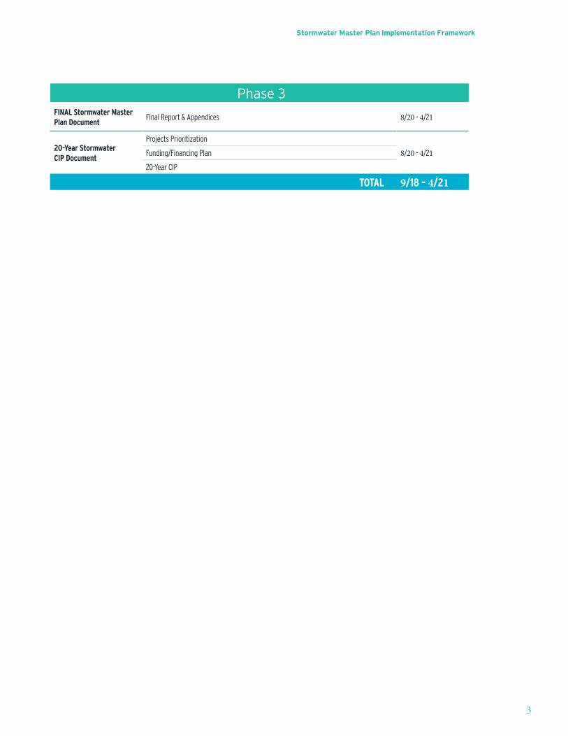
Phase 3FINAL Stormwater Master Plan Document
Final Report & Appendices 8/20 - 4/21
20-Year Stormwater CIP Document
Projects Prioritization
8/20 - 4/21Funding/Financing Plan
20-Year CIP
TOTAL 9/18 – 4/21
3
Stormwater Master Plan Implementation Framework
4
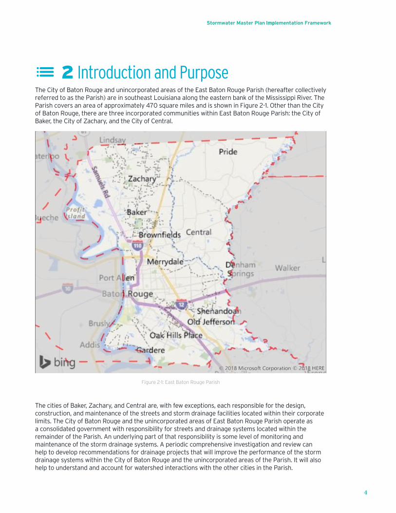
2 Introduction and PurposeThe City of Baton Rouge and unincorporated areas of the East Baton Rouge Parish (hereafter collectively referred to as the Parish) are in southeast Louisiana along the eastern bank of the Mississippi River. The Parish covers an area of approximately 470 square miles and is shown in Figure 2-1. Other than the City of Baton Rouge, there are three incorporated communities within East Baton Rouge Parish: the City of Baker, the City of Zachary, and the City of Central.
Figure 2-1: East Baton Rouge Parish
The cities of Baker, Zachary, and Central are, with few exceptions, each responsible for the design, construction, and maintenance of the streets and storm drainage facilities located within their corporate limits. The City of Baton Rouge and the unincorporated areas of East Baton Rouge Parish operate as a consolidated government with responsibility for streets and drainage systems located within the remainder of the Parish. An underlying part of that responsibility is some level of monitoring and maintenance of the storm drainage systems. A periodic comprehensive investigation and review can help to develop recommendations for drainage projects that will improve the performance of the storm drainage systems within the City of Baton Rouge and the unincorporated areas of the Parish. It will also help to understand and account for watershed interactions with the other cities in the Parish.
Stormwater Master Plan Implementation Framework
5
While the Mississippi River forms the western boundary of the Parish, less than 20 percent of the Parish drains to it. The Amite River forms the eastern boundary of the Parish and serves as the primary drainageoutfallfortheregion.TheComiteRiver,whichistheprimarytributarytotheAmite,flowsthrough the central portion of the Parish. Approximately 42 percent of the land area in East Baton Rouge Parishhasapotentialofbeingfloodedbya1%annualexceedanceprobability(AEPevent(100-Year.TheprincipalcauseoftheinundationriskisbackwaterfromthelargerregionalfloodsalongtheAmiteand Comite Rivers and their tributaries. The Parish should consider these regional impacts with respect to its storm drainage systems and impacts to public safety and property damages.
TheAugust2016widespreadfloodinginsoutheastLouisianafurtherexposedtheneedtoaddressstormwater issues on a regional basis. It is imperative that representatives from Ascension, Iberville, and Livingston Parishes work in conjunction with the Parish to review causes and potential solutionstofloodingalongthelowerreachesoftheAmiteRiverandBayouManchac.Collaborationwilllead to better stormwater management outcomes for all the parishes in the region.
The Parish contracted with HNTB Corporation and its sub-consultants (the HNTB team) to assist in the development of a Parish Stormwater Master Plan (SMP). The purpose of this SMP Implementation Framework document is to summarize the purpose and goals of the SMP and how it will be developed and implemented. The SMP will help guide the Parish into the futurewithimproveddata,stormwatersystemplanning,andfloodriskreduction.Theoverallgoalisa comprehensive plan for stormwater system improvements that will address both local and regional issues. A 20-Year Capital Improvement Plan (CIP) for stormwater will be produced in support of that goal.
In addition to the development of the SMP Implementation Framework document, the Parish requested assistancewithfindinganddevelopingprojectsthatwouldsecureavailablefundingthroughFederal Emergency Management Agency (FEMA)Hazard Mitigation Grant Program (HMGP). In order to accomplish this, preliminary risk assessments, regional hydrology and hydraulic modeling, and engineering assessments were performed. Portions of these assessments and modeling will serve as a foundation for the analysis in the next phase of the SMP. Further development of the HMGP projects is not considered a component of the SMP, and as such is not discussed further within this SMP Implementation Framework document. However, the HMGP projects will be reviewed and accounted for, along with other ongoing projects and initiatives throughout the Parish, as the SMP is developed.
Stormwater Master Plan Implementation Framework
6
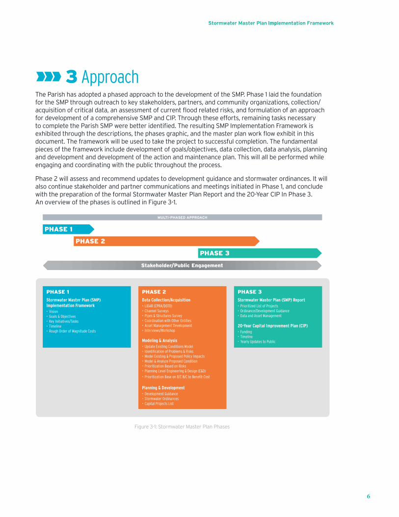
3 ApproachThe Parish has adopted a phased approach to the development of the SMP. Phase 1 laid the foundation fortheSMPthroughoutreachtokeystakeholders,partners,andcommunityorganizations,collection/acquisitionofcriticaldata,anassessmentofcurrentfloodrelatedrisks,andformulationofanapproachfor development of a comprehensive SMP and CIP. Through these efforts, remaining tasks necessary tocompletetheParishSMPwerebetteridentified.TheresultingSMPImplementationFrameworkisexhibitedthroughthedescriptions,thephasesgraphic,andthemasterplanworkflowexhibitinthisdocument. The framework will be used to take the project to successful completion. The fundamental piecesoftheframeworkincludedevelopmentofgoals/objectives,datacollection,dataanalysis,planningand development and development of the action and maintenance plan. This will all be performed while engaging and coordinating with the public throughout the process.
Phase 2 will assess and recommend updates to development guidance and stormwater ordinances. It will also continue stakeholder and partner communications and meetings initiated in Phase 1, and conclude with the preparation of the formal Stormwater Master Plan Report and the 20-Year CIP In Phase 3. An overview of the phases is outlined in Figure 3-1.
PHASE 1
Stormwater Master Plan (SMP) Implementation Framework• Vision• Goals & Objectives• Key Initiatives/Tasks• Timeline• Rough Order of Magnitude Costs
East Baton Rouge Parish Stormwater Master Plan - Overview
PHASE 3
Stormwater Master Plan (SMP) Report• Prioritized List of Projects• Ordinance/Development Guidance• Data and Asset Management
20-Year Capital Improvement Plan (CIP)• Funding• Timeline• Yearly Updates to Public
PHASE 2
Data Collection/Acquisition• LiDAR (CPRA/DOTD)• Channel Surveys• Pipes & Structures Survey• Coordination with Other Entities• Asset Management Development• Interviews/Workshop
Modeling & Analysis• Update Existing Conditions Model• Identification of Problems & Risks• Model Existing & Proposed Policy Impacts• Model & Analyze Proposed Condition• Prioritization Based on Risks• Planning Level Engineering & Design (E&D)
• Prioritization Base on B/C B/C to Benefit-Cost
Planning & Development• Development Guidance• Stormwater Ordinances• Capital Projects List
PHASE 1
PHASE 2
PHASE 3
MULTI-PHASED APPROACH
Stakeholder/Public Engagement
Figure 3-1: Stormwater Master Plan Phases
Stormwater Master Plan Implementation Framework
7
4 Phase 1 SummaryThefollowingsectionssummarizestheworkcompletedaspartofPhase1.ThisincludestheVisioningWorkshop that was completed to help identify overall project goals and objectives; the initial data collection and data needs assessment; preliminary risk assessment; preliminary regional model development; and this SMP Implementation Framework document.
4.1 Visioning WorkshopTo develop a strong implementation framework for successful execution, it is critical to ensure a common understanding of the SMP between the project stakeholders and HNTB project team. This implementation framework lays out a path based on the ultimate goals of the stakeholders and the required elements to achieve those goals. The HNTB Team conducted a SMP Visioning Workshop on December 11, 2017. The workshop was attended by representatives from the Parish and HNTB Team members. The intent of the workshop was to obtain input from the Parish stakeholders that would provide insight and convey their knowledge of the problems, solutions, and expectations for the project, as well as to include them in the development of this implementation framework. The results of the workshop discussions form the foundation of this framework, and are included in the following sections.
4.1.1 Stakeholder Expectations
OneofthefirstactivitiesintheVisioningWorkshopwastoelicitanddefineParishexpectationsregarding what the SMP should include and involve. Drainage issues are the primary concern in the community, so stakeholders have correspondingly high expectations for drainage improvements. It was expressedthecomprehensiveplantoaddressneedsforreducedfloodriskshouldincludethefollowing items:
• Innovative and cost-effective ideas to change drainage in the Parish and the region
• Inc orporation of a resiliency initiative
• Modificationoftheout-of-datestormwaterregulations
• T echnical information to serve as the basis for change
• Parishwatershedfloodriskreductionwithconsiderationofdownstreamimpacts
• T echnical data collection on all streams for Parish-wide updates
• Or dinance updates
• Migration to GIS-based data management
• Updates to outdated rainfall data for development and public projects
4.1.2 Vision for Success
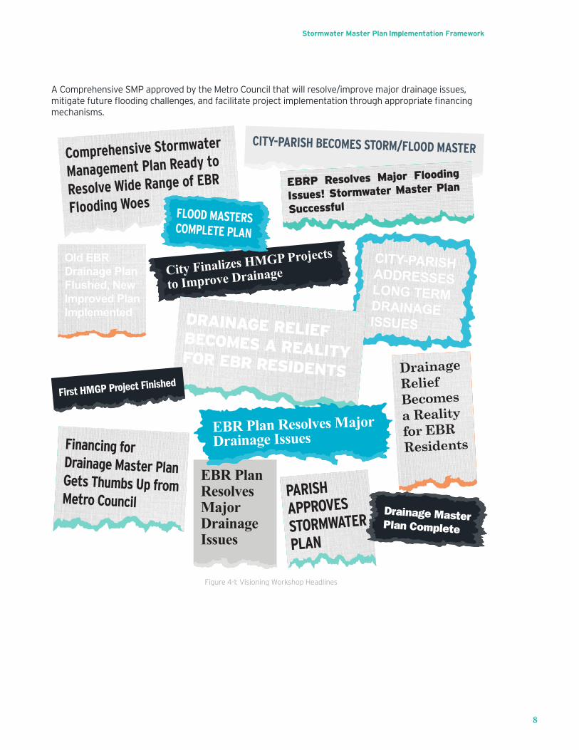
OneofthekeyobjectivesoftheVisioningWorkshopwastounderstandhowtheParishdefinesasuccessful SMP. A headline exercise was conducted to elicit what each representative hoped the local newspapers would publish once the HNTB Team delivers this plan. As shown on the next page in Figure 4-1,eachoftheseheadlinesreflectindividualvisionfortheSMP–somelong-termandothersfocusedonnear-termsolutions.Theconsensuswastoresolvefloodinganddrainageissues,helptheresidentsofthe Parish while remaining respectful of their neighbors, and provide technical information and planning that will allow success long into the future. Based on the headlines and the discussions that followed during the workshop, a Vision Statement for the Parish SMP was developed:
Stormwater Master Plan Implementation Framework
8
AComprehensiveSMPapprovedbytheMetroCouncilthatwillresolve/improvemajordrainageissues,mitigatefuturefloodingchallenges,andfacilitateprojectimplementationthroughappropriatefinancingmechanisms.
PARISHAPPROVES
STORMWATER
PLAN
CITY-PARISH BECOMES STORM/FLOOD MASTERComprehensive Stormwater
Management Plan Ready to
Resolve Wide Range of EBR
Flooding Woes
EBRP Resolves Major Flooding
Issues! Stormwater Master Plan
SuccessfulFLOOD MASTERSCOMPLETE PLAN
Old EBR Drainage Plan Flushed, New Improved Plan Implemented
CITY-PARISHADDRESSESLONG TERMDRAINAGE ISSUES
City Finalizes HMGP Projects
to Improve Drainage
DRAINAGE RELIEF BECOMES A REALITYFOR EBR RESIDENTSFirst HMGP Project Finished
Drainage Relief Becomes a Reality for EBR Residents
EBR Plan Resolves MajorDrainage IssuesFinancing for
Drainage Master PlanGets Thumbs Up fromMetro Council
Drainage MasterPlan Complete
EBR Plan Resolves Major Drainage Issues
Figure 4-1: Visioning Workshop Headlines
Stormwater Master Plan Implementation Framework
9
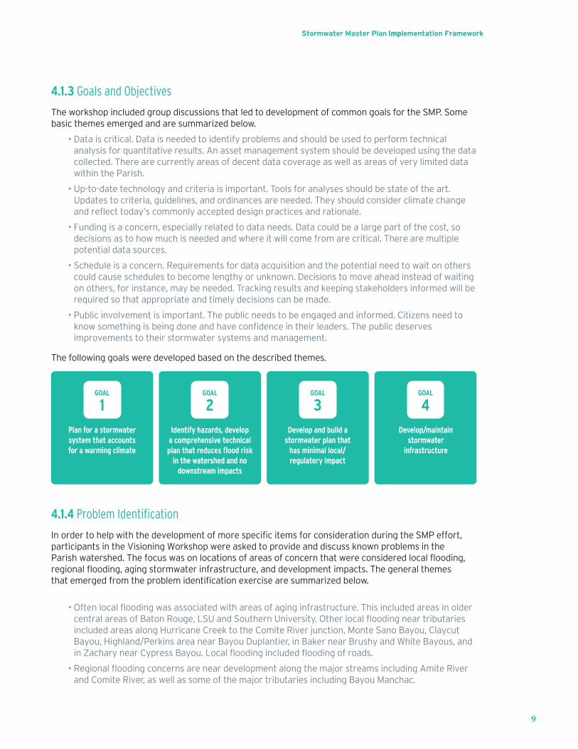
4.1.3 Goals and Objectives
The workshop included group discussions that led to development of common goals for the SMP. Some basic themes emerged and are summarized below.
• Data is critical. Data is needed to identify problems and should be used to perform technicalanalysis for quantitative results. An asset management system should be developed using the datacollected. There are currently areas of decent data coverage as well as areas of very limited datawithin the Parish.
• Up-to-date technology and criteria is important. Tools for analyses should be state of the art.Updates to criteria, guidelines, and ordinances are needed. They should consider climate changeandreflecttoday’scommonlyaccepteddesignpracticesandrationale.
• Funding is a concern, especially related to data needs. Data could be a large part of the cost, sodecisions as to how much is needed and where it will come from are critical. There are multiplepotential data sources.
• Schedule is a concern. Requirements for data acquisition and the potential need to wait on otherscould cause schedules to become lengthy or unknown. Decisions to move ahead instead of waitingon others, for instance, may be needed. Tracking results and keeping stakeholders informed will berequired so that appropriate and timely decisions can be made.
• Public involvement is important. The public needs to be engaged and informed. Citizens need toknow somethingisbeingdoneandhaveconfidenceintheirleaders.Thepublicdeservesimprovements to their stormwater systems and management.
The following goals were developed based on the described themes.
GOAL
1GOAL
2GOAL
3GOAL
4Develop/maintain
stormwater infrastructure
Plan for a stormwater system that accounts for a warming climate
Identify hazards, develop a comprehensive technical plan that reduces flood risk
in the watershed and no downstream impacts
Develop and build a stormwater plan that
has minimal local/regulatory impact
4.1.4 Problem Identification
InordertohelpwiththedevelopmentofmorespecificitemsforconsiderationduringtheSMPeffort,participants in the Visioning Workshop were asked to provide and discuss known problems in the Parish watershed.Thefocuswasonlocationsofareasofconcernthatwereconsideredlocalflooding,regionalflooding,agingstormwaterinfrastructure,anddevelopmentimpacts.Thegeneralthemesthatemergedfromtheproblemidentificationexercisearesummarizedbelow.
• Oftenlocalfloodingwasassociatedwithareasofaginginfrastructure.ThisincludedareasinoldercentralareasofBatonRouge,LSUandSouthernUniversity.Otherlocalfloodingneartributariesincluded areas along Hurricane Creek to the Comite River junction, Monte Sano Bayou, ClaycutBayou,Highland/PerkinsareanearBayouDuplantier,inBakernearBrushyandWhiteBayous,andinZacharynearCypressBayou.Localfloodingincludedfloodingofroads.
• RegionalfloodingconcernsareneardevelopmentalongthemajorstreamsincludingAmiteRiverand Comite River, as well as some of the major tributaries including Bayou Manchac.
Stormwater Master Plan Implementation Framework
10
• Thelinebetweenlocalandregionalfloodingissomewhatblurredattimes.Thestakeholders oftenidentifiedthesamelocationsduringtheworkshop,butsomeindicatedlocalfloodingand someindicatedregionalflooding.
• Development impacts were mostly noted in areas further away from downtown Baton Rouge.These included near the Mall of Louisiana; between Burbank and Hwy 30 near Gardere; S. HarrellsFerry Road near Jones Creek and Amite River; along Mt. Pleasant Road between Hwy 964 and US61; near Doyle Bayou near Zachary; in the City of Central near Hooper Road and Beaver Bayou,development south of Claycut Bayou in Tiger Bend Rd. area; and the area just south of LSU.
4.1.5 Solution Considerations The project stakeholders were able to provide a better understanding of issues, objectives, and goals for the SMP through the Visioning Workshop. The HNTB Team used it as a listening session to learn the expectations and needs of those closely tied to the outcome of the project. The stakeholders have their constituents’ best interests in mind and conveyed several key considerations with respect to the solutions ultimately provided by the SMP.
• The initial expectation from most was to have something produced by end of 2018. As the groupdiscusseditfurther,itwasconsideredmorerealistictohavethepathdefinedforimplementationof the SMP and submitting applications for approval funding for the HMGP projects within thattimeframe. The overall schedules for both will be dependent on funding.
• There should be proactive communication and outreach with the stakeholders and in thecommunity. The team should have an initial assessment to present and ask for input fromcommunities at public meetings. There is a need to understand what the public is willing to pay forthe improvements. Coordination should be done with the Federation of Greater Baton Rouge CivicAssociation. Media should be kept in the loop and there should be proactive communication withthe Metro Council to provide updates once progress on the project starts.
• Unified Development Code (UDC) updates should be part of the SMP. The UDC changes arecurrently being proposed to clarify and simplify without data. Updates should be evaluated as partof Phase 2. The Metro Council expects substantial revisions to the UDC quickly.
• The SMP must consider water quality.
• The recommendations in the SMP need to consider climate change impacts. LSU has a grant toevaluate climate change and impact on rainfall. Collaboration with the universityshouldbeusedtobenefittheSMPoutcomes.
• The Visioning Workshop brought out many valuable ideas and considerations though thoughtfuldiscussions with the project stakeholders. The HNTB team will utilize the feedback and knowledgegained when considering the components, steps, and challenges presented through this importantprocess for the Parish. Early communication is a key contributor to success.
4.2 Data Collection and Data Needs AssessmentThe purpose of the data collection task was to:
1. Collect currently available information that will be used in support of planning, modeling, design, costestimation, and prioritization for the SMP and development of the HMGP projects.
2. Coordinate with other agencies to avoid duplication of future data collection efforts.3. Develop a list of additional data and information that will need to be collected to complete subsequent
phases of the SMP.
Stormwater Master Plan Implementation Framework
11
4.2.1 Data Needs
AsignificantamountofdataisrequiredtodevelopacomprehensiveSMP.Thefollowinglistsummarizesthe general information necessary for completing a SMP.
• Historicrecordsofflooding,especiallyonesthatindicatewhereorhowpastfloodingmayhaveoccurred, including property owner complaint reports, high water marks, and stream gage data.
• Physical and geometric data related to the hydrologic and hydraulic properties of the watershedsand drainage systems. This information will be used to develop hydraulic models of the existingsystems and provide the resulting water levels in channels and pipe systems for various frequencystorm events.
• Geospatial and temporal hydrologic data, such as data from rainfall gages, stream gages, and high-water marks. This information will be used to develop inputs to the hydraulic models, as well ascalibrate and validate them.
• Geospatial data related to population, economics, planimetrics, critical infrastructure, zoning,planning,andotherinformationrelatedtofloodimpacts.
• Current ordinances, codes, laws, design criteria, and guidance that govern stormwater planningand design within the Parish (parish, state, and national).
• Public and stakeholder input related to stormwater challenges and solutions.
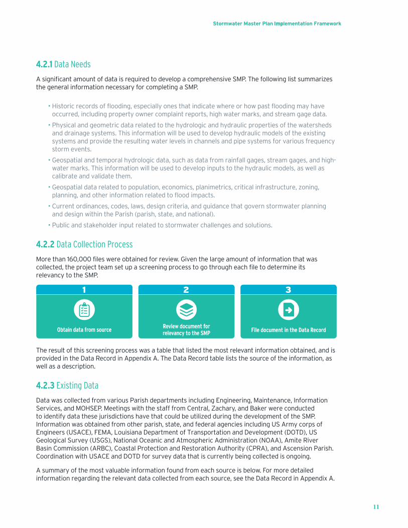
4.2.2 Data Collection Process
More than160,000fileswereobtainedforreview.Giventhelargeamountofinformationthatwascollected,theprojectteamsetupascreeningprocesstogothrougheachfiletodetermineitsrelevancyto the SMP.
Obtain data from source
1
Review document for relevancy to the SMP
2
File document in the Data Record
3
The result of this screening process was a table that listed the most relevant information obtained, and is provided in the Data Record in Appendix A. The Data Record table lists the source of the information, as well as a description.
4.2.3 Existing Data
Data was collected from various Parish departments including Engineering, Maintenance, Information Services, and MOHSEP. Meetings with the staff from Central, Zachary, and Baker were conducted to identify data these jurisdictions have that could be utilized during the development of the SMP. Information was obtained from other parish, state, and federal agencies including US Army corps of Engineers (USACE), FEMA, Louisiana Department of Transportation and Development (DOTD), US Geological Survey (USGS), National Oceanic and Atmospheric Administration (NOAA), Amite River Basin Commission (ARBC), Coastal Protection and Restoration Authority (CPRA), and Ascension Parish. Coordination with USACE and DOTD for survey data that is currently being collected is ongoing.
A summary of the most valuable information found from each source is below. For more detailed information regarding the relevant data collected from each source, see the Data Record in Appendix A.
Stormwater Master Plan Implementation Framework
12
East Baton Rouge ParishThe project team received a hard drive of drainage related information from the Parish dated September 2017.Theharddrivecontainedmorethan160,000filesinover16,000folders.Giventhelargenumberoffilesandfolders,apre-screeningofthefilefolderswasperformedinordertodeterminetheirrelevance.Below is a list of most relevant information received from the Parish.
• As -builtplansofsubdivision,roadway,bridge/culvert,anddrainageprojects.
• Hy drologic and Hydraulic models of streams within the Parish
• Maps of the drainage system for the Parish
• Historicfloodinformation
United States Army Corps of Engineers (USACE)The project team coordinated with USACE to obtain the following information.
• HE C hydrologic and hydraulic models of the Amite-Comite River basin and tributaries
• De signmemorandums,reports,andplansforvariousUSACEfloodcontrolprojects
• S tream and precipitation gage information
• S urveydataassociatedwithvariousUSACEfloodcontrolprojects
• Ne wsurveydata(streamprofilesandcross-sections)oftheAmiteRiverandComiteRiver
Federal Emergency Management Agency (FEMA)Hydrology and hydraulic information and models related to the current Flood Insurance Study (FIS) for the Parish. A FEMA data request was made in September 2017. A list of the effective FIS models is provided in Appendix A.
• FIS reports and maps
• Hy drologic and hydraulic models for most of the Zone AE streams in the Parish
• Letter of Map Revision (L OMR) requests
• 2 016floodedstructuredata
4.2.4 Data Gaps
Although the data collection process was extensive, gaps still exist in the data that will be required for completion of future phases of the SMP. Based on this review, most of the data needed is related to the layout and size of the existing drainage systems. Below is a summary of the major data gaps that must befilledforfuturephasesoftheSMP.
Enclosed Drainage System - Based on preliminary estimates, there are more than 25,000 enclosed drainage system structures within the Parish. These structures and associated pipe systems must be surveyed to develop a comprehensive stormwater system map and stormwater models that will be used to analyze existing conditions and potential projects.
Open Channel Drainage System - Based on preliminary estimates, there are more than 550 miles of major tributary streams that drain to the Amite and Comite Rivers within the Parish. Channel surveys, including bridges and culverts, must be performed on these channels. These channels and bridges must be surveyed to develop comprehensive stream system maps and detailed models that will be usedtoanalyzeexistingconditionsandpotentialfloodprotectionprojects.Thisdatacollectioneffortwillsupplement surveys that have been completed or are currently being conducted by USACE and DOTD.
Stormwater Master Plan Implementation Framework
13
LiDAR Elevation Data - The DOTD is in the process of obtaining new LiDAR for the Amite River basin and the Coastal Protection Restoration Authority is in the process of obtaining new LiDAR for the coastal areas of southeast Louisiana. The elevation information provided by these two sources will be utilized to develop the digital elevation dataset and land use for the hydrology and hydraulic modeling. The areas have already beenflownandbothentitiesareprocessingthedatawiththeintenttodistributethedatainSummer2018.
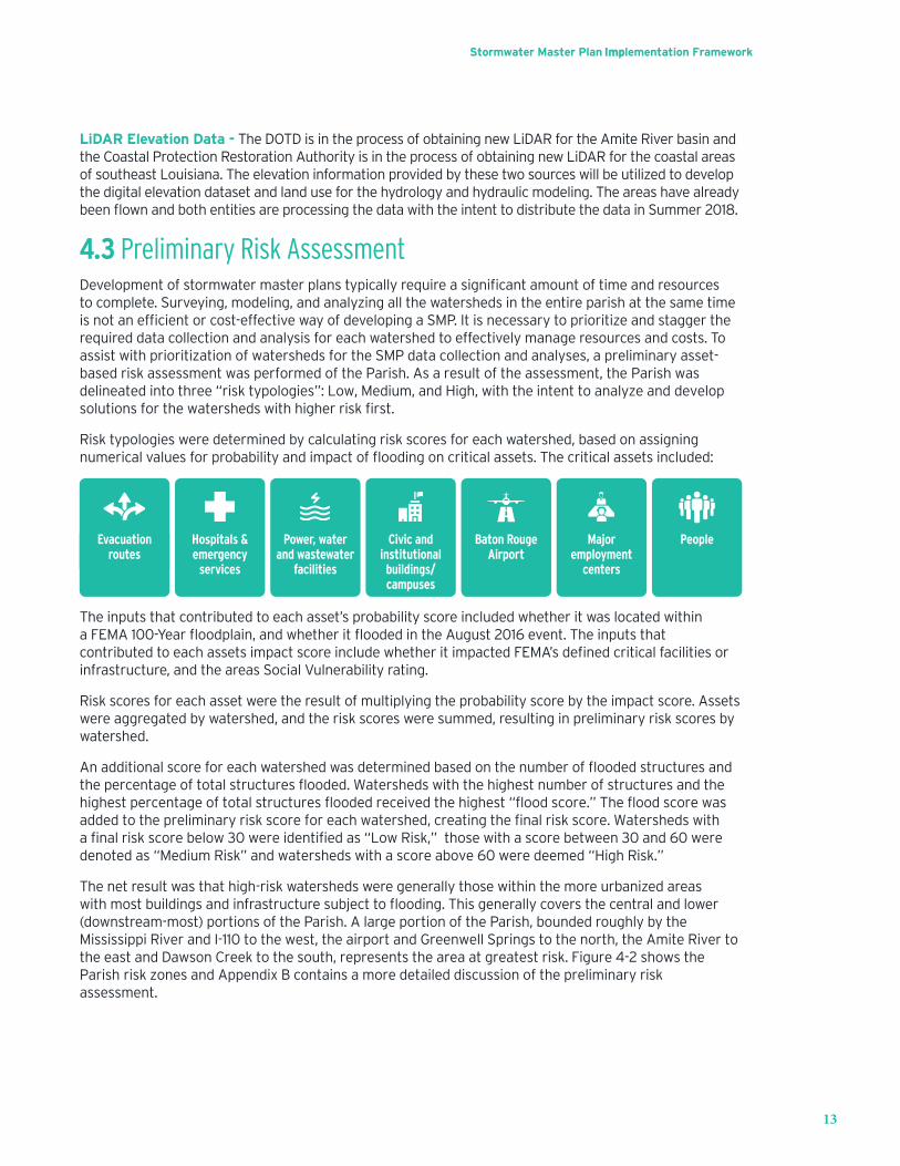
4.3 Preliminary Risk AssessmentDevelopmentofstormwatermasterplanstypicallyrequireasignificantamountoftimeandresourcesto complete. Surveying, modeling, and analyzing all the watersheds in the entire parish at the same time isnotanefficientorcost-effectivewayofdevelopingaSMP.Itisnecessarytoprioritizeandstaggertherequired data collection and analysis for each watershed to effectively manage resources and costs. To assist with prioritization of watersheds for the SMP data collection and analyses, a preliminary asset-based risk assessment was performed of the Parish. As a result of the assessment, the Parish was delineated into three “risk typologies”: Low, Medium, and High, with the intent to analyze and developsolutionsforthewatershedswithhigherriskfirst.
Risk typologies were determined by calculating risk scores for each watershed, based on assigning numericalvaluesforprobabilityandimpactoffloodingoncriticalassets.Thecriticalassetsincluded:
Power, water and wastewater
facilities
Hospitals & emergency
services
Civic and institutional buildings/ campuses
Baton Rouge Airport
Major employment
centers
Evacuation routes
People
The inputs that contributed to each asset’s probability score included whether it was located within aFEMA100-Yearfloodplain,andwhetheritfloodedintheAugust2016event.TheinputsthatcontributedtoeachassetsimpactscoreincludewhetheritimpactedFEMA’sdefinedcriticalfacilitiesorinfrastructure, and the areas Social Vulnerability rating.
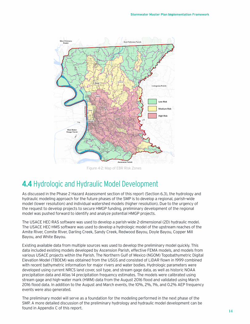
Risk scores for each asset were the result of multiplying the probability score by the impact score. Assets were aggregated by watershed, and the risk scores were summed, resulting in preliminary risk scores by watershed.
Anadditionalscoreforeachwatershedwasdeterminedbasedonthenumberoffloodedstructuresandthepercentageoftotalstructuresflooded.Watershedswiththehighestnumberofstructuresandthehighestpercentageoftotalstructuresfloodedreceivedthehighest“floodscore.”Thefloodscorewasaddedtothepreliminaryriskscoreforeachwatershed,creatingthefinalriskscore.Watershedswithafinalriskscorebelow30wereidentifiedas“LowRisk,” thosewithascorebetween30and60weredenoted as “Medium Risk” and watersheds with a score above 60 were deemed “High Risk.”
The net result was that high-risk watersheds were generally those within the more urbanized areas withmostbuildingsandinfrastructuresubjecttoflooding.Thisgenerallycoversthecentralandlower(downstream-most) portions of the Parish. A large portion of the Parish, bounded roughly by the Mississippi River and I-110 to the west, the airport and Greenwell Springs to the north, the Amite River to the east and Dawson Creek to the south, represents the area at greatest risk. Figure 4-2 shows the Parish risk zones and Appendix B contains a more detailed discussion of the preliminary risk assessment.
Stormwater Master Plan Implementation Framework
14
Figure 4-2: Map of EBR Risk Zones
4.4 Hydrologic and Hydraulic Model DevelopmentAs discussed in the Phase 2 Hazard Assessment section of this report (Section 6.3), the hydrology and hydraulic modeling approach for the future phases of the SMP is to develop a regional, parish-wide model (lower resolution) and individual watershed models (higher resolution). Due to the urgency of the requesttodevelopprojectstosecureHMGPfunding,preliminarydevelopmentoftheregionalmodelwaspushed forward to identify and analyze potential HMGP projects.
The USACE HEC-RAS software was used to develop a parish-wide 2-dimensional (2D) hydraulic model. The USACE HEC-HMS software was used to develop a hydrologic model of the upstream reaches of the Amite River, Comite River, Darling Creek, Sandy Creek, Redwood Bayou, Doyle Bayou, Copper Mill Bayou, and White Bayou.
Existing available data from multiple sources was used to develop the preliminary model quickly. This data included existing models developed by Ascension Parish, effective FEMA models, and models from various USACE projects within the Parish. The Northern Gulf of Mexico (NGOM) Topobathymetric Digital ElevationModel(TBDEM)wasobtainedfromtheUSGSandconsistedofLiDARflownin1999combinedwith recent bathymetric information for major rivers and water bodies. Hydrologic parameters were developed using current NRCS land cover, soil type, and stream gage data, as well as historic NOAA precipitation data and Atlas 14 precipitation frequency estimates. The models were calibrated using streamgageandhigh-watermark(HWM)datafromtheAugust2016floodandvalidatedusingMarch2016flooddata.InadditiontotheAugustandMarchevents,the10%,2%,1%,and0.2%AEPfrequencyevents were also generated.
The preliminary model will serve as a foundation for the modeling performed in the next phase of the SMP. A more detailed discussion of the preliminary hydrology and hydraulic model development can be found in Appendix C of this report.
Stormwater Master Plan Implementation Framework
15
5 Implementation Framework for Phases 2 & 3The Parish has adopted a phased approach for developing the SMP. The intent of Phase I was to develop the foundation for the SMP through outreach to key stakeholders, partners, and community organizationstodeveloppartnerships,collection/acquisitionofexistingcriticaldata,preparationofariskanalysis to determine areas of various risk within the Parish, and development of preliminary regional hydrology and hydraulic models for use in development of initial projects.
Phase 2 will include developing a comprehensive public engagement plan, assessing and recommending updatestodevelopmentguidanceandstormwaterordinances,acquiringinformationidentifiedbythe Phase 1 data needs assessment, collecting storm drainage system data, developing regional and watershed-basedhydrologyandhydraulicmodelstoevaluatefloodhazardsandmitigationofsuch,developingandprioritizingplanninglevelprojectstoaddressfloodingproblems,andanactionplantocommunicate the path forward towards implementation and funding of projects.
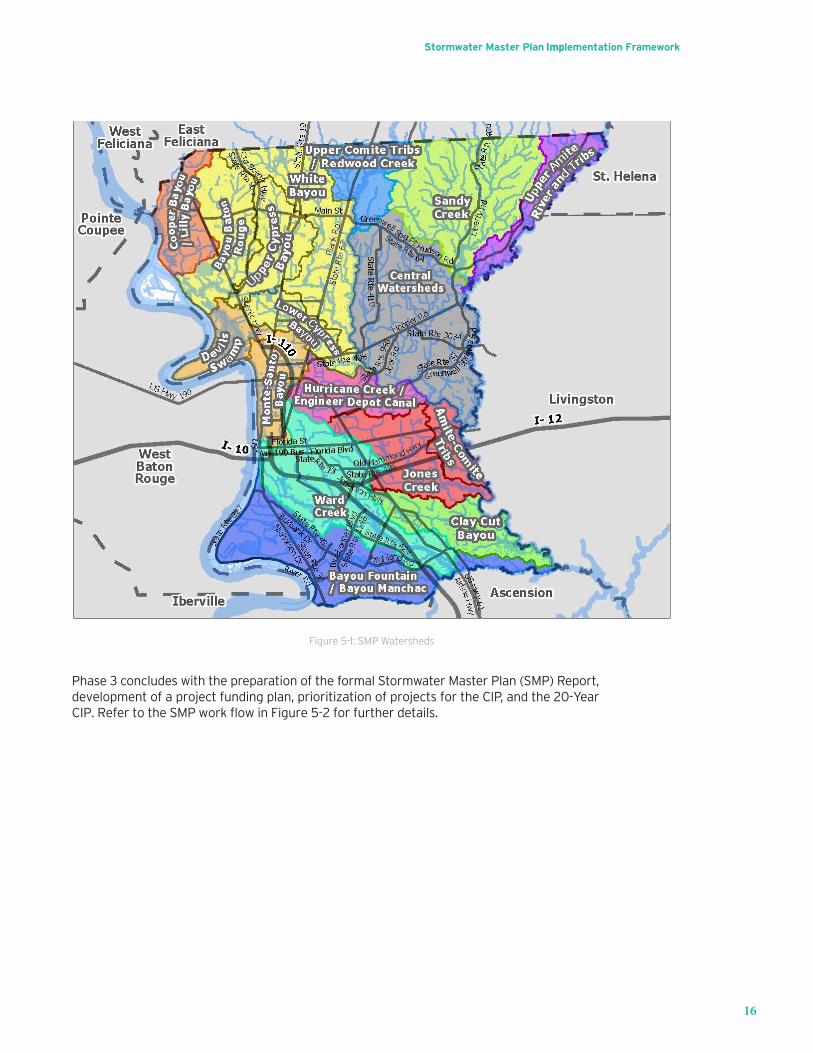
Becausedevelopingaplanforallofthewatershedsintheparishconcurrentlyisnotanefficientorcost-effective way of developing a SMP, it is necessary to prioritize and stagger the required data collection and analysis by watershed to effectively manage resources and costs. Given this, the parish was separated into 11 major watersheds, some of which include groupings of smaller watersheds that become interconnectedduringlargefloodevents.AsdiscussedinSection4.3,apreliminaryriskassessmentwas performed to assist with prioritization of watersheds for the SMP data collection and analyses. The Parish was delineated into low, medium, and high risk topologies with the intent to analyze and develop solutionsforthewatershedswithhigherriskfirst.The11watershedsinorderbytheirrisktopologiesareand shown in Figure 5-1:
1. Ward Creek2. JonesCreek/HoneyCutBayouandTributariesnearAmite/ComiteRiverConfluence3. Claycut Bayou4. HurricaneCreek/EngineerDepotCanal5. Monte Sano Bayou6. Lower&UpperCypressBayou/BakerCanal/BayouBatonRougeandWhiteBayou7. BayouFountain/BayouManchac8. CooperBayou/LillyBayou9. RedwoodCreek/UpstreamComiteRiverandTributaries10. SandyCreek/LittleSandyCreek/MillCreek11. Upstream Amite River and Tributaries
Stormwater Master Plan Implementation Framework
16
Figure 5-1: SMP Watersheds
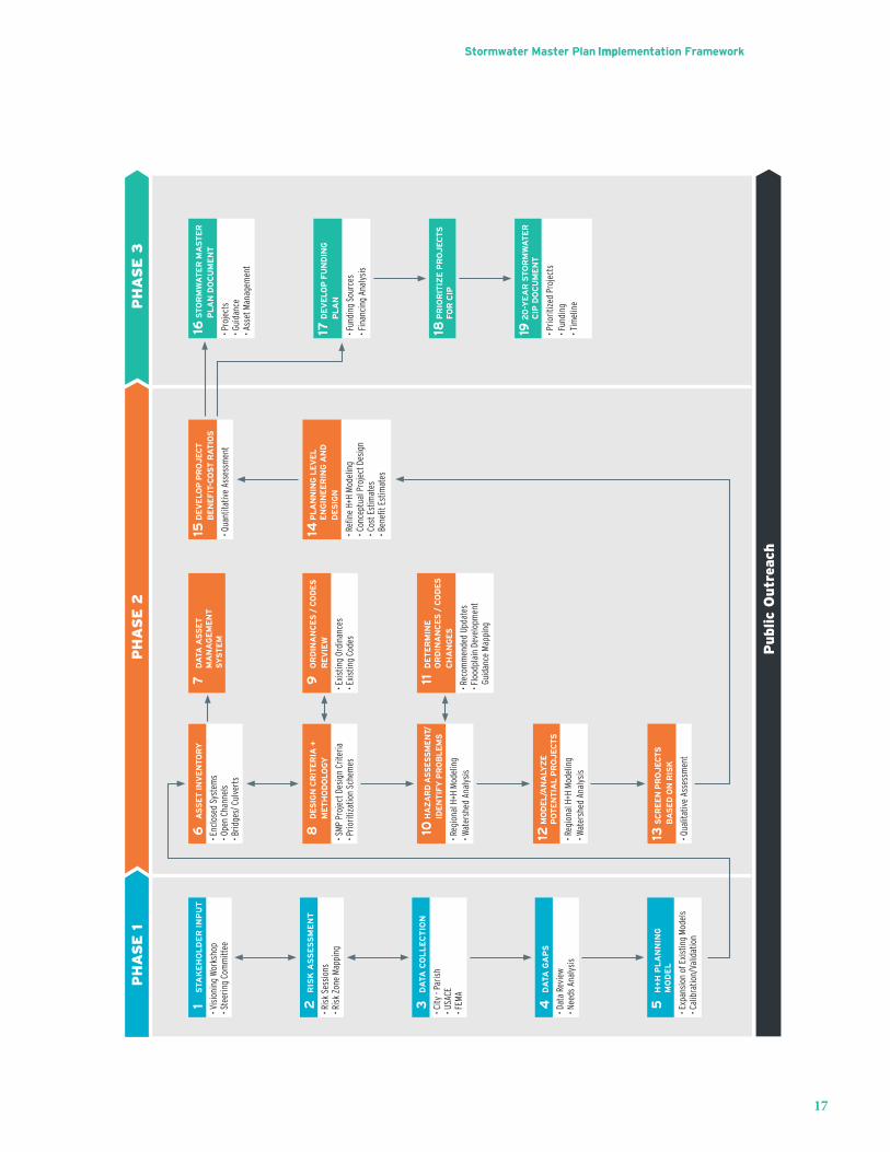
Phase 3 concludes with the preparation of the formal Stormwater Master Plan (SMP) Report, development of a project funding plan, prioritization of projects for the CIP, and the 20-YearCIP.RefertotheSMPworkflowinFigure5-2forfurtherdetails.
Stormwater Master Plan Implementation Framework
17
PH
AS
E 1
PH
AS
E 3
PH
AS
E 2
Public
Outr
each
6
AS
SE
T IN
VE
NTO
RY
• Enc
lose
d Sy
stem
s• O
pen
Chan
nels
• B
ridge
s/ C
ulve
rts
15 D
EV
ELO
P P
RO
JE
CT
BE
NE
FIT
-CO
ST
RA
TIO
S
• Qua
ntita
tive
Asse
ssm
ent
16 S
TO
RM
WA
TE
R M
AS
TE
R
PL
AN
DO
CU
ME
NT
• Pro
ject
s• G
uida
nce
• Ass
et M
anag
emen
t
17 D
EV
ELO
P F
UN
DIN
GP
LA
N
• Fun
ding
Sou
rces
• Fin
anci
ng A
naly
sis
14 P
LA
NN
ING
LE
VE
LE
NG
INE
ER
ING
AN
D
DE
SIG
N
• Refi
ne H
+H M
odel
ing
• Con
cept
ual P
roje
ct D
esig
n• C
ost E
stim
ates
• Ben
efit E
stim
ates
8 D
ES
IGN
CR
ITE
RIA
+
ME
TH
OD
OLO
GY
• SM
P Pr
ojec
t Des
ign
Crite
ria• P
riorit
izat
ion
Sche
mes
9
OR
DIN
AN
CE
S /
CO
DE
SR
EV
IEW
• Exi
stin
g Or
dina
nces
• Exi
stin
g Co
des
10 H
AZ
AR
D A
SS
ES
SM
EN
T/ID
EN
TIF
Y P
RO
BL
EM
S
• Reg
iona
l H+H
Mod
elin
g• W
ater
shed
Ana
lysi
s
13 S
CR
EE
N P
RO
JE
CTS
BA
SE
D O
N R
ISK
• Qua
litat
ive
Asse
ssm
ent
7
DA
TA A
SS
ET
M
AN
AG
EM
EN
T
SY
ST
EM
11 D
ET
ER
MIN
EO
RD
INA
NC
ES
/ C
OD
ES
C
HA
NG
ES
• Rec
omm
ende
d Up
date
s• F
lood
plai
n De
velo
pmen
t Gu
idan
ce M
appi
ng
1 S
TAK
EH
OL
DE
R I
NP
UT
• Vis
ioni
ng W
orks
hop
• Ste
erin
g Co
mm
ittee
2 R
ISK
AS
SE
SS
ME
NT
• Ris
k Se
ssio
ns• R
isk
Zone
Map
ping
18 P
RIO
RIT
IZE
PR
OJ
EC
TS
FO
R C
IP
19 2
0-Y
EA
R S
TO
RM
WA
TE
R
CIP
DO
CU
ME
NT
• Prio
ritiz
ed P
roje
cts
• Fun
ding
• Tim
elin
e
12 M
OD
EL
/AN
ALY
ZE
PO
TE
NT
IAL
PR
OJ
EC
TS
• Reg
iona
l H+H
Mod
elin
g• W
ater
shed
Ana
lysi
s
3
DA
TA C
OL
LE
CT
ION
• City
- Pa
rish
• USA
CE• F
EMA
5
H+
H P
LA
NN
ING
M
OD
EL
• Exp
ansi
on o
f Exi
stin
g M
odel
s• C
alib
ratio
n/Va
lidat
ion
4 D
ATA
GA
PS
• Dat
a Re
view
• Nee
ds A
naly
sis
Stormwater Master Plan Implementation Framework
18
5.1 Data CollectionNew data will be collected to supplement what was obtained during Phase I of the SMP. The data will be usedtopreparehydrologyandhydraulicmodelstoidentifyfloodhazardsandproblemsanddevelopproposedimprovementswithinthe11identifiedwatersheds.Thedatacollectionwillbeprioritizedbywatersheds based on the watershed risk factors that were determined during the risk assessment that was performed in Phase I. The data collection will be conducted in stages as necessary for modeling and planning efforts to progress smoothly and seamlessly. Most of the data collection will focus on collection of physical information related to stormwater infrastructure. This includes obtaining new LiDAR informationandsurveysofopenchannels/streams,enclosedsystems,bridges,andculverts.
Prior to deployment of survey crews to collect the necessary data, a GIS asset inventory database and GIS data collection forms will be developed for data input by the surveyors. The asset inventory databasewillincludefieldstocollectallofthenecessarydrainagefeatureinformationrequiredfortheSMP modeling and analysis, as well as a cursory condition assessment for use in future maintenance operations by the Parish. Once the initial asset inventory is complete, the data will be migrated into a GIS asset management system to be maintained by the Parish and used for their ongoing operations and maintenance.
5.2 Public EngagementThestormwatermasterplanprocesswillidentifyfloodhazards,problemsandrecommendimprovements.Itwillalsoserveasavehicletoeducatethegeneralpublicandspecificstakeholdersabout the process, about trade-offs, and to collect ideas and concerns for inclusion in the planning process and implementation. It is vitally important that the public be engaged in all phases of the SMP projectaspublicinputisvaluabletoassistinidentifyinglocation-specificproblemareasandprovidingfeedback on potential capital improvements and proposed parish ordinances and legislation. It is also advantageous to gauge the public’s tolerance for risk and willingness to fund any necessary capital and operating costs.
A draft comprehensive public engagement plan will be written and presented to the Parish at the beginningoftheSMPproject.Thisplanwilldetailthetasks,staffing,scheduleanddeliverablesnecessaryto successfully engage the public for this parish-wide project.
5.2.1 Project Branding
It is recommended to establish a unique and concise identity for the effort and the program’s sustained life.Thisprojectbrand,name,andlogowouldbecomethepublic-facingandeasilyrecognizableidentifierof this work, helping to distinguish it from other ongoing projects and studies.
In addition to a graphic mark and project name, an internet domain name and potentially a project slogan would be developed and reserved. Once produced, the logos, fonts, and slogan can be incorporatedintoMSOfficetemplatedocumentsforprojectletterhead,memos,sign-insheets,on-screenpresentations,flyersandFAQsheets,andsimilardocuments.
A brief Project Impact Video may be produced to provide a multi-media promotion tool. This professionally produced video would be distributed to TV media outlets for community notices, posted on the project website, utilized at public meetings and distributed via social media channels such as Facebook, Twitter and Instagram.
Stormwater Master Plan Implementation Framework
19
5.2.2 Project Coordination
Project StakeholdersProjectstakeholderswillbeidentifiedincludingrepresentativesofconstituencygroupssuchasindustries, real estate developers, local governments, and neighborhoods to ensure representation of key user groups and of traditionally disenfranchised populations. Stakeholders groups will be used to inform the stakeholders of project status and goals, provide an opportunity to solicit feedback from them,andset/manageexpectationsofprojectoutcomes.Animportantgoalofstakeholdergroupdiscussionswillbetodeterminetheirresponsetoproposedadjustmentstopublicpolicyandlanduse/development regulations as well as project prioritization and funding scenarios. Such proposals will be presentedtoprojectstakeholdersseekingfeedback,recommendedrefinements,oralternativesolutions.
Project PartnersProject partners consist of agency representatives will be organized for the project. This will be an extension of the coordination efforts initiated under Phase 1. These could include representatives such as theParish,LDEQ,USEPA,FEMA,HUD,USACE,DOTD,theOfficeofCommunityDevelopment,andsimilarorganizations. These additional organizations could be the Amite River Basin Commission (ARBC), AscensionParish,IbervilleParish,andLivingstonParish,whohaveaninfluenceondecisionswithintheParish.Thisgroupwillinfluenceaspectsoftheplanincluding:regulatoryreviews,floodingassessments,water quality assessment, funding governance and maintenance reviews. Sub-committees may be needed depending upon the size of the group, and agency participants such as regional leaders may need to have differing levels of involvement.
General Public Open house style public meetings should also be conducted within the Parish for the SMP. These meetings will be geographically distributed to maximize contact with the public. There will also be conclusion or “wrap-up” public meeting(s) at or near the end of the project period. In addition, engagementsshouldbetargetedtospecificneighborhoodsandlocationswithintheparishbasedonthe watersheds and risk assessment. Civic associations, HOAs, or neighborhood leaders should be selected for with whom to coordinate outreach events. The purpose of these meetings will be twofold, establishingbi-directionalcommunicationto:1ensuretheHNTBteamreceivesspecificandground-truthed information about stormwater conditions in that locale, and 2) educate the population of the capacity of the planning effort to address their needs.
Elected Officials CoordinationwithelectedofficialswillincludeattendanceatMetroCouncilmeetingsasrelatedtotheSMP and will be done to provide status updates quarterly. Meetings with Metro Council members will be conducted on a watershed basis to include an anticipated two meetings per watershed. Council members willalsobeinvitedtostakeholdermeetingswithintheirdistricts.Quarterlyandannuallegislativeandcongressionalbriefingswillbeconducted.
5.2.3 Media Efforts
A project website would be developed, tested and launched on its unique domain name for the SMP project.Thiswebsitewouldserveasa24/7portalofinformationabouttheprojectandwillberegularlyupdated throughout the duration of the project. Updates would include news articles, dates and descriptionsofeventsandprojectmilestones,copiesofdraftandfinaldocuments,descriptionsofindividual drainage improvements, and contact information for additional information. It is recommended that the website hosting be obtained directly by the Parish. This is to ensure that the website can live on beyond the preparation of the SMP. Low-cost basic hosting from a reliable hosting company is adequate. Alternately, it could be hosted in conjunction with the City-Parish’s existing web presence.
Another role of public engagement will be to distribute Public Service Announcements (PSAs) to local broadcast and print media outlets. These will aid in informing the public of available meeting opportunities, key project milestones, and opportunities to provide their input. City-Parish
Stormwater Master Plan Implementation Framework
20
communications staff and local news media should also be informed to: 1) make sure they are aware of the event and, 2) assist the news reporters and camera operators with any needs they have at the event.
5.3 Design Criteria and Methodology
A SMP design criteria and guidance document will be developed at the beginning of Phase 2 to generate consistency between the Parish and the SMP design team. This document will help to provide all SMP team members and reviewers with standard design criteria and guidance that will be used to identify and develop solutions to stormwater challenges throughout the development of the SMP.
In addition to development of the SMP design criteria and guidance document, a qualitative screening process will be developed for the initial list of projects along with a quantitative analysis process for developingbenefit/cost(B/C)informationforthescreenedprojects.Theseprocesseswillhelpthedesignteambyprovidingaconsistentmethodologyforanalysisandanefficientprocesstodetermineprojectbenefits.
5.4 Hazard AssessmentForthepurposesoftheSMP,ahazardisdefinedasafloodorstormeventthathasthepotentialtocauseharmorloss.Riskisdefinedastheprobabilityofexposuretothathazard,andanidentifiedproblemisdefinedasanunacceptablelevelofriskofexposuretothathazard.
Ahazardassessmentisnecessarytodefinethehazardssothatproblemareascanbeidentifiedandmitigated.Inordertodefinethestormwaterhazards,ahydrologyandhydraulicsanalysismustbeperformedtodeterminetheextentandseverityofthehazardsandrisksassociatedwithflooding.Oncethe stormwater hazards are determined, an analysis will be performed to identify where and to what extent they will impact public safety, structures, and infrastructure.
Thefirststepinthehydrologyandhydraulicsanalysisisdevelopmentofmodelsthatwillbeusedtorepresent the stormwater systems throughout the parish. When developing hydrology and hydraulic models, a certain level of detail is necessary to adequately represent existing conditions, determine problem areas, and develop proposed solutions. Given the large nature of the project area to be modeled (over 470 square miles) and the relatively high level of detail that will be needed in order to analyze the problems and solutions, it was decided that multiple watershed models should be created. This will allowwatershedanalysestobeperformedconcurrently.Thewatershed-specificmodelingincludesthedevelopmentofHEC-RAS1D/2Dmodelsforopenchannelsandfloodplainsforallwatersheds,andEPASWMM models for watersheds with extensive enclosed drainage systems. New LiDAR data, selective channelsurveys,andbridge/culvertcrossingswillbeusedtoimprovetheaccuracyanddetailofthemodels. Models will be calibrated to stream gage data and the numerous highwater marks that exist for priorevents,particularlyfortheAugust2016flood.
In addition to individual watershed models, a regional model will also be developed to determine downstream boundary conditions for each of the watersheds. The regional model will also be used to determine downstream impacts and analyze larger regional multi-watershed projects. The model developed during Phase 1 will be used as a basis for development of the regional model in Phase 2.
5.5 Mitigation ActivitiesHazards and risks can be mitigated by both infrastructure improvements and policy updates. The followingsectionsdescribehowprojectswillbeidentifiedanddeveloped,aswellasdiscussdevelopmentof updates to the Parish stormwater ordinances and codes.
Stormwater Master Plan Implementation Framework
21
5.5.1 Flood Risk Reduction Projects Identification/Evaluation
Asthemodelsarecompleted(bothregionalandwatershed-specificandthehazardshavebeendefined,an analysis will be performed to identify problem areas and develop a preliminary list of projects. These preliminary projects will go through a qualitative screening process to determine if they should be further analyzed and developed. The screened projects will be further analyzed through a qualitative processforformulationofbenefit/cost (B/C)information.Theprojectscouldbeveryspecific,suchasculvert or structure replacements, but they could also be more regionally based, such as detention ponds or channel improvements. The appropriate models will be used to simulate events at each of the project sitestodeterminethepotentialbenefitsandcosts.OncetheprojectsandB/Cinformationhasbeendeveloped, they will be incorporated into the CIP and prioritized based on funding opportunities and public input.
5.5.2 Ordinance Reviews and Recommendations
During the initial stages of Phase 2, recommendations for changes to development standards and stormwater guidance and ordinances will be developed. This will include evaluations of design events and possible variations based on location and magnitude of risk throughout the Parish. To provide backup andjustificationforthechangesbeingrecommended,ananalysiswillbeperformedtodeterminehowfloodplaindevelopmentimpactsfloodriskandwhatthepotentialbenefitsandimpactsareregardinglimitingdevelopmentinfloodproneareas.
5.5.3 Flood Zone Mapping
Mappingisaneffectivetoolthatcanandhasbeenusedtoclearlycommunicatefloodrisktothepublic.OncethehazardshavebeendefinedandordinanceshavebeenupdatedtodefinethelevelofriskthatthecommunitiesintheParisharewillingtoaccept,floodzonemapswillbedeveloped.Theintentofthefloodzonemapsisthattheywillbecomepartofthestormwaterpolicyandordinancestohelpdefineanddirecthowdevelopmentoccurswithinthefloodplains.Thiseffortwillalsohelptoemphasizetothepublichowfloodplainsareacommunityassetandnaturalresourcethatshouldbeprotected,andcanbeused in coordination with community education and outreach efforts.
5.6 Stormwater Master PlanAs the various components of the SMP are completed, documentation will be developed to summarize thefindingsandrecommendations.Therelevantinformationfromthemodeling,investigationsanddetailed analyses will be included in applicable appendices. A summary for each watershed will be developed.StakeholderinvolvementmeetingswillbeconductedtopresenttheSMPfindingsandresultstointerested/affectedorganizationsandstakeholders.ItistheintentthattheSMPbecomesalivingsetof documents that should be reviewed and updated on a 5-Year basis as projects are continually being designed and constructed. One of the goals for development of the SMP is to meet the requirements of the National Flood Insurance Program (NFIP) Community Rating System (CRS) credit requirements for stormwater master planning.

Stormwater Master Plan Implementation Framework
22
6 20-Year Stormwater Capital Improvement PlanThe purpose of the Stormwater CIP is to take the technical information and results from the SMP and prioritize the projects based on public input and funding opportunities.
6.1 PrioritizationBased on results of the results of the studies performed for the SMP, a prioritized list of projects for the 20-Year Stormwater Capital Improvement Plan (CIP) will be developed and prioritized based on funding opportunities and public input. Investigations of methods to fund the 20-Year CIP will be performedand will include recommendations for some projects to be “shovel ready” in anticipation of near-term funding opportunities. Stakeholder involvement meetings will be used to present the 20-Year CIP to interested/affectedorganizationsandstakeholdersandgatherinputregardingpriorityprojects.
6.2 Funding PlanThe Parish recognizes that municipal stormwater management for local governments has evolvedovertimefromanurbanfloodcontrolfunction,toawaterandresourcemanagementfunction,toanenvironmental protection and regulatory function. All three functions now co-exist as responsibilitiesof the Parish. As such, the stormwater function has evolved from a basic capital construction and maintenance program supported primarily by local taxes, to a program of integrated water resource management,environmentalenhancement,andrecreationalservicesrequiringamulti-facetedbenefitbasedfinancesystem.
The focus of the funding plan for the SMP project is to develop a resource that will address stormwater programfinancingforthe20-YearCIPprojectsandpotentiallybeyond.Itwillincluderesearchinganddocumentingprocedural,legal,andfinancialconsiderationsindevelopingviablefundingapproaches.A AThe project will examine a range of possible approaches to paying for stormwater management andaddress various sources of funding. Legal considerations and implementation of stormwater funding programs will also be outlined.
Stormwater Master Plan Implementation Framework
23
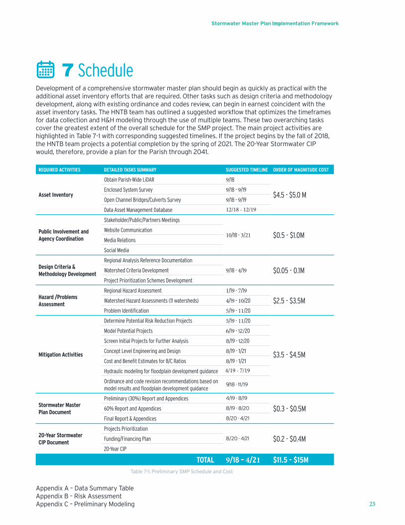
7 ScheduleDevelopment of a comprehensive stormwater master plan should begin as quickly as practical with the additional asset inventory efforts that are required. Other tasks such as design criteria and methodology development, along with existing ordinance and codes review, can begin in earnest coincident with the assetinventorytasks.TheHNTBteamhasoutlinedasuggestedworkflowthatoptimizesthetimeframesfor data collection and H&H modeling through the use of multiple teams. These two overarching tasks cover the greatest extent of the overall schedule for the SMP project. The main project activities are highlighted in Table 7-1 with corresponding suggested timelines. If the project begins by the fall of 2018, the HNTB team projects a potential completion by the spring of 2021. The 20-Year Stormwater CIP would, therefore, provide a plan for the Parish through 2041.
REQUIRED ACTIVITIES DETAILED TASKS SUMMARY SUGGESTED TIMELINE ORDER OF MAGNITUDE COST
Asset Inventory
Obtain Parish-Wide LiDAR 9/18
$4.5 - $5.0 MEnclosed System Survey 9/18 - 9/19
Open Channel Bridges/Culverts Survey 9/18 - 9/19
Data Asset Management Database 12/18 - 12/19
Public Involvement and Agency Coordination
Stakeholder/Public/Partners Meetings
10/18 - 3/21 $0.5 - $1.0MWebsite Communication
Media Relations
Social Media
Design Criteria & Methodology Development
Regional Analysis Reference Documentation
9/18 - 4/19 $0.05 - 0.1MWatershed Criteria Development
Project Prioritization Schemes Development
Hazard /Problems Assessment
Regional Hazard Assessment 1/19 - 7/19
$2.5 - $3.5MWatershed Hazard Assessments (11 watersheds) 4/19 - 10/20
Problem Identification 5/19 - 11/20
Mitigation Activities
Determine Potential Risk Reduction Projects 5/19 - 11/20
$3.5 - $4.5M
Model Potential Projects 6/19 - 12/20
Screen Initial Projects for Further Analysis 8/19 - 12/20
Concept Level Engineering and Design 8/19 - 1/21
Cost and Benefit Estimates for B/C Ratios 8/19 - 1/21
Hydraulic modeling for floodplain development guidance 4/19 - 7/19
Ordinance and code revision recommendations based on model results and floodplain development guidance
9/18 - 11/19
Stormwater Master Plan Document
Preliminary (30%) Report and Appendices 4/19 - 8/19
$0.3 - $0.5M60% Report and Appendices 8/19 - 8/20
Final Report & Appendices 8/20 - 4/21
20-Year Stormwater CIP Document
Projects Prioritization
8/20 - 4/21 $0.2 - $0.4MFunding/Financing Plan
20-Year CIP
TOTAL 9/18 – 4/21 $11.5 - $15MTable 7-1: Preliminary SMP Schedule and Cost
AppendixA–DataSummaryTableAppendixB–RiskAssessmentAppendixC–PreliminaryModeling

East Baton Rouge Parish Stormwater Master Plan – Draft Implementation Framework
Appendix A – Data Summary Table
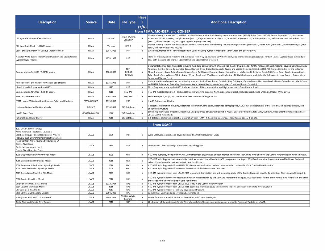
Description Source Date File Type
Have
?
(Y/N)
Additional Description
Old Hydraulic Models of EBR Streams FEMA VariousHEC-2, WSPRO,
USGS SBPY
Models are only scans of HEC-2, WSPRO, or USGS SBP output for the following streams: Amite River (HEC-2), Baker Canal (HEC-2), Beaver Bayou (HEC-2), Blackwater
Bayou (HEC-2 and WSPRO), Draughan Creek (HEC-2), Engineer Depot Canal (HEC-2), Honey Cut Bayou (HEC-2), Hub Bayou (HEC-2), Indian Bayou (HEC-2), Robert Canal
(HEC-2), Shoe Creek (HEC-2), and Upper Cypress Bayou (USGS SBP)
Old Hydrologic Models of EBR Streams FEMA Various HEC-2 YModels are only scans of hand calculations and HEC-1 output for the following streams: Draughan Creek (hand calcs), Amite River (hand calcs), Blackwater Bayou (hand
calcs), and Honeycut Bayou (HEC-1)
Letter of Map Revision for Various Locations in EBR FEMA 1987-2015 PDF Y LOMR documentation for various locations in EBRP, including hydraulic models for Sandy Creek and Beaver Bayou
Plans for White Bayou - Baker Canal Diversion and East Lateral of
Cypress Bayou ProjectsFEMA 1970-1977 PDF Y
Plans for widening and deepening of Baker Canal from Hwy 61 eastward to Wilson Street, also channelization project plans for East Lateral Cypress Bayou in vicinity of
zoo, both plans include channel size/material and size/material of laterals
Documentation for 2008 FIS/FIRM update FEMA 2004-2007
PDF,
HEC-RAS,
HEC-HMS
Y
Documentation for 2007 FIS update including map data, calculations, TSDNs, and HEC-RAS hydraulic models for the following Phase I streams: Bayou Duplantier, Bayou
Fountain, Clay Cut Bayou, Corporation Canal, Dawson Creek, Elbow Bayou, Jacks Bayou, and Wards Creek; and including HEC-RAS hydraulic models for the following
Phase II streams: Bayou Baton Rouge, Beaver Creek, Duff Bayou, Flanagan Bayou, Hanna Creek, Hub Bayou, Little Sandy Creek, Mill Creek, Sandy Creek, Scalous Creek,
Taber Creek, Cypress Bayou, White Bayou, Weiner Creek, and Wind Bayou; and including HEC-HMS hydrologic models for the following streams: Cypress Bayou, White
Bayou, and Weiner Creek
Historic Studies and Reports for Various EBR Streams FEMA 1976-1995 PDF YHistoric studies and reports for the following streams: Amite River, Bayou Fountain, Clay Cut Bayou, Cypress Bayou, Hurricane Creek - Monte Santo Bayou, Ward Creek,
and USACE Tributaries Feasibility (Blackwater Bayou, Beaver Bayou, Jones Creek, Ward Creek, and Bayou Fountain)
Historic Flood Information from USGS FEMA 1975 PDF Y Flood frequency study by the USGS, includes pictures of flood innundation and high water marks from historic floods
Documentation for 2012 FIS/FIRM update FEMA 2010 HEC-RAS Y HEC-RAS models related to a FIRM update for the following streams: North Branch Ward Creek, Redwood Creek, Shoe Creek, and Upper White Bayou
FEMA FIS and FIRM Maps FEMA 2007-2012 PDF, SHP Y FEMA FIS reports, maps, and GIS data for EBRP and surrounding Parishes
FEMA Hazard Mitigation Grant Program Policy and Guidance FEMA/GOHSEP 2015-2017 PDF Y HMGP Guidance and Policy
Louisiana Watershed Resilency Study GOHSEP 2016-2017 GIS Database YGeospatial information including, watershed information, land cover, watershed demographics, GDP, SoVI, transportation, critical facilities, emergency facilities, and
energy infrastructure
LaWRS Flood Data GOHSEP/MOHSEP 2018 GIS Database YSevere Repetitive Loss properties, Repetitive Loss properties, Structures Flooded in August 2016 (flood claims), Jobs Data, GDP data, flood extent rasters (Aug and Mar
2016), LaWRS watersheds
National Flood Hazard Layer FEMA 2018 GIS Database Y GIS database containing geospatial information from FEMA FIS flood insurance maps (flood hazard zones, BFEs, etc.)
2017-2018 Channel Surveys
Amite River and Tributaries, Louisiana
East Baton Rouge Parish Flood Control Projects
February 1995 Environmental Impact Statement
USACE 1995 PDF Y Ward Creek, Jones Creek, and Bayou Fountain Channel Improvement Study
Flood Control, Amite River and Tributaries, LA
Comite River Basin
Design Memorandum No. 1
Comite River Diversion Project
USACE 1995 PDF Y Comite River Diversion design information, including plans
2009 Degredation Study Hydrologic Model USACE 2009 HMS Y HEC-HMS hydrology model from USACE 2009 streambed degredation and sedimentation study of the Comite River and how the Comite River Diversion would impact it.
2016 Comite Flood Hydrologic Model USACE 2016 HMS YHEC-HMS hydrology for the low resolution hindcast model created by the USACE to represent the August 2016 flood event for the entire Amite/Blind River Basin and
other tributaries on the northern side of Lake Ponchitrain.
2016 Economic III Evaluation Hydrologic Model USACE 2016 HMS Y HEC-HMS hydrology model from USACE 2016 economic evaluation study to determine the cost benefit of the Comite River Diversion
2009 Comite Diversion Hydrologic Model USACE 2009 HMS Y HEC-HMS hydrology model from USACE 2009 study of the Comite River Diversion
2009 Degradation Study 1-d RAS Model USACE 2009 RAS Y HEC-RAS hydraulic model from USACE 2009 streambed degredation and sedimentation study of the Comite River and how the Comite River Diversion would impact it.
2016 Comite Flood 2-d Model USACE 2016 RAS YHEC-RAS hydraulic for the low resolution hindcast model created by the USACE to represent the August 2016 flood event for the entire Amite/Blind River Basin and other
tributaries on the northern side of Lake Ponchitrain.
Diversion Channel 1-d RAS Model USACE 2012-2014 RAS Y HEC-RAS hydraulic model from USACE 2009 study of the Comite River Diversion
Econ Level III Evaluation Model USACE 2016 RAS Y HEC-RAS hydraulic model from USACE 2016 economic evaluation study to determine the cost benefit of the Comite River Diversion
Lilly Bayou 1-d RAS Model USACE 2013 RAS Y HEC-RAS hydraulic model for the Lilly Bayou drop structure.
Misc Comite Diversion RAS Models USACE 2004-2012 RAS Y Comite River Diversion guide levees and other models
Survey Data from Misc Corps Projects USACE 1999-2017Various Survey
FormatsY Survey for various projects related to the Comite River Diversion Project
Amite River and Comite River Surveys USACE 2018 SHP Y 2018 survey of the Amite and Comite River channels (profile and cross sections), performed by Forte and Tablada for USACE.
From FEMA, MOHSEP, and GOHSEP
From USACE
1 of 5
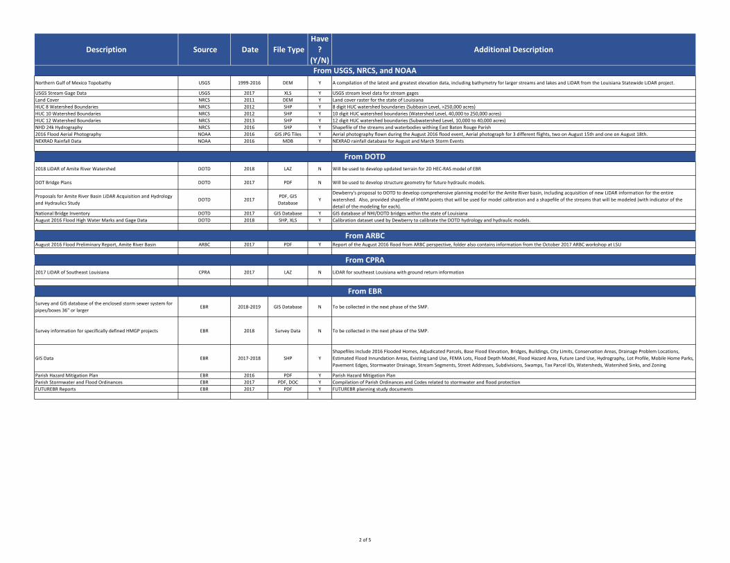
Description Source Date File Type
Have
?
(Y/N)
Additional Description
Northern Gulf of Mexico Topobathy USGS 1999-2016 DEM Y A compilation of the latest and greatest elevation data, including bathymetry for larger streams and lakes and LiDAR from the Louisiana Statewide LiDAR project.
USGS Stream Gage Data USGS 2017 XLS Y USGS stream level data for stream gages
Land Cover NRCS 2011 DEM Y Land cover raster for the state of Louisiana
HUC 8 Watershed Boundaries NRCS 2012 SHP Y 8 digit HUC watershed boundaries (Subbasin Level, >250,000 acres)
HUC 10 Watershed Boundaries NRCS 2012 SHP Y 10 digit HUC watershed boundaries (Watershed Level, 40,000 to 250,000 acres)
HUC 12 Watershed Boundaries NRCS 2013 SHP Y 12 digit HUC watershed boundaries (Subwatershed Level, 10,000 to 40,000 acres)
NHD 24k Hydrography NRCS 2016 SHP Y Shapefile of the streams and waterbodies withing East Baton Rouge Parish
2016 Flood Aerial Photography NOAA 2016 GIS JPG Tiles Y Aerial photography flown during the August 2016 flood event, Aerial photograph for 3 different flights, two on August 15th and one on August 18th.
NEXRAD Rainfall Data NOAA 2016 MDB Y NEXRAD rainfall database for August and March Storm Events
2018 LiDAR of Amite River Watershed DOTD 2018 LAZ N Will be used to develop updated terrain for 2D HEC-RAS model of EBR
DOT Bridge Plans DOTD 2017 PDF N Will be used to develop structure geometry for future hydraulic models.
Proposals for Amite River Basin LiDAR Acquisition and Hydrology
and Hydraulics StudyDOTD 2017
PDF, GIS
DatabaseY
Dewberry's proposal to DOTD to develop comprehensive planning model for the Amite River basin, including acquisition of new LiDAR information for the entire
watershed. Also, provided shapefile of HWM points that will be used for model calibration and a shapefile of the streams that will be modeled (with indicator of the
detail of the modeling for each).
National Bridge Inventory DOTD 2017 GIS Database Y GIS database of NHI/DOTD bridges within the state of Louisiana
August 2016 Flood High Water Marks and Gage Data DOTD 2018 SHP, XLS Y Calibration dataset used by Dewberry to calibrate the DOTD hydrology and hydraulic models.
August 2016 Flood Preliminary Report, Amite River Basin ARBC 2017 PDF Y Report of the August 2016 flood from ARBC perspective, folder also contains information from the October 2017 ARBC workshop at LSU
2017 LiDAR of Southeast Louisiana CPRA 2017 LAZ N LiDAR for southeast Louisiana with ground return information
Survey and GIS database of the enclosed storm sewer system for
pipes/boxes 36" or largerEBR 2018-2019 GIS Database N To be collected in the next phase of the SMP.
Survey information for specifically defined HMGP projects EBR 2018 Survey Data N To be collected in the next phase of the SMP.
GIS Data EBR 2017-2018 SHP Y
Shapefiles include 2016 Flooded Homes, Adjudicated Parcels, Base Flood Elevation, Bridges, Buildings, City Limits, Conservation Areas, Drainage Problem Locations,
Estimated Flood Innundation Areas, Existing Land Use, FEMA Lots, Flood Depth Model, Flood Hazard Area, Future Land Use, Hydrography, Lot Profile, Mobile Home Parks,
Pavement Edges, Stormwater Drainage, Stream Segments, Street Addresses, Subdivisions, Swamps, Tax Parcel IDs, Watersheds, Watershed Sinks, and Zoning
Parish Hazard Mitigation Plan EBR 2016 PDF Y Parish Hazard Mitigation Plan
Parish Stormwater and Flood Ordinances EBR 2017 PDF, DOC Y Compilation of Parish Ordinances and Codes related to stormwater and flood protection
FUTUREBR Reports EBR 2017 PDF Y FUTUREBR planning study documents
From DOTD
From ARBC
From USGS, NRCS, and NOAA
From EBR
From CPRA
2 of 5
Description Source Date File Type
Have
?
(Y/N)
Additional Description
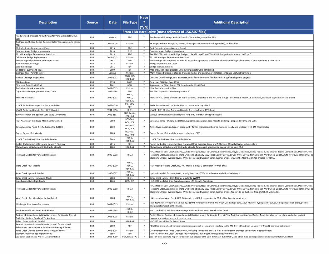
Roadway and Drainage As-Built Plans for Various Projects within
EBREBR Various PDF Y Roadway and Drainage As-Built Plans for Various Projects within EBR
Drainage and Bridge Design Documents for Various projects within
EBREBR 2004-2016 Various Y 96 Project Folders with plans, photos, drainage calculations (including models), and GIS files
Multiple Bridge Replacement Plans EBR 2015 PDF Y Cost Estimate information also found
Denham Street Bridge Improvement EBR 2010 TIFF Y Denham Street Bridge Improvement
2013 LRA Brdiges Replacement Locations EBR 2013 PDF Y See PDFs "2013 Updated Bridge Budget 12Sept2013.pdf" and "2013 LRA Bridges Replacement 11X17.pdf"
Off-System Bridge Replacements EBR 2011-2013 Various Y 2013 LRA Brdiges Replacement Locations
Minor Bridge Replacement on Roberts Canal EBR 1960's PDF Y Minor bridge install for one resident to access back property, plans show channel and bridge dimensions. Correspondence is from 2014.
East Brookstown Bridge EBR 2014 Various Y Bridge over Hurricaine Creek
Woodlake Bridge EBR 2011 PDF Y Bridge over Jones Creek
Bridges for 2009 Bond Issue EBR 2009 PDF Y Map showing bridge projects, unknown if projects were completed
Drainage Files (Parent Folder) EBR Various Various Y Many files and folders related to drainage studies and design, parent folder contains a useful stream map
Various Drainage Project Files EBR 1995-2002DWG, XLS,
HEC-RASY Contains CAD drawings, cost estimates, and a few H&H model files for 59 drainage/development projects.
EBR Base Map EBR 1998 DWG Y Base map CAD files from 1998.
DEM data from 1999 LiDAR EBR 2001 DEM Y Appears to be DEM tiles for EBR based on the 1999 LiDAR
Parish Benchmark Information EBR 2001-2013 Various Y Misc Parish Survey BM files
Capitol Lake Pumping Station Pump Curve EBR 1982-1984 PDF Y See PDF "Capitol Lake Pumping Station 2"
Misc. H&H Models EBR 1990-2003
HEC-1,
HEC-2,
HEC-RAS
Y Primarily HEC-2 files of most EBR major streams, some HEC-1 and HEC-RAS files (all loose files in main COE directory), many are duplicates in sub folders
USACE Amite River Inspection Documentation EBR 2005-2010JPG, DOC,
PDFY Aerial Inspections of the Amite River as documented by USACE
USACE Amite and Comite River HEC-1 Models EBR 1994-1996 HEC-1 Y USACE HEC-1 files for Amite and Comite Rivers, including 1993 flood
Bayou Manchac and Spanish Lake Study Documents EBR 2002-2107DOC, Emails,
PDF, JPGVarious communications and reports for Bayou Manchac and Spanish Lake
H&H Analysis of the Bayou Manchac Watershed EBR 2002HEC-RAS,
DOC, PDFY Bayou Manchac HEC-RAS model files, supporting geospatial data, reports, and maps prepared by URS and CSRS
Bayou Manchac Flood Risk Reduction Study H&H EBR 2009HEC-RAS,
DOC, PDFY Amite River models and report prepared by Taylor Engineering (George Hudson), steady and unsteady HEC-RAS files included
Beaver Bayou H&H Models EBR 2006HEC-RAS,
HEC-HMSY Beaver Bayou H&H models, appears to be from CSRS
USACE Comite River Diversion H&H Models EBR 2003HEC-1,
HEC-RASY USACE Comite River Diversion H&H Models
Bridge Replacement at Firewood Dr and N Flannery EBR 2016 PDF Y Permit for bridge replacements of Firewood Dr @ Drainage Canal and N Flannery @ Lively Bayou, includes plans
Elbow Bayou at Nicholson Dr Hydraulic Models EBR 2004 HEC-RAS Y Elbow Bayou at Nicholson Dr Hydraulic Models, for propsed apartments, appears to be from E&G
Hydraulic Models for Various EBR Streams EBR 1990-1998 HEC-2 Y
HEC-2 files for EBR: Clay Cut Bayou, Amite River (Maurepas to Comite), Beaver Bayou, Bayou Duplantier, Bayou Fountain, Blackwater Bayou, Comite River, Dawson Creek,
Hurricane Creek, Jones Creek, Ward Creek (including July 1992 Flood), Lively Bayou, Lower White Bayou, North Branch Ward Creek, Upper Amite River (Denham Springs to
State Line), Upper Cypress Bayou, White Bayou East Diversion Canal, Weiner Creek. May be the files that USACE created for FEMA.
Ward Creek H&H Models EBR 1990-2000
HEC-1,
HEC-2,
HEC-RAS
Y H&H models of Ward Creek, HEC-RAS model is a HEC-2 conversion for Mall of LA
Jones Creek Hydraulic Models EBR 1990-2007HEC-2,
HEC-RASY Hydraulic models for Jones Creek, mostly from the 2000's, includes one model for Lively Bayou
Jones Creek Lateral Hydrologic Model EBR 2003 HEC-1 Y Jones Creek Lateral HEC-1 files for input into SWMM
Knox Branch Hydrologic Model EBR 2004 HEC-HMS Y HEC-HMS model of Knox Branch upstream of S Harrells Ferry Road
Hydraulic Models for Various EBR Streams EBR 1990-1998 HEC-2 Y
HEC-2 files for EBR: Clay Cut Bayou, Amite River (Maurepas to Comite), Beaver Bayou, Bayou Duplantier, Bayou Fountain, Blackwater Bayou, Comite River, Dawson Creek,
Hurricane Creek, Jones Creek, Ward Creek (including July 1992 Flood), Lively Bayou, Lower White Bayou, North Branch Ward Creek, Upper Amite River (Denham Springs to
State Line), Upper Cypress Bayou, White Bayou East Diversion Canal, Weiner Creek. Appears to be duplicate files, USACE/FEMA models.
Ward Creek H&H Models for the Mall of LA EBR 2000HEC-1,
HEC-RASY H&H models of Ward Creek, HEC-RAS model is a HEC-2 conversion for Mall of LA. May be duplicates
Mississippi River Levee Documents EBR 2009-2015 Various YIncludes top of levee profiles (including PLD MS River Levees from BR to NOLA), daily stage data, 2004 MS River hydrographic survey, emergency action plans, permits,
and projects impacting the levees.
North Branch Wards Creek H&H Models EBR 1993-1995HEC-1,
HEC-2Y HEC-1 and HEC-2 files for EBR: Country Club Lateral and North Branch Ward Creek
Section 14 streambank stabilization project for Comite River at
Pride Port Hudson Road and Tucker RoadEBR 2003-2015 Various Y
Project files for Section 14 streambank stabilization project for Comite River at Pride Port Hudson Road and Tucker Road, includes survey, plans, and other project
documentation (pre and post construction)
Robert Canal Hydraulic Model EBR 2006 HEC-RAS Y HEC-RAS model files for Robert Canal
Section 14 streambank stabilization project for Unnamed
Tributary to the MS River at Southern University (F Street)EBR 2009 PDF Y FONSI for Section 14 streambank stabilization project for unnamed tributary to the MS River at Southern University (F Street), communications only
Jones Creek Channel Surveys and Drainage Analyses EBR 2001-2004 Various Y Documentation for Jones Creek project, including survey files and GIS files, includes some drainage calculations in spreadsheets
Weiner Creek Drainage Improvements EBR 1997 PDF Y Plan set for Weiner Creek Drainage Improvements, including channel geometry information
LSU Lakes Section 206 Project Documentation EBR 2008-2009 PDF, Email, JPG Y See PDF Cost Estimate Report for Section 206 project "LSU_Cost_Estimate_20080730", also other misc. correspondence and documentation, no H&H
From EBR Hard Drive (most relevant of 156,507 files)
3 of 5
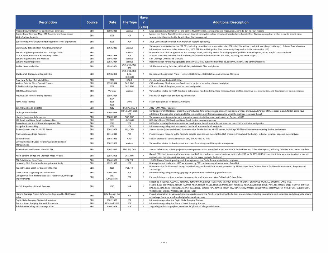
Description Source Date File Type
Have
?
(Y/N)
Additional Description
Project Documentation for Comite River Diversion EBR 2000-2015 Various Y Misc. project documentation for the Comite River Diversion, correspondence, maps, plans, permits, but no H&H models
Comite River Diversion Map, CBR Analysis, and Downstream
Water Surface ImpactsEBR 2008 PDF Y
Map of the Comite River Diversion, map of downstream water surface elevation impacts due to Comite River Diversion project, as well as a cost to benefit ratio
summary/justification for the Comite River Diversion project
2008 Comite River Diversion H&H Report by Taylor Engineering EBR 2008 PDF Y 2008 Comite River Diversion H&H Report by Taylor Engineering
Community Rating System (CRS) Documentation EBR 1992-2015 Various YVarious documentation for the EBR CRS, including repetitive loss information (also PDF titled "Repetitive Loss lot & block Map", old maps), finished floor elevation
information, insurance policy information, 2006 EBR Hazard Mitigation Plan, community Program for Public Information (PPI)
EBR Drainage Design Studies and Drainage Issues EBR Various Y Documentation of drainage studies and drainage issues, including folders for each project or problem area with plans, maps, and/or correspondence
USACE Amite River Basin & Tributary Studies EBR 1964-1998 PDF Y Scans of past USACE studies that have been performed on the Amite River and Tribs, including the FRMP projects.
EBR Drainage Criteria and Manuals EBR 1994-2014 Various Y EBR Drainage Criteria and Manuals
EBR Drainage Design Files EBR 1993-2014 Various Y Documentation for drainage projects, primarily CAD files, but some H&H models, survevys, reports, and communications
Azalea Lakes Study Files EBR 1998-2001CAD, DOC, HEC-
RASY 5 folders containing CAD files, HECRAS files, HYDRAWIN files, and photos
Bluebonnet Realignment Project Files EBR 1998-2001
CAD, DOC, HEC-
RAS,
HEC-HMS
Y Bluebonnet Realignment Phase I: Letters, HECRAS files, HECHMS files, and unknown file types
Core Lane Bridge H&H Model Files EBR 2000 HEC-1 Y Core Lane Bridge Project H&H files
Various Data for Flood Control Projects EBR 1998-2014 CAD, PDF Y CAD and survey files for various flood control projects, including channels and pipes
E. Mckinley Bridge Replacement EBR 2008 CAD, PDF Y PDF and tif file of the plans, cross sections and profiles
EBR FEMA Documents EBR Various Various Y Various files related to FEMA floodplain delineation, flood modeling, flood recovery, flood profiles, repetitive loss information, and flood recovery documentation
Previous EBR HMGP Funding Requests EBR 1999-2014 Y Past HMGP application and funding information
FEMA Flood Profiles EBR
2004
2005
2008
DWG Y FEMA flood profiles for EBR FEMA streams
2012 FEMA Model Updates EBR 2012 HEC-RAS, HEC-2 Y 2012 FEMA Model Updates
Drainage Issue Studies EBR 2004-2015PDF, GMW, CAD,
JPGY
Contains over 350 folders of areas that were studied for drainage issues, primarily just contour maps and survey/GPS files of these areas in each folder, some have
additional drainage, plan sheets, and ROW information, no information regarding what the drainage issue was though
Historic Hurricaine Information EBR 2008-2015 DOC, PDF Y Various documents regarding past hurricaine events, including repair work done for Gustav in 2008
Mill Creek and Ward Creek Hydrology Files EBR 2003 HEC-HMS Y HEC-HMS files of Mill Creek and Ward Creek basins, purpose unknown
Bayou Manchac Scenic River Management Plan EBR 2012 PDF Y LDEQ plan showing the requirements for development in and around Bayou Manchac due to it's scenic river designation
Navigable Streams Map EBR 2009 PDF Y Information regarding which streams in the Parish are considered navigable
Stream System Map for NPDES Permit EBR 2002-2004 XLS, CAD Y Stream system (open and closed) documentation for the Parish's NPDES permit, including CAD files with stream numbering, basins, and streets
Pipe Location and Size Requests EBR 2011-2013 PDF Y Property owner requests to the Parish to provide pipe size and material for ditch crossings throughout the Parish. Indicates location, size, and material type.
Stream Profiles EBR 1993-1996 CAD Y Stream profiles for various streams in EBR, all CAD files, 47 files
Development and Codes for Drainage and Floodplain
ManagementEBR 2002-2008 Various Y Various files related to development and codes for drainage and floodplain management
Stream Index and Stream Maps for EBR EBR 2007-2015 PDF, TIF, CAD Y Stream index maps, stream project numbering system maps, watershed maps, and USACE Amite River and Tributaries reports, including CAD files with stream numbers
Road, Stream, Bridge and Drainage Maps for EBR EBR 1993-2008 CAD, PDF YOverall EBR road, stream, and bridge maps and CAD files, includes a map of drainage projects for EBR for FY 1993-2002 (it's unclear if they were constructed, or are still
needed), also there is a drainage area map for the larger basins in the Parish
EBR Subdivision Plans/Plats EBR 2000-2003 PDF, TIF Y 1,987 folders of layout, grading, and drainage plans, one folder for each subdivision or phase
University Club Plantation Drainage Impact Study EBR 1997-1999 PDF Y Drainage impact study from 1997 as prepared by CSRS, review copy with comments from EBR
Repetitive Loss Grant for Greenwell Springs EBR 2009 PDF, TIF YDocumentation for Greenwell Springs repetive loss grant from FEMA, report generated by University of New Orleans Center for Hazards Assessment, Response and
Technology
USGS Stream Gage Program Information EBR 2006-2017 PDF Y Information regarding stream gage program procurement and other gage information
College Drive from Perkins Road to S. Foster Drive, Drainage
ImprovementsEBR
1967
(2010 scan)PDF Y Enclosed drainage system, roadway improvments, and bridge over Ward's Creek at College Drive
ArcGIS Shapefiles of Parish Features EBR 2017 SHP Y
Shapefiles including: ALLUVIAL_TERRACE, BENCHMARK, BRIDGE_LOCATION, DISTRICT_FLOOD_PROTECT, DRAINAGE_OUTFALL, EXISTING_LAND_USE,
FLOOD_BASE_ELEVATION, FLOOD_HAZARD_AREA, FLOOD_PANEL, HYDROGRAPHY, LOT_ADDRESS_AREA, PAVEMENT_EDGE, PIPELINE, PUBLIC_LAND_SURVEY_SYSTEM,
RAILROAD, RAILROAD_CROSSING, SEWER_MANHOLE, SEWER_PIPE, SEWER_PUMP_STATION, STORMWATER_CONVEYANCE, STORMWATER_STRUCTURE, SUBDIVISION,
WATERSHED_MICRO, WATERSHED_MICRO_SINK
Historic Drainage Project Information Organized by EBR Stream
IndexEBR
60's through the
00'sPDF Y
Project information for various drainage projects around the Parish, organized by the Parish's stream index, including calculations, cost estiamtes, and plan/profile sheets
of drainage features, also found original stream index map
Capitol Lake Pumping Station Information EBR 1982-1983 PDF Y Information regarding the Capitol Lake Pumping Station
Terrace Street Pumping Station Information EBR 1974 and 2015 PDF Y Information regarding the Terrace Street Pumping Station
Subdivision Grading and Drainage Plans EBR 2000-2008 PDF Y 24 grading and drainage plans, some are for phases of a larger subdivision
4 of 5
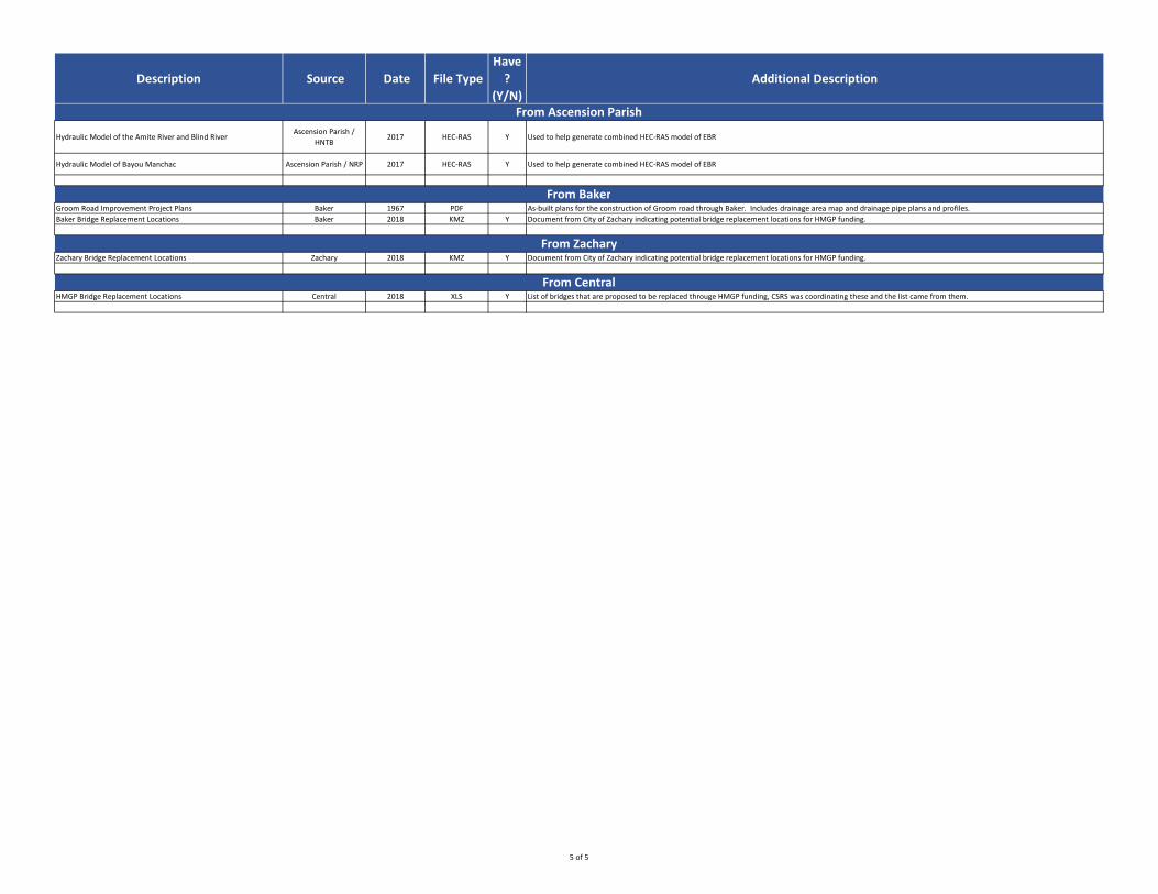
Description Source Date File Type
Have
?
(Y/N)
Additional Description
Hydraulic Model of the Amite River and Blind RiverAscension Parish /
HNTB2017 HEC-RAS Y Used to help generate combined HEC-RAS model of EBR
Hydraulic Model of Bayou Manchac Ascension Parish / NRP 2017 HEC-RAS Y Used to help generate combined HEC-RAS model of EBR
Groom Road Improvement Project Plans Baker 1967 PDF As-built plans for the construction of Groom road through Baker. Includes drainage area map and drainage pipe plans and profiles.
Baker Bridge Replacement Locations Baker 2018 KMZ Y Document from City of Zachary indicating potential bridge replacement locations for HMGP funding.
Zachary Bridge Replacement Locations Zachary 2018 KMZ Y Document from City of Zachary indicating potential bridge replacement locations for HMGP funding.
HMGP Bridge Replacement Locations Central 2018 XLS Y List of bridges that are proposed to be replaced througe HMGP funding, CSRS was coordinating these and the list came from them.
From Baker
From Zachary
From Central
From Ascension Parish
5 of 5
LIST OF FEMA FIS MODELS FOR EAST BATON ROUGE PARISH
FLOODING SOURCE COMMUNITY NAME CASE NUMBER EFFECTIVE DATE STUDY TYPE LOMR STATUS REACH DESCRIPTION MODEL XS AFFECTED FLOODWAY BFE RANGE (D/S) BFE RANGE (U/S)
Clay Cut Bayou EAST BATON ROUGE PARISH 08-06-2505P 8/15/2008 LOMR EFFECTIVE From approximately 1600 feet downstream of Elliot Road to approximately 6000 feet upstream of Antioch Road. OTHER (SEE NOTES) - 0 0
Bayou Duplantier EAST BATON ROUGE PARISH MICS 30156 5/2/2008 RESTUDY From confluence with Dawson Creek to confluence of Bayou Duplantier and Corporation Canal HEC-RAS A-N NO 26 26
Bayou Fountain North Branch EAST BATON ROUGE PARISH MICS 30156 5/2/2008 RESTUDY From confluence with Bayou Fountain to approx. 7,300 feet above HEC-RAS A-J NO 15 22
Bayou Fountain South Branch EAST BATON ROUGE PARISH MICS 30156 5/2/2008 RESTUDY From confluence with Bayou Fountain to approx. 7,900 feet above HEC-RAS A-I NO 22 24
Bayou Fountain Tributary 1 EAST BATON ROUGE PARISH MICS 30156 5/2/2008 RESTUDY From confluence with Bayou Fountain to approx. 11,800 feet above HEC-RAS A-J NO 8 19
Corporation Canal EAST BATON ROUGE PARISH MICS 30156 5/2/2008 RESTUDY From approx. 14,700 feet above confluence with Dawson Creek to approx. 29,100 feet above HEC-RAS O-AE NO 26 30
Dawson Creek EAST BATON ROUGE PARISH MICS 30156 5/2/2008 RESTUDY From confluence with Wards Creek to 43,700 feet above HEC-RAS A-AJ NO 24 37
Elbow Bayou EAST BATON ROUGE PARISH MICS 30156 5/2/2008 RESTUDY From confluence with Bayou Fountain to approx. 31,200 feet above HEC-RAS A-W NO 20 24
North Branch Wards Creek EAST BATON ROUGE PARISH MICS 30156 5/2/2008 RESTUDY From confluence with Wards Creek to approx. 20,400 feet above HEC-RAS A-O NO 17 45
Unnamed Tributary to Bayou Fountain EAST BATON ROUGE PARISH MICS 30156 5/2/2008 RESTUDY From confluence with Bayou Fountain to approx. 8,450 feet above HEC-RAS A-G NO 7 14
Unnamed Tributary to North Branch Wards Creek (Harelson Lateral) EAST BATON ROUGE PARISH MICS 30156 5/2/2008 RESTUDY From confluence with North Branch Wards Creek to approx. 5,900 feet above HEC-RAS A-G NO 35 44
Wards Creek EAST BATON ROUGE PARISH MICS 30156 5/2/2008 RESTUDY From confluence with Bayou Manchac to approx. 76,150 feet above HEC-RAS A-BR NO 19 53
Clay Cut Bayou EAST BATON ROUGE PARISH MICS 30156 5/2/2008 RESTUDY From confluence with Amite River to approx. 3.4 miles above HEC-RAS A-AA NO 21 33
Jacks Bayou EAST BATON ROUGE PARISH MICS 30156 5/2/2008 RESTUDY From confluence with Clay Cut Bayou to approx. 9,800 feet above HEC-RAS A-I NO 23 37
Upper White Bayou EAST BATON ROUGE PARISH MICS 30156 5/2/2008 RESTUDY From confluence with South Canal to approx. 52,500 feet above HEC-RAS A-AV NO 73 120
Upper Cypress Bayou EAST BATON ROUGE PARISH MICS 30156 5/2/2008 RESTUDY From confluence with Baker Canal to approx. 26,700 feet above HEC-RAS A-Y NO 75 95
Weiner Creek EAST BATON ROUGE PARISH MICS 30156 5/2/2008 RESTUDY From confluence with Jones Creek to approx. 14,050 feet above HEC-RAS A-N NO 23 43
Bayou Fountain EAST BATON ROUGE PARISH MICS 30156 5/2/2008 RESTUDY From confluence with Bayou Manchac to approx. 69,650 feet above HEC-RAS A-BF NO 11 24
Beaver Creek EAST BATON ROUGE PARISH MICS 30156 5/2/2008 RESTUDY HEC-RAS N/A N/A 72 116
Duff Bayou EAST BATON ROUGE PARISH MICS 30156 5/2/2008 RESTUDY HEC-RAS N/A N/A 88 122
Flanagan Bayou EAST BATON ROUGE PARISH MICS 30156 5/2/2008 RESTUDY HEC-RAS N/A N/A 104 113
Hanna Creek EAST BATON ROUGE PARISH MICS 30156 5/2/2008 RESTUDY HEC-RAS N/A N/A 111 121
Little Sandy Creek EAST BATON ROUGE PARISH MICS 30156 5/2/2008 RESTUDY HEC-RAS N/A N/A 66 117
Mill Creek EAST BATON ROUGE PARISH MICS 30156 5/2/2008 RESTUDY HEC-RAS N/A N/A 92 110
Sandy Creek EAST BATON ROUGE PARISH MICS 30156 5/2/2008 RESTUDY HEC-RAS N/A N/A 66 118
Scalous Creek EAST BATON ROUGE PARISH MICS 30156 5/2/2008 RESTUDY HEC-RAS N/A N/A 103 116
Taber Creek EAST BATON ROUGE PARISH MICS 30156 5/2/2008 RESTUDY HEC-RAS N/A N/A 97 109
UNT 1 to Mill Creek EAST BATON ROUGE PARISH MICS 30156 5/2/2008 RESTUDY HEC-RAS N/A N/A 96 112
UNT 1 to Little Sandy Creek EAST BATON ROUGE PARISH MICS 30156 5/2/2008 RESTUDY HEC-RAS N/A N/A 77 99
UNT 2 to Little Sandy Creek EAST BATON ROUGE PARISH MICS 30156 5/2/2008 RESTUDY HEC-RAS N/A N/A 72 104
UNT 1 to Sandy Creek EAST BATON ROUGE PARISH MICS 30156 5/2/2008 RESTUDY HEC-RAS N/A N/A 102 116
UNT 2 to Sandy Creek EAST BATON ROUGE PARISH MICS 30156 5/2/2008 RESTUDY HEC-RAS N/A N/A 91 112
UNT 3 to Little Sandy Creek EAST BATON ROUGE PARISH MICS 30156 5/2/2008 RESTUDY HEC-RAS N/A N/A 75 98
UNT 3 to Sandy Creek EAST BATON ROUGE PARISH MICS 30156 5/2/2008 RESTUDY HEC-RAS N/A N/A 72 95
UNT 4 to Little Sandy Creek EAST BATON ROUGE PARISH MICS 30156 5/2/2008 RESTUDY HEC-RAS N/A N/A 65 79
UNT 4 to Sandy Creek EAST BATON ROUGE PARISH MICS 30156 5/2/2008 RESTUDY HEC-RAS N/A N/A 65 77
UNT 5 to Little Sandy Creek EAST BATON ROUGE PARISH MICS 30156 5/2/2008 RESTUDY HEC-RAS N/A N/A 58 76
UNT to Duff Bayou EAST BATON ROUGE PARISH MICS 30156 5/2/2008 RESTUDY HEC-RAS N/A N/A 89 122
Wind Bayou EAST BATON ROUGE PARISH MICS 30156 5/2/2008 RESTUDY HEC-RAS N/A N/A 66 109
Cypress Bayou ZACHARY, CITY OF 03-06-827P 9/30/2003 LOMR EFFECTIVE From approximately 250 feet upstream of Rollins Road to approximately 500 feet downstream of Rollins Road. HEC-RAS W YES 95 97
Tributary of Jones Creek EAST BATON ROUGE PARISH 93-06-340P 10/28/1993 LOMR EFFECTIVE Just downstream of Mollyea Drive to approximately 600 feet upstream. OTHER (SEE NOTES) - 0 0
Blackwater Bayou Tributary 1 EAST BATON ROUGE PARISH 93-06-296P 9/16/1993 LOMR EFFECTIVE OTHER (SEE NOTES) - 0 0
Blackwater Bayou Tributary 2 EAST BATON ROUGE PARISH 93-06-296P 9/16/1993 LOMR EFFECTIVE OTHER (SEE NOTES) - 0 0
Blackwater Bayou EAST BATON ROUGE PARISH 5/17/1993 RESTUDY From confluence with Comite River to approx. 41,575 feet above WSPRO F-J NO 75 79
Blackwater Bayou Tributary No. 1 EAST BATON ROUGE PARISH 5/17/1993 RESTUDY From the confluence with Blackwater Bayou to 30,625 feet above WSPRO H-K NO 77 80
Blackwater Bayou Tributary No. 3 EAST BATON ROUGE PARISH 5/17/1993 RESTUDY From the confluence with Blackwater Bayou to approx. 3,350 feet above WSPRO N/A NO 76 78
Amite River EAST BATON ROUGE PARISH 5/17/1993 RESTUDY From 35 miles above mouth to approx. 82.6 miles (Parish Boundary) HEC-2 A-AS YES 19 110
Draughans Creek EAST BATON ROUGE PARISH 5/17/1993 RESTUDY From the confluence with Comite River to approx. 23,600 feet above HEC-2 F-L NO 47 59
Blackwater Bayou Tributary 1 EAST BATON ROUGE PARISH 2/10/1987 LOMR EFFECTIVE In the vicinity of Core Lane and Blackwater Road. HEC-2 YES 58 75
Blackwater Bayou Tributary 2 EAST BATON ROUGE PARISH 2/10/1987 LOMR EFFECTIVE In the vicinity of Core Lane and Blackwater Road. HEC-2 YES 58 75
Wards Creek EAST BATON ROUGE PARISH 10/8/1986 LOMR INCORPORATED Along the South Acadian Thruway. OTHER (SEE NOTES) - 0 0
North Branch Wards Creek EAST BATON ROUGE PARISH 10/8/1986 LOMR INCORPORATED Along the South Acadian Thruway. OTHER (SEE NOTES) - 0 0
Blackwater Bayou Tributary No. 2 EAST BATON ROUGE PARISH 11/15/1985 RESTUDY From confluence with Blackwater Bayou to 10,675 feet above HEC-2 A-G NO 66 77
Baker Canal EAST BATON ROUGE PARISH 11/15/1985 RESTUDY From approx. 4,000 feet above confluence with Bayou Baton Rouge to confluence with Upper Cypress Bayou HEC-2 A-G NO 64 85
Beaver Bayou EAST BATON ROUGE PARISH 11/15/1985 RESTUDY From confluence with Comite River to approx. 46,250 feet above HEC-2 A-N NO 35 76
Engineer Depot Canal EAST BATON ROUGE PARISH 11/15/1985 RESTUDY From the confluence with Comite River to approx. 13,050 feet above HEC-2 A-I NO 30 53
Honey Cut Bayou EAST BATON ROUGE PARISH 11/15/1985 RESTUDY From confluence with Amite River to approx. 23,250 feet above HEC-2 A-I NO 15 42
Hub Bayou EAST BATON ROUGE PARISH 11/15/1985 RESTUDY From confluence with Amite River to approx. 19,000 feet above HEC-2 A-H NO 45 78
Indian Bayou EAST BATON ROUGE PARISH 11/15/1985 RESTUDY From confluence with Upper White Bayou to approx. 14,200 feet above HEC-2 A-H NO 92 105
Robert Canal Tributary No. 1 EAST BATON ROUGE PARISH 11/15/1985 RESTUDY From confluence with Robert Canal to approx. 2,400 feet above HEC-2 A-D NO 53 58
Shoe Creek EAST BATON ROUGE PARISH 11/15/1985 RESTUDY From confluence with Comite River to approx. 21,000 feet above HEC-2 A-I NO 42 59
Shoe Creek Tributary No. 1 EAST BATON ROUGE PARISH 11/15/1985 RESTUDY From confluence with Shoe Creek to approx. 6,275 feet above HEC-2 A-D NO 47 60
Blackwater Bayou Tributary No. 1 EAST BATON ROUGE PARISH 11/15/1985 RESTUDY From confluence with Blackwater Bayou to McCullough Road HEC-2 A-G NO 57 78
Weiner Creek EAST BATON ROUGE PARISH 10/28/1985 LOMR EFFECTIVE At the Interstate I-12 crossing. HEC-2 NO 45 51
Comite River EAST BATON ROUGE PARISH 7/2/1979 STUDY From confluence with Amite River to approx. 18.5 miles above REPORT A-U NO 0 0
East Lateral Cypress Bayou EAST BATON ROUGE PARISH 7/2/1979 STUDY From confluence with Lower Cypress Bayou to approx. 0.38 miles above REPORT N/A NO 0 0
Gibbens Lateral North EAST BATON ROUGE PARISH 7/2/1979 STUDY From confluence with lower Cypress Bayou to approx. 0.57 miles above REPORT N/A NO 0 0
Hollywood Lateral EAST BATON ROUGE PARISH 7/2/1979 STUDY From confluence with Monte Sano Bayou to confluence of Wildwood Lateral REPORT N/A NO 0 0
Hurricane Creek EAST BATON ROUGE PARISH 7/2/1979 STUDY From confluence with Comite River to confluence of Wildwood Lateral REPORT A-J NO 0 0
Jones Creek EAST BATON ROUGE PARISH 7/2/1979 STUDY From confluence with Amite River to Airline Highway REPORT N/A NO 0 0
Knox Branch EAST BATON ROUGE PARISH 7/2/1979 STUDY From confluence with Jones Creek to approx. 1.425 miles above REPORT N/A NO 0 0
Lively Bayou EAST BATON ROUGE PARISH 7/2/1979 STUDY From confluence with Jones Creek to approx. 3.55 miles above REPORT A-H NO 0 0
Lively Bayou Tributary EAST BATON ROUGE PARISH 7/2/1979 STUDY From confluence with Lively Bayou to approx. 2.475 miles above REPORT N/A NO 0 0
Lower Cypress Bayou EAST BATON ROUGE PARISH 7/2/1979 STUDY From confluence with Comite River to approx. 7.1 miles above REPORT A-G NO 0 0
Lower White Bayou EAST BATON ROUGE PARISH 7/2/1979 STUDY From confluence with Comite River to confluence with Upper White Bayou UNKNOWN A-I NO 0 0
Monte Sano Bayou EAST BATON ROUGE PARISH 7/2/1979 STUDY From approx. 3,000 feet above confluence with Mississippi River to approx. 5.5 miles above REPORT A-J NO 0 0
North Airport Lateral EAST BATON ROUGE PARISH 7/2/1979 STUDY From confluence with Gibbens Lateral North to approx. 0.78 miles above REPORT N/A NO 0 0
Scotlandville Lateral EAST BATON ROUGE PARISH 7/2/1979 STUDY From confluence with Monte Sano Bayou to approx. 1.63 miles above REPORT N/A NO 0 0
1 of 2
LIST OF FEMA FIS MODELS FOR EAST BATON ROUGE PARISH
FLOODING SOURCE COMMUNITY NAME CASE NUMBER EFFECTIVE DATE STUDY TYPE LOMR STATUS REACH DESCRIPTION MODEL XS AFFECTED FLOODWAY BFE RANGE (D/S) BFE RANGE (U/S)
South Airport Lateral EAST BATON ROUGE PARISH 7/2/1979 STUDY From confluence with Monte Sano Bayou to approx. 0.78 miles above REPORT N/A NO 0 0
South Canal EAST BATON ROUGE PARISH 7/2/1979 STUDY From confluence with Upper Cypress Bayou to confluence with Upper White Bayou UNKNOWN H-L NO 0 0
South Canal Diversion EAST BATON ROUGE PARISH 7/2/1979 STUDY From confluence with Comite River to confluence with Upper White Bayou UNKNOWN A-F NO 0 0
South Lateral EAST BATON ROUGE PARISH 7/2/1979 STUDY From confluence with Lower Cypress Bayou to approx. 1.1 miles above REPORT N/A NO 0 0
West Lateral Cypress Bayou EAST BATON ROUGE PARISH 7/2/1979 STUDY From confluence with Lower Cypress Bayou to approx. 1.1 miles above REPORT N/A NO 0 0
Wildwood Lateral EAST BATON ROUGE PARISH 7/2/1979 STUDY From confluence with Hollywood Lateral to confluence with Hurricane Creek REPORT N/A NO 0 0
Robert Canal EAST BATON ROUGE PARISH 7/2/1979 STUDY From confluence with Hurricane Creek to approx. 5 miles above REPORT A-C NO 0 0
Upper Cypress Bayou Tributary No. 1 ZACHARY, CITY OF 9/15/1977 STUDY From approx. 9,200 feet above confluence with Upper Cypress Bayou to approx. 12,975 feet above USGS STEPBACKWATER MODEL A-H YES 88 99
Upper Cypress Bayou Tributary No. 2 ZACHARY, CITY OF 9/15/1977 STUDY From approx. 7,650 feet above confluence with Upper Cypress Bayou to approx. 10,925 feet above USGS STEPBACKWATER MODEL A-K YES 84 86
2 of 2

East Baton Rouge Parish Stormwater Master Plan – Draft Implementation Framework
Appendix B – Risk Assessment
RISK ASSESSMENT Stormwater Master Plan - East Baton Rouge Parish, Louisiana April 2018
GENERAL NOTES Page 1 of 12
RISK ASSESSMENT METHODOLOGY
To assist with the identification and privatization of projects, CSRS performed a high-level, asset-based, risk assessment of East Baton Rouge Parish. The preliminary outcome of the assessment is the delineation of the Parish into three “risk typologies”: Low, Medium and High.
The methodology to determine the risk typologies and apply them across the Parish included calculating a risk score for each watershed. This was done by assigning a numeric value to inputs that indicate the probability and impact of flooding for a specific set of critical assets. Those critical assets included:
• Evacuation routes• Hospitals & Emergency Services• Power, water & wastewater treatment facilities• Civic & institutional buildings/campuses• Baton Rouge Airport• Major employment centers• People (as indicated by social vulnerability)
The inputs that contributed to each asset’s probability score included:• Is the asset located in a FEMA 100-year Flood Zone? If so, the asset received a
score of “2”.• Did the asset experience any flooding during the August 2016 event? If so, the
asset received an additional score of “1”.
The inputs that contributed to each asset’s impact score included:• Does the asset fall within FEMA’s defined critical facilities or critical infrastructure
sectors? If yes, the asset received a score of “3”. If no, the asset received a score of “2”.
• Social Vulnerability Index (“SoVI”) rating. Those watersheds rated “High” the index received a score of “3”. Those rated “Low” got a score of “1”. Watersheds that were found to have “Low-Medium”, “Medium”, or “Medium-High” vulnerability on the index received a score of “2”.
Risk scores for each asset were then calculated by multiplying the probability score by the impact score. Assets were then aggregated by watershed, and the risk scores were added together to produce a preliminary risk score by watershed. No risk value was given greater weight than another.
CSRS also looked at flooded structures by watershed, creating an additional score for each, based on:
• Number of flooded structures• Percentage of total structures flooded.
Those watersheds with the highest number of flooded structures and highest percentage of total structures flooded (structures flooded divided by total structures) received the highest “flood score”, which was added to the preliminary risk score for each watershed, to create the final risk score.
Watersheds with a final risk score below 30 were identified as “Low Risk”, those with a score between 30 and 60 were identified as “Medium Risk”. Watersheds with a score above 60 were denoted as “High Risk”.
1. BASE MAP
East Feliciana Parish
Livingston Parish
Ascension Parish
West Baton Rouge Parish
West Feliciana Parish
CentralBaker
Zachary
Baton Rouge
I-12
I-10
I-10
LSU
SU
US 61
US 61
LA 1
US190
LA 30
LA 6
7
US 61
Mississippi R
iver
Amite River
Downtown
Exxon
Airport
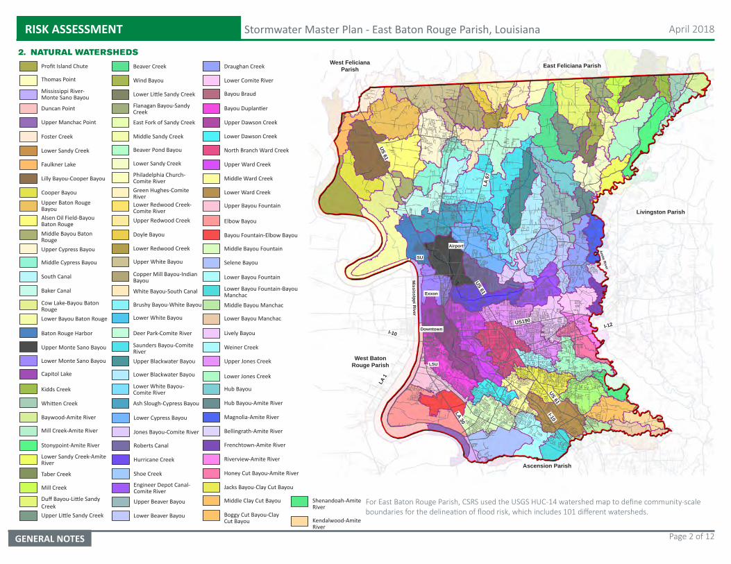
RISK ASSESSMENT Stormwater Master Plan - East Baton Rouge Parish, Louisiana April 2018
GENERAL NOTES Page 2 of 12
2. NATURAL WATERSHEDS
Profit Island Chute
Thomas Point
Mississippi River-Monte Sano Bayou
Duncan Point
Upper Manchac Point
Faulkner Lake
Lilly Bayou-Cooper Bayou
Cooper Bayou
Upper Baton Rouge BayouAlsen Oil Field-Bayou Baton RougeMiddle Bayou Baton RougeUpper Cypress Bayou
Middle Cypress Bayou
South Canal
Baker Canal
Cow Lake-Bayou Baton RougeLower Bayou Baton Rouge
Baton Rouge Harbor
Upper Monte Sano Bayou
Lower Monte Sano Bayou
Capitol Lake
Kidds Creek
Whitten Creek
Baywood-Amite River
Mill Creek-Amite River
Stonypoint-Amite River
Lower Sandy Creek-Amite River
Beaver Creek
Wind Bayou
Lower Little Sandy Creek
Flanagan Bayou-Sandy Creek
East Fork of Sandy Creek
Middle Sandy Creek
Beaver Pond Bayou
Lower Sandy Creek
Philadelphia Church-Comite RiverGreen Hughes-Comite RiverLower Redwood Creek-Comite RiverUpper Redwood Creek
Doyle Bayou
Lower Redwood Creek
Upper White Bayou
Copper Mill Bayou-Indian Bayou
White Bayou-South Canal
Brushy Bayou-White Bayou
Lower White Bayou
Deer Park-Comite River
Saunders Bayou-Comite RiverUpper Blackwater Bayou
Lower Blackwater Bayou
Lower White Bayou-Comite River
Ash Slough-Cypress Bayou
Draughan Creek
Lower Comite River
Bayou Braud
Bayou Duplantier
Upper Dawson Creek
Lower Dawson Creek
North Branch Ward Creek
Upper Ward Creek
Middle Ward Creek
Lower Ward Creek
Upper Bayou Fountain
Elbow Bayou
Bayou Fountain-Elbow Bayou
Middle Bayou Fountain
Selene Bayou
Lower Bayou Fountain
Lower Bayou Fountain-Bayou Manchac
Middle Bayou Manchac
Lower Bayou Manchac
Lively Bayou
Weiner Creek
Foster Creek
Lower Sandy Creek
East Feliciana Parish
Livingston Parish
Ascension Parish
West Baton Rouge Parish
West Feliciana Parish
I-12
I-10
I-10
LSU
SU
US 61
US 61
LA 1
US190
LA 30
LA 6
7
US 61
Mississippi R
iver
Amite River
Downtown
Exxon
Airport
Taber Creek
Mill Creek
Duff Bayou-Little Sandy CreekUpper Little Sandy Creek
Lower Cypress Bayou
Jones Bayou-Comite River
Roberts Canal
Hurricane Creek
Shoe Creek
Engineer Depot Canal-Comite River
Upper Beaver Bayou
Lower Beaver Bayou
Upper Jones Creek
Lower Jones Creek
Hub Bayou
Hub Bayou-Amite River
Magnolia-Amite River
Bellingrath-Amite River
Frenchtown-Amite River
Riverview-Amite River
Honey Cut Bayou-Amite River
Jacks Bayou-Clay Cut Bayou
Middle Clay Cut Bayou
Boggy Cut Bayou-Clay Cut Bayou
Shenandoah-Amite River
Kendalwood-Amite River
For East Baton Rouge Parish, CSRS used the USGS HUC-14 watershed map to define community-scale boundaries for the delineation of flood risk, which includes 101 different watersheds.
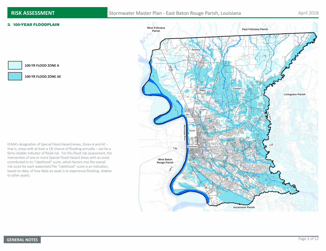
RISK ASSESSMENT Stormwater Master Plan - East Baton Rouge Parish, Louisiana April 2018
GENERAL NOTES Page 3 of 12
3. 100-YEAR FLOODPLAIN
100-YR FLOOD ZONE A
100-YR FLOOD ZONE AE
East Feliciana Parish
Livingston Parish
Ascension Parish
West Baton Rouge Parish
West Feliciana Parish
CentralBaker
Zachary
I-12
I-10
I-10
LSU
SU
US 61
US 61
LA 1
US190
LA 30
LA 6
7
US 61
Mississippi R
iver
Amite River
Downtown
Exxon
Airport
FEMA’s designation of Special Flood Hazard Areas, Zones A and AE – that is, areas with at least a 1% chance of flooding annually – can be a fairly reliable indicator of flood risk. For this flood risk assessment, the intersection of one or more Special Flood Hazard Areas with an asset contributed to its “Likelihood” score, which factors into the overall risk score for each watershed.The “Likelihood” score is an indication, based on data, of how likely an asset is to experience flooding, relative to other assets.
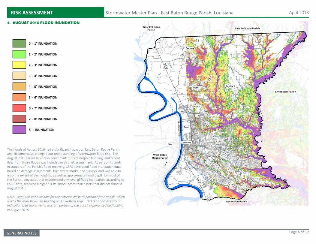
RISK ASSESSMENT Stormwater Master Plan - East Baton Rouge Parish, Louisiana April 2018
GENERAL NOTES Page 4 of 12
4. AUGUST 2016 FLOOD INUNDATION
0’ - 1’ INUNDATION
1’ - 2’ INUNDATION
2’ - 3’ INUNDATION
3’ - 4’ INUNDATION
4’ - 5’ INUNDATION
5’ - 6’ INUNDATION
6’ - 7’ INUNDATION
7’ - 8’ INUNDATION
8’ + INUNDATION
East Feliciana Parish
Livingston Parish
Ascension Parish
West Baton Rouge Parish
West Feliciana Parish
CentralBaker
Zachary
I-12
I-10
I-10
LSU
SU
US 61
US 61
LA 1
US190
LA 30
LA 6
7
US 61
Mississippi R
iver
Amite River
Downtown
Exxon
Airport
The floods of August 2016 had a significant impact on East Baton Rouge Parish and, in some ways, changed our understanding of stormwater flood risk. The August 2016 serves as a fresh benchmark for catastrophic flooding, and recent data from those floods was included in this risk assessment. As part of its work in support of the Parish’s flood recovery, CSRS developed flood inundation data, based on damage assessments, high water marks, and surveys, and was able to map the extent of the flooding, as well as approximate flood depth for most of the Parish. Any asset that experienced any level of flood inundation, according to CSRS’ data, received a higher “Likelihood” score than assets that did not flood in August 2016.
Note: Data was not available for the extreme western portion of the Parish, which is why the map shows no shading on its western edge. This is not necessarily an indication that the extreme western portion of the parish experienced no flooding in August 2016.
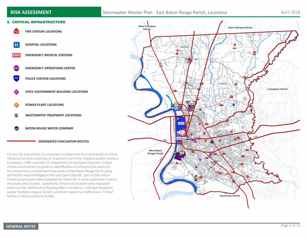
RISK ASSESSMENT Stormwater Master Plan - East Baton Rouge Parish, Louisiana April 2018
GENERAL NOTES Page 5 of 12
5. CRITICAL INFRASTRUCTURE
FD FIRE STATION LOCATIONS
H HOSPITAL LOCATIONS
EMERGENCY MEDICAL STATIONSEMS
EOC EMERGENCY OPERATIONS CENTER
POLICE STATION LOCATIONSPD
G STATE GOVERNMENT BUILDING LOCATIONS
DESIGNATED EVACUATION ROUTES
POWER PLANT LOCATIONS
WASTEWATER TREATMENT LOCATIONS
PO
BATON ROUGE WATER COMPANYBW
WT
East Feliciana Parish
Livingston Parish
Ascension Parish
West Baton Rouge Parish
West Feliciana Parish
CentralBaker
Zachary
I-12
I-10
I-10
LSU
SU
US 61
US 61
LA 1
US190
LA 30
LA 6
7
US 61
Mississippi R
iver
Amite River
Downtown
Exxon
Airport
For any risk assessment, it is important to determine the vulnerability of critical infrastructure that could play an important role in the response and/or recovery to disasters. CSRS used the U.S. Department of Homeland Security’s Critical Infrastructure Sectors to guide its identification of infrastructure assets for this assessment, and tailored those assets to East Baton Rouge Parish using the Parish’s Hazard Mitigation Plan and Open Data BR. Each of the critical infrastructure assets were evaluated for flood risk, in every watershed in which the assets were located. Specifically, infrastructure assets were evaluated based on their likelihood of flooding (Was it located in a 100-year floodplain and/or flooded in August 2016?), and their impact (Is it defined as a “critical” facility or infrastructure by FEMA).
RISK ASSESSMENT Stormwater Master Plan - East Baton Rouge Parish, Louisiana April 2018
GENERAL NOTES Page 6 of 12
6. SOCIAL VULNERABILITY (2006 - 2010)
Low Vulnerability
Low-Medium Vulnerability
Medium Vulnerability
Medium-High Vulnerability
High Vulnerability
East Feliciana Parish
Livingston Parish
Ascension Parish
West Baton Rouge Parish
West Feliciana Parish
I-12
I-10
I-10
LSU
SU
US 61
US 61
LA 1
US190
LA 30
LA 6
7
US 61
Mississippi R
iver
Amite River
Downtown
Exxon
Airport
Social vulnerability refers to the resilience of communities when confronted by external stresses on human health, stresses such as natural or human-cased disasters. Reducing social vulnerability can decrease both human suffering and economic loss. For this risk assessment, CSRS used the U.S. Center for Disease Control’s Social Vulnerability Index (SoVI), which uses U.S. census variables at tract level to help local officials identify communities that may need support in preparing for hazards, or recovery from disasters.
SVI data was aggregated by HUC-14 watershed, and a social vulnerability score was calculated for each watershed, based on the SoVI’s determination of “Low”, “Medium” (which includes Low-Medium, Medium, and Medium-High) or “High” vulnerability. The social vulnerability score was then added to other asset risk scores, so that the presence of vulnerable populations in a watershed would contribute to a higher overall risk score.
RISK ASSESSMENT Stormwater Master Plan - East Baton Rouge Parish, Louisiana April 2018
GENERAL NOTES Page 7 of 12
7. RISK ASSESSMENT SUMMARY
Low Risk
Medium Risk
High Risk
East Feliciana Parish
Livingston Parish
Ascension Parish
West Baton Rouge Parish
West Feliciana Parish
CentralBaker
Zachary
I-12
I-10
I-10
LSU
SU
US 61
US 61
LA 1
US190
LA 30
LA 6
7
US 61
Mississippi R
iver
Amite River
Downtown
Exxon
Airport
Based on the location and vulnerability of critical assets, as well as the presence and concentration of structures that flooded in August 2016, each of the 101 HUC-14 watersheds in East Baton Rouge Parish were assigned a risk score. Knowing the vulnerability of the watersheds relative to flooding can help guide disaster planning and investments in flood risk reduction in the Parish.
A large portion of the Parish, bounded roughly by the Mississippi River and Interstate 110 to the west, the airport and Greenwell Springs Road to the north, the Amite River to the east, and Dawson Creek to the south, represents the “core” of the Parish at greatest risk. The area just north of downtown Baton Rouge, and those surrounding the communities of Baker, Central and Zachary, make up the “medium risk” zones. The northern and southwestern edges of the Parish largely represent the “low risk” zones.
Generally, those watersheds within East Baton Rouge Parish that are more urbanized and house a higher density of assets present a higher level of risk due to flooding than outlying areas that are less developed.
RISK ASSESSMENT Stormwater Master Plan - East Baton Rouge Parish, Louisiana April 2018
GENERAL NOTES Page 8 of 12
8. AUGUST 2016 FLOOD - FLOODED STRUCTURES
FLOODED STRUCTURES
FLOODED ROADWAYS
East Feliciana Parish
Livingston Parish
Ascension Parish
West Baton Rouge Parish
West Feliciana Parish
CentralBaker
Zachary
Baton Rouge
I-12
I-10
I-10
LSU
SU
US 61
US 61
LA 1
US190
LA 30
LA 6
7
US 61
Mississippi R
iver
Amite River
Downtown
Exxon
Airport
Structures and roadways that experienced any level of flooding in August 2016 were also aggregated by watershed. Those watersheds with the highest numbers of flooded structures and the highest concentration (by percentage) of flooded structures received the highest “flood scores” in this assessment. The process helps indicate those watersheds in which the greatest number of structures are at risk.
RISK ASSESSMENT Stormwater Master Plan - East Baton Rouge Parish, Louisiana April 2018
GENERAL NOTES Page 9 of 12
9. AUGUST 2016 FLOOD - FLOODED STRUCTURES WITH INUNDATION
FLOODED STRUCTURES
FLOODED ROADWAYS
East Feliciana Parish
Livingston Parish
Ascension Parish
West Baton Rouge Parish
West Feliciana Parish
CentralBaker
Zachary
Baton Rouge
I-12
I-10
I-10
LSU
SU
US 61
US 61
LA 1
US190
LA 30
LA 6
7
US 61
Mississippi R
iver
Amite River
Downtown
Exxon
Airport
Understanding the extent and depths of the flooding in August 2016, as well as the locations of structures that flooded during that event, helps to understand where the greatest impacts of the flooding were felt, relative to the built environment. Those watersheds that had housed critical assets and experienced flooding in 2016, including a high concentration of flooded structures, scored highest, in terms of flood risk in this assessment, especially if social vulnerability in those watersheds was higher.
0’ - 1’ INUNDATION
1’ - 2’ INUNDATION
2’ - 3’ INUNDATION
3’ - 4’ INUNDATION
4’ - 5’ INUNDATION
5’ - 6’ INUNDATION
6’ - 7’ INUNDATION
7’ - 8’ INUNDATION
8’ + INUNDATION
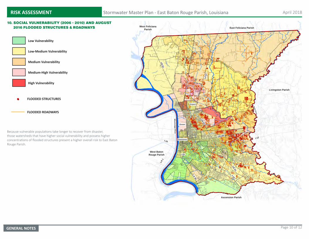
RISK ASSESSMENT Stormwater Master Plan - East Baton Rouge Parish, Louisiana April 2018
GENERAL NOTES Page 10 of 12
10. SOCIAL VULNERABILITY (2006 - 2010) AND AUGUST 2016 FLOODED STRUCTURES & ROADWAYS
Low Vulnerability
Low-Medium Vulnerability
Medium Vulnerability
Medium-High Vulnerability
High Vulnerability
East Feliciana Parish
Livingston Parish
Ascension Parish
West Baton Rouge Parish
West Feliciana Parish
I-12
I-10
I-10
LSU
SU
US 61
US 61
LA 1
US190
LA 30
LA 6
7
US 61
Mississippi R
iver
Amite River
Downtown
Exxon
Airport
FLOODED STRUCTURES
FLOODED ROADWAYS
Because vulnerable populations take longer to recover from disaster, those watersheds that have higher social vulnerability and possess higher concentrations of flooded structures present a higher overall risk to East Baton Rouge Parish.
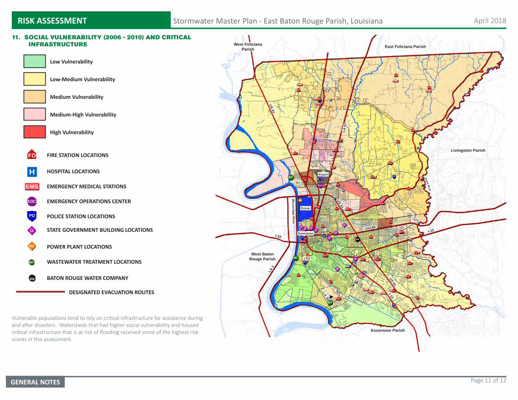
RISK ASSESSMENT Stormwater Master Plan - East Baton Rouge Parish, Louisiana April 2018
GENERAL NOTES Page 11 of 12
11. SOCIAL VULNERABILITY (2006 - 2010) AND CRITICAL INFRASTRUCTURE
Low Vulnerability
Low-Medium Vulnerability
Medium Vulnerability
Medium-High Vulnerability
High Vulnerability
East Feliciana Parish
Livingston Parish
Ascension Parish
West Baton Rouge Parish
West Feliciana Parish
I-12
I-10
I-10
LSU
SU
US 61
US 61
LA 1
US190
LA 30
LA 6
7
US 61
Mississippi R
iver
Amite River
Downtown
Exxon
Airport
FD FIRE STATION LOCATIONS
H HOSPITAL LOCATIONS
EMERGENCY MEDICAL STATIONSEMS
EOC EMERGENCY OPERATIONS CENTER
POLICE STATION LOCATIONSPD
G STATE GOVERNMENT BUILDING LOCATIONS
DESIGNATED EVACUATION ROUTES
POWER PLANT LOCATIONS
WASTEWATER TREATMENT LOCATIONS
PO
BATON ROUGE WATER COMPANYBW
WT
Vulnerable populations tend to rely on critical infrastructure for assistance during and after disasters. Watersheds that had higher social vulnerability and housed critical infrastructure that is at risk of flooding received some of the highest risk scores in this assessment.
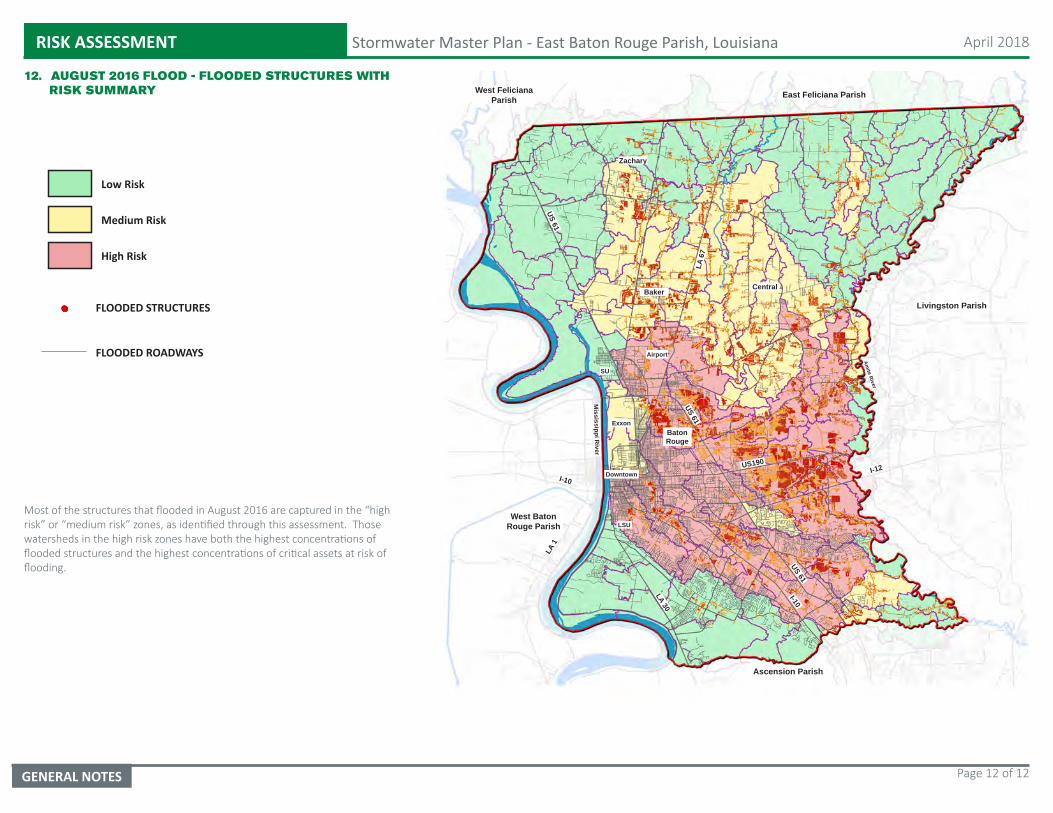
RISK ASSESSMENT Stormwater Master Plan - East Baton Rouge Parish, Louisiana April 2018
GENERAL NOTES Page 12 of 12
Most of the structures that flooded in August 2016 are captured in the “high risk” or “medium risk” zones, as identified through this assessment. Those watersheds in the high risk zones have both the highest concentrations of flooded structures and the highest concentrations of critical assets at risk of flooding.
12. AUGUST 2016 FLOOD - FLOODED STRUCTURES WITH RISK SUMMARY
FLOODED STRUCTURES
FLOODED ROADWAYS
East Feliciana Parish
Livingston Parish
Ascension Parish
West Baton Rouge Parish
West Feliciana Parish
CentralBaker
Zachary
Baton Rouge
I-12
I-10
I-10
LSU
SU
US 61
US 61
LA 1
US190
LA 30
LA 6
7
US 61
Mississippi R
iver
Amite River
Downtown
Exxon
Airport
Low Risk
Medium Risk
High Risk

East Baton Rouge Parish Stormwater Master Plan – Draft Implementation Framework
Appendix C – Preliminary Modeling
East Baton Rouge City-Parish Department of Public Works Page 2 of 44
Phase I Regional, Conceptual-Level Model Development
TABLE OF CONTENTS
1 Introduction....................................................................................................................................... 3
2 Regional, Conceptual-Level Model .............................................................................................4
2.1 Spatial Input Datasets...............................................................................................................................5
2.1.1 Topography ...........................................................................................................................................5
2.1.2 Channel Bed Elevations....................................................................................................................6
2.1.3 Precipitation..........................................................................................................................................7
2.1.4 Rainfall Runoff Parameters..........................................................................................................11
2.1.5 Roughness ...........................................................................................................................................15
3 Hydrology Model Development ................................................................................................17
3.1 Model Setup................................................................................................................................................17
3.1.1 Upper Amite River ...........................................................................................................................17
3.1.2 Comite River .......................................................................................................................................19
3.1.3 Other Creeks and Bayous..............................................................................................................21
3.2 Preliminary Calibration ........................................................................................................................23
3.2.1 Upper Amite River ...........................................................................................................................23
3.2.2 Comite River .......................................................................................................................................25
4 Hydraulic Model Development .................................................................................................27
4.1 Model Geometry.......................................................................................................................................27
4.1.1 Features and Structures ................................................................................................................27
4.2 Boundary Conditions .............................................................................................................................28
4.2.1 Upland Discharge .............................................................................................................................28
4.2.2 Water Level .........................................................................................................................................29
4.2.3 Open Boundaries ..............................................................................................................................30
4.3 Preliminary Calibration ........................................................................................................................31
4.3.1 March 2016 Flood Event Water Level Comparisons ........................................................33
4.3.2 August 2016 Flood Event Water Level Comparisons .......................................................38
4.3.3 High Water Mark Comparisons..................................................................................................43
5 Conclusions...................................................................................................................................... 44
East Baton Rouge City-Parish Department of Public Works Page 3 of 44
Phase I Regional, Conceptual-Level Model Development
1 INTRODUCTION
Widespread flooding during the August 2016 Flood Event exposed the need to address
flooding on a local and regional basis working with Ascension, Iberville, St. James, and
Livingston Parishes to review flooding along the Comite River, lower Amite River and Bayou
Manchac. The City of Baton Rouge and Parish of East Baton Rouge (EBR) selected the HNTB
Corporation (HNTB) team to assist in the development of a Parish Stormwater Master Plan
(SMP). To develop this SMP, the Parish adopted a phased approach. Phase 1 of the project
was focused on developing critical capital projects within the Parish that qualify for the
FEMA Hazard Mitigation Grant Program (HMGP) allocations the Parish will receive for the
August 2016 Flood Event. A regional, conceptual-level model was developed to:
help the team better understand the hydraulic system of rivers, bayous and canals;
help identify (from a macro level) problem areas and potential projects;
simulate and develop proposed solutions to the macro problems; and
provide a foundation for the development of the future, more detailed models for the
next phase of the Stormwater Master Plan.
HNTB requested Natural Resource Professionals, LLC (NRP) to assist in developing the
conceptual-level model. NRP developed the hydrology and 2-Dimensional (2-D) hydraulic
models using the Hydrologic Engineering Center’s Hydrologic Modeling System (HEC-HMS)
and River Analysis System (HEC-RAS), respectively. HNTB utilized this 2-D hydraulic model
to determine potential project locations and simulate proposed solutions for HMGP projects.
The following sections describe the models’ development.
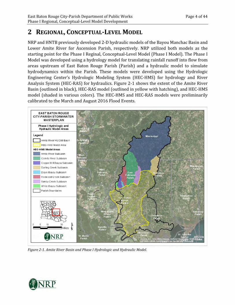
East Baton Rouge City-Parish Department of Public Works Page 4 of 44
Phase I Regional, Conceptual-Level Model Development
2 REGIONAL, CONCEPTUAL-LEVEL MODEL
NRP and HNTB previously developed 2-D hydraulic models of the Bayou Manchac Basin and
Lower Amite River for Ascension Parish, respectively. NRP utilized both models as the
starting point for the Phase I Reginal, Conceptual-Level Model (Phase I Model). The Phase I
Model was developed using a hydrology model for translating rainfall runoff into flow from
areas upstream of East Baton Rouge Parish (Parish) and a hydraulic model to simulate
hydrodynamics within the Parish. These models were developed using the Hydrologic
Engineering Center’s Hydrologic Modeling System (HEC-HMS) for hydrology and River
Analysis System (HEC-RAS) for hydraulics. Figure 2-1 shows the extent of the Amite River
Basin (outlined in black), HEC-RAS model (outlined in yellow with hatching), and HEC-HMS
model (shaded in various colors). The HEC-HMS and HEC-RAS models were preliminarily
calibrated to the March and August 2016 Flood Events.
Figure 2-1. Amite River Basin and Phase I Hydrologic and Hydraulic Model.
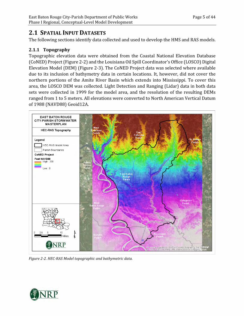
East Baton Rouge City-Parish Department of Public Works Page 5 of 44
Phase I Regional, Conceptual-Level Model Development
2.1 SPATIAL INPUT DATASETS
The following sections identify data collected and used to develop the HMS and RAS models.
2.1.1 Topography
Topographic elevation data were obtained from the Coastal National Elevation Database
(CoNED) Project (Figure 2-2) and the Louisiana Oil Spill Coordinator's Office (LOSCO) Digital
Elevation Model (DEM) (Figure 2-3). The CoNED Project data was selected where available
due to its inclusion of bathymetry data in certain locations. It, however, did not cover the
northern portions of the Amite River Basin which extends into Mississippi. To cover this
area, the LOSCO DEM was collected. Light Detection and Ranging (Lidar) data in both data
sets were collected in 1999 for the model area, and the resolution of the resulting DEMs
ranged from 1 to 5 meters. All elevations were converted to North American Vertical Datum
of 1988 (NAVD88) Geoid12A.
Figure 2-2. HEC-RAS Model topographic and bathymetric data.
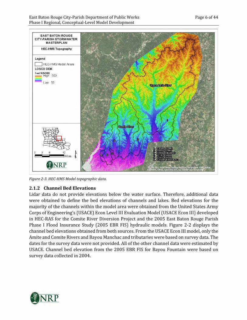
East Baton Rouge City-Parish Department of Public Works Page 6 of 44
Phase I Regional, Conceptual-Level Model Development
Figure 2-3. HEC-HMS Model topographic data.
2.1.2 Channel Bed Elevations
Lidar data do not provide elevations below the water surface. Therefore, additional data
were obtained to define the bed elevations of channels and lakes. Bed elevations for the
majority of the channels within the model area were obtained from the United States Army
Corps of Engineering’s (USACE) Econ Level III Evaluation Model (USACE Econ III) developed
in HEC-RAS for the Comite River Diversion Project and the 2005 East Baton Rouge Parish
Phase I Flood Insurance Study (2005 EBR FIS) hydraulic models. Figure 2-2 displays the
channel bed elevations obtained from both sources. From the USACE Econ III model, only the
Amite and Comite Rivers and Bayou Manchac and tributaries were based on survey data. The
dates for the survey data were not provided. All of the other channel data were estimated by
USACE. Channel bed elevation from the 2005 EBR FIS for Bayou Fountain were based on
survey data collected in 2004.
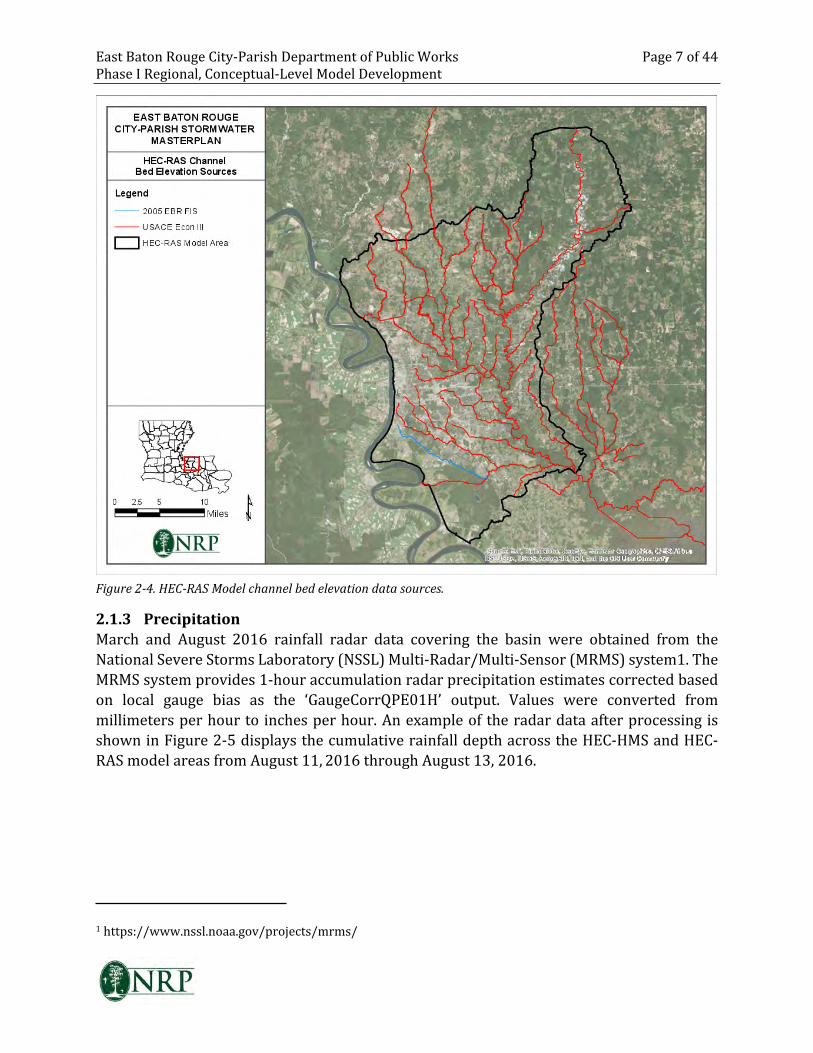
East Baton Rouge City-Parish Department of Public Works Page 7 of 44
Phase I Regional, Conceptual-Level Model Development
Figure 2-4. HEC-RAS Model channel bed elevation data sources.
2.1.3 Precipitation
March and August 2016 rainfall radar data covering the basin were obtained from the
National Severe Storms Laboratory (NSSL) Multi-Radar/Multi-Sensor (MRMS) system1. The
MRMS system provides 1-hour accumulation radar precipitation estimates corrected based
on local gauge bias as the ‘GaugeCorrQPE01H’ output. Values were converted from
millimeters per hour to inches per hour. An example of the radar data after processing is
shown in Figure 2-5 displays the cumulative rainfall depth across the HEC-HMS and HEC-
RAS model areas from August 11, 2016 through August 13, 2016.
1 https://www.nssl.noaa.gov/projects/mrms/
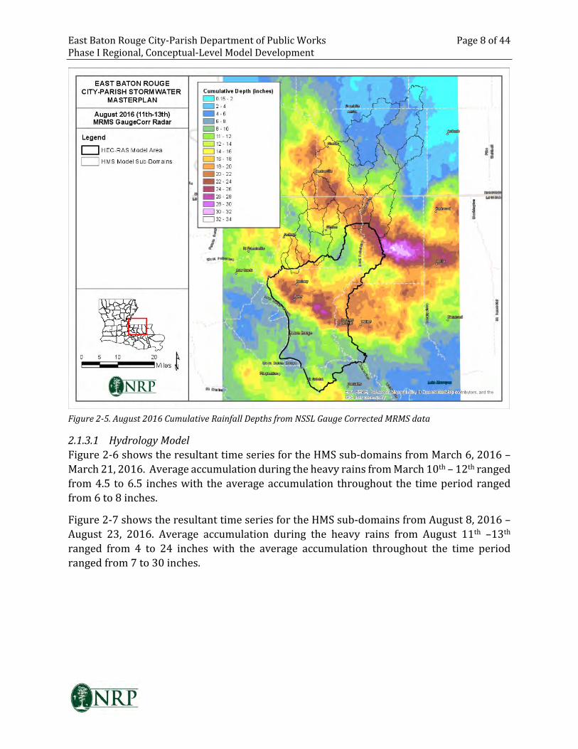
East Baton Rouge City-Parish Department of Public Works Page 8 of 44
Phase I Regional, Conceptual-Level Model Development
Figure 2-5. August 2016 Cumulative Rainfall Depths from NSSL Gauge Corrected MRMS data
2.1.3.1 Hydrology Model
Figure 2-6 shows the resultant time series for the HMS sub-domains from March 6, 2016 –
March 21, 2016. Average accumulation during the heavy rains from March 10th – 12th ranged
from 4.5 to 6.5 inches with the average accumulation throughout the time period ranged
from 6 to 8 inches.
Figure 2-7 shows the resultant time series for the HMS sub-domains from August 8, 2016 –
August 23, 2016. Average accumulation during the heavy rains from August 11th –13th
ranged from 4 to 24 inches with the average accumulation throughout the time period
ranged from 7 to 30 inches.
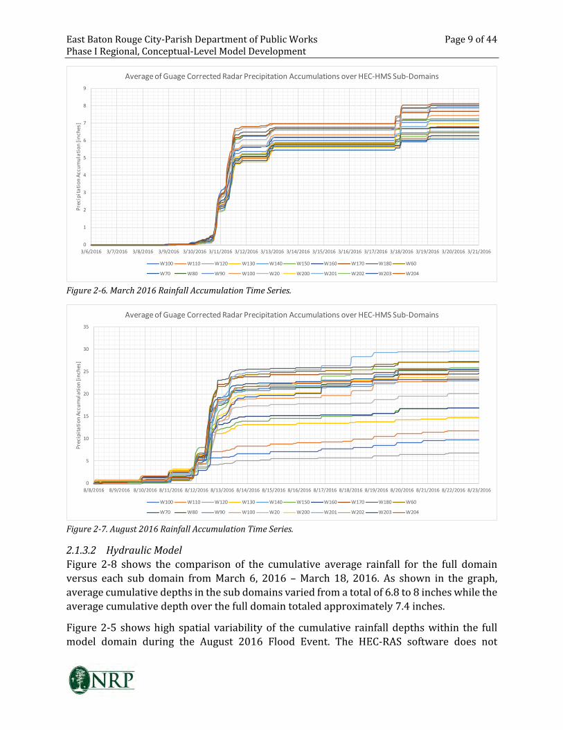
East Baton Rouge City-Parish Department of Public Works Page 9 of 44
Phase I Regional, Conceptual-Level Model Development
0
1
2
3
4
5
6
7
8
9
3/6/2016 3/7/2016 3/8/2016 3/9/2016 3/10/2016 3/11/2016 3/12/2016 3/13/2016 3/14/2016 3/15/2016 3/16/2016 3/17/2016 3/18/2016 3/19/2016 3/20/2016 3/21/2016
Pre
cip
ita
tio
n A
cc
um
ula
tio
n [
inc
he
s]
Average of Guage Corrected Radar Precipitation Accumulations over HEC-HMS Sub-Domains
W100 W110 W120 W130 W140 W150 W160 W170 W180 W60
W70 W80 W90 W100 W20 W200 W201 W202 W203 W204
Figure 2-6. March 2016 Rainfall Accumulation Time Series.
0
5
10
15
20
25
30
35
8/8/2016 8/9/2016 8/10/2016 8/11/2016 8/12/2016 8/13/2016 8/14/2016 8/15/2016 8/16/2016 8/17/2016 8/18/2016 8/19/2016 8/20/2016 8/21/2016 8/22/2016 8/23/2016
Pre
cip
ita
tio
n A
cc
um
ula
tio
n [
inc
he
s]
Average of Guage Corrected Radar Precipitation Accumulations over HEC-HMS Sub-Domains
W100 W110 W120 W130 W140 W150 W160 W170 W180 W60
W70 W80 W90 W100 W20 W200 W201 W202 W203 W204
Figure 2-7. August 2016 Rainfall Accumulation Time Series.
2.1.3.2 Hydraulic Model
Figure 2-8 shows the comparison of the cumulative average rainfall for the full domain
versus each sub domain from March 6, 2016 – March 18, 2016. As shown in the graph,
average cumulative depths in the sub domains varied from a total of 6.8 to 8 inches while the
average cumulative depth over the full domain totaled approximately 7.4 inches.
Figure 2-5 shows high spatial variability of the cumulative rainfall depths within the full
model domain during the August 2016 Flood Event. The HEC-RAS software does not
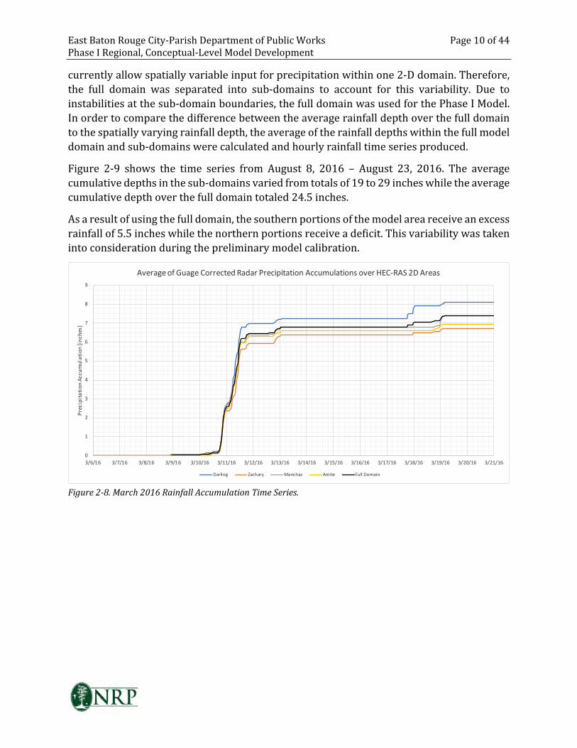
East Baton Rouge City-Parish Department of Public Works Page 10 of 44
Phase I Regional, Conceptual-Level Model Development
currently allow spatially variable input for precipitation within one 2-D domain. Therefore,
the full domain was separated into sub-domains to account for this variability. Due to
instabilities at the sub-domain boundaries, the full domain was used for the Phase I Model.
In order to compare the difference between the average rainfall depth over the full domain
to the spatially varying rainfall depth, the average of the rainfall depths within the full model
domain and sub-domains were calculated and hourly rainfall time series produced.
Figure 2-9 shows the time series from August 8, 2016 – August 23, 2016. The average
cumulative depths in the sub-domains varied from totals of 19 to 29 inches while the average
cumulative depth over the full domain totaled 24.5 inches.
As a result of using the full domain, the southern portions of the model area receive an excess
rainfall of 5.5 inches while the northern portions receive a deficit. This variability was taken
into consideration during the preliminary model calibration.
0
1
2
3
4
5
6
7
8
9
3/6/16 3/7/16 3/8/16 3/9/16 3/10/16 3/11/16 3/12/16 3/13/16 3/14/16 3/15/16 3/16/16 3/17/16 3/18/16 3/19/16 3/20/16 3/21/16
Pre
cip
ita
tio
n A
cc
um
ula
tio
n [
inc
he
s]
Average of Guage Corrected Radar Precipitation Accumulations over HEC-RAS 2D Areas
Darling Zachary Manchac Amite Full Domain
Figure 2-8. March 2016 Rainfall Accumulation Time Series.
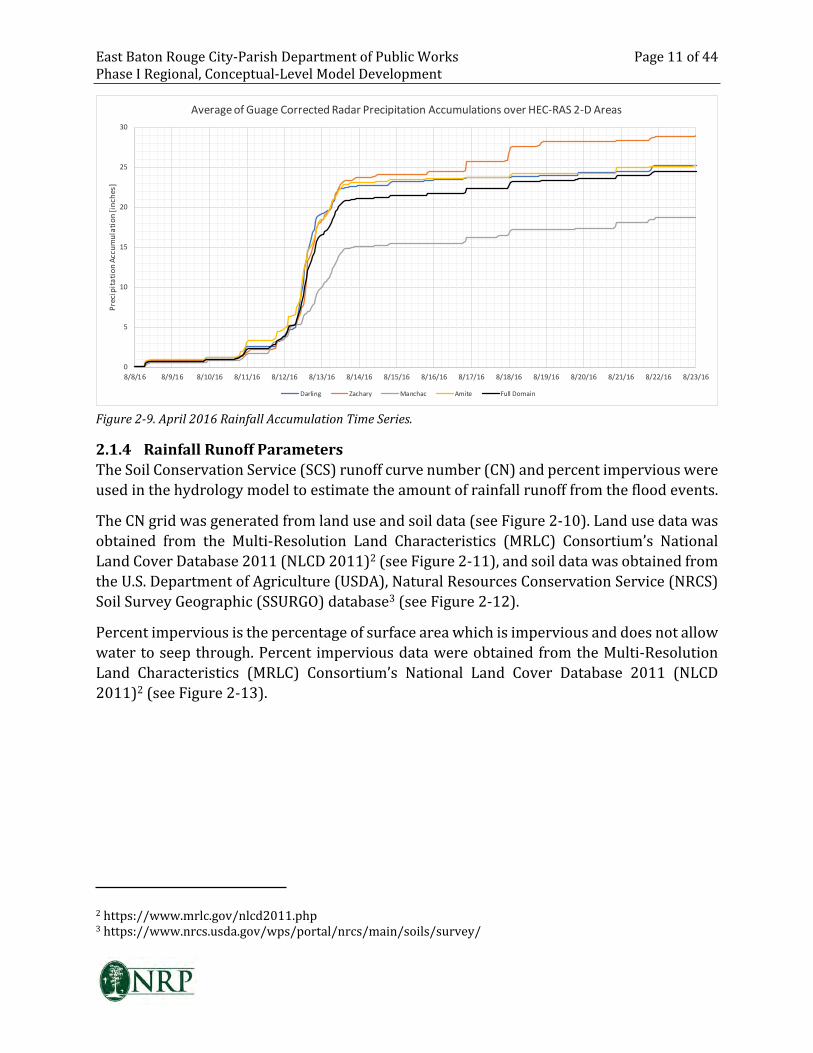
East Baton Rouge City-Parish Department of Public Works Page 11 of 44
Phase I Regional, Conceptual-Level Model Development
0
5
10
15
20
25
30
8/8/16 8/9/16 8/10/16 8/11/16 8/12/16 8/13/16 8/14/16 8/15/16 8/16/16 8/17/16 8/18/16 8/19/16 8/20/16 8/21/16 8/22/16 8/23/16
Pre
cip
ita
tio
n A
cc
um
ula
tio
n [
inc
he
s]
Average of Guage Corrected Radar Precipitation Accumulations over HEC-RAS 2-D Areas
Darling Zachary Manchac Amite Full Domain
Figure 2-9. April 2016 Rainfall Accumulation Time Series.
2.1.4 Rainfall Runoff Parameters
The Soil Conservation Service (SCS) runoff curve number (CN) and percent impervious were
used in the hydrology model to estimate the amount of rainfall runoff from the flood events.
The CN grid was generated from land use and soil data (see Figure 2-10). Land use data was
obtained from the Multi-Resolution Land Characteristics (MRLC) Consortium’s National
Land Cover Database 2011 (NLCD 2011)2 (see Figure 2-11), and soil data was obtained from
the U.S. Department of Agriculture (USDA), Natural Resources Conservation Service (NRCS)
Soil Survey Geographic (SSURGO) database3 (see Figure 2-12).
Percent impervious is the percentage of surface area which is impervious and does not allow
water to seep through. Percent impervious data were obtained from the Multi-Resolution
Land Characteristics (MRLC) Consortium’s National Land Cover Database 2011 (NLCD
2011)2 (see Figure 2-13).
2 https://www.mrlc.gov/nlcd2011.php3 https://www.nrcs.usda.gov/wps/portal/nrcs/main/soils/survey/
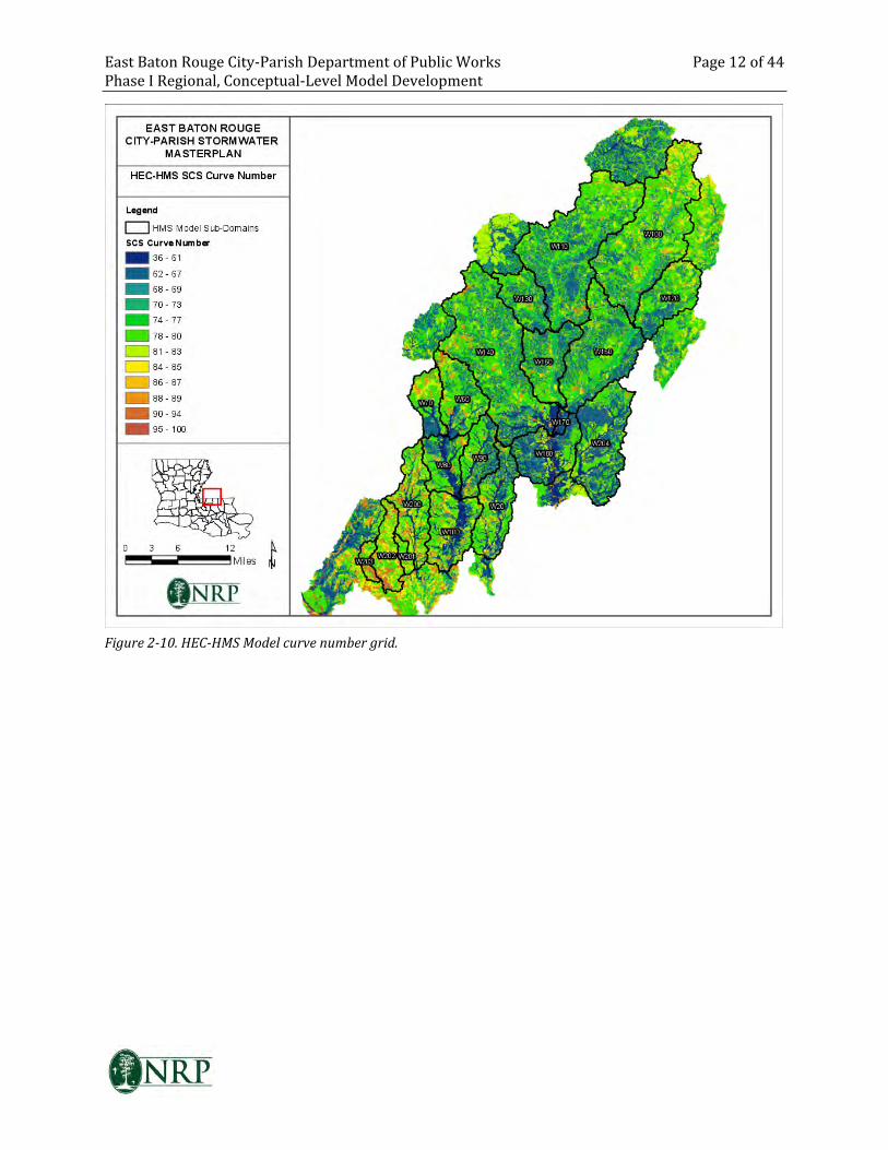
East Baton Rouge City-Parish Department of Public Works Page 12 of 44
Phase I Regional, Conceptual-Level Model Development
Figure 2-10. HEC-HMS Model curve number grid.
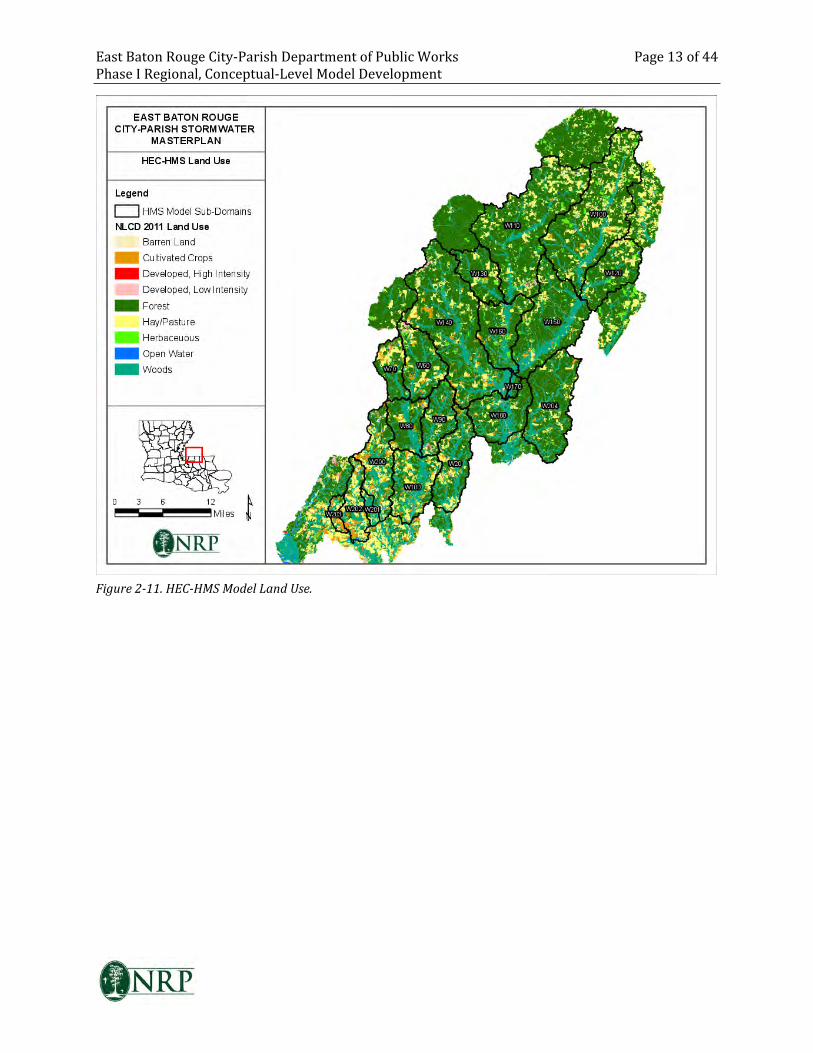
East Baton Rouge City-Parish Department of Public Works Page 13 of 44
Phase I Regional, Conceptual-Level Model Development
Figure 2-11. HEC-HMS Model Land Use.
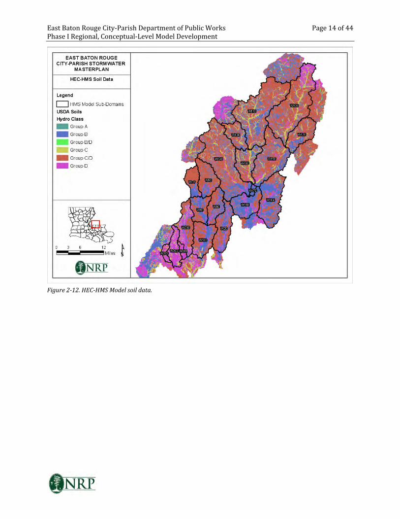
East Baton Rouge City-Parish Department of Public Works Page 14 of 44
Phase I Regional, Conceptual-Level Model Development
Figure 2-12. HEC-HMS Model soil data.
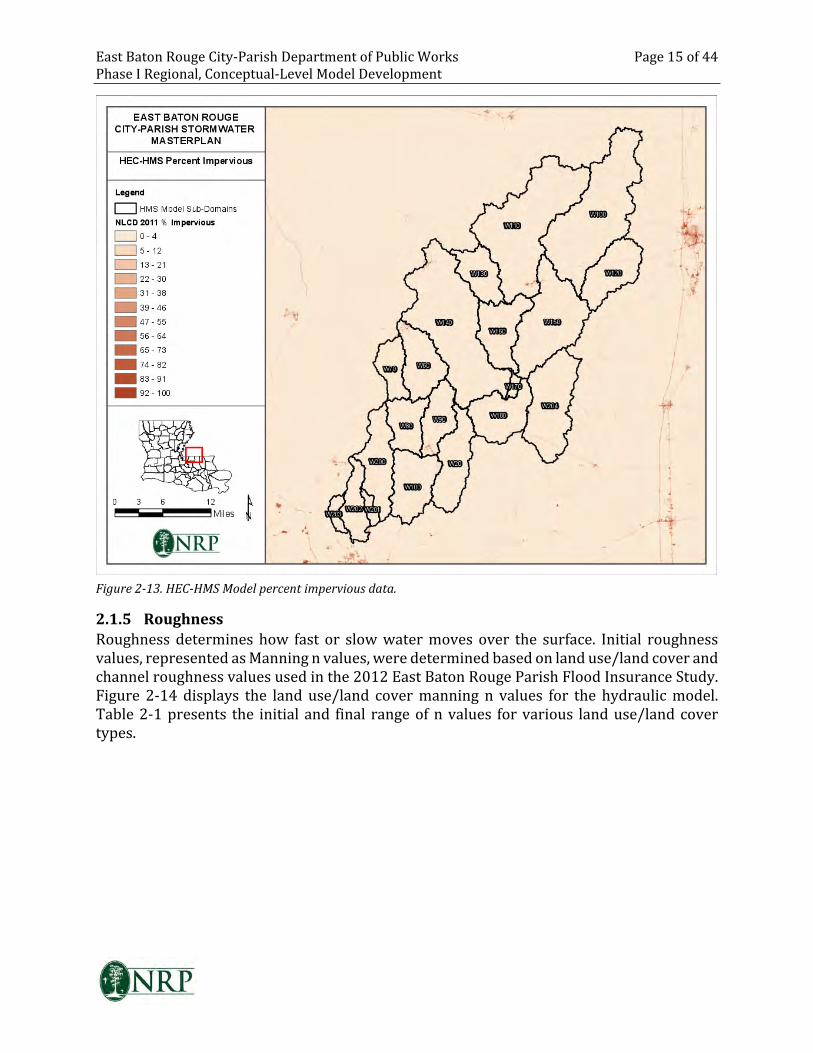
East Baton Rouge City-Parish Department of Public Works Page 15 of 44
Phase I Regional, Conceptual-Level Model Development
Figure 2-13. HEC-HMS Model percent impervious data.
2.1.5 Roughness
Roughness determines how fast or slow water moves over the surface. Initial roughness
values, represented as Manning n values, were determined based on land use/land cover and
channel roughness values used in the 2012 East Baton Rouge Parish Flood Insurance Study.
Figure 2-14 displays the land use/land cover manning n values for the hydraulic model.
Table 2-1 presents the initial and final range of n values for various land use/land cover
types.
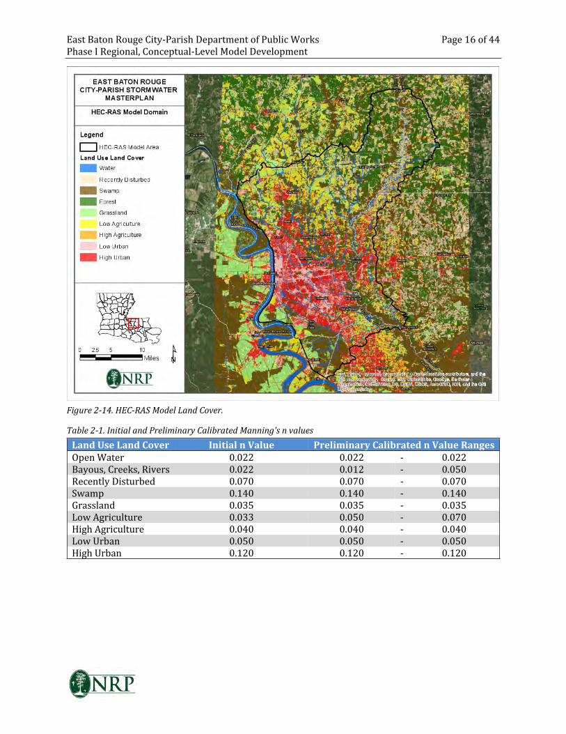
East Baton Rouge City-Parish Department of Public Works Page 16 of 44
Phase I Regional, Conceptual-Level Model Development
Figure 2-14. HEC-RAS Model Land Cover.
Table 2-1. Initial and Preliminary Calibrated Manning's n values
Land Use Land Cover Initial n Value Preliminary Calibrated n Value Ranges
Open Water 0.022 0.022 - 0.022
Bayous, Creeks, Rivers 0.022 0.012 - 0.050
Recently Disturbed 0.070 0.070 - 0.070
Swamp 0.140 0.140 - 0.140
Grassland 0.035 0.035 - 0.035
Low Agriculture 0.033 0.050 - 0.070
High Agriculture 0.040 0.040 - 0.040
Low Urban 0.050 0.050 - 0.050
High Urban 0.120 0.120 - 0.120
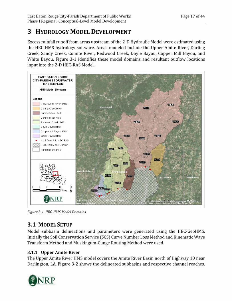
East Baton Rouge City-Parish Department of Public Works Page 17 of 44
Phase I Regional, Conceptual-Level Model Development
3 HYDROLOGY MODEL DEVELOPMENT
Excess rainfall runoff from areas upstream of the 2-D Hydraulic Model were estimated using
the HEC-HMS hydrology software. Areas modeled include the Upper Amite River, Darling
Creek, Sandy Creek, Comite River, Redwood Creek, Doyle Bayou, Copper Mill Bayou, and
White Bayou. Figure 3-1 identifies these model domains and resultant outflow locations
input into the 2-D HEC-RAS Model.
Figure 3-1. HEC-HMS Model Domains
3.1 MODEL SETUP
Model subbasin delineations and parameters were generated using the HEC-GeoHMS.
Initially the Soil Conservation Service (SCS) Curve Number Loss Method and Kinematic Wave
Transform Method and Muskingum-Cunge Routing Method were used.
3.1.1 Upper Amite River
The Upper Amite River HMS model covers the Amite River Basin north of Highway 10 near
Darlington, LA. Figure 3-2 shows the delineated subbasins and respective channel reaches.
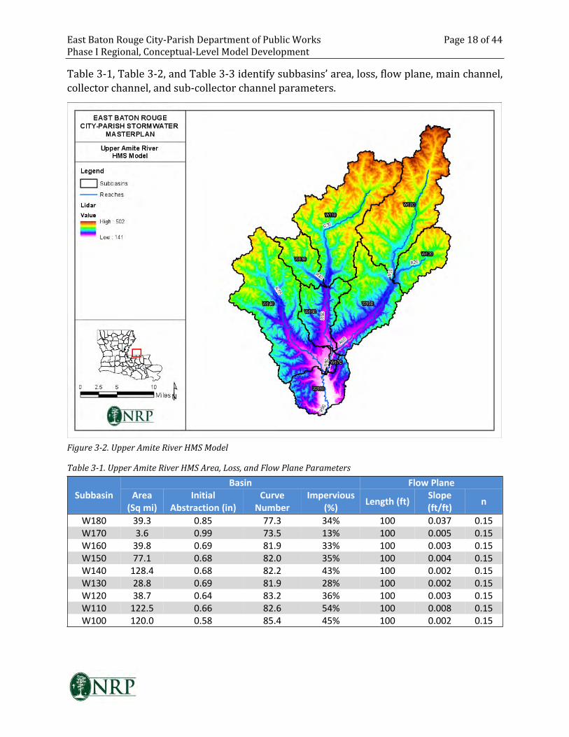
East Baton Rouge City-Parish Department of Public Works Page 18 of 44
Phase I Regional, Conceptual-Level Model Development
Table 3-1, Table 3-2, and Table 3-3 identify subbasins’ area, loss, flow plane, main channel,
collector channel, and sub-collector channel parameters.
Figure 3-2. Upper Amite River HMS Model
Table 3-1. Upper Amite River HMS Area, Loss, and Flow Plane Parameters
Basin Flow Plane
Subbasin Area
(Sq mi)
Initial
Abstraction (in)
Curve
Number
Impervious
(%)Length (ft)
Slope
(ft/ft)n
W180 39.3 0.85 77.3 34% 100 0.037 0.15
W170 3.6 0.99 73.5 13% 100 0.005 0.15
W160 39.8 0.69 81.9 33% 100 0.003 0.15
W150 77.1 0.68 82.0 35% 100 0.004 0.15
W140 128.4 0.68 82.2 43% 100 0.002 0.15
W130 28.8 0.69 81.9 28% 100 0.002 0.15
W120 38.7 0.64 83.2 36% 100 0.003 0.15
W110 122.5 0.66 82.6 54% 100 0.008 0.15
W100 120.0 0.58 85.4 45% 100 0.002 0.15
East Baton Rouge City-Parish Department of Public Works Page 19 of 44
Phase I Regional, Conceptual-Level Model Development
Table 3-2. Upper Amite River HMS Main Channel and Reach Parameters
Subbasin
/ Reach
Route
Method
Length
(ft)
Slope
(ft/ft)Shape n
LB n /
Width
(ft)
RB n /
Side
Slope
(xH:1V)
X-Sec
W180 Musk-Cunge 27,906 0.001 Eight Point 0.08 0.1 0.1 Amite_R90
W170 Musk-Cunge 21,116 0.001 Eight Point 0.08 0.1 0.1 Amite_R80
W160 Musk-Cunge 69,067 0.001 Eight Point 0.08 0.1 0.1 Amite_R50
W150 Musk-Cunge 96,034 0.001 Eight Point 0.08 0.1 0.1 Amite_R60
W140 Musk-Cunge 140,625 0.001 Eight Point 0.08 0.1 0.1 Amite_W140
W130 Musk-Cunge 27,629 0.001 Trapezoid 0.06 1000 36 --
W120 Musk-Cunge 45,823 0.001 Trapezoid 0.06 1000 200 --
W110 Musk-Cunge 133,301 0.001 Trapezoid 0.06 2000 42 --
W100 Musk-Cunge 135,547 0.001 Trapezoid 0.06 2500 200 --
R50 Musk-Cunge 81,310 0.0008 Eight Point 0.06 0.08 0.08 Amite_R50
R60 Musk-Cunge 99,027 0.0008 Eight Point 0.06 0.08 0.08 Amite_R60
R80 Musk-Cunge 24,534 0.0007 Eight Point 0.06 0.08 0.08 Amite_R80
R90 Musk-Cunge 45,710 0.0007 Eight Point 0.06 0.08 0.08 Amite_R90
Table 3-3. Upper Amite River HMS SubCollector and Collector Channel Parameters
Subbasin CollectorLength
(ft)
Slope
(ft/ft)n
Area
(Sqmi)Shape
Width
(ft)
Side Slope
(xH:1V)
W180 Sub 3,000 0.004 0.08 0.1 Trapezoid 50 1
W180 Collector 39,189 0.004 0.08 4.8 Trapezoid 800 10
W170 Sub 3,000 0.002 0.08 0.1 Trapezoid 50 1
W170 Collector 13,437 0.002 0.08 0.4 Trapezoid 100 10
W160 Sub 3,000 0.005 0.08 0.7 Triangle -- 20
W160 Collector 29,839 0.005 0.08 4.6 Triangle -- 20
W150 Sub 3,000 0.003 0.08 1.0 Trapezoid 250 1
W150 Collector 66,477 0.003 0.08 7.5 Trapezoid 500 30
W140 Sub 3,000 0.003 0.08 0.7 Triangle -- 20
W140 Collector 50,342 0.003 0.08 7.1 Trapezoid 500 20
W130 Sub 3,000 0.003 0.08 0.2 Triangle -- 20
W130 Collector 46,960 0.003 0.08 2.5 Triangle -- 20
W120 Sub 3,000 0.004 0.08 0.2 Triangle -- 20
W120 Collector 32,929 0.004 0.08 3.0 Triangle -- 20
W110 Sub 3,000 0.002 0.08 1.5 Triangle -- 20
W110 Collector 46,972 0.002 0.08 10.0 Triangle -- 20
W100 Sub 3,000 0.002 0.08 1.8 Triangle -- 1000
W100 Collector 53,019 0.002 0.08 7.5 Triangle -- 1000
3.1.2 Comite River
The Comite River HMS model covers the Comite River Basin north of Highway 67 near Olive
Branch, LA. Figure 3-3 shows the delineated subbasins and respective channel reaches. Table
3-4,
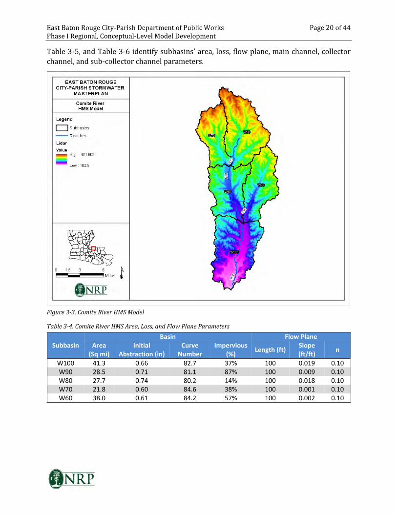
East Baton Rouge City-Parish Department of Public Works Page 20 of 44
Phase I Regional, Conceptual-Level Model Development
Table 3-5, and Table 3-6 identify subbasins’ area, loss, flow plane, main channel, collector
channel, and sub-collector channel parameters.
Figure 3-3. Comite River HMS Model
Table 3-4. Comite River HMS Area, Loss, and Flow Plane Parameters
Basin Flow Plane
Subbasin Area
(Sq mi)
Initial
Abstraction (in)
Curve
Number
Impervious
(%)Length (ft)
Slope
(ft/ft)n
W100 41.3 0.66 82.7 37% 100 0.019 0.10
W90 28.5 0.71 81.1 87% 100 0.009 0.10
W80 27.7 0.74 80.2 14% 100 0.018 0.10
W70 21.8 0.60 84.6 38% 100 0.001 0.10
W60 38.0 0.61 84.2 57% 100 0.002 0.10
East Baton Rouge City-Parish Department of Public Works Page 21 of 44
Phase I Regional, Conceptual-Level Model Development
Table 3-5. Comite River HMS Main Channel and Reach Parameters
Sub-
basin
Route
Method
Length
(ft)
Slope
(ft/ft)Shape n
LB n /
Width
(ft)
RB n /
Side
Slope
(xH:1V)
X-Sec
W100 Musk-Cunge 72,782 0.001 Eight Point 0.11 0.1 0.11 Comite_R50_2
W90 Musk-Cunge 52,497 0.001 Eight Point 0.08 0.08 0.08 Comite_W90
W80 Musk-Cunge 63,553 0.001 Eight Point 0.08 0.1 0.1 Comite_R30_2
W70 Musk-Cunge 53,557 0.002 Eight Point 0.08 0.08 0.08 Comite_W70
W60 Musk-Cunge 68,188 0.002 Eight Point 0.08 0.08 0.08 Comite_W60
R30 Musk-Cunge 67,777 0.0012 Eight Point 0.08 0.10 0.10 Comite_R30_2
R50 Musk-Cunge 69,338 0.0012 Eight Point 0.10 0.11 0.11 Comite_R50_2
Table 3-6. Comite River HMS SubCollector and Collector Channel Parameters
Subbasin CollectorLength
(ft)
Slope
(ft/ft)n
Area
(Sqmi)Shape
Width
(ft)
Side
Slope
(xH:1V)
W100 Sub 3,000 0.005 0.06 0.3 Triangle -- 15
W100 Collector 12,683 0.005 0.06 3.0 Trapezoid 700 15
W90 Sub 3,000 0.005 0.06 0.3 Triangle -- 20
W90 Collector 20,932 0.005 0.06 2.3 Trapezoid 600 20
W80 Sub 3,000 0.009 0.06 0.5 Triangle -- 40
W80 Collector 7,355 0.009 0.06 2.3 Trapezoid 1000 40
W70 Sub 3,000 0.007 0.06 0.5 Triangle -- 50
W70 Collector 10,143 0.007 0.06 2.7 Triangle -- 50
W60 Sub 3,000 0.007 0.06 0.5 Triangle -- 20
W60 Collector 9,079 0.007 0.06 5.6 Trapezoid 500 20
3.1.3 Other Creeks and Bayous
The Darling Creek and Sandy Creek models neighbor and are more similar in composition to
the Upper Amite River model (see Figure 3-4). Since no data was available for preliminary
calibration of these creeks, similar processes used in and changes in parameters during
preliminary calibration of the Upper Amite River were used.
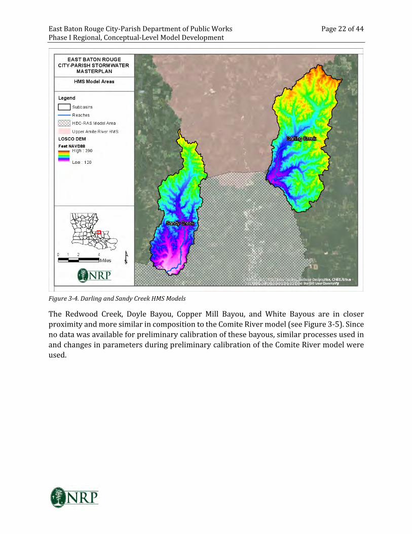
East Baton Rouge City-Parish Department of Public Works Page 22 of 44
Phase I Regional, Conceptual-Level Model Development
Figure 3-4. Darling and Sandy Creek HMS Models
The Redwood Creek, Doyle Bayou, Copper Mill Bayou, and White Bayous are in closer
proximity and more similar in composition to the Comite River model (see Figure 3-5). Since
no data was available for preliminary calibration of these bayous, similar processes used in
and changes in parameters during preliminary calibration of the Comite River model were
used.
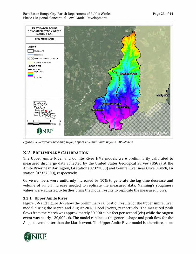
East Baton Rouge City-Parish Department of Public Works Page 23 of 44
Phase I Regional, Conceptual-Level Model Development
Figure 3-5. Redwood Creek and, Doyle, Copper Mill, and White Bayous HMS Models
3.2 PRELIMINARY CALIBRATION
The Upper Amite River and Comite River HMS models were preliminarily calibrated to
measured discharge data collected by the United States Geological Survey (USGS) at the
Amite River near Darlington, LA station (07377000) and Comite River near Olive Branch, LA
station (07377500), respectively.
Curve numbers were uniformly increased by 10% to generate the lag time decrease and
volume of runoff increase needed to replicate the measured data. Manning’s roughness
values were adjusted to further bring the model results to replicate the measured flows.
3.2.1 Upper Amite River
Figure 3-6 and Figure 3-7 show the preliminary calibration results for the Upper Amite River
model during the March and August 2016 Flood Events, respectively. The measured peak
flows from the March was approximately 30,000 cubic feet per second (cfs) while the August
event was nearly 120,000 cfs. The model replicates the general shape and peak flow for the
August event better than the March event. The Upper Amite River model is, therefore, more
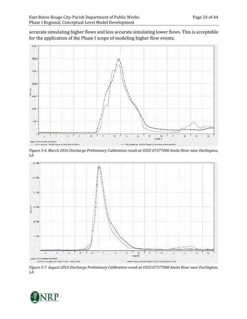
East Baton Rouge City-Parish Department of Public Works Page 24 of 44
Phase I Regional, Conceptual-Level Model Development
accurate simulating higher flows and less accurate simulating lower flows. This is acceptable
for the application of the Phase I scope of modeling higher flow events.
Figure 3-6. March 2016 Discharge Preliminary Calibration result at USGS 07377000 Amite River near Darlington,
LA.
Figure 3-7. August 2016 Discharge Preliminary Calibration result at USGS 07377000 Amite River near Darlington,
LA.
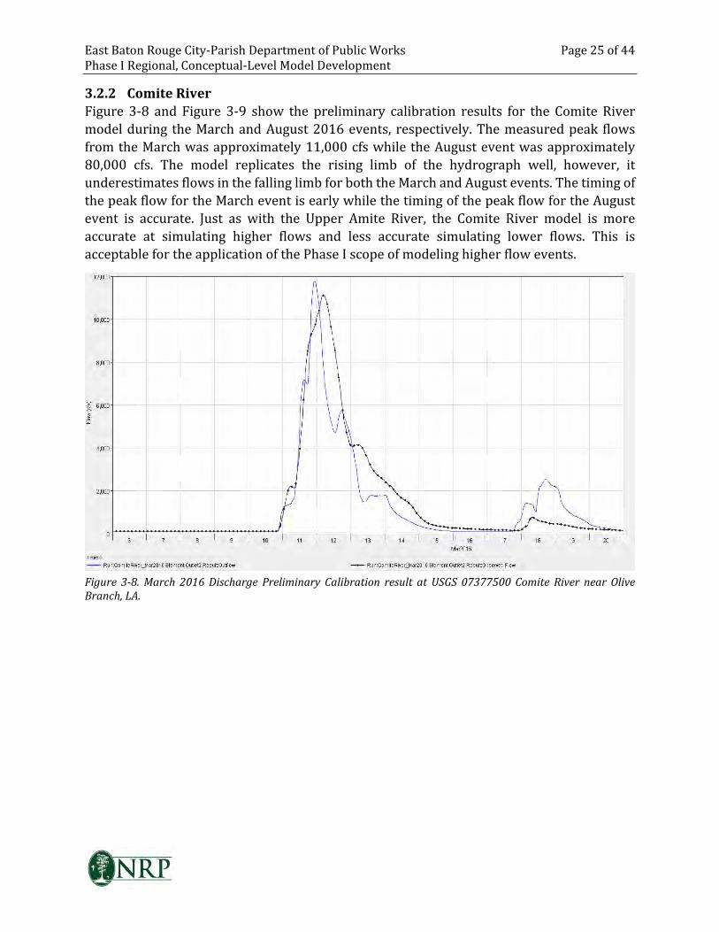
East Baton Rouge City-Parish Department of Public Works Page 25 of 44
Phase I Regional, Conceptual-Level Model Development
3.2.2 Comite River
Figure 3-8 and Figure 3-9 show the preliminary calibration results for the Comite River
model during the March and August 2016 events, respectively. The measured peak flows
from the March was approximately 11,000 cfs while the August event was approximately
80,000 cfs. The model replicates the rising limb of the hydrograph well, however, it
underestimates flows in the falling limb for both the March and August events. The timing of
the peak flow for the March event is early while the timing of the peak flow for the August
event is accurate. Just as with the Upper Amite River, the Comite River model is more
accurate at simulating higher flows and less accurate simulating lower flows. This is
acceptable for the application of the Phase I scope of modeling higher flow events.
Figure 3-8. March 2016 Discharge Preliminary Calibration result at USGS 07377500 Comite River near Olive
Branch, LA.
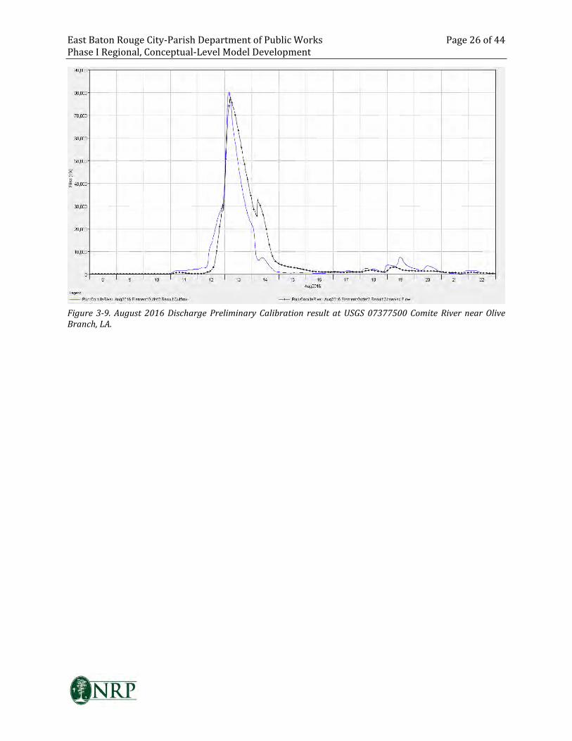
East Baton Rouge City-Parish Department of Public Works Page 26 of 44
Phase I Regional, Conceptual-Level Model Development
Figure 3-9. August 2016 Discharge Preliminary Calibration result at USGS 07377500 Comite River near Olive
Branch, LA.
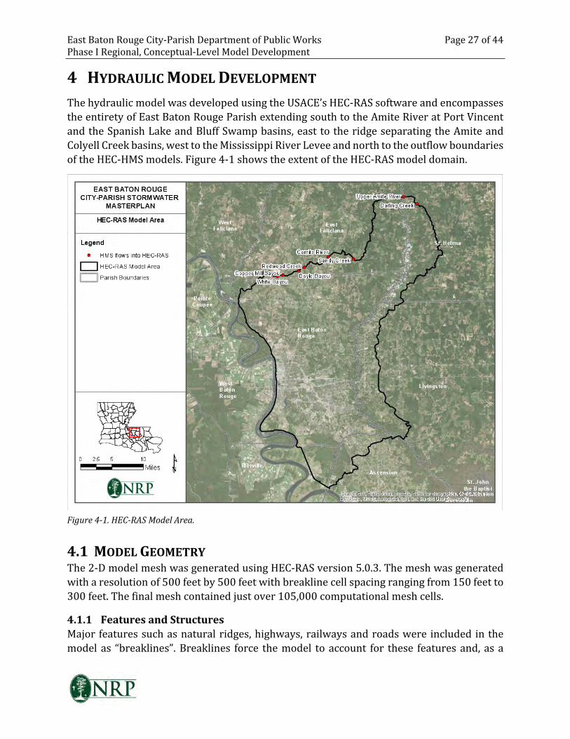
East Baton Rouge City-Parish Department of Public Works Page 27 of 44
Phase I Regional, Conceptual-Level Model Development
4 HYDRAULIC MODEL DEVELOPMENT
The hydraulic model was developed using the USACE’s HEC-RAS software and encompasses
the entirety of East Baton Rouge Parish extending south to the Amite River at Port Vincent
and the Spanish Lake and Bluff Swamp basins, east to the ridge separating the Amite and
Colyell Creek basins, west to the Mississippi River Levee and north to the outflow boundaries
of the HEC-HMS models. Figure 4-1 shows the extent of the HEC-RAS model domain.
Figure 4-1. HEC-RAS Model Area.
4.1 MODEL GEOMETRY
The 2-D model mesh was generated using HEC-RAS version 5.0.3. The mesh was generated
with a resolution of 500 feet by 500 feet with breakline cell spacing ranging from 150 feet to
300 feet. The final mesh contained just over 105,000 computational mesh cells.
4.1.1 Features and Structures
Major features such as natural ridges, highways, railways and roads were included in the
model as “breaklines”. Breaklines force the model to account for these features and, as a
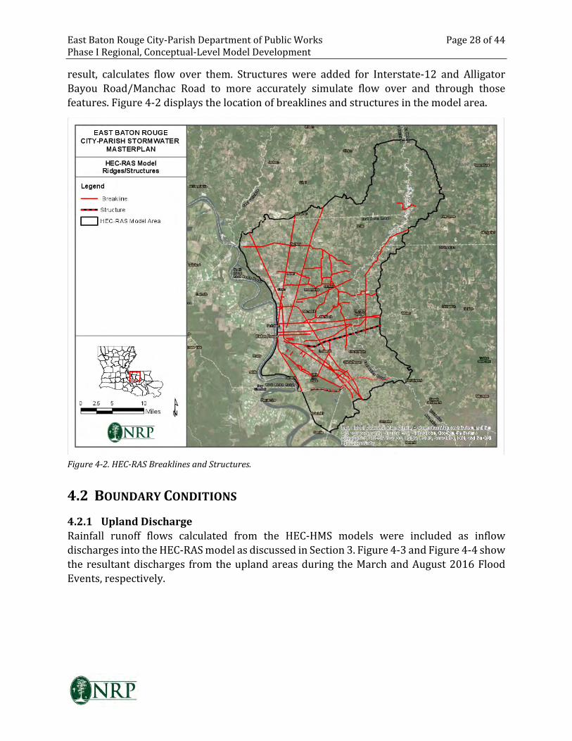
East Baton Rouge City-Parish Department of Public Works Page 28 of 44
Phase I Regional, Conceptual-Level Model Development
result, calculates flow over them. Structures were added for Interstate-12 and Alligator
Bayou Road/Manchac Road to more accurately simulate flow over and through those
features. Figure 4-2 displays the location of breaklines and structures in the model area.
Figure 4-2. HEC-RAS Breaklines and Structures.
4.2 BOUNDARY CONDITIONS
4.2.1 Upland Discharge
Rainfall runoff flows calculated from the HEC-HMS models were included as inflow
discharges into the HEC-RAS model as discussed in Section 3. Figure 4-3 and Figure 4-4 show
the resultant discharges from the upland areas during the March and August 2016 Flood
Events, respectively.
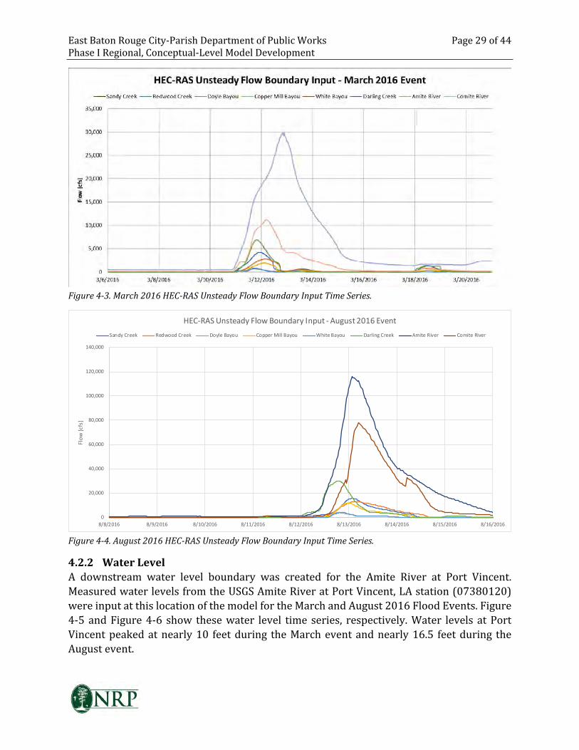
East Baton Rouge City-Parish Department of Public Works Page 29 of 44
Phase I Regional, Conceptual-Level Model Development
Figure 4-3. March 2016 HEC-RAS Unsteady Flow Boundary Input Time Series.
0
20,000
40,000
60,000
80,000
100,000
120,000
140,000
8/8/2016 8/9/2016 8/10/2016 8/11/2016 8/12/2016 8/13/2016 8/14/2016 8/15/2016 8/16/2016
Flo
w [
cfs
]
HEC-RAS Unsteady Flow Boundary Input - August 2016 Event
Sandy Creek Redwood Creek Doyle Bayou Copper Mill Bayou White Bayou Darling Creek Amite River Comite River
Figure 4-4. August 2016 HEC-RAS Unsteady Flow Boundary Input Time Series.
4.2.2 Water Level
A downstream water level boundary was created for the Amite River at Port Vincent.
Measured water levels from the USGS Amite River at Port Vincent, LA station (07380120)
were input at this location of the model for the March and August 2016 Flood Events. Figure
4-5 and Figure 4-6 show these water level time series, respectively. Water levels at Port
Vincent peaked at nearly 10 feet during the March event and nearly 16.5 feet during the
August event.
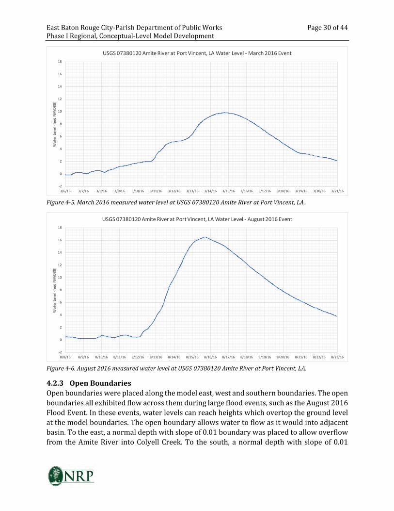
East Baton Rouge City-Parish Department of Public Works Page 30 of 44
Phase I Regional, Conceptual-Level Model Development
-2
0
2
4
6
8
10
12
14
16
18
3/6/16 3/7/16 3/8/16 3/9/16 3/10/16 3/11/16 3/12/16 3/13/16 3/14/16 3/15/16 3/16/16 3/17/16 3/18/16 3/19/16 3/20/16 3/21/16
Wa
ter
Lev
el
{fe
et
NA
VD
88
]USGS 07380120 Amite River at Port Vincent, LA Water Level - March 2016 Event
Figure 4-5. March 2016 measured water level at USGS 07380120 Amite River at Port Vincent, LA.
-2
0
2
4
6
8
10
12
14
16
18
8/8/16 8/9/16 8/10/16 8/11/16 8/12/16 8/13/16 8/14/16 8/15/16 8/16/16 8/17/16 8/18/16 8/19/16 8/20/16 8/21/16 8/22/16 8/23/16
Wa
ter
Lev
el
{fe
et
NA
VD
88
]
USGS 07380120 Amite River at Port Vincent, LA Water Level - August 2016 Event
Figure 4-6. August 2016 measured water level at USGS 07380120 Amite River at Port Vincent, LA.
4.2.3 Open Boundaries
Open boundaries were placed along the model east, west and southern boundaries. The open
boundaries all exhibited flow across them during large flood events, such as the August 2016
Flood Event. In these events, water levels can reach heights which overtop the ground level
at the model boundaries. The open boundary allows water to flow as it would into adjacent
basin. To the east, a normal depth with slope of 0.01 boundary was placed to allow overflow
from the Amite River into Colyell Creek. To the south, a normal depth with slope of 0.01
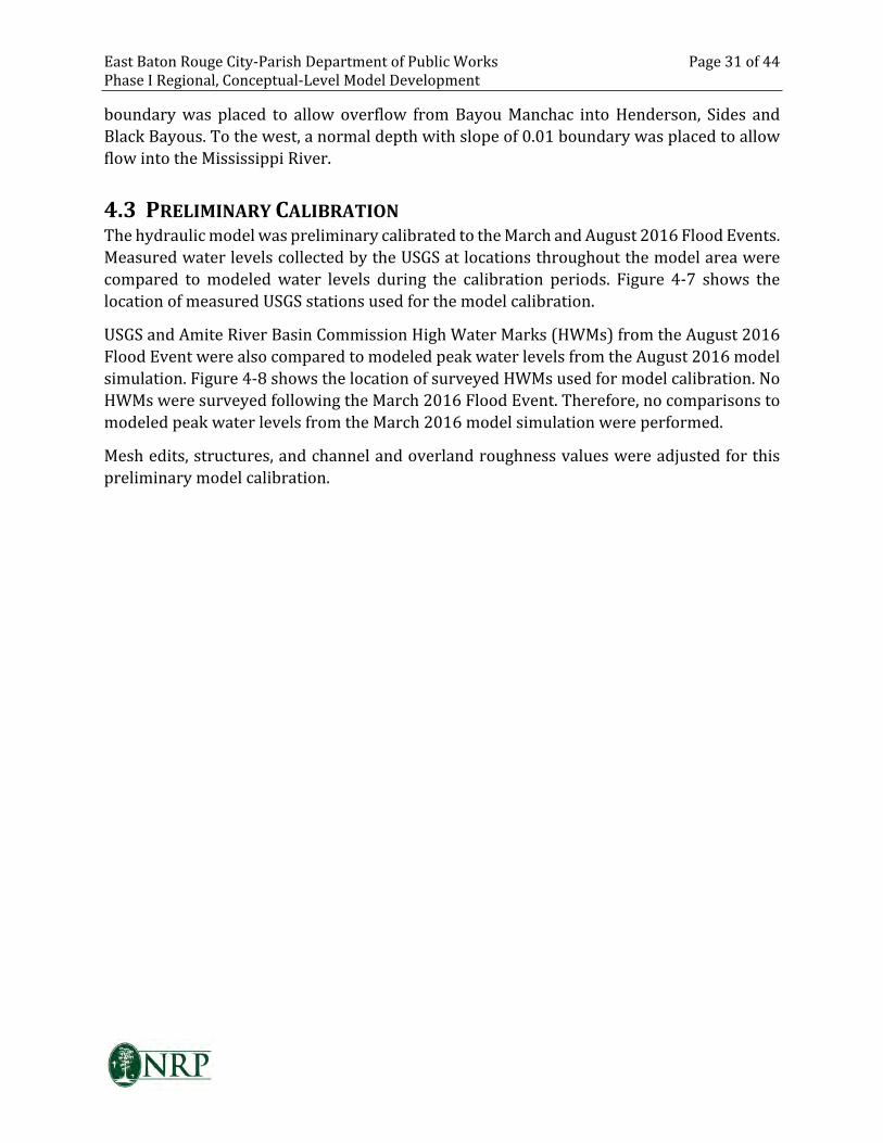
East Baton Rouge City-Parish Department of Public Works Page 31 of 44
Phase I Regional, Conceptual-Level Model Development
boundary was placed to allow overflow from Bayou Manchac into Henderson, Sides and
Black Bayous. To the west, a normal depth with slope of 0.01 boundary was placed to allow
flow into the Mississippi River.
4.3 PRELIMINARY CALIBRATION
The hydraulic model was preliminary calibrated to the March and August 2016 Flood Events.
Measured water levels collected by the USGS at locations throughout the model area were
compared to modeled water levels during the calibration periods. Figure 4-7 shows the
location of measured USGS stations used for the model calibration.
USGS and Amite River Basin Commission High Water Marks (HWMs) from the August 2016
Flood Event were also compared to modeled peak water levels from the August 2016 model
simulation. Figure 4-8 shows the location of surveyed HWMs used for model calibration. No
HWMs were surveyed following the March 2016 Flood Event. Therefore, no comparisons to
modeled peak water levels from the March 2016 model simulation were performed.
Mesh edits, structures, and channel and overland roughness values were adjusted for this
preliminary model calibration.
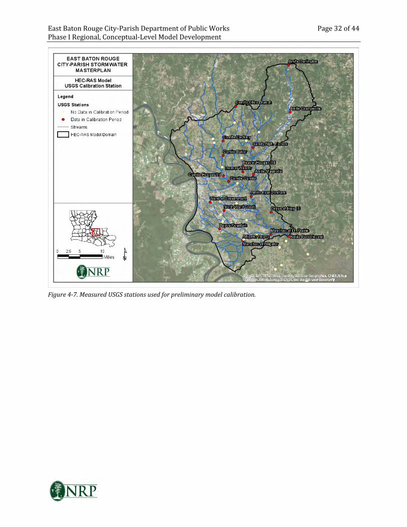
East Baton Rouge City-Parish Department of Public Works Page 32 of 44
Phase I Regional, Conceptual-Level Model Development
Figure 4-7. Measured USGS stations used for preliminary model calibration.
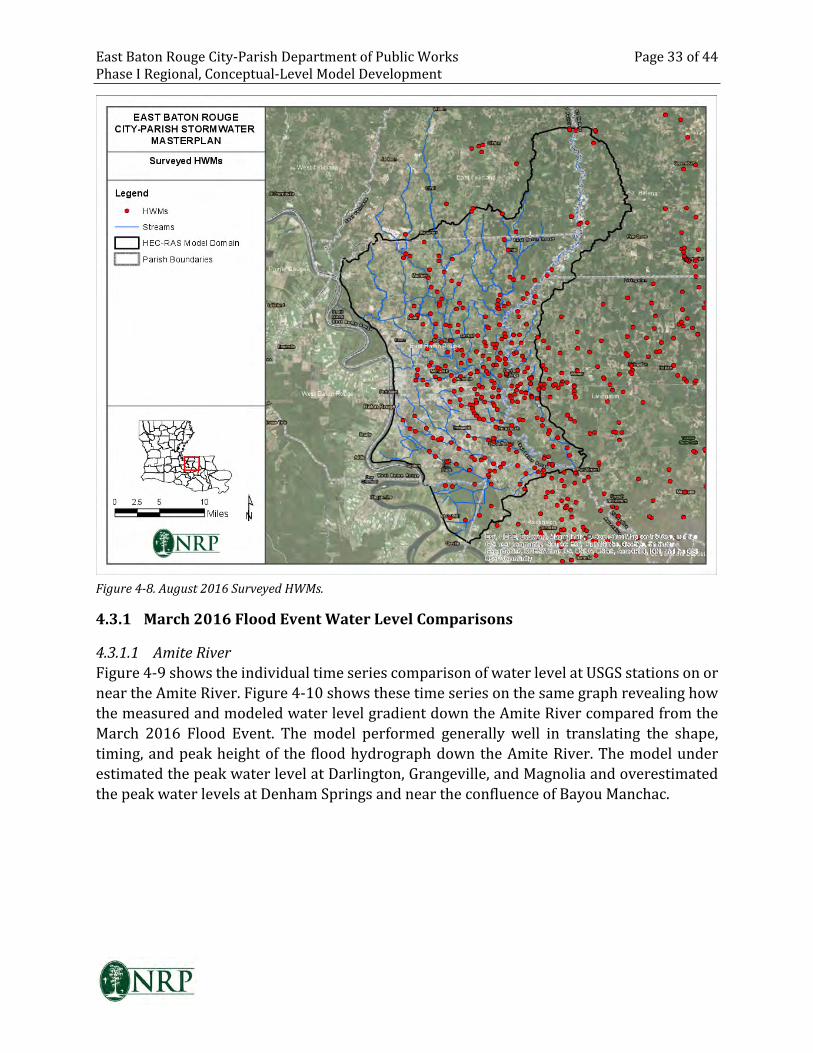
East Baton Rouge City-Parish Department of Public Works Page 33 of 44
Phase I Regional, Conceptual-Level Model Development
Figure 4-8. August 2016 Surveyed HWMs.
4.3.1 March 2016 Flood Event Water Level Comparisons
4.3.1.1 Amite River
Figure 4-9 shows the individual time series comparison of water level at USGS stations on or
near the Amite River. Figure 4-10 shows these time series on the same graph revealing how
the measured and modeled water level gradient down the Amite River compared from the
March 2016 Flood Event. The model performed generally well in translating the shape,
timing, and peak height of the flood hydrograph down the Amite River. The model under
estimated the peak water level at Darlington, Grangeville, and Magnolia and overestimated
the peak water levels at Denham Springs and near the confluence of Bayou Manchac.
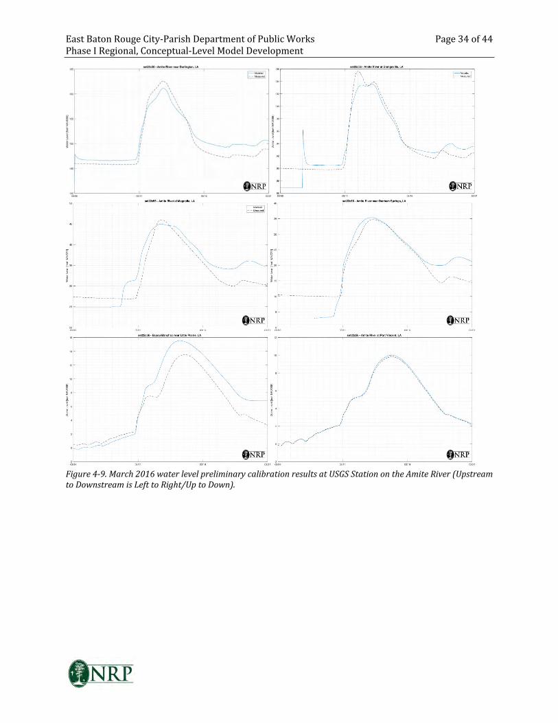
East Baton Rouge City-Parish Department of Public Works Page 34 of 44
Phase I Regional, Conceptual-Level Model Development
Figure 4-9. March 2016 water level preliminary calibration results at USGS Station on the Amite River (Upstream
to Downstream is Left to Right/Up to Down).
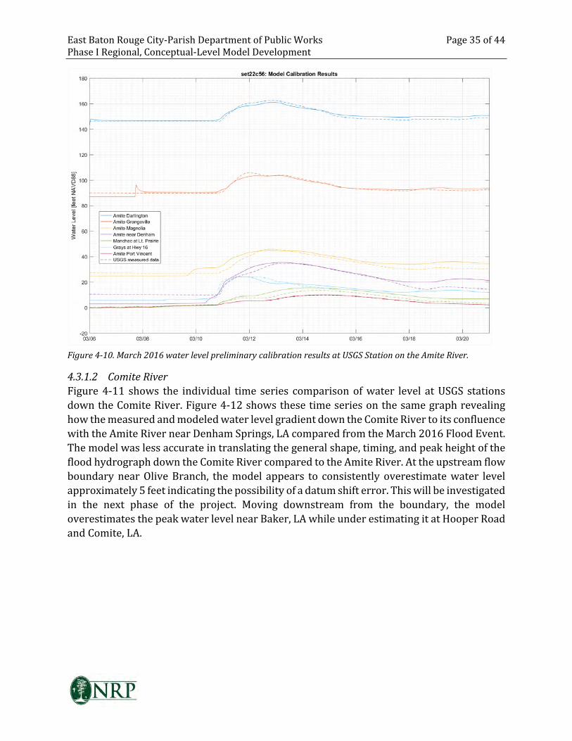
East Baton Rouge City-Parish Department of Public Works Page 35 of 44
Phase I Regional, Conceptual-Level Model Development
Figure 4-10. March 2016 water level preliminary calibration results at USGS Station on the Amite River.
4.3.1.2 Comite River
Figure 4-11 shows the individual time series comparison of water level at USGS stations
down the Comite River. Figure 4-12 shows these time series on the same graph revealing
how the measured and modeled water level gradient down the Comite River to its confluence
with the Amite River near Denham Springs, LA compared from the March 2016 Flood Event.
The model was less accurate in translating the general shape, timing, and peak height of the
flood hydrograph down the Comite River compared to the Amite River. At the upstream flow
boundary near Olive Branch, the model appears to consistently overestimate water level
approximately 5 feet indicating the possibility of a datum shift error. This will be investigated
in the next phase of the project. Moving downstream from the boundary, the model
overestimates the peak water level near Baker, LA while under estimating it at Hooper Road
and Comite, LA.
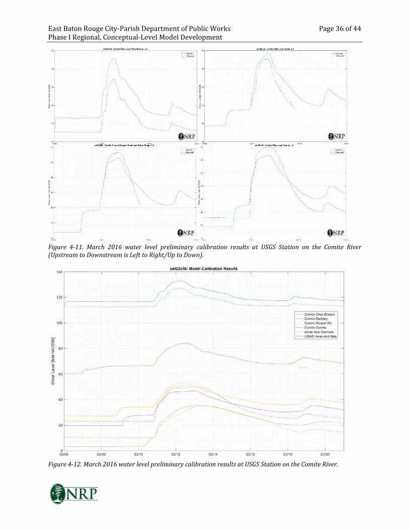
East Baton Rouge City-Parish Department of Public Works Page 36 of 44
Phase I Regional, Conceptual-Level Model Development
Figure 4-11. March 2016 water level preliminary calibration results at USGS Station on the Comite River
(Upstream to Downstream is Left to Right/Up to Down).
Figure 4-12. March 2016 water level preliminary calibration results at USGS Station on the Comite River.
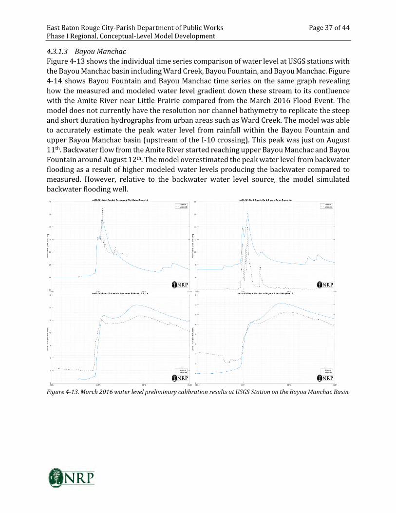
East Baton Rouge City-Parish Department of Public Works Page 37 of 44
Phase I Regional, Conceptual-Level Model Development
4.3.1.3 Bayou Manchac
Figure 4-13 shows the individual time series comparison of water level at USGS stations with
the Bayou Manchac basin including Ward Creek, Bayou Fountain, and Bayou Manchac. Figure
4-14 shows Bayou Fountain and Bayou Manchac time series on the same graph revealing
how the measured and modeled water level gradient down these stream to its confluence
with the Amite River near Little Prairie compared from the March 2016 Flood Event. The
model does not currently have the resolution nor channel bathymetry to replicate the steep
and short duration hydrographs from urban areas such as Ward Creek. The model was able
to accurately estimate the peak water level from rainfall within the Bayou Fountain and
upper Bayou Manchac basin (upstream of the I-10 crossing). This peak was just on August
11th. Backwater flow from the Amite River started reaching upper Bayou Manchac and Bayou
Fountain around August 12th. The model overestimated the peak water level from backwater
flooding as a result of higher modeled water levels producing the backwater compared to
measured. However, relative to the backwater water level source, the model simulated
backwater flooding well.
Figure 4-13. March 2016 water level preliminary calibration results at USGS Station on the Bayou Manchac Basin.
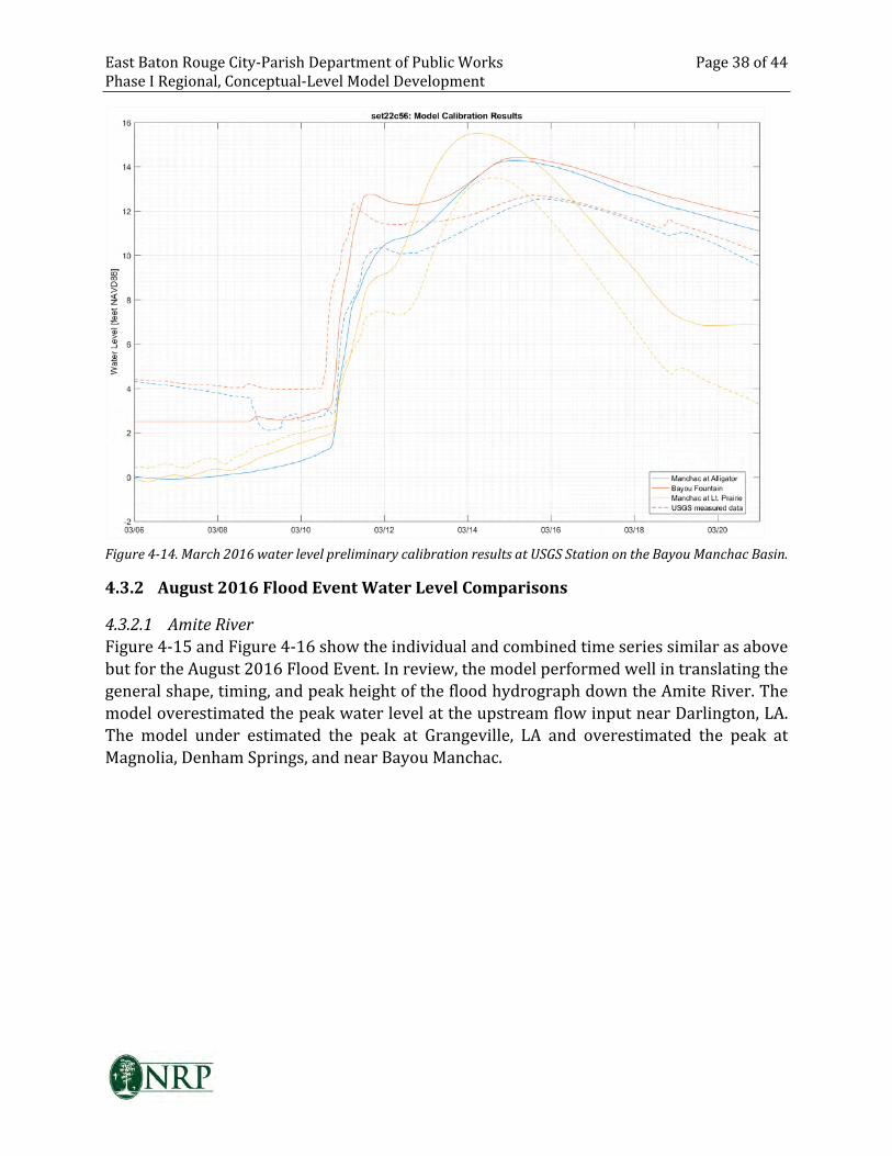
East Baton Rouge City-Parish Department of Public Works Page 38 of 44
Phase I Regional, Conceptual-Level Model Development
Figure 4-14. March 2016 water level preliminary calibration results at USGS Station on the Bayou Manchac Basin.
4.3.2 August 2016 Flood Event Water Level Comparisons
4.3.2.1 Amite River
Figure 4-15 and Figure 4-16 show the individual and combined time series similar as above
but for the August 2016 Flood Event. In review, the model performed well in translating the
general shape, timing, and peak height of the flood hydrograph down the Amite River. The
model overestimated the peak water level at the upstream flow input near Darlington, LA.
The model under estimated the peak at Grangeville, LA and overestimated the peak at
Magnolia, Denham Springs, and near Bayou Manchac.
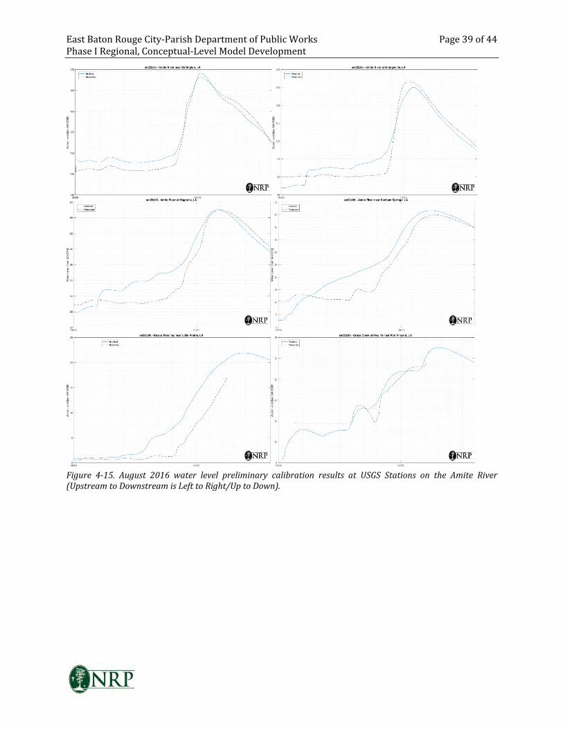
East Baton Rouge City-Parish Department of Public Works Page 39 of 44
Phase I Regional, Conceptual-Level Model Development
Figure 4-15. August 2016 water level preliminary calibration results at USGS Stations on the Amite River
(Upstream to Downstream is Left to Right/Up to Down).
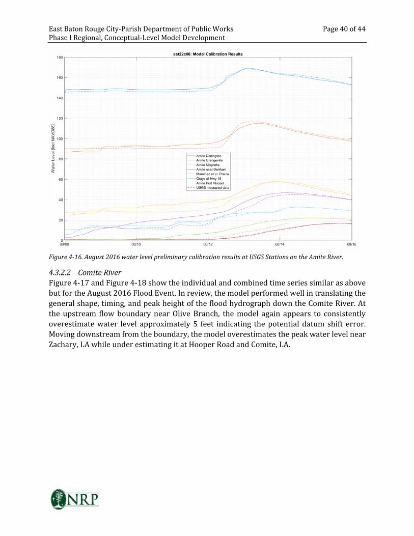
East Baton Rouge City-Parish Department of Public Works Page 40 of 44
Phase I Regional, Conceptual-Level Model Development
Figure 4-16. August 2016 water level preliminary calibration results at USGS Stations on the Amite River.
4.3.2.2 Comite River
Figure 4-17 and Figure 4-18 show the individual and combined time series similar as above
but for the August 2016 Flood Event. In review, the model performed well in translating the
general shape, timing, and peak height of the flood hydrograph down the Comite River. At
the upstream flow boundary near Olive Branch, the model again appears to consistently
overestimate water level approximately 5 feet indicating the potential datum shift error.
Moving downstream from the boundary, the model overestimates the peak water level near
Zachary, LA while under estimating it at Hooper Road and Comite, LA.
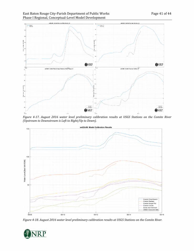
East Baton Rouge City-Parish Department of Public Works Page 41 of 44
Phase I Regional, Conceptual-Level Model Development
Figure 4-17. August 2016 water level preliminary calibration results at USGS Stations on the Comite River
(Upstream to Downstream is Left to Right/Up to Down).
Figure 4-18. August 2016 water level preliminary calibration results at USGS Stations on the Comite River.
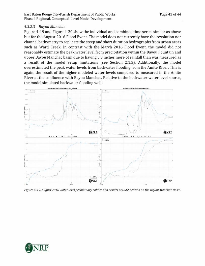
East Baton Rouge City-Parish Department of Public Works Page 42 of 44
Phase I Regional, Conceptual-Level Model Development
4.3.2.3 Bayou Manchac
Figure 4-19 and Figure 4-20 show the individual and combined time series similar as above
but for the August 2016 Flood Event. The model does not currently have the resolution nor
channel bathymetry to replicate the steep and short duration hydrographs from urban areas
such as Ward Creek. In contrast with the March 2016 Flood Event, the model did not
reasonably estimate the peak water level from precipitation within the Bayou Fountain and
upper Bayou Manchac basin due to having 5.5 inches more of rainfall than was measured as
a result of the model setup limitations (see Section 2.1.3). Additionally, the model
overestimated the peak water levels from backwater flooding from the Amite River. This is
again, the result of the higher modeled water levels compared to measured in the Amite
River at the confluence with Bayou Manchac. Relative to the backwater water level source,
the model simulated backwater flooding well.
Figure 4-19. August 2016 water level preliminary calibration results at USGS Station on the Bayou Manchac Basin.
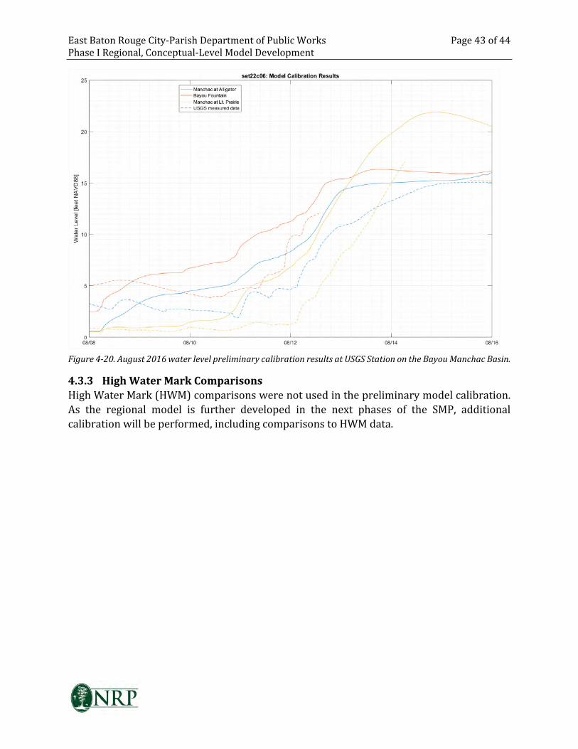
East Baton Rouge City-Parish Department of Public Works Page 43 of 44
Phase I Regional, Conceptual-Level Model Development
Figure 4-20. August 2016 water level preliminary calibration results at USGS Station on the Bayou Manchac Basin.
4.3.3 High Water Mark Comparisons
High Water Mark (HWM) comparisons were not used in the preliminary model calibration.
As the regional model is further developed in the next phases of the SMP, additional
calibration will be performed, including comparisons to HWM data.
East Baton Rouge City-Parish Department of Public Works Page 44 of 44
Phase I Regional, Conceptual-Level Model Development
5 CONCLUSIONS
The Phase I Regional, Conceptual-Level Model was able to provide an understanding the
hydraulic system of rivers, bayous, and canals. It is an acceptable tool which can be used to
identify, from a macro-level, problems areas and potential projects as well as estimate
regional impacts of large scale projects influencing the Comite and Amite Rivers within East
Baton Rouge Parish. Additionally, this model provides a foundation for the development of
the future, more detailed models for the next phase of the Stormwater Master Plan when
new LiDAR and additional survey are performed.


