Embed Size (px)
Citation preview
Technical Report
Geology, Mineralization, and Exploration
of the
Santo Tomás Cu‐(Mo‐Au‐Ag) Porphyry Deposit
Sinaloa, Mexico
Latitude 26° 53’ 00” N
Longitude 108° 11’ 30” W
Prepared for
Oroco Resource Corp. Suite 1201‐1166 Alberni Street
Vancouver, BC V6E 3Z3 and
Altamura Copper Corp.
Prepared by
Dane Bridge, M.Sc., P. Geol. Dane A. Bridge Consulting Inc.,
Calgary, Alberta
Effective Date: Aug. 22, 2019
Revised: Apr. 21, 2020

This page is intentionally blank
Santo Tomás Property, Sinaloa: Technical Report by Dane A. Bridge, P. Geol., Aug. 22, 2019 Page iv
DISCLAIMER
This report was prepared by Dane A. Bridge Consulting (“Bridge Consulting”) of Calgary, Alberta as a
Geological Report for Oroco Resource Corp. (“Oroco”) in accordance with the policies of the TSX Venture
Exchange and is prepared in the requirement of the Canadian National Instrument 43‐101 ‐ Standards of
Disclosure for Mineral Projects (“NI 43‐101”) and NI 43‐101 Form F1. This report is intended for use by
Oroco subject to the terms and conditions of its contract (the “Contract”) with Bridge Consulting and the
relevant regulatory policies, national instruments, and legislation. The Contract permits Oroco to file this
report as a Geological Report with the TSX Venture Exchange. Bridge Consulting has also consented to
Oroco filing this report with securities commissions and regulatory authorities and to Oroco’s use of any
extracts from or summary of this report in written and electronic disclosure. Altamura Copper Corp. is
also granted permission to use this report, subject to the same terms and conditions of the Contract.
This report was revised April 21, 2020 to address certain technical disclosure deficiencies, but the
information contained herein has not been updated and remains as at the August 22, 2019 effective date
of the original report.
The user of this document should ensure that this is the most recent Geological Report for the subject
property as it is not valid if a newer Geological Report has been issued.
Santo Tomás Property, Sinaloa: Technical Report by Dane A. Bridge, P. Geol., Aug. 22, 2019 Page v
TABLE OF CONTENTS
Date and Signature ............................................................................................................................. iii
Disclaimer ........................................................................................................................................... iv
Table of Contents ................................................................................................................................. v
Summary ............................................................................................................................................. 1
Property Description and Location ........................................................................................................... 1
Location .............................................................................................................................................. 1
Mineral Tenure & Ownership ............................................................................................................. 1
History ....................................................................................................................................................... 1
Exploration Programs ......................................................................................................................... 1
Historical Mineral Resource Estimates ............................................................................................... 4
Geological Setting and Mineralization ...................................................................................................... 7
Drilling ....................................................................................................................................................... 8
Sample Preparation, Analysis and Security ............................................................................................... 8
Data Verification ....................................................................................................................................... 9
Mineral Processing and Metallurgical Testing ........................................................................................ 10
Interpretation and Conclusions .............................................................................................................. 11
Discussion of the Historical Geological Interpretation ..................................................................... 11
Historical Mineral Resource Estimate – Thornton (2011) ................................................................ 12
Revised Geological Interpretation .................................................................................................... 13
3D Geological Model ........................................................................................................................ 14
Exploration Target ............................................................................................................................ 14
Recommendations .................................................................................................................................. 15
Introduction ....................................................................................................................................... 16
Scope of Work ......................................................................................................................................... 17
Units and Abbreviations .......................................................................................................................... 18
Reliance On Other Experts ................................................................................................................. 20
Property Description and Location ..................................................................................................... 20
Property Location .................................................................................................................................... 20
Mexican Mineral Tenure System ............................................................................................................ 20
Governing Law and Regulations ....................................................................................................... 20
Mexican Public Registry of Mining ................................................................................................... 20
Santo Tomás Property, Sinaloa: Technical Report by Dane A. Bridge, P. Geol., Aug. 22, 2019 Page vi
Assessment Work and Mining Duties ............................................................................................... 22
Valid Concession Holders & Surface Rights ...................................................................................... 22
Location Surveys ............................................................................................................................... 22
Mineral Tenures of the Property ............................................................................................................ 22
Oroco Resource Corp. Interest in the Property ................................................................................ 23
Legal Survey of the Property ............................................................................................................ 24
Obligations to Maintain the Property .............................................................................................. 24
Surface Rights ................................................................................................................................... 26
Permits and Liabilities ............................................................................................................................. 26
Accessibility, Climate, Local Resources, Infrastructure and Physiography ........................................... 26
Physiography ........................................................................................................................................... 26
Local Resources ....................................................................................................................................... 29
Accessibility ............................................................................................................................................. 29
Climate .................................................................................................................................................... 29
Infrastructure .......................................................................................................................................... 29
History ............................................................................................................................................... 34
Historical Exploration Programs ............................................................................................................. 34
Artisanal Miners ............................................................................................................................... 34
ASARCO Exploration Program from 1968 to 1971 ........................................................................... 34
Tormex – Peñoles Exploration Program from 1973 to 1977 ............................................................ 35
Government Supported Mapping 1973 ........................................................................................... 35
Consejo de Recursos Minerales Regional Geological and Geophysical programs ........................... 36
Esmeralda Group, 1990 .................................................................................................................... 36
Minera Real de Angeles, 1991 .......................................................................................................... 36
Exall Resources Ltd. Exploration Program from 1992 to 1997 ......................................................... 36
Minera MGM S.A. de C.V. (Morgain Mineral Inc.) from 1997‐1998 ................................................ 38
Ruero International Ltd. & Compañía Minera Ruero S.A. de C.V. .................................................... 38
Xochipala Gold S.A. de C.V. .............................................................................................................. 41
Historical Mineral Resource Estimates ................................................................................................... 42
Early Mineral Resource Estimates (Prior to 2011) ............................................................................ 42
Thor Resources LLC, 2011 – Historical Technical Report .................................................................. 42
Geological Setting and Mineralization ................................................................................................ 50
Regional Geology .................................................................................................................................... 50
Stratified Rocks ................................................................................................................................. 50
Santo Tomás Property, Sinaloa: Technical Report by Dane A. Bridge, P. Geol., Aug. 22, 2019 Page vii
Intrusive Rocks .................................................................................................................................. 51
Structural Geology & Mineralization ................................................................................................ 54
Property Geology .................................................................................................................................... 54
Introduction ...................................................................................................................................... 54
Stratified Rocks ................................................................................................................................. 57
Intrusions .......................................................................................................................................... 58
Alteration .......................................................................................................................................... 61
Structure ........................................................................................................................................... 65
Western Fault Zone .......................................................................................................................... 70
Mineralization ................................................................................................................................... 71
Geological Chronology and Controls to Mineralization ................................................................... 72
Grade Distribution ............................................................................................................................ 75
Deposit Types .................................................................................................................................... 77
Porphyry Deposits ................................................................................................................................... 77
Laramide‐Age Porphyry Deposits of NW Mexico.................................................................................... 78
Exploration ........................................................................................................................................ 81
2017 FieldWork ....................................................................................................................................... 81
2017 2018 Remote Sensing .................................................................................................................... 81
2017 Survey Control Work ...................................................................................................................... 82
2019 Survey Compilation ........................................................................................................................ 83
Digital Terrane Model and Orthophoto............................................................................................ 83
Survey Control – Transform from Exall Mine Grid ........................................................................... 83
2019 Exploration and Modelling ............................................................................................................. 84
Fieldwork & Structural Interpretation .............................................................................................. 84
Modelling Methods .......................................................................................................................... 85
2019 Modelling ................................................................................................................................. 85
Drilling ............................................................................................................................................... 86
Drilling On the Property .......................................................................................................................... 86
Summary and Interpretation of Relevant Results .................................................................................. 89
South Zone Drilling ........................................................................................................................... 93
North Zone Drilling ........................................................................................................................... 93
Sample Preparation, Analysis and Security ....................................................................................... 104
Historical Sample Preparation .............................................................................................................. 104
Historical Analysis ................................................................................................................................. 104
Santo Tomás Property, Sinaloa: Technical Report by Dane A. Bridge, P. Geol., Aug. 22, 2019 Page viii
Historical Security ................................................................................................................................. 104
Historical Quality Control ...................................................................................................................... 104
Data Verification .............................................................................................................................. 106
Mineral Processing and Metallurgical Testing .................................................................................. 107
Lakefield Research ................................................................................................................................ 107
Microscopic evaluation by Lakefield Research of Canada, March 1975 ........................................ 107
Recovery of copper by Lakefield Research of Canada, March 1975 .............................................. 107
Exall Testing .......................................................................................................................................... 107
Comisión de Fomento Minero, November 1991 ............................................................................ 107
Consejo de Recursos Minerales, August 1993 ............................................................................... 108
American Assay Laboratories, October 1993 ................................................................................. 108
Consejo de Recursos Minerales, December 1993 .......................................................................... 108
Bateman Engineering Pre‐feasibility Study ........................................................................................... 108
Minetek, December 1993 ............................................................................................................... 108
Mountain States Research and Development Inc. (MSRDI), March 1994 ..................................... 108
Processing: Grinding and Flotation ....................................................................................................... 109
Mineral Resource Estimates ............................................................................................................. 110
Items 15 to 22 Omitted .................................................................................................................... 110
Adjacent Properties ......................................................................................................................... 110
Lluvia de Oro ......................................................................................................................................... 110
La Reforma ............................................................................................................................................ 110
El Tempisque ......................................................................................................................................... 110
Bahuerachi ............................................................................................................................................ 111
Other Relevant Data and Information .............................................................................................. 113
Mineral Tenures Abutting the Property ................................................................................................ 113
Drilling on Abutting Mineral Concessions ............................................................................................. 114
Interpretation and Conclusions ........................................................................................................ 116
Discussion of Historical Geological Interpretation................................................................................ 116
Historical Mineral Resource Estimate – Thornton (2011) .................................................................... 117
Revised Geological Interpretation ........................................................................................................ 118
3D Geological Model ............................................................................................................................. 119
Exploration Target ................................................................................................................................. 121
Santo Tomás Property, Sinaloa: Technical Report by Dane A. Bridge, P. Geol., Aug. 22, 2019 Page ix
Recommendations ........................................................................................................................... 122
Introduction .......................................................................................................................................... 122
Phase 1.0 – Surface Exploration ............................................................................................................ 123
Permitting ....................................................................................................................................... 123
Physical Work ................................................................................................................................. 123
Geophysical Surveys ....................................................................................................................... 124
Geological Program ........................................................................................................................ 124
Phase 1.1 – Non‐Success Contingent Drilling Program ......................................................................... 125
North Zone Definition Drilling ........................................................................................................ 128
Phase 2.0 – Surface Exploration and Environmental Program ............................................................. 130
Geological Program ........................................................................................................................ 130
Remote Sensing .............................................................................................................................. 130
Environmental Baseline Survey ...................................................................................................... 131
Phase 2.1 – Non‐Success Contingent Drilling Program ......................................................................... 131
North Zone Definition Drilling – Continued .................................................................................... 131
South Zone Drilling at the Ridge Target – Initial Drilling ................................................................ 132
Phase 2.2 –Success Contingent Drilling Program .................................................................................. 134
North Zone Exploration Drilling ...................................................................................................... 134
South Zone Drilling: Ridge Target ................................................................................................... 135
South Zone Drilling: Hanging Wall Targets ..................................................................................... 136
Brasiles Zone Drilling – Initial Program ........................................................................................... 136
References ....................................................................................................................................... 140
Appendix I – Statement of Qualifications .............................................................................................. i
List of Tables
Table 1. List of other units and abbreviations ............................................................................................ 18
Table 2. List of units and abbreviations for distance, area and mass ......................................................... 19
Table 3. List of units and abbreviations for time, volume and flow, elements and assay and
grade ...................................................................................................................................... 19
Table 4. List of the Santo Tomás Mineral Tenures held by Compañía Minera Ruero S.A. de C.V. ............. 23
Table 5. Ownership Interests at Certain Expenditure Thresholds .............................................................. 24
Table 6. Historical Drilling and Assaying ..................................................................................................... 86
Table 7 Historical Drill Collars – Coordinates in WGS 84 ............................................................................ 88
Table 8 Listing of Significant Cu Composite Intervals ................................................................................. 90
Table 9. Bahuerachi Deposit Mineral Resource Estimate, McCandlish (2007) ......................................... 112
Santo Tomás Property, Sinaloa: Technical Report by Dane A. Bridge, P. Geol., Aug. 22, 2019 Page x
List of Figures
Figure 1. Property Location Map ................................................................................................................ 21
Figure 2. Property Concession Map ............................................................................................................ 25
Figure 3. Local Physiography Map .............................................................................................................. 27
Figure 4. View of the Santo Tomás Deposit Area looking SSW with the Rio Fuerte in
foreground. ............................................................................................................................ 28
Figure 5. Santo Tomás Core Storage Facility, Bienestar Ranch ................................................................... 31
Figure 6. Local Infrastructure Map .............................................................................................................. 32
Figure 7. Potential Sites for Additional Infrastructure for Mining Operations ........................................... 33
Figure 8. View of the West Bench Area, Esme Concession, Santo Tomás, Looking South ......................... 34
Figure 9. Example of Cross‐section 77025 (in Exall Mine Grid), with the Wireframe shown
Looking North, from Thornton (2011) ................................................................................... 43
Figure 10. Cu Variogram Model, North Zone, Thornton (2011) ................................................................. 45
Figure 11. Cu Variogram Model, in an E‐W Plane, North Zone, Thornton (2011) ...................................... 45
Figure 12. Total Cu (CuT) Directional Semi‐variograms, along strike (Thornton, 2011) ............................. 46
Figure 13. Total Cu (CuT) Directional Semi‐variograms, down dip (Thornton, 2011) ................................. 46
Figure 14. Historical Mineral Resource Estimate (Thornton 2011‐STM‐MODREV). ................................... 48
Figure 15 Analysis of Thornton (2011) – 2011‐STD‐MODREV .................................................................... 48
Figure 16. Regional Geology Map ............................................................................................................... 52
Figure 17. Regional Geology Legend ........................................................................................................... 53
Figure 18. Property Geology Map ............................................................................................................... 55
Figure 19. Property Geology Legend ........................................................................................................... 56
Figure 20. Core Sample of Quartz Monzonite from STD‐42. ...................................................................... 59
Figure 21. Outcrop of Contact between hornfelsed Andesite (left) and a Quartz Monzonite
dike (right) ............................................................................................................................. 60
Figure 22. Outcrop of Phyllic Altered Quartz Monzonite Porphyry ............................................................ 64
Figure 23. Schmidt Plot of Fracture Planes of Santo Tomás ....................................................................... 66
Figure 24. Circular Histograms and Schmidt Plots of North Zone structural data. ..................................... 67
Figure 25. Circular Histograms and Schmidt Plots of Brasiles structural data ............................................ 68
Figure 26. Circular Histogram and Schmidt plots of Brasiles East‐West faulting ....................................... 69
Figure 27. 3D Perspective View Looking South – of the Western Fault, showing the North
Zone mineralization, (Unit Mx, Pink). .................................................................................... 70
Figure 28. North Zone Section N 44 Looking NNE (Azimuth 020°) ............................................................. 76
Figure 29. Schematic diagram of a porphyry Cu system from Sinclair (2007). ........................................... 78
Figure 30. Late Cretaceous to Early Tertiary “Laramide” intrusion‐related deposits of
northwestern Mexico. ........................................................................................................... 80
Santo Tomás Property, Sinaloa: Technical Report by Dane A. Bridge, P. Geol., Aug. 22, 2019 Page xi
Figure 31. Monument for Esme mineral concession showing the South Zone in background. ................. 82
Figure 32. Map of Drill Hole Collar Locations ............................................................................................. 87
Figure 33. North Zone, Layout of Longitudinal Sections ............................................................................. 95
Figure 34. Drill Section Legend ................................................................................................................... 96
Figure 35a. North Zone Longitudinal Section 17 Looking West. ................................................................. 97
Figure 35b. North Zone Longitudinal Section 18 Looking West. ................................................................ 98
Figure 35c. North Zone Longitudinal Section 19 Looking West. ................................................................. 99
Figure 35d. North Zone Longitudinal Section 20 Looking West. .............................................................. 100
Figure 35e. North Zone Longitudinal Section 21 Looking West. ............................................................... 101
Figure 35f. North Zone Longitudinal Section 22 Looking West. ............................................................... 102
Figure 35g. North Zone Longitudinal Section 23 Looking West. ............................................................... 103
Figure 36. Peripheral Concession Map ..................................................................................................... 115
Figure 37. 3D Views of the North Zone Geological Model with Historical Drill Holes, Looking
Southwest ............................................................................................................................ 120
Figure 38 North Zone Cross‐Section N 46 Showing typical definition drilling layout for
Indicated Level of Mineral Resource Estimate (200 m drill hole spacing) ........................... 125
Figure 39. 3D Geological Model of North Zone, (Mx, Pink) Showing Proposed Phase 1.1 and
2.1 Definition Drilling Looking South‐Eastward .................................................................. 126
Figure 40. Plan of Recommended Drill Collars Locations ......................................................................... 127
Figure 41 3D View Southeastward of the North Zone (Mx, Pink) and Collars of the Proposed
Definition Drilling: Phase 1.1 (Magenta) and 2.1 (Blue) ...................................................... 128
Figure 42. South Zone Cross‐Section S‐14 Showing typical drilling layout for Exploration of the
Ridge Target ......................................................................................................................... 134
Santo Tomás Property, Sinaloa: Technical Report by Dane A. Bridge, P. Geol., Aug. 22, 2019 Page 1
SUMMARY
PROPERTY DESCRIPTION AND LOCATION
Location The Santo Tomás property (the “Property”) is in the municipality of Choix, in northern Sinaloa State, México.
The Property is centred at latitude 26°53’00” N and longitude 108°11’30” W. The Property comprises a total
area of 1,172.9 ha of concessions, covering the initial area of exploration and the area of the Santo Tomás
North and South porphyry copper deposits.
Access to the Property is by way of a 160 km paved highway from the Pacific sea Port of Topolobampo, through
the city of Los Mochis to the northern city of Choix. The southern end of the Property is reached by a 32 km
access road originally built to service the El Sauzal Mine of Goldcorp in Chihuahua State.
The Property area is mountainous and is part of the southwestern Sierra Madre Occidental mountain range.
The topography of the area is deeply incised with steep‐walled valleys that rise in elevation from Rio Fuerte,
at 220 m elevation, to approximately 1,340 m at the El Bienestar Ranch.
Mineral Tenure & Ownership The Property comprises a total area of 1,172.9 ha of mineral concessions, covering the initial area of
exploration and the area of the North and South porphyry copper deposits. Compañía Minera Ruero S.A. de
C.V. (“CMR”), a private Mexican registered mining company, has a 100% ownership of the Property. CMR is
owned 99.998% by Ruero International Ltd. (“Ruero International”), a Bahamas company and 0.002% by
Ruben Rodriguez Villegas (“Rodriguez”), a Mexican citizen.
Oroco Resource Corp. holds interests in the Property via its interest in Altamura Copper Corp. (“Altamura”).
Altamura holds its interest in the Property via its interest in Ruero International, Xochipala Gold S.A. de C.V.
(“XG”) (which has contractually acquired 100% of the Property from CMR), and its option to acquire the
balance of either CMR or XG that it does not already hold.
HISTORY
Exploration Programs Informal miners have been working at the Santo Tomás site sporadically since the early 1900s resulting in
several small excavations and two small adits in the North and South Zones.
The first systematic exploration at Santo Tomás was initiated by ASARCO Mexicana S.A. (“ASARCO”).
Commencing in 1968 ASARCO constructed an access road to the Property from El Bienestar Ranch and
conducted a predominantly drill‐based exploration program. A total of 43 vertical diamond‐drill holes totalling
13,697 m and 16 vertical rotary percussion holes totalling 1,391 m were completed by 1971. Most of the
ASARCO drill holes were in the North Zone.
Tormex Mining Developers Ltd. (Contratista Tormex S.A.) and Industria Minera Peñoles (“Tormex”) optioned
the Property in 1973 and conducted exploration and re‐sampling to 1977, mainly on the North Zone. Twenty‐
six ASARCO core holes from the North Zone were re‐logged, and 7 drill holes totalling 2,401 m were drilled in
Santo Tomás Property, Sinaloa: Technical Report by Dane A. Bridge, P. Geol., Aug. 22, 2019 Page 2
1974. A new mineral resource estimation was made, and a revised geological interpretation depicted a
shallowly west‐dipping mineralized zone.
In the 1980’s and 1990’s, the Santo Tomás deposit region was included in a series of regional airborne
magnetic surveys, helicopter surveys, LANDSAT imagery and geological mapping by Mexican government
agencies. The Esmeralda Group and Minera Real de Angeles S.A. de C.V. interpreted existing data and
produced mineral resource calculations. However, the results of these studies are not available.
Exploration activity on the Property resumed in 1990 when the Esmeralda Group produced a new set of
geologic sections and plan‐maps, which summarized the previous exploration work and provided a new
Mineral Resource calculation.
In 1991, Minera Real de Angeles S.A. de C.V. re‐logged 12 ASARCO drill holes and produced a block model
resource calculation. However, the results of this study are not available.
A Canadian Company – Cerro de Cobre Inc. (“CDCI”) entered into a purchase agreement with the Esmeralda
Group for the Property and then optioned the Property to Exall Resources Ltd. (Exall) in 1992. Exall focused
on the higher grade near‐surface oxide zone. Exall engaged Watts, Griffis and McOuat Ltd (“WGM”) to review
the available data. WGM recommended that ongoing exploration was warranted with a focus on higher‐grade
near‐surface oxide mineralization.
In 1993, Exall conducted a 4,000 m drill program composed of 33 reverse circulation drill holes and 7 diamond
drill holes. A new resource estimate was made based on 14,881 m of drilling information (49 ASARCO/Tormex
and 40 Exall drill holes). Exall retained Bateman Engineering Inc. (“Bateman”) of Phoenix, Arizona, to prepare
a Pre‐feasibility study and contracted metallurgical testing from Mintek S.A. de C.V. and Mountain States
Research and Development Inc. of Tucson, Arizona (“MSRDI”). Also, Mintec, Inc. of Arizona (“Mintec”), was
retained to prepare a mineral resource estimate and a mining study, as part of the Bateman studies.
The MSRDI testing included flotation tests, bottle roll leaching tests, and concentrate bioleaching tests. They
concluded that the Santo Tomás mineralization responds favourably to flotation but is not amenable to direct
leaching using sulfuric acid. The test work shows that approximately 90% of the contained copper is
recoverable through standard concentration methods, yielding a concentrate of 28% Cu.
During and after the Exall drilling programs, in the period 1992 to 1995, the Luis Donaldo Colosio Dam (“Huites
Dam”) was constructed about 15 km downstream from the property on Rio Fuerte. The maximum water level
was raised approximately 70 m after the dam completion. The new water level of the reservoir impinges on
the northern flank of the Santo Tomás deposit.
In 1997, Exall relinquished its option on the Santo Tomás property.
In 1997‐1998, Morgain Minerals Inc. (‘‘Morgain’’) and its wholly owned Mexican subsidiary Minera MGM S.A.
de C.V. (“MGM”) signed an agreement with Mr. Ruben Rodriguez for the acquisition of 100% interest in the
Property. Morgain evaluated the Santo Tomás Project technical data in conjunction with consultants and with
Cominco Engineering Services Ltd. (‘’CESL’’) regarding bench‐scale testing of copper concentrates and
produced a series of north‐facing vertical sections at 1:1,000 scale. The Author was not able to locate any
further information regarding this agreement.
Santo Tomás Property, Sinaloa: Technical Report by Dane A. Bridge, P. Geol., Aug. 22, 2019 Page 3
In 2002, Ruben Rodriguez Villegas (“Rodriguez”) transferred 100% ownership of the Property to Compañía
Minera Ruero, S.A. de C.V. (“CMR”), a private registered mining company in Mexico. CMR is owned 99.998%
by Ruero International Ltd. (“Ruero International”), a Bahamas company, and 0.002% by Rodriguez.
In 2002, Fierce Investments Ltd., a USA company, entered into a Share Purchase agreement with Rodriguez to
acquire the shares of Ruero International.
IGNA Engineering and Consulting Ltd. (‘’IGNA’’) was engaged to conduct a geological study and evaluation of
the Santo Tomás property in 2002. IGNA conducted field examinations of the project in 2002 and 2006. Eight
complete holes and a few partial holes were re‐logged and verification samples collected. Examination of the
drill core led to a new interpretation of the geology that the mineralized quartz monzonite is quartz monzonite
dike, is striking roughly NNE and dipping steeply to the NW, rather than shallowly dipping.
IGNA noted that Tormex, Minera MGM and Exall interpreted the geology and structure in different ways. IGNA
concluded that the mineral resource calculations completed by various companies appeared to be acceptable
within the limitations of the drill spacing. Additional drilling and exploration were recommended to improve
and upgrade the Mineral Resources for both the North and South Zones.
Re‐logging and selective resampling of drill core were done by Tormex in 1977 on 1971 ASARCO core, in 1991
by Minera Real de Angeles S.A. de C.V. on ASARCO core and by IGNA in 2002. Good correlations have been
obtained from all the past re‐sampling programs.
In 2003, Bateman prepared an update to the completed Prefeasibility Study of 1994. The report focused on
plant design and metallurgical test work and incorporated the 1994‐dated mineral resource estimates. Later
in 2003, Mintec conducted a review of potential target areas for additional drilling and suggested that the area
lying to the south and west of the South Zone was open for finding additional copper mineralization. A
systematic drill program at 250 m spacing was recommended.
Cambria Geological Ltd. (in 2005) and Cambria Geosciences Inc. (together, “Cambria”) (2006‐2009) conducted
several technical reviews of the Santo Tomás property for Cambria’s business development reasons
throughout 2005 to 2009. In 2008, Cambria purchased a copy of the MineSight database for Santo Tomás
directly from Mintec, Inc. and assembled all exploration and drilling data then available.
In that period, geological mapping by Cambria personnel noted a dominant fracture set in the North Zone that
controlled the emplacement of sulphide deposition, quartz veining, and mineralized quartz monzonite dikes.
This observed set (020°/50°W) was used to significantly revise the structural interpretation and block
modelling of the North Zone. Employing that data, Cambria prepared a review of the Mintec MineSight project
firstly from 1994. From this work, a new, derivative MineSight project was initialized. Using wireframes
provided by Paul McGuigan, P. Geo., a principal with Cambria, 3D envelopes were set on the hanging wall and
footwall of the North Zone, to limit the preparation in MineSight of a block model and grade shells around the
historical drilling. The Grade Shell of Cu > 0.30% proved particularly informative (the “2009 Grade Shell”).
In 2010, John Thornton, P.Eng. of Thor Resources LLC, prepared a revised report (Thornton, 2011) summarizing
the mineral resource estimates for all mineral resource classifications, scoping the project with current costs,
and metal prices to determine a pit‐constrained mineral resource estimate.
In 2015, 100% ownership of Ruero International reverted to Rodriguez under a decision of the Supreme Court
of the Commonwealth of the Bahamas. Ruero International is currently owned 50% by Altamura and 50% by
Rodriguez.
Santo Tomás Property, Sinaloa: Technical Report by Dane A. Bridge, P. Geol., Aug. 22, 2019 Page 4
In June 2016, Xochipala Gold S.A. de C.V. (“XG”) acquired a 100% interest in the Property from CMR.
Registration of the sale agreement and transfer of title to XG was impeded by a court judgement which was
nullified in 2019. Registration is now pending.
Exploration from 2017 to 2019 by Oroco consisted of access road rebuilding, surveying, limited outcrop and
structural field mapping, acquisition of Synthetic Aperture Radar data, and structural interpretation based on
a digital terrain model and an orthophoto; the structural interpretation was supplemented field mapping and
structural measurement in 2019.
Historical Mineral Resource Estimates Early mineral resource estimates included estimation work by ASARCO and Tormex. However, the reporting
as described in Spring (1992) lacks the details of the methods and geological controls to mineralization. The
results are not acceptable under the current standards of disclosure. Therefore, these historical mineral
resources estimates are not cited herein.
In 1993, Mintec Inc. was retained to review the mineral resource estimates, to assess the project’s overall
potential and to design conceptual pit phases, as part of the Prefeasibility Study requested by Exall Resources
(Bateman, 1994). The Author does not cite herein the historical mineral resource estimate included in
Bateman (1994) and Mintec (1994).
Thornton (2011) Technical Report: John Thornton, P. Eng., of Thor Resources LLC prepared the most recent
Mineral Resource and Reserve calculation of the Santo Tomás deposit. The results are presented in the
document titled: “Santo Tomás Copper Project, Choix, Sinaloa, Mexico, Technical Report” dated September
23, 2011 (Thornton, 2011). The report has not been released publicly and was recently obtained by Oroco
under agreement with Thornton for internal review.
The mineral resource estimate prepared by Thornton (2011) is a Historical Estimate as defined under Canadian
National Instrument 43‐101 ‐ Standards of Disclosure for Mineral Projects (“NI 43‐101”). The Historical
Estimate is relevant as it is the most recent, comprehensive estimate available for the Property. The Historical
Estimate employed reliable estimation practice and contained all the available drilling information on the
Property.
Thornton’s Historical Estimate and related scoping study are an invaluable foundation of technical information
for planning the anticipated near‐term round of mineral exploration activities and drilling targets. Therefore,
the methods, key assumptions, and parameters of the Historical Estimate are reviewed and presented after
this.
Thornton (2011) addressed certain important limitations of the 1994 Mineral Resource estimate released by Bateman (1994). Thornton (2011) revised the block modelling scheme to better accommodate the structural geology by using a 3D volume of the main mineralized zones to constrain his Historical Estimate.
A very important conclusion of the Bateman (1994, 2003) studies was that gold, silver and molybdenum report
to the concentrates during processing (Bateman, 1994; Thornton, 2011), notwithstanding that the recovery
rates for these metals were not determined in the initial metallurgical test work conducted for either of the
1994 or 2003 reports.
Santo Tomás Property, Sinaloa: Technical Report by Dane A. Bridge, P. Geol., Aug. 22, 2019 Page 5
Thornton performed a geostatistical analysis on the drill hole and assay data for the North Zone using a 15 m
bench height. The South Zone was not included in the variogram work since there was insufficient drill density
to obtain meaningful results. Classification of the blocks was made by Thornton, as follows:
A ‘Measured’ block was interpolated with data where the closest composite is no more than 50 m
away and with up to 12 composites.
To be considered an ‘Indicated’ block, the rules are enforced with up to 12 composites and between
50 m to 130 m to the closest composite.
All other blocks are considered ‘Inferred’ (distances of greater than 130 m).
For a block to be considered ‘Proven’ or ‘Probable,’ it must reside inside the ultimate pit boundary.
Thornton (2011) Historical Estimate – 2011: Thornton (2011) prepared a scoping of mine plans and pit designs
for the North and South Zones of Santo Tomás, to estimate those mineral resources that lie in a suitable
location for an open‐pit mining operation. Within the designed pits, he made a mineral resource estimate (a
“pit‐constrained mineral resource estimate”). The Santo Tomás ultimate pits were designed in 6 Phases:
Phases 1 to 4 targeting the North Zone
Phases 5 and 6 targeting the South Zone
A review of the historical Thornton (2011) mineral resource model was undertaken with the assistance of an
independent resource consultant retained by Oroco to check the historical mineral resource and ensure that
the historical grade and tonnage values could be reproduced using the historical data files. The consultant,
Mr. Mark Stevens, C.P.G. (“Stevens”), reviewed the September 2011 historical resource model 2011‐STM‐
MODREV applying selected total copper (“CuT”) cutoff grades, constrained by six (6) progressive open‐pit
phases constructed by Thornton, with the ultimate pit represented by the final sixth phase.
The Measured and Indicated mineral resource values of Thornton were reported for the resource, where all
Inferred mineral resource was included as Waste (including in the computation of stripping ratios). While
byproduct gold, silver and molybdenum are present at low levels and reported by Thornton, the work by
Stevens did not include these metals as the historical sampling is not as complete as for copper (refer to the
section on Drilling).
The Stevens checks obtained mineral resource numbers that closely compare with those reported in historical
tables by Thornton in 2011, as follows:
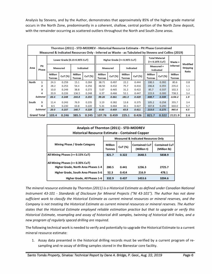
1. At a 0.15% CuT cutoff grade, the results show a large historical mineral resource of 822 million
tonnes at an average grade of 0.322% CuT, for a total of 5.84 billion contained pounds of copper.
2. Within this large historical mineral resource, there exists a higher‐grade central area in the North Pit
area, that outcrops at the surface and dips to the west, within a broad structural/intrusive zone.
3. At a 0.35% CuT cutoff grade, the results show a higher‐grade component of mineralization that
consists of 333 million tonnes at an average grade of 0.437% CuT, for a total of 3.20 billion pounds
of copper.
Santo Tomás Property, Sinaloa: Technical Report by Dane A. Bridge, P. Geol., Aug. 22, 2019 Page 6
Analysis by Stevens, and by the Author, demonstrates that approximately 85% of the higher‐grade material
occurs in the North Zone, predominantly in a coherent, shallow, central portion of the North Zone deposit,
with the remainder occurring as scattered outliers throughout the North and South Zone areas.
The mineral resource estimate by Thornton (2011) is a Historical Estimate as defined under Canadian National
Instrument 43‐101 ‐ Standards of Disclosure for Mineral Projects (“NI 43‐101”). The Author has not done
sufficient work to classify the Historical Estimate as current mineral resources or mineral reserves, and the
Company is not treating the Historical Estimate as current mineral resources or mineral reserves. The Author
states that the Historical Estimate employed reliable estimation practice but that to upgrade or verify this
Historical Estimate, resampling and assay of historical drill samples, twinning of historical drill holes, and a
new program of regularly spaced drilling are required.
The following technical work is needed to verify and potentially to upgrade the Historical Estimate to a current
mineral resource estimate:
1. Assay data presented in the historical drilling records must be verified by a current program of re‐
sampling and re‐assay of drilling samples stored in the Bienestar core facility.
Million
TonnesCuT (%)
Contained CuT
(Million t)
Contained CuT
(Million lb)
821.7 0.322 2648.5 5838.9
280.5 0.441 1236.3 2725.7
52.3 0.414 216.9 478.1
332.9 0.437 1453.6 3204.6
All Mining Phases (>= 0.35% CuT)
Higher Grade, North Area Phases 1‐4
Higher Grade, South Area Phases 5‐6
Higher Grade, All Phases 1‐6
All Mining Phases (>= 0.15% CuT)
Measured & Indicated Resources Only
Analysis of Thornton (2011) ‐ STD‐MODREV
Historical Resource Estimate ‐ Contained Copper
Mining Phase / Grade Category
Santo Tomás Property, Sinaloa: Technical Report by Dane A. Bridge, P. Geol., Aug. 22, 2019 Page 7
2. Five inclined STE‐series drill holes in the North Zone terminate in higher‐grade material. These holes
are suitable for twinning but also are suitable to be extended to test the width of the mineralization
fully.
3. The historical data has identified valid drill targets to firstly verify historical estimates in the pit‐
constrained Mining Phase 1 to 4 regions in the Thornton (2011) historical estimate because 85% of
the higher grade (>=0.35% CuT) blocks occur there.
A program of resampling and twinning of drill holes would be valid only for the verification of historical copper values because the historical assay information is too sparse for other metals. New drilling is required to establish a current estimate for Cu that includes Au, Ag and Mo.
GEOLOGICAL SETTING AND MINERALIZATION The intrusive rocks and porphyry copper mineralization at the Santo Tomás Property are related to the Late
Cretaceous to Paleocene (80 to 55 Ma) Laramide Orogeny. Most of the known porphyry copper deposits in
Mexico lie along a 1,500 km‐long, NW trending belt subparallel to the western coast of Mexico that extends
from the southwestern United States through to the state of Guerrero in Mexico.
The Santo Tomás deposit is within the Sierra Madre Occidental belt of Mexico. This region is underlain by the
Guerrero terrane characterized by volcanic and volcaniclastic sequences associated with island arcs of Middle
Jurassic and Early Cretaceous age. The bedrock in the Santo Tomás region is predominantly comprised of older,
Mesozoic‐aged, bedded, carbonate‐rich sediments including limestone, marble bodies, sandstones, and large
volumes of andesitic volcanic rocks.
The igneous rocks hosting much of the mineralization at Santo Tomás are related to the Late Cretaceous
Sinaloa‐Sonora Batholith which is contemporaneous with the Jurassic and Cretaceous accretion of the terranes
that make up much of the North American Cordillera. The batholith contains multiple phases of intrusive rock
of dioritic to monzonitic composition. The emplacement of intrusions was partially controlled and
subsequently offset by several phases of faulting dating from Late Cretaceous to Tertiary time.
Quartz monzonite is the dominant intrusive lithology at Santo Tomás, and it was intruded into highly fractured
rocks. Locally, the Laramide age intrusive rocks are emplaced in north‐ and northeast‐ trending fault zones
and clearly post‐dates the Sinaloa‐Sonora Batholith. The quartz monzonite Laramide intrusions that host
mineralization on the Property are Paleocene age, dated at 57.2 ± 1.2 Ma, which constrains the timing of the
mineralization.
The older Mesozoic sedimentary and volcanic sequence in the Santo Tomás region is folded to varying degrees
by regional deformation and by deformation related to the emplacement of the Late Cretaceous Sinaloa‐
Sonora Batholith. Early‐stage faulting controlled the emplacement of Santo Tomás quartz monzonite dike
system and is marked by NNE and NE trending normal faults and broad, curving, transcurrent wrench‐fault
zones. These zones are a locus for Laramide dike swarms, hydrothermal brecciation, hydrothermal alteration,
and sulphide mineralization. Late‐stage faulting is characteristically normal faulting of the younger Choix horst
and graben structures which represents a period of extensional deformation dating to the Oligocene‐Miocene.
Overlying the Mesozoic sedimentary and volcanic rocks, and the older bodies of intrusive rocks, is a Tertiary‐
aged volcano‐sedimentary sequence composed of andesitic volcaniclastic rocks and flows, rhyolite
ignimbrites, and intercalated sediments termed the Sierra Madre Occidental (“SMO”) volcanic province. This
Santo Tomás Property, Sinaloa: Technical Report by Dane A. Bridge, P. Geol., Aug. 22, 2019 Page 8
province is an aerially extensive, middle Tertiary, a volcanic province which extends from the southwestern
United States to central Mexico. The SMO is characterized by huge volumes of ignimbrites were erupted during
the Oligocene and Early Miocene (approximately 38 to 15 Ma), forming a large silicic igneous province that
caps much of the terrain in the belt.
The Santo Tomás mineral camp is characterized by copper porphyry and skarn/replacement style
mineralization. The Santo Tomás Cu (‐Mo‐Au‐Ag) porphyry deposit lies mostly on the Santo Tomás
Concessions and is associated with an NNE‐trending zone of quartz monzonite porphyry stocks and dikes,
hosted in strongly faulted and fractured Cretaceous metamorphosed andesite and limestone. The main
portion of the deposit consists of a zone of disseminated copper along the axis of multiple quartz monzonite
porphyry dikes. Wedges or roof pendants of metamorphosed andesite commonly occur within the quartz
monzonite dike complex. Locally, these older stratified rocks tend to occur as gently dipping “rafts” of
limestone/marble are floored by quartz monzonite on the Property, and nearby massive, thick
limestone/marble beds dip gently northward and correlate ridge to ridge. They serve as markers to trace the
effect of several stages of brittle fault deformation.
Mineralization at Santo Tomás is mostly comprised of chalcopyrite, pyrite, and molybdenite sulphides with
minor bornite, covellite, and chalcocite, which occur as fracture fillings, veinlets, and fine disseminations
together with potassium feldspar, quartz, calcite, chlorite, and locally, tourmaline. Minor copper oxides occur
near the surface. Santo Tomás and the deposits in the region that are associated with subvolcanic stocks and
dikes of monzonitic to quartz‐dioritic compositions are commonly enveloped by extensive zones of potassic,
phyllic, propylitic, silica‐albite and argillic hydrothermal alteration.
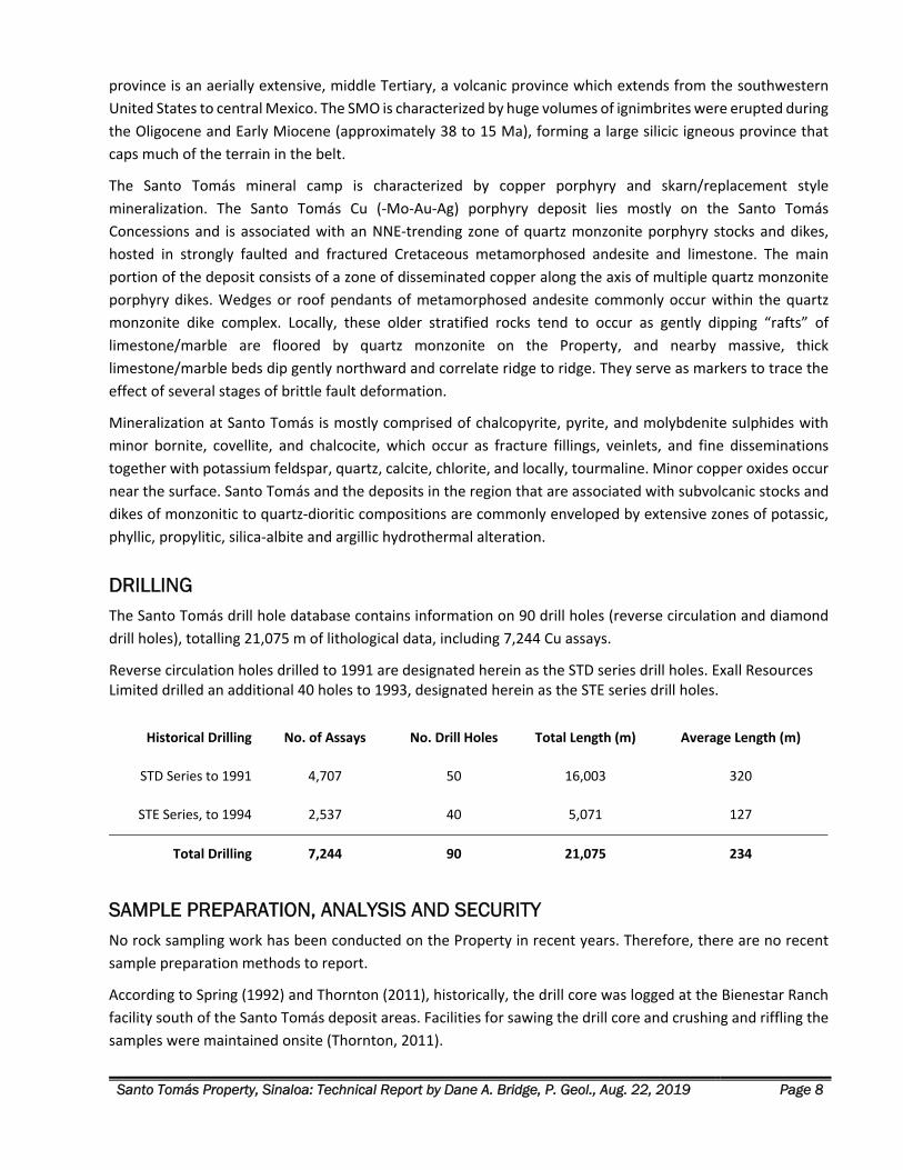
DRILLING The Santo Tomás drill hole database contains information on 90 drill holes (reverse circulation and diamond
drill holes), totalling 21,075 m of lithological data, including 7,244 Cu assays.
Reverse circulation holes drilled to 1991 are designated herein as the STD series drill holes. Exall Resources Limited drilled an additional 40 holes to 1993, designated herein as the STE series drill holes.
Historical Drilling No. of Assays No. Drill Holes Total Length (m) Average Length (m)
STD Series to 1991 4,707 50 16,003 320
STE Series, to 1994 2,537 40 5,071 127
Total Drilling 7,244 90 21,075 234
SAMPLE PREPARATION, ANALYSIS AND SECURITY No rock sampling work has been conducted on the Property in recent years. Therefore, there are no recent
sample preparation methods to report.
According to Spring (1992) and Thornton (2011), historically, the drill core was logged at the Bienestar Ranch
facility south of the Santo Tomás deposit areas. Facilities for sawing the drill core and crushing and riffling the
samples were maintained onsite (Thornton, 2011).
Santo Tomás Property, Sinaloa: Technical Report by Dane A. Bridge, P. Geol., Aug. 22, 2019 Page 9
Sample lengths varied to reflect the geology and mineralization. ASARCO assayed at various lengths that
generally varied between 1 and 3 m (Spring, 1992), but where no visible mineralization was encountered,
sample lengths were 4 m or greater. Exall prepared samples of 2 m lengths (Thornton, 2011).
ASARCO used their professional laboratories in Mexico for assaying. Tormex sent their samples to Ensayadores
Quimicos del Noroeste in Hermosillo, Mexico, with one sample in ten sent for check assay to TSL Laboratories
in Toronto, Canada (Spring, 1992).
Exall analyzed the Santo Tomás samples for total copper percent (CuT), acid‐soluble copper (CuS), and assayed
for copper, gold, silver, molybdenum and iron (Thornton, 2011). Exall also prepared several samples for
metallurgical testing at Mountain States Research and Development Inc. (MSRDI) and at Minetek in 1993 and
1994 (Bateman, 1994).
In 2002, Borovic selected a total of 48.65 m of core (18 samples) and had them assayed at ALS Chemex, in
Hermosillo (Borovic, 2002).
None of the historical procedures for sample and drill core security are available to the Author. Data for the
drill core sampling and logging has been in the continuous custody of John Thornton, P. Eng. since 1994.
DATA VERIFICATION Data verification is the process of confirming that the data underlying the written disclosure is properly
generated, is accurately transcribed, and is suitable for the purpose that the data is used. The Author has
conducted data verification steps. The Author reviewed and verified technical data from source documents,
digital files, and application software to verify for completeness and accuracy of their transcription.
Additionally, the Author’s 2019 fieldwork served to verify the principal structural and geological elements of
the Santo Tomas geological model.
The data verification was limited due to the lack of available historical assay certificates or records on historical
quality control procedures. Assay data is incomplete for molybdenum, gold and silver. The distribution of these
metals is known only from assays of each 5th sample in the Exall drilling program. The distribution of grades in
the North and South Zone is known only for copper.
Data verification steps noted and corrected minor transcription errors. Otherwise, the comparison showed an
excellent agreement between the source data and the digital files. The only exception found during the
Author’s independent verification was the omission of drill hole STD‐50 from the original Bateman (1994) and
Thornton (1994, 2011) records. That omission has been corrected from the scans of the original STD drill logs.
Presently, all corrected drill records are assembled in Microsoft Excel sheets and in a Target drilling database.
Verification of the geological model was successful. Additional structural information confirmed the
interpretation of the attitude of the North Zone mineralization and its contacts.
The Author finds the historical exploration information fully adequate for the purposes in this technical report.
These uses include geological modelling, planning for the verification of the Thornton (2011) Historical
Estimate, the targeting of exploration drill programs, planning of mineral exploration, and the identification
of associated exploration risks.
Santo Tomás Property, Sinaloa: Technical Report by Dane A. Bridge, P. Geol., Aug. 22, 2019 Page 10
MINERAL PROCESSING AND METALLURGICAL TESTING Metallurgical testing of the Santo Tomás ores and host rocks began in 1975. The most recent metallurgical
test work was completed in 1994 by Mountain States Research and Development Inc. (MSRDI). This work and
results are described in Bateman (1994). The mineralized drill samples selected for testing by Exall were
selected from only the North pit area.
Spring (1992) reported that both ASARCO and Tormex examined mineralized samples to recover the copper
as a concentrate through a normal plant circuit of crushing‐grinding and flotation. The preliminary
metallurgical tests suggested that at a grind of approximately 60% passing 200 mesh, a concentrate of 26% Cu
and a recovery of 95% was attainable (Spring, 1992).
Microscopic evaluation by Lakefield Research of Canada (1975) of a minus 10‐mesh rock sample identified
chalcopyrite as the major copper mineral (3% by weight of the sample), 2% pyrite and traces of chalcocite and
covellite. Grains range from 10‐300 µm in size. The origin and source location of the sample was not
determined, but it is assumed that the sample is from the North Zone (Bateman, 1994).
A grind of 60% minus 200‐mesh could be enough to obtain a copper recovery of 95% and a final recovery of
about 90% in testing by Lakefield Research of Canada (1975). A positive response of the mineralized samples
to grinding and flotation was noted. The origin and location of the sample were not determined, but it is
assumed that the sample is from the North Zone (Bateman, 1994).
Under the direction of Exall, Comisión de Fomento Minero (1991) processed samples from 11 drill holes
containing quartz monzonite separated into high grade >0.6% Cu and low grades <0.6% Cu. The results for
recovery for the low‐grade was significantly lower than for the high grade in the tests of the Comisión. The
mineralogical interpretation of the rougher concentrate grade suggests roughly 38% chalcopyrite, 10% pyrite,
5% chalcocite, 4% covellite, 2% bornite, 3% sphalerite and <1% molybdenite/galena (Bateman, 1994).
The andesite zone samples are from the same drill holes used in the quartz monzonite tests and were used to
test the flotation response for high (>0.6% Cu) and low grade (<0.6% Cu) andesite. The recovery for the low‐
grade andesite was significantly lower than for the high grade. The mineralogical interpretation of the rougher
concentrate grade suggests roughly 44% chalcopyrite, 18.7% pyrite and <1% each for bornite, sphalerite and
molybdenite/galena (Bateman, 1994).
The concentrate from the 500 kg sample processed by the Consejo de Recursos Minerales (1993) was used
for the BRISA (Biolixiviación Rápida Indirecta con Separación de Acciones or Rapid Indirect Bioleaching with
Action Separation) process tests. The best bioleach test result was 98% Cu recovery in 5 hours, at 70°C, using
1 mg silver per gram of concentrate as a catalyzer. For a more detailed description of the results of these tests,
please see Bateman (1994).
According to Thornton (2011), the flotation and leaching test work conducted by Mountain States Research
and Development Inc. (MSRDI) in 1994 under the direction of Bateman Engineering is the best work
completed to date on the Santo Tomás diamond‐drill hole composited material. The recovery developed by
this work averaged 90.7% Cu into the concentrate (Thornton, 2011), as follows:
5 drill core samples (from STD‐02, 08, 20, 27 and 43) yielding a sample weighing 39.5 kg, was crushed
to ‐1/2 inch, containing 0.56% Cu of which 92% is chalcopyrite + 5% acid‐soluble Cu and 3% cyanide
soluble Cu. The composite contained 0.003 oz/t Au and 0.10 oz/t Ag. The results of these tests are
described in Bateman (1994).
Santo Tomás Property, Sinaloa: Technical Report by Dane A. Bridge, P. Geol., Aug. 22, 2019 Page 11
Thornton (2011) noted that the molybdenum intensity (determined from assay results) in the South
Zone is three times that of the samples assayed from the North Zone. These assay results indicate a
variable metal content between the North and South Zones.
The Santo Tomás sulphide mineralization did not respond well to direct leaching because of the high
sulphide and low oxide content. Concentrate direct leaching tests were not favourable, suggesting that more
oxidizing conditions are required for greater recoveries (Bateman, 1994).
This summary is taken directly from the 1994 Bateman Engineering report for the grinding and flotation
potential for the Santo Tomás project:
‘Although a relatively fine grind at 200 mesh is required, the Santo Tomás ore responded favorably to
flotation using common reagents. The test results, although limited in nature, indicate that the Santo
Tomás ore would be amenable to beneficiation in a conventional concentrator to produce copper
concentrate for smelter treatment. The recovery can be expected to decrease to produce a final
concentrate of about 28%, but not in a significant proportion, since an optimized balance could be
reached between a primary grind‐rougher flotation with regrind‐cleaner flotation.’
According to Thornton (2011), the work performed by MSRDI was as valid in 2011 as it was in 1994 for a
conventional copper concentrator, and would operate in a very similar manner to such operations as Sierrita
in Arizona, Bajo de la Alumbrera in Argentina, and Cananea in Mexico. The final process‐flow‐plant settings
would need to be determined during the engineering plant design (Thornton, 2011).
INTERPRETATION AND CONCLUSIONS Porphyry‐copper type mineralization is the primary focus for exploration on the Santo Tomás property. The
skarn and oxide copper potential of the Property is very much subordinate to the hypogene base metal
sulphide potential, but offer an opportunity for additional mineral resources The thick beds of limestones in
the Brasiles Zone hold a high potential for base metal and precious metal‐bearing skarns, lying within and
beneath, in addition to copper porphyry mineralization.
Systematic exploration and drilling of the copper‐porphyry mineralization at Santo Tomás has been conducted
since October 1968. The porphyry copper mineralization is sulphide‐dominant with chalcopyrite being the
main Cu‐bearing sulphide mineral (Borovic, 2006; Spring, 1992).
The deposit is also oxidized along the surface to depths ranging from 10 to 30 m (Spring, 1992). After a review
of the drilling data, the Author concludes that the oxide mineralization is not a significant component of the
economic potential of the Property.
Discussion of the Historical Geological Interpretation Historical interpretation of the geology and structure of the Santo Tomás porphyry‐copper deposit was
strongly influenced by exploration diamond drilling programs before 1992, comprising 50 drill holes (“STD”
series), of 16,003 m total length, with an average depth of 320 m. All STD holes were vertical.
Drilling by Exall in the period 1992‐1993 (the “STE” series) comprised 40 shorter holes, with a total of 5,071 m
total length and an average depth of 127 m. Most of the holes were vertical.
Collectively, all historical drilling activity was biased towards relatively shallow, vertical holes that do not
fully test the breadth of the moderately west‐dipping Santo Tomás main mineralized zone. In the North
Santo Tomás Property, Sinaloa: Technical Report by Dane A. Bridge, P. Geol., Aug. 22, 2019 Page 12
Zone, many of the drill holes either terminate in strong mineralization or, alternately, were collared on the
eastern fringe of the main mineralized zone and pass downwards into low‐grade footwall mineralization. In
each of these cases, the holes do not fully test the mineralized zone.
Bateman/Mintec modelling was performed on sections facing North without geological modelling or
wireframing to prevent the influence of low‐grade hanging wall and footwall mineralization from affecting the
block modelling of the main zones of mineralization.
Historical Mineral Resource Estimate – Thornton (2011) An independent consultant to the Company, Mr. Mark Stevens, C.P.G., reviewed the September 2011
historical resource model 2011‐STM‐MODREV applying selected total copper (“CuT”) cutoff grades,
constrained by six (6) progressive open‐pit phases constructed by Thornton, with the ultimate pit represented
by the final sixth phase.
The Stevens verification work obtained mineral resource numbers that closely compare with those reported
in historical tables by Thornton in 2011. The Historical Estimates and recent geological mapping by the Author
confirm that approximately 85% of the higher‐grade material occurs in the North Zone (See Figs.14 15),
predominantly in a coherent, shallow, central portion of the North Zone deposit, with the remainder occurring
as scattered outliers throughout the North and South Zone areas.
The Author concludes the following technical work is needed to verify and potentially to upgrade the Historical
Estimate to a current mineral resource estimate:
1. Assay data presented in the historical drilling records must be verified by a current program of re‐
sampling and re‐assay of drilling samples stored in the Bienestar core facility.
2. Five inclined STE‐series drill holes in the North Zone terminate in higher‐grade material. These
holes are suitable for twinning.
3. The historical data has identified valid drill targets to firstly verify estimates in the pit‐constrained
Mining Phase 1 to 4 regions in the Thornton (2011) Historical Estimate because 85% of the higher
grade (>=0.35% CuT) blocks occur there.
A program of resampling and twinning of drill holes would be valid only for the verification of historical copper values because the historical assay information is too sparse for other metals. New drilling is required to establish a current estimate for Cu that includes Au, Ag and Mo.
The reader is cautioned that a new program of drilling might not confirm the Thornton (2011) 2011‐STM‐
MODREV Historical Estimate.
The Author has accommodated the risk inherent in confirming the Thornton (2011) block model by designing
a drilling program that places drill hole collars for confirmation drilling on the western side (hanging wall) of
the North and South Zone deposits and with inclined drill holes aimed orthogonal to the measured strike and
dip of the deposit.
The Author concludes that Thornton’s technical work is an invaluable source of exploration information that
can be used with reasonable confidence for the current evaluation of exploration risk and for designing future
exploration work, including confirmation drilling.
Santo Tomás Property, Sinaloa: Technical Report by Dane A. Bridge, P. Geol., Aug. 22, 2019 Page 13
Revised Geological Interpretation Geological and structural mapping firstly by Cambria up to 2009, and more recently by the Author and Tapsoba
in 2019, demonstrates the main mineralized zone is defined by the distribution and structural attitude of
sheeted quartz monzonite dikes within a fractured and faulted andesite host rock, and by post‐mineralization
faulting.
Structural information provides support for future block modelling in the North Zone using the attitudes to
the hanging wall and footwall of 020°/50°W. In 2009, Cambria validated and prepared a block model using
drilling data, structural data, and the geostatistical range of the Cu semi‐variogram of 130 m both along strike
and down‐dip. The 2009 Grade Shell of Cu > 0.30%, passing through the mid‐point of the blocks at the edge,
was created to 3D‐model the core of the mineralized zone (McGuigan, 2009).
The 2019 structural mapping by the Author and Tapsoba highlighted the Early Stage NNE‐ and NE‐oriented
structural control to Laramide mineralization of the Santo Tomás deposits. For the first time, the 2019 data
provided information to model the younger, post‐mineralization displacement of the deposit by NNW and E‐
W faulting in the North Zone and Brasiles Zone, respectively.
Importantly, the Author observed no clusters of flat‐ to gently dipping mineralized structures in the new 2019
structural observations. This data conclusively invalidates the Mintec 1994 and 2003 historical mineral
resource estimates. The Author concluded that an updated 3D geological model was required for exploration
planning and layout of confirmation drilling.
Historical Cambria and Thornton work was checked against the data from the current 2019 exploration data,
structural interpretation, and cross‐sections. Both Cambria (McGuigan) in 2009 and Thornton in 2011
employed wireframing to limit the inclusion of poorly mineralized hanging wall and footwall intersections in
preparing block models of the main mineralized North Zone. This verification yielded the following relevant
conclusions by the Author:
1. Correlograms in the geostatistical analysis within Thornton (2011) conform to the strike of 020° and
the observed 50°W dip of the main mineralizing stage. This geostatistical finding was first employed
in the Cambria 2009 geological modelling work and is now confirmed by structural measurements in
the 2019 field studies by the Author and Tapsoba.
2. The shape and distribution of the 2009 Grade Shell of Cu > 0.30% was also evaluated using the 2019
structural data. The southwestern limit of the grade shell does not cross the new estimated position
of the younger Western fault zone.
3. The 2009 Grade Shell of Cu > 0.30% compared to the historical mineral resource blocks of Thornton
(2011) on recent cross‐sections is a superior representation of the higher‐grade core of the North
Zone, especially at depth.
The 2009 Grade Shell Cu > 0.30% volume identifies a promising, shallow‐seated North Zone exploration target.
This target is estimated to be a tabular body that dips towards the west at 50° within the higher‐grade central
axis of the North Zone mineralization unit Mx.
Santo Tomás Property, Sinaloa: Technical Report by Dane A. Bridge, P. Geol., Aug. 22, 2019 Page 14
3D Geological Model The Author reviewed the shape and position of the higher‐grade portion of the Thornton 2011‐STM‐MODREV
block model (above a 0.35% CuT cut‐off grade) to the 3D volume of the Cambria 2009 Grade Shell Cu > 0.30%
prepared from the same historical drilling data. The Author concludes that the 2009 Grade Shell of Cu > 0.30%
informs a more realistic shape and position for targeting the recommended phase of new definition drilling,
especially as the drilling progresses down‐dip and along strike from the historical drilling.
Furthermore, the Author concludes that the new 2019 mapping and structural data summarized in the section
on Property Geology validates the features in the Santo Tomas 3D geological model (see Fig. 37), as follows:
1. Hanging wall and footwall contacts of mineralization.
2. Western Fault and splays terminate the SW fringe of the North Zone.
3. North Zone Mineralized Unit (“Mx”): The North Zone is validly modelled to the limits of quartz
monzonite dikes, altered andesite, and copper mineralization (above about 0.10% CuT) using the
020°/50°W structural attitude for the footwall and hanging wall.
4. 2009 Grade Shell Cu > 0.30% was compared to elements of the 2019 structural mapping. The Author
concludes this grade shell volume remains valid today and conforms to the revised 3D geological
model of the North Zone. The 2009 Grade Shell nests within Unit Mx.
Exploration Target The Author concludes that the highest priority exploration target on the Property lies in the central core of
the North Zone, at a shallow depth below the surface. This area was also identified in the Historical Estimate
of Thornton (2011) as having 85% of the higher‐grade material (above 0.35% CuT). A new program of regularly
spaced drilling is required to confirm this higher‐grade material and to conduct additional exploration.
After review of the historical drilling data, the Thornton (2011) Historical Estimate, and the Santo Tomas 2019
geological model, the Author concludes the highest priority exploration target is within and near the 3D
volume of the 2009 Grade Shell Cu > 0.30%, that is part of the North Zone mineralized unit (Mx). New drilling
is recommended on cross sections spaced 200 m apart. Drilling on these sections would test the 2009 Grade
Shell target at 200 m spacing along strike and 200 m down the dip direction (150 m elevation spacing).
1. Cross‐Sections N30 to N46: The first priority target is the North Zone mineralized unit (Mx), where Mx
is widest on the surface. The target is 1,000 m along strike and above about 100 m elevation (see
herein Recommendations Phase 1.1).
2. Cross‐Sections N18 to N50: A second priority target is a periphery to the core of the North Zone, in
areas northwards, southwards, and to a greater depth than (1), across a total of 1,800 m of strike
length of Mx (see herein Recommendations Phase 2.1).
The 3D 2009 Grade Shell Cu > 0.30% encloses a target of approximately 280 to 315 million tonnes of material
with a target grade of 0.45% to 0.55% CuT. First and second priority drilling on the Sections N18 to N50 would
test this initial target and also test for additional tonnage, mostly along strike to the south, and down‐dip
within Mx. The tonnage and grade stated for the target are conceptual, and the Author does not treat the
target to be a mineral resource estimate under NI43‐101. The Author cannot be sure whether future
exploration will result in the target becoming a current mineral resource or reserve.
Santo Tomás Property, Sinaloa: Technical Report by Dane A. Bridge, P. Geol., Aug. 22, 2019 Page 15
The risks in drilling this exploration target include the possibility that the strike and dip of the North Zone are
incorrectly estimated. Additionally, the structural termination of the North Zone against the Western fault
zone is somewhat uncertain due to sparse information for that fault from drilling and surface mapping. The
Western Fault, if dipping more steeply than expected, will lessen the North Zone tonnage to depth. Conversely,
if the Western Fault is shallower than expected, the North Zone target will be more open for a tonnage
increase at depth. This risk is only relevant for the southern part of the North Zone. Central and northern
portions of the North Zone are well‐separated from the Western Fault zone.
RECOMMENDATIONS Phase 1: Exploration and Drilling Non‐Success Contingent ‐US $2,198,600
Phase 1.0 Surface Exploration be first initiated. After road access is re‐established to the West Bench
and North Zone, construct an exploration camp and survey the Property with ground geophysical and
geological surveys.
Phase 1.1 North Zone Definition Drilling Program, Stage 1 be started as soon as road access, and the
camp is constructed. The drilling recommended in this First Stage can run concurrently to the surface
exploration. The First Stage program of drilling is recommended to confirm the geology and mineral
resources of the central, near‐surface portions of the North Zone. Work in this stage would accrue to
building a mineral resource estimate at the Indicated Resource level of confidence at a nominal 200
m spacing down the dip and along strike of mineralization. It is followed by a non‐success contingent
program of definition drilling in Phase 2.1. Recommended is 7,300 m in 11 diamond drill holes.
Phase 2: Exploration and Drilling Program – Non‐Success and Success Contingent ‐ (US $10,426,000)
Phase 2.0 Surface Exploration & Environmental Program be initiated in Phase 2, comprising a
geological mapping of the Property, Remote Sensing, and Baseline Environmental studies.
Phase 2.1 North Zone Definition Drilling Program, Stage 2 is not contingent on the results of the
Phase 1 results. This stage will see the completion of definition drilling on North Zone sections N 18 to
N 50, above the elevation of 200 m below sea level. Recommended is 19,400 m of drilling in 28
diamond drill holes.
Phase 2.1 South Zone Exploration Drilling Program is not contingent on the results of Phase 1 work.
Recommended is that concurrent with the start‐up of the North Zone definition drilling Phase 2.1,
South Zone drilling focus on the Ridge zone to follow‐up on the significant historical intersections in
STD‐50 and ‐36 (Section S‐14, two holes, Phase 2.1). Recommended is 1550 m in 2 diamond drill
holes.
Phase 2.2: Drilling Program – Success Contingent: comprising drilling for extensions of the North Zone
(down‐dip and along strike) to about ‐200 m elevation on Sections N‐26 to N‐18, and in the South Zone
on Sections S‐10, S‐14 and S‐18. Brasiles Zone drilling is recommended to start, success contingent, on
results of Phase 1 geology and geophysics programs. Recommended is 29,250 m of diamond drilling
in 43 diamond drill holes (26 in the North Zone, 4 in Brasiles Zone, and 13 in the South Zone).
Santo Tomás Property, Sinaloa: Technical Report by Dane A. Bridge, P. Geol., Aug. 22, 2019 Page 16
INTRODUCTION
The Santo Tomás Property, in Sinaloa State, Mexico is a copper exploration project, located in northeastern
Sinaloa State, near the border with Chihuahua, Mexico. This report was prepared as a Technical Report for
Oroco Resource Corp. (“Oroco”) by Dane A. Bridge, M.Sc., P. Geol. (the “Author”) of Dane A. Bridge Consulting
Inc. (“Bridge Consulting”) of Calgary, Alberta. Additionally, Altamura Copper Corp. is granted a license by
Bridge Consulting to use this report for its corporate purposes.
Oroco holds a beneficial interest (via its subsidiary companies and agreements) in the subject mineral
concessions registered under the name of Compañía Minera Ruero, S.A. de C.V. (“CMR”), that is a private
registered mining company in Mexico. The subject concessions are herein termed the “CMR Concessions” and
comprise 7 mineral concessions with a total area of 1,172.9 ha. Herein, the CMR concessions are termed the
Santo Tomás Property (the “Property”) and mostly hold the historically drill‐defined mineral resources.
Oroco also holds various interests in abutting mineral concessions (the “Peripheral Concessions”) that are not
the subject of this Technical Report. The Peripheral Concessions are described herein, along with other
properties within the report section “Adjacent Properties.”
This technical report documents a geological description of the Property prepared by Bridge Consulting. It was
prepared following the Canadian Securities Administrators’ National Instrument (“NI”) 43‐101 and Form 43‐
101F1 Technical Report. Recommendations presented herein conform to the generally accepted Canadian
Institute of Mining, Metallurgy and Petroleum’s (“CIM”) Mineral Exploration Best Practice Guidelines. The
review and citing of historical mineral resource statements herein were prepared in conformity with generally
accepted CIM Estimation of Mineral Resources and Mineral Reserves Best Practice Guidelines.
This Technical Report summarizes a historical Pre‐Feasibility Study (1994, 2003) and other technical
information available on the Property and demonstrates that the Property is a promising exploration property.
The quality of information, conclusions, and recommendations contained herein are consistent with the level
of effort involved the review and two site visits by Bridge Consulting and is based on:
1. The information available at the time of preparation;
2. data supplied by outside sources; and,
3. the assumptions, conditions, and qualifications outlined in this report.
This report is intended for use by Oroco subject to the terms and conditions of its contract with Bridge
Consulting and relevant securities legislation. The contract permits Oroco to file this report as a Technical
Report with Canadian securities regulatory authorities under the National Instrument 43‐101, Standards of
Disclosure for Mineral Projects. Except for the purposes legislated under provincial securities law, any other
uses of this report by any third party is at that party’s sole risk. The responsibility for this disclosure remains
with Oroco.
The user of this document should ensure that this is the most recent Technical Report for the Property as this
report is not valid if a newer Technical Report has been issued.

Santo Tomás Property, Sinaloa: Technical Report by Dane A. Bridge, P. Geol., Aug. 22, 2019 Page 17
SCOPE OF WORK The scope of work, as defined in a letter of engagement executed on the effective date of January 28, 2019,
between Oroco and Bridge Consulting and includes the review of historical technical information that was
assembled by Oroco and its supporting consultants and the preparation of an Independent Technical Report.
This work involves the assessment of the following aspects of this project:
Access, topography, climate and local infrastructure;
Regional and local geology;
Exploration history;
Audit of historical drilling and exploration work carried out on the Property;
Geological cross‐section preparation;
Review of any relevant publicly released mineral resource estimations made; and,
Recommendations for additional work.
The exploration database was compiled and maintained by Oroco. The contained information was reviewed
and edited by Bridge Consulting, where needed. The geological cross‐sections and outlines for the copper
mineralization were constructed by Bridge Consulting from the geological database and certain grade‐shell
files provided by Oroco and its supporting consultants. In the opinion of Bridge Consulting, the geological
model employed on the Property is a reasonable representation of the distribution of the targeted
mineralization at the current level of sampling.
Bridge Consulting has no reason to doubt the reliability of the information provided by Oroco. This technical
report is based on the following sources of information:
Discussions with Oroco and its consulting personnel;
Field geological and structural mapping on the Property by the Author in February and March of 2017,
including visiting rock outcroppings, and examining sample collections and drill core;
Review of exploration data collected by Oroco and digital assemblies of historical exploration and
drilling data dating from 1968;
Review of additional information from public domain sources; and
A second field mapping program by the Author from March 3 to March 14, 2019.
A brief list of the most important documents reviewed follows below. A complete list is in the section titled
“References” at the end of this document.
Spring, V. (1992). A Review of the Potential of the Santo Tomás Porphyry Copper Deposit, Sinaloa,
Mexico for Exall Resources Limited by Watts, Griffis and McOuat Limited, Toronto, Ontario, Canada:
38p.
Bateman Engineering Inc. (1994). Prefeasibility Study, Exall Resources, Santo Tomás Project, Sinaloa,
Mexico. Tucson, Arizona, Bateman Engineering Inc. Bateman Project No. 8119: 263p (Includes:
Thornton, J.C. (1994). Preliminary Geological Ore Reserves and Mining Reserve Determination Based
on ASARCO and Exall Diamond Drill hole Programs. Tucson, Arizona, Mintec Inc.: 56p.)
Santo Tomás Property, Sinaloa: Technical Report by Dane A. Bridge, P. Geol., Aug. 22, 2019 Page 18
Bateman Engineering Inc. (2003). Update Previous Prefeasibility Study, Santo Tomás Project. Tucson,
Arizona, Bateman Engineering Inc.: 69p.
Borovic, I. R. (2002). Report on the Mineral Exploration and Development of the Santo Tomás Property
Lat. 26° 56' 47" N; Long. 108° 19' 20" W, Municipality of Choix, State of Sinaloa, Mexico; Summary and
evaluation for Aztec Copper Inc., Vancouver, British Columbia: 60p
Borovic, I. R. (2006). Exploration of the Santo Tomás Copper Porphyry Deposit, Choix, Sinaloa, Mexico.
Vancouver, British Columbia, Igna Engineering & Consulting Ltd.: 61p.
Borovic, I. R. (2007 (Revised 2008)). Exploration of the Santo Tomás Copper Porphyry Deposit, Choix,
Sinaloa, Mexico. Vancouver, British Columbia, Igna Engineering & Consulting Ltd.: 60p.
Thornton, J. C. (2011). Santo Tomás Copper Project, Choix, Sinaloa, Mexico: Technical Report, Tucson,
Arizona: 171p.
In addition to the reports, the Company’s collection of the available drill logs and re‐logs available were
reviewed. Three sets of detailed geological cross‐sections (50 m spacing) of historical drilling were reviewed.
UNITS AND ABBREVIATIONS All map locations and drill hole positions are in meters, and Universal Transverse Mercator (“UTM”)
coordinates are in World Geodetic System (“WGS”) 84 Zone 12. All units and measurements presented in this
report are in metric, except for the price weight of copper and molybdenum, which are presented in dollars
per pound (lb.). Dollar values presented are in the United States of America dollars unless otherwise stated.
The most common units and abbreviations presented in this document are listed below in Tables 2.1 to 2.3.
Table 1. List of other units and abbreviations
Other
Tonnes per day tpd
Cubic metres per hour per square metre m3/hr/m2
United States dollar US$ or $
Inverse distance to the 3rd power interpolation method IDW
Measured and Indicated M & I
Proven and Probable 2P
Proven, Probable, and Possible 3P
Strip ratio S/R
Million tonnes per year MTPY
Smelting and Refining S&R
General and Administrative Expense G&A
Resources and Reserves R&R
Santo Tomás Property, Sinaloa: Technical Report by Dane A. Bridge, P. Geol., Aug. 22, 2019 Page 19
Table 2. List of units and abbreviations for distance, area and mass
Distance
millimetre mm
centimetre cm
metre m
kilometre km
Area
square metre m2
square kilometre km2
hectare ha
Mass
troy ounce (= 31.1035 g) oz
gram g
kilogram kg
tonne (1,000 kg) T or t
kilo‐tonnes or 1,000 tonnes Kt
million tonnes or 1,000,000 tonnes Mt
pound (= 453.592 g) lb or lbs
Table 3. List of units and abbreviations for time, volume and flow, elements and assay and grade
Time
minute min
hour hr
day d
year yr
Volume and Flow
cubic metre m3
cubic metres per hour m3/hr
Elements
copper Cu
gold Au
silver Ag
molybdenum Mo
Assay and Grade
grams per tonne g/t
grams per litre g/L
parts per million ppm
parts per billion ppb
total copper percent CuT
Acid soluble copper percent CuS
Santo Tomás Property, Sinaloa: Technical Report by Dane A. Bridge, P. Geol., Aug. 22, 2019 Page 20
RELIANCE ON OTHER EXPERTS
Bridge Consulting has not performed independent verification of land title and tenure. Bridge Consulting did
not verify the legality of any underlying agreement(s) that may exist concerning commercial agreement(s)
between third parties. Bridge Consulting’s opinion, as presented in this technical report, relies on the
information provided by Oroco’s management and legal counsel in early July 2019 and updated on August 22,
2019.
Bridge Consulting is relying upon verification surveys conducted by a professional (registered) land surveyor
(a “Perito Minero”) Barney Green Lee Portillo (“Green”). Sr. Green located and surveyed concession
monuments of the CMR Concessions during the 2017 field program. Sr. Green’s concession boundaries are
used in this report. Also, he surveyed a point corresponding to Exall’s principal survey control point “Patricia”
that was used to survey the collars of the Exall 1993 drilling program and to, therefore, verify the locations of
earlier ASARCO and Tormex drill collars.
PROPERTY DESCRIPTION AND LOCATION
PROPERTY LOCATION The Santo Tomás property (the “Property”) is in the municipality of Choix, on the south bank of Rio Fuerte
in the Western Sierra Madre mountain range. The Property is in the northern part of Sinaloa, bordering
and lying partly within the State of Chihuahua, México, and is centred at latitude 26°53’00” N and longitude
108°11’30” W (see Figure 1).
MEXICAN MINERAL TENURE SYSTEM
Governing Law and Regulations Mexico (Estados Unidos Méxicanos) has a well‐established system of mineral land tenure. Mexican Mining
Law is based on Article 27 of the Constitution, which establishes that the Federal Republic owns all minerals
found in Mexican territory. The Mining Law of August 2006 and the current Regulations (enabled in October
2012) regulate or administer Article 27. All land in Mexico is available for claiming except existing mining
concessions or allotments, applications for mining concessions and allotments that are in progress, areas
reserved from mining, maritime zones and certain federally regulated areas. The term “concession” refers to
mining lots, that are valid for fifty years and renewable for one additional 50‐year period.
Mexican Public Registry of Mining Mexican Public Registry of Mining (the “PRM”) is the central titles registration office under the Mexican Mines
Bureau. The application of the Mining Law and its Regulations is the responsibility of the Federal Executive
(the President´s Office) through the Ministry of Economy. All concessions must be registered with the PRM.
The Title to a concession is evidenced through registration. Concessions have maintenance obligations
comprised of assessment work expenditure commitments and the payment of mining duties.
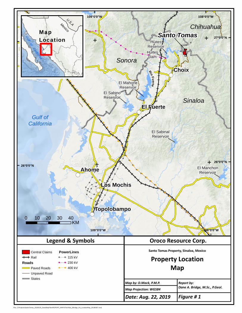
!
!
!
!
!
!
!
!
!
!
!
!
!
!
!
!
!
!
!
!
!!
!!
!!
!!
!
!
!
!
!
!
!
!
!
!
!
!
!
!
!
!
!
!
!
!
!
!
!
!
!
!
!
!
!
!
!
!
!!
!
!
!
!!
!
!
!
!
!!
!!
!!
!
!
!
!!
!
!!
!
!
!
!
!
!
!!
!!
!
!
!!
!!
!!
!
!
!
!
!
!
!!!
!!
!!
!!
!
!!
!!
!
!
!
!
!
!
!
!
!
!
!
!
!
!
!
!
!
!
!
!
!
!
!
!
!
!
!
!
!
!
!
!
!
!
!
!
!
!
!
!
!
!
!
!
!!
!
!
!
!
!
!
!
!
!
!
!
!(
!(
!(
!(
!(
Choix
Ahome
El Fuerte
Los Mochis
Topolobampo
108°0'0"W
108°0'0"W
109°0'0"W
109°0'0"W
27°0'0"N27°0'0"N
26°0'0"N26°0'0"N
EE
EE
Gulfof
California
U.S.AMexico
Santo TomasMapLocation
File: Z:\Projects\SantoTomas_2018\GIS_Data\MapFiles\REPORT_MAPS\TechRpt_DBridge_A4_LocationMap_20190307.mxd
Oroco Resource Corp.Santo Tomas Property, Sinaloa, Mexico
Property LocationMap
Map Projection: WGS84
Report by:Dane A. Bridge, M.Sc., P.Geol.
Legend & Symbols
Map by: D.Mack, P.M.P.
0 10 20 30 40KM
Sonora
Gulf ofCalifornia
HuitesReservoir
Rio Fuerte
Sinaloa
Chihuahua
El MahoneReservoir
El SabinoReservoir
El SabinalReservoir
HuitesDam
Central Claims
Rail
RoadsPaved Roads
Unpaved Road
States
PowerLines! ! 115 kV
! ! 230 kV
! ! 400 kV
El ManchonReservoir
Date: Aug. 22, 2019 Figure # 1
Santo Tomás Property, Sinaloa: Technical Report by Dane A. Bridge, P. Geol., Aug. 22, 2019 Page 22
Assessment Work and Mining Duties Assessment work reports must be filed in May of each year. The mining regulations specify the minimum
expenditure obligations required for concessions. Mining duties are payable in advance in January and July of
each year. The minimum expenditure obligations and the mining duties payable are each calculated based on
the size and age of the concession.
Valid Concession Holders & Surface Rights Only Mexican nationals or Mexican incorporated companies (there are no restrictions on foreign ownership
of such entities) may hold concessions (El Congreso de Los Estados Unidos Mexicanos, 1992, updated 2014).
Concessions holders do not automatically acquire surface rights, and access permission must be negotiated
with the landowner (El Congreso de Los Estados Unidos Mexicanos, 1992, updated 2014).
Location Surveys In Mexico, the location of a concession is determined by the location of a single claim monument (“mojonera”),
with all corners being located based on surveyed distances and bearings from that monument. A licensed
surveyor (a “Perito Minera”) must determine these distances and bearings. The monument may be placed
outside of the surveyed claim boundaries. Although the perimeter lines may not have been partially or entirely
surveyed, the method of locating the claim corners constitutes a legal survey. All meets and bounds of the
concession boundaries are defined in metric dimensions. Historically, coordinates cited in the Mexican Mineral
tenure system are based on a UTM grid, North American Datum (NAD) 27 datum.
The National Institute of Statistics and Geography (Instituto Nacional de Estadística y Geografía) under Article
26 of Part B of the Constitution of Mexico approved a change to the coordinate system used to display and
publish geospatial data. This change is to improve the quality and accuracy of the geospatial data they present.
This transition is from datum NAD27 (North America Vertical Datum 1927) to ITRF08 (International Terrestrial
Reference Frame, 2008), which is compatible with WGS84 (World Geodetic System 1984) and SIRGAS
(Geocentric Reference System for the Americas). The change was published in the Official Gazette on
December 23, 2010 and entered into law the following day. All geospatial data from the Mexican Government
since 2010 contains metadata detailing the coordinate system used and any transformations applied to the
original data (Diario Oficial de la Federacion, 2010).
MINERAL TENURES OF THE PROPERTY Oroco Resource Corp. holds interests in the Santo Tomás “Core Concessions” (the “Property”) via its interest
in Altamura Copper Corp. (“Altamura”) which has an interest in the registered owner, Compañía Minera Ruero
S.A. de C.V. (“CMR”), and a controlling interest in the contractual owner of the Property, Xochipala Gold, S.A.
de C.V. (“XG”). The concessions of the Property are listed in Table 4 and shown in Figure 2. The Property
comprises a total area of 1,172.9 ha of concessions.
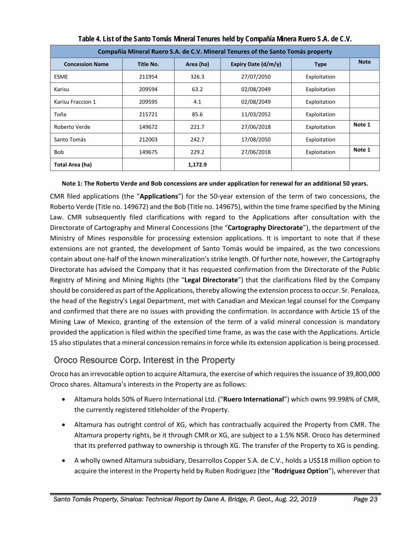
Santo Tomás Property, Sinaloa: Technical Report by Dane A. Bridge, P. Geol., Aug. 22, 2019 Page 23
Table 4. List of the Santo Tomás Mineral Tenures held by Compañía Minera Ruero S.A. de C.V.
Compañía Mineral Ruero S.A. de C.V. Mineral Tenures of the Santo Tomás property
Concession Name Title No. Area (ha) Expiry Date (d/m/y) Type Note
ESME 211954 326.3 27/07/2050 Exploitation
Karisu 209594 63.2 02/08/2049 Exploitation
Karisu Fraccion 1 209595 4.1 02/08/2049 Exploitation
Toña 215721 85.6 11/03/2052 Exploitation
Roberto Verde 149672 221.7 27/06/2018 Exploitation Note 1
Santo Tomás 212003 242.7 17/08/2050 Exploitation
Bob 149675 229.2 27/06/2018 Exploitation Note 1
Total Area (ha) 1,172.9
Note 1: The Roberto Verde and Bob concessions are under application for renewal for an additional 50 years.
CMR filed applications (the “Applications”) for the 50‐year extension of the term of two concessions, the
Roberto Verde (Title no. 149672) and the Bob (Title no. 149675), within the time frame specified by the Mining
Law. CMR subsequently filed clarifications with regard to the Applications after consultation with the
Directorate of Cartography and Mineral Concessions (the “Cartography Directorate”), the department of the
Ministry of Mines responsible for processing extension applications. It is important to note that if these
extensions are not granted, the development of Santo Tomás would be impaired, as the two concessions
contain about one‐half of the known mineralization's strike length. Of further note, however, the Cartography
Directorate has advised the Company that it has requested confirmation from the Directorate of the Public
Registry of Mining and Mining Rights (the “Legal Directorate”) that the clarifications filed by the Company
should be considered as part of the Applications, thereby allowing the extension process to occur. Sr. Penaloza,
the head of the Registry's Legal Department, met with Canadian and Mexican legal counsel for the Company
and confirmed that there are no issues with providing the confirmation. In accordance with Article 15 of the
Mining Law of Mexico, granting of the extension of the term of a valid mineral concession is mandatory
provided the application is filed within the specified time frame, as was the case with the Applications. Article
15 also stipulates that a mineral concession remains in force while its extension application is being processed.
Oroco Resource Corp. Interest in the Property Oroco has an irrevocable option to acquire Altamura, the exercise of which requires the issuance of 39,800,000
Oroco shares. Altamura’s interests in the Property are as follows:
Altamura holds 50% of Ruero International Ltd. (“Ruero International”) which owns 99.998% of CMR,
the currently registered titleholder of the Property.
Altamura has outright control of XG, which has contractually acquired the Property from CMR. The
Altamura property rights, be it through CMR or XG, are subject to a 1.5% NSR. Oroco has determined
that its preferred pathway to ownership is through XG. The transfer of the Property to XG is pending.
A wholly owned Altamura subsidiary, Desarrollos Copper S.A. de C.V., holds a US$18 million option to
acquire the interest in the Property held by Ruben Rodriguez (the “Rodriguez Option”), wherever that
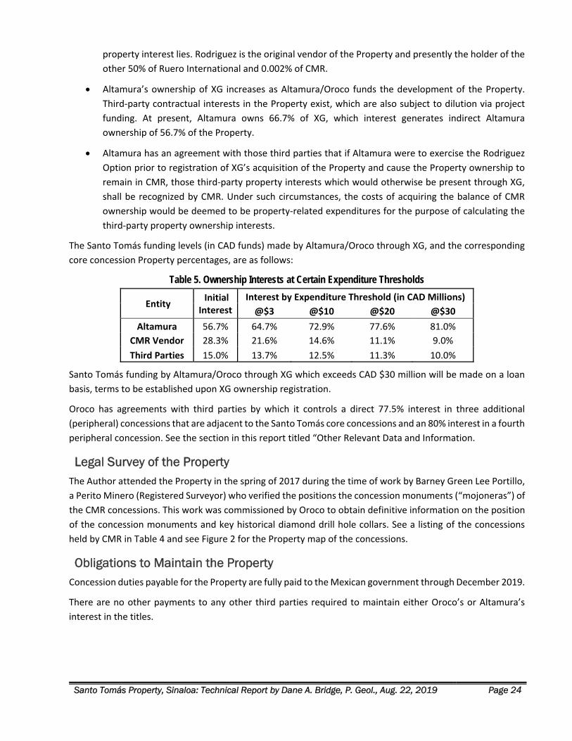
Santo Tomás Property, Sinaloa: Technical Report by Dane A. Bridge, P. Geol., Aug. 22, 2019 Page 24
property interest lies. Rodriguez is the original vendor of the Property and presently the holder of the
other 50% of Ruero International and 0.002% of CMR.
Altamura’s ownership of XG increases as Altamura/Oroco funds the development of the Property.
Third‐party contractual interests in the Property exist, which are also subject to dilution via project
funding. At present, Altamura owns 66.7% of XG, which interest generates indirect Altamura
ownership of 56.7% of the Property.
Altamura has an agreement with those third parties that if Altamura were to exercise the Rodriguez
Option prior to registration of XG’s acquisition of the Property and cause the Property ownership to
remain in CMR, those third‐party property interests which would otherwise be present through XG,
shall be recognized by CMR. Under such circumstances, the costs of acquiring the balance of CMR
ownership would be deemed to be property‐related expenditures for the purpose of calculating the
third‐party property ownership interests.
The Santo Tomás funding levels (in CAD funds) made by Altamura/Oroco through XG, and the corresponding
core concession Property percentages, are as follows:
Table 5. Ownership Interests at Certain Expenditure Thresholds
Entity Initial Interest
Interest by Expenditure Threshold (in CAD Millions)
@$3 @$10 @$20 @$30
Altamura 56.7% 64.7% 72.9% 77.6% 81.0%
CMR Vendor 28.3% 21.6% 14.6% 11.1% 9.0%
Third Parties 15.0% 13.7% 12.5% 11.3% 10.0%
Santo Tomás funding by Altamura/Oroco through XG which exceeds CAD $30 million will be made on a loan
basis, terms to be established upon XG ownership registration.
Oroco has agreements with third parties by which it controls a direct 77.5% interest in three additional
(peripheral) concessions that are adjacent to the Santo Tomás core concessions and an 80% interest in a fourth
peripheral concession. See the section in this report titled “Other Relevant Data and Information.
Legal Survey of the Property The Author attended the Property in the spring of 2017 during the time of work by Barney Green Lee Portillo,
a Perito Minero (Registered Surveyor) who verified the positions the concession monuments (“mojoneras”) of
the CMR concessions. This work was commissioned by Oroco to obtain definitive information on the position
of the concession monuments and key historical diamond drill hole collars. See a listing of the concessions
held by CMR in Table 4 and see Figure 2 for the Property map of the concessions.
Obligations to Maintain the Property Concession duties payable for the Property are fully paid to the Mexican government through December 2019.
There are no other payments to any other third parties required to maintain either Oroco’s or Altamura’s
interest in the titles.
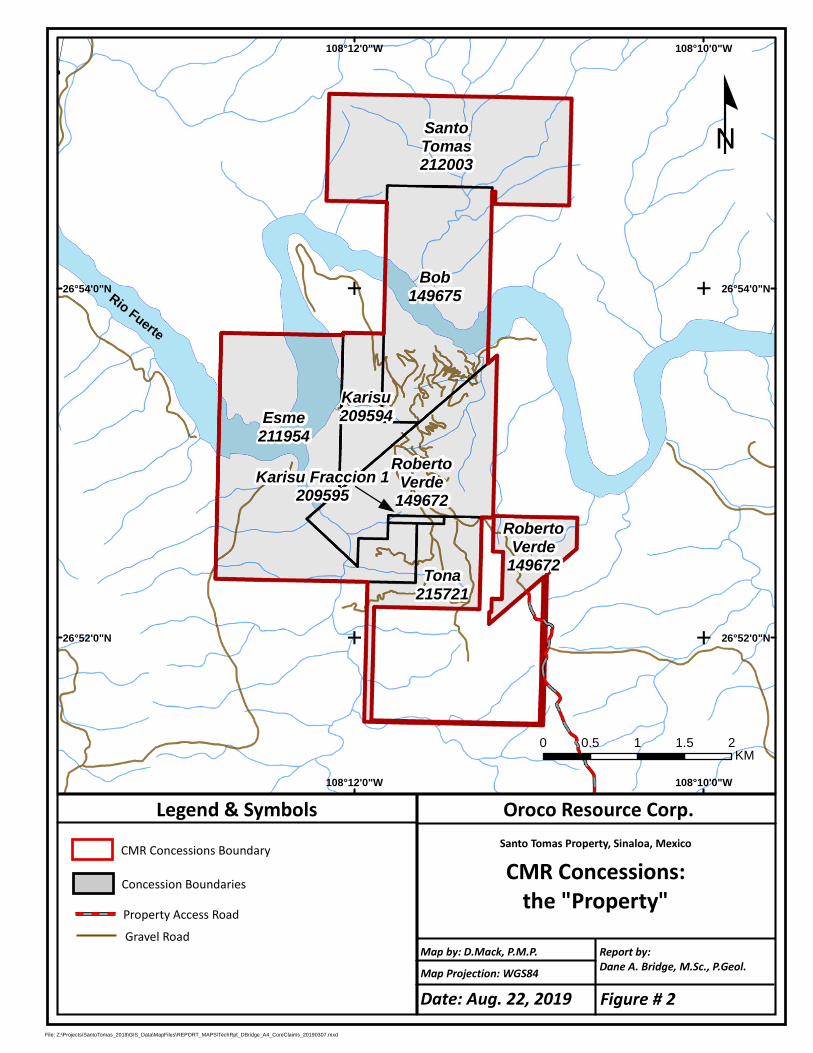
!
!
!
!
!
!
!
!
!
!
!
!
!
!
!
!
!
!
!
!
!
!
!
!
!
!
!
!
!!
!!
!!
!!
!!
!!
!!
!!
!
!
!
!
!
!
!
!
!
!
!
!
!
!
!
!!
!
!!
!
!
!
!
!
!
!
!
!!
!
!
!
!
!
!
!
!
!
!
!
!
!
!
!
!
!
!
!!
!!
!!
!!
!!
!
!
!
!
!
! ! ! ! ! ! ! ! !
!
!
!!
! ! ! ! !
!
!
!
!
!
!
!
!
!
!
!
!
!!
!!
!
RobertoVerde
149672
Bob149675
Karisu209594
SantoTomas212003
Tona215721
Esme211954
108°10'0"W
108°10'0"W
108°12'0"W
108°12'0"W
26°54'0"N 26°54'0"N
26°52'0"N 26°52'0"N
EE
EE
File: Z:\Projects\SantoTomas_2018\GIS_Data\MapFiles\REPORT_MAPS\TechRpt_DBridge_A4_CoreClaims_20190307.mxd
Oroco Resource Corp.Santo Tomas Property, Sinaloa, Mexico
CMR Concessions:the "Property"
Map Projection: WGS84
Report by:Dane A. Bridge, M.Sc., P.Geol.
Legend & Symbols
Map by: D.Mack, P.M.P.
Property Access RoadConcession Boundaries
º
0 0.5 1 1.5 2KM
Gravel Road
RobertoVerde
149672
Rio Fuerte
Karisu Fraccion 1209595
CMR Concessions Boundary
Date: Aug. 22, 2019 Figure # 2
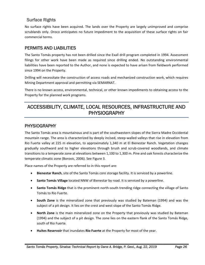
Santo Tomás Property, Sinaloa: Technical Report by Dane A. Bridge, P. Geol., Aug. 22, 2019 Page 26
Surface Rights No surface rights have been acquired. The lands over the Property are largely unimproved and comprise
scrublands only. Oroco anticipates no future impediment to the acquisition of these surface rights on fair
commercial terms.
PERMITS AND LIABILITIES The Santo Tomás property has not been drilled since the Exall drill program completed in 1994. Assessment
filings for other work have been made as required since drilling ended. No outstanding environmental
liabilities have been reported to the Author, and none is expected to have arisen from fieldwork performed
since 1994 on the Property.
Drilling will necessitate the construction of access roads and mechanized construction work, which requires
Mining Department approval and permitting via SEMARNAT.
There is no known access, environmental, technical, or other known impediments to obtaining access to the
Property for the planned work programs.
ACCESSIBILITY, CLIMATE, LOCAL RESOURCES, INFRASTRUCTURE AND PHYSIOGRAPHY
PHYSIOGRAPHY The Santo Tomás area is mountainous and is part of the southwestern slopes of the Sierra Madre Occidental
mountain range. The area is characterized by deeply incised, steep‐walled valleys that rise in elevation from
Rio Fuerte valley at 225 m elevation, to approximately 1,340 m at El Bienestar Ranch. Vegetation changes
gradually southward and to higher elevations through brush and scrub‐covered woodlands, and climate
transitions to a temperate zone at elevations between 1,100 to 1,300 m. Pine and oak forests characterize the
temperate climatic zone (Borovic, 2006). See Figure 3.
Place names of the Property are referred to in this report are:
Bienestar Ranch, site of the Santo Tomás core storage facility. It is serviced by a powerline.
Santo Tomás Village located NNW of Bienestar by road. It is serviced by a powerline.
Santo Tomás Ridge that is the prominent north‐south trending ridge connecting the village of Santo
Tomás to Rio Fuerte.
South Zone is the mineralized zone that previously was studied by Bateman (1994) and was the
subject of a pit design. It lies on the crest and west slope of the Santo Tomás Ridge.
North Zone is the main mineralized zone on the Property that previously was studied by Bateman
(1994) and the subject of a pit design. The zone lies on the eastern flank of the Santo Tomás Ridge,
south of Rio Fuerte.
Huites Reservoir that inundates Rio Fuerte at the Property for most of the year.
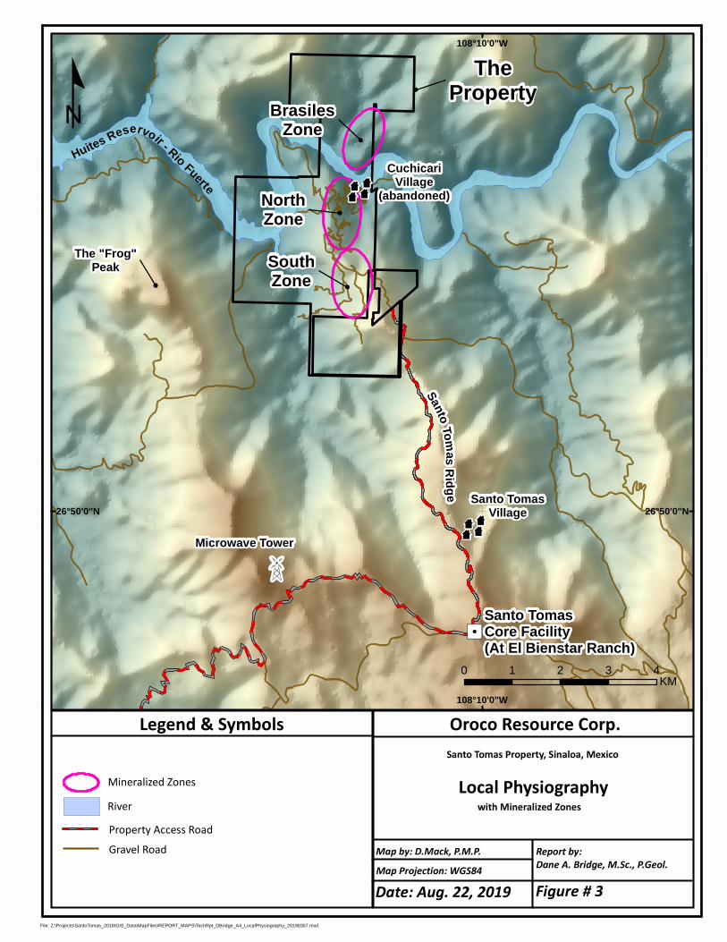
"/Santo TomasCore Facility(At El Bienstar Ranch)
108°10'0"W
108°10'0"W
26°50'0"N 26°50'0"N
File: Z:\Projects\SantoTomas_2018\GIS_Data\MapFiles\REPORT_MAPS\TechRpt_DBridge_A4_LocalPhysiography_20190307.mxd
Oroco Resource Corp.Santo Tomas Property, Sinaloa, Mexico
Local Physiographywith Mineralized Zones
Map Projection: WGS84
Report by:Dane A. Bridge, M.Sc., P.Geol.
Legend & Symbols
Map by: D.Mack, P.M.P.
Property Access RoadRiver
º
0 1 2 3 4KM
Gravel Road
Mineralized Zones
Z
Huites Reservoir - Rio FuerteMicrowave Tower
SantoTomasRidge
z
Santo TomasVillage
The "Frog"Peak
BrasilesZone
NorthZone
SouthZone
zCuchicari
Village(abandoned)
TheProperty
Date: Aug. 22, 2019 Figure # 3
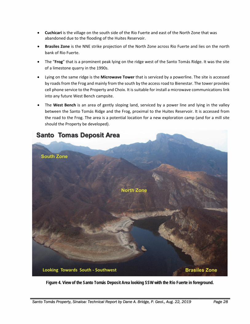
Santo Tomás Property, Sinaloa: Technical Report by Dane A. Bridge, P. Geol., Aug. 22, 2019 Page 28
Cuchicari is the village on the south side of the Rio Fuerte and east of the North Zone that was abandoned due to the flooding of the Huites Reservoir.
Brasiles Zone is the NNE strike projection of the North Zone across Rio Fuerte and lies on the north
bank of Rio Fuerte.
The “Frog” that is a prominent peak lying on the ridge west of the Santo Tomás Ridge. It was the site
of a limestone quarry in the 1990s.
Lying on the same ridge is the Microwave Tower that is serviced by a powerline. The site is accessed
by roads from the Frog and mainly from the south by the access road to Bienestar. The tower provides
cell phone service to the Property and Choix. It is suitable for install a microwave communications link
into any future West Bench campsite.
The West Bench is an area of gently sloping land, serviced by a power line and lying in the valley
between the Santo Tomás Ridge and the Frog, proximal to the Huites Reservoir. It is accessed from
the road to the Frog. The area is a potential location for a new exploration camp (and for a mill site
should the Property be developed).
Figure 4. View of the Santo Tomás Deposit Area looking SSW with the Rio Fuerte in foreground.
Santo Tomás Property, Sinaloa: Technical Report by Dane A. Bridge, P. Geol., Aug. 22, 2019 Page 29
LOCAL RESOURCES The nearest supply center is the city of Choix, with a population of 20,000. The cities of El Fuerte and Los
Mochis are well‐serviced with industrial supply and repair facilities, due to the region’s port, agricultural and
mining activities.
Labour and experienced mining technicians and equipment operators are available in northwestern Mexico,
a consequence of the region’s long mining history.
ACCESSIBILITY Access to the Property is by way of a 160 km paved highway from the Port of Topolobampo, through the city
of Los Mochis to the northern city of Choix (Figure 1). From the Chihuahua Pacific highway, access is by
secondary, unsurfaced roads that are useable in all seasons.
Historically, the Property was explored from an exploration camp located on the Bienestar Ranch (La Parida
Ranch) that is located on a ridge south of the Property. The ranch and camp buildings remain on‐site and
include a core storage building where diamond drill core and rotary drilling cuttings are stored.
The Bienestar Ranch is accessed by from Km 32 on the El Sauzal Mine (a closed mine operation of Goldcorp
Inc.) via a short branch road. Alternately, the ranch is directly accessed from Cajon de Cancio village via an
access road repaired by Oroco in 2017. From El Bienestar, the old access road was repaired in 2017 to access
the South Zone of the Property.
Access to the North Zone of the Property is also afforded from the end of the Chihuahua‐Pacific highway at
the Huites Reservoir. From there, a boat is needed to access the northern area of the Property. Additional
road repair is needed to access each of the historical drill sites fully.
CLIMATE Elevation effects on the climate are dramatic. The climate varies from subtropical at the northern end of the
Property to temperate climates at higher elevations on the south of the Property at Bienestar. The deep river
valley is hot and humid.
The climate is dry, arid for most of the year and with heavy, monsoon rains during the period from
September to November. Levels of Rio Fuerte are highly variable during this period. Localized flooding may
also occur requiring engineering of access and roadways to mitigate erosion and landslides in the steep terrain.
INFRASTRUCTURE
Regional Infrastructure
Facilities for ocean shipping of concentrate are available in the Port of Topolobampo (See Figure 1) that is 160
km from the Property. The Port has recently completed significant upgrades to berth‐side storage and installed
additional berths, cranes and ship‐handling tugboats (Secretaria de Comunicaciones y Transportes, 2014).
Santo Tomás Property, Sinaloa: Technical Report by Dane A. Bridge, P. Geol., Aug. 22, 2019 Page 30
Nearby is the international airport at Los Mochis (Aeropuerto Federal del Valle del Fuerte: IATA Code LMM;
ICAO Code MMLM) services scheduled commercial jet aircraft.
The Port of Topolobampo and Los Mochis are serviced by several rail lines, including the Chihuahua Pacific
railroad that connects to El Paso, Texas. The latter line passes within 12 km of the west of the Property.
The Chihuahua Pacific Highway under construction and planned to connect with El Paso, Texas. Work is
complete from Topolobampo to the Huites Reservoir, passing within 6 km of the Property, see Figure 6. Bridge
construction to cross the Huites Reservoir / Rio Fuerte is permitted and planned to commence soon.
Local Infrastructure
Adequate water for mining operations is available from Rio Fuerte and Huites reservoir if a suitable allotment
is arranged by permit. However, if that permitted allotment is not available, drilling of local aquifers for well‐
water would be needed.
The large Huites dam (officially known as the Luis Donaldo Colosio Dam) was constructed for irrigation and
power generation (440 megawatt capacity) and is located on the Rio Fuerte 20 km from the Property. The dam
produces an average of 875 million kWh annually. The Colosio dam is connected to the main power
transmission grid of northwestern Mexico, via a 230kV power line.
A smaller 110kV power transmission line to the former Reforma Mine and Jinchuan’s Bahuerachi property
passes within 4 km west of the Property. A smaller powerline services the ranch houses located on the Esme
mineral concession proximal to the areas of exploration and drilling on the Property. The line is suitable for
servicing camp facilities in support of work on the Property.
TransCanada Pipelines brought a large capacity natural gas pipeline into service on June 29, 2018, that
connects the city of Ahome and the Port of Topolobampo with existing pipelines in Chihuahua State. The
pipeline has a capacity of 670 million cubic feet (19.0 million cubic m) per day. The pipeline passes within 20
km of the Property and offers a very significant alternate energy supply to any mine or infrastructure
development in the area.
Infrastructure for Exploration and Mining Operations
Oroco has acquired no surface rights. The lands over the Property are largely unimproved and comprise
scrublands only. Land rights are held by several owners, both ejido groups and private ranchers. Oroco
anticipates no impediment to the future acquisition of these surface rights on fair commercial terms for a mill,
roads, mining operations, and the storage of waste rock and tailings.
Remaining from the historical drilling programs is the core facility at Bienestar Ranch that is suitable for
continued use after repairs, see Figure 5. Other historical camp facilities on the Property and at Bienestar
Ranch are no longer suitable for support to a renewed exploration program. A new camp is planned for a
location in the Esme concession on a flat area proximal to the North and South Zone, termed herein the “West
Bench.”
A preliminary analysis of the local physiography of the Property and adjacent areas have identified areas
suitable for a potential mill, roads, mining operations, and the storage of waste rock and tailings. See Figure
7. Depicted is the tailings impoundment recommended in the Bateman (1994) Pre‐Feasibility Study and
additional potential sites for co‐mingled tailings and waste rock.
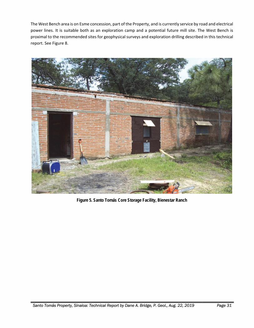
Santo Tomás Property, Sinaloa: Technical Report by Dane A. Bridge, P. Geol., Aug. 22, 2019 Page 31
The West Bench area is on Esme concession, part of the Property, and is currently service by road and electrical
power lines. It is suitable both as an exploration camp and a potential future mill site. The West Bench is
proximal to the recommended sites for geophysical surveys and exploration drilling described in this technical
report. See Figure 8.
Figure 5. Santo Tomás Core Storage Facility, Bienestar Ranch
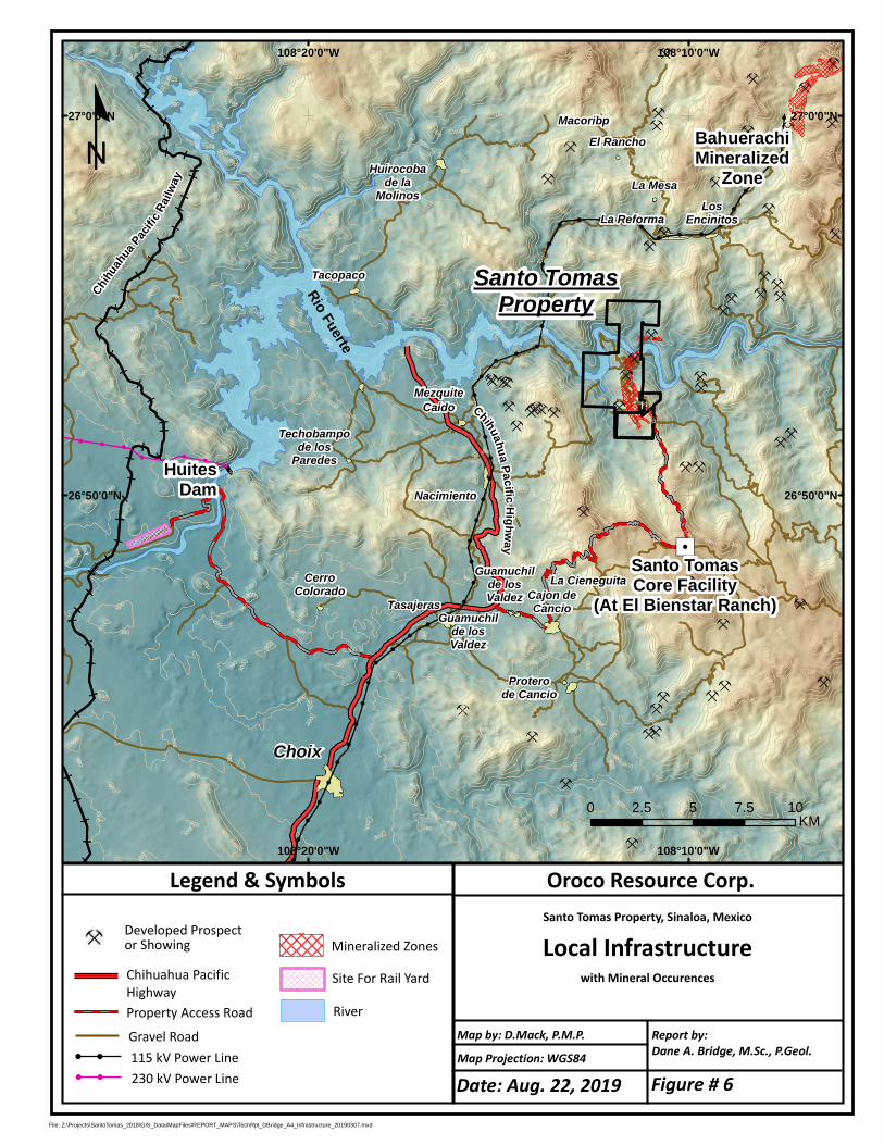
"/
HuitesDam
Choix
MezquiteCaido
Techobampode los
Paredes
Nacimiento
TasajerasGuamuchil
de losValdez
Guamuchilde losValdez Cajon de
Cancio
Tacopaco
La ReformaLos
Encinitos
La CieneguitaCerroColorado
Huirocobade la
Molinos
MacoribpEl Rancho
La Mesa
Proterode Cancio
Rio Fuerte
400
400
300
1100
400
400
400
500
200
600
400400
200
300
600
400200
600
200
1300
500
900
700
1100
500
400
300
300
600
300
600
600
800
300
1300
200
300
500
600
1300
300
1500
500
400
900
600
1400
1400
300
1400
400
900
900600
500
1100
1200
600
900
400
700
1100300
300
400
800
400
300
300
500
1300
1400
300
800
600
400
1500
400
500
700
400
700
700
900
500
500
600
400
1300
800
1100
300
900
1000
400
200
300
700
700
600
800
50012
00
40015
00
700
900
1000
500
800
1200
1100
600
600
1200
1100
900
1300
500
1200
1400
800
1200
110
0
300
400
1500
400
400
400
400
500
400
700
300
900
400
700
1100
800
1100
300
300
300
1400
300
600
1300
1100
300
1300
200
600
1100
600
200
400
700
300
1300
300
500
400
800
400
700
300
1000
500
400
500
500
300
1000
700
900
600
800
1000
600
900
1300
1400
500
700
1300
300
900
500
500
500
300
600
400
300
1400
1000
300
800
800
300
600
300
700
200
400 500
200
400
800
900
500
500
400
800
500
300
800
1000
900
1000
1200
1400
300
200
500
500
400
1100
1300
900
800
400
1200
1200
800
900
400
400
600
600
600
800
1300
1500
900
700
300
700
700
400
300
500
600
600
500
1400
600
300
600
900
1100
500
300
1000
500
200
1200
1400
1000
1500
1300
500
500
400
800
13001200
500
900
600
1300
400
400
700
600
900
700
300
1300
1300
700
200
200
1300
1200
1300
900300
30012
00
1400
1000
700
600
900
600
1500
800
300
300
600
500
400
900
700
300
700
600
600
300
800
700
800
300
400
1000
200
300
900
1300
600
600
500
900
600
1000
1100
1000
1100
700
1200
900
1500
700
900
400400
600
1400
1300
800
1400
1300
700
900
900
500
200
1000
600
500
800
800
1400
800
300
900
700
500
300
1000
500
800
1400
900
800
600
700
600
1100
500
800
500
300
1000
700
800
50050
0
400
400
700
600
400
900
1000
600
6001200
700
900
1300
1200
1000
1200
1100
200
1000
700
800
300
800
500
400
200
Santo TomasCore Facility
(At El Bienstar Ranch)
Santo TomasProperty
BahuerachiMineralized
Zone
108°10'0"W
108°10'0"W
108°20'0"W
108°20'0"W
27°0'0"N 27°0'0"N
26°50'0"N 26°50'0"N
File: Z:\Projects\SantoTomas_2018\GIS_Data\MapFiles\REPORT_MAPS\TechRpt_DBridge_A4_Infrastructure_20190307.mxd
Oroco Resource Corp.Santo Tomas Property, Sinaloa, Mexico
Local Infrastructurewith Mineral Occurences
Map Projection: WGS84
Report by:Dane A. Bridge, M.Sc., P.Geol.
Legend & Symbols
Map by: D.Mack, P.M.P.
Developed Prospector Showing
Property Access Road
Chihuahua PacificHighway
RiverSite For Rail Yard
º
0 2.5 5 7.5 10KM
Gravel Road
Chihuahua PacificHighway
Mineralized Zones
115 kV Power Line230 kV Power Line
Chihuah
uaPaci
ficRa
ilway
Date: Aug. 22, 2019 Figure # 6
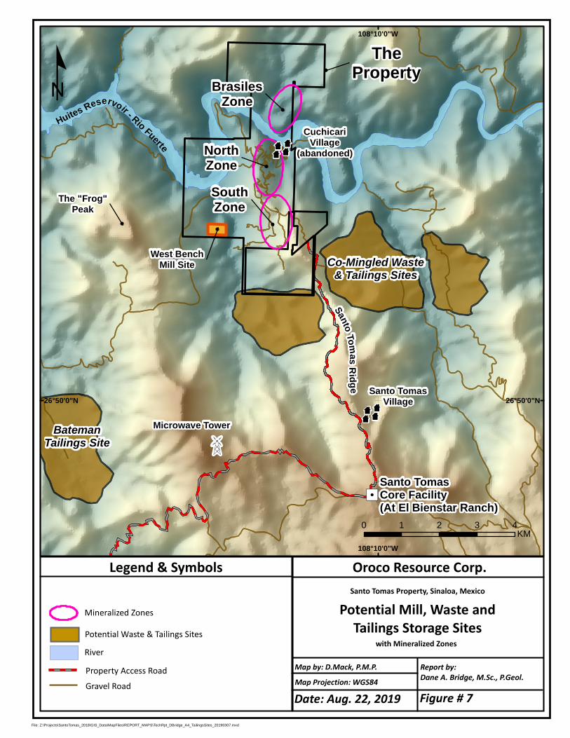
"/Santo TomasCore Facility(At El Bienstar Ranch)
108°10'0"W
108°10'0"W
26°50'0"N 26°50'0"N
File: Z:\Projects\SantoTomas_2018\GIS_Data\MapFiles\REPORT_MAPS\TechRpt_DBridge_A4_TailingsSites_20190307.mxd
Oroco Resource Corp.Santo Tomas Property, Sinaloa, Mexico
Potential Mill, Waste andTailings Storage Sites
with Mineralized Zones
Map Projection: WGS84
Report by:Dane A. Bridge, M.Sc., P.Geol.
Legend & Symbols
Map by: D.Mack, P.M.P.Property Access RoadRiver
º
0 1 2 3 4KM
Gravel Road
Mineralized Zones
Z
Huites Reservoir - Rio FuerteMicrowave Tower
SantoTomasRidge
z
Santo TomasVillage
The "Frog"Peak
West BenchMill Site
BrasilesZone
NorthZoneSouthZone
zCuchicari
Village(abandoned)
Potential Waste & Tailings Sites
BatemanTailings Site
Co-Mingled Waste& Tailings Sites
TheProperty
Date: Aug. 22, 2019 Figure # 7
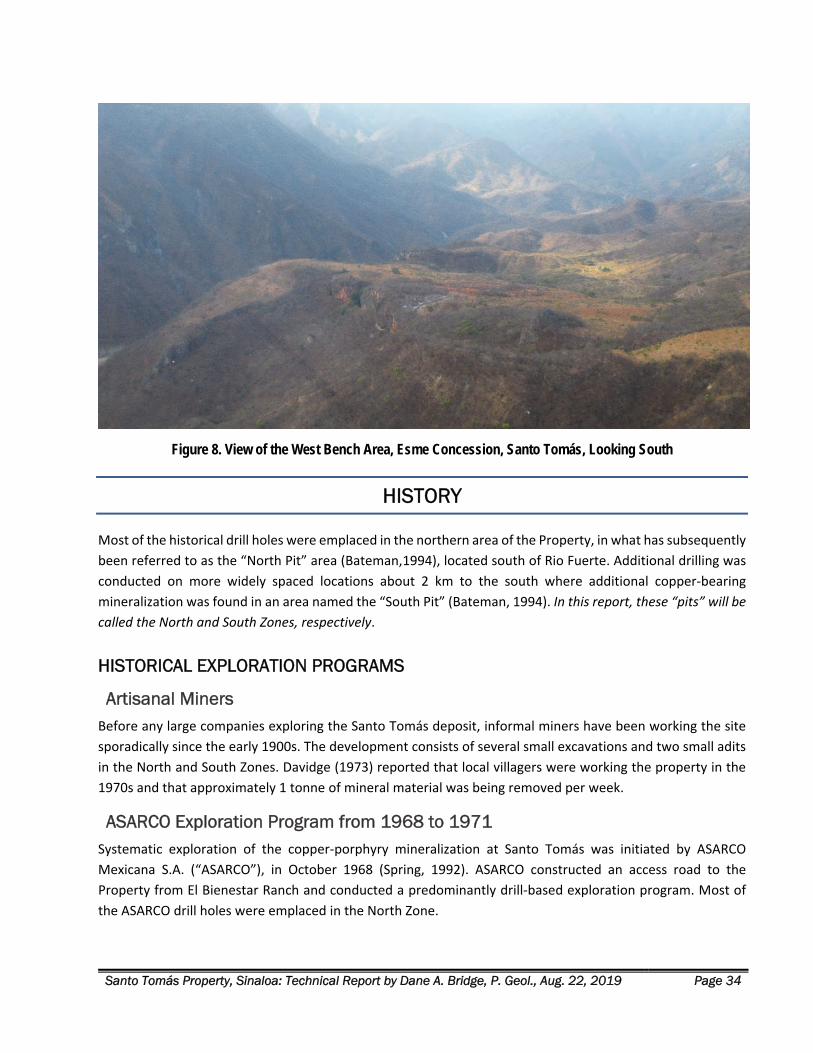
Santo Tomás Property, Sinaloa: Technical Report by Dane A. Bridge, P. Geol., Aug. 22, 2019 Page 34
Figure 8. View of the West Bench Area, Esme Concession, Santo Tomás, Looking South
HISTORY
Most of the historical drill holes were emplaced in the northern area of the Property, in what has subsequently
been referred to as the “North Pit” area (Bateman,1994), located south of Rio Fuerte. Additional drilling was
conducted on more widely spaced locations about 2 km to the south where additional copper‐bearing
mineralization was found in an area named the “South Pit” (Bateman, 1994). In this report, these “pits” will be
called the North and South Zones, respectively.
HISTORICAL EXPLORATION PROGRAMS
Artisanal Miners Before any large companies exploring the Santo Tomás deposit, informal miners have been working the site
sporadically since the early 1900s. The development consists of several small excavations and two small adits
in the North and South Zones. Davidge (1973) reported that local villagers were working the property in the
1970s and that approximately 1 tonne of mineral material was being removed per week.
ASARCO Exploration Program from 1968 to 1971 Systematic exploration of the copper‐porphyry mineralization at Santo Tomás was initiated by ASARCO
Mexicana S.A. (“ASARCO”), in October 1968 (Spring, 1992). ASARCO constructed an access road to the
Property from El Bienestar Ranch and conducted a predominantly drill‐based exploration program. Most of
the ASARCO drill holes were emplaced in the North Zone.
Santo Tomás Property, Sinaloa: Technical Report by Dane A. Bridge, P. Geol., Aug. 22, 2019 Page 35
A drill program was conducted on more widely spaced locations about 2 km to the south where additional
copper‐bearing mineralization was found in the South Zone.
ASARCO completed a total of 43 vertical diamond‐drill holes totalling 13,697 m and 16 vertical rotary
percussion holes totalling 1,391 m (for a total of 15,088 m of drilling) (Spring, 1992).
The diamond‐drill core was sampled at an irregular spacing with the sample limits set by ASARCO’s observed
geological boundaries. Sample interval lengths generally varied between 1 and 3 m (Spring, 1992).
Assaying was completed at several laboratories, located at Nacozari in Sonora, San Luis Potosi in San Luis
Potosi, and Parral in Chihuahua. These were probably ASARCO’s laboratories (Borovic, 2002). Assay values
between the different laboratories showed good agreement (Spring, 1992).
ASARCO calculated a preliminary mineral resource estimate for the Property that is a historical mineral
resource and is not cited in this report.
ASARCO relinquished the property in 1973 after spending about $1 million US. It is believed that they dropped
the Property owing to large monetary option payment obligations and their misinterpretation of the geology,
which undervalued the Property (Spring, 1992).
Tormex – Peñoles Exploration Program from 1973 to 1977 Tormex Mining Developers Ltd. (Contratista Tormex S.A.) and Industria Minera Peñoles (“Tormex”) optioned
the Property in 1973. Twenty‐six of the ASARCO diamond‐drill holes from the North Zone were re‐logged, and
5,336 m of half‐core was re‐split and sent for assay. Tormex sampled on 4 m intervals for total copper.
According to Spring (1992), the Tormex assays from the quarter‐split samples agreed closely with the original
assays by ASARCO. The re‐logging effort instigated a new geological interpretation where the mineralization
was depicted as a shallow west‐dipping zone, within and alongside a large sill of monzonite porphyry (Spring,
1992).
Tormex completed an additional seven drill holes totalling 2,401 m from January to August 1974. Six were
emplaced in the North Zone to tighten the drill spacing, and a new mineral resource estimation exercise was
undertaken.
One drill hole was completed in the South Zone (Spring, 1992).
In the South Zone, Tormex re‐logged and selectively re‐sampled twelve ASARCO drill holes. The samples were
sent to Ensayadores Quimicos del Noroeste in Hermosillo, with one sample in ten sent for check assay to TSL
Laboratory in Toronto, Canada. The check samples agreed closely with those of the Mexican laboratory. The
Sonora laboratory yielded an average of approximately 0.07% higher copper values for samples with values
greater than 0.25% Cu than the Toronto laboratory (Spring, 1992).
The Santo Tomás property appears to have sat idle from the late 1970s until 1990. Royalties may have been a
reason for the termination of exploration activities on the Property, according to Spring (1992). No other
available information provides alternative reasons for the discontinuation of work and interest in the Property.
Government Supported Mapping 1973 E. Davidge and K.F. Clark performed fieldwork in the Santo Tomás area from June 10 to August 19, 1973. The
work was carried out with the support and assistance of the Consejo De Recursos Naturales No Renovables
Santo Tomás Property, Sinaloa: Technical Report by Dane A. Bridge, P. Geol., Aug. 22, 2019 Page 36
and the Instituto de Geología del Estado de Sinaloa. The report provides preliminary data concerning the
geology and mineralization of the Choix area (Davidge, 1973).
Consejo de Recursos Minerales Regional Geological and Geophysical programs The Consejo de Recursos Minerales (“CRM”) (today known as the Servicio Geológico Mexicano; “SGM”)
performed a series of regional airborne magnetic surveys, helicopter surveys and surface mapping campaigns
of the Santo Tomás area. The Santo Tomás deposit is located in the northeast part of the Huatabampo (G12‐
6 at 250,000 scale) map area and the central portion of the Tasajeras (G12‐B59 at 50,000 scale) map area
(Cuevas et al., 1996; Montiel et al., 1985; Servicio Geologico Mexicano, 2002).
In the late 1980s, an exploration program was conducted by helicopter over northern Sinaloa and other parts
of the State. The work was based on LANDSAT imagery to identify new areas of interest for mineral
exploration. The Santo Tomás deposit (Cuchicari Prospect: “Anomalia CHY‐3”) was described as hosting four
small anomalies inside a larger anomaly covering an area of approximately 14 km2. The anomaly is situated on
the south margin of Rio Fuerte, at the elevation of ranch El Rosarito some 23 km northeast at 30° from Choix
(Guzman et al., 1989).
Esmeralda Group, 1990 The next round of exploration activity on the concessions that now constitute the Property began in 1990
when the Esmeralda Group (“Esmeralda”) produced a new set of geologic sections and plan‐maps, which
summarized the previous exploration work. In addition to the new geologic sections and plans, Esmeralda’s
examination produced a new topographic map showing drill hole locations (Tormex coordinates), and a new
calculation of the Mineral Resource (Thornton, 2011). Esmeralda reported their new Resource calculation, but
the documents produced by Esmeralda Group have not been located. Therefore, their contents and these
statements cannot be verified and are not cited in this report.
Minera Real de Angeles, 1991 In 1991, Minera Real de Angeles S.A. de C.V. (“MRA”) re‐logged 12 of the ASARCO drill holes and re‐assayed
two holes. Good correlation was reported between the results from the re‐assays and the older ASARCO
results (Spring, 1992).
MRA entered all the ASARCO data into the geostatistical software program MEDSYSTEM (Mintec software,
later branded as “MineSight”) to generate block models and mineral resource outputs. The results of this study
are reported to be similar to those obtained by ASARCO (Spring, 1992). The results of this study are not
available to the authors. Therefore, the statements made by Spring (1992) cannot be verified.
Exall Resources Ltd. Exploration Program from 1992 to 1997 Exall Resources Ltd. (“Exall”) acquired the Property in 1992 from a Canadian Company – Cerro de Cobre Inc.
(“CDCI”). CDCI made a purchase agreement with the Esmeralda Group, for up to $4.2 million US plus a 2% Net
Smelter Royalty (NSR) and an additional 0.5% NSR payable to Minera Piña Cati S.A. de C.V. Subsequent to the
agreement between Esmeralda and CDCI, CDCI brought the Property to the attention of Exall for their review
and consideration. Exall obtained an option to acquire the Property and perform exploration drilling (Spring,
1992).
Santo Tomás Property, Sinaloa: Technical Report by Dane A. Bridge, P. Geol., Aug. 22, 2019 Page 37
Watts, Griffis and McOuat Ltd (“WGM”), of Toronto, Canada, was engaged to review the available data and
recommended to Exall that ongoing exploration work was warranted on the property. Exploration of the
“oxide zone” was of significant interest to Exall. The oxide zone was reported to contain higher grades and had
the potential to be mined by open pit, at a low stripping ratio, with low‐cost processing for metal recovery by
heap leach using SX‐EW (solvent extraction and electrowinning) (Spring, 1992).
WGM performed a site visit to the Property in July of 1992. Traverses were conducted across the Property and
surrounding area to examine the deposit setting and surface geology. Diamond‐drill cores were also examined
at the La Parida Ranch (El Bienestar). Engineer Rafael Gaytan M., a Mexican consulting geologist, accompanied
V. Spring during the site visit. Mr. Gaytan was familiar with the project geology and drill cores, having mapped
the surface geology and re‐logged several holes in late 1991 for MRA (Spring, 1992).
Following the site visit and data review, WGM recommended that a significant amount of exploration and
drilling be conducted concurrently to meet the tight deadlines of the option payments from the Esmeralda‐
Cerro de Cobre Inc. agreement. They also recommended the acquisition of the ASARCO and Tormex drill core
and other technical data from Minera Real de Angeles S.A. de C.V., since replication of that data would be a
costly proposition (Spring, 1992). It is not clear whether Exall pursued this recommended course of action. The
ASARCO and MRA data have not been identified among the Exall data. Therefore, it is concluded that the
ASARCO and Tormex data was not acquired.
In 1993, a 4,000 m drill program composed of 33 reverse circulation drill holes and 7 diamond‐drill holes
(Borovic, 2002, Thornton, 2012c) was initiated by Exall. The results from this program prompted Exall to
announce a new mineral resource estimation for the deposit (Thornton, 1994).
In 1993, Exall Resources Ltd. retained the services of Bateman Engineering Inc. of Phoenix, Arizona, to prepare
a Pre‐feasibility study of the Santo Tomás porphyry copper deposit (Bateman, 1994). In addition to the mineral
resource estimate, Exall also contracted metallurgical testing of the mineralization.
The metallurgical testing was performed by Minetek S.A. de C.V. and Mountain States Research and
Development Inc. (“MSRDI”), which included flotation tests, bottle roll leaching tests, and concentrate
bioleaching tests (Bateman, 1994).
Results from MSRDI of Tucson, Arizona, indicate that the Santo Tomás mineralization responds favourably to
flotation but is not amenable to direct leaching using sulfuric acid. Concentrate leaching appeared to be
feasible under highly oxidizing conditions at controlled temperatures (Bateman, 1994; Bateman, 2003). The
test work shows that approximately 90% of the contained copper is recoverable through standard
concentration methods, yielding a concentrate of 28% copper (Bateman, 1994; Roman, 1994b).
Mintec Inc., of Tucson, Arizona, was retained to review the mineral resource estimates, to assess the economic
potential of the project, and to design conceptual pit phases for open‐pit mining. The preliminary pit‐
constrained mineral resource estimate is based on a combined database containing 14,881 m of drilling
information (49 ASARCO/Tormex and 40 Exall drill holes) (Bateman, 1994; Thornton, 1994). [Please note: the
current validation contains records for 50 ASARCO/Tormex holes as hole STD‐50 was missing from the 1994
Mintec work].
The deposit was evaluated as two pits: North and South (Bateman, 1994). The historical mineral resource
estimates are calculated to 0 m elevation (sea level) because of a lack of significant drilling below this
elevation. It was noted that the deposit appeared to be open at depth in the North Zone. The South Zone was
Santo Tomás Property, Sinaloa: Technical Report by Dane A. Bridge, P. Geol., Aug. 22, 2019 Page 38
assumed to mirror the characteristics of the North. Mintec (1994) reported an estimate of the mineral
resources, a summary of their work appears in the section Mineral Resource Estimates (this report).
After the Exall drilling programs, in the period 1992 to 1995, the Luis Donaldo Colosio Dam (“Huites Dam”)
was constructed about 15 km downstream from the North Zone on the Rio Fuerte. In 1995, after completion
of the dam, the maximum water level was raised from approximately 200 m to 270 m above sea level. The
new reservoir impinges on the north and northeastern flank of the mineralization in the North Zone.
In 1995, Exall Resources and Britannia Gold executed a letter of intent, but Britannia dropped their option to
acquire the Property in 1996 (Holmes, 1996).
A write‐down of the Santo Tomás Project in 1997 by Exall was recommended by its auditors, to its
management and board of directors as that company sought to present as a profitable mining company. Exall
determined that if a mining partner could be found to proceed with a Feasibility study, then the value could
then be ascribed on Exall’s balance sheet (Roman, 1997).
In 1997, Exall dropped its option on the Property.
Minera MGM S.A. de C.V. (Morgain Mineral Inc.) from 1997-1998 In 1997‐1998, Morgain Minerals Inc. and its wholly owned Mexican subsidiary Minera MGM S.A de C.V. signed
an agreement with Mr. Ruben Rodriguez for the acquisition of 100% interest in the Property.
Morgain Minerals Inc. evaluated all of the technical data in conjunction with consultants and continued its
discussion with Cominco Engineering Services Ltd. (CESL) concerning bench‐scale testing its copper
concentrates (Mongeau and De Felice, 1998).
Minera MGM S.A. de C.V. (“Minera MGM”) produced a series of E‐W vertical sections at 1:1,000 scale for the
Santo Tomás Project. The Author was not able to locate any further information regarding this agreement.
Ruero International Ltd. & Compañía Minera Ruero S.A. de C.V. In December 2002, Ruben Rodriguez Villegas (“Rodriguez”) transferred 100% ownership of the Property to
Compañía Minera Ruero, S.A. de C.V. (“CMR”), a private registered Mexican mining company. CMR is owned
99.998% by Ruero International Ltd. (“Ruero International”), a Bahamas company, and 0.002% by Rodriguez.
In 2002, Rodriguez sold Ruero International to Fierce Investments Ltd. (“Fierce”), subject to its return to him
in the event of non‐performance by Fierce of the sale agreement. Also, in 2002, Fierce sold Ruero International
to Aztec Copper Inc. (“Aztec”), subject to Rodriguez’s right to the return of Ruero International in the event of
the non‐performance of the Rodriguez‐Fierce agreement. Ruero was returned to Rodriguez in 2015 as a result
of the non‐performance of both the Rodriguez‐Fierce agreement and the Fierce‐Aztec Agreement.
IGNA Engineering and Consulting Ltd.
IGNA Engineering and Consulting Ltd. was engaged to conduct a geological study and evaluation of the Santo
Tomás property (Borovic, 2006).
IGNA Engineering and Consulting Ltd. conducted a field examination of the project from May 22, 2002, until
June 7, 2002. Work was done by Ignacije Borovic, P. Eng., accompanied by geologists Helgi Sigurgeirson of
Vancouver, Canada, and Marco Antonio Monteño Morales and Javier Castaño Duarte of Hermosillo, Mexico.
Eight complete holes and a few partial holes were re‐logged and verification samples collected. The assays
Santo Tomás Property, Sinaloa: Technical Report by Dane A. Bridge, P. Geol., Aug. 22, 2019 Page 39
from the samples collected in 2002 are in good agreement with the historical assays from ASARCO/Tormex
sampling (Borovic, 2002; Borovic, 2007 (Revised 2008)). A second site visit was performed in September 2006.
Examination of the drill core by IGNA led to a new interpretation of the geology. The mineralized quartz
monzonite was proposed to represent a branching quartz‐feldspar porphyritic quartz monzonite porphyry
dike, based on contact relationships in core and surface outcroppings. The mineralized body was projected to
strike roughly NNE and dip steeply to the northwest (Borovic, 2002). Cross‐sections and longitudinal sections
using from Exall, Minera MGM, and Tormex data supported the new interpretation. Field examination of the
area from Cuchicari along surface exposures of the oxide zone showed that cross‐faults are centers for high‐
grade accumulations of sulphides (Borovic, 2002).
Geological traverses were completed between El Bienestar Ranch and the South Zone (to correlate the surface
geology with copper‐bearing rocks from drill hole samples), following the south shore of the Huites reservoir
from Cuchicari towards the west, and other traverses across the oxide zone south of the village (Borovic, 2002;
Borovic, 2007 (Revised 2008)).
Borovic remarked that Tormex, Minera MGM and Exall interpreted the geology and structure in different
ways. Borovic did not conduct a formal mineral resource estimate. He noted that the mineral resource
calculations (completed by various companies) appeared to be acceptable within the limitations of the drill
spacing (Borovic, 2002). He deemed the estimate to be a historical mineral resource estimate under Canadian
NI 43‐101.
Multiple geological reports were prepared on the Santo Tomás property by Borovic between 2002 and 2008.
The reports are listed below:
Borovic, I. R. (2002). Report on the Mineral Exploration and Development of the Santo Tomás property
Lat. 26° 56' 47" N; Long. 108° 19' 20" W, Municipality of Choix, State of Sinaloa, Mexico; Summary and
evaluation for Aztec Copper Inc. Vancouver, British Columbia: 60.
Borovic, I. R. (2006). Exploration of the Santo Tomás Copper Porphyry Deposit, Choix, Sinaloa, Mexico.
Vancouver, British Columbia, Igna Engineering & Consulting Ltd.: 61.
Borovic, I. R. (2007 (Revised 2008)). Exploration of the Santo Tomás Copper Porphyry Deposit, Choix,
Sinaloa, Mexico. Vancouver, British Columbia, Igna Engineering & Consulting Ltd.: 60.
Borovic recommended additional drilling and exploration to improve and upgrade the Mineral Resources for
both the North and South Zones, and that after conducting “success contingent” phases of exploration and
drilling, exploration should be expanded to other areas of the Property (Borovic, 2007 (Revised 2008)).
Bateman Engineering Inc. 2003
On July 7, 2003, Bateman Engineering Inc. prepared an update to the completed Prefeasibility study of 1994.
The report was released in October of 2003 and titled “Update Previous Prefeasibility Study,” which specifically
addressed the plant design and metallurgical test work. The report does not re‐address the 1994‐dated
mineral resource estimates, mineralogy or environmental components of the project. The report (Bateman
Engineering Inc., 2003) examined the following subjects:
plant size and location,
updated the capital costs (CAPEX),
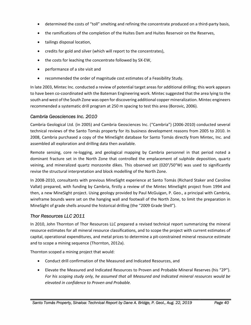
Santo Tomás Property, Sinaloa: Technical Report by Dane A. Bridge, P. Geol., Aug. 22, 2019 Page 40
determined the costs of “toll” smelting and refining the concentrate produced on a third‐party basis,
the ramifications of the completion of the Huites Dam and Huites Reservoir on the Reserves,
tailings disposal location,
credits for gold and silver (which will report to the concentrates),
the costs for leaching the concentrate followed by SX‐EW,
performance of a site visit and
recommended the order of magnitude cost estimates of a Feasibility Study.
In late 2003, Mintec Inc. conducted a review of potential target areas for additional drilling; this work appears
to have been co‐coordinated with the Bateman Engineering work. Mintec suggested that the area lying to the
south and west of the South Zone was open for discovering additional copper mineralization. Mintec engineers
recommended a systematic drill program at 250 m spacing to test this area (Borovic, 2006).
Cambria Geosciences Inc. 2010
Cambria Geological Ltd. (in 2005) and Cambria Geosciences Inc. (“Cambria”) (2006‐2010) conducted several
technical reviews of the Santo Tomás property for its business development reasons from 2005 to 2010. In
2008, Cambria purchased a copy of the MineSight database for Santo Tomás directly from Mintec, Inc. and
assembled all exploration and drilling data then available.
Remote sensing, core re‐logging, and geological mapping by Cambria personnel in that period noted a
dominant fracture set in the North Zone that controlled the emplacement of sulphide deposition, quartz
veining, and mineralized quartz monzonite dikes. This observed set (020°/50°W) was used to significantly
revise the structural interpretation and block modelling of the North Zone.
In 2008‐2010, consultants with previous MineSight experience at Santo Tomás (Richard Staker and Caroline
Vallat) prepared, with funding by Cambria, firstly a review of the Mintec MineSight project from 1994 and
then, a new MineSight project. Using geology provided by Paul McGuigan, P. Geo., a principal with Cambria,
wireframe bounds were set on the hanging wall and footwall of the North Zone, to limit the preparation in
MineSight of grade shells around the historical drilling (the “2009 Grade Shell”).
Thor Resources LLC 2011
In 2010, John Thornton of Thor Resources LLC prepared a revised technical report summarizing the mineral
resource estimates for all mineral resource classifications, and to scope the project with current estimates of
capital, operational expenditures, and metal prices to determine a pit‐constrained mineral resource estimate
and to scope a mining sequence (Thornton, 2012a).
Thornton scoped a mining project that would:
Conduct drill confirmation of the Measured and Indicated Resources, and
Elevate the Measured and Indicated Resources to Proven and Probable Mineral Reserves (his “2P”).
For his scoping study only, he assumed that all Measured and Indicated mineral resources would be
elevated in confidence to Proven and Probable.
Santo Tomás Property, Sinaloa: Technical Report by Dane A. Bridge, P. Geol., Aug. 22, 2019 Page 41
His scoping study created new open‐pit models driven by the 2011 economics and relied upon only the higher
classifications of resource estimates (Measured and Indicated Resources). His scoping excluded Inferred
Resources and carried them as “waste” in each mining plan case (Thornton, 2011). Thornton studied two
distinct production schedules for 28 and 35 million tonnes per year.
The results of Thornton’s mining‐related technical work are important as they guide the definition drilling and
exploration plans presented in the Recommendations section in this report.
Return of Ruero International Ltd.
In 2015, 100% ownership of Ruero International reverted to Rodriguez under a decision of the Supreme Court
of the Commonwealth of the Bahamas. Ruero International is currently owned 50% by Altamura and 50% by
Rodriguez.
Xochipala Gold S.A. de C.V. In June 2016, XG acquired a 100% interest in the Property from CMR. Registration of the sale agreement and
transfer of title to XG was impeded a court judgement which was nullified in 2019. Registration is now pending.
Santo Tomás Property, Sinaloa: Technical Report by Dane A. Bridge, P. Geol., Aug. 22, 2019 Page 42
HISTORICAL MINERAL RESOURCE ESTIMATES
Early Mineral Resource Estimates (Prior to 2011) Both ASARCO and Tormex estimated the mineral resources at Santo Tomás. However, the reporting as
described in Spring (1992) lacks the details of the methods and geological controls to mineralization. The
results are not acceptable under the current standards of disclosure. Additionally, these estimations were
made before the extensive drilling performed by Exall in 1993. Therefore, these historical mineral resources
estimates are not cited herein.
In 1993, Mintec Inc. was retained to review the mineral resource estimates, to assess the project’s overall
potential and to design conceptual pit phases, as part of the Prefeasibility study requested by Exall Resources
(Bateman, 1994).
The Mintec work was conducted under the direction of John Thornton, P. Eng. At that time, the deposit
modelling work did not accommodate the structural style and chronology of mineralization at Santo Tomás. A
block model was constructed using an early software version of MineSight, unconstrained by the structural
geology and attitude of the mineralized quartz monzonite dikes on the Property.
This first work by Mintec constructed a block‐model that was incorrectly biased to flat and shallow dips (about
20° W) for the deposits and was skewed to a northerly strike of the deposit because consideration was not
given to the structural attitude and host rocks of the mineralization.
Also, lacking constraint from structural information, the mineral resource estimate did not adequately
accommodate the many drill holes that terminated in good grade copper. Therefore, the Author does not rely
upon the historical mineral resource estimate included in Bateman (1994).
Thor Resources LLC, 2011 – Historical Technical Report
Relevance and Reliability
John Thornton, P. Eng., of Thor Resources LLC prepared the most recent mineral resource estimation of the
Santo Tomás deposit. The results are presented in the document titled: “Santo Tomás Copper Project, Choix,
Sinaloa, Mexico, Technical Report” dated September 23, 2011 (Thornton, 2011). The report has not been
released publicly and was recently obtained by Oroco under agreement with Thornton for internal review.
The mineral resource estimate by Thornton (2011) is a Historical Estimate as defined under Canadian National
Instrument 43‐101 ‐ Standards of Disclosure for Mineral Projects (“NI 43‐101”). The Historical Estimate is
relevant as it is the most recent, comprehensive estimate available for the Property. The Historical Estimate
employed reliable estimation practice and contained all the available drilling information on the Property.
Thornton’s technical work constitutes an invaluable foundation of technical information for planning the
anticipated near‐term round of mineral exploration activities and drilling targets. Therefore, his methods, key
assumptions, and parameters are reviewed and presented after this.
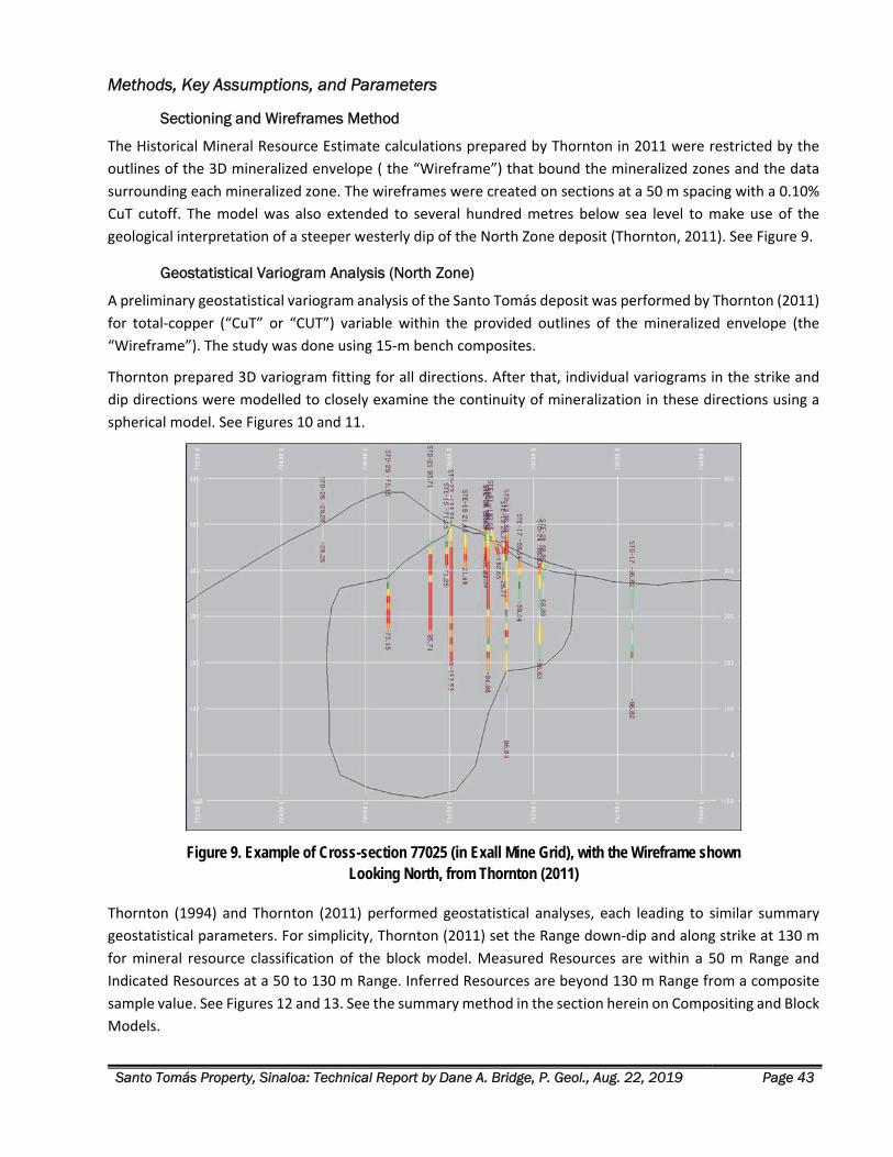
Santo Tomás Property, Sinaloa: Technical Report by Dane A. Bridge, P. Geol., Aug. 22, 2019 Page 43
Methods, Key Assumptions, and Parameters
Sectioning and Wireframes Method
The Historical Mineral Resource Estimate calculations prepared by Thornton in 2011 were restricted by the
outlines of the 3D mineralized envelope ( the “Wireframe”) that bound the mineralized zones and the data
surrounding each mineralized zone. The wireframes were created on sections at a 50 m spacing with a 0.10%
CuT cutoff. The model was also extended to several hundred metres below sea level to make use of the
geological interpretation of a steeper westerly dip of the North Zone deposit (Thornton, 2011). See Figure 9.
Geostatistical Variogram Analysis (North Zone)
A preliminary geostatistical variogram analysis of the Santo Tomás deposit was performed by Thornton (2011)
for total‐copper (“CuT” or “CUT”) variable within the provided outlines of the mineralized envelope (the
“Wireframe”). The study was done using 15‐m bench composites.
Thornton prepared 3D variogram fitting for all directions. After that, individual variograms in the strike and
dip directions were modelled to closely examine the continuity of mineralization in these directions using a
spherical model. See Figures 10 and 11.
Figure 9. Example of Cross-section 77025 (in Exall Mine Grid), with the Wireframe shown Looking North, from Thornton (2011)
Thornton (1994) and Thornton (2011) performed geostatistical analyses, each leading to similar summary
geostatistical parameters. For simplicity, Thornton (2011) set the Range down‐dip and along strike at 130 m
for mineral resource classification of the block model. Measured Resources are within a 50 m Range and
Indicated Resources at a 50 to 130 m Range. Inferred Resources are beyond 130 m Range from a composite
sample value. See Figures 12 and 13. See the summary method in the section herein on Compositing and Block
Models.
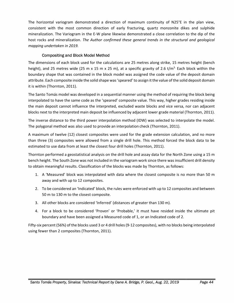
Santo Tomás Property, Sinaloa: Technical Report by Dane A. Bridge, P. Geol., Aug. 22, 2019 Page 44
The horizontal variogram demonstrated a direction of maximum continuity of N25°E in the plan view,
consistent with the most common direction of early fracturing, quartz monzonite dikes and sulphide
mineralization. The Variogram in the E‐W plane likewise demonstrated a close correlation to the dip of the
host rocks and mineralization. The Author confirmed these general trends in the structural and geological
mapping undertaken in 2019.
Compositing and Block Model Method
The dimensions of each block used for the calculations are 25 metres along strike, 15 metres height (bench
height), and 25 metres wide (25 m x 15 m x 25 m), at a specific gravity of 2.6 t/m3. Each block within the
boundary shape that was contained in the block model was assigned the code value of the deposit domain
attribute. Each composite inside the solid shape was ‘speared’ to assign it the value of the solid deposit domain
it is within (Thornton, 2011).
The Santo Tomás model was developed in a sequential manner using the method of requiring the block being
interpolated to have the same code as the ‘speared’ composite value. This way, higher grades residing inside
the main deposit cannot influence the interpreted, excluded waste blocks and vice versa, nor can adjacent
blocks next to the interpreted main deposit be influenced by adjacent lower grade material (Thornton, 2011).
The inverse distance to the third power interpolation method (IDW) was selected to interpolate the model.
The polygonal method was also used to provide an interpolation check (Thornton, 2011).
A maximum of twelve (12) closest composites were used for the grade extension calculation, and no more
than three (3) composites were allowed from a single drill hole. This method forced the block data to be
estimated to use data from at least the closest four drill holes (Thornton, 2011).
Thornton performed a geostatistical analysis on the drill hole and assay data for the North Zone using a 15 m
bench height. The South Zone was not included in the variogram work since there was insufficient drill density
to obtain meaningful results. Classification of the blocks was made by Thornton, as follows:
1. A ‘Measured’ block was interpolated with data where the closest composite is no more than 50 m
away and with up to 12 composites.
2. To be considered an ‘Indicated’ block, the rules were enforced with up to 12 composites and between
50 m to 130 m to the closest composite.
3. All other blocks are considered ‘Inferred’ (distances of greater than 130 m).
4. For a block to be considered ‘Proven’ or ‘Probable,’ it must have resided inside the ultimate pit
boundary and have been assigned a Measured code of 1, or an Indicated code of 2.
Fifty‐six percent (56%) of the blocks used 3 or 4 drill holes (9‐12 composites), with no blocks being interpolated
using fewer than 2 composites (Thornton, 2011).
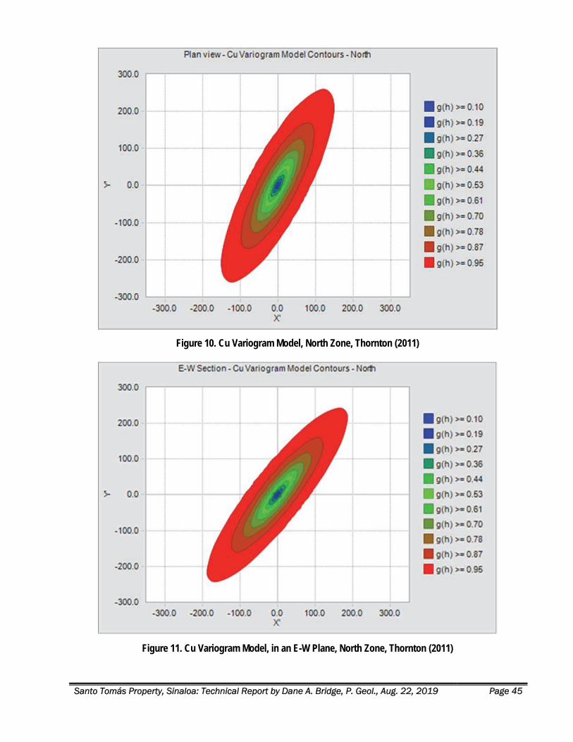
Santo Tomás Property, Sinaloa: Technical Report by Dane A. Bridge, P. Geol., Aug. 22, 2019 Page 45
Figure 10. Cu Variogram Model, North Zone, Thornton (2011)
Figure 11. Cu Variogram Model, in an E-W Plane, North Zone, Thornton (2011)
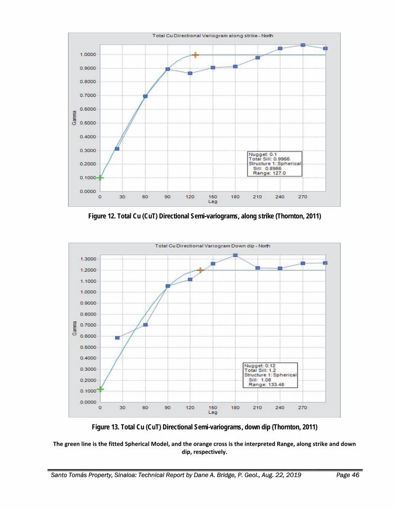
Santo Tomás Property, Sinaloa: Technical Report by Dane A. Bridge, P. Geol., Aug. 22, 2019 Page 46
Figure 12. Total Cu (CuT) Directional Semi-variograms, along strike (Thornton, 2011)
Figure 13. Total Cu (CuT) Directional Semi-variograms, down dip (Thornton, 2011)
The green line is the fitted Spherical Model, and the orange cross is the interpreted Range, along strike and down dip, respectively.
Santo Tomás Property, Sinaloa: Technical Report by Dane A. Bridge, P. Geol., Aug. 22, 2019 Page 47
Historical Mineral Resource Estimate & Scoping Study - 2011
Review of Thornton 2011-STM-MODREV Estimate
Thornton (2011) prepared a scoping study of mine plans and pit designs for the North and South Zones of
Santo Tomás. Within the designed pits, he made a mineral resource estimate for the contained mineable
mineral resources. The Santo Tomás ultimate pits were designed in 6 Phases:
Phases 1 to 4 targeting the North Zone
Phases 5 and 6 targeting the South Zone
A review of the historical Thornton (2011) resource model was undertaken with the assistance of an
independent resource consultant, Mr. Mark Stevens, C.P.G., who reviewed the September 2011 historical
resource model 2011‐STM‐MODREV applying selected total copper (“CuT”) cutoff grades, constrained by six
(6) progressive open‐pit phases as constructed by Thornton, with the ultimate pit represented by the final
sixth phase. The Measured and Indicated mineral resource values of Thornton are reported for the historical
resource, where all Inferred mineral resource is included as Waste (including in the computation of stripping
ratios). See Figure 14. While byproduct gold, silver and molybdenum are present at low levels and were
reported by Thornton, and Stevens did not include these metals as the historical sampling is not as complete
as it is for copper (refer to the section on Drilling).
Figure 14 reflects the modified stripping ratio (Modified Waste Calculation = Waste + Inferred) that assumes
none of the 529 million tonnes of Inferred material would be upgraded to Indicated or Measured or included
in a mining study.
Aspects of the Thornton (2011) scoping study, such as his mining phases, pit design, and stripping ratios are
used herein only to design a drilling program for verification of the Historical Estimate. Neither the Author nor
the Company treats the scoping study chapters in Thornton (2011) as current studies.
Summary of Thornton (2011) Historical Estimate Results
The Stevens checks obtained mineral resource numbers that closely compare with those reported in historical
tables by Thornton in 2011, as follows:
1. At a 0.15% CuT cutoff grade, the results show a large historical Measured and Indicated mineral
resource estimate of 822 million tonnes at an average grade of 0.322% CuT, for a total of 5.84 billion
contained pounds of copper, as shown in (Figure 14).
2. Within this sizeable historical mineral resource, there exists a higher‐grade central area in the North
Pit area, that outcrops at the surface and dips to the west, within a broad structural/intrusive zone.
3. At a 0.35% CuT cutoff grade, the results show a higher‐grade component of mineralization in the
historical Measured and Indicated mineral resource estimate that consists of 333 million tonnes at
an average grade of 0.437% CuT, for a total of 3.20 billion pounds of copper (Figure 15).
The analysis by Stevens, and by the Author demonstrates that approximately 85% of the higher‐grade material
occurs in the North Zone, predominantly in a coherent, shallow, central portion of the North Zone deposit,
with the remainder occurring as scattered outliers throughout the North and South Zone areas.
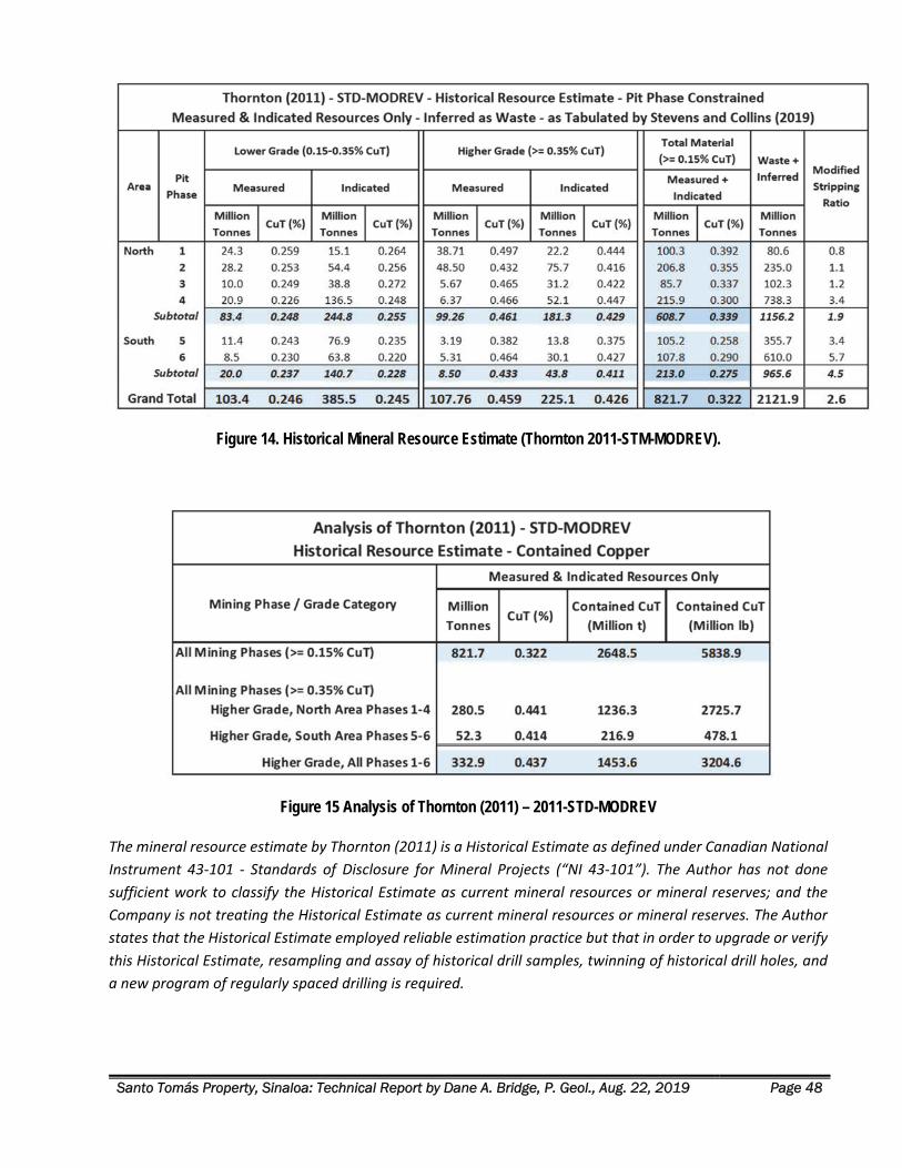
Santo Tomás Property, Sinaloa: Technical Report by Dane A. Bridge, P. Geol., Aug. 22, 2019 Page 48
Figure 14. Historical Mineral Resource Estimate (Thornton 2011-STM-MODREV).
Figure 15 Analysis of Thornton (2011) – 2011-STD-MODREV
The mineral resource estimate by Thornton (2011) is a Historical Estimate as defined under Canadian National
Instrument 43‐101 ‐ Standards of Disclosure for Mineral Projects (“NI 43‐101”). The Author has not done
sufficient work to classify the Historical Estimate as current mineral resources or mineral reserves; and the
Company is not treating the Historical Estimate as current mineral resources or mineral reserves. The Author
states that the Historical Estimate employed reliable estimation practice but that in order to upgrade or verify
this Historical Estimate, resampling and assay of historical drill samples, twinning of historical drill holes, and
a new program of regularly spaced drilling is required.
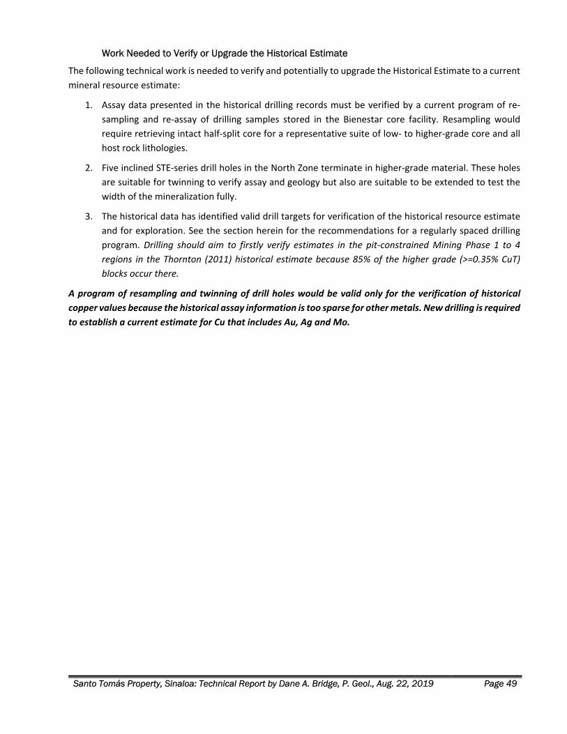
Santo Tomás Property, Sinaloa: Technical Report by Dane A. Bridge, P. Geol., Aug. 22, 2019 Page 49
Work Needed to Verify or Upgrade the Historical Estimate
The following technical work is needed to verify and potentially to upgrade the Historical Estimate to a current
mineral resource estimate:
1. Assay data presented in the historical drilling records must be verified by a current program of re‐
sampling and re‐assay of drilling samples stored in the Bienestar core facility. Resampling would
require retrieving intact half‐split core for a representative suite of low‐ to higher‐grade core and all
host rock lithologies.
2. Five inclined STE‐series drill holes in the North Zone terminate in higher‐grade material. These holes
are suitable for twinning to verify assay and geology but also are suitable to be extended to test the
width of the mineralization fully.
3. The historical data has identified valid drill targets for verification of the historical resource estimate
and for exploration. See the section herein for the recommendations for a regularly spaced drilling
program. Drilling should aim to firstly verify estimates in the pit‐constrained Mining Phase 1 to 4
regions in the Thornton (2011) historical estimate because 85% of the higher grade (>=0.35% CuT)
blocks occur there.
A program of resampling and twinning of drill holes would be valid only for the verification of historical copper values because the historical assay information is too sparse for other metals. New drilling is required to establish a current estimate for Cu that includes Au, Ag and Mo.

Santo Tomás Property, Sinaloa: Technical Report by Dane A. Bridge, P. Geol., Aug. 22, 2019 Page 50
GEOLOGICAL SETTING AND MINERALIZATION
REGIONAL GEOLOGY Regional geology affecting the mineral deposits of the Property is described by the Servicio Geológico
Mexicano (SGM), Tasajeras, Sheet G12‐B59 and marginal notes. Unit abbreviations used herein are those of
the SGM.
The region of the Property and the surrounding Tasajeras map sheet area is underlain by the Guerrero terrane
that is characterized by volcanic and volcaniclastic sequences of oceanic affinity, associated with island arcs of
Middle Jurassic and Early Cretaceous age, which were accreted to North America in the Late Cretaceous
(Campa and Coney, 1983; Centeno‐García et al., 1993). The northernmost exposures of the Guerrero terrane
occur in northern Sinaloa, where meta‐andesites, tuffs, pelagic sediments, pillow basalts, and ultramafic rocks
of Early Cretaceous age are recognized (Ortega‐Gutiérrez, et al., 1979; Servais et al., 1986), but its northern
limit may extend up to southern Sonora (Valencia‐Moreno et al., 2001).
Stratified Rocks
Mesozoic Volcanic and Sedimentary Rocks
The bedrock is predominantly comprised of older, Mesozoic‐aged, bedded, carbonate‐rich sediments,
including limestone, marble bodies, sandstones, and large volumes of andesitic volcanic rocks (Borovic, 2006).
In the Tasajeras map sheet area, the lower greenschist metamorphosed Mesozoic intermediate volcanic, and
volcanic‐sedimentary rocks are designated Jurassic‐Cretaceous Meta‐andesite (JtKapMA). Thick limestone
and marble beds are common. Limestones and marls enclosed by the andesitic rocks are termed Jurassic‐
Cretaceous Meta‐Limestone (JtKapMCz). Similar limestone units that are floored and enclosed by the Late
Cretaceous Sinaloa‐Sonora Batholith are locally termed Meta‐Limestone (KaMCz) although they are likely
equivalent to the unit JtKapMCz.
Tertiary Sierra Madre Occidental (SMO) Volcanic Rocks
Overlying the Mesozoic sedimentary and volcanic rocks, and the older bodies of intrusive rocks, is a Tertiary‐
aged volcano‐sedimentary sequence composed of andesitic volcaniclastic rocks and flows; rhyolite
ignimbrites; and intercalated sediments including polymictic conglomerates and breccia termed the Sierra
Madre Occidental (SMO) volcanic province. The SMO is an aerially extensive, middle Tertiary volcanic
province which extends from the southwestern United States to central Mexico.
In the northern part of its distribution, the SMO is composed of silicic ash‐flow tuffs and rhyolitic lavas with
minor amounts of andesitic lavas. Their average thickness exceeds 1 km (McDowell and Clabaugh,1979) and
the ages cluster in two discrete periods of Eocene and Oligocene age.
In the Tasajeras map sheet, the oldest SMO units are Oligocene Sandstone and Polymictic Conglomerate
(TeoAr‐Cgp) and Andesite and Rhyolite Tuff (ToA‐TR, TomTR). Dacitic volcanic rocks at the Bahuerachi
deposit, located 15 km northeast of the Property, are dated as 59 ma age (approximately Eocene in age) and
importantly, are termed “post‐mineralization.” Younger SMO units comprise the largest volumes of silicic ash‐
flow tuffs and rhyolitic lavas, termed Rhyolite Tuff and Ignimbrite (TomTR‐Ig). Feeder dikes and small felsic
intrusions coeval with the SMO are locally termed Rhyolite intrusions (TmR).
Santo Tomás Property, Sinaloa: Technical Report by Dane A. Bridge, P. Geol., Aug. 22, 2019 Page 51
This silicic volcanism is largely the result of fractional crystallization of mantle‐derived basalts (Johnson, 1991;
Wark,1991) and the volcanic activity appears contemporaneous with the waning of compression after
Laramide orogenesis and with the first part of Basin and Range extension (Wark et al., 1990; Aguirre‐Diaz and
McDowell, 1991, 1993).
The close age range of the Eocene SMO rocks indicates the oldest SMO units might represent the extrusive
components of the youngest Laramide intrusive events. The overlap in age ranges is possibly confirmed with
age determinations performed on units within and nearby the Bahuerachi deposit.
Quaternary Surficial Deposits
Quaternary alluvial deposits are localized, and the largest accumulations form near the major rivers incising
the area.
Intrusive Rocks Intrusive rocks intrude older sedimentary and volcanic rocks and consist of several varieties and overlapping
phases of granodiorite, quartz monzonite, granite, and tonalite plutonism.
Late Cretaceous: Sinaloa-Sonora Batholith
The Late Cretaceous Sinaloa‐Sonora Batholith is contemporaneous with the Jurassic and Cretaceous accretion
of the terranes that make up much of the North American Cordillera. The batholith contains multiple phases
of intrusive rock ranging in composition from diorite and tonalite to granite and quartz‐monzonite. The
emplacement of intrusions was partially controlled and subsequently offset by several phases of faulting
dating from Late Cretaceous to Tertiary time.
In the region near the Property, the Sinaloa‐Sonora Batholith is mostly Granodiorite (KsGd) and Tonalite
(KsTn).
Late Cretaceous to Paleocene: Laramide Intrusions
Locally, the Laramide age intrusive rocks are emplaced in north and north‐east trending fault zones and clearly
post‐date the Sinaloa‐Sonora Batholith. The Laramide intrusions in the region of the Property are Paleocene
age.
On the Tasajera map sheet, Granodiorite (Te(?)Gd & KsTe‐Gd) is of uncertain age. The intrusive felsic rocks
are more certainly of Laramide‐age and are designated as Porphyritic Quartz Monzonite (Te(?)PqMz),
Porphyritic Andesite (Te(?)PA) and Granite (Te(?)Gr).
Late Dikes
Younger Mid‐ to Late‐Tertiary intrusive rocks, mostly in the form of dikes cut the older sedimentary rocks and
early intrusive rocks. Observed dike rocks include mafic (basalt equivalent) varieties; Rhyolite and Trachyte
(TmR).
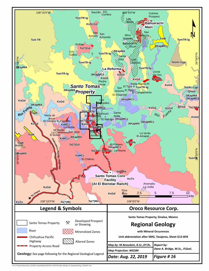
Ç
Ç
Ç ÇÇÇ
ÇÇ
ÇÇ
Ç
ÇÇÇ Ç Ç
ÇÇ
Ç
Ç
Ç
Ç
ÇÇ
ÇÇÇ ÇÇÇÇÇÇ
Ç
ÇÇÇ
ÇÇ
Ç
Ç
Ç
Ç
Ç
Ç ÇÇ
Ç
Ç
"/
R io Fuerte
La Reforma
BahuerachiMain
PinoSolo
El Platano
La Reyna
El AmapalLa Verde
El Refugio
SantaAnita
CuchicariSanto Tomas
LosAzulacos
LosBrasiles
El Chapotal
SanAntonio El Campamento
El Tigre IEl Tigre II
Delta Sigma PI
SantaRita
El Pilar
LosGallos
SanArmando
SanAntonio
El CopalilloEl Creston
La Nubia
La Chimenea San JoseEl Boleo
Mi Madre
LluviaDe Oro
LosAlisos
ColomeProspect
SanMarcosMina
Yolanda
Maria deJesus
LasSalvias
AnomaliaLa Judia
El Chileno
PiedraVerde
Saucillo EGCumbre
BahuerachiSouth
TmR
TomTR-Ig
TomTR-Ig
TmR
TeoAr-Cgp
Te(?)Gd JtKapMCz
TomTR-IgTomTR-Ig
TomTR-Ig
KsGd
JtKapMA
JtKapMCz
KsGd
KsGd
KsGd
JtKapMA
Te(?)PAKsGd
TomTR-IgQhoal
JtKapMCz
TeoAr-CgpJtKapMA
KsGdJtKapMA
KsGd
JtKapMCz
Qhoal
KsGd
JtKapMCz
JtKapMA
KsGdKsGdTomTR-Ig
Te(?)PA
JtKapMCz
TmR
Te(?)PqMz JtKapMCzKaMCz
TomTR
JtKapMCzKsGd
TmR
KsGd
JtKapMAKaMCzTmR Te(?)PA
JtKapMCzTe(?)PAJtKapMA
Te(?)GrKaMCz
Te(?)PA
KsGd
Te(?)Mz
KsTe-Gd
JtKapMA
TomTR-IgToA-TR
KsGd
KsTn Te(?)Mz
KsTn
Te(?)Gd
Santo Tomas CoreFacility
(At El Bienstar Ranch)
108°8'0"W
108°8'0"W
108°16'0"W
108°16'0"W
26
°58
'0"N
26
°58
'0"N
26
°50
'0"N
26
°50
'0"N
File: Z:\Projects\SantoTomas_2018\GIS_Data\MapFiles\REPORT_MAPS\TechRpt_DBridge_A4_RegionalGeology_20190307.mxd
Oroco Resource Corp.Santo Tomas Property, Sinaloa, Mexico
Regional Geologywith Mineral Occurences
Unit abbreviation after SMG, Tasajeras, Sheet G12-B59
Map Projection: WGS84
Report by:Dane A. Bridge, M.Sc., P.Geol.
Legend & Symbols
º
Map by: M.Beaudoin, B.Sc.,DT.Rs.
Developed Prospector Showing
Geology:See page following for the Regional Geological LegendProperty Access Road
Chihuahua PacificHighway
Mineralized Zones
0 2.5 5 7.5 10KM
Rio F uerte
ChihuahuaPacificHighway
River
To Choix
b
Santo Tomas Property
Santo TomasProperty
Altered Zones
Date: Aug. 22, 2019 Figure # 16
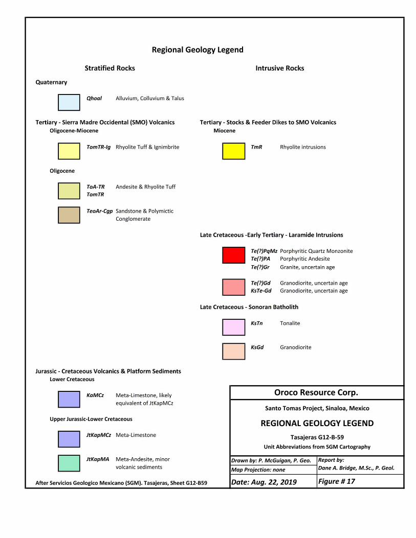
Drawn by: P. McGuigan, P. Geo.Map Projection: none
Report by:Dane A. Bridge, M.Sc., P. Geol.
Oroco Resource Corp.
Santo Tomas Project, Sinaloa, Mexico
REGIONAL GEOLOGY LEGENDTasajeras G12-B-59
Unit Abbreviations from SGM Cartography
Date: Aug. 22, 2019 Figure # 17
Santo Tomás Property, Sinaloa: Technical Report by Dane A. Bridge, P. Geol., Aug. 22, 2019 Page 54
Structural Geology & Mineralization Regional mapping indicates that the older, Mesozoic sedimentary and volcanic sequence is folded to varying
degrees by regional deformation and by deformation related to the emplacement of the Late Cretaceous
Sinaloa‐Sonora Batholith. Locally, these older stratified rocks tend to occur as wedges between intrusive
bodies or as roof pendants. Recrystallization of limestone by heat derived from plutonism has produced
marble bodies, contact‐type hornfels alteration and locally skarn.
On the Tasajera map sheet, gently dipping “rafts” of marble (KaMCz) are locally floored by granodiorite of the
Sinaloa‐Sonora Batholith. Contact metamorphism lithologies include marble, magnetite‐epidote‐wollastonite
exoskarn, and locally, endo‐skarn in the Cretaceous granodiorite.
Near the Property, and in the vicinity of the Reforma and Bahuerachi deposits, the style of deformation is
indicated by the distribution of the thick Mesozoic limestone units. In domains of meta‐andesite (JtKapMA),
gently dipping limestone beds show no evidence of strong folds. Near the Property, massive, thick
limestone/marble (JtKapMCz) beds dip gently northwards and correlate ridge to ridge. They serve as markers
to trace the effect of several stages of brittle fault deformation. See the Property Geology section of this report
for details of the stages of brittle deformation.
NNE and NE trending normal faults and broad, transcurrent wrench‐fault zones are a locus for Laramide dike
swarms, hydrothermal brecciation, hydrothermal alteration, and sulphide mineralization. NNE and NE
trending intrusive bodies and hydrothermal breccia have been documented at Bahuerachi (e.g. Tyler
Resources Technical Report: Jutras and McCandlish (2003)), in the barren Santa Rita hydrothermal breccia
body, and on the Property within the Santo Tomás North, South, and Brasiles Zones.
Late‐Stage faulting is characteristically normal faulting of the younger Choix horst and graben structures which
represents a period of extensional deformation dating to the Oligocene‐Miocene. These structures have offset
and modified the contact relationships between the older phases of intrusive rocks, metasedimentary host
rocks and mineralization.
Locally, late‐stage faulting has served to control and localize the emplacement of younger, Miocene‐aged SMO
rhyolitic volcanic rocks.
At the Santo Tomás, late‐stage faulting also displaces SMO volcanic strata and appears to exploit certain of
the early‐stage fault planes of the Santo Tomás deposit.
PROPERTY GEOLOGY
Introduction Property geology and legend are found in Figures 18 and 19. Included in the legend are the codes employed
in the summary geological logs of the historical diamond drilling programs. In this description, for each rock
type described, the map unit ID and the drill log code is cited. For instance, Jurassic‐Cretaceous meta‐andesite
is identified on the Property and Regional maps with the Servicio Geológico Mexicano codes of “JtKapMA”; in
the drill logs, the logging code is “A.”
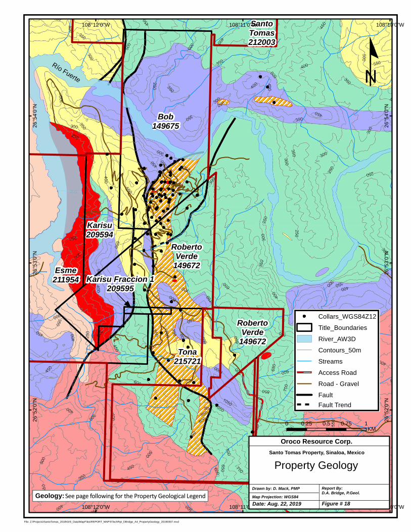
RobertoVerde
149672
Bob149675
Karisu209594
SantoTomas212003
Tona215721
Esme211954
108°10'0"W
108°10'0"W
108°11'0"W
108°11'0"W
108°12'0"W
108°12'0"W
26
°54
'0"N
26
°54
'0"N
26
°53
'0"N
26
°53
'0"N
26
°52
'0"N
26
°52
'0"N
File: Z:\Projects\SantoTomas_2018\GIS_Data\MapFiles\REPORT_MAPS\TechRpt_DBridge_A4_PropertyGeology_20190307.mxd
Río Fuerte
Map Projection: WGS84Drawn by: D. Mack, PMP Report By:
D.A. Bridge, P.Geol.
Property Geology
Oroco Resource Corp.Santo Tomas Property, Sinaloa, Mexico
0 0.25 0.5 0.75 1KM
º
Geology:See page following for the Property Geological Legend
RobertoVerde
149672
Karisu Fraccion 1209595
Collars_WGS84Z12
Title_Boundaries
River_AW3D
Contours_50m
Streams
Access Road
Road - Gravel
Fault
Fault Trend
Date: Aug. 22, 2019 Figure # 18
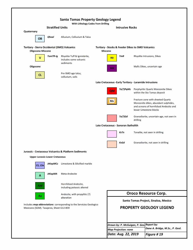
Report by:Dane A. Bridge, M.Sc., P. Geol.
Oroco Resource Corp.Santo Tomas Project, Sinaloa, Mexico
PROPERTY GEOLOGY LEGEND
Drawn by: P. McGuigan, P. Geo.
Map Projection: none
Date: Aug. 22, 2019 Figure # 19
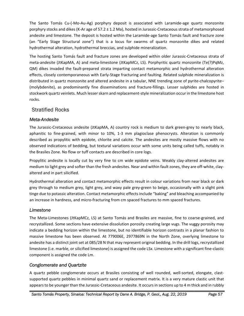
Santo Tomás Property, Sinaloa: Technical Report by Dane A. Bridge, P. Geol., Aug. 22, 2019 Page 57
The Santo Tomás Cu‐(‐Mo‐Au‐Ag) porphyry deposit is associated with Laramide‐age quartz monzonite
porphyry stocks and dikes (K‐Ar age of 57.2 ± 1.2 Ma), hosted in Jurassic‐Cretaceous strata of metamorphosed
andesite and limestone. The deposit is hosted within the Laramide‐age Santo Tomás fault and fracture zone
(an “Early Stage Structural zone”) that is a locus for swarms of quartz monzonite dikes and related
hydrothermal alteration, hydrothermal breccias, and sulphide mineralization.
The hosting Santo Tomás fault and fracture zones are developed within older Jurassic‐Cretaceous strata of
meta‐andesite (JtKapMA, A) and meta‐limestone (JtKapMCz, LS). Porphyritic quartz monzonite (Te(?)PqMz,
QM) dikes invaded the fault‐prepared strata imparting contact metamorphic and hydrothermal alteration
effects, closely contemporaneous with Early‐Stage fracturing and faulting. Related sulphide mineralization is
distributed in quartz monzonite and altered andesite in a tabular, NNE trending zone of pyrite‐chalcopyrite–
(molybdenite), as predominantly fine disseminations and fracture‐fillings. Lesser sulphides are hosted in
stockwork quartz veinlets. Much lesser skarn and replacement‐style mineralization occur in the limestone host
rocks.
Stratified Rocks
Meta-Andesite
The Jurassic‐Cretaceous andesite (JtKapMA, A) country rock is medium to dark green‐grey to nearly black,
aphanitic to fine‐grained, with minor to 10%, 1‐3 mm plagioclase phenocrysts. Alteration is commonly
described as propylitic with epidote, chlorite and calcite. The andesites are mostly massive flows with no
observed indications of bedding, but textural variations occur with some units being called tuffs, notably in
the Brasiles Zone. No flow or tuff contacts are described in core logs.
Propylitic andesite is locally cut by very fine to cm wide epidote veins. Weakly clay‐altered andesites are
medium to light grey and softer than the fresh andesites. Near and within fault zones, they are off‐white, clay‐
altered and in part silicified.
Hydrothermal alteration and contact metamorphic effects result in colour variations from near black or dark
grey through to medium grey, light grey, and waxy pale grey‐green to beige, occasionally with a slight pink
tinge due to potassic alteration. Contact metamorphic effects include “baking” and bleaching accompanied by
an increase in hardness, and micro‐fracturing from cm spaced fractures to mm spaced fractures.
Limestone
The Meta‐Limestones (JtKapMCz, LS) at Santo Tomás and Brasiles are massive, fine to coarse‐grained, and
recrystallized. Some sections have extensive dissolution porosity creating large vugs. The vuggy porosity may
indicate a bedding horizon within the limestone, but no identifiable horizon contrasts in a planar fashion to
massive limestone has been observed. At 779006E, 2977869N in the North Zone, overlying limestone to
andesite has a distinct joint set at 085/28 N that may represent original bedding. In the drill logs, recrystallized
limestone (i.e. marble, or silicified limestone) is assigned the code LSx. Limestone with a significant fine‐clastic
component is assigned the code Lm.
Conglomerate and Quartzite
A quartz pebble conglomerate occurs at Brasiles consisting of well rounded, well‐sorted, elongate, clast‐
supported quartz pebbles in minimal quartz sand or replacement matrix. It is a very mature clastic unit that
appears to be younger than the Jurassic‐Cretaceous andesite. It occurs in sections up to 4 m thick and in rubbly
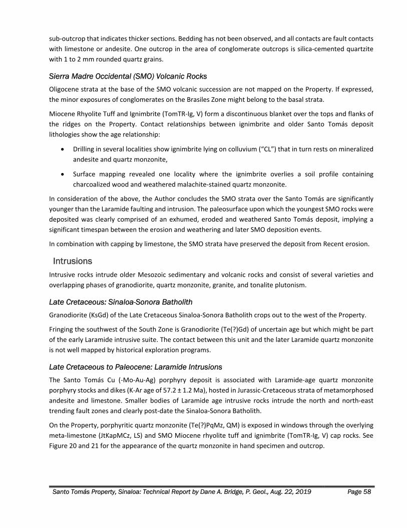
Santo Tomás Property, Sinaloa: Technical Report by Dane A. Bridge, P. Geol., Aug. 22, 2019 Page 58
sub‐outcrop that indicates thicker sections. Bedding has not been observed, and all contacts are fault contacts
with limestone or andesite. One outcrop in the area of conglomerate outcrops is silica‐cemented quartzite
with 1 to 2 mm rounded quartz grains.
Sierra Madre Occidental (SMO) Volcanic Rocks
Oligocene strata at the base of the SMO volcanic succession are not mapped on the Property. If expressed,
the minor exposures of conglomerates on the Brasiles Zone might belong to the basal strata.
Miocene Rhyolite Tuff and Ignimbrite (TomTR‐Ig, V) form a discontinuous blanket over the tops and flanks of
the ridges on the Property. Contact relationships between ignimbrite and older Santo Tomás deposit
lithologies show the age relationship:
Drilling in several localities show ignimbrite lying on colluvium (“CL”) that in turn rests on mineralized
andesite and quartz monzonite,
Surface mapping revealed one locality where the ignimbrite overlies a soil profile containing
charcoalized wood and weathered malachite‐stained quartz monzonite.
In consideration of the above, the Author concludes the SMO strata over the Santo Tomás are significantly
younger than the Laramide faulting and intrusion. The paleosurface upon which the youngest SMO rocks were
deposited was clearly comprised of an exhumed, eroded and weathered Santo Tomás deposit, implying a
significant timespan between the erosion and weathering and later SMO deposition events.
In combination with capping by limestone, the SMO strata have preserved the deposit from Recent erosion.
Intrusions Intrusive rocks intrude older Mesozoic sedimentary and volcanic rocks and consist of several varieties and
overlapping phases of granodiorite, quartz monzonite, granite, and tonalite plutonism.
Late Cretaceous: Sinaloa-Sonora Batholith
Granodiorite (KsGd) of the Late Cretaceous Sinaloa‐Sonora Batholith crops out to the west of the Property.
Fringing the southwest of the South Zone is Granodiorite (Te(?)Gd) of uncertain age but which might be part
of the early Laramide intrusive suite. The contact between this unit and the later Laramide quartz monzonite
is not well mapped by historical exploration programs.
Late Cretaceous to Paleocene: Laramide Intrusions
The Santo Tomás Cu (‐Mo‐Au‐Ag) porphyry deposit is associated with Laramide‐age quartz monzonite
porphyry stocks and dikes (K‐Ar age of 57.2 ± 1.2 Ma), hosted in Jurassic‐Cretaceous strata of metamorphosed
andesite and limestone. Smaller bodies of Laramide age intrusive rocks intrude the north and north‐east
trending fault zones and clearly post‐date the Sinaloa‐Sonora Batholith.
On the Property, porphyritic quartz monzonite (Te(?)PqMz, QM) is exposed in windows through the overlying
meta‐limestone (JtKapMCz, LS) and SMO Miocene rhyolite tuff and ignimbrite (TomTR‐Ig, V) cap rocks. See
Figure 20 and 21 for the appearance of the quartz monzonite in hand specimen and outcrop.
Santo Tomás Property, Sinaloa: Technical Report by Dane A. Bridge, P. Geol., Aug. 22, 2019 Page 59
Figure 20. Core Sample of Quartz Monzonite from STD-42.
Note Core sample of the quartz monzonite (the yellow is a stain for K‐feldspar) (A), host to the mineralization at Santo Tomás. A magnified photograph of the sample showing the porphyritic texture of the rock (B), the scale is in
millimetres.
The average modal mineralogy of the intrusions is:
Plagioclase 35%
K‐feldspar 43%
Quartz 8%
Mafic minerals (mostly hornblende, biotite) 11%
Sulphides 0.5%
Other 2.5%
The above‐listed percentages for plagioclase, K‐feldspar and quartz normalize to 41% plagioclase, 50% K‐
feldspar and 9% quartz, yielding a composition of quartz monzonite under the IUGS (International Union of
Geological Sciences) plutonic rock classification scheme following the Quartz‐Alkali feldspar‐Plagioclase‐
Feldspathoid (“ QAPF”) diagram (Walker and Cohen, 2009).
In the diamond drill core logs available for the STD holes, and certain re‐logging efforts, the intrusive suite is
described variously as quartz monzonite, quartz monzonite porphyry, and monzonite. For the STE rotary holes,
the logging is less descriptive, and re‐logging is not possible due to the loss of the rotary drill rejects. The
intense alteration also obscures original textures. For these reasons, the summary drill logs were prepared
with the nomenclature of quartz monzonite (code: “QM”) for all the Laramide intrusions on the Property.
Later exploration programs require more detailed logging.
Lithologies described as quartz‐feldspar porphyry and feldspar porphyry are the dominant intrusive phase in
some drill holes. These lithologies are probably closely related to the quartz monzonite intrusive phases. The
A B
Santo Tomás Property, Sinaloa: Technical Report by Dane A. Bridge, P. Geol., Aug. 22, 2019 Page 60
porphyries are light to medium grey, with variable abundances of large, euhedral to subhedral plagioclase
phenocrysts, <5% fine plagioclase phenocrysts, 3‐5% quartz phenocrysts and minor to 5% chlorite, mainly as
phenocrysts probably replacing hornblende or biotite, in a very fine‐grained to near‐aphanitic groundmass.
Figure 21. Outcrop of Contact between hornfelsed Andesite (left) and a Quartz Monzonite dike (right)
The view is Looking towards Azimuth 200° (Contact is 020°/50°W), the site is near STE‐27, North Zone
Hydrothermal Breccia
Hydrothermal breccias (Hbx) are noted in the drill core logs of the North Zone but have not been re‐logged by
the Author. Traverses by the Author in the Brasiles Zone noted several occurrences of hydrothermally
brecciated rocks.
Andesitic hydrothermal breccias consist of well‐rounded andesitic clasts, mainly 2‐3 cm to 10 cm, locally up
to 15 cm, in a fine‐grained granular rock flour matrix. They vary from packed clast supported to matrix‐
supported with about 75% matrix. Only andesitic clasts were observed. No hydrothermal alteration was
apparent. However, a few broken clasts have a thin, light grey rim that may be from hydrothermal alteration
or might be a weathering effect.
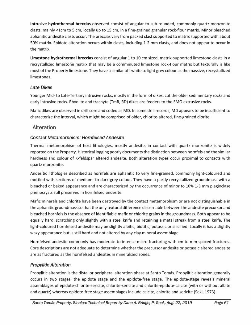
Santo Tomás Property, Sinaloa: Technical Report by Dane A. Bridge, P. Geol., Aug. 22, 2019 Page 61
Intrusive hydrothermal breccias observed consist of angular to sub‐rounded, commonly quartz monzonite
clasts, mainly <1cm to 5 cm, locally up to 15 cm, in a fine‐grained granular rock‐flour matrix. Minor bleached
aphanitic andesite clasts occur. The breccias vary from packed clast supported to matrix supported with about
50% matrix. Epidote alteration occurs within clasts, including 1‐2 mm clasts, and does not appear to occur in
the matrix.
Limestone hydrothermal breccias consist of angular 1 to 10 cm sized, matrix‐supported limestone clasts in a
recrystallized limestone matrix that may be a comminuted limestone rock‐flour matrix but texturally is like
most of the Property limestone. They have a similar off‐white to light grey colour as the massive, recrystallized
limestones.
Late Dikes
Younger Mid‐ to Late‐Tertiary intrusive rocks, mostly in the form of dikes, cut the older sedimentary rocks and
early intrusive rocks. Rhyolite and trachyte (TmR, RD) dikes are feeders to the SMO extrusive rocks.
Mafic dikes are observed in drill core and coded as MD. In some drill records, MD appears to be insufficient to
characterize the interval, which might be comprised of older, chlorite‐altered, fine‐grained diorite.
Alteration
Contact Metamorphism: Hornfelsed Andesite
Thermal metamorphism of host lithologies, mostly andesite, in contact with quartz monzonite is widely
reported on the Property. Historical logging poorly documents the distinction between hornfels and the similar
hardness and colour of K‐feldspar altered andesite. Both alteration types occur proximal to contacts with
quartz monzonite.
Andesitic lithologies described as hornfels are aphanitic to very fine‐grained, commonly light‐coloured and
mottled with sections of medium‐ to dark‐grey colour. They have a partly recrystallized groundmass with a
bleached or baked appearance and are characterized by the occurrence of minor to 10% 1‐3 mm plagioclase
phenocrysts still preserved in hornfelsed andesite.
Mafic minerals and chlorite have been destroyed by the contact metamorphism or are not distinguishable in
the aphanitic groundmass so that the only textural difference discernable between the andesite precursor and
bleached hornfels is the absence of identifiable mafic or chlorite grains in the groundmass. Both appear to be
equally hard, scratching only slightly with a steel knife and retaining a metal streak from a steel knife. The
light‐coloured hornfelsed andesite may be slightly albitic, biotitic, potassic or silicified. Locally it has a slightly
waxy appearance but is still hard and not altered by any clay mineral assemblage.
Hornfelsed andesite commonly has moderate to intense micro‐fracturing with cm to mm spaced fractures.
Core descriptions are not adequate to determine whether the precursor andesite or potassic altered andesite
are as fractured as the hornfelsed andesites in mineralized zones.
Propylitic Alteration
Propylitic alteration is the distal or peripheral alteration phase at Santo Tomás. Propylitic alteration generally
occurs in two stages; the epidote stage and the epidote‐free stage. The epidote‐stage reveals mineral
assemblages of epidote‐chlorite‐sericite, chlorite‐sericite and chlorite‐epidote‐calcite (with or without albite
and quartz) whereas epidote‐free stage assemblages include calcite, chlorite and sericite (Seki, 1973).

Santo Tomás Property, Sinaloa: Technical Report by Dane A. Bridge, P. Geol., Aug. 22, 2019 Page 62
Sodic-Calcic Alteration
Albitic alteration is an early‐stage, high‐temperature alteration that is a deeper or core alteration in porphyry
systems. At Santo Tomás sodic‐calcic or albitic alteration is very poorly defined and may be mainly overprinted
by later potassic alteration.
In STD‐45, silica‐albite alteration in quartz monzonite occurs in part of the 328.2‐351.7 m interval, at 315.5 m,
and in STD‐44 at 333 m. It is a uniformly light‐coloured, off‐white groundmass consisting of about 50% opaque
to semi‐translucent albite (?) and 50% transparent to translucent, colourless quartz as distinct, very fine,
separated, sand‐like grains. Minor euhedral remnants of the original plagioclase phenocrysts and quartz
phenocrysts attest to a quartz monzonite precursor.
Irregular tourmaline patches and minor remnants of chlorite are common. The overall character is a whiter
lithology compared to normal quartz monzonite and absent to minor, wispy to indistinct chlorite, but with the
chlorite appearing brighter green, possibly because of the whiter groundmass.
Very localized potassic alteration occurs with the silica‐albite alteration and may indicate that the albitic
alteration of plagioclase phenocrysts and groundmass predates potassic alteration.
Silica‐albite alteration is associated with higher than normal sulphide concentrations.
Potassic Alteration
Potassic alteration is characterized by the exchange of K for Ca & Na ions, leading to the replacement of Ca‐
Na bearing mineral phases by potassic minerals; typical assemblages are orthoclase and biotite after
plagioclase and hornblende. It is commonly developed in the core of porphyry Cu‐systems.
Very thin potassic alteration halos occur along the margins of quartz and quartz‐sulphide veins as indicated by
staining for potassium. However, in unstained rock, there is little colour contrast between these halos and the
rock, so the presence of potassic alteration is near impossible to detect unaided by staining.
Potassic altered andesite: Potassium feldspar (Potassic) alteration in andesite locally alters the groundmass
from an aphanitic texture to a uniform and very fine‐grained hypidiomorphic granular texture and imparts a
slight translucency to the groundmass.
Potassic altered andesite is commonly medium grey and does not display any potassium feldspar colouration.
Individual mineral grains are indistinct due to potassic alteration, and the rock appears to consist of weakly
translucent plagioclase and altered plagioclase with minor chloritic remnants of mafic minerals. Staining for
potassium indicates abundant speckling, up to 50‐60%, of potassic alteration that results in slightly indistinct
grain boundaries. Locally the groundmass contains abundant fine‐grained black tourmaline.
Fracture and veining intensity vary from minor to intense with some correlation of higher copper values with a
higher fracture intensity.
Biotite altered andesite: Biotite alteration in andesite or hornfels imparts a black to a nearly black colour and
an aphanitic to very fine‐grained texture. The rock is slightly softer to a scratch with a steel point, but the
hardness is variable and is not a reliable indicator.
Some andesite may be biotite altered, especially at monzonite contacts where it is locally near black, rather
than dark grey. From observations limited to selected core samples from STD‐44 and 45, biotite alteration
appears to be less common than other potassic alteration suites.
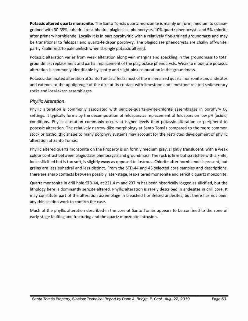
Santo Tomás Property, Sinaloa: Technical Report by Dane A. Bridge, P. Geol., Aug. 22, 2019 Page 63
Potassic altered quartz monzonite. The Santo Tomás quartz monzonite is mainly uniform, medium to coarse‐
grained with 30‐35% euhedral to subhedral plagioclase phenocrysts, 10% quartz phenocrysts and 5% chlorite
after primary hornblende. Locally it is in part porphyritic with a relatively fine‐grained groundmass and may
be transitional to feldspar and quartz‐feldspar porphyry. The plagioclase phenocrysts are chalky off‐white,
partly kaolinized, to pale pinkish when strongly potassic altered.
Potassic alteration varies from weak alteration along vein margins and speckling in the groundmass to total
groundmass replacement and partial replacement of the plagioclase phenocrysts. Weak to moderate potassic
alteration is commonly identifiable by spotty and slight pink colouration in the groundmass.
Potassic dominated alteration at Santo Tomás affects most of the mineralized quartz monzonite and andesites
and extends to the up‐dip edge of the dike at its contact with limestone and limestone related sedimentary
rocks and local skarn assemblages.
Phyllic Alteration
Phyllic alteration is commonly associated with sericite‐quartz‐pyrite‐chlorite assemblages in porphyry Cu
settings. It typically forms by the decomposition of feldspars as replacement of feldspars on low pH (acidic)
conditions. Phyllic alteration commonly occurs at higher levels than potassic alteration or peripheral to
potassic alteration. The relatively narrow dike morphology at Santo Tomás compared to the more common
stock or batholithic shape to many porphyry systems may account for the restricted development of phyllic
alteration at Santo Tomás.
Phyllic altered quartz monzonite on the Property is uniformly medium grey, slightly translucent, with a weak
colour contrast between plagioclase phenocrysts and groundmass. The rock is firm but scratches with a knife,
looks silicified but is too soft, is slightly waxy as opposed to lustrous. Chlorite after hornblende is present, but
grains are less euhedral and less distinct. From the STD‐44 and 45 selected core samples and descriptions,
there are sharp contacts between possibly later‐stage, less‐altered monzonite and sericitic quartz monzonite.
Quartz monzonite in drill hole STD‐44, at 221.4 m and 237 m has been historically logged as silicified, but the
lithology here is dominantly sericite altered. Phyllic alteration is rarely described in andesites in drill core. It
may constitute part of the alteration assemblage in bleached hornfelsed andesites, but there has not been
any thin section work to confirm the case.
Much of the phyllic alteration described in the core at Santo Tomás appears to be confined to the zone of
early‐stage faulting and fracturing and the quartz monzonite intrusion.
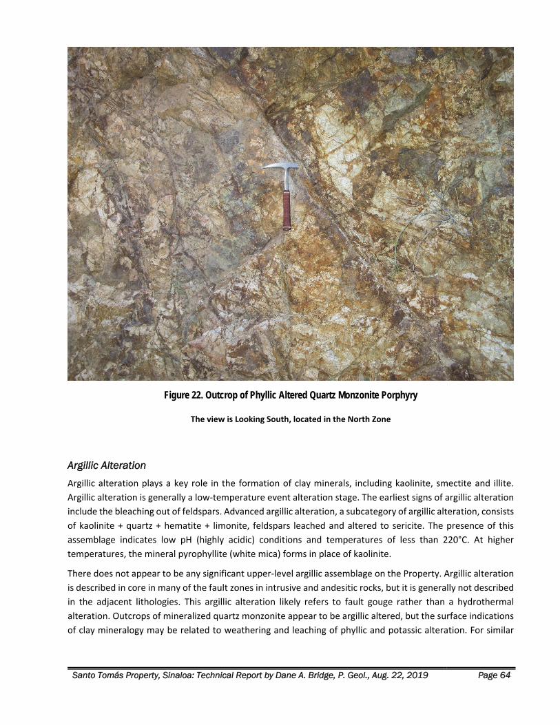
Santo Tomás Property, Sinaloa: Technical Report by Dane A. Bridge, P. Geol., Aug. 22, 2019 Page 64
Figure 22. Outcrop of Phyllic Altered Quartz Monzonite Porphyry
The view is Looking South, located in the North Zone
Argillic Alteration
Argillic alteration plays a key role in the formation of clay minerals, including kaolinite, smectite and illite.
Argillic alteration is generally a low‐temperature event alteration stage. The earliest signs of argillic alteration
include the bleaching out of feldspars. Advanced argillic alteration, a subcategory of argillic alteration, consists
of kaolinite + quartz + hematite + limonite, feldspars leached and altered to sericite. The presence of this
assemblage indicates low pH (highly acidic) conditions and temperatures of less than 220°C. At higher
temperatures, the mineral pyrophyllite (white mica) forms in place of kaolinite.
There does not appear to be any significant upper‐level argillic assemblage on the Property. Argillic alteration
is described in core in many of the fault zones in intrusive and andesitic rocks, but it is generally not described
in the adjacent lithologies. This argillic alteration likely refers to fault gouge rather than a hydrothermal
alteration. Outcrops of mineralized quartz monzonite appear to be argillic altered, but the surface indications
of clay mineralogy may be related to weathering and leaching of phyllic and potassic alteration. For similar
Santo Tomás Property, Sinaloa: Technical Report by Dane A. Bridge, P. Geol., Aug. 22, 2019 Page 65
reasons, argillic alteration is commonly mentioned in the upper portions of drill holes where the rock is
fractured, broken and weathered.
Structure
Deposit Morphology
The Santo Tomás‐Brasiles porphyry copper system is atypical of porphyry deposits in that it consists of a 300‐
400 m wide dike or dike complex with a strike extent of at least 5 km. This gives it a very high aspect ratio in
the range of 12 to 17:1. Consequently, it exhibits strong structural control rather than the more typical stock
or batholith control evident in many porphyry systems. The permeability and fluid flow that produced the
alteration and mineralization were the results of multiple faults and an extensive set of fractures related to
the faults, that developed in response to hydraulic fracturing. The Santo Tomás deposit has the structural
characteristics of porphyry deposits that are broadly related to regional and pull‐apart structures at dilational
bends, strike‐slip faults, shear zones, duplexes, pull‐apart basins, and grabens such as described by Berger et
al., (2008).
Deformation
On and near the Property, the style of deformation is indicated by the distribution of the thick Mesozoic
limestone units that serve as local “marker” beds. In domains of meta‐andesite (JtKapMA), gently dipping
limestone beds show evidence of gentle “warping.” On the central ridge of the Property, massive, thick
limestone/marble (JtKapMCz, LS) beds dip gently northwards from the ridge top in the South Zone, peak to
peak down the ridge, and pass across Rio Fuerte to the Brasiles Zone. The limestone bed serves to trace the
effect of several stages of brittle fault deformation.
Brittle Deformation: 2019 Structural Mapping
Kinematic analysis of fault data collected in the North and Brasiles Zones during the 2019 exploration program
demonstrates the importance of early NNE faulting in the structural control to the Cu (‐Mo‐Au‐Ag)
mineralization and geological modelling.
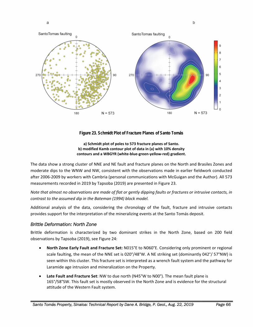
Santo Tomás Property, Sinaloa: Technical Report by Dane A. Bridge, P. Geol., Aug. 22, 2019 Page 66
Figure 23. Schmidt Plot of Fracture Planes of Santo Tomás
a) Schmidt plot of poles to 573 fracture planes of Santo. b) modified Kamb contour plot of data in (a) with 10% density contours and a WBGYR (white‐blue‐green‐yellow‐red) gradient.
The data show a strong cluster of NNE and NE fault and fracture planes on the North and Brasiles Zones and
moderate dips to the WNW and NW, consistent with the observations made in earlier fieldwork conducted
after 2006‐2009 by workers with Cambria (personal communications with McGuigan and the Author). All 573
measurements recorded in 2019 by Tapsoba (2019) are presented in Figure 23.
Note that almost no observations are made of flat or gently dipping faults or fractures or intrusive contacts, in
contrast to the assumed dip in the Bateman (1994) block model.
Additional analysis of the data, considering the chronology of the fault, fracture and intrusive contacts
provides support for the interpretation of the mineralizing events at the Santo Tomás deposit.
Brittle Deformation: North Zone
Brittle deformation is characterized by two dominant strikes in the North Zone, based on 200 field
observations by Tapsoba (2019), see Figure 24:
North Zone Early Fault and Fracture Set: N015°E to N060°E. Considering only prominent or regional
scale faulting, the mean of the NNE set is 020°/48°W. A NE striking set (dominantly 042°/ 57°NW) is
seen within this cluster. This fracture set is interpreted as a wrench fault system and the pathway for
Laramide age intrusion and mineralization on the Property.
Late Fault and Fracture Set: NW to due north (N45°W to N00°). The mean fault plane is 165°/58°SW. This fault set is mostly observed in the North Zone and is evidence for the structural attitude of the Western Fault system.
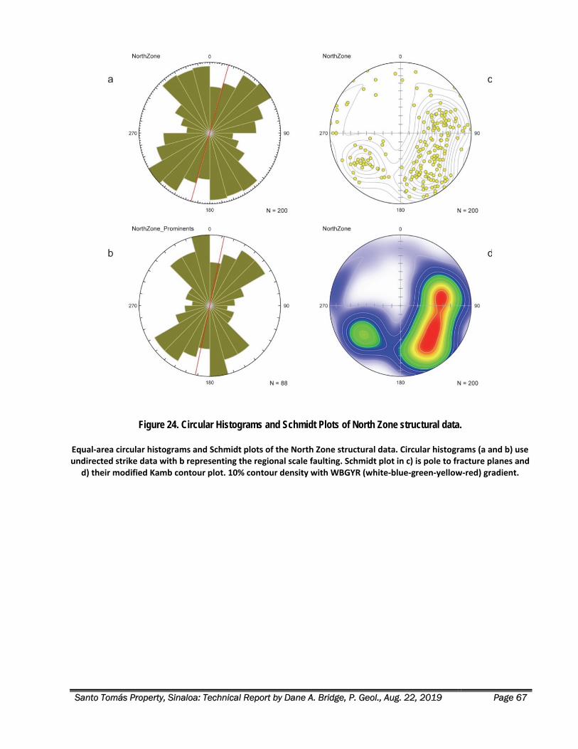
Santo Tomás Property, Sinaloa: Technical Report by Dane A. Bridge, P. Geol., Aug. 22, 2019 Page 67
Figure 24. Circular Histograms and Schmidt Plots of North Zone structural data.
Equal‐area circular histograms and Schmidt plots of the North Zone structural data. Circular histograms (a and b) use undirected strike data with b representing the regional scale faulting. Schmidt plot in c) is pole to fracture planes and
d) their modified Kamb contour plot. 10% contour density with WBGYR (white‐blue‐green‐yellow‐red) gradient.
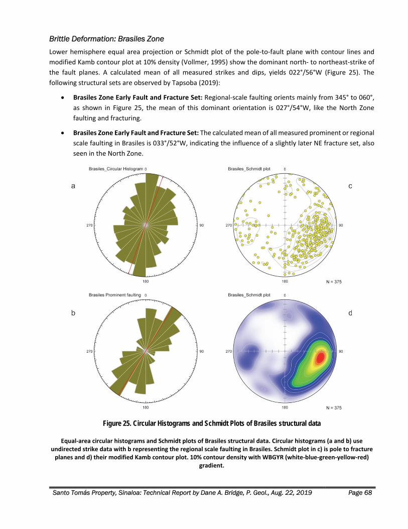
Santo Tomás Property, Sinaloa: Technical Report by Dane A. Bridge, P. Geol., Aug. 22, 2019 Page 68
Brittle Deformation: Brasiles Zone
Lower hemisphere equal area projection or Schmidt plot of the pole‐to‐fault plane with contour lines and
modified Kamb contour plot at 10% density (Vollmer, 1995) show the dominant north‐ to northeast‐strike of
the fault planes. A calculated mean of all measured strikes and dips, yields 022°/56°W (Figure 25). The
following structural sets are observed by Tapsoba (2019):
Brasiles Zone Early Fault and Fracture Set: Regional‐scale faulting orients mainly from 345° to 060°,
as shown in Figure 25, the mean of this dominant orientation is 027°/54°W, like the North Zone
faulting and fracturing.
Brasiles Zone Early Fault and Fracture Set: The calculated mean of all measured prominent or regional
scale faulting in Brasiles is 033°/52°W, indicating the influence of a slightly later NE fracture set, also
seen in the North Zone.
Figure 25. Circular Histograms and Schmidt Plots of Brasiles structural data
Equal‐area circular histograms and Schmidt plots of Brasiles structural data. Circular histograms (a and b) use undirected strike data with b representing the regional scale faulting in Brasiles. Schmidt plot in c) is pole to fracture planes and d) their modified Kamb contour plot. 10% contour density with WBGYR (white‐blue‐green‐yellow‐red)
gradient.
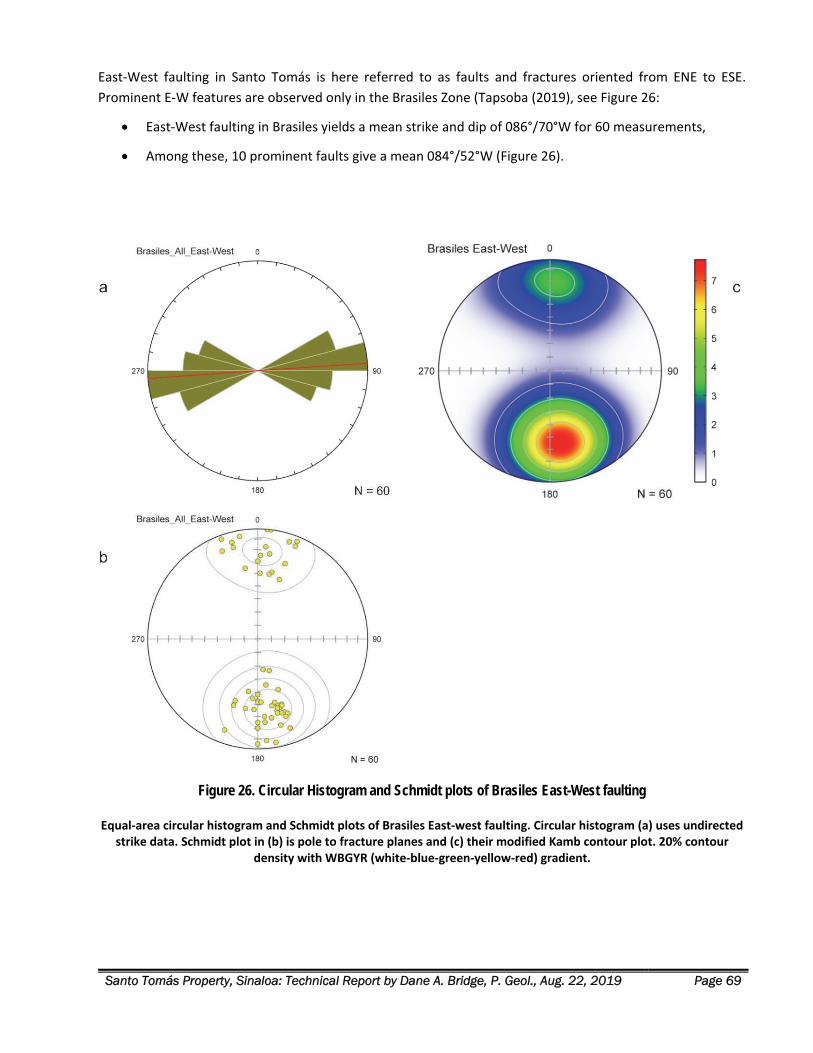
Santo Tomás Property, Sinaloa: Technical Report by Dane A. Bridge, P. Geol., Aug. 22, 2019 Page 69
East‐West faulting in Santo Tomás is here referred to as faults and fractures oriented from ENE to ESE.
Prominent E‐W features are observed only in the Brasiles Zone (Tapsoba (2019), see Figure 26:
East‐West faulting in Brasiles yields a mean strike and dip of 086°/70°W for 60 measurements,
Among these, 10 prominent faults give a mean 084°/52°W (Figure 26).
Figure 26. Circular Histogram and Schmidt plots of Brasiles East-West faulting
Equal‐area circular histogram and Schmidt plots of Brasiles East‐west faulting. Circular histogram (a) uses undirected strike data. Schmidt plot in (b) is pole to fracture planes and (c) their modified Kamb contour plot. 20% contour
density with WBGYR (white‐blue‐green‐yellow‐red) gradient.
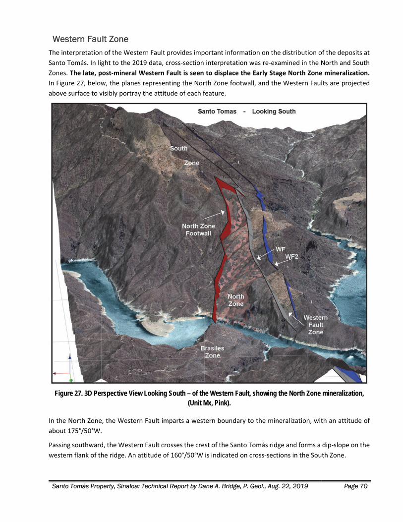
Santo Tomás Property, Sinaloa: Technical Report by Dane A. Bridge, P. Geol., Aug. 22, 2019 Page 70
Western Fault Zone The interpretation of the Western Fault provides important information on the distribution of the deposits at
Santo Tomás. In light to the 2019 data, cross‐section interpretation was re‐examined in the North and South
Zones. The late, post‐mineral Western Fault is seen to displace the Early Stage North Zone mineralization.
In Figure 27, below, the planes representing the North Zone footwall, and the Western Faults are projected
above surface to visibly portray the attitude of each feature.
Figure 27. 3D Perspective View Looking South – of the Western Fault, showing the North Zone mineralization, (Unit Mx, Pink).
In the North Zone, the Western Fault imparts a western boundary to the mineralization, with an attitude of
about 175°/50°W.
Passing southward, the Western Fault crosses the crest of the Santo Tomás ridge and forms a dip‐slope on the
western flank of the ridge. An attitude of 160°/50°W is indicated on cross‐sections in the South Zone.
Santo Tomás Property, Sinaloa: Technical Report by Dane A. Bridge, P. Geol., Aug. 22, 2019 Page 71
Movement on the Western Fault, from cross‐sectional interpretation and kinematics measured on the bank
of Rio Fuerte in 2019, is west‐side down and southward (left‐lateral displacement). The Western Fault, from
data in the South Zone, demonstrates a minimum of 200 m vertical displacement. The magnitude of the
displacement across the full width of the Western Fault zone (Western Fault + Western Fault 2) is not known
due to the paucity of data from the hanging wall (western) side of the fault zone.
The Western Fault zone is the latest major fault and fracture set on the Property and as such, strongly affects
the local topography. The western flank of the Santo Tomás ridge in both the North and South Zones is a dip‐
slope of the late NNW trending fault and fracture set. See Figure 27, for the perspective view of the Western
Fault superimposed on the new acquired DTM and orthophoto information.
Mineralization The Laramide orogenic activity was followed by Middle Tertiary orogenic movements, extension, and finally,
the development of horst and graben structures (Staude and Barton, 2001). The Santo Tomás mineral camp is
characterized by copper porphyry and skarn/replacement style mineralization linked to the Laramide Orogeny
(80‐40 Ma age). The Santo Tomás Cu (‐Mo‐Au‐Ag) porphyry deposit lies mostly on the Property and is
associated with an NNE‐trending zone of quartz monzonite porphyry stocks and dikes (K‐Ar age of 57.2 ± 1.2
Ma), hosted in strongly faulted and fractured Cretaceous metamorphosed andesite and limestone. The
deposits are similar in age, host rocks and mineralization styles to the Cananea deposits, in Sonora, and other
Laramide‐age deposits of the southwestern USA.
The Santo Tomás deposit is mostly comprised of chalcopyrite, pyrite, and molybdenite sulphides with minor
bornite, covellite, and chalcocite, which occur as fracture fillings, veinlets, and fine disseminations together
with potassium feldspar, quartz, calcite, chlorite, and locally, tourmaline. Minor copper oxides occur near the
surface.
Chalcopyrite is the main copper mineral. It occurs with pyrite both as fine‐grained disseminations throughout
altered rock types and along with the central or marginal parts of microfractures that have been filled with
quartz and potassium feldspar, and locally with black tourmaline crystals within the intrusive and adjacent
andesite. The microfractures host mm to 2‐3 mm thick quartz and potassium feldspar veins. The hairline
fractures produce surfaces with scattered very fine sulphide grains that have the appearance of randomly
disseminated grains. Some mm to 2‐3 mm quartz‐sulphide veins contain chlorite or magnetite.
The mineralization is hosted mainly by Laramide‐age quartz monzonite intrusions and strongly fractured and
faulted Mesozoic‐age andesitic volcanic rock. Both sets of Early Stage faulting and fracturing act as a host for
the dikes. Screens of andesite between dikes are strongly hornfelsed. At Santo Tomás, the drill hole spacing
does not allow a confident correlation of individual sub‐parallel dikes.
The quartz monzonite dikes, and screens of andesite can be mapped together as a definable Early Stage
fracture zone unit (Property Map unit, Mx) comprised of sheeted quartz monzonite dikes, and screens of highly
fractured, hornfelsed andesite, and lesser limestone. Related sulphides occur as disseminations, in fractures,
and in quartz veinlets.
The Santo Tomás deposit is exposed in outcrop pattern along a 5 km strike length. South of Rio Fuerte,
mineralization that lies on the eastern flank of the prominent N‐S ridge is referred to herein as the “North
Zone.” To the south, similar mineralization on the west flank of the Santo Tomás ridge is termed the South
Zone.” In the North Zone, the mineralized zone dips westward into the eastern flank of the ridge; in the South
Santo Tomás Property, Sinaloa: Technical Report by Dane A. Bridge, P. Geol., Aug. 22, 2019 Page 72
Zone, the mineralized zone is sub‐parallel to the western flank of the Santo Tomás ridge. The mineralized zone
lying north of Rio Fuerte is termed the Brasiles Zone.
The main mineralized zone varies in thickness between approximately 100 to 400 m (locally 600 m) in true
thickness and dips moderately to the west at 50° in the North Zone. Similar moderate angle dips are apparent
in the southerly portion of the South Zone where mineralization dips subparallel, or slightly steeper than, the
west‐facing slope of the Santo Tomás ridge. Interpretation of the moderate westerly dip of the mineralized
zone is complicated by stepwise down‐dropping of the mineralized zone along the west side of both the North
and South Zones, due to the influence of late faulting of the Western Fault zone.
The deposit only partly crops out at the surface. The deposit is formed beneath a blanket of Cretaceous
limestone beds and later covered by young felsic volcanic rocks. These rock formations conceal much of the
strike length of the deposit on the Property. The main area of surface exposure is in the North Zone on the
east flank of the prominent ridge of 500 to 700 m relief, above the Rio Fuerte.
Drilling on the Property is widely spaced or incomplete in certain areas. The Santo Tomás deposit is open for
significant extensions of the mineralization in the following areas on the Property:
1. North Zone: along strike to the north and south, within the footwall of the Western Fault;
2. North Zone: down‐dip to a potential pit limit of ‐200m or ‐300 m (below sea level);
3. South Zone lying above the Western Fault, in a displaced fault block interpreted as the extension of
the North Zone;
4. South Zone: lying in the footwall of the Western Fault, in a newly interpreted Ridge zone; and,
5. Brasiles Zone: surface exposures of mineralized quartz monzonite indicate a fault displace extension
of the North Zone, on the Santo Tomás concession and the peripheral concession of Amp. Santo Tomás
Reducc. 1.
Geological Chronology and Controls to Mineralization Understanding the distribution of economic copper sulphide mineralization in the Santo Tomás deposit
requires consideration of the chronological sequence of the mineralization events and their structural controls
on the Property. Successful geological modelling of the Santo Tomás deposit requires a resolution of the early
Laramide age intrusive and mineralizing events and their displacement across later, post‐mineralization faults.
The chronological sequence of the Santo Tomás mineralized zone is broadly described as follows, from the
oldest events to the youngest:
Guerrero Terrane – Jurassic-Cretaceous Arc Volcanics, Intrusions, and Sediments
Jurassic‐Cretaceous volcanic and sedimentary strata of the Guerrero terrane are weakly deformed
and gently tilted to the northeast. Map Units JtKapMA and JtKapMCz are the most common in the
local bedrock.
Cretaceous intrusions of the Sonoran Batholith invaded the Guerrero sequence and are coeval with
the arc‐related volcanic strata. Map Units KsTn and KsGd belong to this association.
Santo Tomás Property, Sinaloa: Technical Report by Dane A. Bridge, P. Geol., Aug. 22, 2019 Page 73
Laramide Orogeny - Late Cretaceous to Paleocene (80 to 55 Ma)
Laramide orogenic movement is marked by oblique subduction, transpression, and intrusion that is distinctly
younger and separate from the Guerrero volcano‐sedimentary arc terrane and the formation of the Sonoran
Batholith. Laramide deformation in the Tasajeras map sheet area is dominantly brittle faulting and fracturing.
Laramide wrench‐faulting: Laramide faulting in the Tasajera map sheet is oriented North and
Northeasterly, and dips are moderately westward. Age of the wrench faulting is indicated by the
Laramide age of intrusions emplaced syn‐ and post‐fault movement.
Displacement of Limestone Marker Beds: At Santo Tomás, the wrench faulting imparted significant
normal dip‐slip and oblique‐slip displacements, marked by relative movements on thick beds of
Cretaceous limestone in the South, North and Brasiles Zones. Individual blocks of limestone drop‐
down, stepwise on the west side of NNE trending faults, and down on the north side of NE and ENE
trending cross‐faults. Large displacements are seen across the Western Fault.
Early Stage NNE & NE‐ENE Faulting: Structural mapping in 2019 demonstrated, using 200 field
observations, that the Laramide brittle deformation of the Santo Tomás is marked by early NNE
trending faults and fracture sets (average 020°/ 48°W in the North Zone). Branching and somewhat
younger fault sets are more easterly striking. This NE and ENE set (average 042°/ 57°W in the North
Zone) is seen to cut the NNE fracture set. Similar relationships persist well into the southern parts of
the Brasiles Zone, based on an additional 375 field observations.
Laramide Quartz Monzonite Intrusions: Laramide intrusions at Santo Tomás are mostly branching,
sub‐parallel dikes of quartz monzonite. Host pathways for the dikes include both sets of Early Stage
faulting and fracturing. Screens of andesite between dikes are strongly hornfelsed. At Santo Tomás,
the drill hole spacing does not allow confident correlation of individual sub‐parallel dikes. However,
taken together, the dikes and screens can be mapped as a definable Early Stage fracture zone unit
(Property Map unit, Mx) comprised of sheeted quartz monzonite dikes, and screens of highly
fractured, hornfelsed andesite and lesser limestone. Related sulphides occur in disseminations,
fractures and quartz veinlets.
Cu‐Mo‐Au‐Ag Porphyry Mineralization: After the displacement of limestone, coeval quartz
monzonite intrusion, hydrothermal brecciation, veining, stockworks, and sulphide mineralization
were emplaced in linear zones along and within the early‐stage wrench‐fault systems. The Santo
Tomás mineralized zones (Te(?)PqMz) yield age determinations of Laramide age, common with
Bahuerachi and La Reforma deposits.
Related Alteration: Widespread propylitic alteration in andesite is common. In the core of the
mineralized zone at Santo Tomás is an early K‐feldspar alteration. Later phyllic alteration is partially
developed. The strong structural overprint and its likely control on fluids preclude the development
of classic porphyry alteration halos found in other districts.
Santo Tomás fault system is interpreted to represent a regional‐scale, anastomosing fault zone with inferred
Laramide‐age dextral displacement and likely a long‐lived fault mesh with several episodes of movement. The
NE faults are interpreted as normal‐motion flower structure faults linking to a master‐fault structure. The
interpreted translational and tensional zone is the zone of weakness responsible for hosting intrusive bodies
of Laramide quartz monzonite intrusions and related sulphide mineralization.
Santo Tomás Property, Sinaloa: Technical Report by Dane A. Bridge, P. Geol., Aug. 22, 2019 Page 74
Pre-Basin & Range – SMO Volcanic Province Faulting
Prominent across all the geology maps of the NW Mexico, including the Tasajeras map sheet, are late NW‐
trending lineaments and faults. Locally, the structural province is termed the Choix Graben and Horst province.
The onset of the extensional basin and range event was marked by rhyolite tuff and ignimbrite (TomTR‐Ig) of
the SMO Volcanic Province and related sub‐volcanic intrusions (TmR). The chronology of the onset of SMO
formation likely predates the formation of the SW USA / NW Mexico Basin and Range tectonism but shares a
similar geometry.
At Santo Tomás, this later brittle deformation was observed in the North Zone during the 2019 field mapping.
The field observations document an NW fault and fracture set with a prominent N20°W trend that cuts the
Early Stage faulting and fracturing. Data is sparse, but a cluster of orientations of approximately 140‐180°/35‐
60°W characterize the set. NW faulting cuts all NE and NNE structures. From limited 2019 data, the kinematics
of this NW faulting is west‐side down and left‐lateral.
North Zone, “Western Fault”: Field mapping and drill data indicate a west‐dipping, post‐
mineralization, oblique‐slip normal fault bounds the south‐western margin of the North Zone
mineralization. Herein, this fault is designated the “Western Fault” or “WF” on the sections. Sectional
interpretation of the limestone marker indicates a minimum 150 to 200 m, stepwise down‐drop of the
west side of the fault. The WF fault is modelled as 0°/45°W in the area. Displacement is not likely
confined to one fault plane but rather cumulates across a set of fault planes across an approximate
100 m width. A second fault (Western Fault 2, or “WF2” on the sections) might have greater
displacement and is sub‐parallel to the Western Fault. It is modelled with N15°W/50°W attitude. The
planes are marked in drill core by zones of fault gouge, fault breccia, and intense fracturing. Locally,
the position of the fault zone is defined by a rhyolite dike (TmR, RD).
South Zone, Western Fault: Satellite radar data, the topographic expression, and drill data indicate
that the Western Fault curves slightly as it passes over the ridge southward into the South Zone.
Sectional interpretation of the limestone marker indicates a 150 to 200 m, stepwise down drop to the
west side of the fault, consistent with the North Zone. The fault is modelled with a strike about N20°W
and a dip of about 50°W. The fault surface lies closely parallel to the western slope of the South Zone
ridge. No data is available for Western Fault 2 in the South Zone.
Brasiles: The data in the Brasiles Zone shows little of the late, NW brittle deformation, except for a
fault zone that crops out on the north bank of the Rio Fuerte that is invaded by rhyolite dikes (TmR,
RD). The fault defines the western extremity of the Brasiles limestone and places that limestone in
fault contact with SMO Volcanic strata (TomTR‐Ig). That fault is provisionally correlated with the
Western Fault 2 of the South and North Zones.
SMO Volcanic Strata & Related Intrusions: Andesite and rhyolite (TmR, RD) form dikes and small
stocks, aligned with the NW fault and fracture set but also following some older NNE fault sets. The
NW fault set is also seen displacing the overlying ignimbrite and felsic volcanic strata (TomTR‐Ig) in
the North Zone and the western side of Brasiles.
Latest East Striking Faulting - Brasiles
East striking faulting in Santo Tomás is here referred to as faults and fractures oriented from ENE to ESE.
Easterly faulting in Brasiles yields a mean strike and dip of 086°/ 70°N over 60 measurements. Among these,
Santo Tomás Property, Sinaloa: Technical Report by Dane A. Bridge, P. Geol., Aug. 22, 2019 Page 75
ten prominent faults give a mean 084°/52° N. Displacement of the limestone marker unit demonstrates that
easterly faulting on the northern margin of the Brasiles Zone has lifted the limestone on the north side. The
easterly fault has a reverse throw.
No other significant easterly faults are observed.
Grade Distribution Cambria conducted several technical reviews of the Santo Tomás property from 2005 to 2009. In 2008,
Cambria purchased a copy of the Mintec MineSight database directly from Mintec, Inc.
Geological mapping by Cambria personnel during that time noted a dominant early‐stage fracture set in the
North Zone that controlled the emplacement of sulphide deposition, quartz veining, and mineralized quartz
monzonite dikes. The structural attitude of this observed set (020°/50°W) was used to significantly revise the
structural interpretation and block modelling of the North Zone.
Mapping the hanging wall of the North Zone was primarily based on drilling information. The footwall to the
North Zone was mapped on the surface and interpreted from drilling data. The North Zone is dominated by
sheets of quartz monzonite dikes, separated by screens of hornfelsed andesite, and enclosed in disseminated
and fracture‐hosted sulphide‐mineralization. Available drilling information was used to prepare a sectional
interpretation of the North Zone at 50 m section intervals.
In 2008‐2009, MineSight consultants with previous experience at Santo Tomás (Richard Staker and Caroline
Vallat) prepared a new MineSight project funded by Cambria. Using the sectional interpretation and
wireframes for the 3D envelope enclosing mineralization provided by Paul McGuigan, P. Geo., a principal with
Cambria, bounds were set on the hanging wall and footwall of the North Zone, to limit the data used in
modelling the historical drilling (the “2009 Grade Shell”).
The 2009 Grade Shell was calculated as follows:
1. A MineSight block model was calculated for the copper grades (CuT), using a 130 m range from the
semi‐variogram analysis, both in the dip direction and along strike.
2. The grade shell passes through the mid‐point of each block at the fringe of the 3D volume enclosing
CuT > 0.30%.
3. For the current report, the 2009 Grade Shell has been transformed into the WGS 84 Zone 12 projection
and posted to a new sectional interpretation.
The purpose of the 2009 Grade Shell is solely for a valid spatial representation of the central part of the North
Zone mineralization based upon historical drilling, and for its display within the 3D geological model. This grade
shell informs the design of new drilling within the shallow, central axis of the North Zone.
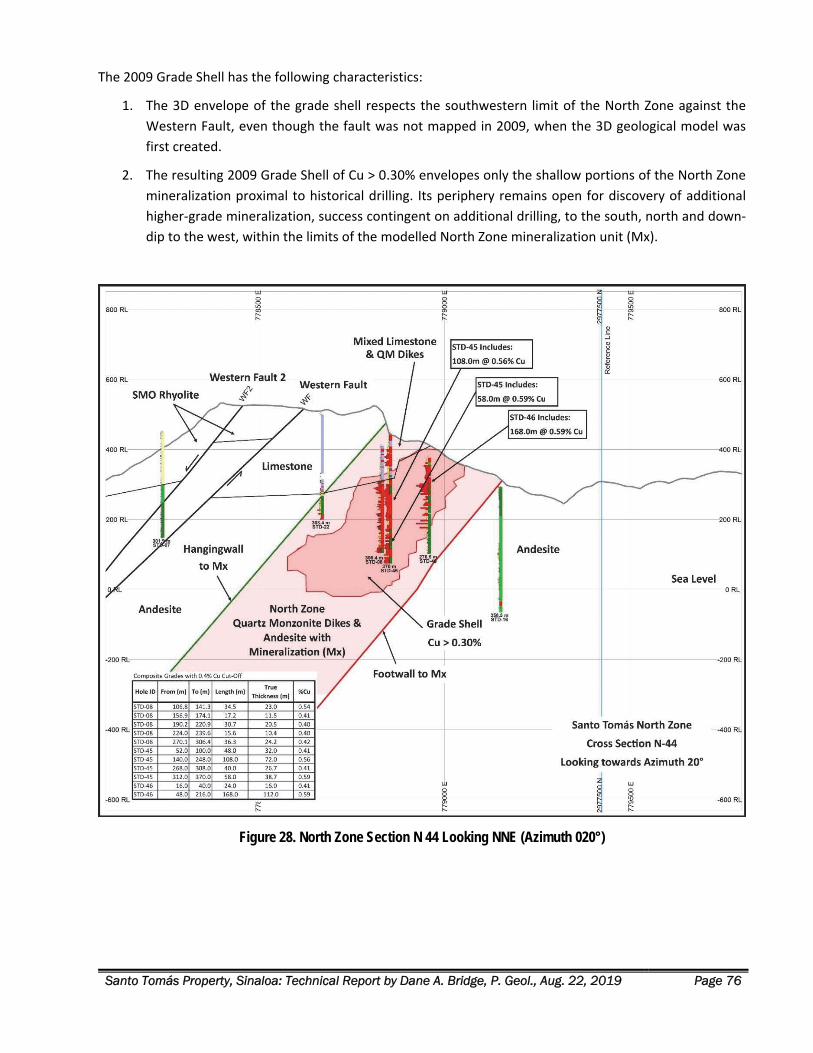
Santo Tomás Property, Sinaloa: Technical Report by Dane A. Bridge, P. Geol., Aug. 22, 2019 Page 76
The 2009 Grade Shell has the following characteristics:
1. The 3D envelope of the grade shell respects the southwestern limit of the North Zone against the
Western Fault, even though the fault was not mapped in 2009, when the 3D geological model was
first created.
2. The resulting 2009 Grade Shell of Cu > 0.30% envelopes only the shallow portions of the North Zone
mineralization proximal to historical drilling. Its periphery remains open for discovery of additional
higher‐grade mineralization, success contingent on additional drilling, to the south, north and down‐
dip to the west, within the limits of the modelled North Zone mineralization unit (Mx).
Figure 28. North Zone Section N 44 Looking NNE (Azimuth 020°)
Santo Tomás Property, Sinaloa: Technical Report by Dane A. Bridge, P. Geol., Aug. 22, 2019 Page 77
Figure 28 presents Cross‐section N‐44 in the North Zone. The section is informative for several aspects of the North Zone geology:
1. The central axis of the North Zone mineralization (Mx) is comprised of west‐dipping, mineralized
sheets of quartz monzonite dikes and screens of hornfelsed andesite. The North Zone has a true
thickness of 400 m on this section.
2. The 2009 Grade Shell Cu > 0.30% has a true thickness of 250 to 300 m on this section.
3. The core of the 2009 Grade Shell Cu > 0.30% includes long drill intersections of 0.40 to 0.59% Cu
intercepts.
4. Common to many of the cross‐sections in the North Zone, drilling in Figure 28 shows that STD‐08 and
STD‐45 terminate in well‐mineralized material ranging up to 0.59% CuT over long intervals.
5. Stepwise displacement, west‐side down, is seen across the Western fault zone. Displacement of the
SMO volcanic rocks is evidence for the young age of the Western fault zone.
6. Limestone strata form a partial “cap” to the North Zone mineralization on the hanging wall contact.
The 2009 Grade Shell Cu > 0.30% volume encloses a higher‐grade central portion of the North Zone and
comprises a high‐priority drilling target. This target is tabular and dips towards 50°W. The potential tonnage
and grade contained in the grade shell volume are conceptual in nature, as there has not been enough
exploration to define it as current mineral resource and it is uncertain whether future exploration will result
in the target being delineated as a mineral resource or reserve.
DEPOSIT TYPES
The Santo Tomás exploration programs have primarily focused on Cu‐Mo‐Au‐Ag porphyry deposit types.
Herein, exploration recommendations continue with this deposit‐type target.
PORPHYRY DEPOSITS Porphyry deposits are large, low‐ to medium‐grade deposits in which primary (hypogene) ore minerals are
dominantly structurally controlled and which are spatially and genetically related to felsic to intermediate
porphyritic intrusions (Sinclair, 1996). The generalized geological setting of porphyry‐related deposits is shown
in Figure 29. The large size and structural control exhibited by veins, vein sets, stockworks, fractures, 'crackled
zones' and associated hydrothermal breccias serve to distinguish porphyry deposits from a variety of deposits
that may be peripherally associated, including skarns, high–temperature mantos, breccia pipes, peripheral
mesothermal veins, and epithermal precious metal deposits.
Lowell and Guilbert (1970) proposed a relatively simple model characterized by lateral and vertical zoning of
the ore and alteration mineralogy, which is centred on an intrusive body characterized by a porphyritic texture.
Sillitoe (1973) proposed that the mineralizing porphyries are calc‐alkaline stocks that are emplaced at depths
of 1.5–3 km in the crust, which grade downward to stockwork mineralization and potassic alteration zones in
a larger equigranular intrusive.
In general, the longevity and dynamism of the hydrothermal activity, as well as the presence of favourable
physical‐chemical conditions in the fluid‐rock relation, are important factors for producing economic deposits
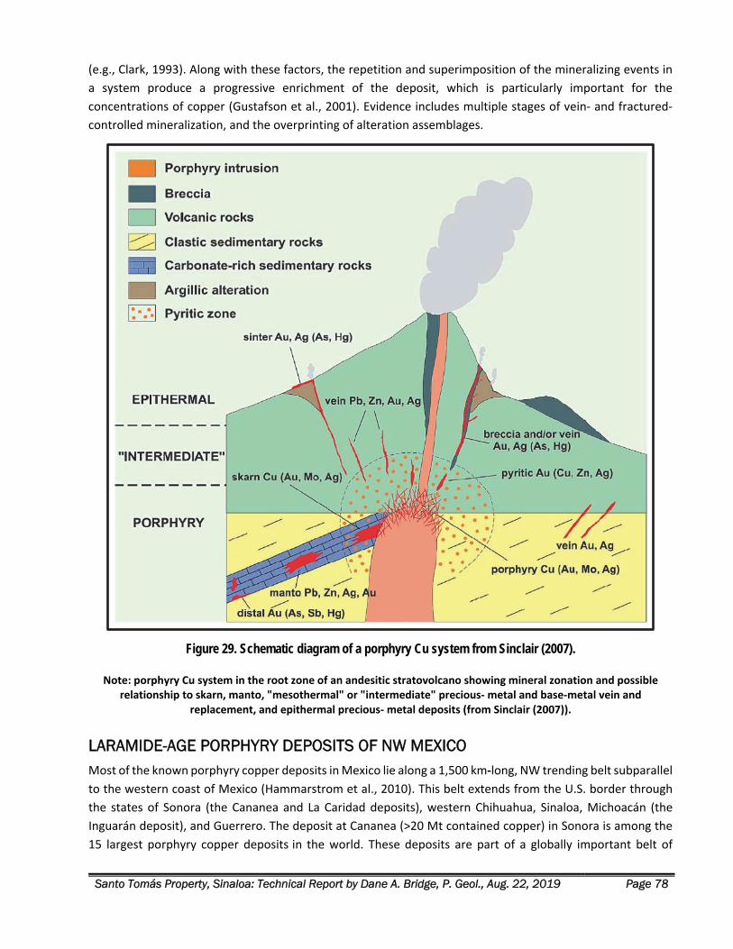
Santo Tomás Property, Sinaloa: Technical Report by Dane A. Bridge, P. Geol., Aug. 22, 2019 Page 78
(e.g., Clark, 1993). Along with these factors, the repetition and superimposition of the mineralizing events in
a system produce a progressive enrichment of the deposit, which is particularly important for the
concentrations of copper (Gustafson et al., 2001). Evidence includes multiple stages of vein‐ and fractured‐
controlled mineralization, and the overprinting of alteration assemblages.
Figure 29. Schematic diagram of a porphyry Cu system from Sinclair (2007).
Note: porphyry Cu system in the root zone of an andesitic stratovolcano showing mineral zonation and possible relationship to skarn, manto, "mesothermal" or "intermediate" precious‐ metal and base‐metal vein and
replacement, and epithermal precious‐ metal deposits (from Sinclair (2007)).
LARAMIDE-AGE PORPHYRY DEPOSITS OF NW MEXICO Most of the known porphyry copper deposits in Mexico lie along a 1,500 km‐long, NW trending belt subparallel
to the western coast of Mexico (Hammarstrom et al., 2010). This belt extends from the U.S. border through
the states of Sonora (the Cananea and La Caridad deposits), western Chihuahua, Sinaloa, Michoacán (the
Inguarán deposit), and Guerrero. The deposit at Cananea (>20 Mt contained copper) in Sonora is among the
15 largest porphyry copper deposits in the world. These deposits are part of a globally important belt of
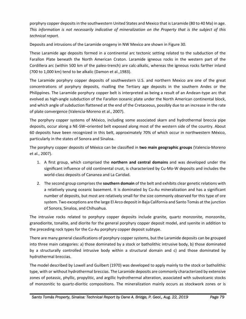
Santo Tomás Property, Sinaloa: Technical Report by Dane A. Bridge, P. Geol., Aug. 22, 2019 Page 79
porphyry copper deposits in the southwestern United States and Mexico that is Laramide (80 to 40 Ma) in age.
This information is not necessarily indicative of mineralization on the Property that is the subject of this
technical report.
Deposits and intrusions of the Laramide orogeny in NW Mexico are shown in Figure 30.
These Laramide age deposits formed in a continental arc tectonic setting related to the subduction of the
Farallon Plate beneath the North American Craton. Laramide igneous rocks in the western part of the
Cordillera arc (within 500 km of the paleo‐trench) are calc‐alkalic, whereas the igneous rocks farther inland
(700 to 1,000 km) tend to be alkalic (Damon et al.,1983).
The Laramide porphyry copper deposits of southwestern U.S. and northern Mexico are one of the great
concentrations of porphyry deposits, rivalling the Tertiary age deposits in the southern Andes or the
Philippines. The Laramide porphyry copper belt is interpreted as being a result of an Andean‐type arc that
evolved as high‐angle subduction of the Farallon oceanic plate under the North American continental block,
and which angle of subduction flattened at the end of the Cretaceous, possibly due to an increase in the rate
of plate convergence (Valencia‐Moreno et al., 2007).
The porphyry copper systems of México, including some associated skarn and hydrothermal breccia pipe
deposits, occur along a NE‐SW–oriented belt exposed along most of the western side of the country. About
60 deposits have been recognized in this belt, approximately 70% of which occur in northwestern México,
particularly in the states of Sonora and Sinaloa.
The porphyry copper deposits of México can be classified in two main geographic groups (Valencia‐Moreno
et al., 2007).
1. A first group, which comprised the northern and central domains and was developed under the
significant influence of old continental crust, is characterized by Cu‐Mo‐W deposits and includes the
world‐class deposits of Cananea and La Caridad.
2. The second group comprises the southern domain of the belt and exhibits clear genetic relations with
a relatively young oceanic basement. It is dominated by Cu‐Au mineralization and has a significant
number of deposits, but most are relatively small for the size commonly observed for this type of ore
system. Two exceptions are the large El Arco deposit in Baja California and Santo Tomás at the junction
of Sonora, Sinaloa, and Chihuahua.
The intrusive rocks related to porphyry copper deposits include granite, quartz monzonite, monzonite,
granodiorite, tonalite, and diorite for the general porphyry copper deposit model, and syenite in addition to
the preceding rock types for the Cu‐Au porphyry copper deposit subtype.
There are many general classifications of porphyry copper systems, but the Laramide deposits can be grouped
into three main categories: a) those dominated by a stock or batholithic intrusive body, b) those dominated
by a structurally controlled intrusive body within a structural domain and c) and those dominated by
hydrothermal breccias.
The model described by Lowell and Guilbert (1970) was developed to apply mainly to the stock or batholithic
type, with or without hydrothermal breccias. The Laramide deposits are commonly characterized by extensive
zones of potassic, phyllic, propylitic, and argillic hydrothermal alteration, associated with subvolcanic stocks
of monzonitic to quartz‐dioritic compositions. The mineralization mainly occurs as stockwork zones or is
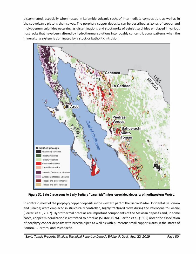
Santo Tomás Property, Sinaloa: Technical Report by Dane A. Bridge, P. Geol., Aug. 22, 2019 Page 80
disseminated, especially when hosted in Laramide volcanic rocks of intermediate composition, as well as in
the subvolcanic plutons themselves. The porphyry copper deposits can be described as zones of copper and
molybdenum sulphides occurring as disseminations and stockworks of veinlet sulphides emplaced in various
host rocks that have been altered by hydrothermal solutions into roughly concentric zonal patterns when the
mineralizing system is dominated by a stock or batholitic intrusion.
Figure 30. Late Cretaceous to Early Tertiary “Laramide” intrusion-related deposits of northwestern Mexico.
In contrast, most of the porphyry copper deposits in the western part of the Sierra Madre Occidental (in Sonora
and Sinaloa) were emplaced in structurally controlled, highly fractured rocks during the Paleocene to Eocene
(Ferrari et al., 2007). Hydrothermal breccias are important components of the Mexican deposits and, in some
cases, copper mineralization is restricted to breccias (Sillitoe,1976). Barton et al. (1995) noted the association
of porphyry copper deposits with breccia pipes as well as with numerous small copper skarns in the states of
Sonora, Guerrero, and Michoacán.
Santo Tomás Property, Sinaloa: Technical Report by Dane A. Bridge, P. Geol., Aug. 22, 2019 Page 81
EXPLORATION
Historical exploration programs are described in the History section herein. Current 2017 to 2019 field
exploration programs conducted by Oroco on behalf of CMR were aimed at firstly verifying certain historical
drill programs and mapping observations, and secondly, to assemble an improved interpretation of the
geology, structure, and mineralization of the Property. All work and results in this section on Exploration are
derived from work conducted by or on behalf of Oroco or Altamura.
2017 FIELDWORK In the period January 26 to February 18, 2017, the old access road to the South Zone was rebuilt for about 20
km to provide access by 4x4 truck, using a motor grader and a backhoe. Repair work was performed on 13.4
km road departing the village of Cajon de Cancio for the El Bienestar ranch, site of Oroco’s core storage facility.
From Bienestar, the road traverses near the crest of the prominent North trending Santo Tomás ridge to near
the Roberto Verde concession. Mechanized work was stopped after repairs of 9.6 km of road and did not reach
Rio Fuerte. Onwards, a four‐person crew of local labourers used machetes to clear a walking route along the
old drill roads into the North Zone and to the Huites Reservoir (Rio Fuerte).
The core building at the El Bienestar Ranch was constructed for the historical drilling programs. Repairs to the
building were done by Cambria in 2008, including roof and wall repair, digging drainage ditches and shoring
up core‐storage racks. The historical diamond drill core was partly re‐boxed.
Accessing historical drill core was beyond the scope of the 2017 program. However, the core storage site was
visited and needed repair work assessed. As soon as it is feasible, this storage building must be repaired again,
and the core secured.
Limited geological mapping by the Author was conducted on the South Zone of the Property, February 22 to
March 2, 2017, with one day spent on the North Zone. Mapping was done with GPS control mainly from old
drill access trails, and certain old drill sites were verified. Results and conclusions of the 2017 and 2019
geological mapping are summarized in the section herein on Property Geology.
2017 2018 REMOTE SENSING In September 2017, Auracle Geospatial Science, Inc. (“Auracle”) was contracted by Oroco to task the
MacDonald, Dettwiler and Associates Ltd. (MDA) RADARSAT‐2 satellite for the acquisition of Synthetic
Aperture Radar (“SAR”) data. The data acquisition spanned the area shown in the Regional Geology map,
Figure 17, in this technical report. Auracle delivered several technical products from this survey. The most
useful was a set of radar reflections, spatially corrected, that comprises the “First Competent Reflector” in the
datasets. This reflector represents the surface of the soil, talus and bare rock, with no influence of vegetation.
In certain cases, the radar reflection appears somewhat sub‐surface in areas of dry soil and talus. This radar
image tends to enhance the imaging of planar features such as faults and fracture surfaces.
The raw First Competent Reflector point cloud was processed by Crossrange, a Cambria affiliate, in early 2018.
A provisional DTM was created, and the vertical control of the provisional DTM surface was adjusted to create
a fit of the Exall drill collar surveys and the Barney Green WGS 84 Zone 12 survey. This radar‐derived
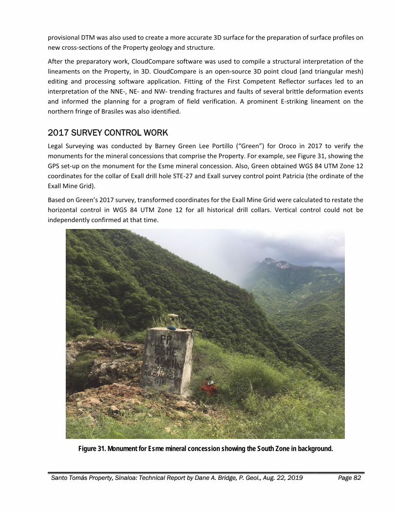
Santo Tomás Property, Sinaloa: Technical Report by Dane A. Bridge, P. Geol., Aug. 22, 2019 Page 82
provisional DTM was also used to create a more accurate 3D surface for the preparation of surface profiles on
new cross‐sections of the Property geology and structure.
After the preparatory work, CloudCompare software was used to compile a structural interpretation of the
lineaments on the Property, in 3D. CloudCompare is an open‐source 3D point cloud (and triangular mesh)
editing and processing software application. Fitting of the First Competent Reflector surfaces led to an
interpretation of the NNE‐, NE‐ and NW‐ trending fractures and faults of several brittle deformation events
and informed the planning for a program of field verification. A prominent E‐striking lineament on the
northern fringe of Brasiles was also identified.
2017 SURVEY CONTROL WORK Legal Surveying was conducted by Barney Green Lee Portillo (“Green”) for Oroco in 2017 to verify the
monuments for the mineral concessions that comprise the Property. For example, see Figure 31, showing the
GPS set‐up on the monument for the Esme mineral concession. Also, Green obtained WGS 84 UTM Zone 12
coordinates for the collar of Exall drill hole STE‐27 and Exall survey control point Patricia (the ordinate of the
Exall Mine Grid).
Based on Green’s 2017 survey, transformed coordinates for the Exall Mine Grid were calculated to restate the
horizontal control in WGS 84 UTM Zone 12 for all historical drill collars. Vertical control could not be
independently confirmed at that time.
Figure 31. Monument for Esme mineral concession showing the South Zone in background.
Santo Tomás Property, Sinaloa: Technical Report by Dane A. Bridge, P. Geol., Aug. 22, 2019 Page 83
2019 SURVEY COMPILATION Oroco contracted Pacific Geomatics Ltd. in early 2019 to provide an accurate Digital Terrane Model (“DTM”)
and Orthophoto of the Property. The new DTM, in combination with the 2017 survey control data, provided
enough information to assemble all mineral concession, surface mapping, remote sensing and drilling data in
a common WGS 84 Zone 12 horizontal and vertical control grid, as described below.
Digital Terrane Model and Orthophoto The new DTM was prepared and sold jointly by NTT DATA and Remote Sensing Technology Center of Japan
(“RESTEC”). This service prepared a highly detailed 1‐meter resolution version of its 3D map utilizing multiple
satellite images from DigitalGlobe and termed the “AW3D Enhanced DTM”.
The accuracy of the new AW3D Enhanced DTM was initially verified by Oroco’s contractors, at the road surface
collar location of the vertical Exall drill hole, STE‐27. The difference between the elevation indicated by the
DTM and the collar survey of STE‐27, as surveyed by Green, is less than 1 meter.
The source of vertical control of the Exall Grid coordinate system is not known. Adjusting the Exall vertical
control to sit 15m lower (the difference between the Green 2017 survey and Exall Mine Grid survey at STE‐27)
brings STE 27 and all of the STE holes into less than 2 m of vertical difference with the new AW3D Enhanced
DTM, which is regarded by the Author as an excellent correspondence.
Additionally, an orthophoto satellite image of 60 cm resolution was orthorectified by Pacific Geomatics to fit
the AW3D Enhanced DTM.
Survey Control – Transform from Exall Mine Grid The spatial control employed in this Technical Report relies upon several sources of information to verify the
locations of historical drill hole collars and surface features.
Exall Mine Grid uses a local coordinate grid, which is based on meters from an ordinate control point
that was designated “Patricia” on their plan maps. Exall performed limited re‐surveying to tie prior
ASARCO and Tormex drill collar surveys into the Exall Mine Grid.
Control survey maps by Exall were reviewed, and scans of available drill logs were cross‐checked with
the Exall compilation.
Horizontal Control: Surveying by Green in 2017 was reviewed to obtain WGS 84 Zone 12 UTM
coordinates for Exall STE‐27 and Exall survey control point Patricia (the ordinate of the Exall Mine
Grid). Transformed coordinates for the Exall Mine Grid were calculated to restate the horizontal
control in WGS 84 UTM Zone 12.
Vertical Control: For purposes of the current phase of work, vertical reference for the Property has
been accepted as the WGS 84 Ellipsoid heights in the AW3D Enhanced DTM. The height above the
Ellipsoid at STE‐27 was measured by Barney Green and compared closely with the height above the
Ellipsoid at the same location in the AW3D Enhanced DTM.
Elevations cited in the Exall drilling database were adjusted by subtracting 15.0 m, ensuring continuity
between the present work and historical geological & resource modelling in the Exall Mine Grid.
Santo Tomás Property, Sinaloa: Technical Report by Dane A. Bridge, P. Geol., Aug. 22, 2019 Page 84
Transform: Using the WGS 84 coordinates from the transformed Exall collar data, elevations from
Exall data were compared to the vertical data in the AW3D Enhanced 1m resolution DTM and showed
a close vertical correspondence within 1 to 2 m. This demonstrates the good quality of the Exall
surveying (after the fit for the 15 m vertical adjustment).
Based on Barney Green’s 2017 survey, and the above verification, transformed coordinates for the Exall Mine
Grid were calculated to restate the horizontal control in WGS 84 UTM Zone 12 for all historical drill collars.
The original Exall Mine Grid coordinates and those survey coordinates transformed to WGS 84 Zone 12 for the
drilling are listed in Figure 7.
The Author concludes this assembly of survey data for the historical drilling is suitable for the construction of
3D geological models and the planning of the current and future exploration and drilling programs on the
Property.
2019 EXPLORATION AND MODELLING The Author and a structural geologist, Boukare Tapsoba, Ph.D., G.I.T., were retained in February 2019 to review
the historical Property exploration and drilling and to verify earlier geological modelling.
Historical drill hole spacing is sufficiently closely spaced in the North Zone to permit the preparation of a robust
geological model. Each generation of work by Cambria, Crossrange and the Author employed a sectional
interpretation along vertical sections spaced 50 m apart, depicting assay results, lithology, and structure in the
historical drill holes.
In 2009, Cambria first produced a geological model of the North Zone, preparing 3D wireframes of the hanging
wall and footwall of the mineralized zone. Additional 3D surfaces depict the upper limit of the mineralized
zone against the lower contact of SMO volcanic units and barren Jurassic limestone.
Instead of implicit 3D modelling directly from drill hole assays, MineSight grade shells served to envelope 3D
domains with total copper (CuT) above 0.30% CuT, limits in a MineSight block model only to create a 3D volume
for the geological model and depict targets for drilling.
Fieldwork & Structural Interpretation Before fieldwork, Tapsoba and the Author examined the AW3D Enhanced DTM, the orthophoto, and point
cloud models using CloudCompare software to identify and measure structural features (fault planes) for
verification in the field. Processed DTM data and satellite imagery of the property was of significant assistance
in identifying regional‐scale faulting and targeting areas of interest as well as prioritizing the sites to map.
The Author and Tapsoba conducted field mapping from March 4 to 13, 2019. They expended three days on
the North Zone and seven days on Brasiles, including shoreline mapping along Rio Fuerte. Access to the
Property was by boat from the end of the Chihuahua‐Pacific highway. Mapping was done with GPS control
mainly by traversing along dry creek beds and, in part, using old drill access trails. Two local workers
accompanied the geologists to aid in searching for trails and clearing thorn brush.
Mapping employed handheld GPS control (Garmin GPSMAP 66st) with a powerful antenna that connects three
different satellite constellations: GPS, GLONASS and Galileo. Outcroppings were sought mainly along dry creek
beds and old drill access trails.
Santo Tomás Property, Sinaloa: Technical Report by Dane A. Bridge, P. Geol., Aug. 22, 2019 Page 85
The geological mapping is reported in data files from Bridge (2019) for the geology, and a report from Tapsoba
(2019) for the structural mapping.
The results and conclusions of the 2017 and 2019 geological mapping are summarized in the section herein on
Property Geology.
Modelling Methods Historical work by Cambria after 2007, Thornton (2011), and the current work by the Author employ similar
methods of data presentation, sectional interpretation, and the preparation and use of 3D solids and surfaces.
1. Wireframes are the modelling tool used to build, manage, and analyze 3D solids and 3D surfaces for
advanced exploration, geological modelling, resource estimation, and mining.
2. Grade shells are 3D volumes constructed from drill hole information that form interpreted boundaries
to geological and block model domains.
2019 Modelling The PacGeo AW3D Enhanced DTM was used in early 2019 to construct 124 2D cross‐sections for interpreted
major geological contacts, fault surfaces and the hanging wall and footwall of the main mineralized zones
(comprised of quartz monzonite intrusion, hornfelsed andesite, and sulphide mineralization). New 3D
wireframes and solids were prepared from this cross‐section set.
The 2019 work was responsible for several advancements in the understanding of the Santo Tomás deposit:
1. The structural mapping verified the geological model that frames the 2009 Grade Shell. Early‐Stage
Laramide‐age faulting and fracturing (attitude 020°/50°W) were demonstrated to control the main
intrusions and sulphide mineralization in conformance to early mapping programs by Cambria.
2. 2019 structural mapping defines a newly interpreted set of faults and fractures. The principal fault of
this set, the Western Fault, is much later in chronology than the Laramide intrusions and
mineralization and terminates the southern margin of the North Zone.
3. A comprehensive chronology of the geological events and controls to mineralization guides the 3D
geological modelling of the Santo Tomás deposit. The 3D geological model of the core of the North
Zone mineralization (the 2009 Grade Shell) remains valid and, transformed to WGS 84 Zone 12, it is
suitable for inclusion in the 2019 geological model.
The Author has not done sufficient work to verify the 2009 Grade Shell as a mineral resource or mineral
reserve. The Author is not treating 2009 Grade Shell as a current mineral resource or mineral reserve.
The purpose of the 2009 Grade Shell is solely for a valid spatial representation of the central part of the North
Zone mineralization based upon historical drilling, and for its display within the 3D geological model. This grade
shell informs the design of new drilling within the shallow, central axis of the North Zone.
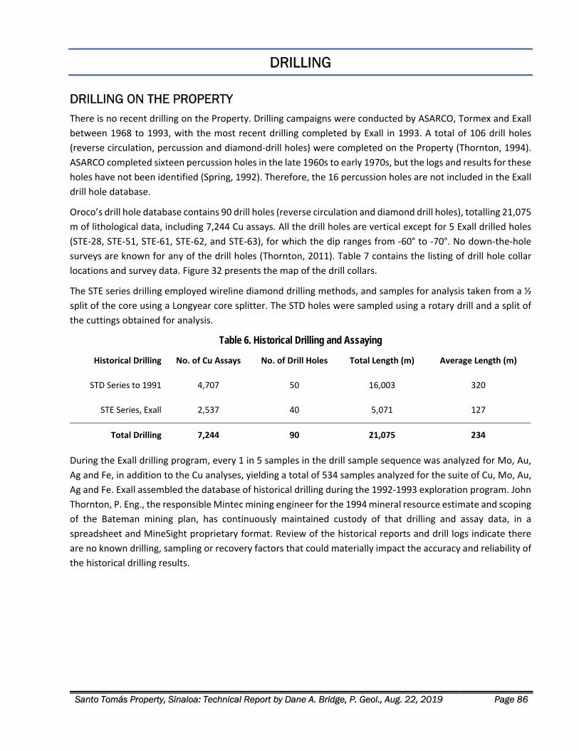
Santo Tomás Property, Sinaloa: Technical Report by Dane A. Bridge, P. Geol., Aug. 22, 2019 Page 86
DRILLING
DRILLING ON THE PROPERTY There is no recent drilling on the Property. Drilling campaigns were conducted by ASARCO, Tormex and Exall
between 1968 to 1993, with the most recent drilling completed by Exall in 1993. A total of 106 drill holes
(reverse circulation, percussion and diamond‐drill holes) were completed on the Property (Thornton, 1994).
ASARCO completed sixteen percussion holes in the late 1960s to early 1970s, but the logs and results for these
holes have not been identified (Spring, 1992). Therefore, the 16 percussion holes are not included in the Exall
drill hole database.
Oroco’s drill hole database contains 90 drill holes (reverse circulation and diamond drill holes), totalling 21,075
m of lithological data, including 7,244 Cu assays. All the drill holes are vertical except for 5 Exall drilled holes
(STE‐28, STE‐51, STE‐61, STE‐62, and STE‐63), for which the dip ranges from ‐60° to ‐70°. No down‐the‐hole
surveys are known for any of the drill holes (Thornton, 2011). Table 7 contains the listing of drill hole collar
locations and survey data. Figure 32 presents the map of the drill collars.
The STE series drilling employed wireline diamond drilling methods, and samples for analysis taken from a ½
split of the core using a Longyear core splitter. The STD holes were sampled using a rotary drill and a split of
the cuttings obtained for analysis.
Table 6. Historical Drilling and Assaying
Historical Drilling No. of Cu Assays No. of Drill Holes Total Length (m) Average Length (m)
STD Series to 1991 4,707 50 16,003 320
STE Series, Exall 2,537 40 5,071 127
Total Drilling 7,244 90 21,075 234
During the Exall drilling program, every 1 in 5 samples in the drill sample sequence was analyzed for Mo, Au,
Ag and Fe, in addition to the Cu analyses, yielding a total of 534 samples analyzed for the suite of Cu, Mo, Au,
Ag and Fe. Exall assembled the database of historical drilling during the 1992‐1993 exploration program. John
Thornton, P. Eng., the responsible Mintec mining engineer for the 1994 mineral resource estimate and scoping
of the Bateman mining plan, has continuously maintained custody of that drilling and assay data, in a
spreadsheet and MineSight proprietary format. Review of the historical reports and drill logs indicate there
are no known drilling, sampling or recovery factors that could materially impact the accuracy and reliability of
the historical drilling results.
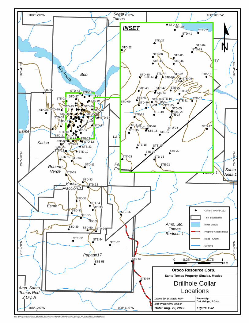
RobertoVerde
Bob
Karisu
KarisuFraccion 1
SantoTomas
Tona
Amp. SantoTomas Red
2 Div. A
Rossy
Rossy 1
Papago17
SantaAnita 1
Esme
Esme
Amp. Sto.Tomas
Reducc. 1
La China II
PapagoFracc. 1
STD-03
STD-04
STD-06
STD-07
STD-09
STD-10
STD-11
STD-12
STD-13
STD-14
STD-16
STD-17
STD-21
STD-22
STD-25
STD-27
STD-28
STD-30
STD-31
STD-32
STD-33
STD-34
STD-35
STD-36
STD-37STD-38
STD-39
STD-40
STD-42
STD-43
STD-45 STD-46
STD-48
STD-50
STE-01STE-02
STE-04
STE-12
STE-17STE-18
STE-22
STE-23
STE-27
STE-28
STE-52
STE-53
STE-54
STE-55STE-56
STE-57
STE-58
STE-59
STE-64
STE-65
STE-66
108°10'0"W
108°10'0"W
108°11'0"W
108°11'0"W
108°12'0"W
108°12'0"W
26°5
4'0
"N
26°5
4'0
"N
26°5
3'0
"N
26°5
3'0
"N
26°5
2'0
"N
26°5
2'0
"N
File: Z:\Projects\SantoTomas_2018\GIS_Data\MapFiles\REPORT_MAPS\TechRpt_DBridge_A4_CollarsTitles_20190307.mxd
Collars_WGS84Z12
Title_Boundaries
River_AW3D
Property Access Road
Road - Gravel
Streams
RíoFuerte
STD-01
STD-02
STD-05
STD-08
STD-09
STD-13
STD-15
STD-16
STD-17
STD-18
STD-19
STD-20
STD-21
STD-22
STD-23STD-24
STD-27
STD-41
STD-42
STD-44
STD-45 STD-46
STD-47STD-48
STD-49
STE-01STE-02
STE-04
STE-05
STE-07 STE-08
STE-09
STE-10STE-11
STE-12STE-13
STE-14
STE-15 STE-16 STE-17
STE-18 STE-19
STE-20
STE-21
STE-24
STE-25
STE-26
STE-27
STE-28
STE-29
STE-38
STE-51
STE-61
STE-62
STE-63
INSET
Map Projection: WGS84Drawn by: D. Mack, PMP Report By:
D.A. Bridge, P.Geol.
Drillhole CollarLocations
Oroco Resource Corp.Santo Tomas Property, Sinaloa, Mexico
0 0.25 0.5 0.75 1KM
º
Date: Aug. 22, 2019 Figure # 32
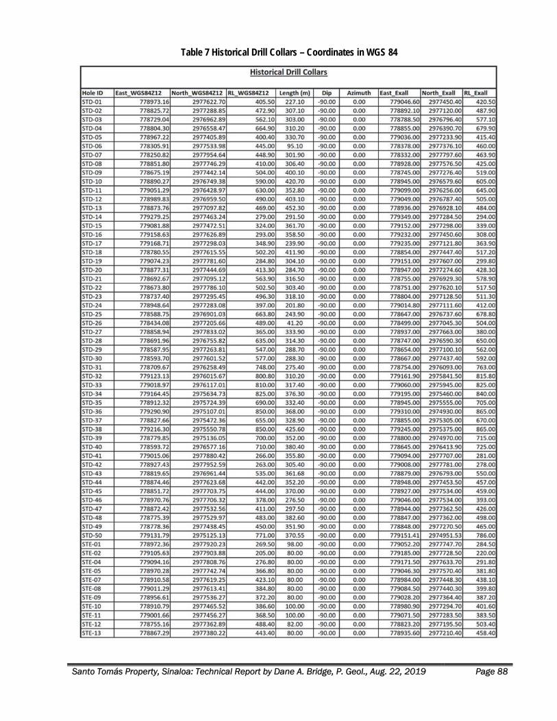
Santo Tomás Property, Sinaloa: Technical Report by Dane A. Bridge, P. Geol., Aug. 22, 2019 Page 88
Table 7 Historical Drill Collars – Coordinates in WGS 84
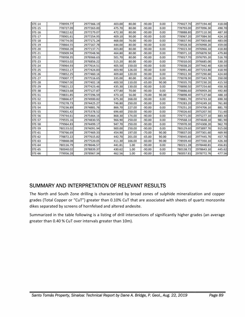
Santo Tomás Property, Sinaloa: Technical Report by Dane A. Bridge, P. Geol., Aug. 22, 2019 Page 89
SUMMARY AND INTERPRETATION OF RELEVANT RESULTS The North and South Zone drilling is characterized by broad zones of sulphide mineralization and copper
grades (Total Copper or “CuT”) greater than 0.10% CuT that are associated with sheets of quartz monzonite
dikes separated by screens of hornfelsed and altered andesite.
Summarized in the table following is a listing of drill intersections of significantly higher grades (an average
greater than 0.40 % CuT over intervals greater than 10m).
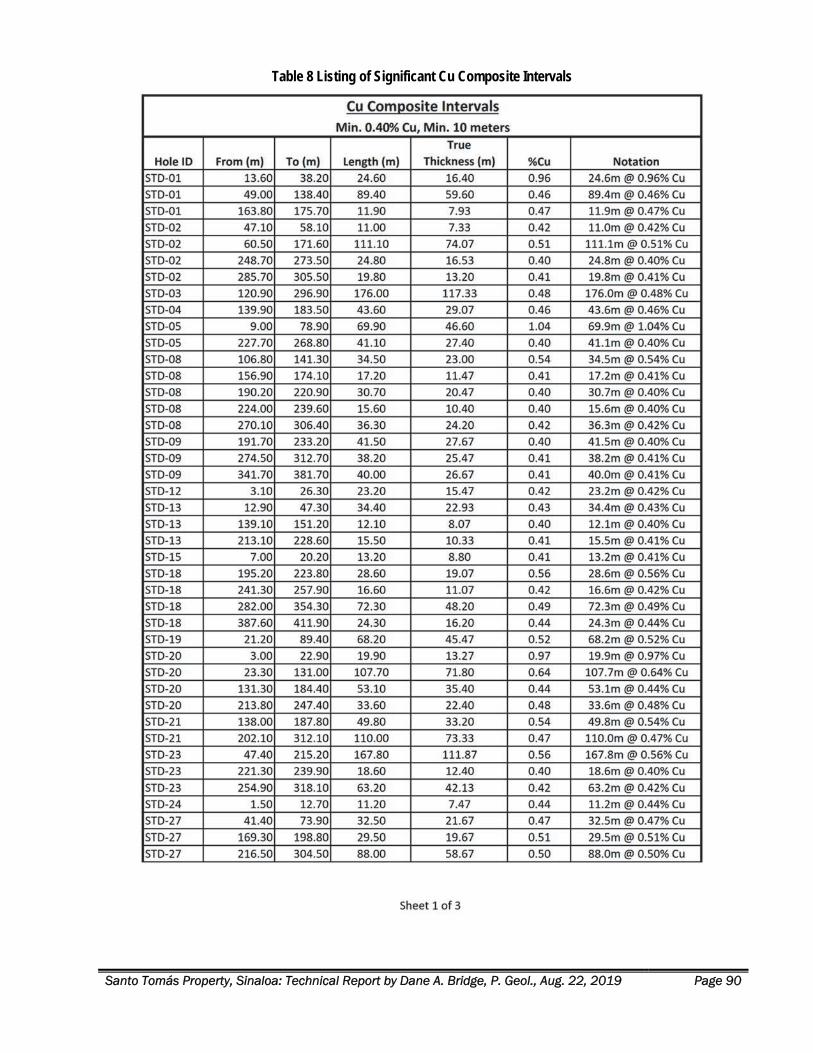
Santo Tomás Property, Sinaloa: Technical Report by Dane A. Bridge, P. Geol., Aug. 22, 2019 Page 90
Table 8 Listing of Significant Cu Composite Intervals
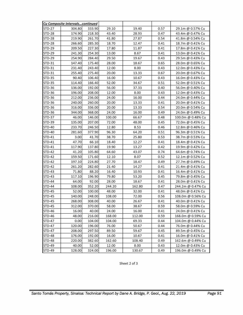
Santo Tomás Property, Sinaloa: Technical Report by Dane A. Bridge, P. Geol., Aug. 22, 2019 Page 91
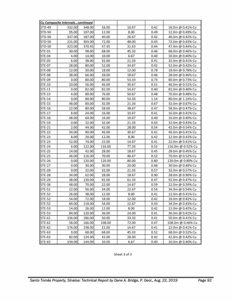
Santo Tomás Property, Sinaloa: Technical Report by Dane A. Bridge, P. Geol., Aug. 22, 2019 Page 92
Santo Tomás Property, Sinaloa: Technical Report by Dane A. Bridge, P. Geol., Aug. 22, 2019 Page 93
South Zone Drilling Drilling in the South Zone is widely spaced. Drill results there are interpreted as the fault‐displaced, southern
extension of the North Zone copper mineralization and a zone (the “Ridge zone”) that is characterized as lying
parallel to and eastward of the North Zone. These two zones are juxtaposed across the hanging wall and
footwall sides of the late Western Fault.
The promising South Zone “Ridge zone Target” lies in the footwall of the Western Fault, as follows:
STD‐50 intersected 192m of 0.37% Cu, starting at 111 m depth.
STD‐36 intersected 208m of 0.32% Cu, starting at 28 m. At the bottom of the hole, are separate
intersections of 20.0 m of 0.54% and, finally, 24.0 m of 0.49% Cu.
The drill intersections mostly represent mineralization that lies 400 m eastward and distinctly separate from
the main mineralization of the North Zone. Both STD‐50 and STD‐36 bottomed in good grade mineralization.
This Ridge zone could be significantly wider than intersected in drilling to date. A drilling target, about 400 m
wide, striking at N20°E is indicated. See Figure 42 for a representative cross‐section of with recommended
drilling of this target.
Mineralization in holes STD‐50 and STD‐36 are interpreted as the most significant of the South Zone drilling
because they are interpreted as being open for additional mineralization up and down‐dip and along‐strike to
both the north and south of section S 14 location. See Figure 42. They define a drilling target designated herein
as the Ridge Target.
North Zone Drilling The North Zone is drilled at the closest spacing on the Property. The along‐strike continuity of the North Zone
historical drilling results is best viewed in a set of closely spaced longitudinal sections, spaced 50 m apart and
facing azimuth 290°. Figure 33 presents the plan view of the section lines. The section layout and surface map
of the North Zone portrays the outcropping of North Zone mineralization (Mx). The map is simplified, and, in
detail, parts of the zone are covered by a blanket of SMO rhyolite strata and minor limestone not shown on
the map.
The surface trace of the Western fault shows that the separation between the fault and the North Zone is
decreasing southward. Structural mapping in 2019 demonstrates a left‐lateral and west‐side down fault
displacement across the Western fault. The fault‐displaced North Zone is projected to lie at depth on the west
side of the fault and to the south. The fault displaced North Zone block is not portrayed in this view but likely
is present south of section N‐22, where it is designated the South Zone.
The average historical drill hole on the Property is 234 m length. All but 5 drill holes are vertical. The vertical
section thickness of the North Zone is commonly greater than 500 m. Therefore, few drill holes test the full
thickness of the mineralization. Longitudinal drill sections are best for portraying the continuity of the
mineralization in the core of the North Zone because of this historical drill pattern.
Like the Azimuth 020°E facing cross‐sections, the higher‐grade areas on the Azimuth 290° facing Longitudinal
Section are visualized using the 2009 Grade Shell Cu > 0.30%. Longitudinal Sections P17 to P25 are shown in
Figures 35a to 35g and are arranged, as shown in Figure 33. A significant example of the continuity of
mineralization is presented in Longitudinal Section P20 is shown in Figure 35d.
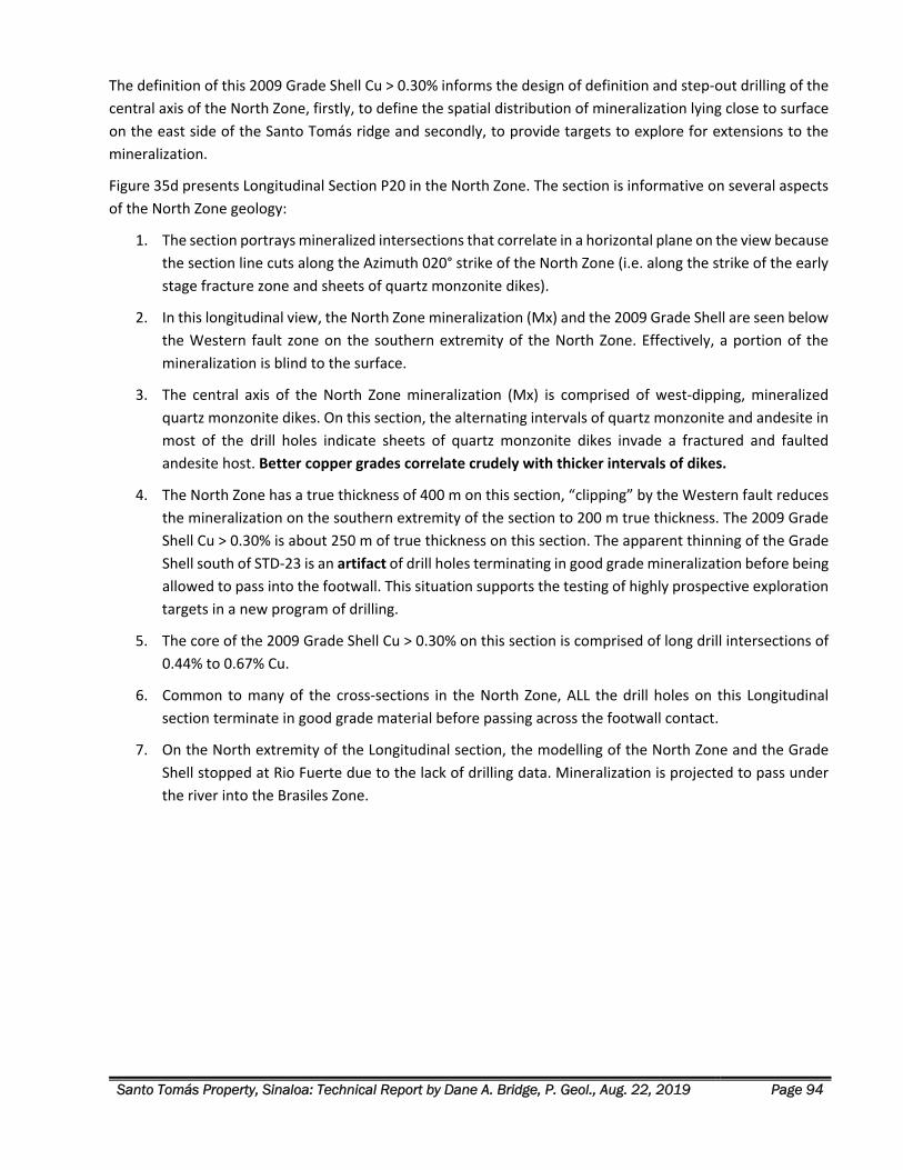
Santo Tomás Property, Sinaloa: Technical Report by Dane A. Bridge, P. Geol., Aug. 22, 2019 Page 94
The definition of this 2009 Grade Shell Cu > 0.30% informs the design of definition and step‐out drilling of the
central axis of the North Zone, firstly, to define the spatial distribution of mineralization lying close to surface
on the east side of the Santo Tomás ridge and secondly, to provide targets to explore for extensions to the
mineralization.
Figure 35d presents Longitudinal Section P20 in the North Zone. The section is informative on several aspects
of the North Zone geology:
1. The section portrays mineralized intersections that correlate in a horizontal plane on the view because
the section line cuts along the Azimuth 020° strike of the North Zone (i.e. along the strike of the early
stage fracture zone and sheets of quartz monzonite dikes).
2. In this longitudinal view, the North Zone mineralization (Mx) and the 2009 Grade Shell are seen below
the Western fault zone on the southern extremity of the North Zone. Effectively, a portion of the
mineralization is blind to the surface.
3. The central axis of the North Zone mineralization (Mx) is comprised of west‐dipping, mineralized
quartz monzonite dikes. On this section, the alternating intervals of quartz monzonite and andesite in
most of the drill holes indicate sheets of quartz monzonite dikes invade a fractured and faulted
andesite host. Better copper grades correlate crudely with thicker intervals of dikes.
4. The North Zone has a true thickness of 400 m on this section, “clipping” by the Western fault reduces
the mineralization on the southern extremity of the section to 200 m true thickness. The 2009 Grade
Shell Cu > 0.30% is about 250 m of true thickness on this section. The apparent thinning of the Grade
Shell south of STD‐23 is an artifact of drill holes terminating in good grade mineralization before being
allowed to pass into the footwall. This situation supports the testing of highly prospective exploration
targets in a new program of drilling.
5. The core of the 2009 Grade Shell Cu > 0.30% on this section is comprised of long drill intersections of
0.44% to 0.67% Cu.
6. Common to many of the cross‐sections in the North Zone, ALL the drill holes on this Longitudinal
section terminate in good grade material before passing across the footwall contact.
7. On the North extremity of the Longitudinal section, the modelling of the North Zone and the Grade
Shell stopped at Rio Fuerte due to the lack of drilling data. Mineralization is projected to pass under
the river into the Brasiles Zone.
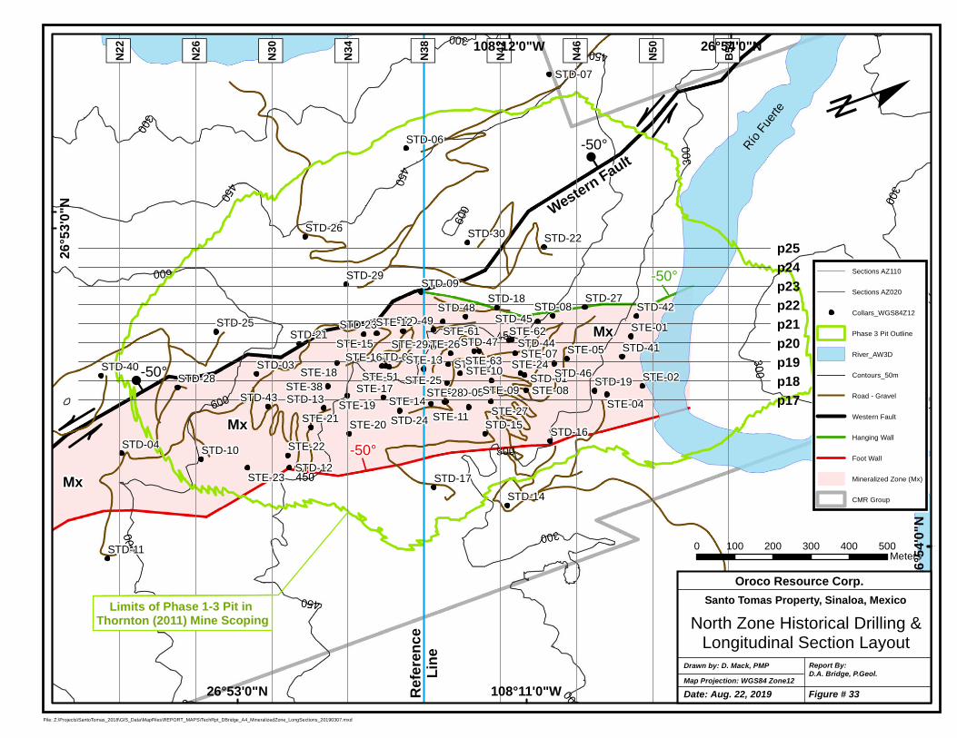
p25p24p23
p19p18p17
p22p21p20
STD-01
STD-02STD-03
STD-04
STD-05
STD-06
STD-07
STD-08
STD-09
STD-10
STD-11
STD-12
STD-13
STD-14
STD-15STD-16
STD-17
STD-18
STD-19
STD-20
STD-21
STD-22
STD-23
STD-24
STD-25
STD-26
STD-27
STD-28
STD-29
STD-30
STD-40
STD-41
STD-42
STD-43
STD-44
STD-45
STD-46
STD-47
STD-48STD-49
STE-01
STE-02
STE-04
STE-05STE-07
STE-08STE-09
STE-10
STE-11
STE-12
STE-13
STE-14
STE-15STE-16
STE-17
STE-18
STE-19
STE-20STE-21
STE-22
STE-23
STE-24
STE-25
STE-26
STE-27
STE-28
STE-29
STE-38STE-51
STE-61 STE-62
STE-63
" )B54
" )N50
" )N22
" )N26
" )N30
" )N34
" )N38
" )N42
" )N46108°12'0"W
108°11'0"W
26°5
4'0"N
26°5
3'0"N
26°54'0"N
26°53'0"NFile: Z:\Projects\SantoTomas_2018\GIS_Data\MapFiles\REPORT_MAPS\TechRpt_DBridge_A4_MineralizedZone_LongSections_20190307.mxd
Sections AZ110
Sections AZ020
Collars_WGS84Z12
Phase 3 Pit Outline
River_AW3D
Contours_50m
Road - Gravel
Western Fault
Hanging Wall
Foot Wall
Mineralized Zone (Mx)
CMR Group
Río
Fuer
te
0 100 200 300 400 500Meters
ºF
F
J
Map Projection: WGS84 Zone12Drawn by: D. Mack, PMP Report By:
D.A. Bridge, P.Geol.
North Zone Historical Drilling &Longitudinal Section Layout
Oroco Resource Corp.Santo Tomas Property, Sinaloa, Mexico
-50°
-50°
-50°
J-50°
Western Fault
Limits of Phase 1-3 Pit in Thornton (2011) Mine Scoping
Mx
Mx
Mx
Refer
ence
Line
Date: Aug. 22, 2019 Figure # 33
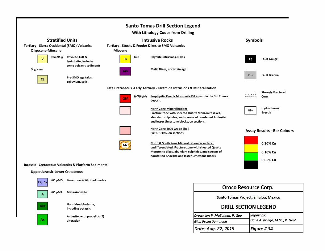
Tertiary ‐ Sierra Occidental (SMO) Volcanics Tertiary ‐ Stocks & Feeder Dikes to SMO Volcanics Oligocene‐Miocene Miocene
TomTR‐Ig TmR Rhyolite Intrusions, Dikes
Oligocene Mafic Dikes, uncertain age
Late Cretaceous ‐Early Tertiary ‐ Laramide Intrusions & Mineralization
Te(?)PqMz
0.30% Cu
0.10% Cu
0.05% CuJurassic ‐ Cretaceous Volcanics & Platform Sediments
Upper Jurassic‐Lower Cretaceous
JtKapMCz Limestone & Silicified marble
JtKapMA Meta‐Andesite
North Zone 2009 Grade ShellCuT > 0.30%, on sections.
Rhyolite Tuff & Ignimbrite, includes some volcanic sediments
North Zone Mineralization: Fracture zone with sheeted Quartz Monzonite dikes, abundant sulphides, and screens of hornfelsed Andesite and lesser Limestone blocks, on sections.
With Lithology Codes from DrillingSanto Tomas Drill Section Legend
Porphyritic Quartz Monzonite Dikes within the Sto Tomas depositQM
Stratified Units Intrusive Rocks
MD
Pre‐SMO age talus, colluvium, soils
V RD
CL
Symbols
Fg Fault Gouge
LS, LSx
Ahf
Ax
Hornfelsed Andesite, including potassic
Andesite, with propylitic (?) alteration
A
Fbx Fault Breccia
Strongly Fractured Core
HBx
North & South Zone Mineralization on surface: undifferentiated. Fracture zone with sheeted Quartz Monzonite dikes, abundant sulphides, and screens of hornfelsed Andesite and lesser Limestone blocks
Hydrothermal Breccia
Assay Results ‐ Bar Colours
Mx
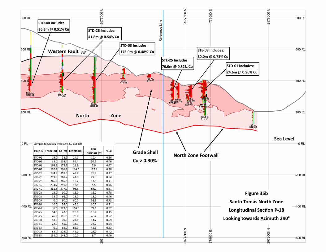
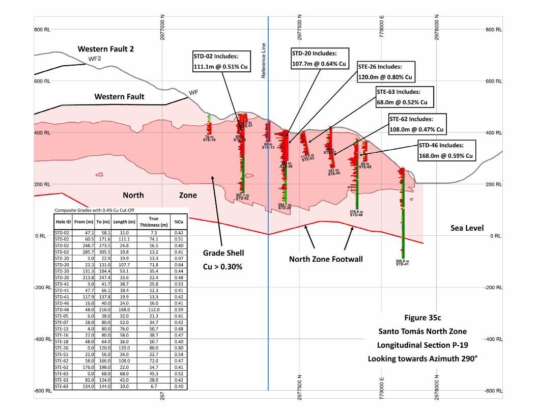
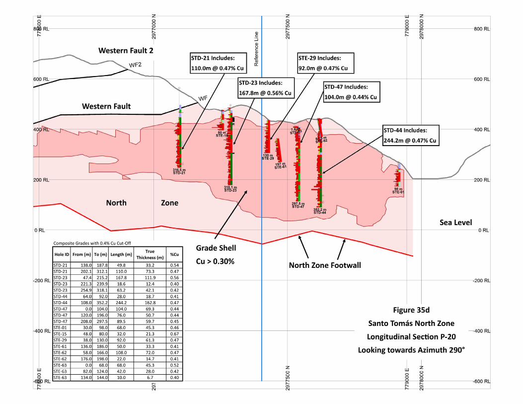
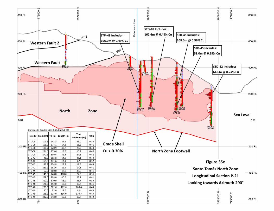
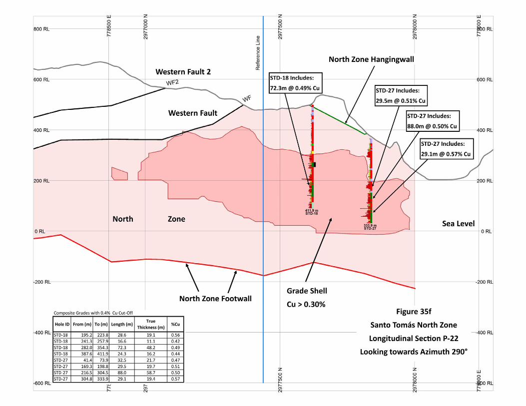
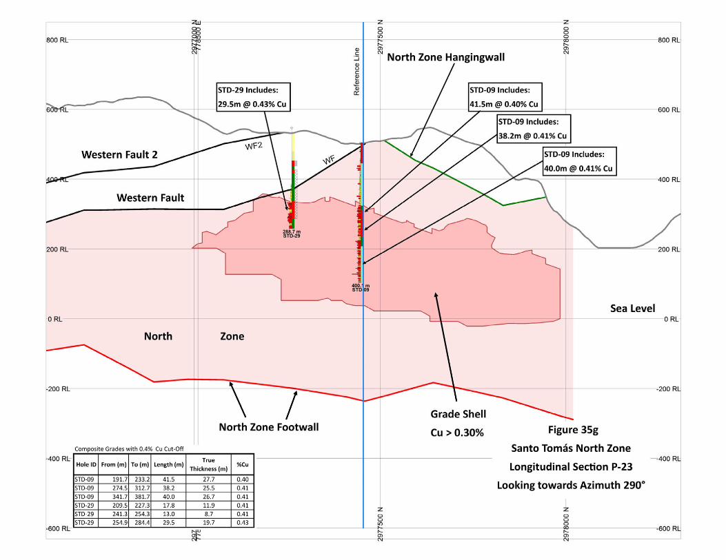
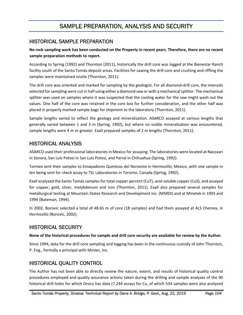
Santo Tomás Property, Sinaloa: Technical Report by Dane A. Bridge, P. Geol., Aug. 22, 2019 Page 104
SAMPLE PREPARATION, ANALYSIS AND SECURITY
HISTORICAL SAMPLE PREPARATION No rock sampling work has been conducted on the Property in recent years. Therefore, there are no recent
sample preparation methods to report.
According to Spring (1992) and Thornton (2011), historically the drill core was logged at the Bienestar Ranch
facility south of the Santo Tomás deposit areas. Facilities for sawing the drill core and crushing and riffling the
samples were maintained onsite (Thornton, 2011).
The drill core was oriented and marked for sampling by the geologist. For all diamond‐drill core, the intervals
selected for sampling were cut in half using either a diamond saw or with a mechanical splitter. The mechanical
splitter was used on samples where it was suspected that the cooling water for the saw might wash out the
values. One half of the core was retained in the core box for further consideration, and the other half was
placed in properly marked sample bags for shipment to the laboratory (Thornton, 2011).
Sample lengths varied to reflect the geology and mineralization. ASARCO assayed at various lengths that
generally varied between 1 and 3 m (Spring, 1992), but where no visible mineralization was encountered,
sample lengths were 4 m or greater. Exall prepared samples of 2 m lengths (Thornton, 2011).
HISTORICAL ANALYSIS ASARCO used their professional laboratories in Mexico for assaying. The laboratories were located at Nacozari
in Sonora, San Luis Potosi in San Luis Potosi, and Parral in Chihuahua (Spring, 1992).
Tormex sent their samples to Ensayadores Quimicos del Noroeste in Hermosillo, Mexico, with one sample in
ten being sent for check assay to TSL Laboratories in Toronto, Canada (Spring, 1992).
Exall analyzed the Santo Tomás samples for total copper percent (CuT), acid‐soluble copper (CuS), and assayed
for copper, gold, silver, molybdenum and iron (Thornton, 2011). Exall also prepared several samples for
metallurgical testing at Mountain States Research and Development Inc. (MSRDI) and at Minetek in 1993 and
1994 (Bateman, 1994).
In 2002, Borovic selected a total of 48.65 m of core (18 samples) and had them assayed at ALS Chemex, in
Hermosillo (Borovic, 2002).
HISTORICAL SECURITY None of the historical procedures for sample and drill core security are available for review by the Author.
Since 1994, data for the drill core sampling and logging has been in the continuous custody of John Thornton,
P. Eng., formally a principal with Mintec, Inc.
HISTORICAL QUALITY CONTROL The Author has not been able to directly review the nature, extent, and results of historical quality control
procedures employed and quality assurance actions taken during the drilling and sample analyses of the 90
historical drill holes for which Oroco has data (7,244 assays for Cu, of which 534 samples were also analyzed
Santo Tomás Property, Sinaloa: Technical Report by Dane A. Bridge, P. Geol., Aug. 22, 2019 Page 105
for the suite of Mo, Au, Ag and Fe). Due to the then standards of reporting prior to 1994, the technical reports
did not include data listings or detailed description of quality control procedures.
Owing to the age of the historical drill programs, performing check assays at this stage of recently renewed
exploration is challenging. Wooden racks in the El Bienestar core storage facility have partly collapsed since
last rehabilitated in the summer of 2008, spilling the contents of many of the core boxes. Also, locals have
disturbed some of the stored core. A careful rehabilitation of the storage building is required and is beyond
the scope of this technical report.
The Author of this report is not aware of the sampling procedures at the laboratories used by any of the
previous companies, nor is he aware of the use of any quality control samples in the sampling program. It can
only be assumed that the laboratories performed their QAQC (quality control and quality assurance) for each
sample batch analyzed, as this was common practice at the accredited laboratories used during the historical
drill programs.
Since the original assay certificates are not available, it is not possible currently to determine whether there
are transcription errors or inconsistencies between the assay certificates and the original drill logs for the
historical drilling before 1992.
Instead of re‐entering the core storage building and conducting check assay work, the Author is relying on
historical programs of quality control, documented as follows:
Check assaying was conducted by Tormex on one in every ten samples (Spring, 1992).
Check assay programs conducted by Tormex, Minera Real de Angeles, and Exall showed an excellent
correlation of results between the original assays reported by ASARCO and the re‐assays (Thornton,
2011).
Spring (1992) states “The considerable check assaying done, at different laboratories and at different
times coupled with the very good agreement among the various investigators, suggests that the
copper values as reported represent the drill core values.”
The most recent drill core sample intervals obtained from the El Bienestar core storage facility by
Borovic in 2002 returned virtually identical results to the historical assays (Borovic, 2006).
Thornton (1994) prepared a mineral resource estimation and stated (Thornton, 2011):
“With the amount of core removed from the drilling programs for re‐assay and comparison to the
previous assay results, the comparisons summarized leave the authors who have reviewed them with
the view that extreme care was taken with the physical data, and they summarize very closely with
each other.”
The Author’s opinion is that the above historical information on the nature, extent, and results of quality
control indicates the database records for copper are suitable for designing programs of drilling verification
and exploration. The historical drilling data remains too sparse for characterization of the Mo, Au and Ag values
in the Santo Tomás deposit.
These statements lead to a high degree of confidence in the copper analytical results in the Santo Tomás
database. Thornton and Mintec, separately, have maintained a continuous chain‐of‐custody of that data
since 1994.
Santo Tomás Property, Sinaloa: Technical Report by Dane A. Bridge, P. Geol., Aug. 22, 2019 Page 106
DATA VERIFICATION
Data verification is the process of confirming that the data underlying the written disclosure has been properly
generated, was accurately transcribed, and is suitable for the purpose that the data is used. The Author has
conducted data verification steps. The Author:
1. Reviewed the historical reports prepared by WGM in 1992; Bateman Engineering in 1994 and
subsequently in 2003; Borovic reports in 2002, 2006 and 2008; as well as the most recent report by
Thornton in 2011.
2. Reviewed the digital files related to drilling in MS Excel, sourced from MineSight project files, from
both Mintec and, separately, from Thornton (2011‐STM‐MODREV). Mintec and Thornton have
separately maintained a continuous chain‐of‐custody of the MineSight project data, since 1994.
3. Reviewed copies of the original drill logs of the Santo Tomás deposit. The Author compared data from
scanned copies (in Spanish) of the ASARCO and Tormex drill holes with a) the drill hole database
compiled by Cambria, and b) the full MineSight database of Thornton (2011).
4. Conducted geological field mapping with Tapsoba to verify the principal structural and geological
elements of the Santo Tomas geological model.
5. Reviewed the drill logs for completeness of geological information.
6. Examined skeleton core samples from certain of the diamond drill holes and compared the observed
lithologies to the drill records.
7. Reviewed the cross‐sections, and longitudinal sections, and the new geological model for agreement
with the new 2019 structural observations.
8. Reviewed the control survey work by surveyor Barney Green and Cambria to verify the drill hole collars
and mineral concession boundaries.
The following factors limited the data verification:
1. There are no available historical assay certificates or records on historical quality control procedures.
2. Source documents for geological information in the Exall drilling program are not available and are
only the sole sources are the MineSight project files delivered by Mintec and, separately, by Thornton.
3. Assay data is incomplete for molybdenum, gold and silver. The distribution of these metals is known
only from assays of each 5th sample in the Exall drilling program.
Data verification steps noted and corrected minor transcription errors. Otherwise, the comparison showed an
excellent agreement between the source data and the digital files. The only exception found during the
Author’s independent verification was the omission of drill hole STD‐50 from the original Bateman (1994) and
Thornton (1994, 2011) records. That omission has been corrected from the scans of the original STD drill logs.
Presently, all corrected drill records are assembled in Microsoft Excel sheets and a Target drilling database.
Additionally, the Author made minor alterations to the lithologies in certain of the drill holes, related to the
logging of hornfels vs fine grained intrusive rock.
Santo Tomás Property, Sinaloa: Technical Report by Dane A. Bridge, P. Geol., Aug. 22, 2019 Page 107
The verification of the geological model was successful. Additional structural information confirmed the
interpretation of the attitude of the North Zone mineralization and its contacts.
The Author finds the historical exploration information fully adequate for the purposes applied in this technical
report. These uses include geological modelling; planning for the verification of the Thornton (2011) Historical
Estimate; the targeting of exploration drill programs; planning of mineral exploration; and the identification
of associated exploration risks.
MINERAL PROCESSING AND METALLURGICAL TESTING
Metallurgical testing of the Santo Tomás ores and host rocks began in 1975. The most recent metallurgical
test work was completed in 1994 by Mountain States Research and Development Inc. (MSRDI). This work and
results are described in Bateman (1994). The mineralized drill samples selected for testing by Exall were
selected from only the North Zone area. Notably, the South Zone contains three times the Mo relative to
the North (Thornton, 2011), suggesting that there is metallurgical variation between the mineralized zones.
Spring (1992) reported that both ASARCO and Tormex examined the mineralized samples to recover the
copper as a concentrate through a normal plant circuit of crushing‐grinding and flotation. The preliminary
metallurgical tests suggested that at a grind of approximately 60% passing 200 mesh, a concentrate of 26% Cu
and a recovery of 95% was attainable (Spring, 1992).
Minera Real de Angeles (“MRA”) also reported metallurgical testing of samples from surface trenches and
composites from 2‐3 drill holes in late 1991. The head grade of the sample was reported at 0.75% Cu, and
roughly 85% of the copper recovered in 38 days (Spring, 1992).
LAKEFIELD RESEARCH
Microscopic evaluation by Lakefield Research of Canada, March 1975 Microscopic evaluation of a minus 10‐mesh rock sample identified chalcopyrite as the major copper mineral
(3% by weight of the sample), 2% pyrite and traces of chalcocite and covellite. Grains range from 10‐300 µm
in size. The origin and source location of the sample was not determined, but it is assumed that the sample is
from the North Zone (Bateman, 1994).
Recovery of copper by Lakefield Research of Canada, March 1975 A grind of 60% minus 200‐mesh could be enough to obtain a copper recovery of 95% and a final recovery of
about 90%. A positive response of the mineralization to grinding and flotation was noted. The origin and
location of the sample were not determined, but it is assumed that the sample is from the North Zone
(Bateman, 1994).
EXALL TESTING
Comisión de Fomento Minero, November 1991 The Comisión processed samples from 11 drill holes containing quartz monzonite separated into high grade
>0.6% Cu and low grades <0.6% Cu. The results for recovery for the low‐grade was significantly lower than for
Santo Tomás Property, Sinaloa: Technical Report by Dane A. Bridge, P. Geol., Aug. 22, 2019 Page 108
the high grade in the tests of the Comisión. The mineralogical interpretation of the rough concentrates
suggests roughly 38% chalcopyrite, 10% pyrite, 5% chalcocite, 4% covellite, 2% bornite, 3% sphalerite and <1%
molybdenite/galena (Bateman, 1994).
The andesite zone samples are from the same drill holes used in the quartz monzonite tests and were used to
test the flotation response for high (>0.6% Cu) and low grade (<0.6% Cu) andesite. The recovery for the low‐
grade andesite was significantly lower than for the high grade. The mineralogical interpretation of the
concentrate suggests roughly 44% chalcopyrite, 18.7% pyrite and <1% each for bornite, sphalerite and
molybdenite/galena (Bateman, 1994).
Consejo de Recursos Minerales, August 1993 Acid‐leach bottle‐roll tests of ‐3/8‐inch crushed North Zone samples and core were performed. The acid‐
soluble and cyanide soluble copper recovery rates are variable, and the oxides leached easily (see Bateman,
1994) for further details)
American Assay Laboratories, October 1993 Acid leach bottle roll test by American Assay Laboratory performed 96‐hour tests of 6 samples (3 oxide and 3
sulphide). The 3 oxides samples produced moderate recoveries, and the 3 sulphide samples were not
amenable to direct acid leaching (Bateman, 1994).
Consejo de Recursos Minerales, December 1993 Flotation tests were performed on 500 kg of mineralization assaying 0.68% Cu that was milled for 15 min and
floated for 2 min, yielding 14 kg of rougher concentrate to be used for bacterial leaching tests (see the section
following). The rougher concentrate grade is 10.6% Cu, 28.85% Fe, 0.09% Pb, 0.20% Zn, 1.163 g/t Au and 32.05
g/t Ag (Bateman, 1994).
BATEMAN ENGINEERING PRE-FEASIBILITY STUDY
Minetek, December 1993 The concentrate from the 500 kg sample processed by the Consejo de Recursos Minerales was used for the
BRISA (Biolixiviación Rápida Indirecta con Separación de Acciones or Rapid Indirect Bioleaching with Action
Separation) process tests. The best bioleach test result was 98% Cu recovery in 5 hours, at 70°C, using 1 mg
silver per gram of concentrate as a catalyzer. For a more detailed description of the results of these tests,
please see Bateman (1994).
Mountain States Research and Development Inc. (MSRDI), March 1994 According to Thornton (2011), the flotation and leaching test work conducted by MSRDI under the direction
of Bateman Engineering is the best work completed to date on the Santo Tomás diamond‐drill hole
composited material. The recovery developed by this work averaged 90.7% Cu into the concentrate (Thornton,
2011), as follows:
5 drill core samples (from STD‐02, 08, 20, 27 and 43) yielding a sample weighing 39.5 kg, was crushed
to ‐1/2 inch, containing 0.56% Cu of which 92% is chalcopyrite + 5% acid‐soluble Cu and 3% cyanide
Santo Tomás Property, Sinaloa: Technical Report by Dane A. Bridge, P. Geol., Aug. 22, 2019 Page 109
soluble Cu. The composite contained 0.003 oz/t Au and 0.10 oz/t Ag. The results of these tests are
described in Bateman (1994).
Thornton (2011) noted that the molybdenum intensity (determined from assay results) in the South
Zone is three times that of the samples assayed from the North Zone, indicating there is a variable
molybdenum content between the North and South Zones.
PROCESSING: GRINDING AND FLOTATION The Santo Tomás sulphide mineralization did not respond well to direct leaching because of the high sulphide
and low oxide content. Concentrate direct leaching tests were not favourable, suggesting that more oxidizing
conditions are required for greater recoveries (Bateman, 1994).
This summary is taken directly from the 1994 Bateman Engineering report for the grinding and flotation
potential for the Santo Tomás project:
‘Although a relatively fine grind at 200 mesh is required, the Santo Tomás ore responded favorably to
flotation using common reagents. The test results, although limited in nature, indicate that the Santo
Tomás ore would be amenable to beneficiation in a conventional concentrator to produce copper
concentrate for smelter treatment. The recovery can be expected to decrease to produce a final
concentrate of about 28%, but not in a significant proportion, since an optimized balance could be
reached between a primary grind‐rougher flotation with regrind‐cleaner flotation.’
According to Thornton (2011), the work performed by MSRDI is as valid in 2011 as it was in 1994 for a
conventional copper concentrator, and would operate in a very similar manner to such operations as Sierrita
in Arizona, Bajo de la Alumbrera in Argentina, and Cananea in Mexico. The final process‐flow‐plant settings
would need to be determined during the engineering plant design (Thornton, 2011).
Results of the detailed metallurgical studies, including the processing options updated to 2003 (with
equipment lists) for the Santo Tomás pre‐feasibility level operations plans are presented in the reports listed
below:
Bateman Engineering Inc. (1994). Prefeasibility Study, Exall Resources, Santo Tomás Project, Sinaloa,
Mexico. Tucson, Arizona, Bateman Engineering Inc. Bateman Project No. 8119: 263p.
Bateman Engineering Inc. (2003). Update Previous Prefeasibility Study, Santo Tomás Project. Tucson,
Arizona, Bateman Engineering Inc.: 69p.
In the opinion of the Author, the historical metallurgical results indicate a conventional copper concentrator
design would be suitable for a Santo Tomás mining operation. Copper‐bearing sulphides, mainly chalcopyrite,
comprise the main economic proportion of marketable copper concentrate. Historical metallurgical testing
focused on both oxide and sulphide mineralization types, but the Author concludes the oxide portion of the
Santo Tomás is a sparse component of the deposit. There is only one sulphide ore‐style intersected in drilling,
and aside from the higher molybdenum contents in the South Zone, the mineralization style is uniform across
the mineral deposit as a whole on the Property. The is no indication in the historical data of any deleterious
elements in the concentrates.
Santo Tomás Property, Sinaloa: Technical Report by Dane A. Bridge, P. Geol., Aug. 22, 2019 Page 110
MINERAL RESOURCE ESTIMATES
There are no current mineral resource estimates on the Property.
ITEMS 15 TO 22 OMITTED
Items 15 to 22 of the Canadian NI 43‐101 Form F1 pertain to only to advanced properties and are therefore
omitted herein.
ADJACENT PROPERTIES
Several mineral deposits are documented adjacent to the Property. The Author has been unable to verify the
following information and the information is not necessarily indicative of the mineralization on the Property
that is the subject of this technical report.
LLUVIA DE ORO The Lluvia de Oro mine has a recorded production of 100,000 tonnes grading 85 to 312 g/t Au and 865 g/t Ag
from structurally controlled high‐grade bonanza style shoots/veins and mantos in silicified limestones. Little
to no modern exploration has been conducted onsite since the final phase of mining, in the late 1950s (Palma
and Lavalle, 1992).
LA REFORMA La Reforma mine, located approximately 7.5 km north of Santo Tomás, was operated by Compañía Minera la
Campaña S.A., a former subsidiary of Industria Peñoles S.A. de C.V. from 1968 to 1980.
The La Reforma deposit contains Zn‐Pb‐Cu‐Ag mineralization in replacement zones in Cretaceous limestones,
intruded by a Laramide‐age granodiorite and a granite porphyry with biotite K‐Ar ages of 59.9 ± 1.3 and 59.2
± 1.3 Ma, respectively (Damon et al., 1983; Clark et al., 1988).
EL TEMPISQUE El Tempisque (formerly El Creston), an iron skarn deposit, is located west of the Santo Tomás deposits. The
host to the mineralization is an altered and metamorphosed sequence of interbedded sediments and
limestone contained in what appears to be a roof pendant in granodiorite. Skarn development occurs near the
contact with the surrounding granodiorite and is accompanied by selective metasomatic replacement by
magnetite of limestone and calcareous units in the metasedimentary rocks. The magnetite‐rich units are
massive and generally occur as discrete tabular bodies or as discontinuous pods and lenses. They are
characteristically hard, massive and generally homogenous with thicknesses ranging from 5 to 15 m. (Verzosa,
2011).
Santo Tomás Property, Sinaloa: Technical Report by Dane A. Bridge, P. Geol., Aug. 22, 2019 Page 111
BAHUERACHI The Bahuerachi Project, explored by Tyler Resources Inc., is located 2 km northeast of the boundary of the
Santo Tomás property. The Chinese company, Jinchuan Group Ltd., purchased Tyler Resources in January 2008
for $214 million Canadian in a friendly purchase of all the Tyler shares (Daily News, 2008).
The geology of the Bahuerachi deposit is like that of the Santo Tomás copper porphyry deposit. A Triassic‐
Cretaceous age volcano‐sedimentary section with andesitic flows and interbedded sedimentary rocks
consisting of conglomerates, sandstones, siltstones, carbonates and limy sedimentary rocks have been
intruded by a predominantly dacitic mineralized porphyry intrusion of Laramide age (+/‐ 65.7 million years)
(McCandlish, 2007; Jutras, 2007).
The intrusive complex at Bahuerachi consists of multiple intrusive phases ranging in composition from mafic
(dioritic/andesitic) to felsic (rhyolitic). Regionally, the core of this complex is exposed over a north‐south
distance of at least 10 km with a minimum width of 3 km. The main mineralization‐related intrusive body at
Bahuerachi consists of a 4 km long predominantly mineralized dacite porphyry intrusion that is cut by syn‐ and
post‐mineral dikes of andesitic to rhyolitic composition.
The volcano‐sedimentary section and the mineralized porphyry intrusion are overlain by a thick succession of
Tertiary rhyolitic flows (McCandlish, 2007; Jutras, 2007), part of the SMO volcanic province.
Several phases of porphyry have been identified through the intrusive complex. They are, in order of
importance:
Coarse crowded quartz‐feldspar porphyry (QFP) with biotite +/‐ hornblende with an aphanitic matrix.
This unit is the main host for copper mineralization, with wide zones of high‐grade (>0.7% Cu). Locally
it has more than 3% Cu and with related gold and silver. This unit exhibits variable potassic and phyllic
alteration as well as variable quartz veining.
Coarse crowded QFP with a holocrystalline matrix. This QFP typically has Cu grades up to 0.8% Cu
but is generally low grade, with a background around 0.1%‐0.2% Cu.
Late feldspar‐biotite +/hornblende, quartz deficient, porphyry with an aphanitic matrix. This phase
is insignificantly altered and generally barren but locally hosts quartz‐chalcopyrite veins
demonstrating a late Cu pulse.
The main porphyry complex at Bahuerachi is exposed over 4 km of strike length, with widths varying from
lenses of tens of metres to an interpreted true thickness of about 400 m. The intrusion is dike‐like and is
generally steeply dipping, near‐vertical to 75° W to NW. It is currently interpreted that the main complex has
been structurally dismembered into three major porphyry lobes, referred to as the Main Zone porphyry,
South/Goat porphyry and North porphyry, separate by E‐W faults.
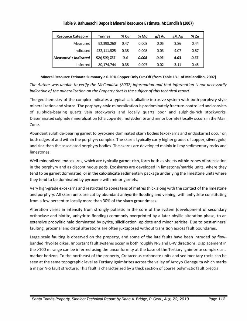
Santo Tomás Property, Sinaloa: Technical Report by Dane A. Bridge, P. Geol., Aug. 22, 2019 Page 112
Table 9. Bahuerachi Deposit Mineral Resource Estimate, McCandlish (2007)
Mineral Resource Estimate Summary ≥ 0.20% Copper Only Cut‐Off (from Table 13.1 of McCandlish, 2007)
The Author was unable to verify the McCandlish (2007) information and that information is not necessarily
indicative of the mineralization on the Property that is the subject of this technical report.
The geochemistry of the complex indicates a typical calc‐alkaline intrusive system with both porphyry‐style
mineralization and skarns. The porphyry‐style mineralization is predominately fracture‐controlled and consists
of sulphide‐bearing quartz vein stockworks and locally quartz poor and sulphide‐rich stockworks.
Disseminated sulphide mineralization (chalcopyrite, molybdenite and minor bornite) locally occurs in the Main
Zone.
Abundant sulphide‐bearing garnet to pyroxene dominated skarn bodies (exoskarns and endoskarns) occur on
both edges of and within the porphyry complex. The skarns typically carry higher grades of copper, silver, gold,
and zinc than the associated porphyry bodies. The skarns are developed mainly in limy sedimentary rocks and
limestones.
Well‐mineralized endoskarns, which are typically garnet‐rich, form both as sheets within zones of brecciation
in the porphyry and as discontinuous pods. Exoskarns are developed in limestone/marble units, where they
tend to be garnet dominated, or in the calc‐silicate sedimentary package underlying the limestone units where
they tend to be dominated by pyroxene with minor garnets.
Very high‐grade exoskarns and restricted to zones tens of metres thick along with the contact of the limestone
and porphyry. All skarn units are cut by abundant anhydrite flooding and veining, with anhydrite constituting
from a few percent to locally more than 30% of the skarn groundmass.
Alteration varies in intensity from strongly potassic in the core of the system (development of secondary
orthoclase and biotite, anhydrite flooding) commonly overprinted by a later phyllic alteration phase, to an
extensive propylitic halo dominated by pyrite, silicification, epidote and minor sericite. Due to post‐mineral
faulting, proximal and distal alterations are often juxtaposed without transition across fault boundaries.
Large scale faulting is observed on the property, and some of the late faults have been intruded by flow‐
banded rhyolite dikes. Important fault systems occur in both roughly N‐S and E‐W directions. Displacement in
the >100 m range can be inferred using the unconformity at the base of the Tertiary ignimbrite complex as a
marker horizon. To the northeast of the property, Cretaceous carbonate units and sedimentary rocks can be
seen at the same topographic level as Tertiary ignimbrites across the valley of Arroyo Cieneguita which marks
a major N‐S fault structure. This fault is characterized by a thick section of coarse polymictic fault breccia.
Resource Category Tonnes % Cu % Mo g/t Au g/t Ag % Zn
Measured 92,398,260 0.47 0.008 0.05 3.86 0.44
Indicated 432,111,525 0.38 0.008 0.03 4.07 0.57
Measured + Indicated 524,509,785 0.4 0.008 0.03 4.03 0.55
Inferred 80,174,744 0.38 0.007 0.02 3.11 0.45
Santo Tomás Property, Sinaloa: Technical Report by Dane A. Bridge, P. Geol., Aug. 22, 2019 Page 113
OTHER RELEVANT DATA AND INFORMATION
MINERAL TENURES ABUTTING THE PROPERTY Concurrent with the mineral exploration activities on the Property, Oroco has conducted a land assembly
involving certain concessions abutting the Property. These peripheral concessions are not the subject of this
technical report and are not related to the transactions between Oroco and Altamura. These concessions
contain no known mineral resource or mineral reserves.
Oroco seeks these peripheral concessions for multiple purposes:
Exploration: Santo Tomás quartz monzonite intrusions and porphyry Cu mineralization extend
beyond the limits of the central Property concessions at both the northern and southern extremities
of the Property. Viable exploration targets extend from the Property and lie within the Peripheral
concessions.
Infrastructure: Should the Property advance to development and production, surface rights will be
needed for use as tailings, waste rock storage, and possible routes for transportation and powerlines.
It is prudent to obtain the underlying mineral concessions to avert potential conflicts over land‐use
between acquired surface rights and the mineral concessions.
Oroco holds a contractual interest in the following abutting concessions to the Property:
Papago 17 – a concession held by Ubaldo Trevizo Ledezma (“Trevizo”), a Mexican businessman.
Oroco's wholly‐owned subsidiary, Minera Xochipala, S.A. de C.V. (“Minera Xochipala”), holds a
contractual, but not yet registered, right to a 77.5% interest. The contract includes certain NSR terms.
La China II – was cancelled but reinstated as of June 5, 2019. The registered owner is Santo Tomás
Metals, S.A. de C.V. (“STM”). Minera Xochipala holds a contractual, but not yet registered 77.5%
interest. The contract includes certain NSR terms.
Amp. Santo Tomás Reduccion 1 – was cancelled but reinstated as of February 18, 2019. The registered
owner is STM. Minera Xochipala holds a contractual, but not yet registered 77.5% interest. The
contract includes certain NSR terms.
Rossy – the registered owner is STM. Minera Xochipala holds a contractual, but not yet registered,
80% interest. The contract includes certain NSR terms.
Note that Minera Xochipala’s legal counsel holds a power of attorney from each of Santo Tomás Metals S.A.
de C.V. and Trevizo effective for registering Minera Xochipala's interest in the respective concessions.
Pursuant to an agreement between Altamura and third parties who control STM, the third parties have
covenanted, as and when directed by Altamura, to cause STM to transfer 80% of the rights and interests it
holds in the Rossy and Rossy 1 concessions to Minera Xochipala for nominal consideration and the assumption
by Minera Xochipala of any outstanding liabilities and obligations owed to the Mexican government in relation
to the concessions. As of this date, Altamura has not directed the third parties to cause STM to affect such a
transfer, and no interest has been transferred.
Santo Tomás Property, Sinaloa: Technical Report by Dane A. Bridge, P. Geol., Aug. 22, 2019 Page 114
Pursuant to an agreement between Altamura and Paul McGuigan, a Canadian businessman, McGuigan has
covenanted, as and when directed by Altamura, use his commercially reasonable best efforts to cause Cambria
Geosciences, S.A. de C.V., a Company controlled by McGuigan, to transfer 80% of the rights and interests it
holds in the Pagago Fraccion 1 concession to Minera Xochipala for nominal consideration and the assumption
by Minera Xochipala of any outstanding liabilities and obligations owed to the Mexican government in relation
to the concession. As of this date, Altamura has not directed McGuigan to affect such a transfer, and no
interest has been transferred. The peripheral concessions referred to in this section are shown in Figure 36.
DRILLING ON ABUTTING MINERAL CONCESSIONS Six of the historical drill holes were drilled in the South Zone, outside of the Property, on abutting mineral
titles now owned by or under option by Oroco but not part of the Property. The drilling delineates a potential
southern extension to the South Zone deposit near the Property. These holes are on the Papago 17 and Amp.
Santo Tomás Reducc. 1 concessions that are controlled by Oroco. See the drill hole collar location map, Figure
32.
Three additional holes were purportedly drilled by Exall near the Property on the Brasiles Zone, on what is
now Amp. Santo Tomás Reducc. 1. The access roads and collars of the holes were surveyed and recorded.
However, the results of those holes are not in the data obtained from Exall by the vendor of the Property.
These collars are on mineral concessions under an option agreement with Oroco but are not included in any
statistics of historical drilling results or the count of the drill holes completed on the Property.
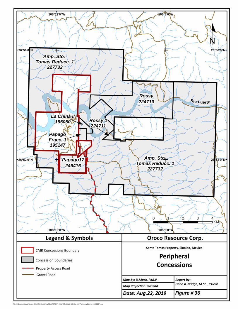
Rossy224710
Papago17246416
Amp. Sto.Tomas Reducc. 1
227732
108°8'0"W
108°8'0"W
108°12'0"W
108°12'0"W
26°56'0"N 26°56'0"N
26°52'0"N 26°52'0"N
EE
EE
File: Z:\Projects\SantoTomas_2018\GIS_Data\MapFiles\REPORT_MAPS\TechRpt_DBridge_A4_PeripheralClaims_20190307.mxd
Oroco Resource Corp.Santo Tomas Property, Sinaloa, Mexico
PeripheralConcessions
Map Projection: WGS84
Report by:Dane A. Bridge, M.Sc., P.Geol.
Legend & Symbols
Map by: D.Mack, P.M.P.
Property Access Road
CMR Concessions Boundary
º
0 1 2 3 4KM
Gravel Road
Amp. Sto. Tomas Reducc. 1
227732
Concession Boundaries
Rossy 1224711
PapagoFracc. 1195147
La China II195050
Rio Fuerte
Date: Aug.22, 2019 Figure # 36
Santo Tomás Property, Sinaloa: Technical Report by Dane A. Bridge, P. Geol., Aug. 22, 2019 Page 116
INTERPRETATION AND CONCLUSIONS
Porphyry‐copper type mineralization continues to be the primary focus for exploration on the Santo Tomás
property. Associated mineralization types and styles are also of interest as they offer an opportunity for
additional mineral resources but, currently, the skarn and oxide copper potential of the Property is very much
subordinate to the hypogene base metal sulphide potential. Lying within and beneath the thick beds of
limestones in the Brasiles Zone are targets for base‐metal and precious‐metal skarn‐type mineralization, in
addition to copper porphyry mineralization. However, that zone is in the initial stages of exploration only.
Systematic exploration of the copper‐porphyry mineralization at Santo Tomás was initiated by ASARCO
Mexicana S.A. (“ASARCO”), in October 1968. Subsequently, several drilling campaigns have been conducted
on the Santo Tomás property. The work has highlighted the presence of porphyry copper type mineralization.
The mineralization is sulphide‐dominant, with chalcopyrite being the main Cu‐bearing sulphide mineral
(Borovic, 2006; Spring, 1992).
The deposit is also oxidized along the surface to depths ranging from 10 to 30 m (Spring, 1992). After a review
of the drilling data, the Author concludes that the oxide mineralization is a sparse component of the known
mineralization on the Property.
DISCUSSION OF HISTORICAL GEOLOGICAL INTERPRETATION Historical interpretation of the geology and structure of the Santo Tomás porphyry‐copper deposit was
strongly influenced by exploration diamond drilling programs before 1992, comprising 50 drill holes (“STD”
series), of 16,003 m total length, with an average depth of 320 m. All STD holes were vertical.
Drilling by Exall in the period 1992‐1993 (the “STE” series) comprised 40 shorter holes, with a total of 5,071 m
total length and an average depth of 127 m. Most of the holes were vertical.
Collectively, all historical drilling information was biased towards relatively shallow, vertical holes that do
not fully test the breadth of the moderately west‐dipping Santo Tomás main mineralized zone. In the North
Zone, many of the drill holes either terminate in strong mineralization or, alternately, were collared on the
eastern fringe of the main mineralized zone and pass downwards into low‐grade footwall mineralization. In
each of these cases, the holes do not fully test the mineralized zone.
Furthermore, the Exall drilling program was initially aimed at defining a shallow mineral resource of copper
oxides. The Exall program failed to delineate any significant mineral resource of oxide copper. Consequently,
the Bateman (1994) Pre‐feasibility Study was developed on an information base that lacked an optimal spatial
distribution of drilling for hypogene mineralization.
After negative results for delineating oxide mineral resources, Exall evaluated the very extensive hypogene
base metal sulphide mineralization of the North and South Zones. Block modelling of the drill hole results by
Mintec in 1994 was performed on this shallow‐hole dataset. This early Bateman/Mintec modelling was
performed on sections facing North without geological modelling or wireframing to prevent the influence of
low‐grade hanging wall and footwall mineralization from affecting the block modelling of the main zones of
mineralization.
Santo Tomás Property, Sinaloa: Technical Report by Dane A. Bridge, P. Geol., Aug. 22, 2019 Page 117
Additionally, without a suitable structural and geological model to constrain the modelling, historical mineral
resource estimates in Bateman (1994) biased estimates towards flat to 20°W dips to mineralization (implied
mineralization attitude of 0°/0°‐20°W).
The Author considers the 2003 and earlier technical reports from Mintec and Bateman lack a valid geological
model. Therefore, the Author does not rely upon the historical estimates contained in those reports.
HISTORICAL MINERAL RESOURCE ESTIMATE – THORNTON (2011) An independent consultant to the Company, Mr. Mark Stevens, C.P.G., reviewed the September 2011
historical resource model 2011‐STM‐MODREV applying selected total copper (“CuT”) cutoff grades,
constrained by six (6) progressive open‐pit phases constructed by Thornton, with the ultimate pit represented
by the final sixth phase.
The Stevens verification work obtained mineral resource numbers that closely compare with those reported
in historical tables by Thornton in 2011. The Historical Estimates and recent geological mapping by the Author
confirm that approximately 85% of the higher‐grade material occurs in the North Zone (See Figs.14 15),
predominantly in a coherent, shallow, central portion of the North Zone deposit, with the remainder occurring
as scattered outliers throughout the North and South Zone areas.
The following technical work is needed to verify and potentially to upgrade the Historical Estimate to a current
mineral resource estimate:
1. Assay data presented in the historical drilling records must be verified by a current program of re‐
sampling and re‐assay of drilling samples stored in the Bienestar core facility. Resampling would
require retrieving intact half‐split core for a representative suite of low‐ to the higher‐grade core and
all host rock lithologies.
2. Five inclined STE‐series drill holes in the North Zone terminate in higher‐grade material. These holes
are suitable for twinning to verify assay and geology but also are suitable to be extended to test the
width of the mineralization fully.
3. The historical data has identified valid drill targets for verification of the historical resource estimate
and for exploration purposes. See the section herein for the recommendations for a regularly spaced
drilling program. Drilling should aim to firstly verify historical estimates in the pit‐constrained Mining
Phase 1 to 4 regions in the Thornton (2011) Historical Estimate because 85% of the higher grade
(>=0.35% CuT) blocks occur there.
A program of resampling and twinning of drill holes would be valid only for the verification of historical copper values because the historical assay information is too sparse for other metals. New drilling is required to establish a current estimate for Cu that includes Au, Ag and Mo.
The reader is cautioned that a new program of drilling might not confirm the Thornton (2011) 2011‐STM‐
MODREV Historical Estimate. If the target in the North Zone is not confirmed, subsequent exploration planning
must be revised.
The Author has accommodated the risk inherent in confirming the Thornton (2011) block model by designing
a drilling program (see Recommendations) that places drill hole collars for confirmation drilling on the western
side (hanging wall) of the North and South Zone deposits and with inclined drill holes aimed orthogonal to the
Santo Tomás Property, Sinaloa: Technical Report by Dane A. Bridge, P. Geol., Aug. 22, 2019 Page 118
measured strike and dip of the deposit. The individual drill holes are designed to properly test the
mineralization even in the event of moderate variations of actual strike and dip compared to the 2019
structural estimates.
The Author concludes that Thornton’s technical work is an invaluable source of exploration information that
can be used with reasonable confidence for the current evaluation of exploration risk and for designing future
exploration work, including confirmation drilling.
REVISED GEOLOGICAL INTERPRETATION Geological and structural mapping, firstly by Cambria up to 2009, and more recently by the Author and
Tapsoba in 2019, demonstrates the main mineralized zone is defined by the distribution and structural attitude
of sheeted quartz monzonite dikes within a fractured and faulted andesite host rock, and by post‐
mineralization faulting.
Structural information provides support for future block modelling in the North Zone using the attitudes to
the hanging wall and footwall of 020°/50°W. In 2009, Cambria validated and prepared a block model using
drilling data, structural data, and the geostatistical range of the Cu semi‐variogram of 130 m both along strike
and down‐dip. The 2009 Grade Shell of Cu > 0.30%, passing through the mid‐point of the blocks at the edge,
was created to 3D‐model the core of the mineralized zone (McGuigan, 2009).
The 2019 structural mapping by the Author and Tapsoba highlighted the Early Stage NNE‐ and NE‐oriented
structural control to Laramide mineralization of the Santo Tomás deposits. For the first time, the 2019 data
provided information to model the younger, post‐mineralization displacement of the deposit by NW and E‐W
faulting in the North Zone and Brasiles Zone, respectively.
Importantly, the Author observed no clusters of flat‐ to gently dipping mineralized structures in the new 2019
structural observations. This data conclusively invalidates the Mintec 1994 and 2003 historical mineral
resource estimates. The Author concluded that an updated 3D geological model was required for exploration
planning and layout of confirmation drilling.
Historical Cambria and Thornton work was checked against the data from the current 2019 exploration data,
structural interpretation, and cross‐sections. Both Cambria (McGuigan) in 2009 and Thornton in 2011
employed wireframing to limit the inclusion of poorly mineralized hanging wall and footwall intersections in
preparing block models of the main mineralized North Zone. This verification yielded the following relevant
conclusions by the Author:
1. Correlograms in the geostatistical analysis within Thornton (2011) conform to the strike of 020° and
the observed 50°W dip of the main mineralizing stage. This geostatistical finding was first employed
in the Cambria 2009 geological modelling work and is now confirmed by structural measurements in
the 2019 field studies by the Author and Tapsoba.
2. The shape and distribution of the 2009 Grade Shell of Cu > 0.30% was also evaluated using the 2019
structural data. The southwestern limit of the grade shell does not cross the new estimated position
of the younger Western fault zone.
3. The 2009 Grade Shell of Cu > 0.30% compared to the historical mineral resource blocks of Thornton
(2011) on recent cross‐sections is a superior representation of the higher‐grade core of the North
Zone, especially at depth.
Santo Tomás Property, Sinaloa: Technical Report by Dane A. Bridge, P. Geol., Aug. 22, 2019 Page 119
The 2009 Grade Shell Cu > 0.30% volume identifies a promising, shallow‐seated North Zone exploration target.
This target is estimated to be a tabular body that dips towards the west at 50° within the higher‐grade central
axis of the North Zone.
3D GEOLOGICAL MODEL The Author reviewed the shape and position of the higher‐grade portion of the Thornton 2011‐STM‐MODREV
block model (above a 0.35% CuT cut‐off grade) to the 3D volume of the Cambria 2009 Grade Shell Cu > 0.30%
prepared from the same historical drilling data. The Author concludes that the 2009 Grade Shell of Cu > 0.30%
informs a more realistic shape and position for targeting the recommended phase of new definition drilling,
especially as the drilling progresses down‐dip and along strike from the historical drilling.
Furthermore, the Author concludes that the new 2019 mapping and structural data summarized in the section
on Property Geology validates the features in the Santo Tomas 3D geological model (see Fig. 37), as follows:
1. Hanging wall and footwall contacts of mineralization can be constructed with a 020°/50°W structural
attitude on sectional interpretations and with the 3D modelling. (see Fig. 27 & the map in Fig. 33).
2. Western Fault and splays are post‐mineralization and impart an oblique‐slip displacement of the
southern extremity of the North Zone. This fault terminates the SW fringe of the North Zone (see Fig.
27 & the map in Fig. 33).
3. North Zone Mineralized Unit (“Mx”): The North Zone is validly modelled to the limits of quartz
monzonite dikes, altered andesite, and copper mineralization (above about 0.10% CuT) using the
020°/50°W structural attitude for the footwall and hanging wall. In the North Zone, a 3D volume can
be confidently drawn because the historical drilling is sufficiently close‐spaced. This volume is
modelled as unit Mx and shaded pink on cross‐sections and plans. (Mx is shown in Fig. 37 and in Fig.
27 & the map in Fig. 33)
4. 2009 Grade Shell Cu > 0.30% was transformed into WGS 84 Zone 12 datum and compared to elements
of the 2019 structural mapping. The Author concludes this grade shell volume remains valid today and
conforms to the revised 3D geological model of the North Zone. The 2009 Grade Shell nests within
Unit Mx (See Fig. 37). The grade shell was prepared using geostatistical limits of 130 m from drilling
data and validly represents a higher‐grade exploration target, within the North Zone central core. The
2009 Grade Shell Cu > 0.30% is coloured red on sections and 3D views in this technical report. No
implication is made as to the copper content or economic viability of the volume inside the 2009 Grade
Shell until that volume is tested by a new program of drilling recommended herein.
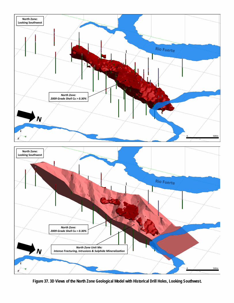
North Zone: Looking Southwest
0 500m
North Zone: 2009 Grade Shell Cu > 0.30%
North Zone Unit Mx: Intense Fracturing, Intrusions & Sulphide Mineraliza on
North Zone: Looking Southwest
North Zone: 2009 Grade Shell Cu > 0.30%
Figure 37. 3D Views of the North Zone Geological Model with Historical Drill Holes, Looking Southwest.
0 500m
Santo Tomás Property, Sinaloa: Technical Report by Dane A. Bridge, P. Geol., Aug. 22, 2019 Page 121
EXPLORATION TARGET The mineral resource estimate by Thornton (2011) is a Historical Estimate as defined under Canadian National
Instrument 43‐101 – Standards of Disclosure for Mineral Projects (“NI 43‐101”). The Author has not done
sufficient work to classify the Historical Estimate as current mineral resources or mineral reserves, and the
Company is not treating the Historical Estimate as current mineral resources or mineral reserves. The Author
states that the Historical Estimate employed reliable estimation practice but that to upgrade or verify this
Historical Estimate, resampling and assay of historical drill samples, twinning of historical drill holes, and a new
program of regularly spaced drilling are required.
The Author concludes that the highest priority exploration target on the Property lies in the central core of
the North Zone, at a shallow depth below the surface. This area was also identified in the Historical Estimate
of Thornton (2011) as having 85% of the higher‐grade material (above 0.35% CuT). A new program of regularly
spaced drilling is required to confirm this higher‐grade material and to conduct additional exploration.
After review of the historical drilling data, the Thornton (2011) Historical Estimate, and the Santo Tomas 2019
geological model, the Author concludes the highest priority exploration target is within and near the 3D
volume of the 2009 Grade Shell Cu > 0.30%, that is part of the North Zone mineralized unit (Mx). As described
in the Recommendations section, new drilling is spaced on cross sections spaced 200 m apart. The maps in
Fig. 33 and Fig. 40 (following) present the cross‐section layouts. Drilling on these sections would test the 2009
Grade Shell target at 200 m spacing along strike and 200 m down the dip direction (150 m elevation spacing).
1. Cross‐Sections N30 to N46: The first priority target is the North Zone mineralized unit (Mx), where Mx
is widest on the surface. The target is 1,000 m along strike and above about 100 m elevation (see
herein Recommendations Phase 1.1).
2. Cross‐Sections N18 to N50: A second priority target is a periphery to the core of the North Zone, in
areas northwards, southwards, and to a greater depth than (1), across a total of 1,800 m of strike
length of Mx (see herein Recommendations Phase 2.1).
The 3D 2009 Grade Shell Cu > 0.30% encloses a target of approximately 280 to 315 million tonnes of material
with a target grade of 0.45% to 0.55% CuT.
First and second priority drilling on the Sections N18 to N50 would test this initial target and also test for
additional tonnage, mostly along strike to the south, and down‐dip within Mx.
The tonnage and grade stated for the target are conceptual, and the Author does not treat the target to be a
mineral resource estimate under NI43‐101. The Author cannot be sure whether future exploration will result
in the target becoming a current mineral resource or reserve.
The risks in drilling this exploration target include the possibility that the strike and dip of the North Zone are
incorrectly estimated. Additionally, the structural termination of the North Zone against the Western fault
zone is somewhat uncertain due to sparse information for that fault from drilling and surface mapping. The
Western Fault, if dipping more steeply than expected, will lessen the North Zone tonnage to depth. Conversely,
if the Western Fault is shallower than expected, the North Zone target will be more open for a tonnage
increase at depth. This risk is only relevant for the southern part of the North Zone. Central and northern
portions of the North Zone are well‐separated from the Western Fault zone.
Santo Tomás Property, Sinaloa: Technical Report by Dane A. Bridge, P. Geol., Aug. 22, 2019 Page 122
RECOMMENDATIONS
INTRODUCTION The Santo Tomás has not been drilled since 1993. Oroco’s Santo Tomás drill hole database contains 90 drill
holes (reverse circulation and diamond drill holes), totalling 21,075 m of lithological data, including 7,244 Cu
assays. The historical drill spacing in the North Zone, combined with newly acquired 2019 structural data, is
enough to support a confident recommendation for a large definition drilling program. Drilling is
recommended to span North Zone cross‐sections N 18 to N 50, or 1.8 km of strike length.
Separation of the North Zone definition drilling into Phase 1.1 (Stages 1) and Phase 2.1 (Stage 2) is driven by
the logistics of road construction to access drill sites on the western flank of the Santo Tomás ridge, not by a
requirement for success contingent exploration stages.
Also, except where noted herein, the North Zone definition drilling program is not contingent on the results
from the recommended Phase 1.0 surface exploration work.
Access to the historical drilling sites was partly repaired in 2017. Access to the North Zone and West Bench
camp accommodation on the Property is recommended to be fully re‐established in the initial stages of the
recommended programs herein.
The Author recommends the general objectives in a sequence of work as follows:
Phase 1: Exploration and Non‐Success Contingent Drilling
Phase 1.0 Surface Exploration be first initiated. After road access is re‐established to the West Bench
and North Zone, construct an exploration camp and survey the Property with ground geophysical and
geological surveys.
Phase 1.1 North Zone Definition Drilling Program, Stage 1 be started as soon as road access and the
camp fully constructed. The drilling recommended in this First Stage can run concurrently with surface
exploration. The First Stage program of drilling is recommended to confirm the geology and mineral
resources of the central, near‐surface portions of the North Zone. Work in this stage would accrue to
building a mineral resource estimate at the Indicated Resource level of confidence, followed by a
program of definition drilling in Phase 2.1.
Phase 2: Exploration and Drilling Program – Non‐Success and Success Contingent
Phase 2.0 Surface Exploration & Environmental Program be initiated in Phase 2, comprising a
geological mapping of the Property, Remote Sensing, and Baseline Environmental studies.
Phase 2.1 North Zone Definition Drilling Program, Stage 2 is not contingent on the results of the
Phase 1 results. This stage will see the completion of definition drilling on North Zone sections N 18 to
N 50, above the elevation of 200 m below sea level.
Phase 2.1 South Zone Exploration Drilling Program is not contingent on the results of Phase 1 work.
Recommended is that concurrent with the start‐up of the North Zone definition drilling Phase 2.1,
Santo Tomás Property, Sinaloa: Technical Report by Dane A. Bridge, P. Geol., Aug. 22, 2019 Page 123
South Zone drilling focus on the Ridge zone to follow‐up on the significant historical intersections in
STD‐50 and ‐36 (Section S 14, two holes, Phase 2.1)
Phase 2.2: Drilling Program – Success Contingent, comprising drilling for extensions of the North Zone
(down‐dip and along strike), and in the South Zone. Brasiles Zone drilling is recommended to start,
success contingent, on results of Phase 1 geology and geophysics programs.
PHASE 1.0 – SURFACE EXPLORATION Phase 1 recommendations can be executed in separate program components, and one component is not
contingent on the results of the other components.
Permitting The application of Mining Law and Regulations is the responsibility of the President’s Office (Federal Executive)
through the Ministry of the Economy, under the Mexican Mines Bureau. SEMARNAT supervises the
environmental aspects of exploration.
Mineral exploration, road and camp construction and drilling require the filing, approval, and compliance with
a NOM‐120 (Informe Preventivo) for mechanical exploration work, such as drilling and road construction.
SEMARNAT in both Sinaloa and Chihuahua will review the NOM‐120 for those areas of the Property lying in
their respective states.
Permitting is recommended in stages; Firstly, for geophysical surveys, line cutting, and road repair. Secondly,
permitting for Phase 1 and 2 drilling and additional road work, to be initiated as soon as practical.
Physical Work
Field Camp
In support of surface exploration and drilling, a West Bench camp is recommended proximal to the work areas
of the Property and Rio Fuerte. The West Bench is on the Property (mineral concession Esme) and serviced by
road from the Chihuahua Pacific highway. It is line‐of‐sight from West Bench to the “Microwave Tower” south‐
west of the campsite. Local contractors are available to establish a microwave link between the tower and
camp for telephone and high‐speed internet.
Depending on the number of concurrent activities and the availability of labour in the villages near the camp,
the camp will be required to accommodate up to 20 technical, drilling, and support personnel during the
duration of Phase 1 activities. The camp will be readily extended as required.
The new West Bench camp will have a new core logging and core storage facility, and a works yard to support
the drilling activities.
Property Access Road Work
Road access was repaired in 2017 to the ridge above the South Zone. An additional four kilometres of road
repair is needed to access Rio Fuerte.
Access to the West Bench exploration camp requires repair of 12 km of existing road from the Chihuahua
Pacific highway to the West Bench. Much of that road segment was used in the past for heavy hauling from a
limestone quarry operation at the “Frog.” Repair of that section of the road will give good access to the ridge
Santo Tomás Property, Sinaloa: Technical Report by Dane A. Bridge, P. Geol., Aug. 22, 2019 Page 124
above the West Bench. Beyond the Frog, the road descending to the West Bench should be repaired, or newly
constructed.
A five‐kilometre branch road from the West Bench to the Santo Tomás Ridge (via repair and extensions to
South Zone roads) is also needed to connect the West Bench field camp to the drilling areas of the North and
South Zones.
Logistics will be assisted by landing barges on the Huites Reservoir. Construction of a one‐kilometre road is
needed to connect the West Bench to the Huites Reservoir.
Bienestar Core Facility
The Bienestar core facility was rehabilitated in 2008. In the last ten years, the core racks have partly collapsed.
The core must be retrieved and selected holes re‐boxed, logged and resampled. Repairs required will be minor.
The facility is suitable to remain as storage for historical drill core. A new core storage facility should be
provided for future drilling campaigns.
Geophysical Surveys Geophysical surveys are recommended to characterize the sulphide mineralization, quartz monzonite
intrusions and faulting on the Property.
Line Cutting
Line‐cutting and picketing are required to support geological mapping and geophysical surveys across the
Property from the South Zone to Brasiles Zone. To support the ground geophysical surveys, and swath
approximately 2.6 km wide by 7.6 km north to south is required to survey the South, North and Brasiles Zones.
Line spacing would be 100 m, requiring about 76 lines or about 200 km of brushed line.
3D Induced Polarization Survey
The primary recommendation is for 3D Induced Polarization (“3D DCIP”) survey over the South, North and
Brasiles Zones. The DIA32 system of Dias Geophysical can acquire quality 3D IP and resistivity data to a depth
of at least 600 m below the surface, depending on the electric properties of the rock. Recommended is a 2.6
km wide by 7.6 km north‐south swath of surveying, with a 100 m line spacing. The survey is costed on fixed
mobilization‐demobilization and reporting plus a daily charge for field operations.
Magnetic Survey
A secondary recommendation is for an airborne magnetic survey. The most cost‐effective method will be a
drone‐based airborne survey. Recommended is a survey area of 5 km wide by 10 km north‐south beyond the
bounds of the Property at 100 m line spacing (500 line‐km), to characterize the hosting fault network, intrusive
bodies, and alteration.
Geological Program Complimentary to the Phase 1 Definition Drilling program, the Author recommends a limited program of
surface geological mapping on the North Zone over the area of Phase 1 drilling, to determine the location and
orientation of faults and other geological features that control mineralization.
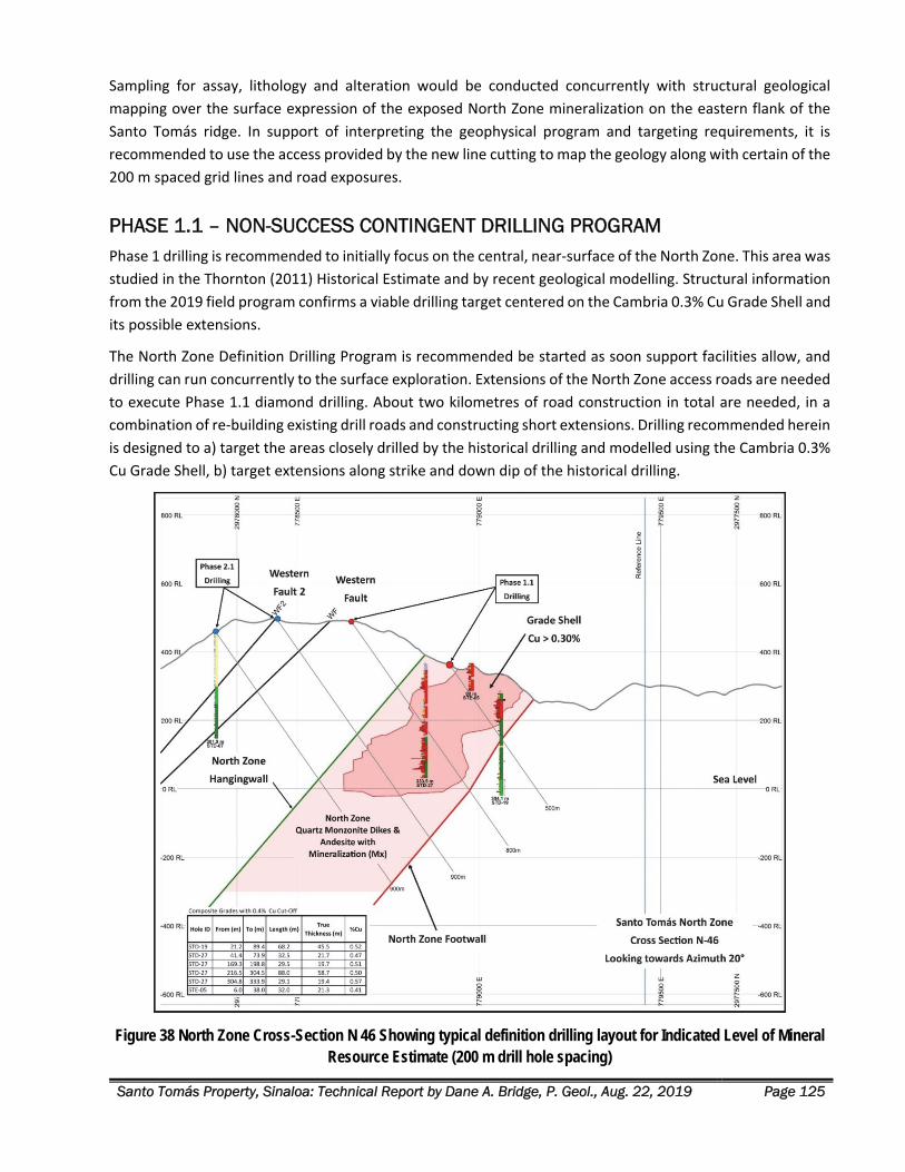
Santo Tomás Property, Sinaloa: Technical Report by Dane A. Bridge, P. Geol., Aug. 22, 2019 Page 125
Sampling for assay, lithology and alteration would be conducted concurrently with structural geological
mapping over the surface expression of the exposed North Zone mineralization on the eastern flank of the
Santo Tomás ridge. In support of interpreting the geophysical program and targeting requirements, it is
recommended to use the access provided by the new line cutting to map the geology along with certain of the
200 m spaced grid lines and road exposures.
PHASE 1.1 – NON-SUCCESS CONTINGENT DRILLING PROGRAM Phase 1 drilling is recommended to initially focus on the central, near‐surface of the North Zone. This area was
studied in the Thornton (2011) Historical Estimate and by recent geological modelling. Structural information
from the 2019 field program confirms a viable drilling target centered on the Cambria 0.3% Cu Grade Shell and
its possible extensions.
The North Zone Definition Drilling Program is recommended be started as soon support facilities allow, and
drilling can run concurrently to the surface exploration. Extensions of the North Zone access roads are needed
to execute Phase 1.1 diamond drilling. About two kilometres of road construction in total are needed, in a
combination of re‐building existing drill roads and constructing short extensions. Drilling recommended herein
is designed to a) target the areas closely drilled by the historical drilling and modelled using the Cambria 0.3%
Cu Grade Shell, b) target extensions along strike and down dip of the historical drilling.
Figure 38 North Zone Cross-Section N 46 Showing typical definition drilling layout for Indicated Level of Mineral Resource Estimate (200 m drill hole spacing)
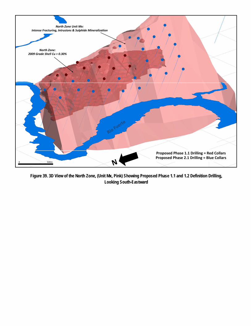
0 500m
North Zone: 2009 Grade Shell Cu > 0.30%
North Zone Unit Mx: Intense Fracturing, Intrusions & Sulphide Mineraliza on
Proposed Phase 1.1 Drilling = Red Collars Proposed Phase 2.1 Drilling = Blue Collars
Figure 39. 3D View of the North Zone, (Unit Mx, Pink) Showing Proposed Phase 1.1 and 1.2 Definition Drilling, Looking South-Eastward
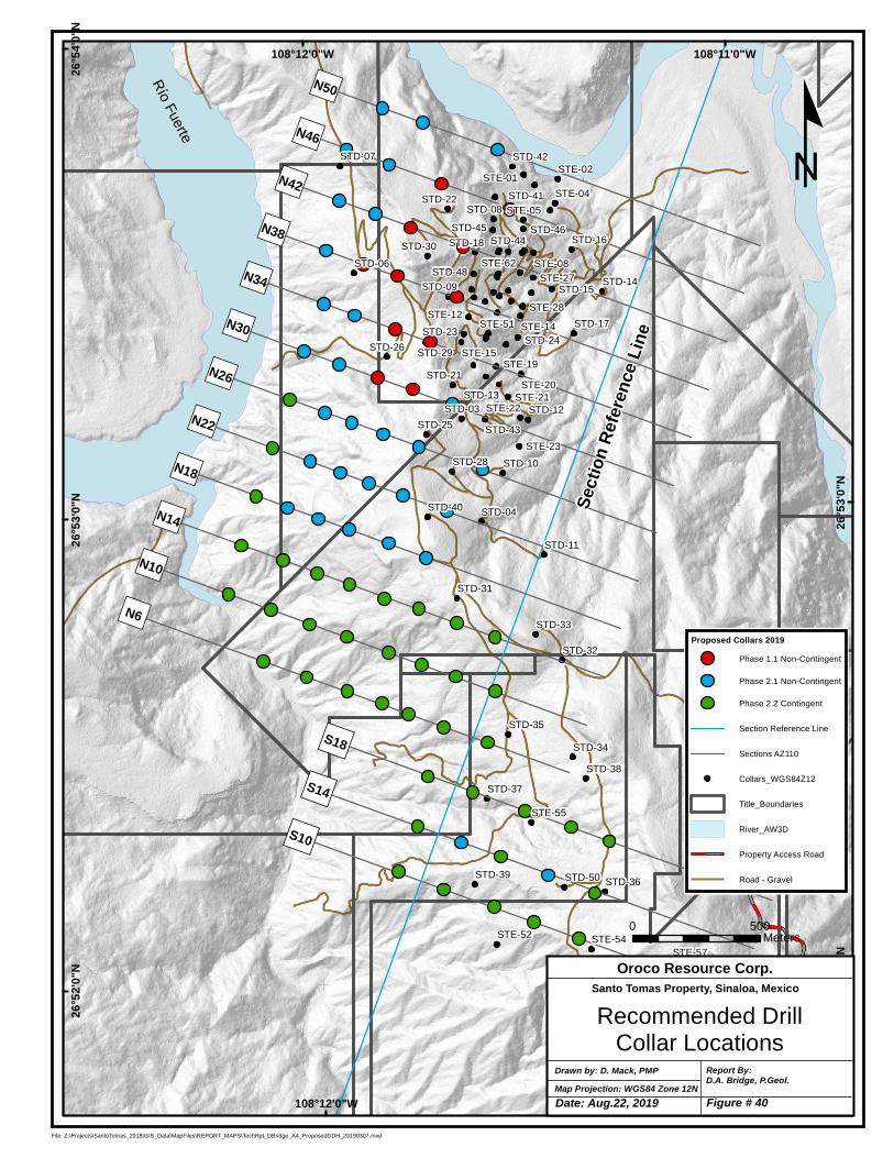
STD-03
STD-04
STD-06
STD-07
STD-08
STD-09
STD-10
STD-11
STD-12
STD-13
STD-14STD-15
STD-16
STD-17
STD-18
STD-21
STD-22
STD-23STD-24
STD-25
STD-26
STD-28
STD-29
STD-30
STD-31
STD-32
STD-33
STD-34
STD-35
STD-36
STD-37
STD-38
STD-39
STD-40
STD-41
STD-42
STD-43
STD-44STD-45 STD-46
STD-48
STD-50
STE-01STE-02
STE-04
STE-05
STE-08
STE-12STE-14
STE-15STE-19
STE-20STE-21
STE-22
STE-23
STE-27
STE-28
STE-51
STE-52
STE-53
STE-54
STE-55
STE-56
STE-57
STE-58
STE-62
")N50
")N6
")N14
")N22
")N34
")N42
")N10
")N30
")N38
")N46
")N18
")N26
")S18
")S14
")S10
108°11'0"W
108°11'0"W
108°12'0"W
108°12'0"W26
°54'0
"N26
°53'0
"N
26°5
3'0"N
26°5
2'0"N
26°5
2'0"N
File: Z:\Projects\SantoTomas_2018\GIS_Data\MapFiles\REPORT_MAPS\TechRpt_DBridge_A4_ProposedDDH_20190307.mxd
Proposed Collars 2019Phase 1.1 Non-Contingent
Phase 2.1 Non-Contingent
Phase 2.2 Contingent
Section Reference Line
Sections AZ110
Collars_WGS84Z12
Title_Boundaries
River_AW3D
Property Access Road
Road - Gravel
Río
Fuerte
Map Projection: WGS84 Zone 12NDrawn by: D. Mack, PMP Report By:
D.A. Bridge, P.Geol.
Recommended DrillCollar Locations
Oroco Resource Corp.Santo Tomas Property, Sinaloa, Mexico
0 500Meters
º
Secti
on Re
feren
ce Li
ne
Date: Aug.22, 2019 Figure # 40
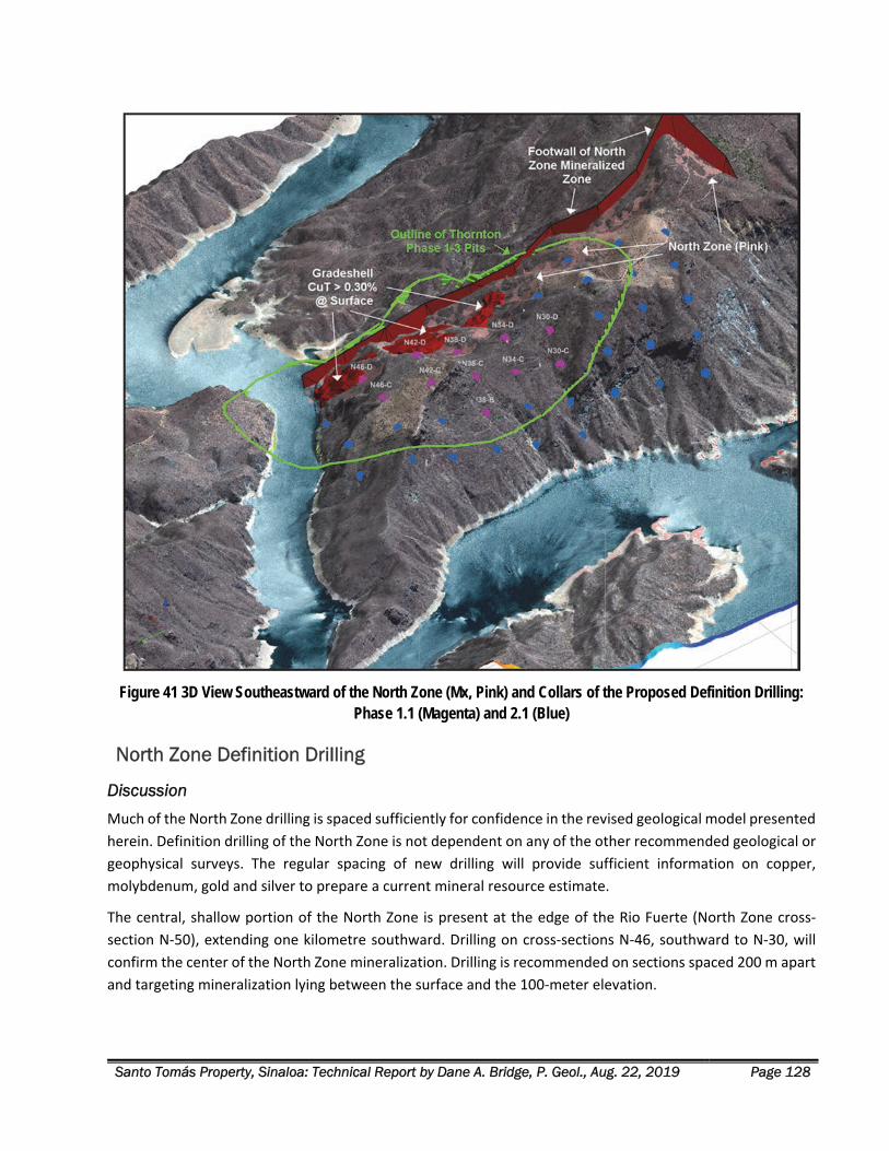
Santo Tomás Property, Sinaloa: Technical Report by Dane A. Bridge, P. Geol., Aug. 22, 2019 Page 128
Figure 41 3D View Southeastward of the North Zone (Mx, Pink) and Collars of the Proposed Definition Drilling: Phase 1.1 (Magenta) and 2.1 (Blue)
North Zone Definition Drilling
Discussion
Much of the North Zone drilling is spaced sufficiently for confidence in the revised geological model presented
herein. Definition drilling of the North Zone is not dependent on any of the other recommended geological or
geophysical surveys. The regular spacing of new drilling will provide sufficient information on copper,
molybdenum, gold and silver to prepare a current mineral resource estimate.
The central, shallow portion of the North Zone is present at the edge of the Rio Fuerte (North Zone cross‐
section N‐50), extending one kilometre southward. Drilling on cross‐sections N‐46, southward to N‐30, will
confirm the center of the North Zone mineralization. Drilling is recommended on sections spaced 200 m apart
and targeting mineralization lying between the surface and the 100‐meter elevation.
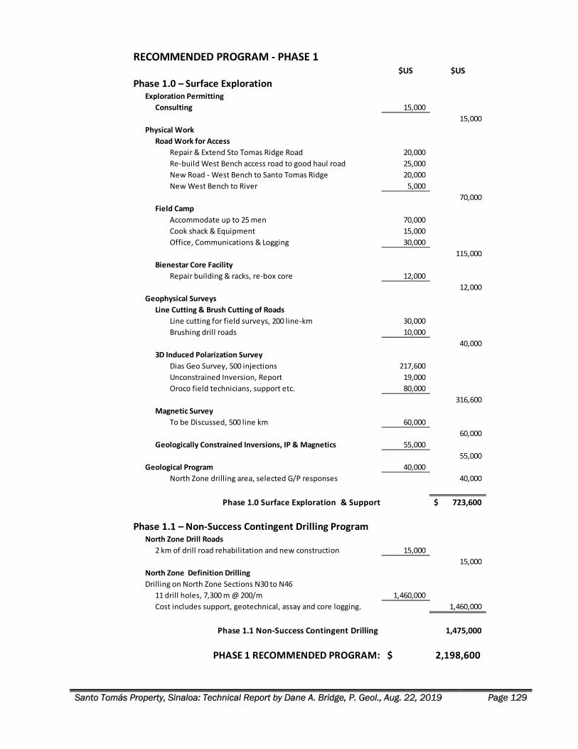
Santo Tomás Property, Sinaloa: Technical Report by Dane A. Bridge, P. Geol., Aug. 22, 2019 Page 129
RECOMMENDED PROGRAM ‐ PHASE 1$US $US
Phase 1.0 – Surface ExplorationExploration Permitting
Consulting 15,000
15,000
Physical Work
Road Work for Access
Repair & Extend Sto Tomas Ridge Road 20,000
Re‐build West Bench access road to good haul road 25,000
New Road ‐ West Bench to Santo Tomas Ridge 20,000
New West Bench to River 5,000
70,000
Field Camp
Accommodate up to 25 men 70,000
Cook shack & Equipment 15,000
Office, Communications & Logging 30,000
115,000
Bienestar Core Facility
Repair building & racks, re‐box core 12,000
12,000
Geophysical Surveys
Line Cutting & Brush Cutting of Roads
Line cutting for field surveys, 200 line‐km 30,000
Brushing drill roads 10,000
40,000
3D Induced Polarization Survey
Dias Geo Survey, 500 injections 217,600
Unconstrained Inversion, Report 19,000
Oroco field technicians, support etc. 80,000
316,600
Magnetic Survey
To be Discussed, 500 line km 60,000
60,000
Geologically Constrained Inversions, IP & Magnetics 55,000
55,000
Geological Program 40,000
North Zone drilling area, selected G/P responses 40,000
Phase 1.0 Surface Exploration & Support 723,600$
Phase 1.1 – Non‐Success Contingent Drilling ProgramNorth Zone Drill Roads
2 km of drill road rehabilitation and new construction 15,000
15,000
North Zone Definition Drilling
Drilling on North Zone Sections N30 to N46
11 drill holes, 7,300 m @ 200/m 1,460,000
Cost includes support, geotechnical, assay and core logging. 1,460,000
Phase 1.1 Non‐Success Contingent Drilling 1,475,000
PHASE 1 RECOMMENDED PROGRAM: 2,198,600$
Santo Tomás Property, Sinaloa: Technical Report by Dane A. Bridge, P. Geol., Aug. 22, 2019 Page 130
North Zone Phase 1.1 Definition Drilling: Non-Success Contingent – 7,300 m
Drilling of the center of the North Zone is laid out as follows in 11 drill holes, drilled toward Az. 110°, at ‐55°
inclination:
1. Drill 11 holes of 500 to 900 m length to initially test the 400 m to 100 m elevations, refer to Figure 40
(plan view) and 41 (3D view), for total estimated drilling about 7,600 m.
2. These Phase 1.1 holes are recommended to stay within the rake of the thickest and highest‐grade
mineralization, in the center of the higher‐grade copper mineralization from historical drilling..
PHASE 2.0 – SURFACE EXPLORATION AND ENVIRONMENTAL PROGRAM
Geological Program A program of surface geological mapping focusing on intrusive lithologies, alteration assemblages, and
structural features is required to compliment exploration drilling and to determine the location and
orientation of faults and other geological features that may offset or displace the mineralization.
Re-logging of Historical Drill Core
Concurrently with the check assay program, relog all holes that have enough remaining sample to be useful.
It is estimated that two man‐months would be required for re‐logging after the core facility has been repaired.
Re‐secure the core facility and move individual important drill core to a new facility.
Surface Geological Mapping
Work is recommended to be conducted at a scale of 1:1,000 with equivalent locational accuracy and detail to
any diamond drilling program. Attention to the chronology and structural setting of mineralization is critical
and requires future drilling programs to be conducted over areas with careful surface geological mapping to
ensure the correct interpretation of drilling data is obtained. Sampling for assay, lithology and alteration would
be conducted concurrently with structural geological mapping.
Comprehensive geological mapping is recommended to encompass a 3 km by 7 km swath of the Property and
abutting concessions. Priority for mapping would be the surface of the North and South Zones, then Brasiles
Zone, followed by any zones with a favourable geophysical response in the Phase 1.0 exploration.
Remote Sensing Oroco’s current remote sensing information is limited to ASTER data (2008 historical data) and RADARSAT 2
data (2017 program).
A minimum area of coverage comprising the Property and the Adjacent Properties is recommended for the
acquisition of WorldView‐3 high‐resolution satellite imagery (or equivalent), with about 16 times the
resolution of ASTER alteration mapping. In areas of sparse vegetation, 16 band WorldView‐3 imagery can be
used to map hydrous silica, clay, ferric and hydrous ferric iron oxide, micas, ammonium feldspar, carbonate
and propylitic minerals for epithermal gold and silver and porphyry copper exploration.
Enough bare rock and talus are found across the Property in gullies, talus slopes and ridge tops to perform a
reliable remote sensing interpretation. Diagnostic alteration and lithological responses can be obtained with
a resolution of 2m on the ground and merged with the newly acquired AW3D Enhanced DTM.
Santo Tomás Property, Sinaloa: Technical Report by Dane A. Bridge, P. Geol., Aug. 22, 2019 Page 131
Environmental Baseline Survey At this initial stage of definition drilling, recommended is that an Environmental Baseline Survey (EBS) be
commenced. The EBS is used to develop the scope of a needed Environmental Impact Assessment/Statement
in later project stages.
A Mexican‐based environmental consulting firm that specializes in EBS can be contracted to undertake the
work as the project advances through exploration and definition drilling. Oroco can initiate some of the work
during the exploration phase at relatively little expense.
Some of the EBS data that can be collated or collected by field crews and Mexican environmental consultants
in Phase 1 exploration include:
1. Local geological data and topography.
2. Surface water network mapping and preliminary water sampling.
3. Soil and stream sediment sampling of different geological terrains.
4. Wildlife and vegetation identification.
5. Climatic data from an inexpensive, automatic weather station at the West Bench camp.
6. Assembly of socio‐economic information including local infrastructure, community descriptions,
important local leaders/groups and land uses.
7. Initial engagement of communities and communal (“ejido”) groups.
Guidance for the Santo Tomás EBS might be provided by the information contained in the Environmental
Impact Statement for the nearby Huites Bridge, filed with SEMARNAT in 2019. That document includes certain
environmental surveys that spanned the Huites Reservoir and all the Santo Tomás South, North and Brasiles
Zones.
PHASE 2.1 – NON-SUCCESS CONTINGENT DRILLING PROGRAM
North Zone Definition Drilling – Continued
Discussion
Definition drilling was recommended to commence with cross‐sections N‐30 to N‐46, within the central North
Zone. Additional drilling in Phase 2.1 is recommended that is not contingent on the results of Phase 1
exploration and definition drilling.
Review of the cross‐sections and level plans that incorporate the recent structural data show that at Section
N 18, at the 150 m Level and downwards to ‐200 m below Sea Level, the higher‐grade core of the North Zone
mineralization is projected to remain at full width to depth.
Additionally, the thickest and highest‐grade portion of the North Zone between Sections N 34 and N 42 is at
the intersection of N20°E/50°W and N42°E/50°NW mineralization trends. The plunge indicated for the best
mineralization is therefore 42°E towards 270°, verging away from the south bank of the Rio Fuerte.
Based on the preceding analysis, the body of mineralized quartz monzonite and andesite beneath the Western
Fault + North Zone Hanging Wall contact, and above the North Zone Footwall, is highly prospective. Drilling in
Santo Tomás Property, Sinaloa: Technical Report by Dane A. Bridge, P. Geol., Aug. 22, 2019 Page 132
Phase 2.2 is planned to complete the drilling of the core North Zone target of 280 to 315 million tonnes within
the Cambria 2009 +0.30% CuT Grade Shell and to target of additional mineralization down to the ‐200 m
elevation.
North Zone Phase 2.1 Definition Drilling: Non-Success Contingent Drilling – 19,400 m
Continued definition drilling of the North Zone is laid out as follows in 28 drill holes, drilled toward Az. 110°,
at ‐55° inclination and located on cross‐sections from N‐50 southward to N‐18:
1. Nominally, the centerline of targets on the North Zone is set at 450 m, 300 m, 150 m, 0 m and ‐150 m
elevations. This will result in drill testing down to approximately 200 m elevation below sea level.
2. Nine cross‐sections (spaced 200m apart) are recommended for drilling, ranging from the Rio Fuerte
(at N‐50), southward for 1.8 km to section N‐18, comprising a total of 28 additional holes with 19,400
m of drilling.
3. This drill pattern tests the southern limit of the North Zone to 150 m south of STD‐40.
4. After this Phase 2.1, following the North Zone southward from STD‐40 is success contingent on drilling
results and the geophysical program. Structural projections in the geological model indicate the zone
continues to section N‐6 at the 150 m Level but at reduced thickness.
South Zone Drilling at the Ridge Target – Initial Drilling
Discussion
The South Zone is segmented by the post‐mineralization Western Fault. In the South Zone, the Western Fault
demonstrates an attitude of 160°/50° W and forms a dip‐slope of faulted ground along the western flank of
the Santo Tomás ridge. Kinematics measured on the Western Fault near Rio Fuerte by Tapsoba (2019) shows
a southwest throw to the fault (normal fault, with the hanging wall displaced southward and down relative to
the footwall).
The existing drill information on the South Zone is enough for Phase 1 targeting of the zone of best results in
the South Zone historical drilling. However, the 2019 structural interpretation shows the mineralization is
segmented into two “panels,” as follows:
1. Footwall to the Western Fault: This segment lies east of the Western Fault and is characterized by
limestone and SMO rhyolite above the 800 m elevation, with altered andesite below. Quartz
monzonite dikes like those found in the footwall to the main North Zone are intersected in drilling and
are variably mineralized.
2. Hanging wall to the Western Fault: This segment lies west of the Western Fault and above the plane
of the Western Fault. Limestone is intersected as low as the 600 m elevation, indicating a normal fault
displacement downward of about 200 m across the first Western Fault splay (“WF”). Reconstruction
of the southwest oblique slip movement across the Western Fault indicates the intersections of STD‐
39, STE‐52 and STE‐53 are displaced “Footwall Target” rocks. Future geological mapping might show
these holes intersect displaced North Zone material.
In Phase 1.1 and 2.1, no specific recommendation for drilling the Hanging wall to the Western Fault is made.
However, several of the promising historical drill intersections in the Hanging wall to the Western Fault lie
Santo Tomás Property, Sinaloa: Technical Report by Dane A. Bridge, P. Geol., Aug. 22, 2019 Page 133
above higher priority targets such as the Ridge zone target and can be tested during drilling of those deeper
targets.
The promising South Zone “Ridge zone target” lies in the footwall of the Western Fault, as follows:
STD‐50 intersected 192m of 0.37% Cu, starting at 111 m depth.
STD‐36 intersected 208m of 0.32% Cu, starting at 28 m. At the bottom of the hole, are separate
intersections of 20.0 m of 0.54% and finally, 24.0 m of 0.49% Cu.
The drill intersections mostly represent mineralization that lies 400 m eastward and distinctly separate from
the main mineralization of the North Zone. Both STD‐50 and STD‐36 bottomed in good grade mineralization.
This Ridge zone could be significantly wider than intersected in drilling to date. A drilling target, about 400 m
wide, striking at N20E is indicated. See Figure 42 for a representative cross‐section of with recommended
drilling of this target.
Lineaments on the RADARSAT 2 survey, ASTER anomalies and the structural data from the 2019 fieldwork
indicate the zone in STD‐36 and ‐50 lies under the Western Fault and has an N20°E trend. The northern
extension of these holes is “blind” to the surface as it lies below limestone beds and rhyolite volcanic rocks.
The zone is otherwise not drill tested and is open to the north.
Success in confirming the Ridge Target would represent an initial stage in defining a large zone of
mineralization that dips sub‐parallel to the western flank of the Santo Tomás ridge and is potentially a zone
with a very low strip ratio. The historical intersections span the 800 m and 400 m elevations on the west flank
of the Santo Tomás ridge. The zone projects up‐dip, under the limestone cap of the ridge. Potentially, this
Ridge Target could extend to double the elevation above sea‐level of the North Zone.
Ridge Target Exploration-Phase 2.1 Drilling: Non-Success Contingent– 1,550 m
The initial drilling of the Ridge zone target is laid out as follows in 2 drill holes, drilled toward Az. 110°, at ‐55°
inclination:
1. Nominally, the centerline of targets on the Ridge zone is recommended to be drilled at the 450 m and
150 m elevations on three sections, S‐10, S‐14 and S‐18 (200 m spacing), centred on Section S‐14 that
contains STD‐50 and ‐36. This drilling is aimed at confirming the structural attitude and width of the
zone by “spearing” the known intersections and bracketing it below, and along the projected strike to
the north and south.
2. Drilling is recommended to be initiated with 2 non‐contingent drill holes on section S‐14, for 1,550 m
of drilling
The attitude and thickness of the South Zone Ridge Target (shaded in pink) is depicted in Figure 42, following.
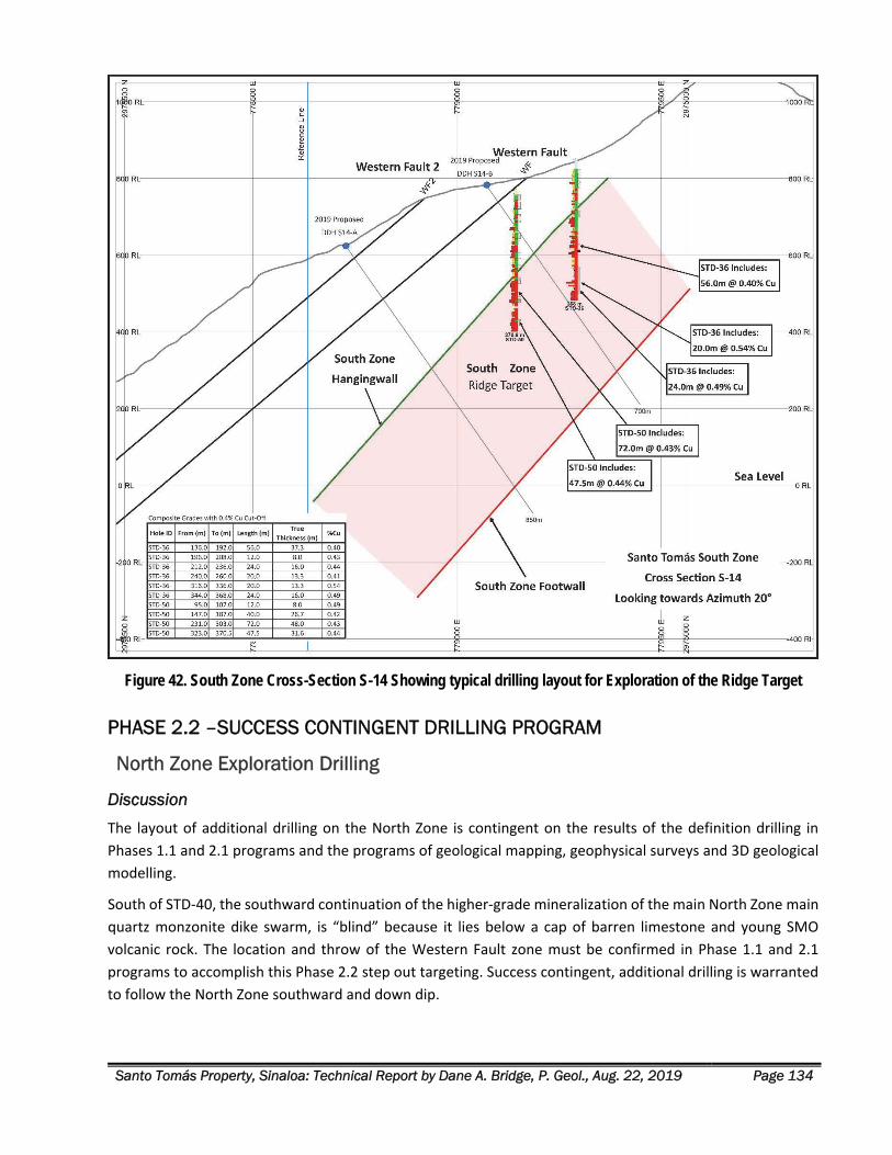
Santo Tomás Property, Sinaloa: Technical Report by Dane A. Bridge, P. Geol., Aug. 22, 2019 Page 134
Figure 42. South Zone Cross-Section S-14 Showing typical drilling layout for Exploration of the Ridge Target
PHASE 2.2 –SUCCESS CONTINGENT DRILLING PROGRAM
North Zone Exploration Drilling
Discussion
The layout of additional drilling on the North Zone is contingent on the results of the definition drilling in
Phases 1.1 and 2.1 programs and the programs of geological mapping, geophysical surveys and 3D geological
modelling.
South of STD‐40, the southward continuation of the higher‐grade mineralization of the main North Zone main
quartz monzonite dike swarm, is “blind” because it lies below a cap of barren limestone and young SMO
volcanic rock. The location and throw of the Western Fault zone must be confirmed in Phase 1.1 and 2.1
programs to accomplish this Phase 2.2 step out targeting. Success contingent, additional drilling is warranted
to follow the North Zone southward and down dip.
Santo Tomás Property, Sinaloa: Technical Report by Dane A. Bridge, P. Geol., Aug. 22, 2019 Page 135
That blind mineralization is recommended to be tested as part of the North Zone Phase 2.2 exploration on
Sections N‐14, N‐10 and N‐6, as southern, along‐strike step‐outs to the North Zone program. If successful, this
drilling would extend the higher‐grade core of the North Zone 550 m south from hole STD‐40, for an aggregate
of 2.2 km south of Rio Fuerte.
North Zone Phase 2.2 Drilling: Southward Along Strike: Success Contingent– 13,400 m
A total of 23 drill holes, drilled toward Az. 110°, at ‐55° inclination with 13,400 m of drilling is laid out.
Success contingent on drilling in Phase 2.1, drilling of Sections N‐4, N‐10 and N‐6 will extend exploration an
additional 600 m south. Deeper holes on these sections below 200 m elevation will have an increasing
separation between the hanging wall of the main mineralization and the Western Fault, and therefore greater
targeted mineralized tonnage.
Priority in drilling these holes will be on the westernmost drill sites because they test regions projected by
Cambria and the Author to contain greater thickness of the mineralized zone.
North Zone Phase 2.2 Drilling: Down Dip – Success Contingent– 2,200 m
A total of 3 drill holes, drilled toward Az. 110°, at ‐55° inclination with 2,200 m of drilling is recommended.
Success contingent on drilling in Phase 2.1, drilling deeper under the North Zone is recommended to explore
for additional mineral resources down‐dip to about ‐200 m elevation. 3 holes on sections N‐ 26 to N ‐18 would
require 2,200 m of drilling.
South Zone Drilling: Ridge Target
Discussion
The northern extension of Ridge target is “blind” to the surface as it lies below limestone beds and rhyolite
volcanic rocks on the Santo Tomás ridge. Success contingent on the Phase 2.1 drilling, additional drilling would
be required to define mineral resources proximal to STD‐36 and STD‐50 to define a potential “core” of a
promising South Zone deposit.
By drilling sets of parallel drill holes aimed at discrete elevations on the Ridge target, the higher, sub‐parallel
zones will also be tested in regular 200 m spacings.
Ridge Target Exploration- Phase 2.2 Drilling: Success Contingent– 10,450 m
A total of 13 drill holes drilled toward Az. 110°, at ‐55° inclination are recommended success contingent on
the prior drilling on S‐14 and the Phase 1 geophysical program, as follows:
1. The centerline of targets on the Ridge zone is recommended to be drilled at 600, 450, 300, 150 and 0
m elevations on three sections, S‐10, S‐14 and S‐18 (200 m spacing).
2. The work on Section S‐10 will also continue testing the area of STD‐39 that intersected 104.0 m of
0.38% Cu at 100 m below surface (including 72.0 m of 0.45% Cu), and work on Section S‐18 will further
understanding around STD‐37 which intersected 124.0 m of 0.43% Cu (including 100.0 m of 0.48% Cu),
starting at 20 m below surface.
Santo Tomás Property, Sinaloa: Technical Report by Dane A. Bridge, P. Geol., Aug. 22, 2019 Page 136
South Zone Drilling: Hanging Wall Targets
Discussion
Drilling on the lower slopes of the South Zone (STD‐39, STE‐52 and STE‐53) intersect near‐surface
mineralization that lies on the hanging wall of the Western Fault. Those intersections are interpreted as the
downward and southward displaced footwall mineralization. This mineralization is interpreted as a narrow
wedge that will thicken down‐dip and to the southwest. Limestone beds serve as markers to define a late,
post‐mineral 200 m vertical downthrow and inferred from 2019 structural data, a possible 200 m southern
movement across the Western Fault.
Specifically targeting these good grade holes, STD‐39, STE‐52 and STE‐53, is not required if a systematic test
of the Ridge target is successful. All these drill holes lie above the dip of the Ridge target and can be tested
with the same drill holes for the Ridge target.
Success contingent the Phase 1 and 2 recommended programs would provide an Indicated level of confidence
to the mineral resource estimate for a portion of the South Zone, lying above 100 m elevation, in a west‐
dipping band, 400 m wide by 1000 m down the dip slope (700 m vertical). Proving the continuity of this
mineralization could lead to the following additional programs:
1. Drilling on the same elevation swath (600 m to 0 m Levels) northward on Sections 22 and 26, to the
North, under the limestone capping the Santo Tomás ridge.
2. Drilling a somewhat lower elevation swath (500 m to 0 m Levels) southward on Sections S‐6 and S‐2.
Geological mapping and geophysical survey results are needed to confirm the targeting on and beyond these
additional Sections.
Success contingent on the geophysical surveys and definition drilling at the higher levels, additional drilling on
the South Zone would be required to evaluate the mineralization on both the Hanging Wall and Ridge targets
below 0 m elevation.
Brasiles Zone Drilling – Initial Program
Discussion
The proposed Brasiles Zone drilling is not success‐contingent on any surface exploration program results, as it
is within one kilometre of favourable North Zone drill intersections. Mapping in 2019 confirms that the main
mineralization and intrusive trends of the North Zone extend across the Rio Fuerte to Brasiles, on the northern
side of an oblique‐slip fault trending N60°E.
Concurrent with mapping and surface geophysical surveys, a program of exploration drilling is recommended
at Oroco’s discretion concerning timing.
Drilling is laid out to respect the known geological mapping information that shows the quartz monzonite dikes
of the North Zone are present in the Brasiles Zone but offset approximately 200 m to the east and downward
across a fault trending N60°E.
Brasiles Zone Phase 2.2 Drilling: Success Contingent – 3,200 m
A program of 4 drill holes, drilled toward Az. 110°, at ‐55° inclination is recommended, totalling 3,200 m of
drilling. The area is presently undrilled, and the initially recommended drilling is targeted at the northward
Santo Tomás Property, Sinaloa: Technical Report by Dane A. Bridge, P. Geol., Aug. 22, 2019 Page 137
extension of the North Zone mineralization that is located on the south bank of Rio Fuerte (see STE‐01, STD‐
42, STD‐27 and STE‐05). The drill hole layout must be confirmed with surface geological mapping and the Phase
1.0 geophysical program, before finalization.
A program of four 800 m drill holes, drilled toward Az. 110°, at ‐55° inclination is recommended. It is presently
anticipated that work starting on Section N‐54 to Section N‐62, spaced 200 m apart, for a total step‐out of
800m from the last drilled North Zone section, will be appropriate.
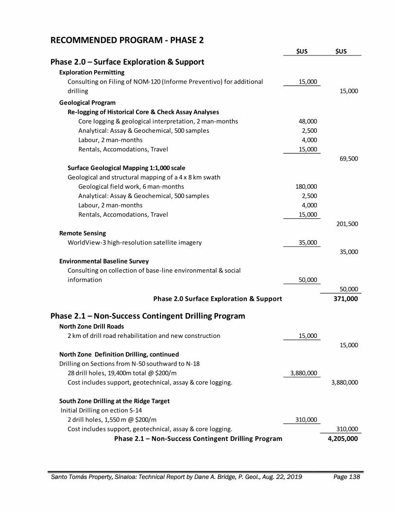
Santo Tomás Property, Sinaloa: Technical Report by Dane A. Bridge, P. Geol., Aug. 22, 2019 Page 138
RECOMMENDED PROGRAM ‐ PHASE 2$US $US
Phase 2.0 – Surface Exploration & SupportExploration Permitting
15,000
15,000
Geological Program
Re‐logging of Historical Core & Check Assay Analyses
Core logging & geological interpretation, 2 man‐months 48,000
Analytical: Assay & Geochemical, 500 samples 2,500
Labour, 2 man‐months 4,000
Rentals, Accomodations, Travel 15,000
69,500
Surface Geological Mapping 1:1,000 scale
Geological and structural mapping of a 4 x 8 km swath
Geological field work, 6 man‐months 180,000
Analytical: Assay & Geochemical, 500 samples 2,500
Labour, 2 man‐months 4,000
Rentals, Accomodations, Travel 15,000
201,500
Remote Sensing
WorldView‐3 high‐resolution satellite imagery 35,000
35,000
Environmental Baseline Survey
50,000
50,000
Phase 2.0 Surface Exploration & Support 371,000
Phase 2.1 – Non‐Success Contingent Drilling ProgramNorth Zone Drill Roads
2 km of drill road rehabilitation and new construction 15,000
15,000
North Zone Definition Drilling, continued
Drilling on Sections from N‐50 southward to N‐18
28 drill holes, 19,400m total @ $200/m 3,880,000
Cost includes support, geotechnical, assay & core logging. 3,880,000
South Zone Drilling at the Ridge Target
Initial Drilling on ection S‐14
2 drill holes, 1,550 m @ $200/m 310,000
Cost includes support, geotechnical, assay & core logging. 310,000
Phase 2.1 – Non‐Success Contingent Drilling Program 4,205,000
Consulting on Filing of NOM‐120 (Informe Preventivo) for additional
drilling
Consulting on collection of base‐line environmental & social
information
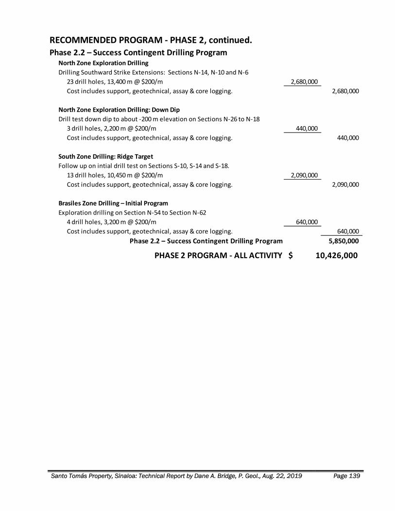
Santo Tomás Property, Sinaloa: Technical Report by Dane A. Bridge, P. Geol., Aug. 22, 2019 Page 139
RECOMMENDED PROGRAM ‐ PHASE 2, continued.Phase 2.2 – Success Contingent Drilling Program
North Zone Exploration Drilling
Drilling Southward Strike Extensions: Sections N‐14, N‐10 and N‐6
23 drill holes, 13,400 m @ $200/m 2,680,000
Cost includes support, geotechnical, assay & core logging. 2,680,000
North Zone Exploration Drilling: Down Dip
Drill test down dip to about ‐200 m elevation on Sections N‐26 to N‐18
3 drill holes, 2,200 m @ $200/m 440,000
Cost includes support, geotechnical, assay & core logging. 440,000
South Zone Drilling: Ridge Target
Follow up on intial drill test on Sections S‐10, S‐14 and S‐18.
13 drill holes, 10,450 m @ $200/m 2,090,000
Cost includes support, geotechnical, assay & core logging. 2,090,000
Brasiles Zone Drilling – Initial Program
Exploration drilling on Section N‐54 to Section N‐62
4 drill holes, 3,200 m @ $200/m 640,000
Cost includes support, geotechnical, assay & core logging. 640,000
Phase 2.2 – Success Contingent Drilling Program 5,850,000
PHASE 2 PROGRAM ‐ ALL ACTIVITY 10,426,000$
Santo Tomás Property, Sinaloa: Technical Report by Dane A. Bridge, P. Geol., Aug. 22, 2019 Page 140
REFERENCES
Bateman Engineering Inc., 1994. Prefeasibility Study, Exall Resources, Santo Tomás Project, Sinaloa, Mexico,
Bateman Engineering Inc., Tucson, Arizona.
Bateman Engineering Inc., 2003. Update Previous Prefeasibility Study, Santo Tomás Project, Bateman
Engineering Inc., Tucson, Arizona.
Barton, M.D., Staude, J.‐M.G., Zürcher, L., and Megaw, P.K.M., 1995. Porphyry copper and other intrusion‐
related mineralization in Mexico, in Pierce, F.W., and Bolm, J.G., eds., Porphyry copper deposits of the
American Cordillera: Tucson, Arizona Geological Society Digest, v. 20, p. 487‐524.
Berger, B.R., Ayuso, R.A., Wynn, J.C., and Seal, R.R., 2008. Preliminary model of porphyry copper deposits: U.S.
Geological Survey Open‐File Report 2008–1321, 55 p.
Borovic, I.R., 2002. Report on the Mineral Exploration and Development of the Santo Tomás Property Lat. 26°
56' 47" N; Long. 108° 19' 20" W, Municipality of Choix, State of Sinaloa, Mexico; Summary and evaluation
for Aztec Copper Inc., Vancouver, British Columbia.
Borovic, I.R., 2006. Exploration of the Santo Tomás Copper Porphyry Deposit, Choix, Sinaloa, Mexico, Igna
Engineering & Consulting Ltd., Vancouver, British Columbia.
Borovic, I.R., 2007 (Revised 2008). Exploration of the Santo Tomás Copper Porphyry Deposit, Choix, Sinaloa,
Mexico, Igna Engineering & Consulting Ltd., Vancouver, British Columbia.
Bridge, D.A, 2019. Memorandum on Geological Data from Outcrop Mapping and Drill Core Examination, Santo
Tomas Project, 2017 and 2019, memo for Oroco Resource Corp.
Canadian Institute of Mining Metallurgy and Petroleum, 2014. CIM Definition Standards‐ For Mineral
Resources and Mineral Reserves. Canadian Institute of Mining, Metallurgy and Petroleum, Canada,9 p.
Clark, K.F., and de la Fuente L., F.E., 1978. Distribution of mineralization in time and space in Chihuahua,
Mexico: Mineralium Deposita, v. 13, p. 27‐49.
Clark, K.F., Davidge, E.C., Roldan, J.Q. and Cardenas, J.V., 1973. Geology and Mineral Resources of the Los
Mochis‐Choix Area of Northern Sinaloa, Mexico, Consejo de Recursos Naturales No Renovables; Instituto
de Geologia; University of Iowa.
Cuevas, A.C., Boris, E. and Hernandez, I.P., 1996. Carta Magnetica, Tasajeras G12 ‐ B59, Estado de Sinaloa
(Escala 1: 50,000). Servicio Geologico Mexicano, Pachuca, Hidalgo, Mexico, pp. Total field magnetics
published by the Servicio Geologico Mexicano on a base map from INEGI at a scale of 1:50 000 in the state
of Sinaloa. Daily News, 2008. China's Jinchuan Group to acquire Canada's Tyler Resources, The Northern
Miner. www.northernminer.com. The Northern Miner.
Damon, P.E., Shafiqullah, M., and Clark, K.F., 1983. Geochronology of the porphyry copper deposits and
related mineralization of Mexico: Canadian Journal of Earth Sciences, v. 20, p. 1052‐1071.
Davidge, E.C., 1973. Preliminary Report on Mineralization in the Choix District Sinaloa, Mexico, University of
Iowa, Iowa City, Iowa, USA.
Santo Tomás Property, Sinaloa: Technical Report by Dane A. Bridge, P. Geol., Aug. 22, 2019 Page 141
Diario Oficial de la Federacion, 2010. Acuerdo por el que aprueba la Norma Técnica para el Sistema Geodésico
Nacional., Al margen un sello con el Escudo Nacional, que dice: Estados Unidos Mexicanos. ‐ Instituto
Nacional de Estadística y Geografía.‐ Junta de Gobierno. In: S.D. Gobernacion (Editor). Diario Oficial de la
Federacion, Distrito Federal, Mexico.
El Congreso de Los Estados Unidos Mexicanos, 1992, updated 2014. Ley Minera. In: El Congreso de Los Estados
Unidos Mexicanos (Editor). Diario Oficial de la Federacion, Cuauhtemoc, D.F., Mexico, p. 22‐44.
Els, F., 2014. Goldcorp says El Sauzal may not be restarted, Mining.com. Mining.com. Mining.com, Vancouver,
BC.
Engels, J., 2014. Tailings handling and storage techniques. Tailpro Resource, Web site offering tailings
information.
Ferrari, L., Valencia‐Moreno, M., and Bryan, S., 2007. Magmatism and tectonics of the Sierra Madre Occidental
and its relation with the evolution of the western margin of North America, in Alaniz‐Alvarez, S.A. and
Nieto‐ Samaniego, A.F., eds., Geology of Mexico, celebrating the centenary of the Geological Society of
Mexico: Geological Society of America Special Paper 422, p. 1‐40.
Goldcorp Inc., 2007. Delivering Growth, Goldcorp 2007 Annual Report, Goldcorp Inc., Vancouver, BC.
Goldcorp Inc., 2014. El Sauzal ‐ Overview & Operating Highlights. Goldcorp Inc., pp. El Sauzal Overview &
Operating Highlights.
Greenslade, J., 1995. Letter of intent between Britannia Gold and Exall Resources, 1995‐11‐02 06:55 ET ‐ News
Release, See News Release (C‐BGP) Britannia Gold Corp. Exall Resources Ltd. 1 p.
Gustafson, L.B., Orquera, W., McWilliams, M., Castro, M., Olivares, O., Rojas, G., Maluenda, J., and Méndez,
M., 2001. Multiple centers of mineralization in El Indio Muerto District, El Salvador, Chile: Economic
Geology and the Bulletin of the Society of Economic Geologists, v. 96, p. 325–350.
Guzman, J.G., Nevarez Del C., L. and Bustamente Yanez, M.A., 1989. Resultados de la Exploration Regional con
Helicoptero en el Estado de Sinaloa y sus Limites con el Estado ‐ de Chihuahua. In: R.S. Consejo de
Recursos Minerales (Editor). Consejo de Recursos Minerales, Culiacan, Sinaloa, Mexico, 120 p.
Holmes, P., 1996. Britannia drops Santo Tomás option, 1996‐04‐02 13:08 ET ‐ News Release. Exall Resources
Ltd., 1 p.
Hammarstrom, J.M., Robinson, G.R., Jr., Ludington, Steve, Gray, Floyd, Drenth, B.J., Cendejas‐ Cruz, Francisco,
Espinosa, Enrique, Pérez‐Segura, Efrén, Valencia‐Moreno, Martín, Rodríguez‐Castañeda, José Luis ,
Vásquez‐Mendoza, Rigoberto, and Zürcher, Lukas, 2010. Global mineral resource assessment—porphyry
copper assessment of Mexico: U.S. Geological Survey Scientific Investigations Report 2010‐5090‐A, 176
p.
Jutras, J.P., 2007. Tyler receives scoping study confirming potential for large scale open pit development and
low‐cost copper production at Bahuerachi Project, Mexico. Bahuerachi Project, Mexico. Tyler Resources
Inc., Calgary, Alberta, 2 p.
Jutras, J.P. and McCandlish, K., 2003. Summary Technical Report and Valuation of the Tyler Resources
Inc./CDG Investments Inc., Bahuerachi Property, Chihuahua State, Mexico.
Santo Tomás Property, Sinaloa: Technical Report by Dane A. Bridge, P. Geol., Aug. 22, 2019 Page 142
Keay, A., 2013. Revolution to Acquire a 100% Interest from Lake Shore Gold in Mexican Properties. McLeod
Williams Capital Corp., Vancouver, British Columbia.
Keith, S. and Swan, M., 1995. The great Laramide porphyry copper cluster of Arizona, Sonora, and New
Mexico: The tectonic setting, petrology, and genesis of a world‐class porphyry metal cluster, Geology and
Ore Deposits of the American Cordillera: Geological Society of Nevada, Symposium Proceedings,
Reno/Sparks, Nevada, p. 1667‐1747.
Keresztes, T., Thompson, J., Solano‐Rico, B. and Castrodale, P.J., 2013. Review of Santo Tomás Copper Project,
Choix, Sinaloa, Mexico (Project No. 13‐064), Behre Dolbear Capital Inc., New York, NY.
Lowell, J.D., and Guilbert, J.M., 1970. Lateral and vertical alteration zoning in porphyry ore deposits: Economic
Geology and the Bulletin of the Society of Economic Geologists, v. 65, p. 373–408.
Martin, T.E., Davies, M.P., Rice, S., Higgs, T. and Lighthall, P.C., 2002. Stewardship of Tailings Facilities, AMEC
Earth and Environmental Limited, AMEC Simons Ltd., Vancouver, British Columbia.
McGuigan, P., 2008. Property Examination, El Creston Magnetite Skarn Deposit, Choix, Sinaloa, Mexico,
Vancouver, British Columbia.
McCandlish, K., 2007. Updated Resource Estimate for the Bahuerachi Deposit, Chihuahua State, Mexico,
Technical Report on a Mineral Property Pursuant to National Instrument 43‐101 of the Canadian
Securities Administrators, prepared by associated Geosciences for Tyler Resources Inc., 277 p.
McGuigan, P.J. and Sebert, C., 2006. Preliminary Review; Santo Tomás Area Properties, Sinaloa State, Mexico,
Cambria Geosciences Inc., Vancouver, British Columbia, Canada.
Mendoza, R.C., Jimenez, A. and Ritch, M., Heather y Nicolau, S.C, 2014. Mexico. Law Business Research Ltd 87
Lancaster Road, London W11 1QQ, UK pp. Website providing business law for Latin America.
Mongeau, R.J. and De Felice, J., 1998. Morgain Minerals 1997 Annual Report and update of Corporate
Activities and Financial Statements for the year ending December 31, 1997, Morgain Minerals Inc.,
Toronto, Ontario.
Montiel, R.M., Garcia, C.J.V. and Lara, F.A., 1985. Informe Final de Verificacion de Estructuras Magnetics y
Seleccion de Aereas Favorables en el Area de Choix, Sinaloa, Consejo de Recursos Minerals, Subdireccion
de Exploracion, Gerencia de Exploration Geofisica.
Palma, M.L.P. and Lavalle, F.d.l.F., 1992. Reconocimiento Geologico ‐ Minero del Yacimiento Lluvia de Oro,
Municipio de Urique, Estado de Chihuahua. 0892PAPM0001, Consejo de Recursos Minerales, Chihuahua,
Chihuahua.
Pineda, M. and Hernandez, A., 2014. 2014 Mexico's Tax and Social Security Reform (Gain Report). MX4301,
USDA Foreign Agricultural Service.
Roman, S., 1993. Drilling increases tonnage at Santo Tomás, 1993‐09‐17 12:30 ET ‐ News Release. Exall
Resources Ltd., 1 p.
Roman, S., 1994a. Mexican government supports Santo Tomás development, 1994‐08‐24 14:17 ET ‐ News
Release. Exall Resources Ltd. 2 p.
Santo Tomás Property, Sinaloa: Technical Report by Dane A. Bridge, P. Geol., Aug. 22, 2019 Page 143
Roman, S., 1994b. Positive prefeasibility for Santo Tomás, 1994‐07‐27 16:03 ET ‐ News Release. Exall
Resources Ltd., 4 p.
Roman, S., 1997. $7m asset writedown, 1997‐05‐21 10:45 ET ‐ News Release. Exall Resources Ltd., 1 p.
Sebert, C., 2006. The Mazomique Iron Skarn, Northeast Sinaloa, Mexico; Geological Reconnaissance Report,
Vancouver, British Columbia.
Secretaria de Comunicaciones y Transportes, 2014. Topolobampo, Coordinacion General de Puertos y Marina
Mercante. Secretaria de Comunicaciones y Transportes,34 p.
Seki, Y, 1973. Alteration Notes in: www. gabargold.com/alteration.html
Servicio Geologico Mexicano, 2002. Carta Magnetica de Campo Total, Escala 1: 250 000, Huatabampo G12‐6,
Estado de Sinaloa. Servicio Geologico Mexicano, Pachuca, Hidalgo, Mexico, pp. Total field magnetics on a
base map from INEGI published by the Servicio Geologico Mexicano at a scale of 1:250 000 of the state
of Sinaloa.
Servicio Geológico Mexicano, 2014. GeoInfoMex. Servicio Geológico Mexicano, http://www.sgm.gob.mx.
Sillitoe, R.H., 2010. Porphyry Copper Systems. Economic Geology, v.105, p 3‐41.
Sillitoe, R.H., 1973. The tops and bottoms of porphyry copper deposits: Economic Geology and the Bulletin of
the Society of Economic Geologists, v. 68, p. 799–815.
Sillitoe, R.H., 1976. A reconnaissance of the Mexican porphyry copper belt: Transactions of the Institution of
Mining and Metallurgy, Section B, p. B170‐B189.
Sinclair, W.D., 2007. Porphyry deposits. Mineral deposits of Canada: A synthesis of major deposit‐types,
district metallogeny, the evolution of geological provinces, and exploration methods: Geological
Association of Canada, Mineral Deposits Division, Special Publication, 5: p. 223‐243.
Spring, V., 1992. A Review of the Potential of the Santo Tomás Porphyry Copper Deposit, Sinaloa, Mexico for
Exall Resources Limited, Toronto, Ontario, Canada.
Staude, J.‐M.G. and Barton, M.D., 2001. Jurassic to Holocene tectonics, magmatism, and metallogeny of
northwestern Mexico. Geological Society of America Bulletin, 113(10), p. 1357‐1374.
Tapsoba, B., 2019. Santo Tomás Structural Report, Structural mapping in Brasiles and the North Zone, of the
Santo Tomás Cu‐ (Mo‐Au‐Ag) Porphyry Deposit, Sinaloa, Mexico, for Oroco Resource Corp., 31 p.
Thornton, J.C., 1994. Preliminary Geological Ore Reserves and Mining Reserve Determination Based on
ASARCO and Exall Diamond Drill hole Programs, Mintec Inc., Tucson, Arizona.
Thornton, J.C., 2011. Santo Tomás Copper Project, Choix, Sinaloa, Mexico: Technical Report 43‐101 Compliant,
Tucson, Arizona.
Thornton, J.C., 2012a. Overview of Documents for the Santo Tomás Copper Project in Sinaloa, Mexico, and
Several answers to 'Frequently Asked Questions' concerning the Project. Thor Resources LLC, Tucson,
Arizona, 4 p.
Thornton, J.C., 2012b. Santo Tomás Copper Price Sensitivity, Request to exclude Resources past the South rim
of the North Zone varying the copper price from $1.50/lb. to $3.75/lb. for M & I Resources, and then for
the model created after drilling for M & I (the development model) Thor Resources LLC, 13 p.
Santo Tomás Property, Sinaloa: Technical Report by Dane A. Bridge, P. Geol., Aug. 22, 2019 Page 144
Thornton, J.C., 2012c. Santo Tomás Copper Project Overview: Discovery and Exploration to Date 2012, Thor
Resources LLC, Tucson, Arizona.
Thornton, J.C., 2012d. Santo Tomás Copper Project Part 1, Resources and Reserves with Phase Designs,
Production Schedules at14, 28 and 42 MTPY with Scoping Study CAPEX and OPEX. Thor Resources LLC, 15
p.
Thornton, J.C., 2012e. Santo Tomás Copper Project Part 2, Scoping Study for 14, 21, 28 and 42 MTPY CAPEX
and OPEX Estimates, Production Schedule and Economics, 14 to 28 MTPY Engineering and Construction
Investment. Thor Resources LLC, 42 p.
Thornton, J.C., 2012f. Summary Expenditures for Development and Exploratory Drilling on Santo Tomás, Final
Feasibility Study, Engineering, and Metallurgical Test work. In: W. Boguski (Editor). Thor Resources LLC,
Tucson, Arizona, 3 p.
Thornton, J.C. and Plaza, D., 2012. Santo Tomás Geology, initial revised North and South Zone models, based
on regional geology and mapped fault structure zones ‐ Updated geology with regional and sectional
interpretation merged. Thor Resources LLC, Tucson, Arizona, 22 p.
Valencia‐Moreno, M., Ochoa‐Landín, L., Noguez‐Alcántara, B., Ruiz, J., Pérez‐Segura, E., 2007. Geological and
metallogenetic characteristics of the porphyry copper deposits of México and their situation in the world
context, in Alaniz‐Álvarez, S.A., and Nieto‐Samaniego, Á.F., eds., Geology of México, celebrating the
centenary of the Geological Society of México: Geological Society of America Special Paper 422,p. 433‐
458.
Verzosa, R.S., 2010. Summary Report on the Reforma Property, Sinaloa State, Mexico, Langley, British
Columbia.
Verzosa, R.S., 2011. Summary Report on the El Creston Property, Sinaloa State, Mexico, Sierra Iron Ore
Corporation, Langley, British Columbia.
Verzosa, R.S., 2014. Updated Summary Report on the Reforma Property (Detailing the Results of Recent
Exploration and Diamond Drilling), Sinaloa State, Mexico, Victory Resources Corporation, Langley, British
Columbia.
Vollmer, F.W., 1995. C program for automatic contouring of spherical orientation data using a modified Kamb
method: Computers & Geosciences, v. 21, p. 31‐49.
Walker, J.D. and Cohen, H.A., 2009. The Geoscience Handbook: AGI data sheets, 4th Edition, Revised.
American Geological Institute, Alexandria, VA, 302 p.
Zientek, M.L., Hammarstrom, J.M., Robinson, G.R., Ludington, S.J., Grey, F., Drenth, B.J., Cendejas‐Cruz, F.,
Espinosa, E., Perez‐Segura, E., Valencia‐Moreno, M., Rodrigues ‐Castaneda, J.L., Vasquez‐Mendoza, R. and
Zurcher, L., 2010. Global Mineral Resource Assessment‐ Porphyry Copper Assessment of Mexico: U.S.
Geological Survey Scientific Investigations Report 2010‐5090‐A, U.S. Geological Survey, Reston, Virginia.
Santo Tomás Property, Sinaloa: Technical Report by Dane A. Bridge, P. Geol., Aug. 22, 2019 Page ii


