Embed Size (px)
Citation preview

BLM LIBRARY
88000340
AUPEAU OF I AMD MANAGEMENT
iURIAUl ©F> MANA© HIM I
COLORADO
R.D.Reed J.fl.Hallosi
U.S. White D.R.Breternitz
CULTURALRESOURCES
SERIES
N°. 7

QSff»*

THE ARCHEOLOGY AND STABILIZATIONOF THE DOMINGUEZ AND ESCALANTE RUINS
PART I
The Dominguez Ruin:A McElmo Phase Pueblo in Southwestern Colorado
byAlan D. Reed
PART II
Archeological Excavation at the Escalante Site,Dolores, Colorado, 1975 and 1976
by
Judith Ann Hallasi
PART III
Stabilization of Escalante Ruin 5MT2149and
Dominguez Ruin 5MT2148Dolores, Colorado
byAdrian S. White
andDavid A. Breternitz
Colorado State OfficeBureau of Land Management
1979
BUREAU OF LAND MANAGEMENT LIBRARYDenver, Colorado
88666340

COPIES OF THIS REPORT ARE AVAILABLE FROM:
BUREAU OF LAND MANAGEMENTCOLORADO STATE OFFICEROOM 700, COLORADO STATE BANK BUILDING1600 BROADWAYDENVER, COLORADO 80202

FOREWORD
The purpose of this volume of Colorado's cultural resourceseries is to present to the archeological profession and otherinterested persons the exciting results of some recent research in
Southwestern Colorado. One of the sites reported on in this volumemay be the site Father Escalante referred to in his journal of 1776.
If this is the case the Escalante site is the first recordedarcheological site in what is now the State of Colorado.
If it had not been for the celebration of America's Bicentennialthe Dominguez and Escalante sites probably would not have been
excavated, studied, and stabilized. These sites were originally to
be excavated primarily for interpretive purposes, but as work began it
became obvious that these two sites were not typical of otherarcheological values in the area. The results of those excavations,which are reported here, have expanded our knowledge of Chacoan trade
systems and suggested new theories about the status of people in theprehistoric Anasazi culture of Southwestern Colorado.
I am very pleased to make this seventh publication in cultural
resources available to the public and the professional community.
<=^III!^a^^DALE R. ANDRUSState DirectorColoradoBureau of Land Management

THIS DOCUMENT IS PUBLIC DOMAINAND MAY BE QUOTED. PLEASE CREDITTHE AUTHOR OR BLM IF YOU QUOTEFROM THIS WORK.
DESIGNED BY: LEIGH WELLBORN

THE DOMINGUEZ RUIN:
A McELMO PHASE PUEBLO IN SOUTHWESTERN COLORADO
by
Alan D. Reed
with Appenciices by
Linda J. Scott
and
Meredith H. Matthews
PART I
Cultural Resource Series No. 7
Colorado State Office
Bureau of Land Management
1979


ACKNOWLEDGEMENTS
Many individuals have aided in the preparation of this re-
port, to whom I am indebted. They helped to make this undertaking
both educational and, for the most part, pleasurable.
I am especially grateful to the members of my committee, Drs.
David A. Breternitz, Jack E. Smith, and Deward E. Walker, Jr., for
their many helpful criticisms concerning this report. To Dr.
Breternitz, who served as my advisor, and Dr. Smith, I extend my
heartfelt thanks for guidance, encouragement, and for productive
archaeological employment. Dr. Douglas Scott, who provided me
with my first field experience, also deserves special thanks.
Field crew members who participated in the 1976 excavations
were Jay Dickinson, Janet Eidsness, Woody Farr, Jerry Fetterman,
Meredith Matthews, and Paul Roebuck. Helpful advice on excavation
procedures and interpretations was offered by James A. Lancaster,
Dr. Breternitz, Joel Brisbin, and Kent Leidy. Laboratory analysis
was directed by Kellie Masterson. Bertrand de Peyer handled the
photography and darkroom work for the project.
Special assistance was offered by Malcolm Withers, who helped
analyze the shell material, and Lorraine Shupe, Supervisor of the
X-ray Department at the Student Health Center, who did X-ray work
on the burials. Robert Carpenter, Roger Cichorz, and Keith Grossaint
donated time from their work at Rockwell International to perform
mass spectrometer and infrared analysis of the adhesive specimens.
Dr. Robert Bye, an ethnobotanist at the University of Colorado,
kindly donated lac samples for the infrared and mass spectrometer
studies. Dr. Paul Nickens was helpful in teaching me some of the
basic techniques in human skeletal analysis. Also, Drs. Charles
Love and John Love aided in the identification of mineral specimens.
in

I am grateful to Meredith Matthews and Linda Scott for their
respective bulk soil and pollen reports, included as appendices to
this report. The typist of the final draft, Penny Kokora, saved
me countless hours of frustration.
To my family, friends, and office partners, I also extend
special thanks. These people provided the support, humor, and
perspectives that so greatly contribute to any endeavor.
IV

PART ONE - TABLE OF CONTENTS
PAGE
ACKNOWLEDGEMENTS iii
TABLE OF CONTENTS v
LIST OF TABLES vii
LIST OF FIGURES viii
CHAPTER
I. INTRODUCTION 1
The Setting 4
Discussion 9
II. ARCHITECTURE 11
Introduction 11
General Roomblock Construction 12
Kiva Architecture 27
Plaza Excavations 34
Discussion 34
III. MATERIAL CULTURE 43
Pottery 43
Ornaments 53
Chipped Stone Artifacts 66
Ground Stone Artifacts 72
Miscellaneous Stone Artifacts 83
Modified Bone 85
Textiles 91
IV. SUBSISTENCE 93
Floral Exploitation 93
Faunal Exploitation 94

CHAPTER PAGE
V. HUMAN BURIALS 97
Burial 1 97
Burial 2 99
Burial 3 103
Isolated Human Remains 103
Anthropometry 103
Anomalies 109
Pathologies 109
VI. INTERPRETATIONS 113
The Relationship between theDominguez Ruin and theEscalante Ruin 113
The Social Organization ofChacoan Outliers 120
The Archaeological Record 123
Conclusion 135
REFERENCES CITED 139
APPENDICES: 139
/\ #Pollen Analysis of Dominguez Ruin:
by Linda J. Scott 151
B. Soil Sample Analysis of 5MT2148;Dominguez Ruin, Dolores, Colorado:by Meredith H. Matthews 173
C. Analysis of Adhesives from 5MT2148:
by Alan D. Reed 195
PART TWO 197
PART THREE 427
VI
LIST OF TABLES
TABLE PAGE
1. Mesa Verde Area Cultural Sequence 3
2. Provenience of Potsherd Types 44
3. Projectile Points 67
4. Blade Fragment 67
5. Hammerstones 69
6. Core Scrapers 71
7. Utilized Flakes 71
8. Debitage 73
9. Provenience of Manos 75
10. Metates 77
11. Lapstones 79
12. Polishing Stones 79
13. Worked Cobbles 81
14. Worked Slabs 82
15. Crusher 84
16. Axes 84
17. Awls 89
18. Minimum Number of Individuals andUsable Pounds of Meat 95
19. Cranial Measurements 105
20. Post-Cranial Measurements 106
21. Non-metric Observations 108
Vll

LIST OF FIGURES
FIGURE PAGE
1. Location of the Dominguez Ruin in
southwestern Colorado 5
2. Architectural plan of the DominguezRuin 13
3. The primary roomblock during excavation,looking northwest 15
4. Plan of Room 1 18
5. Plan of Room 2 20
6. Plan of Room 3 22
7. Plan of Room 4 24
8. Kiva upon completion of excavations 29
9. Plan of kiva 30
10. View of northwest pilaster, slumpedforward 32
11. Ventilator tunnel and deflectorsystem 32
12. Large Pueblo 1 1 — 1 1 1 jar in situin kiva 46
13. Miniature Pueblo 1 1 — 1 1 1 corrugated jar;greatest diameter: 8.5 cm 46
14. Pueblo 1 1 — 1 1 1 corrugated jar; greatestdiameter: 21.2 cm 48
15. Pueblo 1 1 — 1 1 corrugated jar; greatestdiameter: 16.5 cm 48
16. Mancos Black-on-white bowl; diameter:
18.2 cm 50
Vlll

FIGURE PAGE
17. McElmo Black-on-white canteen;
greatest diameter: 18.9 cm 50
18. McElmo Black-on-white pitcher;greatest diameter: 5.7 cm 52
19. McElmo Black-on-white bowl;diameter: 30.2 cm 52
20. Oliva bead associated with Burial 1 55
21. Bi-lobed shell bead associated withBurial 1 55
22. Disk beads. From left to right:
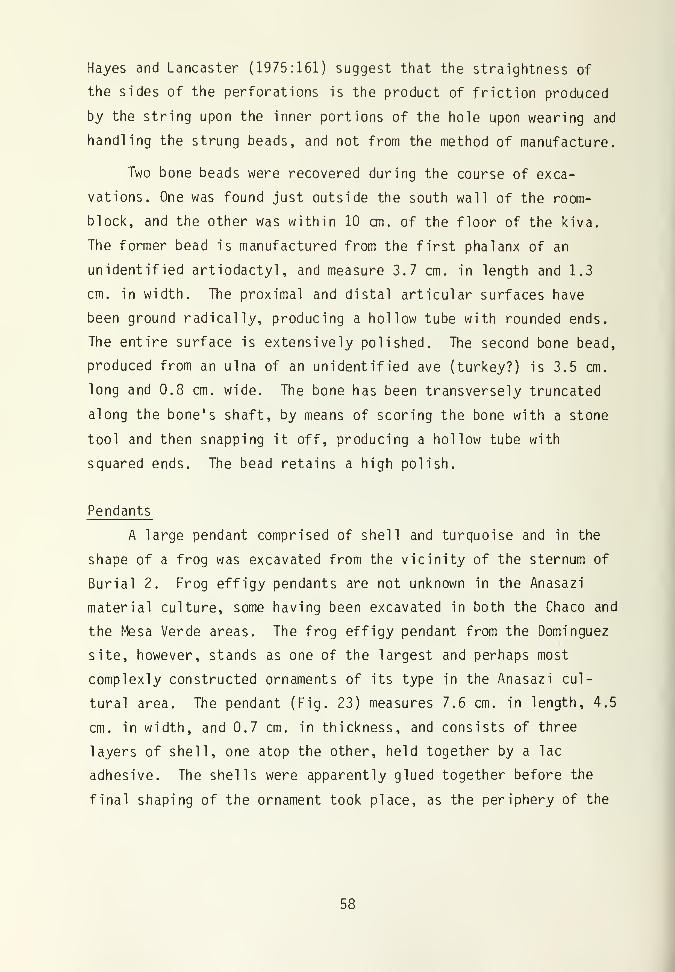
beads made of shale, turquoise,and jet 57
23. Dorsal view of frog-effigy pendantLength: 7.6 cm 59
24. Ventral view of frog-effigy pendant 59
25. One of two nearly identical shell,
specular hematite, and turquoisependants. Maximum diameter is
4.2 cm 63
26. Fragment of a large jet pendant 65
27. Shale pendant 65
28. Projectile points 67
29. Petroglyph on building stone. Widthis 13.3 cm. 86
30. Spiral petroglyph on face of buildingstone. Width of stone is
approximately 30 cm 86
31. Burial 1, infant 98
32. Burial 2, high status adult 100
33. Frog-effigy pendant of Burial 2 102
34. Shell, specular hematite, andturquoise pendants on Burial 2 102
35. Burial 3, child ' 104
IX


CHAPTER I
INTRODUCTION
During the summer of 1976, the Dominguez Ruin (5MT2148) was
excavated under the direction of the Mesa Verde Research Center.
The excavation was requested by and funded by the Bureau of Land
Management, under Contract Number 52500-CT5-1044, with the inten-
tion of developing an archaeological park to allow for public
interpretation of the impressive Escalante Ruin and other smaller
nearby ruins. The Dominguez Ruin was selected for excavation and
stabilization because of its proximity to both U.S. Highway 147
and the Escalante Ruin, and also because it was hoped that its
excavation could demonstrate the relationship between the large
and architecturally preplanned Escalante Ruin and the small and
relatively simple yet contemporaneous surrounding sites. This
relationship is of special interest in that the Escalante Ruin is
considered a "Chacoan outlier" (Nemetz 1977), that is, a site-unit
intrusion emanating from the Chaco Canyon area of New Mexico, and
the Dominguez site is, in most ways, a typical Mesa Verde area
site. The relationship between the indigenous and the intrusive
sites has not been satisfactorily studied, even though "Chacoan
outliers" have been identified for some time (e.g., Martin 1936;
Morris 1919). At present, there have been at least 21 "Chacoan
outliers" identified in the Four Corners area (David Breternitz,
personal communication), six of which are located in southwestern
Colorado. It is the intention of this report to examine the
nature of the relationship between the "indigenous" Mesa Verde
sites and the "Chacoan outliers", and to determine how this rela-
tionship might affect our concepts of Anasazi socio-political
organization.

The Dominguez site consists of a block of 4 rooms and a small
kiva. A trash mound, which had been located to the south of the
kiva, had been bulldozed away during the construction of a power
line some years earlier. On the basis of its architecture, den-
drochronological dates, and material culture, the site has been
assigned to the McElmo Phase of the Pueblo III Period (Table 1) of
the Anasazi culture. Due to the small size of the site and the
plan for its complete stabilization, the Dominguez site was exca-
vated in its entirety. Dr. David A. Breternitz was the overall
supervisor of the excavation, and students of the University of
Colorado provided the labor.
Previous Work in the Area
An awareness of the archaeological resources in the immediate
area of the Dominguez Ruin began in 1776. In that year, a small
party of explorers led by two Franciscans, Fray Silvestre Velez de
Escalante and Fray Francisco Antanasio Dominguez, passed through
southwestern Colorado while searching for an overland route con-
necting Santa Fe with Spanish settlements along the Californian
coast. On August 12, 1776, the expedition set up camp near the
present town of Dolores, Colorado, near the Dolores River. The
party remained in camp the following day, in order to calculate
their exact location and to allow Father Dominguez to recover from
a recent bout with an illness. While Dominguez rested, Father
Escalante explored the immediate area. Escalante wrote that "on
an elevation on the south bank of the river in ancient times there
was a small settlement of the same form as those of the Indians of
New Mexico, as shown by the ruins which we purposely examined"
(Bolton 1972:28).
This site eventually became known as the Escalante Ruin.
5MT2148 was in 1976 named the "Dominguez Ruin" in honor of the

Table 1: Mesa Verde area cultural sequences(from Gillespie 1975).
DateA.D.
Pecosclassification
Phase sequence(Hayes 1964)
1300
Pueblo III
Mesa Verde
1100 McElmo
Pueblo IIMancos
900Ackmen
Pueblo I Piedra
Basketmaker III
700
La Plata
Basketmaker II
300

Franciscan explorer who stayed behind at camp.
J. Walter Fewkes, the renowned archaeologist of the Southwest
during the first part of this century, apparently did some work in
the area of the Escalante Ruin, as he realized the historical
significance of the first Indian ruin recorded by a white man in
Colorado. He published a description of the site in 1919 (Fewkes
1919).
In 1970, the University of Colorado Archaeological Center,
under contract with the Bureau of Land Management, recorded the
Escalante and Dominguez sites, as part of an archaeological survey
and inventory of BLM cultural resources.
During the summers of 1975 and 1976, the Mesa Verde Research
Center, under the direction of Dr. David A. Breternitz, conducted
excavations and stabilization at the Escalante Ruin. Approxi-
mately one-third of the site was excavated. At the time of this
writing, Judith Nemetz, a student of the University of Colorado,
is completing a report of the excavations.
The Setting
Geography and Geology
The Dominguez Ruin is situated at the southern base of a
large hill at an elevation of 7,100 feet above sea level. The
hill, upon which the Escalante Ruin is located, overlooks the
Dolores River to the northeast as it meanders from its headwaters
in the San Miguel Mountains of Colorado towards its confluence
with the Colorado River in eastern Utah (Fig. 1). The Dolores
River is one of the largest rivers in southwestern Colorado,
comparable in size only to the San Juan and the Animas Rivers.
In the vicinity of the Dominguez Ruin, the Dolores River has
DOMI N6UEZRUIN
CORTE Z
UTAH
|-
J *'•
MESA VERDENATIONAL PARK i
Figure 1. Location of the Dominguez Ruin in southwesternColorado. The Escalante Ruin, not shown here,
is 150 meters to the north of the Dominguez Ruin
5

deposited a broad flood plain of Quaternary alluvial material
which, in places, is over one-half kilometer wide and bounded by
rolling hills and numerous tributary drainages. Some benches and
hills along the river maintain Quaternary alluvial and eolian
deposits. Within 5 kilometers to the north, the Dolores River
Canyon and tributary canyons deepen substantially, and relief
between the flood plain and the top of the surrounding hills may
be several hundred feet. The hills surrounding the Dolores River
in the vicinity of the Dominguez Ruin are generally of lesser
relief. The river's downcutting and other erosional factors have
primarily exposed two formations. The hill upon which the Esca-
lante Ruin is located, outcroppings of the Dakota and Burro Canyon
Formation and the Mancos Formation occur. The Dakota and Burro
Canyon Formation is the predominant stratum in at least a 5 km.
radius around the site. This formation is Lower Cretaceous in
age, and, according to Haynes et aj_. (1972), consists of predom-
inantly yellowish-brown to gray quartzitic sandstone and some
conglomeritic sandstone in thick beds, with small layers of impure
coal, gray claystone, shale, and gray friable carbonaceous sand-
stone interbedded with the more massive strata. This formation
averages 100 feet thick, and is easily visible along the north-
eastern slope of the hill atop of which the Escalante site is
located. On the southern slope of this hill, just above the
Dominguez site, the Cretaceous -age Mancos Shale outcrops. This is
a marine clayey shale that is highly fossil iferous , gray in color,
and fragments into thin tabular spalls at outcrops. The Mancos
shale contains a few layers of calacareous sandstone and sandy
clayey limestone in its lower portions, and grades vertically into
and intertongues with the formations of the Mesaverde Group (Haynes
et a1_. 1972). The Mancos Formation reaches 2,000 to 3,000 feet in
thickness in some parts of Montezuma County. The hillside soils,

that in most places overlie the two formations mentioned above,
are of the Camborthids-Torriorthents-Haplargids association
(Colorado State University Experimental Station et aj_. 1972).
This soil type is characterized as a warm, dominantly shallow and
well drained soil located on steep hillsides, benches, and canyons.
Immediately south of the Dominguez Ruin, the hills surroun-
ding the Dolores River give way to much more gently rolling hills.
These hills are covered with a deep layer of reddish-brown loess,
which are Quaternary eolian deposits. This soil can probably be
considered a Haplargid soil (Colorado State University Experi-
mental State et al_. 1972), in that it is on a gentle slope and is
well drained. The soil is suitable for cultivation, and presently
is extensively farmed. The gently rolling hills are dissected by
intermittant drainages that develop and deepen to the southwest.
The drainages eventually enter McElmo Creek near the town of
Cortez, Colorado. These canyons expose the Upper Jurassic Brushy
Basin member of the Morrison Formation. This member is comprised
of a bentonitic mudstone, with a few lenses of a distinctive green
and red chert-pebble conglomeritic sandstone interspersed (Haynes
et a]_. 1972).
Flora
The Dominguez Ruin is located approximately at the border of
the Upper Sonoran and the Transition life zones (Armstrong 1972).
The vegetation in the immediate area of the Dominguez Ruin is
diverse, partially because of soil disturbances caused by recent
and prehistoric peoples. Atop the site itself and to the south in
the area of construction and cultivation disturbances, cheat grass
( Bromus tectorum ), Indian Rice-Grass ( Oryzopsis hymenoides ),
sunflower ( Helianthus annuus ), thistle ( Cirsium ) , bindweed ( Can -
volvuls arvensis ), goosefoot ( Chenopodium sp. ) , poison milkweed

( Asclepias suberticillata ), salisfy ( Tragopogon pratensis ) and
globe mallow ( Sphaeralcea coccinea ) grow abundantly. Many other
weeds associated with disturbed soils were also observed, but not
identified. Big sagebrush ( Artemisia trident at
a
), and Gambel's
oak ( Quercus gambelii ) dominate the flora in this area.
Along the slope of the hill to the north of the site is an
undisturbed Pinon and Juniper forest. Along with the pinon ( Pinus
edulis ) and juniper ( Juniperus osteosperma ) grow squaw apple
( Peraphyllum ramosissimum ) , serviceberry ( Amelanchier utahensis ),
fendlerbush ( Fendlera rupicola ) , bitterbush ( Purshia tridentata ),
rabbitbrush ( Ch rysothamnus nauseosus ), mountain mahogany ( Cerco -
carpus montanus ), and broad leaf yucca ( Yucca baccata ). This list
is by no means exhaustive.
Fauna
The diverse environmental niches in the area of the Dominguez
Ruin support a plethora of faunal types. Members of the field
crew observed mule deer ( Odocoileus hemionus ), cottontail ( Syl -
vilagus sp.), skunk ( Mephitis mephitis ), rock squirrel ( Cite! lus
variegatus ) , chipmunk ( Eutomias quadrivittatus ) and a variety of
birds and reptiles. Undoubtedly, coyote ( Cam's latrans ), several
species of mice ( Peromyscus sp. ) , badger ( Taxidea taxus ), porcu-
pine ( Erethizon dorsatum ), and black tailed jackrabbit ( Lepus
cal ifornicus ) , also inhabit the area. Elk ( Cervus canadensis ) may
be seasonal migrants to the area. Pronghorn antelope ( Antilocapra
americana ) probably roamed the Montezuma Valley in prehistoric
times, as did wolves ( Cam's lupus ) and bison ( Bison bison ) (Steven
Emslie, personal communication).
CI imate
The U.S. Weather Bureau collected climatic data in the town

of Dolores, Colorado, from 1908 until 1952. Dolores is located
approximately 2 miles east of the Dominguez Ruin, at an elevation
of 6,942 feet--approximately 150 feet lower in elevation than the
site. Between 1908 and 1952, the average annual precipitation
amounted to 47 cm, with definite peaks occurring in the months of
December and January, in March and April, and in August and Sep-
tember. The mean annual temperature for the town of Dolores is
approximately 46 degrees Farenheit. The temperature at the Domin-
guez site may average somewhat higher than the town of Dolores,
however, in that the site is not situated in a valley as is
Dolores. Cold air tends to drain off hills and mesas and into the
canyons, thereby allowing the elevated land to be somewhat warmer.
The town of Dolores between 1909 and 1927 averaged 128 days of
growing season per year, that is days between the last killing
frost of spring and the first killing frost of autumn. The vi-
cinity of the Dominguez Ruin may average a few more days of
growing season per year. That corn can presently be raised in the
Dominguez site area seems certain. Corn, without the benefit of
an irrigation system, requires a growing season of 120 days, 26 to
30 cm. of annual precipitation including 11 to 15 cm. of rain in
the summer, and sufficient winter and springtime moisture to allow
for germination (Winter 1976). The Dolores area meets all of
these requirements. Pollen and archaeo-botanical studies indicate
that the climate in the 12th and 13th centuries was essentially
the same as today (Erdman et a2- 1969:57; Scott, Appendix A, this
volume).
Discussion
Even from this brief discussion of the environment in the
immediate vicinity of the Dominguez Ruin, it should be apparent

that there is today, and probably was prehistorically, a diversity
of resources available for exploitation. The rolling hills south
of the Dominguez site are suitable for cultivation. The Dolores
River provides aquatic resources and an area attractive to wild-
life, and further, the hills surrounding the river and the many
tributary canyons provide a variety of niches for floral and
faunal communities.
10

CHAPTER II
ARCHITECTURE
Introduction
At the time of initial archaeological investigations at the
Dominguez Ruin, in the summer of 1976, archaeologists found a
rubble mound badly overgrown with Gambels oak, serviceberry, and
other brush. Very few surface artifacts were visible, and no
depression indicative of a subterrainean kiva was present. The
site's location at the base of a hill had facilitated rapid post-
occupational deposition of alluvial soils onto the site.
After the brush was cleared from the site, the rubble mound
and a few surface artifacts were mapped via an alidade/planetable
and a metric tape. This combination was employed throughout all
phases of the excavation. When the initial mapping was complete,
a grid system of one meter squares was superimposed over the site
in order to facilitate horizontal control, especially necessary
outside of the roomblock. A primary datum, set at the highest
point of the site, was the locus for vertical as well as hori-
zontal control.
Employing the grid system, a test trench was excavated south
of the rubble mound in search of the kiva. When a portion of the
kiva was discovered, other grid squares were excavated to de-
lineate the orientation and the extent of the kiva. When this was
done, the grid system was abandoned for the remainder of the kiva
excavation. The kiva was divided approximately into halves, and
excavated, one half at a time. This technique exposed a con-
tinuous profile of the natural stratigraphy across the entire kiva
when the first half was completely excavated. From the strati-
graphic profile, we were able to determine the sequence of events
11

after the kiva was abandoned, and to take pollen and bulk soil
samples. The pollen samples were taken in vertical increments of
10 cm., and the bulk soil samples were taken from features such as
firepits and from the natural stratigraphic levels. Both types of
samples were taken frequently throughout the site, and the results
of their analysis are presented as appendices to this volume.
Excavation of the roomblock began with the placement of a
test trench into the north end of the rubble mound, with the
-"ntention of encountering the north exterior wall of the pueblo.
When this was accomplished, the wall was followed via a 1 meter
wide trench until the entire site was outlined. Small shallow
trenches were then dug inside the roomblock itself, following the
known walls until all interior walls were discovered. Secondary
datums were then set into the corners of each room. Rooms 2, 3,
and 4 were divided into quadrants and excavated a quadrant at a
time, with the first quadrant being excavated in arbitrary 10 cm.
levels until the floor was reached. The natural stratigraphy of
the resulting soil profile in each room was studied, and the
remainder of the fill in the rooms, save for a small stratigraphic
column, was excavated according to the natural stratigraphy.
Pollen and bulk soil samples were taken from the stratigraphic
columns; the columns were then mapped, and removed.
A backhoe was used in the excavation of the second half of
the kiva and portions of the plaza area. These areas were care-
fully tested beforehand, so the potential for unnecessary destruc-
tion was - nimal. The local operator was most proficient, and far
more benefit was obtained from his services than damage.
General Roomblock Construction
In its final form, the roomblock of the Dominguez Ruin con-
12

rNtrue
dot urn
A
12 3
meters
5MT2I48
Figure 2. Architectural plan of the Dominguez Ruin
13

sisted of four contiguous rooms, oriented northwest to southeast
(Fig. 2). Two periods of construction produced Rooms 2, 3, and 4,
a somewhat rectangular roomblock measuring 10.05 m. along the
north wall, 9.77 m. along the south wall, 4.07 m. along the west
wall, and 3.17 m. along the east wall (Fig. 3). The four exterior
walls of the roomblock are continuous in their extent, show no
interruption in the masonry, and are bonded into each other. This
indicates that the original roomblock was built as a single unit.
The two interior walls, which divide the roomblock into three
rooms of roughly equal size, were built after the four exterior
walls. This is evidenced by the fact that the interior walls,
with the possible exception of the south end of the east interior
wall of Room 2, are abutted against the exterior walls.
Sometime after the completion of the primary roomblock, Room
1 was added onto the pueblo. The north end of the west wall of
this small room is abutted against the cornerstones of the south-
east corner of the primary roomblock. The method of wall con-
struction is much different for Room 1 than for the other three
rooms of the roomblock. Whereas the walls of the primary room-
block average 35 to 45 cm. in thickness and are compound—meaning
that they are two building blocks in thickness--the walls of Room
1 are simple—only one building stone in thickness. The west,
south, and east walls of this room are composed of small sandstone
blocks, with each stone facing both the interior and the exterior.
The walls average approximately 25 cm. in thickness.
The roomblock is built upon a layer of artificial fill.
Apparently the ground surface at the site at the time of its
construction was not level, and therefore dirt, containing cul-
tural material such as potsherds, lithics, and bone, was carried
in and deposited. When the surface was brought up to the desired
level, often requiring as much as 50 cm. of fill on the downhill
14

Figure 3. The primary roomblock during excavation,
looking northwest.
15

(southern) side, construction of the walls was begun.
The Anasazi constructed the Dominguez site by building a
foundation under what was to be the four exterior walls of the
primary roomblock. This was done by first digging shallow trenches
in the appropriate places, and then filling the trench with river
cobbles and an abundance of white-colored mortar. The resulting
foundation is from 2 to 3 courses in height, and is, in places,
wider than the walls built atop of it. The river cobbles were
probably obtained from the Quaternary deposits that abound in the
area.
The roomblock was then constructed atop the foundation, using
stone that was obtained from nearby outcrops of the Dakota and
Burro Canyon Formation. The sandstone, once quarried, was shaped
by crudely roughing out the desired shape by direct percussion
flaking and to a lesser extent, by pecking the surface smooth.
The latter technique was most frequently used to produce corner-
stones. The masonry produced at the site is of relatively good
quality. The sandstone blocks are laid in fairly regular, defi-
nite courses, with a modest amount of reddish-brown mortar. The
use of "chinking" or of thin spalls wedged in the interstices of
the exposed wall surface, is minimal. The surfaces of the walls
are smooth and the size of the building stones is generally homo-
genous. The quality of the masonry is comparable to other Pueblo
III sites on the Mesa Verde.
Although the walls of the primary roomblock averaged 60 cm.
in height upon excavation, no doorways were found. Rooms 2, 3,
and 4 were probably accessible only through entry-ways in the
roof. The masonry walls of Room 1 average only 25 cm. in height.
Too little of the walls of this room remain to ascertain the
manner of entry.
16
No roofing material was found in the fill of the roomblock.
The material either completely disintegrated without burning or
was removed for the construction of a nearby pueblo.
Room 1
As mentioned above, Room 1 is a small addition to the primary
roomblock. The walls are simple in most places, and are built
directly on soil rather than on a foundation. The building stones
are on the average smaller and more roughly shaped than those of
the primary roomblock. Masonry walls define all but the north
side of the room; here, a jacal wall stood. Evidence for the
jacal wall's existence consists of a distinct change in soil color
and texture, and of three postholes in line with the soil change
at right angles to the northern extreme of the east wall. Sticks
and brush were presumably woven around these posts and were abutted
to the masonry walls on either side. Mud and small stones then
could have been plastered over the wooden framework, and left to
harden in the sun. The postholes were set approximately 55 cm.
apart.
The interior of Room 1 measures 1.7 by 2.1 m., and has a
floor area of 3.5 sq. m. The room contains the roomblock's only
firepit. The firepit has a diameter of 47 cm., and a depth of 14
cm. The feature is abutted against the center of the south wall,
and uses a portion of the wall to confine the firepit. The fire-
pit is partially slab lined.
The floor of Room 1 is not plastered, and consists of a hard-
packed soil surface. Floor artifacts were sparse, consisting of a
few potsherds, a lapstone, and a turkey humerus (Fig. 4).
Evidence of roof construction for Room 1 is nonexistent. The
room's small size implies that the roof was not as high as that of
the primary roomblock.
17

Figure 4. Plan of Room 1.
Room 1, Floor Artifact List. Numbers correspond to
locations on Fig. 4.
1
.
corrugated potsherd
2. lapstone
3. turkey humerus, unmodified.
18

POSTHOLE
RM 4
\
ME TERS
ROOM
19

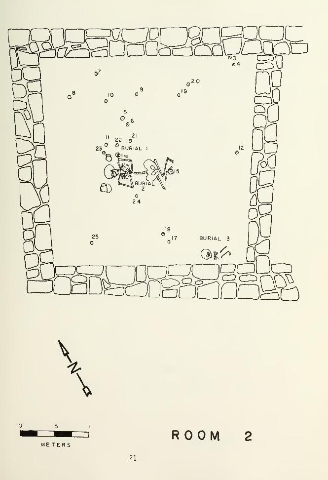
Figure 5. Plan of Room 2.
Room 2, Floor Artifact List. Numbers correspond to locations on Fig. 5,
1. Mancos Black-on-White potsherds, provenience missing
2. corrugated potsherd, provenience missing
3. unclassifiable gray ware potsherds
4. mule deer mandible fragment, unmodified
5. corrugated potsherds
6. mano fragment
7. corrugated potsherd
8. unclassifiable white ware potsherd
9. mano
10. corrugated potsherd
11. corrugated potsherd
12. corrugated potsherd
13. discarded
14. discarded
15. hammerstone
16. human ulna, part of Burial 3
17. mano fragment
18. mano fragment
19. hammerstone
20. mano
21
.
corrugated potsherds
22. corrugated potsherds
23. corrugated potsherds
24. corrugated potsherds
25. corrugated potsherds20
a
BURIAL 3
Q>t^
a
\
\
METERSROOM
21

Figure 6. Plan of Room 3.
Room 3, Floor Artifact List. Numbers correspond to locations on Fig. 6
1
.
metate
2. nonutilized flake
3. discarded
4. discarded
5. mule deer humerus, unmodified
6. unclassifiable white ware potsherd
7. Mancos Black-on-White potsherd
8. Mesa Verde Corrugated potsherd
9. corrugated potsherd
10. corrugated potsherd
11. metate
12. metate
13. unclassifiable gray ware potsherd
14. Mancos Black-on White potsherd
15. Mancos Black-on-White potsherd
16. discarded
17. human talus
18. discarded
19. discarded
20. unclassifiable white ware potsherd
21. Mancos Black-on-White potsherd
22

Dnag3SB 1D
RM 2
Possess\1c
\
.5 I
METERS ROOM 323
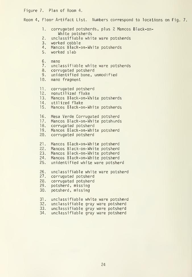
Figure 7. Plan of Room 4.
Room 4, Floor Artifact List. Numbers correspond to locations on Fig. 7
1. corrugated potsherds, plus 2 Mancos Black-on-White potsherds
2. unclassifiable white ware potsherds3. worked cobble4. Mancos Black-on-White potsherds5. worked slab
6. mano7. unclassifiable white ware potsherds8. corrugated potsherd9. unidentified bone, unmodified
10. mano fragment
11. corrugated potsherd12. nonutilized flake13. Mancos Black-on-White potsherds14. utilized flake15. Mancos Black-on-White potsherds
16. Mesa Verde Corrugated potsherd17. Mancos Black-on-White potsherds18. corrugated potsherd19. Mancos Black-on-White potsherd20. corrugated potsherd
21. Mancos Black-on-White potsherd22. Mancos Black-on-White potsherd23. Mancos Black-on-White potsherd24. Mancos Black-on-White potsherd25. unidentified white ware potsherd
26. unclassifiable white ware potsherd27. corrugated potsherd28. corrugated potsherd29. potsherd, missing30. potsherd, missing
31. unclassifiable white ware potsherd32. unclassifiable gray ware potsherd33. unclassifiable gray ware potsherd34. unclassifiable gray ware potsherd
24
R M 3
2C*D
\
\
METERS
25
ROOM 4

Room 2
Room 2 was the largest room of the pueblo, measuring approxi-
mately 3.08 m. by 3.14 m., with a floor area of 9.7 sq. m. As in
Rooms 3 and 4, the top course or two of the foundation intrudes
onto the floor in places. No floor features are present (Fig. 5).
The floor was apparently heavily damaged by the interrment of
three sub-floor burials after the room's abandonment. The ori-
ginal light-gray plastered floor is visible only in a few places.
Artifacts located on the floor's surface and on the approxi-
mate level of the original floor included unmodified animal bone,
potsherds, two hammerstones, and fragments of ground stone.
Room 3
Room 3, the central room of the primary roomblock, measures
approximately 2.80 m. by 3.0 m. with a floor area of 8.4 sq. m.
(Fig. 6). The floor is in good condition, consisting of a light-
gray plaster surface.
Set into the floor in the northwest quarter of Room 3 were
two slab metates. Both metates were positioned at an angle of
approximately 45 degrees, with the lower end set into a shallow
depression in the floor. This depression was evidently used to
catch vegetal material as it was ground. One unmodified mule deer
humerus and a variety of potsherds were found on the floor through-
out the room.
Room 4
Room 4 is the eastern-most room of the primary roomblock
(Fig. 7). The room measures approximately 2.6 by 2.5 m., with a
floor area of 6.5 sq. m. Room 4, as the other rooms in the pri-
mary roomblock, has a hard packed floor of light-gray plaster.
26

Upon the floor were found two mano fragments, some chipped
stone, two fragments of unmodified animal bone, and a scattering
of potsherds. No floor features were found.
Kiva Architecture
The kiva (Figs. 8 and 9) is located 5 m. south of the room-
block. It is very crude and small compared to typical McElmo
Phase kivas; it measures 3.25 m. north to south and 3.50 m. east
to west, it has a dirt back wall and banquette instead of coursed
masonry, and has four pilasters instead of the typical six. At
first glance, the structure seems more typical of an Ackmen Phase
kiva than one of the McElmo Phase. Tree ring dates from the kiva,
however, indicate that it was constructed in the McElmo Phase.
The presence of these simple features may be due to the kiva's
small size, and to the compact nature of the alluvial soil.
While the kiva was probably architecturally sound during the
occupation of the pueblo, it has stood the test of time poorly.
The earthen back wall and banquette have since largely collapsed,
leaving only two badly slumped pilasters, the lower portions of
the banquette, and the floor and its features intact. The lack of
a back wall substantially complicated the excavation of the kiva.
Pi Tasters
As mentioned above, the kiva was constructed with four pilas-
ters. Only the northwest pilaster remained essentially intact,
and it too had slumped forward from its original position on the
banquette (Fig. 10). The base of the intact pilaster was .77 m.
above the floor; this measurement is probably fairly close to its
original height. The pilaster itself was built of shaped sand-
stone blocks laid in regular courses. It measures .53 m. across
27

its interior face, and extends .40 m. towards the presumed loca-
tion of the back wall. The pilaster presently is .40 m. in height.
Several courses of the northeast pilaster remained intact, al-
though most of it had fallen. It appears to have been constructed
much like the northwest pilaster.
The southeast and the southwest pilasters have completely
collapsed. Some of the rubble was found in the area where these
pilasters originally stood, and the remainder had fallen within 15
cm. of the f loor--indicating that these two pilasters had fallen a
relatively short time after the kiva was abandoned. The southern
two pilasters may have been recognized as being structurally
unstable by the builders, as these two pilasters each had two
vertical slabs set beneath them into the face of the banquette,
presumably for additional support.
Ventilator shaft
As is typical with Mesa Verde area kivas, the ventilator
shaft of the kiva at the Dominguez Ruin is located at the southern-
most extreme of the structure. The tunnel is largely intact as it
enters the kiva, for at that point it is partially masonry-lined.
The masonry wall extends .74 m. along the banquette wall, and
stands .81 m. in height--probably the original height of the
banquette at this portion. The masonry is two courses in thick-
ness, and merely encloses the ventilator tunnel where it passes
through the banquette into the kiva. The remainder of the venti-
lator tunnel is unlined, and has since collapsed. The tunnel
extends from the floor up .55 m., and is .30 m. wide.
No evidence of a southern recess was found, although it is
possible that one did exist.
28

~ZB
Figure 8. Kiva upon completion of excavations
29

Figure 9. Plan of kiva.
Kiva, Floor Artifact List. Numbers correspond to locations on Fig. 9.
1. unclassifiable gray ware potsherd
2. utilized flake
3. hammerstone/core
4. unidentified bone, unmodified
5. lapstone
6. worked cobble
7. worked cobble
8. mano
9. unclassifiable gray ware potsherd
10. mano
11. mano
12. bobcat femur
13. mano
14. nonutilized flake
15. metate
30

PILAST
PILASTER
~Z.
VENTI LA TOR
METERSKl VA
31

^^sag5MT2148KIVA a;
r*S
Figure 10. View of the northwest pilaster, slumped forward
Figure 11. Ventilator tunnel and deflector system,
32

Floor Features
The typical masonry or jacal deflector was absent in the
kiva. In its place was a system whereby a large, tabular sand-
stone slab was placed over the ventilator tunnel opening (Fig. 11).
The slab is subrectangular in shape, and measures 57 cm. high, 34
cm. wide, and 7 cm. thick. When excavated, the sandstone slab
essentially plugged the ventilator tunnel, and had a large in-
verted metate abutted against its base. By abutting one end of
the sandstone slab to the metate, and by leaning the other end
against the masonry surrounding the ventilator tunnel, the in-
coming flow of air could have been deflected. The amount of
incoming air could have been regulated by moving the metate towards
or away from the ventilator tunnel.
A large circular firepit is situated just south of the center
of the kiva. The firepit is clay lined, and has a clay collar
raised just slightly above the surrounding floor. The sides and
the bottom exhibit a red burn. The firepit measures approximately
.80 m. in diameter, and is .25 m. deep. It may have been re-
modeled, in that the sides of the pit, after descending from the
collar about 10 cm., level off briefly before descending again to
the bottom. The firepit may have either been enlarged at the top
or deepened in its center.
The firepit contains fine white ash and charcoal fragments in
its lower levels, with increasing amounts of alluvial soils and
roof fall in its upper strata.
Roughly in line with the ventilator shaft and the firepit in
the northern portion of the kiva is located the sipapu. It mea-
sures 0.07 m. across and is covered completely by a ceramic cap.
The cap is fashioned from a gray ware potsherd which is ground
along the periphery.
33

Floor Artifacts
Upon the floor of the kiva were found two "lithic flakes, a
hammerstone/core, four manos, a metate (part of the deflector
system), two animal bones, and the remains of a utility jar. The
various implications of the presence of these floor artifacts will
be discussed later in this chapter.
Roof Construction
The kiva at the Dominguez Ruin, like virtually every other
Mesa Verde area kiva, had a cribbed roof, as evidenced by the
presence of pilasters and several charred juniper beams which had
fallen roughly in line with their original orientation. The beams
provided the only dendrochronological specimens on the site. The
kiva apparently burned well after it was abandoned, as there is
approximately .50 m. of fill between the floor and the burned roof
material
.
Plaza Excavations
Numerous test squares were excavated in the area south of the
roomblock and north of the kiva, with hopes of locating the plaza
surface. Oftentimes firepits, mealing bins, and other activity
areas are found in the immediate area. Unfortunately, no plaza
surface or features were encountered.
Discussion
The architecture of the Dominguez Ruin generally conforms to
other McElmo Phase sites in the Mesa Verde area. The quality of
the building blocks and the manner of coursing the masonry is
comparable to many early Pueblo III sites on the Mesa Verde. The
34

layout of the pueblo, with the kiva to the south of the roomblock,
is typical of many Pueblo II and Pueblo III Period sites in the
area.
The kiva is unusual for the McElmo Phase in that it has only
four pilasters, an earthen back wall and banquette, and an atypi-
cal deflector system, but the variation may be due to the small
size of the structure. The remainder of the features of the kiva,
such as the large masonry pilasters, the above-floor ventilator
shaft, and the possibility of a southern recess conform well to
typical Pueblo II and Pueblo III Period Mesa Verde kivas. That
the kiva is contemporaneous with the rest of the pueblo is beyond
reasonable doubt, as the ceramics found therein are predominantly
the same types, and in the same frequencies, as those found in the
roomblock.
As mentioned, the kiva produced several dendrochronological
specimens. These were sent to the Laboratory of Tree-Ring Research
at the University of Arizona for analysis. While most of the
specimens were unsuitable for providing cutting dates, one, in the
subjective judgment of the Tree-Ring Laboratory, was found to have
been cut around 1123 A.D. This date falls within the McElmo
Phase, and is probably close to the date of the construction of
the primary roomblock.
The primary roomblock is notable in that it is constructed of
compound walls and has quite large rooms—averaging approximately
8 sq. m. A sample of six other Mesa Verde sites was undertaken in
order to see how the room size of the primary roomblock compared
in size to other McElmo Phase sites. Big Juniper House (Swannack
1969), MV499 (Lister 1964), MV875 (Lister 1965), MV1104 (Lister
and Breternitz 1968), MV1914 (Hewett 1968), and MV1088 (Lister and
Smith 1968) were selected solely on the basis of contemporaneity,
35

availability of written reports, and by being mesatop pueblos
rather than cliff dwellings. Together, these Mesa Verde sites had
an average floor area of 5.06 sq. m. All of the Mesa Verde sites
in the sample except MV875 were constructed primarily of simple
walls. These predominantly simple walled pueblos had rooms that
averaged 4.30 sq. m. --close to half the size of the Dominguez Ruin
rooms. At MV875, the construction during the second occupation of
that site resulted in an apparently preplanned pueblo consisting
of compound walls enclosing rooms averaging 8.83 sq. m. This
indicates that while pueblos with compound walls are not all that
common on the Mesa Verde, they do exist, and they tend to have
rooms upwards of twice the size of simple walled pueblos. The
architecture of the primary roomblock at the Dominguez Ruin,
therefore, is somewhat uncommon in the Mesa Verde area, but does
have its parallels.
Essential to the reconstruction of any site is the deter-
mination of the functions of architectural features, and of the
activities that may have taken place therein. Analysis of floor
features, pollen samples, distribution of floor artifacts, and
ethnographic literature concerning the western Pueblo Indians are
studies employed in this report towards these ends.
Roomblock
The four rooms of the roomblock can be divided into two
functional types: habitation rooms and storage rooms. The two
types are usually easily distinguishable from each other; storage
rooms are generally smaller in size and are relatively featureless
in comparison to habitation rooms (Hill 1970). At the Dominguez
Ruin, the problem of distinguishing the two is a more complicated
task, as the three rooms of the primary roomblock are nearly all
the same size, and all rooms except the smallest room (Room 1)
36

lack firepits. The identification of function for each room will
have to be made on the basis of specific data.
Room l:--Normally, a room substantially smaller than others
in a site would be designated a storage facility. The presence of
a firepit containing seeds amongst the ash indicates that this
small room was used at least at some point in the site's occu-
pation as a cooking area. It is hard to imagine the room being
used extensively for food preparation, however, as the room's
small size makes it impossible for one to get more than a meter
away from the fire. The majority of the cooking done at the site
was possibly done in a plaza area, although no archaeological
features were found there to support this supposition. The ab-
sence of a prepared floor and the paucity of floor artifacts
indicates that the room was not utilized extensively.
Room 2:--The wholesale destruction of the floor of Room 2
that occurred upon the interrment of three individuals beneath the
floor has made it impossible to determine the room's original
function. Items designated as "floor artifacts" may actually be
just constituents of disturbed fill. No economic pollen was found
in the samples taken at floor level (Scott: Appendix A, this
volume). Some lenses of ash were found mixed in with the fill
approximately to 10 cm. above the floor level, possibly indi-
cating the presence of a firepit in this room before the floor was
disturbed.
Room 3:--The presence of a large number of floor artifacts
along with two "mealing bins" strongly suggests that Room 3 was a
habitation room, and that activities such as food preparation,
eating, sleeping, water storage, and a great many other activities
were carried out in this room (Hill 1970). Hill (1970:48) states
that at the Broken K Pueblo, whenever two or more metates were
37

found in bins in the same room, their grinding surfaces would vary
in coarseness. This, he states, is indicative of at least two
stages being used in the grinding of vegetal material. The two
metates of Room 3 conform to this pattern, as one (F.A. 1) is
comprised of a coarse pebble conglomerate, and the other (F.A. 12)
is comprised of quartzitic sandstone.
Hill (1970:49) also was able to infer that a great deal of
butchering was carried out in the habitation rooms at the Broken K
Pueblo, as evidenced by the occurrence of 77% of all the unmodi-
fied animal bone from the site in the habitation rooms. The
pattern was substantially different at the Dominguez Ruin, how-
ever, as only 24% of all unmodified bone came from the entire
roomblock. The bones discarded in the roomblock at the Dominguez
site were probably waste products from cooking and eating. Only
one unmodified bone was found upon the floor of Room 3.
A plethora of black-on-white potsherds from the floor consti-
tutes additional evidence that food preparation and eating took
place in Room 3. Pollen samples taken from the floor level also
point to these activities taking place in this room, as Scott
(Appendix A, this volume) reports finding Zea pollen from this
level. While Hill (1970:51) reports that storage rooms at the
Broken K Pueblo contained greater amounts of domestic pollen than
either habitation rooms or kivas, the opposite seems to be true at
the Dominguez Ruin. The floor of Room 3, an apparent habitation
room, had a greater concentration of domestic pollen than the
other floors tested.
Room 4:--Room 4 lacks any floor features so its classifi-
cation as a habitation room is dubious. It does contain a mano
and a mano fragment, two unmodified animal bones, and the highest
number of potsherds of any living surface. The potsherd counts
38

include a number of corrugated jar fragments and black-on-white
bowl and jar fragments. Pollen samples taken from the floor
indicate that .5% was comprised of Zea pollen.
Room 4 may have been multifunctional—serving as a storage
facility as well as housing activities such as food preparation
and consumption.
Kiva
According to Mindeleff (1891:130) the kivas of the Hopi and
Zuni serve as ceremonial structures where religious events are
focused and also as a male "clubhouse" where leisure time is spent
in activities such as weaving and other crafts. Archaeological
remains indicate that prehistoric kivas maintained similar func-
tions. At the Dominguez Ruin, it appears that the kiva was used
for ceremonial purposes, f lintknapping, weaving, bone tool manu-
facturing, and roasting and/or eating.
That the Dominguez kiva was used for ceremonial purposes is
evinced by the occurrence of rather rare items in the kiva, which
have no counterparts in the other parts of the site. The kiva
contained a nodule of malachite, which may have been highly valued
for its scarcity and its color. Also found in the kiva was a
large gray ware vessel atop the firepit, which contained quan-
tities of Sphaeralcea and Zea pollen (Scott, Appendix A, this
volume). Scott writes that Sphaeralcea is used for medicinal
purposes among the Hopi, and suggests that it may have served a
similar function prehistorical ly. Spaeralcea appears to have been
cultivated or manipulated at the Dominguez site, as at Hovenweep
(Scott, Appendix A, this volume). It is interesting to note that
"exotic" animals are found only in the kiva. Whereas dogs, arti-
odactyls, and turkey bones occur throughout the site, the bones of
39

wolf, porcupine, bobcat, beaver, goose, and grouse occur only in
the kiva fill and on the kiva floor. These animals are all common
to the area (or once were), but evidently were not hunted exten-
sively. They possibly had ceremonial as well as subsistence
value. A "tibia tinkler" was found near the floor of the kiva.
This artifact, consisting of a cottontail tibia with its proximal
articular surface ground off, is frequently in association with
kivas (Swannack 1969).
As is the case among the ethnographic accounts of the Pueblo
Indians, the kiva at the Dominguez site appears to have been the
center for weaving (Mindeleff 1891). Three bone weaving tools,
characterized by large transverse grooves along the shaft and a
high degree of surface polish, were found at the site--all in the
kiva. Clothing, probably of both cloth and leather, apparently
was manufactured in the kiva, as nine out of the ten awls found at
the site were from the kiva. Gillespie (1976:50) points out that
awls and other bone tools show a clear association with pit struc-
tures in the Mancos Canyon, and cites Rohn (1971) and Swannack
(1969) as stating that this association with kivas is found
throughout the Pueblo II and III Phases of the Mesa verde.
Gillespie adds that the occurrence of bone tools in prehistoric
kivas supports the hypothesis that these structures were used
predominantly for male activities, as males of the modern western
pueblos manufacture most of their people's clothing (1976:150).
Whether the male inhabitants of the Dominguez Ruin manufactured
clothing is, however, unknown. The manufacture of the bone tools
themselves evidently took place in the kiva, as all occurrences of
bone scored or grooved for controlled splitting were in the kiva.
As at the Broken K Pueblo, f
1
intknapping was an important
activity in the kiva at the Dominguez Ruin. The only bone tool
40

classified as a "flaker" was found in the fill of the kiva, and
the floor itself was strewn with several lithic flakes and a core.
That the kiva was used for roasting and/or food consumption
is evidenced by the presence of several burned artiodactyl and
small rodent bones in the firepit. The importance of the kiva as
a cooking facility is not well understood at the Dominguez Ruin,
but it is speculated that it was of relatively minor importance
for the pueblo at large.
The gray ware jar found atop the firepit in the kiva may have
been used as a cooking vessel, but the pollen types found within
its contents suggests that it served for the preparation of medi-
cinal concoctions.
Social Groups
The Dominguez Ruin may have consisted of one or two house-
holds, with a total population of approximately 8 to 11 people.
These estimates are based on Mindeleff's (1891:65) observation
that modern Pueblo households usually consist of one storage room
and one habitation room per household, and Hill's (1970:75) popu-
lation estimate of 2.8 people per room as based on Hopi data. It
should be noted, however, that the validity of using ethnographic
accounts of Hopi and Pueblo behavior for extrapolating Anasazi
behavior is ultimately questionable. Hill's formula may be gener-
ally applicable to the Dominguez Ruin, in that Hopi rooms average
approximately 9.0 sq . m., which is only slightly larger than the
three rooms of the primary room-block at the Dominguez Ruin (8.0
sq. m.). If all four rooms of the Dominguez Ruin were occupied
simultaneously, approximately 11 people inhabited the site. If
Hill's (1970:75) observation that 21% of the rooms of a living
Pueblo are abandoned at any point in time is applicable to small
41

prehistoric sites like the Dominguez Ruin, the number of inhabi-
tants occupying the Dominguez Ruin was probably closer to eight
42

CHAPTER III
MATERIAL CULTURE
Pottery
Indigenous Mesa Verde Ceramics
Excavations at the Dominguez Ruin yielded a total of 1,092
potsherds and eight whole or restorable pottery vessels. The
ceramic artifacts are basically classified following the typo-
logical schemes of Abel (1955) and Breternitz, Rohn and Morris
(1974). The types for corrugated gray wares have been changed
somewhat from those offered by the authors mentioned above, how-
ever. The distinction between Mancos Corrugated and Mesa Verde
Corrugated (Breternitz et aJL 1964) is not recognized in this
report unless the criteria for these types are manifested in the
extreme. A high number of corrugated potsherds, therefore, are
simply typed as "Unclassif iable Corrugated".
A summary of the total number of potsherds classified within
pottery types and their proveniences are presented in Table 2.
Gray Wares :--Pottery of this type probably constituted the
basic utilitarian pottery of the Anasazi. Grayware potsherds
represented 60% of the total ceramic artifacts recovered. Of the
grayware potsherds, nearly all were jar rather than bowl frag-
ments.
A single Chapin Gray potsherd, and a single Mancos Gray
potsherd were found. These pottery types tend to date before A.D.
950 (Breternitz et_ aj_. 1974). Over a hundred other non-corru-
gated grayware potsherds were recovered, but lacked the attributes
required for specific typing. Five hundred and forty-four corru-
gated vessel fragments were recovered. Of these, 2 were classi-
fied as Mesa Verde Corrugated, and 4 were classified as Mancos
Corrugated.
43

TABLE 2
Provenience of potsherd types
TDCD4-> o CD03 CD CD S-
-o cr> +-> b 03CD 3 03 O c 3+-> S- CT> S^ o"3 S- 3 CD _c >i -oCD o S- >> 4-> u 03 CD3 c_> S- 03 •i— >, to a;
>> >! S_ o S- -C ^— 3"3 03 S- <D <_> o 3 3 3 3 o 1— Dd 3S- S_ o T3 ^, ^_ *-
—
D_ c "^ 3 ^^o CJ3 c_> S-
<d to to03 CO CQ
to C to
+->5"
CQCQ
CO
c to to > to to 03 to O 00 o to O Q-•i— o o 03 03 S- o E 03 >> 03 CD o O o _Ja. <_> o 03 ^~ i— "D o r^ r^ 03 r— M S- U r— <c<o c: c C/l o O CD c UJ o to O •r— CD 03 i
—
h-.c 03 03 ai c c • r— 03 o c 3 c -CT 3 -C 03 oo s: s: s: ZD ZD O- s: 2: => 1— =3 3 D- C_) O (-
ROOM 1
Level 1
16 6 1 1 6 30
Floor Fill1 2 3
Floor1 1
ROOM 2
Level 1 12 5 5 1 11 1 1 36
Floor Fill7 3 3 ? 7 22
Floor23 3 10 1 37
Sub-floor 23 3 6 6 11 49
ROOM 3
Level 1 21 4 5 3 10 2 45
Floor Fill 16 1 3 2 14 36
Floor1 5 1 4 2 13
Sub-floor79 4 4 5 92
ROOM 4
Level 11 5 ,1 1 1 2 1 12
Floor Fill8 1 3 1 12 25
Floor1 12 3 28 4 48
Sub-floor1 18 11 9 5 44
KIVAUpper Fill
53 15 13 11 22 1 115
Lower Fill 1 1 53 13 19 3 37 127
Floor Fill 5 si 1 520~
F loor ..1
EXTRAMURAL 2 181 24 35 2^4 62 2 5 1 336
TOTAL 1 1 k 2 539 109 1 149 56 216 5 5 1 1 1 1 1092
44

White Wares :--White ware pottery, i.e., pottery that is
painted and/or slipped, accounts for 40% of the total potsherd
inventory. Excavations yielded a single Piedra Black-on-white
potsherd, which usually dated between A.D. 750 to 900 (Breternitz
et_ a]_. 1974). The predominate white ware is Mancos Black-on-
white, accounting for 34% of the white ware potsherds. McElmo
BLack-on-white also is common, comprising 12% of the white ware
total. Mancos Black-on-white and McElmo Black -on-white tend to
date to the Pueblo II and Pueblo III phases respectively (Breternitz
et aJL 1974). The remaining white ware potsherds were unclassi-
f i ab 1 e
.
Trade Wares
A total of 14 trade ware potsherds was found at the Dominguez
site. Of these, most originated in the Kayenta rather than the
Chaco areas within Anasazi culture. Five potsherds were classi-
fied as Tusayan Polychrome, Variety A, and five were unclassi-
fiable Tusayan redwares. One Puerco Black-on-red potsherd, and one
White Mountain Redware potsherd, were also recovered. The im-
ported white wares were represented by a Gallup Black-on-white
potsherd and a Chaco Black-on-white potsherd.
Whole or Restorable Vessels
Pueblo 1 1— 1 1 1 corrugated jar
A partial large jar was found in the fill immediately above
the fire pit in the kiva (Fig. 12). The jar, whose corrugations
had been almost completely obliterated, can be attributed to the
Pueblo II or Pueblo III Period. The jar has yet to be recon-
structed.
45

Figure 12. large Pueblo 1 1- 1 1 1 jar in situ in kiva
Figure 13. Minature Pueblo 1 1- 1 1 1 corrugated jar; greatestdiameter: 8.5 cm.
46

Miniature Pueblo 1 1 — 1 1 1 corrugated jar
Height: 10.8 cm. Neck height: 1.1 cm.
Maximum diameter: 8.5 cm.
Neck diameter: 6.3 cm.
Orifice diameter: 7.7 cm. Thickness: 0.38 cm.
Average width of coils: 0.43 cm.
This complete small jar (Fig. 13) was found in apparent associ-
ation with Burial 1. The rim is filleted and pinched to a narrow,
slightly rounded edge. The rim flares out sharply from the neck.
The shoulders are barely discernible. The base is rounded with
one flattened circular area, which is slightly off center. The
overall shape of the vessel is globular.
Pueblo 1 1 — 1 1 1 corrugated jar
Height: 21.0 cm.
Height of corrugations: 17.5 cm.
Maximum diameter: 21.2 cm.
Wi dth of coils : 0.6 cm
Minimum diameter: 12.2 cm.
Width of rim fillet: 0.9 cm.
Orifice: 18.0 cm. Thickness: 0.5 cm.
Height of maximum diameter: 8.0 cm.
Height of minimum diameter: 18.0 cm.
This jar (Fig. 14) has a round bottom and rounded shoulders. The
walls curve inward gently to the neck constriction, and then flare
outwards. The rim is filleted and rounded. The coils at the
basal rim is filleted and rounded. The coils at the basal portion
are obliterated. The vessel is globular in shape. The nearly
complete jar was found broken and scattered in the subfloor exca-
vation of Room 2, in the fill above Burial 1.
47
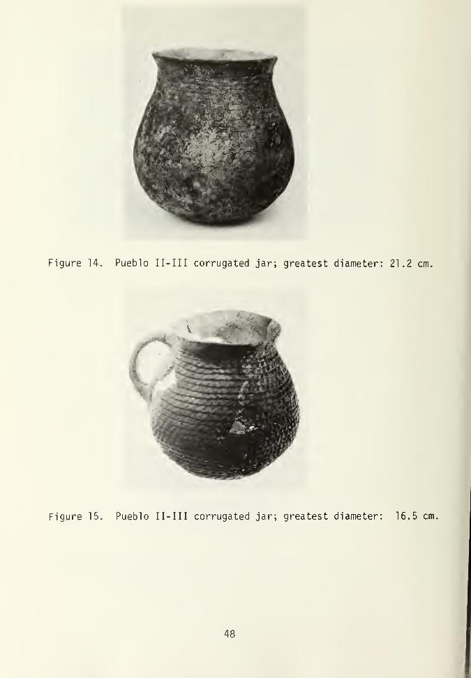
Figure 14. Pueblo 1 1- 1 1 1 corrugated jar; greatest diameter: 21.2 cm.
Figure 15. Pueblo 1 1 - 1 1 1 corrugated jar; greatest diameter: 16.5 cm,
48

Pueblo 1 1— 1 1 1 corrugated jar
Height: 16.0 cm. Maximum diameter: 16.5 cm.
Minimum diameter: 9.6 cm. Orifice: 11.6 cm.
Height of corrugated band: 15.0 cm.
Average width of coils: 0.7 cm.
Width of rim fillet: 1.6 cm.
Height at minimum diameter: 15.0 cm.
Thickness : 0.5 cm.
This necked jar (Fig. 15) has a rounded bottom and rounded shoul-
ders. The walls curve inward from the point of maximum diameter
to constrict the neck, and then flare outward. The rim is fil-
leted. The overall shape of the vessel is globular. A single
strap handle 2 cm. wide is present. This fragmentary vessel was
found broken in the fill beneath the floor level of Room 2, imme-
diately above Burial 1.
Mancos Black-on-white bowl
Height: 10.1 cm. Diameter: 18.2 cm.
Thickness: 0.5 cm.
This artifact (Fig. 16) is a deep, open bowl with a round bottom
and steep rounded sides. The rim is uneven and rounded. The
surface is polished but not slipped. On the exterior, the coils
have been only partially obliterated. The interior of the pot is
decorated with a mineral paint, consisting of an unframed band
layout of hatched double scrolls. The top of the entire rim is
painted. The vessel was found in the subfloor fill of Room 2,
immediately above Burial 1.
49

Figure 16. Mancos Black-on-white bowl; diameter: 18.2 cm.
xn cttt "err
Figure 17. McElmo Black-on-white canteen; greatest diameter:
18.9 cm.
50

McElmo Black-on-white canteen
Height: 19.0 cm. Maximum diameter: 18.9 cm.
Neck height: 2.7 cm. Neck diameter: 3.8 cm.
Base to shoulder: 9.5 cm. Thickness: 0.4 cm.
Orifice diameter: 3.1 cm.
Handle height, width: 1.7 x 3.8 cm.
This necked jar (Fig. 17) is canteen-shaped with a globular body
and a small constricted orifice. It has two small handles, set
high on the wall above the shoulders, which occur at mid-point.
The neck tapers inward towards the orifice. The base is indented.
The surface of the jar is slipped and polished, but badly wea-
thered. The carbon paint is apparently completely burned out and
is discernable only where a fire cloud has preserved it in nega-
tive. The design is a series of nested chevrons with medium-thick
lines. The design begins 2 cm. below the shoulder, and continues
up to the neck region. The vessel was found in the fill of Room
1.
McElmo Black-on-white pitcher
Height: 21.1 cm. Neck diameter: 10.5 cm.
Neck height: 12.7 cm.
Orifice diameter: 10.1 cm.
Maximum diameter: 5.7 cm.
Thickness: 0.5 cm.
Handle: 13.2 x 3.2 x 0.8 cm.
This vessel (Fig. 18) is pitcher-shaped. It has a strap handle
extending from just below the rim to the shoulder. The walls are
slightly curved up to the shoulder, and then form sharp shoulders
as they constrict to form the neck. The neck is cylindrical and
slightly constricts at the center. The rim is even and rounded,
and the base is indented. The surface of the vessel is slipped and
polished. The design is of carbon paint, and is divided into
51

Figure 18. McElmo Black-on-white pitcher; greatest diameter: 5.7 cm.
Figure 19. McElmo Black-on-white bowl; diameter: 30.2 cm.
52

three areas. At the shoulder are three lines which encircle the
pitcher. Two are solid lines and one is dotted. The neck is
covered with a panel band of various designs. The top of the
handle is painted with negative diamonds. This vessel was found
in association with Burial 2.
McElmo Black-on-white bowl
Height: 12.6 cm. Diameter: 30.2 cm.
Thickness: 0.5 cm.
This shallow, open bowl (Fig. 19) has relatively straight, flaring
sides and an uneven, squared rim. Both the interior and exterior
surfaces are unslipped. The exterior has been wiped and sketchily
polished, and the interior has been well polished. The vessel is
tempered with crushed sherd, rock, and calcite, the latter of
which has expanded creating pits in the vessel's surface. The
interior has been decorated with carbon paint, in the form of
bilateral, converging circular scrolls. The scrolls are hatched.
The bowl is slightly warped. This vessel was found in association
with Burial 2.
Ornaments
Morris (1939) has pointed out the relative dearth of orna-
ments found in Anasazi sites north of the San Juan River. Few if
any sites in this region have produced ornaments which can compare
quantitatively or qualitatively to specimens excavated from some
of the great town sites such as Pueblo Bonito in the Chaco Canyon
(see Judd 1954). The Dominguez Ruin, however, stands out as an
exception.
Within the confines of this small site were excavated literally
53

thousands of beads, and also several pendants of such quality as
to rank among some of the finest examples of Anasazi craftman-
ship. Nearly all of the ornaments were found in association with
Burials 1 and 2, two individuals interred in close proximity to
each other beneath the floor of room 2. The remainder of the site
produced only 2 bone beads, approximately one half of a large jet
pendant, and a small keystone-shaped shale pendant. Excluding the
ornaments found in association with the burials, the inventory of
ornaments within the Dominguez site appears to conform well with
other Mesa Verde sites.
Beads
Close to 6,900 beads were excavated from the pueblo; all but
four were found in association with Burial 2. Two beads were
found in the mid section area of Burial 1, a small infant. One of
these beads (Fig. 20) measures 0.6 cm. by 0.5 cm., and is manu-
factured from an Oliva undatella shell, a species probably col-
lected along the Pacific coast. The bead was produced by grinding
off the spiral end of the shell down to a point where a hollow
tube resulted. Small amounts of red pigment, possibly hematite,
were observed on the bead upon excavation. Whether the bead was
at one time entirely covered with this pigment, or whether the
pigment was deposited upon the shell after the interrment of the
pigment-covered infant is uncertain. A few faint striations
oriented parallel to the logitudinal axis of the bead are present,
but no polish is discernible.
Within a few centimeters of the 01 iva bead was found a bilo-
bed or "figure-8" shaped bead (Fig. 21). This bead measures 0.9
cm. in length, 0.5 cm. in width, and 0.3 cm. in thickness. When
viewed from the side it is thicker at the base, that is, the lobe
distal to the perforated lobe, than it is from the top. Judd
54

Figure 20. Oliva bead associated with Burial 1
Scale in millimeters.
.
\$'
'** • **ryS)
*.'*^
Figure 21. Bi-lobed shell bead associated with Burial 1
Scale in millimeters.
55

(1954) observes that this attribute compensates for the "end
spreading" that would result from stringing a large number of
these relatively long beads together and then wearing such a
string about the neck. Judd (1954:92) suggests that the bilobed
style of bead is unique to the Pueblo III Period. The bilobed
bead from the Dominguez site is biconally drilled, and is ground
to a slight polish. The bead is made of shell, the species of
which is not descernible.
The approxiamtely 6,900 disk-shaped beads (Fig. 22) found in
association with Burial 2 were by far the most common, outnum-
bering the turquoise beads by a 6 to 1 ratio. This ratio, coupled
with the discovery of groups of these beads in their original
pattern in the hard soil surrounding the skeleton, suggest that
many of these beads were strung in a pattern consisting of a
series of 6 to 10 jet and shale beads, followed by a series of 4
turquoise beads. The turquoise beads are more variable in size
than the jet and shale beads, ranging from 2.0 mm. to 4.0 mm. in
diameter, and 1.0 mm. to 2.0 mm. in thickness. There is little
variation in the color and quality of the turquoise; however, all
are deep blue to bluish-green in color, and contain no matrix
whatsoever. It seems probable that the turquoise comprising these
many beads come from the same source. The jet and shale beads are
much more consistent in size than the turquoise beads, averaging
2.5 mm. in diameter and 1.5 mm. in thickness. Color ranges from
the lustrous, coal black jet beads to the dull gray of the shale
beads. With the exception of some of the largest of the turquoise
beads, which are biconally drilled, the perforations of the disk
beads are straight and not flared. The holes average only 1.0 mm.
in diameter. Haury (1931) has shown that it is possible to drill
such miniscule holes with a cactus spine--few other objects suit-
able for drilling seem appropriately delicate or ubiquitous.
56

^f&
Figure 22. Disk beads. From left to right: beads made of shale,
turquoise, and jet. Scale is in millimeters.
57
Hayes and Lancaster (1975:161) suggest that the straightness of
the sides of the perforations is the product of friction produced
by the string upon the inner portions of the hole upon wearing and
handling the strung beads, and not from the method of manufacture.
Two bone beads were recovered during the course of exca-
vations. One was found just outside the south wall of the room-
block, and the other was within 10 cm. of the floor of the kiva.
The former bead is manufactured from the first phalanx of an
unidentified artiodactyl, and measure 3.7 cm. in length and 1.3
cm. in width. The proximal and distal articular surfaces have
been ground radically, producing a hollow tube with rounded ends.
The entire surface is extensively polished. The second bone bead,
produced from an ulna of an unidentified ave (turkey?) is 3.5 cm.
long and 0.8 cm. wide. The bone has been transversely truncated
along the bone's shaft, by means of scoring the bone with a stone
tool and then snapping it off, producing a hollow tube with
squared ends. The bead retains a high polish.
Pendants
A large pendant comprised of shell and turquoise and in the
shape of a frog was excavated from the vicinity of the sternum of
Burial 2. Frog effigy pendants are not unknown in the Anasazi
material culture, some having been excavated in both the Chaco and
the Mesa Verde areas. The frog effigy pendant from the Dominguez
site, however, stands as one of the largest and perhaps most
complexly constructed ornaments of its type in the Anasazi cul-
tural area. The pendant (Fig. 23) measures 7.6 cm. in length, 4.5
cm. in width, and 0.7 cm. in thickness, and consists of three
layers of shell, one atop the other, held together by a lac
adhesive. The shells were apparently glued together before the
final shaping of the ornament took place, as the periphery of the
58

2L*j
\
Figure 23. Dorsal view of frog-effigy pendant. Length: 7.6 cm,
. "V i j :
*W-
V,
totmm
m
t*s**em»"~*'
Figure 24. Ventral view of frog-effigy pendant.
59

ornament is beveled from top to bottom via grinding. The resul-
ting edge is smooth. The pendant is biconvex in cross section
both longitudinally and transversely. The ventral surface of the
pendant is comprised of abalone shell (either Haliotus fulqens or
H. crocherodii ) according to Malcolm Withers (personal communi-
cation), and retains its mother-of-pearl luster. Three holes,
which perforate only the ventral and perhaps medial shell layers,
are located just posterior to the neck of the frog effigy on the
on the ventral surface. These holes (Fig. 24) have been biconally
drilled. The smallest hole measures 3.5 mm. in diameter; two
larger holes measure 5.0 mm. in diameter and are somewhat symmet-
rical in their location. The holes probably functioned to suspend
the pendant, but the manner in which this was accomplished is not
known.
The medial layer of shell has not been identified specifi-
cally, as only a small area is visible. It may consist of abalone.
The dorsal side of the frog effigy pendant was certainly the
side for display. The dorsal layer of shell, identified as
Laevicardium elatum , has been cut away in certain places down to
the medial layer, leaving a space in which to inlay turquoise
bands. Three such bands are present. The neck band is slightly
biconvex in cross section, and measures 2.7 cm. in length, 0.8 cm.
in width, and 0.03 cm. in thickness. Maximum thickness is found
at the center of the band. The turquoise band, similar to all of
the turquoise from the pendant, is sky blue in color and contains
no matrix. In addition, to the neck band, two small squares of
turquoise (0.6 x 0.6 cm.) are inlaid in the hind legs of the
pendant. In addition, two semi-spherical "eyes" were found in
close proximity to the pendant upon excavation. The "eyes" have a
diameter of 0.07 cm., and stand in profile 0.04 cm. The base has
60
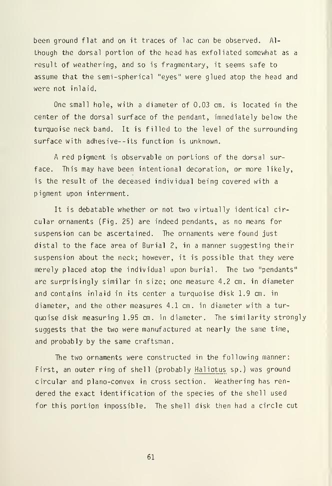
been ground flat and on it traces of lac can be observed. Al-
though the dorsal portion of the head has exfoliated somewhat as a
result of weathering, and so is fragmentary, it seems safe to
assume that the semi-spherical "eyes" were glued atop the head and
were not inlaid.
One small hole, with a diameter of 0.03 cm. is located in the
center of the dorsal surface of the pendant, immediately below the
turquoise neck band. It is filled to the level of the surrounding
surface with adhesive--its function is unknown.
A red pigment is observable on portions of the dorsal sur-
face. This may have been intentional decoration, or more likely,
is the result of the deceased individual being covered with a
pigment upon interrment.
It is debatable whether or not two virtually identical cir-
cular ornaments (Fig. 25) are indeed pendants, as no means for
suspension can be ascertained. The ornaments were found just
distal to the face area of Burial 2, in a manner suggesting their
suspension about the neck; however, it is possible that they were
merely placed atop the individual upon burial. The two "pendants"
are surprisingly similar in size; one measure 4.2 cm. in diameter
and contains inlaid in its center a turquoise disk 1.9 cm. in
diameter, and the other measures 4.1 cm. in diameter with a tur-
quoise disk measuring 1.95 cm. in diameter. The similarity strongly
suggests that the two were manufactured at nearly the same time,
and probably by the same craftsman.
The two ornaments were constructed in the following manner:
First, an outer ring of shell (probably Haliotus sp.) was ground
circular and plano-convex in cross section. Weathering has ren-
dered the exact identification of the species of the shell used
for this portion impossible. The shell disk then had a circle cut
61

out of its center, into which an abalone plug with a thickness of
approximately half that of the outer shell ring was inserted. A
lac adhesive held this plug in position, in addition to a large,
well ground and polished turquoise disk which was placed atop the
plug. The turquoise disks in both ornaments are blue in color,
and possess no matrix. The exceptional quality of the turquoise
suggests that it originated in the Los Cerillos area of New
Mexico; however, no physical tests have been performed to confirm
the source.
Surrounding the turquoise disk is a concentric ring of specular
hematite. This material, while beautifully polished and dark
black and metallic in appearance, is very brittle and has been
broken badly through time. The band is only 0.3 cm. in width, and
0.15 cm. in thickness. The specular hematite was not inlaid into
the shell; rather, it was merely set into the lac adhesive surround-
ing the turquoise disk.
Within the ash of the firepit in Room 1 was found a large jet
(or possible gilsonite) pendant. The pendant (Fig. 26) is roughly
rectangular in shape, but has one end broken off which is apparently
burned. In cross section, the pendant is biplanar; it measures
5.7 cm. in length, 4.5 cm. in width, and 1.0 cm. in thickness.
The entire surface of the pendant retains a high polish, but also
possesses many striations that are oriented both parallel and
perpendicular to the longitudinal axis of the ornament. The cause
of these striations are unknown. In the center of the pendant
near the very top is a biconally shaped hole that completely
penetrates the pendant. This hole probably functioned to suspend
the ornament. To each side of this central hole, on both the
front and back of the pendant, are two holes. These holes do not
penetrate the pendant nor are they aligned with the hole on the
62

4&**
:.. "K:
M
Figure 25. One of two nearly indentical shell, specular hematiteand turquoise pedants. Maximum diameter is 4.2 cm.
63

opposite face. The holes on one side are cone-shaped and quite
shallow; they may have been inlaid with some other material. The
holes on the other side may also have been for inlay, but are much
different in design. Both of these holes have been drilled from
two direct ions--from the front and from the top. A notch out of
the top edge of the pendant results. Several percussion flakes
have been removed, possible unintentionally, from one side of the
pendant. The relatively battered appearance of this pendant may
have resulted in its being discarded to the fire hearth. It
seems, however, that a piece of jet of such size would have been
kept for reworking.
A small rectangular shale pendant was recovered during the
excavation in the kiva fill. This ornament (Fig. 27) appears to
closely resemble many others found in the Mesa Verde area (e.g.,
Rohn 1971; Swannack 1969). Measuring 1.9 cm. in length and 1.2
cm. in width, the pendant has been ground to shape. Both sides of
the pendant are very flat and possess polish as well as minute
randomly oriented striations. A small hole for the ornament's
suspension is located in the center towards the top of one end.
Mosaics
While mosaic ornaments are more common in archaeological
sites in the Mesa Verde area than are the two preceeding ornament
types, seldom are they in abundance. Morris (1919:102) describes
one burial at the Aztec Ruin that contained twenty mosaic-incrusted
shell disks, but such finds are uncommon, even in Chacoan outliers
such as Aztec. Burial 2 at the Dominguez Ruin was interred with
three mosaic ornaments. Two were located immediately beneath a
McElmo Black-on-white bowl placed near the head of the individual,
and another was found near the skeleton's right elbow. The three
ornaments appeared to be identical in size, design, and materials.
64

, L-^3 ^^j
ill!
Mffi
Hi)
ic 1
IIII
2
III! IIII IIII IIII IIII IIII lit
3 4 5
Figure 26. Fragment of a large jet pendant,
Figure 27. Shale pendant,
65
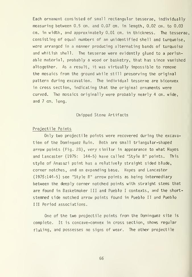
Each ornament consisted of small rectangular tesserae, individually
measuring between 0.5 cm. and 0.07 cm. in length, 0.02 cm. to 0.03
cm. in width, and approximately 0.01 cm. in thickness. The tesserae,
consisting of equal numbers of an unidentified shell and turquoise,
were arranged in a manner producing alternating bands of turquoise
and whitish shell. The tesserae were evidently glued to a perish-
able material, probably a wood or basketry, that has since vanished
altogether. As a result, it was virtually impossible to remove
the mosaics from the ground while still preserving the original
pattern during excavation. The individual tesserae are biconvex
in cross section, indicating that the original ornaments were
curved. The mosaics originally were probably nearly 4 cm. wide,
and 7 cm. long.
Chipped Stone Artifacts
Projectile Points
Only two projectile points were recovered during the excava-
tion of the Dominguez Ruin. Both are small triangular-shaped
arrow points (Fig. 28), ^jery similar in appearance to what Hayes
and Lancaster (1975: 144-5) have called "Style B" points. This
style of Anasazi point has a relatively straight sided blade,
corner notches, and an expanding base. Hayes and Lancaster
(1975:144-5) see "Style B" arrow points as being intermediary
between the deeply corner notched points with straight stems that
are found in Basketmaker III and Pueblo I contexts, and the short-
stemmed side notched arrow points found in Pueblo II and Pueblo
III Period associations.
One of the two projectile points from the Dominguez site is
complete. It is concave-convex in cross section, shows regular
flaking, and possesses no signs of wear. The other projectile
66

TABLE 3
PROJECTILE POINTS
Provenience Length Width Thickness Material Remarks
Room 1
Floor fill
Room 4
Level 1
2.4
1.6
1.3 0.3
1.3 0.3
quartzite
quartzite
complete
fragment
TABLE 4
BLADE FRAGMENT
Provenience Length Width Thickness Material Remarks
Plaza area 2.7 0.5 quartzite medialfragment
llll iiiii1
' METRIC 1 cm 2
mi
3
1 1 i 1
1
III!
4
llllIII
Kl51
Figure 28. Projectile points.
67

point is broken along both its transverse and longitudinal axis.
Blade Fragment
Besides the two projectile points mentioned above, only one
other stone artifact modified from a flake by purposeful chipping
of the surface of the tool was found. The reason for this relative
dearth of intentionally flaked stone artifacts at the Dominguez
site is unknown. The single blade fragment represents the medial
portion to a triangular or leaf-shaped knife. One working edge is
straight, shows a moderate amount of attrition, and has an edge of
37 degrees. The other working edge is slightly convex in shape,
has an edge angle of 28 degrees, and shows light wear.
Hammerstones
Hammerstones are approximately fist-sized nodules of stone,
usually water worn cobbles, that show signs of intentional batter-
ing along their peripheries. Most show no evidence of purposeful
manufacture, but through use have had flakes removed from their
surfaces in a random order. Incidental flake removal does not
decrease the efficiency of the tool, and it indeed rejuvinates the
working facets, until the cobble has become too small to be of
practical use. Several ethnographic accounts of the use of hammer-
stones by the modern Pueblo Indians are discussed by Woodbury
(1954:92-93); they include use as a pecking implement in the
manufacture of stone tools and for pecking the grinding surface of
manos and metates; use in crushing seed and vegetable fibers, and
for dressing building stones.
Of the 16 hammerstones found at the Dominguez site, all show
the usual battering along the flake ridges and the naturally
narrow portions of the cobble. Twelve hammerstones possess wing
fracturing, indicative of striking hard surfaces, and 6 show the
68

TABLE 5
HAMMERSTONES•
Provenience Length Width Thickness Material Remarks
Room 2
floorF.A. 15 5.2 4.8 4.5 quartziteF.A. 19 6.7 6.1 3.9 quartzite
Room 3
level 1 11.2 6.8 4.9 quartzitesub-floor 6.7 6.4 5.0 quartzite
Room 4
sub-floor 7.6 7.1 5.7 quartzite
Kiva
upper fill 5.8 4.1 2.3 quartzitelower fill 6.0 5.0 4.0 quartzitefloor, F.A. 3 11.5 9.1 4.5 quartzite used as a core
Extramural 6.3 4.7 2.3 quartzite8.3 8.2 4.7 quartzite7.9 5.9 5.9 quartzite8.0 5.8 2.9 quartzite7.7 5.8 4.8 quartzite5.8 5.5 3.1 quartzite7.0 5.5 4.4 un unidentified
Surface 8.8 7.0 5.7 quartzite
69

random striations over the surface of the tool that would be
expected from use and abuse over an extended time. One hammer-
stone has flakes removed from it in a fashion suggesting that it
also served as a core.
Core Scrapers
Core scrapers are herein defined as roughly modified core
tools which have wear patterns indicating their use as scraping
implements. Most were manufactured from river cobbles, show little
flake reduction, and possess slight to moderate wear in the form
of unifacial attrition, edge polish, and edge rounding. The shape
of the working edge tends to be irregular. Four tools from the
Dominguez site fall into this category.
Utilized Flakes
Random percussion flakes that show signs of wear along one or
more otherwise unmodified margins are classified as utilized
flakes. Except for the indications of wear, these flakes are
indistinguishable from debitage.
There are 42 artifacts in this type. Seven percent are
obsidian, 26 percent are chert, and 67 percent are quartzite. No
primary flakes are represented in the utilized flake population.
Secondary flakes comprise 71 percent of the total, and interior
flakes comprise the remaining 29 percent.
Several utilized flakes possess more than one utilized edge.
Of the 42 utilized flakes there are 56 utilized edges. Thirty-
three of these show unifacial wear, and 23 possess bifacial wear.
The average edge angle for the unifacial edges is 42 degrees, and
the average angle on the bifacial or bifacial wear is any indica-
tion of the flakes function, then in the Dominguez sample, edge
70

TABLE 6
CORE SCRAPERS
Provenience Length Width Thickn 5SS Material Remarks
Kiva
floor fill 6.5 5.9 4.1 quartzite
Extramural 9.85.7
6.5
7.05.6
4.5
2.94.72.9
quartzitequartzitequartzite
TABLE 7
UTILIZED rLAKES
ProvenienceMaterial
Quartzite Chert Obsidian Total
Room 2, sub- floor 2 1 3
Room 3, sub- floor 1 1
Room 4, floorsub-floor 1
1
1
1
2
Kiva, upperlower fil 1
floor fill
floor
fill 10
3
3
5
2
1
1
15
6
3
1
Extramural 7 1 1 9
Surface 1 1
TOTAL 28 11 3 42
71
angle apparently plays no role in the flakes' selection for the
various functions.
In addition to the utilized flakes, two rejuvination flakes
were recovered. These flakes are the waste products resulting
from the remodification of a utilized tool, and so bear the wear
patterns of the original tool. As flakes they were not utilized.
One flake shows evidence of battering, and the other shows signs
of attrition.
Debitage
This category includes unmodified and unutilized flakes that
are simply the waste material produced by f lintknapping. The
majority were found in the fill of the kiva. Sixty-five percent
of the flakes were secondary, and showed some cortex on at least
one facet. Thirty-four percent were interior flakes. No primary
flakes, i.e., flakes with a substantial amount of cortex on one or
more sides of the artifact, were observed. The debitage consists
almost exclusively of quartzite material. Ninety-six percent of
all unutilized flakes consist of quartzite, and the remaining 4
percent are chert.
Ground Stone
Manos, with convex grinding surfaces
Manos whose grinding surfaces are convex in longitudinal
cross section were designed for use in trough metates (Woodbury
1954:67). Of the 30 manos excavated, six are classified within
this type. Five of the six manos are unifacial, and one is bi-
facial, possessing a slightly utilized flat grinding surface on
the face opposite the convex grinding surface. All are rectan-
gular to subrectangular in shape. When viewed transversely in
72

TABLE 8
DEBITAGE
ProveniencePrimaryFlakes
SecondaryFlakes
InteriorFlakes Total
Room 1,
floor fill 1 1
Room 2,
sub-floor 2 2 4
Room 3,
level 1
floor1
1
1
1
Room 4,
level 1
floorsub-floor
2
1
1
2
1
1
Ki va
,
upper fill
lower fill
floor fill
floor
7
8
4
3
9
1
7
11
13
1
Extramural 6 3 9
73

cross section, 4 are airfoil in design and 2 are plano-convex.
All manos in this type are manufactured from sandstone. The
length of these manos ranges from 13.7 cm. to 11.2 cm., and averages
12.0 cm. Thickness varies from 5.5 cm. to 2.2 cm. and averages
3.3 cm. None possess finger grooves.
Manos, with flat grinding surfaces
Twenty-three manos possessing at least one flat grinding
surface were excavated. According to Woodbury (1954:68), manos of
this type were suitable for use on slab metates. Slab metates,
Woodbury (1954:59) writes, began to rapidly replace trough metates
during the first part of the Pueblo III Period. The relatively
large number of manos suitable for use on slab metates found at
the Dominguez site, is indicative of the slab metates' popularity
by the early 1100' s A.D.
The manos of this type tend to be subrectangular in shape;
only four oval shaped manos were observed. The materials used in
the manufacture of the flat surface manos is diverse. Seventeen
are sandstone, 3 are a relatively coarse conglomerate, 2 are made
of a felsitic porphyry, and one is limestone. The transverse
cross section of the tools are also diverse; 4 are airfoil in
shape, 9 are planoconvex, and 10 are biplanar. A single mano
possesses finger grooves, which are short grooves pecked into the
edge to facilitate handling. Six of the 23 manos of this type are
bifacial. Of these, 4 possess flat grinding surfaces, and two are
slightly concave in outline.
The length of the complete manos in this type ranges from
28.2 cm. to 15.2 cm., and averages 21.0 cm. Width ranges from
13.3 cm. to 9.8 cm., and averages 12.0 cm. Thickness varies from
6.3 cm. to 1.9 cm., with a mean of 3.8 cm.
74

TABLE 9
PROVENIENCE OF MANOS
ProvenienceManoTypes
ConvexSurfaceManos
FlatSurfaceManos
OneHandManos
Room 1, level 1 1
Room 2, floor fill
floorsub-floor
1
1
1
3 1
Room 3, level 1
sub-floor2
1
Room 4, floor fill
floor1
1 1
Kiva, upper fill
lower fill
floor1
1
2
3
3
Extramural 6
75

Manos, One Hand variety
A single small mano comprises this category. The tool has
been pecked around its periphery to give it an oval shape. The
mano possesses a single grinding surface which is flat in cross
section. The tool's distinctive shape separates it from the mano
types discussed above. Hayes and Lancaster (1875:154) report on a
number of such manos, and point out their resemblance to manos
found associated with basin metates in certain Desert Culture and
Basketmaker II sites. Basin metates do not appear in the later
periods, however, so the exact function of this tool type is
questionable.
The artifact is 9.0 cm. long, 7.9 cm. wide, 2.7 cm. thick,
and is made of felsite. It was found upon the floor of Room 2
(F.A. 9).
Metates
Metates are defined as stone slabs on which food has been
ground by means of a smaller upper stone. The grinding motion is
reciprocal (back and forth) and not rotary or in varying direction
(Woodbury 1954:50).
Four metates were excavated at the Dominguez Ruin. All are
slab metates, meaning that an entire surface has been worn flat or
slightly concave as a result of grinding activity. The four
metates have been generally shaped by unifacial spalling and
pecking. Two are rectangular in form, and two are ovate. The
grinding surfaces of all of the metates show wear striations, and
two metates retain signs of pecking on their grinding surfaces.
According to Woodbury (1954:93), the pecking of a grinding surface
increases the surface's efficiency in milling seed materials.
76

TABLE 10
METATES
Provenience Length Width Thickness Material Remarks
Room 2,
level 1 18.5 16.2 7.5 sandstone fragment
Room 3,
floorF.A. 1 36.0 25.7 13.3 conglomerateF.A. 12 42.6 25.5 15.0 quartzite
Kiva,
floor fill 42.5 25.1 13.0 conglomerate
77

Lapstones
Artifacts of this type are flatfish, oval river cobbles that
show various types of wear on one or more surfaces. Working
surfaces are highly polished, and possess numerous striations.
Whether these striations are the result of using the lapstone with
an abrasive action or a cutting action is unknown. Lapstones are
thought to be general, portable working surfaces. (Judd 1959:21).
Of the five lapstones excavated, all have utilized surfaces
on both sides of the artifact. In addition to possessing polish
and striations, two lapstones show signs of pecking on one sur-
face, and two others are somewhat discolored on both working
surfaces.
Pol ishing Stones
A single polishing stone was recovered at the Dominquez site.
The tool is unmodified except through use, and consists of a sub-
rectangular, rather flat river cobble. A single utilized surface
is present; this surface retains a very high degree of polish and
shows a dense concentration of striations, most of which are
oriented parallel to the width of the tool. Woodbury (1954:97)
suggests that artifacts of this type were used for polishing
pottery during manufacture, grinding pigments, and for smoothing
and polishing cooking slabs.
Worked Cobbles
Twelve cobbles showing varying degrees of manufacture and use
are lumped into this category. Eleven of the twelve possess
surfaces that have been ground, and of these, four have been
pecked on the grinding surface. One tool possess evidence of
pecking only. Three of the tools have been chipped to shape. Two
78
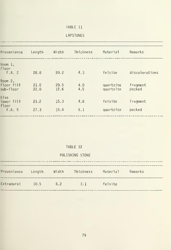
TABLE 11
LAPSTONES
Provenience Length Width Thickness Material Remarks
Room 1,
floorF.A. 2 28.8 20.2 4.3
Room 2,
floor fill 21.8 20.5 4.0sub-floor 22.0 12.6 4.5
Kiva
lower fill 21.2 15.3 4.8
floorF.A. 5 27.3 15.4 5.1
felsite discolorations
quartzite fragmentquartzite pecked
felsite fragment
quartzite pecked
TABLE 12
POLISHING STONE
Provenience Length Width Thickness Material Remarks
Extramural 10.5 6.2 3.1 felsite
79

cobbles show evidence of battering as well as grinding, indicating
that they may have functioned partly as hammerstones. Tools
classified as worked cobbles may have had a myriad of functions.
Worked Slabs
Seven artifacts are classified in this category, and consist
of tabular sandstone, quartzite, or felsite slabs that show wear
patterns and/or evidence of manufacture. All have been ground on
at least one face. Two of the worked slabs are uniformly thin,
slightly ground bifacially, and have been spalled around the
periphery to produce a circular artifact if complete. These two
slabs may have functioned as jar covers.
One small slab shows bifacial grinding, with one edge adja-
cent to the grinding surfaces ground smooth. While no discolora-
tion was observed on this artifact, it may have served as a palette
The function of the remaining artifacts in this type is
undetermined.
Crusher
A single fragment of a crusher was excavated. This tool is
sub-rectangular in shape, and generally looks like a mano. Its
massive size, however, clearly renders it unsuitable for mano-like
use. The entire periphery has been pecked to shape. Some evidence
of grinding is apparent on the convex face of the crusher, but by
no means approximates the degree of grinding found on manos
.
Swannack (1969:122) beleives that crushers may have been used to
pulverize hard materials to produce temper for ceramic manufac-
ture. A crusher excavated from a preceramic Basketmaker II site
north of Durango, Colorado, however, throws considerable doubt on
Swannack 1
s hypothesis (Reed and Kainer 1977).
80

TABLE 13
WORKED COBBLES
Provenience Length Width Thickness Material Remarks
Room 1
level 1 11.4 7.9 6.3 sandstone triangular in
shape10.9 9.2 3.4 sandstone
Room 4
floorF.A. 3 18.3 14.8 4.2 fel site
Kiva
upper fill 8.2 7.8 2.8 fel sitelower fill 6.8 4.4 2.3 quartzite battering
11.7 8.1 5.9 quartzite
floorF.A. 7 10.6 10.4 5.2 sandstone
Extramural 11.9 9.1 2.9 sandstone battering10.3 9.7 2.9 sandstone20.8 12.7 7.7 sandstone15.0 12.1 4.5 fel site18.7 9.6 4.7 sandstone battering
81

TABLE 14
WORKED SLABS
Provenience Length Width Thickness Material Remarks
Room 2
floor fill 25.2 12.4 2.3 sandstone29.7 10.4 0.9 sandstone jar cover (?)
Room 4
floorF.A. 5 8.9 4.8 2.8 sandstone jar cover (?)
Kivalower fill 9.5 6.3 0.7 sandstone jar cover (?)
5.6 4.1 0.8 sandstone palette (?)
floorF.A. 6 15.1 8.0 7.4 fel site
sub-floor 12.1 7.9 1.9 quartzite
82

Axes
Two complete three-quarter grooved axes were found. Both
were manufactured from river cobbles, but have been greatly modi-
fied by both pecking and grinding. The grooves for hafting are
pecked just distal ly from the center of the tool. The poll ends
show evidence of battering on both artifacts. The bit ends are
carefully ground and show slight to moderate amounts of wear. One
axe retains striations on the bit that are oriented primarily
perpendicular to the axis of the blade; however, some oblique
striations are also present.
Miscellaneous Stone Artifacts
Mineral Pigments
Four specimens of paint pigments were recovered at the site.
Three consist of hematite, and one of malachite. The three hema-
tite samples vary substantially in texture and hardness, but are
all reddish to rusty in color. Two of the hematite pebbles show
at least one grinding surface where the pigment was rubbed against
a palette or an object being colored.
Pigments were found in the upper, lower, and floor fill of
the kiva, and beneath the floor of Room 2.
Petroglyphs
Two building stones with petroglyphs on their finished faces
were found at the Dominguez site. Both were sandstone, and had
been generally shaped by spalling. The faces of these petroglyph
building stones, which presumably would have been exposed beyond
the limits of a plastered wall, were pecked smooth, and then had
designs pecked and ground into them. One petroglyph (Fig. 29)
83

TABLE 15
CRUSHER
Provenience Length Width Thickness Material Remarks
Room 3
sub-floor 17.0 15.2 7.3 felsite fragment
TABLE 16
AXES
Provenience Length Width Thickness Material Remarks
Kiva
lower fill 11.8 5.4 3.4 quartzitefloor fill 11.1 6.4 3.8 granite
84

consists of a series of concentric rings, with diameters of 2.7
cm., 5.6 cm. and 9.0 cm. It measures 19.6 cm. in length, 13.3 cm.
in width, and 12.7 cm. in thickness. The other (Fig. 30) has a
spiral design, with the outer portions of the spirals truncated by
the limits of the stone.
Relatively few artifacts of this type are found within the
Mesa Verde area. Room 2 at Badger House (Hayes and Lancaster
1975:166) contained a building stone with an incised swastika, and
8 were excavated from the Escalante Ruin. Artifacts of this type
seem to be found predominately in the vicinity of the north walls
of a pueblo. The petroglyph from Badger House was found in the
fill of a room oriented on the north side of the pueblo (Hayes and
Lancaster 1975:166), and Nemetz (personal communication) reports
that the petroglyphs from the Escalante Ruin were also found in
the area of the north wall. One petroglyph from the Dominguez
site (Fig. 29) was found in the wall rubble just 1 meter north of
the pueblo's north wall. The provenience of the other petroglyph
is unknown.
Modified Bone
A total of 29 worked bone implements was recovered. Two
specimens are classified as bone beads, and are discussed in the
ornament section of this chapter.
Artiodactyl bone was the most common material utilized,
accounting for 72% of the total. Of the artiodactyl bone tools,
mule deer account for 11 of the artifacts, antelope and elk each
account for one artifact, and 8 are from unidentified artiodactyls,
Bone tools made from turkey elements are also fairly common,
comprising 17% of the modified bone. Single artifacts of dog,
85

!/'*':% *£«* *4 .4*.
Figure 29. Petrolyph building stone. Width is 13.3 cm.
Figure 30. Spiral petroglyph on face of building stone. Widthof stone is approximately 30 cm.
86
cottontail, and jackrabbit were also found; these comprise the
remaining percentages of the total.
Awls
Ethnographic accounts concerning the function of awls suggest
that they were used primarily in basket weaving and for the per-
foration of hides in clothing manufacture (DiPeso 1956:412;
Kluckhohn 1971:304). The basic motion of an awl, then, whether
being used in sewing or basketry manufacture, is one of piercing.
Semenov (1973:18) writes:
In practice, piercing is not done by straight pressure but is
accompanied by turns of the hand to right and left in a
quarter or half circle. In this case the points' wear is
influenced by two movements; a straight and a rotary one;
traces on the point will reflect these two forms of movement.
Lines parallel to the axis of the tool will be cut by lines
going around it, that is, at right angles to its axis if we
think of it in a section.
Those tools classified here as awls are pointed tools which
exhibit the type of wear patterns described above by Semenov.
Within the awl category, a couple of sub-types can be recog-
nized. Three of the 13 tools classified as awls can be further
classified as weaving tools. These tools are distinctive from the
remainder of the awl population in that they possess a very high
degree of polish near the tip, and also possess large grooves,
oriented transversely to the axis of the tool, located a few
centimeters back from the tip. This wear is evidently the result
of friction by the tool against the tightly stretched warp strands
during the beating down of the weft in loom weaving (Kidder
1932:226).
Another sub-type of awl consists of a single turkey tibio-
tarsus that has been shaped in a manner so as to closely resemble
87
what Reed (1975) calls Type 3 of Bird Bone Awls. These tools
possess wear patterns typical of awls, are usually made from large
avian tibiotarsi, and have their shafts ground down to a tip at
approximately a 20 angle. The high degree of morphological and
functional uniformity of these tools suggest that they form a
discrete type in the Mesa Verde area.
Flaker
A single flaker was found at the Dominguez site. The tool is
rather massive, measuring 13.8 cm. in length and 1.3 cm. in thick-
ness. It was manufactured from a metapodial shaft splinter of an
elk. The tip end is pitted and rough, presumable due to the
nature of the tool's function: pressure flaking of stone arti-
facts. The butt end of the tool is somewhat battered, suggesting
that the flaker may have also served as a punch. The tool was
recovered in the lower kiva fill.
Humerus Scrapers
Six bone implements of this type were recovered, and all were
associated with Burial 2. Four of the tools were made from the
humeri of mule deer, one of an antelope, and one of an unidenti-
fied artiodactyl. These tools range in size from 15.3 to 19.1 cm.
in length, and average 17.1 cm. The articular head (distal) of
the tools were ground to varying degrees, with the apparent inten-
tion of removing sharp protuberances.
The wear patterns ovserved on these tools generally supports
their classification as scrapers. While wear striations on the
exterior of the diaphysis near the transverse scraping blade are
oriented both parellel and perpendicular to the working edge, the
striations on the interior of the diaphysis tend to be oriented at
right angles to the working edge.
88

TABLE 17
AWLS
Provenience Length Species Element Remarks
Room 4
Floor fill 13.4 unidentifiedartio.
R. tibia
Kivalower fill 9.7 mule deer L. tibia
8.2 unidentifiedartio.
metapodial tip missing
6.2 dog firstphalange
weaving tool
16.8 mule deer L. metatarsal weaving tool16.3 unidentified
artio.metapodial
7.2 unidentified unidentified butt end usedas spatula orscraper
17.1 mule deer L. metatarsal weaving toolturkey R. tibiotarsus fragment
6.8 turkey radius delicate
floor fill 8.7 turkey L. tibiotarsus drill holenear butt
13.8 unidentifiedartio.
metatarsal
9.4 jackrabbit L. tibia
89

Spatula
A single spatula is classified within this type. It consists
of an unidentifiable species of artiodactyl, and is fragmented.
The working edge is rounded in form, and retains striations on one
surface that are generally oriented at right angles to the working
edge. The tool's function is uncertain. This artifact was found
in the lower kiva f ill
.
Tibia Tinkler
A possible tibia tinkler was excavated from the floor fill of
the kiva. The tool consists of the proximal half of a right tibia
of a cottontail, and measures 8.4 cm. in length. As with nearly
all artifacts of this type identified in the Mesa Verde area, the
proximal articular surface has been removed in a manner as to
expose the hollow interior of the bone. The entire surface of the
tool shows a moderate degree of polish. The characteristic perfora-
tion usually found along the shaft of the artifact is missing,
however, probably having been located below the break.
The function of tibia tinklers is unknown. Swannack (1969:155)
points out that such artifacts are usually found associated with
kivas, and so may have had some ceremonial purpose. The proven-
ience of the tinkler found at the Dominguez Ruin supports Swannack 's
hypothesis.
Tube
A single bone tube fashioned from the right ulna of a turkey
was found in the floor fill of Room 3. The artifact shows a
slight degree of polish across its surface, and measures 4.9 cm.
in length. The truncated ends of the tool are unmodified. The
artifact is classified as a tube rather than as a bead because of
its rather unfinished appearance in contrast to the high degree of
90

polish found on beads, and because of its similarity to a class of
artifacts described by Reed (1975) from the Mancos Canyon area of
southwestern Colorado. The tubes from this area (called Type 2
tubes) are all made of turkey elements and are highly uniform in
size and shape. Tubes similar to those found in the Mancos Canyon
area and at the Dominguez site are described by Hodge (1920:125),
who believes that they were strung side by side to form a wrist-
guard. Several skeletons excavated at Hawikuh were found to have
such tubes on their wrists (Hodge 1920:125).
Tool Blanks
One metacarpal and 3 metatarsals of mule deer show evidence
of being prepared for controlled splitting. The splitting probably
represents a step in the manufacture of bone tools. All artifacts
within this type have been grooved along the anterior and posterior
mid-lines of the metapodials, presumably with a stone implement.
No wear is present. All blanks were from the floor fill of the
kiva.
Texti les
While no actual textile remains endured the centuries of
weathering at the Dominguez Ruin, the impressions of two such
artifacts were encountered. Both were associated with Burial 2.
One impression represents a burial mat, laid atop the deceased.
This specimen was originally constructed by plaiting 2 strips of
vegetal material over 2 underlying strips. The vegetal strips
were probably about 0.5 cm. in width, and consisted of reed
(Phragmites sp. )
.
A small, vague impression of cotton cloth or some other
tightly woven textile was excavated near two identical shell and
turquoise pendants found with Burial 2. Its poor condition renders
further analysis impossible.
91


CHAPTER IV
SUBSISTENCE
The physical remains excavated from the Dominguez Ruin indi-
cate a mixed economy, based on agriculture, hunting, and gathering
of wild plants. While the relative importance of each of these
subsystems to the overall subsistence pattern is \jery difficult to
ascertain from the archaeological record, it appears that the
means of subsistence at the Dominguez Ruin was similar to that of
the Mesa Verde area in general.
Floral Exploitation
Corn, beans, and squash were the most important domesticated
plants in the Southwest, and were probably all grown by dry land
farming methods on the large tract of arable land to the south of
the Dominquez Ruin. The excavations produced evidence only of
corn (Zea mays ), however, and this in rather small quantities.
One charred kernel was found in the firepit of Room 1, and several
pollen samples contained Zea pollen grains.
In addition to the cultigens listed above, certain "wild"
plants were probably part of the prehistoric inhabitant's diet.
Lambsquarter (Chenopodium sp.), pigweed (Amaranthos sp.), mallow
(Malvastrun and Sphaeralcea ) , purselane (Portulaca ) and blazing
star (Mentzelia albicaulis ) seeds were recovered at the site. All
have ethnographic use in the Hopi and Zuni societies as foods or
as medicines (Stevenson 1915; Whiting 1939).
Plants commonly found growing in the area today with ethno-
graphic use as food plants but which are absent in an archaeo-
logical context at the Dominguez Ruin are yucca ( Yucca baccatta ),
pinon ( Pinus edulis ), beeweed ( Cleome serrulata ), and Indian rice
grass ( Oryzopsis hymenoides ).
93

Fauna! Exploitation
Two hundred and fifty unmodified animal bones were recovered
in the course of excavation, representing at least 16 separate
species. Artiodactyl bones were the most numerous, accounting for
62% of the total number of bones. This figure does not adequately
describe the importance of artiodactyls to the subsistence system
at the Dominguez site, however, as the relationship between the
number of bones of a certain species and its importance in the
diet is not a strong one. Many individuals of a small sized species
may not be as important to the overall diet of a people as a
single animal of a very large species. To alleviate this problem,
the minimum number of individuals has been calculated for each
species represented at the Dominguez Ruin, based on the total
number of the most common element within the bone population of a
single species. Pounds of usable meat for each species, obtained
by multiplying the average weight of a butchered carcass (White
1953:397) by the minimum number of individuals, perhaps best
reflects the relative importance of each species to the Anasazi
diet (Table 18).
Calculations of the usable pounds of meat per species repre-
sented at the site places artiodactyls as the most important meat
source. Various species of artiodactyls combine to comprise 93% of
the meat utilized at the site. Of this, mule deer accounts for
49%, antelope, elk and bighorn sheep combine to account for 40%,
and unidentified artiodactyls account for 4% of the total. Birds,
including turkey, goose, and grouse, comprise 2% of the total
pounds of usuable meat at the site. Dogs (and possible coyote),
wolf, jackrabbit, cottontail, porcupine, beaver, bobcat, mice and
rats make up the remaining percentages, but clearly are of rela-
tively minor importance. It should be noted that the sample is
skewed slightly in favor of the larger animals, as excavation
94

TABLE 18
MINIMUM NUMBER OF INDIVIDUALSAND USABLE POUNDS OF MEAT
Species
MinimumNumber ofIndividuals
Pounds of
Usable Meat
Jack rabbit(Lepus californicus) 1 3.0
Cottontail (Sylvilagus sp.) 2 3.5
Porcupine(Erethizon dorsatum) 1 10.0
Beaver (Castor canadensis) 1 38.5
Mouse (Peromyscus sp.
)
1 nominal
Rat (Neotoma sp.
)
2 1.0
Grouse(family: Tetraonidae) 1 2.0
Turkey(Meleagris galopavo) 5 42.5
Goose (Branta sp.
)
1 4.0
Dog (Canis familiaris) 1 7.0
Wolf (Canis lupus) 1 30.0
Bobcat (Lynx rufus) 1 15.0
Unidentified Canis sp.
(coyote ?) 1 12.5
Elk (Cervus canadensis) 1 350.0
Mountain Sheep
(Ovis canadensis) 1 100.0
Mule Deer
(Odocoileus hemionus) 7 700.0
Antelope(Antilocapra americana) 2 110.0
Unidentified Artiodactyl 7 700.0
TOTAL 2129.0
95

techniques employed at the site undoubtedly resulted in the loss
of some of the small rodent, fish, and reptile remains.
The inhabitants of the Dominguez Ruin may have done much of
their hunting a few miles to the northeast along the House Creek
and Beaver Creek, in what is now the San Juan National Forest. In
this area, Anasazi lithics have been found in abundance; but very
little in the way of pottery and no pueblos have been found (Zier
1977). The area is above 7,000 feet in elevation, making agri-
culture risky. Ponderosa pine, dense scrub, and numerous drain-
ages provide an optimum environment for deer (Zier 1977).
96

CHAPTER V
HUMAN BURIALS
Three human burials and three isolated human bones were
uncovered during the excavations at the Dominguez Ruin. The three
burials are interred beneath the floor level of Room 2, and were
placed there after the abandonment of the room.
Burial 1
Located approximately in the center of Room 2, 0.35 m. below
the floor level, was an infant burial (Fig. 31). The infant was
positioned on its back in a semi-flexed position, with its head
toward the west and facing north. The infant was in surprisingly
good condition, with virtually all bones present. Its age at the
time of death was between 1 and 4 months, based on the observation
that no milk teeth had erupted, the length of the long bones, and
that virtually none of the long bones, and that virtually none of
the epiphyses had sealed. Determination of sex was not possible.
The infant burial was positioned 0.11 m. above Burial 2, an
adult. The infant was evidently covered with a red pigment, probably
hematite, upon burial, as this substance is found adhering to the
surfaces of many of the bones.
The proximity of Burial 2, a high status burial, to the
infant's grave makes it difficult to determine which grave goods
are associated with which burial. Of certain association with
Burial 1 are two shell beads, found in the vicinity of the in-
fant's midsection. One bead (Fig. 20) consists of an Olivella
shell with a spire end ground off to form a hollow tube. This
bead, according to Ms. Malcolm Withers (personal communication),
is manufactured from an Oliva undatella shell. The other bead
97

fcr.
fry,7r
5MT2148ROOM 2BURIAL |
= •:/"- '-•
H:
P^gg *ii;^'*- j-f,<p~Jiy
Figure 31. Burial 1, infant.
98

(Fig. 21), of undetermined species, is bilobed or "figure-8" in
form.
Of probable association with the infant burial is a miniature
corrugated jar (Fig. 13). This jar is approximately 15 cm. from
the head of the infant, almost resting atop the skull of Burial 2.
The base of this jar is roughly on the same level as the infant
skeleton, which would be at the presumed bottom of the burial pit
dug for the infant.
Two medium sized corrugated jars (Figs. 14 and 15) and a
small Mancos Black-on-White bowl (Fig. 16) were found in the fill
above Burial 1. Whether these vessels are associated with the
infant burial or were placed as offerings to the high status
burial after the interrment of both burials is moot.
Burial 2
Burial 2 is located in the center of Room 2, 0.45 m. beneath
the level of the floor and 0.11 m. beneath Burial 1. Burial 2 is
an adult female, approximately 35+2 years of age, as determined
by the analysis of the pubis symphis and by other less exact
methods. The condition of the burial is excellent, and all bones
are present. The skeleton was found in a semi-flexed position,
lying on its right side with its head to the west, facing south
(Fig. 32). Citing Trotter and Gleser (1952:496) and Genovas
(1966:41), Bass (1971) presents calculations for determining the
stature of a living adult from skeletal material. The individual
represented by Burial 2 stood, on the basis of these calculations,
approximately 155 + 3 cm. in height. As in the case of Burial 1,
some of the bones of this individual were covered with a red
pigment, presumably red ochre or hematite. The pigment was placed
on the flesh and not the bones directly as evinced by the occur-
99

^^5:
**%"
I-
^'*^<<,
Figure 32. Burial 2, high status adult.
100

rence of small amounts of reddish stain in the soil surrounding
the skeleton.
The quality and quantity of the burial goods found with
Burial 2 sets the burial apart from any other in the Mesa Verde
area. Found with the burial were three elaborate pendants (Figs.
23 and 25), six humerus scrapers, 6,900 turquoise, jet, and shell
beads (Fig. 22), three turquoise and shell mosaics, two ceramic
vessels (Figs. 18 and 19), impressions of a burial mat, several
obsidian and chert flakes, and some fragments of unmodified animal
bone. The three pendants, described in detail in Chapter III,
were found in a manner suggesting that they were probably sus-
pended around the body's neck. The frog effigy pendant was found
near the sternum (Fig. 33). One of the two medallion-shaped
pendants was found under the chin, and the other was near the
right shoulder of the skeleton (Fig. 34). Of the thousands of
beads, many were strewn throughout the grave, but most were con-
centrated around the face of the deceased. Some were found in
their original pattern, indicating that many of the beads were
worn as a necklace. Others were found in the base of one of the
ceramic vessels in a random order.
The two vessels definitely associated with Burial 2 consist
of a McElmo Black-on-white bowl. The pitcher had been placed
inside of the bowl, atop hundreds of beads found therein. The six
humerus scrapers were placed together in a cluster, all oriented
with the articular heads to the west, next to the skeleton's right
arm. A burial mat was placed atop the body, as evidenced by
fragments of basketry impressions over portions of the skeleton.
The original material, probably Phragmites sp., had completely
decomposed, leaving only a white-colored residue. Also near the
right elbow was found one of the three mosaics. The other two were
found beneath the McElmo Black-on-white bowl near the skull.
101

Figure 33. Frog-eftigy pendant on Burial 2,
Figure 34. Shell, specular hematite, and turquoisependants on Burial 2.
102

Burial 3
Tucked into the southeast corner of Room 2 was the burial of
a child. The child, based on the degree of fusion of the epiphy-
sial plates, the eruption of the 6 year molar, and other dental
features, is thought to have been 7 years old at death. The
burial has been disturbed by rodent activity, as evidenced by the
presence of a few of the child's bones in an adjacent room. The
sternum, patellae, hand, and feet bones were never found. The
bones present are in fairly good condition. The child was found
in a fully flexed position, with the legs drawn tightly up to the
chest and under the skull. The skeleton was laying slightly on
its right side, with the head to the southwest, facing upward and
toward the east (Fig. 35). No pigment was found on the bones, and
no grave goods were associated with the burial.
Isolated Human Remains
Three isolated human bones were recovered during the course
of excavations. A left talus of an adult individual was found in
two pieces in Room 3. One piece was found in the fill, and the
other piece was found upon the floor and was designated Floor
Artifact #17. In the lower portions of the kiva fill were found a
badly eroded mandibular fragment, with parts of a molar intact,
and also a proximal fragment of a femur. The femur is adult
sized, but may not have been completely fused at the epiphysis.
No pathologies were observed on any of the isolated human bones.
Anthropometry
Tables 19 and 20 present the available anthropometric data
for Burials 2 and 3. No measurements were made for the infant
103

Figure 35. Burial 3, child
104

TABLE 19
CRANIAL MEASUREMENTS
Burial 2 Burial 3
Maximum length*Maximum breadth*Minimum frontalBasion- bregma
Circumference*Auricular height*Total facial heightUpper facial heightBi zygomatic breadthNasal heightNasal breadthNasion- basionBasion- prosthionL. Orbital heightR. Orbital height
L. Orbital breadthR. Orbital breadthInter- orbital breadthExternal palate lengthExternal palate breadthInterior palate heightMandibular lengthBicondylar breadthBigonial breadthL. Ramus heightL. Ramus minimum breadthSymphyseal heightInter- foraminal breadthCoronoid heightBody thickness
Indicies :
CranialHeight lengthHeight breadthUpper facial
Total facialNasal
OrbitalExternal palateMandibular
16.60 12.0°
14.35 15.5°
9.45 9.313.85 - -
48.40 47.011.45 - -
11.45 - -
7.20 5.612.50 - -
4.60 4.42.65 2.29.45 - -
9.45 - -
3.70 3.53.55 3.7
3.60 3.84.10 - -
2.35 2.0- - + 3.75.40+ 5.7
1.60 1.210.60 7.9
12.60 9.610.25 8.56.50 4.33.92 2.7
3.35 2.24.75 4.05.90 4.21.65 1.45
.864 1.29°
.834 - -
.965 - -
.576 - -
.916 - -
.576 .50
1.020 .92_ _ 1.52.841 .823
* = skewed due to artifical deformation+ = distortion due to pathologyo = distortion due to post mortem deformation- = absent or damaged
105

TABLE 20
BURIAL 2, POST-CRANIAL MEASUREMENTS
Humerus length
Max. head diameter
Distal end breadth
A-P mid-shaft diameter
M-L mid-shaft diameter
Ulna length
Trochlear notch height
Distal end breadth
Radius length
Max. head diameter
Distal end breadth
Femur length
Bicondylar length
A-P sub-trochanteric diameter
M-L sub-trochanteric diameter
A-P mid-shaft diameter
M-L mid-shaft diameter
Max. head diameter
Epicondylar breadth
Tibia length
Physiological length
Max. diam. proximal end
Nutrient foramen A-P diam.
(Continued)
106
R
L
R
L
R
L
R
L
R
L
R
L
R
L
R
L
R
L
R
L
R
L
R
L
R
L
R
L
R
L
R
L
R
L
R
L
R
L
R
L
R
L
R
L
R
L
29.930.4
3.73.7
5.35.6
1.91.82.1
2.1
24.925.22.42.31.9
1.923.322.92.1
1.92.7
2.640.840.740.240.5
2.82.93.93.82.62.7
2.32.3
3.93.9
7.1
7.034.034.033.3
33.26.66.63.1
3.1
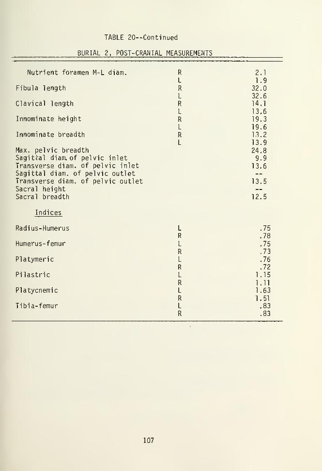
TABLE 20—Continued
BURIAL 2, POST-CRANIAL MEASUREMENTS
Nutrient foramen M-L diam. R 2.1
L 1.9Fibula length R 32.0
L 32.6Clavical length R 14.1
L 13,6Innominate height R 19.3
L 19.6Innominate breadth R 13.2
L 13.9Max. pelvic breadth 24.8Sagittal diam. of pelvic inlet 9.9Transverse diam. of pelvic inlet 13.6Sagittal diam. of pelvic outletTransverse diam. of pelvic outlet 13.5Sacral heightSacral breadth 12.5
Indices
Radius-Humerus L .75
R .78
Humerus-femur L .75
R .73
Platymeric L .76
R .72
Pilastric L 1.15R 1.11
Platycnemic L 1.63R 1.51
Tibia-femur L .83
R .83
107

TABLE 21
NON-METRIC OBSERVATIONS
Burial BurialSide 2 3
Os Inca
Lambdoid ossicles
Tympanic dehiscence
Supra- orbital foramen, closed 1
Supra- orbital foramen, notch
Accessory mental foramina
Accessory infra- orbital foramina
Metopic suture
Parietal foramen
Mandibular torus
Mastoid torus
Pierced olecranon fossa, humeri
Third trochanter, femora
Zygo- maxillary tuberosity
Squatting facets, tibiae
A P
A P
R
L
A
AA
A
R
L
P
P
P
A
R
L
A
A
P
A
R
L
A
AA
A
R
L
A
A
A
A
R A P
L A P
P A
P -
R A A
L A A
R A A
L A A
R P _
L A -
R P _ ,
L A - .
A = absentP = present- = no observation, damaged or missingR = right
L = left1Q8

burial (Burial 1) as neither the skull nor any of the post cranial
epiphysial plates had fused. Cranial measurements only are pre-
sented for Burial 3, as again, epiphysial fusion had not begun on
the long bones. Both cranial and post cranial measurements are
presented for Burial 2.
Anomal ies
Subjective non-metrical observations were made on the three
burials, and are presented in Table 21. In addition to the data
presented therein, it should be noted that Burials 2 and 3 have
slight chin projections, no palatal tori, U-shaped palates, and
elliptic auditory meatuses. All burials have bilateral chin forms.
Burials 1 and 2 have elliptic eye orbits, while Burial 3 has round
rhomboid eye orbits. Burial 2 also has an X-shaped pterion and a
slight development of the supraorbital ridge. Artificial deforma-
tion of the occupital is evident in Burial 2, and indeterminable
in Burials 1 and 3 due to the lack of suture fusion and post-
mortem deformation.
Pathologies
Burial 1
Bilateral osteoporosis (cribra cranii) was observed on the
parietals of the infant skull. Zaino (1967:40-42) writes that the
cause of symmetrical osteoporosis is unknown, but that nutritional
deprivation alone is an unlikely explanation. Carlson et al .
(1974) has linked symmetrical osteoporosis to iron deficiency
anemia, and Angel (1969) associates the pathology with hemolytic
blood disorders. A brief survey of the literature on Anasazi
pathologies indicates that symmetrical osteoporosis is a rather
common feature of the burial population.
109

An analysis of X-ray exposures taken of Burial 1 reveals,
even at the infant's young age, Harris or growth arrest lines.
These lines, which appear as faint transverse lines of dense
calcification across the long bones, indicate periods where the
individual nearly stopped growing. Wells (1964:155) writes:
If during development, the bone is subjected to any adverseinfluence this process of active proliferation is disturbedand the growth cartilage remains dormant for an indefinitetime depending on the kind of injury. This may be a shortacute illness such as pneumonia or enteritis, or a moreprotracted episode such as a period of famine especially,perhaps, protein starvations.
Growth arrest lines of course only reflect trauma experienced
before one reaches adulthood. The lines are usually permanent,
but tend to fade with age. The infant of Burial 1 experienced
one, or possibly two, periods of arrested growth before death.
No evidence of bone injuries or of diseases other than those
mentioned above were observed on Burial 1.
Burial 2
The individual represented by Burial 2 appears to have enjoyed
reasonably good health. No bone injuries or diseases were detected
from the skeletal analysis. The individual did possess a slight
degree of lipping along the margins of the bodies and on the
articular surfaces of the toracic vertebrae, but these, according
to Dr. Dennis Van Gervin (personal communication), are evidence of
arthio-arthritis, a natural and non-pathological breakdown of the
carti ledge system with age. X-rays revealed at least two periods
of growth arrest during Burial 2's childhood. Two Harris lines
were visible on the right tibia and the left femur. Birthing
trauma was evident on the innominates.
Burial 2 possessed shovel-shaped incisors and predominately a
4-Y cusp pattern. Attrition of the teeth was moderate; the incisors
110

and premolars were worn into the dentine, but the molars showed a
lesser degree of wear. Little was observed in the way of calculus
deposits, and alveolar resorption, which is associated with perio-
dontal infection, is slight. One case of protostylid was found on
the second molar on the left side. Four cases of chronic dental
abscesses were noted, resulting in the antemortem loss of the
first maxillary molars bilaterally, the second maxillary premolar
on the right side, and the third maxillary molar on the left side.
In addition, the first mandibular premolar on the right side is
abscessed, as well as possessing an advanced occlusal carie.
Interdental carries are present on the second mandibular molar on
the right side and the second maxillary premolar on the left side,
with the latter in an advanced stage. Occlusal caries are present
on the first maxillary premolar and the third mandibular molar.
The third mandibular molar, in addition to the carie, is impacted
and peg-shaped. The maxillary and mandibular second and third
molars on the right side, the maxillary second molar on the left
side, and the mandibular third molar of the left side all have
fused roots.
Burial 3
Burial 3 possessed no apparent bone injuries, but did exhibit
obvious symptoms of cribra orbital is, a symmetrical osteoporosis
centered in the eye orbits. Additionally, at least 3 growth
arrest lines are visible on X-ray exposures of the tibias and
femurs. The growth arrest lines on these bones seem to spacically
correlate with each other. The child possessed on occlusal carie
on its left maxillary second milk molar, and one supernumerary
milk pre-molar. The milk incisors and canines were worn down to
the dentine, but the permanent teeth lacked attrition.
Ill


CHAPTER VI
INTERPRETATIONS
The Relationship Betweenthe Dominguez Ruin and the Escalante Ruin
If one is to understand the nature of the relationship be-
tween the Dominguez Ruin and the Escalante Ruin, it is first
necessary to examine both sites within a larger framework. As
mentioned in preceeding chapters, the Dominguez Ruin seems to
generally conform with other sites in the Mesa Verde area of the
same time period. The Escalante Ruin, on the other hand, does not
conform so readily. Of primary importance is understanding the
relationship between the two sites is examing the Escalante Ruin
as a Chacoan outlier. If the Escalante Ruin is indeed a site-unit
intrusion instead of an indigenous development shaped by intrusive
trait-units, then the implications of the inter-site relationship
may be most profound.
Architectural evidence indicates that the Escalante Ruin is
actually site-unit intrusion. When discussing site-unit intru-
sions as opposed to trait-unit intrusions in general, Collins
(1975:19) points out that the distinction is both qualitative and
quantitative; the greater number of distinctive normative traits
and the more extreme the differences between a given site and
surrounding sites, the more likely it would be classified as an
intruded site unit. Architectural features of the Escalante Ruin
are notably atypical of the Mesa Verde area and compare favorably
to only five other sites in Southwestern Colorado, namely the
Lowry Ruin (Martin 1936), Chimney Rock Pueblo (5AA83) (Eddy 1977),
the Ida Jean site, the Wallace Ruin (Bradley 1974), and Yucca
House (Gillespie 1977). In addition to these Colorado sites, 15
113

other Chacoan outliers have been identified in the northwestern
New Mexico and northeastern Arizona (Dr. James Judge, personal
communication). Judge (personal communication) finds that Chacoan
sites are characterized by the following criteria:
1. Symmetrical ground plan, including a single, massiveroomblock (often "D" or "E" shaped).
2. Probability of multiple stories.
3. Compound, or rubble and veneer masonry.
4. Relatively large rooms, with high ceilings.
5. Ceramic assemblages roughly equivalent to Bonito Phaseassemblages in Chaco Canyon (Red Mesa Black-on-White,Gallup Black-on-White, Chaco Black-on-White, and equi-valent carbon paint types).
6. Possible association with a great and/or tower kiva.
7. Possible association with a roadway.
The Escalante Ruin fits some of the criteria listed above,
but does not possess a great or tower kiva or a roadway (Nemetz
1977). Several other characteristics seem applicable to all of
the Chacoan outliers presently identified in Colorado. First, all
five sites are located atop a hill or ridge with a commanding view
of the surrounding area. This may have facilitated long distance
visual communication. The settlement pattern evident here may be
an important characteristic, because if physiographic variables
are constant, differences between the settlement patterns of
different communities, such as a Chacoan outlier and the sur-
rounding indigenous pueblos, may be explained as differences
between cultures. "Similarities in settlement patterns can be
explained by similarities in beliefs, customs, and social organi-
zation" (Collins ly75:20). The excavated sites of Chaco affili-
ation (all except Yucca House have been at least partially exca-
vated) also have kivas that are enclosed in the roomblock proper
and are confined within a masonry quadrangle with artificial fill
placed between the walls of the quadrangle and the kiva walls.
114

Kiva features such as "floor vaults," sub-floor ventilator shafts
and low pilasters with beams in association frequently occur in
these sites.
Within a radius of 300 m. of the Escalante Ruin, at least one
half dozen small Azasazi pueblos, including the Dominguez Ruin,
are found. These sites, like the Dominguez Ruin, are situated at
the base of the hill atop of which the Escalante Ruin is located,
or on benches along the hillside. Most of these sites are on
private lands, and so have not been recorded or analyzed properly.
A brief visit to these sites by this author leads him to believe
that thay can be classified as Pueblo II or Pueblo III Period
sites, and may well represent a "community" of sorts, contempor-
aneous with the Escalante Ruin. That the Dominguez site is
contemporaneous with the Escalante Ruin seems reasonable, as the
percentages of ceramic types are essentially the same, stone
petroglyphs of similar nature are found at both sites, and dendro-
chronological dates are fairly close. According to Judith Nemetz
(personal communication), much of the building at the Escalante
Ruin occurred in the late 1130's A.D. The Dominguez Ruin, as
mentioned in Chapter II, was built approximately 1123 A.D. Evi-
dence less difinitive in nature, such as that little or no build-
ing stones were robbed from the Dominguez Ruin for construction
elsewhere, supports the assumption of contemporaniety. The model
presented here, with small indigenous sites surrounding a Chacoan
outlier, may represent the settlement patterns around many, if not
all, Chacoan outliers. Robert Powers (personal communication)
states that at three Chacoan outliers intensively surveyed in the
Chaco basin of New Mexico, small Hosta Butte phase villages, with
their "just plain- folk architecture" were found clustered around
the large outlier towns.
115
The nature of the interactions between the Chacoan outliers
and indigenous sites is difficult but certainly not impossible to
determine from the archaeological record. That the small sites
functioned as field houses for the large outliers seems unlikely.
While the Dominguez Ruin is adjacent to an arable tract of land,
its proximity to the Escalante Ruin (ca. 150 m.) makes its value
as a fieldhouse questionable. The Dominguez Ruin also has a kiva,
a feature whose presence implies more than just a temporary occu-
pation. Artifacts appear to represent a full gamut of activities,
and seem to be similar in frequencies to other Mesa Verde area
sites which definitely were occupied the year round. On the other
hand, the relative dearth of firepits leads one to wonder about
heat production in the habitation rooms in the winter months; the
only explanation offered here is that there could have been a
firepit in Room 2, before the interrment of the three burials
destroyed the floor and its features.
Of increasing popularity is the hypothesis that the Chacoan
outliers, as well as the large town sites within Chaco Canyon,
functioned as part of an extensive trading network which pervaded
the entire Gran Chichemaca (cf. Di Peso 1974; Kelley 1975).
Whether small groups of actual pochteca from Mesoamerica were
inhabiting sites in the San Juan area or whether the pochteca were
merely trading with local traders at special centers and living
elsewhere is of course uncertain.
Kelley (1975) better defines these alternatives in discussing
the concepts of "soft diffusion" and "hard diffusion". The former
concept involves group-to-group migration involving the actual
presence of members of the donor culture in the recipient culture
(Kelley 1975:184). The impact of both types of diffusion may be
highly variable. In any case, the trading centers, in the form of
the Chacoan outliers, possessed architectural and artif actual
116

attributes unique to the surrounding area. These unique attributes
may have facilitated practical benefits, such as the storage and
redistribution of trade items, or may have functioned more to
display wealth and status.
Frisbie (1972) suggests that Chacoan outliers "represent a
colonization by an expanding Chacoan population, due in large
measure to the improved quality of hybrid forms of maize, as well
as for the exploitation of a variety of natural resources occurr-
ing in close proximity to the satellite sites. The resources,
per se , could easily have included minerals (particularly those
prized for ornamental and/or ceremonial use especially turquoise,
paint pigments, salt, and others), feathers, hides (and meat),
timber (possibly a variety of wood in general), and plants (a
great variety would have been available since varying ecological
situations exist at different satellites)." In short, Frisbie
makes a case for a more localized trading network, with the out-
liers serving the core area of Chaco Canyon. Trading activities
from other cultures would ultimately have been tunneled into Chaco
Canyon.
The material remains excavated from the Escalante Ruin and
other outliers suggests that if such a trade network was of major
importance to the sites, mostly perishable items, which have since
left little or no trace, must have been the primary items in
circulation.
Some sort of trade network was undoubtedly operating in the
Southwest in Pueblo III times (and beforehand as well), as evi-
denced by the widespread occurrences of turquoise, shell, jet, and
lithic material, in addition to copper bells, macaws, mosaics,
pyrite mirrors, and other objects in certain areas of the South-
west. If the Escalante Ruin was actually a satellite for a larger
117

trading complex, small sites may have been constructed by local
peoples around the outliers to somehow benefit from the outlier's
presence. The benefits received by the villages surrounding the
presumed trading centers are difficult to ascertain. The Hosta
Butte Phase sites of Chaco Canyon lack exotic items such as
cylindrical jars, mosaics, quantities of turquoise, inlaid repre-
sentations, cloisonne, copper bells, and macaws (Vivian and
Mathews 1973) that were found in the town sites just a few hundred
meters away. As mentioned above, the Dominguez Ruin lacked exotic
items excepting those found with the burials. These grave goods,
as will be discussed below, are thought to have emanated from the
Escalante Ruin and did not belong to the inhabitants of the Domin-
guez Ruin. The benefits received by the inhabitants of the Domin-
guez site may have been, therefore, in the form of trade items
other than ornaments and the like. It is possible that certain
food items were prepared at the Dominguez Ruin for export, al-
though pollen and seed analysis do not support this speculation.
Explanations other than the pochteca model may be useful in
understanding the presence of outliers in Colorado. It seems
feasible that while Escalante Ruin may have had some trading
relations with Chaco Canyon, the site itself may have been settled
for reasons entirely removed from trade. The outliers may have
made attempts to lessen population pressures on the Chaco Canyon
center, which were possibly considerable in Chaco Canyon during
the major construction periods in Pueblo II and III phases. The
population of the Mesa Verde area, on the other hand, evidently
had begun to decline by the advent of the Pueblo II period (Hayes
1964), so that area may have possessed sufficient arable land to
provide for the incoming migrants. It should be noted, however,
that whatever the cause of the decline in population in the Mesa
Verde area, it would probably produce and equal impact on the
118

Chacoan immigrants. If the immigrants did indeed find a suitable
homeland in the Mesa Verde area, and trade was of minimal impor-
tance, then the impact on the indigenous Mesa Verde people would
possess characteristics much different from those resulting from
the pochteca model mentioned above. The Chacoan outliers would
have been in competition for resources with the indigenous Mesa
Verde peoples, and so the likelihood of the settlement pattern
resulting, with the small indigenous sites clustering around the
outliers, seem slight. It should be reiterated, however, that in
the vicinity of the Escalante Ruin, analysis establishing the
contemporaniety of the sites other than the Dominguez Ruin with
the outliers has not been attempted.
Regardless of the reasons why Chacoan outliers were constructed
in the Mesa Verde area, one interesting possibility concerning the
nature of the relationship between the peoples involved should be
mentioned. The Chacoan outliers may have been constructed for and
utilized by individuals or lineages of higher social status than
those people inhabiting the nearby sites. Proposing a similar
explanation for the occurrence of Hosta Butte Phase and Bonito
Phase sites in Chaco Canyon, Martin and Plog (1973:305) write:
One hypothesis for explaining the great towns on oneside of thewall and small contemporaneous villages on theother, is that the elite lived in the great towns (wherethe goods were found), and the less important peopleoccupied the smaller one-story villages.
Plog (1974:128) adds that the differences between the two types
of sites must have been organizational.
If there was a distinct difference in the level of social
organization between the Chacoan outliers and the nearby villages,
then the major benefits obtained by the village inhabitants may have
been in the form of organization rather than in material items. In
the following portion of this chapter, an attempt will be made to
show that the Chacoan outliers possessed a ranked level
119

of social organization. If this can be done successfully, then
the hypothesis that the village sites benefited via the outliers'
higher level of social orangization will be supported.
The Social Organization of Chaco Outliers
Statuses: Different categories of individuals, residenceunits, or sodalities that serve in the organization ofinterpersonal and inter-institutional behavior. They may bedivided into achieved and ascribed statuses. Statuses may bedistinguished on the basis of age, sex, group membership,specialization and so forth (Hill 1970:16).
Social categories can imply a great deal about the social
organization of a culture. An analysis of the rigidity of the
social distinctions between members of separate statuses, of the
degree of authority and/or power members of one status may have
over members of other statuses, and of the manner in which sta-
tuses are conferred upon members of subsequent generations may
provide the best indication of the level of social organization
possessed by a society.
Ascertaining such social distinctions from the archaeological
record, is, at best, difficult. While various phenomena discovered
in the course of an archaeological excation may appear indicative
of the superorganic features of the extinct culture, it is ethno-
graphic analogy that provides the best possibilities for the
interpretation of these findings. If an attempt is to be made in
determining the level of social organization attained at the
Chacoan outliers of Colorado, then an examination of some of the
social characteristics common to ethnographically described so-
cieties of various levels of social organization is in order.
Egalitarian Societies
As the term implies, an egalitarian society is one in which
120

ranking and stratification are absent, with leadership positions
being informal and based solely on the personal attributes of an
individual. The "leader" is indeed one held in somewhat higher
esteem than others within his society, but his position is based
solely on his strength, his prowess as a hunter orwarrior , or his
generosity, and remains intact only as long as his virtue is
recognized. The leader has authority rather than formal status
(Service 1975), which is based on community respect. While one
may be a leader in one activity or situation, different demands by
different activities may thrust another person into a position of
leadership. As Service (1975:52) points out, there are instances
in which an individual combines a high degree of skill, judgement,
and other virtues to such an extent that he may be deemed a leader
in a variety of contexts, giving him the appearance of a full
"chief". Even in such a case, points out Service (1975), the
leader does not occupy an office , which is a permanent position in
the society. Leaders in an egalitarian society do not occupy
permanent or pervasive position; one leads only as long as others
in his band or tribe wish to follow, and without the "ego-satis-
fying embellishments that go with, and mark, hierarchical author-
ity positions" (Service 1975:55). There can be as many "leaders"
within a society as there are people with the desired attributes.
Status distinctions in egalitarian societies are usually
based on age and sex. More status is usually conferred upon the
male rather than the female gender (Service 1975:55), and men, not
women, usually occupy the political-like situations (1975).
"Status symbols" are possessed by nearly all individuals within
age and sex classes, and differentiation of such symbols within a
class are quantitative and qualitative, rather than a result of
formal exclusion of particular forms to particular status grades
(Binford 1962:222).
121

The redistribution system finds its simplest expression in
the egalitarian society. Redistribution of products occurs pri-
marily at the faimily level, and according to Fried (1974), can
grow no more elaborate than the pooling and redistributing of
products to the extended family. The economy of the egalitarian
society, like the system of leadership, remains at a relatively
simple level, and involves a limited number of people.
Ranked Societies
A ranked society, or chiefdom, is defined by Service (1962:
164) as follows:
A chiefdom is largely familistic but is not egalitarian;it has no government but does have authority and centralizeddirection; there is no private property in resources orentrepreneurial market commerce, yet there is unequal controlover goods and production; there are rank differences but noclear socioeconomic or political classes.
The major difference between an egalitarian society and a
ranked society, then, is the presence of a permanent central
agency for coordination of community activities, which facilitates
another \/ery important feature of ranked society—economies based
on redistribution. Methods of food production may remain the same
in a ranked society as in an egalitarian society, and the standard
of living generally remains equal (Fried 1967). While all indivi-
duals within a ranked society retain access to the basic resources
for survival, there is a tendency for the accumulation of consumer's
property, as patterns of reciprocal exchange do not operate to
keep non-strategic items in circulation (Fried 1967). As a result,
possession of certain non-economic items may be used to demonstrate,
to the community at large, rank distinctions. Service (1962)
writes that specialization in production may be more apparent in
chiefdom societies than in band or tribal societies, yet seldom is
there a particular technological innovation marking the distinctions
122

In a ranked society, there are fewer positions of valued
status than there are people capable of handling them (Fried
1974). These valued positions or "offices" are distinct socio-
political structures, and have ascribed functions and conventional
attributes regardless of who may occupy them. While these "of-
fices" cannot be described as being part of a government per se ,
they do represent a step up from the familistic customs and in-
formal public sanctions characteristic of an egalitarian society.
According to Service (1975:90) chiefdoms have "the most necessary
ingredient of law, a central authority that can create rules for
behavior, and judge breaches of them." The sphere of influence
possessed by a leader in a ranked society, while substantially
greater than that of an ephemeral leader in an egalitarian so-
ciety, is limited. The leader may lead, but it remains up to the
community whether or not they follow. The leader does not possess
the gamut of coercive powers possessed by stratified societies,
partly as a result of his not having differential access to and
control over strategic resources, as is characteristic of leader-
ship positions in stratified societies. Authority is exerted
regularly and repetitively, and extends into many spheres of
social life. Its influence within the ceremonial sphere fre-
quently results in the political leaders assuming priestly-type
roles, producing a theocracy of sorts. When an incipient theo-
cracy results, "offices" of leadership have been incorporated into
the ideology of the society to the extent as to make possible a
still more complex level of social organization.
As mentioned above, members of a valued position may accu-
mulate non-strategic items as visible symbols of their status.
These signs of prestige, however, have limited functions, as they
cannot be used to acquire foods or productive resources (Fried
1967). There is little or no infiltration of items from one so-
123

cial sphere to another (Fried 1967).
Perhaps one of the greatest advantages a centralized system
of leadership has over an egalitarian system is its capability to
raise and direct a work force and so intensify production.
Flannery (1972:48) goes so far as to say that primitive agri-
culturalists [egalitarian] are not limited so much by their tech-
nology, as they are by the lack of centralized authority. Inten-
sification of productivity in part results from getting more
people to work, in a more organized fashion. In an egalitarian
society, work parties are usually small in size. If large work
parties are assembled, they usually exist for short periods of
time; subsequent reassembly is likely to produce a group with
different membership with possibly even a different leader (Fried
1967:133).
A leader in a ranked society has the authority to organize
large work parties for cultivation, irrigation maintenance and
construction, and for other massive public works. Membership in
such work parties is usually determined by sex and age, and ulti-
mately, is largely voluntary. The leader is by no means free from
laboring himself; indeed, he usually is expected to work harder
than anyone else (Fried 1967).
Another advantage a ranked society has over an egalitarian
society is that the former has the social mechanisms necessary to
maintain a fairly large community. When intra-vil lage stress
appears in egalitarian societies, fission is usually the result.
Flannery (1972:47) emphasizes that a strong polity, rather than
factors such as agricultural potential, allow for the maintenance
of intra-village peace after a village has grown large. Central-
ized authority also plays an important role in inter-village
relations. War can be planned and waged more effectively; like-
124

wise, peace and agreements between villages can more readily be
enforced.
Chiefdoms are primarily redistributional societies (Service
1962, and the positions of high rank are intimately involved in
the redistribution of produce within the community. The presence
of a permanent redistribution system not only functions to more
systematically distribute and store foodstuffs, but also rein-
forces and maintains the ranked social structure itself. When a
few individuals are in control of the redistribution of strategic
materials, the possibility for social control via withholding
goods from dissident groups is present (Service 1975). The ne-
cessity for a redistribution system is usually thought to result
from a local specialization of production—often an advantageous
adaptation in areas of environmental diversity—with its concomi-
tant need for the distribution of produce and other goods through-
out the entire community (cf. Sanders and Price 1968: and Service
1962).
Another important factor concerning the development of a
ranked society is population density. Sanders and Price (1968:84)
write:
Organizational stresses occur as a society increases in size;size is broadly limited by population density and such stressesstimulate the development of more effective systems of socialcontrol. Considered in this sense, social systems are adap-
tive systems that may be viewed as both causes and effects of
population growth.
Sanders and Price (1968), then, view population growth as a
major stimulus toward more complex levels of social organization,
and also propose a "close correlation" between the rapidity of
population growth and change within social systems.
Ethnographically, the chiefdom level of social organization
was yery widespread, possibly because of its increased efficiency
125
when compared to an egalitarian society (Service 1962). Service
(1975:79) suggests that egalitarian societies, when thrown into
contact with a ranked society, were either transformed into a
ranked society by the latter, or transformed themselves in emu-
lation. This could possibly explain what Service (1975:79) sees
as rapid appearances and dispersion of chiefdoms in the archaeo-
logical record.
The Ethnographic Pueblos
Traditionally, Southwestern archaeologists have turned to
historical descriptions of the Pueblo Indians for their ethno-
graphic comparisons, rather than utilizing "general comparative
analogies" ( W i 11 ey 1974), such as those offered by Service (1962,
1975) and Fried (1967). While Pueblo informants and ethnographic
accounts of the Pueblos have been of tremendous value in the ana-
lysis of archaeological material culture, there are some (most
notably Dr. Susan Collins, personal communication) who are finding
the "specific historical approach" to be inadequate in dealing
with questions concerning Anasazi social organization.
The Pueblos are what Gillespie (1976:188) calls a "classic
example of socio-political ly egalitarian agricultural adaptation
without a dominating redistributive economy"--which certainly
cannot be considered a ranked society in the truest sense. Still,
there are individuals with political power. Dozier (1970:128)
writes of "chiefs" and "priests" among the Rio Grande Pueblos
being able to compel villagers to engage in secular and ceremonial
activities, under the threat of physical punishment or banishment
and confiscation of property. Nonkinship sodalities, organized
into two basic divisions, govern the Rio Grande Pueblos. The
Western Pueblos, including the Hopi and Zuni, are governed more at
the clan level, and are thought to better represent what might
126

have been the social organization of the Anasazi, due to less
contact with Europeans and American invaders. In brief, the Rio
Grande Pueblos have features of egal itarianism combined with cer-
tain inegal itarian offices, and are considered more influenced by
historic contacts with European culture than the Western Pueblos.
The social organization of the somewhat more "pristine"
Western Pueblos still does not fit the archaeological record for
certain phases of Anasazi development, however. As Vivian (1959)
points out, nowhere after the point of historic contact are found
great kivas, double and tri-walled structures enclosing kivas, and
extra-pueblo structures supported by more than one village.
Furthermore, burial practices were different prehistorically than
at present:
The numerous objects of art found in graves on prehistoricsites show that in the past it was customary to bury valuedpossessions with their dead, but this is not done at present,although occasionally one or two trifling articles are placedin the grave (Stevenson 1904:306).
Archaeological evidence indicates that after the end of the
thirteenth century, the Anasazi had completely abandoned the San
Juan region and had moved southwards, probably into areas of New
Mexico and Arizona. This movement south, according to Dr. Susan
Collins (personal communication) was probably a revitalization
effort precipitated by unfavorable environmental conditions in the
San Juan region. Such an effort alone would have a profound
impact upon the culture, due to the incredible stress involved
with being forced to emmigrate in order to maintain a certain
life-style. Within a relatively short time after the movement
south, other external factors exerting tremendous impact upon the
culture occurred. Athabascan-speaking peoples entered the area,
and then Spanish conquerors with their horses and culture exacted
their toll from the Pueblo society. Anglo explorers, traders,
127

and later colonists followed, imposing their system of government
upon the Pueblos. It seems most unlikely that the social organi-
zation of the Pueblos would remain similar to that of their pre-
historic antecedants through all of this turmoil. The models of
social organization offered by the "general comparative" approach,
therefore, seems the most useful when dealing with the Anasazi.
The Archaeological Record
The two most basic social entities that distinguish a ranked
society from an egalitarian society are status distinctions based
on attributes other than personal qualities, and relatively com-
plex systems of redistribution. Archaeological data from south-
western Colorado and northeastern New Mexico strongly suggests
that the Anasazi culture possessed both of these social entities
by the Pueblo III Period.
Status Differentiation
Obviously the most direct evidence needed to demonstrate
archaeological ly the existence of a few number of Anasazi possess-
ing authority and prestige far above that of the rest of the popu-
lation would be to discover an elaborate burial with a veritable
crown on its head. Excavations at the Dominguez Ruin, Aztec,
Pueblo Bonito, and a few other sites have essentially accomplished
just that.
Hill (1970:46) defines high status burials by the following
attributes:
(1) quantitative and qualitative differences in grave goods
(2) variation in burial location
(3) variation in burial position
(4) variation in the burial pit
128

(5) stylistic differences on ceramics and other goods
(6) spatial placement of grave goods.
The attributes above indicate that Burial 2, and possibly
even Burial 1 from the Dominguez site are high status burials.
The number and quality of the grave goods associated with Burial 2
strongly asserts the individual's uniqueness and esteem in which
he was held by his community.
While the ceramic artifacts associated with Burial 2 and the
burial pit itself do not appear stylistically different from other
Mesa Verde burials, the location of the burial and possibly even
the placement of the grave goods therein may be quite unique.
Burial 2 may represent an individual who in life dwelled at one
site, and who was buried beneath a floor on an entirely different
site. It is of course difficult to determine this with any cer-
tainty, but the evidence in this case seems substantial. There
are two viable possibilities as to where the individual repre-
sented by Burial 2 may have lived: either at the Dominguez Ruin,
or at a site heavily influenced by the towns of Chaco Canyon. If
the individual was entirely associated with the Dominguez site,
then it must be explained how such an incredible amount of material
wealth came into the possession of a member of such an unimpres-
sive, four room pueblo. The ornaments with which this individual
was buried, it must be noted, qualitatively surpass those found in
other Chacoan outliers and most of the great Chaco towns, let
alone those few ornaments found on the Mesa Verde. It seems far
less radical to assume that the individual represented by this
burial was, instead, a highly ranked member or distinguished
visitor to the Escalante site, and somehow played a part in the
trading network established by the Chacoans. Burial 2, then,
becomes one of perhaps a half-dozen high status burials associated
with Chacoan towns and outliers, instead of the one and only
129

decidedly high status burial in the Mesa Verde population.
If indeed Burial 2 was once associated with the Escalante
Ruin, it seems likely that the Dominguez Ruin was abandoned before
the burial's interrment. The room itself was certainly abandoned,
as no floor surface was prepared above the burial pits. The
nature of the fill above the burials indicates that little or no
destruction had affected the pueblo before the burials were interred,
As mentioned above, the spatial arrangement of burial goods
with Burial 2 may be distinctive. The positions of the vessels,
worked bone artifacts, and ornaments seem typical; all were care-
fully placed in the burial pit around and atop the body. What may
be unusual is the location of Burial 1 in relation to Burial 2.
The body of this small infant was interred directly above Burial
2, and upon excavation, was separated from Burial 2 by 10 cm. of
soil. Burial 1 was interred sometime after Burial 2, but it is
impossible to determine just how much time lapsed between the two
burials. The mere proximity of the infant burial to Burial 2
suggests that the infant was consanguineously or socially related
in some manner to the high status individual.
It seems reasonable to infer that the high status female
adult was the mother of the infant represented by Burial 1. If
this is the case, then the spatial relationship between the burials
need not be considered unusual. If, however, the infant was not
the child of the high status adult, then it is possible that it
was interred with the high status burial as a result of its own
social position.
It is possible that the infant was sacrificed at the time of
Burial 2's interrment, and that after that individual was partially
buried, the infant's body was placed atop the adult as an offer-
ing. Whether the infant possessed a unique social position before
130

his death is moot. The infant, if sacrificed, probably possessed
a high social status after death. It should be strongly emphasized,
however, that there was no archaeological evidence pointing to a
violent death for the infant. Furthermore, human sacrifice among
the Anasazi is virtually if not entirely unknown.
While no undoubted high status infant burials have been
recovered in Pueblo III Period Anasazi sites, there are, as
mentioned, a few other adult high status burials. The most
spectacular of all burials is undoubtedly that of the so-called
"Magician" excavated by McGregor (1943) from the Ridge Ruin site
east of Flagstaff, Arizona. The Aztec Ruin (Morris 1919), a
Chacoan outlier, produced, several possible high status burials,
most of which included the remains of two or more individuals.
These burials contained a great amount of burial goods. Perhaps
the best known burial found at the Aztec Ruin is the "Warrior's
Grave", Burial 83 (Morris 1919). This burial contained a "shield",
digging sticks, seven bowls, five awls, several arrowheads, and
other items, including 19 "white disks", 8 jet pendants, 2 red
disks, and 2 pieces of turquoise. Pueblo Bonito in Chaco Canyon
has produced some incredible burials; Pepper (1909) reports that
with one burial (Skeleton 13) was found 10 turquoise pendants and
5,890 beads, and with another in the same room (Skeleton 14) was
found 698 pendants and over 9,000 turquoise beads, plus numerous
tesserae and shell ornaments. Judd (1954:32) adds that Burial 12
from Pueblo Bonito had associated with it a turpquoise pendant, a
string of turquoise beads, a basket, some bone tools, and 14
vessels. Burial 12 has been identified as a woman, making it the
only other female represented in the individual high status burial
population.
The fact that high status burials are found exclusively in
association with the great Chaco towns and Chacoan outliers sug-
131

gests that site stratification was present in Anasazi culture--a
characteristic of ranked societies (Sanders and Price 1968). These
authors (Ibid: 116) present three models of settlement patterns in
ranked societies in Mesoamerica, the first being the most typical.
They are:
(1) Ceremonial centers with a civic precinct and \jery smallresidential groups made up of the chiefly lineage, plusperhaps a small group of service personnel. The otherlineages would be scattered over the countryside in
nuclear family, extended family, or lineage settlements.These settlements would support the chiefly lineage byfood tribute, and themselves consist of full-time farmersor farmers-part- time-craftsmen with specializationsbased upon local resources.
(2) The entire chiefdom could have resided in a single,large, compact nucleated center.
(3) A relatively large population could reside at the
center with the balance of the population residing in
smaller settlements as in (1).
The Escalante site may have functioned, then, as a ceremonial
center for the surrounding Mesa Verde sites, just as the large
Chaco Canyon towns may have served the small Hosta Butte Phase
vi 1 lages.
In order to discern which of the three settlement patterns
described above may have applied to the Pueblo III Period Anasazi
culture, population estimates for the Bonito Phase sites and the
Hosta Butte Phase sites are required. Drager (1977:167) estimates
that the central Chaco Canyon was inhabited by 2,947 Bonito Phase
people, and 2,889 Hosta Butte Phase people shortly after 1100 A.D.
If these estimates are correct, then the third model presented by
Sander and Price (1968:116) above, with large populations residing
in the ceremonial centers as well as in surrounding areas, may be
the most viable.
132

Dr. James Judge (personal communication) suggests a hypoth-
esis however, that may cast a different light on the matter. In
what he calls the "Dry-Hole" hypothesis, Judge suggests the fact
that many Bonito Phase sites have large, but relatively feature-
less rooms with comparitevely few artifacts may indicate that many
of the rooms in these sites may have functioned for other uses
besides habitation. If so, then the population of the Chacoan
town sites may have been substantially lower than previously
estimated, and the concept of a relatively few number of people
residing in the ceremonial centers may apply. This hypothesis
would explain why the great town sites and Chacoan outliers have
far fewer burials than expected (Vivian 1959:53, Judd 1954:32).
Other, less direct evidence implies a ranked society in the
Pueblo III period. The existence of monumental public works in
the form of irrigation systems (Vivian 1970), inter-pueblo cere-
monial structures, and massive town-sized pueblos strongly suggests
the presence of well-organized work forces and centralized authority
As has been pointed out in the discussion concerning attributes of
ranked societies, worldwide, a centralized authority is instrumental
in maintaining large workforces, and is decidedly alien to egali-
tarian societies.
The extent of the Pueblo III period monumental works should
not be underestimated. Pueblo Bonito alone, for example, contained
some 800 rooms and covered three acres, according to Martin and
Plog (1973:303) The pueblo was not the result of amorphous growth,
either. A brief examination of the floor plan of this structure
clearly suggests that a definite plan of sorts was followed in its
construction. Underlying parts of Pueblo Bonito are the remains
of an extensive foundation system that was constructed and then,
for some unknown reason, was abandoned without ever having walls
built atop it (Judd 1964). The foundation's construction implies
133

the presence of a large labor force, and its abandonment in favor
of another foundation constructed but a few meters away implies a
decision-making body not found in egalitarian societies. Gillespie
(personal communication) sees the possiblity that a specialized
labor force consisting of masons may have been responsible for the
construction of many Chacoan towns and outliers. His speculation
is based partially on the construction sequence of various sites,
in which the progress of this labor force can be traced from one
project to another. If further research can substantiate Gillespie's
hypothesis, then the model of a ranked Chacoan society will be
supported.
The mere size of some of the Chacoan sites suggests a strong
polity. As Flannery (1972:47) has pointed out, it is difficult to
maintain intra-village peace and so avoid fission without a
centralized authority.
The proximity of contemporaneous pueblos and their ability to
efficiently utilize inter-village facilities such as great kivas
(e.g., Casa Rinconada) and irrigation systems also bespeaks a
certain solidarity. Irrigation systems passing through the
"territories" of several pueblos would obviously precipitate
conflict in times of drought, unless they were somehow regulated.
Redistribution
Attempts to archaeological ly define evidence of a relatively
complex redistribution system in Anasazi culture have tradition-
ally relied on speculated functions of certain structures. Plog
(1974:125) suggests that the enigmatic double and triple walled
kivas described by Vivian (1959) served as large storage facili-
ties. Plog (1974) bases his agrument on the fact that the rings
of rooms surrounding the central kiva are small (6 m ) and are
134

usually featureless. Plog (1974) also writes that the periphal
rooms occasionally found adjacent to great kivas may have also
served as storage facilities. These rooms, similar to the small
rooms in the double and triple walled structures, also tend to be
rather small and featureless. While Plog's (1974:123) assertion
that, if a redistribution system were to emerge in a society, it
would be associated with the existing pan-village institutions
(e.g., the kiva) is reasonable, it may be that large centralized
storage facilities were unnecessary. In ethnographic examples of
ranked societies, frequently there are no discrete, centralized
storage facilities encountered (Jack Smith, personal communication).
An individual with authority has the ability to allocate goods
throughout the community without having to store the goods himself.
The necessity of centralized storage facilities is also dependent
upon the types of items involved in the redistribution network.
If basic items such as foodstuffs are involved, then large storage
facilities may be useful. But if the items are in the form of
pottery, wood, ornaments and raw material for ornaments, and per-
haps even labor, then such facilities would not be expected. The
study of the transport of such goods, and not so much of the func-
tions of enigmatic structures, may be the most informative source
for understanding the Chacoan redistribution system.
Conclusion
An attempt has been made to demonstrate the possibility that
high status social positions and a redistribution system were
present in Chaco Canyon and in Chacoan outliers. If these entities
were important to the Chacoan culture, then the basic criteria for
a ranked society were met in the Pueblo III period. No attempt
has been made to explain the need for the development of such a
level of social organization, as that task is well beyond the
135

the limited scope of this report. As with seemingly every other
aspect of human behavior, however, such an adaptation was probably
an attempt to maintain a certain lifestyle. Change, according to
Romer's Rule, is often an attempt to revitalize the status quo.
The nature of the stresses impinging upon the Anasazi in the
Pueblo II and III periods is debatable. Changing rainfall pat-
terns (Shoenwetter and Eddy 1964) over the centuries of dry land
farming may have necessitated the development of new cultivation
practices, such as large scale irrigation. Periods of drought and
man-caused deterioration of the environment may also have been
important factors. Whatever the nature of the stresses affecting
the Anasazi, they were substantial. The population of the Mesa
Verde reached its maximum during the Pueblo I period (Hayes 1964)
and declined thereafter. The population of the Chaco Canyon had
declined significantly by sometime around A.D. 1075 (Martin and
Plog 1973:305). By the end of the thirteenth century, the Four
Corners area was virtually abandoned. Stresses of the magnitude
necessitating the abandonment of one's homeland are indeed great.
As Sanders and Price (1968:182) write: "The more severe the
conflict, the greater the need for and probably evolution of cen-
tral ized control .
"
The excavations at the Dominquez Ruin have hopefully contri-
buted to our knowledge of Anasazi social organization. The small,
unimpressive pueblo yielded one of the most impressive burials in
the Southwest, which qualitatively and quantitatively is distinct
from all but a few other Anasazi burials. If Burials 1 and 2
indeed did emanate from the Escalante Ruin rather than the Dominguez
Ruin, then the level of social organization possessed by the in-
habitants of the Chacoan outlier may be said to be distinct from
that of the indigenous Mesa Verde peoples, when coupled with other
architectural and artifactual evidence. The comparatively smaller,
136
less planned, and less wealthy Dominguez Ruin and other Mesa Verde
area sites may represent a less complex level of social organiza-
tion than the Chacoan peoples.
The settlement pattern present around the Escalante Ruin, as
well as at other Chacoan outliers, suggests interaction between
the Chacoans and the indigenous peoples. At the Dominguez Ruin,
artifacts such as the building stone petroglyphs and architectural
features such as the relatively large rooms may be the result of
such contact. Notably absent from the Dominguez Ruin, however, is
the presence of large amounts of trade items such as pottery and
ornaments. The dearth of such items implies that the interaction
between the two pueblos may have been more on the social level
than on the material level. The Dominguez inhabitants may have
benefitted mainly by means of religious and political organiza-
tion. The Escalante inhabitants may have in turn received per-
ishable resources which in turn may have been transported to Chaco
Canyon.
The "Chacoan phenomenon" has been the subject of extensive
work in recent years. The relationship between the peoples of
Chaco Canyon and the Mesa Verde area is only beginning to be
understood. It is hoped that this description of a small Mesa
Verde site has shed some light on the broader perspective.
137


REFERENCES CITED
Abel , Lei and J.
1955 Pottery types of the Southwest, Harold S. Colton,editor. Museum of Northern Arizona Ceramic Series , No
3. Northern Arizona Society of Science and Art.
Flagstaff.
Angel , J. Laurence1969 Porotic hyperstosis or osteoporosis symmetrica. In :
Disease in Antiquity . Donald Brothwel 1 and A. T.
Sandison, editors, pp. 378-389. Charles Thomas,Springfield.
Armstrong, David M.
1972 Distribution of mammals in Colorado. University ofKansas Museum of Natural History Monograph No. 3 .
Lawrence.
Bass, William M.
1971 Human Osteology . Missouri Archaeological Society,Columbia.
Binford, Lewis R.
1962 Archaeology an anthropology. American Antiquity 28
(20): 217-225.
Bohrer, Vorsila L.
1962 Ethnobotanical materials from Tonto National Monument.In : "Archaeological Studies at Tonto National Monu-ment, Arizona," by Charlie R. Steen, Lloyd M. Pierson,Borsila L. Bohrer, and Kate Peck Kent, pp. 75-114.
Southwestern Monuments Association Technical SeriesVol . 2. Globe, Arizona.
Bohrer, Vorsila L. and Karen E. Adams1976 Guide to Learning Prehistoric Seed Remains from Salmon
Ruin, Unpublished MS, Eastern New Mexico University,Portal es, New Mexico.
Bolton, Herbert E.
1972 Pageant in the Wilderness . Utah State HistoricalSociety, Salt Lake City, Utah.
Bradley, Bruce
1974 Preliminary report of excavations at Wallace Ruin,1969-1974. Southwestern Lore 40(3&4) :63:71. Boulder.
139

Breternitz, David A., Arthur H. Rohn and Elizabeth A Morris1974 Prehistoric ceramics of the Mesa Verde Region. Museum
of Northern Arizona , Ceramic Series No. 5. Flagstaff.
Carlson, D. S.; George J. Armelagos and D. P. Van Gerven1974 Factors influencing the eitiology of cribra orbital ia
in prehistoric Nubia. Journal of Human Evolution 3:
405-10.
Collins, Susan M.
1975 Prehistoric Rio Grande Settlement Patterns and theInference of Demographic Change. Unpublished Ph .D.
Dissertation. Department of Anthropology, Universityof Colorado, Boulder.
Colorado State University Experiment Station, Fort Collins,Colorado and U.S. Department of Agriculture, Soil ConservationService, Denver, Colorado
1972 General Soil Map, Montezuma County, Colorado.
Di Peso, Charles C.
1956 The llpper Pima of San Cayetano del Tumacacori . AmerindFoundation No. 7, Dragoon, Arizona.
Di Peso, Charles C.
1974 Casas Grandes . Amerind Foundation, Dragoon, Arizona.
Dozier, Edward P.
1970 The Pueblo Indians of North America . Holt, Rinehartand Winston, New York.
Drager, Dwight L.
1977 Anasazi population estimates with the aid of data
derived from photogrammetric maps. J_n: "RemoteSensing Experiments in Cultural Resource Studies,"Thomas R. Lyons and Robert K. Hitchcock, editors, pp.157-172. Rej^irtLJif_th£.XI]Ldca.ieilter^_Lla,_.l. Albuquerque
Eddy, Frank
1977 Archaeological investigations at Chimney Rock Mesa:1970-1972. Memoirs of the Colorado ArchaeologicalSociety No. 1. Boulder.
Elmore, F. H.
1944 Ethnobotany of the Navajo. Monograph No. 8 , Unniversityof New Mexico and the School of American Research ,
Sante Fe
.
140

Erdman, James A., Charles L. Douglas, and John W. Marr
1969 Environment of Mesa Verde, Colorado. ArchaeologicalResearch Series , 7-B. National Park Service,
Washington, D.C.
Faegri, Knut and Johs. Iverson1964 Textbook of Pollen Analysis . Hafner Publishing Co.,
New York.
Fernald, M. L.
1950 Gray's Manual of Botany . American Book Company, New
York.
Fewkes, J. Walter1919 Prehistoric villages, castles, and towers in South-
western Colorado. Bureau of American Ethnology BulletinNo. 70. Washington.
Flannery, Kent V.
1972 The origins of the village as a settlement type in
mesoamerica and the near east: a comparative study.
In : "Man. Settlement and Urbanism ." Peter Ucko, Ruth
Tringham, and G. W. Dimelby, editors, pp. 1-31. GeraldDuckwork and Co., London, and Schendman Publishing Co.,Cambridge, Mass.
Fried, Morton H.
1967 The Evolution of Political Society . Random House, NewYork.
1974 On the evolution of social stratification and the
state. j_n: "The Rise and Fall of Civili zations ," C.
C. Lamberg-Karlousky and J. A. Sabloff, editors, pp.26-40. Cummings Publication Co., California.
Frisbie, Theodore1972 The Chacoan Interaction Sphere: A Verification of the
Pochteca Concept within the Southwestern United States.Paper presented at the 37th annual meeting of the So-ciety for American Archaeology, Miami Beach, Florida.
Genoves, S. C.
1966 La Proporcionalid entre Los Huesos Largos y su Relaci6ncon la Estatura en Restos Mesoamericanos. Instituto de
Investigaciones Hi st6ricos. Serie Antropologica No.19.
141

Gi llespie, Wi 11 iam B.
1976 Culture Change at the Ute Canyon Site: A Study of thePithouse-Ki va Transition in the Mesa Verde Region.Unpublished Master's Thesis, University of Colorado,Boulder.
1977 Chacoan Sites in the Northern San Juan . Unpublished MS
on file at the Chaco Center, National Park Service,Albuquerque.
Harrington, H. D.
1954 Manual of the Plants of Colorado . Sage Books, Denver.
1967 Edible Native Plants of the Rocky Mountains . Universityof New Mexico Press, Albuquerque.
Haury, Emil W.
1931 Minute beads from prehistoric pueblos. AmericanAnthropologist 33(1): 80-87.
Hayes, Alden C.
1964 The archaeological survey of Wetherill Mesa, Mesa VerdeNational Park, Colorado. Archaeological ResearchSeries No. 7-A. National Park Service, Washington,D.C.
Hayes, Alden C. and James A. Lancaster1975 Badger House Community, Mesa Verde National Park,
Colorado. Publications in Archaeology , No. 7-E.
National Park Service, Washington, D.C.
Haynes, D. D., J. D. Vogel, and D. G. Wyant1972 Geology, structure and uranium deposits of the Cortez
Quadrangle, Colorado and Utah. U.S.G.S. MiscellaneousGeologic Investigations Map No. I 629.
Hewett, Arthur F. , Jr.
1968 The salvage excavation of Site 1914, Navajo Hill. In :
"Contributions to Mesa Verde Archaeology; EmergencyArchaeology in Mesa Verde National Park, Colorado,1948-1966," Robert H. Lister, editor, pp. 5-32.
University .of Co 1 Qr.adjQ_..Stu.d..i es _.» ... S.erj es in AnthropologyNo. 15. Boulder.
Hi 11, James N.
1970a Broken K Pueblo. Anthropological Papers of theUniversity of Arizona, No. 18, Tucson.
142

1970b Prehistoric social organization in the American South-west. Tn:
" Reconstructing Prehistori c Pueblo Societies,"William Longacre, editor, pp. 11-58. School of AmericanResearch, Albuquerque.
Hodge, Frederick W.
1920 Hawikuh Bonework. Indian Notes and Monographs , Vol. 3,
No. 3. Museum of the American Indian, Heye Foundation.New York.
Jones, Volney H. , and Robert L. Fonnor1954 Plant materials from sites in the Durango and La Plata
areas, Colorado. J_n: "Basketmaker II Sites nearDurango, Colorado,: by Earl H. Morris and Robert F.
Burgh, pp. 93-115. Carnegie Institution of Washingto n.
Publication 604. Washington, D.C.
Judd, Neil M.
1954 The material culture of Pueblo Bonito. SmithsonianMiscellaneous Collections , Vol. 124. Washington, D.C.
1959 Pueblo del Arroyo, Chaco Canyon, New Mexico.Smithsonian Miscellaneous Collections Vol. 138, No. 1
Washington, D.C.
1964 The architecture of Pueblo Bonito. SmithsonianMiscellaneous Collections Vol . 147, No
D.C.
1. Washington
Kelley, Charles J. and Ellen Abbot Kelley1975 An alternative hypothesis for the explanation of
Anasazi culture history, Jjk "Collected Papers in
Honor of Florence Hawley Ellis," pp. 178-223. Papers
of the Archaeological Society of New Mexico , 2 . „
Hooper Publication Co., Albuquerque.
Kidder, Alfred Vincent1932 The artifacts of Pecos. Papers of the Phillips
Academy , Southwestern Expedition No. 6. New Haven.
Kluckhohn, Clyde, W. W. Hill, and L. W. Kluckhohn1971 Navajo Material Culture . Belknap Press, Harvard University
Press. Cambridge.
143

Lister, Robert H.
1964 Contributions to Mesa Verde archaeology, I, Site 499,Mesa Verde National Park, Colorado. University ofColorado Studies , Series in Anthropology , No. 9.
Boulder.
1965 Contribution to Mesa Verde archaeology II, Site 875,Mesa Verde National Park, Colorado. University ofColorado Studies , Series in Anthropology , No. 11.
Boulder.
Lister, Robert H. and David A. Breternitz1968 The salvage excavation of Site 1104, Wetherill Mesa.
In : "Contributions to Mesa Verde Archaeology, V;
Emergency Archaeology in Mesa Verde National Park,Colorado, 1948-1966," R. H. Lister, editor, pp. 69-88.
University of Colorado Studies in Anthropology No. 15.
Boulder.
Lister, Robert H. and Jack E. Smith1968 Salvage excavations at Site 1108, Morfield Canyon. In :
"Contributions to Mesa Verde Archaeology, V; EmergencyArchaeology in Mesa Verde National Park, Colorado,1948-1966," R. H. Lister, editor, pp. 5-32. Universityof Colorado Studies in Anthropology No. 15. Boulder.
Litzinger, Wi 11 iam J.
1975 Vegetation study and annotated checklist of plants of
Cajon Mesa, Utah. ln_: "Hovenweep 1974," Joseph C.
Winter, editor, pp. 112-160. Archaeological Report No.
1, Anthropology Dept., San Jose State University, San
Jose.
1976 Annotated checklist of vascular plants of Cajon Mesa,
Colorado-Utah. In^: Hovenweep 1975," Joseph C. Winter,editor, pp. 387-434. Archaeological Report No. 2 .
Appendix III. Anthropology Dept., San Jose State
University, San Jose.
Martin, Paul S.
1936 Lowry Ruin in southwestern Colorado. Field Museum
of Natural History, Anthropology Series , Vol. 23, No.
1. Chicago.
144

Martin, Paul S. and William Byers
1965 Pollen and archaeology at Wetherill Mesa. J_n: Con-tributions of the Wetherill Mesa Archaeological Pro-
ject, Assembled by Douglas Osborne, pp. 122-135.Society for American Archeology Memoir 19 . Salt LakeCity.
Martin, Paul S. and Fred T. Plog1973 The Archaeology of Arizona . Doubleday/Natural History
Press, New York.
Martin, Paul S. and Floyd W. Sharrock1964 Pollen analysis of prehistoric human feces: a new
approach to ethnobotany. American Antiquity , 30(2):168-181.
McGregor, John C.
1943 Burial of an early American magician. Proceedingsof the American Philosophical Society , Vol. 86, No. 2.
Philadelphia.
Mindeleff, Victor1891 A study of pueblo architecture; Tusayan and Cibola.
Bureau of American Ethnology , 8th Annual Report , 1886-
87, pp. 3-228. Washington.
Minnis, Paul E. and Richard I. Ford1976 Paleo-ethnobotany of Black Mesa, Arizona . Unpublished
MS, Ethnobotanical Laboratory, University of Michigan,Ann Arbor.
Morris, Earl H.
1919 The Aztec Ruin. Anthropological Papers of the AmericanMuseum of Natural History , Vol. 26, New York.
1939 Archaeological studies in the La Plata district,southwestern Colorado and northwestern New Mexico.Carnegie Institution of Washington
,Publ ication
No. 519 . Washington.
Nemetz, Judi
1977 Archaeological Excavations at the Escalante Site,
Dolores, Colorado, 1975-1976 . Unpublished Master'sThesis, University of Colorado, Boulder.
145

Pepper, George H.
1909 The exploration of a burial-room in Pueblo Bonito, NewMexico. Putnam Anniv. Vol . pp. 196-252. Cedar Rapids,Iowa.
Plog, Fred T.
1974 The Study of Prehistoric Change . Academic Press, New York.
Reed, Alan D.
1975 Bone artifacts of the Johnson Canyon area of south-western Colorado. IN: The Johnson-Lion Canyon Pro-
ject: Report of Investigations I," assembled by PaulR. Nickens, pp. 57-70. Unpublished Report submitted to
the Bureau of Indian Affairs and the Four-CornersRegional Commission.
Reed, Alan D. and Ronald Kainer1977 The Tamarron Site: A Basketmaker II structure in
southwestern Colorado. Unpublished MS on file in theEnvironmental Division of the Colorado Highway Depart-ment, Denver.
Robbins, W. W. , J. P. Harrington, and B. Freire-Marreco1916 Ethnobotany of the Tewa Indians . Bureau of American
Ethnology, Bulletin 55.
Rohn, Arthur H.
1971 Mug House. National Park Service, ArchaeologicalResearch Series No. 7-D. Washington, D.C.
Sanders, William T. and Barbara J. Price1968 Mesoamerica: The Evolution of a Civilization . Random
House, New York.
Sauer, Jonathan1950 The grain Amaranthus: a Survey of their history and
classification. Annals of Missouri Botanical Garden ,
37(4); 561-631.
Schoenwetter, James1970 Archaeological pollen studies of the Colorado Plateau.
American Antiquity , 35(1): 35-48.
Schoenwetter, James and Frank Eddy1964 Alluvial and palynological reconstruction of environ-
ments, Navajo Reservoir district. Museum of New
Mexico Papers in Anthropology , No. 13, Santa Fe.
146
Scott, Linda J.
1976 Hoy House--a polynological study. J_n: "The Johnson-Lion Canyon Project, Report of Investigations III,"assembled by Paul R. Nickens, pp. 8-49. Mesa VerdeResearch Center, University of Colorado, Boulder.
Semenov, S. A.
1973 Prehistoric Technology . Second Edition. Barnes and
Noble, New York
.
Service, Elman R.
1962 Primitive Social Organization . Random House, New York
1975 Origins of the State and Civilization . W. W. Nortonand Co. , New York.
Stevenson, Matilda C.
1904 The Zuni Indians. 23 Annual Report of the Bureau ofAmerican Ethnology . Washington.
1915 Ethnobotany of the Zuni Indians. 30th Annual Reportof the Bureau of American Ethnology . Washington D.C.
Stewart, R. B. and William Robinson1971 Moisture and seed carbonization. Economic Botany .
25(4): 381.
Streuver, Stewart1968 Floatation techniques for the recovery of small scale
archaeological remains. American Antiquity . 33(3):353-362.
Swannack, Jervis D. , Jr.
1969 Big Juniper House, Mesa Verde National Park, Colorado.National Park Service , Archaeological Research Series ,
7-C. Washington, D.C.
Trotter, Mildred and Goldine C. Gleser1952 Estimation of stature from long bones of American
Whites and Negroes. American Journal of PhysicalAnthropology 10: 463-514.
Vivian, Gordon R.
1959 The Hubbard site and other tri-wall structures.Archaeological Research Series No. 5 ., National Park
Service, Washington, D.C.
147

Vivian, R. Gwin
1970 An inquiry into prehistoric social organization in
Chaco Canyon, New Mexico, jn^: "Reconstructing Pre-historic Societies," William Longacre, editor, pp. 59-
83. University of New Mexico Press, Albuquerque.
Vivian, R. Gordon and Tom W. Mathews1964 Kin Kletso, a Pueblo III community in Chaco Canyon, New
Mexico. Southwestern Monuments Association, TechnicalSeries Vol . 6, No. 1. Globe, Arizona.
Weir, Glendon H.
1976 Preliminary pollen analysis of Hovenweep area archeo-logical sediments. J_n: "Preliminary Report: Hovenweep1975," Joseph C. Winter, editor, pp. 40-55. Manuscripton file with the National Science Foundation and NationalPark Service.
Wells, Calvin1964 Bone, bodies and disease. Ancient People and Places ,
vol. 37, Glyn Daniel, editor. Thames and Hudson,London.
Welsh, Stanley L. and James A. Erdman1964 Annotated Checklist of the Plants of Mesa Verde, Colorado,
Brigham Young University Science Bulletin , BiologicalSer
gnam Youngies, IV(2)
White, T. E.
1953 A method of calculating the dietary percentage ofvarious food animals utilized by aboriginal peoples.American Antiquity 19(4); 396-398.
Whiting, Alfred F.
1939 Ethnobotany of the Hopi. Museum of Northern ArizonaBulletin No. 15, Flagstaff.
Willey, Gordon R. and Jeremy A. Sabloff1974 A History of American Archaeology . Thames and Hudson,
London.
Winter, Joseph C.
1976a Hovenweep 1975. Archaeological Report No. 2 , San Jose
State University, San Jose, California.
1976b Ethnobotanical uses of significant plants at Hovenweep.In : "Hovenweep 1975, Archeological Report No. 2,"
Joseph C. Winter, editor, pp. 370-386. San Jose StateUniversity, San Jose, California.
148

Woodbury, R. B.
1954 Prehistoric stone implements of northeastern Arizona.Papers of the Peabody Museum, Harvard University , Vol
.
34. Cambridge.
Wycoff, Donald G.
1977 Secondary forest succession following abandonment ofMesa Verde. The Kiva (3-4): 215-231. Tucson.
Zaino, Edward C.
1967 Symmetrical osteoporosis, a sign of severe anemia in
the prehistoric Pueblo Indians of the Southwest.Miscellaneous Papers in Paleopathology: I, TechnicalSeries No. 7. William D. Wade, editor, Museum ofNorthern Arizona, Flagstaff.
Zier, Christian J.
1977 Prehistoric utilization of the House Creek Drainage,San Juan Naitonal Forest, Colorado. Southwestern Lore43(2): 1-1.
149


APPENDIX A
POLLEN ANALYSIS OF DOMINGUEZ RUIN
by
Linda J. ScottPalynological Analysts
Montrose, Colorado
151

Introduction
Pollen samples from the Dominguez Ruin, 5MT2148, were taken
during archaeological excavations conducted in August 1976, in
Montezuma County, Colorado. The project was directed by Dr. David
A. Breternitz and was under the field supervision of Alan D. Reed.
The Dominguez Ruin, a four-room pueblo and associated kiva, is
located three miles west of Dolores, Colorado, on land owned by
the Bureau of Land Management.
Nineteen soil samples (Table 1) were submitted for pollen
analysis representing the present ground surface, the living
surfaces associated with the site, and two stratigraphic columns.
Several features were also sampled including: a McElmo bowl
associated with Burial 1, a McElmo pitcher associated with Burial
2, and the rib cage area of Burial 2, which is a high status
burial. A sample of the adhesive used on a piece of jewelry found
with the high status burial was also submitted for analysis.
The variety of pollen sample types was submitted to obtain as
much information as possible about the site. General environ-
mental data was sought from the stratigraphic columns, as well as
delineation of occupational and post-occupation levels. Flor
samples were analyzed with some hope that room function could be
assigned in addition to gathering general environmental data. It
was also hoped that analysis of the pollen from the various fea-
tures would give some indication of the economic importance of
certain plants at the site and/or reveal cultural uses of specific
plants or pollen. The adhesive sample was analyzed in antici-
pation of finding pollen grains which would indicate the origin of
the material. All samples submitted contained pollen suitable for
analysis, with the exception of the adhesive sample.
152

TABLE 1
PROVENIENCE OF POLLEN SAMPLES
PollenSampleNumber Provenience Comments
1
42
43
44
45
Kiva
2 Kiva
3 Kiva
8 Kiva
13 Kiva
18 Kiva
22 Kiva
25 Room 3
26 Room 3
27 Room 3
28 Room 3
29 Room 2
34 Room 4
41 Room 2
Room 2
Room 2
Surface
Surface
Contents of McElmo canteen from floornear firepit.
Floor. 3.82 mbd.
Floor fill. 3.75 mbd.
"Roof fall." 3.15 mbd. A lense withcharcoal and burned earth.
Fill. 2.75 mbd. Hard-packed, light brown"lens.
Fill. 2.25 mbd. Hard-packed, darkerbrown lens.
Fill. 1.85 mbd (10 cm. below presentground surface).
Floor. 1.15 mbd.
Floor fill. 1.05 mbd.
Fill. 0.95 mbd.
Fill. 0.75 mbd (15 cm. below presentground surface).
Floor. 1.30 mbd.
Floor. 1.10 mbd.
Contents of McElmo bowl associated withBurial 1 (an infant). Bowl from sub-floor test trench.
Contents of McElmo pitcher associatedwith Burial 2 (high status burial).Pitcher from sub-floor test trench.
Sample from rib cage area of Burial 2,
sub-floor test trench. Some beads wereincluded in the sample.
Flat weedy area to the south of the site.
Hillside just above and to the north of
the site.
153

Methodology
The pollen was extracted from soil samples, which due to
their low relative percentage of pollen, required some special
treatment. A chemical preparation based on flotation was selected
as the most effective method of removing the pollen from the large
volume of sands, silts, and clays with which they were mixed.
This method is less harsh on the pollen grains and more effective
than some of the more traditional methods based on the use of HF
for extended periods of time.
The following is an outline of the chemical method used to
prepare the samples:
1. HC1 (10%) was added to approximately 50 ml. of dry sedi-
ment (in a 500 ml. beaker) and this mixture was stirred to dis-
solve any calcium carbonate. HC1 was added and the mixture was
stirred until there was no further reaction.
2. The material was screened through 150 micron mesh to
remove the large particles of sand, charcoal, and small pebbles,
after which the material was centrifuged. The screens were ex-
amined to insure that the larger grains of pollen were passing
through the mesh satisfactorily.
3. Material containing large quantities of charcoal was
treated with a 1:1 solution of concentrated HN(K and KC10^
(nitric acid and potassium chlorate) for a period of up to 10
minutes. The material was then washed several times with dis-
tilled water to remove the acid.
4. The samples were then ready for flotation. Zinc bromide
(density 2.0) was used to float all samples. The sample was mixed
thoroughly with the zinc bromide on a vortex mixer. This mixture
was then poured into a piece of tygon tubing doubled over in a 50
154

ml. centrifuge tube and centrifuged for 25 minutes at approxi-
mately 2,500 rpm. A clear separation between the supernatant
(containing the pollen) and the inorganic matter was produced.
The supernatant was then decanted and saved. The entire process
was repeated at least once, depending on the amount of organic
material in the sample. The inorganic residue left after flo-
tation was checked microscopically to insure there was no dif-
ferential selection of pollen grains in the flotation process.
5. The supernatant was diluted with distilled water and HC1
,
then centrifuged. The samples were washed with distilled water
and centrifuged several more times.
6. Fifty percent HF was added to the samples to remove any
small traces of clay remaining after flotation and set in a hot
water bath for three minutes. The samples were then washed with
distilled water and centrifuged three times.
7. The sediment remaining was acetolated for three minutes
and washed with glacial acetic acid. The samples were washed with
distilled water and centrifuged approximately six to eight times.
8. Slides were made with glycerine jelly and stained with
basic fuschin.
A light microscope was used to count the pollen at a magni-
fication of 430x. Oil immersion at a magnification of 970x was
employed occasionally to discern the features of certain pollen
grains. A total of 200 pollen grains was counted from each sam-
ple, except where otherwise noted. Clumps of pollen comprised of
only one type of pollen were counted as one pollen grain. The
column marked "poorly preserved" represents pollen with morpho-
logical features too obscure for positive identification. These
pollen grains were included in the 200 grain count.
155

Analysis of the Data
Surface
The two surface samples submitted were designated PS 45 and
PS 44 and were taken from the hillside just above and to the north
of the site, and from a flat weedy area south of the site. The
hillside vegetation consists primarily of Pinus with very small
amounts of Quercus , Juniperus,and Yucca , whereas the flatter area
surrounding the site supports Quercus , Artemisia , and numerous
weeds. Cultivated bean fields are in evidence on the south side
of Highway 147, which is approximately 200 to 300 meters south of
the site.
The extant vegetation on the hillside is composed mainly of
Pinus , as is reflected in pollen sample from that area. The
sample contains 68.5% Pinus pollen, and clearly dominates the
pollen record of the modern environment on the hillside. The
small amount of Juniperus observed growing on the slope was re-
flected by a level of 1.5% in the pollen diaqram, and Quercus was
represented by 4% of the total pollen (Fig. 1). Pinus , Quercus ,
and Juniperus total 75% of all pollen in this sample. The under-
story growth on the hillside is represented by very low frequen-
cies of non-arboreal pollen, approximately 1-2% for each type, in
most cases. The Compositae family, including Ambrosia and Artemisia ,
probably account for most of the understory growth, and account
for about 11% of the total pollen rain. The presence of some of
the non-arboreal pollen is probably a result of wind transport
from the nearby flat weedy area. Pinus and other arboreal vege-
tative types dominate the modern vegetation and this is clearly
reflected in the pollen sample.
Pollen sample 44 from the flat weedy area near the site
contains much more non-arboreal pollen than does the sample from
156

asiNnoo N3"nod
O O ro a> — in
— 0'^'''eu <\J — — — —
O O o> OO o t\j ON W - W rj w w
J)
A,
VMS 1
V
v
\
I I
. I
I I .
. . . I
I I
• I I
fc^j I
CO
00
ld
Na>
enc
ON Sd :
. I I I
o
S-
o
enn3
O)
o
cn
the hillside. It is, however, also dominated by Pinus pollen
(41%), which in this case represents a short distance wind trans-
port of the Pi nus pollen from the hillside. Although the dif-
ference in Pinus percentages is almost 30% between the hillside
and weedy area samples, Pinus still contributes heavily to the
pollen rain in PS 44. Pinus is a very prolific pollen producer
and is frequently transported by the wind (Faegri and Iversen
1964:37-38). These properties of Pinus pollen explain its pre-
sence in relatively high frequencies in all the samples from this
site, even though Pinus may not have been growing immediately on
the weedy area.
Quercus , which grew on the area sampled in PS 44, increases
to 11% in this sample, as compared to PS 45, indicating its imme-
diate presence. The major non-arboreal pollen species represented
in PS 44 are Artemisia (23%) followed by the cheno-ams with 7.5%
of the pollen. Artemisi a and cheno-ams were both observed growing
in the vicinity sampled, and this is indicated by the higher
percentages of these pollen types. The remaining non-arboreal
pollen are present in extremely small quantities, indicating that
they probably play a relatively minor role in the environment sam-
pled.
The surface samples seem to correlate reasonably well with
the vegetation as observed in the general area of the site. A
full botanical identification has not yet been completed on the
plants in the area, so it is impossible, at this time, to make a
plant by plant comparison. There were several types of pollen,
generally each representing less than 2% of the total pollen pre-
sent, which could not be identified at this time, but were well
preserved and are described in Table 2. Table 3 provides both the
common and scientific names of all plants and pollen types dis-
cussed in this paper.
158

TABLE 2
DESCRIPTION OF "UNKNOWN" POLLEN GRAINS
Unknown Description
A Tricolpate, scabrate, approximately 40 microns.
B Possibly periporate, clavate, approximately 28-30microns.
C Tricolpate, scabrate, approximately 23 microns.
D Stephanocolpate, reticulate, approximately 25 microns.
E Tricolporate, scabrate, approximately 25 microns.
F Discoid, convoluted, large indentation in center,approximately 25-35 microns.
G Inaperturate, verrucate, approximately 45-50 microns.
H Tricolpate, verrucate, approximately 20 microns.
K Tricolporate, scabrate, approximately 32 microns.
M Periporate, tectum in per-reticulate design, similarto Tribulus, spaces between tectum appear to protruce,approximately 45-50 microns, cf. Phlox
N Tricolporate, smooth, exine thick, especially in polarview, approximately 25 microns, 15 microns polar.
Pericolpate, psilate, approximately 35-40 microns.
JR Inaperturate, rugulate, approximately 35 microns.
159

TABLE 3
POLLEN TYPES FOUND AT DOMINGUEZ
Scientific Name Common Name
ARBOREAL POLLENJuniperusPiceaPinusQuercusUlmus
-ARBOREAL POLLENAmbrosiaArtemisiaCompositaeAmelanchierApocynumCaryophyllaceaeCercocarpusCheno-AmsConvolvulusCleomeDryas
EphedraEpilobiumErysimumGraminaeLeguminosaeLi 1 iaceae
CalochortusOenotheraPlantagoPolygonumSarcobatusSphaeralceaZea
JuniperSprucePine
OakElm
RagweedSagebrushComposite familyServiceberryIndian HempPink familyMountain MahoganyChenopod and Amaranth familiesBindweedBeeweedMountain AvensMormon tea
FireweedTreacle-mustardGrass familyPea family
Lily familyMariposa lily, Sego lilyEvening primroseBuckhornSmartweedGreasewoodGlobe MallowMaize, corn
160

Kiva
The kiva was sampled in natural strati graphic layers as
defined during the excavation and one pollen sample was analyzed
from each layer, totaling six pollen samples. The lower four
levels of the kiva, PS 2, 3, 8, and 13, did not contain sufficient
pollen for a standard 200-grain count. It was hoped, however,
that some information could be gathered from a partial count, so
the slides of these levels of the kiva were counted in their
entirety, producing between 109 and 145 pollen grains, as indicated
on the pollen diagram.
Pollen samples 2 and 3 from 3.82 meters below datum (mbd) and
3.75 mbd are representative of the period of occupation at the
site and represent the floor and floor fill respectively. The
arboreal pollen frequency is very similar in these two samples and
in both cases is clearly dominated by Pinus . Pollen sample 2
contains 47% Pinus , while PS 3 yields 51% Pinus . The non-arboreal
pollen percentages are fairly similar and constant between the two
samples with a few exceptions. The area showing the greatest
difference is in the percentage of Cleome , which occurs in
greater frequency in PS 3.
Cleome is noted as an important food plant for the Hopi and
Tewa (Whiting 1939:77; Robbins et al . 1916:58-59). Its uses are
many and varied including as a spring green, use of the seeds, and
boiling and drying of the plant for later reconstitution as either
a food or a paint for pottery. Weir (1976:44) has included Cleome
under the heading "Possible Economic Plant Pollen" in his work at
Hovenweep National Monument. Cleome is noted by Litzinger (1975:
120) to have been observed in the past at Hovenweep, but was not
observed in his study. Welsh and Erdman (1964:12) however, note
the occurrence of Cleome at Mesa Verde National Park. The
Cleome pollen does not occur regularly in large quantities
161

during the period of occupation of this site, and in fact, increases
during the post-occupational period, so the likelihood of this
plant having been used economically at this site is very slight
from the pollen evidence.
While discussing the pollen samples from the occupational
period of the kiva, PS 1 representing the contents of a McElmo
canteen found on the floor of the kiva near the firepit should
also be mentioned. This sample contains much less arboreal
pollen, particularly Pinus , than do the floor samples of the kiva.
The Compos itae, however, are very similar in frequency to the
floor samples, as are most of the rest of the non-arboreal pollen.
Most of these pollen types may be referred to as "background
pollen" when discussing the pollen record from the pot, since they
are indicative of the general pollen rain of the period, rather
than being specific indicators of the probable contents of the
vessel. Two types of "economic" pollen, or in this instance,
"ethnobotanic" pollen were found in this sample. Ethnobotanic is
the term preferred since it allows a more liberal interpretation
and includes both medicinal and ceremonial usage, as well as the
traditional connotations of the word economic (Bohrer 1966 in
Schoenwetter 1970:38). Sphaeralcea pollen was observed in large
amounts (15%) in this sample, but was noted in the other kiva
samples. It was also noted that there were several clumps of
Sphaeralcea pollen from this sample, indicating the probability
that entire flowers or anthers were present in the pot. Whiting
(1939:85) states that the root of Sphaeralcea was chewed or boiled
for broken bones because of the "gristle" in it. The roots were
also used as a cure for diarrhea, constipation or when defecation
was difficult or accompanied by blood. The roots were chewed
along with cactus roots or the two roots were boiled together.
This remedy was also used for bowel trouble in babies. There is,
162
however, no mention of the use of the flowers or the pollen with
respect to the Hopi. Winter (1976:374) in citing other indicates
that Sphaeralcea was used by the Hopi for treating broken bones
and bowel ailments, specifically diarrhea. S. angustifolia was
also chewed as a gum. The Tewa used this plant for a face paint
and also to treat headaches, snake bites, and infected sores.
Weir (1976:44) lists Sphaeralcea among the "Possible Manipulated
Plant Pollen" from the Hovenweep area. It is obvious from the
concentration of the pollen in this vessel that it was of some
importance to the occupants of the site. Sphaeralcea is insect-
pollinated, so its occurrence here cannot be attributed to the
pollen rain from the area. Its inclusion in the vessel must have
been deliberate.
One grain of Zea was also found in the pot, which may be a
fortuitous occurrence, or may indicate that Zea was stored in this
pot at a previous time. One Liliaceae pollen grain was also ob-
served in this sample. This may be accounted for by accidental
inclusion as a part of the background pollen, or it may represent
intentional collection of the plant. The pollen noted as Liliaceae
probably belongs to the genus Calochortus . Harrington (1967:159-
161) indicates that all parts of the plant are edible, although the
bulbs are considered a real delicacy and the source of a good food
supply.
Pollen sample 8 represents the kiva "roof fall" from 3.15 mbd
and is indicated by a lense of charcoal and burned earth. This
sample may be a mixture of occupational and post-occupational
pollen deposition. The arboreal pollen from this level represents
65% of the pollen, including 58% Pinus , 4.5% Juniperus , and 2.75%
Quercus . The mixture of pollen is indicative of an environment
similar to that of today, with a heavy concentration of arboreal
pollen, as in the hillside surface sample. Sphaeralcea also
occurs at this level and is represented by 14.5% of the pollen.
163

The high percentage of Sphaeralcea pollen may indicate that the
rooftop was used as a work area during the occupation of the site,
and that Sphaeralcea may have played an important part in the life
at Dominguez as a medicine. If this sample also represents some
post-occupational depositon of pollen, Sphaeralcea may have also
grown on the roof after abandonment. This sample is probably
representative of pollen that accumulated on the kiva roof during
and after the period of occupation.
The remaining three samples (PS 13, 18, and 22) are represent-
ative of the post-occupational period. The arboreal pollen de-
clines through the post-occupational period with a corresponding
sharp rise in the cheno-am pollen in the latest two samples.
Cleome continues to be a contributor to the pollen record in
these post-occupational levels, and increases in frequency through
the post-occupation. The remaining non-arboreal pollen are typi-
cal of the area, with one possible exception. Three large grains
of Graminae were noted in PS 18 and although a positive identifi-
cation was impossible at this time, they are s/ery similar to an
unidentified Graminae grain reported by Martin and Sharrock
(1964:176) as a "scabate large grass".
The lack of a rise in arboreal pollen is unusual in post-
occupational desposts. The decline in arboreal pollen in the kiva
may, however, represent merely a decline in the relative frequency
of arboreal pollen to non-arboreal pollen as the cheno-ams and
other weeds increased and became the first stage of plant succes-
sion at the abandoned site. The very sharp rise in cheno-ams may
indicate that the abandoned kiva, as it silted in, provided a
shelter habitat for certain cheno-ams and that the depression
served to trap large quantities of cheno-am pollen and thus arti-
fically prejudiced the pollen record in favor of that pollen type.
164
Indeed, the evidence of numerous slumps of cheno-am pollen from
these two levels and the absence of such clumps in the lower
levels of the kiva lends credence to this supposition. Samples 18
and particularly 22 also contained substantially more pollen than
did the lower levels allowing a full count of 200 pollen grains.
This increase in pollen may be a side-effect of the pollen con-
centrating in the kiva depression and certainly does not run
counter to the idea that the chen-ams were suddenly contributing
"more than their share" of pollen to the pollen record. This
post-occupational sequence does not correlate with pollen diagrams
from other Mesa Verde area sites where the post-occupational per-
iod is represented, and probably is not representative of the
occupation to post-occupation sequence at this site. For an
indication of the environmental fluctuations accompanying aban-
donment and marking the post-occupational period, we will have to
rely exclusively on the stratigraphic column from room 3, which
exhibits a more typical post-occupationl trend.
Rooms
Four pollen samples (PS 25, 26, 27, and 28) were taken from
the natural stratigraphic layers of room 3. The pollen in PS 25,
the floor sample, was not well preserved and provided special pro-
blems in counting. Many of the grains were in too poor a condi-
tion to allow positive identification. The data presented in the
pollen diagram were arrived at after several attempts to count the
slide, so some identifications are tenuous, at best. Sample 26,
the floor fill, also provided a special problem in that it yielded
only 129 pollen grains, even though the preparation was concen-
trated on one slide and it was counted in its entirety.
The stratigraphic column from room 3, when viewed as an
occupation to post-occupation sequence, follows a more typical
165

pattern than did the stratigraphic column from the kiva. The
floor and floor fill samples (PS 25 and 26 respectively) have
relatively low frequencies of arboreal pollen (37% and 50%),
which rise suddenly in PS 27 to a peak of 73%, then taper off to
56% in PS 28. Fluctuations in the Pinus pollen are largely
responsible for this change. Since the beginning of the post-
occupational period occurs between PS 27 and 28, this rise in
arboreal pollen seems to indicate a reforestation of the area
following abandonment. This phenomenon was first observed by
Martin and Byers on Wetherill Mesa (1965) and since then has also
been described by Wycoff (1977) and Scott (1976) in studies in
the Mesa Verde culture area. The cheno-ams remain constant
during the early portion of the post-occupation, which is consistent
with patterns exhibited in other occupation to post-occupation
sequences in the area. They do show a rise in PS 28, however,
which is approximately 15 cm. below the present ground surface.
Room 4 is represented by a single sample taken on the floor.
This sample (PS 34) contains approximately 50% arboreal pollen,
mostly Pinus , and is generally similar to other occupational
period samples. There are, however, few cheno-ams in this sample
and the remaining non-arboreal pollen are also represented by low
percentages. The unidentifiable grains from this level are
particularly high and represent an abundance of folded, mutilated,
and otherwise obscurred pollen, which were impossible to positively
identify. This sample will be further discussed in relation to
the other floor samples.
Room 2 is represented by four pollen samples from specific
features, rather than stratigraphic layers. PS 29 was taken from
the floor surface, PS 41 from the interior of a large McElmo bowl
found associated with Burial 1 (an infant), PS 42 represents the
interior of a McElmo pitcher associated with Burial 2, and PS 43
166
was taken from the rib cage area of Burial 2. Burial 2 was a
high status burial with associated pots, jewelry, and turquoise
and brown stone beads. The beads were observed in the pollen
sample when it was readied for chemical preparation. All four
pollen samples from room 2 show a basic similarity to one another.
The arboreal pollen percentages are similar, as are the Compos itae.
The remaining non-arboreal pollen show some variation, but in
each case only very small amounts of pollen are involved. The
pots associated with burials 1 and 2 do not vary substantially
from the pollen in the floor and burial samples. The pollen
contained in the pots indicates that they silted in or were
filled with dirt from the surrounding area of the floor. This
pollen is referred to as "background pollen" since it mirrors the
pollen record as indicated by the surrounding fill. The pot
associated with the high status burial (PS 42) did, however,
yield 1.5% Zea pollen. This is in contrast to the background
pollen, since Zea was not in evidence in either the floor or
burial samples and as such cannot be accounted for by siltation
into the pot. Its presence in the pot probably relates to ceremonial
use of the pot in the burial, or possibly the pollen remained in
the pot after prior use as a utility vessel.
Floors
For purposes of comparison, both floor and floor fill samples
will be discussed together, as both categories represent the
period of occupation. From the kiva, PS 2 and 3 represent the
floor and floor fill respectively. In room 3 the floor and floor
fill samples are numbered PS 25 and PS 26. The floor of room 4
is represented by PS 34, while the floor of room 2 is designated
PS 29. The samples from rooms 3 and 4 contain the least arboreal
pollen and are very similar in most categories of pollen. The
167

samples from room 2 and the kiva are very similar to each other
with respect to arboreal pollen frequency and most non-arboreal
pollen, with the exception of the cheno-ams. Room 2 shows very
little evidence of cheno-ams in the floor sample, although they
are better represented by the features sampled from that room.
There are also many similarities between the room 4 and kiva
floors, including most arboreal pollen, as well as non-arboreal
pollen. Similarities between the various floor samples within
the site would seem to indicate a fairly constant environment
and/or a relatively short period of occupation.
Identification of room function through pollen analysis was
attempted at this site, but the only economic pollen observed in
the floor samples was Zea , which occurred in s/ery small quantities
Room 4 (PS 34) contained 0.5% Zea in the floor sample and room 3
(PS 34) contained 1.5% Zea in the floor fill sample. Both rooms
were noted archaeological ly to contain mano fragments and room 3
also contained 2 metates. The combination of archaeological
evidence of manos and metates and palynological evidence of corn
in these rooms strongly suggests their use as food preparation
areas. The floor sample from room 2 did not contain any economic
pollen, even though mano fragments were reported from that room.
Palynological ly no confirmation of room function can be suggested
from room 2.
Adhesive Sample
The adhesive is from one of the pieces of turquoise jewelry.
The purpose of examining the sample was to define the source of
the adhesive by identifying the potential inclusion of pollen.
The preparation yielded only 1 grain of Pinus and one Pinus
bladder, so no determination of possible source was made.
168

Summary and Conclusions
The purposes of this study were to (1) obtain general
environmental data from the stratigraphic columns and living
surfaces, (2) define occupational and post-occupational deposits,
(3) determine room function in rooms 2, 3, and 4, (4) analyze
various features to determine the presence or absence of "economic"
or "ethnobotanic" pollen, and (5) analyze an adhesive sample to
determine its origin, if pertinent pollen was present. Analysis
of the nineteen samples submitted produced pollen in all cases,
although in the adhesive sample only one and one-half grains were
present and they were non-diagnostic. A desired count of 200
pollen grains was not obtained from all samples, but when partial
counts were necessitated, they yielded over 100 grains in every
case.
Two stratigraphic columns were sampled at the site; one in
the kiva and one in room 3. Both ranged in time from the period
of occupation through a long post-occupational period almost to
the present. Although the columns do not yield similar pollen
sequences reflecting environmental changes, the problem seems to
lie mainly with the post-occupational period of the kiva. After
abandonment the kiva depression apparently provided a sheltered
haven for the cheno-ams. There does appear to be some deposition
of the general pollen rain at the same time, although it is
overshadowed by the large percentages of cheno-ams (36-38%) in
the later post-occupational period. Clumps of cheno-am pollen
were frequently encountered while counting the upper two levels,
indicating that massive amounts of cheno-am pollen were being
deposited directly from the plants onto the soil below. It was
judged prudent to ignore the results of the analysis of the post-
occupational period of the kiva and concentrate on the occupational
169
to post-occupational sequence provided by room 3. This stratigraphic
column exhibited a considerable rise in arboreal pollen percents
between the occupation and post-occupational periods, indicating
a probable reforestation of the area similar to that recorded on
Wetherill Mesa following abondonment (Martin and Byers 1965).
The general percentages of arboreal pollen, Compositae, and
cheno-ams are \/ery similar between the period of occupation and
the surface sample from the flat weedy area. There is no evidence
to indicate that the general environment was much different than
it is today.
Cleome has been identified in the Hovenweep area as an
economic plant. Its occurrence in the occupation
samples at the Dominguez Ruin, however, is limited, but it rises
in frequency in the post-occupational period. The pattern of
occurrence of this pollen at the site does not definitively
suggest an economic use for the plant. Its rise in the post-
occupational levels may be attributed to its invading of waste
spaces, or formerly cultivated areas.
Floor samples from rooms 2, 3, and 4 were examined to
determine if room function could be assigned. Rooms 3 and 4
yielded a very small amount of Zea , which when combined with the
archaeological notation of the presence of mano and metate
fragments would indicate that these rooms may have been used for
food preparation. The room 2 sample did not contain ethnobotanic
pollen of any kind, so no determination of room use may be suggested
from the pollen evidence.
Four features were sampled in hopes that ethnobotanic
pollen would give some indication of the function of the vessel,
or of inclusion of ceremonial plants or pollen. The McElmo
canteen from the kiva floor yielded large amounts of Sphaeralcea
170

pollen, including clumps of Sphaeralcea , which were counted as
only one grain each. This pollen may be classified as "ethnobotanic 1
since it is documented as a medicinal plant used by the Hopi
(Whiting 1939) and has been observed as a cultivated or manipulated
plant at Hovenweep (Weir 1976). The McElmo bowl associated with
the infant burial (Burial 1) did not contain any ethnobotanic
pollen grains. The McElmo pitcher associated with Burial 2, the
high status burial, yielded 1.5% Zea pol Ten. It is not clear
whether this pollen is present due to a ceremonial function or
whether it indicates prior use of the vessel. The sample from
the rib cage of Burial 2 yielded no ethnobotanic pollen. The
background pollen from the various features was similar to that
observed in the floor samples. Pollen was found in all features
sampled, but only the Burial 2 vessel and the vessel from the
kiva contained any economic or ethnobotanic pollen.
The analysis of the pollen samples from the Dominguez Ruin
has shown a basic similarity of the pollen record from the period
of occupation to the present. The changes in arboreal pollen
frequencies appear to be largely attributable to the abandonment
of the site and withdrawal of man's impact on the area, allowing
a reforestation to occur. This is reasonably consistent with the
pattern of reforestation accompanying abandonment as seen in
other recent studies of the Mesa Verse area. The ethnobotanic
pollen was observed at this site includes Zea and Sphaeralcea ,
which are documented in other studies of the area. Zea is by far
the most commonly found "economic indicator" in studies of the
Anasazi culture. At this site the presence of Zea pollen is
indicative of agricultural practices. Ethnographic analogies may
be drawn between the reported medicinal use of Sphaeralcea by the
Hopi and the presumed similar use of this plant by the inhabitants
of the Dominguez Ruin.
171

The overall results obtained in this study are basically
consistent, except for some local variation, with the patterns
emerging as typical of the pollen record throughout the Mesa
Verde culture area. The environment at the time of occupation
was apparently basically the same as that of today. The rise in
aboreal pollen probably indicates a reforestation after abandonment
rather than a climatic change.
172

APPENDIX B
SOIL SAMPLE ANALYSIS OF 5MT2148:
DOMINGUEZ RUIN, DOLORES, COLORADO
by
Meredith H. MatthewsUniversity of Colorado
173
Introduction
Twenty-six soil samples were collected from site 5MT2148
during the excavation conducted the summer of 1976. Analysis of
the botanical materials recovered from these soil samples was
undertaken to investigate the economic plants used by the prehis-
toric occupants of the site. Of special interest was the recovery
and analysis of botanical remains from soil samples associated
with fire hearths and food processing areas. Plant remains re-
covered from such areas allow a more definite indication of their
economic usefulness than plant remains recovered from the soil
from more generalized areas of the sites. A rough comparison of
wild economic plant remains with cultivated plant remains, per
given sample, was attempted during the analysis.
Site 5MT2148, Dominguez Ruin, is located approximately two
miles west of Dolores, Colorado on Highway 50. Excavation of the
site in July and August, 1976, was directed by Dr. David A.
Breternitz of the Mesa Verde Research Center. Alan D. Reed super-
vised the excavation in the field. The excavation uncovered a
four-room pueblo with an associated dirt line kiva (see Figure 2).
The site has since been dated to A. D. 1123, the McElmo Phase
(Reed, personal communication).
The vegetation at Dominguez Ruin is presently characteristic
of the Upper Sonoran, dominated by shrub-grass type growth.
Vegetation observed in the area included Quercus , Pinus , Juniperus
Artemisia , Yucca , Chenopodium , Amaranthus , and species of the
Compos itae and Graminae families. The climate of this area is
typical of southwestern Colorado, hot and dry. The seasonal
distribution of rainfall belongs to the summer-dominant pattern.
174

Methodology
Sampling
The soil samples were collected from each room and from Kiva
A. Two fire hearths, associated with Room 1 and Kiva A, were also
sampled. Samples were collected from the area associated with
three burials uncovered in Room 2. One of these burials was a
high status burial with jet, turquoise, and shell jewelry, and
associated funeral pottery. Samples were collected here to test
for potential grave goods, i.e., special wild plant foods interred
with the bodies. Samples were collected also from special arti-
fact features, e.g., a pot and bowl from Room 2, a pot from Room
1, and a corrugated pot from the floor of Kiva A. Samples were
recovered from soil layers above and below the floor levels of
the rooms. Two samples, collected from Room 3 and the upper fill
of Kiva A, represent post-occupational plant material, a fact
which should help elucidate the changes that occurred in the plant
community after Dominguez Ruin was abandoned.
Water Separation
The technique of water separation was used to recover the
botanical material from each soil sample. The best flotation
method for this study was one almost identical to that described
by Streuver (1968) for indoor water flotation, since only a small
quantity of soil, a liter or less, was to be processed per sample.
In addition, all flotation procedures took place after the field
season, and this method allowed the most flexibility for the space
and equipment available.
The method of water separation is based on the principal that
different substances have different porosities and specific gravities
(Streuver 1968:353). When added to water, organic materials will
175

float on or slightly below the surface, while inorganic matter
will settle to the bottom. The organic matter then can be co-
llected from the surface of the water for analysis.
Since comparative statistical studies are not a focus of this
analysis, samples were recorded by volume instead of by weight.
Ideally, samples were to have been collected in 1.5 liter quantities
However, this was not always feasible since some features did not
contain enough soil. Since a set amount of 1.5 liters was estab-
lshed for quantitative consistency, a certain degree of control
has been lost due to the inconsistency of the total amount of soil
floated. However, for the purpose of this study, it is believed
this inconsistency did not skew the results.
When a sample contained 1.5 liters of soil, one liter of this
was floated out, setting aside the remaining half liter. For
samples containing less than 1 liter but more than 375 milliliters
of soil, all but one third of the soil was floated. Any sample
containing less than 375 milliliters of soil was completely floated
out. Whenever possible, one third of the soil was retained in
case of damage to the majority of the sample or later studies.
All samples to be floated were measured for total volume,
recorded and remeasured for the amount to be floated. Each por-
tion of a sample to be floated was dry-scanned to retrieve any
large observable material, e.g., bone or large seeds. The soil
was then slowly poured into a bucket of water that was being
stirred in one direction to create a centrifugal force. All
matter on or near the water's surface was skimmed off with an
ordinary tea strainer that had been covered with copper mesh 1/80
inch. This organic matter was then transferred to drying pans.
This procedure of alternately rotating the water and skimming off
the lighter fraction was continued until all material on or near
176

TABLE I
PROVENIENCE OF SOIL SAMPLES
35TI
SampleNumber Provenience
1 Room 1 - taken from pot within the room; .95 mbd
2 Kiva A - taken from pot in kiva; test square p-12; 3.67-
3.97 mbd
3 Room 2 - gray clay lense; 1.1 mbd
4 Kiva A - lower kiva fill; 3.50 mbd
5 Kiva A - lower kiva fill - roof burn fall; 3.15 mbd
6 Kiva A - upper kiva fill; 2.15 mbd
7 Room 3 - floor fill; 1.0-1.15 mbd
8 Room 3 - roof fall; .4-. 8 mbd
9 Room 2 - floor fill
10 Room 4 - floor fill; 1 mbd
11 Room 4 - below humus; .70 mbd
12 Room 1 - Feature 7 - fire hearth fill; 1.9-1.24 mbd
13 Room 3 - sub-floor trench; 1.45 mbd
14 Room 3 - sub-floor trench; 1.55 mbd
15 Room 3 - sub-floor trench; gravel lense; 1.65 mbd
16 Room 2 - Burial 1, infant burial; 1.55 mbd
17 Room 2 - Burial 2, high status burial, right illiaccrest; 1.80 mbd
18 Room 2 - Burial 2, FS 242 Chaco pot; 2.50 mbd
19 Room 2 - Burial 2; FS 243 bowl; 1.60 mbd
20 Room 2 - Burial 2; 1.55 mbd
21A Room 2 - Burial 2; organic material; 1.66 mbd
22A Room 2 - Burial 3; adolescent burial; rib cage, pelvis
22B Room 2 - Burial 3
23 Room 2 - Burial 3; contents of rib cage; 1.50 mbd
24 Kiva A - sample from fire hearth
177
the surface had been removed.
After all material had been cleared with the strainer, the
bucket of water was poured through three different size screens
with mesh of 1/4 in., 1/16 in., and 1/40 in., respectively.
Residue caught in each screen was examined for any material,
cultural or organic, that should be retained. The floated ma-
terial was left to air dry, which took approximately two to four
days. Although an incubator was available for drying and would
have shortened the drying time considerably, it was not used for
fear of heat distortion to the seed material. For further dis-
cussion on the effects of heat to seeds, one should refer to
Stewart and Robinson (1971). Once the material had dried, it was
bagged, labeled and ready for microscopic analysis.
Microscopic Analysis
All recovered material was dry-screened through three dif-
ferent mesh screens, each progressively smaller: 1/16 in., 1/40
in., 1/80 in. The purpose of subdividing the sample by size
difference of the organic material was to create a more workable
unit of matter to deal with at one time. The subparts were then
viewed individually under a binocular scope at a power of 10X.
All whole seeds, identifiable portions of seeds, plant parts and
unusual materials were pulled from the sample and analyzed more
thoroughly after the total sample had been viewed.
Highly specific identifaction of botanical material from
5MT2148 was not usually possible. The condition of the material,
the limited amount of material recovered and the lack of a herb-
arium collection for a direct reference hindered specification.
In general, identification manuals like Martin and Barkley (1961)
were helpful. All identifications made by this analyst were
178

confirmed by Dr. Robert Bye, ethnobotanist at the University of
Colorado, Boulder. Dr. Bye also provided identification of am-
biguous specimens.
Results
Table II outlines the botanical remains recovered and ana-
lyzed from the 26 soil samples collected at the Dominguez Ruin.
The symbols associated with Table II designate the degree of
assurance with which each identification was made and a key has
been provided to aid in understanding these symbols. All plants
have been represented only on the family level of identification
in Table II. More specific identification follows in Table III.
Botanical remains recovered were scarce per sample and usually
poorly preserved.
Initial analysis of botanical material from the Dominguez
Ruin showed a high percent of small, black, spherical specimens.
These were placed in the grass family. However, during the final
stage of analysis the lack of identifying external morphological
structures on most, although not all, of these specimens made the
initial Gramineae identification questionable. Furthermore, it
was not clear whether these specimens were plant material or
possibly were insect eggs or droppings. Because grasses are
common to disturbed areas and were one of the more common wild
plant foods exploited by prehistoric-historic southwest Indians
and because several specimens from 5MT2148 have external morpho-
logical features, it was thought best to leave these specimens
included in Gramineae. They might represent one of the variable
forms of a genera of Gramineae that has been affected by some
extraneous force of nature. It should be noted that all seed
179

material excluding Zea mays that was here included in the grass
family has been done so on the assumption that later research will
clarify this classification.
Another identification problem concerned that of Malvaceae.
Although examples of Malvaceae were relatively frequent or at
least numerous than other seeds per given sample, erosion to the
outer surface precluded positive identification beyond the family
level. Except for the genus Malvastrum positively identified from
sample 12, Room 2, all other specimens of Malvaceae were similar
in shape and probably of the same genus. The pollen analysis by
Scott (Appendix A) provided positive identification of Sphaeralcea
(Globe Mallow). The pollen samples containing evidence of Sphaeralcea
were collected from similar proveniences as samples containing
Malvaceae seeds. Scott does not indicate any other genus of
Malvaceae in her pollen analysis, which strongly suggests that the
recovered Malvaceae specimens from soil samples are of the genus
Sphaeralcea . This suggestion is furthered by the present-day
growth of Spaeralcea at Dominguez Ruin. However, positive corre-
lations cannot be made due to the poor preservation of the Malva-
ceae seeds.
Rooms
As can be seen from Table II, eight plant families were
represented by seeds recovered from soil samples from the rooms at
Dominguez Ruin. These families included Amaranthaceae, Chenopodia-
ceae, Compositae, Gramineae, Fagaceae, Leguminosea, Loasceae and
Malvaceae. Many of the soil samples collected from the rooms
contained seed material too poorly preserved to be identified,
with any assurance, to even the family level. Table III provides
the more specific identification of the seed material recovered
from each room.
180

Kiva A
Seeds analyzed from samples collected on the floor and from
the fill of Kiva A were categorized into five families. As Table
II shows, these families are Maranthaceae, Chenopodiaceae, Gramineae,
Malvaceae and Portulacaceae. The Portulacaceae seeds recovered
from the kiva were the only evidence of this plant from soil
collections made at 5MT2148. This lack of Portulacaceae is int-
eresting because the plant is quite common to the area, has been
documented ethnographically as a utilized economic plant and has
been recovered from other prehistoric Southwestern sites (Jones
and Fonner 1954). As previously mentioned the Malvaceae seeds
could not be identified beyond the family level. However, prove-
nience correlation with pollen samples suggest that these seeds
might be the genus Sphaerlacea
Disussion
Ethnobotanical Information
In dealing with prehistoric plant remains, it is helpful to
refer to the present day utilization of the plant to conjecture
its prehistoric use. All plants recovered and analyzed from the
soil samples have been documented as wild economic plants used at
one time or presently by Southwest Indians. With the exception of
soil samples 3, 6, 8, 11, 13, 14, and 15, all samples had cultural
significance, collected from either floor fill, roof fall, pottery
or soil surrounding the three burials.
Specimens of Amaranthaceae from 5MT2148 include Amaranthus blitoides
and A. retroflexus . Both are common to disturbed areas and bloom
June through August, with the seeds ripening from July to October.
Amaranthus or pigweed is a common food source among the Hopi,
181

Table II illustrates the occurrence of seeds,
by family within each soil sample. Although positiveidentification below the family level was possible in
some cases, it is not noted in this table.
Based on Bohrer and Adam's "Guide to LearningPrehistoric Seed Remains from Salmon Ruin, New Mexico"the following symbols designate:
* positive identification on whatever level, familyor more specific, that could be confidently estab-lished.
t type. This symbol is a qualifying term to designatealmost positive identification. However, similargenuses or species of the genus in the area have not
been examined, thus positive identification is
lacking.
cf doubtful identification
182

TABLE II
RESULTS OF SEED ANALYSISDOMINGUEZ RUIN
Soil Sample andProvenience
Evidence
of
Plant
Family
CD
03CDOfO-C4->
cfOs-03E
CD
03CDU03•r—ooQ.OcCD
o
CD
034->
'i
—
COoCLEo
CDraCDOo3en03Li_
CD
03eE03J-CD
CD0300
oCI
•1
—
ECDCD_l
CD03CDoCO03
o—1
CD
03CD<_>
.T3
>03
CD
03CD
U03O03
3+->
S-
o_
Unidentified
Material
Total
#of
Families
per
sample
SS 1-Rm 1 cf 1
2-Kiva A *1
3-Rm 2
4-Kiva A t* * cf * 4
5-Kiva A cf * • 3
6-Kiva A * cf * • 4
7-Rm 3 * * * cf * * 6
8-Rm 3 • * * cf * • 6
9-Rm 2 * cf 2
10-Rm 4 cf 1
11-Rm 4 t • cf * 4
12-Rm 1* * cf • • 5
13-Rm 3 cf 1
14-Rm 3 cf 1
15-Rm 3 cf * 2
16-Rm 2 • * cf * 4
17-Rm 2 cf 1
18-Rm 2 * cf 2
19-Rm 2 cf * * 3
20- Rm 2
21A-Rm 2 cf 1
21B-Rm 2 cf 1
22A-Rm 2 * cf 2
22B-Rm 2 cf * 2
23-Rm 2 cf * 2
24-Kiva A • * cf * * • 5
Total occurrenceof family forall samples
5 11 2 2 23 1
1
1 6 1
183
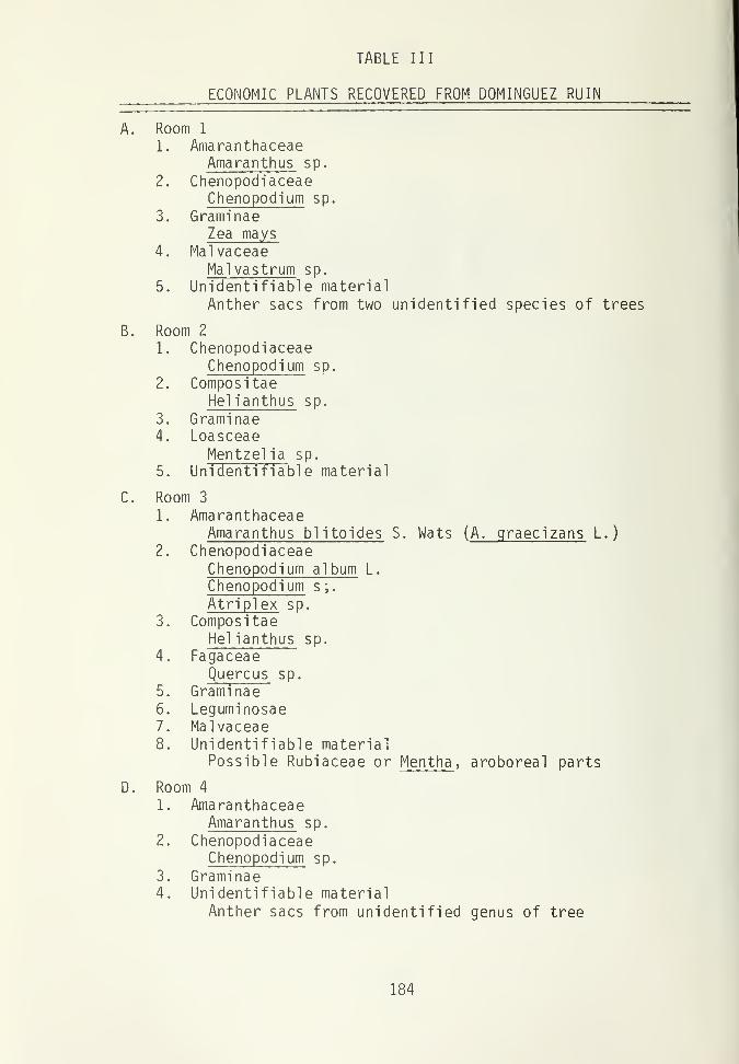
TABLE III
ECONOMIC PLANTS RECOVERED FROM DOMINGUEZ RUIN
A. Room 1
1. AmaranthaceaeAmaranthus sp.
2. ChenopodiaceaeChenopodium sp.
3. GraminaeZea mays
4. MalvaceaeMalvastrum sp.
5. Unidentifiable material
Anther sacs from two unidentified species of trees
B. Room 2
1. ChenopodiaceaeChenopodium sp.
2. Compos itaeHelianthus sp.
3. Graminae4. Loasceae
Mentzellia sp.
5. Unidentifiable material
C. Room 3
1. AmaranthaceaeAmaranthus blitoides S. Wats ( A. graecizans L.
)
2. ChenopodiaceaeChenopodium album L.
Chenopodium s;.
Atriplex sp.
3. CompositaeHelianthus sp.
4. FagaceaeQuercus sp.
5. Graminae6. Leguminosae7. Malvaceae8. Unidentifiable material
Possible Rubiaceae or Mentha , aroboreal parts
D. Room 4
1. AmaranthaceaeAmaranthus sp.
2. ChenopodiaceaeChenopodium sp.
3. Graminae4. Unidentifiable material
Anther sacs from unidentified genus of tree
184

TABLE III (Continued)
ECONOMIC PLANTS RECOVERED FROM DOMINGUEZ RUIN
E. Kiva A.
1. AmaranthaceaeAmaranthus sp.
A. blitoides S. WatsA. Retroflexus L.
2. ChenopodiaceaeChenopodium sp.
3. Graminae4. Malvaceae5. Portulacaeae
Portulaca sp.
185

Pima, Papago, Zuni, and Navajo (Whiting 1939; Winter 1976; Elmore
1944). The seeds of Amaranthus occur in compact heads of the
plant when ripe and can easily be collected in quantity. The
usual processing method used by the Indians is to parch and then
grind the seeds into a meal, which is made into breads or mush.
The greens of this plant have been documented as collected and
prepared like spinach. Both the Hopi and Zuni have cultivated
A. cruentus as a dye plant and there is documentation of the
domesticated grain amaranth, A. leucocarpus occurring as a culti-
gen among the Zuni and Arizona Indians (Winter 1976:372). As
Bohrer demonstrated (1962) in her analysis of seed material from
Tonto National Monument, A. leucocarpus was also a cultigen of
prehistoric peoples.
Chenopodiaceae, represented at Dominguez Ruin by Chenopodium
sp. and Atriplex , is one of the more frequently documented wild
plant families utilized by Southwest Indians. Atriplex sp. is
common to sage zones and blooms in June. The Hopi used this
shrubby bush more for its wood than the seeds. Not only was it
used as fuel, but the ashes were incorporated into certain corn
dishes or used like baking soda (Winter 1976:371). The plant has
also been used as medicine or as prayer sticks by the Hopi, Zuni,
and Jemez(Ibid . ). Chenopodium or lambsquarter is also common to
sage and pinyon- juniper zones. Like amaranth, both the greens and
seeds of chenopod have been documented food sources (Winter 1939;
Elmore 1944; Whiting 1939). The greens were gathered from June
through August and prepared like spinach. Chenopodium plants
produce copious numbers of seeds which are collected August to
late September or October (Minnis and Ford 1977). These seeds are
dried, ground and treated much the same way as corn. Among the
Navajo specifically the ground meal is used for tortillas or bread
(Elmore 1944:44). The meal is often made into a mush type dish
also.
186

Helianthus sp. (Compositae) is known comnonly as sunflower.
The fruits of this plant are popular at present among a wide
cross-section of the American public. The Hopi used different
species of Helianthus for a dye, body paint, construction purposes
and food (Whiting 1939). The Zuni, on the other hand, use it only
for rattlesnake medicine (Winter 1976:372).
The genuses included in the grass (Gramineae) family are
numerous. As previously discussed the material in Gramineae,
except for the specimen of Zea mays , is not identifiable at pre-
sent. However grasses have played an important part in Indian
diets as a wild plant food. Grasses are common to disturbed areas
and relatively hardy plants. For the most part, the seeds were
the plant part sought, these being parched, ground, or stored and
used like any other grain plant.
Before excavation of 5MT2148, Quercus gambelii covered the
site. The genus Quercus is part of the Fagaceae family (Beech)
and common to the area surrounding Dominguez Ruin. Evidence of
this shrub-tree from soil samples came from floor fill or roof
fall-humus, the latter being too contaminated with modern material
to be considered in a cultural context. The most feasible use of
Quercus is as fuel or as construction material with the acorns
edible when leached to remove the tannic acid. Since Room 3,
where Quercus buds from a sample were recovered, does not contain
a fire hearth, it is assumed the remains of Quercus are either
cultural debris, left from construction activity or are post-
occupational contaminants.
Only one specimen of the wild pea family was recovered and
could not be identified beyond that designation. Members of the
pea family have been used as medicine, as food, and as ceremonial
objects (Whiting 1939). Southwest Indians are documented as using
187
the stalks, roots, and seeds for a variety of purposes. The one
seed found cannot substantiate intentional collection of wild
legumes by the prehistoric occupants of Dominguez Ruin. However,
it should be noted that the specimen was found in Room 3, which
also contained two milling bins, thus indicating the room as a
food processing area.
Loasceae, or more specifically Mentzelia (Blazing Star) is a
herbaceous pernnial, blooming in June and July (Winter 1976:419).
Whiting (1939:21) notes that the Hopi only used Mentzelia in times
of food shortage as the food value of the plant is quite low. The
seeds were gathered, parched, and ground before being eaten. The
seeds appear to have been more important medicinally, commonly
used to cure toothaches (Whiting 1939:85). The plant is further
documented as a substitute for tobacco.
Four Mentzelia seeds were recovered from the soil of a funeral
bowl associated with the high status burial in Room 2. It is not
known whether these four seeds are indications of ceremonial
-
medicinal activities associated with the high status individual or
the bowl they were contained in. However, these four seeds repre-
sent the total recovery of Mentzelia from the site. Since other
soil samples were collected in close provenience to this funeral
bowl and did not contain evidence of Mentzelia , it is doubtful
that their appearance in the bowl can be attributed to silting
from the surrounding fill. It is likely, therefore, that the
seeds were placed in this bowl for a culturally significant pur-
pose.
The family Malvaceae includes wild and cultivated cotton plus
a variety of mallow genuses. The genus ethnographical ly documented
most is Sphaeralcea , a Globe Mallow, and has been documented as a
medicinal plant among the Hopi, Tewa, Navajo, and Zuni (Whiting
188

1939; Elmore 1944; Winter 1976). Whiting states (1939:85) that
the roots of the plant were chewed to treat broken bones or to
relieve bowel ailments, especially among babies. Chewing the root
seems to be used as a diuretic or antispasmodic, depending upon
the ailment. The Tewa used the plant as face paint or as a cure
for headache, snake bites and infected sores (Winter 1976:374).
Elmore states (1944:63) that S. coccinea was used by the Navajo to
stop bleeding or remedy diseases caused by witchcraft. Medicinal
use of the seeds alone has not been highly documented.
The identification problem concerning the Malvaceae seeds
recovered has already been discussed. Malvaceae seeds were re-
covered from the firehearth in Room 1, a pot on the kiva floor and
from differeent levels of kiva fill, one associated with roof
fall. The occurrence of Malvaceae with specialized areas of
Dominguez Ruin, a firehearth and ceremonial unit, suggests de-
finite cultural use. However, whether this use was medicinal,
ceremonial or a combination is impossible to determine. Although
documentation of Malvaceae seeds being used was limited, it stands
to reason that the seeds are the most likely part of the plant to
be preserved if utilized by the prehistoric occupants. Preserva-
tion rate among seeds would not only be higher because of their
disuse, but the seed coat would afford some protection. It cannot
be determined if the occurrence of Malvaceae in the pot on the
kiva floor was intentional or just accidental siltings since the
kiva fill itself did contain Malvaceae seeds.
Portulaca or purslane appears to have limited uses among
Southwest Indians although it occurs in the same type of environ-
ment as amaranth and chenopod and is often found coexisting with
the two. Purslane also provides copious members of seeds per
plant. The seeds were eaten by the Navajo and used a potherb in
189

making gravy by the Hopi (Elmore 1944:47; Whiting 1939:75). The
only evidence of Portulaca from the site came from the kiva fire-
hearth, which indicates preparation of the seeds for consumption
or some other purpose.
Cultigens
There was an obvious lack of cultigens recovered from 5MT2148.
The only evidence of domesticated plants was one carbonized kernel
of Zea mays recovered from the firehearth of Room 1. The pollen
analysis indicates the relatively frequent occurrence of corn
pollen within the site, but no evidence of the two other typical
Puebloan cultigens, beans and squash. Ethnographical ly, the two
latter cultigens are important food sources among Pueblo Indians,
usually cultivated concurrently with maize. Beans are especially
important as a source of storable plant protein (Minnis and Ford
1977:10).
The lack of cultigens is puzzling. The agricultural poten-
tial of the land surrounding Dominguez Ruin is illustrated by the
extenstive farming of the area at present. Other Pueblo sites of
comparable age within the same general area show evidence of corn,
beans, and squash. Possibly prehistoric preparation and utiliza-
tion methods have hindered the recovery of cultigens, since this
is frequently the case found elsewhere when recovery of especially
beans and squash is low (Minnis and Ford 1977:11). Poor preserva-
tion or possibly a poor sampling scheme could also have skewed
recovery of cultigens. However, all food processing areas were
sampled so the latter suggestion is not really feasible. If for
some reason collection and preparation took place elsewhere, then
there would be limited recovery of cultigens although not total
absence. However, there is the possibility that cultivation of
beans and squash was not actively pursued at the Dominguez Ruin,
190

although cultivation of Zea mays was
.
Food Processing Areas
Two metates were found in association with milling bins in
Room 3. One metate was found in situ , on the floor of Kiva A,
with miscellaneous metate fragments in the kiva fill. Firehearths
were uncovered in Room 1 and Kiva A. All of these areas have been
designated as food processing areas. Seeds recovered from each
area have economic value, mostly for subsistence purposes. As
previously noted, the firehearth of Room 1 yielded the only culti-
gen, Zea mays . Both firehearths from Room 1 and Kiva A provided
chenopods, amaranths and specimens of Malvaceae, with the occurrence
of Portulaca limited to the firehearth of Kiva A. Samples taken
in association with the metates yielded chenopod, amaranth, grass
and the single wild legume. Samples from these areas did not
provide large quantities of economic plant material. While all
material recovered was of ethnobotanical significance, the corn
kernel, the wild legume and the Malvaceae seeds associated with
both firehearths were the most noteworthy. The association of
Malvaceae with the firehearths implies some economic importance to
the occupants of the site and most likely were important as a
medicinal plant if the seeds prove to be the genus Sphaeralcea .
Although wild legumes are edible, the small occurrence of legume
at the site cannot really indicate anything since there are extra-
neous factors that could be responsible for its appearance,
without cultural affiliations. The significance of the corn
kernel has already been discussed.
Burials
From the ten soil samples analyzed from the burials, only the
occurrence of Mentzelia was noteworthy. Since Mentzel ia seeds
191
were recovered from among the grave goods, it is thought to have
some commercial medicinal value associated with the high status
burial. All other seeds found are believed to be either from silt
in or part of the general debris left by the occupants of Dominguez
Ruin.
Post Occupation
Plant remains recovered from soil samples representing post
occupation were typical of plants occurring in disturbed areas.
These plants included Chenopodium , Gramineae , Mai vaceae , arboreal
material, most of which was oak, and He] ianthus . Litzinger notes
(1976:420) that the genus Sphaeralcea coccinea is frequently found
on archaeological ruins in the pinyon-juniper and sage zone. It
was noted that there was an increase in chenopods in post occupa-
tion soil samples. Population increase of Chenopodium is typical
for plant succession in disturbed areas. In general, soil samples
of the post occupation period of Dominguez Ruin yield the expected
seed and plant material for that area.
Summary
Analysis of the twenty-six soil samples from 5MT2148 has not
provided as much information as originally hoped, concerning the
economic plants used by the prehistoric occupants of the site.
The recovered plant remains were exiguous and often poorly pre-
served, providing insufficient evidence to connote the subsistence
activities pursued at this site. However, all plant remains
recovered at 5MT2148 were of economic, ethnobotanical significance.
The appearance and provenience of both Mentzel ia and Malvaceae
suggests some ceremonial -medicinal import of both plant types.
The recovery from food processing areas was disappointing although
192

one kernel of Zea mays was recovered. In general, the lack of
evidence for cultigens was surprising especially since the site is
thought to have been in continuous occupation and in a time
period when the Anasazi were intensive agriculturalists (Reed,
personal communication). The disproportionate occurrence of
cultigens to wild economic plants would at first suggest a gather-
ing type economy. However, the minimal recovery of wild plant
foods does not support this either. It is believed that the
occupants of 5MT2148 were agriculturalists, but for some reasons,
analysis of the soil samples does not substantiate this, although
the pollen analysis does lend more evidence for the occurrence and
cultivation of Zea mays .
In conclusion, eight families of plants were recovered from
the soil samples: Amaranthaceae, Chenopodiaceae, Compositae,
Fagaceae, Gramineae, Leguminosae, Loasceae, Malvaceae, and Portu-
lacaceae. All eight are documented ethnographically among South-
west Indians as economic plants. Except for the specimens of
Fagaceae, the questionable specimens of Gramineae and the single
Leguminosae seed, all other plants are believed to have had sub-
sustence or medicinal significance to the occupants of Dominguez
Ruin.
193

TABLE IV
ECONOMIC PLANTS IDENTIFIED FROM 5MT2148
Common Name Scientific Name
Pigweed Amaranthus (Amaranthaceae)
Lambsquarter Chenopodium (Chenopodiaceae)
Saltbush Atrip! ex (Chenopodiaceae)
Sunflower Helianthus (Compositae)
Oak Quercus (Fagaceae)
Grass (Gramineae)
Corn Zea mays (Gramineae)
Pea, Bean (Leguminosae)
Blazing Star Mentzelia (Loasceae)
Mallow (Malvaceae)
Rose Mallow Malvastrum (Malvaceae)
Purslane Portulaca (Portulacaceae)
194

APPENDIX C
ANALYSIS OF ADHESIVES FROM 5MT2148
by
Alan D. Reed
195

A sample of adhesive material was taken from one of the two medallion-
shaped pendants (Fig. 25) and was submitted to the laboratories at
Rockwell International for infrared and emissions spectroscopic analysis.
A sample of lac produced from Coursetia glandulosa , collected in Barranca
de Batopolis, Chihuahua, Mexico, and a lac sample from Larrea divaricata ,
collected in Utah or Arizona, were also submitted for comparative purposes.
Tests showed that the archaeological adhesive consisted of 80% to
90% inorganic material. This inorganic material was predominately
comprised of an aluminum and silicate substance, thought to be clay.
The inorganic constituent of the adhesive, comprising the remaining 10%
to 20% of the total, was found to resemble the Larrea divaricata
sample.
The Larrea sample has an acid structure, and characteristics of
esters and of fatty (mono-) glycerides. It has been broken down to a
gum (e.g., carbohydrate polymers, glycosides/acetals, and starches), and
has a eel lulosic- type infrared spectra. The sample, like the Coursetia
sample, is entirely organic.
The Coursetia glandulosa specimen has a high aromatic acid content,
similar to benzonic and cinnamic acids. Fatty acids and rosin acids are
present. Infrared spectra have an extensive carbonyl character, which
is more indicative of natural resins than of gums. The Coursetia lac
sample is distinctive from the Larrea and the archaeological sample.
The adhesive in the two medallion-shaped pendants and the frog-
effigy pendant were macroscopical ly identical. When these ornaments
were manufactured, the adhesive was probably prepared by means of
adding a small amount of water to some clay--enough to make it sufficiently
pliable--and then adding lac, possibly obtained from Larrea sp. shrubs.
The clay would have acted as a suitable matrix in which to inlay the
shell, turquoise, and specular hematite materials, and would have served
to stretch the amount of pure lac needed for a proper bond in the construc-
tion of the ornaments.
196

ARCHEOLOGICAL EXCAVATION AT THE ESCALANTE SITE,
DOLORES, COLORADO, 1975 AND 1976
by
Judith Ann Hallasi
With Appendices
by
Steven D. Emslie
and
Peter J. Gleichman
PART II
Cultural Resource Series No. 7
Colorado State Office
Bureau of Land Management
1979
197

ACNOWLEDGEMENTS
The excavations at the Escalante Site are the result of the
archaeological and historical concern of the Bureau of Land
Management. Because of the interest of this federal agency in
developing the scientific and scenic aspects of the Escalante
Site, the University of Colorado Department of Anthropology was
awarded two seasons of contract support. Without the financial
and personal interest provided by the Bureau of Land Managment
personnel this project would not have been accomplished. Although
many people in the Bureau of Land Management have aided in the
project, special thanks are given to Harry Lawson, Doug Scott and
Jay Boren for their interest and help in the field excavations.
I wish to extend my gratitude to Dr. David A. Breternitz for
his support and direction. Breternitz, as director of the Mesa
Verde Research Center, provided the administrative and equipment
support and field direction for the Escalante archaeological
project for the summers of 1975 and 1976. He also provided the
direction for the report preparation as chairman for the thesis
commi ttee
.
Once or twice a week through the summers James A. Lancaster
was present at the site to supervise and consult with the progress
of the excavations aiding in the interpretation of the excava-
tions. Special thanks to Curtis W. Martin and L. Kent Leidy who
supplied direction as field foremen in the 1975 and 1976 field
seasons respectively.
Through the summers many students of the Mesa Verde Research
Center worked at the Escalante excavations on a rotational basis.
The crew members included Marci Donaldson, Tom Euler, Pete Gleichman,
Laura Maness, Todd Metzger, Alan Reed, Betsy Tipps, Wolky Toll,
199

and Paul Williams in 1975; and Woody Farr, Jerry Fetterman, Marcia
Kelly, Laura Maness, Meredith Matthews, Janet Rose, and Betsy
Tipps in 1976.
Lab analysis was under the direction of Christine Robinson
for the 1975 field season, and Kellie Masterson for the 1976
season. The people performing artifact analysis for the 1975
season include: Tim Weston, worked bone tools; Marci Donaldson,
bone identification; Pete Gelichman, lithic analysis; Mark Stiger,
plant identification. The people who helped with the analysis of
the 1976 season's material included: Todd Metzger, lithic anal-
ysis; Steve Emslie, bird bone identification and help with mammal
bone identification; Pete Gleichman, soil analysis; and Kellie
Masterson, ceramic analysis and help with stone and bone analysis.
A group of people who deserve special acknowledgement are
specialists who contributed their expertise to the investigations
and analysis of the excavation data. I would like to express by
appreciation to Dr. Joe Ben Wheat of the University of Colorado
Museum for his very supportive help with the lithic analysis and
suggestions; to Dr. Judy Van Couvering of the University of
Colorado Museum and Danny dinger of the Midwest Archaeological
Center, National Park Service, in Lincoln, Nebraska for their aid
in the identification of the fish scales; to Dr. William J.
Robinson, Director of the Laboratory of Tree-Ring Research at the
University of Arizonia for his attention to and interpretation of
the tree-ring data; and to Roger S. Cichorz of the Organic Mass
Spectroscopy Laboratory, Rockwell International, Rocky Flats
Division, Colorado for the analysis of the pendant adhesive.
Finally I wish to thank all the people who helped with the
production and editing of the manuscript. Mary Dufer of Dolores,
Colorado contributed the stone artifacts drawings. Kellie Masterson
200

producted the ceramic and shell artifact drawings and read sec-
tions of the text. Special thanks to Kalman Halasi for drafting
the figures, proof reading and help throughout the project. My
thanks to Bertrand de Peyer for the artifact photography. Dr.
Jack Smith and Dr. Frank Eddy as members of the thesis committee
read the manuscript and made helpful suggestions and editing.
Finally I wish to thank Fran Snow for typing the manuscript.
This report is submitted in partial compliance of BLM Con-
tract No. 52500-CT5-1044. Additional work conducted under terms
of this contract include reports of stabilization conducted during
1975 and 1976 (White 1976, 1977) and a report of excavations
conducted at the Dominguez Ruin (Reed, 1977).
201

TABLE OF CONTENTS
PAGE
ACKNOWLEDGEMENTS 119
TABLE OF CONTENTS 203
LIST OF TABLES 207
LIST OF FIGURES 210
CHAPTER
I. INTRODUCTION 215
Purpose of Wdrk 215
Geology 217
Natural Resources 218
Agriculture 218
Flora 219
Modern History 221
Field Methods 226
II. ARCHITECTURE
Setting 231
Plan 231
Condition 234
General Remarks on Wall Construction .... 235
Materials 235
Construction 237
Styles 239
Bonding 244
Architectural Details 244
III. ARTIFACT ANALYSIS 251
Ceramics
Types 251
Stone
Chipped Stone 262
203

CHAPTER PAGE
Materials 262
Flakes and Cores 264
Utilized Flakes 269
Formal Chipped Stone Tool Types 269
Projectile Points, Drills, and Blanks. 269
Bi faces 269
End and Side Scrapers 269
Denticulate Edged Tools 271
Chopping and Pounding Tools 271
Axes 271
Hammers 274
Mauls 271
Choppers 274
Hammerstones 274
Grinding and Polishing Stones 280
Metates 280
Manos 280
Grinding Stones 282
Polishing Pebbles 290
Anvils 290
Grooved Stones 290
Worked Sandstone Slabs 290
Tablets 290
Tchamahia 296
Petrified Wood 296
Paint Grinder 296
Ornaments 298
Pendants 298
Paint Stones 300
Miscellaneous 300
Petroglyph 300
204

CHAPTER PAGE
Building Stone Effigy 307
Sandstone Concretion 307
Fossil Molluscs 307
Shell 309
Bone 309
Fauna
Mammals and Birds 309
Fish 311
Artifacts 313
Classification of Awls, Reamers and
Weaving Tools 313
Scrapers 324
Bone Tubes 324
Perforated Mammal Tibias 324
Antler Tines 324
Miscellaneous Artifacts 327
Fragmentary Modified Pieces 330
Stock Pieces 330
Human Bone 330
Artifact Distribution 332
Room 2, Floor 1 332
Room 5, Floor 1 337
Room 6, Floor 2 341
Room 6, Floor 1 348
Room 8, Floor 1 348
Room 9, Floor 3 349
Room 9A, Floor 1 354
Room 10, Floor 1 356
Room 10, Floor 2 356
Room 20, Floor 2 363
Kiva A 369
Artifact Conclusions 380
205
CHAPTER PAGE
IV. DATING
Strati graphic Profiles 385
Ceramic Dating 387
Room Sequences 388
Tree-ring Dates 392
Dating Conclusions 396
V. CONCLUSIONS 399
REFERENCES CITED 405
APPENDIX A 411
Numbers of animal bones and minimum numbers of
individuals for the rooms and kivas.
APPENDIX B 415
Bird remains from the Escalante Site
by S. D. Emslie
APPENDIX C 419
Plant remains from the Escalante Site
by Pete Gleichman
206

LIST OF TABLES
TABLE PAGE
1. Periods, dates, and number of sherds givenfor the predominant ceramic types 252
2. Numbers of sherds by type for the rooms andkivas. Percentages given by type for the
relative amounts to the classifiable sherdsand to the total number of sherds 253
3. Number of trade ware sherds present in theoccupation levels 255
4. Flakes, cores and formal chipped stonetools by material types 264
5. Material types for functional categories ofutilized flakes and the percentages of thetotal number of flakes which are utilized foreach material 265
6. Provenience and description for projectilepoints, drills and blanks 266
7. Provenience and description of bifaces 270
8. Provenience and description for end andside scrapers 272
9. Provenience and description for denticulateedged scrapers 273
10. Provenience and description for axes,hammers, and mauls 275
11. Provenience and description for cobbles,flakes and cores used as choppers 277
12. Provenience and description for cobbles,flakes and cores used as hammerstones 278
13. Provenience and description of slab,
troughed, and basin shaped metates 281
14. Numbers of manos represented by
attribute combinations 283
15. Provenience and description of manos 284
16. Provenience and description of
grinding stones 28^

TABLE PAGE
17. Provenience and description ofpolishing pebbles 291
18. Provenience and description of
anvils 292
19. Provenience and description of abraders 293
20. Provenience and description for largeand small worked sandstone slabs 294
21. Provenience and description of shapedtablets and sandal lasts 295
22. Measurements and description of the petroglyphs 303
23. Distribution of animal forms with artifact types 314
24. Modification of bone in awls, reamersand weaving tools 317
25. Distribution of tip shape with awls,reamers, and weaving tools 317
26. Provenience and description of bone awls 320
27. Provenience and description of bone reamers 322
28. Provenience and description of boneweaving tools 323
29. Provenience and description of bone scrapers 325
30. Provenience and description of bone tubes 325
31. Provenience and description of miscellaneous bone 328
32. Provenience and description of fragmentarymodified bone 331
33. Artifacts found on Floor 1 of Room 2 334
34. Artifacts found on Floor 1 of Room 5 338
35. Artifacts found on Floor 2 of Room 6 342
36. Artifacts found on Floor 1 of Room 6 344
37. Artifacts found on Floor 1 of Room 8 346

TABLE PAGE
38. Artifacts found on Floor 3 of Room 9 350
39. Artifacts found on Floor 1 of Room 9A 352
40. Artifacts found on Floor 2 of Room 10 359
41. Artifacts found on Floor 2 of Room 20 364
42. Artifacts found on Floor 1 of Kiva A 370
43. Numbers of stone, shell and bone artifactsby occupation levels 381
44. Ceramic dating for the predominant ceramic wares,trade wares, and the infrequent Mesa Verdeceramic types 389
45. Numbers of sherds by type for the floors fromthe three occupation levels 390
46. Tree-ring dates for Kiva A and three rooms 393

LIST OF FIGURES
FIGURE PAGE
1. Map showing the location of the Escalante Ruin,
Site 5MT2149 216
2. View of the uncleared growth of the site 220
3. Excavations in process in the 1975 field season
showing Rooms 2 and 5 cleared and Kiva A
partially excavated 228
4. Aerial view of the excavated and stabilizedEscalante Ruin on the hilltop and theDominguez Ruin on the plain below at theedge of the hill 232
5. Aerial view of the Escalante Ruin afterstabilization 232
6. Plan view of Escalante Ruin 233
7. The west wall of Room 2 showing the Style1 masonry 240
8. The east wall of Room 6 showing the Style2 masonry 242
9. The south wall of Room 20 showing the Style3 masonry 242
10. Decorative band seen in the lower courses in
the test trench along the north exterior wallof the pueblo 245
11. Map of the test trench in Kiva B 250
12. Reconstructed Mesa Verde Corrugated jar 258
13. White ware bowl made from the base of a
Black-on-white jar 258
14. Partial unidentified Black-on-white bowl 259
15. Mancos Black-on-white bird effigy jar 260
16. Partial Sosi Black-on-white bowl 261
17. Projectile points, drills, and blanks 267

FIGURE PAGE
18. The biface tools 269
19. Stone axe heads 276
20. Stone hammer head from Floor 1 of Room 276
21. Partial sandstone tablet in the shape of a jog-toed woven sandal 297
22. Circular jet pendant 299
23. Turquoise and jet mosaic pendant 299
24. The infrared spectras 301
25. Petroglyph with a spiral design 303
26. Petroglyph with an irregular curvilinear design 304
27. Petroglyph with a concentric circle design 305
28. Petroglyph with a concentric circle design 305
29. Petroglyph with a biomorphic figure 306
30. Petroglyph with a pecked circular face 306
31. Building stone effigy designed to extend froma masonry wall 308
32. Bone awl classification 319
33. Bone tools 321
34. Bone weaving tools 321
35. Bone tools 326
36. Shaped deer mandible 329
37. Plan view and profile of Room 2 showingFloor 1 335
38. Floor 1 of Room 2 showing the artifacts on
the floor and a section of the roof beams 336
39. Plan and profile of Floor 1 in Room 5 339
40. View of Room 5 showing the cobble wall andcorrugated pot set in the floor 340
41. Plan and profile views of Floor 2 in Room 6 343

FIGURE PAGE
42. Plan and profile views of Floor 1 in Room 6 345
43. Plan and profile views of Room 8 showing Floor 1 347
44. Plan and profile views of Floor 3 in Room 9 351
45. Plan and profile views of Room 9A 353
46. Floor 1 in Room 9A 355
47. Plan and profile of Room 10, Floor 2 357
48. View of Floor 2 in Room 10 showing the two
large pits in the west and east halves ofthe room 360
49. Close view of Feature 1 at the edge of eastpit in Floor 2 of Room 10 361
50. Close view of Features 3 and 4 in the
west pit in Floor 2 of Room 10 361
51. Plan and profile of Floor 2 in Room 20 365
52. North wall of Room 20 showing the T-shapeddoor, which opens to Room 10 366
53. The east wall of Room 20 showing the breakat the south end 366
54. The west wall of Room 20 showing the wall
fill slumped in the top of the wall break 367
55. View of Floor 2 in Room 20 367
56. Close view of Feature 3 in Floor 2 of Room 20 368
57. View of the subfloor Feature 8 extending from
Feature 6 in Floor 2 of Room 20 368
58. Map of Kiva A and the surrounding quadrangle 371
59. Kiva A profiles 372
60. The crescent-shaped wall at the northeastside of Kiva A 373
61. Kiva A Floor and floor features 374
62. View in Kiva A of the remains of beams extendingfrom the wall sockets and resting onPilaster 4 374

FIGURE PAGE
63. Four views of the Kiva A pilasters showingtheir construction 375
64. Pilaster 4 in Kiva A, cleared and
partially excavated 376
65. Detailed plan and profile views of theventilator tunnel in Kiva A 377
66. View of the intrusive wall built on fill
above the floor in Kiva A 378
67. Plan and profile views of the intrusivewall in Kiva A 379
213


CHAPTER I
INTRODUCTION
Purpose of Work
The Department of Anthropology of the University of Colorado
conducted two seasons of excavation and stabilization during the
summers of 1975 and 1976 at the Escalante Ruin, site 5MT2149 (Fig.
1). This project was sponsored by the Bureau of Land Management
to be open for public viewing as part of the Escalante Trail, a
Bicentennial project tracing the path of the 1776 Dominguez and
Escalante Expedition.
This volume includes a report of the archaeological excava-
tions during 1975 and 1976 at the Escalante Ruin submitted in
partial compliance of BLM Contract No. 52500-CT5-1044. The par-
tial excavation of the site included excavation of one kiva and
seven rooms with testing in the second kiva and along the exterior
walls of the ruin. Additional work conducted under terms of this
contract include reports of excavation at the Dominguez Site and
stablization of the Escalante and Dominguez Sites. The excava-
tions conducted in the 1976 field season at the Dominguez Site,
one of the small ruins located below the Escalante Site hill, is
presented by Reed (1977). Stabilization was conducted during both
the 1975 and 1976 field seasons at the Escalante Site and was
conducted at the Dominguez Ruin in the 1976 season. Reports of
the stabilization during the two field seasons are presented in
separate volumes (White: 1975, and this volume).
The excavations at the Escalante Ruin contribute to the
prehistory of the region where few excavations have been per-
formed. The site is also important in its relationship with Chaco
Canyon in New Mexico, and it adds to the knowledge of Chaco outliers
in the Mesa Verde area.
215

Figure 1. Map showing the location of the Escalante Ruin,
site 5MT 2149.
216

Geology
The southern extension of the La Plata Mountains ends in a
long slope about 7500 feet above sea level forming a plateau, the
Mesa Verde, which stretches southward to the San Juan River and
ends in abrupt, nearly vertical faces, 1200 to 1500 feet in height.
Between the mesa and the mountains is a natural pass or "puerta"
through which an old Spanish trail as well as an old Indian trail
led. This puerta opens onto an extensive area of flat land, one
of the largest in the plateau country, which Newberry (1876:83)
named the Great Sage Plain. The Great Sage Plain, about 1200
square miles in the area, extends into southeastern Utah, varying
from 7000 to 5000 feet in elevation (Gregory 1938:7).
The floor of the Great Sage Plain is a massive resistent
stratum 200 to 300 feet thick of Lower Cretaceous Sandstone
(Gregory 1938:60) named "Dakota(?) Sandstone." Above the Dakota
Sandstone is the Middle Cretaceous Shale known as Mancos Shale, a
predominantly blue-gray crumbling, gullied shale displayed in the
Mesa Verde walls (Gregory 1938:58). Here the Mancos Shale is 2000
feet in thickness, overlaid by the Upper Cretaceous strata of the
great beds of Mesa Verde Sandstone.
Across the plain the Mancos Shale is worn away so that the
Dakota Sandstone is exposed. In places it is bare and in places
it is covered with thin patches of soil. Scattered over the plain
are small mesas and ridges of Mancos Shale that rise 10 to 100
feet above the Dakota Sandstone. Wherever the shales have been
entirely eroded, quantities of Gryphaea and oyster shells may be
seen washed out from the shale beds on the hard standstone floor
(Holmes 1875:259; Newberry 1876:88). Only at the edge of the
Great Sage Plain on the Mesa Verde where the protective overlying
217

Upper Cretaceous Mesa Verde sandstone is present, has the Mancos
Shale layer not eroded.
The Great Sage Plain is cut by the large streams descending
from the west slope of the Rocky Mountains forming long canyoned
valleys. These streams cut through the nearly horizontal beds of
strata through the Dakota formation into the underlying Upper
Jurassic formations of which the local type is the Morrison forma-
tion.
The Dolores River rises from the west side of the La Plata
Mountains. It runs through a narrow valley cut into the rocks
forming bluffs on either side of the river which eventually rise
over 1200 feet high.
The hill on which the Escalante Ruin rests is a Dakota form-
ation. This Dakota layer was pushed up along a fault so that it
lies 100 feet higher than the surrounding plain, also of the
Dakota formation and covered by the Mancos Shale.
The surface of the hill is a conglomerate of rolled river
cobbles held in a gravel matrix. Below it occurs a gray clay and
in the hillside are seen other levels of sandstone.
The stream bed deposit is laid bare across much of the hill
surface but below the ruin it is overlain by a shallow deposit of
brown earth, residue to the Mancos Shale layer. This suggests the
possibility that at the time of occupation this thin soil layer
had also been present across the hill surface.
Natural Resources
Agriculture
The location of the Escalante Ruin is above and overlooking a
GO m wide floor plain, the Dolores River, of rich alluvial soil
218

suitable for flood water farming. This type of farming was prac-
ticed in Chaco Canyon (Vivian and Mathews 1964:12-13). The loca-
tion of the Escalante Ruin above the flood plain might indicate a
desire by the builders of the pueblo from Chaco Canyon to select a
site where the agricultural conditions would be similar to that
found in the Chaco Wash. The plain below the hill has moderately
dark colored deep soils which provide for good cropland (Draft
Environmental Statement 1957:11-53, Figure 11-10) and would be
suitable for dry land farming.
The area of Dove Creek located northwest of the Escalante
Ruin is today used for agriculture, and produces wheat, beans,
corn and other products (Draft Environmental Statement 1975:11-10-
11). This indicates a growing season adequate for the Anasazi
crops, which usually included corn, beans, and squash.
Flora
The Escalante Ruin is within the Upper Sonoran life zone,
4500 to 7500 feet and characterized by pinyon, juniper and sage
brush. The environment on the hill itself is transitional pinyon-
juniper woodland and brushland type. Figure 2 gives a view of the
uncleared growth on the site. Modern trees and shrubs identified
on the hill itself were: Juniper ( Juniperous sp.), Pinyon pine*
( Pinus edulis ), Service berry* (Amelanchier utahensis ), Sage
( Artemesia tridentata ), Mountain mahogany ( Cercocarpus montanus ),
Rabbitbrush ( Chrysothamnus nauseosus ), Fendlerbush ( Fendlera
rupicola ), Squawapple* ( Peraphyllum ramosissimum ), Gambel oak*
( Quercus gambell
i
), Currant* (Ribes sp.), Snowberry* (Symphoricarpos
oeophilus ), Yucca* (Yucca baccata ). Herbs found on the site
include: Yarrow* (Achilla millefolium ), Fern (Cheilanthes sp.),
Goosefoot* ( Chenopodium album ), Thistle ( Cirsiam sp.), Wild buck-
wheat* ( Eriogonum sp.), Resinweed ( Grindel ia sp.), Beardtongue
219

Figure 2: View of the uncleared growth on the site,
220

( Penstemon sp.), Choi la* ( Opuntia fragilis ), Prickly pear* (Opuntia
sp.), Indian Rice Grass* ( Oryzopsis hymenoides ), Orange Globe
Mallow (Sphaenalcea cossinea ). The starred bushes or herbs are
ones which either produce an edible part or can be eaten.
The land on the plain below the hill is primarily brush! and
with some pinyon-juniper woodland. The riparian environment in
the Dolores River valley below the site was described by Newberry
in 1876 as being "nearly level, half a mile wide and very fertile,
covered with fine grass, with groves of cottonwood and willow and
scattered trees of yellow pine, thickets of virgins 's bower and
hop, and abundant flowers" (Newberry 1876:86). This environment
could have supplied wild berries and fruits as well as being used
for agriculture. Extensive listing of plants generally found in
these environments can be found in Gregory (1938) and Brew (1946).
Modern History
The first written reference to an archaeological site in
Colorado was on August 13, 1776, when Escalante recorded in his
journal the ruin believed to be the Escalante Ruin. Silvestre
Velez de Escalante had noted in his diary that: "On an elevation
on the south bank of the river in ancient times there was a small
settlement of the same form as those of the Indians of New Mexico,
as is shown by the ruins which we purposefully examined" (Bolton
1972:141). The Escalante Ruin is the first historically recorded
site in Colorado and is therefore of interest to people of the
region. The Escalante expedition had started out July 29, 1776,
the same year as the birth of the United States on the Atlantic
seaboard. The purpose of the expedition was to work out a new
route from Santa Fe to the Spanish settlement of Monterey on the
upper California coast. The ten-men expedition was led by Fray
221

Francisco Atanacio Dominguez. Fray Silvestre Velez de Escalante
had planned the expedition and kept a journal of the trip. The
journey started from Santa Fe , went north to the San Juan, fol-
lowed the trappers' trail northwest past Mesa Verde, descended the
Dolores, cut across to the Uncompahgre Plateau to the Gunnison
River moving northward to the Green River from where they headed
west to Utah Lake and then south and west following the edge of
the Sevier Desert back to Santa Fe •
Other Spanish explorers, trappers, gold seekers and traders
had passed through the region of the Colorado River and as far
north as the Gunnison River. Bolton (1972:7) suggests that this
region had become fairly well known to the Spanish traders of New
Mexico by 1776. A member of the Escalante Expedition, Andres
Munis de Bernalillo, guide and interpreter of the Yuta language,
had traveled twice before as far as the Gunnison River: once with
the Riveria Expedition of 1765 and again in 1775 with a small
party probably following the same route taken by the Escalante
Expedition (Bolton 1972:7). However, none of these early trav-
elers are known to have left a written record of the ruins of the
San Juan which they might have encountered, so Escalante is cred-
ited as being Colorado's first archaeological site recorder.
Following the Escalante expedition little attention was given
to the region or the ruins. However, three events in the 1840's
caused further explorations in the Southwest which brought the
ruins to the attention of the scientific world: the Mormon migra-
tion to Utah, the California gold rush and the war between the
United States and Mexico.
These events produced the three types of explorations given
by Brew (1946:17): (1) Mormon surveys for colonization, (2)
official government explorations under the War Department and the
222
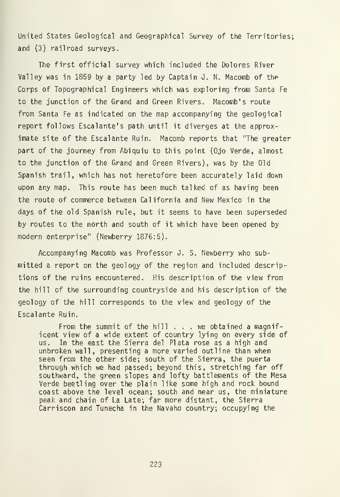
United States Geological and Geographical Survey of the Territories;
and (3) railroad surveys.
The first official survey which included the Dolores River
Valley was in 1859 by a party led by Captain J. N. Macomb of the
Corps of Topographical Engineers which was exploring from Santa Fe
to the junction of the Grand and Green Rivers. Macomb's route
from Santa Fe as indicated on the map accompanying the geological
report follows Escalante's path until it diverges at the approx-
imate site of the Escalante Ruin. Macomb reports that "The greater
part of the journey from Abiquiu to this point (Ojo Verde, almost
to the junction of the Grand and Green Rivers), was by the Old
Spanish trail, which has not heretofore been accurately laid down
upon any map. This route has been much talked of as having been
the route of commerce between California and New Mexico in the
days of the old Spanish rule, but it seems to have been superseded
by routes to the north and south of it which have been opened by
modern enterprise" (Newberry 1876:5).
Accompanying Macomb was Professor J. S. Newberry who sub-
mitted a report on the geology of the region and included descrip-
tions of the ruins encountered. His description of the view from
the hill of the surrounding countryside and his description of the
geology of the hill corresponds to the view and geology of the
Escalante Ruin.
From the summit of the hill . . .we obtained a magnif-icent view of a wide extent of country lying on eyery side ofus. In the east the Sierra del Plata rose as a high andunbroken wall, presenting a more varied outline than whenseen from the other side; south of the Sierra, the puerta
through which we had passed; beyond this, stretching far off
southward, the green slopes and lofty battlements of the MesaVerde beetling over the plain like some high and rock bound
coast above the level ocean; south and near us, the miniaturepeak and chain of La Late; far more distant, the SierraCarriscon and Tunecha in the Navaho country; occupying the
223

whole western horizon the monotonous expanse of the Sage-plain, beyond which rose the summits of the Orejas del Oso,Sierra Abajo, and Sierra la Sal. In the north appeared a newand grand topographical feature. From N. 10 W. to NE mag-netic stretched a chain of great mountains higher and morepicturesque than any we had yet seen. (Newberry 1876: 87).
His description of the ruins does not seem as consistent with
the excavations:
The hill from which we obtained this view is crownedwith an extensive series of very ancient ruins. The prin-ciple one is a pueblo, nearly square, once substantiallybuilt of dressed stone, now a shapeless heap, in which theplan of the original structure can however be traced. Likemost of the ruined pueblos of New Mexico, it consisted of a
series of small rooms clustered together like cells in a
beehive. Near the principle ediface are mounds of stone,representing subordinate buildings. Among these are largedepressions marking the places of cisterns or estuffas.Quantities of broken pottery similar to that so commonly seenin like circumstances, but bearing the marks of great age,strew the ground about these ruins (Newberry 1876:88).
The F. V. Hayden party of the United States Geological and
Geographical Survey of the Territories brought to the attention of
the public the importance of the ruins within the Mesa Verde
region, principally through the archaeological surveys reported by
W. H. Jackson (1876, 1878) and W. H. Holmes (1876). Holmes (1876:
386) reports on several ruins near the bend in the Dolores River.
One, which he describes with some detail, is located near the
Escalante Ruin on the low ridge. He mentions further: "At two
other localities near the South bend of the Rio Dolores I observed
similar groups of standing stone, about which was the usual accom-
panyment of pottery and flint chips" (Holmes 1876:386). Holmes
had possibly looked on the Escalante Ruin but the reference is too
vague to be certain.
Following these initial descriptive reports, there was a
period of sporadic excavations across the Mesa Verde area and of
extended surveys.
224

T. Mitchell Prudden, a New York medical doctor who worked
with the Wetherills, became interested in "small house ruins" and
through 1914 to 1918 he located and excavated a number of sites in
the San Juan. Fewkes (1919:12) recorded that Prudden had mentioned
ruins at the Dolores bend.
J. Walter Fewkes, who conducted numerous excavations on Mesa
Verde, became interested in the location of the Escalante Ruin and
wrote an article about it entitled, "The First Pueblo Ruin in
Colorado Mentioned in Spanish Documents" (Fewkes 1917). However,
he had not visited the site when this article was written and he
confused it with another site, probably the Emerson Ruin. In 1919
Fewkes reports in his description of sites west of the Mesa Verde
a more accurate description of these sites indicating that he had
surveyed them for himself. He presented a detailed description of
the Escalante Ruin:
The name Escalante Ruin, given to the first ruin recorded
by a white man in Colorado, is situated about 3 miles fromDolores on top of a low hill to the right of the MonticelloRoad, just beyond where it diverges from the road to Cortez.
The outline of the pile of stones suggests a D- shaped or
semicircular house with a central depression surrounded by
rooms separated by radiating partitions. The wall on the
south or east sides was probably straight, rendering the formnot unlike the other ruins on hilltops in the neighborhood of
Dolores (Fewkes 1919:36).
The descriptions of the site as presented above all seem to
indicate that the same site might have been viewed by the observers
The difference in the descriptions were probably due to the vege-
tation growing on the site which obscured a complete view of the
ruin; and also due to the unfamiliarity of the observers with the
shape and form of the ancient Anasazi ruins. Although Escalante'
s
reference is very brief, the hill on which the Escalante Ruin
rests is distinctive enough in its position and size to have been
the elevation which Father Escalante had ascended.
225

The site of the Escalante Ruin is part of the public domain
and is under the jurisdiction of the Bureau of Land Management.
The Bureau of Reclamation has used the hill as an elevation marker
for surveys in the area since the location was easily viewable and
a bench mark was placed on the surface of the site.
From the years 1965 to 1970 the University of Colorado Archae-
ological Research Center conducted an archaeological inventory and
evaluation of the Indian Ruins on the Public Lands for the Bureau
of Land Management. The Escalante Ruin was the final site re-
corded in 1970 when it was designated as 5MT2149. The site was
recongnized at that time as fitting the location of the site
Escalante had described in his journal.
Field Methods
In the 1975 field season the excavations were begun by clearing
the site of the dense overgrowth. The pinyon pine and brush were
cut with a chain saw and the bushes were removed with pickaxes.
After mapping the height and extent of the mound in relation
to the surface of the hill, excavations began in the kiva depres-
sion, Kiva A, and in one room, Room 2. Since not all of the
pueblo was to be excavated, it was decided to dig the sections
adjacent to Kiva A to the east and to define the exterior walls of
the pueblo.
The rooms and the kiva were designated as the basic features
and therefore were excavated as units. The method of excavation
was to first define the inside walls of a room. Then the room was
excavated by removing the fill according to the levels following
the natural stratigraphy where it occurred or by arbitrary levels
within the natural levels about 15 cm in depth. The levels were
226

identified and the fill and artifacts were designated with field
specimen numbers according to their presence within the natural
levels. Test windows were dug in the fill against a wall to
determine the depth of a level or proximity to the floor. When-
ever a floor level was found, the fill would be cleared to within
5 to 10 cm above it. This level, designated as Floor Fill, was
troweled to the floor surface, and the artifacts from the Floor
Fill were placed in a separate provenience. Artifacts found
directly on the floor were left in place to be mapped and recorded
separately.
The floor was then mapped, profiled, and photographed. Floor
features were profiled and sampled. A test trench reaching the
native sterile earth was made in the floor to determine the compo-
sition and depth of the floor and to determine the location of the
wall bases. Soil and pollen samples were taken from the floor at
this time. Finally a description of the room and all the features
was made. Figure 3 shows the 1975 excavation in progress.
In the 1976 field season the rooms were excavated in halves
by 20 cm levels or following natural levels where they were dis-
tinguishable. When a floor level was encountered the floor fill
was left in place above the floor and the profile seen in the
other half of the room was drawn and then excavated by the natural
levels. The floor fill and floor were then cleared, artifacts
recorded as they were excavated and the floor recorded as described
above.
The site was mapped using a plane table and alidade located
above a bench mark placed in the fill of the ruin by the Bureau of
Reclamation. The metal cap, labeled "Big Bend," was 7214.24 feet
above sea level. This mapping method was used for the preliminary
topographic map and for the final map of the site. The individual
227

Figure 3: Excavations in process in the 1975 fieldseason, showing Rooms 2 and 5 cleared andKiva A partially cleared.
228

rooms and Kiva A were mapped using a Brunton compass and metal
tape measures.
All field measurements were made in the metric system al-
though the stadia rod used for the preliminary mapping was in the
English system and some of the room maps use scales in both Eng-
lish and metric systems.
Field specimens were first sorted into general categories:
sherds, lithic, or bone and were then placed in paper bags and
labeled as to site, provenience, type, date, and excavator. These
were then taken to the laboratory at the end of each week's exca-
vation for cleaning and analysis. Part of the analysis was com-
pleted during the field season at the Mesa Verde Research Center
with the rest completed during the fall and spring at the Univer-
sity of Colorado Laboratory. All specimens were removed from the
site for further analysis except for the metates and large slabs
from the 1975 field season. These were drawn and analyzed in the
field, and at the end of the excavations were reburied on the hill
off of the site.
Tree-ring specimens were wrapped with string and labeled,
then soaked in a solution of saturated paraffin in gasoline.
After drying these were wrapped in foam or cotton and securely
tied with string for shipment to the Laboratory of Tree-Ring
Research, University of Arizona.
229


CHAPTER II
ARCHITECTURE
Setting
The Escalante Ruin is located on the southern edge of a long
narrow hilltop and overlooks the wide flood plain of the Dolores
River. The river makes a sharp turn at the Escalante hill and
heads north from this point, creating a wide flood plain in the
valley. The site has a commanding view of the flood plain below
as well as a wide view of the area in every direction since it is
the highest point in the immeditate vicinity. A number of smaller
ruins are located to the south at the bottom and on the hillside
of the Escalante hill. One of these is the Dominguez Ruin, site
5MT2148, excavated by the University of Colorado Research Center
in 1976 (Reed, 1977 and this volume). Figures 4 and 5 show the
Escalante and Dominguez Ruins after excavation and stabilization.
Plan
The architecture and layout of the Escalante Ruin (fig. 6) is
identifiable as being of Chaco style. The pueblo is rectangular
in shape, 25.30m in length and 19.23m in width, with a single
Chaco-style kiva in the center. Double rows of rooms are located
on the east, north and west sides, and on the south side there is
a single row of rooms of the same architectural style which was
added to the pueblo at a later date. The kiva within the room
block, Kiva A, is built partially above ground, and set in a
quadrangle of striaght walls.
A second kiva depresssion is to the immediate south of the
room block. A test-trench across the depression revealed that
this kiva is a Mesa Verde style kiva which is set below the
231
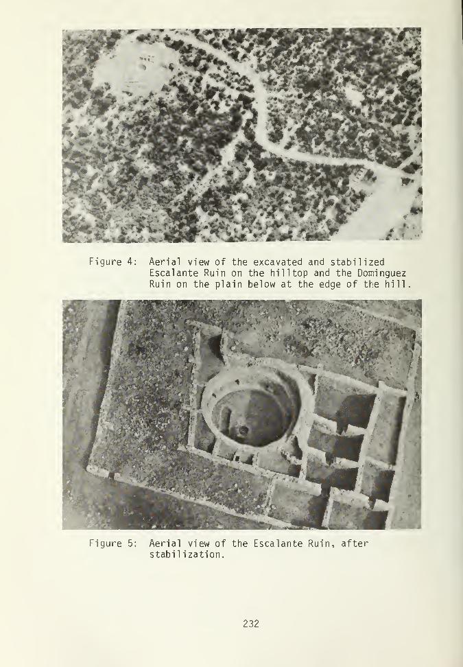
Figure 4: Aerial view of the excavated and stabilizedEscalante Ruin on the hilltop and the DominguezRuin on the plain below at the edge of the hill.
Figure 5: Aerial view of the Escalante Ruin, afterstabil ization.
232

2'
METERS
i5^r
i—
r
/ \\
/ KIVA B
\ yOpen doorwaysSealed doorwaysWall openingsPartially sealed doorwaysL-BondT-BondAbuttment
Figure 6. Plan view of the Escalante Ruin
233

ground. It probably postdates the main Chaco occupation of the
site.
Located to the west of the pueblo is a shallow trash accu-
mulation on the hill surface which is washing down the hillside.
The accumulation seems shallow since the natural gravels which can
be seen on the surface are accompanied with few artifacts; but the
area has not been tested, so the depth of the trash remains un-
certain.
Testing to the depth of the exterior wall of the pueblo
revealed that the space along the outside of the pueblo was used
for work areas. Along the west wall there had probably been a
ramada-type roofed structure over a well-used work area. On the
east side, a wall extending about 4m from the exterior pueblo wall
may define a contemporaneous work area or an earlier structure.
More testing and excavation is needed to adequately define the use
of these areas.
There appear to be 25 rooms in the pueblo as seen in the site
map, this number being approximated from the depressions and
ridges seen in the unexcavated portions of the pueblo.
The rooms excavated are large and deep, similar to the size
of rooms found in Chaco architecture. The highest standing wall
excavated was in Room 2: 230cm in height. At this height there
is no evidence of a ceiling support in the walls, indicating that
the ceiling was at least this high and probably higher.
Conditio n
When the site was cleared of vegetation the extent and shape
of the pueblo was clearly seen. The rubble on the site stood to a
maximum height of 5m above the surrounding hill surface. Sand-
stone building blocks were seen on the surface and the room loca-
234

tions could be discerned by the depressions between the higher
mounded walls. Kiva A was a deep depression but the radiating
partitions around the depression reported by Fewkes in 1919 and
discussed previously were not discernable.
Two rooms had been excavated prior to the beginning of our
excavations. These are designated as Room 1 and Room 4 as seen in
Figure 6. Room 1, which is actually not a room but a section of
the quadrangle surrounding Kiva A, had eight to ten courses ex-
posed and was in good condition. Room 4 was exposed on three
sides and partially exposed on the fourth side. This room had
sheets of corrugated tin in the room, suggesting that it had been
used as a "club house" by local children.
An electric power pole, located on the hill to the northwest
of the ruin, was removed before the 1976 field season; and a radio
tower which had stood on the hill northeast of the ruin had been
removed before the 1975 excavations began.
Remarkably few artifacts remained on the surface of the site
although previous explorers had mentioned the great accumulations
of artifacts. Probably these were removed by persons visiting the
site.
General Remarks on Wall Construction
A general discussion of the material and techniques of wall
construction follows in this section.
Materials
The material used in the walls is principally sandstone, al-
though some river cobbles were used as discussed below. Five
different types of sandstone and one shale type are used. The
235

sandstone all appear to be types of Dakota sandstone which may be
located close to the site as indicated by the geology, but the
exact quarries were not found. Two of the sandstones are massive,
blocklike, soft calcareous stone which were used as block as large
as 12 by 37 cm on the face and 24 cm in width. These stones
appear to be hewn somewhat and the surface is often pecked. The
third type of sandstone is a laminated, dark colored sandstone. A
fourth type is a white, soft sandstone which crumbles and erodes
easily. This type is used infrequently in the walls. The fifth
type is a sandstone with a wavy surface, which was difficult to
break evenly so was used in irregular shaped blocks. This type is
used in upper courses of some walls, indicating a possible re-
building of collapsed walls when other stone was less accessible;
also the inner wall of the crescent wall surrounding Kiva A was
built with this stone. The shale is a blue-gray crumbly stone
used infrequently as a filler or for chinking.
River cobbles were utilized in wall construction. There is
occasional use of river cobbles in the masonry of the room walls
when the size and shape of the cobbles approximates that of the
shaped sandstone blocks used in the wall. The foundations of the
walls were built of river cobbles. The base of the wall found in
the floor of Room 5 is built of flat river cobbles. Large river
cobbles, up to 50 by 30 by 15 cm, are also used in the construc-
tion of most of the buttresses around Kiva A. Also, river cobbles
are used as the rubble core, set in mortar, within the crescent
wall surrounding Kiva A.
The river cobbles used in the construction of the site were
probably not brought from the Dolores River below but were from
the native fill of the hill surface. This is the gravel and
cobble basal conglomerate as discussed in the geology section.
The river cobbles used in the supporting structure of Kiva A could
236

have been supplied from the pit dug for the Kiva A base and floor
features
.
Two kinds of mortar are used. The mortar in the majority of
the walls is brown (7.5 YR 5/4) (Munsell Color Co., Inc. 1954).
This mortar compares in color to the local soils found on the
plain below the hill. A light gray mortar, of which two shades
can be distinguished (10 YR 7/1 and 2.5 Y 7/2), is used in the
construction of Kiva A and is also found in the walls of the addi-
tion of rooms along the south exterior wall of the pueblo. These
mortar colors compare with the natural fill occurring below the
alluvial deposit of the surface of the hill, the two shades de-
pending on the degree of mixing of the mortar. This earth would
have been available from the pit dug for the Kiva A base, and it
also outcrops on the hill slope to the south of the pueblo.
Construction
Several different types of walls occur at the Escalante Ruin.
The majority of the walls are compound walls, coursed on both
sides with a narrow rubble fill, approximately 50 cm in width
(Fig. 8). The core is composed of unshaped sandstone and mortar.
The use of simple walls only one stone wide is frequent in
the excavated rooms. These include a short section in the west
wall of Room 2 which is faced on one side and backed with clay
fill (Fig. 7); the section in the east wall of Room 2 which is
faced on both sides and stood at one time as the west wall of an
earlier room; the north wall of Room 4; and the northern-most
section of the west wall of Room 8 which begins as a simple wall
but expands to the use of a retaining feature along the crescent
wall of Kiva A and then forms the south wall of Room 8 which is a
compound wall with no rubble fill.
237

The crescent wall (Fig. 60) enclosing the northeast side of
Kiva A is a compound wall with a wide rubble fill, faced on both
sides with a narrow face to the exterior and a wide inner face of
exteremely crude masonry built with the Type 5 sandstone (as de-
scribed above). The width between the two faces is 1 m, and the
core is composed of river cobbles held in mortar. This type of
wall is similar in construction and width, though not in appear-
ance to the type Vivian and Mathews (1966:108) identify as being
used in the Bonito Phase, exemplified in Pueblo Bonito.
Two of the walls are of dry-laid construction. These occur
in the north and south walls of Room 5, which are of dry-laid and
partially dry-laid construction respectively. The occurrence of
dry-laid walls is not mentioned in Chaco architecture but is known
to have occurred in other Anasazi architecture. Kidder and Guernsey
(1919:26, 33, 53, Plate 6c) record a small watch tower, four rooms
of a cliff dwelling and a small granery, "peculiarly constructed,"
noting that no mud mortar was used, all of which are located in
the Monument District of northeast Arizona. Roys (1936:146)
reports from information from a letter from Robert Burgh the
occurrence of dry wall masonry in Cliff Palace, Mesa Verde, in a
wall against the cave roof in the upper gallery and possibly in
the turkey pens at the back of the cave. Roys also discusses the
use of dry-laid masonry for reservoirs in the Mesa Verde area and
suggests that the use of dry-laid masonry could have been in
continuous practice in Mesa Verde from Basket Maker times, though
only rarely seen in pueblo construction. The dry-laid masonry
occurring at the Escalante Ruin, which is a feature of the reoccu-
pation of the site, appears to be a Mesa Verde architectural
feature.
238

Styles
The first three of the four styles of masonry encountered at
the site appear to be wery similar. The internal construction,
when noted during stabilization, includes a generous amount of
mortar between the stones and in most cases there does not seem to
be a stone-to-stone contact. This is consistent with a Chaco-type
masonry as it was analysed by Roys (1936:119-120) from examples in
the Lowry Ruin.
The masonry variations encountered seem to differ by the
physical properties of the type of sandstone used. These varia-
tions demonstrate a blending of styles. For example, one long
wall (as viewed in the east walls of Rooms 5 and 6) shows a change
in masonry style where one type of sandstone is replaced by an-
other. In addition, these variations occur within a block of
rooms which appear to be a part of the planned layout of the
pueblo and which were probably built within a short period of time
by the same group of people.
The best example of Style 1 masonry is seen in Room 2.
Roughly shaped sandstone blocks are set in uneven courses due to
the range in sizes of blocks used, which varies from 4 by 23 cm to
12 by 37 cm. Rows of sandstone spalls are set in the mortar
between the courses and continue in the fill between the stones
within the wall. The chinking, achieving almost a decorative
pattern, is fairly regular throughout the room, but is the most
regular in the simple wall in the west wall of the room (Fig 7),
which employs more uniformly sized building stones in the wall.
The other walls of the room demonstrate the use of irregular sized
blocks and an increasing use of larger blocks. In Room 8 ad-
joining and built onto Room 2, the blocks used are larger although
there is a range in the size of the blocks, and the chinking
though still present is less regular. The transition of the style
239

Figure 7: The west wall of Room 2 showing theStyle 1 masonry.
240

may indicate that it was evolving to another form by carelessness
or by the property of the stones available or by individual styles
of two different builders. This style compares with Hawley's Type
IV masonry (1934:14-15, 28) dated A.D. 1100 to 1116, and seen in
Chetro Ketl and Kinya'a, where there also occurred a marked irre-
gularity in the size of the blocks used.
It is interesting to note that there is an occurrence in the
Style 1 masonry (Fig. 7) of a small sandstone block set vertically
into the wall instead of being laid along the structurally sound
horizontal plane. Similar occurrences are also seen in the walls
in Kiva A.
Style 2 is exhibited by the long wall which forms the east
exterior wall of the pueblo. This wall continues further to the
west and forms part of the perimeter of the original pueblo. Where
the face of the wall is seen in the interior of Room 4, the masonry
face consists of spalled and pecked sandstone blocks set in courses
with thinner slabs generally alternating between thicker slabs.
Further to the south, as seen in the east and south walls of Room
6 (Fig. 8), long thin slabs with unshaped faces are used in the
wall. Spalls are rare in the wall and do not exhibit the pattern-
ing between courses seen in Style 1. This style includes then
walls which are constructed similarly to Style 1 but the block
size is more variable, treatment in the shaping of stone is less
uniform, and the decorative patterned chinking is only sporadi-
cal ly present.
Style 3 masonry is found in the south and east walls of Room
9, which is an addition to the original southern edge of the
pueblo (Fig. 9). The section of wall traced at the western corner
of the pueblo indicates that this masonry style continued along
the entire southern addition to the pueblo. These walls are
241

Figure 8: The east wall of Room 6 showing the Style 2
masonry.
Figure 9: The south wall of Room 20 showing Style 3
masonry.
242

narrower than the rest of the compound walls in the pueblo with
the individual blocks measuring approximately 7 by 15 by 20 cm.
These are set close together in fairly regular courses. The gray
mortar used in the walls is different from that in other room
walls but is also found in the walls of Kiva A. The use of the
small, regular-sized blocks is also similar to the Kiva A walls,
perhaps indicating a comtemporanei ty of building.
Style 4 is a rough grouping of the later additions to the
architecture: the dry-laid wall in Room 5 (Fig 40), the masonry
seen in the blocked doors in the south walls of Room 8 and Room 9,
the west wall in Room 9, and the intrusive wall in Kiva A (Fig.
66). These are much different from the masonry types described
above and can be considered to be non-Chaco by Roy's criteria
(1936). They exhibit the use of little or no mortar, and the
stones are set closely together or touching. Little care was
taken to form good bases to the walls or to evenly face a section
of wall which would occur below the level of the heightened floors.
The evidence of these features accompanied by the fact that all
were built in the reoccupation of the site indicates a non-Chaco
style of masonry which is not inconsistent with a Mesa Verde style
of architecture.
Some decorative elements are included in the north exterior
wall of the pueblo. A five course decorative band, 28 cm in
height, of narrow stones, is set above one wide course along the
base of the wall, which is 16 cm in height (Fig. 10). This band
was noted in the test trench at the center of the north wall and
presumably continues along the extent of this wall, although it is
not found on the exterior of the other walls which were also
tested.
There is evidence of a second decorative feature in the north
wall. Seven building stones with pecked designs on one face were
243

found at the site (Figs. 25-31). Four of these came from the
rubble fill encountered along the exterior of the north wall in
the excavation of this area for stabilization. The other three
lack provenience. Since none of these stones were found in the
wall, they must have been used at a higher level than the height
of the standing walls, approximately 77 cm.
A single stone sculpture was found on the site, north of Kiva
A, which may have been built into a wall (Fig. 31). The sculpture
is carved from a sandstone block, one end of which is a blocked
building stone, the other end is an animal head, possibly a young
bison or mountain sheep. From its location on the rubble fill of
the site it may be presumed to have been incorporated into a wall
surrounding Kiva A.
Bonding
New walls are commonly abutted to a previously standing wall,
which is a good indication of building sequences. Of the corners
which are tied, or bonded, to form curved corners. One curved
corner occurs in the southwest corner of Room 8, and one in the
northeast corner of Room 6 (Fig. 8) which is curved only in the
bottom 8 courses.
There is one case of a wall connection which is part abuttment
and part bonded: in the east wall of Room 2.
Architectural Details
The excavations at the Escalante site included approximately
one-third of the pueblo. Three occupations of the pueblo were
indicated.
The entire pueblo room block with the enclosed kiva had been
built in the original occupation. From the evidence of the excava-
tions a building sequence, as follows, is indicated. There is
evidence of a single early room (with single course wide walls) in
244

Figure 10: Decorative band seen in the
lower courses in the testtrench along the north exterior
wall of the pueblo.
245

the north half of Room 5 and extending through to the north wall
of Room 4. Room 2 was built between this earliest room (after the
south wall of the earliest room was removed) and Kiva A, against
the crescent wall surrounding Kiva A. The other rooms were added
onto Room 2 probably within a short period. The layout, bonding
of the walls, and similarities of the masonry in Rooms 2, 8, 10,
5, 6, 20, Kiva A, and in the stabilization trenches indicates that
these rooms and possibly the rest of the unexcavated pueblo repre-
sents a planned layout in the form of a rectangle with the kiva
enclosed in the house block. As an addition during the first
occupation, a row of rooms with a slightly different wall construc-
tion was added to the south end of the pueblo.
The seven excavated rooms had access to each other in the
original occupation. Room 2, Room 8, Room 10, and Room 20, lying
in a north-south alignment, had a series of "T"-shaped doorways
connecting them. Rooms 4, 5, and 6 had probably been part of a
single long room with a door connecting with Room 9 to the south.
It is unknown if there is a door connecting Room 4 with rooms to
the north. These two blocks of rooms connect to each other
through the breaks in the walls between Rooms 20 and 9. A wall
break in each of these rooms leads to the exterior of the pueblo
and a break in the west wall of Room 20 gives entrance to rooms to
the west.
Discussion of the room use follows in Chapter III with the
artifact distribution analysis. However, room 2, with a firepit,
is identified as having been a living and a work area; Room 8 used
as a work room and possibly a sleeping room; Room 10 as a grinding
room; Room 20 used for multiple cooking and food preparation area;
Room 5 and 6 (and possibly extending through Room 4 as well), one
long room at this level, was possibly used for storage; and Room
9, by evidence of the large firepit and the breaks in the walls
246

leading to the exterior and to Room 20, makes it probable that it
was also used for food preparation. The adjoining Rooms 2 and 8
appear to have been habitation rooms for a family unit. The
remainder of the rooms are special function rooms for grinding,
cooking or storage. These might have been used by the single
family unit or might have been communally shared by the entire
pueblo.
As discussed previously, the masonry style of the original
pueblo walls are more consistent with a Chaco Region influence
than a Mesa Verde Region style. The planned layout of the pueblo,
the large size of the rooms, the kiva enclosed in the house block
and a Pueblo Bonito style kiva (with a circular shape, bench
recess, subfloor ventilator tunnel, log and masonry pilasters, and
large size) all suggest a Chaco Region style architecture.
The second level rooms were found in all of the excavated
rooms. Evidence of similar levels in the stabilization trenches
suggest that this occupation may have included most of the pueblo.
These floors are built on fill approximately onehalf meter above
the original floors and the architecture in the rooms show some
remodeling such as blocked doors and a new wall. The remains of
the intrusive wall in Kiva A probably also dates from this occupa-
tion. Construction of Kiva B might have been started by these in-
habitants.
The arrangement of the seven rooms in the second occupation
suggest four habitation clusters. Rooms 2 and 8 adjoin through
one door and must have had an exit through the ceiling in one or
both of these rooms. There is little data on the use of these two
rooms but their arrangement suggests a single family habitation
unit. Room 5 does not connect with any other room, and probably
had a ceiling entrance. The floor had a firepit but there is
247

little evidence for the use of this level. Room 10, Room 20, Room
9, and Room 6 join through mutual doors or wall breaks and have an
exterior exit through Room 20. Room 20 also connects with rooms
to the west through a wall break. The floor features indicate
uses for some of these floor levels. Room 10 with a firepit was
used for food preparation and living space. Although it adjoins
through a T-shaped door with Room 20 it appears that Room 10 might
have been used as a single room unit. The evidence of a door slab
on the floor in Room 10 before the door into Room 20 indicates
that it could be closed off from Room 20. Room 20 had no features
and no indications of use, and with breaks in the walls to the
east, west, and south, might have been used only as an exit to
other rooms or the exterior. Room 6, with a firepit in the corner
of the room, was probably used as a living and a work area. There
were two floors in the second occupation level of Room 9, defined
only in the west half of the room. The original floor had a
possible firepit, and the second floor had some artifacts includ-
ing part of a smashed corrugated jar. These two rooms, Rooms 6
and 9, probably represent a two room habitation unit.
Several features in the architecture and arrangement of the
rooms between the two occupations suggest that the occupations
were not by the same people.
The arrangement of the excavated rooms in the second occupa-
tion is different from the original occupation. In the second
occupation the rooms are broken into one and two room units with
no evidence of communal activity rooms. In the first occupation
all of the rooms adjoined with each other and five of the seven
rooms had indications of communal group activities. This sample
of excavated rooms suggests that there may have been a different
social organization for the inhabitants of the two different
248

occupations. However, further excavation in the remaining rooms
of the pueblo would be necessary to confirm this sample which may
not be presenting an accurate picture of the use of the pueblo.
The masonry seen in the architectural modifications displays
a much cruder style in the second occupation than in the first.
This includes the use of dry-wall masonry which as discussed
previously in the chapter, appears to be a Mesa Verde Region
style. The heightening of the floors suggests a desire to make
rooms with lower ceilings. Kiva B (Fig. 11), with a southern
recess and masonry pilasters, shows a much different architectural
construction and design than Kiva A built in the original occupation.
This style of kiva construction is more typical of kivas of the
Mesa Verde Region. Although this evidence may indicate an his-
torical continum for a single culture, the differences suggest
that these were two different cultural groups, the second occupa-
tion possibly of the regional "Mesa Verde" type.
The third occupation, evidenced in only two rooms, is well
represented by only one floor, from Room 9A. Similar occupation
levels were not found in any of the stabilization trenches around
the exterior walls of the pueblo. The room had been used for a
habitation with cooking, food preparaion and other activities. It
appears to represent a temporary reuse of the site which may not
have any further occurrence on the remainder of the site.
249

N
\
< "N Firepit
I
1
II]room
•119
3
itf jpOOM
!
': 20
//////
Figure 11. Map of the test trench in Kiva B,
250

CHAPTER III
ARTIFACT ANALYSIS
There was a general paucity of artifacts encountered at the
site, both on the surface and within the excavation units. The
historical evidence as discussed in the introduciton suggests that
there had been a greater occurrence of artifacts on the surface
which have probably been removed by visitors to the location due
to the renown of the site. However, the scarcity of artifacts
found in the excavation and the evidence of the shallow trash
accumulation in the trash pit location suggests that the total
occupation of the site, including the original occupation and the
subsequent reoccupations , was of short duration.
Ceramics
Types
Of the 9,751 sherds 2,702 were classifiable into types. Of
these the predominant ceramic types present were of the Mesa Verde
Ceramic Series. Almost the whole range of possible types in the
series from early to late appeared. The preponderence of classi-
fiable sherds, 83.6 percent, or 23.2 percent of the total number
of sherds, were of four types falling in the late Pueblo II to
early Pueblo III range (Figs. 12-15), indicating a time span of
A.D. 1100 to 1150. These types are shown in Tables 1 and 2.
Trade wares are present from the site representing 3.82 per-
cent of the total sherd assemblage and 11.84 percent of the classi-
fiable sherds. Trade from within the region and with three other
regional area is indicated. Tusayan Black-on-red, Tusayan Poly-
251

TABLE 1
PERIODS, DATES, AND NUMBERS OF SHERDSGIVEN FOR THE PREDOMINANT CERAMIC TYPES
Type Period Date No. of
Sherds
Mancos B/W Pueblo II A.D. 900-1150 1,361McElmo B/W Pueblo III A.D. 1075-1275 535Mancos Corrugated Pueblo II A.D. 900-1200 232
Mesa Verde Corrugated Pueblo III A.D. 1100-1300 129
252

4- rOO 4->
o
o <c
5-8 C_J
-Qro4->
1/1
CD
rO>
<rO>
CCM
o
E
CTi
CTi
Eoc
00
Eo;
CD
Ea:
ID
Eod
CM
O)Q-
CO *3- <* ^HllO i—1 CO CM CO ^J- CM CM <* ITJCM UD 00 O O CM CM i—i oi cn CO CD CTi CM LO CM —l i—
1
CO CO CO co|co O O CM O O f-H CM O <—i o o O LT) CO CO CM iowo ^a- ^a- cm o O O O .—
i
CO LO CXI rH|0 o o o o o o o o o o o O *3" LO CM o ^-i o o CD O O O o o o oi—
l
1^f- ,—1 r-l
.—i rH O r-Jcn cj- 1—1 1—
1
Hirxt h lo CTi r-. cm o ^j- r-^ co in io rx rx 00 r-~ <3-
CO *H- LO r-^jcxi OHC0 i-H <—1<3" CO i—l LO O CM CO CO O CO i-h CD C O h o O
O CTi CO <d-|«-< o o o o o o o o o o o o in i—i o O i—i i—• o o o oLO i-H
1
•—1 LO O CTl LO •—I CO CM CO «* CM CM q-lD(\HO CO -—I CO o CM CO CTi CTi CM LO CTi CM LT) CXI i—I i—
i
CO CXI CO CM CO CM .—I CM «—
1
1— O i—
i
CM LD CM *a- ^s- <xi i—
l
CO 00 CM i—
1
CO LT> CM 1—
1
1—
1
*3" i-H i—
1
«3- co cr> •& 1—1 1—
1
CM 1—1 1—
1
lOUlts i—
i
CMLO i—
1
CTi *d- lo
co lo i—
i
i—
i
r~- ^d- oo (XI CO i-H CO i-H «—
i
CM CO CO i-H CO
CO o CM co ^- r-~
CM CM CM CM
LO CO —
1
^J- CM CO i—1 O CM CM CM .—
I
cm i—i co en LO CTt i—
i
i—i i—
i
m in in i-H i—I i—
l
CO CM CO !—
1
CO LT) CO CM
CO CTl LO CM i—
l
iHCOU) CO CO CXICO CO CO —1 LT)
i—
l
r-^ co CTi 00 CO CM LT)O "=Jr CO LO CTi --H O CO i—l CM CTl i—
l
CM oo CM "=J-
r^ o 1—
1
1—
1
5tHlD3- rH r-l
.—
1
CMLO CO i—
1
i-H i—1 LD i—1 OCO CO nnrj-
CTl CM «d" «s- CO OhcO CO VD CMlo «a- *h- ^1- <=*•
i—
i
CO r-H
LO CXI CO CO «* i—
1
co i—i co co COCO LO >3- 1—1 CO CO CTi
C\J i—lCM CO i-H i—
l
LO O O I—
1
CM i—
1
^a- cr. co in ,_,
r^ co co 1—
1
CO CTi CM 1—1
O O CM *t <-* *3- i—l «* t rHCSJ co co ^a- CM CM >* CD CMCM CM CO r--~ CO =H- LO CM1-1 CTi i-h
HCO* CO|CO LD H <* i—i ld <d- i—1 CO CO *h- i—
i
IT) i—l r-~ co co«t r-^ lo CO r-l o CXICO
1
J .
CTi LT) CM
CD
CD
EO
CDCD
CDEO
ill i. >, m >> 5- S- ro s_S-IS- rO CD 3 ro ro CD -£Z S- -CO' o >> S- s- -v. S- 3 <- U O 3 o
• o o -a rO Od CD ro CO C3 ro >l C£ >,S- ai >, S_ --^ >> 3 CD 3 i— o; v^ r- CO Cd I LO3 3 S- aj.<—
<
3q: rO C3 CO 3 3 ro CI) CD S- C +J O "-^ CQ CD -v. CC 3 O CD-~-.\ o -o;>—
>
-^ S- O -^ -^ s- -* >, "O S- -r- T- "O Q. CO O) t|_ CO ^ ^- Q_ S-DO CO (_) S- —
i
CQ 0) CD C \ W CQ CO CD ro ro S- O ro -C CD CD CO 4- 3 CO CQ ro0)1 > •i- Cd C _l S- CD O i— 3 CC c c c 1— (O \ CD D. 3
(/I O VI 5>D- C •- C LO ro (C N in CD > Q_ ro ro !- +-> CO +-> O Q. 3O E O 1
1 •i- 4-> -r- ro o E s_ m o >> >i >> O • (/) ro U 3U •
O i— o n3ji—
i
Q.T- au'o'D "a +-> O E <D ro i— •
—
i
—
ro ro -r- r— OVr- CTt S- r— -acue l/>li— id ai mu to io <u s- c E +-> on O U O O t/1 (/) "O O ro L0 C cd — rz -r-ro u ra Ol _C 13 SZ | O -Q 0> -i- O ro 3 ro 0) c c c c 13 3 CD C •— O -r- 3 hjt cs: 2! s: SlCL UU.U 5! < Q Q_ o s: s: —
i
e: zd => zd ZD I— r- s: DLl W3 Q-CDHD
CXI
coCTi
CXIOCO
LDCDCXI
CTi
cn
COCTi
COLT)
CDCD
=H-
*a-«3-
OCT.
r—o
253

chrome, Medicine Black-on-red and unclassif iable Tsegi Orange
wares represent Tsegi Orange Ware. Flagstaff Black-on-white and
Sosi Black-on-white (Fig. 16), represent Tusayar. White Ware. Both
of these are from the Kayenta Region in northern Arizona. Seventy-
four percent of the trade ware sherds are Tsegi Orange Ware. In-
cluding the Tusayan White Ware types, the sherds from the Kayenta
region account for 97 percent of the trade wares present at the site,
Wingate Black-on-red and Puerco Black-on-red are White Mountain Red
Ware from the Cibola Region in west-central Arizona and north cen-
tral New Mexico are present in a wery low frequency (seven sherds).
Gallup Black-on-white from the Chaco Branch of the Cibola White
Ware is present at the site, again in a low frequency (two sherds).
One Tin Cup Polychrome sherd was present at the site. This is a
regional "deviant" of the Mesa Verde White Ware Series occurring
in the Montezuma Valley are of Cajon Mesa, Colorado (Washburn
1976:18-19).
Eighty-four percent of the trade ware from the site is from
the original occupation levels. Fifteen percent is from the
second occupation levels and one percent (three sherds) is from the
one floor representing the third occupation level. These figures
show a uniform percentage throughout the levels since the total
number of sherds accountable to each of the three occupation levels
varies similarly: the original occupation levels were well repre-
sented by sherds, the second occupation levels had fewer artifacts
and fewer floors were identified, and there is only one third
occupation floor level.
The three levels varied somewhat in the range of types pre-
sent. As seen in Table 3 Tsegi Orange Ware, besides being the
most abundant, was present in all three levels, represented by
Tusayan Black-on-red. The low frequency encountered in the third
254

TABLE 3
NUMBERS OF TRADE WARE SHERDS PRESENT
IN THE OCCUPATION LEVELS
143 7
23 5
24
39 1
Trade Ware Types First Second ThirdUnassignable
to levels
Tsegi Orange WareTusayan Polychrome 143 7 10
Tusayan B/RMedicine B/R
Unci . Tsegi Orange wares
Tusayan White WareFlagstaff B/W 30
Sosi B/W 29
White Mountain Red WareWingate B/R 1 2
Puerco B/R 1 1
Chaco Branch, Cibola White WareGallup B/W 2
Mesa Verde White Ware variantTin Cup Polychrome 1
Unidentified 8 1
255

occupation level, three sherds from Floor 1 in Room 9A, does not
necessarily indicate a continuing trade of the Tusayan pottery but
may reflect a reuse of sherds already present on the site. Tusayan
White Ware is present in both the first and second occupation
levels but represented by different types in this series. Sherds
of White Mountain Red Ware are present in both the first and the
second occupation levels but in yery low frequencies. Tin Cup
Polychrome is present only from the second occupation level indica-
ting regional trade in the Montezuma Valley.
This data, despite the low frequencies, seems to indicate
that trade had existed in the original occupation with the Kayenta
Region, the Cibola Region, and the Chaco area. The second occupa-
tion apparently also obtained trade ware from the Kayenta Region
and possibly from the Cibola Region. This level also shows evi-
dence of local regional trade in the Montezuma Valley. As already
indicated the evidence of the trade ware from the third occupation
level may only represent a random reuse of sherds present at the
site.
Twelve other sherds, apparently trade wares are possibly of a
Southern origin. They have been examined at the Mesa Verde Research
Center and at the Chaco Center, but have not yet been identified.
The ceramics encountered at the site are similar to ceramics
reported at other Chaco outliers located in the vicinity. Martin
(1936:79-80) reports from the Lowry Ruin the occurrence of Mesa
Verde ceramics and an assemblage of trade wares which almost para-
llels the regional trade indicated at Escalante: Sunset Redware,
Wingate Black-on-red, Abajo Red-on-orange, Black Mesa Black-on-
white, Tusayan Black-on-white, Tusayan Black-on-red, Tusayan Poly-
chrome, and Puerco Black-on-red. At the Chimney Rock site, Eddy
(1972; VI-52 ) encountered a predominance of Mesa Verde ceramics and
256

1.91 percent occurrence of trade wares which included Tusayan
Polychrome, Tusayan Black-on-red, Chaco Black-on-white and an
unidentified red ware.
The trade wares encountered at Escalante and at the other two
sites are the usual trade wares found at this time period in Chaco
sites. Vivian and Mathews (1964:73-74) report that trade wares in
Chaco sites are scarce in all periods, occurring in a low fre-
quency, and that for Pueblo III the most frequently reported
imports have been confined to the Wingate and Puerco Black-on-reds
and the Tusayan-Citadel group.
Portions of 16 vessels were recovered from the deep trash
layer above the grinding bins in Floor 2 of Room 20, an original
occupation floor level. Some sherds from these vessels were also
recovered from fill above the original floor levels in Rooms 9 and
20. Only one of the vessels was reconstructed. This is a Black-
on-white bowl with a flared rim, described below. The other
vessels include four Pueblo II-Pueblo III Corrugated jars, three
McElmo Black-on-white bowls, two with corrugated exteriors, three
Mancos Black-on-white bowls, one Tsegi red ware jar, one Flagstaff
Black-on-white bowl, and one unidentified black-on-white bowl
(Fig. 14). This thick trash layer contains 55.6 percent of the
trade ware from the site, or 69 percent of the trade ware from the
original occupation levels.
The preliminary ceramic analysis did not include a formal
investigation of temper, paint, or design. Further investigations
of this nature are recommended for the site. The design elements,
though consistent with the types of the Mesa Verde Ceramic Series
(Breternitz, et al . 1974) and classifiable into those types demon-
strated a slight variation attributable to the spatial separation.
257

Figure 12: Reconstructed Mesa VerdeCorrugated jar.
Figure 13: White ware bowl made from the
base of a black-on-white jar.
258

Figure 14: Partial unidentified black-on-white bowl
259

Figure 15: Mancos Black-on-whi te bird effigy jar,
260

ff?$B*
Figure 16: Partial Sosi Black-on-white bowl
261

Stone
Chipped Stone
There is a total of 1,002 chipped stone artifacts from the
site, including the flakes, cores, and formal chipped stone tool
types.
Material s . Five materials make up 98 percent of the collec-
tion. Over half is quartzite (Qe), chert (Ct) is the second high-
est in frequency, then obsidian (On), siltstone (SS), and chalce-
dony (Cy). Present in very low frequencies are felsite porphyry
(FePy), sandstone (Se), limestone (Le), agate (Ae), and basalt
(Bt). The frequency of these material types is shown in Table 14.
The quartzite tally actually includes three quartzite sub-
types which are distinguished by grain size (Emslie 1975): quart-
zite (Qe), fine quarzite (fQe), and very fine quartzite (vfQe).
The quarzites are metamorphosed rocks composed of quartz cemented
by silica. Quartzite has coarse grains from 2 to 0.25 mm in dia-
meter, appearing granular in texture. Fine quartzite has a "Sugary"
appearance. The grains can be seen by the naked eye but the tex-
ture is less granular than the quartzite. The grains range from
0.25 to 0.125 mm in diameter. The very fine quartzite has very
small grains ranging from 0.125 to 0.062 mm in diameter. The
grains usually cannot be seen by the naked eye and the stone is
sil ty in appearance.
This distinction was made only in the analysis from the se-
cond season, accounting for only one-third of the quartzite in the
collection. However, from the second season's data it was found
that the fine quartzite was the most abundant, 63 percent; quart-
zite was next, 31 percent; and very fine quartzite represented
only 5 percent of the sample. The fine quartzite flakes show the
262

most frequent utilization (12); compared to quartzite (2) or very
fine quartzite (1). Of the 15 cores, 12 were fine quartzite and
3 were quartzite.
All but four of the materials, obsidian, chalcedony, sand-
stone, and shale display river cobble cortex. Modern river cobble
sources may have been from two places: the Dolores River located
below the Escalante site, or the surface fill of the Escalante
hill which is an ancient river terrace.
Of the 27 pieces of chalcedony, only two had cortex remaining
and neither of these appeared to have been river tumbled. Al-
though this material may be present in the river beds, it appears
that another source was utilized.
The obsidian displays a cortex which is clearly not river
rolled. There is no local source of obsidian so this material
must have been obtained through trade or travel to a distant
source. Two varieties of obsidian are distinguishable. One is
very clear and gray to black in color depending on its thickness
and contains some white sphericuli tes. The other type is also
gray to black in color but the thin pieces are "milky" in appear-
ance from many tiny inclusions. The former type is predominant.
These two types of obsidian were also found in the excavations at
Yellow Jacket (Wheat, personal communication).
Although the obsidian is present throughout the levels, 81
percent of the pieces accountable to occupation levels are asso-
ciated with the original occupation. Ten percent (seven pieces),
and nine percent (six pieces) are associated with the second and
third occupation levels. This may indicate a reuse of the mater-
ials already present, or a reduced volume of the total number of
artifacts present from the second and the third occupations.
263

CO_lOo
oh-oo
QUJQ_ UOQ_ UJi—> Q_ZZ >-O I—
—I _J< =£
00 Ctl Cd<=t O UJi— u_ I—
<Cq 2:2:=t >-
CO#\
COUJq:
#»
00LU
<:
I—o
rotor0CO
CD
rOCT>
<C
1 CDcu cE
•1
—
+J_J to
1 O)"O cc:03 +->
OO to
CD
00
>>CD i.+-> >>•1
—
JZ00 Q.
1
—
S-CDU_ O-
1
CD>>
1
—
cre-C -0c_>
cu
1
—
•1
—
+->
00 00
1
1
—
c00 ro-O •
i
—
-a
4->
^CD
M+-> CDS- 4->
ro "i-
cr
CD
+->
+->
orO4-•1
—
+->
o or-» r^-r— cr> o o
CO LO o~>
o cr> cr> >3- o 1—LO LO 1— 1— 1
—
to C\Jro oo
CNJ CM
<=J- <3"
CM .— CO
tO 1— r^.
CM
CNJ
OJI^N
CO 1 -=d"
1 <vf LO
CONin1— r^> CT)
O LO LO>^- I— LO
O LO r— tO1— O LO to
CO C\J LO
to OO 1
—
to (— r^
00 to cr>
r-^ >^- to
1— CO CO 1— 00
1-^
c\j
to
toCTi
COCMto
XCD
S~
oo
>,io oS- -O -i-ro C S-
E O CD CO•r- O 4-> CDS- OJ C^D_ OO >—
1 ro
CO CO COCD CD CD _l^^^:<ro ro ro
I
—
.— .— 1— O
XCD4->
s-oo>>
ro O"O -r-
e s-
O CD coO +-> CDCD C S-O0 1—
1 OOco co 1
CD CD <CS- S- H-OOOC_J <_> I—
CO4->
O
CD
oo4->
CD4->
r0
rju+jcCDO
+-> COO CDCD <_>
(—) ro
O 4-S- •-
OO00
S-CD COQ-i— —1ro r-<S- T- I—o s- o
D_ QQ OO Q I—
\—o

TABLE 5
MATERIAL TYPES FOR FUNCTIONAL CATEGORIES OF UTILIZEDFLAKES AND THE PERCENTAGES OF THE TOTAL NUMBEROF FLAKES WHICH ARE UTILIZED FOR EACH MATERIAL
Functional Quartz- Obsi-categories ite dian Chert
Chalce- Lime- Si 11-
dony stone stone Shale TOTALS
Scraper use 162
Knife use $
Scraper andKnife use 1
Rejuvination 13
Chopper use 6
Hammer use 2
Miscel laneous 1
TOTAL 47
% of flakesutilized 8.3
% of materialutilized 8.5
15 !
17 !
36
37.9
39.6
18'1 1
30
19.4 11.7 100.0
27.0 44.4 100.0
1
1
1.8
1.7
33.3
33.3
52
35
7
13
6
4
2
119
Superscripts indicate the number of flakes which show multiple side and/orend use.
265

L/0
<_lCQ
Q<
rt
OO
00
oO-
in oUJ
UJ <~3
_l o<=t O-I—
o
o00UJO
<:
UJ
UJ>ooro_
co
a
CD S-S- O)=3 .aen E
o to•r- a>JZ c
4->
-o
-MCD
a>
cu .—+-> 0303 -r-
ai
oa>
cai>oS-Q_
-a a>r- JDa; E•1— 13u_ c:
oO-
<u
o oa; o.
oa.
cuo ai
» o o<U <U 1— CD 1— 1
—
4- •!-,,— -r-)r- .—•1- O -p- O -i- !-C S- S- S_ S- S--^ CLT3 Q.-0 "O
(0£1 UT3 OJ^
00 o co lo lo oCM CO CM CM CM CM
O LO l~^ O O OLO LO LO *d" ^J- LO
CM CM CM CM CM CM
>> +-> +-> >>4-> +->u uuuuu
00
n3 COCM CO
S_ S- S- S- CU s-
o o o o > oO O O O O) o
<CvJ LDUDi— CT>
03 E E E E E> o o o o o•r- O O O O O^ a a a: a: ct:
IDNCOOMNCM 1— CO 1— CO
CM CM
"O toCD CD-C c
cu 03CL +-> +J>>— r> c: CU
, s_,— cu 0303 0 :s
E •r~ crto to to
cu <u4- 4-•r— »r-c sz-^ J*:
-O "O
03 03
-o -a
CD.
o lo00 00
000000 00
CO LO CO O O O ouiCO^J-i— Mi— U0 CMO
LO OO CO
00 00
r— O•r- CO
s-
o >—or— i.4- oJD O00
LO CO
o oo oa; en
LO «3"
.— 00
CU
+J
CU
•>~s
CDs- 4-CL
Cft X3 -O T3 .*:
U- +-> O) a> a>ai c to LO to *>
CL-i- cu =3 =3 3 CD r—03 4- CD ^~s- ex •1
—
-t-> -M +-> 3 r"C O O O S_
VI J*£ C c C CD "O
lo
ocd.
s-oo
LO
OOa:
oCM
•i-T-,^: r-
00000CO LD "vl" LO OO
00000
O O LD LT> Onrv rv id rv
000.—incncoco oCM OO CM CM CM
"O toCD CDJZ c 4->
O 03 C+-> +-> • 1
—
• O OS- c CL) Q- toCD s_ -!«£
CD CD 03 4-> cc= -a =3 S- 03O T- CT 03 1
—
— to to -a m
oLD
unCM
oCM
CO
>> >> +J >,+J +J 4-> 4-> CUC_> C_J C_) <_) C_> C_) C_) C_) o-
CM 1— 1—LT> CD i— 1— -r- r^.
. . . .,- 4_ •
-cC <C <=t 4- «=C. . . CM •
U_ U_ U_ 1
—
u_s_r s. i- s. S-00000
C O O O r—O) 1— r— 1— u_ 1
—
CQLlLlLl u_
#\ #\ r» #» Pi n<< <C\JC\J <03 03 03 E E 03> > > O O >•1- •!- -i- O O • 1
—
N*i iz ^ q: or ^
^- LO uo O CO LD1— CO
CM
,
—
CO03 LOO•1— CUS- s-+-> 3ai CDE •r—
>> U_toto<=C *

«Jc d e f
mg
i j
en £ 3 4 5 B ' 7 ' 8 9 10
n
Figure 17: Projectile points, drills, and blanks: a,b,d,
Small, side notched, square tanged points; c,
e-h,n, Drills; j,k, Blanks; a,g,h,i,l, Knife use,
267

Utilized flakes . The flakes showing use but which are unmodi-
fied in shape are separated into functional categories. Table 5
shows the breakdown of the categories of the functional types
according to the material. Ratios are also given in the second to
the last row of the table for the number of utilized flakes to the
total number of flakes in the collection for each material. Al-
though quartzite flakes are the most frequently utilized, quart-
zite represents a low percentage of utilization. Obsidian, chert,
and chalcedony show higher utilization compared to the total
number of flakes of these materials. The final percentage column
indicates this material selection more graphically. The percent-
ages are tabulated including the formal tool types with the uti-
lized flakes and then divided by the total amount of chipped
stone, including flakes and cores.
Formal Chipped Stone Tool Types
Projectile points, drills, and blanks . Within the morpho-
logical grouping of the small shaped hafted points a variety of
functions for the artifacts were indicated by wear. Table 6 gives
their proveniences and description, and the artifacts are illus-
trated in Figure 17.
B ifaces . This group includes large bifacially formed tools,
or fragments of these tools, which have been utilized as knives
(Table 7 and Fig. 18).
End and side scrapers . The end or side scraper is defined by
an edge with a steep unifacial bevel produced by pressure flaking
and located on either the end or side of the flake. All six of
these scrapers are combination end and side scrapers (Table 8).
On each tool the end has the most prominent use edge, a steep edge
268

Figure 18: The biface tools: a, Stemmed biface;b, Leaf-shaped biface; c-f, Fragmen-tary; g, Assymetrical stemless biface;h- j , Fragmentary.
269

oo
c_><CO
u_o2:o
_l C_>CO 00ct UJI— Q
Q
o
-aO QJ •>
-a +J T3 OJ dJc: C W D)3 "O d> 3 fo 3
to O a> CD -Q+> S- 00 =3 s- enc cn 3 +->
O) en >> ro coE a> CL-O 1— fO
E to •1- <U "O CO 4-> dJ d)O rO -I-) 4-i d) ro -c co "O coO X) ro Q.
« S- roen 3 cu
T3 •!— CO3
•> "O O JZ a> r- i. 3 s-T3 d) 4- CO co co ai (1)
d) E s- 3 Q. Ol Gi-4-> E <V<+- CD ro t- ro4- dJQ.ro aw s--p S-rO +J a> •1- ro U uJC CO 1
—
P J2 W CO
*0) S-J_ a>3 -Oen E•r- 13
U_ C
-^ 00O CO•1— CU
-t->
encd)
1
d) r-+-> roro »r-
2: t-
cn+Jro CS- d)
d)uOJ
d)>oQ_
S--a rjj
p— -Qd> E•1- 3
d) ro
IDOO CO C\J
<d" CM CT>
O O C_>
X X
S- S-1—00r— O O
CM CO CO
E E EOOOOOOcc cd cc
CO CO fv-)
ro ro
o en
N COCOl
—
00 co r-v w>
•p-p <u aiooaa
x x
S— S_ £_r— O O O<— o o o
in in in en
E E E E00000000CC CU CC Cd
00 1— i— CO
"O •!—3 T-
in in co co in 1— o 1— un 00
OOO OOOr— OOOLn
r*~ *d- r-^ r^i— r^r-^ cooor^cm cm cm n ojron co co <3-
o cm oco co co
+-> >> CDC_) o o
XXX
r- r- 4-
O COo1— s-4- o-O O3 1
—
00 u_
« « <umm u(O
E E 4-o o J-
O O 3a: cc 00
*3-
co
CU

with a convex outline. The edges display exhausted end scraper
wear: the steeply retouched edge is sharply undercut through use
by multiple step fractures and the bottom edge shows grinding.
This type of wear is described by Wilmsen (1970:71-76) as the wear
typical of scrapers used as hide scrapers by Eskimo Indians.
These tools could nave been used for similar tasks.
Two other edges on each scraper also have been utilized, the
use commonly occurring on the two opposing sides. Eight of the
twelve edges have been retouched to form a beveled edge. These
edges are straight or concave in outline and show heavy to mod-
erate wear. The other four edges show scraper wear but little or
no retouch.
Denticulate edged tools . Six tools from the site display
notching along one or more edges to form a denticulate edge (Table
9).
Denticulate edged tools have been reported from Mesa Verde by
Rohn (1971:219) and O'Bryan (1950:79-80, PI. XXVII), from Alkali
Ridge by Brew (1946:241, Fig 171), and from Kin Kletso in Chaco
Canyon (Vivian and Mathews 1966:89-90, Fig 50). These tools are
designated as saws and display no secondary flaking of the surface.
The same type of tool is present in the Yellow Jacket area
from Pueblo II and Pueblo III sites (Wheat, personal communication)
The notched edge is present on flakes with no secondary flaking
and on bifacial ly shaped blades.
Chopping and Pounding Tools
Axes . A total of eight axes were recovered from the excava-
tions. Two of the axes are side-notched. One, in the process of
271

CO
CO
OOonUJd_<cq;ooo
UJQi—
(
00
Q
Q
o
o00UJQ
UJ>o
-a CD "O "OCD CD > CD CDCO r— <a n— r—=3 00 CD c_> CD CD
O) > c -a > CD >S- "O O) "O O CD CD > CDCD -r- JD CD o <— .a n3 -a JDQ. 00 i— CD o r— <DfC -SZ CD JC > -C c i— -SZ JZS- C +-> > +j as 4-> o fl3 o +J(-> O o CD o .n O u zs oOO -Q -O JD
CD-O.
CD" o
CD 4-JJD
^ r> " C ^ c CD CD #%
o CD o o O o S_ S_ O2 e s 2 JZ s4-> o +-> 4-> +-> +->
*CD S-S- CD=3 .aen E•r- Zi
u_ c
I
-^ 00O 00r- CDJZ C
-t->
-a
CD i—
n3 t-2: s-
o
CM
<JD
o
LT>
CNJ
CNJ
C\J
+-> C\J CO LT)
en • • •
c CM OO LOCD
C_> o
4- 4-CDCJ r— t—~ t—~
cCD 5- S- S-•r— o o oC o o oCD 1— r— t—> u_ u_ u_OS- ** r% ^
Q_ IT) LT) UO
E E Eo O Oo o Oon on on
5-
-O CDi— .aCD E i
—
i—
i
—
fO
LT)O
*3-
oo
CTi
oo
JDO
S-
oo
LD
Ooon
en
CD
en
o
CO
CNJ
=3-
CNJ
c_>
CD>CD
CO
ooon
r-~.
CNJ
CNJ
co
oo
c_>
COCO
oo
COLD
E COoo CDon S-
Zi
cn•i—
u_CNJ
CNJ
272

CO4->
CD
OC_>
CD
CO
IS)
ccLUO-<CCO</)
oQ
_l
o
to<u
o4->
O
S- d)=3 -Oen E•i- 3
i
O (/)
•i- CO
I— C
a
orc_>tnLUQQ CD
oQ-
o
00
d)4-
s- •!-
0) c
s-o COco cd cd
en en«-o -ocd a> coc•r- S- S-.*: cd CD
I— -t-) +->
4- O O>>C\J 1—s-
S-CDex13s-oco
-oc:o<_>
CDCO
1— CO
en a>C CD•<- -oc a>c•1- S_.c: cd+-> .c
+->
r- oC C <T300 •>-—
oro cd4- co•1- 3.Q
00
O) COco co3 3
toa>CDa COCO CD
-Os- a>CO.c j_4-> a>O x:
+jO54-> 1
—CO COCO co3 3S- J-CD COD_ Q.»a fOS- S-
CO CO
LOCO r—
CD CVJ
C\J
CD
O
0O
CD
O
CO
CXI
<a
00
o
CO
co
co oo ^
LO 1—
«3- CO
-M CD en COCD • • •
C CD ^- CO
1— r-«. 1
—
CO 1
—
4-> fO CO +->
rO •!- Cr <_>
2: s-
CO
co Ll_
uc S-CO O 1
—
•r" O r^c r— •1
—
O) LL. Ll_
>V ft
i_ <: CNJ
o_m E> O*r- O^ cn
i_-0 CO— -O LO COCD E•1- 3
(_5
S-
oo
00
oocc
coco
273
CO
CO
4-
CNJ
i-
Oo
CO
Eoocc
oco
co
o
<D COo u14- 4-
OO oo
co<DCD-aco
COs-a><+-
14-
-O
COaj
o+->
oc«+-
oi_
<u01
COCO4->
TCI
a•r-
^?+->
cCO
a;co
CO cCO fO
CO +->
s_3 COCD i_•1- O

manufacture, is unutilized the second is fragmented. The remaining
six axes are grooved.
Table 10 gives the proveniences and description for these
artifacts. Seven of the axes are shown in Figure 19.
Maul s . A maul is designated here as a \/ery large hafted
stone tool used for pounding. Only two specimens were found.
Both of these are unshaped except for the hafting modification,
and they show little use.
Choppers . A chopper has an edge which has been formed by
removing percussion flakes unifacially or from alternating faces
of a single edge. The tool, which is hand held, is used to cut by
blows, rather than by slicing. The resulting wear is a series of
step fractures and battering along the edge.
The descriptive information for these tools is given in Table
11.
Hammer stones . Hammerstones are hand held pounders which may
have been used for many purposes including striking flakes from
cores, shaping building stone, and processing bone and plant
material. The greatest number of hammerstones are cores left over
from the production of flakes. Four flakes demonstrated use as
hammerstones. In addition four of the hammerstones found are
river cobbles displaying intentional percussion flake removal on
an edge to form the surface and subsequent battering wear. A
fifth river cobble which displays no modification had also been
used as a hammerstone. Table 12 give the provenience and descrip-
tions for these tools.
274

oo_l
<Q
00QiLU
tn
o x
COa:
C£o
onc_>
00LUQQ
LUO
OQ_
CU S-S- CD3 .QC7> E•I- 3u_ c
S- CUa» to
E <D(0 s_
++j a)4- Q.
i
-^ COCJ CO•r- CD
4->
-a
+J
ca>
2: s-
cu
a
cu>os-a.
s--O CDr— -QCU E•r- 3U_ C
CDQ.
4- "O CD C7>-Q CJ n3r^» r-~ 1 r— r-^ r-^ r— 1
—
V.O CO CO CO CO CO CO
X X
ocr>cocr>oor-^oOLO
LOOOCMOOOO«3-CM«3-
r-v. cm cm r-^ .— aiococor--.cococoi-ncor^
CDCDCDCDCDCU^CU<zr cy cy cy cy cy a. cy
cd
3 . • 1— •
4-> r— <=C ci r- <=C
S- -i- U_ Ll_ 4-O 4-+-> CM C\J 1
—
fO r—1— S- i- S-•1- S- O O O
r— +•> O O O Or— C O >— f— 1—•1- CL) •— U_ U_ U_4- > U_
o
CD+JXcu
oCO
«%*»#* c^ CZ) C3<C < 00 i— r- ,—
OO
(OfOEEEEEE>>oooooor- •!- O O O O O O
OOLOCOOOOOOCTiC\J CO CO CO CO r O
COCDX
00
O O CO M CO OMTHO LO
r-OOCT>i— 00 c\i r^ 1— «d-
aicy
(T3 -Q00 1 CT> CT>CO CO CO
CD O
<sj- OO
OO CM
CO CO
<C r-
Ll! C+I
CJ3
r-^ o
00 oCM LO
CO LO 1— LO
00 O LO o~>1— r— CM
CU CD cu cucycy cycy
CO00
«3- S-^~ ^— O)
1— 4->
cu s_ S- CO> fOcu r—_l r— ^~ •1
—
u_ u_ o_n -O
*» «> #N c CUCM CM CO <C 2
CJ
E E E ra c 4->
O O O •> ^: OO O O •r~ c ^Ql cm cc ^ =D
4-
00 r^. en LO , *»
LO 00 -^- CM -aCM cu
>EO +->
s- •- S-4- J3
CU CU cu CO 11
.*: x E n—CO «3 E 31— n3 fOLl_ DC s: +
275

Figure 19: Stone axe heads
Figure 20: Stone hammer head from Floor 1 of Room 2
276

LU
OOocUJQ-D_OOoo«=c
oo
OOUJ
o
ooUJ
00UJ
CO COct COI— oo
onoli-
ce:oooUJQQ
Oct:
o_
CU
o o+j toto i
—
S- 03CU
03
I
o to•i— to-C 0)
-M-a
<u
i
cu .—+-> 03<T3 'r-
O)ua>
cu>os~
-a cur— JOcu E•i- =3
cuQ.
ocnjctii^-co oun w lon oococ\jc\jLnr--c\j<vj-Lno^«3-
in m<\] to — cnji— ^-^d-.— r-«.«3-r^.Lntoc\jooLnmc\j«3-
ooi-wcoo~> oo Ln oo oo
C\J Ol r~- LO m
CU CU cu cu cuczr cr czr o- czr
r— OOr— C\J
S-. s_ s_ s-
O O i— o oO O r— O O
<c <=t cvi co oo
03 03 E E E> > O O O•i- T- o o o
m UO tO OO OOOO OO
toCU
JOJOOC_>
oo *3-
oo Ln
Ln in
r-. *3- oNOLT
IDOlOm oo lo
cu cu cu cu cu cucr cr o- cr or cr
^-<d-«3-otoc\jLn^j-iOi— to
oooooocr>uDLnLnto<^-tnoo
cr)«d-r-»cr>.— oooloco^ooLnococ\jcr>totor-~.r--ocr>
cucucucucucucucucucucuao-aaaacyaao-a
•r— cu r- "r~ 1
—
00 4-O0 4->
• r— r— i— 2 T- •r™ •l— t—— I— i— 4-<C =3 i
—
O 4- M- 4- 4-• fO r- S- i— Ln S- S- 1
—
U_ > 4- O <V r— r— i— o o C\J <^-
O JO r— o o S-S_ S- S- r- S- S- CU S— r— I— S- i— oo o O 4- i
—
i— o i— o > O 4- 4- o cu o
o o O JO r— i— o ^— o cu O JO JO o > 1
—
i— r— i— 13 •l
—
•*r* r— *i
—
r— _J i— =5 13 i— cu u_u_ u_ u_ oo u_ U_ Ll- U_ u_ U_ OO OO U 1
«, • .> „ ^ cu<< tvjirno u03
03 03 E E E 4-> > O O O S-•r- t- O O O =3±n ^ oc cz. on oo
un to o «d- oo
tocu
03
•» « •» »0 « « « « *<<C LncooocsjtotntntocTiCTi
«3EEEEEEEEEE> oooooooooo•i- oooooooooo^oconcnoncncnonononon
C\J OOCTiOOtOO^-^OtOOOi— r— i— O0.— C\J C\J CM OO C\J tO
C\J CM
tocuS-oC_3
277

00UJ OO-J UJCO ^OO OO I—O OO
cnCC UJo 2:
oCM M(/)r- I— <C
o_LjJ i—i Q-J CC UJCO O 00<C OO Z3I— UJQ OO
UJQ cnZL O«=C C_>
UJ Qo 2:
UJI—I 00^ UJUJ ^> <O —Io: u.q.
oS- COCD r—o. mexO O)-C toCO 3
o to•1- a)
T3
+->
cncCD
CD 1—+-> fO
2: s_
CDQ.
*o oencooCO «3" *3" •si- <0
idnn (DO
<d" CO O 1— «3-
vo 00 cr> 00 r—
CD CD CD >> CDo-cro'o_ o-
CD
co cnj .— o — coiorvpjifHD«d-(\]rNCOO1— 1— roi— iDrounuDcoinroLnr-^CNj^-'*
r-» cnj to po fONMncoinir5<*cnooocnj >^- to cnj uOLnr-^tOLntototOi— <^- m to
^fcn«d-^- r-tflfONOivOLnowvoolo to o co cotooor--<o<or^r^CNjLntocy>
+-> CD CD CDo cr_i crCDCDCDCDCDCDCDCDCD-t->CDCDczro'CzyO'O'O-O'CD'Crcj crcr
CD ,
—
1— 1— ,—<T> ^1- C CO CO r— r— r— r— LOCM ^ CNJ C CNJ CNJ •r- •r— »r— •1- Ln «3-
r— • 1— • • 3 • • 4- "4- 4- M- • . r- !—4-> <—<c r- et < P<< < <C 1— ^-
CD r™ •r~ • •r~ • • • • ^— ^^ ^™ ^— • • •!— •!—
O 3 <4- U. 4- U- U_ s- u. U- U_ U_ M- <4-
C (T3 00 S- S- S- S-CD > 1— CNJ r— r— ^~ +j 1— 1
—
O O CNJ CNJ 1— 1—•! r— CC O c OC S- i~ i- S- i- s- CD 1— s- S- t— ^— r— 1— S- S- S_ S_CD O — O O r— O O > •r- O O 4- 1
—
4- «4- ^-OOOO> O >— O O 1— O O CD •4-> O O -Q 1
—
JD J2 -Q O O O OO 1— •!— r— I'- •r— r— r— T— _J C 1
—
r— 3 •1
—
3 3 rs 1— 1— 1— 1—S- U. U_ LL. U_ U. U_ Li- u_ CD U. u_ OO u_ CO 00 00 u_ u. u. u_Q_ O >*
<C CNJ 00 tO CX> LD un O^ CN * CNJ CNJ lo ud 1X5 (JD tO <JD UD 00 00<to E E E E E E E E E E E E E E E E E E E> O O O O O O O ra O O O O O OOOOOr- O O O O O O > O O O O O O OOOOO
O CD— .a
^ a: cn or Cn cn cn Cn cn •r- CH cn cn cn cn cn cn cn cn cn cn
tO tO co 1— 1
—
r— cr> «d- ld r-^ r-- *$ CO <3- ^f v& 1—1 t-H CO COCD E CNJ CO CO CO 1— «d- t— CNJ 1—
1
1
—
CNJ CNJ CNJ CO CO CO CO1- 3 CNJ
C/1
CD
JD
OC_>
toCD.*: CD
s-oo
278

oc_>
C\J
CO<
oCU .—CL<Ca.o cu
C_> Z3
i
•i- V)-c a;l— c
+->
-t->
C7>
cu
I
CU r—4-> <QfO -i-
a»occu
c>os-
-a a»i— -Qcu E
X X
oioh cruDi— ctii— is uiin <*
IT) OOOi OU3 OJ Or— OOLDi— co
V0C0l£300r^CT>O<£>V0C0a^Cr>
CUOOCUt/OCUCUCUCUCUCUCUCUawaooaaaaaaaa
(£) yD
.— •!- CVJ • • !-•i- <4- U_ U_ M-4- S_<*i-NNCOCO OCNJCNJIT)!—r— O
i— S-r-i— i— r- r— S- S_r— S-S-CUOCUCUCUCU^-OOCUO0>0>>>>-QOO>0OCUi— CU CU CU CU 3 i— i— CU i
—
i— _1U I _J __l _l U0 Ll_ Ll I U_
•>oooooooooo<OOr— r- i— i— i— r— i— i— i— CM Ol
oooooooooooooooooooooooo
oo ofOvD^o<t<tiOLnLnHnCO CO i— 0000"—<<—lO W CTUD VO
i— r— i— C\JC\JC\Ji— i— C\J
ai/> l cu
cu cu c ^a. s- o c>> O O T-h- O^— -M
279

Grinding and Polishing Stones
Metates . A total of eighteen metates, twelve of which are
complete is the slab metate, although there are two basin and one
troughed metates as well. The two basin metates were both incorp-
orated into the wall as building stones. Provenience and descrip-
tion for these artifacts is given in Table 13.
Manos . There are a total of 86 manos, 33 complete, and 53
fragmentary. Sandstone is the predominant material used for the
manos (52), but quartzite (23), conglomerates (10), and felsite
prophyry (1) are also used. River cobbles had been used for six
of the manos.
The manos are classified into groups (based on Rohn 1971:
203-207) according to individual attributes including lateral and
horizontal cross-sections and the number of grinding surfaces.
The lateral cross-sections are flat (F), concave (Ce) or convex
(C), forms resulting from the reciprocal movement across a metate.
In addition some are designated (F&C) or (F&Cv) if two grinding
surfaces on a single mano have different lateral cross-sections.
The horizontal cross-sections are slab (S) with the front and back
faces almost parallel; humped (H) with a low hump or dome shape;
or airfoil (A), a triangular form. The grinding surfaces have
been designated as unifacial (U) if they had been used on one
face, and bifacial (B) if they had been used on both faces. The
number of grinding surfaces is indicated by numbers: (1), (2), or
(3). Although it is possible to have two grinding surfaces on a
single face, none of the unifacial manos demonstrated this, and
only two bifacial manos (B3) had two grinding surfaces on one
face, with one on the other face.
280

ooLU
<
QUJQ_<oo
OO
en
Q
C3
Oor
_i COca <c<C —II— oo
O
o
ccoooL±JQ
<C
UJo
ooro_
to-M
a;
oo
cua.rO
oo
totoa>cz(J
CD
O)
a;
caj
ECDA3S-
dJu
>oS-Q-
-o cur— JOcu E•r- Z3
CU
CD
S-CD CL)
C_>
CU fl3
a> cu > 4- CU cu CUr^ ^~ fl S-i- 1— -i^ i
—
J3 jo O 13 JO JO SZ JOJO JO C WI2 JO (O JOo O o o O r— Oo O o o U JO O
(/) o oi a w o c o: a a aoao: a:
oloooloolooo.—coornDNr^cot-x^ocoLn
looooooolooocDCNjcDr-»coooocDCNjcoCNJOOCnJCNJCNJCNJCNJCNJOOCNJ
ooooooooooCDi- iDroioror^co^-oo
00 00oooooooo c c: oo oo oo ooOO CDOO OO O O OO OO OO CD
(j cj> o a
X X
U_ Li_ S-+-> oi— MM O13 QfO S_ S_ (JO> o o •>
O O O r-S- i— i— i— cuO'— i— i— i— i— 4- <+- >Or-^-r— r-r— jQJD-O CU
i— *— -i— -i— •— •— Z3 13 C I
U_LI_Ll_U_Ll_LI_O0O0 n3
« r « « , , » .COO<£COC\JC\JC\JC\JCOOO i
—
fCfCEEEEEEEE>>oooooooo•r-T- OOOOOOOO^^ctrctrorciictiaQiQ:
cococo<oco<or-^.r^c\j cd cm c\j
CNJ
JO<T3
oCO
o un o o oen co cd oo o
t-n o o o un
lo lo cnj r~^ coCNJ C\J C\J C\J cnj
lo o o o o
LO
CNJ Ll_
S_ LO i—OO r— S_i— CU O
i— 4- > Or— JO CU i—•r- 3_IU.U_ OO
CO CD CNJ CD
O O O OO O O Oor or or a;
CO CD CNJ co <—
I
i— OO LO i— CNJ
CNJ r-
«o
CO
CO
co
"Ocu
o
croOO
O CO
O COCNJ
o ot—I LO LOCNJ CNJ CNJ
o ooo cnj r^. «d- r*- LO CO CD^j- cnj «3- oo ^r CNJ CNJ CNJ
ooOO OO 00 oo oo oo oo oooo oo oo cnoo 00 00 oo
o
oO >— i—
Ll_ (O <0
O » "I <C CNJ
E (O Eo > oo •- oor n/ ca
•— CO COCD 0O CNJ
OO ca
i.(T3
CD S-
C <T3
fO r—-M 3O CDCU C CUS- (O CU S-I P+J (O
^3 O lO 33 CU > CToo or o oo
II II II II
oo or o cr* oo
281

The classification of these manos resulted in thirteen styles.
Table 14 presents the styles and number of each type for the
classifiable artifacts. One style, CAbc , represented by only one
artifact, is indicated in the Convex Bifacial Airfoil category as
a superscript.
Table 15 gives provenience, measurements and the attribute
categorization for the individual manor. In addition the plan
view shape and the presence of finger grooves is indicated. Five
of the manos display use as a work surface. Four retain traces of
pigments on a small area of a face, all but one of these on the
face opposite the grinding surface. The fifth mano retains evidence
of use as a work surface but no pigment was apparent on this
surface.
Grinding stones . This category includes 33 stones, all river
cobbles, which have been used to rub or grind against another
surface. All of the stones exhibit polish on at least one surface,
which may be accompanied by unidirectional or multidirectional
striations. Thirteen of the stones, 40 percent, have been used on
more than one surface, including the other face, sides, ends or
edges. Only six of the stones show any shaping, the rest being
unmodified. On two of these the shaping produced finger grooves.
The size of the stones vary between 17.5 to 3.5 cm in length, 12.9
to 3.2 cm in width and 11.8 to 0.7 cm in thickness. Table 16
gives the provenience and descriptions for these stones.
Four of the stones also have battering on an end. Woodbury
(1954:88) isolates a category of artifacts from sites in northeast
Arizona, which he calls pounding and rubbing stones: stones with
a flat surface, striated or polished, combined with pounding
(battering) use on the end.
282

TABLE 14
NUMBERS OF MANOS REPRESENTED BY ATTRIBUTE COMBINATIONS
Lateral
Cross SectionsGrindingSurfaces
Slab Ai r Foil Humped
Flat Unifacial 18 9 12
Bifacial 5 9 2
Convex UnifacialBifacial
3
5l
Flat & Convex Bifacial 1 4 2
Flat & Convex Bifacial 1
One bifacial with three grinding surfaces
283

ooo
ir>
CO
a:oooUJOQ
Oor
to+>cCD
FEOo
(/)
s- O)CD >CT OC o
•i
—
s-Ll_ o
*C O)fC Q.r— IT3
Q- _c00
1
toU w•r- CD.c: c1—
.c+->
-a
-MCT>C
s-cd
<D
oo
1
cn+J<o cS- CD
CDoE<u•r"
CCD>OS-
T3 CD<— -QCD E•e- Z3
CDCD to a»+-> 3 +->
•r- •r-
c r— 4->
o •r" fd
E > E•r— C a>i
—
< -£Z
o; or q;oo
X X
OO 00 OO oo
coo oooinuiNLnooin^inoocMcooocoo^inLnoLn• • i
CO «3" tOCMCMCMOOCM^CMLnCM^COCM^-OOtOCOCM'vi-^t-CMCM
mo oootnr— LOLnoi-Oi— o^onsi— ioOkD<toioo• • I I—
CM OO COOCM M MCTir- CMCMLOCMOOCMCMCMi— CM CT> .— r— O «5f
<^> o OLr>LnuniX)LnLnoooroOLOoootD«^-csjLnoinin^- oo i r-cjoj(omino^LnrHOOiN^-^D<*<*«tcoM>*r-^CM i
—
i— i— CM CM CM i— i— CM i— CM CM CM i— C\Ji— CM CM i
—
ai<ucc<uc(UQj(ua>aic:(u<uo(D<uocc'(U<u<U(U(Uoo o ooo o oooo ooo o oo oo a; oo oo a: o oi/icyaaauo o o \ \ooOO 00OO 00
f— CM i— i— i— C\Ji— i— CM CM i— i— CM CM CM — i— i— I— i— CM i— i— CsJi
—
U_U_U- I U_ U_ U_ U_ •> U_ U_ U- "Ll.Li_OIj_U_Li_Ll.OIJ-U.Ll. I
CD O<_> oSo3 U_
X X X X X X X X X X X XXX X X
O i—E i—CD -r-
2 S-
o or- oai .—CO U_
c cc c3 _34-> -I-)
+J -|_> -|_> -(-> +Jr— r— i— i— .— S_ S_ 0013 3 3 3 3 O O10(0(0(0 (O +->+-> S-.>>>> > (O (O CD CM CM CM
i— i— -!->
o +-> +-> (a cu cu a>O C E i— > > >— CD CD •— CU CD CD__ > :> o i r i
s- _-
o oo o
o oo o
<+- M— <4— M—
_._._._-o o o oo o o o
^<:<t><<:<c<:<;<:<ccc<c<:criDacQcQCMcvJco<Njovi(NjcNj<Nj
(0(a(0<O(0(0f0<Of0(0(O(0(0f0<O(0(0EEEEEEEE>>>>>>>>>>>>>>>>>oooooooo•r— «l— -i— •!— •!— 'r— "r- •!— "I— -r— •!— •!— -r- •!— •!— •!— •!— O O O O O O O O
mncOWrNVOiOVD^DtOirnDNCMMNrN^D^OkDkOOOOOi—i c— CMCMCMCMCMCMCM'^-cr>cr>(X><_n .— — h,—
CM
284

to+Jc<1>
EEoo
V)S- Qi<_> >en oc: o•r— s-U_ CD
*C O)<V Q.—
—
rOD_ -C
CO
1
-_i toO CO•i— <D-C Et—
-C+->
"O
+->
COSZCD
•r™S-<D4->
0)
CO
C0 4->
S_ C1J
CDoEa>•r—
C0)>os_
s-"O <ur— .O0J E•r- _3
<D
cu
ZJ
en
os-+->
o_ o o_ o_ i c_: o_ o a. o_ o a- i i i o_ i i o q_ q_ i i 0:0:0:on co co co co co co
ir)OOLfiO(^Or-cTnorv«d-oOfO«j-NiHVDt»n£)roifiooooiDNro1—1— CO «* O CO CO i— 1— r- CO i— CNICNJCVJCVJCMC\iC\JC\JCNJC\JCsJCNJCOCO
Lor>.oor^Lnooocr>cooooocT>i— co«^oooco_nc\JOLnLOC\JOC\JC\Jr— O CNJ CNJ r— Oi— ONNVONOOlONO^D^MMCD
ir)OOOOSCONS<JNM'*NOr-Ni— i— CO «-H r— CO 1^ O CTl
COCOOCNIO">OCOCNJCNIi— ^IflMnN^OrOr-CTlCMNrsOiOnCNJ CNJ CNJ CNJ 1— CNJf— 1— 1— CMi
—
i— i— i— r— i—
t
i— CNli
—
DajcucajajQjiiiiiaioaimajaicuciJUiDcuajaiiUiDcualCTO'O'OO'COCOCOCOCOQiCOCOCOCOCOCOCOCOCOCOCOCOCOCOCOO \
COCO
CNJi— CNJ r— 1— CO r— CNJ C\J r— CNJ r— CNJCNJCNICNJCNJCNJCNJCNJCNJCNJC\J.__CNJr— CNJ-3 __1 13 _J _Q 3 __) .O 3J3 3J3I311X)J3XlJ3Xl^i3^Xi3 3 J2coctcoci:arcococo<C3:^:<:cc<:in«=cca;n:ea:ea:ca:<i: i <oiiU_Li_Li_Ll.ILl.U_Li_U-U.U_Li_I I I U_ I U_ O O O
o3O O
o3
X X XXX xxxxxxxxxxxxx
CO CO i— CT> i—I-3-
i— ^- i— ojroro
<c <ai £" ^ =a: ct <• • cvj •«- . • •
U_ U_ »+- U_ U_ u_
O i— r— r— i— i— — •— i— r— i— r— .— .— i— .— i— c—s- s- r— s-i-s-s-cuajajojcucuaJcuajajcDiDajcucuajcuOOr— i— <4-0000>>>>>>>>>>>>>>>>>OOi— i— j30000CUcDcUCDcU<D<DcD<DcU(Daj<D<D<l>a>a>
i— i— T— ••— _3 .— r— r— r— I I I I I I I I I I I I I T I I —
I
Ll.U_Li_U-COLi_U.Ll.Lj_
- - - „ „ - - - "OOOOOOOOOOOOOOOOOCNJCSJOOOOOOOOOOOOOOr— r— r— i— i— i— i— i— r—i—r— t— t-Hr— i— i— i—
EEEEEEEEEEEEEEEEEEEEEEEEEEooooooooooooooooooooooooooooooooooooooooooooooooooooC£C£<^CCC£C£CtlO£C£CCCCC£OCC£CCCCalO£OCC£C£C£0£C£alCC.
SSO\OlNfT!t^tN>vrOOOOOOOOOOOOO_Mi— i— c\jrooofO<^r^i^o^cy>cno^c7^c7^cT»o>o^c^(_^CT>cTicrit-H
r— r— i— r— r— i— i—r— r— r— r— r— i— r— r— i—CNJ
285

oc_>
CO<:
to4->
cO)
EEoo
COs- (L)
CD >cr> oc o
•1
—
s_lo- o
*ci d)fO Q.r— fOQ_ _c
oo
J^ tou to•r- CU
JC
a
-M
c0)
n3•r—
s-cu4->
f0
a>
OO
1
en -m
CUoc
a;>os-
-a a»i— .a<u E•i— Z5
c(0
c4->
cu -r-
-i-> +->
•i- roc Eo a>
-Q c—
XXX X
i oooaaaoao:oo oo
or a: i a: o or or or i q: q:q: i aaoo oo oo
OOr-MNlDOOOOONO.— «3- oo cm lo — coloi— oo
L0L0OL0L0OOOOL0OOr^cr>L0*d- cm — oo cm lo oo cm cm •— lo ^d- oo cm **•
o o*> i— inn i— ^j- o LO o o «3- ^f- 00 CO o lo lo lo o O LO LO LO oo i— i— i— CO i— OO CM i— CM oo cr» r- CM i— cmpjcvj on LO l
—
00.— CO
lo lo «d- o lo lo lo o o o Lf) VO Ol r— O o cr> lo o cm o o lo r-^ LO
i— *d-«=tLOi— oo en >^- lo cx>.— i— CM i— i— CM CM CM .
—
a) (uoou ai ai <u cu <uooooorororoocro'oocr
CSJCT^^-CvJ'—<oooooloooolooooo^i-r-t CM CM O0 CM CM CM CO CM i— CM
CCUCUCUCUCCUCUCUCUCUCUCUCUCUooooooocroooooooooo'O'oooooo
CU CU >,OO OO D_
CUU_
<— CM CM i— r^-i— i— r—ii— i— i— CM CM i— i— r— i— i— C\JC\Ji— i
—
3 -Q -Q =3 3 3 13 I ^ ^X << <I 01CO(/)<COU_ "OLlLlU-Ll I LlLlo
o0
CM i—3JDJDZSZS3ZS3X)JQ33I3J3O0 <=E I tOI COWOO<< IWX<U_ IU_L±_U-U_Ll_ ILl_U-U_U_0O
X X XXX XXX X X
C\J s-. O r- 4-> I— r— r— r— I— r— I— CVJ
fl Or- -i- r- r- i— r- t— i— i— <v|-
CU "O • O- •- •!- -r- T- •!-•!- -r- I— i— •U-cC l4-4-<4-L|_q_Lt_L|_ r_ r_ =a;
i— • CSJ !-•!-••<! U_ <—l .—I r-l . .-Hi—I , , , .— CM CM L|_ H_ U_
C0 CO t- 5 N O S- S-S-J.s.L,s.s.S.s.s.L.!.Hr-tHQ. o o oooooooooooo
i— r— _C S- .— o oooooooooooos-s-s-CU CU +->+-> O 4- >— r— r— i— .— .— .— ,— r— r— l— r— .— OOO> > V) S. OXlr- i— >— 4- 4-t|_L4_l+_lt_l4_4_t|_L|_t(_tv_Lt_oOO0JCUa>O<— 3 r— r— r— _Q I3J3J2j3Xl£li3J3^^UJ2r-i-r-J J 3 Z U. (/I 'r 'r 'r 3 r5333Z533333r3r3LL.U_Ll_
U_Li_Li_O0 oooooooooooooooooooooooooooooo •>•>•>»- «...,«,.,..«.»•»•«*#.<:<:<i— i— i— CM CM CM LO LO LO LO LOLOLOLOLOVOLOLOLOLOO". CT> C> CJ~> CT>
EEEEEEEEEE EEEEEEEEEEEEEEEoooooooooo ooooooooooooooooooooooooo oooooooooooooooorororororororororor c^c^aic^ccaiccaicc:c£.atiaice:a:ai
lOlOONCMOOCOOOCO"*rH r-HO N CTl iH r—
I
CM CM .— CM CM OO
*d-^J-<d-^f-^l-'=3-«=d-<3-^r"=d-cr>cr>ooooco.—I.—l<-HCMCMCMCMCMCMCMOOOO«3-<3-i—
286

co4->
Co>EEOo
(/)
5- CDQJ >CT) Oc o
•1
—
S-u. o
*c CDrO Q.
i
—
fOQ- .c
CO
1
V)U CO•r— CD
-a
4->
c:cd
S-(U+->
<T3
CD
CO
C7> +J
CDOCD
•r-CCD>Os-
-O CDi— .aCD E
oc
-^ 13c cr03 to
aaa i a: o or a: c£ oCO CO
CO «— C\J LD O LO CO LO O• • I
un .— n <* ro cm c\j w in
i— r--» cnj «d- lt> o o ir> r^• • i
CO CM r— CM O CO CM C\J CT>i— «—t i— i— i— .—I >—
I
Oi— co cm en en o lo en• • i
i-^o i— i— unooLncoi
—
CM r— i I— C\J CM I
—
ajCDCDCDCDCDCDCCDCDco oo oo aaaa o </) ono
I 1 C\JC\JC\Jl I 1 r-i
3I3_Q.Q_Q3 33 I
CO <! CO I <C 3C I CO COC_> Ll_ Ll_ I LULL I U_ I
X X X X X X x
CJ-c -c -c ca u u CDc c: c s-CD CD CD -t->
s_ s_ s_+->+-> 4-> r—
S_ S- S- 'ido o o s
•i— *r" "r*s_ s- s—c:CD CD CD +->
4-> 4-> +J S-C C C O
CMLOLOCTiCDCDCDCCCi—i —i >-h i— u u OS 2 5
(T3 (O fO O O OEEEE^^-^CCCoooo s-i- s- .*: j* -s^0000333ECCDiCtraoiOOWOODDZI
MnrooCO r-» r^. ld C\J CM
CT>
cro4JOCDS--Q3CO
II
CO
en
03+JO
^~ CDr^ a:CTii
—
II
Oic-C »
o i
—
cc ra>
s_ o<DM II
<TJ O+ *
287

co
of—to
o
C3
CO 2:
CO
c_>coUJQQ
UJo
UJ>ooro_
-Oto ES- CD
to (O s--0 <u *cd > to <uQ. O) Q.Q. O OJ > <o
CO •1— s- .*: .e+J sz CD <C O CD CO T3e u r— S- E <UCD s- <+_ CO'i- s-E CO cd 1— 4-> CDE cd CD E S_ 1— 4->
"O e <D (TJ +-> +->
•r" •r- -O oia-r flto 14- E C Wr-JDC\J 00 S-
•1- CL4- </)
E £O O•r" »i—-«-> +jOJ c•r- CDS- S_4-> •-CO Q
toCI) *(_> -o(O cd4- COs- =d «—
t
on
-ii COo CO•1- <u.e e
-o
CDECD
CD r—
ro •-2: s-
co+jfO e
OEOJ
EOJ>oc_
a.
i-"O cd1— -Qa) E•r- 3
3E
CM
CO
ro
00 CD r-^ CO «3- 1—
1
O *d" CO CM CO O
vo co o en c\j
CO LO O CO CM
CD <Z CD OJ CDco o crco co
CD
r— <1)
<C eC «=C < «=E
fO fO fO fO ^> > > > >•r- apa .p— .p— .,—
^i ^i ^ b^ i»i
ro cm r-^ ld cd<—I 1— CM CSJ
fO>
LO
oB COE
co •r—
-a &-
E CDOJ
+->
E <aO x>
CO •N0E to c
•r- CD CD^-» COr— -a EfC CD OQ.CO
CD r- CD CD -i-E +-> E E 4JO
3E
O
COCD-O•r—
O •—3E
r— ^~ CO1— CM .—1 1
—
1—
(
r— f—fO fO CM
CM
OrHCC Oil 1 HfflfO^JNCO CM 1— 1— COi— ro r— LD CM ro
COLOi— COCOLOrOLOi— IONco^oocor^rorocDi— ldoo
1— COi— COLOCOLOOLOCOOoloi— ssnusiors^oo
(DCDCDCDCDCDCD^CDCDCDacooocot/K/i coo. aacr
CO CD CD CD CD CD CD4- crcrcycr au.
4- 34->
-E 4-> LDO f— S_ r— • 1—E 1— O 3 «=c r—CD •- 4-> <0 • 'r-
jd 4- fO > u. 4-
2 s- •! s_ s_ J_4-> O
r— O E OCD <— CD 1— 1
—
r—CO U- > U_ u_ Li_
XX X XX
r- 4-•I—
rNNCOCOMrOCVJ S_
oCD CD CD CD CD CD O 1—>>>>>>Oi— C(_
CD CDCD CDCD CDi— 1— JD_J_I_1_I_I_JU_t- 3
U. CO
•>o o o o o o o •> •« «CMi— 1— 1— i— CMCMCMLDLDCD
EEEEEEEEEEEOOOOOOOOOOOOOOOOOOOOOOc£c£cxiaiaiaio£cx:aicca:
OO'*MINCM00lO00'*00— COCT»OOLO<d-CT> 1—li
—
1— 1— CM CM CM CM CM
CDEO
<0 fO
CM LD O 1— LD
CO «3- 1— 1— CM
CO "3" CM LD LO
r^ co ro ro cd
CD 1— LD O CM
O O ro cd co
CD >> CD CD >>cro_ co 00 d_
CD CD CD CDu. oau.
+J I— I—
C_ 4-Q.
r— CD
•i- -r- ro ro
1— .— CM O Oo o
S_ i. S- r— >—O O O "+- M-O O O -Q -Or— r— 1— 3 3Lull Ll.00 CO
CD CD CO CO C^
E E E E Eo o o o oo o o o oor o; c£ q; d;
o ro cm «d- «=t
cm cm cm ro roCM CM CvJ
288

to+->
O)
oo
C EO O•r— "r"+J 4->
03 O•1- CU%- 5-4-> T-OO Q
toO) * nO -O to "O05 CU cu cM- to -D O)S~ Z3 •1
—
3 to 1
—
OO Acm
1
u to r^•r- CU •
-C C
+J
en
<D
I
CD r-•-> *03 -r-
s- <uU- E
0)u coca> s-•1—
Ca) r—> 4-
XJS- 3Q_ 00
OO
S_ a:"O cu1
—
X)aj E «=d-
•1
—
3 COLi_ Z CM
CT>
CM
to
CO
CDOO
en
T3 "Oc ccu cu
CDT3 T3E <D CU•r- S- S-r— CU CU1— 4-> +->
03 +-> 4->
Q. 05 A3to XI XI
CD (1) cu .,_._C C c +-> +JO O 1— 1
—
CU cuO CD1— •- -o
CM — r-H </1 1— r— CU i— 1— 1—03
f—I1
—
CM CM
co w ^o io r- in o co ^t 10
roi— nirii— cm cm tn ur> to
t-H«^-i— r-»i— ctin om co
^-OOOOOLDCMCOOUDCO
roi— 1-^ to to lo 00 1— >— or-«r^-ocr>to«3-o^3-cT>o
cucucucucucucucucucu00 wacri/x/)!/) coaacu cu cu cu cu00 o-czro-
X X
CM
03CU
•* (O fO <X5 r~ <"— f-~— 2 2 2 05 03 05
2 2 2s_ x: .e x:O -M +J 4-> +-> -M 4->
O 3 i- S- to to toc— O O O ID (O flU_ OO Z 2: UJ LU LU
ct; CO 0~> OI CTi 0~> OI e CUCT> <—1 1— 1 1— r— 1
—
203
E E E E •— Eooooooo-— -^ S-OOOOOOO03EZ5o:ci:DiQicr:QiC£:3:D(/)
o<—icocncncnoocMiDHLnincocooow1—I CO CM CM CM
CU
OCUCLl/>
CUto
S-a>x:+->
ototocu
cuto
1/1
cuo03
s-cuXI
o
tos-cuil-
CU
289

Pol ishing Pebbles . This category includes twelve river
rolled pebbles demonstrating polish on one or more sides. The
polish is, in a few cases, accompanied by unidirectional or
multidirectional striations. The distinction between the polish-
ing pebble and the grinding stones, which are both used to rub
against other objects, is based primarily on size and by a high
glossy polish present on the polishing pebbles. Table 17 gives
the provenience and descriptions for these artifacts.
Anvils . Anvils are large stones used as work surfaces. All
but one of the twelve anvils are river cobbles and two-thirds of
these had been used with no further modification. One is a shaped
sandstone slab. Most of the anvils had been used on only one
face: where both faces had been utilized (2 cases), one face shows
predominant use. The wear consists of a polished area, accompanied
on some stones by unidirectional striation or pecking. Table 18
gives the provenience and descriptions for the anvils.
Grooved Stones . This grouping includes stones with grooves
formed on a surface. By their size and form, indicative of active
or passive abrading use, they have been placed into two categories,
following Woodbury (1954:101-111): simple grooved abraders and
elongated shaf tsmoothers. Table 19 gives the provenience and des-
cription for these artifacts.
Worked Sandstone Slabs . The worked sandstone slabs are flat
slabs, fractured along the natural plane of the stone, and chipped
at the edges to shape. Two categories are delineated according to
the size of the slabs. Table 20 gives the provenience and descrip-
tions for these two groups.
Tablets . The tablets are thin, 0.6 to 1.1 cm, fine-grained
sandstone or slate slabs which have been elaborately manufactured.
Both faces are ground and polished, and the edges, which are
290

00
co
COCO
Q_
CO
oo_
o
otoUJQQ
oCdO-
00+JcCD
EEoo
CO CO<D _c '1
—
o +-> 1
—
nj • r- ou_ 3 Q_
i
00u CO
•1
—
O)
T3
CT>
<D
I
CD i—
CD
UcCD
cCD>o
S-
i— JOCD E•r- 3
CO CO t-
00 CD Sc 00 "Oo c •r- CO
•1
—
o 00 00-l-> •I— o<T3 4-> S- s-•i— to =3 C_>
s- •i
—
O ro-(-) s- 4-00 +J 00
00 £Z £Z1— O OfO r— 'i
—
c fO sz +->
o c oo ro•1" o •1— •!—4-> •1
—
r— £-
U 4-> O +->
CD U Q_ 00S- CD to•r- i_ CD 4- JZ-o •i— O O 4J•i
—
-o CO •i
—
+-> 1 4- E 2r™ CD u13 c 1
(T3 <TJ
t— r— r— r— i— i— i— CVJr— .— O
«3-c\jcr>«=j-coc\jLOO'3-<tf-c\j
C\JC\JC\JC0C\J«*00«*00C\Ji
—
>=d-cooocr>oo«=3-oi-noooc\j
roro^nc\jio<*^-'*oocM
CDCDCDCDCDCDCD>>>>CDCDcrcr crco crocrQ. o_ ooa
CTi CD CD CD CDu_ u_ u_ czru.
co en
<C <=C <
M- 4- <+- r- i— I—
s. r s. i. s. s. oo o o o o o >o c o o o o a>r- d) r- r- r- r- _lU_ CO Li_ Ll_ U_ Li_
i— 4-
•i- OO4-
S-oo o
os- •—
i— O 4-i— O JO•i-i— 13U_ U_ CO
«fea;c\jc\jc\jc\jc\jcoco<T>cr>
fOfOEEEEEEEEE>>ooooooooo•i-t-OOOOOOOOO"^.•^.OLQlCCCCCtiCdCCCdCC
NkOOrsrsN cmcooo H«tr— i— i— LDi— i— 0O0O
C\J C\J C\J
CO
CO
CD
C\J
CsJ
OOai
291

00
CO
oo
o
OLlJQO
O
GO+J
CD
EEoo
CD
TO
I
-^o toI- CO-C CD
4->
(1)
i
n3 CS- CDLl. E
CDOcCD
CD>OS-
"O CDi— XICD E•i- zs
CDCO l/> Uc c 03o o oo 4-•r— *i
—
C+-> 4-> •r— TDrO fO TO CD•1— *l S~ .^s- s- 4-> u+-> -l-> 00 oo CD CO CO CO(/I CO c CL C c c
O CD O o ocs r> *l +-> #\ «^- • 1
—
•I
—
o -a -a +J •i
—
T3 4-> 4-> +->
CD CD CD n3 +-> CD 03 03 03Cl Q- Q- •
i
—
03 D.T- • i
—
•i
—
O fC fO 5- E 03 S- S_ S--C .c _c -M CD .c: 4-> 4-> +->
oo CO CO 00 .C CO CO CO co
CCDCDCD>,CDC>,CDCDCDCDocroooo Q-Cr oo. oo cr oo crO CDCDCD O (U QJ ai
cyczr u_ u_ o- 4-
OOCM COn ,— ^ CO<3- LTl,— LO-vJ-
nm,— r^<vi-c£)ooLn«^-ooc\jcr>
i— CD CO CO CTlCDNNr^lDCMnWfONCMi— CTiOOOi— C\J CXJ OOi i i i C\J r— , . i
coLnCLnoicDfOLncMcncoooLOCOi— «tCMCDlDCO(NJC\lC\J00C\J C\J — i— i— i— i— CNJOOi— C\Ji
—
X X
o ro1— '
—
tn <=C <^r • • 1
—
• i
—
u_ u_ 1
—
< r— 03• un CO •> 1— 5
Ll_ 2 ooi
—
s- JZS. CD 4-> s- o 4->
O > CO i o o 5-
o CD CD i— O r- o
r. r. •% O O « ^ =£ CO C C C<<<r-ojaiCDC^-- 2 3 2o o orCfOasHEEEEEccc>>>000000-^-^-^•i-'i-'i-OOOOOOECC
ro ro id oo lo Is. i— colt>c\jc\Ji—
<3- CO oo "vT i— OO C\J
292

to+->
CU
oo
to<1J "O-d cu•i— (/>
3
COUJ
oh-co
QUl>Ooa:cu
c£o
co
I
o
-a
enca;
<T>CD r- CD CD CD+J ro on co COfO -i- en en ens: j- u. s: u_
co a.
I— a;ocoujQ
c_>
UJ
oa:a.
u_ c
to +->
cu .c> eno -i-
O S-.
i_cn-f->
fO
a> tor- a>
totoats_Q.ai-o
toQJ "0
a. cni
—
o o c o2 2 (O 0)+->--> CL
CO i—
r-» cm
co r-^
o o
CM
en
CO
en
o co enCO r— i—
O LO
lo cmC\J CM
CTiCM
CI) ,— ,
—
(Oo sc s- s-cu o o 4->
•1
—
o o toc 1— 1
—
cucu u_ u_ :s>o #\ r> #%
s_ o <C LnCL. r— CT> '
—
E E Eo o oO O oCC Cd or
S-
-o cu— XI ^j- CO COcu E co *d- r^
cutofO_a
Xcu>coo
«=d- to
CM CM
00 CM• •
CM LO
CM CM
<3" ID
cu a»CO co
eno
CM
<U_ i—
r— £o oo oU_ U.
CM LO
o oo ocu cc
-o S_cu cu> .co 4->
o Os_ to -o Oen s- cu E
cu cu +-> toCL cu -a f0 +->
>> i— n3 en ti-— Q. S- er mE -Q o -c•r- (O — toCO UJ
293

C3
_l CO
CC —1O OO
o oo h- coC\J O- Q
t-H ^UJ cc: <c_l <_) ooCO 00<C LU Oh- Q LU
^Zq q:^ o< 2LU _lO _l^ <clu s:t—i oo3ELU>oq:q_
to+->
cO)
EEOo
"OC to3 CUO US- 03CJ3 4-
I
.*: too to•r- CU
CDccu
I
CD4->fO cS- CULu E
ocu
•r-
CU>oJ-
-a a>i— .aCU E•i— 3
cuo_>>
cu>oo
cu
s-o4->
03
-t->
ccu>
s- s-o o2 3to tocu cuCD cd-o -acu cu
S-•> f oS_S_S_S_J_S_J_S_0
03O303O3030303O3 I
—
13:3:33:3:3:3:3 4-cnDioiCTicncncnyiccecccccc-r-c0303030303030303 "'
—
+J+J+J+J+J+->-t-i-t->+->OCJUUOUOOCU+->CUCUCUCUCUCUCUCUtoCUS-S_S_S-S_S-S-S_ CO
CM CM CO C\J
LO O LO O LO LO CM 1— LO
«3-CMCOCM^-COCOCMCM
OOOLOOLOLOCM^"
cuc
s-o4->
03
4->
ccu
03cu
J- .— kDOvJC\J o
O S- 1— s-1— >— o cu ocu 4- o > o> -O <— CU 1—cu 3 u 1 i_i_
I 00
<CMPJ CO COCO.— 1— 1
—
03EEEEEEEE>oooooooor- OOOOOOOOCO to CO CD l^~ "=d" 1— 1^0cm c— c\j ro r^ lo co
cuCDs-03
*3-
CD
Or— co ^f- co r-^ 00 lo lo cdir> 00 ro n <* oo 1— rood cvj
looooloooocnjo oO N <t OO CVJ Ol CM CTlN tOr~.cocOLO«d-cocMLOco ro
X X
03cu
CM
s_
oo
Eoo
oto
toco+->
03•r-s-
to
cuCD"Ocu
-ocu>s-3o
cucd 1
"O s-cu 3
COT3CU 1—> I—S- 03
O CD
-aCU
-o -a-a cu cuc c c3 J_ J_
O 3 3CD I I
cu cu"D i- L
-a
3OS-cn
T3 eCU M- M- CU
T3cu
CU S-O 303 .a
cuS-
O T-4-
-a -ocu cc: >i-
3 CDjQ
I +Jcu -CS- CD
<4- r-^
-QI
cu
•r- C^.4- -M
co». cu
CO S-cuo +->
03 O<4- Q.
CM O 00 CO
1— CNJ 1— CO
CM 00 CO 00
o cm r^ co
CM LO O tO
1— to — r-«
X X X X
1— CO 1—
<4- t|_ CJ-i
^: -c00 • I—c c <C <—cu cu • •!-
jQ XI U_ 4_
S 2 S- S-0000— 1— o ocu cu <— 1—CQ COLL LL
>— <<<CQ03 03 03 03> > > >^ i^ i^ i«i
CM CM LO en1— 1— CM
CO
03E00
CM LO ^d"
1— CM «Sfr
CO o or-^ r^ p^
O LO CM
CD CO 00
X X
+-> CM
o_ •
cu 03s- cu
s- o1—00•— O 1—
00 CO CD
E E E000000o: q: cc:
CD CO O1— CM LO
to
CM
LO
CO
oCM
03
+Jcocu
LO
ooa;
CO
294

CM
CO<
oo
oo
<Q
oo
Q<oo
CO
oroo
Li-
CD
O
o:(_>
LjJOQ
Oa:
to4->
CD
o
-*: toO 00•r- CD
4->a
+->
en
CD
CDOcO)
O)>os-
S-
-a a>.— JOcd E•i- Z3
r>»1—OOu_
0003
+->
O)i
—
01 CO JO<D HI 03<_) O +->
a> CD•i
—
• r— CDQ. Q. E
03CM ro CO
to 00 00ai CD 03o OCD CD -a•r" •i— CDCL Q. oo
00 ZJc; CM "3" CD•r- s-03 *> «*
+-> CD +J +-> CD CDto en to CO en CD
"O 03 03 "O "OCD CD n- 00 1— CD CD S- 004-> CD CD CD•r- T3 r- U r— T3 E "O O4-> cd 03 CD 03 CD CD 03 CD03 > T3 •r- T3 > _x s- •^E S~ C Q. C S- O -Q Q.CD Z5 03 03 =3 S- 03jr O 00 CM 00 u JO OO
CO.— cr> oo >— r--.r-^cooocoo->oocooo cr^cn
Or- OO.— OOOOOOOOO oo
ounoocMCMOr^CT><^-uno«=d-CMCM r^ro
oi— cT>onvoi-ncTico«^-cT>Lr)CMcD^- ooi
—
mincoMnooo^i— oncoco ioncoroo idoj i— corsiniococoNrs loc\j
r— r— i— .— i— i— i— CM i—
,
—
CD CD CD CD CD CD03 c c d C C c
•I"* o o O O O oS- +J +-> 4-> +J +J +JCD 00 00 00 00 00 00 CD4-> -o "D "O -o -a a •->
03 c C c: c c e 03s: <o 03 03 03 03 03 i—
oo 00 00 oo oo 00 00
+->
cCD
E X X X X X Xcn03S-
CD CD CD CD CD CD CDC C C C C C Co o o o o o o+J 4-> +J +J +J -|_> -|_>
oo oo oo oo oo oo oo-a to "a -o -a T3 -oc c c c: c c: c03 03 03 03 03 03 0300 00 00 00 00 00 00
X X X X X X X
oS-CD+->
JZ +J 4->
u i
—
i
—
i
—
c r— =3 13
CD •I
—
03 03JO M- > >
3 S- ^- S_
O o O oi
—
o O oCD r— i— ^~CO Li_ Li_ U_
r-^ r~» oo i- CM 03O 2
r^ r— r~— O —CD CD CD r— CD +->
.— > > > <4- > 00<— CD CD CD JO CD n3
«.««».««.«..»«000 »OM<<<<<MC\JOJi-i— i— 'vO CM CM
03030303O3EEEEEEEEE>>>>>ooooooooo•r- -i- -i- •!-•!- O O O O O O O O O
OOCMr~-CDCDCDCOCOOOO"=d-00 CT>1— 1— CM CM CT> CT> CO CM *d" CM
1— 1— 1— CM CM
CD CD
O+J 4->
CO 00-0 TOC c03 0300 00
X X
CD Co 503 OM- CS- -^=3 COO IO
r— CM
295

chipped to shape, are ground to rounded or straight cross-sections.
A curved-edged piece may be a fragment of a sandal last or some
other type of shaped slab. Table 21 gives the provenience and
description for the tablets and sandal lasts (Fig. 21).
Tehama hi a . There is a single fragment of black hornfels,
well polished on the faces and edge, which is probably a fragment
of a tchamahia.
Petrified Wood . There is one fragment of a worked piece of
petrified wood from level 8 in Room 10, the thick trash layer
above Floor 2. This fragment is tabular in form with two ground
faces, and one edge which is ground to a curved profile. Rohn
(1971:242) reports nine tabular sections of petrified wood from
Mug House. He indicates that petrified wood is considered sacro-
sanct by Pueblo Indians and suggests that these objects may have
been ceremonial paraphernalia.
Paint Grinder . This object of fine-grained sandstone has a
tabular form. Both faces are ground smooth with one lateral side
tapering to an edge. The side opposite the tapered side and one
edge are ground straight. The other edge is uneven but also shows
some grinding and shaping. The tapered edge has striations parallel
to the edge and hematite stains extending on both faces, indica-
ting its use as a paint grinder. The length of the edge had been
moved sideways against the grinding surface. Judd (1954:125-125)
describes similar objects from Pueblo Bonito which he calls "sand-
stone saws." Two of these are double edged, but nine are single
edged, like the specimen from Escalante. Judd indicates that the
sandstone saws are beveled equally from both sides along the edge,
and some of the edges were noticeably dulled. He did not indicate
that any of the sandstone saws had paint stains.
296

Figure 21: Partial sandstone tablet in the shape of a
jog-toed woven sandal
.
297

Ornaments
Pendants . There are two pendants from the site.
One pendant is made of lignite. It is circular in shape,
with a biconical hole drilled near the edge (Fig. 22). A circular
concave depression ground in the center of one face was probably
inlaid with another stone. The piece is ground and polished on
both faces, with the edges ground straight in profile. This
piece, which is from Floor 2 in Room 10, measures 2.3 cm in dia-
meter and is 0.2 cm thick.
The second, a lignite and turquoise pendant, was found in the
fill of Room 2, 20 cm above Floor 1. The base of the pendant is a
square piece of lignite, flat on one side but convex on the base,
with a hole drilled in one corner. A second flat square piece of
lignite was glued around the resulting border (Fig. 23). It mea-
sures 2 cm square and is 0.3 cm thick. Judd reports a similar
pendant from Pueblo Bonito (1954:99-100, Fig. 20). He reports
that this pendant has a countersunk border instead of having an
attached lignite square.
A comparison of the adhesive from the pendant with non-
volatile residues from pine pitch and gum from the prickly pear
cactus was made by mass spectroscopy analysis to determine what
substance was used for the adhesive. This analysis was performed
by Roger S. Chichorz, Organic Mass Spectroscopy Laboratory, Rock-
well International, Rocky Flats Division, Colorado. The obtained
spectrums are illustrated in Figure 24. Chichorz 's report on the
analysis is as follows:
Samples of pine pitch and gum from the prickly pearcactus were artificially aged (i.e., volatile constituentswere removed) by heating in a vacuum desiccator in order to
approximate the centuries-old weathering of the EscalanteAdhesive. The resulting residues from the pine pitch and
298

Figure 22: Circular jet pendant.
Figure 23: Turquoise and jet mosaic pendant.
299

cactus gum were mortar-and-pestle ground, mixed with a
potassium bromide matrix, pelletized at 20,000 p.s.i., and
their infrared spectra recorded. Likewise, a portion of the
Escalante adhesive was ground, mixed with potassium bromide,
pelletized, and its infrared spectra recorded. The infraredspectra, which are characteristic of the chemical structuresof material, are compared below (see Figure 24).
Pine pitch residue: the spectrum is indicative of lig-
nin and terpene (noncarbohydrate) derivatives.Prickly pear sap residue: the spectrum is character-
istic of several types of plant gums (polysaccharides, carbo-hydrates).
Escalante adhesive: the spectrum is characteristic of
plant gums and resembles, but is not identical to, the spec-trum of the prickly pear sap residue. This adhesive wasprobably derived from a cactus rather than from a pine tree
based on these spectral similarities. In addition the ad-hesive contained siliceous matter (absorbance bands at 1,020cm and 466 cm); this may have been indigeneous to the plantfrom which the organic portion was extracted or may have beendeliberately added from another source (such as clay) for thepurpose of thickening or filling (adding bulk to) the adhesiveSiliceous matter (inorganic silicates) is not detected in
either the pine- or cactus-derived residues.
Further mass spectrscopy analysis is planned for comparing
the sample with lac specimens and with adhesive from pendants of
the Dominguez Ruin, 5MT2148 (Reed, 1977 and this volume).
Paint Stones . A single piece of hematite was recovered from
the site in the ventilator tunnel in Kiva A. One piece of limonite
was recovered from the Kiva B fill. Neither of these displays
use.
Miscel laneous
Petroglyphs . Eight building stones, each with a design
pecked onto one surface of the stone were recovered from the site,
Seven of these have the design on the exposed end of the building
stone, one is on the cleavage plane face of the stone.
300

4000 3000ill n i.l i i l >
1000 900 800 700
4000 3000
7 8 9 10 11 12 13 14 15
WAVELENGTH (MICRONS)
1000 900 800
Figure 24: The infrared spectras. a, Pine pitch residue, 24 hours
at 120° C; b, Prickly pear sap, dried down; c, Adhesiveresidue from the jet and turquoise pendant.

Three of the stones have spiral designs (Fig. 25). Two have
concentric circles, one with three (Fig. 27), the other with four
circles (Fig. 28). One stone has an irregular curvillinear design
which covers its whole face including a pecked border extending
from one edge of the stone into two spirals (Fig. 26). Another
stone has a biomorphic figure pecked and incised on one face (Fig.
29). The final stone has its exposed face shaped into a circle
which is pecked but with no discernable design (Fig. 30). Table 22
gives the measurement and descriptions for the petroglyphs.
The first five stones described were found in the wall rubble
from the stabilization trench along the exterior of the north wall
of the pueblo. The remainder of the stones are of unknown proven-
ience, but may have been used in the north wall as well. No
petroglyphs were found built into the walls so it remains uncertain
whether these stones had been incorporated in the wall with an ex-
posed decorated face, or whether they had been used as reused
building stones disregarding the previously decorated faces. Two
of the stones have an alternate face which is flat and finished by
pecking. The others appear to have been utilized with the decorated
face exposed.
Petroglyphs on building stones have also been reported from
the Mesa Verde (Fewkes 1911:67, PI, 23, 1917:472, 1919:12,
Fig. 4; Franke 1932:29-32; Hayes and Lancaster 1975:166, Fig. 215)
and from northeastern Arizona (Woodbury 1954:162; Kidder and
Guernsey 1919:196, Fig. 97). Two additional petroglyphs were
recovered from the Dominguez Ruin (Reed 1977:98-100 and this
volume) from the north exterior wall rubble ; a similar provenience
to the stones from Escalante. These stones have spiral designs on
one side similar to the above described stones.
302

TABLE 22
MEASUREMENTS AND DESCRIPTIONS OF THE PETROGLYPHS
FieldNumber Length Width
Thick-ness Comments
82 22 15 10
81 26 26 15
85 19 13 14
86 22 13 23
83 22 19 13
84 18.5 15 13.587 21 22 12.5
88 13 14 14
spiral , 3 loopsspiral , 3 loops3 concentric circles4 concentric circles cleavage plane facespiral , 5 loops
2 spirals at irregular anglesbiomorphic figureindeterminable design, end shaped to
circular form
Figure 25: Petroglyph with a spiral design
303
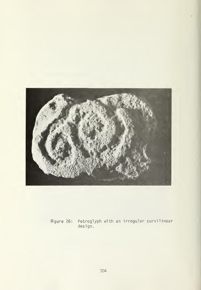
Figure 26: Petroglyph with an irregular curvilinear
design.
304

Figure 27: Petroglyph with a concentric circle design,
Figure 28: Petroglyph with a concentric circle design,
305
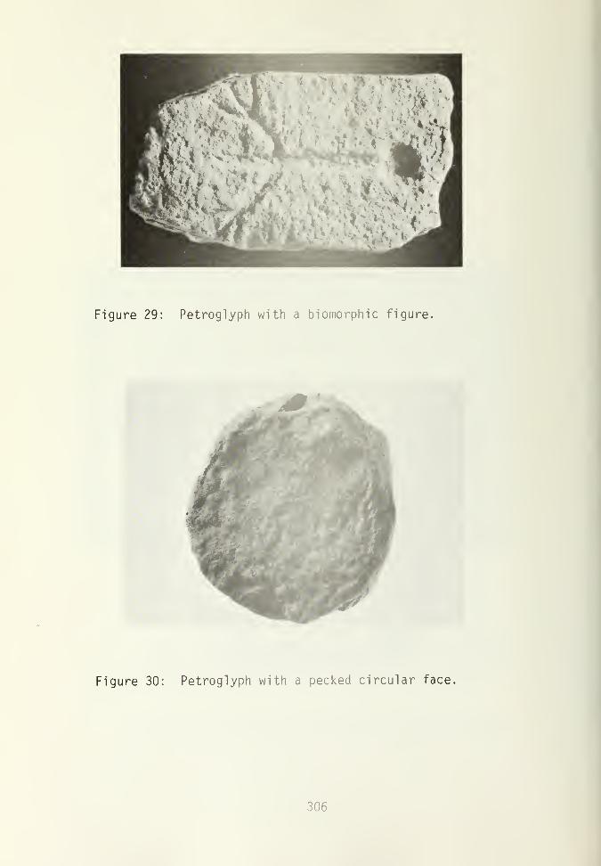
Figure 29: Petroglyph with a biomorphic figure.
Figure 30: Petroglyph with a pecked circular face,
306

Building Stone Effigy . The effigy is carved from a sandstone
block, one end of which is a blocked building stone, the other end
being the neck and head of an animal (Fig. 31). The figure had
been formed by pecking and grinding. It has a long pointed snout,
an incised groove for a mouth, two concave circles at the snout
edge for nostrils (at the edge of a small broken chip), a bulging
brow ridge with no well defined eyes, and slight bulges on the
forehead which may represent either immature horns or ears. The
neck is steeply indented from the back of the head. It measures
23.5 cm in length, 9.0 cm in width, and 14.0 cm thick. The stone
came from the surface rubble of the site just north of Kiva A.
Stone animal scul ptures, are present in the Mesa Verde area
from Far View House (Fewkes 1917:480), from Pipe Shrine House
(Fewkes 1924:384, PI. 4, Fig. 4) and from northeastern Arizona
Woodbury 1954:158-162). These sculptures are commonly carved in
the round depicting the entire animal. The forms are plump with
stubby legs and ears with details in low relief. The type of
sculpture found at this site, apparently intended to be located in
a wall with the head extending out from the wall, is not known
from any other site in the Mesa Verde area. The execution of the
figure also exhibits a higher degree of skill than the sculptures
typical for the Mesa Verde area.
Sandstone Concretion . There is one sandstone concretion,
suboval in shape with a small natural hole in one end. Sandstone
concretions are abundant in sites on Mesa Verde (Rohn 1971:243-
244; Hayes and Lancaster 1975:164).
Fossil Molluscs . Fossil molluscs, Gryphae newberri , were
recovered in the excavation. These fossils erode out of the
Mancos Shale and are present in the plains located below the
Escalante hill. None of the specimens had any wear indicating
307

Figure 31: Building stone effigy designed to extendfrom a masonry wal 1
.
308

indicating use, and their presence appeared to be random in the
fill. Although the fossils may have been brought purposefully to
the site, it is also possible that they were brought with sand or
soil to be used for mortar.
Shell
There are only three occurrences of the use of shell at the
site.
A single shell bead made from an olivella shell is from the
ventilator tunnel fill in Kiva A. The bead is tubular, ground
smooth at both ends.
A fragment of a worked piece of glycymeris was recovered from
Room 8 in the Level 2 fill. The fragment is approximately 1 cm in
length, is well polished, with a groove running along the edge. It
is not possible to tell what the whole piece might have been.
Half of a glycymeris bracelet came from the Room 9A floor,
the third occupation floor level.
Bones
Mammal s and Birds . The mammals found at the site include
Rocky Mountain Mule deer ( Odoco ileus hem i onus ), Pronghorn antelope
( Antilocapra americana ), mountain sheep ( Ovis canadensis ), Bison
( Bison bison ), Cam's ( Cam's sp.), Texas Jack rabbit ( Lepus cal ifor-
nicus texianus ), Western cottontail ( Sylvilagus auduboni ), Yellow-
haired Porcupine ( Ereltuzon epizanthum ), Marmot (Marmota flavivent -
isis ), Pocket gopher ( Thomomys talpoides ), Rock squirrel ( Citellus
varigatus ) , Wood rat ( Neotoma albigula ) , Deer mouse ( Peromycus
sp.), Prairie dog ( Cynomis sp.), and Beaver ( Caster sp. ). The
birds identified from the site include Turkey (Meleagris gallopavo ),
Red-tailed Hawk (Buteo jamaicensis) ,. Swainson's Hawk (Buteo
309

swainsoni ), Common Raven ( Corvus corax ), and the Mourning Dove
( Zenaida macroura ).
The above list indicates the animal and bird remains found in
the excavation units. Complete listings of the animals present in
the region are found in Gregory (1938) and Brew (1946). Emslie
(1977:22-26) gives a listing of mammals and birds sighted in
Mancos Canyon.
The charts in Appendix A give the numbers of animal bones and
minimum number of individuals (MNI) for the proveniences within
the rooms and the kivas.
The cottontail was the most populous individual represented
by skeletal remains in the excavation. A minimum number of 75
individuals of cottontail were identified. The evidence of butcher
marks, burned bones, and modification found on cottontail bones
indicates that the cottontail had been utilized by the prehistoric
dwellers of the ruin. However, this figure is skewed by the
evidence that the cottontail rabbit had been a post abandonment
feature using the soft dirt within the ruins for burrows. This
activity was most clearly seen in the ventilator tunnel fill of
Kiva A. The dense bone bed in the tunnel included 25 individuals
of cottontail and numerous other bones which could have been
shifted by the rabbits' activities.
The jackrabbit was represented by a minimum number of seven
individuals. Other small rodents given in decreasing numbers of
individuals (MNI) were rock squirrel (seven), pocket gopher (five,
wood rat (four), prairie dog (three) and deer mouse (two).
The artiodactyla family was represented by deer (eleven),
antelope (seven), mountain sheep (two), and bison (one). An
additional twelve individuals of Artiodactyla sp. were present but
were not identifiable as to species. Only one bison bone was
310

identified at the site. Since this bone was present in the venti-
lator tunnel fill, it unknown whether it represents utilization of
the animal by the prehistoric inhabitants or if this could be a
result of post abandonment activity.
The turkey was the third most populous animal from the site
represented by a minimum number of nine individuals. Other birds,
as identified by Steve Emslie (Appendix B), were present in very
low frequency. These include the Red-Tailed Hawk (one), Swainson's
Hawk (one), Common Raven (one), and Mourning Dove (one). These
birds have a natural occurrence in the region, and they might have
been utilized by the prehistoric peoples for their food value as
well as the use of the feathers. There is a single occurrence
from the bird remains of a pygostyle, the tail bone of a bird
which holds the tail feathers. The bone was from an unidentified
bird of small to medium size. It is possible that this bone had
been removed from the bird attached to the tail feathers which
might have been valued for some use.
Fish . Two fish bones and 52 fish scales were found at the
site. The bones have not yet been identified. The scales are
from a gar (Lepistoseus sp.). The scales of this fish are of a
bony material, one side covered with an enamel similar to dental
enamel. The section of 52 scales was found in the natural inter-
locking position about 7 cm long and 2 cm wide. This section
included the median line of the fish and scales from either side,
although not identified as to dorsal or ventral. Given the size
of the scales the fish would have weighed about two pounds and
would have been 2 feet in length. This represents a medium or
small size gar, some species of which can grow to 6 feet in length.
Remains of gar have been reported in the literature from two
other southwest sites both in Chaco Canyon. At Kin Kletso parts
311

of a lower jaw and 25 scales of a gar were found (Vivian and
Mathews 1964:22-23). Although a species identification for the
scales cannot be made, the lower jaw was identified as being from
a Longnose gar ( Lepistoseus osseus ). Judd (1959:35) has also
reported gar scales from pueblo del Arroyo.
Six species of gar occur in the United States with a distr-
ibution restricted to the east side of the Rockies (Eddy 1969:39).
The gar are found primarily in the Mississippi drainage and in the
smaller Gulf drainages of Mexico (Pflieger 1971:469-470). The
Longnose gar ( Lepistoseus osseus ) is found today in the Rio Grande
to about the Texas-New Mexico border. There is some evidence that
in historic times the gar might have had a wider distribution in
the Rio Grande, perhaps up into middle New Mexico (Tom Mathews,
personal communication). This would be the source favored for the
gar present at Escalante. It is uncertain as to whether the gar
would represent a trade item or procurement by the Escalante in-
habitants or whether the item had been brought from Chaco Canyon
or some place to the south.
The gar are known to have been used for many purposes. This
fish is used in the diet of the Seminole Indians in the Everglades
and the scales have some use in making ornaments and jewelry
(Herald 1972). The scales of the gar, probably of a larger fish
than our specimen, have been used ethnographical ly as arrow points
by the Cherokee Indians (Williams 1948:85).
The scales found at the Escalante site were found in the
floor fill of Room 5. Since there were no other bones of the fish
found with the scales, it does not appear that it was used for
food. The state of the scales found in a rectangular unbroken
strip suggests their possible use as an ornament, though for lack
of any further comparison their purpose at the site remains un-
certain.
312

A total of 89 bone artifacts were recovered from the site.
These include those bones which had been modified for use as tools
or as ornaments, but excluding those with random marks for butch-
ering. The artifacts are grouped into broad functional categories.
Table 23 denotes the distribution of the artifact types with
animal forms. The artiodactyla family is the most well repre-
sented, accounting for 53 percent of all the bone artifacts. This
indicates a selection for this bone in the worked bone tools since
the artiodactyla family represents only 37 percent of the bone
from the site (calculated excluding the unidentified fragment
count), and is second in bone count to the Sylvilagus genus.
Classification of Awls, Reamers, and Weaving Tools . Thi
s
grouping of artifacts includes almost half of the worked bone
artifacts, including the three most numerous groups of tool types.
The form of these three types is very similar. All are tapered,
pointed instruments but the wear present on the tools separates
them into different functional categories. They are classified by
morphological criteria to display any possible relationship be-
tween form and function. The criteria presented includes the
amount of modification of the bone and the tip shape.
The initial classification of the tools includes the func-
tional categories separating the three tool types. Awls have a
sharp tapering point which is used for piercing. This action
leaves minute striations parallel to the shaft of the tool and
results in a dense polish on the tip. The reamer is used for
piercing but is rotated in use, thus producing striations perpen-
dicular to the shaft of the tool near the point. Weaving tools
are highly polished along most of the shaft and usually have a
sharp and polished point. These tools had been used to pack down
the weft threads, rubbing against the tightly stretched warp
313

s;uaojad
sieioi
O CM
00* COr— CO
coLU
>~
SBDdLj >|3o; S
/je;u9uj6ejj
to *3-
00
CO
CO
fO CT)
o Sn09UP[L9DSLW
<T> tocm s:
oruj oCO=C _J
Li_Oo1—1
I—
COI—
I
a:t—on1—
1
Q
saqni auog
suddens
siooi 6uLAea/^
s^aweay ^ ^
S[wy CO cr>
03
CO in
cr>
00
CM
CM
CM
CO
co
CO r—
CM
^ CM
"vf 00 >— CO
03 co3
'r- Ci. O
• <D •r—
210
E03-—-£
03 s-
ECLr-CO T-
O 03
>>+J<_>
03XJO
s-
Q.-CCO tl)
3 -alagus
ttontc
ID
03 CT1u e
cur— Ci)"1— r—
to
co
r— t~1- Q_+->—
-
O 3U EO—
-
E1->
03E
"OO OCD IS)
E =c03
1
-Q-Q03
• S-
CO <J03
CO t-j3Q.CD
to
c03C_>
314

S^U9DU9dr-^ O »-
sLnoi i— CT> -
saoa.Ld >pois -
^JB^U3UJ6B-»J
snoauBLL9DS !-W-
^rtsauLi ubl^uv
cu3Cr- SBLqilco p8^.BolOJ.U8do—
'
COCM
saqni auog ^1-
LxJ_JCO<ct— suedeuos
siooi 6ULABe|V\
sueiueay
slmv CM
o>Q-O
ro '—c2
C ai >> o2 a> co 1/1 -^ -*:
c •i- s- c±i S- =5 !3c rO 4J
=D CD*
—
4->
c"O a> cu
s_ s: -o•r— oCO cc
oo
ro
CM
vn
rO+-)
o
315

threads. This use results in the diagnostic wear found above the
tip and on the shaft: striations are formed perpendicular to the
length of the tool and eventually one or more deep parallel grooves
are developed.
The modification of a bone to form an awl is the first cri-
teria of classification. This is the observable form of the tool,
which determines its versatility for the user, and will often
obscure the species identification of the bone. The classifica-
tion is arranged by Kellie Masterson, based on Kidder (1932:203-
217). Kidder distinguished whether the articular end of the bone
is whole (1), split (2), or if the tool is made of a bone splinter
(3). He further distinguished the degree of modification for the
split awls. His categories are elaborated here to indicate whether
the head of the tool (for a whole or a split awl), or the edges of
the tool (for a splinter awl), are unmodified (a), slightly modi-
fied (b), or completely modified (c).
Table 24 presents the number of awls, reamers, and weaving
tools displaying the different forms of bone modification. Al-
though as seen in the table there is no clear cut dicotomy of
form, there appears to be a different selection between the awls
and the weaving tools. The majority of the awls, 65 percent, are
splinter awls; the rest are split, but none are whole shaft. The
largest percentage, 56 percent, of the weaving tools are split.
Some are whole shaft, but proportionally fewer are splinter when
compared with the awls. Perhaps the whole or split bone provided
a stronger or a bigger tool which may have been preferable for a
weaving tool since the wear on this tool extends along the shaft.
The weaving tools are, on the average, 4 cm longer than the awls.
The reamers show a range of forms with no preponderence of one
type, but the sample for this group is small, less than half that
of the other two groups.
316

TABLE 24
MODIFICATION OF BONE IN AWLS,
REAMERS, AND WEAVING TOOLS
Awls Reamers **$£«
1
1 2
3
2 3
3
1
1 1
2 3
1-
la2- 3
2b 1
2c 2
3-
3b 1
3c 10
TABLE 25
DISTRIBUTION OF TIP SHAPE FOR AWLS,
REAMERS AND WEAVING TOOLS
Weaving
Awls Reamers Tools
A 4 1
B 7 4 8
C 2 2
D 1
E 1
317

The tip shape classification (Fig. 32) is based on Morris and
Burgh (1954:60, Fig 32). They identify five categories, which are
designated here as: (A) long, very slender, needlelike; (b) long,
uniformly tapered; (C) long, slender with concave sides; (D)
blunt, with a rounded point; (E) blunt, with a flat point.
The various tip shapes may represent the shaping of the tool,
wear by functional use, or progressive wear on a given tool
.
Morris and Burgh (1954:60) suggest progressive wear for two of the
types: That (B) will grade into (C) through the wear and resharp-
ening.
Table 25 presents the distribution of the tip shapes for the
tool types. Tip shape B is the predominant form in all three tool
types. Type A is a common awl tip form and is present in one
weaving tool, but is not present as a reamer tip. There are four
tools with type C tips, two of these being reamers and two weaving
tools, one of which is a reamer tip. This indicates the possibi-
lity that the concave sides of the type C tip may be a result of
the reamer action which, perhaps, as Morris and Burgh have sug-
gested, grades from the Type B tip, the predominant form in the
reamer category. Morris and Burgh have also suggested, however,
that this type B-C tip results from basket making.
Morris and Burgh (1954:6C) suggest, also, that there is no
correlation between the joint ends and tip shape. A larger sample
than is present here would be needed to test this hypothesis.
Although no direct bone modification and tip shape correlation is
evident, there dees appear to be, as indicated in the above dis-
cussion, a tendency toward a predominance of certain types within
the three tool categories, which may produce an indirect relation
between joint ends and tip shape. Tables 26-28 and Figures 33-35
illustrate provenience and type of bone tools.
318

Figure 32: Bone awl classification, a, Long, veryslender, needle like; b, Long, uniformlytapered; c, Long, slender with concavesides; d, Blunt, with a rounded point;e, Blunt, with a flat point.
319

toE•r-
C
en cm•i- (T>
I
-X 10O to•r- CUx: c
00
oCO
zot—
«
<JO I—CM Q.—
I
UJ cc_l oCO OO«( LUt- Q
QZ
XJ
enccu
oce:
a.
en 4->
to CS. CUu. E
Q. a.•r— <aJ— x:
00
-a <ufO S- C7>CU o X53T
4->
UJ
«- CUto a.JT >>00
cuuccu•r~
Ccu>os-Ou
s-XJ cur— XJCU E•r- 3
CU •
c a.o to
idCOr—C >> (OO -t-> •«-
r— O XJ(d O
r--o ato O 10E f- 4->
E -t-> cu(O i- EE <C
a.CO
(O
a.L0
(O
to
fO
>> fO >>+->•!-•»->
OT3 Ua o aXJ O-XJ <0O A3 O •-•r- 4-> i- XJ•4-> <U +> f-i- E S- -M<C <
a xjto oxj a.o to•r- +j+-> a>s- E
cucoXJ -l->
x: toen en 3c •- toO s- S-
* +Jr- >> OtO CU -r-
E -X XJE S- f-(B 3-PE +>
cu cu •
C C Q.O O toXI XJ
toen enr—c: c >>o o +->
i— r— OrtJ
r— i— -ato to o
to to S-
E E<C
a.to
to
">>4->
to a3 <0s_ -oO oE i-3 -t->
J= s-
cu •
C Q.O toXJ
to
cu g%C O 4->
2 — °XJ nj
™ ^^C7J CU OC J*: -r-O S_ +J>— 3 s-
+> «=c
cucoXJ
i— ento co. os- i—too i—fO fO*-> ECU EE to
E
CU i—
cu •
c a.o toXJ
tocni—
o +-> t-r— o -a
»o oi— xj ato o to
E •- +jE 4-» CUt0 S- Ee«=c
-i<£ en
to
03
>>a>+-> co ofESXJ
O en•r- c4-> oS-f—
*3- to oo r>. uo to to to oo lo uo co r>* coroi— ^t-
oo o o o oo ooo o oo ooo o
cr> t-^ lo «3- o oCJ\ 00 r— ^" CO 1-o.a^ MN^t CM .. ...
• • • • • * O i— OOr- i—C>0 r— i— O OO r—Or— >—
LT) r^ tD CO i— UDroN O ro r>» CT>ro <— «a- cm lo .. ...
. . • • • •• ... ' N^t OO^CO 00io* oo co co oom nm* n ,—
X X
CO
u a
CO CM
JZ s-
o oc oCU i—
u
CM
CO
uccuoo
oo
UJ CO CO
xj u i
CO CO CM
XXXI < I CO
(J O I I
CO CO CM CM
CO
a xj
CO CM
cu+Jtoto
s-
oo
CM CM
cu cu> >CU CU
CM i—J- cu
i— o >cu o cu> I— _lcu u_
CO
cu>cu
i— cur— >•i- CU
to to> >2 Q
to r^»
to>
to>i^
CO
CM
Eooo;
CO 00
E Eo oo oa: cc
«o00 •— i— ID tO
o r^» r-»i— CM CM
E E E Eooo oooo occ od oc cc
r-«. ro lo i
—
CM CO 00 Oi— CM
E Eo oo occ cc
co oo
oo <=c co
ooo
CO CO CO
^ <c
u_ u_
CO CM CM
,— s- s-
cu o o> o oCU r— i—_J u_ u.
r. r ^
to to <x>
oooooocc cc cc
«=*- o .—CM CO CO
CO
CO
S-
ooM^XJ3to
cr>
oocc
toCOCM
320

c d
111
II!h i
Ik i
f 9
Figure 33: Bone tools: a-d, Reamers; e-1 , Awls;m, Eyeless needle.
b c d e f g h
Figure 34: Bone weaving tools.
321

. . CD +-> a)Q. Q. c c
E CO co O 4-> os- JD <4- .Qo ta (O a>J_ r— i
—
t— COi— cn>> «3 >> (U C e-l-> CO +J c o • o
«3 O S- a o r— Q. ^—E rO fTD (O -Q CO
COr- CMLl_ 0~>
I
O
r-~.
CM
CO
UJcn
oCO
oo
4->
CD
<L>
_l Q_CQ t—)
<£ Oih- c_>
COUJQQ
CD+->fO C
a)CL
oo
o
-o a)<T3 s- cn<l> o "O3: UJ
4->
<+- a><a Q_JC >>CO 1—
ocCD
aj>oa.
-o CDr— JDCD E
03
-O +-> T3 i—
CO
«3
^ CO+Ja on3 J3
>>.— -aoiooaiffltrtdjioooi•r- +J •!- C E •>- -^ E T- C+-> CD +-> O E C S-E-MOS-ES-i— <T3fO 3 Id Li
—
< <C E O -M E <
(O
co
o
ai
CTi
CO
CO
CM
oCL)
00
ajCO
fO>
jd -a i
CO CO i— CO LT> <T>
O O i— o o o
CM LD CTi IT) Oi— i— O O CM
CM
o
CO
JD
a;CO
CO
>
LO^" r— CO 1— r—
Mrv^^tr-
X X
uucoma
o <a i o .a
CO .— CO CO CO
O i—
•.- CO
J- CDO i— > i—o <— ai i—
<=£ CM i— ID CM
ro E E E E> o o o o•r- O O O O^ a: a: or a;
r«» co cn oo r-»i— 00 CO
i— CM
322

t/0
ooC3
03 • CD o • . . CD • i a> .
•i- O- c o a. Q. O- SZ Q. ^ C CL Q. •
E a to o Q. to to to O to +-> O to tO 1— a.S- o jQ ta jo CD JO 03 too a. 03 +-> 03 03 ta 03 E 03 03 toLl_ <T3 r— CD <L) i— r— i— CD.— CD t— r— S- 03
4-> >, 03 C E >> >> CD >> 03 c >, 1 c >> cd >> a> 03 i
—
^— a; +j •i
—
O fO +j -M c 4-> •i
—
O 4-> 03 O 03 4-> z +J z 4-> >>fO E u -a i— E <u u O o O -o r- a 3 — c a o o o 03 +->
E 03 o r— Q. 03 03 JO 03 o 03 CD i
—
•— 03 jo n3 JO +-> O•i
—
i— -a Q. i— 3 O T3 03 "C "O D. •— -o •i
—
03 i— 3 "D T3 a» 03 toc n3 O 03 03 i— O •i
—
O CD O 03 03 O +-> a. 03 O CD O CD E -o Z3
«C E •!— 4-> E 5- aj -r- JO •r- C •r— +-> E -r- to <- E s- ••- Z •i
—
E O •i
—
E 4-> ai E CD +-> +-> •i
—
4-> o *-> ai E +-> ai 03 E ai +-> o -M o i_ •r- "OT3 J- E 03 d) c s- 4-> S- 1
—
S- E 03 S- > O * ai s. r— S- 1
—
CD 4-> n3
E <: E -a 03 <| <=C <c E -=C E -o < < CU S- <-• -a <c
CT>•r- CM T3 CD 1 •!— JO 1 1 a> i i M- JZ 1 1
LJ_ cd 03 u
-±£
O 1/) CO O O r— *3- r— to tO lo oo lo oo lo o•f— to • • • • to C\JJZ cd O •— 1— 1
—
r— i— o i
—
o o OCMO ^~ • •
1— c " r—
JZ CM+-» LO LO o r^ o uo o CO r^- r- O ^d- O r~~-
"O • • • • CO 00•r— i— i
—
i— OOWp- 1
— —
o o i— oo .
—
i
—
• •
oCO
O
o
CdoooLU
Q<:
LUo
oCdo_
+->
CDc<D
CD +J03 cS- <uu_ E
Q.CL o3•1— -CH- oo
T3 CD
03 s- CDCD o anr
4->
LU
lf- CDo3 Q.^T >>OO 1—
CDOCD
c<D>os-a.
-a cdr— .aCD E
03
c\ji— lo oofo «t cvj to
mcri cx)ct>loo co c\j
CO LO
tO LO
X X X X
+CO CO CO 00 O CO CO II
U U I (OJ3 I I JO O JO
to o r-.
cr> cr. c\j
X X
+ *CO I I o
O 03 I JO
CXJ C\J i— .— CM CM CM
(_> O U r—C E E i
—
CD CD CD •!-
OO OO CO U_
>— >— i— O O O O r—
CD CD CD <DCO CO CO CO
ro cm
tO CMCO <=t
o oo o
CM
< < <C eX. cC < CM CM CM
0303 03030303 03 E EE>> >>>> > O OOI— •!— •!— -r— T— •!— •!— O O Oi^^ i^^^i^ i^ CU OC CZ
CO CM CM CM to
323
to r-« «d- ocm oo to
oto
CM i
—
o r-.
o uo «*i— CM i—
+<C OO
O o
CM CM
OOoo r^ i
—
CM • •
<t <• Ll_ U_ l_i_
u_CNJ CM CM
CM .
—
S- S- 5-i— s- O o
i— OCD O O o
i— O> O i— r—CD i— U_ u_ U_ Lu
LO LO00 00 r— r-
E E E E IIO O O O O oO O O O Cxi CxiCxi Cd Cd Cd
CO LO
a.•r"!->
Q.•p- S-+J CD
Er— 03S CD03 S_

Scrapers. This category includes six end scrapers and one
side scraper. The descriptive information for these tools is
given in Table 29.
Bone Tubes . Four bone tubes made from turkey bones were
found. They range is size from 6.5 to 3.3 cm (Table 30, Fig. 35
d-e) and are all highly polished on the surfaces with ends that
are rounded or beveled as well as polished. The interiors of the
tubes show a light polish, showing that they had been strung and
used as beads.
Perforated Mammal Tibias . Two specimens of perforated mammal
tibias were found. One, from Room 10 Level 8, was made from the
left tibia of a jackrabbit. This item consists of the proximal
end of the bone and about one third of the shaft. The second
(Fig. 55f) from the floor fill of Room 9, F.S.40, has a conical
hole drilled in the polished shaft. The ends of the piece are
broken. It is made from the left tibia of a jackrabbit (Table
22).
Rohn (1971:250) and Hayes and Lancaster (1975:170) both
indicate the probable function of this type of artifact as a
"tinkler." Hayes and Lancaster (1975:190) report the occurrence
of similar perforated mammal tibias in the Mesa Verde Region, from
the Piedra River, and from the Ackmen-Lowry region, north of Mesa
Verde. They report that the artifact is unknown south of the San
Juan River.
Antler Tines . The two antler tines are unmodified sections
of antlers. One is fairly short (Fig. 34), and the other is 22 cm
long. Both are broken at the ends and display some use at the
tips. The long tine has a point rounded from use. The tip of the
short tine is almost obliterated from rodent gnawing, with a sec-
tion of polish near the tip from hand use, possibly indicating the
use of this tine as a f laker.
324

CO- Q. D_ D_CO to 4-> CO 4-> oo
E M- <4-
i_ OO rO rO O) rO <L) rOoLi- 1- >1 >> >> >>
a> +-> +-> to " CO +-> OO «s CO -M rot- E o U 3 ai 3 u 3 cd 3 O i
—
re 3 ro fO fO S- Q. i- fO 1_ O- S- rO 3E jC -o •i
—
-o a; O 0) "O CD O cu -a Q-•! O JO o E i— E O E r— E o raE S- T- •1
—
•t- 3 a) 3 •!- 3 CD 3 -r- u<c <U +-> +-> 4-> J= +J jz +-> -C +-> _e -i-> 00
CD S- s- e s_ E S-T3 <C < ro «=c fO <=E
coa:LUQ-<oCO
LU
oCO
cd-vj-•i— CDu.
CUT3 S- TE O •r~
LU
1
CO
o 00•r— 00sz cu(— e
-E+->
-o
oCOLUQQ
LUC_)
Oa:
JZ+->
CDEa>
i
CD4-><o Et- a;u_ E
ro -O I I I
LU CO
o r— oo oo oo cd oo
"d" >— O O O O O
NN LO oo r*» ro r^
*3- ro CM CM CM CM o
i— co oo lo ro r-> ro
lt) cd r^. lo en ro >=*
LO CsJro
CD CDCD i— CVJ CMu i— r— t— r—E &_ r— a> CU CU CU i_CU O CU > > > > o•r~ O > cu CU CU CU oE i— <L» _i _l _l _1 r—CU Li 1 Lt-
> #1 ft ft •%
o *• Ct O o o o 9\
s- CM 00 r— r— 1— CM COD_
E E E E E E Eo o O o O o Oo o O o o o oac cd cc a: a: a: a:
s_-o a>r— jo r^ r« CO 00 LO r-^ r—CD E CM r» r^~ 00 «3- ro•I— 3 r— r— 1
—
CM
COLUOOoo
LUz.o00
oro
LU—ioo
onc_>COLUQQ<c
LUC_>
LUI—
i
z.LU>oo_
cd•r- «5fU_ CD
J*£
O CO•r- CO-E CU1— E
co oo3 300 OOS- c_
f= ro roS- CO +-> -Mo 3 O O roU. •r~ •!"• •!" »r-
"O JO JO JOr—
•
ro *r™ 'r— •!-
fO S.+J4J+JF•r- >,>,>,>,E CU CU CU CU<r J5^ Jili JKi J*Z
S- S- S- s-3 3 3 3PP-PP
+JCDECI)
CD+JfO Et_ CU
CUOECU•r-ECU>os-D.
TD CUr— JOCU E
aj-D i i
ro CD oo ^d-
O O O O
CD <— CD CD
Or-OO
lo ro ro i
—
cd lo ro «3-
CDCM
CD
00 CM
i— S_S- CU O
r— O > Or— O CU i—
•v «> o o<Mi— i
—
ro E E E> O O Or- O O O^ a: oi cu
ro r-~ cd co00 CD
325

Figure 35: Bone tools: a, Humerous scraper; b, End
scraper; c, Side scraper; d-e, Bone tubes;f, Perforated tibia; g, Antler tine.
326

Miscellaneous Artifacts. This category includes pieces which
cannot be grouped in other categories. Table 31 indicates the
provenience, measurements and bone identification for these arti-
facts.
One piece is a splinter of a larger tool whose surface had
been highly polished. One edge of the bone shows wear from being
used as a pol isher.
A tool in the form of a long bone splinter whose end had been
ground to a rounded edge was found in contact with the bench of
Kiva B. A portion of the tip shows polish from a rubbing use.
Figure 36 illustrates a shaped deer mandible. It is the
right half of the mandible extending from the diastema to the
cavity of the last molar. The teeth have been removed from the
mandible and the sockets ground, displaying a series of holes.
The base of the mandible as well as the ends of the piece are
modified by grinding and the surface of the bone has been lightly
ground. The cancellous material was removed from the bottom half
of the mandible but not from the sockets of the teeth. All sur-
faces of the bone are covered with a polish.
Morris and Burgh (1954:64) report on similarly shaped, though
smaller, worked deer mandibles from Basket Maker II sites near
Durango, Colorado, which were strung on a necklace. Although this
mandible is longer than those of Morris and Burgh, it is possible
that it was used in a similar fashion.
The final item is a group of bones which were found in a
cluster in the fill above Floor 2 in Room 10. The cluster con-
sists of a weaving tip (included in the weaving tool classifica-
tion), six medial fragments of cottontail rabbit bones including
one right humerus, three left tibias, and two right tibias, an
unidentified rodent pelvis fragment, a medial fragment of an
327

CU
03QJ
j= o>-oto -^ sz•i- </> fO
CL O -aCl (u
O) Q.CT>"0 ro"o 5F *=O) O) on
CL)
o-Qen
CO
OCO
00
oUJ
LUo
oo
CO D_
oUJQQz:<LUO
oo_
Eo
03
<:
i
•r- </)
-C CU
a
4->
C
CL) CLc toO CU.a <a r—C7>i
—
_Q
o +-> -ar— O C
03 03r- X3 E03 OE-r- S-E +-> QJ03 S- CUE<: q
ION C\J
OO r-^
in co lo
i— i— CM
«3- 00 LO
<^-oo in
CU
c3f-
cms- .
o <c+J .
03 U_CU r—o •i- XTc •<-> (J 1
—
<u c c: i—•r™ CU CU -r-c >CQLla>> A «l Ao <t CO CMS-Q_
Kiva Kiva Room
XJ cu1
—
-Q lo co i£>QJ E CM r—
•i
—
3 OO
328

Figure 36: Shaped deer mandible.
329

unidentified bird tibia. The bones were all burned to diffemt
degrees from black to light brown, and all have a high luster
which could have resulted either from polishing or from having
been burned. They were recovered from the trashy charcoal -filled
level above the floor, but may have been buried or deposited there
in the trash fill independent of the floor association.
Fragmentary Modified Pieces . This category includes 20
pieces. They are bones which are fragments of larger tools show-
ing polish or striations but lacking any diagnostic wear (Table
32).
Included in this category are two jackrabbit and three cotton-
tail tibias which show some similarity to the perforated tibias.
Each of the jackrabbit tibias have a hole drilled or ground in the
side and one of the cottontail tibias has a hole drilled in the
distal end. All of the bones have a high polish on the bone sur-
face.
Stock Pieces . The objects in this group are either discards
or tools in the process of being manufactured. Two pieces are
deer metacarpals, one is split in half, and the other is intact
but deeply scored on either side in preparation for splitting.
The third bone is the proximal end of a turkey tibiotarsus. It is
the discard from the manufacture of bone splinters. Six deep
scores had been cut along the length of the shaft and a break had
been accomplished by means of a score set vertically around the
bone. These pieces are from the Kiva A Floor fill, Room 2 fill,
and the Kiva A ventilator tunnel, respectively.
Human Bone
Although no burials were found in the excavations, a few
human bones were found in the excavation levels. There were a
total of 31 bones, all but one, a phalanx, which were fragmentary.
330

oCD
QUJ
QO>-en<
CJ3
<:DC
<NJ u_OO
U_LU o_lCD •2TL
<c O
ce:oooLUQQ
oa:
rCCD
o
o to•i— tox: CD
-a
encCD
aiuai
O)>oS-
i— JDCU E
CD"O cd cdc c c "O
to CD -i— •!—i— CD^-^
C -o 3 o~O -C i— CD TJ C fl "O
CD -i— to rO i
—
JZZ CD'i— CD> +J •!— +» O to .C S- CD JC i
—
OCD fOi— to JT-r- W OIC Ifl 2O (/)•!— O *i— i— •(— O •>— fOS- 3 S- O. "O "O O i— "OJDi
—
CT>+-> C CL O C O *>
_c .— to cd cd 3 are -p a..
—
to CD 2 E ffli— O " •!— fOO•r-i_rO "OOCDO S- to "OtOi— CDT30— 3 C to S_ _C CD C C C Q. S_ C +->
O -M CD ro ro O ro O l/> ro rOQ_ (J. , c* #s «\ •!— .,_ t|_
ro.a.c-c _0-C-C-c_c-c +->.c.c-a+-><4-_c-oo>,M--i— totocDtotoi/itoi/iCDroiotocraotoc> 3 tO •!— 'I— Q. •!— •!— •!— •!— 'I— "O 'I- >|— "r— 3 'I— 'I
- 3 "Oro C tOi— — rrji— i— i— — i— -r- S-i— i— O S- "O i— O roCD(OOOO.COOOOOt/l-MOOS-4->COS-CD-CEQ-Q-O-t0Q-O_O-O-O_ to Q_ O- CD tO CD Q- CD-C
fO•r- CD
l/> CD "O C3 C O to to Otoo Q- ro ro ro S- 3 3 jQS- -Q ro •!—•!— *i— 13 •(— ro •!— CD rorC CD +-> JOJD -Q jO. E "O C T3 C C+-> C CD •!-•!- •!-•!- CD ro i— ro O
—
OO E -M+J +-> S- 14- S_ 3 S- r— 3•r- i— ro ro_Q • • -t-> 4-> t- t- +-> •
CD-i-O- CD Q. ro ^ M- -O. -Q <4-Q.CDQ-Q.Q-Q.Q-Q.ZPl/llOCI/lCOJCJ-r-r CDtOC</)tOt0tOt0</>o co r— i— .— -(->+-> i— o_Q+-><Oi— U (O 3 rC-QrororOrarorCCD<4— i— 3 CDi— " " « " "i— CDi— i— i— "— i— i
—
C CD >> C >,+-> r— r— .— 4-> f) >, C >>>,>,>,>,>)Oi— -t-> • O 4-> <4- •!-•<- •!-•!- •!-+-> 0+->4->+->+->+J4->
i— O O-i— OCDrarorO-O -Q O — OOOOOO" (O irt <Oi— +-> +->+-> .Q _Q rO (OrOrorOfOrO
i— >,T3 i— ~0 C C C rC fOT5r— T3T3T3-0-OT3(OCDOtOrOO ^ O O O S- S-OrOOOOOOOE -^ •<- t- E •<- S- +-> +-> +J -i*: -^ -r- E •!-•!- •!-•!- -^ -i-
ES-4->CE+->CD-l->+->+->U o-t-*E+-> +J +->+-) -t->-4->
rorsS-fOroS-CDOOOrO rOi-fOi-S-S-S-S-S-E4->=CO E=C-0 O O U-ro •>-><: E -=C «=C < <C <C <C
OOi— r—OOOOOOO OOOi— i— Oi— o>—
vi-c\jr^LOcooc\Jcr>unLoo <^-.— <^-c\JC\JCO«vl-unco
.— f— C\J .— i— i— i— OOOi— i— i— CMCM CMCfAJ.— OO
r-~-Oi— coco "^t-toOi— o cncNjLnocvjrorvcoi
—
CO^•Ln^cmi— nud inin ^- <^-t£)Lncrii«OLOi— cocoi— i— CD r—
CD
cC\J
S-
o-t->
ro
<C r—
i— cr> r-~ oo oo
•r-i-S-OCDCDCDCDi— i— i— 4->000>>>>i— r— •— CO O-— CD CD CD CD*i— -r— •— CD i— i— U I I I I
o o o o o<<< <CM CO
(OrorOroEEEEEEE>>>>ooooooo•i- -r- -i- •!- O OOOOOO^.^.-^^.cticiictictiaiaicx:
oocoooLnr^oocDCOi-ncDuoco noNCOcoo
C\J
oo oo
^ <C <C•i- . .00 00 00LU U_ Ll_
00 s- s_ s_C\J C\J C\J o o o
r— O O OCD S— S— S- .
—
i— i
—
r> i— OO OM-M-M-CDi— OO O-O-Q-Q_J't-l— I— I— 3 3 3
u_ u_ u_ u_ oo to oo
i— LDiOCOCOCDCDCDi—EEEEEEEEEoooooooooooooooooor/r/fyf/r^fyfyfyr/
lOCOOi— i— ooooooooi— oooooooooooocoC\J OO CsJ oo
331

These include 22 skull fragments, 2 femur fragments, 1 tibia, 1
clavicle, 3 phalanx, and 1 sacrum. The proveniences for the human
bones are given in Appendix A.
A minimum number of five individuals could be distinguished
by age, two immature individuals, a very old individual, and two
individuals of average adult age.
Artifact Distribution
Room 2 (Fig. 37-38, Table 33 )
The western half of the room contains mainly bone fragments
on floor contact. In the northwest corner of Room 2 is a large
concentration of bone fragments including deer, Artiodactyla sp.
,
cottontail rabbit, and cam's. Two of the deer bones exhibit
butchering marks. In the corner surrounded by the cluster of
bones is a fragmentary worked bone made from a mammal long bone, a
broken piece from a larger tool
.
A bone awl is located near the easternmost extension of this
bone concentration, F.A. 42, made from a vestigial metacarpal from
an artiodactyl, species unidentified. The awl displays polish
from use but does not display wear patterns identifying a function-
al use. Within the area three polishing pebbles were found, F.A.
8, F.A. 11, and F.A. 14.
In the northeast corner another smaller bone cluster is
accompanied by a polishing stone, as well as fragmentary worked
bone.
A bone cluster rested above the unexcavated firehearth. This
cluster was of the major portions of two individual rodents, a
rock squirrel (41 bones) and a woodrat, probably a post-abandonment
feature since the room lay open and abandoned before the roof
fell.
332

A second artifact cluster surrounds the firehearth in the
center of the room representing the probable use of this are for
food preparation. This area includes the greatest sherd concentra-
tion in the room, although few sherds (a total of 45) v,ere located
on floor contact, and no whole pots were encountered. The sherds
in the cluster include unidentified corrugated, unidentified plain
gray, one Chapin Gray sherd, unidentified whiteware, and eight
grayware sherd which form a 16 cm wide indented pot base. With
the sherds located within the central area of the room are two
manos and a core tool used as a hammerstone.
In the northeast corner of the room is a cluster of tools and
a few, probably random sherds. The tools include a bone weaving
tool, two core tools used as hammerstones, both of fine quartzite,
a chert scraper, a rubbing stone, a mano showing hematite stains
on its surface, possibly used as a lap anvil for grinding pigment,
a hammer with a full groove and no apparent wear, possibly a cere-
monial object, four non-utilized fine quartzite flakes, and one
utilized \/ery fine quartzite flake.
The southwest quarter of the room is bare of any floor con-
tact artifacts.
A few other interesting artifacts are located on the floor
but not associated with the above artifact clusters. A side-
notched projectile point, F.A. 18, is located north of the fire-
pit. Near it to the east is a small rectangular sandstone block,
F.A. 21, with a groove on one side and bevelled on opposite edges
which might have been used as a shaft straightener. North of
these along the north wall is a bone tool, a humerus scraper (Fig.
35). Located near the east wall is a bone bead (Fig. 35d) which
is well polished showing long use, probably as a decorative object.
333

TABLE 33
Artifacts found on Floor 1 of Room 2
Field No ,
7-1
7-2
7-3
7-47-5
7-6
7-77-8
7-97-10
7-11
7-127-13
7-147-15
7-167-177-18
7-197-207-21
7-227-237-247-257-26
7-277-28
7-297-307-31
7-327-33
7-347-357-367-37
7-387-39
7-407-41
7-427-43
Artifact Description
17 bones
6 corrugated sherdsBone
Non-utilized flake, Qe2 Chapin Gray sherdsBone
Fragmentary worked bone toolPolishing pebble8 bones11 Mancos B/W sherds, 1 Moccasin Gray sherd, 3 corrugated
sherds, 5 grayware sherds, 1 whiteware sherdPolishing stoneChapin Gray sherd, corrugated sherd, 3 grayware sherdsMano
Polishing pebbleBone scraperCharcoal fragments2 grayware sherds, 2 whiteware sherdsProjectile point9 whiteware sherdsBonesGrooved abraderBonesCore hammerstoneGrayware pot baseManoHammer
2 non-utilized flakes, Qe; utilized flake, QeMano fragment, polishing stoneBone beadNon-utilized flake, QeRubbing stoneScraperNon-utilized flakeNon-utilized flakeNon-utilized flake, QeBone weaving toolBoneBonePolishing stoneBoneCore hammerstoneBone Awl
Mano

3
ROOM 7 ~L.11. .ulirni
.37
.10
56
1 1
1
3 1
£ 3 J
35 ..3432
. .10
.33 5i
43.
•26
J!
ROOM 8
1 Meter
rra*rtn> Top of Wall
Base of Wall
—TTnimimj V st*v»O<>0 » 1/ o t . i
• *o « '°o•«••'.
• • • VW ••••••• • ' • • ' . » •
1 Meter
GZ3 Masonry
"""' Floor Plaster
*.V. Sterile
Figure 37: Plan and profile views of Room 2 showing Floor 2,
335

Figure 38: Floor 1 of Room 2 showing the artifacts on
the floor and a section of the roof beams.
336

This room appears to have been used for cooking and as a work room
for making various tools including bone tools and arrows.
Room 5, Floor 1 (Fig. 39-40, Table 34)
Against the north wall is a cluster of artifacts including a
complete obsidian end scraper, three chipped stone flakes (one of
which was utilized), bone fragments, and two sherds. This cluster
was located next to the wall and may continue further north under
the wall since this wall may be part of a later addition built
across the room.
In the center of the room are two clusters of artifacts, lo-
cated north and south of the cobble wall base in the floor. The
north cluster is of six sherds, two bone fragments and one utilized
obsidian flake. South of and partially over the wall base is an
accumulation across the width of the floor of 27 sherds, 16 of
which are corrugated, and one bone fragment.
South of this cluster of sherds and against the west wall a
corrugated pot was set in the floor, probably for storage.
At the southern end of the room is another cluster of arti-
facts including seven corrugated sherds, and the skull of a rock
squirrel (Probably a post-abandonment feature).
No definite activity concentrations are suggested by these
clusters. This floor represents the middle section of a longer
room which extended south into Room 6, Floor 2, and possibly north
to the north wall of Room 4. The total length of the room, the
lack of a firepit in this floor or in Floor 2 of Room 6, and the
presence of a storage pot in the floor suggest that this long room
might have been used as a storage room. The clusters of artifacts
seen here might represent utility areas or trash accumulation in
the room.
337

TABLE 34
Artifacts Found on Floor 1 of Room 5
Fie" d No
9-19-29-3
9-49-59-•6
9-79-•8
9-•9
9-10
Artifact Decription
utilized flake, Qe
BonesMancos B/W sherdGray ware sherdTwo non-utilized flakes, Qe and CyEnd and side scraper, OnTwo gray ware sherdsCorrugated sherdsThree corrugated sherdsThree corrugated sherdsCorrugated sherdThree Mancos B/W sherdsAbajo R/0 sherdFive white ware sherdsTen corrugated sherdsRed ware sherd
9-11 Bone9-12 Corrugated pot9-13 Two gray ware sherds
Mancos B/W sherdCorrugated sherd
9-14 Two corrugated sherdsGray ware sherd
9-15 Rock squirrel skull9-16 Non-utilized flake, Qe9-17 Three corrugated sherds
Mesa Verde Corrugated sherd9-18 Bone9-19 Utilized flake, On9-20 Bone
338

E-i
•«4• -
• « •»
in
EOoon
s-
oo
to
<4-
Os-Q.
X)e<o
E
enCO
s-
339

/ r
Figure 40: View of Room 5 showing the cobble wall
and corrugated pot set in the floor.
The north half of the room is clearedto the base of the trash fill level.
340

Room 6, Floor 2 (Fig. 41, Table 35 )
In the northwest quarter of the room is a large artifact
concentration consisting mainly of sherds: 80 corrugated, 1 Mesa
Verde Corrugated, 1 Mancos corrugated, 2 gray ware, 1 Mancos
Black-on-white, 2 McElmo Black-on-white, 3 Tusayan Polychrome, and
1 white ware. The cluster also includes two bone fragments, one
displaying butcher marks; an end and side scraper; a core- hammers tone;
four chipped stone flakes, three of which were unutilized; and one
utilized obsidian flake.
East of this cluster is a second cluster including two worked
bone tools, an end scraper made from an Artiodactyla sp. scapula,
the other a fragmentary worked piece. Also included in the group
is another bone fragment, a deer phalanx displaying butcher marks,
a hammerstone, an obsidian flake, and five corrugated sherds.
This cluster may represent a manufacture area of some sore by the
presence of the bone scraper, the utilized flake and the harmer-
stone.
A second large cluster of sherds lies south of the sherd
cluster discussed above. Besides the 48 sherds, 32 of which are
corrugated, there are 2 burned bone fragments and 1 flake.
In the southwest corner is a cluster of artifacts including a
bone awl made from an Artiodactyla sp. metapodia, a fragmentary
worked bone piece, an unutilized bone, and a core-hammerstone.
This cluster may indicate an area used for bone tool manufacture.
The burned roof had fallen on top of the floor. The large
accumulation of sherds on the floor may be explainable by vessels
which had been suspended from the roof which had fallen onto the
floor, then followed by the burned roof. This room is an extension
of Floor 1 in Room 5 which as discussed above was probably used as
341

TABLE 35
Artifacts Found on Floor 2 of Room 6
Field No . Artifact Description
31-1
31-231-3
31-4
31-531-631-731-8
31-931-10
31-11
31-12
31-13
31-1431-15
31-16
31-1731-18
31-1931-2031-21
31-2231-23
31-24
31-25
Non-utilized flake,Qe
Utilized flake, QeMancos CorrugatedsherdCorrugated sherdCore hammerstoneBoneCone awl
Fragmentary workedbone
Corrugated sherdTwo corrugated sherdsNon-utilized flake,Qe
Mancos B/W sherdMesa Verde CorrugatedsherdTusayan PolychromesherdCorrugated sherdMancos Corrugatedsherd, corrugatedsherd, two Mancos B/Wsherds, boneMancos Corrugatedsherd, Mesa VerdeCorrugated sherd, 24
Corrugated sherd 3
gray ware sherds, 5
Mancos B/W sherdsTwo corrugated sherdsTwo corrugated sherdsMcElmo B/W sherdMcElmo B/W sherdCorrugated sherdWhite ware sherdBoneEight corrugatedsherubBone fragments, 13
corrugated sherds, 1
Mancos B/W sherdFive corrugated sherds
Field No. Artifact Description
31-26 Non-utilized flake, Qe31-27 Non-utilized flake, Qe31-28 Utilized flake, On31-29 Hammerstone31-30 Two corrugated sherds31-31 Three corrugated sherds31-32 Bone scraper31-33 Five corrugated sherds,
Tusayan Polychromesherd
31-34 Two Tusayan Polychromesherds
31-35 22 corrugated sherds31-36 Non-utilized flake, On31-37 Four corrugated sherds31-38 13 corrugated sherds,
Snubnose scraper31-39 Utilized flake, On31-40 Utilized flake, On
31-41 Bone
342

A.*A- Trash F111 and Rubble
&** Rock Rubble
,r"r* p"rr> Base of Wall
Top of Wall
Unexcavated
•* Ash Area
l- -t•30-cm
**««» Burned Sterile
ii
Charcoal lens
*•' o 'o Sterile
o'-V'/ Trashy Kloor Fill
COo
Figure 41: Plan and profile views of Floor 2 in Room 6.
343

TABLE 36
Artifacts Found on Floor 1 of Ro^m 6
Field No . Artifact Description
22-2 Non-utilized flake22-3 Hammerstone rejuvination flake22-4 Plain gray sherd22-5 Two corrugated sherds22-6 Two non-utilized quartzite flakes22-7 Bone fragments; three Artiodactyla
sp. , fourteen unid. mammal22-8 Mancos B/W sherd
Tusayan Polychrome sherd22-9 Bone fragment22-10 Mesa Verde Corrugated sherd22-11 Bone fragment22-12 Bone fragment22-13 Two Mancos B/W sherd
Bone fragmentNon-utilized sherd, Qe
22-14 Mancos B/W sherd22-15 Non-utilized flake, Qe22-16 Corrugated sherd22-17 White ware sherd
344

J
J
ROOM 9
Sandstone
Top of Wall
Unexcavated
Base of Wall
Masonry
Dry- laid Walla
l\*i Trash Fill
XTtt= I'irepit Ash Fill
I | 30-cm
Figure 42: Plan and profile views of Floor 1 in Room 6
345

TABLE 37
Artifacts Found on Floor 1 of Room 8
Field No . Artifact Description
34-1 Two bones34-2 White ware sherd34-3 Two gray ware sherds34-4 Corrugated sherd34-5 Corrugated sherd34-6 Corrugated sherd34-7 Three white ware sherds34-8 Corrugated sherd34-9 Two gray ware sherds34-10 Bone34-11 Two gray ware sherds34-12 White ware sherd34-13 Corrugated sherd34-14 Three corrugated sherds34-15 McElmo B/W sherd34-16 White ware sherd34-17 White ware sherd
Bone34-18 Mancos B/W sherd34-19 Corrugated sherd34-20 Corrugated sherd34-21 Bone34-22 Mancos Corrugated jar, partial pot34-23 Bone weaving tool34-24 Nine Tusayan B/R sherds34-25 Mancos B/W sherd34-26 Two Mancos B/W sherds
Mesa Verde Corrugated sherdsFive corrugated sherdsGray ware sherd
34-27 Non-utilized flake Qe34-28 Non-utilized flake On34-29 Mano34-30 Projectile point34-31 Mano fragment34-32 Worked sherd
346

r "li
L_ J>
"1r 1 r~ Jt ]
-JU^Ji
f—1 r-l^—, r—, r—, f—)
frr-, r-] f-~
]
UNEXCAVATED
]
J
-c]
1 i
! J
N
\
irm
I METER
Top of WallWest of Do"
I I
ROOM 2
• o o o •
1 Meter
PTN Stones
oV. Sterile
?:».'; Wall Plaster
;''':• Floor Plaster
Figure 43: Plan and profile view of Room 8 showing Floor 1
347

a storage room. The evidence of the abundance of artifacts on
this floor compared with the Room 5, Floor 1 (Fig. 49) suggests
that the vessels had been suspended from the ceiling in this part
of the room. It also appears that the floor in Room 6 had been
used for the manufacture of bone tools. It is suggested that this
location close to the door in the south wall of Room 6 would have
provided good or adequate light for this project compared to the
use of the room further to the north (in the area designated Room
5, Floor 1) which would have had poorer light.
Room 6, Floor 1 (Fig. 42, Table 36 )
This floor was used as a living surface by evidence of the
firepit in the corner of the floor. Few artifacts are associated
with the floor, most of these being sherds and bone fragments,
with six flakes, only one of which is utilized.
One artifact cluster, extending north from the firepit,
included 6 sherds, 2 flakes, and 30 bone fragments most of which
were found together in a group. This cluster may represent bone
refuse from a meal. Surrounding the cluster in the center of the
room were four flakes, one of which was used.
Room 8
Room 8 (Fig. 43, Table 37) shows two artifact clusters, one
of bones in the southwest corner and adjoining it, lying directly
west, is a large cluster of sherds with a few bones mixed in. The
sherd cluster includes eight corrugated, nine unidentified white-
ware, four unidentified grayware, and one Mancos Black-on-white
sherd.
Along the center of the north wall extending before the
doorway is a collection cf Mancos Corrugated sherds representing a
348

partially restorable vessel. Also within this area are nine
Tusayan Black-on-red sherds. In this same area is a weaving tool
with a broken tip, a unifacial mano fragment, and a worked McElmo
Black-on-white sherd. The sherd is chipped into a circular form
and two places on the edge show grinding either from use in that
form or from the uncompleted manufacture area where the mano
fragment might have been used to grind the edges of the sherd and
to regrind the broken weaving tool.
A second worked sherd, a Mancos Black-on-white is located to
the east in the sherd cluster, F.A. 26, which is within reaching
distance from the above mentioned cluster. This sherd shows
grinding perpendicular to the edge. Possibly it was being ground
at this location by use or manufacture.
On the remainder of the floor surface are a few random arti-
facts. Two of these are chipped stone flakes, one of fine quart-
zite, one of obisdian. Both are unutilized.
In the southeast corner is a bifacial rectangular mano and a
point (long, side notched, square based, Fig. 17h) which shows
evidence of use as a drill and a knife with the base having been
ground for hafting.
The evidence of the artifacts indicates the use of this room
as a work area.
Room 9, Floor 3
Figure 44 and Table 38 show the location cf artifacts on
Floor 3 of Room 9. There are five artifact clusters on the floor
extending across the center of the room around the firepit and the
large ash pit. One is located around the edges of the firepit
consisting of 23 sherds, 3 flakes and the base of a biface reused
349

TABLE 38
Artifacts Found on Floor 3 of Room 9
Field No. Artifact Description Field No
41-1 Mancos B/W sherd 41--32
41-2 Mancos B/W sherd41-3 Bone 41--33
41-4 Corrugated sherd 41--34
41-5 Three bones 41--35
41-6 Corrugeted sherd
Gray ware sherdMancos B/W sherd
41--36
White ware sherd 41--37
41-7 Utilized flake, Ct41-8 Mancos B/W sherd 41--38
41-9 Mancos B/W sherd41-10 Ground stone 41--39
41-11 Bone41-12 Tusayan Polychrome 41--40
sherd 41--41
41-13 Mancos B/W sherd 41--42
41-14 Red ware sherd41-15 Gray ware pipe fragment 41--43
41-16 Bone41-17 Mancos B/W sherd
Two corrugated sherdsGray ware sherdWhite ware sherd 41--44
41-18 Mancos B/W sherd41-19 Two Mancos B/W sherds41-20 Non-utilized flake, Qe41-21 Two corrugated sherds
Gray ware sherdMancos B/W sherd
41-22 Knife base41-23 Mancos B/W sherd41-24 Utilized flake, Ze41-25 Corrugated sherd41-26 Non-utilized flake, Ct.41-27 Three non-utilized
flakes, Ct, Qe, FQe41-28 Two McElmo B/W sherds41-29 Two bones, turkey skull
fragment, small mammalfragment
41-30 Plain gray ware41-31 Non-utilized flake, fQe
Artifact Description
Two small mammal bone
fragmentsWhite ware sherdMcElmo B/W sherdJackrabbit left ulna
3 Artiodactyla sp.
fragments, 4 small
mammal fragmentsMancos B/W sherd, 6
corrugated sherdsNon-utilized flake,
fQeMcElmo B/W jar sherd,
corrugated sherdBoneUtilized flake, On
2 Artiodactyla sp.
bone fragments7 corrugated sherdsGray ware sherd2 Mancos B/W sherds2 McElmo B/W sherds
White ware sherdMancos B/W sherd
White ware sherd
350

]
ROOM 10 ROOM 6
I '19
Plaster
32
.29
,10
,18
.39
. 38V
.36
•35
34
LJ i
i
i
B
Exterior of Pueblo
.11
.12
,13
. 16
2.
Plaster
^^rr . r*\t . .. \r-
Exteriorof I
Puebloi
i
«r
Floor 2, b Plaster
excavated//|1
1
Floor 2, a
on wall
1
1
1 Floor 3__jm
/-/// r7Sterile
i .1
50 CM
Figure 44: Plan and profile views of Floor 3 in Room 9.
! 351
East wallof
r ROOM 10

TABLE 39
Artifacts Found on Floor 1 of Room 9A
Field No ,
8-1
8-2
8-3
8-48-5
8-68-78-8
8-98-108-11
8-128-13
8-148-15
8-168-178-188-198-208-21
8-228-23
8-24
8-258-26
8-278-288-29
8-308-318-328-338-34
Artifact Description Field No. Artifact Description
McElmo B/W bowl sherd 1 18-35 Non-utilized flake, Qe
Non-utilized flake, fQe 1 18-36 McElmo B/W jar sherd
3 unci . corrugated 1 18-37 Mancos B/W bowl
sherds sherd+McElmo B/W bowl sherd 1 18-38 2 non-utilizedUnci . white ware bowl flakes, fQe
sherd 1 18-39 McElmo B/W jar sherdBone 1 18-40 3 McElmo B/W jarMancos B/W bowl sherd+ sherds*Mancos B/W bowl sherd+ 1 18-41 McElmo B/W jar sherdsMancos B/W bowl sherd# 1 18-42 Slab manoMcElmo B/W jar sherd* 1 18-43 Unci, white ware bowl
Side notched axe, FePy sherdsNon-utilized flake, SS 1 18-44 Core, fQeMcElmo B/W jar sherd* 1 18-45 Slab metate3 McElmo B/W jar sherds* 1 18-46 Not artifactMcElmo B/W jar sherd* 1 18-47 Non-utilized flake,
McElmo B/W jar sherd* CtNon-utilized flake, fQe 1 18-48 Unci . white ware jarNon-utilized flake, fQe sherdMcElmo B/W jar sherd* 1 18-49 Unci . white ware jarMcElmo B/W jar sherd* sherdMcElmo B/W jar sherd* 1 18-50 Non-utilized flake,
Core chopper, Ct OnUnci . white ware jar 1 18-51 Unci . white ware bowl
sherd* sherdUnci, white ware bowl 1 18-52 Non-utilized flake,sherd fQeMancos B/W bowl sherd# 1 18-53 Non-utilized flake,McElmo B/W jar sherd* On
3 McElmo B/W jar sherd* 1 18-54 Unci . white ware bowl
3 McElmo B/W jar sherd* sherdNon-utilized flake, fQe 1 18-55 Non-utilized flake,Mesa Verde B/W jar sherd Onunci . corrugated sherd 1 18-56 2 unci . white wareFlake scraper, fQe bowl sherdsAnvil 1 18-57 Non-utilized flake,McElmo B/W bowl sherd QeFlake scraper, On
h glycimeris shel
1
bracelet
+ from the same Mancos B/W bowl# from the same Mancos B/W bowl* from the same McElmo B/W bowl 352

KIVA A QUADRANGLE
• . .2225 23
24
>2 9V.% 3^l<f.9
ft• »%36 21«»» % 1B
33 30 31 41 3433 11 »42 • * • 1
% PH2°* 3f\l6'
^8 47 4*4 36 •38
^rN^_S2»»49 ° 57 _
r^M^I---
ROOM 6
Exterior df Pueblo
1 M
Firepit
/ / / /
East WallProfile
Figure 45: Plan and profile views of Room 9A.
353

as a scraper. One large cluster is located to the west of the
firepit (twelve sherds, fourteen bones, and three flakes). One
cluster of six sherds, one ground stone, and one flake lies to the
north of the ash pit. A cluster of seven sherds including half of
a plain gray ware pipe sherd (Fig. 16a) and one bone lies to the
east of the ash pit. The last cluster is two sherds, three bones
and one flake which lie along the south wall at the east corner.
Seven other isolated artifacts lie across the floor.
The abundance of sherds and bone on the floor probably reflects
a food preparation area as already indicated by the floor features
and architectural evidence.
Room 9A, Floor 1 (Figs. 45-46, Table 39 )
There are three artifact clusters on the floor and nineteen
isolated artifacts. The three main clusters on the floor are in
the western half of the room. One cluster close to the v/est wall
has fourteen sherds from five different vessels, two flakes and
one anvil. Two clusters lie to the west of the central firepit.
The cluster further north has nine sherds, one flake, and a side-
notched axe. The cluster to the south consisted of five flakes, a
core, a slab mano, two sherds and one-half of a glycymeris brace-
let. The remainder of the floor has scattered artifacts including
twelve sherds, six flakes, one bone, and a slab mano.
This floor shows evidence of multiple uses including grinding
food products, a flake working area, and abundant sherds suggesting
food preparation or consumption. Some sections of the floor in
the east half of the room are relatively free of artifacts, and
this section might have been used as a living area for sitting or
sleeping.
354

**& v-^!1*!
>«r
Figure 46: Floor 1 in Room 9A.
355

Room 10, Floor 1
There are three artifact clusters on the floor and a few
isolated artifacts. One large artifact cluster lying in the
southeast corner includes six corrugated sherds, one Mancos Black-
on-white sherd, and one obsidian flake used as a knife. A group
of artifacts to the north of the firepit includes two fine quart-
zite flakes, one used as a scraper, one fragmentary worked bone,
and three sherds. A group of four fine quartzite flakes, one of
which has been used as a scraper, is located at the western edge
of the firepit. Along the south wall is a cluster of artifacts
including a door slab, a grooved abrader and two bones. The
isolated artifacts on the floor include three fine quartzite
flakes and a white ware sherd.
The door slab was evidently stored at this location for use
in the door in the south wall. The grooved abrader with two broad
shallow grooves in one surface and evidence of anvil use on the
other surface, was probably used in the room but was placed at
this location for storage. The other artifacts and the presence
of a firepit suggest that the room was used for food preparation
and for a living space. The room was probably also used as a work
room by evidence of the grooved abrader, but this activity is only
suggested by the storage of the abrader in the room.
Room 10, Floor 2 (Figs. 47-50, Table 40 )
The artifacts on the floor are located in six clusters with
a single isolated artifact. One cluster is in the west pit; one
is on the floor to the south of the west pit; one is on the floor
between the two pits; one is within Feature 2; one large cluster
is in the east pit below Feature 1; and the last is on the floor
to the south of the east pit.
356

Sterile
ROOM
50 CM
Sterile
Figure 47: Profiles of Room 10, Floor 2
357

x5s?y*} x/yffcS* Stones
E-'.-J Gravel spot on floor
U-i\ Gray clay plaster
ftjfl Plaster in cross section
Figure 47 (Continued):
50 cm
Plan and profiles of Room 10,
Floor 2.
358

TABLE 40
Artifacts Found on Floor 2 of Room 10
Field No . Artifact Description
160-1 Grooved axe, fQe160-2 Deer bone, left metacarpal160-3 Mesa Verde Corrugated jar sherd160-4 Grooved axe, fQe160-5 McElmo B/W bowl sherd
Unci, white ware bowl sherdThree unci . corrugated sherds
160-6 Four McElmo B/W bowl sherds160-7 Bone bundle; 7 cottontail, 1 humerous,
5 tibias, 1 mandible frag.,1 Artiodactyla sp. awl tip, rodentpelvis, raven left ulna
160-8 Two unci, corrugated sherds160-9 Turkey bone tube, 8 cottontail bones,
1 unid. bone fragment160-10 Two Tusayan Polychrome bowl sherds160-11 Artiodactyla sp. splinter awl, prong-
horn metacarpal , Artiodactyla sp. bonefragment
160-12 Medicine B/R jar sherd160-13 Two Tusayan Polychrome, variety B
bowl sherds, two unci, red ware sherds160-14 Five McElmo B/W bowl sherds160-15 Grinding stone160-16 Two core hammerstones, Qe and fQe160-17 Three McElmo B/W bowl sherds160-18 Utilized flake, On160-19 Two Flagstaff B/W bowl sherds, Tusayan
B/R jar sherd, Tusayan PolychromeVariety A bowl sherd, unci, white warejar sherd
160-20 Non-utilized flake, Qe160-21 Jet pendant160-22 Projectile point, Ct160-23 Slab mano
359

Figure 48: View of Floor 2 in Room 10 showingthe two large pits in the west andeast halves of the room.
360

Figure 49: Close view of Feature 1 at theedge of the east pit in Floor 2
of Room 10.
Figure 50: Close view of Feature 3 and 4
in the west pit in Floor 2 of
Room 10.
361


The fill above the floor was a thick trash layer with many
artifacts including portions of sixteen identifiable vessels.
Seventeen of the sherds on the floor are identifiable as being
from these vessels', including sherds from F.A. 5, 6, 12, 13, 14,
and 19. This indicates that these ceramics are part of the trash
accumulation which happen to rest on the floor rather than indi-
cative of the use of the floor. Probably a portion of the remain-
der of the artifacts on the floor, such as the corrugated sherds
and bones, may also be attributable to trash fill resting on the
floor.
The evidence of the floor features suggest that this room had
been used as a grinding room and that the grinding bins had been
removed from the floor before the room was used for a trash deposit,
Some artifacts located on the floor might have been used in the
grinding process and were left on the floor at the abandonment
such as: F.A. 1 and 4, two axes, both displaying hammer use,
located in and at the edge of the east pit; two core-hammerstones,
F.A. 16, located in Feature 6 of the west pit; a grinding stone,
F.A. 15, with some use on all sides but heavy use on one side; and
a slab mano located on the floor north of the west pit, F.A. 23.
Room 20, Floor 2 (Fig. 51-57, Table 41 )
There are two artifact clusters in the southeast part of the
room and five other isolated artifacts across the floor. One
cluster, lying south of Feature 6, contains fifteen sherds repre-
senting at least five different vessels, and one chert flake. The
small cluster along the south wall contains bone fragments from
turkey, jackrabbit, and cottontail, and four sherds. The other
isolated floor artifacts include deer bone fragments, a chert
flake, a sherd and a mano.
363

TABLE 41
Artifacts Found on Floor 2 of Room 20
Field No . Artifact Description
292-1 McElmo B/W sherdFour unci . corrugated sherdsTwo unci, gray ware sherdsUnci, white ware jar sherd
292-2 Flagstaff B/W bowl sherdTwo unci, corrugated sherds
292-3 McElmo B/W bowl sherdUnci . corrugated sherd
292-4 Non-utilized flake, Ct292-5 Unid. B/R bowl sherd292-6 Unid. B/W jar sherd292-7 Flagstaff B/W bowl sherd292-8 Non-utilized flake, Ct292-9 Three turkey bones, jackrabbit bone,
Three unid. small mammal bones292-10 Unid. red ware bowl sherd292-11 Slab mano292-12 McElmo B/W bowl sherd
Unci, white ware bowl sherd
Unci . Tsegi red ware bowl sherd292-13 Two jackrabbit bones, one cottontail
bone, two turkey bones, two unid. bonefragments
292-14 Two unid. bone fragments292-15 Deer bone, four Artiodactyla sp. bones
364

-J
KIVA A QUADRANGLE L J^ t .,„. >. > A f—^rr-^<-^r-^r-r-*r*-ROOM 10
Exterior of Pueblo
Sterile
50 CM
Figure 51: Plan and profile of Floor 2 in Room 20,
365

Figure 52: North wall of Room 20 showing the T-shapeddoor which opens to Room 10.
Figure 53: The east wall of Room 20 showing the breakat the south end.
366

c \
mgk
jfr-'WT
Hi
-. .
Figure 54: The west wall of Room 20 showing the wall
fill slumped in the top of the wall break
%
Figure 55: View of Floor 2 in Room 20,
367

Figure 56: Close view of Feature 3 in Floor 2 of Room 20
! >
f
Figure 57: View of the subfloor Feature 8 extendingfrom Feature 6 in Floor 2 of Room 10.
368

The evidence of the floor artifacts reinforce the inter-
pretation evidenced by the floor features that the room was used
for the cooking and preparation of food.
Kiva A (Figs. 58-67, Table 43 )
The distribution of the artifacts indicates two stone working
areas. The first is in the southeast section extending from
Pilaster 7 to the bench recess before Pilaster 8. This cluster
includes three projectile point blanks, two cobble choppers, both
unutilized, thirteen flakes, and eight corrugated sherds.
The second lithic work area lies along the northwest edge of
the kiva from Pilaster 3 to half way between Pilasters 4 and 5.
This cluster, all of quartzite, includes a polishing stone showing
use on one face, a flake displaying chopping use, and seven other
flakes, one of which is utilized. Three sherds were also associ-
ated in this cluster.
A third artifact cluster is in the eastern half of the kiva
before Pilaster 6. This is a large cluster of bone fragments with
a few sherds.
A number of artifacts are located on bench contact, the
majority of which are bone fragments. These are scattered along
the entire bench but concentrations occurred on the bench above
the floor artifact cluster areas. The exception to this is the
bone cluster on the bench between Pilaster 5 and 6, which has no
artifacts on the floor below it but lies within reaching distance
from the cluster on the floor before Pilaster 6. Also located on
the bench is a projectile pcint fragment, a chalcedony flake, two
sherds and a bone awl
.
The bones found on the bench and floor represented minimum
numbers of one individual each of mule deer, pronghorn antelope,
369

TABLE 42
Artifacts Found on Floor 1 of Kiva A
Fie"Id No,
5-•1
5--2
5-35-45-5
5-65-•7
5-85-95-•10
5-115-•12
5-135-145-•15
5-165-•17
5-•18
5-•19
5-205-•21
5-22
5-235-245-25
5-265-27
5-285-29
5-305-31
5-325-335-345-355-36
5-375-38
5-395-40
5-41
Artifact Description
Bone1 grayware sherd1 corrugated sherdNon-utilized flake, CyProjectile pointfragmentNon-utilized flake, On
Projectile pointUtilized flake, CyProjectile pointHammerstone rejuvena-tion flake, QeChopper, Qe
Projectile pointNon-utilized flake, Qe2 corrugated sherds1 whiteware sherd1 corrugated sherdBoneBone awl
Bone3 whiteware sherds1 Mancos B/W sherd,3 corrugated sherds
2 non-utilized flakes,1 Qe, 1 Cy
1 non-utilized flake, Qe3 non-utilized flakes1 corrugated sherd1 non-utilized flake, Qe1 non-utilized flake, Qe1 corrugated sherdChopper, Qe
1 non-utilized flake, QeDenticulate edge scraperMancos B/W sherdPolishing pebble1 non-utilized flake, Qe1 non-utilized flake, Qe1 non-utilized flake, Qe1 non-utilized flake, QeChopper flakeMancos B/W sherd1 corrugated sherd1 non- utilized flake, Qe
Field No
5-425-43
5-445-45
5-46
5-47
5-485-49
5-50
5-51
5-52
Artifact Description
1 corrugated sherd1 non-utilized flake,
Qe
1 corrugated sherd1 non-utilized flake,
Qe1 non-utilized flake,
Se1 redware sherd4 corrugated sherdsSandstone shaped
slabGrinding slab frag-
ment1 corrugated sherd
1 grayware pot base
370

' • _ • Unexcavatedo •
'/////////floor Plaster Eroded
Top of Wall
Beams
ROOM
1
Figure 58: Map of Kiva A and the surrounding quadrangle.
371

\) * ©
//// Unexcavated
o o°o Sterile
Stones
1-m
oog»o0oo<>« * o • • •
, ,1-ra
(v~3 Stones
////// Unexca '
° °, Steril*
Figure 59: Kiva A profiles. The profiles shown from top to
botton: east-west profile, south-north profile.
372

g
...
Figure 60: The crescent shaped wall at the
northeast side of Kiva A.
373

Figure 61: Kiva A floor and floor features
Figure 62: View in Kiva A of the remains of beamsextending from the wall sockets and restingon Pilaster 4. The river cobble wall repairis seen in the wall .
374

presumed originalextent of pilaster
front of bench
A. FRONT VIEW OF PILASTER 4
B. SIDE VIEW, WEST FACE OF PILASTER 4
kiva wall
front of bench
C. TOP VIEW OF PILASTER 4
Stone
ar Beams
////// Mortar
*0«M*W Plaster
I i10 cm
limits of
socket width
extent of
excavation
wall
front of bench
D. CONSTRUCTION OF THE BASE OF PILASTER 3
Figure 63: Four views of the Kiva A pilasters showing their
construction.
375

Figure 64: Pilaster 4 in Kiva A, clearedand partially excavated.
376

Bench
W:It
o^—'.s .
• » . 1 \\
:
.••.•>• •,' •' • •••;
...I- ,'» .-' •'• • «
'-'
}o t—;~~"»~«— ~ — »~ ~» ~ •" ~i • » •
o ••*«•,.! |«f« • o • o • » o» • t •
9 0*
33 Masonry vftV Roofing Plaster
£3) Stones*« Sterile
•V.-'Fill
1 METER
Roofing Beams
Figure 65: Detailed plan and profile views of the ventilator
tunnel in Kiva A.
377

y
Figure 66: View of the intrusive wall built on fill
above the floor in Kiva A.
378

Back of Bench
Top of Wall
' Front of Bench
WlJTop of Bench
\'t7Ti >77' * ' o • » o „ o / . * **,k—
J
-J l-m
• '«'> Trash Fill
Stones
Unexcavated////////
Figure 67: Plan and profile views of the intrusive wall in
Kiva A.3?g

Cam's sp. , jackrabbit, and turkey; and three individuals of cotton-
tail. Most of the bones were fragments, a few display butcher
marks and a few had been gnawed by rodents (probably a post-
abandonment feature). The clusters of bones do not seem to indi-
cate manufacture areas but may have been placed in these locations
following a meal
.
A few artifacts were found in contact with the floor of the
ventilator tunnel including five corrugated sherds, one red ware
sherd, a gray ware pot base, some bone fragments, a shaped slab
fragment, and a bifacial mano fragment. These appear to be random
objects which had fallen into the tunnel.
Artifact Conclusions
The total artifact inventory from the site represents an
assemblage typical for a Pueblo II-Pueblo III habitation. How-
ever, these artifacts are from three separate occupations of the
pueblo. The artifacts from the original occupation of the pueblo
are overwhelmingly represented compared to the other two occu-
pations although the artifacts were not particularly abundant from
the original occupation. Artifacts were sparse from the second
occupation levels and the third occupation was represented by
artifacts from only one floor. The relative numbers of stone,
shell and bone, and artifact types for each occupation period is
presented in Table 43. These occupation periods include artifacts
from floor contact, floor fill, and other fill levels attributable
to that occupation. As seen in the table, 77.8 percent of the
artifacts are attributable to the original occupation, 10.6 percent
to the second, and 4.1 percent to the third. An additional 7.5
percent of the artifacts were not assignable to the occupation
periods.
380

TABLE 43
NUMBERS OF STONE, SHELL AND BONE ARTIFACTS
BY OCCUPATION PERIODS
NotTool Type 1st 2nd 3rd Assignable
Projectile points 3 1 _ _
Drills 6 - - -
Blanks, preforms, iDther 5 - - -
Bi faces 9 - - -
Scrapers 5 1 - -
Denticulate edged tools 4 - - 2
Axes 5 3 1 -
Hammers 2 - - -
Mauls 1 - - 1
Choppers 19 1 1 1
Hammerstones 27 5 1 -
Slab metates 10 - 1 2
Trough metates - 1 - 1
Manos 64 2 7 13Grinding stones 18 11 1 3
Polishing pebbles 8 4 - -
Anvils 7 1? 1 3
Abraders 3 1 1 -
Shaped slabs 13 3 1 1
Tablets 12 2 - 2
Other ground stone 3 - - -
Pendants 2 - - -
Petroglyphs 8? - - -
Shell artifacts 1-
1-
Bone awls 15 2 - -
Bone reamers 6 1? - -
Bone weaving tools 16 - - -
Bone scrapers 6 1- -
Bone tubes 4 - - -
Miscellaneous bone artifacts 3 - - -
Fragmentary bone tools 19 2 - -
Totals 301 41 16 29
Percentages 77.8% 10.6% 4.1% 7.5%
381

Given the overwhelmingly greater number of artifacts in the
original occupation levels, it is difficult to compare the inven-
tories from the three occupations. The limited number of arti-
facts from the second and third occupations prevents meaningful
comparisons. Although no significant differences were noted
between the occupations in these basic assemblages, the original
occupation had some artifacts, not present in the second or third
periods, which are similar to objects found in Chaco Canyon.
These include the gar scales, the turquoise and jet pendant, the
well formed sandstone tablets and abraders (Vivian and Mathews
1964:93-94), and the paint grinder. This would suggest at least
some Chaco influence or trade in the original occupation which is
probably not present in the second or third occupations.
One similarity noted in the three assemblages presented in
Table 43 is the presence of artifact types which are a Mesa Verde
regional style. These include the slab metates and manos (troughed
metates occur in Chaco Canyon at this time), and the presence of
perforated mammal tibias (tibia tinklers?) which do not occur in
the Chaco Canyon region. In addition to these artifacts the
predominant ceramic assemblage is the Mesa Verde Ceramics. Trade
wares occur in all three occupation periods at low frequencies.
The ceramics indicate trade in the original occupation with the
Kayenta Region, the Cibola Region, and with the Chaco Region. In
the second occupation there were trade wares from the Kayenta
Region, the Cibola Region, and local interregional trade. The
trade ware from the third occupation is from the Kayenta Region;
however, its occurrence may represent only a reuse of artifacts
present on the site.
The second and third occupation inventories are consistent
with styles usually attributed to the Mesa Verde Region. The
382

original occupation has both Chaco Canyon and Mesa Verde arti-
facts. These artifacts may be interpreted functionally by a
simple breakdown between male and female manufacture and use. A
similar cultural dichotomy was noted by Eddy (1977:49-50) at the
Chimney Rock Pueblo, a Chaco outlier located east of Escalante
(Fig. 1), which he attributes to intrusive male population inter-
marriage with local women. The predominant ceramic assemblage and
the style of milling stones is typical of the Mesa Verde Region.
These artifacts are of female use and manufacture. The occurrence
of perforated mammal tibias is also a Mesa Verde Region occurrence
and may also, by the reasoning presented above, represent female
use and manufacture. The primary evidence for a male-Chaco influ-
ence is the architectural evidence of the pueblo which was built
in the original occupation. The gar scales, the pendant, the
abraders and tablets, and the paint grinder are the objects of
Chaco Canyon style and by similar reasoning should then represent
male use and manufacture. The pendant, abraders and tablets, and
paint grinder are either objects of ornamental use and manufacture
or used for preparing paints. These activities might have been
performed by men. The gar scales, an object procured by either
travel or trade could have been used as an ornament or had a
ceremonial value also inferring male use and procurement.
The artifact assemblages indicate an original occupation of
the pueblo by a Chaco Canyon male population with intermarriage
with women of the local Mesa Verde culture. Some trade is evi-
denced with other areas by the presence of trade wares and the use
of obsidian. The second occupation inventory suggests that the
reoccupation of the pueblo was by a Mesa Verde population and
although the reoccupation was extensive possibly occurring through-
out the pueblo, it was of short duration. Some trade is also
383

indicated in this occupation. The third occupation inventory also
indicates a Mesa Verde cultural group, possibly a single family,
occupying the habitation for a limited period of time.
384

CHAPTER IV
DATING
Stratigraphic Profiles
The stratigraphic profiles for the rooms show similar levels
of deposition. The original floors are all prepared and plastered
on sterile soil in conjunction with the bases of the walls.
Following the original building and occupation, Rooms 2, 8, and 9
fell into disuse. Room 2 was abandoned long enough for a thin
layer of wind blown sand to accumulate on the floor before the
roof fill. The rest of the rooms all had burned roof material in
the first level above the floors. It appears that the roofs might
have burned simultaneously, perhaps at the abandonment of the
pueblo.
Above the roof fall material (in Room 2 above the trash
filled level) a thick packed clay level ranging from 45 to 62 cm
above the original floors indicates reoccupation at this higher
level. The higher floor levels corresponded to remodeled archi-
tectural features such as blocked doors, raised sill levels in
doorways and blocked cross bars in "T"-shaped doors. New walls
had been built at the north and south ends of Room 5 to divide
Room 5 and Room 6.
The architecture exhibited in the remodeling is a much cruder
masonry than the original, implying that the people of the reoccu-
pation were not the original builders of the site. It is also
possible that the later inhabitants desiring rooms with lower
ceilings raised the floor levels through the addition of thick
clay levels across the entire rooms.
385

Two walls representing a third occupation level were found in
Rooms 2 and 9A. The remains of these walls both stand three
courses in height and both walls indicating a possible comtempor-
aneity of use. This occupation seems to represent a short or
perhaps temporary reuse of the pueblo. The location of these
walls atop the ruins of former walls suggests that their occu-
pations occurred long after the previous occupations of the
pueblo.
Kiva A shows a slightly different sequence of occupation.
Following the abandonment there is a trash buildup across the
floor, but there is no evidence of the same burn which had occu-
rred in the excavated rooms. Most of the timbers had been removed
from the kiva roof and the lowest beams which had been socketed
into the walls had collapsed in the fill prior to the reuse of the
kiva is similar to the second occupations found in the rooms in
that the wall is built on a level of thick clay, presumably added
by the reoccupants, and that the reuse occurred prior to the
collapse of the walls. It is probable then that the intrusive
wall in the kiva is contemporaneous with the second occupation
floor levels seen in the rooms. Following the abandonment and at
least partial collapse of the structure within the kiva, the kiva
walls began to collapse inward and the kiva was filled with the
rocks, mortar, and the natural processes of soil building.
The stratigraphy of the Kiva B test trench exhibits some fea-
tures which are difficult to explain. The location of the kiva in
the hillside below the rest of the pueblo proved to be poorly
situated for drainage. This was apparent during the excavation of
the test trench across the kiva and suggests a difficult drainage
problem if it was to be stabilized. It is likely that the builders
of the kiva also encountered this problem and it seems possible
that the kiva might have not been compel ted. There is no evidence
386

of masonry extending higher than seven courses above the bench on
the kiva walls (the north face which is exposed in the trench
shows a sterile vertical wall above seven courses of masonry).
Also, there were no beams or adobe present in the trench which
appear to be roof material. However, the fire pit is present in
the floor, and it is filled with ash, evidencing use.
One stratigraphic level ties Kiva B with the rest of the
site. This is Level 3, a layer of building stone which is slumped
from the pueblo walls above the kiva. This level apparently dates
to a time after the abandonment of the second occupation of the
pueblo, since the corresponding wall fall in the rooms occurs
above the second occupation floors. With the amount of fill in
the kiva below this level, it is possible that the structure
might have been built either in the first or second occupation of
the pueblo. However, the architecture and features of Kiva B
appear to be stylistically different from that of Kiva A which had
been built in the original occupation. Therefore it seems more
likely that Kiva B had been built in the second occupation.
Ceramic Dating
Table 44 shows the time extent of the pottery types. As
already discussed, the time span indicated from the dating of the
four predominant classifiable ceramic styles, Mancos Black-on-
white, McElmo Black-on-white, Mancos Corrugated, and Mesa Verde
Corrugated is A.D. 1100-1150.
The trade ware cross-dating indicates a time span from A.D.
1075-1150. The dark and dotted lines shown for Wingate Black-on-
red and Puerco Black-on-red indicate their most abundant use as
trade wares (black lines). The time span indicated for Tin Cup
387

Polychrome is the same as the Mancos Black-on-white since the type
is considered as a Mancos Black-on-white deviant (Washburn 1976:
18-19).
The third group in Table 44 is the assortment of Mesa Verde
Ceramic Types given in descending order by the frequency of
occurrence. These early to late types equal 5.09 percent of the
classifiable sherds or 1.26 percent of the total number of sherds.
The time span indicated ranges from A.D. 850-1200. As already
discussed, the early ceramics occurred throughout the excavations
from floor levels to general surface and probably represent heir-
loom pieces which continued in use to a much later period than is
ordinarily designated as the time range. The late types, including
Mummy Lake Gray, Late Gray wares and Mesa Verde Black-on-white had
only sporadic occurrence. The Mummy Lake Gray occurred in floor
proveniences of the first occupation. The Mesa Verde Black-on-
white and Late Gray wares were found in upper fill levels and on
the floor of Room 9A, a third occupation floor level
.
Room Sequences
A comparison of the frequencies of pottery types associated
with the floors was made to determine historical relationships of
the floor levels in the rooms. Table 45 shows the numbers of
sherds by type for each floor. The lists include the floor arti-
facts and the floor fill (5 to 10 cm above the floor), and for
Kiva A also includes the bench fill and artifacts from the floor
features. As is seen in the table, any strict comparison between
these levels will be skewed since there are many more first level
floors, and the number of artifacts associated with the floors in
the first levels is about fourteen times that of the other levels
combined. For this reason only general indications of time will
be discussed.
388

TABLE 44
CERAMIC DATING SEQUENCES FOR THE PREDOMINANT CERAMIC WARES,TRADES WARES AND THE INFREQUENT MESA VERDE CERAMIC TYPES.
Time
Predominant*
Mancos B/WMcElmo B/W
Mancos Corr.Mesa Verde Corr,
Trade Wares*
A.D.500 600 700
I
800 900I
1000 1100 1200 1300I
Tusayan PolychromeTusayan B/RMedicine B/R
Flagstaff B/WSosi B/WWingate B/R
Puerco B/WGallup B/W
Tin Cup Polychrome
Infrequent Types+
Chapin GrayPiedra GrayMancos GrayDeadman's B/R
Mesa Verde B/WLate Gray WaresCortez B/WAbajo R/0Fugative Red
Moccasin GrayMummy Lake GrayChapin B/W
->
+ Dates from Breternitz 1966* Dates from Breternitz,
389

LO
02
D.
Ooo
Cxi
LU
oor
00CHoo
o
CO
OOQCxi
LUHIoo
ooQi
CQ
Cxi CT,
3C EI— Cxi
<I—Oh-CQrO>
CTi
21 EO CxioUJ LOoo
Eq:
o
or
_l
I—o
or
ooCDQ.
LO CO OOOO OO
•=d- r*. cm ooOO CM
CM i— CsJ
oi =*•
LO LO CM
lo r-«
CM
CO CT, CO CT) ID OO -vfCTi CT) LO CvlC>0
cm c\j lo c
—
CT, CM O oorO co r—>r"i^
CTi o "3" 1
—
E CM r—q;
LO*3- o 1
—
<sf
E r— 1— r—or
lo OOLO
CO o l->
h- Eoo Cxia>—
i
OLl_ C\J
Een
o
CM LO ^r
r~ ooo
"—
ECxi
CO o oo ro oE "vj- CM co ,
—
or
CM o oo
CM i—
r— >*
oo i— i—
OO i— o
P-*. =* Or-- — lo
co ^)- CM
OCM
NIX)NOO
COLO
CMCM
o~>LO
LOCM
LO
CMCM CM
c— LOLO
CM LOOOi— OO^tOi— o~ir-.«3-ooCMOOi— LO.— i— LOOO LO CM LO.— CM
LO 00 O i—LO i— CM
OO CM CO OO i
—
OO r- CM
co lo r^- ooLO CsJ
CM
cm nc\iNi— r^ oo
5
en oo loCXt
<=d-LDi— CMLOOOi— OLOO CM 0O 0O i
—
I"-. CT, ^ CMCM CO OO
LO 0O 00 c
—
CM LO LO
00o
LOOOoo
LO LO
LO
CO CM r— LOOO
coLOCM
0OLO0O
CM
0)
ra3• >, CD
5- >> nD S- "OS- • (O 0)3 S- fO a> CDo S- >> S- S- -«v crs s L. • or 3
• C_J s_ T3 rO Cxi O fC CQ ro >. Ctl ^^S- o CD >> S- \ >> s • C CD 3 CC -—
,
r- CQ 003 i_ CD CJ CC CO O CQ 3: 3 >T3 CD CD S- •r- +-> o \^ CQ CT) CD^^ o *o i- O -^ •v^ s- ^ >>-o ^ ro - -a Q- CQ CD <4- i-
CQ en C_3 '^ 1—
I
CD <s C \ O0 CQ CQ CJ3 f0 n3 i_ o i— JZ CD CD OO L|_ (OCD ^
—
I > •r- Cxi C _J S- CD CJ> D_ 3 cc C c C r— ro 3L0 o 00 > ,—
I
•i
—
c (/) fO 03 N oo CJ3 > ro ra •i
—
4-> OOO E O Q_ +-> •1— <0 O E ^ CD O >, • • • >> >^ o • 00 • _lu r— u rO 1 <T> Q. O t-)-0 "O 4-> U E (D fl ,
—
i— f— .
—
(O rO •r— r— DID <£.
c LU c 00 1 1 CD to o ro ro CD S- c E +-- wj (_> (_) u u 00 OT *o O ro •r- I—ro O fO OJ H—
1
=5 JC O -Q CJJ •r- O ra =3 r*3 CD sz c c c Z5 =5 CD C i
—
C Os rs:
8* s D_ U. CJ ">: < q Q_ CJ ZZ-1S =) => rD rD 1— h- s => U_ =3 h-
390

One indication of a slightly later date for the second and
third levels is seen in the tallies of Mancos Black-on-white and
McElmo Black-on-white. For the first level floods the Mancos
Black-on-white is usually the more predominant type. The second
and third level floors have almost equal numbers of the two types.
Although the frequencies are low, more early sherds are
associated with first level floors (eighteen sherds) than with the
second and third level floors (six sherds). It is also signifi-
cant that the early sherds from the second and third levels are of
later date (starting with Deadmans Black-on-red, a Pueblo I-Pueblo
II type) than the early sherds from the first level floors where
there are ten sherds representing four different types not present
in the higher levels which are earlier than or partially contempor-
aneous with the Deadmans Black-on-red.
The predominant association of trade wares with the first
floor levels already discussed in the ceramics section of Chapter
III is shown \/ery graphically in this table.
Room 2 has the earliest ceramic assemblage of the first level
floors. It has six sherds from four different "early" ceramic
types, and it has no sherds of Pueblo III date: neither McElmo
Black-on-white nor Mesa Verde Corrugated, which occur in all other
proveniences. The architectural evidence also indicates that this
room, built after Kiva A, was the first room built of all the
other rooms excavated. However, the time spa" indicated from such
an assemblage, before A.D. 1075, seems to be too early for the
room's construction when viewed with the tree-ring dates for Kiva
A.
391

Tree-Ring Dates
Tree-ring dates were obtained for 35 wood specimens. The
dated specimens came from Room 9, Room 6, Room 20, and Kiva A
(Table 46).
Nineteen dates were obtained for Kiva A. Three of the four
beams on the Kiva A floor were dated but none of these dates were
good cutting dates. Dates were obtained for nine of the beams
from the Pilasters. The latest date was from the left beam in
Pilaster 2, dated A.D. 1137vv. The dates for the outside rings on
the other pilasters vary greatly but all received the same "vv"
designation. Since it is probable that all the pilasters were
placed in the Kiva A walls at the same phase of construction, this
latest date obtained would indicate that the kiva was probably
remodeled no earlier than A.D. 1137.
The most confident dates for the kiva are two beams from the
Kiva A Fill below the Bench, possibly beams from roof fall, dated
as A.D. 1138v and 1136+v. Another beam dates A.D. 1138vv. This
group of dates reinforces the pilaster date and indicates a pro-
bable remodeling date for the kiva of A.D. 1138.
Room 9 has four dates, one from a beam in the roof fall lying
directly on the original floor in the room, Field Number 62. The
other three dates are from beams in the roof fall above the floor,
two of the specimens being from the same beam, Field Numbers 53
and 57. These two levels represent the same roof fall. One
sample from the second level gives a confident date of A.D. 1134r.
However, there is a later date from the same level of A.D. 1134+b,
which is less confident but indicates a date for the room closer
to the date of remodeling for Kiva A.
392

TABLE 46
TREE-RING DATES FOR KIVA A AND THREE ROOMS
Field ESC DatingProvenience Number Number Species Inside - Outside
Kiva A
Floor, beam 4 46 19 JUN 0875fp - 1002vvFloor, beam 3 45 18 JUN 08950 - 1073+vvFloor, beam 1 43 16 JUN 0908 - 1088vv
Pilaster 3, left 64 23 JUN 0835+p - 0988vvPilaster 4, left 51 21 JUN 0910p - 1027vvPilaster 7, right 72 65 JUN 1021fp - llOOvvPilaster 7, left 73 66 JUN 1049fp - 1105vvPilaster 4, right 52 22 JUN 091 9fp - mowPilaster 2, right 69 26 JUN 0898p - 1118vv
Pilaster 1
,
left 79 69 JUN 1022fp - 1127vv
Pilaster 1
,
right 80 70 JUN 1045fp - 1128+vv
Pilaster 2, left 68 25 JUN 091 lp - 1137vv
Fill below bench 17 11 PP 1029p - 1116vv
Fill below 1)ench 13 10 JUN 0986p - 1128vvFill below t)ench 9 8 JUN 1077p - 1136+v
Fill below bench 10 9 JUN 1056p - 1138v
Kiva A fill 5 6 JUN 0935+p - 1057vvKiva A fill 4 5 JUN 1042 - 1134vv
Room 9
Floor fill 53 52 PP 1074p - 1112vvFloor fill 57 56 PP 1074p - 1124r
Floor fill 54 53 JUN 0900p - 1134+B
Floor 2 62 64 JUN 0938 - 1118++rB
Room 6
Floor 2 fil 1 32 44 JUN 0932fp - 1084vv
Floor 2 fil 1 33 45 JUN 0946fp - 1084vv
Sub-Floor 2 40 48 JUN 1056fp - 1098vv
Room 20
Level 6 56 123 PP 1064p - 1112vv
Level 6 54 122 JUN 1016fp - 1129r
Level 6 60 127 JUN 1044 - 1129r
Level 6 57 124 JUN 1047p - 1129rB
Level 6 58 125 JUN 0974p - 1129rB
Level 6 59 126 JUN 1020 - 1129rB
393

TABLE 46 (Continued)
ProvenienceField Field DatingNumber Number Species Inside - Outside
Room 20 (continued)
East wall break fill 64 131 JUN 0984+p - 1129rB
Floor 2 63 130 JUNFloor 2 62 129 JUN
year = no pith ring present
P= pith ring present
fp = far from pith
+P = had to count back to pi th
B = bark presentr = ring
V = within a few yearsvv = cannot estimate distance to outside ring+ = one or more rings may t>e missing++ = cannot be dated beyond a certain point
1056p - 1128+r1096p - 1129rB
JUN = JuniperPP = Ponderosa Pine
394

Room 6 has three dated beams. One, Field Number 40, is from
the trash fill below Floor 2, the original floor in the room. The
other two are from above Floor 2, in the roof fall layer. It
would be expected that the beam from the lower level would have an
earlier date. The dates obtained for the beams contradict this
due probably to the decayed and burned condition of the beams,
which all have a "vv" designation. The latest date is for the
beam located below Floor 2, dated at A.D. 1098vv, which indicates
that the room was built at least no earlier than this.
Seven of the samples from Room 20 have the outermost ring
present around the available circumference, and two of these also
have bark present. All dated A.D. 1129 and were from burned roof
fall on Floor 2, the original floor level in the room, or in Level
6 above Floor 2, also burned roof fall from the same roof. This
cluster of dates is the most confident for the pueblo and indicates
a building date of A.D. 1129 for the room. All of the outer rings
from the beams were complete indicating that they had been cut
after July 1129. Room 20 is one of the rooms in the southern
addition onto the pueblo. This room would be expected to have a
similar date as Room 9 which adjoins it and which by architectural
evidence was built as part of the same addition. It would also be
expected to have the same or slightly later date from the rest of
the room block to the north since it is part of an addition or
revision in the building of the pueblo.
The samples from Kiva A give a good date for the remodeling
of the kiva, A.D. 1138. The date of A.D. 1129 from Room 20 indi-
cates an earlier date for the building of the rooms. Given the
architectural evidence that the room block was built onto the Kiva
A quadrangle, the tree ring evidence forces the interpretation
that the layout of the pueblo had been a planned arrangement with
395

the kiva at the center and that the building of the pueblo began
in or slightly before A.D. 1129 and the kiva was remodeled about
A.D. 1138.
Specimens from a variety of trees were recovered. Of the
dated specimens 90 percent were juniper and 10 percent were pon-
derosa pine. The specimens from Room 10, none of which were dated,
were all from short ponderosa. Additional undated specimens from
Room 9 were cottonwood. Samples from the third occupation floor
of Room 9A were all of short pinyon from which no dates could be
obtained.
Dating Conclusions
The stratigraphic evidence indicates that the original inha-
bitants of the pueblo had occupied the pueblo long enough for se-
veral rooms to have fallen into disuse. The roof collapsed in
Room 2, which according to the excavations thus far conducted in
the pueblo, was the second room built in the pueblo. This room
was subsequently used as a trash deposit and the two rooms adjoin-
ing it to the south, Rooms 8 and 10, were also used for trash
deposits. Burned roof material in all of the rooms but Room 2
(where the roof had previously collapsed) indicates that the
pueblo had burned, presumably on the abandonment by the original
occupants
.
The second occupation was subsequent to this. The pueblo was
probably not abandoned for yery long between the two occupations
since there is little evidence of any natural erosional forces be-
tween the roof fall materials and the remodeling activities. The
scarcity of the artifactual materials associated with the second
occupation and the elusive nature of the second occupation floors
(which were not well packed by extensive use) suggests that this
occupation was of short duration.
396

The third occupation followed the second after a period of
long abandonment. This occupation appears to have been of very
short duration.
The ceramic evidence suggests some general dates for the
occupations. In the original occupation Mancos Black-on-white was
the most frequent ceramic type and McElmo Black-on-white occurred
in the second greatest frequency. This suggests a date when the
two ceramic types overlap in time, but before the McElmo Black-on-
white becomes predominant: post A.D. 1075, at the early extreme
of this time span. Other rooms have assemblages which suggest
ages more at the middle to later range of the time span.
In the second occupation Mancos Black-on-white and McElmo
Black-on-white occur in almost equal frequency suggesting a date
of about A.D. 1150.
In the third occupation Mancos Black-on-white and McElmo
Black-on-white also occur in almost equal frequency; however, a
sherd of Mesa Verde Black-on-white on the floor of Room 9A sug-
gests a much later date for this occupation of about, or post A.D.
1200.
Tree-ring dates were obtained only for the original occupa-
tion. Room 20 had a very confident date of A.D. 1129 for the
building of that room. Room 9 had a less confident date of A.D.
1124. These rooms are part of the southern addition onto the
pueblo and although they are part of the original occupation, they
may or may not have been built at the same time as the rest of the
rooms. A less confident date of A.D. 1138 was obtained for the
remodeling of Kiva A. This date is obtained for the pilasters
which are the base of the kiva roof. By this evidence it appears
that Kiva A was rebuilt long after the pueblo had been laid out
and the rooms were built.
397

The compiled dating evidence suggests a firm building date of
A.D. 1129 for one room, with the earliest room possibly built as
early as A.D. 1075. Kiva A, enclosed in the original pueblo, was
reroofed in A.D. 1138. The tree-ring dates indicate an occupation
span of at least nine years for the pueblo. The ceramic assem-
blage which suggests a date of A.D. 1075 for Room 2 seems excess-
ively early as this would indicate an occupation of 63 years for
the original occupation. This length of occupation is not war-
ranted by the excavation evidence. However, the assemblage of the
room does suggest that the original occupation of the pueblo in
the earlier part of the pueblo may be earlier than the confident
building date (A.D. 1129) from Room 20 has provided.
An age of about A.D. 1150, provided by the ceramic assemblage
for the second occupation, seems to correspond well with the
stratigraphic evidence for a reoccupation of the pueblo which
follows a short abandonment.
A date of A.D. 1200 or later is suggested by the ceramic
assemblage for the third occupation which is also reinforced by
the stratigraphic evidence.
398

CHAPTER V
The excavations at the Escalante Site were of approximately
one-third of the pueblo. This entailed the excavation of seven
rooms and of the kiva within the room block. It also included the
trenches placed along the exterior walls for stabilization pur-
poses and the trench in the second kiva lying at the southern edge
of the pueblo.
The excavations revealed three prehistoric occupations of the
site. The entire room block with the enclosed kiva had been built
in the original occupation. The architecture displays Chaco
influence in its planned layout, the masonry style, the size and
height of the rooms and the style and emplacement of the kiva
within the room block.
The reuse of the pueblo in the second occupation was evi-
denced in all of the excavated rooms. The evidence of similar
occupation levels seen in many of the stabilization trenches in
the rooms along the exterior walls of the pueblo indicates that
the reuse of the pueblo in the second occupation may extend through-
out most of the pueblo. Mew construction in the pueblo included
the addition of walls to divide rooms (north walls of Rooms 5 and
6), remodeling of doors (doors between Rooms 2 and 8, Rooms 8 and
10, Rooms 10 and 20, and Room 9 and the exterior of the pueblo),
the addition of a room in Kiva A (intrusive wall built en fill),
and the addition of Kiva B lying at the south edge of the room
block. The masonry of the new construction includes the use of
drywall masonry, of a less masterful or "sloppy" appearance of the
remodeling, and a different style of kiva layout and construction.
399

These aspects of masonry are identifiable as being more typical of
the Mesa Verde style of architecture.
The third occupation was present in only two rooms. The
evidence suggests that this occupation was a short term reuse of
the pueblo by a small group of people. The architectural evidence
for the occupation is limited. Only two walls are identifiable as
being constructed in this occupation. One was a simple wall in
very poor condition. The other had three courses still standing
in bad condition of a compound wall with no rubble fill. The
masonry of the walls shows no indication of Chaco influence but
are not inconsistent with a Mesa Verde style of architecture.
The artifactual evidence adds more information for an assess-
ment of the occupations. In the first occupation the assemblage
includes artifact types which are attributable to Chaco Canyon and
types which are attributable to Mesa Verde. These types, as
discussed in the Chapter III artifact conclusions appear to repre-
sent a male and female dichotomy of use. The milling stones and
ceramics are of types attributable to the Mesa Verde area and are
objects of female manufacture and use. The architecture of the
original occupation is of a Chaco Canyon style and architecture is
generally attributable in prehistoric societies to a male manu-
facture. Artifacts of ornamental and possible ceremonial use are
of styles comparable to objects which may be of male manufacture
and use. The artifact evidence with the architectural evidence
suggests a male Chaco population. It is suggested that the ori-
ginal occupation was of a male population from Chaco Canyon with
intermarriage with females of the local Mesa Verde population.
Other types of artifacts are not attributable to one or the
other cultural groups. Many of these artifacts are similar for
the two cultural groups such as chopping and pounding tools, flake
400

debitage and projectile points. Although at some time intensive
artifact research may be able to distinguish these groups, no
valid distinctions can be identified at this time.
For the second and third occupations the artifacts identi-
fiable to a female Mesa Verde culture are similar to those from
the original occupation but no artifacts identifiable to the Chaco
Canyon culture are present. Since the architecture also appears
to be of the Mesa Verde style, it is suggested that the reoccupa-
tions of the pueblo were by populations of the Mesa Verde culture.
The original construction and occupation of the Escalante
site was by a colony from Chaco Canyon. A number of sites in as
dispersed locations outside of Chaco Canyon as Chuska, Zuni,
Chimney Rock and Tesuque have been identified as being Chaco
Canyon colonies (Ford, Schroeder, and Peckham 1972:35), which are
often referred to as Chaco outliers.
The excavations at the Escalante Site raise many questions as
to the function of this Chaco outlier site. The location of the
site at a commanding view and along a route knov/n historically to
be an old trade route would suggest its use as a trading outpost.
However, few trade wares and objects of trade are present in the
assemblage.
Eddy (1972 :p. VI 70 and 71) had suggested the presence of a
male group from Chaco Canyon occupying a commanding position
almost at the pinnacle of Chimney Rock as a colonizing group of
religious elite in the Chimney Rock community. Martin also sug-
gests the Lowry Ruin as a religious center by the presence of the
great kiva which had continued in use throughout the occupation of
the site (1936:207). No similar use is indicated for the Escalante
site. Although the site has a commanding view, it is not located
401

at what might be a spectacular and perhaps spiritual location nor
did it have a great kiva associated with it.
Another theory raised is that this site may not be a colony
but represents a site of the McElmo phase. Three different phases
of Anasazi development and tradition have been suggested for the
Chaco population in Pueblo III times. These include what Vivian
and Mathews described as the Bonito Phase, Hosta Butte Phase, and
the McElmo Phase (1964:108-110). The Escalante site seems to fit
most closely in the McElmo Phase as exemplified by Kin Kletso and
described by Vivian and Mathews (Ibid.) based on eight criteria.
These criteria include a compact, multistoried plan; kivas en-
closed in house blocks; one period site with no development in
place; walls faced on both sides with a thin core; typical facing
of large blocks of soft stone, pecked and dimpled; Pueblo Bonito
or San Juan style kivas; great kivas absent; low artifact inven-
tory with low diversity; and close proximity to water collecting
systems. Vivian and Mathews have suggested that this phase, dated
A.D. 1050 to 1124+ is a site intrusion into the Chaco area, intro-
ducing dimpling in the masonry and the McElmo pottery. However,
the two sites, Escalante and Kin Kletso, display some differences
which would not be expected if the two sites were of a single
phase. These differences in the artifact inventory are the milling
stones and the ceramics. At Kin Kletso, the milling stones are
troughed rnetates and the predominant type in the ceramic assem-
blage is McElmo Black-on-white evidently of a local type, not
identifiable as being a trade ware of the Mesa Verde Ceramic
series. At Escalante the inventory includes slab rnetates and the
ceramics are of the regional Mesa Verde Ceramic with Mancos Black-
on-white the predominant type. Although these artifacts represent
objects of female manufacture and use and may represent a single
male fraction intermarrying with local populations, it still
402

remains to determine whether the male populations of the McElmo
phase site represent the Mesa Verde Region as Vivian maintains or
the Chaco Region as supporters of a Chaco colony concept would
maintain. It is possible that the numerous migrations of Chaco
peoples as evidenced by other Chaco outliers such as Salmon or
Aztec could have developed this new phase and that Kin Kletso and
Escalante, both dating late in the period of Chaco outliers, are a
result of colonization from the other established Chaco colonies
to new locations or back into Chaco.
It is proposed, however, that the construction and subsequent
occupation of the Escalante Site was by a colony of men from Chaco
Canyon who represent part of the abandonment of the Chaco Canyon.
The latest dates from Chaco Canyon marking the abandonment are
about A.D. 1130 and by A.D. 1150 all had departed (Vivian and
Mathews 1964:111). The Escalante colony of Chaco men were then
absorbed into the Mesa Verde culture through the intermarriage
with women of the local Mesa Verde.
403


REFERENCES CITED
Ahler, Stanley A.
1971 Projectile Point Form and Function at Rodgers Shelter,Missouri. Missouri Archeological Society Research Series ,
No. 8 , Columbia, Missouri.
Bolton, Herbert E.
1972 Pageant in the Wilderness, The Story of the EscalanteExpedition to the Interior Basin 1776 . Utah StateHistorical Society, Salt Lake City, Utah.
Breternitz, David A.
1966 An Appraisal of Tree-Ring Dated Pottery Types in the
Southwest. Anthropology Papers of the University ofArizona, No. 10 , University of Arizona Press, Tucson,Arizona.
Breternitz, David A., Arthur H. Rohn, Jr., and Elizabeth A. Morris1974 Prehistoric Ceramics of the Mesa Verde Region. Museum of
Northern Arizona, Ceramics Series, No. 5. The NorthernArizona Society of Science and Art, Inc., Flagstaff,Arizona.
Brew, John Otis1946 Archaeology of Alkali Ridge, Southeastern Utah . Papers
of the Peabody Museum of American Archaeology and
Ethnology, Harvard University, Vol. XXI, Cambridge,Massachusetts
.
Carl son, Roy L.
1970 White Mountain Redware: A Pottery Tradition of EastCentral Arizona and Western New Mexico. AnthropologicalPapers of the University of Arizona, No. 19 , The Univer-sity of Arizona Press, Tucson, Arizona.
Draft Environmental Statement 75-64
1975 Proposed Dolores National Wild and Scenic River Prepared
by Mid-Continent Region, Bureau of Outdoor Recreation,U.S. Dept. of the Interior; Region 2 Forest Service U.S.
Dept. of Agriculture, December, 1975. Darrel 1 P.
Thompson, Regional Director B of OR, USDI. R. Max Peter-
son, Chief, FS, USDA.
405

Eddy, Frank W.
1964 Metates and Manos, The Basic Corn Grinding Tools of the
Southwest . Museum of New Mexico Press, Santa Fe, NewMexico.
Eddy, Frank W.
1972 Archaeological report covering the Chimney Rock and its
survey and excavations at the Chimney Rock Pueblo, 5AA83.
Unpublished manuscript submitted to the United StatesNational Forest Service. San Juan National Forest,Durango, Colorado.
1977 Archaeological Investigations at Chimney Rock Mesa:1970-1972. Memoirs of the Colorado Archaeological SocietyNumber 1 . The Colorado Archaeological Society in cooper-ation with the University of Colorado and the UnitedStates Forest Service, Boulder, Colorado.
Eddy, Samuel
1969 How to Know Freshwater Fishes . Wm. C. Brown CompanyPublishers, Debuque, Iowa.
Emsl ie, Steven D.
1975 Petrographic Analysis of Mesa Verde Lithics. Journal of
Colorado Wyoming Academy of Science 7:2., Denver.
1977 Interpretation of Faunal Remains from ArchaeologicalSites in Mancos Canyon, Southwestern Colorado. Unpub-lished Master's Thesis, Department of Anthropology,University of Colorado, Boulder.
Fewkes, J. Walter1911 Antiquities of the Mesa Verde National Park, Cliff Palace.
Bureau of American Ethnology, Bulletin 51 . Washington.
1917 The First Pueblo Ruin in Colorado Mentioned in SpanishDocuments. Science n.s. 46:1185:255-56.
1919 Prehistoric Villages, Castles and Towers of SouthwesternColorado. Bureau of American Ethnology, Bulletin 70 ,
Washington.
Ford, Richard I., Albert M. Schroeder, and Stewart L. Peckham1972 Three persepectives on Puebloan prehistory. _In_ New
Perspectives on the Pueblos , edited by Alfonso Ortiz,
pp. 19-39, School of American Research, University of NewMexico Press, Albuquerque.
406

Gillespie, Will iam B.
1975 Preliminary Report on Excavations at the Ute Canyon Site,5MTUMR 2347, Ute Mountain Ute Homelands, Colorado.Department of Anthropology, University of Colorado,Boulder.
Gladwin, Harold Sterling1957 A History of the Ancient Southwest . Bond Wheelwright Co.,
Portland, Maine.
Gregory, H. E.
1938 The San Juan Country, a geographic an geologic reconnais-sance of southeastern Utah. U. S. Geologic Survey,Professional paper 188 , Washington.
Hau ry, Emil W.
1941 Excavations in the Forestdale Valley, East-CentralArizona. University of Arizona Bulletin, SocialScience Bulletin, No. 12 , University of Arizona, Tuscon,Arizona.
Hawley, F. M.
1934 The Significance of the Dated Prehistory of Chetro Ketl
,
Chaco Canyon, N.M. The University of New Mexico Bulletin,Vol . 1, No. 1 , University of New Mexico Press,Al buquerque.
Hayes, Alden C. and James A. Lancaster1975 Badger House Community, Mesa Verde National Park, Colorado.
National Park Service Archeological Research Series, 7E ,
Washington.
Herald, Earl
1972 Fishes of North America . Doubleday, New York.
Holmes, W. H.
1875 Geological Report on the San Juan District. U. S. Geo!
.
and Geog. Survey of the Territories, 9th Annual Report ,
p. 237-265, Washington, D.C.
1876 Report on the Ancient Ruins of Southwestern Colo., examinedduring the summers of 1875 and 1876. U. S. Geog. and Geo!
.
Survey of the Territories, 10th Annual Report , p. 383-408,Washington, D.C.
407

Jeancon, Jean A.
1922 Arch. Research in the N.E. San Juan Basin of ColoradoDuring the Summer of 1921 . The State of Historical and
Natural History Society of Colorado and the University ofDenver, Denver, Colorado.
Jett, S. C.
1964 The Pueblo Indian Migrations: An Evaluation of the
Possible Physical and Cultural Determinants. AmericanAntiquity 29:3:281-300. Salt Lake City, Utah.
Judd, Neil M.
1954 The Material Culture of Pueblo Bonito. SmithsonianMiscellaneous Collections, Volume 124 , Washington, D.C.
1959 Pueblo del Arroyo, Chaco Canyon, New Mexico. SmithsonianMiscellaneous Collections, Vol. 138, No. 1 , Washington,D.C.
Kidder, Alfred Vincent1932 The Artifacts of Pecos. Papers of the Southwestern
Expedition, No. 6 , Phillips Academy, Andover, and the
Carnegie Institution, New Haven, Conn.
Kidder, Alfred Vincent and Samual J. Guernsey1919 Archaeological Explorations in N.E. Arizona. Bureau of
American Ethnology, Bul-letin 65 . Washington.
Lister, Robert H. and David A. Breternitz1968 The Salvage Excavation of Site 1104, Wetherhill Mesa. J_n
"Contributions to Mesa Verde Archaeology: V, EmergencyArchaeology in Mesa Verde National Park, Colorado, 1948-1966," Assembled and edited by Robert H. Lister, pp. 69-
88. Series in Anthropology, University of ColoradoStudies No. 15 , Boulder.
Martin, Paul S. , L. Roys, and G. von Bonin1936 The Lowry Ruin in Southwestern Colorado. Field Museum of
Natural History, Vol. XXIII, No. 1 , Chicago.
Morris, E. H. and Burgh, R.F.
1954 BasketMaker II Sites Near Durango, Colorado. CarnegieInstitution of Washington, Publication 604 , Washington.
Munsell Color Company, Inc.
1954 Soil Color Charts . Baltimore, Maryland.
408

Newberry, J. S.
1876 Report of the Exploring Expedition From Santa Fe, NewMexico, to the Juncture of the Grand & Green Rivers ofthe Great Colorado of the West in 1859 under the commandof Capt. JN. Macomb . Government Printing Office, Wash-ington.
Nordby, Larry Vance1973 Salvage Excavations in Mancos Canyon, Ute Mountain Ute
Homelands, Colorado, during the Summer 1972. UnpublishedMaster's Thesis, Department of Anthropology, Universityof Colorado, Boulder.
1974 The Excavations of Sites 5MTUMR2343, 5MTUMR2345, and5MTUMR2346, Mancos Canyon, Ute Mountain Ute Homelands,Colorado. Report submitted to Bureau of Indian Affairs,Albuquerque, New Mexico.
Pfl ieger, Will iam L.
1971 A Distribution Study of Missouri Fishes. University ofKansas Publications 20:3:225-570, Lawrence.
Reed, Alan1977 Excavations at the Dominguez Ruin. Unpublished Master's
Thesis, University of Colorado, Boulder.
Rohn, Arthur H.
1971 Mug House, Mesa Verde National Park, Colorado. NationalPark Service, Archaeological Research Series 7-D , Wash-ington, D. C.
Roys, Lawrence1936 Lowry Ruin as an Introduction to the Study of South-
western Masonry. ln_ Lowry Ruin in Southwestern Colorado ,
By Paul S. Martin, pp."llb-142. Meld Museum of NaturalHistory, Vol. XXIII, No. 1, Chicago.
Truell , Marcia R,
1972 Archaeological Excavations at the Ravine Site ChimneyRock, Colorado. Unpublished Master's Thesis, Departmentof Anthropology, University of Colorado, Boulder.
Vivian, Gordon and Tom. W. Mathews1964 Kin Kletso, A Pueblo III Community in Chaco Canyon, New
Mexico. Southwestern Parks and Monuments Association,Technical Series, Vol. 6, Parts 1 and 2, Globe, Arizona.
409

Washburn, Dorothy K.
1976 Ceramic Analysis. Hovenweep 1975: Archaeological Report
No. 2 by Joseph C. Winter, et al
.
Anthropology Depart-
ment, San Jose State University, San Jose, California.
Weston, Timothy1975 A Functional Analysis of Worked Bone Tools from Mancos
Canyon, Southwestern Colorado. Unpublished Manuscripton file, Department of Anthropology, University of
Colorado, Boulder.
White, Adrian S.
1976 Stabilization of Escalante Ruin 5MT2149, Dolores, Colo-rado. 1975 Season. Report submitted to the Bureau ofLand Management, Colorado State Office, Denver. Univer-sity of Colorado, Boulder, Colorado.
1977 Stabilization of Escalante Ruin 5MT2149, Dolores, Colo-rado. 1976 Season. Report submitted to the Bureau ofLand Management, Colorado State Office, Denver. Univer-sity of Colorado, Boulder, Colorado.
Williams, Samuel Cole1948 The Memoirs of Lieut. Henry Timberlake, 1756-1765 .
Continental Book Company, Marietta, Georgia.
Wilmsen, Edwin
1970 Lithic Analysis and Cultural Inference: A Paleo IndianCase. Anthropological Papers of the University of
Arizona, No. 16 , University of Arizona Press, Tuscon,Arizona.
Winter, Joseph C. , et al
.
1976 Hovenweep 1977, Archeological Report No. 2 , AnthropologyDept. , San Jose State University, San Jose, California.
Woodbury, Richard B.
1954 Prehistoric Stone Implements of Northeastern Arizona.Reports of the Awatovi Expedition Report No. 6. Papersof the Peabody Museum of American Archaeology andEthnology, Harvard University, Vol. XXXIV , Cambridge,Massachusetts.
410

HSJd
Sbjj auog • pfun rH vO \0
ubuitih
3Aoa Sujuanow
oi-i
r-l
U3ABH
^MBH
PJT3 "PTun
Xa^anj, iH i-H
J3AEag
5omjBw
2oa ajjfBJd
asnon aaaa
aaildog ^a^ooj
laajfnbs >poH
3Bjpoofl
airfdroaoj
XTB3U03303
3Tqq^H ^oer
SJUBQ
uosjg
daaqs *3W
300X33UV
•ds
BxX30Bp073.1v
in ci en CMo m ^,ni-i i-i r-~ ci
CN cs| H N
CM CM
Cvl Csl
CM rH On
-* n co CM iH n <N
CM rH rH IT1 rH OrH rs| i-H rH CM rH CO rl M n H4
CM rH f">
CM CI m iH m to m h a>
rH iH -3-
-r^ rH /-^ c CM CM o rH rH rH CMrH r* h n ~» o \ I-) CM rH H d rH rH /-^^ rH ^-v rH rH rH U rH o rH rH »H M <f UH >H 1) rH <f
r~ -rH ON -H •H ^ o •~' 00 •H O CM o c^ > iH COvO •w UH 00 w UH UH O Csl CO rH U-< rH O ^ CN CM o rH 1) UH ^~-
CM rH IN rH CO rH rH rHcm rl rl rH in rl U U ~~* UH "~^ u U rH vO H u cm UH <-t u i-l U-, H CO h rl rH
rH o o « rH o o O rH rH o O nl r-t O O rH o o o ro rH ^ o CO
S rH o o u a rH o o O .O ra i-» a rH (0 X> -H o m o -O in e rH ~< o *JO -rl <-i rH o o •rl rH r-\ HB1 3D rH u o o rl rH rH CD rH 3 UH rH rH 3 o o •H «H rH rH O
fePS
(L, (L. Hr2
U. b. &H Ck 00 U. Hc§
u. It, tu, b en h M- in Hs
b. h b tu H
411

•3bJJauog "p-fufi
UBtnTtj:
aAoa Sufujnop,
uaAP^
PJT8 -pw
Aa^jnj
J3AB3f
3oulxb>
8o(j axafeaj
asnoH jaac
aaildoo 33^00,:
tjejpooj
aujdnojo,:
XJB3U0330C
SJUFQ
uosts
daaqs #
3b
adoxaauv
J330
•ds
00 rH © N H c< rs CO
rH rH m r—
H ro •a-
H CM CM
ro mCO H co CM CM
rH rH rH rH rH CM
CM CM iH m
co co
co en
h in n>o rt n ifl
.H CO vO >H >H
r-l H rodn
J ~t i-H rH r* cri vC
,-v rH CM COJP -3- -H CM CM
r^ O c^ 00 on i-h
O H rvH H^CD «
o "-t m vO >H
vO .CO
,—, 41 rH rH N UJw n~- i-l >-J m <-Nr» > 1-1 -J U 3 CM •H -w r-»
P) « W v O II W H nO•-< rH O < O CO w
<J\ m H H r-l <JN M 1-1 H rH iH On CO M t-i rH rHrH -H O O "H « WH ,<0
O O JO 4J
6 HH H 3 O
•-m O O tcBHH O JO n>-H -H rH rH 3 O
e ^ u SH H> >O 3 H rH O
O Ik Ik h In VI HM
Q In In In CO H O to In In r-i -J -J
•H n_^ m ^ w CM -H
m r^ coCM ,-* ^ .—, ^ CM ON »
-» ST CO ~3- --' CM CM•. 10 <r no r- >^ onO CM CM CM CM ^( N^vCO ^ v^ n^ ^ OHUOrH O -H CMWCO<J-lAv£>TJ'HCMCO
r-( rH >0 r-~ U
> rH0) >rJ rJ
O CMOrH r-(
In In
CO ON rH CM CM ^ r-i rH t-\ X
§ 5
<u a) at m ti r-j o oo «9
>>>>)-. oo*jhJ ,J J J 2 [in fe H
412

8ejj 9Uog -pjun
UEumH
3A0Q Sufuanon
U3AE^
paTa - PTun
J9Aeas
30UUBV
2oa 3J3.J-BJ. C
asnow asac
TazzTnbs ^°°^
JBjpOOf
au^dnoao,:
XTB3U03303
SfUB
UOSfJ
daaqs °3fc
3doxs3UV
aaaa
•ds B"[^33BpoT:3a\
CO H ^O >^ (*1
r- rH rH m
rH O rH CO
rH CI rH CO
o\ H 00 a\ nrH CO -! rH H
PI CT\
CN CT.
o\ ao M fi 1
—
*"* »*n
H vO 'J "^ H -3" co
^ 0\ lO N ft 1—
I
1—
)
s-, ^ en /~.
u-i CN f-H CM
^-* ^ON CNm CN CO
rH eo ro
\o ^ n a^ en \o
>-j- o-> N H rH
en m m cm
CN CN rH
HMrOHvO Held
aomrH CN
,-^ ^ -3- CN
O rH i-4
C rH rH ,-v^v,-^ <U -H -H -a- mco pa p^ uh ^ *—
'
<: ?£ ni nrH O CJ O O O
CO rH rH C O C O>H D «H llrt•h (k oa pa tn ca tu
a)
a. ui0)
h 11
drl »HH
fcZd,f«H
vC u-i vC rH CO CN COCN CN en H VO O CO -^
rH"^
urH rH ~~^ co
rH4J <1) h rH 0) COrH C 3 CO vO > v^3 c CO ON Oven 3 rH > JO rH> H «-<
vtJ rH COCO rH
•H-J CO S UH rH
4-J U U O ffl
C C e CO rH rH urH 0) 0J 0) > > > 1/1 rH OU. > > > •H r-t rJ CN [K H
C »/^ 'N Ol/MO OH-J •*
O coc04Ju~iiAr^\DCOr-^iOO•H * SO u~> WrHiHsOCNeNCNCNU"!4J CI) ^^ S^^N-^vj^ —.wco m to ^NOrHCN COm rHCNvOOO^•H*HrHrH<rHrHrHCNCNrHCNrHrH U ,H•H<UBScoBBBBBBSB<fljD4JOO>OOOOOOOOJ->COXQQ'HOOOOOOQOOuwptfpd^e^e^osoSaSoScSpeiH
O r-^ wCO CN Hm ^_, rHU Cfi
3 CCO 01 «
•O OrH U u<CO 3t-C J3CD U s!c oj Ho 6
413


APPENDIX B
BIRD REMAINS FROM THE ESCALANTE RUIN
by S. D. Emslie
The following is a report in the bird remains recovered
during the excavations of the Escalante Ruin, southwestern Colorado,
during the summer of 1976. Turkey remains (Meleagris gallopavo )
are not included in this analysis.
Identification of the remains entailed the use of the com-
parative bird collection of Dr. Lyndon L. Hargrave. I am grateful
to Dr. Hargrave for his guidance during my early attempts at bird
bone identification. I would also like to thank Mr. Amadeo Rea of
the University of Arizona Ornithology Lab for verifying my identi-
fications. However, the results of this report are solely my
responsibil ity.
FS 189 Room 10, Floor 2 Fill
Order: Falconi formes
Family: Accipitridae
Species: Red-tailed Hawk (Buteo jamaicensis )
The proximal end of a left femur was identified to this
species. The Swainson's Hawk (B. swainsoni ) overlaps in size with
B. jamaicensis and several specimens of each species were care-
fully checked for distinguishing characters before final identi-
fication was made.
The Red-tailed Hawk is a resident of Colorado and may be
sighted at any time of the year. It is found on the plains and
into the foothills or in places where prairie dogs are available
for food (Bailey and Niedrach 1965). This species is commonly
sighted in southwestern Colorado.
415

Species: Swainson's Hawk ( B. swainsoni )
A carpometacarpus with the proximal end and third metacarpal
fragmented was identified to this species. Although this element
was found in the same provenience as the Red- tailed Hawk described
above, it exhibited traits more like the Swainson's Hawk.
The Swainson's Hawk is a summer resident and the most abun-
dant hawk in the state of Colorado (Ibid.). This hawk migrates
into the state about mid-March and leaves by the end of September
although some have been spotted during the winter months. Accor-
dingly, procurement of this hawk and of the Red-tailed Hawk could
have taken place at any time of the year.
Species: Hawk (Buteo sp.)
A left scapula with the distal end fragmented could not be
identified beyond the genus-group level. Presumably this scapula
is from one of the hawks mentioned above.
Order: Passeriformes
Family: Corvidae
Species: Common Raven ( Corvus corax )
A complete right tarsometatarsus (length 62.1 mm), a left
ulna (length 106.1 mm) and the distal third of a left tibiotarsus
were identified to this species. The ulna is from a large female-
sized specimen.
The Common Raven is a well known year-round resident of
Colorado.
Species: Unidentifiable
In addition to the above elements from this provenience in
the site, three were unidentifiable at this time. One is a shaft
fragment of a femur of a medium-sized bird, one is a pygostyle of
a medium to small -si zed bird and the last is a tibiotarsus of a
416

very young small bird (less than four weeks old). The pygostyle
is the tail bone of a bird and also supports the rectrices or tail
feathers. It is possible this element was cut from the bird in
obtaining the rectrices and was left attached to these feathers.
FS 205 Room 10, Floor 2 Fill
Order: Col umbiformes
Family: Columbidae
Species: Mourning Dove ( Zenaida macroura )
One left femur, fragmented in two pieces, was identified to
this species. This species is also a common year-round resident
of Colorado and found throughout the state. The specimen repre-
sented at the site could have been obtained at any time of the
year.
FS 160 Room 10, Floor 2--FA 7
Order: Pas seri formes
Family: Corvidae
Species: Common Raven (£. Corax )
The shaft section of a left ulna was identified to this
species and represents a floor artifact of Room 10. The bone is
burned to a dark brown and appears polished. This element could
be from the same individual discussed above.
FS 251 Room 20, Level 2
Order: Unidentifiable
One unidentifiable shaft fragment of an ulna was located at
this provenience. The element is from an immature medium-sized
bird and has been badly gnawed by rodents.
FS 282 Room 20, South Exterior
Order: Passeriformes
Family: Corvidae
Species: Common Raven (C. Corax)
417

A Shaft fragment of the proximal end of a right humerus was
identified to this species. The element is from a female-sized
individual
.
Summary
The species of birds recovered from the Escalante Ruin indi-
cate the environment prehistorically was no different than that of
today. All the birds identified can still be found in the region
surrounding the site today.
In addition the species identified reflect no seasonality of
bird procurement by the prehistoric population. It seems likely,
however, that the Swainson's Hawk {Q. swainsoni ) , represented by
one element at the site, was obtained during the late spring and
summer months.
Finally, the presence of a pygostyle (FS 189) indicates
probable use of feathers by the prehistoric population.
References
Bailey, A.M. and R. J. Niedrach1965 Birds of Colorado . Denver Museum of Natural History,
Denver.
418

APPENDIX C
PLANT REMAINS FROM THE ESCALANTE RUIN
BY
PETER J. GLEICHMAN
Excavations at 5MT2149 during 1975-76 revealed a general
dearth of artifacts and a particular scarity of perishable remains.
Macrobotanical remains were limited to one fragment of corn
( Zea mays ) and construction beams and posts of poplar ( Popul ius
sp.), ponderosa ( Pinus edulis ), and juniper (Juniperus osteosperma )
In the hope of obtaining microbotanical remains soil samples
were taken from firepits, cists, and floor features in rooms 9,
9A, 10, 20 and Kivas A and B. A somewhat haphazard sampling
scheme left rooms 2, 4, 5, 6, and 8 unsampled. The soil samples
were returned to the Anthropology Laboratories, University of
Colorado, and put through an indoor water separation process.
Halite (NaCl) was added to water to provide a dense flotation
medium. The soil was then added to the flotation medium and the
"light fraction" of suspended organic material was removed. The
residue or "heavy fraction" was wet-screened and examined for
bone, shell, stone, and ceramics. Material recovered was allowed
to air-dry, then dry-screened and microscopically sorted, pro-
ducing carbonized seed remains representing several varieties of
wild plants.
Seeds from the Chenopodium and Amaranth families were the
most common, being present in small quantities in most of the
samples. Due to the poor condition of these seeds and the close
resemblance of seed boat morphology between the two families, the
419

seeds have not been identified as to family and the various genera
recovered have been lumped under the heading cheno-ams. Ground
cherry seeds were recovered, as were seeds from the sunflower,
mallow, loasa, and grass families. A chokecherry pit and a car-
bonized juniper berry and twigs were also recovered. Most of the
plants represented are "weedy" types or pioneers in disturbed
areas, and all have documented ethnographic use in the Southwest,
with the possible exception of sedge.
Room 9
The sample from the ashpit in Room 9 contained no seeds, but
did contain a half-dozen microliths or small waste flakes, and 2
unidentifiable bone fragments.
The sample from Floor 3 (dating to the original occupation of
the ruin) contained a rib from a turkey (Meleagris gallopaud ) and
the following seeds: cheno/ams, grass, composit, ground cherry,
and a juniper berry, as well as one unidentified seed.
Room 9A
Room 9A is postulated as representing a third occupation of
the site. A sample taken from the floor contained Mentzel ia
seeds, while a sub-floor sample had grass seeds. The fill of
Feature 2 (a slab-lined firepit) contained cheno/ams, microliths,
and unidentifiable fragments of burned bone. A sample from Fea-
ture 1 (firepit) also had one microlith, but lacked seeds.
Room 10
A sample from Quad B, Level 4, a trash level directly above
Floor 1 (dating to the second occupation) produced cheno/ams.
The firepit associated with Floor 1 also produced cheno/ams, one
microlith, and one bone fragment. The sample from Floor 2 (the
original occupation), Feature 1, one contained cheno/ams, while
420

the sample from the east pit in Floor 2 contained mallow seeds and
cheno/ams.
Room 20
Several samples were taken from floor features in Room 20,
Floor 2 (associated with the original occupation) all contained
cheno/ams. The sample from Feature 5 had grass seeds, sedge
seeds, carbonized juniper twigs, and a fragment of egg shell,
assumed to be turkey egg. Features 6 and 7 both had mallow seeds
and juniper twigs. Feature 6 also contained grass seeds and a
chokecherry pit. Feature 7 contained ground-cherry seeds. Room
20 also produced the only corn from the site - the charred tip of
an 8-rowed cob.
Kiva A
The firepit in Kiva A consisted mostly of white ash and did
not contain seeds. It did have the burned astragal as of a cotton-
ta i 1 ( Sylvilagus audobonii )
.
Kiva B
The fill above the floor of Kiva B contained cheno/ams,
grass, and mentzel ia seeds.
Quantities of seeds recovered were all small, generally only
a few individuals per soil sample. It is likely that they are
seeds lost during the process of food preparation. The above
mentioned lack of samples from other rooms makes corroboration of
Nemetz' postulated room functions tenuous. It appears that fire-
pits served as a recepticle for floor sweepings, as they generally
contained bone fragments and lithic waste from tool manufacture
and/or use.
421

PLANT USES AND AVAILABILITY
Pinaceae - Pine family
Juniperus osteosperma (Torr. ) Little
"Utah Juniper"
large shrub or small tree
3000-7500'
common throughout the southwest, a codominant in the pinyon-
juniper forest
The fruits (berries) are avaialable from approximately mid-
September through mid-November and have been harvested as a food
source by various southwestern groups.
Amaranthaceae - Amaranth family
"Pigweed"
Chenopodiaceae - Goosefoot family
"Goosefoot" "Lambsquarters"
herbacious annuals and perennials
adventures in disturbed ground
Numberous species of both pigweed and goosefoot are present
in the southwest. Available as greens throughout the summer,
seeds available in late summer and fall.
Compos itae - Sunflower family
Unidentified as to general level - there are some 13,000 species
of composits, many being adapted to disturbed habitats.
Cyperaceae - Sedge family
Carex sp.
"Sedge"
Common plant in riparian areas, numerous varieties.
422

Gramineae - Grass family
Genus unidentified - Seeds of various grasses are available
from early June until late September.
Loasaceae
Mentzel ia sp.
"Stickleaf"
Herbaceous perrenial, blooms in mid- summer, seeds available
in late summer. Seeds of this plant were collected for both
construction and medicinal purposes by southwestern groups.
Malvaceae - Mallow family
Genus unidentified. Many plants in this family are pioneers
in disturbed ground and burned areas. The roots of sphaeralcea
sp. were utilized by southwestern groups for medicinal purposes.
Rosaceae - Rose family
Prunus virginiana L.
"Chokeberry"
Large shrub or tree up to 25 feet in height
4500-8000 '
Fruit available from August Until late October, eaten fresh
or dried.
Solanaceae - Potato family
Physal is sp.
"Ground cherry"
plant of disturbed soils
fruit available in late summer and fall
423

Or—1
—
<vsOOz fO1—
1
^—<c r
—
2: CUUJ Ncc 4->
C1— Olz 2:<:_i
r~ Q. to
UJ Q fO_l _J S-CQ 1—
1
CJ3
<c 3
OO
o
oo
CU
-oCUOO
<0to>)
to
c
Q_
toOQ.Eoo
<I
o(D
CDQ.
g""3
CUOOJ
CU>oi_Q_
C\i
CO
cn s-
oE oo r—O U_
oo
OO
S-oo<+^
I
-OZ300
fO
ooC£
ooU_ C\J
•> CUCO S-CT> 3
+->
E (0O CDo u_cc
ca
-a<o
oo
cu>cu
oo
•> +->O •!-
r- Q.CD
E S-O -1-
o u_cu
CM
s-
ooU. CVJ
•N CUo s-1— 3E roO <L>
o u.cc
C\J
s-oo
O Q.
+->
E toO fOo lucu
CO
s-
oo
oocu
C\J
s_
ooU- CM
o CDo s-C\J 13
+->
E roo cuo Li-
ar
CM
s-
ooU. LO
•> cuo s-CSJ 13
4->
E too cuo u.cc
CM
s-ooU_ ^o
" CUo s_
O CU
c%^
m

o>T3CDon
to
s-
o
<T3
-oCD
I—
I
UJ
r- <+-> _lE Q.OO Q
CO to
<C 00 o\— z. a.o E
1—
1
O1— c_>
<:o too E_i
i
oc
fO
CDN4->
CD
toto03s-
Q.
c
a)occu•I—c<u>oS-Q-
C\J
s-
ooU_ 1^
« CDO S-CM =5
+->
E 03o a;o u_cc
i— s-i— o•i- o
CO CD>
«3 O> XI•i- fO
425


STABILIZATION OF ESCALANTE RUIN 5MT2149
AND
DOMINGUEZ RUIN 5MT2148
DOLORES, COLORADO
by
Adrian S. White
and
David A. Breternitz
PART III
Cultural Resource Series No. 7
Colorado State Office
Bureau of Land Management
1979


ACKNOWLEDGMENTS
I would like to thank my field crew, who were Susan Breternitz,
Jerry Fetterman, Marcia Kelly, Kurt Long, Kellie Masterson, Meredith
Matthews, Todd Metzger, Alan Reed, Janet Rose and Betsy Tipps. Many
thanks to Dr. David A. Breternitz and Al Lancaster for their assistance
and advice. A special thanks to my fellow stabilizer, Kent Leidy, who
was willing to listen. Kellie Masterson drafted figures 1, 2, 4, 10
and 15. Bertrand A. de Peyer produced the photographic plates. The
archaeological materials for Escalante Ruin will be described by Judith
Nemetz and for Dominguez Ruin by Alan Reed in their respective Master's
Theses. The final manuscript was typed by Debbie Otters trom.
The excavation-stabilization of Escalante Ruin was conceived by the
Bureau of Land Management personnel, and in particular I wish to thank
Marlyn Jones, District Manager, Harry Lawson and Douglas D. Scott of the
Montrose District.
I would also like to thank Jay Boren, Engineering Technician for
the Bureau of Land Management, for his help and interest in the people
working at Escalante Ruin.
429


PART III
TABLE OF CONTENTS
Pa^e_
Table of Contents 431
List of Tables 433
List of Figures 434
Acknowl edgements 429
Chapter
I. Introduction 435
II. Escalante Ruin
Description and Location 439
Wal 1 s 439
Mortar 443
Stabi 1 ization 447
Capping 447
Patches 448
Roots 449
Drainage 449
Mortar Duplication 458
Background 458
Mixing 459
Soi 1 Cement 459
Color Pigments 462
Contouring 464
Maintenance 466
431

Page
III. Doming uez Ruin
Description and Location 467
Damage 469
Stabilization 469
Mortar Dupl ication 472
IV. Materials and Cost Factors
Lowry Ruin 475
Escalante Ruin 477
East Rock Canyon , 5MT 264 480
Dominguez Ruin 482
Concl usion 484
References Ci ted 487
Appendix A - Materials, Area and Time Spent on DifferentWalls at Escalante and Dominguez Ruins 489
432

LIST OF TABLES
Table Page
1
.
Time Estimate-Lowry Ruin 477
2. Time Estimate-Escalante Ruin 479
3. Time Estimate-East Rock 5MT 264 481
4. Time Estimate-Dominguez Ruin <. 483
5. Average Total of Man Hours Per Cubic Meter 484
433

LIST OF FIGURES
Figure Page
1. Map of Southwest Colorado 436
2. Map of Escalante Ruin-5MT 2149 440
3. Escalante Ruin-5MT 2149. After stabilization 441
4. Wall Types, a, single wall; b, compound wall with no core; c,
compound wall with rubble and mortar core 442
5. Wall Damage, a, Room 2 east exterior wall; b, Room 4, eastexterior wal 1 445
6. Wall Damage, a, Rooms 13 and 21, south wall; b, Room 2, eastwal 1 446
7. Wall Damage, a, Room 14, north wall; b, Room 18, west wall... 450
8. Wall Caps, a, flat cap of the north wall of Room 5; b, roughcap of the northeast corner of Room 12 451
9. Drainage Methods, a, resurfaced room; b, retaining wall 453
10. Elevation of firepit and ventilator tunnel of Kiva A 454
11. Kiva A, bench, a, before stabilization; b, afterstabilization 455
12. Kiva A, firepit. a, before stabilization; b, afterstabilization 456
13. Kiva A, ventilator tunnel, a, before stabilization; b, afterstabilization 457
14. Escalante Ruin, a, after excavation; b, after contouring 465
15. Map of Dominguez Ruin-5MT 2148 468
16. Dominguez Ruin, a, before excavation; b, after excavation 470
17. Dominguez Ruin, a, after stabilization; b, beforestabilization 471
18. Dominguez Ruin, a, retaining wall; b, after clean-up 473
434

Chapter I
INTRODUCTION
In 1975 a project was conceived to excavate and stabilize a ruin on
the Escalante Trail near Dolores, Colorado. The ruin was first described
by Sylvestre Velez de Escalante in his journal of his historic trip in
1776 to find an overland route from Santa Fe, New Mexico, to California
(Bolton 1972: 28). The project was created as part of Colorado's
celebration of the Bicentennial of the United States. The site was
designated as site number 5MT 2149 by Mesa Verde Research Center
surveyors in 1970, but became known as the Escalante Ruin. On 13 August
1976 in Colorado's official ceremony for the Bicentennial, Escalante
Ruin was dedicated as a site on the National Register of Historic
Places. In conjunction with the excavation-stabilization of Escalante
Ruin, a small four-room surface habitation was also excavated and
stabilized in 1976. This ruin, 5MT 2148, is called Dominguez Ruin
after Francisco Atanasio Dominguez, who was the Franciscan superior of
Escalante.
To restore and stabilize both the Escalante and Dominguez Ruins,
consideration had to be given to the fact that the ruins would be
unattended, there would be visitation throughout the year, and they
would be open to the elements. Consequently, materials used for
stabilization of exposed areas, had to be strong enough to support
visitors, and to avoid deterioration from water and other elements.
Both ruins were documented by the requirements set forth in the Handbook
for Ruins Stabilization (Vivian and Richert 1962).
This report covers extensively the work achieved during the 1976
field season; it is also a complete summary of the stabilization of
Escalante and Dominguez Ruins for both 1975 and 1976. In this report
the types of damage encountered, the solutions of this damage and the
materials and methods used, are discussed. The Munsell Soil Color
435

A"
5MTT264-/
DOOBrTEZ.
i
*=3 MOUA/m/tf •%
> Z 3 4- S mils*N
Figure 1. Map of Southwest Colorado
436

Chart (1971), is used to classify mortar and sandstone colors. When
techniques used were the same at Dominguez Ruin, as those at Escalante
Ruin, they were not repeated. A material and cost factor section is
included in this report to summarize the work at Lowry Ruin, Escalante
Ruin, East Rock-5MT 264, and Dominguez Ruin (Fig. 1).
The purpose of this report is more than just to document the
stabilization; it is hoped that the publication of reports on stabiliza-
tion will encourage others involved in preservation to document their
techniques unique to their area.
437


Chapter II
ESCALANTE RUIN
Description and Location
Escalante Ruin is a Pueblo II - early Pueblo III surface Pueblo.
Available tree-ring dates, indicate that construction took place in the
1120' s and 1130' s. The ruin is located about 1500 feet north of
Colorado Highway 147, on a hilltop with an elevation of 7200 feet. The
Dolores River is to the east. The ruin consists of double rows of
rooms on the west, north and east sides. On the south side, there is
a single row of rooms. Kiva A is located in the center of the room block.
Kiva B is located outside of the room block immediately to the south
(Figs. 2-3).
Five rooms (2, 5, 6, 8 and 9) and Kiva A were completely excavated
in 1975. Room 3 was partially excavated to outline the south wall and
its relationship to the outer walls of Kiva A. Rooms 1 and 4 were
partially excavated previously by unknown parties. Rooms 10 and 20
were excavated in 1976 and Kiva B was trenched. The exterior walls of
the Pueblo were defined and trenches were dug along the interiors and
exteriors of the walls.
Walls
Ninety-eight percent of the walls stabilized at Escalante Ruin are
compound with a rubble and mortar core, one percent are single walls, and
one percent are compound walls with no core (Hayes 1964:37) (Fig. 4).
The range of courses exposed is 12 to 24 for fully excavated rooms. An
average of six courses were exposed by the trenching of the outer Pueblo
walls. Of the walls stabilized in 1976, 79 percent have excavated
bases. The walls that have excavated bases show that large footer stones
set in a reddish-brown mortar were used for wall foundations.
439

Figure 2. Map of Escalante-Ruin 5MT 2149
440

Figure 3. Escalante Ruin - 5MT 2149. After stabilization.
441

Figure 4. Wall Types, a, single wall; b, compound wall with no core;c, compound wall with rubble and mortar core.
The masonry walls are constructed of sandstone building stones and
river cobbles. Five distinguishable sandstone types, and also shale, are
utilized as building stones. All types appear to be from the Dakota Layer,
which composes the hill on which Escalante Ruin sits. The sandstone would
have been easily accessible from outcrops on the north and east sides of the
hill above the Dolores River. The river cobbles are found on the hill as
part of a Pleistocene gravel deposit. The sandstone is characterized by
colors ranging from white to gray with pinkish and yellow hues (7.5YR 6/2,
8/2, 2.5Y 8/2 and 10YR 8/1) to brown (10YR 5/3). Dakota sandstone is
carbonaceous of fluvial origin, streaks of iron oxide are common along with
clearly visible quartz granules. Of the different types of sandstone
found at Escalante Ruin, only two types are in poor condition. One of
these is a large-grained sandstone with no obvious streaks of iron oxide
present. Where it is used as a building material, it erodes from the
walls. The shale building stones are also in poor condition in every
instance where they are used in a wall. It is laminated with dark layers
of some organic material, possibly close to coal in composition, causing
it to split vertically at the points of lamination.
Building stones are shaped and a large percentage are pecked.
Some ground building stones are used in the construction of Kiva A. Few
442

stones are used unshaped, except for those utilized of a particular
type of sandstone, that did not fracture well, and some of the small
building stones. This particular type of sandstone is bubbly with
iron nodules present, which prevents it from spalling well. Chunky and
thin slabbed spalls are used as both levelers and true spalls (Roys
1936:127). Occasionally small river cobbles are used as spalls, and in
the north wall of Room 9, small pieces of shale are used.
Mortar
Two colors of prehistoric mortar are present at Escalante Ruin.
One is a light gray of two slightly different hues (10YR 7/1, 2.5Y 7/2).
The other, more prevalent, mortar is brown (7.5YR 5/4). Upon excavation,
the gray is consistently in better condition than the brown, and once
exposed withstands weathering better. The brown mortar appears to be
higher in organic matter, with a high content of fine sand. The gray
mortar is a heavy clay. Sources for the brown mortar could have been
both from the top of the hill, and/or below the hill where the ground
levels out. The source for the gray mortar appears to be in a layer of
shale interbedded in the Dakota Layer. It is easily obtained 48 m.
downslope, south from the ruin.
Damage
Stabilization immediately followed excavation at Escalante Ruin in
both 1975 and 1976, which eliminated the problems associated with
excavations that remain open to the elements. We did not have problems
such as undermining and mortar bleeding from exposure; thus, the walls
at Escalante Ruin remain as high as when excavated.
The problems at Escalante Ruin can either be classed as post-
abandonment erosion or can be associated with the subsequent plant growth,
which eventually covered the ruin. Some years after abandonment, roofs
collapsed destroying sections of the walls and leaving the cores of walls
open to exposure. Walls were weakened by capillary and gravitational
443

water seeping into the cores; lateral separation in the form of bulges
occurs when water freezes, separating the two veneers of compound walls
(Fig. 5a). At Escalante Ruin there are many instances where bulges
have broken out leaving one veneer and the core exposed. These areas
are usually small, and do not involve whole walls. Another common
problem is caused by the gradual filling of rooms. As the fill level
in a room increases, additional pressure is put on upper courses pushing
these courses outward. There are several instances where the upper
courses overhung the lower courses from 8 to 15 cm (Fig. 5b). Sometimes
the pressure of rock and fill inside the rooms pushed the walls over
completely. A good example of this is the south walls of Rooms 13 and
19 as seen in Figure 6a. Gravitational slippage and poor footing can also
cause external damage.
Practically eyery wall at Escalante Ruin has some degree of damage
from areas sloping inward or outward. Much of this damage is due to the
size and depth of the rooms, which do not have the additional support
of crosswalls. The east wall of Room 2, as seen in Figure 6b, is a good
example of this type of damage.
Plant growth over the ruin caused many problems. The cores of com-
pound walls provided easy access for roots by acting as sources for moisture
since capillary action continues as long as the wall exists. The roots
opened walls to water and fill causing lateral separation. The north wall
of Room 14, as seen in Figure 7a, is completely separated by roots, with
the outside veneer almost parallel to the ground surface. Plants with
the most destructive root systems are Serviceberry Bush, Pinyon Pine,
Gambel Oak, and Yucca.
In 1975, there were few evidences of man-made problems. Damage
appeared to be limited to partially excavated Rooms 1 and 4, which
incurred bleeding of mortar from exposure over the years.
Greater man-made problems were encountered in 1976, for at one time
a radio tower had been located approximately 5 m. north of the mound.
Guy lines ran from the tower to the ruin. These guy lines were secured by
cement deadman, and can be seen in Figure 7b in the west wall of Room 18.
444

a.
*
XT'
b.
Figure 5. Wall Damage, a, Room 2, east exterior wall, lateral
separation is causing wall to bulge; b, Room 4, east exterior wall,The upper courses overhang the lower due to room pressure.
445

b.
Figure 6. Wall Damage, a, Rooms 13 and 19, south wall is slumped from
fill pressure; b, Room 2, east wall, wall is bulging from lack of supportand lateral separation.
446

Removal of the cement deadman from the west wall of Room 18, involved
rebuilding of seventeen courses.
Stabilization
Capping
The majority of the stabilization done at Escalante Ruin was capping.
Walls are capped with a minimum three-course cap without rebar reinforcing,
and a two to three course cap when rebar is used. A cap consists of taking
three courses off the original wall, and relaying these courses with a
cement mortar back to the original height.
The daytime temperatures at Escalante Ruin during the summer months
range from 75 to 100 degrees Fahrenheit. Rapid loss of water causes
cement to shrink, which causes tensile stresses at the drying surface.
If this drying occurs before the cement has attained adequate strength,
surface cracks can result. This problem resulted in some cracking in 1975.
In 1976, as soon as the cement mortar had hardened sufficiently to
prevent texturing, wet burlap bags were placed on the walls. This method
worked to slow the moisture loss in the early hardening stage. The walls
were kept covered and moist for at least 24 hours and this decreased
surface cracks significantly. We did have some cracking in 1976, which
could be due to several factors. In hot weather, cracks can develop in
hardened cement because of increased shrinkage and the necessity of
higher water requirements. The cracks could be caused from volume changes
due to cooling from the initial high temperature. Settling could also
have caused some of these cracks since all cracks occurred in the caps of
walls with unexcavated bases. We used rebar in capping walls in 1976, and
it appears to have decreased the amount of cracks in the cap that were
caused from settling.
A compromise is always reached when stabilizing a ruin. Safety for
visitors has to be combined with presenting the ruin in an aesthetically
stabilized form. If care is not taken to blend the stabilized with the
unstabilized, it can often distract from the interpretative aspects of
447

the ruin. Finishing off a cap involves one of these problems. In 1975,
we built the caps with flat surfaces that slightly sloped for drainage
purposes (Fig. 8a). These caps are safe for people to walk on, and since
they are flat invite use. When walls are capped in this manner it
presents an unrealistic view of how the ruin looked when excavated.
The walls have the appearance of originally being only that high, since
they are relatively flat on top. When a room is of a depth that visitors
would be injured, if they slipped and fell, flat caps are advisable.
In 1976, we capped the outer walls of the pueblo with rough caps
(Fig. 8b). These walls are adjacent to the dirt path encircling the
ruin and enclose rooms that remain unexcavated. There is no need for
visitors to walk on these walls when they can observe the same aspects
of the ruin from the dirt path. In roughing the caps the primary objective
was still to avoid water pooling on the walls, freezing, and thus cracking
the caps. In order to cap the walls so that they retained the appearance
of newly excavated walls, attention was given to details of wall erosion.
There are certain patterns that are continually repeated in excavated
walls. Sometimes in compound walls, only one veneer and a partial core
remains. Most corners at Escalante Ruin were pushed outward, due to fill
pressure from within the room creating a stepped appearance. In the
cores, fill stones were not always laid horizontally; sometimes they were
set in the core vertically. The rough bubbly sandstone was often used
for core stones, along with small river cobbles. These factors were
taken into consideration when building rough caps. The caps needed to
blend in with the unexcavated rooms and yet give the same appearance as
when first exposed. As in rebuilding the flat caps, as much stone as
possible was exposed minimizing the amount of cement showing. On the
rough capped walls, shallow channels were grooved in the cement so that
water will flow off the walls.
Patches
There were several areas at Escalante Ruin where it was necessary
to remove small areas of weakened and bulging stone. We called these
448

areas patches, and normally they are caused by lateral separation and
extend through one veneer and the core. Small bulges are more common
in maintenance stabilization, as they normally occur under the cement
mortar cap.
Roots
Roots caused extensive damage in the walls at Escalante Ruin (Fig. 7a).
Roots grow through the cores breaking walls open. When a wall is torn
down to a stable base in preparation for stabilization, it is sometimes
impossible to completely remove roots which continue downward through the
core of the wall. In these instances, a herbicide called Pramotol was
used to kill the root growth. It was poured at full strength directly on
the root. Pramotol was also sprayed in excavated rooms to sterilize the
soil
.
Drainage
Drainage is one of the most important problems associated with the
stabilization of a prehistoric ruin. The construction of Escalante Ruin
on a Pleistocine gravel deposit provided good drainage for the ruin as a
whole. None of the walls we excavated are built on fill, they are built
directly on the river cobbles and clay. Since the ruin as a whole has
good drainage, our problems centered around surface run-off into open
rooms and Kiva A. We filled all excavated rooms with 5-10 cm of soil above
the original floor. Some of the soil was then banked against the walls,
allowing all surface moisture to drain to the center of the room, and
to either evaporate or sink down through the floor into the underlying
river cobbles and clay (Fig. 9a).
Kiva A had more complex drainage problems. A high fill level in
Room 3 created surface run-off down the north side of the Kiva wall,
resulting in extensive mortar bleeding and loosened stones. To remedy
this problem, we built a retaining wall that extends from the east wall
of Room 1 eastward to the upper crescent wall of Kiva A. This wall
449

""4k-
a.
"-
&.' -*$2*i
b.
Figure 7. Wall Damage, a, Room 14, north wall is almost destroyed from
root growth; b, Room 18, west wall is extensively damaged from cement
deadman.
450

a.
i J***&£-M
b.
Figure 8. Wall Caps, a, flat cap of the north wall of Room 5; b,
rough cap of the northeast corner of Room 12.
451

is not a prehistoric wall, but a necessary addition due to the drainage
problems (Fig. 9b).
The stabilization of the floor vault of Kiva A in 1975 did not hold
up due to the fact that it is a sub-surface feature built of small river
cobbles set in clay. The floor vault is dug into sterile soil with a
river cobble veneer, resulting in a condition where there is only the
soil to bond the veneer. In 1976, we filled the floor vault with soil to
within 10 cm of the upper edge. This stabilized the feature and yet
still gives the impression of being a sub-surface feature. The edge was
also reinforced and built slightly higher than the floor level of the Kiva.
The floor of Kiva A was contoured to avoid as much surface water from
entering the floor vault as possible.
The firepit and ventilator tunnel were both in poor condition after a
year of exposure. Moisture collecting in Kiva A ran into the firepit and
ventilator tunnel throughout the previous winter. We solved these drainage
problems by rebuilding the ventilator tunnel and firepit. As the ventilatoi
tunnel and firepit were torn down for stabilization, it was found that they
were tied in as one structural unit. A drain was made from the firepit
through the north wall of the ventilator into the tunnel; this decreased
the chances of water setting in the firepit and eventually undermining
the walls. The floor of the firepit was rebuilt of mechanic's mesh and
cement, and was slightly sloped in the direction of the drainage opening
(Fig. 10). The walls of the ventilator tunnel were rebuilt slightly lower
than the floor surface. A depth of 5 to 10 cm of fill was added to the
floor surface, and banked against the wall of the bench. The entire floor
surface was contoured to slope into the ventilator tunnel. The bench
surface was also sloped to the outer edge eliminating surface water from
setting on the bench surface. The plaster layers originally covering
the bench were duplicated by spreading layers of soil cement on the
bench (Figs. 11-13).
452

a.
b.
Figure 9. Drainage, a, view of rooms after surfaces have been contoured
to drain water run-off to the center of the room; b, retaining wall
above Kiva A.
453

idzzh
!e
>
>
CDcc3+J
s_o<T3
+->
COl
>-octo
Q.
co+J
>CL)
UJ
s-3

ro
1 'Itvfrv
Aft
455
4->
N
tO4->
CO
S-
+->
M-fO
o
fON
-O -Qro+->
(/)
(US-o4-<U-Q
fO
aE
(O>

m.
s*.
.*/• - ^
Figure 12. Kiva A, firepit. a, before stabilization; b, afterstabilization.
456

a.
IVA AVENTSHAFT
b.
Figure 13. Ventilator Tunnel,
stabilization.
a, before stabilization; b, after
457

Mortar Duplication
Background
It is necessary to cap prehistoric surface ruins with a cement mortar.
A straight Portland Cement mortar has compression strengths of 3,000 to
4,000 lb. per square inch (PCA 1951:1). Although this strength far exceeds
the requirements needed for capping prehistoric walls, cement mortar is
chosen over masonry cement because of the additional strength needed due
to visitor traffic. Unfortunately with the necessary use of cement,
problems exist in matching the color of the original mortar. Differences
between the prehistoric and cement mortar affect the general appearance,
and the interpretative qualities of the total ruin.
During the 1975 field season at Escalante Ruin no attempt was made
to match cement mortar with the prehistoric mortar in either color or
texture. At that time we were unaware of available commercial color
products that would give the colors needed. Matching the yellow and
reddish-browns of the Four Corners area has been a well-known problem
among stabilizers, since stabilization began.
A Portland Type I and II cement mixed with sand from Shiprock, New
Mexico, a natural sharp mortar sand, was used for mortar at Escalante Ruin.
Tamm's Light Buff coloring was added to the cement-sand mixture. The
coloring acted as a lightener, removing some of the natural blue-green
color of the cement and leaving it a light gray. This light gray color,
of course, did not match the prehistoric mortar, but it was lighter than
the original color of the cement and subsequently easier to stain. If
cement mortar is painted with a soil paint, when it is semi-set, it will
absorb some of the colored water, resulting in an earthy tint to the
cement. How long this coloring will last depends primarily on the composi-
tion of the soil used for the paint. When the soil and water are mixed,
it should be kept in a liquid state, allowing it to be absorbed by the
cement. If applied in the form of a semi-liquid, it will set on top of
the cement, and will look good until the first rain and then it will
completely disappear.
458

Mixing
When coloring was mixed with cement and sand, general rules for
mixing cement were followed. All dry ingredients were mixed for several
minutes before water was added. Ingredients were measured by volume.
If it is imperative that each batch of mixed mortar be the exact color,
it would be necessary to measure ingredients by weight. The maximum
time allowed between the time of mixing and use was two and one-half
hours. Mortar not used within this time limit was discarded. Due to
the hot, dry weather, the mortar in the box, wheelbarrow, and on the
mortar board was kept covered with plastic sheeting, boards and wet
burlap bags. All joints were pointed to a depth of 5 cm which decreased
the poor effects of having mortar of a different color brought flush to
the front of the building stones. Although we were aware of the con-
sequences of using soil mortar to grout with in a surface habitation, we
had no other choice at the time, other than not grouting the joints at
all. Therefore, our best alternative was the use of a soil mortar of 3:1 and
2:1 proportions; neither combination resulted in a mortar with a hard
texture. This problem was partly due to the high organic content of the
soil. Kiva A required a gray mortar. As a test, we melted prehistoric
mortar from the Kiva walls, and mixed it in a three to one proportion with
water. This mortar dried to a hard texture with minimal cracking. This
success probably was due to the high clay content of the original mortar.
Soil Cement
Late in the 1975 season, to ascertain the effectiveness of soil cement
for grouting joints, a small test was tried on the east wall of the Pueblo.
The soil cement consisted of five parts soil, one part sand, and one part
regular cement. When the test was examined in 1976, it was observed that
there was no cracking, shrinking, crumbling, or pulling away from the
joints. The soil cement retained a hard surface and was in excellent con-
dition. These factors greatly advocated the use of soil cement, if a color
could be found to match the prehistoric mortar.
459

To begin our tests, we first closely examined the varieties of
prehistoric mortar used at Escalante Ruin. One mortar is classified as
a light gray, that is further divided into two slightly different hues
(10YR 7/1, 2.5Y 7/2). This light gray was used in the construction of
Kiva A, its river cobble buttresses, and also in building the south
row of rooms of the Pueblo. The mortar has a high clay content, and
becomes slightly glossy when moistened, and observed in its original
state. The joints have a very textured appearance, which is partly
due to the mortar's natural form of erosion, and of crumbling from the
joints in chunks. The same textured appearance results from the
granular pieces of undissolved shale, gravel, and other unmixed raw
materials. The mortar is in good condition when excavated and retains
a hard texture. Most joints in the walls, where this mortar had been
used, were still flush with the stone. In the walls where there was
erosion, the mortar broke off in chunks, but did not become powdery.
The other, brown mortar is used more extensively at Escalante Ruin.
The mortar color is brown (7.5YR 5/4) and has a high fine sand content.
When observed in its excavated state, it appears powdery and flakey in
exposed areas, but in areas that are unexposed it still remains hard. The
areas of Escalante Ruin that were opened to exposure in 1975, and are
constructed of the brown mortar, are eroding more quickly than those
areas built with the light gray. This mortar erosion is due to the
different composition of the original soils used for the mortar.
In conducting the tests for the soil cement, we first took samples
of different colors of soil from the immediate area surrounding Escalante
Ruin. Seven different colors were found; two of these had hues of light
gray, and the other five were varying shades of brown. The samples are
color classified with the Munsell Color Chart. Cement requirements are
estimated from the Soil Cement Laboratory Handbook (PCA 1971). In the
handbook, available data indicates that 85 percent of all soil likely to
be used for soil cement can be adequately hardened by the addition of
14 percent cement or less. Fifty percent of all soils tested by their
460

laboratory require 10 percent cement or less for adequate hardening. We
used a mixture of 4 parts soil, 1 part sand, and 1 part white cement which
resulted in approximately 16% percent cement. Generally, the cement
requirement increases as the silt and clay content increases. Soils which
contain gravel and sand usually require less cement for adequate hardness.
The exception to this rule is poor grade, one-size sand materials that may
lack any clay or silt (PCA 1971). The soils in hues of brown, selected
to test for the brown mortar, are wind blown loess, which falls into the
poor grade one-size sand category. The soils gathered for the light gray
mortar, are very high in clay, if not totally clay. The addition of one
part sand gives both soils more temper.
Samples of soil cement should be at least 6 to 8 cm thick. They
need to be this thick to be tested by picking with an ice pick, and/or
clicking against a hardened surface, usually an adequate amount of cement
has been added (PCA 1971:42). The test is called the Rapid Test Procedure.
The seven soil tests were again tested for color after drying. Five
of the samples lightened by one value. Two of the browns had lightened by
three values. For both mortar colors, the closest we came to matching was
one value lighter than the prehistoric.
Two methods were used to darken and texture the soil cement. To
darken the brown, we added two parts of the dark room fill to two parts of
the soil, which turned out to be the darkest in the first test. To this
mixture we added one part sand, and one part white cement, and this
succeeded in darkening the soil cement one value, but increased the gray
tones. It was decided to use this mixture to grout the brown mortar areas,
although the match was not exact. To blend this mortar in with the pre-
historic, we rubbed the soil onto the surface of the mortar, after it had
been placed in the joints. The dry dirt clings to the wet soil cement
giving it a textured appearance. Although this soil will eventually wear
off, it leaves the joint surface textured in a way that cannot be
duplicated by the use of a masonry tool.
In 1976, we used a different procedure to increase the bond between
the cement mortar and the soil cement grouted into the joints. When
461

When pointing our joints, instead of scraping the joints out to a depth
of 5 cm, we pushed the mortar back into the joint with modified calking
trowels. The trowels were modified by rounding off and curving up the tip.
This procedure compacted the cement and increased the density of the joints,
To increase our bond between the cement mortar and soil cement, we grouted
with soil cement after the cement mortar was semi-set.
Color Pigments
We experimented with color pigments at Escalante Ruin in an attempt
to reach a color match to the prehistoric mortar in the firepit of Kiva A.
The firepit was built with a brown mortar which turned a reddish-brown
from heat. The firepit had to be relaid with cement mortar, because of
the amount of moisture it would receive. Most commercial color products
are produced for flatwork, and for vertical architectural concrete. Thus,
adaption had to be made for their use in masonry and subsequently in
stabilization. The general guide for pigments used in coloring is (PCA
1951):
Red, Yellow, black, brown Iron OxideBlack or brown Manganese DioxideBuff Synthetic Yellow Oxide of Iron
Green Chrominum OxideBlue Cobalt OxideBlacks Carbon Pigments and Iron Oxide
Iron oxides are available both as natural and synthetic types, with
the natural pigments being lower in cost per pound. Synthetic oxides
give brighter shades and less pigment is needed.
The chief pigments we are interested in are the iron oxides.
Different shades can be obtained by mixing two or more pigments. Pigments
cannot be judged by their appearance in a dry state, due to the greater
coloring power of some over others. Manufacturers of pigments will blend
various shades to reach a desired color, but a large quantity has to be
bought to make this worth the manufacturer's cost. In archaeological
stabilization, testing the mortar, surrounding soil, and sand sources, is
462

an important phase of stabilizing the ruin so the mortar will blend with
the prehistoric masonry.
There are conditions to keep in mind when running color tests on
cement mortar. Coloring should never exceed 10 percent of the cement by
weight. The color of aggregates will affect the color of the cement
mortar. Cement is darker when wet, and the more water used, the lighter
the final color. White cement causes lighter shades, and regular cement
is a graying color. Color pigments must be mixed in a dry state with
cement and aggregates for a period of several minutes, when using a cement
mixer, and thoroughly mixed if by hand. After water is added the mixing
period should be no less than five minutes, possibly longer for pigments
which have a tendency to separate. The longer mixing period intensifies
the shades. If. the pigments are not thoroughly mixed, there will be
color bleeding and inconsistency in the colors. An easy test suggested by
the Portland Cement Association is to flatten some of the mix under a
trowel, if streaks of color are evident, more mixing time is required.
Samples of cement should be thick enough (6-8 cm) to give a true test of
the actual color. The samples should be kept moist for several days, then
allowed to dry under the same conditions as actual work will require.
After drying, the sample should be split in half, and the color test made
from the inside surface. Frequently a white film can be seen on the
surface, this film is called calcium hydroxide or efflorescense, and it
will affect the color test.
For the first sample test of the firepit in Kiva A, white cement
and three commercial colors were used. These colors were Tamm's Red 2256,
Dark Buff 2321, and Chocolate 2607. Mixing the white cement with the Red
and Dark Buff separately resulted in two light shades of red (Red 10R 6/8
and Dark Buff 2.5YR), and both were too light and bright. Four more tests
were done using regular cement, heavy Dark Buff and varying amounts of
Red. A small amount of Chocolate was added to one sample along with heavy
Red. The Chocolate added grayer value to both of the samples. Both the
Chocolate and Red are strong pigments, requiring only small amounts for
coloring. We had no success with the Chocolate, even after extensive
463

mixing with other dry ingredients in a mixer, because it would rise to
the surface when water was added. This may be because this color had
carbon pigments added which are finer than the other ingredients, thus
separating and rising to the surface. It also produced a lavender cast,
which might indicate it has some carbon coloring in it, and consequently
would fade in the sun. The sample that most closely matched the prehistoric
is the one using heavy Dark Buff with moderate Red. The differences between
the cement mortar and the prehistoric mortar are lessened by crumbling
the prehistoric mortar and rubbing it into the surface of the wet cement
after it is laid.
Contouring
Due to post abandonment falling of walls, the amount of stone
against the outer walls was substantial. When the outer walls were
excavated the ruin gave the appearance of being built on a mound (Fig.
14a). This appearance was due to the fill against the outer walls
gradually sloping onto the ground surface. To present a more realistic
view to visitors, the ruin should look as if the walls were covered and
continued down below the rubble area.
Several factors had to be considered in contouring the outer edges
of the ruin. The area immediately adjacent to the outer walls had to be
flat and wide enough for a wheelchair. Ten rooms bordering the outer
walls were unexcavated thus putting pressure on the outer walls.
As first steps to determining how to contour Escalante Ruin, test
pits were dug to determine the actual height of the wall to its footing.
After learning the depth of the fill, a backhoe was used to fill the
trenches with stone and fill to the stabilized areas of the walls. The
surface adjacent to the exterior wall was leveled for a walkway. The
rubble that sloped onto the ground surface was removed up to 3 m. of the
walls. This lessened the effect that the ruin was built on a mound
(Fig. 14b). The rubble on the west side is wider than on the north or
east due to a higher surface indicated on this side. All loose or
protruding stones were removed.
464

a.
mm
Eg
b.
Figure 14. Escalante Ruin, a, after excavation; b, after contouring,
465

The trench in Kiva B was filled with backdirt up to the original
depression level. Loose stones were scattered in the depression to give
it less of a disturbed appearance. This procedure was done on all areas
of the ruin that were disturbed by excavation.
Maintenance
Capping prehistoric walls creates continual maintenance problems.
Gradually exposed areas beneath the cap will require grouting due to
mortar bleeding. Some water will seep into the walls through capillary
action, causing weakened areas sometimes to bulge. These areas, if caught
in the early stages, are easily repaired; if they are left to erode they
can involve extensive repair.
The entire ruin should be checked for surface drainage problems
each year. This annual check includes the resurfacing of room to drain
the water to the center of the room. The ventilator tunnel in Kiva A
should be closely checked for undermining from water run-off. All the
areas above Kiva A should be checked to see that they are not draining in
the Kiva. All exposed walls at the ruin should be checked for undermining.
One of the most foreseeable problems at Escalante Ruin will be from
root vegetation. The site must be kept clear of scrubby growth as the
root growth has and will extensively damage the walls.
Walls should be periodically checked for loosened stones, particularly
those walls which invariably will be used as steps by visitors to higher
walls.
466

Chapter III
DOMINGUEZ RUIN
Description and Location
The Dominguez Ruin is a surface Pueblo which is located about 150
yards N-NW of Highway 147, and the Dolores River is to the east. The
ruin is oriented in an east-west direction and consists of a single row
of rooms (2, 3, and 4) with a room added on to the west (1). Kiva A is
located in front of the room block to the south (Fig. 15).
All rooms are completely excavated. Rooms 2, 3, and 4 are constructed
of compound walls with rubble and mortar cores. The number of courses
remaining is 2 to 6 (30-70 cm). The walls have a footing of a gray clay
mortar and river cobbles. The four corners of the room block are L bonds
with two crosswalls abutting the north and south walls. The outside walls
of the pueblo average 38 cm in width, and the crosswalls are 45 cm in
width. Room 1 abuts the south wall of the pueblo. The walls are compound
without a core, and they average 28 cm in width. The footing for these
walls is of clay mortar. Three to five courses are exposed to 38 cm in
height. Kiva A is plasterlined with six stone pilasters. Kiva A was not
stabilized due to its deteriorated condition, but it was backfilled.
The masonry walls of Rooms 2, 3, and 4 are predominately constructed
of pecked sandstone building stones. Some of the smaller stones used in
the walls are shaped. Chunky, thin slab and potsherd spalls are used as
true spalls and levelers (Roys 1936:127). River cobbles and unshaped
stones are used in the construction of the walls of Room 1. Chunky and
small river cobble spalls are used as true spalls and levelers.
Mortar
Two colors of prehistoric mortar are present at Dominguez Ruin. A
light gray (10YR 7/1) is used for the foundation footers. Mortar used
for wall construction is yellowish-red (5YR 5/6). The sources for these
467

A^r x
/
DEPRESSION
\
Vi
X /
J MuTEFO
Figure 15. Map of Dominguez Ruin - 5MT 2148
468

mortars are probably the same as for Escalante Ruin.
Damage
Stabilization immediately followed excavation at Dominguez Ruin.
Walls remain the same height as when excavated.
Walls have some lateral separation with resulting bulges, but this
is a minor problem at Dominguez Ruin. The main problems center around
plant growth. Before the ruin was excavated, Gambel Oak covered the
mound (Fig. 16a). The roots had wrapped around building stones and were
impossible to remove without dislodging large areas of the walls (Fig. 16b)
Stabilization
The major type of stabilization done at Dominguez Ruin is capping
and grouting. Walls are capped with a 2-3 course cap with a tipped rough
cap on top of these courses. The walls of the pueblo average about 50
cm in height. A wall of this height does not hinder visitors from look-
ing over the wall. There is no reason to walk on the walls, due to the
small room block. In viewing, the only contact visitors will have with
the wall, is to lean on it. The top cap is built to resemble as nearly
as possible the newly excavated wall (Fig. 17a). To copy the effect of a
newly excavated wall, one wall at a time was cleared leaving the other
walls as they were when newly excavated for a visual reference (Fig. 17b).
In roughly the caps the primary objective was still to avoid water pooling
on the walls. In order to match the cement mortar with the prehistoric
mortar, all walls were grouted to the ground surface.
Drainage at Dominguez Ruin is a problem due to its location at the
base of a hill. Soil is banked against the north wall of the pueblo. A
shallow ditch running east-west catches run-off water from the hill
above before the water can undermine the north wall. All rooms are
filled with 5-10 cm of soil above their original surfaces. Soil is
banked against the walls allowing surface moisture to flow to the center
469

a.
b.
Figure 16. Dominguez Ruin, a, before excavation; b, after excavation
470

tikii u l
a.
^ '-'. W^^'h^*' __*-/* »* ^
Figure 17. Dominguez Ruin, a, after stabilization; b, before
stabilization.
471

of the room and evaporate or sink down into the sterile soil. Room 1 is
parallel to the road leading to the Escalante Ruin. The road is higher
than the room wall. To lower the damage incurred from fill and water run-
off, a dry wall was built along the road (Fig. 18a). This wall will not
completely remedy the situation, but will lessen the long range effects
(Fig. 18b).
Mortar Duplication
In our last weeks of work at Escalante Ruin we acquired a new pigment
color. It is called Burnt Umber Oxide BU-5452, and is produced by Pfizer
Color Company. We experimented with this new pigment only slightly while
at Escalante Ruin, since we only had a few walls left to rebuild that
required brown mortar. One important result noted about this coloring is
that it turns darker when it dries, instead of lighter as does Tamms
Coloring. After acquiring this color pigment, we decided to run tests to
see if we could match the prehistoric mortar of Dominguez Ruin. The pre-
historic mortar color is a yellowish-red (5YR 5/6), similar to the mortar
at Escalante Ruin, although higher in organic matter. For five samples we
used \h parts regular cement, \h parts white cement, and 1 part sand. Our
color base was heavy Umber with varying amounts of Red, Dark Buff, and Red
and Dark Buff combined. A combination of heavy Umber and heavy Red resulted
in a match to the prehistoric mortar. Three tests were done using regular
cement and sand in a 3:1 proportion. The color base was still heavy Umber
with varying amounts of Red and light amounts of Dark Buff. The same color
combination was reached as the prehistoric mortar with the use of heavy
Umber, heavy Red and light amounts of Dark Buff. With two combinations
resulting in a match with the prehistoric mortar, the most economical one
was chosen using the regular cement with no white cement.
472

a.
b.
Figure 18. Dominguez Ruin,
clean-up.a, Retaining wall above Room 1; b, after
473


Chapter IV
MATERIALS AND COST FACTORS
The Mesa Verde Research Center began stabilization activities
utilizing students at Lowry Ruin in 1974. Records were kept on areas
stabilized, amount of time, and materials used. This recordation was
carried through at the following ruins stabilized by the Mesa Verde
Research Center (Fig. 1). The following section is an attempt to
summarize the information in these records and to show that these
results are affected by many factors. Each ruin will be discussed
individually and then, in comparison, in the conclusion.
Lowry Ruin
Lowry Ruin is a surface pueblo with enclosed kivas and double rows of
rooms. The ruin was first stabilized in 1965-66. The work done by the Mesa
Verde Research Center involved maintenance stabilization and the excavation
and roofing of Kiva B (White and Breternitz 1976a). The following list
of factors affected the time spent at Lowry Ruin.
PersonnelLowry had a crew experienced in Southwest Archaeology, but with
no previous experience in stabilization.
Records and PhotographsOne person was placed in charge of all records and photographs.This appears to be the most efficient way of obtaining necessaryinformation.
Site PreparationVegetation was removed so that problem areas were more easilydefined. Often these problem areas extend below the ground
surface. They seem to be yery prevalent in walls with cementcaps. If these areas extend below the surface, excavation is
required.
Material AvailabilityCommercial Supplies
All supplies were easily obtained from the nearby city of
Cortez, and stockpiled at the site location.
475

Natural MaterialsBuilding Stones
When Lowry Ruin was excavated in 1936 stone and fill dirt werenot separated. This created a scarcity of building stones forstabilization. Those stones that were readily available wereused in the initial stabilization of Lowry Ruin. A shortageof building stones in 1974 necessitated excavation in the1936 backdirt areas.
Soil
Soil for soil mortar was obtained from the backdirt of Kiva B.
Stabilization TechniquesExcavation
A significant increase in time was incurred at Lowry Ruin by theexcavation of Kiva B and the rooms providing entry to the kiva.A trench also had to be dug for the drainpipe for the roof ofKiva B, which involved 24 man hours (White and Breternitz 1976a).
Mixing ProceduresThe first season all cement was mixed by hand. A power mixer was
used the second season. Mixing the soil mortar for repointingjoints involved a lengthy process of kneading the mortar.
MasonryInaccessibility of repair areas due to height, narrowness, andinterior room location increased time spent. When scaffoldingwas used the work time was increased. Kiva B presented specialproblems due to the small size of the building stones necessitatedby the arc of the circle. Seven pilasters were rebuilt requiringa substantial amount of corner stones. Complexity of masonrystyle affects the amount of time spent. The size of stones and
the thickness of the core affects the amount of cement mortarused.
CarpentryDue to the size of Kiva B and the rooms surrounding it roof beams
had to be long enough to span the diameter, and support the
excess weight of moisture, soil and roof materials. These beamshad to be special ordered, commercially delivered and finallylifted with the help of a boom truck.
DrainageAll the room surfaces at Lowry Ruin were resurfaced to drainwater run-off to the center of the room.
476

Table 1 shows how the work time at Lowry Ruin is divided as affected
by the previously mentioned factors. Since most of the masonry work at
Lowry Ruin involved patches and not capping there is no linear measure-
ment of time.
Table 1
Time Estimate-Lowry Ruin
Hours Percentage
734.53 36
188.23 9
416.00 20
242.00 12
466.00 23
MasonryRepointingExcavationCarpentryMisc.
Total 2047.00 100
Average time per stone including repointing time is 45 minutes. Repoint-
ing averages out to 22 percent of masonry time. Total masonry time
averages 30 hours per cubic meter. The average amount of cement per
cubic meter is 74 and 1/4 shovels of sand to 1.23 bags of cement.
Escalante Ruin
PersonnelThe stabilization of Escalante Ruin was done at the beginningof the summer field season. The experience of the crew
ranged from none to 3 weeks.
Records and PhotographsIndividuals kept their own records for the specific wall on
which they were working. Although this method of keeping
records is beneficial, to students it is not the fastest
or most efficient way of obtaining information. Several
individuals were in charge of the photographs and this
worked well
.
477

Site PreparationExtensive vegetation had to be removed before and after wallswere excavated. Trenches were dug along the interior andexterior of the west, north, and south walls before stabiliza-tion could begin on these walls. The fill at Escalante Ruinwas very rocky causing a significant increase in time spentexcavating.
Material AvailabilityCommercial Products
All commercial supplies were easily obtained from nearbyCortez and stockpiled at the site location.
Natural MaterialsBuilding Stones
There was no shortage of building stones at Escalante Ruin.
Soil
Soil for soil mortar and soil cement was obtained fromvarious locations near the ruin.
Stabilization TechniquesExcavation
A significant increase in time was incurred at EscalanteRuin by trenching the outer walls.
Mixing ProceduresAll cement at Escalante Ruin was mixed by power mixer and
carried by bucket and wheelbarrow to job areas. When a
wheelbarrow can be filled with mortar, and placed in a
central location for several people to use, time is saved.All soil mortar, soil cement and plaster was mixed by hand,
It can be mixed in a power mixer with paddles but it is
difficult to remove from a blade mixer.
MasonryInaccessibility of cap areas due to height, narrowness of
trenches and interior room location increased work timeand sometimes required scaffolding. The masonry atEscalante Ruin varies from wall to wall and special carehad to be taken to match walls. The cores are thick andthe building stones are generally small. These two
factors increase the amount of cement per cubic meter.The second season the walls were covered with wet burlapwhile the cement was drying to slow down the hydrationprocess, thus decreasing excess cracking. This practiceincreases work time. The features of Kiva A took con-siderable time to rebuild due to their specialized nature.
478

CarpentryThe vent tunnel is partially roofed for interpretive purposes.
DrainageAll rooms are surfaced to drain water to the center of the room.
ContouringA backhoe was used to contour the area of the outer pueblo wallsAnytime a backhoe can be used to move substantial amounts ofrock and dirt, time is saved.
Table 2 shows the work time at Escalante Ruin for the 1975 and 1976
seasons. In 1975 63 percent of the total time was spent in masonry work
with 6 percent in repointing time. Repointing averages 19 percent of
masonry time. Thirty-one percent is accounted for in miscellaneous
Table 2
Time Estimate-Escalante Ruin
Hours Percentage1975 1976 1975 1976 Overall
Masonry 754.15 1083.00Repointing 71.00 161.00Misc. 366.85 756.00
Total 1192.00 2000.00 100 100 100
63 54 58
6 8 7
31 38 35
activity. In 1976, 54 percent of the time was spent doing masonry with
8 percent for repointing. Excavated room walls with both sides repointed
averaged 28 percent of masonry time. Those walls with one exterior
requiring repointing averaged 15 percent of the masonry time. Miscellaneous
activities, which included excavation of outer pueblo walls, increased to
38 percent. Records were not continually kept on excavation time, but
479

according to the records available, the average time per linear meter is
about 3h hours. Cleaning down a wall before rebuilding averages 1-3/4
hours per linear meter. It takes from 45 minutes to 1 hour to fill out
the required forms for each wall. Photos for each wall can take from
15 minutes to 1/2 hour. The average masonry time per cubic meter was
55 hours. Cement mortar per cubic meter was 116 shovels of sand to 1.93
bags of cement. Average time per linear meter is 10 hours in 1975 and
12 hours in 1976.
East Rock , 5MT 264
East Rock 5MT 264 is a three room dwelling in an overhang. The ruin
was stabilized in 1975 (White and Breternitz 1976b). The primary objec-
tive of the job was to stabilize two painted walls. Below are the factors
that affected the job time.
PersonnelThis ruin was stabilized at the end of the summer field season,
Most workers had had from two to six weeks experience in
stabilization.
Records and PhotographsIndividuals filled out specific wall descriptions. Elevationdrawings were made of the two painted walls. This resulted in
an increase of time but presented a useful documentation of
specific types of damage that are not clearly seen in photo-graphs. A plan view map was also made.
Site PreparationFill had to be removed from particular wall bases in order to
assess deterioration.
Material AvailabilityCommercial Products
All materials, and stabilization equipment had to be
backpacked and carried in for a distance of approximatelyone-third mile, over rough terrain.
Natural MaterialsBuilding Stones
The ruin is unexcavated; the only building stones
available for stabilization were those on the
480

surface. This factor necessitated a lot of handwork in shaping stones.
Soil
Local soil was used instead of sand to make soilcement.
Stabilization TechniquesMixing Procedures
Soil cement mortar was used for masonry and soil mortarwas used for repointing joints. All soil was screened toremove plant material and large pieces of shale. Bothmortars were mixed by hand.
MasonryMost areas were easily accessible. The painted wallsrequired some work from a ladder. The masonry style wasnot difficult to match. The cores were small whichdecreased the amount of mortar required.
OtherRebar was set in the cave roof and in the unstable walland set with liquid sulfur. This process was quitelengthy. Time probably could have been saved by usingexpansion bolts.
Clean-upThe only time spent in cleaning up was in the removal oftools and materials and raking for cement pieces andspalls.
Table 3
Time Estimate-East Rock 5MT 264
Hours Percentage
Masonry 112 39
Repointing 56 19
Rebar Supports 20 7
Misc. 100 35
Total 288 100
481

Table 3 indicates hours and percentages from East Rock 5MT 264.
The masonry time at 5MT 264 was 39 percent, which is almost equal to the
miscellaneous time of 35 percent. The large miscellaneous category is
due to the amount of time needed to transport materials and tools by
backpack. Repointing is 19 percent, which averages 33 percent of the
masonry time. This percentage is high due to the large amount of cracks
that were grouted, in addition to repointing newly cemented joints. The
rebar supports amount to 7 percent, which strongly points out the
lengthiness of this type of stabilization. A 4:1 soil cement combination
resulted in 149 shovels of soil, and 1.85 bags of cement per cubic meter.
The average amount of time for masonry per cubic meter is 44 hours.
Doming uez Ruin
The following factors affected the amount of time it took to stabilize
Dominguez Ruin.
Personnel
This ruin was stabilized at the end of the summer field season.All the workers had from three weeks to five months of stabiliza-
tion experience.
Records and PhotographsRecords were filled out by individuals on specific walls. Photo-
graphs were taken by two individuals.
Site PreparationMassive roots had to be removed from the walls before
stabilization. Dominguez Ruin was newly excavated thus
eliminating extensive site preparation.
Material AvailabilityCommercial Products
All supplies were easily obtained from nearby Cortez, and
stockpiled at the site location.
Natural MaterialsBuilding Stones
Building stones were abundant and close at hand. Stones
required little, if any, shaping.
Soil
No soil mortar or soil cement was used at Dominguez Ruin.
482

Stabilization TechniquesMixing Procedures
All cement was mixed by one individual. This procedurelessened masonry time significantly by leaving masons freeto continue laying stone without stopping at intervals tomix cement.
MasonryThe walls of Dominguez Ruin were easily accessible, and theheight was easy to work. No scaffolding was required. Themasonry is of large stones with a small core. The smallcore and large stones greatly decreased the amount of cementmortar used. The cement was colored to match the prehistoric,thus eliminating repointing. Walls were covered with wetburlap to decrease cracking.
Clean-up and ContouringAll rooms were resurfaced to drain run-off moisture to thecenter of rooms. A backhoe was used to fill Kiva B in
front of room block, and to contour the area surroundingthe pueblo.
Repointing was eliminated at Dominguez Ruin, resulting in a total
masonry time of 59 percent. Miscellaneous time of 41 percent is suggestive
of the amount of time required for a small job such as Dominguez Ruin. The
average time per linear meter is 4^ hours and the time per cubic meter is
16 hours. Cement per cubic meter was 57 shovels to .95 bag of cement.
Table 4
Time Estimate-Dominguez Ruin
Hours Percentage
Masonry 142.30 59Misc. 97.70 41
Total 240.00 100
483

Conclusion
In looking at all four ruins as a whole it can be seen that man
hours spent in masonry work account for from 36 to 59 percent of the
total time. If repointing is necessary it takes from 7 to 9 percent
of the total time. Where excavation is necessary a substantial amount
of time should be allotted for this. Any time specialized stabilization
such as carpentry or work involving rebar supports time has to be
allowed depending on the type of work to be done. Time spent in
miscellaneous activities accounts for in most cases as large a percentage
as masonry work. The range of percentages for miscellaneous activities
is 23 to 41 percent.
The difference in the average man hours taken to rebuild one cubic
meter between the ruins discussed clearly points out job differences
(Table 5). Experience, accessibility of materials and of the ruin,
style of masonry, size of the ruin, techniques used and amount of clean-
up and contouring required are the most influential factors affecting
man hours.
Table 5
Average Total of Man Hours Per Cubic Meter
Lowry Escalante Dominguez East Rock
Average Man
Hours Per 30 55 16 44
Cubic Meter
In conclusion, there is no general rule that will work for all ruins
that will say how long it will take to stabilize, or how much cement will
be needed. The varied types of jobs done by the Mesa Verde Research
Center point this out in the many affecting factors. What may be
484

considered as a small factor, may make a large difference in the total
amount of time that is required to stabilize a ruin, when considering
one ruin against another.
485


REFERENCES CITED
Bolton, Herbert E.
1972 Pageant in the Wilderness . Utah State Historical Society,Salt Lake City, Utah.
Hayes, Alden C.
1964 The Archaeological Survey of Wetherill Mesa. ArchaeologicalResearch Series 7A , National Park Service, Washington, D.C.
Munsell Color Division1971 Munsell Soil Color Chart. Kollmorgen Corporation, Baltimore,
Maryland.
Portland Cement Association1951 Mineral Pigments for Use in Coloring Cement. Bulletin 15131.03T
Skokie, Illinois.
1971 Soil-Cement Laboratory Handbook. Bulletin EB052.065, Skokie,Illinois.
Roys, Lawrence1936 Lowry Ruin as an Introduction to the Study of Southwestern
Masonry. J_n Lowry Ruin in Southwestern Colorado, by Paul
S. Martin, pp. 115-142. Field Museum of Natural History,Anthropological Series , 23(1).
Vivian, Gordon and Roland Richert1962 Prehistoric Ruins Stabilization Handbook. United States
Department of the Interior, National Park Service.
White, Adrian S. and David A. Breternitz1976a Stabilization of Lowry Ruins. Cultural Resource Series , No. 1,
Bureau of Land Management, Denver, Colorado.
1976b Emergency Stabilization of 5MT 264, East Rock Canyon,Colorado. Report submitted to Bureau of Land Management,Colorado State Office.
1976c Stabilization of Escalante Ruin-5MT 2149, Dolores, Colorado.
Report submitted to Bureau of Land Management, ColoradoState Office.
487


APPENDIX A
Materials, area, and time spent on different walls
at Escalante and Dominguez Ruins.
489


r^»JC LO4-> 00
I—
1
3 COI—
1
O oto
CMCT>
+-> CM«/i too at *fr
«—
1
s
O+-> Ol/l CMo (O «tf-
r—1 cu •
CO
CvJ
LO
00
cr>CO
ftLO
LO
CO
CO
00
LO
i—
I
to
.-I o
i-l CO
LO
OCO
i-l o
CO
oCO
LO
+->O S-I-H O
CMLO
COCvJ
OCO
«3-
oCO
COto
CD
"Oc
CD
toI-"
«o•I—J-<u4->
(0
3
0)
(0
<oowUJ
jz: LO4-> CM
<J\ zs O T—1 CVJ *J- Oo • «3- i—
1
i—
l
</)
o>
i—
l
SZ c *d-+-> •^ CM
<T> S- Q. LO I—
1
*a- 00 «—
l
o Q- r»» 00 CM i—
I
e
r^+-> r-~</> t—
i
«3"
ft (O to 1 to CM to<u • I—
1
to CM CM
i—
•
CM
i-l *3-
i-* ft
-C LO4-> to
ft S- r>»
o toc
r^.+-> 00</l 1—
1
i—
1
01 «3-
2 •
CO i—
I
CO 1-H
oCO
CO
LOCO
to CM •
to CM CM
LOCM
CM
+J 00V) orO oat •
CM r-l 00
SI •51- LO LO+-> t-H CM r>. CM
I—
1
i- LO 1 • • o 1—t 00 00o at T—1 LO LO LO LOc
cr•i—
to
V)S-
o
O CO
Cement
kers
cuE•r-1—
c S- c c S- t—E r— .c (O o cu -a cu CU r— O cu (0O ^~ o cu 3 E c E E •r- 3 E •»->
O ra a> s_ CU <o 33 •r™ O P" occ 3 1— «s: =*= O CO CO \— CO =*fc 1— 1—
491

004-> o
«d- l/> oo «—
1
1—
1
a o5 '
sz 10 CM«tf- 4-> co 1
1—
1
i- o I—1
o **c
i—
i
»-> CO CMCO to tO 1
t—t (0 o f—
1
cu »
CM tO
O tO If)
i—i to
in CO
to
CM CO 00^1-
CO
co
o
oo CMI
oto
oCM
oCO
«3- **•
CO
oo
3DC
0)4->
CfO
<oo10
-C 1^ CMCO -M o i
t—
1
S-oc
-»->
a)c
CMcy>
i—
i
CM </i o. i—
•
.—
1
a>3
Q.03U
r>^•-> *3- CM
CM «/> CM 1
«—
1
CU00CO
!-H
tO CMCO r-t
<n
CM
toto
toto
od
CM
COCM
.-1 CO
CM
toCM
CM-C l—t CM o o to
CM •4-> CO 1 CM «d- cow—1
oc
CM
COIS)
i—
l
i—t
oLO
I—
1
(/) CM «—
l
en co •
t—
1
cu5
toto
to CM oCM
o«3-
oLf>o
f-H OCO
r>.+J LO
r-
1
«/> 00 t-H CX» CO *s- «d"i—
t
*o COa>
cu=3
o
S-CU
+Js-
o
-M 4->
Cement
kers
CUE
C s_ C c S- i
—
E i— -C <o o cu -o cu cu i— o cu 03O r— CJ cu 3 E c E E ••- 3 E 4-J
O «a cu t- cu 03 CU O ODC 3: »— <c =*»= o t/> o £ t/> =*: £ 1—
492

cr>
»->
i_
o
V)oo a>rH S
IDi—l
00 COI
lo LO <T>r-« CM i—
«
LO inCM r*»
• • «*i—i CO LOto LO
•—
I
C\J i—
I
N * COLO
00
001—
I
LOoLO
CMI
oLO
oLO
CO
LO t-H cvj r»»
i—i LO LO4-> LO CM CM r>.to LO 1 • •
r^ <v «3- i—l i—l CO1—4 3 • r*. CM
LO i-H O LOi—
I
LO
-C cr>+J LO3 LOO r>»to i—i
CM LO i—l LO
Oa
3OH
Qi
G<a
uto
•-> LO10 LO
LO ai T—
1
t—
1
s «d-O^ CO CO CO
C7>
JZ C 004-> •i— LO
LO S- a. o CM CT> CO *fr CM LO <X>i—
1
oc
Gi-roo
1—1
o>
i—l
CM
LO LO i—
1
CT>
</» CO CM • • o CM LO LOLO Qi t-H 1 LO LO l-H 1 oi—
1
2 • t—
1
cr> LO i—
t
«—
4
CM
o>
LO 3 CT>l-H O 00
to OLO
LO
LO
LOCT> <T\
-C LO CO o o-M CM CO LO CO co CO CO CO
LO J- CO 1 CO • • 1 i-H •
l-H o crt l-H l-H LO CM i-H LOe
0)3cr
c
•
s-
J-
s-
s-os:
+->
c
«3-
4->
c
LO
4->
C<v
Ea>o
tos-<D
S-
CD
E
E r— sz rtJ o Qi -O a> CD «— o <x» <oO r— o 0) 3 E c E E •^ 3 E +->
O <o a» S_ 83 «o CO •r™ o •r* oC£ 3 l— < =**= o co o i— to =*= »— 1—
493

4->
COCO <o<NJ CD
COCO CvJ
00 • 00 1 KO >*ID CX> CvJ i—t CO
CO 3C\J o
CO
OO-M OO(/) l^«
CvJ »o CvJCvJ CU LO
<T> CO
CSJCOCO CvJ
CvJCO
COCO
+->
CvJ 3CvJ O
CO
CT> CO CO CO
4JEOo
3
cu+->
EfO
oCO
4->
i-« 3CvJ O
CO
+->
COO fOCvJ <1>
CvJ LO
OCvJ O
E•r-Q.Q.(OO
CvJ
I
COCO
COCO
CO CvJ
CvJCvJ
00CO
CVJCO
ir>
00
"3-"3-
oCvJ o
ELO i—
1
CO t—i «—i i-»»
4->
to
i—
l
<U CvJ00 CvJ CvJ
CXl
-E CvJ4-> CO3 r»».
O COto •
cooCvl
COCvJ
t—I CO COCvJ
<o4-> +JS- E CU
0) CO o <U CO E3 t- s: E S- •1—
O" cu cu cu 1—•r— -ii +-> 4-> O -^E s- E E %. r—
E r— -E *0 o <U T3 CU CU i— o cu fOO l— U CU 3 E E E E •i- 3 E •->
O <o <D S- CD to CU •f~ o •r- Occ 3 h- <c =«= <_> OO o 1— CO =*fc 1— 1—
494

to>
0)S- i—
> -Q•i- O
totoCUs-+J+J3OQ
c\j00 LO 1-H C\J
>(O r—+-> I—CU (OCC 3
C\J oCO co
.—i co toCO
(O 4-> <u> d cp— d) c:
CM «ea- .-< COC\J CsJ
coo
13
CU+->
c03
(OOto
+->
Q.
> a)•i- s-
LO LOCsJ • •
1 o CO
<0>
oca>00
C\J COCO
oCO
CvJI
vo toCO
Eooa:
fO
S-<a4-> -i->
S- c cuCU t/> o CU l/> E3 s- s E S-
CT cu cD cu £•r— -^ -l-> +J O -*C S- c c fc. ^~sz (O o cu -a cu CU r- O CU <oo cu 3 E c E E •r- 3 E +J<u S- CU <d CU •r— O •r— o1— <c =«= O CO o i— CO =«fc i— t—
495

CMCOCO
4-> totO *tf-
<U 1—
1
5 •
to•-> cr>to 00rO <T>
<u i—
1
cr> CO CO CO
00 tO
to
4-> to r-l CT> CO CM3 CT<
O Lf)
CO CM
Oro ** CM CM CTi CO ro2 I t—
1
1 co t—
1
•
CO CO o t—
1
CMto CO r-H
o r>.s- •
o
CM
OCO
•
CM
<D
-oC
roCDS-
to
ro•r-S-CD4->
rO
roS CDCO I
CO CMOS-o
oI— +->
JD CO<L> CU
«3-OCM
00
o
CMin to
<T» to t-H
CMI
lo ID• • 00
00 en t-Hid i—
i
00
cCD
£CDbfl
c
cCUos
3on
NCU3o>c•I—
EoQ
O 4->
i— to.O. roCU CU
O -Ci— +J-O 30) O3 toQ.
CMCM CMO 1
00 t—
1
Lf)
OLf)
ro
00oto roCM I
CT> r-H
ocr> CO COLT) to •
i—l
oCO
13
CO
CJ
0)
r— .C ojQ +-> to Lf) o o roCU s- o 1 Lf) If) •
3 oc LO
I—
1
»—
1
COro
oro
COro
J-ro+-> +->
S_ c CU0) to o CU to E3 s_ s
CD cu
•p*
o- CU \—•r— -^: 4-> »-> o -*G S- c c u r—
E r— JZ ro o 0) -o CU CU r- O CU roO r— o CU 3 E c E E •i- 3 E +JO ro CU S- 33 ro CU •r~ o *f— Occ 3 1— <£ =»*= o t/> t_> 1— co =*t= 1— h-
496
U. S. GOVERNMENT PRINTING OFFICE 1979 - 680-520/5'3 Reg. 8


n

ral CenteL

STATE Of COLORADO