Embed Size (px)
Citation preview

Journal of Environmental Management (1999) 55, 157–166Article No. jema.1999.0255, available online at http://www.idealibrary.com on
The cost-effectiveness of remotesensing for tropical coastal resourcesassessment and management
P. J. Mumby∗† ‡, E. P. Green‡ §, A. J. Edwards‡ andC. D. Clark†
Although coastal habitat mapping is expensive, remote sensing is a more cost-effective technique thanalternative field-survey methods (where effectiveness is defined as overall map accuracy). Satellite imageryis suitable for coarse detail habitat mapping where overall accuracies of c. 70% can be achieved but isinadequate for fine detail mapping, achieving c. 40% accuracy. Four types of cost are encountered whenundertaking remote sensing: (1) set-up costs, (2) field survey costs, (3) image acquisition costs and (4) thetime spent on analysis of field data and processing imagery. The largest of these are set-up costs such asthe acquisition of hardware and software which may comprise 48–78% of the total cost of the projectdepending on specific objectives. For coarse-detail habitat mapping with satellite imagery, the secondhighest cost is field survey which can account for c. 20% of total costs and >80% of total costs if a remotesensing facility already exists. Field survey is a vital component of any habitat mapping programme andmay constitute c. 70% of project duration. For mapping small coastal areas (<60 km in any direction) incoarse detail, SPOT XS is the most cost-effective satellite sensor, but for larger areas Landsat TM is themost cost-effective and accurate sensor. Detailed habitat mapping should be undertaken using digitalairborne scanners or interpretation of colour aerial photography (API). The cost of commissioning theacquisition of such imagery can be high [£15 000–£27 000 (US$24 000–$43 000) even for small areas of150 km2] and may constitute 27–40% of total costs (64–75% if set-up costs are excluded). Acquisition ofdigital airborne imagery is more expensive than the acquisition of colour aerial photography but is offsetagainst the huge investment in time required to create maps from API. If habitat maps are needed urgently,API may be prohibitively time-consuming. For small areas of say 150 km2, a map could be created within25 days using CASI but might take six times longer to create using API. We estimate that API is only cheaperif the staff costs for API are considerably less than £80 day−1. As the scope of the survey increases in size,the cost of API is likely to rise much faster than that arising from digital airborne scanners. If the costs ofAPI and digital airborne scanners are similar, the latter instruments should be favoured because they arelikely to yield more accurate results than API.
∗Corresponding author 1999 Academic Press (‡ present address)
†Sheffield Centre for EarthKeywords: coastal management, coral reef, seagrass, mangrove, cost-effectiveness, remote Observation Science andsensing. Department of Geography,
University of Sheffield,Winter Street, SheffieldS10 2TN, UK‡Centre for Tropical86) considered remote sensing to be a cost-Introduction Coastal Managementeffective means of mapping tropical coastalStudies, Department of
habitats. However, when 60 coastal managers Marine Sciences andCoastal Management,Coastal habitat maps are widely regarded from tropical areas were questioned on theirUniversity of Newcastleto be an essential data source for coastal uptake of remote sensing methods, 70% con- upon Tyne, Newcastle
management planning (Kenchington and sidered cost to be the main hindrance to using upon Tyne NE1 7RU, UK¶World ConservationClaasen, 1988; Cendrero, 1989; McNeill, remote sensing (Mumby, unpublished data).Monitoring Centre,1994) yet there is little consensus of opinion Reconciling the issue of cost-effectiveness 219 Huntingdon Road,
on the cost-effectiveness of remote sensing is complex. Few recent papers (if any) have Cambridge CB3 0DL, UK
methods used to create such maps. In a review presented an analysis of costs and any genericReceived 28 April 1998;of relevant literature (Green et al., 1996), we discussion of cost-effectiveness is limited by accepted 28 October1998found that more than a third of papers (31/ the large number of variables to take into
0301–4797/99/030157+10 $30.00 1999 Academic Press
158 P. J. Mumby et al.
account including mapping objectives, hard- use of boat-based or land-based surveyswhere the habitat type is recorded at eachware availability, size of the study site, tech-
nical expertise of staff, cost of data acquisition point in a grid and boundaries are fitted usinginterpolation methods (Figure 1). Unlike re-(remote sensing method), intended accuracy
of output maps and so on. These difficulties mote sensing methods, which sample the en-tire seascape, errors arise from sampling anotwithstanding, an objective assessment of
cost-effectiveness is urgently needed if coastal grid of points because of the possibility ofoverlooking some habitats between adjacentmanagers are to make appropriate choices
when faced with the growing plethora of re- survey sites. The probability of missing hab-itats decreases if a finer grid is surveyed, butmote sensing technologies (reviewed in
Stoney and Hughes, 1998), many of which a finer grid requires much greater surveyeffort. If say a 10% risk of missing boundarieshave strikingly different capabilities (Mumby
et al., 1997b). is tolerated, the appropriate sampling densityis approximately half the mean distance be-We draw on a case study from the Turks
and Caicos Islands (TCI, British West Indies) tween habitat boundaries (Burgess and Webs-ter, 1984a, b).to evaluate the relative cost-effectiveness of
the most widely-used remote sensing By calculating the spatial frequency (av-erage patch size) of habitats on the Caicosmethods for coastal habitat mapping. These
include the satellite sensors, Landsat Mul- Bank we were able to estimate the costs ofusing a boat survey to achieve maps of similartispectral Scanner (MSS), Landsat Thematic
Mapper (TM), SPOT multispectral (XS), detail to those obtained using remote sensing.The analysis is conservative with respect toSPOT Panchromatic (Pan) and two airborne
methods: 1:10 000 colour aerial photography the boat survey because an additional re-connaissance survey of boundary spacingsand digital multispectral scanning using the
Compact Airborne Spectrographic Imager would be required to plan the sampling strat-egy for a purely boat-based survey. Using(CASI). The spatial resolutions of these sens-
ors range from 1 to 80 m, and their spectral remotely sensed data as a surrogate re-connaissance survey makes the seeminglyresolutions range from 1 to 16 bands. Costs
are determined for various types of habitat fair assumption that remotely sensed datareveal the boundaries between habitats, al-mapping and degrees of field survey, and
effectiveness is determined as the accuracy of though this does not include the unrealisticnotion that the habitats are identified cor-output habitat maps (reviewed in Congalton,
1991). Two types of habitat mapping are con- rectly. At the scale of the Caicos Bank(15 000 km2), coarse descriptive resolutionsidered: coarse habitat resolution (e.g. coral,
seagrass, algae, sand, mangrove) and fine (corals, seagrass, algae, sand) is more feasiblethan detailed habitat mapping (e.g. coral as-habitat discrimination (e.g. assemblages of
coral reef organisms, seagrass standing crop, semblages, seagrass standing crop) and datafrom the sensor Landsat TM were used tomangrove assemblages; for more details see
Green et al., 1998a, b; Mumby et al., 1997a, estimate mean boundary spacings from 2650polygons on the image.b). Cost-effectiveness is evaluated first in the
light of alternative methods of habitat map- For a 10% risk of missing boundaries, theinterval for a synoptic boat survey of theping and second, between remote sensing
methods. We argue that habitat mapping is Caicos Bank mapping at a coarse descriptiveresolution would be 152 m, which translatesexpensive but that remote sensing is the most
cost-effective method available. to c. 190 000 sites at an estimated cost of£380 000.1 This would take a survey team ofthree more than 8·5 years to complete!
At the scale of marine protected areas (MPACost-effectiveness of remote median size=16 km2; Kelleher et al., 1995),sensing compared to
1Costs assume 60 sites surveyed day−1 over the Caicosalternative methodsBank but 150 sites day−1 in a small 16 km2 area. Boatcost £125 day−1 including the captain’s salary. Readerswishing to make an approximate conversion between
The only alternative to remote sensing for UK pounds sterling and US dollars, should multiplycosts given here by 1·6.mapping marine and shoreline habitats is

Remote sensing for tropical coastal areas 159
1. A three-person team in a boatsamples across a grid at a constantsampling frequency.
2. Point habitat data are enteredinto mapping software.
A A A B B B B B C C
A C C C C B B B C C
C C C C C C B B C C
C C A A A B B B B C
B B A A A B B C C C
B B B A A A C C B D
D D D D A A A D D D
D D D D D C A A D D
C C D D D C A A B D
A C D D A A A A B B
Habitat A
Habitat B
Habitat C
Habitat D
3. Interpolation of point data toproduce the final habitat map.
Figure 1. Overview of boat-based habitat mapping methods. A three-person team collect field datawhich are categorized by habitat type and interpolated to create a thematic habitat map.
where detailed habitat mapping is more feas- more realistic grid spacing of 25 m (half themean boundary spacing of dense seagrassible, CASI would be a more appropriate re-
mote sensing method than Landsat TM which had the largest patches) would stillrequire 25 600 points, taking a team of three(Mumby et al., 1998a). Although the mean
boundary spacing of habitats will vary ac- surveyors 170 days and would cost c. £21 250in boat charges. To utilize CASI for such acording to the location of the MPA, a mean
boundary spacing of 20 m was obtained from small area would be approximately half thiscost (£12 000) and field survey would be re-CASI data of a representative fringing reef
and lagoon in the TCI (Cockburn Harbour). duced to 1 day. Although image analysis maytake about a month, boat-based survey wouldHowever, a corresponding grid spacing of
10 m would barely be possible, given the 5 m still be less accurate, more expensive, andinvolve an extra 16 person months of effort.positional errors of differential global po-
sitioning systems (August et al., 1994). A In summary, while almost 70% of ques-

160 P. J. Mumby et al.
Table 1.The cost of mapping submerged marine habitats based on a case study of 150 km2 in the Turks and Caicos. The relativeproportions of set-up (S), field survey (F) and image acquisition (I) costs are given for two scenarios—the costs required to startfrom scratch (i.e. including set-up costs) and the cost given existing remote sensing facilities (excluding set-up costs). API=aerialphotograph interpretation. To convert costs and time estimates to those pertinent to mapping mangrove habitats, subtract £1030from each total cost and subtract 57 days from each time estimate. The main assumptions of the table are given below.
Landsat SPOT Airborne API
All costs (£) MSS TM XS Pan MSS
Total costs incl. set-up 41 030 42 820 42 270 42 670 66 870 56 370Cost component S F I S F I S F I S F I S F I S F I% total cost 78 21 1 75 20 5 76 21 3 75 21 4 48 13 39 57 16 27
Total costs excl. 8930 10 720 10 170 10 570 34 770 24 270set-up
Cost component F I F I F I F I F I F I% total cost 98 2 82 18 86 14 83 17 25 75 36 64
Time taken (per day) 97 98 97 95 94 229
Set-up costs assume that a full commercial image processing software licence is purchased and that the software is run on an UNIX workstation.Field survey costs assume that a differential GPS is included, that 170 ground-truthing sites and 450 accuracy sites are visited, and that boat costsare £125 day−1. Estimates of time are based on a three person survey team and include the time required to derive habitat classes from field dataand process imagery/photo-interpret and digitize photographs into a geographic information system.
tionnaire respondents considered the cost of work, this may prove to be a false economygiven that much of the set-up equipmentremote sensing to be a main hindrance to
using it for coastal habitat mapping, the issue would be needed for an institution to makeeffective use of the output habitat maps inis not that remote sensing is expensive but
that habitat mapping is expensive. Remote a geographic information system or imageprocessing environment. Looking at the costssensing is just a tool which allows habitat
mapping to be carried out at reasonable cost. including set-up, it can be seen that imagerywould represent a small proportion of theTherefore, the main issue facing practitioners
is, ‘Which is the least expensive remote sens- total cost (3–5%) if coarse-level habitat map-ping using appropriate satellite sensorsing method to achieve a given habitat map-
ping task with acceptable accuracy?’. (Landsat TM and SPOT XS) was the ob-jective. This rises to about 25–40% of projectcosts if accurate fine-level habitat mapping isrequired, in which case only digital airborneThe overall cost of remotescanners (e.g. CASI) or aerial photographsensing interpretation (API) are adequate. If thereare no set-up costs, the total costs fall dra-matically and the acquisition of SPOT orFour main sources of expenditure are en-Landsat TM satellite images account for be-countered during remote sensing: set-up coststween 10 and 20% of total costs. Field survey(e.g. hardware and software), field survey, theconstitutes a significant proportion of remotetime required for image processing (analysis)sensing costs even if set-up costs are included.and derivation of habitat classes, and the cost
of imagery. Specific costs will not be discussedhere but a list is provided in Appendix 1. Theoverall costs of remote sensing have been How much field survey issimulated for an area of c. 150 km2, based on required?the costs and time spent conducting a remotesensing project in the Turks and Caicos (Table
Field survey is an expensive but necessary1).Although set-up costs could be avoided by aspect of remote sensing. Field data are
needed to describe the habitats present in ancontracting consultants to undertake the
Remote sensing for tropical coastal areas 161
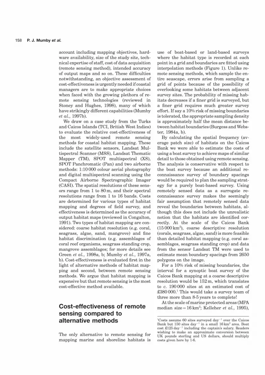
in Figure 2 would give about 30 sites perclass at coarse habitat discrimination (fourhabitat classes).
Although ground-truthing requirementsmay vary, it is imperative that an adequatenumber of sites are visited for accuracyassessment. Congalton (1991) recommendsat least 50 independent sites per habitat.
100
0.8
020
% of original signature file used
Tau
coe
ffic
ien
t 0.6
0.4
0.2
40 60 80
How much image analysis isFigure 2. The effect of increasing amounts offieldwork on classification accuracy expressed as required?the Tau coefficient (Ma and Redmond, 1995) forsupervised multispectral classification of LandsatTM data at coarse habitat discrimination. Vertical A wide variety of image processing methodsbars are 95% confidence limits representing three exist and the effects of conducting some ofrandom simulations.
these are presented in Figure 3 (for moredetails on the methods refer to Green et al.,1998a; Mumby et al., 1998b). Two key pointsemerge from this figure: firstly, to achievearea, identify the locations of habitats in the
imagery (i.e. for interpretation of aerial pho- acceptable accuracy a considerable in-vestment in staff time is required; ap-tography or multispectral classification of di-
gital data), and to provide an independent proximately 1 month for Landsat TM (andother satellite imagery such as SPOT XS),evaluation of the thematic accuracy of output
maps (Congalton, 1991). and about 1·5 months for CASI or similarairborne imagery; secondly, increased imageThe derivation of habitat classes is dis-
cussed elsewhere (Mumby and Harborne, processing effort generally leads to increasingaccuracy of outputs. A notable exception to1999) but the degree of survey effort will
depend on the mapping objectives (de- this rule is the merging of Landsat TM datawith SPOT Pan to increase spatial resolution.scriptive resolution), size of the area and
presence or absence of an existing habitat Although the merge produces visually pleas-ing outputs, the loss of spectral data duringclassification scheme (e.g. we surveyed 170
sites to create a classification of 13 habitats the intensity-hue-saturation merge (Mather,1987) actually reduced accuracies (Green etin the TCI).
It is difficult to give a generic estimate of al., 1998a). Given the costs of inputs such asfield survey data and set-up costs, extra effortthe number of field sites required to classify
remotely sensed data. However, in an em- devoted to image processing is worthwhile.pirical investigation, we used the TCI casestudy to examine the effect of various degreesof field work on the accuracy of marine habitat The relative cost-effectivenessmaps from Landsat TM. A total of 157 sites of remote sensing methodswere used to ground-truth this image. Toassess the effect of variable field data on
Whether a practitioner aims to map marineaccuracy, the supervised classification pro-cedure (Mather, 1987) was repeated three or terrestrial habitats, the choice of satellite
vs. airborne sensors depends on the level oftimes using a random sample of 25, 50, and75% of these data (Figure 2). The accuracy habitat detail required. If coarse descriptive
resolution (e.g. corals/seagrasses; mangrove/of the resulting habitat maps was assessedusing 450 independent data points. non-mangrove) is all that is required, satellite
sensors will be the most cost-effective optionThe amount of field survey used to directsupervised classification profoundly in- and reasonable accuracy (>60–80%) should
be expected (Mumby et al., 1997b; Green etfluenced the accuracy of outputs although theincrease in accuracy between 75 and 100% of al., 1998a). For detailed habitat mapping,
however, airborne remote sensing methodsfield survey inputs was not significant (Figure2). Seventy-five percent of the signature file are far more likely to provide results of high

162 P. J. Mumby et al.
40
90
2010
Image acquisition time and processing effort (person days)
Ove
rall
acc
ura
cy (
%)
15
50
80
70
60
40
30
20 25 30 35
ED
BC
A
FG
WX
YZ
Figure 3. The relationship between the overall accuracy of marine habitat maps of the TCI and thetime required in preparation from Landsat TM (and TM/SPOT Pan merge) and CASI data at coarse (Φ)and fine (Ε) levels of habitat discrimination, respectively. Time includes image acquisition, correction,image classification and the merging of SPOT Pan with Landsat TM data. Five levels of image processingeffort were applied to Landsat TM alone: A=unsupervised classification of raw (DN) data; B=supervisedclassification of raw (DN) data; C=unsupervised classification of depth-invariant data; D=supervisedclassification of depth-invariant data, without contextual editing; E=supervised classification of depth-invariant data, with contextual editing. Depth-invariant Landsat TM data were combined with SPOT Panto increase the spatial resolution, and the resultant merged image classified in two ways: F=supervisedclassification of merged image, without contextual editing; G=supervised classification of merged data,with contextual editing. Four levels of image processing effort were applied to CASI: W=supervisedclassification of raw (reflectance) data, without contextual editing; X=supervised classification of raw(reflectance) data, with contextual editing; Y=supervised classification of depth-invariant data, without
contextual editing; Z=supervised classification of depth-invariant data, with contextual editing.
accuracy (Mumby et al., 1998b). Therefore, from SPOT XS to Landsat TM would costc. £550 (i.e. just under £100 per 1% rise inthe comparison between satellite and air-
borne methods is somewhat irrelevant be- accuracy). However, once the study site istoo large to fall within a single SPOT scenecause they are used to achieve different
descriptive resolutions. Thus, the cost- (60×60 km), the cost-effectiveness of SPOTis drastically reduced. For example, an areaeffectiveness of satellite sensors and airborne
sensors are compared separately. Data are of 15 000 km2 would easily fit within a singleLandsat TM scene (total cost c. £2700) whilepresented for mapping marine habitats but
a similar conclusion would be reached had requiring five SPOT XS scenes (total cost c.£8300). In this case study, Landsat MSS couldwe used data for mangrove mapping.only be considered cost-effective if an overallaccuracy of c. 50% was considered acceptable.However, given that half the pixels might beSatellite-borne sensorsincorrectly assigned, this seems unlikely tobe the case.The time required to process an individual
satellite image does not vary substantiallyfrom sensor to sensor (Table 1) and therefore,
Digital airborne scanners vs. aerialthe most cost-effective solution depends onthe cost of each image and the accuracy photographyachievable. Figure 4 compares the cost andexpected map accuracy resulting from various It is difficult to assess the relative cost-
effectiveness of airborne remote sensingsatellite sensors for study sites of variousmagnitude. For areas less than 3600 km2, methods because the cost of data acquisition
is so case-specific. The accuracies of tropicalSPOT XS is slightly more cost-effective thanLandsat TM: the small (6%) rise in accuracy coastal habitat maps resulting from digital

Remote sensing for tropical coastal areas 163
14 000
80
400
Cost of imagery (£)
Ove
rall
acc
ura
cy (
%)
4000
50
70
60
6000 8000 10 000 12 000
(b)
Landsat TM
Area > 15 000 km2
Landsat MSS
SPOT Pan
Landsat TM/SPOT Pan
SPOT XS
2000
12 000
80
400
Cost of imagery (£)
Ove
rall
acc
ura
cy (
%)
4000
50
70
60
6000 8000 10 000
(a)
Landsat TM
Area < 3600 km2
Landsat MSS
SPOT Pan
Landsat TM/SPOT Pan
SPOT XS
2000
Figure 4. Cost-effectiveness of various satellite sensors for mapping coastal habitats of the CaicosBank with coarse detail. (a) A small area within a single SPOT scene (3600 km2), (b) represents a larger
area comprising multiple (5) SPOT scenes.
scanners and aerial photographs have not airborne data and aerial photography aresimilar for a given study, CASI is likely to bebeen compared directly although Mumby et
al. (1998b) made a tentative comparison of the most cost-effective option.The relative costs of commissioning newCASI data from the TCI and the results of
Sheppard et al. (1995) in Anguilla using aerial photography and digital airborne scan-ners were compared using four independent1:10 000 colour aerial photography. We con-
cluded that CASI is at least as accurate and quotes for mapping a coastal area of ap-proximately 150 km2. The prices are based onpossesses greater spectral sensitivity than
colour aerial photography (i.e. overall ac- a remote coastal area so a survey aircraftwould have to be specially mobilized (in thiscuracies for fine habitat discrimination, c.
80% and c. 60%, respectively). Therefore, if case, leased from the US). Specifically, quoteswere sought for 1:10 000 colour aerial pho-the costs of acquiring and processing digital

164 P. J. Mumby et al.
Table 2.Cost of mapping a coastal area of 150 km2 using CASI and 1:10 000 colour aerialphotography interpretation (API). CASI is more expensive to acquire but, being digital, requiresmuch less processing time post-acquisition. Processing time (person days) for CASI assumesthat mosaicing and geometric correction are carried out by contractor. Processing time for APIassumes that polygons are digitized by hand using conventional cartographic methods and ageographic information system
Method Cost of acquisition (£) Staff time required post acquisition (pd)
Quotes Mean CASI–API API–CASI
CASI—3 m pixels 27 00026 000
25
25 00010 500 135
1:10 000 colour 16 00015 500
160
API 15 000
tography and CASI imagery with 3 m spatial whereas the average staff cost for a non-resolution (Table 2). This is a fairly small consultant would probably be about £80 day−1
area and the time required to photo-interpret in some developed countries and less thanand digitize aerial photographs would be dis- £80 day−1 in some developed and most less-proportionately greater for larger study sites. developed countries. Given that the accuracyAlthough scanning of aerial photographs of the final map is likely to be greater if ashould increase the speed of map production digital airborne scanner is used, it is probablyby allowing digital classification techniques only cost-effective to commission aerial pho-to be used, the effect of scanning on accuracy tography when staff costs are appreciablyand processing time has not yet been evalu- less than £80 day−1. As pointed out above, theated. disparity in time required to create habitat
This comparison between CASI and aerial maps from airborne scanners and API willphotography assumes that set-up costs and increase with size of the survey (i.e. as thefieldwork costs do not differ between studies. scope of the survey increases, the cost of APIThis seems to be a realistic assumption, par- is likely to rise much faster than that arisingticularly if the map derived from aerial pho- from digital airborne scanners).tography is to be used within a geographic A final consideration is the time requiredinformation system which often have similar to deliver the final map, particularly if habitathardware requirements and software costs to mapping is being carried out to detect changeimage processing software. Assuming that in coastal resources (e.g. if investigating thethe costs and mapping rates given in Table effects of a pollution event or cyclone). If the2 are representative, CASI is more expensive extra time required to digitize aerial pho-to acquire but map production from API re- tographs is prohibitive, airborne scannersquires a six-fold greater investment in staff may be the only feasible solution.time. The overall cost of the two methodswould be equal if the photo-interpreter waspaid c. £80 day−1 (£10 500/135 day−1). If staffcosts exceed £80 day−1, CASI would be Conclusionscheaper, whereas if staff time costs less thanthis figure, API would be cheaper.
Habitat mapping is an important activity forIn practice, the relative costs of map-mak-coastal management planning and althoughing with digital airborne scanners and aerialit is expensive, remote sensing is the mostphotography are likely to differ between de-cost-effective method available. The Turksveloped and less-developed nations. A con-
sultant might charge in excess of £300 day−1, and Caicos Islands are an ideal site for remote

Remote sensing for tropical coastal areas 165
accuracy and precision of locational data. Photo-sensing of coral reefs and seagrass beds be-grammetric Engineering and Remote Sensingcause the banks are relatively shallow (av-60, 41–45.
erage depth c. 10 m) and the water clarity is Burgess, T. M. and Webster, R. (1984a). Optimalhigh (horizontal Secchi distance 30–50 m). sampling strategies for mapping soil types. I.
Risk distribution of boundary spacings. JournalTherefore, the accuracies quoted here for hab-of Soil Science 35, 641–654.itat maps are likely to represent the max-
Burgess, T. M. and Webster, R. (1984b), Optimalimum accuracies possible for such habitats.sampling strategies for mapping soil types. II.
With this caveat in mind, SPOT XS and Risk functions and sampling intervals. JournalLandsat TM are the most cost-effective means of Soil Science 35, 655–665.
Cendrero, A. (1989). Mapping and evaluation ofof mapping with coarse descriptive res-coastal areas for planning. Ocean and Shorelineolution. Airborne methods can provide sig-Management 12, 427–462.nificantly more detailed information on
Congalton, R. G. (1991). A review of assessing thecoastal habitats and the choice of com- accuracy of classifications of remotely sensedmissioning digital vs. photographic (analog) data. Remote Sensing of Environment 37, 35–46.
Green, E. P., Mumby, P. J., Edwards, A. J. andsensors depends on staff costs and the ur-Clark, C. D. (1996). A review of remote sensinggency of data acquisition. As a rule of thumb,for tropical coastal resources assessment andaerial photography should only be selected ifmanagement. Coastal Management 24, 1–40.
photographs can be manually digitized at a Green, E. P., Clark, C. D., Mumby, P. J., Edwards,cost considerably lower than £80 day−1. A. J. and Ellis, A. C. (1998a). Remote sensing
techniques for mangrove mapping. Inter-Given the dynamic, technology-led naturenational Journal of Remote Sensing 19, 935–of remote sensing this study needs a temporal956.context. Our focus here is current remote
Green, E. P., Mumby, P. J., Edwards, A. J., Clark,sensing technology in which digital airborne C. D. and Ellis, A. C. (1998b). The assessmentmulti-spectral imaging represents the state- of mangrove areas using high resolution mul-
tispectral airborne imagery (CASI). Journal ofof-the-art. It is too early to evaluate the ef-Coastal Research 14, 433–443.fectiveness of new high resolution satellite
Kelleher, G., Bleakely, C. and Wells, S. (1995). Ainstruments (Stoney and Hughes, 1998) andGlobal Representative System of Marine Pro-
digital video cameras but it is hoped that the tected Areas. Washington DC, USA: World Bankcurrent study sets a precedent against which Publications.
Kenchington, R. A. and Claasen, D. R. (1988).their capabilities for mapping tropical coastalAustralia’s Great Barrier Reef—managementhabitats may be judged in future.technology. Proceedings of the Symposium onRemote Sensing of the Coastal Zone, Gold Coast,Queensland, pp. KA2·2–2·13. Brisbane: De-partment of Geographic Information.Acknowledgements
Ma, Z. and Redmond, R. L. (1995). Tau coefficientsfor accuracy assessment of classification of re-mote sensing data. Photogrammetric En-The authors thank Angie Ellis and the Turks andgineering and Remote Sensing 61, 435–439.Caicos Ministry of Natural Resources (C. Hall, P.
Mather, P. M. (1987) Computer Processing ofSeymore, C. Ninnes, P. Medley and J. Ewing)Remotely-Sensed Images: an Introduction.for their invaluable assistance during field work.Chichester: J. Wiley & Sons.Charles Sheppard is thanked for his comments
McNeill, S. E. (1994). The selection and design ofon cost issues relating to airborne methods, twomarine protected areas: Australia as a casereferees made helpful comments on an earlierstudy. Biodiversity and Conservation 3, 586–draft of the manuscript and Bob Foster-Smith605.kindly drew the field survey cartoon. This work
Mumby P. J. and Harborne A. R. (1999). De-was funded by a grant from the Environmentvelopment of a systematic classification schemeResearch Programme of the Department for Inter-of marine habitats to facilitate regional man-national Development to AJE and CDC and moreagement of Caribbean coral reefs. Biologicalrecently, by a NERC post-doctoral fellowship toConservation 88, 155–163.PJM under the Earth Observation Science Ini-
Mumby, P. J. Green, E. P., Edwards, A. J. andtiative.Clark, C. D. (1997a). Measurement of seagrassstanding crop using satellite and digital airborneremote sensing. Marine Ecology Progress Series159, 51–60.References
Mumby, P. J., Green, E. P., Edwards, A. J. andClark, C. D. (1997b). Coral reef habitat mapping:
August, P., Michaud, J., Labash, C. and Smith, how much detail can remote sensing provide?Marine Biology 130, 193–202.C. (1994). GPS for environmental applications:
166 P. J. Mumby et al.
Mumby, P. J., Clark, C. D., Green, E. P. and Sheppard, C. R. C., Matheson, K., Bythell, J. C.,Murphy, P., Blair-Myers, C. and Blake, B.Edwards, A. J. (1998a). The practical benefits
of water column correction and contextual ed- (1995), Habitat mapping in the Caribbeanfor management and conservation: use anditing for mapping coral reefs. International
Journal of Remote Sensing 19, 203–210. assessment of aerial photography. Aquatic Con-servation: Marine and Freshwater EcosystemsMumby, P. J., Green, E. P., Clark, C. D. and
Edwards, A. J. (1998b). Digital analysis of mul- 5, 277–298.Stoney, W. E. and Hughes, J. R. (1998). A newtispectral airborne imagery of coral reefs. Coral
Reefs 17, 59–69. space era is on. GIS World 11, 44–46.
Appendix
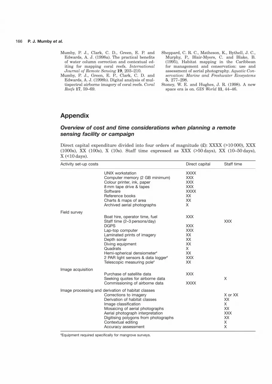
Overview of cost and time considerations when planning a remotesensing facility or campaign
Direct capital expenditure divided into four orders of magnitude (£): XXXX (>10 000), XXX(1000s), XX (100s), X (10s). Staff time expressed as XXX (>50 days), XX (10–50 days),X (<10 days).
Activity set-up costs Direct capital Staff time
UNIX workstation XXXXComputer memory (2 GB minimum) XXXColour printer, ink, paper XXX8 mm tape drive & tapes XXXSoftware XXXXReference books XXCharts & maps of area XXArchived aerial photographs X
Field surveyBoat hire, operator time, fuel XXXStaff time (2–3 persons/day) XXXDGPS XXXLap-top computer XXXLaminated prints of imagery XXDepth sonar XXDiving equipment XXQuadrats XHemi-spherical densiometera XX2 PAR light sensors & data loggera XXXTelescopic measuring polea XX
Image acquisitionPurchase of satellite data XXXSeeking quotes for airborne data XCommissioning of airborne data XXXX
Image processing and derivation of habitat classesCorrections to imagery X or XXDerivation of habitat classes XXImage classification XMosaicing of aerial photographs XXAerial photograph interpretation XXXDigitising polygons from photographs XXContextual editing XAccuracy assessment X
aEquipment required specifically for mangrove surveys.