Embed Size (px)
Citation preview
THESE TERMS GOVERN YOUR U S E OF THIS DOCUMENT
Your use of this Ontario Geological Survey document (the "Content") is governed by the terms set out on this page ("Terms of Use"). By downloading this Content, you (the
"User") have accepted, and have agreed to be bound by, the Terms of Use.
Content: This Content is offered by the Province of Ontario's Ministry of Northern Development and Mines (MNDM) as a public service, on an "as-is" basis. Recommendations and statements of opinion expressed in the Content are those of the author or authors and are not to be construed as statement of government policy. You are solely responsible for your use of the Content. You should not rely on the Content for legal advice nor as authoritative in your particular circumstances. Users should verify the accuracy and applicability of any Content before acting on it. MNDM does not guarantee, or make any warranty express or implied, that the Content is current, accurate, complete or reliable. MNDM is not responsible for any damage however caused, which results, directly or indirectly, from your use of the Content. MNDM assumes no legal liability or responsibility for the Content whatsoever.
Links to Other Web Sites: This Content may contain links, to Web sites that are not operated by MNDM. Linked Web sites may not be available in French. MNDM neither endorses nor assumes any responsibility for the safety, accuracy or availability of linked Web sites or the information contained on them. The linked Web sites, their operation and content are the responsibility of the person or entity for which they were created or maintained (the "Owner"). Both your use of a linked Web site, and your right to use or reproduce information or materials from a linked Web site, are subject to the terms of use governing that particular Web site. Any comments or inquiries regarding a linked Web site must be directed to its Owner.
Copyright: Canadian and international intellectual property laws protect the Content. Unless otherwise indicated, copyright is held by the Queen's Printer for Ontario.
It is recommended that reference to the Content be made in the following form:
Ontario Bureau of Mines.1903. Twelfth report of the Ontario Bureau of Mines, part 1, 1903; Ontario Bureau of Mines, Annual Report, 1903, v.12, 354p.
u s e and Reproduction of Content: The Content may be used and reproduced only in accordance with applicable intellectual property laws. Non-commercial use of unsubstantial excerpts of the Content is permitted provided that appropriate credit is given and Crown copyright is acknowledged. Any substantial reproduction of the Content or any commercial use of all or part of the Content is prohibited without the prior written permission of MNDM. Substantial reproduction includes the reproduction of any illustration or figure, such as, but not limited to graphs, charts and maps. Commercial use includes commercial distribution of the Content, the reproduction of multiple copies of the Content for any purpose whether or not commercial, use of the Content in commercial publications, and the creation of value-added products using the Content.
Contact:
FOR FURTHER INFORMATION ON
PLEASE CONTACT: BY TELEPHONE: BY E-MAIL:
The Reproduction of Content
MNDM Publication Services
Local: (705) 670-5691 Toll Free: 1-888-415-9845, ext.
5691 (inside Canada, United States)
The Purchase of MNDM Publications
MNDM Publication Sales
Local: (705) 670-5691 Toll Free: 1-888-415-9845, ext.
5691 (inside Canada, United States)
Crown Copyright Queen's Printer Local: (416) 326-2678 Toll Free: 1-800-668-9938
(inside Canada, United States)

TWELFTH REPORT OF THE
ONTARIO BUREAU OF MINES
1 9 0 3

REPORT OF
T H E BUREAU OF MINES
1903
C O N T E N T S
INTRODUCTION p. 1-6 STATISTICS FOR 1902 7-53 SUMMER MINING SCHOOLS - - - - 54-61 MICHIPICOTON MINING DIVISION = 62-67 PROVINCIAL ASSAY OFFICE - 68-72 MINES OF NORTHWESTERN ONTARIO - 73-107 MINES OF EASTERN ONTARIO - 108-140 FOSSILIFEROUS ROCKS OF SOUTHWEST ONTARIO 141-156 UP AND DOWN THE M1SSISSAGA = = - 157-172 ROUND LAKE TO ABITIBI RIVER - 173-190 PEAT FUEL: ITS MANUFACTURE AND USE - 191-234 THE SUDBURY NICKEL DEPOSITS - 235=303 IRON RANGES OF NORTHERN ONTARIO - - 304-317 MOOSE MOUNTAIN IRON RANGE - 318=321 MAGNETIC CONCENTRATION OF IRON ORES - 322=342
PRINTED BY ORDER OF THE LEGISLATIVE ASSEMBLY OF ONTARIO.
TORONTO : PRINTED AND PUBLISHED BY L. K. CAMERON,
Printer to the K ing ' s Most Excel lent Majesty, 1903.
WARWICK B R O S & RUTTER, P r i n t e r s , TORONTO.
CONTENTS. P a c k
L e s t e r o f T r a n s m i s s i o n 1
I n t r o d u c t o r y L e t t e r 3-6
T w e l f t h R e p o r t o f B u r e a u o f M i n e s . . 7-53 Mining companies formed in 1902 8 Licensed mining companies 9 Mininsr lands 10 Mineral production 11
Gold and silver 14 Gold mining, 1898-1902 14 Anglo-Canadian Gold Estates, Ltd.. 15 Silver mining, 1898-1902 17
Nickel and copper 17 Nickel-copper mining, 1898-1902 . . . . 17 Non-nickeliferous copper mines, 1902 18 Total production of copper, 1902 . . . . 18 Labor employed in nickel and copper
mines 18 Iron ore, pig iron and steel 19
Iron ore mined 1898-1902 19 Prospecting for ore 20 Pig iron and steel production, 1896-
1902 22 Cramp Steel Co., Ltd 28 Payments out of iron mining fund.. , 25
Molybdenite and sine ore 25 Actinolite, graphite, mica, talc 26
Production of graphite, 1898-1902 . . . 27 Building materials and clay products.. 27
Production of stone, lime and brick, 1898-1902 27
Production of other clay products, 1898-1902 29
Portland and hydraulic cement 29 Production of cement, 1891-1902 . . . . 30 Development of cement manufacture 31 Plants building and projected 32 Condition of the industry 34
Arsenic, calcium carbide, corundum... 36 Production of arsenic, 1899-1902 36 Production of calcium carbide, 1898-
1902 37 Production of corundum, 1900-1902.. 37
Feldspar, gypsum, salt, pyrites 37 Production of salt, 1898-1902 38
Natural gas 38 Production of, 1898-1902 39
Petroleum and petroleum products.... 39 Production of 1898-1902 40 The Raleigh oil field 41
Mining accidents 42 Deloro gold mine 43 Victoria mine 43 Ontario smelting works 44 Canadian Copper Co.'s mines 44 Big Master gold mine 46 Elsie nickel mine 46
P a g e Radnor iron mine 47 Helen iron mine 47 Moore iron mine 47 Table of accidents 48
Mining agencies 49 Government diamond drills 50
The C" drill 50 The "S 'drill 50 Summary of boring operations 53
Summer M i n ing S c h o o l s 54-61 The season's itinerary 54 Class at Calabogie 55 Deloro school 56 A.t Cordova mines 56 Classes at Copper Cliff 57 Victoria mines 58 Mikado gold mine 59 Black Eagle mine 69 Rat Portage 59 Class at Helen mine 60 Grace gold mine 60 Rock Lake copper mine 61
M i c h i p i c o t o n M in ing D i v i s i o n 62-67 Emily gold mine 62 Josephine iron mine 62 Brule" Harbor copper locations 63 Helen iron mine 63 Lloyda gold mine 64 Manxman Gold Mining Co 64 Grace gold mine • 64 Work on other locations 65 List of licensees 65
P r o v i n c i a l A s s a y O f f i c e 63-72 Work done for Bureau of Mines 68 Work done for private parties 69 Laboratory determinations 70 Laboratory equipment and methods 71
M ines o f N o r t h w e s t e r n O n t a r i o 73-107 Railway building in mining districts 73 Lessons taught by experience 74 General remarks 75 Gold and silver mines 76
Scadding township gold mine 76 Emily gold mine 77 Michipicoton gold mines 78 Grace mine 78 Manxman mine 79 Other Michopicoton gold claims. 80 Ophir gold mine 80 Empress gold mine 81 Gold properties on Canadian Northern 81 A. L. 282 mine 81 Elizabeth mine 82 Sturgeon lake region 82 St. Anthony reef 82
i v C o n t e n t s
M i n k s o f N. W. Ontario.—Continued. P a g e English River Gold Mining Co 84 United States Gold Mining Co 85 Symmes' prospect 86 Prospects on Contare lake 86 Sturgeon lake to Savant lake 87 Savant lake placers 88 Lake Manitou gold area 91 Big Master mine. 91 Summit Lake Mining Co 91 National Claim 92 Giant mine 92 Twentieth Century mine 92 Royal Sovereign mine 92 Eagle lake gold district 92 Northern Light Mines Co 93 Golden Eagle 93 Grace mine 93 Viking mine 93 Baden-Powell 93 Lake-of-the-Woods region 93 Flint Lake 94 Golden Horn 94 Golden Reef 94 Indian Joe 94 Mikado gold mine 95 Nino 95 Olympia 95 Wendigo 96 Other properties 96 Silver mines 96 West End silver mine 97
Copper mines 97 Massey Station mine 97 Other prospects 98 Bruce mines 98 Rock Lake mine 99 Copper Queen 99 Indian Lake 100 Squaw Chute 100 Taylor mine 100 Ranson mine 100 Township of McMahon 100 Superior Copper mine 100 Goulais Bay 101 Tip-Top mine 101
Iron mines 102 Helen mine 102 Newer Michipicoton iron properties.. 103
Notes on rocks 104 Nepheline syenite 104 St. Anthony reef 105 Route Biscotasing to Flying Post — 106 Other localities 106
M i n e s o f E a s t e r n O n t a r i o . . . 108-140 Gold mines 108
Deloro mine 108 Atlas Arsenic Co 110 Cook mine 110 Belmont mine I l l International mine . 1 1 2
Iron mines 1 1 3 Canada Iron Furnace Co 1 1 3
P a g e Radnor mine 1 1 3 Big Jim property 1 1 4 Dacre mine 1 1 4 Mineral Range Iron Mining Co 1 1 4 Childs or No. 1 mine 1 1 4 No. 3 mine 1 1 4 No. 4 mine 1 1 5 St. Charles mine 1 1 5 Coe mine 1 1 5 Calabogie mine 1 1 5
Copper mines 1 1 5 Wilcox mine 116 McGown mine 1 1 6 Consolidated Copper Co 1 1 6
Nickel-Copper mines 1 1 7 Canadian Copper Go's, mines & works. 1 1 7 Copper Cliff mine 118 No. 2 mine 1 1 9 No. 3 mine 1 1 9 Nos. 4 & 5 mines 120 Stobie mine 120 Creighton mine 120 Quartz mine 1 2 1 Smelters and roast heaps 1 2 1 Ontario Smelting works 1 2 1 Gertrude mine 122 Elsie mine 123 Victoria mine... 123
Mica mines 125 Raymond mine 126 Bear Lake mine 126 Lacey mine '. 126 McClatchey mine 127 Stoness 127 Pike Lake mine 128 McLaren's mica mine 128 Martha mine 128 Gibson's mine 129 Byrne's mine 129 Hanlan mine 129 Noble's Bay mine 130 Donnelly mine 130 Adams' mine 131
Mica Trimming works 1 3 1 Kent Bros', mica trimming works 1 3 1 Adams' mica-trimming works 1 3 1 Trousdale trimming works 131 Mica trimming works in Ottawa 131 Mica grinding works 131
Graphite mines .. 132 Black Donald graphite mine 132 McConnell graphite mine 134
Corundum mines 135 Canada Corundum Co 135 Ontario Corundum Co 135
Feldspar mines 136 Richardson feldspar mine 136 Pennsylvania Feldspar Co 137 Harris feldspar mine 138
Jarman pyrites mine 139 Richardson zinc mine 139 Ottawa carbide works 140
Contents v
P a g e F o s s i l i f e r o u s R o o k s o f S o u t h w e s t On
t a r i o .141156 Niagara limestone at Ancaster 141 Ontcrops of the Corniferous 142 Corals in Townsend and Walpole 142 Limestone quarries at Hagersville 144 Oriskany and Lower Helderberg 145 Gypsum deposits in the Onondaga 147 The Beachville quarries 148 Marl beds in Dumfries 149 Borings at Stratford and Guelph 150 Quarrying in the Corniferous at St. Marys 151 Lower Helderberg or water-lime formation 152 Corniferous a varied ferie* 153 Fossiliferous bed, of Hamilton formation 153 Other exposures of Hamilton fossil beds.. 154 Kettle Point concretions 156
U p a n d D o w n t h e M i s s i s s a g a 157-172 Starting point of expedition 157 General method of procedure 157 Topographical features 158 Peculiarity of hill profiles 158 The starting point and westward 159 On the White river 159 Intrusive area in the Laurentian 160 Red pine, spruce and jack pine 160 On the Rapid river 160 On the Meridian line 161 The Mississaga river .... ............ 161
Aubrey or Akikenda falls 161 Canoeing down stream 162 Characteristics of the river 162 Panning gravel for gold 163 First Huronian exposure 163 Mining and gardening at Squaw chute. 164 Slate rapids and Grande Portage falls. 164 Copper prospects at Grande Portage .. 165 Up the Aubinadong 165
West on the base line 165 Meridian north of the Mississaga 166 Ascending the Wenebegon 166 Seven Mile lake 167 Round and Peninsula lakes 167 Old Green lake 167 The river Epinette 168 Back to Biscotasing 168 Geology and Petrography 169
An almost entirely Laurentian region. 169 Intrusive dikes and veins 170 A grano-dioritic mass 170 Huronian rooks in the area 171 The region summed up 172
R o u n d L a k e t o A b i t i b i R i v e r 173-190 Wilson's landing to Round lake 173 Round lake 173 The Blanche above Round lake 174 Partridge-crop lake 174 Lake Kenogami 175
Geology of Kenogami basin 175 Jasper conglomerate with iron ore . . . . 176 Township of Eby 176
P a g e A swampy section 177 Sandy plains and rocky ridges 177 Contact of Laurentian and Huronian.. 178 Clay land and muskeg 179 Mineral indications in Eby 179 Northwest arm of lake Kenogami 179 Outcrops of conglomerate 180
The Blanche above lake Kenogami . . . 180 Outcroppings of slate and diorite .. 181
Lake Sesekinaka to lake Anikojigami... 181 Anikojigami lake 182 From the Blanche to the White Clay 183
Swan and Gull Lakes *.. 183 Malloch and Butler lakes 184 Kekekwabik lake 184
White Clay river 185 The Black river 185
Kawanaska river and Bolton lake 185 A spruce forest 186 Falls on the river 186
Black river to Abitibi river 187 On margin of great clay belt 187 Pulpwood forests and good soil 187
Summary 188 Notes on rocks : 189
P e a t F u e l , i t s M a n u f a c t u r e a n d U s e . 191 Peat fuel no novelty 192 Place of peat among fuels 194 Anthracite and peat compared 195 Aotual test of peat fuel 195 The question of price 196 European methods of manufacture 196
Cut peat 197 Machine peat 197 Danish peat plant 198 Mills for making machine peat 198
Manufacture in Ontario 200 Progress of industry 201 Peat bogs and plants 202
Analyses of Ontario peats 202 Welland bog 203 Beaverton bog 203 Perth bog 204 Brunner bog 204 Brockville bog 205 Rondeau bog 206 Rondeau peat works 206 Newington bog 208
Process of making peat fuel 208 Wet and dry bogs 209 Ditching a dry bog 209 Clearing the surface 210 Laying down tramways 210 Harvesting peat at Welland 211 Dobson mechanical excavator 211 Air-drying 212 Disintegrating and drying 214 Dobson peat dryer 215 Simpson peat dryer 218 Drying by pressure not successful 219
Making the briquettes 221 Dickaon press 221
vi Contents
P e a t F u e l Em—Continued. P a g e Dobson press 222 Newington plant 223 Power generation and distribution 224 Cost of manufacture 225
Special apparatus for burning 226 Peat gas 228
Merrifield gas generator 228 Quality of Merrifield peat gas 292 Cost of gas plant 231
Sulphur in Ontario peat 233 Dobson's new peat machines 233
T h e S u d b u r y N i c k e l D e p o s i t s — 235-299 Geological literature of region 235 Topography of the district 236 Sedimentary rocks near Sudbury 238 Eruptives of the region 239 Pleistocene deposits 241 The main nickel range 242
Creighton mine 243 Rock associations of deposits 244 The ore body 245 Gertrude mine 246 NorthlStar mine 248 Elsie mine 249 Murray mine 251 Blezard and adjoining mines 254
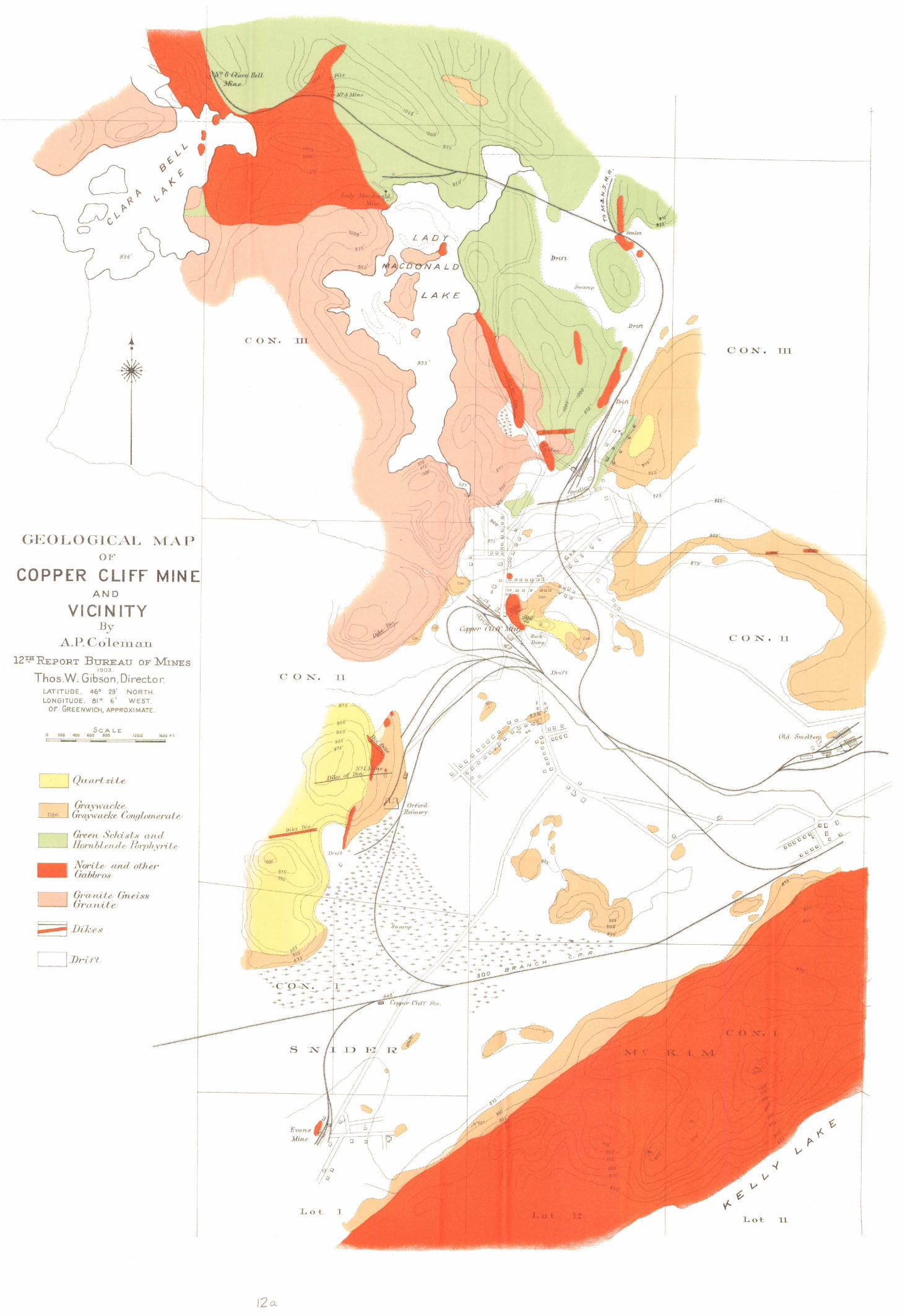
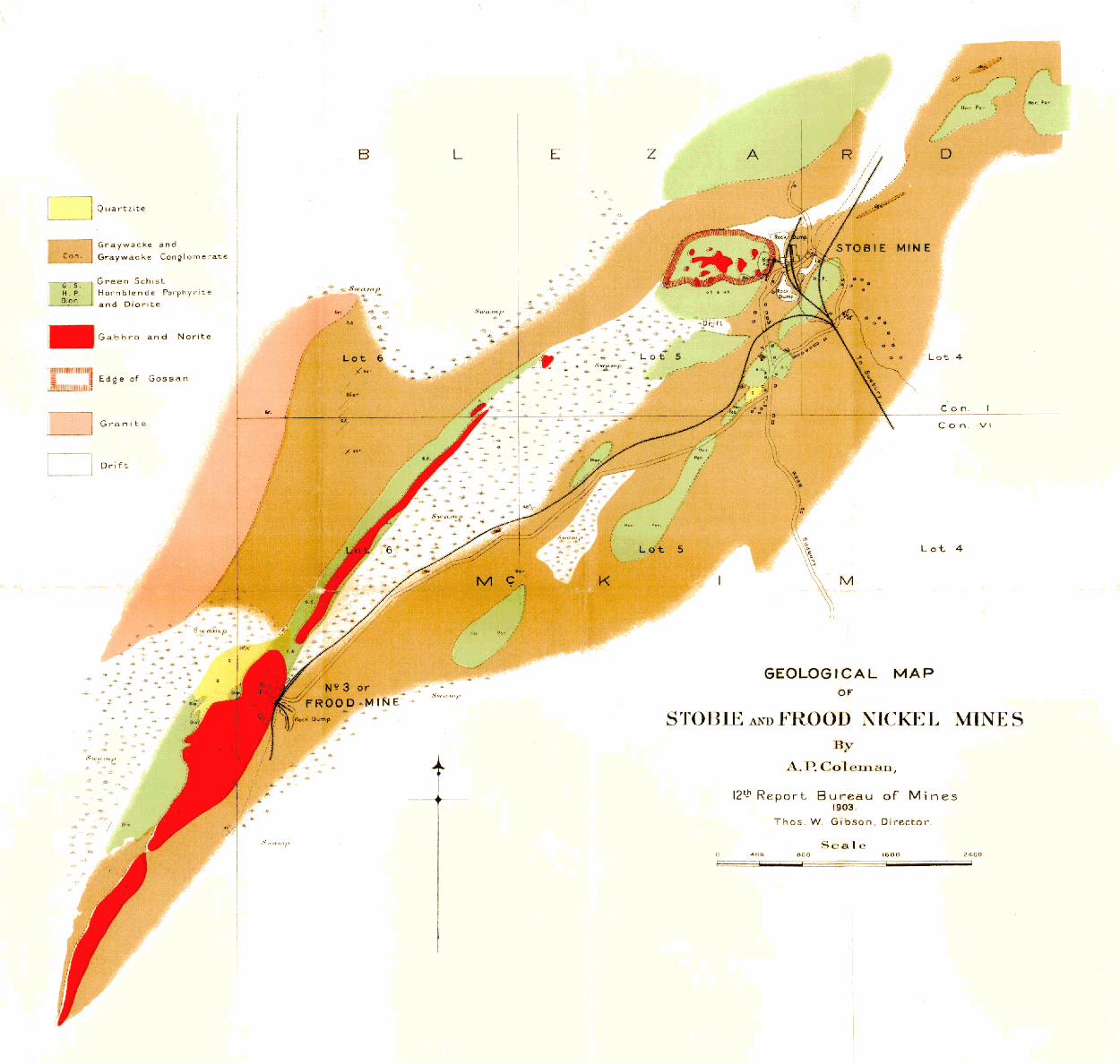
Southeastern offshoot of main norite range 256 Copper Cliff mine 258 Evans mine 261 Stobie and Frood mines 263
Victoria mine region 2fi8 Worthington gabbro band 272 Northern nickel range 273
Ore deposits at Blue lake 273 Whistle property 274
General conclusions 276 Features of the norite band 276 Theory of ore formation 277 Three types of ore deposits 278 Composition of ore bodies 280 Nickel-bearing minerals 281 Silver, platinum, gold, cobalt 282
Development of mining in district 284 Canadian Copper Co 284 H. H. Vivian & Co 286 Dominion Mineral Co 286 Mond Nickel Co 287 Lake Superior Power Co 287 Production of nickel and copper ores.. 288
Stratigraphical and petrographical notes. 289 Quartzites and greywackes 289 Other sedimentary rocks 291 Schists and greenstones 291 Granitoid gneiss 2i>2 Nickel-bearing eruptive 293 Varieties of the norite 294
P a g e Gabbro of Copper Cliff off-set.. 295 Later granites .- 296 Diabase dikes 297
Moose Mountain iron mine 298
M e t h o d s o f M e t a l l u r g y a t C o p p e r C l i f f 299-303
Mining the ore 300 Roasting out the sulphur 300 Smelting the roasted ore 301 Pyritic smelting 302
I r o n R a n g e s o f N o r t h e r n O n t a r i o 304-317 District of Rainy river 306
The Atikokan range 306 Steep Rock lake 306 Limestone associations of iron ore 307 Significance of pyrite-bearing rocks.... 308
District of Thunder bay 309 Mattawin range 309 The Mesabi extension 309 Lake Nipigon ranges 310 Near Black Sturgeon lake 311 Deposits on Pic river 313 Magnetite on Savant lake 313 Other occurrences in the district 314
District of Algoma 314 Ground Hog river iron belt 315 Iron formation of Woman river 317 On the Mattagami 317
District of Nipissing 317
M o o s e M o u n t a i n I r o n R a n g e 318-321 Geological features 318 Comparison with Vermilion iron district. 319 Possible origin of the ore 320
M a g n e t i c C o n c e n t r a t i o n o f I r o n O r e s . 322-342 What is concentration ? 322 Reasons for concentrating iron ores 322 Methods of concentration 323 Magnetic vs. water concentration 324 Present status of magnetic concentration 325 Types of conveying-belt separators 325 Ball-Norton drum machine 326 Other forms of drum separators 328 Edison stationary magnet separator 328 Grondal-Delvik separator 329 Finely divided ores in blast furnace 330 Smelting finely-crushed ores in Europe.. 331 Opportunities for magnetic concentration 332 Experiments with magnetites from Mayo 333 A non-concentrating ore 334 Treating a jaspery ore from Temagami.. 336 Low-grade Calabogie magnetite 336 Review of literature on magnetic concen
tration 337
I L L U S T R A T I O N S .
PAGE. Helen mine ; The last of Hematite Hill 80 Helen iron mine 80 Helen iron mine • 80 Helen iron mine ; Dining hall, sleeping camps and other buildings 80 Cape Gargantua, Lake Superior 80 Stamp mill, Grace gold mine, Michipicoton 80 Whitefiah rapids, Lake of the Woods 80 Ore from St. Anthony Reef ; Quartz stringers in protogine 80 Flan shewing geological formations on St. Anthony Reef, Sturgeon lake 96 Victoria mines ; Smelters . . . . 96 Sand hills, Island in Savant lake 96 Miner's hand-drilling contest 96 Rock Lake copper mine : 96 Rock Lake copper mine ; Concentrating plant 96 Belmont gold mine ; Falls at outlet of Deer lake 112 Belmont gold mine; Hydraulic power plant, showing water flume and air pipe 112 Belmont gold mine ; Compressor at hydraulic power plant 112 Belmont gold mine ; Flume line to hydraulic power plant » 112 Collingwood steel works ; General view of plant 160 Collingwood steel works; Semi-continuous Belgian rod mill 160 First falls in the " Tunnel," Mississaga river 160 Radnor iron mine, Grattan township 160 A g l impse of the " Tunnel," Mississaga river 160 Up and down the Mississaga ; Burned country above Old Green lake : 160 Mississaga Indians 160 On the Wenebegon river 160 Welland bog ; harrowing the peat 192 Welland bog; scraping the peat 192 Welland peat works 192 Brockville peat bog 192 Sounding a peat bog . . 192 A Norwegian peat bog 192 Brockville peat bog and works 192 Brunner peat bog and works 192 Rondeau peat bog 192 Rondeau peat bog and works i92 Plan of Rondeau peat works 207 Dickson's peat briquetting press "08 Beaverton peat bog and works 208 Perth peat bog 208 Perth peat works 20° Newington peat bog ; near margin 208 Newington peat bog ; central area 208 Beaverton bog ; scraping and raking peat 208 Anrep's peat milling machine, opened to show construction 208 Anrep's peat-milling machine at work 208 Dobson's peat excavator ; front view 208 Dobson's peat excavator ; side view 208 Dobson's improved peat excavator 208 Dobson's peat gatherer 208 Dobson's peat briquetting press 208 Dobson's peat briquetteB. Fresh from press. After transportation by railway 208 Peat briquetteB made by Dickson process 208 Lange, Jenson & Coy's peat stove 208 Fire-box for burning peat under steam boilers • 208 Dobson's peat dryer 213 The Simpson peat dryer , 217 Die-block and bed, Dobson peat press 220 Die-block of Dickson peat press 221 Reek's fissure stove for burning peat 226 Christensen's peat cook-stove 227 The Sudbury Nickel Deposits ; Creighton mine looking northwest 240 The Sudbury Nickel Deposits; Open pit, Creighton mine 240 Creighton nickel mine in winter 240 Creighton nickel mine, showing dikes in ore 240 Creighton mine 243 Plan of Gertrude mine and railway 247 Surface plant, Elsie mine 249 Elsie mine, sketch shewing plan of underground workings 250 Section on proposed line of incline 250 Plan of Buildings and plant at Murray nickel mine 252 Murray mine 253
vii
viii Contents
PAGE. Blezard nickel mine and vicinity 255 Copper Cliff nickel mine 256 The Sudbury Nickel Deposits ; Gossan hill, Copper Cliff 256 Stobie nickel mine 256 The Sudbury Nickel Deposits ; Evans mine 256 Copper Cliff mine ; Plan of levels 1, 2, 3 256 Copper Cliff mine ; Plan of levels 4, 5, 6 256 Copper Cliff mine; plan of levels, 7, 8, 10 256 Copper Cliff mine; Plan of levels 11, 13, 13 256 Canadian Copper Co. Copper Cliff mine, July, 1902 259 Evans mine ; Plan of levels and vertical section of shaft 282 Stobie mine ; Plan of surface and vertical section through shaft 264 Stobie mine ; Plan of levels 1 and 2 265 Stobie mine ; Plan of levels 3 and 4 266 Stobie mine; Sections 267 Plan of Victoria mine 269 Surface plan Worthington mine 270 Worthington mine 271 The Sudbury Nickel Deposits; Bedding of quartzite and slate 272 The Sudbury Nickel Deposits ; No. 2 mine showing old skipway and men on scaling ladder 272 The Sudbury Nickel Deposits ; Dike 2 feet wide with boulder-like projections, Creighton mine... . 272 Canadian Copper Co.; Matte yard, west smelter 272 No. 2 nickel mine, from old skipway 272 The Sudbury Nickel Deposits ; Cross sections of staurolite 272 The Sudbury Nickel Deposits ; No. 1 mine looking towards the Evans 272 Victoria mine; Sections looking westerly 272 Victoria mine ; Sections looking northerly 272 Victoria mine; Plan of levels 272 Victoria mine ; Plan of levels 272 Plan of Whistle location . 275 Canadian Copper Co.; West smelter 288 Canadian Copper Co.; West smelter 288 Ontario Smelting Works, Copper Cliff 288 The Sudbury Nickel Deposits ; NO 4 MINE from rock-house 288 The Sudbury Nickel Deposits ; Possible section of nickel-bearing eruptive 288 INDEX map iron ranges of Northern Ontario 305 Plan OF iron ore locations east of LAKE Nipigon 310 Plan OF iron ore locations in VICINITY OF Black Sturgeon lake 312 PLAN OF IRON ore locations N. E. ARM of LAKE Temagami and Kokoko BAY ,. 316 Map showing locations on Hutton iron ranue 321 Magnetic Concentration of Iron ORES ; Concentrating plant 336 Magnetic Concentration of Iron ORES ; Diagram of Wetherill cross-belt magnetic separator.... 336 MAGNETIC Concentration of Iron Ores ; Bowand cross-belt machine for weakly magnetic material... 336 MAGNETIC Concentration of Iron ORES ; Sample of interband«d jaspery iron ore. Magnetite layers
LIGHT color ; jasper dark 336 Magnetic Concentration of Iron ORES ; Sample of ore amenable to concentration by coarse cruthing. 336 Magnetic Concentration of Iron ORES ; Sample of magnetite (black) with segregations of pyrite
(WHITE) large enough to be separated by coarse concentration 336 Magnetic Concentration of Iron Ores ; Sample OF ore amenable to fine concentration, but not re
quiring briquetting of concentrates 336 MAGNETIC Concentration of Iron ORES ; SAMPLE of ORE amenable to medium coarse concentration 336 Magnetic Concentration of Iron ORES ; SAMPLE of ORE showing MASSIVE magnetite (BLACK) and pyrite
(WHITE) IN grains TOO Bmall TO be REMOVED except by very fine crushing 336
M a p s .
GEOLOGICAL MAP OF COPPER CLIFF MINE AND VICINITY. By A. P. COLEMAN. GEOLOGICAL MAP OF STOBIE ANDJFROOD NICKEL MINES. By A. P. COLEMAN.
TO HIS H o n o r
T h e H o n o r a b l e W i l l i a m M o r t i m e r C l a r k , e t c . , e t c . , e i c ,
Lieutenant-Governor of the Province of Ontario.
S i r :
I HAVE THE HONOR TO TRANSMIT HEREWITH, FOR PRESENTATION TO THE LEGISLATIVE ASSEMBLY, THE
TWELFTH REPORT OF THE BUREAU OF MINES.
I HAVE THE HONOR TO BE, SIR,
YOUR OBEDIENT SERVANT,
E. J. D A V I S ,
C o m m i s s i o n e r o f C r o w n L a n d s .
D e p a r t m e n t o f C r o w n L a n d s ,
T o r o n t o , 30TH A p r i l , 1903.
L 1 J

I N T R O D U C T O R Y L E T T E R .
TO t h e H o n o r a b l e E. J. D a v i s ,
Commissioner of Crown Lands.
S i r :
I HAVE THE HONOR TO SUBMIT TO YOU HEREWITH, FOR PRESENTATION TO HIS HONOR THE LIEUTENANT-
GOVERNOR, THE TWELFTH REPORT OF THE BUREAU OF MINES.
THE BUREAU AIMS AT DEALING, FIRST AND FOREMOST, WITH THE PRACTICAL AND ECONOMIC SIDE OF
MINING, HENCE ITS ENERGIES ARE DIRECTED IN THE MAIN TOWARDS COLLECTING AND DISSEMINATING INFORM
ATION WHICH CAN BE USED IN THE INITIATION, DEVELOPMENT AND OPERATION OF MINING AND MINERAL
INDUSTRIES IN THE PROVINCE. SUCH INFORMATION IS NECESSARILY VERY VARIED IN ITS CHARACTER AND
SOURCES. THE WORKING OUT AND CLASSIFYING OF THE ROCK FORMATIONS OF ONTARIO ; THE EXPLORING OF
THE LITTLE-KNOWN PORTIONS OF THE PROVINCE FOR THEIR MINERAL POSSIBILITIES ; THE DELIMITING OF THOSE
FORMATIONS WHICH ARE SPECIALLY FAVORABLE FOR TH» OCCURRENCE OF VALUABLE ORES OR MINERALS IN
GENERAL OR OF PARTICULAR KINDS ; THE EXAMINATION OF VEINS, DIKES AND ORE DEPOSITS WITH A VIEW
NOT ONLY OF DETERMINING THEIR NATURE AND COMPOSITION BUT ALSO OF ELUCIDATING THEIR MODE OF
ORIGIN AND RELATION TO SURROUNDING OR ADJACENT ROCKS, THUS OBTAINING A BASIS FOR INFERRING THE
POSSIBILITY OF OTHER BODIES OCCURRING UNDER PIMILAR CONDITIONS ; THE BEST METHODS OF WORKING AND
TREATING ORES AND MINERALS; THE UTILIZATION OF MATERIALS HITHERJFEO NEGLECTED OR CONSIDERED WASTE ;
THE DISCOVERIES IN SCIENCE AND ART AND THE INVENTION OR IMPROVEMENT OF PROCESSES TENDING TO
PROMOTE THE EFFICIENCY OF THE MINING INDUSTRY, OR ANY BRANCH OF IT, ARE ALL MATTERS NATURALLY
COMING UNDER THE COGNIZANCE OF THE BUREAU, AND ALONG WITH FACTS AND STATISTICS RELATING TO THE
PROGRESS OF MINING IN THE PROVINCE, CONSTITUTE THE FABRIC OF ITS ANNUAL REPORTS, THE OBJECT OF
WHICH IS TO MAKE KNOWN THE MINERAL RESOURCES OF THE PROVINCE SO THAT THEY MAY BE DEVELOPED
AND UTILIZED.
THE PRESENT VOLUME CONTAINS A VARIETY OF STATISTICAL TABLES SHOWING THE OUTPUT OF THE MINES
AND MINERAL WORKS FOR THE YEAR 1902, AND ALSO COMPARATIVE SCHEDULES EXHIBITING THE PROGRESS
MADE DURING A SERIES OF YEARS INJTHE PRINCIPAL ITEMS OF MINERAL PRODUCTION. THESE TABLES ON
THE WHOLE TELL A STORY OF STEADY DEVELOPMENT AND OF INCREASE BOTH IN THE QUANTITY AND VALUE OF<
THE YIELD.
THE SUMMER MINING CLASSES, WHICH FOR A NUMBER OF YEARS NOW HAVE BEEN CONDUCTED UNDER
THE AUSPICES OF THE BUREAU FOR THE PURPOSE OF INSTRUCTING MINERS, PROSPECTORS AND OTHERS IN THE
ELEMENTS OF MINERALOGY, GEOLOGY AND CHEMISTRY, WERE CARRIED ON LAST YEAR BY DR. W. L. GOOD
WIN, DIRECTOR OF THE SCHOOL OF MINING AT KINGSTON, AND MR. J. WATSON BAIN, LECTURER IN
CHEMISTRY AT THE SCHOOL OF PRACTICAL SCIENCE, TORONTO. FROM DR. GOODWIN'S REPORT IT WILL
BE SEEN THAT THE EFFORTS OF THE BUREAU TO GIVE THE WORKING MINERS AND PROSPECTORS OF THE PROV
INCE AN OPPORTUNITY OF ACQUIRING A MORE SCIENTIFIC AND SYSTEMATIC KNOWLEDGE OF THE MATERIALS
OF THEIR DAILY WORK ARE MUCH APPRECIATED. [ 3 ]
4 I n t r o d u c t i o n N o . 5
M r . D . G . B o y d , I n s p e c t o r o f t h e M i c h i p i c o t o n M i n i n g D i v i s i o n , p r e s e n t s a r e p o r t o f t h e
w o r k d o n e a t t h e M i c h i p i c o t o n office l a s t y e a r , a n d a b r i e f a c c o u n t o f t h e p r i n c i p a l d e v e l o p
m e n t s i n t h a t r e g i o n .
T h e P r o v i n c i a l A s s a y office e s t a b l i s h e d a t B e l l e v i l l e s o m e f ive y e a r s a g o h a s p r o v e d q u i t e
s u c c e s s f u l a s a m e a n s o f f u r n i s h i n g a s s a y s a n d a n a l y s e s o f o r e s a n d m i n e r a l s t o p r o s p e c t o r s a n d
o t h e r s a t a l o w c h a r g e , a n d i n o t h e r w a y s h a s m a t e r i a l l y a s s i s t e d i n p r o m o t i n g t h e w e l f a r e o f
t h e m i n i n g i n d u s t r y . M r . J . W a l t e r W e l l s o c c u p i e d t h e p o s i t i o n o f P r o v i n c i a l A s s a y e r f r o m
t h e b e g i n n i n g u p t o 1 s t O c t o b e r 1 9 0 2 , w h e n h e r e s i g n e d a n d w a s s u c c e e d e d b y M r . A l f r e d
G . B u r r o w s . M e s s r s . W e l l s a n d B u r r o w s m a k e a j o i n t r e p o r t o n t h e office fo r t h e y e a r .
F o r t h e p u r p o s e o f i n s p e c t i n g t h e w o r k i n g m i n e s t h e P r o v i n c e i s d i v i d e d i n t o t w o d i s t r i c t s ,
e a s t a n d w e s t , t h e d i v i s i o n b e i n g t h e w e s t e r n b o u n d a r y o f t h e S u d b u r y n i c k e l - c o p p e r field.
T h e m i n e s of n o r t h w e s t e r n O n t a r i o w e r e v i s i t e d b y P r o f . W . G . M i l l e r , P r o v i n c i a l G e o l o g i s t
a n d I n s p e c t o r o f M i n e s , w h o s u b m i t s a n i n t e r e s t i n g r e p o r t t h e r e o n . T h e r e p o r t i s n o t c o n
f ined t o a d e s c r i p t i o n o f t h e w o r k i n g p r o p e r t i e s , b u t i n c l u d e s a l s o c o n s i d e r a b l e i n f o r m a t i o n
r e s p e c t i n g t h e m i n e r a l o g i c a l f e a t u r e s o f N o r t h w e s t O n t a r i o , e m b r a c i n g a m o n g o t h e r t h i n g s
a n a c c o u n t of t h e g r a v e l d e p o s i t s o n S a v a n t l a k e , i n w h i c h t h e e x i s t e n c e o f p l a c e r
g o l d w a s r e p o r t e d a y e a r o r so a g o . T h e s e i n v e s t i g a t i o n s d i d n o t g o t o s h o w t h a t a
p l a c e r f ie ld o f a n y c o n s i d e r a b l e v a l u e is t o b e l o o k e d fo r i n t h a t r e g i o n . G o l d u n d o u b t
e d l y is t o b e f o u n d i n t h e g r a v e l , b u t i n s m a l l q u a n t i t i e s , p r o b a b l y t o o s m a l l t o b e p r o f i t a b l y
w o r k e d u n d e r p r e s e n t c o n d i t i o n s . P r o f . M i l l e r ' s r e m a r k s c o n c e r n i n g c e r t a i n f e a t u r e s o f m i n i n g
o p e r a t i o n s a r e w o r t h y o f c a r e f u l p e r u s a l b y t h o s e r e s p o n s i b l e f o r o r financially i n t e r e s t e d i n
m i n i n g w o r k i n t h e t e r r i t o r y u n d e r r e v i e w .
I n an a r t i c l e e n t i t l e d T h e I r o n R a n g e s o f N o r t h e r n O n t a r i o P r o f . M i l l e r b r i n g s
t o g e t h e r i n c o n c i s e f o r m d a t a c o n c e r n i n g t h e i r o n o r e d e p o s i t s a n d i r o n o r e f o r m a t i o n s o f t h e
n o r t h e r n p o r t i o n s o f t h e P r o v i n c e , m u c h o f w h i c h is d r a w n f r o m h i s o w n o b s e r v a t i o n s i n t h e
field.
T h e m i n e s i n t h e e a s t e r n p o r t i o n o f O n t a r i o w e r e e x a m i n e d b y M r . W . E . H . C a r t e r , w h o
is I n s p e c t o r o f M i n e s a s w e l l a s S e c r e t a r y o f t h e B u r e a u , a n d h i s r e p o r t t h e r e o n w i l l b e f o u n d
i n t h e p r e s e n t v o l u m e .
T h e p r i m e i m p o r t a n c e o f f u e l i n a c o u n t r y a n d c l i m a t e l i k e o u r o w n h a s l e d t h e B u r e a u
f r o m t h e b e g i n n i n g t o t a k e a n a c t i v e i n t e r e s t i n t h e p o s s i b i l i t y o f d e v e l o p i n g a d d i t i o n a l s o u r c e s
o f f u e l in t h e p e a t b o g s o f O l d a n d N e w O n t a r i o a n d t h e l i g n i t e s n o r t h o f t h e h e i g h t o f l a n d .
T h e l a t t e r a r e o u t s i d e t h e r a n g e o f p r e s e n t t r a n s p o r t a t i o n f a c i l i t i e s , b u t i n v e s t i g a t i o n c o n f i r m s
t h e o p i n i o n t h a t i n h e r h i t h e r t o n e g l e c t e d p e a t b o g s O n t a r i o p o s s e s s e s v a l u a b l e r e s o u r c e s , b o t h
f r o m a n e c o n o m i c a n d p u b l i c p o i n t o f v i e w . T h e c o n d i t i o n , w h i c h r e a c h e d n e a r l y o n e o f p a n i c
l a s t w i n t e r a s a r e s u l t o f t h e s t r i k e o f t h e a n t h r a c i t e m i n e r s i n P e n n s y l v a n i a , i s s t i l l f r e s h i n t h e
p u b l i c m i n d , a n d i t i s a n o p p o r t u n e t i m e t o p u b l i s h t h e r e s u l t s o f t h e i n q u i r i e s w h i c h t h e
1902 INTRODUCTION 5
BUREAU HAS FOR SOME TIME BEEN MAKING WITH REGARD TO THE UTILIZATION OF PEAT FOR FUEL PURPOSES.
THE PAPER ON PEAT FUEL, ITS MANUFACTURE AND USE, PREPARED BY MR. CARTER, WAS PRINTED AS A
SEPARATE BULLETIN, BUT IS RE-PUBLISHED IN THE PRESENT REPORT.
IN A SHORT PAPER ON THE FOSSILIFEROUS ROCKS OF SOUTHWESTERN ONTARIO DR. W. A. PARKS,
LECTURER IN GEOLOGY AT TORONTO UNIVERSITY, RECORDS THE OBSERVATIONS MADE IN A PEDESTRIAN TRIP
FROM HAMILTON TO THE SHORE OF LAKE HURON, AND GIVES IN ADDITION NOTES ON THE OCCURRENCE OF
LIMESTONE, MARLS, GYPSUM, ETC. THE WEALTH OF NATURAL RESOURCES CONTAINED IN THE PALAEOZOIC
ROCKS OF OLDER ONTARIO HAS NEVER YET BEEN THOROUGHLY EXPLORED, AND IT IS HOPED BY THE BUREAU
TO BEGIN THE SYSTEMATIC EXAMINATION OF THESE AT AN EARLY DATE.
THE RUNNING OF BASE AND MERIDIAN LINES ON THE UPPER REACHES OF THE MISSISSAGA RIVER, AND
OF A MERIDIAN LINE TO CONNECT THE TOWNSHIPS NORTH OF LAKE TEMISCAMING WITH ABITIBI LAKE AND
RIVER AFFORDED AN OPPORTUNITY OF MAKING A GEOLOGICAL RECONNAISSANCE OF THESE DISTRICTS. MR. L.
C. GRATON WAS ATTACHED AS GEOLOGIST TO THE SURVEYING PARTY HEADED BY MR. ALEXANDER NIVEN
O. L. S. WHO TRAVERSED THE FIRST MENTIONED REGION, AND MR. L. L. BOLTON ACCOMPANIED IN A
SIMILAR CAPACITY THE PARTY UNDER MR. T. B. SPEIGHT O. L. S. WHO RAN THE MERIDIAN LINE TO THE
ABITIBI RIVER. IN THE PAPER, UP AND DOWN THE MISSISSAGA, MR. GRATON DESCRIBES THE COUNTRY
ON THE UPPER PORTION AND TRIBUTARIES OF THAT STREAM, WHICH PROVED TO BE MAINLY LAURENTIAN IN ITS
CHARACTER; AND IN THE ARTICLE, ROUND LAKE TO LAKE ABITIBI, MR. BOLTON PERFORMS A LIKE SERVICE WITH
REGARD TO THE DISTRICT THROUGH WHICH MR. SPEIGHT'S LINE WAS RUN. THE AGRICULTURAL CAPABILITIES OF
THE ABITIBI COUNTRY POSSIBLY OVERSHADOW ITS MINERAL RESOURCES, BUT IN THE NEIGHBORHOOD OF THE
HEIGHT OF LAND THE INDICATIONS ARE NOT UNFAVORABLE FOR THE OCCURRENCE OF VALUABLE MINERALS.
DR. A. P. COLEMAN, GEOLOGIST AND METALLURGIST OF THE BUREAU, SPENT THE SEASON FOR FIELD
WORK LAST YEAR IN THE NICKEL-COPPER DISTRICT, AND IN THE PAPER ENTITLED THE SUDBURY NICKEL
DEPOSITS HE GIVES THE RESULTS OF HIS OBSERVATIONS, AND STATES HIS THEORIES AS TO THE ORIGIN OF THE
ORES AND THE RELATIONS OF THE ORE-BEARING ROCKS. THE PAPER IS ACCOMPANIED BY TWO GEOLOGICAL
MAPS AND A NUMBER OF PLANS AND SECTIONS OF THE PRINCIPAL WORKING MINES IN THE DISTRICT.
THE DISCOVERY OF IRON ORE BODIES OF CONSIDERABLE SIZE AND IMPORTANCE IN THE TOWNSHIP OF
HUTTON, NORTHWEST OF LAKE WAHNAPITAE, HAS EXCITED A GOOD DEAL OF INTEREST AMONG IRONMASTERS
BOTH IN CANADA AND THE UNITED STATES. AMONG THE EXPERTS FROM SOUTH OF THE LINE COMMIS
SIONED TO INVESTIGATE THEM WAS DR. C. K. LEITH OF THE UNITED STATES GEOLOGICAL SURVEY AND
UNIVERSITY OF WISCONSIN. DR. LEITH HAS BEEN GOOD ENOUGH TO COMMUNICATE TO THE BUREAU HIS
VIEWS ON THE GEOLOGY OF THIS IRON FIELD IN A SHORT PAPER ENTITLED THE HUTTON TOWNSHIP IRON
RANGE.
IN THE EASTERN PART OF THE PROVINCE ARE MANY DEPOSITS OF MAGNETITE, SOME OF THEM OF GOOD
QUALITY, AND OTHERS LESSENED IN VALUE BY THE PRESENCE OF SULPHUR AND AN UNDUE PROPORTION OF
ROCK MATTER. THE MAGNETIC CONCENTRATION OF IRON ORES IS A SUBJECT POSSESSING MUCH ECONOMIC
INTEREST, AND IN A PAPER UNDER THAT TITLE MR. J. WALTER WELLS SHOWS WHAT HAS BEEN DONE IN THIS
6 Introduction. No. 5
way in other countries, and also gives the results of experiments in concentrating magnetic
ores from various Ontario deposits. Mr. Wells' investigations were carried on by him as a
post graduate student of the School of Mining, Kingston.
Many inquiries were made of the Bureau during the past year respecting minerals and
mineral deposits, both by prospective purchasers and sellers. The substances involved in
cluded almost the entire list of economic minerals found in the Province, but iron ores and
iron ore lands were perhaps in greatest demand. Nickel, gold, copper, zinc, molybdenite, iron
pyrites, feldspar, mica, baryta, gypsum, petroleum, natural gas, actinolite, corundum and graphite
have all formed the subject of correspondence, as well as limestone, for the several varieties
of which, suited for particular uses, there has been much inquiry. Marl for cement is abund
ant in Ontario, and numerous deposits are held for sale by the owners. The same may be said
of peat bogs. There has also been some inquiry for sand to be used in glassmaking, and
kaolin or china clay for the manufacture of pottery. By informing purchasers where they
may secure supplies or deposits, and by advising sellers of the names and addresses of probable
purchasers, it is the aim of the Bureau to facilitate transactions to the mutual advantage of
both parties.
It may here be stated that it is open to the owners of mines or mining lands in
the Province during a limited period of the year, and at a reasonable charge, to procure the
services of the Provincial Geologist, Prof. W. G. Miller, for the purpose of reporting upon
their properties, and in this way to obtain skilled and impartial advice as to the probable value
of deposits, the most economical methods of operation, the relations of ore bodies to enclosing
rocks and other problems connected with development or mining. For particulars as to terms,
etc., communications should be addressed to the undersigned.
I have the honor to be, Sir, Your obedient servant,
T h o s . W. G i b s o n ,
Director. Office of the Bureau of Mines,
T o r o n t o , 30th April, 1903.
TWELFTH REPORT OF THE BUREAU OF MINES.
B y T h o s . W . G i b s o n , D i r e c t o r .
S T A T I S T I C S F O R 1902.
IN A PROVINCE ENDOWED WITH SO GREAT AN EXPANSE OF TERRITORY AND SO MUCH WEALTH OF NATURAL RESOURCES AS ONTARIO, INHABITED TOO BY A PROGRESSIVE AND ENERGETIC PEOPLE, THERE IS APT TO BE A FEELING OF IMPATIENCE SHOULD'THE UTILIZATION OF ANY CONSIDERABLE BODY OF THESE RESOURCES FAIL TO PROCEED WITH RAPIDITY. IN THE DEVELOPMENT OF A COUNTRY LIKE OUR OWN, THE FIRST OBJECT OF ATTACK IS THE LAND, FROM WHICH MAN'S SUSTENANCE IS TO BE WON ; HENCE WITH US AGRICULTURE IS THE OLDEST AS WELL AS THE MOST ADVANCED OF THE INDUSTRIAL ARTS. TO OBTAIN ACCESS TO THE SOIL, THE FIRST SETTLERS WERE OBLIGED TO FELL THE TREES WHICH COVERED IT, AND FROM THIS COMPULSORY PRACTICE OF LUMBERING, THEY PASSED ON TO LEVEL AND MAKE USE OF THE FORESTS OF PINE AND OTHER WOODS WHICH FORMED SO OBVIOUS A PORTION OF THE NATIONAL HERITAGE.
AGRICULTURE AND LUMBERING NECESSARILY PRECEDED MINING IN ONTARIO, AND THE NATURAL ORDER OF SEQUENCE WAS ENFORCED BY OTHER CONSIDERATIONS. A PURELY FARMING PEOPLE, EARNING THEIR BREAD AND LAYING BY A MODEST COMPETENCE BY STEADY INDUSTRY, HAVE NEITHER THE SKILL TO DISCOVER THE MINERAL WEALTH OF THE ROCKS AROUND THEM, NOR THE BOLDNESS TO VENTURE THEIR HARD-WON EARNINGS IN THE BUSINESS OF EXTRACTING IT FROM THE GROUND.
AGAIN, ARTIFICIAL MEANS OF TRANSPORTATION ARE EVEN MORE NECESSARY FOR THE DEVELOPMENT OF MINING THAN OF AGRICULTURE, AND MUCH MORE SO THAN FOR THAT OF LUMBERING. THE FARMERS OF ONTARIO FOR MANY YEARS SENT THEIR PRODUCTS TO MARKET OVER THEIR COUNTRY ROADS WITH LITTLE ASSISTANCE FROM RAILWAYS, AND THE LUMBERMAN ASKS FOR NO BETTER HIGHWAY ON WHICH TO TRANSPORT HIS PRODUCT THAN THE FOREST STREAM OR THE BOSOM OF THE LAKE. NOT SO THE MINER ; ESPECIALLY THE MINER WHO BRINGS TO THE LIGHT OF DAY SUCH HEAVY MATERIALS AS IRON, NICKEL OR COPPER ORE. RAILWAYS ARE A PRIME NECESSITY TO HIM, BOTH TO HAUL IN HIS HEAVY MACHINERY AND TO TAKE AWAY HIS NO LESS HEAVY PRODUCT. NECESSARILY THEREFORE THE MINING INDUSTRY IN ONTARIO HAS HAD TO WAIT ON THE RAILWAY BUILDER. NO KLONDIKE PLACER FIELDS HAVE YET BEEN FOUND WHERE THE MINER'S MUSCLE SUFFICES TO WIN GOLDEN NUGGETS FROM THE SAND, AND WHICH CAN BE WORKED A HUNDRED OR TWO HUNDRED MILES FROM THE NEAREST RAILWAY STATION, IF ONLY FOOD AND WATER CAN BE HAD. AN IRON OR NICKEL MINE CANNOT BE OPENED UNDER SUCH CIRCUMSTANCES, BUT MUST PERFORCE REMAIN UNDEVELOPED UNTIL THE WHISTLE OF THE LOCOMOTIVE WAKES IT INTO ACTION.
THE PROGRESS OF MINING IN OUR PROVINCE SHOWS THESE STATEMENTS TO BE CORRECT, AS WITNESS THE OPENING UP OF THE NICKEL FIELDS OF THE SUDBURY DISTRICT, WHICH FOLLOWED IMMEDIATELY ON THE BUILDING OF THE CANADIAN PACIFIC RAILWAY AND WHICH ARE NOW THE BACKBONE OF ONTARIO'S MINING INDUSTRY. SO IT WAS ALSO IN THE CASE OF THE IRON RANGES OF MICHIPICOTON. THE HELEN IRON MINE WAS DISCOVERED, BUT ALTHOUGH SITUATED WITHIN A FEW MILES OF DEEP WATER ON LAKE SUPERIOR, THE ORE COULD NOT BE MINED OR MARKETED UNTIL THE RAILS OF THE ALGOMA CENTRAL CONNECTED THE MINE WITH THE HARBOR. THESE CONSIDERATIONS MAY PARTLY EXPLAIN THE SOMEWHAT TARDY DEVELOPMENT OF THE BUSINESS OF MINING IN ONTARIO ; BUT HAVING ONCE SPRUNG INTO BEING THE INDUSTRY NOW CONTINUES TO GROW IN A HEALTHY AND NATURAL WAY AND AT A FAIR RATE OF SPEED, AS THE STATISTICS GIVEN IN THIS REPORT WILL SHOW.
8 BUREAU OF MINES REPORT NO. 5
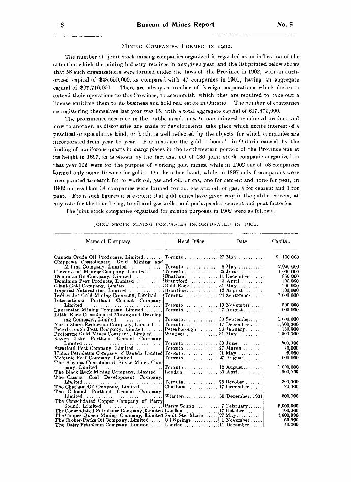
MINING COMPANIES FORMED IN 1902.
The number of joint stock mining companies organized is regarded as an indication of the attention which the mining industry receives in any given year, and the list printed below shows that 58 such organizations were formed under the laws of the Province in 1902, with an authorized capital of $48,650,000, as compared with 47 companies in 1901, having an aggregate capital of $27,716,000. There are always a number of foreign corporations which desire to extend their operations to this Province, to accomplish which they are required to take out a license entitling them to do business and hold real estate in Ontario. The number of companies so registering themselves last year was 15, with a total aggregate capital of $17,375,000.
The prominence accorded in the public mind, now to one mineral or mineral product and now to another, as discoveries are made or developments take place which excite interest of a practical or speculative kind, or both, is well reflected by the objects for which companies are incorporated from year to year. For instance the gold "boom" in Ontario caused by the finding of auriferous quartz in many places in the northwestern portion of the Province was at its height in 1897, as is shown by the fact that out of 136 joint stock companies organized in that year 102 were for the purpose of working gold mines, while in 1902 out of 58 companies formed only some 15 were for gold. On the other hand, while in 1897 only 6 companies were incorporated to search for or work oil, gas and oil, or gas, one for cement and none for peat, in 1902 no less than 18 companies were formed for oil, gas and oil, or gas, 4 for cement and 3 for peat. From such figures it is evident that gold mines have given way in the public esteem, at any rate for the time being, to oil and gas wells, and perhaps also cement and peat factories.
The joint stock companies organized for mining purposes in 1902 were as follows :
JOINT STOCK MINING COMPANIES INCORPORATED IN 1902.
Name of Company.
and Canada Crude Oil Producers, Limited... Chippewa Consolidated Gold Mining
Milling Company, Limited. .. . . . Clover Leaf Mining Company, Limited. . Dominion Oil Company, Limited Dominion Peat Products, Limited Giant Gold Company, Limited Imperial Natural Gas, Limited Indian Joe Gold Mining Company, Limited... International Portland Cement Company,
Limited Laurentian Mining Company, Limited Little Rock Consolidated Mining and Develop
ing Companv, Limited North Shore Reduction Company, Limited .. Peterborough Peat Company, Limited Protogene Gold Mines Company, Limited. .. Raven Lake Portland Cement Company,
Limited Stratford Peat Company, Limited Union Petroleum Companv of Canada, Limited Volcanic Reef Company, Limited The Algcima Consolidated Silver Mines Com
pany. Limited . . . . . The Black Rock Mining Company, Limited. The Cassiar Coal Development Company,
Limited The Chatham Oil Company, Limited The Colonial Portland Cement Company,
Limited The Consolidated Copper Company of Parry
Sound, Limited The Consolidated Petroleum Company, Limited The Copper Queen Mining Company, Limited The Croker-Parks Oil Company, Limited The Daisy Petroleum Company, Limited
Head Office. Date.
Toronto Toronto Toronto Chatham Brantford Gold Rock 31 May Brantford 12 August . . . Toronto 24 September.
27 May
8 May 25 June 11 December 3 April
Toronto. Toronto.
19 November 27 August...
Toronto 30 September. Toronto 17 December . Peterborough 23 January . . . Windsor . 31 May
Toronto 30 June Toronto 27 March . Toronto 31 May . . . Toronto .. 27 August.
Toronto 12 August. London 30 April . Toronto.. Chatham
Wiarton.
Parry Sound London Sault Ste. Marie. Oil Springs London
25 October . 17 December
30 December, 1901
7 February., 17 October .., 27 May
1 November ill December
Capital.
S 100,000 2,000.000 1.000,000
850,000 1 no, 000 700,000 100,000
1,000,000 500,000
1,000,000
1,000,000 1,500,000
150,000 1,500,000
500,000 40,000 25,000
1,000.000
1,000,000 1,500,000
300,000 20,000
800,000
5,000,000 100,000
3,000,000 50,000 40,000
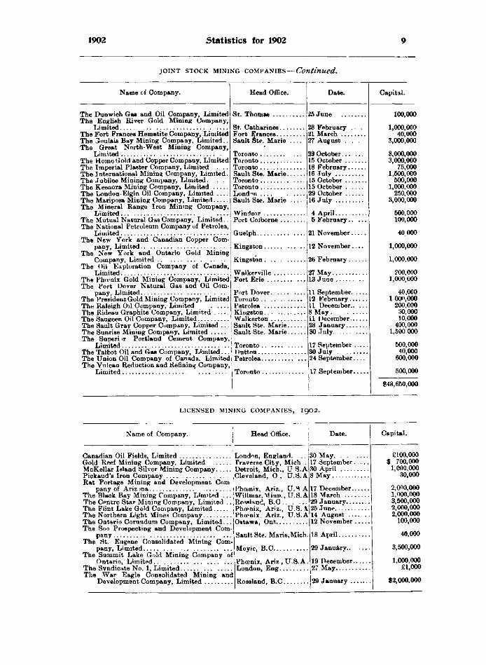
1902 Stat is t ics for 1902 9
j o i n t s t o c k m i n i n g c o m p a n i e s — C o n t i n u e d .
Name of Company.
The Dunwich Gas and Oil Company, Limited The English River Gold Mining Company,
Limited The Fort Frances Hematite Company, Limited The Gloulais Bay Mining Company, Limited.. The Great North-West Mining Company,
Limited The Home Gold and Copper Company, Limited The Imperial Plaster Company, Limited .. The International Mining Company, Limited. The Jubilee Mining Company, Limited. . . The Keenora Mining Company, Limited The London-Elgin Oil Company, Limited The Mariposa Mining Company, Limited The Mineral Range Iron Mining Company,
Limited... The Mutual Natural Gas Company, Limited.. The National Petroleum Company of Petrolea,
Limited The New York and Canadian Copper Com
pany, Limited The New York and Ontario Gold Mining
Company, Limited The Oil Exploration Company of Canada,
Limited The Phoenix Gold Mining Company, Limited The Port Dover Natural Gas and Oil Com
pany, Limited The President Gold Mining Company, Limited The Raleigh Oil Company, Limited . . The Rideau Graphite Company, Limited . . The Saugeen Oil Company, Limited The Sault Gray Copper Company, Limited The Sunrise Mining Company, Limited . . . The Superior Portland Cement Company,
Limited The Talbot Oil and Gas Company, Limited... The Union Oil Company of Canada, Limited The Vulcan Reduction and Refining Company,
Limited
Head Office.
St. Thomas
St. Catharines Fort Frances Sault Ste. Marie ..
Toronto Toronto Toronto Sault Ste. Marie.., Toronto Toronto London . . . . . , Sault Ste. Marie .
Windsor Port Colborne Guelph....
Kingston.
Kingston.
Walkerville Fort Erie . .
Port Dover Toronto . . . . . . . . . Petrolea Kingston Walkerton Sault Ste. Marie. Sault Ste. Marie.
Toronto . I >uttnn.. Petrolea.
28 February 21 March . . . 27 August .
29 October... 15 October .. 18 February. 16 July 15 October .. 15 October . 29 October . 16 July . . . .
27 May 13 June 11 September. 12 February.. 11 December.. 8 May. .. . 11 December.. 28 January... 30 July
17 September . 30 July 24 September.
Toronto 17 September
25 June
4 April
6 February..
21 November.
12 November.
26 February..
L I C E N S E D MINING C O M P A N I E S , I 9 O 2 .
Name of Company.
Canadian Oil Fields, Limited Gold Reef Mining Company, Limited McKellar Island Silver Mining Company Pickaud'8 Iron Company Rat Portage Mining and Development Com
pany of Ariz ma The Black Bay Mining Company, Limited . . . The Centre Star Mining Company, Limited .. The Flint Lake Gold Company, Limited The Northern Light Mines Company The Ontario Corundum Company, Limited... The Soo Prospecting and Development Com
pany The St. Eugene Consolidated Mining Com
pany, Limited The Summit Lake Gold Mining Company of
Ontario, Limited The Syndicate No. 1, Limited The War Eagle Consolidated Mining and
Development Company, Limited
London, England. .130 May. Traverse City, Mich..Il7 September. Detroit, Mich., U S.A 30 April Cleveland, O , U.S. A 8 May .
Phoenix, Ariz., U.S A Willmar.Minn.,U.S.A Rowland, B.C Phoenix, Ariz., U.S. A Phoenix. Ariz., U.S.A Ottawa, Ont.
Sault Ste. Marie.Micb.
Moyie, B.C
Phoenix, Ariz , U.S. A London, Eng
Rossland, B.C.
17 December. 18 March 29 January... 25 June. 14 August .. 12 November
18 April
29 January..
19 December. 27 May
29 January ..
40,000
3,500,000
1,000,000 £1,000
$2,000,000
10 BUREAU OF MINES REPORT NO. 5
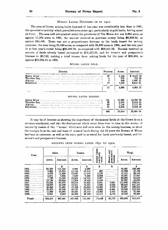
M i n i n g L a n d s D i s p o s e d o f i n 1902.
The area of Crown mining lands disposed of last year was considerably less than in 1901, the speculative activity which prevailed some years ago, particularly in gold lands, having spent its force. The area sold and granted under the provisions of The Mines Act was 3,985 acres, as against 11,302 acres in 1901, the amount received as purchase money being $8,202.52, as against $24,865. There was not a proportionate decrease in the lands leased for mining purposes, the area being 25,549 acres, as compared with 28,699 acres in 1901, and the sum paid in as first year's rental being $25,288.38, as compared with $28,411.52. Rentals received on account of lands already leased amounted to $14,171.05, and for miner's and prospector's licenses to $2,742, making a total income from mining lands for the year of $50,404, as against $70,904.51 in 1901.
m i n i n g l a n d s s o l d .
District. Number. Acres. Amount.
Rainy River 27 6 7
17
57
1,104 376 830
1,675
3,985
$ 2,548 50 752 00
1,285 37 3,616 65
Algoma Elsewhere
27 6 7
17
57
1,104 376 830
1,675
3,985
$ 2,548 50 752 00
1,285 37 3,616 65
Algoma Elsewhere
27 6 7
17
57
1,104 376 830
1,675
3,985 8,202 52
MINING L A N D S L E A S E D .
Elsewhere
101 26 53 21
10,369 2,450 7,138 5,592
10,368 50 2,450 25 7,117 20 5,352 43
101 26 53 21
10,369 2,450 7,138 5,592
10,368 50 2,450 25 7,117 20 5,352 43
200 25,549 25,288 38
It may be of interest as showing the importance of the mineral lands of the Crown from a revenue standpoint, and also the fluctuations which occur from time to time in this source of income by reason of the " booms" which ever and anon arise in the mining business, to show the receipts from the sale and lease of mineral lands during the 12 years the Bureau of Mines has been in existence, as well as the sums paid in as rental for lands previously leased, and for miner's and prospector's licenses.
R E C E I P T S F R O M MINING L A N D S 1891 T O 1902.
Year. Sales. Leases.
Ren
tal
leas
es
prev
ious
ly
issu
ed.
Min
er's
and
pr
ospe
ctor
's | l
icen
ses.
Total. Year.
Acres. Amount. Acres. Amount.
Ren
tal
leas
es
prev
ious
ly
issu
ed.
Min
er's
and
pr
ospe
ctor
's | l
icen
ses.
Acres. Amount.
1891 59,389 6,200 4,370 3,271 7,720
10,733 29,795 19,529 35,049 30,972 11,302 3,985
$ 117,154 15,273 11,498 7,646
15,868 22,084 59,478 40,469 75,367 69,196 24,865 8,203
4,998 13,122 13,047 7,050
15,084 13,224 86,014 48,911 63 258 28,127 28,699 25,549
$ 4,886
12,314 11,934 6,489
14,924 13,498 84,821 48,064 63,000 27,971' 28,412 25 288
$ 64,387 19,322 17,417 10,321 22,804 23,957
115,809 68,440 98,307 59,099 40,001 29,534
569,398
$ 122,400 28,190 26,168 17,943 34,079 40,588
J 53,561 101,187 156,954 112,294 70,905 50,404
1892 59,389 6,200 4,370 3,271 7,720
10,733 29,795 19,529 35,049 30,972 11,302 3,985
$ 117,154 15,273 11,498 7,646
15,868 22,084 59,478 40,469 75,367 69,196 24,865 8,203
4,998 13,122 13,047 7,050
15,084 13,224 86,014 48,911 63 258 28,127 28,699 25,549
$ 4,886
12,314 11,934 6,489
14,924 13,498 84,821 48,064 63,000 27,971' 28,412 25 288
603 2,736 3,808 3,287 5,006 6,241 9,430
12,608 8,326
13,223 14.171
79,43t
64,387 19,322 17,417 10,321 22,804 23,957
115,809 68,440 98,307 59,099 40,001 29,534
569,398
$ 122,400 28,190 26,168 17,943 34,079 40,588
J 53,561 101,187 156,954 112,294 70,905 50,404
1893 1894
59,389 6,200 4,370 3,271 7,720
10,733 29,795 19,529 35,049 30,972 11,302 3,985
$ 117,154 15,273 11,498 7,646
15,868 22,084 59,478 40,469 75,367 69,196 24,865 8,203
4,998 13,122 13,047 7,050
15,084 13,224 86,014 48,911 63 258 28,127 28,699 25,549
$ 4,886
12,314 11,934 6,489
14,924 13,498 84,821 48,064 63,000 27,971' 28,412 25 288
603 2,736 3,808 3,287 5,006 6,241 9,430
12,608 8,326
13,223 14.171
79,43t
64,387 19,322 17,417 10,321 22,804 23,957
115,809 68,440 98,307 59,099 40,001 29,534
569,398
$ 122,400 28,190 26,168 17,943 34,079 40,588
J 53,561 101,187 156,954 112,294 70,905 50,404
1895 , 1896
59,389 6,200 4,370 3,271 7,720
10,733 29,795 19,529 35,049 30,972 11,302 3,985
$ 117,154 15,273 11,498 7,646
15,868 22,084 59,478 40,469 75,367 69,196 24,865 8,203
4,998 13,122 13,047 7,050
15,084 13,224 86,014 48,911 63 258 28,127 28,699 25,549
$ 4,886
12,314 11,934 6,489
14,924 13,498 84,821 48,064 63,000 27,971' 28,412 25 288
603 2,736 3,808 3,287 5,006 6,241 9,430
12,608 8,326
13,223 14.171
79,43t
64,387 19,322 17,417 10,321 22,804 23,957
115,809 68,440 98,307 59,099 40,001 29,534
569,398
$ 122,400 28,190 26,168 17,943 34,079 40,588
J 53,561 101,187 156,954 112,294 70,905 50,404
1897
1899 1900 1901 1902
Totals
59,389 6,200 4,370 3,271 7,720
10,733 29,795 19,529 35,049 30,972 11,302 3,985
$ 117,154 15,273 11,498 7,646
15,868 22,084 59,478 40,469 75,367 69,196 24,865 8,203
4,998 13,122 13,047 7,050
15,084 13,224 86,014 48,911 63 258 28,127 28,699 25,549
$ 4,886
12,314 11,934 6,489
14,924 13,498 84,821 48,064 63,000 27,971' 28,412 25 288
603 2,736 3,808 3,287 5,006 6,241 9,430
12,608 8,326
13,223 14.171
79,43t
3,021 3,224 4,979 6,801 4,405 2,742
64,387 19,322 17,417 10,321 22,804 23,957
115,809 68,440 98,307 59,099 40,001 29,534
569,398
$ 122,400 28,190 26,168 17,943 34,079 40,588
J 53,561 101,187 156,954 112,294 70,905 50,404
1897
1899 1900 1901 1902
Totals 222,315 467,461 347,083 341,601
603 2,736 3,808 3,287 5,006 6,241 9,430
12,608 8,326
13,223 14.171
79,43t 25,172
64,387 19,322 17,417 10,321 22,804 23,957
115,809 68,440 98,307 59,099 40,001 29,534
569,398 913,673
1902 Statist ics for 1902 11
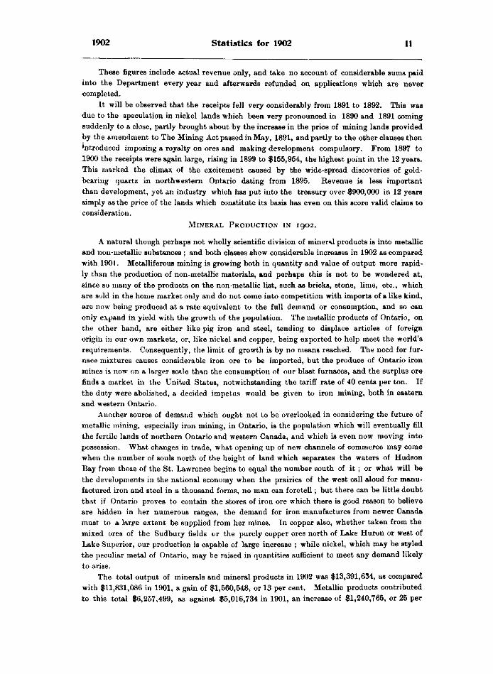
These figures include actual revenue only, and take no account of considerable sums paid into the Department every year and afterwards refunded on applications which are never completed.
It will be observed that the receipts fell very considerably from 1891 to 1892. This was due to the speculation in nickel lands which been very pronounced in 1890 and 1891 coming suddenly to a close, partly brought about by the increase in the price of mining lands provided by the amendment to The Mining Act passed in May, 1891, and partly to the other clauses then *ntroduced imposing a royalty on ores and making development compulsory. From 1897 to 1900 the receipts were again large, rising in 1899 to $155,954, the highest point in the 12 years. This marked the climax of the excitement caused by the wide-spread discoveries of gold-bearing quartz in northwestern Ontario dating from 1895. Revenue is less important than development, yet an industry which has put into the treasury over $900,000 in 12 years simply as the price of the lands which constitute its basis has even on this score valid claims to consideration.
M i n e r a l P r o d u c t i o n i n 1902.
A natural though perhaps not wholly scientific division of mineral products is into metallic and non-metallic substances ; and both classes show considerable increases in 1902 as compared with 1901. Metalliferous mining is growing both in quantity and value of output more rapidly than the production of non-metallic materials, and perhaps this is not to be wondered at, since so many of the products on the non-metallic list, such as bricks, stone, lime, etc., which are sold in the home market only and do not come into competition with imports of a like kind, are now being produced at a rate equivalent to the full demand or consumption, and so can only expand in yield with the growth of the population. The metallic products of Ontario, on the other hand, are either like pig iron and steel, tending to displace articles of foreign origin in our own markets, or, like nickel and copper, being exported to help meet the world's requirements. Consequently, the limit of growth is by no means reached. The need for furnace mixtures causes considerable iron ore to be imported, but the produce of Ontario iron mines is now on a larger scale than the consumption of our blast furnaces, and the surplus ore finds a market in the United States, notwithstanding the tariff rate of 40 cents per ton. If the duty were abolished, a decided impetus would be given to iron mining, both in eastern and western Ontario.
Another source of demand which ought not to be overlooked in considering the future of metallic mining, especially iron mining, in Ontario, is the population which will eventually fill the fertile lands of northern Ontario and western Canada, and which is even now moving into possession. What changes in trade, what opening up of new channels of commerce may come when the number of souls north of the height of land which separates the waters of Hudson Bay from those of the St. Lawrence begins to equal the number south of it ; or what will be the developments in the national economy when the prairies of the west call aloud for manufactured iron and steel in a thousand forms, no man can foretell; but there can be little doubt that if Ontario proves to contain the stores of iron ore which there is good reason to believe are hidden in her numerous ranges, the demand for iron manufactures from newer Canada must to a lar^e extent be supplied from her mines. In copper also, whether taken from the mixed ores of the Sudbury fields or the purely copper ores north of Lake Huron or west of Lake Superior, our production is capable of large increase ; while nickel, which may be styled the peculiar metal of Ontario, may be raised in quantities sufficient to meet any demand likely to arise.
The total output of minerals and mineral products in 1902 was $13,391,634, as compared with $11,831,086 in 1901, a gain of $1,560,548, or 13 per cent. Metallic products contributed to this total $6,257,499, as against $5,016,734 in 1901, an increase of $1,240,765, or 25 per
12 BUREAU OF MINES REPORT NO. 5
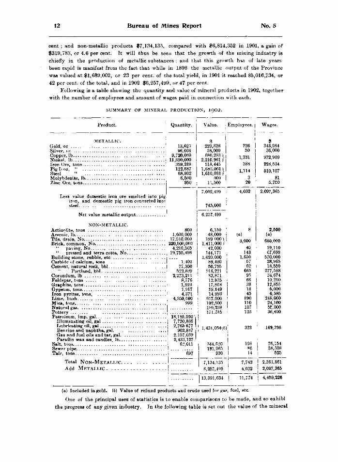
CENT ; AND NON-METALLIC PRODUCTS $7,134,135, COMPARED WITH $6,814,352 IN 1901, A GAIN OF $319,783, OR 4.6 PER CENT. IT WILL THUS BE SEEN THAT THE GROWTH OF THE MINING INDUSTRY IS CHIEFLY IN THE PRODUCTION OF METALLIC SUBSTANCES ; AND THAT THIS GROWTH HAS OF LATE YEARS BEEN RAPID IS MANIFEST FROM THE FACT THAT WHILE IN 1898 THE METALLIC OUTPUT OF THE PROVINCE WAS VALUED AT $1,689,002, OR 23 PER CENT, OF THE TOTAL YIELD, IN 1901 IT REACHED $5,016,734, OR 42 PER CENT, OF THE TOTAL, AND IN 1902 $6,257,499, OR 47 PER CENT.
FOLLOWING IS A TABLE SHOWING THE QUANTITY AND VALUE OF MINERAL PRODUCTS IN 1902, TOGETHER WITH THE NUMBER OF EMPLOYEES AND AMOUNT OF WAGES PAID IN CONNECTION WITH EACH.
SUMMARY OF MINERAL PRODUCTION, 1902.
Product.
METALLIC. Gold, oz Silver, oz Copper, lb Nickel, lb Iron Ore, tons.. Pig lion, " .. Steel " . Molybdenite, lb. Zinc Ore, tons..
Quantity. I Value. Employees. Wages.
Less value domestic iron ore smelted into pig iron, and domestic pig iron converted into steel.
Net value metallic output.
13,625 96,666
9,720,000 11,890,000
359,288 112,687 68,802 6,500
950
229,828 58,000
680,283) ,210,961 / 518,445 ,683,051) ,610,031 /
400 11,500
NON-METALLIC. Actinolite, tons 800 Arsenic, lb 1,600,000 Tile, drain, No 17,510,000 Brick, common, No 220,500,000
" paving, No 4,210,565 " pressed and terracotta, No 19,755,496
Building stone, rubble, etc . Carbide of calcium, tons 1.402 Cement, natural rock, bbl I 77,300
Portland, bbl 522,899 Corundum, lb ! 2,273,211 Feldspar, tons J 8,776 Graphite, tons I 1,923 Gypsum, tons I 1,917 Iron pvrites, tons , I 4,371 Lime, bush I 4,300,000 Mica, tons 999 Natural gas. J Pottery J Petroleum, imp. gal ! 18,185,592'i
" 7 , 7 2 0 , 8 6 6 2,765 677 1
902,847 j 2,157,039 2,433,127 J
62,011
Illuminating oil, gal Lubricating oil, gal Benzine and naphtha, gal. Gas AND fuel oils and tar, gal. Paraffin wax and candles, lb..
Salt, ton 8. Sewer pipe Talc, tons 697
Total NON-METALLIC. Add METALLIC
7,002,499
745,000
6,257,499
6, 48,
199 1,411
42 144
1,020, 89, 50,
916, 83, 12. 17, 19 14
617 102 199 171
150 000 000 \ ,000 I 000 171 000 420 795 221 871 875 868 ,149 993 ,000 ,500 ,238 ,315
726 50
9 343,984 36,000
1,731 972,909 388 228,534
1,114 510,107 3
20 81
5.7C0
4,032 2.097,365
(a) 3,000
40 143
1,650 57 62
665 95 66 38 18 45
890 110 107 135
2,500 (a)
660,000 19,110 67,699
570,000 28,965 18,550
277,588 34,674 10.250 12,855 5,000 6,585
248,000 24,100 55,000 36,400
1,431,054(6) 323 168,398
344,620 191,965
930
198 86 14
76,154 38,508
525
7,134,135 7,742 2,361,861 6,257,499 4,032 2,097,365
13,391,634 11,774 4,459,226
(A) INCLUDED IN GOLD. (6) VALUE OF REFINED PRODUCTS AND CRUDE USED FOR GAS, FUEL, ETC. ONE OF THE PRINCIPAL USES OF STATISTICS IS TO ENABLE COMPARISONS TO BE MADE, AND b o EXHIBI
THE PROGRESS OF ANY GIVEN INDUSTRY. IN THE FOLLOWING TABLE IS SET OUT THE VALUE OF THE MINERAL
1902 Stat is t ics for 1902 13
production of Ontario during each of the last five years, from which it will be seen that steady growth has characterized the industry during that period.
T A B L E S H O W I N G M I N E R A L P R O D U C T I O N 1898 T O 1902.
P r o d u c t . 1898 1899 1900 1901 1902
Metallic— G«'d
Steel
$ 275,078 51,960
268,080 514,220 48,875
530,789
$ 424,568 65,575
176,237 526,104 80,951
808,157
$ 297,861 96,367
319,681 756.626 111.805 936,066 46,380
$ 244,443 84,830
589,080 1,859.970
174,428 1.701,703
347,280
$ 229,828 58,000
680,283 2,210,961
518.445 1,683,051 1,610,031
400 Molybdenite
$ 297,861 96,367
319,681 756.626 111.805 936,066 46,380
$ 244,443 84,830
589,080 1,859.970
174,428 1.701,703
347,280
$ 229,828 58,000
680,283 2,210,961
518.445 1,683,051 1,610,031
400 24,000 500 15,000 11,500 24,000 500 15,000 11,500
Less value domestic iron orn smelted into pig iron, and domestic pig iron converted into steel.
1,689,002 2,«55,t92 2,565,286 5,016,734 7,002,499
745,000 Total Metallic . 1,689,002 2,055.592 2.565.286 5,016,734 6.257,499
Product.
Non-Metallic— ActiDolite Areenic Brick, common
" paving " pressed and terra cotta
Building stone, rubble, etc .. Carbide of calcium Cment, natural rock
• * Portland Corundum Feldspar Graphite Gypsum Iron pyrites Lime Mica Natural gas Pottery Petroleum products Salt Sewer pipe Talc Tile, drain
Total Non-metallic Add Metallic
Total production.
1898. 1899.
914,000 100,344' 750,000 55,976 74,222
302,096
6,000 4,000
308.000 7,500
301,600 155,000
1,970,534 278,886 93,717
225,000 5,546,875 1,689,002
7,235,877
4,842 1,318,750
42.550 105,000 667,532 74,680
117,039 444,227
16,179 16,512
535,666' 38,000
440,904 101,000
1,747,352 317,412 138,356
500 240,246
1900.
6.361,081 2,055,592
8,416,673
22,725 1,379,590
26,950 114,419 650,342 60,300 99,994
598,021 6,000 5,000
27 030 18,050
544,000 91,750
392,823 157,449
1,869,045 324,477 130,635
5,000 209,738
6.733,338 2,565,386
9,298,624
1901.
3,126 41,677
1,530,460 37,000
104,394 850,000 168.792 107,6 5 563,255 53,115 6.375
20,000 13,400 17,500
550,000 39.780
342,183 193,960
1,467,940 323,058 147,948
1,400 231,374
6.814,352 5,016,734
1902.
11 831,086
For an exact comparison deductions from the value of the metallic output similar to those made from that for 1902 should be made in the case of the previous years, but as it is the table tells a story of constant, even notable, advance. An increase of 87 per cent, in five years cannot but be considered satisfactory.
Another feature of interest is the growing list of minerals produced in the Province. Ontario contains within her borders a wide and varied range of mineral substances utilized in the industries of modern life, and one by one those formerly lying dormant are being sought out and brought into use. For example, the metallic products in 1898 numbered six, while in 1902 they were nine ; zinc ore and molybdenite having meanwhile been added, and the manufacture of iron ores having been brought to the steel-making stage. In 1898 16 non-metallic minerals and products stood at the credit of the mines and works of the Province, while in 1902, by the
14 Bureau of Mines Report No. 5
ADDITION OF ACTINOLITE, ARSENIC, PAVING BRICK, CORUNDUM, FELDSPAR, IRON PYRITES AND TALC, THE LIST HAD GROWN TO 23. NOR ARE THESE ADDITIONS UNIMPORTANT OF NON-METALLIC SUBSTANCES ALONE NOT RAISED IN 1898, $208,819 WORTH WERE PRODUCED IN 1902, AND SEVERAL OF THEM GIVE PROMISE OF PROVIDING MATERIAL FOR INDUSTRIES OF CONSIDERABLE EXTENT.
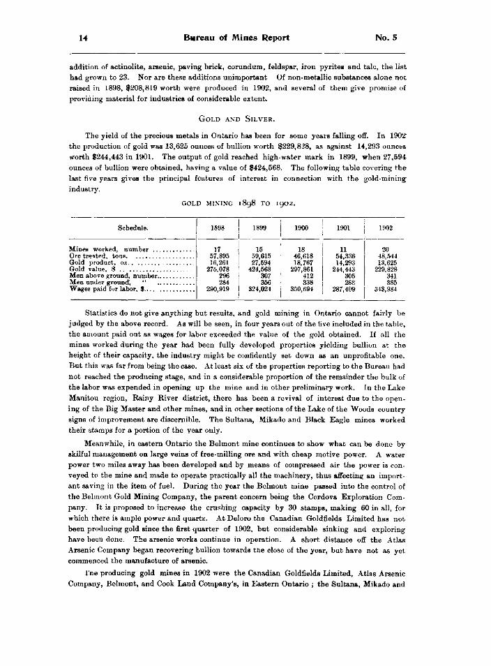
G o l d a n d S i l v e r .
THE YIELD OF THE PRECIOUS METALS IN ONTARIO HAS BEEN FOR SOME YEARS FALLING OFF. IN 1902" THE PRODUCTION OF GOLD WAS 13,625 OUNCES OF BULLION WORTH $229,828, AS AGAINST 14,293 OUNCES WORTH $244,443 IN 1901. THE OUTPUT OF GOLD REACHED HIGH-WATER MARK IN 1899, WHEN 27,594 OUNCES OF BULLION WERE OBTAINED, HAVING A VALUE OF $424,568. THE FOLLOWING TABLE COVERING THE LAST FIVE YEARS GIVES THE PRINCIPAL FEATURES OF INTEREST IN CONNECTION WITH THE GOLD-MINING INDUSTRY.
G O L D MINING 1898 T O 1902.
Schedule. 1898 1899 | 1900 1901 1902
Gold value, $ ..
17 57,895 16,261
275,078 296 284
290,919
15 59,615 27,694
424,568 307 356
324,024
18 46,618 18,767
297,861 412 338
350,694
11 54,336 14,293
244,443 305 288
287,409
20 48,544 13,625
229,828 341 385
343,984
STATISTICS DO NOT GIVE ANYTHING BUT RESULTS, AND GOLD MINING IN ONTARIO CANNOT FAIRLY BE JUDGED BY THE ABOVE RECORD. AS WILL BE SEEN, IN FOUR YEARS OUT OF THE FIVE INCLUDED IN THE TABLE, THE AMOUNT PAID OUT AS WAGES FOR LABOR EXCEEDED THE VALUE OF THE GOLD OBTAINED. IF ALL THE MINES WORKED DURING THE YEAR HAD BEEN FULLY DEVELOPED PROPERTIES YIELDING BULLION AT THE HEIGHT OF THEIR CAPACITY, THE INDUSTRY MIGHT BE CONFIDENTLY SET DOWN AS AN UNPROFITABLE ONE. BUT THIS WAS FAR FROM BEING THE CASE. AT LEAST SIX OF THE PROPERTIES REPORTING TO THE BUREAU HAD NOT REACHED THE PRODUCING STAGE, AND IN A CONSIDERABLE PROPORTION OF THE REMAINDER THE BULK OF THE LABOR WAS EXPENDED IN OPENING UP THE MINE AND IN OTHER PRELIMINARY WORK. IN THE LAKE MANITOU REGION, RAINY RIVER DISTRICT, THERE HAS BEEN A REVIVAL OF INTEREST DUE TO THE OPENING OF THE BIG MASTER AND OTHER MINES, AND IN OTHER SECTIONS OF THE LAKE OF THE WOODS COUNTRY SIGNS OF IMPROVEMENT ARE DISCERNIBLE. THE SULTANA, MIKADO AND BLACK EAGLE MINES WORKED THEIR STAMPS FOR A PORTION OF THE YEAR ONLY.
MEANWHILE, IN EASTERN ONTARIO THE BELMONT MINE CONTINUES TO SHOW WHAT CAN BE DONE BY SKILFUL MANAGEMENT ON LARGE VEINS OF FREE-MILLING ORE AND WITH CHEAP MOTIVE POWER. A WATER POWER TWO MILES AWAY HAS BEEN DEVELOPED AND BY MEANS OF COMPRESSED AIR THE POWER IS CONVEYED TO THE MINE AND MADE TO OPERATE PRACTICALLY ALL THE MACHINERY, THUS AFFECTING AN IMPORTANT SAVING IN THE ITEM OF FUEL. DURING THE YEAR THE BELMONT MINE PASSED INTO THE CONTROL OF THE BELMONT GOLD MINING COMPANY, THE PARENT CONCERN BEING THE CORDOVA EXPLORATION COMPANY. IT IS PROPOSED TO INCREASE THE CRUSHING CAPACITY BY 30 STAMPS, MAKING 60 IN ALL, FOR WHICH THERE IS AMPLE POWER AND QUARTZ. AT DELORO THE CANADIAN GOLDFIELDS LIMITED HAS NOT BEEN PRODUCING GOLD SINCE THE FIRST QUARTER OF 1902, BUT CONSIDERABLE SINKING AND EXPLORING HAVE BEEN DONE. THE ARSENIC WORKS CONTINUE IN OPERATION. A SHORT DISTANCE OFF THE ATLAS ARSENIC COMPANY BEGAN RECOVERING BULLION TOWARDS THE CLOSE OF THE YEAR, BUT HAVE NOT AS YET COMMENCED THE MANUFACTURE OF ARSENIC.
I'RIE PRODUCING GOLD MINES IN 1902 WERE THE CANADIAN GOLDFIELDS LIMITED, ATLAS ARSENIC COMPANY, BELMONT, AND COOK LAND COMPANY'S, IN EASTERN ONTARIO ; THE SULTANA, MIKADO AND
1902 Stat is t ics for 1902 15
BLACK EAGLE, ON LAKE OF THE WOODS ; THE BIG MASTER AND TWENTIETH CENTURY, IN THE MANITOU DISTRICT ; THE ENGLISH RIVER GOLD MINING COMPANY, STURGEON LAKE ; THE SAKOOSE, NEAR DYMENT STATION, AND THE GRACE IN THE MICHIPICOTON MINING DIVISION. AT THE CLOSE OF THE YEAR STAMP MILLS WERE BEING INSTALLED AT THE ELIZABETH MINE NEAR ATIKOKAN STATION AND AT THE MANXMAN IN THE MICHIPICOTON MINING DIVISION.
A N G L O - C A N A D I A N G O L D E S T A T E S , L I M I T E D .
THE LICENSE OF OCCUPATION GRANTED TO THE ANGLO-CANADIAN GOLD ESTATES, LIMITED, CONFERRING ON THE COMPANY THE EXCLUSIVE RIGHT OF PROSPECTING FOR MINERALS IN CERTAIN AREAS OF LAND IN THE RAINY RIVER DISTRICT WHICH REQUIRED THE COMPANY TO EXPEND IN EXPLORATION AND MINING NOT LESS THAN $120,000 IN THREE YEARS EXPIRED 31ST DECEMBER, 1902. THE OBLIGATIONS IMPOSED BY THE LICENSE AS TO EXPENDITURE WERE FULLY MET BY THE COMPANY, BUT THE LATTER FOUND THE TIME TOO SHORT TO THOROUGHLY EXAMINE ALL THE TERRITORY, AND ACCORDINGLY APPLIED FOR AN EXTENSION OF TIME SO FAR AS BLOCK 4, OTHERWISE THE DICK AND BANNING TIMBER LIMIT, SOUTH OF CALM LAKE, WAS CONCERNED. AN ADDITIONAL YEAR FOR THIS PURPOSE WAS ACCORDINGLY GIVEN, ON THE COMPANY AGREEING TO EXPEND $30,000 OVER AND ABOVE THE AMOUNT PROVIDED IN THE LICENSE. ONE OF THE DEPOSITS DISCOVERED BY THE COMPANY HAS BEEN DEVELOPED INTO THE ELIZABETH GOLD MINE, WHICH HAS COMMENCED TURNING OUT BULLION SINCE THE BEGINNING OF 1903. SPEAKING OF THE OPERATIONS OF THE COMPANY DURING 1902, MR. ALAN SULLIVAN, C.E , THE MANAGER, STATES THAT THEY CONSISTED IN THE PARTIAL PROSPECTING OF THE AREAS STILL COVERED BY THE LICENSE OF OCCUPATION, IN THE DEVELOPMENT AND EQUIPMENT OF THE ELIZABETH MINE, AND THE PARTIAL DEVELOPMENT OF THE LAKE STURGEON PROPERTIES. WHILE NO DISCOVERIES OF MARKED VALUE HAD BEEN MADE, THE WORK DONE WAS SUFFICIENT TO SHOW THAT IT WAS IMPOSSIBLE TO THOROUGHLY COVER ALL THE GROUND IN THE TIME AT THE COMPANY'S DISPOSAL, THE SURFACE OF THE ROCK BEING IN MOST PLACES HEAVILY COVERED WITH SOIL AND TIMBER, AND THE SOLID OUTCROPS DIFFICULT TO LOCATE AND INVESTIGATE. ON THE SOUTH AND SOUTHWEST SIDE OF CALM LAKE FLOAT HEMATITE HAD BEEN FOUND, BUT SO FAR IT HAD NOT BEEN ENCOUNTERED IN PLACE EXCEPT IN THE FORM OF SMALL LENSES AND DEPOSITS OF NO COMMERCIAL VALUE. THIS AREA, HOWEVER, APPEARED TO CALL FOR MUCH CLOSER WORK THAN HAD YET BEEN DONE UPON IT, HENCE THE COMPANY'S APPLICATION FOR LONGER TIME TO ENABLE THIS TO BE DONE.
THE ELIZABETH MINE, MR. SULLIVAN CONTINUES, HAS SO FAR JUSTIFIED THE EXPECTATION THAT IT WOULD PROVE A PROFITABLE PROPERTY TO OPERATE, AND THE SYSTEM OF DIAMOND DRILLING WHICH PRECEDED DEVELOPMENT HAD BEEN OF MUCH ASSISTANCE IN SUBSEQUENT WORK. THE LODE IS DEVELOPED BY SHAFTS, WINZES AND LEVELS TO A DEPTH OF 280 FEET AND THE GROSS AMOUNT OF ORE EXPOSED TO DATE (10TH FEBRUARY, 1903) WAS ABOUT 20,000 TONS. THE WIDTH OF THE STOPES VARIES FROM 4 TO 12 FEET, AND WHILE THERE ARE SOME RICH LENSES AND CHUTES OF QUARTZ IN WHICH THE VALUES RISE TO $40 AND $50 A TON, THE AVERAGE VALUE MAY BE TAKEN AT FROM $8 TO $10, WHICH WILL PROBABLY PROVE THE RULING VALUE OF ORE IN THAT FIELD. SURFACE WORK HAS PROVED THE EXISTENCE OF OTHER PAYABLE LODES, BUT SO FAR THESE HAVE ONLY BEEN TESTED IN A PRELIMINARY WAY, THE MAIN OBJECT BEING TO PROVE THE MINE A PROFITABLE PROPOSITION.
LATE IN 1902 A 10-STAMP MILL WAS PURCHASED AND A SMALL BUILDING ERECTED AT THE MINE WITH ROOM FOR 5 STAMPS ADDITIONAL. CONSTRUCTION BEGAN IN NOVEMBER AND FINISHED IN JANUARY. ON 5TH FEBRUARY THE MILL WENT INTO COMMISSION, AND WORKED VERY SATISFACTORILY. IT WAS EXPECTED TO CRUSH 25 TO 30 TONS DAILY. THE STAMPS WEIGH 1050 POUNDS EACH AND DROP 90 TIMES A MINUTE THE HEIGHT OF DROP BEING ABOUT 8 INCHES. A GATES NO. 3 CRUSHER AND TWO FRUE VANNERS WITH 6-FOOT BELTS ARE INSTALLED. THE MILL IS CONNECTED WITH THE MAIN SHAFT-BY A TRAMWAY 350 FEET LONG WITH A GRADE TO THE MILL OF 1 PER CENT., THE CARS DUMPING DIRECTLY OVER THE GRIZZLY INTO THE CRUSHER. THE INNOVATION OF DRIVING THE CAM SHAFT DIRECT FROM THE MILL ENGINE APPEARS TO WORK VERY SATISFACTORILY, AND THERE BEING A SEPARATE ENGINE FOR THE CRUSHER NO TROUBLE IS EXPERIENCED FROM
16 Bureau of Mines Report No. 5
the variation of load. Power is supplied from main boiler house by a 3-inch steam main laid along the tramway, thus saving the use of fireman for mill boiler. The mill is in charge of Mr. Alex Cotter, late mill foreman and head amalgamator at the Sultana mine, his assistant being Mr William Gale, also late of the same mine. Two men only are required in the mill by day, and one at night.
The compressor capacity is 6 drills, furnished by one Rand and one Ingeraoll-Sargeant machine. The boilers give 140 horse power from two locomotive type, one Robb Economic and one Cooper return tubular.
All underground work is in charge of Capt. W. H. Johns, recently underground captain of the Stanley mine, Idaho Springs, Colorado.
It is expected that a force of 35 to 40 men will be sufficient for the ordinary working of the mine, this is to be exclusive of those employed in prospecting and other exploratory work. Buildings to comfortably accommodate 50 men have been erected and good roads have been graded from Rice Lake to the mine.
In road building, dams, landings, docks, etc., a sum of $2,194 has been spent by the Company, the only assistance received from the Government towards this expense being a grant of $400 in 1902. The total expenditure of the Company in the district up to December 31 1902 was $146,809.
On one of the company's Sturgeon Lake locations further stripping and trenching was done and a test pit was put down 30 feet. The pay chute is 500 feet long by 3 feet 6 inches wide, with an average value of $12. It has yielded some remarkably fine samples of coarse gold, and the test pit proved its continuity so far as it went. Another property owned by the company adjoins that now being developed by the Jack Lake Mining Company, and the recent favorable work of the latter leads to the impression that the company's location may be of considerable value.
Development in the Sturgeon Lake district is greatly handicapped by the cost of freighting from the Canadian Pacific Railway, which may be estimated at $40 to $60 a ton. This almost prohibitive cost might be largely reduced by building small and inexpensive tramways across the portages and placing barges on the intervening lakes—a woru to which the mine owners would no doubt contribute.
The amount expended by the Anglo-Canadian Gold Estates during 1902 on the lands comprised in their license of occupation was $68,877, of which the principal items were, plant $10,898, development $18,017, buildings $4,027, board $8,316, stores $5,957, management $3,715, etc.
Mr. Sullivan expresses the opinion that should the operations of the company prove sufficiently and reasonably profitable, they will do much towards a reinstatement of the field in the eyes of the British investing public.
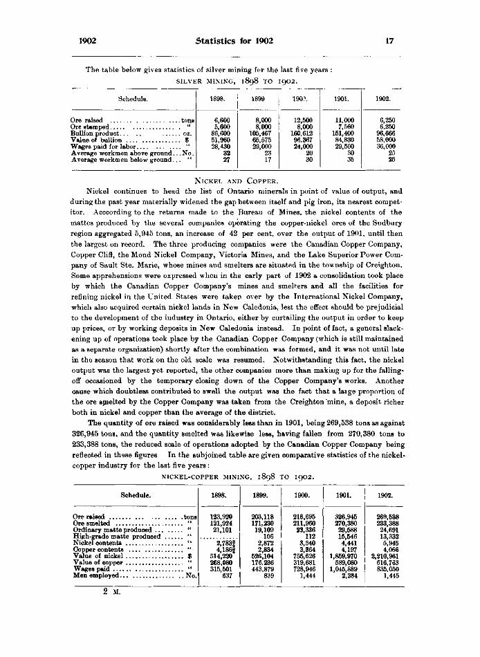
The claim of silver to be considered a precious metal is growing less tenabte as the price continues to fall year by year. The bulk of the world' output of silver now comes from mines worked for lead, copper and other metals, the silver itself being merely a by-product. In the deposits west of Port Arthur, Ontario possesses some of the comparatively few silver mines which are still operated for the sake of that metal alone. The Consolidated Mines Company of Lake Superior, Limited, worked the West End mine during the year for about eight months. The mill was dismantled in September, and additional stamps installed. The property was generally improved and a large compressor plant put in. The Big Master gold mine on Lake Manitou was operated by the same company.
1902 Statistics for 1902 17
The table below gives statistics of silver mining for the last five years : S I L V E R MINING, 1898 T O 1902.
Schedule. 1898. 1899 190?. 1901. 1902.
6,600 8,000 12,500 11,000 6,250 IS 5,600 8,000 8,000 7,560 6.250
Bullion product . OZ. 86,600 105,467 160,612 151,400 96,666 . $ 51,960 65,575 96.367 84,830 58,000
Wages paid for labor u 28,430 29,000 24,000 29,500 36,000 Average workmen above ground. '.No. 32 23 20 .30 25 Average workmen below ground. 27 17 30 35 25
N i c k e l a n d C o p p e r .
Nickel continues to head the list of Ontario minerals in point of value of output, and during the past year materially widened the gap between itself and pig iron, its nearest competitor. Acccording to the returns made to the Bureau of Mines, the nickel contents of the mattes produced by the several companies operating the copper-nickel ores of the Sudbury region aggregated 5,945 tons, an increase of 42 per cent, over the output of 1901, until then the largest on record. The three producing companies were the Canadian Copper Company, Copper Clift, the Mond Nickel Company, Victoria Mines, and the Lake Superior Power Company of Sault Ste. Marie, whose mines and smelters are situated in the township of Creighton. Some apprehensions were expressed when in the early part of 1902 a consolidation took place by which the Canadian Copper Company's mines and smelters and all the facilities for refining nickel in the United States were taken over by the International Nickel Company, which also acquired certain nickel lands in New Caledonia, lest the effect should be prejudicial to the development of the industry in Ontario, either by curtailing the output in order to keep up prices, or by working deposits in New Caledonia instead. In point of fact, a general slackening up of operations took place by the Canadian Copper Company (which is still maintained as a separate organization) shortly after the combination was formed, and it was not until late in the season that work on the old scale was resumed. Notwithstanding this fact, the nickel output was the largest yet reported, the other companies more than making up for the falling-off occasioned by the temporary closing down of the Copper Company's works. Another cause which doubtless contributed to swell the output was the fact that a laige proportion of the ore smelted by the Copper Company was taken from the Creighton mine, a deposit richer both in nickel and copper than the average of the district.
The quantity of ore raised was considerably less than in 1901, being 269,538 tons as against 326,945 tons, and the quantity smelted was likewise less, having fallen from 270,380 tons to 233,388 tons, the reduced scale of operations adopted by the Canadian Copper Company being reflected in these figures. In the subjoined table are given comparative statistics of the nickel-copper industry for the last five years:
N I C K E L - C O P P E R MINING, 1898 T O 1902.
Schedule. 1898. 1899. 1900. 1901. 1902.
123,920 203,118 216,695 326,945 269,538 121,924 171.230 211,960 270,380 233,388
« 21,101 19; 109 23,336 29,588 24,691 High-grade matte produced 106 112 15,546 13,332
2,783| 2,872 3,540 4,441 5,945 4,186| 2,834 3,364 4,197 4,066
. . . $ 514,220 526,104 756,626 1,859.970 2,210,961 ii 268,080 176.236 319,681 589,080 616,763 (t 315,501 443,879 728,946 1,045,889 835,050
637 839 1,444 2,284 1,445
2 M.
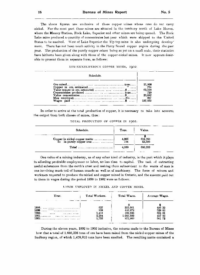
18 Bureau of Mines Report No. 5
THE ABOVE FIGURES ARE EXCLUSIVE OF THOSE COPPER MINES WHOSE ORES DO NOT CARRY NICKEL. FOR THE MOST PART THESE MINES ARE SITUATED IN THE TERRITORY NORTH OF LAKE HURON, WHERE THE MASSEY STATION, ROCK LAKE, SUPERIOR AND OTHER MINES ARE BEING OPENED. THE ROCK LAKE MINE PRODUCED A QUANTITY OF CONCENTRATES LAST YEAR WHICH WERE SHIPPED TO THE UNITED STATES TO BE SMELTED. WEST OF LAKE SUPERIOR THE TIP-TOP MINE IS ALSO UNDERGOING DEVELOP" MENT. THERE HAS NOT BEEN MUCH ACTIVITY IN THE PARRY SOUND COPPER REGION DURING THE PAST YEAR. THE PRODUCTION OF THE PURELY COPPER MINES BEING AS YET ON A SMALL SCALE, THEIR STATISTICS HAVE HITHERTO BEEN GIVEN ALONG WITH THOSE OF THE COPPER-NICKEL MINES. IT NOW APPEARS DESIRABLE TO PRESENT THEM IN SEPARATE FORM, AS FOLLOWS:
N O N - N I C K E L I F E R O U S C O P P E R M I N E S , 1 9 0 2 .
Schedule.
21,800 794
9 63,520 720
^ 28,082 287
Wages paid 9 137,859
IN ORDER TO ARRIVE AT THE TOTAL PRODUCTION OF COPPER, IT IS NECESSARY TO TAKE INTO ACCOUNT THE OUTPUT FROM BOTH CLASSES OF MINES, THUS :
T O T A L P R O D U C T I O N OF C O P P E R IN I 9 0 2 .
Schedule. Tons. Value.
Total
4,066 794
4,860
9 616,763 63,520
680,283
ONE VALUE OF A MINING INDUSTRY, AS OF ANY OTHER KIND OF INDUSTRY, IS THE PART WHICH IT PLAYS IN AFFORDING PROFITABLE EMPLOYMENT TO LABOR, NO LESS THAN TO CAPITAL. THE TASK OF EXTRACTING USEFUL SUBSTANCES FROM THE EARTH'S CRUST AND MAKING THEM SUBSERVIENT TO THE WANTS OF MAN IS ONE INVOLVING MUCH TOIL OF HUMAN MUSCLE AS WELL AS OF MACHINERY. THE FORCE OF MINERS AND WORKMEN REQUIRED TO PRODUCE THE NICKEL AND COPPER MINED IN ONTARIO, AND THE AMOUNT PAID OUT TO THEM IN WAGES DURING THE PERIOD 1898 TO 1902 WERE AS FOLLOWS:
L A B O R E M P L O Y E D IN N I C K E L A N D C O P P E R M I N E S .
Year.
1898 1899 1900 1901 1902
Total Workers.
637 839
1,444 2,284 1,732
Total Waees.
315,501 443.879 728,946
1,045,889 972,909
Average Wages.
$ 495 29 529 05 504 81 457 92 561 72
DURING.THE ELEVEN YEARS, 1892 TO 1902 INCLUSIVE, THE RETURNS MADE TO THE BUREAU OF MINES HOW THAT A TOTAL OF 1,666,336 TONS OF ORE HAVE BEEN RAISED FROM THE NICKEL-COPPER MINES OF THE
SUDBURY REGION, OF WHICH 1,478,810 TONS HAVE BEEN SMELTED. THE RESULTING MATTE CONTAINED a
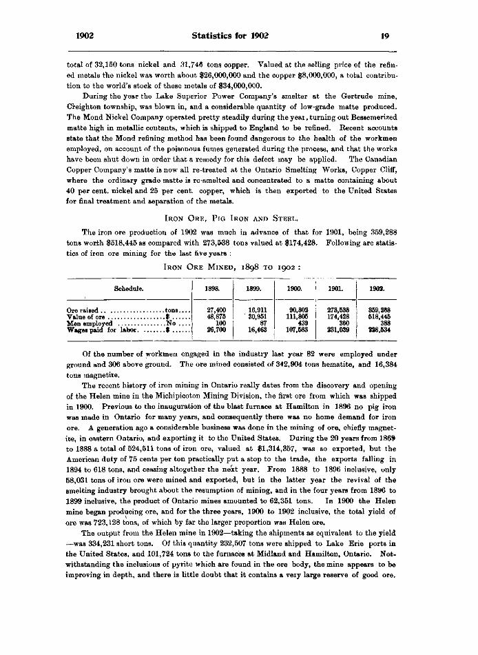
1902 Statistics for 1902 19
total of 32,150 tons nickel and 31,746 tons copper. Valued at the selling price of the refined metals the nickel was worth about $26,000,000 and the copper $8,000,000, a total contribution to the world's stock of these metals of $34,000,000.
During the year the Lake Superior Power Company's smelter at the Gertrude mine, Creighton township, was blown in, and a considerable quantity of low-grade matte produced. The Mond Nickel Company operated pretty steadily during the yeai, turning out Bessemerized matte high in metallic contents, which is shipped to England to be refined. Recent accounts state that the Mond refining method has been found dangerous to the health of the workmen employed, on account of the poisonous fumes generated during the process, and that the works have been shut down in order that a remedy for this defect may be applied. The Canadian Copper Company's matte is now all re-treated at the Ontario Smelting Works, Copper Cliff, where the ordinary grade matte is re-smelted and concentrated to a matte containing about 40 per cent, nickel and 25 per cent, copper, which is then exported to the United States for final treatment and separation of the metals.
I r o n O r e , P i g I r o n a n d S t e e l .
The iron ore production of 1902 was much in advance of that for 1901, being 359,288 tons worth $518,445 as compared with 273,538 tons valued at $174,428. Following are statistics of iron ore mining for the last five years :
I r o n O r e M i n e d , 1898 t o 1902 :
Schedule. 1898. 1899. 1900. 1901. 1902.
27,400 48,875
100 26,700
16,911 30,951
87 16,463
90,302 111,805
439 107,583
273,538 174,428
360 231,039
359,288 518,445
388 228,534 Wages paid for labor. . . .
, No . . . .
27,400 48,875
100 26,700
16,911 30,951
87 16,463
90,302 111,805
439 107,583
273,538 174,428
360 231,039
359,288 518,445
388 228,534
Of the number of workmen engaged in the industry last year 82 were employed under ground and 306 above ground. The ore mined consisted of 342,904 tons hematite, and 16,384 tons magnetite.
The recent history of iron mining in Ontario really dates from the discovery and opening of the Helen mine in the Michipicoton Mining Division, the first ore from which was shipped in 1900. Previous to the inauguration of the blast furnace at Hamilton in 1896 no pig iron was made in Ontario for many years, and consequently there was no home demand for iron ore. A generation ago a considerable business was done in the mining of ore, chiefly magnetite, in eastern Ontario, and exporting it to the United States. During the 20 years from 1869 to 1888 a total of 524,511 tons of iron ore, valued at $1,314,357, was so exported, but the American duty of 75 cents per ton practically put a stop to the trade, the exports falling in 1894 to 618 tons, and ceasing altogether the next year. From 1888 to 1896 inclusive, only 58,031 tons of iron ore were mined and exported, but in the latter year the revival of the smelting industry brought about the resumption of mining, and in the four years from 1896 to 1899 inclusive, the product of Ontario mines amounted to 62,351 tons. In 1900 the Helen mine began producing ore, and for the three years, 1900 to 1902 inclusive, the total yield of ore was 723,128 tons, of which by far the larger proportion was Helen ore.
The output from the Helen mine in 1902—taking the shipments as equivalent to the yield —was 334,231 short tons. Of this quantity 232,507 tons were shipped to Lake Erie ports in the United States, and 101,724 tons to the furnaces at Midland and Hamilton, Ontario. Notwithstanding the inclusions of pyrite which are found in the ore body, the mine appears to be improving in depth, and there is little doubt that it contains a very large reserve of good ore.
20 Bureau of Mines Report No. 5
Four mines in eastern Ontario produced an aggregate of 23,057 tons of ore, some of which went to furnaces in this Province and some to furnaces in Quebec. One of these was the Radnor mine, owned by the Canada Iron Furnace Company, and recently opened in the township of Grattan, Renfrew' county. The ore is magnetite of fair quality, and the indications seem to promise a large deposit. So far the product has been taken to the company's smelters at Radnor Forges, Quebec, but if the expectations formed of the deposit are realized, arrangements may be made by the company to utilize the ore in this Province, either at the Midland furnace or at some point nearer the mine. Other iron ore prospects in the neighborhood are being tested by the same company.
Besides the Helen and Radnor mines already mentioned, the following properties were worked during the year, all in the county of Hastings • the Moore, by Mr. Arthur Coe, Madoc ; the St. Charles, by Stephen Wellington, Madoc, and the Mineral Range, by the Mineral Range Mining Company, L'Amable Station. From the Breitung mine, on the Algoma Central railway, north of Sault Ste Marie, a small quantity of ore was raised in the course of development work.
P R O S P E C T I N G FOR O R E .
The activity in exploring for iron ores spoken of in last year's Report has continued without abatement. Some disappointment has been expressed that up to the present comparatively few deposits of workable ore have been found in the iron ranges of northern and northwestern Ontario, the ascertained extent of which is very great. Allowance must however be made for the difficulties of exploring in the rough country through which the ranges run and the obstacles interposed by the covering of soil and timber. In addition to this, experience on the analogous ranges south of lake Superior proves that large surface outcroppings of ore will be of infrequent occurrence, and that for the most part prospecting must be carried on by the diamond drill. The iron formations in the Michipicoton region have, perhaps been more carefully and systematically explored than in any other district, and several bodies of hematite in addition to the Helen mine have been located, notably those at the Josephine location and Brant lake. American capitalists have for considerably over a year been prospecting for iron ore on the shores of Steep Rock lake on the line of the Canadian Northern, where numerous boulders of first-rate hematite occur, and though borings have given encouraging indications, no important body of ore appears to have yet been struck. Messrs. Hille of Port Arthur and Williams of Kingston have been conducting explorations in the neighborhood of Arrow lake on the Port Arthur, Duluth and Western railway, where the Mesabi iron formation extends from Minnesota into Ontario. Here they have acquired the old Paulison locations laid out many years ago, and have been testing them with the diamond drill.
In the Lake Temagami region outcrops of iron ore banded with jasper were some years ago found by D. O'Connor of Sudbury, who surveyed a number of locations on the northeast arm and elsewhere. Owing to the lands lying within the boundaries of the Temagami Forest Reserve, no title could be procured until recently, when regulations were promulgated authorizing prospecting for minerals and working deposits in the reserve on conditions which will protect the timber, principally pine, to safeguard the magnificent forests of which the reserve was set apart. Mr. O'Connor has interested other parties in these locations, including Mr. T. B. Caldwell of Lanark, and it is understood steps will shortly be taken to test the deposits. The banded ore is mainly magnetite, but hematite has also been found.
In the township of Hutton, northwest of Lake Wahnapitae, a range of rocks containing magnetite with jasper was discovered some two or three years ago. Further exploration on the range has located a body of magnetic ore said to be of considerable dimensions and good quality , so far as freedom from impurities goes, but not especially high in metallic contents. Two diamond drill holes have been boied to a depth of 250 feet, but the results of the borings have
1902 Statistics for 1902 21
not been made public, except that considerable ore has been found containing no injurious percentage of sulphur. A good deal of stripping, test-pitting, cross-cutting, etc., has been done, and a road built into the property from McDonald's lumber camp. In addition, a complete magnetic and geological survey has been made under the direction of Prof. C. K. Leith, of the University of Wisconsin and United States Geological Survey. A short paper on the deposit by Dr. Leith in another portion of this volume will be read with interest. The ore outcrops on the surface in a number of places, and it is believed the shipping ore will average about 60 per cent, metallic iron and about .070 per cent, phosphorus. In*"some places it is very lean, while in others it runs as high as 64 per cent. iron. The work of all kinds done in 1902 cost about $100,000. The property is owned or controlled by Mr. Chase S. Osborne of Sault Ste. Marie, Mich. Much interest has been aroused by the discovery, not only among local prospectors, but also among American ironmasters, and the neighborhood is likely to be the scene of very active prospecting as soon as the season opens. Indeed, a number of prospectors, undeterred by the concealing mantle of snow, to say nothing of the cold, have remained at work all winter, using the dip needle as their guide.
Unless all legitimate inferences drawn from the similarity of geological conditions in the Ontario iron ranges to those of the Mesabi and Vermilion regions south of the line are doomed to be proven fallacious, there is good reason to believe that this Province contains an immense quantity of iron ore, probably much greater than has until recently been suspected. Whether this is the case, or whether as certain authorities are inclined to think, the severer glacial erosion to which some of the Ontario ranges have been subjected, as compared, with those south of (he line, is an inauspicious feature of sufficient moment to neutralize the otherwise favorable conditions for large ore bodies, is not likely to remain many years in doubt. Should the question be decided favorably, the iron mining industry of the Province will without doubt, take on very large proportions.
That part of the iron and steel manufacturing business in the United States which has so far succeeded in remaining outside of the United States Steel Corporation, is beginning to feel that the raw materials upon which its existence absolutely depends, are rapidly passing into the control of their gigantic competitor. Competent authorities state that of the ore reserves in the Mesabi, Gogebic, Vermilion and other known ranges of the Lake Superior district, supposed to contain about 1,000 millions of tons, the United States Steel Corporation now owns 900 millions, and its domain is being rapidly extended. The boundaries of these ranges are now well denned, and there is little or no probability of similar ones being discovered in the region which has conferred upon its owners unquestioned supremacy in the iron trade ot the world. New deposits may be found and old ones extended, but already the drain upon this, the richest iron field the world has ever known, is becoming so large as to cause those interested to look into the future with some apprehension. Of about 35 million (long) tons of iron ore produced in the United States last year, some 27 and a half million tons came from the mines of the Lake Superior region ; by far the largest quantity that has ever yet been raised there, and the probability is that the present year will see this output exceeded. Before these tremendous and increasing drafts, even the large reserves still extant, will at no distant date disappear, and long before that period arrives the iron ores of Ontario will be in strong demand. It may well be doubted whether other iron ranges equal say to the Mesabi in quality as well as extent of ore bodies, are likely to be again discovered, and it appears certain that the iron smelters of the coming generation will have to be less fastidious as to the quality and richness of their ores than those of the present day. However this may be, the iron ranges of Ontario, provided the ore is there, are well fitted by their situation to take the place of the Minnesota and Michigan ranges in furnishing the necessary supplies for this essential industry. Tributary, practically all of them, to the great lakes, the same system of boat transportation,
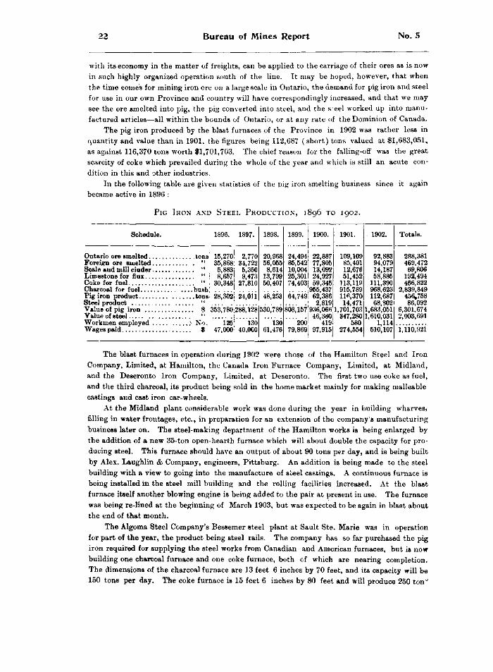
22 BUREAU of MINES Report No. 5
with its economy in the matter of freights, can be applied to the carriage of their ores as is now in such highly organized operation south of the line. It may be hoped, however, that when the time comes for mining iron ore on a large scale in Ontario, the demand for pig iron and steel for use in our own Province and country will have correspondingly increased, and that we may see the ore smelted into pig, the pig converted into steel, and the s e e l worked up into manufactured articles—all within the bounds of Ontario, or at any rate of the Dominion of Canada.
The pig iron produced by the blast furnaces of the Province in 1902 was rather less in quantity and value than in 1901, the figures being 112,687 (short) tons valued at $1,683,051, as against 116,370 tons worth $1,701,703. The chief reason for the falling-ofl" was the great scarcity of coke which prevailed during the whole of the year and which is still an acute condition in this and other industries.
In the following table are given statistics of the pig iron smelting business since it again became active in 1896 :
P i g I r o n a n d S t e e l P r o d u c t i o n , 1896 t o 1902.
Schedule. 1896. 1897. 1898. 1899. 1900. 1901. 1902. Totals.
15,270 35,868 5,883 8,657
30,348
2,770 34,722 5,350 9,473
27,810
20,968 56,055 8,614
13,799 50,407
24,494 85,542 10,004 25,301 74,403
22,887 77,805 13,092 24,927 59,345
955,437 62,386 2,819
936,066 46,380
419 97,915
109,109 85,401 12,676 51,452
113,119 915,789 116,370 14,471
1,701,703 347,280
580 274,554
92,883 94,079 14,187 58,886
111,390 968,623 112,687 68,802
1,683,051 1,610,031
1,114 510,107
288,381 469,472 69,806
192,494 466,822
2,839,849 456,758 86,092
6,301,674 2,003,691
Steel product " 28,302 24,011 48,253 64,749
22,887 77,805 13,092 24,927 59,345
955,437 62,386 2,819
936,066 46,380
419 97,915
109,109 85,401 12,676 51,452
113,119 915,789 116,370 14,471
1,701,703 347,280
580 274,554
92,883 94,079 14,187 58,886
111,390 968,623 112,687 68,802
1,683,051 1,610,031
1,114 510,107
288,381 469,472 69,806
192,494 466,822
2,839,849 456,758 86,092
6,301,674 2,003,691
353,780 288,128 530,789 808,157
22,887 77,805 13,092 24,927 59,345
955,437 62,386 2,819
936,066 46,380
419 97,915
109,109 85,401 12,676 51,452
113,119 915,789 116,370 14,471
1,701,703 347,280
580 274,554
92,883 94,079 14,187 58,886
111,390 968,623 112,687 68,802
1,683,051 1,610,031
1,114 510,107
288,381 469,472 69,806
192,494 466,822
2,839,849 456,758 86,092
6,301,674 2,003,691
Workmen employed No. 125 47,000
130 40.OC0
130 61,476
200 79,869
22,887 77,805 13,092 24,927 59,345
955,437 62,386 2,819
936,066 46,380
419 97,915
109,109 85,401 12,676 51,452
113,119 915,789 116,370 14,471
1,701,703 347,280
580 274,554
92,883 94,079 14,187 58,886
111,390 968,623 112,687 68,802
1,683,051 1,610,031
1,114 510,107
288,381 469,472 69,806
192,494 466,822
2,839,849 456,758 86,092
6,301,674 2,003,691
125 47,000
130 40.OC0
130 61,476
200 79,869
22,887 77,805 13,092 24,927 59,345
955,437 62,386 2,819
936,066 46,380
419 97,915
109,109 85,401 12,676 51,452
113,119 915,789 116,370 14,471
1,701,703 347,280
580 274,554
92,883 94,079 14,187 58,886
111,390 968,623 112,687 68,802
1,683,051 1,610,031
1,114 510,107 1,110,921
The blast furnaces in operation during 1902 were those of the Hamilton Steel and Iron Company, Limited, at Hamilton, the Canada Iron Furnace Company, Limited, at Midland, and the Deseronto Iron Company, Limited, at Deseronto. The first two use coke as fuel, and the third charcoal, its product being sold in the home market mainly for making malleable castings and cast iron car-wheels.
At the Midland plant considerable work was done during the year in building wharves, filling in water frontages, etc., in preparation for an extension of the company's manufacturing business later on. The steel-making department of the Hamilton works is being enlarged by the addition of a new 35-ton open-hearth furnace which will about double the capacity for producing steel. This furnace should have an output of about 90 tons per day, and is being built by Alex. Laughlin & Company, engineers, Pittsburg. An addition is being made to the steel building w i t h a view to going into the manufacture of steel castings. A continuous furnace is being installed in the Btee l mill building and the rolling facilities increased. At the b l a B t
furnace itself another blowing engine is being added to the pair at present in use. The furnace was being re-lined at the beginning of March 1903, but was expected to be again in blast about the end of that month.
The Algoma Steel Company's Bessemer steel plant at Sault Ste. Marie was in operation for part of the year, the product being steel rails. The company has so far purchased the pig iron required for supplying the steel works from Canadian and American furnaces, but is now building one charcoal furnace and one coke furnace, both of which are nearing completion. The dimensions of the charcoal furnace are 13 feet 6 inches by 70 feet, and its capacity will be 150 tons per day. The coke furnace is 15 feet 6 inches by 80 feet and will produce 250 ton°
1902 Statistics for 1902 23
o f p i g i r o n d a i l y . T h e f u r n a c e s a r e e q u i p p e d w i t h s e v e n F o o t e t i r e - b r i c k s t o v e s 1 8 b y 8 9 f e e t i n
Bize, f o u r b l o w i n g e n g i n e s , e a c h w i t h a c a p a c i t y o f 1 3 , 0 0 0 c u b i c f e e t o f a i r p e r m i n u t e , a n d o n e
3 , 0 0 0 - h . p . C a h a l l v e r t i c a l b o i l e r p l a n t . A 3 - s t r a n d H e y l a n d P a t t e r s o n p i g - c a s t i n g m a c h i n e
w i l l r e c e i v e t h e p r o d u c t o f b o t h f u r n a c e s , o r t h e h o t m e t a l c a n b e c o n v e y e d d i r e c t t o t h e m e t a l
m i x e r a t t h e s t e e l w o r k s , a n d t h e n c e t r a n s f e r r e d t o t h e c o n v e r t e r s a s r e q u i r e d , T h e u n l o a d
i n g d o c k , w h i c h h a s a f r o n t a g e o f 1 , 4 0 0 f e e t a n d a d e p t h o f 2 9 5 f e e t , i s e q u i p p e d w i t h a m o d e r n
H u l l e t t u n l o a d i n g m a c h i n e b y w h i c h t h e r a w m a t e r i a l i s u n l o a d e d f r o m t h e v e s s e l s a n d c o n v e y
e d t o t h e s t o r a g e y a r d o r d i r e c t t o t h e s t o c k b i n s , a n d t h e f u r n a c e a c c e s s o r i e s e m b r a c e t h e
l a t e s t a n d m o s t a p p r o v e d d e v i c e s f o r e c o n o m i c a l o p e r a t i o n .
T h e c h a r c o a l f u r n a c e w i l l r e q u i r e c h a r c o a l f r o m a b o u t 3 0 0 c o r d s o f h a r d w o o d p e r d a y . I n
o r d e r t o s u p p l y t h i s f u e l k i l n p l a n t s w i t h a c a p a c i t y o f 1 5 0 c o r d s p e r d a y h a v e b e e n b u i l t a t
W i l d e a n d S e a r c h m o n t s t a t i o n s o n t h e A l g o m a C e n t r a l R a i l w a y , a n d a r e t o r t p l a n t n e a r t h e
r a i l m i l l . T h e k i l n p l a n t s w i l l c o n s i s t o f 5 6 k i l n s , 3 0 f e e t i n d i a m e t e r a t t h e b o t t o m , 2 8 f e e t a t
s p r i n g o f a r c h , 1 4 f e e t h i g h t o s p r i n g o f a r c h , a n d 5 f e e t t o t o p o f a r c h , e a c h k i l n h o l d i n g a b o u t
6 5 c o r d s o f w o o d . O f t h e s e , 1 6 k i l n s a r e n o w c o m p l e t e d a t W i l d e a n d 2 0 a t S e a r c h m o n t . W h e n
t h e p l a n t s a r e a l l i n o p e r a t i o n t h e i r o u t p u t w i l l b e a b o u t 6 , 5 0 0 b u s h e l s o f c h a r c o a l d a i l y . A
r e t o r t p l a n t i s a l s o t o b e b u i l t h a v i n g a c a p a c i t y o f 1 6 0 c o r d s o f w o o d p e r d a y , y i e l d i n g a b o u t
8 , 0 0 0 b u s h e l s o f c h a r c o a l . A f u l l e r d e s c r i p t i o n o f t h e s t y l e o f r e t o r t i s g i v e n i n t h e E l e v e n t h
R e p o r t o f t h e B u r e a u of M i n e s ( p p . 9 9 a n d 1 0 0 ) .
T H E C R A M P S T E E L C O M P A N Y , L I M I T E D .
A t C o l l i n g w o o d t h e w o r k s o f t h e C r a m p S t e e l C o m p a n y , L i m i t e d , a r e b e i n g p r o s e c u t e d
w i t h v i g o r . T h i s c o m p a n y w a s o r g a n i z e d i n 1 9 0 1 w i t h a c a p i t a l O f $ 5 , 0 0 0 , 0 0 0 , o f w h i c h
$ 2 , 0 0 0 , 0 0 0 i s 7 p e r c e n t , c u m u l a t i v e p r e f e r r e d , a n d $ 3 , 0 0 0 , 0 0 0 c o m m o n s t o c k . T h e o f f i c e r s o f
t h e C o m p a n y a r e : p r e s i d e n t , J . W e s l e y A l l i s o n , N e w Y o r k , N . Y . ; s e c r e t a r y - t r e a s u r e r ,
J . A . C u r r i e , T o r o n t o ; d i r e c t o r s , A . M c L e a n M a c d o n e l l , T o r o n t o ; H . P r e n t i s s T a y l o r , N e w
Y o r k , N . Y . ; M a j o r C o l l i n s , B r a z i l , I n d i a n a ; W m . C r a m p a n d C h a s . D . C r a m p , P h i l a d e l p h i a ,
P a . ; J . W e s l e y A l l i s o n , N e w Y o r k , N . Y . ; J . A . C u r r i e , T o r o n t o ; H o n . S i r . C h a s . H . T u p p e r ,
V a n c o u v e r , B . C . M r . J . C . R o y c e , a g r a d u a t e o f t h e M a s s a c h u s e t t s S c h o o l o f T e c h n o l o g y , i s
s u p e r i n t e n d e n t a n d e n g i n e e r .
T h e c o m p a n y w a s o r g a n i z e d t o e r e c t a b l a s t f u r n a c e , o p e n - h e a r t h s t e e l p l a n t a n d r o l l i n g
m i l l s , a n d h a s b e e n g i v e n b y t h e t o w n o f C o l l i n g w o o d a n e x c e l l e n t s i t e o f s o m e 8 0 a c r e s , a
p o r t i o n o f w h i c h f r o n t s o n t h e h a r b o r , a l s o a c a s h b o n u s o f $ 1 1 5 , 0 0 0 a n d c e r t a i n e x e m p t i o n s i n
t h e m a t t e r o f t a x a t i o n . B u i l d i n g w a s b e g u n i n t h e f a l l o f 1 9 0 1 b u t w a s n o t a c t i v e l y p u s h e d
u n t i l t h e s p r i n g o f 1 9 0 2 . T h e b u i l d i n g s a r e s u b s t a n t i a l l y m a d e o f c o n c r e t e , s t o n e , s t e e l a n d
w o o d , a l l s h e a t h e d i n h e a v y c o r r u g a t e d i r o n .
C o n t r a r y t o t h e u s u a l p r a c t i c e , t h e c o m p a n y h a s p r o c e e d e d b y e r e c t i n g i t s o p e n - h e a r t h
s t e e l p l a n t a n d stee\ finishing m i l l s b e f o r e p u t t i n g u p a b l a s t f u r n a c e . I n t h i s w a y b y
p r o c u r i n g p i g i r o n e l s e w h e r e t h e c o m p a n y w i l l b e a b l e t o s u p p l y t h e i r c u s t o m e r s w i t h s t e e l
w h i l e t h e i r o w n f u r n a c e i s b e i n g b u i l t , a n d m e a n t i m e w i l l n o t b e a c c u m u l a t i n g l a r g e s t o c k s o f
p i g i r o n . T h e s t e e l p l a n t a n d finishing m i l l s , w h i c h f r o n t o n t h e b a y a n d a l o n g s i d e o f w h i c h
t h e G r a n d T r u n k R a i l w a y r u n s , a r e a p p r o a c h i n g c o m p l e t i o n .
I n a l a r g e s t o n e b u i l d i n g , 7 5 b y 1 4 0 f e e t , a r e l o c a t e d t h e m a c h i n e s h o p , f o r g e a n d p o w e r ,
a n d e l e c t r i c l i g h t p l a n t s . T h e s t o n e o f w h i c h t h e b u i l d i n g i s c o n s t r u c t e d i s a h a r d , g r a y l i m e
s t o n e f r o m t h e c o m p a n y ' s o w n q u a r r y . I n t h e s o u t h e a s t e n d i s l o c a t e d t h e f o r g e , w h i c h iB
d e s i g n e d f o r f o r g i n g a r t i c l e s o f t h e l a r g e s t s i z e ; t h e e q u i p m e n t s u c h a s p o w e r - h a m m e r , b o l t -
c u t t e r s , e t c . , i s c o m p l e t e . T h e m a c h i n e s h o p s t a n d s i n t h e n o r t h e a s t c o r n e r , a n d c o n t a i n s t w o
l a r g e s c r e w - c u t t i n g e n g i n e l a t h e s , o n e w i t h a 2 0 - f o o t b e d , a l s o a 3 6 - i n c h p l a n e r , a n d a m a s s i v e
l a t h e , w h i c h s w i n g s 7 2 i n c h e s a n d w e i g h s 2 0 t o n s , d e s i g n e d t o t u r n t h e l a r g e s t c l a s s o f r o l l s .
24 Bureau of Mines Report No. 5
There are also a large boring mill radial and other drills and necessary equipment. A 100-h.p. Atlas engine furnishes the power and also operates the electric light plant. The boiler plant consists of four large tubular boilers, each of 150-h.p. capacity. A railway switch serves the boiler house as well as the machine shop.
The rolling mill building adjoins the power house, and is 120 feet wide, including bays, and 210 feet long, with an additional building at the west end 70 feet long. It contains an 18-inch merchant bar mill and a semi-continuous 10-inch Belgian mill, besides two heating furnaces equipped with upright water tube boilers to utilize the waste heat, each developing 150-horse power.
The large train is designed to roll ingots 8 inches by 8 inches by 4 feet into billets and into bars round, square or flat, down to one inch. It will bloom the ingots from the open-hearth furnaces and will supply billets to the 10-inch mill. It will also roll angles, shafting, girders, street railway rails, mine rails, etc. The 10-inch mill will make small bars, bolts, rods and hoops in all shapes under 1£ inches. In both mills, the floors are provided with underground tunnels' where the heated bars, instead of passing over the floor, will pass in the tunnels out of sight, thus leaving the floor space clear. The 10-inch mill is supplied with looping devices, whereby bars can be carried from one side of the rolls to the end, thus permitting the mill to roll a bar 120 feet long at one pass. The large mill is driven by a 600-h.p. engine, built by Inglis & Co., of Toronto, in size 28 by 56 inches, non-condensing in type and with a 30-ton fly wheel. Steam is furnished b ythe waste heat boilers, supplemented by the boilers in the power house. The 10-inch train is operated by a belted 300-h.p. Atlas engine. Throughout the building are located shears and other appliances for cutting the material into lengths and delivering it on cars. A narrow gauge track runs into the building to deliver ingots from the open-hearth furnaces, whilst a wide gauge track runs along both sides of the building for delivering coa and receiving the finished steel.
The open-hearth plant, which consists of two 20-ton furnaces of the most modern design, is situated in a building 100 feet long, 100 feet wide and 30 feet high. The furnaces are of the straight line tapping type, the latest development in open-hearth practice. The regenerators for the furnace are by an ingenious method of construction placed under the charging platform, by which the checker-work of the regenerators is expected to be four or five times that in the old style. The charging platform is in rear of the furnace, and further t o the rear a r e the gas producers which furnish producer gas for reducing the steel. These producers were built in
Canada from designs by the company's engineer, and embody the latest improvements. They are water-sealed and will be charged from a top platform l>y an elevated railway trestle. Coal will be brought up i n drop-bottom cars and dropped on this platform for charging, thus doing away with the expense of hoisting up coal to charge the producers, which is the usual practice.
Two large B tee l stacks, 90 feet high, made of heavy plate, on concrete foundations and lined with fire-brick, serve the two open-hearth furnaces. The casting pits in front of the furnaces are done away with. The casting ladle is handled by a 25-ton hydraulic crane, which swings in a n a r c of 180 degrees. Two other large swinging hydraulic cranes are located in front of the charging platform, one to handle the empty ladles and the other to strip the ingots. The machinery is actuated by hydraulic power, the pumps being situated in a separate building some distance away. Two large hydraulic rams furnish the necessary pressure, together with a 40- ton accumulator.
The plant i s designed to produce about 120 tons of basic open-hearth steel per day, by t h e Thomas-Gilchrist method. The product will be high carbon nickel steel, h i g h carbon spring and tool steel, m i l d steel of various grades down t o soft rivet steel, and the finishing mills w i l roll the product into any size required by machine shops, foundries or blacksmiths.
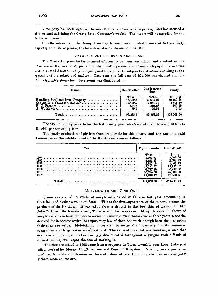
1902 Statistics for 1902 25
A company has been organized to manufacture 50 tons of wire per day, and has secured a site on land adjoining the Cramp Steel Company's works. The billets will be supplied by the latter company.
It is the intention of the Cramp Company to erect an iron blast furnace of 250 tons daily capacity on a site adjoining the lake shore during the summer of 1903.
P A Y M E N T S O U T OF I R O N MINING F U N D .
The Mines Act provides for payment of bounties on iron ore mined and smelted in the^ Province at the rate of $1 per ton on the metallic product therefrom, such payments however not to exceed $25,000 in any one year, and the rate to be subject to reduction according to the quantity of ore mined and smelted. Last year the full sum of $25,000 was claimed and the following table shows howthe amount was distributed :—
Name. Ore Smelted. Pig iron product. Bounty.
Tone. Tons. $ c. 78,409.6 43,698.29 20,280 20 17,779.6 9,846.08 4,569 50
604.8 303.28 140 75 A. W. Hawley, 39.0 20.57 9 55
96,833.2 53,868.22 $25,000 00
The rate of bounty payable for the last bounty year, which ended 31st October, 1902 was $0.4641 per ton of pig iron.
The yearly production of pig iron from ore eligible for this bounty and the amounts paid thereon, since the establishment of the Fund, have been as follows :—
Year.
1896. 1897. 1898. 1899 1900. 1901. 1902.
Totals.
Pig iron made.
Tons] 4,000 00 2,603.95 8,647.19
12,752.07 6,737.80
55,214.00 53,868.22
Bounty paid.
$ c ~ 4,000 00 2,603 95 8,647 19
12,752 07 6,737 80
25,000 00 25,000 00
145,823.23 $84,741 01
M o l y b d e n i t e a n d Z i n c O r e .
There was a small quantity of molybdenite raised in Ontario last year, amounting to 6,500 lbs, and having a value of $400. This is the first appearance of the mineral among the products of the Province. It was taken from a deposit in the township of Laxton by Mr. John Webber, Sherbourne street, Toronto, and his associates. Many deposits or shows of molybdenite ha /e been brought to notice in Ontario during the last two or three years, since the demand for it became active, but upon very few of them has work enough been done to prove their extent or value. Molybdenite appears to be essentially " pocketty " in its manner of occurrence, and large bodies are exceptional. The value of the substance, however, is such that even a small deposit, if not too sparingly disseminated throughout a gangue rock difficult of separation, may well repay the cost of working it.
The zinc ore mined in 1902 came from a property in Olden township near Long Lake post office, worked by Messrs. H. Richardson and Sons of Kingston. Nothing was reported as produced from the Zenith mine, on the north shore of Lake Superior, which in previous years yielded more or less ore.
26 Bureau of Mines Report No. 5
A c t i n o l i t e , G r a p h i t e , M i c a , T a l c .
The hornblende variety of asbestos known as actinolite is found in considerable quantities in the County of Hastings. After being mined it is ground in attrition mills without destroying the fibre, and a proportion of mica is added to increase the "bond". It is then sold mainly for making roofing cement, for which purpose it is mixed with the proper percentage of coal tar, asphalt or roofing pitch. Usually, heavy tarred felt is first laid on the roof, after which the cement is laid on warm with a plasterer's trowel, and sand sifted over it. Roofs made in this way are said to be fire-proof and very durable, withstanding successfully extremes of cold and heat. Mr. Joseph James, of Actinolite, mines and grinds the mineral, and the Helena Mining Company, Cloyne, also began mining last year, their product going to the States for treatment. The total output was 800 tons, worth $6,150.
There are now three properties producing graphite in the Province ; the Black Donald mine at Whitefish lake in the county of Renfrew, owned by the Ontario Graphite Company, Limited, of Ottawa; the McConnell mine in North Elmsley township on the Rideau canal owned by Rinaldo McConnell of Ottawa ; and the Allanhurst property in the township of Denbigh, which has recently been opened up by Mr. J. G. Allan of Hamilton. Several other deposits have undergone preliminary development.
The graphite bodies found in Ontario are usually associated with crystalline limestones of Archnean age, and the mineral occurs in the amorphous and flake forms. Of the amorphous variety the only known large deposit is the Black Donald, flake being the more generally distributed form. Of crystalline graphite, such as occurs in Quebec associated sparingly with flake, little or none has been found in this Province.
A refinery at the Black Donald property was completed last year, and went into operation in July. The motive power is electricity generated by a water fall on the Madawaska river some two miles away. The works have a capacity of 15 tons of crude ore per day, and employ the wet concentration process, using large buddies. Flake graphite for crucible-making, is the leading product, and the amorphous kind is also made in varying proportions of carbon contents, for use as foundry facings and other purposes. The ore body at the Black Donald mine is of unusual size and excellence of quality. It has been followed under the bed of Whitefish lake for some distance.
Work was first done on what is now known as the McConnell graphite mine over 30 years ago. In 1872 a mill was erected at Oliver's Ferry for treating the product of the mine, 1 which however did not remain very long in operation. An effort was again made in 1893 by the late J. F. Torrance, of Montreal, to revive the property, 2 and a good deal of boring was done with the diamond drill, which showed the presence of a large quantity of graphite. Nothing permanent, however, came of the attempt. In 1901 Dr. R. A. Pyne, of Toronto, employed the Government diamond drill to good effect on lot 21 in the sixth concession of North Elmsley, and found extensive bodies of good quality graphite. 3 Mr. Rinaldo McConnell, of Ottawa, having obtained possession of adjoining lands, also tested his property with the government drill, and last spring began the work of mining. The graphite is of the flake variety, and occurs disseminated throughout the limestone. Works have been erected about two miles east of the mine for treating the ore, a small water power on the river Tay furnishing the necessary ower. A process has been tried, the principal features of which are crushing, screening, concentrating in pneumatic jigs, grinding or polishing between millstones, and huddling in small vats for final purification of the flake, which is then graded in revolving screens. The flake product is of high grade suitable for crucible stock. The refinery has a capacity of about 20 tons of ore per day.
1 See description in 6th Report Bureau Mines, pp 36 and 36. 8 3rd Report Bureau Mines, p. 06. 3 11th Report Bureau Mines, pp. 59, 60.
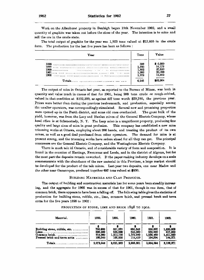
1902 Statistics for 1902 27
Work on the Allanhurst property in Denbigh began 19th November 1902, and a small quantity of graphite was taken out before the close of the year. The intention is to mine and sell the ore in the crude state.
The total output of graphite for the year was 1,923 tons valued at $12,855 in the crude form. The production for the last five years has been as follows :
Year Tons Value
1898 300 1,220 1,802 1,000 1,923
6,245
$ 6,000 16,179 27,030 20,000 12,855
$82,064
1899 300
1,220 1,802 1,000 1,923
6,245
$ 6,000 16,179 27,030 20,000 12,855
$82,064
1900
300 1,220 1,802 1,000 1,923
6,245
$ 6,000 16,179 27,030 20,000 12,855
$82,064
1901 1902
300 1,220 1,802 1,000 1,923
6,245
$ 6,000 16,179 27,030 20,000 12,855
$82,064
300 1,220 1,802 1,000 1,923
6,245
$ 6,000 16,179 27,030 20,000 12,855
$82,064
The output of mica in Ontario last year, as reported to the Bureau of Mines, was both in quantity and value much in excess of that for 1901, being 999 tons crude or rough-cobbed, valued in that condition at $102,500, as against 427 tons worth $39,780, the previous year. Prices were better than during the previous twelvemonth, and production, especially among the smaller operators, was correspondingly stimulated. Several new and promising properties were opened up in the Perth district, and some old ones overhauled. The great bulk of the yield, however, was from the Lacy and Hanlan mines of the General Electric Company, whose head office is at Schenectady, N. Y. The Lacy mine is a magnificent property, producing fine quality and large sizes of mica in great profusion. This company has established a new mica trimming works at Ottawa, employing about 200 hands, and treating the product of its own mines, as well as a good deal purchased from other operators. The demand for mica is at present strong, and the trimming works have orders ahead for all they can get. The principal consumers are the General Electric Company, and the Westinghouse Electric Company.
There is much talc in Ontario, and of considerable variety of form and composition. It is found in the counties of Hastings, Frontenac and Leeds, and in the district of Algoma, but for the most part the deposits remain unworked. It the paper-making industry develops on a scale commensurate with the abundance of the raw material in this Province, a large market should be developed for the product of the talc mines. Last year two deposits, one near Madoc and the other near Gananoque, produced together 697 tons valued at $930.
B u i l d i n g M a t e r i a l s a n d C l a y P r o d u c t s .
The output of building and construction materials has for some years been steadily increasing, and the aggregate for 1902 was in excess of that for 1901, though in one item, that of common brick, there appears to have been a falling off. The folio wing table gives the statistics of production for building stone, rubble, etc., lime, common biick, and pressed brick and terra cotta for the five years 1898 to 1902 :
p r o d u c t i o n o f s t o n e , l i m e a n d b r i c k 1898 t o 1902.
Material. 1898. 1899. 1900. 1901. 1902.
Totals
$ 760,000 308,000 914,000 100,344
$ 667,682 636,000
1,313,750 106,000
$ 660,342 644,000
1,379,590 114,419
$ 860,000 650,000
1,630,460 104,394
$ 1,020,000
617,000 1,411,000
144,371
Totals 2,072,844 2,621,282 2,688,861 3,034,864 8,192,871
28 Bureau of Mines Report No. 5
The item of stone in the above table includes not only stone quarried for building purposes, but also material crushed for road-making and use as flux in blast furnaces. A considerable business is done at points near the United States frontier in quarrying and breaking limestone for uses of this kind. Railway companies get out considerable stone at the convenient points along their lines for building bridges and other railway structures, among them being the Canadian Pacific Railway Company, which operates a granite quarry at Peninsula Harbor, and the Algoma Central Railway Company, which has also opened a quarry of fine red granite on the northeast quarter of section 9, Tarentorus township, within 8 miles of Sault Ste. Marie.
The principal producers of stone making returns to the Bureau for 1902 were: Estate of John Battle, Thorold ; Queenston Quarry Company, St. David's ; Empire Limestone Company, Sherkston ; Hughes Bros, and Bangs, Buffalo, N.Y. ; G. F. Webb, Hamilton ; Walker Bros.. Thorold ; Amherstburg Quarry Company, Amherstburg; Thomas Barnes, Hamilton ; Longford Quarry Company, Longford Mills ; Canada Iron Furnace Company, Midland ; J. W. Graham, St. Mary's ; Credit Forks Quarry Company, Toronto ; T. Shea, Pembroke ; St. Mary's Quarry Company, St Mary's; J. Elliott, St. Mary's ; D. Robertson & Company, Milton ; J. Maloney, & Company, Puslinch ; Spence Bros, Bruce Mines ; Lake Superior Power .Company, Sault Ste-Marie ; Algoma Central Railway Company, and Canadian Pacific Company. The greater proportion of the product is limestone.
There was a small increase in the quantity of lime produced in 1902 as compared with 1901, but the increase in value was more marked. In 1901 the total was $550,000, and the average price per bushel 13.4 cents, while in 1902 the production was $617,000, and the average price per bushel 14.3 cents Very much of the lime in Ontario is the product of small kilns operated by farmers or farmers' sons, which only " burn " when lime is wanted, and which supply the limited local demand ; but for the larger and more regular supplies required by city markets, more expensive plants are necessary which are kept much more steadily in operation.
Among the largest producers of lime are H. Robillard Son, Ottawa ; Estate of J. A. Jamieson, Renfrew ; D. Robertson and Company, Milton ; A. Ballantyne, Gait ; J. Sclater, Downie ; Toronto Lime Company, Limehouse ; J. Gow, Fergus ; W. M. Cameron, Carleton Place ; Canadian Portland Cement Company, Strathcona ; Christie Henderson and Company» Guelph and Kelso ; Welland County Lime Works, Port Colborne, and the Empire Limestone Company, Sherkston.
The use of brick for building purposes is wide-spread in Ontario, and contributes much to the substantial appearance of both urban and rural dwellings. There is an abundance of clay suitable for the manufacture of red and white brick, mostly the former, in nearly all the settled parts of the Province. Last year the output of bricks seems to have been somewhat less than in the year before, being 220,000,000 valued at $1,411,000, as against 259,265,000 worth $1,530,460. The reduction in output was coincident with and may be partly attributable to an increase in cost, the average price having gone up from $5.90 per thousand, to $6.41 per thousand. No doubt the decided advance in cost of building materials, including brick, lime and lumber, together with the equally marked increase which has taken place in wages of all kinds, has acted as a restraint upon building operations throughout the Province.
The multitude of small brick-yards operated at a minimum of expense in the main supply the wants of village and rural communities, whose market is preserved to the local makers by reason of the heavy cost of transporting so weighty a material, but as in the case of lime the building trade of cities and large towns demands a source from which constant and large supplies may be procured. This has naturally led to a large development of the brick-making industry in the suburbs of those cities where suitable deposits of clay are to be found. In the immediate neighborhood of Toronto, for instance, are very many brick-yards, some of them equipped with plants of great capacity, which cater for the city trade. Several years ago a
1902 Statistics for 1902 29
number of these were deserted and idle, and others were only working part of the time, but the resumption of building activity which took place two or three years ago, has again provided a ready outlet for their product. Most of these work surface deposits or banks of clay, but at the Don Valley Brick Works, shales of the Hudson River formation are quarried from deep open workings by means identical with those employed in mining operations at a similar depth. These shales are ground and made into pressed brick. Similarly, shales of the Medina series are excavated for pressed brick and terra cotta at Milton, Campbellville and elsewhere.
Large manufacturers of common brick and drain tile, reporting their product to the Bureau, are the following: John Price, Toronto; C. Mason, Carleton West; R. Rattledge, Carleton West; Bell Bros., Toronto; J . Logan, Toronto; Morley & Ashbridge, Toronto; W. West, Penetanguishene; Lake Superior Power Company, Sault Ste Marie; Mrs. H. Ollmann, Hamilton; King & Mulligan, Harbord; Ponsford & Freek, St. Thomas; Crawford Bros , Hamilton; R. Holton, Drew; Merkley Bros., Casselman; G. Frid & Company, Hamilton ; Odell Bros., Ottawa; T. Fanning, Hamilton; Wakefield Brick Company, Carleton West; Brown Bros., Mount Dennis; J. Pears, Davisville; Ottawa Brick Company, Ottawa; Waide Bros., London; Curtis Bros., Peterborough; S. Allen, Norwich; Baker Bros., Casselman; G. S. Townsley, Carleton West; Bechtel Bros., Waterloo; Ontario Brick Company, Toronto Junction.
Manufacturers of pressed brick are the Toronto Pressed Brick and Terra Cotta Works, Milton; Milton Pressed Brick Company, Milton; Don Valley Brick Works, Toronto, James Packham, Brampton.
Other clay products consisting of drain tile, paving brick, sewer pipe and pottery, were made during the year to the value of $604,280, a slight decrease from 1901. The output of these articles during the last five years was as follows :
D R A I N T I L E , P A V I N G B R I C K , S E W E R P I P E A N D P O T T E R Y 1898 T O I 9 O I .
Product. 1898 1899 1900 1901 1902 Total.
226,000
93,717 155,000
$ 240,246 42,550
138,356 101,000
$ 209,738
26,950 130,635 157,449
$ 231,374 37,000
147,948 193,950
$ 199,000 42,000
191,965 171,315
$ 1,105,358
148,500 702,621 778,714
473,717 522,152 524,772 610,272 604,280 2,735,193
The principal manufacturers of sewer pipe in .the Province are the Ontario Sewer Pipe Company, Limited, of Toronto, whose works are at Mimico, and the Hamilton and Toronto Sewer Pipe Company, Limited, with manufactory at Hamilton; and of pottery, J. Taylor, Port Hope; John Davis & Son, Davisville; Belleville Pottery Company, Belleville; F. Van Andel, Cornwall.
P o r t l a n d a n d H y d r a u l i c C e m e n t .
The use of cement has now become very general, and its manufacture has developed with extraordinary rapidity within the last ten years, both in Europe and America. Notwithstanding that the lasting qualities of cement had been fully proven by the success with which structures built in Roman times have resisted the wear and tear of the elements down to the present day, until a few years ago it occupied but a secondary place on the architect's or building contractor's list of materials. As it grew in favor, however, and as the raw ingredients for its manufacture were found to be wide-spread, it sprang by leaps and bounds into a position almost of pre-eminence in the building world. In the United States the production of Portland cement has developed with unexampled speed, the output increasing from 454,813 barrels in
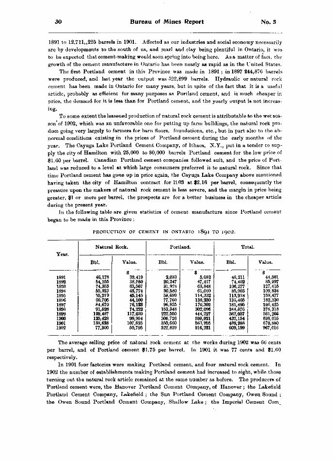
30 Bureau of Mines Report No. 5
1 8 9 1 t o 1 2 , 7 1 1 , , 2 2 5 b a r r e l s i n 1 9 0 1 . A f f e c t e d a s o u r i n d u s t r i e s a n d s o c i a l e c o n o m y n e c e s s a r i l y
a r e b y d e v e l o p m e n t s t o t h e s o u t h o f u s , a n d m a r l a n d c l a y b e i n g p l e n t i f u l i n O n t a r i o , i t w a s
t o b e e x p e c t e d t h a t c e m e n t - m a k i n g w o u l d s o o n s p r i n g i n t o b e i n g h e r e . A s a m a t t e r o f f a c t , t h e
g r o w t h o f t h e c e m e n t m a n u f a c t u r e i n O n t a r i o h a s b e e n n e a r l y a s r a p i d a s i n t h e U n i t e d S t a t e s .
T h e first P o r t l a n d c e m e n t i n t h i s P r o v i n c e w a s m a d e i n 1 8 9 1 ; i n 1 8 9 7 2 4 4 , 8 7 6 b a r r e l s
w e r e p r o d u c e d , a n d l a s t y e a r t h e o u t p u t w a s 5 2 2 , 8 9 9 b a r r e l s . H y d r a u l i c o r n a t u r a l r o c k
c e m e n t h a s b e e n m a d e i n O n t a r i o f o r m a n y y e a r s , b u t i n s p i t e o f t h e f a c t t h a t i t i s a u s e f u l
a r t i c l e , p r o b a b l y a s e f f i c i e n t f o r m a n y p u r p o s e s a s P o r t l a n d c e m e n t , a n d i s m u c h c h e a p e r i n
p r i c e , t h e d e m a n d f o r i t i s l e s s t h a n f o r P o r t l a n d c e m e n t , a n d t h e y e a r l y o u t p u t i s n o t i n c r e a s
i n g .
T o s o m e e x t e n t t h e l e s s e n e d p r o d u c t i o n o f n a t u r a l r o c k c e m e n t i s a t t r i b u t a b l e t o t h e w e t s e a
s o n ' o f 1 9 0 2 , w h i c h w a s a n u n f a v o r a b l e o n e f o r p u t t i n g u p f a r m b u i l d i n g s , t h e n a t u r a l r o c k p r o
d u c t g o i n g v e r y l a r g e l y t o f a r m e r s f o r b a r n f l o o r s , f o u n d a t i o n s , e t c . , b u t i n p a r t a l s o t o t h e a b
n o r m a l c o n d i t i o n s e x i s t i n g i n t h e p r i c e s o f P o r t l a n d c e m e n t d u r i n g t h e e a r l y m o n t h s o f t h e
y e a r . T h e C a y u g a L a k e P o r t l a n d C e m e n t C o m p a n y , o f I t h a c a , N . Y . , p u t i n a t e n d e r t o s u p
p l y t h e c i t y o f H a m i l t o n w i t h 2 5 , 0 0 0 t o 3 0 , 0 0 0 b a r r e l s P o r t l a n d c e m e n t f o r t h e l o w p r i c e o f
$ 1 . 6 0 p e r b a r r e l . C a n a d i a n P o r t l a n d c e m e n t c o m p a n i e s f o l l o w e d s u i t , a n d t h e p r i c e o f P o r t
l a n d w a s r e d u c e d t o a l e v e l a t w h i c h l a r g e c o n s u m e r s p r e f e r r e d i t t o n a t u r a l r o c k . S i n c e t h a t
t i m e P o r t l a n d c e m e n t h a s g o n e u p i n p r i c e a g a i n , t h e C a y u g a L a k e C o m p a n y a b o v e m e n t i o n e d
h a v i n g t a k e n t h e c i t y o f H a m i l t o n c o n t r a c t f o r 1 1 0 3 a t $ 2 . 1 6 p e r b a r r e l , c o n s e q u e n t l y t h e
p r e s s u r e u p o n t h e m a k e r s o f n a t u r a l r o c k c e m e n t i s l e s s s e v e r e , a n d t h e m a r g i n i n p r i c e b e i n g
g r e a t e r , $ 1 o r m o r e p e r b a r r e l , t h e p r o s p e c t s a r e f o r a b e t t e r b u s i n e s s i n t h e c h e a p e r a r t i c l e
d u r i n g t h e p r e s e n t y e a r .
I n t h e f o l l o w i n g t a b l e a r e g i v e n s t a t i s t i c s o f c e m e n t m a n u f a c t u r e s i n c e P o r t l a n d c e m e n t
b e g a n t o b e m a d e i n t h i s P r o v i n c e :
P R O D U C T I O N O F C E M E N T I N O N T A R I O 1891 T O 1902.
Natural Rock. Portland. Total. Year. Year.
Bbl. Value. Bbl. Value. Bbl. Value.
1891 1892 1893 1894 1895 1896 1897 1898 1899 1900 1901 1902
46,178 54,155 74,353 55,323 55,219 60,705 84,670 91,528
139,487 125,428 138,628 77,300
$ 39,419 38,580 63,567 48,774 45,145 44,100 76,123 74,222
117,039 99,994
107,625 50,795
2,033 20,247 31,924 30,580 58,699 77,760 96,825
153,348 222,550 306,726 350,660 522,899
$ 5,082
47,417 63,848 61,060
114,332 138,230 170,302 302,096 444,227 598,021 563,255 916,221
48,211 74,402
106,277 85,903
113,918 138,465 181,495 244,876 362,037 432,154 489,288 609,199
$ 44,501 85,997
127,415 109,834 159,477 182,330 246,425 376,318 561,266 698,015 670,880 967,016
T h e a v e r a g e s e l l i n g p r i c e o f n a t u r a l r o c k c e m e n t a t t h e w o r k s d u r i n g 1 9 0 2 w a s 6 6 c e n t s
p e r b a r r e l , a n d o f P o r t l a n d c e m e n t $ 1 . 7 5 p e r b a r r e l . I n 1 9 0 1 i t w a s 7 7 c e n t s a n d $ 1 . 6 0
r e s p e c t i v e l y .
I n 1 9 0 1 f o u r f a c t o r i e s w e r e m a k i n g P o r t l a n d c e m e n t , a n d f o u r n a t u r a l r o c k c e m e n t . I n
1 9 0 2 t h e n u m b e r o f e s t a b l i s h m e n t s m a k i n g P o r t l a n d c e m e n t h a d i n c r e a s e d t o e i g h t , w h i l e t h o s e
t u r n i n g o u t t h e n a t u r a l r o c k a r t i c l e r e m a i n e d a t t h e s a m e n u m b e r a s b e f o r e . T h e p r o d u c e r s o f
P o r t l a n d c e m e n t w e r e , t h e H a n o v e r P o r t l a n d C e m e n t C o m p a n y , o f H a n o v e r ; t h e L a k e f i e l d
P o r t l a n d C e m e n t C o m p a n y , L a k e f i e l d ; t h e S u n P o r t l a n d C e m e n t C o m p a n y , O w e n S o u n d ;
t h e O w e n S o u n d P o r t l a n d C e m e n t C o m p a n y , S h a l l o w L a k e ; t h e I m p e r i a l C e m e n t C o m _
1902 Statistics for 1902 31
pany, Owen Sound; the Gray and Bruce Portland Cement Company, Owen Sound; and the Canadian Portland Cement Company, Marlbank and Strathcona. The natural rock cement factories in operation were those of the Toronto Lime Company, Limehouse ; Estate of John Battle, Thorold ; F. W. Schwendiman, Hamilton ; and Isaac CJsaher, Queenston.
Since the beginning of 1903 the National Portland Cement Company's works at Durham, in the County of Grey, have gone into operation. Several other plants are in course of construction, and a number of others are projected.
D E V E L O P M E N T OF T H E C E M E N T M A N U F A C T U R E .
The manufacture of Portland cement in Ontario had its origin at Marlbank in the county of Hastings and at Shallow Lake in the county of Grey, at nearly the same time about 12 years ago. The present centre of the industry is in the county of Grey, where six out of the nine producing plants are situated. A brief description of these and the other factories in the Province, and some account of the new establishments which appear likely to be manufacturing cement shortly, may be found of interest.
The works of the Hanover Portland Cement Company, Limited, are situated at Hanover, Grey County. Its marl beds are a mile and a half distant, and its clay deposits close to the works. The plant consists of a brick factory, and brick and cement warehouses, and include drying darres, wash mills, ball and tube mills, slurry grinding and pumping machinery, automatic carriers, etc. The kilns at present in use are five Bachelor set kilns and one Schneider continuous kiln. The capacity of the plant is 150 barrels per day, but the company has recently offered for sale $180,000 worth of 7 per cent, cumulative preferred stock—the total authorized capital being $500,000—with the proceeds of which it is proposed to increase the capacity to 650 barrels per day, construct a railway to the marl deposits, develop a water privilege on the Saugeen river for power purposes, and make other improvements. The company's brand of cement is the " Saugeen.'' A siding connects the factory with the Grand Trunk Railway. D. Knechtel is president, and J. S. Knechtel managing director.
The Lakefield Portland Cement Company, Limited, began the construction of their plant at Lakefield in the County of Peterborough in 1900, and were manufacturing cement early in 1902. The works are situated on the Trent canal and were planned with a view of utilizing an all-water route for the transportation of cement to Montreal and lower ports. The whole of the machinery is operated by electric power derived from the Trent canal, which affords a large economy in fuel for power purposes. The completion of the canal would, it is estimated, enable the company to reduce its coal bill for cement burning to the extent of $15,000 per annum. Three kilns only were installed last year, but three more are now being added, which will give the plant a capacity of about 200,000 barrels per annum. The company's brand is "Monarch," and it has taken well in the market. J. M. Kilbourn is president of the company, F. A, Kilbourn, secretary-treasurer, and A. S. Butchart, superintendent.
Manufacturing was begun at the Sun Portland Cement Company's works at Owen Sound in October of last year, the output up to 31st December being about 8,000 barrels. The site of the plant consists of about 4£ acres of land lying between the bay at Owen Sound and the Grand Trunk Railway, with which line the works are connected by switches, and there is ample dock room for unloading and storing coal as well as for shipping cement. The manufacture is by the dry rotary kiln system. The buildings were erected with the view of producing 600 barrels of cement per day, but machinery for one-half this output only was installed. Additional facilities are being added to bring the capacity up to 500 barrels per day. The marl bed is at McNab lake in the township of Keppel, about 2£ miles from Shallow lake, where the company's railway connects with the Grand Trunk system. The marl is loaded on ordinary cars by means of a steam derrick, which will lift from the bed and place on the cars
32 Bureau of Mines Report No. 5
about 700 tons per day. These cars are hauled by the company's locomotive to the Grand Trunk at Shallow lake and thence to the mills by special G.T.R. trains. The clay beds are in the village of Brookholm, about three-quarters of a mile from the factory, to which it is at present delivered by team. Mr. James A. Cline is secretary and general manager of the company.
The Owen Sound Portland Cement Company, Limited, has its works alongside of the marl deposit at Shallow lake on the Grand Trunk railway. The wet process of manufacture is employed. The power mixing and grinding capacity of the plant is equal to 1000 barrels per day, but the kilns now in use cannot put through more than 525 barrels. Rotary kilns are being added to place the burning facilities on a level with the rest of the plant. Mr. R. P. Butchart is manager of the company.
Mr. M. Kennedy is president, and Mr. J. \V. Maitland, secretary-treasurer, of the Imperial Cement Company of Owen Sound, which has an authorized capital of $250,000. The works are situated at Owen Sound, and have a capacity of 300 barrels per day. The process used until last year was the dry system, but was changed to the "semi-wet," drying being done in rotary dryers, and burning in stationary Alborg kilns. Marl is procured from Williams lake, about 14 miles from Owen Sound on the Canadian Pacific railway, and clay close to the works. The company's product is branded as "Imperial," and is marketed mainly in Ontario and Manitoba.
Another plant at Owen Sound is that of the Grey and Bruce Cement Company, Limited, which began making cement in 1902. The capacity is about 300 barrels daily.
The Canadian Portland Cement Company, Limited, whose head offices are at Deseronto, operates two factories, one at Marlbank and the other at Strathcona. In 1902 the capacity of the former was 600 barrels per day, but in the autumn the installation of additional kilns and machinery was begun to increase the capacity to 1200 barrels per day, and the work will now shortly be completed. The raw materials are marl, of which there are large deposits at Dry and White lakes, and blue clay. In mixing the wet process is employed; in burning rotary kilns are used, and grinding the clinker is done in ball and tube mills. At the Strathcona plant, the capacity of which is 300 barrels per day, mixing is carried on by the wet process, burning by continuous shaft kilns, and grinding by ball and tube mills. This company's brand is the "Star," which is favorably known.
The plant of the National Portland Cement Company, Limited, which began producing cement since the beginning of the present j ear, is situated at Durham, in the county of Grey. The marl beds are at Wilder's Lake, some miles away, where the marl is raised by a steam dredge and placed in hopper cars on a line of railway connecting with the works. The rotary kiln system is employed, and the works have a capacity of 1,000 barrels per day.
P L A N T S B U I L D I N G A N D P R O J E C T E D .
The factories mentioned in the foregoing paragraphs comprise all those which have been completed and are at the present time actually producing cement, but there are two or three more which are now in process of construction.
Among these is the plant of the Raven Lake Portland Cement Company, Limited, which was incorporated in 1902, and the directors of which are : Hon. Geo. McHugh, Lindsay ; J. H. Carnegie, M.P.P. , Coboconk ; John Lucas, Toronto ; Thomas Christie, Toronto ; Duncan Robertson, Toronto ; W. Sargeant, Barrie ; Thos. McLaughlin, Toronto. The last named is also secretary-treasurer with offices at 16 King St. west, Toronto. Raven Lake is a sheet of water about 354 acres in extent, lying alongside the Coboconk branch of the Grand Trunk railway, about Ik miles from Victoria Road station. The water is about one foot deep and underlying it is a body of marl said to be from 10 to 20 feet in depth. The buildingswhich are now being erected will stand between the railway track and the lake. Four rotary kilns are to be installed at
1902 Statistics for 1902 33
t h e o u t s e t , e a c h 6 0 f e e t l o n g w i t h a d r y i n g e x t e n s i o n 4 0 f e e t i n l e n g t h , m a k i n g a k i l n p r a c t i c a l
l y 1 0 0 f e e t l o n g . T h e o u t p u t o f t h e s e f o u r k i l n s i s e x p e c t e d t o b e 7 0 0 b a r r e l s e v e r y 2 4 h o u r s .
P r o v i s i o n i s b e i n g m a d e f o r - a n e a s y e n l a r g e m e n t o f t h e p l a n t b y i n s t a l l i n g a d d i t i o n a l k i l n s .
T h e w o r k i s b e i n g d o n e u n d e r t h e s u p e r v i s i o n o f M r . R . F . W e n t z , o f N a z a r e t h , P e n n s y l v a n i a ,
w h o h a s h a d l o n g e x p e r i e n c e i n e r e c t i n g c e m e n t f a c t o r i e s . T h e b u i l d i n g s a r e t o b e fire-proof
a n d o f s t e e l - f r a m e c o n s t r u c t i o n . A l l m a c h i n e r y i s t o b e o p e r a t e d b y e l e c t r i c p o w e r g e n
e r a t e d a t E l l i o t t ' s F a l l s o n t h e G u l l r i v e r , s o m e 1 2 m i l e s a w a y . S p e c i a l f e a t u r e s c l a i m e d f o r
t h i s u n d e r t a k i n g a r e w a t e r p o w e r w i t h d a m s a l r e a d y b u i l t , a n d p r o x i m i t y o f m a r l s u p p l y a n d
f a c t o r y t o t h e r a i l w a y , t h u s o b v i a t i n g t h e e x p e n s e o f c o n s t r u c t i n g a n d o p e r a t i n g b r a n c h l i n e s .
T h e O n t a r i o P o r t l a n d C e m e n t C o m p a n y , L i m i t e d , i s b u i l d i n g a c e m e n t p l a n t a t B l u e l a k e
i n t h e t o w n s h i p o f S o u t h D u m f r i e s , w h e r e , a n d i n t h e m a r s h e s s u r r o u n d i n g t h e l a k e , t h e r e i s a
l a r g e d e p o s i t o f m a r l . A s i d i n g f r o m t h e G r a n d T r u n k r a i l w a y w i l l r u n t o t h e s t o c k - h o u s e
d o o r , w h i l e t h e w o r k s t h e m s e l v e s a r e w i t h i n 7 5 f e e t o f t h e m a r l b e d . C l a y u n d e r l i e s t h e m a r l .
M a n u f a c t u r i n g w i l l b e b y t h e w e t p r o c e s s ; r o t a r y k i l n s 7 0 f e e t l o n g w i l l b e u s e d f o r b u r n i n g .
T h e b u i l d i n g s a r e o f b r i c k w i t h s t e e l a n d i r o n r o o f s , a n d a r e b e i n g e r e c t e d o f s i z e s u f f i c i e n t t o
a l l o w o f a d d i t i o n a l m a c h i n e r y b e i n g p u t i n i f r e q u i r e d . A t t h e o u t s e t t h e o u t p u t w i l l b e a b o u t
5 0 0 b a r r e l s p e r d a y . T h e c o m p a n y , w h o s e h e a d o f f i c e i s a t B r a n t f o r d , h a s a n a u t h o r i z e d c a p i
t a l o f $ 4 5 0 , 0 0 0 . T h e o f f i c e r s a r e E . L . G o o l d , p r e s i d e n t ; W . S . W i s n e r , v i c e - p r e s i d e n t ; W . C .
E l l i o t t , m a n a g i n g d i r e c t o r , a n d E . D . T a y l o r , s e c r e t a r y - t r e a s u r e r .
H i t h e r t o a l l t h e P o r t l a n d c e m e n t p r o d u c e d i n O n t a r i o h a s b e e n m a d e w i t h s h e l l m a r l a s
t h e i n g r e d i e n t s u p p l y i n g t h e n e c e s s a r y c a r b o n a t e o f l i m e . I t i s c o n t e n d e d b y s o m e t h a t w h e r e
s o l i d l i m e s t o n e c a n b e o b t a i n e d o f t h e r e q u i r e d c h e m i c a l c o m p o s i t i o n , i t c a n b e s u b s t i t u t e d f o r
m a r l w i t h a d v a n t a g e i n e c o n o m y o f m a n u f a c t u r e . T h e m a r l a s i t i s r a i s e d f r o m t h e b e d s o f
s h a l l o w l a k e s , w h e r e i t i s u s u a l l y f o u n d , c o n t a i n s a g r e a t d e a l o f w a t e r w h i c h m u s t b e g o t r i d
o f i n t h e p r o c e s s o f m a n u f a c t u r e , a n d w h i c h a d d s t o i t s w e i g h t a n d c o n s e q u e n t l y t o t h e e x p e n s e
o f h a n d l i n g . S o l i d l i m e s t o n e o n t h e o t h e r h a n d c a r r i e s l e s s m o i s t u r e , a n d t h e c r u s h i n g
t o w h i c h i t r e q u i r e s t o b e s u b j e c t e d c a n b e p e r f o r m e d a t l e s s c o s t t h a n i s r e q u i r e d f o r e x p e l l i n g
t h e w a t e r f r o m t h e m a r l .
T h e B e l l e v i l l e P o r t l a n d C e m e n t C o m p a n y h a s b e e n o r g a n i z e d t o m a n u f a c t u r e P o r t l a n d
c e m e n t f r o m l i m e s t o n e a n l c l a y , b y w h a t i s k n o w n a s t h e d r y r o c k p r o c e s s . R o u g h l y s p e a k
i n g , t h i s m e a n s t h e c r u s h i n g o f t h e l i m e s t o n e i n l a r g e g y r a t o r y c r u s h e r s , a f t e r w h i c h t h e c l a y
i s m i x e d w i t h t h e r o c k i n t h e p r o p e r p r o p o r t i o n s . T h e m a t e r i a l t h e n p a s s e s t h r o u g h t h e r o c k
d r y e r s , a n d t h e s m a l l a m o u n t o f m o i s t u r e d r i v e n o f f . I t t h e n p a s s e s t o t h e r o c k p u l
v e r i z i n g r o o m s , w h e r e i t i s r e d u c e d i n G r i f f i n m i l l s t o t h e fineness o f f l o u r . F r o m t h i s
r o o m i t g o e s t o t h e k i l n s t o b e d r i e d o r b u r n e d , i s s u i n g a s c l i n k e r , w h i c h i s t h e n g r o u n d o r
p u l v e r i z e d t o t h e p r o p e r d e g r e e o f fineness f o r finished c e m e n t . T h e c o m p a n y ' s r o c k d e p o s i t
i s s a i d t o b e o f fine q u a l i t y a n d t o c o n t a i n a v e r y l a r g e q u a n t i t y o f r a w m a t e r i a l . I t i s e n t i r e l y
b a r e o f c o v e r i n g . T h e c l a y b e d s l i e c l o s e b y , a n d t h e r a i l w a y c o n n e c t i n g t h e w o r k s w i t h t h e
G r a n d T r u n k r u n s d i r e c t l y t h r o u g h t h e m , s o t h a t t h e c o s t o f h a u l i n g w i l l b e s m a l l - T h e e q u i p
m e n t o f t h e m i l l w i l l b e o f t h e m o s t m o d e r n t y p e . G r i n d i n g m a c h i n e r y w i l l b e o p e r a t e d b y
d i r e c t c o n n e c t e d e n g i n e s , a n d t h e o u t l y i n g p o r t i o n s o f t h e p l a n t b y e l e c t r i c i t y . T h e b u i l d i n g s
w i l l b e o f s t o n e w i t h e x p a n d e d m e t a l a n d c o n c r e t e r o o f s .
T h e s i t u a t i o n o f t h e w o r k s w i l l b e o n t h e B a y o f Q u i n t e , o n l o t 1 8 i n t h e b r o k e n f r o n t
c o n c e s s i o n o f t h e t o w n s h i p o f T h u r l o w , w i t h i n f o u r m i l e s o f t h e c i t y o f B e l l e v i l l e , w h e r e t h e
c o m p a n y w i l l h a v e t w o d o c k s , e a c h w i t h 1 4 f e e t o f w a t e r , t h u s e n a b l i n g t h e r e g u l a r r i v e r a n d
l a k e b o a t s t o l o a d . O n e d o c k w i l l b e u s e d f o r u n l o a d i n g c o a l f r o m O s w e g o , a n d t h e o t h e r f o r
t h e s h i p p i n g o f finished c e m e n t . T h e p l a n t i s t o h a v e t e n r o t a r y k i l n s , e a c h b e i n g r a t e d a t
2 5 0 b a r r e l s p e r d a y o f 2 4 h o u r s , t h u s g i v i n g a d a i l y o u t p u t o f 2 , 5 0 0 b a r r e l s . L i m e s t o n e f o r
m a k i n g t h e c e m e n t w i l l b e t a k e n f r o m l o t s 1 6 , 17, 1 8 a n d 1 9 o f t h e b r o k e n f r o n t c o n c e s s i o n *
T h u r l o w t o w n s h i p , a n d c l a y f r o m l o t 1 4 i n t h e first c o n c e s s i o n , a b o u t t w o m i l e s f r o m t h e w o r k s .
3 M .
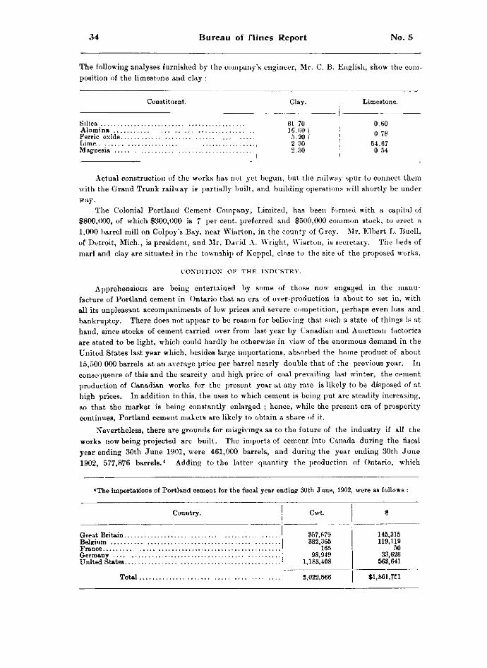
34 Bureau of nines Report No. 5
The following analyses furnished by the company's engineer, Mr. C. B. English, show the composition of the limestone and clay :
Constituent. Clay. Limestone.
Silica Alumina . . . Ferric oxide. Lime.. Magnesia . . .
61 70 16.60' 5.20 2 30 2.30
0.60 0.78
54.67 0 54
Actual construction of the works has not yet begun, but the railway spur to connect them with the Grand Trunk railway is partially built, and building operations will shortly be under way.
The Colonial Portland Cement Company, Limited, has been formed with a capital of $800,000, of which $300,000 is 7 per cent, preferred and $500,000 common stock, to erect a 1,000-barrel mill on Colpoy's Bay, near Wiarton, in the county of Grey. Mr. Elbert L. Buell, of Detroit, Mich., is president, and Mr. David A. Wright, Wiarton, is secretary. The beds of marl and clay are situated in the township of Keppel, close to the site of the proposed works.
C O N D I T I O N OF T H E I N D U S T R Y .
Apprehensions are being entertained by some of those now engaged in the manufacture of Portland cement in Ontario that an era of over-production is about to set in, with all its unpleasant accompaniments of low prices and severe competition, perhaps even loss and bankruptcy. There does not appear to be reason for believing that such a state of things is at hand, since stocks of cement carried over from last year by Canadian and American factories are stated to be light, which could hardly be otherwise in view of the enormous demand in the United States last year which, besides large importations, absorbed the home product of about 15,500 000 barrels at an average price per barrel nearly double that of the previous year. In consequence of this and the scarcity and high price of coal prevailing last winter, the cement production of Canadian works for the present year at any rate is likely to be disposed of at high prices. In addition to this, the uses to which cement is being put are steadily increasing, so that the market is being constantly enlarged ; hence, while the present era of prosperity continues, Portland cement makers are likely to obtain a share of it.
Nevertheless, there are grounds for misgivings as to the future of the industry if all the works now being projected are built. The imports of cement into Canada during the fiscal year ending 30th June 1901, were 461,000 barrels, and during the year ending 30th June 1902, 577,876 barrels. 4 Adding to the latter quantity the production of Ontario, which
*The importations of Portland cement for the fiscal year ending 30th June, 1902, were as follows :
Great Britain. Belgium France Germany United States.
Total
Country. Cwt.
357,679 145,315 382,365 119,119
165 50 98,949 33,626
1,183,408 563,641
2,022,566 fl,861,7El
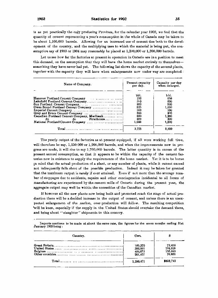
1902 Statistics for 1902 35
is as yet practically the only producing Province, for the calendar year 1902, we find that the quantity of cement representing a year's consumption in the whole of Canada may be taken to be about 1,100,000 barrels. Allowing for an increased use of cement due both to the development of the country, and the multiplying uses to which the material is being put, the consumption say of 1903 or 1904 may reasonably be placed at 1,200,000 or 1,300,000 barrels.
Let us see how far the factories at present in operation in Ontario are in a position to meet this demand, on the assumption that they will have the home market entirely to themselves— something they have never had yet. The following list shows the capacity of the several plants, together with the capacity they will have when enlargements now under way are completed :
Name of Company. Present capacity per day.
Capacity per day when enlarged.
bbl. bbl. 150 650 300 600 300 500 525 1,000 300 300 300 300 600 1,200 300 300
1,000 1,000
3,775 5,850
The yearly output of the factories as at present equipped, if all were working full time, will therefore be say, 1,150000 or 1,200,000 barrels, and when the improvements now in progress are made, it will rise to say 1,700,000 barrels. The latter quantity is in excess of the present annual consumption, so that it appears to be within the capacity of the cement factories now in existence to supply the requirements of the home market. Yet it is to be borne jn mind that the actual production of a plant, or any number of plants, while it cannot exceed not infrequently falls short of the possible production. Indeed it may be Caken for granted that the maximum output is rarely if ever attained. Even if not more than the average number of stoppages due to accidents, repairs and other contingencies incidental to all forms of manufacturing are experienced by the cement mills of Ontario during the present year, the aggregate output may well be within the necessities of the Canadian market.
If however all the new plants now being built and promoted reach the stage of actual production there will be a decided increase in the output of cement, and unless there is an unexpected enlargement of the market, over production will follow. The resulting competition *will be keen, especially if the supply in the United States should overtake the demand there, and bring about '' slaughter " shipments to this country.
Imports continue to be made at about the same rate, the figures for the seven months ending 31st January 1903 being :
Country. Cwt.
189,370 399,991 489,673 201,437
72,418 194.818 155.840 70,666
189,370 399,991 489,673 201,437
72,418 194.818 155.840 70,666
189,370 399,991 489,673 201,437
72,418 194.818 155.840 70,666
189,370 399,991 489,673 201,437
72,418 194.818 155.840 70,666
Total
189,370 399,991 489,673 201,437
72,418 194.818 155.840 70,666
Total 1,280,471 $493,742 1,280,471 $493,742
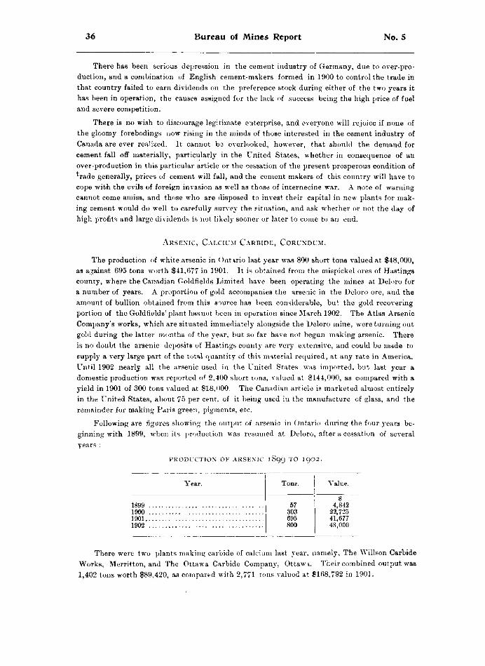
36 Bureau of Mines Report No. 5
There has been serious depression in the cement industry of Germany, due to over-production, and a combination of English cement-makers formed in 1900 to control the trade in that country failed to earn dividends on the preference stock during either of the two years it has been in operation, the causes assigned for the lack of success being the high price of fuel and severe competition.
There is no wish to discourage legitimate enterprise, and everyone will rejoice if none of the gloomy forebodings now rising in the minds of those interested in the cement industry of Canada are ever realized. It cannot ba overlooked, however, that should the demand for cement fall off materially, particularly in the United States, whether in consequence of an over-production in this particular article or the cessation of the present prosperous condition of rade generally, prices of cement will fall, and the cement makers of this country will have to
cope with the evils of foreign invasion as well as those of internecine war. A note of warning cannot come amiss, and those who are disposed to invest their capital in new plants for making cement would do well to carefully survey the situation, and ask whether or not the day of high profits and large dividends is not likely sooner or later to come to an end.
The production of white arsenic in Ontario last year was 800 short tons valued at $48,000, as against 695 tons worth $41,677 in 1901. It is obtained from the mispickel ores of Hastings county, where the Canadian Goldfields Limited have been operating the mines at Deloro for a number of years. A proportion of gold accompanies the arsenic in the Deloro ore, and the amount of bullion obtained from this source has been considerable, but the gold recovering portion of the Goldfields' plant hasnot been in operation since March 1902. The Atlas Arsenic Comjjany's works, which are situated immediately alongside the Deloro mine, were turning out gold during the latter months of the year, but so far have not begun making arsenic. There is no doubt the arsenic deposits of Hastings county are very extensive, and could be made to supply a very large part of the total quantity of this material required, at any rate in America. Until 1902 nearly all the arsenic used in the United States was imported, but last year a domestic production was reported of 2,400 short tons, valued at $144,000, as compared with a yield in 1901 of 300 tons valued at $18,000. The Canadian article is marketed almost entirely in the United States, about 75 per cent, of it being used in the manufacture of glass, and the remainder for making Paris green, pigments, etc.
Following are figures showing the output of arsenic in Ontario during the four years beginning with 1899, when its production was resumed at Deloro, after a cessation of several years :
A r s e n i c , C a l c i u m C a r b i d e , C o r u n d u m .
P R O D U C T I O N OF A R S E N I C 1899 T O I902.
Year. Tone. Value.
1899 1900 1901 1902
57 303 695 800
4,842 22,725 41,677 48,000
There were two plants making carbide of calcium last year, namely, The Willson Carbide Works, Merritton, and The Ottawa Carbide Company, Ottawa. Their combined output was 1,402 tons worth $89,420, as compared with 2,771 tons valued at $168,792 in 1901.
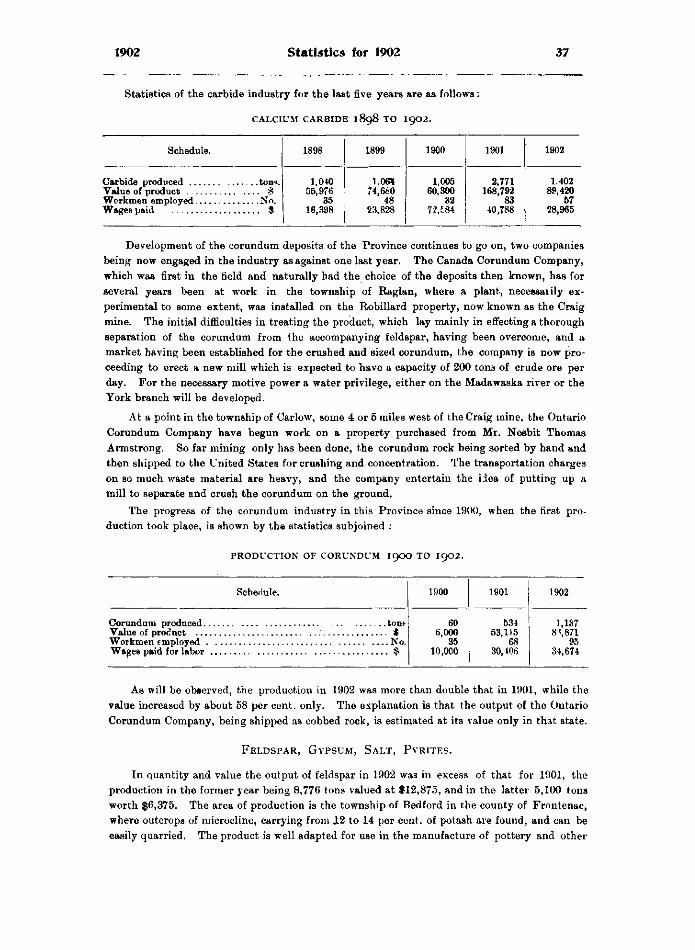
1902 Statistics for 1902 37
Statistics of the carbide industry for the l a B t five years are as follows:
C A L C I U M C A R B I D E 1898 T O 1902.
Schedule. 1898 1899 1900 1901 1902
. . . . $ No.
$
1,040 55,976
35 16,398
1.069 74,680
48 23,828
1,005 60,300
32 72.E84
2,771 168,792
83 40,788
1.402 89,420
57 28,965
Development of the corundum deposits of the Province continues to go on, two companies being now engaged in the industry as against one last year. The Canada Corundum Company, which was first in the held and naturally had the choice of the deposits then known, has for several years been at work in the township of Raglan, where a plant, necessaiily experimental to some extent, was installed on the Robillard property, now known as the Craig mine. The initial difficulties in treating the product, which lay mainly in effecting a thorough separation of the corundum from the accompanying feldspar, having been overcome, and a market having been established for the crushed and sized corundum, the company is now proceeding to erect a new mill which is expected to have a capacity of 200 tons of crude ore per day. For the necessary motive power a water privilege, either on the Madawaska river or the York branch will be developed.
At a point in the township of Carlow, some 4 or 5 miles west of the Craig mine, the Ontario Corundum Company have begun work on a property purchased from Mr. Nesbit Thomas Armstrong. So far mining only has been done, the corundum rock being sorted by hand and then shipped to the United States for crushing and concentration. The transportation charges on so much waste material are heavy, and the company entertain the idea of putting up a mill to separate and crush the corundum on the ground.
The progress of the corundum industry in this Province since 1900, when the first production took place, is shown by the statistics subjoined :
P R O D U C T I O N OF C O R U N D U M I 9 O O T O 1902.
Schedule. 1900 1901 1902
t o D > 60 534 1,137 * 6,000 53,115 8*,871
No. 35 68 95 Wages paid for labor ,, $ 10,000 30,406 34,674
As will be observed, the production in 1902 was more than double that in 1901, while the value increased by about 58 per cent. only. The explanation is that the output of the Ontario Corundum Company, being shipped as cobbed rock, is estimated at its value only in that state.
F e l d s p a r , G y p s u m , S a l t , P y r i t e s .
In quantity and value the output of feldspar in 1902 was in excess of that for 1901, the production in the former year being 8,776 tons valued at $12,875, and in the latter 5,100 tons worth $6,375. The area of production is the township of Bedford in the county of Frontenac, where outcrops of microcline, carrying from JL2 to 14 per cent, of potash are found, and can be easily quarried. The product is well adapted for use in the manufacture of pottery and other
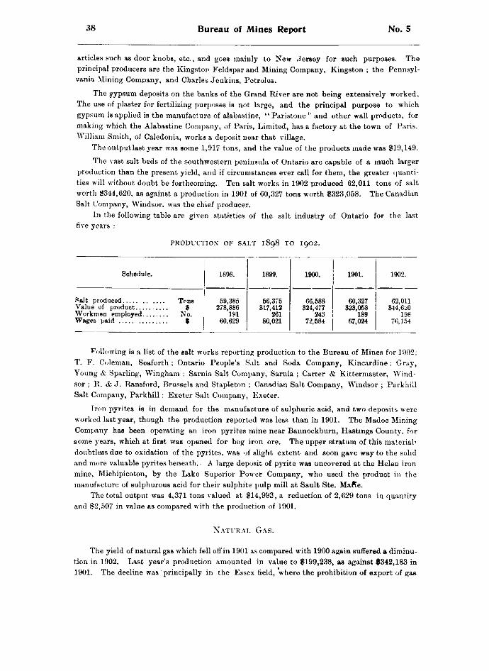
38 Bureau of Mines Report No. 5
articles such as door knobs, etc., and goes mainly to New Jersey for such purposes. The principal producers are the Kingston Feldspar and Mining Company, Kingston ; the Pennsylvania Mining Company, and Charles Jenkins, Petrolea.
The gypsum deposits on the banks of the Grand River are not being extensively worked. The use of plaster for fertilizing purposes is not large, and the principal purpose to which gypsum is applied is the manufacture of alabastine, " Paristone " and other wall products, for making which the Alabastine Company, of Paris, Limited, has a factory at the town of Paris. William Smith, of Caledonia, works a deposit near that village.
The output last year was some 1,917 tons, and the value of the products made was $19,149.
The vast salt beds of the southwestern peninsula of Ontario are capable of a much larger production than the present yield, and if circumstances ever call for them, the greater quantities will without doubt be forthcoming. Ten salt works in 1902 produced 62,011 tons of salt worth $344,620, as against a production in 1901 of 60,327 tons worth $323,058. The Canadian Salt Company, Windsor, was the chief producer.
In the following table are given statistics of the salt industry of Ontario for the last five years :
P R O D U C T I O N OF S A L T 1 8 9 8 T O I 9 0 2 .
Schedule. 1898. 1899. 1900. 1901. 1902.
Value of product Workmen employed
Tons $
No. $
59,385 278,886
191 60,629
56,375 317,412
261 80,021
66,588 324,477
243 72,584
60,327 323,058
189 67,024
62,011 344,61*0
198 76,154
following is a list of the salt works reporting production to the Bureau of Mines for 1902: T. F. Coleman, Seaforth ; Ontario People's Salt and Soda Company, Kincardine: Gray, Young & Sparling, Wingham : Sarnia Salt Company, Sarnia ; Carter & Kittermaster, Windsor ; R. & J. Ransford, Brussels and Stapleton ; Canadian Salt Company, Windsor ; Parkhill Salt Company, Parkhill : Exeter Salt Company, Exeter.
Iron pyrites is in demand for the manufacture of sulphuric acid, and two deposits were worked last year, though the production reported was less than in 1901. The Madoc Mining Company has been operating an iron pyrites mine near Bannockburn, Hastings County, for some years, which at first was opened for bog iron ore. The upper stratum of this material' doubtless due to oxidation of the pyrites, was of slight extent and soon gave way to the solid and more valuable pyrites beneath. • A large deposit of pyrite was uncovered at the Helen iron mine, Michipicoton, by the Lake Superior Power Company, who used the product in the manufacture of sulphurous acid for their sulphite pulp mill at Sault Ste. Mafte.
The total output was 4,371 tons valued at $14,993, a reduction of 2,629 tons in quantity and $2,507 in value as compared with the production of 1901.
N a t u r a l G a s .
The yield of natural gas which fell off in 1901 as compared with 1900 again suffered a diminution in 1902. Last year's production amounted in value to $199,238, as against $342,183 in 1901. The decline was principally in the Essex field, where the prohibition of export of gas
1902 Statistics for 1902 39
to Detroit, having been imposed in October 1901, had a full year's effect upon the figures of production. The method taken to put an end to the export of gas from the Essex field well illustrates the powers possessed by the Provinces by virtue of their owning the lands under the waters forming the international boundaries. Some years ago a license of occupation was granted to the Interior Construction and Improvement Company to lay down pipe lines on that part of the bed of the Detroit river opposite a given point within the limits of Ontario, the right to cancel the license being reserved to the Lieutenant-Governor in Council. The company laid down their mains, and for some years did a large business in sending gas across to the city of Detroit. Complaints began to be made as to the approaching exhaustion of the gas supply by inhabitants of the field who wished to preserve it for their own use. On investigation being made these complaints were ascertained to be well-founded, and an Order-in-Council was passed revoking the license of occupation, which at once brought the business of exporting gas to an end. Notwithstanding stoppage of the export, it does not appear that there has been any increase in supply or pressure of gas in the Essex field. In the town of Leamington, where wells owned by the municipality supply the inhabitants, barely enough gas is obtained for cooking purposes. None is used for heating.
Following are the figures showing value of natural gas produced in Ontario during the last five years:
Year. Value. 1898 $301,600 1899 440,904 1900 392,823 1901 342,183 1902 199,238
The production, it will be seen, has been on a descending scale since 1899. Last year's yield was less than 60 per cent, of that for 1901, about 50 per cent, of that for 1900, and about 45 per cent, of the output for 1899.
The returns show that there are 169 wells producing gas in the Province, of which 18 are situated in the Essex field, 120 in the Welland field, 2 in the Bruce peninsula, and the remainder in Haldimand county, where some 11 wells have been sunk near Dunnville, developing gas territory of considerable importance. Eighteen producing and thirteen non-producing wells were bored during the year. The number of miles of pipe used in distributing the gas was 369, and the number of employees engaged was 107, to whom $55,618 was paid in wages. The bulk of the production from the Welland field goes to Buffalo.
Taxation of natural gas companies under the Supplementary Revenue Act produced $6,308.95, as follows :
Provincial Natural Gas & Fuel Company of Ontario (Limited) $2,547 74 United Gas and Oil Company, of Canada, (Limited) 3,761 21
P e t r o l e u m a n d P e t r o l e u m P r o d u c t s .
The production of petroleum was less than in 1901, being 18,185,592 imperial gallons of crude oil as against 21,433,500 gallons in that year. The reduction of the yield is proceeding slowly, being to some extent from time to time offset by the finding and opening up of new " pools " or " fields." Formerly all the crude oil was refined, but within the last two or three years an increasing proportion has gone into consumption in the crude condition for fuel and gas-making purposes. The quantity of crude distilled in 1902 was 15,630,592 gallons, leaving the remainder, estimated to amount to 3,555,000 gallons to be devoted to other uses
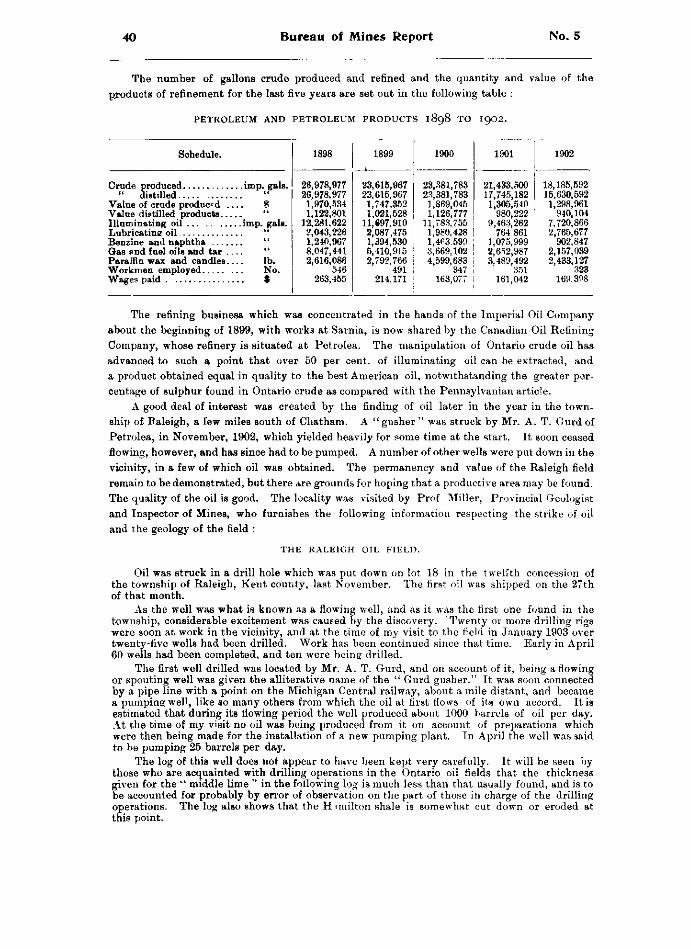
40 Bureau of Mines Report No. 5
THE NUMBER OF GALLONS CRUDE PRODUCED AND REFINED AND THE QUANTITY AND VALUE OF THE PRODUCTS OF REFINEMENT FOR THE LAST FIVE YEARS ARE SET OUT IN THE FOLLOWING TABLE :
P E T R O L E U M A N D P E T R O L E U M P R O D U C T S 1898 T O 1902.
Schedule. 1898 1899 1900 1901 1902
26,978,977 23,615,967 23,381,783 21,433.500 18,185,592 " distilled ii 26,978,977 23,615,967 23,381,783 17,745,182 15,630,592
Value of crude produced .. 1,970,534 1,747,352 1,869,045 1,305,540 1,298,961 1,122,801 1,021,528 1,126,777 980,222 940,104
Illuminating oil imp. gals. 12,281,622 11.S97.910 11,783,755 9,463,262 7,720,866 Lubricatine oil 2,043,226 2,087,475 1,980,428 764 861 2,765,677 Benzine and naphtha 1,240,967 1,394,530 1,4^3.599 1,075,999 902,847 Gas and fuel oils and tar .. " 8,047,441 5,410,915 3,669,102 2,652,987 2,157,039 Paraffin wax and candles.. lb. 2,616,086 2,792,766 4,599,683 3,489,492 2,433,127
No. 546 491 347 351 323 $ 263,455 214,171 163,077 161,042 169,398
THE REFINING BUSINESS WHICH WAS CONCENTRATED IN THE HANDS OF THE IMPERIAL OIL COMPANY ABOUT THE BEGINNING OF 1899, WITH WORKS AT SARNIA, IS NOW SHARED BY THE CANADIAN OIL REFINING COMPANY, WHOSE REFINERY IS SITUATED AT PETROLEA. THE MANIPULATION OF ONTARIO CRUDE OIL HAS ADVANCED TO SUCH A POINT THAT OVER 50 PER CENT, OF ILLUMINATING OIL CAN BE EXTRACTED, AND A PRODUCT OBTAINED EQUAL IN QUALITY TO THE BEST AMERICAN OIL, NOTWITHSTANDING THE GREATER PERCENTAGE OF SULPHUR FOUND IN ONTARIO CRUDE AS COMPARED WITH THE PENNSYLVANIAN ARTICLE.
A GOOD DEAL OF INTEREST WAS CREATED BY THE FINDING OF OIL LATER IN THE YEAR IN THE TOWNSHIP OF BALEIGH, A FEW MILES SOUTH OF CHATHAM. A "GUSHER " WAS STRUCK BY MR. A. T. GURD OF PETROLEA, IN NOVEMBER, 1902, WHICH YIELDED HEAVILY FOR SOME TIME AT THE START. IT SOON CEASED FLOWING, HOWEVER, AND HAS SINCE HAD TO BE PUMPED. A NUMBER OF OTHER WELLS WERE PUT DOWN IN THE VICINITY, IN A FEW OF WHICH OIL WAS OBTAINED. THE PERMANENCY AND VALUE OF THE RALEIGH FIELD REMAIN TO BE DEMONSTRATED, BUT THERE ARE GROUNDS FOR HOPING THAT A PRODUCTIVE AREA MAY BE FOUND. THE QUALITY OF THE OIL IS GOOD. THE LOCALITY WAS VISITED BY PROF MILLER, PROVINCIAL GEOLOGIST AND INSPECTOR OF MINES, WHO FURNISHES THE FOLLOWING INFORMATION RESPECTING THE STRIKE OF OIL AND THE GEOLOGY OF THE FIELD :
T H E R A L E I G H OIL F I E L D .
OIL WAS STRUCK IN A DRILL HOLE WHICH WAS PUT DOWN ON LOT 18 IN THE TWELFTH CONCESSION OF THE TOWNSHIP OF RALEIGH, KENT COUNTY, LAST NOVEMBER. THE FIRST OIL WAS SHIPPED ON THE 27TH OF THAT MONTH.
AS THE WELL WAS WHAT IS KNOWN AS A FLOWING WELL, AND AS IT WAS THE FIRST ONE FOUND IN THE TOWNSHIP, CONSIDERABLE EXCITEMENT WAS CAUSED BY THE DISCOVERY. TWENTY OR MORE DRILLING RIGS WERE SOON AT WORK IN THE VICINITY, AND AT THE TIME OF MY VISIT TO THE FIELD IN JANUARY 1903 OVER TWENTY-FIVE WELLS HAD BEEN DRILLED. WORK HAS BEEN CONTINUED SINCE THAT TIME. EARLY IN APRIL 60 WELLS HAD BEEN COMPLETED, AND TEN WERE BEING DRILLED.
THE FIRST WELL DRILLED WAS LOCATED BY MR. A. T. GURD, AND ON ACCOUNT OF IT, BEING A FLOWING OR SPOUTING WELL WAS GIVEN THE ALLITERATIVE NAME OF THE " GURD GUSHER." IT WAS SOON CONNECTED BY A PIPE LINE WITH A POINT ON THE MICHIGAN CENTRAL RAILWAY, ABOUT A MILE DISTANT, AND BECAME A PUMPING WELL, LIKE SO MANY OTHERS FROM WHICH THE OIL AT FIRST FLOWS OF ITS OWN ACCORD. IT IS ESTIMATED THAT DURING ITS FLOWING PERIOD THE WELL PRODUCED ABOUT 1000 BARRELS OF OIL PER DAY. AT THE TIME OF MY VISIT NO OIL WAS BEING PRODUCED FROM IT ON ACCOUNT OF PREPARATIONS WHICH WERE THEN BEING MADE FOR THE INSTALLATION OF A NEW PUMPING PLANT. IN APRIL THE WELL WAS SAID TO BE PUMPING 25 BARRELS PER DAY.
THE LOG OF THIS WELL DOES NOT APPEAR TO HAVE BEEN KEPT VERY CAREFULLY. IT WILL BE SEEN BY THOSE WHO ARE ACQUAINTED WITH DRILLING OPERATIONS IN THE ONTARIO OIL FIELDS THAT THE THICKNESS GIVEN FOR THE " MIDDLE LIME " IN THE FOLLOWING LOG IS MUCH LESS THAN THAT USUALLY FOUND, AND IS TO BE ACCOUNTED FOR PROBABLY BY ERROR OF OBSERVATION ON THE PART OF THOSE IN CHARGE OF THE DRILLING OPERATIONS. THE LOG ALSO SHOWS THAT THE HIMILTON SHALE IS SOMEWHAT CUT DOWN OR ERODED AT THIS POINT.
1902 Statistics for 1902 41
L O G O F T H E G U R D W E L L , L O T 1 8 , C O N . 1 2 , R A L E I G H .
Thickness. Boulder clay 160 feet Shale , 4 0 " Middle lime ' 2 " Shale 73 " Lower lime to 460 " from the sur
face of the ground. A well which was being drilled on lot 19 in the thirteenth concession, 700 yards from the
Gurd, at the time of my visit showed 150 feet of boulder clay and then hard pan, sand and gravel to 220 feet, the point reached at that date. The greater thickness of loose material at this point, as compared with that found where the first w«ll was drilled, gives evidence of the presence of an old stream or river channel. It is stated this old channel was found to be 100 feet deep.
Of the following logs No. 1 is said to represent a typical well of the district, and No. 2 a well put down on the centre of lot 15 in the twelfth concession of Raleigh.
N O . I .
Boulder clay with occasional layers of sand and gravel 184 feet Shale to 205 " Limestone (argillaceous) 5 to 211 " Shale to 240 " Limestone to 246 " Shale to 247 " Limestone (middle lime ; slightly argillaceous). to 249 Shale to 278£ " Limestone, very slightly argillaceous, becoming almost
pure lime thereafter , to 511 " The last is what is known as the " big lime."
N O . 2 .
Alluvium 140 feet Portage shale ' 45 " Hamilton shale 193 " Bottom part corresponds to what is given under No. 1.
It may be noted that a well put down at Dresden showed 200 feet of alluvium. The anticline which had been only roughly outlined in the neighborhood of the Gurd well at
the time of my visit showed a dip of about 30 feet in one-half mile on its northern side, and about the same dip on its southern face. This was determined by the drill holes which had been put down, the underlying rock being covered, as already stated, by about 160 feet of alluvium.
The part which an anticlinal structure plays in prospecting is well known to oil men, but for the benefit of the general reader it may be stated that in the Ontario field, and in most other districts of the world, oil is found only where the rocks have taken on this form, i. e., where they have been bent into a gentle ridge-like structure, which is called an anticline.
This structure in rocks is of course discovered with difficulty where the surface is occupied by a thick mantle of drift such as that which covers the solid rocks in Raleigh. That the oil in this district was not discovered by mere chance or by drilling at random, without any knowledge of the structure of the underlying rocks, will be evident from the following statement : In the neighborhood immediately surrounding what is now known as the Gurd well the farmers had put down a number of wells through the 150 feet or so of alluvium to the solid rock in order to get water, which was obtainable in quantity only at this depth. The water from one of these wells was found to carry more or less oil. This fact of itself would be of little significance had not the surrounding wells when their logs were studied given evidence of the presence of an anticline in the vicinity. Mr. Gurd, who was travelling through the district, had his attention drawn to the well from which the oily water came. He and his associates also obtained the logs of other wells which had been put down, and from these it was quite evident to them that an anticline was present. This was seen from the fact that the bottom of some of the wells struck the shale, the layer of rock which here lies immediately under the mantle of clay and sand, at greater depth than others. Moreover, it was found that some of the wells yielded little or no water, while others gave a copious supply, thus affording evidence that the former were on top of an anticline, from which the water ran off to the sides.
5Characteristic baud of limestone 70 or 80 feet above the " lower lime.
42 Bureau of Mines Report No. 5
Of course, after drilling operations had begun and a number of holes put down for oil additional information became available, by means of which the outline of the anticline or protuberance on the surface of the shale could be much more accurately defined. At the time of my visit this had been done in the Raleigh field, so that experienced oil men were able to tell me that oil would be struck in a certain well, which was then being drilled, some days before the oil horizon was really reached. When the latter was struck the oil and water spurted to a height in the air which was estimated to be sixty feet. It is stated, however, that this well has produced very little oil, and the spouting appears to have been due to the drill having struck a pocket of gas. The distance from the only two others, the Gurd and another, in which oil had been struck at that time was four or five miles. It will thus be seen that the locating of oil wells rests on a systematic basis, and that they are not usually discovered in the haphazard way that many persons suppose.
There seems to be a slight difference as regards the vertical boundaries of these important formations or rock groups—the Portage, Chemung, Hamilton and Corniferous—between the description given in the Geological Survey Reports on the district and those followed by the oil men. The latter describe the rocks of these formations as follows : The Chemung, or uppermost formation, is a uniform shale, while the upper bed of the Hamilton may be either a limestone, an argillaceous limestone, or a shale which is commonly called "soap." The Chemung, as recognized by the drillers, is said to be black, quite sandy and stratified, while the Hamilton shale is said to be gray when dry, and to show little stratification.
The Hamilton " soap " or shale which passes into the Corniferous limestone is said to have a thickness ranging from 25 to 30 feet. The limestone referred to is known as the "big lime " or "lower lime."
The most distinct and persistent limestone in the Hamilton is what is called the " middle lime." It lies 30 to 50 feet above the " lower lime " and varies in thickness froni 7 to 20 feet. It is always present while other layers of shale and limestone in the Hamilton may vary in position or be wanting altogether.
The top limestone is persistent in thickness, 40 to 50 feet, over wide areas. Where the top of the Hamilton is in place this formation is 255 to 260 feet in thickness.
Where the top layer is not found below the Chemung, the formation is 195 to 210 feet in thickness.
The Oriskany is believed not to be present in the southwestern peninsula of the Province. A few grains of sand are sometimes found, but the rock is principally carbonate.
The only producing well in the Raleigh field at the present time, April 1903, is the Gurd, the first to be put down.
It is stated that a little oil has been obtained from some of the wells which have recently been sunk in the vicinity of Thamesville.
M I N I N G A C C I D E N T S .
The number of accidents reported to the Bureau of Mines in 1902 was 17, involving 22 men, and causing 10 deaths. This is an improvement over 1901, when 29 casualties occurred to 39 men, of whom 13 were killed.
Falls of rock and ore and unexpected explosions of dynamite continue to be the most fruitful sources of accident. The former was unusually prolific last year, falls of one kind or other being responsible for 8 out of the 10 deaths. To detect hidden seams in the roofs of workings amid darkness, illuminated only by miners' candles, is at best a difficult and uncertain task, yet the only way to secure a maximum of immunity from the dangers which lurk in loosened rock or opening fissures is to maintain a constant and systematic examination of the roofs and walls of all workings. Ground which one day may appear perfectly sound, and ring true to the scaler's hammer, may the next be shattered by the effects o some blast near by or far away ; or moisture percolating from the surface or rising from floor to roof may, by alternate freezing and thawing, produce the same disintegrating effects in the workings of a mine as in rock masses on the surface. Nor should it be forgotten that in a climate like ours, where the winters are severe, the effects of freezing water are much more marked than in countries where frost is unknown or seldom seen. Open pit workings, on account of the free access to them of snow, rain and frost, seem especially liable to falls of rock and ore.
1902 Statistics for 1902 43
Human life is precious, and no pains to preserve it can be considered too great. There is a laudable desire on the part of mining companies to take precautions for the safety of their men ; a desire which is sometimes, it cannot be denied, defeated by the recklessness and foolish hardihood of the men themselves, who not infrequently despise the means provided for their own welfare, and reject a safer method involving trouble or inconvenience to themselves in favor of a more dangerous one which saves them steps or time. The scaling of walls and roofs however is not a matter which comes within the category of precautions to be taken by the workmen. It is one for managers and foremen ; and even on selfish grounds, if no other, the most careful measures to guard against falls of rock or ore in mine workings would be well repaid. Nothing tends to demoralize a force of miners more than a repetition of accidents due to causes over which they have themselves no control, and a gang of men full of anxiety for their safety cannot in the nature of things get out as much ore or do as much work as a gang working in the knowledge that recent and thorough examination has shown the roof under which they are laboring to be sound and whole, and that any crack or fissure which may be developed will be revealed, and the danger from it eliminated at the next scaling a short time ahead.
On the other hand, explosives are in the main used and handled by miners and workmen themselves. The temerity with which powerful and uncertain explosives are sometimes treated is almost incredible. Sticks of dynamite have been known to be carried about in a miner's pocket, or, to keep them from freezing, in his boot leg or shirt-bosom, and in the absence of a pair of plyers, a convenient method of fixing caps in place is by compressing them with the teeth. Bravado impels men to expose themselves during a blast rather than take sufficient cover, and missed holes are not treated with the degree of suspicion which their dangerous character deserves. There is no satisfactory way of protecting men from themselves, and to the end of the chapter there will doubtless be a proportion of accidents preventible in their nature, but preventible only if prudence and common sense are permitted by miners to rule their dealings with explosives, instead of recklessness and contempt of danger. There is reason to believe that in some cases the quality of the dynamite has been inferior, either because of defective manufacture or deterioration through long keeping, and this is a matter which managers should carefully guard against.
D e l o r o G o l d M i n e .
One P. Flinn was shovelling in a stope of the Deloro gold mine, owned by the Canadian Goldfields Limited, on 29th January, when a piece of rock fell from the roof above him» striking him on the shoulder and fracturing his collar bone. Flinn was at once removed to the surface where he was given medical attendance, and afterwards taken to Marmora. On 27th February he was reported as quite well again.
In the same mine, on 20th May, while the skip was being hoisted, one of the wheels came off, and falling down a distance of 100 feet, struck Thomas Neal, who was at the bottom of the incline, on the left foot, crushing it severely. The wound was dressed and Neal sent home* The mine manager states that the company's rules require the fbreman to examine the hoist rope and all running gear every Monday morning and to report upon their condition. The mine skips are mounted with the Anaconda pattern of wheels. One of the latter, it was found, had cracked, allowing the key holding it to fall out "and permitting the wheel itself to become detached.
V i c t o r i a M i n e .
On 14th January an electrician named Harry Long, employed at the smelter, Victoria Mines, was directed to go to the mine to repair the electric light plant; and, contrary to orders
44 Bureau of Mines Report No. 5
posted at the terminal of the tramway, boarded a backet of the jerial tramway to ride to the mine. Seated on the outer edge of the bucket he swung it in toward the tower, causing it to collide with the latter. The bucket and Long were thrown to the ground, a distance of about 13 feet, and Long's leg was broken.
The following day, P. Chener, a drill-runner's laborer, was working in the fourth level, west stope, and while drilling into the roof in the rise was injured by a piece of rock falling on him. His shoulder was broken and he was otherwise severely bruised.
O n t a r i o S m e l t i n g W o r k s .
The nickel-copper mattes of the Canadian Copper Company are re-smelted and concentrated by the Ontario Smelting Works. The fine flue dust is collected in a large chamber 12 feet wide, 30 feet long and 18 or 20 feet high ; and it is part of the routine to clean out this chamber on Sundays when the furnaces are not being operated. The dust is very hot and must be cooled with water before it can be handled with safety. On the morning of 23rd February, a man named George Legault, employed by the contractor for this work, P. For-tier, entered the flue chamber and while throwing water on its contents through a hcse, was suddenly overwhelmed by a falling mass of the hot dust, which burned him very severely. It is believed also that some of the dust got into his lungs and so hastened his death, which took place a few hours later. It was contrary to the company's rules for any one to go inside the flue chamber before the dust was cooled. The contractor testifitd that he himself and one or two other men were in the room with the deceased, but that at his directions they all came out before the accident occurred except Legault, who persisted in remaining inside. An inquest was held by Dr. R. B. Struthers, coroner, and the jury's verdict exonerated the Ontario Smelting Company and its foreman from any negligence, but found that the contractor did not exercise sufficient authority over the men working for him.
C a n a d i a n C o p p e r C o m p a n y ' s M i n e s .
At the Creighton nickel mine, on the morning of 25th February, Montrose Hays, foreman of the rock-picking department, descended into an ore bin to release ore clinging to the side of the bin and refusing to discharge. He was caught by the sliding ore and suffocated before he could be rescued. The ore after being crushed and sent over the j'g table, passes through perforated revolving screens and assorts itself, according to size, into different bins beneath which the cars are placed for loading. Sometimes the ore in one of these bins becomes matted or wedged together, and must be loosened or shaken up before it will descend. This is done by prying the ore from above or below with an iron bar. Occasionally an arch of ore is formed from side to side of the bin, the pieces below the arch falling through and leaving an apparently solid mass of ore, though in reality only a crust. Some such occurrence doubtless induced Haj7s, who is described as an energetic, willing young man, to get into the bin, the more easily to loosen the ore, notwithstanding that the orders were, as he was aware, not to do so. No one saw Hays go into the bin, but he was soon missed from his post, and hi« mittens lying on the rail beside the bin indicated his whereabouts. The aperature at the bottom of the bin was opened as being the quickest way to get him out, but, though the body was quickly recovered, life was extinct. A coroner's jury, summoned by Dr. R. B. Struthers, returned a verdict to the effect that Hayes met his death from being suffocated in an ore bin at the Creighton mine, and that he came to be in the bin by accident or misadventure.
At No. 3 or Frood mine on 11th March, a miner named Gustavus England was killed by a large piece of rock falling from the roof of the drift in which he was wwking and crushing him, causing instant death. Coroner Struthers held an inquest, at which evidence was given that
1902 Statistics for 1902 45
the custom was to scale the roofs and walls of workings on Sundays, and whenever at other times there seemed to be a necessity. The roof in question was scaled on Sunday, 2nd March, when it appeared to be quite sound. Foreman Joseph Harris testified that he had carefully examined the roof on the morning of the accident, and thought it all right. Foreman Hiram Walker gave like testimony, stating that he h»d examined the roof that day ahead of the men and deemed it quite safe. Some of the witnesses thought that a frost the night before followed by a heavy thaw in the morning had had the effect of loosening the mass of rock or ore—about 500 lb. in weight—which fell on poor England. The fall took place in a tunnel or drift off the main stope, at which point the roof was 10 or 15 feet from the botton of the level, and 50 or 55 feet below the surface. The coroner's jury, while not attributing special neglect to any employe of the Canadian Copper Company, earnestly recommended that increased vigilance be exercised in scaling the roofs of all mines.
Another fatal accident of a similar nature occurred on 3rd April in the Canadian Copper Company No. 2 mine, when two Finlanders named Emil Sarminen and John Kuski were killed. The men were working under the brow of the stope at the entrance of a drift when a piece of ore weighing about two tons fell upon them from a height of 10 or 12 feet and instantly crushed them to death. It is stated that the ground at this point was scaled the day before the accident and again on the morning of the day the fall took place, and that all the men wTorking in the pit were satisfied there was no danger. The surface of the ore which fell showed some frost, indicating that there was a seam into which the frost had penetrated, and that as the frost came out the block of ore was loosened. An inquest was held by Dr. Struthers. The jury simply found that the men accidentally came to their death by being crushed under falling ground, without attempting to place the responsibility tor the occurrence upon any one.
An Italian workman named Araso Galaso, who was working for contractor D. L. McKinnon atthe Copper Clrff roast yard, was injured on 4th August by the effects of a blast set off in roasted ore. The regular blaster blew his whistle, lit the fuse and at once withdrew in one direction, supposing Galaso to have done the same in another direction, but on returning to see what the blast had accomplished he found Galaso lying on the ground. He had been struck by flying ore, his face being badly bruised, his left wrist dislocated, and his eyesight injured. The shock was a severe one, but the wounds were not of a dangerous character. The contractor reports that the ore in which the blasting was being done was cold.
At the Creighton open cut mine a power-drill helper named Thomas McHugh met his death on 15th December by being precipitated down the stope from a point about 15 feet below the surface. McHugh was on his way down to a bench on which the drill was set up, being followed by W. D. McKerrow, the driller. The latter stepped on a small projection of rock which gave way, and falling down struck McHugh on the breast, causing him to lose his balance and fall to the bottom of the stope, a distance of about 40 feet. He was taken up suffering from concussion of the brain, and died next morning at 3 o'clock. Coroner Struthers conducted an inquest, from the evidence given at which it appears that the stope had been scaled the previous day, Sunday, and left in what wa^ considered good shape. A rope fastened to boulders at the top led down the stope for the protection of miners, but McHugh did not make use of the rope in descending. The bench on which the deceased was standing was only four feet wide. It was not perfectly level, and from this somewhat insecure footing, the shock of the falling stone—which was about the size of a man's head—was sufficient to dislodge him. There was some discrepancy of testimony among the witnesses as to the sufficiency of the scaling done on the previous day, some alleging that loose pieces of "muck " had been left near where the drillers were working. The jury were not unanimous in their finding. A majority
46 Bureau of Mines Report No. 5
verdict, signed by eight jurymen, stated "that Thomas McHugh came to his death from a fall in Creighton mine, and that he was made to fall by a piece of loose rock falling and striking him ; and we believe there was negligence in having that part of the mine in the condition it was in " The remaining five jurymen rendered a minority verdict, holding the fall to have been purely accidental. The majority seem to have based their view as to the condition of the stope on the presence of loose material upon it, and the narrowness of the bench upon which the drillers had to stand while working. McHugh's usual occupation was that of a trammer, and he had been put on as " helper " for the first time on the day he was killed.
B i g M a s t e r G o l d M i n e .
An explosion of dynamite in the Big Master gold mine on 17th March, severely injured John Archibald and John St. Amand, and less severely Malcolm Spear and George Robinson. On the accident being reported to the Bureau of Mines, Inspector of Mines Carter, being in the neighborhood, was instructed to investigate the circumstances, and report. The substance of Mr. Carter's report is as follows : The four injured men comprised one of the eight-hour shifts who were sinking the main shaft, and hid begun work at 3 p.m. The previous shift had completed drilling the round of 16 holes, and it remained for this gang to load, blast and muck out. The centre sink of eight holes was blasted out, eight discharges counted, and the muck removed. The remaining holes were then loaded and fired, but only six discharges were counted. On partially removing the muck, the two missed holes were found with the burnt fuses still in place. Archibald and St Amand began picking out the loose shattered rock at the bottom of the shaft, Spears and Robinson standing back out of the way. While thus engaged Archibald's pick struck and exploded some loose dynamite, the resulting injuries being : to Archibald, leg broken, two fingers blown off, face and eyes cut and eyesight destroyed ; to St. Amand, jaw broken, face and eyes injured ; to Spear, face and one eye cut and bruised ; to Robinson, hand and face bruised and cut, but not seriously. Those on the surface hearing the unexpected explosion hurried below and brought up the injured men, who were all cared for as well as possible under the circumstances. The nearest physician, Dr. White of Wabigoon, arrived in 13 hours' time and Dr. Blair of Dryden, 9 hours later. On 19th March the men were driven to Wabigoon and taken thence by rail to Winnipeg, where they were placed in the hospital, and soon began to mend. How the loose dynamite came to be in the bottom of the shaft could not be ascertained, but an examination of the remaining stock of the explosive showed it to be in poor condition, and its destruction was ordered. Directions were also left the manager to inspect drilling and blasting operations frequently enough to be certain that all missed holes were found and entirely discharged before resuming operations in working faces.
E l s i e N i c k e l M i n e .
The premature explosion of a sand blast at the Elsie nickel mine, the property of the Lake Superior Power Company, on 19th March, injured James Thompson, powderman, and Robert Neil, block-holer, the former so seriously as to necessitate amputation of the left leg above the knee, and the latter somewhat less severely in the head, back and right leg. Both were removed to the Sudbury general hospital, where Thompson died in 24 hours. Neil's bruises were sufficient to keep him indoors for ten days or so. The fuse connected with the charge of dynamite seems to have burned faster than was expected, thus causing an explosion before the men got out of the way. There were no others present when the accident occurred, and after making inquiries Coroner Struthers did not consider an inquest called for, in which view Mr. A. G. Browning, District Crown Attorney, concurred.
On 8th May another employee of the Elsie mine, named Peter Morrison, had the first finger of his left hand caught by the dump bucket and slightly crushed.
1902 Statistics for 1902 47
R a d n o r I r o n M i n e .
A MASS OF ROCK FALLING DOWN THE INCLINE AT THE OPEN PIT WORKINGS OF THE RADNOR IRON MINE, OWNED BY THE CANADA IRON FURNACE COMPANY, AND SITUATED ON LOT 16 IN THE NINTH CONCESSION OF THE TOWNSHIP OF GRATTAN, CAUSED THE DEATH OF PETER LARMOND, OR L'ARMOUR, ON 29TH APRIL. LARMOND WAS ABOUT 67 YEARS OF AGE, INFIRM AND SLIGHTLY DEAF, AND WHEN THE ROCK TUMBLED DOWN THE SLOPE THE OTHER MEN WHO WERE WORKING ON THE PIT BOTTOM RAN UP THE SIDES AND ESCAPED WITHOUT DIFFICULTY, WHILE THE OLDER AND LESS ACTIVE MAN WAS CAUGHT AND CRUSHED BY THE FALLING PIECES. HIS INJURIES WERE VERY SEVERE, BOTH LEGS BEING BROKEN AND INTERNAL INJURIES INFLICTED, AND THEY RESULTED IN HIS DEATH IN ABOUT 32 HOURS AFTER THE ACCIDENT. DR. CHANNON-HOUSE WAS THE ATTENDANT PHYSICIAN, BUT NO CORONER WAS NOTIFIED, THE MINE SUPERINTENDENT, MR. D. J. MCCUAN, BEING UNDER THE IMPRESSION THAT DR. CHANNONHOUSE HIMSELF WAS STILL A CORONER, AS HE HAD PREVIOUSLY BEEN. MR. W. G. MILLER, IN HIS CAPACITY AS INSPECTOR OF MINES, WAS INSTRUCTED TO VISIT THE MINE AND MAKE AN INVESTIGATION, WHICH HE DID UNDER OATH. THE STATEMENTS OF THE VARIOUS WITNESSES WHO WERE CALLED WENT TO SHOW THAT THE SUPERINTENDENT AND MINE FOREMAN HAD ALWAYS TAKEN THE NECESSARY PRECAUTIONS TO GUARD AGAINST ACCIDENTS, AND THAT THE ROCK WHICH FELL HAD GIVEN NO PREVIOUS INDICATIONS OF BEING LOOSE OR IN ANY WAY DANGEROUS. NO BLAME APPEARED TO ATTACH TO ANY ONE ON ACCOUNT OF THE ACCIDENT.
H e l e n I r o n M i n e .
THE HELEN IRON MINE, MICHIPICOTON MINING DIVISION, WAS THE SCENE OF A FATAL ACCIDENT ON 26TH AUGUST, WHEN A "MUCKER" NAMED AUGUST ANDERSON, FINLANDER, WAS CAUGHT BY A ROCK, WHICH HAD BEEN LOOSENED BY A BLAST, ROLLING DOWN THE STEEP INCLINE OF THE OPEN PIT AND CRUSHING HIM, CAUSING INSTANT DEATH. THE BLAST WAS A PRELIMINARY ONE SET OFF TO "SPRING" THE BOTTOM OF A DEEP HOLE AND PREPARE IT FOR THE FINAL CHARGE, AND ON SUCH OCCASIONS IT IS THE DUTY OF THE "POWDER MONKEY" TO NOTIFY THE MEN WORKING NEAR BY TO STAND BACK. ANDERSON, HOWEVER, IT IS STATED, PAID LITTLE OR NO ATTENTION TO THE WARNING, NOT EVEN LEAVING HIS CAR, THE RESULT BEING THAT HE WAS KILLED IN THE MANNER DESCRIBED. THERE IS NO CORONER AT THE HELEN MINE, BUT MR. M. B. R. GORDON, JUSTICE OF THE PEACE, WAS NOTIFIED OF THE ACCIDENT, AND HE GAVE IT AS HIS OPINION THAT AN INQUEST WAS UNNECESSARY. ANDERSON WAS A MARRIED MAN ABOUT 45 YEARS OF AGE, AND HAD BEEN EMPLOYED AT THE MINE ABOUT THREE YEARS.
A SIMILAR CASUALITY OCCURRED AT THIS MINE ON 17TH OCTOBER, WHEN ONE PETER KARCONA, A MACHINE HELPER, WAS KILLED BY SOME GROUND WHICH GAVE WAY ABOUT 20 FEET ABOVE WHERE HE WAS WORKING IN THE OPEN PIT, FALLING UPON HIM AND CRUSHING HIS SKULL. THE FOREMAN, CAESAR CAIN, SAW THE ROCK BEGINNING TO FALL, AND SHOUTED A WARNING TO THE MINERS, ALL OF WHOM GOT OUT OF THE WAY BUT THE DECEASED. THE ROCK HAD SHOWN NO SYMPTOMS OF BEING LOOSE. NO INQUEST WAS HELD.
M o o r e I r o n M i n e .
AT THE MOORE IRON MINE, HASTINGS COUNTY, WORKED BY MR. ARTHUR COE, MADOC, ON 3RD SEPTEMBER A DERRICK SUDDENLY GAVE WAY THROUGH THE BREAKING OF THE MAST, AND WAS PRECIPITATED INTO THE PIT, WHERE IT FELL UPON A MINER NAMED JOSEPH SANFORD, AGED 18, BREAKING HIS RIGHT LEG AND CRUSHING HIS LEFT ANKLE. THE DERRICK HAD BEEN IN USE LESS THAN TWO YEARS, AND WAS CONSIDERED EQUAL TO THE TASKS IMPOSED UPON IT.
A SUMMARY TABLE OF THE ACCIDENTS IS GIVEN BELOW, FROM WHICH IT WILL BE SEEN THAT OF THE 22 AFFECTED, 3 WERE SLIGHTLY AND 9 SERIOUSLY INJURED, WHILE 10 WERE EITHER KILLED OUTRIGHT OR DIED SHORTLY AFTER BEING HURT. FIVE OF THE MEN WERE WORKING ABOVE GROUND WHEN INJURED, AND 17 BELOW GROUND.
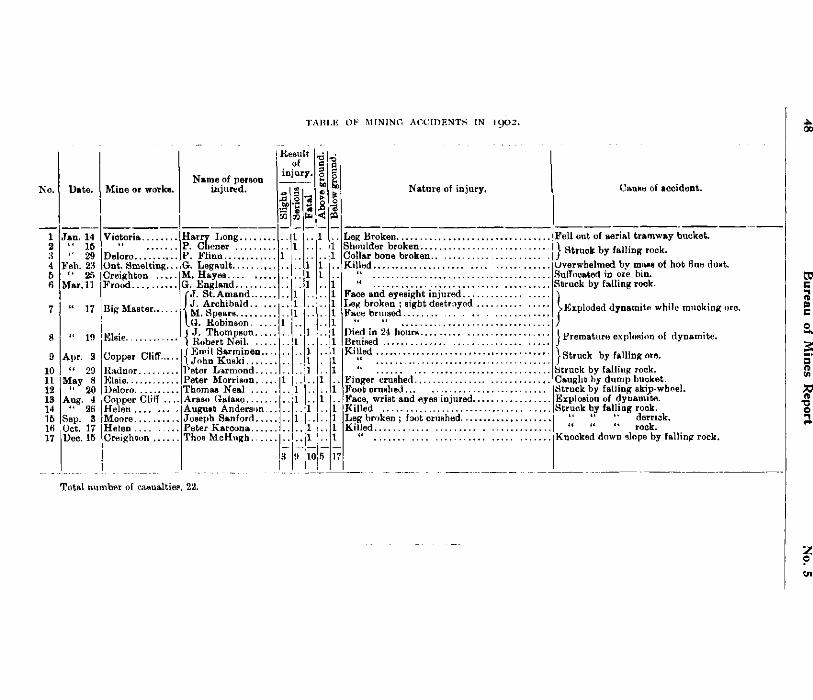
T A B L E OF MINING A C C I D E N T S IN i g 0 2 .
Date.
Jan. 14 16 29
Feb. 23 " 25
Mar. 11
" 17
" 19
Apr. 3 " 29
May 8 ' 20
Aug. 4 "' 26
Sep. 3 16 Oct. 17 17 Dec. 15
Mine or works.
Victoria.
Deloro Ont. Smelting. Creighton .... Frood
Big Master.
Elsie.
Copper Cliff.... Radnor Elsie Deloro Copper Cliff .. Helen Moore Helen Creighton
Name of person injured.
Harry Long P. Chener P. Flinn
,G. Legault , M. Hayes G. England
J. St.Amand.... J. Archibald.. . M. Spears G. Robinson. ..
t J. Thompson... I Robert Neil j Emit Sarminen.. \ John Kuski Peter Larmond... Peter Morrison. . Thomas Neal AraBo Galaso August Anderson. Joseph Sanford... Peter Karcona Thos McHugh.. ..
Result of
injury,
10
Nature of injury.
Leg Broken Fell out of aerial tramway bucket,
coiiafbonberSen.:•:::::.:::::::::::::::•.} st™k *fallin*rock
Killed . " " Face and eyesight injured... Leg broken ; sight destroyed Face bruised
17
Died in 24 hours. Bruised Killed
Finger crushed Foot crushed Face, wrist and eyes injured. Killed Leg broken ; foot crushed.... Killed
Canst) of accident.
Overwhelmed by mass of hot flue dust. Suffocated in ore bin. Struck by falling rock.
^.Exploded dynamite while mucking ore.
j Premature explosion of dynamite.
j Struck by falling ore. Struck by falling rock. Caught by dump bucket. Struck by falling skip-wheel. Explosion of dynamite. Struck by falling rock.
" " derrick. " " " rock.
Knocked down slope by falling rock.
Total number of casualties, 22.
1902 Statistics for 1902 49
M I N I N G A G E N C I E S . The mining land agencies at Sudbury and Rat Portage have as usual been found very
useful to the mining community. The agents, Messrs. T. J. Ryan and L. C. Charlesworth respectively, report briefly on the operations of their offices as follows :
Mr. Ryan states : " There was brisk mining activity during the year, especially in the iron range in Hutton township and vicinity. Other parts of the Sudbury district were more carefully explored for nickel and with very satisfactory results. In this latter work Mr. Edison's party, under Mr. J. V. Miller, put in a faithful season's work. About 8,660 acres of land were appliedrfor at the Sudbury Agency, and the sum of $1,663 forwarded to the Crown Lands Department. More applications would be taken and more money received during the year at the Agency, only that many prospectors and companies have their own solicitors at Toronto and other places who do that part of the work for their clients, and the Agency does not get the credit for it. However, this course seems to work agreeably for all parties concerned, and does not detract in the least from the usefulness of the Mining Agency.
" This year the correspondence was greatly increased, and the actual attendance of people at the office was double that of the previous year. The land roll has been constantly in use> and has been a great assistance to prospectors and others. A great number of strangers from the United States and different parts of the old country have personally used the office and have obtained maps, reports, mining regulations and other general information required in a strange place. Some of these were gentlemen of experience fiom the States and Australia, and they freely expressed the opinion that the Report of the Bureau of Mines of Ontario was a valuable work, and the maps were far ahead of the maps used in their country, and our Department of Mines well abreast of other countries. One gentleman told me that a map in Australia not as complete as our "Sudbury Mining District" map cost 5 shillings at the Land Office Department there, and he greatly preferred our map which we gave free to prospectors.
"The land roll has been invaluable to people requiring immediate information before going out to prospect, and it would be a great boon if some more townships were added, where mining is most active. During the past year an enormous quantity of Bureau Reports, Mining Acts, maps, Game Acts, etc., etc., were distributed from the Agency to applicants who personally came for them. In fact the supplies were exhausted several times. The Provincial Assay Office at Belleville is a decided help to prospectors,'and is being more appreciated each year.
"The possibility of coal being discovered in New Ontario is a 'burning question ' with the people up here. The fuel problem is getting to be a serious one. Wood is getting scarce and dearer, and coal brought in by rail is dear at all times, and especially this year."
Mr. Charlesworth reports under date of 3rd January, 1903 : " This year has shown some increase over 1901 in the volume of business done, the activity
chiefly centring in the vicinity of Eagle lake. A considerable amount of American capital has become interested in the region mentioned during the past few months, and work has been carried on at the Baden-Powell, Viking, Golden Eagle and Grace mines. The results have led prospectors toward Eagle lake, and hence the greater number of applications have been made for land in that vicinity, and fewer than usual around the Lake of the Woods.
" During the year the sum of $4,927.17 was forwarded through this office, being more than twice as much as in 1901, and applications were received covering more than 8,000 acres of land.
" Prospectors and others have, as usual, made constant use of the office in seeking information regarding mining lands, and many maps, blank affidavit and application forms, Reports of the Bureau of Mines, and copies of the Mines Act have been furnished to those requiring them.
" I receive many requests for a recent map of Eagle lake, as well as for a map of the country lying north and east from Whitefish bay, where indications would point to some activity next season, as it appears likely that mining operations will be carried on at several properties in that vicinity."
4 M.
50 Bureau of Mines Report No. 5
GOVERNMENT DIAMOND DRILLS.
The two diamond drills owned by the Government have been in steady use during the past year, one in the continuous employ of a single company, and the other serving a number of different parties. Both machines were made by the Sullivan Machinery Company of Chicago, the larger one a " C " drill capable of boring to a depth ©f 1,200 or 1,500 feet, and the other an " S," boring to a depth of 500 feet, the core extracted by the first having a diameter of an inch and an eighth, and that by the second or " S " drill of fifteen-sixteenths of an inch. Under the regulations governing the use of the drills, 35 per cent, of the actual cost of operations is borne by the Bureau of Mines.
T h e " C " D r i l l .
In January 1902 this drill was placed at the service of Mr. J. M. Clark, K.C., of Toronto, representing American capitalists, and sent to the vicinity of Steep Rock lake, on the Atikokan iron range, to explore a number of locations for workable bodies of iron ore. The drift in that neighborhood is plentifully sprinkled with fragments of excellent hematite, indicating the prqbable presence of bodies of the same in place. Since putting the drill at work boring operations have been continuous, and are likely to go on for some time to come. The results of the work appear to be such as to warrant faith in the ultimate success of the efforts. Large camp buildings have been erected and give an appearance of permanency to the undertaking. As it is not possible to arrive at the total cost of drilling until the completion of the work, the expense at this place is not included in the accompanying table.
T h e " S " D r i l l .
Towards the end of February 1902 the " S " drill was sent at the request of Mr. Rinaldo McConnell of Ottawa, to explore a graphite property belonging to him at Oliver's Ferry, in N. Elmsley township, a few miles southeast of Perth. The drill was in operation there from 1st March until 26th April, during which time seven holes were bored to a depth of 196, 110, 175, 68, 37, 35 and 40 feet respectively. A number of graphite-bearing beds or'zones were cut by the drill, varying in width along the course of the holes from 2 to 19 feet, and in quality from lean to rich. The rock bounding the mineral was made up of crystalline limestone and altered granite, both of Archaean age, and on the whole it drilled easily and at small cost per foot. Occasional delays were caused by the gravel of the overlying drift getting into the bore-holes. The gross cost of the work was $487.82, or 74 cents per foot; and the net cost to the operator, 48 cents per foot. For the depth drilled the cost for diamonds was low, amounting to but $31.13, or 5 cents per foot.
On 1st May 1902 at the request of Mr. George C. Gibbons of London, Ont., and others, the drill was shipped to South River and thence taken 13 miles farther west by road to lot 136 in concession B, Lount township, Parry Sound district, belonging to the above parties. This property shows some outcroppings of magnetic iron ore which it was desired to explore by means of the drill. Operations continued until 24th May, by which time three holes had been bored to depths of 29, 31 and 92 feet respectively, a total of 152 feet. The formation of horn-blendic rock interspersed with occasional narrow quartz veins was hard to drill, making the wear and tear on diamonds amount in the gross to $27.87, or 18 cents per foot. The total cost was $278.26, or $1.83 per foot , and the net cost to the operators (after deducting the Government's share, 35 per cent.) $180.86 or $1.19 per foot. Several veins or bands of magnetite, for the most part of narrow width, were struck.
From here the drill was moved about half a mile across country to lot 137, in concession B of Lount township, the property of Mr. George Archer of Mecunoma P.O., to prospect for
02 Statistics for 1002 51
magnetic iron there. The duration of the work was from 2nd June to 7th June. Only one hole was bored, and that to a depth of 50 feet, through hornblende and mica schist, and without striking any iron ore. The total expenses amounted to $61.13, or $1.22 per foot ; and the net cost to the operator, 80 cents per foot. The loss in diamonds caate to 24 cents per foot on the gross amount.
On 9th June the drill was taken to Mr. George W. Fowke's property, lot 32 in the eighth concession of Lount township, in the same neighborhood as the two previously explored locations. This also was reported to show outcroppings of iron ore. The drill was in operation for six days and sank two holes to a depth of 51 and 30 feet respectively, a total of 81 feet, through a formation of hornblende gneiss and hornblende schist, in each of which a narrow vein of magnetite was cut. The exposures of this iron ore were found to be not very continuous in depth or length. The gross cost of the work was $72.69, or 90 cents per foot; and the net cost 58 cents per foot. Wear and tear of diamonds amounted to 19 cents per foot on the gross expenditure.
Having the drill in the district, John Paget and others of Sundridge also decided to take advantage of the opportunity and engage it to explore a quartz deposit of theirs supposed to be auriferous. This outcrops on lot 20 in the tenth concession of Strong township, Parry Sound district, and here on 24th June the drill was taken and set in operation. From then until 8th July two holes were bored, one to a depth of 70 feet and the other to a depth of 40 feet, a total of 110 feet. The formations drilled through were reported by the drill manager to be quartzite, gneiss and the quartz body itself. They proved to make very hard drilling, even polishing the diamonds, and as a result progress was somewThai slow. The gross expenditure amounted to $160.50, or $1.46 per foot; and the net to 95 cents per foot. The cost included in the gross expenditure for loss of diamonds was $36.20, or 39 cents per foot.
From about 9th July until near the end of November the drill was employed by Mr. Lewis Stockton of Buffalo, N. Y., and his associates, for the purpose of testing for nickeliferous ore on an outcropping of rock on lot 5 in the fifth concession of the township of Falconbridge, Nipissing district, situated about 12 miles north of Wahnapitae station on the C. P. Ry. The drill manager reported the formation to be a dark quartzose schist, very hard and compact, and having crystalline texture, and frequently much fractured, all combining to make the drilling slow. The diamonds wore to a smooth polish, entailing constant resetting and a heavy consumption of blank bits. The severe strain put upon the drill itself whenever a fissure was struck in the rock caused considerable wear and tear to the. whole plant, so that altogether the drilling at this property was the most expensive done during the year. The gross cost amounted to $2,095.35, or $3.43 per foot; and the net cost to the operators, after the deduction of the Government's share of 35 per cent, to $1,361.95, or $2 23 per foot. The item for diamonds in the gross figure amounted to $695.54, or $1.14 per foot. In the work of exploration five holes were bored to the depths of 146, 125, 150, 47, and 142 feet respectively, a total of 610 feet. They were put down from both sides of an outcropping of quartzose schist rising above the low swampy ground of the locality. Apparently no mineral of any kind was visible over the surface of this rock ; but prospecting by the magnetometer had found strong magnetic attraction on the spot, and the presence underground of a body of nickeliferous pyrrhotite was accordingly inferred. The drill holes were located with the view of striking this supposed ore body, but nothing of value was encountered.
Immediately on the completion of drilling in Falconbridge, the drill was shipped to St. Mary's at the request of Mr. H. B. Harrison of Owen Sound, to explore the limestone formation on lot 17 in the Thames concession of Blanshard township, county of Perth, about a mile and a half west of the town of St. Mary's. Bed rock lies at a considerable depth below the
52 Bureau of Mines Report No. 5
surface over most of the lot and it was only after several preliminary tests that the higher points were located, from 7 to 48 feet down. The drift being made up of clay and many boulders it was necessary to drive stand-pipes to bed rock in each of the four holes sunk, preparatory to drilling the limestone. The deepest hole, 48 feet, was opened up by Mr. Harrison with a churn drill, in order to save time while the others were being drilled. Three of the holes were located along the bank of the St. Mary's river and the fourth at a point about one mile north. They measured in depth 87, 65, 59 and 88 feet respectively, or a total of 251 feet, not counting the 48 feet done by the churn drill ; 67, 52, 52, and 40 feet being their respective depths in the limestone. The latter made easy drilling ; but the boulders in the clay bed gave considerable trouble, and this, with the time lost in finding suitable locations for the holes and the expense for casing brought the total cost to a higher figure than if the drilling had been in limestone alone. The gross figure was $499.77, or $1.99 per foot ; and the net, $324.86, or $1.29 per foot. The expense for diamonds used was small for the distance sunk, being only $7.35, or 3 cents per foot.
From here, after undergoing some repairs at St. Mary's, the drilling plant was sent to Port Colborne to bore again in limestone formation on part of lot 32 in the first concession and parts of lots 19, 20 and 23 in the second concession of Huniberstone township, county of Welland. The work in this instance was done by Mr John H. Smith of Port Colborne, the purpose being to ascertain the quality of the limestone with depth and also at those points where covered with clay. On lot 23 in the second concession nine holes were drilled from 14 feet to 41 feet in depth ; on lot 20 in the same concession, four holes, from 10 feet to 31 feet in depth; and on lot 19, one hole 23 feet in depth, total amount being 309 feet. The formation as reported by the drill manager was found to be made up of a shallow stratum of limestone of a somewhat flinty nature overlying other strata of slate and flint and of these latter two mixed. It was severe on diamonds and bits so that this item of expense in connection came fairly high, in all to $146.90, or 48 cents per foot. The period of operation being in the middle of winter, namely from 5th January to 24th February, considerable difficulty was experienced in supplying water for use of the drill plant, nevertheless good progress was made. The total cost cf the work was $831.69, or $2.69 per foot ; and the net, $1.75 per foot.
The seveial operations carried on for the season of 1902 may be summed up as follows :
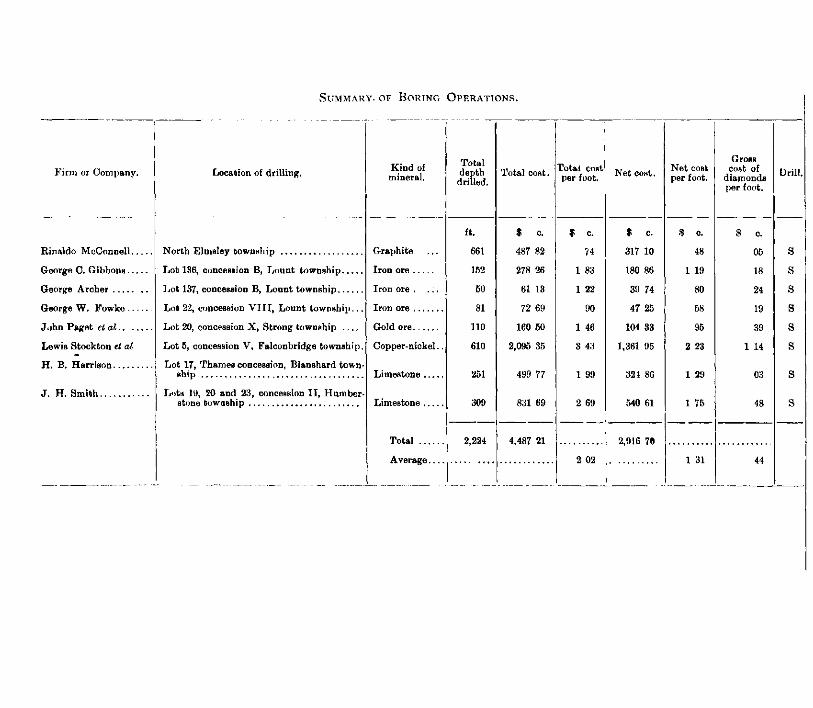
SUMMARY, OF BORING OPERATIONS.
Firm or Company.
Rinaldo McConnell.
George C. Gibbons..
George Archer
George W. Fowke ..
John Paget etal.. .
Lewis Stockton et al
H. B. Harrison
J. H. Smith
Location of drilling.
North Elmsley township
Lot 136, concession B, Lount township
Lot 137, concession B, Lount township
Lot 22, concession VIII, Lount township...
Lot 20, concession X, Strong township
Lot 5, concession V, Falconbridge township.
Lot 17, Thames concession, Blanshard township
Lots IVJ, 20 and 23, concession II, Humber-stone towaship
Kind of mineral.
Graphite
Iron ore
Iron ore .
Iron ore
Gold ore
Copper-nickel.
Limestone
Limestone
Total . . .
Average.
Total depth drilled.
ft.
661
152
50
81
110
610
251
309
2,224
Total cost.
$ c.
487 82
278 26
61 13
72 69
160 50
2,095 35
499 77
831 69
4,487 21
Total cost per foot.
74
1 83
1 22
90
1 46
3 43
1 99
2 69
2 02
Net cost.
317 10
180 86
39 74
47 25
104 33
1,361 95
324 86
540 61
2,916 70
Net cost per foot.
5 c.
48
1 19
80
58
95
2 23
1 29
1 75
1 31
Gross cost of
diamonds per foot.
c.
05
18
24
19
39
1 14
03
48
44
54 Bureau of Mines Report No. 5
SUMMER MINING SCHOOLS. BY W. L. GOODWIN.
I beg to submit herewith a report on the work done in the schools or classes for the practical instruction of miners and others in the mining districts of the Province conducted last summer by Mr. J. Watson Bain, of the School of Practical Science, Toronto, and myself.
THE SEASON'S ITINERARY.
On Wednesday 14th May, I left Kingston by the Kingston and Pembroke railway for Calabogie, accompanied by James Denny. The class was opened at seven o'clock that evening, and was carried on until Wednesday 21st May. On Monday 2nd June, preparations were begun for the remainder of the summer's work. I left Kingston on 4th June, and was joined at Central Ontario Junction by Mr. Bain, who accompanied me thereafter. We drove to Deloro, where the class was opened the same evening. The work was completed here on 11th June On the 12th we drove to Cordova Mines, and opened the class at 7 p.m. It was continued until 19th June, when we. drove to Havelock on the C.P.R. to take train for Sudbury. I went by way of Sharbot Lake and Renfrew, while Mr. Bain took the route via Toronto and North Bay. In Renfrew I collected crystalline limestone and garnet. Sudbury was reached on Saturday morning 21st June. I proceeded immediately to Copper Cliff, and opened the class there in the evening. Mr. Bain joined me on Monday 23rd June. The class was continued until Saturday, the 23rd, when we left for Victoria Mines. The class there was opened on Monday, and closed on Saturday 5th July. On the following Monday we left Victoria Mines for Rat Portage, via Sudbury. Rat Portage was reached on Wednesday 9th July, and we were at once taken in hand by Mr. T. R Deacon, managing director of the Mikado mine, who placed the Company's steamer at our service, and accompanied us to the mine. The class was opened that evening, and closed on Monday 14th J uly. On the 15th we took the steamer Heather Bell for Rat Portage, and proceeded on the 10th by the Ethel to the Black Eagle mine. The class was begun on the same day, and closed on Monday 21st July. On Tuesday, the 22nd, we proceeded by the Edna Brydges to Rat Portage, but did not succeed in catching the C.P.R. train, which connected with Wednesday's steamer from Fort William. We left Fort William on Friday. In Port Arthur I saw specimens of hematite from Steep Rock. This deposit was located by a prospector wTho became acquainted with iron ores by attending the class in Mine Centre in 1899. We reached Sault Ste. Marie on Saturday 26th July, and went on same day by the Minnie M. to Michipicoton Harbor. The Helen mine was reached on Sunday, and the class opened there on Monday. On Saturday "2nd August, I went by train to Wawa station and arranged for transportation of luggage by wagon to the Grace gold mine. Mr. Swenson, superintendent-of construction for Messrs. Foley Bros., kindly offered to send us over in his buckboard. This saved us a six-mile walk over an unfamiliar trail. On Sunday morning we walked to Wawa station, where Mr. Gregory, agent for Foley Bros., met us, and sent us on our way by the buckboard. We reached the Grace in time for dinner, and were welcomed and entertained by Manager Nissen and Mrs Nissen. The quiet Sunday in this well-ordered camp was very restful. The class was begun on Monday. On Tuesday 5th August, I drove to the Mission, leaving Mr. Bain to complete the work at the Grace
1902 Summer Mining Schools 55
and Rock Lake mines. I have to thank the officials of the Algoma Central Railway Company and the Algoma Transportation Company for much help and many courtesies.
The Captain of the Minnie M. made an early start from the Harbor to catch the C.P.R. steamer for Owen Sound. This he succeeded in doing by a few minutes, in spite of various delays. It was impossible however for me to get the luggage transferred in time, and I was obliged to go on by train next day by way of Sudbury and Renfrew. I reached Kingston on Friday, August 8th.
Mr. Bain completed the work at the Grace mine on August 8th, and arrived at Sault Ste Marie on the 10th. After spending two days there examining the works of the Lake Superior Power Company, he proceeded to Rock Lake and opened the class there on August 14th. The class was continued until the 20th, on which day Mr. Bain left for the east.
Free transportation of our heavy luggage was given by the Canadian Pacific, Kingston and Pembroke, Central Ontario, and Algoma Railway companies.
THE CLASS AT CALABOGIE. The class here was held in the township hall, which had been bespoken and prepared by
Mr. William Fairbairn, foreman in the lumber business of Messrs Carswell & McKay, and Mr. J. Johnston, B.A., teacher and township clerk. It opened in the evening with an attendance of 55. Arrangements were at once made to hold classes at 3 p.m. as well as at 6.15 p.m. The former class suited those who had long distances to come. An occasional morning class was added. Many of the farmers in this district are more or less practised in prospecting and are anxious to improve their knowledge of minerals. Several of them drove from four to six miles every day to reach the class. This is an interesting mineral region, and members of the class occasionally brought in specimens of valuable minerals collected in the neighborhood. Among these may be noted molybdenite, from the farm of Edward Hunter, 1^ miles south of Calabogie; graphite from several localities, (one specimen was a mixture of graphite and hematite, both in bright scales) fibrous hornblende, magnetite, talc and zincblende. Iron pyrite crops out on the farm of Joseph Dillon on the north side of the village. The limestone in the immediate vicinity is dolomitic, probably sufficiently so to be classed as true dolomite. In the cutting near the station it can be seen banded with magnetite. Stratified limestone is found four miles to the westward, at the head of the lake, where the land is correspondingly level and suitable for farming. Several excursions were made to mineral localities. Good specimens of molybdenite were collected at Edward Hunter's, where I was informed that pieces of the mineral had been ploughed up over a considerable area Some years ago several hundred pounds were taken out of a vein near Hunter's house. Through the kindness of Dr. E. G. Cooper I was able to visit Caldwell's iron mine, where we found Cyrus Holden hoisting ore,— a good looking magnetite, with occasionally a little pyrite. Malachite stains were noticed on some pieces. The deposit consists of a series of parallel veins with a strike nearly west, and measuring about 400 feet across the strike. The vein then being worked was 62 feet wide at the bottom, and was dipping at about 45°. Mr Harry McArthur, superintendent for Carswell & McKay, took me to see a vein of talc and asbestos about seven miles west of the village. The vein is in a dolomite bluff which forms the west face of the only dolomite ridge in the vicinity, the surrounding elevations in this rugged district being granitic. There are several veins of fibrous material associated with massive white talc and calcite. The fibres are in some places several feet in length. A few miles further west is the Black Donald graphite mine, which was being equipped with a modern washing and concentrating plant run by water power. Parties were engaged in building a road from this mine to Calabogie. If the success of the mine warrants it, it should pay the company to develop the water power along the route and run an electric tramway from the mine to the Kingston and Pembroke railway, a distance of about 14 miles.
56 Bureau of Mines Report No. 5
The total number of students at Calabogie was 55 and the average daily attendance was 40. I take this opportunity of expressing my indebtedness to Messrs. Wm. Fairbairn, J. Johnston, W. Moore, Harry McArthur, and Dr. E. 6 . Cooper for much assistance and several pleasant and profitable trips.
THE DELORO SCHOOL.
The hall built by the Canadian Goldfields Limited, for the use of their employees and friends was again offered us as a place of meeting for the class. The basement has been completed and is used as the meeting place of the literary and dramatic club, and also as a reading room and library. The books in the library are given out once a week and are evidently in demand. The whole building is nicely finished and well furnished. The class was held in the basement, and was divided into an elementary and an advanced section. The elementary class studied the minerals, some thirty-five in number, which have been used in previous years. For the advanced class, composed of those who had attended last summer, a set of minerals had been provided consisting of less common species and rarer varieties of the common kinds. This division of the class wTas found to work satisfactorily, and was adopted in all places in which the class was being held for the second time. It will be possible to continue in this way the process of education, by providing several sets of minerals and adding to these sets of typical rocks.
Several evening lectures were given, illustrated by lantern slides. These lectures served as an introduction to the study of geology, and were always well attended. Most of the mines, like the Canadian Goldfields, have electric lights, so that an electric lantern can be used to illustrate lectures Through the kindness of the manager, Mr. Kirkegaard, I was able to visit the works of Mr. Joseph James of Actinolite, where a mixture of actinolite, talc, and mica is ground into a roofing material. Actinolite (formerly Bridgewater), is eighteen miles from Deloro in an easterly direction. Deposits of mispickel have been found there. There is also a quarry of crystalline limestone which can fairly lay claim to the designation marble.
Specimens of molybdenite were brought to the class by Mr. W. M. H. Jones. These specimens were found on lot 24 or 25 in the fourteenth concession of Anstruther township The boulders in the neighborhood afforded a considerable variety of rocK specimens. A number were collected and used to illustrate the last lesson with the advanced class.
Thanks are due the manager and the staff for many courtesies, and to Mrs. Kirkegaard for her pleasant hospitality.
AT CORDOVA MINES.
Here we found the church completed which was being planned last summer, and the basement was in use as a lecture and entertainment room. This part of the building, by the way, was put up by the company, and given as the foundation of the church structure, an economical co-operation. The basement was fitted up with tables and benches for our use, and as it was equipped with e'ectric lights (which are also supplied free to the church) it answered our purpose admirably Both day and evening classes were well attended, and the evening lecture, taxed the room to its limit. Quite a town is growing up around this mine, or group of mines, for such a number of independent workable veins can hardly be described as one mine. A large number of new buildings had been put up since our last visit, and building operations were in evidence everywhere.
Manager Kerr drove us to the new power house on Deer lake. This was well advanced and the flume line from the falls was approaching completion. At the invitation of Mr. Kerr we visited the great stope in No. 3 shaft, where a body of ore is exposed in the second level between 40 and 50 ft. wire, and carrying good values. A similar and even larger stope was seen between the second and third levels of No. 1. In some places the pyrite is in considerable
1902 Summer Mining Schools 57
masses, which are said to assay from four to six ounces a ton, the sort of specimens which would rejoice the heart of a " boom " prospectus manufacturer. But this whole body of ore is of good grade, and is sufficient in itself to keep the mill going merrily for twelve months. These great stopes contradicts an impression which seems to be prevalent regarding the ore deposits of Eastern Ontario, which are often spoken of as * pocketty ' and of small extent. While this may be true of some of the deposits, as it is in every mining district, it cannot be taken as a general description, and a more thorough examination of the irm, zinc, lead, mispickel and other ore bodies in this district should be made before the least credit should hi given to such a statement.
Mr. Edward Shannon reported molybdenite from Peterborough county not far from Cordova mines. Fine clean dolomite was noted in lot 23 in the first concession of Belmont. Many specimens of .bog ore, chlorite, tourmaline and pyrite were collected for the use of the classes. The chlorite and tourmaline were found in a cross-cut on No. 7 vein, near the point at which the vein crosses the road leading from the office to the boarding-house. Chlorite schist, with beautiful cubes of pyrite, were obtained from the same place and also from No. 7 dump.
Whil i at Cordova Mines we were the guests of the company, which means a great deal in this case.
CLASSES AT COPPER CLIFF.
Here the classes wrere held in the Gorringe club as before, tables being put in by the company. Owing to the business of consolidating the Canadian Copper Company and other interests into the International Nickel Company, the working force had been very much reduced before the classes were opened, and men were beingx laid off almost every day. As the company thoughtfully gave the married men and older hands the preference, very few young men were left to attend the classes. In spite of this the attendance was much more satisfactory than last year, showing a growing interest in the work. While here I was the guest of the Rev Jas. White, an enthusiastic student, and a power for good in this, the largest mining camp in Ontario.
The classes were held at 4 p.m. and 7 p.m Evening lectures were given at 8.30, illustrated by lantern slides and drawings. The local geological features were discussed by Mr. Bain in such a way as to show the bearing on the ore deposits of the neighborhood. Through the kindness of Mr. White I enjoyed a visit to the Stobie and Frood mines, three miles north of Sudbury. The Stobie was closed down, while the Frood was working with half the usual complement of men. Accompanied by Mr. White, we rode through the woods to the Creighton, eight miles west of Copper Cliff, hoping to replenish our stock of pentlandite. The heavy rain interfered with this work, and we were obliged to content ourselves with a few poor specimens. The immense body of ore in this mine was being worked as a great quarry. The ore body has been shown by test pits to extend northwards to the hill, and was being examined by the diamond drill. The ease with which large quantities of high grade ore are mined here explains the temporary closing down of so many smaller mines. A mining village is rapidly growing up, and the company is providing for a regular arrangement of the cottages and stores along streets. The rough ride back by a ragged bridle path with a drenching rain beating down upon us made the pentlandite come dear ! But a change of clothes and the good cheer of Mrs. White put all right again.
Specimens of a recent conglomerate were collected not far from the west smelter. This conglomerate was formed by the cementing together of drift pebbles and sand by limonite produced by the weathering of the pyrrhotite, or, perhaps, the diorite. Near the end of the trestle connected with the smelter is a gravel pit, where sand and gravel similar to that of the conglomerate is found.
58 Bureau of Mines Report No. 5
The total number registered at Copper Cliff waB 32 ; the average attendance was 20.
This opportunity is taken of thanking the manager, the president and other officers of the company for many kindly attentions.
A T VICTORIA MINES.
Here the classes were held as usual at 4 p.m. and 7 p.m. The school house, completed since last summer's visit, was fitted up with temporary tables and benches, in place of the fine new school desks which would have suffered from the hammering, heating and grinding of the minerals. The Company also put in an electrical wire so that the lantern could be used for the evening lectures. The total enrolment was 22, and the average attendance 14. Two evening lectures were attended by about 30.
On Dominion Day we walked in to the mines about two and a half miles, and saw the holiday sports of the miners, most of whom are French and English Canadians, with a few Finlanders, Swedes and Russians. There is a larger proportion of women and children than in some of the more western camps, and the beginnings of home life are seen, with its softening and elevating influences. A shooting match, races, jumping, and other sports usually seen on such occasions were varied in a most interesting way by contests in hand-drilling. The contestants competed in pairs, one man striking and one man turning the drill. At the end of two minutes the men changed, almost without missing a blow. The match was won by James Langdon and Edward Cretzchmann, (Russian), who drilled 12£ inches in 10 minutes,—said to be a good record for the hard rock in which the drilling was done.
A visit was made to the Worthington mine which had been unwatered a short time before. Ore was being raised from the 200-ft. level—the usual mixture of pyrrhotite and chalcopyrite. The lead can be traced l£ mile east of the station. We were pleasantly received by Mr D. L. Lockerby, the managing director of the Dominion Mineral Company, who gave us every assistance in collecting specimens The foreman, John Dwyer, who has spent the last twelve years at the mine, guided us to the outcrops which stretched easterly several miles. From several of these prospects we collected good specimens of gersdorffite and niccolite. There is a vein of loose granular gersdorffite in the prospect owned by the Hamilton Nickel Steel Company. The specimens collected made a heavy load for the walk back to Victoria mines, and the load was not lightened by the rain which began to pour down soon after the railway track was reached. However, it is not often that the mineralogist is lucky enough to fill his bag with niccolite and gersdorffite. We took our drenching cheerfully.
Manager Hixon selected specimens of matte and slag to add to our store. We also succeeded in getting good samples of sperrylite gossan.
The slag is granulated at Victoria mines by a process similar to that used at Copper Cliff, but Mr. Hixon has introduced an improvement which enables him to distribute the slag over a large area and to completely control the stream. The device is very simple, being an application of the injector principle. A stream of water is driven through a pipe into which the slag falls through a second pipe opening inside the first at such an angle that the slag is caught by the stream and driven along to the exit. By moving the pipe the slag can be distributed so as to fill up hollows and swampy places. The same method was tried with the matte, but was abandoned on account of the frequent explosions. Mr. Garr, smelter foreman, kindly hunted up specimens of the granulated matte for us, and through the kindness of Mr. Forsythe we secured pieces of stalactitic matte, the iridescent colors of which were very beautiful.
Our stay at Victoria mines was made pleasant by the hospitalities of Mrs. ilixon and by the many courtesies of Mr. Hixon and his staff.
1902 Summer Mining Schools 59
THE MIKADO GOLD MINE.
Here we found our old friends, Manager McMillan and Captain Mackenzie, who gave us the hearty welcome which is always ready at the Mikado. The attendance was unusually good considering the pay roll,—only about 50. There were 31 enrolled, and the average attendance was 17. The attendance at the illustrated lectures was large, averaging 47. This camp is an example of what can be done by a manager who takes care of his men, providing them with homes for their families, a school for their children, and encouraging them to practise the virtues of sobriety and industry. It is said that every Mikado miner has a healthy bank account. It is a pretty sight to see, in this out of the way place, forty miles from the nearest settlement, quite in the wilderness, twenty or thirty children going to school up the little street which is lined with neat, prosperous looking cottages. The teacher, Mr. John C. Little, gave us the run of his rooms and library,—welcome privileges. The house of the manager was always open to us, as was that of the bookkeeper, Mr. Alex. Milne. Indeed we were everywhere made to feel at home among our good friends at the Mikado.
T H E BLACK EAGLE MINE. This is the gold mine formerly called the Regina, situated on Whitefish bay. We were
met by Mr. Norman McMillan, who welcomed us to his home, where Mrs. McMillan made us comfortable during our short stay. The class was held in the hall used for religious services and social gatherings. A separate building has been put up for the school. The total enrolment was 48, and the average attendance 22. One illustrated lecture was given, the attendance at which was about fifty. Accompanied by Manager McMillan and Capt. Trethewey, we made a lengthy visit underground. There was every evidence of the difficult task undertaken by the present management. The mine had been gutted and left in an almost impossible condition, particularly noticeable being the absence of timber. Several interesting short excursions were made. Just across the bay is the farm of Fred. Caron, guide, hunter, farmer, raconteur. We found Fred's Indian father-in-law weeding the potato patch, and took a snap shot in spite of his protest. Caron entertained us for an hour with stories of his experiences in the woods and on the lake.
On Sunday the whole camp, men, women and children, went on board the company's steamer and started for Whitefish rapids. An organ had been put on board, and the men sang hymns in a way which gave unmistakeable evidence of their being used to this manner of spending the Sabbath. At the Rapids, a beautiful spot, we saw a strange sight, the steamer Josie, with scows, etc., a complete ftiining outfit, being portaged to Whitefish lake to be taken to Flint Lake mine, a prospect being opened up under the management of Mr. Th. Breiden-bach. The mine is about eight miles from the Rapids. Above the Rapids are the scows and other property of the Rat Portage Lumber Company. In the afternoon a religious service was conducted by Mr. McMillan, and the spirit of it was excellent. It is to be regretted that he and Capt. Trethewey have not a brighter prospect in the mine.
A pleasant incident, among the many, was a miners' dance held in the school house. At midnight the night shift came up the hill with the candles glimmering in their helmets, very picturesque and quite unpremeditated.
Mr. and Mrs. McMillan made us so much at home and in every way so comfortable at the Black Eagle, that our short visit was terminated with sincere regret. We thank them for their hospitality, and the officials of the mine for many courtesies and much assistance.
RAT PORTAGE.
No classes were held here this summer, as it has been the policy of the Bureau of Mines to confine the work to the mining camps, into which have now been drafted a great majority of the men really interested in minerals. In this brisk town we saw marks of the
60 Bureau of Mines Report No. 5
epidemic of fires which broke out during the preceding winter. The familiar old Hilliard House had disappeared, and with it a large part of the block. In spite of the failure of many investors in the mines of the district to realize on their investments, the town seems to be holding its own in many respects. The fever of speculation is departing. Legitimate enterprise is taking its place. Solid work in lumbering, fishing, mining, and manufactures will yet make this a large and thriving centre of industry. Through the courtesy of Mr. T. R. Deacon, I saw something of the lumbering and wood manufacturing industry. With unlimited water-power and easily accessible timber supply, this should be the place for building up industries of this kind to supply the whole of the West.
The enterprising western towns of Port Arthur and Fort William are also feeling the impetus of rapid development, and of the enormous increase in the transhipment of grain. The Canada Northern has given new life to Port Arthur in particular. With better harbor accommodation these towns should in the near future expand into large shipping cities.
CLASS AT THE HELEN MINE.
The management of this mine had been changed since the class was held there last summer, being in charge of Captain Buzzo, who has had large experience with the hematite ores of Michigan. A considerable proportion of the miners and other employees were from the same iron district (Ishpeming), where the ore is got out in much the same way as at the Helen. The force of men had been reduced to about 250, without, it was stated, decreasing the output of ore. These Ishpeming miners are largely Manxmen, as is seen by such names as Buzzo, Quayle, Moyle, etc. Boyer lake was nearly pumped out, being reduced to a small patch of water only six feet deep. The precipitous banks sloped down almost like a funnel. The hill of ore was fast disappearing,—Mt. Hematite was reduced to a small peak upon which was planted the destroying drill in the hands of two stalwart Swedes. On the lower level two shafts were being sunk in good ore, and tunnels were being driven fron Boyer lake to catch these shafts which were making a good deal of water.
The class was held in one of the dining rooms kindly placed at our disposal by Capt. Buzzo. The total number enrolled was 52, and the average attendance 33. Three evening illustrated lectures were given, and these were well attended.
A botryoidal incrustation of a manganese compound, probably pyrolusite, was noticed on the rocks near what had been the shore of Boyer lake. It was deposited in such a way as to suggest that it had existed as manganous carbonate, or some other salt in solution, and had been oxidised at the surface wrhere the water wet the rocks. Similar incrustations of limonite were noticed on the same rocks.
By walking 3£ miles on a good trail, Wawa was visited. The intervening country is extremely rough. Wawa is beautifully situated at the south end of Wawa lake, which extends northward six miles. We were shown specimens of galena and copper pyrite said to have been found near the lake.
We had arranged to walk from Wawa to the Grace mine and send the luggage around by Michipicoton Harbor and the Mission, a distance of about 25 miles ; but wre were saved the long tramp and the uncertainties of an unfamiliar and not very definite trail, through the kindness of Mr. Swenson, superintendent for Messrs. Foley Bros., contractors, who lent us his buckboard. The drive from Wawa through the woods to the Miss'on was delightful and converted us to the buckboard as a general-purpose means of locomotion where the roads are not quite as smooth as streets.
A T THE GRACE GOLD MINE.
The Grace mine was found to be much advanced in development under the energetic management of Mr. Norman Nissen, who, with Mra. Nissen, welcomed us to their charming
1902 Summer Mining Schools 61
h6me. Here, indeed, we had a real Sunday at home. Work on the stamp mill and power plant was nearing completion, and everything pointed to the early advent of the Grace among the producing mints. There were fifty men employed, the underground work being in charge of Capt. Harris.
The class was held in the dining room, and was attended not only by the employees at the Grace, but also by several from the Manxman, two miles away, the total enrolment being 30, and the average attendance 23.
ROCK LAKE COPPER MINE.
The difficulties in keeping a class together here were somewhat unusual. Most of the men are drawn from the farms and villages of the district, few of them living at the mine. It is thus hard to keep them together in the evening, the only time available for the day shift. There were 150 men employed. The ore is chalcopyrite with small quantities of bornite and chalcocite. One shaft was being worked and was down 420 feet. There is a good shaft house i
a church, a school house, and other buildings. The mill is situated two miles distant on the shore of Rock lake and is connected with the mine by a railway. A railway from the mine to Bruce Mines was under construction.
The total number attending the classes was about 30, and the average attendance 12. The work done was excellent.
For this educational work two modifications of the present procedure are to be recommended. In the first place, the time devoted to each place should be at least doubled. The work as at present carried on is too hurried and leaves an impression only on the brightest men. In ten days (five at present) the ground could be covered much more thoroughly and the slower intellects would not undergo the discouragement very noticeable under present conditions. To get over forty mineral species and varieties in five lessons of about one and a half hours each is not easy. In the second place, the range of study might be extended to a greater number of species, and rocks might also be included. In this way the men in each camp could be classified. This was done to a certain extent during the tour just completed. Wherever, men were found who had attended the class during the previous summer, they were set at work on a different set of minerals, including some rarer species. As the money now annually voted is not quite1 sufficient to meet the expenses of the classes as conducted during the past few years, it is plain that the adoption of these recommendations involves one of two alternatives, either fewer camps visited or a larger yote for expenses.
62 Bureau of Mines Report No. 5
MICHIPICOTON MINING DIVISION. BY D. G. BOYD, INSPECTOR.
I beg herewith to present the sixth annual report on the Michipicoton Mining Division. The office at Michipicoton River was opened on 21st May, and continued open until 1st November.
During the period 104 miner's licenses were issued, and 103 mining claims registered. The total number of licenses issued during the year was 132, 28 being issued from Toronto.
The claims registered numbered 126, of which 23 were registered at Toronto while the office at Michipicoton River was closed.
The amount of money forwarded to the Treasury Department from the office at Michipicoton was $1,983, and the amount received at Toronto $741, making a total of $2,724. Of this amount $1,320 was received for miner's licenses ; $882 fees for additional mining claims ; $90 fees for transfer of claims, and the balance, $432, fees for patents.
Compared with the figures for 1901, there is a decrease in the number of licenses issued of 55, in the number of claims registered of 38, and in the total receipts of $2,641.50. These large decreases are to be accounted for by the continued withdrawal of the lands on account of the land grant accruing to the Algoma Central Railway Company, and by the fact that most of the licensees holding claims within the ten-mile area of Michipicoton Harbor have performed all the working conditions required by the regulations, and as a result hold their claims free from any further license or renewal fee.
As regards actual development, more work was done in the past season than ever before ; the output from the Helen iron mine was greater; stamp mills were completed at the Grace and Manxman gold mines ; diamond drilling was done all season at the Frances iron mine, and at the Emily gold mine, on a bay off Dog lake. At the Josephine iron mine machinery was installed and a shaft started.
EMILY GOLD MINE.
The Emily mine, situated on a bay running off Dog lake, was visited on 18th September, at which time the only work being done was diamond drilling with a prospector's hand drill, a crew of ten men being at work.
On 30th October I was informed by Mr. A.B. Willmott, mines manager of the Algoma Commercial Company, that drilling had ceased and that a shaft was being sunk by a crew under Mr. E. H. Dodd, which was 25 feet deep at that time.
JOSEPHINE IRON MINE.
This property has been thoroughly tested by diamond drills and this season saw the commencement of mining operations. On the south shore near the west end of Parks lake a vertical shaft 6 feet by 8 feet inside the timbers, was being sunk, which at the time of inspection, 7th October, was 70 feet deep.
Machinery had been installed as follows ; An Ingcrsoll-Sargent 4-drill air comjjressor, one 25-h.p. upright boiler, one No. 5 Northey duplex pump, one James Cooper hoist, with drums 3 feet diameter and 4-foot face, and double cylinders 6 by 10 inches. The shaft is being put
1902 Michipicoton Mining Division 63
down to connect with the ore body, and it was intended to sink to a depth of 300 feet and then cross cut.
The manager was Mr. T.H. Kneebone (late of Iron Mountain,Mich.) who had a crew of 15 men, 8 of whom were miners, working in three shifts of 8 hours each.
The Frances iron mine was not visited,as the work consisted of diamond drilling under the management of Mr. R. W. Seelye.
BRUIJ; HARBOR COPPER LOCATIONS.
Locations BY 1, BY 2, BY 3, BY 4, owned by Mr. John Abell of Toronto, and situated about one-quarter of a mile east of Brule Harbor, were inspected on 16th October. A contract had been let for a 50-foot vertical shaft which was being finished on that day.
Previous to this a tunnel had been driven 100 feet into a hill to tap a vein outcropping on the surface, which did not prove successful.
HELEN IRON MINE. The Helen mine was inspected on 23rd October when A. E. Buzzo was superintendent, F.
LT. Nelson, engineer, and Ambrose Teare, foreman, working with a crew of 232 men, composed of 177 underground and 55 surface men, in two shifts. The output was 1,200 tons per 24 hours. In addition to the machinery employed last year a 10-drill Ingersoll-Sargent air compressor had been installed.
The main shaft, situated 60 feet south of the pit, 6 feet by 14£ feet inside the timbers, and divided into three compartments—ladder-way and two skip-ways—timbered with 10 by 10-inch square timbers, cl< se cribbed, was down to a depth of 198 feet, and a station was being cut out at the bottom. The hoisting shaft (temporary), 6 feet by 16 feet inside timbers, and double-tracked, was 51 feet deep from the bottom of the pit. The skips were being operated by the Lidgerwood hoist, formerly in use on the cableway.
From the bottom of this shaft drifting had been done 110 feet westerly and 300 feet easterly, the latter being called the south drift. At a distance of 78 feet from the shaft a drift was run north 80 feet, branching westerly 50 feet and easterly 100 feet.
The lake drift from the old bottom of Boyer lake, is 5 feet by 6 feet inside timbers, and runs 178 feet east, where it strikes the main shaft 86 feet down from the collar, then branches north 175 feet, at which point it connects with the first level west from the hoisting shaft.
The east tunnel is situated on the hill east of the workings, 5 feet by 6 feet inside timbers, and runs 300 feet easterly. At 200 feet from the entrance it turns south 125 feet, where it branches east and west 50 feet.
The main shaft is unwatered by a No. 5 Cameron pump, and the hoisting shaft by two Northey pumps, one 10 by 6 by 12 inches and the other 7 i by 6 by 10 inches. The lake drift is used for unwatering the workings.
The foundations for a new power plant have been completed west of the main shaft, and a double-drum hoist with drums 5 feet in diameter and 48 inches in face, and cylinders 14 by 30 inches, was in place. When completed, the skip road now in use will be abandoned and destroyed, and all the ore will be hoisted through the main shaft. At the time of inspection the ore was being taken from the open pit as mentioned in previous reports, and was also being milled down through three mills to the drifts below, where it was trammed to the hoisting shaft and elevated to the crusher.
The water in Boyer lake was completely pumped out, and pumping was done about every two weeks to keep it empty.
The amount of ore shipped from Michipicoton Harbor up to 1st November amounted to 289,324 tons. Of this 20,902 tons went to Midland, 3,149 tons to Deseronto, 53,221 tons to Point Edward, and 212,052 tons to American ports.
64 Bureau of Mines Report No. 5
LLOVDA Gold MINE.
The Lloydagold mine is operated by the United Mining Company, Limited, of Niagara Falls. When about to \ isit the claim on 24th October I met the superintendent, Mr. W. A. Stowell, in Wawa, who told me the shaft was full of water, so T did not go out to the property. He also gave me the following particulars : Work started on 20th March and ceased on 15th September, during which time the shaft, which had been sunk 19 feet in 1901, was completed to a depth of 90 feet. Camps and an assay office had been built and roads cut.
A contract has been let for 100 feet additional sinking to be done during the winter.
MANXMAN GOLD MINING COMPANY.
Work on the main shaft on claim 1,229 stopped on 20th July. At that time the shaft had been sunk to a depth of 126 feet, and timbered to 120 feet in depth. At 100 feet drifting was done 20 feet south and 18 feet north, with a cross cut of 10 feet.
On claim "Mabel," No. 641, the work consisted in quarrying on a dyke of quartz porphyry, working on a face about 125 feet east and west, with an average height of 20 feet. About 300 tons had been quarried.
Sinking at an angle of 40°, a shaft 6 feet by 6 feet, 20 feet deep, had been put down on a small quartz vein in the dike with an average width of one foot.
At the time of inspection, 25th October, a ten-stamp mill (Fraser & Chalmers) was being installed. The foundations had been completed, the mortars were in place, and the mill building sided up. Power will be supplied by the engine and boiler formerly in use at the shaft on claim 1,229. The mill is situated on the shore of a small lake 1,000 feet southwest of the quarry. The ore will be conveyed to the mill by a horse tram. Thirty men were employed, five of whom were miners, the balance working on the buildings. Mr. Angus Gibson is manager, with Mr. J. W. Douglas as assistant.
GRACE GOLD MINE.
I inspected this mine 30th October, when the main shaft was 304 feet in depth and timbered to the bottom.
First level, depth 100 feet, no increase in drifts ; second level, depth 200 feet ; south drift 204 feet, an increase of 88 feet ; north drift 115 feet, unchanged ; third level, depth 300 feet ; south drift 31 feet ; north drift 50 feet. A winze was sunk, connecting the drifts on the second and third levels on the north side, 57 feet from the shaft. A raise of 16 feet had been made in the south drift on the first level.
Stoping has been done on first level, north drift, 100 feet, with an average height of 20 feet from the floor, and on the second level, south drift, 80 feet, with an average height of 20 feet.
On the surface a new head frame and shaft house have been built, and a ten-stamp Allis-Chalmers mill has been erected, equipped with stamps of 950 pounds, dropping 95 per minute; 1 Blake 7 by 10-inch ore crusher ; three six-foot belt Frue vanners ; and 1 automatic tailing sampler under the floor of the mill. Power is supplied by a 60-h.p. Corliss engine, the steam for which is generated by two 60-h. p. Mumford boilers. Two water tanks made of cypress wood, having a capacity of 5,000 gallons, are situated on the north side of the mill, which are fed by a Northey pump, having a 4-inch suction and 3-inch discharge from a pond to the south.
The ore is raised and dumped on a picking floor, then falls through a hopper on a car, and is hauled over a tramway trestle to the mill, situated 350 feet southwest, the power being supplied through a friction hoist, with drum 30 inches in diameter and 24 inches face, operated by a belt, and situated above the ore bins in the mill building.
1902 flichipicoton flining Division 65
The size of the mill building is 78 feet by 24 feet 8 inches ; engine room 20 feet by 30 feet ; boiler room 30 feet by 24 feet; the whole building being sheeted with corrugated iron. The mill was designed and built by the superintendent, Mr. P. N. Nissen. Fifty men were employed. 16 of whom were miners and muckers. The mill began running about the middle of October.
WORK ON OTHER LOCATIONS.
The Sunrise Mining Company have purchased the "Sunrise" claim, on which there is a shaft 25 feet deep. A contract has been let to Mr. Joseph Trembley for 100 feet additional sinking, who began the work about 1st November.
The Mariposa Mining Company purchased the claims owned by Messrs. Blackinton and Lewis, on which considerable work had been done. They had a gang of men at work on 30th October, building camps and improving the roads. Machinery had been ordered, and work will be pushed during the winter with a crew of from 15 to 20 men.
LIST OF LICENSEES.
Appended is a list of licensees, giving place of residence, number of license, and number of claims (if any) registered during the year. Where not otherwise indicated, the licensees are residents of Ontario. Claims marked with an asterisk (*) are in dispute.
Name. Residence. No. of License.
Abell, J (Toronto.... 1,206 Algoma Commercial Co S.S.Marie 1,289 Andre, G Michipicoton River 1,250
~~ " " i 1,304 Guelph j 1,312
S. S. Marie 1,277
Armstrong, H.. Armstrong, W. J.
Pleasantville, Pa. White River Michipicoton River.
Barton, S . . . Beebe, W. D Beggs, T. J Blackinton, A. B Blackinton, C. B Boyer, B 'S. S. Marie Brown, A. F Michipicoton River. Buckley, H S. S. Marie Buckley, J. P (Detroit, Mich
Cameron, A i White River Campbell, T S. S. Marie, Mich. Cash, J 'Michipicoton River. Charlebois, F i Wawa. Clark, E. D Clergue, B. J . . . Clergue, F. H. . , Clergue, J. H . . . Cochrane, R. B.. Coleman, W Oressey, E. W. . Culbert, D. S . . .
Guelph . .. S, S. Marie.
Michipicoton River. Bay City, Mich Wawa
Davidson, J Ottawa. Davis, J Wawa. DicksoD, J. L Dion, J. J. T Donovan^J.^ Michipicoton River..
~ " Harbor. " River... " Harbor.
Wawa.. Michipicoton Harbor.
" River.
Dorway, F. C. Douglas, J. W Dowslev. G. W. O. Dovle, K Dunlop, W. W . . . . Dycie, J. G Dycie, M
Edey, M. C Ottawa Edey, R. W iBellirica, Que... . Eldridge, R. C S. S. Marie, Mich
5 M .
1,213 1,216 1,280 1,254 1,279 1,292 1,305 1,303
1,195 1,283 1,225 1,227 1,309 1,263 1,230 1,264 1,234 1,251 1,302 1,208
1,270 1,177 1,278 1,236 1,273 1,224 1,261 1,222 1,241 1,223 1,192 1,171
1,266 1,268 1,275
Claims.
1,220
1,324, 1,393 1,397, 1,398
1,410, 1,411 1,392 1,345, 1,348 1,363, 1,449 1,396
1,436 1,412
1,351
1,357
1,407
1,401, 1,419
1,442 1,378 1,418 1,358 1,328, 1,416 1,360
1,356 1,339, 1,374, 1,434 1,338
1,341, 1,420
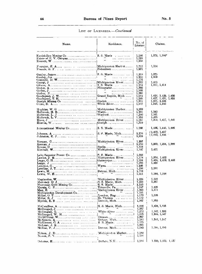
66 Bureau of flines Report No. 5
LIST OF LICENSEES. — Continued
NAME. RESIDENCE.
EONISKILLEN MINING CO S. S. MARIE ESTATE OF E. V. CLERGUE I " EVERETT, W
FOURNIER, H. A MICHIPICOTON HARBOR. FRANCIS, G. F ,PAKENHAM
GANLEY, JAMES 'S. S. MARIE GANLEY. JOS I " GEMMILL, D. W GEORGI, J GIBSON, A GODON, A GODON, J GODON, N GOODSPEED, J. W.. GOODSPEED, T. H.. . GUELPH MINING CO GUNN, D. A
HOPKINS, W. G HOLBROOK, H. B. HOLBROOK, L. J . HOLBROOK, L. V . HUNT, J HUSSON, W
INTERNATIONAL MINING CO.
JOHNAON, A JOHNSTON, E. J
KEENAN, C MICHIPICOTON RIVER. KEENAN, J KEUSIE, O KIMBALL, W
MICHIPICOTON RIVER. S. S. MARIE MISBANABIE
GRAND RAPIDB, MICH.
GUELPH WHITE RIVER.
MICHIPICOTON HARBOR. WAWA WATFORD
MICHIPICOTON RIVER. GUELPH
S. S. MARIE.
S. S. MARIE, MICH.
BERLIN MICHIPICOTON RIVER.
S. S. MARIE. MICHIPICOTON RIVER. GANANOQUE
LAKE SUPERIOR POWER CO LAWLOR, J. H LEGGE, C. H LEGGE, J LEMIEUX, C WAWA. LETELLIER, J. T LEWIS, M | DETOUR, MICH LEWIS, W. H " "
MAGINODON, W JMICHIPICOTON RIVER. MAHONEY. D. J P . S. MARIE, MICH... MANXMAN GOLD MINING CO S. S. MARIE MARTIN, C. E . JTITUSVILLE, PA MAY, E MICHIPICOTON DEVELOPMENT CO MILLER, O. T MILLER, R. J MYRICK, E. B
IMICHIPICOTON RIVER
LONDON, ENG. ST. THOMAS . DETROIT, MICH.
S. S. MARIE, MICH.
WHITE RIVER.
McCandle88, A MCDOUGALL, J MCDOUGALL, L MCDOUGALL, W . H MCGILLIVRAY, W MCKENZIE, A (DETOUR, MICH. MCKINNON, C. A 'S. S. MARIE. . MCLEAN, J. R MCRAE, P . J DETOUR, MICH.
OTTAWA
MICHIPICOTON HARBOR.
OSBORNE, H !BUFFALO, N .Y
NSLSON, J. D NISSEN, P. N
NO. OF LICENSE
1,246 1,233 1,258
1,212 1,271
1,218 1,255 1,176 1,262 1,214 1,200 1,202 1,201 1,284 1,285 1,311 1,217
1,260 1,291 1,290 1,253 1,287 1,310
1,265
1,276 1,259
1,297 1,210 1,193 1,197
1,288 1,178 1,294 1,293 1,235 1,196 1,184 1,211
1,226 1,238 1,243 1,247 1,203 1,191 1,179 1,172 1,207
1,286 1,257 1,272 1,215 1,267 1,183 1,175 1,245 1,242
1,188 1,198
1,166
CLAIMS.
1,379, 1,380*
1,354
1,375 1,409
1,415 1,352, 1,414
1.426, 1,429, 1,430 1.427, 1,431, 1,432 1,371, 1,406 1,345, 1,348
1,382 1,361 1,395 1,364, 1,417, 1,441
1,436, 1,445, 1,446 / 1 , 4 2 3 , 1,437 (1,443, 1,444
1,369, 1,394, 1,399
1,421
1,353, 1,402 1,404, 1,439, 1,440 1,403
1,381
1,384, 1,338
1,359 1,367
1,405 1,373
1,326
1,355
1,424, 1,425
1,342, 1,350 1,344, 1,347
1,383, 1,387
1 ,386,1 ,390
1,330, 1,333, 1,337
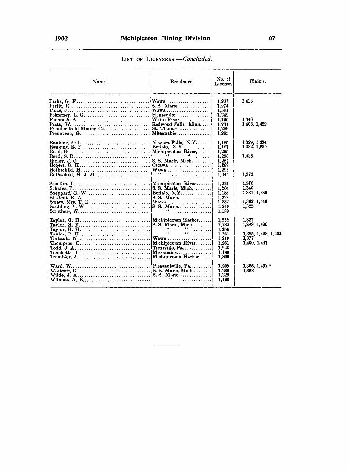
1902 flichipicoton /lining Division 67
LIST OF LICENSEES.—Concluded.
Name. Residence.
Parks, G. F Pettit, R Piuze, J Pokorney, L. G Pononish. A Pratt, W Premier Gold Mining Co. Preneveau, G
Rankine, de L Rankine, R. F Reed, G Reed, S. R Ripley, J. O Rogers, G. H Rothschild, H Rothschild, H. J. M.
Wawa • S. S. Marie Wawa Huntsville White River Redwood Falls, Minn. St. Thomas Missanabie
Niagara Falls, N.Y. Buffalo, N.Y. . . . . . Michipicoton River,
S. S. Marie, Mich. Ottawa Wawa
Schellin, T Schafer, F . Sheppard, G. W. . Sjostedt, E. A Smart, Mrs. T. R. Stribling, F. W. . . Struthers, W
Taylor, G. H. Taylor, H. F . . Taylor, H. H. Taylor, R. H. Thibault, N . . Thompson, C. Todd, J. A . . . Touchette, J. Trembley, J . .
Ward, W Westcott, G.. . , Wilde, J. A . . . . Wilmott, A. B.
Michipicoton River. S. S. Marie, Mich,.. Buffalo, N.Y
S. Marie Wawa S. S. Marie
Michipicoton Harbor. S. S. Marie, Mich....
Wawa Michipicoton River., Tituavijje, P a . . . . . . . . Missanabie Michipicoton Harbor.
Pleasantville, Pa.. S. S. Marie, Mich. S. S. Marie
No. of License.
1,237 1,274 1,301 1,249 1,190 1,231 1,299 1,205
1,185 1,187 1,295 1,296 1,282 1,269 1,298 1,244
1,221 1,204 1,188 1,228 1,232 1,240 1,189
1,252 1,182 1,256 1,181 1,219 1,281 1,248 1,180 1,300
1,209 1,239 1,229 1,199
Claims.
1,413
1,346 1,408, 1,422
1,329, 1.334 1,332,1,335
1,438
1,372
l,3f6 1,340 1,331, 1,336
1,362, 1,448 1,325
1,327 1,389, 1,400 1,385, 1,428, 1,433 1,377 1,400, 1,447
1,366,1,391 1,368
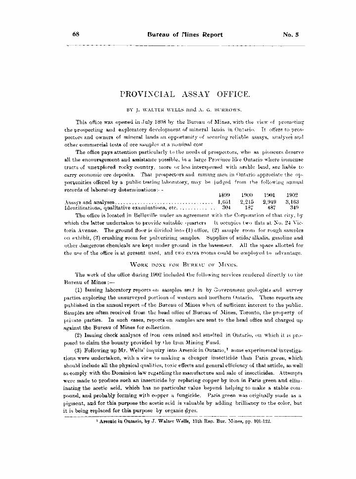
68 Bureau of nines Report No. 5
P R O V I N C I A L A S S A Y O F F I C E .
BY J. WALTER WELLS AND A. G. BURROWS.
Thi3 office was opened in July 181)8 by the Bureau of Mines, with the view of promoting the prospecting and exploratory development of mineral lands in Ontario. It offers to prospectors and owners of mineral lands an opportunity of securing reliable assays, analyses and other commercial tests of ore samples at a nominal cost
The office pays attention particularly to the needs of prospectors, who as pioneers deserve all the encouragement and assistance possible, in a large Province like Ontario where immense tracts of unexplored rocky country, more or less interspersed with arable land, are liable to carry economic ore deposits. That prospectors and mining men in < )ntario appreciate the opportunities offered by a public testing laboratory, may be judged from the following annual records of laboratory determinations'.—
1899 1900 1901 1902 Assays and analyses 1,051 2,215 2,949 3,163 Identifications, qualitative examinations, etc 304 187 487 349
The office is located in Belleville under an agreement with the Corporation of that city, by which the latter undertakes to provide.suitable quarters It occupies two fiats at No. 24 Victoria Avenue. The ground floor is divided into (1) office, (2) sample room for rough samples on exhibit, (3) crushing room for pulverizing samples. Supplies of acids," alkalis, gasoline and other dangerous chemicals are kept under ground in the basement. All the space allotted for the use of the office is at present used, and two extra rooms could be employed to advantage.
WORK DONE FOR BUREAU OF MINES.
The work of the office during 1902 included the following services rendered directly to the Bureau of Mines :—
(1) Issuing laboratory reports on samples sent in by Government geologists and survey parties exploring the unsurveyed portions of western and northern Ontario. These reports are published in the annual report of the Bureau of Mines when of sufficient interest to the public. Samples are often received from the head office of Bureau of Mines, Toronto, the property of private parties. In such cases, reports on samples are sent to the head office and charged up against the Bureau of Mines for collection.
(2) Issuing check analyses of iron ores mined and smelted in Ontario, on which it is proposed to claim the bounty provided by the Iron Mining Fund.
(3) Following up Mr. Wells' inquiry into Arsenic in Ontario, 1 some experimental investigations were undertaken, with a view to making a cheaper insecticide than Paris green, which should include all the physical qualities, toxic effects and general efficiency of that article, as well as comply with the Dominion law regarding the manufacture and sale of insecticides. Attempts were made to produce such an insecticide by replacing copper by iron in Paris green and eliminating the acetic acid, which has no particular value beyond helping to make a stable compound, and probably forming with copper a fungicide. Paris green was originally made as a pigment, and for this purpose the acetic acid is valuable by adding brilliancy to the color, but it is being replaced for this purpose by organic dyes.
1 Arsenic in Ontario, by J. Walter Wells, 11th Rep. Bur. Mines, pp. 101-122.
1902 Provincial Assay Office 69
The retail price of Paris green averages about 25 cents per pound in Canada, and it was thought that a more general use of the insecticide in fruit-growing, with a consequent improvement in the quality, would be a result if a cheaper and equally efficient insecticide could be made. Paris green is a chemical compound known as aceto arsenite of copper, with the following theoretical composition; copper arsenite, 82 per cent, and copper acetate 18 per cerit., which may be expressed thus :— p e r c e n j . Arsenious Oxide (As O) 58.64 Copper oxide (C„ O,) 31.30 Acetic acid (C 2 H 4 0 2 ) 10.06
100.00 Free white arsenic and arsenious acid are often present in the commercial compound. Paris green has proved such an efficient insecticide for many pests affecting trees, garden
plants and fruits, that it has become the standard fixed by common usage, so that any new compound replacing it must comply with the following conditions : It must have a green color resembling Paris green to satisfy prejudices ; it must be insoluble in water so that it may not be washed readily from leaves, etc.; it must be effectively poisonous for all biting insects ; it must contain as little free arsenic as possible so as not to scald the leaves and fruits when applied ; it must carry at least 50 per cent, combined arsenious acid to comply with the law, and it must be cheaper than Paris green.
The following compounds were prepared, using white arsenic from the Deloro works and cheap commercial chemicals :—
(a) Copper Arsenite (Cu H As 0 3 ) ; made by adding white arsenic to a blue ammoniacal solution of copper sulphate. A light green precipitate is formed insoluble in water and very poisonous. The dried precipitate carried 40 per cent, arsenious acid. It answers all the conditions excepting the legal minimum of combined arsenious acid.
(6) By digesting carbonate of copper (Cu C 0 3 ) with water and white arsenic and evaporating the solution, a yellow-green salt was obtained partly soluble in water and carrying 54.50 per cent, arsenious acid. This compound complies with all the requirements except that it is partially soluble.
(c) Arsenite of iron ; made by mixing a solution of ferrous sulphate (copperas of commerce) with a solution or emulsion of white arsenic and adding a little ammonia. A white insoluble compound is formed, which when dried carries 43.8 per cent, combined arsenious acid, thus falling below the legal standard. No experiments were made to test its efficiency as an insecticide. This compound can be made very cheaply.
(d) Arsenite of lead ; made by adding a solution of lead acetate to an emulsion or solution of white arsenic slightly alkaline with ammonia or sodium hydroxide. A white insoluble compound is formed which does not carry the necessary amount of combined arsenious acid.
The few experiments were made in spare moments, but the results were sufficiently encouraging to warrant further experimental investigation on the part of interested parties, such as producers of white arsenic, chemical manufacturers, and agricultural chemists, who should also have the opportunity of carrying on actual tests in the garden to prove the efficiency of each new preparation.
WORK DONE FOR PRIVATE PARTIES. The following services have been rendered during the year to prospectors and others
engaged in the mineral industry in Ontario :— (1) Issuing laboratory reports, consisting of assays, analyses, qualitative examinations,
identifications and reports as to probable commercial value. In no case does the report issued on a sample give any opinion as to the extent or commercial value of the deposit which may be the source of the sample, the office dealing only with the sample as received. Fees are collected on these reports according to the scale of fees approved by the Director of the Bureau of Mines. Each report issued as custom work is the property of the party ordering the test
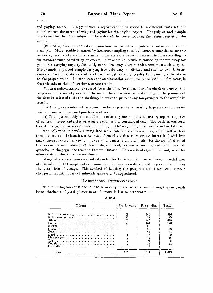
70 Bureau of nines Report No. 5
and paying the fee. A copy of such a report cannot be issued to a different party without an order from the party ordering and paying for the original report. The pulp of each sample is retained by the office subject to the order of the party ordering the original report on the sample.
(2) Making check or control determinations in case of a dispute as to values contained in a sample. More trouble is caused by incorrect sampling than by incorrect analysis, as no two parties appear to take a similar sample on the same ore deposit, unlass it is done according to the standard rules adopted by engineers. Considerable trouble is caused by the fire assay for gold ores carrying nuggety free gold, as the fire assay gives variable results on such samples. For example, a pulped sample carrying free gold may be divided and sent to two different assayers ; both may do careful work and yet get variable results, thus causing a dispute as to the proper value. In such cases the amalgamation assay, combined with the fire assay, is the only safe method of getting accurate results.
When a pulped sample is ordered from the office by the sender of a check or control, the pulp is sent in a sealed parcel and the seal of the office must be broken only in the presence of the chemist selected to do the checking, in order to prevent any tampering with the sample in transit.
(3) Acting as an information agency, so far as possible, answering inquiries as to market prices, commercial uses and purchasers of ores.
(4) Issuing a monthly office bulletin, containing the monthly laboratory repoit, inquiries of general interest and notes on minerals coming into commercial use. The bulletin was sent, free of charge, to parties interested in mining in Ontario, but publication ceased in July last.
The following minerals, coming into more common commercial use, were dealt with in these bulletins :—(1) Bauxite, a hydrated form of alumina more or less intermixed with iron and silicious matter, and used as the ore of the metal aluminium, also for the manufacture of the various grades of alum ; (2) Cassiterite, commonly known as tinstone, and found in small quantity in the pegmatite rocks in Eastern Ontario. This ore is always in demand, as no tin mine exists on the American continent.
Many letters have been received asking for further information as to the commercial uses of minerals, and 124 samples of economic minerals have been distributed to prospectors during the year, free of charge. This method of keeping the prospectors in touch with various changes in industrial uses of minerals appears to be appreciated.
LABORATORY DETERMINATIONS.
The following tabular list shows the laboratory determinations made during the year, each being checked off by a duplicate to avoid errors in issuing certificates :—
ASSAYS.
Mineral. For Bureau. For public. Total.
56 760 816 13 12 25 52 467 519 22 104 126
Nickel
CO 63 71 3 30 33
Zinc 3 21 24 1 18 19 3 13 16
Tin 2 6 8 Cobalt 2 19 21
1 1
Total 165 1,514 1,679
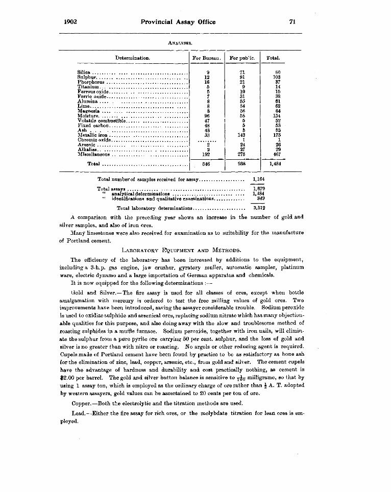
1902 Provincial Assay Office 71
ANALYSES.
Determination. For Bureau. For pub'ic. Total.
9 71 80 12 91 103 16 21 37
Titanium 5 9 14 5 10 15 7 31 38 8 53 61 8 54 62 8 56 64
96 58 154 47 5 52 48 5 53
Ash . . . 48 5 53 33 142 175
1 1 2 24 26 2 27 29
192 275 467
Total 546 938 1,484
Total number of samples received for assay 1,164
Total assays 1,679 " analytical determinations 1,484 " identifications and qualitative examinations 349
Total laboratory determinations 3,512
A comparison with the preceding year shows an increase in the number of gold and silver samples, and also of iron ores.
Many limestones were also received for examination as to suitability for the manufacture of Portland cement.
LABORATORY EQUIPMENT AND METHODS.
The efficiency of the laboratory has been increased by additions to the equipment, including a 3-h.p. gas engine, jaw crusher, gyratory muller, automatic sampler, platinum ware, electric dynamo and a large importation of German apparatus and chemicals.
It is now equipped for the following determinations :—
Gold and Silver.—The fire assay is used for all classes of ores, except when bottle amalgamation with mercury is ordered to test the free milling values of gold ores. Two improvements have been introduced, saving the assayer considerable trouble. Sodium peroxide is used to oxidize sulphide and arsenical ores, replacing sodium nitrate which has many objectionable qualities for this purpose, and also doing away with the slow and troublesome method of roasting sulphides in a muffle furnace. Sodium peroxide, together with iron nails, will eliminate the sulphur from a pure pyrite ore carrying 50 per cent, sulphur, and the loss of gold and silver is no greater than with nitre or roasting. No argols or other reducing agent is required. Cupels made of Portland cement have been found by practice to be as satisfactory as bone ash for the elimination of zinc, lead, copper, arsenic, etc., from gold and silver. The cement cupels have the advantage of hardness and durability and cost practically nothing, as cement is $2.00 per barrel. The gold and silver button balance is sensitive to milligrame, so that by using 1 assay ton, which is employed as the ordinary charge of ore rather than \ A. T. adopted by western assayers, gold values can be ascertained to 20 cents per ton of ore.
Copper.—Both the electrolytic and the titration methods are used.
Lead.—Either the fire assay for rich ores, or the molybdate titration for lean ores is employed.
72 Bureau of nines Report No. 5
Nickel.—The electrolytic process is adopted as being the most accurate, even though somewhats low.
Platinum.—The fire assay is found to be satisfactory.
Zinc.—The titration method, using potassium ferro-cyanide, is adopted.
Iron ores, cokes, coal, limestones, marl, clay, etc., are analysed by the latest known standard methods.
Samples are pulped to 100-mesh, and those requiring an impalpable powder are further ground in an agate or diamond mortar.
Certificates are made out on samples, analysed at ordinary temperature, unless otherwise stated. Ores carrying moisture sufficient to prevent grinding, are dried at 110°, and reported on in both states.
Laboratory fees amounting to $1,712.53 were collected during the year and remitted to head office. While the fees are nominal, reports cannot be issued till they are paid.
No charges are made on identification and qualitative analysis of samples brough personally to the office.
Circulars of rates, shipping bags and mailing envelopes, are sent to parties wishing assays. Two laboratory assistants are employed, whom it is difficult to keep, as they usually obtain
more lucrative positions after a few months' practice. Four different assistants were employed during the year ; G. C. Reid, who joined a cavalry force of Canadian volunteers to South Africa ; L. L. Bolton, transferred as geologist to a Crown Lands' survey in the James Bay district ; F. J. Thorpe, who accepted a position on the laboratory staff at the Steel Works, Sydney, C. B.; and A. T. Fife, science master at the Peterborough Collegiate Institute. The last assistant showed commendable enthusiasm, which should be of benefit to the students in his charge.
The Assay Office was in charge of Mr. J. Walter Wells from its establishment until 1st October 1902, when he resigned in order to pursue some special lines of study connected with the mining industry. Mr. Wells was succeeded by Mr* Alfred G. Burrows, M.A., B . S c , formerly laboratory assistant and later demonstrator in Applied Chemistry at the School of Mining, Kingston.
1902 flines of Northwestern Ontario 73
MINES OF NORTHWESTERN ONTARIO.
BY WILLET G. MILLER.
This report deals primarily with the working mines and prospects in the region which occupies that part of the Province lying to the west and northwest of the town of Sudbury. At the end of the report notes are added on various specimens of rocks collected during the tour of inspection.
The nickel mines, all of which are found within a few miles of Sudbury, are not included in the following description. This town lies near the western boundary of the district of Nip-issing. The present report therefore covers the mines in the districts, beginning with the most eastern, of Algoma, Thunder Bay and Rainy River. As few people realize the size of these districts it may be stated that the three together cover a territory which is approximately 600 miles in length, with an average breadth of about 250 miles. An idea of the large size of the region may also be gained from the statement that the length of that part of the * main line of the Canadian Pacific Railway between Sudbury on the east and Rat Portage on the west is 848 miles.
RAILWAY BUILDING IN MINING DISTRICTS.
During the last two or three years the railway facilities in parts of. the region have been greatly improved. We now have the Canadian Northern railway running through the district, south of the Canadian Pacific, from Port Arthur westward to Fort Frances. This has rendered much more accessible several tracts of mineral lands, among which are the Atikokan and Mattawin iron ranges.
Farther east in the region there are now the branch of the Algoma Central, which connects Michipicoton Harbor with the iron deposits, and the main line of that railway, the grading of which has been finished from the town of Sault Ste Marie to its junction with the branch just mentioned. This railway, which has been completed for some distance north of Sault Ste Marie, passes through a district in which a number of metalliferous deposits are being developed. These include four or five copper deposits and two or three iron properties, all of which are within forty miles of Sault Ste Marie.
Then there is another mineral railway now running from Bruce Mines, on Lake Huron, to the Rock Lake copper mine, some twelve or fourteen miles distant, called the Rock Lake and Algoma line.
The nickel range railway, a part of the Manitoulin and North Shore system, runs west from Sudbury through the district in which nickel deposits are being worked. Trial lines for the continuation of this railway have been run westward to the main line of the Algoma Central, and northeastward to the northern nickel range and the iron deposits of the township of Hutton, north of Sudbury. It is stated that the Canadian Pacific has also made preliminary surveys of a line which is to afford an outlet for the ore of these deposits.
The construction of the Government railway from North Bay station on the Canadian Pacific, to the head of lake Temiscaming, is being energetically prosecuted. It is expected that during the coming autumn or winter this line will be completed to lake Temagami.
74 Bureau of flines Report No. 5
In the vicinity of the latter lake the railway will pass over a part of the iron ranges which have as yet, on account of the lack of transportation facilities, had little development work done on them.
Other railway lines through mineral areas have been projected, especially in the more western part of the region, but their construction has not been begun.
LESSONS TAUGHT BY EXPERIENCE.
The industry is recovering rapidly from the injury it received during the boom, and apparently the lessons then learned have been taken to heart. Work is being done on a more conservative basis and development is being put in charge of more experienced men.
In a lew cases some of the old mistakes are being repeated, such as erecting mills on properties on which sufficient development work has not been done, and, in one or two instances, putting in plants manifestly unsuited to the kind of work they are required to do. These mistakes are in most cases due to the directors rather than to the managers, the latter being forced by the enthusiasm of the former to erect plants against their own judgment.
A striking feature in connection with the industry is that most of the capital being introduced comes from the United States. The purely Canadian companies number not more than three or four, and there are about the same number whose headquarters are in Great Britain.
It is probably as well that the work is being so largely done by Americans, as there are many capitalists in the United States who have achieved success in the industry and who know how it should be conducted. The ordinary successful business man who has had no experience in mining often does the industry as much harm as good. He knows nothing of its technology, and is as apt as not to make a poor choice of his advisers. Many of the so-called failures which have been made in mining in Canada in recent years could have been avoided had the directors of the companies possessed even a slight knowledge of the industry. Frequently such directors have chosen incompetent advisers ; at other times they have been given good advice and refused to accept it. The writer can name more than one property which was condemned by experts who were asked to report on it before much outlay of capital had been made. But the directors of the companies declined to take the advice of trustworthy men. They accepted instead the opinions of self-styled experts, whose views agreed with what the directors themselves wished to believe. That weakness of human nature expressed in the old saying, "the wish is father to the thought" has been the means of injuring many a promising mining field. Loss of capital in mining, through whatever causes it may be brought about, is unfortunately by the public always checked up against the industry. Mining men justly complain that this is grossly unfair. Let capitalists use the same common sense in their mining enterprises that they use in ordinary business transactions, and they will find that the risk is no greater, if indeed it is as great, in this industry as in ordinary commercial pursuits.
GENERAL REMARKS.
In the following pages the mineral industries in operation in the region will be referred to in the following order : Gold and Silver, Copper, Iron. Since most of the larger mines were somewhat fully described in the last report it will not here be necessary to repeat the description. Reference will simply be made to recent changes and improvements.
The writer has received inquiries during the past season from a number of persons, mostly stock-holders, concerning his opinion of various mines and prospects. He therefore takes this opportunity of stating that it is not a part of his work to thoroughly sample all the deposits visited by him ; hence he is not in a position, in all cases, to express an opinion as to their values. The question as to the assay value of the ore is a matter which concerns the owners only, and the Bureau of Mines, even if in possession of the information, would not be free to make it public without the full permission of those controlling the properties.
1902 nines of Northwestern Ontario 75
In addition to attracting capital from the United States, the Province'3 western mining districts are supplying a field of labor for an increasing number of experienced technical men. Several superintendents and mining captains of experience in great American mines have come into the country during the last year or two, and last season the writer met graduates of half a dozen or more American technical schools and universities who are employed in various capacities. He was told by some of these men that they had been advised by their instructors, on graduating from college, to go north, as Canada was the coming mining country.
In addition to this younger generation of technical men, the region received visits from a number of well-known authorities on various branches of mining. The iron ore fields proved especially attractive to some of the leading American experts.
Probably the greatest increase in activity during the past year, in the part of the Province under review, has been in connection with iron. Most of the iron ranges which have been brought to light during the last few years were visited by experts and prospected to a greater or less extent. Three or four prospects in the Michipicoton Mining Division were tested with very encouraging results, and diamond drills have been at work at Steep Rock lake, on the Canadian Northern railway, and along the line of the Port Arthur, Duluth and Western. The iron ore deposits in the Township of Hutton, north of Sudbury, have also been tested by the diamond drill.
Compared with a few years ago the activity in the development of copper properties is noticeable, especially in the district surrounding Sault Ste. Marie to the north and east.
Interest in gold mining, notably in the Manitou, Eagle Lake, and Lake of the Woods areas, has been renewed, and since my tour of inspection ended in December, work has been begun on a number of gold properties which are not mentioned in this report.
The regulations of the Mines Act, as regards the safety of employees, are on the whole well observed. Managers and superintendents show a strong desire to live up to the spirit of the Act,
For the better protection of employees two points should be mentioned. One of these is concerning the tendency to erect buildings over the mouths of shafts. In some cases these buildings are large and contain boiler and engine rooms, hoisting machinery, blacksmith and carpenter snops. This gives rise to great danger from fire which might cause the suffocation of men working underground, particularly if, as is the case with most properties, the only means of escape from the workings is by way of a single shaft. Loss of life has occurred in the Province through suffocation in the workings caused by the burning of buildings at the shaft's mouth. It might also be mentioned that in the case of one mine visited by the writer during the past summer, where the buildings—boiler house, blacksmith shop and others—were grouped at the mouth of the only shaft available for escape, a fire has since taken place and the buildings have been burned to the ground. Fortunately, however, no lives were lost in this instance. The situation of this group of buildings was criticised, and a note was made of the criticism in the Inspector's book, at the time the inspection was made.
The practice now followed in many of the leading mining countries is either to have little else than a framework at the mouth of the shaft, or to have the building, if any, constructed largely of metal. The boiler house, blacksmith shop and other buildings do not need to be erected at the shaft's mouth.
My attention was also drawn by four or five mine superintendents to the character of some of the dynamite supplied them. In some cases it is claimed that this material does not possess the strength, whether 40 or 60 per cent, or higher, which the makers represent it to have. Efficiency is thus lost.
The most serious criticism made of some of the dynamite,however,is that portions of charges, or of certain cartridges, fail to explode, which is apparently due to imperfections in manufacture
76 Bureau of flines Report No. 5
or to the age of the material supplied. This gives rise to great danger. One superintendent told me, for instance, that a certain charge was fired in his mine. When the loose rock was hoisted to the surface it was found that one large block contained portions of three different sticks of dynamite. If one of these fragments had been struck by a pick w7hile the rock was being got ready for hoisting an explosion would in all probability have taken place, resulting in serious or fatal injuries to one or more men.
It would seem that this question of the quality of dynamite is one that should engage the attention of the Inland Revenue Department. Samples might be collected at various mines and subjected to chemical and other tests, just as are samples of groceries, fertilizers and other materials.
The dynamite should be examined both with regard to its strength and the perfection of its manufacture. Each box should be distinctly marked at the factory with the date of its manufacture, since explosives are known to deteriorate with age and tend to become more dangerous to handle.
GOLD AND SILVER MINES.
Work has been done on about thirty gold and silver properties in the northwestern part of the Province during the past year. The two metals are classed together on account of the fact that a small amount, sometimes merely a trace, of silver is always found in alloy with gold. Of the number mentioned two or three are purely silver properties. Only one of them was, however, a shipper of silver. Work has been begun on a half dozen or more gold properties since the waiter's last visit to the field.
SCADDING TOWNSHIP GOLD MINE.
This property, which is owned by Messrs. F. Cochrane and T. Clemow of Sudbury, consists of the southeast quarter of the north half of lot 7, and the south half of the noj'th half of lot 6 in the sixth concession of the township of Scadding, which bounds lake Wahnapitae on the southeast. This is the only property described in the present report which is situated in the district of Nipissing.
At the time of my visit on 10th July, 1902, work was confined to the main shaft which was down to a depth of 186 feet. The first level in this shaft is at a depth of 40 feet from the surface, the east drift being 18 feet in length and the west 22 feet. The second level is a a depth of 160 feet, drift wrest' 45 feet and east 90 feet. Work was continued into the autumn and before shutting down for the winter the length of the lower level had been materially increased.
The vein, where followed by the west drift on the second level, was well defined and separated freely from the walls, a considerable amount of flucan, selvage or decomposed rock matter, lying between the quartz of the vein and the walls-. The east drift on this level also followed a well defined vein for about 40 feet when the vein was found to end sharply, having apparently been cut through by a dike of diabase which is now much altered or changed into chlorite. The direction of throw of the vein, whether to the north or to the south, at its contact with the dike had not been determined. In order to obtain light on this point, I advised a study of the surrounding rock exposures. If faults are found in some of the dikes and veins exposed at the surface it can be pretty definitely determined, from the direction of the throw in these, in which direction to look for the continuation of the vein in the level. A fair idea should also be obtained in this way as to the amount of the throw in the vein.
The rock through which the vein cuts is a metamorphic conglomerate, consisting of a chloritic base through which are set, sparingly, pebbles of pink or light colored granite.
1902 flines of Northwestern Ontario 77
The strike of the vein is approximately 70 degrees west of north and the dip is about 80 degrees to the northward. In the second level the vein averages probably six feet or more in width.
Another shaft has a depth of 40 feet. Work has been discontinued on it on account, it is said, of bad air. This shaft lies a short distance south of the one just described and it is claimed to be on another vein which forms a junction with the main vein to the westward.
The swamp lies immediately east of the workings and makes it impossible to trace the vein farther in that direction. On the west of the shaft a hill runs in a north and south direction. A shallow pit has been sunk on the vein on this hill. Farther westward the vein is covered by soil and brushwood.
The ore is quartz which carries gold, together with copper pyrites. Mill tests have been made and it is said the gold values can be extracted by the free milling process.
A small lake lies about 500 yards to the north of the workings. It has a length of about 200 yards, with a breadth of 100 yards. This lake is on lot 7 in the sixth concession and is drained by a creek which runs through the swamp northeast of the mine. It will thus be seen that a water supply is available for any mining operations that may be undertaken.
The mine is reached from lake Wahnapitae by a road one and a half miles in length. From this point across the lake to the landing place or end of the road running to Wahnapitae station the distance is 8 miles. The length of the latter road is 13 miles. It is said that a winter road can be built from the mine to the railway which will necessitate travelling only 13 miles.
The buildings consist of dining and sleeping camps, stable and boiler house. The steam for a hoist and a 2^-in. duplex pump is obtained from a 12-h.p. boiler. Ten men are employed.
EMILY GOLD MINE.
This property is owned by the Algoma Commercial Company and lies about seven miles southwest of Missanabie, a station on the main line of the Canadian Pacific Railway 232 miles northwest of Sudbury. The work being done at the time of my visit, 24th October, 1902, was in connection with a shaft, 7x9 in size, which had reached a depth of 20 feet in felsite. Another shaft, 6x8, and of the same depth as the one mentioned, had previously been sunk but was abandoned on account of the heavy flow of water encountered. Some diamond drilling had also been done.
The workings lie about a quarter mile north of the shore of an arm of the lake and the property is reached by canoe from the railway station. The greater part of the surface surrounding the openings is drift covered. As the weather was bad at the time of my hurried visit I did not make a careful examination of the surrounding rocks, but they seemed to be of two kinds, felsite, or quartz porphyry, and green schist. Similar rocks are seen along the north shore of the canoe route from the railway, the former being intrusive in the latter. The force consisted of 6 men, of whom 5 were miners, under the superintendence of Mr. E. M. Dodds. As Mr. Dodds was absent I was unable to learn the number of the claim and the extent of the company's holdings at this point.
The ore where penetrated by the first shaft is quartz carrying iron pyrites and free gold. The second shaft, not being carried down on the vein, was not in ore.
The buildings consist of a combined cook house and sleeping camp at the shore of the lake, and a blacksmith shop in the vicinity of the shaft. The powder house is about a quarter mile from the workings.
I was told that work was about to be begun on another property, known as the Goodrow, which lies about 15 miles west of the Emily. Mr. Dodds was said to be superintending the erection of camps on this property.
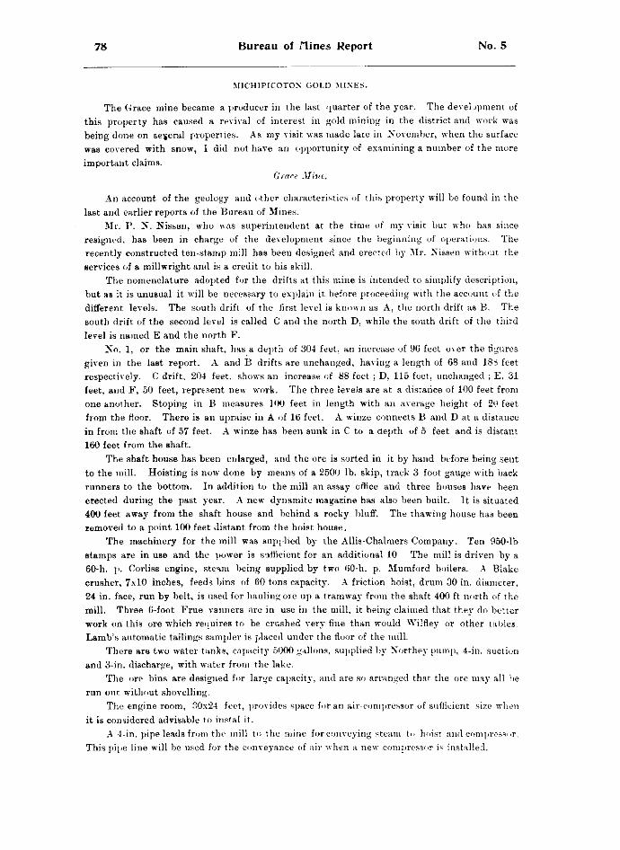
78 Bureau of nines Report No. 5
MICHIPICOTON GOLD MINES.
The Grace mine became a producer in the last quarter of the year. The development of this property has caused a revival of interest in gold mining in the district and work was being done on several properties. As my visit was made late in November, when the surface was covered with snow, I did not have an opportunity of examining a number of the more important claims.
Grace Mine.
An account of the geology and other characteristics of this property will be found in the last and earlier reports of the Bureau of Mines.
Mr. P. N. Nissen, who was superintendent at the time of my visit but who has since resigned, has been in charge of the development since the beginning of operations. The recently constructed ten-stamp mill has been designed and erected by Mr. Nissen without the services of a millwright and is a credit to his skill.
The nomenclature adopted for the drifts at this mine is intended to simplify description, but as it is unusual it will be necessary to explain it before proceeding with the account of the different levels. The south drift of the first level is known as A, the north drift as B. The south drift of the second level is called C and the north D, while the south drift of the third level is named E and the north F.
No. 1, or the main shaft, has a depth of 304 feet, an increase of 96 feet over the figures given in the last report. A and B drifts are unchanged, having a length of 68 and 188 feet respectively. C drift, 204 feet, shows an increase of 88 feet ; D, 115 feet, unchanged ; E, 31 feet, and F, 50 feet, represent newT work. The three levels are at a distance of 100 feet from one another. Stoping in B measures 100 feet in length with an average height of 20 feet from the floor. There is an upraise in A of 16 feet. A winze connects B and D at a distance in from the shaft of 57 feet. A winze has been sunk in C to a depth of 5 feet and is distant 160 feet from the shaft.
The shaft house has been enlarged, and the ore is sorted in it by hand before being seut to the mill. Hoisting is now done by means of a 2500 lb. skip, track 3 foot gauge with back runners to the bottom. In addition to the mill an assay office and three houses hare been erected during the past year. A new dynamite magazine has also been built. It is situated 400 feet away from the shaft house and behind a rocky bluff. The thawing house has been removed to a point 100 feet distant from the hoist house.
The machinery for the mill was supplied by the Allis-Chalmers Company. Ten 950-lb stamps are in use and the power is sufficient for an additional 10 The mill is driven by a 60-h. p. Corliss engine, steam being supplied by two 60-h. p. Mumford boilers. A Blake crusher, 7x10 inches, feeds bins of 60 tons capacity. A friction hoist, drum 30 in. diameter, 24 in. face, run by belt, is used for hauling ore up a tramway from the shaft 400 ft north of the mill. Three 6-foot Frue vanners are in use in the mill, it being claimed that they do better work on this ore which requires to be crushed very fine than would Wilfley or other tables. Lamb's automatic tailings sampler is placed under the floor of the mill.
There are two water tanks, capacity 5000 gallons, supplied by Northey pump, 4-in. suction and 3-in. discharge, with water from the lake.
The ore bins are designed for large capacity, and are so arranged that the ore may all be run out without shovelling.
The engine room, 30x24 feet, provides space for an air-compressor of sufficient size when it is considered advisable to instal it.
A 4-in. pipe leads from the mill to the mine for conveying steam to hoist and compressor. This pipe line will be used for the conveyance of air when a new compressor is installed.
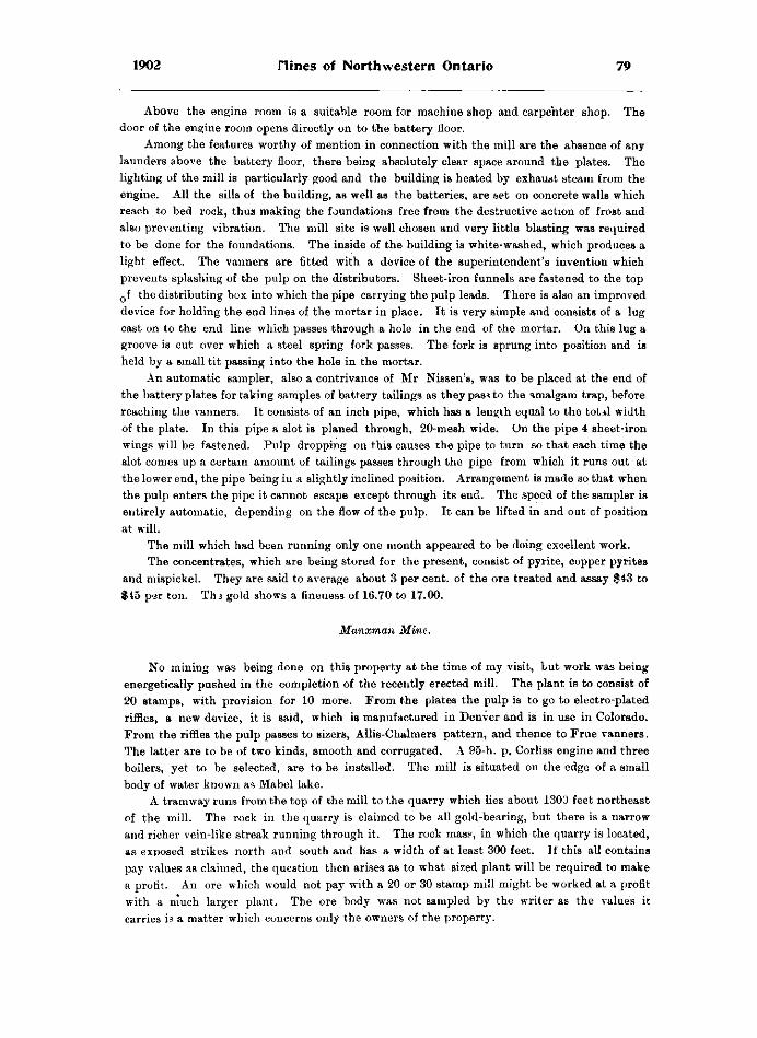
1902 nines of Northwestern Ontario 79
Above the engine room is a suitable room for machine shop and carpenter shop. The door of the engine room opens directly on to the battery floor.
Among the features worthy of mention in connection with the mijl are the absence of any launders above the battery floor, there being absolutely clear space around the plates. The lighting of the mill is particularly good and the building is heated by exhaust steam from the engine. All the sills of the building, as well as the batteries, are set on concrete walls which reach to bed rock, thus making the foundations free from the destructive action of frost and also preventing vibration. The mill site is well chosen and very little blasting was required to be done for the foundations. The inside of the building is white-washed, which produces a light effect. The vanners are fitted with a device of the superintendent's invention which prevents splashing of the pulp on the distributors. Sheet-iron funnels are fastened to the top Q f the distributing box into which the pipe carrying the pulp leads. There is also an improved device for holding the end lines of the mortar in place. It is very simple and consists of a lug cast on to the end line which passes through a hole in the end of the mortar. On this lug a groove is cut over which a steel spring fork passes. The fork is sprung into position and is held by a small tit passing into the hole in the mortar.
An automatic sampler, also a contrivance of Mr Nissen's, was to be placed at the end of the battery plates for taking samples of battery tailings as they pass to the amalgam trap, before reaching the vanners. It consists of an inch pipe, which has a length equal to the total width of the plate. In this pipe a slot iB planed through, 20-mesh wide. On the pipe 4 sheet-iron wings will be fastened. Pulp dropping on this causes the pipe to turn so that each time the slot comes up a certain amount of tailings passes through the pipe from which it runs out at the lower end, the pipe being in a slightly inclined position. Arrangement is made so that when the pulp enters the pipe it cannot escape except through its end. The speed of the sampler is entirely automatic, depending on the flow of the pulp. It can be lifted in and out cf position at will.
The mill which had been running only one month appeared to be doing excellent work. The concentrates, which are being stored for the present, consist of pyrite, copper pyrites
and mispickel. They are said to average about 3 per cent, of the ore treated and assay $43 to $45 per ton. Thi gold shows a fineness of 16.70 to 17.00.
Manxman Mine.
No mining was being done on this property at the time of my visit, but work was being energetically pushed in the completion of the recently erected mill. The plant is to consist of 20 stamps, with provision for 10 more. From the plates the pulp is to go to electro-plated riffles, a new device, it is said, which is manufactured in Denver and is in use in Colorado. From the riffles the pulp passes to sizers, Allis-Chalmers pattern, and thence to Frue vanners. The latter are to be of two kinds, smooth and corrugated, A 95-h. p. Corliss engine and three boilers, yet to be selected, are to be installed. The mill is situated on the edge of a small body of water known as Mabel lake.
A tramway runs from the top of the mill to the quarry which lies about 1300 feet northeast of the mill. The rock in the quarry is claimed to be all gold-bearing, but there is a narrow and richer vein-like streak running through it. The rock mas?, in which the quarry is located, as exposed strikes north and south and has a width of at least 300 feet. If this all contains pay values as claimed, the question then arises as to what sized plant will be required to make a profit. An ore which would not pay with a 20 or 30 stamp mill might be worked at a profit with a much larger plant. The ore body was not sampled by the writer as the values it carries is a matter which concerns only the owners of the property.
80 Bureau of nines Report No. 5
The superintendent stated that no mining would be done during the winter, as sufficient ore was blasted out in the quarry to keep the mill, when completed, running till spring.
The shafts and oth,er workings mentioned in the last report have been abandoned for the present. The main shaft is said to have a depth of 126 feet and to be timbered down to a depth of 120 feet, with manway and ladders separate from the hoisting compartment. At the 100-foot level a drift runs north 18 feet. The south drift was stated to be 23 feet in length with cross, cut south 10 feet.
The quarry referred to is on location 641. The workings are about 120 feet in length with drift 30 feet in the bottom across the pay streak.
A dynamite house, 10x10 feet, has been built. It lies about 600 feet south of the quarry, with rise of ground between. No explosives are kept in it at present. The dynamite is stored at the main shaft half a mile south of the works.
The officers of the company are : president, M. L. Parker of Fort Yates, N. D.; secretary, J. J. Nierling of Jamestown, N. D.; manager, Angus Gibson of Duluth. Thirty men are employed under superintendent J. W. Douglas.
Other Michipicoton Gold Claimn.
A plant was being put on the Mariposa. It is to consist of a 5-drill air compressor, Lidgerwood double-acting hoist and 60 h. p. locomotive boiler. Dining and sleeping camps and an engine house have been erected. A recent fall of snow, and the presence of water in them, prevented my making an examination of the pits and surface workings on this property. Some work was done here two or more years ago and some stripping more recently. In the tenth report of the Bureau, p. 139, it is stated that a shaft, 9x11 feet, had been sunk to a depth of 33 feet and two pits each eleven feet deep have been put down. Three miners were at work at the time of my visit squaring up the mouth of the shaft, preparatory to putting in a collar? and it is the intention to vigorously prosecute development as soon as the machinery is in place. Messrs. Brown and Lennox have charge of the work, but were not present at the time I visited the property.
I was told that a contract had recently been let to sink a shaft 100 feet deep on the Sunrise claim.
The shaft on the Cora was being unwatered for the purpose of sampling the ore body.
Mr. P. N. Nissen furnished me with information concerning claims 1102, 1103, 1104 and l i05 . They are controlled by Messrs. Francis and Dixon and 1105 is said to contain a promising vein. The vein is stated to have a width in places of 10 feet and strikes northwest and southeast. It is found on both sides of the Fire Sand river which runs through 1105, on which there is a falls. The dip of the vein is westward and its width on the north side of the river is 5 feet. A water power on the Michipicoton river is about one mile distant from the outcrops. The Anjigomi road passes within a mile of the vein. The ore body is said to lie near the contact of diorite and greenstone. The quartz is mineralized, carrying pyrite and chalco-pyrite. Work has recently been done on some of these claims.
OPHIR GOLD MINE.
This property, which attracted considerable attention a few years ago. was started up again, after a long shut down, on 1st December, under the direction of Messrs. E. L. Lawyer & Co., Mr. J. P. McNolty being superintendent. At the time of my visit on December 1st ten men were employed, of whom only two were miners.
The vertical shaft is 97 feet deep with drift to the east, from the bottom of the shaft, 119 feet, and north cross-cut of 40 feet. It is proposed to put a new shaft down through an old
Helen iron mine.
[ i ]

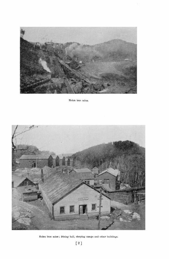

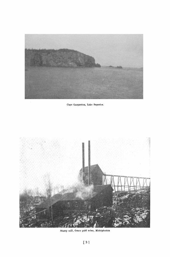
[ 3 1

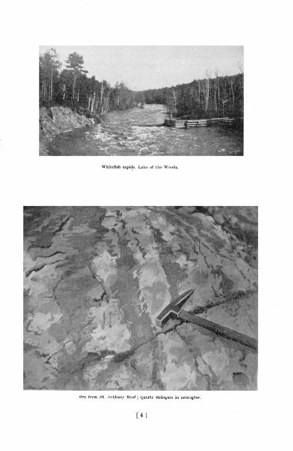
Ore from St. Anthony Reef ; Quartz stringers in protogine.
[ 4 1

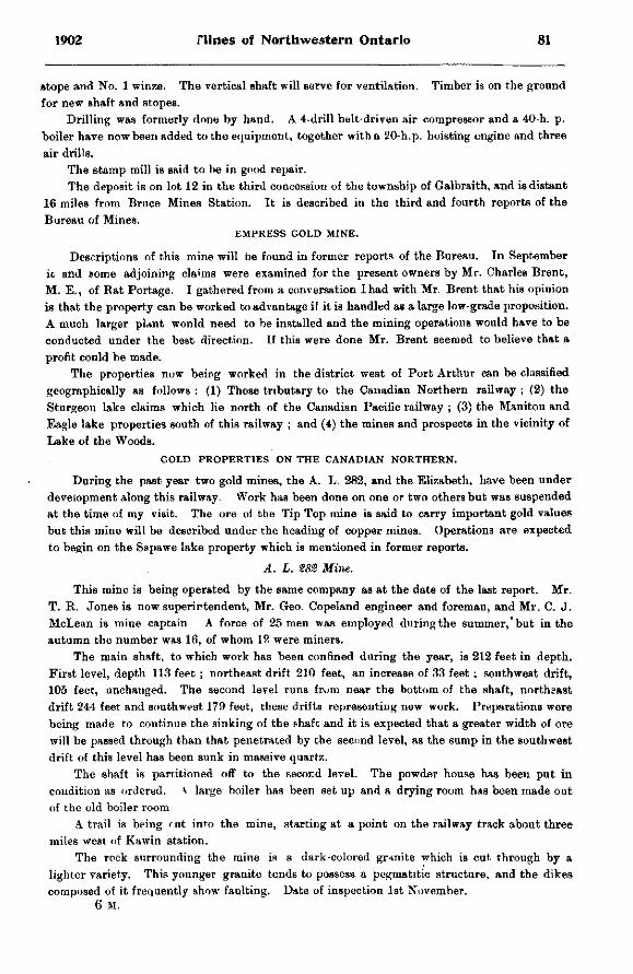
1902 nines of Northwestern Ontario 81
stope and No. 1 winze. The vertical shaft will serve for ventilation. Timber is on the ground for new shaft and stopes.
Drilling was formerly done by hand. A 4-drill belt-driven air compressor and a 40-h. p. boiler have now been added to the equipment, together with a 20-h.p. hoisting engine and three air drills.
The stamp mill is said to be in good repair. The deposit is on lot 12 in the third concession of the township of Galbraith, and is distant
16 mileB from Bruce Mines Station. It is described in the third and fourth reports of the Bureau of Mines.
EMPRESS GOLD MINE.
Descriptions of this mine will be found in former reports of the Bureau. In September ic and some adjoining claims were examined for the present owners by Mr. Charles Brent, M. E., of Bat Portage. I gathered from a conversation I had with Mr. Brent that his opinion is that the property can be worked to advantage if it is handled as a large low-grade proposition. A much larger plant wonld need to be installed and the mining operations would have to be conducted under the best direction. If this were done Mr. Brent seemed to believe that a profit could be made.
The properties now being worked in the district west of Port Arthur can be classified geographically as follows : (1) Those tributary to the Canadian Northern railway ; (2) the Sturgeon lake claims which lie north of the Canadian Pacific railway ; (3) the Manitou and Eagle lake properties south of this railway ; and (4) the mines and prospects in the vicinity of Lake of the Woods.
GOLD PROPERTIES ON THE CANADIAN NORTHERN.
During the past year two gold mines, the A. L. 282, and the Elizabeth, have been under development along this railway. Work has been done on one or two others but was suspended at the time of my visit. The ore of the Tip Top mine is said to carry important gold values but this mine will be described under the heading of copper mines. Operations are expected to begin on the Sapawe lake property which is mentioned in former reports.
A . L. S8S Mine.
This mine is being operated by the same company as at the date of the last report. Mr. T. R. Jones is now superintendent, Mr. Geo. Copeland engineer and foreman, and Mr. C. J. McLean is mine captain A force of 25 men was employed during the summer,'but in the autumn the number was 16, of whom 12 were miners.
The main shaft, to which work has been confined during the year, is 212 feet in depth. First level, depth 113 feet ; northeast drift 210 feet, an increase of 33 feet; southwest drift, 105 feet, unchanged. The second level runs from near the bottom of the shaft, northeast drift 244 feet and southwest 179 feet, these drifts representing new work. Preparations were being made to continue the sinking of the shaft and it is expected that a greater width of ore will be passed through than that penetrated by the second level, as the sump in the southwest drift of this level has been sunk in massive quartz.
The shaft is partitioned off to the secor.d level. The powder house has been put in condition as ordered, a large boiler has been set up and a drying room has been made out of the old boiler room
A trail is being < ut int'o the mine, starting at a point on the railway track about three miles west of Kawin station.
The rock surrounding the mine is a dark-colored granite which is cut through by a lighter variety. This younger granite tends to possess a pegmatitic structure, and the dikes composed of it frequently show faulting. Date of inspection 1st November.
6 M.
82 Bureau of nines Report No. 5
Elizabeth Mine.
A s a pretty full account of the ore bodies and other characteristics of this property-is given in the last report, it will only be necessary to mention changes which have since taken place.
Mr. W. H. Johns, at one time of the Deloro mine, has recently been appointed mine captain.
At the time of my visit, ith November, no mining was being done, but the water was being kept pumped out of the workings. All the employe* s were at wor is on the erection of a 15-stamp mill. The plant, which has seen little service, was purchased from the owners of the Decca mine, on which property it was erected a couple of years ago. The site selected lies a short distance from the shaft.
Outside of the work in the main shaft the development done since the date of the last inspection consists of 20 feet of drifting on the north end of location F M 171, together with some surface work on a recently discovered ore budy which lies on the roadway b tween the main shaft and the mill site.
The depth of the main shaft is unchanged; first level, north drift, unchanged; second level, north drift, 230 feet with cross cut south 104 feet. A winze in the second level, which is 185 feet north of the shaft, has a depth of 70 feet. The north drift of the thirl level is 138 feet, with winze, 115 feet north of the shaft, 35£ feet deep. The south drift of this level is 112 feet with a crosscut east about 20 feet.
A new dynamite house has been built and other changes made according to instructions given at the time of the last inspection.
STURGEON LAKE REGION.
This gold mining district is reached in summer by a canoe route northward from Osaquan, a siding oa the Canadian Pacific railway, which lies about five miles west of Ignace station. Sketches of the geology of the district are given in the last Report of the Bureau of Mines and in Summary Reports for 1899, pages 118 to 120, and for 1901, p>ges 90 to 92 of the Geological Survey, Ottawa. As the route is described in these reports it is not necessary to give a detailed account of it in this place. From Osaquan to the end of the portage into Sturgeon lake the distance by canoe is about 50 miles, with easy'portages. There is a small steamboat on the lake, which is the property of the Jack Lake Gold Mining company. This boat does a general freight and passenger business, and, arriving at the lower end of the lake, one has the option of canoeing up to the gold properties or of travelling on the steamer.
At the time of my visit to the lake, July. 1902, work was in progress on four properties, and more or less development had been done on others during the year.
My thanks are especially due to Mr. J. S. Steele and the company represented by him for the facilities with which he so kindly furnished me for visiting various parts of the lake.
St. Anthony Reef.
This mine is the property of the Jack Lake Gold Mining company, formerly operators in the Seine river district. The officers of the company are : Arthur Hill of Saginaw, Mich., president, and G. W. Weadock, secretary-treasurer. The mine staff consists of J. S. Steele, manager ,K. T. Barnard, assayer, and R. Andrew, mine captain.
At the time of my visit 23 men were employed, of whom 14 were miners. Drilling was being done by hand, but four steam drills are on the property. A steam hoist was in use at No. 3 shaft, and at No. 2 a horse was used for hoisting. There are also a No. 5 Cameron sinking pump and two duplex pumps. The workings, which are near the shore of Couture lake
1902 nines of Northwestern Ontario 83
are about one-third mile south-east of the camp, which is on a bay of Sturgeon lake. The buildings at the camp consist of manager's office and assay office, dining house, storehouse and stable. The dynamite house, 16 by 20 feet, lies at a distance of nearly one-half mile across the bay from the camp, which is on location B G 154.
The holdings of the company include B G 151, 152, 153, 154, 168 and H W 699. The workings are on either side of the boundary between B G 151 and 152.
The surface cuts, pits and shafts extend along the surface for a distance of 1,140 feet. The disturbed zone, or so called reef, rises to a height of 40 feet above Couture lake.
The workings are near the contact of granite, protogine, and green or grey schists and schistose quartz porphyry. It is difficult to say what the character of the green schists was originally, but they were probably traps and related materials. The schists are older than the quartz porphyry which protrudes through them at different points. This relationship between these rocks is the same as that which has been described in former reports as occurring in various localities in the southern part of the Rainy River district and elsewhere in this region.
After the eruption of the quartz porphyry a disturbance took place which subjected this rock and the accompanying green schist to great pressure and caused them to take on a schistose or laminated structure. At or about this time openings or fissures were made through these rocks which were invaded by molten material. On cooling and solidification this material gave rise to granite. As the granite cooled contraction took place, with the result" that a line of fracture or disturbance was formed which does not follow the contact, as is usually the case, but crosses it, its south end, in the vicinity of the ore bodies, being iti the green schist and its north end in the shattered granite. No doubt had the contact between the granite and the schist followed a straight line, the line of fracture would have paralleled it more closely. The contact at this point is quite irregular. There has, however, been some disturbance along the line of contact, as masses of quartz are found along it, stretching northeastward from No. 2 shaft.
For structural purposes, so far as their relation to the granite is concerned, the green schist and quartz porphyry may be considered to be identical, as the granite bears the same relation to the one that it does to the other. This is worthy of attention as the quartz porphyry and the granite possess almost exactly the same color, and the former I found had been mistaken for the latter. When attention is once directed to the structure of the two rocks the resemblance disappears. The quartz porphyry is more perfectly laminated and its quart? grains which are set in a rather fine-grained ground-mass, are more prominent than those in the granite. In chemical composition the two rocks are similar. Their structure depends on the conditions of cooling of the molten material from which they were formed.
The granite shows evidence of disturbance over a width of 200feet in a direction at right angles to the strike of the rocks. In places it is much fissured and shattered, the openings thus made being filled with quartz which frequently surrounds fragments of the granite. This mixture of quartz and altered granite or quartz andschist represents the ore,allof which is said to be gold-bearing. With the exception of the difference in character of the fragments of rock mixed with the quartz the ore occurring in the granite and in the green schist shows a great similarity. The associated minerals are pyrite, zinc blende, galena and occasionally free gold. There is also at times some calcite with the quartz. The writer did not attempt to sample the deposit, but it would appear that there is a great width of ore deposited at the surface which seems not to differ very much in character from point to point.
The main workings follow a line which runs approximately ten degrees east of north. The most southern is a pit, No. 6, 12 feet deep, near the shore of a small bay of Couture lake. From this pit to No. 3 shaft the distance is about 50 yards. This shaft and the pit both lie in
84 Bureau of flirtes Report No. 5
the green schist to the east of the line of contact. From No. 3 to the boiler and hoist house the distance is 15 yards, and from the latter to the pit from which water is being pumped is 25 yards. From this pit, which lies a little east of the line of contact, to the pit on the contact the distance is 35 yards. It is to be noted that the ore body at the latter pit can be seen to dip strongly to the east. Shaft So. 2 lies 30 yards to the north of it, and a shallow opening lies 30 yards north of the shaft. 30 yards farther north is the large open cut which runs into the hill side.
Shaft No. 3 is 7 x 13 ft. in cross section and has a depth of 100 feet. A crosscut was being driven east at the time of my visit, and it had attained a length of 16 feet. There was also a crosscut of 6 feet to the west. The depth of No. 2 shaft is 100 feet. From the bottom of this shaft a drift, then 17 feet in length, was being driven east. The open cut, known as No. 1, runs westward into the hillside a distance of 71 feet and has a depth of 25 feet at the back end. The pit, No. 4, at the contact, is 15 feet in depth. Shafts Nos. 2 and 3 are not timbered but material for this purpose was on the ground.
Enqlish River Gold Mining Company.
The property being worked by this company, formerly the Sturgeon Lake Mining Company, is commonly known as the Dawson mine.
The officers of the company are : President, J. Ross, of Parry Sound ; treasurer, H. J . Taylor, of St. Catharines ; secretary, J. E. Varley, of St. Catharines. At the time of my visit C. E. Eve was in charge of the development work. The holdings include locations BG 155 to 159 inclusive, about 200 acres.
The workings consist of a shaft 64 feet deep, and an open cut, near the shaft, which has a length of 70 feet and an average depth of about 10 feet, following the vein. Several pits have been put down and stripping has been done on other parts of the locations. At the time of my visit work was confined to the open cut and shaft. In the latter, which is timbered down to a depth of 24 feet, a cross-cut was being driven east from a depth of 60 feet. Hoisting was being done at the shaft by a whim. The employees numbered 14.
There are twelve buildings on the property, including stamp mill, assay office, blacksmith shop and houses for staff and men. 'I he dynamite house is situated at a distance of one-half mile from the camp..
The mill consists of a log building equipped with machinery, supplied by the Jenckes Machine company, consisting of 10 stamps, 40 h.p. boiler, Blake crusher and other accessories if such plants.
At the point where the most work has been done the strike of the vein is approximately parallel with dikes of granite which cut through the green schist of the neighbourhood. The vein lies in the schist and dips to the eastward or away from the lake at an angle of about 65°.
It will be seen that the character of the ore body here is considerably different from that at the St. Anthony Reef. It will also be evident from the amount of development done that the mill has been erected prematurely. The ore is high-grade but to prove that there is sufficient of it to supply a mill will require the expenditure of considerable more capital.
Some rich specimens of gold in quartz are found in the shaft and open cut Associated minerals are pyrite, galena, blende, and a little copper in the native state. These minerals would be obtained as concentrates in milling operations, and if n paying quantities would have to be sent to some smelter to be treated.
On a claim lying immediately east of the Dawson property, with which it is connected by a trail, a mass of quartz, somewhat remarkable on account of its richness, was fiund a couple of years ago. The claim is commonly known as the White Prospect, but at the time of my visit the title was in dispute. The mass of quartz referred to consisted originally, it is said, or a large angular piece of vein matter, weighing 15 or 20 tons, which lay on the surface of the swamp,
1902 flines of Northwestern Ontario 85
apparently quite isolated from rooks in place. Owing to the quartz carrying large grains and nuggets of free gold it had, at the time of my visit, been completely broken up by hammers and sledges, in the hands of itinerant prospectors, into pieces, the largest of which were only a few inches in diameter. Many fine specimens, it is siid, were obtained, and in examining the material remaining we had little difficulty in finding "shows" of gold. This mass which gives one a good idea of the richness of some of the quartz of the district appeared to me not to have been far removed from its parent ledge. It is said to have been very angular and hence would seem not to have been transported by glaciers any great distance. It would look as if it were a portion of a vein which probably projected a short distance above the surrounding surface on account of the wall rock being more readily acted on by agents of denudation. It would also seem that the mass had fallen or been shoved over, probably by a glacier, and perhaps carried a short distance. To the southward, a couple of hundred yards or so, a quartz vein was seen in place. If this vein is continuous under the surface, and its strike does not change, it must pass almost directly under the now broken-up mass of quartz which has been described.
My attention w*s, however, drawn to the fact that the quartz which occurs in place in the rock contains much lower values in gold than did the loose angular mass. While this is true, it is no proof that the two were not originally part of one and the same vein. It is well known that a vein, although its width may not vary, may show a great difference in values from point to point. This may be accounted for by a change in the character of the wall rock, and in other ways. Examples of this have been observed in this region. The Mikado vein, for instance, has been found to carry high gold values where it is confined by granite walls, and to show much lower value where it passes beyond the boundaries of this rock. The dip of the part of the vein which is in place on the White property is eastward.
United Hates Gold Mining Company.
This company was the third largest operator in the vicinity of the lake during the year. At the time of my visit, 31st July, eight men were employed but no mining was being done, and shortly afterwards all operations ceased. Ore from Nc. 2 prospect was being treated in the two-stamp Tremaine mill. Shaft No. 1 near the mill is said to have a depth of 100 feet, with cross section 6 x 8 feet, and is filled with water. It is also said to' be timbered and to have a manway separate from the hoisting compartment. No. 3 is near the water's edge. It has a depth of 60 feet and is provided with a collar, but is otherwise untimbered. There is also a combined open cut and tunnel which runs about 125 feet N. 60° W. into the hillside. No. 2.shaft, which lies back on the hill, is 70 feet deep but has been abandoned.
The plant consists of the mill, to which reference ha* been made, two steam hoists, three steam drills, three sinking pumps, together with other machinery. The buildings on this property, known as No. 1, in order to distinguish it from another holding of the company which lies at some distance across the bay, consist of combined cook and sleeping camp, office, store house and blacksmith shop, in addition to 'the mill and other structures. The dynamite house is on an island, one-quarter mile from No. 1 mine.
The officers of this company are : E. G. Filer, president; A. V. McAlvay, of Manistee, Mich., secretary ; E. A. Shores, jr., manager.
A brief visit was made to the No. 2 prospect of this company. Here a tunnel eighty or ninety feet in length, runs into the side hill from near the edge of the water. At the inner end of the tunnel a crosscut has been driven twenty-five or thirty feet to the west. The vein has been partially uncovered for a distance of one hundred feet to the south-west of the shore. The walls are granite, specimens of which show little decomposition or alteration at the point where the wall rock and the quartz of the vein form a junction. The quartz is irregular in form and the walls are not clear cut. Much of the quartz is dark in color.
86 Bureau of nines Report No. 5
The manager being absent at the time of my visit, I was unable to get a list of the locations controlled by the company. The main or No. 1 camp where the mill is situated is on the south shore of King's bay and the workings on No. 2 claim are on location BG 135. Thus both camps are not far distant from the upper end of the narrows -n hich connects the upper and lower expanses of Sturgeon lake. King's bay runs westward from near the lower end of North bay.
Symmes' Prospect. Following the shore of the North bay southward from the camp at the St. Anthony Reef,
the next property on whiih work of importance has been done, is known as Symmes' location, B G 138 and adjoining claims. The strike of the vein which occurs in granite is approximately north and south and the dip is to the westward. No work was being done at the time of my visit, but I was told that the most southern of the two shafts had a depth of twenty-two feet and it measured 6x8 feet in cross-section. The vein has been stripped for a distance of about one hundred feet. The north shaft is about twenty-five feet dis-ant from the one to which reference has been made. It has a depth of about fifteen feet. Stripping has been done for a dis'ance of twenty feet west of the north shaft and east fifteen feet. The quartz at the bottom of the north pit is said to have a width of eighteen inches. The vein cannot be traced very far as the south end of the exposure disappears under a swamp and the north is covered. The vein is about 9 feet wide just north of the north shaft, but its width is variable. The vein matter consists of rather dark quartz, carrj ing iron pyrites, dark zincblende and occasionally visible gold. The granite through which the vein runs is porphyritic in character like that which shows at various points on the shores of Sturgeon lake
From these openings the vein can be picked up at one or two points going northward towards the shore and an outcrop on a small island B G 60 appears to be a continuation of it, judging from the strike.
Prospects on Couture Lake.
In addition to an examination of the St. Anthony Reef a brief visit was paid to a number of other properties in the vicinity of this lake. Location B G 170 includes an island of eight acres in the lake. A body of quartz which sometimes has a width of 25 or 30 feet occurs on this island. Its strike is towards the northeast,parallel in a general way with that of the green schist through which it runs. At times, however, the quartz breaks across the strike of the schist, the ore body not being bounded by definite walls. Very little work has been done on the deposit. The quartz in places carries a small amount of copper pyrites and iron pyrites, as well as a little tourmaline. Messrs. Forget, Rowan and Daigle control the property. The ore is said to pan well in places. A sample which I took across a considerable width of the deposit, being careful not to get above the average value, gave $2.75 in gold per ton of 2000 lbs.
A small island lying to the south h*s a large outcrop of quartz on its southern end. On the large island to the east of the one just mentioned a quartz vein carrying some
iron pyrites runs parallel with the strike of the enclosing chloride schist. It has been stripped and opened up at a number of points for a distance of 200 or 300 yards. The dip of the vein is towards the east.
On the east side of Couture lake and somewhat southeast of the property just described is what is known as Martin's claim, H W 686. Its characteristics are similar to those of the last mentioned claim.
A little work was being done on a claim that was unsurveyed at the time of my visit, but which has since been laid out as location H W 747. It lies at the southern extremity of Couture lake and near the portage which runs from this body of water into the northeast
1902 flines of Northwestern Ontario 87
bay of Sturgeon lake. The quartz exposed in a pit was seen to be smoky or dark colored, fn structure the deposit is similar to the last two claimls mentioned.
It will be seen that the three or four claims last referred to possess characteristics in common in that the ore bodies are quartz veins in schist, the strikes of the vein and enclosing rock being approximately the same. They thus differ in structure from the St. Anthony Reef and the Symmes location.
The rock on B G 170 and some of the other claims on Couture lake may be described as chlorite schist, but in places it passes into or is closely associated with bands of more massive diabase and related trappean rocks.
Two or three claims were examined on the northeast bay or arm of Sturgeon lake. On location F M 207, the property of the Anglo-Canadian Gold Estates, the strike of the quartz vein is M. 10° E., and the dip, where it can be determined, is to the westward. Stripping and other work has been done along the vein at points for a distance of about 300 yards. A shaft, 6x8 feet, has been sunk at one point. As it was filled with water we did not learn its depth. The vein lies in chloriticschist which is in contact, near the south end of the vein, with what appears to be squeezed quartz porphyry. The body of quartz is more vein-like near the shaft. At other points it has the appearance of being a somewhat irregular segregation in the schist. The minerals associated with the quartz consist of small quantities of pyrite, copper pyrites and dolomite. Che camp is at the shore, a trail about 150 yards in length running from this point to the workings. Quartz porphyry outcrops along the shore.
An examination was made of a number of claims on Belmore bay and in the area lying a mile or more to the eastward. Work has been done on a number of these, but no operations were being carried on at the time of my visit. As the geological characteristics of these claims are similar to those already described, with the exception of the St. Anthony Reef, it will not be necess iry to enter into a description of them. Rich quartz has been found on a number of these claims, but it remains to be shown, by further development, in what quantity it occurs.
On a trip which was made inland from the shore of East bay, from a point which lies about two miles south of Belmore bay, two or three boulders of the somewhat rare rock, nepheline syenite, were found. These will be referred to again. The rocks in place here, a mile or less in from the shore, consist of granite in contact with a highly shattered rock of indefinite character. The latter is highly stained in places with iron rust.
STURGEON LAKE TO SAVANT LAKE.
I was advised that of the two routes from Sturgeon to Savant lake the one leading from the Northeast bay or arm of the former was easier, especially during dry weather, than that running from the north bay.
The first portage from the head of the northeast bay is over a half mile in length and runs in a northeast direction. There is considerable soft ground on the trail. The next body of water is a marshy pond about 200 yards long. Then there is a portage of about; the same length which leads to a small pond. From here the route follows a small creek a short distance to a lake which has a bay stretching eastward about three miles. The general direction of this lake is however about northwest.
The rocks observed along this part of the route from Sturgeon lake may be described in a
general way as greenstone schist. The lake referred to is known to the prospectors by the name of Nine-mile lake. Near its upper end the route turns off through a narrows and runs about north one mile to the foot of the portage. Although this lake is called Nine-mile lake, the distance we travelled on it did not seem to be more than six or seven miles. The portage we followed out of it is over a mile in length and is across muskeg for the greater part of the distance.
88 Bureau of nines Report No. 5
At the north end of the portage one hay of the lake which the route crosses stretches to the northeast and runs about three miles to a cnain of portages which lead to lake Nipigon.
The other arm of the lake which our route followed runs to the northwest one-quarter mile. Then there is a pull up a small rapid, on the north shore, into a lake which is about one-half mile long. Then up a creek one-half mile from the west end of the lake to a pond-like expansion and a portage running off from the south side of a little falls. This portage is a little over 100 yards long. The rock here is granite, as it is also on the lake below. From here the route runs west 200 yards around a point. This lake is given the name Granite by the prospectors, the rock of this name showing distinctly on its northeast shore. We canoed up Granite lake three miles, the rou e turning to the liortheast and the portage running from its east shore a short distance from the end of the lake. The portage is about 35 chains in length over schistose rocks and begins by a climb up a hill. The trail is good, much better than those crossed since leaving Sturgeon lake, as the route from the north bay of this lake joins that which we followed in Granite lake. All the travel from the two routes passes over this one portage. After this portage a pretty lake about 3 miles long, which extends from the portage in a direction somewhat east of north, is passed through. This lake has regular shores and is about one-third of a mile broad. The portage goes out of the east bay and a creek runs from the northwest bay to Savant lake. The rock on the shores is green schist. The portage leading to Savant lake is about two-thirds of a mile in length and the trail is good. A small creek of good spring water is to be found in the ravine just east of the north end of the portage.
The other route between the two lakes has been surveyed by Mr. Wm. Mclnnes. who states that leaving the north arm or bay of Sturgeon lake by a small brook, entering ten miles north of the outlet and ascending the brook for two miles, a portage of two miles leads to a lake about a mile in length. From the head of this lake a portage of thirty-five chains tuns to a long narrow lake, Granite lake, extending north for over four miles. The remaining two portages and lake, nearly three miles in length, lying between Granite lake and Savant are common to this route and the one from the northeast bay of Sturgeon lake and need not be a.'ain described.
SAVANT LAKE PLACERS.
A brief description of Savant or Musipomigut lake is given in the Summary Report of the Geological Survey for 1901, pages 92 and 93. It is also referred to on pages 175 and 180 of the Report of the Survey and Exploration of Northern Ontario, 1900, published by the Crown Lands Department, where it is wrongly identified with Wahbahkimmung lake.
Mr. Mclnnes, in the Summary Report mentioned, states that his log survey of the lake proved "that there was little or no resemblance between the real lake and its representation on existing maps."
" We found i t " he says, " to be a little over 23 miles in length in a direction about N 20° E . having a central portion forming the main lake eleven miles long by five miles wide, with a number of bays of considerable length branching from it. The Huronian belt of Sturgeon lake was found to be c o n t i n u D u s almost to the foot of the lake, the two arms, one running northerly to the outlet and the othtr north-easterly, extending into the granite-gneisses on either side of the central belt.
" The lake is characterized by many shallow bays, that are divided from one another along the shore-line by long and irregular, rocky points, and at their heads, by areas of swamp. The central part of the lake shows wide expanses of deep water, while the narrower parts and the bays are for the most part exceedingly shallow, long stretches having only a few inches of water covering a bottom of slimy mud. The forest growth is for the most part of small size and consists principally of black spruce, poplar and white birch, with occasional red and white pine. This is the highest latitude (about 50° 35') in which I have observed the white pine in this district.
" The Huronian rocks are of the usual kinds, with a large proportion of massive igneous t ypes, and include a considerable thickness of schists, conglomerates and quartzites, similar to
1902 flines of North western Ontario 89
those that occur in the same belt at Sturgeon, Abram and Vermilion lakes. A drift-covered area or basin similar to those occurring in other parts of the district, occupies part of the shores and islands of the central part of the lake The close resemblance of this drift area to that at Lac Seul makes it probable that they are similarly derived That at Lac Seul seems to have been laid down at the foot of a glacial barrier that cut off the draina:e to the north, and so formed a lake basin between it and the higher land to the south. Pebbles in this drift contain ft ssils that seem to be of Devonian age and are probably derived from strata of that age, occurring to the north near Hudson's bay. The derivation of the drift about this lake is the more interesting, as colours of gold have been obtained from it."
The south end of Savant lake is narrow and is split at the southern extremity into two channels, the more western being the one the portage enters. The river from the last lake passed through enters > avant by a little falls a short distance up the west shore. About five miles up trom the end of the portage is a deserted Hudson Bay post on the west shore near the foot of the narrows which connects the larger northern expanse of the lake with the smaller southern portion. The bay on which the post is situated has a sand beach and a sand hill lies a short distance inland.
As gold had been reported to occur iu important amounts m the sands and gravel from some parts of the lake, we panned simples taken in the vicinity of the post with the object of verifying the reports if possible. We found, however, no "colors " in a number of p»nnings taken from the beach and from the hill inland. A couple of large double handfuls taken by myself along the shore about 100 yards west of the post, and near the top of the bank, gave one color of good size and shot-like form. The point from which this sample was taken lies ab.Mit 8 feet above the.surface of the lake which was then, July, at a high level for the time of year. The sand from which the sample was taken is very fine grained, light in color and occurs in layers. Other samples of the same sand gave no indication of gold on panning, leading to the presumption that the precious metal in the free state is very sparingly or very unevenly distributed through this sand, or that it was present in the one panning simply by acciilent. Rock, green schist, is exposed in place, a short distance back from the shore at this point. It contains stringers of quartz and is more or less rusted. It would thus seem that the gold in some of the sands may have come from no great distance.
Two or three miles farther up sand is exposed on both sides of the canoe channel and shous quite distinctly at a point where at one time there was an Indian village on the east side of the route. Some pits have been sunk along the west shore which will be referred to again. They lie a short distance south of the north end of the narrows.
Crossing a wide expanse of the lake from the head of the narrows, we came to a large island, which we shall call island No. 1. At the south end of this island, sand is exposed, and some pits have been sunk in it not far from the water's level. Prom a number of pans of the sand we obtained only one color. There is much magnetite in the sand and the shore is built up of gravel. On the north end of this island there is a high sand hill covered with a growth of beautiful Norway pine of medium size. This pine is of second growth, as is evident from one or two burnt stubs which we saw still standing. One color was obtained from a sample taken from the top of this hill. The deposits on the hill and island are gravel rather than sand, and are composed of pebbles of all kinds of white and other colored quartz, granite, quartz porphyry, green schist and small pebbles of jasper. It is from all appearances a glacial deposit. One or two pebbles of fossiliferous rocks were also obtained.
Since the deposit consists of such a variety of pebbles arid the Huronian rocks of the region have been proved to contain more or less gold in numerous places, it is not surprising to find occasional grains of gold in the sand and gravel. The deposit resembles that which covers the area surrounding the height of land at various points.
Rock is in place on the south-west point of this large island. It is green schist. Some boulders of varied composition are found imbedded in the sand. They have diameters up to
90 Bureau of nines Report No, 5
two feet or more. Magnetite shows distinctly in every pan. In the pits which have been sunk near the shore it can be seen that coarse travel in layers about two feet in thickness overlies the sand, giving evidence that the bank has been worked over.
On the next large island which lies to the north, deposits of similar material are found. The islands along the east side of the lake are composed of rock in place.
While the sand and gravel show very little gold in panning they do show values in the precious metal by tire assay. These values come from material, which is probably more or less refractory in the rusty fragments of rock in the grave). Only a very small percentage of the gold can be extracted by placer methods.
The following results were obtained from the fire assay of samples collected by the writer :
FIRE ASSAYS OF SAND AND GRAVEL FROM SAVANT LAKE.
Locality. Weight of sample.
Gold value per ton of 2,000 lbs.
Silver.
1. Sample taken 100 yards west of old H. B. Co.'a Post, and 8 feet above surface of water, July 28th
2 Two or three miles north of H. B. O.'s. Post, from some pita on shore on west side of the canoe channel
8. From top of hill on northern pai t of island No. 1 4. Ditto
2 lb. 14 oz.
2 lb. 12 oi. l ib . 4oz. 31b.
2 lb. 11 oz. 2 IK 11 oz 3)b 3 lb.
$2.00
50 80 51 80 SO. 80
trpce trace SO.80 $0.80
trace
trace trace
5 From opening in bank, rear shore level, on southwest point of island No. 1
2 lb. 14 oz.
2 lb. 12 oi. l ib . 4oz. 31b.
2 lb. 11 oz. 2 IK 11 oz 3)b 3 lb.
$2.00
50 80 51 80 SO. 80
trpce trace SO.80 $0.80
2 lb. 14 oz.
2 lb. 12 oi. l ib . 4oz. 31b.
2 lb. 11 oz. 2 IK 11 oz 3)b 3 lb.
$2.00
50 80 51 80 SO. 80
trpce trace SO.80 $0.80
truce trace
Mr. J. W. Wells, late Provincial Assayer, who made these assays, states that only traces of gold were obtained when the samples were subjected to the amalgamation test. This agrees with the results of our panning, and demonstrates that the greater part of the gold shown by the result of the fire assay is locked up in the fragments of rock and mineral of which the sand and gravel are composed. Mr. A. (T. Burrows, the present Provincial Assayer, subsequently made an amalgamation test of the crushed samples of gravel and sand which had been left over from Mr. Wells' assays. As there was insufficient material to make a separate test of each sample the pulp from samples 1 to 8 was mixed. One pound of this mixed pulp gave 0.15 milligrammes of gold, which is equivalent to 19cts. per ton. This result does not, of course, contradict that obtained by Mr. Wells in his amalgamation test, Mr. Burrows' test being made on crushed gravel and sand while the material tested by Mr. Wells was uncrushed, or in the form in which it occurs in the field.
It will be seen from the report on the Vermilion river placers that the value of gold carried by those deposits is somewhat like that in the sands and gravels of lake Savant. 1
There appears, however, to be a great difference in the form in which the gold occurs in the placers in the two distticts. Colors found in a pan of the Vermilion material sometimes number 40, and in a few cases run above 100. They appear to be very fine and difficult to save.
The placers of Savant lake are about 500 miles distant from those of the Vermilion riverr the former locality being northwest of the latter. It may be interesting to note, however, that, while the Vermilion river is farther south than Savant lake, the one locality is situated about as near to the centre from which it is thought glaciers moved over this region as the other. This centre is believed to have been in the vicinity of James bay.
An account of the iron belt on Savant lake will be taken up under the heading devoted to iron ranges.
1Vermilion River Placers, by Dr. A. P. Coleman, Tenth Report Bureau of Mines, pp. 151-159.
1902 nines of Northwestern Ontario 91
LAKE MANITOU GOLD AREA.
This area was visited in the second week in November, 1902. Owing to the closing of navigation being so near at hand, it was not found possible to visit all the working properties without missing the last boat of the season. There was no object in spending two or three weeks in the district at that time of year, till travel began over the ice, as snow had already fallen and it was not possible to study the surface exposures of the rocks and ore bodies.
During the past year Upper and Lower lakes Manitou have been the scene of very active operations in gold mining and prospecting. In fact, it can be said that there has been more concentrated work in gold mining in this district than in any other area of like extent in the Province during 1902.
The geology of the area needs to be worked out more systematically in order to determine the character of the various deposits and their relationship to one another. The writer hopes to make an examination i f the district during the coming summer.
Big Master Mine.
This prpperty has attracted much attention to the district during the past year. As it was described pretty fully in the last report of the Bureau of Mines it will suffice to give an account here only of the Changes that have taken place and the development carried out since the publication of that report
The company operating the mine is the Interstate Consolidated Mineral Company, the officers being, president, W. A. Blackstone, of Jamestown, N.Y., and secretary, M. A. Myers, of Warren, Pa.
The only change which has been made in the staff at the mine is the addition of Mr. Harry Hook as assayer. The number of men employed at the time of inspection was 42, of whom 12 were miners.
The main shaft now has a depth of 185 feet, being an increase of 15 feet since last inspection. First level is unchanged in length, but some stoping has been done amounting to probably 700 or 800 tons in the north drift. The second level is at a depth of 185 feet; south drift 166 feet with stoping about 10® tons ; north drift 223 feet with some stoping An up raise, now 40 feet in height, has been started 185 feet in from the shaft in the last mentioned drift. The timbering in the shaft has been carried to the bottom in the same manner as in the upper part. A new pump, a Worthington, has been installed in the lower level. The aer" ial tramway from the mine to the mill has been completed. An assay office and other buildings have been erected during the last few months. The Helena shaft remains unchanged.
The big vein, or what is spoken of as the east vein in the last report, is reached by a cross-cut from the main shaft. No further development has beeu done on it, as the present plant is not adapted to treat the ore, which is of a refractory nature. It consists essentially of siderite with iron pyrites, and is said to carry gold in paying quantities. The gold probably occurs practically all in the pyrite. If so, there should be no difficulty in extracting it by the ordinary cyanide process. The gaugue carrying siderite resembles somewhat closely that of many of the auriferous deposits of Hastings county. Some work was being done by another company on an adjoining property, where it is said a similar vein of refractory ore occurs. I, however, did not get an opportunity of visiting it.
The Big Master stamp mill was not running at the time of my visit on account of the lack of fuel. The ore which has been treated during the past season is said to have given high returns.
Summit Lake Mining Company.
In the latter part of 1902 three companies which had been organized to work properties in the Manitou district were amalgamated under this name. The officers of the newly organized company consist of president, A. F. Maclaren, M.P., and general manager, S. V. Halstead.
92 Bureau of nines Report No. 5
On the Little Master, A L 206, which is claimed to be on a continuation of the Big Master vein, pits have been sunk here and there and one shaft has attained a depth of 100 feet -
In December work was begun on another vein. On the Imperial property, G 19, there is a shaft 50 feet deep. On the Peninsular, H W 31, a shaft' is down to a depth of 110 feet and cross-cutting is
being prosecuted at this level in order to determine the width of the vein. At 60 feet in depth a cross cut 14 feet in length was driven.
The company have up to the present employed about 20 men, but this number, it is expected, will be increased shortly.
Machinery, consisting of air-compressor, pump, hoisting apparatus and air drill is being ordered and will be installed early in 1903. Development will then be vigorously prosecuted.
The National Claim.
I am informed that since my visit work has been started on the National claim, situated on the border of Three Hundred lake. The government road is said to run across this property.
Giunt Mine.
This property is described in the last report under the heading, Locations H W 74 and 75. It is on Mosher bay, an eastern extension of Upper Manitou lake, and is operated by the Giant Gold Company. Mr Daniel Simpson, of Buffalo, is manager, and Mr. Paul Paulson, is in charge of the work at the mine. Twelve men are employed, of whom nine are miners.
On H W 75 work is being prosecuted in a shaft which had reached a depth of 50 feet. A tunnel said to be a 100 feet in length has been run into the hillside on location H W 74 Considerable stripping has also been done on these claims. Machinery was being put in place at the shaft. It consisted of a Jenckes 5x5 in. special hoisting engine, diameter of drum 12 in." length 21 in., complete with foot brake, etc , a 10 h.p. vertical tubular boiler, Cameron sinking pump, 2 in. suction and l£ in. discharge, one 2 4 x 3 0 x 1£ in. Cornish kibble, etc.
The camp, which is near the shore of the bay about 300 yards from the shaft, consists of neat buildings recently constructed, comprising two-storey office 16 x 24, dining room 20 x 40, kitchen 16 x 36, and barn 12 x 18. At the shaft is a blacksmith shop and dry-room. A dynamite house has been built since last inspection.
Twentieth Century Mine. This property is pretty fully described in the last report. I did not visit it during my trip
to the lake, as I was told the only changes made since the last inspection were in connection with the mill which was nearing completion at the time I was on the lake. No mining was being done, as it was considered advisable to concentrate the work on the completion of the mill, skipway and surface plant, before the severe weather set in.
Royal Sovereign Mine.
This property, which was being worked at the time I was in the Manitou district, was like a few others, not visited on account of the lateness of the season, and the irregularity of the trips then being made by the two small steamers on the lake, which were busily engaged taking in supplies to the lumbering and mining camps.
EAGLE LAKE GOLD DISTRICT.
This district lies about 25 miles north-west of the Manitou field. It is reached by steamer from Vermilion Bay, a station on the Canadian Pacific railway, 60 miles east of Rat Portage. No very extensive development has yet been done on the claims surrounding the lake. At the
1902 nines of Northwestern Ontario 93
time of my visit work was being prosecuted on four claims. Accounts of the geology of the-district by Mr. Mclnnes will be found in reports of the Geological Survey, Ottawa.
The Northern Light Mines Company.
The head office of this Company is in Buffalo, N.Y. It was incorporated in 1902 under the laws of Arizona. Joseph E. Gavin and W. H. Barnhart, of Buffalo, are president and secretary, respectively. Mr. Newton Higbee, of Rat Portage is superintendent.
The claims on Eagle Lake controlled by the company are said to be the following : M H 244, 246, 248, 250, 252, 257, 258, 339 ; S 459, 460, 461, 464, 465, 492 ; McA 288 ; D 560.
Two shafts are being sunk, one on each of two locations. That on M H 246 had reached a depth of 16 feet at the time of my visit ill November. On M H 257, known as the Eldorado claim, the shaft is 31 feet deep. A two-stamp gravity mill has been erected near the shaft and will prove of great value in testing the ores from the various claims owned by the company as they are being developed. Sleeping and cook camps are also situtated on this claim, not far distant from the mill. Arrangements were being made for the erection of a powder house,which was badly needed.
The company own the small steamer Caro, by means of which supplies are brought in from the railway.
At the time of my visit twelve men were employed, of whom six were miners.
Golden Eagle.
This property belongs to Mr. N. Higbee. It is expected that development work will be resumed in the near future. The shaft is said to be 75 feet in depth with drift north 100 feet and south 60 feet, at the 50-foot level.
Grace Mine.
This property,which has the same name as the mine already described in the Michipicoton district, was being worked by a small force of men last autumn. It is said that a tunnel or adit runs into the hillside from the lake shore and that a shaft is down to a depth of 15 feet. The powder house is on an island in the lake in sight of the steamboat channel. The company have a small steamboat on the lake.
Viking Mine.
A contract to sink a shaft to the depth of 80 feet had been let on this property, and at the time of my visit to it in November sinking was in progress, the shaft at that time being 30 feet deep. Pits, together with stripping, are found on other parts of the property.
Baden Powell.
Development is proceeding on this property under the direction of Mr. R. H. Ahn. About 40 tons of ore have recently been taken out and tested at the Eldorado mill. A shaft is to be sunk on the open cut and preparations were being made for continuing work throughout the winter. A boarding house 32 x 32 feet has recently been built, and roads from the shore to the works have been improved.
LAKE OF THE WOODS REGION.
This gold mining field, judging from the number of properties now being worked, appears to be rapidly recovering from the evil effects of the boom of a few years ago. At the time of my visit, in the middle of November, work was or had recently been in progress on the follow-
94 Bureau of nines Report No. 5
ing properties, namely, Flint Lake, Golden Horn, Golden Reef, Indian Joe, Mikado, Nino, Olympia, Wendigo. Arrangements were also being made for the resumption of work at othe?. mines and claims.
Flint Lake.
This property is being worked by the Flint Lake Gold Company, head office, Philadelphia, Pa. There is a shaft sunk to a depth of 27 feet, with cross section of 6x1 L feet, and a pit 12 feet in depth. The vein is said to be 8 feet in width and to have been stripped for a distance of 350 feet. As the vein stands, it is claimed, at a height of 20feet above the edge of a swamp it is proposed to quarry this and mill it before doing other development work. A Krupp ball mill is being erected. The following buildings are on the property, namely, dining and sleeping camps, blacksmith shop, assay office and powder house. The ice was taking on the canoe route to this property at the time of my visit to the district. Hence I did not find it possible to make an inspection. I am indebted to Capt. Jones for the foregoing data.
Golden Horn.
Twenty men, of whom ten were miners, were employed at this mine jn November. Mr. H. Rideout is manager.
The shaft is 184 feet deep. First level, at 100 feet east drift 75 and west 45 feet. Preparations are being made to start the second level at 166 feet. The partition between the man-way and hoisting compartment is now complete down to the firjt level and the shaft is timbered to the second level. Planking is on the ground for the completion of the timbering.
Machinery, put in since last report, consists of No. 5 Cameron sinking pump return tubular 50-h. p. boiler and other plant.
New buildings comprise two dwelling houses, a building to cover hoist, boiler and compressor, also a store house, stable and blacksmith shop, together with enlargement of the sleeping and dining camps to suit present requirements. A small steamboat and barge have been purchased by the company. A powder magazine has been built as requested at time of last inspection.
Golden Reef.
In the last report this property is described under the name of Mikado Reef. It is now operated by the Golden Reef Mining Company, whose head office is Traverse City, Mich.
The shaft, 7x9, is down to a depth of 100 feet. At this level there is a drift north 50 feet and south 40 feet. It is the intention to proceed immediately with sinking to the 200 foot level. The shaft collar is made of sawn timber and is 14 feet in height. The manway is not divided from the hoisting compartment.
The dip of the vein is towards the east. The ore carries much iron pyrites and is said to pan well. Nine miners and three surface men were employed under the direction of Mr. H. J. Shields Drilling is done by hand, the machinery at present in use consisting only of 14-h. p. boiler and hoist. Several camps have been erected. The powder is stored on an island.
Indian Joe.
The Great Northwest Company who are developing this property control a number of locations in the vicinity of the north shore of Clytie bay, among which are 352 E A, 352 E, 354-5-6-7-8 E, 336 E, 339 E, 305 E and 306 E. The men employed, who are in charge of Capt. J. P. Williams, are ten in number, of whom six are miners. Mr. J. W. Cheeseworth, of Toronto, is the financial agent of the company.
On the Indian Joe location, to which the work was confined at the time of my visit, a shaft, 10x 13, had reached a depth of 60 feet. The strike of the vein, according to Capt. Williams, is northeast and southwest, and the dip is at an angle of 75° to the northwest. The vein
1902 nines of Northwestern Ontario 95
is described as possessing a banded character, and is made up of quartz, iron pyrites and schist. Work on other locations consists of two shafts, 15 and 20 feet deep respectively, and an open cut 15 feet in length.
Machinery was being installed, consisting of Worthington pump, 30-h.p. boiler and hoist. The camp, which is situated near the shore, consists of two or three recently erected buildings.
Mikado Gold Mine.
Only twenty men were employed at this mine at the time of my visit in November. The mill had been shut down some time before, and the work was confined to development.
Drifting was in progress on the 4th level, north, of No. 1, or the vertical shaft. The drift had reached a length of 525 feet, and was to be carried under the lake where the rock has already been tested by diamond drill, and good values are expected to be obtained.
It may be mentioned that in this mine, which has produced upwards of 9500,000 in gold, the best values are always found where one or both walls are composed of granite. It is claimed that this condition prevails in that part of the vein which runs under the lake.
A winze, which was down 20 feet below the fourth level, or 260 feet from the surface, was being sunk from the end of the crosscut on the fourth level. This winze will be connected with the shaft above, and will thus form part of a new shaft. Work, with the exception of diamond drilling, will be confined to this shaft and its levels for some time to come.
Since the last inspection considerable work has been done on the inclined shaft, which now reaches a depth of between 1,300 and 1,400 feet. On the 9th level the drift was carried south 800 feet from the shaft. On the 10th level, which is 100 feet below the 9th, 60 feet vertical, the south drift is about 75 feet in length. It may be added that some stoping was done between the 8th and 9th levels.
No nejv work has baen done on No. 2 vein. The skip.vay will have to be put in condition before work is continued here. It is intended to test No. 3 vein by the diamond drill at a depth of 650 feet from the surface.
It is to be regretted that the development work which is now being carried on in No. 1 shaft was not done before the ore reserves in the inclined shaft were exhausted.
Nino.
The Nino Mining Company control locations J E S 93 and J S 110 on Tille lake, east of Whitefish lake. The property is now reached by a canoe route on which there are six portages. A road is however to be cut out from the head of Lobstick bay.
According to Mr. Chas. Brent, the gray granite in which the vein occurs is a continuation of the Eagle lake belt. The development work consists of a shaft 110 feet deep and an adit level 60 feet in length. It is intended to secure powar from the Caribou falls, which are two and one-half miles distant. There is said to be a fall here of 60 feet.
The machinery at the Boulder mine has been purchased and is now being taken into the property. It includes a 7x10 duplex hoist, a seven-drill duplex compressor, three locomotive boilers a^d saw mill.
The head office of the company is in Toronto. Mr. William Chaplin of St. Catharines is president, and Mr. Chas. Brent of Rat Portage is the consulting engineer of the company.
Olympia.
The Olympia Mining Company are sinking a shaft on location M 11 which has reached a depth of about 95 feet. Mr. S. J. Griffiths is manager of the company. The property lies a short distance south of the Mikado mine.
96 Bureau of nines Report No. 5
Wendigo.
In November 8 men were said to be at work on this property under the direction of Mr. Fred Pfau of Rat Portage. The operators are the Chippewa Consolidated Gold Mining and Milling Company, with head office in Buffalo. A shaft is down to a depth of about 100 feet. The location is on Witch bay. Descriptions of the property will be found in the ninth and tenth Reports of the Bureau of Mines.
Other P'-opertiet.
It is expected that work will be resumed on a number of other properties in Lake of the Woods district at an early date. Mr. J. F. Caldwell is reported to have secured the support of foreign capital and will continue development work on the Sultana in the early spring. It seems to be agreed by those most intimately acquainted with this property that mining operations ceased last summer, not on account of the failure to locate ore bodies, but owing to disagreements among the operators.
The well known Black Eagle, (formerly Regina). which has been closed down for some time, is highly spoken of by all those who should be in a position to know the character of the ore bodies I made inquiries concerning the shutting down of this mine, and the information 1 received led me to the conclusion that it was due to neither the quality nor the size of the ore body but owing to outside causes. Men who should know and who speak from a disinterested standpoint state that there is no more promising ore deposit in the district than that of the Black Eagle. The history of the property certainly seems to point to extravagant management, at times at least. It is much to be desired that operations be resumed on this property, as with no great amount of development work and with comparatively slight changes in the plant it is believed it would be a steady producer. This would do much t< wards attracting capital to this gold Held and would give stability to the industry in the district.
Among other properties on which it is expected work will shortly be begun is the Violet which lies three miles northeast of the Nino. An option has lately been given on this claim. It is also stated that option money has recently been paid on the Gold Panner.
The recently organized Keenora Mining and Milling Company is said to control the following properties, viz : Dominion Reduction Works, Scramble, D 217 and claims on Cedar Island, Lake of the Woods. Mr. M. A. Myers of Warren, Pa., is secretary of the company.
SILVER MINES
While silver is found associated with gold in all the deposits of the latter metal, there are other well known properties in the northwestern part of the Province which have been producers of silver alone. The metal occurs in these chiefly as the sulphide, argentite, and also to some extent in the native form. An interesting and instructive report on the geology of this silver field, by Mr. E. D. Ingall, is to be found in the annual report of the Geological Survey of Canada for 1887-8.
Recently interest has been renewed in this field, and during the last year while only one property was a producer work of a prospecting character was done on a number of other claims.
Two American companies, of both of which Mr. M. A. Myers is secretary, have recently been organized, and they control the greater number of the silver properties The Consolidated Mines Company of Lake Superior is said to control the following properties, namely, East End Silver Mountain, West End Silver Mountain, Porcupine. Badger and Keystone or Climax. The Beaver, Rabbit, Silver Creek, Rabbit Junior, Black Fox and North Bluff, are held by the Algoma Mining Company.
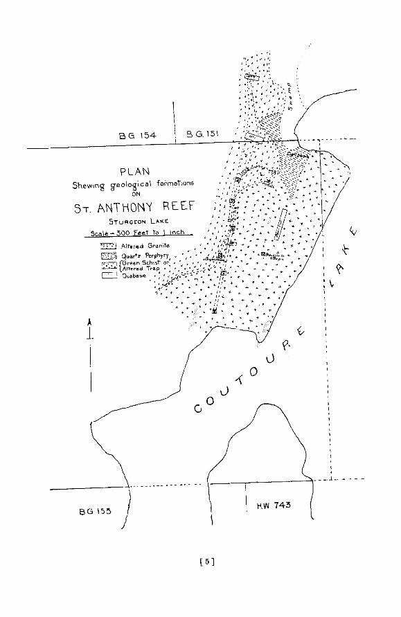
[ 5 1

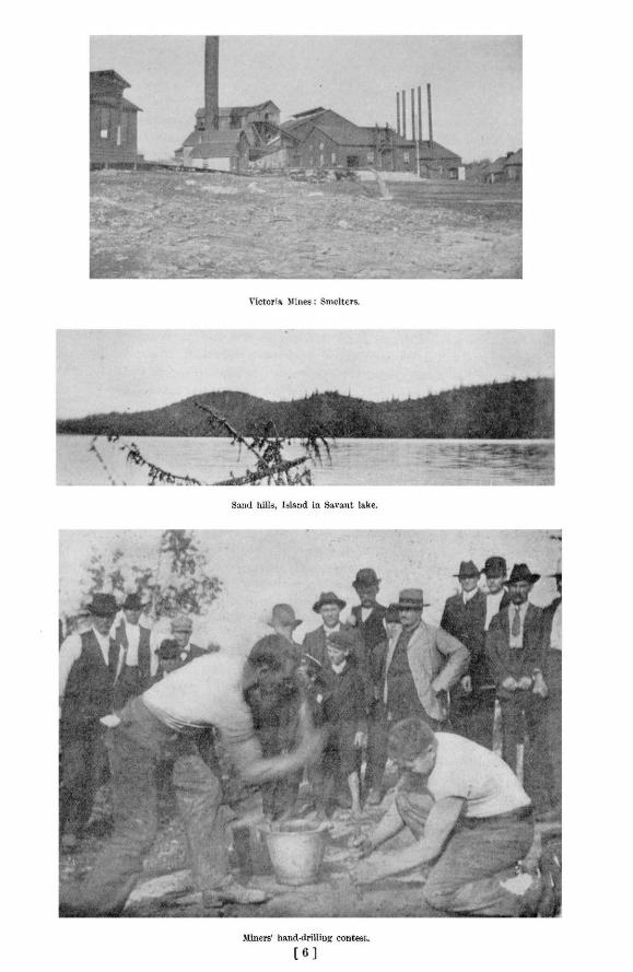

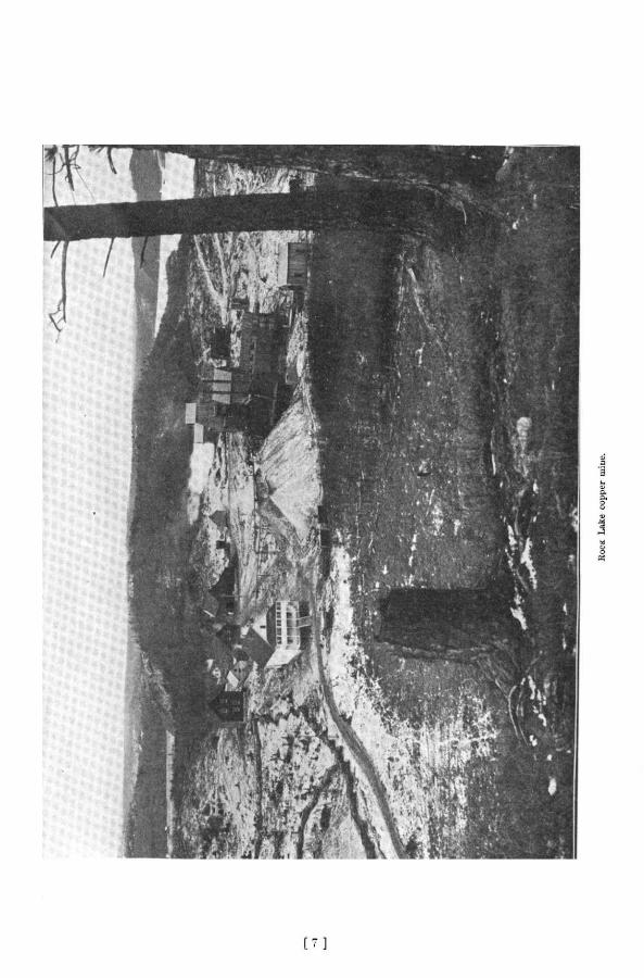

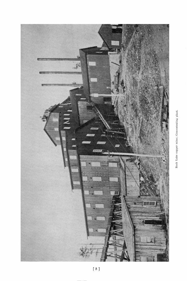
[ 8 ]

1902 flines of Northwestern Ontario 97
WEST END SILVER MINE.
Work on the proposed changes mentioned in the last report was in progress at the time of my visit, 17th Movember. The mill was run till 1st AuguBt, and it was then necessary to shut it down on account of the alterations being made.
A dam and reservoir have been built in the gulch on the hill 1500 feet from the mine. A centrifugal pump is being put in at Lizard lake to pump into the reservoir if necessary. Six additional Frue vanners are being put in the mill, making nine altogether. A new shaft house, 24x24 and 30 feet high, has been built and the shaft is being timbered. The boiler house, engine house and blacksmith shop are part of the Bhaf t house. A double cylinder Bacon hoist and cage with safety attachment is being put in the shaft. Three new boilers, return tubular, manufactured by the Jenckes Machine Company, are to be added to the equipment. The stamp mill now has a capacity of 30 stamps. The dynamite is stored the same as formerly, but a new magazine is being arranged for. A new store and office building is to be erected.
Mining work since the last report has been confined to the second and third levels of the main shaft. Second level, east drift, is now 375 feet in length, stoping coatinued at a point 252 feet from the shaft. Third level, east drift, is now about 550 feet in length ; back stoping has been continued above this line ; at 420 feet in, the crosscut south is 64 feet, and has cut two small veins one and one-half and two feet wide respectively, and penetrates the large vein at 64 feet.
The employees number 40.
COPPER MINES
The Sudbury mines are our greatest producers of copper, but the metal here is to be considered rather as a by-product of the nickel industry than as an essential constituent of the ores. The other copper properties in northwestern Ontario contain various ores of the metal, chief among which is copper pyrites, although other sulphides are also often present.
Outside of the area immediately surrounding Sudbury, the only producing copper mine in the Province at the present time is the Rock Lake mine, which lies some miles north of Bruce Mines. The ore at this mine is simply concentrated and shipped to the United States to be smelted and refined. Other properties are approaching the producing stage, and if the promise which they now show is fulfilled it is believed that a local smelter will be erected.
The copper properties now being developed lie, with one exception, in the district immediately north of the north shore of Lake Huron. Three or four are reached by the Sault branch of the Canadian Pacific, the most eastern of these being the Massey mine. Five or six properties are under development along the line of the Algoma Central railway, within 40 miles of Sault Ste. Marie. In the region lying west of Port Arthur only one copper property is being worked.
Attempts have been made from time to time to work deposits of native copper on the eastern and northern shores of Lake Superior, where formations carrying more or less of the metal and similar in character to those in the great copper district on the south shore are found. So far these attempts have met with little success.
MASSEY STATION MINE.
This mine, which has been described in previous Reports of the Bureau of Mines, lies within about four miles by wagon road of Massey Station, 58 miles west of Sudbury. A branch railway, which will be three miles in length, is to be built from the station to the mine. A mile is already graded, the ties required are nearly all on hand, and rails for two miles have been secured.
7M
98 Bureau of flines Report No. 5
During the last year, work has been confined to the main shaft, which has now reached a depth of 330 feet, an increase of 97 feet. First level, 74 feet from the surface, unchanged. Second level, 150 feet from the surface ; west drift, 130 feet, an increase of 10 feet; east drift unchanged. Third level, 220 feet from the surface ; drifts have been run about 10 feet in either direction, and a station has been cut. Fourth level, 290 feet from the surface ; east drift 80 feet, and west 60 feet, and work is to be continued in these drifts. Sinking will also be continued to 600 feet.
There is a lined track for the hoisting bucket, but the ore is handled in a skip, tools, etc., being carried in the bucket. Square sets and dividers have been put in, wall plates and a double track with back runners to the fourth level. There is a pentice below this level. Cars will run from the levels and dump in the skip. A rock house for handling 150 tons a day has been built. A new Lidgerwood hoist, to handle 3 tons a load, is to be put in at once, and it is intended to make this part of the plant complete and up-to-date. A 60-h.p. locomotive boiler is being added. A new straight line 5-drilI air-compressor and Northey pump have been added since the publication of the last report.
The number of men employed is 30, of whom 22 are miners. The officers of the company remain the same, with the exception that Mr. R. C. Barclay is now secretary at the mine.
The ore being highly silicious will be shipped to Sudbury, and used in the Bmelters with the more basic nickel-copper ores.
OTHER PROSPECTS.
It was the writer's intention to have made a somewhat detailed examination of the copper deposits along the north shore of Lake Huron during the past summer, but it was not found possible, owing to pressure of other work, to do much more than pay a hasty visit to the working properties.
Within what may be called the Massey area the following lots are said to have been taken up as copper claims, viz. : lots 2, 3, 4, 7 and 8 in the sixth concession of May ; section 12 on the Sable river, in Salter ; and a number of claims near Whiskey lake and McCool's lake in the northern part of township 137. The property of the Massey mine includes E. or S.E. i of section 16, S.E. i of S.W. J of 16, S \ of 15, S.W. J-14, W. £ of S.E. \ of 14, N. \ of S.W. \ of 13. or 860 acres. Massey station is in the centre of section 25.
A number of copper prospects north of Blind river station have recently been attracting considerable attention. I am indebted chiefly to Mr. M. J. Scott for the following information concerning these properties. Messrs. Mackenzie and Mann are said to have an option on locations 87 and 88 P in township 163. Surface work only has so far been done. The projected line of the Manitoulin and North Shore railway runs within one quarter mile of the property. There is a good water power at the White Falls Scott Bros, have a group of claims in 167.
Twelve men are said to be at work in the Huston mine, in the township of Montgomery-A New York syndicate is also said to be working in the same township. A number of other discoveries of copper ore have been made in adjacent townships.
BRUCE MINES.
An account of the recently constructed plant and of the condition of affairs at this mine was given in the last report. Since its'publication mining operations have not been resumed. Tailings are being constantly shipped, however, as they have been for a number of years, to the Canadian Copper Company at Sudbury, where they are used to flux more basic ores. It would appear that they should soon be replaced for this purpose to a large extent, at least, by the silicious copper ores from the vicinity of Massey.
1902 nines of Northwestern Ontario 99
ROCK LAKE MINE.
On 2nd December, when thia property was visited, it was found that mining operations during the past year have been confined to the workings above the third level. Since that date, however, arrangements have been made to continue the sinking of the shaft, which now lias a depth of 420 feet, and a new hoisting outfit is to be put in position.
First level, northwest drift, 324 feet, an increase of 155 feet. Intermediate drift is 30 feet in length. The stopes in the northwest drift have been enlarged. The southeast drift is 248 feet in length, an increase of 108 feet. At 60 feet in, the crosscut southwards is 39 feet in length ; then from its end there is a drift eastward 35 feet, and then crosscut again 59£ feet. The overhand stope in this drift has been enlarged and is now 150 feet in length. At 90 feet in, the crosscut of 17 feet remains the same. Two openings to the surface, one east and the other west of the shaft, serve for ventilation.
Second level, northwest drift 248 feet, an increase of 120 ; slope begins 178 feet west of the shaft and is 15 feet high and 10 feet wide. The southeast drift remains unchanged. There has been no change below the second level.
Hereafter the ore is to be hand-picked or sorted at the mine before going to the concentrators at the mill. The building in which the sorting equipment is placed is 55x16 feet. The ore is thrown on a belt conveyor which is 30 feet in length and 30 in. in width, with board sides 2 in. high. Boys or men will do the sorting, throwing out the barren pieces of rock as the ore is carried past them on the belt.
The powder magazine now in use is near the shore of Rock lake. The thawing house, the situation and character of which were criticized in the last report in the Inspector's book, blew up last summer, fortunately without injuring any person, and a new one 10x8 feet has been built. It is placed farther back from the railway track and is 'heated in the same way as the old one.
The railway, which has been completed for some time from Bruce Mines station to within a short distance of the mill, is in use for shipping concentrates. It is almost completed from the station to Bruce Mines village and will shortly be in running order the whole distance, from the concentrating plant to the village of Bruce Mines.
Additions have been made to the concentrating plant during the past year, including a set of rolls, an Overstrom and a Wilfley table. A sleeping camp has also been erected. When running at its full capacity the mill treats about 120 tons of ore in twenty-four hours.
The number of men employed at the njine is 150, of whom 40 work underground, and at the concentrator there are 30 employees.
Mr. W. C. Madge has recently been appointed mill superintendent, and Mr. W. Wearne mine captain. At the beginning of 1903 Mr. Geo. P. Good was appointed manager of the mine.
COPPER QUEEN.
I did not visit this mine, which is referred to in the last report as one of the properties of the Sault Prospecting and Development Company. It is situated in the township of Morin, about 16 miles by road northeast of the Rock Lake mine. The mine is now owned by the Copper Queen Mining Company, Limited, which was incorporated in May, 1902. The company is reported to control 960 acres of land, the east end of the property adjoining Shelden lake. The secretary, Mr. R. N. Adams, of Sault Ste. Marie, Mich., informed me that No. 1 shaft is 140 feet deep, at which depth a crosscut was being started in December. No. .3 shaft has a depth of 20 feet. Five or six men are at work.
100 Bureau of nines Report No. 5
The main shaft is now down as deep as it is advisable to go with the present hoisting plant. Recently a plant has been ordered from the Ingersoll-Sargent Company, and it is intended to prosecute the development of the property energetically.
INDIAN LAKE.
This property, which lies, a mile distant from the Rock Lake mine, has been developed to some extent since the publication of the last report, but at the time of my visit operations had ceased. It is also known locally as the Kimberley.
SQUAW CHUTE.
In the vicinity of Squaw Chute, on the Mississaga river, development work has been done on some copper prospects. One of the ore exposures is on an island in the river at the rapids, and other claims lie across the river 1o the eastward. The properties in the neighborhood controlled by the gentlemen associated in the enterprise are said to comprise the following, in the township of Haughton, viz. :—The south half of lot 4 in the fourth concession, the south quarter of lot 3, the south half of lot 2, and the south half of lot 1 in the same concession, together with the north half of lot 3 in the third concession. Mr. J. L. Ripley, of Sault Ste. Marie, Michigan, is one of the owners,
A number of prospects are being developed to the eastward of the Algoma Central railway, and within 40 miles of Sault Ste. Marie. The owners belong for the most part to Sault Ste. Marie. Mich.
TAYLOR MINE.
This copper property lies about 8 miles east of the Algoma Central railway, and is reached by way of Silver Creek siding
The shaft was down 90 feet on 29th November, and ladders had been put in position. The tunnel or adit was 60 feet in length, an increase of 35 feet. It is intended to continue the sinking of the shaft and to put on two shifts. Up to the present 9 men have been employed, of whom 3 are miners. Mr. R. H. Taylor of Sault Ste Marie, Mich., is manager. The prop, erty is described in last year's Report.
RANSON MINE.
The shaft and buildings of the Ranson Copper Mining Company are on the southeast quarter of lot 12 in the 5th concession of Chesley.
The buildings consist of sleeping and cook camp 22 x 22, an office 16 x 16, a blacksmith shop and barn for four horses. A store house 20 x 20 is being constructed.
Machinery, consisting of 50-h p., boiler, a two-drill air-compressor, a No. 5 Cameron pump and a hoist, has recently been ordered from the James Cooper Company. The company expects to get control of about 3,600 acres of land.
The shaft was down to a depth of 35 feet in December 1902, and other work had been done. About 25 men are employed.
TOWNSHIP OF MCMAHON.
Mr. D. J. Ranson has eight men at work on lot 11 in the sixth concession of this township. A shaft is down 14 feet. Machinery is to be put in at an early date.
SUPERIOR COPPER MINE.
A rather full account of this property is given in the last Report. Since its publication some changes have been made in the staff, Mr. Frank M. Perry, the secretary-treasurer, being now in charge at the mine, and Mr. W. M. Edwards having recently been appointed chemist. Messrs P. A. Derry and A. H. Derry are mine captain and master mechanic respectively. The number of men employed is 48, of whom 20 are miners.
1902 flines of Northwestern Ontario 101
SHAFTS NOS. 1 AND 4 ARE UNCHANGED. NO. 2 SHAFT IS 90 FEET DEEP, NORTHWEST DRIFT 90 FEET AT FIRST LEVEL. AT THE END OF THIS DRIFT THERE IS A CROSSCUT 33 FEET TO THE SOUTHWEST. THE SOUTHEAST DRIFT iB 20 FEET, AND THERE IS A CROSSCUT FROM THIS 75 FEET TO THE SOUTHWEST AND 10 FEET TO THE NORTHEAST. THIS SHAFT IS PROVIDED WITH A SOLID TIMBER COLLAR 15 FEET IN DEPTH. THE LADDER WAY AND HOISTING COMPARTMENT ARE DIVIDED TO A DEPTH OF 60 FEET.
NO. 3 SHAFT HAS A DEPTH OF 105 FEET. FIRST LEVEL AT 60 FEET; DRIFT NORTHWEST 20 FEET AND SOUTHEAST 15 FEET. SECOND LEVEL AT 100 FEET; NORTHWEST DRIFT 12 FEET WITH CROSSCUT TO THE SOUTHWEST 41 FEET. THE SHAFT HAS A SOLID TIMBER COLLAR 18 FEET IN DEPTH.
NO. 5 SHAFT WHICH LIES ABOUT 300 FEET NORTH OF NO. 2, IS 25 FEET DEEP, 29TH NOVEMBER 1902, AND IS BEING WORKED WITH HAND WINDLASS AND HAS TEMPORARY TIMBERING AT THE MOUTH.
NO. 6 IS APPARENTLY ON THE SAME STRIKE AS NO. 5. IT IS 15 FEET DEEP AND LIES NORTHWEST OF THE LATTER.
NOS. 5 AND 6 REPRESENT THE MOST RECENT WORK DONE. THE LODE ON WHICH THEY ARE SITUATED APPEARS TO DIP TO THE SOUTHWEST WHILE THE OTHER LODE DIPS TO THE NORTHEAST. THERE IS 350 FEET BETWEEN THE SURFACE EXPOSURES OF THE TWO LODES. THE ORE BEING TAKEN FROM SHAFTS NOS, 5 AND 6 AT THE TIME OF MY VISIT SHOWED A HIGH PERCENTAGE OF EOPPER PYRITES.
SINCE THE PUBLICATION OF THE LAST REPORT CONSIDERABLE ADDITIONS HAVE BEEN MADE TO THE PLANT. THE BOILER HOUSE IS 32 X 50. THERE ARE NOW IN USE TWO 60-H.P. BOILERS, A SIX-DRILL INGER-SOLL-SARGENT AIR-COMPRESSOR AND TWO HOISTS, 30 IN. DRUM. FOUR MACHINE DRILLS ARE RUNNING NIGHT AND DAY. A NO. 4 CAMERON PUMP HAS ALSO BEEN ADDED TO THE PLANT.
An OFFICE BUILDING 22X26 AND TWO STORIES HIGH, HAS BEEN ERECTED. THE DRYING HOUSE IS 16X 18. THE UPPER STORY is USED AS A LUNCH ROOM FOR THE NIGHT SHIFT, THUS ADDING GREATLY TO THE COMFORT OF THE MEN. THE BUILDING IS HEATED BY A PIPE FROM THE BOILER HOUSE.
THE NEW DYNAMITE HOUSE IS 10X12 AND IS PROVIDED WITH A DOOR AUD LOCK. IT IS SITUATED AT A DISTANCE OF ABOUT 750 FEET FROM THE WORKS. A LARGER THAWING CAN HAS BEEN PROVIDED, AS SUGGESTED AT THE TIME OF THE LAST INSPECTION.
A ROUTE FOR A SPUR FROM THE RAILWAY HAS BEEN LOCATED. IT IS SAID TO BE FOUR MILES AND A HALF IN LENGTH AND TO PRESENT NO DIFFICULTIES OF CONSTRUCTION.
GOULAIS BAY.
-THE TECUMSEH COPPER COMPANY OF SAULT STE. MARIE, MICH., PRESIDENT H. SCHURMAN, AND SECRETARY M. T. MCDONALD, ARE BEGINNING OPERATIONS AT GOULAIS BAY. INFORMATION OBTAINED FROM THE OFFICERS OF THE COMPANY IS TO THE EFFECT THAT A CONTRACT HAS BEEN LET TO SINK A SHAFT, 6X11, TO A DEPTH OF 50 FEET. THE PROPERTY CONSISTS OF THE SOUTHWEST QUARTER OF SECTION 14, TOWNSHIP OF VANKOUGHNET. CAMPS ARE BEING BUILT. THE ORE IS SAID TO POSSESS VALUE IN BOTH COPPER AND GOLD. THE PROPERTY IS REACHED BY WAGON ROAD, 8 MILES IN LENGTH, WHICH RUNS FROM THE ALGOMA CENTRAL RAILWAY AT A POINT 16 MILES FROM SAULT STE. MARIE, ONT.
TIP-TOP MINE.
THIS IS THE ONLY COPPER PROPERTY IN THE PROVINCE THAT IS WORKING WEST OF THE NORTHERN PART OF LAKE SUPERIOR. IT IS SEPARATED BY A CONSIDERABLE DISTANCE FROM THOSE JUST DESCRIBED. HOWEVER, THERE WOULD APPEAR TO BE NO DIFFICULTY IN MAKING USE OF ONE SMELTER FOR ALL OF THESE MINES IF IT WERE SITUATED NEAR THE FOOT OF LAKE SUPERIOR. ORE FROM NONE OF THE PROPERTIES WOULD HAVE TO BE CARRIED BY RAIL A GREAT DISTANCE TO THE LAKE SHORE.
THIS MINE WHICH LIES SOUTH OF THE CANADIAN NORTHERN RAILWAY AND EIGHT MILES FROM KASHA-BOIE STATION, WITH WHICH IT IS CONNECTED BY A RECENTLY CONSTRUCTED GOVERNMENT ROAD, HAS BEEN SYSTEMATICALLY DEVELOPED DURING THE PAST YEAR.
ALL THE WORK HAS BEEN DONE ON LOCATION K 65. ON 1ST NOVEMBER 1902, NO. 1 SHAFT WAS 160 FEET DEEP, AN INCREASE OF 104 FEET, AND SINKING WAS TO BE CONTINUED. THE FIRST LEVEL IS AT A DEPTH OF 60 FEET. THE SECOND LEVEL IS AT 100 FEET AND HAS A CROSSCUT NORTH ACROSS THE ORE BODY
102 Bureau of nines Report No. 5
25 feet in length. There is also a crosscut at the third or 150 foot level. Work has been confined to No. 1 shaft during the past year.
A three drill Rand air-compressor, two machine drills, No. 3 A Cameron pump, and No. 7 Blake have been added to the equipment since the last Report. A dynamite house has been erected. Arrangements are being made to prosecute development work vigorously during the coming year.
The ore body strikes approximately east and west, and lies at or near the contact of talc schist on the north and green schist on the south. Along this line of contact there has been considerable disturbance, with perhaps some faulting, and a felsite dike runs parallel to the ore body.
The green schist, judging from its character at the bottom of the shaft and on the south along the edge of the ore body, appears to be an altered or squeezed quartz diabase. A short distance west of No. 1 shaft diabase showing little alteration and containing quartz grains is exposed in places. It shows the characteristic spheroidal weathering. The quartz grains in the schist and in the diabase are often bluish in color.
On the third level of No. 1 shaft the felsite dike has been cut through to the north of the shaft, and ore lies on either side of it. The ore consists of copper pyrites, pyrrhotite and iron pyrites. It carries values in gold in addition to the copper. The values are found both in the schist and in felsite and quartz. What has been called chalcedony appears to be a very fine grained aphanitic felsite or quartz porphyry. To the east of the present workings and near the boundary of the location is an outcrop of gabbro.
It seems likely that all the rocks associated with the ore body are volcanic in nature. The talc or sericite schist on the north may have been an ash rock originally, and the green schist along the south is probably, as already stated, an altered or schistose quartz diabase. The ore body looks much better in the workings than on the surface. It often happens that ore bodies which weather easily are decomposed down to a point where a leaner layer or mass comes in. This frequently represents the present surface of the ground, the overlying decomposed material having been carried off by the action of water and glaciers.
IRON MINES.
In that part of the Province lying west and northwest of Sudbury there has been only one producing iron mine during the past year. This is the Helen mine of the Michipicoton Mining Division. As somewhat detailed descriptions of this mine and the area which surrounds it have been given in the last two or three Reports of this Bureau, I shall not attempt to do more than mention the changes which have taken place at the mine since the date of the last official inspection.
THE HELEN MINE.
My visit to the Helen mine was made on 21st November. The most noticeable change which has taken place is in connection with the amount of drifting or underground work which has been done during the last few mouths. The deposit has been turned from essentially a quarry or surface working into an underground mine proper. Between March and November approximately 1300 feet of drifting had been done.
Important changes are also being made in the plant and surface arrangements. The west skip road, known as No. 1, is to be done away with, as it interferes with the moving of the ore. A new road is to be put in on the extreme west end. It is to have a double track down to the bottom of Boyer lake. This will be at the same distance from the surface as the development work on the first level, and will eventually connect with all the underground workings of this level.
1902 flines of Northwestern Ontario 103
A new vertical shaft, begun 12th July, is now finished, the station having been cut, pump house completed and pipes put in place. A crosscut has been started towards the ore. It runs from a point 00 feet below the first level and is now 40 feet in length. The shaft lies about 40 feet south of the edge of the ore body, 70 feet west of No. 1 shaft and close to the railway track. One or more new crushers are to be installed, for which all preparations have beon made. The crushers are to be of the Austin type and will be in readiness for the operating of the new shaft.
When the new engine house is finished, all the old plant is to be abandoned and will be taken down next summer.
A new coal dock has just been completed. Heretofore the coal has been carried on flat cars and has been handled with shovels. Now it is brought up in 50-ton steel cars, dumped and run by gravity to the new boiler room which will hold 1500 tons.
This boiler house is 175 feet west of the new shaft. The hoist, double drum, with capacity of three and one-half tons to each drum, can raise 2000 tons per day. The boilers are of 125-h. p. each and were supplied by the James Cooper Company. They are 72 inches in diameter and 15 feet in length, and of the return tubular pattern. Two of the old boilers will be taken out and placed with the new ones, thus making a battery of four, giving a combined h. p. of 475.
There are two Ingersoll-Sargent air-compressors, one of seven and the other of ten drill capacity, which will be removed from the present temporary quarters and placed on permanent, very substantial, foundations, built of stone and cement.
The men now employed number 230, consisting of miners, trammers and surface men. They all work by contract, trammers getting so much per car of ore handled, and miners so much per foot for drifting, including putting in timbering, tracks and tramming their own waste. They have to throw this dirt out of their way in any case,.and by doing their own tramming they save the time that would be lost in waiting for timbermen.
The production of ore for the year, the superintendent stated, would be over 355,000 tons. The diamond drill now operating in Boyer lake has penetrated 100 feet of what is said to
be a very clean iron pyrites. This is to the west of the mine proper. The company is considering the advisibility of putting down an independent shaft to handle the pyrite so as to keep it free from the iron ore. All the pyrite is in a large body similar in consistency to a sand pile. This characteristic of the pyrite found in the vicinity of the Helen mine is mentioned in last year's Report. The pyrite is overlain with 40 feet of mud and 20 feet of intermixed pyrite and sand. The clean pyrite will be penetrated by drifts, using the square set system, and it is believed that there will be little loss of the pyrite in mining. By using one of the methods employed in mining large bodies of soft iron ore, the overlying loose deposits can be kept from becoming intermixed with the pure pyrite. Boyer lake will have to be kept d r y but this will not be a difficult matter. There is not enough work done on the deposit as yet to determine its size, as its boundaries have not all been located.
As there is a good demand for high grade iron pyrites at a price of about $5.00 per ton it will be seen that the mining of it, if in a large body, should be much more profitable than the production of iron ore.
Further notes on the Helen mine will be found, in this volume, in Mr. D. G. Boyd's report on the Michipicoton Mining Division.
THE NEWER MICHIPICOTON IRON PROPERTIES.
Considerable work of a prospecting character was done by the Clergue company during the past year on other iron properties in the Michipicoton Mining Division. Mr. E. F . Bradt, who was in charge of the work at the time of my visit, stated the ore body at the Josephine had
104 Bureau of nines Report No. 5
been proved by diamond drilling to be over 3000 feet in length, and at a depth of 600 or 600 feet it was found to have a width or thickness of 50 feet. The ore is said to be superior to that of the Helen mine, being of Bessemer quality. This ore body had been examined only by the diamond drill, but a shaft was being put down at the edge of Parka lake, whence drifts will be run to strike the ore which lies under the lake. The shaft had a depth of 93 feet and was equipped with a hoist, a three-drill Ingersoll-Sargent air-compressor and a 100-h. p. Mumford boiler. As the property is connected by rail with Michipicoton Harbor every facility is afforded for its rapid development. A peculiarity of this deposit compared with those of districts having a similar geological structure is the depth at which the ore body appears to lie beneath the surface of the ground. It is true that on the Vermilion range of Minnesota ore bodies have been worked at a much greater depth, but in their case the ore was followed down from or near the surface.
At the Frances claim two diamond drills had been used, and very fair prospects of good ore were met with at a depth of 600 feet or more.
At Iron lake a diamond drill was being put in place. An ore body is known to occur here, but its size has not been determined. It was cut by a tunnel driven some time ago but has not been followed in length or depth. The conditions are said to be most favorable for the finding of a large body of ore
A deposit, known as Brant lake, discovered for the Company by Messrs. Bell and Scott in 1902, is said to be one of the most promising iron deposits in the district. The ore here outcrops at the surface.
It was stated that diamond drilling was to be done on a pyrite deposit which lies 12 or 15 miles northeast of the Josephine.
N O T E S O N R O C K S .
The following notes describe specimens of rock which were collected in various parts of northwestern Ontario during the past season's field work. Most of these rocks have been briefly referred to on preceding pages.
NEPHELINE SYENITE. I have already stated that several boulders of nepheline syenite, a couple of feet or so in
diameter, were found not fat from the east shore of the upper part of Sturgeon lake. Syenite somewhat similar in character, but in which no nepheline was ubserved in hand specimens, was seen in place on the shore of what the prospectors call Nine-mile lake, on the route from the northeast arm of Sturgeon lake to Savant lake. This outcrop was not carefully examined. It is extremely likely, however, that the nepheline syenite is in place in the district lying between the two lakes, judging from the character of the outcrop seen, which was not carefully examined, and from the fact that boulders of nepheline-bearing rock are somewhat abundant some miles to the southward.
The interest in the finding of these boulders, 150 miles northwest of Port Arthur, lies in the fact that they show nepheline syenite to exist farther to the northwest than had previously been known to be the case. The occurrences of this rock, which was formerly placed among the rare varieties, in Hastings county and adjoining territory in the most eastern part of the Province, as well as across the Ottawa river in Quebec, at lake Kippewa and other points, and along the north shore of lake Superior in the vicinity of Port Coldwell, have been described in the last three or four volumes of the Bureau of Mines. A unique type of nepheline-holding rock has also been described from the southeastern part of the Rainy River district. It is thus shown that nepheline as a rock constituent occurs widely distributed in the Archaean districts of the Province. These rocks are of economic interest from the fact that the corundum deposits, which have given rise to an important industry in the eastern part of the Province daring the last three or four years, belong to the same series.
1902 /lines of Northwestern Ontario 105
Hand specimens of the Sturgeon lake boulders show the rock to be light gray in co'or, and medium to coarse-grained in structure. The minerals that can be made out with the naked eye are feldspar, nepheline, black mica, magnetite, apatite and pyrite.
Feldspar is the most abundant mineral in the rock and appears to be, so far as can be determined without the use of the microscope, all of the alkali variety. Carlsbad twinning is shown by some of the individuals which exhibit a tendency to take on a crystal outline, being set in a ground mass of nepheline.
Nepheline is the most abundant constituent after the feldspar. On a weathered surface, which is, however, not characteristic of all the specimens, the nepheline has become stained a light brown, while the feldspar is to all appearance unaltered. The latter mineral here makes up approximately two-thirds of the mass of the rock, and the former one-third.
Black mica is, after nepheline, present in the greatest proportion. In one specimen there is considerable apatite. This mineral shows a tendency to associate itself with the mica.
The magnetite is present in subordinate amounts. One octahedral crystal, which has a diameter about two-thirds that of a pea, reminds one of the occurrence of this mineral in the nepheline syenite of Hastings county.
One or two cubes of pyrite are present in the specimens. They have diameters of about the same length as that of the magnetite crystal just mentioned.
As is well known, nepheline rocks show a great tendency to exhibit variety of grain and mineralogical composition in comparatively small parts 6f the same mass, or even in a single hand specimen. It is therefore difficult to give a clear idea of the characteristics of a mass of this rock by discribing a few thin sections.
Two small sections of the hand specimens described were examined microscopically by Prof. R . W. Brock, who has kindly furnished me with the following account of them :
"The rock is a hypidiomorphic granular one, consisting essentially of microperthite, Tnicrocline and hydronephelite, nepheline, with some biotite, amphibole and a little diopside(?) A little magnetite and some calcite secondary after the pyroxene are also present
"The feldspars which make up the bulk of the rock are hypidiomorphic—some of them show crystal outlines. They have the well-marked cleavage and other characteristics of the alkali feldspars. No lime-soda feldspar was seen.
" Hydronephelite ; A' clear white mineral in leafy or columnar aggregates filling the interstices between the feldspar crystals. Index of refraction is low, double refraction high. It possesses rude cleavage parallel to the long axis of the columns, and this is the direction of the axis of least elasticity. Uniaxial. Positive. Gelatinizes with acids. It is no doubt an alteration product from nepheline which originally filled the interstices between the feldspars.
"The biotite is the most abundant colored constituent, but is present in only small amount in the sections. I t occurs in two forms, in stout thick places, having a deep brown color scattered through the sections, and in small green scales, giving generally a lath-shaped section showing perfect cleavage. These occur in groups, and dp not appear to be altered forms of the brown biotite.
"Amphibole; Several large crystals of a deeply colored bluish green amphibole, somewhat resembling arfvedsonite, occur in the section. They do not show crystal terminations. The pleochroism is strong ; O—deep bluish green, B—olive green, Q—deep yellowish green. G>B>(J. The double refraction is low. The extinction is high, O : c = 20°, which differentiates it from arfvedsonite. B = b, so that the clinopinacoid is the axial plane. It is optically negative—the axial angle appears to be small. It sometimes holds inclusions of brown biotite and is somewhat decomposed. It resembles arfvedsonite in some respects, but the latter has an extinction of O : c = 76°. Hastingsite bears a close resemblance but its extinction is 30° . 2 A very similar amphibole is discribed by Dr. Wright from an alkali syenite from Beverly, Mass . 3 "
ST. ANTHONY REEF.
A thin section of the granite from near the ore body when examined nnder the microscope is seen to contain microcline and lime-soda feldspar in forms approaching phenocrysts. Quartz occurs rather sparingly, and there is considerable secondary matter present.
*. Am. Jr. Soience, 1896, p. 210. s . Tschermnk's Min. and Mit.. Band xix., Heft 4.
106 Bureau of flines Report No. 5
The green or brown schist in the vicinity of the deposit contains much calcite or dolomite, together with biotite, quartz, feldspar and specks of magnetite.
The dark massive medium-grained rock which outcrops a short distance southwest of the blacksmith shop has the characteristics of a diabase rather than those of a gabbro. Under the microscope the ferro magnesian minerals are seen to be changed to chlorite. In this are set laths of plagioclase.
A thin section of the unsqueezed quartz porphyry from a part of the rock near the ore body was found to consist of a fine-grained crystalline ground-mass, through which are set phenocrysts of plagioclase, lime-soda, quartz and orthoclase. The rock is therefore more properly called a quartz-porphyrite than a porphyry.
ROUTE, BISCOTASING TO FLYING POST.
A greywacke-like rock on the west shore of the canoe channel below the portage into Opeepeesway lake is composed of fragments of quartz, lime-soda feldspar and other minerals set in a fine-grained ground-mass.
On either side of the belt of banded silicious series of rock, on the portage into the southern end of the lake just mentioned there is a gabbro-like rock. A thin section of this rock from the north side of the belt, at the upper end of the portage, contained hornblende and lime-soda feldspar, and proved to have a structure approaching that of diabase. A similar section from the south side was found to possess a more indefinite character. It contained quartz, hornblende or actinolite, epidote and other secondary minerals.
A medium, even-grained, pink granite which outcrops on a point opposite an Indian's cabin on the lake, which was taken to be Marion lake as marked on the map, contains hornblende, quartz, orthoclase, microcline, and garnets. A little micropegmatite is also present.
A specimen of quartz porphyry taken from the foot of the first lake above the mouth of Woman river contains phenocrysts of orthoclase, plagioclase and quartz. Chlorite is also present.
A specimen from a point a short distance south of the one just mentioned was found to be a very fine-grained, much decomposed trap.
Granite or aplite outcrops at the foot of the first portage below the mouth of Woman river. Parts of the rock are composed of phenocrysts of plagioclase, together with quartz, biotite and orthoclase. Finer grained dikes in the mass are composed of a finely crystalline ground-mass through which are set phenocrysts of orthoclase and plagioclase.
A rock which outcrops on a little island in the upper part of Matagaming lake is a quartz hornblende diabase. It is coarser grained than typical diabases.
A porphyritic granite which occurs on the east side of the narrows at the upper end of Matagaming lake is seen, in hand specimens, to have a grayish to pinkish color and to contain crystals of feldspar which are set in a medium-grained ground-mass. Under the microscope the feldspar phenocrysts are seen to be plagioclase, and the individuals of hornblende also show a tendency to take on a crystal outline. The latter mineral is partly changed to chlorite.
The slate which occurs on the west side of the Ground Hog river, along the south edge of the iron belt was found to possess no unusual characteristics when a thin section was examined under the microscope. It is very fine-grained and of a uniform structure. The point at which it outcrops is four or five miles north of Flying Post.
OTHER LOCALITIES.
A trap rock which outcrops immediately west of the village of Chapleau contains phenocrysts of feldspar, of the character formerly called Huronite. Finer grained, narrow, black dikes, of apparently similar composition to the mass of the trap cut through it at various points. This fine-grained material proves to be a rather striking rock when
1902 nines of Northwestern Ontario 107
examined microscopically. It is an augite porphyrite which shows a very strong resemblance to a rock described some years ago from the banks of the Rideau canal. 4 Phenocrysts of feldspar, labradorite, and augite are set in a fine-grained crystalline ground-mass which is made up of needles of plagioclase, grains of magnetite, etc. The augite phenocrysts are older than those of the labradorite. The coarser grained rock through which these dikes cut has a similar mineralogical composition.
A thin section of the crystalline limestone from Geneva lake was found to possess no unusual features. The rock is very fine-grained and uniform in composition.
Thin sections of the dark massive rock which outcrops immediately south of Massey station show its chief constituents to be hornblende, lime-soda feldspar, and orthoclase. The rock resembles diabase to some extent, but its constituents appear to have crystallized out at very nearly the same time, and thus have grown together or interfered with one another, the feldspar having been prevented by the others from taking on the perfect lath-like form so characteristic of diabase.
4 Can. Jour. Science, Oct., 1895.
108 Bureau of nines Report No. 5
MINES OF EASTERN ONTAEIO. BY W. E. H. CARTER, INSPECTOR.
The past year has witnessed a greater all-round advance in the mining business in the eastern portion of the Province than ever before. On the nickel-copper range about Sudbury, although a temporary suspension with some of the companies prevailed, several new properties entered the list of active producers and maintained or exceeded the previous annual output. Another gold mine with its mill joined the other working gold mines in Hastings county. The output of a few of the larger iron mines has been steadily maintained, in strong contrast to the usual intermittent policy of development of these properties. Several new feldspar prospects, another corundum property, and a zinc mine, the last a new mineral in economic occurrence in this part of the Province, have begun production. In the graphite industry two new mines and another refinery are in operation; and in the mica field, although the number of active mines remains about the came, the yearly production has been more than doubled, to handle which increase several large new trimming shops have been built.
A gratifying improvement is noticeable throughout the mines as a whole in the safer methods employed in mining and in the handling of dynamite and other explosives. There is, however, still much to be desired in the latter respect, which can be realized only by the gradual education of the more inexperienced or ignorant miners up to the necessities of the case.
GOLD MINES.
The active operators are still confined to the eastern Ontario gold belt which centres about Hastings county. A new property in Kaladar township has been recently opened up with active development, and at Deloro the Atlas Arsenic Company's mine and mill were again put in operation. On the other hand the Deloro mine has closed down, presumably only temporarily if indefinitely, since the underground workings are by no means barren of ore. The Belmont mine is developing into one of the largest gold properties in the Province, and may even become the largest if the proposed plans for doubling the equipment be carried into effect.
DELORO MINE.
In March 1902, while sinking a winze from the fourth to the prospective fifth level, a heavy flow of water was struck in the mine workings which poured in so rapidly that in a very short time the lower levels were flooded and all stoping and extraction of ore brought to an end. Before the pumps obtained control of the water the mill had closed down for lack of ore ; and it has remained closed ever since. With the resumption of mining, therefore, it has been possible to direct all efforts to the necessary work of blocking out more ore in both the new lower level and in the lateral extensions of the vein, for although there still remain scattered bunches of ore in place through the Gatling workings and in the intersecting veins, without the exposure of new bodies the quantity is hardly sufficient to warrant raising and milling.
The arsenic plant has continued in steady operation, refining the concentrates accumulated from recent and former mill runs, and a lot from the adjoining Atlas Arsenic Company's mill.
The contemplated amalgamation of the different interests in the gold-arsenic properties of this district has unfortunately been balked several times when on the point of completion. Even though it be possible to work these small scattered veins separately at a profit, the returns, from some of them at least if one concern managed all, could be increased sufficiently to make the difference between a paying and a losing proposition. The scheme of amalgamation involved the centralization at the Deloro works of the other existing reduction plants, to
1902 nines of Eastern Ontario 109
form one of adequate capacity to treat ore from all the veins in the district which might prove capable of being worked at a profit, for the arsenic alone if the gold values were low, and then to refine the concentrates in the present arsenic plant.
By later word from the manager, Mr. P. Kirkegaard, I learn that all operations at the mine and works were suspended early in March 1903, and will likely remain so until some such agreement as above outlined can be arrived at.
The employees at the time of my visit, 10th January 1903, numbered 45, of whom ten were miners, under foreman E. Croft. The surface plant remains the same, but only the compressors have run continuously, and these in order to supply air to the pumps, and latterly to the three machine drills.
In the last underground work all remaining ore on the main or Gatling vein above the second level was removed, and below this down to the fourth level the large stopes were further extended, leaving now but a comparative'y small tonnage of ore in sight. The Gatling (ormain) shaft has reached a depth of 347 feet (101 feet increase) maintaining the former incline of 55° west. Second level north : near the end of the west crosscut therefrom, andon the Air vein an upraise out of the narrow stope is being carried to connect with the bottom of the old Air vein shaft, when, having established proper ventilation, the remaining ore will be stopedout. Third level: north drift 16 feet (new). Fourth level: south drift 393 feet (10 feet increase) ; at 24 feet in, a crosscut east 35 feet; at 207 feet in, an inclined upraise along the foot-wall of the vein to the third level with, directly below, its continuation down as a winze 101 feet deep ( in the bottom of which the flow of water was struck), the original intention being to use this as an auxiliary hoist way. It appears that this winze runs along the intersection of the Gatling, and another vein thought to be the Dowd vein. Its dip is about 60° west, while that of the Gatling is but 55° or less west, and its strike a few degrees further west of south than the latter vein. Fifth level, depth 328 feet (new): opened up from the main shaft; south drift 87 feet and now driving to connect with the foot of the winze from the level above.
The Gatling vein was followed down by the shaft for 40 feet below the fourth level where it pinched out; but by continuing down at the same incline the hanging-wall of another vein was struck at 70 feet depth, dipping here a little flatter and with a strike that points to an intersection with the winze, from which latter fact it is concluded to be the Dowd vein. Along the fifth level it gradually widens from 3 feet at the shaft to 5 feet in the face and is composed of quartz and mispickel. A heavy flow of water still gushes from the foot-wall of the vein in this drift, but is now kept down by an adequate number of pumps, two located on the fifth level and one on the fourth, all raising to the well in the Tuttle shaft, whence the air lift sends it to the surface.
Red shaft : after reopening with some development the workings have again been closed; depth 155 feet. First level, depth 42 feet: south and north drifts unchanged; east drift 57 feet; and west drift 12 feet. Second level, depth 150 feet; south drift 117 feet (new). The four drifts on the first level explore spurs of the ore body, which is quite irregular in its make-up of quartz fillings along schistose bands radiating from a disturbed centre.
Air shaft: depth unchanged at 83 feet. First level, depth 42 feet; south drift, 40 feet. Ore was stoped out here and raised early last year, but this work was suspended until connection could be completed with the main mine by the upraise now driving from the second level west crosscut.
The methods of handling the dynamite, both above ground in the thawing house and in the underground storage places, were not altogether satisfactory, necessitating instructions for the general safety.
110 Bureau of nines Report No. 5
ATLAS ARSENIC COMPANY.
The Pearce mine has continued in operation all year and was joined last August by the Five Acre mine. Since October, with the reopening of the stamp mill, all ore from both places has been shipped thither for treatment. Under the manager Mr. W. A. Hungerford, and foremen Dan McCrimmon (of the Five Acre mine) and John Auger, (of the Pearce mine), the employees number 60.
Pearce shaft: depth unchanged, and mining restricted to breaking out the ore above the bottom or 150-foot level and extending the drifts at that depth. The first, or 65-foot level, has merged into the open stope. The second level drifts run north 110 feet, and south 86 feet, both following the vein which, to the north, varies from 5 to 6 feet in width to within 50 feet of the face where it pinches down, in consequence of which further development north has been suspended; and to the south it is from 6 to 8 feet in width to near the face where it narrows a little^ but with walls again diverging gives promise of greater continuity in this direction. The stope above this south drifj; decreases in height from 25 feet at the shaft to 15 feet at the face, with a narrow pillar left paralleling the drift as a support to the roof. Drilling is done by three air-machines taking compressed air through a three-inch pipe froui the power plant at the Five Acre mine, about one-third of a mile to the north. The original skids and bucket hoisting apparatus have been replaced by rails and a skip, and in the power-house another, boiler of 60-h.p. installed. From here the ore is hauled to the mill at the Five Acre.
Five Acre shaft: depth the same, namely 200 feet. At 80 feet depth an inter-level drift has been run south 80 feet. First level, depth 100 feet ; north drift 100 feet, previously stop-ed out to full length and in height to near the surface, with a width of 5 feet; at 75 feet in a crosscut running 20 feet east strikes another similar and parallel vein on which drifts have been run north 50 feet and south 50 feet and an overhand stope made 20 feet high and 3 to 8 feet wide from end to end. One machine is now breaking ore here. Second level, depth 190 feet; north drift 135 feet now being continued with stoping overhand on the vein, which here varies from 4 to 5 feet in width to within 25 feet of the face of the drift and then broadens to 15 feet, the ore composed of quartz carrying mispickel and pyrite. The south drift, 61 feet in length, follows the line of fracture of the vein, but found only small quantities of quartz intermixed with wall rock, so that development here has for the present been suspended. The working levels are solidly timbered. The ore is hoisted out by the skip road and dumped into other cars to be drawn up the trestle to the top of the adjoining stamp mill building. The mine being fairly dry, one pump suffices to keep the water down.
The surface plant has not been altered. The accumulated concentrates from the three months' mill run were hauled over and treated in the arsenic refinery of the adjoining Deloro mine.
COOK MINE.
Development has continued under the same management and with an average force of about 11 miners, since last inspection, but no more ore was treated after the mill was burned down in March. After continuing sinking as far as practicable with the steam drills in the No. 1 shaft, this working was closed and the small power plant of boiler and hoist shifted farther north to a new shaft, the No. 4, on another vein. Mining has since been confined to this point.
The pit in the marsh was sunk a little deeper in the morrainal bed of auriferous quartz boulders 1, but with no further developments. At other points over the company's lands superficial prospect work was carried on during the summer months.
xBur. Mines, Vol. 12, > 234.

1902 flines of Eastern Ontario 111
No. 1 shaft; depth 179 feet, maintaining the same incline of 25° south. At 70 feet depth a drift runs west 32 feet ; at 80 feet depth another east 20 feet; and at 139 feet depth a winze branches off to the west on a 45° incline in that direction to a depth of 35 feet. A considerable tonnage of mineralized quartz was raised, and all not milled placed on the stock pile at the shaft The water had risen in the shaft at the time of inspection, 9th January 1903, making an examination impossible.
No. 4 shaft; located about 1500 feet northeast of No. 1 shaft, depth 120 feet on an incline of 45° west. First level, depth 90 feet, south drift 45 feet. Hoisting is done in a bucket on skids by means of the small hoist engine in the adjoining power shed. Several improvements for the safety of the workings were advised. Drilling progresses in the face of the drift with one steam machine.
The vein which No. 4 shaft is exploring, strikes north and south with a dip of 45° west through a dark diorito formation and is lenticular in character, waving in and out from 18 inches to G feet in width. White, coarsely crystalline calcite forms the chief matrix, intermixed with a little quartz, wall rock with mica, pyrite, chalcopyrite and occasionally a little mispickel. The values are said to be in gold and copper.
BELMONT MINE.
The Belmont Gold Mines, Limited, with head office in Newcastle-upon-Tyne, England, and Canadian office at Cordova, Ont., was organized last fall as a separate company to take over and conduct operations at the Belmont mine. The transfer of the property was made on 1st January 1903, by the parent concern, the Cordova Exploration Syndicate, of England. Mr. D. G. Kerr remains as manager. The Belmont property now covers 450 acres in one block in Belmont township, Peterborough county, and the adjoining township of Marmora, Hastings county. A considerable portion of this has been surveyed into town lots, which are for lease to employees or others desirous of building at Cordova. The company itself has erected a number of private frame dwellings for rent to the employees. Altogethei the town about the mine is assuming respectable proportions.
Last summer active interest was taken in adjoining lots by parties prospecting for the extensions of the Belmont lodes, and the success attained in the work leads to the expectation that more systematic development will follow this year.
Inspection of the mine was made on 8th and 9th January, 1903. It was found that mining had during the year been confined mainly to stoping and raising the ore previously blocked out in the No. 1, No. 2, and No. 3 shaft workings without much drifting or other development either here or in the rest of the shafts, for the reason that until completion of the new hydraulic plant to furnish compressed air, insufficient power was available for more than getting out the supply of ore for the mill. A good deal of stripping was done over the surface for the purpose of locating the various lodes in greater length.
No. 1 shaft; depth 410 feet (the same). First and second levels; no new development. Third level, west drift 190 feet (85 feet increase); east drift 135 feet (4 feet increase), with at 40 feet east a crosscut 40 feet south, 40 feet in width, from the end of which a drift runs southeast 170 feet. Fourth level, east drift 200 feet (11 feet increase). The stopes noted in the last Report 2 as just opened have been extended, and crosscuts run through them on the different levels to both walls of the ore body. Along some of these crosscuts the stopes have been widened out to the full extent of the vein, which is thus seen to vary from 8 feet to nearly 60 feet in width. In several places the stopes measure from 30 to 50 feet in width, all reported to be pay ore. At some points, however, this large body is broken into two veins by the presence of a barren band of rock which has been incompletely or not at all metamorphosed with the rest of the ore.
'Bur. Mine. Vol. XI, p. 235.
112 Bureau of nines Report No. 5
The stope timbers are well loaded with ore ready for removal. All the rock is hoisted to the shaft house floor, washed sufficiently to roughly sort out the gangue, and then trammed around to the mill. The working levels are being solidly timbered and lagged overhead, in the wide stopes the square set system being adopted.
No. 2 shaft is still maintained with complete hoisting appliances as an auxiliary to No. 3 shaft, and for a ventilation way.
No. 3 shaft is continuing down, being at the above date 40 feet below the third level or 325 feet deep in all. First level; unchanged. Second level ; the only development consisted in connecting the winze, sunk from a point 338 feet in the west drift, with the third level. Third level; east drift unchanged ; west drift, 352 feet (75 feet increase), connecting at face with the above winze for good ventilation. The stopes between Nos. 2 and 3 shafts and those west of No. 2 have been enlarged and extended down to the third level. East of No. 3 shaft the stope between the first and second level now extends down to the third level, and is showing the ore body up as a chimney of somewhat irregular outline about 40 feet wide by 90 feet long. There is reported to be about 18,000 tons of ore on the timbers in all these stopes.
No. 7 shaft was re-opened in December, 1902, and sunk a few feet deeper to allow of completing the timbering, which work is now in progress.
At the other shafts no resumption of development has yet taken place. The hydraulic power plant has been entirely completed as per specifications given in my
last report, with the result that now all the mine, mill and other machinery is operated by means of the compressed air furnished by it. The present duplex turbine connected with and operating the compressor is capable of generating only 1,000-h.p. of the total 1,300-h.p. capacity of the water power, and to develop the remaining 300-h.p. a T connection has been left on the flume beside the present terminal to attach another Leffel turbine ; this would operate the dynamo at this point, which is now run by compressed air from the mine. This addition to the plant is expected during the present season. The old steam power plant at the mine has up to the present been left intact, and will so remain until such time as it can be sold.
Several alterations and additions to the surface and mining plant are proposed for this season, such as the doubling of the stamp mill capacity to a total of 60 stamps, and the removal of the crushing plant from the top of the mill back 200 feet or so to No. 1 shaft, to be there set up again, in a new combined shaft, crusher and sorting house, where all ore will be treated before entering the mill.
T. W. Fisber and W. Scott fill the positions of foremen with 170 employees under them.
INTERNATIONAL MINE.
The International Gold and Copper Company, Limited, incorporated under the laws of the State of Arizona, but now operating under license in Ontario, has its head office in Buffalo, N.Y. The properties purchased in this Province are located on lots 6, 7, 8 and 9 in the ninth concession of Barrie township, Frontenac county, 22 miles by road northeast of Kaladar station on the C. P. By,
Mining commenced in August 1902, under superintendent R. E. Erdman, and with an average force of 15 men. Seven test pits have been sunk at intervals over three-quarters of a mile of the quartz vein, and at two other points 200 feet apart on the same lead two shafts sunk 70 feet and 40 feet respectively. These shafts are now being continued down, but with no lateral drifting other than short crosscuts from the former at the 60-foot level. The vein carries as its chief values gold and silver. In order to satisfactorily cope with the flow of water in the shafts a 50-h.p boiler and two duplex pumps were brought in.
Besides the power-house, the camp buildings comprise office, blacksmith shop, dynamite magazine and shaft houses.
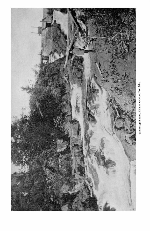


Belmont gold mine: Hydraulic power plant, showing water flume and air pipe.

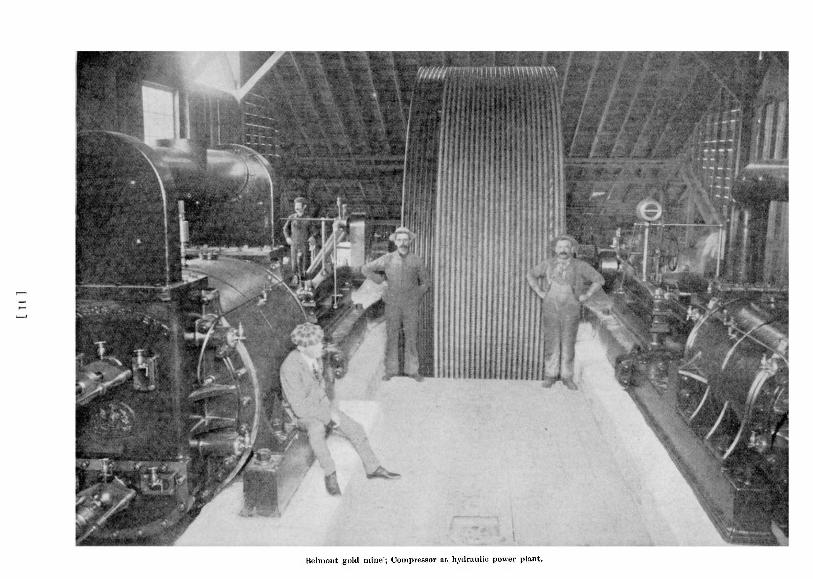
Belmont gold mine; Compressor at hydraulic power plant.

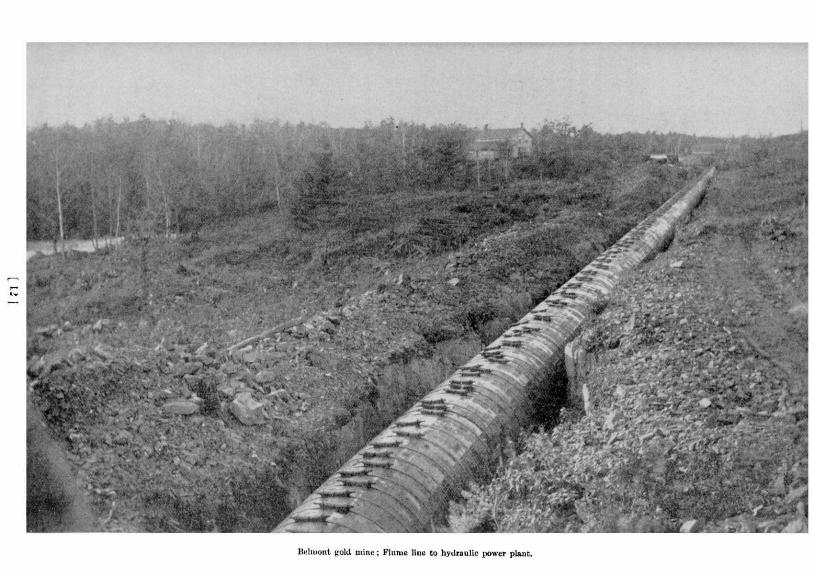

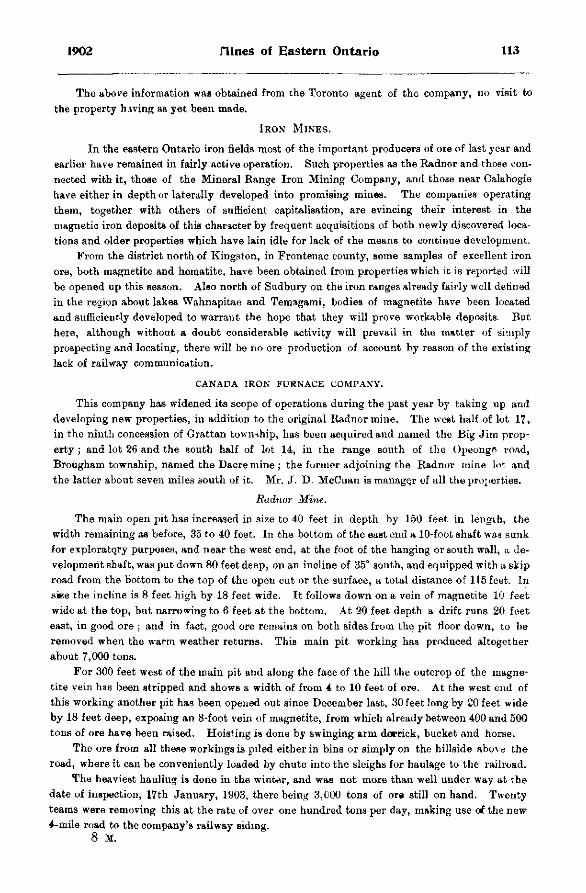
1902 nines of Eastern Ontario 113
The above information was obtained from the Toronto agent of the company, no visit to the property having as yet been made.
IRON MINES.
In the eastern Ontario iron fields most of the important producers of ore of last year and earlier have remained in fairly active operation. Such properties as the Radnor and those connected with it, those of the Mineral Range Iron Mining Company, and those near Calabogie have either in depth or laterally developed into promising mines. The companies operating them, together with others of sufficient capitalisation, are evincing their interest in the magnetic iron deposits of this character by frequent acquisitions of both newly discovered locations and older properties which have lain idle for lack of the means to continue development.
From the district north of Kingston, in Frontenac county, some samples of excellent iron ore, both magnetite and hematite, have been obtained from properties which it is reported will be opened up this season. Also north of Sudbury on the iron ranges already fairly well defined in the region about lakes Wahnapitae and Temagami, bodies of magnetite have been located and sufficiently developed to warrant the hope that they will prove workable deposits. But here, although without a doubt considerable activity will prevail in the matter of simply prospecting and locating, there will be no ore production of account by reason of the existing lack of railway communication.
CANADA IRON FURNACE COMPANY.
This company has widened its scope of operations during the past year by taking up and developing new properties, in addition to the original Radnor mine. The west half of lot 1 7 , in the ninth concession of Grattan township, has been acquired and named the Big Jim property ; and lot 26 and the south half of lot 14, in the range south of the Opeongr) road, Brougham township, named the Dacre mine ; the former adjoining the Radnor mine lot and the latter about seven miles south of it. Mr. J. D. McCuan is manager of all the projterties.
Radnor Mine.
The main open pit has increased in size to 40 feet in depth by 150 feet in length, the width remaining as before, 35 to 40 feet. In the bottom of the east end a 10-foot shaft was sunk for exploratory purposes, and near the west end, at the foot of the hanging or south wall, a. development shaft, was put down 80 feet deep, on an incline of 35° south, and equipped with a skip road from the bottom to the top of the open cut or the surface, a total distance of 115 feet. In ske the incline is 8 feet high by 18 feet wide. It follows down on a vein of magnetite 10 feet wide at the top, but narrowing to 6 feet at the bottom. At 20 feet depth a drift runs 20 feet east, in good ore ; and in fact, good ore remains on both sides from the pit floor down, to be removed when the warm weather returns. This main pit working has produced altogether about 7,000 tons.
For 300 feet west of the main pit and along the face of the hill the outcrop of the magnetite vein has been stripped and shows a width of from 4 to 10 feet of ore. At the west end of this working another pit has been opened out since December last, 30 feet long by 20 feet wide by 18 feet deep, exposing an 8-foot vein of magnetite, from which already between 400 and 500 tons of ore have been raised. Hoisting is done by swinging arm derrick, bucket and horse.
The ore from all these workings is piled either in bins or simply on the hillside above the road, where it can be conveniently loaded by chute into the sleighs for haulage to the railroad.
The heaviest hauling is done in the winter, and was not more than well under way at the date of inspection, 17th January, 1903, there being 3,000 tons of ore still on hand. Twenty teams were removing this at the rate of over one hundred tons per day, making use of the new 4-mile road to the company's railway siding.
114 Bureau of Hines Report No. 5
The steam hoisting and drilling plant, north of the main open pit, was completed and operated last season, and a new office erected.
The employees number 53, of whom 12 are miners and the rest on the surface and hauling ore, all under foreman S. Smith.
Big Jim Property.
The iron outcroppings here were prospected by stripping for several weeks last summer and about 50 tons of ore raised, but all work since then has been suspended.
Dacre Mine.
Development commenced here last October, and all work so far has been confined to mining alone, without the construction of camp buildings. There appear to be two parallel veins of magnetite separated by 2£ feet of trap rock and dipping at about 45°, the upper band 3 feet wide and the lower one 5 feet. On the outcropping an open pit has been excavated 14 feet deep and 32 feet by 30 feet in area ; and down the under vein an incline shaft sunk to a total depth from the surface of 22 feet (or 8 feet below the pit floor). Several hundred tons of ore have been raised and some shipped out.
The employees number 20, of whom 8 are miners and 14 teamsters hauling ore, under foreman A. Woodhus.
MINERAL RANGE IRON MINING COMPANY.
During the past year nearly 3,000 tons of magnetite have been mined out of the Child's, or No. 1, and No. 3 mines, the latter newly opened up. The No. 4 property, also new, has been extensively prospected on the surface by stripping and a very fine show exposed, but no ore has yet been raised.
The most important work accomplished has been the construction of a graded road past the various properties, about 8 miles in length to L'Amable station on the Central Ontario railway, on which over $1,000 has been expended, with more to be laid out on its completion to the Childs or No. 1 mine, the farthest away. This road for the present will serve as a wagon road, but ultimately the company intend to construct a standard gauge railroad and equip it with electric motor cars capable of handling two ordinary freight cars loaded with ore, over the somewhat steep grades and sharp curves.
The disputed land on lots 4 and 5 in the sixth concession of Mayo township has been granted to the company, and this, together with their old and newly acquired properties, totals 2,300 acseB located as follows, all in Hastings county : Lots 6 and 7 in the sixth concession of Dungannon township ; lots 1, 2, 3, 4, 5, 6 and 7 in the sixth concession, lots 2, 3, 4, and 5 in the seventh concession, lots 3, 4, 6, 10 and east half of 9 in the eighth concession, lots 11, 12 and south half of 10 in the ninth concession, and lots 8 and 9 in concession B, all in Mayo township.
Childs or No. 1 Mine.
Beyond the stripping of the magnetite body and the 1000 tons of ore raised last spring, noted in the last Report, no more mining has been done. There is still about 1000 tons of ore on the stock piles ready for shipment.
No. S Mine.
This lies in lot 3 in the sixth concession of Mayo, about 800 feet east of No. 2 mine. Since last spring two pits have been opened out 75 feet apart on the magnetite deposit,' one 50 feet by 50 feet in plan by 15 feet deep and the other 20 feet by 20 feet in plan by 12 feet deep, both in good ore in one continuous deposit, and some 1800 tons magnetite raised, of

1902 nines of Eastern Ontario 115
which 1,300 tons have alroady been shipped. Hoisting is done by a solidly guyed swinging arm derrick, bucket and horse whim. The other surface plant erected consists of boarding house, storehouse and stable.
The magnetite is fine grained and free of much intermixed rock matter, giving a high percentage of metallic iron with but traces of sulphur and phosphorus. It lies in a formation of diorite similar to that of the other magnetite bodies of the locality, and has been uncovered by stripping and test-pitting in and outside the workings for a total length of 300 feet by a width of 100 feet. By dip needle it has been found to underlie an area 800 feet in length by 300 feet width.
No. 4 Mine.
This property, also newly developed, is located on lots 4 and C in the sixth concession of Mayo, about £ mile east of No. 3 mine. The work last spring was confined to stripping the body of magnetite, and test-pitting here and there, the former over an area of 50 feet by 80 feet. As a result of these explorations the body of magnetite has been visibly defined over an area of £0 feet by 160 feet; while the dip needle indicates a width of 100 feet and length of 800 feet.
ST. CHARLES MINE.
From the lessee and operator, Mr. Stephen Wellington, of Madoc, I learn that mining continued at the St. Charles until May last year. With the termination, however, of the supply contract with the smelter, operations were suspended and have remained so until the present time.
COE MINE.
Mining has continued in the same open pit dmring the past year and until January 1903, when, on account of the difficulties of open work in the winter, production was suspended until spring. Most of the hematite mined has been shipped to the smelters.
CALABOGIE MINE.
This magnetite property which has been intermittently developed for the past few years, was again re-opened last season with the production of between 800 and 900 tons of ore.
It is situated on lot 16 in the ninth concession of Bagot township, about two miles east of the village of Calabogie. The Hamilton Steel and Iron Company began development at a new point in January last under their lease from Mr. T. B. Caldwell, of Lanark, the owner, and continued until the expiry of the same in July, working with a small force of miners. A new inclined shaft was sunk beside the old workings to a depth of 86 feet on a vein of magnetite, and out of this the above quantity of ore was raised and shipped to the furnace at Hamilton. After this mining was continued by the owner, but confined to surface prospecting and stripping on the bands of magnetite at other out«roppings,
COPPER MINES.
In the Parry Sound Copper district the scope of the mining industry has not been appreciably extended. The small amount of development at a few of the older properties and at some newly opened prospects has, however, kept interest alive, since new ore bodies have been exposed, particularly those at the McGown and Spider Lake properties which give promise of making pay ore.
Two small furnaces for making smelting tests of the ores of the locality were set up during theyear; one, an electric furnace at the town of Parry Sound, and the other, a Vulcan water-j acketted blast furnace at the Wilcox mine. The former was removed before being completed to Sfcult Ste. Marie, in order to be sure of obtaining sufficient electric energy. The other ran for
116 Bureau of nines Report No. 5
several weeks on ore from the Wilcox mine, this being typical of most of the occurrences in the region containing, as it does, chalcopyrite in gneiss. The test proved, according to report of the operators, that the ore is practically self-fluxing, but contains in the raw state too little sulphides for a sufficiently bulky matte. Therefore" the probability is that preliminary con-centration will have to be resorted to. It is proposed by some of the older companies and by another recently formed to carry on active development this coming season as well in the Moon river section to the north as in the original field, and if these promises cometo anything a revival in the industry should result.
WILCOX MINE.
In December last a 5-ton Vulcan smelter was erected in the shaft house of this mine, making a test run of 10 days' duration for the purpose of ascertaining the suitability for direct smelting of the low grade ores of this and similar properties in the district. No further mining was attempted, and the works are now shut down again.
MCGOWN MINE.
This mine suspended development last September, but from the superintendent, Carl Anderson, I learn that all the work since last inspection was confined to the south crosscut at the bottom of the shaft, where at 70 feet in a 3-foot vein of bornite was struck. Drifts were run along this northeast 12 feet, and southwest 10 feet, and then the south crosscut continued in to 131 feet. The depth of the shaft remains unchanged. The milling machinery consisting: of 10 stamps and the vanners was sold and taken from the mill building last fall. Mr. Anderson expects that as soon as more capital can be raised, which may be this spring, development will continue.
CONSOLIDATED COPPER COMPANY.
The mining lands owned by the above company cover lots 9, 10, 11, 12, 15, 16, 20 and 21 in the sixth concession of Cowper township, and lot 35 in the ninth concession of Foley, as well as two lots each in McDougall and Ferguson townships, all in Parry Sound district. The mine workings are on lot 10 in the ninth concession of Cowper and 7 miles southwest of Parry Sound on Spider Lake. The head office of the company is at the town of Parry Sound, with a branch office in the Manhattan Building, Duluth, Minn. Under mine superintendent John Moffat, the employees have averaged 11 since the commencement of operations in April 1902.
At the date of inspection, 30th January 1903, the mine was temporarily closed to allow the erection a shafthouse, head frame and mining machinery, and timbering the shaft. The main shaft is near the shore of Spider lake, in depth 103 feet, size 7 by 7 feet, and vertical; with a 13-foot collar. There are as yet no lateral extensions. The new mining plant consists of a small hoist and boiler with bucket. At 1,200 feet west of the main shaft another shaft was sunk 38 feet on the vein, but abandoned for the present in favor of the other which shows better ore. Still another >vas sunk by the previous owner to a depth of 30 feet, but no work has since been done in it.
The chalcopyrite occurs along mineralized bands striking northeast-southwest with a dip of 45° southeast through a formation of highly garnetiferous grey granite. Over a widti of 18 feet in the main band or zone the copper sulphide together with a small amount of pyrites and pyrrhotite is finely disseminated at a low average per cent., and outside of this for several hundred feet away scattered grains may be found, but in too small quantity to be of any value. The bottom of the shaft is said to have cut through another band striking and dipping parallel to the one above and similar in quality. With the continuation of mining a crosscut will be driven southeast at the 100-foot level to explore both bands.
1902 nines of Eastern Ontario 117
NICKEL-COPPER MINES.
In spite of the partial suspension of mining and smelting during last year at the Canadian Copper Company's works, the district's total production of nickel was greater than that of any former year on account of the steady operations at the mines and smelters of the Mond Nickel Company and of the Lake Superior Power Company, and on account of the increased rate of treatment in the first company's plant since the resumption last fall. At several other properties in the outlying districts development has been resumed or started up by the above concerns. Until, however, a railroad is built into the northern mineral ranges, either by the Canadian Pacific or the Algoma Central & Hudson Bay Railway company, the latter having gone so far as to locate the line, very little mining development or ore production can be expected. A number of nickel-copper and other properties have already advanced to that stage of development where it no longer pays to continue until treatment of the ore be made possible by cheap railway communication.
CANADIAN COPPER COMPANY'S MINES AND WORKS.
The period of slack operations which extended over the greater part of last year affected production all round, although at some of the workings to a lesser degree than at others. At the smelters varying numbers of furnaces remained in blast, on the whole a smaller number than usual, which reduced the output of matte slightly, while of all the mines the Creighton alone approached its former yearly tonnage, and some of the small workings closed down entirely. This suspension, however, has furnished the long needed opportunity to thoroughly define the various ore bodies, particularly those in the deeper and larger mines, and the mos t
has been made of it both by diamond drilling and by exploratory mining at lower levels. The detailed knowledge obtained in this work has now made it possible to adopt more efficient as well as safer methods of mining than the old open cast plan, and also permits of blocking out ore bodies of known quantity and quality, from which any desired supply for future requirements will be available at once. Another very satisfactory result of this work has been the incidental proof given of the maintenance in size and richness of the ore in the hitherto unexplored lower and lateral extensions of the deposits. At the bottom level, or more than 900 feet down vertically, in the Copper Cliff mine the present ore chutes, while not so large as higher up, are still of good size and as rich in copper and nickel as ever. The chimney of ore in the No. 2 mine is seen to be gradually increasing in diameter from the 200-foot level down to the bottom drifts at 382 feet depth, its average diameter at the former depth being 120 feet. It maintains an even high grade throughout. The No. 3 and Creighton mines also look well, particularly the latter, where the extensive exploratory drilling for the past eight months has served to verify the former estimate of the size and richness of the deposit.
The entire property of the Canadian Copper Company has been sold to the International Nickel Company, the transfer resulting from negotiations which were under way at last inspection a year ago. The new owners have, however, re-organized the Canadian Copper Company and left the direct management of the business in its hands as before. Mr. A. P. Turner has been appointed president, and under him the old staff remains with Mr. James McArthur in charge of the metallurgical department, and Mr. John Lawson superintendent rf all mining operations.
The number of employees was still small, but with the return to the former scale of ore production expected next spring the force will probably exceed considerably that at any previous time. At the date of inspection, January 1903, the employees numbered 1069, distributed as follows :—Smelters, 368 ; mines, 157 underground and 97 above ground ; roast heaps, 110 ; on surface and in shops, 296 ; office and laboratory, 41.
118 Bureau of nines Report No. 5
Metallurgical tests have been under way for some time looking to the replacement of the present method of first roasting and then smelting by one operation of pyritic smelting, and on the success of this depends the future layout of the works. With the adoption of pyritic-furnaces a more compact plant would be possible, roasting would be done away with, and the much needed consolidation of the many scattered workings, to overcome the present excessive amount of handling, could be made.
The general surface plant outside of that at the mines has been added to by the erection of a sampling house, near the west smelter, where large samples of several hundred pounds weight of ore or other material for analysis are reduced to the proper quantity by treatment in crushers, automatic sampling machines, pulverizer, etc. Adjoining this is the new chemical laboratory almost completed, its equipment including the most modern apparatus for both ordinary and research work.
The now completed electric light station in the lower part of the town contains two generators, each with its high speed engine. In the same locality a store house for oils has been built, 35 feet by 45 feet in plan, of brick, and safely removed from the other buildings. The new general office is now occupied.
Another needed and much appreciated structure is the hospital which has just been erected in the town by the new company. Besides presenting a beautiful exterior, ornamental enough for any locality, the building is internally a model of neat finish and complete equipment. There are cots for 20 patients with apartments for the resident staff of doctors and nurses.
Copper Cliff Mine.
The work, under way at last inspection of taking out a remaining block of ore from the old open stope at the 4th level, has been completed and now this entire excavation from the 1st down to the 13th level is abandoned, and most of the entrances thereto boarded up. The east skip-road down the old shaft, which was last year temporarily put in shape from the junction of the old and new shafts, in order to hoist this ore, has been restored to the new shaft, the old shaft serving now merely as a pump way. Since that time all mining has been confined to the bottom or 13th and 14th levels from which the ore production for some time back has amounted to about 1000 tons per month, the ore averaging approximately 13 per cent, copper and nickel, in the proportions of 10 to 11 per cent, copper to 2 to 2.5 per cent, nickel.
The main shaft has not been sunk below the sump on the 13th level, the new 14th level opening out from the bottom of a winze sunk from one of the 13th level drifts. Thirteenth level : from the old winze chamber, last year at the end, or 144 feet in the, west drift, an extension has been run 130 feet southeast inclining up steeply from about two-thirds way in as an open stope. It connects at the top with the bottom of a 60-foot winze from the 12th level. The stope measures 40 feet in height by 9 feet width with vertical walls and is being carried still further in.
The entrance to the old main stope which terminates at this level has been boarded up. The northwest drift continues in to 135 feet, with at 100 feet a 20-foot crosscut west and a veritical winze 85 feet deep to the new 14th level, a small air hoist installed at this station operating the bucket between the two. Fourteenth level, depth 1052 feet : the connecting winze is timbered for a hoistway and ladderway, and from the bottom drifts run east 120 feet and west r0 feet, the latter stoped overhead 30 feet high nearly from end to end, 6 feet to 10 feet wide, and vertical.
The main shaft is kept in good repair from top to bottom ; the pumps are stationed on the 13th, 12th, 10th and 7th levels ; and good air prevails throughout the working places.
On the surface the power plant has been increased by the addition of a fourth 100-h. p. boiler. The quartz and limestone crushing plant formerly located in the sheds a hundred feet
1902 nines of Eastern Ontario 119
or so to the rear of the rock house has been moved up. into this latter building, the crusher being placed alongside the original large crusher for the Copper Cliff rock, and now both are run by the same engine. By means of another hoist engine set higher up in the building, the rock is raised by skip and trestle road from the railway tracks up to the crusher. From here it drops into separate bins and later is shipped in the cars to the smelters for use as flux
No. 2 Mine.
Stoping continued in the open pit until the end of January 1903, enlarging its area along the third level floor at 217 feet depth, until now there remains only a small block of ore in front of the station of the old shaft, and with the extraction of this before the frost leaves the walls, the open pit will be abandoned. At the same time development of underground levels has advanced sufficiently to permit carrying on all mining in future under a solid roof, thereby insuring greati r safety to the men and avoiding the interruptions attending exposure to the changeable weather. The plan consists in opening out levels at regular intervals beneath the pit floor and on each of these crosscuttiug the ore body by series of drifts ; after first breaking away over-hand to an arched roof all but the supporting pillars, which are to project from either side, the succeeding level floors will be systematically stoped away underhand to the level below and the rock hoisted out of the new shaft. The old shaft has been abandoned as a hoistway and manway.
New shaft, depth 390 feet (vertical); from the turn at the first level it descends almost vertically, in size 8 by 18 feet, and timbered down to the 4th level with double skip road and ladderway carefully and solidly set. Below the 4th level hoisting is done by auxiliary air engine and bucket. Third level ; out of the old shaft station on the pit floor a winze sunk vertically 76 feet to the 4th level ; at 26 feet depth in this a subsidiary level opened with a north drift 100 feet long crosscutting the ore body ; the new shaft is connected with the old shaft and open pit at this level by a 70-foot north drift. Fourth level, depth 293 feet; north drift, 60 feet, connecting at face with winze from 3rd level. Fifth level, depth 374 feet; north drift, 55 feet.
The incline of the trestle skip road connecting the shaft with the rock house, a distance of about 200 feet, has been increased by raising the upper end 3 feet to cause the skip to return more rapidly. The old battery of boilers in the power house has been replaced by four new ones fitted with mechanical underfeed stokers, and preparations are now under way to install four more. Three of these will furnish all necessary steam for the mine workings, the remain ing five to form part of the smelter power plant.
No. 2 Mine extensions : A limited amount of further development was accomplished in the first and second extension mines, and at the same time a third opened out a short distance north of the other two, about 50 feet deep and 25 feet by 25 feet in plan. In the spring however work ceased in all three. If present intentions mature their continued operation as open pits will depend on the results of diamond drill tests to establish whatever connection may exist between them and the No. 2 ore deposit, and should ore be found to continue from the latter north into the others, it will mo t likely be preferable to work them all from the No. 2 mine shaft.
No. 3 Mine.
Since August of last year, when mining in the open pits ceased, all work has been confined to opening up lower levels below the pit floors, the small amount of ore produced from this development constituting the total output during this period. Extensive diamond drilling has defined the ore bodies sufficiently to allow of future ore extraction by a systematic underground plan applicable to all conditions, to be conducted under a roof formed by the
120 Bureau of nines Report No. 5
present floors of the pits. The new method is one of filling. Only ore will be hoisted, the waste remaining in the stopes to be added to from the rook dumps on the surface in order to complete the fill.
Main shaft, depth about 150 feet (vertical), now being sunk from the 2nd to the 3rd level ; first level or pit floor ; the last work here consisted in carrying back the pit faces from the floor level, leaving them nearly vertical all around, without however appreciably enlarging the area at the surface. Second level, depth 100 feet ; opened out from the shaft, whioh is timbered down to this point with double skip road and ladderway ; northeast drift 100 feet, with at 25 feet in a cross drift northwest 50 feet as an inclined upraise holding through into the open pit floor, and another southeast 60 feet and then south 75 feet ; at 75 feet in the northeast drift an 85-foot vertical winze sunk, 6 by 6 feet in size, and from the bottom the 3rd level opened out. Third level, depth 185 feet (vertical) ; from the foot of the winze the ore body has been undermined by a series of connected drifts totalling in length 517 feet, and the foot of the shaft upraised on 20 feet at 25 feet southeast of the winze. Connection was being made between the 2nd and 3rd levels by this shaft. On the surface the large balanced double-drum hoist has been replaced by a smaller one from the Stobie mine on which the drums act singly ; and for the hoist cables, an intermediate set of sheaves has been placed at the foot of the rock house.
Nos. 4 and 5 Mines.
These two properties have remained idle since the general suspension of operations last spring, and were therefore not inspected. The open pits are reported not to have been appreciably enlarged over the measurements of a year ago.
Stobie Mine.
The characteristic of the Stobie ore is its high iron content, but this quality of ore is not in demand at present at the smelters so that idleness still prevails at this mine, complete now since pumping also has been stopped.
Creighton Mine.
Yv ith the exception of two months during last summer production has continued steadily at the rate of about 550 tons a day. The employees, including those running the diamond drills, total 140 under mine captain F. Rodda.
Ore is raised still from the one open pit and off the same floor level (62 feet deep), its area having now increased to 150 feet by 200 feet (from 80 feet by 135 feet a year ago). The walls are steep, but kept in safe condition and on them the six air-drill gangs are perched at different points breaking out the ore in immense masses. Out of the southwest corner a vertical winze has been sunk 80 feet, 6 by 8 feet in size. From a crosscut from the bottom of this the main shaft will be upraised on, this method of development being adopted to avoid interference with ore production above.
Two diamond drills have been prospecting the deposit since June last and a third since December, and as a result a great number of holes have been sunK, chiefly on the north, east and west sides, since the dip, though slight, is to the north and the strike, if such it may be called, runs about east and west. The work has not only confirmed last year's estimate of the extensive surface area of thia deposit, but has shown the ore body to be continuous in depth, both in size and in the clean nature of the sulphides, the occasional intrusions of rock being sharply separated as barren bands. The nickel-copper contents average between 6.5 per cent, and 7 per cent., the proportion of copper to nickel being approximately as 1 : 2.5.
At the power house the three boilers have been fitted with mechanical underfeed stokers. The smaller of the two original air-compressors has been replaced by another straight-line
1902 nines of Eastern Ontario 121
Ingersoll compressor of double the capacity (6 drills) : and the new hoist engine having to be returned for reconstruction is in the meantime being replaced by the No. 3 mine hoist, similar both in size and make
Quartz Mine. About one mile south of Copper Cliff and on the shores of Kelly lake at the top of the next
range of hills a large deposit of clean massive quartz is being quarried for use as flux in the smelters. The rock is lowered in counter-balanced cars on a double track surface tram-road one-quarter mile long built entirely on trestles and at an incline of about 80 feet. From the ore pocket at the foot it is hauled in sleighs or wagons across the flat to the crushing plant at the Copper Cliff rock house. The daily output amounts to about 100 tons, but may vary considerably depending on requirements.
Smelters and Boast Heaps.
At the east smelter several furnaces have been kept in blast since June last, working on the incompletely roasted portions of the ore in the roast-heaps. The low grade matte formed is spilled, re-roasted and then smelted again at the west smelter plant. Operations at the old smelter were to be discontinued for some time and probably for good. Most of the furnaces at the west smelter continued in blast during the year, though in the early part of 1902 production slacked off. At the beginning of 1903, however, the rate of output from both plants exceeded that of any previous period.
Two of the furnaces have been altered to withstand a hot blast at increased pressure for the purpose of making pyritic smelting tests of the raw ore. The results of the initial runs seem to indicate that the new process will allow of successful adoption with these ores, and if so a great saving will be effected in fuel consumption and in expense of roasting. The hot blast is generated in a large specially constructed brick stove, and for operation with this a specially designed brick furnace is being built.
Two slag elevators have been erected in front of the furnace building for the disposal of all slag not used for making ground about the works. The blower plant has reached the full capacity of the building by the addition of the sixth complete blower unit of the Connersville type of machine.
Of the three roast yards only Nos. 1 and 3 continue in full swing. No. 2 is to be abandoned as soon as the present heaps burn out. Its location is disagreeably near the town and works. Dan McKinnon now has charge as contractor of all the roasting operations At No. 1 yard the heaps number about 25, and at No. 3 or the west yard about 40, of which half are composed of
spilled matte. Dangerous methods of thawing the dynamite are still in practice, which necessitated a repetition of last year's instructions.
Ontario Smeitinq Works.
The Ontario Smelting Works have been sold out entirely to the Canadian Copper Company and are now operated under the direction of that company's staff at Copper Cliff. The work of raising the grade of the Canadian Copper Company's matte prior to shipment to New Jersey for refining has progressed steadily at this smelter during the past year. .The management of the works was placed in the hands of Mr. H. J. B. Baird on the resignation of Mr. T. W. Stiles, and under him the number of employees hag varied from 175 to 200, with an addition at the present time to this number of about 50 on account of the new construction work.
The capacity of the plant hitherto has been limited by the calciners to about half the matte output of the adjoining smelters of the Canadian Copper Company, which is 150 tons per day, so that the other half has had to be enriched* as well as refined in the United States. In order to be able to handle everything here alterations and additions to the plant were begun several months ago, to be completed and the new plant put in operation by April next. The two
122 Bureau of nines Report No. 5
original Brown calciners have been lengthened from their former measurement of 140 feet to 206 feet and 210 feet respectively and the building enlarged to fit. For the third or new calciner which is 200 feet in length and nearly completed, a new structure has been erected. This will give double the roasting capacity for the powdered matte. By .incorporating a briquetting machine for the roasted fines, one of the present two furnaces will be able to take care of the full 150' tons a day. The foundations for this briquetting plant are now in the course of construction. A third boiler of 120-h.p. has been installed alongside the other.
GERTRUDE MINE.
Considerable activity has marked the progress of this mine during the past year, largely on account of the completion and continuous operation of the smelter since early last spring ,* thus necessitating the raising of much more ore than formerly, which in turn required additional power at the old plants and the erection of new ones. Three of the four mines have been reopened on fair-sized bodies of ore, and although one of these has suspended work, the other two produce about 200 tons a day, of which 180 go to the roast heaps at the smelter grounds, the remaining 20 from which the copper pyrites has been cobbed as clean as possible being shipped to the Lake Superior Power Company's sulphite works at Sault Ste. Marie, Ont. There, after the extraction of the sulphur, the sweet-roasted ore is to be smelted in the ferro-nickel plant for the direct production of nickel steel.
No. 1 shaft: The former depth of 120 feet is not increased, but the shaft has been widened out to a size of 50 feet by 60 feet, for a depth of 50 feet, partly as a stope extending under a heavy arch on the west side ; out of the other side, but at only 35 feet depth a trench runs 75 feet east narrowing down towards the far end from 50 feet to 20 feet. From the south side of this a crosscut explores south 60 feet; and under most of the north wall a low stope has been cut out, apparently along a branch of the ore body. Several of the faces of this working are covered with shattered or fractured rocks which will require careful scaling from day to day to avoid accident to the men working below. The system of raising the ore by means of a heavy swinging arm derrick is somewhat awkward, and not infrequently attended with danger to the miners. It might advantageously be replaced by some more easily controlled method, such as a skip road. The surface plant comprises a double drum hoist and small boiler installed at one end of a temporary shed : the other end of the sheds forms the dry room.
No. 2 shaft: Since re-opening here the entire work has consisted in stoping, and now from the south drifts on the 2nd or 71-foot level underground one large stope extends up to the surface on a steep rise to the south, in size 80 feet long by 25 feet wide by 20 to 40 feet high to the arched roof left over the north portion. The ore is all hoisted out of the old shaft by the cage, for which a new head frame and ore pocket combined have been erected. The new hoist house stands 75 feet to the east and contains a 40-h.p. return tubular boiler, and double cylinder, single 3-foot drum hoist engine. The ore from this bin is transported by rail to the rock house at No. 4 shaft where it is crushed and sorted.
No. 3 shaft remains closed. No. 4 shaft: Development was continued on the one level for a period of three months during
lust spring, several hundred tons of ore being raised. The depth of the shaft remains the same First level, depth 45 feet; west drift 100 feet with the first 50 feet stoped out 14 feet wide and up to a roof gradually rising to the surface at the face ; east drift 60 feet, with a stope extending in 16 feet, in size 16 by 16 feet.
The ore body in No. 1 trends east and west heading directly for that in No. 4 shaft 750 feet west; but explorations have not yet demonstrated whether there is any connection between the two. In No. 1 large masses of clean ore, together with other mixed areas, cover the
1902 flines of Eastern Ontario 123
working faces of the stope, similar to the deposit in No. 2 mine, and both ore bodies give promise of continuity beyond the present levels. Pyrrhotite forms by far the most abundant sulphide, the chalcopyrite content being only in scattered pockets and stringers.
At the rock house the power plant has been increased by a second 60-h.p boiler ; and shortly the present double, 12 by 15 inch jaw crusher will be replaced by a single 15 by 30 inch Blake of larger capacity now on hand. A number of new dwellings have been built about the
roperty both by the company and by private parties. It was necessary to give instructions for the immediate employment of safe methods of
storing and thawing the dynamite, the present practice at both the working mines being dangerous.
The smelter reached completion early in June 1902, and has since run steadily, putting through from 100 to 100 tons of roasted ore per day. The matte has been allowed to accumulate until now about 1,700 tons are on hand. This will be shipped later to the converter plant now in course of erection at Sault Ste. Marie, Ont., or elsewhere to be refined. The nickel-copper content in this matte averages 29 per cent., the proportion of nickel to copper being as 2 is to 1.
The plant consists of one water-jacketted furnace with forehearths, a 50-h.p. boiler, a Connersville blower with engine, dynamo and engine, ore and coke bins, a slag elevator, and other accessories. It is the company's intention to add two more Herreshoff furnaces each of one-third greater capacity than the present one and to supplement them with all other necessary additions. As parts of the new plant have already arrived, probably the increases will be effected during the coming summer.
Since November last the roast heaps have been gradually diminishing in numbers because of the temporary cessation of shipments of ore from the Elsie mine. There are still seven with more of Gertrude ore building.
Under superintendent Thos. Travers are mine foreman Thos. Williams and smelter foreman Alex. McPhee. At date of inspection, 2nd February 1903, there were 140 employees, about the usual number, on the roll.
ELSIE MINE.
In November last all mining work was suspended to allow of shifting the surface plant from the north or hanging-wall side of the open pit to the more solid south or foot-wall side, and of erecting more elaborate works. Later when prevented by the frost from setting the foundations, all hands were laid off until April. The erection of the new building will then be rushed in order to resume ore production as soon as possible. The open pit with its flat incline of about 30° north was gradually undermining the ground now occupied by the power and other houses and the shaft head-frame, forcing the vacation of that site. The enlarged plant will consist largely of new machinery of considerably greater capacity, and will include a rock house for crushing and sorting prior to shipment to the Gertrude roast yards and smelter.
A large gang of wood-cutters were, at time of inspection, out in the bush cutting and bringing in the full supply for the coming year.
VICTORIA MINE.
After a year's steady production at the Victoria mine and reduction in the smelter, and the development of some of the company's other properties, all activity ceased in December 1902, owing to a close-down at the Mond nickel refinery in Wales where the Victoria matte is refined.
The management remains unchanged. The number of employees has been reduced to 77, outside of some 200 axe-men in the bush cutting and drawing out cordwood. To both smelter and mine a very large stock of this fuel has already been brought and piled.
124 Bureau of nines Report No. 5
The mining done by the company to the date of inspection, 10th February 1903, after the lapse of a year, is as follows :
Main shaft: depth 557 feet (185 feet increase). First level: the west open-cast enlarged to a plan of 50 feet by 100 feet on the first level
floor, and to 70 feet by 125 feet at surface, narrowing down to a width of 6 feet for the last 40 feet on the east or shaft side ; the east open-cast enlarged to a plan of 50 feet by 80 feet from surface down to first level, but below this to the floor on the second level remaining about the same.
Second level : the west stope considerably enlarged, now 45 feet in width, while the rising drift connecting the top of stope with the floor of the west open-cast has now a cross-section 25 feet square.
Third level : out of the top of the old west stope a 25-foot upraise driven connecting with the second level, and from the bottom another large branch stope opened out 110 feet in length on a 45° rise north, in size 30 feet by 35 at bottom, and 10 feet by 15 feet at top ; in the east stope the numerous branch drifts have now disappeared into one unbroken opening which curves back west for 90 feet on a 50-foot rise up over the level drift, 20 feet by 30 feet in cross section, and runs up east 65 feet at the same rise, 15-feet by 25 feet in size, the roof between the two arms descending to within 40 feet of the level.
Fourth level : the west stope carried 10 feet higher to 60 feet in all, maintaining about the same size of 30 feet by 30 feet, and ending in a 10 by 15-foot upraise to the third level ; east drift, 270 feet (79 feet increase), with at 65 feet in a branch drift 100 feet northeast, and at the junction a small overhead stope ; at 210 feet in, the east stope started, 50 feet in length by 20 feet high and 20 feet wide.
Fifth level; west drift 65 feet (60 feet increase) with a short stope in the middle of drift 6 feet high by 17 feet wide; east drift 223 feet (20$ feet increase.)
Sixth level; (new), depth 454 feet, with shaft station on north side; east drift 133 feet. Seventh level; (new), depth 540 feet, with shaft station on north side; east drift 27 feet. The timbering of the two cage-ways and ladder-way compartments continues down to the
seventh level. The mine pumps are located in the shaft sump, and on the seventh and fourth levels. An auxiliary air hoist set up in the seventh level station operates the bucket below this level in the continuation of the shaft. Two other outlets besides the main shaft exist from the underground workings by way of the stopes and open casts : from the fourth level on the west side and from the second on the east side.
A large amount of diamond drilling has been carried on up to the present time from the underground levels, viz., from the face of the third level west; from the floor at the face of the fourth level east; from the floor of the west stope fifth level; from the floor of the seventh level station. By these holes the west ore body has been defined below the fifth level, where last stoped on, to a vertical depth from the surface of 650 feet, and already has been partially blocked out on the lower levels, preparatory to stoping. The east ore body has been defined only down to the fifth level by the holes from the fourth level, and by the east drift on the fifth which has just tapped it.
In the old stopes, particularly below the second level, there yet remains considerable ore in place, while in the bottom levels the ore has hardly been touched. A large quantity of broken ore lies in the different stopes ready for removal when required.
No. 3 shaft situated about one-half mile northwest of the main shaft was further developed last summer. It has attained a depth of 102 feet, with the first level just commenced, but the second, at 96 feet depth, driven a total length of 220 feet on both sides of the shaft.
No. 4 shaft, about 600 feet east of the main shaft, was opened out during the past year, and a hoist and shaft house erected in the latter, a small hoisting plant similar to that of No. 3
1902 nines of Eastern Ontario 125
mine being set up. The compressed air for drilling was taken from the power house at the main workings. The shaft was sunk 201 feet, vertical. First level 47 feet deep; drifting northeast 12 feet, and south 60 feet. Second level, depth 129 feet; drifting northeast 25 feet, and south 50 feet. These two drifts branch out from a shaft chamber 20 feet by 35 feet in plan.
Both these shafts were reopened rather for the purpose of exploiting other nickeliferous deposits than with any idea of immediate stoping for the production of more ore.
Two other mines were operated during the year by The Mond Nickel Company, under the management of the Victoria mine staff, all the ore produced being shipped at once to the Victoria mines smelter to be treated. Those mines are the North Star on part of lot 9 in the second concession, and part of lot 9 in the third concession of Snider township, situated a mile northeast of the Creighton mine ; and the Little Stobie on the north half of lot 6 in the first concession of Blezard township, between Stobie and Blezard mines. From the North Star 4,724 tons of ore were extracted, and from the Little Stobie 1,584 tons.
At the Victoria mine the condenser is now in operation in conjunction with the hoists and engines of the power house and, as part of that plant, an 8 by 5 by 10 duplex Snow pump has been installed.
Recommendations given at the last inspection for the safe handling of explosives have been complied with.
The smelter continued in steady operation until the latter part of December. Since then some alterations have been going forward on one of the two furnaces for the purpose of making pyritic smelting tests on the raw ore, and the necessary hot blast stove is now about completed. After some demonstration runs on this method regular smelting will probably continue.
MICA MINES.
The number of active mines in the mica field of eastern Ontario remains about the same as at this time a year ago, although some of those then in operation have again closed down and their places have been taken by others. Of the new properties several are prospects, and others are old mines which have lain idle for a period. As a result of the increased scale of production at a few of the largest of the mines, the year's output is considerably greater than ever before, as will be seen by a comparison of the following figures. In l!K)l the production amounted to 854,000 lb. valued at $39,780, and in 1902 to 1,998,000 lb. valued at $102,100.
A gradual change has come about during the past two or three years in the demand by the trade for the large and small sizes of mica respectively, induced by improvements in the methods of utilizing the material in electric insulation. Now, instead of the larger sizes (3 by 5, 4 by 6, 5 by 7-inch and up) alone supplying the needs and thereby bringing fancy prices, their use has diminished to such an extent, with a corresponding increase in the demand and price for the small sizes (1 by 3, 2 by 3 and 2 by 4-inch), that at many of the large mines all the product is ruthlessly cut down to the latter dimensions. This, while it may appear to strip the smaller mines of their main source of profit does not really do so, since now practically all of the mica may be marketed, and at considerably better figures for the small sizes than ever prevailed before ; besides which there w i l remain much less waste than when trimming for the larger sizes only. The probability is that the prices for these smaller sizes will never be less than at preseut, but on the other hand that they will increase a little until some uniform figure is established for a unit of size on the run-of-mine mica, to vary more with the quality than the size.
There is a movement on foot now to even utilize the 1 by 2 inch grade, up to the present considered scrap, and if this proves profitable, as there appears every reason to believe it will, those who have stored away their trimmings against such an event will reap a rich reward.
126 Bureau of nines Report No. 5
The advance in the art of mica insulation in electrical apparatus, which has caused this chanye in the market requirements, is due to the successful and practically universal adaptation of the manufactured mica board, also called micanite or other similar name. This may be sawed, bent or moulded into any desired shape so readily that it has almost entirely replaced the natural mica crystal. One of its chief advantages over the latter is its inability to split up or cleave.
Micanite or mica board is made by building up layer after layer of the thinnest mica flakes, with a coating of a special cement or adhesive containing shellac between the layers, and then subjecting the whole to hydraulic pressure. The resultant hard board is then planed and sawn up as desired. The boards are made in sizes usually about 3 by 4 feet square by any thickness up to an inch or so.
The mica market is to-day in a better—steadier—condition than it has ever been before. The demand for any and all sizes and for even the most inferior grades is strong enough to absorb the miners' output at once and to leave most of the trimming shops short of their usual excess stock.
RAYMOND MINE.
This new property, though now closed down, produced a considerable tonnage of good amber mica during the period of operation from July to November 1902. It covers the south part of lot 22, in the eleventh concession of Loughboro township, Frontenac county, and is situated about 2 miles northeast of Perth Road. The owners are Messrs. Stevens, Franklin and Kent Bros., of Kingston. Development may be resumed this season.
BEAR LAKE MINE.
Mining here continued for about three months after last inspection 8 with the same small force and the production of nearly two tons of thumb-trimmed mica. Again in the fall another month's prospecting work was spent over the surface, but no quantity of mica was raised. Production will probably start again this season.
LACEY MINE.
Considerable progress has been made in the steady development of this property both above and below ground during the past year. The number of employees has averaged 48, and at date of inspection was 56, over double that of a year ago, the management remaining the same.
With the opening of new and lower levels underground the mica body has been found gradually expanding downwards as from the apex of a pyramid, and what is of as much importance the quality and quantity of the mica is keeping pace. Instead of generally small and scattered crystals through the matrix, as occurs in most other mines of the region, the mica in the Lacey workings is almost massive, the diameter of the crystals being generally more than a foot, and as great as 7 feet with a thickness of equal dimensions, from which immense cuts of clear mica are taken. There are also of course numerous small mica crystals but these confine themselves pretty well to the more barren portions of the deposit. All the mica is of first-class quality.
Now, instead of partially trimming the mica at the mine as formerly, the trimming shop has been done away with, as also the mica storehouse, and all mica simply rough-culled on the shafthouse floor and immediately barrelled and hauled to Sydenham for shiptaent to the company's new trimming shops at Ottawa (replacing those at Sydenham).
> Bur. Mines, Vol XI, pp. 263-9
1902 flines of Eastern Ontario 127
The main shift has reached a depth of 135 feet (25 feet increase), the still advancing bottom reduced in Bize to 12 by 20 feet, later to be enlarged to about 20 feet by 20 feet. It has maintained the same incline of 84° northeast. First level, depth 60 feet ; the former depth of 45 feet has since been increased by taking .out of the old floor a bench or underhand stope 15 feet deep, from the main shaft back to the air shaft. The one drift southeast is on the new level, in length 255 feet, made up of several sharp turns. At 85 feet depth in shaft a sub-level runs 30 feet northwest. At 95 feet depth another runs southeasterly 42 feet. Second level, depth 117 feet; southeast drift 30 feet, with branches east 75 feet and south 50 feet ; northwest drift, 45 feet. Most of these drifts are wide and high, serving as well for the stopes from which the mica is taken Occasional pillars are left supporting the walls and roofs along the irregular drifts. Solidly placed stulls and lagging protect the first level between the two shafts from loose rocks in the soft roof. Down the main shaft complete stagings are placed at the levels and sub-levels, these being pierced by the skid road for the bucket and by the ladder-way. For the lower levels the ladderway is transferred to this shaft, descending down the air shaft only to the first level. Ventilation is satisfactory, and one pump is easily sufficient to keep down the small amount of water. Sinking in the shaft continues.
Other mining progressed over the surface of the property in an exploratory way, two shafts being sunk, one at 200 feet south of the main shaft to a depth of 40 feet on the incline, and the other at a greater distance east to a depth of 30 feet also on the incline.
On the erection of the 35-foot head frame over the shaft and besicVe the power house these two buildings were then thrown into one and the new plant of boiler and hoist engine set in operation. Several new buildings, including a boarding house, have been built, and a dry room made out of the old mica shop. The practices followed in the storing and handling of the explosives were not satisfactory, and advice for safe methods was given.
M'CLATCHEY MINE.
The recent owners, Messrs McClatchey and Hayden of Belleville, sold their entire interest in this property last July to J . W. Trousdale of Sydenham, the present operator. Development continued fairly steadily during the year and for the latter half under the new management, with foreman E. K. Kellar and a force of 7 miners, the output for this period amounting to 15 tons rough mica.
The shaft has been sunk to a depth of 100 feet, gradually widening out to a cross section at the bottom of 8 feet by 30 f«et and increasing in incline from 80° to vertical. The rock is raised by derrick, bucket and horse whim. A portion of the trimming shop has been converted into living quarters, and another blacksmith shop has been built. The unsafe practices which prevailed in the handling of the explosives were prohibited and proper methods advised, and also several changes recommended in the underground workings.
STONESS MINE.
Latterly production at, this mine has fallen off verf appreciably on account of the enforced curtailment of sinking in the main shaft, due to lack of fuel for power to pump out water and operate the drills. The shaft reached a depth of 425 feet (71 feet increase) maintaining about the same size of 20 feet by 30 feet and incline of 25° north, but has now been allowed to fill up to the 225-foot level. At 135 feet depth a branch drift runs northeast 30 feet where the remainder of a show of mioa was taken out. At 201 feet depth, the southeast drift turned north parallel to the shaft and inclining up, in length 30 feet, in height 25 feet, and width 8 feet, leaving a wall a few feet thick between it and the main shaft. This drift followed aud
128 Bureau of Hines Report No. 5
removed the mica from a small vein or chute parallel to the large body. From the opposite side of the shaft another crosscut was being driven west, in length to date of inspection 27 feet, prospecting a body of calcite for a show of mica.
According to the manager, the mica still holds good in the bottom of the shaft, though in less quantity than formerly, the vein or chute measuring but 7 feet in width by 20 feet in height. All down the shaft workings the walls and faces are being systematically robbed of any remaining crystals of mica. As a result the timbers have been damaged at several places and will require replacing or bracing.
Several other shafts in sight of the Stoness workings have been further developed during the year. One at 100 feet west was sunk 30 feet inclining north. Another at 1,000 feet west is also 30 feet deep inclining north. The pit at 600 feet north was continued down as a shaft to 35 feet depth inclining north. All of these have been shut down for the winter months. On lot 5 in the thirteenth concession, and at one half mile northwest of the Stoness mine two other pits are now in operation after a period of idleness of two years. The two workings lie 150 feet apart, the northwest one 12 feet deep by 8 by 10 feet in plan with a 25-foot drift east from the bottom ; and the southeast one 20 feet deep by 8 feet wide by 18 feet long. To the north of this 25 feet is another old pit of about the same size and depth, not yet re-opened. The rock exposed in the pits is mainly pyroxene bounded by a formation of granite, with but a poor show as yet of mica, the development being undertaken rather in the hope that the satisfactory indications will expose more mica later. A boiler of 12-h. p. furnishes steam for the one machine drill. The only other house is the mica shop.
At the Stoness camp a new oil house has been built in a satisfactory location following instructions given at the last inspection. The force numbers 20, under foreman Jan. Jones.
PIKE LAKE MINE.
The lease of this mine has been transferred to Messrs. D. Farry, of Ottawa, and P. C. McParland of Micaville, who re-opened the workings about the first of November, 1902. Tha force of three men has since then enlarged some of the old pits, both by a little sinking in some and drifting back in the walls of others, as a result of which some five tons of rough white mica have been obtained. The mica deposits in these pits have not altered appreciably under the new development, but continue to carry fairly uniform amounts of mica, and probably the other openings if further prospected would produce an equally good grade and quantity. At the best, however, the clear cuts of mica seldom exceed a 2 by 3 inch size. Instructions were left for much needed improvements in the present reckless methods of handling the explosives.
M'LAREN's MICA MINE.
Operations continued here steadily until last March, by which time the open trench (the only working) had been lengthened a few feet at boih ends over the former length of 80 feet and deepened 5 feet to about 13 feet in all, several tons more of finished mica being obtained and also a quantity of apatite, or phosphate, as it is usually called. The mica deposit had however by this time pinched out at both ends, and dipped south past beyond the property's south boundary line to which it ran parallel, so that though the show of mica in the bottom of the trench remains good the mine has been abandoned and all surface plant removed. This information was given me by Mr. John Adams, mica dealer, Perth.
MARTHA MINE.
The Mica Manufacturing Company re-opened this mine last spring and during the two-succeeding months produced about 36 tons rough mica, after which they again shut down.
1902 flines of Eastern Ontario 129
Now, however, Mr. T. T. Smith, the foreman of former operations, has secured a lease of the mine from the company, and again started the pumps unwatering the pits, with the intention of continuing development and production immediately, his force to number about twelve.
GIBSON'S MINE.
This property was transferred to Mr L. J. Oemmell of Perth early last year, and for about four months actively developed by him with the production o f a few tons of trimmed mica. According to Mr. Gemmell, the mica body gradually pinched out, and as no indications could be found pointing to the existence there of other adjoining or connected deposits the mine has been abandoned. The mica was not of the best quality, being of a dark color and fissured, and giving only small cuts from even the largest crystals.
BYRNE'S MINE.
The former owner, Mr. Patrick Byrne, sold this property last year to the General Electric Company, of Schenectady, N.Y., but as yet no resumption of development and production has taken place.
HANLAN MINE.
This mine was transferred last May by Webster and Company to the General Electric Company of Schenectady, N.Y., and since September active development has marked the progress of operations under the new management. Mines superintendent G. W. McNaughton is in charge, with foreman Samuel Cordick and a force of 28 men.
The main and only working consists of one open stope from the surface down, following along the strike and dip of the vein. It now measures 60 feet deep, by 50 feet long at surface and 75 feet at bottom, by 8 feet to 10 fc et wide on an 80° dip east, the strike of the vein—or length of the stope—running north and south. In the future development a shaft will be sunk out of the south end to a depth of about 12 feet or two stope benches in advance of the floor level, and the rock stoped away underhand to it ; and from the north drift, kept a little ahead of the north face of the main stope, the roof will be carried up to the surface with the advance north of the whole face. A solid set of stulls and lagging covers the stope at the surface, and below this three other similar lines of timbers run from end to end of the working as a support to the somewhat shattered hanging wall and a protection to the miners. Through these one pumpway, two skid roads for the bucket, and one ladderway descend, the bucket being dropped down either road by the swinging arm derrick.
At 50 leet north of the main working another pit was sunk three years ago, 20 feet deep by 20 by 20 feet in plan, producing good mica to the bottom ; and for 50 feet or so farther north, to the northern boundary line of the location, other mica shows outcrop, which when taken together would indicate that but one vein extends through them all. For a distance of 200 feet south of the main mine the vein disappears beneath a swamp, but good mica crystals cover the south face of the underground stope pointing to the vein's continuation in that direction also. All the mica has been removed from the vein from wall to wall as the work proceeded. Latterly a production of from 5 to 6 barrels, or from 1,500 to 1,800 pounds per day of mica in the rou^h state has been attained. A large body of phosphate was struck recently in the hanging wall above the floor of the stope and this will be raised separately.
The surface plant remains about the same except for the new store house 250 feet east of the mine buildings. A proper dynamite magazine as well as a separate shed for thawing this explosive have not yet been built. Immediate attention to this requirement was advised.
Adjoining the Hanlan property to the south at about one-third mile distant, the old Captain Adams property on lot 12 in the sixth concession of N. Burgess township lay idle for a number of years, until last October the General Electric Company took hold of it
9 M.
130 Bureau of nines Report No. 5
under lease and resumed development. Since then the old pit has been enlarged to 35 feet deep by 8 to 10 feet wide and by 15 to 20 feet long, with an 8-foot drift out of the north end.
From an examination of this working it appears that throughout a small shattered area of the formation of gray syenite, an eruptive tongue of green pyroxene has been intruded, very indefinite and broken in outline ; and that through both of these interwoven rocks amber mica occurs in fair-sized clear crystals, but as yet not in large quantity.
Hoisting of the rock is done by bucket, derrick and horse whim, and the mining by a force of four.
Other development work was undertaken last fall in a number of pits and trenches on the Hanlan property, but at about a quarter mile southeast of the main workings, and this was suspended again only a short time ago. Pits were sunk 15 feet in one place, and in several others from 5 to 10 feet, for 300 feet along the same line of strike, and all showed up mica, which would point to the probability of one vein running through them all. Small quantities of good amber crystals were raised.
NOBLE'S BAY MINE.
A syndicate composed of Perth gentlemen and represented by Mr. J. M. Rogers has acquired a parcel of lands covering 1,444 acres in the township of N. Burgess, county of Lanark. The properties comprise parts of lots 2 and 3, and all of 4, 6, 7, 8 and 9, in the fifth concession, lots 7 and 23 in the sixth concession, and lot 24 in the fourth concession, all situated on or in the vicinity of Noble's Bay, which is tributary to the Rideau waterway system, and about 9 miles south of Perth.
Some of the outcrops were worked for phosphate about forty years ago, but since then practically nothing was done until last September, when the present owners began work with a force of seven, under foreman David Boyce. As a result four of the old pits on lot 8, in the fifth concession, have been deepened to about 30 feet, each giving good shows of mica and considerable phosphate.
A mica shop, storehouse, stable and blacksmith shop have been erected on the property.
DONNELLY MINE.
This property was several years ago worked in a small way for the production of phosphate In December last, Messrs. Gemmell and Thompson, of Perth, re-opened it under lease, prospecting the old pits with results which have been so satisfactory that already about 10 tons of rough mica has been raised, and a mica body of unusual richness exposed. The mine is located on lot 16 in the fifth concession of N. Burgess township, Lanark county, and about 5 miles south of Perth. Operations are in charge of Mr. Gemmell, with a force of seven.
The main open pit or trench, which is sunk along the vein, measures a length of 40 feet, in a northeast-southwest course, by a width of 6 to 8 feet, and a depth of 25 feet, and dips 80° southeast. At 100 feet northeast, along the same line of strike of the vein, another pit was sunk, 6 by 6 feet in plan and7 feet deep. One shed has been erected for a storehouse and mica shop. The hoisting is done by derrick and horse whim, and the drilling by hand. Instructions were given to employ safe methods of handling the explosives.
The mica vein is composed mainly of calcite with pyroxene, in which, where exposed over the entire floor of the pit, large crystals of mica are thickly embedded. Most of the crystals measure over a foot in diameter, although, of course, the usual proportion of small sized ones is also present. All are, however, remarkably clear, light-colored and free from fissures. The vein or mica body strikes northeast through a country rock of gray syenite, at the top only a few inches in width, but gradually increasing to over 8 feet at the bottom of the workings, and dipping at about 80° southeast.
1902 flines of Eastern Ontario 131
ADAMS* MINE.
During the past three years this old mica property has been in operation only intermittently, and last year for but one month. At the present time, January 1903, two miners have again started work in one of the pits. The property lies on lot 7 in the eighth concession of N. Bur gess township, 3 miles southeast of Perth, and is owned by W. Adams. A boiler and pumps were set up last summer to unwater one of the lower pits by the lake shore. Less thaa a ton of finished mica was raised.
KENT BROS.' MICA TRIMMING WORKS.
At these shops the scale of operations has been greatly reduced, one of the two branches having been in fact abandoned because of the difficulty of obtaining the same large supply of mica as formerly, their own mine, the Stoness in Bedford township, having dropped off in production. Not more than eight employees on the average were retained during the year, and at present the number is still less. Most of the stock of mica has been sold.
ADAMS' MICA TRIMMING WORKS.
Owing to a general desire on the part of mine operators to thumb-trim and cull their own mica, instead of trusting it to the trimming shops, work of this description has about ceased at this shop, and now the proprietors act merely as middlemen between miner and consumer, to accommodate the small independent producers in the disposal of their mica.
TROUSDALE TRIMMING WORKS.
Trimming has gone on fairly steadily all year with an average force of 4 men, the rough mica handled amounting to about 45 tons, from which some 11 or 12* tons finished product in various sizes was cut. The entire stock has now been cleared out, and operations will remain suspended until such time as the proprietor's mine, the McClatchey, shall have raised sufficient to keep the shop busy again.
MICA TRIMMING WORKS IN OTTAWA.
Webster and Company have continued trimming on a small scale, with an average force of about 5 girls during the year, handling mica from a new mine in Ontario, in which the company is interested, and from other producers in this Province, and in Quebec. Only a small stock is maintained on hand.
Eugene Munsell and Company have steadily employed an average of about 25 men and girls during the year. At present, however, the number is reduced to about 16. No changes have been made in the plant, and as formerly the mica is obtained from their own mines in Quebec, and from others in both that Province and Ontario ; but a somewhat smaller stock is kept on hand.
The Mica Manufacturing Company and the Canadian Mica Company have gone out of the mica trimming business in Ottawa.
The Sills-Eddy Mica Company has employed about 80 hands during the year, of whom 60 were girls doing nothing but fine splitting. However, at the present time, January 1903, the force is reduced in numbers on account of production having slacked off somewhat at the Company's mines during the winter season. The splitting department forms a new branch of the business, inaugurated last spring on account of the increased demand for this very thin mica product. The Company has not mined recently for itself, but purchased its supplies of mica from various other mines in both Ontario and Quebec.
Mr. E. Wallingford, representing both the Wallingford Bros, and Company and the Ottawa Mica Mining Company, has temporarily opened up a trimming shop at 359 Rideau St. to handle the mica from the Cook mine in Quebec, and probably later from some of their other
132 Bureau of nines Report No, 5
mines north of Ottawa. With a force of 5 culling and thumb-trimming alone is attempted, which operations have hitherto been carried on altogether at the mines. The mica will not be held here in stock, but as soon as finished shipped to the various markets.
The General Electric Company have transferred their shops from Sydenham to Ottawa, and at the same time have enlarged the capacity and scope of the business. The new works are situated on the corner of Isabella and Elgin streets, in a spacious brick building, and contain all modern trimming and splitting appliances and machines, so that it undoubtedly surpasses anything of the kind yet established. Superintendent Chas. F. Briggs employs a force of 275, of whom but 12 are men and the remainder girls.
The rough-culled run-of -mine mica is prepared into a complete line of marketable sizes and grades, from the largest slabs of any thickness desired down to the thinnest flakes, though put principally into the latter state.
Separate departments have been established for the different operations of rough-cobbing and cleaning, of thumb-trimming and grading, of knife-trimming and of thin-splitting, through each of which, in the order given, the mica passes. The machine knives, of which there are 30, are constructed after an improved design, with a girl stationed at each. In the work of thin-splitting, 125 girls aie employed.
Very large quantities of mica are handled here and all of it from the company's own mines. It is trimmed and shipped out again as soon as possible to Schenectady, the point of consumption. All of the waste or scrap formed (about 35 per cent, of the mine product) has-up to the present, been carefully stored here, awaiting the better market conditions for its sale for such purposes as mica boiler covering, and on the chance that the 1 by 2-inch size contained in it will soon become valuable for use with the next larger sizes in the manufacture of mica board.
All the machinery in the works is run by electricity supplied by the Consumers' Electric Company of Ottawa, and for heating, a 45-h.p. boiler has been installed. The sanitary arrangements include commodious well-kept lavatories. A lunch counter is also provided for the girls.
MICA GRINDING WORKS.
Under date of 20th January 1903, Mr. J W. Logan, manager of the National Mica Grinding Company at Gananoque, informed me that the operations at their plant have been suspended for a time, on account of the difficulty of disposing of the ground product, of which a large tonnage had accumulated at the works. This will be sold before grinding is resumed.
GRAPHITE MINES.
During the past year two producing graphite properties have been added to the list, which formerly comprised the Black Donald mine only. At one of the new mines, the McConnell, a concentrator was erected and has been in operation since the latter part of 1902, turning out refined flake graphite ; while from the other, the Allanhurst, the graphite which occurs in the amorphous form has been shipped in the lump form as mined. Besides these, a few other prospects with fair shows of this mineral have received attention at various points in east-em Ontario, and with results which may this year place them also among active producers.
BLACK DONALD GRAPHITE MINE.
The main underground workings were unwatered, and mining was resumed about 1st June last year to provide ore for the refinery, which, along with the hydraulic power plant neared completion at that time. The east stopes under the lake were enlarged both in height and length, and 600 tons more of ore taken out in the two subsequent months; but during all this time, and in fact from the beginning of mining, no accurate underground plans had been
1902 Hines of Eastern Ontario 133
kept, as a consequence of which too much rock was removed from the roof, and the weight of water in the lake above caused a cave-in. Fortunately no one was underground at the time, for almost instantly the entire mine was flooded. It appears now that only by damming for a length of 300 feet across the bay under which the hole lies, will it be possible to make the workings sufficiently water-tight to start the pumps.
In the meantime a small amount of ore is being raised from some of the old open trenches and pits farther inland which do not connect with the main mine. This southwesterly portion of the vein is being actively explored, both by mining and diamond drill operations, with the view of locating, if possible, a continuation of the graphite deposit in this direction. The ore from this, together with the old stock piles of lower grade material from the main workings, has meantime supplied the refinery to its full capacity. It is desired to defer building the dam for a year if enough ore can be put in sight by the new development. The timbers for the dam are, however, being drawn out now.
The hydraulic power plant on the Madawaska river, generating electricity to operate the mine machinery, was completed early in the spring, and has since continued in steady operation. At the mine the transmission lines lead into the new transformer house situated above the workings, and furnish abundance'of power for machinery, electric lighting and refinery.
Another ahaft has been sunk in the old open pit at 210 feet southwest of the main shaft; depth 34 feet, vertical and timbered. A crosscut from the bottom runs south 46 feet, and from its face an inclined upraise driven west 32 feet to near the surface. At 50 feet southwest of this a 20-foot pit was recently sunk in what appears to be the west end of the main ore body. At 300 feet southwest and up the narrow valley a 21-foot pit has been sunk near some older pits of about the same depth, but no ore was found, and now the diamond drill is exploring to greater depths and laterally. Considerable other drilling has been done along this southwest line of the vein, but so far without disclosing any large continuation of the ore.
The new shaft unexpectedly struck an enlargement of the main vein in the crosscut from the bottom. The graphite here has a width of 46 feet, but gives indications of extending only to the east, and possibly paralleling the main body. The graphite bodies maintain a fairly equal carbon content at all points of about 65 per cent., composed of the amorphous and the flake or crystalline in the proportions of 45 per ceut. and 20 per cent, respectively. Limestone forms both the country rock through which the vein runs, and the intermixed gangue in the graphite; in the latter case associated with some foliated green chlorite locally called "mica" ^rom its similarity to this mineral. Any graphite contaminated with this chlorite is sorted out for shipment without treatment as a product for foundry facings, since it has not as yet proven capable of being cleanly separated from the graphite.
The last mining underground in the flooded portion of the workings had disclosed a width of 26 feet, the greatest yet met in the most easterly face of the stopes. The width has fairly steadily increased from 15 feet at the westerly out-cropping to 26 feet at the east end over a distance of about 400 feet.
The refinery was completed last July with the installation of the various parts of the plant noted in my last report 4 and since has continued in operation. The first tests called for alterations in a few parts of the plant, such as the temporary erection of an auxiliary dryer of the ordinary fire-heated type to allow of further experimenting with the eltctrical machine. Also some more satisfactory design of crusher than the jaw machine and the disintegrator must be adopted, which will be capable of firmly gripping and crushing this most slippery graphite rock.
Two 30-h.p. and one 75-h.p. electric motors operate the refinery. From the 8 tons a day so far put through, graphite has been produced in nine grades. The first four are composed of flake or crystalline graphite, decreasing in size from the maximum of about 10-mesh, and in
* Bur. Mines, Vol. 12, pp. 292-4.
134 Bureau of nines Report No. 5
purity from 96 to 93 per cent, carbon; the next is a mixture of flake and amorphous for pulverization in the Raymond mill, running about 78 per cent carbon; and the last four are of amorphous powders, becoming successively finer and decreasing in purity from 62 to 54 per cent, carbon.
On the completion of the work of construction, Mr. W. K. Ganong succeeded Mr. J. B. McRae, as superintendent. The employes now number 32, the average working force.
M'CONNELL GRAPHITE MINE.
Located in !N. Elmsley township, county of Lanark, about 7 miles easterly from Perth, the above graphite property has again been opened up after a period of idleness covering a good many years. The present owner, Mr. Rinaldo McConnell of Ottawa, before actually acquiring the rights, obtained the use of one of the Government's diamond drills and extensively explored the graphite bodies, which proved sufficiently continuous in richness and size to induce him to purchase the property and enter on the present course of development without delay. For several months both mine and mill have been in operation at the rate of about 20 tons per day.
The mine, which is at Oliver's Ferry, about two miles west of the concentrator at Port Elmsley, consists of two openings, one a vertical pit 18 feet deep by 30 feet long east and west by, from 4 to 8 feet wide, with a 6-foot drift from the bottom south on another intersecting, vein ; and the other 100 feet north of this, a trench running 250 feet east and west, increasing in width and depth from west to east from 8 feet by 6 feet to 30 feet by 15 feet.
The country rock in the vicinity is a gray crystalline limestone, through which run a series of graphite-bearing zones or veins, the two main bodies apparently lying parallel with an east and west strike, the others cutting across at different angles. The graphite occurs entirely in the flake form, disseminated through the limestone in an average content of 10 per cent, or thereabouts, although richer narrow bands appear in places ; and outwards into the schistose walls the amount of flake, if the wall be not sharply defined, gradually decreases. The workings are all in ore. In the east end of the long trench are indications that the body may add several feet beyond the walls to its present width of 30 feet. The flakes maintain a fairly uniform size of about 10-mesh.
A derrick and bucket are used at the pit, and a sled in the trench for raising the ore. All is at once transferred to sleigh or wagon and hauled to the refinery, two miles distant. Practically nothing but pay rock has been raised so far. One building serves as blacksmith shop, storehouse, etc. The dynamite is stored in a place of safety, but in several respects the methods of handling the same were dangerous, and instructions for proper practices were given.
The refining machinery has been installed in a substantial stone building which was formerly used for other purposes The site overlooks the river Tay, beside a small water power which was already partially developed, but as it could not furnish sufficient power for the new works the plant has had to be repaired and enlarged. The main building has a floor area of 40 feet by 80 feet, and is now somewhat extended by several recent additions. There are four floors in the total height of 40 feet. Storehouses and office adjoin.
The graphite rock is dumped from the sleighs into a large bin outside the crusher room on the ground floor, and thence shot into the first crusher for reduction to one-inch material preparatory to drying. After all moisture is removed, an elaborate process of dry, followed by wet, concentration is pursued through a variety of machines in order that the saving from the somewhat lean ore may be as great as possible. The plant covers the four floors of the mill and consists of an 11 by 15-inch Dodge crusher, a stationary sloping floor dryer, another 6 by 10-inch jaw crusher, numerous revolving sizers interposed in various stages of the process, as also sun-
1902 flines of Eastern Ontario 135
dry elevators, two sets of rolls of 16-inch diameter and 10-inch face, three pneumatic jigs, three sets of mill-stones, two buddies 4 feet in diameter, a revolving cylindrical dryer, and a power, light and heat plant, consisting of water turbine, a 125-light dynamo and a 30-h.p. boiler.
Two sizes of flake graphite are produced, the largest about 12-mesh, and these after barrelling are hauled to Elmsley station on the C. P. Ry., a mile and a half distant.
At the mine the employees number 8 under foreman D. McDonell; and at the refinery, 13 under the superintendent, A. McDonell.
CORUNDUM MINES.
The corundum deposits of Renfrew and Hastings counties are receiving considerable attention, and the industry is taking on a permanent aspect well justified by the extensive occurrence of the raw material. Two companies are now actively mining rock, one producing sized corundum in grains, and the other shipping the ore to the United States for further treatment.
CANADA CORUNDUM COMPANY.
Another year of steady mining and milling by this company with the same plant and at the same rate of between thirty and forty tons of corundum rock per day has passed, with a widening of the scope of operations during the summer months by commencing a thorough surface exploration of the Craig mine, hill or mountain, and by carrying prospecting for other corundum outcroppings well into the surrounding country under the guidance of a qualified geologist. At the date of inspection, 15th January 1903, the work of erecting a new concentrator of a capacity of two hundred tons of rock per day has begun, the plan of construction, site, etc., having already been decided upon. The timber is being cut and drawn to the mill-site, to be sawn on the grounds as soon as the portable mill arrives. Concurrently with this a water power for the generation of electric energy for. mine and new mill will 1 e developed .probably on the York branch of the Madawaska river about seventeen miles distant, the whole if possible, to reach completion towards the end of the coming summer.
Most of the corundum rock has been taken from the same open-cut workings that were in operation a year ago. The main or central cut maintains the same width of 80 feet, but now extends back into the hill 125 feet with a face 40 feet high ; and 75 feet west of the top bench another shallow cut has been opened out to 50 feet by 50 feet in plan by 30 feet high at face. The west cut farther up the hill has since the advent of the snow remained idle, though previous to this it had .been considerably enlarged. The east cut, a year'ago but a small pit, now measures 40 feet wide by 80 feet long by 25 feet depth at face ; a short distance down the hill from this the surface rock has been stripped clean over a length east and west of 300 feet, and up and down the hill 100 feet, exposing corundum bearing rock over nearly all of it. The other surface work was carried up to the top of the Craig mine mountain and a good distance to the west of the present workings over the face of this big hill, and resulted in showing up numerous other areas of rock containing corundum.
No changes have taken place in the management, and the number of employees remains at about 65, with the exception, of course, of the bush-men and construction gangs now on the way in, or already engaged.
ONTARIO CORUNDUM COMPANY.
In July 1902 this company commenced developing a corundum-bearing deposit on a property located on the south halves of lots 14 and 15, in the tenth concession, of Carlow township, county of Hastings, and situated some mileB west of the Craig corundum mine, or by the road past Craigmont about 32 miles from Barry's Bay station on the C. A. Railway. The owners, the Ontario Corundum Company, with offices in Ottawa and Boston, have erected substantial
136 Bureau of nines Report No. 5
power buildings and camp, and mined a large tonnage of rock which, after hand-sorting to a content of about 15 per cent, corundum, has been shipped in the lump form to the company's works in the United States, and there concentrated into clean corundum for the manufacture of abrasive tools by admixture with other abrasive materials such as emery and garnet. It can hardly be advantageous to ship rock carrying about 85 per cent, waste first by sleigh and then by rail over such a distance, and the likelihood is therefore that a concentrator will be erected at the mine at an early date.
All mining is confined to one open cut driven north into the rock bluff which rises 75 feet above the flat or valley bottom. The cut measures 60 feet by 60 feet in plan, by 50 feet high, this height being attained in several narrow working benches or steps up the face. Only one machine drill is used, but the masses of rock which can be blasted out at a time are so large that it is quite sufficient. After sorting the ore out into waste, mixed, and shipping grades, these are stocked in separate dumps.
This rock bluff presents an almost perpendicular face running east and west, ending abruptly at about 150 feet west of the mine workings, where it cuts back to the north. From this western face east for 200 feet, or 50 feet beyond the mine cutting, it is formed of a band of pink feldspathic rock carrying the corundum in a surrounding reddish sjenite formation. Other narrow bands of black micaceous schist and of coarse pink pegmatite in the syenite serve to define the dip and strike of the syenite and bound the corundum-bearing band on the east and west sides. To the north and south the bai d cannot be traced very far on account of the overl i n g drift. The rock in sight will, however, average about 12 per cent, corundum in crystals fairly uniformly distributed. The occurrence and composition of the band closely resembles that of the well-known Craig mine deposits to the east.
The power house situated 100 feet east of the mine, and close to the rock bluff for protection from the blasts, is partitioned off into several rooms, and in these has been installed a plant consisting of a 30-h. p. vertical boiler, a 12-h. p. horizontal engine connected to a 7 by 11 inch Blake crusher, and the boiler feed pump, also blacksmith shop, ore bins and store and shipping room. The use for the crusher has for the time being disappeared, since it is found more satisfactory simply to rough hand-cob for shipment in large lump sizes than to crush down everything prior to sorting and sacking.
The camp buildings comprise office, several private dwellings, boarding house, storehouse, stable and dynamite magazine. With regard to the last and to the general handling and thawing of the explosives, several instructions for the adoption of safer methods were necessary.
At the date of inspection, 16th January 1903, the employees numbered twelve, under foreman S. White and superintendent G. F. Sandt. The mine post office is New Carhyw, Ontario.
FELDSPAR MINES.
Feldspar high in potash, and both pink and white in color, is found in quantity in Bedford and adjoining townships of Frontenac county, and is in demand among pottery and porcelain manufacturers in New Jersey and elsewhere in the United States. The quarrying and shipping of the rock has given rise to a local industry of some importance.
RICHARDSON FELDSPAR MINE.
With the exception of four months in the spring, when all operations were suspended, last year witnessed a fairly heavy production, which frequently went as high as 200 tons of feldspar per day. In summer the route by which the ore is transported from mine to railway follows a quarter mile of road to Thirteen Island lake, where the ore wagons are run on to the three flat barges and towed across to the other shore three-quarters of a mile distant by the small steam
1902 nines of Eastern Ontario 137
boat belonging to the company. Here other teams draw the loads 1£ miles farther by road to the terminal of the 2-mile branch of railroad run in a few years ago to the Glendower iron mine from the K. & P. Railway at Bedford station. In winter the sleighs follow much the same route, crossing the lake on the ice, but continuing on to Bedford, 2 miles farther by road, this being the winter loading place.
The mine workings or quarries are confined to an aiea of about 150 feet by 200 feet, all of which, with the exception of a small central portion, has been stripped of several feet of clay covering to allow of raising rock from every available point. The main working extends as an open cut from end to end of the west side, 175 feet long by 50 feet wide by 35 feet deep at the west face, the floor rising in three benches of 5 feet each from the south end. The pit next in size lies at the east side 50 feet long by 50 feet wide by 20 feet deep. The numerous other working places are scattered at various points over the area, but are all as yet of considerably smaller dimensions than the above two.
Feldspar covers the floor of this whole mine area, practically all of it clean and pure, but on the west side in the wall of the main cut the good spar runs flatly under a capping of granite, which, on account of the rising surface of the hill, has gradually increased in thickness to 12 feet at this distance in. This capping has had to be blasted off first and removed separately to avoid contaminating the feldspar beneath. On the floors of the workings any cobbing and sorting that may be necessary are carried out, so that the clean spar need not be again handled on the surface. A. large swinging arm derrick, the carriage operated by hoist engine from the adjoining power house, raises rock from the main cut ; but from the others the rock is all handled by horse and sleigh or wagon. Drilling is doneby three machine drills using steam.
The camp buildings comprise office, stables, blacksmith shop and boiler and hoist house. So far the men have boarded at the farm houses in the neighborhood, but this is proving unsatisfactory, so that probably the company will in the near future erect buildings of their own at the mine. The power plant includes a 30-h.p. locomotive type boiler, and a double-drum duplex cylinder hoist engine using f-inch steel rope.
It was necessary to give instructions for the adoption of proper buildings, appliances and methods for the safe handling of explosives in and about the mine. There are now 30 employees engaged in mining and 22 on the road hauling ore, all under superintendent Sam Hunter.
PENNSYLVANIA FELDSPAR COMPANY.
The above company with headquarters in Toughkenamon, Pa., leased several feldspar properties in Frontenac county last year, and since the month of November have produced several thousand tons of the spar. This has been immediately shipped away to the company's pottery and porcelain works at the above town in the United States. On 27th January 1903, I inspected the Border mine ; and as to the other smaller workings operated by the company I obtained information from the superintendent, Mr. W. H. Oliphant of Hartington.
Border mine : This is situated on lot 6 in the twelfth concession of Portland township, an area of 60 acres, situated near the south shore of Long lake and about 2 miles east by road from Verona, K. & P. Ry. The mining work is confined to one open pit or quarry 40 feet long by 30 feet wide by 6 to 12 feet deep, from which the feldspar is hauled out in wagons to the stock piles or directly to Verona for shipment.
The band of feldspar under development runs in a northeast-southwest direction through a formation of gneiss, and in places is capped over to a depth of a few feet with the same or with a mica schist. It is said to be traceable for about 1,000 feet in length with a width at the pit of 40 feet. No more definite idea of its extent was obtainable, since it had not been uncovered
138 Bureau of /"lines Report No. 5
y exploration in any other places. The feldspar is a pink microcline with cleavage planes well developed, one of which lies flat and gives the whole a bedded appearance. Intermixed are occasional small and large stringers of clear quartz together with some plagioclase feldspar near the gneiss and black mica schist walls. The blasts shatter the spar into small material thus allowing of fairly close and rapid hand-sorting both in the pit and when loading off the stock piles.
Great carelessness was displayed in the handling of the blasting explosives, and instructions for the immediate adoption of safe methods were given. The force of miners numbers 12, under foreman F. Clarke.
Freeman mine : This property is situated on adjoining parts of lot 1 in the twelfth concession of Portland and lot 1 in the 12th concession of Loughboro township on Fourteen Island lake about 5 miles east by winter road from Verona. Mining has been confined to one open cut or quarry 10 feet by 40 feet in plan by 30 feet deep at the face, following into a band of white feldspar which is said to cut through a hill over a traceable length of 500 feet. The feldspar contains a rather large quantity . of quartz in small disseminated stringers, and also some black mica. Although quartz is not injurious (having to be added later at the manufactory) its presence in the feldspar at the mine occasions a loss in freight charges for its transportation. The mica, however, ruins the spar for pottery work unless it be all cleanly sorted out. This white spar has not a denned cleavage, rarely presenting a plane face Its use is said to give equal satisfaction to that of the pink variety.
The force of miners here numbers 12 under foreman J. Carstlick. Walker mine : This mine is on lot 2 in the 10th concession of Portland township, 5 miles
northeast of Hartington or the same east of Verona. Two pits or quarries Were opened out each about 20 feet by 20 feet in plan by 20 feet deep at the face in the hill. The feldspar here is also white but more glassy than at the Freeman mine on account of better defined planes of cleavage. -
HARRIS FELDSPAR MINE.
This recently opened property is located on lot 3 in the third concession of Bedford township, Frontenac county, containing an area of 200 acres, 4 miles by road east of Bedford station on the K. & P. Ry. The mine workings are on the top of a high hill at the northeast end of Thirteen Island lake. Chas. Jenkins of Petrolea the owner, has kept a force of 7 men mining since last fall under foreman Joe Harris, with the production and shipment of over 200 tons of feldspar up to 26th January 1903.
The mine workings are in two open pits 10 feet apart, one of them measuring 30 by 40 feet in plan by 15 feet deep, and the other 15 by 20 feet in plan by 5 feet deep, the rock from both being raised by the one swinging arm derrick and bucket operated by a block and tackle and horse. The feldspar is quite similar to that of the Richardson mine as far as revealed in the two pits, which are the only uncovered places. It is a pink microcline with well denned cleavage planes, one of them flat, and traverses a formation of gray to pink gneiss. But very little quartz or rock matter is to be found, giving a feldspar of first-class quality. According to Mr. Harris the body of feldspar measures over 200 feet east and west and considerably more than this north and south (probably its length if it occurs as a band). On account, however, of the limited amount of surface development the quality over this area is not yet known, the outcroppings being few and scattered.
One small camp building has been erected which serves all purposes of living and storage. It was advised that proper buildings and apparatus for the ssfe handling of dynamite be at once provided.
1902 nines of Eastern Ontario 139
JARMAN PYRITES MINE. Production of pyrites ore has continued steadily since last inspestion ; but at 12th Janu
ary 1903, the open pit had been abandoned for about a month and mining was being confined to the shaft workings some 600 feet to the south. Considerable more ore has been raised out of the open pit, and an 18-foot shaft sunk in the floor close to the foot wall, from the bottom of which crosscuts run north 45 feet, west 35 feet and east 40 feet. This exploratory work, according to the manager, showed pyrite, but too lean to pay for mining.
The shaft has reached a depth of 136 feet (38 feet increase), the new portion increasing in dip to nearly vertical. First level, north drift 183 feet (178 feet increase), with crosscuts from the face west 16 feet and east 10 feet. Second level (new), depth 113 feet ; north drift 148 feet, with at 65 feet in a stope 26 feet long by 9 feet high by 6 feet wide ; south drift 138 feet, with at 100 feet in a stope 14 feet long by 6 feet high by 8 feet wide, and at 125 feet in another stope 9 feet long by 4 feet high by 6 feet wide.
A new skip road has been solidly placed down the shaft to the second level and fitted with back timbers, and the ladderway down to the bottom ; but the two are not yet partitioned off. In a station just north of the shaft on the second level a small hoist is installed to continue sinking the shaft with bucket.
A new surface plant has been erected consisting of a power house in which are installed two 100-h.p. return tubular boilers, an Ingersoll air-compressor of 6-drill capacity, and a duplex-cylinder, single 5-foot drum hoist engine operating the skip by 1-inch steel rope ; a solid shaft house 53 feet high to sheave where the skip dumps the rock over a set of grizzlies for classification into three sizes, viz., coarse, middling and fines for'separate shipment; and a comfortable dry room just east of the shaft house.
The underground development shows the vein to be lenticular in character with usually well defined walls of soft schist, and to vary in width from zero in the south faces of both levels where, for the time being at any rate, it pinches out, to a maximum of 11 feet, the average being about 6 feet and the sulphur content 40 per cent.
The name by which the owners now designate themselves is the Madoc Mining Company with offices at Madoc, Ont., and manager Mr. Z. K. Jarman. The employees number 45, of whom 25 are engaged in mining.
RICHARDSON ZINC MINE. A zinc mine in Frontenac county is another of the unexpected developments of this
varied mining district, and it is the more interesting in that from the surface down pay ore has been raised, the vein maintaining its richness and size in depth and length where explored. The property is located on lot 3 in the fifth concession of Olden township, 8 miles by road west of Parham station on the K. & P. Ry., and is owned by J. Richardson & Sons and others, of Kingston, Ont.
With the advanced state of sinking the mining machinery became inadequate, particularly for a winter season's work, since proper quarters for both men and plant have not yet been erected. Further development was therefore suspended in December until this spring. Up to that time about 900 tons of ore running 46 per cent, zinc was raised from the several shafts. The main shaft attained a depth of 80 feet on the vertical vein traversing the limestone formation. On the same lead at some distance from the main shaft a second shaft was sunk 18 feet; and a parallel vein 12 feet to one side of the other has been stripped and prospected over its length. The matrix of the veins is limestone through which the blende occura disseminated, together with an occasional pocket of galena.
The present mining plant of boiler, steam hoist, machine drills and derrick will either be added to or entirely replaced by larger and more satisfactory appliances on the resumption of operations this season.
140 Bureau of /"lines Report No. 5
OTTAWA CARBIDE WORKS.
With the completion of alterations in the arrangement of the milling portion of the works, and with the sale of the last of the calcium carbide on hand from the previous year, operations were again started in July last, but at a rate of production reduced now to just sufficient to supply the demand. The number of furnaces in fusion at one time during the day varies from 6 to 20 (the maximum) according to the amount of electric power then available, but always so as to maintain the proper daily output.
Two years ago when this plant commenced manufacturing, the acetylene gas industry was in its infancy, and no estimate of the demand for carbide has until recently been obtainable, with the natural result that over-production followed. Now, however, it is possible to closely adjust the supply to the demand, and it is interesting to note a gradual steady increase in the latter.
The carbide manufactory at Merritton, Welland county, was also in operation during 1902, but was not visited by the writer.
1902 Fossiliferous Rocks of Southwest Ontario 141
FOSSILIFEROUS ROCKS OF SOUTHWEST ONTARIO.
BY W. A. PARKS.
Pursuant to arrangements made with the Director of the Bureau of Mines the writer spent the month of May 1902 in collecting fossils and in examining the various rocks in the southwestern peninsula of Ontario with a view to ascertaining their economic importance.
The field examined covered the whole region from Hamilton to the mouth of the Aux Sables river. It is evident therefore that but a cursory inspection could be given to any particular locality. This report does not pretend in any way to be a detailed account of the area in question, or of any part of it, being merely a series of notes intended to express the more striking points observed in an itinerary trip of one month across the region. A considerable number of fcssils were collected, all of which have been added to the palreontological collection of the University of Toronto.
The southern part of the western peninsula of Ontario comprises a comparatively level region reaching from the escarpment at Niagara, Hamilton and Collingwood to the waters of lakes Huron, St. Clair and Erie. The greatest altitude is reached in the vicinity of Stratford, from which point a gentle slope leads westward to lake Huron and southward to lake Erie. A mantle of glacial detritus hides the rock at considerable depths, permitting it to outcrop only where post-glacial river valleys have furnished lines of dissection. This covering of clay and sand begins at the eastern end of the section at the very brow of the '' mountain " at Hamilton. The upper layer of the Niagara formation as here exposed consists of a stratum of hard limestone filled with chert, known as as the upper chert bed. These silicious fragments show impressions of several obscure bryozoa of the genera Cladopora, Callopora, Fenestella, Liche-•nalia, etc. In some instances the whole nodule is the remains of a lithistid sponge as Atdocopium, Hussosignum, etc. Besides these, numerous spicules of silicious sponges are found, which make it very probable that these organisms furnished the whole supply of silica for the chert beds. The fields along the escarpment form splendid hunting grounds for these sponges and other flint-flake fossils whose superior hardness has permitted their preservation after the surrounding limestone has succumbed to the various forces of disintegration. Deep grooves and fine glacial striae in a southwesterly direction may be seen where the rock has been recently exposed.
NIAGARA LIMESTONE AT ANCASTER.
Between the head of the inclined railway at Hamilton and the village of Ancaster no rock exposures are seen ; at this latter point however we may pass over the edge of the escarpment and encounter Niagara limestones where the main road from Hamilton enters the village. Here several quarries are in operation. One owned by Mr. Middleton is situated on the north side of the road, and presents at the top five feet of so-called honeycomb rock. This is a cavernous limestone the spaces in which are lined by small quartz crystals or filled with gypsum and, in some instances, barite. In the better preserved parts of the honeycomb these cavities are seen to arise from the weathering away of masses of a favositoid coral probably Favorites Ooth-landim. This rock is said to make a sandy lime and consequently it is used mostly as road metal. The next stratum is a heavy limestone bed in which fine crystallization has obliterated all trace of fossils. This bed is somewhat shattered in places by jointing, but still furnishes
142 Bureau of nines Report No. 5
large quantities of excellent building stone. Underlying the bed are three feet of thin lime-atones, five feet of well laminated limestone, five feet of solid finely crystalline limestone said to chisel excellently, and eight inches of loose material. On the opposite side of the road quarries have been opened by Messrs Guest and Hendrie which present practically the same series of rocks. An analysis of the best rock from these quarries shows it to be a typical dolomite with the following composition :
Moisture 0.23 per cent. Insoluble matter 1.60 " Carbonate of lime 53.30 " Carbonate of magnesia 43.13 "
OUTCROPS OF THE CORNIFEROUS.
Proceeding westward from Ancaster no exposures of rock are encountered until Woodstock is'reached, at which point the erosion of the Thames has removed the glacial debris from the underlying Corniferous limestone. Both north and south of the highway rock is to be seen, not however for some distance west of Ancaster. The road from this place to Brant' ford reaches the summit about two miles out and then traverses a level clay country. At Brantford although no rock is normally exposed, it has been encountered above the dam at about 15 feet below water level, and below the dam about five feet down. An opportunity was had of seeing a small piece removed in making excavations for new piers for the Brantford Power and Light Company. The sample was a hard compact gray limestone with a distinctly glaciated surface ; the direction of glaciation was of course indeterminable, the rock not being in place. Conversation with workmen led to the opinion that both the striae and dip of the rock had a southwesterly direction.
At Brantford post-glacial gravel lies directly on the rock ; it is almost continuous as far as Gait and also extends west to Burford. Southward however it gives place to clay ; for at the Cockshutt bridge, two miles south of Brantford, forty feet of continuous clay, devoid even of sandy partings, was pierced in making foundations for a new bridge.
These post-glacial beds consist mainly of coarse sand with pebbles mostly of limestone, but many of the Archaean rocks are also represented, sometimes by fragments of considerable size. Continuing south from Brantford, clay deposits alternate with gravel, the country gradually growing less hilly to the vicinity of Waterford. South of this place several interesting ex*-posur' i of Corniferous rock are to be seen. Stratified gravels prevail in the immediate vicinity of Wit jrford, but on passing south towards Rockford theyagain give place to clay, which is pracicilly continuous to the shore of lake Erie.
CORALS IN TOWNSEND AND WALPOLE.
At Villa Nova, lot 18 in the eighth concession of the township of Townsend, is an excellent exposure on which a quarry has been opened. About eight feet are here exposed, the upper three being a silicious hornstone with corals, and the lower five, banded limestone with numerous fossils. The best stratum for building purposes is eight or ten inches in thickness the last layer exposed being bluer, harder and less fossiliferous than the overlying seams. One band in particular is so filled with corals and is so clean and compact that it should cut and polish to a handsome ornamental stone. A number of fosBils were collected here, and it must
1902 Possiliferous Rocks of Southwest Ontario 143
be understood that this list and those which follow make no pretence to being complete but simply represent the species the writer was able to collect in the short time at his disposal :
Syringopora perelegans, Syrinqopora nobilis, Syrinqopora Hisingeri, Blothrophyllum decorticatwm, Zaphrentis gigantea, Favosites basaltica, Streptelasma comicula, Favosites turbinata, Miehelinia zonvexa, Favosites limitaris, Cyathophyllum exiguum, Zaphrentis prolifica, Zaphrentis Schumardi,
Stropheodonta ampla, Stropheodonta demissa, Calymene sp.. Ganoid plate, Favosites hemispherica, Favosites Helderbergios ? Favosites favosus, F, G-othlandica (Lambe) Zaphrentis gigantea, Crepidophyllum colligatum, Heliophyllum exiguum, Gladopora labiosa, Miehelinia Olappi.
For some distance south of Villa Nova the rock is quite close to the surface and crops out at several places. At Rockford, lot 22 in the ninth concession of Townsend, are considerable exposures of coralline limestone bearing many other fossils, conspicuous among which are masses of Stromatopora. The exposures are some acres in extent, with the fossils well weathered out and lying on the surface of the fields, particularly where a small stream has aided in the disintegration of the rock. About 20 feet are exposed in all. Some flint of a reddish color is attached to many of the corals and much resembles that at Villa Nova. The fossils from Rock-ford are as follows :
Stromatopora tuberculata, Stromatopora mammillata, Stromatopora perforata, Favosites turbinata, Favosites hemispherica, Favosites basaltica, Favosites polymorpha(Bill.), Blothrophyllum decor ticalnm, Fistulipora Canadensis, Zaphrentis mirabile.
Zaphrentis Schumardi, Zaphrent s prolifica, Oyathophyllum Halli, Diphyphyllum Simcoense, Syringopora Hisingeri, PhiUipsastrea Billingsi, Ganoid plate, Crinoid joints, Numerous ill preserved Bryozoa.
A third excellent exposure in this vicinity is at Teitz' quarry, lot 1 in the fourteenth concession of Walpole, which- probably lies at a higher horizon than either of the preceding. About ten feet are exposed of roughly bedded limestones with numerous fossils, which are in some respects different from the assemblage at the two other quarries. Some species are found here which are rare or quite absent from the previously described deposits.
Platyceras ventricosum, Platyceras bisulcatum ? Platyceras sp. Platyostoma ventricosa, Athyris clara, Stropheodonta ampla, Stricklandinia elongata, Favosites turbinata, Favosites hemispherica,
Miehelinia convexa, Syringopora perelegans, Chonophyllum magnificum, Oyathophyllum Halli, Zaphrentis prolifica, Zaphrentis mirabile, Fistulipora Canadensis, Numerous indistinct Bryozoa, Large crinoid columns.
144 Bureau of nines Report No. 5
At Springvale, lot 6 in the fourteenth concession of Walpole, outcrops an even bedded non-fossiliferous limestone showing glacial striae west-southwest on the surface. The heaviest beds are eight to ten inches thick and of a whitish gray color. Below the level of thet quarry the rock is said to be a blue limestone, but this requires confirmation. The non-fossiliferous limestone shows increasing silica on descending. The average lime made from the rock has hydraulic properties and requires about 16 to 1 of gravel to make a durable cement. Analysis:
Moisture 0.15 per cent. Silica 3.69 Alumina 3.29 Ferric oxide 1.89 Calcium oxide 31.58 " Magnesium oxide , . . . . 17.79 " Ignition loss 44.73 "
Overlying this and a few rods west of the exposure are beds of Oriskany sandstone six to eight feet in thickness, from which were obtained specimens of
Platyostoma ventricosa, Pentamerus aratus, Leptaena rhomboidalis, Stropheodonta inaquistriata, Atrypa reticidaris, Stropheodonta ampla (magnifica),
Zaphrentis prolifica, also a magnificent fragment of the jaw of a ganoid fish.
The fossils, with the exception of the ganoid fragment, are mostly casts, the calcareous matter of the shell having been dissolved. Two sorts of stone are quarried from this exposure, an extremely hard variety with silicious cement which may prove useful for grindstones and for refractory purposes, and a soft friable example possessing insufficient coherence to make a satisfactory building stone. Above the sandstone, towards the northwest corner of lot 6 in the fourteenth concession of Walpole, is a ridge of Corniferous rock, presenting the characteristic fossils of the coralline beds and many fragments of trilobites. Among numerous examples were found :
Fourteen species of corals. Phacops bujo, Stropheodonta demissa, Phacops rana, " in&quistriata, Calymene (crushed), " ampla, Platyostoma ventricosa, Etc., etc., etc.
This seems the best locality for the collection of trilobites.
Southwest of these deposits, on the farm of Elias Shoap, lot 9 in the thirteenth concession of Walpole, is an^excellent exposure showing 20 feet of vertical section. The upper strata consist of about ten feet of thin bedded fossiliferous cherty limestone with corals predominating, as at Rockford. This is underlaid by five feet of soft sandstone as at Springvale, while the bottom five feet consist of hard indurated sandstone with silicious cement.
LIMESTONE QUARRIES AT HAGERSVILLE.
But occasional small outcrops are seen from this point to Hagersville, where are situated some of the most extensive quarries in the district. Glacial striae west-southwest are observed on the surface rock. The upper ten feet of this section show the cherty coralline limestone with a predominance of favositoid corals, below which lie six or eight feet of more heavily bedded and leBS fossiliferous stone of excellent quality for building purposes. Underlying this
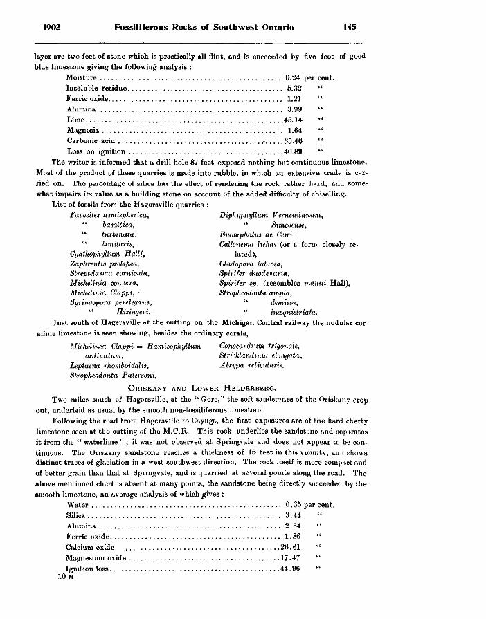
1902 Fossiliferous Rocks of Southwest Ontario 145
layer are two feet of stone which is practically all flint, and is succeeded by five feet of good blue limestone giving the following analysis :
Moisture 0.24 per cent. Insoluble residue 5.32 " Ferric oxide 1.21 " Alumina 3.99 Lime 45.14 " Magnesia 1.64 " Carbonic acid r 35.46 " Loss on ignition 40.89 "
The writer is informed that a drill hole 87 feet exposed nothing but continuous limestone. Most of the product of these quarries is made into rubble, in which an extensive trade is carried on. The percentage of silica has the effect of rendering the rock rather hard, and somewhat impairs its value as a building stone on account of the added difficulty of chiselling.
List of fossils from the Hagersville quarries : Faoosites hemispherica, Diphyphyllum Vernemlanum,
" basaltica, " Simcoense, " turbinata, Euomphalns de Cewi, " limitaris, Gallonema lichas (or a form closely re-
Gyathophyllum Halli, lated), Zaphrentis prolifica, Cladopora labiosa, Streptelasma comicula, Spirifer duodenaria, Miehelinia convexa, Spirifer sp. (resembles mauni Hall), Miehelinia Glappi, • Stropheodonta ampla, Syringopora perelegans, " demissa,
" Hisingeri, " inmqnistriata. Just south of Hagersville at the cutting on the Michigan Central railway the nodular cor
alline limestone is seen showing, besides the ordinary corals,
Michelinea Clappi — Ramieophyllum Conocardium trigonale, ordinatum, Strickland inia elongata,
Leptaena rhomboidalis, Atrypa reticularis. Stropheodonta Patersoni,
ORISKANY AND LOWER HELDERBERG. Two miles south of Hagersville, at the " Gore," the soft sandstones of the Oriskany crop
out, underkid as usual by the smooth non-fossiliferous limestone. Following the road from Hagersville to Cayuga, the first exposures are of the hard cherty
limestone seen at the cutting of the M.O.R. This rock underlies the sandstone and separates it from the " waterlime " ; it was not observed at Springvale and does not appear to be continuous. The Oriskany sandstone reaches a thickness of 15 feet in this vicinity, an I shows distinct traces of glaciation in a west-southwest direction. The rock itself is more compact and of better grain than that at Springvale, and is quarried at several points along the road. The above mentioned chert is absent at many points, the sandstone being directly succeeded by the smooth limestone, an average analysis of which gives :
Water , 0.35 per cent. Silica 3.44 Alumina 2.34 " Ferric oxide. , , 1.86 " Calcium oxide , , 26.61 " Magnesium oxide 17.47 " Ignition loss . , 44.96 "
10 M
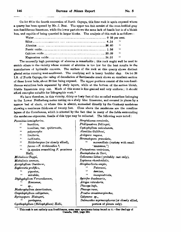
146 Bureau of Mines Report No. 5
On lot 40 in the fourth concession of North Cayuga, this lime rock is again exposed where a quarry has been opened by Mr. J. Best. The upper ten feet consist of the even-bedded gray non-fossiliferous limestone, while the lower part shows the same lack of fossils but is of a bluish hue, and capable of being quarried in larger blocks. The analysis of this rock is as follows :
Water 0 55 per cent. Silica 4 .14 Alumina 96.60 " Ferric oxide 1.56 " Calcium oxide 20.09 " Magnesium oxide 14.51 "
The unusually high percentage of alumina is remarkable ; this rock might well be used to enrich others in the vicinity whose content of alumina is too low for the best results in the manufacture of hydraulic cements. The surface of the rock at this quarry shows distinct glacial striae running west-southwest. The overlying soil is heavy boulder clay. On lot 36 I.S. of North Cayuga,'the valley of denudation of Rattlesnake creek shows an excellent section of these lower beds, about 30 feet being exposed. The upper portions consist of the non-fossiliferous-waterlime beds separated by shaly layers, while at the bottom of the section bluish, friable limestones crop out. Much of this stone is fine-grained and very uniform ; it should afford examples suitable for lithographic work. 1
We have therefore, in this vicinity, thirty or fo»ty feet of the so-called waterlime belonging to the Lower Helderberg series resting on a shaly blue limestone, and covered in places by a narrow bed of chert, or where this is absent, succeeded directly by the Oriskany sandstone showing a maximum thickness of twenty feet. Close above the .sandstone are the coralline layers of the Corniferous, which is attested by the fact that in many of the fields surrounding the sandstone exposures, fossils of this type may be collected. The following were noted :
Favosities hemispherica, ' '• basaltica, " busaltisa, var. epidermata, " polymorpha '' limitaris, " turbinata, " Helderbergiae (6r closely allied), '' favosa = F. Gothlandica 1, " (a species resembling F. proximus
Hall), Miehelinia Clappi, Miehelinia eonvexa, Acrophyllum On»ide*se, Zaphrentis prolific x ,
" gigantea, " mirabile,
Diphyphylhim Vemeuilanum, " Simcoense,
Blothrophyllum decorticatum, CrepidophyUum colligatum, Syringopora Hisingeri,
" perehgant, Cyathophyllum (Heliophgilum) Halli,
Streptelasma cornicula, Phillipsastrea Billingsii, Cystophyllum vesiculasum, Alveolites Goldfvssi, Aulopora respens, Stromatopora granulata,
" mammillata (variety with small 'mammae,")
Platyostoma ventricosa, Fiuomphalus de Cewi, GaUonema lichas (probably cast only), Leptaena rhomboidalis, Stropheodonta ampla,
" Patersoni, " demissa, '' inaequistriata,
Spirifer duodenaria, Atrypa reticularis, Phacops bufo, Phacops rana, Proetus crassimarginaltus, Calymene sp., Dalmanites myrmecophorus (or closely allied,
portioH of pleura only).
This rook is not entirely non-fossllifeious, some nre specimens being feund in it.-Canada, 1863, page 351.
-See Geology of
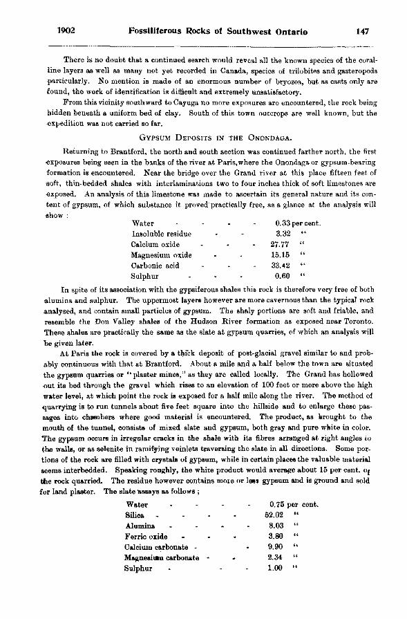
1902 Fossiliferous Rocks of Southwest Ontario 147
There is no doubt that a continued search would reveal all the known species of the coralline layers as well as many not yet recorded in Canada, species of trilobites and gasteropods particularly. No mention is made of an enormous number of bryozoa, but as casts only are found, the work of identification is difficult and extremely unsatisfactory.
From this vicinity southward to Cayuga no more exposures are encountered, the rock being hidden beneath a uniform bed of clay. South of this town outcrops are well known, but the expedition was not carried so far.
GYPSUM DEPOSITS IN THE ONONDAGA.
Returning to Brantford, the north and south section was continued farther north, the first exposures being seen in the binks of the river at Paris, where the Onondaga or gypsum-bearing formation is encountered. Near the bridge over the Grand river at this place fifteen feet of soft, thin-bedded shales with interlaminations two to four inches thick of soft limestones are exposed. An analysis of this limestone was made to ascertain its general nature and its content of gypsum, of which substance it proved practically free, as a glance at the analysis will show :
Water . . . - 0.33 per cent. Insoluble residue - - 3.32 " Calcium oxide - - - 27.77 " Magnesium oxide - - 15.15 " Carbonic acid - - - 33.42 " Sulphur - - - 0.60 "
In spite of its association with the gypsiferous shales this rock is therefore very free of both alumina and sulphur. The uppermost layers however are more cavernous than the typical rock analysed, and contain small particles of gypsum. The shaly portions are soft and friable, and resemble the Don Valley shales of the Hudson River formation as exposed near Toronto. These shales are practically the same as the slate at gypsum quarries, of which an analysis will he given later.
At Paris the rock is covered by a thick deposit of post-glacial gravel similar to and probably continuous with that at Brantford. About a mile and a half below the town are situated the gypsum quarries or "plaster mines," as they are called locally. The Grand has hollowed out its bed through the gravel which rises to an elevation of 100 feet or more above the high water level, at which point the rock is exposed for a half mile along the river. The method of quarrying is to run tunnels about five feet square into the hillside and to enlarge these passages into chambers where good material is encountered. The product, as brought to the mouth of the tunnel, consists of mixed slate and gypsum, both gray and pure white in color. The gypsum occurs in irregular cracks in the shale with its fibres arranged at right angles to the walls, or as selenite in ramifying veinlets traversing the slate in all directions. Some portions of the rock are filled with crystals of gypsum, while in certain places the valuable material seems interbedded. Speaking roughly, the white product would average about 15 per cent. Of the rock quarried. The residue however contains more or lees gypsum and is ground and sold for land plaster. The slate assays as follows ;
Water 0.75 per cent. Silica 52.02 «(
Alumina . . . 8.03 it
Ferric oxide 3.80 a
Calcium carbonate - 9.90 <t
Magnesivan carbonate - 2.34 n
Sulphur 1.00 « (
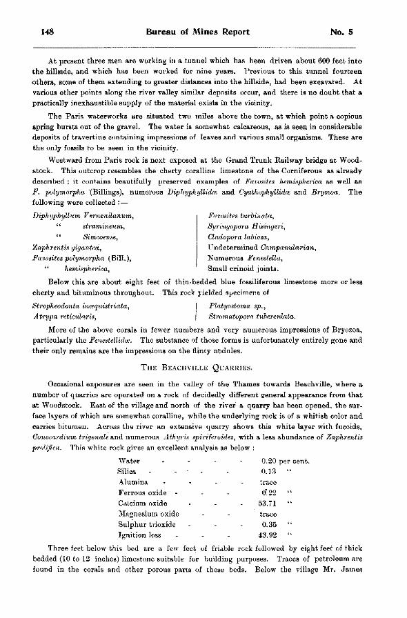
148 Bureau of Mines Report No. 5
At present three men are working in a tunnel which has been driven about 600 feet into the hillside, and which has been worked for nine years. Previous to this tunnel fourteen others, some of them extending to greater distances into the hillside, had been excavated. At various other points along the river valley similar deposits occur, and there is no doubt that a practically inexhaustible supply of the material exists in the vicinity.
The Paris waterworks are situated two miles above the town, at which point a copious spring bursts out of the gravel. The water is somewhat calcareous, as is seen in considerable deposits of travertine containing impressions of leaves and various small organisms. These are the only fossils to be seen in the vicinity.
Westward from Paris rock is next exposed at the Grand Trunk Railway bridge at Woodstock. This outcrop resembles the cherty coralline limestone of the Corniferous as already described ; it contains beautifully preserved examples of Favosites hemispherica as well as F. polymorpha (Billings), numerous Diphyphyllida and Gyathophyllidm and Bryozoa. The following were collected : —
Diphyphyllum V erneuilanum, " stramineum, " Simcoense,
'Laphrentis gigantea, Favosites polymorpha (Bill.),
" hemispherica,
Favosites turbinata, Syringopora Hisingeri, Cladopora labiosa, Undetermined Campanularian, Numerous Fenestella, Small crinoid joints.
Below this are about eight feet of thin-bedded blue fossiliferous limestone more or less cherty and bituminous throughout. This rock yielded specimens of
Stropheodonta incequistriata, Atrypa reticxdaris,
Platyostoma sp., Stromatopora tuberculata.
More of the above corals in fewer numbers and very numerous impressions of Bryozoa, particularly the Fenestellidte. The substance of those forms is unfortunately entirely gone and their only remains are the impressions on the flinty nodules.
THE BEACHVILLE QUARRIES.
Occasional exposures are seen in the valley of the Thames towards Beachville, where a number of quarries are operated on a rock of decidedly different general appearance from that at Woodstock. East of the village and north of the river a quarry has been opened, the surface layers of which are somewhat coralline, while the underlying rock is of a whitish color and carries bitumen. Across the river an extensive quarry shows this white layer with fucoids, Conocardium trigenale and numerous Athyris spiriferoides, with a less abundance of Zaphrentis prolifica. This white rock gives an excellent analysis as below :
Water . . . - 0.20 per cent. Silica - - - - - 0.13 " Alumina - trace Ferrous oxide - - - 0*22 " Calcium oxide - - - 53.71 " Magnesium oxide - - trace Sulphur trioxide - - - 0.35 " Ignition loss - - - 43.92
Three feet below this bed are a few feet of fridble rock followed by eight feet of thick bedded (10 to 12 inches) limestone suitable for building purposes. Traces of petroleum are found in the corals and other porous parts of these beds. Below the village Mr. James
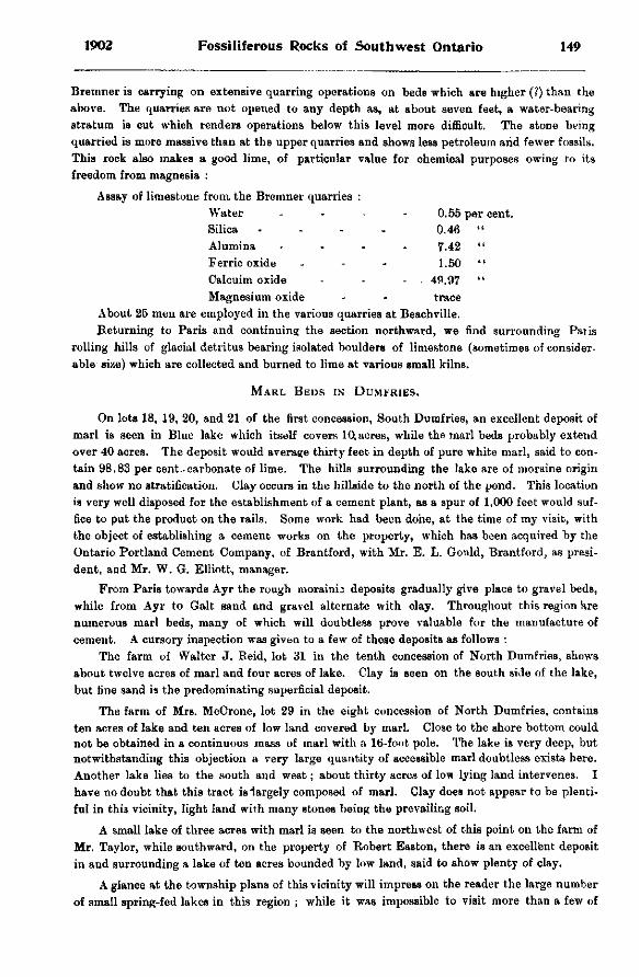
1902 Fossiliferous Rocks of Southwest Ontario 149
Bremner is carrying on extensive quarring operations on beds which are higher (?) than the above. The quarries are not opened to any depth as, at about seven feet, a water-bearing stratum is cut which renders operations below this level more difficult. The stone being quarried is more massive than at the upper quarries and shows less petroleum arid fewer fossils. This rock also makes a good lime, of particular value for chemical purposes owing to its freedom from magnesia :
Assay of limestone from, the Bremner quarries : Water - - - - 0.55 per cent. Silica . . . . 0.46 " Alumina . . . . 7.42 " Ferric oxide - - - 1.50 " Calcuim oxide - - - . 49.97 " Magnesium oxide - - trace
About 25 men are employed in the various quarries at Beachville. Returning to Paris and continuing the section northward, we find surrounding Palis
rolling hills of glacial detritus bearing isolated boulders of limestone (sometimes of considerable size) which are collected and burned to lime at various small kilnB.
MARL BEDS IN DUMFRIES.
On lots 18, 19, 20, and 21 of the first concession, South Dumfries, an excellent deposit of marl is seen in Blue lake which itself covers 10, acres, while the marl beds probably extend over 40 acres. The deposit would average thirty feet in depth of pure white marl, said to contain 98.83 per cent..carbonate of lime. The hills surrounding the lake are of moraine origin and show no stratification. Clay occurs in the hillside to the north of the pond. This location is very well disposed for the establishment of a cement plant, as a spur of 1,000 feet would suffice to put the product on the rails. Some work had been done, at the time of my visit, with the object of establishing a cement works on the property, which has been acquired by the Ontario Portland Cement Company, of Brantford, with Mr. E. L. Gould, Brantford, as president, and Mr. W. G. Elliott, manager.
From Paris towards Ayr the rough morainii deposits gradually give place to gravel beds, while from Ayr to Gait sand and gravel alternate with clay. Throughout this region are numerous marl beds, many of which will doubtless prove valuable for the manufacture of cement. A cursory inspection was given to a few of these deposits as follows :
The farm of Walter J. Beid, lot 31 in the tenth concession of North Dumfries, shows about twelve acres of marl and four acres of lake. Clay is seen on the south side of the lake, but fine sand is the predominating superficial deposit.
The farm of Mrs. McCrone, lot 29 in the eight concession of North Dumfries, contains ten acres of lake and ten acres of low land covered by marl. Close to the shore bottom could not be obtained in a continuous mass of marl with a 16-foot pole. The lake is very deep, but notwithstanding this objection a very large quantity of accessible marl doubtless exists here. Another lake lies to the south and west; about thirty acres of low lying land intervenes. I have no doubt that this tract isiargely composed of marl. Clay does not appear to be plentiful in this vicinity, light land with many stones being the prevailing soil.
A small lake of three acres with marl is seen to the northwest of this point on the farm of Mr. Taylor, while southward, on the property of Robert Easton, there is an excellent deposit in and surrounding a lake of ten acres bounded by low land, said to show plenty of clay.
A glance at the township plans of this vicinity will impress on the reader the large number of small spring-fed lakes in this region ; while it was impossible to visit more than a few of
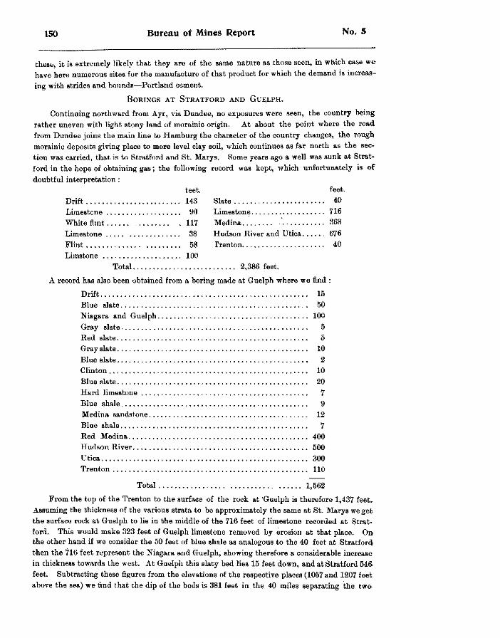
150 Bureau of Mines Report No. 5
these, it is extremely likely that they are of the same nature as those seen, in which case w e have here numerous sites for the manufacture of that product for which the demand is increasing with strides and bounds—Portland cement.
BORINGS AT STRATFORD AND GUELPH.
Continuing northward from Ayr, via Dundee, no exposures were seen, the country being: rather uneven with light stony land of morainic origin. At about the point where the road from Dundee joins the main line to Hamburg the character of the country changes, the rough morainic deposits giving place to more level clay soil, which continues as far north as the section was carried, that is to Stratford and St. Marys. Some years ago a well was sunk at Stratford in the hope of obtaining gas; the following record was kept, which unfortunately is of doubtful interpretation :
feet. feet. Drift 143 Slate 40 Limestone y0 Limestone 716 White flint 117 Medina ' 368 Limestone 38 Hudson River and Lftica 676 Flint 58 Trenton 40 Limstone 100
Total 2,386 feet.
A record has also been obtained from a boring made at Guelph where we find :
Drift , 15 Blue slate 50 Niagara and Guelph , 100 Gray slate 5 Red slate 5 Gray slate 10 Blue slate 2 Clinton 10 Blue slate 20 Hard limestone 7 Blue shale 9 Medina sandstone 12 Blue shale 7 Red Medina 400 Hudson River ; 500 Utica 300 Trenton 110
Total 1,562
From the top of the Trenton to the surface of the rock at 'Guelph is therefore 1,437 feet. Assuming the thickness of the various strata to be approximately the same at St. Marys wo get the surface rock at Guelph to lie in the middle of the 716 feet of limestone recorded at Stratford. This would make 323 feet of Guelph limestone removed by erosion at that place. On the other hand if we consider the 50 feet of blue shale as analogous to the 40 feet at Stratford then the 716 feet represent the Niagara and Guelph, showing therefore a considerable increase in thickness towards the west. At Guelph this slaty bed lies 15 feet down, and at Stratford 546 feet. Subtracting these figures from the elevations of the respective places (1057 and 1207 feet above the sea) we find that the dip of the beds is 381 feet in the 40 miles separating the two
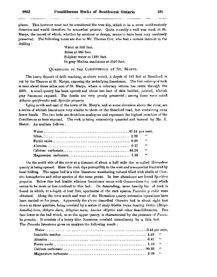
1902 Fossiliferous Rocks of Southwest Ontario 151
places. This however must not be considered the true dip, which is in a more southwesterly direction and would therefore be somewhat greater. Quite recently a well was sunk at St. Marys, the record of which, whether by accident or design, seems to have been very carelessly preserved. The following notes are due to Mr. Thomas Cox, who had a certain interest in the drilling :
M'ater at 550 feet. Brine at 985 feet. Sulphur water at 1185 feet. In gray Medina sandstone at 1510 feet.
QUARRYING IN THE CORNIFEROUS AT ST. MARYS.
The heavy deposit of drift reaching, as above noted, a depth of 143 feet at Stratford, is cut by the Thames at St. Marys, exposing the underlying limestones. The first outcrop of rock is seen about three miles east of St. Marys, where a tributary stream has eaten through the drift. A small quarry has been opened and about ten feet of thin bedded, jointed, whitish gray limestone, exposed. The fossils are very poorly preserved ; among them were noted Athyris spiriferoides and Spirifer gregaria.
Lying north and east of the town of St. Mary's, and at some elevation above the river, are a series of whitish limestones very similar to those on the Stratford road, but containing even fewer fossils. The two beds are doubtless analogous and represent the highest members of the Corniferous as here exposed. The rock is being extensively quarried and burned by Mr. J. Slater. An analysis follows :
Water 00.14 percent. Silica.; 2.32 Ferric oxide 0.88 Alumina 0 17 Calcium carbonate 94.24 Magnesium carbonate 2.10
On the south side of the river at a distance of about a half mile the so-called Horseshoe quarry is. being opened. Here the rock dips perceptibly to the west and is somewhat fractured by local folding. The upper bed is a thin limestone weathering red and filled with shells of Chon-etes hemispherica and other species of the same genus. In less abundance are found Spirifera gregaria. Below this bed friable silicious limestones occur with Gonocardium trk nale which seems to be more or less confined to this bed. On descending, more heavily bei ed rock is found in which, at a depth of four feet, specimens of the rare species Panenla g; undis were obtained. Along the river south and west of the Horseshoe quarry extensive operations have been carried on for years. Apparently the above described Cho-mtes bed is about eight feet down at these quarries, being overlaid by a series of shaly friable rocks bearing Orthis (Rhipi- • domella) livia, Athyris clara, Athyrias maia, Lucina elliptica and other lamellibranchs. Two feet lower is the bed which, as at the upper quarry, is characterized by the presence of Panen-ka grandis. It consists of a heavy blue limestone overlaid immediately by a thin bed. The Panenka limestone gives on analysis the following result:
Water , 0.41 per cent. Insoluble residue 4.49 Alumina 0.47 Ferric oxide 1.19 Calcium carbonate 90.22 Magnesium carbonate 2.09
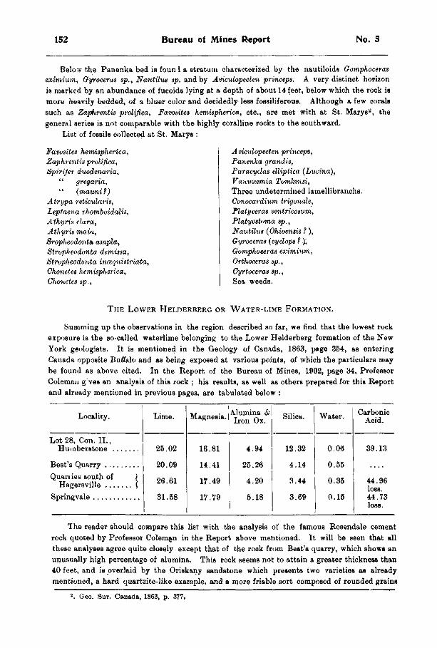
152 Bureau of Mines Report No. 5
Below the Panenka bed ia foun I a stratum characterized by the nautiloids Gomphoceras eximium, Gyroceras sp., Nautilus sp. and by Aviculopecten princeps. A very distinct horizon is marked by an abundance of fucoids lying at a depth of about 14 feet, below which the rock is more heavily bedded, of a bluer color and decidedly less fossiliferous. Although a few corals such as Zaphrentis prolifica, Favosites hemispherica, etc., are met with at St. Marys 2 , the general series is not comparable with the highly coralline rocks to the southward.
List of foBsils collected at St. Marys :
Favosites hemispherica, Zaphrentis prolifica, Spirifer duodenaria,
" gregaria, '' (mauni f)
Atrypa reticularis, Leptaena rhomboidalis, Athyris clara, Athyris main, Sropheodonta ampla, Stropheodonta demissa, Stroplieodonta inmquistriata, Chonetes hemispherica, Chonetes sp.,
A viculopecten princeps, Panenka grand is, Paracyclas elliptica (Lucina), Vanvxemia Tomkinsi, Three undetermined lamellibranchs. Conocardmm trigonale, Platyceras ventricosum, Platyostoma sp., Naviilus (Ohioensis ? ) , Gyroceras (cyclops f ); Gomphoeeras eximium, Orthoceras sp., Cyrtoceras sp., Sea weeds.
THE LOWER HELDERBERG OR WATER-LIME FORMATION.
Summing up the observations in the region described so far, we find that the lowest rock exposure is the so-called waterlime belonging to the Lower Helderberg formation of the New York geologists. It is mentioned in the Geology of Canada, 1863, page 354, as entering Canada opposite Buffalo and as being exposed at various points, of which the particulars may be found as above cited. In the Report of the Bureau of Mines, 1902, page 34, Professor Coleman g ves an analysis of this rock ; his results, as well as others prepared for this Report and already mentioned in previous pages, are tabulated below :
Locality. Lime. Magnesia. Alumina & Iron Ox. Silica. Water. Carbonic
Acid.
Lot 28, Con. II. ,
Quarries south of )
25.02
20.09
26.61
31.58
16.81
14.41
17.49
17.79
4.94
25.26
4 .20
5.18
12.32
4.14
3.44
3.69
0.06
0.55
0.35
0.15
39.13
44.96 loss. 44.73 loss.
The reader should compare this list with the analysis of the famous Rosendale cement rock quoted by Professor Coleman in the Report above mentioned. It will be seen that all these analyses agree quite closely except that of the rock from Best's quarry, which shows an unusually high percentage of alumina. This rock seems not to attain a greater thickness than 40 feet, and is overlaid by the Oriskany sandstone which presents two varieties as already mentioned, a hard quartzite-like example, and a more friable sort composed of rounded grains
°. Geo. Sur. Canada, 1863, p. 377.
1902 Fossiliferous Rocks of Southwest Ontario 153
of quartz with some feldspar. This rook is found just west of Port Colborne where it forms a bed not over a foot thick. The position here, which is distinctly between the Waterlime and the Corniferous, is maintained, but with increasing thickness, towards the north, reaching south of Hagersville a maximum of about 20 feet. However, if we have rightly interpreted the well at Stratford, a thickness of 117 feet is attained at that point.
THE CORNIFEROUS A VARIED SERIES.
Our knowledge of the series of limestones lying above the Oriskany sandstone to which the name Corniferous has been given is most meagre and unsatisfactory. The term Corniferous has been applied to a whole series of strata the fossil contents of which show most striking differences, e.g. the coralline rocks of Hagersville and vicinity, the nautiloid and lamellibranch strata of St. Marys, and the rocks characterized by the very much mixed assemblage of fossils from Amherstburg described by the Rev. Thomas Nattress in the last Report of the Bureau of Mines 3. The writer does'not wish to be understood as quarrelling with the name Corniferous, although, as Sir William Logan himself says, it is not exactly comparable with the American series of the same name, but desires merely to emphasize the lack of knowledge of the subdivisions of these rocks, call them what we may.
The natural conformable succession of rocks westward from the Niagara outcrops at Hamilton lies through the Barton beds to the Guelph dolomites. The non-fossiliferous Onondaga and the so-called Waterlime with its overlying Oriskany form a very dissimilar and non-contin-
• uous series of sediments. Whether these deposits follow the Guelph or are more or less contemporaneous, I believe there is no evidence to decide ; it seems likely however, from the nature of the Onondaga, that shallow enclosed seas prevailed, in which were deposited the characteristic gypsum, salt and shale. In North and South Cayuga, in Walpole and in Town-send as well as in other townships a distinctly cherty, coralline layer overlies the Oriskany sandstone and attains no great thickness. At Hagersville this same coral layer seems to be directly superimposed on the Lower Helderberg, as a drill hole 87 feet deep failed to reveal any sandstone. (Compare the analysis of the bottom rock at Hagersville with that of the " Waterlime.") At Woodstock the coral layer is more feebly represented and underlies a series of rocks richer in brachiopods, which series is covered at Beachville by the peculiar white rock already described as being characterized by the presence of fucoids (sea weeds) and small examples of Athyris spiriferoides. The series at St. Marys is quite different, the coralline layer not being exposed, although of course some corals occur as is the case in all these rocks. This series has already been described ; in all probability it lies above the others, but accurate measurements and complete collections of fossils are required to decide the point.
FOSSILIFEROUS BEDS OF THE HAMILTON FORMATION.
The heavy deposits of drift continue westward from St. Marys, being represented by rolling boulder clay, interrupted in places by deposits of gravel. After passing Lucan, some morainic hills are encountered, which however soon give place to remarkably level clay land. No rock exposures are seen over this entire region until the famous Hamilton outcrops at Thedford are reached. The excellent series of rocks rendered accessible at this point have become classic in the annals of geology, as they form an exceedingly rich hunting ground for the fossils characteristic of the Hamilton formation. So much has been published on the fauna of these rocks that it would be superfluous for the writer to deal with that side of the matter here. An idea of the richness of the remains may be gathered from the fact that, in spite of time spent in travelling, he succeeded in three days in collecting over a thousand specimens represent-
3 . The Corniferous Exposure in ADc'eidon, ry Bev. Thos. Nattrets, B.A ; 11th Rep. Bur. Mines, pp. 123-127.
154 Bureau of Mines Report No. 5
ing 110 species. Some attempt was made by the writer to work out the fossil contents or at least to establish the characteristic fossils of the various layers, but he is glad to find that this had been done by others in greater detail than his time would permit. Professor A. A. Wright during the summer of 1900 made a complete series of measurtments, and during the season of 1901, Professors Shimer and Grabau made exhaustive collections. The results of their work are published in a valuable bulletin of the Geological Society of America. 4
It may be well however to describe briefly the places at which exposures are to be seen. The first is at Thedford, where the Grand Trunk railway cuts through the series to a depth of forty feet. At this point Spirifer pennuta (Spirifer mucronata var. Thedfordensis of the above authors) is very abundant, as well as bryozoa of different genera. This section is also much the best for the collection of Athyris spiriferoides, Goniatites uninngvlaris and Cynina Hamiltonensis. Shimer and Grabau mention 39 species from here, mostly bryozoa and brachiopods. A second exposure is found three-quarters of a mile north of the railsvay cut in what are known as Hanniford's fields. A heavy limestone with crinoid stems is here overlaid by a soft shale from which weather out numerous specimens of corals which may be picked up in perfect condition on the surface of the ground. Particularly noticeable among the 12 species of Shimer and Grabau are :
Favosites Billingsii, Alveolites Goldfussi, Cystophyllurn Vesiculosum,
Cyathophyllum HaUi, Vya thophyllum tetiuiseptatum, Zaphrentis pi olifica, Favosites placenta = F. nitella,
Besides the corals 14 or 15 species of brachiopoda occur, of which the most important and numerous are : Spirifer pennata, Rhipidomella Vanuxemi, Cyrtina Hamiltonensis, Pholidostrophia /owaensis,
Rhipidomella Penelope, Atrypa reticularis.
Fragments of bryozoa and joints of crinoids are also abundant. The third section is found on a small stream west of the above and presents practically the
same series of rocks, reaching however a greater vertical extent. The top is the decomposed coral shale underlaid by limestone in several layers, beneath which is 15 feet of blue clay. This material makes excellent drain pipes and brick of a red color, while the overlying boulder clay burns white. The blue Hamilton shale is filled with nodules of a harder nature which prove objectionable on account of their resistance to the action of both fire and water. An analysis of one of these nodules follows •
Water 0.57 per cent. Silica 17.67 Alumina 10.59 " Ferric oxide , 4.25 " Calcium oxide 32.84 Magnesium oxide traces. "
The nodules would seem to owe their origin therefore to concretions of lime which has entered into chemical union with the elements of the shale. The assemblage of fossils is, as would be expected, about the same as in Hanniford's fields and the railway cut.
OTHER EXPOSURES OF HAMILTON FOSSIL BEDS.
Probably the best section of these Hamilton rocks is to be seen in Rock Glen, where a small tributary of Aux Sables river has exposed 70 feet of the series. Another excellent
*. Bulletin, Geol. Soc. Am., Vol. 13, 1901, pp. 149-186.
1902 Fossiliferous Rocks of Southwest Ontario 155
section of the lower portion is seen at Marshall's Mills on the Aux Sables, about a mile above the mouth of Rock Glen. Finally, small exposures are met with in the valleys of creeks cutting down to the rock on the road from Thedford to Arkona. Particularly may be mentioned a good section at " No. 4 hill." At Stony P^oint, lake Huron, the heavy limestone is exposed for a short distance along the shore. As this is not mentioned by Shimer and Grabau a list is added of forms collected here :
Bhipidomella Penelope, Rhipidomella Vanuxerni, Stropheodonta demissa, Strepheodonta concam, Boemeria ramosa, Phacops rana, Atrypa reticularis,
Spirifer pennata, Chonetes lineata, Pterinea flabella, Limoptera macroptera, Polypora tuberculata, Fenestella sp., Ancyrocrinus bulbosus.
An analysis of this limestone is given below, as well as one of what is probably the same bed from Thedford:
Stony Point, per cent.
Water 0,14 Silica 0.78 Alumina 0.13 Ferrous oxide 1.56 Calcium oxide 51.74 Magnesium oxide 0.46 Sulphur trioxide 1.27 Carbonic acid and loss 43.02
It will be observed that this stone is practically free from magnesia, although the sulphur may prove objectionable for certain chemical purposes.
Below are shown side by side the sections of the Hamilton formation at Thedford as prepared by Professor Wright and by Professors Shimer and Grabau. My observations, made a year later, can add nothing to the systematic measurements of these geologists. For detailed information as to the fossil content of the various layers the reader is referred to the publication already cited.
Thedford. per cent.
1.51 2.19 2.49
51.26 traces.
41.10
Shimer and Grabau. Feet.
Calcareous Ceratopora Bryozoa beds
Shales with Spirifer beds at base.. Argillaceous limestone Blue calcareous shale Calcareous Bhale and slaty blue
limestone . Argillaceous shales with Styliolila Coral layers Encrinal limestone Blue shales, lower, with calcareous
fossil beds
Total 81.26 feet. I
10 8 1.5
18
6 1.5 3 26 3
30
A. A. Wright. 0*0 •£
o ®. S O »
Encrinal limestone.
Nodular shale Upper argillaceous limestone. Upper bine shale Lower argillaceous limestone.
Coral beds Rugose limestone Lower blue shales Calcareous blue shales
Total
c
1 14 87.6 1.3
1 6
I 1.6 9 29 3 1.3
•5"
1.3
3.9 3.9 2.6 2.6
20 '20 16 115
84 feet.
The various shales, particularly those free from fossils, make excellent tile and coarse pottery. Mr. Jas. Cornell has for years carried on this industry at the exposure on the creek
156 Bureau of Mines Report No. 5
north of Thedford. Rock Glen and Marshall's Mills both furnish equally good sites for this purpose. The limestones are practically free from magnesia and alumina, making splendid lime and the even-bedded portions are easily quarried for building stone. Two miles north of Thedford a gravel ridge is crossed, beyond which,a distinct beach is seen (Algonquin beach) representing the shore line of lake Huron in post-glacial times.
To complete the trip a visit was paid to the famous region at Kettle Point where the peculiar spherical concretions, in some instances as large as four feet in diameter, are found embedded in the Genessee shales which are exposed for about 15 feet. These shales are even-bedded and highly bituminous, so much so that if once ignited in large quantities they will continue to burn indefinitely. An analysis of these bituminous shales is given below ; the specimen was taken two and a half feet from the equator of one of the larger kettles.
While constituting a geological phenomenon, this exposure does not merit further consideration in a report of this nature. A day was spent in examining the Kettles and in making certain measurements which may, at some future date, form the substance of a papar on the subject.
The analyses given herein, with the exception of those of the Beachville rock and that from Stony Point for which I am indebted to Mr. A. G. Burrows, were made under the direction of Mr. J. Walter Wells, late Provincial Assayer at Belleville.
Acknowledgments are due to the following gentlemen for assistance M i d valuable informa tion while in the field : Rev. Hector Currie, Thedford; N. H. Cowdry, Esq., Waterford; D. McNeil, Esq., St. Marys.
THE KETTLE POINT CONCRETIONS.
Water Silica Alumina Ferrous ox ide . . . Ferric oxide . . . . Calcium oxide.. . Magnesium oxide Carbonic acid . . . Sulphur trioxide Bitumen Loss on ignition.
54.44 19.77
2.84 3.16 3.11
trace. 2.44 8.98
11.21 14.15
0.49 per cent.
1902 Up and Down the Mississaga 157
UP AND DOWN 1HE MISSISSAGA. BY L. C. GRATON.
In June 1902 I was appointed by the Director of the Bureau of Mines geologist to accompany the surveying party sent out by the Crown Lands Department in charge of Mr. Alexander Niven, O. L. S., which was to run a series of lines along the upper reaches of the Mississaga river in the district of Algoma. I reached Toronto on 27th June, and joining Mr. Niven and a portion of the party, left on 1st July for Biscotasing station on the C. P . R. main line, where we arrived the following day. The remainder of the party having joined us on the way, we numbered seventeen all told.
STARTING POINT OF THE EXPEDITION.
The starting point of the survey was to be the 36th mi'e post of the base line run by Mr. Niven the winter before, i.e 50 miles west of Straight Lake station on the C.P.R. At the end of the 36 miles, Mr. Niven had turned north and run what is called his 1st meridian. 1902, to the C.P.R. at Woman River station. This corner or starting point, then, lay about 50 miles rather east of south from Biscotasing.
At this station we took our supplies, and starting on 3rd July, proceeded by canoes up the Spanish River route, over the divide into the head waters of the Mississaga, and on to Upper or New Green Lake, where there is an abandoned post of the Hudson's Bay Company. Continuing, we kept to the Mississaga course till within a few miles of where it crosses Niven's 1st meridian; there we turned south, and by lakes, creeks and long portages cut by ourselves, we reached the starting point on 10th July.
Mr. Niven was to prolong westward thebase line already begun until it should reach the northeast corner of the Township of Curtis, a distance of 54 miles. He was also to run a line, to be called the second meridian, from the 66th mile of this base line, or 30 miles from the season's starting point, north for 18 miles, and then turn eastward for 30 miles to join his 1st meridian.
My instiuctions were to study as carefully as possible the geology of the country on either side of these lines, and to be especially on the lookout for mineral deposits of economic importance. I was also to note and describe the character of the country—its topography, soil, climate, flora, fauna, etc. Mr. Niven being head of the party, I was subject to him in all matters pertaining to the conduct of the expedition.
GENERAL METHOD OF PROCEDURE.
Before leaving the main waters of the Mississaga. it was decided that I should follow along with the line for 30 miles to the starting point of the second meridian. This I did, making trips alternately to the north and south of the line on every day possible, usually in company with an Indian as guide. In general I would start from camp hi the morning, strike perhaps south for nearly half the day, turn west for about a mile and a half—an average day's run on the line—then turn north and reach the line at about the point chosen for that night's camp. It was usually advantageous to kee# to the ridges and hills as much as possible, both i n account of the better view they afforded, and the greater likelihood of finding rock exposed there than in the valleys. The country is exceedingly rough and affords difficult passage even to one carrying no load. In the "green bush" densely wooded tracts, as a rule, give way only to lakes, swamps, or steep rocky hills, and in country that has been burned, progress is made extremely arduous by the network of fallen logs, so that a walk of seven to twelve miles
158 Bureau of Mines Report No. 5
was about all that could be accomplished in a day. Now and then a level sandy plain half a mile or a mile across, usually covered with jack-pine, was a welcome occurrence.
At different times during the summer I had the services of George Friday and William McLean, Indians from the Temagami Reservation, both of whom were efficient and obliging.
The journey from Biscotasing-to the starting point was entirely through Laurentian country; and it may as well be stated at the outset that all the lines of this summer run through country underlain, with one possible exception, by the Fundamental Gneiss.
TOPOGRAPHICAL FEATURES OF THE REGION.
This region is a portion of the great protaxis of the continent, and so forms part of the old dissected Archsean plateau. That this is true can be seen by noticing that from the top of a hill the sky-line is even; and although the country is decidedly rugged, no great differences of level occur, five, six or seven hundred feet being the greatest. " The landscape is of a very pronounced type, which, while lacking on one hand the grandeur and sublimity of the great mountain regions of the world, and on the other the tranquil beauty of the well-cultivated lowlands, has a certain rugged beauty of its own." In the aspects of its relief this country pre -sents a monotonous succession of great and small knolls or bosses, between which are found either drift-filled valleys or lakes both large and small. This mammillated or undulating surface, which is so characteristic of the Laurentian, can be seen especially well where forest fires have stripped the hills of their vegetation and left .the bare rocks exposed.
Practically no generalizations can be made as to the topography. The covering of drift is so thin, and the underlying rock so resistant and massive that the physiographic features are quite immature. Except very near to the main water courses streams are found flowing in any and all directions; lakes may occur anywhere, and at practically all levels, and rapids are ex" ceedingly numerous, although owing to the smooth and rounded surface of the rocks falls are not frequent.
PECULIARITY OF HILL PROFILES.
There is one very striking exception, however, to this apparently lawless topography. The hills are decidedly smoother, and the ascent more gradual on the north side than on the south. Steep cliffs, sometimes several hundred feet high, may be found at the south side of some of the hills, while almost invariably the north side is a slope, gentJa and usually drift-covered. This has a marked effect in two ways upon the outlook from the hill-tops. The view to the north is very often obscured'or shut out entirely by the trees which find soil and footing on that slope, while to the south the view is unobstructed; likewise whenever one can see to the northward the country appears very rough and rocky looking at the south side of the hills, while southward the elevations seem to have a more regular foam, and are usuaHy wo oded. This difference in the north and south sides of the elevations is also well seen in the small rocky 'slands which protrude from the surface of lakes. Approaching one of these from the north it is seen to rise gently out of the water, and suggests by its form a huge turtle back. When as the side of the island, however, so that a profile can be had, it is striking to see how abrupt it the south side in comparison.
This phenomenon is almost universal. It can be explained as the effect of the enormous mass or masses of ice which during the glacial epoch moved down from the north, and planing off and passing up on the north side of the hills, fell away rapidly and with comparatively little erosive action on the south side. At the foot of these precipitous southern slopes there is often a heap of rock fragments which, in so far as I could make out, were simply talus piles of local origins-derived from the hill at whose base they lie—and not a dumping of material transported by the glacier, as has been suggested. I found no marked examples of "crag and tail," nor of combed drift.
1902 Up and Down the Mississaga 159
THE STARTING POINT AND WESTWARD.
In the vicinity of the starting point there is little of interest except a patch of good pine. Small lakes are numerous, but connected, floatable water courses are few. The county is timbered with balsam, spruce, white birch, jack-pine, and pine, in order of their abundance. Drift covering is general, but here and there rock is exposed and seen to be the typical Laur-entiarr granite, either massive or gneissic, rich in orthoclase, and as a rule poor in basic constituents. It is not infrequently cut by intrusions of greenish-gray diabase, either as dikes or irregular masses. With minor variations, this description applies to the greater part of the country traversed.
At the 42nd mile we came to a fine lake of clear water about one and a half miles long and one-eighth to half a mile wide, which we named Otter lake. It is emptied by a small stream flowing southwesterly, which may be one branch of the White river. A series of portages and lakes and a creek lead seven and a half miles almost north to the Mississaga at the most southern point of a deep bend which the river makes to the south. Half a mile south of this lake, the end of one of P. L. S. Herrick's meridian lines, run in 1857, was found and continued to the base line.
ON THE WHITE RIVER.
At 46 miles, the line crosses the southern end of a long narrow lake, fed by a creek from the north, and drained at its southern extremity by a creek of sufficient size to carry canoes. Turning to the west, the creek follows close to the line, and finally, after several portages over boulders, crosses to the north side of it at 48J miles. J ust east of this, the stream passes over a direct fall 50 feet high (aneroid), above the fall proper being a steep rapid of 12 feet descent in a distance of 100 feet. A protruding mass of rock at the foot of the rapid divides the fall into two parts. On the north side, a cliff of Laurentian gneiss rises 260 feet (aneroid) above the top of the fall, and from its brink the line crosses diagonally to the south side of the stream. The south bank is also rocky, but the slope is such that it is partly wooded. A few feet south of the verge of the falls is an irregular gulch about 10 feet wide and 15 feet deep, running parallel with the stream ; it may represent a former channel of the river, and at any rate is certainly filled in time of high water. In its bottom there is exposed a quartz vein about 15 inches wide, dipping 75° N .E . . and holding a little pyrite. The hanging wall is of granite, while the foot wall is a 3-foot dike of diabase, which at the contact with the vein has had its structure somewhat changed. Fragments of quartz on the flat rock above, and the presence of cuttings along the near-by rapids indicate that the vein has been observed by Indians. A sample of the most promising part of the vein, however, when examined by the Provincial Assayer, showed only a trace of gold.
We cut a 10-chain portage on the north side to avoid these falls. Going down stream I took notes as follows :
20 chains (from falls) : Steep rapid of 15 feet fall, portage 5 chains on north bank.
35 chains : Rapid, 8 feet fall, portage on north bank, 3 chains. Here were seen two beiver houses and several beavers.
45 chains : Shallow rapid, portage south side, 10 chains. Line crosses at 49th mile at foot of this portage. Just above, a shallow rapid stream 15 feet wide comes in from N. 50° W. ; a mile from the main stream its course has veered to east and west.
From this point the river becomes wider and shallower, small rapids barely passable for a canoe being very frequent. Turning south it flows for half a mile, passing over a recently built beaver dam on the way, into a small, round lake. From this it emerges on the east side, and
160 Bureau of Mines Report No 5
was last seen flowing in a southwesterly direction through a long, deep valley. One of the Indians of our party, who had been a considerable distance up the White river, believed this to be one of the main upper branches of that stream, and taking into account the most northern point at "which the White river has been mapped—in township 163, by Mr. Cozens in 1898— this conclusion is without a doubt correct.
AN INTRUSIVE AREA IN THE LAURENTIAN.
Climbing a long hill from the river, on which grew some very good white pine, we soon entered a recent brule which continued for almost two miles. At 51 miles the line crossed the southern end of a pond, on whose eastern side the characteristic Laurentian granitic gneiss was seen, but the west side exposed a grayish-green, rusty weathering, basic looking rock, differing in appearance from the ordinary diabase to such an extent that I sought to determine its boundaries. It was traced northwards for perhaps three-fourths of a mile. On the shore of the third pond from the line a large mass of it was found, planed smooth and showing glacial grooves running S 18° west. The mass here dipping 30° to the south passed under a pink, finegrained, granitic rock, probably part of a large dike, which was exposed for 40 feet. No more of this basic intrusion was found to the northward. A quarter of a mile farther Laurentian gneiss was seen in situ. Eastward the mass was followed to the eastern arm of Bonanza lake, and a little south of the line, near a creek flowing into it, this rock forms a wall 15 feet high and 50 feet long. Farther south the ground is low and swampy, and when rock is next seen (a mile from the line) it is the ordinary gneiss. Between the two arms of Bonanza lake Laurentian is also exposed, so it appears that this intrusive mass is lenticular in form, about a mile and a half long and three-fourths of a mile wide, the long axis runningoiorth and south, or possibly a little east of north. Actual contact with the Laurentian was nowhere observed. A description of this and other noteworthy rocks will be given on a subsequent page.
Bonanza is the most eastern of a chain of three lakes draining westward by a stream, often floatable, which follows the line more or less closely for about nine miles, and finally empties into Bella Donna lake.
RED PINE, SPRUCE AND JACK PINE.
A six-mile tramp north from the line at 54^ miles brought me within sight of the Mississaga river just below 0!d Green lake. Two and a half miles from the line there is a good-sized tract of excellent red pine ; north of this brule begins and reaches to the river and beyond. The range of hills just south of the river at this point are composed of pink porphyritic granite, and contain large elongated crystals of orthoclase, with parallel arrangement, in a base of finer grained quartz and feldspar. Some of the orthoclase individuals are three inches long by one inc'i wide.
A small lake, which the line crosses at about 5 5 | miles, lies in a valley seven or eight miles long and a mile wide, running nearly north and south, and thickly covered with spruce five to ten inches in diameter. Blue lake, two miles long and a mile wide, lies in this valley three miles south of the line.
ON THE RAPID RIVER.
South of the line at 60 miles, a recent fire has completely cleaned up a jack-pine plain along what is probably the upper part of Rapid river ; near the line and north of it, however, the country is wooded. A trapper's portage from Rapid river crosses the line at60^ miles, and leads to a beautiful small lake which we named Bella Donna, from these words carved on a tree near it. It drains northwesterly, probably into trie Mississaga. From its north end, a series of lakes and well-travelled portages leads 5s miles nearly north to the Miss'ssag* at Minissin-aqua lake.
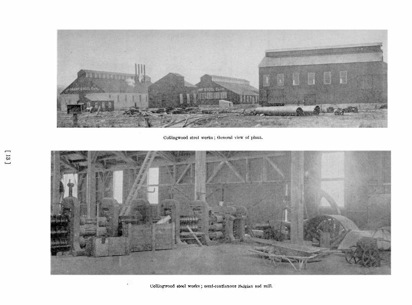
Collingwood steel works ; semi-continuous Belgian rod mill.

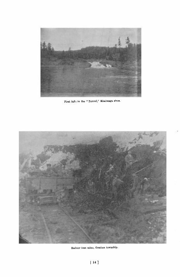
First, fall* in the "Tunnel," Mississaga river.

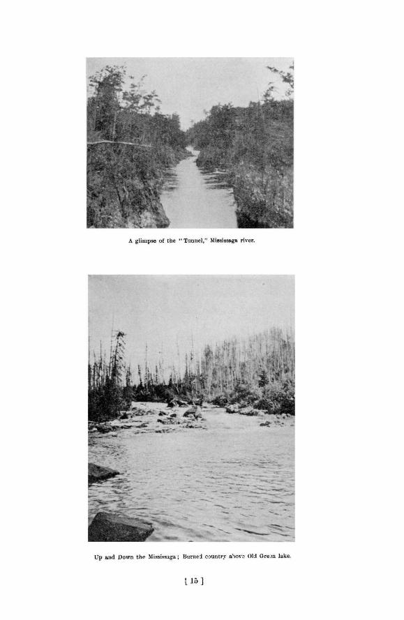

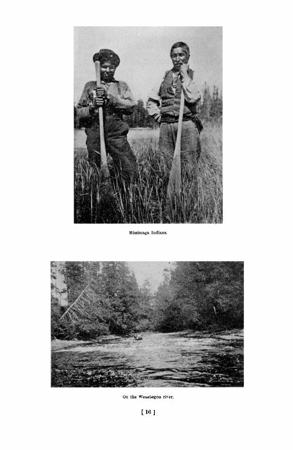
On the Wenebegon river.
[ 1 6 J

1902 Up and Down the Hississaga 161
A prominent hill three miles north of the 63rd mile post was rather interesting geologic Ay. I t held a great mass of gray fine-grained granite, probably intrusive, about which were found bands and layers of gneiss, quite different from the ordinary foliated granite usually met with in this region ; the whole cut by almost innumerable large and small veins of pegmatite. Acid, basic and intermediate bands of the gneiss alternated with each other.
South of the 66th mile, Rapid river was again seen where the driftwood had been cut to allow passage of canoes. At 66£ miles the line entered a brule now growing up to jack pine, •which continued westward to the Mississaga. Gravel river was crossed near the 67th mile.
ON THE MERIDIAN LINE.
At the 66th mile post, or 30 miles from the season's starting point, the party was divided into two bodies ; one, under Mr. Rundle of the School of Practical Science, was to continue west to the Mississaga, while the main body under Mr. Niven turned north on the meridian. It was decided that I should accompany the latter.
A little 3outh of the 3rd mile post, the north line crosses a narrow lake of clear green •water, with sandy bottom, and fed by several large springs which emerge from the base of the hill at the south. This we called Clearwater lake ; it empties itself easterly by a small stream into the much larger Beaver lake, which is almost completely shut in by rocky hills, and which -drains north into the Mississaga. On the north side of Clearwater lake rises a steep hill, 500 feet high, from which an excellent, view can be had -of the country to the east and south. Near its top is a small quartz vein, which, however, appeared barren. From here to the river, occasional patches of good white pine occur.
THE MISSISSAGA RIVER.
The line crosses the Mississaga at 5 miles, about a quarter mile below the mouth of the Wenebegon. Here the river is three chains wide, the water dark in color, and the current sluggish ; the banks are low and muddy, covered with cedar, black ash and elm, and black alder bushes, and completely honeycombed by musk-rat holes. Just to the west, the river turns north and for two miles keeps close to the line, touching it at three places. For this •distance, the line passes through a very good tract of pine.
AUBREY OR AKIKENDA FALLS.
At 7 miles the meridian crosses to the west side of the river, just above a very bad rapid -through a gorge in the Laurentian gneiss. About a quarter of a mile farther on, the line -comes within a stone's throw of the river again ; and just at this point the rapid gives way to fall of 60 feet at one leap, called Aubrey falls, to which the Indians have given the name Akikenda, meaning perhaps, " Kettle Falls."
Just above the rapid is the beginning of a depression which represents either an old channel of the river, or more probably a second channel in time of high water. It passes through a small lake, and by a deep cleft, reaches the river below the fall. The descent in this is much more gradual than in the river, and it seems probable that with a comparatively small expenditure it could be made to float timber safely.
The country on this side of the river has been burned ; and a half-mile portage leads over the bare rock to the river below the fall, cutting off a considerable bend. The line crosses finally to the north side of the river between the fall and the foot of this portage at about 7£ miles.
Just opposite the fall, on the west side of the river, there is a quartz vein about six inches wide which in places carries small lenses of specular hematite, and a claim for 320 acres, including it, has been staked. The name of the claimant, written on the blaze of a dead tree, is now illegible. Some rods farther north, on a quartz vein about three feet wide which can be traced southeasterly for nearly a quarter mile, but in which no minerals of value were found, a
11 M
162 Bureau of /lines Report No. 5
claim for 320 acres has been staked by one Jas. Halleck. About a half mile below the falls, on the west side of the river, a nearly horizontal quartz vein about a foot wide carries small amounts of copper pyrites. Three hundred and twenty acres are claimed here by William Black and others, of Sudbury. There appears to be little of promise—unless it be the prospect of future water power—in any of these locations.
CANOEING D O W N S T R E A M .
After carrying the line to the 8-mile post we returned to the river and started down it in canoes. For a couple of miles the river is broad and smooth, flowing in a wide gravel or mud valley, but then narrows up suddenly and runs over rock as a short, steep rapid, for which there is a good portage on the east side, or at low water over a rocky island in the middle of the channel. Within a mile another similar rapid occurs, with portage also on the east bank. Open water then continues for a couple of miles, when a rapid is encountered which extends probably one and a half miles over a bed of boulders There is no good portage around this rapid. At high water it can be run without danger, and during the dry season also, if care is taken. On the upstream journey we waded and drew our canoes up after us.
Perhaps three miles from the foot of this rapid the Aubinadong or Obabica river enters from the north. Here burned rocky hills begin to rise on both sides, the brule on the east being continuous with that beginning near the 66th mile of the base line. Three miles below the Aubinadong an Indian cache and winter camp stands at the head of a series of portages and lakes which finally reaches the river again ten or twelve miles below. Two miles farther we came to a bad rapid with a 25-chain portage on the east side, and a quarter mile below this, just south of a seven-hundred foot hill on the west, we came in with that portion of the company which had been continuing the base line from the corner at the 66th mile post. The river crosses this line at the 74th mile.
Leaving the main party, which was-to continue the base line, I started down the rivtr with George Friday. Our map of the river, which had been made some time before, having proved unreliable in several cases farther up, I thought it advisable to make a plan which should extend to the township of Otter, beyond which the.river has been surveyed. Since I was able to verify on the return journey the bearings and distances which I had recorded, I think my plotting may be taken as fairly accurate.
C H A R A C T E R I S T I C S jOF T H E R I V E R .
At that season, the middle of August, the water was very low, but evidence of much higher level was to be had in stranded drift wood on the banks, and scars on the trees immediately bordering the stream, inflicted by the rushing ice at flood time, could be seen fully seven feet above the existing water mark. Just at the line the character of the river changes from its general nature to the north. The valley alternates frequently-from comparatively narrow, with steep rocky sides rising several hundred feet, to wide stretches through sand or gravel plains, but never are the hills far distant. The water becomes shallow, and the current very strong, while rapids occur at short intervals. An extract from my note book will serve as an illustration :
15 chains (below line) Shallow rapid. 45 " Rapid. 50 " Small rapid. 65 " Strong rapid. 1 mile Rapid. 1 mile, 20 chains Strong rapid.
All the intervening water is swift.
1902 Up and Down the flississaga 163
With very few exceptions the rapids were run, but when returning up stream it was necessary to portage part of our load in several instances, and even then many were too strong for us to pole up, and we were obliged to wade, drawing the canoe after u s 1 . At several places where the river widened out, the water became so shallow that the canoe would barely pass, even after careful selection of the deepest part. In many of these places low gravel islands occur, showing that the river was so embarrassed by sediment where the water became shallow that deposition was necessary. Also, nearly every side stream of any size brings such a load of gravel that the main stream is unable to carry it away, and one or more islands are formed just below the mouth of the tributary.
About 3£ miles below the line, Gravel river, a shallow, rapid streim, which will not carry a canoe, enters from the east. A mile below, on the same side, is the mouth of Rapid river, a similar stream. It is said that iron claims nave been staked some four miles up this stream, but time was not available to find them out.
PANNING GRAVEL FOR GOLD. A mile farther down, on the west side, is the beginning of a gravel plain, several hundred
acres in extent. It is shut in, except toward the river, by comparatively low rocky hills, at d probably represents a tilled lake ; it is about ten feet above the water level (20th August) and for the most part is cov'yed with blue-berry and other low bushes, though near the river at the southern part, there n> a fine grove of medium-sized red pine. Just below this, and bounding the plain on the south, a creek from a chain of lakes to the northwest empties into the river.
This plain had been reported to hold gold in placer form, and I therefore examined it carefully. In all seven lots were taken from different points along the river, and also in from the shore ; these were panned, but no trace of gold was obtained. The rocky hill bounding the plain on the northwest was examined for a short distance at its base, but no indications of veins nor anything especially worthy of note was seen.
Just below this plain, there begins on the east side, a cliff four to five hundred feet high, which the river follows for one mile and a half. As usual, it is composed of the typical granitic gneiss, cut by dikes and masses of diabase. A mile or more below where this ridge bends away from the river, a number of rock hills, on the west side, with steep flanks and rounded tops, are partially covered with good pine. Then the river narrows in between low walls of a fine grained red syenite, and passes into a broad pool below ; in the spring, the streim passes over these walls, forming a four-foot fall.
FIRST HURONIAN EXPOSURE.
We camped over Sunday just about where the northern boundary of township 188 must be, but although Friday and I searched carefully for the line several times, we were unable to locate it. Four miles below, or about two miles above where the river crosses the eastern boundary of the township of Otter, there is an outcrop on the eastern side, of greenish-gray slate conglomerate holding many pebbles and boulders of gneiss, and with it is intercalated almost horizontally, a band of red quartzite about two feet thick Several hundred feet of this conglomerate are exposed, and its peculiar character is immediately and strikingly apparent to one going along the river. This was the most northern bit of Huronian rock which I encountered in situ, though I did find a pebble of the same conglomerate a little above the northern boundary of township 188. It is to be not. d that in the immediate vicinity of this exposure there are no elevations of importance ; and nowhere was Huronian rock found comprising, either entirely or partially, hills of any considerable size. The probable significance of these facts will be considered under another section.
1 Of. A. Murray, Geo]. Sur. Can., 1858, p r . 72 73.
164 Bureau of nines Report No. 5
The old survey line fixing the eastern boundary of Otter township crosses the river near a number of islands ; some of the concession lines of the township can also be seen from the river. From this boundary, the river flows for about a mile between two rocky ridges 200 to 400 feet high. Emerging from this narrow valley, no rock is seen for a mile and a half, then a rounded knob of gneiss, pierced by diabase intrusions, projects into the river and causes a short rapid of about two feet fall, which can be run going down, but is too swift to come up ; a portage of two chains can be made over the rock on the west side. Some two miles below this, a gravel plain on the west side, into which the river had cut, was tried for gold by panning, but no " colors " were obtained.
MINING AND GARDENING AT SQUAW CHUTE.
A mile beyond we came to a rapid and fall in Haughton township, known as Squaw chute. The river splits around a rocky island 200 yards long and 30 yards wide, running smoothly on the left or north side 111 at the end of the island it takes a fall of 15 feet. The " south channel " is a gorge 25 feet wide through which a smaller amount of water tumbles as a rapid ; it probably owes its origin and has been largely formed by the decay of a vertical basic dike, remains of which can be seen protruding from the bottom at intervals throughout almost the entire length. The portage was formerly on the southwestern bank, and though good, was rather long, but this year Mr. M. T. Ripley built a foot bridge across the Bouth channel, so now one can cross the island and portage in only about 5 chains.
At the foot of the old portage, Mr. Ripley, a veteran prospector, has a cabin and a garden on a copper claim which he has taken up. The soil is sandy, but contains enough clay and silt to make it loamy. Since the land was cleared only the season before, the garden is an unexpectedly good one, and grows good c r o p 3 of potatoes, corn, beans, cabbage, turnips, squash, etc. Mr. Ripley is now the only settler in the township, all other attempts at agriculture having been abandoned some two or more years ago. Wagon roads lead to Thessalon and Sault Ste. Marie.
Some prospecting work has been done by Mr. Ripley and his man in two places. Near the middle of the old portage he has put down a small shaft about 16 feet deep, in a quartz vein carrying chalcopyrite. At the upper end of the island also he has been opening up a similar vein 2 . The greater part of the island is full of quartz stringers, and seems to be all vein matter, but in no place does the percentage of copper appear to be high. The surrounding rocks are syenite, quartzite, and the breccia conglomerate, the latter well exposed just below the falls.
SLATE RAPIDS AND GRANDE PORTAGE FALLS.
Not far below Squaw chute, part of the river circles round an island which must be nearly a mile long. On the west bank below the island is an extensive gravel plain; I found no traces of gold on panning its materials. Two miles farther down we came to a bad rapid, near the head of which an outcrop of compact green slate, almost horizontally bedded, occurs on the east side' Another outcrop of this slate, overlying pink quartzite, occurs two miles below ; and a half-mile farther begins a long series of falls and rapids.
Here the river passes over two falls near together and enters a gorge, 50 to 80 feet deep, and 25 to 30 feet wide, and about two miles long, known locally as the " Tunnel." In it falls are frequent, separated by stretches of usually turbulent water, but in some places the walls spread out sufficiently for the stream to run smoothly, though always very swiftly. It may be
2 Cf. A. Murray, Geol. Sur. Can., 18S8, p. 226.
1902 Up and Down the Hississaga 165
that the formation of this gorge is one of the effects of the crustal movement which took place in raising the Mississaga anticlinal, which Logan 3 and Murray 4 mention as following the river for several miles farther down. This gorge has always been a source of trouble to the lumber men, for the best pine has been cut as much as 15 miles above it. It is passed by a 3 mile portage on the southwest side, known as the Grande Portage, usually made by teams which can be had in the settlement of Wharnecliffe, two miles distant. 1 his settlement is in the northern part of the township of Wells, some 15 miles northeast of Thessalon. It represents the present northern limits of civilization in the Mississaga country, but its population appears thrifty and prosperous.
COPPER PROSPECTS AT GRANDE PORTAGE.
Numerous mineral claims have been taken out in this vicinity, some for gold, but chiefly for copper. I saw several samples which contained large lumps of chalcopyrite, and one vein a mile south of the tunnel appeared quite promising. A sample which I took from here, and another from a vein a mile distant carried only slight amounts of gold. Glacial scratches near the first of these veins point SS 12° W. Near the head of the tunnel, on the southwest side, is located the Ohenev or Grande Portage mine, described by Dr. Coleman in 1899. 5 It is idle at present, though some manipulation of the stock rather than poor values was said to be the cause of the suspension of activity. The slate conglomerate is beautifully exposed near the shaft, while red quartzite and masses of diabase are seen not far distant. Lumps of specular hematite, some weighing probably 50 pounds, were found on the rock dump. Access to the underground workings could not be had.
UP THE AUBINADONG.
We did not go farther down the river, but started on the return journey up stream. This we found quite a different matter, and what we had done rather easily in a day and a half coming down, took us five hard days to accomplish going back. Reaching the base-line on the afternoon of 25th August, we camped that night at the mouth of the Aubinadong, and started up that river the following day.
At its mouth the river is deep, and though the current is rather strong, it gives promise of a good stream for canoeing. It soon shallows out, however, and after winding back and forth between sandy and gravelly banks for half a mile, comes within a stone's throw of the Mississaga only a short distance below its mouth. Here the rapids begin, and even where there are no real rapids, the current is so strong and the water so shallow at that season that progress can be made only with difficulty. One and a half miles from the mouth is a small rapid over granite and syenite, and a quarter of a mile from the shore is a 200-foot hill ; this was th° only rock exposure which I saw. The water was very clear, however, and the pebbles bright and clean ; among them I found only acid Laurentian rock with now and then a pebble of diabase. After having gone about four miles up the river and having seen nothing of interest, not even pine, I decided not to struggle with the swift shallow water any longer, so turned and went back. Mr. D. F. Macdonald, timber estimator, who followed our party, later made his way for a considerable distance up this river. He reported one more exposure of rock—granite, and practically no pine ; finally the river split into two branches, neither of which was navigable, so he returned.
WEST ON THE BASE LINE.
Reaching the base line again, we left our canoe and started west with the hope of reaching the survey party before they should start back from its end. At the 76th mile we crossed
' Geology of Canada, 1863, p, 62. 4 Loc. cit., p. 77. 6 8th Rep. Bur. Mines, p. 148.
166 Bureau of nines Report No. 5
the line of portages which heads from the Mississaga three miles above. Near the 80th mile we crossed a branch of the Garden river, and after an easy mile walk over a sandy plain covered with jack-pine came to the main stream, here about a chain wide, but so shallow as to barely carry laden canoes. At about the 82nd mile post the line passed into a grove of fine maple, whose tinting foliage was a welcome relief from the monotonous colorings before met with. Up to the 85th mile Laurentian exposures had been frequent, but from that point to the end of the line the covering of drift became so thick that no more rock was seen. The 90th mile post, the last of the line, was planted and connected with the northeast corner of Curtis township, a mile to the south. Exhaustion of provisions then sent us all hurriedly back to the river where we had a store of provisions.
MERIDIAN NORTH OF THE MISSISSAGA.
While Mr. Niven was finishing the last eight miles of the base line a portion of the party which he had sent up the river had begun at the 8th mile post on the north meridian line, and was continuing the line. A narrow strip along the river has been burned, but north of this good pine begins and continues as far as I went. Fine groves of maple are not infrequent on the higher parts. The country is rough and hilly, and as usual composed entirely of Laurentian rocks. When we overtook the advance party they had reached almost to the 15th mile post. Owing in part to the good quality of the pine Mr. Niven decided to make this meridian line 24, instead of 18 miles long. Since I could not follow all the lines so determined upon in the time at my disposal, it was decided that I could cover more ground by keeping to the waterways.
Accordingly on 5th September I bade good-bye to Mr. Niven and his party, and started back over the line with William McLean as general utility man. Reaching the river we proceeded up stream to the mouth of the Wenebegon, where we joined Messrs. Macdonald and Robinson, timber estimators. They were also just about to go up this river, so we all journeyed together for part of the distance.
ASCENDING THE WENEBEGON.
The Wenebegon enters the Mississaga from the north, just below a bad rapid in the latter, as a stream about one chain wide, of clear water and moderate current. The banks are low and muddy, covered with ash and elm. The bottom is generally sandy, but in some places shows pebbles and occasionally boulders, all of Laurentian material. Rock was found exposed in only a few places along the river, though rocky hills near-by were frequent and always of granite or gneiss.
About four miles north of the mouth a jam of floodwood necessitates a short portage on the east bank. Three miles farther up Mr. Robinson and his man left us to take an old portage eastward into* Seven Mile lake.
Above here the river becomes very crooked, narrower and swifter, and small rapids are fre. quent; rock outcrops and rocky hills are not seen. Some fourteen miles from the mouth a bad shallow rapid begins. On both sides are banks of sand and clay, beyond which are larg-burned plains. There is a long portage on the east side, but it was in such poor condition that it was easier to pole or draw the canoes up stream than to carry. At points where the rapid is very bad, however, the use of short portages, which have been more frequently travelled, was found advantageous. This rapid continues almost without break for over three miles. Then the current becomes calm again, and no more rapids were encountered so far as I saw the river.
1902 Up and Down the flississaga 167
From the head of the rapid the river, which has been bearing a trifle to the east, now turns considerably more in that direction. A couple of miles above, on a sandy point between the river and a large lake on the northwest side, an attempt has been made by an Indian to make a garden. The place has been abandoned, however, probably because the soil was too sandy. Burned country soon begins again, exposing rounded rocky hills. Three miles above this another log jam necessitates a portage on the southeast side.
SEVEN MILE LAKE.
Two miles farther on I left Mr. Macdonald and started south over a well travelled portage which leads first for 50 chains over a rocky hill, from whose summit a good view of the surrounding country can be had, and it is desolate in the extreme ; all is burned and rocky except a range of hills some miles to the north, where green bush can be seen. The portage extends to a small lake, at whose southern end a short portage took us into the north end of Seven Mile lake. This is a narrow lake, -broadening out at the south, set in a trough of granite and pegmatite, and really is about seven miles long. Small patches of green pine occur at intervals along the shore, and should make very good timber. A mile from the foot, a sandy point a few acres in extent projects into the lake from the base of the hills on the eastern side. On this was an Indian winter camp, and a garden growing good potatoes, although corn turnips and squashes seemed rather late. The soil is quite loamy.
ROUND AND PENINSULA LAKES.
Here we came in again with Mr. Robinson, who reported good pine on the lakes between this and the Wenebegon. We continued southward together over two portages and through a small lake into Kawaweagoma or Round Lake, a large body of irregular shape, mainly surrounded by green wooded hills. An Indian family camped on the shore of a bay on the eastern side informed us that the route into and through Gull lake and the chain to the northeast is very bad, being made up largely of shallow creeks with rapids and long portages, and as they
«aid that all the country in that direction is burned we decided not to attempt the trip. Leaving Round lake by a small shallow creek flowing south we came in about a mile and a
half to a bay in the northeast of Minissinaqua or Peninsula lake, a beautiful sheet of water some six miles long, one of the largest lakes through which the Mississaga flows. It is set within rocky hills wooded with spruce, birch and balsam, and a little pine on the northeast side. Glacial striae on the south shore, opposite the island point S 12° W. We were told by an Indian that long ago there had been a post of the Hudson's Bay Company on the northern shore of this lake ; that before the memory of his father it had been removed to Old Green lake, some eight miles up the river. This second post was abandoned seveial years ago to establish the one at New or Upper Green lake, which is now also abandoned.
OLD GREEN LAKE.
From here we made our course as direct as possible to Biscotasing. Between Minissinaqua and Old Green lakes the river flows through a rocky valley which is so broad that the stream is lake-like. Two short rapids with good portages are met. Just before reaching Old Green lake we entered a flat, marshy tract, which in time of high water is flooded, and doubtless becomes part of the lake. Old Green lake probably owes Wttle of its physiographic history to the river, for the outlet is very close to the inlet, and it appears as if a bend in the river simply happened to tap the lake. It is a good-sized and pretty body of water, and at its northeastern •corner, commanding a view of its entire extent, stand the dilapidated buildings of the old trading post. The northern shore is rocky and burned, presumably by the same fire which swept the country about Seven Mile lake and to the eastward.
168 Bureau of flines Report No. 5
Coming into the river again we found it to flow for a long distance through a broad, drift-filled valley. Occasionally a mass of rock protrudes, causing an increase in the velocity of the current. Some twelve miles east of Old Green lake a large island, probably a mile and a half long by half a mile wide, divides the river about equally, but the northern channel is shorter and said to be more free from logs. At the upper end of this island is another very small one, against which a jam of logs has formed. A narrow channel has been cut close to the northern shore through which, with care, a canoe can be taken.
THE RIVER EPINETTE.
The Epinette, where it joins the Mississaga, is a black, sluggish stream about 20 feet, wide. We were told by Indians that all the country through which it flows has been burned, with the exception of a narrow fringe along the river's edge, wooded with spruce, from which the stream takes its name. The two rivers come together from almost opposite directions, for the Mississaga here makes a sharp turn from a north to a westerly course. This northward stretch is the lower half of a deep U-shaped loop which the river makes to the south. This part of the river flows in a trough in the rocks two or three hundred yards wide, partly filled with deposited sediment to form a level tract, which gives evidence of being entirely flooded in time of high water. Through this plain the river, which is only 20 to 30 feet wide and 6 to 8 feet deep, and carries practically no sediment load, switches back and forth in abrupt meanders which reach nearly from side to side of the valley. The peculiarity, however, is that the cure rent is particularly strong, making up-stream progress laborious. In the natural development of a river one expects a sluggish current accompanying a meandering stream, and I am unable to account for this exception to the lule.
At the southern extremity of the U a stream from the south comes in ;.it is on the line of portages from Otter lake. The lower half of the eastern arm of the bend is also through a mud flat, but the course is straighter and the current more moderate. All the surrounding country has been burned. The river on the northern part of this arm of the bend and beyond it is again on a rocky bed, and rapids and portages, separated by long lake-like expanses are encountered for the next three miles. Then we entered a long narrow lake which we called Deer lake, running southeast for about 3£ miles, and shut in by rocky ridges on which the forest growth is young. At the south end it broadens out into a round lake, which in turn sends a narrow arm northeastward across Niven's first meridian at 10J miles
BACK TO BISCOTASING.
Two miles above this linefwe came to a small potato garden which Indians have made in the very sandy soil. It lies at one end of a short portage leading north to a small lake ; from this a 25-chain portage reaches an arm of the main water route. By taking advantage of this course we cut off a long bend of the river. Once on the main channel, we paddled directly to Upper Green lake, where we took leave of Mr. Robinson, and on 21st September reached Biscotasing.
Regarding the country covered by the survey party after I left it, I quote from a letter which I received from Mr. Niven after he had returned :
" From the 6-mile point on the thirty-mile east line, I ran six miles south, crossing the Wenebegon river twice, and the portage from the river to Seven Mile lake at five miles and about 15 chains from the river.
"Al l the country east from Seven Mile lake being burned, I decided to continue the 24-mile line east, so ran on to the 18-mile poiut on east line and then ran south three miles ; at two miles I again got into the brule . . . . I then returned to my base line and continued east to meridian line of last winter
" I saw no minerals, and nothing but Laurentian formation."
1902 Up and Down the flississaga 169
GEOLOGY AND PETROGRAPHY.
The geology of the region in the vicinity of the survey lines run thiB summer was very little known, and practically nothing had been published concerning it. In 1857 and 1858 Mr. Alexander Murray ascended the Mississaga for some distance, and the results of his trips are recorded in the Reports of Progress of the Canadian Geological Survey of those years, and are also summarized in the Geology of Canada, 1863. In 1898 Dr. A. P. Coleman, acting for the Bureau of Mines, reached the Cheney mine on the Mississaga, and his report is contained in the Bureau's eighth annual volume.
AN ALMOST ENTIRELY LAURENTIAN REGION.
As previously stated, the country included by and surrounding the various lines run by Mr. Niven this year is underlain, with one possible exception, by rocks of the Laurentian system. The predominant variety has the composition of a granite, and varies in texture from massive granitic—sometimes porphyritic, with-large phenocrysts of orthoclase—to decidedly foliated gneisses. In these rocks the dark constituents are not abundant, so their characteristic color is pinkish, due to the red orthoclase or microcline, and they weather almost white.
At one poiflt, however, namely, the hill already mentioned 3 miles north of the 63rd mile post, banded gneisses suggestive of extremely altered sediments were found, closely related with a fine-grained, gray granite. There were three types of bands composing this gneiss, light-colored acid, dark green hornblendiq and grayish green, exceedingly schistose : this last kind was seen only in a large talus at the foot of the hill, and nol in place, but the other two were well shown, alternating, and very sharply defined. Through this body of gneiss pierctu the gray plagioclase granite. The intimate relation of these two, and the fact that neither was found alone elsewhere seemed to me to strengthen the idea that the remnants of old metamorphosed sedimentary rocks are here represented. A microscopic examination of the gray granite shows it to contain considerable quartz, a very little microcline, a large amount of fairly fresh plagioclase which from its extinction angle is seen to be oligoclase with some rather more basic feldspar, considerable green hornblende with a little biotite, both changing slightly to chlorite, and a few grains of titanic iron surrounded by their colorless border of leucoxene. One of the more acid bands of the gneiss shows under the microscope numerous grains of quartz, a large amount of turbid feldspar mostly untwinned, but a little with polysynthetic twinning, probably albite, and a small amount of hornblende. A specimen of one of the hornblendic bands can be seen with the aid of the microscope to be composed chiefly of green hornblende, while grains of turbid twinned and untwinned feldspar are not infrequent, a little brown biotite, a few few irregular grams of brownish sphene, a very little limonite and magnetite, and several small crystals of apatite and of zircon are also present. The probable third type of band is an acti . nolite schist, being composed largely of light green fibrous hornblende ; feldspar, if ever present, has been altered entirely to a fine scaly mineral with high interference colors—mus-covite, or more probably talc ; grains of titaniferous iron ore with leucoxene are numerous.
Not infrequently the granitic gneiss passes over—probably gradually—to a syenitic gneiss, usually fine-grained. This change seems to be more common in the southern part of the territory covered than farther north. A specimen from a rapid of the Mississaga a couple of miles above the northern boundary of township 188, which appeared when viewed megascopically to be typical of this phase of the gneiss, was found under the microscope to still contain numerous grains of quartz ; cloudy untwinned orthoclase is abundant, and chlorite seen to be derived from biotite is present, with pyrite in small amount.
170 Bureau of /lines Report No. 5
INTRUSIVE DIKES AND VEINS.
All these Laurentian rocks are cut very generally by intrusions of two classes. One of these consists of dikes or veins of coarse-grained pegmatite or of finer-grained material of apparently similar composition—almost wholly quartz and red orthoclase and microcline. They never hold more than very small crystals of mica, and have only minute grains of magnetite and pyrite scattered through them. The second class of intrusions, most commonly in the form of dikes, consists of rather fine-grained, grayish green, rusty weathering diabase ; such rock is found very frequently, often in masses of considerable size. Three specimens, from a mass at 34 miles 70 chaims. from the foot-wall of the quartz vein at 48£ miles, and from a large intrusion 2£ miles south of 66 miles, respectively, are very similar in outward appearance, and the microscope confirms this similarity. All are considerably altered by the weather. The first contains plagioclase which is so turbid that twinning cannot be seen, a good amount of very light brown augite, considerable green uralitic hornblende, probably secondary from the pyroxene, and largely altered in its turn to chlorite, many irregular grains of titanic iron ore with a narrow border of leucoxene, a little pyrite, and a few small grains of epidote. The third specimen is very similar ; a little of the feldspar shows twinning according to the albite law, hornblende is absent, but light yellowish brown augite is in some cases greenish due to incipient alteration. Chlorite and pyrite are less abundant, and no epidote or iron ore is seen.
The second specimen differs to some extent from these ; pinkish individuals can be seen in the hand specimen, and in the thin section, although the feldspar is badly altered, there seems co be a little orthoclose ; the augite has changed mainly to uralite and a little chlorite, while grains of ilmenite are numerous.
A GRANO-DIORITIC MASS.
The large intrusive mass which crosses the line between the 51st and 52nd miles, gave an appearance in the field which was immediately suggestive of the typical Huronian greenstone or diorite of Logan, and when I had ascertained its elongated form, I questioned whether it were not an outlying remnant of a long narrow trough of Huronian rock, trending northeastward, similar to that on which Sudbury stands. It is a greenish rock, of medium grain, the lighter colored constituents being partly pale green and partly pinkish. Microscopically, it is fount to contain a very little plagioclase, and abundant very turbid untwinned feldspar, the alteration product of much of which appears to be muscovite, pointing, together with the pink color, to the original presence of considerable orthoclase ; fair amounts of brownish green hornblende, and of apparently secondary brown biotite, a very little augite and chlorite. A few grains of quartz, and numerous patches of magnetite make up the remainder of the rock.
For comparison, I took a specimen, from a mass just below the Cheney mine, of the greenstone which Murray mentioned. 1 5 It is a rock similar in appearance to the preceding, somewhat finer in grain, and containing less of the pink constituent and hence having a more basic look. When examined with the microscope, most of the rather abundant feldspar is found to be too cloudy for identification, but a few lath-shaped individuals point to the presence of plagioclose, while a micropegmatitic intergrowth 7 with a part of the small amount of quartz present indicates orthoclase ; also green hornblende, changing to chlorite is present in considerable amount, as well as numerous grains of titanic iron and of pyrite, mostly embedded in the hornblende.
It therefore appears probable that the magmas of these two rocks were quite similar. But since Dr. Coleman finds that intrusions like this latter one have come up at a later date than
6- Geo. Sur. Can. 1858, p. 99. Cf. A. P. Coleman, Rep. Bur. Mines, vol. VIII,, 1899, p. 169.
1902 Up and Down the Hississaga 171
the laying down of Huronian sediments, 8 correlation of any rock with such an intrusion gives no definite idea of its age. This grano-diorite at the 51st mile is the rock which has been cited as the one possible exception to the universal distribution of the Laurentian in the area' traversed by the survey this season ; but the foregoing facts, together with its rather close resemblance to some of the smaller and very common intrusive masses, for example that occurring at 48J miles, make it probable that it is simply an unusually large mass of such intrusive, and has no relation to anything Huronian.
A pink, finely grained granitic dyke lying in this same basic mass is found to be composed of quartz, abundant feldspar, with ratio of plagioclase to that untwinned about 1:3, and biotite altering to chlorite ; the whole rock is dusted full of ferrite.
HURONIAN ROCKS IN THE AREA.
The green Huronian slate as seen exposed between Squaw chute and the Tunnel consists of a very fine-grained, green, probably chloritic material, enclosing numerous particles of magnetite.
The slate conglomerate, of which I took a specimen from the most northern exposure seen on the river, 9 has been very well described megascopically by Logan. 1 0 The finer-grained parts, when examined microscopically are seen to consist of quartz fragments, and feldspar, mainly orthoclase, with some microcline and numerous grains of hematite, all embedded in a fine-grained greenish matrix, doubtless chloritic. A piece of the wall rock of the Cheney or Grande Portage mine is found to be the finer parts of this same slate conglomerate, in which can be seen very small fragments of diabase as well as particles of quartz and iron ore, the whole traversed by many minute quartz veins.
A specimen of what I called in the field a red quartzite, taken from a narrow, sharply-defined band intercalated almost horizontally with slate conglomerate two miles above Otter township on the Mississaga, is reddish in color, evenly fine-grained, and not very compact; fragments of feldspar can, however, be detected.
Under the microscope it is found to consist of roughly equi-dimensional and equal-sized sub-angular grains of quartz and cloudy untwinned feldspar in about equal proportion, a very little plagioclase, and a few grains of magnetite and pyrite. The large amount of feldspar, and the peculiar relation of this band to the surrounding rock admit the possibility of its being a dike. But the texture of the rock as seen under the microscope, its great similarity of appearance to what is undoubtedly the red quartzite of Logan exposed farther down the river, and the fact that the typical red quartzite is really feldspathic and rather an arkose, 1 1
make it practically certain that'this rock also is the ordinary red Huronian quartzite. While the exposures of Huronian rocks on the part of the river which I visited make it
certain that the system has a more or less extended development in that region, I found in every case that came to my notice that the higher hills were composed of granite, syenite, or gneiss identical with that which makes up the Laurentian. This, it seems to me, points strongly to a duplication of what Lawson found in the Lake of the Woods 1 2 and Rainy Lake 1 3
regions, where either the Laurentian had penetrated the Huronian in places, or else strata of the latter had sagged down away from bosses of the former, giving the effect of Laurentian islands in a Huronian sea.
For the identification of some of the minerals I have to thank Dr. A. C. Gill, Professor of Mineralogy and Petrography in Cornell University.
8- Loc. cit., p. 169. » GeoloRy of Canada, 1863, p. 62. , 0 Ibid., p. 56. 1 1 A. P. Coleman, Ioc. cit., p. 159.
1 5 Geol. Sur., Can., An. Rep't, 1885, Vol I. Pare CC. l a Ibid, 1888, Vol. III., Part F.
172 Bureau of flines Report No. 5
THE REGION SUMMED UT-.
.The country is a part of the old dissected Archaean plateau, underlain for the most part by rocks of the Laurentian system, but toward the south the Huronian comes in.
In the Laurentian, a very few quartz veins are found, but they appear to be either barren or very poor in content of economic minerals. In the Huronian, however, veins are more numerous, and frequently carry considerable amounts of copper, and at times possibly gold. No deposits of iron were seen, nor could anything of value be found in the way of placer gold.
Perhaps a quarter of the whole country has recently been burned ; and where the rock is not too bare, Banksian or jack pine is springing up. In the wooded parts, spruce, balsam, and white birch are found abundantly, also considerable poplar ; cedar, tamarac, and sometimes ash and elm are found in the low places, while maple occurs on some of the higher ground. Some very good areas of pine were encountered, notably along the 2nd meridian line. Black alder bushes often skirt the swamps, and great spongy masses of sphagnum are rapidly encroaching on many of the lakes.
Red deer are common along the Mississaga, but caribou and moose are scarce. Several bear were seen near that river in the vicinity of the Wenebegon. A colony of beaver lives on White river near the base line, while fresh traces of them were found near the Epinette. Musk-rats are plentiful wherever stream or lake banks are muddy. Few other fur-bearing animals were seen.
Fish are surprisingly scarce in the lakes ; only rarely can one be caught, usually a trout. In certain parts of the Mississaga pike are plentiful. Partridge and wild duck are often found in large numbers. During the first half of the season, we were greatly troubled by the black flies, gnats, and mosquitoes.
A few families of Indians of the Chippewa tribe live during the colder months of the year along the Wenebegon and Mississaga rivers and the large lakes near them, and generally spend their summers at some of the Hudson's Bay posts. Inland, one comes only occasionally upon traces of their former presence.
The summer season is generally bright and warm, but the winters are long and doubtless severe. Practically none of the drift covering deserves the name of soil, being far too sandy. For these reasons the region has no agricultural possibilities whatever.
1902 Round Lake to Abitibi River 173
ROUND LAKE TO ABITIBI RIVER. BY L. L. BOLTON.
In the summer of 1902 Mr. T. B. Speight, O.L.S. , of Toronto, was sent to the District of Nipissing to subdivide the township of Eby into farm lots, and to run a tie-line north from the northwest angle of that township to the Abitibi river. To this party I was attached as geologist, and besides myself there was also in the party a land and timber estimator, Mr. E. B. Lloyd, of Eversley, Ont., in company with whom I was instructed to work, our task being to acquire all the information possible concerning the country lying in and about Mr. Speight's field of work.
I joined Mr. Speight's party in Toronto on 27th June, and the same day we left for the north by way of North Bay, Mattawa and Lake Temiscaming. After leaving the steamer " Meteor" at New Liskeard, we went on board the Clyde, a small steamboat, which took us and our supplies to Wilson's landing at the " first chute" on the Blanche river. This is in the second lot in the fourth concession of the township of Evanturel. From there we proceeded up the Blanche to the township of Eby, where we were engaged till 4th August. Then rain followed for two days, after which we started north to the Abitibi. The Abitibi was reached on 4th September. The following day we started for home by way of the Abitibi lakes and the usual canoe route south from Abitibi Post over the height of land to lake Temiscaming.
WILSON'S LANDING TO ROUND LAKE.
On the morning of 1st July we proceeded up the Blanche river in canoes. About twelve miles above Wilson's landing we came to the first obstruction to navigation, a rapid caused by a ridge of very fine-grained greenstone, which is exposed close to the water's edge. At the next rapid, 200 yards farther on, there is an exposure of Huronian diorite. At the third portage, 300 yards above the mouth of the east branch of the Blanche, there is a fall of 35 feet (aneroid) oveT coarBe-grained red granite, containing many small stringers of quartz. Between this fall and Round lake there are twelve portages, the last of which furnishes a short route from the river to the southern shore of the lake.
Having crossed this" lake we ascended the Blanche about 200 yards, when we came to the mouth of a small creek entering from the west, up which we canoed about 100 yards. From here we portaged westward to the township of Eby, a distance of three and a half miles. The trail lay mostly through wet swampy land, supporting a thick growth of Banksian pine and spruce. Two or three outcrops of reddish granite were noticed on the way.
ROUND LAKE.
Round lake is a pretty body of clear, deep water. As its name indicates, it is almost round, being about three miles in diameter. It is fed by the Blanche river, which enters from the north about three-quarters of a mile east of the western arm of the lake, and is drained by the same river flowing from its southwestern angle.
Both Laurentian and Huronian rocks are exposed on its shores. On a small point two hundred yards west of the mouth of the Blanche, the rock is diorite, much cut up by small irregular dikes of fine-grained, reddish granite. Along the western shore the rock is all red granite, composed of quartz, feldspar and hornblende, but on a point just northeast of the outlet, there is a breccia made up chiefly of feldspar fragments. Opposite this on the south
174 Bureau of nines Report No. 5
shore we find diorite to be the country rock, and this continues along the south shore to the eastern end of the lake, where it is associated with a breccia similar to that just mentioned. On the north shore there are several small rocky points separated by intervening bays with sandy shores. These show rocks of Laurentian age, namely, granite and syenite, both reddish in color ; the syenite is to be seen on the first point east of the mouth of the Blanche.
THE BLANCHE ABOVE ROUND LAKE.
On ascending the Blanche we find it flowing between clayey, and in places, swampy banks. Rock exposures are not numerous ; what few there are, are of reddish syenite. In several places the stream is blocked with driftwood. About ten miles above Round lake we come to the foot of a series of rapids over Huronian rocks in most places fine-grained and schistose. These are avoided by a portage three-quarters of a mile long leading northward to Lake Kapikokonaka
This lake is about one mile long from north to south, and about half a mile wide. Near the northern end there is an island with high, rocky shores which gives the lake its name. The shores on the east, south, and west of the lake are high and steep ; the only kind of rock seen is grayish greenstone. To the northeast the shore is low and marshy, and here a sluggish stream enters. After ascending this for about a mile and a quarter, we come to a rapid caused by a ridge of greenstone. About two hundred yards farther on there is another rapid passed by a portage of four chains on the west bank. Here is seen the jasper conglomerate, cut by a band of dolomite, which is mentioned by Mr. VV. J. Wilson in the Summary Report of the Geological Survey for 1901, p. 124.
Above this rapid is a sluggish body of water varying in width from ten to one hundred and twenty-five yards, and extending almost due west for four miles. The banks at the east end of this body of water, are low and wet, but to the west they gradually rise in height. The south bank, which is the lower of the two, supports a second growth of spruce, birch, balsam, and alders : the north bank rises more abruptly and is clothed chiefly with Banksian pine and poplar, along with spruce, birch, balsam, and a few ash. To the north low hills are to be seen, on which the prevaijing timber appears to be Banksian pine and poplar. There are a few exposures of greenstone to be seen along the shores. About three and a half miles west of the last rapid mentioned conglomerate carrying small jasper pebbles appears on the side of a hill about seven chains inland from the north bank.
PARTRIDGE-CROP LAKE.
At its western end this body of water narrows to a stream which i#e ascend in a northerly direction for three-quarters of a mile when we come to a small expanse of water known as Bineomodai or Partridge-crop lake. On all sides of this, except to the north, where it is swampy, there are low hills covered with Banksian pine, poplar and spruce.
Leaving this lake we follow the stream westward for fifteen chains, and then northward for twenty-five chains. Here the stream takes an abrupt bend and the direction of our course, as we proceed to Kenogami lake, is about southwest. At several points along the shore there are exposures of diorite carrying pyri'te. One such exposure is seen at the most northern part of the stream ; the shore here rises about twenty feet above the water level, and rough and rocky ground extends southward for thirty chains to a hill about seventy-five feet in height.
In general the land to the south rises rapidly into low hills, which are clothed chiefly with Banksian pine, poplar, spruce and birch. Along the north bank there is a clay belt, averaging twenty-five chains in width, thickly timbered with poplar, spruce and birch, s ime trees attaining a diameter of eight inches. Beyond this there is a rise of ground, the hills in places reaching a height of seventy-five feet. The rock here too is diorite carrying many small disseminated grains of pyrite. North of this ridge the land drops to a lower level for a distance
1902 Round Lake to Abitibi River 175
of two or two and a half miles, when it again rises into a series of low hills stretching northeast and southwest. The depression between these two lines of hills is in places swampy, but is chiefly an area of low rocky ridges and sandy soil, supporting small BankBian pine, poplar and birch.
LAKE KENOGAMI.
Lake Kenogami is an irregularly-shaped body of water. Its length from east to west is about three miles, and from northwest to southeast, including an arm stretching to the northwest, about five miles : its width from north to south varies from half a mile to one mile. In it are a few small islands, only two of them, however, being large en >ugh to deserve mention.
On nearly all sides the shores rise into low hills. To the north and east the timber is all second growth, but to the west and for a short distance inland from the south shore some large spruce and poplar are seen. A few red pine grow on a point on the north side of the lake, and on a ridge about thirty chains west of the lake there are some scattered white pines. The spruce between this ridge and the shore often attain a diameter of sixteen inches.
From Kenogami lake we endeavored to find a canoe route westward to the south branch of the Blanche river. An Indian trail was found leading inland, but this had apparently not been used for some years, for it soon became so indistinct that we were unable to follow it. This having been abandoned, we tried to make use of the northern boundary of the township adjoining Eby on the west, run in 1889 by Mr. Niven, O.L. S. This attempt, too, was unsuccessful, for the line was so thickly overgrown with small brush that one could only with the greatest difficulty make any progress. Accordingly, as our base of supplies lay in this locality for some time, we made a rather detailed examination of the township of Eby and the country to the north of lake Kenogami.
GEOLOGY OF KENOGAMI BASIN.
Around the shores of lake Kenogami several types of rocks are exposed. The following may be mentioned : diorite, diabase, conglomerate, and greywacke. Of these, diorite is the most common ; conglomerate comes next ; and lastly we have diabase and greywacke. On the north side of the lake is a rocky point (forming parts of lots b and 7 in the sixth concession of the township of Eby) composed chiefly of conglomerate. This is made up of angular, sub-angular, and rounded fragments, varying in diameter from an inch to two or two-and-a-half feet They are principally reddish granite, reddish quartzite, diorite, and greenstone. The matrix has a brownish color, thus giving the rock a reddish-brown color when viewed from a distance. In places the rock is very coarse-grained, but it shades into a phase so fine-grained that the component fragments cannot be determined with the naked eye. The latter variety, examined microscopically, is seen to be made up of small fragments of quartz and feldspar, some angular, some rounded, set in a matrix of still finer fragments. Particles of pyrite, biotite, chlorite, and slate occur in smaller amount. Of the feldspars, plagioclase is the most common, orthoclase and microcline occur sparingly, the latter probably as an alteration product, for the wavy extinction of the plagioclase shows that the rock is highly metamorphosed. The rock niay be called a greywacke.
Northward from this point we find fairly level, clayey, and swampy land for twenty chains. At this distance we encounter a ridge of brecciated conglomerate similar to that exposed on the point. In addition to the varieties of component fragments occurring in the previously described conglomerate, we here see fragments of jasper, few in number however. This ridge is low—about forty-five feet in height—and extends east and west. For three miles farther north there is a succession of low ridges, showing exposure of weathered diorite, which usually carries many small disseminated grains of pyrite. These ridges are rarely more than thirty feet in height; between them lie narrow strips and patches of sandy, and occasionally swampy soil. The timber is all second growth.
176 Bureau of flines Report No. 5
JASPER CONGLOMERATE WITH IRON ORE.
At the eastern end of Lake Kenogami we find coarse-grained diorite exposed on a couple of points. About twenty chains inland along the northern boundary of Eby we come across an outcrop of conglomerate, and beyond this similar ridges extend for more than half a mile. This is very much like the conglomerate described before. It carries a few more jasper pebbles; and I also noticed one pebble measuring 2 inches by 3 inches which was composed of inter-banded jasper and magnetite. A peculiar feature was the occurrence of narrow irregular streaks of hematite from one-quarter to one-half inch in thickness, one of which could be traced along *he face of a rock for a distance of twelve feet.
One mile south of here, and a few chains eastward from the southeastern arm of the lake, is a very badly decomposed serpentinous rock containing an abundance of small, distinct crystals of pyrite. The surface of the rock weathers rapidly, forming a reddish, iron-stained, cellular crust from one to two inches in thickness.
On the west side of the southeastern arm of the lake there is an exposure of a very finegrained, grayish rock, resembling trap. It is composed of intergrown plagioclase and hornblende, the former partially altered to saussurite. The hornblende is the older. About three chains southsast from here, at the half-mile post between lots 5 and 6 of the sixth concession, there is a magnetic variation of 90° to the west. The only rock exposed in the vicinity is diorite, but for the most part rock exposures are obscured by a covering of gravelly soil. Fifteen chains to the westward a magnetic variation is again noticed. The behavior of the needle is very erratic over a considerable area. The greatest variation noticed was N 150° E. Scarcely any rock in place could be seen, as it appeared to be everywhere concealed beneath a coating of soil, only one small exposure being found. This rock is very fine-grained and hard, and its color is reddish. A thin section shows the rock to be made up almost wholly of feldspar fragments, plagioclase predominating, and orthoclase being present in small amount. The larger fragments are set in a ground-mass of very small fragments, most of which are plagioclase. Pyrite, quartz and chlorite are also present. That the rock has been severely metamorphosed is shown by the wavy extinction of the feldspar.
Proceeding westward along the southern shore, exposures of pyritous diorite are frequent. On one point projecting to the north the rock is conglomerate. At the west end of the lake there is clay soil, and no rock is exposed. Having followed the west shore for three-quarters of a mile we pass the mouth of a small creek; and from there the direction of our course, as we follow the shore line, is northeast. The shore here is quite rocky, diorite being exposed in must places. On one point there is an area of coarsely crystalline diabase. Having followed this rocky shore for about one mile we come to a narrows, beyond which an arm of the lake stretches to the northwest. Of this arm we shall speak later.
TOWNSHIP OF EBY.
That part of the township of Eby lying eastward of lake Kenogami is composed almost wholly of rocky ridges separated by swampy tracts ; but there are a few small areas of muskeg and gravelly clay soil. The swamp's support a dense growth of bushy spruce and black alders, and occasionally a few cedar. Exposures of weathered diorite are plentiful on the ridges and hills. The slopes of these ridges, and many of their small depressions, are occupied by sandy and gravelly deposits of glacial origin. The highest elevations—amounting to about seventy-five feet—lie in the vicinity of the line between the fifth and sixth concessions. On the higher parts of the river, where soil is scarce, there is only Banksian pine, while on the slopes we find poplar, birch and spruce. On lot 4 of the sixth concession there are a few white pine, and along the eastern boundary there are some large spruce measuring sixteen inches in diameter.
1902 Round Lake to Abitibi River 177
The only indication of economic mineral in this locality was noticed along the line between lots 4 in the fourth and fifth concessions. About twenty chains east of the western boundary of these lots a low ridge of diorite crosses the line. In this there is a small vein of quartz from four to six inches wide, which carries particles of galena ; pyrite and hematite are also present, but in very small amount. Owing to a covering of soil this vein could be traced only for a short distance.
From ten to sixty chains south of lake Kenogami lies a range of low hills (connecting with the ridges to the east near the line between the fifth and sixth concessions) which forms a watershed, turning all the waters falling on its southern side into a small stream which joins the Blanche just below the outlet of Round lake. At various places along this ridge rock exposures are seen, more particularly on lots 5, 6 and 7 of the fifth concession. The rock exposed is, in every case, diorite, usually dark, greenish-black in color, and rather coarsegrained. One occurrence shows particles of calcite, formed no doubt by weathering.
A SWAMPY SECTION.
South of this ridge, and lying in lots 5, 6, 7 and 8 of the fourth and fifth concessions, is a large area of wet swamp supporting only black alders, bushy spruce and willows. This varies in width from one mile to one and a quarter, and its length from northwest to southeast is two miles. Below the water and black muck there is a clay bottom, so that with proper drainage this area might be reclaimed. At the southeastern end, in lot 5 of the fourth concession, it changes gradually into a muskeg, which is drained by a stream about six feet wide and two feet deep, flowing towards the southwest. The stream continues flowing in this direction until it reaches the northern end of lot 6 in the third concession, where it turns and flows south for three-quarters of a mile, after which it proceeds southwest, finally joining a larger stream in lot 7 in the second concession.
In the southern end of lot 6 in the fourth concession we find that the stream has clay banks, which extend back for about half a mile and support a thick growth of spruce from three to eight inches in diameter. This strip of ground is almost perfectly level, and as the impervious clays prevent the water draining away a thick growth of moss is promoted and the ground is everywhere damp.
Along the larger stream which enters Eby from the west, there is a similar strip of clay land extending near to the junction of the two streams. In that vicinity there is a gradual change to muskeg, which occupies the larger part of lots 7 and 8 in the second concession, and lots 5, 6, 7 and 8 in the first concession. This muskeg is everywhere wet, and it supports only small bushy spruce. It is skirted on both east and west by a wet swamp with black muck from two to three feet deep over a clay bottom. In these swamps we find spruce three to six inches in diameter, and dry tamarac.
SANDY PLAINS AND ROCKY RIDGES.
To the eastward of the swamp, in lots 3, 4 and 5 of the second and third concessions, there is an extensive area of white sand which supports nothing but Banksian pine and birch. This timber is mostly small, but a few of the pine attain a diameter of from ten to twelve inches. In the northern part of lots 3 and 4 of the third concession the surface becomes rougher, and many small ridges outcrop, all showing exposures of weathered diorite carrying pyrite. This rocky area extends northeastward, across lots 1, 2, 3 and 4 of the fourth concession, to the township of Otto. The sandy area mentioned above rises towards the east and gives place to a number of slight elevations in lots 2 of the second and third concessions.
This ridge drops abruptly into a swamp which extends eastward beyond the boundary for two or two and a half miles, and southward to within a few chains of the southern boundary of
12 M.
178 Bureau of Mines Report No. 5
Eby. In the swamp spruce prevails, while cedar is present in small amount. On the ridge to the west of it there is a thick growth of small Banksian pine, Bpruce, birch and poplar. A small clump of white pine is seen in the northern half of lot 4 of the third concession.
CONTACT OF LAURENTIAN AND HURONIAN ROCKS.
The rock exposed on the ridges is almost exclusively diorite. One exception was noticed ; along the line between lots 1 and 2 of the second and third concessions there is a fine-grained reddish granite in association with a rock made up almost wholly of fragments of reddish feldspar. Another granitic outcrop is seen in the township of Otto about thirty chains from ttie southeastern corner of Eby. About twelve chains west of this corner is a ridge, which, although made up largely of pyritous diorite. has an exposure of reddish granite on its northeast side. There is evidently a contact between rocks of Laurentian and Huronian age in this vicinity, but it is concealed by a covering of soil.
The creek mentioned some time before leaves the township of Eby at the southern end of lot 5 in the first concession. Westward from this we find muskeg and swamp for two or two and a half miles, supporting small spruce, balsam and alders. Here and there are small patches of clayey and sandy land.
In the southern part of lot 11 of the first concession, a hill rises to a height of one hundred and twenty-five feet (aneroid) above the swamp level. On the north and east this hill has a steep front, but to the south and west it is connected with other hills. The northern part is made up of a coarsely crystalline, reddish, hornblende granite. Elsewhere on the hill the rock exposed is a hornblende schist which cleaves readily. The contact between the two is quite distinct, and the schist has the appearance in places of being baked. The strike of the schist is N 70° E, and through it are scattered small irregular stringers of quartz.
West of this hill, and separated from it by a small depression is a hill composed of hornblende schist, which attains a height of one hundred and seventy-five feet. To the west there is a narrow depression occupied by a lake half a mile long from northwest to southeast, whose waters are held back by a beaver dam across a narrow gorge at its northeastern extremity. Not far west of this dam an almost horizontal dike of granite is seen, cutting through diorite. Northward from the lake are a couple of hills sixty feet in height, composed of a dark diorite, in which are scattered stringers of quartz. North of the second hill lies a low depression filled with a dense growth of small spruce, Banksian pine, birch and alders, which separates it from a hill composed of reddish, hornblende granite. From this granite hill exposures of reddish granite could be seen for four or five miles to the west. The contact between this granite and the Huronian is concealed by a covering of soil.
Granite outcrops continue for about a mile northward, where the ground again reaches swamp level. Outliers of this area of Laurentian rocks are found for a couple of miles to the northeast; these appear as granite ridges rising a few feet above the swamp level, and were noticed in the northern part of lot 11 in the first concession, in lot 10, and in the northern part of lot 9 in the second concession. In the last mentioned place granite and diorite are exposed in proximity.
In lots 8 and 9 of the third and fourth concessions the land emerges from the general low level, and we find rising slopes of gravelly and clayey soil. In several places ridges attain to a height of thirty and forty feet. These, as usual, show exposures of diorite carrying pyrite. On this higher land poplar and balm of gilead are plentiful, and reach a diameter of eight or ten inches. Birch, Banksian pine, and spruce also occur, and a few white pine were noticed in the northern part of lot 9 in the third concession.
1902 Round Lake to Abitibi River 179
CLAY LAND AND MUSKEG.
Tho greater part of lota 10, 11 and 12 of the third concession is composed of flat clay land covered with a coating of moss, and supporting spruce from three to eight inches in diameter. This clay land extends north and embraces part of the corresponding lots in the 4th concession. It is separated by a series of low diorite ridges from a muskeg extending a mile and a half north to the 6th concession, and westward from lot 9 in the 5th concession to the western boundary of the township. This muskeg is a large peat bog varying in depth from three and four feet along the edges to six and seven feet elsewhere. To the north there is a swamp about twenty chains wide in which the chief timber is spruce and cedar. This is separated from lake Kenogami by a narrow strip of rising gravelly soil supporting spruce, poplar, birch and balm of gilead. A few outcrops show the rock in place to be diorite.
MINERAL INDICATIONS IN EBY.
From what has been said it will be seen that rocks of both Laurentian and Huronian age are found in the region to the south of lake Kenogami. The locality of the contact between these rocks ought to be favorable to the occurrence of mineral deposits. In addition, in the areas of Huronian rocks we have several outcrops of conglomerate, containing in places jasper pebbles, which is favorable to the occurrence of iron ores. The extensive magnetic yariation noticed in some places would seem to point to the occurrence of bodies of magnetite.
Owing to the fact that the rock outcrops are as a rule isolated, being separated by intervening areas of clay, sand, swamp or muskeg, little detailed work could be done on them, and their relation to one another could not be carefully worked out. A few quartz veins were noticed cutting dioritic rocks. These were seldom more than eight or ten inches wide. A sample of one of them from the northern end of lot 3 in the 3rd concession was assayed for gold and silver, but was found to contain neither. Speaking of the whole area, however, it is-one which ought to be worth prospecting.
The larger part of the township of Eby is swamp and muskeg, the latter usually having a-clay bottom. None of this is now fit for agricultural purposes as it is too wet. However, if a comprehensive scheme of drainage were employed, many hundreds of acres of good land ought to be available, for the clay usually contains enough sand to make it easily workable.
Of good timber there is a scarcity. This country was burned over about thirty years ago, and as a consequence the timber is all second growth, with the exception of small areas which escaped the fire. Such areas occur along the south and west shores of lake Kenogami, and another is seen in lots 4 and 5 in the third concession where there are a few large white pine, balsam, and spruce. The second growth timber embraces spruce, Banksian pine, poplar, white birch, balm of gilead, balsam, black alder, soft maple, yellow birch, etc. These would be useful only for fire-wood.
NORTHWEST ARM OF LAKE KENOGAMI.
Mr. Speight having completed the survey of the township of Eby, commenced work on the the tie-line to be run north to the Abitibi river. Accordingly we left our camp on lake Kenogami, and proceeded northward. We have previously mentioned that the lake has an extension to the northwest with which it is connected by a narrows. Passing through this narrows we find a body of water one and a half miles long, and half a mile broad. Near the centre lies a large island. The shores to the north, east, and south are high and rocky, and prove on examination to be dioritic. The timber seen on these hills is Banksian pine and poplar.
180 Bureau of Mines Report No. 5
.at the northwestern end the west shore is quite low. Going inland here for a distance of three chains we find a small lake twelve chains broad and fifty chains long lying almost parallel to the first mile of the tie-line, from which it is about ten chains distant. This is emptied at its southern end by a small creek, in all probability the one entering the western end of lake Kenogami. To the west of the lake the land rises steeply, and at a distance of ten chains the height is one hundred and twenty-five feet. From this hill we can see that the country for several miles to the east is hilly and rocky, and is timbered almost wholly with Banksian pine and poplar. To the northwest a much higher hill is seen. Returning to lake Kenogami, we proceed about fifteen chains northward to the end of this expansion of the lake. Beyond the narrows here—about five chains wide—we find another expanse of water three-quarters of a mile long and half a mile broad. This is fed at its northwestern angle by the Blanche river, which here enters as a shallow stream, the mouth being almost hidden in marsh. The tie-line cuts across the head of this expanse, and the second mile-post is only a few chains distant from the mouth of the river. .
OUTCROPS OF CONGLOMERATE.
On the west shore we find a sloping strip of clay land about five chains wide on which is a thick growth of white poplar and white birch. This is succeeded by a narrow strip of gravelly soil, beyond which is a flat-topped ledge of fine-grained conglomerate about four chains in width. West of this for ten chains lies a swamp with a dense growth of small bushy spruce and alders, and occasionally a few large spruce. Beyond the swamp the land begins to rise steeply, and on it we find an abundance of small white birch and black cherry, along with a thick underbrush of soft maple. In making the ascent we meet three almost perpendicular faces of rock, between which there are steep slopes. The last of these walls of rock is thirty feet in height and extends about twenty chains in a direction N 20° E. The rock is principally slate with dip about vertical. In some places conglomerate is seen. This shades into a fine-grained brownish rock similar to that occurring in association with the conglomerate on the north shore of lake Kenogami. It may be called graywacke. This hill attains its greatest height, two hundred feet, at its southern end where it presents a steep front. Towards the north and northwest it slopes gradually into a range of lower hills. To the southwest and west lies a valley about three miles wide, apparently a continuation of the low-lying belt crossing the township of Eby. Beyond this is a ridge timbered chiefly with Banksian pine, and rising in height towards the north.
THE BLANCHE ABOVE LAKE KENOGAMI.
Ascending the Blanche, which is about thirty feet wide and seven feet deep, we came to the mouth of a small tributary about half a mile from the lake. We canoed up this creek in a northwesterly direction for about half a mile. No exposures of rock were seen. Near the mouth of the stream were clay banks on which white birch and poplar grew plentifully. Farther up the soil becomes sandy, and here Banksian pine predominates
Returning to the Blanche we continued up stream, going about north, the river flowing between clay banks. Close to the river there is a dense growth of black alders, but back of this we find spruce, Banksian pine, birch, etc About one mile and a half above the lake we landed on the west bank and went inland. We found the clay belt to extend about ten chains when we came to a hill, one hundred feet high (aneroid), composed of slate and conglomerate. To the west of this hill lay a marsh; to the east, across the river, hills appeared not very far away, hence it is probable that the strip of clay land along the river has not anywhere a very great width.
1902 Round Lake to Abitibi River 181
About half a mile farther up stream a creek enters from the east. This can be ascended by canoe for about ten chains. About ten chains farther on there is a fall of fifteen feet, above which is the arm of the lake drained by this creek. The length of the lake from east to west is forty chains, and its greatest width is fifteen chains. At a distance of ten chains from the western end it narrows to a width of two chains, and about fifteen chains farther to the east there is another narrows, six chains wide. On the south the shores are high and rocky, and are clothed with Banksian pine and poplar. To the east there is low level land beyond which hills appear in the distance. Northward the country is fairly level and there we find poplar, birch, and balm of gilead. The rock outcrops are all diorite, and similar rock was seen on the tie-line both north and south of the lake. Near the west end of the lake there is an exposure of diorite showing glacial striae N 15° W.
Above the mouth of the stream draining the lake the Blanche becomes narrower and shallower, and its current more rapid. The general direction of the stream is still north and south but it is very crooked. The clay belt along the banks almost disappears, and sandy areis and low rocky hills come almost to the water's edge.
OUTCROPPINGS OF SLATE AND DIORITE.
About one mile and a quarter due north of the small creek last ascended there is a small rapid where the stream flows over a flat slate rock dipping to the south ; eastward from this near the tie-line another outcrop of slate occurs. A mile and a half farther north there is an outcrop of diorite showing glacial striae N 12° W. This is followed by similar outcrops, and ten chains farther on there is a fall of five feet over an outcrop of diorite. This tall is passed by a portage of one chain on the east bank.
One mile above this fall we come to lake Sucker. This is about fifty chains long from north to south, and about thirty chains broad. Around its shores are several exposures of diorite. To the west, twenty chains away, are two hills showing exposures of conglomerate, and, in places, schistose diorite carrying small segregations of quartz, and small particles of calcite. The timber to be seen around here is all second growth, similar to that along the banks of the stream ; the varieties present are Banksian pine, spruce, poplar, birch, balsam, balm of gilead, etc.
At a distance of ten chains above lake Sucker we come to a rapid with a fall of five feet over schistose diorite. This is passed by a portage of two chains on the north bank. The river here takes a sharp bend to the east, and following it for a mile and a quarter we reach Uke Sesekinaka, having skirted the southern flank of the height of land on the way.
Lake Sesekinaka is about three miles long. It is from one to one and a half miles broad, tapering to both north and south. In it are many islands, which lie close to one another, hence the name of the lake, Sesekinaka, meaning "islands clustered together." Rock expos, ures are plentiful : diorite, diabase, and slate are seen. On all sides are low rolling hills covered chiefly with spruce, birch, and poplar.
LAKE SESEKINAKA TO LAKE ANIKOJIGAMI.
Our course across this lake lay to the southeast for a mile and a quarter, when we came to the mouth of a creek entering from the east, up which we proceeded for a distance of forty chains, when we came to the foot of a series of rapids over boulders and pebbles. These are avoided by a portage of fifteen chains on the north bank, which leads over a strip of good clay land. Soil of a similar nature is seen along both banks of the stream all the way from lake Sesekinaka to this point.
From the head of this portage we continued up stream from one and a hilf miles till we came to a rapid with a fall of twelve feet. The stream is only about fifteen feet wide
182 Bureau of Mines Report No. 5
and from two to three feet deep. In several places it is too shallow to float a canoe. Several exposures of greenstone are seen along the banks on which grow Banksian pine, spruce and birch. The rapid is avoided by a portage of four chains on the north bank. This brings us to the foot of the first lake east of lake Sesekinaka.
This is a small lake, twenty-five chains long from north to south and fifteen cha ;ns broad across its southern end. Fine-grained greenstone is exposed in several places on its rocky shores. Our course across this lake lay due east to a narrows thirty feet wide connecting with another lake. Through this there is a swift flow of water with a fall of six inches.
Passing through this narrows we go N 135° E ten chains ; next N 160° E fifty chains, which brings us to a narrows, beyond which is another part of the lake fifty chains long from north to south and twenty-five chains wide. From the narrows we go due east twenty-five chains to the east shore. Each part of the lake just crossed is fed by a creek entering from the north, where the country appears swampy. To the south, east and west it is hilly. Along the east shore of the lake near the north end there is an exposure of granite. Elsewhere greenstone is seen.
From this lake a portage of one and a quarter miles leads east over a high hill to another lake, the third east of Sesekinaka. Along this portage reddish hornblende granite outcrops in a few places. The soil is a gravelly clay, supporting spruce, Banksian pine, poplar, birch and balsam. These are all large, many of them having a diamater of twenty inches. There is also here a dense growth of small soft maple. This area evidently escaped the fire which passed over this region thirty years ago.
The lake to which this portage brings us extends forty chains east and west, and twenty-five chains north and south. It contains many small islands. The country to the south and west is hilly ; to the north low and swampy. Exposures of reddish hornblende granite occur on the east and west shores, and on the islands. Our course across this lake was about N 80° E.
A portage of thirty chains, S 60" E, leads to the fourth lake east of Sesekinaka. The land along this portage is comparatively level and supports large spruce, poplar, Banksian pine and balsam. The lake now reached consists of two parts ; the first extending N 50° E twenty-five chains, and the second extending N 40° E thirty-five chains. We travel southeasterly across the first part to a narrows which connects it with the larger part. On the west shore there are exposures of reddish hornblende granite showing glacial striae N 12° W. At the narrows we find the granite in association with greenstone, the latter being cut by small irregular granite dikes. To the east about ten chains distant are some high hills.
A small stream enters this lake at its northeastern end, whioh is two chains long and has a fall of two feet. It diains a small lake measuring five chains from north to south. Several exposures of diorite are seen along its shores.
ANIKOJIGAMI LAKE.
From a narrow bay at the south end of this little lake, a portage leads thirty chains southeasterly to lake Anikojigami. The portage passes over a hill one hundred and twenty-five feet in height. The soil is gravelly and sandy. Small second growth Banksian pine, poplar and birch are plentiful. A few exposures of diorite, somewhat schistose in nature, were noticed here.
"Anikojigami lake, as its name implies, is a collection of lakes joined together by narrow passages. It is more than eight miles loDg, with narrow winding arms." 1 To the north, south, and east are smaller lakes which empty into it. The outlet is about one mile south of the point where the portage from the west reaches the lake. From here a stream flows south which joins the Blanche in the vicinity of the first portage east of lake Kenogami.
1 Sum. Rep. Geol. Sur., 1901, p. 125.
1902 Round Lake to Abitibi River 183
The shores of the lake are usually high and rocky. They show exposures of diorite, in places coarsely crystalline, but more usually schistose, in which case it carries stringers of quartz. On the west side of the narrows, which are ten chains northeast from the end of the portage, there is a reddish dike cutting the greenstone. It is about fifteen feet wide and strikes east and west. Feldspar fragments can be distinguished in it by the naked eye. These are set in a crypto-crystalline ground-mass. A thin section shows that the feldspar occurs in crystals as well as in fragments ; both plagioclase and microcline are present. In addition to the feldspar there are many small fragments of hornblende. The ground-mass is found to be made up chiefly of minute fragments of feldspar. About one mile southeast from here a large granite boulder was observed, which probably indicates an outcrop of granite to the north. Glacial striae were observed in several places. Their direction was N 30° W, but it is possible that the compass was here affected by some local attraction, for all the other striae observed during the summer were N 12° to 15° W. On the hills surrounding the lake there is a stunted growth of poplar, birch, Banksian pine, etc. Some ash were noticed in a couple of places along the south shore.
FROM THE BLANCHE TO THE WHITE CLAY.
From lake Anikojigami we returned to the height of land portage before mentioned. This leads north from the Blanche river to the head waters of the White Clay river. The portage, which is forty chains long, passes over almost perfectly level swampy and sandy land to
a small pond three chains long and two chains broad. Having crossed this another portage, ten chains in length, is necessary to reach the next pond which is about the same size. This is drained from its northern end by a small creek too shallow to float a canoe. Consequently a portage is made along the west bank of this creek for a distance of twenty chains.
No rock exposures are seen between the Blanche river and the last-mentioned portage. Here several outcrops of diorite are visible, and also one of red granite ; the relation of this to the diorite could not be determined, as it was surrounded by sandy soil. Scrubby Banksian pine and spruce prevail in this locality.
The creek where the portage reaches it is still shallow ; it here flows through a muskeg. After poling down it for fifty chains we reach a small lake-like expansion, where the water is slightly deeper. At the northwestern angle a stream enters, which drains Swan and Gull lakes. From the northeast corner the White Clay river flows northward to Kekekwabik lake.
SWAN AND GULL LAKES.
We proceeded up stream to Swan lake half a mile distant. Along the stream a few exposures of diorite were noticed. On the east bank there are some large spruce, but to the west the timber is all small. Swan lake extends seventy-five chains N 60° W. Its width is twenty-five chains. . The lake is shallow and weedy. To the northeast there is a small clump of white pine.
We travelled in a direction N 30° W across this lake to the mouth of a creek, which for a few chains above its mouth winds about, but after that the direction of its course for a mile and a quarter is north and south. Here it turns to the west, crossing the meridian line at eleven miles thirty chains north of the township of Eby. Just south of the stream the line passes over a hill of reddish conglomerate forty feet high (aneroid). Thirty chains farther south there is another hill fifty feet high, showing exposures of slate. To the north and northwest low swampy land extends about two and a half miles, beyond which is higher ground clothed with Banksian pine. To the northwest a reddish brown hill appears beyond the swamp.
184 Bureau of Mines Report No. 5
Twenty-five chains northwest of where the line crosses the stream we come to Gull lake. The stream up to this point varies in width from thirty to sixty feet and in depth from two to six feet. In many places the bed of the stream is filled with rounded greenstone boulders.
Gull lake measures seventy chains from east to west. Its width at the western end is sixty chains, and at the eastern end twenty-five chains. At the east and west ends and near the southeastern sh,ore there are small rocky islets showing exposures of diorite of Huronian age. These show glacial striae N 15° W. The southeast shore is composed of gravelly clay on which grow large birch and balsam. On all other sides there is low swampy land. These wet swampy areas are drained by small creeks entering at the northwest, northeast and southwest angles of the lake.
MALLOCH AND BUTLER LAKES.
Two miles and a half north of Gull lake we come to a large tract of sandy soil with Banksian pine from three to eight inches in diameter. In this sandy area there are two lakes draining northeast into the Black river. The first of these, Malloch lake, is three and a half miles north of Gull lake and lies parallel to the sixteenth mile of the meridian line. It is a pretty body of beautifully clear water, surrounded by high sandy shores covered with Banksian pine. It is one and a quarter miles long, and from six to*ten chains broad. Near the southern end there is a bay on the west ten chains long by seven chains broad. Five chains south of this there is a pond six chains long, beyond which is a smaller one throe chains long. There is not a rock exposure to be seen anywhere in this vicinity. A few pebbles of quartz, granite, greenstone, etc., are mixed with the sand on the shore.
Proceeding to the northerly end of this lake we find it empties by a shallow s t r e a m -blocked by several beaver dams—into a larger lake six chains to the north, named Butler lake. This lake is a mile and thirty chains long from north to south, and fifty chains broad. The water here, too, is beautifully clear. The shores are sandy and support Banksian pine along with some birch and spruce. On the eastern shore, and on a hill to the west, there are exposures of reddish conglomerate. The lake is emptied by a shallow stream flowing to the northeast. From the head of a bay at the northern end of the lake a portage leads north for one mile and three-quarters to a beaver pond, five chains in diameter. This is drained by a small stream, sixty chains in length, flowing northeast to the Black river. A portage leads from the beaver pond along the bank of this stream to the last-named river, which it reaches about fifty chains below the mouth of the Kawanaska river.
KEKEKWABIK LAKE.
The canoe route from Gull lake to the Black river is by way of Swan and Kekekwabik lakes and the White Clay river. Kekekwabik lake lies one and a half miles northeast of the point where we turned up the stream draining Swan and Gull lakes, as we came north from the height of land portage. It is one mile long and from ten to twelve chains broad. On the west side, near the northern end, is a steep cliff of conglomerate eighty feet high. Forty chains south there is a finegrained reddish-brown conglomerate, and farther still to the south the prevailing diorite is seen. On the east side there are exposures of diorite, quartzite and also one of feldspathic agglomerate. Ten chains to the west there is a narrow lake fifty chains long. Westward, there is a clump of white pine amonp the small spruce, birch and Banksian pine which here abound. Half a mile to the east of Kekekwabik lake lies Lloyd lake, one and a quarter miles long and half a mile broad. On its shores are exposed slate and Huronian greenstone. The lake is drained by a stream entering the White Clay river half a mile below Kekekwabik lake.
1902 Round Lake to Abitibi River 185
WHITE CLAY RIVER.
For two miles and a quarter below Kekekwabik lake the White Clay is a sluggish stream from thirty to forty feet wide. Near the mouth of the stream draining Lloyd lake we find clay banks which extend north for a mile A mile and a quarter north of Kekekwabik lake the river bends to the northeast. Here we went inland to the west. The clay belt which consists of rich sandy loam extends back thirty chains. Three-quarters of a mile farther to the northwest there is a high hill showing exposures of slate and conglomerate, the dip of the slate being about vertical S *ampy land stretches far to the west and eastward across the White Clay river.
A mile below the eastward bend in the river there is a small rapid over a diorite ridge, which is passed by a short portage. One mile and a quarter farther on there is a portage of fifteen chains on the west bank to avoid a fall and rapids over a diorite outcrop. Here the river bends again and proceeds about north to the Black river. Belov this portage the river is narrow and has a swift current. There is a succession of small rapids over boulders lying in the bed of the stream. The banks are quite high, and are composed of a sandy white clay. Farther on there are two portages ; at the second there is a fall of twenty feet over a ridge of diorite. Below this the current is less rapid, and the river pursues a winding course through swampy land to the Black river.
THE BLACK RIVER.
The Black river, where the White Clay enters it, is a chain and a half wide, and has no perceptible current. On either side are low clay banks Twenty chains above the mouth of the White Clay, the foot of a rocky hill reaches down to the shore The hill, which is one hundred feet high (aneroid), shows exposures of diorite carrying visible quantities of quartz. The strike is about east and west. To the south and east, the country is quite hilly ; to the north, the land is fairly level with a few hills rising into view ; to the west, the prospect is cut off by a few high hills about two and a half miles away. At the foot of the hill the river takes a bend to the north for a mile and a half, when it bends back again to the southeast, entering a region of hilly country.
Proceeding down the Black river we find it retains its sluggish nature for a distance of six miles. Several small streams flow into it and it gradually increases in size. Small spruce and alders are plentiful along its banks. Among these are scattered occasional small clumps of large spruce. Two miles below the mouth of the White Clay a rocky ridge comes down almost to the river. This rises towards the south to a height of one hundred feet (aneroid). The rock is a schistose diorite carrying innumerable small veinlets of quartz, none of which however are large enough to be worth sampling. The general strike of the rock is N 20° E.
KAWANASKA RIVER AND BOLTON LAKE.
Two miles farther on we come to the mouth of the Kawanaska river. This river has not the size attributed to it on the sketch map of the Abitibi region accompanying the Summary Report of the Geological Survey for 1901. It is in reality only ten chains long and drains a lake 2
whose southern end lies only five chains from the Black river. This lake extends sixty-five chains north and south and is fifty chains wide at itB northern end. The western shore is low and swampy, and to the north there is muskeg. The eastern shore is rocky, and the rising land supports large spruce and poplar. Near the south end of the lake a very bally decomposed rock outcrops, which carries a large proportion of magnetite. Farther north along the shore the ordinary greenstone is exposed in several places. At a point on the north shore there is
2 Marked Bolton lake on Mr. Speight's plan of territory through which he ran the meridian line.
186 Bureau of Mines Report No. 5
an exposure of a fine-grained, grayish trap-like rock showing at the water's edge. Near this several water-worn limestone fragments were seen, some of which contained fossil remains of carals and brachiopoda. These were examined by Mr. J. F . Whiteaves of the Geological Survey, Ottawa, who states that the coral is probably a Favosites. The brachiopoda were too badly eroded to be determined specifically or even genencally. No sedimentary rocks were seen in this vicinity, so it is likely the limestone fragments were transported during the glacial epoch from the Devonian strata in the vicinity of James bay. Glacial striae were observed in several places along the shores. Their direction was N 15° W.
A SPRUCE FOREST.
From the northeast angle of this lake we walked two miles and a half to the northeast. For a mile and a half the land is quite level, and the soil is a sandy clay with spruce from twelve to sixteen inches in diameter. Dry tamarac were very plentiful, but not a green tamarac was to be seen. Beyond this clay land we cross a sandy area half a mile wide, which brings us to the foot of a hill whose summit (400 feet high, aneroid) lies about fifty chains farther to the northeast. Exposures of badly weathered diorite are common. Spruce from eight to ten inches in diameter abounds, along with birch and balsam. To the west we have a fine view for five or six miles over level country. This appears to be timbered chiefly with spruce, scattered through which are patches of Banksian pine, poplar and birch.
The meridian line crosses the Black river forty chains below the mouth of the Kawanaska. Here an area of clay land stretches to the west for over a mile. One mile and a quarter south of the river, there is a hill on the line 320 feet in height, and half a mile farther south there is another almost as high. On the former the rock exposed is mostly diabase, showing a good deal of weathered feldspar, and in close association with it there is a fine-grained schistose diorite carrying grains of pyrite. On the other hill there are outcrops of a dark, greenish-black, lustrous diorite. These hills are the highest in this locality. To the north and west the country is quite level, and no high elevations appear except to the east and northeast.
FALLS ON THE RIVER. Returning to the river we proceed down stream a mile and a half where we come to the
first obstruction to navigation. Here there is a fall with a series of rapids below, the total drop being forty feet (aneroid). The fall is occasioned by a ridge of Huronian diorite striking about N 45° E. It is passed by a portage of thirty chains on the northeast side. Below this portage exposures of diorite are frequent for a mile, when we come to a small rapid ; a mile below this is another rapid over large rounded glacier boulders. Neither of these requires a portage. From the second rapid to the next portage, a mile distant, the river is broad and deep, and free from obstruction.
At the second portage a ridge of pyritous diorite, in which are scattered veinlets of quartz and epidote, crosses the line from east to west. This presents a perpendicular face to the north thirty-five feet in height. At the foot of the fall there are rapids with a descent of fifteen feet. This fall would no doubt furnish valuable water power, for even in August there was a large flow of water over it. It is passed by a portage of thirty chains on the southwest bank.
Below the foot of the rapids for the first half-mile the bar>ks are not very high, and they 8 oon drop into low fiat swamps of spruce and tamarac. Farther down they increase in height and rock exposures are frequent. The rock is a grayish-green diorite more or less schistose, and often containing veinlets of quartz and more rarely epidote. The rock examined in thin sections is seen to be very badly altered. Feldspar is present in slender needles in an indistinct base of hornblende and chlorite. Glacial striae N 12° to 15° W are abundant. The
1902 Round Lake to Abitibi River 187
clay banks are in places seventy-five to eighty feet high (aneroid). To the west the land is rolling, and comparatively free from boulders and rock exposures, and as the clay has mixed with it some sand it ought to form an easily workable soil.
Flat rapids are numerous below the fall mentioned above, and continue for three miles before we come to one where it is necessary to portage. Here we have a fall of about five feet over a ridge of diorite. The rapid is passed by a portage of three chains on the southwest bank-Believing we were now in the vicinity of the point where Messrs. Taylor and Baker turned back in 1900, we returned to the lake drained by the Kawanaska river.
BLACK RIVER TO ABITIBI RIVER.
From the Black river to the Abitibi river, twenty-five miles distant, there are no navigable waterways in proximity to the meridian line. Seven miles north of where the Black river crosses the line we find another stream crossing it, which flows to the northwest. This is the Pike river, a tributary of the Black. Progress on this stream is barred a short distance on each side of the line by rapids and driftwood. Nine miles farther north there is a small stream which pursues a winding course northward, gradually increasing in size. It remains close to the line for a distance of four miles, when it turns to the northwestward. A mile and a half north of here we went westward to endeavor to locate the stream or any lake into which it may empty, but we were unsuccessful in our quest; so it is probable the stream pursues a westward course from where it leaves the line to join the Shallow river which empties into the Black, six and a half miles above the Abitibi.
ON THE MARGIN OF THE GREAT CLAY BELT.
The country between the Black and the Abitibi rivers traversed by us lies along the southern edge of the great clay belt which stretches westward from Quebec across the districts of Nipissing, Algoma, and Thunder Bay. Between the two rivers there are few elevations more than 75 feet high. Nine miles south of Couchiching falls on the Abitibi there is a hill attaining an elevation of 275 feet (aneroid). From this the high hills south of the Black river— seventeen miles distant—could be plainly seen. To the north and west the range of vision extended even farther. Eastward the country is slightly rougher, but no high hills were visible. Many small ridges are met with which rise from ten to thirty or forty feet above the level of the surrounding country ; these invariably show exposures of Huronian diorite, usually carrying desseminated particles of pyrite, and occasionally schistose in character. Near the Pike river one of the Indians in our party found a fragment of rock in which particles of chalcopyrite were embedded in calcite. This outcrop I was unable to locate.
The soil over a large part of this area is clay and clay loam, but there are also many swamps and occasional sandy plains ; in a few places too, there are areas of muskeg. As the land is mostly low-lying, the impervious nature of the soil prevents the filtration of water, consequently we find a luxuriant growth of moss over most of the country. For three miles north of the point where the line crosses the Black river, the soil is whitish sand, but between that and the Pike river there is rolling clay land well watered by many small streams of hard water. North of the Pike river there are a few areas of muskeg, notably in the vicinity of the thirtieth and forty-third miles of the meridian line. Extensive swampy areas also occur, but these usually have a subsoil of clay one or two feet beneath the surface. Clay land of course predominates.
PULPWOOD FORESTS AND GOOD SOIL.
About three miles north of the Black river the northern limit of the area of second growth timber crosses the meridian line. From here to the Abitibi river large timber prevails. The
188 Bureau of Mines Report No. 5
following varieties occur : Spruce, poplar, balsam, birch, balm of gilead and Banksian pine. Almost everywhere there is a dense growth of small black alders which makes progress slow and difficult. Spruce and poplar form seventy-five per cent, of the timber standing. These attain a large size, the diameter of the spruce being often sixteen inches, and that of the poplar twenty inches. The spruce is tall and healthy, and ought to furnish a very large supply of pulpwood. The poplar might also be utilized for pulpwood or sawlogs, but a good deal of it is faulty.
This supply of pulpwood is not now available, as it lies north of the height of land. However, should the Temiscaming railway be pushed forward towards James bay it would cross this area. With the advent of modern means of communication with the older settled parts of the Province to the south, this country ought to be marked by an era of rapid development. Its pulpwood forests would form a valuable asset and when these were cleared off, there would be an opportunity for agricultural pursuits which ought to be attended with favorable results, for the clay loam of this district # should form an easily workable soil, mixed as it is with a considerable proportion of sand. The fact, too, that this land is farther south than the southern boundary of Manitoba shows that there is nothing in the latitude to prevent successful cultivation of the soil ; and, in addition, with the removal of the forests the climate, not even now severe, would become much milder.
NUMMARY,
Geology :—Laurentian granite was seen near both the southeastern and southwestern corners of Eby. Elsewhere Huronian rocks are exposed. Of these there is a considerable variety, many of which are of fragmental origin. The following types were seen :—Diorite, diabase, brecciated conglomerate, slate, graywacke, hornblende schist, etc. As the rock outcrops of the district explored are, as a rule, separated by areas of sand, swampy or clayey soil, the relations of the different types could be seldom worked out.
With the exception of the indications of magnetite, chalcopyrite, and galena mentioned elsewhere, no minerals of value were found, but of the whole district south of the clay belt it may be said that it is not unfavorable to the occurrence of economic minerals.
Timber :—As before mentioned, extensive areas of large spruce and poplar, along with a smaller proportion of balsam, balm of gilead,Banksian pine, etc., extend from twenty to twenty-five miles south of the Abitibi as far as the latter stream. South of this area the timber is all second growth, and so is valueless from' an economic point of view. The varieties occurring are Banksian pine, white and yellow birch, poplar, balsam, ash, soft maple, etc.
Soil:—South of the clay belt previously described, the country is rougher, being dotted with many small rocky ridges, and marked by hills rising above the general level, but rarely exceeding 100 feet in height. These are separated usually by swampy and sandy areas. Clay belts are met with along the rivers, but they rarely extend far back.
Climate :—The climate during the summer is usually moderate. The highest temperature observed was 84° Fahr. On three occasions, namely, the nights of 17th and 18th August and 4th September, the temperature dropped below freezing point. From the reports of those who worked to the north and west of the district in 1900 we learn that frosts are not usual before September, so it is likely that the occurrence of frost last summer was exceptional. The rainfall was fairly plentiful, but not excessive.
Water po*er :—On the Blanche river there are numerous falls and rapids which would furnish an abundance of water power, for the volume ot water carried down by this river is large. On the Black river, too, at the first and second portages below the White Clay river there are falls, respectively forty and forty-six feet in height, which might be utilized.
Fruits :—The native fruits observed were blueberries, raspberries, low and high bush cranberries, and strawberries ; none of these were plentiful. Blueberries were found on a few
1902 Round Lake to Abitibi River 189
burnt hills, and raspberries usually on clay soil, where the growth of timber had been thinned by windfalls.
Fauna :—Moose are very plentiful south of the Black river, especially around the headwaters of that stream. Their tracks were visible almost everywhere, and over thirty were seen by us during the summer. Red deer are almost entirely absent, rarely coming so far north. Caribou are scarce. Black bears are plentiful. Their tracks were frequently seen, and we found many old logs which had been torn up by them in quest of ants. Colonies of beaver appear to be fairly plentiful throughout the whole district, and some fine beaver dams where observed. Muskrats are very common. The rabbit, marten, fisher, otter and skunk are present in small numbers.
Birds are not numerous. The following were seen : Duck, spruce partridge, bald-headed eagle, bittern, raven, loon, gull, wheat-bird, and swallow.
Fish :—Pike and pickerel were abundant in Round lake, and our Indian guides informed us that maskalonge are also caught there. Elsewhere fish were not plentiful. The brooks and streams in the vicinity of the height of land are too muddy to form a suitable habitat for brook trout.
Before closing I wish to convey to the following gentlemen my sincere thanks for valuable information and assistance : Prof. W. G. Miller, Provincial Geologist and Inspector of Mines ; Mr. T. B. Speight, 0 . L. S., Toronto ; Prof. R. W. Brock, M.A.; and Mr. M. B. Baker, B.A. B . S c , of Queen's University.
N O T E S O N R O C K S .
Ridge 20 chains south of Kenogami lake, lot 6 in the fifth concession, Eby : The rock i s
hypidiomorphic-granular in texture and fine-grained. Examined under the microscope the prevailing constituents are seen to be hypersthene and hornblende. A few small scattered grains of biotite are present surrounded by hypersthene. Occupying the spaces between the colored constituents we find calcite and feldspar plentifully present, the latter altered to saus-surite. Quartz is present in very small amount associated with the feldspar. The rock may be called a hypersthene-diorite.
Township of Eby, south end of lot 3 in the fourth concession : A thin section shows the rock to be made up chiefly of greenish hornblende in stout tabular masses ; also, less frequently, in thin strips. The interstices are filled with lime-soda feldspar. The rock is a diorite.
Lake Anikojigami, east shore near head of lake : A grayish green rock of aphanitic texture. The microscope shows the presence of narrow laths of lime-soda feldspar, hence the rock is a diabase. The feldspar laths lie in a very fii.e-grained matrix of pyroxene, hornblende and feldspar. The latter is badly altered, principally to epidote.
Hill near south shore of Black river, 20 chains above mouth of White Clay river : Lime-soda feldspar and the alteration minerals sausaurite and calcite form about 60 per cent, of the rock. Hornblende, pale green in color, is also plentiful in irregular plates and grains. Quartz in scattered grains is plentiful. The rock is a quartz diorite.
Hill at 19th mile post on meridian line : The rock is a diabase. The feldspar, which is the oldest constituent, is nowhere fresh, being altered principally to saussurite. The colored constituents are hornblende and diopside, the former in irregular grains, the latter in clear, colorless lath-like strips. Small quantities of calcite were also noticed.
Black river, second portage below mouth of Kawanaska river : Augite occurs plentifully in grains. This forms the most striking constituent, as it is much less altered than the other colored constituents. Hornblende and its alteration product, chlorite, form a large proportion
190 Bureau of Mines Report No. 5
of the rock. Feldspars (lime-soda varieties predominating ; orthoclase in small amount) constitute the remainder of the rock. All are badly altered, principally to epidote. A few grains of pyrite occur. The rock may be called an augite diorite.
Hill three-quarters of a mile east of 37th mile of meridian line : The rock is hypidiomor-phic-granular in texture. When examined microscopically it appears to be composed principally of augite. When examined in thin sections the augite is seen to be in large irregular grains and elongated strips. Hornblende in narrow strips is present sparingly. Feldspar is present in small amount, occupying the interstices between the colored constituents. This is completely altered to saussurite, etc. A few grains of quartz and also a few of altered ilmenite were noticed.
1902 Peat Fuel: Its Manufacture and Use 191
PEAT FUEL ITS MANUFACTURE AND USE.
BY VV. E. H. CARTER.
[Note by the Director :—The following Report on Peat Fuel was issued in February 1908, as Bulletin No. 5 of the Bureau of Mines, but in view of the widespread interest in the subject, it is, with slight additions, re-printed herewith. The data contained in the Report are drawn from many sources, but so far as the industry in Ontario is concerned, they are in larce part the result of personal examination of the peat plants and bogs of the Province by Mr. Carter. Determinations of peat and peat gas were made by Mr. J. Walter Wells, who also reports on practical experience with peat fuel burned at the Provincial Assay Office, Belleville. Thanks are due to Mr. J. G. Thaulow, engineer to the Norwegian Government, for permission to make use of his valuable report on peat fuel in Europe and America, to Peat Industries, Limited, the Peat Machinery Supply Company, Limited, and to others connected with the industry, for assistance rendered. Discussion is restricted solely to the value and use of peat for fuel and the processes employed for manufacturing it for that purpose, this being the aspect of the subject which confers upon it pressing, if not vital, importance. There are many other economic uses for peat, but they are not dealt with in this Report.—T. W. G.]
Life in a northern climate implies the free use of fuel. Abundance of fuel means comfort and the smooth working of the social and industrial machine ; scarcity means inconvenience, distress and the dislocation of industries ; absolute want of it would render the temperate regions of the earth uninhabitable. The prime necessity of ample supplies of so obviously important an article requires no proof ; but if any were needed ic has been thrust upon the people of Canada by the recent strike of the anthracite coal miners of Pennsylvania, and in a way calculated to open the eyes of the most unthinking. A generation ago such a strike would have excited little interest here, because the splendid hardwood forests of southern Ontario had not then disappeared, and good " body" beech and marie warmed the houses and generated steam in the mills and factories of the time. To-day the situation is changed. The dwindling forests have retreated to such a distance from " older " Ontario as to make wood expensive and scarce. All things considered, anthracite for domestic use and bituminous coal for steam raising are preferable to wood ; and so partly for this reason, and partly because of the diminishing supplies of the native fuel and the increased facilities for procuring the foreign article, it has come about that the urban and town dwellers of Ontario almost wholly, and to a lesser, but still appreciable extent, farmers and villagers also now rely entirely upon coal for fuel. The number of coal-users is constantly increasing, and the area in which wood is the chief article of fuel is yearly retreating farther to the north.
One effect of the change has been to place the people of Ontario in a position of absolute and abject dependence on the coal barons—or coal miners, it matters little which—of a foreign state for the right to live. As to the merits of the dispute between the coal companies and the mine workers, the people of Ontario may have their opinion, but they have no voice whatever in its settlement, and can have no Bhare in framing laws which might make a recurrence of it impossible. Their only privilege is to accept vrith gratitude whatever coal their dealers can induce the companies in Pennsylvania, whether mining or railway, to send across the border, and to pay such prices therefor as may be dictated by business slightly tempered with philanthropy.
It is not an easy matter to arrive at the total amount annually paid out for fuel by the people of Ontario. The quantity and cost of the coal consumed can be ascertained with much exactness, since it is practically all imported from a foreign country and the figures are therefore to be found in the trade and navigation tables, but the production and consumption of wood, which constitutes the source of heat for one-half the population or more, is not so easy to estimate. An
192 Bureau of Mines Report No. 5
attempt, however, may be made. According to the census of 1901 the population of Ontario was 2,182,947 persons, of whom 935,978 dwelt in the cities, towns and incorporated villages of the Province. The bulk of the people, 1,246,969 in number, are classed as "rural," and are made up of the farming community and those living in hamlets and places too small to be incorporated as separate municipalities. In view of the originally wooded condition of the country, it is probably within the mark to assume that wood is still the fuel mainly used by the rural population. True, much wood is used in the cities, towns and villages, and much coal in the country ; but roughly speaking, urban dwellers are users of coal and country-dwellers of wood Now, taking into account all the purposes for which wood is employed as fuel, including the raising of steam as well as domestic uses, and having regard also to the fact that the original abundance of wood created the habit of using it with little regard to economy,—a habit which, despite the changed conditions, s t i l survives—it does not seem excessive to place the quantity of wood annually consumed for all purposes at 2J cords per head of the rural population. At this rate the consumption of an ordinary family comprising five persons would be about 12 cords a year. To supply the community at this rate would require say 2,900,000 cords of wood per annum, the cost of which, taking one quality with another, may be placed at $1.50 per cord. Good, dry hardwood cannot be purchased anywhere now for such a price, but much of the wood burned for fuel consists of the inferior varieties, such as ash, elm, tamarack, or the branches and limbs of the more valuable kinds, and is sold at a smaller price. At $1.50 pi r cord, the value of the*wood burned every year would be $4,350,000.
The imports of anthracite into Ontario during the twelve months ending 30th June 1900, (the last fiscal year in which imports were classified according to Provinces) were 1,075,441 tons, valued at $4,406,231, and of bituminous coal for home consumption, 2,362,115 tons, worth with the duty added $5,357,373. ,The quantity of coal brought from Nova Scotia in a normal year is so small as to be hardly worth taking into account, consequently the imports of anthracite and bituminous coal may be regarded as covering the total consumption. Adding then the several items together, and leaving out of consideration petroleum and natural gas, which have a restricted use for fuel, we reacli the following as representing the fuel bill of the people of Ontario for a year : —
The expenditure annually of so large a sum of money stamps the fuel question at once as one of the first importance, and in any circumstances it would be a proper subject of inquiry whether the sources and supply of so necessary and largely used an article could not be augmented ; but there is a double motive for such inquiry when it has been brought home to us that one of the principal items on our list of fuels is but a broken reed.
The old adage of the advantage of having several strings to one's bow is applicable to this question of fuel. Those who, finding it impossible to procure coal during the present winter have had recourse to wood, have found themselves not in such bad case after all, considering the fact that their stoves, furnaces, etc., were constructed to consume coal only. If still another fuel could be added to the list, comparable in efficiency to coal or wood, the situation would be decidedly improved. If, too, the preparation of this article would create an entirely new industry of the first magnitude, employing labor and capital on a very large scale, utilizing resources now almost entirely dormant, and substituting a native product for one of foreign origin, there would seem to be every reason, both from the private and the public point of view, for welcoming the introduction of the new fuel. The peat bogs of Ontario are, it is believed, quite capable of furnishing such a fuel and sustaining such an industry.
Anthracite, 1,075,441 tons Bituminous coal, 2,362,115 tons Wood, say 2,900,000 cords
Value. , . $4,406,231
5,357,373 4,350,000
Total $14,113,604
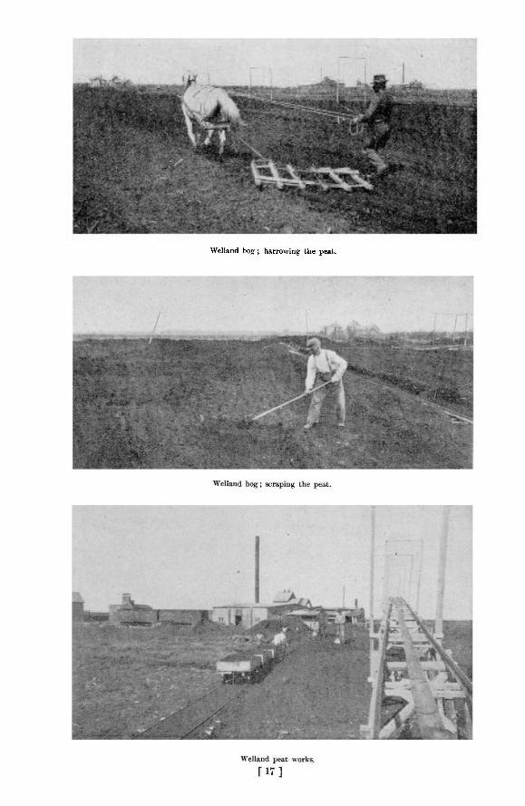
Welland bog ; harrowing the peat.

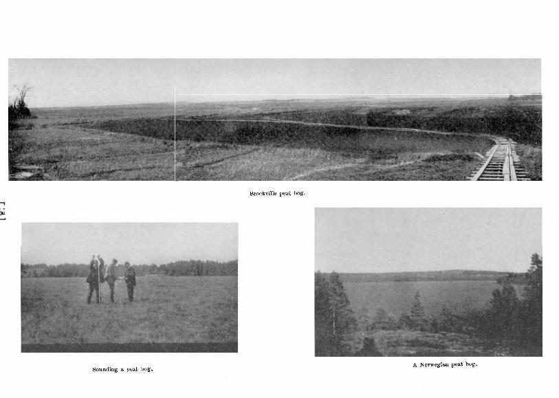
Brockville peat bog.
A Norwegian peat bog. Sounding a peat bog.

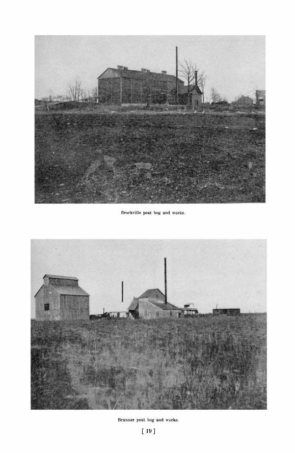
[ 1 9 ]

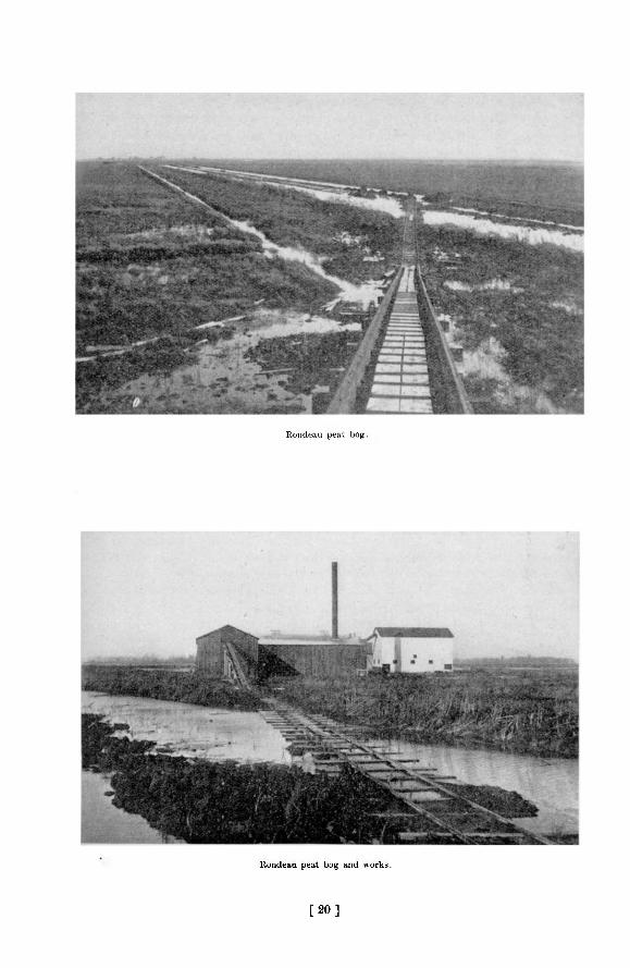
Rondeau peat bog.
Rondeau peat bog and works.
[ 2 0 ]

1902 Peat Fuel: Its Manufacture and Use 193
PEAT FUEL NO NOVELTY.
Peat fuel, though new here, is no novelty in older lands. In Scotland and Ireland in the ordinary or air-dried form it has been burned for many centuries, and still in places survives the competition of coal from the English and Scottish mines. Jn the countries of continental Europe, especially Germany, Holland, Russia, Denmark and Sweden, there H annually A large and apparently increasing consumption of peat. In central Sweden it is said that as much as one million tons of peat are prepared and used yearly, and two million tons in the whole country. Not only is peat in demand as domestic fuel for coking aud producing warmth, but in metallurgical processes, in steel and glass furnaces, for firing locomotive boilers, for generating electric power and for many other purposes it is used in solid or gaseous form. Germany is believed to have more fuel in peat than in coal, and much ingenuity has been displayed in that country and elsewhere in devising processes and machinery for preparing it. In short, so far from peat being an obsolete fuel, it is coming more and more into use as its manufacture is being perfected and a better article produced.
THE COMPARISON MUST BE WITH COAL.
Coal is the standard by which any competing fuel must be measured, though there are substances which for special purposes are equal or superior. Some petroleums, for instance, give better results in locomotive or steamship boilers, costing less and occupying smaller space for the quantity required to produce a given amount of power. Charcoal from wood makes a better product in the iron blast furnace than mineral coke, because of its greater freedom from sulphui, which deteriorates the quality of the pig. In certain other respects, such as cleanliness of handling and completeness of combustion, coal compares unfavorably with wood and peat ; but in the main, and for general use coal (including both anthracite and bituminous) is the fuel which at present holds first place in public esteem, and no doubt rightly so.
The comparison of peat with coal must be at two points (1) efficiency, ( 2 ) price. Unless there is a fair equality in the result of these factors, peat must be ruled out. If on the one hand it is so far below the level of coal in calorific value that no matter at what price produced it would not be used where coal could be had ; or if on the other, it cannot be produced and sold for a price at least as low as that for which the equivalent in heating value of coal could be bought, all efforts to introduce peat will be unavailing except at times when nothing else can be had.
The fact that peat continues to be used in many countries concurrently with coal where there is no difficulty in procuring the latter, is proof that for some purposes at least it is equally well adapted and not more expensive. The Holland housewives, proverbial for their neatness, will have no other fuel, and in the Dutch brick-yards peat only is used.
Peat is in reality incipient coal. The coal beds, which are the basis of modern arts and industries, were laid down ages ago in some such way as peat bogs are now being formed, except perhaps that in most cases trees were the source of the carbon of the coal instead of the mosses or aquatic plants of which peat bogs are composed. A regular gradation can be traced beginning with peat or wood and passing through lignite, bituminous coal, anthracite and even graphite, the various stages of the process depending upon the degree of pressure or heat which has been exerted ; and doubtless the peat bogs of to-day, if not sooner consumed, may in subsequent ages be metamorphosed into seams of coal for the benefit of the coming man. Being incipient coal, peat contains less carbon and is inferior in specific gravity to coal, though, as has already been pointed out, its properties in this respect must be considered in relation to the price at which it can be produced ar.d sold.
13 M.
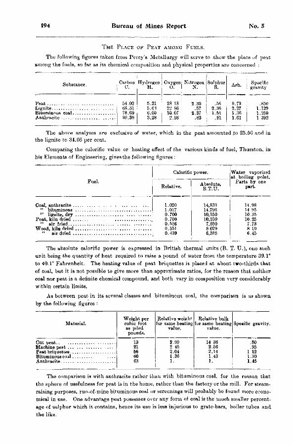
194 Bureau of Mines Report No. 5
THE PLACE OF PEAT AMONG FUELS.
The following figures taken from Percy's Metallurgy will serve to show the place of peat among the fuels, so far as its chemical composition and physical properties are concerned :
Carbon Hydrogen Oxygen Nitrogen C. H. 0. N.
54.02 5.21 28 18 2.30 6*i.31 5.63 22 86 .57 78.69 6.00 10.07 2.37 90.39 3.28 2.98 .83
Substance.
Feat Lignite Bituminous coal Anthracite
Sulphur S.
.56 2.36 1.51
.91
Ash.
9.73 2.27 1.36 1.61
Specific gravity
.850 1.129 1.259 1 392
The above analyses are exclusive of water, which in the peat amounted .to 25.5G and in the lignite to 34.66 per cent.
Comparing the calorific value or heating effect of the various kinds of fuel, Thurston, in his Elements of Engineering, gives the following figures :
Fuel.
Calorific power.
Relative.
Coal, anthracite . " bituminous " lignite, dry
Peat, kiln dried . " air Iried...
Wood, kiln dried " air dried .
1.020 1.017 0.700 0.700 0.526 0.551 0.439
Absolute, B.T.U.
Water vaporized at boiling point.
Parts by one part.
14,833 14,796 10,150 10,150 7,650 8.029 6,385
14.98 14 95 10.35 10.25 7.73 8 10 6.45
The absolute calorific power is expressed in British thermal units (B. T. U.), one such unit being the quantity of heat required to raise a pound of water from the temperature 39.1° to 40.1° Fahrenheit. The heating value of peat briquettes is placed at about two-thirds that of coal, but it is not possible to give more than approximate ratios, for the reason that neither coal nor peat is a definite chemical compound, and both vary in composition very considerably within certain limits.
As between peat in its several classes and bituminous coal, the comparison is as shown by the following figures :
Weight per Relative weieht Relative bulk Material. cubic foot for same heating for same heating Speeific gravity.
as piled value. value. Speeific gravity.
pounds. 13 2.99 14 36 .50 21 2 45 2.56 .95 56 2.04 2.14 1.12 60 1.36 1.43 1.30 63 1. 1. 1.45
The comparison is with anthracite rather than with bituminous coal, for the reason that the sphere of usefulness for peat is in the home, rather than the factory or the mill. For steam-raising purposes, run-of-mine bituminous coal or screenings will probably be found more economical in use. One advantage peat possesses over any form of coal is the much smaller percentage of sulphur which it contains, hence its use is less injurious to grate-bars, boiler t u b e 3 and the like.
1902 Peat Fuel: Its Manufacture and Use 195
ANTHRACITE AND PEAT COMPARED.
The principal uses of anthracite are in cooking and heating, being burned for the former purpose in stoves and ranges, and for the latter in stoves and furnaces of varying dos ;gn. The large percentage of carbon and high specific gravity of anthracite constitute i t » dense and lasting fuel, requiring little attention after being once ignited, and, as householders know, there is little difficulty in maintaining a fire in stove or furnace over night ready for fresh fuel in the morning.
Peat when first placed on the fire burns with a short blue flame, continuing to do so until the grate spaces become covered with embers, when it emits an intense yellow glow and short flame of the same color. It is now giving out an intense heat, wh'ch may be easily an:l accurately controlled by adjusting the draught. A peat fire may be made to last over night by banking it properly and closely stopping all the draughts. Once well lighted a peat lire will not go out until every atom of fuel has been consumed. This is due to the fact that it .requires very little oxygen to sustain its combustion.
The ordinary methods of burning fuel, whether coal or wood, are very wasteful, only a comparatively small proportion of the theoretical heating value being utilized. This is partly due to the large amount of air which finds access to the fuel, carrying off the heated products of combustion into the chimney or smoke-stack before they have performed their work. With coal the clinkers and live embers which drop through the grate bars are an additional source of loss. There are similar losses in the case of peat when burned in apparatus not well suited for its combustion, such as ordinary stoves or furnaces intended for coal or wood. Hence much at-tentioii has been given in Europe to specially constructed stoves for burning peat, in the invention of which the Danes appear to take the lead. Further mention of these is made below.
AN ACTUAL TEST OF PEAT FUEL.
At the Provincial Assay Office, Belleville, Ontario, peat briquettes alone were used as fuel for a portion of the winter of 1901-2, and the results are given in the report of Mr. J. Walter Wells, then Provincial Assayer. The office building contained upper and lower flats with a total air space of 23,000 cubic feet, for heating which two coal stoves were ordinarily employed. The same stoves—one an Imperial Oxford Air-tight Heater, and the other a Fire King—were used for burning the peat. The stoves were filled whenever nece-sary, and no special attempt was made to economize fuel. From careful observations covering a period of twenty days the following figures were obtained: Average temperature of outside air, 21° Fahr.; ditto inside air, 56° ; ditto upper flat, 6 1 ° ; ditto lower flat front room, 6 1 p ; back room, 53°. The peat was consumed at the rate of 186 lbs. per day, at a cost of 37 cents, the price of the fuel being $4.00 per ton, delivered. Starting or replenishing the fire caused smoke, and it was found advisable to prepare for adding fuel by creating a strong draught to carry off this smoke, after which the draught could again be cut off. The stoves required feeding about six times a day, or once every two or three hours. Fire was maintained during the night by covering the peat with ashes and closing all the draughts When the latter were opened in the morning the fire would spring into life again. No visible amount of soot was deposited in the flues.
In these stoves, as well as in several types of cooking ranges in which peat briquettes were experimentally burned last winter, the gratings were found too coarse, and it was not practicable to prevent an excess of draught, or to wholly check loss of fragments falling into the ashes below. This difficulty was partially overcome by covering the bars with clinkers or wire netting. These observations agree with the experience of the people of Beaverton, where peat briquettes made by the Dobson process are in common use as fuel.
196 Bureau of Mines Report No. 5
For many purposes, such as culinary uses, it is more important to have an intense heat for a short time than a lower heat for a longer time, and the rapidity with which peat reaches a high temperature renders it very useful in such cases. Often a burning briquette becomes white hot over its entire surface while the interior, if broken into, is seen to be quite cool.
Peat makes no clinker, but leaves considerable ash, depending in this respect upon the composition of the bog from which it is made. The ashes are light and powdery, and in weight are usually greater proportionally than those of wood, though not greater than those of coal as ordinarily burned, When peat burns without any particles falling through the grate bars, there is absolutely no unconsumed fuel, whereas with coal the percentage of half-burned fragments which escape with the ashes is usually considerable. Peat ashes consist partly of the inorganic substances taken up by the growing mosses or plants during their lifetime, but chiefly of the clay, sand and Bilt drained or blown into the bog from the surrounding soil. They occasionally run high in alkaline earths, carrying carbonates, phospate of lime, potash, etc., and when rich in phosphoric acid and potash they are suitable for fertilizing purposes.
Peat has some disadvantages, one of which is the considerable proportion of water which it contains even in the briquetted form, thus lowering its calorific value. Another, as noted above, is the tendency in ordinary grates of unconsumed particles to escape into the ash-box.
THE QUESTION OF PRICE.
Then, as to price, which in some respects is a consideration paramount even to quality. The cost of producing "machine" peat in Europe is from 85 cents to $1.35 per ton ; of peat briquettes $2.15 per ton. As the detailed data set out in the following pages show, peat briquettes can be made in Ontario at about $1.00 per ton of 2,000 lbs. Allowing a suitable margin for profit, interest on investment, etc., it is evident that compressed peat fuel can be sold at the place of production for $3.00 per ton, and at a correspondingly greater figure if railway freights have to be paid. As a matter of fact, it has already been sold by one maker for two successive seasons at $3.00 per ton, and beyond doubt in this price was included a fair profit. Putting .the theoretical value of peat briquettes at two-thirds that of coal, at $3.00 per ton their cost would be equivalent to anthracite at $4.50 per ton, and at $4.00 per ton to anthracite at $6.00 per ton. Such figures at once bring peat fuel into the economic arena, as it may be doubted whether with the effective control now exercised by the trusts over the production and sale of anthracite, we are likely to see it again drop to a lower retail level than $6.00 per ton. In the light of the facts brought out in this report, it will be surprising if the citizens of Ontario are not soon given their choice between compressed peat fuel and coal, instead of as at present being confined entirely to the latter.
EUROPEAN METHODS OF MANUFACTURE.
The peat fuel industry being of comparatively recent origin in Ontario, and little having been accomplished in the United States, where the abundance of coal relegates the question to a position of minor importance, it is to the countries of Europe, where the peat industry is of venerable standing, that we must turn for fuller information as to cost and methods of manufacture. The government of Norway, where the fuel question is in almost the same position as it is in Ontario, both countries being without coal, and both being situated in a northern climate and containing within their borders many peat bogs, commissioned Mr. J. G. Thaulow, a mechanical engineer of that country, to investigate the peat industries of Europe and Canada, and his report dated June, 1902, contains much interesting and valuable information concerning costs and manufacturing methods in the countries which he visited. Mr. Thaulow's report is freely drawn upon in the present paper, and other available sources of information have been made use of. Comparisons with European countries in the matter of costs should be made
1902 Peat Fuel: Its Manufacture and Use 197
with care, because of the lower price commanded by labor there ; but so far as climatic conditions are concerned which play a very important part in the manufacture of peat fuel, there is no great difference between Ontario and the countries of central Europe, where peat is largely made and used. There is probably a longer summer season, more sunshine and less rain in Ontario than Denmark and Sweden, so ihat processes depending upon the weather such as outside drying, which are practicable there, ought to be even mora successful here.
In European countries three kinds of peat fuel are known; (1) cut or "st ick" peat, namely, the crude peat cut in blocks out of the bog aad dried in the air, after which it is burned without further treatment; (2) "machine" peat, which is the name given to peat ground or imcerated to a pulp while wet, sometimes with the addition of water, and then cut or moulded into blocks and dried with or without artificial heat; (3) peat briquettes made by artificially drying and compressing powdered peat.
Coke or charcoal is also made from peat and is used in the smelting of ores and other metallurgical processes. In converting the raw peat into charcoal practically the same range of by products is obtained and made use of as in the coking of coal ; but charcoal fuel is little used in this country, and it has not been thought necessary to make any extended allusion to this aspect of the subject in the present paper.
CUT PEAT.
The first mentioned variety, or cut peat, is the sort used by the poorer classes, who employ their own labor in the spring and summer in making it. Though constituting a fuel by no means to be despised, especially when taken from the decomposed layers of a good bog, cut peat is suited only for local use, because of its retaining, even when apparently quite dry, a considerable proportion of moisture, and because of its bulkiness and friability and consequent unfitness for transportation to long distances. This variety of peat can only be made from a dry or drainable bog. A ter digging, for which purpose a specially shaped spade is used, with a wing at one side, in order to cut out rectangular blocks, the latter are laid on the surface of the bog, where in a few days they lose sufficient water to be turned over and afterwards piled up. During the summer months the blocks of peat will dry down to a water content of about 30 per. cent., by which time they have shrunk to about one-quarter of their original size. Probably the larger proportion of the peat fuel used in Europe is of the cut or " stick " variety, its great recommendation being its cheapness. An able-bodied laborer can dig up the equivalent of l j tons dried peat per day, and in most cases the digging and subsequent handling is done bf himself and members of his family. The use of cut peat as fuel for general consumption is out of the question in Ontario.
MACHINE PEAT.
" Machine " peat is a compacter and better article. It is sold in large quantities in Holland, Germany, Austria, Denmark, Sweden and Russia, and is used not only for domestic purposes, but also in manufacturing, metallurgical and other industrial operations. A great many steam boilers, including railway locomotives, are fired with this variety of peat, while in breweries, distilleries and under salt pans in Germany, it is preferred to other fuel. In Austrian glass-works and brick yards it is also freely employed. Most of the peat consumed in Europe, except by the peasantry, is machine peat, and it forms in fact the only fuel for large bodies of the population. The methods of preparing it are very numerous, and much ingenuity has been displayed in inventing machinery and devising processes to suit varying conditions.
Two principal systems are distinguished in making machine peat, depending upon the treatment of the raw material immediately upon raising it from the bog. One plan is to digest the peat with the addition of water into a liquid mud, which is then poured into moulds in
198 Bureau of Mines Report No. 5
the open air, and after losing some of its water, divided into blocks and allowed to dry. The product is sometimes called "knead" peat. The other and more commonly employed process consists of grinding or mincing the peat as it comes from the bog, into a soft plastic mass, which is then cut into bricks and dried.
a d a n i s h p e a t p l a n t .
A well known and successful establishment for the manufacture of "knead "peat, is in operation atSparkjer, Denmark, on a large scale. The works are either stationary or portable, in the latter case floating in the bog, where there is sufficient water. The peat, dug by hand or machines, is conveyed mechanically to the works, where water is added and it is passed through the mixing machines,—plain wooden boxes, containing rotating screw-shaped knives— whence it is elevated to a large tank, and afterwards taken in cars to the drying fields. These consist of fields of sandy soil covered with grass. Elevated flats or gentle slopes are preferred, well exposed to prevailing winds. The peat mixture is then poured into bottomless cast iron moulds, after standing a few hours in which sufficient water is absorbed by the sandy soil to consolidate the peat and allow the moulds to be removed. In three or four days the peat lumps or bricks are turned and subsequently piled in heaps. The whole drying p-ocess requires from three to six weeks, according to the weather, the finished product containing about 22 per cent, water.
At other works the dense peat liquid is poured in thick layers over the drying ground, and when in semi-dry state is rammed and cut into small bricks. By this method the drying capacity of each acre of ground is increased, and the labor cost reduced.
The cost of peat plants, such as those at Sparkjer, is about $80 per ton of daily production when of the portable variety, and about $135 per ton when stationary. In 1901 the total production of the Sparkjer establishment, which comprises a large number of individual works, was 25,000 tons of dry peat, which had a selling value of $54,000, or $2.16 per ton (2,240 lb.) The cost of production varied in the separate plants from 85 cents to $1.10 per ton f.o.b. railway cars. The laborers work by contract and earn on an average $1.35 per day. The power required is small, the product of one nominal horse-power being placed at 5 to 8 tons per day.
In the manufacture of ordinary machine peat more powerful machinery is used. After reducing by drainage the water content of the bog to 80 or 85 per cent, the peat is dug and and thrown at once into an elevator which carries it to the peat-mill. This may be either portable and capable of being moved on tracks laid on the surface of the bog, or stationary and placed at some central point. The mixing machine (see illustrations of Anrep's peat-milling machine) consists of a hollow iron cylirder or cone in which rotate one or two rollers set with screw ridges, which break up the peat and anjr accompanying small roots, thoroughly working the whole into a soft, plastic mass ?ad forcing it out in long rectangular shape to be cut into bricks. These are then transported * -> the drying ground, either terra firma or bog. The drying process occupies from 6 to 8 weeks, and when finished the peat bricks contain about 22 per cent, water, below which point it is scarcely possible by air-drying to reduce the moisture in machine peat.
m i l l s f o r m a k i n g m a c h i n e p e a t .
The mills or machines used in making machine peat are of various construction, but all incorporate very much the same principles. Their operations have proven so satisfactory that the demand for them has increased very greatly within the past year or two. The plant usually stands complete in itself on the bog, either all on the one portable platform, or with the locomobile, or power plant of engine and boiler, a short distance away and connected by belting.
1902 Peat Fuel: Its Manufacture and Use 199
The Akerman machine, manufactured by Akerman's Foundry and Mechanical Works, Eslof, Sweden, requires an 18-h p. engine and boiler, and can turn out from 20 to 25 tons machine peat per ten-hour day with the help of 15 men. With locomobile, lails, wagons and other requisites, the plant complete costs $1900.
The An rep (or Anrys) peat machine, probably the most modern and approved, is the invention of Aleph Anrep (or Anrys) a Swedish engineer now resident in Russia, where over one thousand of them have been built and are in use. It is also now being constructed by the Munktell's Mechanical Works Company at Eskilstuna, Sweden. On some of the larger Russian bogs, often up to 20,000 acres in extent, 50 or 70 of these machines may be seen at work. In principle they are much the same as Akerman's machine, the main difference being that with the latter the h comobile and mill are sf-parable, while with Anrep's they stand on the the same carriage. It is accounted superior to all other existing machines of the kind because of its greater capacity per man per day and consequently lower cost of production.
The Anrep machine is built in two sizes, the larger producing from 40 to 60 tons finished fuel per 10 hours with 28 workmen, and requiring 38 horse power. It costs $1,900 exclusive of power plant. The smaller type is built in light and heavy styles, the former turning out 20 tons peat fuel per 10 hours with 13 men, and consuming 19 horse power. It is sold for $830, exclusive of power plant. The stronger machine produces from 25 to 30 tons of finished fuel per 10 hours, employing 15 men and using 25 horse power, its price being $1,200, exclusive of power plant.
Another machine has receutly been put on the market by the Abjorn Andersson's Mechanical Works Company of Svedela, Sweden, and.a number are now in use. Several sizes are made, ranging in capacity from 20 to 40 tons finished peat per day. The machines proper cost from $215 to $675.
In Germany most of the peat-milling machines are made by R. Dolberg of Rostock and A. Heinen of Oldenburg. They are similar in construction, and resemble the Swedish machines already described. Much hand labor is required in their operation, but they are able to produce 1£ to 2 tons peat fuel per man per day.
With wages ranging from 95 cents to $1.20, or averaging say $1.00 per day, at some of the large Swedish peat works machine peat is made at a total cost of $1.35 per ton, though this figure may vary appreciably one way or the other depending on the condition of the bog which affects the cost of labor alone to the extent of from 56 to 80 cents per ton.
Machine peat contracts very much in drying, the volume of the dried peat often being not more than one-sixth that of the original block. Thus the bricks acquire a very compact consistency, bearing a close resemblance to lignite both in appearance and density. In specific gravity it often surpasses water, but commonly weighs from 30 to 40 lb. per cubic foot. It will stand ordinary handling in being moved from place to place, is less hygroscopic than cut peat, and may easily be stored without absorbing moisture. In some places in Germany and Denmark the practice is to thatch the peat stacks to keep out the rain.
'' Cut" and "machine" peat in their various methods of preparation almost exhaust, the forms in which peat fuel is used in Europe, comparatively little pressed or briquetted peat being manufactured as yet. Of recent years, however, the briquetting of fuels has assumed large proportions, especially in Germany, where in 1901 the output of briquetted fuel was 1,643,416 tons. Of this quantity about half was used by the railways and one-third in factories and industrial works, the remainder being about equally divided in use between dwelling-houses and steamships. The principal substances used in making these briquettes are coal screenings or waste, and lignite, but peat is now also employed. In the case of peat an
200 Bureau of Mines Report No. 5
attempt i s made to carbonize it by heat and compression during the process of manufacture in order to give i t greater fuel value. Briquetted fuels sold in 1901 at an average price of 13£ marks ($3.13) per ton wholesale.
In face of the general acceptability of machine peat, and the firmly established position of its manufacture i n Europe, there is not the same inducement there to apply briquetting processes to peat as to other crude fuels which cannot be solidified or reduced in bulk in any other way. The peat briquettes are produced in presses of the open-tube type, similar to those hereinafter described, the pressure required being about 11 tons per square inch, a very solid block with smooth, polished surface being the result. Cut peat air-dried down to 30 or 40 per cent, water i s first pulverized, then artificially dried in a pan-drying apparatus heated with live or exhaust steam until not more than 12 per cent, moisture remains. The briquettes are oval in cross-section, instead of circular like those made in Ontario. Four plants only are known to be making peat briquettes in Europe at the present time, namely, two in Germany, one in Russia, and one in Holland at Helenaveen. At the last named place the cost of production iB from $2.00 to $2.15 a ton.
PEAT FUEL MAKING IN ONTARIO.
For several years the peat fuel industry of Ontario has been gradually developing, and the point has now been reached at which the makers can turn out their product at a profit. The burden of experiment and investigation, always an onerous one in establishing a new industry, has been borne by a few, and no doubt much money has been spent on methods and machinery which in the end gave only negative results. But there were those who did not despair of ultimate success, and with dogged resolution determined to persevere until the goal was reached. Among the most persistent of the inventors and experimenters have been Mr. A. A Dickson, formerly of Montreal, but now of Toronto, who has spent a lifetime in intelligent efforts to solve the problem of peat manufacture ; Mr. Alexander Dobson, of Beaverton, whose mechanical skill and ingenuity have been of signal assistance ; Mr. J. M. Shuttleworth of Brantford, and Mr. E. J. Checkley, of Toronto, all of whom are deserving of praise for their sustained and well-directed attempts to put the industry on a practical and paying basis. The Canadian Peat Fuel Company, the Peat Development Syndicate,—now Peat Industries, Limited—and the Peat Machinery Supply Company are the organizations through which the above-named gentlemen and others associated with them have carried on their labors. It would perhaps be too much to assert that all the difficulties have been surmounted, and that the success of the industry is an assured and established fact ; but at any rate, the preliminary stage appears to have been passed, and there can be little doubt that what yet remains to be done will soon yield to the address and skill of those who have already done so much. There have been many problems of manufacture which defied for years the wit and inventiveness of man, but few indeed in the long run have failed to yield to bold experiment and patient investigation. We may be certain that the difficulties surrounding the production of a cheap and efficient fuel from peat will in like manner disappear ; indeed, some of them have already vanished, and the question seems to be rather how to produce the best possible fuel at the least possible cost, than how to produce a good fuel at a fairly low cost.
The peat fuel question presents itself in somewhat different shape to the people of Ontario than to inhabitants of European countries. Here we have for long been able to obtain hard coal, or anthracite—the best domestic fuel in the world—at comparatively low cost, and this has made us fastidious in the matter of fuel. Anthracite is unknown in Europe, and the consequence is, that forms of peat or other fuel perfectly acceptable to Europeans, would not be regarded with favor here. The assumption however that we can continue to rely upon anthracite has been suddenly and rudely dispelled, and the possibility of obtaining an
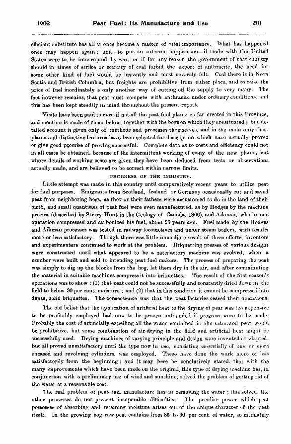
1902 Peat Fuel: Its Manufacture and Use 201
efficient substitute has all at once become a matter of vital importance. What has happened once may happen again ; and—to put an extreme supposition—if trade with the United States were to. be interrupted by war, or if for any reason the government of that country should in times of strike or scarcity of coal forbid the export of anthracite, the need for some other kind of fuel would be instantly and most severely felt. Coal there is in Nova Scotia and British Columbia, but freights are prohibitive from either place, and to raise the price of fuel inordinately is only another way of cutting off the supply to very many. The fact however remains, that peat must compete with anthracite under ordinary conditions; and this has been kept steadily in mind throughout the present report.
Visits have been paid to most if not all the peat fuel plants so far erected in this Province, and mention is made of them below, together with the bogs on which they are situated j but detailed account is given only of methods and processes themselves, and in the main only thos-plants and distinctive features have been selected for description which have actually proved or give good psomise of proving successful. Complete data as to costs and efficiency could not in all cases be obtained, because of the intermittent working of many of the new plants, but where details of working costs are given they have been deduced from tests or observations actually made, and are believed to be correct within narrow limits.
PROGRESS OF THE INDUSTRY. Little attempt was made in this country until comparatiyely recent years to utilize peat
for fuel purposes. Emigrants from Scotland, Ireland or Germany occasionally cut and saved peat from neighboring bogs, as they or their fathers were accustomed to do in the land of their birth, and small quantities of peat fuel were even manufactured, as by Hodges by the machine process (described by Sterry Hunt in the Geology of Canada, 1866), and Aikman, who in one operation compressed and carbonized his fuel, about 25 years ago. Fuel made by the Hodges and Aikman processes was tested in railway locomotives and under steam boilers, with results more or less satisfactory. Though there was little immediate result of these efforts, inventors and experimenters continued to work at the problem. Briquetting presses of various designs were constructed until what appeared to be a satisfactory machine was evolved, when a number were built and sold to intending peat fuel makers. The process of preparing the peat was simply to dig up the blocks from the bog, let them dry in the air, and after comminuting the material in suitable machines compress it into briquettes. The result of the first season's operations was to show : (1) that peat could not be successfully and constantly dried down in the field to below 30 per cent, moisture ; and (2) that in this condition it cannot be compressed into dense, solid briquettes. The consequence was that the peat factories ceased their operations.
The old belief that the application of artificial heat to the drying of peat was too expensive to be profitably employed had now to be proven unfounded if progress were to be made. Probably the cost of artificially expelling all the water contained in the saturated peat would be prohibitive, but some combination of air-drying in the field and artificial heat might be successfully used. Drying machines of varying principle and design were invented or adapted, but all proved unsatisfactory until the type now in use ; consisting essentially of one or more encased and revolving cylinders, was employed. These have done the work more or less satisfactorily from the beginning ; and it may here be conclusively stated, that with the many improvements which have been made on the original, this type of drying machine has, in conjunction with a preliminary use of wind and sunshine, solved the problem of getting rid of the water at a reasonable cost.
The real problem of peat fuel manufacture lies in removing the water ; this solved, the other processes do not present insuperable difficulties. The peculiar power which peat possesses of absorbing and retaining moisture arises out of the unique character of the peat itself. In the growing bog raw peat contains from 85 to 90 per cent of water, so intimately
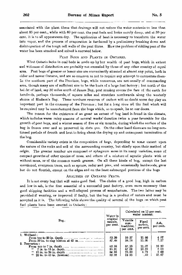
202 Bureau of Mines Report No. 5
associated with the plant fibres that drainage will not reduce the water contents to less than about 85 per cent., while with 60 per cent, the peat feels and looks merely damp, and at 30 per cent, it is to all appearances dry. The application of heat is necessary to transform the water into vapor, and the process of evaporation is furthered by a preliminary breaking down and disintegration of the tough cell walls of the peat fibres. How the problem of ridding peat of the water has been attacked and solved is narrated below.
PEAT BOGS AND PLANTS IN ONTARIO. What Ontario lacks in coal beds is made up by her wealth of peat bogs, which in extent
and wideness of distribution are probably not exceeded by those of any other country of equal area. Peat bogs of greater or lesser size are conveniently situated at almost any point, both in older and newer Ontario, and are so common as not to require any attempt to enumerate them-In ttie southern part of the Province, bogs, while numerous, are not usually of commanding area, though many are of sufficient size to be the basis of a laige fuel factory ; but north of the height of land, say 50 miles south of James Bay, peat muskeg covers the face of the earth for hundreds, perhaps thousands, of square miles and stretches northwards along the westerly shores of Hudson's Bay. These northern reserves of carbon will no doubt some day play an important part in the economy of the Province ; but for a long time all the fuel which will be required may be manufactured from the bogs which, so to speak, lie at our doors.
The reason for the existence of so great an extent of bog land is found in the climate, which includes warm rainy seasons of several weeks' duration twice a year favorable for the growth of peat bogs, and a winter season of five or six months, during which the surface of the bog is frozen over and so preserved in statu quo. On the other hand there are no long-continued periods of drouth and heat to bring about the drying up and consequent termination of the bog.
Considerable variety exists in the composition of bog?, depending to some extent upon the nature of the rocks and soil of the surrounding country, but chiefly upon their method of origin. The greater number are composed oi sphagnum moss in its many varieties, some of compact growths of other species of moss, and others of a mixture of aquatic plants with or without moss, or of the common marsh grasses. On all these kinds of bog, except the last mentioned, evergreen trees, such as spruce, cedar and pine, and occasionally hardwoods, grow but do not flourish, except on the edges and on the least submerged portions of the bogs
ANALYSES OF ONTARIO PEATS. It is not every bog that will make good fuel. The choice of a good bog, high in carbon
and low in ash, is the first essential of a successful peat factory, even more necessary than good shipping facilities and a well-adapted process of manufacture. The two latter may be provided if wanting, or improved if faulty, but the bog is a product of nature and must be accepted as it is. The following table shows the quality of several of the bogs on which peat fuel plants have been erected in Ontario :
Bog. Water in original sample,
per cent.
Calculated on 15 per cent, water content.
Bog. Water in original sample,
per cent. Volatile
combustible?, per cent.
Fixed carbon, per cent.
Ash, per cent.
1. Welland:
2. Beaverton:
82.20 87.48
62.98 83.31 84.86 82.98
59.27 56.78
57.13 67.58 73.60 C6 93
21.66 21.05
11.67 10.39 4.72
.40
4.07 7.17
16 20 7.03 6 68
27.67
1902 Peat Fuel: Its Manufacture and Use 203
A N A L Y S E S OF ONTAKIO PEATS.—Continued.
Bog.
3. Perth: Top 5 feet
" 4 " 4. Branner:
Top 3 feet 5. Brockville :
Upper stratum, 3 feet Parti lower stratum, from 3 down to 5 feet.
6. Rondeau : Lower stratum, beneath surface growth...
From stock pile 7. Newington :
Sample No. 1 " " 2
" 3 . . " " 4 . .
T H E W E L L A N D B O G .
The Welland bog is situated in the townships of Humberstone and Wainfleet, six miles north of the town of Welland and between the Welland canal and its feeder, and is owned by Peat Industries, Limited,of Brantford. It covers an estimated area of 4,000 acres, or between 6 and 7 square miles, and varies in depth from 3 to 7 f eet, averaging probably 5 feet. I t will furnish over 4.000,000 tons of finished fuel estimating 1,070 tons to the acre. Composed of sphagnum moss, it typifies the great majority of such areas in this country. The upper portion of the bog consists of fresh or growing moss. This in the course of propagation dies out at the roots with the appearance of new growths above, the result being a gradual accumulation of moss and plant remains. Proceeding downward, the brown light moss changes in color and density until at the bottom there is an almost black, very compact muck, super-saturated with the peaty waters. These lower layers are not decayed, but by chemical alteration and el imination of some of the volatile constituents the percentage of carbon has been increased, and the first step taken towards the formation of a future coal bed. N u m e r o u s large and small roots are found embedded in the peat from top to bottom, the only remains of a once flourishing forest of cedar, spruce, and other hard and soft woods. Now nothing but scattered shrubs and grasses are capable of subsisting on the surface of the bog. V e r y compact, c lean, greenish clay forms the bottom, the usual underlying bed of shell marl being in this case absent. The lowest six inches of the bog contains too much clay and other incombustible material to be of value for fuel, a fine silt having impregnated it, doubtless through the unrestrained m o v e m e n t of the waters in the early days of the bog. The remainder of the bog overlying this stratum is low in ash, and is quite suitable for fuel. If the 6 inches at the bottom had been e l iminated from the sample, there would have be^n an appreciable decrease in the amount of the ash shown in the lower portion of the bog (see analysis in foregoing table).
Many years ago when the Welland canal and its feeder were under construct ion this bog formed an immense undrained swamp, so full of malaria that nobody l ived within miles of it. The unfortunate laborers died in scores. Now all this is changed B y means of the artificial waterway and the county and township ditches, both swamp and surrounding country have been reclaimed for habitation, and the locality is as healthful as any.
The Welland bog, described above, and the Beaverton bog, a description of which is given in the following paragraph, together with the factories respectively belonging to them, are
Water in original sample, per cent.
Calculated on 15 per cent, water content. Water in
original sample, per cent.
Volatile corr-
bustibles, per cent.
Fixed carbon, per cent.
Ash, per cent.
54.72 57.81
19.85 18.92
10.43 8.27
60.10 15.70 9*. 20
66.08 67.15
20.62 13.73
9.30 14.12
58.56 54.60 67.99
23.29 22.44 11.06
3.15 7.96 5.95
87.94 86.66 87.62 90.12
56.74 64 42 58.70 58.15
27.21 28.61 24.73 25.30
1.05 1.97 1.57 1.55
204 Bureau of Mines Report No 5
classic scenes in Ontario peat fuel manufacturing. Scores of experiments in drying and bri-quetting processes, the two most troublesome of the inside operations, have been conducte 1 at these places, tests of machinery and presses having been carried on at Welland for nearly twelve years, and at Beaverton for about half that time.
T H E B E A V E R T O N BOG.
This bog covers an area of about 100 acres in the township of Thorah, Ontario county, adjoining the village of Beavertjon, and is owned by Mr. Alexander Dobson of that place. It is composed of the dead and blackened remains of rushes, grasses, weeds and other aquatic growths, with practically no moss except a stratum of a few inches in width at the bottom. In depth it measures about 40 inches, but of this only the upper 26 inches is fit for manufacture into briquettes, the lower 14 inches resting on the sand and marl bottom containing, as the analysis shows, too high a percentage of incombustible material to be of value for saleable fuel. It is consequently left for subsequent removal to be consumed in the works. The analysis figures of this bog show that in peat beds the percentage of fixed carbon does not always increase with the depth. The advisability is also shown, in order that a product of uniform quality may be obtained, of excavating the peat from top to bottom at one t ime; or if this is not possible, of mixing that from various levels. In this way a thin bed containing too much ash may be utilized, provided the other strata are of good quality. This is illustrated in Mr. Dobson's practice on the Beaverton bog. The uppermost layer of peat 7 inches thick contains over 16 per cent, of ash, which is certainly high ; yet after being mixed with 8 inches containing 7.03 per cent, and 11. inches containing 6.68 per cent, respectively, a good fuel is produced, showing less than 10 per cent, of ash. This bog, though not of large extent, admits of easy drainage, and is remarkably free from buried stumps, roots or timber of any kind. It has therefore formed an admirable arena for the evolution and testing of mechanical methods of performing the necessary field operations, in the devising and application of which no less than in the invention of apparatus for the drying and briquetting of peat, Mr. Dobson has shown much ingenuity.
T H E P E R T H B O G .
The Perth bog, or No. 3 in the foregoing table, lies in the township of Drummond, about a mile and a half north of the town of Perth and half a mile from the Canadian Pacific railway. It is known locally as the " blueberry marsh," and is roughly estimated to cover an area of 2,000 acres, of which the Lanark County Peat Fuel Company of Perth owns a small portion, comprising some 35 acres. This was formerly ploughed and cultivated for grass, so that from the surface down all is now rich, black, crumbly peat. It bears a dense growth of willow bushes, while on the next lot and in the middle of the bog, a small forest of stately hardwood trees flourishes. This seemed so remarkable that a number of soundings were made of the ground on which the trees stood, the result being to prove that they were actually growing on peat of considerable thickness. The average depth of the bog is between 8 and 10 feet. The peat is composed of the remains of grasses, both fine and coarse, large-stemmed weeds and aquatic plants, well preserved, but with an almost entire absence of moss. Fallen logs and roots are plentiful, but do not interfere with excavating operations, except when near the surface, as when deeply buried they are so completely waterlogged that the spade cuts through them nearly as easily as through the peat itself. But exposed to the air, the timber in a short time turns tough and very hard.
The company has partly ditched the bog, and installed a plant for making peat fuel, including a dryer and a briquetting press of the Dickson or open-tube type, but tor various reasons little practical success has attended its operations.
1902 Peat Fuel: Its Manufacture and Use 205
T H E B R U N N E R B O G .
The Brunner bog lies in the township of Ellice in the county of Perth, and is traversed by the line of the Grand Trunk railway. It covers an area of about 2,000 acres of which 1,300 acres are held under lease by the Stratford Peat Company, Limited, the peat plant erected in the middle of the bog beside the G. T. R. tracks be ing about 2 miles south of Brunner station, or 9 miles north of Stratford The bog is of the true moss variety, but differs from most bogs of the kind in that the moss is of the genus hypnum. Marked variations in quality characterize the bed, the upper foot or so yielding a brown to black, fairly compact muck higher in carbon than the beds below. Next comes an 8-inch stratum of bluish-black dense peat devoid of vegetable fibre, but containing charred fragments'of surface shrubs—evidences of fire in by-gone times. From here to a depth of 3 feet from the surface more brown peat occurs, which is then succeeded by a dark brouze-colored mass with fibre almost as distinct and fresh, except for the hue, as when living, and not much more compact. This material is said to extend to the bottom of the bog, the total depth of which is 6 to 10 feet. Probably only the upper 3 feet will prove of value for fuel purposes. Many stumps are embedded in the bog, while over the surface a forest of upturned pine s'umps is scattered, the labor of clearing the ground of which will be in part compensated by their value as fuel. Willows have densely over-grown several extensive areas of the bog, and over all of the remaining surface tall weeds flourish.
The company put in a plant for making peat fuel, the drying machine being a modification of the Simpson apparatus, and the press a Dickson one, which appeared to work satisfactorily, making briquettes 2 inches or 2J inches in diameter as desired. Owing to the large number of stumps and roots on the ground, harrowing is the method employed for harvesting the peat. A quantity of fuel was produced, but a fire in the works about the end of 1902 interrupted the operations. These have since been resumed, and some alterations made in the apparatus, including the substitution of a Dobson press for the open-tube one formerly employed. Shipping facilities are unusually good, a switch from the Grand Trunk railway running into the plant, and cars can be loaded by conveyors leading directly from the press.
An interesting fact was noted in connection with the operations here. Air-dried peat cut and stacked on the bog several years ago was drawn in last summer (1902) in as dry a state , except for the outside of the piles, as when first gathered. The unusually heavy and prolonged rains of 1902, which hampered peat-making everywhere in Ontario, had penetrated the heaps only for about 30 inches, and where the covering was of fine or broken peat, only the outs ide 6 inches was wetted. It will be an important economy if it is found that the supply of air-dried peat for winter manufacture can be stored without having to provide sheds or other covering for it.
T H E B R O C K V I L L E B O G .
Bog No. 5 in the list lies two miles north of Brockville, in the township of El izabethtown, Leeds county, and is reached by a branch of the Grand Trunk railway, which skirts its northeasterly edge. I t covers some 1400 acres in rectangular area, and occupies a basin wi th clay and gravel ^bottom. Soundings taken from the edge toward the centre increase in depth to 40 feet and probably upwards. The upper 3 feet is composed of the remains of grasses, grass roots and slender aquatic plants, and but little moss could be detected. Scattered patches of moss of the genus sphagnum occur, however, apparently increasing toward the central portion of the bog which is still submerged. The upper stratum of 3 feet is of uniform quality throughout, and of high fuel value. At this depth a sharp change takes place b o t h in the character and quality of the peat. A dark brown plastic bed or s tratum comes in h*re which is said to extend to the bottom of the bog. It is dense and finely stratified, a n d except for occasional minute fragments of plant roots, vegetable fibre is entirely absent, the whole presenting a uniform, smooth surface when torn or cut. On thin edges it is translucent When dried the color changes from brown to black, but at a distance has a grayish cast, from
206 Bureau of Mines Report No. 5
the minute particles of incombustible material desseminated throughout the mass, some of which are quartz grains. The texture of a specimen while being dried passes into a rubberlike consistency, and finally becomes quite hard and brittle, splitting along the lines of lamination and curling up at the edges As the analysis in the foregoing table shows, this lower bed is much inferior to the upper one for fuel purposes, being higher in ash and lower in carbon. The surface of the bog is heavily covered with grass and shrubs, and stumps of evergreen trees, such as spruce, tamarack and cedar, the remains of a dense forest some time ago cut down.
Considerable ditching was done by a local company and peat works erected, the plant consisting of two 60-h. p. boilers, a horizontal engine, two Dickson briquetting presses, and a Dickson dryer. This dryer followed original designs, but unfortunately proved unsuccessful. It differed entirely both in principle and construction from the dryers now in use. Since these short first trials the works have remained idle, and the property has been transferred to the Peat Industries, Limited, Brantford.
T H E R O N D E A U BOG.
The Rondeau bog, or No. 6 in the list, bordars on Rondeau harbor, a lake-like bay on the shore of lake Erie, in the county of Kent. It extends along the water-front a distance of several miles and has a width of one-quarter to one-half a mile. Wide but low sand bars separate the bog from the waters of the harbor. It occupies an area of about 1500 acres in the township of Harwich. The Western Peat Fuel Company, Limited, of Chatham, own 328 acres of the bog, on which they have erected a peat factory and installed the necessary machinery. The depth of the peat is markedly variable, ranging from 1 foot to 30 feet within short distances, leading to the belief that a series of sandbars underlies the bog similar to that which now divides it from the lake, in the quiet waters behind which grew and accumulated the plants whose decay resulted in the present bog. The upper stratum consists of a light brown, intricately interlacing mass of minute plant roots, quite different in texture from the peat of a moss bog. Lower down the color deepens, and a coarser flora appears ; no doubt the remains of a growth entirely aquatic and submerged. The upper portion is not sufficiently dense for compression into good briquettes, but farther down the peat is fairly dense and good. The first two analyses in the above table were furnished by the secretary of the company.
A railway filling guards one side of the bog, a farmer's dike another and the company's dikes the remainder, but all proved ineffectual to exclude the waters of lake Erie when their level rose in 1902. Just when the company had everything ready to begin operations the bog was flooded and work had to be suspended. A pumping station was built on the "bog earlier in the operations to keep down the water, and this will be used to unwater the bog again as soon as the outside lake lowers to normal level. A ditch 2000 feet long, 3 feet deep, and 30 feet wide has been dug, which will, by forming a drainage channel, assist in keeping the bog dry. There is a complete absence of roots or trees of any kind, and consequently mechanical methods of removing the peat may be conveniently employed.
R O N D E A U P E A T W O R K S .
The works erected by the company on a rise of clay, which comes nearly to the surface towards the interior of the bog, show much judgment in design and arrangement, as will be seen from the illustration,and may be here briefly described. One main brick building 60 by 60 feet in plan with steel trussed roof of sheet iron and cement floors has been divided by brick walls into dryer room, press room, engine room, and storage bins for the dried peat, and is entirely fire proof. The boiler room, also of brick, is annexed and is contained in the shed where the peat for fuel purposes is stored. At the side of these is built a storehouse for air dried peat 120 feet long, 28 feet wide, and 20 feet high to the eaves or tram track. A short distance away is another building in which 200 tons of peat briquettes can be stored, and from which fuel can be load id in the farmers' wagons on one side and into railway cars on the other.
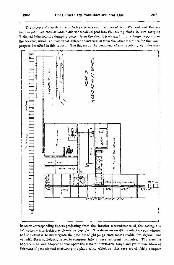
1902 Peat Fuel: Its Manufacture and Use 207
The process of manufacture includes methods and machines of both Welland and Bcaver-ton designs. An endless cable hauls the air-dried peat into the storing sheds in cars carrying V-shaped balanced side-dumping boxes ; from the shed it is elevated into a large hopper over the breaker, which is of somewhat different construction from the other machines for the same purpose described in this report. The fingers on the periphery of the revolving cylinder work
between corresponding fingers projecting from the interior circumference of j the casing, the two systems interlocking as closely as possible. The drum makes 800 revolutions per minute, and the effect is to disintegrate the peat into a light pulpy mass most suitable for drying, and yet with fibres sufficiently intact to compress into a very coherent briquette. The machine appears to be well adapted to tear apart the mass of interwoven, tough and yet minute fibres of this class of peat without shattering the plant cells, which in this case are of fairly compact

208 Bureau of Mines Report No. 5
structure and not merely water receptacles, and the consumption of power is moderate. The dryer is an improved Simpson, and the briquetting press is of the Dobson type, manufactured by the Peat Machinery Supply Company of Beaverton.
All elevators and conveyors are tightly boxed, and each part of the works is partitioned off from the rest so that dust-raising is not only minimized, but confined to its source. The fire-doors of boiler and dryer being side by side with but a brick wall between, one man is able to keep the fires going in both, and one engineer will attend to both engine and press. Another man will distribute and dump the incoming cars of air-dried peat, and this man, the fireman, the engineer and the foreman constitute the entire inside working force. The output is expected to be 15 tons fuel per ten hours, or 30 tons working day and night shifts.
The cost of erecting these works, together with other charges for bringing the whole to completion, have been furnished by Mr. J. L. Scott, manager and secretary-treasurer of the
company. Buildings $ 6,872.17 Plant, except briquetting press 8,820.59 Briquetting press 2,000.00 Tramway 943.19 Expense account 2,864.17 Bog 3 671.60 Railway spur 533.74 Charter for company 400.00
Total $27,986.15
THE NEWINGTON BOG.
The Newington bog, No. 7 in the above table, is a large muskeg 20 miles northeast of Cornwall, or 2 miles south of the village of Newington on the New York and Ottawa railway. It covers an area of about 1,200 acres in the township of Osnabruck in the county of Stormont. Dominion Peat Products, Limited, of Brantford, have purchased 1,000 acres of this bog and are erecting a peat fuel plant, a description of which is given below.
Several varieties of sphagnum moss combine to form the body of the deposit, the uppermost 2 feet of which is alive showing various shades of light yellow, green and red. This stratum is valueless for fuel, but would make excellent moss litter. A sturdy forest of spruce flourishes on the edges of the bog, but quickly dwarfs and thins out towards the interior. The central areas are composed of small lakes and ponds—deep, soft masses of impenetrable ooze. The average depth of a section a mile wide was found by soundings to be about 25 feet, ranging from 20 feet at the sides to 27 feet in the centre. The analyses given in the above table were furnished by the company, and show the peat to be of unusually fine quality, being rich in carbon and poor in ash. It should make the best of fuel.
THE PROCESS OF MAKING PEAT FUEL.
The three divisions in which may be grouped the various operations comprised in making peat fuel by what we may call the Canadian process, are (1) Excavating, (2) Drying, (3) Compressing. Various methods are adopted of carrying on all these operations, according to the nature of the bog and other controlling circumstances ; but it cannot be too strongly stated that the crux of the manufacture lies in drying the raw material. The difficulty consists, not merely in getting rid of the water, but in getting rid of it at reasonable cost. It is at this point that numberless promising processes have broken down, and it is this essential feature of manufacture that requires unceasing vigilance on the part of the peat-maker if his product
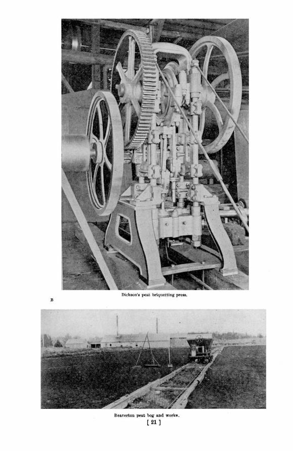

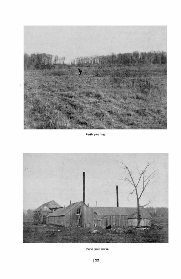
[ 2 2 ]

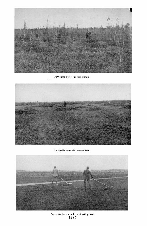
1
Newington peat bog; near margin.
Newington peat bog ; central area.
Beaverton bog ; scraping and raking peat.
[ 2 3 ]

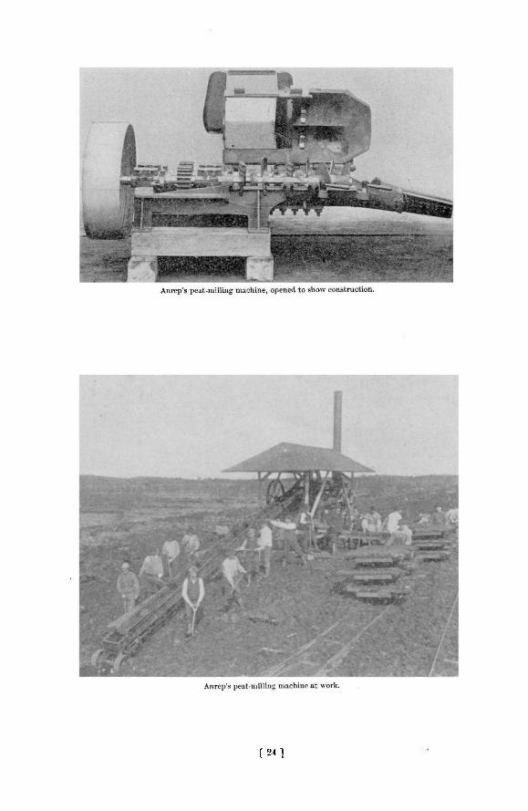
[ 2 4 ]

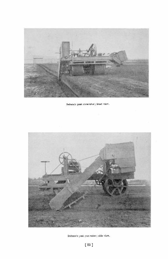
Dobson's peat excavator; front view.

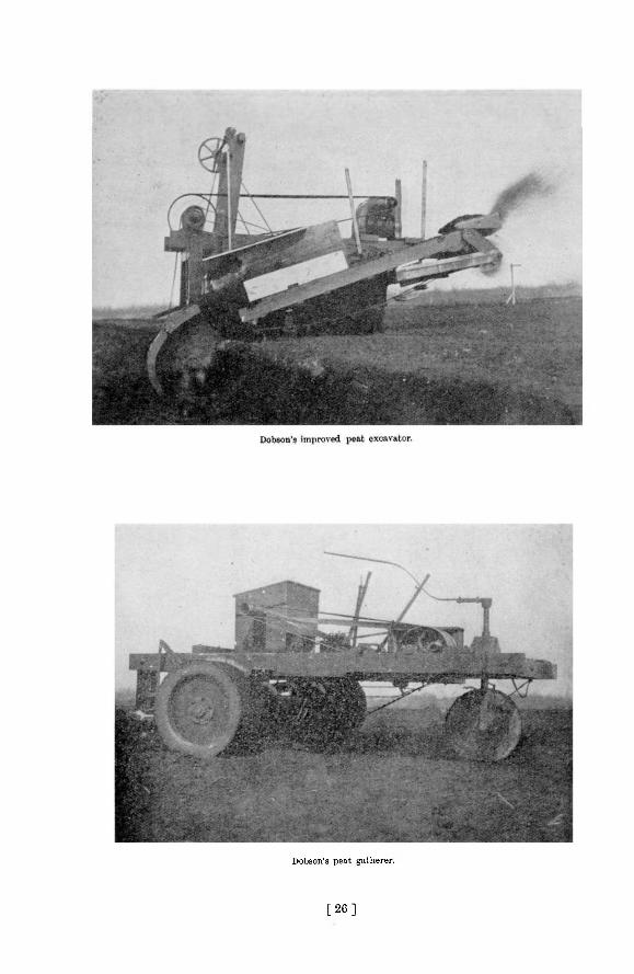
Dobson's peat gatherer.
[ 2 6 ]

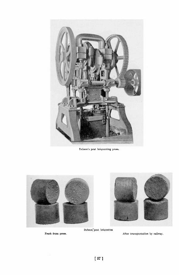
Dobson's peat briquetting press.
[271

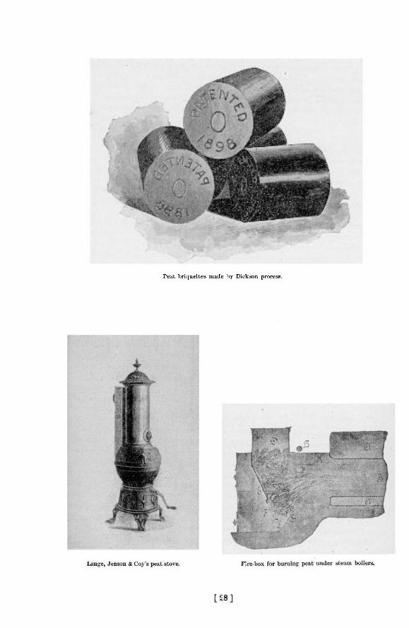
Peat briquettes made by Dickson process.

1902 Peat Fuel: Its Manufacture and Use 209
is to be satisfactory. In describing the manufacture of peat fuel, it has been thought that a a more intelligible account would be given if tho several steps were taken up in order and the various methods of accomplishing them dealt with, than if a detailed description were attempted of a number of peat factories, in which different means of doing the same work are employed. I n this way the disadvantage of unnecessary repetition will be avoided, and emphasis laid on the process rather than on the plant. Wherever practicable, the cost of the several operations is given.
W E T A N D D R Y B O G S .
Peat bogs are of two classes, wet and dry. In a permanently wet bog, the peat is submerged in water which does not admit of being drained away. The method of recovering peat from such a bog may be seen by the plan adopted near Kirkfield in Eldon township, Victoria county, three miles west of Victoria Road station, which was worked in 1900 and 1901 by the Trent Valley Peat Fuel Company,Limited, of Peterborough. The bog is situated on the route of the Trent Valley canal and covers about 10 square miles in one immense muskeg on both sides of the canal. The water lieB flush with the surface of the mass, and the depth of the peat is from 4 to 50 feet. A dredge floating on the bog excavated the peat in trenches and then followed into the paths thus cut for itself with scows attending, each carrying a number of boxes of about 2 cubic yards capacity into which to load the peat. The scows were towed to the terminal of an aerial tramway, over which the boxes were conveyed to the works about 500 yards away, where the saturated peat was dumped into the hopper cf a root extractor and disintegrating machine, from which it issued as a fragmentary muck with the fibres pretty well broken or fractured in preparation for the drying process which followed.
Another method of extracting peat from a wet bog, is the one proposed to be put in practice by Dominion Peat Products, Limited, of Brantford, on the bog near Newington, in the County of Stormont, above described, where a peat fuel plant is now in course of construction. A German machine, known as the Brosowski or Jasenitzer Peat Digger, will cut and lift out cubical blocks of peat 3 feet long by 1 foot wide and 1 foot deep, by means of a rectangular knife, which is driven or forced down into the peat. The same knives raise the mass and dump it into a conveyor, which transports it to the works. The digging continues in the same place to a depth of 25 feet, the limit of the machine, when it is moved sideways and begins on the next section of the bog. Hand power alone is used. This digger is said to be in successful operation in European countries.
D I T C H I N G A D R Y B O G .
For " dry " bogs, different methods are required. The word " dry," as applied to a peat bog, does not mean the absence of water, but rather that the bog is not submerged and is capable of being drained. The first thing to be done is to get rid of the surplus water, for which purpose drains or ditches must be dug. At the Welland bog, already spoken of, the following system has been adopted : Two or more parallel drainage ditches are run through the length of the bog, 660 feet apart and 10 feet wide. They are, sunk through the peat, which is about 4£ feet deep, and to a depth of 2 feet or more into the clay underlying the bog, and conduct the water to the county ditch with which they connect. A series of cross ditches is now run at right angles to the first, intersecting them at intervals of 50 feet, until a plot or working area 660 feet square or 10 acres in extent has been ditched and drained. Cross ditches 100 feet apart would probably be as effective, and would certainly leave the surface of the bog less cut up and in better condition for subsequent operations. Two main ditches 660 feet long, 10 feet wide and 6 feet deep, and 13 cross ditches 3 feet wide by 5^ feet deep being dug for every 10-acre plot, it follows that 8,170 cubic yards of material is removed per 10 acres. The equivalent per acre is 817 cubic yards which at the contract price of 6 cents per yard, cost
14 M.
210 Bureau of Mines Report No. 5
$49 per acre for ditching. As one foot of the top of this bog is moss, valueless for fuel, and 6 inches at the bottom contains too much ash, but 3 feet remains for good fuel, with which thickness the bog it is estimated will yield 645 tons finished fuel per acre. The cost of ditch ing the Welland bog is therefore equal to $0.0759 per ton.
Physical conditions, to a Urge extent, govern the expense of ditching, and at the Beaverton bog the expense is considerably less. A few main drains 400 to 600 yards apart, and cross ditches 100 feet apart, are all that is necessary, involving 420 feet of ditching per acre. It was ascertained that a man at a wage of $1.40 per day can shovel 26 cubic yards of peat per day, so that.these ditches being 3 feet wide and 3 feet deep, 140 cubic yards per acre are removed at a cost of $7.53. An acre of this bog 2£ feet deep will yield 535 tons finished fuel, and the cost of ditching the bog per ton of fuel is therefore $0.0141.
At nearly all of the othei bogs in the Province where peat fuel manufacture has been attempted, drainage has been necessary, the expense per acre varying with the depth and size of the drains.
C L E A R I N G T H E S U R F A C E .
After draining, the light, growing or undecomposed moss is removed, together with protruding stumps and roots of trees, and a level surface is prepared for the digging or excavating process, which comes next in order.
In some European countries the moss is manufactured into litter for bedding cattle and horses, for which its high powers of absorbing moisture render it peculiarly suitable. An attempt was made at the Welland bog some years ago to establish a moss litter industry, but though there was no difficulty in preparing a first-class article, the business languished and did not succeed, presumably through lack of demand.
On a 10-acre plot at Welland $25 was paid for extracting etumps and roots, and $50 for removing the covering of moss. For one acre, the cost therefore was $7.50, or $0.0116 per ton of finished fuel. The moss and roots are allowed to dry in the air and are subsequently used for fuel at the peat works. At Beaverton, the cost of clearing the bog is estimated at $0.0052 per ton of briquettes.
L A V I N G D O W N T R A M W A Y S .
The bog being drained, levelled, and sufficiently consolidated to be worked, the laying of light tramways on which to haul the peat into the factory is the next preliminary. The tracks are sometimes laid along the ditches, as on the Welland bog, in order to bring the trucks on a level with the surface and so facilitate loading ; but this is a temporary advantage only, for as the peat is removed the height of the bog decreases. It is more satisfactory to lay them oh the surface, where they may be quickly shifted to any place or in any direction desired. The bottom of the ditch is too wet and soft for the tram horse, which is obliged to walk along the top, playing hnvoc with the crumbling sides ot the trench.
At Welland a track runs down each of the 13 cross ditches in a 10-acre plot, involving the laying of 860 feet of track per acre. The track being constructed in short sections is easily and quickly handled, two men at $1.20 laying 300 feet per day. The cost of track-laying therefore amounts to $6.86 per acre or $0.0106 per ton of finished fuel.
At Beaverton a single tram line is constructed down the centre of each 100-foot section, leaving a 50-foot strip of bog on either side. About 400 feet of track per acre iB required, the cost of laying which is $3.73, or $0.0070 per ton of finished fuel. The ordinary method of hauling the peat is by horse, but at Beaverton the motive power is electricity.
1902 Peat Fuel: Its Manufacture and Use 211
H A R V E S T I N G T H E P E A T A T W E L L A N D .
Usually the first step in the actual harvesting or gathering of the peat is to run an ordinary farm harrow over the surface and expose a thin covering of peat to the action of the wind and sun. This is the p!an perforce employed where stumps and roots are numerous, as on the Welland bog. In the miin it answers very weH, but one disadvantage it possesses is that successive strata in the bog being often of varying composition, differing in proportion of ash and in other ways, the peat product will not be of uniform quality. Provision may, however, easily be made for mixing these different strata by stacking them in large heaps, from which the supplies for manufacture will be drawn. By harrowing the ground twice on each occasion, a layer of peat from 1^ to 2 inches deep is exposed, the work being done by the tram horse and driver during spare intervals, and occupying about one-quarter of their time. Man and horse are paid at the rate of $1.75 per day. When dried down to a water content of about 45 per cent, the peat is scraped by hand over to the taam roads and loaded into the cars by 3 men, each of whom is paid $1.20 per day. At the factory or stock pile another m m helps the driver unload the cars, which are not self-dumping. These men will in one day with fair drying weather harrow and scrape over an area of 48,700 square feet, or 1.118 acres. The average depth of air-dried peat removed at each scraping is about three-quarters of an inch, which gives an output of 3,044 cubic feet for the above area, or 2,722 cubic feet per acre. A cubic foot of peat in the air-dried condition, containing 45 per cent, water weighs on the average about 24 lb. Therefore 2,722 cubic feet weigh about 32 tons, equal to 21 tons finished fuel containing 15 per cent, water. The items of cost in connection with this part of the field
operations when summed up are as follows :— For one day.
1 horse and driver $1.75 3 scrapers and loaders, at $1.20 3.60 1 unloader 1.20
Total $6.55 This sum representing the cost psr day of harvesting 1.118 acres, the cost per day per
acre is $5,858, or $0,279 per ton of finished fuel.
The cost of field operations at the Welland plant may now be tabulated as follows, per ton of finished fuel:
Ditching $0.0769 Clearing 0.0116 Track-laying 0.0106 Harrowing, scraping and tramming in 0.2790
Total $0.3771
T H E D O B S O N M E C H A N I C A L E X C A V A T O R .
The Beaverton method of excavation is entirely different. After the bog is drained and levelled, a mechanical and electrically driven digger is set at work, which travels slowly up and down one or both sides of the area under removal, the excavating device working in the side or wall of the ditch. A good idea of the excavator may be had from the accompanying illustrations It consists of a platform 7 feet wide by 10 feet long, mounted on four wood-faced wheels, the front pair being the drivers and measuring 33 inches in diameter and 18 inches face, and the rear wheels being 22 inches in diameter and 18 inches face. The large superficial area of these wheels is necessitated by the softness of the bog surface. A 10-h.p. electric motor operates by belting and gear wheels all the machinery and at the same time propels the carriage forward at the desired speed. Overhanging the ditch on the right hand side is the combined
212 Bureau of Mines Report No. 5
excavating and elevating mechanism which is free to swing in a vertical plane about the upper sprocket wheel shaft, and may be raised or lowered according to the depth of cut to be made, the maximum depth being 4 feet. Tt consists of an endless chain which travels down the outside and up the inside of the elevator box, and which is set alternately with a row of cutting teeth and a sharp-edged plate. It serves the double purpose of scraping off a thin slice of peat and elevating it to a conveyor running across the front of the carriage. At the opposite side the distributor, a partially hooded paddle wheel revolving at a high velocity, catches the stream of fragments and showers them over the surface of the bog to a distance of 30 to 50 feet, or as far as the tramway running down the centre of the section is which the excavator is working. Each such shower of peat forms a deposite about half an inch thick, consisting of finely divided fragments, which are in excellent condition to be dried by wind and sun. The machine travels at the rate of 3 to 3.5 feet per minute. The workable depth of the Beaverton bog being 2.2 T O 2.5 feet, the quantity of peat handled by the excavator is 7.5 cubic feet per minute, or 4,500 cubic feet per day of 10 hours. A cubic foot of peat in the bog weighs 56 lb., consequently the machine raises 126 tons of wet peat per day, equivalent to 22 tons of finished peat containing 15 per cent, water. Heavily insulated transmission wires trail over the bog behind the carriage from a central point in the field and convey the electric current to the motor. One man at $1.40 per day attends the machine, which requires 8 horse power to operate it. As will be shown further on the energy consumed by the entire plant at Beaver ton, .when it is all working, is 40 horse power, the generation of which costs $4.28 per day. The excavator's share of the cost is one-fifth of this sum, or $0,856 per day. The entire expense of operating the machine per day is therefore :
On the quantity of peat handled by the excavator per day,^which is equivalent to 22 tons finished fuel, the cost per ton of briquettes is $0.1025.
Tt is not necessary that the first layer of peat should >be ]dry^before another is scattered upon it by the excavator, as experience has shown that successive layers up to six inches in depth may be deposited without hindering the drying process. Consequently, the work of excavating the peat may go on irrespective of the weather until, at any rate, six inches of peat cover the ground.
Scraping and raking the peat, in the Beaverton proce3s, begin immediately upon the uppermost layer becoming sufficiently dry. Two men, each with a wooden scraper about four jeet wide in the blade draw the layer of dried peat—from half an inch to an inch in depth—to the side of the tramway, and a third man following close behind drags after him a wide, long-toothed rake, thus loosening the next layer and putting it in condition to be dried. In favorable weather the whole process is a continuous one, consequently the cost of scraping and raking is the wages of three men at $1.40 per day, or $4.20 in all, equal to $0.1909 per ton of finished fuel, the basis being the output of the excavator per day.
A I R - D R Y I N G T H E P E A T .
The time required for drying the excavated peat depends of course upon the weather. The wind is a more efficient agent than the sun, a good breeze carrying off the moisture and so promoting evaporation. Under the best conditions, bright sun, high temperature and strong wind, a layer of distributed peat from 1 to 1J inches deep will dry down from 85 per cent, to 45 per cent, moisture in about 2 | hours. This is approximately the period required by the men scraping and raking the peat to complete the tour of one of the areas 300 feet
Attendance Power
$1,400 , 0.856
Total $2,256
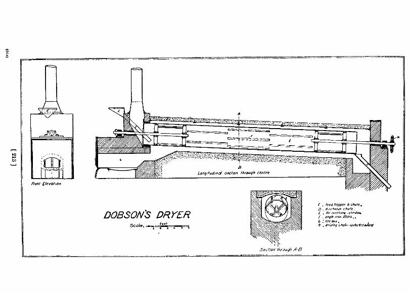
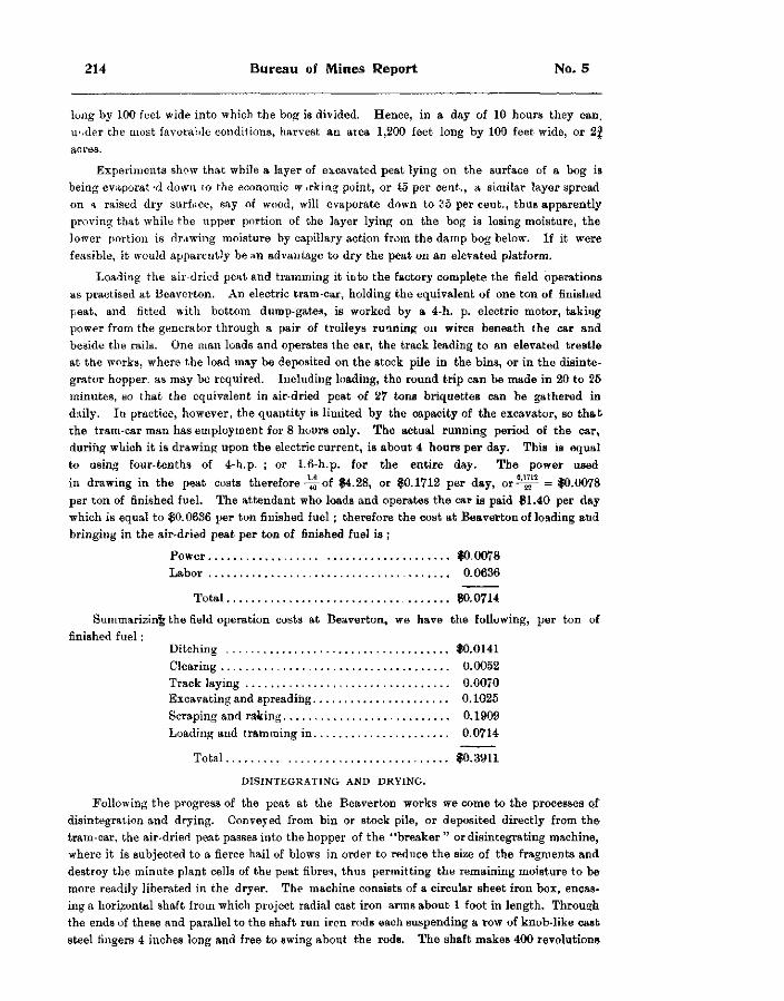
214 Bureau of Mines Report No. 5
long by 100 feet wide into which the bog is divided. Hence, in a day of 10 hours they can, under the most favorable conditions, harvest an area 1,200 feet long by 100 feet wide, or 2 | acres.
Experiments show that while a layer of excavated peat lying on the surface of a bog is being evaporat'd down to the economic w .rking point, or 15 per cent., a similar layer spread on a raised dry surface, say of wood, will evaporate down to 35 per cent., thus apparently proving that while the upper portion of the layer lying on the bog is losing moisture, the lower portion is drawing moisture by capillary action from the damp bog below. If it were feasible, it would apparently be an advantage to dry the peat on an elevated platform.
Loading the air-dried peat and tramming it into the factory complete the field operations as practised at Beaverton. An electric tram-car, holding the equivalent of one ton of finished peat, and fitted with bottom dump-gates, is worked by a 4-h. p. electric motor, taking power from the generator through a pair of trolleys running on wires beneath the car and beside the rails. One man loads and operates the car, the track leading to an elevated trestle at the works, where the load may be deposited on the stock pile in the bins, or in the disintegrator hopper, as may be required. Including loading, the round trip can be made in 20 to 25 minutes, so that the equivalent in air-dried peat of 27 tons briquettes can be gathered in daily. In practice, however, the quantity is limited by the capacity of the excavator, so that the tram-car man has employment for 8 hours only. The actual running period of the car, during which it is drawing upon the electric current, is about 4 hours per day. This is equal to using four-tenths of 4-h. p. ; or 1.6-h.p. for the entire day. The power used in drawing in the peat costs therefore-^5-of $4.28, or $0.1712 per day, o r ^ p = $0.0078 per ton of finished fuel. The attendant who loads and operates the car is paid $1.40 per day which is equal to $0.0636 per ton finished fuel; therefore the cost at Beaverton of loading and bringing in the air-dried peat per ton of finished fuel is ;
Power $0.0078 Labor 0.0636
Total $0.0714
Summarizing the field operation costs at Beaverton, we have the following, per ton of finished fuel:
Ditching $0.0141 Clearing 0.0052 Track laying 0.0070 Excavating and spreading 0.1025 Scraping and raking 0.1909 Loading and tramming in 0.0714
Total $0.3911
D I S I N T E G R A T I N G A N D D R Y I N G .
Following the progress of the peat at the Beaverton works we come to the processes of disintegration and drying. Conveyed from bin or stock pile, or deposited directly from the tram-car, the air-dried peat passes into the hopper of the "breaker " or disintegrating machine, where it is subjected to a fierce hail of blows in order to reduce the size of the fragments and destroy the minute plant cells of the peat fibres, thus permitting the remaining moisture to be more readily liberated in the dryer. The machine consists of a circular sheet iron box, encasing a horizontal shaft from which project radial cast iron arms about 1 foot in length. Through the ends of these and parallel to the shaft run iron rods each suspending a row of knob-like cast steel fingers 4 inches long and free to swing about the rods. The shaft makes 400 revolutions
1902 Peat Fuel: Its Manufacture and Use 215
per minute, and the steel fingers flying out radially dash the peat fragments against a semicircular grizzly set c'ose beneath. Through the 1/16-iach spaces of this grating the peat drops as a mixture of fine particles and dust, damp to the touch.
The breaker itself requires no special attendance, being looked after by the dryer attendant ; but for the greater part of the time a man must be employed to shovel the air-dried peat into the conveyor leading from the storage bins or stock piles to the disintegrator, since, for a portion of the year only, can the peat be dumped directly into the hopper of the machine from the tram-car bringing it in frcm the bog. Estimating the time thiB man will be required at seven months in the year, that is 180 working days, his wages at $1.40 per day, or $252.00, must be distributed over the product for the year, say 3,800 tons. The power required for conveying the peat issunl l , and its cost is included in that given below for this section of the works as a whole. The approximate cost of conveying the peat to the disintegrator is therefore $252 -3800=$0.0663 per ton of finished fuel.
T H E D O B S O N P E A T D R Y E R .
From the bottom of the breaker a conveyor carries the disintegrated peat to the hopper over the dryer, into tho cylinder of which a regular feed is maintained. The Dobson dryer, along with the Dobson excavator and Dobson press, is a distinguishing feature of the Beaverton works. The principles it embodies are : Applying the greatest heat to the exterior of the upper end of the cylinder where the damp peat enters ; causing the flames and hot gases to pass along and about the outside of the revolving cylinder, to the lower or rear end before entering, and then to pass back through the interior of the cylinder, traversing the showering peat ; arranging an internal system of lifters so that this showering of the peat will be continuous and uniform from side to side of the interior of the cylinder ; slightly pitching the cylinder so that as it revolves the peat will travel slowly towards the discharge end ; and so adjusting the firing in accordance with the proportion of water present in the peat that a product uniform in moisture content will be the result.
The Dobson dryer is simple in construction and operation, and does good work at a moderate cost. A reference to the cut will show its plan of construction. Inside the rectangular brick casing is a cylinder 30 feet long by 3 feet diameter made of §-inch sheet iron plates, and set with a pitch of 14 inches in its length. Shafting resting on bearings outside the brickwork extends 12 feet into each end of the cylinder, supporting the latter by cast iron arms. Sets of six 3 by 3-inch angle irons five feet long are equally spaced around the interior of the cylinder, each angle raised by pins 3 inches from the surface, and each set advancing on the preceding one through a small angle of revolution to break the ends. The fire-box is built at the front end as a separate structure. The spacing between the cylinder and brickwork allows of unobstructed circulation of flames and gases about the exterior from front to rear. The cylinder revolves by chain gear at the fixed speed of 1§ revolutions per minnte, at which rate a charge of peat will pass through it in 20 minutes.
The dryer was under observation for test purposes during part of a working da}', samples of the peat before and after drying being taken for analysis,and the quantity of product and fuel consumed being also noted.
This test gave for a day of 10 hours : Weight of air-driei peat charged into dryer, 29,300 lb., containing 34.21 per cent, water ; weight of peat discharged from dryer, 23,000 lb., containing 16.61 per cent water. The weight of water evaporated was 6,300 lb. Blocks of crude air-dried peat containing 34 per cent, water were used as fuel at the rate of 3,145 lb. per day. As is noted above under the head of ditching, one man at $1.40 per day will dig 26 cubic yards of bog, the equivalent of which in peat containing 34 per cent, water is 8,935 lb. ; hence the labor cost of the 3,145 lb. peat used as fuel is $0.4431 per day,;or $0.0385 per ton of finished fuel.
216 Bureau of Mines Report No. 5
One man at $1 40 per day is employed in bringing in air-dried peat or other fuel to boiler and dryer ; one-half of this sum is chargeable to the latter, amounting to $0.0608 per ton of output.
The quantity of power used by the disintegrator and dryer, with accompanying conveyors and elevators, together with an exhaust dust fan, was found to approximate closely to 15 horse power. The cost of this is J$ of $4.28, or $1,605 per day, equivalent on the output of 11.6 tons to $0.1395 per ton of briquettes.
One man at $1.40 per day attends dryer and disintegrator, and this sum amounts to $0.1217 per ton of output.
The cost, therefore, of operating the dryer on the occasion of the test with an output of 11.5 tons per day was as follows, per ton of finished fuel:
Fuel, digging $0.0385 '• bringing in 0.0608
Power 0.1395 Attendance 0.1217
Total $0 3605
These figures differ somewhat from those of the actual working cost, since at the time the test was made only one of the two punches in the press was in operation. The output of the press was therefore diminished by one-half, and the peat was allowed to remain longer in the field and dry down to 34 per cent, moisture, 10 per cent, less than the ordinary run of air-dried peat.
The dryer is said in actual operation to deliver 12.5 tons peat to the briquetting press from air-dried material containing 45 per cent, water. This means the evaporation of 13,600 lb. water per day, double the quantity given off during the test. The expulsion of this additional volume of water involves the use of more fuel, i.e., increases the charge for digging the crude peat for this purpose, but not that for bringing it in, as one man easily gathers a supply for the dryer in ha'f a day. Doubling, then, the cost of this item and distributing- it and the other charges over an output of 12.5 tons finished fuel per day, the following table of costs for operating the dryer is obtained, per ton of peat briquettes :
Fuel, digging $0.0709 " bringing in , 0.0506
Power 0.1284 Attendance 0.1120
Total $0.3673 The crude peat fuel used under dryer and boiler is dug at the beginning of the season in
sufficient quantity for a year's supply, and allowed to lie on the field for a season to dry. Necessary ditching operations may be taken advantage of to procure the fuel so reducing the cost. Analysis of the crude fuel taken from top to bottom of the bog gave :
ppr ce> t. Moisture 34.19 Volatile combustibles 45.28 Fixed earbon 13 42 Ash 7 11
Total 100.00
In the Welland peat works the air-dried peat is first screened, then put through the mechanical dryer, and then disintegrated or reduced. The main tram line from the bog approaches the works through long stock piles where the field product has accumulated. The present hand methods of unloading and moving the peat will no doubt be replaced by labor-saving appliances, such as elevated trestles, side-dumping cars, conveyors, etc., when the works are in continuous operation.
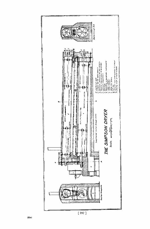
[ 2 1 7 ] (30A)
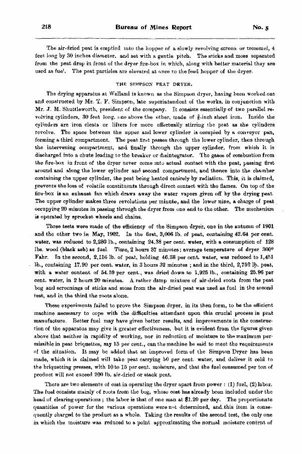
218 Bureau of Mines Report No. 5
The air-dried peat is emptied into the hopper of a slowly revolving screen or trommel, 4 feet long by 30 inches diameter, and set with a gentle pitch. The sticks and moss separated from the peat drop in front of the dryer fire-box in which, along with better material they are used as fuel. The peat particles are elevated at once to the feed hopper of the dryer.
T H E S I M P S O N P E A T D R Y E R .
The drying apparatus at Welland is known as the Simpson dryer, having been worked out and constructed by Mr. T. F. Simpson, late superintendent of the works, in conjunction with Mr. J. M. Shuttleworth, president of the company. It consists essentially of two parallel revolving cylinders, 30 feet long, one above the other, made of f-inch sheet iron. Inside the cylinders are iron cleats or lifters for more effectually stirring the peat as the cylinders revolve. The space between the upper and lower cylinder is occupied by a conveyor pan, forming a third compartment. The peat first passes through the lower cylinder, then through the intervening compartment, and finally through the upper cylinder, from which it is discharged into a chute leading to the breaker or disintegrator. The gases of combustion from the fire-box in front of the dryer never come into actual contact with the peat, passing first around and along the lower cylinder and second compartment, and thence into the chamber containing the upper cylinder, the peat being heated entirely by radiation. This, it is claimed, prevents the loss of volatile constituents through direct contact with the flames. On top of the tire-box is an exhaust fan which draws away the water vapors given off by the drying peat. The upper cylinder makes three revolutions per minute, and the lower nine, a charge of peat occupying 20 minutes in passing through the dryer from one end to the other. The mechanism is operated by sprocket wheels and chains.
Three tests were made of the efficiency of the Simpson dryer, one in the autumn of 1901 and the other two in May, 1902. In the first, 3,006 lb. of peat, containing 42.64 per cent, water, was reduced to 2,280 lb., containing 24.38 per cent, water, with a consumption of 128 lbs. wood (black ash) as fuel. Time, 2 hours 37 minutes; average temperature of dryer 300° Fahr. In the second, 2,116 lb. of peat, holding 46.38 per cent, water, was reduced to 1,451 lb., containing 17.90 per cent, water, in 3 hours 32 minutes ; and in the third, 2,752 lb. peat, with a water content of 54.59 per cent., was dried down to 1,9251b., containing 25.96 per cent, water, in 2 hours 20 minutes. A rather damp mixture of air-dried roots from the peat bog and screenings of sticks and moss from the air-dried peat was used as fuel in the second test, and in the third the roots alone.
These experiments failed to prove the Simpson dryer, in its then form, to be the efficient machine necessary to cope with the difficulties attendant upon this crucial process in peat manufacture. Better fuel may have given better results, and improvements in the construction of the apparatus may give it greater effectiveness, but it is evident from the figures given above that neither in rapidity of working, nor in reduction of moisture to the maximum permissible in peat briquettes, say 15 per cent., can the machine be said to meet the requirements of the situation. It may be added that an improved form of the Simpson Dryer has been made, which it is claimed will take peat carrying 50 per cent, water, and deliver it cold to the briquetting presses, with 10 to 15 par cent, moisture, and that the fuel consumed per ton of product will not exceed 200 lb. air-dried or stack peat.
There are two elements of cost in operating the dryer apart from power : (1) fuel, (2) labor. The fuel consists mainly of roots from the bog, whose cost has already been included under the head of clearing operations ; the labor is that of one man at $ 1.20 per day. The proportionate quantities of power for the various operations were not determined, and this item is consequently charged to the product as a whole. Taking the results of the second test, the only one in which the moisture was reduced to a point approximating the normal moisture content of
1902 Peat Fuel: Its Manufacture and Use 219
peat briquettes, as a basis, the output of dried peat per 10 hours would be 14,510 lb., or 7.25 tons, the labor cost of which would be $0,165 per ton of briquettes.
After drying, the peat at the Welland works is passed through a disintegrator, the object being to promote further evaporation and cool the peat. At other works the peat is disintegrated before being put through the dryer, which would seem to be the natural and more effective method. The machine much resembles the one used at Beaverton already described, the chief difference being that the fingers attached to the cylinder are rigid instead of being loosely suspended. From the disintegrator the peat goes into storage bins, and another man at $1.20 per day is employed to shovel the peat out of the bins when the presses are in use. This labor represents $0.0686 per ton on a daily output of 17.5 tons briquettes.
D R Y I N G BY P R E S S U R E N O T S U C C E S S F U L .
Countless attempts have been made to mechanically expel the water from crude peat by pressure, nitration or centrifugal force, all applied in a multitude of ways, but so far these attempts have invariably ended in failure. At the Trent Valley peat works hydraulic presses built for the purpose by Boomer and Boschert, of Syracuse, N.Y., capable, it is stated, of exerting a pressure of 300 tons, or 2 tons per square inch, were employed, the peat after passing through the macerating machine being loaded on trucks in layers between perforated trays overlaid with filter cloths, and in this manner subjected to pressure. Nineteen pressings were made in 10 hours, the output being 14.42 tons of parlially dried peat per press. The following table summarizes the results so far as removing the water is concerned :
Water content of peat.
Water displaced, Sample Number. per cent.
Entering press, Leaving press, per cent. per cent.
1 78.19 58. o9 19.30 79 35 63.16 16.19
3 77.24 64 49 12 75 4 76 92 61 29 12.63 5 75.48 61.52 13.98 6 78.17 65 56 12 61 7 78 28 65.27 13 01 8 79 40 63 24 16.16 9 79 41 66 58 12.83
10 77.99 64.63 13 36 1 1 74.42 60.70 13.72
Average . . . 77.71 63.48 14.23
It will be seen therefore that an average of 63.48 per cent, water remained in the peat after pressing. This is almost too high for subsequent drying by artificial heat; b u t criticizing the results from the other point of view, namely that of expense, 4 men and an engineer being required to tend the machine, it must be conceded that the cost was out of proportion to the comparatively small quantity of peat handled and the low extraction of water.
The last momentous experiments in this line were carried on for a period of several years at Dusseldorf, Germany, with a patent hydraulic filter press. Unlimited capital was available, and the expenditure amounted to about $100,000, every idea which appeared feasible receiving a thorough trial, so that if at all possible the aim of the process might be accomplished. B u t all in vain, for the attempt has recently been abandoned as impracticable. Mr. Thaulow thus reports on this point :
" It was contended that this press would bring the peat down to contain about 50 per cent , water, but it proved difficult to reduce the water even to 66 per cent; and this required so long
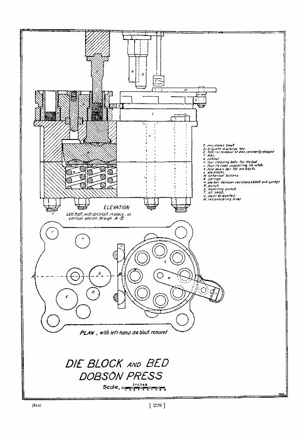
DIE BLOCK AND BED DOBSON PRESS
SCALE, i
=2&1 ( 220 ]
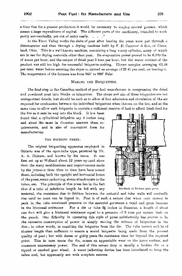
1902 Peat Fuel: Its Manufacture and Use 221
a time that for a greater production it would be necessary to employ several presses , which means a large expenditure of capital. The different parts of the machinery, intended to work partly automatically, get out of order easily. . . ."
A t the Trent Valley works the slabs of peat after leaving the press were put through a disintegrator and then through a drying machine built by F. D. Cummer & S o n , of Cleveland, Ohio. This is a well-known machine, containing a long rotary cylinder, man} 7 of which are in use for drying materials other than peat. Its evaporative power proved to be 6,000 lbs. of water per hour, and the output of dried peat 3 tons per hour, but the water content of the product was still too high for successful briquette-making. Eleven samples averaging 03.48 per cent, water before entering the dryer coatained an average of 23.41 per cent, on leaving it. The temperature of the furnace was from 965° to 980° Fahr.
MAKING THE BRIQUETTES.
The final step in the Canadian method of peat fuel manufacture is compressing the dried and powdered peat into blocks or briquettes. The shape and size of these briquettes are not unimportant details, but should be such as to allow of free admission and circulation of the air required for combustion between the individual briquettes when thrown on the fire, and at the same time to allow each briquette to contain a sufficient reserve of fuel to afford fresh food for the fire as it eats its way into the block. It has been found that a cylindrical briquette say 2 inches long and about the same in diameter answers these requirements, and is also of convenient form for manufacturing.
THE DICKSON PRESS.
The original briquetting apparatus employed in Ontario was of the open-tube type, patented by Mr. A . A . Dickson, and known by his name. It was first set up at Welland about 12 years ago,and since then the many modifications and improvements made by the inyentor from time to time have been tested there, including both the upright and horizontal forms of the press, water-jacketting, steam attachments to the tubes, etc. The principle of this press lies in the fact th>it if a tube of indefinite length be fed with any Die-block of Dickson peat press,
material, the resistance due to friction between the material and tube walls will gradually rise until no more can be forced in. Peat is of such a nature that when once caused to pack in.the tube continued pressure on the material generates a rapid and great increase in the frictional resistance For a die or tube 2 | inches in diameter, a length of about one font will give a frictional resistance equal to a pressure of 8 tons per square inch on the punch. One difficulty in operating this style of press satisfactorily has proven to be the excessive consumption of power in simply moving the column of briquettes in the dies ; in other words, in expelring the briquette from the die. The tube cannot well be of shorter length than sufficient to ensure a sound briquette being made from the poorest quality of peat; but with dense or gritty peats the resistance rises far beyond the required point. This in turn heats the die, causes an appreciable wear on the inner surface, and consumes unnecessary power. The end of this severe duty is usually a broken die or a ripped or cracked gear wheel. A water jacketting device has been introduced to keep the tubes cool, but apparently not with complete success.
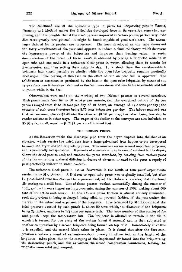
222 Bureau of Mines Report No. 5
The continued use of the open-tube type of press for briquetting peat in Russia, Germany and Holland makes the difficulties developed here in its operation somewhat surprising, and it is possible that if the machine were improved at certain points, particularly if the dies were greatly strengthened, it might be found capable of good work here. The advantages claimed for its product are important. The heat developed in the tube draws out the tarry constituents of the peat and appears to induce a ehemical change which decreases the hygroscopic power of the briquettes and improves their heating value. A ready demonstration of the former of these results is obtained by placing a briquette made in an open-tube and one made in a resistance-block press in water, allowing them to remain for five minutes, and then setting them aside to dry. In a short time the resistance-block briquette falls apart, partially or wholly, while the open tube briquette remains practically unchanged. The bearing of this fact on the effect of rain on peat fuel is apparent. The solidifation or cementation produced by the heat in the open-tube briquette, by means of the tarry substances it develops, also makes the fuel more dense and less liable to crumble and fall to pieces while in the fire.
Observations were made on the working of two Dickson presses on several occasions. Each punch made from 54 to 60 strokes per minute, and the combined output of the two presses ranged from 17 to 18 tons per day of 10 hours, an average of 17.5 tons per day ; the capacity of each press therefore being 8.75 tons briquettes per day The labour required was that of two men, one at $1.40 and the other at $1.20 per day, the latter being free also to render assistance in other ways. The wages of the feeder at the conveyer are also included, or $3.80 a day in all, equal to $0.2171 per ton of finished fuel.
T H E D O B S O N P R E S S .
At the Beaverton works the discharge pipe from the dryer empties into the shoe of an elevator, which carries the dried peat into a large galvanized iron hopper or bin interposed between the dryer and the briquetting press. This reservoir serves several important purposes, and is practically indispensable. It permits of a reserve supply in case of accident to the dryer; allows the dried peat to cool; and enables the press attendant, by drawing from various parts of the bin containing material differing in degree of dryness, to send to the press a supply of peat practically uniform in water content.
The resistance-block press in use at Beaverton is the result of four years' experiments carried on by Mr. Dobson. A Dickson or open-tube press was originally installed, but after 1 jng-continued trial was chauged for a press embodying Mr. Dobson's own idea, that of a closed die resting on a solid base. One of these presses worked successfully during the summer of 1901, and, with some important improvements, during the summer of 1902, making about 600 tons of briquettes each season. In the Dobson press friction is, almost entirely eliminated, each die previous to being re-charged being oiled to prevent friction of the peat against the die wall in the subsequent expulsion of the briquette. It is estimated by Mr. Dobson that the total pressure exerted by each punch is about 50 tons which, the diameter of the briquette being 2J inches, amounts to 12^ tons per square inch. The large number of dies employed for each punch keeps the temperature low. The briquette is allowed to remain in the die in which it is formed for one cycle of the system (about 6 seconds) and is then subjected to another compression by a second briquette being formed on top of it Immediately after this it is expelled and the second block takes its place. It is found that after the first compression a certain amount of expansion—about one-eighth of an inch in the length of the briquette—takes place, due to the escaping of the imprisoned air forced into the briquette by the descending punch, and this expansion the second compression counteracts, leaving the briquette more solid and compact.
1902 Peat Fuel: Its Manufacture and Use 223
There are two punches in each machine, and to each punch a die block containing eight snugly fitting dies. The dies are heavier in the lower end where the compression takes place. The base block against which the briquettes are formed, remains rigid, unless for any reason the strain exceeds the working pressure, when a set of spiral steel springs, on which the block rests, takes up the excess pressure and prevents any breakage.
The down-thrust of the punches is imparted by two heavy eccentrics faced with roller bearings, and with each stroke of the punch the die block is turned through one-eighth of a revolution. Working in the next die to the compressing punch is the releasing punch which expels the finished briquette, while the third receives an oil swab which coats the inside of the die with a film of crude petroleum, to lessen the friction and facilitate expulsion of the briquette. The two punch-systems of the press act reciprocally, a stroke being delivered at every half revolution of the eccentric shaft. With each down stroke the compressing punch forms a briquette on top of the one previously made in the same die, the discharging punch expels from the next die the bottom or completed briquette, and the third die receives its coating of oil from the oil swab. The cut illustrating the die block and bed of the Dobson press may serve to make clear the construction and working of this partof the machine. Power is transmitted through belting to a pulley on the pinion shaft, and thence by a 5-foot gear wheel operating the eccentric shaft. The machine is steadied by a heavy fly-wheel on each of these two shafts, and runs quietly and with little vibration, notwithstanding the immense and sudden pressure exerted twice every revolution. It makes 50 or 51 revolutions per minute, producing 100or 102 briquettes per minute. Twenty-five briquettes weigh about 10 lb., consequently the output of the press in 10 hours is about 12£ tons finished fuel.
To operate the press with the accessory shafting, conveyors, etc, 13-h.p. is required, o s t ing $1,391 per day, or $0.1112 per ton of briquettes. The press operator is foreman of the plant, receiving $1.75 per day as wages, making the labor cost of briquetting $0.1400 per ton. The cost of this operation may be summed up as follows per ton of finished fuel :
A modification of the open-tube press has lately been tried at Whitewater, Wisconsin, apparently with successful results. The die-b!ock instead of being water-jacketted to keep down the temperature, is heated by steam, and the stroke of the pressing punch is shortened to about 2 inches, working at the same time at a correspondingly higher rate of speed. The effect of the improvements is said to be the production of a denser fuel, the heat developing the t*rry constituents of the peat and uniting them with the fibrous material into a more c o herent mass. Instead of issuing from the press as separate briquettes the peat comes out in lengths or sticks which may be broken to suitable sizes. The improved press is being experimented with at Welland.
One or other of the two different presses above described has been used in every peat factory hitherto established in Ontario, except that at Newington, where Dominion Peat Products, Limited, are installing a European process of manufacture which does not include briquetting, and the product of which will in fact be " machine " peat, either in the form of blocks or charcoal. At these works after the raw peat is dug from the bog it is to be put through a German kneading or macerating machine called the Lucht mill, in which it is thoroughly mixed or pulped, being afterwards cut into blocks weighing about 2 lb. each. These are placed in drying kilns, and relieved of moisture by the application of heated and inert gases, which, while carrying off the moisture, will not attack the carbon of the peat. If it is desired
Power Attendance
$ 0 1112 0.1400
Total . , $ 0.2512
T H E N E W I N G T O N P L A N T .
224 Bureau of Mines Report No. 5
to produce peat coke the drying process is carried farther in the same chamber by raising the temperature of the gases to the necessary degree of heat for carbonizing the peat, the liquors and tarry substances in the peat being duly recovered and the coke removed into and cooled in other chambers. The plant has been partly completed, and is expected to be in operation this summer.
POWER GENERATION AND DISTRIBUTION. The power plant at Welland includes two steam boilers of 120-h. p. each, one of
which has sufficient capacity for the present plant;" a horizontal engine of 175-h. p. ; the necessary pumps for supplying the boiler and press water-jacket ; and a small auxiliary portable boiler with super-mounted engine for operating the dryer plant when the remainder of the machinery is not in use. The fuel used is air-dried peat, of which 4 tons per day were consumed when the tests were made, the cost to dig and deliver being $1,359 per day. One engineer was required whose wages were $2.00 per day. Lubricating oil for the entire plant was used at the rate of two gallons per day, costing $0.34. The total cost therefore of generating power for the entire plant was $3.70 per day, or $0.2113 per ton of finished fuel.
The grate bars of the boiler which were designed for burning peat were fitted with ^-inch space and 5-16 inch bars, thus lessening draught and preventing the fine particles of peat dropping into the ash-pit below. The distance between the grate bars and bottom of the boiler had been reduced to 18 inches, and between boiler and fire wall at the back of the grate to 6 inches, the reason for the latter changes being that peat, both in the air-dried form and briquettes, burns with a short flame. When firing with compressed peat fuel a depth of not more than 4 inches is maintained over the entire surface of the grate. The bottom layer of an inch in depth will be fine ash gradually dropping through the grate spaces as the peat is consumed. The heat is easily and quickly regulated by means of the chimney draught. It is necessary when using briquettes toreplenii-h the fire every 5 minutes.
The fuel employed at Beaverton was dried cedar cordwood, one cord weighing 1700 lb., and costing $1.50. One cord was required for a day's run. Air-dried peat would have been cheaper, but the grate of the boiler was not adapted for burning it. Delivering fuel to the boiler occupied half of one man's time at $1.40 per day, and the engineer in charge was paid at the same rate Pour gallons of oil are consumed in the whole plant per day, costing $0.68. The power cost for the entire process, including field operations, is made up as follows,:
per day Fuel $1.50 Delivery of fuel 70 Attendance 1.40 Oil 68
Total $4.28
Mr. J. J. Milne, mechanical engineer, Toronto, also examined and reported on the Beaverton plant and found the power required for operating it to be 40-h. p., distributed among the various plant units as follows :
Briquetting press and elevator 13 horse power. Tram car 4 " " Excavator 8 " " Dryer, breaker, conveyors and exhaust fan 14 " "
Total 40 "
From these figures the proportionate costs for power for the several parts of the process have been deduced in his report.
1902 Peat Fuel: Its Manufacture and Use 225
COST OF MANUFACTURE. We are now in a position to sum up the cost of manufacturing the briquettes both at
Welland and Beaverton. The totals resulting are not directly comparable because of different conditions existing at the two places. At Welland the workable depth of the bog is 3 feet, as against but 2£ feet at Beaverton, which at once gives an advantage to the former in price per ton in distributing the costs of parts of the field operations ; also at Welland the capacity of the two-briquetting presses is considerably greater than that of the one at Beaverton, while at each the expenditure for labor is about the same.
At Welland, 17J tons briquettes per day : per ton.
Field operations $0.3771 Attendance on dryer 0.1650 Attendance on presses 0.2171 Power 0.2113
Total $0.9705 Wages have gone up since the Welland tests were made, and laborers now get at least $1.40
per day. This advance will add proportionately to the cost of manufacture. At Beaverton, 1 2 | tons briquettes per day :
per ton. Field operations $ 0.3911 Drying. . . 0.3673 Briquetting 0.2512
Total $ 1.0096 In neither case do the above figures cover more than actual operating costs, nothing being
allowed for interest on capital investment, wear and tear of machinery, royalty charges or profits.
The Peat Machinery Supply Company, Limited, of Beaverton, of which Mr. Alex. Dobson is president,quotes the following prices (subject to revision at any time) for the machinery and apparatus required for a complete peat plant according to the Beaverton plan, with a capacity of 3,000 tons of briquettes per year, working 10 hours per day, or 6,000 to 7,000 tons when run continuously 24 hours per day :
Briquette press , $ 2,500 Dryer 1,350 Breaker 400 Excavator, including motor 600 Generator, tram-car, motor and tracks 1,200 Engine and boiler, 50-h.p 2,000 Shafting, belts and conveyors 700 Buildings (brick) 1,500 Sundries : 200
Total $10,450 The same company also manufactures the Dickson briquetting press for $1,500, and the
Simpson dryer for $1,500 or, including cost of brick work and setting up, for $1,750. The price of bog lands owned by private individuals will in most cases be less than that of
arable land probably not exceeding $10 or $20 ; while those belonging to the Crown, situated mostly in more remote districts, may be purchased for much less. In a bog costing say $18 per acre and yielding 1,000 tons fuel per acre, the outlay for land regardless of interest, equals $0,018 per ton of briquettes. Depreciation of plant is difficult of estimation, but let it be taken at 10 per cent, per annum. This on the above cost of $10,450 would require a sum of
15 M.
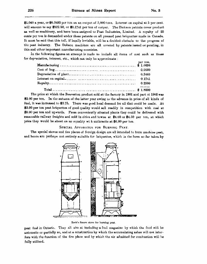
226 Bureau of Mines Report No. 5
$1,045 a year, or $0.3483 per ton on an output of 3,000 tons. Interest on capital at 5 per cent, will amount to say $522.50, or $0.1741 per ton of output. The Dickson patents cover product as well as machinery, and have been assigned to Peat Industries, Limited. A royalty of 25 cents per ton is demanded under these patents on all pressed peat briquettes made in Canada. It must be said that this toll, if legally leviable, will be a decided obstacle to the progress of the peat industry. The Dobson machines are all covered by patents issued or pending, in this and other important manufacturing countries.
In the following figures an attempt is made to include all items of cost such as those for depreciation, interest, etc., which can only be approximate :
per ton. Manufacturing $ 1.0096 Cost of bog 0.0180 Depreciation of plant 0.3483 Interest on capital 0.1741 Royalty 0.2500
Total $ 1.8000 The price at which the Beaverton product sold at the factory in 1901 and part of 1902 was
$3.00 per ton. In the autumn of the latter year owing to the advance in price of all kinds of fuel, it was increased to $3.75. There was good local demand for all that could be made. At $3.00 per ton peat briquettes of good quality would sell readily in competition with coal at $5.00 per ton and upwards. From conveniently situated plants they could be delivered with reasonable railway freights and sold in cities and towns at $4.00 or $4.50 per ton, at which price they would be about on an equality wi h anthracite at $6.00 per ton.
SPECIAL APPARATUS FOR BURNING PEAT. The special stoves and fire places of foreign design are all intended to burn machine peat,
and hence are perhaps not entirely suitable for briquettes, which is the form so far taken by
Reek's fissure stove for burning peat.
peat fuel in Ontario. They all aim at including a fuel magazine by which the feed will be automatic or partially so, and at a construction by which the accumulating ashes will not interfere with the function of the fire place and by which the air admitted for combustion will be fully utilized.
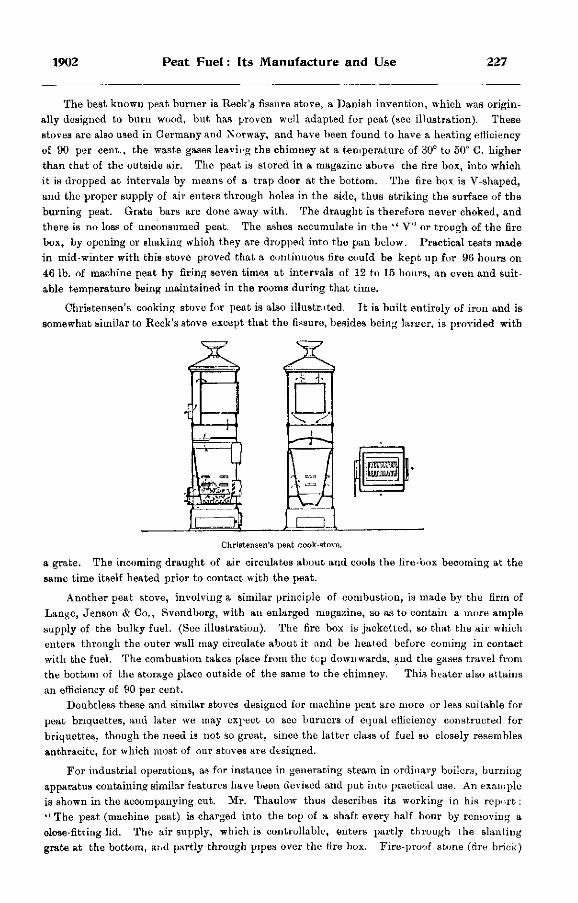
1902 Peat Fuel: Its Manufacture and Use 227
The best known peat burner is Reek's fissure stove, a Danish invention, which was originally designed to burn wood, but has proven well adapted for peat (see illustration). These stoves are also used in Germany and Norway, and have been found to have a heating efficiency of 90 per cent., the waste gases leaving the chimney at a temperature of 30° to 50° C. higher than that of the outside air. The peat is stored in a magazine above the fire box, into which it is dropped at intervals by means of a trap door at the bottom. The fire box is V-shaped, and the proper supply of air enters through holes in the side, thus striking the surface of the burning peat. Grate bars are done away with. The draught is therefore never choked, and there is no loss of unconsumed peat. The ashes accumulate in the " V" or trough of the fire box, by opening or shaking which they are dropped into the pan below. Practical tests made in mid-winter with this stove proved that a continuous fire could be kept up for 96 hours on 46 lb. of machine peat by firing seven times at intervals of 12 to 15 hours, an even and suitable temperature being maintained in the rooms during that time.
Christensen's cooking stove for peat is also illustrated. It is built entirely of iron and is somewhat similar to Reek's stove except that the fissure, besides being larger, is provided with
± 3 .
V 7 ,
Christensen's peat cook-stove,
a grate. The incoming draught of air circulates about and cools the fire-box becoming at the same time itself heated prior to contact with the peat.
Another peat stove, involving a similar principle of combustion, is made by the firm of Lange, Jenson & Co., Svendborg, with an enlarged magazine, so as to contain a more ample supply of the bulky fuel. (See illustration). The fire box is jacketted, so that the air which enters through the outer wall may circulate about it and be heated before coming in contact with the fuel. The combustion take3 place from the top downwards, and the gases travel from the bottom of the storage place outside of the same to the chimney. This heater also attains an efficiency of 90 per cent.
Doubtless these and similar stoves designed for machine peat are more or less suitable for peat briquettes, and later we may expect to see burners of equal efficiency constructed for briquettes, though the need is not so great, since the latter class of fuel so closely resembles anthracite, for which most of our stoves are designed.
For industrial operations, as for instance in generating steam in ordinary boilers, burning apparatus containing similar features have been devised and put into practical use. An example is shown in the accompanying cut. Mr. Thaulow thus describes its working in his report: " The peat (machine peat) is charged into the top of a shaft every half hour by removing a close-fitting lid. The air supply, which is controllable, enters partly through the slanting grate at the bottom, ar.d partly through pipes over the fire box. Fire-proof stone (tire brick)
228 Bureau of Mines Report No 5
lines the fronc part of the boiler, as well as the fire box itself, to withstand the great heat— about 2,500° C.—at which peat burns when the air supply is properly regulated ; the best kind of fire-proof material should be used for this purpose. The influx of cold air which takes place through the fire-box door in the ordinary boiler, is avoided in this case, and as the amount of smoke is less than with any other kind of boiler, the loss of heat through smoke is also less."
There does not appear to be any reason why the ordinary soft-coal boiler equipment, with automatic stoker and automatic dampers, could not be made to work satisfactorily with peat briquettes at small cost. The grate would require to be raised nearer the boiler, and also the fire-wall at the back of the grate ; the spaces between the grate bars should also be reduced one-half. A description of such a grate is given in connection with the Welland peat plant.
In an open grate peat makes a cheerful, strong and steady fire, radiating heat into the room rather than sending it up the chimney, by reason of the small draught required.
PEAT GAS.
The use of peat gas for fuel purposes is of long standing in the iron and steel industry of Sweden, in which it is preferred to coal gas on account of its much greater freedom from sulphur and phosphorus. At the rolling mills peat gas is used in the plate furnaces with the result of reducing the formation of scales, particularly in the rolling of thin steel plates. The use of peat gas has contributed largely to improving the quality of Swedish steel, the excellence of which is well known. Peat gas has also come into use as fuel in steam boilers.
THE MERRIFIELD GAS GENERATOR.
In 1901 the perfected Merrifield peat-gas generator was designed and constructed by Mr. L. L. Merrifield, engineer to the Economical Gas Apparatus Construction Company, Limited, of Toronto. The new plant was erected for demonstration purposes at Toronto Junction, and during the autumn of 1901 a number of experiments were made, several of them under the supervision of the Bureau of Mines. Considering the intermittent nature of the tests and the imperfect installation of the plant, a satisfactory showing was obtained. A gas rich in heating value was produced at a fairly steady rate, and at small cost for maintenance and attendance. Without going into detail, it may be stated that the experiments warranted the following conclusions, namely : That, with connections of suitable size, the generator could produce a much larger quantity of gas per hour or minute than was actually obtained ; that the production of gas will depend almost wholly on the quantity of fuel consumed ; and that this in turn depends on the volume of the air blast.
The cost of maintenance or attendance may be reduced to a minimum by handling the bulky peat and removing the ashes by mechanical means, and this would also effect a saving in time.
The Merrifield gas generator resembles the extensively employed Loomis-Pettibone plants, and particularly that one at Nacozari, Mexico, where the usual Loomis system is somewhat modified with a view of making a uniform and fixed gas out of the mixture of water- and producer-gases, which will be higher in calorific power than producer-gas and lower than water-gas, the fuel employed being wood instead of coal. This result is effected by introducing very little steam with the air blast. The ordinary Loomis generator produces alternately producer-gas and water-gas for short periods of five minutes or so each way, each gas being conducted to its own holder. The Merrifield furnaces are also set up in connected pairs, with charging doors at the top. The grates are near the bottom, and below them is a taperir'.g bottomless ash chamber, terminating several inches below the surface of the water in the ash-
1902 Peat Fuel: Its Manufacture and Use 229
pit. The water seals the bottom of the generators, preventing the ingress of air, and yet does not interfere with the discharge of the ashes.
Crude air-dried peat in lumps forms the fuel. By the time it reaches the generators from one-third to one-half will have crumbled into fragments and dust, making a compact and suitable charge for uniform consumption in the furnace.
The air blast is generated by a small blower operated by gas engine, taking gas from the holder. It passes first through the pipes of the condenser, where in condensing the moisture out of the hot gases from the generators it is itself heated up previous to entering the furnaces by way of the chamber below the grate in the bottom. The pipes for injection of steam also enter here. However, on account of the high percentage of moisture contained in the peat fuel, an internal supply of steam for the mixture of water- and producer-gas is usually assured.
After making a g >od fire, say of wood, in the grate, the peat is charged into the furnaces by the port holes at the top until they are full, when the caps are again clamped down. By forcing the blast for a while and heating the peat into a glowing mass the process becomes properly started, after which the volume of air is adjusted to the production of the maximum capacity of the generators. From now on the operation is continuous except during the loading or re-charging periods, covering a quarter of an hour or so once or twice a day.
Although set up in pairs the generators, like the Nacozari machines, will most of the time work as one, producing the uniform mixed gas ; but should a partial production of water-gas alone be desired, the air blast is shut off and steam injected into one generator, up through the glowing mass of peat, across into and down through the hot coals in the other machine and out thence to the condenser and scrubber. This continues for a few minutes, until the fire has cooled off, so that the air blast is again required to bring it up to the proper temperature, when the same course is again followed, except that this time the direction of the steam in the generator is reversed, entering the bottom of the second and leaving by the first.
Peat, like wood, particularly green wood, is naturally suited on account of its large percentage of moisture, to steady production of the mixed gas, rather than to the alternate generation of first water-gas and then producer-gas, as with dry fuels such as coal.
QUALITY OF MERRIFIELD PEAT-GAS.
In these experimental runs of the Merrifield gas generator the calorific determinations and analyses of the gas were made by Dr. W. Hodgson Ellis, professor of applied chemistry at the School of Practical Science, Toronto. The gas produced on 28th October 1901 gave the following calorific values at the different stages of the operations :
Time. B. T. U. per cubic fcot. 3.00 p.m 96.4 3.10 „ 118. 3.20 „ 149. 3.25 „ 154.6 3.55 „ 159. 4 15 „ 125.
Average 133.7 The quantity of gas made and peat consumed was not ascertained. The plant had been kept warm during the previous part of the day without generating
much gas until this test began, and soon after gas of good quality began to appear a mishap <uused a sudden termination of the test. This accounts for the gradual rise and subsequent abrupt fall in the quality of the gas.
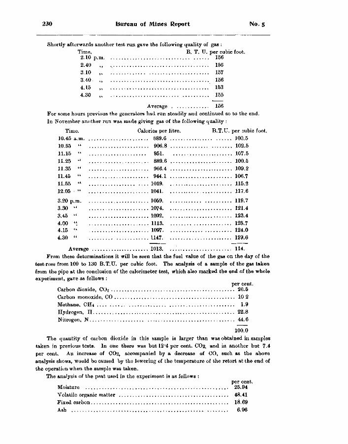
230 Bureau of Mines Report No. 5
Shortly afterwards another test run gave the following quality of gas : Time. B. T. TJ. per cubic foot.
2.10 p. m 156 2.40 3.10 3.40 4.15 4.30
156 157 156 153 155
Average 156 For some hours previous the generators had run steadily and continued so to the end. In November another run was made giving gas of the following quality :
Time. Calories per litre. B.T.U. per cubic foot. 10.45 a.m. 10.55 11.15 11.25 11.35 11.45 11.55 12.05
3.20 p.m 3.30 3.45 4.00 4.15 4.30
889.6 100.5 906.8 102.5 951. 107.5 889.6 100.5 966.4 109.2 944.1 106.7
1019 115.2 1041 117.6
1069 119.7 1074 121.4 1092 123.4 1113 125.7 1097 124.0 1147 129.6
Average 1013 114. From these determinations it will be seen that the fuel value of the gas on the day of the
test rose from 100 to 130 B.T.U. per cubic foot. The analysis of a sample of the gas taken from the pipe at the conclusion of the calorimeter test, which also marked the end of the whole experiment, gave as follows :
per cent. Carbon dioxide, CO2 20.5 Carbon monoxide, CO 10 2 Methane. CH 4 1.9 Hydrogen, H 22.8 Nitrogen, N 44.6
100.0 The quantity of carbon dioxide in this sample is larger than was obtained in samples
taken in previous tests. In one there was but 12'4 per cent. CO2, and in another but 7.4 per cent. An increase of CO2, accompanied by a decrease of CO, such as the above analysis shows, would be caused by the lowering of the temperature of the retort at the end of the operation when the sample was taken.
The analysis of the peat used in the experiment is as follows : per cent.
Moisture 25.94 Volatile organic matter 48.41 Fixed carbon 18.69 Ash 6.96
1902 Peat Fuel: Its Manufacture and Use 231
Another run of the generator was made, and the gas this time tested by Mr. J. Walter Wells. The analytical work was conducted at the gas works, but for the calorimeter determinations samples of the gas were taken in a large aspirator can froru the gas-holder and tested at the School of Practical Science laboratory in the same Junker's calorimeter as was used at the works by Dr. Ellis in the experiments previously described.
In forcing the gas out of the can by in-running water some of the tarry vapors were lost by condensation, as was apparent on examination of the water from the aspirator. In all other respects, however, the method and apparatus worked admirably.
In the accompanying table of analyses on page 232, samples Nos. 1 to 11 are of the water-gas type, made by injecting a large excess of steam with a moderate air blast over the hot peat in the generator. Samples Nos. 12 to 16 are of producer-gas made in reheating the furnace charges, which were cooled by the flow of steam for the water-gas, by reversing the direction of the air blast through the generators and shutting off all steam. On leaving the holders this gas smelt very strongly of tar and contained considerable vapors.
Another similar Merrifield peat-gas generator was installed at the Trent Valley Peat Fuel Company's works, Kirkfield, to produce fuel gas for the dryer, but no tests were made with it, which is to be regretted, since it is said to have worked satisfactorily.
The original Merrifield generator, first set up at Toronto Junction, on which the above experiments were conducted, has since been removed and reinstalled at the Welland peat works, where, if desired, test runs may be made with it. Later the intention is to incorporate it as part of the peat works, to furnish fuel gas for boilers and dryers.
C O S T OF G A S P L A N T .
From the prospectus of Peat Industries, Limited, concerning this method and all necessary apparatus for the production by it of peat gas, the following is quoted :
" From one ton of compressed peat, analysing approximately : moisture 15 per cent., ash 7 per cent., fixed carbon 21 per cent., volatiles 57 per cent., valued at $1.50 per ton delivered at gas retort, figuring wages at 20 cents per hour, and yearly depreciation at 6 per cent, upon value of machinery, and in a plant capable of producing 40,000 cubic feet of gas hourly, a yield will be had of not less than 100,000 cubic feet of fixed gas, carrying not less than 150 B.T.U. per cubic foot, at a cost not exceeding 2J cents per 1000 cubic feet. We will supply all apparatus and material for a plant producing not lesi than 20,000 cubic feet of gas per hour for $5,000, exclusive of freights, cartage to site and erection; larger plants proportionately. Peat carrying up to 30 per cent, moisture may be used, but the yield of gas will be reduced about 1,000 cubic feet for every additional 1 per cent, moisture."
This estimate was made for gas plants situated at a distance from the bogs, to which the peat would have to be shipped, and which therefore must first be manufactured into compressed fuel. If the use of cut-peat be made possible by locating the gas works at the bog, or only at such distance that the peat could be economically transported thereto as cut peat, the cost of the fuel should not exceed 50 to 75 cents per ton.
The above experimental runs with the Merrifield generator were made on cut peat, and the analytical tests show that it gives high results. With compressed peat briquettes the advantages over cut peat would be smaller bulk and therefore less frequent handling, lower moisture content and consequently a higher calorific value.
There are many advantages to be gained in the use of peat by converting it into gaseous .fuel, many of them appertaining equally to other gaseous fuels. While the consumption of t he solid fuel involves a loss of heat of 25 to 30 per cent, or more, this loss, if the fuel be
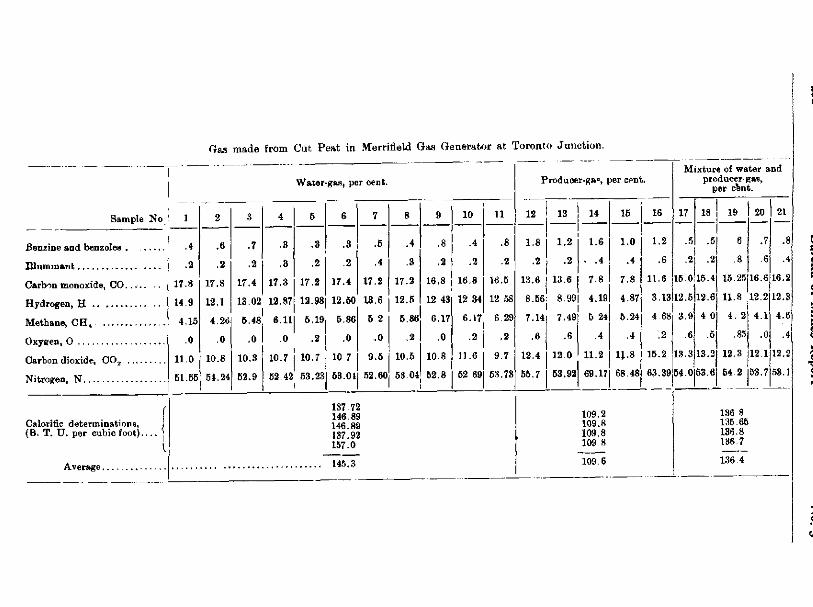
Sample No
Benzine and benzoles
IUuminant:
Carbon monoxide, CO. . . . .
Hydrogen, H
Methane, CH 4
Oxygen, O
Carbon dioxide, C 0 2
Nitrogen, N
Calorific determinations, (B. T. U. per cubic foot)....
.4
.2
17.8
14.9
4.15
.0
11.0
61.55
Gas made from Cut Peat in Merrifield Gas Generator at Toronto Junction.
Water-gas, per cent.
.6
.2
17.8
12.1
.7
.2
17.4
.3
.3
17.3
13.02 12.87
4.2o| 6.48
.0
10.8
54.24
.0
10.3
52.9
6.11
.3
.2
17.2
12.98
.3
.2
17.4
.6
.4
17.2
12.60 13.6
.0 .2
10.7 I 10.7
62 42 53.23 I
6.19 5.86
.0
10 7
53.01
6 2
-0
8
.4
.3
17.2
12.5
5.8(
.2
9.6 I 10.5
52.60 58.04
10
16.8 16.8
12 43
6.17
.0
10.8
62.8
12 34
11
.8
.2
16.5
12 58
6.17 6 29 I
.2 i .2 11.6
62 69
9 7
63.73
Producer-gap, per cent.
12 13 14
1.8 I 1.2
.2 J .2
13.6 | 13.6
1.6
. .4
7.8
8.66: 8.99| 4.19 I I
7.49 7.14
.6
12.4 I 12.0
5 24
.4
11.2
55.7 53.92 69.17
16
1.0
.4
7.8
4.87
5.24
.4
U.8
68.48
137.72 146.89 146.89 137.92 157.0
Average 145.3
109.2 109.8 109.8 109 8
109 6
16
1.2
.6
11.6
3.1312.5
4 68
.2
15.2
Mixture of water and producer-gas,
per cent.
17 18 | 19
.5 .5, 8 j
.2 .2| .8
15.0115.41 15.25
3.9
.6
13.3
20
7
6
16.6
12.6j U.8 12.2
4 Oj 4. 2j 4.1
.6| .85| .0
13.21 12.3 112.1
63.39 54.0 63.61 54.2 153.7
21
.8
.4
16.2
12.8
4.6
.4
12.2
53.1
136 8 135.65 136.8 136.7
136 4
1902 Peat Fuel: Its Manufacture and Use 233
converted into gas, will be reduced to from 15 to 20 per cent. When the fire-box is sufficiently large the combustion is complete, and without smoke or soot, leaving always a c lean boiler surface. A properly regulated draught insures complete and even combustion. Its comparative freedom from sulphur makes possible a long life for the boiler. A better insulation may be had against loss of heat by radiation, and the hot gases from the generator may be util ized for drying the peat which is to be converted iDto gas.
The most important reason, however, why peat gas can be more profitably and extens ive ly employed than peat in large industrial works lies in the fact that by locating a large central power station at a suitable bog the cheapest kind of peat, namely cut peat, satisfies all requirements; and the gas may then be piped for distribution, or, if the place of consumption be at too great a distance, it may be converted at the bog into electrical energy.
SULPHUR IN ONTARIO PEAT.
At the Provincial Assay Office 36 samples of peat from different bogs in Ontario were ana Iysed for their sulphur contents. The results serve to show the general character of our peat in this respect.
Each sample was analysed in duplicate by three different methods. The sulphur content was found to range from 0.112 to 1.00 per cent, with an average of about 0.5 per cent. Pennsylvania anthracite contains over -6 per cent, and bituminous coal over 1.4 per cent, sulphur.
Bogs are however to be had, as the analyses show, which carry little more than traces of sulphur, should freedom from this ingredient be particularly desired.
DOBSON'S NEW PEAT MACHINES.
Since last season when the data for the foregoing report were collected, Mr. Dobson has devised and built a new peat-digger, also a peat gatherer or scraper, the former for excavating and spreading the peat in fragments over the surface, as did the original machine, and the latter replacing the hand scrapers in gathering in to the central tram tracks the layers of air-dried peat.
THE IMPROVED EXCAVATOR.
A comparison of the work done by the two diggers shows that the same end is attained by both, but in greater perfection by the new machine, which raises and spreads the fragments of peat more nearly in their natural uncompacted condition, thus facilitating the subsequent evaporation of the moisture. The carriage of the new machine is mounted on four wide faced wheels and is automatically propelled along the edge of the ditch by the same 8-h.p. electric motor and combination of gear wheels and chains, the electric transmission wires trailing along the bog behiud. The method employed for digging out the peat however is quite different. Instead of the suspended elevator box overhanging the ditch with its link chain and cutting knives which scraped off the peat and carried the same in fragments up the inside of the box, a six-armed wheel, each arm knife-faced, does the work, revolving at a moderate velocity (between 80 and 100 revolutions per minute) and in a plane at right angles to that of the direction of travel of the carriage.
From tip to tip of opposite arms the wheel gives a diameter of 3 feet, so that deducting the diameter of the hub, the arms or blades are each about 16 inches long. The above mentioned knife face is an attached steel blade parallel to the plane of the wheel. Across the top
234 Bureau of Mines Report No. 5
of each arm another knife, formed by the sharpened end of a flat sheet-steel band, projects back at right angles to the edge knife and parallel to the shaft, about 4 inches wide and of a like depth. The rear end of this band then bends down along the back of the arm to form a flange which, when in operation, serves to elevate the cut peat to the top of the wheel and from there to throw it by centrifugal action into the conveyer trough, at the farther end of which revolves the paddle-wheel distributor that casts the fragments in a long stream across the bog. A semi-circular wooden casing set around and close to the outside half of the periphery of the digger wheel prevents the peat particles escaping in their elevation before the proper point, from which when thrown out they drop into the above conveyor trough.
The digger wheel with its shaft and pulleys is suspended over the side of the bog into the ditch by a wooden frame which in turn is affixed to a second platform surmounting that of the carriage. This upper platform is hinged to the lower one at its inner end, over which point also the motor is mounted, and at the outer end is free to be raised or lowered by chain and small windlass for the desired depth of cut. The maximum cut will be a few inches less than the diameter of the wheel.
As the carriage travels forward along the top of the bog and close to the edge of the ditch the face of the revolving digger eat« its way spirally into a strip of bog along the face of the ditch wall, the end cutters shearing off the strips, and the flanges back of each arm catching them up in the way aheady described.
A cut a foot deep may be made, which, at the rate of forward travel of 6 feet to 9 feet as desired, gives a much greater capacity than was possible with the original digging machine.
T H E M E C H A N I C A L G A T H E R E R .
The scraping machine for gathering the successive layers of air-dried peat fragments over to the central tram line follows the same principle as is employed by the hand scrapers. The improvement lies simply in greater speed and therefore reduced cost. The machine consists of a carriage or platform mounted on three wide-faced wheels the two drivers in front on the same axle and the steering wheel in rear operated by a lever arm above. In front of the two forward wheels a semi-circular sheet steel scraper is suspended, and from above the operator may easily drop or raise it by a lever arm to take off any depth of peat desired (from a fraction of an inch to say 2 inches in depth). The motor, by means of belting, drives the carriage across and back from ditch to tram track at a quick speed, working up the field in a diagonal zig-zag fashion, every time leaving a pile of air-dried peat beside the track.
Cuts are given illustrating the new machines.
The experiments which Peat Industries, Limited, has been carrying on with a short-stroke, rapidly working peat press, have, it is said, demonstrated that a fine product is obtainable by rapidly packing the peat dust in a hot tube, and a press has been built to make fuel by this process. It will hammer the peat by short, quick strokes through an open tube surrounded by a steam chamber. The company has inaugurated field operations on its bog at Welland to supply material for a large tonnage.
1902 The Sudbury Nickel Deposits 235
THE SUDBURY NICKEL DEPOSITS.
BY A. P. COLEMAN.
In accordance with the instructions of Mr. T. W . Gibson. Director of the Bureau of Mines of Ontario, my field work last annimer consisted in the examination of the m o i e important nickel deposits of the Sudbury region. Mr. J. M. Empey was appointed assistant, but after a short time went west to accept an appointment on a Dominion surveying party. H i s place w a s taken by Mr. M. T. Culbert, and Mr. F . Y. Harcourt, who rendered efficient service during the summer and continued in the field for some weeks after I was obliged to leave the work.
Our work was much aided by the kind assistance of the officers of the mining companies and by prospectors and others interested in mining. Special thanks are due to the pres ident and officers of the International Nickel Company for permission to make use of the plans and sections of the Copper Cliff and other mines under their control, providing material of the utmost value in the study of ore deposits, since several of their mines have been worked to a considerable depth.
The map and report of Dr. Bell of the Geological Survey of Canada were of course indispensable for a study of the region, and information of much value was obtained from Dr. A. E. Barlow, also of the Survey, who was continuing his work on the geology begun in the previous year. As Dr. Barlow's map, showing the results of his revision of the geology of the region, is expected to appear before long, it was decided to confine my work for the most part to a study of the mines and their immediate surroundings. As the northern range had not been mapped by the Geological Survey, and as I had in previous years examined parts of it, it seemed proper that the Bureau of Mines should undertake part of the field work in this region, though no working mines exist in it. Although the time at our disposal was not sufficient to cover the whole range, a good beginning has been made at the eastern end of it where some large ore deposits are known to exist.
Since the region was mapped by Dr. Bell and his assistants in 1890, 1 the country has been greatly opened up, partly by the settlement and clearing of the land, but to a greater extent by mining and prospecting operations, by the spread of forest fires, which in many places have left the rock completely bare, and by the extension of railroads and the cutt ing of wagon roads to the various mines and settlements. Naturally a much clearer idea of the field geology is possible now than in earlier days, and a considerable body of information as to the associations of the ore bodies has been accumulated by mining operations ; so that a fresh study of this unique and important mining region is demanded.
GEOLOGICAL LITERATURE OF THE REGION.
The literature of the Sudbury mining region has grown to respectable proportions and should be referred to briefly before proceeding to describe the results of our field work, though the history of the development of the nickel deposits is more or less familiar to the public through the political discussions that have arisen as to the policy proper to pursue regarding them.
Although in 18i6 nickel was found in small amounts by Sterry Hunt in ore col lected by Murray north of Whitefish lake, near what is now Naughton station on the " Soo " l i n e , 2 no attention was paid to the ores of the region until the Canadian Pacific railway was constructed, giving freer access. In the building of the line the ore body of the Murray mine was disclosed
1 Geol. Sur. Can., 1890-91, F. 2 Geo!. Sur. Can., 1853-56, pp. 180 and 189.
236 Bureau of Mines Report No. 5
in 1882, and in the following year the Stobie, Copper Cliff, and other deposits were found, but were looked on as of value only for their copper contents. It was not till three or four years later, when a thousand tons of ore had been shipped to England from the Copper Cliff mine, that the value of the pyrrhotite as nickel ore was recognized. 3
In 1890, Dr. Bell and others refer to the Sudbury nickel region in the Report of the Royal Commission on the Mineral Resources of Ontario ; 4 and in the following year Dr. Bell gives an account of the ore bodies of the region in the Report of the Bureau of Mines. 5 In the volume of the Geological Survey for 1890 his report on the Sudbury Mining District appears as part F. including the results of his field work from 1888 to 1890, as well as those of Barlow and various assistants. In the Bureau of Mines Report for 1891, we find the first statistics of the production of nickel ore, and in the following years the nickel contents of the matte produoed are given year by year, and varioui references are made to the mines and their geological relationships by mining inspectors and geologists, as well as accounts of the metallurgy of nickel and its value in the manufacture of armor plate, etc.
In 1891 Gamier, who had discovered the New Caledonia nickel deposits, gives an important account of the Sudbury mines, 0 and Levat in 1892 describes the treatment of the Sudbury ores, comparing them with those of New Caledonia. 7
In the earlier reports the nickel ore was said to occur in masses of diorite at their contact with granitic gneiss, etc., but in 1892 Baron von Foullon described the rock from Murray mines as containing hypersthene and diallage, and hence belonging to the norite variety of gabbro 8 ; and in 1893 it was shown by the present writer that the country rock of nickel deposits south of Clear lake in the northern range was gabbro containing diallage and enstatite. 9
Dr. T. L. Walker, in his Inaugural Dissertation on the Sudbury Nickel District, proves that where unweathered the nickel-bearing rock contains hypersthene and is, as Foullon had said, norite. He makes the additional important observation that this basic eruptive often passes by insensible gradations into syenite and granite . 1 0 His views are confirmed by Barlow in 190 L. i i
Dr. Adams and others, following the theory of Vogt for the Scandinavian nickel deposits, have explained the Sudbury deposits as very basic segregations at the margin of the eruptive mass with which they are connected. 1 2
There have been many papers on the minerals belonging to the nickel ores, but these need not be referred to at this point, nor need those that describe the metallurgical methods applied
to the ores at Copper Cliff and elsewhere.
TOPOGRAPHY OF THE DISTRICT.
The area known to include nickel ores of promise in the Sudbury district is about 40 miles long, from Worthington mine in Drury township northeast to lake Wahnapitae, and about 20 miles broad, from the Evans mine northwest to the township of Levack ; but the mines which have actually been producers of ore on any important scale are confined to a belt about 3 miles wide and 26 miles long, stretching from Worthington to the Blezard mine. Our field work' was mainly devoted to the belt just defined, though some time was put on the Blue lake, Whistle and other properties near lake Wahnapitae and the adjoining part of the northern range.
3 See Dr. Bell in Bur. Mines 1891, p. 89. 4 pp. 23, 67-8, 88, 100, 404-5 and 433-5. 5 Bur. Mines, 1891, pp. 88-90. 8 Men. Soc. des. Ing. Civils, 1891. 7 An des Mines, 1892, Form T, 2 Livraison ; also translation ia Bur. Mines, 1892, pp. 149, etc. 8 Jahr b.d. k-k geol. Reichsanstalt, Vienna, 1892, pp. 223-310. 9 Rooks of Glear lake near Sudbury, Can. Rec. Sc., Apr., 1893, p. 344. 1 0 Quar. Jour.Geol. Soc. Vol. LIII, pp. 40-46 1 1 Geo. Sur. Can. Sum. Rep., p. 143. 1 2 Can. Min. Rev., Jan , 1894, p. 8.
1902 The Sudbury Nickel Deposits 237
In general the region is one of low relief, often quite fiat or with gently rounded hills, though some ridges of unusually durable quartzite or gabbro rise as hills ?00 or 200 feet above the ordinary level. The low ground is frequently covered wilh lacustrine clay, furnishing good farming land but obscuring the field relationships of the older rocks. Lakes are on the whole less numerous than in most Archaean districts, as noted by Dr. Bell, and little of the work can be done with canoes. The railways with their rock cuttings afford great assistance to the geologist, and now that the main line of the Canadian Pacific and the " Soo " branch with their spurs to the Frood, Stobie, Blezard and other mines, are supplemented by the Manitoulin and North Shore railway, reaching from Sudbury to the Oertrude mine, there are excellent bases from which to work.
The whole region has been laid off into townships six miles square, the lines for separate miles and sometimes for half miles also having been run ; but the work was often carelessly done, and in many part3 successive bjsh fires have complefce'y removed ihe timber, and with it all trace of the lines or corner posts. In the township of McKim one can go for miles without finding a trace of the old survey. It would be of the greatest service to geologists and also to the settlers and property owners if lines should be rerun with iron posts at the corners.
The more or less complete burning off of the forest has provided unusual opportunities to study the stratigraphy, and it is fortunate that so experienced a geologist as Dr. Barlow is in the field to take advantnge of it.
The exact demarcation of the boundaries, especially of the norite masses which contain the ore bodies, is of the utmost importance from the practical as well as the theoretical side. The introduction of magnetic surveys of the norite contacts by Dr. Mond, Edison and the Clergues is one of the latest and most interesting methods of prospecting adopted in this district, and though the value of the results is still somewhat disputed, there is a probability that the method may have a future of importance. Unfortunately the pyrrhotite is somewhat variable in its magnetism and is never so strongly attractive as magnetite. Specimens obtained from Blue lake are the most magnetic known, and fragments chosen with the right orientation readily attract iron filings to their north and south poles.
The maps available include the old and often faulty township maps, Dr. Bell's Sudbury sheet of 1890, the Bureau of Mines geologically colored sheet of 1892, both on the scale of four miles to the inch ; and the two-mile-to the-inch map of the.Bureau of Mines accompanying the Report of 1900. The last two maps are c )pies of Dr. Bell's map with few changes, so far as the geology is concerned, but are of importance as showing the locations taken up to date.
It is understood, of course, that under present conditions it is possible to map the geology with much greater precision than twelve years ago when the country was almost devoid of roads and mainly covered with bush. The old map has, however, served an excellent purpose in spite of numerous inaccuracies. Its worst flaw is the want of a. distinction between the norite bands and the adjoining hornblende porphyrites and greenstones. As the former are nickel-bearing and the latter are not, the importance of the distinction is evident. The two rocks being often much alike, it is not surprising that in the early days tbey were mapped together. Their separation will be the most striking change in future maps.
For detailed mapping near the mines we have found it necessary to do a considerable amount of topographical work in order to fix the geology, though we have avoided this as much as possible, since Dr. Barlow and his assistant, Mr. Leroi, have largely covered the ground in their field work.
We are under great obligations to the mine authorities for permission to copy their surface and underground plans, which are, of course, indispensable to a satisfactory study of the ore bodies and their surroundings. In only one or two instances have objections been made to
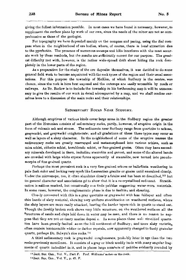
238 Bureau of Mines Report No. 5
giving the fullest information possible. In most cases we have found it necessary, however, to supplement the surface plans by work of our own, since the needs of the miner are not so comprehensive as those of the geologist.
For topography we have depended mainly on the compass and pacing, using the dial compass when in the neighborhood of ore bodies, where, of course, there is local attraction due to the pyrrhotite. The presence of numerous swamps and hills interferes with the most accurate work by these methods, but the results are sufficiently correct for our purpose. The greatest difficulty met with, however, is the rather wide-spread drift sheet hiding the rock completely in the lower parts of the region.
As a preparation for the study of the ore deposits themselves, it was decided to do some general field work to become acquainted with the rock types of the region and their usual associations. For this purpose the township of McKim, of which Sudbury is the centre, was chosen, since the rock is here best exposed and the outcrops are easily accessible by roads or railways. As Dr. Barlow is to include the township in his forthcoming map it will be unnecessary to give the results of our work in detail accompanied by a map, and we shall confine ourselves here to a discussion of the main rocks and their relationships.
SEDIMENTARY ROCKS NEAR SUDBURY.
Although eruptives of various kinds cover large areas in the Sudbury region the greater part of the Huronian consists of sedimentary rocks, partly, however, of eruptive origin in the form of volcanic ash and stones. The sediments near Sudbury range from quartzite to arkose, graywacke, and graywacke" conglomerate; and all gradations of these three types may occur as well as layers of a slaty character. In the neighborhood of some of the eruptive masses the sedimentary rocks are greatly rearranged and metamorphosed into various schists, such as mica schist, chlorite schist, hornblende schist, or fine-grained gneiss. Often they have secondary minerals developed in them, including staurolite and garnet, and some of the altered bands are crowded with large white crystal forms apparently of staurolite, now turned into pseudo-morphs of fine-grained quartz.
Perhaps the most prevalent rock is a very fine-grained arkose or halleflinta weathering to pale flesh color and looking very much like Laurentian granite or gneiss until examined closely. Under the microscope, too, it often simulates closely a felsite and has been so described, 1 3 but its general character and associations go' to show that it is a re-crystallized sediment. Stratification is seldom marked, but occasionally one finds pebbles suggesting water-worn materials. In some cases, however, the conglomeratic phase is due to faulting and shearing.
Closi-ly connected with this is a gray quartzite or graywacke with less feldspar and often thin bands of slaty material, showing very uniform stratification on weathered surfaces, where the slaty layers are more easily attacked, leaving the harder layers rich in quartz to stand out. Though the freshly broken rock shows very little structure, on the weathered surfaces all the structures of sands and clays laid down in water may be seen, and there is no reason to suppose that they are not or dnary marine deposi s. Iu some places these well stratified quartz-ites have been greatly faulted as on the hill northwest of Sudbury; and more slaty varietie s
often contain innumerable whiter or darker crystals, now apparently changed to finely granular quartz, perhaps Dr. Selwyn's rice rocks . 1 4
A third sedimentary rock is graywacke conglomerate, probably later in age than the two rocks previously mentioned. It consists of a gray or black muddy basis with many angular fragments of quartz imbedded in it, and in places large numbers of pebbles evidently rounded by
"3eol. Sur. Can., Vol. V . , fart F. Prof. W i l l i a m o ' notes ou the rock. I 4Geol. Snr. Can., Vol. V., p. 45. F.
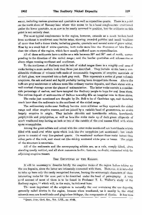
1902 The Sudbury Nickel Deposits 239
water, including various granites and quartzite3 as well as crystalline quartz. There is a point on the north shore of Ramsay lake where this seems to be a basal conglomerate overturned under the lower quartzite, so as now to be nearly reversed in position, but the evidence on this point is not entirely clear.
The most typical conglomerate in the region, however, extends as a much broken band from northeast to southwest near Stobie mine, showing crowded pebbles and small boulders of more than half a dozen kinds, including granite, quartzite and several sorts of green schist. Near by is a small hill of white quartzite, both rocks more like the Huronian of lake Huron than the others of the region, which have usually suffered more re-crystallization.
All of these sediments have a strike as a rule between 35° and 90° east of north, corresponding to the direction of the nickel range ; and the harder quartzites and arkoses rise as sharp ridges running northeast and southwest.
To the northwest of Sudbury and its belt of nickel ranges there is a roughly oval area of rocks having a more modern look than those just described. They include at the base a considerable thickness of volcanic tuffs made of innumerable fragments of eruptive materials or of dark glass, now cemented into a dark gray rock. This represents a series of great volcanic eruptions, the ash and sand and lapilli probably having been dropped into the sea. Above the tuffs are gray sandstones or arkoses more like ordinary marine deposits, and black slates with a well-marked cleavage across the planes of sedimentation. The latter rocks contain a considerable percentage of carbon, and have tempted the Sudbury people to hope for coal from them. The curious deposit of anthraxolite of Balfour township fills an irregular vein in these slates.
The rocks just mentioned are thought by Dr. Bell to be of Cambrian age, and therefore much later than the sediments to the southeast of the nickel range.
The sedimentary rocks near Sudbury become more schistose as they approach the nickel range and other eruptive masses, and are joined by a variable band of greenstones, no doubt largely eruptive in origin. They include chloritic and hornblendic schists, hornblende porphyroids and porphyrites, as well as lava-like rocks made up of dark green ellipsoids of much weathered trap having an inch or two of the outside of the oval masses filled with white spots or amygdules.
Among the green schists and mixed with the other rocks mentioned are hornblende schists filled with small oval white spots which look like the amygdules just mentioned ; but which prove to consist of very fine-grained quartz. On weathered surfaces these resist better than other parts of the.rock, and stand out like thickly scattered white peas or beans. The origin of the structure is uncertain.
All of the sediments and the accompanying schists are, as a rule, steeply tilted, often standing nearly vertical, aud all show numerous faults; features, no doubt, connected with the adjoining eruptive masses.
THE ERUPTIVES OF THE REGION.
It will be necessary to describe briefly the eruptive rocks of the region before taking up the ore deposits, since the latter are intimately connected with them. However, it is intended to take up here only the easily recognized features, leaving the microscopic characters of these interesting rocks for the most part to be described under the head of petrography. A very good account of most of them is to be found in Professor T. L. Walker's study of the Sudbury region, 1 5 which will, in the main, be followed here.
Thrt most important of the eruptives is naturally the one containing the ore deposits, generally called diorite in the region, because when weathered, 'as it usually is, the chief minerals seen are hornblende and plagioclase feldspar, the components of diorite. It has been
"Quart. Jour. Geo!. Soc, Vol. LIII., pp. 40-66.
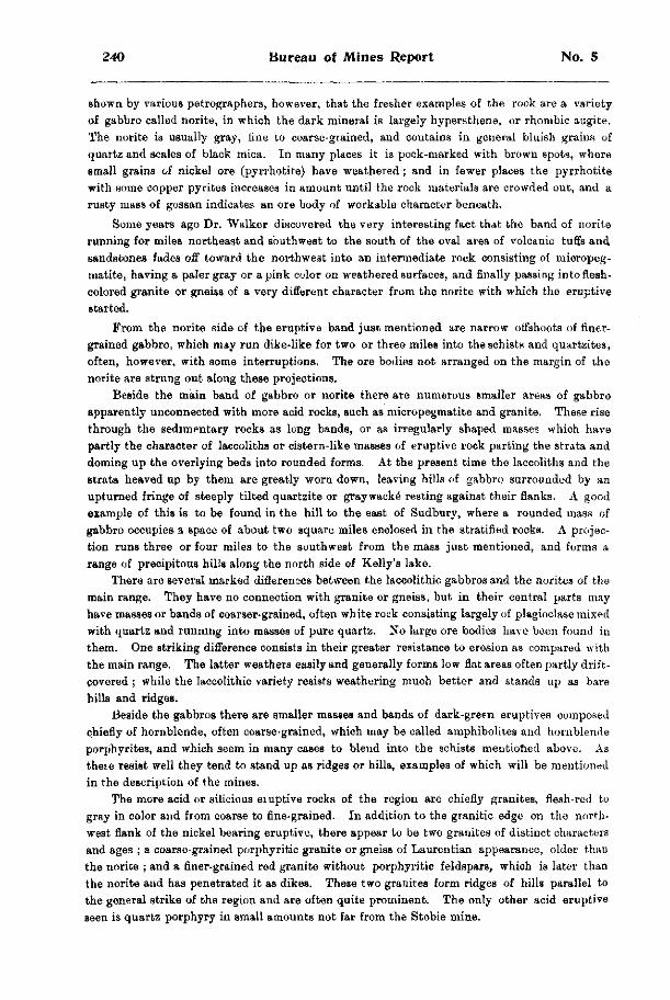
240 Bureau of Mines Report No. 5
shown by various petrographers, however, that the fresher examples of the rock are a variety of gabbro called norite, in which the dark mineral is largely hypersthene, or rhombic augite. The norite is usually gray, fine to coarse-grained, and contains in general bluish grains of quartz and scales of black mica. In many places it is pock-marked with brown spots, where small grains of nickel ore (pyrrhotite) have weathered; and in fewer places the pyrrhotite with some copper pyrites increases in amount until the rock materials are crowded out, and a rusty mass of gossan indicates an ore body of workable character beneath.
Some years ago Dr. Walker discovered the very interesting fact that the band of norite running for miles northeast and southwest to the south of the oval area of volcanic tuffs and sandstones fades off toward the northwest into an intermediate rock consisting of micropeg-matite, having a paler gray or a pink color on weathered surfaces, and finally passing into flesh-colored granite or gneiss of a very different character from the norite with which the eruptive started.
From the norite side of the eruptive band just mentioned are narrow offshoots of finer-grained gabbro, which may run dike-like for two or three miles into the schists and quartzites, often, however, with some interruptions. The ore bodies not arranged on the margin of the norite are strung out along these projections.
Beside the main band of gabbro or norite there are numerous smaller areas of gabbro apparently unconnected with more acid rocks, such as micropegmatite and granite. These rise through the sedimentary rocks as long bands, or as irregularly shaped masses which have partly the character of laccoliths or cistern-like masses of eruptive rock parting the strata and doming up the overlying beds into rounded forms. At the present time the laccoliths and the strata heaved up by them are greatly worn down, leaving hills of gabbro surrounded by an upturned fringe of steeply tilted quartzite or graywacke resting against their flanks. A good example of this is to be found in the hill to the east of Sudbury, where a rounded mass of gabbro occupies a space of about two square miles enclosed in the stratified rocks. A projection runs three or four miles to the southwest from the mass just mentioned, and forms a range of precipitous hills along the north side of Kelly's lake.
There are several marked differences between the laccolithic gabbrosand the norites of the main range. They have no connection with granite or gneiss, but in their central parts may have masses or bands of coarser-grained, often white rock consisting largely of plagioclase mixed with quartz and running into masses of pure quartz. No large ore bodies have been found in them. One striking difference consists in their greater resistance to erosion as compared with the main range. The latter weathers easily and generally forms low flat areas often partly drift-covered ; while the laccolithic variety resists weathering much better and stands up as bare hills and ridges.
Beside the gabbros there are smaller masses and bands of dark-green eruptives composed chiefly of hornblende, often coarse-grained, which may be called amphibolites and hornblende porphyrites, and which seem in many cases to blend into the schists mentioned above. As these resist well they tend to stand up as ridges or hills, examples of which will be mentioned in the description of the mines.
The more acid or silicious eiuptive rocks of the region are chiefly granites, flesh-red to gray in color and from coarse to fine-grained. In addition to the granitic edge on the northwest flank of the nickel bearing eruptive, there appear to be two granites of distinct characters and ages ; a coarse-grained porphyritic granite or gneiss of Laurentian appearance, older than the norite ; and a finer-grained red granite without porphyritic feldspars, which is later than the norite and has penetrated it as dikes. These two granites form ridges of hills parallel to the general strike of the region and are often quite prominent. The only other acid eruptive seen is quartz porphyry in small amounts not far from the Stobie mine.
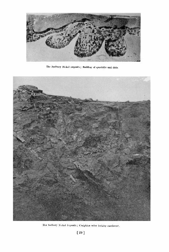
The Sudbury Nickel Deposits,; Bedding of quartzite and slate.
The Sudbury Nickel [>2po9its ; Creighton mine looking northwest.
[ 2 9 ]

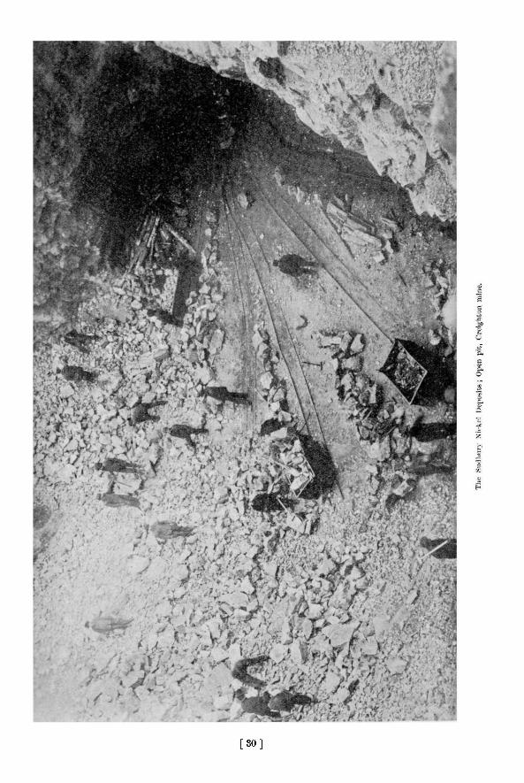
[ 3 0 ]

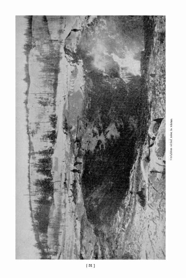

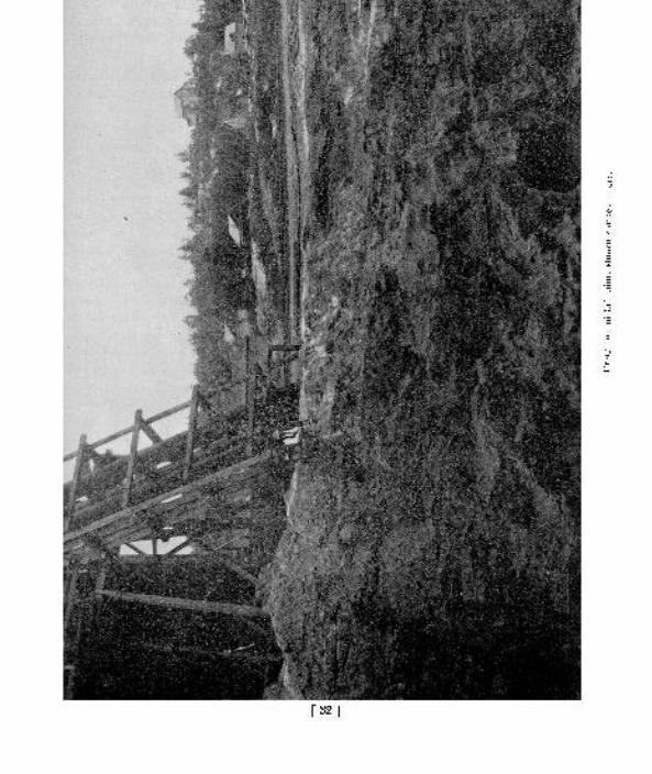

1902 The Sudbury Nickel Deposits 241
Certain gray granites from the east of M c K i m township differ in appearance from tho red granites to the west, and are possibly due to the fusion or recrystallization of rocks l ike the arkoses, as suggested by Prof. Walker, but until their relationships are more complete ly w o i k e d out this must remain doubtful.
Later than any of the other rocks of the region and cutt ing them all impartial ly are dikes of olivine diabase of every dimension up to more than 100 paces in width, and traceable sometimes for several miles. The wider dikes are coarse-grained and resemble the coarser varieties of norite belonging to the nickel range, but they never contain the blue quartz so often found in the norite. Small dikes of diabase or diabase porphyrite occur at most of the nickel mines , often cutting the ore bodies.
PLEISTOCENE DEPOSITS.
The geological record of the Sudbury region, as shown in the solid rocks, ends in very ancient times, probably Huronian, certainly not later than Cambrian ; and from those far off ages to the Pleistocene the region seems to have been dry land and exposed to profound erosion, which has cut down the Archaean mountains and the possibly somewhat later volcanoes almost to a peneplain, leaving only the deep lying stumps of what were once important ranges.
The scouring of the ice sheets, which came from the northeast, as shown by striations on fresh surfaces, has been very effective and the hill tops are usually, smoothed and rounded. In some cases two ice advances are indicated by striations crossing one another, as on the flank of the hill just east of the town, where earlier and stronger scorings run 30° west of south, whi le later ones have a direction of 15° west of south.
Boulder clay is not a very prominent feature, perhaps because largely removed during the time of post-glacial lakes, which have left their marks very plainly on the region. Where the softer rocks have been hollowed out between the hills formed by the more resistant ones, the floor of solid rock is often hidden by lake deposits, stratified gray clay or yellow sand. N o r t h east of Sudbury and to the west of Rayside station as far as Chelmsford we find flat plains of clay, which make good farming land and are now taken up by settlers. The same sheet of clay covers the lower ground near Copper Cliff, hiding the rocks for hundreds of acres.
The level of these broad clay flats is from 848 to 881 feet above the sea, and there is l i t t le doubt that a lake with a very irregular outline covered the region to the upper level, or a l i tt le higher, washing down the clay and distributing it on its bed. The shape of the lake has not been worked out in detail, but it must have had many arms and islands, and have covered some hundreds of square miles. East of the clay deposits, and often higher up , are broad plains or terraces of sand, usually broken by a few hills of rock and frequently containing large and deep kettles with no outlet except by soakage through the drift. Often such basins contain a pond or lake, but some of them are empty. Their origin is generally explained by supposing that on the retreat of the ice sheet for the last time large masses of ice were buried under lake deposits of sand and gravel, and as these slowly melted the surface sank, leaving at last a steep walled basin draining through some gravelly b e d . l s
The sandy plains cover a large area and interfere with the examination of the solid geology of the region, so that up to the present it is uncertain whether the norite band containing the nickel ores extends beneath it to join the nickel belt west of lake Wahnapitae. H o w deep these deposits are is unknown, but undoubtedly the stratified sands and clays and the swampy tracts due to imperfect adjustment of the drainage since the Ice Age form a serious hindrance to the geologist and prospector. Whether the recently introduced method of prospecting for ore with the dip needle will do away with this difficulty is still uncertain, but apparently no important ore bodies previously unknown have yet been disclosed by it, though many miles along the contact of the norite and adjoining rocks have been examined.
1 6 See Bur. Mines, 1897, p. 137. 16 M.
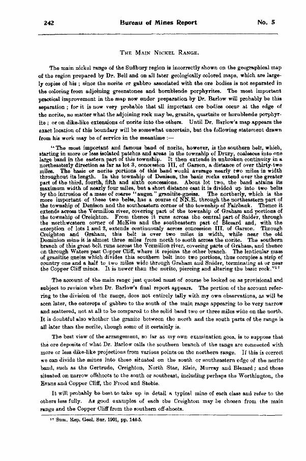
242 Bureau of Mines Report No. 5
THE MAIN NICKEL RANGE.
The main nickel range of the Sudbury region is incorrectly shown on the geographical map of the region prepared by Dr. Bell and on all later geologically colored maps, which are largely copies of his ; since the norite or gabbro associated with the ore bodies is not separated in the coloring from adjoining greenstones and hornblende porphyrites. The most important practical improvement in the map now under preparation by Dr. Barlow will probably be this separation ; for it is now very probable that all important ore bodies occur at the edge of the norite, no matter what the adjoining rock may be, granite, quartzite or hornblende porphyr-ite ; or on dike-like extensions of norite into the others. Until Dr. Barlow's map appears the exact location of this boundary will be somewhat uncertain, but the following statement drawn from his work may be of service in the meantime :—
" The most important and famous band of norite, however, is the southern belt, which, starting in more or less isolated patches and areas in the township of Drury, coalesces into one large band in the eastern part of this township. It then extends in unbroken continuity in a northeasterly direction as far as lot 3 , concession HI , of Garson, a distance of over thirty-two miles. The basic or norite portions of this band would average nearly two miles in width throughout its length. In the township of Denison, the basic rocks extend over the greater part of the third, fourth, fifth and sixth concessions. About lot two, the band attains its maximum width of nearly four miles, but a short distance east it is divided up into two belts by the intrusion of a mass of coarse "augen " granitite-gneiss. The northerly, which is the more important of these two belts, has a course of NN.E . through the northeastern part of the township of Denison and the southeastern corner of the township of Fairbank. Thence it extends across the Vermilion river, covering part of the township of Graham and portions of the township of Creighton. From thence it runs across the central part of Snider, through the northwestern corner of McKim and the southeastern part of Blezard and, with the exception of lots 1 and 2, extends continuously across concession III. of Garson. Through Creighton and Graham, this belt is over two miles in width, while near the old Dominion mine it is almost three miles from north to south across the norite. The southern branch of this great belt runs across the Vermilion river, covering parts of Graham, and thence on through Waters past Copper Cliff, where it rejoins the other branch. The lenticular mass of granitite gneiss which divides this southern belt into two portions, thus occupies a strip of country one and a half to two miles wide through Graham and Snider, terminating at or near the Copper Cliff mines. It is newer than the norite, piercing and altering the basic rock." 1 7
The account of the main range just quoted must of course be looked on as provisional and subject to revision when Dr. Barlow's final report appears. The portion of the account referring to the division of the range, does not entirely tally with my own observations, as will be seen later, the outcrops of gabbro to the south of the main range appearing to be very narrow and scattered, not at all to be compared to the solid band two or three miles wide on the north. It is doubtful also whether the granite between the north and the south parts of the range is all later than the norite, though some of it certainly is.
The best view of the arrangement, so far as my own examination goes, is to suppose that the ore deposits of what Dr. Barlow calls the southern branch of the range are connected with more or less dike-like projections from various points on the northern range. If this is correct we can divide the mines into those situated on the south or southeastern edge of the norite band, such as the Gertrude, Creighton, North Star, Elsie, Murray and Blezard; and those situated on narrow offshoots to the south or southeast, including perhaps the Worthington, the Evans and Copper Cliff, the Frood and Stobie.
It will probably be best to take up in detail a typical mine of each class and refer to the others less fully. As good examples of each the Creighton may be chosen from the main range and the Copper Cliff from the southern off-shoots.
1 7 Sum. Rap. Geol. Sur. 1901, pp. 144-5.
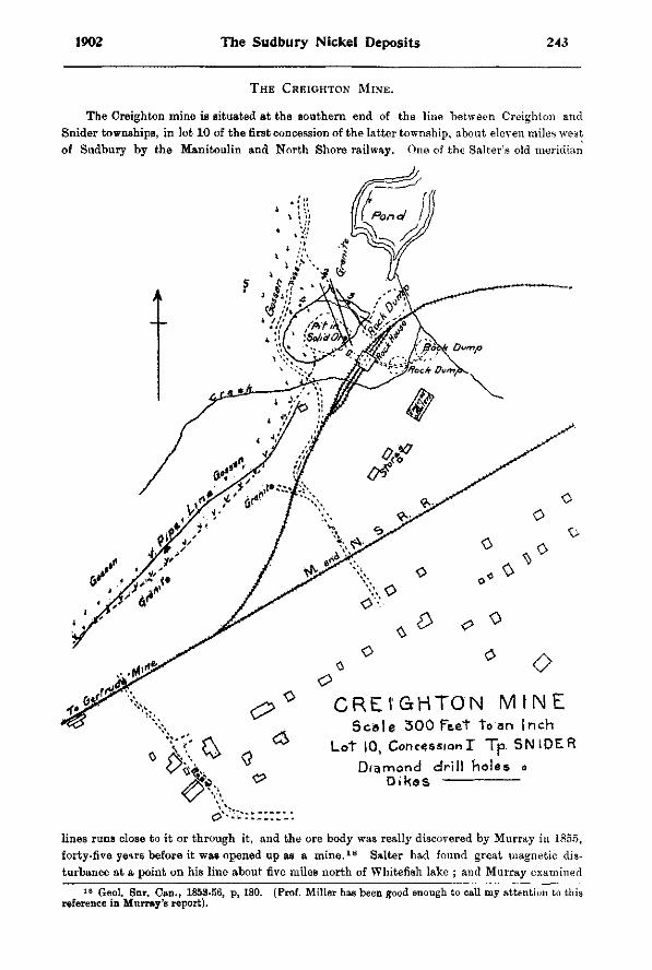
1902 The Sudbury Nickel Deposits 243
THE CREIGHTON MINE.
The Creighton mine is situated at the southern end of the line between Creighton and Snider townships, in lot 10 of the first concession of the latter township, about eleven miles west of Sudbury by the Manitoulin and North Shore railway. One of the Salter's old meridian
lines runs close to it or through it, and the ore body was really discovered by Murray in 1855, forty-five years before it was opened up as a m i n e . 1 8 Salter had found great magnetic disturbance at a point on his line about five miles north of Whitefish lake ; and Murray examined
1 8 Geol. Sur. Can., 1853-56, p, 180. (Prof. Miller has been good enough to call my attention to this reference in Murray's report).
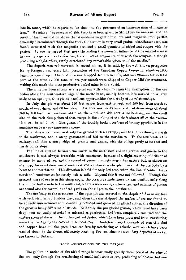
244 Bureau of Mines Report No. 5
into its cause, which he reports to be due " to the presence of an immense mass of magnetic trap." He adds : " Specimens of this trap have been given to Mr. Hunt for analysis, and the result of his investigation shows that it contains magnetic iron ore and magnetic iron pyrites generally disseminated through the rock, the former in very small grains ; titaniferous iron was found associated with the magnetic ore, and a small quantity of nickel and copper with the pyrites. It was remarked that notwithstanding the powerful influence of this magnetic mass in causing a general local attraction, the contact of fragments of it with the compass, although producing a slight effect, rarely occasioned any remarkable agitation of the needle."
The deposit was rediscovered in recent times, it is said, by the well-known prospector Henry Ranger ; and came into possession of the Canadian Copper Company, which in 1900 began to open it up. The first ore was shipped from it in 1901, and last summer for at least part of the time 17,000 tons of ore per month were shipped to Copper Cliff for treatment, making this much the most productive nickel mine in the world.
The mine has been chosen as a typical one with which to begin the description of the ore bodies along the southeastern edge of the norite band, mainly because it is worked on a large scale as an open pit, thus giving excellent opportunities for a study of its relationships.
In July the pit was about 230 feet across from east to west, and 150 feet from north to south, of oval shape, and 60 feet deep. Its floor was nearly level and had dimensions of about 150 by 100 feet. An inclined shaft on the southeast side served for hoisting, and the small size of the rock dump showed that except in the sinking of the shaft almost all of the excavation was in solid ore. The gleam of the freshly broken surfaces of bronzy pyrrhotite in the sunshine made a very impressive scene.
The pit is sunk in comparatively low ground with a swampy pond to the northeast, a marsh to the southwest, and a steep gossan-stained hill to the northwest. To the southeast is the railway, and then a steep ridge of granite and gneiss, with the village partly at its foot and partly on its slope.
The line of contact between the norite to the northwest and the granite and gneiss to the southwest is not always traceable with exactness, because of a slight covering of drift or of swamp in many places, and the spread of gossan products over other parts ; but, as shown on the map, the usual direction of northeast and southwest is sharply broken at the ore body by a bend to the northwest. This direction is held for only 250 feet, when the line of contact turns north and continues so for nearly half a mile. Beyond this it was not followed. Though the greatest mass of ore is in this sharp angle, the gossan extends more or less continuously along the hill for half a mile to the southwest, where a wide swamp intervenes; and patches of gossan are found also for several hundred yards on the ridges to the northwest.
The ore body to the northwest of the open pit was covered to the depth of five or six feet with yellowish, sandy boulder clay, and when this was stripped the surface of ore was found to be entirely unweathered and beautifully polished and grooved by glacial action, the direction of the grooves being 35° west of south. Evidently the pre glacial gossan, which must have been deep over so easily attacked a mineral as pyrrhotite, had been completely removed and the surface scoured down to the unchanged sulphides, which have been protected from weathering since the Ice Age by the coating of boulder clay. Doubtless many thousands of tons of nickel and copper have in the past been set free by weathering as soluble salts which have been washed down by the rivers, ultimately reaching the sea, since no secondary deposits of nickel are known in Ontario.
ROCK A S S O C I A T I O N S OF T H E D E P O S I T .
The gabbro or norite of the nickel range is occasionally greatly decomposed at the edge of the ore body through the weathering of small inclusions of ore, producing sulphates, but one
1902 The Sudbury Nickel Deposits 245
often finds just as fresh rock at the ore body and mixed with particles of ore as at a distance from the open pit. The gneissic and granitic rocks on the other side of the contact are also gossan-stained and far from fresh in appearance.
Southeast of the contact along the railway one finds comparatively fresh material in the shallow cuttings, and also near the boiler house, where coarse-grained porphyritic syen i te with a little quartz is found. The rock is flesh-colored to reddish gray in color and strongly suggests the Laurentian. This is cut in places along the railway to the southwest by finer-grained, reddish-gray quartz syenites, and in other olaces masses of dark, fine-grained greenstone occur enclosed in the porphyritic syenite. The steep hill southeast of the railway shows mainly coarse gneis3, often well banded, but with some finer parts, suggesting a rearranged arkose and patches of porphyrite. Here one finds also a crush conglomerate of gneissoid materials showing earth movements since the rock consolidated.
To the north of the sharp bend of the granitoid gneiss enclosing the ore body the contact between the gabbro and gneiss is sometimes not very certain, and occasionally a rock that seems intermediate may be seen along the wood road. On the whole however the impression is formed that the granitoid gneiss is older than the gabbro, the latter sometimes growing finer-grained at the er'ge of the gneiss.
The gabbro is not fresh in the Creighton region, so that hypersthene can seldom be recognized in thin sections, leaving it doubtful if it should all be called norite. I t is usually a coarse-grained gray rock with blue grains of quartz and scales of black mica as in other regions i and for a mile north of the mine no great change in its character is noted. I t occasionally encloses patches of greenstone like those occurring in the granite.
The latest rock in the region is the diabase, whose dikes cut not alone the other rocks but the ore body also. They are particularly numerous at the Creighton mine, no less than five showing themselves in the pit or on the surface stripped ; none however, more than three or four feet in width, though much wider dikes occur at no great distance to the northeast and southwest. Most of the dikes are of diabase porphyrite with large plate-like plagioclase crystals, and the texture is much finer at the edge than in the middle, especially where the edge comes against ore instead of rock. The most easterly dike is not porphyritic. The three most prominent dikes cutting the ore body run 20°, 15° and 35° west of north respectively, and dip to the southwest, two of them apparently meeting and crossing in the wall of the o p e n pit. The most westerly seems to bend round so as to become nearly horizontal, but it is hard to follow on the smoke-blackened wall. The dikes send off narrow branches into the ore and have attached to their sides numerous well-rounded, boulder-like prominences which at first sight suggest actual boulders ; but the connection with the parent dyke can sometimes bo seen, and the pseudo-boulders are coarser-grained in the middle, and become compact and almost glassy at the contact with the ore just as the dikes do.
T H E O R E B O D Y .
The open pit is sunk largely in pure ore, though portions of both norite and granitoid gneiss seem to be partly or entirely enclosed in it, and the southeastern and northeastern edges of the pit consist of the much-weathered gneiss which slopes irregularly to the northwest, while toward the west more or less norite is found. The edges of the ore body towards the country rock are not very sharp, since both pyrrhotite and copper pyrites are found disseminated not only through the adjoining norite but also frequently in the gneiss. The diabase porphyrite dikes, however, run impartially through rock or ore and evidently reached their place after th« ore-bcdy was in its present position. Nevertheless some secondary deposition has occurred since the dikes were filled, for the compact or glassy edges of the
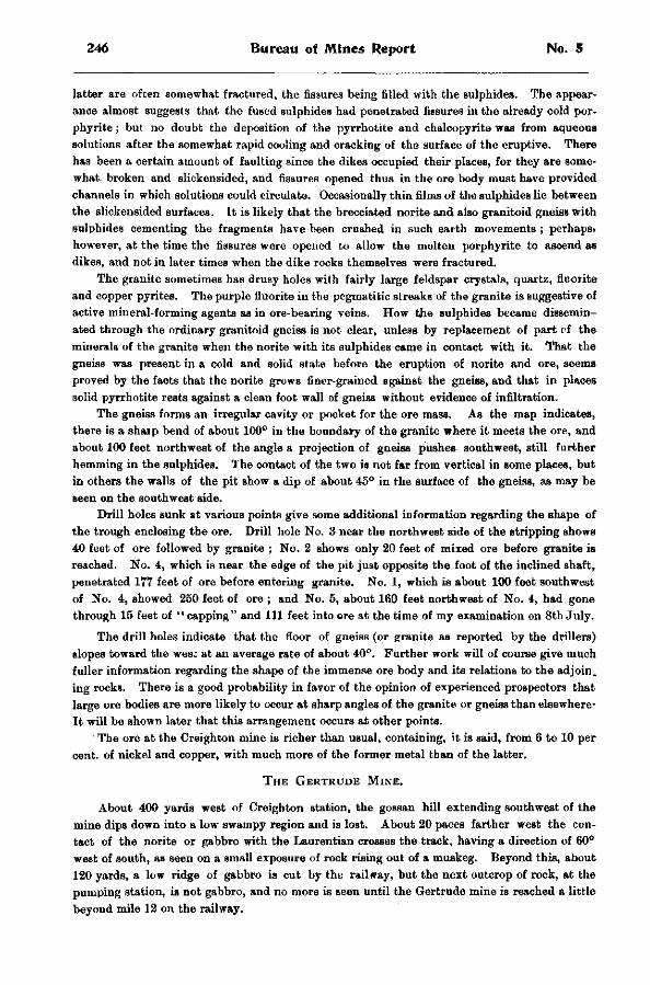
246 Bureau of Mines Report No. 5
latter are often somewhat fractured, the fissures being filled with the sulphides. The appearance almost suggests that the fused sulphides had penetrated fissures in the already cold por-phyrite; but no doubt the deposition of the pyrrhotite and chalcopyrite was from aqueous solutions after the somewhat rapid cooling and cracking of the surface of the eruptive. There has been a certain amount of faulting since the dikes occupied their places, for they are somewhat, broken and slickensided, and fissures opened thus in the ore body must have provided channels in which solutions could circulate. Occasionally thin films of the sulphides lie between the slickensided surfaces. It is likely that the brecciated norite and also granitoid gneiss with sulphides cementing the fragments have been crushed in such earth movements ; perhaps> however, at the time the fissures were opened to allow the molten porphyrite to ascend as dikes, and not in later times when the dike rocks themselves were fractured.
The granite sometimes has drusy holes with fairly large feldspar crystals, quartz, fluorite and copper pyrites. The purple fluorite in the pegmatitic streaks of the granite is suggestive of active mineral-forming agents as in ore-bearing veins. How the sulphides became disseminated through the ordinary granitoid gneiss is not clear, unless by replacement of part of the minerals of the granite when the norite with its sulphides came in contact with it. That the gneiss was present in a cold and solid state before the eruption of norite and ore, seems proved by the facts that the norite grows finer-grained against the gneiss, and that in places solid pyrrhotite rests against a clean foot wall of gneiss without evidence of infiltration.
The gneiss forms an irregular cavity or pocket for the ore mass. As the map indicates, there is a shaip bend of about 100° in the boundary of the granite where it meets the ore, and about 100 feet northwest of the angle a projection of gneiss pushes southwest, still further hemming in the sulphides. The contact of the two is not far from vertical in some places, but in others the walls of the pit show a dip of about 45° in the surface of the gneiss, as may be seen on the southwest side.
Drill holes sunk at various points give some additional information regarding the shape of the trough enclosing the ore. Drill hole No. 3 near the northwest side of the stripping shows 40 feet of ore followed by granite ; No. 2 shows only 20 feet of mixed ore before granite is reached. No. 4, which is near the edge of the pit just opposite the foot of the inclined shaft, penetrated 177 feet of ore before entering granite. No. 1, which is about 100 feet southwest of No. 4, showed 250 feet of ore ; and No. 5, about 160 feet northwest of No. 4, had gone through 15 feet of "capping" and 111 feet into ore at the time of my examination on 8th July.
The drill holes indicate that the floor of gneiss (or granite as reported by the drillers) slopes toward the wesc at an average rate of about 40°. Further work will of course give much fuller information regarding the shape of the immense ore body and its relations to the adjoin, ing rocks. There is a good probability in favor of the opinion of experienced prospectors that large ore bodies are more likely to occur at sharp angles of the granite or gneiss than elsewhere-It will be shown later that this arrangement occurs at other points.
' The ore at the Creighton mine is richer than usual, containing, it is said, from 6 to 10 per cent, of nickel and copper, with much more of the former metal than of the latter.
THE GERTRUDE MINE.
About 400 yards west of Creighton station, the gossan hill extending southwest of the mine dips down into a low swampy region and is lost. About 20 paces farther west the contact of the norite or gabbro with the Laurentian crosses the track, having a direction of 60° west of south, as seen on a small exposure of rock rising out of a muskeg. Beyond this, about 120 yards, a low ridge of gabbro is cut by the railway, but the next outcrop of rock, at the pumping station, is not gabbro, and no more is seen until the Gertrude mine is reached a little beyond mile 12 on the railway.
P L A N O F
G E R T R U D E M I N E AND
R A I L W A Y
Sea TO
248 Bureau of Mines Report No. 5
From the pumping station, southwest, green schist, diorite, syenite merging into diorite or into granite, and dikes of reddish granite or felsitic rock, are encountered ; and the margin of the gabbro area is evidently in the low and generally marshy ground to the northwest. As the railway runs on the whole west to the Gertrude mine, it is evident that the boundary of the norite, after it disappears under swamp and drift near the pumping station, has about the same direction, though for three-quarters of a mile it has not been traced. In the neighborhood of the Gertrude mine, however, the boundary once more comes to the surface, and has been followed for nearly a mile to the west. As the general direction of the edge of the norite or gabbro from the Creighton to the North Star mine, on the opposite side, is about 30° or 35° east of north, it will be seen that the sharp angle if the boundary of the norite at Creighton mine is simply the climax of a bay having a wide funnel-shaped margin, a matter of interest as helping to account for the great body of ore at that mine.
The norite appears first near the Gertrude, just north of the railway near the crossing of a wood road, a little east of the roast beds. It is lost again under drift for nearly a third of a mile, and when it reappears 300 yards north of the roast beds its direction has changed, running now 25° south of west to the western shaft of the Gertrude. From this point it turns 30° north of west for 200 yards, and then goes about west for nearly half a mile, beyond which it was not followed. The gabbro or norite is the same gray, rather coarse grained, rock with some bluish quartz and scales of mica described as occurring at Creighton, but the adjoining rock to the south is not granitoid gneiss, but mainly greenstones of various kinds, partly greatly weathered diorite and partly hornblende porphyrite. Two small outcrops of granitoid rocks occur however, probably sent off from the large area of granitoid gneiss some distance to the south, representing the southwestward continuation of the granitoid gneiss at Creighton ; and a small amount of greenish gray, fine-grained rock like greywacke occurs near the store.
The ore is much more strung out at the Gertrude than at the Creighton, and two shafts were in operation last summer, Nos. 1 and 4, while several openings had been made along the line of contact, the whole extending for three-fifths of a mile from east to west. The gossan does not seem to be confined to the norite, extending, at some of the openings at least, over a a certain width of the greenstones to the south. In the early days of the mine the ore was almost pure pyrrhotite, but some copper pyrites is now found mixed with the magnetic pyrites.
At the eastern end of the property extensive roast beds have been laid out, the ore being transported by a narrow gauge railway running up on trestles and dumping directly on the heaps from the ore cars, a decided saving of labor over the method in use at Copper Cliff. The ore, part of which comes by rail from the Elsie mine six or seven miles to the northeast, after roasting is reduced to matte at a smelter 300 yards south of the roast beds, and then bessemerized to a high grade matte, the plant being compactly and conveniently arranged.
THE NORTH STAR MINE. Following the railway northeast from Creighton, the North Star, formerly the McCharles
mine, now under option by the Mond Company, is the next mine reached on the main nickel range. It is on lot 9 in the third concession of Snider township, and at the time of our visit operations were just beginning, so that not much could be learned regarding it. The norite is of the usual coarse-grained kind, spotted with gossan and containing quartz and biotite ; and the adjoining rock to the southeast is coarse porphyritic granite or granitoid gneiss; a continuation of that at Creighton, with a small greenstone band in places. The contact seems to be nearly straight, and the ore body, which lies between the two rocks, did not appear to be wide. As only eight carloads of ore had been shipped to Victoria Mines up to 11th July, the open pit was too small to give much information as to the relations of the ore body to the enclosing rocks ; but it is stated that a diamond drill hole in the norite shows that the wall of granite dips at about 64 ° to the northwest.
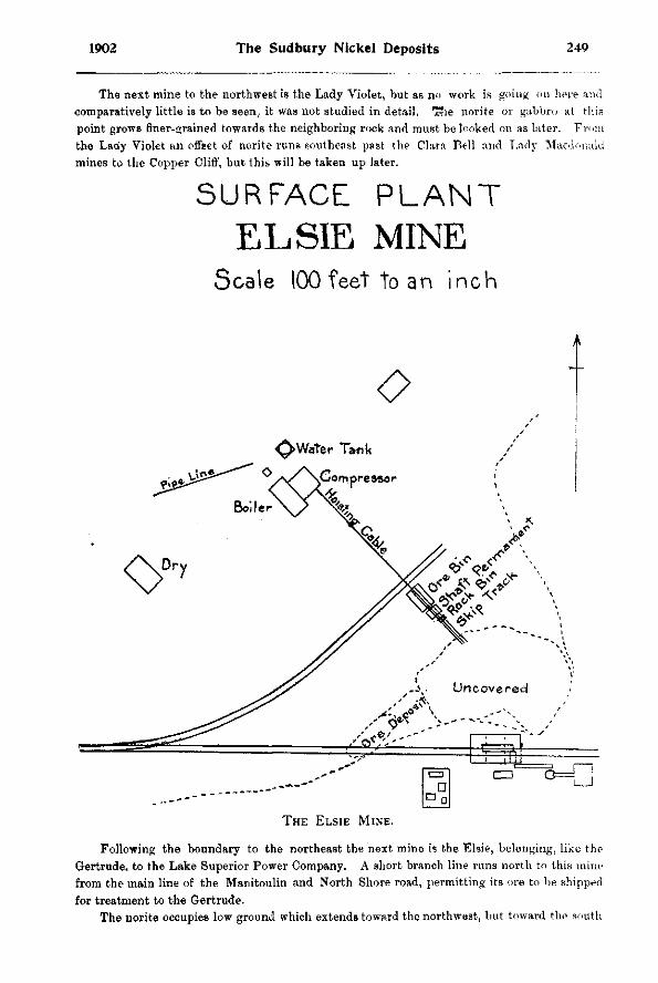
1902 The Sudbury Nickel Deposits 249
The next mine to the northwest is the Lady Violet, but as no work is going on here and comparatively little is to be seen, it was not studied in detail. x«ie norite or gabbro at this point grows finer-grained towards the neighboring rock and must be looked on as later. F r o m the Lady Violet an offset of norite runs southeast past the Clara Bel l and Lady Macdonald mines to the Copper Cliff, but this will be taken up later.
S U R F A C E P L A N T
E L S I E MINE SCALE 1 0 0 FEET TO AN INCH
O ^>Water Tank
o y \ C ompressor
THE ELSIE MINE.
Following the boundary to the northeast the next mine is the Els ie , be longing , l ike the Gertrude, to the Lake Superior Power Company. A short branch l ine runs north to this mine from the main line of the Manitoulin and North Shore road, permitting its ore to be shipped for treatment to the Gertrude.
The norite occupies low ground which extends toward the northwest, but toward the south
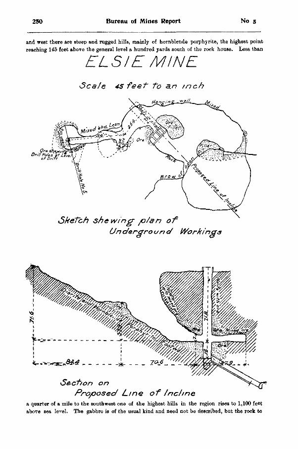
250 Bureau of Mines Report No 5
and west there are steep and rugged hills, mainly of hornblende porphyrite, the highest point reaching 145 feet above the general level a hundred yards south of the rock house. Less than
ELS I'£ MINE
Scale 4 5 feet to a.n tnch
a quarter of a mile to the southwest one of the highest hills in the region rises to 1,100 feet above sea le^el. The gabbro is of the usual kind and need not be described, but the rock to
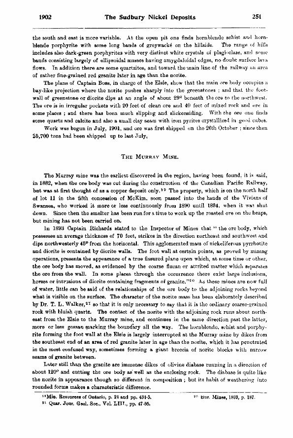
1902 The Sudbury Nickel Deposits 251
the south and east is more variable. At the open pit one finds hornblende schist and hornblende porphyrite with some long bands of greywacke on the hillside. The range of hills includes also dark-green porphyriteB with very distinct white crystals of plagioclase, and some bands consisting largely of ellipsoidal masses having amygdaloidal edges, no doubt surface lava flows. In addition there are some quartzites, and toward the^snain line of the railway an area of rather fine-grained red granite later in age than the norite.
The plans of Captain Boss, in charge of the Elsie, show that the main ore body occupies a bay-like projection where the norite pushes sharply into the greenstones ; and that the foot-wall of greenstone or diorite dips at an angle of about 29° beneath the ore to the northwest. The ore is in irregular pockets with 20 feet of clean ore and 40 feet of mixed rock and ore in some places ; and there has been much slipping and slickensiding. With the ore one finds some quartz and calcite and also a small clay seam with iron pyrites crystallized in good cubes.
Work was begun in July, 1901, and ore was first shipped on the 26th October ; since then 25,700 tons had been shipped up to last July,
THE MURRAY MINE.
The Murray mine was the earliest discovered in the region, having been found, it is said, in 1882, when the ore body was cut during the construction of the Canadian Pacific Railway, but was at first thought of as a copper deposit o n l y . 1 9 The property, which is on the north half of lot 11 in the fifth concession of McKim, soon passed into the hands of the Vivians of Swansea, who worked it more or less continuously from 1890 until 1894, when it was shut down. Since then the smelter has been run for a time to work up the roasted ore on the heaps, but mining has not been carried on.
In 1893 Captain Richards stated to the Inspector of Mines that " the ore body, which possesses an average thickness of 70 feet, strikes in the direction northeast and southwest and dips northwesterly 45° from the horizontal. This agglomerated mass of nickeliferous pyrrhotite and diorite is contained by diorite walls. The foot wall at certain points, as proved by mining operations, presents the appearance of a true fissured plane upon which, at some time or other, the ore body has moved, as evidenced by the coarse flucan or attrited matter which separates the ore from the wall. In some places through the occurrence there exist large inclusions, horses or intrusions of diorite containing fragments of granite." 2 0 As these mines are now full of water, little can be said of the relationships of the ore body to the adjoining rocks beyond what is visible on the surface. The character of the norite mass has been elaborately described by Dr. T. L. Walker , 2 1 so that it is only necessary to say that it is the ordinary coarse-grained rock with bluish quartz. The contact of the norite with the adjoining rock runs about northeast from the Elsie to the Murray mine, and continues in the same direction past the latter, more or less gossan marking the boundary all the way. The hornblende, schist and porphyrite forming the foot wall at the Elsie is largely interrupted at the Murray mine by dikes from the southeast end of an area of red granite later in age than the norite, which it has penetrated in the most confused way, sometimes forming a giant breccia of norite blocks with narrow seams of granite between.
Later still than the granite are immense dikes of olivine diabase running in a direction of about 120° and cutting the ore body as well as the enclosing rock. The diabase is quite like the norite in appearance though so different in composition ; but its habit of weathering into rounded forms makes a characteristic difference.
1 8Min. Resources of Ontario, p. 24 and pp. 431-5. 2 0 Bur. Mines, 1893, p. 187. 8 1 Qoar. Jour. Geol. Soc, Vol. LIIT., pp. 47-55.
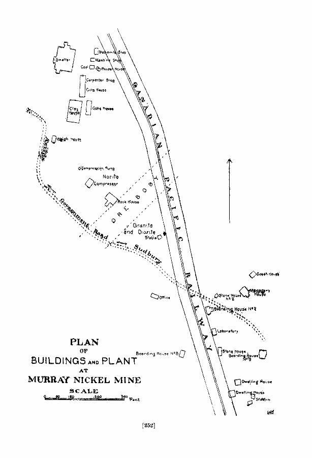
L
Q**A^ .NEWS
0 NORITE
P L A N OP
B U I L D I N G S a n o P L A N T
A T
M U R R ^ F N I C K E L M I N E
S C A L E %• "PI i 'IP .1 .
~\*(<( •'. /'GRANITE ,'-.'F^L -AND OWI.TE
BOARDING Moose
[252]
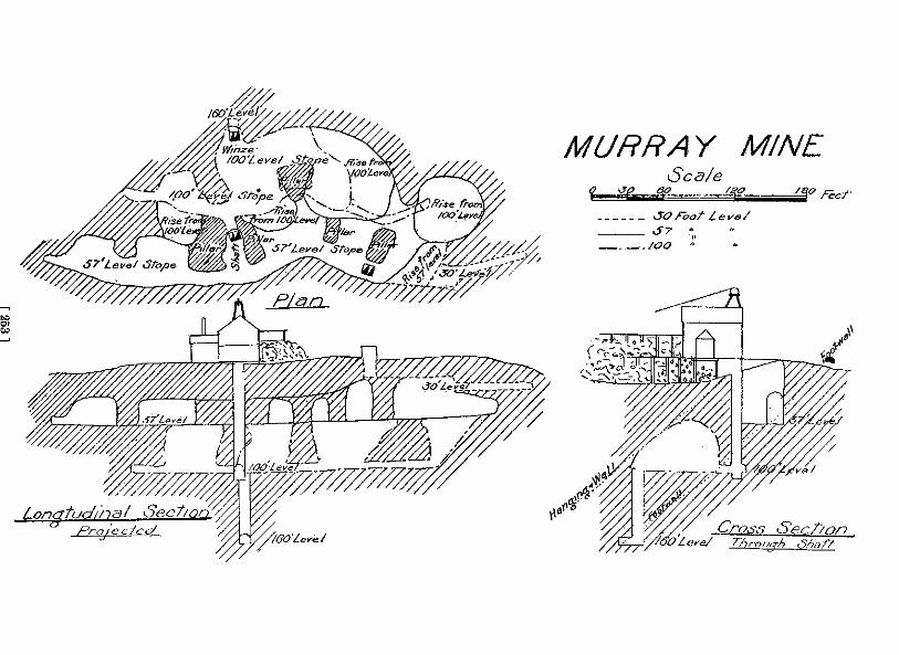
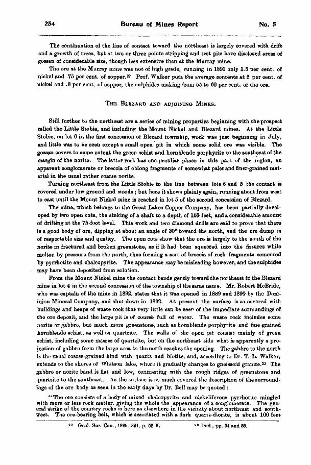
254 Bureau of Mines Report No. 5
The continuation of the line of contact toward the northeast is largely covered with drift and a growth of trees, but at two or three points stripping and test pits have disclosed areas of gossan of considerable size, though less extensive than at the Murray mine.
The ore at the Murray mine was not of high grade, running in 1891 only 1.5 per cent, of nickel and .75 per cent, of copper. 2 2 Prof. Walker puts the average contents at 2 per cent, of nickel and .8 per cent, of copper, the sulphides making from 55 to 60 per cent, of the ore.
THE BLEZARD AND ADJOINING MINES.
Still further to the northeast are a series of mining properties beginning with the prospect called the Little Stobie, and including the Mount Nickel and Blezard mines. At the Little Stobie, on lot 6 in the first concession of Blezard township, work was just beginning in July, and little was to be seen except a small open pit in which some solid ore was visible. The gossan covers to some extent the green schist and hornblende porphyrite to the southeast of the margin of the norite. The latter rock has one peculiar phase in this part of the region, an apparent conglomerate or breccia of oblong fragments of somewhat paler and finer-grained material in the usual rather coarse norite.
Turning northeast from the Little Stobie to the line between lots 6 and 5 the contact is covered under low ground and woods ; but here it shows plainly again, running about from west to east until the Mount Nickel mine is reached in lot 5 of the second concession of Blezard.
The mine, which belongs to the Great Lakes Copper Company, has been partially developed by two open cuts, the sinking of a shaft to a depth of 165 feet, and a considerable amount of drifting at the 75-foot level. This work and two diamond drills are said to prove that there is a good body of ore, dipping at about an angle of 30° toward the north, and the ore dump is of respectable size and quality. The open cuts show that the ore is largely to the south of the norite in fractured and broken greenstone, as if it had been squeezed into the fissures while molten by pressure from the north, thus forming a sort of breccia of rock fragments cemented by pyrrhotite and chalcopyrite. The appearance may be misleading however, and the sulphides may have been deposited from solution.
From the Mount Nickel mine the contact bends gently toward the northeast to" the Blezard mine in lot 4 in the second concession of the township of the same name. Mr. Robert McBride, who was captain of the mine in 1892, states that it was opened in 1889 and 1890 by the Dominion Mineral Company, and shut down in 1892. At present the surface is so covered with buildings and heaps of waste rock that very little can be seen of the immediate surroundings of the ore deposit, and the large pit is of course full of water. The waste rock includes some norite or gabbro, but much more greenstone, such as hornblende porphyrite and fine-grained hornblende schist, as well as quartzite. The walls of the open pit consist mainly of green schist, including some masses of quartzite, but on the northeast side what is apparently a projection of gabbro from the large area to the north reaches the opening. The gabbro to the north is the usual coarse-grained kind with quartz and biotite, and, according to Dr. T. L. Walker, extends to the shores of Whitson lake, where it gradually changes to gneissoid granite. 2 3 The gabbro or norite band is flat and low, contrasting with the rough ridges of greenstone and quartzite to the southeast. As the surface is so much covered the description of the surroundings of the ore body as seen in the early days by Dr. Bell may be quoted :
" The ore consists of a body of mixed chalcopyrite and nickeliferous pyrrhotite mingled with more or less rock matter, giving the whole the appearance of a conglomerate. The general strike of the country rocks is here as elsewhere in the vicinity about northeast and southwest. The ore-bearing belt, which is associated with a dark quartz-diorite, is about 100 feet
" Geol. Sur. Can., 1890-1891, p. 52 F. 2 3 Ibid., pp. 54 and 55.
256 Bureau of Mines Report No. 5
wide and dips northwest at an angle of 65°. It is overlaid by a massive bed of ash-colored graywacke, the weathered surfaces of which present raised reticulating lines. Immediately to the northwest of the shafts there is a dike from 30 to 50 feet wide, of dark brownish gray crystalline diabase, weathering at the surface into rounded boulder-like masses, which scale off concentrically."2 4
The open.pit is said to be 60 feet deep, and the lower workings of the mine reach a depth of 172 feet; but the plans of the mine appear to have been lost, so that the shape of the ore body cannot be definitely given. It may be mentioned that the rock dump is unusually free from ore, showing that the separation of the ore from the waste rock was carried out more carefully than at other mines in the region. The ore averaged 4 per cent, nickel and 2 per cent, copper. 2 5
As little or no work has been done on the Kirkwood, Cryderman and other properties along the eastward extension of the main gabbro range, the work of examination was ended at the Blezard. To the east of the Cryderman mine the range is largely buried under deep deposits of sand and gravel formed in an old lake at the margin of the retreating ice toward the end of the glacial period, so that there is little hope of tracing it to the Blue lake region.
From the account just given it is apparent that the southeastern margin of the norite or gabbro belt from the Gertrude mine to the Blezard and beyond is a practically continuous row of mines, or of prospects showing variable amounts of nickel and copper ores, the largest appearing where the norite projects bay-like into the adjoining rock to the southeast. The nature of the neighboring rock does not appear to be of importance, since ore bodies are found lying against porphyritic granitoid gneiss, quartzite or graywacke, and greenstones of various kinds. The ore bodies dip at angles of 29° to 65°, averaging about 46° to the northwest, corresponding to the surface of contact between the norite or gabbro and the adjoining rock.
SOUTHEASTERN OFF-SHOOT OF MAIN NORITE RANGE.
While the series of mines thus far described includes the Creighton, the largest nickel mine now in operation in the Sudbury district, or in the world, as well as a number of others of considerable magnitude, several important deposits are found to the southeast of it along narrow dike-like off-shoots from the main range or on narrow bands of gabbro which have not been proved to have a connection with the great gabbro band to the northwest.
The best-known of these mines is the Copper Cliff, but with it are associated a series of \eaa important deposits beginning with the Clara Bell, or No. 6, about a mile and a half to the northwest, and ending with the Evans mine about as far in a direction somewhat west of south. To understand the geographical relationship it will be well to begin at the northwest end of the series of mines where the line branches off from the main norite range near the Lady Violet mine. The accompanying geographical map shows the arrangement of the rocks in a general way, but the great extent of drift, particularly in the central part of the map, makes the relationship somewhat uncertain.
Near the Lady Violet mine, which is at the margin of the main norite belt to the southwest of the. Elsie and Murray mines, there is a large projection of the nickel-bearing eruptive to the south, reaching Clara Bell lake in lot 2 of the second concession of Snider township. The offset is here from 500 to 600 feet wide, but to the southeast between Clara Bell and Lady Macdonald lakes enlarges so as to have a width of 1,600 feet, bends to the east and sends out two tongues, one to the north, the other to the southeast, where it touches the north end of the lake, with a width of only about 100 feet. It shows again on the northeast end of an island in the lake and continues on the mainland toward the southeast, until with a short interruption it reaches mine No. 2. Here there is a gap of half a mile, mainly drift-covered,
2 4 Min. ReB. Ont., Appendix, p. 433. " Geo). Sur. Can. 1890-91, p. 62 F.
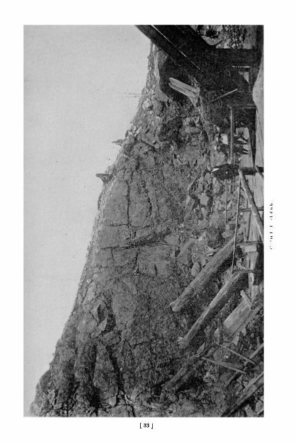
[ 3 3 J

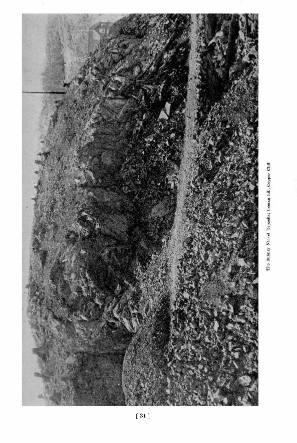
[ 3 1 ]

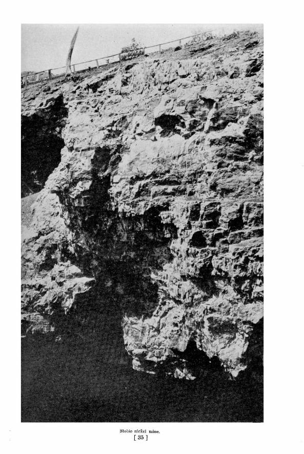

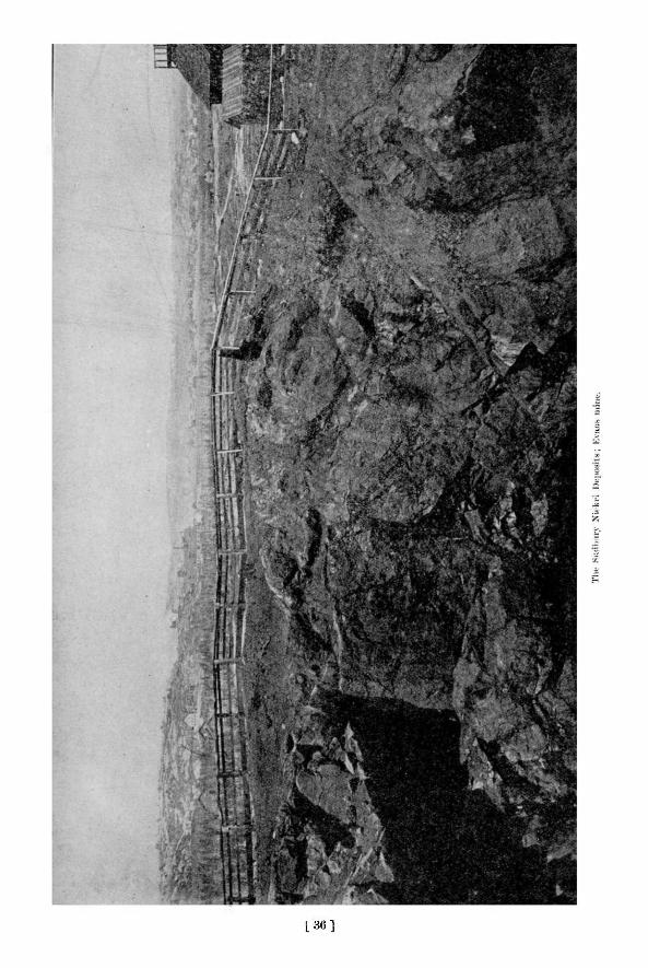
[ 3 6 ]

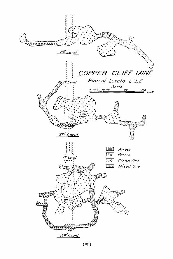
L 37 ]

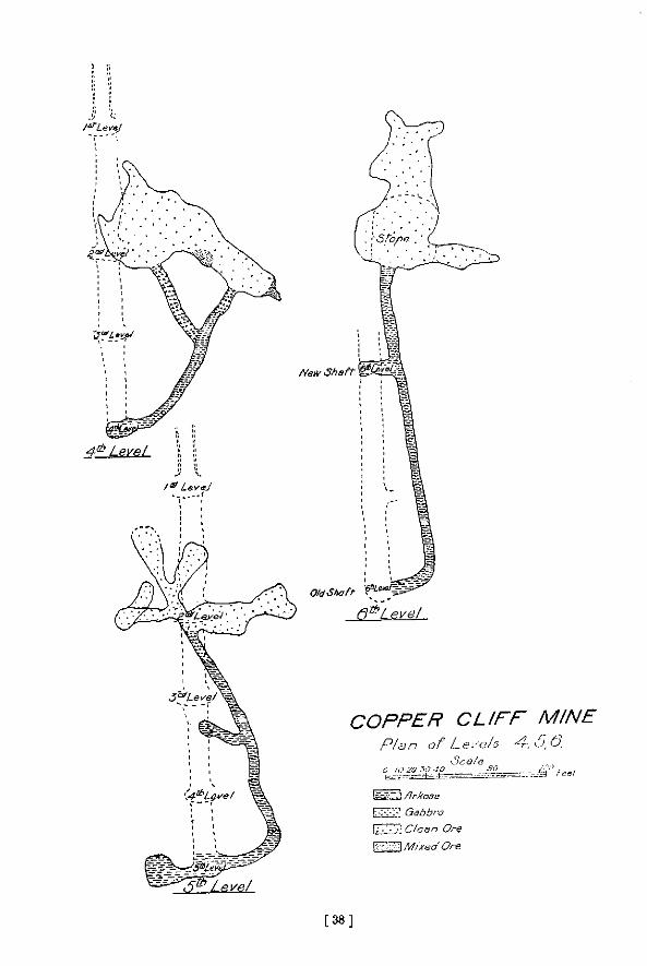
[ 3 8 ]

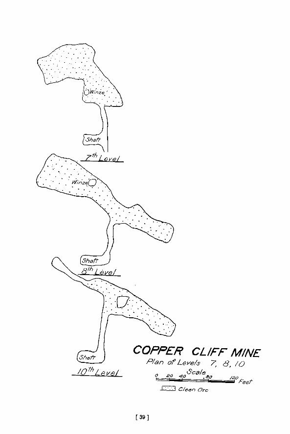
[ 3 9 ]

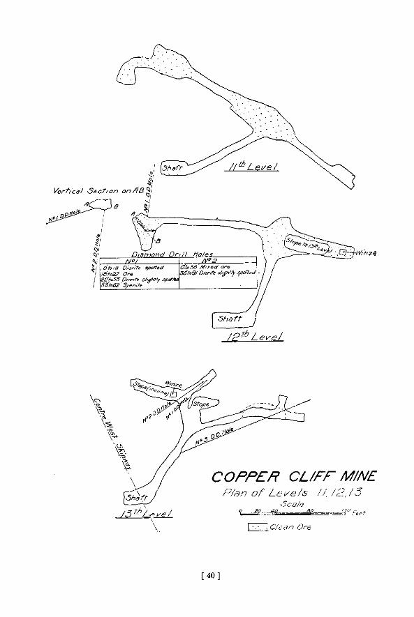
[ 4 0 ]

1902 The Sudbury Nickel Deposits 257
before the gossan hill of the Copper Cliff mine rises to the south. A small patch of gabVrj near the stream less than 100 yards north of the hill is the only indication of a connection between No. 2 and the old mine. It may be that faulting has taken place between them, since the Copper Cliff is much too far west to be in a line continuing the directi' n of the norite band ending at No. 2.
From the Copper Cliff to the next outcrop, about 700 yards to the southwest, stratified clay covers the bed rock ; but here the band of gabbro has become very narrow and runs a little west of south with some interruptions for about 600 yards, when it passes once more beneath the clay. Two-thirds of a mile farther south, beyond a broad expanse of marsh and clay the last outcrop is found, the low gossan hill of the Evans mine. It is possible, but not probable, that the last mentioned outcrop is connected with a range of gabbro rising as a ridge to the southeast between the Copper Cliff plain and Kelly lake.
When the gabbro juts off from the main range it passes between greenstones and granite as if along a line of weakness. The greenstones rise to the northeast as steep and lofty hills consisting of hornblende schist, beautiful hornblende porphyrite with large cleavage planes of the mineral, and diorite, enclosing sometimes small areas of graywack6 or quartzite.
The gabbro appears to be older than the greenstones, and the ore bodies occur against them or penetrating them to some extent, and not in the edge of the granite to the southwest. The gabbro is frequently of the usual coarse-grained quartzose kind described before, but parts of it contain small, greenish, fine-grained inclusions of what appears to be an earlier gabbro ; and occasionally there is a rough banding of coarser and finer-grained varieties, and some admixture of schistose rocks, probably enclosed at the time of eruption.
On the southwest side of the gabbro the relationships are partly concealed by Clara Bell lake, whose outlet has been dammed, raising the water and flooding the low ground ; but apparently the contact all along is with porphyritic granite, often sheared into granitoid gneiss, except at a point to the southeast of the lake, where green schist with conglomerate is found. The granitoid gneiss is apparently later in age at this point, sending dikes into it and carrying off fragments, though this is not altogether certain, for on the edge of the lake farther to the west a finer-grained later granite shows itself, which may have penetrated along the line of contact.
The three mines, Clara Bell (or No. 6), No. 4, and Lady Macdonald (or No. 5), are all at the northeastern edge of the gabbro against the greenstones. The Clara Bell mine, about 150 paces north of the lake of the same name, lies at the edge of " patchy " gabbro, gossan-covered, which sinks into a swamp a little to the west. No work has been carried on here lately, but on the dump one finds gabbro and chloritic and hornblendic schists, with quite a number of minerals, including besides pyrrhotite and chalcopyrite, quartz and calcite, the latter showing crystals with the prism and a blunt rhombohedron, dolomite weathering rusty, and actinolite often in blades several inches long. A pocket of about five tons of magnetite was found completely enclosed in the sulphides in this mine.
At No. 4 extensive open pits have been excavated at the eastern edge of the northern tongue, but the old dumps show no great variation from the last mine. Lady Macdonald (or No. 5) mine is at the edge of the similarly named lake, which, like Clara Bell, has been greatly enlarged by a dam at its outlet, so as to form a reservoir for the water supply of the smelter and other purposes. This was the first of the three to be worked.
An open pit near the lake is at the margin of gabbro and the greenstones, and only a short distance north of the granitoid gneiss on the other side of the narrow, dike-like band which here turns off to the southwest across the lake. There are crush-conglomerates or breccias between the granitoid gneiss and the gabbro, and so far as one can judge on the gossan-covered surface, an irregular dike of granite penetrates to the edge of the pit. Hornblende schist, hornblende porphyrite, a little re-crystallized arkose and red pegmatite occur on the dump,
17 M.
258 Bureau of Mines Report No. 5
and in addition to minerals like those at Clara Bell a few scales of graphite were found in fragments of a gray rock.
The northeast end of an island in Lady Macdonald lake shows the contact of granite and gabbro, the latter thickly covered with gossan ; and on the shore of a bay to the southeast the gabbro band is found again with greenstone to the northeast, and porphyritic granitoid gneiss to the southwest. The greenstone is mainly schistose, hornblendic or chloritic, but is largely mixed with strips and belts of distinctly stratified graywacke. and often on the eastern margin cut by small elongated outcrops of gabbro or of hornblende porphyrite, which, however, do not carry sulphides, and appear to have no connection with the nickel-bearing norite or gabbro.
As the gosBan-covered band is followed to the southeast various small open pits disclose more or less ore, but before mine No. 2 is reached the band turns slightly to the south and is lost under drift for a time. The next outcrop is more to the east, and seems cut off from the band hitherto followed by a dike of greatly weathered diabase ten paces wide, crossing from east to west.
About 150 yards after leaving the bay the band is entirely enclosed in the granitoid gneiss, which seems later than the green schist, since it has carried off strips of it, but older than the gabbro, which becomes fine-grained towards the contact. It is, however, interesting to find a dike ten feet wide of much finer-grained gray granite, not porphyritic or gneissoid, penetrating the gabbro as if an off-shoot of the main granite. It is probably, however, of later age and unconnected with the granitoid gneiss.
The best exposed surface is close to the immense open pit, which is about 230 feet long from southeast to northwest, and about half as broad, and occupies nearly the whole width of the band of gabbro, since porphyritic granitoid gneiss comes within a few feet of the southwest side of the pit and forms its wall on the northwest side. The fringe of rusty gabbro on the sides grows very fine-grained against the gneiss, and is evidently younger than it, and it is clear that the majority of the contents of the dike-like band at this point consisted of the nearly pure sulphides, now mined out in the open pit to the depth of 278 feet, and known by the results of sinking a shaft to go 80 feet deeper, or 358 feet in all.
There have been extensive disturbances in the region since the granitoid gneiss was consolidated, shown by the large amount of faulting and shearing to be seen, often forming crush-conglomerates with large blocks of the gneiss having the schistose cleavage variously arranged in a matrix of fine-grained granitic material. Similar evidence of faulting is found in well stratified graywacke to the east of the new smelter.
T H E C O P P E R CLIFF M I N E .
The Copper Cliff mine in lot 12, in the second concession of the township of McKim, is the richest and has been one of the most productive nickel mines in the Sudbury district. As the name suggests, it was taken up as a cupper mine before the nickel contents of the ore had been recognised, and it is stated that the upper part of the ore body was considerably enriched in copper as compared with the ore at greater depths, the only known example of the kind in the district.
The mine was found soon after the Murray mine in 1882, and siuce it passed into the hands of the Canadian Copper Company in 1886 it has been more or less steadily worked, until now it has got below the 13th level, at a depth of about 1,000 feet from the surface. During the working of this mine much information has been acquired regarding the form and associations of the ore body, and I am under great obligations to the officers of the International Nickel Company, the present owners of the properties formerly belonging to the Canadian Copper Company, for ohe large amount of information they have imparted and tor permission to copy their surface and underground plans.
In the preparation of the plans and diagrams of this and other mines much assistance has
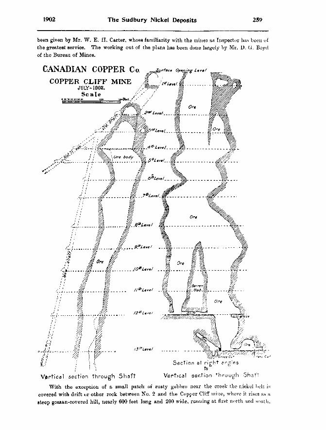
1902 The Sudbury Nickel Deposits 259
been given by Mr. W. E. H. Carter, whose familiarity with the mines as Inspector has been of the greatest service. The working out of the plans has been done largely by Mr. D. G. Boyd of the Bureau of Mines.
C A N A D I A N C O P P E R C o
C O P P E R C J L I F F M I N E JULY-1902.
S c a l e ^
Surface Opening lev*/
••;./- I
1
I
/ Of i0re #
i I
f
I I
eve I
II^Level "A
k
jf.l ; \ •': Section at right angles
/ ' ': to Vertical section through Shaf t Vertical -section through Shaft
With the exception of a small patch of rusty gabbro near the creek the nickel belt is covered with drift or other rock between No. 2 and the Copper Cliff mine , where it rises as a steep gossan-covered hill, nearly 600 feet long and 200 wide, running at first north and south,
260 Bureau of Mines Report No. 5
but bending to the southeast at the shaft house where the ore body originally cropped out at the surface. Toward the west and southwest the hill falls steeply beneath the flat clay plain, and the nearest rocks are a quarter of a mile away, rising as a lofty hill of pink granitoid gneiss with a fringe of crush conglomerate and greenstone along the base. To the south some low hills of well stratified graywacke or quartzite rise through the clay ; and to the east it joins a sharp little hill of pink quartzite, or rather arkose, often spoken of as syenite. It resembles fel-site somewhat in appearance, but is probably sedimentary and related to the wide-spread areas of partially re-crystallized arkose in the region. This arkose is mixed with the grayer rock referred to in this paper as greywacke\ though it has phases like quartzite and also like slate. A little to the north near the main street of the village is a low hill of greywacke' conglomerate with pebbles which seem to have been rounded by water.
The gabbro of the hill at the mine is so sossan-covered as to be hard to study. It is crossed by two small diabase dykes, and just beyond the contact between gabbro and arkose, but in the latter rock, are two dikes of reddish-gray medium-grained granite, each six or eight feet wide, but traceable only for a short distance. On weathered surfaces they are hardly distinguishable from the arkose, and in appearance they are like the granite dike near mine No. 2.
The large rock dump at the mine contains a variety of materials, the most common being rather fine-grained gabbro with a little quartz, commonly called diorite, but there seem to be all gradations from this to a pale gray biotite granite merging into red granite. The gabbro has coarse varieties with some biotite and also hornblende crystals, and sometimes pegmatitic parts with large gray feldspar crystals, generally striated, almost to the exclusion of other minerals. There are also felsitic looking rocks, gray to red, arkoses as shown by thin sections. Finally there are numerous diabases, evidently from dikes, occasionally the whole width being shown in the blocks, the margin being finer-grained than the centre. The diabases are not porphyritic as at the Creighton mine. All of the rocks mentioned may be found more or less charged with sulphides, and there are breccia ted masses of rock cemented with sulphides. Among minerals, in addition to those belonging to the ore and rocks, there are calcite, quartz, and small amounts of galena.
A dike of diabase is said to have been followed down from the third level to the thirteenth, part of the dike matter containing ore, and having a margin of calcite on one side and of quartz with some ore on the other. The largest dike encountered is said to be very fine-grained and black, and to be twenty-five feet wide.
Cores from diamond drill holes below the thirteenth level show, in addition to ore and the usual rocks, diabase dikes and a dike of medium-grained biotite granite.
As shown by the sections given, prepared from the plans of the levels in the mine with aid from Captain Lawson, who has charge of the underground workings, the ore body is roughly cylindrical, narrowing and widening several times and broken by a large horse of barren rock, beginning between the ninth and tenth levels. Many thanks are due to the mine authorities, and especially to Captain Lawson, for this instructive section of the deepest mine in Ontario, a mine that is still'producing rich ore from a depth of 937 feet.
One curious feature of the later development of the mine is the finding of an odorless gas which may be lit with a candle-in drill holes through ore at the thirteenth level.
The chimney-like ore body has a width of from 50 to 90 feet in the section through the shaft, which is inclined about 77 | ° toward the northeast, and from 75 to more than 200 feet in the section at right angles to it.
In the Copper Cliff, as in No. 2, the amount of ore seems greatly disproportionate to the size of the band of norite with which it is connected, and a certain quantity of the ore, being associated with quartz and calcite, must be of later deposition than the ore enclosed in the norite. The fact that two slips are rather marked features at the mine may indicate fractures
1902 The Sudbury Nickel Deposits 261
and fissures in which water currents could circulate, and deposit there materials dissolved out of previous ore masses belonging to the original consol idation after the norite reached its present position.
It is stated that when the ore body in the Copper Cliff is narrow it is richer in copper, and when it widens it becomes richer in nickel.
About 700 yards southwest of the Copper Cliff a small band of gossan covered gabbro rises out of a swamp and runs southward towards the Orford refinery. The gabbro associated with the ore has the customary pitted surface where spots of pyrrhotite have weathered out, and run* with interruptions between well-stratified graywacke and a steep hill of pink felsitic looking arkose. Several pits have been opened upon the band, including No. 1, near the water-tank of the refinery, from which some thousands of tons of rich ore were taken , but all are now filled with water so that not much more than the surface can be seen. T h e amount of gabbro as compared with ore seems to be reduced to a minimum, or even to vanish a l together in a confused intermingling of blocks of graywacke with thin seams of the eruptive.
At the most southerly large open pit hornblende porphyrite shows itself in considerable amounts, and true norite or gabbro can scarcely be discovered at all. I t is as t h o u g h almos. only ore, out of the original mixture of ore and norite, had been forced into this narrow fissuret At the widest the band scarcely goes beyond 50 feet, and in the long ex tens ion toward the Orford club house it narrows down to eight or ten feet. Several d ikes of diabase cut the hill of arkose and approach the open pits, one or two of them actually crossing the norite band, but it is doubtful whether they have had any effect on the ore bodies.
T H E E V A N S M I N E .
After an interval of about two-thirds of a mile of swamp and clay flats with no solid rock but a few low mounds of graywacke, the small gossan hill of the Evans mine rises gent ly above the clay, but is now mainly covered by the rock house and rock dumps, except at the two open pits filled with water. There is little to be learned at present from the surface outcrops, though the large rock dump shows a considerable variety of types, inc luding gabbro, diabase (probably from dikes), graywacke and various products of weathering, such as act inol i te rock. Much slickensiding was noticed on the blocks of rock.
The mine was worked by open pits to a depth of about 160 feet, and be low this by level to the depth in all of about 250 feet.
The question as to whether the Evans outcrop should be connected with the narrow band of ore-bearing gabbro two-thirds of a mile to the north near the Orford refinery, or with the ridge of gabbro rising only 400 yards to the southwest near Kelly lake, is one of considerable interest and should be briefly discussed. The connection with the nearer gabbro area seems at first the more natural, but there are reasons for deciding in favor of the other theory. In the first place, all the important ore deposits in the Copper Cliff region are on what may be considered one curved belt of norite or gabbro projecting from the main range and everywhere gossan-covered, indicating the presence of sulphides. On the other hand, the band of gabbro to the southeast of the Evans mine differs in character from the typical nickel-bearing norite . It resists weathering and rises as sharp ridges of hills, while the nickel bearing norite generally has only low relief ; it is never gossan-covared at its junction with other rocks, and only very small deposits of nickel ore have been found in it, and then only at a considerable distance from the margin. The gabbro belt near Kelly lake is narrow, averaging only about half a mile in width, but it connects about six miles to the northeast with a larger mass several square miles in area, just east of Sudbury. The narrow band and the main body rise through the sedimentary rocks in what seems a laccolithic way, tilting the slaty graywackes up on their flanks till they are nearly vertical or even slightly turned the other way ; and this turned-up edge of graywacke runs right on between the gabbro ridge and the Evans mine as if quite undis turbed.
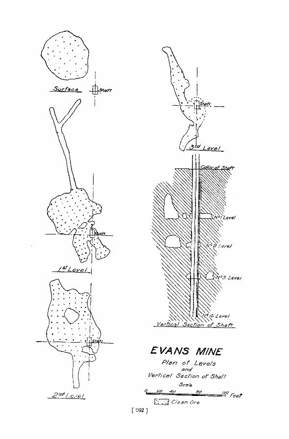
I - ' J C/ean Ore
[ 262 ]
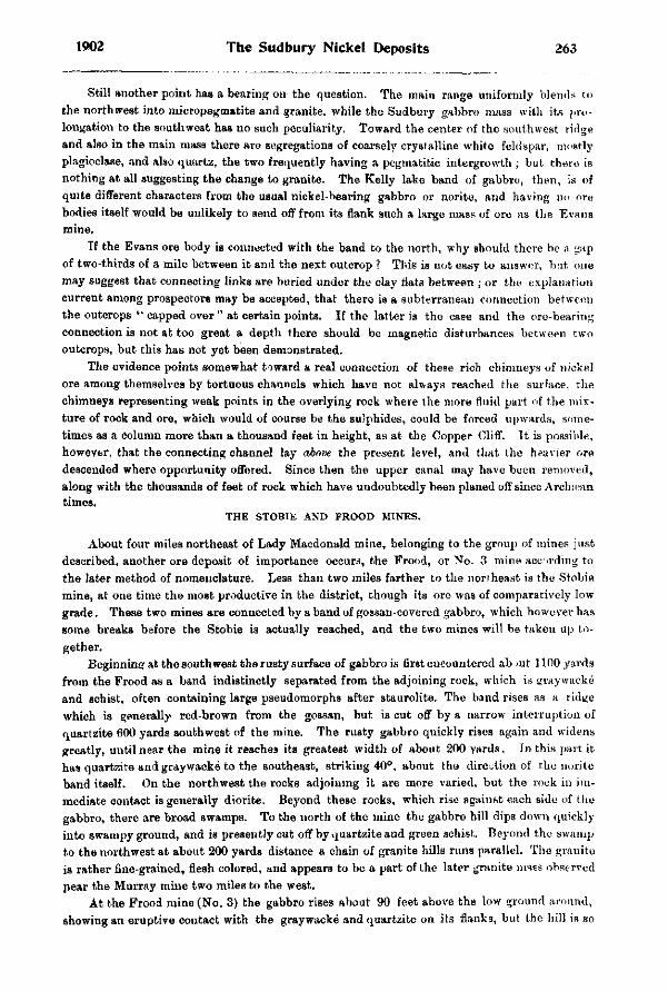
1902 The Sudbury Nickel Deposits 263
Still another point has a bearing on the question. The main range uniformly blends to the northwest into micropegmatite and granite, while the Sudbury gabbro mass with its prolongation to the southwest has no such peculiarity. Toward the center of the southwes t ridge and also in the main mass there are segregations of coarsely crystalline white feldspar, most ly plagioclase, and also quartz, the two frequently having a pegmatitic intergrowth ; but there is nothing at all suggesting the change to granite. The Kelly lake band of gabbro, then , is of quite different characters from the usual nickel-bearing gabbro or norite, and having no ore bodies itself would be unlikely to send off from its flank such a large mass of ore as the Evans mine.
If the Evans ore body is connected with the band to the north, why should there be a gap of two-thirds of a mile between it and the next outcrop ? This is not easy to answer, but one may suggest that connecting links are buried under the clay flats between ; or the explanation current among prospectors may be accepted, that there is a subterranean connect ion b e t w e e n the outcrops " capped over " at certain points. If the latter is the case and the ore-bearing connection is not at too great a depth there should be magnetic disturbances b e t w e e n two outcrops, but this has not yet been demonstrated.
The evidence points somewhat toward a real connection of these rich chimneys of nickel ore among themselves by tortuous channels which have not always reached the surface, the chimneys representing weak points in the overlying rock where the more fluid part of the mixture of rock and ore, which would of course be the sulphides, could be forced upwards, sometimes as a Column more than a thousand feet in height, as at the Copper Cliff. It is possible, however, that the connecting channel lay above the present level, and that the heavier ore descended where opportunity offered. Since then the upper canal may have been removed , along with the thousands of feet of rock which have undoubtedly been planed off since Archaean times.
T H E S T O B I E A N D F R O O D M I N E S .
About four miles northeast of Lady Macdonald mine, belonging to the group of mines jus t described, another ore deposit of importance occurs, the Frood, or No. 3 mine according to the later method of nomenclature. Less than two miles farther to the northeast is the Stobie mine, at one time the most productive in the district, though its ore was of comparatively low grade. These two mines are connected by a band of gossan-covered gabbro, which however has some breaks before the Stobie is actually reached, and the two mines will be taken up together.
Beginning at the southwest the rusty surface of gabbro is first encountered about 1100 yards from the Frood as a band indistinctly separated from the adjoining rock, which is graywacke and schist, often containing large pseudomorphs after staurolite. The band rises as a ridge which is generally red-brown from the gossan, but is cut off by a narrow interruption of quartzite 600 yards southwest of the mine. The rusty gabbro quickly rises again and widens greatly, until near the mine it reaches its greatest width of about 200 yards. In this part i t has quartzite and graywacke to the southeast, striking 40°, about the direction of the norite band itself. On the northwest the rocks adjoining it are more varied, b u t the rock in immediate contact is generally diorite. Beyond these rocks, which rise against each side of the gabbro, there are broad swamps. To the north of the mine the gabbro hill dips d o w n quickly into swampy ground, and is presently cut off by quartzite and green schist,. Beyond the swamp to the northwest at about 200 yards distance a chain of granite hills runs parallel. T h e granite is rather fine-grained, flesh colored, and appears to be a part of the later granite mass observed pear the Murray mine two miles to the west.
At the Frood mine (No. 3) the gabbro rises about 90 feet above the low ground around, showing an eruptive contact with the graywacke and quartzite on i ts flanks, but the hill is so
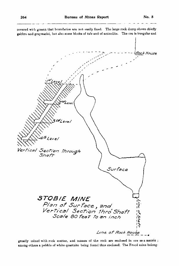
264 Bureau of Mines Report No. 5
covered with gossan that boundaries are not easily fixed. The large rock dump shows chiefly gabbro and graywacke, but also some blocks of talc and of actinolite. The ore is irregular and
flock Mouse.
Vertic&/ Sect/an through S/iafr *
STOB/E M/NE P/&n of Surface,} and Vert, eg/ SecTion 1hro Shaft
>Sc<s>/e 80 feet to an inch
L i n e , o f / ? o c A Hous^e
greatly mixed with rock matter, and masses of the rock are enclosed in ore as a matrix ; among others a pebble of white quartzite being found thus enclosed. The Frood mine belong-
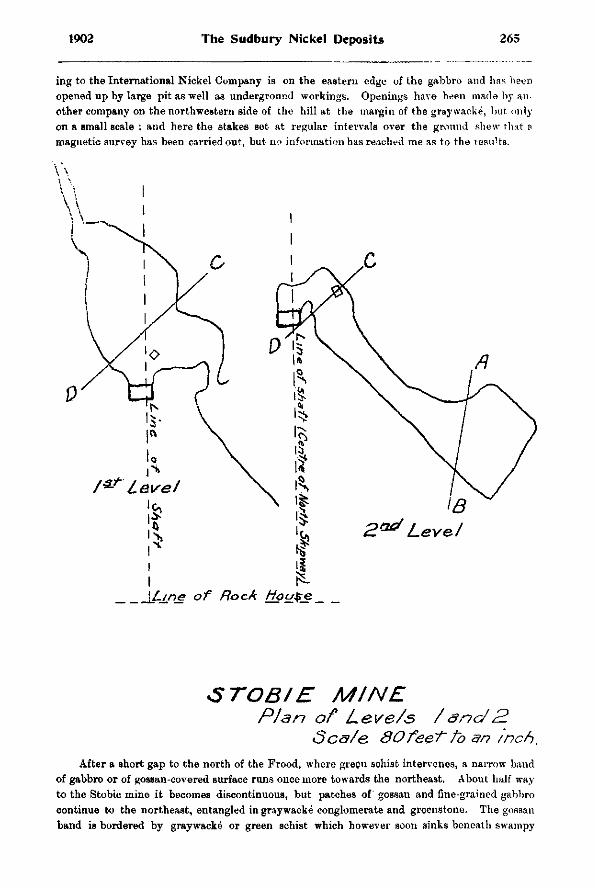
1902 The Sudbury Nickel Deposits 265
ing to the International Nickel Company is on the eastern edge of the gabbro and has been opened up by large pit as well as underground workings. Openings have been made by another company on the northwestern side of the hill at the margin of the graywacke, but only on a small scale ; and here the stakes set at regular intervals over the ground shew that a magnetic survey has been carried out, but no information has reached me as to the results.
\Line of Rock figure.
STOBIE MINE Plan of Le.ve/s /anc/2.
Scs/e 80fee~t~ to an inch. After a short gap to the north of the Frood, where green schist intervenes, a narrow band
of gabbro or of gossan-covered surface runs once more towards the northeast. About half way to the Stobie mine it becomes discontinuous, but patches of gossan and fine-grained gabbro continue to the northeast, entangled in graywacke conglomerate and greenstone. The gossan band is bordered by graywacke or green schist which however soon sinks beneath swampy
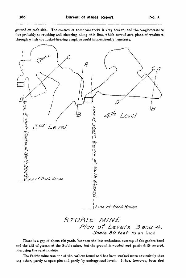
2 6 6 Bureau of Mines Report No. 5
ground on each side. The contact of these two rocks is very broken, and the conglomerate is due probably to crushing and shearing along this line, which served as'a plane of weakness through which the nickel-bearing eruptive could intermittently penetrate.
1
\J-ipe_ of R o c A H o u s e
STOBIE M/NE P/an of Leve/s 3 a n d < 4 - .
<SGO/& 8 0 fee~t~ to an inch
There is a gap of about 400 yards between the last undoubted outcrop of the gabbro band and the hill of gossan at the Stobie mine, but the ground is wooded and partly drift-covered, obscuring the relationships.
The Stobie mine was one of the earliest found and has been worked more extensively than any other, partly as open pits and partly by underground levels. It has, however, been shut
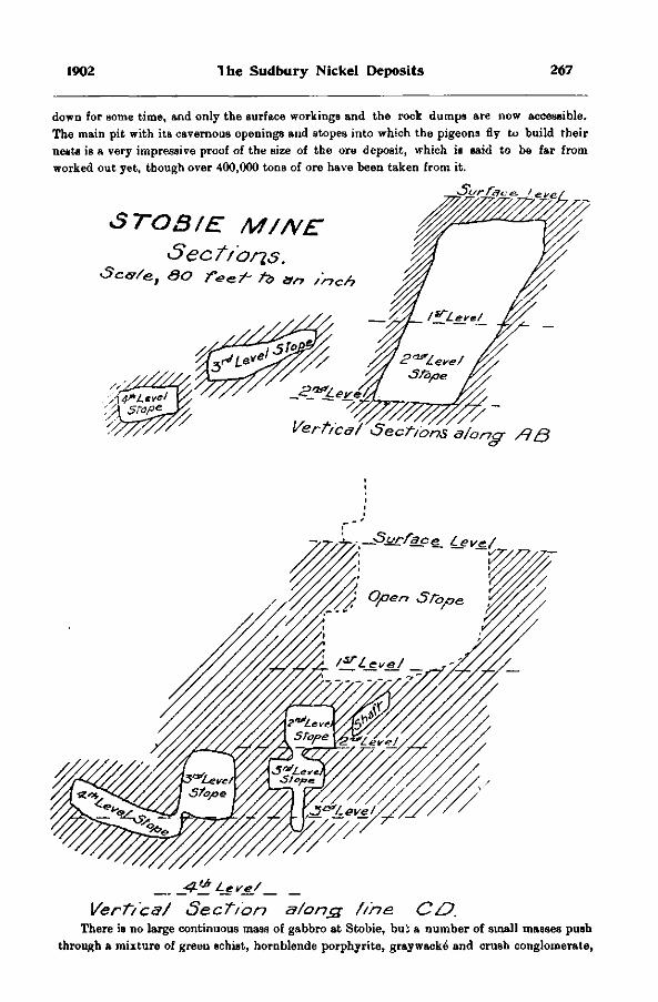
1902 The Sudbury Nickel Deposits 267
down for some time, and only the surface workings and the rock dumps are now accessible. The main pit with its cavernous openings and stopes into which the pigeons fly to build their nests is a very impressive proof of the size of the ore deposit, which is said to be far from worked out yet, though over 400,000 tons of ore have been taken from it.
STOS/E M//VE
Sectr oris. S c v / e , S O r o a n / r j c n
V e r g e d / S e c t i o n s a / o n g - / ? B
Verttca/ Section a/ong //ne. CO. There is no large continuous mass of gabbro at Stobie, bui a number of small masses push
through a mixture of green schist, hornblende porphyrite, graywacke and crush conglomerate,
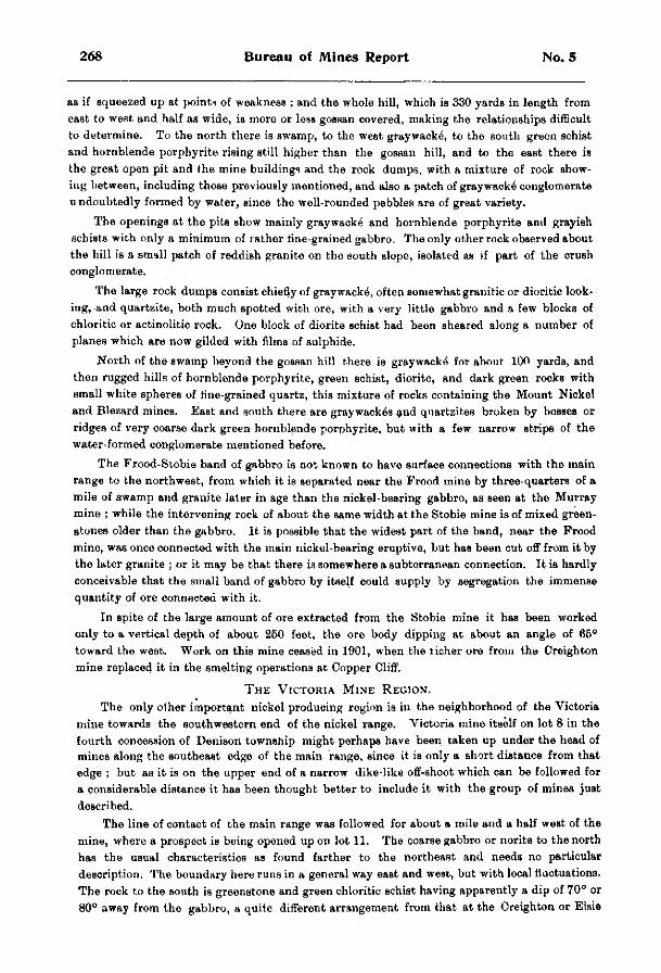
268 Bureau of Mines Report No. 5
as if squeezed up at point* of weakness ; and the whole hill, which is 330 yards in length from east to west and half as wide, is more or less gossan covered, making the relationships difficult to determine. To the north there is swamp, to the west graywacke, to the south green schist and hornblende porphyrite rising still higher than the gossan hill, and to the east there is the great open pit and the mine buildings and the rock dumps, with a mixture of rock showing between, including those previously mentioned, and also a patch of graywacke conglomerate u ndoubtedly formed by water, since the well-rounded pebbles are of great variety.
The openings at the pits Bhow mainly graywacke and hornblende porphyrite and grayish schists with only a minimum of rather fine-grained gabbro. The only other rock observed about the hill is a small patch of reddish granite on the south slope, isolated as if part of the crush conglomerate.
The large rock dumps consist chiefly of graywacke, often somewhat granitic or dioritic looking, and quartzite, both much spotted with ore, with a very little gabbro and a few blocks of chloritic or actinolitic rock. One block of diorite schist had been sheared along a number of planes which are now gilded with films of sulphide.
North of the swamp beyond the gossan hill there is graywacke" for about 100 yards, and then rugged hills of hornblende porphyrite, green schist, diorite, and dark green rocks with small white spheres of fine-grained quartz, this mixture of rocks containing the Mount Nickel and Blezard mines. East and south there are graywack^s and quartzites broken by bosses or ridges of very coarse dark green hornblende porphyrite, but with a few narrow strips of the water-formed conglomerate mentioned before.
The Frood-Stobie band of gabbro is not known to have surface connections with the main range to the northwest, from which it is separated near the Frood mine by three-quarters of a mile of swamp and granite later in age than the nickel-bearing gabbro, as seen at the Murray mine ; while the intervening rock of about the same width at the Stobie mine is of mixed greenstones older than the gabbro. It is possible that the widest part of the band, near the Frood mine, was once connected with the main nickel-bearing eruptive, but has been cut off from it by the later granite ; or it may be that there is somewhere a subterranean connection. It is hardly conceivable that the small band of gabbro by itself could supply by segregation the immense quantity of ore connected with it.
In spite of the large amount of ore extracted from the Stobie mine it has been worked only to a vertical depth of about 260 feet, the ore body dipping at about an angle of 66° toward the west. Work on this mine ceased in 1901, when the licher ore from the Creighton mine replaced it in the smelting operations at Copper Cliff.
T h e V i c t o r i a M i n e R e g i o n .
The only other important nickel producing region is in the neighborhood of the Victoria mine towards the southwestern end of the nickel range. Victoria mine itself on lot 8 in the fourth concession of Denison township might perhaps have been taken up under the head of mines along the southeast edge of the main range, since it is only a short distance from that edge ; but as it is on the upper end of a narrow dike-like off-shoot which can be followed for a considerable distance it has been thought better to include it with the group of mines just described.
The line of contact of the main range was followed for about a mile and a half west of the mine, where a prospect is being opened up on lot 11. The coarse gabbro or norite to the north has the usual characteristics as found farther to the northeast and needs no particular description. The boundary here runs in a general way east and west, but with local fluctuations. The rock to the south is greenstone and green chloritic schist having apparently a dip of 70° or 80° away from the gabbro, a quite different arrangement from that at the Creighton or Elsie
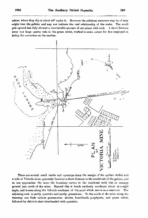
1902 The Sudbury Nickel Deposits 269
mines, where they dip at about 45° under it. However the schistose structure may be of later origin than the gabbro and may not indicate the real relationship of the rocks. The small pits opened last July showed a considerable amount of ore mixed with rock. A short distance away is a large quartz vein in the green schist, worked to some extent for flux employed in lining the converters at the smelter.
There are several small shafts and openings along the margin of the gabbro within half a mile of Victoria mine, generally however a short distance to the southwest of the gabbro, and as one approaches the mine the boundary curves to the southeast until lost in swampy ground just north of the mine. Beyond this it bends suddenly northeast about at a right angle, and is seen along the hill side southeast of the poad which serves as a reservoir. The adjoining rock is partly quartzite and partly greenstone. To the south of the mine along the tramway one finds various greenstones, diorite, hornblende porphyrite, and green schist, followed by chloritic slate interbanded with quartzite.
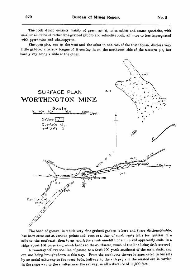
270 Bureau of Mines Report No. 5
The rock dump consists mainly of green schist, mica schist and coarse quartzite, with smaller amounts of rather fine-grained gabbro and actinolite rock, all more or less impregnated with pyrrhotite and chalcopyrite.
The open pits, one to the west and the other to the east of the shaft house, disclose very little gabbro, a narrow tongue of it coming in on the northwest side of the western pit, but
hardly any being visible at the other.
SURFACE PLAN
W O R T H I N G T O N M I N E
S c a l e O 4-00 800 fgqO 3200
Gabbro ) W |
The band of gossan, in which very fine-grained gabbro is here and there distinguishable, has been cross-cut at various points and runs as a line of small rusty hills for quarter of a mile to the southeast, then turns south for about one-fifth of a mile and apparently ends in a ridge about 100 paces long which bends to the southwest, much of the line being drift-covered.
A tramway follows the line of gossan to a shaft 100 yards southeast of the main shaft, and ore was being brought down in this way. From the rockhouse the ore is transported in buckets by an aerial cableway to the roast beds, halfway to the village ; and the roasted ore is carried in the same way to the smelter near the railway, in all a distance of 11,000 feet.
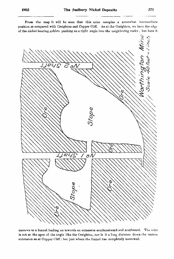
1902 The Sudbury Nickel Deposits 271
From the map it will be seen that this mine occupies a somewhat intermediate position as compared with Creighton and Copper Cliff. As at the Creighton, we have the edge of the nickel-bearing gabbro pushing as a right arjgle into the neighboring rocks ; but here it
narrows to a funnel leading on towards an extension southeastward and southward. The mine is not at the apex of the angle like the Creighton, nor is it a long distance down the narrow extension as at Copper Cliff ; but just where the funnel has completely narrowed.
272 Bureau of Mines Report No. 5
Was the fissure beyond this too narrow for the mass of the ore to traverse it, and did it therefore halt where we find it, only small quantities being able to penetrate farther ? However this question may be answered, there is a large amount of ore in the two bodies about 200 feet apart which mining operations have disclosed. The main shaft, which is vertical; was down 467 feet in July, and work was going on at the sixth level. Since then diamond drilling has shown that the A estern ore body goes to a depth of 750 feet from the surface.
There is evidence here, as in other mines, of movements since the main ore bodies were formed, such as slicken-sided surfaces and the deposit of quartz and calcite. At an opening two or three hundred yards northwest of the mine the gabbro is curiously sheared into rather regular layers about two inches thick, with thin seams of chlorite between. This structure is parallel to the cleavage of the green schists near by, and suggests that at least part of the schistose structure is later in origin than the nickeliferous gabbro.
The interesting Vermilion mine, about a mile and a half to the southeast of Victoria mine, probably represents an extension of the band described above, though our examination failed to disclose any undoubted gabbro at the mine, the country rocks of which are schists and greenstones, related probably to the sheared eruptives of the Huronian.
The ores seem to be associated with irregular veins of quartz, though the sulphides are pyrrhotite and copper pyrites as in the usual nickel range, and very rich nickel ore is reported to have been found at the mine, as well as native copper, native gold and the rare arsenide of platinum, sperrylite 2 6 . It is likely that while the actual gabbro did not penetrata so far, solutions charged with nickel and other metals derived from it circulated here in fissures, thus forming the interesting Vermilion deposit.
THE WORTHINGTON GABBRO BAND.
The Worthington, though one of the older mines of the region, has never been worked very extensively, and for six years has been shut down. Last summer it was pumped out and immense quantities of ice were discovered in i t ; perhaps due to the drifting of snow during the winter into Mo. 2 shaft, which had been left uncovered The mine is unique for the richness of some of its ores, which include nickelite and gersdorffite, as well as the usual sulphides. It is on lot 2 in the second concession of the township of Drury, four miles southwest of Victoria mine, and the line of outcrops runs northeast and southwest, but no direct connection has been traced between the two, though it is probable that the narrow Worthington gossan band is connected in some way with the main nickel-bearing range to the north.
We traced the line of outcrops as shown on the bare surface of ridges or in crosscuts made for exploratory purposes for a mile and a quarter, with numerous interruptions covered by drift, however, the mine being situated about midway in its length. At the Worthington there is very little gabbro to be seen, and what is found is greatly mingled with broken-up country rock, chiefly diorite or hornblende porphyrite, with crush conglomerates of the same materials. The adjoining rock is slaty graywacke, and the rock on the waste dump is mainly actinolite.
Going southwest from Worthington ^the band of gabbro widens somewhat, and at the Hamilton mine, on a hill a quarter of a mile from the Worthington, openings have been made displaying some ore. Here also the relationships are very confused, fine-grained more or less rusty gabbro enclosing fragments of greenstone so as to form a breccia, the whole having a greatest width of 60 paces. Most of the rock on the dump is massive actinolite. The rock to the southeast is graywacke^ and quartzite with crush conglomerate, and to the northwest a
2«Bur. Mints, 1897, p. 142.
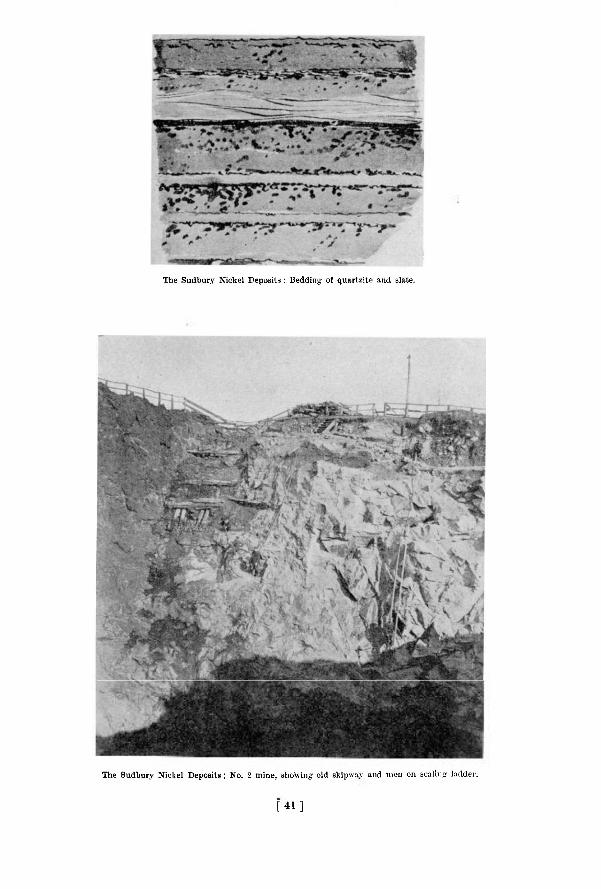
The Sudbury Nickel Deposits ; Bedding of quartzite and slate.
The Sudbury Nickel Deposits ; No. 2 mine, showing old skipwav and men on scaling ladder.
[ 4 1 ]

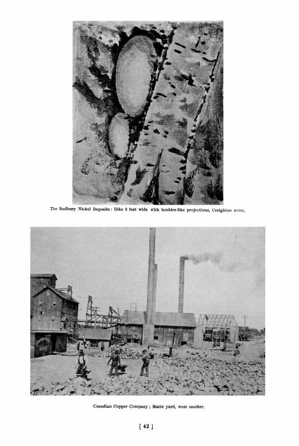
[ 4 2 ]

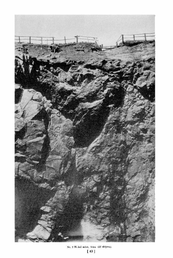
No. 2 Nickel mine, from old skipwa3%
[ 4 3 ]

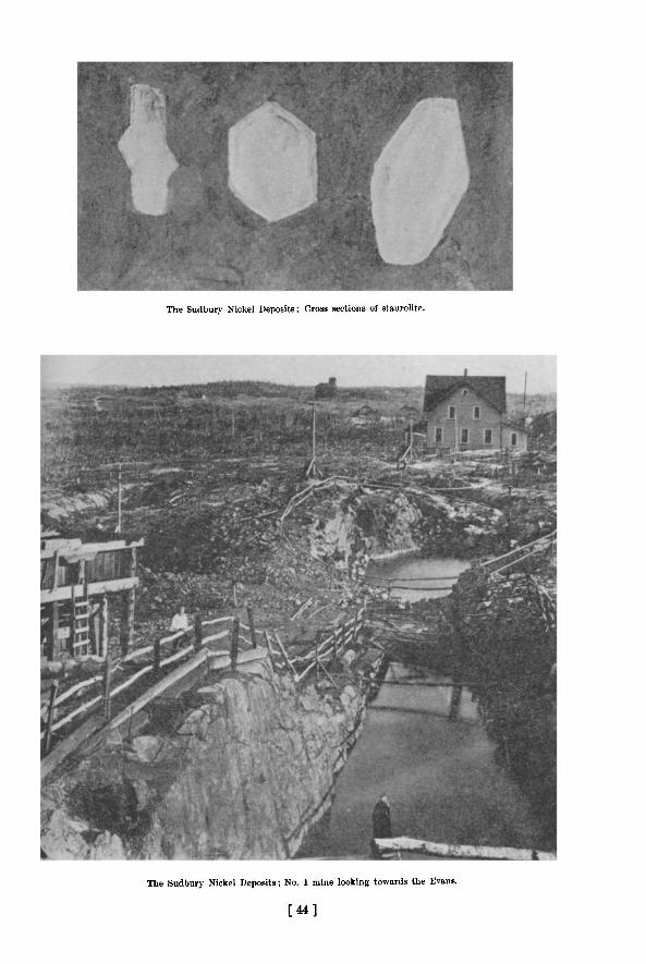
The Sudbury Nickel Deposits; Cross sections of staurolite.
The Sudbury Nickel Deposits; No. 1 mine looking towards the Evans.
[ 4 4 ]

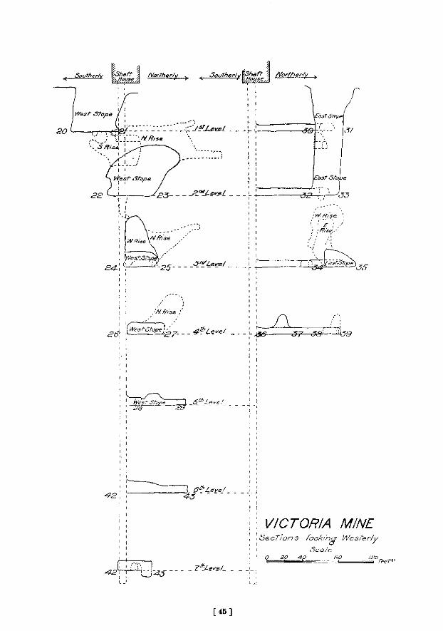
K . South er/v %%E£^ J Mor-Therly ? ^ Souther/y FJFTG . ^ A/orther/y
;Mf?,se
VICTORIA MINE
S e c t i o n s /ooA/ng- Wester/y
S c a l e
fief1'
[ 4 5 ]

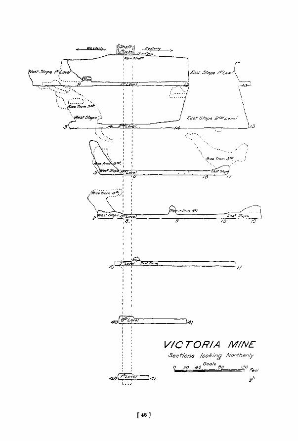
^ ^ s r ^ / ^ r w -s,
\frs& from
~7S~
3 * /
V / C T O R / A M/NE
• S e c t i o n s / o o z i n g /VorTher/y
Scale o 20 4-0
Feet
[ 4 6 ]

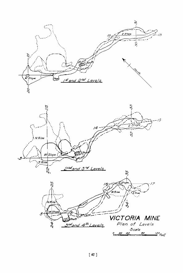
[ 4 7 ]

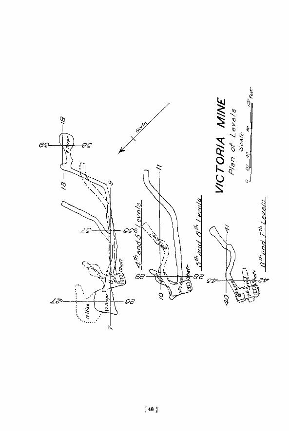
[ 4 8 ]

1902 The Sudbury Nickel Deposits 273
sandstone-like quartzite, sometimes showing a well marked cross bedding. A few hundred yards southwest of the shaft on the hill, the band of gossan sinks toward a swampy lake and was not followed farther.
Going northeast from the Worthington, the rusty band can be fol lowed wherever the rock rises above the drift, but with very little gabbro and a considerable amount of medium-grained actinolite rock, perhaps replacing gabbro. At the last opening, which is about two-thirds of a mile from the mine, quantities of rock impregnated with sulphides occur, including gersdorffite and nickelite.
From this point for about 300 yards the band could not be traced, but beyond there is a large irregularly shaped area of gabbro containing one or two outcrops of sulphides, with which the Worthington band in all likelihood is joined.
The group of mines just mentioned, including the Victoria, Vermilion, and Worthington mines, is quite exceptional in the Sudbury district for the relatively large amounts of arsenical minerals and also for the native gold found in them. The gossan of the first two mines contains both sperrylite and native gold, and in early days these heavy minerals could readily be panned from the gossany materials resting on the ore deposits. The presence of native gold and copper as well as unusually rich compounds of copper and nickel at the Vermilion mine suggest a local concentration of these materials by the ordinary processes of circulating waters in veins, the source of the materials being the still hot, though no longer mol ten , nickel-bearing gabbro ; and the absence of gabbro, so far as observed at the mine, is a further dist inct ion between this curious deposit and the others of the region.
THE NORTHERN NICKEL RANGE.
The mines along the main range of nickel-bearing norite or gabbro have been described in the earlier portions of this report. Beyond the eastern part of the township of Garson the range is difficult to follow, owing to the broad sand and gravel plains under which the solid rock is buried. Apparently the range turns northeast through Falconbridge to Maclemjan township, where the boundary between it and the granites and greenstones forming the southwest shores was picked up in lot 9 in the second concession, and traced northwest past Moose lake to Blue of lake Wahnapitae lake. Most of the contact was worked out by prospectors who took up a series of locations along it before the township surveys were made. The band runs northwest to lot 5 in the fourth concession of Norman township and then turns west. The only points where exploratory work of importance has been done are at Blue lake and on the Whis t l e property where the range bends westward.
ORE DEPOSITS AT BLUE LAKE.
The Blue lake properties follow a chain of small lakes, of which Blue lake and Speck led Trout lake are the largest, and near Blue lake itself a considerable amount of stripping, diamond drilling and magnetic work has been done by the Algoma Commercial Company, under Mr. Clergue. 2 7 The mapping of the boundary throughout this northern range was done by my assistant, Mr. Culbert, and valuable suggestions regarding the relationships of the rocks of the region were given me by Professor Willmott, now in charge of the mining and prospecting operations of the Algoma Commercial Company.
The gabbro is lighter in color as a rule than near the mines formerly described, though a dark specimen was obtained on Moose lake ; and quartz and biotite occur in it as in other local" jties, but the transition to micropegmatite is much more rapid than at Murray mine for instance, the width of gabbro proper being often only a few hundred yards or even less. Two gray gab-bro-like specimens taken for country rock of the ore bodies turn out to be olivine diabase, and
27 Bur. Mines, 1902, pp. 284-5. 18 M.
2 7 4 B U R E A U of M I N E S Report No. 5
no doubt belong to large dikes, as near the Murray mine. The granitic phase of the nickel-bearing eruptive comes against volcanic breccia to the southwest ; while the basic edge wilh the ore bodies lies against granite or greenstones. In some cases the granite appears to have penetrated the gabbro, though this may be deceptive and due to faulting and brecciation at the •edge. In other places the gabbro is observed to be fine-grained at the edge as if it had cooled against the present rock. Near Moose lake in one place there is a band of greenstone between the granite and the gabbro ; and the greenstones are certainly the oldest rocks of the region, having been carried off as angular blocks by the coarse-grained often pegmatitic granite. A green-gray dike rock, much like the finer parts of the nickel-bearing gabbro, penetrates the granite irregularly and has possibly been sent off from the gabbro, though no gossan or ore was observed in connection with it.
The stripping and test pits along the shores of the two lakes prove that ore is widely distributed along the margin of the gabbro, and diamond drill cores show that the solid ore near the east end of Blue lake is in one hole 82 feet thick with several feet of mixed ore and rock in addition. The dip of the ore i3 to the southwest, or away from the contact with the granite and greenstone, corresponding hi this respect to the relationships observed on the main range to the southwest.
T H E W H I S T L E P R O P E R T Y .
A canoe route leads from Blue lake, which is reached by a wagon road from Sudbury, to the Whistle property, passing through the northeast end of Capreol township by Clear lake and Trout lake to Waddell lake and Selwyn lake in Norman township. The Whistle property is on lots 6 in the fourth and fifth concessions ; and has been opened up by stripping and test pitting, showing an extraordinary extent of gossan surface, about half a mile in length from southeast to northwest, and 250 yards wide at the widest place. As far as extent of gossan is concerned this seems to be the largest exposure of ore in the district. The hill on which the stripping has been done rises 230 feet above the valley of McConnell creek to the southwest.
The gabbro in connection with the ore on this property is very fine-grained and mixed with fragments of other rock, almost forming a conglomerate with a matrix of gabbro. It seems to be broken or crossed by some dikes of granite and patches of greenstone ; and the adjoining rocks are granite, often pegmatitic, and greenstone ; these two rocks enclosing the gossan hill on three sides, southeast, northeast and northwest. Here again we find a large ore deposit caught in a sharp angle where the gabbro pushes into the neighboring rock.
The ores of the Blue lake region are like those of other parts of the district in most respects, though the pyrrhotite, as suggested by Mr. Vasey, who was in charge of the diamond drill, is apparently more magnetic than elsewhere. Masses of the ore near Blile lake are fairly strong natural magnets, readily attracting the compass needle and holding iron filings, but they are, of course, far surpassed in this respect by magnetite. Some octahedra of pyrite are found in the pyrrhotite.
The string of small lakes mentioned above follows in a general way the basic edge of the nickel-bearing eruptive, as if that wore most easily acted on by weather, and their western shores often consist of bluffs of reddish, syenitic-looking rock, the more acid and also more resistent phase of the eruptive.
From the Whistle property on Selwyn lake the contact of gabbro, with granite or greenstone was traced by Mr. Culbert through Norman and Wisner townships to the western edge of Bowell township, following the line of locations taken up by prospectors. At about the centre of Bowell the range appears to fork, one branch going a little north of west into Foy, and the other to the southwest into Morgan township. As the work was of a hurried character its results need not be described in detail, but in general they correspond with those obtained
1902 The Sudbury Nickel Deposits 275
on the southern range, but exactly reversed. The gabbro meets older granitic rocks to the north and blends into micropegmatite and quartz syenite or granite toward the south, and the ore bodies are on the northern or northwestern edge of the gabbro.
It is of interest to note that one of the most promising properties of the range, just north of Nickel lake fin W. P. 131), is in a sharp northward angle of the gabbro, a similar arrangement to that of the Whistle and Creighton deposits.
The whole of the northern range is awaiting the coming of a railway when, no doubt, the better properties will be developed, and perhaps prove equal to those of the now well-known southern range.
276 Bureau of Mines Report No. 5
GENERAL CONCLUSIONS.
In the foregoing pages the chief mines of the Sudbury district have been taken up in some detail, and the fact has been brought out that all of them are either on the basic edge of a great eruptive band, which at the opposite edge becomes a quartz syenite or granite, or on dike-like off shoots, often, however, interrupted by other rocks projecting from the southeastern basic edge of the great gabbro band.
Last summer's work proves also what had already been made probable by the patient work of prospectors, that the main belt, after a short drift-covered gap in Falconbridge and the southern half of Maclennan, turns northwest and north to the middle of Norman, and then bends southwest to the middle o f the township of Bowell, where it forks. Though the northern nickel range had been crossed by myself at three points previously, 2 8 it had never been followed up connectedly ; but we can now say that the basic edge of the nickel-bearing eruptive band has been traced practically continuously by the work of Dr. Barlow and of the Bureau of Mines from Drury township east and northeast for 35 miles, then north-n »rthwest for ten miles, and east for 17 miles, making a total length of 62 miles. It is possible, but not yet proved, that one or the other fork of the nickel range in Bowell connects with the promising Levack nickel range about seven miles distant. This band of nickel-bearing eruptive is stated by Dr. Barlow to run southwest for 18 miles to lot 12, in the third concession, of Tr i l l , 2 9 from which the distance to the Sultana nickel mine on the northern edge of Drury is only four miles
FEATURES OF THE NORITE BAND.
It is evident that the nickel-bearing eruptive band encloses with only short interruptions the elongated oval area of r o c k B consisting of volcanic ash, sandstone and black slate represented by Dr. Bell as prol ably Cambrian, an area about 35 miles long and eight miles wide.
As will be seen from the previous description, the main band is everywhere basic and nickeliferous outwards from this roughly oval centre, and more acid and pegmatitic inwards toward the sedimentary rocks For example, Professor Walker describes the Windy lake eruptii-e band, with which the Levack nickel deposits to the northeast are connected, as having much the same character as the Murray mine eruptive on the opposite side of the sedimentary area but in the reversed order. 3 0
In most cases the nickel-bearing gabbro or norite becomes finer-grained against the coarse granites, granitoid gneisses, hornblende porphyrites and other greenstones on its oulward side, and so may be held to be later in age though there is sometimes on the other hand a medium or fine-grained granite which occasionally cuts the gabbro and is undoubtedly later still. The relationship of the acid side of the eruptive band to the adjoining pyroclastic rocks (volcanic ash or vitrophyre tuff) is not so certain. Dr. Bell evidently looks on the sedimentary rocks as younger than the granites and gneisses on which they rest, but Dr. Walker and, if I am not mistaken. Dr. Barlow, think that the contact between them is eruptive, 3 1 and therefore that the overlying sedimentary beds are older than the nickel-bearing eruptive rocks. Our work was s o strictly confined to the nickel-bearing basic edge of the band that we had little opportunity to observe the opposite contact, and saw no section which would determine the matter.
One naturally asks why this oval band o f eruptive rock, basic on the outer edge and acid on the inner edge, should be so symmetrical as i t is ; and if one thinks of the band as simply
2 8 Rocks of Clear lake, near Sudbury, Can. Rec. Sc., Apr , 189!), pp. 343—6, Bur. Mine?, 1901, p. 152 and p. 185.
2 9 Geol. Sur. Car,, Sum. Rep , 1901, p. 144. •° Quor. Jour. Geo. Soc, Vol. LIII (1897) pp. 568. 3 1 Ibid., pp. 53-4.
1902 The Sudbury Nickel Deposits 277
a greatly elongated lacoolite or stock of horseshoe shape there is no discoverable reason for the symmetry. A point previously referred to gives a hint as to the real cause of the symmetry . The contact of the main nickel-bearing band with the older rocks outs ide , so far as k n o w n , always dips inwards, often however with a very irregular surface, but with an average inclination of about 45° in the mines which have been worked sufficiently to show the relationship. This strongly suggests that we are dealing with a vast sheet of eruptive rook having a basin shape ; a sheet nearly 40 miles long and 17 miles wide, and probably a mi le and a half or two miles thick on the average, if the dip is 45°. Following Professor Walker's account, which makes the inward edge granitic or gneissic, it must have cooled slowly and beneath a great thickness of overlying rock, for the granitic structure demands these condit ions. Tiiis would give the exceedingly slow rate of cooling which would be required according to the segregation theory for the gradual separation of the more acid from the more basic materials , and of the most basic materials of all, the sulphides, from the quartz gabbro or norite at whose edge they are found.
T H E O R Y OF O R E F O R M A T I O N .
On what system did the separation take place ? W a s it due to the slow segregation of the sulphides at the solid and relatively cool margin ; or was it essentially the result of gravitation, the heavier materials going to the bottom ? The latter view seems rather probable. Thus we may imagine the ores accumulating in pools where there were indentat ions or hol lows be low the general level, and get an idea of how the narrow dike-like off-shoots could consist of such vast quantities of sulphides with a minimum of rock, as we find iu the gossan band at Copper Cliff. Possibly another factor helped in the process of squeezing the ores with a relatively small admixture of rock into these half-open fissures ; the fact that the sulphides are more fusible than the gabbro magma, and hence could be forced more readily into all the ramifications of the irregular cmals in which we now find them.
We may suppose that the intrusion of the great sheet of molten material took place between the underlying solid crystalline rock and the softer, uncrystalline sediments as the plane of least resistance, but that the rocks beneath underwent great disturbance at the same t ime, including faulting on an extended scale such as we see in all the recks of the region except the gabbros and later eruptives ; and thus the tortuous channels just referred to w e r e opened for the passage of the sulphides and accompanying gabbro.
We may imagine, also, that the pouring upward of such a mass of molten rock would allow the solider parts of the crust to collapse more or less from the removal of material from b e n e a t h . To this, and perhaps to some extent also to the cooling and shrinking of the area which had been so greatly heated, during the ages since the eruption, we may attribute the basin shape of the tract enclosed by the nickel-bearing eruptive.
We must think of the segregation as practically complete before the fissures were opened into which the immense quantities of sulphides found at the Stobie or Copper Cliff were injected ; for it is inconceivable that the small amount of rather acid gabbro associated wi th t h e s e ore bodies could normally have contained such an amount of sulphides.
It will be understood of course that the hypothesis given above is mere ly tentative, and may have to be remodelled or replaced by some other hypothesis as our knowledge of this interesting region grows more extensive ; but it affords at least a working basis for the study of the ore bodies and their associations.
It is a striking fact that the other gabbro areas of the district, such as the laccolite east of Sudbury, which are apparently entirely disconnected with the main range, have not been proved to contain ore bodies of importance, though small quantities of both pyrrhot i te and chalcopy-rite are found in them. Apparently they were of too small magnitude to provide large q u a l i ties of ore, or else their magmas were originally of a different composit ion from that of the
278 Bureau of Mines Report No. 5
main range. They may have been segregation products themselves fiom the already differentiated magma, from which most of the sulphides had already been removed.
Foullon, Bell and Barlow among the early geologists who visited the region recognized distinctly the eruptive origin of the Sudbury ore deposits. In 1891 the latter says "the ores and the associated diabase were therefore in all probability simultaneously introduced in a molten condition, the particles of pyritou3 matter aggregating themselves together in obedience to the law of mutual attraction." 3 2 The theory of segregation, elaborately worked out by Vogt for Norwegian ores associated with norites or other basic rocks, was naturally applied to our deposits by Dr. Adams ; 3 , i and though it has been opposed by Posepny, who thinks the presence of metallic sulphides in the magma of a molten eruptive rock an impossibility 3 4 practically all other geologists who have studied the question admit that the ore deposits are to a greater or less extent of igneous origin. They have been spoken of as stockwerks, lenses, etc., but these terms do not correctly describe the ore bodies, since they are really small or large masses of more or less pure ore fading out into the adjoining rock and often of very irregular shapes, as may be seen at the Stobie or Creighton mines.
It is of interest to find that the late Prof. A. W. Stelzner, of Freiberg, the well known petrographer and mining geologist, held the ore and accompanying eruptive rock to be contemporaneous in origin. In a letter to Mr. G. R Mickle dated Nov 12th, 1892, he gives the result of examination of some specimens of rock and ore which had been sent him as follows ;
" Polishing one side of rather large pieces gives very pretty results. In the ore from the Vermilion mine one sees plainly—much more plainlv than on the surfaces of fracture—the intergrowth of pyrrhotite, chalcopyrite and characteristic yellow lamellae which might be either millerite or polydymite. Moreover on a polished surface like this the black rock inclusions in the sulphides show up plainly. The true nature of these inclusions and their relation to the ore is disclosed by the sections. One sees then that these black rock inclusions in no way are sharply divided from the sulphides but are connected with them by quite gradual transitions. Those of the Vermilion ore consist of quartz, brown mica, chlorite, hornblende and some epidote ; those of the Murray ore of triclinic feldspar, augite, which is more or less decomposed, some brown mica and epidote. The intergrowth with the ore is such an intimate one that I cannot regard the black specks as fragments enclosed by the ore, but can see in them only concretionary formations which are of the same age as the ore. Similar relations of ore and country rock occur also in the Norwegian pyrite and in the pyrrhotite "
T H R E E T Y P E S OF O R E D E P O S I T S .
In reality there are two different types of deposits represented in the mines of the district ; those along the southeastern margin of the main range, often crowded into bay-like indentations of the adjoining rock ; and those strung out along the narrow off-shoots from the main range, as Peters suggests, "like sausages on a string, but with a long piece of string between the sausages." 3 5 Among the former class are the Creighton, Gertrude, Elsie, Murray, and Blezard mines ; among the latter the Copper Cliff, Evans, Frood and Stobie, and the Victoria and Worthington mines.
Perhaps a third variety should be distinguished for the Vermilion mine, which contains rich nickel and copper ores, but has no visible association with a band of gabbro, having, how ever, been formed probably by hot circulating fluids proceeding from such a band. It must be admitted that circulating waters have played a considerable part in all the deposits, but at the Vermilion mine they seem to have been perhaps the only factor; while at other mines they have played a less important part.
3 2Geol. Snr. Can., 1890-91, 128 S.; also Ottawa Naturalist, 1891. "The Igneous Origin of Certain Ore Deposits, Mining Assoc. Pro. Que., 1894 ; alBO copied into the
Mining Review, Vol. XIII, No. 1, p. 8, etc. 3 1 Genesis of Ore Deposits, p. 146. 5 6 Min. Res. Ont., p. 104.
1902 The Sudbury Nickel Deposits 279
The marginal deposits, as we may call the first type, are of all sizes and shapes, but have some features in common. They all dip westward or northwestward with the r,ock adjoining the ore-bearing gabbro as a more or less regular footwall. The ore may penetrate the footwall by impregnation or by deposit in fissures for a short distance and may enclose fragments of it > but it never goes far in this direction, and independent ore bodies'do no t occur in the wall-rock. The footwall has commonly a dip of from 29° to 65° to the west or northwest . In the other direction there is no sharp limit to the ore ; it may fade off into the gabbro ; rounded or irregular masses of the gabbro may be enclosed in it ; or separate ore bodies may be entirely enclosed in the gabbro. A fringe of gossan-covered rock containing intermixed ore may ex tend for some distance in each direction along the margin, and may connect two ore bodies , as at the Elsie and Murray mines. In fact at most points on the basic edge of the great eruptive sheet more or less ore may be found ; but the greatest ore bodies are enclosed in embayments of the edge from which no narrow dike-like offset projects, the ore having been caught there with no chance for escape.
None of the marginal ore deposits have be.n worked to great depths, the deepes t point to which the ore has been followed being not more than 250 feet, so that little can be said as to the vertical continuity of this type, but one of them has already produced about 150,000 tons of ore, showing that the ore bodies may be large.
The other type of ore deposits is confined to offsets from the main range, often dike-l ike projections, but without the uniformity usual in dikes. Bands of gabbro, more or less gossan-covered, lead off from a funnel shaped bay of the main range and here and there accumulations of thousands or hundreds of thousands of tons of ore occur along; the line. Frequently the band is lost on the surface, but from point to point a gossan hill projects where more or less gabbro and ore can be found, suggesting an underground connection. The causes that determine the position of an ore body are not always clear. Some occur at the point where the bay narrows, as at the Lady Macdonald or Victoria mines ; others at the end of a continuous band of gabbro, as at No. 2 mine near Copper Cliff, and still others as separate outcrops like the Copper Cliff, Evans and Stobie mines. The ore bodies may be supposed to occur where some halt or obstruction in the channel along which the mixture of rock and ore was travelling gave an opportunity for separation of the two constituents.
These ore bodies are often rudely cylindrical or chimney-shaped, unl ike the irregular masses of the marginal type ; they are known to have a considerable vertical extension, one having been worked down to 937 feet ; and they are not usually so much incl ined from the vertical as the other type. They include the richest known mine and also the one that has produced the largest amount of ore.
Where a bay-like projection of the main range has no outlet we may expec t to find a large ore body of the first type ; where the bay sends off a projection the ore that would have ccumulated marginally is distributed irregularly along a line that may reach two miles or more
from its starting point. Occasionally the point of departure from the main range of an offset line of ore deposits is not known, e.q., the Frood-Stobie range, but the presence of a band of later granite between the main range and the offset probably accounts for the break of continuity here.
As the relation between ore and rock is much the same in offset deposits as in marginal deposits, we may conclude that they were formed in much the same way, by the more or less complete separation of the two fluids while still in a state of fusion. Most of the offset deposits show the same fading out into barren rock, the same inclusions of country rock, etc., which in the marginal deposits prove the igneous origin of the ores.
There are however undoubted proofs of the secondary origin from solution of considerable portions of the ore at most of the mines of this type. At the Copper Cliff we find bands of
280 Bureau of Mines Report No. J
quartz or carbonates with ore along the sides of dikes later in age than the main body of the ore, showing that a redistribution of materials by circulating water has taken place ; but in general the evidence goes to show that this action has been less important in the production of ore bodies than the original segregation from the molten magma.
The gossan band on which the Worthington mine is found, should be briefly referred to as indicating a transition to the rathor unimportant third type of deposit, formed wholly by circulating water. At the Worthington the gabbro is reduced to a minimum, unless the actinolite rock accompanying the ore is its decomposition product, and the presence of rich nickel ores, combined with arsenic, is probably due to the extensive action of heated waters, which seems to have produced a large part of the deposit.
The only characteristic example of ordinary water-formed voin deposits in the nickel region, however, is the curious Vermilion mino. where we find quartz, etc., but no gabbro, accompanying rich ores of nickel and copper, as well as free gold and copper in the upper parts of the deposit. The close connection of this type of deposit with the off-set type is shown by the presence here as well as at Victoria mine, less than a milo and a half away, of native gold and sperrylite, the rare arsenide of platinum. Evidently the two must have been supplied with platinum from the same source ; and all transitions between ore deposits entirely due to plut-onic action, and deposits formed by circulating heated waters may bo supposed to exist in the region.
The final impression loft is that the marginal type of deposit is in the main of plut^nic origin, the aqueous work being relatively unimportant ; that in the off-set type plutonic is generally more important than aquoous action, though one example, that of the Worthington, suggests moro complete rearrangement of the materials by circulating water ; thus forming a transition to ordinary vein deposits wholly due to water action, as at the Vermilion mine.
C O M P O S I T I O N OK T H E O R E B O D I E S .
The characteristic ores of the deposits which have been referred to are few and monotonous, consisting as they do essentially of pyrrhotite in largest amount, and chalcopyrite in smaller quantities. The pyrrhotite is always nickeliferous, though in varying degrees, and the amount of copper pyiites, though quite variable also, is usually sufficient to provide nearly or quite as much copper to the matte as there is nickel. In some mines, like the Copper Cliff, the copper decidedly outweighs the nickel, while in others, like the Creighton and Blezard, the nickel is more than double'the copper. It is found in the Copper Cliff mine that in narrow patts of the ore body copper pyrites preponderates, whil« in broador ones the nickel contents are greater. In most mines the sulphides are more or l>ss mixed with silicates, showing that the separation, by whatever means it was effected, was incomplete ; and inwards toward the main body of norite or gabbro the sulphides gradually diminish. Prof. Walker notices at the Murray mino that the sulphides are coarser-grained at a distance from the contact, and finer-grained as thoy approach it, suggesting more rapid cooling at the contact, as in the enclosing gabbro. There is, however, no doubt that parts of both ores were deposited from solution long after cooling had advanced far enough for consolidation ; for we find thin stringers penetrating the fractured outer edge of diabase dikes which evidently occupied fissures in the already cold gabbro and the associated sulphide masses.
The pyrrhotite and chalcopyrite having in large part consolidated directly from the cooling rock, crystals of these minerals are almost never found in the ore deposits. The only crystal of pyrrhotite which 1 have heard of in the district was obtained by Mr. G. It. Mickle from a man working in the Worthington mine. Mr. Mickle describes it thus: " The crystal is evidently a hexagonal prism showing strongly marked basal cleavage ; two of the sides are intact and portions of two others remain. The diniens ons are 1 inch or 32 mm. by A inch
1902 The Sudbury Nickel Deposits 281
or 13 mm.; the weight 26.4 grams ; and an analysis of a very small fragment from the crystal gave 2.3 per cent, of nickel."
The amount of sulphur present in the nickel-bearing magma seems to have been generally sufficient to satisfy most of the iron, nickel and copper in the form of mono—or sesqui-—sulphides, such as pyrrhotite and chalcopyrite, which contain 35 to 40 pt'v cent, of the element, but not sufficient to form much pyrite, which requires over 53 per cent. However a small amount of pyrite and also of marcasite has been found by Professor Walker in massive pyrrhotite at the Murray mine, and Mr. Culbert discovered a few small octahedra of pyrite in the Blue lake ore.
Large cubical crystals of pyrite occur however in fissures with quartz and calcite at a few of the mines, such as the Elsie, but are evidently of much later date than the sulphides in general. An assay of one of the crystals from the Elsie mine showed no nickel.
On the other hand, there was occasionally not quite enough sulphur to satisfy the whole of the three metals, and small amounts of magnetite are found in some of the deposits, as in the ore from Levack, well formed octahedra being embedded in the pyrrhotite, showing that the magnetite crystallized first. The largest known mass of magnetite occurred at Clara Bell mine north of Copper Cliff, where according to Captain McArthur about five tons were found completely enclosed in the sulphides. This magnetite is readily attracted by the magnet, so that it is probably not highly titaniferous ; and it contains grains of pyrrhotite and chalcopyrite as well as small portions of a green silicate.
Titaniferous iron ore was found in small quantities by Dr. Walker in the ore at the Murray mine, and most of the thin sections made from the nickeliferous gabbro contain magnetite surrounded by leucoxene, showing that the unweathered mineral contained titanium. It is well known of course that segregations of iron ore from basic eruptive rocks are usually titaniferous.
T H E N I C K E L - B E A R I N G M I N E R A L S .
The source of the nickel in the pyrrhotite has been explained in various ways, some supposing that it simply replaces iron in the compound ; others holding that some other nickel mineral is mixed with the pyrrhotite in small quantities, such as millerite, polydymite or pentlandite. Probably all three of these minerals occur ; though millerite has 1 believe been definitely reported only once from the Copper Cliff mine, where Dr. Peters found it as fine wire-like crystals. 3 0 Polydymite was found in Sudbury ore by Clarke and Catlett 3 7 in an examination for platinum ; and pentlandite occurs probably at most of the mines as small patches enclosed in the pyrrhotite, ciood examples being found at the Evans, Creighton, Worthington and other mines, the platy parting or cleavage and the brassy color distinguishing it from the enclosing pyrrhotite.
In 1892 Dr. S. H. Emmons described three new nickel-iron sulphides from the Sudbury region, folgerite, whartonite and blueite, with amounts of nickel running from 3.70 per cent, in the last to 31.45 in the first,88 but later writers have held that the determinations were probably in error, mixtures of minerals having been analysed instead of pure materials, or the results of the analysis having been wrongly interpreted. Prof. Penfield considers the folgerite really pentlandite, the blueite nickeliferous pyrite and the wharto:iite a mixture . 3 9 Mr. Mickle, who has had much experience in analysing the Sudbury nickel ores, gives the following account of specimens resembling the blueite as described by Dr. Emmons :
s 6Trans Am. fnst. Mining Engineers, Vol. XVIIL, p. 282. "Am. Jour. Sc., Vol. XXXVII"., 1889, p. 372. "Bug. Min. Jour., 1892, p 609. "Am. Jour. Sc., Vol. XLV., 1893, pp. 493-7.
282 Bureau of Mines Report No. 5
" A peculiar grayish-green bronze-colored, non-magnetic mineral, which tarnishes to a dull bronze, was found by Mr. McVittie on the location where the Gertrude mine now is. The mineral occurred massive with small crystals of magnetite and specks of chalcopyrite disseminated through it in a streak about six inches wide adjoining the granite. An analysis of the mineral after removing the magnetite gave the following results :
Found. Calculated. Iron 37.28 por cent. 41.48 percent. Sulphur 46.54 " 51.79 Nickel 5.95 " 6.62 Copper 0.10 " 0.11 Insol 9.66
99.53 100.00
Assuming the composition to be Fc S 2 , Ni S and Cu Fe S 2 : 41.48 per cent, of iron requires 47.41 per cent, of sulphur.
6.62 " " nickel " 3.65 " " 0.11 " " copper " 0.11
which agrees fairly closely with the amount of sulphur found in the calculated composition, viz.: 51.79 per cent.
Polishing one side of the specimen shows that the piece is not homogeneous but resembles a porphyry in structure, consisting of a groundmass with crystals imbedded in it, the crystals having a more yellowish color than the groundmass. Etching reveals a cellular struct ure in the groundmass of alternate light and dark lines somewhat like the surface of meteoric iron or certain steels when similarly treated. Surrounding the crystals is always a dark rim. A similar peculiar grayish-green bronze mineral from Calumet island, Ottawa river, came to my notice, containing 2.64 per cent, of nickel ; also one from the ninth level of the Copper Cliff mine, the light colored mineral forming a band in this case. In the examples at hand it does not seem possible to separate the different components in order to analyse each separately. Emmens' blueite 4 0 with a probable composition of 3.70 per cent, of nickel, 41.01 of iron and 55.29 of sulphur agrees in description with the mixed sulphides just referred to. The percentage of nickol no doubt varies according to the relative amounts of crystals and groundmass."
The fixing of the real mineral which contains the nickel may havo an important economic bearing, since pyrrhotite is rather strongly magnetic and the other minerals mentioned are not so, giving a possibility of magnetic separation of the valuable from the useless part of the ore. Experiments carried out by Dr. Barlow and also by Mr. C. W. Dickson show that if the pulverization is fine enough a very considerable, thoujih not complete, separation may be effected magnetically, and the latter shows that the non-magnetic portion has the composition of pentlandite 1 1 . As there is some nickel retained in the magnetic portion it may be supposed that the mixture of pentlandite with pyrrhotite is very intimate. It is, however, possible that in some cases tho nickel is actually contained in the pyrrhotite ; for the crystal referred to before, showing no hint of pentlandite, contains about tho usual amount of the metal.
S I L V E R , P L A T I N U M , G O L D , C O B A L T .
The only sulphide mineral in addition to the iron, nickel and copper compounds just mentioned is apparently galena, which occurs in small amounts as narrow seams with a little quartz in ore at the thirteenth level of tho Copper Cliff mine, and also in the rock on the dump. The galena may account for part of the silver shown in assays of matte, the rest being contained in the copper pyrites. Galena is reported from the Worthington also.
Arsenical nickel minerals are found in considerable quantities at the sa me mine, where nickelite and gersdorffite are often associated with the pyrrhotite. The most interesting of the minerals containing arsenic is, however, the di-arsenide of platiaum, named by Penheld and Wells sperrylite. 4 2 It occurs as minute shining crystals isomorphous with pyrite, and was
*° Jour. Am. Chem Soc, Vol. 14, No. 7; reprinted in Bur. Mines Rep., 1892. 4 1 Eng. Min. Jour., 1902, (73) p. 660. 4 2 Am. Jour. 3c , XXXVII, 1889, j.p. 67-71.
1902 The Sudbury Nickel Deposits 283
first obtained from the gossan of the Vermilion mine, but afterwards from the McConnell property (now the Victoria mine) a mile or two distant. 4 3 It may be panned along with gold from the gossan of both these mines, and an investigation of the latter locality by Mr. Mickle in 1897 showed that it was generally distributed through not only the gossan but also the solid ore, his assays demonstrating that the platinum is associated with the copper rather than the nickel ores, though some is found in the latter also. The average of six samples of solid ore gave a trifle over 3 dwt. of platinum and a little gold per ton, while pyrrhotite with little copper pyrites gave considerably less than the average, and one example of ore with much chalcopyrite gave 7 dwt. 12 gr. of platinum and a trace of gold. His highest assay showed 1 oz. 3 dwt. of platinum and 3 dwt. of gold from decomposed ore resting on the solid ore.
These results suggest an appreciable increase in the value of the matte trom Victoria mine as compared with the other mines of the district where the amount of gold and platinum in the ore seems to be much less, since these metals and also the silver are concentrated along with the nickel and copper in the matte, and should be recoverable. It is of interest to see that Mr. Dickson found quite a large number of sperrylite crystals in almost pure chalcopyrite from the Victoria mine, but not in the other Sudbury ores examined. 4 4
Dr. Walker's analysis of Manhes matte from the Murray mine shows only about 3 dwt. 4 gr. per ton of platinum metals, which is equal to perhaps 1-15 as much in the ore, or about 5 g r - 4 8
The Bessemer matte from Copper Cliff seems to contain a higher percentage, equal to about 15 gr. per ton of ore, but much below the results from Victoria mine.
The question of the source and amount of the platinum metals in the Sudbury ores has been investigated by several writers since Penfield and Wells discovered sperrylite. Dr. Walker discusses it in 1896 in the article previously referred to, and Mr. Dickson in 1903, while Vogt compares the ores of Canada and Norway in this respect in 1902, 4 6 all agreeing that the platinum is chiefly or wholly found with the copper ores. On the other hand Clarke and Catlett found platinum in polydymite from Copper Cliff, containing only .32 percent, of copper, 4" the amount running from 1.8 to 7 oz. per ton, which would make the polydymite richer than the copper ores of the Victoria mine.
The source of the cobalt found in assays of Sudbury matte, and reported for three years in the returns from certain mines, is no doubt the same as that of the nickel, the two metals being close relatives and usually associated in basic rocks and in meteorites. N o rich cobalt ores have been reported from the Sudbury district, perhaps because there has been little secondary rearrangement of the materials of the ore.
In concluding this brief account of the rarer minerals and elements Vogt's results, cited before, may be quoted. He finds little silver or other precious metals in the richer nickel ores; but a comparatively much larger amount in the mixed ores and copper pyrites. His table comparing the contents of Canadian and Norwegian bessemer mattes is as follows, the analysis from the Murray mine being Dr. Walker's, referred to on a former page :
Murray Mice Copper Cliff Rmgerike Evje, Nor.
} 48.82 39.96 51. IB 41.50 Cobalt } 48.82 39.96 1.98 0 97 Copper 25 92 43.36 16.41 23.60
2 84 0.30 10.87 (13) 22.50 13.76 19.58 (20) 22.50 13.76 19.58 (20)
« Bur. Mines, 189?, pp. 141-2. " Am. Jour. Sc.. Vol. XV., 1903, p. 138. « Ibid., Vol. I, 1896, p, 112. «i Zeitsch. f. prakt. Seol., Heft 8, X Jahrgang, 1902, pp. 258-260. « A m . Jour. Sc., Vol. XXXVII, 1889, p. 374.
284 Bureau of Mines Report No. 5
Thousandths of one per cent.
Gold Silver
.076 1.775
.430
.056
.057
3 to .6 21
.06 8.5 .26
about .1 14
about .3 Platinum . Iridium... Osmium Rhodium. Palladium trace
trace J
1
1.5 \ about.01
Prof. Vogt states that the proportion of the metals is one part gold to 120 of silver, one of platinum to 30 of silver, one of silver to 5000 of nickel, and one of platinum to 150,000 of nickel. He assumes that the platinum of the Norwegian ores comes from sperrylite also, though the mineral has not yet been found in them. Of late sperrylite has been obtained in copper ores in the southern and western States, so that the mineral is no longer peculiar to the Sudbury district, but is evidently rather widely spread, though in very minute quantities.
With the exception of the oxides and silicates belonging to the original norite or the products of its alteration, such as actinolite or talc, very few additional minerals are recorded from the nickel deposits. Quartz, calcite and dolomite or ankerite occur as later vein formations or filling small v"ugs. Fluorite and orthoclase crystals are found in granite with sulphides at the Creighton mine, and minute quantities of cassiterite accompany the sperrylite at the Vermilion mine. Graphite shows as a few scales in country rock on the dump at Lady Macdonald mine.
If we omit the small but unique area including the Vermilion, Victoria and Worthington mines, where the native gold and copper, and the arsenical compounds occur, the district as a whole is singularly monotonous and uninteresting in its minerals for so important a mining region.
It is of interest to mention that the rare substance cubanite (Cu F e 2 S 4 ) has been found by David H. Browne in the roast heaps as one of the products of the roasting process, though it is not known to occur in the unroasted ore.
Though nickel and copper were discovered in the Sudbury district in 1856 by Murray at what is now the Creighton mine, undoubtedly the most productive existing nickel m i n e , 4 8 no importance was attached to this occurrence as long as the region was inaccessible except by canoes ; and the history of mining in the district dates from the construction of the Canadian Pacific railway in 1882, when the ore deposit later called the Murray mine was disclosed. In 1883, the ore bodies of what are now the Stobie and Copper Cliff mines were found, but at first they were taken up for their copper contents, and it was only three or four years later, after a thousand tons of the Copper Cliff ore had been sent away for treatment, that its value as an ore of nickel was established. 4 9
The history of mining in the region is largely that of the Canadian Copper Company, which was organised in 1886 and has continued its operations ever since until about a year ago it was merged into the International Nickel Company. During the first 16 years this company drew almost all its ore from three important mines, the Copper Cliff, the Evans, and the Stobie.
4 3 Geo). Sur. Can., 1856, p 189. 4 9 The main sourcs of the materials for this historical sketch are the statements of Dr. Bell, Dr.
Peteis, Capt. McArthur and others who have worked in the region, as contained in the Report of the Royal Commission on the Mineral Resources of Ontario »Dd the Annual Reports oi the Bureau of Mines
DEVELOPMENT OF MINING IN THE DISTRICT.
THE CANADIAN COPPER COMPANY.
1902 The Sudbury Nickel Deposits 285
The first shipments of ore were from the surface opening at the Copper Cliff in 1886, but soon after the Evans and Stobie mines were producing also, and these three were worked almost continuously till 1899, when the Evans was shut down. The first ore taken from the Copper Cliff is said to have contained 15 to 20 per cent, of copper, the ore having been enriched in copper above the water level, below which it gradually ran down to about 8 or 10 per cent, of copper and nickel, which it has retained to a depth of nearly 1,000 feet. It is much the richest of the large mines, and is not yet exhausted ; workings below the thirteenth level showing a continuation of the deposit, with unusually rich nickel ore.
The Evans mine was worked mainly as an open pit, and with the exception of two idle years furnished ore from the beginning of mining operations till 1899 ; and the Stobie mine produced ore with the exception of one year from its opening till 1901 when it was closed down, after supplying the largest amount furnished by any mine in the region. The ore was of special value as it consisted largely of solid sulphides with little enclosed rock matter, and was useful in fluxing the richer but more silicious ores of the other mines.
In 1898 two new mines became producers, No. 1, near what is now the Orford refinery, southwest of Copper Cliff, and No. 2, north of the Copper Cliff; the former providing rich ore for a year, and the latter average ore, but in much larger quantity.
In 1899 and the two following years, mines No. 4 and 5, northwest of No. 2, provided some ore ; and in 1900 No. 3 , often known as the Frood mine, began to supply considerable quantities of ore containing some intermixed rock, making it a profitable flux for the solid pyrrhotite and chalcopyrite of the Creighton mine, which became an important producer in 1901 and still more so in the following year. For some time last summer, 17,000 tons of rich ore were raised per month from the Creighton, making it much the most prominent mine of the district. As its ore is high grade, and can be mined on a large scale in an open pit, it is evident that the prospects of this mine are most favorable. The opening of this great mine has no doubt been one factor leading to the closing down of other mines belonging to the company, still unexhausted but more difficult to work and providing lower grade ore.
The complex metallurgy of vhese nickel ores need not be treated at length in this report, but in an appendix an account of the practice at Copper Cliff is given by Captain McArthur, so long in charge of the smelters.
As is well known, the ore is roasted in large heaps in the open air until not more than about 7 per cent, of sulphur remains. The roasted ore is smelted in water-jacket furnaces to nickel-copper matte, which may contain from 25 to 40 per cent, of nickel and copper, and which has usually been shipped to the United States for further treatment. Portions of it, however, have been bessemerized to a matte containing 80 per cent, of the metals, and within the last year or two the standard matte has been re-roasted and smelted to a high-grade matte in ordinary furnaces in the Or.'ord refinery.
The old smelter and roast beds were to the east of the mine and the village which surrounded it, but a new smelter is now at work near No. 2 mine, and more than a mile of roast heaps has been put in operation to the north of the new smelter.
The sulphur dioxide rising from the roa'jt heaps has destroyed most of the vegetation for a mile or two around and has injuriously affected the more sensitive plants as far as Sudbury, three miles to the east. The destruction near the roast beds is complete, so that scarcely a green thing survives and the swampy flats have been turned into deserts with white or gray or brown stumps of the trees once growing there. The unpainted houses have taken on a curious brown tinge, and certain colors of the painted houses have suffered. Telegraph and fence wires are rapidly corroded and have to be frequently replaced. The fumes, being free from arsenic, seem to have no ill effect on men or animals, however, the numerous school children, for example, looking plump and rosy.
286 Bureau of Mines Report No. 5
The tree which withstands the sulphur dioxide the best is the inaple, and this may often be found green when all the other trees are reduced to bare skeletons.
The other waste product of the treatment of the ores is slag, mainly a black silicate of iron, which is granulated and removed by pouring into a stream of water.' The granulated slag has no binding power and is not well adapted lor road making, but answers admirably for railway ballast, B O that thousands of tons of it are loaded with a steam shovol on flat cars and removed by the railways. The slag is much heavier than ordinary ballast, holds the ties well, and is almost dustless, according to railway men who have used it. Many miles of track on the Canadian Pacific main lino and " Soo" branch, and also on the Manitoulin and North Shoro railway are ballasted with this material.
The Copper Cliff roast beds have contained on the average for the last two or three years from 100,000 to 120.000 tons of ore,' but in 1902 this had increased to 150,000 tons, apparently as a result of the rapid development of the Creighton mine.
Though the Canadian Copper Company has been assailed in various quarters, it is only fair to state that it has carried on its work in a business-like if somewhat conservative way, and has demonstrated the great importance of the Sudbury nickel district. If good returns have been reaped in the last few years, this is not an unfair reward for its pertinacity in the earlier years when dividends are said to have been lacking.
H. H . V I V I A N A N D C O M P A N Y .
The Murray mine is said to have been discovered in a railway cutting when the Canadian Pacific railway was under construction, and was taken up as a copper mine in 1882, thus slightly antedating the Copper Cliff and Stobie mines. It passed into the hands of the famous Welsh metallurgical company, the Vivians, who began to work it in 1889 and continued to do so with one or two short interruptions till 1894, treating the ore in the usual way by roasting in heaps, smelting in water jacketed furnaces to a low grade matte, and bessemerizing this to a high grade matte containing about 70 per cent, of copper and nickel. This was shipped to Swansea, Wales, for final treatment. The Marines converter was first used in the concentration of nickel matte at the Murray smelter.
Since 1894 tho mine has remained closed down, but 5,000 or 6,000 tons of roasted ore were smelted in 1896, the matte being sent to the Whartons of New Jersey.
The ore is said to have contained 35 per cent, of iron, 23 per cent, of sulphur, 2 per oent. of nickel, 0.8 per cent, of copper and about 40 per cent, of matrix. The pure sulphides averaged 3.6 to 3.75 of nickel with nearly one half as much copper.
T H E D O M I N I O N M I N E R A L C O M P A N Y .
The Dominion Mineral Company owned and worked for some time the Blezard mine, a mile north of the Stobie, and the Worthington at the station of the same name on the " Soo" branch, about 25 miles southwest of Sudbury The former mine was opened up in 1889, and in the following year the Inspector of Minos states that 50,000 tons of ore had been raised. A g melter was constructed and the ore, after being roasted in heaps, was smelted in Herreshoff furnaces to a matte averaging 27 per cent, nickel and 12£ per cent, copper, which was marketed without bessemerizing. The ore from the Worthington mine which was opened shortly after was partly rich enough in nickel to be shipped direct to market, while the rest was smelted with the Blezard ores. In 1893 the mines were shut down.
Mr. Robert McBride, who was in charge of the Blezard mine in 1892, says that for about a year and a half under his management the mine produced 3,000 tons of ore per month, but he was unable to estimate tho amount raised before that. However k seems probable that more than 100,000 tons had been raised before the mine was closed. The ore is said to have
1902 The Sudbury Nickel Deposits
contained 5 to 7 per cent, of nickel and copper, the nickel being more than double the copper in amount, and apparently rivaling that of the Creighton in richness.
The Worthington mine has produced the richest nickel ore in the district, small shipments running it is said from 8 per cent, of nickel upwards, and specimens of nickelite which occur there reach 43 or 44 per cent. The total amount of ore mined up to the present is however small, being estimated at only 25,000 tons.
T H E M O N D NICKEL C O M P A N Y .
The only other mine worked on a large scale up to the present is the Victoria, formerly the McConnell mine, purchased in 1899 by Dr. Ludwig Mond, the inventor of the interesting carbon monoxide process of separating metallic nickel from copper, etc. In 1901 it began to produce ore, under the management of Mr. H. W. Hixon, and a smelter was erected near the " Soo " line of the C. P. railway. At first the ore was roasted near the village on the railway, being transported 11,000 feet by an aerial tramway, but afterward the roast beds were removed to a point about halfway to the mine, and the vegetation, partly destroyed near the village, is beginning to revive again.
The roasted ore is smelted in much the usual way to a low-grade matte, which is run into bes-semer converters and blown until a matte of about 80 per cent, of nickel and copper is produced. This is shipped to the Mond nickel refinery at Clydach, Wales. The works are the most modern and complete in the district.
T H E LAKE S U P E R I O R P O W E R C O M P A N Y .
The Lake Superior Power Company has opened up two mines on the main nickel range, the Gertrude about two miles west of the Creifhton, and the Elsie just west of the Murray mine. Their work began in 1899 with the Gertrude mine, which at that time showed pyrrhotite with very little chalcopyrite ; and it was intended to use this ore for the production of the sulphur dioxide required in making sulphite pulp at Sault Ste. Marie; the roasted ore being afterwards electrically smelted to ferro-nickel. A considerable amount of copper pyrites was encountered later, and at present most of the ore of the Gertrude and also of the Elsie mine is treated according to the methods usual in the district.
Roast beds have been prepared at Gertrude, where the ore from Elsie mine is treated also ; and the roasted ore is smelted to matte in water-jacketed furnaces, and bessemerized to high-grade matte.
The Elsie mine has produced 33,835 tons of ore and the Gertrude 16,000. Several other properties in the district have been more or less developed, and attempts
have been mtde to treat the ores by new methods, but up to the present none of them have been put into operation on a large scale. There are but three companies now producing matte, the International Nickel Company, the Mond Nickel Company and the Lake Superior Power Company.
From the statistics as published by the Bureau of Mines it appears that the average contents of nickel and copper in the matte have slightly fallen off since the earlier years, the average for the whole time being 2.174 per cent, of nickel and 2.146 per cent, of copper. In 1901 the percentages are 1.641 for nickel and 1.552 for copper, but rose in 1902 to 2.54 for nickel and 1.74 for copper. The amount of the two metals lost by leaching during the heap roasting process is not known, but can hardly be negligible, for the ditches near the roast heaps have their water deeply colored after rains ; nor have I any accurate data as to the percentage of nickel and copper passing into the slag in smelting ; but the shrinkage in the amount of the two metals during treatment seems to be very serious. Estimates of the average contents of the ore
288 Bureau of Mines Report No. 5
mined in the district as a whole, using the best authorities available, give not less than 2.6 or 2.7 per cent, of nickel and 2.5 per cent, of copper ; which would imply a loss of nearly a quarter of the more important of the two metals. VYe may expect in the immediate futufre a rise in the percentage of metals in the matte, due to the energetic working of the rich Creighton mine, whose ore is said to run over 6 per cent, of nickel and copper combined.
Up to the present seven or eight of the Sudbury mines have produced over 100,000 tons of ore, four have produced more than 200,000 tons and one more than 400,000 ; so that in magnitude few other Canadian mines can be compared with them. Although several of the 'arger mines are now closed down, there is reason to believe that almost if. not quite all of them still have large reserves of workable ore.
In all a total of over 1,800,000 tons of ore have been mined in the district, the sulphides making up from 55 to 90 per cent, of the whole, the remainder being intermixed rock, chiefly norite, which however serves as a flux for the sulphides.
P R O D U C T I O N OF N I C K E L A N D C O P P E R O R E S .
Ore Nickel Copper Cobalt
Tons Tons Tons Value Tons Value To's Value Year. raised. smelted. Ni. Ni.% $ Cu. Cn. % i Co. Co. % 1
Before 1890.... 100,000 1890.... 13»,278 59,329 1891.... 85,790 71,480 1892.... 72,349 61,924 2,082 3.36 590,902 1,936 3.19 234,135 .1007 3,713 1893. . . 64,043 63,944 1,653 2.21 454,702 1,431 2.38 115,200 19 .0800 9,400 1894.... 112,037 87,916 2,570i 292 612,724 2,748 3.14 195,750 31 .0721 1,500 1895.... 75,439 86,546 2,315| 2 67 404,861 2,3654 2.73 160,913
31 1,500
1896 ... 109,097 73,505 1.948J 2.67 357,000 1,868 2.54 130,660 1897.... 93,155 96,094 1,999 2 08 359,651 2,750 2.86 200,067 1898.... 123,920 121,924 2,7S3f 2.28 514,220 4,1861 3.43 268,080 1899.... 203,118 171,230 2,872 1 67 526,104 2,834 1.68 176,236 1900.... 216,695 211,960 3540 1.67 756,626 3,364 1.58 319,681 1901.... 326,945 270,380 4,441 1.64 1,859,970 4,197 1.55 589,080 1902.... 269,538 233,388 5,945 2.54 2,210,961 4,066 1.74 616,763
1.982 404 1,609,620 32.150J 2.174 8.641,661 31,7464, 2.146 3,004,565 30| 1 14.613
From the figures given above it will be seen that the total ore reported as mined surpassed the amount reported as smelted by 372,784 tons, part of which no doubt represents ore on the roast beds, of which the Canadian Copper Company alone account for about 150,000 tons. 224,000 tons seems, however, a large amount to allow for ore in stock and on the roast beds at the Victoria and Gertrude mines. The 100,000 tons given as rained before 1890 is an estimate for the Canadian Copper Company's mines, and should probably be somewhat increased to allow for ore taken out of the Murray ana Blezard mines before that date.
Of the totals given three-fourths or four-fifths of the ore must be credited to the Canadian Copper Company, and probably more than four-fifths of the nickel and copper, since their ores average higher than the others. Only one company gave returns for cobalt, and those were only for three years.
While the International Nickel Company controls most of the largest developed mines in the district, and up to the present has produced probably at least three-fourths of the ore, it should not be assumed that all the important deposits are in its hands, or in those of the Mond or Lake Superior Power Company ; for there has been no developmant work of importance done on the northern range owing to the lack of a railway, though several large outcrops of gossan are known to exist there, and in the drift-covered areas ore deposits of value may
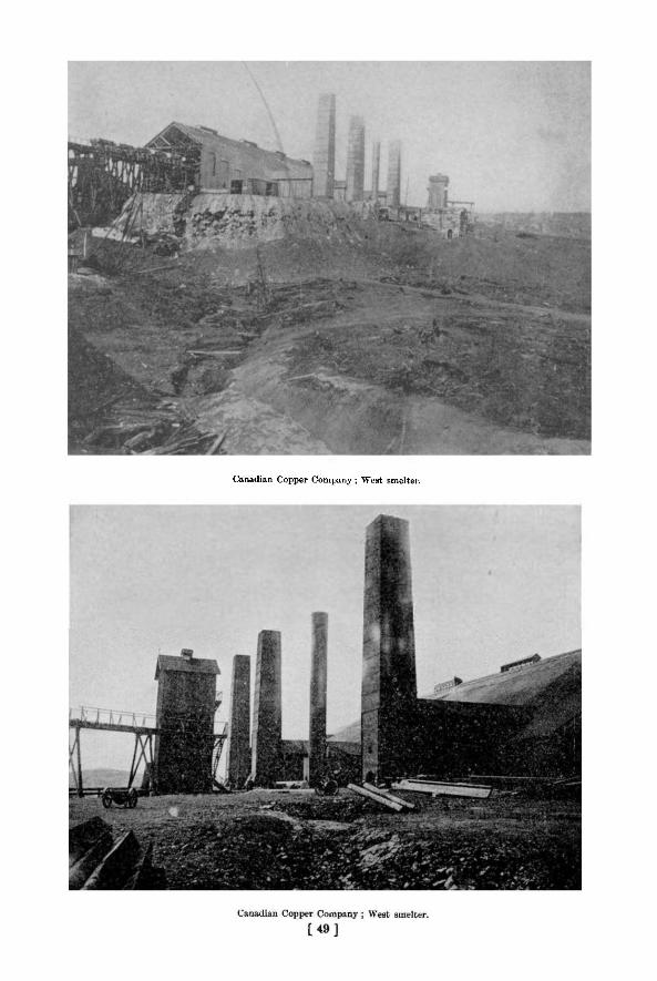
Canadian Copper Company; West smelter.

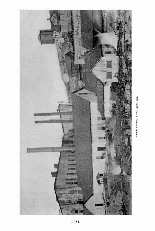
[ 5 0 ]

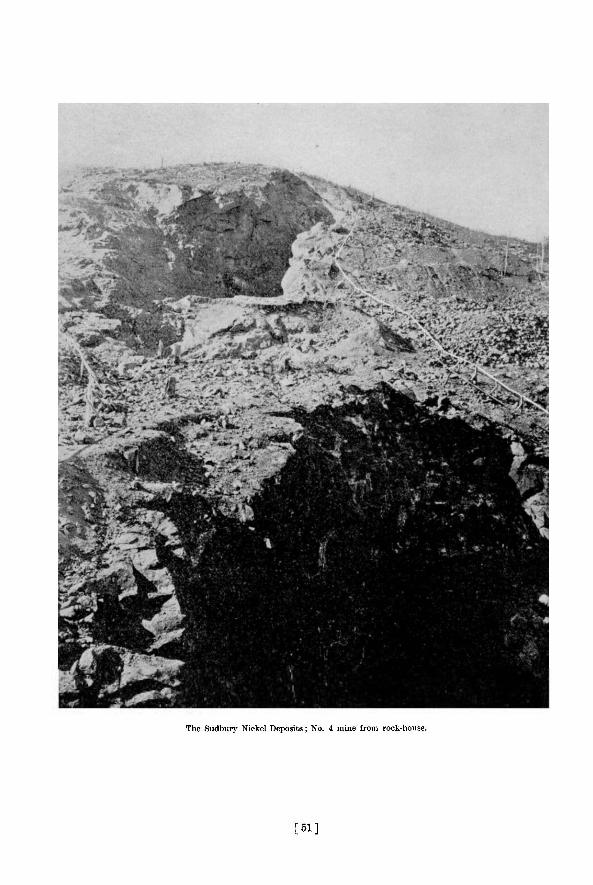
The Sudbury Nickel Deposits; No. 4 mine from rock-house.
[ 5 1 ]

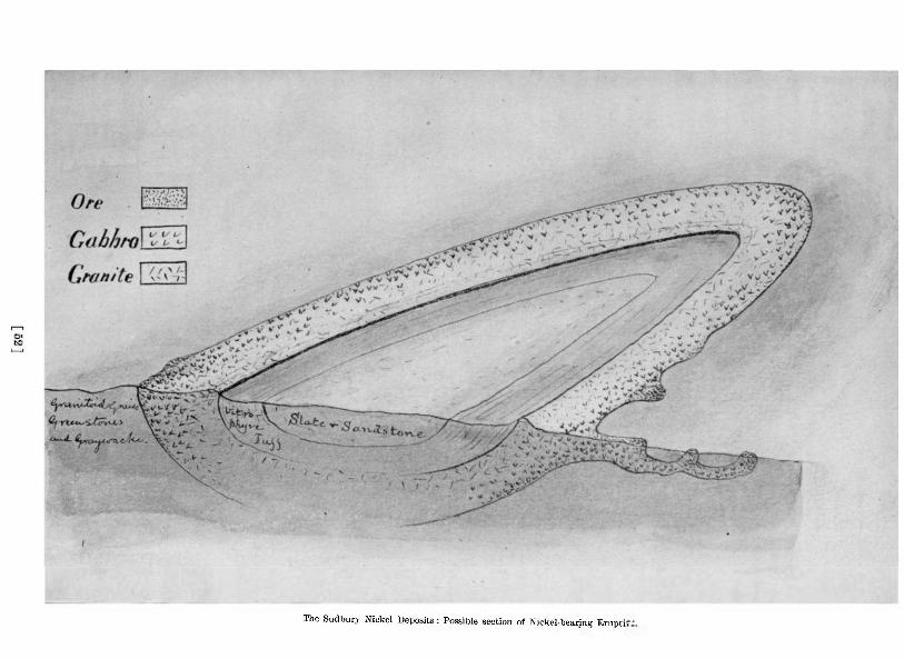
The Sudbury Nickel Deposits: Possible section of Nickel-bearing Erupti-

1902 The Sudbury Nickel Deposits 289
yet be found by means of the dip needle. The most elaborate magnetic survey work in the region has been done by Mr. Nystrom, a Swedish mining engineer, for Dr. Mond, but official reports of the results of his work are not available.
A considerable area of the drift-covered tract between Sudbury and Blue lake has been covered by a magnetic survey carried out for Mr. Edison, and Mr. Kay has done some work of the kind for the Clergues, but how successful their results have been is not definitely known, and no reports of large discoveries made in this way have reached the public. It is understood that some of the ore bodies located by Mr. Edison's party will be explored with the diamond drill during the coming summer.
STRATIGRAPHICAL AND PETROGRAPHICAL NOTES.
In the introductory chapters of this report the more prominent sedimentary and eruptive rocks were briefly referred to, and it is not the intention to take them up now in detail, but to describe the general field relationships and the microscopic characters of the more important rocks which it was necessary to study in working out the ore deposits and their surroundings. It is expected that a more detailed account of the Sudbury rocks will be given in Dr. Barlow's forthcoming report on the region.
The age relationships of the different rocks have never been settled with entire certainty, though all of them are usually referred to the Laurentian and Huronian, with the exception of the central oval area of volcanic sediments, slates and sandstones, around which the nickel-bearing eruptive has been traced, thought by Dr. Bell to be of Cambrian age.
As the original Huronian rocks have been followed with few breaks in continuity from lake Huron to Sudbury, one would naturally expect the classification adopted north of lake Huron to apply at Sudbury ; but in reality the rocks of the two regions stand rather far apart in their characters. The massive white quartzites, jasper conglomerates and limestone bands of lake Huron are almost entirely wanting, and on the other hand arkoses and graywackes are more widely spread and various schists are quite prevalent. In a general way the Sudbury rocks are more highly metamorphosed than those north of lake Huron, perhaps because the band is narrow, often intersected with eruptives, and enclosed on each side by later eruptive granites and gneisses of the Laurentian.
QUARTZITES AND GRAYWACKES.
Apparently the oldest rocks near Sudbury are certain quartzites or graywackes banded with slate, and gray or fiesh-colored arkoses ; the former evidently sandy and muddy sediments of an ordinary type in the beginning, and still showing very plainly the original stratification, lamination and cross bedding ; the latter probably also water-formed sediments, though traces of sedimentation are generally obscure. Typical examples of the two rocks are quite different to the eye, but there are all grades of intermediate rock which often cannot be readily assigned to one or the other type. The two rocks sometimes however meet sharply, the arkose being mixed with the graywacke almost as if it were a felsitic eruptive, though the appearance is probably due to faulting and shearin?.
The quartzites and graywackes pass into one another, and under the microscope both are found to consist mainly of quartz and chlorite, or sometimes biotite, the graywacke having also some undefined dirty material between the quartz fragments, which are larger and more irregular than in the other rocks. A thin section from the specimen figured to illustrate peculiarities of bedding shows angular and also well rounded quartz grains enclosed in a matrix largely chloritic but with some quartz and some decayed feldspar. A portion of the finer textured
19 M.
290 Bureau of Mines Report No. 5
material showing on one side of the section is chiefly chlorite with very fine quartz grains and black particles, probably magnetite. In another slide sericite (or talc ?) in tiny scales joins the other ingredients.
The arkoses are less satisfactory for study, since many of the sections are to such an extent re-crystallized as to suggest felsites. They are composed of very tine-grained quartz, orthoclase, microcline, oligoclase and biotite, muscovite or hornblende. In some sections hints of waterworn grains appear, but in most there is little to show that the rock is clastic, though the field characters prove that it is so. It is probable that all of the felsites described for Dr. Bell by Dr. G. H. Williams are really arkoses 5 0 ; and some of them, such as that from the Copper Cliff mine, are certainly sedimentary, though the materials may have been in part pyroclastic and so of eruptive origin.
The graywackes and slaty quartzites frequently contain secondary minerals, especially staurolite, as if through contact metamorphism ; but the staurolite is now completely rearranged into granular areas of quartz or a greenish scaly material. The crystals are usually stout rods of a whiter color than the enclosing rock, and when they are small and thickly scattered the "rice rock" of the older writings results. Many of these pseudomorphs are, however, large in size, even reaching several inches in length. These white crystal forms, half covering the gray surface, have a very striking appearance, and, though the band of schist containing them is only narrow, it may be followed from point to point for two or three miles in a direction from northeast to southwest near the Frood nickel-bearing offset. The crystals are somewhat rarely cross-like twins, but their sections, with six sides, suggesting the rhombic system, leav^rao doubt that they were originally staurolite. The bands with crystals are sometimes cut at an oblique angle by the schistosity.
The gray fine-grained gneisses and mica schists of the region appear to be only more completely re-crystallized graywackes ; and it is possible, as suggested by Dr. Walker, that some of the gray granitoid rocks of the region are simply reconstructed granites formed of the arkose materials.
A curious variety of the graywacke near Stobie mine contains quite large masses of white quartz having in cross section round or crescent-shaped outlines, often like an eye and eyebrow. How these quartz inclusions, sometimes three inches across, were formed, is hard to imagine. It is as though a concave fracture allowed a rounded layer to rise and drift a little way from the parent mass, the matrix of graywacke being plastic enough to permit of shifting. These eye-like pebbles are found thinly scattered along a band parallel to the one mentioned as containing the large staurolites.
Certainly later in age are the graywacke conglomerates found near Ramsay lake and other points. The matrix is of rather coarser texture than the graywacke referred to above, and shows less banding with slaty materials. Thin sections show a fine-grained matrix of quartz with biotite or chlorite and a little feldspar and magnetite, through which are scattered angular or rounded frajments of quartz of quite variable size, and larger fragments of greatly weathered rocks. The pebbles and boulders include white or red quartzite or arkose and banded slate or quartzite like those described above, probably also binary granite almost free from mica, though the latter boulders may be only re-crystallized arkose. More characteristic conglomerate, though in smaller quantities, runs as a narrow greatly broken band near Stobie mines. The pebbles are well rounded unless where drawn out by shearing, and consist of several different kinds of rock, including granite, quartzite and more than one sort of green schist, as well as greenstone. There are bands crowded with pebbles and small boulders and others freer from them, the whole reminding one greatly of the upper Huronian conglomerate of Michipicoton, though without pebbles of iron-range rocks.
5 0 Can. Geo. Sur., 1890-91, p. 67, F, etc.
1902 The Sudbury Nickel Deposits 291
In addition to the water-formed conglomerates, all the rocks of the distr ict are apt to be sheared into crush conglomerates, which can, however, as a rule, be easily dis t inguished from those formed by water.
O T H E R S E D I M E N T A R Y R O C K S .
T h e other sedimentary rocks of the region belong to Dr. Bel l 's area of supposed Cambrian, occupying the space enclosed by the nickel-bearing eruptives. T h e y include three main t}'pes of rock—what has been called vitrophyre tuffs, gray clayey sandstones, and black slates. The first rock is dark gray, weathering pals gray, with many small angular pebbles of green, red or white rocks. Thin sections show a greater variety of ingredients than Prof. Will iams describes from Dr. Bell's specimens, which seem to have enclosed mainly glass sherds, though chalcedony, quartz and calcite are mentioned a l s o . 5 1 M y sections show in addit ion to these minera ls masses of epidote and fragments of clear plagioclase and of hornblende. T h e whi te enclosure s appear to be micro-granites, or perhaps re-arranged arkoses, composed of quartz, orthoclase and plagioclase, sometimes having rounded edges and sometimes angular. The glass sherds, as mentioned by Prof. Williams, are now transformed either to chalcedony or serpent ine , suggesting, apparently, two kinds of glass, one very acid and the other very basic. 1 am incl ined to think that this rock is only partly pyroclastic, since the pebbles of micro-granite could hardly have a volcanic source.
Resting on the tuffs are dark gray sandstones, or more properly arkoses, rather finegrained and consisting of quartz grains, decayed feldspars, partly oligoclase, some biotite and a little turbid filling material between the grains. A slight beginning at re-crystallization shows itself about some of the grains, but consolidation has not gone far.
With the dark gray arkoses are black carbonaceous slates with good slaty c leavages crossing the planes of sedimentation, composed of very minute particles of quartz, chlorite, sericite or talc and black specks, probably of carbon. These slates were once bituminous, and fissures in them were filled with liquid or plastic bituminous substances, now changed, as in Balfour township, to irregular veins of anthraxolite. 5 2 An analysis by Dr. Ellis showed 6.8 per cent, of carbon in the slate.
S C H I S T S A N D G R E E N S T O N E S .
The older sedimentary rocks previously described pass into various pale colored acid schists, such as mica schist and gneiss, probably as a result of contact metamorphism ; the newly formed minerals, especially mica and chlorite, increasing in amount and all evidence of the clastic origin of the rock disappearing. Good examples occur near the Prood mine, consisting of quartz with small amounts of clear feldspar, muscovite, biotite, chlorite and a l i tt le magnetite ; and with no suggestion of water-rounded grains in the interlocking minerals. In •other cases, for instance east of Stobie mine, the rock comes nearer to a gneiss or felsite schist .
The most important schistoie rocks are however dark green and hornblendic, partly very cleavable and partly rather massive in appearance, forming a northeasterly and south , westerly band along much of the edge of the main nickel range. They are probably younger than the quartzite or graywackes, strips of which may be enclosed by them ; but older than the nickel-bearing eruptive and probably than the granitoid gneiss, though the later granite cuts them.
The origin of these schists and greenstones is not very clear, but many of them seem to be greatly weathered and sheared basic eruptives ; others are probably of pyroclastic origin or a mixture of bombs and finer materials with lava flows, all greatly rolled out. Some very silici-ous varieties may however be ordinary sediments.
8 1 Oeoi. Sur. Can., 1890-1, pp. 75-6F. 5 3 Bur. Mines, 1896, pp. 156-166.
292 Bureau of Mines Report No 5
Thin sections of these rocks all contain hornblende, generally also quartz, and often plagioclase or its replacement products, and small amounts of magnetite. The hornblende is often secondary, probably after some variety of augite, though even remnants of the latter mineral seldom occur.
Very fissile green schist from mine No. 2 at Copper Cliff consists of slender prisms of common green hornblende with a very little quartz and plagioclase ; and hornblende porphyrite from near the Orford refinery is made up almost entirely of rather tattered lookiiis; interlocking masses of hornblende with a very little quartz and rather more magnetite. Most of the hornblendic rocks however contain considerable quantities of quartz or of plagioclase.
One garnetiferous specimen from McKim township (lot 3 in the fifth concession) consists of about equal parts of hornblende and clear quartz, both apparently re-crys'allized and evenly distributed. The hornblende has pale blue, green, and pale brown pleochroism, contains some magnetite, and is somewhat mixed with brown biotite. Some crystals are polysynthetic-ally twinned. In other cas J the quartz is gathered into round or oval masses nearly free from dark minerals, somewhat suggesting an amygdaloid, though the often finely granular quartz can hardly have been deposted in an amygdule. An example from north of the Frood mine is crowded with these white pea-like inclusions. The quartz in the light areas forms a rather coarse mosaic, while the darker parts of the rock contain little quartz and are composed mainly of brown hornblende with some feldspar (both plagioclase and orthoclase) and magnetite. How the quartz became segregated in the clear spots is not evident ; but the structure is rather frequently found among the green schists.
Some examples of quartz-hornblende rock, however, lack this regularity, as in specimens from the Blezard mine, where the qu irtz spreads as large granular areas partially enclosing other minerals. In this rock some plagioclase and apparently also scapolite occur, forming a transition to diorite schist.
At the other extreme are the diorites or diorite schists, in which quartz is present to only a small extent, and a somewhat acid plagioclase with hornblende makes up the rock, as in examples south of the Frood mine, where the plagioclase is oligoclase, the hornblende is accompanied by a little biotite, and there is also some titaniferous magnetite surrounded with leucox-ene. To what extent these rocks were originally augitic is hard to say, most of them showing no trace of the pyroxenes, though the hornblende looks secondary.
With the hornblende schists may be placed the small amounts of interbedded amygdaloidal rocks; evidently surface lava flows with ellipsoidal structure due to rolling of the cooling surface. At present these rocks are so completely weathered and rearranged that their original structure can hardly be determined ; but from their appearance we may suppose them to be basic lava flows far older than the vitrophyre tuffs which give evidence of explosive volcanic action on a large scale a few miles away.
With the green schists should perhaps be included the actinolite rocks, not often very markedly schistose, found associated with ore bodies, e.g. at the Worthington,the Bvans,and other mines. These tough gray green rocks show under the microscope only pale, faintly pleochroic actinolite with a little brown biotite, chlorite and magnetite, but nothing suggesting feldspar. The hornblende is secondary looking, but what it was derived from has not been determined. The fact that these actinolite rocks occur so often on the rock dumps at mines on the offsets from the main nickel range hints at some action connected with the final arrangement of the ores in these deposits.
G R A N I T O I D G N E I S S .
The eruptives of the district appear to be of at least four different kinds and ages, coarse porphyritic granites or granitoid gneisses of a Laurentian type being the oldest ; followed by the nickel-bearing eruptive, ranging in character from norite to granite ; and this succeeded by
1902 The Sudbury Nickel Deposits 293
fine-grained non-porphyritic granite ; and finally by diabase dikes which cut all the other rocks o£ the region.
Coarse porphyritic granitoid gneiss of rather pale flesh-color rises as lofty hills to the northwest of Copper Cliff, between the nickel mines and the main norite range ; and tuns with some interruptions southwest to the Creighton and Gertrude mines, the latter part, however, becoming darker and more basic. I t is apparently younger than the greenstones and green schists, since it encloses masses of them and sends projections into them.
Sections of the rock near Copper Cliff consist chiefly of quartz, and microcline with less orthoclase and oligoclase, as light minerals, and a rather small amount of brown biotite. The quartz and to a less extent the feldspars are somewhat crushed. T h e stone has been used in the new offices of the Canadian Copper Company and makes a handsome building material. A little purple fluorite occurs in it.
Toward the southwest the granitoid gneiss is much mixed with basic rocks and seems to have absorbed some of their materials, becoming less quartzose and darker in color. At Creighton the rock is red to gray with large flesh-red porphyritic orthoclases, often Carlsbad twins, and a considerable quantity of hornblende as well as biotite. This rock forms a large part of the wall of the ore body, and at the mars? 1 is often much impregnated with ore. Where the norite comes in contact with the gneiss it grows somewhat finer in grain, evidence that the gneiss was at least partially cold before the norite was erupted ; however, at the immediate contact the feldspars of the gneiss are apt to be pegmatitic for an inch or two, as if there had been interaction between the two rocks.
The granitoid gneiss has the appearance of a Laurentian rock, and I see no reason why it should not be included with the Laurentian. It cuts the schists and quartzites of the Huronian in the same way as Laurentian gneiss does Huronian rocks in other regions.
T H E N I C K E L - B E A R I N G E R U P T I V E .
The nickel-bearing eruptive has been described by previous writers, especially by Dr. T. L. Walker, 6 2 who have shown that unweathered specimens from near the outer edge of the band are quartz norites, consisting of quartz, plagioclase (bytownite), hypersthene, augite and a little hornblende and biotite. The feldspar which makes the bulk of the rock is rather dusty and brownish in appearance, and the quartz is apt to be blue. The structure is in general that of a gabbro but with an inclination to the ophitic, indicating relationship to quartz diabase. The hypersthene never contains the minute plate-like inclusions usually found in that mineral, and the pleochroism is often so faint that the mineral should rather be called enstatite.
While the freshest material is undoubtedly norite, the great majority of specimens no longer show any rhombic pyroxene, but only secondary hornblende, so that the name diorite given to the rock by the early geologists is not an unnatural one. In fact by far the larger number of my own thin sections contain no hypersthene or enstatite, and in the earlier part of this report the general name gabbro has often been used, since while the hornblende evidently replaces some kind of augite, it is not certain that the original augite was mainly rhombic. Out of thirty-one thin sections of gabbros from the main nickel range and its offsets only seven show with certainty any rhorn,bic augite, and even these are usually in very poor condition. The hand specimens were chosen as the freshest to be seen near the ore deposits, and probably show a larger proportion of norites than the average Professor Walker has found norites still containing rhombic augite immediately at the Mutray mine, probably where Yon Foullon's specimen came from, at one point between this and Rayside, north of the Blezard mine,
" ynar. Tour. Oeol Soc, Vol Lilt . (1897), pp. 40-66
294 Bureau of Mines Report No. 5
and best of all in the Windy lake eruptive on the opposite side of the oval area. My specimens come from Mount Nickel, the Stobie, Little Stobie, Creighton and Gertrude mines, but the majority of the examples of gabbro from the same localities no longer contain rhambie augite. It is of interest to note that most of my specimens containing hypersthene or enstatite are from the immediate margin of the ore, often in fact containing scattered particles of ore, showing that the presence of ore does net imply decomposition of the rock, and hence that the ore was not secondarily deposited.
Professor Walker has been good enough to allow me to compare his thin sections with my own, the most characteristic Jieing from near Onaping in the Windy lake area. One of these has the hypersthene in much letter preservation than any in my own sections, though one or two of the coarser textured examples from my collection are much like them. As Professor Walker's description is excellent there is no need to re-describe them here.
A section of rock from the Creighton ore body enclosing small portions of the sulphides comes closest to Professor Walker's best slides, but differs in some respects. Among colorless minerals, it includes a little quartz, a considerable amount of microcline and a lai ger amount of plagioclase ; among dark oues, a good deal of hypersthene and about as much green hornblende, the latter often enclosing the former and evidently derived at least in part from it. The presence of appreciable quantities of potash feldspar (microcline) marks this rock off from most of the norites, and suggests an intermediate rock between the ordinary quartz-norite and the granitic phase of the eruptive.
In a section from the Gertrude mine the hypersthene is so faintly pleoehroic that it may perhaps better be called enstatite , and with it there is a good deal of augite in clear grains, but no microcline. In another section from the same mine containing sulphides the rhombic augite, though far gone in weathering and not at all pleoehroic, still shows parallel extinction. With it is secondary hornblende and biotite ; and the feldspars are very brown in color.
A slide from Stobie mine consists in nearly equal parts of dark and light minerals, the former mainly very faintly pleoehroic enstatite with some diallage, the latter no doubt originally feldspar but now completely changed to an aggregate in which no twin lamellae can be distinguished.
V A R I E T I E S OF T H E N O R I T E .
Besides these coarse-textured rocks with rhombic augite however, there are examples of very much finer grain and of a different type. Some of the marginal parts of the norite include gray, very fine-grained slabs and fragments quite unlike the main rock both megas-copically and microscopically, the whole sometimes looking like a breccia or conglomerate, so crowded are the fragments. In the best example, which is from near Little Stobie mine, the matrix is of modera ely coarse-grained norite of the kind previously described, consisting of plagioclase, stout prisms of hypersthene and a very little hornblende and biotite ; but the portions of the two fragments contained in the slide are quite different. One is formed almost exclusively of a very granular mixture of plagioclase and hypersthene, the latter making about a quarter of the whole, and both being unusually fresh. The other fragment is wholly of plagioclase (labradorite) in small crystals of about equal diameters with a little magnetite, and must be named anorthosite.
A thin section of a dark green, almost compact rock from the dump of the Mount Nickel mine is of a somewhat similar kind to the first included fragment just mentioned, but is still finer-grained It consists of about equal parts of faintly pleoehroic hypersthene and plagioclase, with a considerable amount of magnetite. Whether this represents the quickly cooled edge of the norite at Mount Nickel or is a fragment of included rock is not certain ; but rather similar specimens, though more weathered, come from the edge of a nickel ore body between
1902 The Sudbury Nickel Deposits 295
Joe's and Clear lakes in Wisner township (W.D. 16). Sections show about equal parts of pyroxene (enstatite and diallage) and plagioclase (labradorite), the dark minerals being partly rearranged into fibrous greenish material, apparently hornblende. The feldspar is often in small, nearly square crystals made up sometimes of two halves, but frequently of several twin lamellae. Pyrrhotite occurs in three of the four slides.
The only specimen taken from a position where its surroundings were clear, is from a hill which stands a little southeast of the boundary of the ore body at Murray mine, and is marked by thin ridges of green rising from a surface weathering pale green gray. Fresh surfaces are darker greenish gray, and in the field work the rock as a whole was taken for part of the band of schists and greenstones running beside the nickel-bearing eruptive. Thin sections however show a very different rock from any others collected as belonging to the band of green schists, since they are formed, like some of the included fragments from Little Stobie, of hypersthene and plagioclase with magnetite. The minerals are in very small crystals of equal diameters, and the two main ingredients are present in about equal amounts. The hypersthene is distinctly pleoehroic ind is scarcely at all changed to hornblende in mott places, though that mineral is present in large quantities in the thin green bands which appear to represent fissures where water could circulate, bringing about the change from hypersthene to hornblende. This occurrence would seem to indicate an older, finer-grained set of norites near the edge of the nickel-bearing norite ; but more field work is needed to settle the matter positively.
It is hardly necessary to describe the different phases of the weathered norites or gabbros associated with the ore bodies. Usually only the augites have undergone rearrangement, and the feldspars, though somewhat brown and dusty in appearance, are for the most part surprisingly fresh for rocks in which the bisilicates have so greatly suffered There are generally quartz(often pegmatitic),biotite and leucoxenic iron ore in addition to the secondary hornblende and basic plagioclase. Along the margin of the main range the rock is generally coarse-grained and fairly uniform in character, but the actual edge against the older granite or gneiss is often somewhat finer-grained.
The dike-like off-sets from the main range a-e, as might be expected, somewhat finer-grained on the whole and more variable, though in almost all cases somewhere near the ore bodies the customary speckled rock containing some quartz and biotite is to be found, though often in sparing amounts and greatly mixed up with brecciated country rock. Hypersthene or enstatite is very seldom preserved in the off-sets, the only instance of its occurrence in my thin sections being from Stobie mine.
G A B B R O OF C O P P E R CLIFF O F F - S E T .
The off-set, including the Copper Cliff mine, was studied most carefully and may be mentioned as a characteristic example The band of norite or gabbro is continuous from the mam range past Clara Bell and Lady Macdonald mines to mine No. 2 ; and where the contact with the granitoid gneiss is exposed the texture grows finer toward the edge and almost compact at the very edge. Thin sections show in the finer-grained portions just the same minerals and usually the same relationships as in the coarser-grained rocks ; though the finest-grained of all, taken from the boundary of the granitoid gneiss near the open pit of mine No. 2, has a hint of the ophitic structure. However, all the thin sections from this point and the Copper Cliff are quite different from those of the adjacent diabase dikes, containing quartz m triangular spaces between the feldspars or intergrown with them as micropegmatite, and also biotite, but never olivine. Sections from the Worthington and Victoria mines off-set have the s;me characters, though they are very fine-grained ; but the few thin sections made from the neighboring Vermilion mine show rocks of a different type. A specimen of the latter rock sent by Mr. G-
296 Bureau of Mines Report No. 5
R. Miekle to the late Prof. Stelzner, of Freiberg, was described by him as a "compact brown rock, originally mica schist, consisting essentially of quartz, brown mica, very little triclinic feldspar and some epidote."
The areas of gabbro unconnected with the main nickel range have not been carefully studied, but the laccolite east of Sudbury and its southwest prolongation towards Kelly lake have much the same characteristics as those described. A specimen from the hill top east of the town is a typical norite, made up essentially of faintly pleochroic enstatite, or hypersthene and plagioclase, the latter somewhat lath-shaped.
A specimen from near Ramsay lake is much more weathered and no longer retains any augite, green hornblende replacing it. The plagioclase too is greatly weathered and contrasts with the clear quartz filling spaces between tlj > crystals. A section from south of the Evans mine is like the last one, but with fresher plag.Dclase and a considerable amount of quartz in micropegmatitic intergrowth with it. This mass of altered norite is associated with small outcrops of pyrrhotite and chalcopyrite which appear to occur, not at the edge but more or less in the centre of the area.
It may be mentioned finally that gabbro containing hypersthene Has been found in other parts of the Province connected with pyrrhotite and chalcopyrite deposits, e. g. at lake Mass-agamashine, near Loring, south of lake Nipissing. The rock is coarse-textured, dark brownish gray, mixed with sulphides, and consists of plagioclase, diallage, hypersthene and some garnet as reaction rims between the plagioclase and pyroxene.
The norite associated with the nickel ores merges inwards into a curious micropegmatitic rock which has been described already from various localities, and need not be taken up at length h e r e . 5 3 Professor Walker's account especially gives a clear idea of the gradual change from quartz-norite to porphyritic micropegmatite and finally hornblende syenite or granite. The micropegmatite was called syenite in early days, but really contains too large an amount of quartz to retain the name, the bulk of the rock as seen in thin sections being composed of a marvellously elaborate intergrowth of quartz and feldspar radiating usually from a well formed crystal of plagioclase.
This differentiation does not occur, at least on a large scale, in connection with the smaller gabbro areas, such as that east of Sudbury ; though towards the centre of these laccolithic masses there may be a segregation of small bodies of very coarse white rock consisting of feldspar alone, of feldspar mtergrown with quartz, or of quartz alone. The best examples I have observed are south of Copper Cliff on the ridge near Kelly lake, where a broken band of this material runs for half a mile or more along the crest of the ridge. At one point pure quartz was quarried some years ago for use as a flux in the Bessemer converter.
Frequently there is a transitional rock between the ordinary gabbro and the quartz-feldspar mass, consisting of a very coarse mixture of hornblende and feldspar of a more or less pegmatitic kind.
The white feldspar rock, as seen in thin sections, contains about equal amounts of striated and. unstriated feldspar with small quantities of quartz, so that the name anorthosite is hardly appropriate, nor does the name granite seem to fit the case. The intergrowth of quartz with the feldspar is often very coarse, like graphic granite, so as to be easily seen with the naked eye ; and this passes in some places rather sharply into solid glassy quartz.
L A T E R G R A N I T E S .
While the granitoid gneisses appear to be older than the nickel-bearing eruptive, there are later, finer grained granites which cut the norite. They are usually flesh-colored but some-
"Seol. Sur. Can., 1890-91, p. 78 F.; Can. R*c. Sc., Apr 1893, p. 345; Quar. Jour. Geol. Soc, Vol. LIII (1897) p. 53-58 ; Sum. Rep. Geo). Sur. Can., 1901, 143-4.
1902 The Sudbury Nickel Deposits 297
times gray, and form large elongated masses rising as hills between Murray mine and the Frood, for instance; or extend as dikes six to ten feet wide as may be seen at Copper Cliff and mine No. 2. Few sections have been made of these rocks and they are not of great interest and need only a brief description. They are granular rocks made up chiefly of quartz, orthoclase, microcline, a little plagioclase and a little biotite.
There is a possibility that the granitoid gneiss, the nickel-bearing eruptive and the later granite are of common descent and do not differ very greatly in age, the granitoid gneiss having been separated first and the later granite last; but the field evidence inclines me to keep them separate, and the fact that the two granite rocks carry no ore bodies is against connecting them with the norites.
Some quartz syenites, fine-grained grayish red rocks, at Creigh'on and between it and Gertrude are perhaps of the same age as the flesh-red granites, but differ from them in containing only a little quartz and having hornblende instead of biotite.
D I A B A S E D I K E S .
The latest rocks of the district are the diabase dikes which intersect all the others, running sometimes for miles in a fairly direct line across country, as between Murray mine and Ramsay lake. The aggregate number of these dikes, large and small, must be very great, since at single mines, as the Creighton, there may be five within 100 yards ; and the size varies from a few inches or less in width to more than 300 feet. In our work only those appearing at or near the ore bodies have been studied, and no attempt has been made to trace the larger dikes for any long distance, as Dr. Barlow has devoted considerable time to their study. Even at mines where no Hike has been observed on the surface, dikes must often really exist, for blocks of diabase are usually to be found on their rock dumps.
The dikes at or near the Creighton mine are perhaps most interesting, since the great open pit shows their relationships very clearly, as has been mentioned in the description of the mine. The most curious feature is the boulder-like projections from some of the dikes into the ore as if oval cavities existed into which the molten diabase porphyrite could be squeezed.
Most of the dikes are of olivine diabase porphyrite, coarser grained in the middle and very fine-grained to compact at the edge when in rock, but frequently with a very narrow rim of glass when coming against ore, as if chilled more suddenly by so good a conductor as the sulphides. The thin shrinkage cracks on the chilled surface are filled with a film of secondarily deposited sulphides, usually copper pyrites. The porphyritic feldspars are broad flat plates reaching a greatest length of about half an inch. A thin section shows the characteristic ophitic structure of olivine diabase, which need not be particularly described, reminding one greatly of diabase porphyrite dikes from the north shore of lake Superior.
In addition to the dikes from four inches to 3 or 4 feet in width shown at the open pit, there are much wider ones, e.g., along the railway east of Creighton, showing naturally a much coarser texture, in which the porphyritic crystals are not conspicuous. These are much like the great dikes near the Murray mine. The augite is red brown and not appreciably pleoehroic ; while the olivine, present in equal amounts, is clear and very little weathered.
Another type of diabase, much more .weathered and perhaps older occurs at Creighton, finer-grained, greenish in color and not porphyritic. This may be seen in a nearly horizontal dike near the winze in the open pit, and also on a wood road half a mile to the north, in the latter case cutting the granitoid gneiss. Thin sections show no olivine or augite, the latter being replaced by hornblende and a little biotite ; and it is possible that these dikes are really off-sets from the norite, weathered examples of which they resemble in composition, but no ore seems to occur in them.
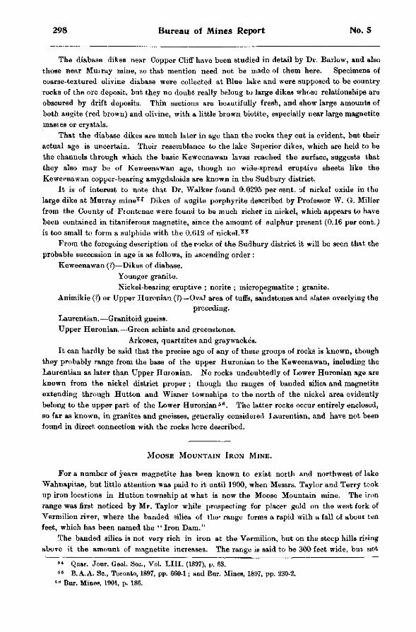
298 Bureau of Mines Report No. 5
The diabase dikes near Copper Cliff have been studied in detail by Dr. Barlow, and also those near Murray mine, so that mention need not be made of them here. Specimens of coarse-textured olivine diabase were collected at Blue lake and were supposed to be country rocks of the ore deposit, but they no doubt really belong to large dikes whose relationships are obscured by drift deposits. Thin sections are beautifully fresh, and show large amounts of both augite (red brown) and olivine, with a little brown biotite, especially near large magnetite maBses or crystals.
That the diabase dikes are much later in age than the rocks they cut is evident, but their actual age is uncertain. Their resemblance to the lake Superior dikes, which are held to be the channels through which the basic Keweenawan lavas reached the surface, suggests that they also may be of Keweenawan age, though no wide-spread eruptive sheets like the Keweenawan copper-bearing amygdaloids are known in the Sudbury district.
It is of interest to note that Dr. Walker found 0.0295 per cent, of nickel oxide in the large dike at Murray mine T l T Dikes of augite porphyrite described by Professor W. G. Miller from the County of Frontenac were found to be much richer in nickel, which appears to have been contained in titaniferous magnetite, since the amount of sulphur present (0.16 per cent.) is too small to form a sulphide with the 0.612 of n i c k e l . 5 ?
From the foregoing description of the rocks of the Sudbury district it will be seen that the probable succession in age is as follows, in dscending order :
Keweenawan (?)—Dikes of diabase. Younger granite. Nickel-bearing eruptive ; norite ; micropegmatite ; granite.
Animikie (?) or Upper Huronian (?)—Oval area of tuffs, sandstones and slates overlying the preceding.
Laurentian.—Granitoid gneiss. Upper Huronian.—Green schists and greenstones.
Arkoses, quartzites and graywackes. It can hardly be said that the precise age of any of these groups of rocks is known, though
they probably range from the base of the upper Huronian to the Keweenawan, including the Laurentian as later than Upper Huronian. No rocks undoubtedly of Lower Huronian age are known from the nickel district proper ; though the ranges of banded silica and magnetite extending through Hutton and Wisner townships to the north of the nickel area evidently belong to the upper part of the Lower Huronian 5 6 . The latter rocks occur entirely enclosed, so far as known, in granites and gneisses, generally considered Laurentian, and have not been found in direct connection with the rocks here described.
MOOSE MOUNTAIN IRON MINE.
For a number of years magnetite has been known to exist north and northwest of lake Wahnapitae, but little attention was paid to it until 1900, when Messrs. Taylor and Terry took up iron locations in Hutton township at what is now the Moose Mountain mine. The iron range was first noticed by Mr. Taylor while prospecting for placer gold on the west fork of Vermilion river, where the banded silica of the- range forms a rapid with a fall of about ten feet, which has been named the "Iron Dam."
The banded silica is not very rich in iron at the Vermilion, but on the steep hills rising above it the amount of magnetite increases. The range is said to be 300 feet wide, but not
6 4 Qaar. Jour. Geol. Soc, Vol. LIII. (1897), p. 63. 5 5 B.A.A. Sc., Toronto, 1897, pp. 660-1; and Bur. Mines, 1897, pp. 230-2.
6 8 Bnr. Mines, 1901, p. 186.
1902 The Sudbury Nickel Deposits 299
nearly the whole of it can be called ore. At the river the banded silica strikes a l i tt le west of north and dips about 70° to the east, but bends toward the northwest where the stripping has been done and dips nearly vertically. The general direction cf the range is said to be about northwest and southeast. The work done in July last consisted mainly in stripping, but a diamond drill was then being got ready for work on a hill top rising according to an aneroid reading 180 feet above the river. The stripping exposed ore for a length of 270 feet and for a breadth of 25 or 30 ; but the amount of magnetite contained in it varied greatly, and some parts seemed to be too lean to be of value, though even these were said to assay 40 per cent, of iron, while the richer parts would reach about 60 per cent.
The stripping disclosed characteristic iron range rock of interbanded whi te or bluish silica and magnetite with little pyrite so far as seen, and few other substances except a l i tt le chlorite. It was richer in magnetite than any other portion of the iron range which I have vis i ted, the nearest approach to it being a small outcrop not far from Fort William, near Murillo station ; and so far as could be inferred from such a superficial examination there is a very large amount of the ore, since it may be supposed to go down for at least 180 feet, to the level of the river, and probably to a much greater depth. This is apparently the only instance in the P r o v i n c e , and, so far as I am aware, in the Great Lakes region, where the original iron range rock is rich enough in the metal to be counted as an ore on any large scale. All other ore deposits connected with the banded silica are of a secondary nature, and represent local enrichments due to leaching of iron from higher portions of the range.
The country rocks of this iron range are greenstones, green schists and granite, and it appears to be completely separated from the nickel range to the south and i ts accompanying sediments and eruptives.
The mine was under the management of Mr. Chase S. Osborne of Michigan in July, and later was visited and reported upon by Dr. C. K. Leith of the U. S. Geological Survey, but the results of the development have not been made public.
M E T H O D S O F M E T A L L U R G Y A T C O P P E R C L I F F .
BY JAMES M'ARTHUR, GENERAL MANAGER CANADIAN COPPER COMPANY.
The following is a brief summary of operations up to thestige of standard or first crude matte as practised at the Copper Cliff departments of the Canadian Copper Company's works.
Open air heap roasting, as practised at the present time, is under fair weather conditions though a fairly profitable process, an old, crude and very simple mode of treatment for the elimination of sulphur from low-grade sulphur ores, i.e., ores having too low sulphur contents to make it profitable to save the latter by any treatment at present in use, the sulphur contents running from 15 to 25 per cent, and iron from 35 to 50 per cent. The roasting and heap building operation is easily learned by any reliable and intelligent man, anxious to work to the letter of the plain instructions given him, who takes no uncertain chances or anything for granted, but one who desires to learn the why and wherefore for everything done. Such a man makes an ideal roaster and generally gives good satisfaction ; the more so if he displays good judgment in the handling and supervision of his men.
The sulphur fumes generated from our heap roasting are non poisonous, being free from arsenic, lead, antimony, zinc, etc., though in dense volume they create when inhaled a slight strangling sensation, which soon disappears. As a whole we find them more beneficial than otherwise, though disagreeable. Our men keep robust and healthy, with good appetites, and
300 Bureau of Mines Report No. 5
there is an entire absence of consumption diseases among permanent residents. Indeed, I have yet to learn of the occurrence of any case of this kind during the past fifteen years, or since operations first began.
MINING THE ORE.
The ores from the different mines, iu large lump form with considerable fines, are hoisted in large skip cars to the top of the rock house, where they are automatically dumped on to a large, inclined "grizzly" sizing screen, which separates the fines from the coarse ore. The latter falls in front of large Blake crushers, each of 400 tons daily capacity, into which it is fed, crushed and broken to the requisite size for heap roasting. It is then discharged and fed into the upper end of slightly inclined horizontal revolving trommel screens, from which it is discharged in three different sizes—fines, raggin and coarse. The first two escape through their respective mesh-holes in the trommel screen, while the last discharges through the lower and open end of the trommel on to oscillating sorting\ ->bles, also slightly inclined lengthwise, the shaking motion of the table causing the crushed prouuets to travel at such a speed to the discharging end as to give a large number of boys stationed along the sides an opportunity to pick out much of the associated barren rock on its passage to the receiving bins.
From these the ore is automatically loaded on standard gauge cars and hauled by locomotive engines, in trains of 400 to 500 tons each, to the roasting yards, the latter covering an extent of carefully graded, prepared and drained ground, about 150 by 7,500 feet, with a roasting capacity of 250,000 tons of ore, more or less, according to the height of the heap.
ROASTING OUT THE SULPHUR.
Here the plans of the heaps, rectangular squares of 60 by 125 feet, are laid out on the prepared ground. This, when an excess of ore fines is in stock over and above the usual requirements necessary for covering the finished heaps preparatory for firing, is covered to a depth of a few inches with the surplus fines, which after two or more heaps have been roasted on top of them get roasted and caked together, then are broken up and smelted as coarse ore.
On the top of these fines, if any, or on the prepared ground if absent, is laid a bed of dry cordwood 9 to 18 inches deep. The fuel bed being finished, coarse ore to the extent of about 65 per cent, of the total ore heap is first transferred from the loaded cars and built roughly and evenly on the prepared fuel bed, followed by the ore raggin (nut size) and finally by a complete covering of ore fines. No chimneys or top vents are now used, long experience having shown that chimneys are detrimental to good roasting, causing heavy matting of the ore to take place in their immediate vicinity, notwithstanding the closest care to prevent it. The green ore heap now being built and finished and nothing but a few kindling holes being still exposed at intervals all round the base of the heap, these are simultaneously igniied and the heap has commenced its long roasting operation. These openings are also covered over with green ore fines as soon as the cordwood has burned to glowing charcoal.
All carbonaceous fuel in large heaps like these, though so well covered and protected from the air, is burned out in about 60 hours after lighting up. A complete oxidizing roasting process then begins and continues until the end, namely, until the sulphur contents are so far reduced and burned off that there is not sufficient left to promote further combustion. The remaining proportion, generally about 7 per cent., is enclosed and sealed up in non-porous portions of ore or matte, the semi-fused covering of which would require to be rebroken in order to expose fresh faces under heat and liberate the remaining sulphur. This could only be done by turning over and re-roasting the ore after the first roast was finished, but it is not at all necessary, as the remaining sulphur is essential in the smelting of the ore in order to produce a clean slag.
1902 The Sudbury Nickel Deposits 301
A heap after being fired up is constantly and carefully watched on both shifts for the first few days, i. e., during the period of its settling caused by the burning out of the fuel bed underneath, and all vent holes created by this disturbance are covered over as soon as formed by throwing on a little fresh ore fines. This is to prevent too great a generation of heat which would kill all roasting by fusing the heap into matte. These precautions being taken, the ore heap is left to itself for the next few months, the duration of roasting operations being in proportion to the tonnage contents of the roast heap.
The smaller the heap, the smaller the coarse portion of the ore should be broken for good roasting ; for a heap of 800 to 1,( 00 tons not much over ordinary egg size, which should burn out in 35 to 40 days ; a heap of 2,500 tons roasts best with ore sized to pass a 3-inch to 3J-inch mesh, and will roast out in 100 to 115 days, while a heap of 4,000 tons will roast well with ore mesh-d to size of brick bats, and under favorable conditions of weather, etc., will roast for seven mouths. The longer the period of roasting the less the matting ; the larger the heap the less of the outside margin or covering is left only partially roasted. The loss by solubility and seepage from wet weather is less than the loss in valuable ore float dust occuring in the rabbling and roasting of similar material in the calcining furnaces. After the heaviest and most prolonged rainstorms I have never found moisture as deep as 24 inches through the covering of one of these heaps ; below that the bed would be dry to dustiness.
The sulphur contents of these ores, as already stated, are not in sufficient quantity to recover and save, as it would cost more than their market value to do so, and there is not a firm operating a nickel mine in Ontario at the present moment but is treating raw ores by heap roasting, the sulphur going to waste, as some term it. I know of no chemical firm making acids, here or in the United States, who ever profitably recovered sulphur from ores carrying less than 30 to 34 per cent, sulphur.
A roast heap once fired up and fairly started to burn, requires no further expense or attention until cold enough to remove to furnaces months after. It is a cheaper, more expeditious and less intricate process than the old and now generally abandoned system of stall roasting. The one better feature in stall roasting is the greater absence of sulphur fumes among the men engaged in handling the ore, but vegetation suffers just as much from stall as it does from heap roasting.
SMELTING THE ROASTED ORE.
The ore when roasted clinkers and centres togetfter in great lumps, and when cold is loosened and broken up by powder and pick into the requisite size for smelting, loaded on large side-dumping cars and hauled by locomotive engines to the different stock sheds and bins at the furnaces. There it is sampled, mixed and made into smelting charges and fed into furnaces.
Each furnace charge consists of 7,000 pounds, the coke being about 14 per cent, of the total charge. Half the coke is first charged into the furnace followed by half the ore, then the remainder of the coke and ore. The blast used is delivered at the tuyeres at a pressure of about fourteen to sixteen ounces per square inch. Each furnace, of which there are thirteen installed^ is provided with a wind bustle and twenty-five two-inch tuyeres ; the total capacity being about 1,800 tons per day.
The furnaces are water-jacketted and built of open hearth, soft steel plates about nine feet in depth, with a side flare of 6 inches from tuyeres to charging doors, encircled by wind bustle and twenty-five tuyere holes, each of a diameter of inches. The feeding and molten discharge of furnaces is continuous, the molten stream escaping from an opening in front, near the bottom, thence through a similar opening into the forehearth or settling well. Here the specific gravity of the contents causes the matte to settle to the bottom and it is periodically
302 Bureau of Mines Report No. S
drawn out into pot moulds, sampled, cooled off and weighed, loaded on cars and shipped to the refinery.
The slag as it separates in the settler rises rapidly to the top and flows over the lip of the settlor in a continuous stream on to a granulating chute, in quiet contact with a stream of water that has already done duty in the jacketted walls of the furnaces and flowing through the chute in the same direction as the stream of molten slag. The latter is granulated and flushes off to the waste dump or into the elevator pit, where the water filters off and the slig is elevated into high waste heaps. From these heaps road makers and radroad companies help themselves freely, loading the slag with steam shovels for the ballasting of tracks, etc., for which it is well adapted ; being heavier than gravel ballast and non-porous, it does not retain water and therefore does not freeza deep in winter and heave up tracks as does sand ballast.
Each furnace is operated by a No. 7 Connorville pressure blower, discharging 67 cubic feet of air blast per revolution and making from 90 to 130 revolutions per minute, each blower being driven by its own directly connected engine of 50-h.p.
The matte product from the first srrelting of roasted ore in these furnaces is always termed standard matte, to distinguish it from converter or Bessemerized matte. When this latter grade iB called for, which is not very frequently, the standard matte is smelted and tapped in the required charges into the Bessemer converters, where a high pressure of air blast is blown through the molten bath of metal, until practically all the iron is oxidized, and taking its flux from the silicious lining of the converter is skimmed off in a very fluid slag. At this stage the charge has been blown to finish, i.e., the standard matte charged at 35 to 40 per cent, metallic contents is blown or converted to a grade of 80 per cent. This is as far as the Bessemer operation can be carried without an immense loss in the nickel contents of the product, caused by the nickel to some extent following the action of the expelled iron and fluxing itself from the silicious linings.
At this stage the sulphur contents will still reach as hi h as 17 per cent., more or less, and this is always a desirable feature, as it leaves the Bessemerized matte in a still sufficiently brittle and short condition to facilitate its further breaking and crushing preparatory for final treatment, i. e., the separation of nickel and copper, or refining.
The duration of a blowing operation depends on the size of the charge and the displacement of converter space owing to a thick and recent lining, the capacity of the converter naturally increasing as its silicious lining is eaten up by the iron in the charge. Each charge can be greater than the preceding one, until the sixth or seventh charge is blown, when invariably a ne,w lining has to be put in. Owing to these conditions a blowing operation generally lasts from 20 to 80 minutes, averaging about 50 minutes. It is an ideal pyritic process in the truest sense of the wood.
Yet if we except the iron contents a similar grade of matte can be produced from one heap roasting and re-smelting of standard matte, the difference being that the matte product in this case will carry 16 per cent, sulphur, and 10 to 11 per cent. iron. These results from heap roasting have not been attained anywhere else so far as I know.
PYRITIC SMELTING.
Cold blast pyritic smelting of sulphide ores has been carried on in Canada, off and on, and for long periods at a time, since 1879 ; not as an experiment, but as a procesp. Thousands of tons of copper sulphide fines have been smelted with cold blast, and later on in recent years at Copper Cliff with cold and also with very moderately hot blast (the latter about 400° F.), making in these recent operations some 18,000 to 20,000 tons of matte product. The coke consumption was about 5 per cent for both temperatures of the blast, the grade of matte product being almost identical. With a blast temperature sufficiently high—not less than 1200" F .—
1902 The Sudbury Nickel Deposits 303
to counteract gumming; at tuyeres, the sulphur contents of the ore, which should be the only fuel used apart from a small percentage of the iron, can be kept in ignition, and with a higher pressure of the blast we should get sufficient rapid oxidization action, even in a large and fast smelting furnace, to produce a direct 30 per cent matte, or over seven into one, from a raw 4 per cent, ore as it comes from the mines, because if we can dispense with all carbonaceous fuel in first smelting and can use the sulphur contents of charge in its stead, we stop all reducing action, and in lieu thereof introduce a complete oxidizing action, oxidizing the iron and consuming the sulphur in the operation.
3 0 4 Bureau of Mines Report No. 5
IRON RANGES OF NORTHERN ONT/ RIO. BY WILLET G. MILLER.
While we have had only one producing iron mine in the northwestern part of the Province during the past year, there has been much activity in prospecting the different ranges. Diamond drilling has been carried on in five rather widely separated areas—at Steep Rock lake, a few miles from Atikokan station in the Rainy River district ; along the line of the Port Arthur, Duluth and Western railway, about 50 miles from Port Arthur; on deposits not far distant from the shores of lake Nipigon ; on a number of claims in the Michipicoton district; and in the township of Hutton which lies on the western boundary of the district of Nipissing, about 25 miles north of the town of Sudbury. Development work has also been done on claims along the Algoma Central railway, about 25 miles from Sault Ste. Marie, and at Loon lake on the Canadian Pacific railway, east of Port Arthur.
It is believed that there will be a great deal of prospecting for iron ores during the coming summer judging among other things, from the fact that considerable search has been made, by means of the dip needle, for ore bodies during the winter. It may be well therefore to give a resume of the distribution of the known iron-bearing formations of the northern and northwestern part of the Province. Puller accounts of some of the iron ranges will be found in the volumes of this Bureau which have been published during the last three or four years.
The following list includes most of the iron ranges and outcrops of iron ore which have been reported as occurring in northern and north western Ontario. In most of these localities the ore is magnetite or hematite associated with jasper or other closely related silicious material.
I. RAINY RIVER DISTRICT.
Atikokan range ; Steep Rock lake ; Watten township ; Dryden ; Upper Manitou lake ; Turtle river ; Hunter's island ; s. w. arm of Red lake, northward of Lake of the Woods ; near the height of land, s. w. of the head of Lake St. Joseph, loose ; Seine bay, titaniferous magnetite.
I I . THUNDER BAY DISTRICT.
Mattawin range : Animikie area along the P. A. and D. Ry. ; lake Nipigon and Little Long lake ranges; Little Pine lake; Black Sturgeon lake; Dog lake and Little Pike lake ; Loon and Ruby lakes ; White Earth lake ; Big Mountain lake ; lake Savant ; Pic river ; Little Pic river ; Slate islands ; Otter cove.
I I I . ALGOMA DISTRICT.
Michipicoton ranges ; Cape Choye ; Batchawana bay ; townships of Deroche, Hodgins, Jarvis and Anderson ; Desert lake, township of Aberdeen, formerly Coffin ; on the Woman river ; north of Flying Post ; Grand Rapids, Mattagami river (Devonian); south of Chapleau, titaniferous magnetite.
I V . NIPISSING DISTRICT.
Ranges between lake Temiscaming and Hutton township, including the lake Temagami and other outcrops ; Shining Tree lake, on the Algoma boundary ; Upper and Lower lakes Abitibi ; near colonization road west of Opimika narrows, lake Temiscaming, titaniferous magnetite.
The map which accompanied the ''Report on the Survey and Exploration of Northern Ontario, lyOO," shows the situation of most of the localities, in the three more eastern districts, given in the above list. This map and report were published by the Crown Lands Department. 1
1 Map of Part of Northern Ontario, showing the Northern Part of the District of Nipissing, Algoma and Thunder Bay, Toronto, 1901.
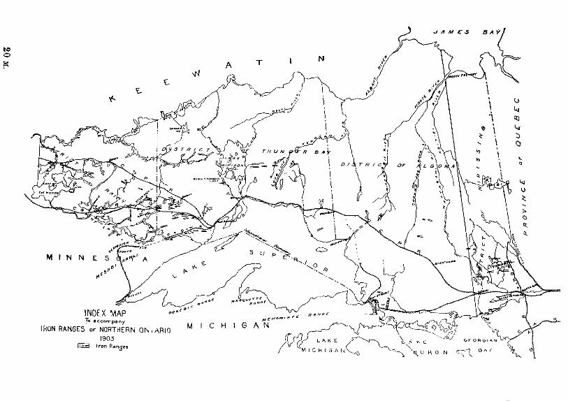
306 Bureau of Mines Report No. 5
It will be seen from the accompanying sketch map, on which the positions of the iron ranges are marked, that practically they completely surround the Ontario, or northern and eastern shores, of Lake Superior and extend approximately to the eastern and western boundaries of the Province. Iron ranges have also been found here and there in the little known more northern regions, and doubtlesB many others will come to light when more careful prospecting has been done.
I. DISTRICT OF RAINY RIVER.
In the Rainy River district there are a number of occurrences, concerning some of which we have little information.
THE ATIKOKAN RANGE.
The best known outcrops in the district are on the Atikokan range which runs, just north of the line of the Canadian Northern railway, from near the boundary between the districts of Rainy River and Thunder Bay. This range shows great variety in the character of the ore and the rocks which occur on it.
Near the eastern end of the range is the McKellar deposit, on which considerable work has been done. 2 The ore here is magnetite and lies in rock which may be called chlorite schiBt.
The deposit stands up as a distinct ridge or hill of considerable size above the swamp. The magnetite is fine-grained, like that usually associated with jasper, and appears to come gradually into the schist, being at first interlaminated with it
This property, which lies about three miles from the railway, is most readily reached from the section foreman's house at the crossing of the Atikokan river, which is about a mile east of Hematite siding. Other deposits on the eastern end of this range, while not showing so large at the Burface, possess characteristics similar to those of the McKellar.
STEEP ROCK LAKE.
Twelve or fifteen miles to the west the rocks surrounding Steep Rock lake have attracted much attention, as being the possible holders of large deposits of iron ore. The lake is easily reached from Atikokan station by way of the river of the same name, which affords a good canoe route, about three miles in length, to the lake.
The lake has been described by a number of writers. For this reason only a brief A c c o u n t of it will be here attempted. The most detailed description of it has been given by Prof. C. H. Smyth in a paper in which the geological structure has been carefully worked out . 3
The shape of the lake is roughly that of the letter M. Going up what may be called the first upstroke of the M we observed brecciated crystalline limestone and loose pieces of hematite and limonite along the west shore.
Near tho end of this upstroke, in the apex of the first half of the M, there are a number of high points, which are almost islands, composed of the reddish or yellowish, more or less brecciated crystalline limestone. At the end of the first downstroke is Mosher'a point. Pits have been sunk here and some of the material taken from them, which appears to have been found in small quantity, has the following percentage composition : metallic iron, 3.00, manganese, 12.32.
Mr. A. G. Burrows, w h o made the analysis of the ore, states : " I thought this specimen might be bog manganese, after I found t h e percentage of iron, but on drying it showed the presence of only a little water. The residue seems to be chiefly silicious and organic matter."
2 11th R«p. Bur. Mines, pp. 131-3. 8 Am. Jour, dcionon, 1891, pp. 317-331.
1902 Iron Ranges of Northern Ontario 307
There are a number of boulders of hematite on a small island which lies nearly opposite Mosher's point. They consist of what may be called hard ore, and appear to be different in character from most of the ore met with in the material thrown out from the pits. One of the boulders has a diameter of four or five feet. Boulders of similar character are said to be found along the creek which runs out at location 254X.
At only one point in the vicinity of the lake, so far as the writer knows, has ore similar in character to that of the boulders been found in place at the surface. This is on location 126E. Here a mass of hematite about two feet in diameter occurs in the limestone in the face of a cliff a few feet up from the water's edge. In shape this mass is not unlike that probably possessed by the boulders before they had their surfaces smoothed by abrasion, after being detached from the parent rock.
However, in spite of the fact that the boulders, which are now strewn on the shores, may have originally existed as comparatively small, detached masses of ore in the crystalline limestone, it seems not unlikely that large bodies of ore, produced by the leaching of iron out of the. limestone, do exist in the vicinity of the lake.
In addition to the outcrops of limestone already mentioned other detached masses occur in the northwest corner of the lake, or at the second apex of the M, and along the southeast arm.. Some of these outcrops are in the form of bold bluffs which are almost islands, the line of contact between the limestone and the rock farther back from the shore being occupied by small valleys or ditch-like depressions. Judging from the isolated outcrops of limestone which are found at numerous points on the shores, it would seem that the whole of what is now the basin of the lake was at one time filled in with this rock. 4 It weathers much more rapidly than the surrounding rocks, and the cliffs of it on the shores are fast breaking down. Large caverns occur in them in places, and considerable danger is encountered in scaling their faces or in canoeing under the overhanging loosened masses of rock. Beautiful quartz crystals occur in some of the cavities of the limestone. That the rock contains considerable iron is seen from the color of weathered surfaces of it, and from the thin layers of powdery oxide which lie on some of the flatter portions of the cliff tops. The following, No. 1, is an analysis which I had made of a sample of this limestone. No. 2 shows the percentage composition of a fine-grained crystalline limestone, specimens of which I collected last summer in the vicinity of Geneva Lake station, on the Canadian Pacific railway. Both being of pre-Cambrian age I have placed the results of their analysis together for comparison.
The lime and magnesia shown in No. 1 exist as carbonates. The insoluble silicious residue after treatment with hydrochloric acid is equal to 31 per cent. The lime and other bases were not determined in this, but the total silica in the rock, as shown above, is 26.46. The loss on ignition was 30.08 per cent., which includes the carbonic acid, 26.32 per cent., as shown in the table.
4 Many lakes in the crystalline limestone areas of southeastern Ontario are of similar origin, their basins occupying depressions which at one time were filled in with limestone. Remnants of the limestone masses are now in place on their shores.
L I M E S T O N E A S S O C I A T I O N S OF \RON O R E .
Silica Alumina Ferrous oxide Lime Magnesia Carbonic acid. Moisture
No. 1. No. 2. .26.46 6.04 . 2 10 0.28 . 5.94 2.31 .20.34 27.01 . 9.63 19.03 .26.32 .41.87
0.16
308 Bureau of Mines Report No. 5
In No. 2 the lime and magnesia shown are also present as carbonates. The insoluble silic-ious residue, after treatment with hydrochloric acid, is equal to 8.55 per cent, of the rock. The lime and other bases in this residue were not determined.
The larger of the two Government diamond drills has been at work in the neighbourhood of the lake for the greater part of the past year. At the time of my visit drilling was in progress at the shore on location 254X, on the southern side of the southeast arm of the lake. It was found that the lake has here a much greater depth than would be expected. The bottom of the depression is filled with a thick deposit of a reddish silt which resembles soft hematite, but carries only about ten per cent, of metallis iron.
Although the Steep rock limestone appears at first sight to be much different from other iron-bearing formations in the northern districts of the Province, especially from those which are characterized by the presence of interbanded jasper and iron ore, still there is a similarity between the Steep Rock series and those of most of our northern ranges. The iron-bearing formation in the vicinity of lake Temagami, for example, has associated with it carbonates, in comparatively small quantities, similar in character to the limestone on Steep Rock lake. 5 Then again the siderite in the neighborhood of the Helen mine, in the Michipicoton Mining Division, is similar in composition to the more western crystalline limestone. It seems probable that the limestone or siderite at lake Temagami and in other localities at one time was present in large quantities, that now remaining being a very small percentage of what was formerly in place. Moreover since the chief characteristics of many of these iron ranges are so much alike it, seems not improbable that at one time, before the extreme erosion to which the region has been subjected took place, siderite or limestone existed on all these ranges.
S I G N I F I C A N C E OF P Y R I T E - B E A R I N G R O C K S .
There is one other prominent characteristic, as the writer has pointed out in former reports, which is common to almost all these older, pre-Animikie, iron ranges lying between the Quebec boundary on the east and Manitoba on the west. 6 This is the occurrence of pyritiferous rocks in close association with the iron ore formation. The interbanded zone of jasper and magnetite is in most cases accompanied by a parallel belt of pyrite-bearing rock, whose base is usually composed of chloritic material. At times the two bands lie close together, while in some cases they lie half a mile or more apart. This relationship has been referred to by the writer in his report on the Temagami ranges. The association of pyrite with the iron ore of the Helen mine has been frequently mentioned, and the results of recent drilling through one of the pyrite deposits are given on a foregoing page of the present Report. This body of pyrite is large enough to be of economic importance and there seems little doubt, judging from surface indications, that similar large bodies of the mineral will be found in the vicinity of lake Temagami. It was therefore of considerable interest to the writer to find on visiting Steep Rock lake that a pyrite deposit had recently been uncovered there, thus furnishing further evidence that the iron ore series of this more western field possesses, in all probability, a closer relationship to the iron-bearing formations of Nipissing and Algoma than would at first seem to be the case.
It may also be added that on the Atikokan range proper, to the east of Steep Rock lake, a pyritiferous band of rock accompanies that in which the iron ore occurs. Farther west again the same association is found.
Then there is also a similarity between the quartz veins which are found in proximity to the iron formation at lake Temagami, and other points in Nipissing, and those of the Atikokan and Steep Rock areas. The fact that pyrite and hematite have been found to occur together in the deposits which have been tested in Michipicoton and other localities should act as an inducement for the testing at considerable depths of all pyritiferous deposits.
6 Tenth Report Bur. Min. p. 169. • Ibid. pp. 169 and 173.

1902 Iron Ranges of Northern Ontario 309
In summing up the facts which have just been stated, I may say it would appear that much work remains to be done both by the field geologist and the mining engineer before all our widely scattered iron ranges can be correlated, and before we can feel safe in affirming that iron ore is not found under certain conditions or that it is certain to be found under others. While we can draw on the valuable experience which has been gained in iron mining on a very extensive scale, in formations similar to our own, in the states of Michigan and Minnesota, it seems that the conditions of occurrence are somewhat different on this side of the international boundary. There are some things to be learned, particularly in connection with the occurrence of iron ore in association with pyrite-bearing belts of rock, which will have to be worked out in our own fields.
The pyrite deposit near Steep Rock lake had been partially stripped at the time of my visit. The rock in which the deposit is situated may be roughly described as a variety of greenstone not unlike that in which some of the pyrite in more eastern districts is found. The pyrite is more or less mixed with rock matter and magnetite, and has a brecciated appearance. A shallow open cut in the deposit was about 150 feet in length from north to south. The length of the deposit from the foot of the little lake known as Straw Hat lake eastward is about 300 feet. It would appear that a part at least of the basin of the little lake was at one time occupied by material similar to that in the deposit. Considerable diamond drilling has recently been done on this pyrite mass.
Other iron ranges and outcrops of iron ore have been discovered in the Rainy River district but little work has been done on them. 7 They include that near the village of Dryden, on the main line of the Canadian Pacific railway, that which crosses the Canadian Northern track near Nickel lake in Watten township, and the reported discoveries of ore on Upper Manitou lake and Turtle river. Then there are the Hunter's island outcrops near the international boundary which are claimed to be on a continuation of the Vermilion range of Minnesota.
I I . DISTRICT OF THUNDER BAY.
In the Thunder Bay district similar ranges occur, some of which have been known for many years and have been more or less carefully examined.
MATTAWIN RANGE.
One of the best known is the Mattawin range. Important outcrops on this range can now be easily reached by taking a train on the Canadian Northern railway to the forks of the Mattawin river. A road runs on either side of the river to the range which lies a couple of miles south of the railway.
This range, so far as it has been traced, has a total length of 35 or 40 miles. It runs from Greenwater lake eastward, south of lake Shebandowan, to Kaministiquia on the Canadian Pacific railway. The ore formation consists of intc —»nded jasper and other closely related silicious material, with, usually, magnetite, although at times the ore associated with the jasper is hematite. This range has been frequently described in a general way both in the reports of the Geological Survey and Bureau of Mines.
THE MESABI EXTENSION.
Another iron-bearing area in the Thunder Bay district which has attracted considerable attention as a probable source of ore is thus outlined by Mr. William Mclnnes, of the Canadian Geological Survey: "Roughly described, this area occupies a triangular space bounded by Lake Superior, the United States boundary, and a line extending from Gunflint lake northeasterly to the shores of Thunder bay." This area is covered by Animikie rocks similar to
7 11th Report, Bur. Mites, p. 131.
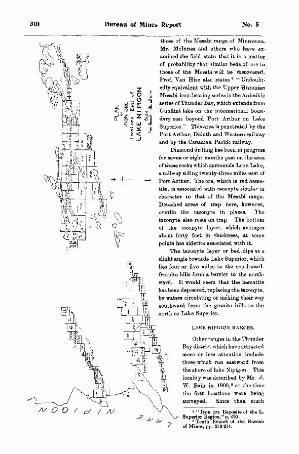
Bureau of Mines Report No. 5
those of the Mesabi range of Minnesota. Mr. Mclnnes and others who have examined the field state that it is a matter of probability that similar beds of ore to those of the Mesabi will be discovered. Prof. Van Hise also states 8 " Undoubtedly equivalent with the Upper Huronian Mesabi iron-bearing series is the Animikie series of Thunder Bay, which extends from Gunflint lake on the international boundary east beyond Port Arthur on Lake Superior." This area is penetrated by the Port Arthur, Duluth and Western railway and by the Canadian Pacific railway.
Diamond drilling has been in progress for seven or eight months past on the area of these rocks which surrounds Loon Lake, a railway siding twenty-three miles east of Port Arthur. The ore, which is red hematite, is associated with taeonyte similar in character to that of the Mesabi range. Detached areas of trap here, however, overlie the taeonyte in places. The taeonyte also rests on trap The bottom of the taeonyte layer, which averages about forty feet in thickness, at some points has siderite associated with it.
The taeonyte layer or bed.dips at a slight angle towards Lake Superior, which lies four or five miles to the southward. Granite hills form a barrier to the northward. It would seem that the hematite has been deposited, replacing the taeonyte, by waters circulating or making their way southward from the granite hills on the north to Lake Superior.
LAKE N I P I G O N R A N G E S .
Other ranges iu the Thunder Bay district which have attracted more or less attention include those which run eastward from the shore of lake Nipigon. This locality was described by Mr. J. W. Bain in 1900, B at the time the first locations were being surveyed. Since then much
s " Iron ore Deposits of the L. Superior Region," p. 410.
0 Tenth Report of the Bureau of Mines, pp. 212-214.
1902 Iron Ranges of Northern Ontario 311
prospecting has been done on the ranges which are said to be three in number and roughly parallel to one another. Two companies who have had options on the locations have done diamond drilling. Operations have now ceased not on account, it is said, of the outlook for the discovery of workable ore bodies being unpromising, but owing to the inability of those doing the work to make satisfactory terms with the owners as regards time for thoroughly testing the properties before having to make large cash payments.
Dr. W. A. Parks makes the following statement concerning these Nipigon iron ranges: 1 0
'"The region, from the Sturgeon to the Black water river and for a few miles on each side of these streams, is occupied by various Huronian rocks, including sericite and other schists, altered porphyrite and quartz-porphyry, slate and, more abundantly, diorite, both massive and in different stages of metamorphism. Agglomerates also are found at a few places. The dividing line between the agglomerates and the rocks between them might be drawn from the mouth of the Sturgeon river to a point north of Windigokan lakes. Particular attention is due to this region as it contains, in places, ranges of schists passing into jasper and hematite. The strike is somewhat north of east in all cases and the dip variable, but always near the vertical. Within the limits of the sheet there are, roughly speaking, three ranges with indications of iron ; one just north of the Sturgeon river and two south of it. Many claims have been staked on these belts, chiefly by the Flaherty and Clergue syndicates, both of which are actively and systematically prospecting the region. Mr. Flaherty has had a diamond drill working during the past summer on the first range south of the Sturgeon (the Sand river range) The jasper rock is here 1,000 feet wide and is filled with narrow bands of pure hematite. Its strike is 22° north of east and its dip northward 76°. The drill was driven down 542 feet at an angle of 60° from the vertical to the south, thus cross-cutting the deposit. The core revealed continuous jasper with narrow bands of hematite and at the bottom a passage into quartzite. This belt has been traced, with some interruptions, to Little Long lake, a distance of 70 miles to the eastward, at which Dr. Bell mentioned the occurrence of iron ore in his report for 1870. North of the Sturgeon, the strike is about the same, but the average width is difficult to ascertain as the deposit is covered by the silt at the river banks. Slaty hematite, giving 40 per cent, iron has been found at different places on this range. I was able to work out the geological conditions of occurrence fairly well and will be in a position to write on this point when the various samples have been exami' d. Jasper was observed at one place on the Blackwater river and magnetite was found sc oh of Blackwater lake."
N E A R BLACK S T U R G E O N L A K E .
Dr. Wilson refers to the occurrence of soft hematite in the vicinity of Black Sturgeon lake rhich lies southwest of lake Nipigon. 1 1 From his report it would appear that there is a prob
ability of workable deposits being -found in the vicinity, and locations have recently been applied for covering some of the outcrops. Dr. Wilson classes the rocks as Huronian. His dis-criptinn of the iron ore outcrops is as follows :
" Commencing near the southeast corner of Black Sturgeon lake and extending southeast to the vicinity of Nonwatinose lake is a narrow belt of highly ferruginous quartzite of an average width, so far as could be determined, of about four hundred yards. On the northeast, this quartzite band, whose beds strike N. 20° B. and are nearly vertical, is cut off by the granitoid gneiss belt referred to above, while on the southwest it is overlaid by later deposits. About half a mile east of Black Sturgeon lake, the quartzites are interbanded with a red hematite, sometimes quite soft, in bands rarely over a foot in width. The outcrop at this point is small, but from the typographic features of the vicinity one would expect that a much larger body of soft hematite ore would be found in the valley near the outcrops, which are on the side of a steep incline. Farther east, other small exposures of the ore occur, but the drift covering makes it impossible to determine their extent and value without considerable stripping. I understand that locations have already been taken up along this belt, although 1 was unable to find any claim stakes in the vicinity of Black Sturgeon lake. Claims have been staked north of Nonwaten and east of Nonwatinose lake. No development works of any kind has as yet been undertaken, and the value of the belt has still to be proved. The ores which I have seen vary from a soft unctuous clay-like mass of bright red hematite to a hard ore, in which are frequently found small patches of sparkling blue-black hematite. I was informed that specular hematite in larger masses has also been found in the vicinity."
1 0 Sum. Report, Geol. Surv. 1901, p. 105. 1 1 Ibid. p. 98.
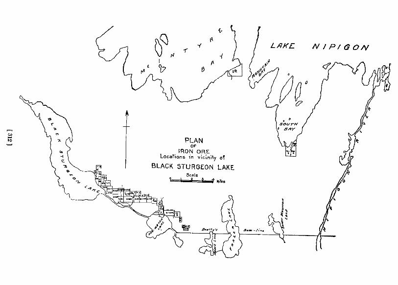
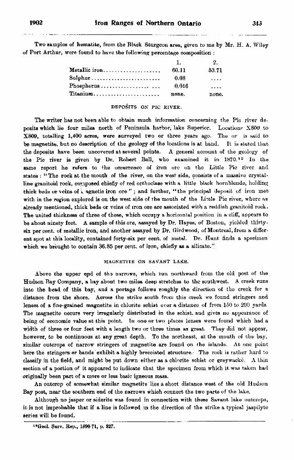
1902 Iron Ranges of Northern Ontario 313
Two samples of hematite, from the Black Sturgeon area, given to me by Mr. H. A. Wiley of Port Arthur, were found to have the following percentage composition :
1. 2. Metallic iron 60.11 53.71 Sulphur 0.08 Phosphorus 0.016 Titanium none. none.
D E P O S I T S O N PIC R I V E R .
The writer has not been able to obtain much information concerning the Pic river deposits which lie four miles north of Peninsula harbor, lake Superior. Location? X800 to X809, totalling 1,400 acres, were surveyed two or three years ago. The or is said to he magnetite, but no description of the geology of the locations is at hand. It is stated that the deposits have been uncovered at several points. A general account of the geology of the Pic river is given by Dr. Robert Bell, who examined it in 1870 . 1 2 In the same report he refers to the occurrence of iron ore on the Little Pic river and states : " The rock at the mouth of the river, on the west side, consists of a massive crystalline granitoid rock, composed chiefly of red orthoclase with a little black hornblende, holding thick beds or veins of w agnetic iron ore " ; and further, "the principal deposit of iron met with in the region explored is on the west side of the mouth of the Little Pic river, where as already mentioned, thick beds or veins of iron ore are associated with a reddish granitoid rock. The united thickness of three of these, which occupy a horizontal position in a cliff, appears to be about ninety feet. A sample of this ore, assayed by Dr. Hayes, of Boston, yielded thirty-six percent, of metallic iron, and another assayed by Dr. Girdwood, of Montreal, from a different spot at this locality, contained forty-six per cent, of metal. Dr. Hunt finds a specimen which we brought to contain 36.85 per cent, of iron, chiefly as a silicate."
M A G N E T I T E O N S A V A N T L A K E .
Above the upper end of the nirrows, which run northward from the old post of the Hudson Bay Company, a bay about two miles deep stretches to the southwest. A creek runs into the head of this bay, and a portage follows roughly the direction of the creek for a distance from the shore. Across the strike south from this creek we found stringers and lenses of a fine-grained magnetite in chlorite schist over a distance of from 150 to 200 yards. The magnetite occurs very irregularly distributed in the schist, and gives no appearance of being of economic value at this point. In one or two places lenses were found which had a width of three or four feet with a length two or three times as great. They did not appear, however, to be continuous at any great depth. To the northeast, at the mouth of the bay, similar outcrops of narrow stringers of magnetite are found on the islands. At one point here the stringers or bands exhibit a highly brecciated structure.- The rock is rather hard to classify in the field, and might be put down either as a chlorite schist or greywacke. A thin section of a portion of it appeared to indicate that the specimen from which it was taken had originally been part of a more or less basic igneous mass.
An outcrop of somewhat similar magnetite lies a short distance west of the old Hudson Bay post, near the southern end of the narrows which connect the two parts of the lake.
Although no jasper or siderite was found in connection with these Savant lake outcrops, it is not improbable that if a line is followed in the direction of the strike a typical jaspilyte series will be found.
"Geol. Surv. Rep., 1890-71, p. 327.
314 Bureau of Mines Report No. 5
OTHER OCCURRENCES IN THE DISTRICT.
The largest of the Slate islands, which lie about eight miles south of Jackfish bay, lake Superior, is reported by Dr. Bell to have ''a band of impure slaty hematite ore " on its western point. Further information on the geology of the Slate islands is given by Dr. Coleman. 1 3
Last autumn a deposit of magnetic iron ore was discovered a few miles inland from Otter cove, lake Superior. The deposit is said to lie a short distance north of the township of Homer. The ore is fine-grained.
The following quotations refer to other outcrops of iron ore in the Thunder Bay district . 1 4
" One side of Little Pine lake has a number of mineral exposures of copper and iron." This lake is on the river of the same name which is a branch of the Kenogami, and it lies not far west of the eastern boundary of the district . 1 5
" At the first portage there is an iron-stained outcrop with a band of red jaspery mineral running through it about two feet wide. . . Samples of this mineral and rock . . . showed reddish jasper mixed with magnetic iron and very silicious." 1^ The portage referred to is on " a river at the southwest of the lake," Wahbahkimmung or White Earth lake. The description given of the location of this outcrop is not very definite, and the river referred to is not shown on the map. White Earth lake lies nearly midway on the canoe route between lake St. Joseph and lake Nipigon.
" A number of islands occur in this lake composed of gneiss, which contains a considerable amount of magnetite. " l T The lake referred to is Big Mountain lake on the route between the Gull river and Obugamiga lake, to the west of lake Nipigon.
"The region northeast of Dog lake is reported to be rich in minerals. A number of iron claims north of Little Pike lake have been surveyed, and other deposits of iron in this district are known to occur." 1 8 The Dog lake referred to lies 12 or 15 miles north of Kaministiquia station.
Referring to that part of the Albany river between the mouths of the Ogoki and Kenogami, in the vicinity of the boundary between the districts of Thunder Bay and Algoma, it is stated that the channel is " full of gravel bars and low gravel islands of rounded pebbles, prominent among which are many of hematite and jasper." 1 9
I I I . DISTRICT OF ALGOMA.
In Algoma, the next district to the east, ircn ore deposits and ranges have been reported in numerous localities. The Michipicoton iron range, which is our only productive range at the present time in northern Ontario, lies, according to the most recent survey, in Algoma close to the boundary of Thunder Bay district. It is not necessary to say much here concerning this range as it has been described in many papers during the last four years, especially in the Eleventh Report of the Bureau of Mines. The Helen mine and other deposits on the range are also referred to in the present report. Considerable interest was aroused during the past summer in an area which lies about four miles south of the Michipicoton river and two miles from lake Superior. About thirty claims have been staked out there.
The Cape Choye range is said to be six miles long and similar in character to that of Miohipicoton proper.
Batchawana bay attracted attention years ago on account of the iron formation which outcrops in its vicinity. The outcrops have been described by a number of writers . 2 0
1 3 U t h Report, Bur. Mines, pp. 137-8. 1 4 Report of the Survey and Exploration of Nwrthera Ontario, 1900. 1 6 Ibid, p. 144. 1 8 Ibid, p. 185. " Ibid, p. 200. 1 8 Ibid, p. 205. 1 8 Ibid, p. 171. 2 0 Tenth Report Bur. Mines, p. 189.
1902 Iron Ranges of Northern Ontario 315
The occurrence of iron ore in the townships of Deroche, Jarvis, Anderson and Hodgins has been already referred to in this report. The ore in the deposits on which work has been done is described as being a soft hematite more or less interbanded with jasper or other closely related material of a silicious nature.
The iron deposit at Desert lake in the township of Aberdeen was opened up in 1874, and worked on a small scale for three or four years. Several vessel loads of ore, which is a hematite, were shipped to Detro i t . 2 1
G R O U N D HOG R I V E R I R O N B E L T .
Iron locations have been staked out on the belt which crosses the Ground Hog river four or five miles north of Flying Post. The post is reached by canoe from Biscotasing station, over a fairly easy route, in a trip of about two and one half days. T h e route fol lowed is shown on the geological map of northern Ontario, published by the Department of Crown Lands. The point at which the belt crosses the river is distant 45 or 50 miles in a straight line from the railway.
At the time of my visit to Flying Post, in September last, I was shown ever that part of the belt which lies adjacent to the river by Mr. Otto E. Telgmann, who has explored a large part of the surrounding district. Several locations had been staked out on t h e east s ide of the river by Mr. Telgmann and associates, and by Mr. Drew. The following notes were made at that time, Mr. Telgmann supplying the measurements. Two parallel be l t s cross the river here. They have a strike which is approximately N 52° E and dip 80° to the northward. From the south edge of one belt to the north edge of the other the distance across the strike is about 1,100 yards. The south belt has a width of about 200 feet a t the river and 800 to 400 feet one mile east, as shown by the dip of the needle.
The space between the two belts is occupied by a greywacke-like rock. Mr. Telgmann claims that the north belt shows five bands of ore, separated by rock. The distance across the strike of these bands is about 450 feet.
The south belt at the time of my visit had been traced east about one and one half mi les , and the north belt one mile. West from the river the south belt has been traced one half mile and the north belt one mile. The rock more closely associated with the bands is chlorite schist, while, as already stated, that occupying the space between the two belts is more like greywacke. Quartz diorite, containing bluish quartz like that of some of the rocks in the vicinity of Sudbury, outcrops in close proximity to the bands, but was not seen to cut them. The southern belt is bounded on the south by what appears to be typical slate. A quarter mile down stream, or north of the northern belt, is an outcrop of a massive igneous rock, whose character was not definitely determined. It may be either a granite or a diorite. Farther down, a quarter of a mile or so, is an outcrop of rather massive chlorite schist. The exposures on the east side of, and near the river, lie in rather low ground, and are pret ty well covered with moss and a growth of green timber. The material in the bands here consists of magnetite, which is at times rather coarse-grained, and interlaminated wi th red jasper and closely related silicious material of other colors. Some of the white silicious material is friable, and can be broken in the fingers to a fine-grained white sand.
During the past winter Mr. Telgmann has traced the iron-bearing formation farther eastward and westward, and has shown that it has a length of at least six miles. Samples which he collected on this last trip consist of silica interbanded in some cases wi th magnetite, but more usually with the red (hematite) or brown oxides of iron. The silica is of light or dull colors, and some at least of the oxide of iron may have been derived from pyrite, which is
2 1 Rep. Com. Min. Res. Ont., 1890, p. 143.
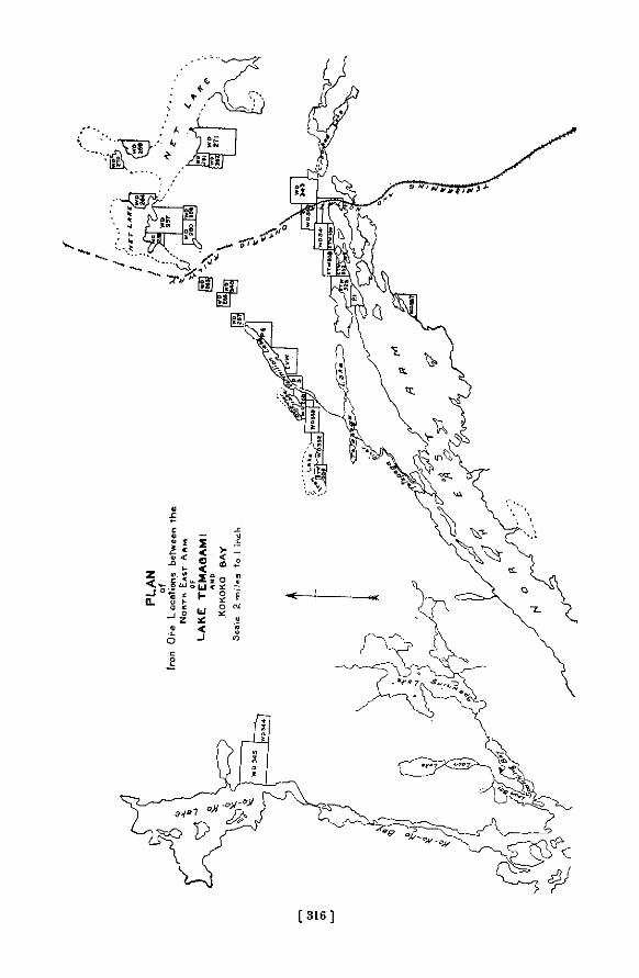
[ 3 1 6 ]
1902 Iron Ranges of Northern Ontario 317
present in some of the specimens. One sample, which has not been examined chemically, appears to be ferruginous dolomite or siderite, and is decomposed, for a half inch or so in from its exposed surface, to iron oxide. These specimens are said to cone from a point three miles or more east of the river.
IRON FORMATION ON WOMAN RIVER.
The locations which have been staked out on the iron belt on Woman river are said to be most easily reached from the mouth of this river, which is passed on the way from Biscotasing to Flying Post.
Some mining has been done on the portage which enters the south end of Opeepeesway lake in a banded silicious series, which is evidently part of an iron-bearing formation, although no iron ore occurs here. The banded material is similar to that of the jaspilyte belts. If traced east and west it is likely that this series will be found to pass into an iron-bearing one. In the pits which have been sunk pyrite has been met with. About one half mile up the western shore of the lake from the northern end of the portage an outcrop of metamorphic conglomerate was examined. It is similar in appearance to that which is associated with the iron-bearing series on lake Temagami and elsewhere.
ON THE MATTAGAMI.
Referring to the occurrence of iron ore at the Grand Rapids on the Mattagami river it is stated :
"This locality is remarkable for the occurrence of a large deposit of iron ore. Its position is on the northwest side of the river, at the foot of the rapids. It runs along the foot of the cliff a distance of upwards of 300 yards, almost continuously, with an exposed breadth of twenty to twenty-five yards. The highest points rise about fifteen feet above the level of the river. The surface is mottled, reddish-yellow and brown, and has a rough spongy or " lumpy" appearance, like that of a great mass of bog ore. At the surface, and sometimes to the depth of several inches, it is a compact brown hematite, occasionally in botryoidal crusts, with a radiating columnar structure ; but deeper down it is a dark gray, compact, very finely crystalline, spathic ore, apparently of a pure quality. The brown hematite evidently results from the conversion of the carbonate. The former yields, according to the analysis of Mr. Hoffman. 52.42 per cent, of metallic iron, while the latter shows a very small amount of insoluble matter ; indeed there is, chemically, little room for impurities, since it gives rise to so rich a brown hematite. The geological relations of this singular deposit are puzzling ; it may be of newer date than the limestone gorge in which it occurs. The adjacent overlooking wall of soft earthy limestone is worn into vertical caverns, with fluted and ronnded walls, like the sides of great pot-holes. They are sometimes partially lined with a thin coating of a highly ferruginous carbonate. The iron ore was nowhere seen quite in contact with the rock." 2 2
I V . DISTRICT OF NIPISSING.
In the district of Nipissing outcrops of iron ore have been found at numerous points. The chief outcrops, between lake Temagami on the east and the Township of Hutton on the west, are described in the Tenth Report of this Bureau, pages 160 to 180. The Shining Tree lake and other outcrops have also been described in recent reports.
The occurrence of magnetite at lake Abitibi is described as follows: " it was observed on the south side of the upper lake and also on the west side of the lower lake. At none of these localities, however, was it found in important quantities." 2 3
»» Report Geological Survey, 1875-6, p. 321. " Rep. Geol. Surv. 1872-3, p. 132.
318 Bureau of Mines Report No. 5
MOOSE MOUNTAIN IRON RANGE. BY C. K. LEITH.
The readers of the Ontario Bureau of Mines Reports are already familiar with the general features of the Moose Mountain iron range of Ontario through the papers of Professors Coleman and Miller. During the fall of 1902 the writer made a somewhat more detailed examination of the area than had before been practicable, and as a result of this work is able to present a few additional points concerning the geology of the range.
The Moose Mountain iron range lies about twenty-five miles north of Sudbury, Ontario, in the township of Hutton and district of Nipissing.
Magnetite ores appear in numerous exposures in the area. On weathered surfaces they are black, dark green and gray, and on glaciated surfaces have the lustre of metallic iron. The ores are minutely interbanded with silicious material, including chert and phases resembling quartzite and graywacke, and in places also they contain monoclinic amphiboles and epidote. Certain of the lean banded silicious ores resemble jasper but the colors are black and gray, and rarely yellow, brown, or dull red. Typical bright red jaspers are not seen. The ores, together with the associated rocks and minerals above mentioned, may be called the iron formation.
The microscope shows complete gradation between masses of almost pure magnetite and aggregates of amphibole, probably mainly hornblende. The associated silicious material which in the hand specimen resembles both chert and quartzite, appears under the microscope as a clear crystalline mosaic of closely fitting particles showing absolutely no trace of fragmental origin, so far as the writer has been able to discover. The re-crystallization of fragmental quartz rock or of chert such as occurs in the Lake Superior region could yield the same result.
Depending upon the amount of silicious or amphibolitic material which they contain, the ores vary from lean to high grade. Ordinarily the lean and high grade ores are in separate exposures. The silicious impurities fend to lower the grade of the ore very rapidly, while amphibolitic and epidotic inclusions may be present in considerable abundance and the ore still be of good grade, although such impurities may slightly increase the difficulty of working in the furnace. The ore has a strong effect on the magnetic needle, and magnetic readings enable one to connect up the isolated exposures into several belts.
GEOLOGICAL FEATURES OF THE RANGE.
The rocks immediately adjacent to the iron formation belts are: (1) Basic igneous rocks, which may be collectively referred to as greenstone and green
schist. They vary in texture from coarsely granular to fine-grained, and from massive to schistose. Under the microscope they may be seen to have close similarity in mineralogical composition in that they all consist mainly of hornblende, with interstitial feldspar and other accessory constituents. According to the abundance and arrangement of these minerals the rocks may be called hornblende schists, hornblende gneisses, diorites, metabasalts, amphibolites, or perknites. Characteristics of nearly all of these phases is the presence of accessory magnetite; in some of the rocks also a little pyrite is to be noted. Near the contact of the ores the magnetite increases in amount, and specimens may be collected showing complete gradation between rocks consisting predominantly of hornblende on the one hand and the magnetite ores on the other. The greenstones and green schists are in considerable part intrusive into the iron formation, but there is no evidence that all of them are intrusive, and indeed it is likely that certain of the more schistose and more metamorphosed of the green schists are basal to the iron formation, have served as the basement upon which it was [originally deposited, and have been folded with the iron formation.
1902 noose riountain Iron Range 319
(2) In a few places immediately adjacent to the ore belts is a j _ T i t i f e r o u s graywacke formation, with quartzitic and slaty phases, and with dark green phases which can with the greatest difficulty be discriminated from the greenstones. The fragmental origin of these rocks seems clear in the field and in the hand specimens, b u t under the microscope there appears a closely fitting mosaic of quartz and feldspar with no traces of rounded or fragmental outlines, a structure which might equally well have resulted from the alteration of fragmental sedimentary rock or from organic chert. The magnetite ores contain thin layers o f graywacke-like material as already noted, and these become more abundant near the c o n t a c t with t h e
graywacke formation. (3) At still other places massive granite comes into contact with the ores, a n d the relations
are such as to indicate the granite t o have intruded the ore and at least part of the greenstone. Near its contact with the greenstone there is at places a zone of weak magnetic attraction. The granite is a biotite granite, and is rarely pyritiferous. Exposures of rich ore are in places found adjacent to the intrusive greenstone and granite, suggesting that the intrusion of these rocks has had an effect on the concentration of the ore.
The granites and a large portion of the greenstones are fresh and massive. The green schists show a vertical schistosity, and the graywacke and iron ore belts exhibit steeply inclined bedding and schistosity.
COMPARISON WITH VERMILION IRON DISTRICT.
In their steeply inclined attitudes, their relations to surrounding greenstones and green schists, their sharp and irregular contacts with these rocks, their intrusion by acid igneous rocks, the iron formation belts of the Moose Mountain range show very suggestive similarity to the iron and jasper belts and associated greenstones and green schists of the Vermilion iron district of Minnesota. They differ in the character of the ores, those in the Moose Mountain range being magnetite, while those in the Vermilion range are hematite ; in their association with fragmental pyritiferous graywacke. the Vermilion ores having associated slate, but apparently no coarsely clastic material; in the presence of amphibole and epidote in a part of the ores, these being lacking in the Vermilion ores ; in that a considerable part of the greenstones in the Moose Mountain range are intrusive, while in the Vermilion range they are practically all basalt; and in that the Moose Mountain ores lack the associated brilliantly colored jaspers which are a very characteristic feature of the Vermilion range.
The iron-bearing series of the Vermilion district of Minnesota has been mapped and described by the United States Geological Survey as Archean or Basement Complex, and on the basis of rough lithological similarity the Moose Mountain series might also be assigned to the Archean. But the differences above noted are such that in the absence of any structural connection with the Vermilion district any correlation of the Moose Mountain and Vermilion iron-bearing series would be a mere guess.
To the southeast of the township of Hutton, near lake Wahnapitae, there may be seen iron formation rocks presumably belonging in the same general belt as the Hutton ores. But the Wahnapitae rocks differ from the Hutton rocks in showing close a s s o
ciation with a clean-cut pyritiferous quartzite, in being very lean, and consisting for the most part of chert and monoclinic amphibole, with a subordinate amount of magnetite. Under the microscope octahedra of magnetite are seen lying in a closely fitting,
somewhat irregular mosaic of quartz, ramifying through which are numerous thin needles o f colorless and light greenish amphibole. The rock is similar to rocks which have b e e n called actinolite-magnetite-schists or grtinerite-magnetite-schists, in the Lake Superior region. The associated pyritiferous quartzite, which, as shown in the ledge and in the hand specimen, i s
320 Bureau of Mines Report No. 5
clearly and without doubt a quartzite, under the microscope exhibits a quartz mosaic differing from the quartz mosaic in the actmolite-magnetite rock only in being somewhat more even in texture. It is possible that the quartoze background of the actinolite-magnetite rock and of the quartzite are the same in origin, but it seems more likely that the recrystallization of the silicious material in two different kinds of rocks has resulted in phases showing general similarity.
POSSIBLE ORIGIN OF THE ORE.
It is yet too early to make any definite statements concerning the origin of the iron ore, but there are known certain significant facts which may be of interest.
The characteristic association of magnetite, amphibole, and quartz (which is probably recrystallized chert) is the Bame as in rocks of the Lake Superior country which can be proved to result from the alteration of iron carbonate and ferrous iron silicate under deep-seated conditions of silication and partial oxidation. In the east end of the Mesabi district actinolite-magnetite rocks have resulted from the alteration of ferrous iron silicate, presumably because of the influence of the great Keweenawan gabbro adjacent, 1 and in the east and west ends of the Penokee-Gogebic range similar rocks 2 have developed through the action of the Keweenawan rocks. The Moose Mountain iron formation is cut by intrusives, and the conditions have been favorable to the development of the presently observed rocks from iron carbonate or iron silicate, if such were ever present. Beyond this, however, there is no evidence that the ores have developed from original rocks of this character.
Professor Miller, of the Ontario Bureau of Mines, has noted, as warranting further study, the common association of the iron ores in the Nipissing district with pyritiferous quartzites and graywackes. 3 This fact, together with the general importance of sulphides of other ores in this district, and the stages of alteration of iron pyrites to iron oxides actually to be observed on a small scale in hand specimens of certain of the adjacent rocks, suggests that iron pyrites may be in some way connected with the origin of the iron ore in this district. This is little more than conjecture, but should certainly be followed up by any one attempting to prove the origin of the ores. Chemically, there is no reason why ores should not develop from iron sulphides as well as from iron carbonates or from iron silicates, and Van Hise has suggested the sulphides as a partial source for certain of the Lake Superior iron ores and especially the Michipicoton ores, and has indicated their probable manner of development. 4 However, the actual development of a considerable body of ore from such a source in the Lake Superior region has not yet been proved, and the burden of proof will rest heavily upon any one attempting to establish this origin for the Moose Mountain ores.
While much of the ore in the Hutton district is too lean for present use, there is also present a considerable amount of ore running above 58 and 60 per cent, in metallic iron. Little test-pitting or drilling has been done to determine the extent of such ore, but the surface indications are promising. Sulphur, an element to be feared in magnetite ores, is in very small quantity ; the considerable number of analyses which have been made of the ore show sulphur varying from .01 to .08 per cent. Titanium is altogether lacking.
The ore is hard and crystalline, and because of its crystalline character will crush to a good size for furnace use. It will doubtless be found to serve admirably for mixing with soft ores such as the Mesabi.
•The Mesabi iron-bearing district of Minnesota, by C. K. Leith : Mon. U. S. Geol. Survey. Vol. XLIII. 1903, pp. 272 274.
'The Penokee iron-bearing »«ries of Michigan and Wisconsin, by R. D. Irving and 0. R. Van Hise : Mon. C S. Geol. Survey Vol. XIX, 1892, pp. 25, -260.
'Report of the Bureau of Mines for 1901, p. 177. *The Iron Ore Deposits of the Lake Superior region, by C. R. Van Hise : 2lst Ann. Rept. TJ. S.
Geol. Survey, Pt. I l l , 1901, pp. 319-320.
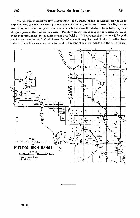
1902 Moose Mountain Iron Range 321
The rail haul to Georgian Bay is something like 60 miles, about the average for the Lake Superior ores, and the distance by water from the railway terminus on Georgian Bay to the great consuming centres near Lake Erie is much less than the distance from Lake Superior shipping ports to the Lake Erie ports. The duty on the ore, if used in the United States, is about counteibalanced by the difference in boat freight. It is assumed that the ore will be used for the most part in the United States, but of course it may be used in the Canadian iron industry if conditions are favorable to the development of such an industry in the early future.
MAP S H E W I N G L O C A T I O N S /<t>
HUTTON IRON RANGE
P-PATENTEO LAND L—LEASED »
21 M.
322 Bureau of Mines Report No 5
MAGNETIC CONCENTRATION OF IRON ORES. BY J. WALTER WELLS.
The future supply of iron ore is a problem which far-sighted ironmasters are investigating, as the resources presently available are not calculated to last many years. Already English and German iron works are importing ores from Spain and Sweden. In the United States the reserves of high-grade ore are not likely to be sufficient for more than 40 years, while the supply in Canada is apparently no more abundant ; so that the best means of utilizing the immense deposits of low-grade iron ores well known to exist becomes a proper subject of inquiry.
Meanwhile the production of pig iron continues to inert ase rapidly. For example, in 1901 the total production of pig iron in the United States was 15,878,854 long tons valued at $242,174,000 using 28,887,479 tons of iron ore, being nearly twice the production in 1896. In 1900 Canada produced 86,090 long toi.s of pig iron, while in 1901 the production rose to 244,976 tons and without doubt is destined to advance with rapid strides.
Iron ore does not reproduce itself as does forest or animal wealth. Ironmasters are facing a constantly decreasing supply of high-grade iron ore along with a constantly increasing consumption. Sooner or later the low-grade iron ores must be drawn upon. And it may be advisable to concentrate such ores before using them in the furnace.
WHAT IS CONCENTRATION ?
To the engineer concentration means the separation of the chaff from the wheat—the elimination of the worthless rock from the valuable ore. Present methods of concentrating iron ores are based upon som3 difference between the constituents of an ore either in hardness, specific gravity, or in magnetic permeability, i. e., the relative susceptibility to a magnetic influence, by taking advantage of which a separation is 'effected. For example, it is comparatively easy to separate a granular hematite imbedded in a calcareous gangue. The calcite being softer than the hematite will crush finer with the same treatment, and as it is of relatively less weight than the hematite, a system of crushing, sizing and treating in a pulsating jig removes the gangue from Che ore.
Again, a hard dense magnetite associated with a soft schist would be amenable to concentration as the schist would crush finer than the ore, the resultant product' after sizing in hydraulic classifiers being readily separated by jigs into heads consisting of pure ore, and tails consisting of worthless rock.
Both the jig and the hydraulic classifiers depend on the difference in specific gravity of the constituents. In the case of the common mixture of magnetite with pyrite, both of about the same hardness and specific gravity, a system of water concentration would not give satisfactory results. Fortunately, an electro-magnet has a greater attractive influence on the magnetite than on the pyrite, so that we have a means of eliminating the pyrite from the magnetite when fhe grains of each constituent are entirely detached. How this may be done will be shown further on.
REASONS FOR CONCENTRATING IRON ORES.
The ironmaster demands as pure an ore as possible in order to make a cheap and high-grade pig. For example, the standard ore of Bessemer grade on which payments are made by most American dealers carries 63 per cent, iron, 0.045 per cent, phosphorus, 0.05 per cent, sulphur, and the proportion of sulphur or phosphorus cannot exceed these limits without
190 Magnetic Concentration of Iron Ores 323
lowering the selling price of the ore. In smelting an ore high in iron contents less fuel, les fluxing material and less labor are required than in using a lean ore. Besides, the stock piles are likely to be more uniform, so that less trouble is experienced in making up the charges for the furnace burden.
The iron blast furnace is practically a concentrating as well as a reducing machine. All of the constituents of the ore except a portion of the metallic contents are separated as worthless slag, while the valuable pig iron is saved. Immense sums of money are annually spent in mining, transporting and fluxing slag-making material in the ore. A modern furnace costs considerably more than a modern concentrating plant both in original outlay and cost of maintenance. When the gangue or worthless part of the iron ore is treated in the blast furnace it must be transported, handled at least twice, melted and fluxed. By removing this gangue at the mine all of the expense of hauling, handling and eliminating in the furnace may be saved, and the ore will command a higher price at the smelter, being a high-grade, uniform ore.
According to present practice, it takes one ton of coke to make one ton of pig iron. Most metallurgists will admit that about 400 lb. of the coke is sufficient to reduce the iron in the oxides, while the remaining 1,600 lb. are used up in melting the pig iron along with a mass of silicious and earthy matter making up the slag. Of course a portion of this waste heat is saved in the form of gas used to heat the air blast, but a large quantity goes to heating, fluxing and getting rid of the slag arising from the gangue matter in the ore. Hence it may be seen that it is better from the metallurgist's point of view to concentrate the ore at the mine rather than in. the furnace.
The question thus may be resolved into a business proposition. Will it pay to concentrate the ore at the mine ?
If the extra price which the ore brings at the smelter, together with the cost of hauling gangue material in the low-grade ore, is greater than the cost of concentrating the ore at the mine, then the operation will be a profitable undertaking. It cannot be piofitable to deliver concentrated ore to the smelter in competition with an equally rich ore in the natural state, the cost of transportation being the same. But rich ores in the natural state are not abundant, so that there is always a chance for the concentrated ore to come into the market.
METHODS OF CONCENTRATION.
Hence it is pertinent to determine the most efficient method of concentrating iron ore at the mine.
The simplest method of concentrating hard iron ores is by hand-cobbing ; the laborer breaks up the ore to small sizes with a sledge hammer, picks out the good ore for use in the smelter, and throws the worthless rock on the waste heap. In the case of soft iron ores intermixed with clay, various forms of washers are used. The log-washer used in the Southern United States is a tilted cylinder rotating on its longer axis, with side paddles forcing the ore upwards in a trough against a descending current of water which washes away the clay and fine material through a screen at the lower end, while the washed ore passes to the ore cars at the upper end.
In concentrating hard iron ores the product should have the coarsest possible size together with the highest possible purity, in order to meet the conditions of transportation and use in the blast furnace. The cost of the crushing depends on the fineness of the desired product. The required fineness depends on the physical character of the ore, i.e., whether it is fine or coarse-grained, and whether the gangue is readily detached from the particles of ore. The cost of separating the ore per ton of finished product varies with the richness of the ore. Hence the number of tons of crude ore which must be crushed to a certain size to obtain a certain concentrated product is an item of importance on the cost sheets.
324 Bureau of Mines Report No. 5
The richness of the ore depends on the amount of gangue material present. A petro-graphical examination of an ore will give a fair idea of how it will respond to any given system of concentration. Illustrations are given of several samples of ore, some of which are amen" able to concentration by coarse, some by medium, and others by fine crushing, while in others concent ration is rendered difficult, if not impossible, by the intimate intermixture of rock matter or impurities with the particles of the ore.
It often happens that pyrite or apatite occurs in an ore of high iron content in such proportion as to render the ore of no commercial value. These deleterious constituents-may be separated by magnetic concentration, for it is only a matter of how fine it is necessary to crush in order to detach the grains of ore from the grains of the other constituents. For example, an ore, such as is shown in the cut, in which the pyrite shows as light colored stringers and segregated masses, whi 'e the ore itself is dark-colored, requires only medium fine crushing about 0.25-inch dian eter to separate the pyrite from the ore. Another specimen shows a dark-colored, dense magnetite with fine particles of pyrite disseminated through the mass. In the photograph these particles are distinguished by their light color. In this ore it is almost impossible to eliminate the pyrite without very fine grinding, as particles of the ore of even 0.10-inch diameter will have fragments of pyrite clinging to them. Although tine crushing would eliminate the pyrite, the process cannot be a commercial success at present, owing to the cost of fine crushing and the briquetting of the fine ore rendered necessary. When by patrographieal means the character of an ore has been determined, it is necessary to ascertain the best method of concentration! adapted to its treatment.
MAGNETIC VERSUS WATER CONCENTRATION.
If the iron in an ore occurs in such a state that it may be attracted by an electro-raagnetr
then we have a simple method of separating the valuable ore from the worthless rock. Magnetites are most readily attracted by magnets, hence such ores lend themselves most readily to treatment. By increasing the strength of the current passing through the magnet hematite may also be separated out as magnetic heads from non-magnetic rock matter.
In discussing the merits of water concentration, it may be remarked that local conditions-here are against its use. A costly plant consisting of jaw crushers, rolls, screens, jigs, expensive water piping, heating arrangements and la'ge power capacity are necessary. The product is not always high-grade, as the gangue may have the same specific gravity as the ore and it may not be possible'to eliminate sulphides and apatite. Iron ore requires handling in large quantity to be profitable, and this entails an expensive plant where water concentration is used. On the other hand, conditions in Canada favor magnetic concentration, as there i s abundance of cheap water power available in the iron districts, while no expensive plant is necessary. The electric power may be used in running drills, hoists, pumps, lighting system,, compressors for air-drills or crushing machinery, and the product may be hauled to the nearest shipping point by electric trams. Cold weather has little influence on electric power, while condensation of steam and the freezing of water and air-conveying pipes often give trouble-during a cold season.
The magnetic permeability of different minerals has been worked out by Walter Crane,. (Transactions of American Institute of Mining Engineers, 1901) who arranges the moat, magnetic minerals in descending order of permeability, thus:—Magnetite, franklinite,. ilmenite, pyrrhotite, hematite, siderite, limonite.
The ideal method of crushing an iron ore for magnetic concentration would be to detach the different grains from each other without further crushing. Granulation should be the rule rather than pulverization, for two reasons : (1) It is a waste of energy to reduce the ore finer
1902 Magnetic Concentration of Iron Ores 325
than is necessary, (2) Fine ore as dust is not desirable for use in the blast furnace. Hence in any system of concentration the essential point is to find out what degree of fineness is necessary to release each individual particle from its neighbor. If the crushing is too coarse, in many ores a magnetic portion will drag a non-magnetic portion attached into the heads, thus lowering the quality of the product. If the ore is crushed too fine, there will be an adhesion of magnetic particles to the non-magnetic, thus preventing a clean separation unless the ore is handled in water as by the Grondal-Delvilk or Heberli separators, or separated by air blast as in some of the dry separators. Besides, the ironmaster objects to using ore in the form of dust in the smelter. Hence it may be seen ttiat each ore is a problem in itself requiring eareful experimental investigation to determine the best method of treatment including the size of grain, the kind of separator best adapted, the pole distance, etc.
An encouraging feature of magnetic concentration is that sulphur in the form of pyrite, and phosphorus in the form of apatite, may be eliminated from many iron ores, thus producing a Bessemer grade. Sulphur in the form of pyrrhotite cannot be separated from magnetite, nor can phosphate of iron and phosphide of iron be readily eliminated, as they are more or less magnetic and go into the heads. Experiments conducted by the writer have shown that in some titaniferous ores the titanium may be eliminated, as ilmenite is not so magnetic as magnetite. In a pure ilmenite it is impossible to reduce the percentage of titanium by magnetic concentration.
PRESENT STATUS OF MAGNETIC CONCENTRATION.
The application of electro-magnets to the concentration of iron ores is not a novel idea, but its use on a commercial scale has been extended within the last 15 years.
In 1*65 the late Dr. Sterry Hunt of the Canadian Geological Survey proved that concentration by magnets was successful on the iron sands on the north shore of St. Lawrence river. A charcoal iron smelter was started at Moisie which made a good grade of charcoal iron, but the product could not compete in price with Swedish iron, and the project was abandoned.
The different types of magnetic concentrators which have met with more or less commercial success may be divided into four classes :—
(1) Those with the ore on conveying belts either traversing magnets or traversed by magnets. Examples are the Conkling, Wetherill, Chase, Hoffman, Kessler, and similar machines.
(2) Those with the ore on a revolving cylindrical drum within which are the magnets. Examples are the Ball-Norton, Heberli, Wenstrom, Buchanan, Sautter, Siemens, Payne and other similar apparatus.
(3) Those in which the ore falls vertically past magnets. Examples are the machines of Edison, Heberli, Grondal-Delvik, Rowand, etc.
(4) Those in which static electricity is utilized, materials conducting the charge being repelled from those which do net become magnetized. The only example is the Blake-Mor-scher type recently invented, and used at the Colorado Zinc Works for separating zinc from lead ores.
It is beyond the scope of this paper to discuss the relative merits of the various machines, but a brief description of a few in commercial use at some time may be of interest.
TYPES OF CONVEYING-BELT SEPARATORS.
The Conkling separator is an endless travelling belt with three cross belts running at right angles to the main belt beneath magnets of different strength, delivering different grades of ore. The non-magnetic tails are carried along the belt. This machine does not appear to have had much success. An improved form as described in Transactions of American Institute of Mining Engineers, 1890, was used at the Tilly Foster mine, in New York State, with good effect.
326 Bureau of Mines Report No. 5
The Wetherill separators are made in several different forms adapted to suit requirements. Two types used at the magnetite mines of Witherbee, Sherman & Co., Port Henry, New York, for concentrating a magnetite carrying silicious matter and apatite may be described. The Row-and type is designed for highly magnetic ores The crushed ore fallsx from a zig-zag delivery spout, thus shaking up the particles, past a revolving drum composed alternately of braBS and iron and magnetized by induction from the permanent magnet. The non-magnetic particles fall past the magnet, while the magnetic portions are held to the periphery till the centre of the lines of magnetic force between the magnets is reached, and as this zone is neutral the particles fall. Provision may be made to classify the material into several grades by baffles. The construction of the rapidly revolving drum may also be seen in the plate, showing that a secondary concentration takes place, the
.magnetic material arranging along the bands of iron while the non-magnetic is thrown into the alternate spaces along the bands of brass. There is also a concentration of the lines of force at P owing to the point of the magnet projecting, and as all material passes through this field of strong magnetic forces, it may be seen that there is little iron allowed to escape in the tails, while only a weak current may be necessary owing to the concentration of the force.
This type of concentrator is used at Port Henry, treating a crude ore carrying about 45 per cent, iron and consisting of magnetite, apatite, hornblende, quartz, etc. The ore is crushed to 0.25-inch, sized and passed through the magnetic separator which delivers heads carrying 69 per cent. iron. The tailings are passed through a Rowand (Wetherill system) cross-belt machine, removing the hornblende as a magnetic product and leading the tailings as almost pure apatite which is sold to fertilizer makers. The last-named machine designed for treating weakly magnetic material is shown in the illustration. The cross belts run under very strong magnets and deliver material according to the Btrength of the magnet, while the non-magnetic material passes along the wide belt as tailings. The writer saw this machine in operation on a sample of monazite sand, removing ilmenite as one product, and cerite earths as a second product, leaving garnets, quartz, etc., as tailings.
The separators made by the Wet herill Separating Company in one form or other are able to remove garnets from corundum, silicious matter, pyrite and apatite from iron ore, and garnets from diamonds as at DeBeers Mine, Kimberly, South Africa. The concentration cf monazite sand by these machines gave an impetus to the industry of collecting rare earths for use in making incandescent mantles for lighting, while the concentration of zinc ores such as frank-linite at Franklin Furnace, New Jersey, is being done on a large scale. The machines will no doubt find still further industrial uses.
T H E B A L L - N O R T O N D R U M M A C H I N E .
The Ball-Norton separator in practical use for the last 10 years has according to the inventor, Mr. C. M. Ball, Rockaway, New Jersey the following distinguishing features —
(1) A stationary range of magnetic poles of alternately opposite polarity in the direction of the ore travel; beneath these the drums enclosing the two groups into which the range of poles is divided may be rotated and may serve as carriers of the granulated ore, the iron particles being held upon the under side thereof by magnetic attraction.
(2) Means for applying a counter current of air to the moving mass of ore while it is suspended upon the under side of the rapidly running drums and being driven along through the machine.
(3) Provision for classifying the ore into three grades, this being done by a differential speed of rotation of the two drums, assisted by relative adjustments of the strength of magnetism in the two groups of alternating magnets.
1902 Magnetic Concentration of Iron Ores 327
The crushed ore is fed into the hopper at the right, the tails falling directly beneath, while the larger and stronger magnet carries magnetic material to the second or weaker magnet where a middle product consisting of ore mixed with rock matter attached falls down into the hopper at the left. A blower forces air in the opposite direction of the ore travel. The particles of ore are tumbled about while suspended on the underside of the drums by. being passed through magnetic fields of successively opposite polarity. Gravity, centrifugal force and a counter current of air act at the Fame time to eliminate the non-m jgnetic particles. The writer recently visited the concentrating plant of the Hibernia mines, New Jersey, where the Ball-Norton machines are in use. At this mine there is some 80.000 tons of re'use ore consisting of magnetite, hornblende, quartz, etc., bging the result of several j ears of hand cobbing. The refuse ore carrying 40.34 per cent, iron, as shown by samples taken by the writer, is crushed in jaw crushers, passed through rolls and trommels with slots of 0.25-inch diameter, the oversize passing through finer rolls. The whole product from the rolls goes to a Ball-Norton separator delivering three products, samples of which taken by the writer show as follows :
(1) Tails carrying 7.08 percent, iron, (2) Middles carrying 48.03per cent, iron, (3) Heads carrying 63.40 per cent. iron. The heads are delivered to ore cars going directly to the smelter. The middles are re-crushed by finer rolls and again passed through the separator. The waste rock, worth 25 cents a ton at the mine, is sold for concrete and building purposes.
At this mine there is also in operation a magnetic cobber, built by Mr. C. M. Ball of Rock-away, New Jersey, which cobs the ore classed as run of mine. The ore is fed from the skips to large jaw crushers, through trommels with slots of 2.5-inches diameter, and to the cobber consisting of a cylindrical magnetized drum around which an inclined belt travels. The crushed ore, consisting of coarse and fines, falling on the belt is divided into non-magnetic tails falling directly down past the end of the drum to cross travelling belts which lead to the waste piles. The magnetic particles cling to the belt till they reach the lowest point of the cylinder, where the magnetism ceases, the ore falling on cross conveying belts leading to ore cars. Samples from the magnetic cobber taken by the writer show :—
Heads ; coarse ore, 2.5-inches diameter 43.86 per cent, iron ; fine ore, 53.43 per cent. iron.
Tails : coarse rock, 6.82 per cent, iron ; fine rock, 13.45 per cent. iron. The scheme for cobbing may be shown thus :
Run of mine
Jf Jaw crusher
V
Trommel (2.5 in. diameter) > oversize
1 V
Magnetic cobber < Rolls V Non-magnetic tails to waste heap.
~ > Magnetic heads to smelter.
The Ball-Norton separators have been used for some years at the Chateaugay mines in northern New York State, treating some 10,000 tons per month. The ore carries 38 per cent, iron, and is difficult, to mine while the smelters are some distance away, so that costs run up high. The only saving factor is that the concentrated ore is uniformly high-grade, carrying 66 per cent. iron. The mine was obliged to quit operations before magnetic concentration was used, as neither Hartz jigs nor hydraulic classifiers gave satisfactory results. The ten magnetic
328 Bureau of Mines Report No. S
separators installed produce one ton of concentrates, carrying 66 percent, iron from two tons of crude ore, carrying 38 per cent. iron. It is necessary to crush the" ore to 0 25-inch diameter for treatment.
Ba'l-Norton separators have also been used at the Benson mine, Port Henry, Arnold Hill, Ferronia in New York-state, Svarto m Sweden, and elsewhere.
O T H E R F O R M S OF D R U M S E P A R A T O R S .
The original Buchanan separator consists of double rolls going in opposite directions, and forming the ends of a horseshoe magnet. The ore, entering at the top, is divided into tails falling down vertically, and the concentrates are deflected by the magnets.
The Buchanan separator is for coarse ore, about 0.50-in. diameter. The large drum, with magnets on either side, rotates to the left, carrying ore fed on the left side upwards against gravity and centrifugal force. Magnetic particles clinging to the ascending surface of the drum, are carried over the top, passing to a second magnetic field and allowing nonmagnetic particles to fall vertically, while the rich ore, clinging to the drum, falls into a chute further down. The rich tailings falling from the right side of the large dr.um are passed over the small drum of intense magnetic power which holds the magnetic portions till they reach the underside of the drum, while the non-magnetic material falls vertically from the side. The Buchanan system has been used at Hibernia mines in New Jersey, Croton in New York, Michigamme in Michigan, and elsewhere.
The Wenstrom separator is a single cylinder with alternate strips of magnetic and nonmagnetic material forming the periphery. Ore falling from the hopper comes in contact with a magnetized portion of the periphery, a'lowing the non-magnetic material to fall vertically as seen in the plate, while the magnetic particles cling to the belt until they reach a demagnetized portion, where they fall. This pepara'or was first used at Hjuljern, Sweden, in 1885^ and has since been used with success at Dannemora, Grangesberg, Gellivare, Lulea and other mines. In America it has been operated at Mineville, Michigamme, Cranberry lake, etc.
The Heberli separator is adapted to complex magnetic ores. This separator allows a clean separation, combining hydraulic classifying with simultaneous magnetic concentration. While used in Germany, it has not yet been introduced in American practice.
E D I S O N S T A T I O N A R Y M A G N E T S E P A R A T O R .
The Edison separator is a stationary magnet, past which the ore falls by gravity The non-magnetic tails fall vertically past the magnet while the magnetic heads are deflected by it. The writer recently visited the mines near Edison, New Jersey, where a large plant had been in operation in 1897, but found the plant dismantled, although accurate information as to the method of concentration was obtained.
The problem which the renownei inventor, Mr. T. A. Edison, sought to solve was the enormous one of quarrying a rock carrying about 25 per cent, magnetite, crushing it fine, separating magnetically the particles of magnetite from the rock, furt her eliminating the apatite from the magnetite by air blast, forming the clean pulverized ore into briquettes, and shipping the product to local furnaces at a cost below that at which lake Superior ores could be delivered so that they might be able to compete with Pittsburg furnaces using cheap lake ores.
The ore was quarried by blasting 2-inch holes 8 feet apart, 20 feet deep, and 12 feet back from the working face. The ore, often thrown out in masses weighing 5 tons, was loaded by a steam shovel to skips dumping into giant rolls 6 feet in diameter with 6 feet face, passing thence to three successively finer rolls delivering ore crushed to 0.5-inch diameter and finer, and then elevated to a vertical dryer 50 feet high and 9 ft et square, with alternate cast iron shelves tilted downwards at 45*. The dried ore was elevated to a stock house and sent to rolls,

1902 Magnetic Concentration ot Iron Ores 329
screened to 14-inch mesh, the oversize returning to rolls while the fines weio allowed to fall past a series of horizontal magnets, deflecting magnetic particles carrying 40 per cent, iron, and allowing the tailings to fall vertically. The concentrates were dried, crushed to cO-mesh, and treated by a second series of magnets delivering c-.ncentrates carrying 60 per cent, iron, which were exposed to an air blast eliminating the apatite as dust, and passed to a third series of magnets, thus making a final concentrates carrying 68 per cent, iron and tailings which were recrushed and returned to the magnets. The final concentrates after being mixed with rosin-soap as a binder were briquetted into blocks 3 inches by 1.5 inches, which were heated in drying ovens to 600° F. to render them waterproof, hard to endure handling, porous to allow furnace gases to penetrate, and non-friable to resist the action of the furnace.
The capacity of the plant was 300 tons rock per day, one quarter of which was made into ore briquettes, the remainder, worth 25 cents per ton, being sold for building purposes.
The raw material was handled entirely by machinery. Some trouble was found in getting a suitable bond which would stand the aciion of the furnace. Operations were suspended, as being too expensive to compete with lake ores, but it seemed to be the opinion of a few in tho district that the concentration would be profitable if at any time the price of lake Superior ores should advance in price 80 cents a ton or more.
The Grondal-Delvik separator is adapted to finely-crushed magnetic ores, water being used to clean the dust from the concentrates.
This separator is being used at Pitkaranta, Finland, treating low-grade iron ore carrying about 30 per cent, magnetite. As the work is a remarkable example of what is being done by magnetic concentration, the following condensed translation made by the writer from descriptive articles in the Oesterreicheische Zeitschrift fur Berg und Hutten ivesen, Feb. 4, 1899, and Aug. 10, 1901, may be of interest :—
The lean magnetic ore carries a!so zincblende, chalcopyrite, pyrite and pyrrhotite, and contains about 25 per cent, iron and 4 per cent, sulphur. The gangue is hard serpentine, and fine grinding is necessary to free the sulphides from the magnetite. Rolls gave poor results, and dry grinding in ball-mills had many objections, so that Grondal ball-mills grinding the ore in water was adopted with success. The plant consists of 4 jaw crushers, 8 Grondal ball-mills, 8 Grondal magnetic separators, etc. The capacity of each separator is 30 tons per day, requiring a current of 6 amperes 31 volts and consuming 0.50 horse power. The concentrates, carrying 68 per cent, iron and 0.18 per cent, sulphur, are made with a loss of about 1 per cent, of the magnetite. The concentrated ore is moistened with water, pressed into bricks by a Dorsten dry press making 1,500 bricks per hour and using 2 horse power. The bricks are heated in a gas-fired kiln for 15 minutes to the sintering point, rendering them hard, porous, entirely free from sulphur, and readily reduced in the blast furnace near the works. The cost of a plant making 150,000 tons of bricks per year and us'ng 150-h. p., is estimated thus :—
T H E G R O N D A L - D E L V I K S E P A R A T O R .
2 crushers 2 elevators 8 ball-mills 8 separators Dynamo and elec rical equipment Pump, 150 gallons per minute . . . Shafting, belting, etc Buildings , Incidentals
$ 1,250 700
8,9. r0 6,700
700 375
2,225 3,750 4,325
00 00 00 00 00 00 00 00 00
Total $28,975 00
330 Bureau of Mines Report No. 5
The Blake-Moracher syetem of ore dressing by means of static electricity was recently-invented by Prof. L. J. Blake. The method consists in passing crushed ore over a charged metallic surface Such ore particles as possess relatively high conductivity are instantly repelled, while those of relatively low conductivity are not repelled till sufficient time has been given for pulling them out of their original path, thereby causing a separation. The method is said to be successful in treating iron ores, and the apparatus is cheap and simple.
FINELY DIVIDED ORES IN THE BLAST FURNACE.
An argument often brought forward against the concentration of iron ores is that the concentrated product is usually too fine for use in the blast furnace without previous briquetting. It appears to be a fact that the continued use of ore in the shape of dust causes irregular fusion with formation of gas-pockets, slips and often explosions doing more or less harm. The trouble due to loss of ore as flue dust appears to be minimized in the latest forms of blast furnaces such as those used in the Pittsburg district working on "straight Mesabi soft ores.
Aware of this objection, the writer visited several of the iron smelting centres in the United States and also some Canadian furnaces to ascertain the present practice regarding the use of fine ores in. the blast furnace. The results of his inquiries convinced him that very few sound arguments can be adduced against the use of finely divided ores in the furnace without briquetting. One metallurgist stated that he would prefer to use ore as fine as (L25-inch diameter, as he could then get a uniform product, but that it was toe-expensive to crush lump ore.
In the Pittsburg district the writer saw furnaces each producing 700 tons of pig iron daily, using entirely soft Mesabi ore, some of which would be as fine as dust if dried. The only trouble in using this ore was an occasional slip or explosion, which might possibly have been avoided by close attention to the stack and the blast.
At the Wharton Furnaces, New Jersey, magnetic concentrates are used along with lump ore. The lump ore is heated by waste gas before it goes into the stack to reduce the size of the lumps, as it is claimed that small sizes such as 2 inches in diameter work better in the furnace than the lump. At Oxford Furnace, New Jersey, magnetic ore is used entirely, and the lump ore is calcined in Gjer's vertical kilns to eliminate the 1 per cent, sulphur in the ore, and to reduce the size of the lumps so that they will allow the furnace gases to penetrate.
In the Scranton district there appears to be no objection to the use of concentrated ore up to 50 per cent, of the ore in the charge.
Mr. E. S. Moffatt, manager of Lackawanna Iron and Steel Company, Scranton, Pa. r
relates his experience with concentrated ore for a period of 6 years, (Transactions of American; Institute of Mining Engineers, vol. 20, page 583) and states that a uniform product'is secured by using concentrated ore and that loss in flue dust was inconsiderable.
At the Port Henry furnaces, according to Mr. Langdon, who was connected with the works, concentrated magnetic ore from Mineville was used up to 80 per cent, of the ore making up the furnace burden. The fine ore used less fuel and gave no more trouble in smelting than lump ore.
According to official statistics 108,847 tons of iron ore concentrates were used in the United States during the year 1901. This is relatively a small consumption, as most of the furnaces are located within easy access of lake ores and coke, while the mines producing concentrates are somewhat distant from the supplies of coke. It appears to be certain that many mines in the Eastern States would be opened up and concentrating plants installed if at any time the supplies of cheap high-grade ores from the Lake Superior country should be diminished.
1902 Magnetic Concentration of Iron Ores 331
The ironmasters in Canada do not appear to have any objection to using ore down to-0.20-inch diameter without briquetting. No concentrated ore is being used steadily at Canadian furnaces, although the soft Mesabi ores are sometimes smelted alone. A company has-been formed to work the iron sands on the north shore of the river St. Lawrence, but so far has not shipped concentrates in large quantity.
S M E L T I N G F I N E L Y C R U S H E D O R E S IN E U R O P E .
Present practice in Sweden allows the use of fine ores in the blast furnace. Experiments conducted some years ago at the expense of the Swedish government proved that finely-divided iron ores could be used in making up the furnace burden with no trouble. Most of, the large iron mines in Sweden have concentrating plants for dressing the refuse or low-grade ore.
At Pitkaranta, Finland, the concentrated ore in the form of dust is briquetted without using a binder as already described.
The records of German practice state that the ironmasters offer no objection to concentrated ores except that founded on the fine dust. Some of the Spanish ore imported to Germany is quice fine when dried.
The English furnaces appear to be able to handle fine ore successfully. The Dunderland Iron Ore Company is a new company recently formed by English capitalists to exploit an immense bed of lean ore in Norway, using the Edison system of concentrating and shipping the product to English iron smelters. The success of this company will be watched with interest.
Various schemes have been proposed for the briquetting of fine ore and flue dust, The-Yeadon press has been used with success in England, and there are two presses on the American market, both being used on flue dust. A serious trouble is to get a bond that will answer all the requirements. The binding material must be cheap, while the briquette must be firm to endure handling, porous to allow furnace gases to penetrate for the reduction of the iron oxides, waterproof to allow shipping, and non-friable to resist the action of the upper part of the furnace so that it will not crumble before reaching the zone of reduction.
The writer spent some time experimenting with different bonds, and it may be said that organic bonds are unsatisfactory owing to decomposition and burning away of the carbon before reduction of the iron oxides can take place. Among the organic binders which have been suggested are molasses, sugar, starch, tar, dextrine, rosin, rosin-soap, linseed oil, etc. Silicate of soda makes a good bond, but it is too expensive. Clay stands the action of the furnace and is cheap, but the briquettes are not porous, so that a slag rich in iron may be formed from the briquette. Milk of lime is the most servicable binder, being cheap and of value in smelting, but the briquettes are more or less liable to disintegrate in the upper part of the furnace before fusion takes place.
A. D. Elbers has recently patented a method of forming lump ore from the soft Mesabi ore by calcining the raw ore in tilted rotary cylindrical furnaces, such as are used in making Portland cement clinker. The moisture(12 per cent.) in the ore is eliminated and the dry particles fritted into masses by using blast furnace slag as a binder and waste gas from the furnace as fuel. This method might be used with profit on concentrated ore carrying sulphur if the heat in the cylinder is sufficient to eliminate the sulphur.
M. Ruthenburgh advocates the fritting of finely divided concentrates in an electric furnace by a continuous operation (Transactions of American Electro-chemical Society, vol. 2, 1902), with a subsequent heating of the fritted mass in an open hearth furnace to produce steel.
Oscar Daube describes a process for smelting finely divided iron ores in Engineering and Mining Journal, October 4th, 1902. The fine ore with the highest purity is mixed with coal-dust, and coked in a coking oven, forming a metallic sponge ready for the blast furnace. A magnetic ore containing by analysis, metallic iron 71.08 per cent., silica .22 per cent., phos-
332 Bureau of Mines Report No. 5
phorus .03 per cent., and titanium dioxide .42 per cent., gave after treatment a sponge analysing carbon 42 per cent., iron 37 per cent., and limestone 18 per cent., with ash 8 per cent.
This sponge made excellent iron when reduced. Flue dust and roasted ores may be similarly treated. The coking takes 24 hours and the gases formed are used to heat the oven, leaving an unused surplus.
OPPORTUNITIES FOR MAGNETIC CONCENTRATION IN ONTARIO.
Possibly the best opportunity to make magnetic concentration a profitable undertaking is in treating silicious ores free from sulphur, and carrying only traces of phosphorus, so that a pig iron can be made carrying less than 0.03 per cent, phosphorus from the clean concentrates. Such pig iron commands a high price in the market, being u=>ed especially for making tool steel and crucible steel. Pure concentrated ore should also find sale at the furnace making charcoal pig iron. In the writer's view it is more advisable to introduce the separation by using the Swedish method of working over old dumps rather than begin by treating run-of-mine ore.
During the past six years the writer has had the opportunity of inspecting the various iron ore deposits in Ontario, among them several large deposits of low-grade ore of no commercial value owing to low iron contents, or the presence of deleterious ingredients, such as sulphur, phosphorus or titanium.
As early as 1890 Mr. A. Blue, secretary of the Royal Commission reporting on the Mineral Resources of Ontario, called attention to the progress made in magnetic concentration of iron ores, and advocated its use in Ontario.
An attempt to concentrate ores in Hastings county was made not long after by Mr. S. J. Ritchie, of the Anglo-American Iron Company at Trenton, where he proved that certain ores were amenable to nugnetic concentration on a commercial scale. At that time there were no local smelters, and it was not profitable to ship the concentrates to American furnaces, so that the project was abandoned. Now there are three smelters in operation in the Province and two are being built, B O that there is a chance of utilizing the low-grade ores, provided they can be put on the market at a low cost.
Practice in magnetic concentration has shown that each ore is a problem in itself, as there are several factors to be considered, such as hardness, texture and composition of the ore, freedom of concentrates from impurities, amenability to concentration, etc. Accordingly the writer secured samples of several varieties of magnetic iron ores found in Ontario and submitted them to complete examination as further described, to ascertain whether the grade of each ore could be raised by magnetic concentration. The only magnetic separator at his convenient disposal was a Wetherill one-pole machine used for removal of magnetite from corundum. The experimental results do not determine which is the best system for each individual ore, but only show that some ores are more amenable to magnetic concentration than others.
Preliminary tests as follows were made on the machine to determine its efficiency :— (1). A crushed sample sized to 0.25-inch diameter, containing 60 parts magnetite, 12 parts
patite, 18 parts hornblende and 10 parts pyrite, was passed through the Wetherill separator. It was found that the magnetite came out as heads fairly pure and free from the non-magnetic constituents passing out as tailings. By re-treating the magnetic heads a pure product was obtained, while but little of the magnetite escaped as failings. The constituents were re-combined and crushed to 0.05-inch diameter and passed through the machine. The magnetic heads had particles of the other constituents adhering, while the tails had some ma pe t i t e enclosed in particles of rock. The results showed that this machine is not adapted to finely crushed ore, hence in some cases the heads were re-treited with results noted further on.
(2). A sample of ten parts magnetite with four parts pyrrhotite was passed through the
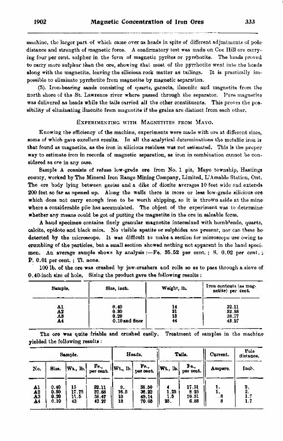
1902 Magnetic Concentration of Iron Ores 333
machine, the larger part of which came over as heads in spite of different adjustments of pole distance and strength of magnetic force. A confirmatory test was made on Coe Hill ore carrying four per cent, sulphur in the form of magnetic pyrites or pyrrhotite. The heads proved to carry more sulphur than the ore, showing that most of the pyrrhotite went into the heads along with the magnetite, leaving the silicious rock matter as tailings. It is practically impossible to eliminate pyrrhotite from magnetite by magnetic separation.
(3). Iron-bearing sands consisting of quartz, garnets, ilmenite and magnetite from the north shore of the St. Lawrence river where passed through the separator. Pure magnetite was delivered as heads while the tails carried all the other constituents. This proves the possibility of eliminating ilmenite from magnetite if the grains are distinct from each other.
EXPERIMENTING WITH MAGNETITES FROM MAYO.
Knowing the efficiency of the machine, experiments were made with ore at different sizes, some of which gave excellent results. In all the analytical determinations the metallic iron is that found as magnetite, as the iron in silicious residues was not estimated. This is the proper way to estimate iron in records of magnetic separation, as iron in combination cannot be considered as ore in any case.
Sample A consists of refuse low-grade ore from No. 1 pit, Mayo township, Hastings county, worked by The Mineral Iron Range Mining Company, Limited, L'Amable Station, Ont. The ore body lying between gneiss and a dike of diorite averages 10 feet wide and extends 200 feet so far as opened up. Along the walls there is more or less low-grade silicious ore which does not carry enough iron to be worth shipping, so it is thrown aside at the mine where a considerable pile has accumulated. The object of the experiment was to determine whether any means could be got of putting the magnetite in the ore in saleable form.
A hand specimen contains finely granular magnetite intermixed with hornblende, quartz, calcite, epidote and black mica. No visible apatite or sulphides are present, nor can these be detected by the microscope. It was difficult to make a section for microscope use owing to crumbling of the particles, but a small section showed nothing not apparent in the hand specimen. An average Bample shows by analysis:—Fe. 35.52 per cent. ; S. 0.02 per cent. \ P. 0.01 per cent. ; Ti. none.
100 lb. of the ore was crushed by jaw-crushers and rolls so as to paes through a sieve of 0.40-inch size of hole, Sizing the product gave the following results :
SAMPLE. SIZE, INCH. WEIGHT, LB. IRON CONTENTS (AS MAGNETITE) PER CENT.
AL 0 . 4 0 1 4 3 2 . 1 1 A 2 0 . 3 0 2 1 3 2 . 8 8 A 3 0 . 2 0 1 3 38 .77 A 4 0 . 1 0 AND FINER 44 43 .27
The ore was quite friable and crushed easily. Treatment of samples in the machine yielded the following results :
SAMPLE. HEADS. TAILS. CURRENT. POLE
DISTANCE.
NO. SIZE. WTU, LB. FE., | PER CENT. WT., LB. PER CENT. WT., LB. BE.,
PER CENT. AMPERE. INCH.
AL A 2 A 3 A 4
0 . 4 0 0 . 3 0 0 . 2 0 0 . 1 0
1 3 1 7 . 7 5 1 1 . 5 4 3
3 2 . 1 1 3 2 . 8 8 38 .47 43 .27
9 . 1 6 . 5 1 0 1 8
3 8 . 5 0 3 6 . 2 2 4 9 . 1 4 7 0 . 0 3
4 1 . 2 5 1.5
25 .
1 7 . 3 1 8 . 2 3
1 0 . 5 1 6 .88
1 . 1 .
.8 8
2 . 2 . 1 .7 1.7
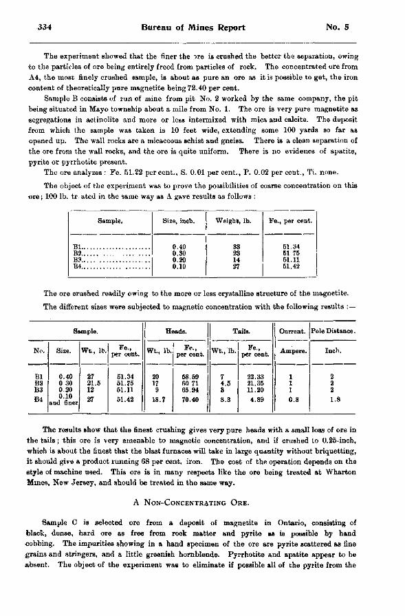
334 Bureau of Mines Report No. 5
The experiment showed that the finer the ^re is crushed the better the separation, owing to the particles of ore being entirely freed from particles of rock. The concentrated ore from A4, the most finely crushed sample, is about as pure an ore as it is possible to get, the iron •content of theoretically pure magnetite being 72.40 per cent.
Sample B consists of run of mine from pit No. 2 worked by the same company, the pit being situated in Mayo township about a mile from No. 1. The ore is very pure magnetite as segregations in actinolite and more or less intermixed with mica and calcite. The deposit from which the sample was taken is 10 feet wide, extending some 100 yards so far as opened up. The wall rocks are a micaceous schist and gneiss. There is a clean separation of the ore from the wall rocks, and the ore is quite uniform. There is no evidence of apatite, pyrite or pyrrhotite present.
The ore analyzes : Fe. 51.22 percent., S. 0.01 per cent., P. 0.02 per cent., Ti. none.
The object of the experiment was to prove the possibilities of coarse concentration on this ore; 100 lb. tr ated in the same way as A gave results as follows :
Sample. Size, inch. Weight, lb. Fe., per cent.
0.40 33 61.34 B2 0.30 23 51 76
0.20 14 51.11 B4 0.10 27 61.42
The ore crushed readily owing to the more or less crystalline structure of the magnetite.
The different sizes were subjected to magnetic concentration with the following results :—
Sample. Heads. Tails. Current. Pole Distance.
No. Size. Wt., lb. Fe., per cent. Wt., lb. Fe.,
per cent. Wt., lb. Fe., per cent. Ampere. Inch.
Bl B2 B3
0.40 0 30 0.20
27 21.6 12
51.34 51.75 51.11
20 17 9
68.69 60 71 65.94
7 4.5 3
22.33 21.35 11.20
1 1 1
2 2 2
B4 0.10 and finer 27 51.42 18.7 70.40 8.3 4.89 0.8 1.8
The results show that the finest crushing gives very pure heads with a small loss of ore in the tails; this ore is very amenable to magnetic concentration, and if crushed to 0.25-inch, which is about the finest that the blast furnaces will take in large quantity without briquetting, It should give a product running 68 per cent. iron. The cost of the operation depends on the style of machine used. This ore is in many respects like the ore being treated at Wharton Mmes, New Jersey, and should be treated in the same way.
A NON-CONCENTRATING ORE.
Sample C is selected ore from a deposit of magnetite in Ontario, consisting of black, dense, hard ore as free from rock matter and pyrite as is possible by hand •cobbing. The impurities showing in a hand specimen of the ore are pyrite scattered as fine grains and stringers, and a little greenish hornblende. Pyrrhotite and apatite appear to be absent. The object of the experiment was to eliminate if possible all of the pyrite from the
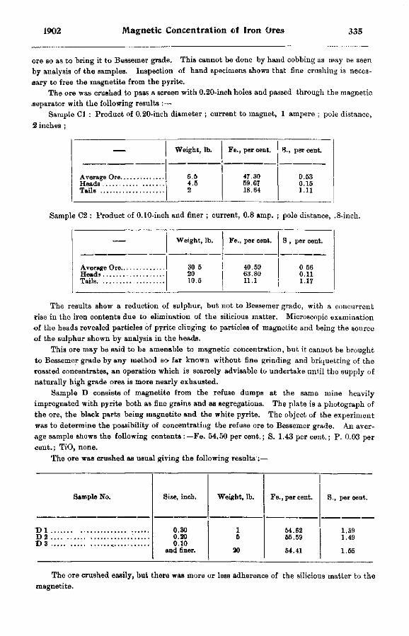
1902 Magnetic Concentration of Iron Ores 335
ore so as to bring it to Bessemer grade. This cannot be done by hand cobbing as may be seen by analysis of the samples. Inspection of hand specimens shows that fine crushing is necessary to free the magnetite from the pyrite.
The ore was crushed to pass a screen with 0.20-inch holes and passed through the magnetic .separator with the following results :—
Sample CI : Product of 0.20-inch diameter ; current to magnet, 1 ampere ; pole distance, 2 inches ;
— Weight, lb. Fe., per cent. S., per cent.
6.5 47.30 0.53 4.5 59.67 0.15
Tails 2 18.64 1.11
Sample C2 : Product of 0.10-inch and finer ; current, 0.8 amp. ; pole distance, .8-inch.
— Weight, lb. Fe., per cent. S , per cent.
30 5 40.59 0 56 20 63.80 0.11
Tails 10.5 11.1 1.17
The results show a reduction of sulphur, but not to Bessemer grade, w i t h a concurrent rise in the iron contents due to elimination of the silicious matter. Microscopic examination of the heads revealed particles of pyrite clinging to particles of magnetite and being t he source of the sulphur shown by analysis in the heads.
This ore may be said to be amenable to magnetic concentration, but i t c a n D o t be b r o u g h t
to Bessemer grade by any method so- far known without fine grinding and briquetting of the roasted concentrates, an operation which is scarcely advisable to undertake until the supply of naturally high grade ores is more nearly exhausted.
Sample D consists of magnetite from the refuse dumps at the same mine h e a v i l y
impregnated with pyrite both as fine grains and as segregations. The plate is a photograph of the ore, the black parts being magnetite and the white pyrite. The object of the experiment was to determine the possibility of concentrating the refuse ore to Bessemer grade. An average sample shows the following contents :—Fe. 54.50 per cent.; S. 1.43 per cent.; P. 0.03 per «ent.; TiO, none.
The ore was crushed as usual giving the following results :—
Sample No. Size, inch. Weight, lb. Fe., per cent. S., per cent.
0.30 1 54.62 1.S9 0.20 5 55.59 1.49 0.10
and finer. 20 54.41 1.55
The ore crushed easily, but there was more or less adherence of the silicious matter to the magnetite.
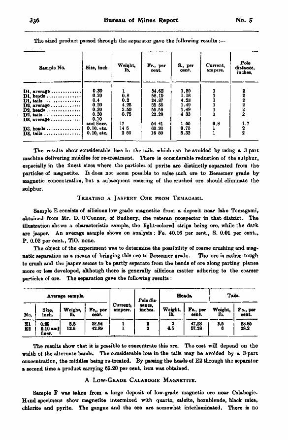
3 3 6 Bureau of Mines Report No. 5
The sized product passed through the separator gave the following results :—
Sample No. Size, inch. Weight, lb.
Fe., per cent.
S., per cent.
Cnrrent, ampere.
Pole distance, inches.
0.30 1 54.62 1.39 1 2 0.30 0.8 68.10 1.16 1 2 0.4 0.2 24.37 4.23 1 2 0.20 4.25 55 58 1.49 1 2 0.20 3.50 65.59 1.49 1 2 0.30 0.75 22.29 4 33 1 2 0.10
and finer. 17 54.41 1 66 0.8 1.7 0.10, etc. 14 6 63.20 0.75 1 2 0.10, etc. 2 50 16 80 6.33 1 2
The results show considerable loss in the tails which can be avoided by using a 3-part machine delivering middles for re-treatment. There is considerable reduction of the sulphur, especially in the finest sizes where the particles of pyrite are distinctly separated from the particles of magnetite. It does not seem possible to raise such ore to Bessemer grade by-magnetic concentration, but a subsequent roasting of the crushed ore should eliminate the sulphur.
TREATING A JASPERY ORE FROM TEMAGAMI.
Sample E consists of silicious low grade magnetite from a deposit near lake Temagami, obtained from Mr. D. O'Connor, of Sudbury, the veteran prospector in that district. The illustration shews a characteristic sample, the light-colored strips being ore, while the dark are jasper. An average sample shows on analysis : Fe. 40.16 per cent., S. 0.01 per cent.* P. 0.02 per cent., TiO. none.
The object of the experiment was to determine the possibility of coarse crushing and magnetic separation as a means of bringing this ore to Bessemer grade. The ore is rather tough to crush and the jasper seems to be partly separate from the bands of ore along parting planes more or less developed, although there is generally silicious matter adhering to the coarser particles of ore. The separation gave the following results :
Average sample. Pole dis
Headi. Tails.
No. Size, inch.
Weight, lb.
Fe„ per cent.
Current, ampere.
tance, inches. Weight,
lb. Fe., per
cent. Weight,
lb. Fe., per
cent. El " E2 0.20
0.10 and finer.
5.6 12.5
38.94 42.89
1 1
2 3
2 6.6
47.28 67.28
8.5 6
28.66 28.2
The results show that it is possible to concentrate this ore. The cost will depend on the width of the alternate bands. The considerable loss in the tails may be avoided by a 3-part concentration, the middles being re-treated. By passing the heads of E2 through the separator a second time a product carrying 65.20 per cent, iron was obtained.
A LOW-GRADE CALABOGIE MAGNETITE.
Sample F was taken from a large deposit of low-grade magnetic ore near Calabogie. Hnnd specimens show magnetite intermixed with quartz, calcite, hornblende, black mica, chlorite and pyrite. The gangue and the ore are somewhat interlaminated. There is no
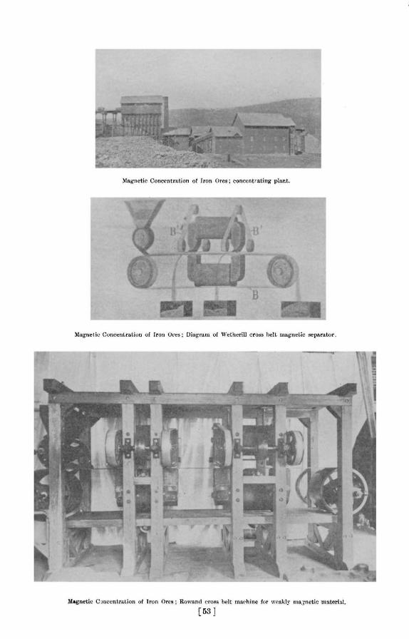

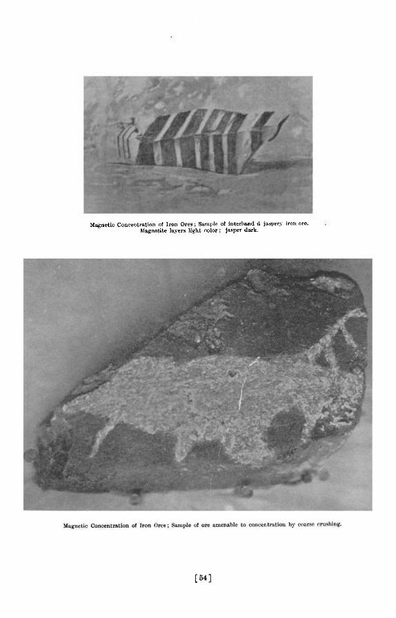
Magnetic Concentration of Iron Ores; Sample of interhand d jaspery iron ore. Magnetite layers light color ; jasper dark.

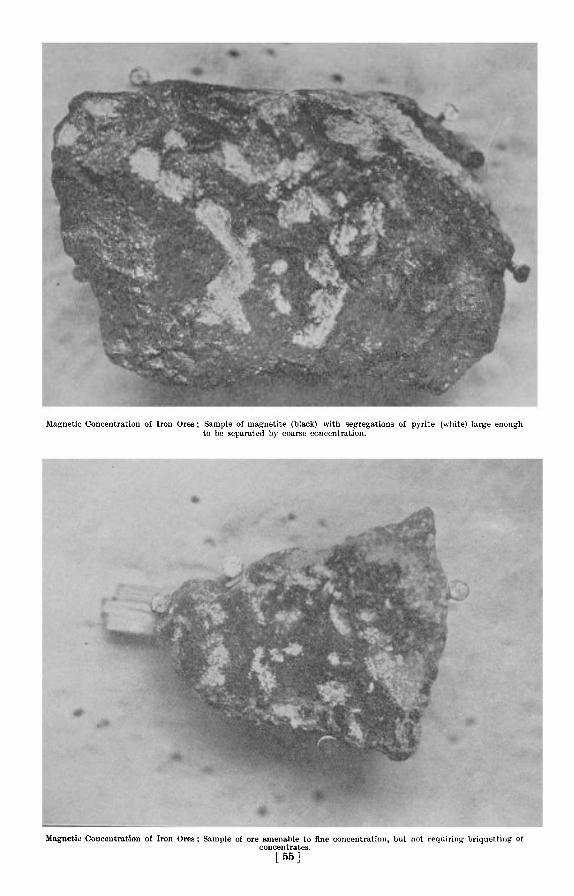
Magnetic Concentration of Iron Ores ; Sample of magnetite (black) with segregations of pyrite (white) large enough to be separated by coarse concentration.
Magnetic Concentration of Iron Ores; Sample of ore amenable to fine concentration, but not requiring briquetting of concentrates.
[ 5 5 j

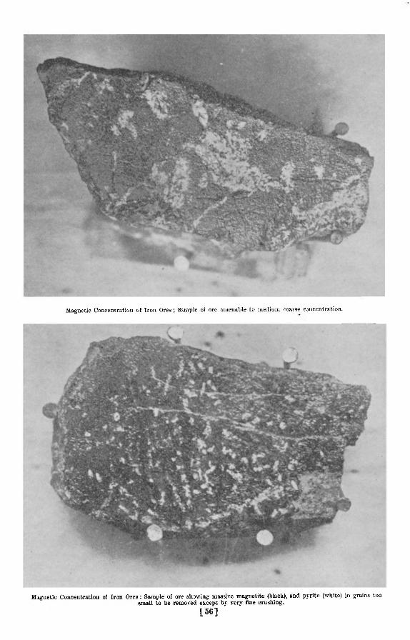
Magnetic Concentration of Iron Ores ; Sample of ore amenable to medium coarse concentration.
Magnetic Concentration of Iron Ores : Sample of ore showing massive magnetite (black), and pyrite (white) in grains too small to be removed except by very fine crushing.
156]

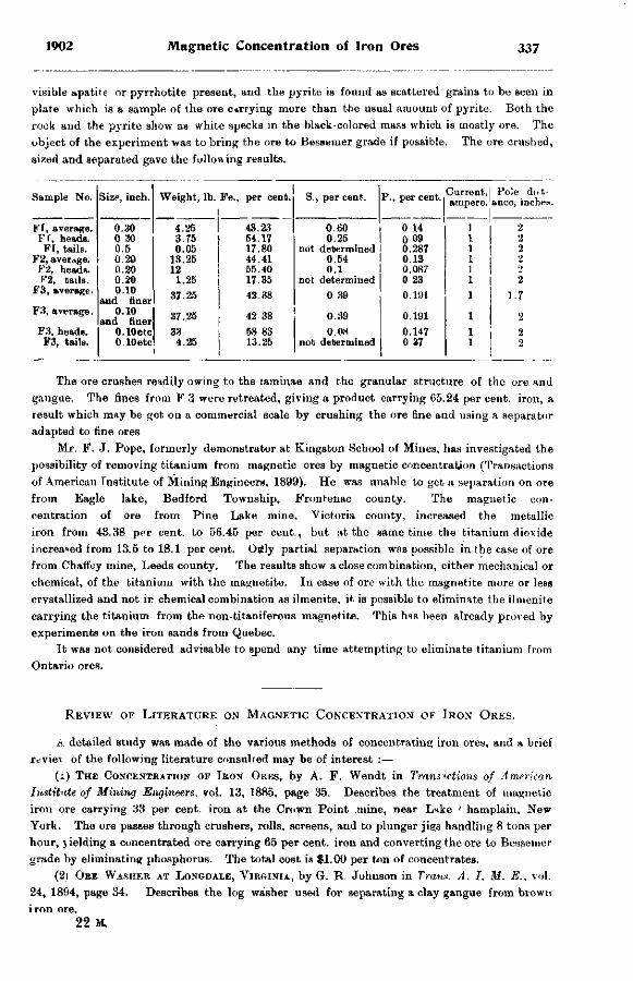
1902 Magnetic Concentration of Iron Ores 337
visible apatite or pyrrhotite present, and the pyrite is found as scattered grains to be seen in plate which is a sample of the ore currying more than the usual amount of pyrite. Both the rock and the pyrite show as white specks in the black-colored mass which is mostly ore. The object of the experiment was to bring the ore to Bessemer grade if possible. The ore crushed, sized and separated gave the following results.
Sample No. Size, inch. Weight, lb. Fe., per cent. S., per cent. P., per cent. Current, ampere.
Pole di»t-ance, inches
H'I, average. 0.30 4.25 43.23 0.60 0 14 1 I 2 Ff. heads. 0 30 3.T6 54.17 0.25 0 09 1 2 FI, tails. 0.5 0.05 17.80 not determined 0.287 1 2
F2, average. 0 20 13.25 44.41 0.54 0.13 2 F2, heads. 0.20 12 55.40 0.1 0.087 1 2
C2, tails. 0.20 1.25 17.35 not determined 0 23 1 2 F3, average. 0.10
and finer 37 25 42.38 0 39 0.191 1 1.7 F3, average. 0.10
and finer 37.25 42 38 0.39 0.191 1 2 F3, heads. O.lOetc 33 58 83 0.08 0.147 1 i 2
F3, tails. O.lOetc 4.25 13.25 not determined 0 37 1 2
The ore crushes readily owing to the laminae and the granular structure of the ore and gangue. The fines from F 3 were retreated, giving a product carrying 65.24 per cent, iron, a result which may be got on a commercial scale by crushing the ore fine and using a separator adapted to fine ores
Mr. F. J. Pope, formerly demonstrator at Kingston School of Mines, has investigated the possibility of removing titanium from magnetic ores by magnetic concentration (Transactions of American Institute of Mining Engineers, 1899). He was unable to get a separation on ore from Eagle lake, Bedford Township, Frontenac county. The magnetic concentration of ore from Pine Lake mine, Victoria county, increased the metallic iron from 43.38 per cent, to 56.45 per cent., but at the same time the titanium dioxide increa«ed from 13.5 to 18.1 per cent. Ogly partial separation was possible in the case of ore from Chaffey mine, Leeds county. The results show a close combination, either mechanical or chemical, of the titanium with the magnetite. In case of ore with the magnetite more or less crystallized and not in chemical combination as ilmenite, it is possible to eliminate the ilmenite carrying the titanium from the non-titaniferous magnetite. This has been already proved by experiments on the iron sands from Quebec.
It was not considered advisable to sjaend any time attempting to eliminate titanium from Ontario ores.
REVIEW OF LITERATURE ON MAGNETIC CONCENTRATION OF IRON ORES.
A detailed study was made of the various methods of concentrating iron ores, and a brief review of the following literature consulted may be of interest :—
( 1 ) THE CONCENTRATION OF IRON ORBS, by A. F. Wendt in Transactions of American Institute of Mining Engineers, vol. 13, 1885, page 35. Describes the treatment of magnetic iron ore carrying 33 per cent, iron at the Crown Point mine, near Lake 1 hamplain, New York. The ore passes through crushers, rolls, screens, and to plunger jigs handling 8 tons per hour, j ielding a concentrated ore carrying 65 per cent, iron and converting the ore to Bessemer grade by eliminating phosphorus. The total cost is $1.00 per ton of concentrates.
(2) ORE WASHER AT LONGDALE, VIRGINIA, by G. R. Johnson in Trans. A. I. M. E., vol. 24, 1894, page 34. Describes the log washer used for separating a clay gangue from brown iron ore.
22 M.
338 Bureau of Mines Report No. 5
(3) CONCENTRATING LAKE SUPERIOR ORE, by L . M . Hardenburgh, being a paper read before Lake Superior Mining Institute, Feb., 1900, and reprinted in Engineering and Mining Journal, April 21, 1900. Fragmental Pewabic hematite with specific gravity 4.5 occurring in sandstone of 2 6 sp. gr. is treated in Hartz jigs. The fragments of ore found in the sandstone vary from the size of a pea to 200 lb. weight. Twenty per cent, of the ore is saved by hand-serting ; capacity of the mill is 300 tons of crude ore per day ; 65 horse-power is required with 3 men and 8 boys per shift.
(4) CONCENTRATING MAGNETITE WITH THE CONKLING JIG, by F . S . Ruttmann in Trans. A. I. M. E., vol. 16, 1888, page 609. The ore, carrying about 35 per cent, iron, is crushed dry to 0.25-inch and treated in Conkling jigs each of 5 tons capacity per hour. A sample of stock carrying 43.5 per cent, iron was concentrated to 66 9 per cent, iron with 22.9 per cent, in the tails, showing a saving of 47.4 per cent, of iron in the ore. Cost of treatment not given.
(5) CONCENTRATING PLANT FOR HEMATITE IRON ORE AT STRIBERG MINE, SWEDEN, by E . Nordensten in Teknisk Tidshtift, vol. 32, page 29. The ore is jigged, giving a rich product. The mill, costing $44,000, treats 100 tons per day.
(6) WASHING IRON ORE IN TENNESSEE, by N. W . Buckhout in Mines and Minerals, vol. 22, page 304. A limonite iron ore is treated by 3 revolving screens and 2 log washers using 700 gallons of water per ton of ore.
(7) MAGNETIC ORE SEPARATION AT PITKARANTA, FINLAND, by G. Grondal in Oesterreich-ische Zeitschrift, Angust 10, 1901. Describes the magnetic separation of a low-grade magnetite carrying 30 per cent, magnetite, 4.5 per cent, sulphur, in the form of pyrite, pyrrhotite, zineblende and chalcopyrite. The gangue is a hard serpentine, and the grain of the ore is so fine chat 80 per cent, of the particles of magnetite are not more than 1 mm. diameter. The plant consists of Grondal ball-mills, Grondal magnetic separators, etc. The richest concentrates carry 68 per cent, iron and 0.18 per cent, sulphur, and are briquetted for use in the blast furnace. A description of the Grondal-Delwik method of magnetically concentrating iron ores is given in the same journal, February 4, 1899.
(8) MAGNETIC CONCENTRATION PLANT AT SVARTO ISLAND, by B. H. Brough in Journal of Society of Arts, London, Dec. 8, 1897. Describes the concentration of a magnetite with 2 per c e n t phosphorus as apatite. The ore is crushed, dried, pulverized and run through a Ball-Norton separator, delivering a high-grade ore, while the apatite is sold to make fertilizer.
(9) NOTES ON THE MAGNETIZATION AND CONCENTRATION OF IRON ORE, by W. B. Phillips n T>ans. A. I. M. E., vol. 25, 1895, page 399. The total cost of treating the ore was $1.15
per ton of concentrates. All the iron was not magnetized, and there was no elimination of phosphorus.
(10) THE CHASE MAGNETIC ORB SEPARATOR, by H. S . Chase in Trans. A. I. M. E., vol. 21, 1892, page 503. An illustrated account of the Chase separator.
(11) MAGNETIC CONCENTRATION AT TILLY FOSTER, by F . H. McDowell in Trans. A.I.M. E., Vol. 21, page 519. Gives iternB of cost of treating low grade magnetite. Fe. in the ore, 27.38 per cent.; Fe. in concentrates, 49.44 per cent.; Fe. in Tailings, 11.00 per cent.; Mill running 208.8 days ; ores used, 34,515 tons ; Concentrates made, 13,066 tons ; 1 ton of concentrates from 2.65 tons of crude ore ; total cost of 1 ton of concentrates, $1.99.
(12) THE GRANULATION OF IRON ORB BY MEANS OF CRUSHERS AND ROLLS, by A. Sahlin in Trans. A.I.M.E., vol. 21, 1892, page 521. Discusses various types of crushers and pulverizers used on iron ores. Fine grinders as ball-mills are of little value. A comparative test of crushers and rolls versus Sturtevant mills showed the former method to be preferable for granulating iron ores.
(13) CRUSHING IRON ORES WITH THE STURTEVANT MILL FOR CONCENTRATION, by S . R . Krom in Trans. A.I.M.E., vol. 21, 1892, page 530. Describes comparative results of crushing
1902 Magnetic Concentration of Iron Ores 339
magnetic iron with rolls versus Sturtevant mill, proving the rolls gave less dust than the mill, which grinds by attrition and hence is not adapted to granulating iron ore for concentration.
(14) PRACTICAL RESULTS IN THE MAGNETIC CONCENTRATION OP IRON ORE, by W . H. Hoffman in Trans. A.I.M.E., vol. 20, page 602. Relates practical experience at Croton mine. It cost $1.95 to produce 1 ton of concentrates from the low-grade iron ore including mining, and all other charges. The concentrates were roasted to eliminate sulphur. The crude ore carries 40 per cent, iron, 1.5 per cent, sulphur, 0.30 per cent, phosphorus. The Sturtevant mill was used for granulating the ore, and the claim is made that magnetic concentration of the ore is profitable.
(15) DISCUSSION ON THE CRUSHING OP IRON ORE, in Trans. A.I.M.E., vol. 21, page 533. Gives different views as to the granulation of iron ore.
(16) THE MAGNETIC SEPARATION OP IRON ORE, by C. M . Ball in Trans. A.I.M.E., vol. 25, page 533. Describes the advantages of concentrated iron ore, and seeks to prove that magnetic concentration is feasible under competitive conditions. Shows that the best way of concentrating is coarse crushing, and division into 3 grades with subsequent treatment of the middles. Describes the Ball-Norton separator giving results obtained at Benson mines, New York, thus :
Magnetite Fe. S. P. per cent. per cent. per cent. per cent.
45.5 32.15 1.00 0.15 Concentrates 88.5 64.0 0.21 0.032 Tails 4.0 2.90
(17) SOUTHERN MAGNETITES AND MAGNETIC SEPARATION, by H. S. Chase in Trans. A.I. M.E., vol. 25, 1895, page 551. Relates experimental work on magnetic concentration of ore at Cranberry mine, N . Carolina, with the following conclusions : (1) Careful washing, screening and sizing are more important than fine crushing. (2) Each size of material should be concentrated separately with suitable magnetic separators, giving concentrates of Bessemer grade carrying 50 to 60 per cent, iron, and coarse enough to be used as a furnace burden without mixing with other ores.
(18) THE WENSTROM MAGNETIC SEPARATOR, by R. A. Cook in Trans. A.I.M.E., vol. 17, page 599. Describes with illustrations the Wenstrom separator used in Sweden since 1885. The cost of concentrating runof-mine and refuse ore according to Swedish practice is said to be 10 cents per ton of crude ore.
(19). INVESTIGATION OP MAGNETIC IRON ORES PROM EASTERN ONTARIO, by F. J . Pope in Trans. A. I. M. E. vol. 29, page 372. Describes the results of experiments to eliminate titanium from titaniferous magnetites by magnetic concentration, showing that a separation is not always practicable, but that in some cases there is a partial removal of the titanium along with sulphur and phosphorus.
(20). THE CONCENTRATION OF IRON ORE, by J. Birkinbine and T. A. Edison in Trans. A. I. M. E. vol. 17, page 728. Relates the poor success of jigs in concentrating iron ores and describes five different types of magnetic concentrators with practical results of each, viz :— Buchanan, Wenstrom, Conkling, Monarch, Edison.
(21). THE BALL-NORTON ELECTRO-MAGNETIC SEPARATOR, by C. M. Ball in Trans. A. I. M. E., vol. 19, page 187. An illustrated description of the machine and its operation, with detailed records of excellent results obtained on different magnetic ores.
(22). MAGNETIC CONCENTRATION AT MICHIGAMME IRON MINE, MICHIGAN, by J. C. Fowle in Trans. A. I. M. E. vol. 19, 1890, page 62. Describes the method used for concentrating mine waste, screenings and wet fines, and gives scheme of crushing, rolling, and sizing bjr the
340 Bureau of Mines Report No. 5
Wenstrom and Buchanan magnetic separators. Tabular results with analyses are given, showing the cost of concentrating to be 2 2 cents per ton. Predicts the further use of this method of concentrating iron ores.
( 2 3 ) . ORE DRESSING BY ELECTRICITY AT THE TILLY FOSTER MINE, by F . H. McDowell in Trans. A . I. M. E. vol. 1 9 , 1 8 9 0 , page 7 1 . Describes results obtained by the Conkling magnetic separator. The total cost is $ 2 . 2 5 per ton of concentrates for a mill run of six months duration. I >oes not advise treatment of ore carrying less than 2 5 per cent. iron.
( 2 4 ) . PROGRESS IS MAGNETIC CONCENTRATION OF IRON ORB, by J. Birkinbine in Trans. A .
I . M . E . vol 1 9 , 1 8 9 0 , page 6 5 6 . An excellent review of results so far obtained, with costs estimated at 5 0 cents per ton, and sanguine hopes for the future of the process.
( 25 ) . HIGH GRADE IRPN ORES, by W. J. May in Colliery Guardian Aug. 1 2 , 1 8 9 8 . Discusses the necessity of dealing with low-grade iron ore deposits by concentrating them at the mine to a high metallic value.
( 2 6 ) . EDISON ORE MINES. An interview with T. A. Edison giving an account of the works and process employed in concentrating a very low-grade iron ore published in Iron Age, Oct. 2 8 , 1 8 9 7 .
( 2 7 ) . EDISON'S REVOLUTION IN IRON ORE MINING, by T. Waters in McClure's Magazine,
Nov., 1 8 9 7 . An illustrated acc >unt of the application of electricity to the separation of magnetic iron ore from rock matter.
( 2 8 ) . MAGNETIC PREPARATION OF ORES, by M. Smith. A paper read at the International Congress of Mining and Metallurgy at Paris, France. Extracts reprinted in Colliery Guardian
July 2 7 , 1 9 0 0 . Gives an illustrated account of the Wetherill process.
( 2 9 ) . RECENT PROGRESS IN THE WETHERILL SYSTEM OF MAGNETIC SEPARATION, by H. A. J. Wilkens in Mineral Industry, vol. 1 0 , 1 9 0 2 . Describes with illustrations the various machines used, with results on differeit material from actual mill experience.
( 3 0 ) . MAGNETIC CONCENTRATION OF IRON ORES. A general review of the progress made in Germany and America published in Stahl und Eisen, March 1 5 , 1 8 9 7 .
( 3 1 ) . MAGNETIC CONCENTRATION, by Dr. H. Wedding, read before the International Congress of Mines and Metallurgy, Paris, 1 9 0 0 . . Published in Bulletin de la Socie'te de I'Industrie
Minerale, series 3 , vol. 14 . 1 9 0 0 . An elaborate paper describing some 2 2 different forms of magnetic separators and the work each has done.
( 3 2 ) . THE HIBERNIA CONCENTRATING MILL, published in Iron Age, Aug. 3 , 1 8 9 3 . Describes operations at Hibernia mines by the Buchanan system.
( 3 3 ) . WETHERILL MAGNETIC SEPARATION PROCESS, by Prof. W. A. Anthony in Cassier's
Magazine, March, 1 8 9 8 , page 4 3 3 .
( 3 4 ) COMPARATIVE RESULTS OP WET JIGGING AND WETHKRILL MAGNETIC SEPARATOR, by S. Farbaky in Oesterreichische Zeitsehrift fur Berg und Hutlen wesen, March 2 6 , 1 8 9 8 . Describes results working on a hematite intermixed with quartz and carrying 2 8 per cent. iron. The results for the two processes are about the same.
( 3 5 ) MAGNETIC CONCENTRATION AT HIBERNIA MINE, NEW JERSEY, by F. W. E. Minder-man in Engineering and Mining Jourtial, vol. 7 3 , page 1 3 6 . Describes the Ball-Norton system in use at this mine.
( 3 6 ) NOTES ON IRON ORES OF CANADA, by T. S. Hunt in Geological Survey of Canada, Reports 1 K 6 6 - 6 9 . Describes magnetic separation of titaniferous iron ores, especially the iron sands on the north shore of river St, Lawrence.
1902 Magnetic Concentration of Iron Ores 341
( 3 7 ) STATIC ELECTRICITY APPLIED TO ORE DRESSING, by W . G. Swart in Engineering and Mining Journal, Jan. 2 4 , 1 9 0 3 . Describes the recently invented Blake-Morscher system of concentration, successful in treating zinc-lead ores in Colorado, and said to be applicable to iron ores.
( 3 8 ) THE GRANGESBERG IRON ORE MINES, SWEDEN, published in Iron and Coal Trades Review, London, Sept. 9 , 1 8 9 8 . Describes the occurrence of the ore, methods of working, separation, etc.
( 3 9 ) SOME FORMS OF MAGNETIC SEPARATORS AND THEIR APPLICATION, by H . C . McNeil 1
in Colliery Guardian, Aug. 1 8 , 1 8 9 9 . Describes with illustrations some of the magnetic concentration plants in Sweden.
( 4 0 ) PRACTICAL RESULTS AT DANNEMORA MINES, SWEDEN, USING WENSTROM SEPARATOR, published in Journal of Iron and Sted Institute, vol. 1 , 1 8 9 9 , page 2 4 3 , also vol. 2 , 1 8 9 0 , page 6 7 2 . Describes the satisfactory result obtained.
( 4 1 ) CONCENTRATING WORKS AT LULEA, SWEDEN, by B. H . Brough in Journal of Society of Arts, Dec. 1 0 , 1 8 9 7 . Describes the concentration works at Lulea, where some 1 0 0 , 0 0 0 tons of magnetic ore are concentrated to raise the iron contents and remove the apatite. Wenstrom and Wetherill machines are used.
( 4 2 ) THE DEVELOPMENT OF THE MAGNETIC SEPARATOR, by E. Languth in Zeitschrift fur Electro-chemie, Dec. 7 , 1 8 9 9 . The issue of this journal of April 5 , 1 9 0 0 , contains an article by the same author discussing the principles of electro-magnetic separation.
( 4 3 ) MAGNETIC CONCENTRATION OF THE FOLKMAR RED IRON ORE, by S . Farbaky in Oesterreichisehe Zeitschrift fur Berg und Sutten wesen, March 2 6 , 1 8 9 8 . Discusses the possibilities of concentrating the large body of ore by the Wetherill process with estimates of cost, etc.
( 4 4 ) MAGNETIC CONCENTRATION OF IRON ORE, by K. Erikson in Jernkonterets Annaler, vol. 5 7 , pages 1 - 6 4 . A full account of the subject of magnetic concentration.
( 4 5 ) THE FRODING MAGNETIC SEPARATOR. Described in Teknisk Tidschrift, vol. 3 2 , page 6 . This is a new magnetic separator in use at Herrang concentration works, Sweden. It costs $ 7 0 0 to build the machine which treats 2 tons of ore per hour, yielding from a crude ore with 2 5 per cent, iron, a concentrated product running 6 3 per cent, iron, the tailings carrying only 8 per cent. iron.
( 4 6 ) EXPERIMENTS ON CONCENTRATION OF IRON ORES, by F . G. Striberg in Bihang till Jernkonterets Annaler, 1 9 0 2 , pages 1 3 5 - 1 4 1 .
( 4 7 ) IRON ORE CONCENTRATION, by W. Peterson in Teknisk Tidschrift, vol. 3 2 , page 1 4 7 . Describes the development of the process in Sweden, and advocates the erection of a testing institution for ascertaining the most suitable methods of concentrating various kinds of iron ore.
( 4 8 ) THE USE OF MAGNETIC CONCENTRATES IN THE PORT HENRY BLAST FURNACES, by N. M. Langdon in Trans. A.I.M.E., vol. 2 0 , 1 8 9 1 , page 5 9 9 . Relates the experience of using magnetic concentrates in the blast furnace for two years. No more trouble was experienced than with lump ore. There is no difficulty in using concentrates up to 8 0 per cent, of the charge for the furnace, and the records show increased economy of fuel. A discussion on this subject is given in Trans. A.I.M.E., vol. 2 0 , page 5 7 5 , where ironmasters give their views. The concensus of opinion favors the use of concentrates.
(49 ) THE USE OF FINELY DIVIDED ORE, by J. Wilborg in Colliery Guardian, Aug. 1 8 , 1 8 9 9 . A paper read before the British Iron and Steel Institute, discussing the ways by which concentrated iron ore may be used.
342 Bureau of Mines Report No. 5
( 5 0 ) RUDOLPHS-LANDIN PROCESS FOR TREATING FINE ORES. Described in Journal of Chemical Society of Sweden, July, 1 9 0 1 . Describes a process of briquetting, etc.
( 5 1 ^ USE OF FINELY DIVIDED ORES IN BLAST FURNACES. The practice at Pittsburg, Pa. is givei, n Journal of Iron and Steel Institute, vol. 2 , 1 8 9 0 , page 7 3 . The German practice is given in the same journal, vol. 2 , 1 8 9 0 , page 4 9 .
( 5 2 ) ROASTING OF PULVERIZED IRON ORES AND MANTJFACTDKB OF BRIQUETTES, by T . Magnuson in Jernkonteretes Annaler, vol. 5 8 , page 2 5 5 - 2 8 8 .
( 5 3 ) PROCESS FOR SMELTING IRON ORE IN FINE STATE, by 0 . Daube in Engineering and Mining Journal, Oct. 4 , 1 9 0 2 . Finely divided ore'is mixed with coal dust and coked in a coking oven, producing a metallic sponge ready for the blast furnace. The coking takes 2 4 hours, the gases being used to heat the ovens, leaving a surplus.
( 5 4 ) THE NEW ADVANCES IN THE DEPARTMENT OF MAGNETIC SEPARATION, read by F . O. Schnelle at a meeting of the Association for the Advancement of Industry (German), October 6 , 1 9 0 2 . Describes the latest forms of the Wetherill separators and gives a discussion by German engineers.
INDEX.
PACK Aberdeen township iron formation 301, 315 Abitibi lake 5
Iron formations on 304, 317 Abitibi river, Bound lake to ; Paper by L. L
Bolton 173-190 Accidents, mining 42-48
Table of 48 Actdnolite 257, 272, 284, 292
Production of 26 Statistics of 12, 13
Adam», Dr 236 Adams mica mine .. 131 Adams mica trimming works 131 Aikman peat process 201 Akerman peat machine 199 Akikenda falls 161 A L 282 gold mine 81 Alabastine . . . 38 Alabastine Co., of Paris 38 Albany river .. 314 Algoma Central Railway Co 28, 62, 78 Algoma Commercial Co 77, 273 Algoma district iron ranges 304, 314 Algoma Steel Co 22 Allanhnrst graphite mine 26, 27, 132 Amherstbnrg Quarry Co 28 Amygdaloid 292 Amphibole 105, 318 Amphibolites 240, 318 Ancaster, Niagara limestone at 141 Anderson, August, accident to 47 Anderson township, iron formation 304, 315 Anglo-American Iron Co 332 Anglo-Canadian Gold Estates 15, 87 Anikojigami lake 181, 182, 189 Animikie formation 298, 310
Iron indication! in 304 Ankerite 284 Anorthosite 294 Anrep peat machine 199 Anthony, Prof. W. A 340 Anthracite, imports of .. 192
Value of, compared with peat 194, 195 Anthraxolite 239, 291 Apatite.. 105, 324, 326 Aplite 106 Archsean rocks 142, 172, 319 Archer, George 50 Archibald, John, accident to 46 Arkose 171, 238, 260, 289, 298 Arrow lake 20 Arsenic 273, 282
Investigations with 68 Production of 36 Statistics of 12, 13, 36
Arsenite of lead 69 Arsenite of iron 69 Asbestos. See Actinolite. Assay Office, Provincial; Report by J. Walter
Wells and A. G. Burrows 68 72 Laboratory determinations 70 Laboratory equipments and methods 71 Work done for Bureau of Mines 68 Work done for private parties 69
Assay Office, tests of peat fuel at 195 Atikokan iron range. 50,304, 306 Atlas Arsenic Co., gold mine 14, 36, 110 AubiDadoDg river 162, 165 Aubrey falls 161 Augite 107,170,189,293,295 298
Baden-Powell gold mine 93 Badger silver mine 96 Bain, J. Watson 3, 54 Baker Bros 29 Ball, C M 339 Ball-Norton concentrator 326, 339
page
[343]
Ballantyne, A 28 Barite . . . . 141 Barlow, Dr. A. E 235, 242, 278, 282, 298 Barnes, Thomas 28 Batchawana bay iron formation 304, 314 Battle, John, estate of 28, 31 Bauxite 70 Beachville quarries 148 Bear lake mica mine 156 Beaver 189 Beaver lake 161 Beaver silver mine 96 Beaverton peat bog 203
Plant at 224 Beohtel Bros 29 Bedford township, feldspar in 37, 138 Bella Donna lake . .160 Bell Bros 29 Bell, Dr 278, 284, 314 Belleville Portland Cement Co 33 Belleville Pottery Co 29 Belmont gold mine 14, 110 Benson mines, N.Y 339 Benzine, production of 39
Statistics of 12, 40 Bessemer matte 302
Analysis of 283 Bessemer steel plant, Sault Ste. Marie 22 B G 138, or Symmes gold location 86 B G 170 gold location 86 Big Jim iron location 114 Big Master gold mine 14, 91
Accident at 46 Big Mountain lake iron formation 304. 314 Btneomodai lake 174 Biotite 105, 169, 260, 295 Birkinbine, J 339, 340 Biscotasing 106, 157, 168 Bituminous coal, imports of 192
Value of compared with peat 1 4 Black Donald graphite mine 26. 132 Black Eagle Rold mine 14, 96
Summer mining class at 59 Black Fox silver mine 96 Blackinbon & Lewis 65 Black river 185, 187, 189 Black Sturgeon lake iron formation .. 304, 311 Blackwater river Blake-Morscher system 3:*0. 341 Blanche river 174, 180 Bian»hard Township, limestone in 51 Blast furnace, finely.divided ores in 330 Blast furnaces 22
Deseronto 22 Hamilton 22 Midland 22
Blezard nickel-copper mine 254, 286 Blue clay 154 Blueite 281 Blue lake 33. 273, 289, 89S Bolton, L. L., paper by, Round lake to Abi
tibi river 173-190 Bolton lake 185 Bonanza lake l*>p Bounties on pig iron 25 Bovd, D. G., Mining Inspector . . . ._.. 4
Report by, on Michipicoton Mining Division 6 2 ' 6 "
Boyer lake 60, 102 Brachiopoda _ .154, 186 Brant lake iron location 104 Breitnng iron mine 20 Breccia 173, 257 Brick, common, production of 2<
Statistics of 12, 13,27 Brick, paving, production of 27
Statistics of 12, 13
344 Index
PAGE Brick, pressed, production of 27
Statistics of 12, 13. 27 Briquettes, peat . . . 221
Oogt of production of 225 Briquetting fine ore 331 Briquetting machines for peat 122, 221
Cost of 225 Brock. Prof. R. W . . . 1 0 5 Brockville peat bog. 205 Brougb, B. H 338, 341 Brown Bros 29 Brace copper mines 98 Brute Harbor copper locations 63 Rrtmner peat bog 204 Bryozoa 141, 147, 154 Buchanan magnetic separator 326, 328 Ruckhout, N. W 338 T'nilding materials 27 Building stone v . . . . 27. 293
Production of 27 Statistics of 12,13, 28
Burrows, Alfred G., Provincial Assayer. . .4, 90 Appointment of 72 Report of, on Provincial Assay Office 68-72
Butler lake 184 Byrnes mica mine 129 Bytownite 293
Calabogie iron mine 115 Summer mining class at .. 55
Calcite 105, 106, 187. 189, 257, 860, 284, 291 Calcinm carbide. See Carbide of calcium. Caldwell, T. B 20 Cambrian formation 239 Cameron, W. M 28 Canada Corundum Co 37,135 Canada Iron Furnace Co 20, 22, 28 Canada Iron Furnace Co's iron mines. 113 Canadian Copper Co's nickel-copper mineB,
17, 98, 117, 284 Accidents at 44
Canadian Copper Co'a smelting works — 121 Quartz mine '. 12'
Canadian ttoldfields, Ltd., gold mine 14, 36 Canadian Mica Co 131 Canadian Northern railway — . 73
Gold properties on 81 Canadian Oil Refining Co 40 Canadian Peat Fuel Co 200 Canadian Pacific Railway Co 28 Canadian Portland Cement Co 28, 31, 32, 35 Canadian Salt Co 38 Cape Choy^ iron formation 304, 814 Carbide of Calcium, production of 36
Statistics of 12, 13. 37 Carbide works, Ottawa 140
Merriton 140 Carbon 239, 291 Carlow townshin, corundum in 37 Carlsbad twinning 105, 298 Carter & Kittermaster 38 Carter, W. E.H., Secretary of Bureau of Mines 4
Paper by on Peat fuel, its Manufacture and Use 191-234
Report of on Mines of Eastern Ontario. .108-140 Cassiterite.... 70, 284 Cayuga Lake Portland Cement Co 30 Cement. . ...- 29, 149
Condition of industry 34 Development of manufacture 31 Importations of 34 Plants building and project'd 32 Production of 29 Statistics of 12, 13 Table showing production 1891-1902 30
Chaffey iron mine 337 Chalcedony 291 Chalcopyrite 164, 187, 257, 280, 296
Chapleau station, iron formation near 304 Charcoal manufacturing plant 23 Charcoal, peat 197 Charlesworth, L.C., mining land agent 49 Chase, H. S 338,839 Chase magnetic separator 325, 338 Chateangay mines, N. Y 327 Cheekley, E J 200 Chemung formation 42 Chener, P., accident to 44 Cheney copper mine 165 Chert 141,319 Childs iron mine 114 Chlorite 106, 291 Christie, Henderson & Co 28 Clara Bell or No. 6 nickel-copper mine 267 Clark, J. M 50 Clay 241
Determination of at Assay Office 72 Products 27
Clay belt 187 Clay land, Eby township 179, 188 Clear lake 274 Clearwater lake 161 Clergue syndicate 311 Climate, Eby township 188 Climax, or Keystone silver mine 96 Coal 192,239
Determination of at Assay Office 72 Value of, compared with peat 194
Cobalt 283, 288 Cold blast pyrite smelting "302 Coe iron mine 115 Coke . 8 2 3
Determination of at Assay Office 72 Peat 197
Coleman, Dr. A. P 5, 169 Report of on Sudbury Nickel Deposits. .235-299
Coleman, T. F ; 38 Collingwood, steel works at 23 Colonial Portland Cement Co 34, 60 Companies incorporated in 1902 8 Concentration, magnetic of iron ores 322-342 Conglomerate 163, 175, 180, 239
Crush 245, 272,291 Greywacke 288, 290 Jasper ; 176
Conkling magnetic separator 325 Consolidated Copper Co's mine 116 Cook gold mine 14,110 Cook, R. A 339 Copper 17,172, 273,280
Determination of at Assay Office 71 Labor employed in mines 18 Production of 17, 288 ProFpects on Mississaga river . . . 165 Stati^icaof 12, 13, 17, 18
Copper arsenite 69 Copper Cliff, Methods of Metallurgy at ;
Paper by James Mo Arthur 299 303 Copper Cliff nickel-copper mine. 17, 118, 258, 284
Hmelters at 121 Summer mining class at 57
Copper mines 17, 97, 115,117, 284 Brul^ harbor locations 63 Bruce mines .. 98 Canadian Copper Co's minep 17, 98,117, 284
Blezard 254,286 Copper Cliff 17, 118, 258, 284 Clara Bell or No. 6 257 Creighton 17, 120, 243, 284 Ev»ni» 261, 284 Frood or No. 3 119, 263, 285 Ladv Maodonaldor No. 5 120, 257, 286 No. 2 .. 119. 285 No. 4 120, 285 Stobie 120,263,284
Cheney 165
Index
Copper mmes. —Continued. PAGE Consolidated Copper Co 116 Copper Queen 99 Cryderman location 256 Elsie 123, 249, 297 Gertrude 19, 122, 246, 287 Gonlais bay or Tecumseth Copper Cn's
location 101 Indian Lake... . 100 Kirkwood location 256 Lady Violet 249 Little 8t>bie 254 Mc<Jown 116 M ackenzie's & Mann's location 98 McMahon township location r 100 Maasey Station 18, 97, 98 Mount Nickel 254 Murray 251, 286 North Star 248 Hanson 100 Rock Lake 18, 99 Sqaaw Chute 100 Superior 18, 100 Taylor 100 Tecumseth Copper Co. or Goulais bay loca
tion 101 Tip-top. 18, 101 Vermilion 272 Victoria 17, 123, 268, 287 Whistle location 274 Wilcox 115 Worthington 272, 286
Copper mines, non-nickelif erous 18 Copper pyrites 162, 240, 245, 272, 297 Copper Queen copper mines 99 Cora gold location 80 Coralline limestone 143 Corals 143,148, 186 Cordova exploration syndicate I l l Cordova mines, summer mining class at . . . . 57 Corniferous formation 42, 142, 153 Cornndum 104, 135
Production of 37 Statistics of 12,13,37
Corundum mines 135 Craig 135 Ontario Corundum Co 135
Couchiching falls 187 Couture lake 83 Craig corundum mine 37, 135 Cramp Steel Co 23 Crawford Bros 29 Credit Forks Quarry Co. 28 Creighton nickel-copper mine 17, 120, 243
Accidents at . 44 Cryderman nickel-copper location 256 Cubanite 284 Gilbert, M. T 235 Curtis Bros 29
Dacre iron mine 114 Danish peat plant 198 Daube, Oscar 331, 342 Davis, John & Son 29 Dawson gold mine 84 Deer : 172 Deer lake 168 Deloro gold mine 108
Accidents at — 43 Summer mining school at. 66
Denbigh township, graphite in 26 Deroche township iron formation 304, 315 Deseronto blast furnace 22 Deseronto Iron Co Ltd 22 Desert lake iron formation 304, 31R Diabase 106, 175, 189, 241, 297, 298 Di&Uage 294 Diamond drills, Work with 50-68
Prospecting for iron ore with 304 Summary of boring operations 53
PAOK Dickson, A. A ^00 Dickson, C. W 282 Dickson peat press : 221 Diopside 105, 189 Diorite 175, 177, 187, 189, 248, 272, 311 Dohson, Alex 200 Dobson improved peat excavator 233 DobBon mechanical excavator 211 Dobson peat dryer 215 Dobson peat mechanical gatherer 234 Dobson peat p'ess 222 Dog lake iron formation. 304, 314 Dolomite 55, 106, 284 Dominion Mineral Co 286, 254 Dominion Peat Products, Limited 208, 223 Dominion Reduction Works OS Donnelly mxa mine 130 Don Valley brick works V-i Drainage of peat bogs 20!i Drain tile. See Tile, drain. Drills. See Diamond drills. Drnry township 236 Dryden iron formation 304, 30'.' Dry rock process of cement manufacture 3:i Dumfries, marl beds in 14!t Dunderiand Iron Ore Co. 331 Dynamite V J „ 75, 108
Eagle lake 337 East End Silver Mountain mine 96 Eastern Ontario, report on mines of, by W
E. H. Carter, mining inspector 108-Eby township
Mineral indications in Rocks of
Edison magnetic separator Edison, T. A 289, 339, Elbers, A. D Eldorado, or M. H. 267 gold mine Eleotro-magnet Elizabeth gold mine 15, Elliott, J Elsie nickel-copper mine 123, 249,
Accident at Emily gold mine 62. Emmons, Dr. S. H Empire Limestone Co Employees, protection of Empress gold mine England, GuBtavns, accident to English, O; B., analyses by English River Gold Mining Co's. mine. IE Enstatite Epidote 106, 189, 291, Epinette river Erikson, K Eruptive origin of Sudbury ore deposits Eruptive, nickel-bearing 276, 293, Evans nickel-copper mine. 261, Exeter Salt Co
Falconbridge township, drilling operations in Fanning, T Farhaky, S 340, Feldspar 105, 107, 171, 175, 189, 260,
Production of Statistics of 12,
Feldspar mineB Harris Pennsylvania Feldspar Co Richardson
Felsite Fife, A. T Finely divided ores Fire assays of samples from Savant lake Flaherty syndicate Flinn, P., accident to Flint W3 Flint lake gold mine
140 176 17!) 189 328 340 331 93
324 , 82
28 287 46
, 77 281 28 75 81 44 34
', 84 294 318 168 341 278 298 284 38
51 29
341 295 37
, 13 136 138 137 136 102
72 330 90
3U 43
145 94
346 Index
P A G B
Fluorite 246, 284 Flying Post 106
Iron formation north of 304 F M 207 gold location. 87 Folgerite 281 Foreign companies licensed in Ontario 8, 9 Forest fires 172, 179 Forget, Rowan k Daigle 86 Fossiliferous rocfce of Southwest Ontario;
Paper by Df. W. A. Parks 141-156 Beachville quarries 148 Borings at Stratford and Guelph — 150 Corals in Townsend and Walpole 142 Corniferous, a varied series 153 Fossiliferous beds of Hamilton formation.. 153 Gypsnm deposits in the Onondaga .. 147 Hamilton formation, exposures at Rock
Glen, etc 154 Kettle Point concretions 166 Lime* tone quarries at Hagersville 144 Lower Helderberg or water.lime formation 152 Marl beds in Dumfries 149 Niagara limestone at Ancaster 141 Oriskany and Lower Helderberg 146 Outcrops of the Corniferous 142 Quarrying in the Corniferous at St. Mary's 151
Fossils at Bolton lake 186 Foullon, Baron von 236 Fowke, Geo. W 51 Fowle, J. C 339 France, iron location €2, 104 Francis & Dixon's gold locations 1102-1105... 80 Franklinite 826 Frid, G. & Co 29 Froding magnetic separator 341 Frood, or No. 3 nickel-copper mine. .119, 263, 285 Fuel oils, production of 39
Statistics of 12, 40 Fuel, Peat, its Manufacture and Use; Paper
on by W. E. H. Carter 191-234 Furnaces, for nickel smelting 301
G19, or Imperial gold location 92 Gabbro 102, 240, 257, 272, 268, 296 Galaso, Araso, accident to 45 Galena 60, 83, 84, 177, 260, 282 Gangue 323 Garden river . . . . 166 Garnets 106, 296, 326 Gamier . . . . 236 Gas, production of. 39
Statistics of 12, 40 Peat . . . 228
Gasteropoda 147 General Electric Co 27, 129
Mica trimming works 132 Geneva lake 107 Geological Snrvey of Canada . 235, 236 Geology of Mississaga region 169 Gersdorffite 58, 272, 273, 282 Gertrude nickel-copper mine 19, 122, 246, 287
Smelter at. . . . 123 Giant, or HW74, 75, gold mine 92 Gibbons, Geo. C 50 Gibson mica mine • • • • 129 Glacial action 141, 183, 186, 241, 256 Gneiss 158, 169, 292, 298 Gold 14, 165
Determination of at Assay Office 71 Obtained fmm mispickel ore 36 Native in Sudbury nickel ores 272, 273 Panning for on Mississaga river 163 Production of 14 Statistic* of 12, 13, 14
Golden Eagle gold mine 93 Golden Horn gold mine 94 Golden Reef gold mine 94 Gold Mines of Eastern Ontario 14, 108
Atlas Arsenic Co 14. 110
Gold Mines of Eastern Ontario.—Con. P A C K
Belmont . . . . 14, 110 Canadian Goldfields Ltd 14 Cook 14, 110 Deloro 108 International 112
Gold Mines of Western Ontario 14, 76 A L 206 or Little Master 92 A L 282 81 Anglo-Canadian Gold Estates — 16, 87 Baden-Powell 93 B G 138 or Symmes location 86 B G 170 location 86 Big Master 14, 91 Black Eagle 14, S6 Cora location 80 Dawson. 83 Eldorado or M H 257 93 Elizabeth 16, 81 Emily 62, 77 Empress 81 English River Gold Mining Co 15, 84 Flint Lake 94 F M 207 location 87 Francis & Dixon's claims 1102—1105 80 G 19 or Imperial. 92 Giant or H W 74, 75 92 Golden Eagle 93 Golden Horn 94 Golden Reef 94 Gold Paoner 96 Grace (Eagle Lake district) 93 Grace (Michipicoton Div.) 15, 64, 78 H W 31 or Peninsular 92 H W 74, 75 or Giant 92 H W 686 or Martin location 86 H W 747 location 86 Imperial or G19 92 Indian Joe 94 Keenora Mining and Milling Co % Little Master or A L 206 92 Lloyda 64 Manxman 16, 64, 79 Mariposa location 65, 80 Martins or H W 686 location 86 M H 246 location 93 M H 257 or Eldorado location 93 Mikado H 95 National claim 92 Nino... 95 Northern Light MineB Co 93 Olympia 95 Ophir • 80 PeninsulaT or H W 31 92 Royal Sovereign 92 Sakoose 15 Savant lake placers 88 Scadding township 76 St. Anthony Reef 82 Sultana 14, 96 Summit Lake Mining Co 91 Sunrise location 65, 80 Symmes or B G 138 location 86 Twentieth Century 15, 92 United States Gold Mining Co 85 Vermilion River placers 90 Viking 93 Wendigo 96 White location 84
Cold Panner gold mine 96 Goodwin, Dr. W. L 3
Report of, on Summer Mining Schools 54-61 Goulais bay or Tecumseth copper location— 101 Gow, J 28 Grabau, Prof 154 Grace gold mine (Eagle Lake) 93 Grate gold mine (Michipicoton) 16, 64, 78
Summer mining class at 60 Graham, J. W 28 Grande Portage falls 165
Index 347
PAGE Grand Rapids, Mattagami river, iron for
mation 304, 317 Grand river, rock exposures on 147 Granite... .28, 88, 106,161, 169, 175, 240j 296, 298 Granite lake 38 Grano-diorite 170 Graphite 26,258, 284
Drilling for BO Production of 26 Statistics of 12, 13, 27
Graphite mines l»2 AUanhurst 26, 132 Black Donald 26, 132 McConnell 26, 50, 132
Graton, L. C 5 Paper by, Up and Down the Mississaga. 157-172
Grattan township, iron ore in 114 Gravel, panning for gold in 163
Post-glacial 142 Gravel river.. 163 Gray, Young & Sparling... 38 Great Lakes Copper Co 254 GreenBtone. ..174, 254, 257, 274, 291, 296, 309, 318 Green water lake 309 Grey & Bruce Portland Cement Co . . .31, 32, 35 Grey county, marl deposits of 31 Greywacke 175, 238, 260, 289, 298 Grondal-Delvik magnetic separator 329, 338 Ground Hog river 106
Iron belt 315 Guelph, borings at 150 Gull lake 167, 183 Gunflintlake 310 Gurd oil well 40 Gypsum . . . . . . 38
Deposits at Paris 147 Production of 38 Statistics of 12, 13
Hagersville, limestone quarries at 148 Halleflinta 238 Hamilton & Toronto Sewer Pipe Co 29 Hamilton blast furnace 22 Hamilton formation 42, 153 Hamilton mountain 141 Hamilton Steel & Iron Co .22, 115 Hanlan mica mine 27, 129 Hanover Portland Cement Co 30, 31, 35 Haroourt, F. Y 285 Hardenburgh, L. M 338 Harris feldspar mine '. 138 Harrison, H. B 51 Hastings county, arsenic deposits of 36 Hays, Montrose, aecident to 44 Heberli magnetic separator 325, 328 Helderberg, Lower, formation 146
Analysis of 152 Helena Mining Co 26 Helen iron mine 19, 63, 102
Accident at 47 Summer mining class at . 60
Hematite 19, 165,176, 307, 313 See also Iron Ore.
Hibernia mines, N. J 328, 340 Hill profiles, Mississaga region 158 Hodges peat process 201 Hodgins township, iron formation 304, 314 Hoffman magnetic separator 326 Hoffman, W. H 339 Holton, R 29 Hornblende.. 106, 107, 169, 189, 240, 272, 291,
292, 318 Hornstone 142 Hughes Bros. & Bangs 28 Humberstone township, limestone in 62 Hunt, Dr. Sterry 325, 340 Hunter's Island iron formation 304 Huronian formation 88,163, 171, 298
Huronian formation.—Con. page Contact of, with Laurentian 173, 293
Hutton township or Moose Mountain iron mine 20, 78, 102, 298
H W 31 or Peninsula gold mine 92 H W 74, 75 or Giant gold mine 92 H W 686 or Martin's gold location 86 H W 747 gold location 86 Hydraulic cement. See Cement. Hydronephelite 105 Hypersthene 189 Hypnum moss 204
Illuminating oil, production of 39 Statistics of 12, 40
Ilmenite 170, 190, 325, 333 Imperial Cement Co 30, 35 Imperial Oil Co 40 Imperial, or G 19 gold location 92 Indian lake copper mine 100 Indian Joe gold mine - . 94 Insecticides 69 International gold mine 112 International Gold and Copper Co 112 International Nickel Co 17, 258, 284, 287 Interstate Consolidated Mineral Co 91 Intrusive dikes 170 Iron lake iron location 104 Iron mines 102, 113
Big Jim location 114 Brant lake location 104 Breitung > 20 Calabogie H6 Canada Iron Furnace Co 113 Chaffey 337 Coe 115 Dacre 114 Frances location 62, 104 Helen 19, 63, 102, 298 Hutton township or Moose Mountain . .20,
73, 102, 298 Iron lake location 104 Josephine . . . . 20, 62, 104 Mineral Range Iron Mining Co 114
Child's, or No. 1 114 No. 3 H4 No. 4 115
Moore 20 Moose Mountain, or Hutton township
20, 73, 102, 298 Pa,ulison locations 20 Pine lake 337 Radnor 20, 113 St. Charles 20, 115
Iron mining fund, payments from for 1902... 25 Table showing total payments, 1896-1902.. 25
Iron ore 19 Analyses of 68 Bounties on 25 Deposits of, near lakes Wahnapitae and
Temagami 113 Deposits of, north of Kingston 113 Determination of, at Assay Office 72 Drilling for 50, 51 Hutton township iron ranges 318-321 Indications of, Eby township 179 IroD ranges of Northern Ontario 304-317 Magnetic concentration of 322-342 Production of 19 Prospecting for 20 Shipments of from Michipicoton Harbor .. 63 Statistics of 12, 13, 19
Iron pyrites 102, 251, 320 Deposit at Boyer lake 103 Production of 38 Statistics of _ 12, 13
Iron Ranges of Northern Ontario; Paper by Willet G. Miller 304-317
Algoma district 314 Ground Hog river iron belt 315
348 Index
Iron Ranges of N. Ont.—Con. P A G K
Woman river 317 On the Mattagami 317
Nipissing district 317 Rainy River district 306
Atikokan range 306 Limestone association of iron ore 307 Pyrite-bearing rocks, significance of 308 Steep Rock lake range 306
Thunder Bay district 309 Deposits on Pic river 313 Lake Nipigon ranges 3 lO Magnetite on Savant lake 313 Mattawin range 309 Mesabi extension. 309 Near Black Sturgeon lake 311 Other occurrences in distriot 314
Jack Lake Gold Mining Co. . . . Jamieson, J. A., Estate of Jarman pyrites mine Jarvis township iron formation. Janper
82 28
139 304, 314
9,175,179, 309 Conglomerate . . 176
Jaspery ore, treating 336 Jenkins, Chas 38 Joint stock mining companies 8
Table of, incorporated in 1902 8 Johnson, G. R 337 Josephine iron mine 20, 62, 104
Kaministiquia 309 Kapikokonaka lake 174 Karcona, Peter, accident to 47 Kawanaska river 184, 185
Falls on 186 Kawaweagoma, or Ronnd lake 167 Keenora Mining and Milling Co 96 Kekekwabik lake 18 . 184
f elly lake 240, 2*6 enogami basin, geology of . . . . 175
Kenogami lake 175 North west arm of 179
Kent Bros., mica trimming works 131 Keppel township, marl beds in 34 Keoaler magnetio separator 325 Kettle Point concretions 156 Keweenawan formation 298, 320 Keystone, or Climax silver mine 96 King & Mulligan 29 Kingston Feldspar and Mining Co. 38 Kirkwood nickel-copper location 256 Krom, S. R 338 Kuski, John, accident to 45
Laboratory, Provincial AssaT Office, determinations at 70,71
Fees of 72 Labor, in nickel and copper M I N E B 18 Labradorite 107, 294, 295 Laccolite 296 Laccoliths 240 Lacey mica mine 27, 126 Lady Macdonald island 258 Lady Macdonald, or No. 5 nickel-copper
mine 120, 257, 285 Lady Violet nickel-oopper mine 249 Lakefietd Portland Cement Co 30, 31, 36 Lake of the WoodB 171 Lake of the Woods gold region 93 Lake Superior Power Co 17, 28,29, 287
Sulphite works of 122 Lanark County Peat Fuel Co 204 Langdon, N. M 341 Languth, E 341 Lands sold and leased 10 Larmond, Peter, accident to 47 Laurentian formation 168, 160, 293, 298
Contact of, with Hnronian 173, 293
P A C E
Laxton township, molybdenite in 25 Lead, determination of, in Assay Office 71 Leases of mining lands 10 Legault, George, accident to 44 Leith, Dr. C. K 5. 21
Paper by on Moose Mt. Iron Range 318-3 il Leucoxene 169, 281 Levack township 236 Licenses, mining,list of,in Michipicoton Div 65-67 Lime ....149, 151
Production of 27,28 Statistics of 12, 13, 27
LimeBtone . . . . . 28, 61,133 Associations of with iron ore 307 Coralline 143 Corniferous 142,151 Crystalline 142, 306 Determination of at Assay Office 72 Hagersville quarries 144 Niagara . 141 Ht. Mary's qnarrie" 151 Stony Point and Thedford, analyses of.... 166
Limonite 169. 306 Literature on magnetic concentration of iron
ores, review of .337-342 Lithographic stone 146 Little Long lake iron range 304 Little Master or A L 206 gold mine 92 Little Pic river iron formation 304, 313 Little Pike lake iron formation 304, 314 Little Pine lake iron formation 304, 314 Little Stobie nickel-copper mine 264 Lloyd, E. B., land and timber estimator 173 Lloyd lake 184 Lloyda gold mine 64 Logan, J 29 Longford Quarry Co 28 Long, Harry, accident to 43 Loon lake, iron ore at 304, 310 Lount township, iron ore in 50 Lower Helderberg. See Helderberg, Lower. Lubricating oil, production of 39
Statistics of 12, 40
McArthur, James ; Paper by, on Methods of Metallurgy at Copper Cliff 299-303
McClatchey mica mine 127 McConnell graphite mine 26, 60, 132 McDonnell, Rinaldo 60 McDowell, F . H 338,340 Moliown copper mine 116 McHugh, Thomas, accident to 45 McKellar iron deposit 306 Mackenzie & Mann's copper location 98 McKim township 238 McLaren's mica mine 128 McMahon township copper location 100 McNab lake 31 McNeill, H. C 341
Madoc Mining Co 38, 139 Magnetic Concentration of Iron Ores ; Paper
on by J. Walter Wells 322-342 Ball-Norton drum machine *26 Conveying-belt separators, types of 325 Drum separators 328 Edison stationary magnet separator 328 Finely divided ores in blast furnace 330 Grondal-Delvik separator 329 Jaspery ore from Temagami, treating 336 Literature on magnetic concentration 8<7 Trial on low-grade magnetite . 336 Magnetic concentration, opportunities for.. 332 Magnetic vs. water concentration 324 Magnetites from Mayo, experimenting with 333 Methods of concentration 323 Non-concentrating ore 334
Index 349
Magnetic Concentration.—Con. P A G K
Present status of concentration 325 Reasons for concentration 322 Smelting finely concentrated ores of Europe 331 What is concentration ? 322
Magnetite. .19, 50, 90, 105, 113, 176, 281, 299, Ste also Iron Ore. 313, 318, 333
Magnuson, T 342 Manhes matte 283 MallochlaVe 184 Waloney, J., & Co 28 Manitou lake gold area 91 Manitoulin and North Shore railway 73, 237 Manxman gold mine 15, 64, 79 M areas ite 281 Marion lake . 106 Mariposa gold location 65. 80 Marl .. 149
Determination of at Assay Office 72 Marlbank . 31 Marshall's Mills, rock exposures at 155 Martha mica mine • • 128 Martin's or H W 686 gold location 86 Mason, C 29 Massagamashine lake 296 Massey Station copper mine 18, 97, 98 Matagaming lake _ 106 Mattagami river, iron formation on 317 Mattawin iron range 304, 309 Matte, nickel 302 Mayo, experiments with magnetite from.... 333 Maj, W. .T 340 Merkley Bros 29 Merrifield peat-gas generator 228
Analysis of gas 232 Cost of plant : 231 Quality of gas 229
Merritton carbide works 140 Mesabi iron formation 20, 320
Extension of 310 Metabasdt 318 Metallic products, statistics of . . . 12, 13 Metallurgy Methods of, at Copper Cliff 299, 303 Methods of Metallurgy at Copper Cliff; Paper
on, by .fameB McArthur 299, 303 Mining the ore 300 Pyritic smelting 302 Roasting out the sulphnr °00 Smelting the roasted ore 301
M H 246 eolrl location 93 M H 257, or Eldorado gold location 93 Mica 105,291
Production of 27 Statistics of 12, IS
Mica grinding works 132 Mica Manufacturing Co -.128, 131 Mica mines 125
Adams . . . . 131 Bear Lake 126 Ryrne'» 129 Donnelly 130 Gibson's 129 Hanlan 27, 129 Lacev 27, 126 McClatchey 127 vfcLaren's 128 Martha 128 Noble's Bay 130 Pike Lake 128 Raymond 126 Stoness 127
Micanite 126 Mica Trimming Works , 131
Adams' 131 General Electric Co 132 Kent Bros 131 Munsell, E. & Co 131 Ottawa Mica Mining Co 181 Sile«-Eddy Mica Co 181 Trousdale 131
Mica Trimrring Works.—Con. P A G E
Wallingford Bros 131 Webster & Co . _ 131
Michigamme iron mine, Mich 328, 339 Michipicoton gold mines • 78, 80 Michipicoton Harbor, shipments of iron ore
from 63 Michipocoton iron ranges 304, 314 Michtpncoton Miaing Division, Report by D.
G. Boyd, Mining Inspector 62, 67 Brule1 Harbor copper locations 63 Emily gold mine 62 Grace gold mine 64 Helen iron mine 63 Josephine iron mine 62 Licensees, list of 65 Lloyda gold mine 64 Manxman gold mine 64 Work on other locations 65
Mickle, G. R 280, 281 Microcline 37, 105, 169, 294 Micro-granite 291 Micro-pegmatite 106, 295, 296, 298 Micro-rerthite 105 Midland blast furnace 22 Minderman, F. W. E 340 Mikado gold mine . 14, 95
Hummer Mining Class at 59 Miller, Prof. W. G , Provincial Geologist. .4, 6
Paper by, on Iron Ranges of Northern Ontario 304-317
Report on mines of Northwestern Ontario. 73-107 Millerite 281 Milton Pressed Brick Oo 29 Mineral production, summary of, 1902 12
From 1898 to 1902.. 13 Mineral Range iron mines 20, 114 Mineral Range Mining Co . . . 20, 114, 333 M'ner's licenses 62
List of in Michipicoton Division 65-67 Mines Act 73
Mines of Eastern Ontario, Report on by W. E. H. Carter, Mining Inspector. .108 140
Copper mines . . . 115 Consolidated Copper Co 116 MoGown 116 Wilcox 116
Corundum mines 135 Feldspar mines 136 Gold mines 108
Atlag Arsenic Co 108 Belmont I l l Cook 110 Deloro. 108 International .. 112
Graphite mines 132 Iron mines 113
Calabogie 115 Canada Iron Furnace Co 113 Coe . 115 Mineral Range Iron Mining Co 114 St. Charles 115
Jarman pyrites mine 139 Mica grinding works 132 Mica mines . 125 Mica trimming works 131 Ntokel-cipper mines 1'7
Canadian Copper Co 117 Elsie . . . . 1 « Gertrude 122 Victoria 123
Ottawa carbide works 140 Richardson zinc mine 139
Mines of Northwestern Ontario, Report on by Prof. Willet G. Miller 73-107 Accidents, protection against 75 Copper mines 97
Bruce Mines 98 Copper Queen • • 99 Uoulais bay 101
350 Index
Mines of Northwestern Ontario.—Con. PAGE Indian lake 100 McMahon township 100 Massey Station 97 Ranson 100 Rock lake 99 Squaw chute 100 Superior 100 Taylor 100 Tip-top 101
Gold miueB . . 76 Emily 77 Empress 81 Gold properties on Canadian Northern 81 Lake of the Woods region 93 Lake Manitoba gold area — 91 Michipicoton mines 78 Ophir . . . . 80 Savant lake placers 88 Scadding township 76 Sturgeon lake region 82
Increase in mining activity 75 Iron mines 102
Helen 102 Newer Michipicoton iron properties 103
Railway building in mining districts 73 Rocks, Notes on 104-
Biscotasing to Flying Post 106 Nepheline syenite 104 St. Anthony's Reef 105 Other localities 107
Silver mines 96 West End silver mine 97
Mining accidents 42-48, 75 Table of .. 48
Mining, American investments in . . . . . . . 74 Companies incorporated in 1902 8 Increased activity in 75,108
Mining land agencies 49 Mining lands sold and leased 10 Minissinaqua, or Peninsula lake 160, 167 MisBissaga, Up and Down the; Paper by L.C.
Graton 167-172 Molybdenite 55
Production of 25 Statistics of 12. 13
Mond Nickel Co 17, 287 Moore iron mine . . . .20, 113
Accident at 47 Moose 189 Moose lake 273 Moose Mountain, or Hutton township iron
mine 20, 78, 102, 298 Moose Mountain Iron Range; Paper by C. K,
Leith 818 321 Geological features 818 Vermilion iron district, comparison with.. 319 Possible origin of ore 320
Morley & Ashbridge 29 Morrison, Peter, accident to 46 Monnt Nickel Co's nickel-copper mine 264 Munsell, E. & Co., mica trimming works 131 Murray, Alex 169 Murray nickel-copper mine 251, 286 Muscovite r 169 Musipomigut lake. See Savant lake.
Naphtha, production of 39 Statistics of 12, 40
National gold claim 92 National Mica Grinding Co , works 132 National Portland Cenv^t Co 32, 36 Natural gas, production 38
Export of, stopped 39 Statistics of 12,13,89 Taxation of companies 39
Nanghton station 235 Nautiloids 162 Neal, Thomas, accident to 48 Neil, Robert, accident to 46
PAGE Nepheline 104 Newington peat bog *208 Newington peat plant 223 New, or Upper Green lake 157, 167 Niagara limestone 141 Niccolite 58 Nickel, determination of at Assay Office 72
Labor employed in mines 18 Production of 17, 288 Statistics of 12, 13. 17 Sudbury deposits, report on 235-2S9
Nickel lake % . . . 275, 309 Nickel i te 272, 273, 282 Nickel mines 17, .17, 284
Canadian Copper Co's mines 17, 98, 117, 284 Blezard 254, 286 Copper Cliff 17, 118, 258, 284 Clara Bell, or No. 6 257 Creighton 17, 120, 243, 284 Evans 261, 284 Frood, or No. 3 119, 263, 285 Lady Macdonald, or No. 5 120, 257, 285 No 2 119, 286 No. 4 120, 285 Stobie 120, 263, 284
Cryderman location 256 Elsie 123, 249, 287 Gertrude 19, 122, 246, 287 Kirkwcod location 256 Lady Violet 249 Little Stobie 264 Mount Nickel 254 Murray 251, 286 North Star 248 Vermi l ion 272 Victoria 17, 123, 268, 287 Whistle location 274 Worthington 272, 286
Nickel oxide 298 Nickel Range railway 73 Nine-mile lake 87 Nino gold mine 96 Nipigon lake iron range 804, 310 Nipissing district iron formations .. 304, 317 Niven, Alex., O. L. S 5
Surveying party in charge of 157 Noble's Bay mica mine 130 Non-concentrating iron ore 334 Non-metallic products, statistics of 12, 13
Additions to list of 13 Noawatinose lake 311 Nordensten, E 338 Norite 240, 273, 293, 294, 398 Norite band, features of 276
Extent of 242 Southeastern offshoot of 256
North Bluff silver mine 96 North Elmsley township, graphite in 26, 50 Northern Light Mines Co 93 Northern nickel range 273 Northern Ontario, iron ranges of 304-317 North Star nickel-oopper mine 248 Northwestern Ontario, Mines of ; Report by
Prof. Willet G. Miller 73-107 Norway, peat industries of ." 196
Obabica river. See Aubinadong river. O'Connor, D. 20 Odnll Bros 29 Olden township, zino ore in 25, 139 Old Green lake 160, 167 Oligoclase • 291 Oliver's Ferry 134 Olivine 241, 297, 298 Ollmann, Mrs. H 29 Olympia gold mine 96 Onandaga formation 147 Ontario Brick Co , 29 Ontario Corundum Co 37, 135
Index 351
PAGE Ontario Graphite Co 26 Ontario People's Salt and Soda Co 38 Ontario Portland Cement Co 33, 149 Ontario Sewer Pipe Co '29 Ontario Smelting works 19. 121
Accident at 44 Opeepeesway lake 317 Opbir gold mine 80 Opimika narrows, iron formation near 304 Orford refioery 285 Oriskany formation 145 Ornamental stone 142 Orthoclase 106, 169, 284 Osborne, Chase S 21 Ottawa Brick Co 29 Ottawa Carbide Co 36, 140 Ottawa Mica Manufacturing Co.'s trimming
works 131 Otter Cove iron formation 301, 314 Otter lake 159 Output. See Mineral production. Owen Sound Portland Cement Co 30, 32, 35 Orford furnace, N. J 830 Paekham, James 29 Paget. John 51 Paraffin wax and candles, production of 89
8tati-tics of 12, 40 Paris green 68
Constituents of 69 Paristone 38 Parkhill Salt Co 38 Parks, Dr. W. A. 5, 311
Paper by, on FossihferouB Rocks of Southwest Ontario 141-156
Parks lake 104 Parry Sound copper district 115 Partridge-crop lake 174 Payne magnetic separator 325 PauliSon iron location 20 Paving brick. —See Brick, Paving. Pears, J 29 Peat bog 4, 179, 202 Peat gas 228 Peat fuel, its Manufacture and Use; Paper on,
by W. E. H. Carter 191-284 Briquettes, plant for making 221
Dickson press 221 Dobson press 222 Newington plant 223 Power generation and distribution 224 Cost of 225
Comparison with coal 193 Dobson's new peat machines 233
Improved excavator 233 Mechanical gatherer. 254
European methods of manufacture 197 Cut peat 197 DaniBh peat plant 198 Machine peat 197 Mills for machine peat 198
Manufacture in Ontario . . 200 Peat bogs and plants in Ontario 202
Analysis of our peats 202 Beaverton bog 203 Brockville bog 205 Brnnner bog 204 Newington bog 208 Perth bog. 204 Rondeau b >g 206 Rondeau peat works 206 Welland bog 203
Peat ?as 228 Andy sis of 232 Cost of gas plant 231 Merrifield gas generator 228 Quality of Merrifield gas 229
PI iO<i of, among fuels 194 Price .' 196
Pe<»t tnel.—Con. p a g e Process of making peat fuel 208
Air-drying 212 Clearing surface 210 Disintegrating and drying 214 Ditching a dry bog 209 Dobson mechanical excavator 211 Dobson peat dryer 215 Drying by pressure not successful 219 Harvesting peat at Welland 211 Laying down tramways 21C Simpson peat dryer 218 Wet and dry bogs 209
Progress of industry 201 Special apparatus for burning 226 Sulphur in Ontario peat 233 Test, at Assay Office 195 Use of, in Europe 193
Peat Industries, Ltd 206,205 Peat Machinery Supply Co 200 Pegmatite 136, 161 Peofield, Prof 281 Peninsula lake . . . . 160, 167 Peninsular, or H W 31 gold mine 92 Pennsylvania Feldspar Co.'s mine 137 Pennsylvania Mining Co 38 Penlandite 281 Perknite 318 Perth peat bog 204 Peterson, W .. 341 Petrographical notes, on Sudbury nickel
deposits 289 Petrography of Mississaga region 169 Petroleum, production of 39
Statistics of 12, 13, 40 Petroleum products, output of 39
Statistics of 12, 13, 40 Phillips, W. B 338 Pio river iron formation 304, 306 Pig iron 22
Bounties on 25 Production of 22, 322 Statistics of 12, 13, 22 Table showing growth of industry 1896-1902. 22
Pike lake mica mine 128 Pike river 187 Pine lake iron mine 337 Pipe, sewer 29 Plagioclase 106, 169, 175, 263, 291, 293 PlatHum 272, 280, 282
Determination of at Assay Office 72 Pleistocene deposits 241 Pleochroism 292 Plutonic origin of nickel deposits 280 Polydymite 281, 283 Ponsford and Freek 29 Pope, F. J 337, 339 Porcupine silver mine . .. 96 Porphyrite 239, 272,297 , 311 Porphyry 83, 89, 311 Portage formation 42 Port Arthur, Duluth & Western Railway... 310 Portland cement. See Cemeot. Port Henry N. Y., furnaces 330, 341
Mines 326 Pottery 165
Production of 29 Statistics of 12, 13, 29
Price, John 29 Provincial Natural Gas and Fuel Co 39 Pnlpwood . . . 187 Pyrite 83, 84, 105, 176, 177, 274, 308, 324 Pyrite-bearing rocks, significance of 308 Pyrites, Jarman mine 139 Pyritic smelting 302 Pyrolusite 60 Pyroxene 130,189, 295 Pyrrhotite 240-246, 257, 272, 280, 295, 296
Quarries 141
352 Index
Quarries.—Con. PAGE Beachville 148 Hagersville 144 Limestone 141, 143, 144 St. Mary's 151
Quartz 5t. 83, 84, 177, 260, 284, 293 Quartz mine, Copper Cliff 121 Quartzite 164, 238, 272, 298r 3)9 Quartz-porphyrite 106 Qvaeenston Quarry Co |28
Babbit Junior silver mine . . 96 Rabbit silvermine 96 Radnor iron mine 20. 113
Accident at . 47 Raglan township, corundum in 37 Railway building in mining districts 73 Rainy lake •• 171 Rainy River district, Iron Ranges of .. .304, 306 Raleigh oil field 40 Ramsay lake 290, 296 Ransford, R. & J 38 Ranson copper mine 100 Rapid river 160 Rat Portage 59 Rat Portage mining land agency 49 Anttladge, R 29 Raven lake . . . 32 Raven Lake Portland Cement Co 32 Raymond mica mini 126 Red lake iron formation 304 Reid, Gr. C , Assistant, Prov. Assay office... 72 Revenue, from mining lands 1891-1902 10
From natural gas 39 Richardson feldspar mine 136 Richardson zinc mine 139 Ritchie, S. J .332 Roasting nickel ore 300 Robertson, 1>. & Co 28 Robillard, H. & Son 28 Robinson Geo., accident to 46 Rockford, rook exposures at 148 Rock Glen, tc ck exposures at 154 Rock lake and Algoma railway 73 Rock lake copper mine 18, 99
Summer mining cl >»ses at . 61 Rocks, fossiliferous, of southwest Ontario .1-156 Rocks, of Northwest Ontario 104
Eby townships '77 Round lake to Abitibi river 189 Sedimentary, near Sudbury 238
Roofing c-ment.. 26 Roudeau peat bog 206 Roudean peat works 206 Round lake 167 Round lake to Abitibi river ; Paper by L. L.
Bolton 173-190 Anikojigami lake 182 Black river 185 Black river to Abitibi river 187 blanche river above Round lake 174
Above lake Kenogami 180 Blanche river to White Clay river 183 Eby township...... 176
Mineral indications i n . . . . . . . . . . 17t* Jasper conglomerate with iron ore . . . 176 Keiogami basin, geology of 175 Kenogami lake 175
Northwest arm of 179 Laurentian and Huronian, contact of 178 Partridge-crop lake 174 Pulpwood forests 187 Rocks, notes on 189 Round lake 173 Seskinaka lake to Anikojigami lake 181 Summary 188 White Clay river 185 Wilson's landing to Round lake 173
Royal Sovereign gold mine 92 Rowand magnetic separator 325
PAGE Rubble 145 Ruby lake iron formation 304 Rudolphs-Landin process 342 Rutherburgh, M 331 Bundle, Mr., surveying party 161 Ruttmann, F. S 338 Ryan, T. J., mining land agent 49
Sahlin, A 338 Sakoose gold mine 15 Sales of mining lands 10 Salt, production of .. 38
Statistics of 12,13, S8 Sandstone 144, 291, 298 Sandy plains, Eby township 177 Sanford, ph, accident to — 47 Sarminer .Jmil, accident to 45 SarniaS«..t Co 38 Sault Prospecting and Development Co.. 99 Sanlt Ste Marie, Bessemer steel plant at 22 Saussurite 176, 189 Sautter magnetic separator 325 Savant lake 4, 87 Savant lake iron formation 304, 313 Savant lake placers 88
Assays of sand and gravel from 90 Scadding township gold mine 76 Schist 83, 89,102, 289, 289, 291, 298; 318 Schlater, J 28 Sedimentary rocks near Sudbury 238 Segregation, theory of 278 Seine bay iron formation 304 Selwyn lake 274 Serpentine 291 Sesekinaka lake 181 Seven Mile lake. 166, 167 Sewer pipe, production of 29
Statistics of ..12, 18, 29 Shale 147, 155
Bituminous, analysis of 15'< Shallow lake 31 Shallow river 187 Shea, T 28 Shimer, Prof 164 Shining Tree lake iron formation 804, 317 Shuttlewortb, J. M 2C0 Siderite 91, 308 Siemens magnetic separator 325 Silica 141,144, 298, 316 Sills-Eddy Mica Co., trimming works 131 Silver, determination of at Assay Office 71
Production of 16 Statistics of. \ 12, 13, 17
Silver Creek silver mine. 96 Silver mines — 96
Algoma Mining Company 96 Badger 96 Beaver 96 Black Fox 96 Climax, or Keystone 96 Consolidated Mines Co 96 East End Silver Mountain 96 Keystone, or Climax 96 North Bluff 96 Rabbit 96 Rabbit Junior 96 Silvsr Creek 96 West End Silver Mountain 96, 97
Simpson peat dryer 218 Slag, as ballast 286, 302 Slate .. . . .106, 181, 291, 298
Conglomerate 171 Slate islands iron formation .304, 314 Slate rapids I«4 Smelting fin»ly crushed free in Europe 331 Smelting nickel ore, process of 301 Smelting works 121
Canadian Copper Co 121, 301 Gerorude nickel-copper mine 123
Index 353
Smelting works.—Con. PAGE Victoria nickel-copper mine 123
Smith, John H 52 Smith, Wm. 38 Southwest Ontario, Paper on fossiliferoun
rocks of. by Dr. W. A. Parks 141-156 Spanish river 157 Spear, Malcolm, accident to 46 Speckled Trout lake 273 Speight, T. B., 0 . L S 5 Spence Bron 28 Sperrylite 58, 272, 280, 282 Sphagnum ntoss 202 Sphene 169 Springvale, rock exposures at 144 Spruce 160, 186, 188 Squaw Chute copper mine 100, 164 St. Amand, John, accident to 46 St. Anthony Beef gold mine 82 St Anthony Reef, rock of 105 Staurolite 290 St. Charles iron mine 20, 115 Steel 22
Bessemer plant, Sault Ste. Marie 22 Cramp Steel Works, Collingwood 22 Production of • 22 Statistics of 12, 13, 22
Steep Rock lake...' 20 Drilling operations near 50 Iron range 304, 306
Stelzner. Prof. A. W 278 St. Joseph lake, iron formation near 304 St. Mary's, borings at 151
Corniferons limestone at 151 St. Mary's Quarry Co 28 Stobie nickel-copper mine 120, 263, 284 Stockton, Lewis 51 Stoness mica mine 127 Stoves, for peat 226 Stratford, borings at 150 Stratford Peat Oo 204 Stratigraphical notes on Sudbury nickel de
posits 289 Striberg, F. G 341 Strong township, drilling operations in 61 Sturgeon lake 87 Sturgeon lake gold region 82 Sturgeon Lake Mining Co 84 Sturgeon river 311 Sturtevant mills 338 Sucker lake 181 Sudbury mining land agency 49 Sudbury Nickel Deposits, The ; Report on by
Dr. A. P. Coleman 235-299 Eruptives 239 General conclusions 279
Nickel-bearing minerals . . . . 281 Norite band, features of 276 Ore bodies, composition of 280 Ore deposits, types of 278 Ore formation, theory of 277 Silver, platinum, gold, cobalt 282
Geological literature of region 235 Main nickel range . . . . 242
Blezard and adjoining mines 254 Creighton mine..; 242 Elsie mine 249 Gertrude mine 246 Murray mine 251 North Star mine 243
Mining development in district 284 Canadian Copper Co 284 Dominion Mineral Co 286 Lake Superior Power Co 287 Mond Nickel Co 287 Nickel and copper ores, production of... 288 Vivian H. H. & Co. . . 286
Moose Mountain iron mine 298 Northern nickel range 273
Ore deposits on Blue lake. 273 23 M.
Sudbury Nickel Deposits.—Con. P A G K
Whistle property 274 Pleistocene deposits 241 Sedimentary rocks 238 Southeastern off-shoot of main range 266
Copper Cliff mine 268 Evans mine ' 261 Stobie and Frood mines 263
Stratigraphical and petrographical notes... 289 Diabase dikes 297 Gabbro of Copper Cliff offsets 295 Granitoid gneiss 292 Later granites 296 Nickel-bearing eruptive. 293 Norite, varieties of 294 Quartzites and graywackes 289 Schists and greenstones 291 Sedimentary rocks 291
Topography of district 236 Victoria mine region 268 Worthington gabbro band 272
Sullivan, Alan, O. E 15 Sulphides 273, 277, 281,294 Sulphite works. Lake Superior Power Co 122 Sulphur 233, 281, 285, 301, 302, 325
Roasting out 300 Sultana gold mine 14 Summer Mining Schools ; Report on, by W.L.
Goodwin.. 54-61 Black Eagle mine 59 Calabogie 55 Copper Cliff 57 Cordova mines 66 Deloro 5 6
Grace gold mine 60 Helen mine 60 Itinerary for season 54 Mikado gold mine 59 Rat Portage 59 Rock Lake copper mine 61 Victoria mines 58
Summit Lake Mining Co 91 Sun Portland Cement Co 30, 31, 35 Sunrise gold location 65, 80 Superior copper mine 18, 100 Swamps in Eby township 177 Swan lake I 8 3
Swart, VV. 3 341 Swedish peat machines 199 Syenite. 136, 171, 174, 245, 297
Nepheline 104 Symmes, or B G 138 gold location 86
Taconyte s l ° Talc... 102, 284
Production of 27 Statistics of . . . . 12, 13
• Tar, production of 39 Statistics of 12,40
Taylor copper mine 100 Taylor, J .- 29 Tecumseth Copper Co.'s location 101 Teitz, quarry, rock exposures at 143 Telgmann, Otto E 315 Temagami lake, iron ore near 20, 113, 304
Treating jaspery oar from 336 Temiscaming lake, iron formation near 304 Temiskaming and N._ 0. railway 73, 180 Terra cotta, production of 27
Statistics of 12, 13, 27 Thaulow, J.G 196, 219 Thedford, rock exposures at 155 Thompson, James, accident to 46 Thorpe, F. J • • • 7 2 Thunder Bay district iron ranges 304, 309 Tile, drain 1H 165
Production of - 29 Statistics of 12, 13, 29
Tilly Foster mine, N. Y 325, 338, 340 Timber, Mississaga region 159
354 Index
Tip-top copper mine 18, 101 Tianium . „ 281, 325, 337 Toronto Lime Co 28, 31 Toronto Pressed Brick and Terra Cotta Works 29 Townsley, G. S 29 Tramways on peat bogs 210 Trap... .VT. 289, 244, 310 Travertine 148 Trent Valley Peat Fuel Co 209, 221 Trilobites 144,147 Trousdale mica trimming works 131 Trout lake 274 Tuffs 239, 291, 298 Turtle river iron'formation 304, 309 Twentieth Century goldmine 15, 92 United Gas and Oil Co 39 United Mining Co 64 United States capital in mining industry 74 United States Geological Survey 319 United States Gold Mining Oo.'s mines 85 United States Steel Corporation 21 University of Toronto, paheontological col
lection of 141 Up and Down the Mississaga. Paper by L. C.
Graton 157-172 Geology and Petrography 169
Grano-dioritic area 170 Huronian rocks 171 Intrusive dikes and veins 170 Laurentian formation 169 Region summed up — 172
Laurentian formation, intrusive area in. . . 160 Meridian line 161 Mississaga river 161
Aubinadong river 165 Aubrey or Akikenda falls 161 Biscotasing 168 Characteristics of 162 Copper prospects at Grande Portage — 165 Bpinette river 168 Grande Portage falls 164 Huronian exposure 163 Meridian north of 166 Old Green lake 167 Panning gravel for gold 163 Round and Peninsula lakes 167 Seven Mile lake 167 Slate rapids 164 Squaw Chute 164 Wenebegon river 166 WeBt on base line 165 Rapid river 160
Red pine, spruce and jack pine 160 Starting point of expedition 167 Topographical features 168
High profiles, peculiarity of 158 White nver 169
Upper Green lake. See New Green Lake. Upper Manitou lake, iron formation 304, 309 Uralite 170 Dasher, Isaac 31
Van Andel, F 29 Van Hise, Prof 310, 320 Vermilion iron district, comparison of Moose
Mountain with 319 Vermilion nickel-copper mine 272 Vermilion river placers 90 Victoria mine region 268 Victoria nickel-copper mine 17, 123, 268, 287
Accident at 43 Smelter at 126 Summer mining class at 68
Viking gold mine 98 Villa Nova, rock exposures at 142 Violet gold location 96 Vivian, H. H. & Co 286 Vogt, Prof 283,284
PACK Waddell lake 274 Wages to employees in mineral production .. 12 Wahbakimmung lake. See White Earth lake. rYahnapitas ) - 236,273
Iron near 20,113, 298, 319 WaideBros 29 Wallingford Bros., mica trimming works 131 Wakefield Brick Co 29 Walker Bros .. 28 Walker, Dr. T. L 236, 281, 283, 293 Water concentration 324 Waterlime formation. See Helderberg, Lower. Water powers 188 Waters, T 340 Watten township iron formation 304, 309 Wawa 60 Wawa lake 60 Webb, G. F 28 Webster & Co., mica trimming works 131 Wedding, Dr. H 340 Welland county lime works 28 Welland peat bog 203
Harvesting peat at 211 Power plant at 224
Wells, J. Walter,- Provincial Assayer 4, 5, 90 Paper by, on Magnetic Concentration of
Iro- Ores ..322-342 Repr of, on Assay Office 68-72 Res\—tion of 72
Wendigo gold mine 96 Wendt, A. F 387 Wenebegon river 166 Wenstrom magnetic separator . .326, 328, 339, 341 West End Silver Mountain mine 96, 97 Westinghouse Electric Co 27 West, W .- 29 Wetherill magnetic separator...,.. .326, 340, 841 Wharncliffe settlement 165 Wharton furnaces, N. J 330 Whartonite 281 Whistle nickel-copper location 274 White arsenic. See Arsenic. White Clay river. 183, 185 White Earth lake iron formation 304, 314 Whitefishbay 59 Whitefish lake 235
Graphite at 26 White gold location • 84 White river 159 Whitsonlake 254 Wilborg, J 341 Wilcox copper mine 116 Wilder's lake 32 Wilkens, H. A. J 340 Williams lake 32 Willson carbide works 36 Wilson's landing 173 Wire, manufacture of 25 Witherbee, Sherman & Co., mines of 326 Woman River 106
Iron formation on 304, 317 Wood, as fuel 192 Woodstock, rock exposures at 142 Workmen, number employed in mineral pro
duction 12 Worthington gabbro band 273 Worthington nickel-copper mine 272, 286 Wright, Prof. A. A 164
Zenith zinc mine 25 Zincblende 83 Zinc mines i 139
Richardson 139 Zenith 26
Zino ore, determination of, at Assay Office .. 72 Production of 25 Statistics of 12, 13
Zircon 169