Embed Size (px)
Citation preview
S3
ü
' - NN. ^ . - % - ia w
P^% „t V -
* * * a i
STRUCTURALLANDFORMSC. R. Twidale
S&v
*
sT4C!
W**5uM
■ fS-T
fc: 'r .• r_-i •'.-« Jjgg*g w
Up to the end of last century, landforms were viewed largely as expressions of the structure of the earth’s underlying crust. But such interpretations were concerned for the most part with generalities and broad effects; the subtleties of structural factors became overshadowed first by cyclic explanations and then by the modern emphasis on process and climatic geomorphology.
This book arose from the neglect of structural factors in geomorphological interpretation. Nowadays it is recognised that details of jointing and faulting, both past and present, of the stresses in folds, of past conditions of sedimentation, all play an important part in the determination of present landforms. Moreover, today’s geomorphologists must think in terms not only of distribution—length and breadth—but also in terms of vertical and temporal change.
The author brings this new thinking into Structural Landforms and the result is a book of great interest and importance to students of geography and geology, to teachers and professional geomorphologists. It is particularly rich in photographs and line figures, and includes an excellent bibliography.
Price in Australia$5.00

This book was published by ANU Press between 1965–1991.
This republication is part of the digitisation project being carried out by Scholarly Information Services/Library and ANU Press.
This project aims to make past scholarly works published by The Australian National University available to
a global audience under its open-access policy.
AN INTRODUCTION TO SYSTEMATIC GEOMORPHOLOGY
The following volumes have been published:
3 Land forms of Cold Climates J. L. Davies 4 Coasts E. C. F. Bird
6 Volcanoes Cliff Ollier
An Introduction to Systematic Geomorphology VOLUME FIVE
Structural LandformsLandforms associated with granitic rocks,
faults, and folded strata
C. R. TWIDALE
1971AUSTRALIAN NATIONAL UNIVERSITY PRESS
CANBERRA
© Charles Rowland Twidale 1971
This book is copyright. Apart from any fair dealing for the purposes of private study, research, criticism, or review, as permitted under the Copyright Act, no part may be reproduced by any process without written permission. Inquiries should be made to
the publisher.
National Library of Australia Card no. and ISBN 0 7081 0733 8
Library of Congress Catalog Card no. 70-10505
Registered in Australia for transmission by post as a book
For Armin Alexander öpik
INTRODUCTION TO THE SERIES
This series is conceived as a systematic geomorphology at university level. It will have a role also in high school education and it is hoped the books will appeal as well to many in the community at large who find an interest in the why and wherefore of the natural scenery around them.
The point of view adopted by the authors is that the central themes of geomorphology are the characterisation, origin, and evolution of landforms. The study of processes that make landscapes is properly a part of geomorphology, but within the present framework process will be dealt with only in so far as it elucidates the nature and history of the landforms under discussion. Certain other fields such as submarine geomorphology and a survey of general principles and methods are also not covered in the volumes as yet planned. Some knowledge of the elements of geology is presumed.
Four volumes will approach landforms as parts of systems in which the interacting processes are almost completely motored by solar energy. In humid climates (Volume One) rivers dominate the systems. Fluvial action, operating differently in some ways, is largely responsible for the landscapes of deserts and savannas also (Volume Two), though winds can become preponderant in some deserts. In cold climates, snow, glacier ice, and ground ice come to the fore in morphogenesis (Volume Three). On coasts (Volume Four), waves, currents, and wind are the prime agents in the complex of processes fashioning the edge of the land.
Three further volumes will consider the parts played passively by the attributes of the earth’s crust and actively by processes deriving energy from its interior. Under structural landforms (Volume Five), features, immediately consequent on earth movements and those resulting from tectonic and lithologic guidance of denudation are considered. Landforms directly the product of volcanic activity and those created by erosion working on volcanic
vii
vi i i Introduction to the Series
materials are sufficiently distinctive to warrant separate treatment (Volume Six). Though karst is undoubtedly delimited lithologically, it is fashioned by a special combination of processes centred on solution so that the seventh volume partakes also of the character of the first group of volumes.
J. N. Jennings General Editor
ACKNOWLEDGMENTS
The production of any book involves far more than its writing. It entails much tedious and painstaking work, and I wish to take this opportunity to thank those several persons who, directly or indirectly, and in numerous ways, have helped with the preparation of Structural Landforms.
Many colleagues and friends have kindly supplied photographs, many of which, for reasons of space, have not been utilised. Only one request for illustrative material was directly refused, and, whether the prints supplied were used or not, I wish to thank those who went to so much trouble on my behalf. I am grateful to the many organisations and individuals who kindly gave permission to use photographs and illustrations, and whose assistance is acknowledged in the text.
Janet Saies and Janeen Nicol read the first draft, justifying their interest with the modest claim that if they could understand the text then anyone could. They could not follow all of it, and I am grateful to them for drawing my attention to ambiguous and confused passages, for their expenditure of time, and their humour and enthusiasm. Tim Hopwood has drawn my attention to certain anachronisms in my use of structural terms, and George Sved has, over the years, done much to disembarrass my mind of some, though I fear not all, mechanically unsound ideas. Yngvar Isaacson and Bruce Curtis have generously made available their expert knowledge of certain North American areas, and I have profited greatly from discussion of particular problems in structural geomorphology with Jim Talbot, Edwin Hills, Rudi Horwitz, Armin Öpik, and Heli Wopfner.
The onerous task of translating my rough sketches into line drawings fell to John Heyward, of the Department of Human Geography, Institute of Advanced Studies, Australian National University. Apart from the field sketches, he is responsible for all the figures, and the skill and flair he has brought to his task are obvious to all.
ix
X Acknowledgments
To John and to his superiors, who so generously and understanding^ allowed me the use of his services, I am most grateful.
My wife, Kate, quite apart from encouraging me to continue with the writing of the book in the face of more than usually difficult and trying circumstances, with her customary skill, patience and instinct, deciphered my scrawl, unravelled my amendments, and from it all produced a typescript. I am the more appreciative of her help because I know how difficult it was for her to fit in the typing between running a household, caring for a family, and sundry other good works.
Most of all, however, I must express my gratitude to the General Editor of this series, J. N. Jennings. Joe has for many years now given me much help and good advice, but never so much as in the preparation of this book. For providing the opportunity to participate in the series, for his liaison work between author and draftsman, for his tact, patience, encouragement, and understanding, for his many helpful suggestions, and, most of all, for his scholarly and critical mind, I thank him.
Adelaide C.R.T.September 1969
CONTENTS
pageIntroduction to the Series, J. N. Jennings vii
Acknowledgments ix
I INTRODUCTION 1
II JOINTS, BOULDERS, AND RELATED FEATURES 4Geological character of granite 4Jointing and its significance 9Terminology 14Outcrops with closely spaced fractures 18Differential subsurface weathering and the origin of
boulders 20Boulders of subaerial origin 39Minor features developed on boulders 41
III CHARACTERISTICS AND ORIGIN OFINSELBERGS 45Shape in plan 50Compartment weathering and the two-stage evolution of
inselbergs 50Other hypotheses of inselberg evolution 55Inselberg profiles 59Lamination: distribution and origin 77Minor forms evolved on inselbergs 80
IV LANDFORMS ASSOCIATED WITH FAULTS 97Geological aspects of faulting 97Landforms related to faulting 109Examples of fault-dominated landscapes 138
xi
xii Contents'page
V LANDFORMS EVOLVED ON FOLDEDSEQUENCES 151Varied resistance of rocks 151Plateau, mesa, and butte assemblages 154Types and geometry of folds 164Tectonic forms: folded or warped land surfaces 173Structural forms: forms eroded from folded sequences 187 Examples of folded terrains 195Drainage patterns of fold belts 206
VI CONCLUSION 217Bibliography 219Index 233
FIGURES
, ^ page1 Occurrence of granitic rocks in Australia 52 Section through the Cornubian granite pluton 73 Cloos’s diagram showing the chief types of joints occurring
in a batholith 114 Field sketches of Dartmoor tors 135 Granite outcrops of the eastern margin of the Mt Lofty
Ranges, South Australia 186 Section showing all slopes topography developed on granite
in Peru 197 Stages in the development of boulders 218 Zones developed in a mature weathering profile on granite,
Hong Kong 249 Development of stepped topography on granite of varied
joint spacing 2610 Massive slabs of gneiss 2911 Sections through inselbergs, Lake Chad region 3712 Development of corestones and cornerstones 3813 The Everard Ranges, South Australia 4614 Plans of domed inselbergs 5115 Field sketch and section of hill-plain junction, Ucontitchie
Hill, Eyre Peninsula, South Australia 5316 Stages in the development of inselbergs 5417 Two-stage development of inselbergs according to Btidel and
Ollier 5618 (a) Development of inselbergs by scarp retreat and pedi-
mentation(b) Persistence, disappearance, and birth of inselbergs vary with distribution of joints in depth 57
19 Cathedral Rocks, Yosemite region of California 6120 Batholiths of Archaean granite in Rhodesia 7021 Sugar loaves of Brazil developed by faulting 7222 Distribution of granite inselbergs and outcrops on north
western Eyre Peninsula 7323 (a) Section through Ucontitchie Hill, Eyre Peninsula
fb) Occurrence of inselbergs in multicyclic landscape 7424 Structure of a gneiss dome, Quebec, Canada 7525 Gaping vertical joint, and lamination in granite, Believer
Tor, Dartmoor 75xiii
xiv Figurespage
26 Development of pits and pans in structurally contrastedgranite bedrock 85
27 Gnammas and gutters on the flattish upper surface of Pil-dappa Hill, northwestern Eyre Peninsula 86
28 A deep weather pit on Kestor. Dartmoor 8729 Suggested stages in the development of flared slopes 9330 Harhagit Ridge, Libya, and surrounding depression 9431 Flared slope at Maggies Springs, Ayers Rock, Northern
Territory, Australia 9532 Types of faults 9833 Some geometrical features of faults 9834 Reverse and thrust faults 9935 Pivotal and rotational faults 10036 Dextral and sinistral wrench faults 10137 The Giants Reef Fault, Northern Territory 10138 Wrench faults in southwest England 10239 Fault drag 10340 Displacement, repetition, and cutting out of strata along
faults 10441 Land level changes along the coast of south-central Alaska
during the earthquake of 1964 10642 Displacement of land surfaces by faulting 10843 Features associated with faults 11144 Block diagram of Mt Lofty Ranges, South Australia 11245 Block diagram of the Awatere valley. New Zealand 11446 Triangular facets resulting from differential erosion of sedi
mentary formations. Flinders Ranges, South Australia 11447 Various types of fault-line scarp 11648 Faults in central and northern Scotland 11849 Pattern of faults in the Iberian Peninsula 11950 Pattern of faults and topography in the Canberra district 11951 Influence of faulting on gross relief of the Kinki district,
central Japan 12052 Rift valleys 12253 Development of minor superficial normal faults on the pro
jecting lip of a reverse faulted block 12354 The Iceland rifts and hörst 12555 Three views of the development of rift valleys 12856 Minor rift structures in the crest of an anticline, Aures
Mountains of Algeria 12957 The Ruwenzori Horst 13258 Development of shutterridges by wrench faulting 13359 Various offset streams along the San Andreas, Big Pine, and
Garlock faults of California 13460 Block diagram of the Echuca district, Victoria and N.S.W. 13661 Linear occurrence of mound springs on the bed of Lake
Torrens, South Australia 13962 Local displacement of weak and resistant strata by faulting
of a plunging syncline. Flinders Ranges, South Australia 139
Figures xvpage
63 The San Andreas fault system 14164 The Alpine Fault in South Island, New Zealand 14565 Pattern of faults in the Wellington area, New Zealand 14666 The South Australian shatter zone, the western margin of
Lake Eyre, and the Lake Torrens depression 14867 The Darling fault system in Western Australia 14968 Simple and intricate scarps in plan 15869 Sections and field sketch of domed plateaux 15970 Simple and complex scarps in section 16071 Types and geometry of folds 16572 Structure contours of a stratigraphic horizon. Maverick
Springs, Wyoming, U.S.A. 16873 Section through the Black Hills of Dakota 17074 Gravity collapse structures in the Zagros Mountains of Iran 17175 Distribution of stress in a fold 17276 Warped land surface east of the Salar de Atacama, northern
Chile 17577 Distribution and structure of silcrete duricrust, northeast
South Australia 17678 Cross-section of probable recent warp east of Paralana Hot
Springs, South Australia 17779 Distribution and warping of the Prairie Terrace, Mississippi 17980 Modern epeirogenic movements in European Russia and
Fennoscandia 18081 Northwestern Utah showing maximum extent of Lake
Bonneville and deformation of Bonneville shoreline 18282 Superficial disturbances of the crust 18483 Suggested mechanism for the development of the Coorong
anticlines 18784 Land subsidence in the area west of Fresno, California 18885 Examples of ridges of asymmetric cross-section 18986 Flatirons near Puttapa Gap, South Australia 19287 Principal sandstone outcrops and major fold patterns of the
Flinders Ranges 19388 Characteristic landform assemblages evolved on eroded
simple fold structures 19489 Principal fold patterns in the Zagros Mountains, Iran 19790 Morphological map of southeastern England 19891 Sections across the Wealden Anticline and adjacent Hamp
shire Basin 19992 The Paris Basin showing the principal escarpments 20093 Simplified block diagram of the Paris Basin 20294 Pattern of ridge-making formations in Pennsylvania and
New Jersey 20495 Inversion of relief in the southern Flinders Ranges 20596 Development of streams on a simple fold 20797 The English Lake District 20998 Local superimposition and persistence of the Kanyaka-
Willochra drainage in the southern Flinders Ranges 210
xvi Figures
99 Development of gorges through snouts of resistant rock formations
100 (a) Stream impressed on resistant stratum from weaker superior member of same fold sequence(b) Stages in drainage capture near Brachina Gorge, South Australia
101 Principal sandstone outcrop structures, and drainage elements of the Big Ben area, southern Flinders Ranges
page
211
213
215
PLATESpage
1 Orthogonal joint sets in gabbro. Giles Complex, northwestSouth Australia 12
2 Blackingstone Rock, eastern Dartmoor 143 Granite outcrop displaying all slopes, Mt Painter, northern
Flinders Ranges, South Australia 194 Corestones of granodiorite. Bliss National Park, California 225 Perched spheroidal boulders, Devils Marbles, Northern
Territory, Australia 276 Bowermans Nose, eastern Dartmoor 287 Elongate and massive boulders in the Devils Marbles,
Northern Territory 298 Spheroidal weathering. Palmer, South Australia 319 Mineral banding and onion weathering, Tooma Dam,
N.S.W. 3110 Split boulder of grey granite near Palmer, South Australia 4211 Cavernous weathering of granite boulder, Ucontitchie Hill,
Eyre Peninsula, South Australia 4412 Sugar loaves, Rio de Janeiro 4713 The Olgas, Northern Territory 4714 Half dome in quartz monzonite, Yosemite National Park,
California 9815 Half dome in sandstone. Great Basin, Utah 4916 The Needles, South Dakota 6017 Smooth granite domes in southwest Africa 6118 Sheet structure in granite, Pearson Island, Great Australian
Bight 6219 Sheeted granitic rock in cirque headwall. Little Shuteye Pass,
California 6520 Long wedges of rock at exposed edges of sheeting planes on
granite inselberg of northwestern Eyre Peninsula 7121 Sheet structure and faults in granite, Vermont 7622 Angular discordance between sheet structure and lamina
tion. Heitor, eastern Dartmoor 7823 Flared lower slope of Yarwondutta Rocks. Eyre Peninsula 7924 Shallow flat-floored gnamma or pan. Kulgera Hills, southern
Northern Territory 8125 Hemispherical gnamma or pit. Pildappa Hill. Eyre Penin
sula 8226 Armchair-shaped hollow. The Humps. Western Australia 83
xv ii
xviii Platespage
27 Pildappa Hill, northwestern Eyre Peninsula 8928 Flared lower slope of Ucontitchie Hill, central Eyre Penin
sula 9129 Reservoir at Yarwondutta Rocks, Eyre Peninsula 9230 Cracks and fault scarps caused by Meckering earthquake,
October 1968 10731 The Clarence Valley, South Island, New Zealand 11032 Thingvellir and Lake Thingvallavatur, central Iceland 12433 Offset streams in the Elkhorn Hills, near Taft, southern
California 13534 Straight course of part of Kwagia River, eastern New
Guinea 13735 Fault line in the Western Cordillera, British Columbia 13836 Fault offsetting of linear ridges and valleys, Labrador
Trough near Schefferville, Canada 14037 Fold limbs displaced by faulting east of Alice Springs,
Northern Territory 14138 The Great Glen of northern Scotland 14439 Wellington and Wellington Harbour, New Zealand 14740 Selective weathering near Blinman, central Flinders Ranges,
South Australia 15341 Massive bed of sandstone as caprock to plateau forms,
Tassili Mountains, southern Algeria 15542 Sandstone caprock above simple faceted slopes. King Leo
pold Ranges, northwest Western Australia 15643 The Blue Mountains west of Sydney, N.S.W. 15744 Well jointed sandstone, Katherine River gorge, Northern
Territory 16045 Massive resistant sandstones, Kimberleys, Western Aus
tralia 16146 Weathering of Jurassic Navajo Formation sandstone, Zion
National Park, Utah 16247 Mesa and butte in Hamersley region. Western Australia 16348 Wilpena Pound, central Flinders Ranges 16649 The three Maverick Domes, Wyoming 16750 Salt dome on Qishin Island, Persian Gulf 16951 Small but steep anticline in Recent muds of the Coorong.
South Australia 18652 James Range, southern Northern Territory 19153 Massive limestones exposed in breached dome in the
Zagros Mountains, Iran 19254 Steeply dipping strata shaped into hogbacks in Zagros
Mountains 19455 Resistant strata exposed by deep erosion, Zagros Mountains 19656 Part of the Ridge and Valley section of the Appalachians,
eastern U.S.A. 214
I
INTRODUCTION
Structural geomorphology is concerned with landforms which owe their character to properties of, or activity within, the earth’s crust. Here, the scope of the subject is limited to a consideration of these features which, on a global scale, are minor forms. Faulting and folding and the landforms related to them are discussed in some detail, but questions of tectonic style (or the association of various structural and tectonic elements in certain areas) are mentioned only in passing, even though the structural character of a region is undoubtedly reflected in its geomorphological development. Problems of the earth’s major relief, such as the structure and origin of the continents and ocean basins, though of obvious interest to the geomorphologist, are primarily the concern of the tectonic geologist and the geophysicist and are largely and deliberately omitted from this discussion.
Structural landforms (sensu lato) are of two principal types:1. Tectonic landforms, which are due directly, wholly, and only to activities within the earth’s crust, without the intervention of the forces of denudation.2. Structural landforms {sensu stricto) which are due to the exploitation of weaknesses in the earth’s crust by external agencies. Thus, outcrops of less resistant rocks or fractures, such as faults, joints, and cleavage, may be preferentially weathered, and subsequently eroded by running water, glaciers, waves, or wind. The resultant forms thus bear a direct relation to the geological structure1 of the area.
1 In the geomorphological sense, the term structure embraces not only passive factors of rock type (lithology) and the arrangement of strata (stratigraphy and tectonics), but also active or continuing changes in these properties. Thus, for the purposes of geomorphology, the geologists’ structure and tectonics are conveniently subsumed under the one heading of structure.
1
2 Structural Landforms
Although many intrinsic properties of different materials making up the earth’s crust affect the development of landforms, relatively few give rise separately to features so widespread and significant as to warrant specific consideration. Landform assemblages due primarily to the occurrence at the earth’s surface of a particular rock type, such as limestone, sandstone, and granite, are of this kind. Another potent influence on landform evolution is the pattern of fractures. Rocks subjected to stress behave in different ways according to their inherent properties, their geological environment, and the nature of the stresses. Some rocks under given conditions are brittle and fracture easily, giving rise to joints and to faults. Other rocks in similar conditions, or the same rocks in different environments or under different conditions of stress, do not break but bend instead, creating folds. But by their very development, folds themselves generate stresses, which cause the further formation of joints and fault patterns. These three types of structure—joints, faults, and folds—are found in common association and have a widespread and significant effect on landform evolution.
The plan of this book is conditioned mainly by the need to explore these principal controls and the landforms related to them in as economical and realistic an arrangement as possible. This last consideration has caused the structural/tectonic distinction to be made at a secondary level, so that forms associated with faults, for instance, whether they be tectonic or structural, are dealt with together; all features related to the folding of strata are similarly treated in the same chapter. The influence of jointing and of lithology are inherent parts of any discussion concerned with geomor- phological landscapes evolved on folded beds. The two factors merge in distinctive fashion in granitic bedrock, a common and widespread component of the continental areas, and specific consideration is devoted to these forms.
These three sections—concerned with landforms associated with granitic outcrops, with folding, and with faulting—constitute this book. Two chapters are devoted to granite forms, and one each to the forms related to faults and folds. These of course are arbitrary and artificial subdivisions of the material to be covered. The compartments are by no means watertight. Joints, for example, are mentioned in several contexts; forms evolved on sandstone are described incidentally in the section concerned with the features evolved on sedimentary sequences, merely because it is convenient
Introduction 3
to do so at that juncture; several features discussed in relation to their development on granitic rocks also occur, as is indicated, on other rock types; and faults are discussed in Chapters III and V as well as in Chapter IV.
It will immediately be noted that at least two important classes of landform which are of structural origin, namely volcanic and karst forms, are omitted. Volcanic forms are a manifestation of activity in the earth’s crust, and are constructional or tectonic features, though characteristic volcanic landscapes also arise from erosion of these primary forms. Karst forms owe their distinction to the particular lithology and fracture pattern of limestone, and are therefore structural features, sensu lato. These classes of form are, however, the subject of separate volumes in this series. This volume is, in a sense, the residue remaining after certain specialist interests have been extracted. This residue constitutes, however, the major part of structural geomorphology and, moreover, covers those features which will most commonly be embraced by the field experience of most students and practising geomorphologists.
II
JOINTS, BOULDERS, AND RELATED FEATURES
GEOLOGICAL CHARACTER OF GRANITE
DistributionOf the plutonic rocks, that is crystalline rocks which originate
at depth in the earth’s crust either through magmatic intrusion or metasomatic replacement, those of granitic composition are the most widely distributed, both in space and time. Geological and geophysical evidence strongly suggest that the continents themselves are fundamentally of granitic composition.
Though the continents vary in their tectonic complexity, each is built of three types of fundamental tectonic unit. The nuclei of the continental areas are the cratons, ancient and resistant areas with foundations of crystalline rocks, in parts exposed in regions known as shields, but elsewhere, in troughs and depressions, buried either by folded sedimentary and volcanic sequences (as for example in the Labrador Trough) or by relatively undeformed sequences (for instance in the Kimberley and Hamersley regions of Western Australia). Erosion of the shield lands has throughout geological time caused the deposition and accumulation of sedimentary detritus in the oceans marginal to the continents. Wherever and whenever there was such marked deposition, the ocean floor was depressed under the weight of sediments, and this resulted in the formation of relatively narrow depressions several hundreds of kilometres long. These are geosynclines in which considerable thicknesses (up to 20,000 m) of detritus accumulated. The compression of these geosynclinal sequences, commonly accompanied by igneous intrusion and extrusion and by metamorphism, gave rise to fold belts or orogens of varied complexity. In such orogenic belts as the Himalaya and the European Alps, great overthrusting and lateral
4
Joints, Boulders, and Related Features 5
translation of strata are evidenced; on the other hand, compression of the Adelaide Geosyncline resulted only in the rather open and, in general, simple folds of the Flinders-Mt Lofty Ranges.
Erosion of the shield and orogenic areas has resulted in the deposition of detrital material upon the margins of the cratons. Relatively shallow and either flat-lying or only gently deformed sequences of sedimentary rocks overlie the crystalline basement in such platform areas. Thus the Russian platform represents the buried southern extension of the Baltic Shield and, in Australia, the Carpentaria plains region (a section of the northern, partly inundated major depression of the Great Artesian Basin) is a platform, Cretaceous and Cainozoic sediments up to 600-700 m thick resting on a crystalline basement.
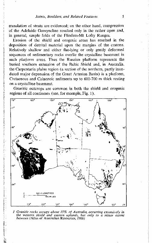
Granitic outcrops are common in both the shield and orogenic regions of all continents (see, for example, Fig. 1).
500 KILOMETRES
5bo MILES
1 Granitic rocks occupy about 15% of Australia, occurring extensively in the western shield and eastern uplands, but only to a minor extent between (Atlas of Australian Resources, 1966)
6 Structural Landforms
OccurrencePlutonic rocks crystallise beneath the earth’s surface under con
ditions of cooling which are slow compared to the average cooling rate of extrusive rocks. Plutonic bodies vary in shape and size, and are classified primarily according to the nature of their relationship with the country rock, and only secondarily on their form and areal extent. The margins of most plutons cut across structures in the surrounding country rock, and are described as discordant. Some few, however, are emplaced concordantly. Most plutons are partly discordant and partly concordant with respect to the adjacent bedrock, but they are classified according to which type of relationship is dominant. The common types of pluton (Badgley, 1965, pp. 314- 32) are briefly described below:
Sills are tabular masses emplaced horizontally and usually parallel to the bedding, cleavage, or foliation of the country rock. Laccoliths are bodies the intrusion of which has caused the roof rocks to be updomed; they are usually acidic and occur at comparatively shallow depths in relatively undisturbed areas.Lopoliths are large, lenticular, intrusive masses, the central areas of which are sunken. The thickness of such bodies is between V i o and y ,o of their width or diameter.Phacoliths occur in the crests of anticlines and the troughs of synclines and were intruded contemporaneously with the folding.Gneiss domes are structural domes in rocks of granitic composition. They have been recognised and described from the Baltic and Laurentian shields, and comparable features have been described from southern Africa. They are believed to be due to repeated uplift and intrusion.Dykes (or dikes) are tabular bodies intruded, vertically or nearly so, usually across the grain of the country rock.Ring complexes consist of oval, circular, or arcuate sheets and dykes related to an intrusive centre.Batholiths (or bathyliths) are massive bodies of intrusive rocks, commonly oval or shield-shaped in plan. On further exposure to erosion they either maintain or, more commonly, increase their diameters in depth. Many batholithic plutons are very extensive and give rise to several isolated outcrops separated by country rock (see, for example, Fig. 2).Stocks are small batholiths. On a purely arbitrary basis a batho- lith of less than 100 km- (40 square miles) is termed a stock.
Some of these types of pluton are of only minor interest in the present context, but reference is made to several below.
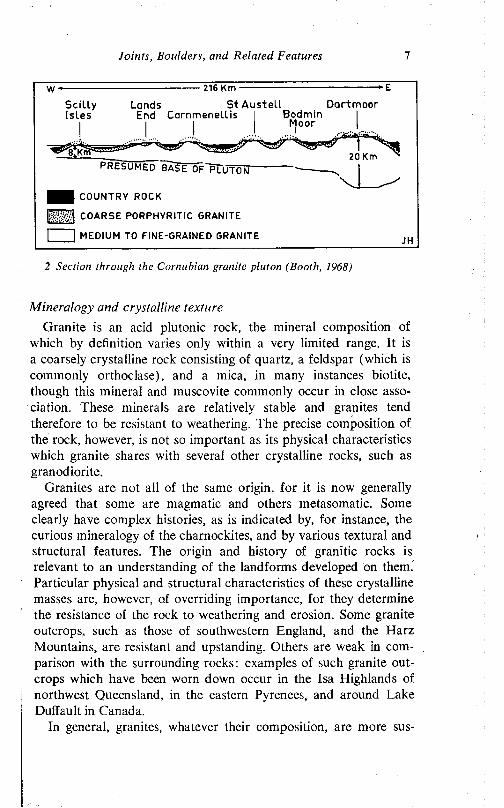
Joints, Boulders, and Related Features 7
216 Km
Scil lyIsles
Lands St Austell DartmoorEnd Carnmenellis
PRESUMED BASE OF'pT uTON-
COUNTRY ROCK
COARSE PORPHYRITIC GRANITE
| I MEDIUM TO FINE-GRAINED GRANITE
2 Section through the Cornu hian granite pint on (Booth, 1968)
Mineralogy and crystalline textureGranite is an acid plutonic rock, the mineral composition of
which by definition varies only within a very limited range. It is a coarsely crystalline rock consisting of quartz, a feldspar (which is commonly orthoclasc), and a mica, in many instances biotite, though this mineral and muscovite commonly occur in close association. These minerals are relatively stable and granites tend therefore to be resistant to weathering. The precise composition of the rock, however, is not so important as its physical characteristics which granite shares with several other crystalline rocks, such as granodiorite.
Granites are not all of the same origin, for it is now generally agreed that some are magmatic and others metasomatic. Some clearly have complex histories, as is indicated by, for instance, the curious mineralogy of the charnockites, and by various textural and structural features. The origin and history of granitic rocks is relevant to an understanding of the landforms developed on them. Particular physical and structural characteristics of these crystalline masses are, however, of overriding importance, for they determine the resistance of the rock to weathering and erosion. Some granite outcrops, such as those of southwestern England, and the Harz Mountains, are resistant and upstanding. Others are weak in comparison with the surrounding rocks: examples of such granite outcrops which have been worn down occur in the Isa Highlands of northwest Queensland, in the eastern Pyrenees, and around Lake Duffault in Canada.
In general, granites, whatever their composition, are more sus-
8 Structural Landforms
ceptible to weathering under tropical conditions, but tend to remain upstanding in cold climates. In a given climatic region, however, there are variations in the susceptibility to weathering and erosion, not only between one outcrop and another, but also within outcrops. The reasons for this are partly mineralogical.
The precise course and products of granite weathering evidently vary from place to place, but in general the order of weathering is the reverse of the order of crystallisation of minerals from an igneous melt. Plagioclase and biotite are the first minerals to show signs of decay. Biotite undergoes hydration and is changed to hydrobiotite and vermiculite and eventually one of the chlorites; iron is released during these changes and, combining with oxygen to form haematitic iron, imparts the characteristic vivid red coloration to weathered granite (and other rocks), even though it is present in only very small quantities. Plagioclase suffers hydration, and hydrolysis, to form clayey products, characteristically kaolin and related minerals. Potash feldspars, which are the next to suffer decay, produce similar materials. Quartz remains unaltered, though it probably suffers slow solution.
Thus, granites with abundant biotite and plagioclase, but little quartz and microcline, and which are coarse textured and porous, are usually readily weathered compared to granites which lack some or all of these characters. Within the Palmer Granite outcrop, in the Mt Lofty Ranges, for instance, two types of rock are displayed. Because it is fine-grained, the grey granite is resistant and underlies all the high points of the local relief. The pink granite, with large crystals of potash feldspar, is, however, relatively weak, presumably on account of its being coarse-grained.
Waters (1964) reports that on Dartmoor the coarse-grained and porphyritic granites have been least affected by frost action, whilst the fine-grained varieties have suffered greatest disintegration. Outcrops of this latter type have been differentially weathered and give rise to shelters or depressions.
In French Guiana, the resistance of some inselbergs is partly attributed to the lack of mica in the granite of which they are built (Hurault, 1963). Dumanowski (1964) reports that a major cirque in a fine-grained granite in the Karkonosze Mountains (Riesengebirge) of Poland is well preserved, whereas similar features nearby, which are scoured out of porphyritic granites, have suffered postglacial erosion. Similarly, in the Canton region of China, finegrained granites are little weathered, though porphyritic granites in
Joints, Boulders, and Related Features 9
the same region are weathered to considerable depths (Dumanow- ski, 1968).
The general trend of geomorphological thinking (see, e.g. Klaer, 1956) is that mineralogy is second only to the nature and closeness of the fracture pattern in determining the susceptibility of a given rock to weathering and, hence, to erosion. In particular, the biotite content is considered significant, though Goldich (1938) and Dumanowski (1968) consider plagioelase the most susceptible of the rock-forming minerals commonly present in granitic rocks. The latter worker, with Lautensach (1950), believes that grain size is more important than either mineralogy or fracture pattern.
However, the nature of the fractures (open or closed, see below) has not evidently been taken into account in this assessment, for although mineralogy is undoubtedly significant in detail, the joint pattern of the country rock is everywhere important, and is, in many areas, the most significant single factor determining the shaping of landforms from granite bedrock.
JOINTING AND ITS SIGNIFICANCE
Many of the important geomorphological attributes of granite and granitic rocks stem from their high perviousness on the one hand and their low porosity and permeability on the other.1 Their high
1 In this book the following usages are adhered to:A pervious rock is one through which water can readily pass by way of
fractures or fissures.The porosity of a rock refers to the ratio of pore volume to the total
volume of the rock, expressed as a percentage. Porosity varies with the shape of the grains which constitute the rock, with their sorting and packing, and with the degree of cementation. With closely packed, uniform spheres, whatever their size, 26 per cent of the total volume is occupied by pores or voids. Of course, such a condition is never found in nature, but the example provides a yardstick.
Permeability (primary permeability) refers to the capability of a porous medium to transmit a liquid. This parameter is not the same as porosity, for permeability depends not only on the volume occupied by pores, but also on their degree of interconnection, the size of pores, and the physical properties of the liquid involved. The pores may be numerous and interconnected, but be so small that surface tension prevents the movement of, say, water.
In these terms a clay may be more porous, but less permeable, than a sandstone, because its pore spaces may be too small to permit free passage of water. A sandstone with little cementation is porous, permeable, and pervious; crystalline limestone, like fresh granite, is pervious by virtue of the joints and bedding planes, but is of low porosity and permeability.
(Continued next page)
10 Structural Landfonns
perviousness is due to the common development of a system of joints.- The significance of the joints is enhanced by the low porosity and permeability of granitic rocks, which, in turn, stem from their crystalline nature and the scarcity of connected voids in the unweathered rock.
Though commonly well developed, the pattern of joints in granitic rocks is variable, generally complex, and in many localities irregular. Not only does the spacing of joints vary to a bewildering extent within short distances, but joints of many orientations are displayed. Furthermore, the condition of the joints differs from place to place, some being open, others closed. This is an important property the significance of which is discussed below. Some joints consist of a single parting, but others, the more common, comprise narrow zones within which there are many discontinuous fractures. Such multiple fracturing may be due directly to shear stresses, but similar features may result from slight release of pressure consequent upon the development of the initial joint plane.
OriginsSome joints are clearly of primary or peneprimary origin. Others
have evolved much later in the geological history of the rocks in which they occur. Some joints are attributed to contraction due to crystallisation and cooling, or, in the case of sediments, to dehydration. The joint patterns of many batholiths display a close geometric relationship with the local and regional tectonic framework and, accordingly, such joints are considered to be manifestations of stresses imposed during the emplacement of the mass (Cloos, 1936; Balk, 1937, pp. 97-117) or during subsequent earth movements. Some joints are fairly clearly related to the upward doming and lateral extension of plutonic masses, either during emplacement or
This usage is possibly old-fashioned, though useful for all that. There is, however, a tendency nowadays to use the terms interchangeably. But some authors differentiate between primary permeability, or intergranular movement ( = permeability as defined above), and secondary permeability, or movement along joints ( = perviousness).
2 A joint is a rock fracture along which no dislocation has occurred. Faults, on the other hand (see Chapter IV), are fractures along which dislocation has taken place. In granites and other plutonic rocks many of the features called joints are in reality faults, but dislocation is difficult to prove. In addition to contributing directly to the subdivision of rock masses, both faults and joints may give rise to secondary fractures.
For systematic discussion of joints and faults, see Hills, 1963, pp. 149-210; Price, 1966.
Joints, Boulders, and Related Features 11
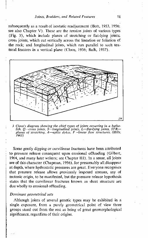
subsequently as a result of isostatic readjustment (Bott, 1953, 1956; see also Chapter V). These are the tension joints of various types (Fig. 3), which include planes of stretching or flat-lying joints; cross joints, which cut vertically across the lineation or foliation of the rock; and longitudinal joints, which run parallel to such textural features in a vertical plane (Cloos, 1936; Balk, 1937).
3 Cloos’s diagram showing the chief types of joints occurring in a hatho- lith. Q—cross joints, S—longitudinal joints, L— flat-lying joints, STR—
planes of stretching, A—aplite dykes, F—linear flow structures. (Hills, 1963)
Some gently dipping or curvilinear fractures have been attributed to pressure release consequent upon erosional offloading (Gilbert, 1904, and many later writers; see Chapter III). In a sense, all joints are of this character (Chapman, 1956), for presumably all disappear at depth, where hydrostatic pressures are great. Everyone recognises that pressure release allows previously imposed stresses, say of tectonic origin, to be manifested, but the pressure release hypothesis states that the curvilinear fractures known as sheet structure are due wholly to erosional offloading.
Dominant geometrical setsAlthough joints of several genetic types may be exhibited in a
single exposure, from a purely geometrical point of view three groups stand out from the rest as being of great geomorphological significance, regardless of their origins.
12 Structural Landforms
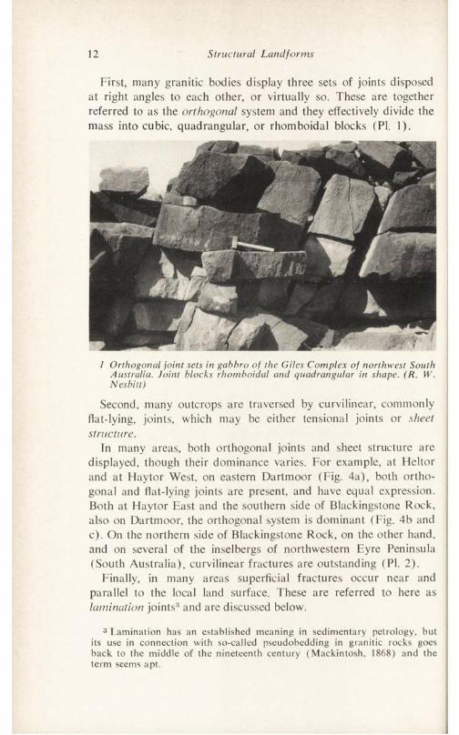
First, many granitic bodies display three sets of joints disposed at right angles to each other, or virtually so. These are together referred to as the orthogonal system and they effectively divide the mass into cubic, quadrangular, or rhomboidal blocks (PI. 1).
1 Orthogonal joint sets in gahhro of the Giles Complex of northwest South Australia. Joint blocks rhomboidal and quadrangular in shape. (R. W. Nesbitt)
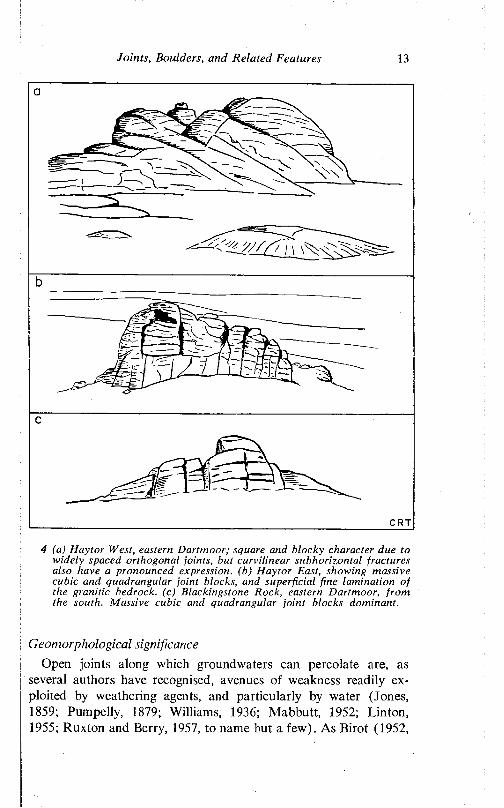
Second, many outcrops are traversed by curvilinear, commonly flat-lying, joints, which may be either tensional joints or sheet structure.
In many areas, both orthogonal joints and sheet structure are displayed, though their dominance varies. For example, at Fleltor and at Haytor West, on eastern Dartmoor (Fig. 4a), both orthogonal and flat-lying joints are present, and have equal expression. Both at Haytor East and the southern side of Blackingstone Rock, also on Dartmoor, the orthogonal system is dominant (Fig. 4b and c). On the northern side of Blackingstone Rock, on the other hand, and on several of the inselbergs of northwestern Eyre Peninsula (South Australia), curvilinear fractures are outstanding (PI. 2).
Finally, in many areas superficial fractures occur near and parallel to the local land surface. These are referred to here as lamination joints8 and are discussed below.
3 Lamination has an established meaning in sedimentary petrology, but its use in connection with so-called pseudobedding in granitic rocks goes back to the middle of the nineteenth century (Mackintosh, 1868) and the term seems apt.
Joints, Boulders, and Related Features 13
CRT
4 (a) Hay tor West, eastern Dartmoor; square and blocky character due to widely spaced orthogonal joints, hut curvilinear subhorizontal fractures also have a pronounced expression, (b) Haytor East, showing massive cubic and quadrangular joint blocks, and superficial fine lamination of the granitic bedrock, (c) Blackingstone Rock, eastern Dartmoor, from the south. Massive cubic and quadrangular joint blocks dominant.
Geomorphological significanceOpen joints along which groundwaters can percolate are, as
several authors have recognised, avenues of weakness readily exploited by weathering agents, and particularly by water (Jones, 1859; Pumpelly, 1879; Williams, 1936; Mabbutt, 1952; Linton, 1955; Ruxton and Berry, 1957, to name but a few). As Birot (1952,
14 Structural Landforms
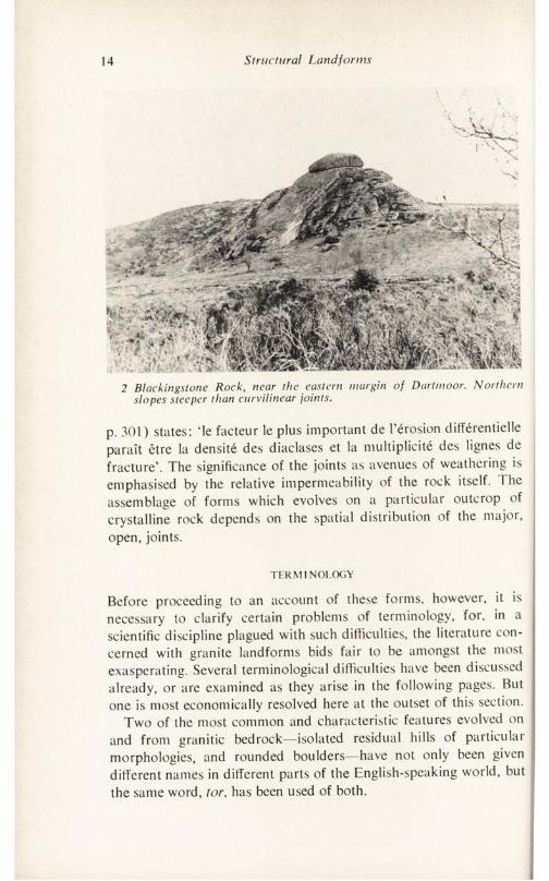
2 Blackingstone Rock, near the eastern margin of Dartmoor. Northern slopes steeper than curvilinear joints.
p. 301) states: ‘le facteur le plus important de l’erosion differentielle paratt etre la densite des diaclases et la multiplicity des lignes de fracture’. The significance of the joints as avenues of weathering is emphasised by the relative impermeability of the rock itself. The assemblage of forms which evolves on a particular outcrop of crystalline rock depends on the spatial distribution of the major, open, joints.
TERMINOLOGY
Before proceeding to an account of these forms, however, it is necessary to clarify certain problems of terminology, for, in a scientific discipline plagued with such difficulties, the literature concerned with granite landforms bids fair to be amongst the most exasperating. Several terminological difficulties have been discussed already, or are examined as they arise in the following pages. But one is most economically resolved here at the outset of this section.
Two of the most common and characteristic features evolved on and from granitic bedrock—isolated residual hills of particular morphologies, and rounded boulders—have not only been given different names in different parts of the English-speaking world, but the same word, tor, has been used of both.
Joints, Boulders, and Related Features 15
The term is of ancient derivation (Cornish, comparable with the Anglo-Saxon torr, Welsh twr, and the Latin turns, in each case meaning a tower) and has long been used of protuberant rock outcrops. Jones (1859, p. 302), for example, describes the tors of Dartmoor as ‘irregularly prominent masses of rudely-heaped rock fragments’. The term was formally defined by Linton (1952) again with reference to the granite tors of southwestern England, which are described as bare rock outcrops, usually of monumental form and ‘about the size of a house’ (p. 354), commonly bounded by near vertical fractures, and boldly fissured by widely spaced joints. Field evidence (Linton, 1952) shows that many, if not most, of these features in southwestern England develop in two stages. First, deep subsurface weathering, controlled by the joint system, takes place and, following the lowering of the land surface, the weathered debris is removed, thus exposing the essentially unweathered masses of rock.
Such clear and precise definition is, of course, laudable, but unfortunately problems of nomenclature are not in practice resolved by assertion, by agreement, or even, in some cases, by the application of logic. For example, the word terrace in the phrase river terrace is used to include forms some of which have been eroded, others of which are constructional. Such usage is in many instances quite incompatible with the generally understood meaning of the word in respect of constructional features (abrasion platform, or wave-cut bench, but a wavc-bnilt terrace', altiplanation bench, but käme terrace). Such usage is, however, deeply implanted in the literature, and the habits of a lifetime are not easily or lightly abandoned. So it is with the word tor, which has strong local connections.
1 he term has, however, been usurped by workers outside Britain and used in an aberrant sense. Whatever the rights and wrongs of the case, the fact is that tor has been used by several workers, particularly in Australia, to denote not a composite residual mass which includes a considerable number of individual joint blocks still in situ, as implied in both Jones’s and in Linton’s descriptions, but rather a single, isolated, spherical or subspherical boulder or block of granitic rock (see, for instance, Williams, 1936; Hills, 1940, pp. 26-8; Cotton, 1948. p. 30, in Fig. 19; Costin, 1950; Browne, 1964; White, Compston, and Kleeman, 1967). Tor is used in the same sense with respect to boulders in southwest Africa (Mabbutt, 1952) and in Nigeria (Thomas, 1965) in contradistinc-
16 Structural Landforms
tion to the massive inselbergs of both of these regions. The individual aspect of the Australian usage is emphasised by the application of a group term—a cluster of tors—to an aggregate of these forms (White, Compston, and Kleeman, 1967, p. 32).
A further difficulty is that features similar to the tors of southwestern England, but which occur in different and various climates in parts of the world other than Britain, have been called inselbergs. If the tors of Devon and Cornwall were located in any other part of the world, most workers would undoubtedly call them inselbergs, for in size and morphological range, the two sets of features are very similar. Admittedly most tors, in the English sense, are less extensive than most inselbergs. But there is a wide overlap between them, and in any case the two are, as is urged below, of identical origin. Moreover, every major form displayed on Dartmoor has been described from the inselbergs of Africa, the Americas, Australia, or elsewhere, and only a very few minor forms known from these other sites are not present in the British areas. But even outside Britain there is no consistent usage; in Western Australia, for instance, domed inselbergs of granite have recently been called tors (Noldart and Wyatt, 1962, p. 51, at Fig. 20).
A second, and broader, problem relates to the definition of features in genetic terms. To what extent is it practical to define features in terms of specific causative processes, or in terms of particular ages or age-ranges? Interpretations of geomorphological features are rarely final, and is it therefore not unrealistic to define any feature in specific genetic terms? While Linton is indubitably correct in his general thesis, there is room for discussion both with respect to the details of age and process (Palmer and Nielson, 1962; Browne, 1964; Caine, 1967) and to the possibility of local variation of origin (King, 1958). It is increasingly recognised that similar forms may originate in different ways, that is that some features are multigenetic in origin, are convergent forms, or to borrow a palaeontological term, homeomorphs, so that too precise a definition may be disadvantageous and lead to difficulties.
To retain the term tor in either of its general senses is clearly to introduce a potent source of confusion in a book aimed at an international audience. On the other hand, though the Australian usage is clearly incorrect, local habits are not lightly discarded and in this work the word is used reluctantly, sparingly, and parenthetically in connection with specific regions in which its usage is well estab-
Joints, Boulders, and Related Features 17
lished and its connotation clear. But in general discussion other terms are retained.
For the single, isolated, rounded or subrounded masses, a term widely used in sedimentary petrology seems apposite. A boulder is defined as ‘a detached rock mass, somewhat rounded or otherwise modified by abrasion in transport’ (Lane et al., 1947) or by weathering in situ ‘and larger than a cobble’ (Pettijohn, 1957, p. 20). The minimum diameter for a boulder is set at 256 mm, or about 10 inches (Lane et al., 1947), with no upper limit. This embraces all granite boulders described in the literature, the minimum diameter of which is about 20 cm, ranging up to a maximum of about 13 m in the Devils Marbles, Northern Territory, Australia. These are unusually massive, however, and the boulders are most commonly between 2 and 4 m in diameter, ft may be noted here that in some of the earliest descriptions of these forms, the word boulder was used (as in Branner, 1896) and it has never really lost currency (see, for example, Larsen, 1948).
The essential feature of a boulder is its isolation and detached appearance: it is a form in its own right. This is not true, however, of the blocks which are integral parts of inselbergs—large, composite, steep-sided residuals comprising a large number of little weathered joint blocks, or woolsacks. The exposed blocks may be moulded by weathering and erosion but this is a superficial trait and the hill consists essentially of joint blocks in situ. Inselbergs are of varied dimensions. Some are in reality ridges and ranges. But these consist of assemblages of the two basic forms which are distinctive and characteristic of granite outcrops: the angular, castellated castle koppie, on the one hand, and the rounded, domed4 bornhardt, on the other. Both are isolated, though composite, forms.
Boulders, castle koppies, and bornhardts as well as associated minor forms are characteristic of many granite outcrops. They occur in varied tectonic settings, which may be of some significance when the genesis of certain landforms is considered, and in various climatic regions. Similar forms evolve on a wide variety of non- granitic bedrock, though both major and minor features are best and most commonly developed on granitic outcrops. However, whatever the bedrock, the spacing of the joint systems is basic to the evolution of these landform assemblages.
4 The word domed is used throughout this book. It is used in a morphological sense to mean a dome-like form. The word as used carries no essential implication as to underlying structure.
18 S tructu ra l Land fo rm s
OUTC ROPS W IT H CLOSELY SPACED FRACTURES
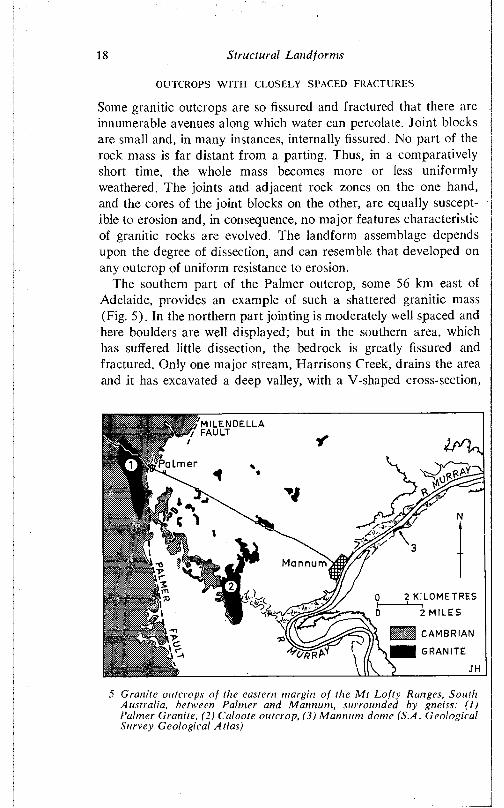
Some granitic outcrops are so fissured and fractured that there are innumerable avenues along which water can percolate. Joint blocks are small and, in many instances, internally fissured. No part of the rock mass is far distant from a parting. Thus, in a comparatively short time, the whole mass becomes more or less uniformly weathered. The joints and adjacent rock zones on the one hand, and the cores of the joint blocks on the other, are equally susceptible to erosion and, in consequence, no major features characteristic of granitic rocks arc evolved. The landform assemblage depends upon the degree of dissection, and can resemble that developed on any outcrop of uniform resistance to erosion.
The southern part of the Palmer outcrop, some 56 km east of Adelaide, provides an example of such a shattered granitic mass (Fig. 5). In the northern part jointing is moderately well spaced and here boulders are well displayed; but in the southern area, which has suffered little dissection, the bedrock is greatly fissured and fractured. Only one major stream, Harrisons Creek, drains the area and it has excavated a deep valley, with a V-shaped cross-section,
P a tm e r
Mannum
2 KILOMETRES
2 MILES
S / n CAMBRIAN
■ GRANITE
5 Granite outcrops o f the eastern margin o f the M t Lo f ty Ranges, South Australia, between Palmer and Mannum, surrounded by gneiss: ( ! ) Palmer Granite, (2) Caloote outcrop, (3) M annum dome (S.A. Gcological Survey Geological Atlas)
Joints, Boulders, and Related Features 19
Soroo5174
L Piticocha Tuyujuto5 7 5 2 m4 3 5 0 4 4 0 0
Granite3 00 0 m
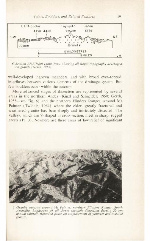
5 KILOMETRES5 MILES
6 Section ENE from Lima, Peru, showing all slopes topography developed on granite (Gerth, 1955)
well-developed ingrown meanders, and with broad even-topped interfluves between various elements of the drainage system. But few boulders occur within the outcrop.
More advanced stages of dissection are represented by several areas in the northern Andes (Kinzl and Schneider, 1950; Gerth, 1955—see Fig. 6) and the northern Flinders Ranges, around Mt Painter (Twidale, 1964) where the older, greatly fractured and weathered granite has been deeply and intricately dissected. The valleys, which are V-shaped in cross-section, meet in sharp, rugged crests (PI. 3). Nowhere are there areas of low relief of significant
3 Granite outcrop around Mt Painter, northern Flinders Ranges, South Australia. Landscape of all slopes through dissection despite 22 cm annual rainfall. Rounded peaks on emplacement of younger and massive granite.
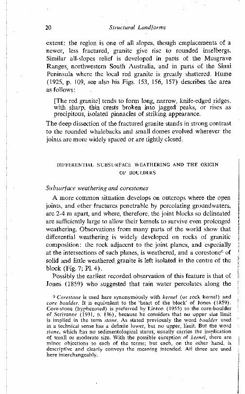
20 Structural Landforms
extent: the region is one of all slopes, though emplacements of a newer, less fractured, granite give rise to rounded inselbergs. Similar all-slopes relief is developed in parts of the Musgrave Ranges, northwestern South Australia, and in parts of the Sinai Peninsula where the local red granite is greatly shattered. Hume (1925, p. 109, see also his Figs. 153, 156, 157) describes the area as follows:
[The red granite] tends to form long, narrow, knife-edged ridges, with sharp, thin crests broken into jagged peaks, or rises as precipitous, isolated pinnacles of striking appearance.
The deep dissection of the fractured granite stands in strong contrast to the rounded whalebacks and small domes evolved wherever the joints are more widely spaced or are tightly closed.
DIFFERENTIAL SUBSURFACE WEATHERING AND THE ORIGIN
OF BOULDERS
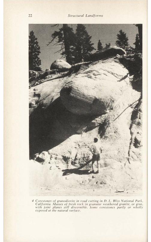
Subsurface weathering and corestonesA more common situation develops on outcrops where the open
joints, and other fractures penetrable by percolating groundwaters, are 2-4 m apart, and where, therefore, the joint blocks so delineated are sufficiently large to allow their kernels to survive even prolonged weathering. Observations from many parts of the world show that differential weathering is widely developed on rocks of granitic composition: the rock adjacent to the joint planes, and especially at the intersections of such planes, is weathered, and a corestone5 of solid and little weathered granite is left isolated in the centre of the block (Fig. 7; PI. 4).
Possibly the earliest recorded observation of this feature is that of Jones (1859) who suggested that rain water percolates along the
5 Corestone is used here synonymously with kernel (or rock kernel) and core boulder. It is equivalent to the ‘heart of the block' of Jones (1859). Core-stone (hyphenated) is preferred by Linton (1955) to the core-boulder of Scrivenor (1931, p. 136), because he considers that no upper size limit is implied in the term stone. As stated previously the word boulder used in a technical sense has a definite lower, but no upper, limit. But the word stone, which has no sedimentological status, usually carries the implication of small or moderate size. With the possible exception of kernel, there are minor objections to each of the terms; but each, on the other hand, is descriptive and clearly conveys the meaning intended. All three are used here interchangeably.
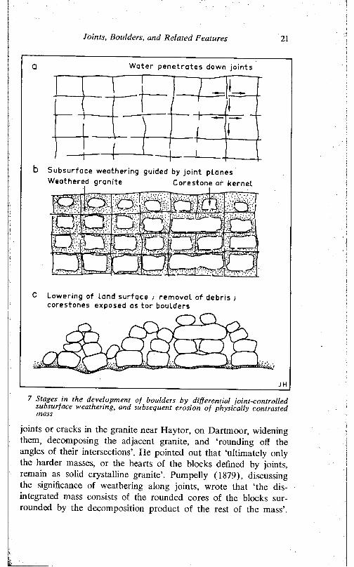
Joints, Boulders, and Related Features 21
Water p en e t ra t e s down joints
Subsurface weathering guided by joint p lanes Weathered granite Corestone or kernel
Lowering of land surface ; removal of debris cores tones exposed as tor boulders
7 Stages in the development of boulders by differential joint-controlled subsurface weathering, and subsequent erosion of physically contrasted mass
joints or cracks in the granite near Haytor, on Dartmoor, widening them, decomposing the adjacent granite, and ‘rounding off the angles of their intersections’. He pointed out that ‘ultimately only the harder masses, or the hearts of the blocks defined by joints, remain as solid crystalline granite’. Pumpelly (1879), discussing the significance of weathering along joints, wrote that ‘the disintegrated mass consists of the rounded cores of the blocks surrounded by the decomposition product of the rest of the mass’.
22 Structural Landforms
4 Corestones of granodiorite in road cutting in D. L. Bliss National Park, California. Masses of fresh rock in granular weathered granite, or gras, with joint planes still discernible. Some corestones partly or wholly exposed at the natural surface.
Joints, Boulders, and Related Features 23
Brunner (1896, p. 278) mentions ‘boulders of decomposition’0 in deeply weathered granitic rocks in Brazil, and Lake (1890) described and figured gneiss corestones surrounded by intensely weathered bedrock in southern India. Reid et al. (1912) described corestones in grus7 from southwestern England, and Scrivenor (1931, p. 136), describing the granitic rocks of the Malay Peninsula, reported that ‘in the weathered mass “core-boulders” are abundant’.
Similar forms have been described from the southern part of the Sierra Nevada Batholith by Larsen (1948) who writes: ‘Imbedded in the gruss and rising above the surface are boulders of disintegration’ (p. 114). These boulders, which rise as much as 6 m above the surface, take the form of triaxial ellipsoids, the longest axes of which run parallel with the chief jointing, flattened inclusions, and other lineations in the rock.
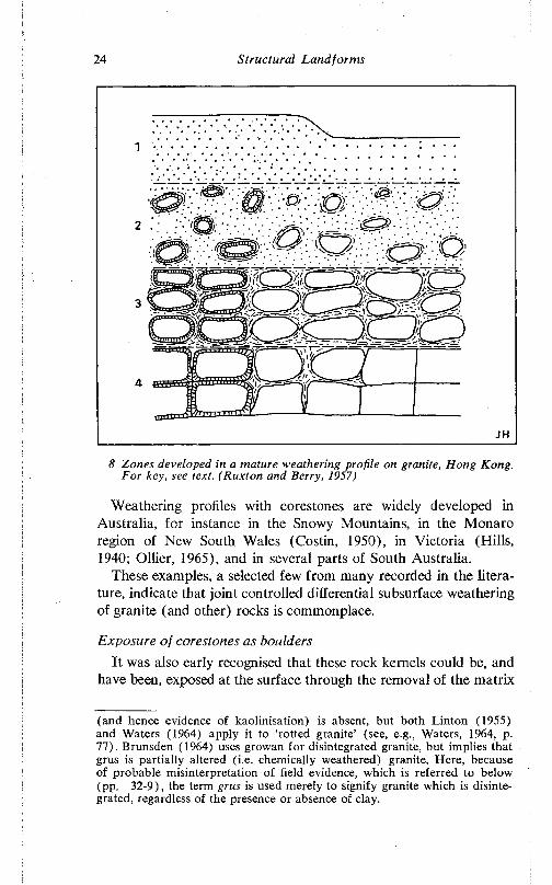
One of the best accounts of joint controlled differential weathering in granitic rocks is due to Ruxton and Berry (1957), who distinguish four distinct zones in the fully developed weathering profiles of Hong Kong (Fig. 8):
Surface1. Structureless sand, clay or clayey sand, with virtually no solid
rock (no corestones).2. Residual debris with small corestones which are well rounded
and isolated. The corestones (fresh or solid rock) account for less than 50 per cent of the total mass.
3. Corestones, subrounded or subangular, and still recognisably derived from juxtaposed blocks, with residual debris. The solid rock constitutes 50-90 per cent of the whole.
4. Partially weathered rock, with small amounts of residual debris along joints. The solid rock, which forms more than 90 per cent of the whole, may, however, be considerably iron stained.
Fresh rockGThis term is not favoured as it is ambiguous.7 Crus (German—grit or fine gravel) is granite which has suffered
granular disintegration. It will be noted that in some American literature the word is written gruss, which spelling is retained here only in direct quotations.
In the southwest of England the word growan is applied to similar material, though usage varies. Worth (1953, p. 7) implies that growan lacks clays, but does not sustain the distinction between such physically disintegrated granite and chemically altered rock. Palmer and Nielson (1962) prefer that the term growan be restricted to weathered granite in which clay
24 Structural Landforms
. \ • • •
8 Zones developed in a mature weathering profile on granite, Hong Kong. For key, see text. (Ruxton and Berry, 1957)
Weathering profiles with corestones are widely developed in Australia, for instance in the Snowy Mountains, in the Monaro region of New South Wales (Costin, 1950), in Victoria (Hills, 1940; Ollier, 1965), and in several parts of South Australia.
These examples, a selected few from many recorded in the literature, indicate that joint controlled differential subsurface weathering of granite (and other) rocks is commonplace.
Exposure of corestones as bouldersIt was also early recognised that these rock kernels could be, and
have been, exposed at the surface through the removal of the matrix
(and hence evidence of kaolinisation) is absent, but both Linton (1955) and Waters (1964) apply it to ‘rotted granite’ (see, e.g., Waters, 1964, p. 77). Brunsden (1964) uses growan for disintegrated granite, but implies that grus is partially altered (i.e. chemically weathered) granite. Here, because of probable misinterpretation of field evidence, which is referred to below (pp. 32-9), the term grus is used merely to signify granite which is disintegrated, regardless of the presence or absence of clay.
Joints, Boulders, and Related Features 25
of weathered granite. Jones (1859, p. 306) remarked that ‘if exposed to adequate agencies’ the corestones he had observed on Dartmoor would either tumble or remain piled up on one another. Branner (1896), writing of boulders in Brazil, commented that the residuals have in places been left perched upon points and ledges by the decay and removal of the rock from about them. Every stage in the exposure of these rock kernels by the uneven lowering of the land surface can be observed, for instance, in the Sierra Nevada ( PI. 4) and in several of the Australian granite areas.
Thus rounded or subrounded granite boulders evolve in two distinct stages which are not, however, necessarily separate in the time sense (Lewis in discussion of Linton, 1955). Differential subsurface weathering, controlled by jointing, leads in turn to differential erosion, and to one of the most common assemblages of land- form evolved on granitic rocks—fields of boulders in groups or clusters with intervening smooth plains underlain by granite but with a cover of alluvial and colluvial debris.
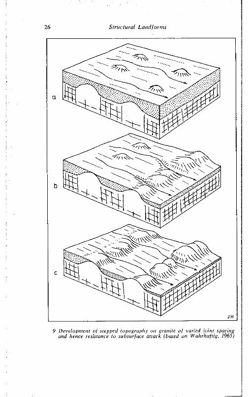
In many areas, and especially where the granitic rock has gneissic tendencies, the distribution of outcrops is irregular but not random. They are discontinuous, but locally display a more or less linear arrangement. Each such line of boulders and slabs acts as a local baselevel so that stream courses and slopes display sequences of treads and steps, the former developed on zones of fractured granite, the latter on the more resistant bedrock. Such benched topography is well displayed, on a minor scale, on gneiss adjacent to the Palmer Granite. More massive versions of stepped topography have been described from the Sierra Nevada of California by Wahrhaftig (1965), who places great emphasis on the contrasted behaviour of granite in response to subaerial weathering, to which it is virtually immune, and to subsurface (moisture) weathering, to which it is very susceptible. Thus once a mass of granite which survives subsurface attack by virtue of wide joint spacing is exposed, it tends more and more to stand out in relief as the still buried granite adjacent to it continues to be weathered. Contrasted resistance to weathering of exposed and buried granite has been reported also from Colorado and Wyoming (Eggler, Larson, and Bradley, 1969), and is also an important factor in the development of inselbergs, as well as of minor landforms (see Chapter III).
The location of steps in the Sierra Nevada must initially be determined by the pattern of joint spacing, and if this varies in depth (see Chapter III), as well as horizontally, then there is no reason
26 Structural Landforms
9 Development of stepped topography on granite of varied joint spacing and hence resistance to subsurface attack (based on Wahrhaftig, 1965)
Joints, Boulders, and Related Features 27
to suppose that once streams have penetrated through the zone of comparatively massive blocks, the stepped topography will persist. But Wahrhaftig’s suggested mechanism (Fig. 9) explains the topographic features and also draws attention to important characteristics of granitic bedrock.
Joint control in detailPetrological variations, and variations in joint spacing, lead to
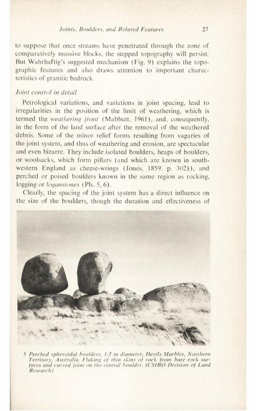
irregularities in the position of the limit of weathering, which is termed the weathering front (Mabbutt, 1961), and. consequently, in the form of the land surface after the removal of the weathered debris. Some of the minor relief forms resulting from vagaries of the joint system, and thus of weathering and erosion, are spectacular and even bizarre. They include isolated boulders, heaps of boulders, or woolsacks, which form pillars (and which arc known in southwestern England as cheese-wrings (Jones, 1859, p. 302)), and perched or poised boulders known in the same region as rocking, logging or loganstones (Pis. 5, 6).
Clearly, the spacing of the joint system has a direct influence on the size of the boulders, though the duration and effectiveness of
5 Perched spheroidal boulders, 1-2 m diameter, Devils Marbles, Northern Territory, Australia. Flaking of thin skins of rock front bare rock surfaces and curved joint on the central boulder. (CSIRO Division of Land Research)
28 Structural Landforms
6 Granite, like sandstone, can weather to odd forms. Grotesque weathering pillar, 7 m high, of angular granite joint blocks in eastern Dartmoor known as Bowermans Nose.
weathering, and the precise petrology and structure of the local bedrock, are also significant in this regard. Boulders only 20 cm in diameter have been weathered from very small joint blocks in a resistant grey granite on the Palmer outcrop, but only a few metres distant, blocks twice as large, in a coarse pink granite, have been greatly disintegrated, and no boulders survive.
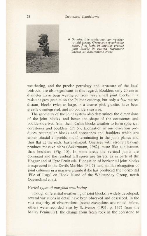
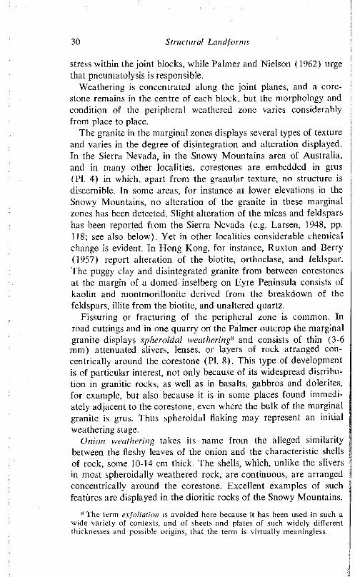
The geometry of the joint system also determines the dimensions of the joint blocks, and hence the shape of the corestones and boulders derived from them. Cubic blocks weather to form spherical corestoncs and boulders (PI. 5). Elongation in one direction produces rectangular blocks and corestones and boulders which are either triaxial ellipsoids, or, if terminating in the joint planes and thus flat at the ends, barrel-shaped. Gneisses with strong cleavage produce massive slabs (Ackermann, 1962), more like tombstones than boulders (Fig. 10). In some areas the vertical joints are dominant and the residual tall spires are turrets, as in parts of the Hoggar and of Eyre Peninsula. Elongation of horizontal joint blocks is expressed in the Devils Marbles (PI. 7), and similar elongation of joint columns in a massive granite dyke has produced the horizontal ‘Pile of Logs’ on Hook Island of the Whitsunday Group, north Queensland coast.
Varied types of marginal weatheringThough differential weathering of joint blocks is widely developed,
several variations in detail have been observed and described. In the vast majority of observations (some exceptions are noted below, others were recorded also by Scrivenor (1931, p. 137) from the Malay Peninsula), the change from fresh rock in the corestonc to
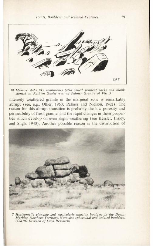
Joints, Boulders, and Related Features 29
10 Massive slabs like tombstones (also called penitent rocks and monk stones) on Rathjen Gneiss west of Palmer Granite of Fig. 5
intensely weathered granite in the marginal zone is remarkably abrupt (see, e.g., Ollier, 1960; Palmer and Nielson, 1962). The reason for this abrupt transition is probably the low porosity and permeability of fresh granite, and the rapid changes in these properties which develop on even slight weathering (see Kessler, Insley, and Sligh, 1940). Another possible reason is the distribution of
7 Horizontally elongate and particularly massive boulders in the Devils Marbles, Northern Territory. Note also spheroidal and isolated boulders. (CSIRO Division of Land Research)
30 Structural Landforms
stress within the joint blocks, while Palmer and Nielson (1962) urge that pneumatolysis is responsible.
Weathering is concentrated along the joint planes, and a corestone remains in the centre of each block, but the morphology and condition of the peripheral weathered zone varies considerably from place to place.
The granite in the marginal zones displays several types of texture and varies in the degree of disintegration and alteration displayed. In the Sierra Nevada, in the Snowy Mountains area of Australia, and in many other localities, corestones are embedded in grus (PI. 4) in which, apart from the granular texture, no structure is discernible. In some areas, for instance at lower elevations in the Snowy Mountains, no alteration of the granite in these marginal zones has been detected. Slight alteration of the micas and feldspars has been reported from the Sierra Nevada (e.g. Larsen, 1948, pp. 118; see also below). Yet in other localities considerable chemical change is evident. In Hong Kong, for instance, Ruxton and Berry (1957) report alteration of the biotite, orthoclase, and feldspar. The puggy clay and disintegrated granite from between corestones at the margin of a domed inselberg on Eyre Peninsula consists of kaolin and montmorillonitc derived from the breakdown of the feldspars, illite from the biotite, and unaltered quartz.
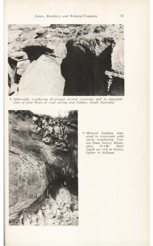
Fissuring or fracturing of the peripheral zone is common. In road cuttings and in one quarry on the Palmer outcrop the marginal granite displays spheroidal weathering8 and consists of thin (3-6 mm) attenuated slivers, lenses, or layers of rock arranged concentrically around the corestone (PI. 8). This type of development is of particular interest, not only because of its widespread distribution in granitic rocks, as well as in basalts, gabbros and dolerites, for example, but also because it is in some places found immediately adjacent to the corestone, even where the bulk of the marginal granite is grus. Thus spheroidal flaking may represent an initial weathering stage.
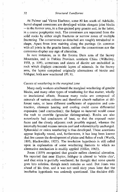
Onion weathering takes its name from the alleged similarity between the fleshy leaves of the onion and the characteristic shells of rock, some 10-14 cm thick. The shells, which, unlike the slivers in most spheroidally weathered rock, are continuous, are arranged concentrically around the corestone. Excellent examples of such features are displayed in the dioritic rocks of the Snowy Mountains.
s The term exfoliation is avoided here because it has been used in such a wide variety of contexts, and of sheets and plates of such widely different thicknesses and possible origins, that the term is virtually meaningless.
Joints, Boulders, and Related Features 31
8 Spheroidal weathering developed around corestone and in marginal zone of joint block in road cutting near Palmer, South Australia
9 Mineral banding marginal to corestones with onion weathering, Too- ma Dam, Snowy Mountains, N.S.W. Dark bands are rich in biotite, lighter in feldspar.
32 Structural Landforms
At Palmer and Victor Harbour, some 80 km south of Adelaide, barrel-shaped corestones are developed within elongate joint blocks —in the former area, in a fine-grained grey granite and, in the latter, in a coarse porphyritic rock. The corestones are separated from the solid rocks by either single fractures or narrow zones of multiple fracturing. The cornerstones so detached are roughly tetrahedral in shape. Apart from iron staining along the partings (in common with all joints in the granite here), neither the cornerstones nor the corestones display any sign of alteration.
In rare instances, as in the Tooma Dam area of the Snowy Mountains, and in Fukien Province, southern China (Wilhelmy, 1958, p. 109), corestones and sheets of diorite are embedded in rock which displays concentric layers of minerals. In the Snowy area, the layers comprised originally alternations of biotite and feldspar, both now weathered (PI. 9).
Causes of weathering in the marginal zoneMany early workers attributed the marginal weathering of granite
blocks, and many other types of weathering for that matter, wholly to insolational effects. Because many rocks are composed of minerals of various colours and therefore absorb radiation at different rates, or have different coefficients of expansion and contraction, alternate heating and cooling could cause differential expansion (and contraction); the fatigue so incurred would cause the rock to crumble (granular disintegration). Rocks are also notoriously bad conductors of heat, so that the exposed outer faces and the closely adjacent rock possibly expand, whereas the internally located masses remain cool and volumetrically unchanged. Spheroidal or onion weathering is thus developed. These assertions appear logically sound, and, furthermore, it has long been known that fire causes the development of plates and flakes of rock (Warth, 1895; Blackwelder, 1927). The insolation hypothesis is still called upon in explanation of some weathering features to which no alternative mechanism is readily applied (Ollier, 1963).
Jones (1859) recognised that granite suffers chemical alteration. He reported that near Haytor, feldspar is altered to ‘white clay’, and that mica is partially weathered; he thought that some quartz goes into solution, though much remains as sand. But Jones was ahead of his time, and it was not until sixty years later that the insolation hypothesis was seriously questioned. The decisive diffi-
Joints, Boulders, and Related Features 33
eulty facing the hypothesis is that differential weathering is known to extend in many areas to great depths, and certainly far beyond the range of influence of temperature changes. Furthermore, Barton (1916) reported that in the Egyptian desert near Cairo granite exposed to the sun shows no discernible weathering, though in the same area granite close to and shallowly buried in the desert sand, where some moisture is available, is altered. Similar arguments and laboratory experiments ( Blackwelder, 1925; Griggs, 1936) led to the conclusion that heating and cooling alone probably achieve little disintegration though heating and cooling in the presence of moisture do.
In arguing from experimental data, the factor of geological time is of course difficult to allow for, but evidence against the insolation hypothesis led Blackwelder (1933) to suggest that water penetrating along joints is responsible for the chemical alteration and rupture of the peripheral zones. The penetration of groundwaters continues and so the corestones are gradually rounded and reduced in size.
There is, indeed, abundant evidence that the marginal zones of joint blocks suffer alteration (see, c.g., Goldich, 1938; Ruellan, 1948; Lautensach, 1950; Ruxton and Berry, 1957; Harriss and Adams, 1966; Wolff, 1967), and it is generally accepted that the chemical changes involved bring about a physical disintegration and weakening of the rock. They are commonly held responsible for differential weathering and for spheroidal and onion weathering, even where analyses have revealed only slight differences between the fresh and the disintegrated granite. For example, Larsen (1948, pp. 114-15) describes boulders of disintegration from the southern part of the Sierra Nevada Batholith, California, and, following Blackwelder, attributes their formation to chemical weathering. He acknowledges that "the chemical change must be small as the difference in composition between the fresh rock and the gruss is small’ (Larsen, 1948, p. 115; see also his p. 116). He goes on, however: ‘A slight hydration of biotite and other minerals is probably sufficient to effect the change in volume that produces the disintegration and formation of boulders’. A similar situation is revealed in analyses published by Chapman and Greenfield (1949, p. 424), who, like Larsen, assume that even slight changes in mineral composition are adequate to cause the rupture of the rock.
Though chemical weathering is responsible for much corestone development, there is reason to question first that chemical altera-
34 Structural Landforms
tion is responsible for all peripheral weathering everywhere, and, second, that it is responsible for the initial breakdown of the rock matrix.
The writer’s experience has been that some granitic rocks which are crumbled, superficially stained, and display feldspars which are ‘milky’ or ‘cloudy’ (i.c. apparently weathered) are found on critical examination to be altered to an undetectable extent. X-ray diffraction analysis and thin section examination of such friable rocks fail to reveal any sign of decay. In many instances, the superficial staining and discoloration is due to iron oxides (usually haematitic) derived from ancient weathered (in some areas, later- itic) profiles and land surfaces or to other, topographically higher, sources. The apparent, though not actual, kaolinisation of the feldspars is due to the minute fracturing of the crystals, possibly under compression (Jaeger, 1963) and along cleavage planes. In these circumstances, it appears that the chemical weathering of some of the rocks reported to have suffered alteration on field, as opposed to laboratory, evidence is in fact illusory.
An examination of weathered profiles on granite in several parts of Australia suggests that, though the granite minerals are eventually altered, these processes are preceded by a physical breakdown. Such a profile near the base of Chilpuddie Hill. Eyre Peninsula, consists of an upper metre of reddish clay with granite fragments, especially quartz, finely divided particles of kaolin and vermiculite, all with haematite coatings. Between this weathered debris and the fresh rock is 6 cm of spheroidally weathered granite in which the biotite and the feldspar (though white and cloudy) are fresh or at most only slightly weathered.
This is rather typical of the many samples collected from various granite outcrops in Australia: the rocks close to the corestones, though disintegrated and apparently weathered, on analysis reveal insignificant alteration of the minerals generally considered most susceptible to chemical attack.
Fresh granite, presumably because of the interlocking of crystals and intercrystalline ionic bonding, is a remarkably strong rock. Measurements made in the U S. A. (d'Andrec, Fischer, and Fogelson, 1965) and in Australia (Stapledon, 1961) are in broad agreement that the average tensile strength of unweathered granites and gneisses ranges between 70-0 and 141-0 kg/cm1’. Values both lower and higher than these have been recorded, but most rocks have a strength in the range indicated. Though much lower than com-
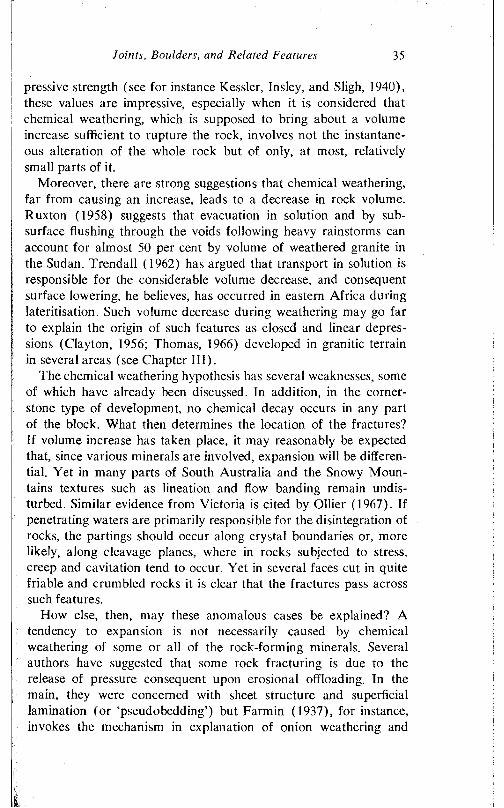
Joints, Boulders, and Related Features 35
pressive strength (see for instance Kessler, Insley, and Sligh, 1940), these values are impressive, especially when it is considered that chemical weathering, which is supposed to bring about a volume increase sufficient to rupture the rock, involves not the instantaneous alteration of the whole rock but of only, at most, relatively small parts of it.
Moreover, there are strong suggestions that chemical weathering, far from causing an increase, leads to a decrease in rock volume. Ruxton (1958) suggests that evacuation in solution and by subsurface flushing through the voids following heavy rainstorms can account for almost 50 per cent by volume of weathered granite in the Sudan. Trendall (1962) has argued that transport in solution is responsible for the considerable volume decrease, and consequent surface lowering, he believes, has occurred in eastern Africa during lateritisation. Such volume decrease during weathering may go far to explain the origin of such features as closed and linear depressions (Clayton, 1956; Thomas, 1966) developed in granitic terrain in several areas (see Chapter III).
The chemical weathering hypothesis has several weaknesses, some of which have already been discussed. In addition, in the cornerstone type of development, no chemical decay occurs in any part of the block. What then determines the location of the fractures? If volume increase has taken place, it may reasonably be expected that, since various minerals are involved, expansion will be differential. Yet in many parts of South Australia and the Snowy Mountains textures such as lineation and flow banding remain undisturbed. Similar evidence from Victoria is cited by Ollier (1967). If penetrating waters are primarily responsible for the disintegration of rocks, the partings should occur along crystal boundaries or, more likely, along cleavage planes, where in rocks subjected to stress, creep and cavitation tend to occur. Yet in several faces cut in quite friable and crumbled rocks it is clear that the fractures pass across such features.
How else, then, may these anomalous cases be explained? A tendency to expansion is not necessarily caused by chemical weathering of some or all of the rock-forming minerals. Several authors have suggested that some rock fracturing is due to the release of pressure consequent upon erosional offloading. In the main, they were concerned with sheet structure and superficial lamination (or ‘pseudobedding’) but Farmin (1937), for instance, invokes the mechanism in explanation of onion weathering and
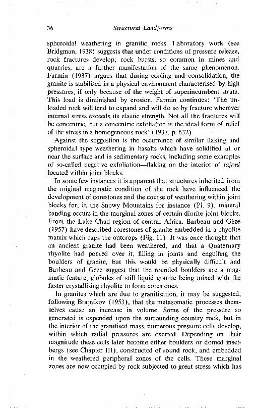
36 Structural Landforms
spheroidal weathering in granitic rocks. Laboratory work (see Bridgman, 1938) suggests that under conditions of pressure release, rock fractures develop; rock bursts, so common in mines and quarries, are a further manifestation of the same phenomenon. Farmin (1937) argues that during cooling and consolidation, the granite is stabilised in a physical environment characterised by high pressures, if only because of the weight of superincumbent strata. This load is diminished by erosion. Farmin continues: ‘The unloaded rock will tend to expand and will do so by fracture wherever internal stress exceeds its elastic strength. Not all the fractures will be concentric, but a concentric exfoliation is the ideal form of relief of the stress in a homogeneous rock’ (1937, p. 632).
Against the suggestion is the occurrence of similar flaking and spheroidal type weathering in basalts which have solidified at or near the surface and in sedimentary rocks, including some examples of so-called negative exfoliation flaking on the interior of tafoni located within joint blocks.
In some few instances it is apparent that structures inherited from the original magmatic condition of the rock have influenced the development of corestones and the course of weathering within joint blocks for, in the Snowy Mountains for instance (PI. 9), mineral banding occurs in the marginal zones of certain diorite joint blocks. From the Lake Chad region of central Africa, Barbcau and Geze (1957) have described corestones of granite embedded in a rhyolite matrix which caps the outcrops (Fig. 11). It was once thought that an ancient granite had been weathered, and that a Quaternary rhyolite had poured over it, filling in joints and engulfing the boulders of granite, but this would be physically difficult and Barbeau and Geze suggest that the rounded boulders are a magmatic feature, globules of still liquid granite being mixed with the faster crystallising rhyolite to form corestones.
In granites which are due to granitisation, it may be suggested, following Brajnikov (1953), that the metasomatic processes themselves cause an increase in volume. Some of the pressure so generated is expended upon the surrounding country rock, but in the interior of the granitised mass, numerous pressure cells develop, within which radial pressures are exerted. Depending on their magnitude these cells later become either boulders or domed insel- bcrgs (see Chapter III), constructed of sound rock, and embedded in the weathered peripheral zones of the cells. These marginal zones are now occupied by rock subjected to great stress which has
Joints, Boulders, and Related Features 37
50 METRES 750 FEET
b GRANITE C RHYOLITEa ALLUVIUM
11 Sections through inselbergs at Ngoura and Gamsous, Lake Chad region, central Africa (after Barbeau and Geze, 1957)
been relieved by fracturing and Assuring tangential to the corestones and by reorientation of minerals in the same general trend.
Jones (1859) remarked that many igneous rocks have a nodular or concentric structure, and even attributed the sheeting of Black- ingstone Rock (see p. 12 and PI. 2) to it. Rondeau (1958) has attributed the formation of boulders to curved joints and, in this, follows several previous authors including Shaler (1868) and Ormerod (1869). Curved joints certainly exist (PI. 5) and furthermore there is suggestion that stress patterns exploited by weathering may have such a nonlinear pattern.
Duffaut (1957) has suggested that the widely evidenced marginal weathering is due to the development of microfissures in these peripheral zones, though the cause is not stated.
Tectonic movements may be responsible for the development of corestones, such as those described from two areas near Adelaide. In the Palmer quarry in which the cornerstones are displayed, there is a minor fault and the major jointing runs parallel to the nearby Palmer and Milendella faults (Fig. 5) which delimit the Mt Lofty Ranges on their eastern side, and which, like several faults in the Adelaide region, have suffered recurrent movements (Glaessner, 1953; Steel, 1962; Mills, 1964, pp. 436-42). The orthogonal joints were probably established early as a result of stresses developed
38 S tru c tu ra l L a n d fo r m s
during Palaeozoic folding and faulting. Renewed dislocation along the faults would cause the joint blocks themselves to be stressed, and if the movements were not purely vertical, but with a torque applied to the shearing motion, forms of spherical section—the shape of least resistance— but elongated normal to the direction of applied stress, could have developed inside each block as a result of the formation of curvilinear fractures (Fig. 12). These last also
1 ***
1 1
w -
\l
N
nJ L i i Jt
N I T I A L O R T
J O I N T S A F T
H O G O N A L J O
E R S H E A R
I N T S V S T E Nt
J H
12 D e ve lo p m e n t o f corestones an d co rners tones by the im p o s it io n o f ro ta t io n a l shear on a g ra n ite mass a lre a d y fra c tu re d by o r th o g o n a l jo in ts
separated the cornerstones from the main mass. Such a mechanism accounts for the observed form, for the notable absence of chemical decay in the blocks, and is consistent with the regional tectonic pattern. Moreover, the concept gains support from Bridgman (1938) who demonstrated experimentally that crystals tend to be arranged with their longitudinal axes normal to the immediate pressure source, that is tangential to the centre of the rotating joint block. Such an arrangement is in fact a remarkable feature of some examples of spheroidally weathered rock.
Palmer and Nielson (1962) have urged that the rotting of parts of the Dartmoor massif is attributable to hot fluids and gases penetrating along joints, and point to the survival of the local tors
Joints, Boulders, and Related Features 39
(inselbergs) in the more massive, and hence less susceptible, regions. But in many areas typical hydrothermal minerals are absent. However, hydrothermal and pneumatolytic action should be noted as yet another possible method whereby joint controlled differential rock disintegration may be brought about.
Ollier (1967) favours an origin involving no change of volume, and following Kieslinger (1932) and Carl and Amstutz (1958) suggests that chemical reactions of the Liesegang type are responsible. In this type of reaction, there is diffusion and periodic precipitation and resolution of salts, and this presumably causes fatigue and disintegration.
Kessler, Insley, and Sligh (1940) noted that most of the samples of granite they subjected to testing took in water. The amounts are small, averaging 0-24 per cent (by weight) after 48 hours, with very little addition subsequently. But it was also noted that even this small intake was associated with a large increase in water transmission rates—that is in permeability. Thus water causes an important change in the physical characteristics of the rocks. Granitic rocks are held together by two forces. The interlocking of mineral crystals is a powerful cohesive force. In addition, unsatisfied ions of those crystal lattices which are located at crystal margins join with opposite, but similarly unsatisfied, ions in adjacent crystals. It is possible that waters penetrating along cleavages and crystal interfaces neutralise this ionic bonding and thus cause a weakening of cohesion along certain structural planes within the rock. Water can then more readily pass along these planes and through the rock.
In summary, though chemical alteration of granite in the vicinity of joints is common in many areas and may well be the primary cause of some corestone development, the changes described are in some cases very slight. Other possible mechanisms must be considered. The morphology and mineral composition of the areas marginal to corestones vary from place to place; it is possible that their genesis also varies from place to place.
BOUL.rn.RS OF SUBAERIAL ORIGIN
The two-stage hypothesis of boulder development described and discussed above clearly applies in very many cases. From time to time, however, it has been suggested that some boulders evolve entirely as a result of subaerial weathering processes (Derruau,
40 Structural Landforms
1958, pp. 249-50; Demek, 1964a). Palmer and Radley (1961) claim that gritstone tors of the English Pennines are wholly subaerial in origin, though their arguments have been severely criticised (Linton, 1964).
It is not easy to find positive support for the subaerial origin of boulders (and indeed of inselbergs). A lack of residual weathered debris between corestones beneath the land surface, for instance, may be the result of erosion outpacing weathering. Demek (1964a), working in Czechoslovakia, has suggested that boulders form as a result of marked disequilibrium of bluffs, where erosion outpaces weathering, and where material is evacuated as soon as it is weathered. In this way, boulder-strewn cliffs form. Similar features have been described from Scotland (Pullan, 1959), western Tasmania, and the eastern Mt Lofty Ranges. In the last named area Reedy Creek, a tributary of the Murray, has cut a gorge through a granite dome. Incision has been so rapid that, in the walls of the gorge, angular joint blocks are dominant. Some have been slightly rounded at the edges, suggesting that in due course they may develop boulder morphology without assistance from subsurface weathering. But even in this area, there is also evidence of two-stage development.
Boulders also evolve as a result of the subaerial disintegration of sheet structure, which, described below in the section dealing with domed inselbergs, is characteristic of these forms. In many areas the massive shells have broken down upon exposure to the atmosphere into a series of angular blocks, due to exploitation by weathering of a series of joints disposed in radial pattern with respect to the dome. These blocks then suffer weathering and gradual rounding. On certain domes of the Everard Ranges in the northern part of South Australia, and on Mt Lindsay in the northwest of the State, some fields of blocks representing massive sheets which have only recently disintegrated are well displayed. The blocks are angular and still perfectly positioned; the intervening joints are narrow. Lurther stages in the widening of the joints and the rounding of the blocks to boulder shape are widely seen, not only in the Everards, but on Eyre Peninsula and near Caloote, south of Palmer and Mannum (see Pis. 17 and 18).
In this last area the boulders are widely scattered, but the general morphology of the area is that of a series of domes, on the upper, greatly disintegrated surface of which were developed gnammas and grooves or gutters. As these features (see Chapter III) which
Joints, Boulders, and Related Features 41
are characteristic of domed inselbergs have survived on the upper surfaces of some boulders, the present boulder-strewn landscape may reasonably be interpreted as resulting from the gradual disintegration, in part at least under subaerial conditions, of a series of domed forms.
MINOR FEATURES DEVELOPED ON BOULDERS
Boulders, of whatever origin, are subject to two sets of processes, one tending to mould them more nearly to spherical forms through the preferential attack on projections as well as on the surface in general, the other tending to create angular forms through the exploitation of latent or secondary joints.
Both superficial granular disintegration on the one hand, and flaking and spalling9 on the other, cause the active reduction of boulders. They may be caused by heating and cooling, disaggregation due to water, some chemical alteration, as well as pressure release. The flakes and spall plates suffer further disintegration and contribute to the supply of granite sand. A superficial form of weathering about which little is known is the so-called polygonal weathering (Leonard, 1929), whereby a polygonal pattern of shallow cracks is produced on the surface of boulders.
Many boulders have been split (PI. 10). The boulder is broken into two hemispherical or subangular parts, depending on the original form of the mass. Plano-convex lenses are produced by marginal splitting. The planes of separation are remarkably straight, and usually regular, though it is significant that where there are minor irregularities, the micro-relief on one side is inversely matched on the other.
Shrubs and trees can cause pre-existing fractures to be opened and widened. Though weathering processes are involved—freeze- thaw on Dartmoor, in the Kosciusko region, and in Antarctica; moisture at Palmer and on Eyre Peninsula—latent joints or other structural planes have been exploited, though they played no part in the delimitation of joint blocks. The delimitation of these secondary joint planes may have begun during subsurface weathering and continued upon exposure to the atmosphere.
9 Flakes are thin (3-6 cm thickness) slivers of uniform thickness; spalls are the rather thicker flakes of regularly varying thickness (up to 15 cm) and shaped like curved lenses.
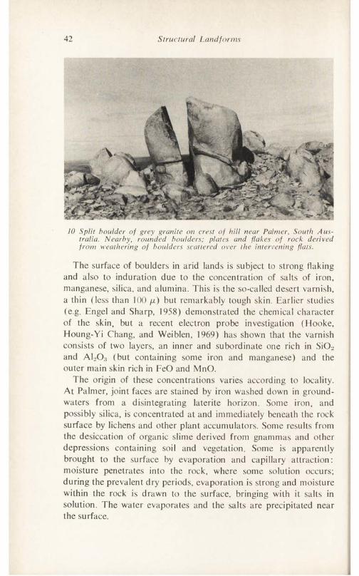
42 Structural Landforms
10 Split boulder of grey granite on crest of hill near Palmer, South Australia. Nearby, rounded boulders; plates and flakes of rock derived from weathering of boulders scattered over the intervening flats.
The surface of boulders in arid lands is subject to strong flaking and also to induration due to the concentration of salts of iron, manganese, silica, and alumina. This is the so-called desert varnish, a thin (less than 100 /x) but remarkably tough skin. Earlier studies (e.g. Engel and Sharp, 1958) demonstrated the chemical character of the skin, but a recent electron probe investigation (Hooke, Houng-Yi Chang, and Weiblen, 1969) has shown that the varnish consists of two layers, an inner and subordinate one rich in SiOL> and AEO.j (but containing some iron and manganese) and the outer main skin rich in FeO and MnO.
The origin of these concentrations varies according to locality. At Palmer, joint faces are stained by iron washed down in ground- waters from a disintegrating laterite horizon. Some iron, and possibly silica, is concentrated at and immediately beneath the rock surface by lichens and other plant accumulators. Some results from the desiccation of organic slime derived from gnammas and other depressions containing soil and vegetation. Some is apparently brought to the surface by evaporation and capillary attraction: moisture penetrates into the rock, where some solution occurs; during the prevalent dry periods, evaporation is strong and moisture within the rock is drawn to the surface, bringing with it salts in solution. The water evaporates and the salts are precipitated near the surface.
Joints, Boulders, and Related Features 43
If this last mechanism has indeed been active, then a zone of depletion, complementary to the surface zone of accretion, should occur just beneath the surface. Such a depleted zone is not everywhere evident (other processes, such as those listed above, may in these instances be responsible for the case hardening) but several excellent examples of these features are known. T. McKinney (personal communication) reports that sandstone core boulders displayed in road cuttings in parts of Tennessee have a tough exterior indurated with secondary silica, but inside consist of a mass of friable quartz grains from which all cement has been removed. Even more striking are examples from southwest Africa and from near Caloote, on the River Murray, 56 km ESE of Adelaide (Fig. 5). Where the case hardened exteriors of boulders have been breached, the indurated layer forms a prominent rim. The core of fresh granite remains in the centre of the block and between it and the casing is a deep moat, presumably corresponding to a depleted zone, some 10-20 cm across. There is evidence from the Snowy Mountains area that the formation of the outer indurated zone occurs while the boulder is still beneath the surface, for some joint blocks exposed in road cuttings reveal that the corestones have a protruding, and therefore presumably resistant, outer rim, with a weaker eroded zone inside that, and a relatively hard core inside that again.
Many boulders display cavernous weathering (PI. 11). Cavities called tafoni have been hollowed out of the undersides and from the overhanging or vertical sides of the rocks. Many have been developed at or close to present ground level. There is no evidence of a consistently preferred orientation.
The forms, which are a common feature of granite outcrops in arid and semiarid lands, and are not so common in humid regions, have been explained in various ways (Högbom, 1912; Cailleux, 1953; Denaeycr, 1956; Wellman and Wilson, 1965), though none is completely satisfactory.
In seeking the origin of these features, two distinct considerations should be borne in mind. First, there are the processes at work within the hollows. Dragovich (1964) has shown that the microclimate within hollows is less extreme than that outside. The weathered rock is altered little, if at all, so that some physical effect of water in causing a weakening of bonding between minerals is involved. Wetting and drying could cause fatigue and disaggregation, and the mamillated surfaces typical of the caverns are sug-
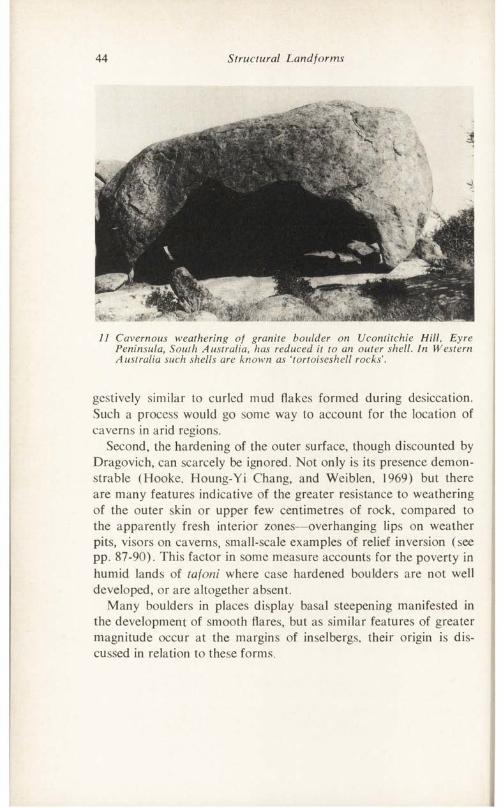
44 Structural Landforms
11 Cavernous weathering of granite boulder on Ucontitchie Hill, Eyre Peninsula, South Australia, has reduced it to an outer shell. In Western Australia such shells are known as ‘tortoiseshell rocks’.
gestively similar to curled mud flakes formed during desiccation. Such a process would go some way to account for the location of caverns in arid regions.
Second, the hardening of the outer surface, though discounted by Dragovich, can scarcely be ignored. Not only is its presence demonstrable (Hooke, Houng-Yi Chang, and Weiblen, 1969) but there are many features indicative of the greater resistance to weathering of the outer skin or upper few centimetres of rock, compared to the apparently fresh interior zones—overhanging lips on weather pits, visors on caverns, small-scale examples of relief inversion (see pp. 87-90). This factor in some measure accounts for the poverty in humid lands of tafoni where case hardened boulders are not well developed, or are altogether absent.
Many boulders in places display basal steepening manifested in the development of smooth flares, but as similar features of greater magnitude occur at the margins of inselbergs, their origin is discussed in relation to these forms.
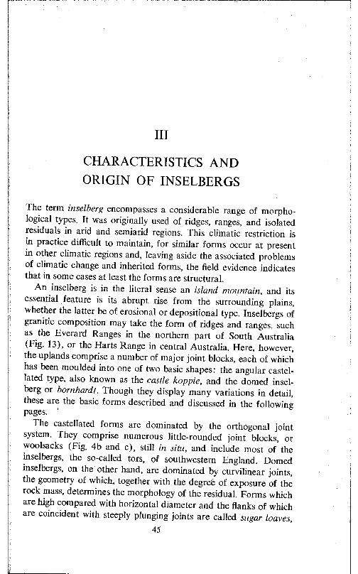
Ill
CHARACTERISTICS AND ORIGIN OF INSELBERGS
The term inselberg encompasses a considerable range of morphological types. It was originally used of ridges, ranges, and isolated residuals in arid and semiarid regions. This climatic restriction is in practice difficult to maintain, for similar forms occur at present in other climatic regions and, leaving aside the associated problems of climatic change and inherited forms, the field evidence indicates that in some cases at least the forms are structural.
An inselberg is in the literal sense an island mountain, and its essential feature is its abrupt rise from the surrounding plains, whether the latter be of erosional or depositional type. Inselbergs of granitic composition may take the form of ridges and ranges, such as the Everard Ranges in the northern part of South Australia (Fig. 13), or the Harts Range in central Australia. Here, however, the uplands comprise a number of major joint blocks, each of which has been moulded into one of two basic shapes: the angular castellated type, also known as the castle koppie, and the domed insel- berg or born hard t. Though they display many variations in detail, these are the basic forms described and discussed in the following pages.
The castellated forms are dominated by the orthogonal joint system. They comprise numerous little-rounded joint blocks, or woolsacks (Fig. 4b and c), still in situ, and include most of the inselbergs, the so-called tors, of southwestern England. Domed inselbergs, on the other hand, are dominated by curvilinear joints, the geometry of which, together with the degree of exposure of the rock mass, determines the morphology of the residual. Forms which are high compared with horizontal diameter and the flanks of which are coincident with steeply plunging joints are called sugar loaves,
45
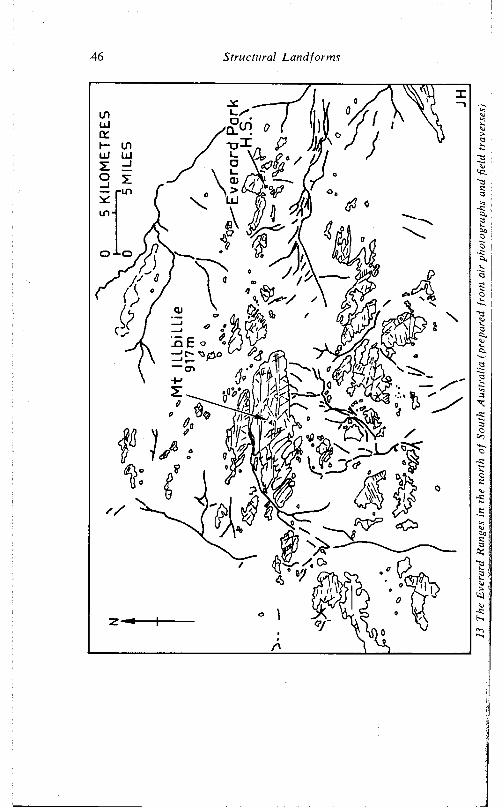
46 Structural Landforms
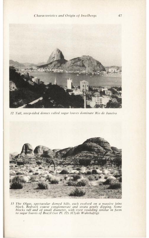
Characteristics and Origin of Inselbergs 47
12 Tall, steep-sided domes called sugar loaves dominate Rio de Janeiro
13 The Olgas, spectacular domed hills, each evolved on a massive joint block. Bedrock coarse conglomerate and strata gently dipping. Some blocks tall and of small diameter, with crest rounding similar in form to sugar loaves of Brazil (see PI. 12). (Clyde Wahrhaftig)
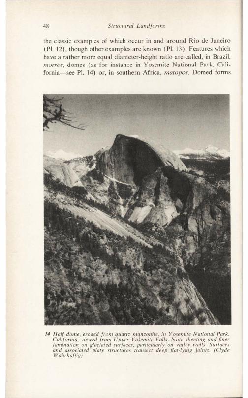
48 Structural Landforms
the classic examples of which occur in and around Rio de Janeiro (PI. 12), though other examples are known ( PI. 13). Features which have a rather more equal diameter-height ratio are called, in Brazil, morros, domes (as for instance in Yosemite National Park, California—see PI. 14) or, in southern Africa, matopos. Domed forms
14 Half dome, eroded from quartz, monzonite, in Yosemite National Park, California, viewed from Upper Yosemite Falls. Note sheeting and finer lamination on glaciated surfaces, particularly on valley walls. Surfaces and associated platy structures transect deep flat-lying joints. (Clyde Wahrhaftig)
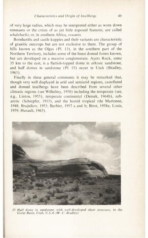
Characteristics and Origin of Insel bergs 49
of very large radius, which may be interpreted either as worn down remnants or the crests of as yet little exposed features, are called whalebacks, or, in southern Africa, ritwares.
Bornhardts and castle koppies and their variants are characteristic of granitic outcrops but are not exclusive to them. The group of hills known as the Olgas (PI. 13), in the southern part of the Northern Territory, includes some of the finest domed forms known, but are developed on a massive conglomerate. Ayers Rock, some 35 km to the east, is a flattish-topped dome in arkosic sandstone, and half domes in sandstone (PI. 15) occur in Utah (Bradley, 1963).
Finally in these general comments it may be remarked that, though very well displayed in arid and semiarid regions, castellated and domed inselbergs have been described from several other climatic regions (see Wilhelmy, 1958) including the temperate (see, e.g., Linton, 1955), temperate continental (Demek, 1964b), subarctic (Schrepfer, 1933), and the humid tropical (de Martonne, 1948; Brajnikov, 1953; Barbier, 1957 a and b; Birot, 1958a; Louis, 1959; Hurault, 1963).
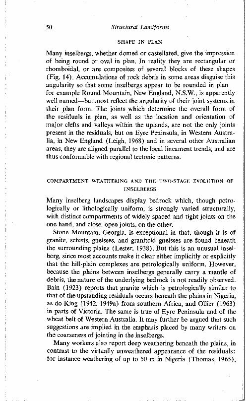
50 Structural Landfonns
SHAPE IN PLAN
Many inselbergs, whether domed or castellated, give the impression of being round or oval in plan. In reality they are rectangular or rhomboidal, or are composites of several blocks of these shapes (Fig. 14). Accumulations of rock debris in some areas disguise this angularity so that some inselbergs appear to be rounded in plan— for example Round Mountain, New England, N.S.W., is apparently well named—but most reflect the angularity of their joint systems in their plan form. The joints which determine the overall form of the residuals in plan, as well as the location and orientation of major clefts and valleys within the uplands, are not the only joints present in the residuals, but on Eyre Peninsula, in Western Australia, in New England (Leigh, 1968) and in several other Australian areas, they are aligned parallel to the local lineament trends, and are thus conformable with regional tectonic patterns.
COMPARTMENT WEATHERING AND THE TWO-STAGE EVOLUTION OFINSELBERGS
Many inselberg landscapes display bedrock which, though petro- logically or lithologically uniform, is strongly varied structurally, with distinct compartments of widely spaced and tight joints on the one hand, and close, open joints, on the other.
Stone Mountain, Georgia, is exceptional in that, though it is of granite, schists, gneisses, and granitoid gneisses are found beneath the surrounding plains (Lester, 1938). But this is an unusual insel- berg, since most accounts make it clear either implicitly or explicitly that the hill-plain complexes are petrologically uniform. However, because the plains between inselbergs generally carry a mantle of debris, the nature of the underlying bedrock is not readily observed. Bain (1923) reports that granite which is petrologically similar to that of the upstanding residuals occurs beneath the plains in Nigeria, as do King (1942, 1949a) from southern Africa, and Ollier (1963) in parts of Victoria. The same is true of Eyre Peninsula and of the wheat belt of Western Australia. It may further be argued that such suggestions are implied in the emphasis placed by many writers on the coarseness of jointing in the inselbergs.
Many workers also report deep weathering beneath the plains, in contrast to the virtually unweathered appearance of the residuals: for instance weathering of up to 50 m in Nigeria (Thomas, 1965),
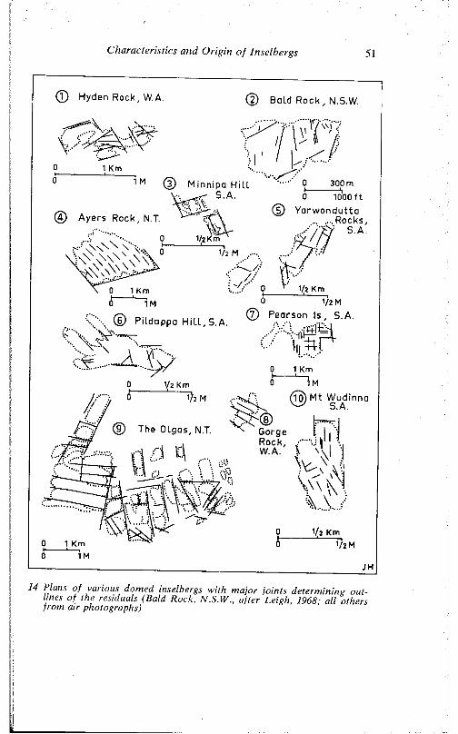
C harac te ris tics a nd O r ig in o f Inse lbergs 51
© Hyden Rock,W A
i«© Bald Rock , N.5.W.
o’1 Km
/1 M © Minnipa Hil l
S. A.
@ Ayers Rock, N T.
0 1000 ft© Yarwondutta
... ....Rocks, ' S . A .
r7 \ D l . . .. .. „ . © Pearson Is, S.A.\ \ V§) Pildappa H i l l , S.A.
> ii^ rf v .
V \ >••;;V '~AJr
1/2 Km
0 __1 Km0 1M
~i)2 M Mt Wudinna S.A.
® The Olgas, N.T. Gorge |[ I .*']» n( n
14 Plans o f various domed inselbergs w ith m ajor jo in ts determ in ing ou tlines o f the residuals (Ba ld Rock, N.S.W ., a fter Leigh, 1968; a ll others from a ir photographs)
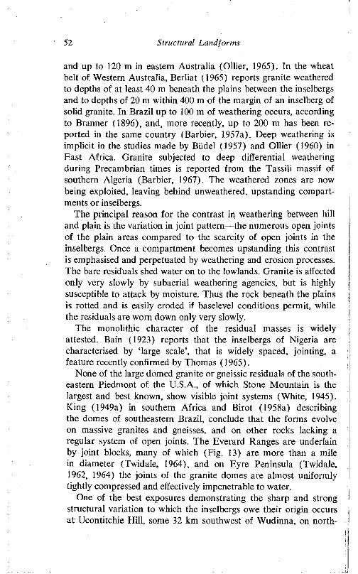
52 Structural Land for ms
and up to 120 m in eastern Australia (Ollier, 1965). In the wheat belt of Western Australia, Berliat (1965) reports granite weathered to depths of at least 40 m beneath the plains between the inselbergs and to depths of 20 m within 400 m of the margin of an inselberg of solid granite. In Brazil up to 100 m of weathering occurs, according to Branner (1896), and, more recently, up to 200 m has been reported in the same country (Barbier, 1957a). Deep weathering is implicit in the studies made by Biidel (1957) and Ollier (1960) in East Africa. Granite subjected to deep differential weathering during Precambrian times is reported from the Tassili massif of southern Algeria (Barbier, 1967). The weathered zones are now being exploited, leaving behind unweathered, upstanding compartments or inselbergs.
The principal reason for the contrast in weathering between hill and plain is the variation in joint pattern—the numerous open joints of the plain areas compared to the scarcity of open joints in the inselbergs. Once a compartment becomes upstanding this contrast is emphasised and perpetuated by weathering and erosion processes. The bare residuals shed water on to the lowlands. Granite is affected only very slowly by subaerial weathering agencies, but is highly susceptible to attack by moisture. Thus the rock beneath the plains is rotted and is easily eroded if baselevel conditions permit, while the residuals are worn down only very slowly.
The monolithic character of the residual masses is widely attested. Bain (1923) reports that the inselbergs of Nigeria are characterised by ‘large scale’, that is widely spaced, jointing, a feature recently confirmed by Thomas (1965).
None of the large domed granite or gneissic residuals of the southeastern Piedmont of the U.S.A., of which Stone Mountain is the largest and best known, show visible joint systems (White, 1945). King (1949a) in southern Africa and Birot (1958a) describing the domes of southeastern Brazil, conclude that the forms evolve on massive granites and gneisses, and on other rocks lacking a regular system of open joints. The Everard Ranges are underlain by joint blocks, many of which (Fig. 13) are more than a mile in diameter (Twidale, 1964), and on Eyre Peninsula (Twidale, 1962, 1964) the joints of the granite domes are almost uniformly tightly compressed and effectively impenetrable to water.
One of the best exposures demonstrating the sharp and strong structural variation to which the inselbergs owe their origin occurs at Ucontitchie Hill, some 32 km southwest of Wudinna, on north-
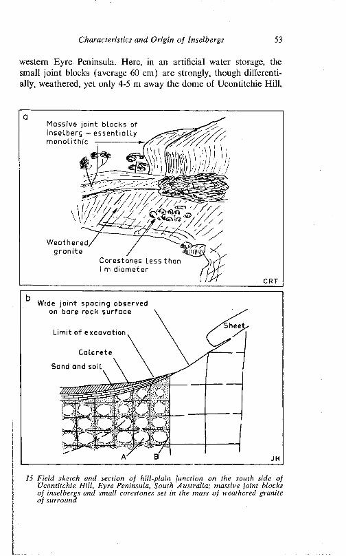
Characteristics and Origin o f Inselbergs 53
western Eyre Peninsula. Here, in an artificial water storage, the small joint blocks (average 60 cm) are strongly, though differentially, weathered, yet only 4-5 m away the dome of Ucontitchie Hill,
Massive joint blocks of inselberg - essential ly monolithic
Weathered/ / /granite / 4ijin10/ > \
Corestones l e s s than I m diameter
CRT
15 Field sketch and section of hill-plain junction on the south side of Ucontitchie Hill, Eyre Peninsula, South Australia; massive joint blocks of inselbergs and small corestones set in the mass of weathered granite of surround
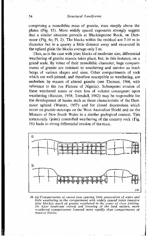
54 Structural Landforms
comprising a monolithic mass of granite, rises steeply above the plains (Fig. 15). More widely spaced exposures strongly suggest that a similar situation prevails at Blackingstone Rock, on Dartmoor (Fig. 4c; PI. 2). The blocks within the residual are 7-10 m in diameter but in a quarry a little distance away and excavated in the upland plain the blocks average only 2 m.
Thus, as is the case with joint blocks of moderate size, differential weathering of granite masses takes place, but, in this instance, on a grand scale. By virtue of their monolithic character, huge compartments of granite are resistant to weathering and survive as insel- bergs of various shapes and sizes. Other compartments of rock which are well-jointed, and therefore susceptible to weathering, are underlain by masses of altered granite (see Thomas, 1966, with reference to the Jos Plateau of Nigeria). Subsequent erosion of these weathered zones or even loss of volume consequent upon weathering (Ruxton, 1958; Trendall, 1962) may be responsible for the development of basins such as those characteristic of the Dartmoor upland (Waters, 1957) and for closed depressions which occur on granite outcrops on the West Australian Shield and on the Monaro of New South Wales in a similar geological context. This structurally (joint) controlled weathering of the country rock (Fig. 16) leads to strong differential erosion of the mass.
; .- A
■“ p r" Dp r ; \y t ;'<
/ T ■ f K ' t y ' -v r Y J V V S V / ’V ' w - i t f J l .A. j
'r-ip4i
(a) Compartments of varied joint spacing; little penetration of water and little weathering in the compartment with widely spaced joints (massive joint blocks); much of granite weathered in the zones of close jointing.(b) After landscape revival and lowering of the land surface, more weathered compartments towered more rapidly than compartments of massive blocks.
Characteristics and Origin of Inselbergs 55
Passarge (1904) considered wind scouring responsible for the differential erosion, but most writers consider streams and rivers are responsible for the evacuation of weathered debris. Thus, as was the case with smaller scale features, castellated and domed inselbergs form in two stages ( Branner, 1896; Bornhardt, 1900; Falconer, 1911; Thiele and Wilson, 1915; Bain, 1923; Willis, 1934; Linton, 1952; Handley, 1952; Büdel, 1957; Ollier, 1960; Twidale, 1964 and many others). Their common occurrence in areas which display evidence of multicyclic evolution (Obst, 1923; King, 1949a; Twidale, 1964) is related to the requirement for deep weathering which, presumably, most readily occurs beneath a relatively stable surface of low relief.
There are, of course, minor differences in interpretation amongst supporters of the two-stage theory. Some consider that in places weathered debris between the subsurface towers of solid granite (Fig. 17a) is completely removed, so that the resulting plain is in effect partially an etch plain (Büdel. 1957). Others (Ollier, 1960) believe the plains are cut wholly across the pre-weathered material (Fig. 17b). These contrasts presumably reflect structural variation and baselevel control, though it is in any case difficult to visualise how a distinction can in every case be made between weathered material which develops beneath the present plain and that which is inherited from an earlier phase of development.
In East Africa, the area discussed by both Büdel and Ollier, the subsurface weathering is of the humid intertropical type, and the evacuation of weathered debris due to river erosion. Most workers, of whom Linton (1955) is representative, consider the tors or inselbergs of southwestern England to have developed through deep subsurface weathering, probably under tropical humid conditions in the Tertiary, followed by erosion, quarrying, and exposure under essentially periglacial conditions during the Quaternary. Palmer and Nielson (1962), on the other hand, believe that periglacial processes are responsible not only for the erosion and outlining of the tors, but also for their preliminary weathering.
OTHER HYPOTHESES OF INSELBERG EVOLUTION
A fundamentally different interpretation of inselberg landscapes is offered by King (1949a), who, bearing in mind the apparent absence of deep weathering beneath the pediment surfaces of southern Africa, considers that inselbergs evolve by joint-controlled
Tropical planation su r fa ce , surface profile
Two-stage planation surface ( t rop ica l planationsurface)
Weathering f ront (1)
Lowering of a t w o - s t a g e planation sur face
Gondwana surface
Basal surfaceWeathered rock
Fresh rock
Pediments Lower slope \ outcrop
African su r face Inselbergs — —
17 Two-stage development of tropical plains and inselbergs as envisaged (a) by Biidel (1957), and (b) by Ollier (1960)
Characteristics and Origin o f Inselbergs 57
stream incision into a surface of low relief, followed by ‘scarp retreat and pedimentation’ from the river valleys. The last remnants standing above the pediplain surface are the steep-sided inselbergs (Fig. 18a). King emphasises joint control, but does not believe that pre-weathering beneath the old land surface is a necessary prerequisite for inselberg development.
The same writer has subsequently argued (King, 1966) that as
River
TValley
.Inselberg
4- r ^ T T - r I I
18 (a) Development of inselbergs by joint-controlled stream incision, scarp retreat and pedimentation, according to L. C. King, (b) Persistence, disappearance, and birth of inselbergs according to variation of jointing in depth. Daring lowering of the land surface from I to 2, inselberg (A) persists, (B) disappears, and (C), not represented at level I, is initiated because of exposure by erosion of a compartment of massive joint blocks.
58 Structural Land for ms
many inselbergs stand well over 300 m above the present plains, that is greater than the usual recorded depth of subsurface weathering, the two-stage theory cannot be sustained. However, many inselbergs, such as all but one of those on northwestern Eyre Peninsula, are of an elevation within the observed limits of weathering, and, in any case, the residuals may persist through more than one cycle of subsurface weathering and subsequent erosion.
Another possibility, inferred by Brajnikov (1953), and arising from the distribution of joints, is that inselbergs do not necessarily persist through several geomorphic cycles, as implied in several published diagrams. Brajnikov’s important paper is entitled ‘Les pains du sucre: sont ils racines?’. The author’s principal theme is that expansion consequent on metasomatism had taken place in cells, many of them of the order of 1 m diameter, but some 100 m, and possibly larger. Brajnikov therefore visualises that some of the morros and sugar loaves of southeastern Brazil are masses of solid rock perched and isolated within a matrix of crushed and disintegrated granite or gneiss. Thus such resistant compartments need not persist in depth and through two or more cycles of erosion. Even in areas not subjected to granitisation, the distribution of joints in a vertical direction may reasonably be expected to display a similar degree of variation to that which they so clearly exhibit in a horizontal sense. Thus the massive and tight jointing characteristic of an inselberg need not necessarily persist in depth. By the same token, there may be incipient monolithic masses ready to be exposed beneath the present plains (Fig. 18b), so that it is impossible to state with certainty whether a given whaleback or ruware is a newly emergent massive compartment or the worn-down remnant of an ancient tower of rock.
Lastly, several authors have suggested that inselbergs are due to dome-like batholithic intrusions, each residual mass being either an individual intrusion or a protuberance emanating from a larger plutonic mass. Holmes and Wray (1912, 1913) advocated such an origin for the inselbergs of Mozambique, and though later students of these same features have supported the two-stage compartment weathering hypothesis (e.g. Thiele and Wilson, 1915), several of the small granitic bodies of the eastern and southern Mt Lofty Ranges and adjacent Murray plains could be of this character. The granite domes, for such they likely were, are now considerably disintegrated but the granite in such areas as Victor Harbour and Caloote is heavily charged with xenoliths of the local Kanmantoo (Pro-
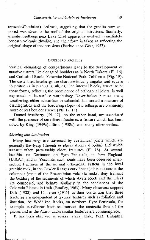
Characteristics and Origin of Inselbergs 59
terozoic-Cambrian) bedrock, suggesting that the granite now exposed was close to the roof of the original intrusions. Similarly, granite inselbergs near Lake Chad apparently evolved immediately beneath volcanic rhyolite, and their form is taken as reflecting the original shape of the intrusions (Barbeau and Geze, 1957).
INSELBERG PROFILES
Vertical elongation of compartments leads to the development of massive turrets like elongated boulders as in North Dakota (PI. 16) and Cathedral Rocks, Yosemite National Park, California (Fig. 19). The castellated inselbergs are characteristically angular and square in profile as in plan (Fig. 4b, c). The internal blocky structure of these forms, reflecting the prominence of orthogonal joints, is well expressed in the surface morphology. Nevertheless in most areas, weathering, either subsurface or subaerial, has caused a measure of disintegration and the bordering slopes of inselbergs are commonly more or less boulder strewn (Pis. 17, 18).
Domed inselbergs (PI. 17), on the other hand, are associated with the presence of curvilinear fractures, a feature which has been noted by King (1949a), Birot (1958a), and many other writers.
Sheeting and laminationMany inselbergs are traversed by curvilinear joints which are
generally flat-lying (though in places steeply dipping) and which transect other, presumably older, fractures (PI. 18). At several localities on Dartmoor, on Eyre Peninsula, in New England (U.S.A.), and in Yosemite, such joints have been observed intersecting fractures of the normal orthogonal system in the local granitic rock; in the Gawler Ranges curvilinear joints cut across the columnar joints of the Precambrian volcanic rocks; they transect the bedding of the sediments of which Ayers Rock and the Olgas are composed, and behave similarly in the sandstones of the Colorado Plateau in Utah (Bradley, 1963). Many observers support Dale (1923) and Cameron (1945) in their contention that these fractures are independent of textural features such as foliation and lineation. At Waddikee Rocks, on northern Eyre Peninsula, for example, curvilinear fractures transect the anatectic flow of the gneiss, and in the Adirondacks similar features are commonplace.
It has been observed in several areas (Dale, 1923; Ljungner,
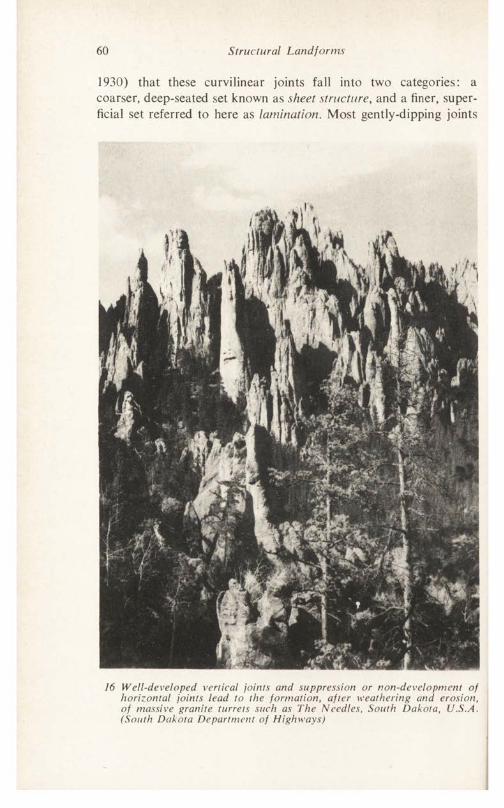
60 Structural Landforms
1930) that these curvilinear joints fall into two categories: a coarser, deep-seated set known as sheet structure, and a finer, superficial set referred to here as lamination. Most gently-dipping joints
16 Well-developed vertical joints and suppression or non-development of horizontal joints lead to the formation, after weathering and erosion, of massive granite turrets such as The Needles, South Dakota, JJ.S.A. (South Dakota Department of Highways)
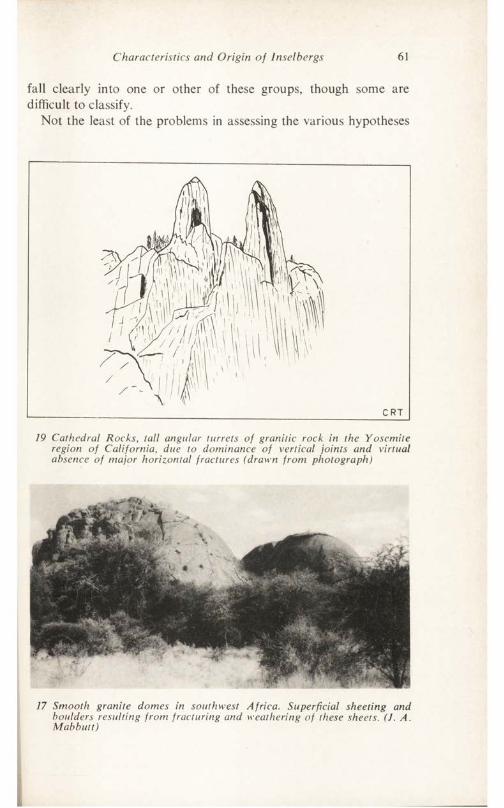
Characteristics and Origin of Inselbergs 61
fall clearly into one or other of these groups, though some are difficult to classify.
Not the least of the problems in assessing the various hypotheses
19 Cathedral Rocks, tall angular turrets of granitic rock in the Yoscmite region of California, due to dominance of vertical joints and virtual absence of major horizontal fractures (drawn from photograph)
17 Smooth granite domes in southwest Africa. Superficial sheeting and boulders resulting from fracturing and weathering of these sheets. (J. A. Mabbutt)
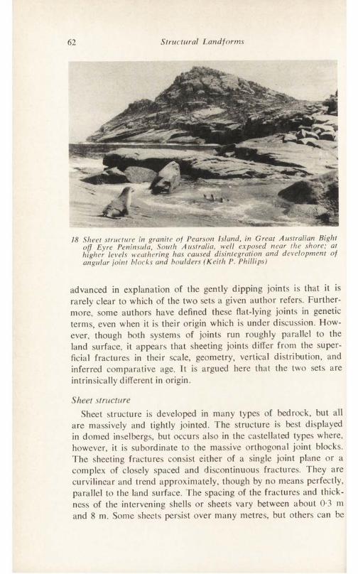
62 Structural Landforms
18 Sheet structure in granite of Pearson Island, in Great Australian Bight off Eyre Peninsula, South Australia, well exposed near the shore; at higher levels weathering has caused disintegration and development of angular joint blocks and boulders (Keith P. Phillips)
advanced in explanation of the gently dipping joints is that it is rarely clear to which of the two sets a given author refers. Furthermore, some authors have defined these flat-lying joints in genetic terms, even when it is their origin which is under discussion. Flow- ever, though both systems of joints run roughly parallel to the land surface, it appears that sheeting joints differ from the superficial fractures in their scale, geometry, vertical distribution, and inferred comparative age. It is argued here that the two sets are intrinsically different in origin.
Sheet structureSheet structure is developed in many types of bedrock, but all
are massively and tightly jointed. The structure is best displayed in domed inselbergs, but occurs also in the castellated types where, however, it is subordinate to the massive orthogonal joint blocks. The sheeting fractures consist either of a single joint plane or a complex of closely spaced and discontinuous fractures. They are curvilinear and trend approximately, though by no means perfectly, parallel to the land surface. The spacing of the fractures and thickness of the intervening shells or sheets vary between about 0-3 m and 8 m. Some sheets persist over many metres, but others can be
Characteristics and Origin of Inselbergs 63
traced only over shorter distances. Thus, besides the concentrically arranged massive shells, thick wedges and lenticular masses of rock occur within the hills. In a general way, the thickness of the sheets increases with depth (Dale, 1923; Chapman and Rioux, 1958). In general the degree of curvature of the shells decreases (the radius of curvature increases) with depth. However, marked steepening of the fractures has been observed in the vicinity of major vertical joints. The curvature of the shells is in places asymmetrical.
Sheet structure extends to depths in excess of 100 m on Dartmoor (e.g. Merrivale Quarry), at Quincy, Massachusetts (Dale, 1923), and at the Rock of Ages Quarry, Barre, Vermont. In none of these exposures is there any sign that the structure may not continue to greater depths. Leigh (1967) records sheet structures to depths of 300 m and more in deeply dissected valleys in northern New South Wales, though these may be oply superficial fractures.
The sheeting joints are of antiquity, and certainly older than the lamination. On Dartmoor, sills of fine-grained granite and aplite are in some places intruded along such joints, for instance, at Believer Tor and Kestor Rock. Some at least of the fractures predate the intrusions, which, ranging in age from Carboniferous to Eocene (Darnley in discussion of Blyth, 1962), are, in the present context, all old.
Origin of sheet structure: general commentTwo major schools of thought emerge from an examination of the
considerable literature concerned with the origin of sheeting. Some workers, late in the field, but now in overwhelming majority, regard sheet structure as a secondary feature, the geometry of which is determined by the form of the land surface: the offloading or pressure release hypothesis is very widely supported. Others, however, interpret the land surface as consequent upon internal structure, and view sheeting as a primary or peneprimary feature of bedrock.
InsolationOf those who consider sheeting a secondary feature, a few in
years gone by attributed sheeting to insolational effects. Tyrrell, for instance, stated that some of the granite sheets on Arran are ‘an exfoliation effect due to temperature variations operating from, and producing rifts parallel to, the present surface of the ground’ (1928, pp. 160-1). If only because of the great depths to which
64 Structured Landforms
sheeting is known to extend, this view can no longer be supported. A similar origin has been attributed to some of the pseudobedding of Dartmoor (McMahon. 1893), but since it was the superficial, flaggy pseudobedding that was apparently described, this will be considered later (p. 77).
Erosional offloadingUndoubtedly the most widely accepted view of sheeting is that
it is a secondary feature due to pressure release brought about by erosional offloading. So acceptable is this hypothesis that many now refer to the structures as offloading joints and yet others, either implicitly or explicitly, define sheeting in terms of offloading, thereby begging the question. Thus Soen (1965, p. 12):
From a genetic point of view sheeting should also be distinguished from primary and tectonically imposed joints in the granites. Sheeting in a granite is the splitting off of the granite mass into sheets parallel to the topography; thus sheeting should be a secondary feature occurring after the development of the topography.
The gist of the offloading or pressure release concept, which was formally stated by Gilbert in 1904, and which has been referred to earlier (p. 11), is that granitic rocks, for example, whatever their origin, crystallise deep in the earth’s crust under high pressure conditions. As erosion removes the superincumbent load, hydrostatic pressures are decreased and the relief of pressure is expressed in a series of fractures disposed tangential to the direction of stress, that is parallel to the land surface.
As also stated in the previous chapter, it is of course true that while few would go so far as Chapman (1956) and assert that the disposition of all joints is controlled by topography, they are all nevertheless in some measure an expression of erosional offloading. Presumably all fractures, including joints, disappear at depth because of increased hydrostatic pressures. But with the removal of overburden by erosion, the stresses inherent in the rock, hitherto suppressed by the pressure of the overburden, are manifested as joints. The essential difference between such joints and those allegedly due to offloading is that, in the former, pressure release allows pre-existing stresses in the rocks to be manifested as joints, whereas, in the latter, erosion alone induces rock fractures. In the former case, the topography is consequent upon the inherent struc-
Characteristics and Origin of Inselbergs 65
tures in the bedrock; in the latter, it is the topography which controls the geometry of the joint system. This argument is almost irrefutable in those areas where the sheeting occurs on the surface of glacially eroded surfaces (PI. 19) which have suffered local temporary loading and unloading by ice (Matthes, 1930; Lewis, 1954). But there are obvious difficulties when it is applied generally.
19 Spectacular mass of sheeted granitic rock in cirque headwall. Little Shuteye Pass, Sierra Nevada, California. Note synform, or basin-like configuration, of gently dipping joint near top of the exposed wall, and beneath crest of hill. (N. King Hubbert, U.S. Geological Survey)
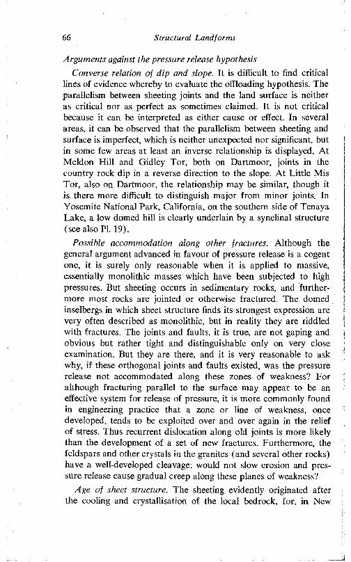
66 Structural Landforms
Arguments against the pressure release hypothesisConverse relation of dip and slope. Tt is difficult to find critical
lines of evidence whereby to evaluate the offloading hypothesis. The parallelism between sheeting joints and the land surface is neither as critical nor as perfect as sometimes claimed. It is not critical because it can be interpreted as either cause or effect. In several areas, it can be observed that the parallelism between sheeting and surface is imperfect, which is neither unexpected nor significant, but in some few areas at least an inverse relationship is displayed. At Meldon Hill and Gidley Tor, both on Dartmoor, joints in the country rock dip in a reverse direction to the slope. At Little Mis Tor, also on Dartmoor, the relationship may be similar, though it is there more difficult to distinguish major from minor joints. In Yosemite National Park, California, on the southern side of Tenaya Lake, a low domed hill is clearly underlain by a synclinal structure (see also PI. 19).
Possible accommodation along other fractures. Although the general argument advanced in favour of pressure release is a cogent one, it is surely only reasonable when it is applied to massive, essentially monolithic masses which have been subjected to high pressures. But sheeting occurs in sedimentary rocks, and furthermore most rocks are jointed or otherwise fractured. The domed inselbergs in which sheet structure finds its strongest expression are very often described as monolithic, but in reality they are riddled with fractures. The joints and faults, it is true, are not gaping and obvious but rather tight and distinguishable only on very close examination. But they are there, and it is very reasonable to ask why, if these orthogonal joints and faults existed, was the pressure release not accommodated along these zones of weakness? For although fracturing parallel to the surface may appear to be an effective system for release of pressure, it is more commonly found in engineering practice that a zone or line of weakness, once developed, tends to be exploited over and over again in the relief of stress. Thus recurrent dislocation along old joints is more likely than the development of a set of new fractures. Furthermore, the feldspars and other crystals in the granites (and several other rocks) have a well-developed cleavage; would not slow erosion and pressure release cause gradual creep along these planes of weakness?
Age of sheet structure. The sheeting evidently originated after the cooling and crystallisation of the local bedrock, for, in New
Characteristics and Origin of Inselbergs 67
England (Dale, 1923, pp. 31-2), on Eyre Peninsula, and in Aberdeenshire (Cameron, 1945), the structure transgresses the rift and grain and crystal orientation in the country rock. Kieslinger (1960) also points out that in Norway and the western U.S.A. the sheet structure is a later geological feature which has developed gradually through the Cainozoic. This secondary age of the structures can be explained in varied terms, for in most areas the postulated age of sheeting structures is not diagnostic. On Dartmoor, however, the age of the joints is of significance, for if the gently-dipping joints are related to erosional offloading, they should be related to the denudation chronology of the region in which they occur.
On Dartmoor, a complex series of erosional cycles has been reconstructed to explain the landforms of the southern part of the massif (Orme, 1963). All are of late Cainozoic age, and though the details of interpretation are probably invalidated by the recognition of significant late geological faulting in the massif (Blyth, 1957, 1962; Dearman, 1963, 1964) considerable erosion clearly occurred during this period. But it has long been recognised that erosion exposed, or nearly exposed, the crystalline pluton by the end of the Mesozoic, possibly by the Lower Cretaceous (see, for example, Smith, 1961; Hutchins, 1963), and the importance of the sub- Cretaceous land surface as a significant element of the present landscape has been increasingly recognised (Simpson, 1964). Thus the erosion to which the advocates of the offloading hypothesis attribute the development of the deep-seated joints is probably that which occurred in the Mesozoic. This is supported by the occurrence along some of the joints of aplite and fine-grained granite; these intrusions of Carboniferous to Eocene age (Damley in discussion of Blyth, 1962) show that some of the joints were in existence before the Eocene.
But deep, youthful valleys, such as those of the Dart and Teign, clearly related to Quaternary events and standing in strong contrast with the shallow, open valleys of the moor proper, score the margins of the Dartmoor massif and adjacent regions. The gently- dipping joints, including both deep-seated and superficial types, trend parallel with the slopes of some of these valleys also. Thus, according to the pressure release hypothesis, joints of great antiquity evolved in sympathy with a land surface the morphology of which was not produced until the Quaternary. The discrepancy is surely only explicable by accepting that the valleys have developed along lines of weakness related to faults and major vertical joints, and
68 Structural Landfonns
that their morphology is controlled by essentially gently-dipping joints which predate the erosion; in other words, that it is structure which is controlling the form of the land surface and not the reverse.
Failure to explain significant geomorphological and geological features. The offloading hypothesis fails to account for several features consistently and closely associated with sheet structure. These will be discussed in detail below, but they include the preservation of the inselbergs in which the sheet structure occurs; the common association of sheeting with faulting; the relationship of the sheeting with newer granites in Sermasoq, southern Greenland (Soen, 1965); and several details observed in the field, such as wedges, slickensides along the sheeting planes, and possible imbricate structure. Finally, it should be pointed out that the notion of expansive release of pressure is inconsistent with the argument that the inselbergs survive by virtue of their tightly closed joints, which is suggestive of compressive stress.
Sheeting as a primary or peneprimary featureAs related to deep-seated cooling. On Dartmoor the gently dip
ping joints were noted early. De la Beche ( 1839, p. 163) suggested that they are a cooling phenomenon disposed in general parallelism to the outline of the original igneous intrusion. Although it seems unlikely that at the depths envisaged a temperature gradient would develop sufficiently steep to induce rupture, and despite the occurrence of sheeting in sedimentary rocks such as the arkose of Ayers Rock and the conglomerate of the Olgas, this notion is regarded as at least a possible explanation by some later workers (Brammall, 1926, p. 262; Hollingworth in discussion of Blyth, 1962). In areas like Caloote and Victor Harbour (pp. 58-9) where the granite intrusions have the form and character of small protuberances, it seems more likely that the arched joints are stretching planes (see Fig. 2) related to the upward surge of the igneous masses. Similar suggestions may be made with respect to granite intrusions near Lake Chad, central Africa (Barbeau and Geze, 1957).
As a petrogenic feature. Jones (1859) remarked that many igneous rocks have a nodular or concentric structure, and suggested that the sheeting so well displayed on Blackingstone Rock, at the eastern margin of Dartmoor, is due to the crystallisation of a core, and subsequent concentric crystallisation about it. In this connection, it is of interest that a century later similar ideas have been
Characteristics and Origin of Inselbergs 69
entertained with respect to the morros of southeastern Brazil which have been explained by Brajnikov (1953) and Barbier (1957b) as being in effect original protuberances of granite and gneiss.
As mentioned earlier (pp. 36-7), however, Brajnikov (1953) points to the occurrence, several dozens of metres below the surface, of boulders of fresh granite surrounded by zones which are traversed by fissures arranged concentrically around the boulders. These structures may be due to deep weathering, but are interpreted by Brajnikov as petrogenic features associated with the process of granitisation. Brajnikov regards some of the fissures and fractures (which are geometrically comparable to sheeting structure) in the morros as tensional fractures caused by variations in volume consequent upon granitisation. However, if the masses are in tension, it is difficult to comprehend why they survive as hills, since they are not of a different and more resistant composition than the surrounding country rock.
As clue to lateral compression. It has long been known that, in many areas, rocks are in a state of compressive stress. Such compressive stresses commonly exceed vertical pressures (Talobre, 1957, p. 57; see also Moye, 1958) and are commonly greater than anticipated on theoretical grounds. In the Kolar goldfield of southern India it was estimated that at a depth of 1056 m in one of the shafts the theoretical stresses should have been 313-6 kg/cm2 vertically and 135-0 kg/cm2 in a horizontal direction; measurements showed that the stresses were, in fact, 409-2 kg/cm2 vertically and 471-0 kg/cm2 horizontally (Isaacson, 1957; see also Leeman, 1962). These inherent stresses may be attributed to the original crystallisation of the rock, to recrystallisation during metamorphism (cf. Brajnikov, 1953), to the residual effects of denudation which will result in lateral stresses being greater than would be anticipated from considerations of depth alone (Caw, 1956), and the influence of former and present tectonism. Domed structures in granite basement rock such as those described from Rhodesia (McGregor, 1951) are presumably manifestations of such compressive stress (Fig. 20). Domed forms are associated with them, though some have disintegrated and are boulder-strewn.
In the field, inselbergs display forms consistent with the residuals being in compression. Many joints of the orthogonal system are tightly closed, and some joints within the sheet structures are suggestive of imbrication. Slickensides along the sheeting planes indicate
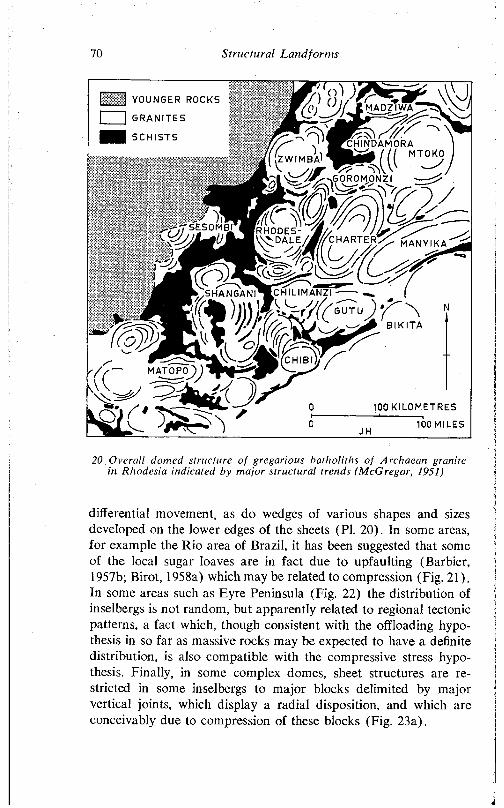
70 S tru c tu ra l L a n d fo rm s
i^^GqROM,ONZI_
- ' J iP SESOMBI
[ I YOUNGER ROCKS
1 1 GRANITES
I SCHISTS
C . . . . y MTOKOZWIMBA '
r > n u u c . J M l / ■ / s ' /
m a n y i k a
S H A N G A N I ^ C H I L I M A N Z I
&//(( GUTU
me? B I K I TA
CHIBI
'?)MAT0P0
m l 100 KILOMETRES
100 MILES
20 O vera ll domed structure o f gregarious batho liths o f Archaean granite in Rhodesia indicated by m ajor s tructu ra l trends (M cG regor, 1951)
differential movement, as do wedges of various shapes and sizes developed on the lower edges of the sheets (PI. 20). In some areas, for example the Rio area of Brazil, it has been suggested that some of the local sugar loaves are in fact due to upfaulting (Barbier, 1957b; Birot, 1958a) which may be related to compression (Fig. 21). In some areas such as Eyre Peninsula (Fig. 22) the distribution of inselbergs is not random, but apparently related to regional tectonic patterns, a fact which, though consistent with the offloading hypothesis in so far as massive rocks may be expected to have a definite distribution, is also compatible with the compressive stress hypothesis. Finally, in some complex domes, sheet structures are restricted in some inselbergs to major blocks delimited by major vertical joints, which display a radial disposition, and which are conceivably due to compression of these blocks (Fig. 23a).
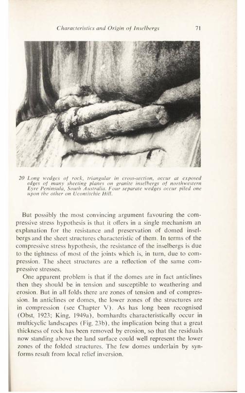
Characteristics and Origin of Inselbergs 71
20 Long wedges of rock, triangular in cross-section, occur at exposed edges of many sheeting planes on granite inselbergs of northwestern Eyre Peninsula, South A ustralia. Four separate wedges occur piled one upon the other on Ucontitchie Hill.
But possibly the most convincing argument favouring the compressive stress hypothesis is that it offers in a single mechanism an explanation for the resistance and preservation of domed inselbergs and the sheet structures characteristic of them. In terms of the compressive stress hypothesis, the resistance of the inselbergs is due to the tightness of most of the joints which is, in turn, due to compression. The sheet structures are a reflection of the same compressive stresses.
One apparent problem is that if the domes are in fact anticlines then they should be in tension and susceptible to weathering and erosion. But in all folds there are zones of tension and of compression. In anticlines or domes, the lower zones of the structures are in compression (see Chapter V). As has long been recognised (Obst, 1923; King, 1949a), bomhardts characteristically occur in multicyclic landscapes (Fig. 23b), the implication being that a great thickness of rock has been removed by erosion, so that the residuals now standing above the land surface could well represent the lower zones of the folded structures. The few domes underlain by syn- forms result from local relief inversion.
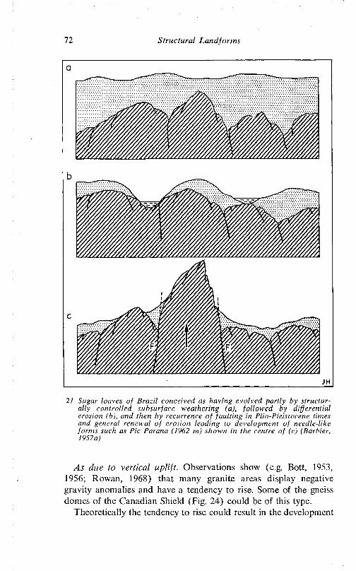
72 Structural Landforms
21 Sugar loaves of Brazil conceived as having evolved partly by structurally controlled subsurface weathering (a), followed by differential erosion (b), and then by recurrence of faulting in Plio-Pleistocene times and general renewal of erosion leading to development of needle-like forms such as Pic Parana (1962 m) shown in the centre of (c) (Barbier, 1957a)
As due to vertical uplift. Observations show (e.g. Bott, 1953, 1956; Rowan, 1968) that many granite areas display negative gravity anomalies and have a tendency to rise. Some of the gneiss domes of the Canadian Shield (Fig. 24) could be of this type.
Theoretically the tendency to rise could result in the development
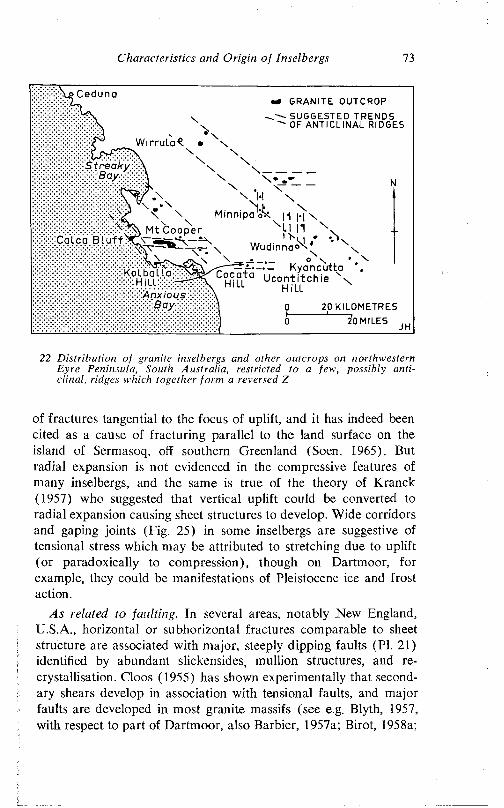
C h a ra c te r is tic s and O r ig in o f Inse lbergs 73
u c o n t i t c n i e H'LL H i'LL
•0 GRANITE OUTCROPSUGGESTED TRENDS OF ANTICLINAL RIDGES
0h0
20 KILOMETRES
\
^0 MILES
N
JH
22 D is tr ib u tion o f granite inselbergs and other outcrops on northwestern Eyre Peninsula, South Austra lia , restricted to a few, possibly an tic lina l, ridges which together fo rm a reversed Z
of fractures tangential to the focus of uplift, and it has indeed been cited as a cause of fracturing parallel to the land surface on the island of Sermasoq, off southern Greenland (Soen, 1965). But radial expansion is not evidenced in the compressive features of many inselbergs, and the same is true of the theory of Kranck (1957) who suggested that vertical uplift could be converted to radial expansion causing sheet structures to develop. Wide corridors and gaping joints (Fig. 25) in some inselbergs are suggestive of tensional stress which may be attributed to stretching due to uplift (or paradoxically to compression), though on Dartmoor, for example, they could be manifestations of Pleistocene ice and frost action.
As related to faulting. In several areas, notably .New England, U.S.A., horizontal or subhorizontal fractures comparable to sheet structure are associated with major, steeply dipping faults (PI. 21) identified by abundant slickcnsides, mullion structures, and recrystallisation. Cloos (1955) has shown experimentally that secondary shears develop in association with tensional faults, and major faults are developed in most granite massifs (see e.g. Blyth, 1957, with respect to part of Dartmoor, also Barbier, 1957a; Birot, 1958a;
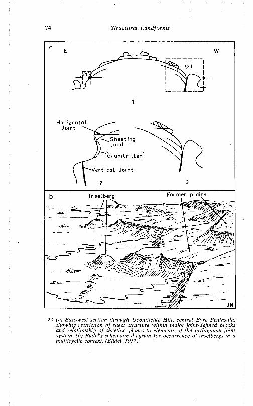
74 Structural Landforms
HorizontalJoint
Sheet ingJoint
Granitr i l len
Vert ical Joint
Former plainsInselberg
23 (a) East-west section through Ucontitchie Hill, central Eyre Peninsula, showing restriction of sheet structure within major joint-defined blocks and relationship of sheeting planes to elements of the orthogonal joint system, (b) Biidel's schematic diagram for occurrence of inselbergs in a multicyclic context. (Biidel, 1957)
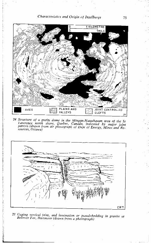
Characteristics and Origin of Inselbergs 75
24 Structure of a gneiss dome in the Mingan-Natashquan area of the St Lawrence north shore, Quebec, Canada, indicated by major joint pattern (drawn from air photograph of Dept of Energy, Mines and Re-
25 (’aping verttca/joint, and lamination or granite at Believer I or, Dartmoor (drawn from a photograph)
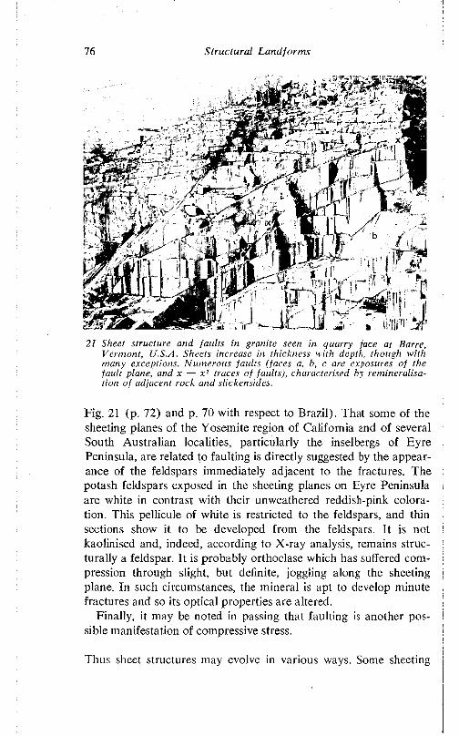
76 Structural Land forms
21 Sheet structure and faults in granite seen in quarry face at Barre, Vermont, U.S.A. Sheets increase in thickness with depth, though with many exceptions. Numerous faults (faces a, h, c are exposures of the fault plane, and x — x 1 traces of faults), characterised by remineralisation of adjacent rock and slickensides.
Fig. 21 (p. 72) and p. 70 with respect to Brazil). That some of the sheeting planes of the Yosemite region of California and of several South Australian localities, particularly the inseibergs of Eyre Peninsula, are related to faulting is directly suggested by the appearance of the feldspars immediately adjacent to the fractures. The potash feldspars exposed in the sheeting planes on Eyre Peninsula are white in contrast with their unweathered reddish-pink coloration. This pellicule of white is restricted to the feldspars, and thin sections show it to be developed from the feldspars. It is not kaolinised and, indeed, according to X-ray analysis, remains structurally a feldspar. It is probably orthoclase which has suffered compression through slight, but definite, joggling along the sheeting plane. In such circumstances, the mineral is apt to develop minute fractures and so its optical properties are altered.
Finally, it may be noted in passing that faulting is another possible manifestation of compressive stress.
Thus sheet structures may evolve in various ways. Some sheeting
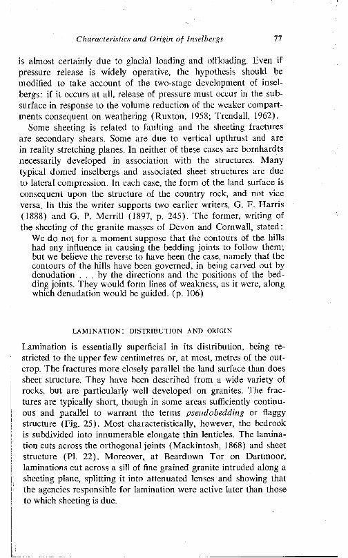
Characteristics and Origin of Insel bergs 77
is almost certainly due to glacial loading and offloading. Even if pressure release is widely operative, the hypothesis should be modified to take account of the two-stage development of insel- bergs: if it occurs at all, release of pressure must occur in the subsurface in response to the volume reduction of the weaker compartments consequent on weathering (Ruxton, 1958; Trendall, 1962).
Some sheeting is related to faulting and the sheeting fractures are secondary shears. Some are due to vertical upthrust and are in reality stretching planes. In neither of these cases are bornhardts necessarily developed in association with the structures. Many typical domed inselbergs and associated sheet structures are due to lateral compression. In each case, the form of the land surface is consequent upon the structure of the country rock, and not vice versa. In this the writer supports two earlier writers, G. F. Harris (1888) and G. P. Merrill (1897. p. 245). The former, writing of the sheeting of the granite masses of Devon and Cornwall, stated;
We do not for a moment suppose that the contours of the hills had any influence in causing the bedding joints to follow them; but we believe the reverse to have been the case, namely that the contours of the hills have been governed, in being carved out by denudation . . . by the directions and the positions of the bedding joints. They would form lines of weakness, as it were, along which denudation would be guided, (p. 106)
lamination: distribution and origin
Lamination is essentially superficial in its distribution, being restricted to the upper few centimetres or, at most, metres of the outcrop. The fractures more closely parallel the land surface than does sheet structure. They have been described from a wide variety of rocks, but are particularly well developed on granites. The fractures are typically short, though in some areas sufficiently continuous and parallel to warrant the terms pseudobedding or flaggy structure (Fig. 25). Most characteristically, however, the bedrock is subdivided into innumerable elongate thin lenticles. The lamination cuts across the orthogonal joints (Mackintosh, 1868) and sheet structure (PI. 22). Moreover, at Beardown Tor on Dartmoor, laminations cut across a sill of fine grained granite intruded along a sheeting plane, splitting it into attenuated lenses and showing that the agencies responsible for lamination were active later than those to which sheeting is due.
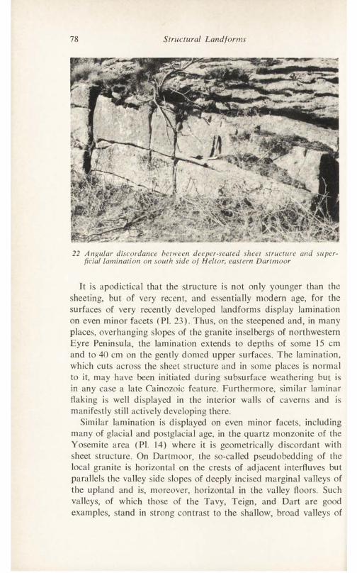
78 Structural Landforms
22 Angular discordance between deeper-seated sheet structure and superficial lamination on south side of Heitor, eastern Dartmoor
It is apodictical that the structure is not only younger than the sheeting, but of very recent, and essentially modern age, for the surfaces of very recently developed landforms display lamination on even minor facets (PI. 23). Thus, on the steepened and, in many places, overhanging slopes of the granite inselbergs of northwestern Eyre Peninsula, the lamination extends to depths of some 15 cm and to 40 cm on the gently domed upper surfaces. The lamination, which cuts across the sheet structure and in some places is normal to it, may have been initiated during subsurface weathering but is in any case a late Cainozoic feature. Furthermore, similar laminar flaking is well displayed in the interior walls of caverns and is manifestly still actively developing there.
Similar lamination is displayed on even minor facets, including many of glacial and postglacial age, in the quartz monzonite of the Yosemite area (PI. 14) where it is geometrically discordant with sheet structure. On Dartmoor, the so-called pseudobedding of the local granite is horizontal on the crests of adjacent interfluves but parallels the valley side slopes of deeply incised marginal valleys of the upland and is, moreover, horizontal in the valley floors. Such valleys, of which those of the Tavy, Teign, and Dart are good examples, stand in strong contrast to the shallow, broad valleys of
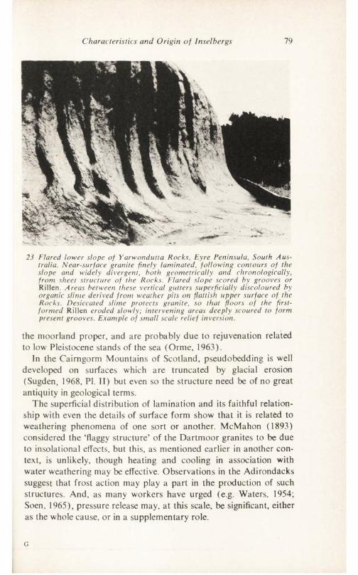
Characteristics and Origin of Insel bergs 79
23 Flared lower slope of Yarwondutta Rocks, Eyre Peninsula, South Australia. Near-surface granite finely laminated, following contours of the slope and widely divergent, both geometrically and chronologically, from sheet structure of the Rocks. Flared slope scored by grooves or Rillen. Areas between these vertical gutters superficially discoloured by organic slime derived from weather pits on flattish upper surface of the Rocks. Desiccated slime protects granite, so that floors of the first- formed Rillen eroded slowly; intervening areas deeply scoured to form present grooves. Example of small scale relief inversion.
the moorland proper, and are probably due to rejuvenation related to low Pleistocene stands of the sea (Orme, 1963).
In the Cairngorm Mountains of Scotland, pseudobedding is well developed on surfaces which are truncated by glacial erosion (Sugden, 1968, PI. II) but even so the structure need be of no great antiquity in geological terms.
The superficial distribution of lamination and its faithful relationship with even the details of surface form show that it is related to weathering phenomena of one sort or another. McMahon (1893) considered the ‘flaggy structure’ of the Dartmoor granites to be due to insolational effects, but this, as mentioned earlier in another context, is unlikely, though heating and cooling in association with water weathering may be effective. Observations in the Adirondacks suggest that frost action may play a part in the production of such structures. And, as many workers have urged (e.g. Waters, 1954; Soen, 1965), pressure release may, at this scale, be significant, either as the whole cause, or in a supplementary role.
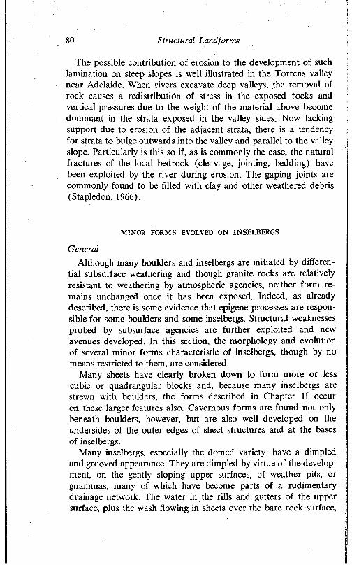
80 Structural Landforms
The possible contribution of erosion to the development of such lamination on steep slopes is well illustrated in the Torrens valley near Adelaide. When rivers excavate deep valleys, the removal of rock causes a redistribution of stress in the exposed rocks and vertical pressures due to the weight of the material above become dominant in the strata exposed in the valley sides. Now lacking support due to erosion of the adjacent strata, there is a tendency for strata to bulge outwards into the valley and parallel to the valley slope. Particularly is this so if, as is commonly the case, the natural fractures of the local bedrock (cleavage, jointing, bedding) have been exploited by the river during erosion. The gaping joints are commonly found to be filled with clay and other weathered debris (Stapledon, 1966).
MINOR FORMS EVOLVED ON INSELBERGS
GeneralAlthough many boulders and inselbergs are initiated by differen
tial subsurface weathering and though granite rocks are relatively resistant to weathering by atmospheric agencies, neither form remains unchanged once it has been exposed. Indeed, as already described, there is some evidence that epigene processes are responsible for some boulders and some inselbergs. Structural weaknesses probed by subsurface agencies are further exploited and new avenues developed. In this section, the morphology and evolution of several minor forms characteristic of inselbergs, though by no means restricted to them, are considered.
Many sheets have clearly broken down to form more or less cubic or quadrangular blocks and, because many inselbergs are strewn with boulders, the forms described in Chapter II occur on these larger features also. Cavernous forms are found not only beneath boulders, however, but are also well developed on the undersides of the outer edges of sheet structures and at the bases of inselbergs.
Many inselbergs, especially the domed variety, have a dimpled and grooved appearance. They are dimpled by virtue of the development, on the gently sloping upper surfaces, of weather pits, or gnammas, many of which have become parts of a rudimentary drainage network. The water in the rills and gutters of the upper surface, plus the wash flowing in sheets over the bare rock surface,
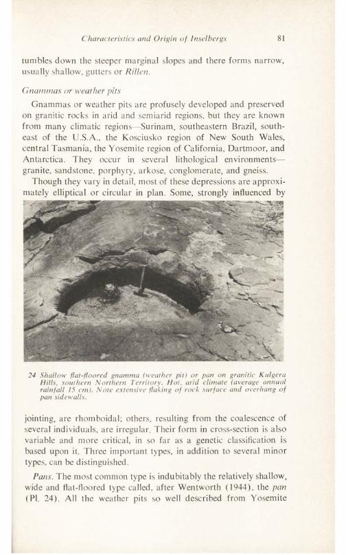
Characteristics and Origin of Inselbergs 81
tumbles down the steeper marginal slopes and there forms narrow, usually shallow, gutters or Rillen.
Gnammas or weather pitsGnammas or weather pits are profusely developed and preserved
on granitic rocks in arid and semiarid regions, but they are known from many climatic regions—Surinam, southeastern Brazil, southeast of the U.S.A., the Kosciusko region of New South Wales, central Tasmania, the Yosemite region of California, Dartmoor, and Antarctica. They occur in several lithological environments— granite, sandstone, porphyry, arkose, conglomerate, and gneiss.
Though they vary in detail, most of these depressions are approximately elliptical or circular in plan. Some, strongly influenced by
24 Shallow flat-floored gnamma (weather pit) or pan on granitic Knlgera Hills, southern Northern Territory. Hot, arid climate (average annual rainfall 15 cm). Note extensive flaking of rock surface and overhang of pan sidewalls.
jointing, are rhomboidal; others, resulting from the coalescence of several individuals, are irregular. Their form in cross-section is also variable and more critical, in so far as a genetic classification is based upon it. Three important types, in addition to several minor types, can be distinguished.
Pans. The most common type is indubitably the relatively shallow, wide and flat-floored type called, after Wentworth (1944), the pan (PI. 24). All the weather pits so well described from Yosemite
82 Structural Landforms
(Matthes, 1930, pp. 63-4), and the Piedmont of southeastern U.S.A. (Smith, 1941) and most of those of Dartmoor (MacCulloch, 1814; Ormerod, 1859; Jones, 1859; Worth, 1953) are of this type. In Australia, pans are far more numerous than all the other types together.
Pans are generally 2-3 m in diameter, and some 30-50 cm deep; but composite features, of course, achieve much greater dimensions. Pans, like pits, occur only on the upper surfaces of inselbergs with gentle inclination less than 20°, and in laminated granite.
The side walls of pans on Dartmoor display a consistent overhang as well as clefts coincident with lamination fractures. The inclination of the side slopes varies from gently sloping to overhanging; contrasts occur not only from gnamma to gnamma but on different sides of the same pan. Where an arid crust is well developed, as on the Kulgera Hills south of Alice Springs, the overhang occurs con-
25 Hemispherical gnamma or pit, about one metre deep, on Pildappa Hill, Eyre Peninsula, South Australia; flaked surface, lichen (lighter patches) on rock surface, and broad shallow depression beyond the pit
sistently all round the marginal wall (PI. 24), but on Eyre Peninsula, it has been noted that (Twidale and Corbin, 1964) all else being equal, the northwest-facing walls are the steeper. The greatest degree of overhang so far observed is a lip which protrudes about 1 m over a pan at Yarwondutta Rocks, northwestern Eyre Penin-
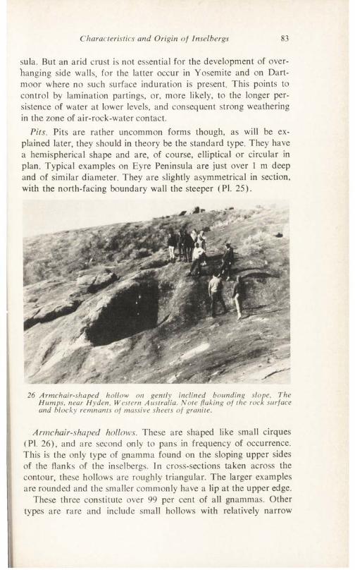
Characteristics and Origin of Inselbergs 83
sula. But an arid crust is not essential for the development of overhanging side walls, for the latter occur in Yosemite and on Dartmoor where no such surface induration is present. This points to control by lamination partings, or, more likely, to the longer persistence of water at lower levels, and consequent strong weathering in the zone of air-rock-water contact.
Pits. Pits are rather uncommon forms though, as will be explained later, they should in theory be the standard type. They have a hemispherical shape and are, of course, elliptical or circular in plan. Typical examples on Eyre Peninsula are just over 1 m deep and of similar diameter. They are slightly asymmetrical in section, with the north-facing boundary wall the steeper (PI. 25).
26 Armchair-shaped hollow on gently inclined bounding slope, The Humps, near Hyden, Western Australia. Note flaking of the rock surface and hlocky remnants of massive sheets of granite.
Armchair-shaped hollows. These are shaped like small cirques (PI. 26), and are second only to pans in frequency of occurrence. This is the only type of gnamma found on the sloping upper sides of the flanks of the inselbergs. In cross-sections taken across the contour, these hollows are roughly triangular. The larger examples are rounded and the smaller commonly have a lip at the upper edge.
These three constitute over 99 per cent of all gnammas. Other types are rare and include small hollows with relatively narrow
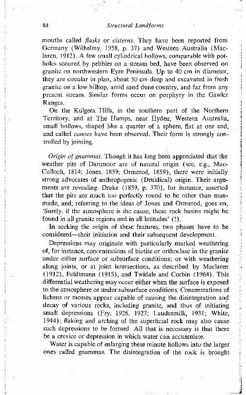
84 Structural Landforms
mouths called flasks or cisterns. They have been reported from Germany (Wilhelmy, 1958, p. 37) and Western Australia (Mac- laren, 1912). A few small cylindrical hollows, comparable with potholes scoured by pebbles on a stream bed, have been observed on granite on northwestern Eyre Peninsula. Up to 40 cm in diameter, they are circular in plan, about 50 cm deep and excavated in fresh granite on a low hilltop, amid sand dune country, and far from any present stream. Similar forms occur on porphyry in the Gawler Ranges.
On the Kulgera Hills, in the southern part of the Northern Territory, and at The Humps, near Hyden, Western Australia, small hollows, shaped like a quarter of a sphere, flat at one end, and called canoes have been observed. Their form is strongly controlled by jointing.
Origin of gnammas. Though it has long been appreciated that the weather pits of Dartmoor are of natural origin (see, e.g., Mac- Culloch, 1814; Jones, 1859; Ormerod, 1859), there were initially strong advocates of anthropogenic (Druidical) origin. Their arguments are revealing. Drake (1859, p. 370), for instance, asserted that the pits are much too perfectly round to be other than manmade, and, referring to the ideas of Jones and Ormerod, goes on, ‘Surely, if the atmosphere is the cause, these rock basins might be found in all granite regions and in all latitudes’ (!).
In seeking the origin of these features, two phases have to be considered—their initiation and their subsequent development.
Depressions may originate with particularly marked weathering of, for instance, concentrations of biotite or orthoclase in the granite under either surface or subsurface conditions; or with weathering along joints, or at joint intersections, as described by Maclaren (1912), Feldtmann (1915), and Twidale and Corbin (1964). This differential weathering may occur either when the surface is exposed to the atmosphere or under subsurface conditions. Concentrations of lichens or mosses appear capable of causing the disintegration and decay of various rocks, including granite, and thus of initiating small depressions (Fry, 1926, 1927; Faudermilk, 1931; White, 1944); flaking and arching of the superficial rock may also cause such depressions to be formed. All that is necessary is that there be a crevice or depression in which water can accumulate.
Water is capable of enlarging these minute hollows into the larger ones called gnammas. The disintegration of the rock is brought
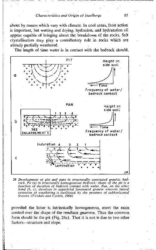
Characteristics and Origin of Insel bergs 85
about by means which vary with climate. In cool areas, frost action is important, but wetting and drying, hydration, and hydratation all appear capable of bringing about the breakdown of the rocks. Salt crystallisation may play a contributory role in rocks which are already partially weathered.
The length of time water is in contact with the bedrock should,
Height on side wall
-+---- TimeFrequency of water/
bedrock contact
PAN
1 2 3 4
5^ +- + * +
A--V
SEE"+ + + + +-
ENLARGEMENT c'
Height on side wall
----- TimeFrequency of water /
bedrock contact
C
Induration 4 3
Lamination
JH
26 Development of pits and pans in structurally contrasted granitic bedrock. Pit (a) in structurally homogeneous bedrock; shape of the pit is a function of duration of bedrock contact with water. Pan, on the other hand (b, c), develops in superficial laminated granite wherein lateral extension of weathering is facilitated by the presence of subhorizontal fissures. (Twidale and Corbin, 1964)
provided the latter is intrinsically homogeneous, exert the main control over the shape of the resultant gnamma. Thus the common form should be the pit (Fig. 26a). That it is not is due to two other factors—structure and slope.
86 S tructu ra l Land fo rm s
The pans occur consistently in granite (or other bedrock) which is laminated. The rock is fissured, with discontinuous fractures running parallel or subparallel to the surface. Water which collects in the initial small crevices and holes can percolate through the weathered laminae more readily than through fresh granite (Kessler, Insley, and Sligh, 1940), but far less rapidly than along the numerous partings between laminae. Hence, weathering proceeds more
rrurmSOIL
GRAVEL
VEGETATION
-— - - DEEPENING WITHIN GNAMMAS
— ► DIRECTION OF DRAINAGE
V " " \ 2 O V ER H A N G - D E P T H IN INCHES
0h0
1J) METRES
30 FEET
27 Part o f flattish upper surface o f P ildappa H ill, northwestern Eyre Peninsula, showing d is tribu tion o f pans, location o f a p it w ith in a pan, and jo in t-con tro lled gutters and pans (Tw ida le and C orbin, 1964)
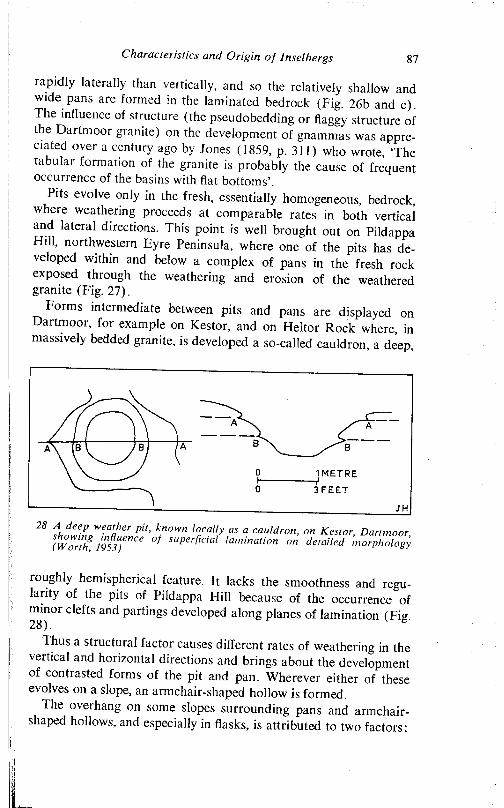
C haracteristics and Origin of Inselbergs 87
rapidly laterally than vertically, and so the relatively shallow and wide pans arc formed in the laminated bedrock (Fig. 26b and c). The influence of structure (the pseudobedding or flaggy structure of the Dartmoor granite) on the development of gnammas was appreciated over a century ago by Jones (1859, p. 311) who wrote, The tabular formation of the granite is probably the cause of frequent occurrence of the basins with flat bottoms’.
Pits evolve only in the fresh, essentially homogeneous, bedrock, where weathering proceeds at comparable rates in both vertical and lateral directions. This point is well brought out on Pildappa Hill» northwestern Eyre Peninsula, where one of the pits has developed within and below a complex of pans in the fresh rock exposed through the weathering and erosion of the weathered granite (Fig. 27).
Forms intermediate between pits and pans are displayed on Dartmoor, for example on Kestor, and on Heitor Rock where, in massively bedded granite, is developed a so-called cauldron, a deep,
1 METRE
3 FEET
28 Ä T Äroughly hemispherical feature. It lacks the smoothness and regularity of the pits of Pildappa Hill because of the occurrence of minor clefts and partings developed along planes of lamination (Fig. 28).
1 hus a structural factor causes different rates of weathering in the vertical and horizontal directions and brings about the development of contrasted forms of the pit and pan. Wherever either of these evolves on a slope, an armchair-shaped hollow is formed.
The overhang on some slopes surrounding pans and armchairshaped hollows, and especially in flasks, is attributed to two factors:
88 Structural Landforms
a. the induration by iron and silica of the upper layers of the fresh bedrock, either subaerially or subsurface;
b. the longer wetting of the lower walls, hence their more rapid weathering.
A lip may, of course, be due to both factors. Preferential development of the overhang on one side (north- and west-facing in the southern hemisphere) may be attributed either to the sun’s having greater effect on the sides facing the sun and thus causing greater induration, or the greater persistence of moisture on the shaded slopes and, hence, a more rapid disintegration of the rock there (Twidale and Corbin, 1964). The typical association of overhanging walls with gnammas developed in the superficial indurated rock layers, and their absence from those evolved in fresh rock suggests that, while both factors are significant, surface induration is most important.
Thus it is suggested that gnammas develop by the enlargement of initial crevices, principally by water acting in various ways. Pits develop in fresh rock, pans in laminated bedrock, in both cases on flat rock surfaces. Armchair-shaped hollows form on appreciable slopes. Flasks form where there is exceptionally marked surface induration, and canoes along major joint faces. The cylindrical form probably evolves in response to prolonged wetting and weathering, but why the sides remain parallel and not divergent is not clear. The evacuation of debris weathered during the development of the gnammas is in many instances achieved during heavy rains either in solution or in suspension, for a rudimentary drainage network, involving the gutters and gnammas, serves large areas of many domed inselbergs. Some fines may be evacuated by turbulent eddies of air. and some cleared by human action. But much debris remains behind in the pits and pans.
That some of the gnammas are still developing is shown by the granite and sand strewn over their floors. There is some indication (Twidale and Corbin, 1964) that they can develop rather rapidly in geological terms, but nothing to suggest that they are evolving as quickly as the 0-25 cm per annum mentioned by some workers (Reid et al., 1912, p. 73). As Worth (1953, p. 30) points out, the depth of Mistor Pan, which is a ‘rock hole’ or gnamma on Dartmoor, and which was described as early as 1291, and also in 1609, was measured in 1802, and again in 1828, 1858, 1875, and 1929, but all the results were approximately the same, and the slight varia-
i
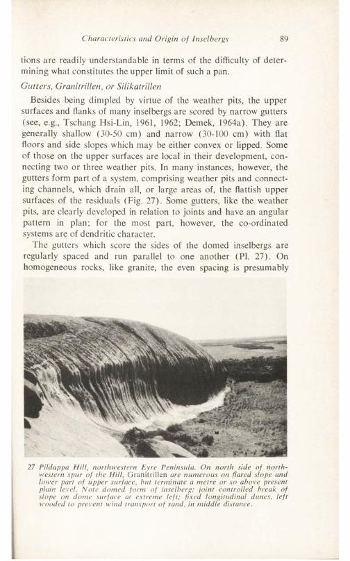
Characteristics and Origin of Insel he rgs 89
tions are readily understandable in terms of the difficulty of determining what constitutes the upper limit of such a pan.Gutters, Granitrillen, or Silikatrillen
Besides being dimpled by virtue of the weather pits, the upper surfaces and flanks of many inselbergs are scored by narrow gutters (see, e.g., Tschang Hsi-Lin, 1961, 1962; Demek, 1964a). They are generally shallow (30-50 cm) and narrow (30-100 cm) with flat floors and side slopes which may be either convex or lipped. Some of those on the upper surfaces are local in their development, connecting two or three weather pits. In many instances, however, the gutters form part of a system, comprising weather pits and connecting channels, which drain all, or large areas of, the flattish upper surfaces of the residuals (Fig. 27). Some gutters, like the weather pits, are clearly developed in relation to joints and have an angular pattern in plan; for the most part, however, the co-ordinated systems are of dendritic character.
The gutters which score the sides of the domed inselbergs are regularly spaced and run parallel to one another (PI. 27). On homogeneous rocks, like granite, the even spacing is presumably
27 Pildappa Hill, northwestern Eyre Peninsula. On north side of northwestern spur of the HUI, Granitrillen are numerous on flared slope and lower part of upper surface, hut terminate a metre or so above present plain level. Note domed form of inselberg; joint controlled break of slope on dome surface at extreme left; fixed longitudinal dunes, left wooded to prevent wind transport of sand, in middle distance.
90 Structural Landforms
due to the uniform spread of water over the surface and the regular development of turbulent vortices which initiate and enlarge the gutters. On residuals like Ayers Rock, however, the steeply inclined bedding determines the trend and spacing of the forms.
The features are undoubtedly due to erosion by small streams flowing over the bare rock surface. In some instances, the more weathered material of joint zones is exploited, and in all cases the development of the gutters, once formed, is assisted by weathering due to the moisture which persists on their floors. Some gutters display either occasional or numerous enlargements due to the development of pot-holes. Such deep hemispherical cups are profusely developed on Ayers Rock.
In a few instances the water which erodes the granite walls to form Rillen flows from large gnammas floored with soil and vegetation. As runoff declines such flows become streams of algal slime (see also p. 42), which, in ways as yet not understood (though it seems that minerals accumulated by plants are redistributed by water and are precipitated as a hard pellicule in some respects similar to desert varnish), indurates the granite surface exposed in the floors of the Rillen. These become hardened, and the flows of water more easily wear away the ‘interfluves’ so that eventually small-scale relief inversion takes place. Excellent examples have been observed on Little Wudinna Hill and Yarwondutta Rocks, both on northwestern Eyre Peninsula (PI. 23).
Finally, in connection with Rillen, it may be mentioned that at Pildappa Hill, northwestern Eyre Peninsula, excavations have shown that the subaerial gullies continue in the subsurface as narrow depressions in the weathering front.
Steepened slopes or flaresThe lower slopes of many domed inselbergs are markedly steep
ened—in some sectors to such an extent as to be overhanging. The steepening takes the form of smooth sigmoidal curves of varied geometry (PI. 27). Similar steepened slopes flank clefts and valleys (mostly joint controlled) within the uplands (see Twidale, 1964). In addition, many isolated boulders display similar features (PI. 28). These steepened slopes, which form the hillfoot, sweep smoothly upward and outward, and hence are called flares.
The steepening extends around virtually all of the lower margins of some inselbergs; in other cases, only a small proportion of the lower slopes are so modified. The flares are best and most com-
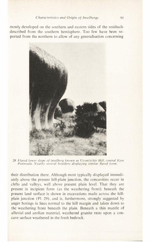
Characteristics and Origin of Insel bergs 91
monly developed on the southern and eastern sides of the residuals described from the southern hemisphere. Too few have been reported from the northern to allow of any generalisation concerning
28 Flared lower slope of inselberg known as Ucontitchie Hill, central Eyre Peninsula. Nearby several boulders displaying similar flared form.
their distribution there. Although most typically displayed immediately above the present hill-plain junction, the concavities occur in clefts and valleys, well above present plain level. That they are present in incipient form (as the weathering front) beneath the present land surface is shown in excavations made across the hill- plain junction (PI. 29), and is, furthermore, strongly suggested by auger borings in lines normal to the hill margin and taken down to the weathering front beneath the plain. Beneath a thin mantle of alluvial and aeolian material, weathered granite rests upon a concave surface weathered in the fresh bedrock.
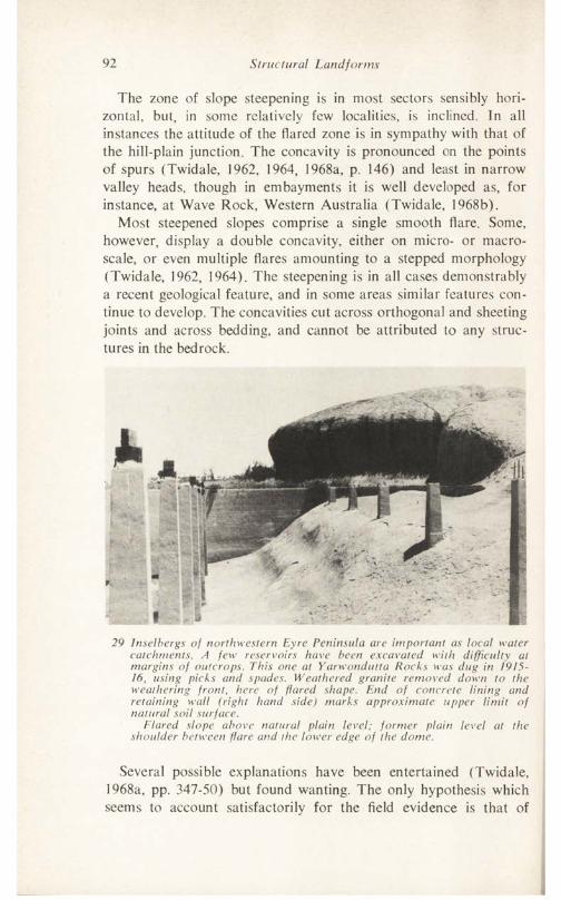
92 Structural Landforms
The zone of slope steepening is in most sectors sensibly horizontal, but, in some relatively few localities, is inclined. In all instances the attitude of the flared zone is in sympathy with that of the hill-plain junction. The concavity is pronounced on the points of spurs (Twidale, 1962, 1964, 1968a, p. 146) and least in narrow valley heads, though in embayments it is well developed as, for instance, at Wave Rock, Western Australia (Twidale, 1968b).
Most steepened slopes comprise a single smooth flare. Some, however, display a double concavity, either on micro- or macroscale, or even multiple flares amounting to a stepped morphology (Twidale, 1962, 1964). The steepening is in all cases demonstrably a recent geological feature, and in some areas similar features continue to develop. The concavities cut across orthogonal and sheeting joints and across bedding, and cannot be attributed to any structures in the bedrock.
29 Inselbergs of northwestern Eyre Peninsula are important as local water catchments. A few reservoirs have been excavated with difficulty at margins of outcrops. This one at Yarwondutta Rocks was dug in 1915- 16, using picks and spades. Weathered granite removed down to the weathering front, here of flared shape. End of concrete lining and retaining wall (right hand side) marks approximate upper limit of natural soil surface.
Flared slope above natural plain level; former plain level at the shoulder between flare and the lower edge of the dome.
Several possible explanations have been entertained (Twidale, 1968a, pp. 347-50) but found wanting. The only hypothesis which seems to account satisfactorily for the field evidence is that of

Characteristics and Origin of Inselbergs 93
concentrated subsurface weathering and subsequent erosion. Under the prevailing arid and semiarid climate, the heavy runoff from the hills, which are of structural origin, tends to spread a short distance over the adjacent plain, but as the water is dispersed it is retarded and percolates into the subsoil. There it causes the granitic bedrock to be weathered, initially by disaggregation of the constituent crystals, and later by alteration of the biotite and feldspars. Thus a relatively narrow moat of weathered rock is developed around the base of each residual (Fig. 29) which, subjected mainly to subaerial weathering, remains relatively unaltered. The surface zone is seasonally desiccated so that maximum weathering occurs beneath the land surface. The weathering front extends not
Desiccated C 4.during dry ] +season ^ /r +
+ + _ + +4
“f* *+■ \ ++ Weathering
Q front
29 Suggested stages in the development of flared slopes. In (a) successive stages in penetration of weathering in zone marginal to the inselberg. In (b) lowering of the land surface resulting in removal of weathered rock and exposure of former weathering front. Subsequently a new weathering front develops below the new plain level. Further lowering of the plain surface (c) results in the exposure of this latter front, and the formation of a double flare.
only downwards but laterally, so that the lower margin of the exposed bedrock, which is attacked only slowly by the processes at work under atmospheric conditions, may become undermined by the advance of the front. When the plain is lowered (presumably as a result of stream rejuvenation), the weathered granite is more easily eroded than is the fresh, and the former weathering front, including those sectors which had eaten into the hill base, is exposed.
This hypothesis explains the overhanging slopes, the preferential development on the shadier southern and eastern aspects (in the southern hemisphere), the extreme development on the points of spurs where there is attack from two sides and in broad embay- ments which are the foci of local drainage, and the observed close
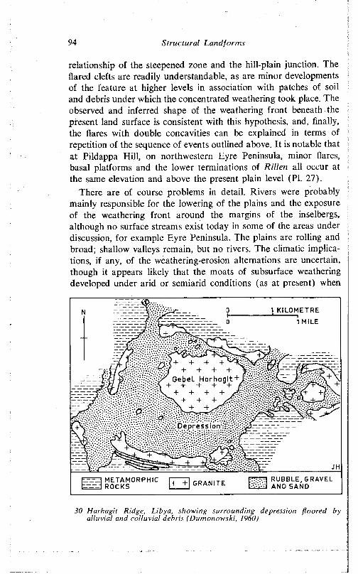
94 S tru c tu ra l L a n d fo rm s
relationship of the steepened zone and the hill-plain junction. The flared clefts are readily understandable, as are minor developments of the feature at higher levels in association with patches of soil and debris under which the concentrated weathering took place. The observed and inferred shape of the weathering front beneath the present land surface is consistent with this hypothesis, and, finally, the flares with double concavities can be explained in terms of repetition of the sequence of events outlined above. It is notable that at Pildappa H ill, on northwestern Eyre Peninsula, minor flares, basal platforms and the lower terminations of Rillen all occur at the same elevation and above the present plain level (PI. 27).
There are of course problems in detail. Rivers were probably mainly responsible for the lowering of the plains and the exposure of the weathering front around the margins of the inselbergs, although no surface streams exist today in some of the areas under discussion, for example Eyre Peninsula. The plains are rolling and broad; shallow valleys remain, but no rivers. The climatic implications, if any, of the weathering-erosion alternations are uncertain, though it appears likely that the moats of subsurface weathering developed under arid or semiarid conditions (as at present) when
1 KILOMETRE
1 MILE
Ge b et Har
RUBBLE, GRAVEL AND SAND
METAMORPHICROCKS GRANITE
30 H arhag it Ridge, L ibya, showing surrounding depression floo red by a llu v ia l and co llu v ia l debris (D um onow ski, I960)
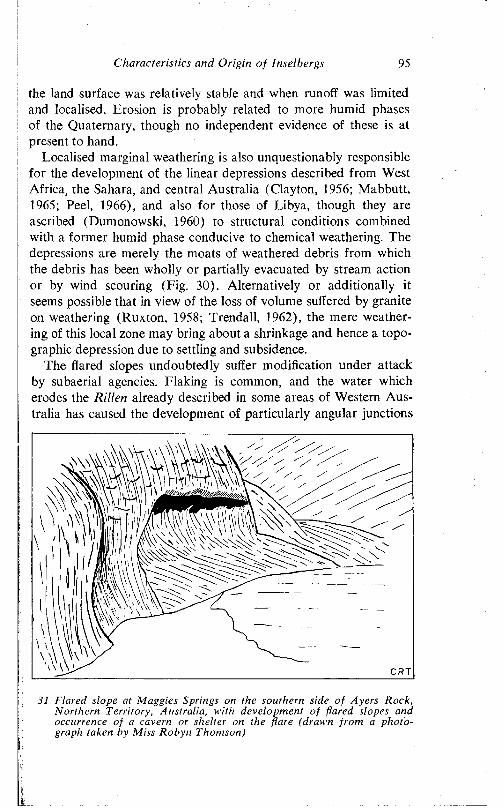
Characteristics and Origin of Insel bergs 95
the land surface was relatively stable and when runoff was limited and localised. Erosion is probably related to more humid phases of the Quaternary, though no independent evidence of these is at present to hand.
Localised marginal weathering is also unquestionably responsible for the development of the linear depressions described from West Africa, the Sahara, and central Australia (Clayton, 1956; Mabbutt, 1965; Peel, 1966), and also for those of Libya, though they are ascribed (Dumonowski, 1960) to structural conditions combined with a former humid phase conducive to chemical weathering. The depressions are merely the moats of weathered debris from which the debris has been wholly or partially evacuated by stream action or by wind scouring (Lig. 30). Alternatively or additionally it seems possible that in view of the loss of volume suffered by granite on weathering (Ruxton, 1958; Trendall, 1962), the mere weathering of this local zone may bring about a shrinkage and hence a topographic depression due to settling and subsidence.
The flared slopes undoubtedly suffer modification under attack by subaerial agencies. Llaking is common, and the water which erodes the Rillen already described in some areas of Western Australia has caused the development of particularly angular junctions
31 Flared slope at Maggies Springs on the southern side of Ayers Rock, Northern Territory, Australia, with development of flared slopes and occurrence of a cavern or shelter on the flare (drawn from a photograph taken by Miss Robyn Thomson)
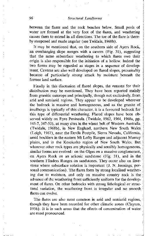
96 Structural Landforms
between the flares and the rock benches below. Small pools of water are formed at the very foot of the flares, and weathering causes them to extend in all directions. The toe of the flare is thereby steepened and made angular (see Twidale, 1968b).
It may be mentioned that, on the southern side of Ayers Rock, an overhanging slope merges with a cavern (Fig. 31), suggesting that the same subsurface weathering to which flares owe their origin is also responsible for the initiation of a hollow. Indeed the two forms may be regarded as stages in a sequence of development. Caverns are also well developed on flared slopes, presumably because of particularly strong attack by moisture beneath the former land surface.
Finally in this discussion of flared slopes, the reasons for their distribution may be mentioned. They have been reported mainly from granitic outcrops and principally, though not exclusively, from arid and semiarid regions. They appear to be developed wherever the bedrock is massive and homogeneous, and as the granite of inselbergs is typically of this character, it is a favoured bedrock for this type of differential weathering. Flared slopes have been observed widely on Eyre Peninsula (Twidale, 1962, 1964, 1968a, pp. 145-7, 347-50), at many sites in the wheat belt of Western Australia (Twidale, 1968b), in New England, northern New South Wales (Leigh, 1967), near the Devils Postpile, Sierra Nevada, California, amid boulders in the eastern Mt Lofty Ranges and adjacent Murray plains, and in the Kosciusko region of New South Wales. But wherever other rock types are physically and sensibly homogeneous, similar forms are evolved: on the Olgas on a massive conglomerate, on Ayers Rock on an arkosic sandstone (Fig. 31), and in the southern Flinders Ranges on sandstones. They occur also on limestone where subsurface solution is important (J. N. Jennings, personal communication). The flares form by strong localised weather- \ ing due to moisture, and only on massive country rock is the advance of the weathering front sufficiently uniform for the development of flares. On other bedrocks with strong lithological or struc- tural variation, the weathering front is irregular and no smooth flares can evolve.
The flares are also most common in arid and semiarid regions, • though they have been recorded for other climatic zones (Clayton, 1956). It is in such areas that the effects of concentration of water are most pronounced.
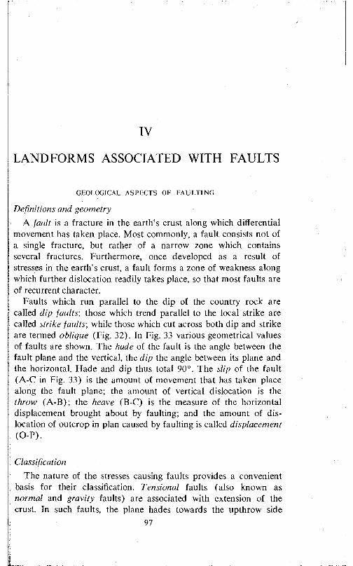
IV
LANDFORMS ASSOCIATED WITH FAULTS
GEOLOGICAL ASPECTS OF FA U LTIN G
Definitions and geometryA fault is a fracture in the earth’s crust along which ditferential
movement has taken place. Most commonly, a fault consists not of a single fracture, but rather of a narrow zone which contains several fractures. Furthermore, once developed as a result of stresses in the earth’s crust, a fault forms a zone of weakness along which further dislocation readily takes place, so that most faults are of recurrent character.
Faults which run parallel to the dip of the country rock are called dip faults', those which trend parallel to the local strike are called strike faults', while those which cut across both dip and strike are termed oblique (Fig. 32). In Fig. 33 various geometrical values of faults are shown. The hade of the fault is the angle between the fault plane and the vertical, the dip the angle between its plane and the horizontal. Hade and dip thus total 90°. The slip of the fault (A-C in Fig. 33) is the amount of movement that has taken place along the fault plane; the amount of vertical dislocation is the throw (A-B); the heave ( B-C) is the measure of the horizontal displacement brought about by faulting; and the amount of dislocation of outcrop in plan caused by faulting is called displacement (O-P).
ClassificationThe nature of the stresses causing faults provides a convenient
basis for their classification. Tensional faults (also known as normal and gravity faults) are associated with extension of the crust. In such faults, the plane hades towards the upthrow side
97
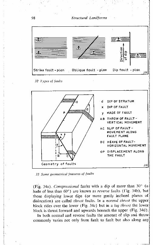
S truc tu ra l Land fo rm s98
32 Types o f fau lts
tm m M M
Geometry of faul ts
d DIP OF STRATUM
X DIP OF FAULT
y HADE OF FAULT
AB THROW OF FAULT - VERTICAL MOVEMENT
AC SLIP OF FAULT - MOVEMENT ALONG FAULT PLANE
BC HEAVE OF FAULT-HORIZONTAL MOVEMENT
OP DISPLACEMENT ALONG THE FAULT
JH
33 Some geometrical features o f fau lts
(Fig. 34a). Compressional faults with a dip of more than 30° (a hade of less than 60°) are known as reverse faults (Fig. 34b), but those displaying lower dips (or more gently inclined planes of dislocation) are called thrust faults. In a normal thrust the upper block rides over the lower (Fig. 34c) but in a lag thrust the lower block is thrust forward and upwards beneath the upper (Fig. 34d).
In both normal and reverse faults the amount of slip and throw commonly varies not only from fault to fault but also along any
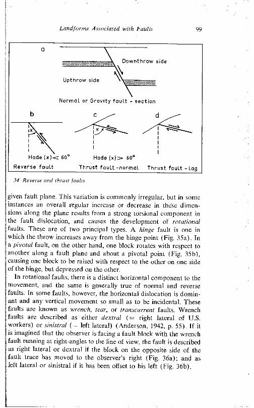
Land for ms Associated with Faults 99
Downthrow side
Upthrow side
Normal or Gravity faul t - sect ion
b
Hade ( x ) < 60° Hade ( x ) > 60°
Reverse faul t Thrust f a u l t - n o rm a l Thrust fault - lag
34 Reverse and thrust faults
given fault plane. 1 his variation is commonly irregular, but in some instances an overall regular increase or decrease in these dimensions along the plane results from a strong torsional component in the fault dislocation, and causes the development of rotational faults. I hese are of two principal types. A hinge fault is one in which the throw increases away from the hinge point (Fig. 35a). In a pivotal fault, on the other hand, one block rotates with respect to another along a fault plane and about a pivotal point (Fig. 35b), causing one block to be raised with respect to the other on one side of the hinge, but depressed on the other.
In rotational faults, there is a distinct horizontal component to the movement, and the same is generally true of normal and reverse faults. In some faults, however, the horizontal dislocation is dominant and any vertical movement so small as to be incidental. These faults are known as wrench, tear, or transcurrent faults. Wrench faults are described as either dextral (= right lateral of U.S. workers) or sinistral (= left lateral) (Anderson, 1942, p. 55). If it is imagined that the observer is facing a fault block with the wrench fault running at right-angles to the line of view, the fault is described as right lateral or dextral if the block on the opposite side of the fault trace has moved to the observer’s right (Fig. 36a); and as left lateral or sinistral if it has been offset to his left (Fig. 36b).
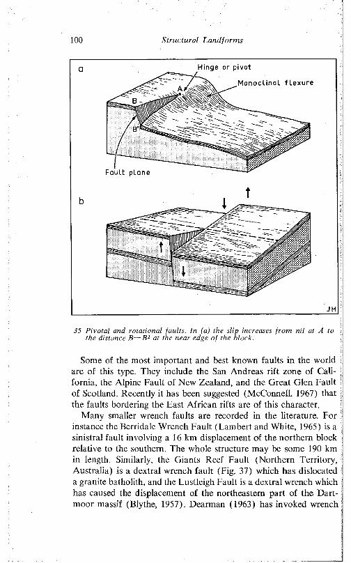
Structural Landforms100
Hinge or pivot
Monoclinal flexure
Fault plane
35 Pivotal and rotational faults. In (a) the slip increases from nil at A to the distance B B1 at the near edge of the block.
Some of the most important and best known faults in the world are of this type. They include the San Andreas rift zone of California, the Alpine Fault of New Zealand, and the Great Glen Fault of Scotland. Recently it has been suggested (McConnell, 1967) that the faults bordering the East African rifts are of this character.
Many smaller wrench faults are recorded in the literature. For instance the Berridale Wrench Fault (Lambert and White, 1965) is a sinistral fault involving a 16 km displacement of the northern block relative to the southern. The whole structure may be some 190 km in length. Similarly, the Giants Reef Fault (Northern Territory, Australia) is a dextral wrench fault (Fig. 37) which has dislocated a granite batholith, and the Lustleigh Fault is a dextral wrench which has caused the displacement of the northeastern part of the Dartmoor massif (Blythe, 1957). Dearman (1963) has invoked wrench
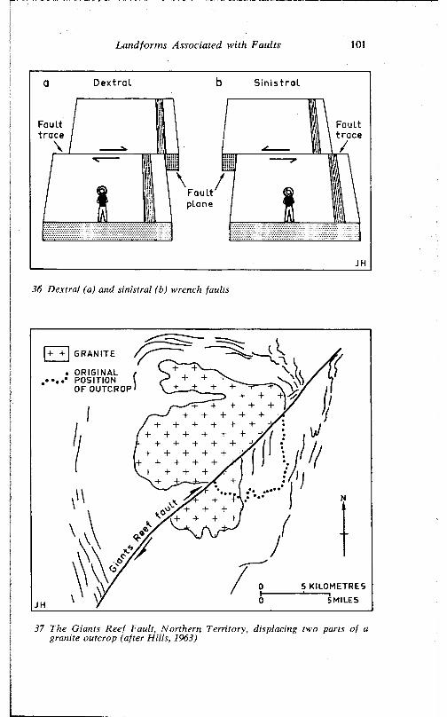
Landforms Associated with Faults 101
Dextra l S in is t ra l
Faulttrace
Faulttrace
Faultplane
36 D extra l (a) and s in istra l (b) wrench faults
|+ + | GRANITE
. ORIGINAL POSITION OF OUTCROP
5 KILOMETRES 5 MILES
37 The G iants Reef Fau lt, N o rthe rn T e rrito ry , d isplacing two parts o f a granite outcrop (after H ills , 1963)
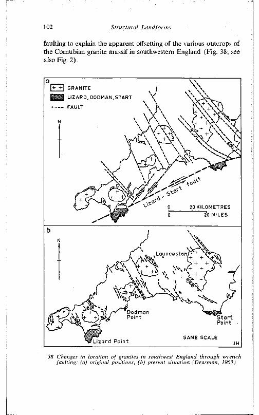
102 S tru c tu ra l L a n d fo rm s
faulting to explain the apparent offsetting of the various outcrops of the Comubian granite massif in southwestern England (Fig. 38; see also Fig. 2).
|+ +1 GRANITE
^ 3 LIZARD, DOOM AN, START
------- FAULT
20 KILOMETRES 20 MILES
Launceston
DodmanPoint S tart
Point
SAME SCALELizard Point
38 Changes in location o f granites in southwest England through wrench fa u ltin g : (a) o rig ina l positions, (b) present s ituation (Dearman, 1963)
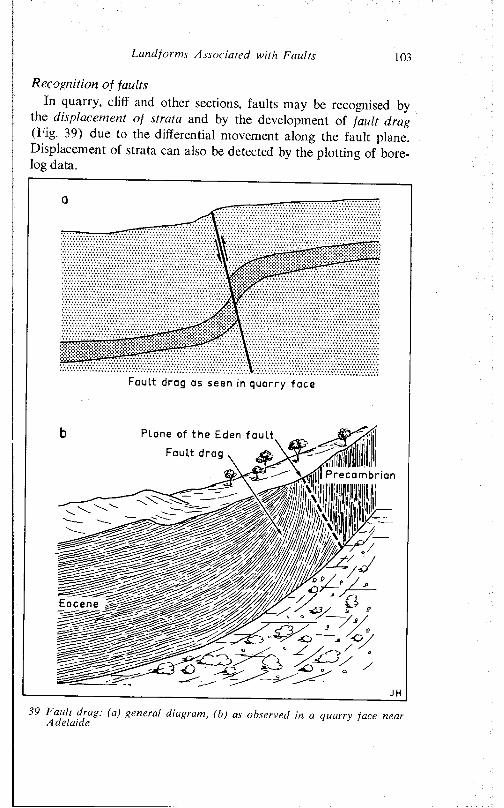
Land forms Associated with Faults 103
Recognition of faultsIn quarry, cliff and other sections, faults may be recognised by
the displacement of strata and by the development of fault drag (big. 39) due to the differential movement along the fault plane. Displacement of strata can also be detected by the plotting of bore- log data.
39 f ault diag: (a) general diagram, (h) as observed in a quarry face near Adelaide
Fault drag as seen in quarry face
Plane of the Eden fault
Fault drag
Precambrian
ÖEocene
=sO
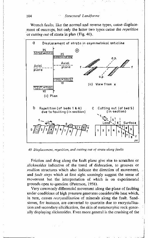
104 Structural Landforms
Wrench faults, like the normal and reverse types, cause displacement of outcrops, but only the latter two types cause the repetition or cutting out of strata in plan (Fig. 40).
0 D isplacement of s t ra ta in asymmetrical anticline
a.p.
/ . j f , / T/
a.p.
(ii) View from x
b Repetition ( of beds 1 & 4 ) C Cutting out (of bed 5)due to faul t ing ( in sect ion) ( in sect ion)
1
L a n d ^ O
I6 | S u r f a c ewiwiwnr 1 2 3 *
b lJH
40 Displacement, repetition, and cutting out of strata along faults
Friction and drag along the fault plane give rise to scratches or slickensides indicative of the trend of dislocation, to grooves or mullion structures which also indicate the direction of movement, and fault steps which at first sight seemingly suggest the sense of movement but the interpretation of which is on experimental grounds open to question (Paterson, 1958).
Very commonly differential movement along the plane of faulting under conditions of high pressure generates considerable heat which, in turn, causes recrystallisation of minerals along the fault. Sandstones, for instance, are converted to quartzite due to recrystallisation and secondary silicification, the skin of metamorphic rock generally displaying slickensides. Even more general is the crushing of the
I
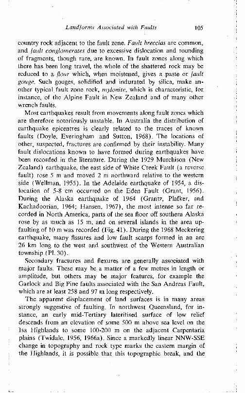
Land forms Associated with Faults 105
country rock adjacent to the fault zone. Fault breccias are common, and fault conglomerates due to excessive dislocation and rounding of fragments, though rare, are known. In fault zones along which there has been long travel, the whole of the shattered rock may be reduced to a flour which, when moistened, gives a paste or fault gouge. Such gouges, solidified and indurated by silica, make another typical fault zone rock, mylonite, which is characteristic, for instance, of the Alpine Fault in New Zealand and of many other wrench faults.
Most earthquakes result from movements along fault zones which are therefore notoriously unstable. In Australia the distribution of earthquake epicentres is clearly related to the traces of known faults (Doyle, Everingham and Sutton, 1968). The locations of other, suspected, fractures are confirmed by their instability. Many fault dislocations known to have formed during earthquakes have been recorded in the literature. During the 1929 Murchison (New Zealand) earthquake, the east side of White Creek Fault (a reverse fault) rose 5 m and moved 2 m northward relative to the western side (Wellman, 1955). In the Adelaide earthquake of 1954, a dislocation of 5-8 cm occurred on the Eden Fault (Grant, 1956). During the Alaska earthquake of 1964 (Grantz, Plafker, and Kachadoorian, 1964; Flansen, 1967), the most intense so far recorded in North America, parts of the sea floor off southern Alaska rose by as much as 15 m, and on several islands in the area up- faulting of 10 m was recorded (Fig. 41). During the 1968 Meckering earthquake, many fissures and low fault scarps formed in an arc 26 km long to the west and southwest of the Western Australian township (PI. 30).
Secondary fractures and flexures are generally associated with major faults. These may be a matter of a few metres in length or amplitude, but others may be major features, for example the Garloek and Big Pine faults associated with the San Andreas Fault, which are at least 258 and 97 m long respectively.
The apparent displacement of land surfaces is in many areas strongly suggestive of faulting. In northwest Queensland, for instance, an early mid-Tertiary lateritised surface of low relief descends from an elevation of some 500 m above sea level on the Isa Highlands to some 100-200 m on the adjacent Carpentaria plains (Twidale, 1956, 1966a). Since a markedly linear NNW-SSE change in topography and rock type marks the eastern margin of the Highlands, it is possible that this topographic break, and the
106 Structural Landforms
41 Land level changes along the coast of south-central Alaska during the Good Friday earthquake of 1964 (Grantz et al., 1964)
apparent dislocation of the erosion surface, are due to faulting. But the possibility of warping and the effects of lithological change on the disposition and behaviour of the surface render this argument inconclusive.
In some areas, however, fault dislocation of surfaces is indisputable. In the western U.S.A. faulting of Pleistocene moraines. Recent alluvial fans, and other unconsolidated deposits is widely evidenced (for review, see King, 1965) and in the Peake and Denison Ranges of northern South Australia, Wopfner (1968) has described the dislocation of a Pleistocene gypsite surface by movements along the Mt Margaret and Levi faults (Fig. 42a). Warping and faulting'of post-Jurassic surfaces is strongly suggested in Kenya (Saggcrson and Baker, 1965). and the fault dislocation of the Kaukau surface near Wellington, New Zealand, has been fully analysed by Stevens (1957).
Japan is a country notorious for the frequency and intensity of its earthquakes, and here the fault-dislocation of shorelines and river terraces is commonplace. Sugimura and Matsudu (1965), for instance, have described the dislocation of terraces along the Kiso River, in central Japan, by recurrent movements along the Atera Fault. Although vertical dislocations arc evidenced along the frac-
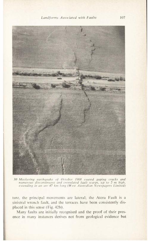
Landforms Associated with Faults 107
30 M eckering earthquake of October 1968 caused gaping cracks and numerous discontinuous and crenulated fault scarps, up to 2 m high, extending in an arc 47 km long (West Australian Newspapers Limited)
lure, the principal movements are lateral; the Atera Fault is a sinistral wrench fault, and the terraces have been consistently displaced in this sense (Fig. 42b).
Many faults are initially recognised and the proof of their presence in many instances derives not from geological evidence but
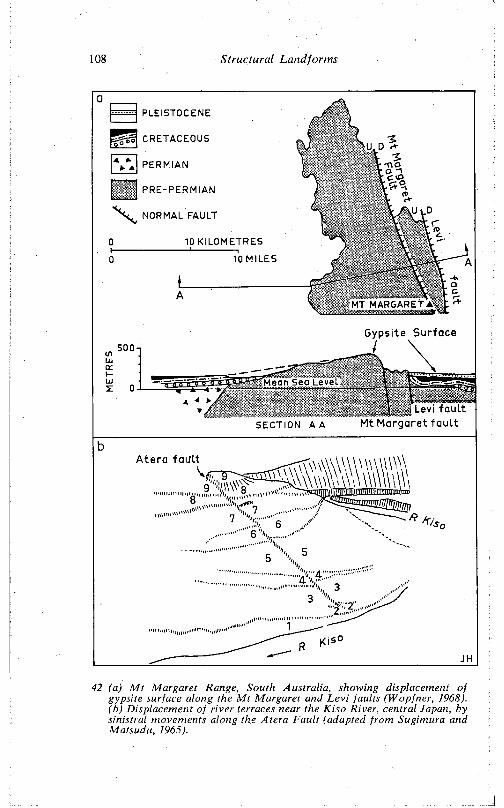
108 S tru c tu ra l L a n d fo rm s
aPLEISTOCENE
CRETACEOUS
PERMIAN
PRE-PERMIAN
NORMAL FAULT
0 10 KILOMETRES1 --------------------------------------1-------------------------- T
0 10 MILES
A
Levi fault Mt Margaret fault
500Gypsite Surface
SECTION A A
42 (a) M t M argare t Range, South A ustra lia , showing displacement o f gypsite surface along the M t M argaret and L e v i fau lts (W opfner, 1968). (b) D isplacement o f rive r terraces near the K iso River, central Japan, by sin istraI movements along the A te ra F a u lt (adapted from Sugim ura and M atsudu, 1965).
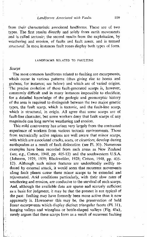
Landforms Associated with Faults 109
from their characteristic associated landforms. These are of two types. The first results directly and solely from earth movements and is called tectonic, the second results from the exploitation, by weathering and erosion, of faults and fault zones, and is termed structural. In most instances fault zones display both types of form.
LANDFORMS RELATED TO FAULTING
ScarpsThe most common landforms related to faulting are escarpments,
which occur in various patterns (thus giving rise to horsts and grabens, for instance; see below) and which are of varied origins. The precise evolution of these fault-generated scarps is, however, commonly difficult and in many instances impossible to elucidate, for a detailed knowledge of the geologic and geomorphic history of the area is required to distinguish between the two major genetic types, the fault scarp, which is tectonic, and the fault-line scarp, which is structural, in origin. All agree that some scarps are of fault-line character, but some workers deny that fault scarps of any magnitude can long survive weathering and erosion.
This mild controversy has arisen very largely from the contrasted experience of workers from various tectonic environments. Those from tectonically active regions are well aware that minor scarps, with which are associated cracks, scars, or cicatrices, develop during earthquakes as a result of fault dislocation (see PI. 30). Numerous examples have been recorded from such areas as New Zealand (see, e.g., Cotton, 1948, pp. 405-12) and the southwestern U.S.A. (Johnson, 1929, 1939; Blackwelder, 1928; Cotton, 1948, pp. 405- 12). Although such minor features are undoubtedly swiftly reduced by external attack, it would seem that recurrent movements along fault planes cause these minor scarps to be extended and rejuvenated. Arid conditions particularly, with their slow rates of weathering and erosion, are conducive to the survival of such scarps. And, although the available data are sparse and scarcely sufficient as a basis for judgment, it may be that the present is not typical of the past: faulting may have formerly been more active than it now apparently is. Howsoever this may be, the preservation of bold linear escarpments which display distinct triangular facets (PI. 31), hanging valleys and wineglass or bottle-shaped valleys (Fig. 43a), surely argues that these scarps form as a result of recurrent faulting
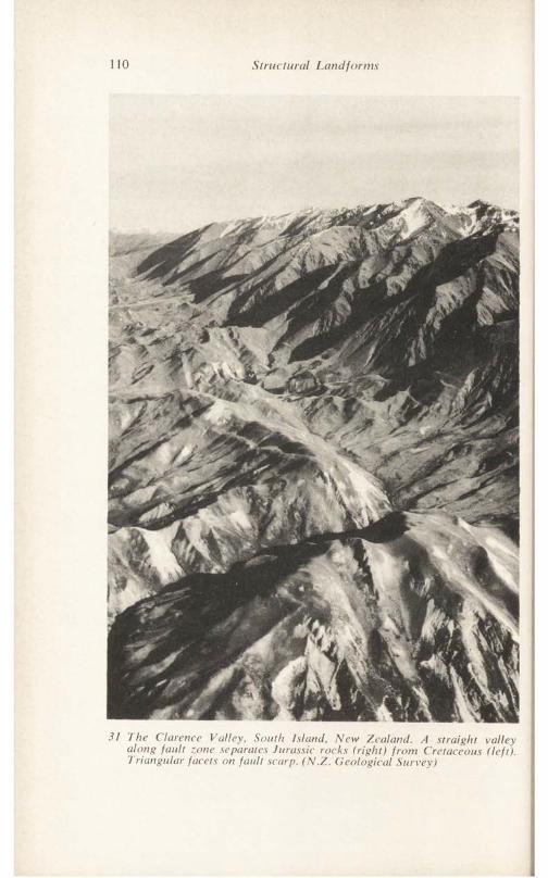
110 S truc tu ra l Land fo rm s
31 The C larence V a lle y , S outh Is lan d , N e w Ze a land . A s tra ig h t va lley a lo n g fa u lt zone separates Jurassic rocks ( r ig h t) f ro m C retaceous ( le f t) . T r ia n g u la r facets on fa u lt scarp. (N .Z . G e o lo g ica l S u rvey)
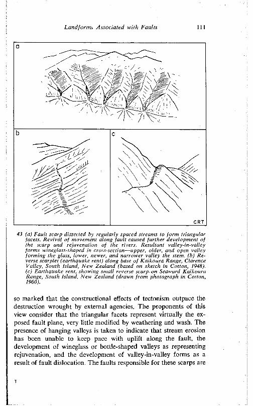
Land form s Associated with Faults 1 1 1
11 •
43 (a) Fault scarp dissected by regularly spaced streams to form triangular facets. Revival of movement along fault caused further development of the scarp and rejuvenation of the rivers. Resultant valley-in-valley forms wineglass-shaped in cross-section— upper, older, and open valley forming the glass, lower, newer, and narrower valley the stem, (b) Reverse scarplet (earthquake rent) along base of Kaikoura Range, Clarence Valley, South Island, New Zealand (based on sketch in Cotton, 1948). (c) Earthquake rent, showing small reverse scarp on Seaward Kaikoura Range, South Island, New Zealand (drawn from photograph in Cotton, I960).
so marked that the constructional effects of tectonism outpace the destruction wrought by external agencies. The proponents of this view consider that the triangular facets represent virtually the exposed fault plane, very little modified by weathering and wash. The presence of hanging valleys is taken to indicate that stream erosion has been unable to keep pace with uplift along the fault, the development of wineglass or bottle-shaped valleys as representing rejuvenation, and the development of valley-in-valley forms as a result of fault dislocation. The faults responsible for these scarps are
i
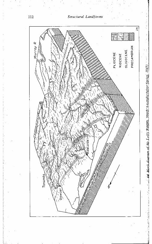
112 Structural Landforms
44
Blo
ck d
iagr
am o
f M
t L
ofty
Ran
,
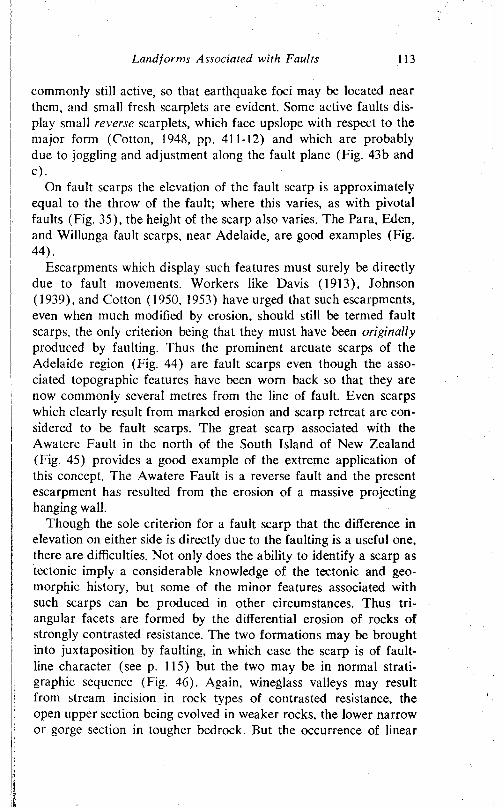
Landforms Associated with Faults 113
commonly still active, so that earthquake foci may be located near them, and small fresh scarplets are evident. Some active faults display small reverse scarplets, which face upslope with respect to the major form (Cotton, 1948, pp. 411-12) and which are probably due to joggling and adjustment along the fault plane (Fig. 43b and c).
On fault scarps the elevation of the fault scarp is approximately equal to the throw of the fault; where this varies, as with pivotal faults (Fig. 35), the height of the scarp also varies. The Para, Eden, and Willunga fault scarps, near Adelaide, are good examples (Fig. 44).
Escarpments which display such features must surely be directly due to fault movements. Workers like Davis (1913), Johnson (1939), and Cotton (1950, 1953) have urged that such escarpments, even when much modified by erosion, should still be termed fault scarps, the only criterion being that they must have been originally produced by faulting. Thus the prominent arcuate scarps of the Adelaide region (Fig. 44) are fault scarps even though the associated topographic features have been worn back so that they are now commonly several metres from the line of fault. Even scarps which clearly result from marked erosion and scarp retreat are considered to be fault scarps. The great scarp associated with the Awatere Fault in the north of the South Island of New Zealand (Fig. 45) provides a good example of the extreme application of this concept. The Awatere Fault is a reverse fault and the present escarpment has resulted from the erosion of a massive projecting hanging wall.
Though the sole criterion for a fault scarp that the difference in elevation on either side is directly due to the faulting is a useful one, there are difficulties. Not only does the ability to identify a scarp as tectonic imply a considerable knowledge of the tectonic and geo- morphic history, but some of the minor features associated with such scarps can be produced in other circumstances. Thus triangular facets are formed by the differential erosion of rocks of strongly contrasted resistance. The two formations may be brought into juxtaposition by faulting, in which case the scarp is of faultline character (see p. 115) but the two may be in normal stratigraphic sequence (Fig. 46). Again, wineglass valleys may result from stream incision in rock types of contrasted resistance, the open upper section being evolved in weaker rocks, the lower narrow or gorge section in tougher bedrock. But the occurrence of linear
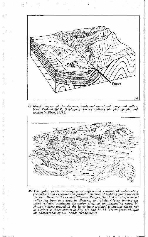
Fault
45 Block diagram of the Awatere Fault and associated scarp and valley, New Zealand (N.Z. Geological Survey oblique air photograph, and section in Birot, 1958b)
46 Triangular facets resulting from differential erosion of sedimentary formations and exposure and partial dissection of bedding plane between the two. Here, in the central Flinders Ranges, South Australia, a broad valley has been excavated in siltstones and shales (right), leaving the more resistant sandstone formation (left) as an upstanding ridge. V- shaped valleys incised in the latter have isolated triangular facets not as distinct as those shown in Fig. 43a and PI. 31 (drawn from oblique air photographs of S.A. Lands Department).
Landforms Associated with Faults 115
scarps, with combinations of the characteristic features described above, trending along or closely parallel with a known fault, is strongly suggestive of a fault scarp.
Thus the existence of fault-generated scarps of tectonic origin is urged by many and is indeed strongly supported by field evidence. Workers whose experience has been in the more stable areas of the earth (none is absolutely stable, but the orogenic regions are certainly more active than the cratons) have, on the other hand, doubted whether tectonism can outpace erosion and weathering. They accept that small scarps develop as a result of faulting, but view them as ephemeral. The great linear escarpments observed in the field are, in their view, of structural and not tectonic origin, being due to the differential erosion of dissimilar strata brought into proximity by faulting. The scarps are, in other words, fault-line scarps, the line of dislocation having been brought into relief by the work of streams. Such scarps developed in association with wrench faults are shown in Fig. 47a.
Two other types of fault-line scarp can be distinguished according to the relationship between the fault-line scarp and the original fault scarp (Fig. 47). A fault-line scarp which faces the same direction as the original tectonic form is called a resequent fault-line scarp, but one which, for one of a variety of possible reasons, faces in a direction opposite to the original is an obsequent fault-line scarp. For instance, if at a given level of erosion in the faulted area, the rock on the downthrown side is more resistant than that on the up- thrown side, an obsequent scarp may form.
In practice, detailed knowledge of the local stratigraphy is necessary before a fault-line scarp can be identified with precision and certainty. In addition, a fault scarp may be buried by detritus from the block above, but be subsequently re-exposed, in whole or in part, as a result of stream action. Such exhumed fault scarps may be difficult to distinguish from fault-line features.
In view of these and other practical difficulties, Cotton’s (1917) suggestion that it is inherently likely that most fault-generated scarps are partly tectonic and partly structural, that is composite in origin, is a useful one. For instance, the scarps bordering the Massif Central of France on its eastern side are, despite their being called fault scarps (Scarth, 1966), almost certainly largely of erosional character. The scarps, which are prominent, if discontinuous, are related to faults, displacement along which began in the Oligocene, though movements continued into the early Pleistocene. The scarps
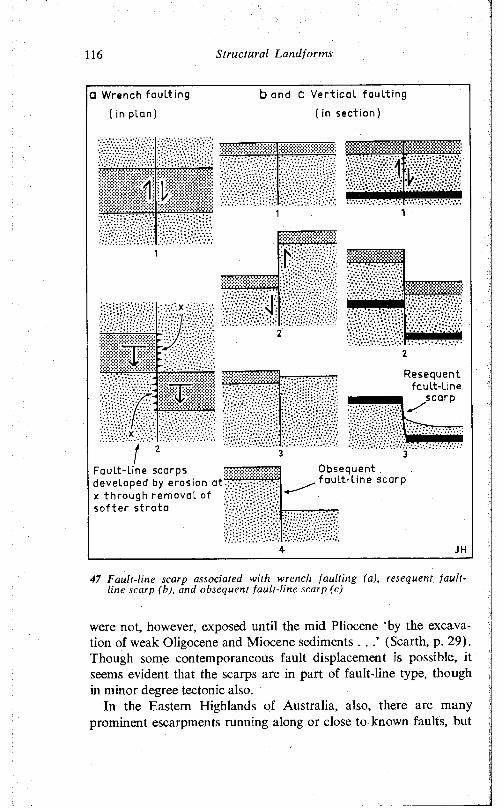
116 Structural Landforms
0 Wrench fault ing
( in p lan )
b and C Vert ical fault ing
( in s ec t i on )
wmmd.ill1 »«;
msmm, . , t r r r r i . . « x ^
m
WSSlv V/V>a v V.*.:V;‘,1
m m m
« S I S
llii•v.\v.y
wv
Fault-line scarps developed by erosion a1x x through removal of so f t er s t rata /•;>v.:.; F-.‘- •!
Obsequent faul t - l ine scarp
47 Fault-line scarp associated with wrench faulting (a), resequent faultline scarp (h), and obsequent fault-line scarp (c)
were not, however, exposed until the mid Pliocene ‘by the excavation of weak Oligocene and Miocene sediments . . (Scarth, p. 29). Though some contemporaneous fault displacement is possible, it seems evident that the scarps are in part of fault-line type, though in minor degree tectonic also.
In the Eastern Highlands of Australia, also, there are many prominent escarpments running along or close to known faults, but
Landforms Associated with Faults 117
it is difficult to be certain whether the scarps are mainly tectonic or mainly structural. In some instances, a fault-line origin has been suggested for scarps associated with faults. The scarp west of Wangaratta, Victoria (Hills, 1940, p. 158), is probably of resequent fault-line character. The same is true of the scarp associated with the MacDonald Fault in the Canadian North-West Territory. Sediments of Proterozoic Et-then Series have been eroded to expose the fault trace and plane which separates the sediments from the older crystalline rocks.
The scarps which delimit the Midland Valley of Scotland (Fig. 48) are also resequent fault-line scarps. Stratigraphic evidence shows that the Midland Valley rift structure, which is superimposed on a broad depositional basin, was established in early Devonian times, the Southern Upland Fault developing then, whereas the Highland Boundary Fault was inherited from Ordovician time (George, in Craig, 1965). Recurrent movement on the faults is indicated, with particularly important dislocations developing in the middle Devonian and middle Carboniferous. In each case, however, the newer faulting took place along established lines and served to revive Caledonian structures and relief. During the later Palaeozoic, the rift was part of a broad depositional basin. The weight of the accumulating sediments caused fracturing and subsidence of the underlying basement rocks. Differential erosion of the softer rocks of the Midland Valley has caused the broad rift structure to be redefined as a distinctive feature of the Scottish scenery.
Fault blocksMany parts of the earth’s crust are cut by series of intersecting
faults. Some of the blocks so delineated are of irregular shape; others have a regular form. Some such blocks have been raised, presumably by differential movement along the faults; others have suffered subsidence.
Many major regions of Australia are delimited by major zones of faulting and/or flexuring which run straight or are only gently arcuate over long distances and which are called lineaments. Amongst the positive fault-defined regions are the Isa Highlands, the Kimberleys, and the Canning, Bonaparte, and Carpentaria basins. Lake Victoria in central Africa evidently occupies a down- faulted area (Brock, 1966) as do Port Phillip Bay in Victoria (Hills, 1940) and the Ebro valley of northeastern Spain (Fig. 49). Eyre Peninsula, in South Australia, is bounded on both southwest and
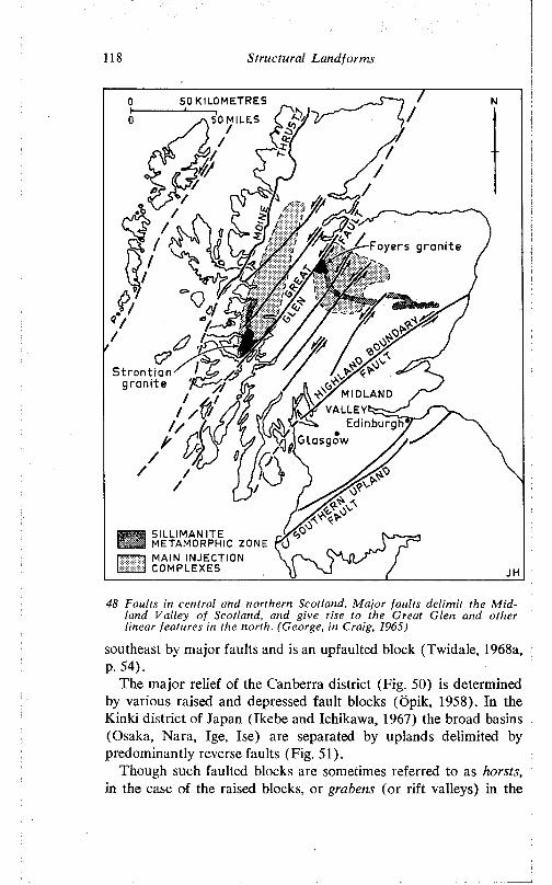
118 S truc tu ra l Land fo rm s
50 KILOMETRES
j \ 50 MILES
Foyers granite
Strontiangranite
/ m i d l a n d
Edinburgh 1 v f io ia s g o w
SILLIMANITE r Vr:;, Cl METAMORPHIC ZONE Kjr ------- 1 MAIN INJECTION \L__J COMPLEXES \
48 Faults in centra l and northern Scotland. M a jo r fau lts de lim it the M id land V a lley o f Scotland, and give rise to the Great G len and other linear features in the north. (George, in Craig, 1965)
southeast by major faults and is an upfaulted block (Twidale, 1968a, P- 54).
The major relief of the Canberra district (Fig. 50) is determined by various raised and depressed fault blocks (Öpik, 1958). Tn the Kinki district of Japan (Ikebe and Ichikawa, 1967) the broad basins (Osaka, Nara, Ige, Ise) are separated by uplands delimited by predominantly reverse faults (Fig. 51).
Though such faulted blocks are sometimes referred to as horsts, in the case of the raised blocks, or grabens (or rift valleys) in the
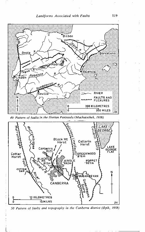
L a n d fo rm s A ssoc ia ted w ith F au lts 119
Bilbao
Barcelona
Valencia:
Lisbon
RIVERFAULTS AND FLEXURES
Seville
200 KILOMETRES 200 MILES
49 Pattern o f fau lts in the Iberian Peninsula (Machatschek, 1938)
Black Mt \ C _ MHorst Am CuLLann O'' Horst o
' LAKE GEORGE
FLATCanberra j
*
^ t S g r e e n w o o df *<- J * 8 7 6 mmm* AINSLIE POPPET
‘ 921m
CotterHorst
COTTER DAM r
QUEANBEYAN
CANBERRA
ip KILOMETRES 10 MILES
50 Pattern o f fau lts and topography in the Canberra d is tric t (Öpik, 1958)
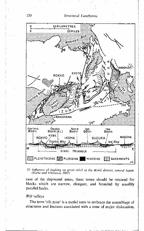
120 S tructu ra l Land fo rm s
HarimaBasin
Osaka Nora IgaBasin (s.L.) Basin Basin
IseBasin
KOBEROKKO / 1 IKOMA
1SUZUKA NAGOYA
Ise Bay
KINKI TRIANGLE
C 3 PLEISTOCENE U U PLIOCENE H MIOCENE Q BASEMENTS
51 Influence o f fau ltin g on gross re lie f o f the K in k i d istrict, central Japan (Ikcbe and Ichikaw a, 1967)
case of the depressed areas, these terms should be retained for blocks which are narrow, elongate, and bounded by sensibly parallel faults.
R ift valleys
The term ‘ rift zone’ is a useful term to embrace the assemblage of structures and features associated with a zone of major dislocation,
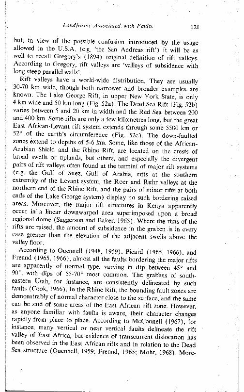
Land forms Associated with Faults 121
but, in view of the possible confusion introduced by the usage allowed in the U.S.A. (e.g. ‘the San Andreas rift’) it will be as well to recall Gregory’s (1894) original definition of rift valleys. According to Gregory, rift valleys are ‘valleys of subsidence with long steep parallel walls’.
Rift valleys have a world-wide distribution. They are usually 30-70 km wide, though both narrower and broader examples are known. The Lake George Rift, in upper New York State, is only 4 km wide and 50 km long (Fig. 52a). The Dead Sea Rift (Fig. 52b) varies between 5 and 20 km in width and the Red Sea between 200 and 400 km. Some rifts are only a few kilometres long, but the great East African-Levant rift system extends through some 5500 km or 52 of the earth s circumference (Fig. 52c). The down-faulted zones extend to depths of 5-6 km. Some, like those of the African- Arabian Shield and the Rhine Rift, are located on the crests of broad swells or uplands, but others, and especially the divergent pairs of rift valleys often found at the termini of major rift systems (e.g. the Gulf of Suez, Gulf of Arabia, rifts at the southern extremity of the Levant system, the Roer and Ruhr valleys at the northern end of the Rhine Rift, and the pairs of minor rifts at both ends of the Lake George system) display no such bordering raised areas. Moreover, the major rift structures in Kenya apparently occur in a linear downwarped area superimposed upon a broad regional dome (Saggerson and Baker, 1965). Where the rims of the rifts are raised, the amount of subsidence in the graben is in every case greater than the elevation of the adjacent swells above the valley floor.
According to Quennell (1948, 1959), Picard (1965, 1966), and Freund (1965, 1966), almost all the faults bordering the major rifts are apparently of normal type, varying in dip between 45° and 90 , with dips of 55-70° most common. The grabens of southeastern Utah, for instance, are consistently delineated by such faults (Cook, 1966). In the Rhine Rift, the bounding fault zones are demonstrably of normal character close to the surface, and the same can be said of some areas of the East African rift zone. Flowever, as anyone familiar with faults is aware, their character changes rapidly from place to place. According to McConnell (1967), for instance, many vertical or near vertical faults delineate the rift valley of East Africa, but evidence of transcurrent dislocation has been observed in the East African rifts and in relation to the Dead Sea structure (Quennell, 1959; Freund, 1965; Mohr, 1968). More-
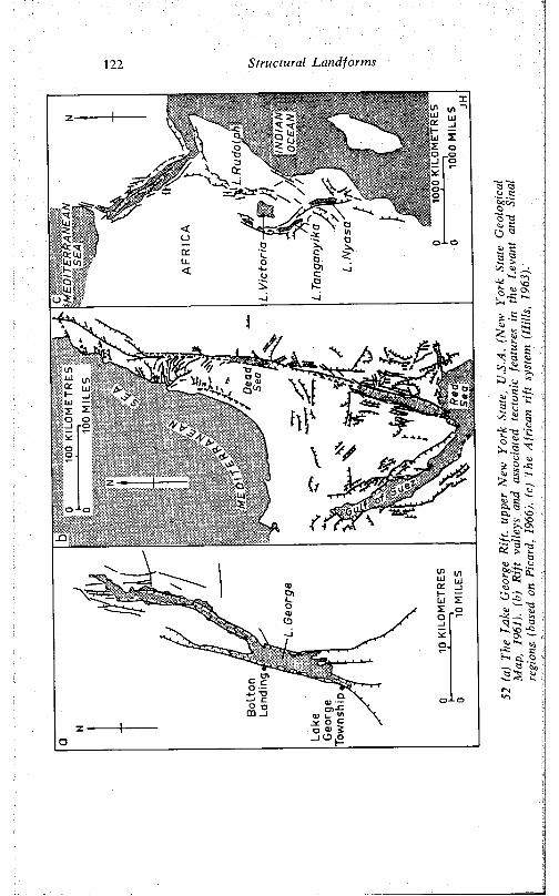
1 2 2 Structural Landforms
"3 '3 -5
o a
l i
js.5 5£ 2 5 -W 3 gx 3 I
a l t l a I
'Cr2 ^ £ . 2 ^ > o ^ 2 2 k
^ a -v v . t 3 £
ca. vo 3 £ £
• ii .~ " l5 § |
o
w 2 Ü S c
- * - < sq23 *-~, 23
^ 8 - i p s^ K .2--V O 0«
S!<N•O
Landforms Associated with Faults 123
TT’7\ \ X\ Y \A \
53 (hZfnTZ'ltiTwerZ^SZT1 ^ ^ “Pover, these are only near surface observations and the fault character may change in depth. Though reverse faults at the surface are rare, it may be argued that faults of this type are present at depth, the projecting angle of the hanging wall developing the normal faults so readily observed in the field as a result of the failure and subsidence (Fig. 53). The bordering faults are commonly arranged en echelon, as is clearly illustrated in northeastern Eyre Peninsula, bordering Spencer Gulf (Miles, 1952), and in the Oslo Fjord Graben (Bederke, 1966). There is usually a zone of multiple fracturing rather than a single fault, a feature well demonstrated in the rift of central Iceland (PI. 32).
Very commonly, one side of the rift is higher than the other, with the principal fault or fault zone on the higher side, and with subsidiary fractures delineating the lower flank. Lake Baikal, for instance, though subject to various interpretations, clearly displays not only this characteristic but also the development of minor hörst (Okhor Island) and graben features within the major depressed structure (Florensov, 1966). Mt Ruwenzori, in central Africa, is an example of a hörst mass within a rift complex, and others occur in central Iceland (Fig. 54), while the Sinai Peninsula and Yorke Peninsula are examples of raised masses of less regular shape in plan involved in rift zones.
Complexities of the marginal fault escarpments are also illustrated in the Paraiba Graben of southeastern Brazil (King, 1956a). In a few areas, the intersection of rift zones causes the formation of deep subsidiary grabens within the main structure. In the Levant system, for instance, the Dead Sea and Lake Tiberias originated in this way (Picard, 1966).
124 Structural Landforms
32 Thingvellir (‘the Plain of the Parliament') and Lake Thingvallavatur in the southwestern bifurcation of the central Iceland graben (see Fig. 54). Holocene lava flows breached by open tectonic fissures and faults. Main scarp due to a 30 m downthrow on the normal Almannagja Fault. (S. Thorarinsson)
Naturally, rift valleys vary greatly in age. The faults bordering the Rhine Rift have been active at least since the early Tertiary. In the East African rifts, the sediments deposited in the valley floors suggest that the structure has been in existence since the late Cretaceous. Dixey (1956). however, has argued a Jurassic or even earlier age for the features, and McConnell (1967) maintains that they probably date from the Precambrian. They affect Precambrian rocks, closely follow structures in the Precambrian bedrock, and are visualised as having been revived several times through geological history during periods of mountain building, suffering severe erosion, indeed, virtual topographic obliteration by erosion, during the intervening stable periods. However, dislocation of the rift sediments certainly continues. Further to the north, the main bordering faults of the Levant system are of Pleistocene age (Picard, 1966). Though Freund (1965) advocates greater antiquity for the structures, the presence of at least 3000 m of Pleistocene deposits (according to gravity surveys, almost 10,000 m) in the trough in
Landforms Associated with Faults 125
Wies!*'- LAVA FLOW • OTHER VOLCANOES■ FISSURE ERUPTION ACTIVE VOLCANIC ZONE
NON-ERUPTIVE FISSURE —*• COURSE OF GLACIER BURST0 50 KILOMETRES PRESENT GLACIER
0 50 MILES
54 The Iceland rifts and hörst (Thorarinsson, 1966)
northern Arabia demonstrates strong downfaulting during the recent past.
Rift valleys and orogenie systems either intersect or are in close proximity in the Jura-Black Forest region and in northern Syria, and in both areas the available evidence is that both types of crustal deformation developed simultaneously.
From a geophysical point of view, rift valleys are the sites of extensive volcanicity and high geothermal gradients. Shallow earthquakes are of common occurrence on these structures, and narrow rifts (which constitute the majority of those known) display strong negative gravity anomalies amounting to several tens of milligals. Flowever, the central parts of the broad Red Sea and Gulf of Aden rifts display very high (140 milligals) positive anomalies.
That large rift systems are represented in many continental areas will be clear from earlier references. The most extensive rift
126 Structural Landforms
systems are, however, developed in the ocean floors. The rifts of the Red Sea and the Gulf of Aden areas have been studied in some detail (see, e.g., Girdler, 1958, 1966; Knott, Bunce, and Chase, 1966), as has the mid-Atlantic ridge, of which the Iceland Rift (Fig. 54) is but an extension (Rutten and Wensink, 1960; Thorarinsson, 1960; Thorarinsson, Einarsson, and Kjartansson, 1960).
Although rift valleys are structurally simple, the problem of their origin has provoked several varied explanations, none of which seems at present to be universally acceptable. There are great difficulties of observation of crucial data, and a general lack of real information. For example, reference has already been made to the difficulty of determining the significance of the normal faults observed in the Rhine and East African rifts, but in some instances doubt has even been cast upon the tectonic character of major features upon which various hypotheses have been particularly based. Recently, for instance, doubts have been expressed as to whether the Red Sea occupies a true rift valley (Whiteman, 1968). The feature was developed as a tensional depression in the late Precambrian and early Palaeozoic, but has since that time been an area of deposition. Fault scarps bounding the Red Sea are few, and, according to Whiteman, the Red Sea occupies an elongate valley eroded by rivers and widened by scarp retreat. The trough has a newly developed rift in its central axis and has been inundated by the ocean. If this is so, then many of the speculations on rifts which take special account of the Red Sea area are pointless.
The issue has been further clouded by what are almost philosophical considerations: the rift systems are interpreted in light of continental drift, a contracting earth or an expanding earth, and so on (Carey, 1956; King, 1962). The dangers of this sort of approach are illustrated by reference to the Philippines. The Pacific basin is, in the view of some workers, encircled by a system of dextral wrench faults. The San Andreas and Alpine faults are part of the system, which is alleged also to pass through the Philippines. This group of islands is certainly traversed by a major zone of faulting but whether it is dominated by transcurrent movements is doubtful. Rutland (1968) has shown that, albeit on the basis of the study of limited area, the evidence for wrench faulting in the recent geological past is slight. The main movements are of vertical (or dip slip) character, though both dextral and sinistral wrench faulting possibly took place in early Tertiary times. At this stage, it seems
Landforms Associated with Faults 127
more important to establish the facts rather than interpret all features in light of one grand concept or another.
If the normal character of the faults observed at the surface of the margins is taken as indicative of their behaviour at depth, then the rifts are clearly related to tension in the crust. Rifts which simulate natural features in many morphological details of form and structure as well as in their gross morphology can be induced experimentally by the stretching of clays (Cloos, 1936). It has been suggested that once the major fracture zone has developed, the sagging of the incipient rift valley (Fig. 55a) causes a secondary fault zone to form in parallel with the first and as a result of bending of the crust (Meinesz, 1950). The African rift in northern Tanganyika and in the Lake Rudolph region of Kenya conforms to this pattern: broad monoclinal dowpwarps on the eastern side face well-developed east-facing fault scarps on the western (Sag- gerson and Baker, 1965).
As the free block sinks, the adjacent areas rise in compensation to form slightly raised rims. Such hypotheses account for the typical negative gravity anomalies of the rifts, but leave unexplained those rifts lacking raised rims, and such high massifs as Ruwenzori (5125 m) and the Lebanon Mountains, both of which occur adjacent to rift valleys and which are very difficult indeed to understand in terms of tensional stresses. Moreover, since this type of explanation involves the subsidence of the floor of the graben into the simatic layer below, it is not possible to apply it to the numerous and large grabens of the ocean floor, beneath which there is no near surface differentiation or layering. It has also been argued that, if the earth is contracting, rifts of tensional origin should not be widely distributed, as they appear to be. Against this, however, is the suggestion that the earth may in fact be expanding and, in any event, the correlation in time of compressive orogenesis and tensional rifting may be interpreted as a compensatory function.
Recently, modifications of the earlier tensional hypotheses which go some way to overcoming their inherent difficulties have been proposed by Freund (1966). In brief, greater emphasis is placed on the lateral extension inherent in tensional hypotheses rather than upon vertical displacements. Tension gives rise to crustal stretching as well as normal faulting. It is envisaged that an ‘antiroot’ of denser material develops beneath the rift (Fig. 55b) as simatic rocks rise to fill the gap caused by the extension above. At first sight such a situation appears at variance with the observed facts, for a bulge of
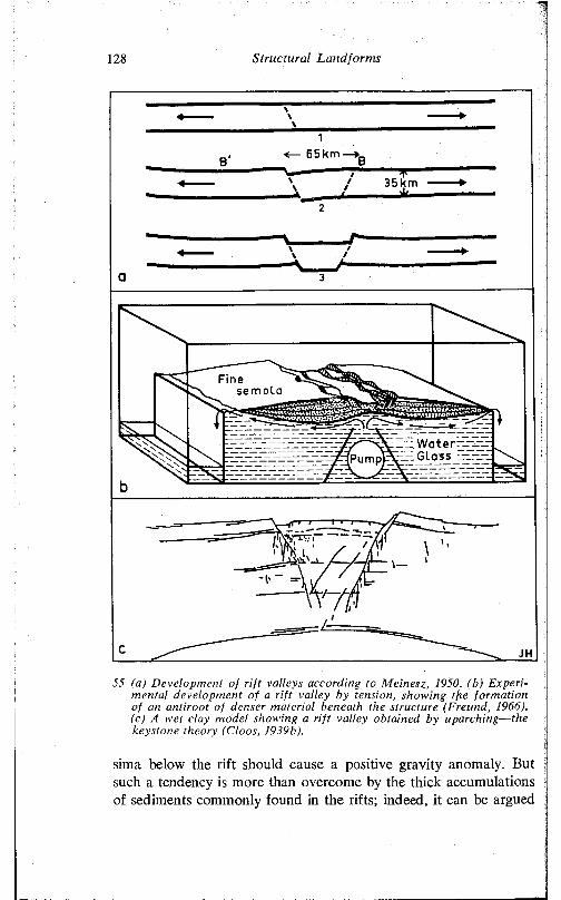
128 Structural Landforms
65km
35km
semola
Waterr_ i Glass -_r
55 (a) Development of rift valleys according to Meinest, 1950. (b) Experimental development of a rift valley by tension, showing tfie formation of an antiroot of denser material beneath the structure (Freund, 1966). (c) A wet clay model showing a rift valley obtained by uparching— the keystone theory (Cloos, 1939b).
sima below the rift should cause a positive gravity anomaly. But such a tendency is more than overcome by the thick accumulations of sediments commonly found in the rifts; indeed, it can be argued
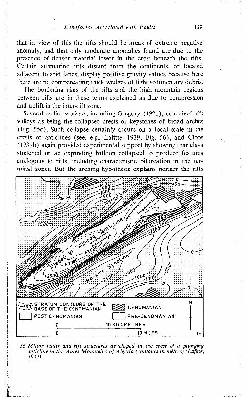
Landforms Associated with Faults 129
that in view of this the rifts should be areas of extreme negative anomaly, and that only moderate anomalies found are due to the presence of denser material lower in the crest beneath the rifts. Certain submarine rifts distant from the continents, or located adjacent to arid lands, display positive gravity values because here there are no compensating thick wedges of light sedimentary debris.
The bordering rims of the rifts and the high mountain regions between rifts are in these terms explained as due to compression and uplift in the inter-rift zone.
Several earlier workers, including Gregory (1921), conceived rift valleys as being the collapsed crests or keystones of broad arches (Fig. 55c). Such collapse certainly occurs on a local scale in the crests of anticlines (see, e.g., Lafitte, 1939; Fig. 56), and Cloos (1939b) again provided experimental support by showing that clays stretched on an expanding balloon collapsed to produce features analogous to rifts, including characteristic bifurcation in the terminal zones. But the arching hypothesis explains neither the rifts
-1500
-"cnrt- STRATUM CONTOURS OF THE BASE OF THE CENOMANIAN
| I POST-CENOMANIAN
l M ^ CENOMANIAN
I | PRE-CENOMANIAN
10 KILOMETRES
10 MILES
56 Minor faults and rift structures developed in the crest of a plunging anticline in the Aures Mountains of Algeria (contours in metres) (Lafitte, 1939)
130 Structural Landforms
not bordered by swells nor the way rifts subside more than the rims rise (which is always the case). It may also be argued (Gzovsky, quoted in Freund. 1966) that Cloos’s experiment does not exactly simulate natural conditions. In particular, if the arched clay were continued laterally beyond the zone affected by the expanding balloon, it would be observed that fractures develop at the outer fringes of bending; no such fracture zones are found in nature, though in practice such broad flexures may be difficult to detect without very detailed mapping.
Vertical tectonics are also invoked by Brock (1966) who interprets the East African rift system as due to uplift of some blocks and subsidence of others. The blocks are of ancient origin, and though ultimate causes of the differential vertical movements are not clear, convection currents, advocated by many as causative factors of rifts and other features and involving lateral displacements, seem inconsistent with such developments.
The observed strong negative gravity anomalies in the East African rifts (Bullard, 1936) apparently afford strong support for the compressive theory of rift development advocated by Wayland (1921). The concept was first applied to the Lake Edward and Lake Albert rifts, and the intervening Ruwenzori upland was explained as an upthrust block. The lack of observed reverse faults is attributed to lack of deep exposures. According to some workers, support for this hypothesis comes from the observed association, and, in some cases, parallelism (see, e.g., Freund, 1966; Picard, 1966) of anticlines and rifts, which is interpreted as suggestive of common compressive origin. On the other hand, the two types of structure can be equally well understood as caused by opposed but complementary stresses.
Lastly, McConnell (1967) considers that geological mapping clearly demonstrates the transcurrent character of the main faults bounding the East African rift valleys. Here again, differential movements between long-established cratonic blocks could account for such features as juggling of blocks and the disturbance of sediments in troughs. Freund et al. (1968) have also reported wrench faulting in the Dead Sea Rift.
Although other explanations of rift valleys are advanced from time to time, it is the tensional and the compressional which are most commonly and most seriously entertained. The compressional hypothesis has its virtues, and could apply in particular instances,

Landforms Associated with Faults 131
but the tensional hypothesis involving stretching of the crust seems satisfactorily to explain most of the field evidence, particularly if it is considered in conjunction with doming. If tensional stress is prevalent over the earth’s surface, including the ocean basins as well as the continents, then it is clear that there is an overall tendency to expansion. However, it may be that rifts form in various ways and the most recent work points more to dislocation of ancient blocks along the lines suggested by Brock and McConnell.
In summary, the tensional hypotheses appear to be most in keeping with the field evidence, as well as with laboratory experiments. The nature of observed and geophysically traced faults and the common association of volcanicity with rift valleys support this interpretation, while the negative gravity anomalies of some rift valleys, which seemingly present an obstacle to the co n g re ssional hypothesis, can satisfactorily be explained, in some cases at any rate, by the thick wedges of light unconsolidated debris accumulated in these recurrently active tectonic features.
HorstsHorsts are the reverse of grabens. They are long, narrow, raised
blocks bounded by faults, and display fault splinters, offset fault patterns, and many other characteristics mentioned in connection with rift valleys. Well-known examples include the Mt Lofty Ranges in South Australia (Fig. 44), the Sierra Guadaverra and Sierra Estralita in central and western Spain (Fig. 49), the Cotter and Cullarin horsts near C anberra (Fig. 50), the Black Forest and Vosges, adjacent to the Rhine Rift, central Iceland (Fig. 54), the Shansi plateau of northern China, and the Ruwenzori massif of central Africa (Fig. 57).
Fault angle valleys and depressionsIn the M t Lofty Ranges of South Australia, the distinct westward
curvature of the fault-bounded upland has caused some complications of the hörst structure. In the south, and on the western side of the upland, the arcuate faults are arranged en echelon (Fig. 44) and there is a tendency for the m inor fault blocks within the hörst to be raised on the western side and depressed on the east. Thus the blocks are tilted down to the east, and the intervening valleys or depressions, formed by the gently inclined backslope of one block and the abrupt fault scarp of the next block to the east, are asymmetrical in cross-section. Because they are located in the angle
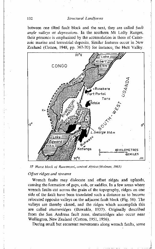
132 Structural Landforms
between one tilted fault block and the next, they are called jault angle valleys or depressions. In the southern Mt Lofty Ranges, their presence is emphasised by the accumulation in them of Caino- zoic marine and terrestrial deposits. Similar features occur in New Zealand (Cotton, 1948, pp. 367-70) for instance, the Hutt Valley.
LakeA lb e r t
619 m
:E dward913 m
30°E
C O N G O
7'
■“T »Rusekere Fort Portal
Toroi Ndale<C
A *
George 914m
Katunqa 40 KILOMETRES40 MILES
30 E
57 Horst block of Ruwenzori, central Africa (Holmes, 1965)
Offset ridges and streamsWrench faults may dislocate and offset ridges and uplands,
causing the formation of gaps, cols, or saddles. In a few areas where wrench faults cut across the grain of the topography, ridges on one side of the fault have been translated such a distance as to become relocated opposite valleys on the adjacent fault block (Fig. 58). The valleys are thereby closed, and the ridges which accomplish this are called shutterridges (Buwalda, 1937). Originally described from the San Andreas fault zone, shutterridges also occur near Wellington, New Zealand (Cotton, 1951, 1956).
During small but recurrent movements along wrench faults, some
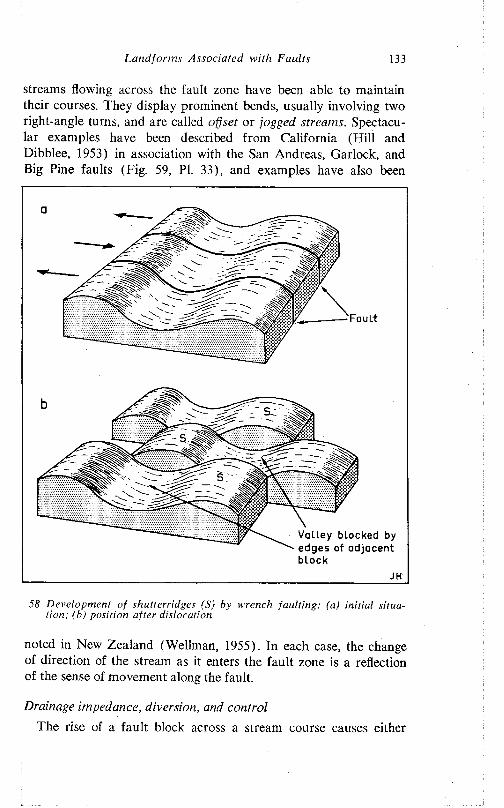
Land forms Associated with Faults 133
streams flowing across the fault zone have been able to maintain their courses. They display prominent bends, usually involving two right-angle turns, and are called offset or jogged streams. Spectacular examples have been described from California (Hill and Dibblee, 1953) in association with the San Andreas, Garlock, and Big Pine faults (Fig. 59, PI. 33), and examples have also been
Fault
>r sIf ^
Valley blocked by edges of adjacent block
58 Development of shutterridges (S) by wrench faulting: (a) initial situation; (b) position after dislocation
noted in New Zealand (Wellman, 1955). In each case, the change of direction of the stream as it enters the fault zone is a reflection of the sense of movement along the fault.
Drainage impedance, diversion, and controlThe rise of a fault block across a stream course causes either
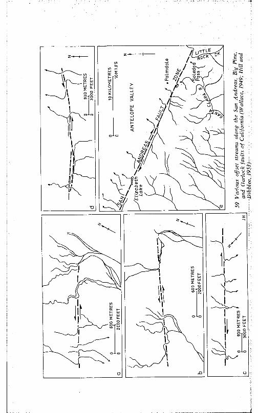
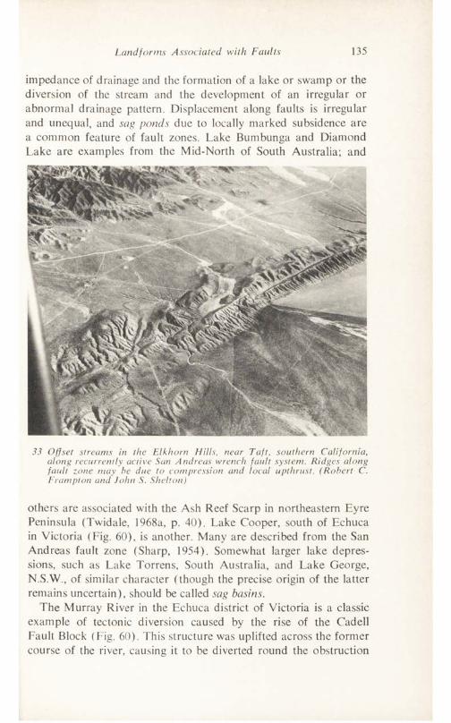
Land forms Associated with Faults 135
impedance of drainage and the formation of a lake or swamp or the diversion of the stream and the development of an irregular or abnormal drainage pattern. Displacement along faults is irregular and unequal, and sag ponds due to locally marked subsidence are a common feature of fault zones. Lake Bumbunga and Diamond Lake are examples from the Mid-North of South Australia; and
33 Offset streams in the Elkhorn Hills, near Taft, southern California, along recurrently active San Andreas wrench fault system. Ridges along fault zone may be due to compression and local upthrust. (Robert C. Frampton and John S. Shelton)
others are associated with the Ash Reef Scarp in northeastern Eyre Peninsula (Twidale, 1968a, p. 40). Lake Cooper, south of Echuca in Victoria (Fig. 60), is another. Many are described from the San Andreas fault zone (Sharp, 1954). Somewhat larger lake depressions, such as Lake Torrens, South Australia, and Lake George, N.S.W., of similar character (though the precise origin of the latter remains uncertain), should be called sag basins.
The Murray River in the Echuca district of Victoria is a classic example of tectonic diversion caused by the rise of the Cadell Fault Block (Fig. 60). This structure was uplifted across the former course of the river, causing it to be diverted round the obstruction
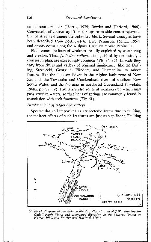
136 Structural Landforms
on its southern side (Harris, 1939; Bowler and Harford, 1966). Conversely, of course, uplift on the upstream side causes rejuvenation of streams draining the upfaulted block. Several examples have been described from northeastern Eyre Peninsula (Miles, 1952) and others occur along the Kulpara Fault on Yorke Peninsula.
Fault zones are lines of weakness readily exploited by weathering and erosion. Thus, fault-line valleys, distinguished by their straight courses in plan, are exceedingly common (Pis. 34, 35). In scale they vary from rivers and valleys of regional significance, like the Darling, Strzelecki, Georgina, Flinders, and Diamantina to minor features like the Jackson River in the Alpine fault zone of New Zealand, the Towamba and Crackenback rivers of southern New South Wales, and the Norman in northwest Queensland (Twidale, 1968a, pp. 27, 39). Faults are also zones of weakness up which may pass artesian waters, so that lines of springs are commonly found in association with such fractures (Fig. 61).Displacement of ridges and valleys
Spectacular and important as are tectonic forms due to faulting, the indirect effects of such fractures are just as significant. Faulting
Deniliquin
CADELL FAULT BLOCK _
Echuca 7T H*y Ba ma \ Sandhi l l s
LakeCooper
30 KILOMETRES 30MILES
COLB INABBIN RANGE
A p p r ox . scaLe
60 Block diagram of the Echuca district, Victoria and N.S.W., showing the Cadell Fault Block and associated diversion of the Murray (based on Harris, 1939, and Bowler and Harford, 1966)
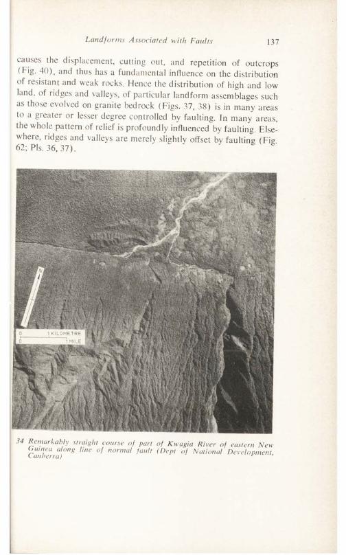
Landforms Associated with Faults 137
causes the displacement, cutting out, and repetition of outcrops (f ig. 40), and thus has a fundamental influence on the distribution of lesistant and weak rocks. Hence the distribution of high and low land, of ridges and valleys, of particular landform assemblages such as those evolved on granite bedrock (Figs, 37, 38) is in many areas to a gieater or lesser degree controlled by faulting. In many areas, the whole pattern of relief is profoundly influenced by faulting. Elsewhere, ridges and valleys are merely slightly offset by faulting (Fig 62; Pis. 36,37).
34 Remarkably straight course of part of Kwagia River of eastern Ne\ Canberra) 8 n° rmul ault (Dcpt °f Nat'onal Development
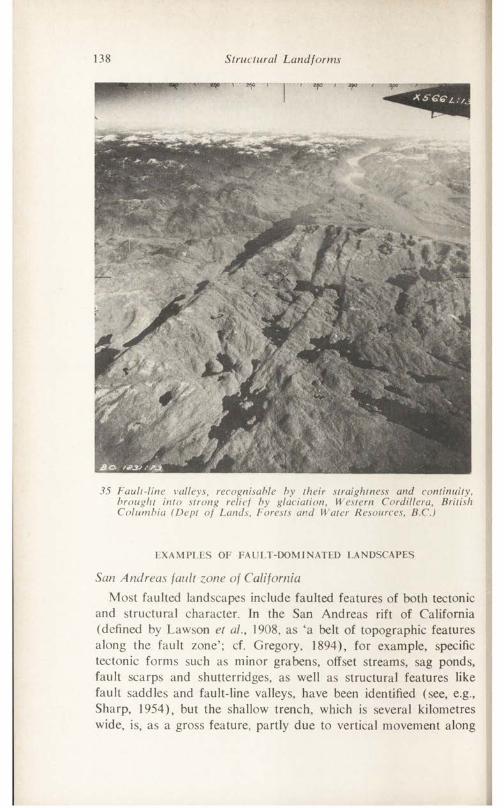
138 Structural Landforms
35 Fault-line valleys, recognisable by their straightness and continuity, brought into strong relief by glaciation, Western Cordillera, British Columbia (Dept of Lands, Forests and Water Resources, B.C.)
EXAMPLES OF FAULT-DOMINATED LANDSCAPES
San Andreas fault zone of CaliforniaMost faulted landscapes include faulted features of both tectonic
and structural character. In the San Andreas rift of California (defined by Lawson et ai, 1908, as ‘a belt of topographic features along the fault zone’; cf. Gregory, 1894), for example, specific tectonic forms such as minor grabens, offset streams, sag ponds, fault scarps and shutterridges, as well as structural features like fault saddles and fault-line valleys, have been identified (see, e.g., Sharp, 1954), but the shallow trench, which is several kilometres wide, is, as a gross feature, partly due to vertical movement along
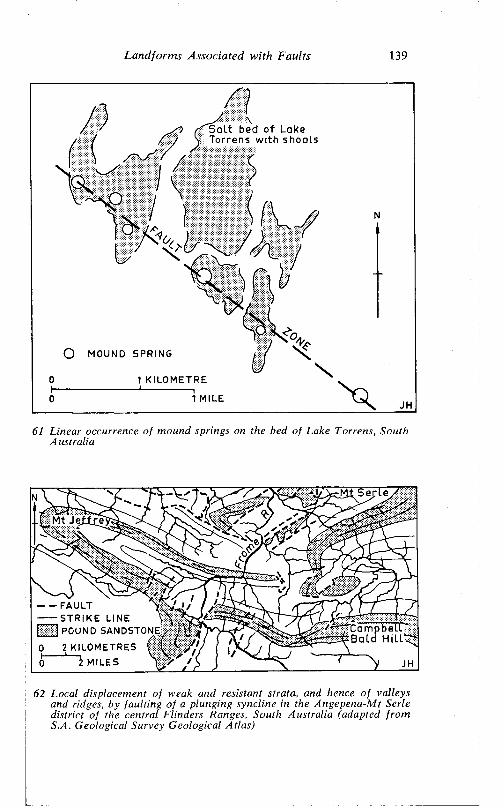
Land fonns Associated w ith Faults 139
S alt bed of Lake Torrens with shoals
O MOUND SPRING
1 KILOMETRE
1 MILE
61 L inear occurrence o f m ound springs on the bed o f Lake Torrens, South A ustra lia
Ser ie
Mt Je ifreX v v " "
------ FAULT Y— S TR IK E LINE \
[ 1 POUND SANDSTONE
0 2 KILOMETRES | | j0 ' MILES N
62 Local displacement o f weak and resistant strata, and hence o f valleys and ridges, by fau ltin g o f a p lung ing synoline in the Angepena-M t Serie d istric t o f the central F linders Ranges, South A ustra lia (adapted fro m S.A. Geological Survey G eological A tlas)
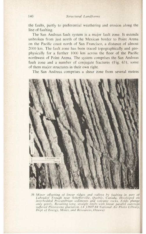
140 Structural Landforms
the faults, partly to preferential weathering and erosion along the line of faulting.
The San Andreas fault system is a major fault zone. Tt extends unbroken from just north of the Mexican border to Point Arena on the Pacific coast north of San Francisco, a distance of almost 2000 km. The fault zone has been traced topographically and geophysically for a further 1000 km across the floor of the Pacific northwest of Point Arena. The system comprises the San Andreas fault zone and a number of conjugate fractures (Fig. 63), some of them major structures in their own right.
The San Andreas comprises a shear zone from several metres
36 Minor offsetting of linear ridges and valleys by faulting in part of Labrador Trough near Schefferville, Quebec, Canada. Developed on interbedded Precambrian sediments and volcanic rocks. Folds plunge only gently. Resulting long, straight limbs with linear parallel outcrops suffered Pleistocene glaciation. (A J 1607-84 National Air Photo Library, Dept of Energy, Mines, and Resources, Ottawa)
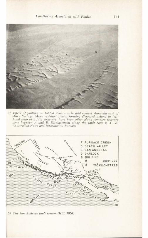
L a n d fo rm s A ssoc ia ted w ith F a u lts 141
37 Effect o f fa u ltin g on fo ld e d structures in arid centra l A ustra lia east o f A lice Springs. M ore resistant strata, fo rm in g dissected upland in le ft- hand lim b o f a fo ld structure, have been offset along complex frac tu re zone between A and B. D isplacement along the fa u lt zone is X — B. (A ustra lian News and In fo rm a tio n Bureau)
F FURNACE CREEK D DEATH VALLEY 5 SAN ANDREAS G GARLOCK B BIG PINE
0__________ 200 MILES 0 200 KILOMETRES
A
63 The San Andreas fa u lt system (H ill, 1966)
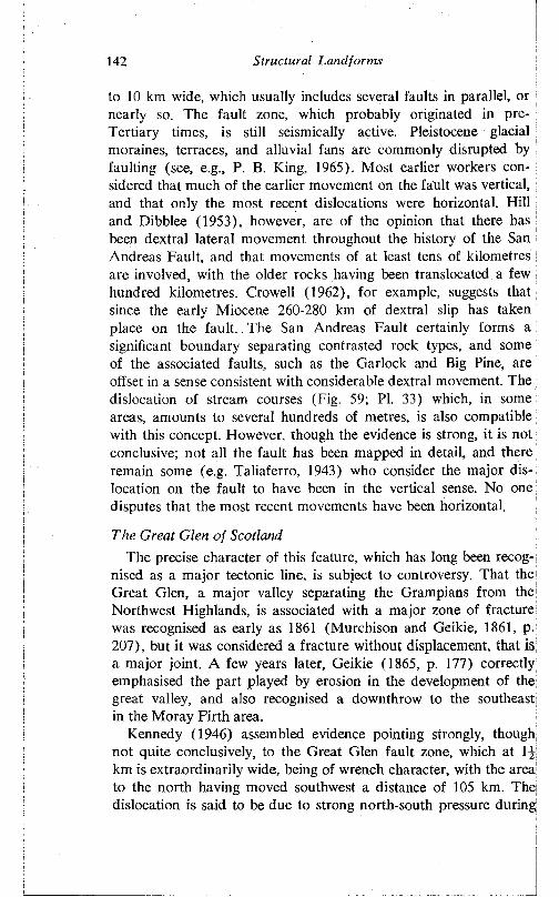
142 Structural Landforms
to 10 km wide, which usually includes several faults in parallel, or nearly so. The fault zone, which probably originated in pre- Tertiary times, is still seismically active. Pleistocene glacial moraines, terraces, and alluvial fans are commonly disrupted by faulting (see, e.g., P. B. King, 1965). Most earlier workers considered that much of the earlier movement on the fault was vertical, and that only the most recent dislocations were horizontal. Hill and Dibblee (1953), however, are of the opinion that there has been dextral lateral movement throughout the history of the San Andreas Fault, and that movements of at least tens of kilometres are involved, with the older rocks having been translocated a few hundred kilometres. Crowell (1962), for example, suggests that since the early Miocene 260-280 km of dextral slip has taken place on the fault. The San Andreas Fault certainly forms a significant boundary separating contrasted rock types, and some of the associated faults, such as the Garlock and Big Pine, are offset in a sense consistent with considerable dextral movement. The dislocation of stream courses (Fig. 59; PI. 33) which, in some areas, amounts to several hundreds of metres, is also compatible with this concept. However, though the evidence is strong, it is not conclusive; not all the fault has been mapped in detail, and there remain some (e.g. Taliaferro, 1943) who consider the major dislocation on the fault to have been in the vertical sense. No one disputes that the most recent movements have been horizontal.
The Great Glen of ScotlandThe precise character of this feature, which has long been recog
nised as a major tectonic line, is subject to controversy. That the Great Glen, a major valley separating the Grampians from the Northwest Highlands, is associated with a major zone of fracture was recognised as early as 1861 (Murchison and Geikie, 1861, p. 207), but it was considered a fracture without displacement, that is a major joint. A few years later, Geikie (1865, p. 177) correctly emphasised the part played by erosion in the development of the great valley, and also recognised a downthrow to the southeast in the Moray Firth area.
Kennedy (1946) assembled evidence pointing strongly, though not quite conclusively, to the Great Glen fault zone, which at 1 km is extraordinarily wide, being of wrench character, with the area to the north having moved southwest a distance of 105 km. The dislocation is said to be due to strong north-south pressure during
Landforms Associated with Faults 143
late Devonian or early Carboniferous times. The evidence for this conclusion is varied. The Great Glen Fault (Fig. 48) is but one of several parallel fractures, along some of which lateral displacement has certainly occurred. Metamorphic zones and a belt of regional injection have evidently suffered horizontal dislocation. The Stron- tian granite mass, with distinctive roughly concentric petrographic zones, is abruptly terminated against the fault on its southern side. At the eastern end of the fault, but on the southern side, the similar Foyers granite stock is likewise truncated but the fracture is on its northern side. It is suggested that the two are but dislocated parts of what was formerly a single igneous mass. Finally, if such a transcurrent movement took place, the major thrust fault known in the islands of Islay and Colonsay becomes a displaced section of the Moine Thrust.
The evidence for a considerable horizontal dislocation along the Great Glen Fault is probably as good as can reasonably be expected of such an ancient feature; but it is not conclusive and from time to time doubts are cast on this interpretation. Shand (1951), for example, was unable to find the mylonite that is a characteristic feature of wrench faults in other regions. More recently, Ahmad (1967) has pointed out differences in the mineralogical and geophysical character of the Strontian and Foyers granites. Because of this, he discounts the wrench fault theory and instead interprets the fault as a dominantly vertical structure. However, the wrench fault theory does not exclude the possibility of some vertical displacement which, as stated, has long been recognised, and because of this variations in mineralogy and magnetic properties may be expected on what are probably different levels of granite stock.
But whatever its geological character, the Great Glen Fault is a line of weakness which has been eroded by streams and glaciers (PI. 38). The great fault-line valley, occupied by Loch Linnhe, Loch Lochy, Loch Ness, and various streams and rivers, forms a major breach in the uplands of northern Scotland which remains seismically active.
The Alpine jault zone of New ZealandIhe Alpine Fault (Fig. 64) is a dextral wrench fault along which
major structures have been displaced by a matter of almost 500 km, the western side of the South Island having travelled northward relative to the eastern block (Wellman, 1955). The fault zone branches in the north of the South Island, and reappears across
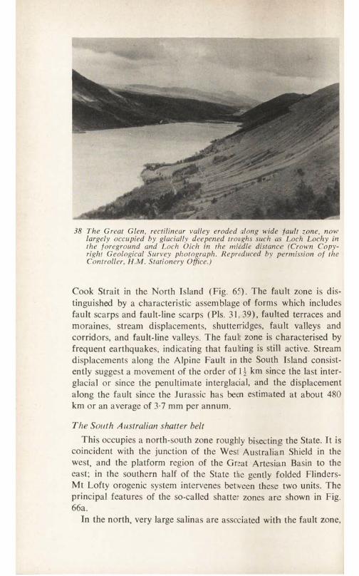
38 The Great Glen, rectilinear valley eroded ilong wide fault zone, now largely occupied by glacially deepened troighs such as Loch Lochy in the foreground and Loch Oich in the middle distance (Crown Copyright Geological Survey photograph. Reproduced by permission of the Controller, H.M. Stationery Office.)
Cook Strait in the North Island (Fig. 65). The fault zone is distinguished by a characteristic assemblage of forms which includes fault scarps and fault-line scarps (Pis. 31, 39), faulted terraces and moraines, stream displacements, shutterridges, fault valleys and corridors, and fault-line valleys. The fault zone is characterised by frequent earthquakes, indicating that faulting is still active. Stream displacements along the Alpine Fault in the South Island consistently suggest a movement of the order of \ \ km since the last interglacial or since the penultimate interglacial, and the displacement along the fault since the Jurassic has been estimated at about 480 km or an average of 3-7 mm per annum.
The South Australian shatter beltThis occupies a north-south zone roughly bisecting the State. It is
coincident with the junction of the West Australian Shield in the west, and the platform region of the Gr;at Artesian Basin to the east; in the southern half of the State the gently folded Flinders- Mt Lofty orogenic system intervenes betveen these two units. The principal features of the so-called shatter zones are shown in Fig. 66a.
In the north, very large salinas are associated with the fault zone,
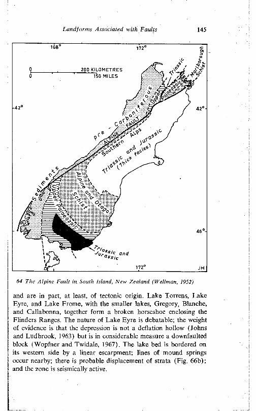
Landforms Associated with Faults 145
64 The Alpine Fault in South Island, New Zealand (Wellman, 1952)
and are in part, at least, of tectonic origin. Lake Torrens, Lake Eyre, and Lake Frome, with the smaller lakes, Gregory, Blanche, and Callabonna, together form a broken horseshoe enclosing the Flinders Ranges. The nature of Lake Eyre is debatable; the weight of evidence is that the depression is not a deflation hollow (Johns and Ludbrook, 1963) but is in considerable measure a downfaulted block (Wopfner and Twidale, 1967). The lake bed is bordered on its western side by a linear escarpment; lines of mound springs occur nearby; there is probable displacement of strata (Fig. 66b); and the zone is seismically active.
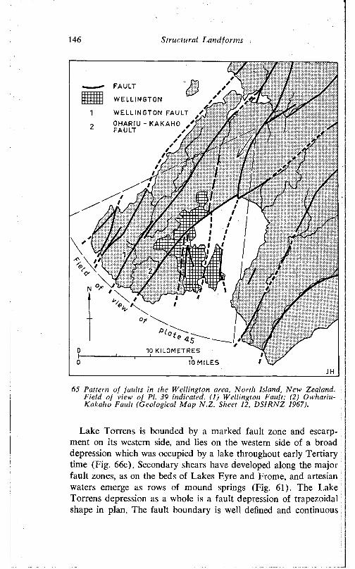
146 S tructu ra l Land fo rm s
FAULT
WELLINGTON
WELLINGTON FAULTOHARIU - KAKAHO FAULT
<510 KILOMETRES
10 MILES
65 Pattern o f fau lts in the W elling ton area, N o rth Island, New Zealand. F ie ld o f view o f PI. 39 indicated. ( I ) W elling ton F au lt; (2) O w hariu- Kakaho Fau lt (G eologica l M ap N .Z . Sheet 12, D S IR N Z 1967).
Lake Torrens is bounded by a marked fault zone and escarpment on its western side, and lies on the western side of a broad depression which was occupied by a lake throughout early Tertiary time (Fig. 66c). Secondary shears have developed along the major fault zones, as on the beds of Lakes Eyre and Frome, and artesian waters emerge as rows of mound springs (Fig. 61). The Lake Torrens depression as a whole is a fault depression of trapezoidal shape in plan. The fault boundary is well defined and continuous
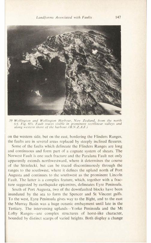
Landforms Associated with Faults 147
39 Wellington and Wellington Harbour, New Zealand, from the north (cf. Fig. 65). Fault traces visible in prominent rectilinear valleys and along western shore of the harbour. (R.N.Z.A.F.)
on the western side, but on the east, bordering the Flinders Ranges, the faults are in several areas replaced by steeply inclined flexures.
Some of the faults which delineate the Flinders Ranges are long and continuous and form part of a cognate system of shears. The Norwest Fault is one such fracture and the Paralana Fault not only apparently extends northwestward, where it determines the course of the Strzelecki, but can be traced discontinuously through the ranges to the southwest, where it defines the upland north of Port Augusta and continues to the southwest as the prominent Lincoln Fault. The latter is a complex feature, which, together with a fracture suggested by earthquake epicentres, delineates Eyre Peninsula.
South of Port Augusta, two of the downfaulted blocks have been inundated by the sea to form the Spencer and St Vincent gulfs. To the west, Eyre Peninsula gives way to the Bight, and to the east the Murray Basin was a huge oceanic embayment until late in the Tertiary. The intervening uplands—Yorke Peninsula and the Mt Lofty Ranges—are complex structures of horst-iike character, bounded by distinct scarps of varied heights. Both display a change
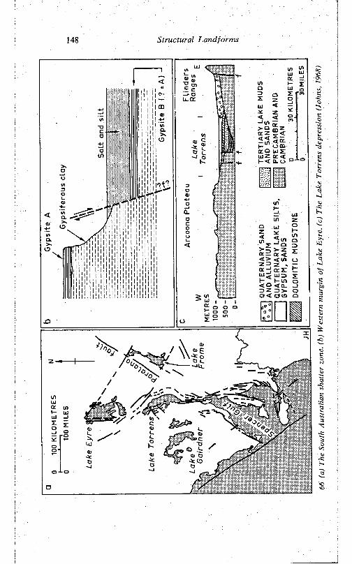
148 Structural Landforms
t—< Q. u
ce <
a -J c r l t u j < l u z> 2 : H I— in o< a < ix _J !D z ID > - OO < a ID Q
'O0 \*>■
c5
3<0
<5'O
Aust
ralia
n sh
atte
r zo
ne, (
h) W
este
rn m
argi
n of
Lak
e Ey
re, (
c) T
he L
ak<
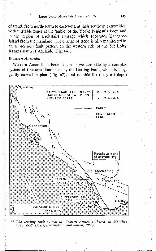
Landforms Associated with Faults 149
of trend, from north-south to east-west, at their southern extremities, with unstable zones at the ‘ankle’ of the Yorke Peninsula boot, and in the region of Backstairs Passage which separates Kangaroo Island from the mainland. The change of trend is also manifested in an en echelon fault pattern on the western side of the Mt Lofty Ranges south of Adelaide (Fig. 44).
Western AustraliaWestern Australia is bounded on its western side by a complex
system of fractures dominated by the Darling Fault, which is long, gently curved in plan (Fig. 67), and notable for the great depth
On slowM > 4 - 4EARTHQUAKE EPI CE NTRE S
MAGNITUDE SHOWN IS ON RICHTER SCALE M 4 - 4 - 4
CONCEALEDFAULT
Carnarvon
Possible zone of instabil ity
cP; Meckering \
DARLING : FAULT :: BrooktonPERTH
DUNSBOROUGH FAULT xXx:
200 K ILOMETRES :
200 MILES!
67 The Darling fault system in Western Australia (based on McWhae et al., 1958; Doyle, Everingham, and Sutton, 1968)
150 Structural Landfonns
(13,000 m) to which it extends. It gives rise to a prominent escarpment, and a few rifts and horsts. Some folds affecting Cainozoic strata in the region may be related to recurrent dislocation along the fault system. A number of conjugate shears are associated with the major Darling Fault, and though the geological evidence is against recent movement along the Darling Fault, that the minor shears remain active is attested by seismic records and by such events as the 1968 Meckering earthquake (Doyle, Everingham, and Sutton, 1968). Other fault-guided landscapes are featured in the Kimberley and Hamersley regions in the north of the State (Jutson, 1950; McWhae et al., 1958; Doyle, Everingham, and Sutton, 1968). The Fitzroy-Christmas Creek valley is a graben and the course of the Fortescue is influenced by faulting, though the precise relationship is not yet clear.
V
LANDFORMS EVOLVED ON FOLDED SEQUENCES
Sedimentary rocks occur extensively in depositional basins, in fold belts, in platform areas, and in basins and troughs within the shield areas. The landforms developed on such sequences are thus widely distributed over the continents. Moreover, morphologically similar features evolve on crystalline rocks, for instance, as a result of duncrusting, or arising from the development of pronounced cleavage consequent upon regional metamorphism.
The assemblage of forms developed on sedimentary rocks varies with the relative resistance or susceptibility of the strata to weathering and erosion, and with their attitude or disposition. These attributes, as well as the distribution of the various strata, are ultimately related to the sedimentary and tectonic history of any given area. The significance of these several factors is illustrated in the following pages by reference to specific areas and examples, as well as by a consideration of general cases.
VARIED RESISTANCE OF ROCKS
1 he resistance of a rock refers to its ability to withstand the prevailing forces of weathering and erosion. Some rocks are very resistant (hard, strong), others are not (soft, weak). There is no direct relationship between the susceptibility of rocks composed primarily of one mineral and the physical hardness of that mineral (as measured, for example, on the Mohr scale). Limestones are composed mainly of calcium carbonate, which has a hardness of 3 (on the 10-unit Mohr scale) but, because of its well-developed jointing and bedding and its resultant propensity for ‘swallowing’ water, limestone generally gives rise to uplands. Again, gypsite is
151
152 Structural Landforms
wholly composed of gypsum crystals which are not only soft (hardness 2 on the Mohr scale) but highly susceptible to solution. Yet a thin bed of gypsum forms a resistant caprock, and gives rise to a precipitous escarpment bordering Lake Eyre on its western side. Under the prevailing very arid conditions, solution is not an important factor, and the gypsite, physically soft though it is, is nevertheless more resistant than the unconsolidated silts which underlie it.
Resistance is, of course, a relative and not an absolute term. In the last cited region, the gypsite is only relatively resistant compared with the unconsolidated silts: compared with sandstone, for example, it is very readily eroded. Again, limestone gives rise to ridges and hills in the Flinders Ranges (depending on how massive it is), but the rock is, under the prevailing conditions, less hard than sandstone which underlies most of the peaks and major ridges in the upland.
Several factors influence the susceptibility of a given rock to attack by weathering and erosion: mineralogy, the cementation or coherence of the rock, texture, jointing and fracturing, climate. The order of susceptibility of the common rock-forming minerals is, as stated earlier, the reverse of their normal sequence of crystallisation from an igneous melt—that is the last formed crystals such as quartz are resistant; the earlier crystals, such as the amphiboles, are susceptible to attack. In other words, basic rocks are weak, the acid ones resistant. Thus, basalts are prone to rapid weathering and erosion because they contain many susceptible minerals.
Sandstone, and especially quartzite, is consistently the most resistant of rocks. A sedimentary quartzite consists of quartz fragments cemented together by secondary silica. Quartz has a hardness of 7 on the Mohr scale, and is, moreover, chemically almost inert. Though their porosity varies with the degree of cementation, sandstones are characteristically pervious by virtue of their well- developed bedding and jointing. Surface waters tend to percolate through the rock rather than run over and erode the surface. Thus, very little subsurface solution or erosion, or surface abrasion, is effected. For these reasons, massive quartzites invariably give rise to uplands.
Variations in composition and structure, however, may render the rock more susceptible to weathering and erosion. For example, sandstones with a calcareous cement, or a considerable proportion of calcite intermixed with quartz, are not only physically softer but
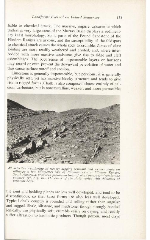
Land for ms Evolved on Folded Sequences 153
liable to chemical attack. The massive, impure calcarenite which underlies very large areas of the Murray Basin displays a rudimentary karst morphology. Some parts of the Pound Sandstone of the Flinders Ranges are arkosic, and the susceptibility of the feldspars to chemical attack causes the whole rock to crumble. Zones of close jointing are more readily weathered and eroded, and, where inter- bedded with more massive sandstone, give rise to ridge and cleft assemblages. The occurrence of impermeable layers or horizons may retard or even prevent the downward percolation of water and thus cause surface runoff and erosion.
Limestone is generally impermeable, but pervious; it is generally physically soft, yet has massive blocky structure and tends to give rise to rugged forms. Chalk is also composed almost entirely of calcium carbonate, but is noncrystalline, weaker, and more permeable;
40 Selective weathering of steeply dipping resistant and weaker strata on hiIIslope a few kilometres east of Blinman, central Flinders Ranges, South A ustralia, produced prominent lines of platy outcrops—‘tombstone country’ (cf. Fig. 10). Thickness of the slabs varies with thickness of resistant beds.
the joint and bedding planes are less well developed, and tend to be discontinuous, so that karst forms are also less well developed. Typical chalk country is rounded and rolling rather than angular and rugged. Shale, siltstone, and mudstone, though strongly bonded ionically, are physically soft, crumble easily on drying, and readily suffer alteration to kaolinitic products. Though porous, most clays
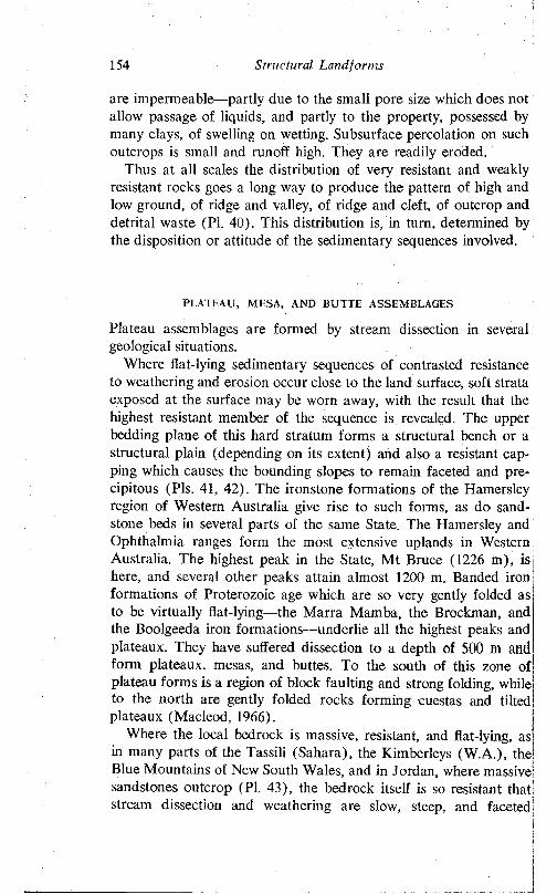
154 Structural Landforms
are impermeable—partly due to the small pore size which does not allow passage of liquids, and partly to the property, possessed by many clays, of swelling on wetting. Subsurface percolation on such outcrops is small and runoff high. They are readily eroded.
Thus at all scales the distribution of very resistant and weakly resistant rocks goes a long way to produce the pattern of high and low ground, of ridge and valley, of ridge and cleft, of outcrop and detrital waste (PI. 40). This distribution is, in turn, determined by the disposition or attitude of the sedimentary sequences involved.
PLATEAU, MESA, AND BUTTE ASSEMBLAGES
Plateau assemblages are formed by stream dissection in several geological situations.
Where flat-lying sedimentary sequences of contrasted resistance to weathering and erosion occur close to the land surface, soft strata exposed at the surface may be worn away, with the result that the highest resistant member of the sequence is revealed. The upper bedding plane of this hard stratum forms a structural bench or a structural plain (depending on its extent) and also a resistant capping which causes the bounding slopes to remain faceted and precipitous (Pis. 41, 42). The ironstone formations of the Hamersley region of Western Australia give rise to such forms, as do sandstone beds in several parts of the same State. The Hamersley and Ophthalmia ranges form the most extensive uplands in Western Australia. The highest peak in the State, Mt Bruce (1226 m), is here, and several other peaks attain almost 1200 m. Banded iron formations of Proterozoic age which are so very gently folded as to be virtually flat-lying—the Marra Mamba, the Brockman, and the Boolgeeda iron formations—underlie all the highest peaks and plateaux. They have suffered dissection to a depth of 500 m and form plateaux, mesas, and buttes. To the south of this zone of plateau forms is a region of block faulting and strong folding, while to the north are gently folded rocks forming cuestas and tilted plateaux (Macleod, 1966).
Where the local bedrock is massive, resistant, and flat-lying, as in many parts of the Tassili (Sahara), the Kimberleys (W.A.), the Blue Mountains of New South Wales, and in Jordan, where massive sandstones outcrop (PI. 43), the bedrock itself is so resistant that stream dissection and weathering are slow, steep, and faceted
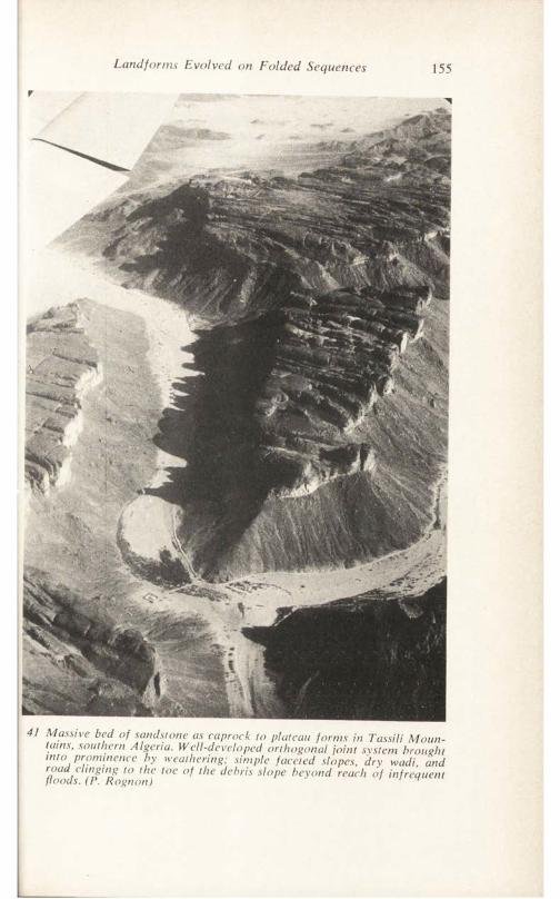
Land for ms Evolved on Folded Sequences 155
r
41 Massive bed of sandstone as caprock to plateau forms in Tassili Mountains, southern Algeria. Well-developed orthogonal joint system brought into prominence by weathering; simple faceted slopes, dry wadi, and road dinging to the toe of the debris slope beyond reach of infrequent floods. (P. Rognon) ^
L
156 Structural Landforms
slopes are evolved and high plains comprising many individual structural benches and plains are prominent.
In some areas a resistant duricrust (ferricrete, silcrete, calcrete, gibber) has formed through soil-forming processes on other geological formations, which may be tilted and folded, crystalline (e.g. granitic), or inherently weak. Such duricrusts form caprock and afford the same degree of protection against weathering and erosion as do primary resistant formations. Thus, latente cappings give rise
42 Sandstone caprock above simple faceted slopes, with prominent bluffs and extensive plateaux, King Leopold Ranges, northwest Western Australia. Stream attack on bluff has led to isolation of some plateau remnants as buttes. (Ivan O'Riley, courtesy W.A. Dept of Industrial Development)
to prominent plateau and mesa forms in the Cue district of Western Australia, in many areas of northern Australia, and in central Africa (Pallister, 1956). Silcrete-capped plateaux are reported from central Australia (Mabbutt, 1965; Wopfner and Twidale, 1967) and gibber-capped plateaux are well displayed west and south of Lake Eyre.
Similarly, where flat-lying igneous veins, dykes and sills, or flows of lava, cap otherwise unresistant strata, plateau and mesa assemblages have evolved. The great Drakensberg escarpment is capped
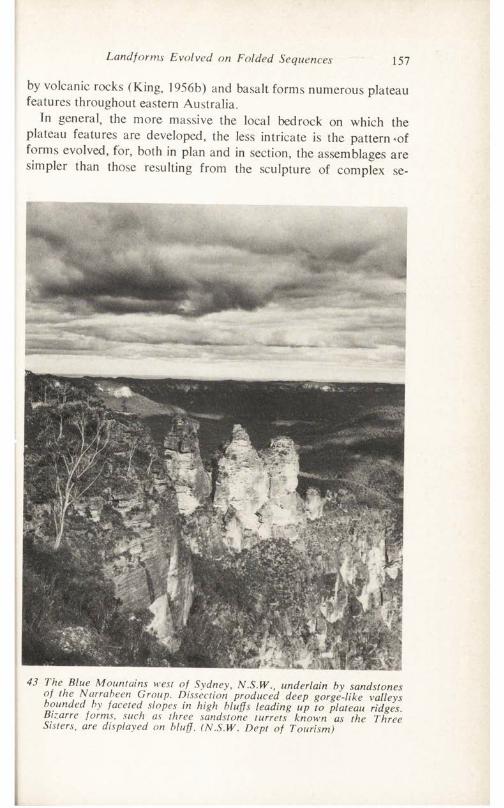
Land forms Evolved on Folded Sequences 157
by volcanic rocks (King, 1956b) and basalt forms numerous plateau features throughout eastern Australia.
In general, the more massive the local bedrock on which the plateau features are developed, the less intricate is the pattern *of forms evolved, for, both in plan and in section, the assemblages are simpler than those resulting from the sculpture of complex se-
43 The Blue Mountains west of Sydney, N.S.W., underlain by sandstones of the Narrabeen Group. Dissection produced deep gorge-like valleys bounded by faceted slopes in high bluffs leading up to plateau ridges. Bizarre forms, such as three sandstone turrets known as the Three Sisters, are displayed on bluff. (N.S.W. Dept of Tourism)
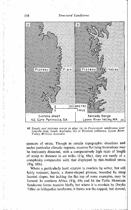
158 Structural Landforms
68 Simple and intricate scarps in plan: (a) in Proterozoic sandstones near Lincoln Gap, South Australia; (b) in Permian sediments, Lyons River Valley, Western Australia
quences of strata. Though in certain topographic situations and under particular climatic regimes, massive flat-lying formations may be intricately dissected, with a comparatively high ratio of length of scarp to distance in air miles (Fig. 68a), they are rarely of a complexity comparable with that displayed by thin-bedded strata (Fig. 68b).
Where a particularly hard stratum is overlain by softer, but still fairly resistant, layers, a dome-shaped plateau, bounded by steep faceted slopes, but lacking the flat top of some examples, may be formed. In southern Africa (Fig. 69a and b) the Table Mountain Sandstone forms massive bluffs, but where it is overlain by Dwyka Tillitc or feldspathic sandstone, it forms not flat-topped, but domed,
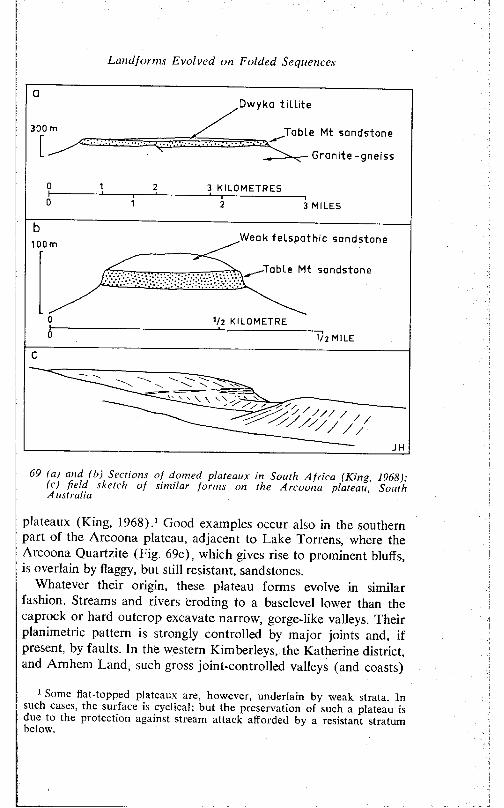
Landforms Evolved on Folded Sequences
Dwyka tilLite
„Table Mt sandstone
Granite -gneiss
3 KILOMETRES
3 MILES
Weak felspathic sandstone1 0 0 m
-Table Mt sandstone
1/2 KILOMETRE
V l MILE
69 (a) and (b) Sections of domed plateaux in South Africa (King, 1968); (c) field sketch of similar forms on the Arcoona plateau, South A ustralia
plateaux (King, 1968).1 Good examples occur also in the southern part of the Arcoona plateau, adjacent to Lake Torrens, where the Arcoona Quartzite (Fig. 69c), which gives rise to prominent bluffs, is overlain by flaggy, but still resistant, sandstones.
Whatever their origin, these plateau forms evolve in similar fashion. Streams and rivers eroding to a baselevel lower than the caprock or hard outcrop excavate narrow, gorge-like valleys. Their planimetric pattern is strongly controlled by major joints and, if present, by faults. In the western Kimberleys, the Katherine district, and Arnhem Land, such gross joint-controlled valleys (and coasts)
1 Some flat-topped plateaux are. however, underlain by weak strata. In such cases, the surface is cyclical; but the preservation of such a plateau is due to the protection against stream attack afforded by a resistant stratum below.
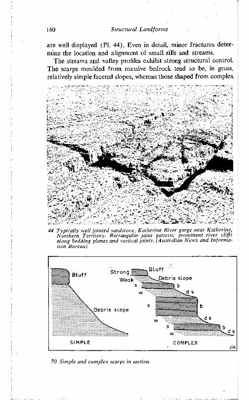
Structural Landfonns160
are well displayed (PI. 44). Even in detail, minor fractures determine the location and alignment of small rills and streams.
The streams and valley profiles exhibit strong structural control. The scarps moulded from massive bedrock tend to be, in gross, relatively simple faceted slopes, whereas those shaped from complex
44 Typically well jointed sandstone, Katherine River gorge near Katherine, Northern Territory. Rectangular joint pattern; prominent river cliffs along bedding planes and vertical joints. (Australian News and Information Bureau)
BluffB l u f f Debris s lope
Debris s l op e
SIMPLE COMPLEX
70 Simple and complex scarps in section
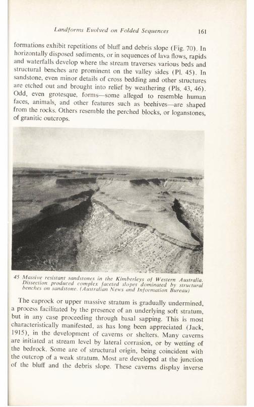
Landforms Evolved on Folded Sequences 161
formations exhibit repetitions of bluff and debris slope (Fig. 70). In horizontally disposed sediments, or in sequences of lava flows, rapids and waterfalls develop where the stream traverses various beds and structural benches are prominent on the valley sides (PI. 45). In sandstone, even minor details of cross bedding and other structures are etched out and brought into relief by weathering (Pis. 43, 46). Odd, even grotesque, forms—some alleged to resemble human faces, animals, and other features such as beehives—are shaped from the rocks. Others resemble the perched blocks, or loganstones, of granitic outcrops.
45 Massive resistant sandstones in the Kimberleys of Western Australia. Dissection produced complex faceted slopes dominated by structural benches on sandstone. (Australian News and Information Bureau)
The caprock or upper massive stratum is gradually undermined, a process facilitated by the presence of an underlying soft stratum, but in any case proceeding through basal sapping. This is most characteristically manifested, as has long been appreciated (Jack, 1915), in the development of caverns or shelters. Many caverns are initiated at stream level by lateral corrasion, or by wetting of the bedrock. Some are of structural origin, being coincident with the outcrop of a weak stratum. Most are developed at the junction of the bluff and the debris slope. These caverns display inverse
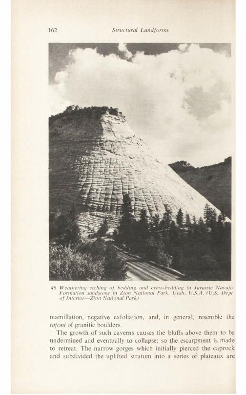
162 Structural Landforms
46 Weathering etching of bedding und cross-bedding in Jurassic Navajo Formation sandstone in Zion National Park, Utah, U.S.A. (U.S. Dept of Interior—Zion National Park)
mamillation, negative exfoliation, and, in general, resemble the tafoni of granitic boulders.
The growth of such caverns causes the bluffs above them to be undermined and eventually to collapse; so the escarpment is made to retreat. The narrow gorges which initially pierced the caprock and subdivided the uplifted stratum into a series of plateaux are
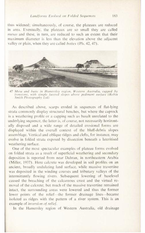
Landforms Evolved on Folded Sequences 163
thus widened; simultaneously, of course, the plateaux are reduced in area. Eventually, the plateaux are so small they are called mesas and these, in turn, are reduced to such an extent that their maximum diameter is less than the elevation above the adjacent valley or plain, when they are called buttes (Pis. 42, 47).
47 Mesa and butte in Hamersley region, Western Australia, capped by ironstone, with simple faceted slopes above pediment surface (Robin Smith Photography Ltd)
As described above, scarps eroded in sequences of flat-lying strata commonly display structural benches, but where the caprock is a weathering profile or a capping such as basalt unrelated to the underlying sequence, the latter is, of course, not necessarily horizontally disposed and a wide range of detailed erosional forms are displayed within the overall context of the bluff-debris slopes assemblage. Vertical and oblique ridges and clefts, for instance, may evolve in folded strata exposed by dissection beneath a lateritised weathering surface.
One of the most spectacular examples of plateau forms evolved on folded strata as a result of superficial weathering and secondary deposition is reported from near Dahran, in northeastern Arabia (Miller, 1937). Here calcrete was developed in soil profiles on an ancient, broadly undulating land surface, while massive travertine was deposited in the winding courses and tributary valleys of the intermittently flowing rivers. Subsequent lowering of baselevel caused the breaching of the calcareous crust and the virtual removal of the calcrete; but much of the massive travertine remained intact, the surrounding areas were lowered and thus the former lower points of the relief—the former drainage lines—became isolated as ridges with the pattern of a river system. This is an example of inversion of relief.
In the Hamersley region of Western Australia, old drainage
164 Structural Landforms
channels have been encrusted with limonite and, after erosion and relief inversion, also form resistant cappings to ridges.
TYPES AND GEOMETRY OF FOLDS
A fold is a bend or an undulation in rocks. Folds vary in magnitude from a few millimetres to many kilometres diameter. Though they are characteristically expressed in sedimentary sequences, they are equally well developed in other layered rocks of metamorphic and igneous origins.
Folds are generated by several mechanisms. Stresses from two opposed directions give rise to anticlines and synclines. The former is a fold which is convex upward, the latter one which is convex downward. Each fold comprises two limbs which meet in the crestal line which is an imaginary line joining all the highest points on any bedding surface of an anticline or antiform (an apparent anticline in which, however, the correct stratigraphic sequence is not determined); or in the trough line, an imaginary line which joins all the lowest points on any bedding plane in a syncline or synform. Usually but not always coincident with crestal or trough line, the hinge line passes through all points of greatest curvature in a bedding plane. The plane which connects the hinge lines between the two limbs of a fold is the axial plane, axial surface, or axis of the fold. The trace of the axial plane on any stratum is the axial line. Symmetrical and upright folds (Fig. 71) have axes which bisect the structures.
Inequality in opposed stresses or failure of parts of the sedimentary sequence causes the development of asymmetrical and inclined folds, with limbs unequally inclined and non-vertical axes. Complex anticlinoria and synclinoria, with minor anticlinal and synclinal structures within the broader forms, may also be developed. In virtually all folds the axial line is not horizontal. The angle between the sloping axial line and the horizontal, as measured in a vertical plane, is the plunge inclination. .Such plunging folds (also and formerly known, particularly in Australia, as pitching folds, though the term pitch or rake, as applied to folds, has now taken on a different meaning, especially in the American literature—see, e.g., Badglcy, 1965, p. 51), are very common and are geomorpho- logically significant by virtue of their convergent and divergent limbs and outcrops (see, e.g., PI. 37). The inequality of opposed stresses
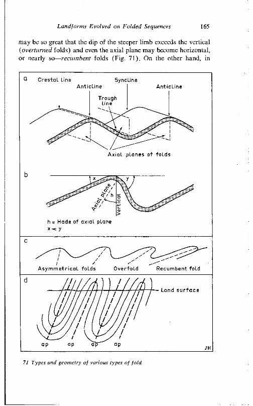
Land forms Evolved on Folded Sequences 165
may be so great that the dip of the steeper limb exceeds the vertical (overturned folds) and even the axial plane may become horizontal, or nearly so— recumbent folds (Fig. 71). On the other hand, in
Crestal Line SynclineAnticl ine Anticl ine
Troughline
Axial planes of f o lds
h = Hade of axial plane x -c y
Asymmetr i ca l folds Overfold Recumbent fold
— Land s u r f a c e
71 Types and geometry of various types of fold
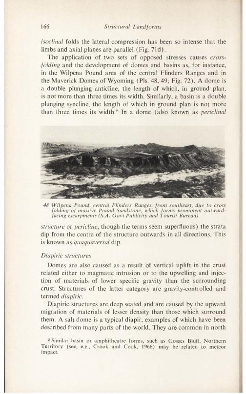
166 Structural Landforms
isoclinal folds the lateral compression has been so intense that the limbs and axial planes are parallel (Fig. 71 d ) .
The application of two sets of opposed stresses causes cross- folding and the development of domes and basins as, for instance, in the Wilpena Pound area of the central Flinders Ranges and in the Maverick Domes of Wyoming (Pis. 48, 49; Fig. 72). A dome is a double plunging anticline, the length of which, in ground plan, is not more than three times its width. Similarly, a basin is a double plunging syncline, the length of which in ground plan is not more than three times its width.2 In a dome (also known as periclinal
48 Wilpena Pound, central Flinders Ranges, from southeast, due to cross folding of massive Pound Sandstone, which forms prominent outward- facing escarpments (S.A. Govt Publicity and Tourist Bureau)
structure or pericline, though the terms seem superfluous) the strata dip from the centre of the structure outwards in all directions. This is known as quaquaversal dip.
Diapiric structuresDomes are also caused as a result of vertical uplift in the crust
related either to magmatic intrusion or to the upwelling and injection of materials of lower specific gravity than the surrounding crust. Structures of the latter category are gravity-controlled and termed diapiric.
Diapiric structures are deep seated and are caused by the upward migration of materials of lesser density than those which surround them. A salt dome is a typical diapir, examples of which have been described from many parts of the world. They are common in north
2 Similar basin or amphitheatre forms, such as Gosses Bluff, Northern Territory (see, e.g., Crook and Cook, 1966) may be related to meteor impact.
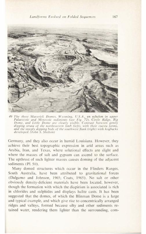
Landforms Evolved on Folded Sequences 167
49 The three Maverick Domes, Wyoming, U.S.A., en echelon in upper Palaeozoic and Mesozoic sediments (see Fig. 72). Circle Ridge, Big Dome, and Little Dome are clearly visible. Contrast between gently dipping strata of the northeastern limb (left), with their cuesta forms, and the steeply dipping beds of the southwest flank (right) with hogbacks developed. (John S. Shelton)
Germany, and they also occur in humid Louisiana. However, they achieve their best topographic expression in arid areas such as Arabia, Iran, and Texas, where solutional effects are slight and where the masses of salt and gypsum can ascend to the surface. The upthrust of such lighter masses causes doming of the adjacent sediments (PI. 50).
Many domed structures which occur in the Flinders Ranges, South Australia, have been attributed to gravitational forces (Dalgamo and Johnson, 1965; Coats, 1965). No salt or other obviously density-deficient materials have been located, however, though the formation with which the diapirism is associated is rich in chlorides and sulphides and displays halite casts. It has been suggested that the domes, of which the Blinman Dome is a large and typical example, and which give rise to concentrically arranged ridges and valleys, formed because silty and other sediments retained water, rendering them lighter than the surrounding, com-
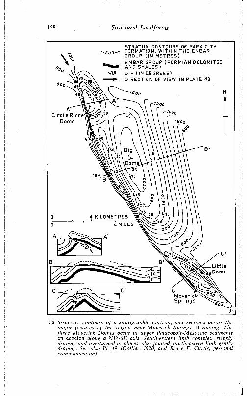
168 S truc tu ra l Land fo rm s
STRATUM CONTOURS OF PARK CITY FORMATION, WITHIN THE EMBAR GROUP (IN METRES)EMBAR GROUP (PERMIAN DOLOMITES AND SHALES)DIP ( IN DEGREES)DIRECTION OF VIEW IN PLATE 49
72 S tructure contours o f a stratig raphic horizon, and sections across the m ajor features o f the region near M averick Springs, W yom ing. The three M averick Domes occur in upper Palacozoic-Mesozoic sediments en echelon along a N W -SE axis. Southwestern lim b complex, steeply d ipp ing and overturned in places, also faulted, northeastern lim b gently dipping. See also PI. 49. (C o llie r, 1920, and Bruce F. Curtis, personal com m unication)
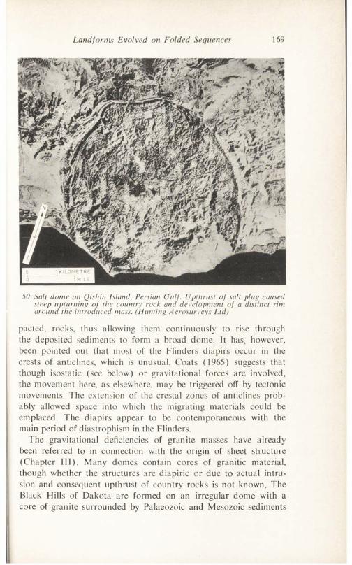
Land forms Evolved on Folded Sequences 169
50 Salt dome on Qishin Island, Persian Gulf. Upthrust of salt plug caused steep upturning of the country rock and development of a distinct rim around the introduced mass. (Hunting Aerosurveys Ltd)
pactcd, rocks, thus allowing them continuously to rise through the deposited sediments to form a broad dome. It has, however, been pointed out that most of the Flinders diapirs occur in the crests of anticlines, which is unusual. Coats (1965) suggests that though isostatic (see below) or gravitational forces are involved, the movement here, as elsewhere, may be triggered off by tectonic movements. The extension of the crestal zones of anticlines probably allowed space into which the migrating materials could be emplaced. The diapirs appear to be contemporaneous with the main period of diastrophism in the Flinders.
The gravitational deficiencies of granite masses have already been referred to in connection with the origin of sheet structure (Chapter III). Many domes contain cores of granitic material, though whether the structures are diapiric or due to actual intrusion and consequent upthrust of country rocks is not known. The Black Hills of Dakota are formed on an irregular dome with a core of granite surrounded by Palaeozoic and Mesozoic sediments
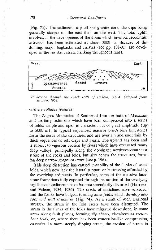
170 S tru c tu ra l L a n d fo rm s
(Fig. 73). The sediments dip off the granite core, the dips being generally steeper on the cast than on the west. The total uplift involved in the development of the dome which involves laccolithic intrusion has been estimated at about 3000 m. Because of the doming, major hogbacks and cuestas (see pp. 188-91) are developed in the resistant strata flanking the igneous mass.
West
Sch i s t Grani te20 KILOMETRES 20 MILES
73 Section through the Black H ills o f Dakota, U.S.A. (adapted from Strahler, 1934)
Gravity collapse features
The Zagros Mountains of Southwest Iran are built of Mesozoic and Tertiary sediments which have been compressed into a series of folds, simple and open in character, but of great amplitude (up to 5000 m). In typical sequences, massive pre-Albian limestones form the cores of the structures, and are overlain and underlain by thick sequences of soft clays and marls. The upland has been and is subject to vigorous erosion by rivers which have excavated many deep valleys, principally along the dominant northwest-southeast strike of the rocks and folds, but also across the structures, forming deep narrow gorges or tangs (see p. 196).
This deep dissection has caused instability of the flanks of some folds, which now lack the lateral support or buttressing afforded by the overlying sediments. In particular, some of the massive limestone formations fully exposed through the erosion of the overlying argillaceous sediments have become secondarily distorted (Harrison and Falcon, 1934, 1936). The crests of anticlines have subsided, and the flanks have bulged, forming knee folds, which develop into roof and wall structures (Fig. 74). As a result of such tensional stresses, the strata in the fold crests have been disrupted. The strata in the flanks of the folds have migrated downslope, in some areas along fault planes, forming slip sheets, elsewhere as recumbent folds, or, where there has been concertina-like compression, cascades. In more steeply dipping strata, the erosion of strata in
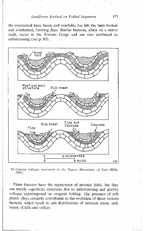
Land fo r ms Evolved on Folded Sequences 171
the overturned knee bends and overfolds has left the beds broken and overturned, form ing flaps. Similar features, albeit on a m inor scale, occur in the Torrens Gorge and are also attributed to unbuttressing (see p. 80).
Roof and w a l l s t r u c t u r e S l i p sheet
F lap and CascadeS l i p sheet Cascade
4 KILOMETRES
4 MILES
74 G ra v i ty co l lapse s truc tures in the Z agros M o u n ta in s o f I ra n (H i l l s ,1963)
I hese features have the appearance of tectonic folds, but they are merely superficial structures due to unbuttressing and gravity collapse superimposed on orogenic folding. The presence of soft plastic clays certainly contributed to the evolution of these various features, which result in odd distributions of resistant strata, and, hence, of hills and valleys.
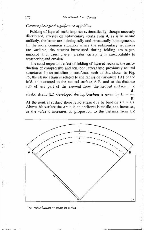
172 Structural Land forms
Geotnorphological significance of foldingFolding of layered rocks imposes systematically, though unevenly
distributed, stresses on sedimentary strata even if, as is in nature unlikely, the latter are lithologically and structurally homogeneous. In the more common situation where the sedimentary sequences are variable, the stresses introduced during folding are superimposed, thus causing even greater variability in susceptibility to weathering and erosion.
The most important effect of folding of layered rocks is the introduction of compressive and tensional stress into previously neutral structures. In an anticline or antiform, such as that shown in Fig. 75, the elastic strain is related to the radius of curvature (R) of the fold, as measured to the neutral surface A-B, and to the distance (d) of any part of the element from the neutral surface. The
delastic strain (E) developed during bending is given by E = —.
RAt the neutral surface there is no strain due to bending (d = 0). Above this surface the strain in an antiform is tensile, and increases, as the value d increases, in proportion to the distance from the
75 Distribution of stress in a fold
Landfonns Evolved on Folded Sequences 173
neutral surface. Below the surface the strain is compressive, and also increases with distance from it, as the value of d also increases. In synforms, similar but converse stress conditions obtain. But both in synforms and antiforms stress conditions at depth are the reverse of those which obtain in the upper parts of the structures.
The stresses are manifested in part by the development of small tensional graben in the crests of anticlines (see, e.g., Fig. 56), in part by the development on the fold limbs of joints additional to those developed during diagenesis or in earlier deformation, and oriented obliquely to the strike of the beds. More significant, however, is the compression of some areas of rock and the extension of others, which causes some zones to be resistant, others to be vulnerable, to weathering and erosion. Thus in newly folded sequence, the antiforms tend to be weak, while the synforms are resistant. The question is of course complicated by variations in the distribution of the various lithological types, and by the prevalent climatic conditions, but in general the situation is as described, and during the earlier stages of the denudation of a folded sequence involving strata of essentially uniform areal distribution, anticlines are worn away more rapidly than are the synclines. This tendency derives directly from the deformation, by folding, of the strata; otherwise, since stream waters would be concentrated in the initial synclinal valleys, it might be expected that erosion would be concentrated there.
Thus in addition to any original contrasts, the selective erosion and weathering induced by folding causes the exposure of strata of varied susceptibility to weathering and erosion. These fold belts of rocks of contrasted resistance to weathering and erosion are moulded into the typical ridge and valley forms, the distribution of which in plan is closely related to the pattern of folding.
TECTONIC FORMS: FOLDED OR WARPED LAND SURFACES
In a few, rather rare, instances, it is possible to show that land surfaces have been folded and thus that their morphology is directly attributable to flexuring. There are, of course, innumerable examples of arched, or otherwise deformed, bedding planes now forming facets of the land surface; but their exposure is due to erosion, and not directly to earth movements.
The problem in the identification of folded forms of tectonic
174 Structural Land forms
origin is to find satisfactory proof that the feature in question is in fact a deformed former land surface. Such proofs may derive from either geological evidence or from detailed geodetic surveys.
This last type of evidence is rare, for only in very few areas, and there only in connection with economic development (usually of oilfields) are repeated surveys made of the high degree of accuracy necessary to detect the comparatively small amounts of distortion involved in the time elapsed between surveys. In southern California, and particularly in and around Los Angeles, surveys taken over the past fifty years have shown that the land surface there is suffering deformation. For instance, following a moderately strong earthquake in the Long Beach area on 10 March 1933, the Alamitos plain, to the east of the city, was found to have been bowed upward ‘presumably at the time of the ’quake, into a gentle arch about 7 inches high and 4 miles across’ (Gilluly, 1949). It has been shown that in the Los Angeles area the northwestern part of the Baldwin Hills is rising at about 1 m per century (Grant and Sheppard, 1939). An area in the Mohave desert between San Bemadino and Victorville has risen in a broad arch some 20 cm in amplitude in just over forty years. The amount of deformation involved in these broad flexures may seem small, but they are not without practical and economic significance. If the deformation of the Mohave cited above continued at a uniform average rate, then the rise of land would be approximately 50 cm in a century, about 5 m per thousand years, and over 130 m in 25,000 years—which is not a long time span in the geological context.
In Mesopotamia, Lees ( 1955) has described evidence for anticlinal development of about 4 m in a vertical sense in about 1700 years. The Shaur Anticline, of Pliocene rocks, gives rise to low hills standing above the flat alluvial plain. In the first or second century A.D., canals were cut across the anticline. One has maintained its course and is now incised to a depth of some 4 m, despite a rise of the structure—an example of a truly antecedent stream. In the same area, the course of a qanat, or underground drainage channel, has been distorted, part having been thrust up in an arch 19 m high, and extending over a distance of 4 km.
In the Chilean Andes, Hollingworth and Rutland (1968) have described a major monoclinal flexure of latest Pliocene age which is expressed directly in the landscape. The flexure affects ignimbrites which, when deposited, form virtually flat surfaces. The monocline between the Salar de Atacama and the Puna surface (Fig. 76)
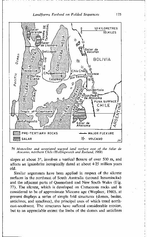
L a n d fo rm s E v o lve d on F o ld e d Sequences 175
50 KILOMETRES 50 MILES
S al arß Grande £ cc
/ 5\Salar ( lude Llamara 5?
•Salar de \ AscotanQuillagua S
B O L I V I A
PUNA SURFACEC H I L E J
tropic of ^Capricorn
A n to fag asta S alar de Atacama
j 1 PRE-TERTIARY ROCKS
SALAR
'— MAJOR FLEXURE
>C VOLCANO
76 M onoc line and associated warped land surface east o f the Salar de Atacama, nö rthe rn C hile (H o llin g w o rth and Rutland, 1968)
slopes at about 3°, involves a vertical flexure o f over 500 m, and affects an ignimbrite isotopically dated at about 4-25 m illion years old.
Similar arguments have been applied in respect o f the silcrete surfaces in the northeast of South Australia (around Innamincka) and the adjacent parts o f Queensland and New South Wales (Fig. 77). The silcrete, which is developed on Cretaceous rocks and is considered to be o f approximate Miocene age (Wopfner, 1960), at present displays a series of simple fo ld structures (domes, basins, anticlines, and synclines), the principal axes of which trend northeast-southwest. The structures have suffered considerable erosion, but to an appreciable extent the limbs of the domes and anticlines
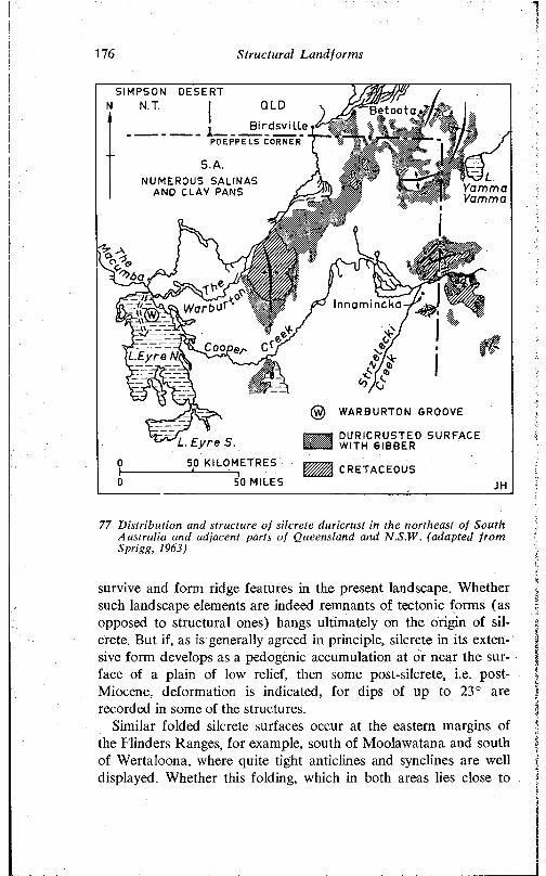
176 S tru c tu ra l L a n d fo rm s
SIMPSON DESERT NT. I Betoota..«
B ird s v i l le P S IP P E L S CORNER '
S. A.NUMEROUS SALINAS
AND CLAY PANS YammaYamma
Innamincka
\L.Eyre N.(
(g) WARBURTON GROOVE
SOT DURICRUSTED SURFACE w m WITH GIBBERL. E yre S.
50 KILOMETRES
50 MILESCRETACEOUS
77 D is tr ib u tion and structure o f silcrete duricrust in the northeast o f South A ustra lia and adjacent parts o f Queensland and N.S.W. (adapted fro m Sprigg, 1963)
survive and form ridge features in the present landscape. Whether such landscape elements are indeed remnants of tectonic forms (as opposed to structural ones) hangs ultimately on the origin of silcrete. But if, as is generally agreed in principle, silcrete in its extensive form develops as a pedogenic accumulation at or near the surface of a plain of low relief, then some post-silcrete, i.e. post- Miocene, deformation is indicated, for dips of up to 23° are recorded in some of the structures.
Similar folded silcrete surfaces occur at the eastern margins of the Flinders Ranges, for example, south of Moolawatana and south of Wertaloona, where quite tight anticlines and synclines are well displayed. Whether this folding, which in both areas lies close to
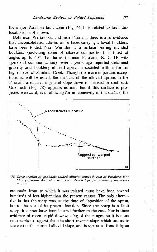
Land for ms Evolved on Folded Sequences 177
the major Paralana fault zone (Fig. 66a), is related to fault dislocations is not known.
Both near Wertaloona and near Paralana there is also evidence that unconsolidated alluvia, or surfaces carrying alluvial boulders, have been folded. Near Wertaloona, a surface bearing rounded boulders (including some of silcrete composition) is tilted at angles up to 40°. To the north, near Paralana, R. C. Horwitz (personal communication) several years ago reported deformed gravelly and bouldery alluvial aprons associated with a former higher level of Paralana Creek. Though there are important exceptions, as will be noted, the surfaces of the alluvial aprons in the Paralana area have a general slope down to the east or southeast. One such (Fig. 78) appears normal, but if this surface is projected westward, even allowing for no concavity of the surface, the
Reconstructed profile
Suggested warped surface
78 Cross-section of probable folded alluvial outwash east of Paralana Hot Springs, South Australia, with reconstructed profile assuming no deformation
mountain front to which it was related must have been several hundreds of feet higher than the present ranges. The only alternative is that the scarp was, at the time of deposition of the apron, far to the east of its present location. Since the scarp is a fault scarp, it cannot have been located further to the east. Nor is there evidence of recent rapid downwasting of the ranges, so it is more reasonable to suggest that the short reverse slope which occurs to the west of this normal alluvial slope, and is separated from it by an
178 Structural Landforms
erosional gap, is the other half of a structural dome, the crest of which has been breached.
On the evidence of their characteristics and setting, these examples of recent and continuing deformation of the earth’s surface are related to orogeny, that is to earth movements of which horizontal compression is an essential component. Warping, or gentle flexuring of the earth’s surface, has affected many other areas. Such distortion is due to vertical movements of the crust, or epeirogeny. In some cases it may not be possible to distinguish such movements from the weakened or marginal groundswell of orogeny. In the examples cited above from California, the warping could be associated with either type of deformation, though the general geological setting is compressive and the movements are on this account interpreted as orogenic (Gilluly, 1949).
Gentle and gradual warping of the land surface is very difficult to demonstrate, though it is suspected in many areas. In northwest Queensland, for instance, it has long been suspected (Taylor, 1911; Öpik, 1961; Twidale, 1966b) that the Selwyn Upwarp has been active in the late Cainozoic. Evidence derived from the pattern and nature of the rivers is indeed suggestive but in the absence of any horizon that can be used as a datum, the same certainty does not attach to these inferences as to the cases where repeated and precise geodetic surveys demonstrate dislocations.
In Japan, which, as previously noted, occupies a tectonically active region, warping of the land surface is commonplace. It is most readily detected through the distortion of river terraces and marine strandlines. These warpings are associated with orogeny, but similar evidence from many parts of the world and on various scales points to widespread deformation of the earth’s surface due to isostatic readjustments.
According to the concept of isostasy, equal masses of rock underlie each unit area of the earth’s crust (see, e.g., Holmes, 1965, pp. 27- 31). Though segments of the crust beneath high mountain ranges such as the Himalaya have a greater volume of rocks than those beneath the lowlands or the ocean floors, the latter are underlain by strata of greater density than the former so that the mass volume (volume X density) of rock beneath each segment is approximately the same. However, this balance between various parts of the crust is not static, but dynamic. For various reasons the load distribution at and near the surface is constantly changing; this redistribution of mass induces compensating movements involving upwarping in
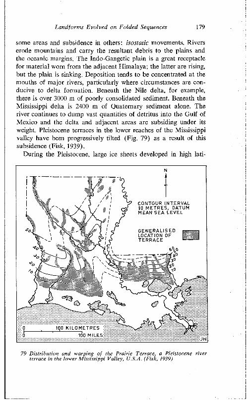
Land forms Evolved on Folded Sequences 179
some areas and subsidence in others: isostatic movements. Rivers erode mountains and carry the resultant debris to the plains and the oceanic margins. The Indo-Gangetic plain is a great receptacle for material worn from the adjacent Himalaya; the latter are rising, but the plain is sinking. Deposition tends to be concentrated at the mouths of major rivers, particularly where circumstances are conducive to delta formation. Beneath the Nile delta, for example, there is over 3000 m of poorly consolidated sediment. Beneath the Mississippi delta is 2400 m of Quaternary sediment alone. The river continues to dump vast quantities of detritus into the Gulf of Mexico and the delta and adjacent areas are subsiding under its weight. Pleistocene terraces in the lower reaches of the Mississippi valley have been progressively tilted (Fig. 79) as a result of this subsidence (Fisk, 1939).
During the Pleistocene, large ice sheets developed in high lati-
m r ,CONTOUR INTERVAL 10 METRES, DATUM MEAN SEA LEVEL
GENER AL I SE D LOCATION OF TERRACE
1Q0 K I L O M ETRES
100 MILES
79 Distribution and warping of the Prairie Terrace, a Pleistocene river terrace in the lower Mississippi Valley, U.S.A. (Fisk, 1939)
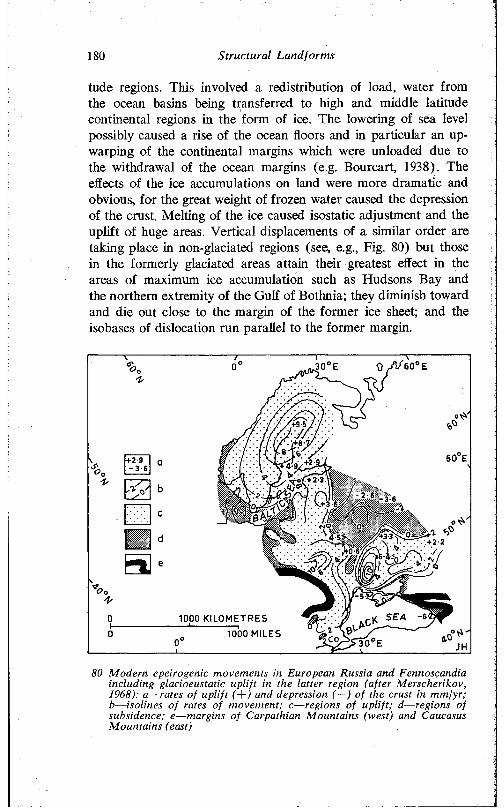
180 Structural Landforms
tude regions. This involved a redistribution of load, water from the ocean basins being transferred to high and middle latitude continental regions in the form of ice. The lowering of sea level possibly caused a rise of the ocean floors and in particular an up- warping of the continental margins which were unloaded due to the withdrawal of the ocean margins (e.g. Bourcart, 1938). The effects of the ice accumulations on land were more dramatic and obvious, for the great weight of frozen water caused the depression of the crust. Melting of the ice caused isostatic adjustment and the uplift of huge areas. Vertical displacements of a similar order are taking place in non-glaciated regions (see, e.g., Fig. 80) but those in the formerly glaciated areas attain their greatest effect in the areas of maximum ice accumulation such as Hudsons Bay and the northern extremity of the Gulf of Bothnia; they diminish toward and die out close to the margin of the foimer ice sheet; and the isobases of dislocation run parallel to the former margin.
1000 KILOMETRES1000 MILES
80 Modern epeirogenic movements in European Russia and Fennoscandia including glacioeustatic uplift in the latter region (after Merscherikov, 1968): a—rates of uplift (-\~) and depression (—) of the crust in mm/yr; b—isolines of rates of movement; c—regions of uplift; d—regions of subsidence; e—margins of Carpathian Mountains (west) and Caucasus Mountains (east)
Landforms Evolved on Folded Sequences 181
This glacioeustatic rebound continues; old shorelines which can be dated are now found high above sea level, and these permit rates and amounts of uplift to be estimated. Fennoscandia, for instance, is still rising, and the surface is being warped (Fig. 80). The maximum uplift is taking place in Sweden, near the head of the Gulf of Bothnia, which has risen over 200 m during the last 10,000 years. Similarly, large areas of northern Britain and northern Canada have risen and continue to rise (Valentin, 1953; Gutenberg, 1954). Melting of the Antarctic ice sheet has caused an isostatic rise of up to 20 m at McMurdo Sound (Nichols, 1968).
Isostatic readjustment is also demonstrable on a more local scale. During the Pleistocene, numerous lakes developed in the Great Basin of the U.S.A. Two of the largest were Lake Bonneville (of which the Great Salt Lake of Utah is the last remnant) and Lake Lahontan. Bonneville at its greatest extent covered some 52,000 km2, and achieved a maximum depth of 325 m, with very large areas covered by about 150 m of water. As Gilbert (1890, pp. 362- 86) recognised, the ancient shorelines of this lake were warped, and their distortion is due to isostatic adjustment following the removal of the load of lake waters. More recent work (Crittenden, 1963) shows that this isostatic deformation involves upwarping by as much as 64 m (Fig. 81). Lake Lahontan was a smaller body of water (maximum extent 22,000 km2, greatest depth 270 m, though much of the lake was less than 100 m deep) and the warping involved in isostatic adjustment is correspondingly less—6-8 m according to Morrison (1965).
Man-made lakes have similar depressive effects. Lake Mead is an artificial lake in Nevada with an area of 600 km2. Such is the weight of water impounded in the reservoir, and the weight of sediment accumulated in it, that the bed of the lake is at present sinking at a rate of L3 m per century.
Though areas affected by such isostatic adjustments are of considerable extent there is some suggestion that they may influence quite limited areas. Jackli (1965), for instance, has described glaciated valleys from the Andermatt area of Switzerland. On the valley side walls, and running parallel with the valley axis, are numerous small reverse scarps associated with faults. Jackli suggests that these are a manifestation of isostatic response to deglaciation, the central area of the valley floor, which bore the greatest thickness of ice, rebounding more than the adjacent fault blocks which carried a lesser load of ice.
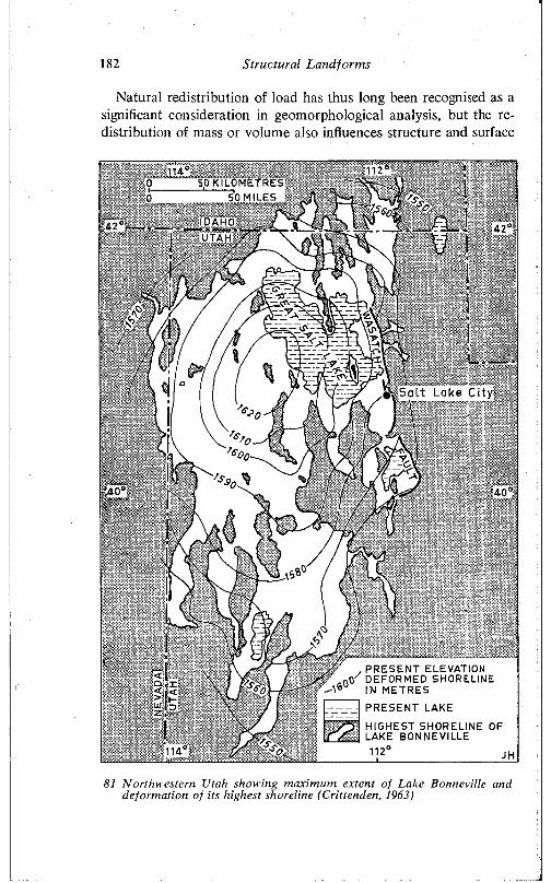
182 S tru c tu ra l L a n d fo rm s
Natural redistribution of load has thus long been recognised as a significant consideration in geomorphological analysis, but the redistribution of mass or volume also influences structure and surface
, PRESENT ELEVATION .rtf DEFORMED SHORELINE
- t 6 IN METRES
PRESENT LAKE
HIGHEST SHORELINE OF LAKE BONNEVILLE112°
81 N orthw estern Utah showing m axim um extent o f Lake Bonneville and deform ation o f its highest shoreline (C rittenden, 1963)
Landforms Evolved on Folded Sequences 183
on a local scale in contexts different from those already described.The structural effects of overloading plastic clays have been well
described from Ghana (MacCallien, Ruxton, and Walton, 1964). Near Accra weathered gneisses were shaped into a shore platform, on which a quartz breccia and other sediments were laid down. Following emergence of the platform, a pisolitic iron developed on the exposed marine deposits. Thus, the densest layer, the pisolitic ironstone, is located high in the sequence, and the least dense, the plastic clay derived from the weathering of the gneiss, is at the base.
The weathering of the gneiss is uneven, so that the weathering front displays highs and lows. The pressure exerted by the over- lying dense layers has caused clays to be squeezed out of the small basins in the irregular weathering front, and this flowage from the several basins has caused distortion, including probable faulting, in the overlying strata. Various convolutions, named globular, gable, mushroom, and tongue-shaped structures (Fig. 82a) have formed, and well demonstrate the considerable force exerted by such gravitational pressures on plastic clays.
In the area described, close to Accra, these structures, though prominent in road cuttings, achieve only minor expression, in large measure because of the strength of the ironstone capping. In Northamptonshire in the eastern English Midlands similar resistant cappings overlying plastic clays have been breached by river erosion, and here the release of pressure gives rise to distinct, if minor, surface features (Flollingworth, Taylor, and Kellaway, 1944).
The Northamptonshire ironstone held occurs in a dissected plateau, which lies some 100-170 m above sea level, and which slopes gently down to the east. The relatively narrow valleys are, however, deep, for the rivers have cut down 70 m and more below the surface of the plateau, which is capped by various resistant members of the Jurassic Oolite groups, prominent amongst which are limestone, sandstone, and ironstone. The Oolite groups are underlain by soft upper Lias clays.
The rivers have in many areas penetrated below the base of the Oolite into the Lias clays. The weight of the overlying limestones and other dense rocks has caused the weak piastic clays to flow outwards from beneath the plateau into the valley floors, where they form distinct bulges (Fig. 82b). In some instances, these bulges are bounded by faults which affect the thinner lower edges of the com-
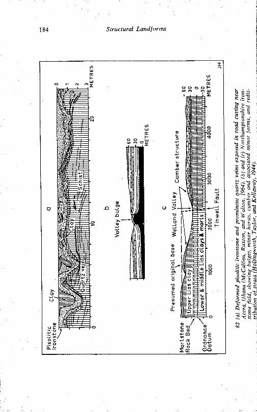
184 Structural Landforms
Land for ms Evolved on Folded Sequences 185
petent strata above, as well as the clays. Minor horsts have in this fashion been developed (Fig. 82c).
Such flowage of clays into the valleys causes deficiencies beneath the plateau margins. Moreover, water has percolated through the pervious limestones and permeable sandstones to the upper surface of the impermeable clays, along which it runs toward the valleys, washing out some rock as it does so, and again causing the outer edges of the caprocks to be undermined. For both these reasons, secondary and non-tectonic dips, called camber, are well developed in the competent caprocks exposed in the valley side slopes. Cambering, in turn, has led to the development of minor faults running along the contour of the hillslopes: the tension on the cambered rock resting on an unstable base, exceeds its strength, and fractures have formed along which there has been differential movement.
Gravitational pressure on immediately adjacent areas appears to be the most likely explanation for small anticlinal structures described from the Coorong region in the southeast of South Australia (Brown, 1969). The anticlines are developed in unconsolidated aragonitic clays close to the margin of the saltwater lagoon (PI. 51). They are 130-200 m long, 2-3 m wide, and appear to have an amplitude of 3-4 m. The folding is complex in detail. The structures occur on the plain exposed between the lagoon and coastal foredunes, and it seems possible that the build-up of the latter has caused local overloading and vertical compression which is relieved in the least weighted area, namely the flat depositional plain (Fig. 83). In some places, the upthrust of the clays is accompanied by distinct faulting and slumping of the adjacent dunes, suggestive of a transference of load stress.
Finally in this section on load distribution we may briefly consider examples of extraction of mass and consequent subsidence of the land surface brought about by man’s activities.
Very localised sinking or collapse of the surface, forming pits or trenches, has long been known from coal-mining districts, particularly in fields where the seams are shallow. Similar pits, trenches, and depressions have developed in central Cheshire, England, as a result of the quarrying of rock salt and the extraction of brine (Wallwork, 1956). Such depressions filled with water to form shallow lakes are called flashes in the salt and coal-mining areas of northern England. In the Los Angeles area of California, extraction of oil has caused a decrease in volume of the oil-bearing rocks and
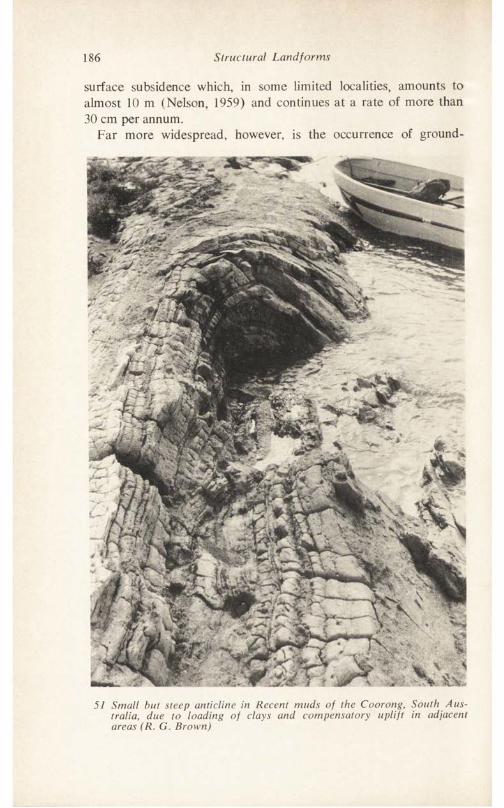
186 Structural Landforms
surface subsidence which, in some limited localities, amounts to almost 10 m (Nelson, 1959) and continues at a rate of more than 30 cm per annum.
Far more widespread, however, is the occurrence of ground-
57 Small but steep anticline in Recent muds of the Coorong, South Australia, due to loading of clays and compensatory uplift in adjacent areas (R. G. Brown)
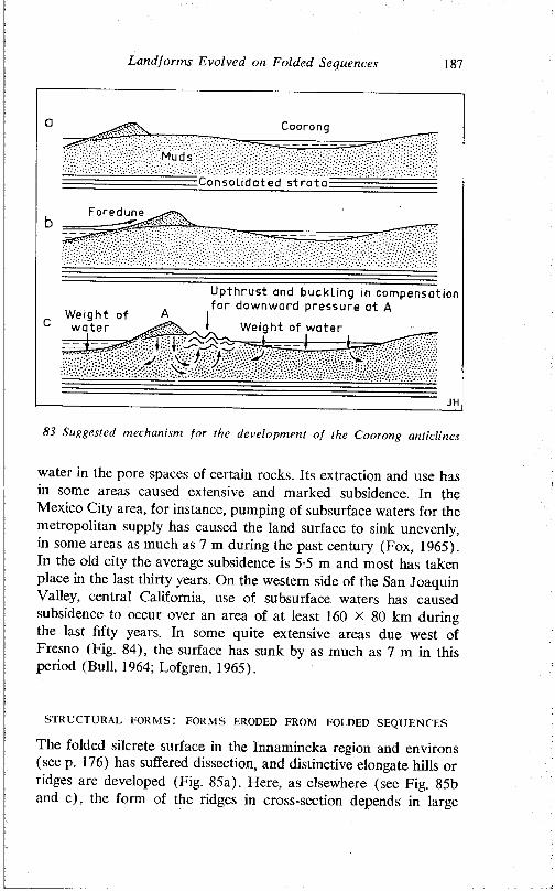
Land for ms Evolved on Folded Sequences 187
Coorong
Muds
Consolidated strata
Foredune
83 Suggested mechanism for the development of the Coorong anticlines
water in the pore spaces of certain rocks. Its extraction and use has in some areas caused extensive and marked subsidence. In the Mexico City area, for instance, pumping of subsurface waters for the metropolitan supply has caused the land surface to sink unevenly, in some areas as much as 7 m during the past century (Fox, 1965). In the old city the average subsidence is 5-5 m and most has taken place in the last thirty years. On the western side of the San Joaquin Valley, central California, use of subsurface waters has caused subsidence to occur over an area of at least 160 X 80 km during the last fifty years. In some quite extensive areas due west of Fresno (Fig. 84), the surface has sunk by as much as 7 m in this period (Bull, 1964; Lofgren, 1965).
STRUCTURAL FORMS! FORMS ERODED FROM FOLDED SEQUENCES
The folded silcrete surface in the Innamincka region and environs (see p. 176) has suffered dissection, and distinctive elongate hills or ridges are developed (Fig. 85a). Here, as elsewhere (see Fig. 85b and c), the form of the ridges in cross-section depends in large
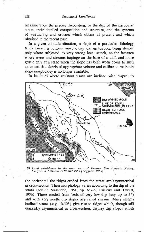
188 Structural Landforms
measure upon the precise disposition, or the dip, of the particular strata, their detailed composition and structure, and the systems of weathering and erosion which obtain at present and which obtained in the recent past.
In a given climatic situation, a slope of a particular lithology tends toward a uniform morphology and inclination, being steeper only where subjected to very strong local attack, as for instance where rivers and streams impinge on the base of a cliff, and more gentle only at a stage when the slope has been worn down to such an extent that debris of appropriate volume and calibre to maintain slope morphology is no longer available.
In localities where resistant strata are inclined with respect to
1 2 ^ \ s i E R R A 'I NEVADA]I
84 Land subsidence in the area west of Fresno, San Joaquin Valley, California, between 1920 and 1963 (Lofgren, 1965)
the horizontal, the ridges eroded from the strata are asymmetrical in cross-section. Their morphology varies according to the dip of the strata (see de Martonne, 1951, pp. 687-8; Cailleux and Tricart, 1956). Those eroded from beds of very low dip (say up to 5°) and with very gentle dip slopes are called cuestas. More steeply inclined strata (say, 10-30°) give rise to ridges which, though still markedly asymmetrical in cross-section, display dip slopes which
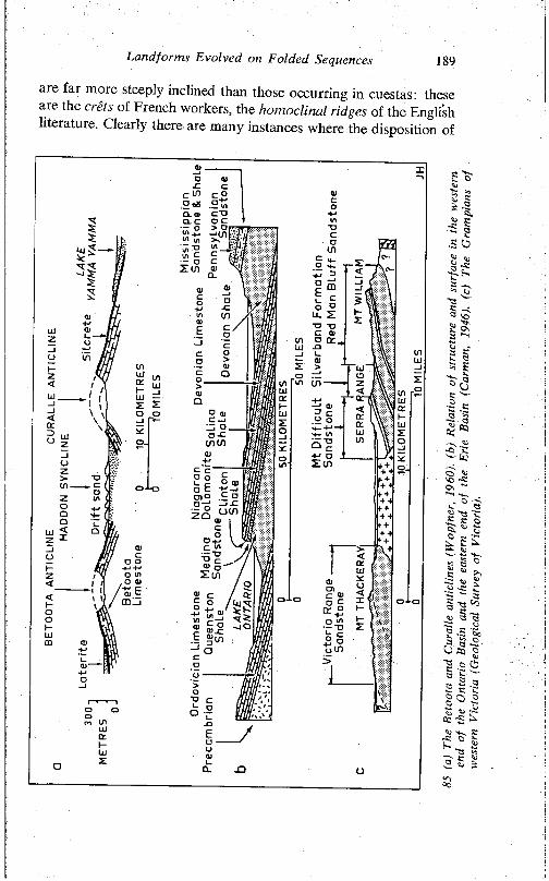
Landfonns Evolved on Folded Sequences 189
are far more steeply inclined than those occurring in cuestas: these arc the crets of French workers, the homoclinal ridges of the English literature. Clearly there are many instances where the disposition of
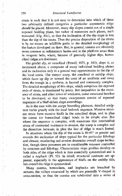
190 Structural Landforms
strata is such that it is not easy to determine into which of these two arbitrarily defined categories a particular asymmetric ridge should be placed. Moreover, many dip slopes consist not of a single exposed bedding plane, but rather of numerous such planes, each truncated (Fig. 85c), so that the inclination of the dip slope is less than the dip of the strata. Thus the precise disposition of the strata is by no means an infallible guide to the detailed morphology of the feature developed on them. But, in general, cuestas are obviously more common in sedimentary basins and in the platform areas than in orogenic belts, where, because of generally higher dips, homo- clinal ridges are dominant.
The gentler clip, or cataclinal (Powell, 1875, p. 160), slope is, as mentioned above, a composite of many individual bedding planes and its inclination only in a general way approximates to the dip of the local strata. The steeper scarp, the anaclinal or antidip slope, which faces up dip or toward the crest of an antiform and away from the trough in a synform, is faceted and commonly complex. The detailed morphology of this slope, which comprises the exposed ends of strata, is dominated by joints. But inequalities in the resistance of strata, and other zones of weakness, cause structural benches to be developed, so that many escarpments consist of repeated sequences of a bluff-debris slope assemblage.
As is the case with the scarps bounding plateaux, detailed sculpture varies greatly with the local bedrock sequence. Massive resistant strata form massive bluffs in the cataclinal slope, and in plan the cuesta (or homoclinal ridge) tends to be simple also. But where the sequence is complex, with numerous thin interbedded strata of contrasted resistance to erosion, the scarp is complex and the dissection intricate; in plan the line of ridge is much fretted.
In situations where the dip of the strata is 40-45° or greater and exceeds the inclination of slope typical for the particular lithology and climate, weathering and erosion determine overall slope inclination, though these processes are in considerable measure controlled by structure and lithology. Characteristic slope profiles develop on both sides of the ridge which is thus essentially symmetrical and is called a hogback (PI. 52). In detail, structural contrasts are apparent, especially in the appearance of bluffs on the antidip side, but overall the ridge is symmetrical.
Many cuestas, homoclines, and hogbacks are breached by streams, the valleys excavated by which are generally V-shaped in cross-section, so that the cuestas are subdivided into a series of
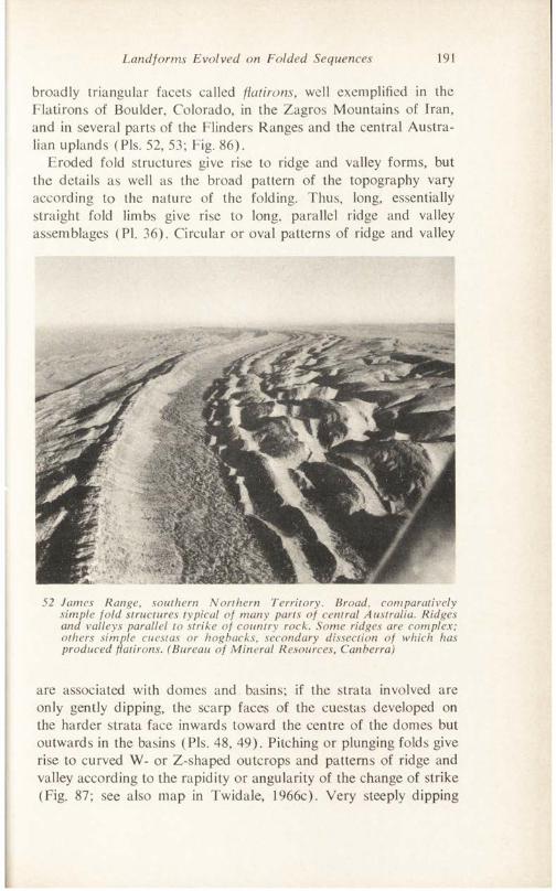
Land forms Evolved on Folded Sequences 191
broadly triangular facets called flatirons, well exemplified in the Flatirons of Boulder, Colorado, in the Zagros M ountains of Iran, and in several parts of the Flinders Ranges and the central A ustralian uplands (Pis. 52, 53; Fig. 86).
Eroded fold structures give rise to ridge and valley forms, but the details as well as the broad pattern of the topography vary according to the nature of the folding. Thus, long, essentially straight fold limbs give rise to long, parallel ridge and valley assemblages (PI. 36). Circular or oval patterns of ridge and valley
52 Janies Range, southern Northern Territory. Broad, comparatively simple fold structures typical of many parts of central Australia. Ridges and valleys parallel to strike of country rock. Some ridges are complex; others simple cuestas or hogbacks, secondary dissection of which has produced flatirons. (Bureau of Mineral Resources, Canberra)
are associated with domes and basins; if the strata involved are only gently dipping, the scarp faces of the cuestas developed on the harder strata face inwards toward the centre of the domes but outwards in the basins (Pis. 48, 49). Pitching or plunging folds give rise to curved W- or Z-shaped outcrops and patterns of ridge and valley according to the rapidity or angularity of the change of strike (Fig. 87; see also map in Twidale, 1966c). Very steeply dipping
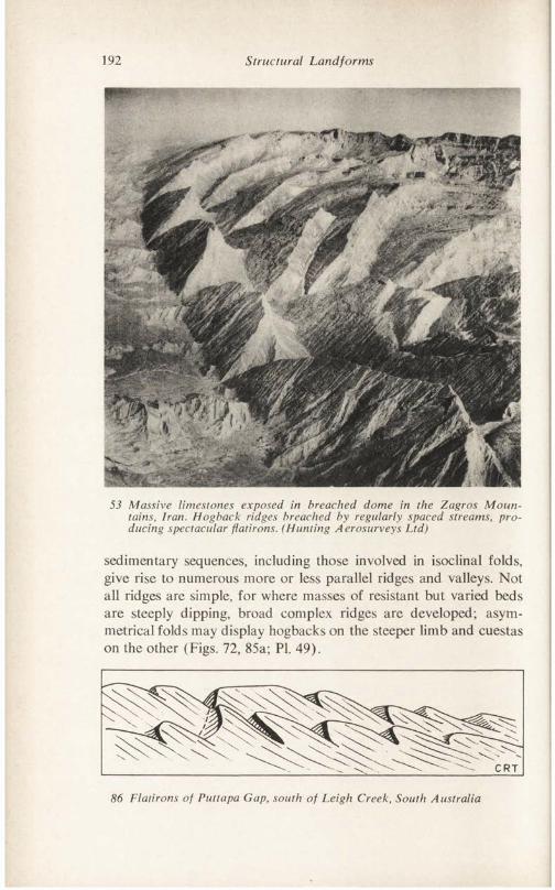
192 Structural Landforms
53 Massive limestones exposed in breached dome in the Zagros Mountains, Iran. Hogback ridges breached by regularly spaced streams, producing spectacular flatirons. (Hunting Aerosurveys Ltd)
sedimentary sequences, including those involved in isoclinal folds, give rise to numerous more or less parallel ridges and valleys. Not all ridges are simple, for where masses of resistant but varied beds are steeply dipping, broad complex ridges are developed; asymmetrical folds may display hogbacks on the steeper limb and cuestas on the other (Figs. 72, 85a; PI. 49).
86 Flatirons of Puttapa Gap, south of Leigh Creek, South Australia
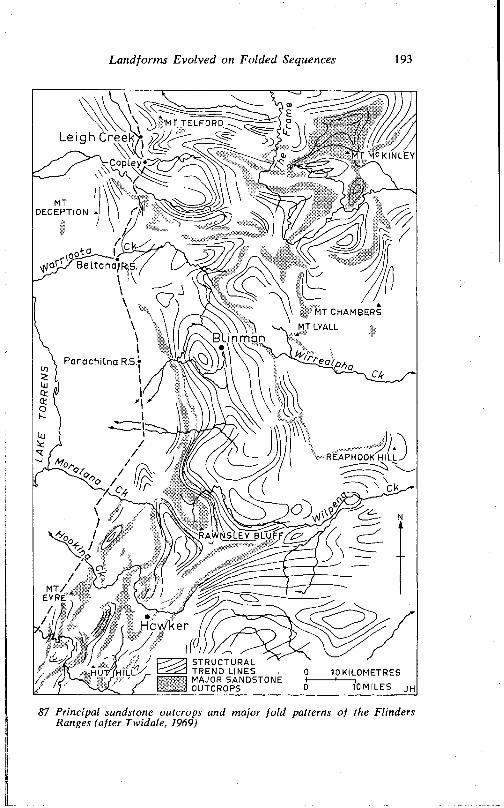
Landforms Evolved on Folded Sequences 193
MT TELFORD
a MT MCKINLEY
MTDECEPTION
r \ o o iS .BeLtana/R.s.
MT CHAMBERS
MT LYALLBl inman
P arach ilna R.S.»
REAPHOOK HILL.
RAWNSLEY BLU F FA g7
EYRE
Hawker
STRUCTURAL TREND LINES MAJOR SANDSTONE OUTCROPS
hut/Jh i l l K .
87 Principal sandstone outcrops and major fold patterns of the Flinders Ranges (after Twidale, 1969)
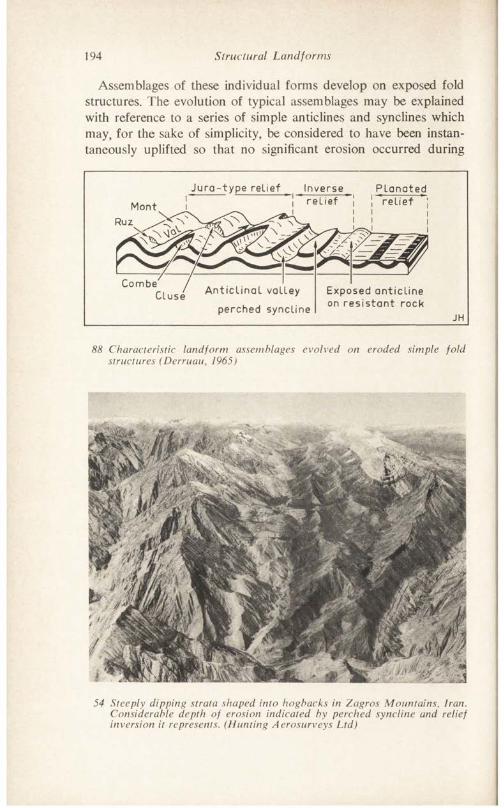
194 Structural Landforms
Assemblages of these individual forms develop on exposed fold structures. The evolution of typical assemblages may be explained with reference to a series of simple anticlines and synclines which may, for the sake of simplicity, be considered to have been instantaneously uplifted so that no significant erosion occurred during
Jura- type relief Planatedrelief relief \Mont
Combe'Cluse Anticlinal valley
perched synclineExposed anticline on resistant rock
88 Characteristic landform assemblages evolved on eroded simple fold structures (Derruau, 1965)
54 Steeply dipping strata shaped into hogbacks in Zagros Mountains, Iran. Considerable depth of erosion indicated by perched syncline and relief inversion it represents. (Hunting Aerosurveys Ltd)
1
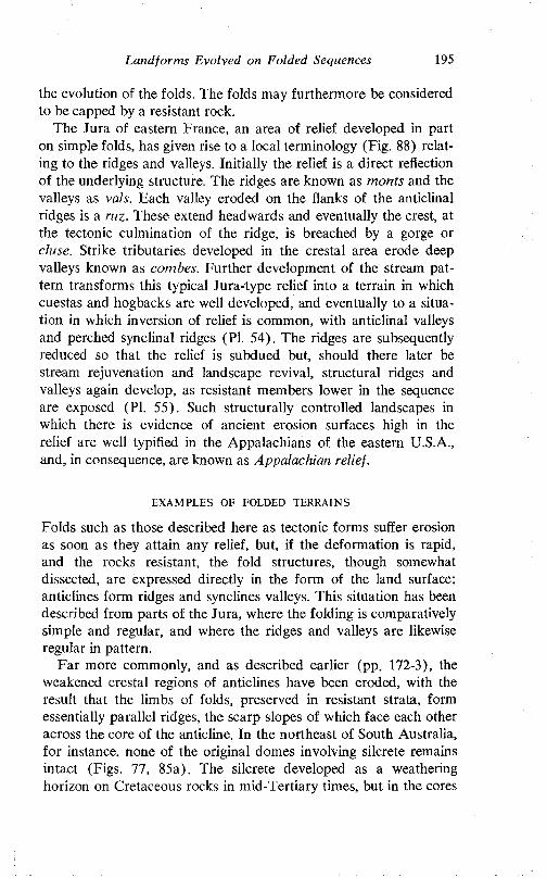
Land for ms Evolved on Folded Sequences 195
the evolution of the folds. The folds may furthermore be considered to be capped by a resistant rock.
The Jura of eastern France, an area of relief developed in part on simple folds, has given rise to a local terminology (Fig. 88) relating to the ridges and valleys. Initially the relief is a direct reflection of the underlying structure. The ridges are known as monts and the valleys as vals. Each valley eroded on the flanks of the anticlinal ridges is a ruz. These extend headwards and eventually the crest, at the tectonic culmination of the ridge, is breached by a gorge or cluse. Strike tributaries developed in the crestal area erode deep valleys known as combes. Further development of the stream pattern transforms this typical Jura-type relief into a terrain in which cuestas and hogbacks are well developed, and eventually to a situation in which inversion of relief is common, with anticlinal valleys and perched synclinal ridges (PI. 54). The ridges are subsequently reduced so that the relief is subdued but, should there later be stream rejuvenation and landscape revival, structural ridges and valleys again develop, as resistant members lower in the sequence are exposed (PI. 55). Such structurally controlled landscapes in which there is evidence of ancient erosion surfaces high in the relief are well typified in the Appalachians of the eastern U.S.A., and, in consequence, are known as Appalachian relief.
EXAMPLES OF FOLDED TERRAINS
Folds such as those described here as tectonic forms suffer erosion as soon as they attain any relief, but, if the deformation is rapid, and the rocks resistant, the fold structures, though somewhat dissected, are expressed directly in the form of the land surface; anticlines form ridges and synclines valleys. This situation has been described from parts of the Jura, where the folding is comparatively simple and regular, and where the ridges and valleys are likewise regular in pattern.
Far more commonly, and as described earlier (pp. 172-3), the weakened crestal regions of anticlines have been eroded, with the result that the limbs of folds, preserved in resistant strata, form essentially parallel ridges, the scarp slopes of which face each other across the core of the anticline. In the northeast of South Australia, for instance, none of the original domes involving silcrete remains intact (Figs. 77, 85a). The silcrete developed as a weathering horizon on Cretaceous rocks in mid-Tertiary times, but in the cores
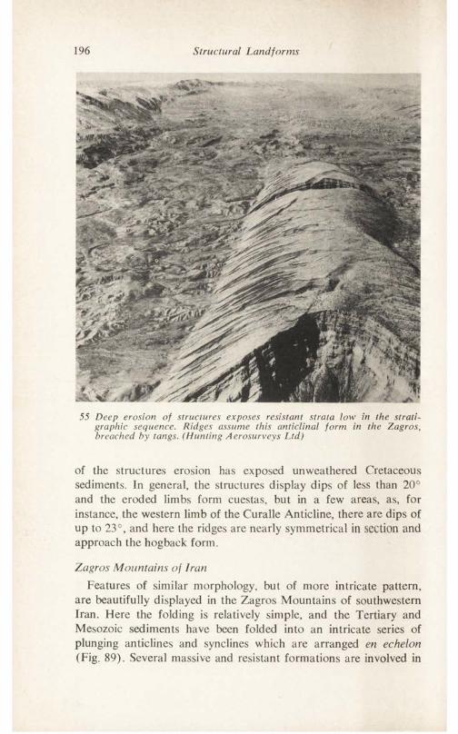
196 Structural Landforms
55 Deep erosion of structures exposes resistant strata low in the stratigraphic sequence. Ridges assume this anticlinal form in the Zagros, breached by tangs. (Hunting Aerosurveys Ltd)
of the structures erosion has exposed unweathered Cretaceous sediments. In general, the structures display dips of less than 20° and the eroded limbs form cuestas, but in a few areas, as, for instance, the western limb of the Curalle Anticline, there are dips of up to 23°, and here the ridges are nearly symmetrical in section and approach the hogback form.
Zagros Mountains of IranFeatures of similar morphology, but of more intricate pattern,
are beautifully displayed in the Zagros Mountains of southwestern Iran. Here the folding is relatively simple, and the Tertiary and Mesozoic sediments have been folded into an intricate series of plunging anticlines and synclines which are arranged en echelon (Fig. 89). Several massive and resistant formations are involved in
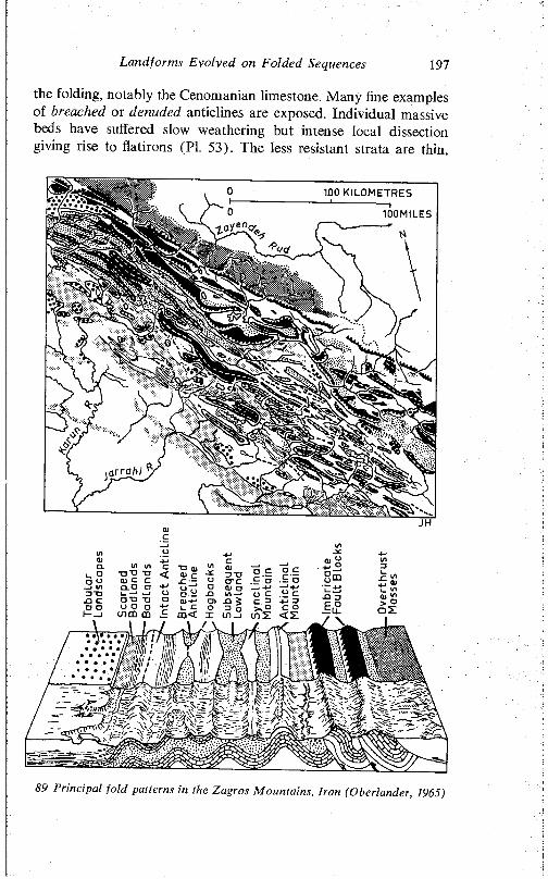
Landforms Evolved on Folded Sequences 197
the folding, notably the Cenomanian limestone. Many fine examples of breached or denuded anticlines are exposed. Individual massive beds have suffered slow weathering but intense local dissection giving rise to flatirons (PI. 53). The less resistant strata are thin,
89 Principal fold patterns in the Zagros Mountains, Iran (Oberländer, 1965)
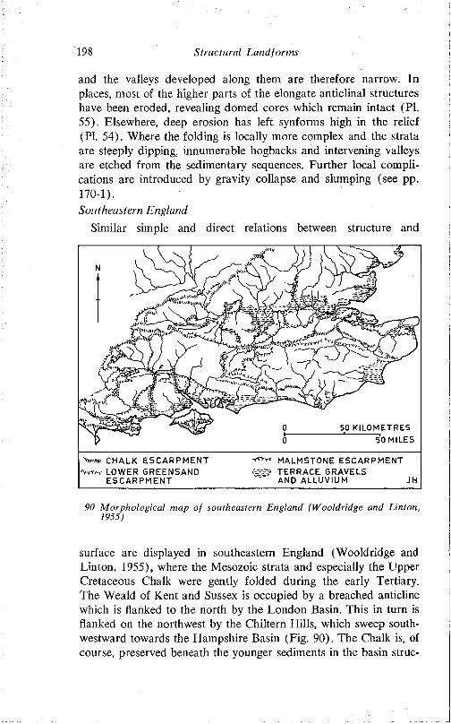
198 Structura l Land fo rm s
and the valleys developed along them are therefore narrow. In places, most of the higher parts of the elongate anticlinal structures have been eroded, revealing domed cores which remain intact (PI. 55). Elsewhere, deep erosion has left synforms high in the relief (PI. 54). Where the folding is locally more complex and the strata are steeply dipping, innumerable hogbacks and intervening valleys are etched from the sedimentary sequences. Further local complications are introduced by gravity collapse and slumping (see pp. 170-1).Southeastern England
Similar simple and direct relations between structure and
'Vw CHALK ESCARPMENT MALMSTONE ESCARPMENT■%*/-,- LOWER GREENSAND .v-i-5 TERRACE GRAVELS
ESCARPMENT " ’ AND ALLUVIUM JH
90 M orpho log ica l map o f southeastern England (W ooldridge and L in ton, 1955)
surface are displayed in southeastern England (Wooldridge and Linton, 1955), where the Mesozoic strata and especially the Upper Cretaceous Chalk were gently folded during the early Tertiary. The Weald of Kent and Sussex is occupied by a breached anticline which is flanked to the north by the London Basin. This in turn is flanked on the northwest by the Chiltern Hills, which sweep south- westward towards the Hampshire Basin (Fig. 90). The Chalk is, of course, preserved beneath the younger sediments in the basin struc-
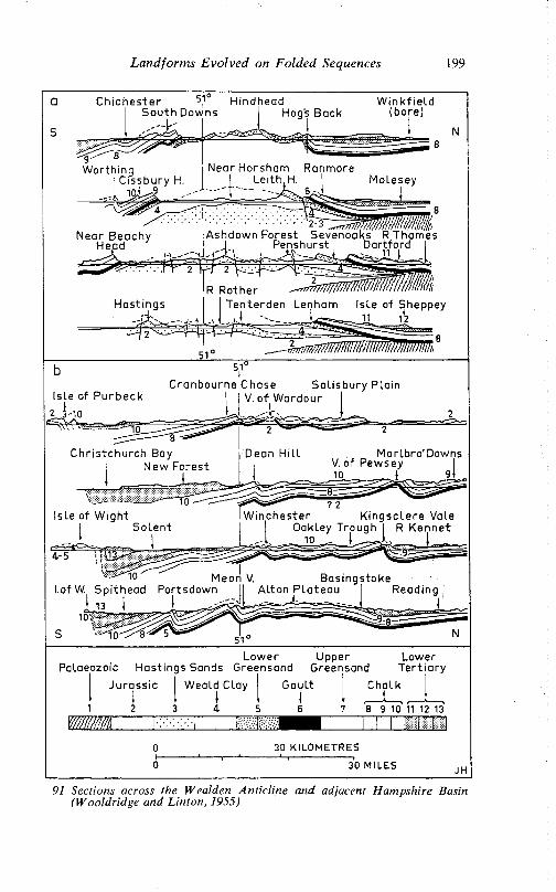
L a n d fo n n s E v o lv e d on F o ld e d Sequences 199
a C h ic h e s te r 5I1° Hindhead W ink f ieLdS o u th Downs | Hog's Back (bore)
S
W orth ingI C issbury H i 10* J )
Near Horsham RanmoreLeith,H. I Molesey
Near Beachy Head
Ashdown Forest Sevenoaks R T ham es J Penshurst I Dar tfo rd
Is le of P u rb e c k
2 3-10
51°l
C ranbourne Chase S a l isb u ry P la in I V. o f W ardour
J ,4 : ,
10 ’ Meori V. B as ings tokel.ofW.^ Sp i thead Portsdown ^ A l ton^PU iteau ~l Reading
Low erPalaeozoic Hast ings Sands Greensand
UpperGreensand
Ju rass ic Weald Clay
4 5
M M
Gau lt
LowerT e r t ia ry
8 9 10 11 12 13
30 KILOMETRES
30 MILES
91 Sections across the Wcalden A n tic lin e and adjacent Ham pshire Basin (W ooldridge and L in ton , 1955)
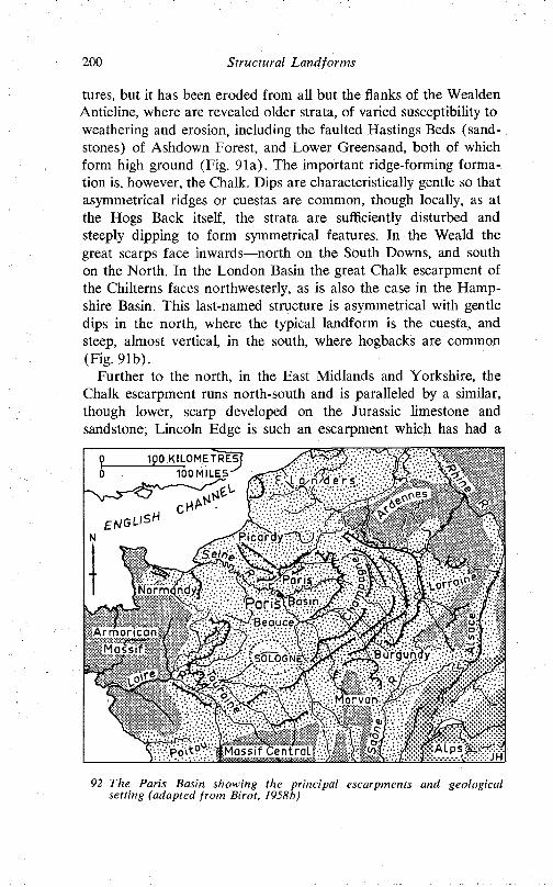
200 Structural Landforms
tures, but it has been eroded from all but the flanks of the Wealden Anticline, where are revealed older strata, of varied susceptibility to weathering and erosion, including the faulted Hastings Beds (sandstones) of Ashdown Forest, and Lower Greensand, both of which form high ground (Fig. 91a). The important ridge-forming formation is, however, the Chalk. Dips are characteristically gentle so that asymmetrical ridges or cuestas are common, though locally, as at the Hogs Back itself, the strata are sufficiently disturbed and steeply dipping to form symmetrical features. In the Weald the great scarps face inwards—north on the South Downs, and south on the North. In the London Basin the great Chalk escarpment of the Chilterns faces northwesterly, as is also the case in the Hampshire Basin. This last-named structure is asymmetrical with gentle dips in the north, where the typical landform is the cuesta, and steep, almost vertical, in the south, where hogbacks are common (Fig. 91b).
Further to the north, in the East Midlands and Yorkshire, the Chalk escarpment runs north-south and is paralleled by a similar, though lower, scarp developed on the Jurassic limestone and sandstone; Lincoln Edge is such an escarpment which has had a
1P0 KILOMETRES lOOMILES-^
Normcmdyy •las in
W ' xA r m o r i c a n / Ma ss i f ”"” }
SOLOGN0
92 The Paris Basin showing the principal escarpments and geological setting (adapted from Birot, 1958b)
Landforms Evolved on Folded Sequences 201
profound influence on routeways and settlements. The Jurassic limestones and sandstones also illustrate very well the detailed influence of disposition on landforms. In the north they are essentially flat-lying and give rise to the broad extent of the North York Moors. To the south, in Lincolnshire, dips are steeper, outcrops narrower, and cuestas dominant, but still further south, in south Lincolnshire and Northamptonshire, the dips decrease, outcrops broaden, and plateau forms again predominate.
Paris BasinVale and scarpland also dominate the Paris Basin, but the
principal interest here derives not so much from the direct expression of structure and rock type in relief and landform but in the influence tectonic and sedimentary history have had on the distribution of the scarp-forming strata (Pinchemel, 1964).
The Paris Basin occupies a depression between the Armorican Massif to the west, the Ardennes to the east, and the Massif Central to the south (Fig. 92). Jurassic sedimentation occurred in the east of the present basin, over 1000 m of deposits being laid down there. The basin floor subsided under this loading, so that shallow water conditions persisted, and the limestones laid down are of uniform character. The sea withdrew at the end of the Jurassic, but returned during the Cretaceous, when glauconitic, marly and sandy chalk beds were laid down. A significant contrast between this Cretaceous sedimentation and that of the preceding Jurassic is that the centre of deposition shifted westward in time, with the result that whereas today as many as six distinct eastward-facing limestone escarpments are associated with the Jurassic rocks of the eastern part of the basin, there is only one such ridge and scarp to the west (Fig. 92). The end of the Cretaceous saw extensive subaerial erosion, but during the Tertiary the sea again invaded the area; the water was, however, only shallow, and there were many lagoons and lakes. In the Miocene the sea withdrew to the southwest, but the Pliocene sea certainly persisted at the northern margin, close to the present coast.
The determination of gross morphological features—ridges and valleys—by conditions of sedimentation in remote geological times has already been described. Sedimentation has also influenced the pattern and type of folding. Thus, in addition to the expectable overall pattern of outward-facing concentric escarpments bordering the basin (Fig. 93) and level-bedded strata and associated plains
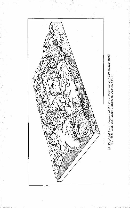
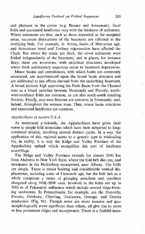
Landforms Evolved on Folded Sequences 203
and plateaux in the centre (e.g. Beauce and Soissonais), local folds and associated landforms vary with the thickness of sediments. Where sediments are thin, such as those deposited in the marginal areas, recurrent dislocations of the basement are reflected in the overlying beds. For example, in Artois, faults of Hercynian age, and Armorican trend and Tertiary rejuvenation have affected the Chalk. But where the strata are thick, the cover sediments were folded independently of the basement, and in places, for instance Bray, there are inversions, with anticlinal structures developed where thick sedimentary sequences occur in basement depressions.
Minor basins and crenulations, with which faults are commonly associated, are superimposed upon the broad basin structure and are additional to any effects derived from the underlying basement. A broad tectonic high separating the Paris Basin from the Channel runs as a broad anticline between Normandy and Picardy; northwest-southeast folds are common, as are also north-south trending flexures. Finally, east-west flexures are common in Normandy, and, indeed, throughout the western zone. Thus, minor basin structures and associated landforms are common.
Appalachians of eastern U.S.A.As mentioned p eviously, the Appalachians have given their
name to simple fold mountains which have been subjected to long- continued erosion, involving several distinct cycles. In a way, the application of this regional name to a generic type is misleading for, in reality, it is only the Ridge and Valley Province of the Appalachian upland which exemplifies this sort of landform assemblage.
The Ridge and Valley Province extends for almost 2000 km from Alabama to New York State, where the fold belt dies out, and terminates in the Helderberg escarpment, near Albany. The folds are simple. There is thrust faulting and considerable vertical displacement, including some of Cainozoic age, but the fold belt as a whole comprises a series of plunging anticlines and synclines elongated along NNE-SSW axes. Involved in the folds are up to 3000 m of Palaeozoic sediments which include several ridge-forming sandstones. In Pennsylvania, for example, are the Pottsville, Pocono, Oriskany, Cheming, Tuscarora, Oswego, and Oneida sandstones (Fig. 94). Though some are more massive and geo- morphologically more significant than others, all give rise to more or less prominent ridges and escarpments. There is a faithful inter-
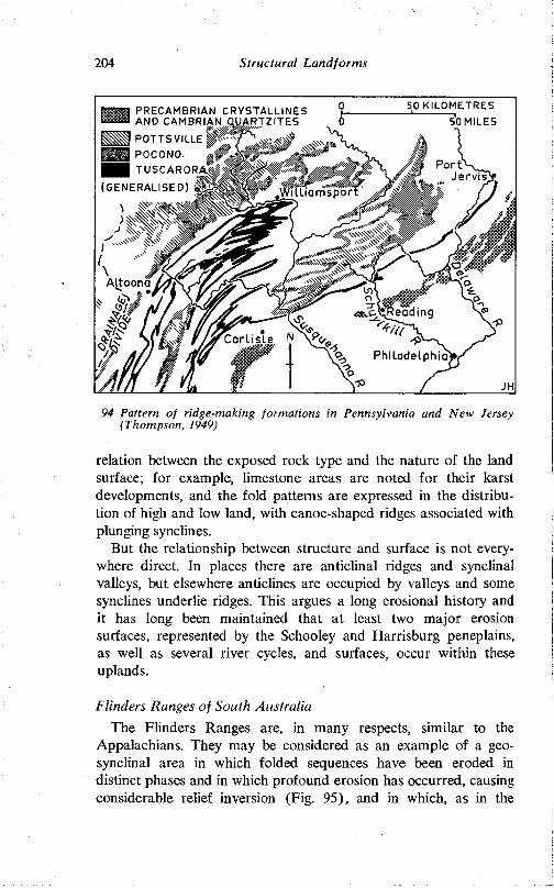
204 Structural Landforms
94 Pattern of ridge-making formations in Pennsylvania and New Jersey (Thompson, 1949)
relation between the exposed rock type and the nature of the land surface; for example, limestone areas are noted for their karst developments, and the fold patterns are expressed in the distribution of high and low land, with canoe-shaped ridges associated with plunging synclines.
But the relationship between structure and surface is not everywhere direct. In places there are anticlinal ridges and synclinal valleys, but elsewhere anticlines are occupied by valleys and some synclines underlie ridges. This argues a long erosional history and it has long been maintained that at least two major erosion surfaces, represented by the Schooley and Harrisburg peneplains, as well as several river cycles, and surfaces, occur within these uplands.
Flinders Ranges of South AustraliaThe Flinders Ranges are, in many respects, similar to the
Appalachians. They may be considered as an example of a geosynclinal area in which folded sequences have been eroded in distinct phases and in which profound erosion has occurred, causing considerable relief inversion (Fig. 95), and in which, as in the
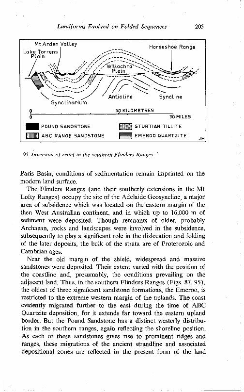
Landforms Evolved on Folded Sequences 205
Mt Arden ValleyLake Torrens
PlainHorseshoe Range
Plain
Anticline SynclineSynclinorium
30 KILOMETRES30 MILES
1111 STURTIAN TILLITE
I U I EMEROO QUARTZITE
POUND SANDSTONE
ABC RANGE SANDSTONE
95 Inversion o f re lie f in the southern F linders Ranges
Paris Basin, conditions of sedimentation remain imprinted on the modem land surface.
The Flinders Ranges (and their southerly extensions in the M t Lofty Ranges) occupy the site of the Adelaide Geosyncline, a major area of subsidence which was located on the eastern margin of the then West Australian continent, and in which up to 16,000 m of sediment were deposited. Though remnants of older, probably Archaean, rocks and landscapes were involved in the subsidence, subsequently to play a significant role in the dislocation and folding of the later deposits, the bulk of the strata are of Proterozoic and Cambrian ages.
Near the old margin of the shield, widespread and massive sandstones were deposited. Their extent varied with the position of the coastline and, presumably, the conditions prevailing on the adjacent land. Thus, in the southern Flinders Ranges (Figs. 87, 95), the oldest of three significant sandstone formations, the Emeroo, is restricted to the extreme western margin of the uplands. The coast evidently migrated further to the east during the time of ABC Quartzite deposition, for it extends far toward the eastern upland border. But the Pound Sandstone has a distinct westerly distribution in the southern ranges, again reflecting the shoreline position. As each of these sandstones gives rise to prominent ridges and ranges, these migrations of the ancient strandline and associated depositional zones are reflected in the present form of the land
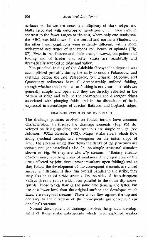
206 Structural Land forms
surface: in the western areas, a multiplicity of stark ridges and bluffs associated with outcrops of sandstone of all three ages, in contrast to the fewer ranges to the east, where only one sandstone, the ABC, was laid down. In the central and northern Flinders, on the other hand, conditions were evidently different, with a more widespread occurrence of sandstones and, hence, of uplands (Fig. 87). Even in the siltstone and shale areas, however, the patterns of folding and of harder and softer strata are beautifully and dramatically revealed in ridge and valley.
The principal folding of the Adelaide Geosyncline deposits was accomplished probably during the early to middle Palaeozoic, and certainly before the late Palaeozoic, but Triassic, Miocene, and Quaternary sediments have all demonstrably suffered folding, though whether this is related to faulting is not clear. The folds are generally simple and open and they are directly reflected in the pattern of ridge and vale, in the convergent and divergent ridges associated with plunging folds, and in the disposition of beds, expressed in assemblages of cuestas, flatirons, and hogback ridges.
DRAINAGE PATTERNS OF FOLD BELTS
The drainage patterns evolved on folded terrain have common characteristics. Tn theory, the drainage elements (Fig. 96) developed on rising anticlines and synclines are simple enough (see Johnson, 1932a; Zernitz, 1932). Major strike rivers which flow along synclinal troughs are consequent on the initial slope of land. The streams which flow down the flanks of the structures are consequent (or cataclinal) also. In the simple structural situation shown in Fig. 96 they are also dip streams. Tributary streams develop most rapidly in areas of weakness (the crestal area or the areas affected by joint development resultant upon folding) and as they follow the development of the consequent elements are called subsequent streams. If they run overall parallel to the strike, they may also be called strike streams. On the sides of the subsequent valleys streams evolve which run parallel to the down dip consequents. Those which flow in the same directions as the latter, but are at a lower level than the original surface and developed much later, are resequent streams. Those which flow against the dip and contrary to the direction of the consequents are obsequent (or anaclinal) streams.
Normal development of drainage involves the gradual development of those strike subsequents which have exploited weaker
Land forms Evolved on Folded Sequences 207
r OBSEQUENT STREAM (ANACLINAL)
d RESEQUENT STREAM
CONSEQUENT STREAM (CATACLINAL)SUBSEQUENT STREAM
96 Development of streams on a simple fold
outcrops, the linking of these long subsequents by short resequent and obsequent streams, and thus the development of a trellis pattern which is adjusted to the structural grain (though even here are seeds of controversy, for the alleged development of the connecting obsequent and subsequent streams through resistant outcrops has been disputed). In dome or basin structure, annular patterns (Zernitz, 1932) are produced.
Frequently the stream patterns of fold mountains pose problems in that in many cases major elements of such patterns run transversely across the structural grain. This is not the place to delve in detail into the various hypotheses advanced in explanation of this common situation, though the principal themes can be considered in connection with the influence of structure on these drainage patterns and its implications for several of the hypotheses.
The hypothesis of stream antecedence argues that the stream course and patterns were established before the fold mountains developed and that the major stream elements at any rate maintained their courses during uplift. Antecedence is very difficult to prove. Reference has already been made to a clear instance from
208 Structural Landforms
the plains of Mesopotamia where an irrigation canal constructed about 1700 years ago has maintained its course through a rising anticline (p. 174).
Coleman (1958) has convincingly argued that the Salzach, in the Austrian Tyrol, is antecedent in its gorge section between Werfen and Hallein.
Known rates of uplift and known rates of stream erosion (Schumm, 1963) suggest that, in theory at any rate, streams can erode their beds sufficiently quickly to maintain their courses through rising areas. Yet in some places uplift has clearly resulted in stream blockage or diversion: the Murray near Echuca is an example described earlier (Chapter IV, Fig. 60).
Another widely-used explanation of drainage discordance involves regional superimposition of streams from an overmass. Though reasonably applied to such areas as the English Lake District where radial drainage, evolved on a dome of Carboniferous limestone, has been superimposed on the underlying contorted Palaeozoic rocks (Fig. 97), this suggestion fails as a general explanation in many areas because of the absence of any evidence for such overmass covers. Locally, however, it has merit. Minor superimposed streams have, for instance, been described from the Zagros (Oberländer, 1965) where streams flowing across the local synorogenic Fars deposits have been superimposed on underlying folded beds. Similarly, local and partial superimposition from alluvial cover on to tilted Precambrian strata (Fig. 98) has been described from the southern Flinders Ranges (Twidale, 1966c). Of possibly wider application, in view of the common identification of ancient plains of low relief high on the landscape, is the rather similar hypothesis of inheritance. Drainage patterns only broadly related to underlying structure may be developed on plains of low relief, especially in those areas carrying a substantial veneer of alluvium, and it is argued that these patterns may survive rejuvenation consequent upon uplift. The absence of overmass deposits is no longer a problem, though in many areas more reassuring evidence of the presence of an old peneplain or pediplain is desirable.
The occurrence of sinuous streams and gorges is proof neither of superimposition nor inheritance. Ingrown meanders and abandoned intrenched meander cut-offs develop during incision. Even where conditions are right for superimposition or inheritance, streams adapt to structure during incision so that the initial pattern may be lost or distorted. This is manifestly true of minor streams,
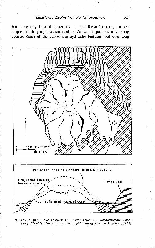
Landforms Evolved on Folded Sequences 209
but is equally true of major rivers. The River Torrens, for example, in its gorge section east of Adelaide, pursues a winding course. Some of the curves are hydraulic features, but over long
Projected base of Carboniferous Limestone
Projected base of^ Permo-Trias v . / ' Cross Felt
Much deformed rocks of core
97 The English Lake District: (1) Permo-Trias; (2) Carboniferous limestone; (3) older Palaeozoic metamorphic and igneous rocks (Dury, 1959)
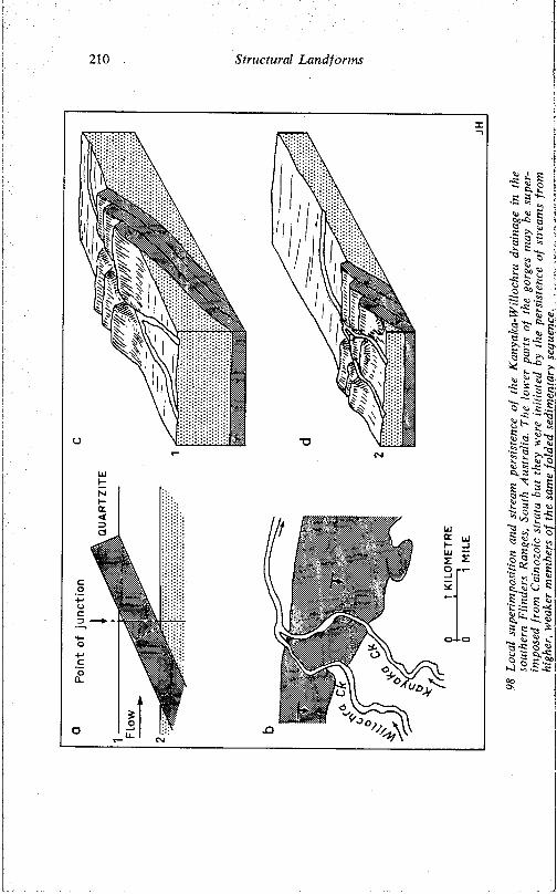
210 S tructura l Land fo rm s
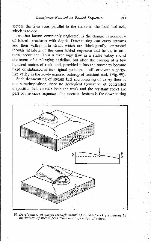
Land for ms Evolved on Folded Sequences 211
sectors the river runs parallel to the strike in the local bedrock, which is folded.
Another factor, commonly neglected, is the change in geometry of folded structures with depth. Downcutting can carry streams and their valleys into strata which are lithologically contrasted though members of the same folded sequence and hence, in attitude, accordant. Thus a river may flow in a strike valley round the snout of a plunging anticline, but after the erosion of a few hundred metres of rock, and, provided it has the power to become fixed or stabilised in its original position, it will excavate a gorgelike valley in the newly exposed outcrop of resistant rock (Fig. 99).
Such downcutting of stream bed and lowering of valley floor is not superimposition since no geological formation of contrasted disposition is involved: both the weak and the resistant rocks are part of the same sequence. The essential feature is the downcutting
99 Development of gorges through snouts of resistant rock formations by mechanism of stream persistence and impression of valleys
212 Structural Landforms
and persistence of the stream and the lowering or impression of the valley into lithologically contrasted strata.
Such a mechanism can explain those rather common but nevertheless curious sectors of strike streams which, winding about in their valleys, impinge upon and erode gorges in the flanking ridges of resistant rock. An example is shown in Fig. 100a. It is clear that the stream sector X-Y developed in a weak outcrop which, because of its dip and the lowering of the land surface, has migrated northward. Thus the stream was lowered into and fixed upon the flanks of the newly uncovered resistant ridge-forming strata.
In the sector Y-Z in Fig. 100a, the stream flows through a gorge and against the dip. Such transverse breaches of uplands constitute yet another source of difficulty in the understanding of drainage patterns in fold belts, and they arise in considerable measure from a failure to appreciate the effectiveness, even the reality of headward erosion. For instance, Thompson (1939, 1949) has suggested that stream capture or piracy, which implies at least some regressive erosion and the breaching of divides, can account for many of the peculiarities of drainage in the northern Appalachians (Fig. 94, PI. 56). But the suggestion has received little favour, and it is not too much to say that until relatively recently the concept of headward erosion has tended to be dismissed summarily by North American workers. Strahler (1945) subjected the drainage patterns of the northern Appalachians to exhaustive analysis and concluded that they were best explained in terms of regional superimposition. He doubted whether headward erosion of streams was capable of breaching divides, and claimed that several critical stages in the process had not been identified. This objection is difficult to sustain in view of the field evidence in both the Zagros Mountains and the Flinders Ranges where there are many indications that head- ward erosion has indeed taken place.
The transverse drainage of the Zagros Mountains, which occupy a geologically young orogenic belt, poses a difficult problem which has, however, been subjected to thorough and successful analysis (Oberländer, 1965). Though much of the drainage is directly related to structure, and some of the remaining elements are explicable in terms of superimposition from locally developed synorogenic strata, the bulk of the transverse drainage, and particularly the gorges locally known as tangs (see, e.g., PI. 55), is explained in terms of stream piracy and change of structural pattern with depth, where the geometry of the folds is different, the distribution of hard and soft rocks different, and the drainage there-
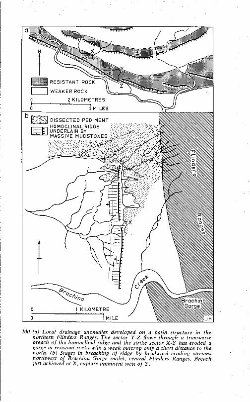
100 (a) Local drainage anomalies developed on a basin structure in the northern Flinders Ranges. The sector Y-Z flows through a transverse breach of the homoclinal ridge and the strike sector X -Y has eroded a gorge in resistant rocks with a weak outcrop only a short distance to the north. (b) Stages in breaching of ridge by headward eroding streams northwest of Brachina Gorge outlet, central Flinders Ranges. Breach just achieved at X, capture imminent west of Y.
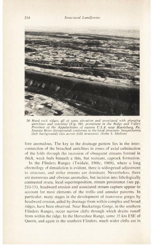
214 Structural Landforms
56 Hard rock ridges, all of same elevation and associated with plunging anticlines and synclines (Fig. 94), prominent in the Ridge and Valley Province of the Appalachians of eastern U.S.A. near Harrisburg, Pa. Juniata River (foreground) conforms to the local structure. Susquehanna (left background) cuts across fold structures. (John S. Shelton)
fore anomalous. The key to the drainage pattern lies in the interconnection of the breached anticlines in zones of axial culmination of the folds through the recession of obsequent streams formed in thick, weak beds beneath a thin, but resistant, caprock formation.
In the Flinders Ranges (Twidale, 1966c, 1969), where a long chronology of denudation is evident, there is widespread adjustment to structure, and strike streams are dominant. Nevertheless, there are numerous and obvious anomalies, but incision into lithologically contrasted strata, local superimposition, stream persistence (see pp. 210-13), headward erosion and associated stream capture appear to account for most elements of the trellis and annular patterns. In particular, many stages in the development of transverse gorges by headward erosion, aided by drainage from within complex and broad ridges, have been observed. Near Buckaringa Gorge, in the southern Flinders Ranges, occur narrow clefts through which drains runolf from within the ridge. In the Horseshoe Range, some 35 km ESE of Quorn, and again in the southern Flinders, much wider clefts are in
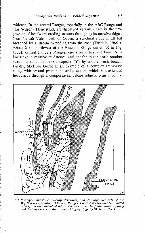
Landforms Evolved on Folded Sequences 215
evidence. In the central Ranges, especially in the ABC Range and near Wilpena Homestead, are displayed various stages in the progression of headward eroding streams through quite massive ridges. Near Yarrah Vale, north of Quorn, a synclinal ridge is all but breached by a stream extending from the east (Twidale, 1966c). About 2 km northwest of the Brachina Gorge outlet (X in Fig. 100b), central Flinders Ranges, one stream has just breached a low ridge in massive mudstones, and not far to the north another stream is about to make a capture (Y) by another such breach. Finally, Skeleroo Gorge is an example of a complex transverse valley with several prominent strike sectors, which has extended headwards through a composite sandstone ridge into an anticlinal
101 Principal sandstone outcrop structures, and drainage elements of the Big Ben area, southern Flinders Ranges. Fault distorted and terminated ridges, and the control of minor stream courses by faults. Stream piracy and drainage reversal due to breaching of ridge by Skeleroo Creek.
216 Structural Landforms
valley, the northern part of which has been lowered to a level lower than the southern area (Fig. 101). These developments are taking place today, but there is also evidence that many of the gorges which mark the transverse drainage elements had developed by the middle Tertiary (Twidale, 1966c).
Thus, in summary, a greater number of streams and stream sectors are more closely adjusted to local structure than appears from a cursory examination of topographical and geological maps. Ingrown meanders are autogenic and do not imply inheritance of flood-plain features. In many instances, to suggest anomalies between drainage and structure, and on that count to invoke superimposition or inheritance, is unwarranted. Furthermore, structures have not only length and breadth but their geometry changes in depth also and a realisation of this, and an appreciation of the effectiveness of headward erosion, stream capture, local superimposition, and stream persistence of the types shown in Figs. 98 and 99, all acting over prolonged periods of time, can readily explain many of the situations for the understanding of which the concepts of antecedence, superimposition, and inheritance have been invoked.
VI
CONCLUSION
Early students of geomorphology were almost without exception trained as geologists. In many areas the relationship between the form of the land surface and the nature and disposition of the underlying bedrock is direct and obvious. For these reasons, early interpretations concentrated almost exclusively on landforms as expressions of structure. Though Hutton and Dana, amongst others, were aware of the importance of rivers and waves in independent shaping of the land surface, gross structural factors dominated geomorphological thinking until comparatively recently. It is still less than a century ago that Colonel George Greenwood had to survive acrimonious attacks before convincing his opponents that valleys are not downfaulted portions of the crust in which rivers happen to flow, but that the valleys have been, and are being, excavated by the rivers themselves. As is shown by the references cited in the foregoing chapters, some of these earlier workers were also keenly aware of the part played by structural details in determining the morphology of familiar features.
But since the turn of the century, and despite their obvious importance, structural factors have, by and large, been neglected. True, the relationship between regional structure and major relief forms has never been overlooked, but with rare exceptions, the consideration of structural influence did not extend beyond the gross, obvious, and superficial. Moreover, the structural framework has tended to be seen as something established in the past, but now static and unchanging. Twentieth-century geomorphological thinking has concentrated on the cyclic concept, and upon the climatically induced processes at work at and near the land surface. Consideration of time and process is indeed important in the analysis and understanding of geomorphic landscapes, but is not inherently more vital than are structural considerations. Over the
217
218 Structural Landforms
past two decades, a measure of balance has been restored with the realisation that such factors as the spacing and condition of joints and other fractures, the detailed spatial variation in rock texture and mineralogy (see, for instance, Waters, 1964), past conditions of sedimentation, recent and continuing tectonism, are, in particular areas, responsible for significant morphological variations. Furthermore, many forms previously interpreted wholly in terms of process are, in some areas and at least in part, now attributed to structural factors. The piedmont angle, for instance, has been explained as the result of a variety of processes (McGee, 1897; Lawson, 1915; Johnson, 1932b; King, 1949b), but recently the influence of variations in joint spacing and of lithology have been invoked as responsible for the development of an initial break of slope which is then exploited and developed by localised weathering and erosion (Twidale, 1967).
Discussing problems of transverse drainage in the Appalachians, Thompson (1949, p. 37) wrote: Tn a broad general way structure is, of course, taken into account, and that is important. It seems to me however that structure should also be viewed in detail.’ One can only endorse these words and, furthermore, suggest that they are relevant to the whole field of geomorphology. It is hoped that sufficient instances and examples, at a variety of scales, have been cited in the foregoing pages to convince the reader that more than a broad and superficial examination of structural factors is essential to the correct interpretation of landforms.
BIBLIOGRAPHY
Ackermann, E. (1962). Büssersteine—Zeugen vorzeitlicher Grundwasserschwankungen. Z. Genmorph. (N.S.) 6:148-82.
Ahmad, M. U. (1967). Some geophysical observations on the Great Glen Fault. Nature, Lond. 213:275-7.
Anderson, E. M. (1942). The Dynamics of Faulting. Edinburgh and London.
d’Andree, D. V., Fischer, R. L., and Fogelson, D. E. (1965). Prediction of compressive strength from other rock properties. U.S. Dept Interior, Bureau of Mines, Report of Investigation 6702.
Badgley, P. (1965). Structural and Tectonic Principles. New York.Bain, A. D. N. (1923). The formation of inselberge. Geol. Mag. 60:97-107.Balk, R. (1937). Structural behaviour of igneous rocks. Bull. geol. Soc. Am.
Mem. 5.Barbeau, J. and Geze, B. (1957). Les coupoles granitiques et rhyolitiques
de la region de Fort-Lamy (Tchad). C.r. somm. & Bull. Soc. Geol. Fr. (Ser. 6) 7:341-51.
Barbier, R. (1957a). Amenagements hydroelectriques dans le sud de Bresil. C.r. somm. & Bull. Soc. Geol. Fr. 6 :877-92.
-------- (1957b). Un probleme morphologique au Bresil: Pains de Sucre, et‘tunique’ tropicale. C.r. hebd. Seanc. Acad. Sei., Paris. 245:2346.
-------- (1967). Nouvelles reflexions sur le probleme des ‘pains de sucre’ äpropos d’observations dans le Tassili N’Ajjer (Algerie). Trav. Lab. Geol. Fac. Sei. Grenoble 43:15-21.
Barton, D. C. (1916). Notes on the disintegration of granite in Egypt. J. Geol. 24:382-93.
de la Beche, H. T. (1839). Report on the geology of Cornwall, Devon and West Somerset. Geol. Surv. Eng. Wales.
Bederke, E. (1966). The development of European rifts, in The World Rift System. Report of Symposium Upper Mantle Project, Ottawa, Canada, 4-6 Sept. 1965, ed. T. N. Irvine, pp. 213-19. Report published as Geol. Surv. Can. Paper 66-14. (Hereafter referred to as The World Rift System.)
Berliat, K. (1965). Exploratory drilling for water in the sandplain country 40 miles east of Hyden. Annual Report (1964), Geological Survey of Western Australia, pp. 8-9.
Birot, P. (1952). Le relief granitique dans le nord-ouest de la Peninsule Iberique. Proc. 17th Int. Cong. I.G.U., Washington, pp. 301-3.
-------- (1958a). Les domes crystallins. C.N.R.S., Mem. & Doc., 7-34.-------- (1958b). Morphologie structural. 2 vols. Paris.Blackwelder, E. (1925). Exfoliation as a phase of rock weathering. J. Geol.
33:793-806.-------- (1927). Fire as an agent in rock weathering. J. Geol. 35:134-40.
219
220 Bibliography
-------- (1928). The recognition of fault scarps. J. Geol. 36:289-311.-------- (1933). The insolation hypothesis of rock weathering. Am. J. Sei.
26:97-113.Blyth, F. G. H. (1957). The Lustleigh fault in northeast Dartmoor. Geol.
Mag. 94:291-6.-------- (1962). The structure of the northeastern tract of the Dartmoor
granite. Q. Jl Geol. Soc. Loud. 118:435-53.Booth. B. (1968). Petrogenic significance of alkali feldspar megacrysts and
their inclusions in Cornubian granites. Nature, Lond. 217:1036-8. Bornhardt, W. (1900). Zur Oberflächengestaltung und Geologie Deutsch
Ostafrikas. Berlin.Bott, M. H. P. (1953). Negative gravity anomalies over ‘acid intrusions’ and
their relation to the structure of the earth’s crust. Geol. Mag. 90: 257-67.
-------- (1956). A geophysical study of the granite problem. Q. Jl Geol. Soc.Lond. 112:45-62.
Bourcart, J. (1938). Le marge continentale. Bull. Soc. geol. Fr. 5:393-474. Bowler, J. M. and Harford, L. B. (1966). Quaternary tectonics and the
evolution of the riverine plain near Echuca, Victoria. J. geol. Soc. Aust. 13:339-54.
Bradley, W. C. (1963). Large-scale exfoliation in massive sandstones of the Colorado Plateau. Bull. geol. Soc. Am. 74:519-28.
Brajnikov, B. (1953). Les pains de sucre du Bresil: sont-ils enracines? C.r. somm. & Bull. Soc. Geol. Fr. 6:267-9.
Brammall, A. (1926). The Dartmoor granite. Proc. Geol. Ass. 37:251-77. Branner, J. C. (1896). Decomposition of rocks in Brazil. Bull. geol. Soc.
Am. 7:255-314.Bridgman, P. W. (1938). Reflections on rupture. J. appl. Phys. 9: 517-28. Brock, B. E. (1966). The Rift Valley craton, in The World Rift System,,
pp. 99-122.Brown, R. G. (1969). Modern deformational structures in sediments of the:
Coorong Lagoon, South Australia. Geol. Soc. Aust. Spec. Publ. 2:237-42.
Browne, W. R. (1964). Grey billy and the age of tor topography in Monaro„ N.S.W. Proc. Linn. Soc. N.S.fL. 89:322-5.
Brunsden. D. (1964). The origin of decomposed granite on Dartmoor, iru Dartmoor Essays, ed. I. G. Simmons. Torquay, pp. 97-116.
Büdel, J. (1957). Die ‘Doppelten Einebnungsflächen’ in den feuchten Tropen. Z. Geomorph. 1:201-28.
Bull, W. B. (1964). Alluvial fans and near-surface subsidence in western Fresno County, California. U.S. geol. Surv. Prof. Paper 437-A.
Bullard, E. C. (1936). Gravity measurements in East Africa. Phil. Trans.. R. Soc. (Ser. A) 235:445-531.
Buwalda, J. P. (1937). Shutterridges, characteristic physiographic features of active faults. Proc. geol. Soc. Am. 1936:307.
Cailleux, A. (1953). Taffonis et erosion alveolaire. Cah. geol. Thoiry 16-17:130-3.
-------- and Tricart, J. (1956). Le probleme de la classification des faitsgeomorphologiques. Annls Geogr. 65:162-85.
Caine, N. (1967). The tors of Ben Lomond, Tasmania. Z. Geomorph. 11:: 418-29.
Cameron, J. (1945). Structural features of the grey granites of Aberdeenshire. Geol. Mag. 82:189-204.
Carey, S. W. (1956). A tectonic approach to continental drift, in Conti-
Bibliography 221
nental Drift—a symposium. University of Tasmania, Hobart, pp. 117- 355.
Carl, J. D. and Amstutz, G. C. (1958). Three-dimensional Liesegang rings by diffusion in a colloidal matrix, and their significance for the interpretation of geological phenomena. Bull. geol. Soc. Am. 69: 1467-8.
Carman, J. E. (1946). The geological interpretation of scenic features in Ohio. Ohio J. Sei. 46:241-83.
Caw, J. M. (1956). The Kolar gold field. Mine Quarry Engng 22:258-68.Chapman, C. A. (1956). The control of jointing by topography. J. Geol.
66:552-8.-------- and Rioux, R. L. (1958). Statistical study of topography, sheeting
and jointing in granite, Acadia National Park, Maine. Am. J. Sei. 256:111-27.
Chapman, R. W. and Greenfield, Mildred A. (1949). Spheroidal weathering of igneous rocks. Am. J. Sei. 247:407-29.
Clayton, R. W. (1956). Linear depressions (Bergfussniederungen) in savannah landscapes. Geogrl Stud. 3:102-26. ,
Cloos, E. (1955). Experimental analysis of fracture patterns. Bull. geol. Soc. Am. 66:241-56.
Cloos, H. (1936). Einführung in die Geologie. Berlin.-------- (1939a). Der Sierra-Nevada Pluton in Californien. Neues Jahrbuch
für Mineralogie, Geologie, und Palaeontologie 76:355-450.-------- (1939b). Hebung, Spaltung, Vulkanismus. Geol. Rdsch. 30:405-527.Coats, R. P. (1965). Diapirism in the Adelaide geosyncline. Australian
Petroleum Exploration Association Journal: 98-102.Coleman, A. (1958). The terraces and antecedence of a part of the River
Salzach. Trans. & Papers Inst. Br. Geogr. 25:119-34.Collier, A. J. (1920). Anticlines near Maverick Springs, Fremont County,
Wyoming, in Contributions to Economic Geology. Bull. U.S. geol. Surv. 711:149-66.
Cook, K. L. (1966). Rift system in the Basin and Range Province, in The World Rift System, pp. 246-90.
Costin, A. B. (1950). Mass movements of the soil surface with special reference to the Monaro region (Pt 2). J. Soil Conserv. Serv. N.S.W. 6:73-80.
Cotton, C. A. (1917). Block mountains in New Zealand. Am. J. Sei. 194: 249-93.
-------- (1948). Landscape. 2nd ed. Christchurch.-------- (1950). Tectonic scarps and fault valleys. Bull. geol. Soc. Am. 61:
717-58.-------- (1951). Fault valleys and shutterridges at Wellington. N.Z. Geogr.
7:62-8.-------- (1953). Tectonic relief: with illustrations from New Zealand.
Geogrl J. 119:213-22.-------- (1956). Tectonic features in a coastal setting at Wellington. Trans.
R. Soc. N.Z. 84:761-90.-------- (1960). Geomorphology. Reprinted. Christchurch.Craig, G. Y., ed. (1965). The Geology of Scotland. Edinburgh.Crittenden, M. D. (1963). New data on the isostatic deformation of Lake
Bonneville. U.S. geol. Surv. Prof. Paper 454-E.Crook, K. A. W. and Cook, P. J. (1966). Gosses Bluff—diapir, crypto-
volcanic structure, or astrobleme? J. geol. Soc. Aust. 13:495-516.
222 Bibliography
Crowell, J. C. (1962). Displacement along the San Andreas fault, California. Geol. Soc. Am. Sp. Paper 71.
Dale, T. N. (1923). The commercial granites of New England. Bull. U.S. geol. Surv. 738.
Dalgarno, C. R. and Johnson, W. (1965). Diapiric structures and Upper Proterozoic to Lower Cambrian sedimentation in the Flinders Ranges, South Australia. Amer. Assoc. Petrol. Geol. Bull. 49:337-8.
Davis, W. M. (1913). Nomenclature of surface forms on faulted structures. Bull. geol. Soc. Am. 24:187-216.
Dearman, W. R. (1963). Wrench-faulting in Cornwall and South Devon. Proc. Geol. Ass. 74:265-87.
-------- (1964). Dartmoor: its geological setting, in Dartmoor Essays, ed.I. G. Simmons. Torquay, pp. 1-29.
Demek. J. (1964a). Slope development in granite areas of Bohemian Massif (Czechoslovakia). Z. Gcomorph. Supp. 5:82-106.
-------- (1964b). Castle koppies and tors in the Bohemian Highland(Czechoslovakia). Biul. peryglac. 14:195-216.
Denaeyer, M. E. (1956). Actualite de l'erosion alveolaire et des ‘taffonis’.C.r. somm. & Bull. Soc. Geol. Fr. 6 (6): 135-6.
Derruau, M. (1965). Precis de geomorphologie. 4th ed. Paris.Dixey, F. (1956). The East African rift system. Overseas Geology and
Mineral Resources Bulletin. Suppl. No. 1. London.Doyle, H. A., Everingham. I. B., and Sutton, D. J. (1968). Seismicity of
the Australian continent. J. geol. Soc. Aust. 15:295-312.Dragovich, Deidre J. (1964). Cavernous weathering. M.A. thesis, University
of Adelaide.Drake, F. E. (1859). Artificial origin of rock-basins. Geologist 2:368-71. Duffaut, P. (1957). Sur la genese des ‘boules’ de certains granites. C.r.
somm. & Bull. Soc. Geol. Fr. (Ser. 6) 7:139-41.Dumanowski, B. (1960). Comment on origin of depressions surrounding
granite massifs in the eastern desert in Egypt. Bull. Acad. Pol. Sei. 8:305-12.
-------- (1964). Problem of the development of slopes on granitoids.Z. Geomorph. Suppl. 5:30-40.
-------- (1968). Influence of petrographical differentiation of granitoids onlandforms. Geogr. Polonica 14:93-8.
Dury, G. H. (1959). The Face of the Earth. Harmondsworth.Eggler, D. H., Larson, E. E., and Bradley, W. C. (1969). Granites, grusses
and the Sherman erosion surface, southern Laramie Range, Colorado- Wyoming. Am. J. Sei. 267:510-22.
Engel, C. G., and Sharp. R. P. (1958). Chemical data on desert varnish. Bull. geol. Soc. Am. 69:487-518.
Falconer, J. D. (1911). The Geology and Geography of Northern Nigeria. London.
Farmin. R. (1937). Hypogene exfoliation in rock masses. J. Geol. 45: 625-35.
Feldtmann, F. R. (1915). Geological observations in the Mulline, Riverina and Ularring centres, North Coolgardie goldfield. Bull. geol. Surv. West. Aust. 64.
Fisk, H. N. (1939). Depositional terrace slopes in Louisiana. J. Geomorph. 2:181-200.
Florensov, N. A. (1966). The Baikal rift zone, in The World Rift System, pp. 173-80.
Bibliography 223
Fox, D. J. (1965). Man-water relationships in metropolitan Mexico. Geogrl Rev. 55:523-45.
Freund, R. (1965). A model of the structural development of Israel and adjacent areas since Upper Cretaceous times. Geol. Mag. 102:189-205.
----------------- (1966). Rift valleys, in The World Rifl System, pp. 330-44.-------- , Zak. I., and Garfunkel. Z. (1968). Age and rate of sinistral move
ment along the Dead Sea rift. Nature, Loud. 220:253-5.Fry, E. J. (1926). The mechanical action of corticolous lichens. Ann. Bot.
40:397-417.-------- (1927). The mechanical action of crustaceous lichens on substrata
of shale, schist, gneiss, limestone and obsidian. Ann. Bot. 41:437-60. Geikie, A. (1865). The Scenery of Scotland. London.Gerth, H. (1955). Der geologische Bau der Südamerikanischen Kordillcra.
Berlin.Gilbert, G. K. (1890). Lake Bonneville. U.S. Geol. Surv. Monogr. 1.
-------- (1904). Domes and dome structures of the High Sierra. Bull. geol.Soc. Am. 15:29-36.
Gilluly, J. (1949). Distribution of mountain building in geologic time. Bull. geol. Soc. Am. 60:561-90.
Girdler, R. W. (1958). The relationship of the Red Sea to the East African rift system. Q. Jl geol. Soc. Lond. 114:79-115.
-------- (1966). The role of translational and rotational movements in theformation of the Red Sea and Gulf of Aden, in The World Rift System, pp. 65-77.
Glaessner, M. F. ( 1953). Conditions of Tertiary sedimentation in southern Australia. Trans. R. Soc. S. A list. 76:141-6.
Goldich. S. S. (1938). A study of rock weathering. J. Geol. 46:17-58.Grant, C. Kerr (1956). The Adelaide earthquake of 1st March. 1954. Trans.
R. Soc. S. Aust. 79:177-85.Grant, U. S. and Sheppard, W. E. (1939). Some recent changes of elevation
in the Los Angeles Basin. Bull, seism. Soc. Am. 29:319-22.Grantz, A.. Plafker, G., and Kachadoorian. R. (1964). Alaska's Good
Friday earthquake. March 27, 1964. U.S. geol. Surv. Circular 491. Gregory, J. W. (1894). Contributions to the physical geography of British
East Africa. Geogrl J. 4:290-315.-------- (1921). The Rift Valleys and Geology of East Africa. London.Griggs. D. T. (1936). The factor of fatigue in rock exfoliation. J. Geol. 44 :
783-96.Gutenberg, B. (1954). Postglacial uplift in the Great Lakes Region. Arch.
Met. Gcopliys. Bioklim. (Ser. A) 6:243-51.Handley, J. R. F. (1952). The geomorphology of the Nzega area of Tan
ganyika with special reference to the formation of granite tors. C.r. Congr. Geol. Inter. (Algiers) 21:201-10.
Hansen, W. R. (1967). The Alaska earthquake of 1964. Nature, Lond. 215:348-51.
Harris, G. F. (1888). Granite and Our Granite Industries. London.Harris, W. J. (1939). Physiography of the Echuca district. Proc. R. Soc.
Viet. 51:45-60.Harrison. J. V. and Falcon. N. L. (1934). Collapse structures. Geol. Mag.
71:529-39.-------- and -------- (1936). Gravity collapse structures and mountain
ranges, as exemplified in south-western Iran. Q. Jl geol. Soc. Lond. 92:91-102.
Harriss, R. C. and Adams, J. A. S. (1966). Geochemical and mineralogical
224 Bibliography
studies on the weathering of granitic rocks. Am. J. Sei. 264: 146-73.Hill, M. L. (1966). The San Andreas System, California and Mexico, in
The World Rift System, pp. 239-45.-------- and Dibblee, T. W. (1953). San Andreas, Garlock and Big Pine
faults, California. Bull. geol. Soc. Am. 64:443-58.Hills, E. S. (1940). Physiography of Victoria: an introduction to geomor
phology. Melbourne.-------- (1963). Elements of Structural Geology. London.Högbom, B. (1912). Wüstenerscheinungen auf Spitzbergen. Bull. geol.
Instn Univ. Uppsala 11:242-51.Hollingworth, S. E. and Rutland, R. W. R. (1968). Studies of Andean
uplift Part I. Post-Cretaceous evolution of the San Bartolo area, North Chile. Geol. Jl 6:49-62.
-------- , Taylor, J. H., and Kellaway, G. A. (1944). Large-scale superficialstructures in the Northampton ironstone field. Q. Jl geol. Soc. Lond. 100:1-35.
Holmes, A. (1965). Principles of Physical Geology. 2nd ed. Edinburgh.-------- and Wray, D. A. (1912). Outlines of the geology of Mozambique.
Geol. Mag. 9:412-17.-------- and -------- (1913). Mozambique—a geographical study. Geogrl J.
42:143-52.Hooke, R. LeB., Houng-Yi Chang, and Weiblen, P. W. (1969). Desert
varnish: an electron probe study. J. Geol. 77:275-88.Hume, W. F. (1925). Geology of Egypt. Vol. I. Cairo.Hurault, J. (1963). Recherches sur les inselbergs granitiques nus en
Guyane Fran^aise. Revue Geomorph. dyn. 14:49-61.Hutchins, P. F. (1963). The lower New Red Sandstone of the Crediton
Valley. Geol. Mag. 100:107-28.Ikebe. N. and Ichikawa, K. (1967). Geologic sketch of the Kinki District,
central Japan. J. Geosci. 10:135-48.Isaacson, E. de St Q. (1957). Research into the rock burst problem on the
Kolar gold field. Mine Quarry Engng 23:520-6.Jack, R. L. (1915). Geology and prospects of the region to the south of
the Musgrave Ranges and the geology of the western part of the Great Artesian Basin. Bull. Dep. Mines S. Aust. 5.
Jackli, H. C. A. (1965). The Pleistocene glaciation of the Swiss Alps and signs of postglacial differential uplift. Paper presented at VII Congress INQUA, Boulder, Colorado.
Jaeger, J. C. (1963). Fracture of rocks. Paper presented at Tewkesbury Symposium on Fracture, Melbourne.
Johns, R. K. (1968). Investigation of Lakes Torrens and Gairdner. Rep. geol. Surv. S. Aust. 31.
-------- and Ludbrook, N. H. (1963). Investigation of Lake Eyre. Rep.geol. Surv. S. Aust. 24.
Johnson, D. W. (1929). Geomorphologie aspects of rift valleys. C.r. 15 Inter. Geol. Congr. (S. Africa) 2:354-73.
-------- (1932a). Streams and their significance. J. Geol. 40:481-97.-------- (1932b). Rock planes of arid regions. Geogrl Rev. 22:656-65.-------- (1939). Fault scarps and fault-line scarps. J. Geomorph. 2:174-7.Jones, T. R. (1859). Notes on some granite tors. Geologist 2:301-12.Jutson, J. T. (1950). Physiography (geomorphology) of Western Australia.
Bull. geol. Surv. West. Aust. 95. 3rd ed.
Bibliography 225
Kennedy, W. Q. (1946). The Great Glen fault. Q. Jl Geol. Soc. Lond. 102:41-76.
Kessler, D. W., Insley, H., and Sligh, W. H. (1940). Physical, mineralogical and durability studies on the building and monumental granites of the United States. J. Res. natn. Bur. Stand. 24:161-206.
Kieslinger, A. (1932). Zerstörungen an Steinbauten, ihre Ursachen und ihre Abwehr. Leipzig and Vienna.
-------- (1960). Residual stress and relaxation in rocks. Int. Geol. Cong.Rept. 2Ist Session (Copenhagen), Pt 18:270-6.
King, L. C. (1942). South African Scenery: a textbook of geomorphology. Edinburgh.
-------- (1949a). A theory of bornhardts. Geogrl J. 112:83-7.-------- (1949b). The pediment landform: some current problems. Geol.
Mag. 86:245-50.-------- (1956a). Rift valleys of Brazil. Trans, geol. Soc. S. Afr. 59:199-209.-------- (1956b). Drakensberg scarp of South Africa: a clarification. Bull.
geol. Soc. Am. 67:121-2.--------- (1958). The problem of tors. Geogrl J. 124:289-91.-------- (1962). Morphology of the Earth. Edinburgh.-------- (1966). The origin of bornhardts. Z. Geomorph. 10:97-8.--------- (1968). Scarps and tablelands. Z. Geomorph. 12:114-15.King, P. B. (1965). Tectonism of Quaternary time in middle North
America, in The Quaternary of the United States, ed. H. E. Wright and D. G. Frey. Princeton, pp. 831-70.
Kinzl, H., and Schneider, E. (1950). La Cordillera Blanca (Peru). Innsbruck. Klaer, W. (1956). Verwitterungsformen in Granit auf Korsika. Pet. Geogr.
Mitt. Ergänzungschaft 261.Knott, S. T., Bunce, E. T.. and Chase, R. L. (1966). Red Sea seismic
reflection studies, in The World Rift System, pp. 33-61.Krank, E. H. (1957). On folding movements in the zone of the basement.
Geol. Rdsch. 46:261-82.Lafitte, R. (1939). Etude geologique de l’Aures. Bull. Serv. Carte geol.
Alger. (2° Series Stratig., Descrip. Reg.) 15.Lake, P. (1890). The geology of South Malabar between the Beypore and
Ponnani Rivers. Mem. geol. Surv. India 24(3) : 1 -46.Lambert, I. B., and White, A. J. R. (1965). The Berridale wrench fault: a
major structure in the Snowy Mountains of New South Wales. J. geol. Soc. Aust. 12:25-33.
Lane, E. W. et al. (1947). Report of the subcommittee on sedimentary terminology. Trans. Am. geophys. Un. 1947:936-8.
Larsen, E. S. (1948). Batholith and associated rocks of Corona, Elsinore and San Luis Rey Quadrangles, southern California. Mem. geol. Soc. Am. 29.
Laudermilk, J. D. (1931). On the origin of desert varnish. Am. J. Sei. 21: 51-66.
Lautensach, H. (1950). Granitische Abtragungsformen auf der Iberischen Halbinsel und in Korea, ein Vergleich. Union Geogr. Inter., Congr. Inter. Geogr. (Lisbon) 1946. C.r. 2:270-96.
Lawson, A. C. et al. (1908). The Californian earthquake of April 18, 1906. Report of the State Earthquake Investigation Commission. Carnegie Inst. Washington, Pub. 87, Vol. 1. Pt 1.
-------- (1915). The epigene profile of the desert. Univ. Calif. Pub. Geol. 9:23-48.
226 Bibliography
Leeman, E. F. (1962). Rock bursts in South African gold mines. New Scientist 16:29-82.
Lees, G. M. (1955). Recent earth movements in the Middle East. Geol. Rdsch. 42:221-6.
Leigh, C. H. (1967). Some aspects of the geomorphology of granitic iand- forms and landscapes on parts of the New England Tableland, New South Wales. Ph.D. thesis, University of New England.
-------- (1968). The form and evolution of Bald Rock, New South Wales.Anst. Geogr. 10:333-45.
Leonard, R. J. (1929). Polygonal cracking in granite. Am. J. Sei. 18: 487-92.
Lester, J. G. (1938). Geology of the region round Stone Mountain, Georgia.Univ. Colorado Studies, Series A. 26:88-91.
Lewis, W. V. (1954). Pressure release and glacial erosion. J. Glaciol. 2: 417-22.
Linton, D. L. (1952). The significance of tors in glaciated lands. Inter. Geogr. Union Proc. 8th Gen. Assemb., 17th Inter. Cong., pp. 354-7.
-------- (1955). The problem of tors. Geogrl J., 121:470-87.-------- (1964). The origin of the Pennine tors—an essay in analysis. Z.
Geomorph. (N.S.) 8:5-24.Ljungner, E. (1930). Spaltentektonik und Morphologie der Schwedischen
Skagerrak-Küste. Bull. geol. Instn Univ. Uppsala 21:1-478.Lofgren, B. E. (1965). Land subsidence due to artesian-head decline in the
San Joaquin Valley, California, in Guidebook for Field Conference I, Northern Great Basin and California. VII Congress INQUA, pp. 140-2.
Louis, H. (1959). Beobachtungen über die Inselberge bei Hua-Hin am Golf von Siam. Erdkunde 13:314-19.
Mabbutt. J. A. (1952). A study of granite relief from South West Africa. Geol. Mag. 89:87-96.
-------- (1961). ‘Basal surface’ or ‘weathering front’. Proc. geol. Ass. Lond.72:357-8.
-------- (1965). The weathered land surface in central Australia. Z.Geomorph. (N.S.) 9:82-114.
MacCallien. W. J., Ruxton, B. H., and Walton, B. J. (1964). Mantle rock tectonics. A study in tropical weathering at Accra, Ghana. Overseas Geol. Miner. Resour. 9:257-94.
McConnell, R. B. (1967). The East African rift system. Nature, Lond. 215: 578-81.
MacCulloch. J. (1814). On the granite tors of Cornwall. Trans, geol. Soc. 2:66-78.
McGee, W. J. (1897). Sheetflood erosion. Bull. geol. Soc. Am. 8:87-112. MacGregor, A. M. (1951). Some milestones in the Precambrian of Southern
Rhodesia. Trans, geol. Soc. S. Afr. 54 :xxvii-lxxi.Mackintosh, D. (1868). On a striking instance of apparent oblique lamina
tion in granite. Q. Jl geol. Soc. Lond. 24:278-9.Maclaren, M. (1912). Notes on desert-water in Western Australia.
‘Gnamma’ holes and ‘night-wells’. Geol. Mag. 9:301-4.Macleod, W. N. (1966). The geology and iron deposits of the Hamersley
Range area, Western Australia. Bull. geol. Surv. West. Aust. 117. McMahon, C. A. (1893). Notes on Dartmoor. Q. Jl geol. Soc. Lond. 49:
385-97.McWhae, J. R. H. et al. (1958). Stratigraphy of Western Australia. Mel
bourne.
Bibliography 227
Machatschek, F. (1938). Das Relief der Erde, Vol. I. Berlin, de Martonne, E. (1948). Problemes morphologiques du Bresil tropical
atlantique. Ann. Geogr. 49:1-27, 106-29.-------- (1951). Traite de Geographie Physique, Vol. 2, Le relief du sol.
9th ed. Paris.Matthes, F. E. (1930). Geologic history of the Yosemite Valley. U.S. geol.
Surv. Prof. Paper 160.Meinesz, F. A. V. (1950). Les ‘graben’ africains, resultat de compression ou
de tension dans le croute terrestre. Karinkl. Belg. Kol. Inst. Bull. 21 : 539-52.
Merrill, G. P. (1897). Treatise on Rocks, Weathering and Soils. London. Merscherikov, Y. A. (1968). Crustal movements—contemporary, in
Encyclopaedia of Geomorphology, ed. R. W. Fairbridge. New York, pp. 223-7.
Miles, K. R. (1952). Tertiary faulting in northeastern Eyre Peninsula. Trans. R. Soc. S. Aust. 75:89-96.
Miller, R. P. (1937). Drainage lines in bas-relief. J. Geol. 45:432-8.Mills, K. J. (1964). The structural petrology of an area east of Springton,
South Australia. Ph.D. thesis, University of Adelaide.Mohr, P. A. (1968). Transcurrent faulting in the Ethiopian rift system.
Nature, Lond. 218:938-40.Morrison. R. B. (1965). Quaternary geology of the Great Basin, in The
Quaternary of the United States, ed. H. E. Wright and D. G. Frey. Princeton, pp. 265-85.
Moye, D. G. (1958). Rock mechanics in the interpretation and construction of T.l underground power station, Snowy Mountains, Australia. Paper presented at Annual Meeting, Geol. Soc. Am.; symposium sponsored by Am. Soc. Civil Eng. & Geol. Am. J. Comm, on Engin. Geol. St Louis, 6-8 Nov. 1958.
Murchison, R. I. and Geikie, A. (1861). On the altered rocks of the Western Islands of Scotland, and the North-Western and Central Highlands. Q. Jl geol. Soc. Lond. 17:171-228.
Nelson, H. J. (1959). The spread of an artificial landscape over southern California. Ann. Am. /Us. 49:80-99.
Nichols, R. L. (1968). Coastal geomorphology, McMurdo Sound, Antarctica. J. Glaciol. 7:449-78.
Noldart, A. J. and Wyatt, J. D. (1962). The geology of portion of the Pilbara Goldfield. Bull. geol. Surv. West. Aust. 115.
Oberländer, T. (1965). The Zagros Streams. Syracuse Geogr. Ser. 1.Obst, E. (1923). Das abflusslose Rumpfschollenland in nordöstlichen
Deutsch-Östafrica. Mitt, geogr. Ges. Hamb. 35.Ollier, C. D. (1960). The inselbergs of Uganda. Z. Geomorph. 4:43-52.-------- (1963). Insolation weathering: examples from central Australia.
Am. J. Sei. 261:376-81.-------- (1965). Some features of granite weathering in Australia. Z.
Geomorph. 9:285-304.-------- (1967). Spheroidal weathering, exfoliation and constant volume
alteration. Z. Geomorph. 11:103-8.Öpik, A. A. (1958), The geology of the Canberra City District. Bull. Bur.
Miner. Resour. Geol. Geophys. Aust. 32.-------- (1961). The geology and palaeontology of the head-waters of the
Burke River, Queensland. Bull. Bur. Miner. Resour. Geol. Geophys. Aust. 53.
228 Bibliography
Orme, A. R. (1963). The geomorphology of southern Dartmoor and the adjacent area, in Dartmoor Essays, ed. I. G. Simmons. Torquay, pp. 31-72.
Ormerod, G. W. (1859). On the rock basins in the granite of the Dartmoor District, Devonshire. Q. Jl geol. Soc. Lond. 15:16-29.
------— (1869). On the results arising from the bedding, joints andspheroidal structure of the granite on the eastern side of Dartmoor, Devonshire. Q. Jl geol. Soc. Lond. 25:273-80.
Pallister, J. W. (1956). Slope development in Buganda. Geogrl J. 122:80-7.Palmer, J. and Nielson, R. A. (1962). The origin of granite tors on Dart
moor, Devonshire. Proc. Yorks, geol. Soc. 33:315-40.-------- and Radley, J. (1961). Gritstone tors of the English Pennines. Z.
Geomorph. (N.S.) 5:37-52.Passarge, S. (1904). Über Rumpfflachen und Inselberge. Z. dt. geol. Ges.
56:193-209.Paterson, M. S. (1958). Experimental deformation and faulting in Wom-
beyan marble. Bull. geol. Soc. Am. 69:465-76.Peel, R. F. (1966). The landscape in aridity. Trans. Inst. Br. Geogr. 38:
1-23.Pettijohn, F. P. (1957). Sedimentary Rocks. 2nd ed. New York.Picard, L. (1965). The evolution of the Quaternary in the Central-Northern
Jordan graben, Israel. Geol. Soc. Am. Spec. Paper 84:337-66.-------- (1966). Thoughts on the graben system in the Levant, in The
World Rift System, pp. 22-32.Pinchemel, P. (1964). Geographie de la France. Tome 1. Paris.Powell. J. W. (1875). Exploration of the Colorado River of the West and
its tributaries explored in 1869, 1870, 1871 and 1872. Washington.Price, N. J. (1966). Fault and Joint Development in Brittle and Semi-brittle
Rock. London.Pullan, R. A. (1959). Tors. Scott, geogr. Mag. 75:51-5.Pumpelly, R. (1879). The relation of secular rock disintegration to loess,
glacial drift and rock basins. Am. J. Sei. 17:133-44.Quennell, A. M. (1948). The structural and geomorphic evolution of the
Dead Sea rift. Q. Jl geol. Soc. Lond. 114:1-24.-------- (1959). Tectonics of the Dead Sea rift. Intr. Geol. Congr. 20
(Mexico), pp. 385-405.Reid, C. et al. (1912). The geology of Dartmoor. Mem. Geol. Surv., Explan,
of Sheet 338.Rondeau, A. (1958). Les ‘boules’ du granit. Z. Geomorph. 2:211-29.Rowan, I. S. (1968). Regional gravity survey—Kimba and Elliston 1:
250,000 map areas. Q. Geol. Notes, Geol. Surv. S. Aust. 25:3-4.Ruellan, F. (1948). La decomposition et la desagregation de granit ä
biotite au Japon et en Coree et les formes du modele qui en resultait. C.r. hebd. Seanc. Acad. Sei., Paris 193:67-9.
Rutland, R. W. R. (1968). A tectonic study of part of the Philippine fault zone. Q. Jl geol. Soc. Lond. 123:293-324.
Rutten, M. G. and Wensink, H. (1960). Structure of the central graben of Iceland. 21st Int. Geol. Congr. Pt 18:81-8.
Ruxton, B. P. (1958). Weathering and subsurface erosion in granite at the piedmont angle, Balos, Sudan. Geol. Mag. 45:353-77.
-------- and Berry, L. R. (1957). Weathering of granite and associatederosional features in Hong Kong. Bull. geol. Soc. Am. 68:1263-92.
Bibliography 229
Saggerson, E. P. and Baker, B. H. (1965). Post-Jurassic erosion surfaces in eastern Kenya and their deformation in relation to rift structure. Q. Jl geol. Soc. Lond. 121:51-72.
Scarth, A. (1966). The physiography of the fault-scarp between the Grand Limagne and the Plateaux des Domes, Massif Central. Trans. Inst. Br. Geogr. 38:25-40.
Schrepfer, H. (1933). Inselberge in Lappland und Neufundland. Geol. Rdsch. 24:137-43.
Schümm, S. A. (1963). Disparity between present rates of denudation and orogeny. U.S. geol. Surv. Prof. Paper 454.
Scrivenor, J. B. (1931). Geology of Malaya. London.Shaler, N. S. (1868). Note on the concentric structures of granite rocks.
Proc. Boston Soc. nat. Hist. 12:288-93.Shand, S. J. (1951). Mylonite, slickensides and the Great Glen Fault. Geol.
Mag. 88:423-8.Sharp, R. P. (1954). Physiographic features of faulting in southern Cali
fornia, in Geology of Southern California, ed. R. H. Jahn. Bull. Cali for. Div. Mines 170:21-2.
Simpson, S. (1964). The supposed 690 ft. marine platform in Devon. Proc. Ussher Soc. 1:89-91.
Smith, L. L. (1941). Weather pits in granite of the southern Piedmont. J. Geomorph. 4 : 117-27.
Smith, W. E. (1961). The detrital mineralogy of the Cretaceous rocks of south-east Devon, with particular reference to the Cenomanian. Proc. geol. /Iss. London 72:303-32.
Soen, Oen Ing (1965). Sheeting and exfoliation in the granites of Sermersöq, South Greenland. Med. Grpn. 179 (6).
Sprigg, R. C. (1945). Some aspects of the geomorphology of portion of the Mount Lofty Ranges. Trans. R. Soc. S. Aust. 69:277-303.
-------- (1963). Geology and petroleum prospects of the Simpson Desert.Trans. R. Soc. S. Aust. 86:35-65.
Stapledon, D. H. (1961). Geological studies for the planning and construction of Tumut 2 underground power station. M.Sc. thesis, University of Adelaide.
-------- (1966). Geological investigations at the site for Kangaroo CreekDam, South Australia. Paper 2140, Inst. Eng. Aust., Site Investigation Symposium, Sydney, Sept. 1966.
Steel, T. M. (1962). Subsurface stratigraphy in the western suburbs of Adelaide. Q. Geol. Notes, Geol. Surv. S. Aust. 2.
Stevens, G. R. (1957). Geomorphology of the Hutt Valley, New Zealand.N.Z. Jl Sei. Technol. (Section B), 38:297-327.
Strahler, A. N. (1945). Hypothesis of stream development in the folded Appalachians of Pennsylvania. Bull. geol. Soc. Am. 56:45-88.
-------- (1954). Physical Geography. New York.Sugden, D. E. (1968). The selectivity of glacial erosion in the Cairngorm
Mountains, Scotland. Trans. Inst. Br. Geogr. 45:79-92.Sugimura, A. and Matsudu, T. (1965). Atera fault and its displacement
vectors. Bull. geol. Soc. Am. 76:509-22.Taliaferro, N. L. (1943). Geologic history and structure of the central Coast
Ranges of California. Bull. Calif. Min. Bur. 118:119-62.Talobre, J. (1957). La mecanique des roches appliquee au travaux pub-
liques. Paris.Taylor, T. G. (1911). Physiography of eastern Australia. Bull. Commonw.
Bur. Met. 8 .
230 Bibliography
Thiele, E. L. and Wilson, R. C. (1915). Portuguese East Africa between the Zambesi River and the Sabi River: a consideration of the relation of its tectonic and physiographic features. Geogrl J. 45:16-40.
Thomas, M. F. (1965). Some aspects of the geomorphology of domes and tors in Nigeria. Z. Geomorph. 9:63-81.
-------- (1966). Some geomorphological implications of deep weatheringpatterns in crystalline rocks in Nigeria. Trans. Inst. Br. Geogr. 40: 173-93.
Thompson, H. D. (1939). Drainage evolution in the southern Appalachians. Bull. geol. Soc. Am. 50:1322-55.
-------- (1949). Drainage evolution in the Appalachians of Pennsylvania.Ann. N.Y. Acad. Sei. 52:31-62.
Thorarinsson, S. (1960). Der Jökulsa canyon und Asbyrgi. Petermanns geogr. Mitt. 104:154-62.
-------- (1966). The median zone of Iceland, in The World Rift System,pp. 187-211.
-------- , Einarsson, T., and Kjartansson, G. (1960). On the geology andgeomorphology of Iceland. Geogr. Ann. 41:135-69.
Trendall, A. F. (1962). The formation of ‘apparent peneplains’ by a process of combined lateritisation and surface wash. Z. Geomorph. 6:183-97.
Tschang, Hsi-Lin (1961). The pseudokarren and exfoliation forms of granite on Pulau Ubin, Singapore. Z. Geomorph. 5:302-12.
-------- (1962). Some geomorphological observations in the region ofTampin, southern Malaya. Z. Geomorph. 6:253-9.
Twidale, C .R. (1956). Chronology of denudation in northwest Queensland. Bull. geol. Soc. Am. 67:867-82.
-------- (1962). Steepened margins of inselbergs from northwestern EyrePeninsula, South Australia. Z. Geomorph. (N.S.) 6:51-69.
-------- (1964). A contribution to the general theory of domed inselbergs.Conclusions derived from observations in South Australia. Trans. & Papers Inst. Br. Geogr. 34:91-113.
-------- (1966a). Geomorphology of the Leichhardt-Gilbert area, northwestQueensland. CSIRO Melbourne, Land Res. Series 16.
-------- (1966b). Late Cainozoic activity of the Selwyn upwarp, northwestQueensland. J. Geol. Soc. Aust. 13:491-4.
-------- (1966c). Chronology of denudation in the southern Flinders Ranges,South Australia. Trans. R. Soc. S. Aust. 90:3-28.
-------- (1967). Origin of the piedmont angle as evidenced in South Australia. J. Geol. 75:393-411.
-------- (1968a). Geomorphology, with Special Reference to Australia.Melbourne.
-------- (1968b). Origin of Wave Rock, Hyden, Western Australia. Trans. R.Soc. S. A ust. 92:115-23.
-------- (1969). Geomorphology of the Flinders Ranges, in Natural Historyof the Flinders Ranges, ed. D. W. P. Corbett. Adelaide, pp. 57-137.
-------- and Corbin, E. (1964). Gnammas. Revue Geomorph. dyn. 14:1-20.Tyrrell, G. W. (1928). Geology of Arran. Mem. Geol. Surv. Scot.Valentin, H. (1953). Present vertical movements in the British Isles. Geogrl
J. 119:299-305.Wahrhaftig, C. (1965). Stepped topography of the southern Sierra Nevada,
California. Bull. geol. Soc. Am. 76:1165-90.Wallace, R. E. (1949). Structure of a portion of the San Andreas rift in
southern California. Bull. geol. Soc. Am. 60:781-806.
Bibliography 231
Wallwork, K. L. (1956). Subsidence in the mid-Cheshire industrial area. Geogrl 7. 122:40-53.
Warth, H. (1895). The quarrying of granite in India. Nature, Lond. 51:272.Waters, R. S. (1954). Pseudo-bedding in the Dartmoor granite. Trans, geol.
Soc. Cornwall 18:456-62.-------- (1957). Differential weathering and erosion on oldlands. Geogrl J.
123:503-9.-------- (1964). The Pleistocene legacy to the geomorphology of Dartmoor,
in Dartmoor Essays, ed. I. G. Simmons. Torquay, pp. 73-96.Wayland, E. J. (1921). Some accounts of the geology of the Lake Albert
Rift Valley. Geogrl 7. 58:344-59.Wellman, H. W. (1952). The Alpine fault in detail: river terrace displace
ment at Maruia River. N.Z. Jl Sei. & Technol. 33:409-14.-------- (1955). New Zealand Quaternary tectonics. Geol. Rdsch. 43:248-57.-------- and Wilson, A. T. (1965). Salt weathering, a neglected geological
erosive agent in coastal and arid environments. Nature, Lond. 205: 1097-8.
Wentworth, C. K. (1944). Potholes, pits and pans: subaerial and marine. 7. Geol. 52:117-30.
White, A. J. R., Compston, W., and Kleeman, A. W. (1967). The Palmer Granite—a study of a granite within a regional metamorphic environment. 7. Petrol. 8:29-50.
White, W. A. (1944). Geomorphic effects of indurated veneers on granite in the southeastern States. 7. Geol. 52:333-41.
-------- (1945). Origin of granite domes in the southeastern Piedmont. 7.Geol. 53:276-82.
Whiteman, A. J. (1968). Formation of the Red Sea depression. Geol. Mag. 105:231-46.
Wilhelmy, H. (1958). Klimamorphologie der Massengesteine. Brunswick.Williams, G. (1936). The geomorphology of Stewart Island, New Zealand.
Geogrl J. 87:238-337.Willis, B. (1934). Inselbergs. Ann. Am. Ass. Geogr. 24:123-9.Wolff, R. G. (1967). Weathering of Woodstock Granite, near Baltimore,
Maryland. Am. 7. Sei. 265:106-17.Wooldridge, S. W. and Linton, D. L. (1955). Structure, Surface and Drain
age in South-East England. London.Wopfner, H. (1960). On some structural development in the central part of
the Great Australian Artesian Basin. Trans. R. Soc. S. Aust. 83: 179-94.
-------- (1968). Cretaceous sediments on the Mt. Margaret Plateau andevidence for neo-tectonism. Q. Geol. Notes, Geol. Surv. S. Aust. 28: 7-11.
-------- and Twidale, C. R. (1967). Geomorphological history of the LakeEyre basin, in Landform Studies from Australia and New Guinea, ed. J. N. Jennings and J. A. Mabbutt, Canberra, pp. 118-42.
Worth, R. H. (1953). Dartmoor. Plymouth.Zemitz, E. R. (1932). Drainage patterns and their significance. 7. Geol. 40:
498-521.
INDEXA.C.T. = Australian Capital Territory; N.S.W. = New South Wales; N.T. = Northern Territory; N.Z. = New Zealand; Qld = Queensland; S.A. = South Australia; Vic. = Victoria; W.A. = Western Australia
ABC Quartzite, 205, 206, 215 ABC Range, S.A., 215 Aberdeenshire, Scotland, 67 Accra, Ghana, 183, 184 Ackermann, E., 28 Adams, J. A. S., 33 Adelaide, S.A., 37, 103, 105, 113, 149 Adelaide Geosyncline, 5, 144, 205,
206Adirondack Mountains, N.Y., 59, 79 Africa, central, 36, 37, 59, 68, 117,
123, 127, 130, 131, 132Africa, East, 52, 55, 100, 121, 122,
124, 126,130Africa, southern, 6, 48, 49, 50, 52,
55, 58, 158, 159 Africa, southwest, 15, 61 Africa, West, 95, 183, 184 African-Arabian Shield, 121 African Surface, 56 Ahmad, M. U., 143 Alabama, U.S.A., 203 Alamitos plain, California, 174 Alaska, 105, 106 Albany, N.Y., 203 algal slime, 42, 79, 90 Algeria, 129, 154, 155 Alice Springs, N.T., 141 all slopes topography, 19, 20 Almannagja Fault, Iceland, 124 Alpine Fault, N.Z., 100, 105, 126,
136, 143, 144, 145 Alps, European, 4 Amstutz, G. C., 39 anaclinal slope, 190 anaclinal stream, 206, 207 Andermatt, Switzerland, 181 Anderson, E. M., 99
Andes Mountains, South America, 19, 174
d'Andree, D. V., 34 Angepena, S.A., 139 annular drainage pattern, 207, 214 Antarctica, 41, 81, 181 antecedence, concept of, 207, 216 antecedent stream, 174, 208 anthropogenic features, 181, 185-7 anticline (anticlinal fold), 164, 165,
169, 170, 173, 174, 175, 176, 185, 187, 194
anticlinorium, 164 antidip slope, 190 antiform, 164, 172 antiroot, 127, 128Appalachian Mountains, U.S.A.,
195, 203, 204, 212, 214, 218 Appalachian relief, 195, 203, 204 Arabia, 121, 125, 163, 167 Arabian Gulf, see Gulf of Arabia Arcoona plateau, S.A., 159 Arcoona Quartzite, 159 Ardennes, France, 201 arkose, arkosic sandstone, 68, 81, 96 armchair-shaped hollow, 83, 84 Armorican Massif, France, 201 Arnhem Land, N.T., 159 Arran, Scotland, 63 Artois, France, 203 Ash Reef Scarp, S.A., 135 Ashdown Forest, Kent, 200 asymmetrical fold, 164, 165, 192 Atera Fault, Japan, 106, 107, 108 axial plane, 164, 165 axis (of fold), 164. 165 Aures Mountains, Algeria, 129 Australia, 5, 34, 52, 82, 105, 117
233
234 Index
Australian Bight, see Great Australian Bight
Austria, 208Awatere Fault. N.Z., 113, 114 Ayres Rock, N.T., 49, 51, 59, 68, 90,
95. 96
Backstairs Passage, S.A., 149 Badgley, P.. 6, 164 Bain, A. D. N., 50, 52, 55 Baker. B. H„ 106, 121, 127 Bald Rock, N.S.W., 51 Baldwin Hills, California, 174 Balk, R., 10, 11 Baltic Shield. 5, 6 Barbeau, R„ 36, 37, 59, 68 Barbier, R.. 49, 52, 69, 70, 72, 73 Barre, Vermont, 63, 76 Barton, D. C., 33basal steepening of slopes (flares or
flared slopes), 44, 90-6 basin: structural, 166, 175, 191;
topographic. 166 batholith, 6. 58, 59, 68. 70 bathylith. see batholith Beardown Tor, Devon, 77 Beauce, France, 203 de la Beche, H. T.. 68 Bederke. E., 123 beehive, on sandstone, 161 Believer Tor, Devon, 63. 75 benched topography, see stepped
topography Berliat, K., 52Berridale Wrench Fault, N.S.W., 100 Berry, L. R.. 13, 23, 24. 30, 33 Betoota Anticline, S.A./Qld, 189 Big Ben, S.A., 215 Big Dome, Wyoming, 167 Big Pine Fault, California, 105, 133,
134, 142Birot, P., 13, 49, 52, 59, 70, 73, 114,
200Black Forest, Germany, 125, 131 Black Hills, South Dakota, 169, 170 Blackingstone Rock, Devon, 12, 13,
14, 37, 54, 68Blackwelder, E., 32, 33, 109 Blinman, S.A., 153 Blinman Dome, S.A., 167 Bliss. D. L., National Park, Cali
fornia, 22Blue Mountains, N.S.W., 154, 157
Blyth, F. G. H., 63, 67, 68, 73, 100 Bonaparte Basin, W.A., 117 Booth, B., 7bornhardt, 17, 45; see also domed
inselbergBornhardt, W., 55 Bott, M. H. P., 11 bottle-shaped valley, 109 boulder, 4-44, 59, 61, 69, 90; origin.
20-7, 37, 39-41 Boulder, Colorado, 191 boulder of decomposition, 23 boulder of disintegration, 23, 33 Bourcart, J., 180 Bowermans Nose. Devon, 28 Bowler, J. M., 136 Brachina Gorge. S.A., 213, 215 Bradley, W. C , 25, 59 Brajnikov, B., 36, 49, 58, 69 Brammall, A., 68 Branner, J. C , 17, 23, 25, 52, 55 Bray. France, 203Brazil, 23, 25, 47, 48, 52, 58, 69, 70,
72, 76, 81, 123breached anticline, 197, 198 breccia, fault, 105 Bridgman, P. W., 36, 38 Britain, 181, 185 British Columbia. Canada, 138 Brock, B. E„ 117, 130, 131 Brown, R. G., 185 Browne, W. R.. 15, 16 Brunsden, D., 23 Buckaringa Gorge, S.A., 214 Büdel, J., 52, 55. 56, 74 bulge, valley, 183 Bull, W. B., 187 Bullard, E. C., 130 Bunce, E. T., 126 butte, 154-64 Buwalda. J. P., 132
Cadell Fault Block, N.S.W., 135, 136 Cailleux, A., 43, 188 Caine, N., 16Cairngorm Mountains, Scotland, 79 Cairo. Egypt, 33 calcarenite, 153 calcrete, 156California, 48, 59, 61, 96. 100, 105,
133, 134. 138, 174, 178 Caloote, S.A., 40, 43, 58, 68 camber, 184, 185
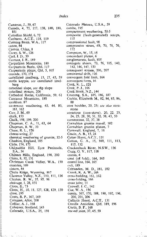
Index 235
Cameron, J., 59, 67 Canada, 4, 75, 117, 138. 140, 180,
181Canadian Shield. 6, 72 Canberra, A.C.T., 118, 119 Canning Basin, W.A., 117 canoe, 84 Canton, China, 8 Carey, S. W., 126 Carl, J. D., 39 Carman, J. E., 189 Carpathian Mountains, 180 Carpentaria Basin, Qld, 117 Carpentaria plains, Qld, 5, 105 cascade, 170, 171castellated inselberg. 13, 17, 45, 59 castle koppie, see castellated insel-
bergcataclinal slope, see dip slope cataclinal stream, 206 Cathedral Rocks, California, 59, 61 Caucasus Mountains, 180 cauldron, 87cavernous weathering, 43, 44. 80,
161, 162 Caw, J. M., 69 chalk, 153Chalk, 198. 199. 200 Chapman, C. A., 11, 63, 64 Chapman, R. W., 33 Chase, R. L., 126 cheese-wring, 27chemical weathering of granite, 32-5 Cheshire, England, 185 Chile, 174. 175Chilpuddie Hill. Eyre Peninsula,
S.A., 34Chiltern Hills, England. 198, 200 China. 8, 32, 131Christmas Creek Valley. W.A., 150 cicatrice, 109 cistern. 84Circle Ridge, Wyoming. 167 Clarence Valley, N.Z., 110, 111, 136 Clayton. R. W., 35, 95, 96 cleavage, 1. 28, 151 Cloos, E., 73Cloos, H., 10, 11, 127, 128. 129, 130 cl use, 195Coats, R. P., 167, 169 Coleman, Alice, 208 Collier, A. J., 168 Colonsay, Scotland, 143 Colorado, U.S.A., 25, 191
Colorado Plateau, U.S.A., 59 combe, 195compartment weathering, 50-5 composite (fault-generated) scarps,
115compressional fault, 98 compressive stress, 69, 70, 71, 76,
172Compston, W., 15, 16 concordant pluton, 6 conglomerate, fault, 105 conjugate sheers, 73, 76, 105, 140,
142, 146, 147. 150 consequent stream, 206, 207 continental drift. 126 convergent fold limb, 164 convergent form, 16 Cook, K. L., 121 Cook, P. J., 166 Cook Strait, N.Z., 144 Coorong, S.A., 185, 186, 187 Corbin. Elizabeth M., 82, 84, 85, 86,
88core boulder, 20, 23; see also core
stonecorestone (core-stone), 20, 22, 23,
24, 25. 28, 30, 31, 32, 38, 43, 53 cornerstone, 32, 37, 38 Cornubian granite massif, 102 Cornubian granite pluton, 7 Cornwall, England, 7, 16 Costin, A. B., 15, 24 Cotter Horst, A.C.T., 131 Cotton. C. A., 15, 109, 111, 113,
115. 132Crackenback River, N.S.W., 136 Craig. G. Y., 117, 118 craton. 4crest (of fold), 164, 165 crestal line, 164, 165 cret, 189Crittenden. M. D., 181. 182 Crook, K. A. W., 166 cross-bedding, 161, 162 cross-folding, 166 cross joint, 11 Crowell, J. C., 142 Cue. W. A., 156cuesta, 167, 170, 188, 190, 192, 196,
200, 201, 206Cullarin Horst, A.C.T., 131 Curalle Anticline. Qld, 189, 196 Curtis. B. F., 168 curved joint, 37, 45, 59
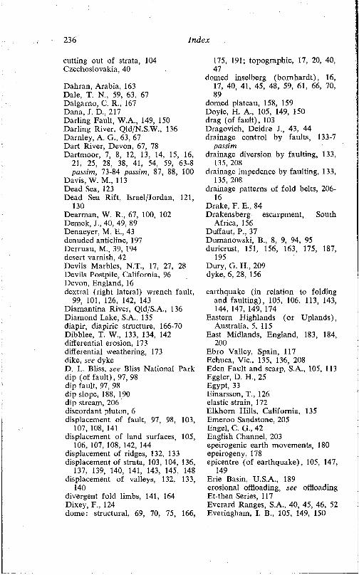
236 Index
cutting out of strata, 104 Czechoslovakia, 40
Dahran, Arabia, 163 Dale, T. N„ 59, 63, 67 Dalgarno, C. R., 167 Dana, J. D., 217 Darling Fault, W.A., 149, 150 Darling River, Qld/N.S.W., 136 Darnley, A. G., 63, 67 Dart River, Devon, 67, 78 Dartmoor, 7, 8, 12, 13, 14, 15, 16,
21, 25, 28, 38, 41, 54, 59, 63-8 passim, 73-84 passim, 87, 88, 100
Davis, W. M„ 113 Dead Sea, 123Dead Sea Rift, Israel/Jordan. 121,
130Dearman, W. R., 67, 100, 102 Demek, J., 40, 49, 89 Denaeyer, M. E., 43 denuded anticline, 197 Derruau, M., 39, 194 desert varnish, 42 Devils Marbles, N.T., 17, 27, 28 Devils Postpile, California, 96 Devon, England, 16 dextral (right lateral) wrench fault,
99, 101, 126, 142, 143 Diamantina River, Qld/S.A., 136 Diamond Lake, S.A., 135 diapir, diapiric structure, 166-70 Dibblee, T. W., 133, 134, 142 differential erosion, 173 differential weathering, 173 dike, see dykeD. L. Bliss, see Bliss National Park dip (of fault), 97, 98 dip fault. 97, 98 dip slope, 188. 190 dip stream, 206 discordant pluton, 6 displacement of fault. 97, 98, 103,
107, 108, 141displacement of land surfaces, 105,
106, 107, 108, 142, 144 displacement of ridges, 132, 133 displacement of strata, 103. 104, 136,
137, 139, 140, 141, 143, 145, 148 displacement of valleys, 132, 133,
140divergent fold limbs, 141, 164 Dixey, F., 124dome: structural, 69, 70, 75, 166,
175, 191; topographic, 17, 20, 40, 47
domed inselberg (bornhardt), 16, 17, 40, 41, 45, 48, 59, 61, 66, 70, 89
domed plateau, 158, 159 Doyle, H. A., 105, 149, 150 drag (of fault), 103 Dragovich, Deidre J., 43, 44 drainage control by faults, 133-7
passimdrainage diversion by faulting, 133,
135. 208drainage impedence by faulting. 133,
135. 208drainage patterns of fold belts, 206-
16Drake, F. E., 84Drakensberg escarpment, South
Africa, 156 Duffaut, P., 37Dumanowski, B., 8, 9, 94, 95 duricrust, 151, 156, 163, 175, 187,
195Dury, G. H„ 209 dyke, 6, 28, 156
earthquake (in relation to folding and faulting), 105, 106, 113, 143, 144. 147, 149. 174
Eastern Highlands (or Uplands), Australia, 5, 115
East Midlands, England, 183, 184, 200
Ebro Valley, Spain, 117Echuca. Vic., 135, 136, 208Eden Fault and scarp, S.A., 105, 113Eggler, D. H., 25Egypt, 33Einarsson, T., 126elastic strain, 172Elkhorn Hills, California, 135Emeroo Sandstone, 205Engel, C. G., 42English Channel. 203epeirogenic earth movements, 180epeirogeny, 178epicentre (of earthquake), 105, 147,
149Erie Basin, U.S.A., 189 erosional offloading, see offloading Et-then Series, 117Everard Ranges, S.A., 40, 45, 46, 52 Everingham, I. B., 105, 149, 150
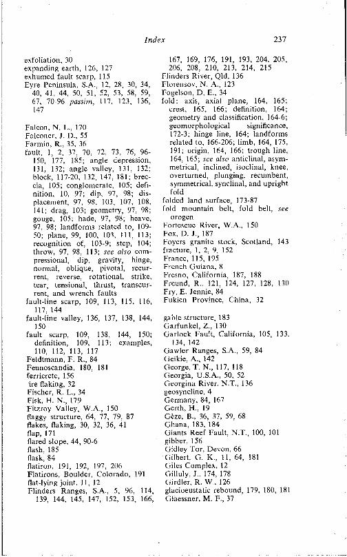
Index 237
exfoliation, 30 expanding earth. 126, 127 exhumed fault scarp. 115 Eyre Peninsula, S.A., 12. 28. 30, 34.
'40, 41, 44. 50, 51. 52, 53, 58, 59, 67. 70-96 passim, 117, 123, 136, 147
Falcon. N. L., 170 Falconer. J. D., 55 Farmin. R.. 35. 36fault, 1, 2. 37, 70. 72, 73, 76, 96-
150, 177. 185; angle depression. 131, 132; angle valley, 131. 132; block, 117-20. 132, 147. 181; breccia, 105; conglomerate, 105; definition. 10. 97; dip. 97, 98; displacement, 97, 98. 103, 107. 108, 141; drag, 103; geometry, 97, 98; gouge. 105; hade. 97. 98; heave, 97. 98; landforms related to, 109- 50; plane. 99, 100, 103, 111, 113; recognition of, 103-9; step, 104; throw. 97. 98, 113; see also com- pressional, dip. gravity, hinge, normal, oblique, pivotal, recurrent, reverse, rotational, strike, tear, tensional, thrust, transcurrent, and wrench faults
fault-line scarp. 109, 113, 115. 116, 117. 144
fault-line valley, 136, 137, 138, 144. 150
fault scarp. 109, 138. 144, 150;definition, 109. 113; examples,110, 112. 113, 117
Feldtmann, F. R., 84 Fennoscandia. 180, 181 ferricrete, 156 ire flaking, 32 Fischer. R. F.. 34 Fisk. H. N., 179 Fitzroy Valley, W.A., 150 flaggy structure, 64, 77, 79. 87 flakes, flaking. 30, 32, 36. 41 flap. 171flared slope, 44. 90-6 flash. 185 flask, 84flatiron, 191, 192, 197. 206 Flatirons, Boulder, Colorado, 191 flat-lying joint. 11,12 Flinders Ranges, S.A., 5, 96, 114,
139, 144, 145, 147, 152, 153, 166.
167, 169. 176. 191, 193, 204. 205, 206. 208, 210. 213, 214. 215
Flinders River, Qld. 136 Florensov, N. A., 123 Fogelson. D. E., 34 fold: axis, axial plane, 164, 165;
crest, 165, 166; definition, 164; geometry and classification. 164-6; geomorphological significance, 172-3; hinge line, 164; landforms related to, 166-206; limb. 164, 175, 191; origin, 164, 166; trough line. 164, 165; see also anticlinal, asymmetrical, inclined, isoclinal, knee, overturned, plunging, recumbent, symmetrical, synclinal, and upright fold
folded land surface, 173-87 fold mountain belt, fold belt, see
orogenFortescue River, W.A., 150 Fox. D. J., 187Foyers granite stock. Scotland, 143fracture. 1, 2. 9, 152France. 115, 195French Guiana, 8Fresno, California, 187, 188Freund, R.. 121, 124. 127. 128, 130Fry, E. Jennie. 84Fukien Province, China, 32
gable structure, 183 Garfunkel, Z.. 130Garlock Fault, California. 105, 133.
134. 142Gawler Ranges, S.A., 59. 84 Geikie. A., 142 George. T. N„ 117. 118 Georgia, U.S.A., 50. 52 Georgina River, N.T.. 136 geosyncline, 4 Germany. 84, 167 Cierth. H.. 19 Geze. B.. 36, 37. 59, 68 Ghana. 183, 184Giants Reef Fault, N.T., 100, 101 gibber. 156Gidley Tor, Devon, 66Gilbert. G. K , 11, 64, 181Giles Complex, 12Gilluly. J.. 174, 178Girdler, R. W.. 126glacioeustatic rebound, 179, 180, 181Glaessner, M. F., 37
238 Index
globular structure, 183 gnamma, see weather pit gneiss, 23, 25, 28, 50, 75 gneiss dome, 6, 75 Goldich, S. S., 9, 33 Gondwana surface, Africa, 56 Gorge Rock, W.A., 51 Gosses Bluff. N.T., 166 gouge, fault, 105graben, 109, 118, 120-31, 138, 150,
173; see also rift valley Grampian Mountains, Scotland, 142 Grampians, Vic., 189 granite, 2, 4, 96; crystalline struc
ture, 7-9; landforms developed on, 14, 18-96; mineralogy, 7-9; occurrence, 4, 5; origin, 4, 7; outcrops in Australia, 5; weathering, 1; 8, 23, 24, 25, 28-39, 50, 52, 54
granitisation, 36, 58, 69 Granitrillen, 89, 90 Grant, C. Kerr, 105 Grant, U. S., 174Grantz. A., 105, 106 ,granular disintegration, 30, 32, 41 gravitational pressure (on plastic
clays), 183-5gravity anomaly, 72, 125-31, passim gravity collapse structure, 17, 170,
171, 198gravity controlled structure, see
diapirgravity fault, 97 Great Artesian Basin, 5, 144 Great Australian Bight, 62, 147 Great Basin. Utah, 49, 181 - Great Glen, Scotland, 100, 142, 143.
144Great Salt Lake, Utah, 181 Greenfield, Mildred A., 33 Greenland. 68, 73 Greenwood. George, 217 Gregory, J. W., 121, 129, 138 Griggs. D. T., 33 groove, see gutter growan, 23-4grus, gruss. 22. 23-4. 30, 33 Gulf of Aden. 125, 126 Gulf of Arabia, 121 Gulf of Bothnia, 180, 181 Gulf of Mexico. 179 Gulf of Suez, 121 Gutenberg, B., 181
gutter, 40, 81, 89, 90, 94 gypsite, 151, 152 Gzovsky. M. V., 130
Haddon Syncline, Qld, 189 half dome. 48, 49 Hallein, Austria, 208 Hamersley region. W.A.. 4, 150, 154,
163Hampshire Basin, 198, 199, 200 Handley, J. R. F., 55 hanging valley, 109 Hansen, W. R., 105 Harhagit Ridge, Libya. 94 Harford. L. B.. 136 Harris, G. F., 77 Harris, W. J., 136 Harrisburg, Pa., 214 Harrisburg peneplain, 204 Harrison, J. V., 170 Harrisons Creek, S.A., 18 Harriss, R. C., 33 Harts Range, N.T., 45 Harz Mountains, Germany, 7 Haytor, Devon, 12, 13, 21, 32 headward erosion, 212-16 passim ‘heart of the block', 20, 21 heave (of fault), 97, 98 Helderberg escarpment, N.Y., 203 Heitor. Devon, 12, 78, 87 Highland Boundary Fault, Scotland.,
117Hill, M. L., 133, 134. 141. 142 Hills, E. S., 10. 11, 15. 24, 101, 117.
122. 171hill-plain junction, 218 Himalaya, 4, 178, 179 hinge fault, 99 hinge line (of fold), 164 hogback. 167, 170, 190, 192, 194,
196, 198. 200. 206 Högbom, B., 43Hoggar Mountains, Algeria, 28 Hogs Back, England, 200 Hollingworth, S. E., 68, 174, 175,
183, 184Holmes, A., 58. 132, 178 homeomorph, see convergent form homoclinal ridge, 189. 190, 213 Hong Kong, 23, 24, 30 Llook Island. Qld. 28 Hooke, R. le B., 42, 43 Horseshoe Range, S.A., 214
Index 239
hörst, 109, 118, 123, 131, 132, 147, 150, 184, 185
Horwitz, R. C., 177 Houng-Yi Chang, 42, 43 Hudsons Bay, Canada, 180 Hume, W. F„ 20 Humps, The, W.A., 83, 84 Hurault, J., 8, 49 Hutchins, P. F., 67 Hutt Valley, N.Z., 132 Hutton, James, 217 Hyden, W.A., 83 Hyden Rock, W.A., 51 hydrostatic pressure, 11, 64 hydrothermal action, 39
Iberian Peninsula, 119 Iceland, 123, 125, 126, 131 Ichikawa, K., 118, 120 Ige Basin, Japan, 118 igneous melt, order of crystallisa
tion from, 8, 152 ignimbrite, 174, 175 Ikebe, N., 118, 120 imbrication, 69 impermeability, 13, 153, 154 impression (of valleys), 211, 212 inclined fold, 164 India, southern, 23, 69 Indo-Gangetic Plain, India/Paki
stan, 179ingrown meander, 13, 153, 154 inheritance, concept of, 208, 216 Innamincka, S.A., 175, 187 inselberg, 12, 16; castellated, 17;
characteristics, 45-96; definition, 17, 45; distribution of, 49, 73; domed, 16, 17, 40, 41. 45, 48, 59, 61, 66, 70, 89; joint pattern, 46; occurrence in multicyclic landscapes, 55, 71, 74; origin of, 15, 45-80; shape in plan, 50, 51; shape in profile, 13, 59-80; two- stage evolution of, 50-5
Insley, H„ 29, 39, 86 insolation hypothesis of weathering,
32, 33, 63, 64, 79 intrenched meander cut-off, 209 inversion of relief, 79, 90, 163, 164,
194, 195, 204, 205 Iran, 167, 170, 191, 192, 194, 197 Isa Highlands, Qld, 7, 105, 117 Isaacson, E. de St Q., 69 Ise Basin, Japan, 118
‘island mountain’, see inselberg Islay, Scotland. 143 isoclinal fold, 165, 166, 192 isostasy, 178isostatic movements, 179, 180, 181,
182Israel, 121, 123, 130
Jack, R. L„ 161Jackli, H. C. A., 181Jackson River, N.Z., 136Jaeger, J. C., 34James Range, N.T., 191Japan, 106, 108, 118, 120, 178Jennings, J. N., 96jogged stream, 133, 134, 142Johns, R. K.. 145, 148Johnson, D. W„ 109, 113, 206, 218Johnson, W., 167joint, 1, 2. 4, 9-12, 75, 152, 159, 160,
173; block, 12, 13, 28, 40, 45, 47, 53, 54; definition, 10; condition (open or tight), 10, 66/69; geometrical sets, 11, 12, 28; origin, 10, 11; peneprimary, 63; primary, 10; significance of, 13, 14, 27, 28, 86; spatial distribution, 11, 12, 28, 52; types, 11, 12; vertical distribution, 57, 58; see also flat-lying, lamination, longitudinal, orthogonal. stretching, and tension joints, and sheet structure
Jones, T. R., 13, 15, 20, 25, 27, 32, 37, 68. 82, 84, 87
Jordan. 121, 130, 154 Jos Plateau, Nigeria, 54 Juniata River, Pa., 214 Jura, France, 125, 195 Jura type of relief, 194, 195 Jutson, J. T., 150
Kachadoorian, R., 105, 106 Kaikoura Range, N.Z., 111 Kangaroo Island, S.A., 149 Kanmantoo Series, 58 Kanyaka Creek, S.A., 210 Karkonosze Mountains, Poland, 8 karst, 3, 153, 204 Katherine, N.T., 159 Katherine River Gorge, N.T., 160 Kaukau surface, N.Z., 106 Kellaway, G. A., 183, 184 Kent, England, 198 Kennedy, W. Q., 142
240 Index
Kenya, 106. 121, 127 kernel. 20, 24, 25 Kessler. D. W., 29, 39. 86 Kestor, Devon, 63, 87 Kieslingen A., 67Kimberleys, W.A., 4, 117, 150, 154,
159. 161King, L. C , 16. 50, 52, 55, 57, 59,
71. 123, 126, 157, 159, 218 King, P. B.. 106, 142 King Leopold Ranges, W.A., 156 Kinki district, Japan, 118, 120 Kinzl, H., 19Kiso River, Japan, 106. 108 Kjartansson, G.. 126 Klaer. W„ 9 Kleeman, A. W., 15, 16 knee fold. 170, 171 Knott. S. T., 126 Kolar goldfield, India. 69 Kosciusko region, N.S.W., 41, 81,
96Kranck. E. H., 73 Kulgera Hills, N.T.. 82, 84 Kulpara Fault. S.A., 136 Kwagia River, New Guinea, 137
Labrador Trough. Canada, 4, 140laccolith, 6. 170Lafitte, R., 129lag thrust fault, 98Lake. P., 23Lake Albert, East Africa, 130 Lake Baikal, U.S.S.R., 123 Lake Blanche. S.A.. 145 Lake Bonneville, 181, 182 Lake Bumbunga, S.A., 135 Lake Callabonna, S.A., 145 Lake Chad region, central Africa,
36, 37, 59. 68 Lake Cooper. Vic., 135 Lake District, England, 208, 209 Lake Duffault, Canada, 7 Lake Edward, East Africa, 130 Lake Eyre. S.A., 145. 146. 148, 152,
156Lake Frome, S.A., 145, 146Lake George, N.S.W., 135Lake George Rift, N.Y., 121, 122Lake Gregory. S.A., 145Lake Lahontan, 181Lake Mead, Nevada. 181Lake Rudolph, Kenya, 127Lake Thingvallavatur, Iceland. 124
Lake Tiberias, Israel, 123 Lake Torrens, S.A., 135, 139, 145,
146, 148, 159Lake Victoria, central Africa, 117 Lambert, I. B., 100 lamination. 12, 35, 59. 60, 64, 75,
86; age, 78, 79, 80; distribution, 77 landforms related to faults and
faulting, 109-50landforms related to flat-lying strata,
154-64landforms related to folds, 166-206 landforms related to granite out
crops, 20-96 Lane, E. W., 17 Larsen, E. S„ 17, 23, 30, 33 Larson, E. E., 25 lateral compression, 69. 70, 71 latente, 156, 163 Laudermilk. J. D., 84 Laurentian Shield, see Canadian
ShieldLautensach, H., 9, 33 Lawson, A. C., 138, 218 Lebanon Mountains, 127 Leeman, E. F.. 69 Lees, G. M„ 174left lateral wrench fault, see sinis-
tral wrench fault Leigh, C. H., 50, 51, 63, 96 Leigh Creek. S.A., 192 Leonard. R. J., 41 Lester. J. G., 50 Levant, 121. 122, 123, 124 Levi Fault. S.A., 106, 108 Lewis, W. V., 25. 65 Libya, 94. 95 Liesegang reaction, 39 Lima. Peru. 19limestone, 9, 151, 152. 153. 204Lincoln Edge, England, 200Lincoln Fault. S.A., 147Lincoln Gap, S.A., 158Lincolnshire, England, 201lineament, 117linear depression, 35, 95Linton, D. L.. 13, 15, 20. 23, 25, 40.
49, 55. 198, 199 lithology, 21. 151-9 Little Dome, Wyoming, 167 Little Mis Tor, Devon, 66 Little Shuteye Pass, California. 65 Little Wudinna Hill, Eyre Penin
sula, S.A., 90
Index 241
Ljungner, E., 59local superimposition, 208, 210 Loch Linnhe, Scotland, 143 Loch Lochy, Scotland. 143, 144 Loch Ness, Scotland, 143 Loch Oich, Scotland, 144 Lofgren, B. E., 187, 188 loganstone, 27, 161 London Basin, 198. 200 Long Beach, California, 174 longitudinal joint, 11 lopolith, 6Los Angeles, California, 174, 185 Louis, H., 49 Louisiana, U.S.A.. 167 Ludbrook, N. L., 145 Lustleigh Fault. Devon, 100 Lyons River, W.A., 158
Mabbutt, J. A., 13, 15, 27, 95, 156 MacCallien. W. L, 183, 184 McConnell. R. B., 100, 121, 124,
130, 131MacCulloch, J., 82, 84 MacDonald Fault, Canada, 117 McGee. W. L, 218 MacGregor, A. M., 69. 70 Machatschek. F., 119 McKinney, T., 43 Mackintosh, D., 12, 77 Maclaren, M., 84 Macleod, W. N., 154 McMahon, C. A.. 64. 79 McMurdo Sound, Antarctica, 181 McWhae, J. R. H„ 149, 150 Maggies Springs, Ayers Rock. N.T.,
95magmatic intrusion, 4. 7, 36, 166 Malay Peninsula, 23, 28 mamillation (in tafoni), 161 man-made or induced features, 181,
185-7Mannum. S.A., 18marginal weathering of granite
boulders, 28-39 de Martonne, E., 49, 188 Massachusetts, U.S.A., 63 Massif Central, France, 115, 201 matopos, 48 Matsudu, T., 106. 108 Matthes, F. E., 65, 82 Maverick Domes, Wyoming, 166,
167, 168Meckering, W.A., 105, 107, 150
Meinesz, F. A. V., 127, 128Meldon Hill, Devon, 66Mercherikov, Y. A., 180Merrill, G. P., 77Merrivale Quarry, Devon, 63mesa, 154-64Mesopotamia, 174, 208metasomatism, 4, 7, 36, 58meteor impact, 166Mexico City, Mexico, 187Mid-Atlantic ridge, 126Midland Valley, Scotland, 117, 118Milendella Fault, S.A., 18, 37Miles, K. R., 123, 136Miller, R. P„ 163Mills, K. J„ 37mineral layering or banding, 31, 32,
35, 36Mingan-Natashquan area, Canada,
75Mississippi delta. U.S.A., 179 Mississippi valley, U.S.A., 179 Mistor Pan, Devon, 88 Mohave Desert, California, 174 Mohr, P. A., 121 Mohr scale, 151, 152 Moine Thrust Fault, Scotland, 143 Monaro, N.S.W., 24, 54 monk stone, see penitent rock monocline, monoclinal flexure. 100,
147, 174 mont, 195Moolawatana, S.A., 176 Moray Firth, Scotland, 142 Morrison, R. B., 181 morros, 48, 58. 69 mound spring, 139, 145, 146 Mt Bruce. W.A., 154 Mt Lindsay, S.A., 40 Mt Lofty Ranges, S.A.. 5. 8, 18, 37,
40, 58. 96, 112, 131, 144, 147, 149. 205
Mt Margaret Fault, S.A., 106, 108 Mt Margaret Range, S.A., 108 Mt Murchison, N.Z., 105 Mt Painter, S.A., 19 Mt Ruwenzori, central Africa, 123,
127, 130, 131, 132 Moye, D. G., 69Mozambique, southern Africa, 58 mullion structure, 73, 104 Murchison, R. I.. 142 Murray Basin. S.A., 147, 153 Murray plains, 58, 96
242 Index
Murray River, 135, 136, 208 mushroom structure, 183 Musgrave Ranges, S.A., 20 mylonite, 105, 143
Navajo Formation, 162 Nara Basin, Japan, 118 negative exfoliation, 36, 162 Needles, The, South Dakota, 60 Nelson, H. J., 186neutral plane or surface (in fold),
172Nevada, U.S.A., 181 New England, N.S.W., 50, 63, 96 New England, U.S.A., 59, 66, 67, 73 New Guinea, 137 New Jersey, U.S.A., 204 New York State, U.S.A., 121, 122,
203New Zealand, 105, 106, 109-14 pas
sim, 132, 133, 136, 143-7 passim Nichols, R. L., 181 Nielson, R. A„ 16, 23, 29, 38, 55 Nigeria, 15, 50, 52, 54 Nile delta, Egypt, 179 Noldart, A. J., 16 normal fault, 97, 98, 121 normal thrust fault, 98 Norman River, Qld, 136 Normandy, France, 203 North Dakota, U.S.A., 59 North Downs, England, 200 North West Territory, Canada, 117 North York Moors, 201 Northamptonshire, England, 183,
184, 201Northern Territory, 47, 49, 51, 95,
100, 101, 156, 191Northwest Flighlands, Scotland, 142 Norway, 67, 123 Norwest Fault, S.A., 147
Oberländer, T., 197, 208, 212 oblique fault, 97, 98 obsequent fault-line scarp, 115, 116 obsequent stream, 206, 207, 214 Obst, E., 55, 71offloading, 11, 64-8; see also pres
sure releaseoffset ridge, 132, 133, 140, 141 offset stream, 132, 133, 134, 138, 142,
144Okhor Island, US S R . , 123 Olgas, N.T., 47, 49, 51, 68, 96
Ollier, C. D., 24, 32, 35, 39, 50, 52, 55, 56
onion weathering, 30, 31, 33, 35 Ontario Basin, Canada, 189 Ophthalmia Ranges, W.A., 154 Öpik, A. A., 118, 119, 178 organic slime, see algal slime Orme, A. R„ 67, 79 Ormerod, G. W., 37, 82, 84 orogen (fold belt), 4, 5, 144, 151 orogeny, 4, 178orthogonal system (of joints), 12,
13, 37, 45, 59, 69, 77, 155 Osaka Basin, Japan, 118 Oslo Fjord, Norway, 123 overloading of plastic clays, 171,
183-5overturned fold, 165 Owhariu-Kakaho Fault, N.Z., 146
Pacific basin, 126 Pacific Ocean, 140 Pallister, J. W., 156 Palmer Granite, 8. 18, 25, 28, 29, 30,
31, 32, 37, 42Palmer, J , 16, 23, 29, 38, 40, 55 Palmer, S.A., 18, 31, 32, 41, 42 Palmer Fault, S.A., 18, 37 pan, 81, 82Para Fault and scarp, S.A., 113 Paraiba Graben, Brazil, 123 Paralana Creek, S.A., 177 Paralana Fault, S.A., 147, 177 Paralana Flot Springs, S.A., 177 Paris Basin, 200, 201, 202, 203 Passarge, S., 55 Paterson, M. S., 104 Peake and Denison Ranges, S.A.,
106Pearson Island, S.A., 51, 62 pedimentation, 57 Peel, R. F., 95 penitent rock, 28, 29 Pennine upland, England, 40 Pennsylvania, U.S.A., 203, 204, 214 perched rock, block, or boulder, 27,
161periclinal structure, 166 pericline, 166permeability, 9, 10, 14, 39, 153 Persian Gulf, 169persistence (of streams), 210, 211,
216Peru, 19

Index 243
perviousness, 9, 10, 153 Pettijohn, F. P„ 17 phacolith, 6 Philippines, 126Picard, L., 121, 122, 123, 124, 130 Picardy, France, 203 Pic Parana, Brazil, 72 piedmont angle, 218 Piedmont region, southeastern
U.S.A., 52, 82Pildappa Hill, S.A., 51, 82, 86, 87,
89, 90, 94Pile of Logs, Hook Island, Qld, 28 pillars (on granite), 27 Pinchemel, P., 201 pit. 81, 83pitch (of fold), 164 pivotal fault, 99, 100, 113 Plafker, G„ 105, 106 plastic clay, 183-5 plateau, 154-64; domed, 158, 159 platform, 5, 144, 151 plunge inclination, 164 plunging fold, 164, 191, 196, 203,
214plutonic body, 6, 10 plutonic rocks, 4, 6 pneumatolysis, 29, 39 Point Arena, California, 140 Poland, 8polygonal weathering, 41 porosity, 9, 10 Port Augusta, S.A., 147 Port Phillip Bay, Vic., 117 Pound Sandstone, 153, 205 Powell, J. W„ 190 Prairie Terrace, U.S.A., 179 pressure release (erosional offload
ing, offloading), 11, 35, 36, 41, 64-8, 79
Price, N. J., 10 primary permeability, 9, 10 pseudobedding, 12, 35, 64, 75, 77,
87Pullan. R. A., 40 Puna surface, Chile, 174 Pumpelly, R., 13, 21 Puttapa Gap, S.A., 192 Pyrenees, 7
qanat, 174Qishin Island, Persian Gulf, 169 quaquaversal dip, 166 quartzite, 152
Quebec, Canada, 75, 140 Queensland, 28, 105, 175, 176, 178 Quennell, A. M., 121 Quincy, Mass., 63 Quom, S.A., 214, 215
Radley, J., 40 rake, 164Rathjen Gneiss, 29 recrystallisation (along faults), 73,
104recumbent fold, 165, 170 recurrent fault or faulting, 109, 132,
150Red Sea, 121, 125, 126 redistribution of mass, geomorpho-
logical effects, 166-9, 178-87 Reedy Creek, S.A., 40 regressive erosion, see headward
erosionReid, C , 23, 88relief inversion, 29, 90. 163, 164,
194, 195, 204, 205 repetition of strata, 104 resequent fault-line scarp, 115, 116 resequent stream, 206 resistance of rocks (to weathering
and erosion), 151-4 reverse fault, 98, 99, 105, 123, 130 reverse scarplets, 111, 113 Rhine Rift, 121, 124, 126, 131 Rhodesia, 69, 70Ridge and Valley Province, Appala
chian Mountains, 203, 214 ridge and valley topography, 167,
187, 191, 200, 201, 203 Riesengebirge, see Karkonosze
Mountainsrift valley, 109, 118, 120-31, 138,
150, 173; ages, 124, 125; characteristics, 121-3; compressional hypothesis, 130; definition, 121; examples, 121, 129; experimentaldevelopment of, 127, 129; keystone hypothesis, 129-30; origins, 126-31; tensional hypothesis, 127- 9; vertical movement hypothesis, 130; wrench faulting hypothesis, 130
rift zone, 120right lateral wrench fault, see dex-
tral wrench fault Rillen, see gutter ring complex, 6
244 Index
Rio de Janeiro, Brazil, 47, 48, 70 Rioux, R. L., 63 rock flour, 105Rock of Ages Quarry, Barre, Ver
mont, 63Roer Valley, Germany, 121 Rondeau, A., 37rcof and wall structure, 170, 171 rotational fault, 99, 100 Round Mountain, New England,
N.S.W., 50 Rowan, I. S., 72 Ruellan, F., 33 Ruhr Valley, Germany, 121 Russia, European, 180 Russian platform, 5 Rutland, R. W. R„ 126, 174, 175 Rutten, M. G., 126 ruware, 49, 58Ruwenzori, see Mt Ruwenzori Ruxton, B. P„ 13, 23, 24, 30. 33, 35,
54, 77, 95, 183, 184 ruz, 195
sag basin, 135 sag pond, 135, 138 Saggerson, E. P., 106, 121, 127 Sahara desert, northern Africa, 95 St Vincent Gulf, S.A., 147 Salar de Atacama, Chile, 174, 175 salinas, tectonic origin of, 144, 145 salt dome, 166, 167, 169 Salzach River, Austria, 208 San Andreas fault (rift zone), 100,
105, 126, 132-42 passim San Bernadino, California, 174 sandstone, 9, 152, 154, 155. 203, 205,
215San Joaquin Valley, California, 187,
188scarp foot depression, see linear de
pressionscarp retreat and pedimentation,
57, 126Scarth. A., 115, 116 SchefTerville. Canada, 140 Schneider, E., 19 Schrepfer. H., 49 Schümm, S. A., 208 Scotland, 40, 100, 117, 118, 143 Scrivenor, J. B., 20, 23, 28 secondary fractures: related to
faulting, 73, 76, 105, 140, 142, 146, 147, 150; related to joints, 10
secondary permeability (perviousness) , 10
Selwyn Upwarp, Qld, 178 Sermasoq, Greenland. 68, 73 Shalcr, N. S„ 37 Shand, S. J., 143 Shansi plateau, China, 131 Sharp. R. P., 42, 135, 138 shatter belt or zone, 144-9 Shaur Anticline, Iran, 174 sheet structure, 11, 12. 37, 40, 45,
49, 59, 60, 62-77, 79; age of, 63, 66, 67, 68; characteristics of, 62; depth of, 63; lithologic distribution, 59-68; origins, 59-77
Sheppard. W. E., 174 shield. 4. 5shutterridges, 132, 133, 138, 144 Sierra Estralita, Spain, 131 Sierra Guadaverra, Spain, 131 Sierra Nevada, California, 25, 30,
65, 96Sierra Nevada Batholith, California,
23, 33silcrete, 156, 175, 187, 195 Silikatrillen, 89 sill, 6, 156 Simpson, S., 67 Sinai Peninsula, 20, 122, 123 sinistral (left lateral) wrench fault,
99, 101, 107, 126 Skeleroo Creek, S.A., 215 Skeleroo Gorge, S.A., 215 slickensides, 68, 69, 73, 104 Sligh, W. H„ 29, 39, 86 slip (of fault), 97. 98, 100 slip sheet, 170, 171 Smith, L. L., 82 Smith, W. E., 67Snowy Mountains, N.S.W.. 24, 30,
31, 32, 35, 36, 43 Soen. Oen Ing, 64, 68, 73, 79 Soissonais, France, 203 South Africa, 159South Australia, 24, 35, 76, 144, 148,
175, 176, 195South Australian shatter belt or
zone, 144-9South Dakota, 60, 169, 170 South Downs, England, 200 Southern Upland Fault. Scotland.
117southwestern peninsula of England,
7, 15, 16, 23, 27, 45, 55, 77, 102
Index 245
Spain, 117, 119, 131 spalling, 41Spencer Gulf, S.A., 123. 147 spheroidal weathering, 30, 31, 33, 36 spire (on granite), 28 split boulders, 41. 42 Sprigg, R. C., 112, 176 Stapledon, D. H., 34, 80 Steel, T. M„ 37steepened slope, see flared slopestep (fault), 104stepped topography, 25-7Stevens, G. R.. 106stock, 6stone, 20Stone Mountain, Georgia, 50, 52 Strahler, A. N., 170, 212 stream capture, 215, 216 stream diversion, 133, 135, 208 stream persistence. 210, 211, 216 stream piracy, 215, 216 stretching joint, 11, 68 strike fault. 97, 98 strike stream, 206. 214 Strontian granite mass, Scotland,
143structural benches, 154, 156, 161,
163structural geomorphology, 1, 217,
218structural landforms: sensu lato. 1,
2, 218; sensu stricto, 1, 20-41, 45- 59, 109, 115-17, 133-8, 154-64, 187-95
structural plain, 154, 156 structure, geomorphological mean
ing of, 1Strzelecki Creek. S.A., 136, 147 subaerial development of boulders,
39-41subaerial development of inselbergs,
55-8submarine rift, 126 subsequent stream, 206, 207 subsidence of land surface, 185-7 subsurface development of bould
ers, 20-39 Sudan. 35sugar loaf, 45, 47, 58. 70, 72 Sugden, D. E., 79 Sugimura, A.. 106, 108 superimposed drainage, 208. 210,
212
superimposition, concept of, 208, 216
Surinam, 81Susquehanna River, Pa., 214 Sussex, England, 198 Sutton, D. J., 105, 149, 150 Sweden, 181 Switzerland, 181 symmetrical fold, 164 syncline, synclinal fold, 66, 164, 165,
173, 175, 176, 194 synclinorium, 164, 205 synform, 65, 66, 164, 173 Syria, 125
tafoni, 36, 43, 44, 80, 162 Taft, California, 135 Taliaferro, N. L., 142 Talobre, J., 69 tang, 170, 196, 212 Tanganyika, 127 Tasmania, 40, 81Tassili Mountains, Algeria, 52, 154,
155Tavy River, Devon, 78 Taylor. J. H„ 183, 184 Taylor, T. G., 178 tear fault, 99tectonic landforms, 107-15, 173-8;
definition, 1, 109 tectonic unit, 4, 5 Teign River, Devon, 67, 78 Tenaya Lake, California, 66 Tennessee, U.S.A., 43 tension joint, 11, 69 tensional fault, 97 tensional stress, 172 Texas, U.S.A., 167 Thiele, E. L„ 55, 58 Thingvellir, Iceland. 124 Thomas, M. F„ 15, 35, 50, 52, 54 Thompson, H. D„ 204, 212, 218 Thorarinsson, S., 125, 126 Three Sisters, N.S.W., 157 throw (of fault), 97, 98, 113 thrust fault, 98, 99, 143, 203 tombstone, see penitent rock tongue-shaped structure, 183 Tooma Dam, N.S.W., 31, 32 tor, 14. 15, 16, 17Torrens River and valiey, S.A., 79,
171, 209tortoiseshell rock, 44 Towamba River, N.S.W., 136
246 Index
tower, 15transcurrent fault, 99, 121, 126, 130 travertine, 163trellis drainage pattern, 207, 214 Trendall, A. F„ 35, 54, 77, 95 triangular face, 109-14 passim Tricart, J., 188trough line (of fold), 164, 165 Tschang Hsi-Lin, 89 turret, 28, 59, 60, 61, 157 Twidale, C. R„ 19, 52, 55, 82, 84,
85, 86, 88, 90, 92, 96, 105, 118, 135, 136, 145, 156, 178, 191, 193, 208, 214. 215, 216, 218
two-stage development: of boulders, 20-39; of flares, 92-4; of insel- bergs, 50-5
Tyrol, Austria. 208 Tyrrell, G. W„ 63
Ucontitchie Hill, S.A., 44, 52, 53, 71, 74, 91
unbuttressing, 80, 170, 171 upright fold, 164 U.S.A., 34, 67, 81, 106, 109 U.S.S.R., 180Utah, U.S.A., 49, 59, 121, 162, 182
val, 195Valentin, H., 181 valley bulge, 183 valley impression, 211, 212 valley-in-valley form, 111 varied resistance of rocks, 151-4 Vermont, U.S.A., 63, 76 Victor Harbour, S.A., 32, 58, 68 Victoria, 24, 35, 50, 117, 189 Victorville, California, 174 volcanic features, 3, 156, 157, 163 Vosges, France, 131
Waddikee Rocks, S.A., 59 Wahrhaftig, C , 25, 26, 27 Wallace, R. E., 134 Wallwork, K. L., 185 Wangaratta, Vic., 117 Walton, B. J., 183, 184 Warth, H., 32warped land surface, 106, 173-87 Waters, R. S.. 8, 23, 54, 79, 218 Wave Rock, W.A., 92 Wayland, E. J., 130 Weald, Kent, 198, 200
Wealden Anticline, 199, 200 weather pit (gnamma), 40, 80, 81-9 weathering front, 27 wedges (of granite), 68, 71 Weiblen, P. W., 42, 43 Wellington, N.Z., 106, 146, 147 Wellington Fault, N.Z., 146 Wellman, H. W., 43, 105, 133, 143,
145Wensink, H., 126 Wentworth, C. K., 81 Werfen, Austria, 208 Wertaloona, S.A., 176, 177 West Australian Shield, 5, 54, 144,
205Western Australia, 5, 16, 50, 51, 84,
95, 105Western Cordillera, Canada, 138 whaleback, 20, 49, 58 wheat belt, W.A., 50, 52, 96 White, A. J. R., 15, 16, 100 White Creek Fault, N.Z., 105 White, W.A., 52, 84 Whiteman, A. J., 126 Whitsunday Group, Qld, 28 Wilhelmy, H„ 32, 49, 84 Williams, G., 13, 15 Willis, B., 55Willochra Creek, S.A., 210 Willunga Fault and scarp, S.A., 113 Wilpena Homestead, S.A., 215 Wilpena Pound, S.A., 166 Wilson, A. T., 43 Wilson. R. C , 55, 58 wineglass valley, 109, 113 Wolff, R. G., 33 Wooldridge, S. W., 198, 199 woolsack, 17, 27Wopfner, H., 106. 108, 145, 156,
175, 189Worth, R. H., 23, 82, 87, 88 Wray, D. A., 58wrench fault, 99, 100, 101, 102, 107,
130, 132, 142, 143 Wudinna, S.A., 52 Wyatt, J. D., 16Wyoming, U.S.A., 25, 166, 167, 168
xenoliths, 58
Yarrah Vale, S.A., 215 Yarwondutta Rocks, S.A., 51, 79,
82, 90, 92
Index 247
Yorke Peninsula, S.A., 123, 136, 147, 149
Yorkshire, England, 200, 201 Yosemite National Park. California,
48. 59, 61, 66, 76, 78, 81, 83
Zagros Mountains, Iran, 170, 171 191-7 passim, 208, 212
Zak, I., 130Zemitz. Emilie R., 206, 207 Zion National Park, Utah, 162
ABOUT THE AUTHOR
C. R. Twidale is a graduate of the University of Bristol and of McGill University. Formerly a geomorphologist with the Australian CSIRO Division of Land Research, he is now Reader in Geography at the University of Adelaide. His long residence in South Australia, with its particularly interesting regions of past and continuing faulting and folding, must be held largely responsible for his special interest in structural geomorphology.
Dr Twidale is also the author of Geomorphology, with special reference to Australia (1968), and joint author of Landforms Illustrated (with M. R. Foale, 1969) and Arid Lands (with R. L. Heathcote, 1969).
Book designed by Arthur Stokes.Text set in 10/12 Intertype Times Roman and printed on 103 gsm Paracote Matt, by Halstead Press Pty Ltd, Sydney.
C. R. Twidale is a graduate of the University of Bristol and of McGill University. Formerly a geomorphologist with the Australian CSIRO Division of Land Research, he is now Reader in Geography at the University of Adelaide. His long residence in South Australia, with its particularly interesting regions of past and continuing faulting and folding, must be held largely responsible for his special interest in structural geomorphology.
Dr Twidale is also the author of Geomorphology, with special reference to Australia (1968), and joint author of Land- forms Illustrated (with M. R. Foale, 1969) and Arid Lands (with R. L. Heathcote, 1969).
Photograph of laterite-capped residual hills, northwest Queensland, by courtesy of CSIRO
Jacket designed by Arthur Stokes
Printed in Australia
An Introduction to Systematic Geomorphology
Seven volumes are at present planned for this series.
1 Humid LandformsI. Douglas (1971)
2 Desert and Savana LandformsJ. A. Mabbutt (1972)
3 Landforms of Cold ClimatesJ. L. Davies (published)
4 CoastsE. C. F. Bird (published)
5 Structural LandformsC. R. Twidale (1970)
6 VolcanoesCliff Ollier (published)
7 KarstJ. N. Jennings (1971)
Further details are available from the A.N.U. Press, P.O. Box 4, Canberra, A.C.T. 2600, Australia.