Embed Size (px)
Citation preview
UNIVERSITY OF KERALA
Syllabus
MSc Geology with specialization in Geoinformatics
1
MSc Geology with specialization in Geoinformatics
9 Oct 2020
Dr AP PradeepkumarChairman, PG BOS in Geology
University of Kerala
M.Sc. Degree Course in Geology with specialization in Geoinformatics
(Outcome-based education OBE syllabus)
(Effective from 2020 Admissions)
About the course
NeedIn this time of global uncertainty over the Covid19 pandemic, and the disruptions in highereducation it has wrought, through reduced ability to travel, and fewer opportunities for classroomteaching and learning, it is imperative that the young generation should be offered courses whichare unconventional, but needed in today’s world. The M.Sc. Degree Course in Geology withspecialization in Geoinformatics is an outcome of such a thought process. Young geologists whoare trained to tackle geological problems, offer solutions on the go and also make use of thelatest spatial planning tools are an urgent need. This is especially so in the context of depletingnatural resources, and multiplying natural disasters, amidst the philosophy of sustainabledevelopment. Also the course will bring in geoinformatics firmly into geology education, therebyenhancing the skill set of students.
Objectives Creation of a pool of skilled and technically qualified geologists who would be industry-
ready, both in core geology as well as in IT-oriented geology fields like geoinformaticsetc.
Creation of skilled geologists who can meld core geology with IT skills, therebycontributing directly to the Make-in-India endeavour
Creation of resourceful geologists who would be grounded in science, but technicallyequipped to tackle geological challenges, adopt spatial planning techniques in problemsolving, and disaster management.
PhilosophyThis Masters in Science in Applied Geology and Geoinformatics is unique in Kerala. Thecurriculum brings within its ambit the best of basic geology and trains the students to apply it inreal life geology – ranging from resource exploration and exploitation using core geological toolsto disaster mitigation and management to spatial planning and resource management usingcutting edge tools of remote sensing, photogrammetry and geoinformatics.
HighlightsCore geology papers with an applied bias is integrated with practicals, thereby reinforcingtheoretical geology, aiding in its application in resource exploitation and conservation. This issupplemented by spatial analysis and planning tools like remote sensing and geoinformatics.
Each paper thus would have a practical component in it, and additional skill development isensured through field work, lab visits and internships, virtual classrooms, mentored dissertations.
2
MSc Geology with specialization in Geoinformatics
Multi-faceted learning is ensured through regular lectures, participatory learning, peer teaching,group tasks, expert interactions, key laboratory visits and internships with professionalorganizations.
Course participants would be trained to present at conferences and workshops. Student-convenedclubs will cater to skill enhancement programs, and the faculty will ensure visits to the campusby firms active in the area of geological as well as geoinformatics-related instrumentation andinvestigation. This will enhance the capabilities of students by keeping them abreast of industrystandards. Stress will be laid campus placements for students.
Acronyms used
PO – Program outcomes
PSO – Program Specific Outcomes
CO – Course Outcomes
Knowledge categories: F – Factual C – Conceptual P – Procedural
Cognitive levels: R – Remember, U – Understand , A – Apply, An – Analyze, E – Evaluate, C – Create
Program specific outcomes (PSO) of MSc Geology with specialization in Geoinformaticsprogram in the colleges under University of Kerala
The MSc Geology with specialization in Geoinformatics program comprises 12 theory courses, 4 practical courses, and dissertation.
PSO 1: Understand the basic concepts of physical geology, geomorphology, structural geology,engineering geology and environmental geology and apply this knowledge to analyze geologicalformations and structures for effective human use.
PSO 2: Understand the minerals, and the economic significance of mineral deposits, apply the conceptsof exploration geology to analyze the formation and significance of ore deposits
PSO 3: Understand how rocks are formed, the underlying geochemical and petrological principles andapply this knowledge to analyze sedimentary, igneous and metamorphic rocks for unravelling earthhistory and economic utilization, understand how water behaves within the Earth, and apply thisknowledge to analyze groundwater resources.
PSO 4: Understand the principles of stratigraphy and palaeontology, and apply this knowledge to analyzethe evolution of the Earth and life on it.
PSO 5: Understand how Earth can be sensed remotely, resources mapped and analysed, with the aid ofgeoinformatics tools, and how disasters can be mitigated and managed.
PSO 6: Analyze and apply the knowledge gained through studies into a thesis that incorporates scientificplanning and execution of work, methodology, analyses, and presentation of results, all within the ambitof research ethics, possibly leading to the creation of new knowledge in geosciences.
3
MSc Geology with specialization in Geoinformatics
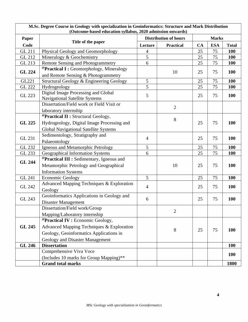
M.Sc. Degree Course in Geology with specialization in Geoinformatics: Structure and Mark Distribution(Outcome-based education syllabus, 2020 admission onwards)
Paper
CodeTitle of the paper
Distribution of hours Marks
Lecture Practical CA ESA TotalGL 211 Physical Geology and Geomorphology 4 25 75 100GL 212 Mineralogy & Geochemistry 5 25 75 100GL 213 Remote Sensing and Photogrammetry 6 25 75 100
GL 224@Practical I : Geomorphology, Mineralogy and Remote Sensing & Photogrammetry
10 25 75 100
GL221 Structural Geology & Engineering Geology 5 25 75 100GL 222 Hydrogeology 5 25 75 100
GL 223Digital Image Processing and Global Navigational Satellite Systems
5 25 75 100
Dissertation/Field work or Field Visit or laboratory internship
2
GL 225
@Practical II : Structural Geology, Hydrogeology, Digital Image Processing and Global Navigational Satellite Systems
825 75 100
GL 231Sedimentology, Stratigraphy and Palaeontology
4 25 75 100
GL 232 Igneous and Metamorphic Petrology 5 25 75 100GL 233 Geographical Information Systems 6 25 75 100
GL 244@Practical III : Sedimentary, Igneous and Metamorphic Petrology and Geographical Information Systems
10 25 75 100
GL 241 Economic Geology 5 25 75 100
GL 242Advanced Mapping Techniques & Exploration Geology
4 25 75 100
GL 243Geoinformatics Applications in Geology and Disaster Management
6 25 75 100
Dissertation/Field work/Group Mapping/Laboratory internship
2
GL 245
@Practical IV : Economic Geology, Advanced Mapping Techniques & Exploration Geology, Geoinformatics Applications in Geology and Disaster Management
8 25 75 100
GL 246 Dissertation 100Comprehensive Viva Voce(Includes 10 marks for Group Mapping)**
100
Grand total marks 1800
4
MSc Geology with specialization in Geoinformatics
Note: * Dissertation work commences in 2nd Semester with 2 hours per week. Field visit or field work orlaboratory internship in 2nd Semester refers to a period of maximum 10 days duration (10 x 5 = 50Hours) and is a compulsory part of the curriculum. Dissertation topics can be chosen as per theinterests of the faculty and student, though it is suggested that remote sensing and GIS tools be usedin the work as far as possible.
# Dissertation work continues in 4th Semester with 2 hours per week and an additional Field workcomponent for a period of maximum 10 days duration (10 x 5 = 50 Hours). ** Group Mapping includes field training in geological mapping, oriented towards ground truthingof remote sensing images for a period of maximum 10 days duration (10 x 5 = 50 Hours) and is acompulsory part of the curriculum to be carried out in the 3rd semester.@ Practical Examinations of 1st and 2nd Semesters will be conducted at the end of second semesterand that of 3rd and 4th Semesters will be conducted at the end of 4 th Semester and each practicalexamination will be of four (4) hours duration.
Eligibility1. BSc in Geology, with any combination of subsidiaries as applicable for admission to MScGeology course of University of Kerala, or equivalent qualifications. Additionally subsidiarieslike GIS, Geoinformatics, Remote Sensing, Water Resources Management can also be acceptedas subjects at BSc level.2. BSc Geology and Digital Surveying (Dual Main).
IntakeSuggested intake is 12 students.
Faculty Faculty qualifications will be the same as that for recruitment to the position of AssistantProfessor in Geology, through the Kerala Public Service Commission or the University ofKerala.
THEORY SYLLABUS (practical syllabus starts on p.35)
SEMESTER I
GL 211: PHYSICAL GEOLOGY AND GEOMORPHOLOGY
AIM
To familiarize students with the basic concepts of physical geology and geomorphology, and toequip them to decipher the pattern of landforms representative of various geological processes.
OBJECTIVES
To make the student understand the various surficial and internal processes which shape thesurface of the earth and be able to evaluate the role of each in sculpting the earth. Students cangain an understanding of the past and present processes operated by different geomorphologicagents.
5
MSc Geology with specialization in Geoinformatics
Course outcomes
CO1: Understand the basics of geochronology and the different dating techniques and their limitations
CO2: Understand the geophysical characteristics of Earth and how palaeomagnetism and plate tectonics are related to these
CO3: Understand the philosophy and different schools of thoughts of environmental dynamism and passivism and compare and analyse different landscape evolution models.
CO4: Understand the origin of various landforms, the concept of morphogenetic regions and influence of climate and structure on it and evaluate the Land forms and structures as geomorphic indicators of neotectonic movements. Understand the geological work of rivers, oceans, wind, glaciers
CO5: Understand the drainage pattern and network characteristics of drainage basin and understand the Soil Formation and classification in Kerala and India
CO6: Understand the geomorphological features of Kerala and India and also understand the basics of tectonogeomorphology.
CO-PSO mapCONo.
CO Statements CognitiveLevel
KnowledgeCategory
PSO
CO1Understand the basics of geochronology and thedifferent dating techniques and their limitations
U & E F & C PSO1
CO2Understand the geophysical characteristics of Earth and how palaeomagnetism and plate tectonics are related to these
U & E F & C PSO1
CO3
Understand the philosophy and different schoolsof thoughts of environmental dynamism and passivism and compare and analyse different landscape evolution models.
U & E F & C PSO1
CO4
Understand the origin of various landforms, the concept of morphogenetic regions and influenceof climate and structure on it and evaluate the Land forms as geomorphic indicators of neotectonic movements. Understand the geological work of rives, oceans, wind
U & E F & C PSO1
CO5
Understand the drainage pattern and network characteristics of drainage basin and understand the Soil Formation and classification in Kerala and India
U F, C & P PSO1
CO6Understand the geomorphological features of Kerala and India and also understand the basics of tectonogeomorphology.
U F & C PSO1
6
MSc Geology with specialization in Geoinformatics
Knowledge category: F – Factual C – Conceptual P – Procedural Cognitive levels: R – Remember, U – Understand , A – Apply, An – Analyze, E – Evaluate, C – Create
UNIT I
Geochronology and age of the Earth – Relative and absolute ages – Principles of isotope dating.Types of decay and half life – Brief idea of U-Pb, K-Ar, and Rb-Sr dating methods and theirsignificance – Fission track dating.
UNIT II
Shape and mass of the earth, density vs depth profile of Earth – Brief idea of Gravity, gravityanomalies and their interpretation – Isostasy – Earth’s magnetic field and its origin –palaeomagnetism – Plate tectonics and its components – destructive, constructive andconservative plate margins and their characteristic features.
UNIT III
Development of geomorphic thoughts – Catastrophism – Gradualism – Brief idea of the modelsof landscape evolution by Davis, King, Penck, JT Hack and Gilbert. Rate of erosion over spaceand time. Geomorphic indicators of neotectonic movements.
UNIT IV
Influence of climate and structure on geomorphic processes and landforms – Concept ofmorphogenetic regions. Evolution of hill slopes – brief idea.
Coastal geomorphology – sea level changes. Geomorphic significance of waves and currents.Shore line processes and associated landforms.
Desert geomorphology – processes of erosion and transport – erosional and depositional features– dunes, rock varnish, pediment, inselbergs, wadis.
UNIT V
Drainage basin – drainage pattern, network characteristics; morphometric analysis of drainagebasins. Fluvial denudational and erosional land forms. Soils – formation, classification, soilprofile, soils of Kerala.
UNIT VI
Major geomorphic features of the Indian subcontinent – Geomorphology of Kerala –classification, relief features, geological significance, rivers of Kerala.
Reference booksAhmad E. Coastal Geomorphology. Orient Longman, 1972.Cox A. Plate Tectonics and geomagnetic reversals. Freeman, 1973.Darlrymple B. G. and Lampere M. A. Potassium-Argon dating. Freeman, 1969.Eicher L. D. Geologic Time. Prentice Hall, 1968.
7
MSc Geology with specialization in Geoinformatics
Hamilton E. I. Applied Geomorphology. Academic Press, 1965.Holmes A. Principles of Physical Geology. Ronald, 1965.King C. A. M. Beaches and Coasts. Arnold, 1972.Lay Thorne, Terry W. C. Modern Global Seismology. Academic Press, 1995.Leopold L., Wolman C. and Miller J. P. Fluvial processes in geomorphology. Freeman, 1963.Russell, RD, John Arthur Jacobs, J. Tuzo Wilson. Physics and Geology. McGraw-Hill Inc., US, 1974Sharma H. S. Indian Geomorphology. Concept Publishing Co., New Delhi, 1990.Soman K 2014 Geology of Kerala, Geol Soc of India, Bangalore.Thornbury W. D. Principles of geomorphology. Wiley, 1968.Turner F. W., Weiss M. P. The Earth. Holt Reinhardt and Winston, 1972.Windley B. F. The evolving continents. John Wiley, 1977.
GL 212 : MINERALOGY and GEOCHEMISTRY
AIMThe aim of this course is to study the major mineral groups, their occurrences, physical,chemical properties and their possible uses in industry, and additionally get to know thegeochemical milieu of earth materials
OBJECTIVESIn this course the students will learn about the structure and chemical makeup of minerals.Focus is given on the physical and chemical properties of minerals, from macroscopic tomicroscopic. Understand thermodynamic and isotopic fundamentals of geochemistry.
Course outcomes
CO1: Understand the diagnostic and advanced optical properties of common rock forming minerals.
CO2: Understand the mineral chemistry and the advanced instrumental analytical techniques used for minerals.
CO3: Understand the physical characters, optical properties, classification, uses and distributionof gem stones. Understand the basics of gem identification by using invisible spectrum radiation.
CO4: Understand the abundance of elements and behavior of elements in the crust, mantle and core of the earth.
CO5: Understand Chemical Equilibrium, Estimation of ionic concentration and Geochemistry of natural waters – river, sea, brines.
CO6: Understand isotope geochemistry and basic thermodynamic concepts
8
MSc Geology with specialization in Geoinformatics
CO – PSO map
CONo.
CO StatementsCognitive Level
KnowledgeCategory
PSO
CO 1Understand the diagnostic and advanced optical properties of common rock forming minerals.
U F & CPSO2
CO 2Understand the mineral chemistry and the advanced instrumental analytical techniques used for minerals. U F & C
PSO2
CO 3 Understand the structure and classification of silicate U & A F, C, PPSO2
CO 4Understand the abundance of elements and behavior of elements in the crust, mantle and core of the earth.
U F & C PSO2
CO 5Understand Chemical Equilibrium, Estimation of ionic concentration and Geochemistry of natural waters – river, sea, brines.
U F & C PSO2
CO 6Understand isotope geochemistry and basicthermodynamic concepts
U & A F & C PSO2
Knowledge category: F – Factual C – Conceptual P – Procedural Cognitive levels: R – Remember, U – Understand , A – Apply, An – Analyze, E – Evaluate, C – Create
UNIT I
Refractive index and birefringence. Interference colours, optical accessories – Berekcompensator, Biquartz wedge and Bertrand ocular. Wave surface and indicatrices. Dichroismand Pleochroism. Pleochroism scheme. Conoscopic study and interference figures. Opticorientation, extinction angle, optic axial angle, optic sign and optic anomalies.
UNIT II
Mineralogy – Occurrence of minerals – Isomorphism, polymorphism and polytypism. Bonding
in minerals. Solid solution and exsolution. AAS, XRF, ICP-MS, Electron probe micro analysis,
scanning and transmission electron microscopy. XRD – powder & single crystal techniques.
Mineralogical expression of radioactivity – metamictisation, fracturing, discoloration, pleochroic
haloes and fission tracks.
UNIT III
Structure and classification of silicates. – Distinctive chemical and optical characters of the
minerals of the following groups – Olivine, garnet, aluminosilicates, pyroxene, amphibole, mica,
feldspar and feldspathoid. Clay mineralogy: characterization, classification and structure of clay
minerals, clay mineral identification by XRD and DTA. Genesis of clays. Different methods of
clay mineral separation.
9
MSc Geology with specialization in Geoinformatics
UNIT IV
Geochemistry –. Cosmic abundance of elements. Geochemical classification of elements.Distribution and behavior of elements in the crust, mantle and core of the earth. Geochemicalcycle. REE and its distribution in meteorites and rocks – Chondrite normalization.
UNIT V
Chemical Equilibrium: Le Chatelier’s principle – concept of stability. Acids and bases.Ionisation constants of acids, bases and hydroxides. Estimation of ionic concentration.Geochemistry of natural waters – rivers and seas.
Unit VI
Introduction to stable isotope geochemistry. Applications of carbon, oxygen and sulphurisotopes. Basic thermodyanmic concepts: Change of Enthalpy – Entropy - Definition of freeenergy, its limitations. Free energies of formation. Gibbs free energy. Chemical potential,fugacity and activity. Oxidation-Reduction reactions. Redox potential – limits of pH and Eh innature. Eh-pH diagrams.
Reference books
Berry L. G. and Mason B. Mineralogy, Freeman, 1959.Brownlow A. N. Geochemistry, Prentice Hall, 1975.Kerr, Paul F. Optical Mineralogy. McGraw-Hill, New York, London. 1977Krauskopf E. B. Introduction to Geochemistry, 1967.Mason B. Principles of Geochemistry. Wiley, 1966.Nesse W. D. Introduction to Mineralogy. Oxford University Press, 2008.Nesse W. D. Introduction to Optical Mineralogy. Oxford University Press, 2004.Perkins D. and Henke K. R. Minerals in thin section. Pearson Education Inc., 2004.Perkins D. Mineralogy. Pearson Education, 2002.Rankama K. Progress in Isotope Geology, Interscience, 1963.Walther J. V. Essentials of Geochemistry. Jones and Barlett Publishers, 2005.Wenk H. R. and Bulakh. Minerals: their constitution and origin. CUP, 2004.Winchell A. N. Elements of optical mineralogy, Pt I, Wiley, 1951.
GL 213 : Remote sensing and Photogrammetry
Unit 1
Introduction to Remote Sensing – Energy sources and Radiation principles, Energy equation,EMR and Spectrum – EMR interaction with Atmosphere – Scattering, Absorption – EMRinteraction with Earth surface features reflection, absorption, emission and transmission –Spectral response pattern – Vegetation, Rocks, Soil, Water bodies – Spectral properties andcharacteristics.
10
MSc Geology with specialization in Geoinformatics
Unit 2
Types of remote sensing with respect to wavelength regions; active and passive remote sensing,Sensor types characteristics: imaging systems, photographic sensors, characteristics of opticalsensors; FOV, IFOV; Sensor resolution - spectral, spatial, radiometric and temporal.Introduction- Active, Passive, Optical Remote sensing, Visible, Infrared, thermal, Sensors andcharacters. Microwave Remote sensing sensors, Concept of Microwave Remote sensing, SLAR,SAR Scatterometer
Unit 3
Data acquisition – Procedure, Reflectance and Digital numbers- Intensity-Reference data,Ground truth, Analog to digital conversion, Detector mechanism-Spectro - radiometer-Idealremote sensing system – Characters of real and successful remote sensing system- Platforms andsensors- orbit types– Resolution Land observation satellites, characters and applications, IRSseries, LANDSAT series, SPOT, series, Sentinel Missions, High resolution satellites, characterand applications, CARTOSAT series, IKONOS Series, QUICKBIRD series, INSAT series,GOES
Unit 4
Multispectral and hyperspectral remote sensing, Comparison of Multispectral and HyperspectralImage Data, Spectral Signatures and BRDF in the Visible, Near Infrared and Shortwave Infraredregions of EMR, Hyperspectral Issues. Sensors and hyperspectral imaging devices - Scannertypes and characterization - specifications of various sensors Spectrographic imagers-hyperspectral sensors, Design tradeoffs. Data formats and systems, AVIRIS, CASI, NASA TerraModerate Resolution Imaging Spectrometer (MODIS), Hyperion. Applications of HyperspectralImage to Mineral exploration.
Unit 5
Definition and concepts, Photogrammetry:- Based on platform (Ground Based, UAV/dronebased, Aerial Photogrammetry, Satellite Photogrammetry) Types of aerial photographs (Vertical,Oblique), Scale of Photographs, Flight height, Flight planning, stereo coverage, Geometricelements of aerial photographs (analog and digital), Scale determination, Source of Distortionsand displacement, Relief Displacement, Parallax
Unit 6
Depth perception, steroscopy/ sterovision, viewing sterophotography in analog environment,viewing sterophotography in digital environment, Sterophotogrammetry, Orthorecrification,interior and exterior orientation parameters. DTM generation - Image correlation - Imagematching - Digital Orthophoto generation - Automated aero-triangulation - Link between GISand Digital Photogrammetry.
REFERENCES
Anji Reddy, Textbook of Remote Sensing and Geographical Information systems, BS Publications, Hyderabad. 2011. ISBN: 81-7800-112-8
11
MSc Geology with specialization in Geoinformatics
Chandra A. M and Ghosh S. K. Remote Sensing and Geographical Information Systems. Narosa Publishing House, 2007.
Chandra and Ghosh. Remote Sensing and GIS, Narosa Publishing Home, New Delhi 2009.Estors J. E. and Senger L. W. Remote Sensing. Hamilton Publishing Company, 1974.George Joseph , Fundamentals of Remote Sensing Universities Press, Hyderabad 2005.Gupta R. P. Remote Sensing Geology. Springer, 2003.Heywood I., Cornelius. S. and Carver S. An Introduction to Geographical Information Systems, Longman LimitedPaul Jude Gibson, Introductory Remote Sensing: Principles and Concepts, Routledge, 11 New Fetter Lane, Landon,
UK. 2000. ISBN: 0-415-17024-9Prithvish Nag, M. Kudrat, Digital Remote Sensing, Concept Publishing Company, India, 1998.Reddy A. M. Text book of Remote Sensing and Geographical Information Systems. BS Publications, 2006.Sabins F. F. Remote Sensing – Principles and Applications. Freeman, 1985.Seigal B. S. and Gillespie A. R. Remote sensing in Geology, John Wiley & Sons, 1980.Thomas M. Lillesand, Ralph W. Kiefer, Jonathan W. Chipman, Remote sensing and image interpretation John
Wiley & Sons, 2008
SEMESTER II
GL 221: STRUCTURAL GEOLOGY AND ENGINEERING GEOLOGY
AIM To understand the rock deformation and different structures produced by brittle and ductiledeformation and analysis of structures. To understand geological properties of materials and earthstructures as applied to construction of engineering structures.
OBJECTIVESThe objectives of this course are: (i) to develop an understanding of rock deformation and factorsinvolves in it. (ii) how the classification of structures based on geometry and origin (iii) analysis ofstructures based on stereographic projection.
Course outcomes
CO1: Understand the concepts of rock deformation, types of Stress and strain, its use in studyingthe stages of deformation and factors affecting deformation.
CO2: Understand the brittle and shear failure including fault, lineaments, deep fractures, Joints and Shear zone, tectonites, petrofabrics, foliation and lineation.
CO3: Understand the concept, classification and mechanism of fold. Understand Superposed fold and interference patterns.
CO4: Understand Structural and geometric analysis. Application of stereographic and equal area projections in the representation of structures and geometric analysis of folds and lineations. CO5: Understand the interpretation of geologic maps. Analyse the Trigonometric, graphic and stereographic problems.
CO6: Understand the engineering properties of rocks and their use in locating engineering structures
12
MSc Geology with specialization in Geoinformatics
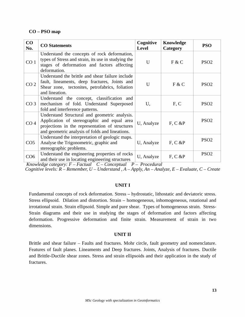
CO – PSO map
CONo.
CO StatementsCognitiveLevel
KnowledgeCategory
PSO
CO 1
Understand the concepts of rock deformation,types of Stress and strain, its use in studying thestages of deformation and factors affectingdeformation.
U F & C PSO2
CO 2
Understand the brittle and shear failure includefault, lineaments, deep fractures, Joints andShear zone, tectonites, petrofabrics, foliationand lineation.
U F & C PSO2
CO 3Understand the concept, classification andmechanism of fold. Understand Superposedfold and interference patterns.
U, F, C PSO2
CO 4
Understand Structural and geometric analysis.Application of stereographic and equal areaprojections in the representation of structuresand geometric analysis of folds and lineations.
U, Analyze F, C &PPSO2
CO5 Understand the interpretation of geologic maps.Analyse the Trigonometric, graphic and stereographic problems.
U, Analyze F, C &PPSO2
CO6Understand the engineering properties of rocksand their use in locating engineering structures
U, Analyze F, C &PPSO2
Knowledge category: F – Factual C – Conceptual P – Procedural Cognitive levels: R – Remember, U – Understand , A – Apply, An – Analyze, E – Evaluate, C – Create
UNIT I
Fundamental concepts of rock deformation. Stress – hydrostatic, lithostatic and deviatoric stress.Stress ellipsoid. Dilation and distortion. Strain – homogeneous, inhomogeneous, rotational andirrotational strain. Strain ellipsoid. Simple and pure shear. Types of homogeneous strain. Stress-Strain diagrams and their use in studying the stages of deformation and factors affectingdeformation. Progressive deformation and finite strain. Measurement of strain in twodimensions.
UNIT II
Brittle and shear failure – Faults and fractures. Mohr circle, fault geometry and nomenclature.Features of fault planes. Lineaments and Deep fractures. Joints, Analysis of fractures. Ductileand Brittle-Ductile shear zones. Stress and strain ellipsoids and their application in the study offractures.
13
MSc Geology with specialization in Geoinformatics
UNIT III
Geometric and genetic classification of cylindrical folds. Canoe fold and inverted canoe fold.Minor folds and their use in determining the major fold structure. Pumpelly’s rule. Mechanics offolding. Superposed folding, simple fold interference patterns. Fold classification of Donath andParker, and Ramsay – Dip isogons.
UNIT IV
Tectonites – classification, tectonic fabric. Foliation – axial plane foliation and its origin, fracturecleavages, crenulation cleavage. Transposed foliation. Use of axial plane foliation and fracturecleavages and the determination of major structures. – Lineation – types, classification andorigin. Introduction to Structural Analysis and Fundamentals of geometric analysis. Applicationof stereographic and equal area projections in the representation of structures.
UNIT V
Engineering Geology – Role of geology in Civil Engineering – Engineering properties of rocksand soil – Geotechnical investigation for Civil Engineering projects – Rock mechanics – strengthand deformation properties of rocks and soils – Rock as building material – Dimension anddecorative stones. Aggregates. Building stones of Kerala.
UNIT VI
Dams: Classification, foundation, abutment and reservoir problem. Geological aspects of daminvestigations – Tunnels: Classification, Geological factors in tunneling – Landslides: Types,causes and prevention – Stability of slopes – Aseismic design of buildings. Geologicalconsiderations in investigations for construction of highways, bridges and shoreline structures.
Reference booksBillings, M. P. Structural Geology Prentice Hall, 1974Marshak S. and Gautam Mitra. Basic methods of Structural Geology. Prentice Hall Inc. 1988.Ragan M. D. Structural Geology, Wiley 1969.Philips F. C. Stereographic projection in Structural Geology. Arnold 1960. Lisle R. J. and Leyshon P. R. Stereographic Projection Techniques for Geologists and Civil Engineers. Cambridge
University Press. 1994.Turner F.J. and Weiss L.E. Structural Analysis of Metamorphic Tectonites. Mc Graw Hill, 1963.Hobbs B.E., Means W.B. and William P. F. An Outline of Structural Geology. John Wiley 1976.Krynine and Judd. Principles of Engineering Geology and Geotechniques. Mc Graw Hill 1957Bell F. G. Engineering Geology. Elsevier 2007.Waltham T. Foundations of Engineering Geology. Spon Press. 1994..
GL 222: HYDROGEOLOGY
AIM To understand the various aspects of origin, occurrence, distribution, movement, hydraulics, quality,pollution, recharge and over-exploitation, and the groundwater conditions in India and Kerala.
OBJECTIVESThe objectives of this course are:
14
MSc Geology with specialization in Geoinformatics
i) to study the origin, occurrence, distribution of groundwater; aquifer types, properties and parameters inrelation to groundwater hydraulics, groundwater movement and application of Darcy’s law, pumping testdata analysis.ii) to understand and describe groundwater exploration and prospecting methods, methods of drilling forgroundwater and well design and maintenance criteria.Iii) to understand and infer groundwater quality for domestic and industrial uses using standard graphs anddiagrams like Hill-Piper Trilinear diagram and U.S. Salinity diagram.iv) to understand the concepts and methods of groundwater recharge, problems related to groundwaterpollution and over-exploitation, groundwater legislation; and groundwater provinces of India andgroundwater conditions in Kerala.
Course outcomes
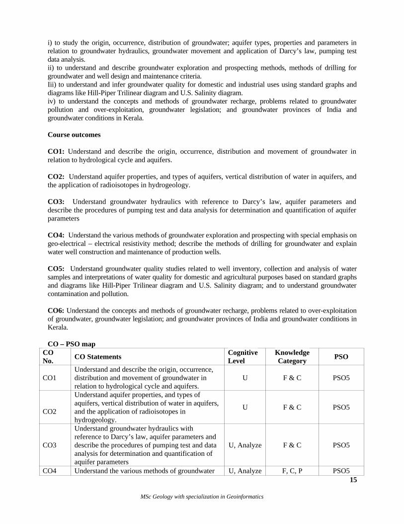
CO1: Understand and describe the origin, occurrence, distribution and movement of groundwater inrelation to hydrological cycle and aquifers.
CO2: Understand aquifer properties, and types of aquifers, vertical distribution of water in aquifers, andthe application of radioisotopes in hydrogeology.
CO3: Understand groundwater hydraulics with reference to Darcy’s law, aquifer parameters anddescribe the procedures of pumping test and data analysis for determination and quantification of aquiferparameters
CO4: Understand the various methods of groundwater exploration and prospecting with special emphasis ongeo-electrical – electrical resistivity method; describe the methods of drilling for groundwater and explainwater well construction and maintenance of production wells.
CO5: Understand groundwater quality studies related to well inventory, collection and analysis of watersamples and interpretations of water quality for domestic and agricultural purposes based on standard graphsand diagrams like Hill-Piper Trilinear diagram and U.S. Salinity diagram; and to understand groundwatercontamination and pollution.
CO6: Understand the concepts and methods of groundwater recharge, problems related to over-exploitationof groundwater, groundwater legislation; and groundwater provinces of India and groundwater conditions inKerala.
CO – PSO mapCONo.
CO StatementsCognitiveLevel
KnowledgeCategory
PSO
CO1Understand and describe the origin, occurrence, distribution and movement of groundwater in relation to hydrological cycle and aquifers.
U F & C PSO5
CO2
Understand aquifer properties, and types of aquifers, vertical distribution of water in aquifers, and the application of radioisotopes in hydrogeology.
U F & C PSO5
CO3
Understand groundwater hydraulics with reference to Darcy’s law, aquifer parameters and describe the procedures of pumping test and data analysis for determination and quantification of aquifer parameters
U, Analyze F & C PSO5
CO4 Understand the various methods of groundwater U, Analyze F, C, P PSO515
MSc Geology with specialization in Geoinformatics
exploration and prospecting with special emphasis on geo-electrical – electrical resistivity method; describe the methods of drilling for groundwater and explain water well construction and maintenance of production wells.
CO5
Understand groundwater quality studies related towell inventory, collection and analysis of water samples and interpretations of water quality for domestic and agricultural purposes based on standard graphs and diagrams like Hill-Piper Trilinear diagram and U.S. Salinity diagram; and tounderstand groundwater contamination and pollution.
U, Analyze F & C PSO5
CO6
Understand the concepts and methods of groundwater recharge, problems related to over-exploitation of groundwater, groundwater legislation; and groundwater provinces of India andgroundwater conditions in Kerala.
U F & C PSO5
Knowledge category: F – Factual C – Conceptual P – Procedural Cognitive levels: R – Remember, U – Understand , A – Apply, An – Analyze, E – Evaluate, C – Create
UNIT I
Introduction – definition and classification of subsurface water. Elements of surface hydrology:formation of precipitation, measurement and depth of precipitation over an area. Evaporation andtranspiration – factors affecting evaporation and transpiration
Measurement of evaporation Consumptive use – infiltration, run off. Types of water – meteoric,juvenile, connate, magmatic and sea water. Hydrological cycle and its components –Groundwater in the hydrologic cycle. Origin of ground water.
UNIT II
Water bearing properties of rocks – interstices and porosity, permeability, specific yield andspecific retention. Aquifers, aquicludes, aquitard and aquifuge. Vertical distribution ofsubsurface water; zone of saturation and zone of aeration. Types of aquifers – unconfined,confined, semi-confined and semi-unconfined. Geological material as aquifers – unconsolidatedmaterials and consolidates rocks. Water table and piezometric surface; their fluctuations.
Radioisotopes in hydrogeological studies.
UNIT III
Groundwater Hydraulics: Movement of groundwater – Darcy’s law; Range of validity; itsexperimental verification. Hydraulic conductivity of geologic materials. Determination ofhydraulic conductivity – formula, laboratory methods and field tests. Flow nets; Flow in relationto groundwater contours. Aquifer parameters – transmissivity, storativity, drainage factor.Pumping tests – objectives, layout of the tests, measurements and interpretation. Methods of
16
MSc Geology with specialization in Geoinformatics
analyzing pumping test data. Theim’s equilibrium method. Theis method, Theis recoverymethod, Jacob and Cooper-Jacob methods.
UNIT IV
Groundwater Exploration: Use of aerial photographs and Landsat imageries in groundwaterexploration. Hydrogeomorphic and lineament mapping.
Prospecting for groundwater – geological aspects. Surface geophysical methods – geo-electrical– electrical resistivity and seismic refraction methods. Drilling for groundwater – cable tool,hydraulic rotary, reverse rotary and down the hole hammer drilling.
Water Well Construction – Water well design criteria and specifications. Well production tests –well loss, specific capacity. Maintenance of production wells.
UNIT V
Quality of groundwater – methods of collection and analysis of water samples as related togroundwater investigations. Physical, chemical and bacterial measures of water quality.Problems of groundwater contamination by As and F – Remedial measures for their treatment.The general occurrence of various constituents in groundwater. Graphical representation ofgroundwater quality data – Collin’s diagram. Quality of groundwater for domestic, irrigationaland agricultural uses.
UNIT VI
Groundwater recharge – natural and artificial recharge. Groundwater management. Rainwaterharvesting and managed aquifer recharge. Groundwater conditions and problems in urban areas.Over-exploitation of groundwater and groundwater mining. Coastal aquifers, sea water intrusionand remedial measures. Groundwater provinces of India. Groundwater conditions in Kerala.Consumptive and Conjunctive use of surface and groundwater – 2019 Guidelines to regulate andcontrol Ground Water Extraction in India
Reference BooksBouwer H. Groundwater hydrology 1978Davis, Stanley N. and Deweist, Roger J. M. Hydrogeology. John Wiley & Sons, 1966Fetter C.W. Hydrogeology. Prentice Hall, 2001.Lindsley R.K., Kohler M.A. and Paulhus J. L.H. Applied Hydrology. Tata McGraw Hill 1975Raghunath H. M. Groundwater. 2nd Edition, Wiley Eastern Limited, Calcutta, 1987.Raghunath H.M. Hydrology. Wiley Eastern Limited, 1998.Sharma, H. D. and A. S. Chawla. Manual on Groundwater and Tube wells. Technical Report No. 18., CBIP, New
Delhi, 1977.Todd D. K. Groundwater hydrology Wiley 1980Walton W. C. Groundwater resource evaluation McGraw Hill 1970http://mowr.gov.in/sites/default/files/CGWA_GWExtraction_Notification_0.pdf
17
MSc Geology with specialization in Geoinformatics
GL 223: Digital Image Processing and Global Navigational Satellite Systems
AIM
To familiarize students with the basic concepts of Digital Image Processing and GlobalNavigational Satellite Systems
OBJECTIVES
Train students in the core concepts of Digital Image Processing and Global NavigationalSatellite Systems, and lay the foundation for studying spatial data acquisition and imageprocessing.
Course outcomes
CO1: Understand the principles of digital image processing
CO2: Understand how remotely sensed images can be enhanced.
CO3: Understand how images are classified and features extracted.
CO4: Understand the characteristics and uses of different remote sensing sensors
CO5: Understand the basic concepts of Global Navigational Satellite Systems (GNSSs).
CO6: Understand the use of GPS and GPS systems
CO-PSO mapCONo.
CO StatementsCognitiveLevel
KnowledgeCategory
PSO
CO1Understand the principles of digital imageprocessing
U & E F & C PSO1
CO2Understand how remotely sensed images can be enhanced.
U & E F & C PSO1
CO3Understand how images are classified and featuresextracted.
U & E F & C PSO1
CO4Understand the characteristics and uses of different remote sensing sensors U & E
F & C PSO1
CO5Understand the basic concepts of Global Navigational Satellite Systems (GNSSs). U F, C & P PSO1
CO6 Understand the use of GPS and GPS systems U F & C PSO1 Knowledge category: F – Factual C – Conceptual P – Procedural Cognitive levels: R – Remember, U – Understand , A – Apply, An – Analyze, E – Evaluate, C – Create
18
MSc Geology with specialization in Geoinformatics
Unit 1Digital Number/pixel value, Image Rectification: Sources of errorsin RS data- Geometric andRadiometric- Types of Geometric and Radiometric errors (Dark Pixel, Pixel Dropping, LineDropping, Atmospheric errors-Geometric Corrections - Image resampling- Resamplingtechniques (Nearest neighbor, Bilinear and Cubic Convolution), Radiometric Correction (Darkpixel subtraction, Destripping, Pixel filling, Atmospheric correction (MODTRAN Algorithm).Computation of radiance and reflectance
Unit 2Image Registration; Image Enhancements, Spatial Enhancement (Spatial Filtering: High passand Low pass), Radiometric Enhancement (Contrast Stretch, Histogram Equalization, Specialstretches), Spectral Enhancement (Band Ratio, Indices (NDVI, NDWI etc), PrincipalComponent Analysis, IHS Transformation)
Unit 3Image Classifications, Digital Supervised classification (Minimum distance to MeansClassifiers, Parallelepiped Classifiers, Gaussian Maximum Likelihood Classifier); Unsupervised(Cluster building, Cluster Labeling, Reclassification Processing and Feature Extraction. Datamerging.
Unit 4
Image Processing Software Introduction; Introduction to Envi Image Processing Software,Introduction to ERDAS Image Processing Software.
Unit 5Basic concepts of Global Navigational Satellite Systems (GNSSs): History and timeline,overview. Components of GNSSs (Space Segment, Control Segment, User Segment),GPSworking principle, -GPS (Global positioning System), - GLONASS, Galileo, BeiDou,NavIC, GPS signals (L1 and L2 Frequencies)/ Coarse Acquisition (C/A), Code Precision (P)codes.
Unit 6
Source of GPS Errors and biases, Selective Availability, Dilution of Precision (DOP),Advantages and disadvantages of GPS surveying GPS positioning types – absolute positioning,differential positioning;GPS Positioning Service- Precise Positioning Service (PPS), StandardPositioning Service (SPS)-Wide Area Augmentation System (WAAS), GPS Aided GeoAugmented Navigation (GAGAN), European Geostationary Navigation Overlay Service(EGNOS), Japanese Multi-functional Satellite Augmentation System (MSAS), DGPSmeasuring Techniques(Static, Rapid Static, Kinematic, Real Time Kinematic), Application ofDGPS.
Reference booksBernhardsen T. Geographic Information Systems – An introduction. Wiley India, 2002.Bonham, G. F and Carter. Geographic Information system for Geoscientists- Modelling with GIS, Elsevier.Chandra A. M and Ghosh S. K. Remote Sensing and Geographical Information Systems. Narosa PublishingHouse, 2007.Estors J. E. and Senger L. W. Remote Sensing. Hamilton Publishing Company, 1974.
19
MSc Geology with specialization in Geoinformatics
George Joseph. Fundamentals of Remote Sensing. Universities Press, Hyderabad. 2003Gupta R. P. Remote Sensing Geology. Springer, 2003.Heywood I., Cornelius. S. and Carver S. An Introduction to Geographical Information Systems, LongmanLimitedLillesand T. M. and Keifer R. W. Remote sensing and Image interpretation. John Wiley and Sons, 1979.Lo C. P. and Yeung A. K. W. Concepts and Techniques of Geographic Information Systems. Prentice Hall2002.Panda, B. C. Remote Sensing – Principles and Applications. Viva Books Private Limited, New Delhi, 2005.Pandey, S. N. Principles and Applications of Photogeology. New Age International (P) Limited Publishers,New Delhi, 2001.Reddy A. M. Text book of Remote Sensing and Geographical Information Systems. BS Publications, 2006.Rees W. G. Physical principles of Remote Sensing. Cambridge University Press, 2001.Sabins F. F. Remote Sensing – Principles and Applications. Freeman, 1985.Seigal B. S. and Gillespie A. R. Remote sensing in Geology, John Wiley & Sons, 1980.
SEMESTER III
GL 231: SEDIMENTOLOGY, STRATIGRAPHY AND PALAEONTOLOGY
AIM
Understand how sediments formed, different rock and sediment strata on Earth was developed,how it can be interpreted to arrive at theories on the evolution of Earth and the vertebrate andinvertebrate life on it.
OBJECTIVES
Study the types of sediments and sedimentary rocks, major theories underpinning stratigraphy,and the techniques used to decipher information from strata. Understand the evolution of life anddecipher its record in the strata.
Course outcomes
CO1: Understand the different types of sedimentary rocks and their composition
CO2: Understand stratigraphic principles and its history, and gain deeper understanding of select stratigraphic systems. Understand the different types of stratigraphic analytical techniques and gain an understanding of boundary problems
CO3: Understand the models of crustal evolution with special reference to the Indian shield
CO4: Examine the patterns of evolution of invertebrates, to understand palaeoclimatic and palaeographic dispositions
CO5: Understand the evolution of vertebrates and extinction events, and the record of plant fossils and its significance
CO6: Understand microfossils, their morphology, palaeoecology and applications in petroleum exploration
20
MSc Geology with specialization in Geoinformatics
CO – PSO map
CONo.
CO StatementsCognitiveLevel
KnowledgeCategory
PSO
CO 1 Understand the different types of sedimentary rocks and their composition
U F & C PSO4
CO 2Understand the different types of stratigraphic analytical techniques and gain an understanding of boundary problems
U F & C PSO4
CO 3Understand the models of crustal evolution with special reference to the Indian shield
U F, C, P PSO4
CO 4Examine the patterns of evolution of invertebrates, to understand palaeoclimatic and palaeographic dispositions
U F & C PSO4
CO 5Understand the evolution of vertebrates and extinction events, and the record of plant fossils and its significance
U F & C PSO4
CO 6Understand microfossils, their morphology, palaeoecology and applications in petroleum exploration
U F & C PSO4
Knowledge category: F – Factual C – Conceptual P – Procedural Cognitive levels: R – Remember, U – Understand , A – Apply, An – Analyze, E – Evaluate, C – Create
UNIT I
Provenance and diagenesis of sediments. Sedimentary textures: Framework, matrix and cementof terrigenous sediments. Frequency distribution of grain size. Size, shape and fabric ofsediments (textures). Sedimentary structures. Mass flows and Turbidity currents.Penecontemporaneous deformation, Biogenic sedimentary structures. Clastic and non clasticrocks – introduction Sedimentary petrology – classification, terminology, chemical composition– of limestone and sandstone.
UNIT II
Stratigraphy: Evolution of Stratigraphic principles. Contributions of Steno, Lehmann, Werner,
Hutton, Darwin, Smith and Holmes. Evolution of Geological Time Scale. Code of Stratigraphic
Nomenclature. Stratigraphic procedures (surface and sub-surface). A brief study of the
stratotypes. Global Boundary Stratotype Sections & Points (GSSP) and major occurrences of the
following systems: Cambrian, Carboniferous, Cretaceous, Tertiary and Quaternary.
UNIT III
Application of stratigraphy in palaeoenvironmental reconstructions. Major climatic events of the
Phanerozoic eon. Boundary problems in Stratigraphy with special reference to Vindhyans and
21
MSc Geology with specialization in Geoinformatics
Saline series. Chronostratigraphy – an introduction – Concepts and Elements of Sequence
stratigraphy, Cyclostratigraphy and Chemostratigraphy.
UNIT IV
Precambrian Geology: Models of crustal evolution Craton-mobile belt concept. Granulite and
Greenstone terrains – origin, rock associations, structure, metamorphism and models of
evolution. Evolution of high grade mobile belts. Precambrian shield of India – special reference
to the Dharwar craton.
UNIT V
Palaeontology – nature of fossil record. Distribution of main groups in time. Importance offossils in palaeoclimatic and palaeogeographic studies, origin and early evolution of life. Patternsof evolution. Invertebrates – trends in the evolution of the following: Brachiopods,Ammonoidea, Trilobita.
UNIT VI
Vertebrate Palaeontology – General characteristics and evolution of reptiles, birds and mammals(horse, elephant and man – basic morphologic features). Siwalik vertebrate fauna. Massextinction events – PT & KT extinctions.
UNIT VII
Micropalaeontology: importance and types of microfossils, collection and preparation ofmicrofossils for study. Foraminifers, Ostracods, Conodonts – their general morphology andpalaeoecology. Application of micro fossils in petroleum exploration. Plant fossils: Gondwanaflora and their significance.
Reference booksAger D. V. Principles of palaeoecology, Mc Graw Hill, 1963.Benton,M. J. Vertebrate Palaeontology, 2nd edition, Blackwell Science, 2000.Brookfield M. E. Principles of Stratigraphy. Blackwell Publishing, 2004.Colebert H. E. Evolution of the Vertebrates. John Wiley & Sons, 1961.Cushman A. J. Foraminifera. Harvard University Press, 1959.Dunbar C. O. & Rogers J. Principles of Stratigraphy. Wiley, 1960Easton W. H. Invertebrate Palaeontology. Harper and Brother, 1960.Eicher L. D. Geologic Time. Prentice Hall, 1968.Flint R. F. Glacial & Pleistocene Geology. Wiley, 1961.Gignoux M. Stratigraphic Geology. Freeman, 1960.Glaessnar M. F. Principles of Micro Palaeontology. Mc Graw Hill, 1953.Kay & Golbert. Stratigraphy & Life history. Wiley, 1965.Krishnan M.S. Geology of India and Burma. Higginbothams, 1968.Krumbein N. C. & Sloss L. D. Stratigraphy and sedimentation. Freeman, 1963.Moore R.C., Lalicker C.G., Fisher A.G. Invertebrate fossils. Mc Graw Hill, 1952.Weller J. M. Stratigraphic principles & Practice. Harper & Row, 1959.Woods H. Invertebrate Palaeontology. Cambridge University Press, 1961.
22
MSc Geology with specialization in Geoinformatics
GL 232: IGNEOUS AND METAMORPHIC PETROLOGY
AIM
To understand igneous and metamorphic rocks, their structure, texture, chemistry and processesthat generate and transform the rocks of the Earth as well as the tectonic settings of these rocktypes.
OBJECTIVEUnderstand the thermal and tectonic history of the earth in association with igneous petrogenesis,evolution of magmas and their products. Understand how phase rule applies to metamorphicmineral paragenesis and how metamorphic rocks are formed, and analyse the textures andstructures of metamorphic rocks.
COURSE OUTCOMESCO1: Understand the application of thermodynamics and reaction principle in the petrogenesisof different igneous rocks, and evaluate the role of phase rule in the study of binary and ternarysilicate systems CO2: Understand the physical properties, chemical composition and evolutionary mechanismsof magmasCO3: Evaluate the different schemes of classification and nomenclature of igneous rocks andtheir tectonic associationsCO4: Understand limits, factors and types of metamorphism and application of Phase rule inChemographic diagramsCO5: Understand classification of metamorphic rocks and textures and structures ofmetamorphic rocksCO6: Understand baric types of metamorphism, thermobarometry, and metamorphism ofcarbonate, pelitic, mafic rocks
CO- PSO MAP CONo.
CO Statements CognitiveLevel
KnowledgeCategory
PSO
CO1 Understand the application of thermodynamics and reaction principle in the petrogenesis of different igneous rocks, and evaluate the role of phase rule in the study of binary and ternary silicate systems
U, Analyse F & CPSO3
CO2Understand the physical properties, chemical composition and evolutionary mechanisms of magmas. Evaluate the different schemes of classification and nomenclature of igneous rocks and their tectonic associations
U F & CPSO3
CO3Evaluate the different schemes of classification and nomenclature of igneous rocks and their tectonic associations
U, Evaluate F & C PSO3
23
MSc Geology with specialization in Geoinformatics
CO4Understand limits, factors and types of metamorphism and application of Phase rule in Chemographic diagrams
U, Apply F, C, PPSO3
CO5Understand classification of metamorphic rocks and textures and structures of metamorphic rocks
U F & CPSO3
CO6Understand baric types of metamorphism, thermobarometry, and metamorphism of carbonate, pelitic, mafic rocks
U F, C, PPSO3
Knowledge category: F – Factual C – Conceptual P – Procedural Cognitive levels: R – Remember, U – Understand , A – Apply, An – Analyze, E – Evaluate, C – Create
UNIT I
Reaction principles in petrogenesis – continuous and discontinuous reaction series.Heterogenous equilibrium and phase rule. Application of phase rule in the study of silicatesystems – binary and ternary. Study of the following systems. Diopside-Anorthite, Albite-Anorthite, Forsterite-Silica, Forsterite-Anorthite-Silica and Othoclase-Anorthite-Albite. Simplebasalt systems of Barth.
UNIT II
Magma – Physical properties – temperature, density, viscosity and melting behavior. Plumemagmatism and Hot spots. Magmatic evolution and differentiation – Chemical compositionEvolutionary mechanisms – crystal settling in magma, magma convection, igneous cumulates,liquid immiscibility, diffusion processes, magmatic assimilations, mixing of magmas,assimilation of fractional crystallization, trace element trends in magmatic evolution. Variationdiagrams – significance and interpretation.
UNIT III
Classifications of igneous rocks – mode, norm, CIPW, Schand and IUGS, igneous rock names.Igneous rock textures and their genetic significance. Tectonic association of igneous bodies.Large layered igneous complexes. Intrusive rocks of Kerala.
UNIT IV
Concept of metamorphism – Beginning of metamorphism – High temperature and high pressurelimit of metamorphism. Types of metamorphism. Factors of metamorphism: P, T, fluid phase(CO2, H2O and CH4). Application of phase rule in metamorphic mineral paragenesis.Equilibrium thermodynamics in metamorphic petrology – Gibb’s free energy, enthalpy, entropy,Clasius–Clapeyron equation, buffering, redox buffers, Schreinemaker’s rule and bundle.Chemographic diagrams – principles of ACF, A’KF and Thompson’s AFM diagrams.
UNIT V
24
MSc Geology with specialization in Geoinformatics
Classification of metamorphic rocks. Concepts in metamorphism – Grubenmann’s depth zoneconcept, metamorphic zone concept – isograd and reaction isograd, metamorphic facies conceptand facies series, Winkler’s grade concept, Miyashiro’s paired metamorphic belts and baric typesof metamorphism, P-T-t paths – isobaric cooling (IBC) and isothermal decompression (ITD)paths. Prograde and retrograde metamorphism; Regional metamorphism of carbonate, pelitic andmafic rocks.
UNIT VI
Structure and texture of metamorphic rocks – mega and microscopic – textures of contact,regional and cataclastic metamorphism - foliation, lineation, porphyroblast and clast, snowballgarnet. Becke Crystalloblastic series. Retrograde metamorphism. Metasomatism andmetasomatic zonation, metamorphic differentiation, migmatites and anatexis, charnockite andincipient charnockite, khondalite, leptynite.
Reference booksBarker A. J. 1998 Introduction to metamorphic textures and microstructures Edition 2, Routledge.Barth T. F. W. Theoritical Petrology. Wiley, 1962.Blatt, J., Tracy J. R. and Owens B.E. 2006 Petrology: Igneous, Sedimentary, and Metamorphic. Edition3, W. H.
Freeman.Bowen N. D. Evolution of Igneous Rocks. Dover Publications, 1956.Bucher K and Frey M. 1994 Petrogenesis of metamorphic rocks Edition6, Illustrated Publisher Springer-Verlag.Carmichael, I. S. E., Turner F. J. Verhoogen J. Igneous Petrology. Mc Graw Hill, 1971.Ehlers E. G. The interpretation of Geological Phase Diagrams. Freeman, 1972.Fry N. The field description of metamorphic rocks. Geological Society of London handbook series. Open University
Press, 1984Kornprobst J. 2002 Metamorphic rocks and their geodynamic significance: a petrological handbook, Springer.Myron G. Best 2003 Igneous and metamorphic petrology Edition2, Wiley-Blackwell, 2003Shelley D. Igneous and metamorphic rocks under the microscope: classification, textures, microstructures, and
mineral preferred - orientations Springer, 1993.Tyrell G. W. Principles of Petrology. Metheun, 1963.Vernon R. H. A practical guide to rock microstructure Cambridge University Press, 2004 BooksVernon R. H. and Clarke G. L. 2008 Principles of metamorphic petrology Cambridge University Press.Wahlstrom E. Theortical Igneous Petrology. Wiley, 1961.Winter J. Principles of Igneous and Metamorphic Petrology 2nd Edition 2009
GL 233: Geographical Information Systems
AIM
To familiarize students with the basic concepts of Geographical Information Systems and therelated software
OBJECTIVES
Train students in the core concepts of Geographical Information Systems, and lay the foundationfor geospatial thinking and usage of software.
25
MSc Geology with specialization in Geoinformatics
Course outcomes
CO1: Understand GIS data formats and software
CO2: Understand GIS data properties and data processing
CO3: Understand GIS vector analysis
CO4: Understand GIS raster analysis
CO5: Understand the basic concepts of maps and map making
CO6: Understand the various flavours of GIS and GIS portals
CO-PSO mapCONo.
CO StatementsCognitiveLevel
KnowledgeCategory
PSO
CO1 Understand GIS data formats and software U & E F & C PSO1
CO2Understand GIS data properties and data processing
U & E F & C PSO1
CO3 Understand GIS vector analysis U & E F & C PSO1
CO4Understand GIS raster analysis
U & E F & C PSO1
CO5Understand the basic concepts of maps and mapmaking U F, C & P PSO1
CO6Understand the various flavours of GIS and GISportals
U F & C PSO1
Knowledge category: F – Factual C – Conceptual P – Procedural Cognitive levels: R – Remember, U – Understand , A – Apply, An – Analyze, E – Evaluate, C – Create
Unit 1
Definition - Usefulness of GIS - Components of GIS - Data Structure in GIS –Spatial and NonSpatial Data, Database Management in GIS- RDBMS, Geometry of Data (Points, Lines andPolygons)- Data storage formats in GIS(Raster and Vector) – Vector and Raster file formats inGIS- Advantages and Disadvantages, Data Conversion, (Vector to Raster and Raster to Vector),Introduction to proprietary and open source GIS.
Unit 2
Spatial Data Input Processes and Devices (Sources of data, - Different Types of Data Entrymethods, viz., Manual input, Run length code, Digitization, Automated Scanning, etc. - Vector toRaster conversion - Raster to Vector conversion - Input devices) - Entry of non-spatial data -Linking of Spatial & Non- spatial data - Data Verification (Sources of Errors - Errors due toNatural Variation - Errors during measurement - Errors during entry - Errors duringmeasurement - Errors during Process & Analysis) - Correction (Rubber Sheet Transformation,
26
MSc Geology with specialization in Geoinformatics
Bilinear interpolation, Cubic Convolution, etc.) - Topology in GIS- Basic Elements of TopologyConnectivity, Containment, Contiguity- Data output (Types of Output, GIS Capabilities foroutput, Output devices).
Unit 3
Vector analysis in GIS; Data Conversion techniques, Vector data Exploring – Find, Measure,Graphs, Reports- Querying – Spatial, Non-spatial (Arithmetic and Boolean Operations)- Overlayanalysis: UNION, IDENTITY, INTERSECT, SYMDIFF, CLIP, ERASE, SPLIT- Managementoperations: DISSOLVE, ELIMINATE, MERGE, MOSAIC- Network analysis, LinearReferencing and Dynamic segmentation
Unit 4
Raster analysis in GIS: Surface modelling and analysis- Triangular Irregular Network (TIN),Digital Elevation Model (DEM)- Slope, Aspect, VIewshed, Hillshade, Line of Sight- -DigitalTerrain Model (DTM), - Digital Surface Model (DSM)- Raster based modelling and analysis -Interpolation techniques (Thiessen polygon, Inverse Distance Weighted (IDW), Krigging),Distance analysis: Straight-line Euclidean, Cost Weighted Distance
Unit 5
Map Elements- Map Characteristics- Compilation process- Generalization- Map Design andSymbolization: Map content, design and implementation- Pattern creation; feature attributes,point, line, areas and volumes; Qualitative and Quantitative symbols. Thematic Mapping-Layoutand Display-Map elements- typography and lettering; portraying land surface form .
Unit 6
Various type of GIS, Desktop, Mobile, Web (WMS/ WFS), Internet GIS, Open source GISconcept: OGC standards in GIS, various open source web GIS platforms: Bhuvan, NSDI-IndiaGeoportal, NNRMS portal, BhooSampada, IBIN, BIS, Sahyadri, GoogleEarth, NOEDA,UN Spider, WorldClim etc.
References
Bonham, G. F and Carter. Geographic Information system for Geoscientists- Modelling with GIS, Elsevier.Cromley, R. G., Digital Cartography. Prentice-Hall of India, New Delhi, 1992.Dent, B. D., Cartography – Thematic Map Design. 5th Edition, W C B McGraw-Hill, Boston, 1999.Heywood I., Cornelius. S. and Carver S. An Introduction to Geographical Information Systems, LongmanLimitedLo C. P. and Yeung A. K. W. Concepts and Techniques of Geographic Information Systems. Prentice Hall2002.Muller, Advances in Cartography, ISBN: 1851666036, Elsevier Science PublicationsR.W. Anson and F.J. Ormeling, Basic Cartography for students and Technicians. Vol.., I, II and III Elsevier Applied Science publishers 2ndEdition, 1995.Rampal, K.K., Mapping and Compilation. Concept Publishing Co.,New Delhi, 1993.Robinson A. H., Morrison, J. L, Muehrcke, A. C., Kimerling, A. J. and Guptill, S. C., Elements of Cartography. 6th Edition, John Wiley and Sons, 1995.
27
MSc Geology with specialization in Geoinformatics
SEMESTER IV
GL 241: ECONOMIC GEOLOGY
AIM To understand the mode of occurrence, genesis and structure of mineral deposists and fossil fuels inIndia and the laws that govern their sustainable utilization.
OBJECTIVESThe objectives of this course are: (i) to develop an understanding of how the National MineralPolicy evolved (ii) how the mineral deposits of the oceans are managed and exploited (iii) how thevarious economic mineral deposits are distributed in India and (iv) the geological characteristics ofthe deposits and (v) to understand the importance of industrial minerals
Course outcomes
CO1: Understand the physicochemical properties of ore deposits, and theories, controls and ageof ore formation.
CO2: Understand the classification of ore deposits, the origin of different rock – oreassociations and the important characteristics of ore deposits formed in different geologicalenvironments
CO3: Understand metamorphic, metasomatic, volcanic, sedimentary, hydrothermal oreformation processes
CO4: Understand how global tectonics influences ore mineralization and understand oremicroscopy to analyze ore textures and genesis.
CO5: Understand the National Mineral Policy and the origin and properties of U, Th, Cu, Al,Fe-bearing and other important mineral deposits of India
CO6: Understand the physico-chemical properties, origin and distribution of fossil fuels in India
CO – PSO Map
CONo.
CO Statements Cognitive LevelKnowledge
CategoryPSO
CO1Understand the physicochemicalproperties of ore deposits, and theories,controls and age of ore formation.
U F & C PSO2
CO2
Understand the classification of oredeposits, the origin of different rock –ore associations and the importantcharacteristics of ore deposits formedin different geological environments
U F & C PSO2
CO3 Understand metamorphic, U F & C PSO2
28
MSc Geology with specialization in Geoinformatics

metasomatic, volcanic, sedimentary, hydrothermal ore formation processes
CO4
Understand how global tectonicsinfluences ore mineralization andunderstand ore microscopy to analyzeore textures and genesis.
U, Analyze F, C, P PSO2
CO5
Understand the National MineralPolicy and the origin and properties ofU, Th, Cu, Al, Fe-bearing and otherimportant mineral deposits of India
U F & C PSO2
CO6Understand the physico-chemicalproperties, origin and distribution offossil fuels in India
U F & C PSO2
Knowledge category: F – Factual C – Conceptual P – Procedural Cognitive levels: R – Remember, U – Understand , A – Apply, An – Analyze, E – Evaluate, C – Create
UNIT I
Nature and morphology of principal types of ore deposits. Textures and structures of ore andgangue minerals. Fluid inclusion studies in ore deposit 1s. Ore forming solutions and theirmigration. Wall rock alteration. Major theories of ore genesis. Paragenetic sequences, zoning.Magmatic processes of mineralization.
UNIT II
Classification of ore deposits. Environments of ore formation – genetic relationship betweenrocks and ore deposits. Diamond in kimberlite, ores in pegmatite. Cr, Pt, Ti, Cu and Ni depositsassociated with basic and ultrabasic rocks.
UNIT III
Skarn deposits, disseminated sulphide, oxide and sulphate deposits of sedimentary and volcanicenvironments. Salient characteristics of hydrothermal, stratiform, stratabound, sedimentary,residual and supergene ore deposits with examples. Metamorphism of ore deposits.
UNIT IV
Metallogenic epochs and provinces; metallogeny and mineral belts. Plate tectonic controls inmineralization. Ore mineralization through geologic time. Principles and applications of oremicroscopy. Ore textures and their genetic significance.
UNIT V
Atomic minerals – geochemistry of U and Th deposits; genetic classification of U and Thdeposits. Geology and genesis of U deposits of Jaduguda. Pb-Zn deposits of Rajasthan, Cudeposits of Singhbhum and Malanjkhand, East Coast Bauxite, Iron ore deposits of Bailadila andKudremukh. Strategic, critical and essential minerals of India. National Mineral Policy of India.
29
MSc Geology with specialization in Geoinformatics
UNIT VI
Coal – physical and chemical properties of coal; coal petrography: - macroscopic andmicroscopic components of coal and their mode of origin. Coal deposits of Raniganj and Jharia.Lignite deposits of Neyveli and Palana. Tertiary coal fields of Assam. Coal Bed Methane.Industrial uses of coal.
Petroleum – source rocks; process of transformation of organic matter to petroleum; migrationand accumulation of petroleum. Some of the important petroliferous basins of India such asAssam shelf, Bombay offshore, Cambay basin, Cauvery basin, Krishna-Godavari basin, andLakshwadeep basins.
Reference booksAswathnarayana U. Principles of nuclear geology. Oxford Uty Press, 1985.Bateman A. M. Economic mineral deposits. Wiley, 1962.Brown J. C. and Dey A. K. India’s mineral wealth. Oxford, 1936Cameroon E. N. Ore microscopy. Wiley, 1961.Edwards A. B. Textures of ore minerals. Aust. Inst. Min. & Met, 1960.Evans A. M. An introduction to ore geology. Blackwell Scientific Publ., 1980.Hobson G. D. and Tiratsoo E.N. Introduction to petroleum geology. Scientific Press Ltd., 1981.Jensen and Bateman A. M. Economic Mineral Deposits, III Edn, John Wiley, 1990.Krauskopf K. B. Introduction to Geochemistry.Lawrence R. Introduction to ore forming processes. Blackwell, 2005.Leverson A. I. Geology of petroleum. Mc Graw Hill, 1958.Mason B. Principles of Geochemistry. Wiley, 1966.Mukherjee A. Metamorphic and metamorphosed sulphide deposits. Econ. Geol., Vol. 65, No.70, 1970.Mukherjee A. Ore genesis – A holistic approach. Prentice Hall, 1998.Park C. G and Mc Diamird R. A. Ore deposits. Freeman, 1964.Sawking F. J. Sulphide ore deposits in relation to plate tectonics. Journ. Geol. Vol.80, No.40, pp 377-397, 1972.Selley R. C. Elements of petroleum geology. Academic Press. Singh M. P. (Ed) Coal and Organic petrology. Hindustan Publ. Corpn, 1998.Stanton R. L. Ore petrology. Mc Graw Hill, 1972.Sullivan C. J. Ore and granitization. Econ. Geol., Vol.43, pp 470-489, 1948.Tissot B. P. and Welta D. H. Petroleum formation and occurrence. Springer Verlag, 1978.Van Krevalen D. Coal. Elsevier, 1964,
GL 242 Advanced Mapping Techniques and Exploration Geology
AIM
To familiarize students with RADAR, LIDAR and hyperspectral remote sensing & explorationgeology
OBJECTIVES
Impart capability to students to use RADAR, LIDAR and hyperspectral remote sensing ingeological mapping and problem solving.
Course outcomes
CO1: Understand RADAR remote sensing and its applications30
MSc Geology with specialization in Geoinformatics
CO2: Understand advanced remote sensing images, like hyperspectral images
CO3: Understand LIDAR remote sensing
CO4: Understand exploration activities, drilling and sampling
CO5: Understand geophysical survey techniques
CO6: Understand techniques for groundwater exploration
CO-PSO mapCONo.
CO StatementsCognitiveLevel
KnowledgeCategory
PSO
CO1Understand RADAR remote sensing and its applications
U & E F & C PSO1
CO2Understand advanced remote sensing images,like hyperspectral images
U & E F & C PSO1
CO3 Understand LIDAR remote sensing U & E F & C PSO1
CO4Understand exploration activities, drilling and sampling U & E
F & C PSO1
CO5 Understand geophysical survey techniquesU F, C & P PSO1
CO6Understand techniques for groundwater exploration
U F & C PSO1
Knowledge category: F – Factual C – Conceptual P – Procedural Cognitive levels: R – Remember, U – Understand , A – Apply, An – Analyze, E – Evaluate, C – Create
Unit 1
Radar-Real and synthetic aperture radars, - Principles - different platforms and sensors, Systemparameters, Target parameters, Radar equation measurement and discrimination, Airborne Dataproducts and selection procedure - SEASAT, SIRA, SIRB, ERS , JERS, RADARSAT missions.Radar data processing - Radar grammetry, Image processing, SAR Interferrometry –Polarimetry- Interpretation of microwave data - Physical mechanism and empirical models forscattering and emission, volume scattering. Applications of microwave remote sensing -Geological interpretation of RADAR –sites-default-files, Application in Agriculture -forestry,Hydrology - ice studies – land use mapping and ocean related studies. Introduction to ThermalRemote Sensing
Unit 2
Multispectral and hyperspectral remote sensing, Comparison of Multispectral and HyperspectralImage Data, Spectral Signatures and BRDF in the Visible, Near Infrared and Shortwave Infraredregions of EMR, Hyperspectral Issues. Sensors and hyperspectral imaging devices - Scannertypes and characterization - specifications of various sensors Spectrographic imagers-
31
MSc Geology with specialization in Geoinformatics
hyperspectral sensors, Design tradeoffs. Data formats and systems, AVIRIS, CASI, NASA TerraModerate Resolution Imaging Spectrometer (MODIS), Hyperion.
Unit 3
LIDAR remote sensing platforms - Introduction to the LIDAR remote sensing platform -Historical development of LIDAR remote sensing platforms Airborne platforms, Laser Scanning,Fixed- Wing Platforms, Rotary-Wing Platforms - Terrestrial, airborne, and spacebar types –Space borne platforms. Introduction to UAV/drone-based sensing
Unit 4
Stages of exploration – Reconnaissance survey; criteria for exploration method (guides to ores).Collection and processing of exploration data. Field work in sedimentary, igneous andmetamorphic terrains. Maps of different scales used in exploration, Trenching and pitting –selection of trench sites, logging and sampling of trenches and pits. Drilling – design of a drillingprogramme, drilling methods – vertical and inclined drill holes. Types of drilling, logging ofbore holes, borehole deviations. Preparation of sections and level plans, mineral maps of thearea, fence diagrams. Subsurface mapping – floor and roof contouring. Sampling –Purpose ofsampling. Sample types, methods of sampling; Sample preparation and errors in sampling.
Unit 5
Geophysical survey, surface investigation, subsurface investigation, Gravity survey, Seismicsurvey, refraction methods, reflection methods, applications, Magnetic survey and Electricalresistivity survey, self potential methods, potential drop methods, resistivity values, datainterpretation, Curve fitting.
Unit 6
Groundwater Exploration: GIS & remote sensing integration in groundwater mapping.Hydrogeomorphic and lineament mapping. Prospecting for groundwater – geological aspects.Surface geophysical methods – geo-electrical – electrical resistivity and seismic refractionmethods.
REFERENCES
Arogyaswamy R. N. P. Courses in Mining Geology. Oxford and IBH, New Delhi.Bagchi T. C. Elements of prospecting and exploration. Kalyan Publishers.Banerjee P. K. and Ghosh S. Elements of prospecting for non – fuel mineral deposits 1997.Boyle R. W. Geochemical prospecting for thorium and uranium deposits. Elsevier.
C Gokceoglu, H R Pourghasemi 2019 Spatial Modeling in GIS and R for Earth and EnvironmentalSciences Berlin: Elsevier Science, 798p
Compton R. R. Manual of Field Geology. Wiley.Dobrin M. B. Introduction to geophysical prospecting. Pergamon Press.
Drury, S. A. Image interpretation in Geology,. Chapman and Hall, London. 1993Ginzburg D. H. Principles of geochemical prospecting. Pergamon
GL Prost 2019 Remote Sensing for Geoscientists: Image Analysis and Integration, London:Taylor &Francis 702pGupta RP 2013 Remote Sensing Geology Springer Berlin 656pGupta, R.P Remote sensing Geology, Springer, 2003.
32
MSc Geology with specialization in Geoinformatics
J Wang, S Liang, X Li eds 2012 Advanced Remote Sensing Terrestrial Information Extraction andApplications. Berlin: Elsevier Science, 800pJohn J. Qu , Wei Gao, Menas Kafatos , Robert E. Murphy, Vincent V. Salomonson, Earth Science SatelliteRemote Sensing, Springer 2007
Lahee F. H. Field Geology. Mc Graw.Low J. W. Geological field methods. Mc Graw Hill.
Malyuga D. P. Biochemical methods of prospecting. Consultants Bureau N York.Moon, Charles J., Whatley, Michael, K. G. and Evans, Anthony M., (ed.). Introduction to Mineral Exploration. 2nd
Edn. Blackwell, 2012.Pandey, S. N. Principles and applications of Photogeology, Wiley eastern. 1987Peters W. C. Exploration and mining geology. Wiley.
Reedman J. H. Techniques in Mineral exploration. Allied Scientific.Roger W. Marjoribanks. Geological Methods in Mineral Exploration and Mining. Chapman & Hall, 1997.
Rose A. W. Hawkes H. E. and Webb J. S. Geochemistry in mineral exploration Academic Press.Scanvic, J-Y Aerospatial Remote Sensing in Geology, A.A. Balkema, Netherlands, 1997
Sinha R. K. and Sharma N. L. Mineral economics. Oxford and IBH.Umathy R. M. Textbook of Mining Geology.
GL 243: Geoinformatics Applications in Geology and Disaster Management
AIM
To familiarize students with the basic concepts of Geographical Information Systems and therelated software
OBJECTIVES
Train students in the core concepts of Geographical Information Systems, and lay the foundationfor geospatial thinking and usage of software.
Course outcomes
CO1: Understand spectral properties of earth objects
CO2: Understand interpretation of images to delineate geological structures
CO3: Understand lithological mapping
CO4: Understanding disasters – hydrological and geological
CO5: Understanding post-disaster reconstruction
CO6: Understanding geoinformatics use in all phases of disasters
CO-PSO mapCONo.
CO StatementsCognitiveLevel
KnowledgeCategory
PSO
CO1 Understand spectral properties of earth objects U & E F & C PSO1
CO2Understand interpretation of images to delineategeological structures
U & E F & C PSO1
CO3 Understand lithological mapping U & E F & C PSO1
33
MSc Geology with specialization in Geoinformatics
CO4Understanding disasters – hydrological and geological U & E
F & C PSO1
CO5 Understanding post-disaster reconstructionU F, C & P PSO1
CO6Understanding geoinformatics use in all phasesof disasters
U F & C PSO1
Knowledge category: F – Factual C – Conceptual P – Procedural Cognitive levels: R – Remember, U – Understand , A – Apply, An – Analyze, E – Evaluate, C – Create
Unit 1
Spectral properties of rocks and minerals - Reflectance Properties of Rocks, minerals in visible,NIR, MIR, SWIR, TIR and Microwave regions Laboratory spectroscopy - laboratory and fieldspectral data comparative studies, Spectral reflection curves for important Rocks, Minerals.Hyperspectral sensors in Mars and Moon Missions
Unit 2
Geological structure and applications - Significance of Geological structures, Role of aerialphotographs, Photo interpretation characters of photographs and satellite images, structuralmapping, Fold, fault, Lineaments, Direction circular features. Intrusive rocks, rock exposure,Fractures and Joints, Rose diagram. Digital image processing for structural mapping. WatershedManagement using geoinformatics.
Unit3
Lithological mapping - Introduction on Igneous rocks, sedimentary rocks, metamorphic rocks,mapping of regional scale lithological units, Image Characters of igneous rocks, sedimentary andmetamorphic rocks, examples. Digital image processing of various rock types, resolution andScale of lithological mapping and advantages.
Unit 4
Hydrological & geological disasters - Basic concepts and principles - Hydrological andgeological disasters, Role of Government administration, NGOs - International disasterassistance - Sharing technology and technical expertise.
Unit 5
Cyclones & floods - Dams, Bridges, Hospitals, Industrial structures, Disaster resistant structures- Low cost housing for disaster prone areas - Cyclone shelter projects and their implications -Reconstruction after disasters.
Unit 6
Remote sensing monitoring & analysis - Remote Sensing Application - Risk assessment -Damage assessment – Land use planning and regulation for sustainable development - Use ofInternet - Communication Network – Various Early Warning Systems - Post disaster review –Case studies. Role of GIS in disasters - Vulnerability analysis of infrastructure and settlements -
34
MSc Geology with specialization in Geoinformatics
Pre-disaster and post disaster planning for relief operations - Potential of GIS application indevelopment planning and disaster management plan - Case studies. Role of NIDM, INCOIS,IMD, NRSC, CWC in disaster management.
REFERENCES
John J. Qu , Wei Gao, Menas Kafatos , Robert E. Murphy, Vincent V. Salomonson, Earth Science Satellite RemoteSensing,Springer 2007Gupta, R.P Remote sensing Geology, Springer, 2003.Jean-yves Scanvk, Aerospatial Remote Sensing in Geology, A.A. Balakarma,Netherlands, 1997Drury, S. A. Image interpretation in Geology,. Chapman and Hall, London. 1993Pandey, S. N. Principles and applications of Photogeology, Wiley eastern. 1987Bell, F.G. Geological Hazards: Their assessment, avoidance and mitigation. E & FN SPON Routledge, London.1999.David Alexander, Natural Disasters, UCL Press, London, Research Press, New Delhi, 1993.Nick Carter. W. Disaster Management -A Disaster Manager's Handbook. Asian Development Bank, Philippines.199.Mitigating Natural Disasters, Phenomena, Effects and options, A Manual for policy makers and planners, UnitedNations. New York, 1991.George G. Penelis and Andras J. Kappos -Earthquake Resistant concrete Structures. E & FN SPAN, London, 1997B Tian 2016 GIS Technology Applications in Environmental and Earth Sciences, Boca Raton: CRC Press, 258pK Knödel, G Lange, H-J Voigt 2007 Handbook of Field Methods and Case Studies, Berlin: Springer, 1357pB Tomaszewski 2020 Geographic Information Systems (GIS) for Disaster Management Milton Park:Taylor &Francis Group, 452pR Abdalla, M Esmail 2018 WebGIS for Disaster Management and Emergency Response Berlin: Springer, 345pS Zlatanova, S Zlatanova 2008 Remote Sensing and GIS Technologies for Monitoring and Prediction of Disasters,Berlin: Springer, 272p
PRACTICAL SYLLABUSGL 224: Practical I (Semester I)
GEOMORPHOLOGY, MINERALOGY and REMOTE SENSING &PHOTOGRAMMETRY
GEOMORPHOLOGY
Interpretation of topographic maps and identification of salient geomorphic features.Morphometric studies.
AIMTo study and interpret topographic sheets and indentify salient geomorphic features and to carryout morphometric analysis of drainage basins.
OBJECTIVES
1) To study the basic information from toposheets, viz., Scale, Index, Grid reference, Arealocation and Contour interval.
35
MSc Geology with specialization in Geoinformatics

2) To make measurements from toposheets and determine distances between places, slopes,lengths of natural and man-made features and areas.
3) To identify and describe the salient geomorphic features such as hills, valleys and drainagenetworks and patterns.
4) To carry out morphometric analysis of drainage basins.
Course outcome GL 224: Practical I GEOMORPHOLOGY
CO 1: Identify and describe basic information of toposheets like Scale, Index, Grid reference,Area location and Contour interval; and make measurements, determine parameters likedistances between places, slopes, lengths of natural and man-made features and areas.
CO 2: Identify and describe salient geomorphic features like hills, valleys and drainagenetworks and patterns in toposheets.
CO 3: Execute the various steps involved in morphometric analysis of drainage basins likestream ordering and determine the parameters like drainage area, basin length, length ofstreams, drainage density, stream frequency, bifurcation ratio and estimate relationshipsof parameters using regression analysis.
CO – PSO map
CONo.
CO Statements Cognitive LevelKnowledgeCategory
PSO
CO 1
Identify and describe basic informationof toposheets like Scale, Index, Gridreference, Area location and Contourinterval; and make measurements,determine parameters like distancesbetween places, slopes, lengths ofnatural and man-made features andareas.
Apply &Analyze
F, C & P PSO1
CO 2
Identify and describe salientgeomorphic features like hills, valleysand drainage networks and patterns intoposheets.
Apply &Analyze
F, C & P PSO1
CO 3
Execute the various steps involved inmorphometric analysis of drainagebasins like stream ordering anddetermine the parameters like drainagearea, basin length, length of streams,drainage density, stream frequency,bifurcation ratio and estimaterelationships of parameters usingregression analysis.
Apply &Analyze F, C & P PSO1
Knowledge category: F – Factual C – Conceptual P – Procedural Cognitive levels: R – Remember, U – Understand , A – Apply, An – Analyze, E – Evaluate, C – Create
36
MSc Geology with specialization in Geoinformatics
MINERALOGY : OPTICAL MINERALOGY
Determination of the following optical characters of minerals by classical methods:
Relative refringence, order of interference colour, sign of elongation, birefringence, scheme ofpleochroism and pleochroic formula, optic orientation, extinction angle, anorthite content.
MINERALOGY : MINERAL CHEMISTRY
Mineralogical calculations: garnet, olivine, pyroxene, feldspar and feldspathoid.
AIM
To develop skills in determining diagnostics optical properties of rock forming minerals in thin sections and to determine mineral formula using mineral chemical data.
OBJECTIVESUnderstand how optical properties of minerals are diagnostic of each mineral and also to determine the mineral formula from chemistry of minerals
Course outcomes
CO1: Understand and evaluate important optical parameters of minerals using polarising microscope and optical accessories.CO2: Understand and evaluate mineral chemistry by stoichiometric calculations, using chemical analysis data of members of important mineral families.
CONo.
CO Statements Cognitive LevelKnowledgeCategory
PSO
CO1
Understand and determine important optical parameters of minerals using polarising microscope and optical accessories.
U, Analyse,Apply, Evaluate
F & C PSO2
CO2
Understand mineral chemistry by stoichiometric calculations, using chemical analysis data of members of important mineral families.
U, Analyse,Apply, Evaluate
F & C PSO2
Knowledge category: F – Factual C – Conceptual P – Procedural
Cognitive levels: R – Remember, U – Understand , A – Apply, An – Analyze, E – Evaluate, C – Create
Remote Sensing
1. Elements of Visual Interpretation of satellite and Aerial Photographs
37
MSc Geology with specialization in Geoinformatics
2. Delineate various geomorphic features from satellite data (Hardcopy FCC)3. Landuse/Landcover mapping (Hardcopy FCC)4. Identification of drainage pattern (Hardcopy FCC)
5. Georeference toposheets and derive basic parameters
AIM
To underatke visual interpretation of satellite and aerial photographs, and developcapabilities in geomorphological mapping
OBJECTIVES
Develop skills in image interpretation and geomorphological mapping
Course outcomes
CO 1: Identify, describe and interpret drainage features, land use patterns, geomorphologicalfeatures, environmental features, lineaments, lithologies and litho-contacts, andgeological structures from aerial and satellite photos.
CO 2: Describe the basic information from satellite imagery like source, year, reference grids,area imaged, etc. and do landuse/landcover mapping
CO – PSO map
CONo.
CO StatementsCognitiveLevel
KnowledgeCategory
PSO
CO 1
Identify, describe and interpret drainagefeatures, land use patterns, geomorphologicalfeatures, environmental features, lineaments,lithologies and litho-contacts, and geologicalstructures from aerial and satellite photos.
Apply & Analyze
F, C & P PSO5
CO 2
Describe the basic information from satelliteimagery like source, year, reference grids,area imaged, etc. and do landuse/landcovermapping
Apply & Analyze
F, C & P PSO5
Knowledge category: F – Factual C – Conceptual P – Procedural Cognitive levels: R – Remember, U – Understand , A – Apply, An – Analyze, E – Evaluate, C– Create
GL 225: Practical II (Semester II)
Structural Geology, Hydrogeology, Digital Image Processing and Global NavigationalSatellite Systems
STRUCTURAL GEOLOGY
38
MSc Geology with specialization in Geoinformatics
Interpretation of geologic maps. Trigonometric, graphic and stereographic solution to problemsin structural geology. Geometric analysis of planar and linear structures.
AIM To understand and analyse geological maps, structural problems and stereographic projections.
OBJECTIVES
The objectives of this course are: (i) to develop an understanding of geological maps and to develophow to draw the cross section of map. (ii) to know how to solve different structural problems. (iii)analysis of structures based on stereographic projection.
Course outcomes
CO1: Application of stereographic and equal area projections in the representation of structures and geometric analysis of folds and lineations.
CO2: Understand the interpretation of geologic maps. Analyse the Trigonometric, graphic and stereographic problems.
CO – PSO
CONo.
CO Statements Cognitive LevelKnowledgeCategory
PSO
CO 1
Application of stereographic and equalarea projections in the representation ofstructures and geometric analysis offolds and lineations.
U, Analyze F, C &PPSO2
CO2
Understand the interpretation of geologic maps. Analyse the Trigonometric, graphic and stereographic problems.
U, Analyze F, C &PPSO2
Knowledge category: F – Factual C – Conceptual P – Procedural
Cognitive levels: R – Remember, U – Understand , A – Apply, An – Analyze, E – Evaluate, C – Create
HYDROGEOLOGY: Solution of problems based on Darcy’s law. Preparation andinterpretation of water table contour maps. Computation of aquifer parameters from pumpingdata. Collection of well inventory data. Graphical representation of hydrochemical data. Hill-Piper Trilinear diagram and U.S. Salinity diagram.
AIM
To solve problems and execute practical exercises related to the occurrence, distribution andmovement of groundwater, determine the aquifer parameters from pumping test data to quantifyaquifers and to determine the quality of groundwater for domestic and agricultural purposesusing typical graphical representations.
39
MSc Geology with specialization in Geoinformatics
OBJECTIVES
1) To study the occurrence, distribution and movement of groundwater using figures, watertable contours and solve problems related to Darcy’s law.
2) To determine the aquifer parameters from pumping test data to quantify aquifers.
3) To determine the quality of groundwater for domestic and agricultural purposes using typicalgraphical representations like Hill-Piper Trilinear diagram and U.S. Salinity diagram.
Course outcome GL 244: Practical II HYDROGEOLOGY
CO 1: Describe and sketch the information related to the occurrence, distribution and movementof groundwater using figures like hydrological cycle, vertical distribution of groundwater,and water table contours; and solve problems based on Darcy’s law.
CO 2: Quantify aquifers by computing aquifer parameters like Hydraulic conductivity,Transmissivity and Storativity, using pumping test data.
CO 3: Determine groundwater quality for domestic and agricultural purposes using graphicalrepresentation like Hill-Piper Trilinear diagram and U.S. Salinity diagram.
CO – PSO map
CO No. CO StatementsCognitive Level
KnowledgeCategory
PSO
CO 1
Describe and sketch the information related to theoccurrence, distribution and movement ofgroundwater using figures like hydrological cycle,vertical distribution of groundwater, and water tablecontours; and solve problems based on Darcy’s law.
Apply & Analyze
F, C & P PSO5
CO 2Quantify aquifers by computing aquifer parameterslike Hydraulic conductivity, Transmissivity andStorativity, using pumping test data.
Apply & Analyze
F, C & P PSO5
CO 3
Determine groundwater quality for domestic andagricultural purposes using graphical representationlike Hill-Piper Trilinear diagram and U.S. Salinitydiagram.
Apply & Analyze F, C & P PSO5
Knowledge category: F – Factual C – Conceptual P – Procedural
Cognitive levels: R – Remember, U – Understand , A – Apply, An – Analyze, E – Evaluate, C – Create
Digital Image Processing and Global Navigational Satellite Systems
Digital Image processing
1. Layer stacking and Various band combinations40
MSc Geology with specialization in Geoinformatics
2. Image rectification3. Image classification, supervised and unsupervised classifications4. Image Fusion5. Stitching of Images6. Change Detection from Multi-Temporal imagery
Global Positioning System
1. Introduction to GPS and initial setting2. Creating codes and attribute table for GPS receiver3. Point Data collection using GPS with different datum4. Line data collection using GPS and measurements5. GPS data collection for area calculation6. Familiarization of DGPS
AIM To understand image processing. To become thorough with the use of GPS and DGPS
OBJECTIVES
The objectives of this course are: (i) to develop skills in image processing and informationextraction (ii) to learn the various uses of GPS and to practically use it for data generation.
Course outcomes
CO1: Understand image rectification, supervised and unsupervised classification, image fusion, change detection
CO2: Understand use of GPS, point – line data collection, and area calculation
CO – PSO
CONo.
CO Statements Cognitive LevelKnowledgeCategory
PSO
CO 1Understand image rectification, supervisedand unsupervised classification, image fusion, change detection
U, Analyze F, C &PPSO2
CO2 Understand use of GPS, point – line data collection, and area calculation
U, Analyze F, C &PPSO2
Knowledge category: F – Factual C – Conceptual P – Procedural
Cognitive levels: R – Remember, U – Understand , A – Apply, An – Analyze, E – Evaluate, C – Create
GL 244: Practical III (Semester III)
SEDIMENTARY, IGNEOUS AND METAMORPHIC PETROLOGY ANDGEOGRAPHIC INFORMATION SYSTEMS
41
MSc Geology with specialization in Geoinformatics
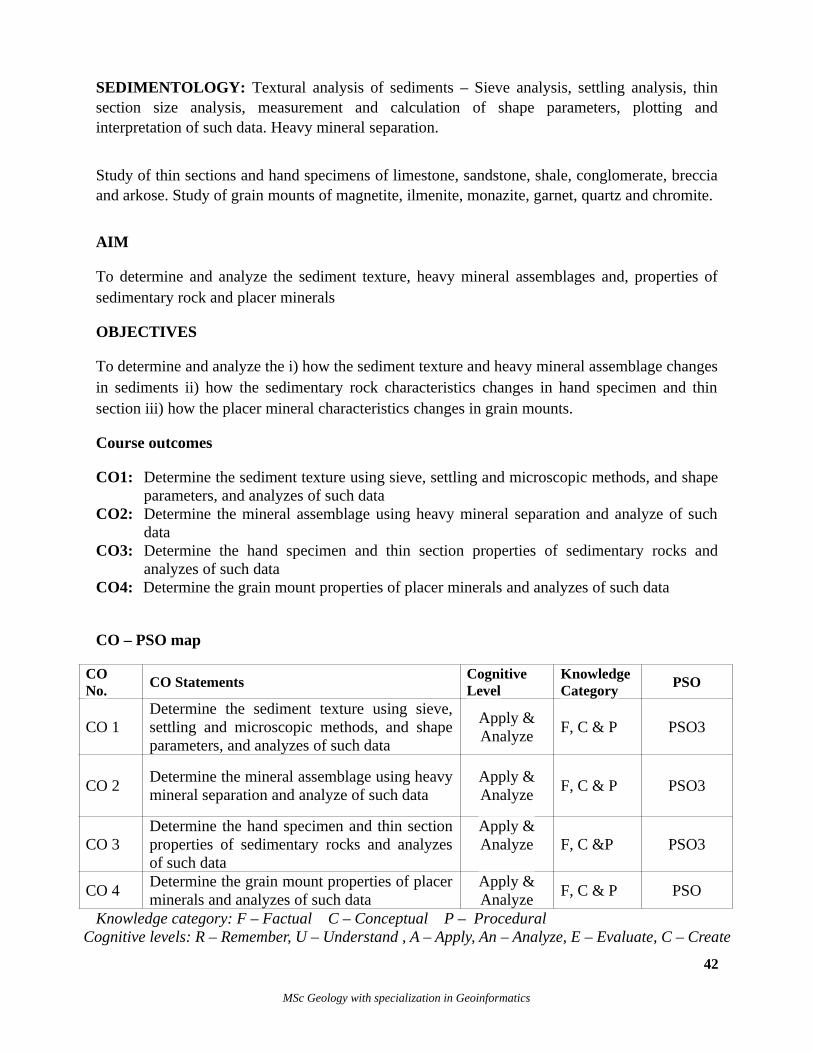
SEDIMENTOLOGY: Textural analysis of sediments – Sieve analysis, settling analysis, thinsection size analysis, measurement and calculation of shape parameters, plotting andinterpretation of such data. Heavy mineral separation.
Study of thin sections and hand specimens of limestone, sandstone, shale, conglomerate, brecciaand arkose. Study of grain mounts of magnetite, ilmenite, monazite, garnet, quartz and chromite.
AIM
To determine and analyze the sediment texture, heavy mineral assemblages and, properties ofsedimentary rock and placer minerals
OBJECTIVES
To determine and analyze the i) how the sediment texture and heavy mineral assemblage changesin sediments ii) how the sedimentary rock characteristics changes in hand specimen and thinsection iii) how the placer mineral characteristics changes in grain mounts.
Course outcomes
CO1: Determine the sediment texture using sieve, settling and microscopic methods, and shapeparameters, and analyzes of such data
CO2: Determine the mineral assemblage using heavy mineral separation and analyze of suchdata
CO3: Determine the hand specimen and thin section properties of sedimentary rocks andanalyzes of such data
CO4: Determine the grain mount properties of placer minerals and analyzes of such data
CO – PSO map
CONo.
CO StatementsCognitiveLevel
KnowledgeCategory
PSO
CO 1Determine the sediment texture using sieve,settling and microscopic methods, and shapeparameters, and analyzes of such data
Apply &Analyze
F, C & P PSO3
CO 2Determine the mineral assemblage using heavymineral separation and analyze of such data
Apply &Analyze
F, C & P PSO3
CO 3Determine the hand specimen and thin sectionproperties of sedimentary rocks and analyzesof such data
Apply &Analyze F, C &P PSO3
CO 4Determine the grain mount properties of placerminerals and analyzes of such data
Apply &Analyze
F, C & P PSO
Knowledge category: F – Factual C – Conceptual P – Procedural Cognitive levels: R – Remember, U – Understand , A – Apply, An – Analyze, E – Evaluate, C – Create
42
MSc Geology with specialization in Geoinformatics
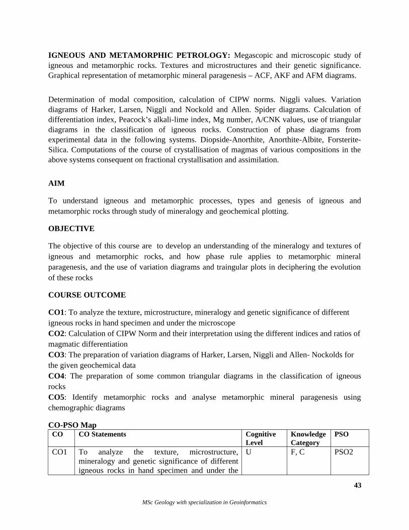
IGNEOUS AND METAMORPHIC PETROLOGY: Megascopic and microscopic study ofigneous and metamorphic rocks. Textures and microstructures and their genetic significance.Graphical representation of metamorphic mineral paragenesis – ACF, AKF and AFM diagrams.
Determination of modal composition, calculation of CIPW norms. Niggli values. Variationdiagrams of Harker, Larsen, Niggli and Nockold and Allen. Spider diagrams. Calculation ofdifferentiation index, Peacock’s alkali-lime index, Mg number, A/CNK values, use of triangulardiagrams in the classification of igneous rocks. Construction of phase diagrams fromexperimental data in the following systems. Diopside-Anorthite, Anorthite-Albite, Forsterite-Silica. Computations of the course of crystallisation of magmas of various compositions in theabove systems consequent on fractional crystallisation and assimilation.
AIM
To understand igneous and metamorphic processes, types and genesis of igneous andmetamorphic rocks through study of mineralogy and geochemical plotting.
OBJECTIVE
The objective of this course are to develop an understanding of the mineralogy and textures ofigneous and metamorphic rocks, and how phase rule applies to metamorphic mineralparagenesis, and the use of variation diagrams and traingular plots in deciphering the evolutionof these rocks
COURSE OUTCOME
CO1: To analyze the texture, microstructure, mineralogy and genetic significance of different igneous rocks in hand specimen and under the microscopeCO2: Calculation of CIPW Norm and their interpretation using the different indices and ratios ofmagmatic differentiationCO3: The preparation of variation diagrams of Harker, Larsen, Niggli and Allen- Nockolds for the given geochemical dataCO4: The preparation of some common triangular diagrams in the classification of igneousrocksCO5: Identify metamorphic rocks and analyse metamorphic mineral paragenesis usingchemographic diagrams
CO-PSO Map CO CO Statements Cognitive
LevelKnowledgeCategory
PSO
CO1 To analyze the texture, microstructure,mineralogy and genetic significance of differentigneous rocks in hand specimen and under the
U F, C PSO2
43
MSc Geology with specialization in Geoinformatics
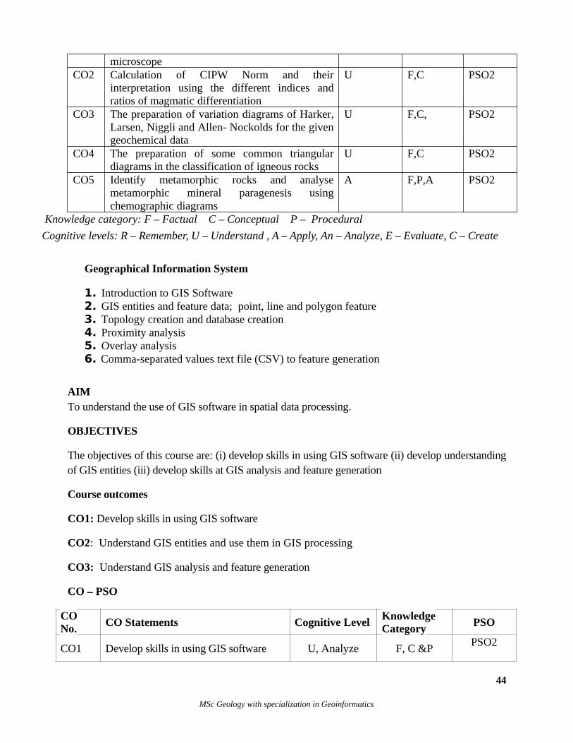
microscopeCO2 Calculation of CIPW Norm and their
interpretation using the different indices andratios of magmatic differentiation
U F,C PSO2
CO3 The preparation of variation diagrams of Harker,Larsen, Niggli and Allen- Nockolds for the givengeochemical data
U F,C, PSO2
CO4 The preparation of some common triangulardiagrams in the classification of igneous rocks
U F,C PSO2
CO5 Identify metamorphic rocks and analysemetamorphic mineral paragenesis usingchemographic diagrams
A F,P,A PSO2
Knowledge category: F – Factual C – Conceptual P – Procedural
Cognitive levels: R – Remember, U – Understand , A – Apply, An – Analyze, E – Evaluate, C – Create
Geographical Information System
1. Introduction to GIS Software2. GIS entities and feature data; point, line and polygon feature3. Topology creation and database creation4. Proximity analysis5. Overlay analysis6. Comma-separated values text file (CSV) to feature generation
AIM To understand the use of GIS software in spatial data processing.
OBJECTIVES
The objectives of this course are: (i) develop skills in using GIS software (ii) develop understandingof GIS entities (iii) develop skills at GIS analysis and feature generation
Course outcomes
CO1: Develop skills in using GIS software
CO2: Understand GIS entities and use them in GIS processing
CO3: Understand GIS analysis and feature generation
CO – PSO
CONo.
CO Statements Cognitive LevelKnowledgeCategory
PSO
CO1 Develop skills in using GIS software U, Analyze F, C &PPSO2
44
MSc Geology with specialization in Geoinformatics
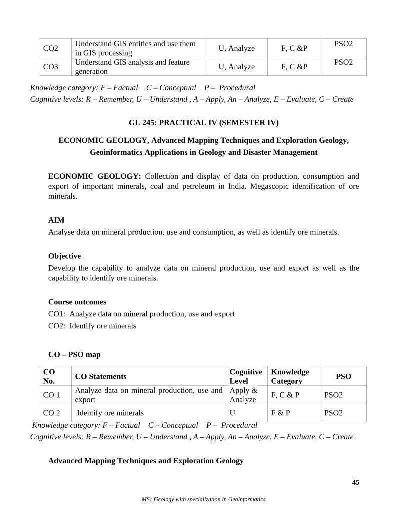
CO2 Understand GIS entities and use them in GIS processing
U, Analyze F, C &PPSO2
CO3Understand GIS analysis and feature generation
U, Analyze F, C &PPSO2
Knowledge category: F – Factual C – Conceptual P – Procedural
Cognitive levels: R – Remember, U – Understand , A – Apply, An – Analyze, E – Evaluate, C – Create
GL 245: PRACTICAL IV (SEMESTER IV)
ECONOMIC GEOLOGY, Advanced Mapping Techniques and Exploration Geology,
Geoinformatics Applications in Geology and Disaster Management
ECONOMIC GEOLOGY: Collection and display of data on production, consumption andexport of important minerals, coal and petroleum in India. Megascopic identification of oreminerals.
AIM
Analyse data on mineral production, use and consumption, as well as identify ore minerals.
Objective
Develop the capability to analyze data on mineral production, use and export as well as thecapability to identify ore minerals.
Course outcomes
CO1: Analyze data on mineral production, use and export
CO2: Identify ore minerals
CO – PSO map
CONo.
CO StatementsCognitiveLevel
KnowledgeCategory
PSO
CO 1Analyze data on mineral production, use andexport
Apply & Analyze
F, C & P PSO2
CO 2 Identify ore minerals U F & P PSO2
Knowledge category: F – Factual C – Conceptual P – Procedural
Cognitive levels: R – Remember, U – Understand , A – Apply, An – Analyze, E – Evaluate, C – Create
Advanced Mapping Techniques and Exploration Geology
45
MSc Geology with specialization in Geoinformatics
Advanced Mapping Techniques
Using software develop
1. Familiarization of Microwave and thermal data, 2. Familiarization of Hyperspectral data3. Familiarization of Lidar/UAV data4. Advanced GIS analysis: undertake any type of GIS analysis at an advanced level
AIM
Familiarization with Microwave, thermal, hyperspectral and Lidar/UAV data, and also getskilled in advanced GIS analysis.
Objective
Develop the capability to distinguish the relative merits and uuses of Microwave, thermal,hyperspectral and Lidar/UAV data, and get skilled in advanced GIS analysis.
Course outcomes
CO1: Capability to distinguish the relative merits and uses of Microwave, thermal, hyperspectraland Lidar/UAV data
CO2: Skill development in advanced GIS analysis.
CO – PSO map
CONo.
CO StatementsCognitiveLevel
KnowledgeCategory
PSO
CO 1Capability to distinguish the relative merits and uses of Microwave, thermal, hyperspectral and Lidar/UAV data
Apply & Analyze
F, C & P PSO2
CO 2 Skill development in advanced GIS analysis. U F & P PSO2
Knowledge category: F – Factual C – Conceptual P – Procedural
Cognitive levels: R – Remember, U – Understand , A – Apply, An – Analyze, E – Evaluate, C – Create
EXPLORATION GEOLOGY: Averaging assays, estimation of ore reserves, cut off grade,core logging and interpretations from litholog plotting.
AIM
To develop skills in resource exploitation and reserve estimation
Objective
46
MSc Geology with specialization in Geoinformatics
Develop the capability to determine assays, ore reserves, cut off grade, core logging and lithologinterpretations.
Course outcomes
CO1: Capability to determine assays, ore reserves, cut off grade
CO2: Capability of core logging and litholog interpretations.
CO – PSO map
CONo.
CO StatementsCognitiveLevel
KnowledgeCategory
PSO
CO 1Capability to determine assays, ore reserves,cut off grade
Apply & Analyze
F, C & P PSO2
CO 2Capability of core logging and lithologinterpretations.
U F & P PSO2
Knowledge category: F – Factual C – Conceptual P – Procedural
Cognitive levels: R – Remember, U – Understand , A – Apply, An – Analyze, E – Evaluate, C – Create
Applications of GIS in Geology and Disaster Management
1. Flood prone area mapping using satellite images and ancillary data.2. Forest fire risk mapping using satellite images and GIS.3. Landslide mapping and risk evaluation.4. Drought prone area mapping using satellite images5. Terrain mapping in coastal region for coastal hazards prediction
AIM
Develop understanding of GIS usage in disaster management
Objective
Develop the capability to use GIS to characterise, map and manage floods, forest fires,landslides, drought, and coastal hazards
Course outcomes
CO1: Capability to use GIS to characterise, map and manage floods, forest fires
CO2: Capability to use GIS to characterise, map and manage landslide, drought, and coastalhazards
47
MSc Geology with specialization in Geoinformatics
CO – PSO map
CONo.
CO StatementsCognitiveLevel
KnowledgeCategory
PSO
CO1Capability to use GIS to characterise, mapand manage floods, forest fires
Apply & Analyze
F, C & P PSO2
CO2Capability to use GIS to characterise, mapand manage landslide, drought, and coastalhazards
U F & P PSO2
Knowledge category: F – Factual C – Conceptual P – Procedural
Cognitive levels: R – Remember, U – Understand , A – Apply, An – Analyze, E – Evaluate, C – Create
DISSERTATION
Aim
Dissertation is to empower the student to develop critical thinking, innovative research ideas, anddeeper knowledge in the subject.
Objective
To develop skills which enable the synthesis of knowledge and improve scientific field work, data collection, analysis and writing skills. To develop and enhance independent research skills.
Course outcomes
CO 1: Understand a specific area of the subject in-depth including deeper insight into current research and development work, through primary, secondary and tertiary sources of information.
CO2: Plan the research, identify the problem, field area, collect data, classify and analyse the data.
CO3: Understand the methodology in the chosen research area and develop the critical thinking ability to choose the most appropriate methodology for the particular research problem.
CO4: Develop capability to use a holistic view to critically, independently and creatively identify, formulate and deal with complex issues.
CO5: Critically and systematically integrate the findings of the research into the current scenarioin the area of research, with concern for and conscious of the ethical aspects of research.
CO6: Evaluate the results through writing the thesis and presenting the results to a learned audience.
CO – PSO map
48
MSc Geology with specialization in Geoinformatics
CONo.
CO StatementsCognitive
LevelKnowledgeCategory
POPSO
CO1
Understand a specific area of the subject in-depthincluding deeper insight into current research and development work, through primary, secondary and tertiary sources of information.
U&A F & C F & C PSO6
CO2Plan the research, identify the problem, field area, collect data, classify and analyse the data.
U,A&E F,P & C F,P & C PSO6
CO3
Understand the methodology in the chosen research area and develop the critical thinking ability to choose the most appropriate methodology for the particular research problem.
A&E F,P& C F,P& C PSO6
CO4 Develop capability to use a holistic view to critically, independently and creatively identify, formulate and deal with complex issues.
E&C F,C&P F,C&P PSO6
CO5
Critically and systematically integrate the findingsof the research into the current scenario in the areaof research, with concern for and conscious of the ethical aspects of research.
E&C F,P & C F,P & C PSO6
CO6Evaluate the results through writing the thesis andpresenting the results to a learned audience.
A&C F&C F&C PSO6
Knowledge category: F – Factual C – Conceptual P – Procedural
Cognitive levels: R – Remember, U – Understand , A – Apply, An – Analyze, E – Evaluate, C – Create
Appendix I
Action Verbs associated with Bloom’s cognitive levels
Remember• Recognize/Identify• Recall/Retrieve: List, mention, state, draw, label, define, name, describe, prove a theorem tell,show, label, collect, examine, tabulate, quote, , who, when, where, etc.
Understand• Interpret: Translate, paraphrase, represent, describe, express, extend and clarify• Exemplify: Illustrate and instantiate• Classify: Categorize and subsume• Summarize: Generalize and abstract• Infer: Extrapolate, interpolate, predict, conclude• Compare: Contrast, match, map, distinguish and differentiate• Explain: Illustrate, construct a model, confirm, state, write down, associate and discuss
Apply
49
MSc Geology with specialization in Geoinformatics
• Execute: Determine, calculate, compute, estimate solve, use, draw, and carry out (a procedurein known situation)• Implementing: Determine, calculate, compute, estimate solve, use draw, and carry out (aprocedure in unfamiliar situation)
Analyze• Differentiate: discriminate, select, focus and distinguish (between accurate and inaccurate,cause and effect, consistent and inconsistent, dominant and subordinate, essential and inessential,facts and conclusions, facts and hypotheses, facts and inferences, facts and opinions, facts andvalue statements, plausible and implausible, possible and impossible, relevant and irrelevant,summaries and conclusions, supportive and contradictory, valid and invalid, verifiable andunverifiable, warranted and unwarranted)• Organize: Identify (adequacy, assumptions, attributes, biases, causes, central issues,completeness, concepts, consequences, contradictions, criteria, defects, distortions, effects,elements, errors, exceptions, fallacies, inconsistencies, inferences, limitations, main ideas, natureof evidence, organization, plausibility, problems, procedures, reasoning, relationships, relevance,stereotypes, trends, validity, variables), structure, integrate, find coherence, outline and parse.• Attribute: Deconstruct and ascertain (Assumptions, attitudes, biases, conditions, characteristics,motives, organization, points of view, purposes, qualities, relationships)
Evaluate• Check/test (Accuracy, adequacy, appropriateness, clarity, cohesiveness, completeness,consistency, correctness, credibility, organization, reasonableness, reasoning, relationships,reliability, significance, usefulness, validity, values, worth), detect, monitor and coordinate.• Critique/judge (Criteria, standards, and procedures)
Create• Generate alternatives and hypotheses• Plan/design• Produce/construct
(Source: N.J.Rao, Nov 2010)
Appendix II
Educational Taxonomy
has four knowledge categories and six cognitive levels.
Knowledge categories
FactualConceptualProceduralMeta cognitive
Cognitive levelsRemember
50
MSc Geology with specialization in Geoinformatics
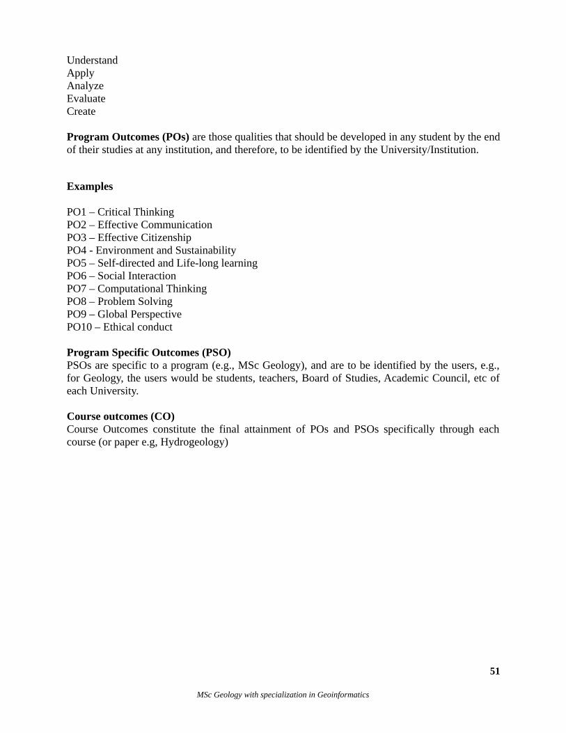
UnderstandApplyAnalyzeEvaluateCreate
Program Outcomes (POs) are those qualities that should be developed in any student by the endof their studies at any institution, and therefore, to be identified by the University/Institution.
Examples
PO1 – Critical Thinking PO2 – Effective Communication PO3 – Effective Citizenship PO4 - Environment and Sustainability PO5 – Self-directed and Life-long learning PO6 – Social Interaction PO7 – Computational ThinkingPO8 – Problem SolvingPO9 – Global Perspective PO10 – Ethical conduct
Program Specific Outcomes (PSO)PSOs are specific to a program (e.g., MSc Geology), and are to be identified by the users, e.g.,for Geology, the users would be students, teachers, Board of Studies, Academic Council, etc ofeach University.
Course outcomes (CO)Course Outcomes constitute the final attainment of POs and PSOs specifically through eachcourse (or paper e.g, Hydrogeology)
51
MSc Geology with specialization in Geoinformatics