Embed Size (px)
Citation preview
Author's personal copy
Wind deposition of mud aggregates and their role in development oflamellae in the Fair Oaks Dunes, Indiana
Zoran Kilibarda ⁎, Erin Argyilan, Joe Blockland
Indiana University Northwest, United States
Received 24 January 2007; received in revised form 18 May 2007; accepted 22 May 2007
Abstract
Three parabolic dunes from the Fair Oaks Dune field in northern Indiana were excavated, in order to study the properties and genesis of lamellae.Reddish lamellae with sharp upper boundaries and diffuse lower boundaries are intercalated with yellowish sand layers within the upper 3–5 m ofeach dune. The thicknesses of the lamellae decrease from N2 cm in the east (Winamac dune) to b0.3 cm in the west (Shelby dune). In deeper parts ofthe dunes lamellae were absent, but straight or slightly convex, clay rich depositional laminae were present. Thin sections of lamellae reveal that mostof the clays are depositional with a lesser clay amount resulting from in situ weathering of feldspar grains. Clays were deposited as sand-size mud (silt/clay) aggregates that winds removed from glacio-fluvial valleys. Lithic fragments, primarily mud aggregates and carbonates, are much moreabundant in unweathered depositional laminae than in weathered lamellae.Weathering and depletion of exchangeable Ca+ andMg+ led to breakdownof mud aggregates and clay dispersion from clay rich sand laminae through clay-poor sand laminae. The reddish color of lamellae results fromoxidation of mafic grains. Sand-size mud aggregates were lighter than quartz or feldspar grains andwere carried further downwind and, as a result, theclay in the dunes, and the thickness of the lamellae, increases to the east. At 5.6 m depth in the Winamac dune we found the straight depositionallaminae transitioning into wavy lamellae. This is the most direct evidence of depositional lamellae (petrogenic) formation in the literature to date.© 2007 Elsevier B.V. All rights reserved.
Keywords: Lamellae; Laminae; Mud aggregates; Dunes
1. Introduction
A lamella is an illuvial soil horizon less than 7.5 cm thick thatcontains accumulation of oriented silicate clay on or bridgingsand and silt grains (Soil Survey Staff, 1999). The genesis oflamellae is very controversial. Dijkerman et al. (1967) distin-guished three kinds of lamellae: a) lamellae that originate bysedimentation during deposition of the parent material (lami-nae); b) lamellae that originate by clay illuviation, initiated and,to some degree, controlled by properties of the deposit acquiredthrough sedimentation; and c) lamellae that originate by processof clay illuviation independent of inherited stratification. Re-cently, Rawling (2000) and Schaetzl (2001) summarized previ-ous research on this topic and presented evidence of petrogenic,pedogenic, and polygenetic lamellae.
The following evidence has been used to document petrogeniclamellae: (1) depositional lamina changing into lamella (this
paper, Fig. 5), (2) lamellae conform to bedding planes (Hannahand Zahner, 1970; Schaetzl, 2001; this paper), (3) lamellae are toothick to have been formed by pedogenesis (Robinson and Rich,1960; Hannah and Zahner, 1970), (4) lamellae do not conform tothe land surface (Schaetzl, 2001), (5) lamellae underlie a zone sodevoid of clay as to preclude it as a clay source (Schaetzl, 2001),(6) lamellae occur at great depth (Robinson and Rich, 1960), and(7) lamellae form by mass wasting and reworking of dune sandduring intense rain storms (Bigarella, 1975).
Pedogenic lamellae form by clay illuviation either from theentire solum (Torrent et al., 1980; Bond, 1986) or from theeluvial zone immediately overlying lamellae (McIntosh, 1988).The mechanisms invoked in pedogenic lamella formation in-clude: a) wetting-front-drying (Gile, 1979; Torrent et al., 1980;Schaetzl, 1992); b) iron induced clay flocculation (Smith et al.,1950; Miles and Franzmeier, 1981); c) carbonate induced clayflocculation (Berg, 1984; Schaetzl, 1992). Evidence in supportof the pedogenic lamellae development includes the following:(1) lamellae that cross bedding planes (Ehrman, 1987), (2)lamellae that cross-cut an archeological pit and undisturbed
Available online at www.sciencedirect.com
Catena 72 (2008) 235–247www.elsevier.com/locate/catena
⁎ Corresponding author.E-mail address: [email protected] (Z. Kilibarda).
0341-8162/$ - see front matter © 2007 Elsevier B.V. All rights reserved.doi:10.1016/j.catena.2007.05.006
Author's personal copy
sediment (Leigh, 1998; Prusinkiewicz et al., 1998), (3) absenceof lamellae deep within and below the C horizon and in theuppermost eluvial zone (Schaetzl, 1992), (4) increasing lamellaedevelopment in soils of increasing age (Gile, 1979; Miles andFranzmeier, 1981; Berg, 1984), and (5) the clear, sharp upperboundaries and lower, ragged boundaries of lamellae (VanReeuwijk and de Villiers, 1985; Ehrman, 1987).
Polygenetic (Schaetzl, 2001) or pedo-petrogenic (Rawling,2000) lamellae form by clay illuviation along sediment dis-continuities. Bouabid et al. (1992) found lamellae developing incoarser sand with larger pores than the underlying interlamellaesand, while Rawling (2000) reports lamellae developing in finersand with less pore space than the underlying interlamellae.
In this paper we demonstrate petrogenic (depositional) originof lamellae in an inland Fair Oaks Dune (FOD) field of north-west Indiana, U.S.A.
2. Location of the study area
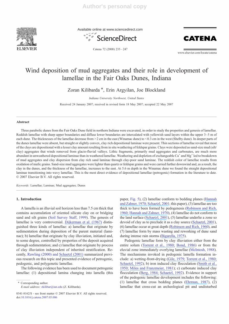
The Fair Oaks Dunes (FOD) are located in northwesternIndiana and cover about 2800 km2, thus being, after Nebraska
Sand Hills, one of the larger inland dune fields in NorthAmerica (Muhs et al., 1999; Bettis et al., 2003). Dunes extend ina SW–NE direction for about 110 km, while the maximum N–Sextent is over 80 km in the eastern part of the dune field (Fig. 1).The Kankakee River outwash plain forms the northern bound-ary of the FOD. The eastern boundary of the dune field ismarked by the complex Maxincuckee morainal system, an areafull of collapsed ice features, kettles and kames. To the west thedune field extends into Kankakee County of northeasternIllinois, where it is known as Parkland sand (Masters, 1983).The southern boundary of the dune field is marked by theIroquois moraine, until the dune field wraps around the easternside of the Iroquois moraine and extends south to Monticello,Indiana.
Dunes and interdune sand sheets (Fraser and Bleuer, 1991)rise from about 204 m above sea level in the western part of thestudy area to about 247 m in the east. In the same W–Edirection, relative dune height rises from 7 m to over 15 m, withthe maximum dune height of 25 m just east of Toto, Indiana.The Fair Oaks Dunes are fixed and stable dunes overgrown byoak and ash forest that contrasts with agricultural fields in flat
Fig. 1. Location of the Fair Oaks Dunes in northwestern Indiana and three study sites including dunes at Winamac (1), I-65 (2) and Shelby (3). Drawing after Rarickand Thornbury (1971–1972), Muhs et al. (1999), Bettis et al. (2003), and USGS 7.5 min maps of Shelby, Fair Oaks, and Winamac quadrangles in NW Indiana.Contour interval=1.5 m.
236 Z. Kilibarda et al. / Catena 72 (2008) 235–247
Author's personal copy
interdune areas. The prevailing morphology is compoundparabolic dunes (Fig. 1) appearing in chains of five to twelveconnected ridges. The last movement of sand and subse-quent fixation of the dunes indicates westerly to south-westerlywinds.
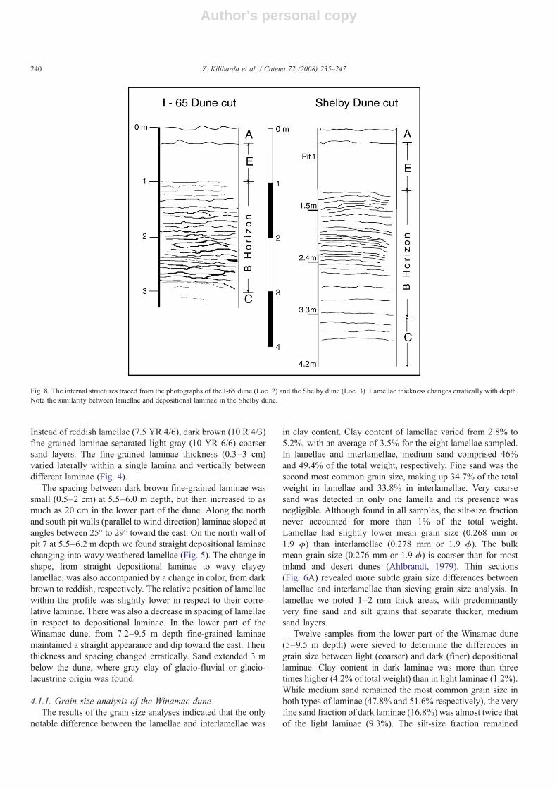
Lush forests on modern dunes prevent access to internalstructures of the dunes and create problems with sampling ofsand. At three localities Winamac (1), I-65 (2) and Shelby (3)(Fig. 1) dunes were excavated to a depth of 3.2–9.5 m to revealand study the dune interior. At locality 2 a dune was cut to makea new ramp and approach to US Interstate 65. Before the dunewas completely removed we examined and photographed(Fig. 6) its internal structures and collected samples of sandfor grain size analysis.
The first observation of the dune's interior indicated muchredder sand than the sand in Lake Michigan coastal dunes.Norris (1969) suggested that dune sands become reddened withthe passage of time, the process being promoted by warmtemperatures, oxidizing conditions, and the periodic presence ofmoisture. The Calumet and the Glenwood phase coastal dunesof Lake Michigan are 11.5 14C B.P. and 12.8 14C B.P. old(Hansel et al., 1985), respectively, yet still contain tan sand. Thesand in the Valparaiso moraine (Kilibarda and Brown, 2005)which was dated 15.1 14C B.P. (Hansel and Johnson, 1992) isalso tan. Does this indicate that the Fair Oaks Dunes are mucholder than Lake Michigan dunes and the sand in the Valparaisomoraine complex? Pye (1981) indicates that reddening in dunesands is dependent on several variables including sand min-eralogy, temperature, moisture availability, drainage conditions,degree of sediment stability, and the input of airborne dust. Pyeconcludes that time cannot be regarded as an independentvariable in the reddening process, and color alone cannot be
used as an adequate guide to age or morphometric correlationbetween different areas.
3. Methods of study
We excavated 9.5 m of a dune at Winamac (Loc. 1; Figs. 2–5), 3.2 m at I-65 (Loc. 2; Figs. 6 and 7) and 4.2 m at Shelby(Loc. 3; Figs. 7 and 8) in a series of step-like pits that were 1–3 m wide and 0.6–1.5 m deep. At all the localities excavationswere made on the downwind slip faces of the dunes. At each pitwe carefully examined one face perpendicular to the winddirection and two faces parallel to the wind direction. The pitswere measured, described, photographed and samples of sandwere collected for mineralogy and grain size analysis.
Grain size analyses were performed at the SedimentologyLaboratory within the Department of Geosciences at IndianaUniversity Northwest. Two smaller sets of samples were pro-cessed and analyzed at the NRCS National Soil SurveyCenter in Lincoln, Nebraska and at the Soil GeomorphologyLaboratory within the Department of Geography at MichiganState University. Each sieve fraction was studied with a stereomicroscope to determine grain texture and composition. Clayfractions from the Winamac dune (Loc. 1) were analyzed withX-ray diffractometer at the NRCS National Soil Survey Centerin Lincoln, Nebraska. We also collected in situ samples oflamellae and laminae by forcing 7 cm diameter, transparent,plastic containers into clean, fresh pit faces. These samples wereimpregnated and then cut into thin sections for study of min-eralogy and visual grain size differences with a petrographicmicroscope. Half of each thin section was stained for bothpotassium and plagioclase feldspars. Large (6×4 cm) thin sec-tions were studied and 2 to 8 runs of 300 grains were point
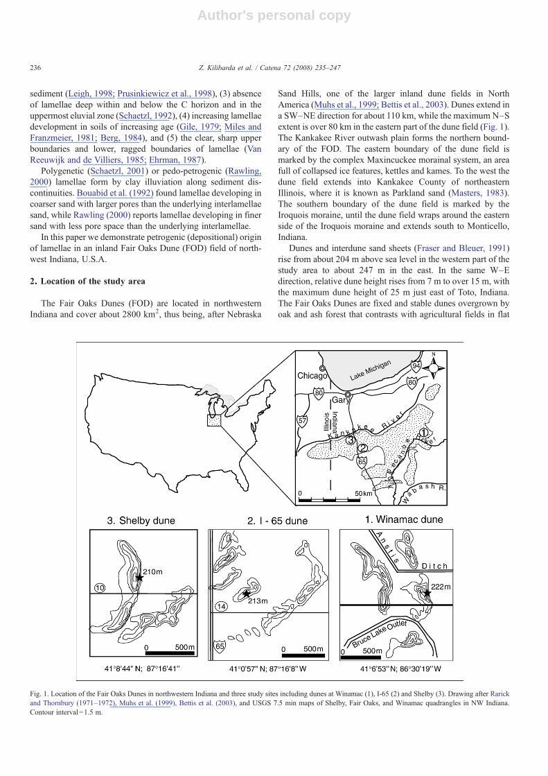
Fig. 2. Differences in lamellae thickness in the Winamac dune due to changes in moisture content. A) Lamellae in dry summer weather, B) lamellae in wet winterweather. Clay (7.5 YR 4/6) in tan sand (10 YR 5/6) doubles or triples the apparent lamellae thickness in wet weather. Light sand (interlamellae) is identified forreference (arrow).
237Z. Kilibarda et al. / Catena 72 (2008) 235–247
Author's personal copy
counted for mineralogy analysis depending on the number oflamellae or laminae.
4. Description of dunes' internal structures
4.1. Winamac dune
The Winamac dune is located in the eastern part of the FODfield (Fig. 1) at N 41°6′53″, W 86°30′19″ at an elevation of
220 m above sea level. The original parabolic dune extended for1.4 km but implacement of two ditches (Bruce Lake Outlet andAnstis Ditch) created three separate dune segments. The middlesegment, where the pits were dug, extends for about 560 m inthe N–S direction and is about 340 m wide. It has a long andgentle western stoss side, and a short and steep eastern slipface.The Winamac dune is 10.5 m high and its slipface has been cutfor the local sand supply. We excavated the dune slip face to9.54 m depth in 12 pits that ranged from 0.6–1.3 m depth and
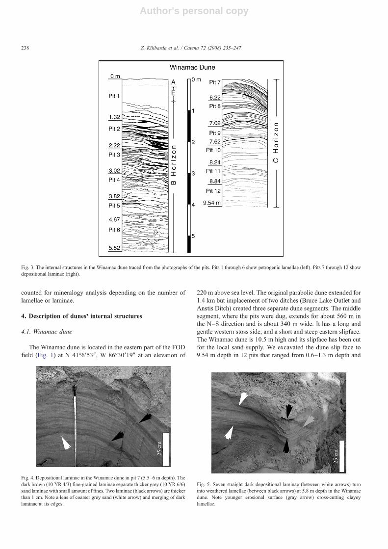
Fig. 4. Depositional laminae in the Winamac dune in pit 7 (5.5–6 m depth). Thedark brown (10 YR 4/3) fine-grained laminae separate thicker grey (10 YR 6/6)sand laminae with small amount of fines. Two laminae (black arrows) are thickerthan 1 cm. Note a lens of coarser grey sand (white arrow) and merging of darklaminae at its edges.
Fig. 5. Seven straight dark depositional laminae (between white arrows) turninto weathered lamellae (between black arrows) at 5.8 m depth in the Winamacdune. Note younger erosional surface (gray arrow) cross-cutting clayeylamellae.
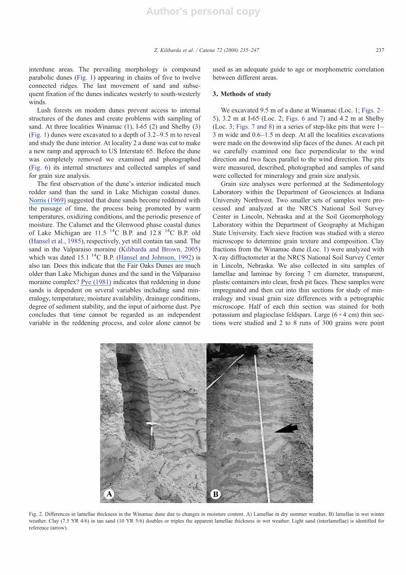
Fig. 3. The internal structures in the Winamac dune traced from the photographs of the pits. Pits 1 through 6 show petrogenic lamellae (left). Pits 7 through 12 showdepositional laminae (right).
238 Z. Kilibarda et al. / Catena 72 (2008) 235–247
Author's personal copy
1–3 m width. From 0.3 m to 3 m of sand was removed from thedune surface to make the pits.
The top 20 cm of the Winamac dune contains a dark brown(10 YR 3/2), organic rich, A horizon of the soil profile. Belowthe A horizon, from 20–80 cm is bioturbated sand of the Ehorizon. Roots of higher plants are abundant in this layer butclays are absent, probably translocated into the B horizon. Thefirst discontinuous lamellae appear at 80 cm depth and mark thebeginning of the Bt horizon. The first continuous lamellae occurat 90 cm depth and have a wavy appearance with a gentleinclination to the north. One lamella maintained 5 mm thicknessover the 3 m wide exposure. From 0.9 m to 1.4 m lamellaeincreased in thickness from 0.5 to 2 cm. As lamellae becomethicker they also appear to straighten, losing the wavy ap-pearance. Large differences in the apparent lamellae thicknesswere observed in wet weather (Fig. 2). To avoid discrepancies inour comparisons, all internal dune structures were observed andmeasured after at least 1 week of dry weather.
In pit 2 (1.4m–2.2m depth) the lamellae thickness varied from0.3–3 cm while their spacing varied from 1–7 cm. The lamellaewere thicker where the spacing between them increased. From2.2–4 m depth lamellae were generally thin (1.5 cm or less) butthere was no progressive decrease in their thickness with depth.Below 4 m depth no lamellae were thicker than 1 cm. The wavylamellae appearance was the rule but their bifurcation or mergingwas erratic. In several instances individual lamellae thicknesschanged as much as 50% over a relatively short distance. On thenorth and south walls, which were parallel with wind direction,the lamellae dip toward the east.
At 5.53 m depth (pit 7) we found straight or gently convexdepositional laminae (Fig. 4) instead of lamellae. The firststriking difference between lamellae and laminae was the color.
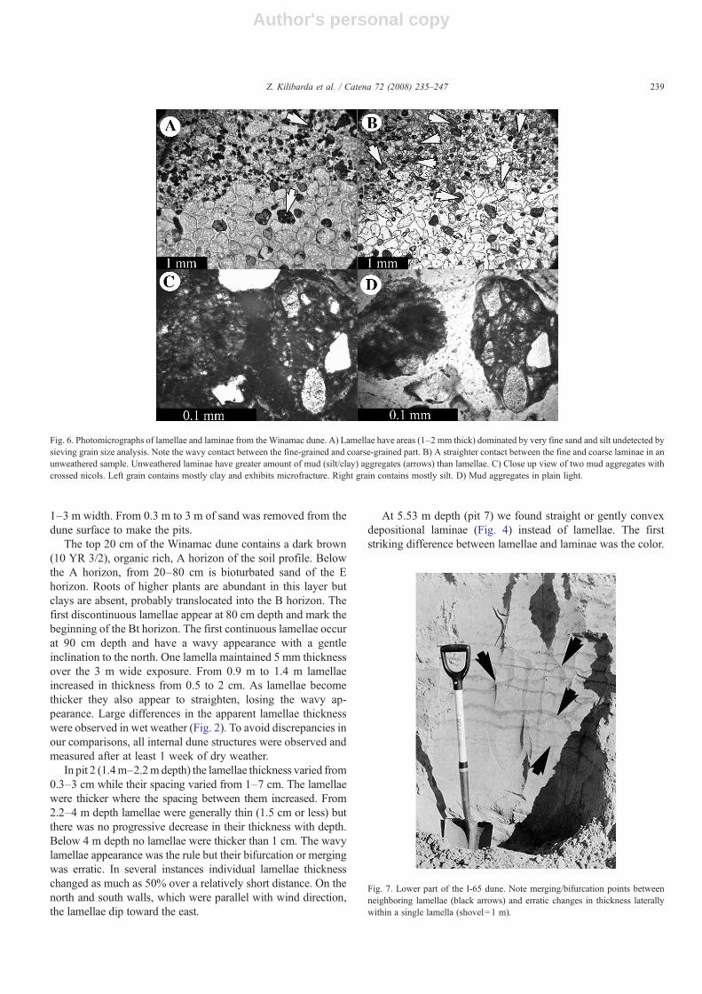
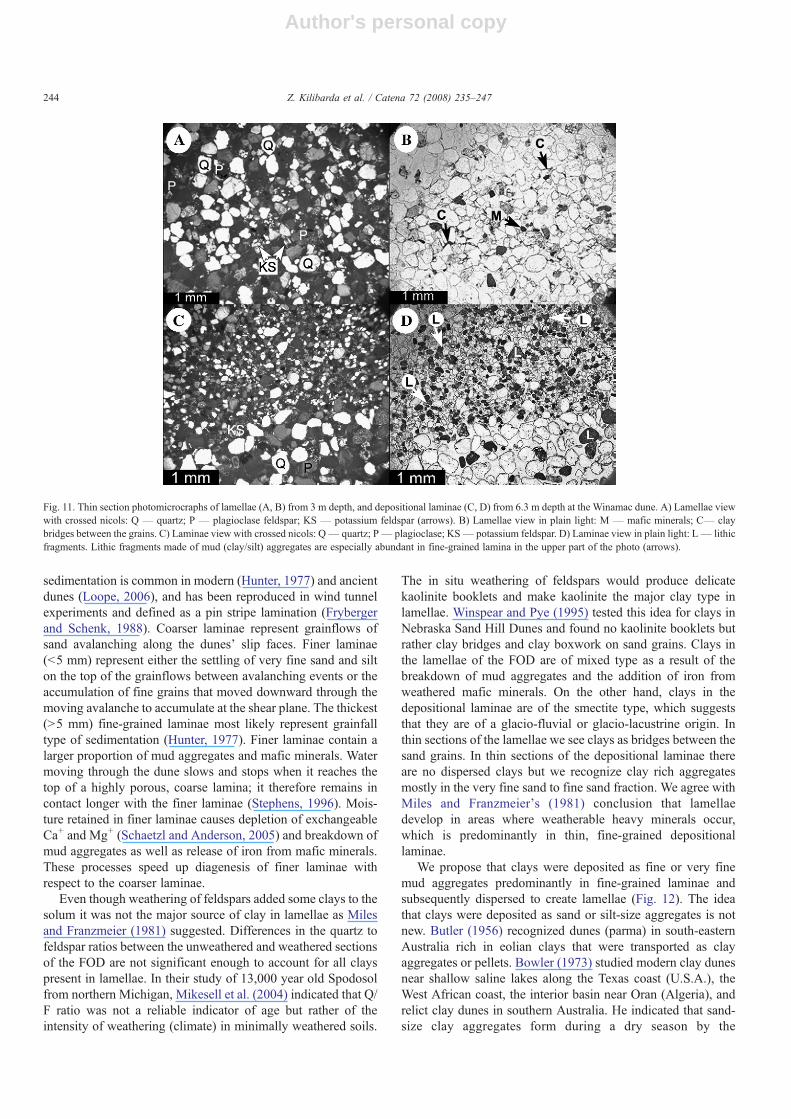
Fig. 6. Photomicrographs of lamellae and laminae from the Winamac dune. A) Lamellae have areas (1–2 mm thick) dominated by very fine sand and silt undetected bysieving grain size analysis. Note the wavy contact between the fine-grained and coarse-grained part. B) A straighter contact between the fine and coarse laminae in anunweathered sample. Unweathered laminae have greater amount of mud (silt/clay) aggregates (arrows) than lamellae. C) Close up view of two mud aggregates withcrossed nicols. Left grain contains mostly clay and exhibits microfracture. Right grain contains mostly silt. D) Mud aggregates in plain light.
Fig. 7. Lower part of the I-65 dune. Note merging/bifurcation points betweenneighboring lamellae (black arrows) and erratic changes in thickness laterallywithin a single lamella (shovel=1 m).
239Z. Kilibarda et al. / Catena 72 (2008) 235–247
Author's personal copy
Instead of reddish lamellae (7.5 YR 4/6), dark brown (10 R 4/3)fine-grained laminae separated light gray (10 YR 6/6) coarsersand layers. The fine-grained laminae thickness (0.3–3 cm)varied laterally within a single lamina and vertically betweendifferent laminae (Fig. 4).
The spacing between dark brown fine-grained laminae wassmall (0.5–2 cm) at 5.5–6.0 m depth, but then increased to asmuch as 20 cm in the lower part of the dune. Along the northand south pit walls (parallel to wind direction) laminae sloped atangles between 25° to 29° toward the east. On the north wall ofpit 7 at 5.5–6.2 m depth we found straight depositional laminaechanging into wavy weathered lamellae (Fig. 5). The change inshape, from straight depositional laminae to wavy clayeylamellae, was also accompanied by a change in color, from darkbrown to reddish, respectively. The relative position of lamellaewithin the profile was slightly lower in respect to their corre-lative laminae. There was also a decrease in spacing of lamellaein respect to depositional laminae. In the lower part of theWinamac dune, from 7.2–9.5 m depth fine-grained laminaemaintained a straight appearance and dip toward the east. Theirthickness and spacing changed erratically. Sand extended 3 mbelow the dune, where gray clay of glacio-fluvial or glacio-lacustrine origin was found.
4.1.1. Grain size analysis of the Winamac duneThe results of the grain size analyses indicated that the only
notable difference between the lamellae and interlamellae was
in clay content. Clay content of lamellae varied from 2.8% to5.2%, with an average of 3.5% for the eight lamellae sampled.In lamellae and interlamellae, medium sand comprised 46%and 49.4% of the total weight, respectively. Fine sand was thesecond most common grain size, making up 34.7% of the totalweight in lamellae and 33.8% in interlamellae. Very coarsesand was detected in only one lamella and its presence wasnegligible. Although found in all samples, the silt-size fractionnever accounted for more than 1% of the total weight.Lamellae had slightly lower mean grain size (0.268 mm or1.9 ϕ) than interlamellae (0.278 mm or 1.9 ϕ). The bulkmean grain size (0.276 mm or 1.9 ϕ) is coarser than for mostinland and desert dunes (Ahlbrandt, 1979). Thin sections(Fig. 6A) revealed more subtle grain size differences betweenlamellae and interlamellae than sieving grain size analysis. Inlamellae we noted 1–2 mm thick areas, with predominantlyvery fine sand and silt grains that separate thicker, mediumsand layers.
Twelve samples from the lower part of the Winamac dune(5–9.5 m depth) were sieved to determine the differences ingrain size between light (coarser) and dark (finer) depositionallaminae. Clay content in dark laminae was more than threetimes higher (4.2% of total weight) than in light laminae (1.2%).While medium sand remained the most common grain size inboth types of laminae (47.8% and 51.6% respectively), the veryfine sand fraction of dark laminae (16.8%) was almost twice thatof the light laminae (9.3%). The silt-size fraction remained
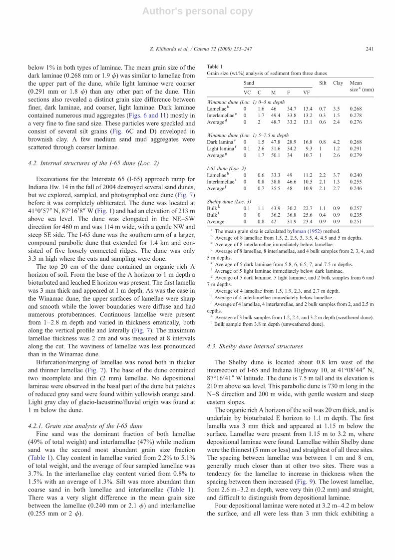
Fig. 8. The internal structures traced from the photographs of the I-65 dune (Loc. 2) and the Shelby dune (Loc. 3). Lamellae thickness changes erratically with depth.Note the similarity between lamellae and depositional laminae in the Shelby dune.
240 Z. Kilibarda et al. / Catena 72 (2008) 235–247
Author's personal copy
below 1% in both types of laminae. The mean grain size of thedark laminae (0.268 mm or 1.9 ϕ) was similar to lamellae fromthe upper part of the dune, while light laminae were coarser(0.291 mm or 1.8 ϕ) than any other part of the dune. Thinsections also revealed a distinct grain size difference betweenfiner, dark laminae, and coarser, light laminae. Dark laminaecontained numerous mud aggregates (Figs. 6 and 11) mostly ina very fine to fine sand size. These particles were speckled andconsist of several silt grains (Fig. 6C and D) enveloped inbrownish clay. A few medium sand mud aggregates werescattered through coarser laminae.
4.2. Internal structures of the I-65 dune (Loc. 2)
Excavations for the Interstate 65 (I-65) approach ramp forIndiana Hw. 14 in the fall of 2004 destroyed several sand dunes,but we explored, sampled, and photographed one dune (Fig. 7)before it was completely obliterated. The dune was located at41°0′57″ N, 87°16′8″W (Fig. 1) and had an elevation of 213 mabove sea level. The dune was elongated in the NE–SWdirection for 460 m and was 114 m wide, with a gentle NW andsteep SE side. The I-65 dune was the southern arm of a larger,compound parabolic dune that extended for 1.4 km and con-sisted of five loosely connected ridges. The dune was only3.3 m high where the cuts and sampling were done.
The top 20 cm of the dune contained an organic rich Ahorizon of soil. From the base of the A horizon to 1 m depth abioturbated and leached E horizon was present. The first lamellawas 3 mm thick and appeared at 1 m depth. As was the case inthe Winamac dune, the upper surfaces of lamellae were sharpand smooth while the lower boundaries were diffuse and hadnumerous protuberances. Continuous lamellae were presentfrom 1–2.8 m depth and varied in thickness erratically, bothalong the vertical profile and laterally (Fig. 7). The maximumlamellae thickness was 2 cm and was measured at 8 intervalsalong the cut. The waviness of lamellae was less pronouncedthan in the Winamac dune.
Bifurcation/merging of lamellae was noted both in thickerand thinner lamellae (Fig. 7). The base of the dune containedtwo incomplete and thin (2 mm) lamellae. No depositionallaminae were observed in the basal part of the dune but patchesof reduced gray sand were found within yellowish orange sand.Light gray clay of glacio-lacustrine/fluvial origin was found at1 m below the dune.
4.2.1. Grain size analysis of the I-65 duneFine sand was the dominant fraction of both lamellae
(49% of total weight) and interlamellae (47%) while mediumsand was the second most abundant grain size fraction(Table 1). Clay content in lamellae varied from 2.2% to 5.1%of total weight, and the average of four sampled lamellae was3.7%. In the interlamellae clay content varied from 0.8% to1.5% with an average of 1.3%. Silt was more abundant thancoarse sand in both lamellae and interlamellae (Table 1).There was a very slight difference in the mean grain sizebetween the lamellae (0.240 mm or 2.1 ϕ) and interlamellae(0.255 mm or 2 ϕ).
4.3. Shelby dune internal structures
The Shelby dune is located about 0.8 km west of theintersection of I-65 and Indiana Highway 10, at 41°08′44″ N,87°16′41″W latitude. The dune is 7.5 m tall and its elevation is210 m above sea level. This parabolic dune is 730 m long in theN–S direction and 200 m wide, with gentle western and steepeastern slopes.
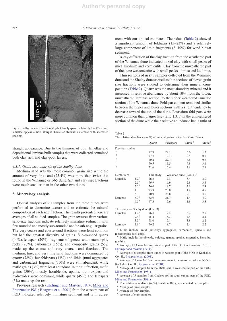
The organic rich A horizon of the soil was 20 cm thick, and isunderlain by bioturbated E horizon to 1.1 m depth. The firstlamella was 3 mm thick and appeared at 1.15 m below thesurface. Lamellae were present from 1.15 m to 3.2 m, wheredepositional laminae were found. Lamellae within Shelby dunewere the thinnest (5 mm or less) and straightest of all three sites.The spacing between lamellae was between 1 cm and 8 cm,generally much closer than at other two sites. There was atendency for the lamellae to increase in thickness when thespacing between them increased (Fig. 9). The lowest lamellae,from 2.6 m–3.2 m depth, were very thin (0.2 mm) and straight,and difficult to distinguish from depositional laminae.
Four depositional laminae were noted at 3.2 m–4.2 m belowthe surface, and all were less than 3 mm thick exhibiting a
Table 1Grain size (wt.%) analysis of sediment from three dunes
Sand Silt Clay Meansize a (mm)
VC C M F VF
Winamac dune (Loc. 1) 0–5 m depthLamellae b 0 1.6 46 34.7 13.4 0.7 3.5 0.268Interlamellae c 0 1.7 49.4 33.8 13.2 0.3 1.5 0.278Average d 0 2 48.7 33.2 13.1 0.6 2.4 0.276
Winamac dune (Loc. 1) 5–7.5 m depthDark lamina e 0 1.5 47.8 28.9 16.8 0.8 4.2 0.268Light lamina f 0.1 2.6 51.6 34.2 9.3 1 1.2 0.291Average g 0 1.7 50.1 34 10.7 1 2.6 0.279
I-65 dune (Loc. 2)Lamellae h 0 0.6 33.3 49 11.2 2.2 3.7 0.240Interlamellae i 0 0.8 38.8 46.6 10.5 2.1 1.3 0.255Average j 0 0.7 35.5 48 10.9 2.1 2.7 0.246
Shelby dune (Loc. 3)Bulk k 0.1 1.1 43.9 30.2 22.7 1.1 0.9 0.257Bulk l 0 0 36.2 36.8 25.6 0.4 0.9 0.235Average 0 0.8 42 31.9 23.4 0.9 0.9 0.251a The mean grain size is calculated byInman (1952) method.b Average of 8 lamellae from 1.5, 2, 2.5, 3, 3.5, 4, 4.5 and 5 m depths.c Average of 8 interlamellae immediately below lamellae.d Average of 8 lamellae, 8 interlamellae, and 4 bulk samples from 2, 3, 4, and
5 m depths.e Average of 5 dark laminae from 5.8, 6, 6.5, 7, and 7.5 m depths.f Average of 5 light laminae immediately below dark laminae.g Average of 5 dark laminae, 5 light laminae, and 2 bulk samples from 6 and
7 m depths.h Average of 4 lamellae from 1.5, 1.9, 2.3, and 2.7 m depth.i Average of 4 interlamellae immediately below lamellae.j Average of 4 lamellae, 4 interlamellae, and 2 bulk samples from 2, and 2.5 m
depths.k Average of 3 bulk samples from 1.2, 2.4, and 3.2 m depth (weathered dune).l Bulk sample from 3.8 m depth (unweathered dune).
241Z. Kilibarda et al. / Catena 72 (2008) 235–247
Author's personal copy
straight appearance. Due to the thinness of both lamellae anddepositional laminae bulk samples that were collected containedboth clay rich and clay-poor layers.
4.3.1. Grain size analysis of the Shelby duneMedium sand was the most common grain size while the
amount of very fine sand (23.4%) was more than twice thatfound in the Winamac or I-65 dune. Silt and clay size fractionswere much smaller than in the other two dunes.
5. Mineralogy analysis
Optical analysis of 20 samples from the three dunes wereperformed to determine texture and to estimate the mineralcomposition of each size fraction. The results presented here areaverages of all studied samples. The grain textures from varioussand-size fractions indicate relatively immature sediment, withfew rounded and mostly sub-rounded and/or sub-angular grains.The very coarse and coarse sand fractions were least commonbut had the greatest diversity of grains. Sub-rounded quartz(40%), feldspars (20%), fragments of igneous and metamorphicrocks (20%), carbonates (15%), and composite grains (5%)made up the coarse and very coarse sand fractions. Themedium, fine, and very fine sand fractions were dominated byquartz (78%), but feldspars (13%) and lithic (mud aggregatesand carbonates) fragments (10%) were still abundant, whilemafic grains (3%) were least abundant. In the silt fraction, maficgrains (50%), mostly hornblende, apatite, iron oxides andhydroxides were dominant, while quartz (45%) and feldspars(5%) made up the rest.
Previous research (Ehrlinger and Masters, 1974; Miles andFranzmeier 1981; Bhagwat et al. 2001) from the western part ofFOD indicated relatively immature sediment and is in agree-
ment with our optical estimates. Their data (Table 2) showeda significant amount of feldspars (15–23%) and a relativelylarge component of lithic fragments (2–10%) for wind blownsediment.
X-ray diffraction of the clay fraction from the weathered partof the Winamac dune indicated mixed clay with small peaks ofmica, kaolinite and vermiculite. Clay from the unweathered partof the dune was smectite with small peaks of mica and kaolinite.
Thin sections of in situ samples collected from the Winamacdune and the Shelby dune as well as thin sections of sieved grainsize fractions were studied to determine their mineral com-position (Table 2). Quartz was the most abundant mineral and itincreased in relative abundance by about 10% from the lower,unweathered laminae section, to the upper weathered lamellaesection of the Winamac dune. Feldspar content remained similarbetween the upper and lower sections with a slight tendency todecrease toward the top of the dune. Potassium feldspars weremore common than plagioclase (ratio 1.3:1) in the unweatheredsection of the dune while their relative abundance had a ratio of
Table 2The relative abundance (in %) of mineral grains in the Fair Oaks Dunes
Quartz Feldspars Lithic a Mafic b
Previous studiesc 72.9 22.1 3.6 1.3d 77.3 19.1 2.4 0.7e 70.2 22.7 6.5 0.6f 70.5 15.5 9.8 3.6g 71.6 16.4 7.8 2.9
Depth in m This study — Winamac dune (Loc. 1) h
Lamellae 1.2 i 76.3 17.3 3.4 2.92.5 i 76.9 16.9 2.8 3.43.5 i 76.0 19.7 2.1 2.44 i 73.9 20.0 1.4 4.75 j 70.9 23.8 2.3 3.0
Laminae 6.3 j 62.9 21.7 11.4 4.06.5 k 67.3 17.6 11.8 3.3
This study — Shelby dune (Loc. 3)Lamellae 1.2 i 76.8 17.4 3.2 2.7
2.4 i 75.4 18.3 4.4 2.13.3 i 78.0 17.1 3.8 2.2
Laminae 3.8 i 76.2 19.7 2.4 2.2a Lithic include: mud (silt/clay) aggregates, carbonates, igneous and
metamorphic rock chips.b Mafic include: hornblende, epidote, garnet, apatite, magnetite, hematite,
goethite.c Average of 13 samples from western part of the FOD in Kankakee Co., IL,
Ehrlinger and Masters (1974).d Average of 6 samples from dunes in western part of the FOD in Kankakee
Co., IL, Bhagwat et al. (2001).e Average of 5 samples from interdune areas in western part of the FOD in
Kankakee Co., IL,Bhagwat et al. (2001).f Average of 4 samples from Plainfield soil in west-central part of the FOD,
Miles and Franzmeier (1981).g Average of 5 samples from Chelsea soil in south-central part of the FOD,
Miles and Franzmeier (1981).h The relative abundance (in %) based on 300 grains counted per sample.i Average of three samples.j Average of four samples.k Average of eight samples.
Fig. 9. Shelby dune at 1.5–2.4 m depth. Closely spaced relatively thin (2–5 mm)lamellae appear almost straight. Lamellae thickness increase with increasedspacing.
242 Z. Kilibarda et al. / Catena 72 (2008) 235–247
Author's personal copy
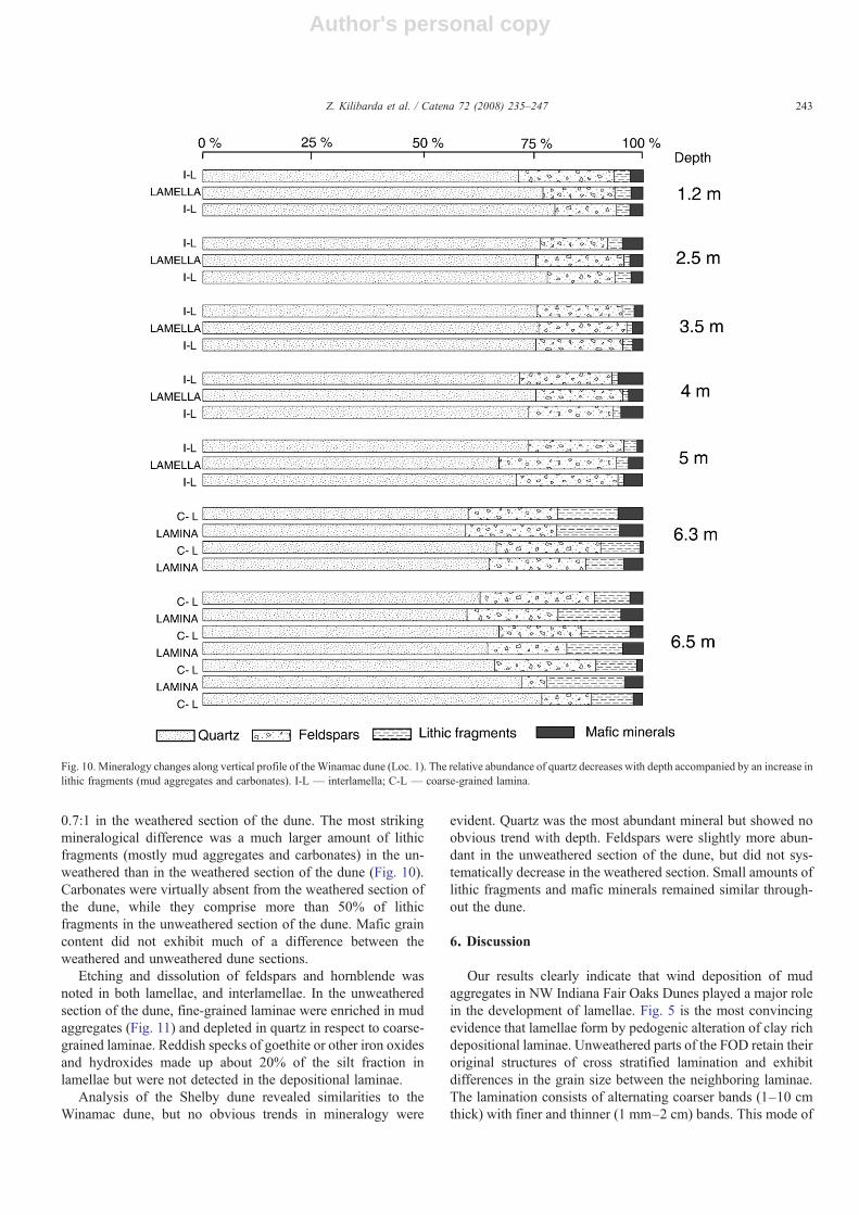
0.7:1 in the weathered section of the dune. The most strikingmineralogical difference was a much larger amount of lithicfragments (mostly mud aggregates and carbonates) in the un-weathered than in the weathered section of the dune (Fig. 10).Carbonates were virtually absent from the weathered section ofthe dune, while they comprise more than 50% of lithicfragments in the unweathered section of the dune. Mafic graincontent did not exhibit much of a difference between theweathered and unweathered dune sections.
Etching and dissolution of feldspars and hornblende wasnoted in both lamellae, and interlamellae. In the unweatheredsection of the dune, fine-grained laminae were enriched in mudaggregates (Fig. 11) and depleted in quartz in respect to coarse-grained laminae. Reddish specks of goethite or other iron oxidesand hydroxides made up about 20% of the silt fraction inlamellae but were not detected in the depositional laminae.
Analysis of the Shelby dune revealed similarities to theWinamac dune, but no obvious trends in mineralogy were
evident. Quartz was the most abundant mineral but showed noobvious trend with depth. Feldspars were slightly more abun-dant in the unweathered section of the dune, but did not sys-tematically decrease in the weathered section. Small amounts oflithic fragments and mafic minerals remained similar through-out the dune.
6. Discussion
Our results clearly indicate that wind deposition of mudaggregates in NW Indiana Fair Oaks Dunes played a major rolein the development of lamellae. Fig. 5 is the most convincingevidence that lamellae form by pedogenic alteration of clay richdepositional laminae. Unweathered parts of the FOD retain theiroriginal structures of cross stratified lamination and exhibitdifferences in the grain size between the neighboring laminae.The lamination consists of alternating coarser bands (1–10 cmthick) with finer and thinner (1 mm–2 cm) bands. This mode of
Fig. 10. Mineralogy changes along vertical profile of the Winamac dune (Loc. 1). The relative abundance of quartz decreases with depth accompanied by an increase inlithic fragments (mud aggregates and carbonates). I-L — interlamella; C-L — coarse-grained lamina.
243Z. Kilibarda et al. / Catena 72 (2008) 235–247
Author's personal copy
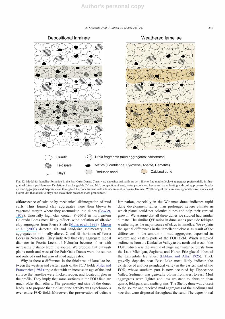
sedimentation is common in modern (Hunter, 1977) and ancientdunes (Loope, 2006), and has been reproduced in wind tunnelexperiments and defined as a pin stripe lamination (Frybergerand Schenk, 1988). Coarser laminae represent grainflows ofsand avalanching along the dunes' slip faces. Finer laminae(b5 mm) represent either the settling of very fine sand and silton the top of the grainflows between avalanching events or theaccumulation of fine grains that moved downward through themoving avalanche to accumulate at the shear plane. The thickest(N5 mm) fine-grained laminae most likely represent grainfalltype of sedimentation (Hunter, 1977). Finer laminae contain alarger proportion of mud aggregates and mafic minerals. Watermoving through the dune slows and stops when it reaches thetop of a highly porous, coarse lamina; it therefore remains incontact longer with the finer laminae (Stephens, 1996). Mois-ture retained in finer laminae causes depletion of exchangeableCa+ and Mg+ (Schaetzl and Anderson, 2005) and breakdown ofmud aggregates as well as release of iron from mafic minerals.These processes speed up diagenesis of finer laminae withrespect to the coarser laminae.
Even though weathering of feldspars added some clays to thesolum it was not the major source of clay in lamellae as Milesand Franzmeier (1981) suggested. Differences in the quartz tofeldspar ratios between the unweathered and weathered sectionsof the FOD are not significant enough to account for all clayspresent in lamellae. In their study of 13,000 year old Spodosolfrom northern Michigan, Mikesell et al. (2004) indicated that Q/F ratio was not a reliable indicator of age but rather of theintensity of weathering (climate) in minimally weathered soils.
The in situ weathering of feldspars would produce delicatekaolinite booklets and make kaolinite the major clay type inlamellae. Winspear and Pye (1995) tested this idea for clays inNebraska Sand Hill Dunes and found no kaolinite booklets butrather clay bridges and clay boxwork on sand grains. Clays inthe lamellae of the FOD are of mixed type as a result of thebreakdown of mud aggregates and the addition of iron fromweathered mafic minerals. On the other hand, clays in thedepositional laminae are of the smectite type, which suggeststhat they are of a glacio-fluvial or glacio-lacustrine origin. Inthin sections of the lamellae we see clays as bridges between thesand grains. In thin sections of the depositional laminae thereare no dispersed clays but we recognize clay rich aggregatesmostly in the very fine sand to fine sand fraction. We agree withMiles and Franzmeier's (1981) conclusion that lamellaedevelop in areas where weatherable heavy minerals occur,which is predominantly in thin, fine-grained depositionallaminae.
We propose that clays were deposited as fine or very finemud aggregates predominantly in fine-grained laminae andsubsequently dispersed to create lamellae (Fig. 12). The ideathat clays were deposited as sand or silt-size aggregates is notnew. Butler (1956) recognized dunes (parma) in south-easternAustralia rich in eolian clays that were transported as clayaggregates or pellets. Bowler (1973) studied modern clay dunesnear shallow saline lakes along the Texas coast (U.S.A.), theWest African coast, the interior basin near Oran (Algeria), andrelict clay dunes in southern Australia. He indicated that sand-size clay aggregates form during a dry season by the
Fig. 11. Thin section photomicrocraphs of lamellae (A, B) from 3 m depth, and depositional laminae (C, D) from 6.3 m depth at the Winamac dune. A) Lamellae viewwith crossed nicols: Q — quartz; P — plagioclase feldspar; KS — potassium feldspar (arrows). B) Lamellae view in plain light: M — mafic minerals; C— claybridges between the grains. C) Laminae view with crossed nicols: Q— quartz; P— plagioclase; KS— potassium feldspar. D) Laminae view in plain light: L— lithicfragments. Lithic fragments made of mud (clay/silt) aggregates are especially abundant in fine-grained lamina in the upper part of the photo (arrows).
244 Z. Kilibarda et al. / Catena 72 (2008) 235–247
Author's personal copy
efflorescence of salts or by mechanical disintegration of mudcurls. Thus formed clay aggregates were then blown tovegetated margin where they accumulate into dunes (Bowler,1973). Unusually high clay content (N30%) in northeasternColorado Loess most likely reflects wind deflation of silt-sizeclay aggregates from Pierre Shale (Muhs et al., 1999). Masonet al. (2003) detected silt and sand-size sedimentary clayaggregates in minimally altered C and BC horizons of PeoriaLoess in Nebraska. They indicated that clay aggregate modaldiameter in Peoria Loess of Nebraska becomes finer withincreasing distance from the source. We propose that outwashplains north and west of the Fair Oaks Dunes were the sourcenot only of sand but also of mud aggregates.
Why is there a difference in the thickness of lamellae be-tween the western and eastern parts of the FOD field? Miles andFranzmeier (1981) argue that with an increase in age of the landsurface the lamellae were thicker, redder, and located higher inthe profile. They imply that some surfaces in the FOD field aremuch older than others. The geometry and size of the dunesleads us to propose that the last dune activity was synchronousover entire FOD field. Moreover, the preservation of delicate
lamination, especially in the Winamac dune, indicates rapiddune development rather than prolonged severe climate inwhich plants could not colonize dunes and help their verticalgrowth. We assume that all three dunes we studied had similarclimate. The similar Q/F ratios in dune sands preclude feldsparweathering as the major source of clays in lamellae. We explainthe spatial differences in the lamellae thickness as result of thedifferences in the amount of mud aggregates deposited inwestern and eastern parts of the FOD field. Winds removedsediments from the Kankakee Valley to the north and west of theFOD, which was the avenue of huge meltwater outbursts fromthe Lake Michigan, Saginaw, and Huron-Erie glacial lobes ofthe Laurentide Ice Sheet (Ekblaw and Athy, 1925). Thickgravelly deposits near Bass Lake most likely indicate theexistence of another periglacial valley in the eastern part of theFOD, whose southern part is now occupied by TippecanoeValley. Sediment was generally blown from west to east. Mudaggregates were lighter and less resistant to abrasion thanquartz, feldspars, and mafic grains. The Shelby dune was closestto the source and received mud aggregates of the medium sandsize that were dispersed throughout the sand. The depositional
Fig. 12. Model for lamellae formation in the Fair Oaks Dunes. Clays were deposited primarily as very fine to fine mud (silt/clay) aggregates preferentially in fine-grained (pin-striped) laminae. Depletion of exchangeable Ca+ and Mg+, compaction of sand, water percolation, freeze and thaw, heating and cooling processes break-up mud aggregates and disperse clays throughout the finer laminae with a lesser amount in coarser laminae. Weathering of mafic minerals generates iron oxides andhydroxides that attach to clays and make their presence more pronounced.
245Z. Kilibarda et al. / Catena 72 (2008) 235–247
Author's personal copy
laminae in the Shelby dune are weakly developed and thelamellae are thinnest and least obvious among all studied dunes.Further east, in the I-65 dune, saltation of mud aggregatesduring wind transport reduced their size and their depositionbecame more concentrated in fine-grained laminae. As a resultlamellae in the I-65 dune are more pronounced and thicker thanin the Shelby dune. The thickest lamellae are in the Winamacdune which was furthest downwind. Most of the mud ag-gregates blown by the westerly winds ended up in the easternpart of the FOD field where their concentration was higher infiner laminae. Mason et al. (2003) also indicate that clay ag-gregate content increases with distance from the source of thePeoria Loess in Nebraska.
Variations in the lamellae thickness along the dunes' verticalprofiles are not a function of the higher concentration of clays,i.e. a 1 cm thick lamella would contain about 2–5% of clayfraction by weight, but so would 5 cm thick lamella. There wereno more clays in lamellae of the Fair Oaks Dunes before or afterthe rain, but the apparent lamellae thickness increased morethan twice in wet weather. Clay and associated iron oxides,especially when wet, can have a pigmentation effect out ofproportion to the actual clay content, accentuating lamellae withonly slightly more clay than interlamellar sand. Bond (1986)showed that even a small amount of clay (1%) leads to bandedstructures developing in sand. Variations in lamellae thicknessin the FOD vertical profiles are function of: 1) variations inlaminae thickness as is shown in Fig. 4); 2) weathering ofseveral closely spaced (b1 cm spacing) laminae which causesdispersion and translocation of clays and their merging into one,thicker lamella. Schaetzl (2001) showed downward migrationof lamellae in a southern Michigan inland dune and we ob-served similar lamellae migration in the Winamac and I-65dunes.
Further work on this topic may include testing for the pre-sence of lamellae on the windward, stoss side of fixed inlanddunes where climbing translatent lamination may be preserved.Modern dunes, downwind from outwash plains of activeglaciers would be good analogs for study of mud aggregatesand their relative abundance in dune sand.
Acknowledgements
We are grateful to D.B. Loope and R. Schaetzl, whosecomments and suggestions greatly improved an early version ofthe manuscript. We thank J. Mason and an anonymous reviewerwho provided constructive comments that greatly improved thispaper. This study was supported by IUNW CRE Grant 5460712to Z. Kilibarda and E. Argyilan.
References
Ahlbrandt, T., 1979. Textural parameters of eolian deposits. In: McKee, E.D.(Ed.), A Study of Global Sand Seas. USGS Professional Paper, vol. 1052,pp. 21–52.
Berg, R.C., 1984. The origin and early genesis of clay bands in youthful sandysoils along Lake Michigan, USA. Geoderma 32, 45–62.
Bettis III, E.A.,Mason, J.P., Swinehart, J.B.,Miao, X., Hanson, P.R., Goble, R.J.,Loope, D.B., Jacobs, P.M., Roberts, H.M., 2003. Cenozoic eolian
sedimentary systems of the USA mid-continent. In: Easterbrook, D.J.(Ed.), Quaternary Geology of the United States. INQUA 2003 Field Guide,pp. 195–218.
Bhagwat, S.B., Huges, R.E., Masters, J.M., De Maris, P.J., 2001. Feldspar andQuartz from the Dunes of Kankakee, Illinois: A preliminary FeasibilityStudy. Illinois State Geological Survey, Illinois Minerals Note, vol. 122.
Bigarella, J.J., 1975. Structures developed by dissipation of dune and beachridge deposits. Catena 2, 107–152.
Bond, W.J., 1986. Illuvial band formation in a laboratory column of sand. SoilScience Society of America Journal 50, 265–267.
Bouabid, R., Nater, E.A., Barak, P., 1992. Measurement of pore size distributionin a lamellar Bt horizon using epifluorescence microscopy and imageanalysis. Geoderma 53, 309–328.
Bowler, J.M., 1973. Clay dunes: their occurrence, formation and environmentalsignificance. Earth-Science Reviews 9, 315–338.
Butler, B.E., 1956. Parna, an eolian clay. Australian Journal of Science 18,145–151.
Dijkerman, J.C., Cline, M.G., Olson, G.W., 1967. Properties and genesis oftextural subsoil lamellae. Soil Science 104, 7–16.
Ehrlinger III, H.P., Masters, J.M., 1974. Commercial Feldspar Resources in SEKankakee County, Illinois. Illinois State Geological Survey, IllinoisMinerals Note, vol. 56.
Ehrman, R.L., 1987. Origin of “Dissipation” Structures, Nebraska Sand Hills.Master Thesis, University of Nebraska — Lincoln.
Ekblaw, G.E., Athy, L.F., 1925. Glacial Kankakee torrent in northeasternIllinois. GSA Bulletin 36, 417–427.
Fraser, G.S., Bleuer, N.K., 1991. Geologic Framework of the Aquifers in theKankakee River Lowland. Indiana Geological Survey, Occasional Paper,vol. 60.
Fryberger, S.G., Schenk, C.J., 1988. Pin stripe lamination: a distinctive featureof modern and ancient eolian sediments. Sedimentary Geology 55, 1–17.
Gile, L.H., 1979. Holocene soils in eolian sediments of Bailey County, Texas.Soil Science Society of America Journal 43, 994–1003.
Hannah, P.R., Zahner, R., 1970. Nonpedogenetic texture bands in outwash sandsof Michigan: their origin, and influence on tree growth. Soil Science Societyof America Proceedings 34, 134–136.
Hansel, A.K., Johnson, W.H., 1992. Fluctuations of the Lake Michigan lobeduring the late Wisconsin subepisode, Sveriges Geologiska Undersokning.Serie Cache-Cache 81, 133–144.
Hansel, A.K., Mickelson, D.M., Schneider, A.F., Larsen, C.E., 1985. LateWisconsinan and Holocene history of the Lake Michigan basin. In: Karrow,P.F., Calkin, P.E. (Eds.), Quaternary Evolution of the Great Lakes.Geological Association of Canada, Special Paper, vol. 30, pp. 39–54.
Hunter, R.E., 1977. Basic types of stratification in small eolian dunes.Sedimentology 24, 361–387.
Inman, D.L., 1952. Measures for describing the size distribution of sediments.Journal of Sedimentary Petrology 22, 125–145.
Kilibarda, Z., Brown, S.E., 2005. Lake Michigan glacial lobe fluctuationsrevealed in Valparaiso moraine. Abstracts of IUN Second Annual COASResearch Conference, Gary, USA, p. 23.
Leigh, D.S., 1998. A 12,000-year record of natural levee sedimentation alongthe Broad River near Columbia, South Carolina. Southeastern Geographer28, 95–111.
Loope, D.B., 2006. Dry-season tracks in dinosaur-triggered grainflows. Palaios21, 132–142.
Mason, J.A., Jacobs, P.M., Greene, R.S.B., Nettleton, W.D., 2003. Sedimentaryaggregates in the Peoria Loess of Nebraska, U.S.A. Catena 53, 377–397.
Masters, J.M., 1983. Geology of Sand and Gravel Aggregate Resources ofIllinois. Illinois State Geological Survey, Illinois Mineral Note, vol. 88.
McIntosh, P.D., 1988. Fragipans, skeletons, and clay lamellae in a texturalsequence of soils formed in loess in north-east Southland, New Zealand. In:Eden, D.N., Furkert, R.J. (Eds.), Loess: Its Distribution, Geology and Soils.Balkema, Rotterdam, pp. 105–106.
Mikesell, L.R., Schaetzl, R.J., Velbel, M.A., 2004. Hornblende etching andquartz/feldspar ratios as weathering and soil development indicators in someMichigan soils. Quaternary Research 62, 162–171.
Miles, J.R., Franzmeier, D.P., 1981. A lithochronosequence of soils formed indune sand. Soil Science Society of America Journal 45, 362–367.
246 Z. Kilibarda et al. / Catena 72 (2008) 235–247

Author's personal copy
Muhs, D.R., Aleinikoff, J.N., Stafford Jr., T.W., Kihl, R., Been, J., Mahan, S.A.,Cowherd, S., 1999. Late Quaternary loess in northeastern Colorado: Part I.Age and paleoclimatic significance. Geological Society of America Bulletin111, 1861–1875.
Norris, R.M., 1969. Dune reddening and time. Journal of Sedimentary Petrology39, 7–11.
Prusinkiewicz, Z., Bednarek, R., Kosko, A., Szmyt, M., 1998. Paleopedologicalstudies of the age and properties of illuvial bands at an archeological site.Quaternary International 51/52, 195–201.
Pye, K., 1981. Rate of dune reddening in a humid tropical climate. Nature 290,582.
Rarick, R.D., Thornbury, W.D., 1971–1972. Sand bodies in Indiana. OutdoorIndiana 36, 31–34.
Rawling , J.E., 2000. A review of lamellae. Geomorphology 35, 1–9.Robinson, G.H., Rich, C.I., 1960. Characteristics of the multiple yellowish-red
bands common to certain soils in the southeastern United States. SoilScience Society of America Proceedings 24, 226–230.
Schaetzl, R.J., 1992. Texture, Mineralogy, and lamellae development in sandysoils in Michigan. Soil Science Society of America Journal 56, 1538–1545.
Schaetzl, R.J., 2001. Morphologic evidence of lamellae forming directly fromthin, clayey bedding planes in a dune. Geoderma 99, 51–63.
Schaetzl, R.J., Anderson, S., 2005. Soils: Genesis and Geomorphology.Cambridge University Press, Cambridge.
Soil Survey Staff, 1999. Soil Taxonomy, 2nd edition. USDA, United StatesGovernment Printing Office, Washington DC.
Smith, G.D., Allaway, W.H., Reicken, F.F., 1950. Prairie soils of the UpperMississippi Valley. In: Norman, N.G. (Ed.), Advances in Agronomy, vol. 2.Academic Press, New York, pp. 157–205.
Stephens, D.B., 1996. Vadose Zone Hydrology. Lewis Publishers, Boca Raton.Torrent, J., Nettleton, W.D., Borst, G., 1980. Clay illuviation and lamella
formation in a Psammentic Haploxeralf in Southern California. Soil ScienceSociety of America Journal 44, 363–369.
Van Reeuwijk, L.P., de Villiers, J.M., 1985. The origin of textural lamellae inQuaternary coastal sands of Natal. South African Journal of Plant and Soil 2,38–44.
Winspear, N.R., Pye, K., 1995. The origin and significance of boxwork claycoatings on dune sand grains from the Nebraska Sand Hills, USA.Sedimentary Geology 94, 245–254.
247Z. Kilibarda et al. / Catena 72 (2008) 235–247


