Embed Size (px)
Citation preview
5/7/2014
1
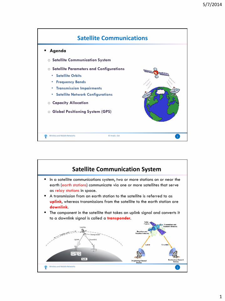
Satellite Communications
Agenda
o Satellite Communication System
o Satellite Parameters and Configurations
• Satellite Orbits
• Frequency Bands
• Transmission Impairments
• Satellite Network Configurations
o Capacity Allocation
o Global Positioning System (GPS)
1Wireless and Mobile Networks © Imad J. Eid
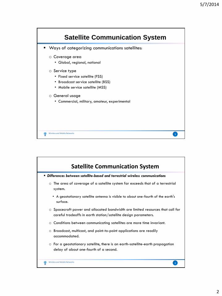
In a satellite communications system, two or more stations on or near the
earth (earth stations) communicate via one or more satellites that serve
as relay stations in space.
A transmission from an earth station to the satellite is referred to as
uplink, whereas transmissions from the satellite to the earth station are
downlink.
The component in the satellite that takes an uplink signal and converts it
to a downlink signal is called a transponder.
Wireless and Mobile Networks 2
Satellite Communication System
5/7/2014
2
Ways of categorizing communications satellites:
o Coverage area
• Global, regional, national
o Service type
• Fixed service satellite (FSS)
• Broadcast service satellite (BSS)
• Mobile service satellite (MSS)
o General usage
• Commercial, military, amateur, experimental
Wireless and Mobile Networks 3
Satellite Communication System
Differences between satellite-based and terrestrial wireless communications
o The area of coverage of a satellite system far exceeds that of a terrestrial
system.
• A geostationary satellite antenna is visible to about one-fourth of the earth's
surface.
o Spacecraft power and allocated bandwidth are limited resources that call for
careful tradeoffs in earth station/satellite design parameters.
o Conditions between communicating satellites are more time invariant.
o Broadcast, multicast, and point-to-point applications are readily
accommodated.
o For a geostationary satellite, there is an earth-satellite-earth propagation
delay of about one-fourth of a second.
Wireless and Mobile Networks 4
Satellite Communication System
5/7/2014
3
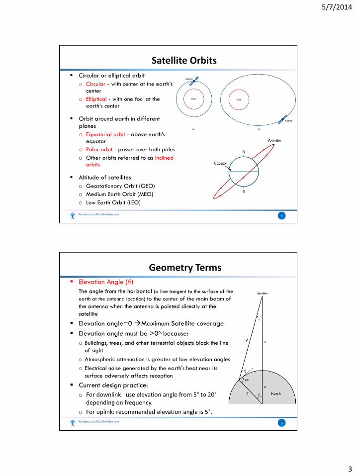
Circular or elliptical orbit
o Circular - with center at the earth’s center
o Elliptical - with one foci at the earth’s center
Orbit around earth in different planes
o Equatorial orbit - above earth’s equator
o Polar orbit - passes over both poles
o Other orbits referred to as inclined orbits
Altitude of satellites
o Geostationary Orbit (GEO)
o Medium Earth Orbit (MEO)
o Low Earth Orbit (LEO)
Wireless and Mobile Networks 5
Satellite Orbits
Elevation Angle (θ)The angle from the horizontal (a line tangent to the surface of the
earth at the antenna location) to the center of the main beam of
the antenna when the antenna is pointed directly at the
satellite
Elevation angle=0 Maximum Satellite coverage
Elevation angle must be >0o, because:
o Buildings, trees, and other terrestrial objects block the line
of sight
o Atmospheric attenuation is greater at low elevation angles
o Electrical noise generated by the earth's heat near its
surface adversely affects reception
Current design practice:
o For downlink: use elevation angle from 5° to 20°depending on frequency.
o For uplink: recommended elevation angle is 5°.
Wireless and Mobile Networks 6
Geometry Terms
5/7/2014
4
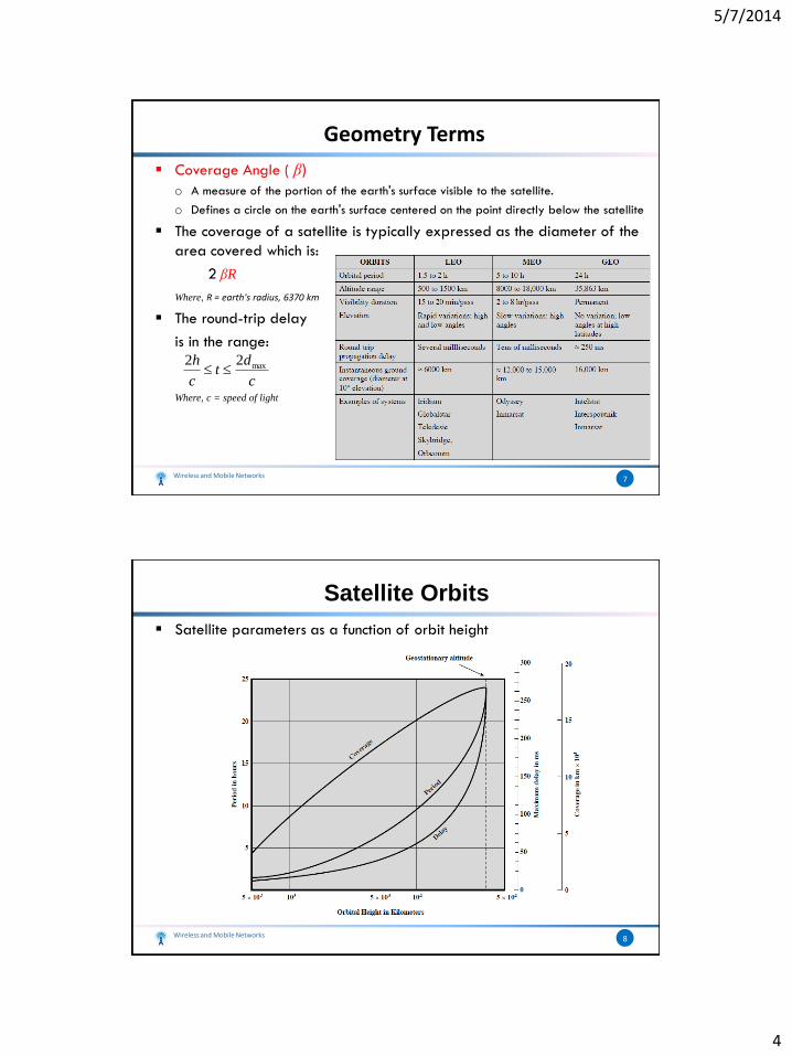
Coverage Angle ( β)o A measure of the portion of the earth's surface visible to the satellite.
o Defines a circle on the earth's surface centered on the point directly below the satellite
The coverage of a satellite is typically expressed as the diameter of the
area covered which is:
2 βR
Where, R = earth's radius, 6370 km
The round-trip delay
is in the range:
Where, c = speed of light
Wireless and Mobile Networks 7
Geometry Terms
c
dt
c
h max22
Satellite parameters as a function of orbit height
Wireless and Mobile Networks 8
Satellite Orbits
5/7/2014
5
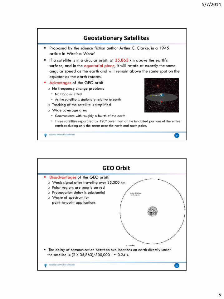
Proposed by the science fiction author Arthur C. Clarke, in a 1945
article in Wireless World
If a satellite is in a circular orbit, at 35,863 km above the earth's
surface, and in the equatorial plane, it will rotate at exactly the same
angular speed as the earth and will remain above the same spot on the
equator as the earth rotates.
Advantages of the GEO orbit
o No frequency change problems
• No Doppler effect
• As the satellite is stationary relative to earth
o Tracking of the satellite is simplified
o Wide coverage area
• Communicate with roughly a fourth of the earth
• Three satellites separated by 120o cover most of the inhabited portions of the entire
earth excluding only the areas near the north and south poles.
Wireless and Mobile Networks 9
Geostationary Satellites
Disadvantages of the GEO orbit:
o Weak signal after traveling over 35,000 km
o Polar regions are poorly served
o Propagation delay is substantial
o Waste of spectrum for
point-to-point applications
The delay of communication between two locations on earth directly under
the satellite is: (2 X 35,863)/300,000 =~ 0.24 s.
Wireless and Mobile Networks 10
GEO Orbit
5/7/2014
6
Circular/slightly elliptical orbit at altitude in the range of 500 to 1500 km
Often in polar orbit.
Orbit period ranges from 1.5 to 2 hours
Diameter of coverage is about 6000 km
Round-trip signal propagation delay is less than 20 ms
Satellite visibility time is up to 20 min
System must cope with large Doppler shifts
Practical use of this system requires the multiple
orbital planes be used, each with multiple
satellites in orbit
Communication between two earth stations
typically involve handing off the signal
from one satellite to another.
Wireless and Mobile Networks 11
LEO Satellite
LEO vs. GEO Satellites:
o Reduced propagation delay
o A received LEO signal is much stronger than a GEO signal of the same
transmitted power.
o LEO coverage can be better localized so that spectrum can be better
conserved.
LEO is proposed for communicating with mobile terminals
LEO Categories
o Little LEOs
• Frequencies below 1 GHz
• Bandwidth is < 5MHz
• Data rates up to 10 kbps
• Aimed at tracking, monitoring, and low-rate messaging
Wireless and Mobile Networks 12
LEO Satellite
5/7/2014
7
o Example on Little LEOs
• Orbcomm:
Used by businesses to track trailers, railcars, heavy equipment, and other remote
and mobile assets.
Used also to monitor remote utility meters and oil and gas storage tanks, wells,
and pipelines.
o Big LEOs
• Frequencies above 1 GHz
• Support data rates up to a few megabits per sec
• Offer same services as little LEOs in addition to voice and positioning
services
• E.g.: Globalstar
Uses CDMA for mobile users
48 satellites and 8 spares
Wireless and Mobile Networks 13
LEO Satellite
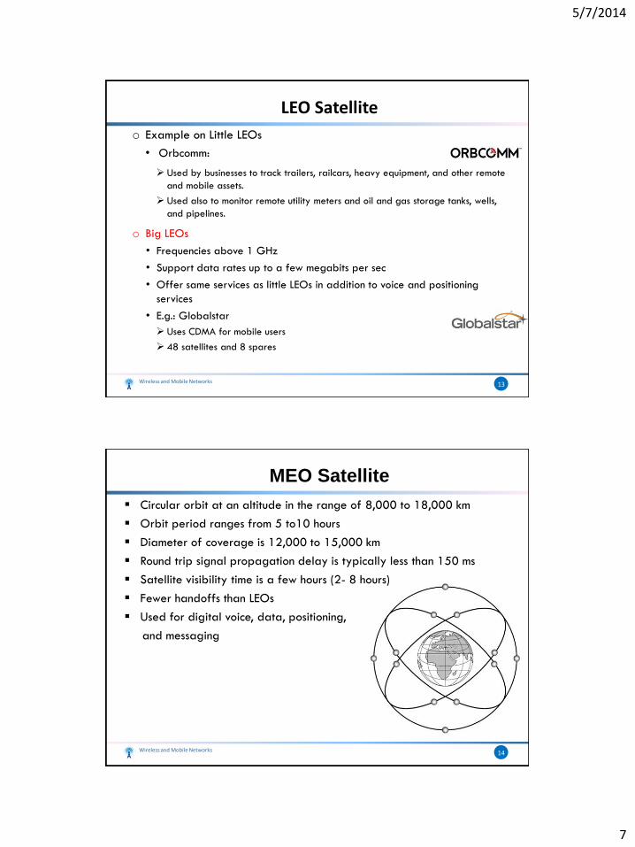
Circular orbit at an altitude in the range of 8,000 to 18,000 km
Orbit period ranges from 5 to10 hours
Diameter of coverage is 12,000 to 15,000 km
Round trip signal propagation delay is typically less than 150 ms
Satellite visibility time is a few hours (2- 8 hours)
Fewer handoffs than LEOs
Used for digital voice, data, positioning,
and messaging
Wireless and Mobile Networks 14
MEO Satellite
5/7/2014
8
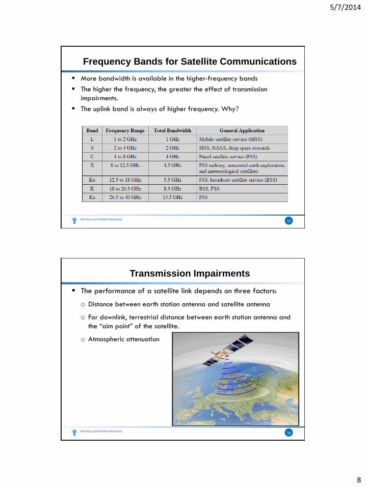
More bandwidth is available in the higher-frequency bands
The higher the frequency, the greater the effect of transmission
impairments.
The uplink band is always of higher frequency. Why?
Wireless and Mobile Networks 15
Frequency Bands for Satellite Communications
The performance of a satellite link depends on three factors:
o Distance between earth station antenna and satellite antenna
o For downlink, terrestrial distance between earth station antenna and
the “aim point” of the satellite.
o Atmospheric attenuation
Wireless and Mobile Networks 16
Transmission Impairments
5/7/2014
9
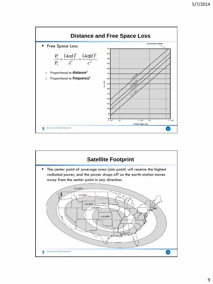
Free Space Loss:
o Proportional to distance2
o Proportional to frequency2
Wireless and Mobile Networks 17
Distance and Free Space Loss
2
2
2
244
c
fdd
P
P
r
t
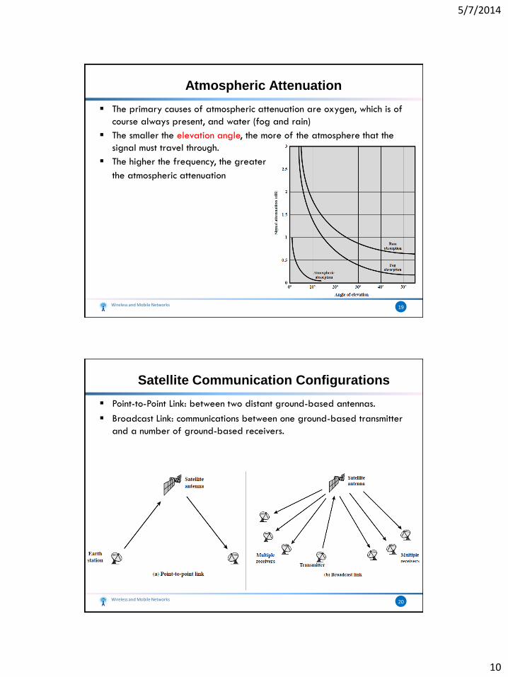
The center point of coverage area (aim point) will receive the highest
radiated power, and the power drops off as the earth-station moves
away from the center point in any direction.
Wireless and Mobile Networks 18
Satellite Footprint
5/7/2014
10
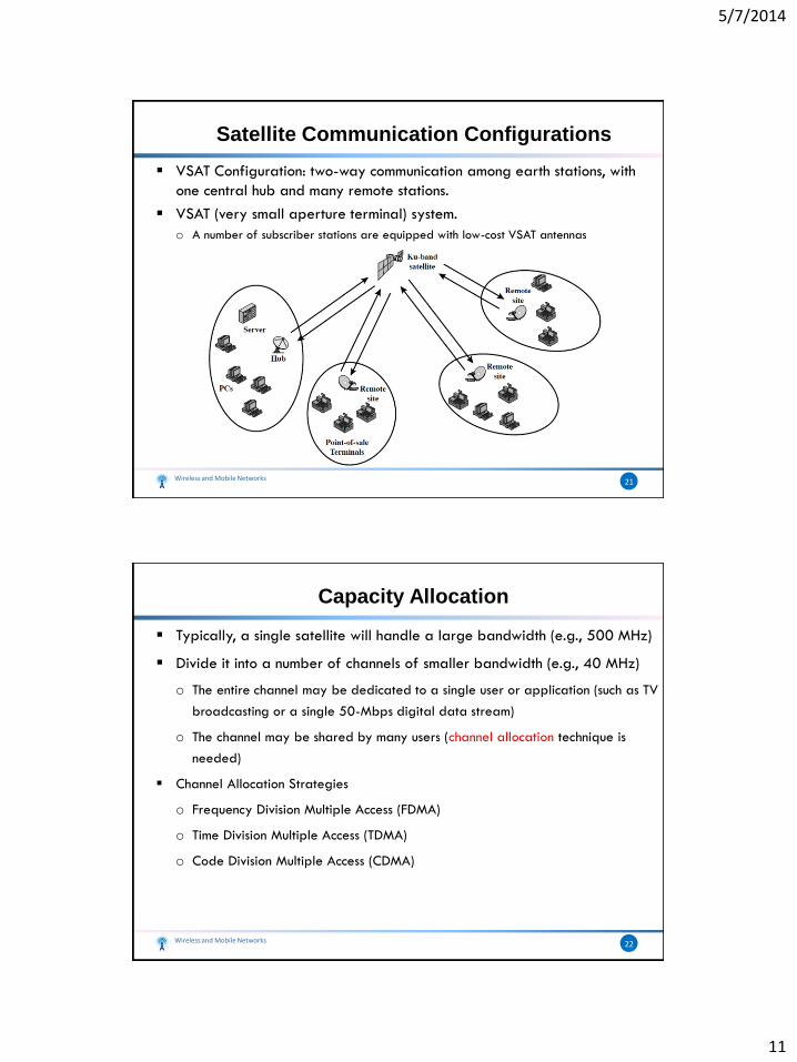
The primary causes of atmospheric attenuation are oxygen, which is of
course always present, and water (fog and rain)
The smaller the elevation angle, the more of the atmosphere that the
signal must travel through.
The higher the frequency, the greater
the atmospheric attenuation
Wireless and Mobile Networks 19
Atmospheric Attenuation
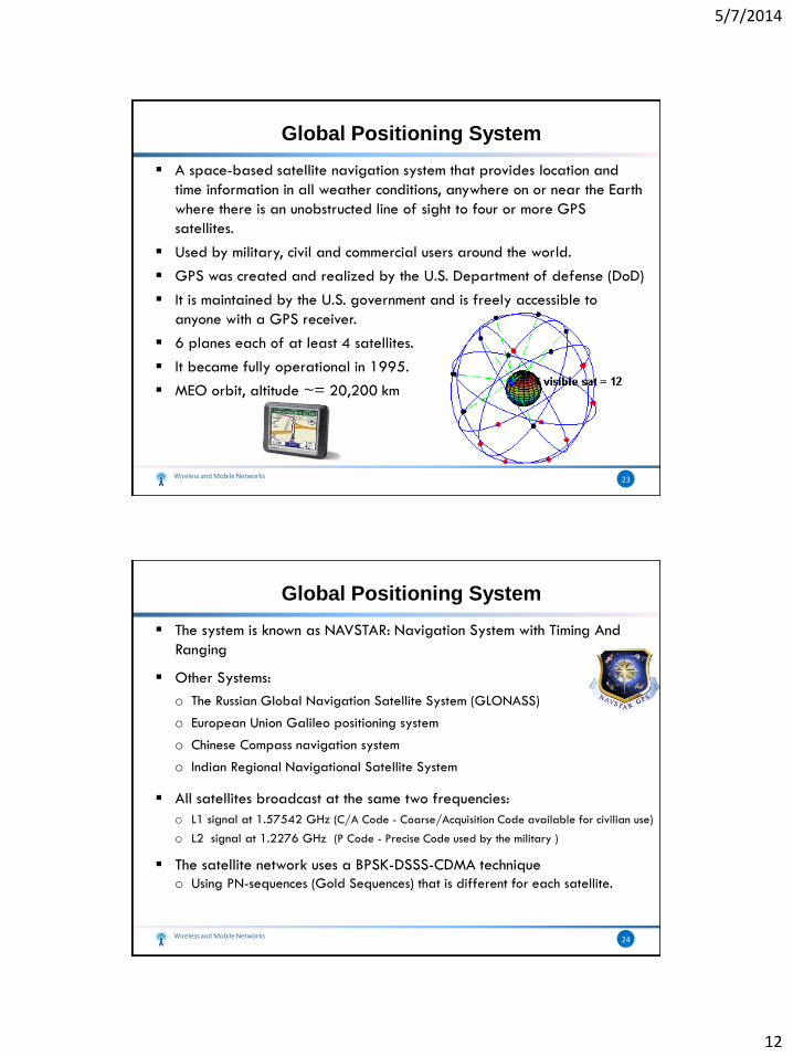
Point-to-Point Link: between two distant ground-based antennas.
Broadcast Link: communications between one ground-based transmitter
and a number of ground-based receivers.
Wireless and Mobile Networks 20
Satellite Communication Configurations
5/7/2014
11
VSAT Configuration: two-way communication among earth stations, with
one central hub and many remote stations.
VSAT (very small aperture terminal) system.
o A number of subscriber stations are equipped with low-cost VSAT antennas
Wireless and Mobile Networks 21
Satellite Communication Configurations
Typically, a single satellite will handle a large bandwidth (e.g., 500 MHz)
Divide it into a number of channels of smaller bandwidth (e.g., 40 MHz)
o The entire channel may be dedicated to a single user or application (such as TV
broadcasting or a single 50-Mbps digital data stream)
o The channel may be shared by many users (channel allocation technique is
needed)
Channel Allocation Strategies
o Frequency Division Multiple Access (FDMA)
o Time Division Multiple Access (TDMA)
o Code Division Multiple Access (CDMA)
Wireless and Mobile Networks 22
Capacity Allocation
5/7/2014
12
Global Positioning System
A space-based satellite navigation system that provides location and
time information in all weather conditions, anywhere on or near the Earth
where there is an unobstructed line of sight to four or more GPS
satellites.
Used by military, civil and commercial users around the world.
GPS was created and realized by the U.S. Department of defense (DoD)
It is maintained by the U.S. government and is freely accessible to
anyone with a GPS receiver.
6 planes each of at least 4 satellites.
It became fully operational in 1995.
MEO orbit, altitude ~= 20,200 km
Wireless and Mobile Networks 23
The system is known as NAVSTAR: Navigation System with Timing And
Ranging
Other Systems:
o The Russian Global Navigation Satellite System (GLONASS)
o European Union Galileo positioning system
o Chinese Compass navigation system
o Indian Regional Navigational Satellite System
All satellites broadcast at the same two frequencies:
o L1 signal at 1.57542 GHz (C/A Code - Coarse/Acquisition Code available for civilian use)
o L2 signal at 1.2276 GHz (P Code - Precise Code used by the military )
The satellite network uses a BPSK-DSSS-CDMA technique
o Using PN-sequences (Gold Sequences) that is different for each satellite.
Wireless and Mobile Networks 24
Global Positioning System
5/7/2014
13
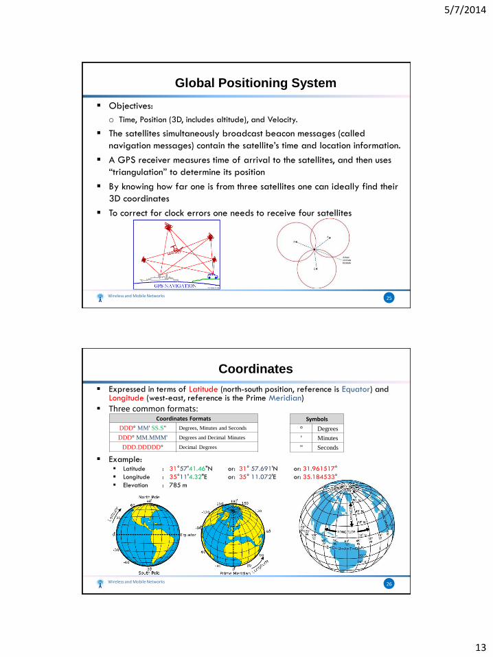
Objectives:
o Time, Position (3D, includes altitude), and Velocity.
The satellites simultaneously broadcast beacon messages (called
navigation messages) contain the satellite’s time and location information.
A GPS receiver measures time of arrival to the satellites, and then uses
“triangulation” to determine its position
By knowing how far one is from three satellites one can ideally find their
3D coordinates
To correct for clock errors one needs to receive four satellites
Wireless and Mobile Networks 25
Global Positioning System
Wireless and Mobile Networks 26
Coordinates
Expressed in terms of Latitude (north-south position, reference is Equator) and Longitude (west-east, reference is the Prime Meridian)
Three common formats:
Example: Latitude : 31°57'41.46"N or: 31° 57.691'N or: 31.961517°
Longitude : 35°11'4.32"E or: 35° 11.072'E or: 35.184533°
Elevation : 785 m
Symbols
° Degrees
' Minutes
" Seconds
Coordinates Formats
DDD° MM' SS.S" Degrees, Minutes and Seconds
DDD° MM.MMM' Degrees and Decimal Minutes
DDD.DDDDD° Decimal Degrees


