Embed Size (px)
Citation preview
.GLOBAL LAND COVER NETWORK/ASIACOVER WORKSHOP
Overview Of The Overview Of The Global Land Cover Network Global Land Cover Network
InitiativeInitiative(GLCN)(GLCN)
Strategies for Land Cover Strategies for Land Cover Mapping Mapping
and Monitoringand Monitoring
John S. LathamJohn S. LathamGLCN Co-ordinatorGLCN Co-ordinator
SDRN, FAOSDRN, FAO
.GLOBAL LAND COVER NETWORK/ASIACOVER WORKSHOP
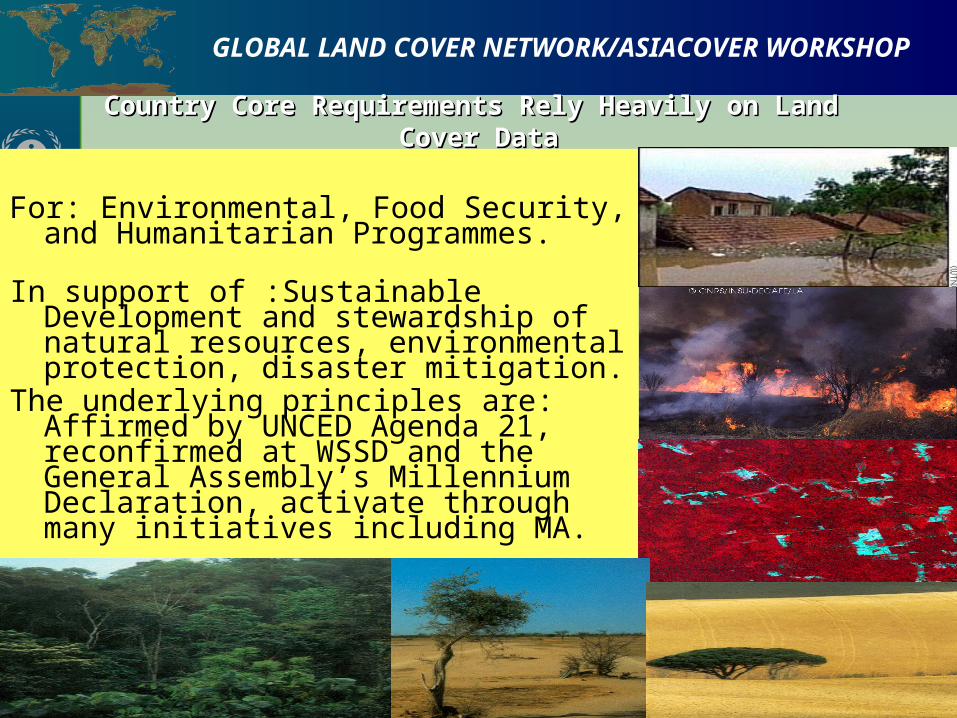
Country Core Requirements Rely Heavily on Land Country Core Requirements Rely Heavily on Land Cover DataCover Data
Country Core Requirements Rely Heavily on Land Country Core Requirements Rely Heavily on Land Cover DataCover Data
For: Environmental, Food Security, and Humanitarian Programmes.
In support of :Sustainable Development and stewardship of natural resources, environmental protection, disaster mitigation.
The underlying principles are: Affirmed by UNCED Agenda 21, reconfirmed at WSSD and the General Assembly’s Millennium Declaration, activate through many initiatives including MA.
.GLOBAL LAND COVER NETWORK/ASIACOVER WORKSHOP
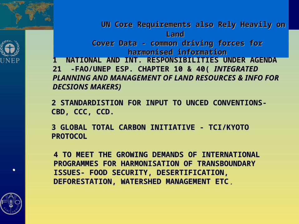
UN Core Requirements also Rely Heavily on Land UN Core Requirements also Rely Heavily on Land Cover Data - common driving forces for harmonised Cover Data - common driving forces for harmonised
informationinformation
1 NATIONAL AND INT. RESPONSIBILITIES UNDER AGENDA 21 -1 NATIONAL AND INT. RESPONSIBILITIES UNDER AGENDA 21 -FAO/UNEP ESP. CHAPTER 10 & 40(FAO/UNEP ESP. CHAPTER 10 & 40( INTEGRATED PLANNING INTEGRATED PLANNING AND MANAGEMENT OF LAND RESOURCES & INFO FOR AND MANAGEMENT OF LAND RESOURCES & INFO FOR DECSIONS MAKERS)DECSIONS MAKERS)
2 STANDARDISTION FOR INPUT TO UNCED CONVENTIONS- 2 STANDARDISTION FOR INPUT TO UNCED CONVENTIONS- CBD, CCC, CCD.CBD, CCC, CCD.
3 GLOBAL TOTAL CARBON INITIATIVE - TCI/KYOTO PROTOCOL3 GLOBAL TOTAL CARBON INITIATIVE - TCI/KYOTO PROTOCOL
4 TO MEET THE GROWING DEMANDS OF 4 TO MEET THE GROWING DEMANDS OF INTERNATIONALINTERNATIONALPROGRAMMES FOR HARMONISATION OF PROGRAMMES FOR HARMONISATION OF TRANSBOUNDARY ISSUES- FOOD SECURITY, TRANSBOUNDARY ISSUES- FOOD SECURITY, DESERTIFICATION, DEFORESTATION, WATERSHED DESERTIFICATION, DEFORESTATION, WATERSHED MANAGEMENT ETCMANAGEMENT ETC..
.GLOBAL LAND COVER NETWORK/ASIACOVER WORKSHOP
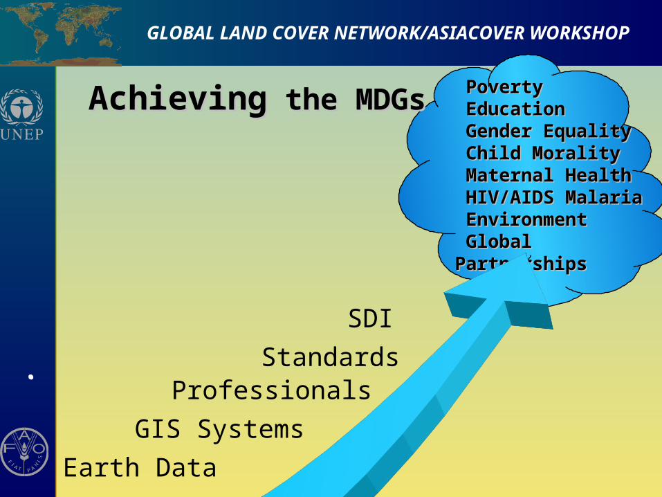
PovertyPoverty EducationEducation Gender EqualityGender Equality Child MoralityChild Morality Maternal HealthMaternal Health HIV/AIDS MalariaHIV/AIDS Malaria EnvironmentEnvironment Global PartnershipsGlobal Partnerships
AchievingAchieving the MDGs the MDGs
Earth Data
GIS Systems
ProfessionalsStandards
SDI
.GLOBAL LAND COVER NETWORK/ASIACOVER WORKSHOP
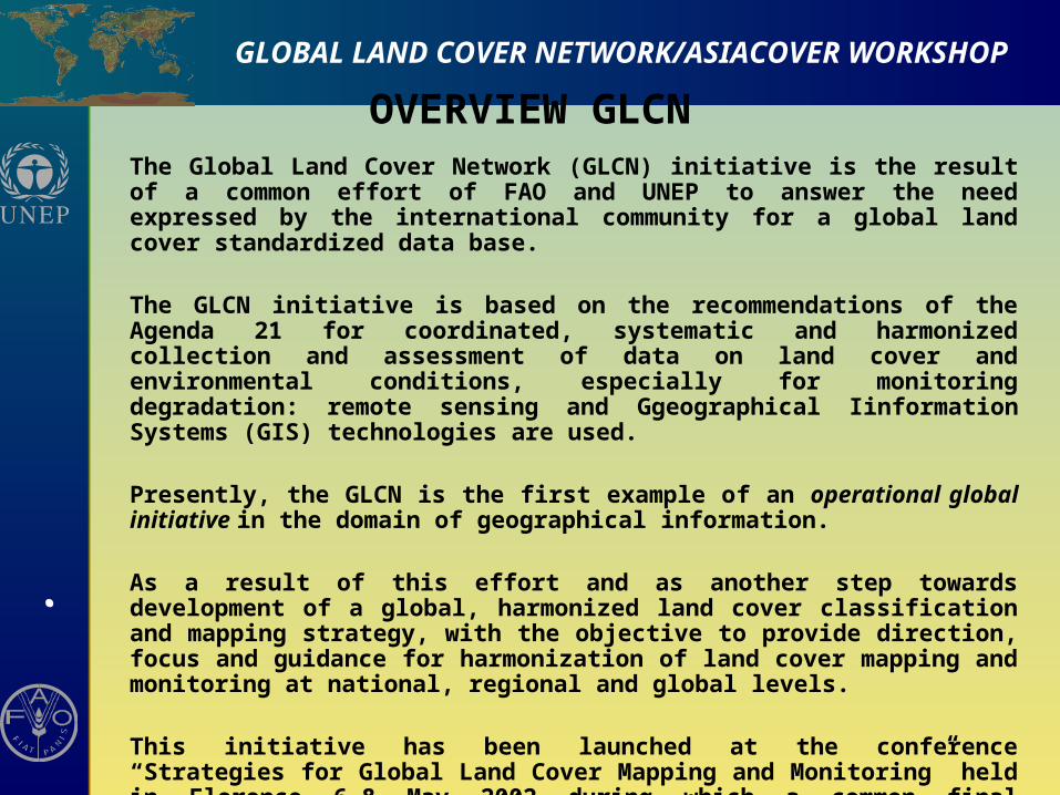
OVERVIEW GLCN The Global Land Cover Network (GLCN) initiative is the result of a common effort of FAO and UNEP to answer the need expressed by the international community for a global land cover standardized data base.
The GLCN initiative is based on the recommendations of the Agenda 21 for coordinated, systematic and harmonized collection and assessment of data on land cover and environmental conditions, especially for monitoring degradation: remote sensing and Ggeographical Iinformation Systems (GIS) technologies are used.
Presently, the GLCN is the first example of an operational global initiative in the domain of geographical information.
As a result of this effort and as another step towards development of a global, harmonized land cover classification and mapping strategy, with the objective to provide direction, focus and guidance for harmonization of land cover mapping and monitoring at national, regional and global levels.
This initiative has been launched at the conference “Strategies for Global Land Cover Mapping and Monitoring” held in Florence 6-8 May 2002 during which a common final declaration (the Artimino declaration) was issued.
.GLOBAL LAND COVER NETWORK/ASIACOVER WORKSHOP
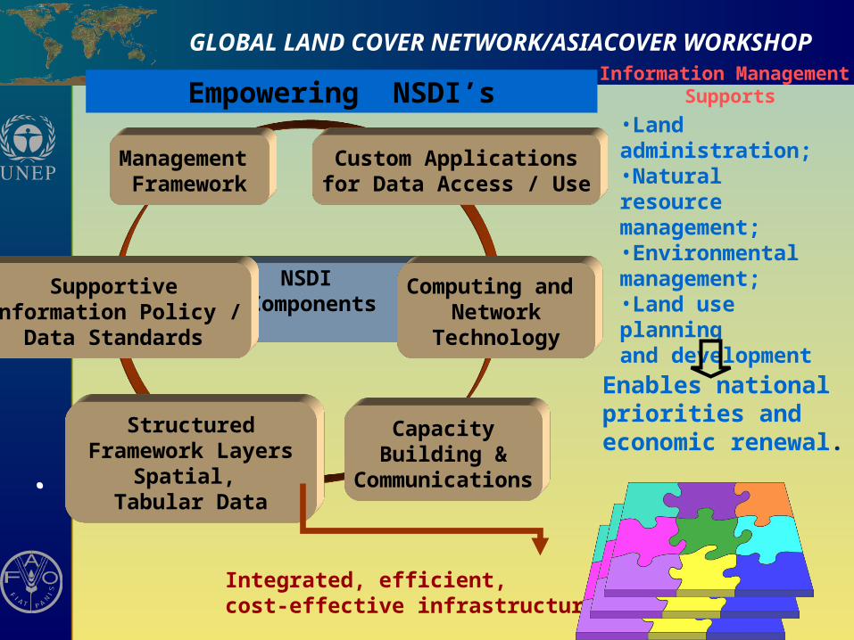
Management Framework
NSDI Components
SupportiveInformation Policy /
Data Standards
Computing and Network
Technology
Custom Applicationsfor Data Access / Use
CapacityBuilding &
Communications
Structured Framework Layers
Spatial, Tabular Data
Integrated, efficient, cost-effective infrastructure
Enables national priorities and economic renewal.
•Land administration;•Natural resource management;•Environmental management;•Land use planning and development
Information Management SupportsEmpowering NSDI’s
.GLOBAL LAND COVER NETWORK/ASIACOVER WORKSHOP
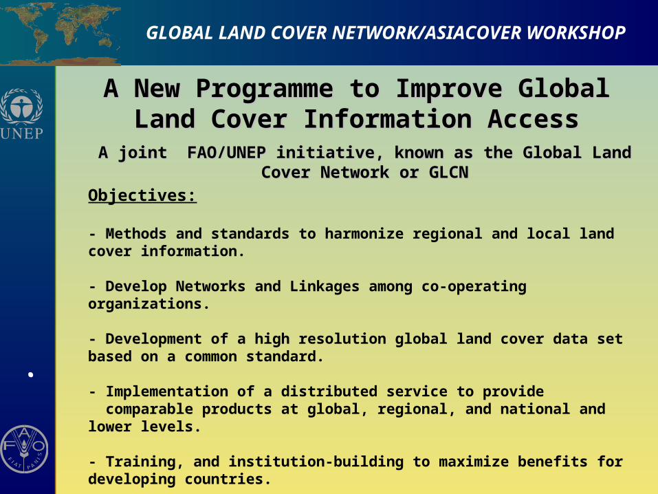
A New Programme to Improve Global Land A New Programme to Improve Global Land Cover Information AccessCover Information Access
A joint FAO/UNEP initiative, known as the Global Land Cover Network or A joint FAO/UNEP initiative, known as the Global Land Cover Network or GLCNGLCN
Objectives:
- Methods and standards to harmonize regional and local land cover information.
- Develop Networks and Linkages among co-operating organizations.
- Development of a high resolution global land cover data set based on a common standard.
- Implementation of a distributed service to provide comparable products at global, regional, and national and lower levels.
- Training, and institution-building to maximize benefits for developing countries.
-Operational development and use by national stakeholders
.GLOBAL LAND COVER NETWORK/ASIACOVER WORKSHOP
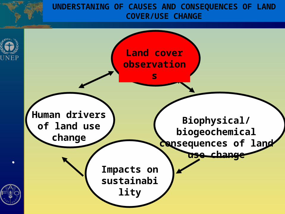
Biophysical/biogeochemical consequences of land use
change
Human drivers of land use change
Impacts on sustainability
Land cover observations
UNDERSTANING OF CAUSES AND CONSEQUENCES OF LAND COVER/USE CHANGE

.GLOBAL LAND COVER NETWORK/ASIACOVER WORKSHOP
EnvironmentalEnvironmentalsuitabilitysuitability
InfrastructureInfrastructure
Socio-Socio-economicseconomics
Land coverLand cover
Multiple data sourcesMultiple data sources
.GLOBAL LAND COVER NETWORK/ASIACOVER WORKSHOP
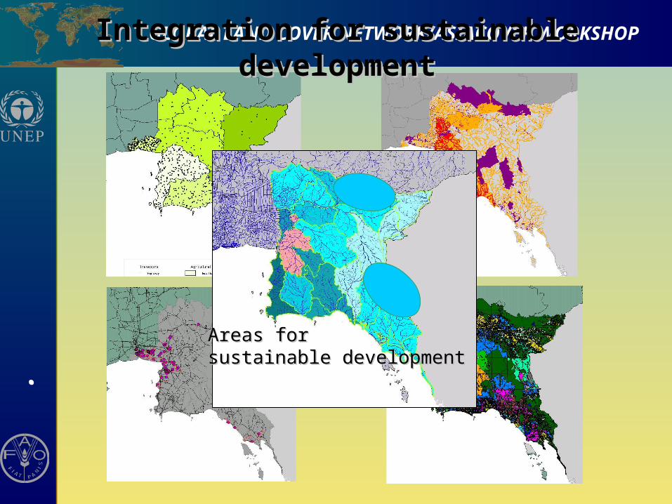
Areas forAreas forsustainable developmentsustainable development
Integration for sustainable developmentIntegration for sustainable development
.GLOBAL LAND COVER NETWORK/ASIACOVER WORKSHOP
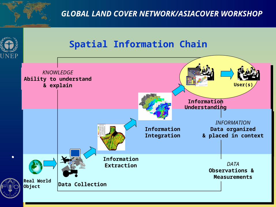
Real WorldObject
User(s)
Spatial Information Chain
Data Collection
InformationExtraction
InformationIntegration
DATAObservations & Measurements
INFORMATIONData organized
& placed in context
KNOWLEDGEAbility to understand
& explain
InformationUnderstanding
.GLOBAL LAND COVER NETWORK/ASIACOVER WORKSHOP
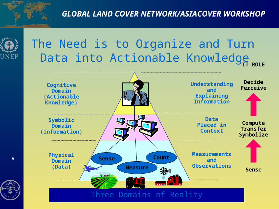
Three Domains of Reality
The Need is to Organize and Turn Data into Actionable Knowledge
CognitiveDomain
(ActionableKnowledge)
SymbolicDomain
(Information)
PhysicalDomain(Data)
Sense
Measure
Count
Understandingand
ExplainingInformation
DataPlaced inContext
Measurementsand
Observations
IT ROLE
DecidePerceive
ComputeTransfer
Symbolize
Sense
.GLOBAL LAND COVER NETWORK/ASIACOVER WORKSHOP
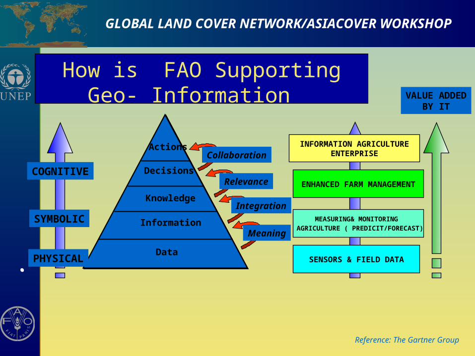
How is FAO Supporting Geo- Information VALUE ADDED
BY IT
Data
Information
Knowledge
Decisions
Actions
Meaning
Integration
Relevance
Collaboration
Reference: The Gartner Group
PHYSICAL
SYMBOLIC
COGNITIVE
SENSORS & FIELD DATA
MEASURING& MONITORING
AGRICULTURE ( PREDICIT/FORECAST)
ENHANCED FARM MANAGEMENT
INFORMATION AGRICULTUREENTERPRISE
.GLOBAL LAND COVER NETWORK/ASIACOVER WORKSHOP
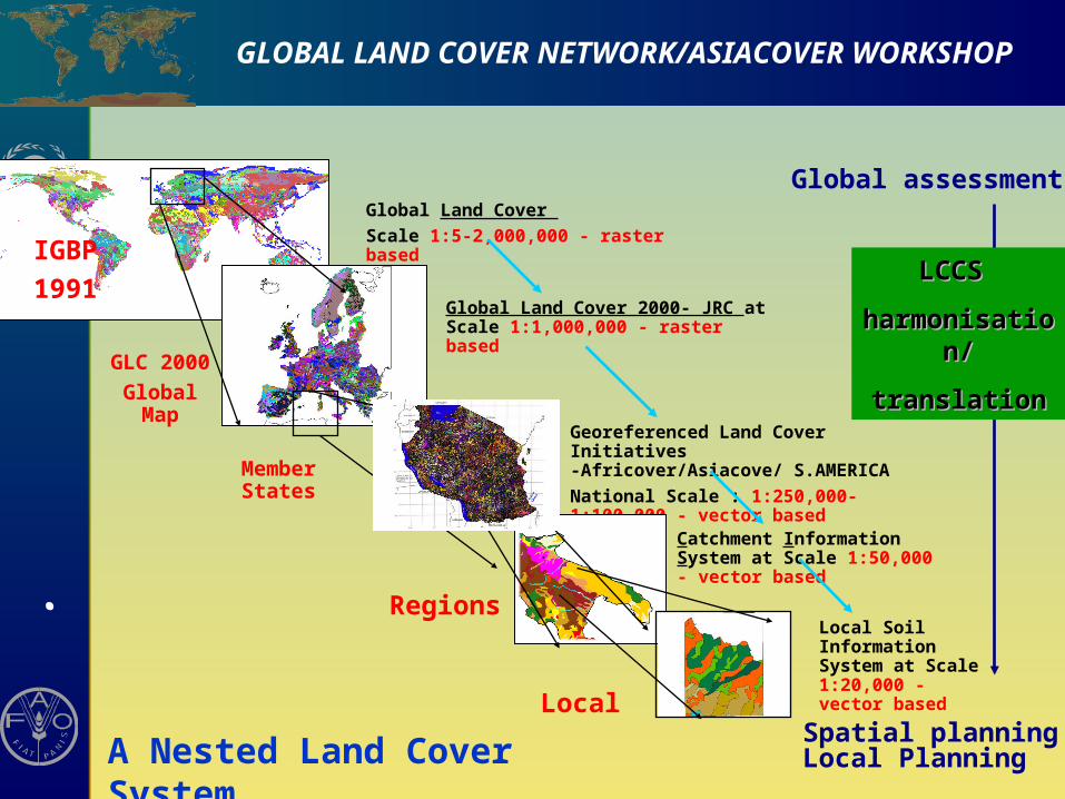
Global Land Cover 2000- JRC at Scale 1:1,000,000 - raster based
Georeferenced Land Cover Initiatives -Africover/Asiacove/ S.AMERICA
National Scale : 1:250,000-1:100,000 - vector based
Global Land Cover
Scale 1:5-2,000,000 - raster based
Local Soil Information System at Scale 1:20,000 - vector based
Catchment Information System at Scale 1:50,000 - vector based
IGBP
1991
GLC 2000
Global Map
Member States
Regions
Local
Global assessments
Spatial planningLocal Planning
LCCS LCCS
harmonisation/harmonisation/
translationtranslation
A Nested Land Cover System
.GLOBAL LAND COVER NETWORK/ASIACOVER WORKSHOP
Building a Global Coalition---Partnership
•A number of initiatives are already in existence A number of initiatives are already in existence
• No single entity at national, regional or international No single entity at national, regional or international level can do it alonelevel can do it alone
•Added-value for synergization and harmonizationAdded-value for synergization and harmonization
• Key partners: governments, industry, academic Key partners: governments, industry, academic institutions, in addition to operational programmes and institutions, in addition to operational programmes and organizations- we invite the African community here to organizations- we invite the African community here to become an active participant in this process and to become an active participant in this process and to become engaged as incubators for ASIAN become engaged as incubators for ASIAN implementationimplementation
AF
RIC
OV
ER
-E.A
.GLOBAL LAND COVER NETWORK WORKSHOP
THANK YOU