Embed Size (px)
Citation preview

1
Historic Hydrologic Landscape Modification and Human Adaptation in Central Lombok, Indonesia from 1894 to the Present
Geo. 522, Professor Ron Doel
March 21, 2008
By John Klock
Introduction This paper examines and interprets historical hydrological landscape change in
Lombok, Indonesia from the 1894 time period to the present. Historical methods are used
to interpret the physical, ecological, social, and cultural conditions of the agricultural
landscape in Lombok (Cronon 1983; Meinig 1979).
This paper begins by examining Sasak ethnic identity in relationship to religious
features on the landscape. Mosque number and pilgrimages to Mecca are examined in a
landscape context. Toponymy is used as a method to analyze place names on maps
particularly for springs, mountains, and villages. Springs play a prominent role in
Lombok agriculture, village life, spirituality, and culture. Springs are examined along
with protected forest groves. Lombok is an island with a high population density. There
has been significant forest and wetland ecological change in Lombok. Forest and riparian
change are examined in relationship to rice agriculture and historic buffer zones. Cattle
grazing is reviewed to understand the impact on: forests, accumulation of savings, and
the accompanying introductions of highly intensive agroforestry practices and their
influence on the hydrological landscape. In addition to toponymy, other methods used in
this study include Geographic Information systems (GIS) analysis of a Nusa Tenggara
province data set. Extrapolations have been made to approximate mosque and pilgrim
numbers for a specific time period. Historical and contemporary images have been
compared to determine degree of landscape change over time. This paper has not gone
into the complex land tenure patterns that are a key component of any landscape
transformation but will be a part of ongoing research.
This paper utilizes resilience theory to understand the socio-economic system of
Lombok from the time frame of 1894 onward. An attempt has been made to define the
characteristics of resilience in Lombok including identifying key adaptations as well as
formulating a timeline for landscape change.

2
Background
The name Lombok was probably coined in the 16th century by Portuguese
navigators who visited the island (1980) The definition of Lombok in the Indonesian
language is “pepper,” but the terms Selaparang and Tanah Sasak are two original names
for this island. Selaparang is a proud reference to the 16th century Sasak aristocracy in
East Lombok while Tanah Sasak literally refers to the “earth of the Sasak,” in the Sasak
language (VanDerKraan 1980)
Lombok is noted in the tourism literature as the “land of a thousand mosques.” In
fact, Lombok is now the land of over 2500 mosques and these structures offer a profound
glimpse of religiosity on the countryside. In Ampenan, Lombok there is a government
banner that hangs at a key intersection advancing the Lombok people as “maju dan
religious” (progressive and religious) (Klock 2007). The indication is clear, that religion
and progressive thinking can co-exist among the people of Lombok. The landscape in
Lombok is full of contrasts which create interpretation challenges for the researcher. As
an example, figure 1 below portrays a Balinese Hindu temple and Islamic mosque in
Cakranegara, Lombok. The image might invoke the following question; is there harmony
or competition among religions as represented by proximity of religious structures on the
landscape? Herein lays the test for landscape interpretation researchers. That challenge
involves finding the correct social and environmental context for the image, map, or other
period piece.

3
Figure 1. Pura Meru Temple and Mosque in Cakranegara
Viewing Lombok island by air, a visitor might observe some of the numerous
mosques, and over 200 Hindu temples, that dot the landscape throughout 324 villages
and larger cities (BadanPusatStatistic 2005). Lombok has three distinct physiographic
areas as noted by Fisher (1999). These areas include the large Rinjani volcano complex
which dominates the north; southern Lombok, composed of uplifted limestone and hilly
topography; while the central plain of approximately 25 km entertains the greatest
population density and constitutes one of the most intensive rice production areas in
Indonesia. Lombok is divided up into three catchments and approximately 32 sub-basins
for administration purposes. There are 119 significant spring sources noted by
government agencies in Lombok (Suratman 2006). These spring sources are the “life
Gate to Balinese Temple Pura Meru built in 1720 Stands in Contrast to Mosque Photo by John Klock 2006

4
source” of the island and contribute the majority of drinking water and a significant
proportion of irrigation water. 33 rivers are found in Lombok with 90 percent of these
waters originating from the Rinjani Massif (Monk 1997). Drainage patterns occur in a
radial pattern around Mt. Rinjani and historically, many of these rivers have been
diverted or dammed for purposes of irrigation.
The Lombok human population has never been a static situation. Lombok’s
central fertile plain today houses 60% of the island’s 2.9 million population and since
1971; the island population has grown by 1.8 million people. The island population in
1846 was estimated to be 405,000 according to Leeman (1989) who cites Zollinger’s
document of 1851. By 1900 the population was estimated to be 530,000 and by 1920 it
reached 617,000 according to Dutch census. In 1930, the Lombok population reached
701,000. Public health improved with the removal of swamps in Ampenan, Lubuhan
Haji, and Pamenang according to Dutch records at that time (Leeman 1989).
Lombok is a Lesser Sunda island positioned at 8 degrees south of the equator and
with a southerly half that straddles the climatic and biological shift called the Wallace
line (Figure 2 below). In particular, the eastern and central areas of Lombok have been
well-studied for the effect of drought and famine from irregular rainfall and a more recent
historic over-concentration of people.

5
Figure 2. Map of Lombok (Created by John Klock Feb. 2008)
Scattered across an island that bears 60 km. by 80 km. at its widest point, is an
agricultural society that has a remarkable number of historic hydrologic features. The
Sasak, the indigenous people, practiced communal forms of resource management for
centuries. The Balinese conquered and colonized Lombok and implemented the subak
(termed irrigation associations, or irrigation societies. Geertz points out that subak are
much more than irrigation societies (Geertz 1980). Rather, these bodies are agricultural
planning units, independent legal institutions, and distinct religious communities

6
(Pasandaran 2001). The impact of the Balinese subak are seen predominantly in West
and Central Lombok and more so among the Balinese, and less frequently elsewhere
among the Moslem Sasak. The structure and viability of the subak in Lombok today are
different than those found in Bali.
The Dutch takeover of Lombok in 1895 increased the wet-rice irrigation with an
extensive increase in irrigation infrastructure to drier parts of the island but in so doing
also imposed higher taxes on rice and stricter requirements for corvee’ labor. Both
Balinese and Dutch periods caused a significant erosion of the Central Lombok forests
through assorted policies that allowed for alienation of land parcels and expansion of rice
lands.
The area of West Lombok is endowed with fertile soils and abundant irrigation
water. In contrast, the area of south and Central Lombok has been described as a lahan
kritis or critical lands due to the pronounced variability in climate. The critical area lies in
the two kabupaten (districts) of Central and East Lombok. This area of Lombok has been
depicted as experiencing famine due to a variety of separate conditions such as: drought,
unequal land distribution, excessive number of sharecroppers, shortage of water, low soil
fertility, cultivation of unsuitable crops, lack of fertilizers, adherence to traditional
methods of farming, inflation, and limited access to credit and land tenure (Brennan
1984; Madconald 1983).
Human Adaptation Background
One of the goals of this paper is to view the manifestation of adaptation on
the hydrologic landscape in Lombok. The means by which villages adapt and survive
change has been the subject of a rich body of research on peasant moral economies
(Scott 1976; Geertz 1963; Netting 1993). Scott mentions that low crop yields, low

7
incomes, and extraction by elites can have a huge impact on peasant life in
Southeast Asia (1976). In most areas of Southeast Asia, the exposure to risk from
commercial farming is high. In such locales, Scott suggests that man-made famines
may occur. Through his work, Agricultural Involution (1963), Geertz studied rice
and swidden agriculture in Indonesia, with a particular emphasis on peasant farmer
survival, and land tenure under the breakdown of kinship and traditional self-help
networks. Adaptation to environmental change is an adjustment in ecological,
economic or social systems to observed or expected environmental stimuli.
Evaluations of adaptive capacity measure levels of risk before and after adjustments
have taken place. Adaptation under a resilience framework is different and is
defined by Nelson et al. (2007) as “the decision-making process and the set of actions
undertaken to maintain the capacity to deal with future change or perturbations to a
social-ecological system without undergoing significant changes in function,
structural identity or feedbacks of that system…”. The ability to adapt is based on
three fundamental characteristics key to the ecological resilience school of thought.
These are: 1) the degree to which the system is vulnerable to change while still
maintaining function and structure, 2) the degree of self-organization and, 3) the
capacity for learning (Nelson et al. (2007). Adaptive capacity describes the
preconditions for a system to be able to adapt to disturbances. A lack of adaptive
capacity, for example, can lead to a collapse of a system due to the inability to
mobilize adaptive capacity. Monk concludes in his ecological work that the
hydrological water balance is a key limiting factor for flora, fauna, and human
populations on small islands such as Lombok (Monk 1997).

8
Methodology
1. Geographic Information Systems From September 2007 to April 2008, the author was involved in a Fulbright
fellowship that allowed for a study of agricultural water management in Lombok,
Indonesia. GIS data acquired during that time from the non-government organization
Participatory Action Research, Rinjani (PAR) allowed for the interpretation of select
aspects of the hydrologic landscape of Lombok. In particular, there were twelve shape
files that proved useful in the analysis of the Lombok hydrology. Several maps made
from this data set are included in this paper. In the desa (village) shape file, there were
666 identified units of study (villages) and 222 attributes. The attributes in this shape file
covered the economic, health, cropland, springs, and numerous other data that are found
throughout Nusa Tenggara province. The province contains seven administrative regions
(kabupaten) composed of 59 districts (kecamatan) and 666 villages (desa) across four
major islands.
There were several challenges that arose from the GIS data set. The first included
a translation of specific Bahasa Indonesia language agricultural acronyms that were not
readily identifiable in the shape files. The second concern involved finding the
appropriate projection and datum for raster data conversion from older Dutch maps (1895
to the 1930s). Dutch maps and early records are written in the Dutch language. The GIS
data set from the PAR-Rinjani is rich and the author was especially fortunate to obtain it.1
The full usefulness of this data set will take some time to fully analyze.
1 The author would like to thank the following groups and individuals who were helpful in providing information: PAR Rinjani, the Transform Organization and its director Pak Markum, the Pusat Studi Pembangunan NTB and Pak Burhanuddin, The Konsepsi Organization and Pak Humaidy, World Wildlife Fund NTB, the faculty and administrators at the University of Mataram, the PSSS institute and its staff on

9
2. Toponymical Methods A grid was laid out on maps to aid in the identification and counting of specific
place names. The following general place names were counted on four maps and one GIS
data set: gunung (mountain), bato, batu, batoe (rock,stone), and aik, air (water). The
names Gunung Pengsong, and Gunung Hadji were also reviewed for frequency of citing.
1897, 1908, and 1926 Dutch Topographic maps were examined with scales ranging from
1:25:000 to 1:200,000 (Government 1908, 1926-1931). One tourist map at a scale of
1:200,000 was used. The final source of information came from attribute files of the PAR
GIS data set that were sorted by ascending alphabet and identified for desa (village) and
mata air (springs).
3.Mosque and Hajj Calculations
Mosque presence was counted from Dutch topographic maps for the period of
1926-1931. Only West and Central Lombok mosques were counted on these early maps.
Mosque numbers for East Lombok were extrapolated based on population at the time.
Please see appendix 2. Similarly, pilgrimage visits to Mecca were determined from
government reports, published documents (BadanPusatStatistic 2006; Daroesman 1976)
and extrapolations (also shown in Appendix 2).
4. Interpretation of Dutch Period Maps and Images
Dutch period maps reveal abundant information about Dutch plans for the island,
especially toward the late 1920s and early 1930s. The Netherlands Indies colonial
government used Lombok as a source of revenue from the tax and trade of rice. Rice
fields are identified across West and Central Lombok. Other useful information were
religious structures (temples, mosques), graveyards, military installations, waterworks, campus of the University of Mataram, Professor Taslim Sjah, and the Fulbright Indonesia Foundation in Jakarta.

10
and tree crops. Images from the Royal Netherlands Institute of Southeast Asian and
Caribbean Studies were purchased for the purposes of this research (Studies;
RoyalNetherlandsInstitute 2007).
Sasak Identity and Its Impact on the Landscape
It is not the intention of this paper to examine the religion of Islam in ways other
than a geographical spatial perspective on watersheds and agricultural water. This spatial
analysis reviews two statistics; mosque number over time and pilgrim journeys to Mecca
over a period of time. Indonesia as a whole is a melting pot of religions and ethnicities.
The success of religious integration and religious harmony over the last 45 years in
Indonesia is noted by Steenbrink (1993). With respect to the influence on the hydrologic
landscape, the dynamic question here considers what are the forces driving the growth of
orthodox Islam in Lombok. In Lombok, Sasak identity is closed associated with being
Moslem as noted by Cederroth (1996) who elaborates:
The political situation also contributed to the spread of orthodox Islam. When Lombok was conquered by the Dutch, after heavy fighting, in 1894, the island had already experienced almost two centuries of Balinese rule. Under the Balinese rajahs, it was above all the Sasak elite who had experienced oppression and had been frustrated in their political ambitions, but during the Dutch period the common people were also put under pressure, above all through heavy economic exploitation. In this situation, Islam was readily accepted by many Sasak as a marker of identity.
In 1976, Daroesman (1976) articulates that Islam is a unifying force in Lombok
society and the “tuan guru” has a large influence on the success of development and other
activities. In 1974, she mentions that 1,040 people in an otherwise impoverished province
made the pilgrimage or hajj (Daroesman 1976). The designation orang Islam and orang

11
Hindu are used today to define Moslems and Hindus in Lombok society (Gerdin 1982).
Gerdin mentions the following:
Probably resentment of ritually expressed political inequality was one reason for the spread of orthodox Islam in Lombok. Lombok is the one Indonesian island with the highest proportion of people undertaking the pilgrimage to Mekkah. All pilgrims are orthodox Moslems, while syncretist Moslems look to the traditions of noble court rituals rather than turn to Mekkah. One might say that for many an orthodox Moslem in Lombok, one type of exemplary centre…….namely the Balinese or Sasak court, has been replaced with an exemplary center of another kind: Mekkah (pg. 53).
Hunter mentions that the Sasak people in East Lombok are more likely to turn to
religion, when times become more difficult. The reasons for this are unclear but may be
related to interpretations of identity, past repression, and growing empowerment. Hunter
further describes mosque building and renovation as ubiquitous in Lombok. “Traveling
along the main road from west to east, one can see mosques being renovated or built in
many of the villages”(Hunter 2004). Klock in 2006 and 2007 also noted the trend in
mosque reconstruction in towns from the provincial capital of Mataram to the city of
Praya. Harnish alludes that an assortment of forces (government religion offices,
religious organizations, tuan hadji (religious leaders that have made the pilgrimage to
Mecca, similar to tuan guru) and others are “compelling Sasak to act like Muslims and
Balinese to act like Hindus…” (2005). In 2003 Hunter (2004) noted the growth to six
Islamic organizations in Elah village, East Lombok since the end of the New Order
(Suharto regime) from a previous number of three in the early 1990s.
Related to mosque construction is the pilgrimage to Mecca. A person who has
made the trip is called a hadji (hajji) tuan guru or tuan hadji, an honor that bestows much
respect from the community. Leeman (1989) explains that those who have fulfilled their
12
obligation to make a pilgrimage to Arabia, may as ‘tuan guru’ gather pupils around them.
The resources to make such a trip are a subject of interest for this spatial study. Judd
(1980) discusses the social dynamics of thrift and profit-making for the pilgrimage in Iaq
Iqu Lombok. Judd notes that landlords and wealthy individuals have stopped partaking in
most traditional Sasak ritual feasts, but instead save their money and goods for the
pilgrimage. While adat emphasizes social responsibilities related to communal living;
Islam orients individuals to the individualism and the ideal of simple living to save
money to make the trip to Mecca. This “saving” of resources for journeys to the Mecca
by village leaders can have a significant impact on village life in Lombok. This possible
decline in one key patron-client safety net at the village level deserves further study,
especially in highly impoverished parts of Lombok. Leeman comments that increasing
Islamic piousness correlates to increasing market involvement of village economies from
around the year 1900. Leeman further notes that in the Central Plain of Lombok,
Islamization does not seem to oppose the accumulation of personal wealth. He notes that
personal savings finance pilgrimages to Mecca but that the high cost of fulfilling the fifth
pillar of Islam2 (hajj) can involve land transactions as well as pelais. A pelais is a share-
cropping contract where the share-cropper provides money in advance for the right of
cultivation.
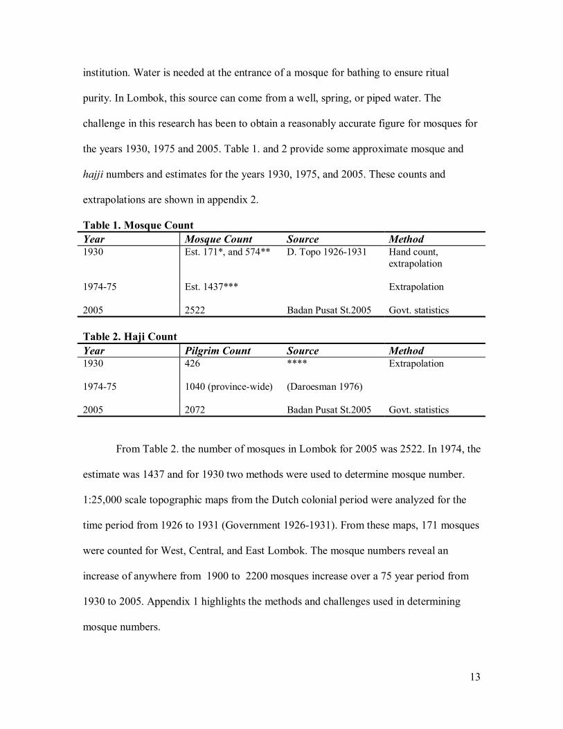
Mosque and Hajj Numbers
The mosque growth rate on Lombok plays a role in landscape modification.
Mosque placement and construction are related to the population that can support the
2 The Five Pillars of Islam are: 1. Affirmation of Allah as the one and only God and Mohammed as his prophet. 2. The execution of prayer five times a day 3. The observance of the time of fasting in the month of Ramadan. 4Pilgrimage to Mecca a the height of celebrations, according to the health and financial situation of the believer. 5. The donation of alms . (Leeman 1989)
13
institution. Water is needed at the entrance of a mosque for bathing to ensure ritual
purity. In Lombok, this source can come from a well, spring, or piped water. The
challenge in this research has been to obtain a reasonably accurate figure for mosques for
the years 1930, 1975 and 2005. Table 1. and 2 provide some approximate mosque and
hajji numbers and estimates for the years 1930, 1975, and 2005. These counts and
extrapolations are shown in appendix 2.
Table 1. Mosque Count Year Mosque Count Source Method 1930
Est. 171*, and 574** D. Topo 1926-1931 Hand count, extrapolation
1974-75 Est. 1437*** Extrapolation
2005 2522 Badan Pusat St.2005 Govt. statistics Table 2. Haji Count Year Pilgrim Count Source Method 1930
426 **** Extrapolation
1974-75 1040 (province-wide) (Daroesman 1976)
2005 2072 Badan Pusat St.2005 Govt. statistics From Table 2. the number of mosques in Lombok for 2005 was 2522. In 1974, the
estimate was 1437 and for 1930 two methods were used to determine mosque number.
1:25,000 scale topographic maps from the Dutch colonial period were analyzed for the
time period from 1926 to 1931 (Government 1926-1931). From these maps, 171 mosques
were counted for West, Central, and East Lombok. The mosque numbers reveal an
increase of anywhere from 1900 to 2200 mosques increase over a 75 year period from
1930 to 2005. Appendix 1 highlights the methods and challenges used in determining
mosque numbers.

14
Similarly, a reasonably accurate count for pilgrims is noted at 2072 in 2005
(BadanPusatStatistic 2006), and at 1040 (province-wide) for the year 1974 (Daroesman
1976). A less reliable statistic of 426 hajji was calculated for 1930 (Appendix 1).
Ethnic Identity and the Results of Place Name Survey
Defining ethnicity is important in Lombok (Harnish 2005). A place name with subak,
kliang, pura, or Gunung Pengsong might involve a village with a large Balinese Hindu
population. A place name with Labuhan Hadji, Aik Bukaq, Berugag, and Lumbung, or
Selaparang International Airport would have a strong Sasak identification. Table 3.
below notes that 4.6% of the villages in Lombok have the place name aik (meaning
water) in the Periplus map. The PAR Rinjani GIS data set provided 8 spring place names
utilizing the term aik that resulted in 8.4% of the spring number total (Prayitno 2005).
Table 3. Lombok Place Names Map Name* Scale
Gunung (all place names)
Batu/Batoe (all place names)
Aik/Air Aik % of Total
Gunung Pengsong -G.Hadji
1897 D. Topo 1:200,000 scale
1:200,000 G.Pengsong –yes G.Hadji -no
D. Topo 1908 1:200,000 29 16 6 village place names
G.Pengsong-no G.Hadji -no
D. Topo 1926(Government 1926-1931)
1:25:000 G.Pengsong –yes G.Hadji -yes
Periplus Tourist Travel Map: Lombok and Sumbawa
1:200,000 62 49 14 village place names
Approx. 4.6% of villages in Lombok have word aik in name
G.Pengsong -yes G.Hadji -no

15
GIS Database 2005 (PAR Rinjani) Village attribute file
Desa— Mata Air—
2
14 1
5 village place names 8 spring place names
Approx. 1.6% of the villages use the word aik in name Approx. 8.4% of the springs use the word aik in name
G.Pengsong yes G.Hadji -no
*Sources:
• D.topo = Dutch topographic (Batavia 1908) KIT Royal Tropical Institute, Amsterdam(Government 1908) • Periplus maps. Lombok and Sumbawa. 1:200,000, Singapore, 2005. • PAR Rinjani GIS data set, Mataram, Lombok , 2005. • D.topo = Dutch topographic (Batavia 1926) KIT Royal Tropical Institute, Amsterdam(Government 1908) • (Government 1926-1931)
Gunung Pengsong and Gunung Hadji
Toponymy is further used to analyze religious context and influence. Gunung
Pengsong is a historic mountain in Balinese folklore and conceived as the arrival site of
the first Balinese on the island most likely in the late 1600s. In the historical work by
Hagerdal (Hagerdal 2001), there is an English translation from Gerdin’s oral history work
on Lombok entitled “Babat Lombok Banjar Getas.” In this story, Gunung Pengsong is
identified as a key reference point. Three photos are provided of the mountain here.
Figure 3 shows the landscape looking from the top of the Balinese Hindu sanctuary on
Gunung Pengsong taken by the author in November of 2006. Figure 4 shows a
perspective from the 1930’s. Neither scene is identical but both scenes depict dry
deciduous tree vegetation indicative of a monsoon forest type during the dry season. In

16
figure 1, mosques can be seen with the dome-shaped green roofs. Figure 5. Shows
Gunung Pengsong from a ground view.
Figure 3. Gunung Pengsong in Nov. 2006 (Photo: John Klock) Figure 4. Dutch Archive photo from the top of Gunung Pengsong in circa 1930’s (Source: KITLV, Amsterdam)
Figure 5. Gunung Pengsong from the ground. Source: (Hagerdal 2001)
From an 1897 Dutch topographic map the mountain name Gunung Pengsong is
present (Figure 6). From the 1926 Dutch topographic map (Government 1926-1931)
Gunung Pengsong is present as is a mountain next to it called Gunung Hadji (beside
Sengkongok village) (Figure 7). Gunung Hadji is not found in other maps although there
are no other maps at the 1:25000 scale examined for that location. Gunung Pengsong is
found in the 1897 1:200,000 scale topographic map and on tourist maps. On the 1:25,000,

17
1926 Dutch topographic map used for this study, a 2 kilometer radius was drawn around
Gunung Pengsong mountain. From this radius of the 1926 map, there were 12 mosques
counted. The question raised in this case is as follows: was the naming Gunung Hadji a
sign of political change with growing Sasak influence on the landscape and declining
Balinese Hindu impact? Certainly, the Dutch defeat of the Balinese Hindu in 1894
resulted in a decline in the fortunes of the Balinese in West Lombok. Growing Sasak
identity in the 1920’s and resentment of Dutch rule was also evident (Gerdin 1982;
Cederroth 1996). Other hadji (also spelled hajji) place names exist in Lombok. Labuhan
Haji is notably famous city on the east coast of Lombok and known for the start of
pilgrimages to Mecca and as a renowned older port visited by Arab traders.
Figure 6. 1897 Dutch Topographic Maps of Gunung Pengsong

18
Figure 7. 1927Cropped Dutch Topo Map with arrows pointing to both Gunung Pengsong and Gunung Hadji . (Government 1926-1931)
Protected Springs and Forest Groves
There are over 100 critical springs identified by the provincial government that
have significant spiritual, cultural, and economic importance in Lombok Most of these
springs have been prioritized for use as either agricultural or drinking water and have
been altered in some manner by concrete enclosures and pipes (Figure 8).
Figure 8. Concrete Spring Box with Spring now Controlled by PDAM Utility and Diverted to City of Praya (photo by John Klock, Nov. 2006)

19
Figure 9. shows the location and flow rate of major springs and their relationship
to the critical dry lands. The Hindu temples in West Lombok are often found in springs,
protected forests, and scenic outcrops. Pura Lingsar is one such temple with a prolific
spring in West Lombok. Each year, a ritual attended by Hindu and Muslim alike, is
commemorated by thousands of people to express gratitude to ancestors and give thanks
for a spring that irrigates hundreds of farms throughout West and Central Lombok
(Nugraha 2006). In Lombok there are numerous traditions of protecting forests and
planting trees Muslim and Hindu alike. In the village of Aik Bukaq, near the site of Aik
Bone spring, there is a protected forest (please see Figure 10.).

20
Figure 9. location and flow rate of major springs (Map created by John Klock, March, 2008)
21
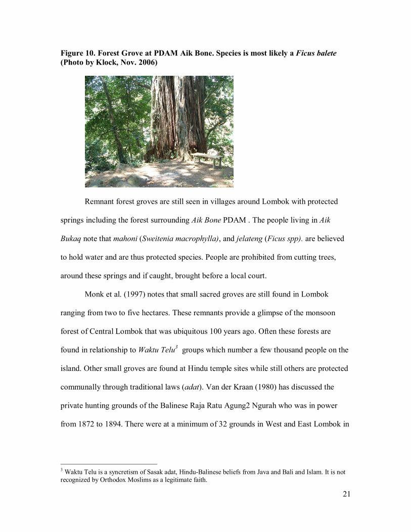
Figure 10. Forest Grove at PDAM Aik Bone. Species is most likely a Ficus balete (Photo by Klock, Nov. 2006)
Remnant forest groves are still seen in villages around Lombok with protected
springs including the forest surrounding Aik Bone PDAM . The people living in Aik
Bukaq note that mahoni (Sweitenia macrophylla), and jelateng (Ficus spp). are believed
to hold water and are thus protected species. People are prohibited from cutting trees,
around these springs and if caught, brought before a local court.
Monk et al. (1997) notes that small sacred groves are still found in Lombok
ranging from two to five hectares. These remnants provide a glimpse of the monsoon
forest of Central Lombok that was ubiquitous 100 years ago. Often these forests are
found in relationship to Waktu Telu3 groups which number a few thousand people on the
island. Other small groves are found at Hindu temple sites while still others are protected
communally through traditional laws (adat). Van der Kraan (1980) has discussed the
private hunting grounds of the Balinese Raja Ratu Agung2 Ngurah who was in power
from 1872 to 1894. There were at a minimum of 32 grounds in West and East Lombok in
3 Waktu Telu is a syncretism of Sasak adat, Hindu-Balinese beliefs from Java and Bali and Islam. It is not recognized by Orthodox Moslims as a legitimate faith.
22
forested areas guarded by a royal police force. These hunting grounds were taken over by
the Dutch Indies government in 1895.
Central Lombok Forest Change
Analysis of the landscape from 1894 is important to comprehend the larger
framework of ecological and social change in Central Lombok regency. Central Lombok
has diverse forest types ranging from high altitude semi-evergreen forests to lower
elevation moist deciduous monsoon forests, to a coastal dry deciduous monsoon type.
Tropical moist deciduous forests receive over 1500 mm of rainfall a year and have four to
six dry months per year and this type is more commonly found inside Rinjani National
Park. Tropical dry deciduous forests receive less than 1500 mm and have more than six
dry months per year. Appendix 2 provides a comparison of historic vegetation and
degradation stage.
Today in Lombok, old growth forests are difficult to find in the lowlands. The
removal of forest cover in Central Lombok has been noted by Monk et al. (1997). A
chronology of ecological disturbance is found in Appendix 3 with footnotes. Particularly
at 100 to 400 meters in elevation there are only gallery monsoon forests seen in ravines,
as well as grasslands, and scrublands. Monsoon forest are highly vulnerable forest
formations and easily lost. As monsoon forest is cleared it can become belukar
(deciduous scrubland) (Monk 1997). Monk estimates that 8.17% of Lombok is covered in
belukar mostly in the southwest. 100 years ago, a dry deciduous forest was ubiquitous but
converted by either shifting cultivation, grassland burning, or grazing.
Belukar or scrublands are a mixture of shrubs and bamboo; often becoming an
impenetrable thicket. The benefit to the farmer in clearing monsoon forests is that this
23
vegetation dries out fast. Soil dries quickly and continuous shifting cultivation maintains
the dense shrub mixture. Regular burning enhances grass regeneration while repeated
grazing inhibits tree regrowth. Monsoon forests can regenerate into essentially three
vegetation types; scrublands, grasslands, and savannas. Savannas are believed, from
inference, to now exist in areas where monsoon forests were present over a hundred years
ago (Monk 1997). Key pioneer species of savannas in nearby Sumba island include
Melaleuca spp., Sesbania grandifolia, tamarind (Timonius sericeus), and Causarina
junghuhniana. These pioneers may take thousands of years to become a mature monsoon
forest but there are no systematic studies done on monsoon forest formation for the
province (Monk 1997) .
Livestock Grazing Impact on the Landscape In 1974, Daroesman notes that there were 145,251 cattle in Lombok at a carrying
capacity of 0.7 ha per animal unit (4.5 hectares was recommended at that time) (1976). In
2004, the number of livestock on Lombok was estimated at 280,000 (Sumarto March
2004). The amount of forage available to feed a cow/calf unit in Lombok has declined to
less than .5 ha. unit. In Sumba island the there are now two cattle per hectares. Cattle are
important for household savings and most likely for financing Mecca pilgrimages but
there is little data to support the latter supposition. The number of livestock or density
found at the beginning of the 20th century is not known.
A mixed agroforestry system is found in Lombok with abundant turi (Sesbania
grandiflora) (figure 11) actively planted along bunds of rice fields and sometimes in
conjunction with long beans which use the trees as trellis works. Sesbania is cut as forage
for livestock and also improves soil fertility (Monk, Fretes, and Reksodiharjo-Lilley 1997
24
and authors’ survey 2006). Fences have gamal (Gliricidia sepium) planted in front of rice
fields as living fences.
Bali cattle (Bos javanicus) are the most common breed of cattle in Lombok
(Figure 12). This species is derived from a wild banteng (Bos sondaicus) which is known
from fossil remains (Monk 1997). Because Bali cattle have evolved in Indonesia, they are
exceptionally adapted to the variable climate and have a high reproductive rate. Monk
notes that overgrazing caused a massive weed infestation of Lantana camara in the
1930s and 1940s that impacted cattle populations. Cattle are a huge export from Lombok
and Timor. In 1995, some 53,000 cattle were needed in Jakarta alone for the Moslem
fasting month of Ramadhan. The current inter-island livestock trade is flourishing but
subject to excessive taxes and corruption through numerous middle-men and poorly
implemented decentralization policies (Sumarto March 2004). Nonetheless, cattle are the
major source of income in rural areas of Lombok (Monk 1997)
The Sasak have a well developed cut and carry forage system (figure 12) for the
feeding of cows and horses and this seems complimentary to the high population
densities and land shortages found on the island (Monk 1997). A history of cattle theft
has led to locally overstocked corrals and overgrazed pastures. Cattle cooperatives are
noted in villages to prevent rustling, improve marketing, and assist in feeding (Klock
interview in Central Lombok Dec. 6, 2006).
There is a scarcity of forage during the dry season. Crop residues are utilized and
several forage grasses (Panicum, Chloris, and Brachiaria) are actively planted in the
Lombok cut and carry systems (Monk, Fretes, and Reksodiharjo-Lilley 1997). The author
noted extensive cutting of weed and pasture grasses by individuals daily that were

25
transported by bicycle to a prospective buyer. Steep terrain usually inhibits the extensive
herding of cattle and less sloping hillsides are often overgrazed. The number of cattle in
Lombok at this time is unprecedented in the island’s history. The culture of cattle raising
has influenced the landscape in numerous ways: inhibiting monsoon forest regrowth from
grazing and burning; impacting riverine and other riparian habitats, adaptation of
agroforestry plants and practices for forage production; and paying for pilgrimages.
Figure 11. Sesbania grandiflora and forage grasses planted alongside rice fields. Sesbania was encouraged for planting through government and NGO grazing management programs. (Photos by John Klock, Oct. 2006)
Figure 12. Bali cattle (Bos javanicus) a prolific breeder, is the most common breed in Lombok. The second image shows forage grass that has been cut and carried to livestock. (Photo by John Klock, Jan. 2007)
26
River Change over Time
The rice economy that has supported Lombok for over 300 years has significantly
impacted rivers. All of the 33 rivers in Lombok have been altered through historic
anthropogenic influence with most of this change coming from intensive rice agriculture
and accompanying irrigation infrastructure. The Balinese Hindu and Sasak manipulated
waterways for subak irrigation. Subak in West Lombok prior to the Dutch period were
administered as units defined by small dams (pengempels) (Hagerdal 2001). The subak of
old in Lombok was controlled by ruling houses who appointed officials for constructions
and distribution of water (pekasih or pembekel pekasi (Gerdin 1982). The Dutch colonial
period created at least 8 modern dams and diversions in Lombok encompassing an
expansion of 17,000 hectares of irrigable rice land (VanDerKraan 1980). The post-WWII
period saw the Indonesian government and international development funding create an
additional 13 dams of various capacities up until the 1990’s. The Indonesian government
efforts were predominantly focused on the Critical Areas in Central Lombok. There are
now over 191 irrigation projects in Lombok irrigating at least 107,000 hectares. Of this
amount, 85,106 ha. or 80% involves water derived from weirs while a further 21,930 is
extracted from embung (impounded micro-catchments) and dams. High-yielding rice
varieties have created a huge demand for water and required significant irrigation
infrastructure.
Lombok rivers are of short length while drainages are steep. Higher flows take
place during the rainy season and dramatic seasonality is experienced with flows
dropping to a minimum during the dry season or drying up altogether (Nippon Koei Co.
1995; Monk 1997). There are few undisrupted parts of rivers in Lombok. Figure 13. is an

27
artistic rendering of a photograph that depicts the Dodokan river in 1895(Cool 1896). In
this image, there are planted palm trees and secondary regrowth of bamboo from a
previous disturbance. The flat topography denotes a slower river movement of the central
plain.
Figure 13. Dutch rendering of a photo of the River Djangkok (Jangkok) from the Dutch Military expedition in 1894 to Lombok (Cool 1896)
Ecologically, the now locally vanished estuarine crocodile can provide clues to
past Lombok river landscapes. The estuarine crocodile (Crocodylus porosus) was
endemic to Lombok and hunted in Lombok as identified in Dutch photographic images
(RoyalNetherlandsInstitute 2007) (see figure 14) . Crocodiles are associated with
brackish water (mangrove swamps), freshwater rivers and grass swamps. Nests are
created on lakes in Papua New Guinea from aquatic plants growing at the edge of the
water. The species is gone from most rivers and rarely sighted in West Nusa Tenggara

28
Province. The cause of this decline is most likely hunting and diversions of water from
rivers and the drainage of wetlands for rice cultivation. The lands that support wet rice
irrigation are often the same lands that are considered ecological wetlands. Slow moving,
low gradient rivers are prime crocodile habitat as well.
Figure 14. Estuarine Crocodile in Lombok (1940) (RoyalNetherlandsInstitute 2007)
Mangroves have been completely removed from the coasts of Lombok within the
past three decades from clear-cutting for construction or fuel requirements for coral
burnings (Monk 1997). Monk notes that the tourist area of Kuta is centered on previously
mangrove land.
There have been numerous fish introductions into Lombok with earliest records
dating back to introductions in 1895 (Monk 1997). Carp were introduced in 1925 and five
species of freshwater fish were brought from Java in 1941 and bred and distributed
throughout the island. In 1947, increasing numbers of other undetermined fish were
released into rice fields (Monk 1997). The increased connectivity between irrigation
canals and rivers has also see migration of non-native fish into rivers. The decline of
endemic species of fish has not be studied to any great length.

29
Figure 15. shows a current day river in Ampenan. Pollution has played a role in
river decline in Lombok. River drainages seem to be the logical place for garbage
deposition, especially since garbage production exceeds removal capacity in cities.
Plastic bags combined with explosive growth of the plant, water hyacinth, inhibits water
flow in rivers, clogs pipes and canals leads to flooding.. Garbage deposition in rivers also
contributes to disease problems such as malaria, dengue fever, and diarrhea. Lombok has
particularly virulent strains of malaria and dengue fever.
Figure 15. Current state of urban rivers in Lombok. This river is used as a dump near a public market in Ampenan. Abundant water hyacinth is present. (Photo taken by J.Klock in Jan. 2007) Discussion
1. Religious Structures and Pilgrimages
The number of mosques in Lombok has increased by over 1500 percent since the
1930s. In 1930, there were an estimated 171 mosques (extrapolated) while today there are
2522. The population has increased from around 700,000 in 1930 to about 2.9 million
people today. This is an over 414% increase in population during the 1930 to 2008 time
period. Hajj numbers have likewise increased from an extrapolated 426 in 1930 to about

30
2070 today. This represents an increase of 485% over a 78 year period. The increase in
haji has implications regarding political, economic, and social influence at the village.
Village level religious changes might include less communal forms of behavior during
disaster or drought as wells as savings-oriented behavior oriented towards making the
pilgrimage.
2. Springs
A toponymical study of spiritual places like Gunung pengsong or Gunung hadji
revealed a pattern where Gunung pengsong ws found in both tourist and topographical
maps but no such pattern was detected for Gunung hadji. Interviews in villages
surrounding these mountains could clarify the record on their naming. The use of the
name aik was prevalent in over 8% of villages. This suggests that villages are named after
resources and have identification with springs. Springs and forest groves have been
protected historically. Recently, there have been studies suggesting that numerous
springs have dried up on Mt. Rinjani. The exact cause of this is unknown but the
Lombok Post reports that 466 springs have been lost throughout the province over a
period of 24 years (Lombok Post June 13, 2005). The Lombok Post also mentions that
there were 712 springs in Lombok and Sumbawa in 1995 but only 114 by 2000
(LombokPost Nov. 27, 2005 ). What is not known is the context of how springs were
utilized, shaped, and transformed over time in addition to the spiritual connection to the
village.
3. Forests
The historic vegetation in the early 1900s in the occupied parts of Central
Lombok is suggested to be monsoon forest (both moist and dry deciduous) with smaller

31
patches of intermittent scrublands, grasslands, and savannas. Scrublands represent a key
vegetation entity for which to understand the past 100 years of anthropogenic activity.
This paper assumes that shifting cultivation in Lombok was always the back-up in case of
rice crop failure. During times of strife, shifting cultivation meant survival, even in the
drier and more infertile parts of the South. Central Lombok forests are proposed here to
be a sanctuary buffer zone to temporarily reside in for a few years during times of war or
disaster. Lombok’s population has been frequently regulated by famines, epidemics
including smallpox, cholera, and malaria, and earthquakes and volcanic eruptions.
Figure 16 shows this buffer zone. Old fields following traditional modes with low
carrying capacities allowed for a successful nutrient regeneration period before repeated
cultivation. In Sapit, Lombok, villagers typically returned to abandoned fields after the
secondary growth became taller than men (Monk 1997). As population densities grew all
over Lombok, the fallow periods became shorter. Ecologically, this means that secondary
monsoon forests might be returned to every 21 years or so, but with more occupants, the
period of return would be shorter. Exemplary studies of integral shifting cultivation in
Southeast Asia are noted by Conklin and Pelzer (1957; Pelzer 1945). If immigration and
or policy prohibited movement to other forest sites, a more intensive cropping rotation
would ensue but with poor regeneration and a possible transition into scrublands (Monk
1997).

32
Figure 16. Proposed Buffer Zone for Central Lombok During Times of Natural and Man-Made Disaster
In dry deciduous and moist deciduous monsoon forests of Central Lombok, prior
to the end of the 1800s, this paper conjectures that the shifting cultivation practices in
Central Lombok were sustainable. That is, the overflow at any given time from East
Lombok or West Lombok could be accommodated by the monsoon forest and allow for
adequate secondary forest regeneration. The Central Lombok lands were able to
accommodate the waves of migrants that arrived after disasters. For example following
the Tambora eruption on Sumbawa or the Balinese war of the 1890s and ensuing famine.
As the population in Lombok increased, the available sites for pioneering migration

33
began to shrink. Interestingly, Lombok also has a high transmigration rate to other islands
of the archipelago.
4. Cattle Grazing and Riparian Change
The number of cattle over the last 30 years has doubled to over 280,000. There
are several possible reasons for this increase. Decentralization by the Indonesian
government in the 1990s led to, in theory, more opportunities to export cattle to Java,
especially during Ramadhan. Raising cattle is the main source of savings for most
farmers. Cattle raising is also a way of saving for the devout to travel to Mecca. Less
participation by village leaders and patrons in ritual feasts has impacted the communal
safety net found in traditional Lombok village life.
Agroforestry practices including cut and carry, and the planting of grasses and
trees have increased the carrying capacity of cattle of cattle on the island. Cattle in
Lombok have a very small amount of grazing land per head and are often raised in nearby
corrals or pastures to avoid theft. This increase in cattle density has contributed to already
overgrazed conditions.
Rivers have been altered for hundreds of years in Lombok and at the start of the
20th century, the human population has doubled and then doubled again. The amount of
available pioneering lands has declined. Wetlands have been drained for reservoirs and
rice fields virtually all of the mangrove have been removed. The settlement of Central
Lombok by the Netherland Indies government was not without consequence. The goal
was to increase rice production for export earnings and the best way to do this was to
create more rice lands. The increase in human population in a drought prone area like
south central Lombok is risky at best. Soils are historically poor and irrigation flows are

34
erratic. This idea of settling a population in a drought prone area is discussed in depth by
Van der Kraan,
Conclusions
This paper has chronicled historical descriptions of the Lombok landscape
hydrology as well as alterations to the watersheds and fields from the early 1890s to
the present day. Key human adaptations that are readily visible on the landscape
include pioneer migration to forested areas, the increase in mosque and cattle
numbers and the enhancement of agroforestry technology through the planting of
grasses and trees. Spring boxes and weirs allowed for the successful capture of water
to irrigate the lowland areas. Cattle are the Bos javanicus breed, or Bali cattle,
which are a prolific slender animal and historic prodigy of wild cattle found in
Indonesia. The increase in cattle population could be related to decentralization of
the beef market and the lifting of restrictions on inter-island trade of livestock. The
numbers of cattle are at a historic high compared to a century ago. Other factors
such as the raising of cattle and the change in individual saving patterns may be at
work in relationship to fulfilling one of the five goals of Islam.
Back in the early 1900s the monsoon forest was abundant in Lombok. A
sense of what this forest type looked like can be seen in protected groves
surrounding springs in the higher elevations. The Sasak and Balinese people have
strong ties to springs both culturally and spiritually as seen in the Lingsar festival
every year. Spring place names can give villages a sense of historical and cultural
identification. At the start of the 20th century, human population density was still
not high in the drought lands of Central Lombok. A key turning point in the human
ecology of Central Lombok was the opening of rice lands with the increase in

35
irrigation infrastructure as highlighted by Van der Kraan, Leeman, and Brennan.
Initial policies to encourage rice land settlement in Central Lombok were later altered as
the number of landless individuals increased. The Lombok people possess a remarkable
ability to adapt and survive. In the course of this research, one questions the continued
focus on wet-rice agriculture in the context of a preferred resilience ‘state’ especially in
drier areas. Maintaining rice as a primary staple in south central Lombok appears to limit
options and exacerbate poverty.
Works Cited
BadanPusatStatistic. 2005. Statistic Potensi Desa Provinsi, Nusa Tenggara Barat 2005. Mataram.
———. 2006. Statistic Potensi Desa Provinsi, Nusa Tenggara Barat 2006 Mataram. Brennan, L., Healthcote, L. and Anton Lucas. 1984. The Causation of Famine: A
Comparative Analysis of Lombok and Bengal 1891-1974. South Asia: Journal of South Asian Studies 7 (1):1-26.
Cederroth, S. 1996. From Ancestor Worship to Monotheism: Politics of Religion in Lombok. Temenos 32:7-36.
Conklin, H. C. 1957. Hanuno'o Agriculture. A Report on an Integral System of Shifting Cultivation in the Philippines. Rome: Food and Agriculture Organization.
Cool, W. 1896. De Lombok Expeditie: G. Kolf and Co. . Crippen. 1975. Technical Reports for Lombok. Vancouver: CIDA and Crippen
International. Cronon, W. 1983. Changes in the Land: Indians, Colonists, and the Ecology of New
England. New York: Hill and Wang. Daroesman, R. 1976. An Economic Survey of West Nusa Tenggara. Bulletin of
Indonesian Economic Studies 12 (1):44-69. Fisher, L. A. 1999. Beyond the Berugaq: Conflict, Policy and Decision-making over
Forest and Conservation Management in Nusa Tenggara, Indonesia, Cornell University, Ithaca.
Geertz, C. 1963. Agricultural Involution: The Process of Ecological Change in Indonesia. Berkeley: University of California Press.
———. 1980. Organization of the Balinese subak. In Irrigation and Agricultural Development in Asia. Perspectives from the Social Sciences, ed. E. W. Coward Jr. Ithaca and London: Cornell University Press.

36
Gerdin, I. 1982. The Unknown Balinese. Land, Labour, and Inequality in Lombok. Goteborg, Sweden: Acta Universitatis Gothoburgensis.
Government, N. I. 1908. In 1:200,000 scale, ed. R. T. Institute. Amsterdam: Topographic Institute, Batavia (Jakarta). .
———. 1926-1931. 1:25:000 topographic map series of Lombok Mataram and Cakranegara and south. Batavia, Jakarta.
Hagerdal, H. 2001. Hindu Rulers, Muslim Subjects: Lombok and Bali in the Seventeenth and Eighteenth Centuries.
Harnish, D. 2005. Defining Ethnicity, (Re)constructing culture: Processes of Musical Adaptation and Innovation Among the Balinese of Lombok. Journal of Musicological Research 24:265-286.
Hunter, C. L. 2004. Local Issues and Changes: The Post-New Order Situation in Rural Lombok. Sojurn 19 (1):100-122.
Judd, M. P. M. 1978. Social Impact Study: Lombok Island Water Resources Development, Phase 2. . In Final Report, vol. 2 Part 6. Vancouver: Crippen International.
———. 1980. The Sociology of Rural Poverty in Lombok, Anthropology, University of California, Berkely.
Klock, J. 2007. This sign in Ampenan states: "Lombok, maju dan religious." Ampenan, Lombok.
Leeman, A. 1989. Internal and External Factors of Socio-Cultural and Socio-Economic Dyanmics in Lombok (Nusa Tenggara Barat). Zurich: Geographisches Institut ABT. Anthropogeograhie Univesitat Zurich.
LombokPost. Nov. 27, 2005 Madconald, S. M. P. A. 1983. West Nusa Tenggara Irrigation Study: Proposal for
Consultancy Services, Volume 2 Technical Proposal. . Cambridge: Sir M Madconald & Partners Asia.
Meinig, D. W. E. 1979. The Interpretation of Ordinary Landscapes: Geographical Essays
New York: Oxford University Press. Monk, K., De Fretes, Yance, and Gayatri Reksodiharjo-Lilley 1997. The Ecology of Nusa
Tenggara and Maluku. . Hong Kong: Periplus Editions. Nelson, D. R., W.Neil Adger, and Katrina Brown. 2007. Adaptation to Environmental
Change: Contributions of a Resilience Framework. Annual Review of Environment and Resources 32:395-419.
Netting, R. M. 1993. Smallholders, Householders: Farm Families and the Ecology of Intensive Sustainable Agriculture: Stanford University Press.
Nippon Koei Co., L. 1995. The Study on the Embung Development Project in East Nusa Tenggara and West Nusa Tenggara in the Republic of Indonesia: JICA and Directorate General of Water Resources Development.
Nugraha, P. 2006. Topat War promotes religious tolerance, harmony in Lombok. Jakarta Post, December 14, 2006.
Pasandaran, E. a. N. Z. 2001. Irrigation Against Rural Poverty: An Overview of Issues and Pro-Poor Intervention Strategies in Irrigated Agriculture in Asia, at Vietnam.

37
Pelzer, K. J. 1945. Pioneer Settlement in the Asiatic Tropics.Studies in Land Utilization and Agricultural Colonization in Southeastern Asia. New York: American Geographical Society.
Prayitno, W. 2005. PAR Rinjani: Data Lahan Kritis dan Mata Air di Pulau Lombok. Roshetko, J. M. a. M. 2002. Agroforestry for Nusa Tenggara: A Summary of Workshop
Outputs. In November 2001. Bali, Indonesai: International Center for Research in Agroforestry (ICRAF) and Winrock International.
RoyalNetherlandsInstitute. 2007. ed. D. G. J. Oostindie. Scott, J. C. 1976. The Moral Economy of the Peasant: Rebellion and Subsistence in
Southeast Asia. New Haven and London: Yale University Press. Steenbrink, K. 1993. Dutch Colonialism and Indonesian Islam: Contacts and Conflicts
1596 - 1950. Amsterdam-Atlanta: Rodopi. Studies, R. N. I. o. S. A. a. C., ed. D. G. J. Oostindie. Sumarto, S., Suryahadi, Asep and Arifianto, Alex, . . March 2004. Governance and
Poverty Reduction: Evidence from Newly Decentralized Indonesia.: SMERU Research Institute.
Suratman. 2006. Daerah Aliran Sungai-Integrated DAS Management. Mataram, Dec. 1, 2006.
VanDerKraan, A. 1980. Lombok, Conquest, Colonization, and Underdevelopment, 1870-1940. Singapore: Heinemann Educational Books.

38
Appendix 1. Graph of Mosque and Pilgrimages, Calculations
• This number was calculated by counting mosque symbols on Dutch topographic maps from the
years 1926 to 1931. There were no large scale maps available for East Lombok, so the number was extrapolated based on population.
Table 1a. Mosque Counts Year and Population Calculation of Mosque # 1930* 1930** 701,204 (Leeman 1989)
Hand count of maps for West and Central Lombok was 129 Assumes that East Lombok had 1/3rd of the population 129 x .33 = 43 43 + 129 = 171 (hand count + East Lombok extrapolation) AND 1,700,000/701,204= .41% .41 x 1437= est. 574 171 AND 574 Mosques in 1930
1975 1,700,000*** 2,950,105/1,700,000 = .57%
.57 x 2522 = est. 1437 mosques in 1975
2005 2,950,105 (BPS 2006) 2522
Table 1b. Haj Counts Year and Population # of Pilgrimages to
Mecca Calculation
1930 1930 701,204 (Leeman 1989) 1975 1,700,000
426**** 1,700,000/701,204= .41% .41 x 1040 = 426****
1974/75 1040 (Source: Daroesman 1976:69) for province
Assumes a relationship between mosque # and Haji. 1040/2072 = .501% x 100 = 50.1%/21 years = 2.3% growth rate in Mecca pilgrimages from 1974 to 2005.

39
2005 2072 (Source: (BadanPusatStatistic 2006)
Appendix 2. Historic Vegetation, Characteristics, and Degradation Stage (Adapted from Monk (1997) Historic Forest or other Vegetation Formation
Elevation/Villages
Rainfall Disturbance Approx. % Area of Lombok Today
Characteristics and Dominant Species
Degradation or Secondary Veg. Stage
Tropical Moist Deciduous Forest (monsoon forest)
Lowlands to 1,200 m. Aik Bukaq, Aik Beriq, Teratak, Batu Kliang Utara, Setiling
1500 – 4000 mm rain; 4-6 dry months
Grazing, shifting cultivation, grass firing
Ficus spp., Tamarindus spp. , Annona squamosa, Pterocarpus indicus,Tectona grandis
From burning: Imperata (alang-alang) grassland with scrubland
Tropical Dry Deciduous Forest (monsoon forest)
Below 1000 m. 12 Villages in southern half of study area
<1500 mm rain; 6+ dry
Grazing, shifting cultivation, grass firing
Tamarindus spp. , Annona squamosa, Pterocarpus indicus, Sterculia spp. , Calophyllum spp. , Aleurities spp.
Scrubland, grassland or Savanna
Tropical Dry Evergreen (monsoon forest)
Below 1000 m. Villages in southern half of study area
<1000 mm rain, 9+ dry months
Grazing, shifting cultivation, grass firing
Schleichera oleosa, Albizia chinensis
Scrub or grassland
Tropical thorn forests (monsoon forest)
Below 1000 m. Villages in southern half of study area
<1000 mm rain, 9+ dry months
Grazing, shifting cultivation, grass firing
Acacia spp. Scrub or grassland
Scrublands (belukar) Secondary Vegetation
Below 1000 m. Villages in southern half of study area
Grazing, shifting cultivation, grass firing
~8.17% Thicket, shrubs, stunted trees, bamboos, Melastoma spp. , Tetraceraa spp., Malvaceae family
Savanna
Mixed Savanna
Below 1000 m. Villages in southern half of study area
<1000 mm rain 9+ dry months
Grazing, shifting cultivation, grass firing
9.32% Albizia chinensis, Eucalyptus alba., Melaleuca spp, Tamarind spp. Palm savanna species include Borassus spp and Crypha spp.
Alang-alang
Grazing, shifting cultivation, grass firing
.89% Imperata cylindrica

40
Appendix 3. A Chronology of Documented and Significant Landscape Ecosystem Change, and Plant Introductions Time frame, Disturbance, Reference (see footnotes)
Specific changes on the landscape including location, and plant introductions mf = monsoonal forests, sc = scrublands, sa = savanna, aa = Imperata spp., la = Leucaena leucocephala, sg=sesbania grandiflora, ke = home gardens (kebun), ga = Gliricida sepium, ba= bananas, co = coffee, grasses
1815s4 Shifting Cultivation
Tambora in Sumbawa, 25 to 50 cm ash fall in Central Lombo with possible fluoride poisoning of water and livestock, sc, aa
Generational shifting cultivation5
Lombok
1700s to late 1800s Balinese Period6
1891-1899 Central Lombok destruction of villages, crops and irrigation work by the Balinese. Food shortages in central Lombok caused many Sasak to flee to the East. By 1894 East Lombok began to experience food shortages. By 1894 there was a shortage of food in Central and East Lombok. Private stocks of rice were sold to buy arms.Plough cattle were in short supply.
1894 – 1940s Dutch Period Forest Opening78
Central Lombok
Dutch Period Wetland Drainage9
Public health improved with the removal of swamps in Ampenan, Lubuhan, Haji, and Pamenang according to Dutch records at that time (Leeman 1989).
WWII1011 Logging and Enforced Cultivation
Lombok
4 Tambora eruption of 1812 could have forced East Lombok residents into Central Lombok and West Lombok. Up to 50 cm of ash all. Crop, livestock poisoning from fluoride. Human diarrheal diseases. Unconfirmed deaths from Tambora in Lombok are up to 40,000, perhaps 1/4th of the population. Migrants subsequently cleared forests for shifting cultivation. 5 Burning of West Nusa Tenggara monsoon forests for multiple generations for hunting and shifting cultivation (Monk 1997) 6 The movement of large numbers of Central Lombok people to East Lombok. In East Lombok, a combination of crop disease and selling a large part of the previous two rice crops to pay for arms resulted ina food shortage (Brennan 1984). Van der Kraan notes that it was reported to the Dutch that the Sasak were eating banana trunks (VanDerKraan 1980) 7 From 1916 to 1925 forest land was opened in Central Lombok (Judd notes near the village of Iaq Iquk)(Judd 1978). 8 The forest separating West from East Lombok was removed in the Dutch period to bring the entire Central Plain under cultivation (VanDerKraan 1980) 9 Dutch removal of swamp ecosystem to remove malaria, dengue, and other disease threat (Leeman 1989) 10 Logging and enforced cultivation during World War II in Lombok and other parts of Nusa Tenggara(Monk 1997) 11 During World War II, thre was a clearing of hill forests near Gapuk, Lombok. Villagers were forced to grow cotton and after the occupation, the land turned into Imperata sp. and further shifting cultivation degraded the lands even more (Monk 1997)

41
Late 1940s loggng in SW Peninsula of Lombok 12
SW Lombok
Present13 Lime burning, brick making, pottery industry
Lombok
1900 to present14 Planting of Leucaeana leucocephala
Lombok, la on farms
Conversion of dry fields to home gardens(kebun)15
Lombok , and Sesaot village, Lombok ke on dryfields with ca,co
1960s to present Planting of Sesbania for fodder, fuelwood, and green manure16
Southern Lombok, Lombok, sg
1960s to present Planting of Gliricidia sepium (gamal) as a living hedgerow in front of rice fields17
Central Lombok
1960s Coffee planting18
Upland areas of Lombok, co
Famine of 196519 10,000 to 50,000 deaths, especially in the critical area of south-central Lombok (Brennan 1984)
1975 Deforestation20
Central and South Lombok
2000-20005 Sesaot, Senaru and
Sesaot is a large upland village in W.Lombok Rempek is an upland community in N. Lombok
12 Gerdin notes that this peninsula was once covered by “rain forest” was cut down by lumber exporters in the late 1940’s(Gerdin 1982). 13 Lime burning using coral, brick making, and pottery industry all command huge amounts of fuelwood on Lombok (Monk 1997) 14 Leucaena leucocephala is called lamtoro in Indonesia. It was introduced into Southeast Asia from Central America in the 1600s with the Spanish and used as a shade tree for coffee, vanilla, and kapok. It is drought resistant.(Monk 1997). 15 Occurs were land pressure is acute and is a way of transforming dry fields into permanent banana gardens with robusta coffee (Monk 1997; Roshetko 2002) 16 Turi or Sesbania gradiflora is planted on paddy land in Southern Lombok and in hedgerows on hills interspersed with annual crops. The intense pressure on land has led to this system of planting fodder for cattle. It is considered a cut and carry method. 17 Pers. obs. Klock 2006 and 2007 and (Monk 1997) 18 Fisher notes that coffee was introduced to upland areas in the early 1960s (Fisher 1999). Van der Kraan mentions that the Balinese prohibited the planting of coffee outside of personal use, during the later part of the Balinese period due to fear that it would attract Dutch interest (VanDerKraan 1980) 19 Unfavorable climate and political change resulting in an anti-communist purge in Lombok (and elsewhere in Indonesia) resulted in anywhere from 10,000 to 50,000 deaths 20 Large areas denuded from logging in Pelangan (SW Peninsula). North of Lembar indigenous forests have disappeared. Near Sengkol in Central Lombok the hills have been completely denunded (Crippen 1975)

42
Rempek village immigration2122
Senaru is a village in NW Lombok
1999 Population density on Lombok23
1975 Cattle grazing 2425
Cut and Carry Systems on Lombok
2005 Cattle grazing26
21 Fisher mentions that Sesaot and Rempek attracted immigrants in the 1950’s who were attracted by employment in timber and forest products industries. Senaru received resettled Balinese following the eruption of Gunung Agung volcano in Bali in the mid 1960’s. There were also translocated Sasaks relocated to Senaru in the 1970s and 1980s (Fisher 1999). 22 Logging concessions and illegal logging are still present in Rempek, and Sesaot (Fisher 1999)with illegal logging still active in most upland forested areas of Lombok.Unclear forest reclassification, failure to license concessionaires, and inconsistent reforestation by the government have all increased conflict. 23 The population density in Lombok is extremely high at 526 persons/km2.(Fisher 1999) 24 Cut and carry systems on Lombok are productive for the limited land space. Introduced grasses are grown along rice fields, ditches, and sides of roads and include Panicum maximum (Guinea grass), Chloris guyana, and Brachiaria decumbent. 25In 1976 Daroesman notes that West Nusa Tenggara as of 1974/75 was seriously overgrazed. In Lombok there were only 0.7 units of grazing land per animal unit. Furthermore overgrazing is creating erosion problems, and altering botanical compositions(Daroesman 1976). 26 Cattle population in 1974 on Lombok was 145,251 while in 1999 the population was 280,000 (Daroesman 1976; Sumarto March 2004)

43
App
endi
x 4
Ecol
ogic
al a
nd P
oliti
cal C
hang
e in
Lom
bok
1815
18
90s
1900
-194
0s
19
60s
1
970s
19
80s
1990
2
2008
1976
po
pula
tion
at 2
m
illlio
n
1891
-99
Bal
ines
e w
ar in
C
entra
l Lo
mbo
k.
Des
truct
ion
of c
rops
, irr
igat
ion,
an
d
Cle
arin
g of
C
entra
l Lo
mbo
k Fo
rest
s by
colo
nial
go
vern
men
t, 19
30
Popu
latio
n at
700
,000
Cle
arin
g of
last
re
mai
ning
m
angr
ove
s in
Lom
bok
Tam
bora
er
uptio
n,
poss
ible
m
igra
tion
to a
nd in
Lo
mbo
k 19
60’s
– P
rese
nt
time.
Lim
e bu
rnin
g us
ing
cora
l, br
ick
mak
ing,
and
pot
tery
in
dust
ry a
ll co
mm
and
Dut
ch
rem
oval
of
sw
amps
in
A
mpe
nan,
La
buha
n H
aji a
nd
else
whe
re
Logg
ing
and
enfo
rced
cu
ltiva
tion
durin
g W
WII
1965
-66
Fam
ine
resu
lting
in
10,
000
to 5
0,00
0 de
aths
Cat
tle
num
ber i
n 19
99 a
t
Cat
tle
num
ber i
n 19
74 a
t
8 da
ms
cons
truct
ed
durin
g D
utch
pe
riod
to
Agr
ofor
estry
C
rops
an
d te
chno
log
ies
enha
nce
d
Hum
an
Popu
latio
n at
2.9
m
illio
n
13 d
ams c
reat
ed in
Lo
mbo
k in
198
0s a
nd
1990
s
1990
s, de
ntra
lizat
ion
in
prov
ince
s

44