Embed Size (px)
Citation preview
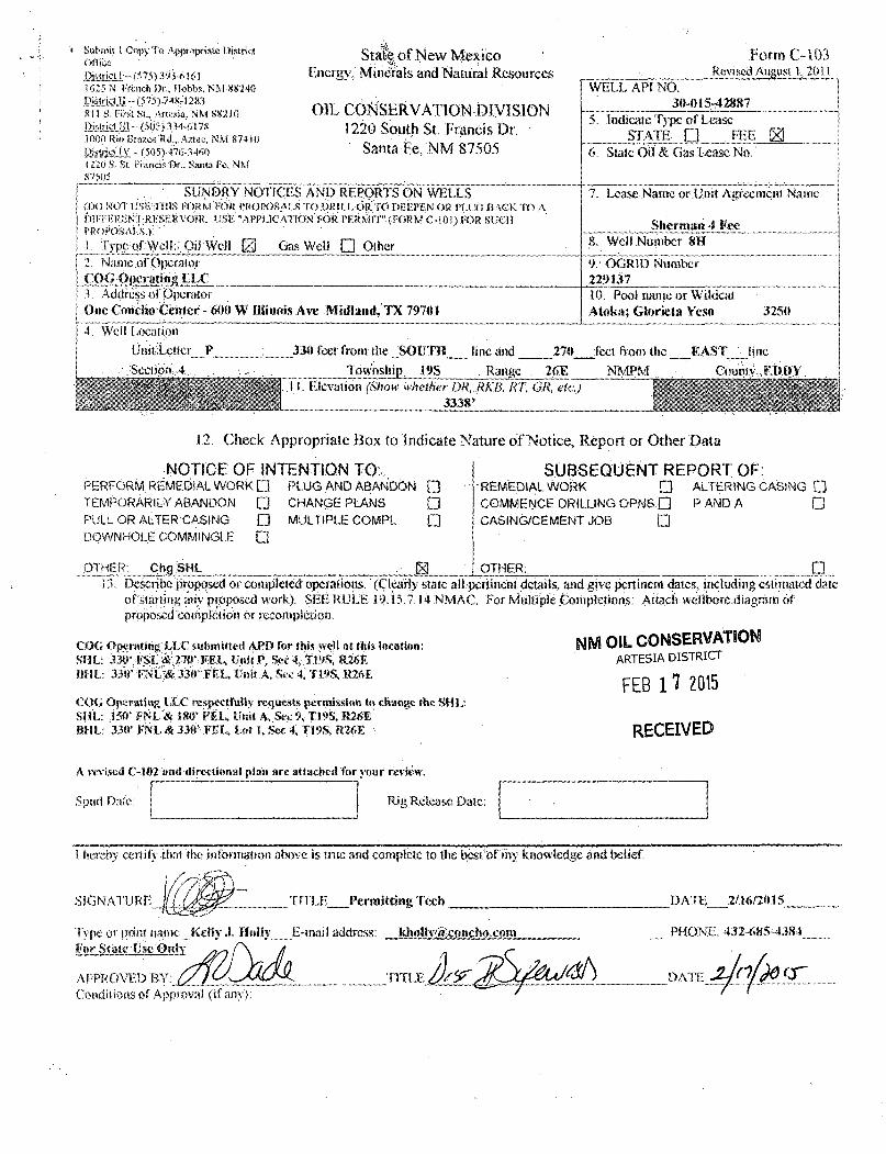
'< Submit 5 Copy To vVnnropriatc District Offwe •* District!--(575)393 -6161 j(S25 N. titnch .T>r., Hobbs, NM-88240 DairMJi - isis)34&i 283 XI! S. First St.. Artesia, NM 88210 JMaSLlIt(505)334-6178 H)0(Tri.w Brazos•Rd,,.Aztec,'NM 87410 fitsfiiilY - (505) 47rV-34«t i i i o i . St. Francis-Dr.. Santa Fe, NM S7505 ' ...
' SUNDRY NOTICES AND REPORTS ON WELLS (IX) NOT USteOflS FORM FOR PROPOSALS TOORIU. OtlTO DEEPEN OR.PLUG BACK TO A DfFFKRENTRKSERVOIR. USE "APPSJCATION FOR PERMIT" (FORM C-101) FOR SUCH PROPOSALS.):'''. 1. Typc;of:Wcl:l:;Oi] Well M Gas Well • Other
7. Lease Name or .Unit Agreement. Name
Sherman 4 fee
' SUNDRY NOTICES AND REPORTS ON WELLS (IX) NOT USteOflS FORM FOR PROPOSALS TOORIU. OtlTO DEEPEN OR.PLUG BACK TO A DfFFKRENTRKSERVOIR. USE "APPSJCATION FOR PERMIT" (FORM C-101) FOR SUCH PROPOSALS.):'''. 1. Typc;of:Wcl:l:;Oi] Well M Gas Well • Other 8. Weil Number 8M
2. Name .of Operator .COC .'Operating LLC
9: OGRID Number 229137
3, Address of Operator One Coricljo;Ceiiter-«00 W Illinois Ave .'Midland,!* 79701
10. Pool name or Wildcat Alnka; Glorieta Yeso 3250
4. Wcll".Locati'on
. Ufiitie«cr_P : 330 feet from the JSOUTH line and 270 feet from ihc EAST_vii.ne. • SfcciirtnU . Township 19S ,. Range . 26F, NMPM-... . ' , Coumy^EiiBY:
j)7i^^m0i(mm0ther.DMi..Rm RT, GR, etc') \ 3338'
State of N ew Mexi eo Energy,' Minerals and Natural .Resources
OIL CONSERVATION DIVISION 1220 South St. Francis Dr.
Santa Fe, NM 87505
.Form C-103 Revised August 1,2011
WELL API NO. _ 3<M)1 S-42887 5. Indicate Type of Lease
STATE- • FEE Eg 6. State Oil & Gas tease No.
12. Check Appropriate Box to Indicate Nature of Notice, Report or Other Data
NOTICE OF INTENTION TO: PERFORM, REMEDIAL WORK O PLUG AND ABANDON • TEMPORARILY ABANDON • CHANGE PLANS • PULL OR ALTER'CASING • MULTIPLE COMPL • DOWNHOLE COMMINGLE •
JDTHER: . 'Chg'SHL _ M
SUBSEQUENT REPORT OF: REMEDIAL WORK • ALTERING CASING • COMMENCE DRILLING OPNS • P AND A • CASING/CEMENT JOB •
OTHER: 13. .Describe proposed or completed operations," (Clearly state all -pertinent details, and give pertinent dates, including estimated
ofstafting any prpposed work). SEE RULE .19.1.5,7.14 NMAC. For Mttltiple Conipletiorts: Attach wellbore.dtagratn of proposed completion or recompletion.
COG Operating'LLC:submirted APD for this well at this location: WA OIL CONSERVATION SHL: •m\^£ : &m i <VXL, Unit P, Sec 4, J.19S, R26R ARTESIA DISTRICT BHL: 33)r :FNL;«33(r reL» '0riit.A. Sec 4, T1.9S. R26E . H m o M C
FEB 1 i Z013 COG Operating '.LLC respectfully requests permisstai.te change the SHL*. SHL: .150* FNL'& 180' FEU Unit. A. Sec % X19S, ' BH L: 330' FNL &33ti'FEL, Lot 1, Sec 4, T19S, R26E •• R E C E I V E D
A revised €-102- an<f directional plan arc attached'for your review.
Spud Dale: Rig Release Date:
I hereby certi fy thai the information above is true and complete to the facstof my knowledge and belief.
SIGNATURE l / f o g g ^ " " TITLE Permitting Tech DATE 2/16/2(115_
Type or print .name Kelly X H»lly_ E-mail address: ldioHv@eone,ho.com For State 'UsMejOnJv
APPROVED BY:. Conditions of Approval (if any)
PHONE-: 432-685-4384
DATE ^ - / ' V ^ C T

U M J 1 ! f f - t r t f ii >•>!», • M »<-4 l
fl > ( 0 t W I n i " i l l . * ~ i
•omimct ii .. • • ••
I « »> Hra.oi f «. 4 i-t M l 411!
il t, irT i\
1" *, f u n t» Sin (» M WS<A
.State,of New. Mexico- . Energy, Minerals & Natural Resources Department
OIL CONSERVATION DIVISION 1220 South St Francis Dr.
Santa Fe, New Mexico 87505
WELL LOCATION AND ACRliAGE DKD1 CATION PLAT
Fnrrn C-10? ttf»i«rd A«j«u t "ul t
Submit onstocft to'opjirupfvit t«sinct Oflttc
D4.MI-NI >LU KIJ'UK)
, 30~0:1'5-42837 FootCade
^22ML-—^—. ' '• Pool Nam' •' ~
, . I L f c f i k ' a - . : f l l r s v \ V n e n •. Property,Ctra
' : S H £ l ^ ^ : # E E Well KranDer.
811 •' (XiR)DfJ(-.;
.22*137 - 0|5cm*isr Name <•=•
COG OPERATING, LLC 3318*
Ul. Of fO!:Si> SesiiOn ; T«WB5?rfp Range lot Mr Ot-t lfwntt,f feutfjcn t i t ! aii*» est line
• A . . . '9 19-S 26-E 150 . ; NORTH 180 EAST . EDDY
Bottom Role Location H Different i 10m Surface
:4
tWic iWHt Acres
Tawnlhip . Range I m Mn
•19-S ] 26TE 'join) isfil! Uohsetifhuori Code
t ret fiwm ttw 330
• Order No
North 8«u<s tine NORTH
Irect from live 330
•f<as \ *cs< line
EAST
C rntniv
EDDY
ViAlUiWABiSWitLM ASStSjNIDIO ItflSCOMTltnONlWrn AU irTTHirsre HA VF BFFN CWNSOlfftATS) OR A NON-SI ANDA8D UNIT ftAS BEEN APPROVED BY WFimKON
t0f?f« MM iOC4,'i/> eOr70« HOtf IOC AWN
mo 27 ,w r 45592/7 f
LAI - U *96J4r ,V
'.AO 27 NME ' I H € t t X A ' W
f~ Ci!S5~ r Af > 4<5f07/ f £'
i tr -3, daryar & :
NM) 83 NME r - f-iB?9S 6 N X ' iJ7IOO.C f
iAi --32.696(55- W iOm^WA 3/96)5* »
•GEODETIC COORDINATES HAD 83 Nm-
•SURFACE lomim .Y* 6USM,2 'ti. •X= -527256.Q E
LAJ:=32S822Q2- N
Lmc.^mS/si'or w
!H I
1
A -
D
r •F G li • 1 • 4
U V \ t k fCORDlWJfS m i E MD 2 7 HUE
SF7232.9 N, Jt= 61:7257.6 n )f«
'••Ym '%'<* •Xw
'6/7265.8 % Jt*.
6I2Q00J: ti. $11974:5 N,
y« 6/0659:4 f= 610666. f M r» 60038.7 rV, "f» '606iS33.7 W,
46097Z6' £ 4S4933A E m252S E~ #6253.0' £
«52S9;g. t '48&4O03 £ • •mi 11,2 E
A -"8 -e -
•D -f -
. f _ c. -"H -•j _
- j -
CORNER .COORDINATES TABLE HAD.mmiE
• r= StmiB ti,-X= 522152.4 £
r» 6??3'?9.4 w; x*.stems f
y a
6!20?0.i A/;
612036.1 M, •6'W'ii.l ti.
X* 52743K9 A'= 526T13.4 Kw '522177:9
6!.e.72?.8 /V, X= $27468.7 E 60S7Q0:3 N, 606$95J K
X* $27579,3 X= 522293./
SECTION 4-SECTION 9
336"
OPtRATOR Cr.RTlFICA HON / ijamt^ that tfoe jstfissmaimfj i? tntsmd--mm$x$a tatbs bm vfmy k&wt&Sge w<S behci tmd
asie«s3«tf maerzl mom m lbs kml wdtuMm Eiie
iiem&iataismitriotsikvmsi: "'• " • •/
• Date • •
-J .. ..,4^14-y
E-MiaiiiAdatsss"*
SURVEYOR Ci:R Tif iCA 1 ION
j»c or t tdfer. JSJ pfirvjssat,' ao thai ffs# msw m arasf ami imftocJ go £&sr tea of js?y.i> je .:. : j | •

600'
1/2" STL. mo
33S7.fi' 9\\ 16
3 '
' to "
170
NOTE: 1} SEE "LOCATION VERIFICATION MAP" FOR PROPOSED ROAD LOCATION.
SHERMAN 4 FEE mi ELEV. 3338. V NAD 27 NME LAT.=32.682088'N Lom-m.37ms" w NAD S3 NME LAT.->32.682202°N LONG-104.379IOr W
;5if
^- PROPOSED WELL PAD
600
o o Ho
FARM RD.
omctiom TO SHOWN 4 FEE /an-. ("ROM THE INTERSECTION Of U.S. HWl' 285 {'/-RIVERS) AND CO. tO. 38 (KINCAiD RANCH) GO EAST ON CO. RD. 38 APPROX. %0 mi TURN RICM AND GO SOUTH APPROX. 2.0 MILES THE WELL LOCATION STAKE IS 200' WEST.
r
r (c) DRAFTS
PROVIDING SURVEYING SERVICES SINCE 1946
JOHN WEST SURVEYING COMPANY 412 N.DAL PASO HOBBS, NM 8824G
($75} 393-3117 wmv.jwsc.bk T8PLS* 10021000
WO 0 100
Scale: 1"= 100'
200 Feel 1
C O G O P E R A T I N G , JL.L.C SHERMAN 4 FEE#SH WELL
LOCATED 150 FEET FROM THE NORTH LINE AND 180 FEET FROM tHE EAST LINE OF SECTION 9,
TOWNSHIP 19 SOUTH, RANGE 26 EAST, N.M.P.M., EDDY COUNTY, NEW.MEXICO
Survey Date: 1/29/15 CAO Dote: 2 /3 / ) 5 I Drown By: LSI.
W.O, No.: !5110086 Rev: W.O.: Sheet ' of I,
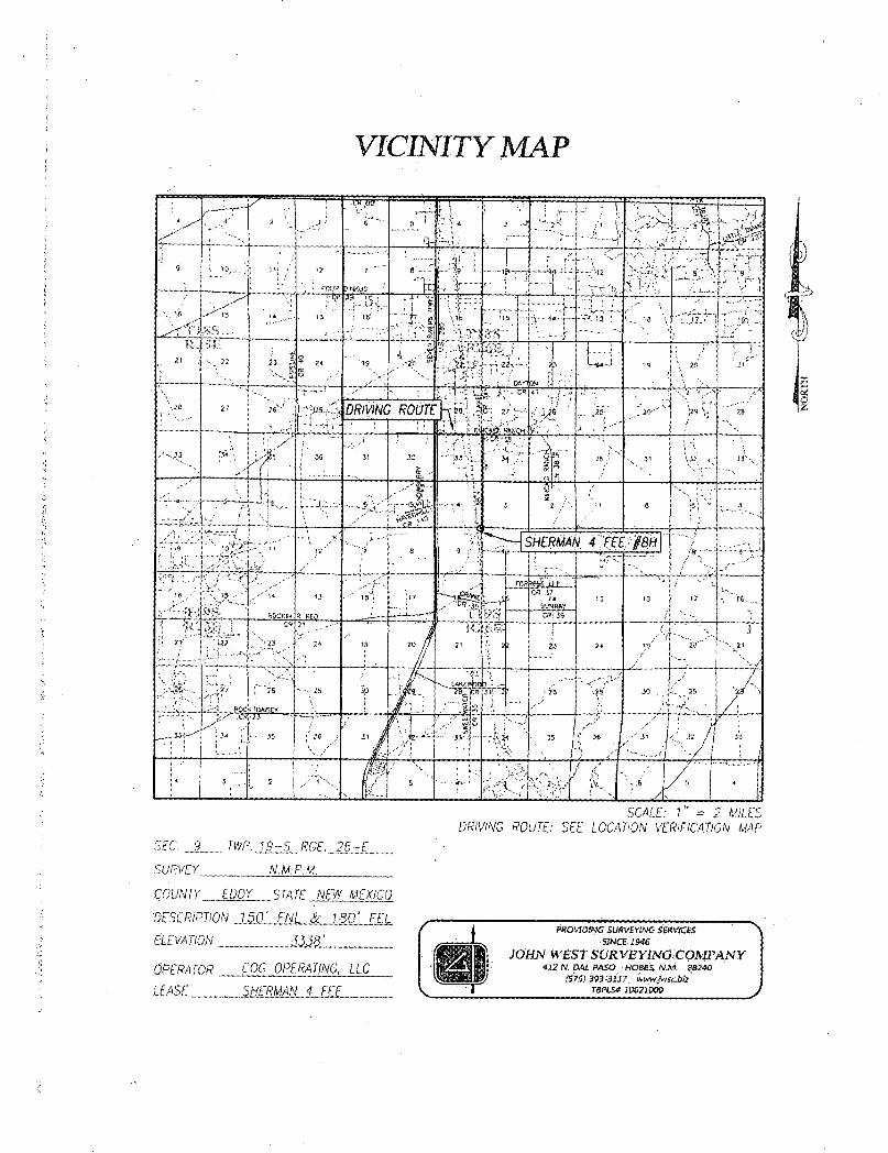
VICINITY MAP
SCALE: 1" = 2 Ml! FS DRIVING ROUTE:'SEE LOCATION VERIFICATION MAP
SEC. £_ TWP. 19-S RCE. "26-E
SURVEY N.M.P.M.
COUNTY EDDY S TA TE NEW MEXICO
'DESCRIPTION 150' FNL & 180' FEL
ELEVATION 3338'
OPERATOR COG OPERATING, LLC
LEASE SHERMAN 4 FEE
PROVIDING SUWBYtNC SERVICES •SINCE. 2 sue
JOHN WEST S UR VB YINGiCOMPANY 412 N. DAL PASO • HOBBS, NM. B8240
(57$) 393-3U7. inwwjwscbiz
TBPLS* loonooo
r
IP lo jJE

LOCATION VERIFICATION MAP
TWP. i S - 5 RGE. 26-E COPY STA !;E NCW'MDaCO
£ I )' t s o - FN^. » i i 3 0 r 7 : : e l " 1 1 / i 3338' 1 r r ? « ' COG opeftaBNC, g c
i f it;.- SHsmm 4 FEE '
cmam wwmu DAYJON. NM, - W
\f "OGRArH.'C Hi V . SURVE'
wtoMEsrvs SUSVMM« stswces
JOHN WEST SURVEYING COMPANY <S7$) 393-3X17 •mm.^tcbb
rafts* loonooo
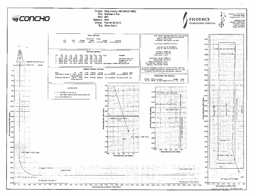
Project: Eddy County, NM (NAD27 NME) Site: Sherman 4 Fee Well: #8H
Wellbore: WB1 Design: Plan #4 02-12-15
Rig: Silver Oak 3
PHOENIX TECHNOLOGY SERVICES
Azimuths !o Gnd Nor th True Nor th : 0.Q2"
Magnetic Field Strength: 48364.2snT
Dip Angle: 60.38* Date: 2/12/2015
Model : IGRF201S
- KB @ 3356.00usfl (Silver Oak 3)
. Ground lever. 3333.00
> 1 9 5 0 - •
I 2100-
2250-•
2400 - '
2550-
»• KOP.' Begin 117100' Build
W E L L DETAILS
Gfound Level. Easting
486077.10
3338.00 Lattttude Longitude
32* 40' 55.5152B N 104* 22' 42.90551 W
MD Inc Azi TVD •N/-S
2701.00 0.00 3522.82 90.40 4164.33 90.40 8110.73 90.40
0.00 0.0 0.00 2701.00 0.00
342.15 3221.86 499.26 1.40 3217.35 1131.23 1.40 3190.01 5075.30
Annotation
SECTION DETAILS
*E/-W Dleg TFace VSect Target 0.00 0.00 0.00 0.00 0.00 0.00 0.00 0.00 KOP. Begm 117100' Build
•160.73 11.00 342.15 503.96 LP, Begin 3*/100'Turn -252.14 3.00 59.94 1133,43 HoH 90.4* Inc • 155,90 0.00 0.00 5078.69 PBHL-Sherman 4 Fee WH v4TD at 8110,73' WD
DESIGN TARGET DETAILS
Name TVD -+J/-S PEHL-Sherman 4 Fee #8H v4 3190.01 5076.30
- plan hits target center PP-Sherman 4 Fee #8H v3 3221.57 479.00
- plan hits target center
-E/-W Northing Easting Latitude Longitude Shape •155,30 616933.30 485921.20 32* 41' 45.74785 N 104' 22' 14.75524 W Point
512335.50 485922.B5 32* 41'0,25464 N 104" 22'44.71275 W Point
Map System: US State Plane 1927 (Exact solutior Datum: NAD 1927 (MADCON CONUS)
Ellipsoid: Clarke 1666 Zone Name: New Mexico East 3001
Local Origin: Well #8H, Grid North
Latitude: 32 ' 40' 55.51523 N Longitude: 104" 22'42.90551 W
Grid East: 486077.10 Grid North: 611357.50
Scale Factor: 1.000
Geomagnetic Model: IGRF2015 Sample Dale: 12-Feb-15
Magnetic Declination: 7 , 6 1 ' Dip Angle from Horizontal: 60.38 '
Magnetic Field Strength: 48364
conver t a Magnetic Direct ion to a Grid Direct ion. Add 7.63* convert a Magnetic Direction to a True Direction. Add 7.61" East
To convert a True Direction to a Grid Direction, Add 0.02*
FORMATION TOP DETAILS
MOPatti Formation OipAngle DtpOir 3500.50 TL. 3225' TVD @ 0 VZ. 90.4" Inc -0.40 351.01
L E G E N D
- #1 . WB1. Inc Surveys VO
™#4H. W B 1 / Job ff13!0484. Surveys (JW 4) VO
- P l a n #4 02-12-15
?BHL-Sherman 4 Fee #8H y 4 . t
-£-4950-
1 = 4900-
330' OFFSET LINE i HARDLINE
:TD at 8110.73* MD
KOP,--Begin 117100' Build
-200 -150 -100 -50 0
West ( - ) /East (+) (50 us f t / i n )
-400 -350 -300 -250 -200 -150
West ( - ) /Eas t (+) (50 us f t / i n )
PP-Sherman 4 Fee <f8H v3 PBHL-Sherman 4 Fee #8H v'4
3200
3000-
12300-3
O o 2 i2600-
o2400-Z
£ 2200-o w
2000-
LP, Begin 37100' Turn :--Hold 90.4*.Inc \
v :-:-:- ; : ;:?-: : : :• • = V : :- ••- -f- - ; ; r — "' i TO"at'8110.73' MD - T'-"*" 200
0
-200
•;Sherman 4 Fee #8H v 4 l .
TD at 3110.73' MD
;Hold 90.4* Ihc •
i P . 1 Begin 37100' Turn
f -PP-Sherman^ Fee #8H v3 -•
• #4H-. . •- - • . .
KG P. Begin 117100' Build
150 300 J50 750 900 1050 1200 1350 1500 1550 1300 1950 2100 2250 2400 2550 2700 2350 3000 31S0 3300 3-150 3600 3750 3900 4050 4200 4350 4500 4650 4800 4950 5100 5250
Ver t ica l Sec t i on at 358 .24 s (150 us f t / i n )
• 1200 -1000 -800 -600 -400 -200 0 200
West( - ) /East{ - - ) (200 us f t / i n )
Created Sv. Julo Ping Date: 13 56. February 12 2015
COG Operating LLC Eddy County, NM (NAD27 NME) Sherman 4 Fee #8H
WB1
Plan: Plan #4 02-12-15 Surface: 150' FNL, 180' FEL, Sec 9, T19S, R26E, Unit I PP: 330' FSL, 330' FEL, Sec 4, T19S, R26E, Unit P BHL: 330' FNL, 330' FEL, Sec 4, T19S, R26E, Unit I
Standard Planning Report 12 February, 2015
PHOENIX TECHNOLOGY SERVICES
^ C O f l C H O Planning Report (j »
Database: Compass 5000 GCR Local Co-ordinate Reference: V.f. • Company COG Operating LLC ' "•• '.. ' TVD Reference: ' KB @ 3356 OOusft (Silver Oak 3) " , , - ' ,
Project- Eddy .County NM "(NAD27 NME) MD Reference: • ' l i @ 3356 OOusft (Silver Oak 3) , • , Site. Sherman 4 Fee North Reference: CM :
Well: Survey Calculation Method: Minimum Curvature
Wellbore: WB1 . _ ' ,
Design Plan #4 02-12-15 ' ' -'•
Project Eddy County, NM (NAD27 NME) •• • ~, •
Map System: US State Plane 1927 (Exact solution) System Datum: Mean Sea Level
Geo Datum: NAD 1927 (NADCON CONUS)
Map Zone: New Mexico East 3001
Site " Sherman 4 Fee ' • .' ' •
Site Position: Northing: 612,151.80 usft Latitude: 32° 40' 58.42381 N
From: Map Easting: 485,212 40 usft Longitude: 104° 22' 53.02452 W
Position Uncertainty 0.00 usft Slot Radius: 13-3/16 " Grid Convergence: -0.03 0
Well #8H , , _ •
Well Position +N/-S -294 30 usft Northing: 611,857.50 usft Latitude: 32° 40' 55.51528 N
+E/-W 864 70 usft Easting: 486,077.10 usft Longitude: 104° 22' 42.90551 W
Position Uncertainty 0 00 usft Wellhead Elevation: Ground Level: 3,338.00 usft
Wellbore WB1 ' ' .
Maqnetics Model Name Sample Date Declination Dip Angle Field Strength
1 IGRF2015 2/12/2015 7.61 60.38 48,364
Design Plan #4 02-12-15 as^liliss mii^i^mmmmm^ tmiSm^&mm
Audit Notes:
Version: Phase: PLAN Tie On Depth: 0.00
Vertical Section' Depth From (TVD) +N/-S +E/-W Direction
(usft) (usft) ( )
0.00 0.00 0.00 358.24
Plan Sections
Measured Vertical Dogleg Build Turn Depth Inclination Azimuth Depth +N/-S +E/-W Rate Rate Rate TFO (usft) I ) C) (usft) (usft) (usft) ( MOOusfl) ( /100usft) ( MOOusft) ( ) Target
0.00 0.00 0.00 0.00 0.00 0.00 0.00 0.00 0.00 0.00
2,701.00 0.00 0.00 2,701.00 0.00 0.00 0.00 0.00 0.00 0.00
3,522.82 90.40 342.15 3,221.86 ' 499.26 -160.78 11.00 11.00 0.00 342.15
4,164.38 90.40 1.40 3,217.35 1,131.23 -252.14 3.00 0.00 3.00 89.94
8.110.73 90.40 1.40 3,190.01 5,076.30 -155.90 0.00 0.00 0.00 0.00. PBHL-Sherman 4 Fee
2/12/2015 2:04:21PM Page 2 COMPASS 50001 Build 73
*s%concHO Planning Report f I P H O E N I X \ B TECHNOLOGY SERVICES
Database Company. Project: Site. Well. Wellbore. Design.
Planned Survey
Comp'ass"£000 GCR COG Operating LLC Eddy County! NM (NAD27 NME) 1
i;Shermani*4'F;on
#8H "' v •' ' f ; ' •• * WB1 "', ;
Plan #4 02-12-15
Local Co-ore mate Reference TVD Reference: MD Reference: North Reference: Survey Calculation Method:
<Well#8H "KB @ 3356 OOusft (Sliver Oak 3) ,;KB @ 3356.OOusft (Silver Oak 3)
Minimum Curvature, "" *• '
Measured Vertical Vertical Dogleg Build Turn Depth Inclination Azimuth Depth +N/-S +E/-W Section Rate Rate Rate (usft) I l l i l l (usft) (usft) (usft) (usft) ( MOOusftl ( /1 OOusft) ( MOOusft)
0.00 0.00 0.00 0.00 0.00 0.00 0.00 0.00 0.00 0.00 2.701:00 0.00 0.00 2.701.00 0.00 0.00 0.00 0.00 0.00 0.00
KOP, Begin 11°/100'"Build" *£1SBI1II 2,800.00 10.89' 342.15 2.799.41 8.93 -2.88 9.01 11.00 11.00 0.00 2,900.00 21.89 342.15 2,895.19 35.75 -11.51 36.08 11.00 11.00 0.00 3,000.00 32.89 342.15 2,983.85 79.47 -25.59 80 22 11.00 11.00 0.00
3,100.00 43.89 342.15 3,062.11 138.49 -44.60 139.79 11.00 11.00 0.00 3,200.00 54.89 342.15 3,127.10 210.64 -67.83 212.62 11.00 11.00 0.00 3,300.00 65.89 342.15 3,176.43 293.27 -94.44 296.03 11.00 11.00 0.00 3,400.00 76.89 342.15 3,208.30 383.34 -123.45 386.95 11.00 11.00 0.00 3,500.00 87.89 342.15 3,221.52 477.54 -153.78 482.04 11.00 11.00 0.00
3,500.50 87.95 342.15 3,221.54 ' 478.02 -153.94 482 52 11.00 11.00 0.00
TL, 3225' TVD @ 0 VZ, 90.4° Inc JSSiiillll 3,522.82 90.40 342.15 3,221.86 499 26* -160 78 503.96 11.00 11.00 0.00
LP, Bocjin 3 MOO Turn .('--I-!.^il;:±.i$f-%£
3.600.00 90.40 344.47 3.221.32 573.18 -182.94 578 53 3.00 0.00 3.00 3.700.00 90.40 347.47 3,220.61 670.18 -207.19 676.23 3.00 0,00 3.00 3,800.00 90.40 350.47 . 3,219.91 768.32 -226.33 774.91 3.00 0.00 3.00
3,900.00 90.40 353.47 3,219.20 867.32 -240.30 874.29 3.00 0.00 . 3.00 4.000.00 90.40 356.47 3,218.50 966.93 -249.07 974.12 3.00 0.00 3.00 4,100.00 90.40 359.47 3,217.80 1,066.85 -252.62 1,074.10 3.00 0.00 3.00 4,164.38 90.40 1.40 3,217.35 1,131.22 -252.14 1,138.43 3.00 0.00 3.00
Hold 90.4° Inc liSIIIiilR J^sli i i i ; :..\:>u.lv:;;:.s;|i^p^:
4,200.00 90.40 1.40 3,217.11 1,166.83 -251.27 1,173.99 0.00 o.oo" 0.00
4,300.00 90.40 1.40 3,216.41 1,266.80 -248.83 1,273.84 0.00 0.00 0.00 4,400.00 90.40 1.40 3,215.72 1,366.77 -246.39 1,373.69 0.00 0.00 0.00 4,500.00 90.40 1.40 3,215.03 1,466.73 -243.95 1,473.53 0.00 0.00 0.00 4,600.00 90.40 1.40 3,214.34 1,566.70 -241.52 1,573.38 0.00 0.00 0.00 4.700.00 90.40 1.40 3,213.64 1,666.67 -239.08 1,673.22 0.00 0.00 0.00
4,800.00 90.40 1.40 3,212.95 1,766.64 -236.64 1,773.07 0.00 0.00 0.00 4,900.00 90.40 1.40 3.212.26 1,866.61 -234.20 1,872.92 0.00 • 0.00 0.00 5,000.00 90.40 1.40 3,211.56 1,966.57 -231.76 1,972.76 0.00 0.00 0.00 5,100.00 90.40 1.40 3,210.87 2,066.54 -229.32 2,072.61 0.00 0.00 0.00 5.200.00 90.40 1.40 3,210.18 2,166.51 -226.88 2,172.45 0.00 0.00 o.oo 5,300.00 90.40 1.40 3,209.49 2,266.48 -224.44 2,272.30 0.00 0.00 0.00 5,400.00 90.40 1.40 3,208.79 2,366.44 -222.01 2,372.14 0.00 0.00 0.00 5,500.00 90.40 1.40 3,208.10 2,466.41 -219.57 2,471.99 0.00 0.00 • 0.00 5,600.00 90.40 1.40 3,207.41 2,566.38 -217.13 2,571.84 0.00 0.00 0.00 5,700.00 90.40 1.40 3,206.71 2,666.35 -214.69 2,671.68 0.00 0.00 0.00
5,800.00 90.40 1.40 3,206.02 2,766.32 -212.25 2,771.53 0.00 0.00 0.00 5,900.00 90.40 1.40 3,205.33 2,866.28 -209.81 2,871.37 0.00 0.00 0.00 6,000.00 90.40 1.40 3,204.63 2,966.25 -207.37 2,971.22 0.00 0.00 0.00 6.100.00 90.40 1.40 3,203.94 3,066.22 -204.94 3,071.07 0.00 0.00 0.00 6,200.00 90.40 1.40 3,203.25 3,166.19 -202.50 3,170.91 0.00 0.00 0.00
6,300.00 90.40 1.40 3,202.56 3,266.16 -200.06 3,270.76 0.00 0.00 0.00 6,400.00 90.40 1.40 3,201.86 3,366.12 -197.62 • 3,370.60 0.00 0.00 0.00 6.500.00 90.40 1.40 3,201.17 3,466.09 -195.18 3,470.45 0.00 0.00 0.00 6,600.00 90.40 1.40 3,200.48 3.566.06 -192.74 3,570.30 0.00 0.00 0.00 6,700.00 90.40 1.40 3.199.78 3,666.03 -190.30 3,670.14 0.00 0.00 0.00
6.800.00 90.40 1.40 3,199.09 3,765.99 -187.86 3,769.99 0.00 0.00 0.00 6,900.00 90.40 1.40 3,198.40 3,865.96 -185.43 3,869.83 0.00 0.00 0.00 7,000.00 90.40 1.40 3,197.71 3.965.93 -182.99 3,969.68 0.00 o.oo 0.00 7,100.00 90.40 1.40 3,197.01 4,065.90 -180.55 4,069.52 0.00 0.00 0.00 7,20_0.00_ 90.40 1.40 3,196.32 4,165.87 -178.11 4,169.37 0.00 0.00 0.00
2/12/2015 2:04:21PM Page 3 COMPASS 5000.1 Build 73
Database
Company:
Project
Site
Well
Wellbore
Design
iiiii
mm
Compass 5000 GCR ,
COG Operating'.Lilt
Eddy County, NM'(N AD27.NME).
Sherman 4 Fee . - ;
#8H •. ' • '" " WB1 •' • ' . " ' , ' ,
Plan #4,02-12-15
Planning Report
Local Co-ordinate Reference:
TVD Reference
MD Reference:
North Reference
Survey Calculation Method
f \ PHOENI I m T i r u u n t n n v c
IX T E C H N O L O G Y S E R V I C E S
,Well#8H . ' - " \ '
KB'@ 3356:00usft (SjlverOak 3)„
' KB @ 3356:00usft (Silver Oak 3)
,'Grid '
Minimum Curvature,
Planned Survey
Measured Vertical Vertical Dogleg Build Turn
Depth Incl ination Azimuth Depth +N/-S +E/-W Section Rate Rate Rate
(usft) Jllfii|B (usft) (usft) (usft) (usft l ( /1 OOusft) ( /1 OOusft) f$(°/100usft)
llsJiiiiiiitteiss 7.300.00 90.40 1.40 3,195.63 . 4,265.83 -175.67 4,269.22 0.00 0.00 0.00 7,400.00 90.40 1.40 3,194.93 4,365.80 -173.23 4,369.06 0.00 0.00 0.00 7.500.00 90.40 1.40 3,194.24 4,465.77 -170.79 4,468.91 0.00 0.00 0.00 7,600.00 90.40 1.40 3,193.55 4,565.74 -168.36 .4,568.75 0.00 0.00 0.00 7,700.00 90.40 1.40 3,192.86 4,665.71 -165.92 4,668.60 0.00 0.00 0.00
7,800.00 90.40 1.40 3,192.16 4,765.67 -163.48 4,768.45 0.00 0.00 0.00 7,900.00 90.40 1.40 3,191.47 4,865.64 -161.04 4,868.29 0.00 0.00 0.00 8,000.00 90.40 1.40 3.190.78 4,965.61 -158.60 4,968.14 0.00 0.00 0.00 8,100.00 90.40 1.40 3.190.08 5.065.58 -156.16 5.067.98 0.00 0.00 0.00 8,110.73 90.40 1.40 3,190.01 5,076.30 -155.90 5,078.69 0.00 0.00 0.00
TD at 8110.73' MD
Design Targets
I K r g e t i N a m f f l l l l ^
- hit/miss target Dip Angle Dip Dir TVD +N/-S +E/-W Northing Easting
( ) (usft) (usft) (usft) Shape I ) (usft) (usft) Latitude Longitude
PBHL-Sherman 4 Fee ft 0.00 360.00 3.190.01 5,076.30 -155.90 616,933.80 485,921.20 32° 41 ' 45.74786 N 104° 22'44.75524 W - plan hits target center - Point
PP-Sherman 4 Fee #8H 0.00 0.00 3,221.57 479.00 -154.25 612,336.50 485,922.85 32° 41 ' 0.25464 N 104° 22'44.71275 W - plan hits target center - Point
Formations
Measured Vertical
Depth Depth
(usft)
Plan Annotat ions
(usft) Name
25' TVD (3) 0 VZ, 90.4° Inc
Lithology
Dip
Dip Direction
c) n -0 40 351 01
Measured
Depth
(usft)
2,701.00 3,522.82 4,164.38 8,110.73
Vertical
Depth
(usft)
2,701.00 3,221.86 3,217.35 3,190.01
Local Coordinates
+N/-S +E/-W
(usft) (usft)
0.00 499.26
1,131.22 5,076.30
Comment
0.00 .KOP Begin 117100'Build -160.78 LP, Begin 3°/100' Turn -252.14 Hold 90.4° Inc -155.90 TD at 8110.73'MD
2/12/2015 2:04:21PM Page 4 COMPASS 5000.1 Build 73
COG Operating LLC Eddy County, NM (NAD27 NME) Sherman 4 Fee #8H
WB1
Plan #4 02-12-15
Anticollision Report
12 February, 2015
PHOENIX TECHNOLOGY SERVICES
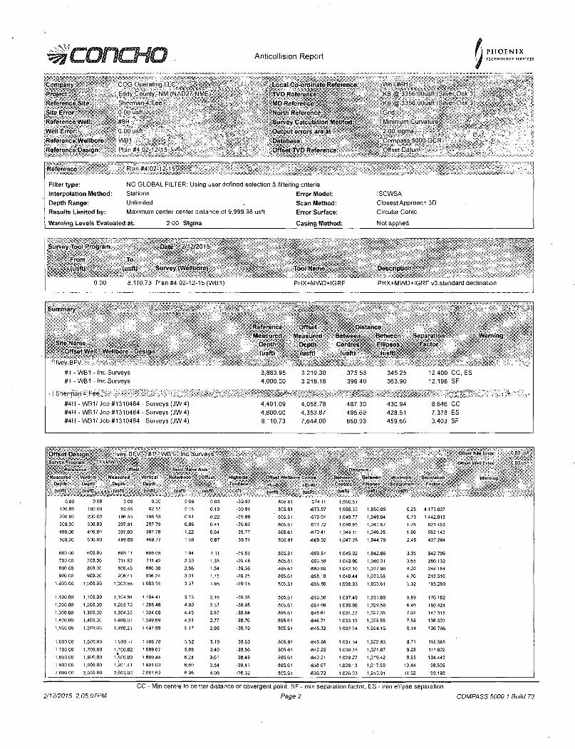
^ L . L J I 11=01 Anticollision Report P H O E N I X TECHNOLOGY SERVICES
Company. Project Reference Site: Site Error Reference Well' Well Error: Reference Wellbore Reference Design
COG Operating LLC Eddy County, NM (NAD27 NME)" Sherman 4 Fee ' •
• 0 00 usft ' " WB1 / . •' , - , , V, Plan #4 02-12-15 - ; ' ' • -, „ ' * • • '
Local Co-ordinate Reference: TVD Reference MD Reference: North Reference: Survey Calculation Method: Output errors are at Database: Offset TVD Reference:
Well #8H . KB @ 3356 OOusft (Silver.Oak 3) KB @ 3356.OOusft (Silver Oak 3)
Minimum Curvature,, • 2 00 sigma ' ' . * 'Compass 5000,GCR -Offset Datum *'
Reference Plan #4 02-12-15 . -'' .
Filter type: Interpolation Method: Depth Range: Results Limited by:
NO GLOBAL FILTER: Using user defined selection Stations Unlimited Maximum center-center distance of 9,999.98 usft
& filtering criteria Error Model: Scan Method: Error Surface:
ISCWSA Closest Approach 3D Circular Conic
Warning Levels Evaluated at: 2 00 Sigma Casing Method: Not applied
Survey Tool Program Date 2/12/2015
From (usft)
^^^^^^^^^^^^^^^^^^^^^^ (usft) Survey (Wellbore) Tool Name Description
0 00 8,110.73 Plan #4 02-12-15 (WB1) PHX+MWD+IGRF PHX+MWD+IGRF v3:standard declination
Summary
Site Name Offset Well - Wellbore - Design
Ivey BFV
#1 -WB1 - Inc Surveys #1 -WB1 - Inc Surveys
Sherman 4 Fee,-r . : '"' ! - . . #4H - WB1/ Job #1310484 - Surveys (JW4) #4H - WB1/ Job #1310484 - Surveys (JW4) #4H -WB1/Job #1310484 -Surveys (JW4)
Reference Measured
Depth (usft)
3,883.95 4,000.00
4,491.09 4,800.00 8,110.73
Offset Measured
Depth (usftl
3,219.30 3,218.18
4,058.78 4,353.87 7,644.00
Distance Between Between Separation Warning Centres
(usft)
375.53 396.40
487.30 495.69 650.93
Ellipses (usft)
345.25 363.90
430.94 428.51 459.66
Factor
12.400 CC, ES 12.196 SF
8.646 CC 7.378 ES 3.403 . SF
Offset Design Ivey BFV - #1 - WB1 - Inc Surveys ' r I l l l f l l l l Offset Site Error- 0 00 ' isl l '
Offset Well Error ll|oioMlSfl|: Reference Sent! Major Axis iiillpSil Distance
Measured Vertical • Measured Vertical Reference; Olfset Highside - Offset Wellbore Centre •' I f f t A i ' l - l l Between Minimum Separation Warning / Depth Depth Depth Depth ToofTace '+N/-S , +E/-W Centres Ellipses Separation Factor
Warning /
(usft) (usftl-,, , ; (usftl (usft) (usftl (usft) ' (*) (usft) (usft) (usft) (u»t t | , „ " ; (usft)
0.00 0,00 0.00 0.00 0.00 0.00 -39.92 805.61 -674.11 1.050.51
100.00 100.00 92.55 92.55 0.15 0.10 -39.91 805.61 -673.87 1,050.30 1,050.05 0.25 4,173.027
200.00 200.00 196.53 196.53 0.51 0.22 -39.88 805.61 -673.01 1,049.77 1,049.04 0.73 1,442.818
300.00 300.00 297.81 297.79 0.86 0.41 -39.82 805.61 -671.72 1,048.95 1,047.67 1.28 821.453
400.00 400.00 397.80 397.78 1.22 0.64 -39.77 805.61 •670.41 1.048.11 1,046.25 1.86 563.143
500.00 500.00 499.80 499,77 1.58 0.87 -39.71 805.61 -669.02 1,047.25 1,044.79 2.45 427.264
600.00 600.00 606.11 606.05 1.94 1.11 -39.61 805.61 •666.81 1,045.92 1.042.86 3.05 342.796
700.00 700.00 711.53 711.42 2.30 1.35 -39.48 805.61 -663.58 1,043.96 1.040.31 3.65 286.132
800.00 800.00 806.45 806.30 2.66 1.54 -39.36 805.61 -660.80 1,042.10 1.037.90 4.20 248.184
900.00 900.00 906.41 906 24 3.01 1.75 -39.25 805.61 -658.18 1.040.44 1,035.68 4.76 218.516
1,000.00 1,000.00 1,003.56 1,003.35 3.37 1.95 -39.15 805.61 -655.86 1,038,93 1.033.61 5.32 195.290
1.100.00 1,100.00 1,104.64 1.104.41 3.73 2.16 •39.05 805.61 •653.56 1,037.49 1.031.60 5.89 176.182
1,200 00 1.200.00 1,205.72 1.205.46 4.09 2.37 -38.95 805.61 -651.09 1,035.96 1.029.50 6.46 160.424
1.300.00 1.300.00 1.304.30 1,304,00 4.45 2.57 -38.84 805.61 -648.61 1,034.37 1,027.35 7.02 147.315
1,400,00 1.400.00 1,400.01 1,399.69 4 81 2.77 -38.76 805.61 -646.71 1,033.13 1,025.55 7.58 136.303
1.500.00 1,500.00 1,496.21 1,497.89 5.17 2.98 -36.70 805,61 •645.32 1,032.24 1,024.10 8.14 126.766
1.600.00 1.600.00 1.599.11 1,598.78 5.52 3.19 -38.63 805.61 -643.86 1,031.34 1,022.63 8.71 118.385
1,700 00 1,700.00 1,700.02 1,699.67 5.88 3.40 -38.56 805.61 •642.25 1,030.35 1.021.07 9.28 111.022
1.800.00 1.800.00 1*800.80 1,800.44 6.24 3.61 -38.49 805.61 •640.51 1.029.27 . 1,01942 9.85 104.443
1.900,00 1,900.00 1,901.41 1,901.03 6,60 3.84 -38.41 805.61 •63867 1,028.13 1,017.69 10.44 98,505
2,000,00 2,000.00 2,002.02 2.001.62 6.96 4.06 •36.32 805.61 -636.72 1.026.93 1.015.91 11.02 93.189
2/12/2015 2:05:07PM
CC - Min centre to center distance or covergent point. SF - min separation factor, ES - min ellipse separation
Page 2 COMPASS 5000.1 Build 73
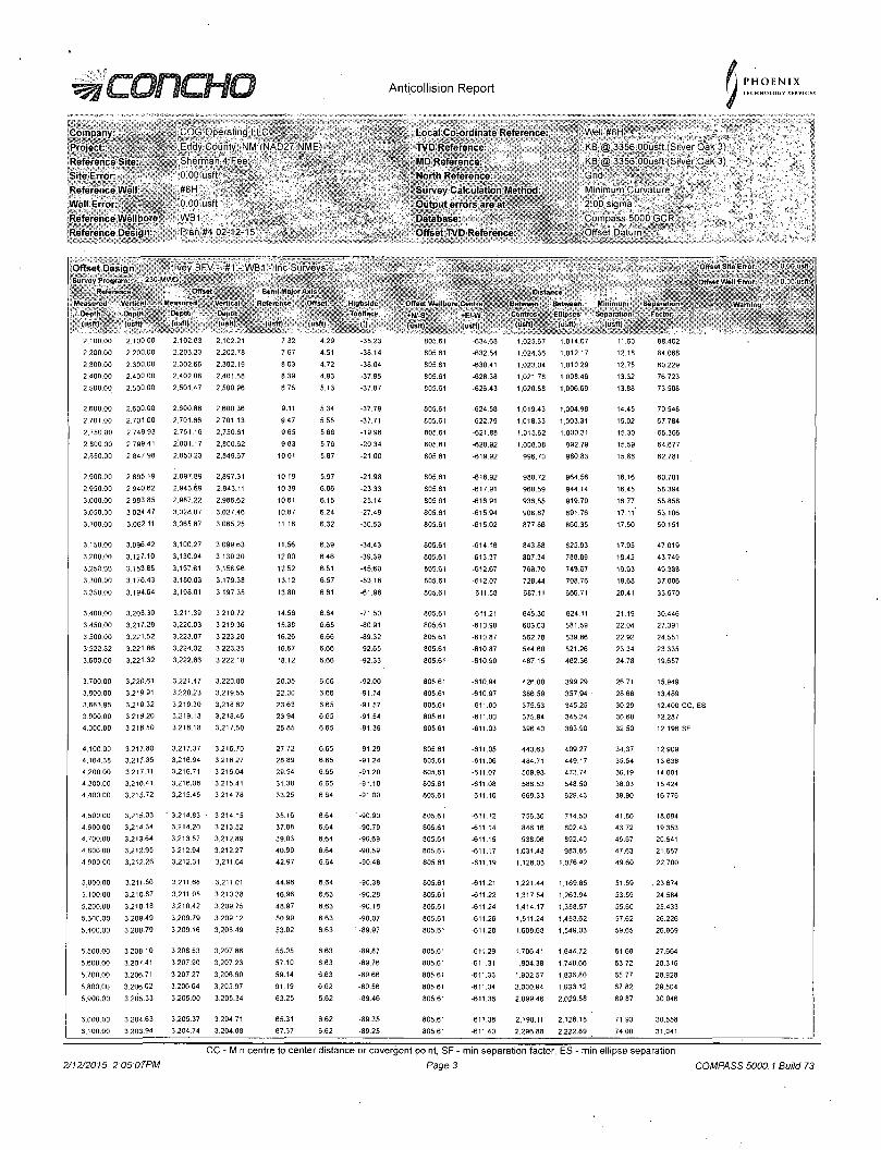
Anticollision Report P H O E N I X TECHNOLOGY SERVICES
Company Piojcct Reference Site-Site Error: Reference Well Well Error: Reference Wellbore Reference Design:
COG Operating LU. Eddy County, NM*(NAD27 NME) Sherman 4 Fee ; 0 00 usft #8H ' .0 00 usft WB1 Plan #4 02-12-15 '' "f • .
Local Co-ordinate Reference: TVD Reference: MD Reference: North Reference: Survey Calculation Method-Output errors are at Database: Offset TVD Reference:
Well#8H f KB @ 3356 OOusft (Silver Oak 3) KB @ 3356 OOusft (Sliver Oak 3) Grid • - -" ; Minimum Curvature ' " 2.00 sigma ' s
Compass 5000 GCR -.Offset Datum
Offset Design Ivey BFV - '#1 - WB1 - Inc Surveys • Survey Program: 230-'.V...
Reference Offset Semi Major Axis Distance
ensured Vertical Measured Vertical Reference offset - ; Highside Offset Wellbore Centre Between Between Minimum Separation Depth Dapth Depth Depth Toolface +rJ/-S^ +EI-W Centres Ellipses Separation Factor (usft) ' (usltl • . (usft) (usft) (usft) tiisftl •Ijlllll (usft)* (usft) (usft) . (usft) (usftl
2.100.00 2.100 00 2,102.63 2.102.21 7.32 4.29 -38.23 805.61 -634.68 1.025.67 1,014.07 11.60 88.402
2.200.00 2,200.00 2.203.23 2,202.78 7.67 4.51 -38.14 805.61 -632.54 1.024.36 1,012.17 12.18 84.068
2,300.00 2.300.00 2.302.66 2.302.19 8.03 4.72 -38.04 805.61 -630.41 1.023.04 1,010,29 12.75 80.229
2.400.00 2.400 00 2.402.06 2.401.58 8.39 4.93 •37.95 805.61 -628.38 1,021.78 1,008.46 13.32 76.723
2.500.00 2.500.00 2,501,47 2.500.96 8.75 5.13 •37.87 805.61 -626.43 1.020.58 1.006.69 13.88 73.508
2,600.00 2,600.00 2.600,88 2.600.36 9.11 5.34 -37.79 805.61 -624.58 1,019.43 1,004.98 14.45 70.548
2.701.00 2,701 00 2.701.66 2,701.13 9.47 5.55 -37.71 805.61 -622.79 1.018.33 1.003.31 15.02 67.784
2.750.00 2,749.93 2.751.16 2,750.61 9.65 5.66 -19.96 805.61 -621.88 1,015.62 1.000.31 15.30 66.366
2.800.00 2.799.41 2.801.17 2,800.62 9.83 5.76 -20.34 805.61 -620.92 1,008.38 992.79 15.59 64.677
2.850.00 2,847.98 2.850,23 2,849.67 10.01 5.87 . -21.00 805.61 -619.92 996.70 980.83 15.88 62.781
2,900.00 2.895.19 2,897.89 2,897.31 10.19 5.97 -21.98 805.61 -618.92 980.72 964.56 16.16 60.701
2,950.00 2.940.62 2.943.69 2,943.11 10.39 6.06 -23.33 805.61 -617.91 960.59 944.14 16.45 58.394
3.000.00 2,983.85 2,987.22 2.986.62 10.61 6.15 -25.14 805.61 -616.91 936.55 919.79 16.77 55.858
3,050.00 3,024 47 3.028.07 3,027.46 10.87 6.24 -27.49 805.61 -615.94 908.87 891.76 17.11* 53.106
3.100.00 3,062.11 3.065.87 3,065.25 11.18 6.32 -30.53 805.61 -615.02 877.86 860.35 17.50 50.151
3,150.00 3,096.42 3,100.27 3,099.63 11.56 6.39 -34.43 805.61 -614.16 843.88 825.93 17.95 47.019
3.200.00 3.127.10 3.130.94 3,130:30 12.00 6.46 -39.39 805.61 -613.37 807.34 788.89 18.45 43.749
3.250.00 3,153.85 3,157.61 3,156.96 12.52 6.51 -45.60 805.61 •612.67 768.70 749.67 19.03 40.388
3.300.00 3.176.43 3.180,03 3,179.38 13.12 6.57 -53.18 805.61 -612.07 728.44 708.76 19.68 37.006
3.350.00 3.194.64 3,198.01 3,197.35 13.80 6.61 -61.98 805.61 -611.58 687.11 666.71 20.41 33.670
„ Offset Site Error:
Offset Wt.ll Error
W. i im i i c j
0 00 uift
0 00 USft :
3.400.00 3.208.30 3.211.39 3.210.72 14.56 6.64 -71.50 805.61 -611.21 645.30 624.11 21.19 30,446
3.450,00 3.217.28 3,220.03 3,219.36 15.38 6,65 -80.91 805.61 •610.98 60363 581.59 22.04 27.391
3.500.00 3,221.52 3.223.87 3.223.20 16.26 666 -89.32 805.61 •610.87 562.78 539.86 22.92 24.551
3,522.82 3.221.86 3.224.02 3.223.35 16.67 6.66 -92.65 805.61 -610.87 544.60 521.26 23.34 23.335
3,600.00 3,221.32 3,222.86 3.222.18 18.12 6.66 -92.33 805.61 -610.90 487.15 462.36 24.78 19.657
3.700.00 3.220.61 3,221.47 3,220.80 20.05 666 •92.00 805.61 -610.94 426.00 399.29 26.71 15.949
3,800.00 3.219.91 3,220.23 3,219.55 22.00 6.66 -91.74 805.61 -610.97 386.59 357.94 • 28.66 13.489
3.883.95 3,219.32 3.219.30 3,218.62 23.63 6.65 -91,57 805.61 -611.00 375.53 345.25 30.29 12.400 CC, ES
3.900.00 3,219.20 3.219.13 3,218.46 23.94 6.65 -91.54 805.61 -611.00 375.94 345.34 30.60 12.287
4.000.00 3.218.50 3,218.18 3,217.50 25.85 6.65 -91,39 805.61 -611.03 396.40 363.90 32.50 12.196 SF
4.100.00 3,217.80 3,217.37 3,216.70 27.72 6.65 -91.29 805.61 -611.05 443.63 409.27 34.37 12.909
4.164.38 3.217.35 3,216.94 3,216.27 28.89 6.65 •91.24 805.61 -611.06 484.71 449.17 35.54 13.638
4.200.00 3,217.11 3.216.71 3.216.04 29.54 6.65 -91.20 805.61 -611.07 509.93 473.74 36.19 14.091
4.300.00 3.216.41 3,216.08 3,215.41 31.38 6.65 •91.10 805.61 -611.08 586.53 548.50 38.03 15.424
4.400.00 3.215.72 3,215.45 3,214.78 33.25 6.64 -91.00 805.61 -611.10 669.33 629.43 39.90 16.776
4,500.00 3,215.03 ' 3,214.83 3,214 15 35.16 664 -90.90 605.61 -611.12 756.30 714.50 41,80 18.094
4,600.00 3,214.34 3,214,20 3,213.52 37.08 6.64 -90.79 805.61 -611.14 846.16 802.43 43.72 .19.353
4.700.00 3,213.64 3,213 57 3,212.89 39.03 6.64 •90.69 805.61 -611.15 938.06 892.40 45.67 20.541
4,800.00 3,212.95 3.212.94 3.212.27 40.99 6.64 -90.59 805.61 -611.17 1.031.48 983,85 47.63 21.657
4,900,00 3,21226 3,212.31 3,211 64 42.97 6.64 •90.48 805.61 -611.19 1,126.03 1.076.42 49.60 22.700
5.000.00 3.211.50 3.211.68 3,211.01 44.96 6.64 -90.38 805.61 -611.21 1,221.44 1.169.85 51.59 . 23.674
5.100.00 3.210.87 3.211.05 3.210.38 46.96 6.63 -90.28 805.61 -611.22 1.317.54 1,263.94 53.59 24.584
5,200.00 3,210.18 3,210.42 3.209.75 48.97 6.63 -90.18 805.61 -611.24 1.414.17 1,358.57 55.60 25.433
5,300.00 3,209.49 3.209.79 3,209.12 50.99 6.63 -90.07 805.61 -611.26 1,511.24 1,453.62 57.62 26.226
5.400.00 3,206.79 3,209.16 3,208.49 53.02 6.63 1 -89.97 805.61 -611.28 1,608.68 1,549.03 59.65 26.969
5,500.00 3,208.10 3.208.53 3,207.86 55.05 6.63 -89.87 805.61 -611.29 1,706.41 1,644.72 61,68 27,664
5.600.00 3,207-41 3,207.90 3.207.23 57.10 6.63 -89.76 805,61 -611.31 1.804.38 1,740,66 63.72 28.316
5.700.00 3,206.71 3,207.27 3.206.60 59.14 6.63 -89.66 805.61 -611.33 1.902.57 1,836.80 65.77 28.928
5.800.00 3.20602 3,206,64 3.205.97 61.19 6.62 -89.56 805.61 -611.34 2,000.94 1,933.12 67.82 29.504
5.900.00 3,205.33 3,206.00 3,205.34 63.25 6.62 -89.46 805.61 -611.36 2,099.46 2,029.58 69.87 30.046
6,000.00 3,204.63 3.205.37 3.204.71 65.31 6.62 -89.35 805.61 -611,38 2,198.11 2,126.18 71.93 30.558
6.100.00 3,203.94 3.204.74 3,204.08 67.37 662 -89.25 805.61 -611.40 2.296.88 2,222.89 74.00 31.041
2/12/2015 2:05:07PM CC - Min centre to center distance or covergent point, SF - min separation factor, ES - min ellipse separation
Page 3 COMPASS 5000.1 Build 73
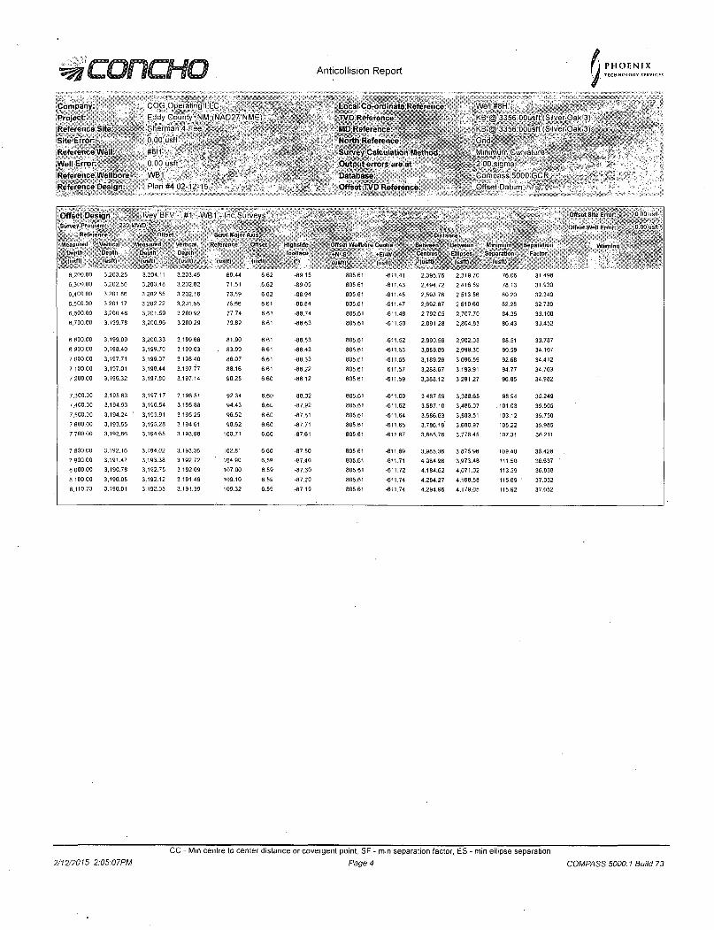
^ILURL-riU Anticollision Report PHOENIX TECHNOLOGY SERVICES
Company: Project. Reference Site: Site Error: Reference Well: Well Error: Reference Wellbore Reference Design:
COG Operating LLC Eddy County, NM (NAD27 NME) Sherman 4 Fee • 0 00 usft #8H ,0.00 usft V WB1 Plan #4 02-12-15
mm
Local Co-ordinate Reference: TVD Reference-MD Reference: North Reference: Survey Calculation Method: Output errors are at Database: Offset TVD Reference.
. Well #8H :;KB @ 3356.dousff(Silver,Oak 3) KB @ 3356 OOusft (Silver Oak 3)
' Minimum Curvature > 2 00 sigm'a ; , ",: Compass 5000 GCR, ' t Offset Datum
Onset Design Ivey BFV - #1 - WB1 - Inc Surveys Survey Program: 230-MWD /
Reference . ' Offset S . ';• • . f^^v-.-
Semi Ma]or Axis. IBlllilBil!! Dl 1. nco Measured • Depth
; lusft)
Vertical Depth (usftl
, Measured Depth (usftl
Vertical Depth (usft)
Reference
(usft)
OfK i l
(usft)
Highside
Toolfaco
CI
, Offset Wellbore
iS^SiBOli: (usft) A
Centre
•E/-W •
(usft)
Rl l A I 1 II
Contres (usft) „ ,
Between
Ellipses
jjjlllljl Minimum;
Separation . (usft) . •
Separation Factor
6 200.00 3,203.25 3.204.11 3,203.45 69.44 6.62 -89.15 805.61 -611.41 2.395.76 2.319.70 76.06 31.498
6.300.00 3.202.56 3.203.48 3,202.82 71 51 ,6.62 -89.05 805.61 -611.43 2.494.72 2,416.59 78.13 31.930
'6,400.00 3.201.86 3,202.85 3,202.18 73.59 6.62 -88.94 805.61 -611.45 2,593.76 2,513.56 80.20 32.340
6,500.00 3.201.17 3,202.22 3,201.55 75.66 6.61 -88.84 805.61 -611.47 2,692.87 2,610.60 82.28 32.730
6.600.00 3,200.48 3,201.59 3,200.92 77.74 6.61 -88.74 805.61 -611.48 2,792.05 2.707.70 84.35 33.100 6,700.00 3.199.78 3,200.96 3,200.29 79,82 6.61 -88.63 805.61 -611.50 2,891.28 2,804.85 86.43 33.452
6.800:00 3.199.09 3.200.33 3,199.66 81.90 6.61 -88.53 805.61 -611.52 2,990.56 2.902.05 88.51 33.787
6,900,00 3,198.40 3.199.70 3,199.03 . 83 99 6.61 -88.43 805.61 -611.53 3.089.89 2.999.30 90.59 34.107
7.000.00 3.197.71 3,199.07 3,198.40 86.07 6.61 -88 33 805.61 -611.55 3.189.26 3.096.59 92.68 34.412 7.100.00 3,197.01 3,198.44 3,197.77 88.16 6.61 -88.22 805.61 -611.57 3.288.67 3.193.91 94.77 34.703
7,200.00 3.196.32 3,197.80 3.197.14 90.25 6.60 -88.12 805.61 -611.59 3.388.12 3,291.27 96.85 34.982
7,300.00 3.195.63 3,197.17 3,196.51 92.34 6.60 -88.02 805.61 -611.60 3.487.59 3.388.65 98.94 35.249 7.400,00 3,194.93 3,196.54 3,195.88 94.43 6.60 •87.92 805.61 -611.62 3.587,10 3.486.07 . 101.03 35.505
7.500,00 3,194.24 ' 3,195.91 3,195.25 96.52 6.60 . -87.81 805.61 -611.64 3,686.63 3.583.51 103.12 35.750 7,600.00 3.193.55 3.195.28 3.194.61 98.62 6.60 -87.71 805.61 -611.65 3,786.19' 3.680.97 105.22 35.985 7,700.00 3.192.86 3,194.65 3,193.98 100.71 6.60 -87.61 805.61 -611.67 3.885.76 3,778.45 107.31 36.211
7.800.00 3,192.16 3,194.02 3,193.35 102.81 6 60 -87.50 805.61 -611.69 3.985.36 3,875.96 109.40 36.428 7,900.00 3,191.47 3,193.38 3,192.72 104.90 6 59 •87.40 805.61 -611.71 4,084.98 3,973.46 111.50 36.637
8.000.00 3.190.78 3,192.75 3,192.09 107 00 6.59 -87.30 805.61 -611.72 4,184.62 4,071.02 113.59 36.838
8,100.00 3,190.08 3,192.12 3.191.46 109.10 6.59 -87,20 805.61 -611.74 4,284.27 4,168.58 115.69 37.032
8,110.73 3.190.01 3,192.05 3.191.39 109.32 6.59 -87.19 805.61 -611.74 4.294.96 4.179.05 115.92 37.052
Offset Site Error:
Offset Well Error:
Warning
0 00 usft
0 00 usft
2/12/2015 2:05:07PM CC - Min centre to center distance or covergent point, SF - min separation factor, ES - min ellipse separation
Page 4 COMPASS 5000.1 Build 73

Anticollision Report PHOENIX TECHNOLOGY SERVICES
Company. Project-Reference Site: Site Error: Reference Well-Well Error. Reference Wellbore Reference Design:
COG Operating LLC Ed'dy'County, NM (NAD27 NME) Sherman 4 Fee 0.00 usft ' " ' #8H "0 00 usft ' ,WB1 Plan #4 02-12-15-
Local Co-ordinate Reference. TVD Reference-MD Reference. North Reference: Survey Calculation Method: Output errors are at Database: Offset TVD Reference.
Well#8H- , ' ' KB"@ 3356 OOusft (Silver Oak 3) KB @ 3356.00usft (Sliver Oak 3) '
l | S r i ^ ^ ^ B i ^ ! ^ ^ ^ 5 ^ Minimum Curvature 2 00 sigma r ' Compass 5000 GCR' . ' ' Offset Datum
Offset Design Sherman 4 Fee - #4H"- WB1/ Job #1310484 --Surveys (JW4) • Offset Site Error 0 00 usft
Survey-program: 100-veS-ISCWSA-«YRO-3,2521-MWD I j l j i l i j l j Offset Well Error: 0 00 usll Reference .Offset Isllfeii Semi Major Axis Distance
Measured Vertical Measured ' Vertical Reference Ullsel Highside Offset Wellbore Centre Between Between Minimum Separation Warning " v . " . Depth Depth Depth Depth Toolface •N/-S +E/-W Cei u*'. ®I8S1§ Separation Factor
lusft) (usft) ] ' (usft) (usftl (usft) (••shl •111191 (usft) (usft) (usft) (usft| (usft)
0.00 0.00 0.00 0.00 0.00 0.00 -71.20 294.30 •864.70 913.42
100.00 100.00 92.11 92.11 0.15 0.08 -71.19 294.64 -864.84 913.67 913.45 0.22 4,069.766
200.00 200.00 188.53 188 52 0,51 0.25 •71.15 295.40 -865.34 914.41 913.65 0.75 1.211.749
300 00 300.00 285.44 285.43 0.86 0.43 -71.12 296.29 -866.16 915.51 914.21 1.29 707.196
400.00 400.00 380.78 380.75 1.22 0.61 -71,06 297.54 -867.24 917.01 915.18 1.83 500.433
500.00 500.00 477.63 477 56 1.58 0.79 -71.00 299.11 -868.71 918.97 916.60 2.37 387.239
600.00 600.00 580.70 580.63 1.94 0.99 -7095 300.62 -870.39 920.99 918.07 2.92 314.914
700.00 700.00 ' 682.39 682.30 2.30 1.17 -70.93 301.37 -871.91 922.64 919.17 3.47 265.785
800.00 800.00 779.51 779.40 2 66 1.35 -70!95 301.71 -873.55 924.36 920.35 4.01 230,572
900.00 900.00 881.13 881.01 3.01 1.54 -70.97 301.90 -875.51 926.23 921.66 4.55 203.409
1,000.00 1,000.00 977.68 977.53 3.37 1.72 -71,02 301.77 -877.44 928.08 922.99 5.09 182.379
1,100,00 1.100.00 1,082.01 1.081.84 3.73 1.91 -71.06 301.91 •879.57 930.06 924.42 5.64 164.890
1,200.00 1.200.00 1.181.67 1.181.49 4.09 2.09 •71.07 302.21 •881.13 931,64 925.46 6 18 150.629
1.300.00 1.300.00 1,280.09 1,279.89 4.45 2.28 -71,07 302.69 -662.78 933.39 926.67 6.73 138.732
1,400.00 1,400.00 1.380.32 1,380.11 4.81 2.47 •71.08 303.20 -884.56 935.23 927.96 7.27 128.569
1,500.00 1.500.00 1,476,82 1.476.59 5.17 2.65 -71.10 303.47 -886.45 937.18 929.37 7.81 119.949
1.600.00 1,600.00 1,576.01 1.575.76 5.52 2.83 -71.11 304.05 -888.63 939.45 931.09 8.36 112.404
1,700.00 1,700.00 1,674 04 1,673.76 5.88 3.02 -71.11 304.87 -890.77 941.78 932.88 8.90 105.812
1.800,00 1.800.00 1,775.03 1.774.71 6.24 3.21 -71.08 306.01 -893.01 944.25 934.80 ' 9.45 99.932
1.900.00 1,900.00 1,873.01 1,872.67 6.60 3.39 •71.08 306.89 -895.20 946.66 936.67 9.99 94.745
2.000.00 2,000.00 1,973.38 1.973.00 6.96 3.58 -71.08 307.74 -897.67 949.26 938.72 10.54 90.072
2,100.00 2.100.00 2,071.71 2,071.30 7.32 3.77 -71.08 308.46 -900.09 951.83 940.75 11.08 85.888
2.200.00 2.200.00 2,172 92 2,172.47 7.67 3.96 -71,09 309.19 • -902.73 954.53 942.89 11.63 82.068
2.300.00 2,300.00 2,275.16 2.274.68 8.03 4.15 -71.10 309.83 -905.15 956.97 944.79 12.18 78.560
2,400.00 2,400.00 2,371.94 2,371.43 8.39 4.33 -71 12 310.35 -907.46 959.40 946.68 12.72 75.415
2.500.00 2,500.00 2.469,69 2,469.14 8.75 4.50 -71.16 310.64 -910.28 962.22 948.98 13.25 72.634
2,600.00 2,60000 2.570.47 2.569.88 9.11 4.55 -71.16 311.60 -913.01 965.10 951.45 13.66 70.664
2.701,00 2,701.00 2.662.63 2.661.72 9.47 4.56 -70.76 318.80 -913.58 968.28 954.25 14.03 68.991
2.750.00 2.749.93 2.703.34 2,701.95 9.65 4.58 -52.59 325.03 -913.15 968.92 954.69 14.22 68.120
2.800.00 2.799.41 2,743.05 2.740.57 9.83 4.60 -52.47 334.09 -912.05 967.19 952.76 14.43 67.039
2.850.00 2,847,98 2,779.53 2.775.00 10.01 4,63 -52.52 345.97 -910.16 963,16 946.52 14.64 65.776
2,900.00 2.895.19 2.814.95 2,807,30 10.19 4.68 -52.74 360.28 -907.78 956.99 942.11 14.87 64.337
2.950.00 2,940,62 2,860.47 2,847.63 10.39 4.78 -53.14 381.08 -904.26 948.52 933.35 15.17 62.535
3,000.00 2,983.85 2,916.08 2,893.94 10.61 4.97 -53.62 411.11 -897.80 937.17 921.59 15.58 60.140
3.050.00 3.024.47 2.969,20 2.934.89 10.87 5,24 -54.31 443.78 -889.15 922.60 906.49 16.11 57.256
3.100.00 3.062.11 3.007.01 2,961.88 11.18 5.49 -55.43 469.26 -881.98 905.58 888.90 16.67 54.316
3,150.00 3,096.42 3,041.45 2,984.44 11.56 5.76 •56.84 494.29 -874 94 886.65 869.34 17.31 51.211
3.200.00 3.127.10 3,075.37 3.004,74 12.00 6.07 -58.50 520.45 -867.60 865.94 847.88 18.06 47.939
3,25000 3,153.85 3,121.09 3.029.32 12.52 6.54 •60.32 557.46 -856.88 843.29 824.23 19.06 44.242
3.300.00 3.176.43 3.153.67 3,044.86 13.12 6.92 -62.64 584.88 -848.61 818.75 798.71 20.04 40.853
3.350.00 3,194.64 3.175.00 3.054.02 13.80 7.18 -65.38 603.37 -843 23 793.17 772.18 20.98 37.798
3.400.00 3,208.30 3,206.00 3,066.08 14.56 7.58 -68.39 630.96 -835.87 766.97 744,83 22.14 34.641
3.450.00 3,217.28 3,222.72 3,072.00 15.38 7.81 -71.70 646.16 -832.19 740,33 717.14 23.19 31.924
3.500.00 3,221.52 3,248.26 3,080.16 16.26 8.16 -75.30 669.77 -826.86 713.53 689.11 24,42 29.219
3.522.82 3,221.86 3,261.46 3.084.05 16.67 8.35 -77.06 682.09 -824.20 701.24 676.21 25.02 28.024
3,600.00 3,221.32 3,310.92 3,096.55 18.12 9.08 ' -78.09 728.93 -814.43 661.71 634.51 27.20 24.327
3,700.00 3.220.61 3,375.81 3,107.35 20.05 10,09 -78.93 791.74 -802.38 617.41 587.27 30,14 20.485
3.800.00 3.219.91 3,456.00 3,113.78 22.00 11.38 -79.28 870.45 -788.59 580.70 547.31 33.39 17.394
3.900.00 3,219.20 3,540.64 3.115.72 23.94 12.76 •79.20 953.96 -774.96 550,88 514.17 36.70 15.009
4.000.00 3.218.50 3,634 20 3.117.39 25.85 14.28 -79,11 1,046.40 •760.63 526.91 486.78 40.13 13.131
4,100:00 3,217,80 3,725.99 3,118.67 27.72 15.81 -79.04 1.137.17 -747:06 508.58 465,06 43.53 11.685
4.164.38 3.217.35 3.777.78 3,119.43 28.89 16.67 -79.07 1,188.55 -740.55 500.84 455.27 45.56 10.992
2/12/2015 2:05:07PM CC - Min centre to center distance or covergent point, SF - min separation factor, ES - min ellipse separation
Page 5 COMPASS 5000.1 Build 73
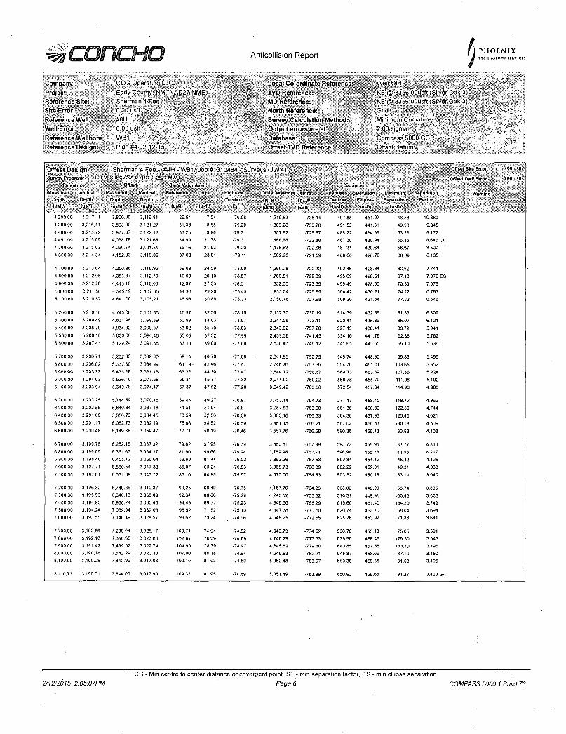
•=57 oncHO Anticollision Report
Company: Project-Reference Site: Sili! Error-Reference Well: Well Error Reference Wellbore Reference Design.
COG Operating LLC Eddy County; NM, (NAD27jNME) Sherman 4 Fee -b'00 usft' ,
.#8H -'„•"?' .• . .-.'.'V' J-0 00 usft WB1 . "
Plan #4 02-12-15' -
Local Co-ordinate Reference TVD Reference: MD Reference: North Reference: Survey Calculation Method: Output errors are at Database: Offset TVD Reference
P H O E N I X TECHNOLOGY SERVI
Well#8H - ' -KB @ 3356 OOusft (Silver Oak 3)
•-.KB @ 3356.OOusft (Silver Oak'3)
Minimum Curvature 2 00 sigma ; ' ' * • Compass 5000 GCR
'.Offset Datum
Offset Design *, Sherman 4 F-er "#4H - WB1/Job #1310484"- Surveys (JW4) - • SIIIRlBj • Offset Site Error: 0 00 usfl
Survey Program: 100-VES-ISCWSA-GYRO-3, 2521 -WWD J|||ij|||'|fS Offsot Well Error: 0 00 usfl -''Reference Offset Sf mi V ijor Am', Distance
Measured Vertical Measured Vertical Reference' Offset Highside ' Offset Wellbore Centre Between Between Minimum Separation Warning - . Depth Depth Depth Oepth Toolface ' .. +IW-S +E/-W ' Centres ' Ellipses Separation faclur (usft) . •(usft) <u*«) (usft) (..•,11. (usft) n (usft).. (usft)
5 (usft) , (uslt) (usft), '
4.200.00 3.217.11 3.800.00 3,119.81 29,54 17.04 -79.08 1.210.63 -738.14 497.85 451.27 46.58 10.689
4 300 00 3,216.41 3.893.00 3.121.27 31.38 18.55 -79.20 1.303.28 -730.28 491.55 441.61 49.93 9.845
4,400.00 3,215.72 3,977.67 3,122.12 33.25 19.98 -79.31 1.387.82 . -725.67 488.22 434.99 53.23 9.172
4,491.09 3.215.09 4.058.78 3,121.68 34.99 21.38 -79.31 1.468.88 -722.88 487.30 430.94 56.36 8,646 CC
4.500.00 3.215.03 4,066.74 3.121.51 35.16 , 21.52 -79.29 1,476.83 -722.68 487.31 430.64 56.67 8.599
4,600 00 3.214.34 4.152.93 3,119,09 37.08 23.01 -79.11 1,562.98 -721.59 488,88 428.78 60.09 8.135
4.700.00 3.213.64 4,250.28 3,115.99 39.03 24.59 -78.90 1.660.28 -722.32 492.46 428.84 63,62 7.741
4.800.00 3.212.95 4,353.87 3,112.70 40.99 26.19 •78.67 1.763.81 -722.69 495.69 428.51 67.18 7,378 ES
4.900 00 3:212.26 4.443.10 3.110.03 42.97 27.63 -78.51 1,853.00 -723.55 499.49 428.90 70.59 7.076
5,000.00 3,211.56 4,545.19 3,107.86 44.96 29.26 -78.45 1.955.04 -725.89 504.42 430.21 74.22 6.797
5,100.00 3.210.87 4.641.00 3,105.21 46.96 30.86 -78.33 2,050.78 -727.98 509,36 431.54 77.82 6.546
5,200.00 3,210.18 4,743.00 3,101.86 48:97 32.56 •78.15 2,152.70 •730.19 514.39 432.86 81,53 6.309
5,300 00 3,209.49 4,831.96 3,099.39 50.99 34.03 -78.07 2,241.58 -733.11 520.41 435.39 85.02 6.121
5,400.00 3.208.79 4,934.32 3.096.97 5302 35.70 •78.03 2,343.82 -737.28 527.13 438.41 88.72 5.941
5,500.00 3.208.10 5.030.00 3.094.48 55.05 37.32 •77.99 2,439.38 •741.45 534.16 441.78 92.38 5.782
5.600.00 3,207.41 5,129.24 3,091.38 57.10 39.00 •77.89 2,538.46 -746.12 541.65 445.55 96.10 5.636
5,700.00 3,206.71 5,232.86 3,089.00 59.14 40.70 -77.88 2,641.95 -750.75 548.74 448.90 99.85 5.496
5.800,00 3,206.02 5,337.80 3,084.99 61.19 - 42.46 -77.67 2,746.76 -753.96 554.76 451.11 103.65 5.352
5,900.00 3,205.33 5.435.8B 3.081.16 63.25 44.10 -77.47 2,844.72 -756.87 560.73 453.39 107.35 5.224
6,000.00 3.204.63 5.536.18 3,077.68 65.31 45.77 -77.32 2.944.92 -760.02 566.78 455.70 111.08 5.102
6,100.00 3.203.94 5.640.78 3.074.47 67.37 47.52 -77,20 3,049.42 -763.08 572.54 457.64 114.90 4.983
6,200.00 3.203.25 5.744.59 3.070.46 69.44 49.27 -76,97 3.153.14 •764.73 577.17 458.45 118.72 4.862
6.300.00 3,202.56 5.849.34 3.067.16 71.51 51.04 -76.81 3,257 83 -766.08 581.36 458.80 122.56 4.744
6.400.00 3.201.86 5,956.73 3.064.45 73.59 52.86 -76.69 3,365.18 -766.33 584.38 457.93 126.45 4.621
6.500.00 3.201.17 6,052.73 3,062.19 75.66 54.52 -76.59 3.461.15 -766.21 587.02 456.83 130.18 4.509
6,60000 3,200.48 6,149.38 3,059.47 77.74 56.19 -76.46 3.557.76 -766.68 590.36 456.43 133.93 4.408
6,700,00 3.199.78 6,252.15 3,057.32 79.82 57.95 -76.39 3.660.51 -767.39 593.73 455.96 137.77 4.310
6.800,00 3.199.09 6,351.67 3,054.37 81.90 59.66 -76.24 3,759.98 -767.71 596.94 455.38 141.56 4 217
6,900.00 3.19840 6.455.12 3,050.64 83.99 61.44 -76.02 3.863.36 -767.53 599.84 454.42 145.42 4.125
7,000.00 3.197.71 6.560.54 3,047.33 86.07 63.24 -75.83 3.968,73 •766.89 602.22 452.91 149.31 4.033
7.100.00 3,197.01 6.661.89 3.043.72 88.16 64.98 •75.57 4,070,00 -764.83 603.32 450.18 153.14 3.940
7.200.00 3,196.32 6,749.66 3,040.37 90.25 66.49 -75.35 4 j 57.70 -764.26 605.83 449.09 156.74 3.865
7.300.00 3.195.63 6.840.13 3,038.09 92.34 68.06 -75.29 4.248.12 -765.62 610.31 449.91 160.40 3.605
7.400.00 3.194.93 6:938.74 3.035.43 94.43 69.77 -75.23 4.346.66 -768.29 615.60 451.40 164.20 3.749
7.500.00 3.194.24 7.039.94 3,032.03 96.52 71.52 -75 10 4.447.78 •770.50 620.74 452.70 168.04 3.694
7.600.00 3.193.55 7,140.49' 3,028.57 98.62 73.24 -74.96 4,548.25 •772.55 625.78 '453.92 171.86 3.641
7 700.00 3,192.86 7,239.04 3.025.17 100.71 74.94 -74.82 4,646.73 -774.52 630.78 455.13 175.65 3.591
7,800,00 3.192.16 7,340.65 3,023.86 102.81 76.69 •74.89 4,748.29 •777.33 635.96 456.46 179.50 3.543
7.900.00 3,191.47 7,439.02 3,022.74 104.90 78.39 -74.97 4.846.62 -779.80 640.85 457.56 183,30 3 496
8.000.00 3.190.78 7,542.29 3.020.38 107.00 80.18 -74.94 4,949.83 -782.21 645.87 458.69 187.19 3.450
8,100.00 3,190.08 7,642.99 3,017.93 109.10 81.93 -74.89 5,050.48 -783.97 650.38 459.35 191.03 3.405
8.110.73 3.190.01 7,644,00 3,017.90 109.32 81.95 -74.89 5,051.49 -783.99 650.93 459.66 191.27 3.403 SF
2/12/2015 2:05:07PM
CC - Min centre to center distance or covergent point, SF - min separation factor, ES - min ellipse separation
Page 6 COMPASS 5000.1 Build 73
Anticolhsion Report 5 P H O E N I X TECHNOLOGY SERVICES
Company Projecl. Referonr.o Situ: Site Error Reference Well Well Error: Reference Wellbore Reference Design:
COG Operatmg.LLC Eddy County"; NM (NAD27 NME) She'man 4 F 0 00 usft
0*00 usft ' -WB1 . • Plaii#4 02-~12-15 ' ,
IS
Local Co-ordinate Reference: TVD Reference: MD Reference: North Reference: Survey Calculation Method: Output errors are at Database: Offset TVD Reference
Well #8H ; :
,KB@ 3356 OOusft (Silver Oak 3) . "KB @ 3356.00usft (Silver Oak 3)
Minimum Curvature '- : 2 00 Sigma ^ _ - 1
Compass 500"o GCR ' -Offset. Datum
Reference Depths are relative to KB @ 3356.00usft (Silver Oak 3)
Offset Depths are relative to Offset Datum
Central Meridian is 104° 19' 60.00000 W
Coordinates are relative to: #8H
Coordinate System is US State Plane 1927 (Exact solution), New Mexico East 30
Grid Convergence at Surface is: -0.02°
Ladder Plot
6000-
4500-
0)
co j» £ 3000-O o jl)
c to O
1500- r-
/
1500 3000 4500
Measunsd Depth
6000 7500 9000
L E G E N D
#1,VVB1,lncSurveysV0 #4H,\AB1/Job#131McM,Surveys(JW4) V0.
2/7 2/20(5 2:05:07PM
CC - Min centre to center distance or covergent point, SF - min separation factor, ES - min ellipse separation
Page 7 COMPASS 5000.1 Build 73
: H O Anticollision Report f \ PHOENIX \ i TECHNOLOGY SERVICES
Company
Project
Reference Site
Site Error:
Reference Well '
Well Error.
Reference Wellbore
Reference Design:
COG Operating L L C
Eday County, NM (NAD27 NME)
Sherman 4 Fee--"' .,
0 00 usft
0 00 usft
Plan #4 02-12-15 '
Local Co-ore inate Reference:
TVD Reference:
MD Reference:
North Reference:
Survey Calculation Method:
Output errors are at
Database:
Offset TVD Reference:
;We l l #8H / _ » *, •
,KB @ 3356 OOusft (Sliver Oak 3)
,KB'@ 3356 OOusft (Sliver Oak 3)
ItGrid'
IsMinimumiGurvature
2 00 sigma
Compass 5000 GCR
Offset Datum
Reference Depths are relative to KB @ 3356.OOusft (Silver Oak 3)
Offset Depths are relative to Offset Datum
Central Meridian is 104° 19'60.00000 W
Coordinates are relative to: #8H
Coordinate System is US State Plane 1927 (Exact solution), New Mexico East 30
Grid Convergence at Surface is: -0.02°
Separation Factor
y fi nn—
3.00—
, Level '.
-HJo
1500 4500
Measured Depth
7500
#1 ,WB1,hcSurveysV0
L E G E N D
#4H,V\E1/Job#1310484,Surveys( jVV4)V0
2/12/2015 2:05:07PM
CC - Min centre to center distance or covergent point. SF - min separation factor, ES T min ellipse separation
Page 8 COMPASS 5000.1 Build 73