Embed Size (px)
Citation preview
SHIRE OF AUGUSTA MARGARET RIVER
ORDINARY COUNCIL MEETING 24 NOVEMBER 2021
11.2 Sustainable Development and Infrastructure ITEM NO SUBJECT PAGE 11.2.3 SCHEME AMENDMENT 74 - LOT 9000 BUSSELL HIGHWAY, MARGARET RIVER, FOR
INITIATION 1

SHIRE OF AUGUSTA MARGARET RIVER ORDINARY COUNCIL MEETING 24 NOVEMBER 2021
11.2 Sustainable Development and Infrastructure 11.2.3 SCHEME AMENDMENT 74 - LOT 9000 BUSSELL
HIGHWAY, MARGARET RIVER, FOR INITIATION Attachment 1 – Scheme Amendment Map Attachment 2 – Scheme Amendment Proposal
1

Lot 9000 Bussell Highway – LPS 1 Amendment 2 | P a g e
SHIRE OF AUGUSTA MARGARET RIVER LOCAL PLANNING SCHEME NO.1
Amendment No. xx
2
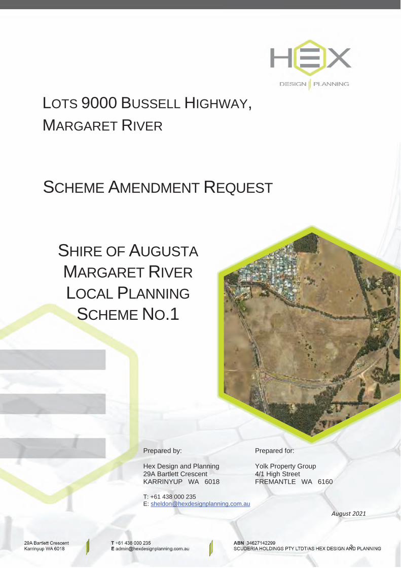
LOTS 9000 BUSSELL HIGHWAY,MARGARET RIVER
SCHEME AMENDMENT REQUEST
SHIRE OF AUGUSTA MARGARET RIVERLOCAL PLANNING
SCHEME NO.1
Prepared by:
Hex Design and Planning29A Bartlett Crescent KARRINYUP WA 6018
T: +61 438 000 235E: [email protected]
Prepared for:
Yolk Property Group4/1 High StreetFREMANTLE WA 6160
August 2021
3
Lot 90000 Bussell Highway Rezoning
Disclaimer and Copyright This document was commissioned by and prepared for the exclusive use of Yolk Property Group (Client). It is subject to and issued in accordance with the agreement between Client and Hex Design and Planning. Hex Design and Planning acts in all professional matters as a faithful advisor to its clients and exercises all reasonable skill and care in the provision of professional services. The information presented herein has been compiled from several sources using a variety of methods. Except where expressly stated, Hex Design and Planning does not attempt to verify the accuracy, validity or comprehensiveness of this document, or the misapplication or misinterpretation by third parties of its contents.
Version Comment Prepared By Reviewed By Review Date Approved By Issue Date Revision 1 Draft SYD SD 9/7/2021 SD -- Revision 1 Final SYD- SD 18/8/2021 SD 19/8/2021
4
Lot 90000 Bussell Highway Rezoning
Contents 1 PURPOSE OF REPORT ........................................................................................................................... 1
2 SUBJECT SITE AND CONTEXT ................................................................................................................ 3
2.1 SUBJECT SITE ......................................................................................................................................... 3
2.2 LEGAL DESCRIPTION, OWNERSHIP & CURRENT LAND USE ................................................................. 6
2.3 SURROUNDING TRAFFIC AND TRANSPORT ENVIRONMENT ................................................................ 8
2.4 SURROUNDING LAND USES .................................................................................................................. 8
3 PLANNING CONSIDERATIONS ............................................................................................................ 10
3.1 STATUTORY PLANNING FRAMEWORK ................................................................................................ 10
3.1.1 SHIRE OF AUGUSTA MARGARET RIVER LOCAL PLANNING SCHEME NO.1 ..................................... 10 3.2 STRATEGIC PLANNING FRAMEWORK ................................................................................................. 10
3.2.1 Local Planning STRATEGY 2036 ...................................................................................................... 10 3.2.2 East Margaret River District STRUCTURE Plan (2017) .................................................................... 14
4 REZONING PROPOSAL ....................................................................................................................... 16
5 NATURAL ENVIRONMENT .................................................................................................................. 17
5.1 TOPOGRAPHY ..................................................................................................................................... 17
5.2 GEOLOGY & SOILS ............................................................................................................................... 17
5.3 SURFACE WATER / WETLANDS ........................................................................................................... 18
5.3.1 Groundwater .................................................................................................................................. 18 5.3.2 Surface Water ................................................................................................................................. 19 5.3.3 Wetlands ......................................................................................................................................... 20
5.4 VEGETATION, FLORA & FAUNA .......................................................................................................... 20
6 HAZARD & RISK ................................................................................................................................. 22
6.1 ROAD NOISE ........................................................................................................................................ 22
6.2 CONTAMINATED SITE ......................................................................................................................... 22
6.3 BUSHFIRE RISK .................................................................................................................................... 22
6.4 ACID SULFATE SOILS ........................................................................................................................... 24
6.5 HISTORIC LAND USE ............................................................................................................................ 24
6.6 UNEXPLODED ORDINANCE (UXO) ...................................................................................................... 25
6.7 ABORIGINAL HERITAGE PLACES .......................................................................................................... 25
6.8 EUROPEAN HERITAGE ......................................................................................................................... 26
5
Lot 90000 Bussell Highway Rezoning
7 SERVICES AND FILL............................................................................................................................. 27
7.1 Topography ......................................................................................................................................... 27
7.2 Water, Drainage, Sewer, Power ......................................................................................................... 27
7.2.1 Sewerage ........................................................................................................................................ 28 7.2.2 Water Supply .................................................................................................................................. 29 7.2.3 Drainage ......................................................................................................................................... 30
7.3 Accessibility ........................................................................................................................................ 30
7.3.1 ROADS & PATHS ............................................................................................................................. 30 7.3.2 PATHS ............................................................................................................................................. 31
7.4 Electricity and Gas Supply .................................................................................................................. 33
7.5 Telecommunications .......................................................................................................................... 33
7.6 Siteworks and Fill ................................................................................................................................ 33
8 PUBLIC USES ...................................................................................................................................... 34
9 FUTURE STRUCTURE PLAN ................................................................................................................. 35
10 CONSULTATION & JUSTIFICATION...................................................................................................... 36
11 CONCLUSION ..................................................................................................................................... 39
APPENDICES APPENDIX 1 – CERTIFICATE OF TITLE APPENDIX 2 – ENVIRONMENTAL ASSESSMENT REPORT APPENDIX 3 – BUSHFIRE MANAGEMENT PLAN APPENDIX 4 – SERVCING REPORT / WASTEWATER SERVICING STRATEGY APPENDIX 5 – DISTRICT WATER MANAGEMENT STRATEGY APPENDIX 6 – MARKET ANALYSIS APPENDIX 7 – VISION / CONCEPT PLAN
6
Lot 9000 Bussell Highway – LPS 1 Amendment 1 | P a g e
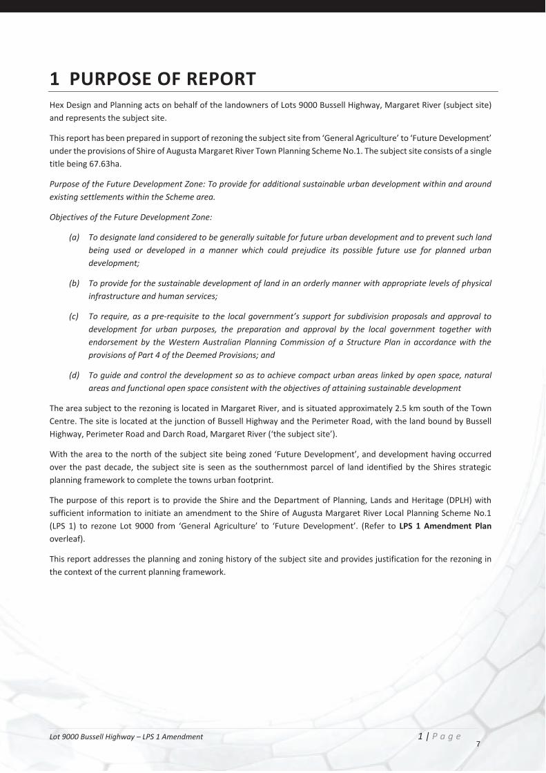
1 PURPOSE OF REPORT Hex Design and Planning acts on behalf of the landowners of Lots 9000 Bussell Highway, Margaret River (subject site) and represents the subject site.
This report has been prepared in support of rezoning the subject site from ‘General Agriculture’ to ‘Future Development’ under the provisions of Shire of Augusta Margaret River Town Planning Scheme No.1. The subject site consists of a single title being 67.63ha.
Purpose of the Future Development Zone: To provide for additional sustainable urban development within and around existing settlements within the Scheme area.
Objectives of the Future Development Zone:
(a) To designate land considered to be generally suitable for future urban development and to prevent such land being used or developed in a manner which could prejudice its possible future use for planned urban development;
(b) To provide for the sustainable development of land in an orderly manner with appropriate levels of physical infrastructure and human services;
(c) To require, as a pre-requisite to the local government’s support for subdivision proposals and approval to development for urban purposes, the preparation and approval by the local government together with endorsement by the Western Australian Planning Commission of a Structure Plan in accordance with the provisions of Part 4 of the Deemed Provisions; and
(d) To guide and control the development so as to achieve compact urban areas linked by open space, natural areas and functional open space consistent with the objectives of attaining sustainable development
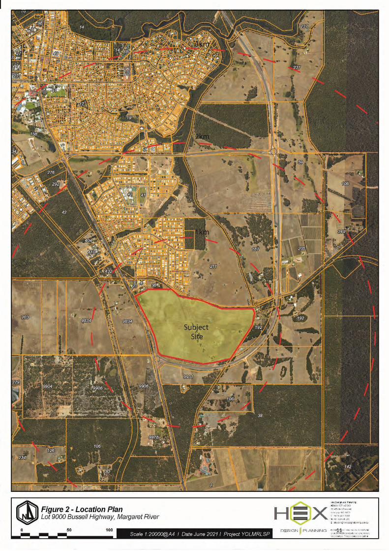
The area subject to the rezoning is located in Margaret River, and is situated approximately 2.5 km south of the Town Centre. The site is located at the junction of Bussell Highway and the Perimeter Road, with the land bound by Bussell Highway, Perimeter Road and Darch Road, Margaret River (‘the subject site’).
With the area to the north of the subject site being zoned ‘Future Development’, and development having occurred over the past decade, the subject site is seen as the southernmost parcel of land identified by the Shires strategic planning framework to complete the towns urban footprint.
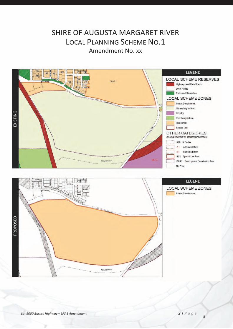
The purpose of this report is to provide the Shire and the Department of Planning, Lands and Heritage (DPLH) with sufficient information to initiate an amendment to the Shire of Augusta Margaret River Local Planning Scheme No.1 (LPS 1) to rezone Lot 9000 from ‘General Agriculture’ to ‘Future Development’. (Refer to LPS 1 Amendment Plan overleaf).
This report addresses the planning and zoning history of the subject site and provides justification for the rezoning in the context of the current planning framework.
7
Lot 9000 Bussell Highway – LPS 1 Amendment 2 | P a g e
SHIRE OF AUGUSTA MARGARET RIVER LOCAL PLANNING SCHEME NO.1
Amendment No. xx
8
Lot 9000 Bussell Highway – LPS 1 Amendment 3 | P a g e
2 SUBJECT SITE AND CONTEXT
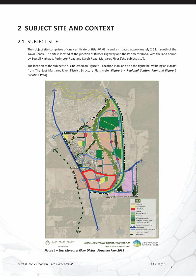
2.1 SUBJECT SITE The subject site comprises of one certificate of title, 67.63ha and is situated approximately 2.5 km south of the Town Centre. The site is located at the junction of Bussell Highway and the Perimeter Road, with the land bound by Bussell Highway, Perimeter Road and Darch Road, Margaret River (‘the subject site’).
The location of the subject site is indicated on Figure 2 – Location Plan, and also the figure below being an extract from The East Margaret River District Structure Plan. (refer Figure 1 – Regional Context Plan and Figure 2 Location Plan).
Figure 1 – East Margaret River District Structure Plan 2018
9
Lot 9000 Bussell Highway – LPS 1 Amendment 4 | P a g e
The site fronts Bussell Highway to the west, which is classified ‘Highways and MainRoads’ by the provisions of the Scheme, and links with the surrounding road network, including the Perimeter Road which provides access to the wider locality.
Access to the subject site is best afforded via Bussell Highway to the west and Andrews Way to the north, with Future Development zoned landholdings to the north also gaining primary access from both these roads.
The subject site is predominantly surrounded by a mix of medium and low-density residential development to the north, which was previously zoned Future Development. Land to the south, east and west on the adjacent side of the abutting roads are zoned General Agriculture, though partially identified for future development by the DSP.
Given the location of the subject site within the context of the town site, and the existing planning framework that identifies the site for development, the subject site is seen as the southern extremity of the Margaret River urban footprint. Noting residential development that is adjacent to the site (north of Andrews Way), and with Perimeter Road being the natural boundary of Margaret River urban core, the development of the site for residential purposes is a logical progression.
10
Lot 9000 Bussell Highway – LPS 1 Amendment 5 | P a g e
11
Lot 9000 Bussell Highway – LPS 1 Amendment 6 | P a g e
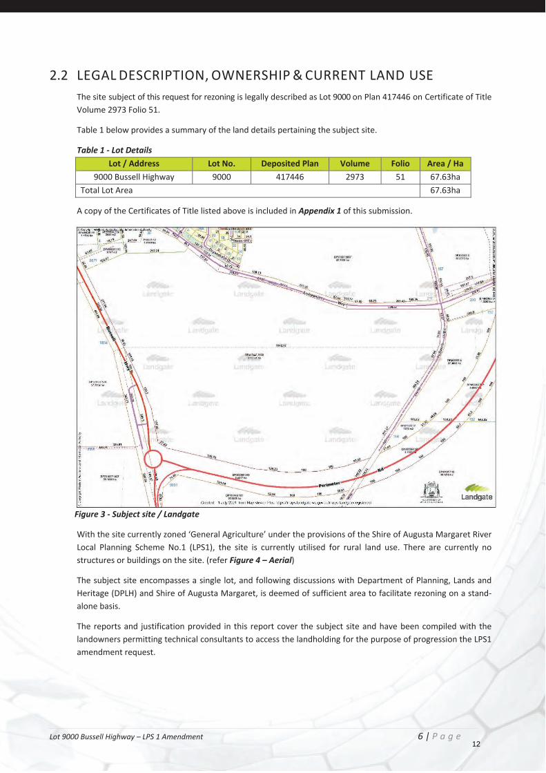
2.2 LEGAL DESCRIPTION, OWNERSHIP & CURRENT LAND USE The site subject of this request for rezoning is legally described as Lot 9000 on Plan 417446 on Certificate of Title Volume 2973 Folio 51.
Table 1 below provides a summary of the land details pertaining the subject site.
Table 1 - Lot Details Lot / Address Lot No. Deposited Plan Volume Folio Area / Ha
9000 Bussell Highway 9000 417446 2973 51 67.63ha Total Lot Area 67.63ha
A copy of the Certificates of Title listed above is included in Appendix 1 of this submission.
Figure 3 - Subject site / Landgate
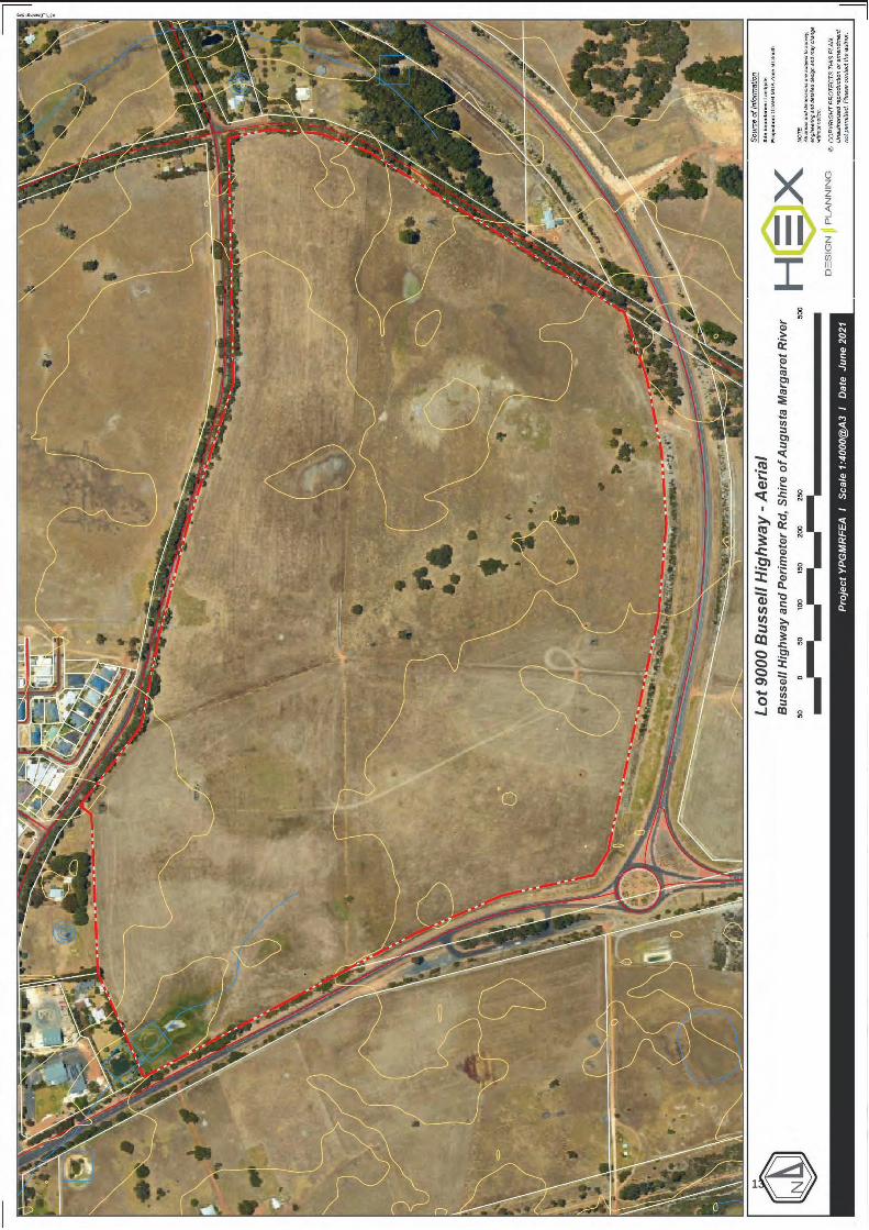
With the site currently zoned ‘General Agriculture’ under the provisions of the Shire of Augusta Margaret River Local Planning Scheme No.1 (LPS1), the site is currently utilised for rural land use. There are currently no structures or buildings on the site. (refer Figure 4 – Aerial)
The subject site encompasses a single lot, and following discussions with Department of Planning, Lands and Heritage (DPLH) and Shire of Augusta Margaret, is deemed of sufficient area to facilitate rezoning on a stand-alone basis.
The reports and justification provided in this report cover the subject site and have been compiled with the landowners permitting technical consultants to access the landholding for the purpose of progression the LPS1 amendment request.
12
Lot 9000 Bussell Highway – LPS 1 Amendment 7 | P a g e
13

Lot 9000 Bussell Highway – LPS 1 Amendment 8 | P a g e
2.3 SURROUNDING TRAFFIC AND TRANSPORT ENVIRONMENT The subject site has excellent access to the Margaret River road network, with Bussell Highway a designated Main Road under the provisions of LPS 1. The Perimeter Road which abuts the southern boundary of the site, and connects to Bussell Highway at the south western corner of the site, provides further connection to the wider Margaret River region.
Access to the site in the context of the approved East Margaret River DSP shows that the site is highly connected and suited for residential development, as identified by the planning framework of the Shire.
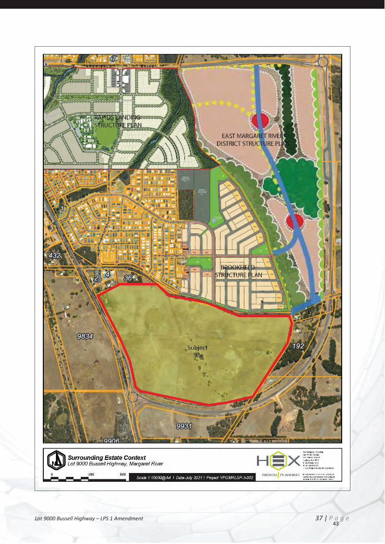
2.4 SURROUNDING LAND USES The land in the immediate locality of the subject site has been developed for residential purposes over the past decade, with several structure plans having been adopted by the Shire. The urban development layout for these areas has been progressing on a staged basis, with various other land uses including commercial having been delivered to date.
Figure 5 shows the context of the subject site with the surrounding structurer plans. These include;
Rapids Landing Structure Plan Brookfield Structure Plan East Margaret River District Structure Plan
Land on the southern and eastern side of Perimeter Road that is identified for industrial land. There are no residential land uses identified on the adjacent side of Perimeter Road.
14

Lot 9000 Bussell Highway – LPS 1 Amendment 9 | P a g e
15
Lot 9000 Bussell Highway – LPS 1 Amendment 10 | P a g e
3 PLANNING CONSIDERATIONS
3.1 STATUTORY PLANNING FRAMEWORK
3.1.1 SHIRE OF AUGUSTA MARGARET RIVER LOCAL PLANNING SCHEME NO.1
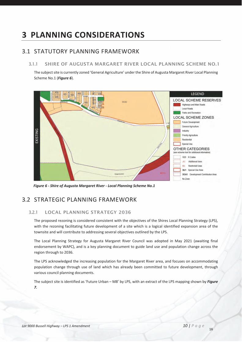
The subject site is currently zoned ‘General Agriculture’ under the Shire of Augusta Margaret River Local Planning Scheme No.1 (Figure 6).
Figure 6 - Shire of Augusta Margaret River - Local Planning Scheme No.1
3.2 STRATEGIC PLANNING FRAMEWORK
3.2.1 LOCAL PLANNING STRATEGY 2036
The proposed rezoning is considered consistent with the objectives of the Shires Local Planning Strategy (LPS), with the rezoning facilitating future development of a site which is a logical identified expansion area of the townsite and will contribute to addressing several objectives outlined by the LPS.
The Local Planning Strategy for Augusta Margaret River Council was adopted in May 2021 (awaiting final endorsement by WAPC), and is a key planning document to guide land use and population change across the region through to 2036.
The LPS acknowledged the increasing population for the Margaret River area, and focuses on accommodating population change through use of land which has already been committed to future development, through various council planning documents.
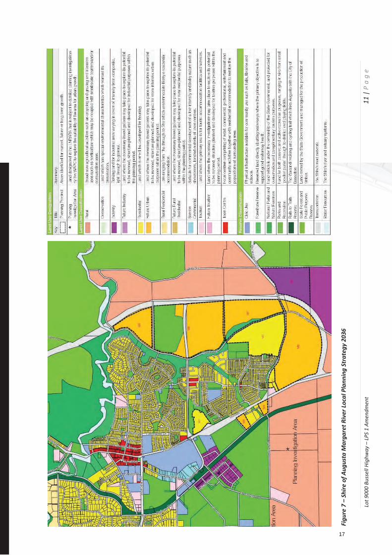
The subject site is identified as ‘Future Urban – M8’ by LPS, with an extract of the LPS mapping shown by Figure 7.
16
Lot 9
000
Buss
ell H
ighw
ay –
LPS
1 Am
endm
ent
11
| P
ag
e
Figu
re 7
– S
hire
of A
ugus
ta M
arga
ret R
iver
Loca
l Pla
nnin
g St
rate
gy 2
036
17

Lot 9000 Bussell Highway – LPS 1 Amendment 12 | P a g e
The key direction for the Margaret River Townsite, in which the subject site is located, forecast continued growth with an estimated population of circa 11,000+ by 2036. This is driven by Margaret River continuing to be the largest urban settlement in the Shire. Margaret River supports the widest range of employment and education opportunities and remains the principal settlement in the Shire.
With the identification of the subject site as a Future Urban Growth Area (M8), there is acknowledgement that development of the site is in accordance with the town sites planned expansion, with it acknowledged that rezoning of the subject site to ‘Future Development’ will then enable the progression of a Structure Plan to guide development of the site.
Planning Preicnct: M8 Porposoed Land Use: Residnetial Current Zoning: Rural Porposed Use: Residntail R10-R40, Parks and Recreation.
Figure 8 – Margaret River Townsite LPS 2036
Further to comments directly affiliated with the subject site within the LPS, there are also several broad objectives of the LPS that rezoning of the subject site goes towards addressing. Whilst many of the responses in the LPS relate to including provisions in the Scheme review, there are several objectives and actions that are able to be addressed by this site. These are detailed in the following table;
18
Lot 9000 Bussell Highway – LPS 1 Amendment 13 | P a g e
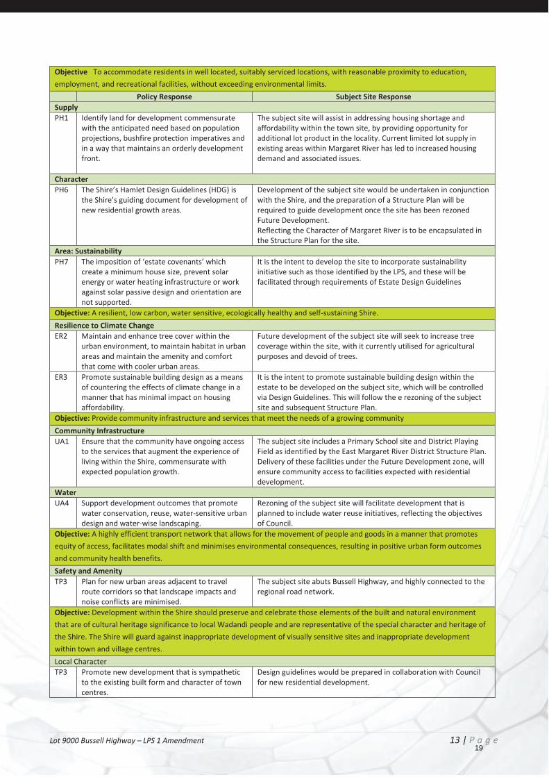
Objective To accommodate residents in well located, suitably serviced locations, with reasonable proximity to education, employment, and recreational facilities, without exceeding environmental limits.
Policy Response Subject Site Response Supply PH1 Identify land for development commensurate
with the anticipated need based on population projections, bushfire protection imperatives and in a way that maintains an orderly development front.
The subject site will assist in addressing housing shortage and affordability within the town site, by providing opportunity for additional lot product in the locality. Current limited lot supply in existing areas within Margaret River has led to increased housing demand and associated issues.
Character PH6 The Shire’s Hamlet Design Guidelines (HDG) is
the Shire’s guiding document for development of new residential growth areas.
Development of the subject site would be undertaken in conjunction with the Shire, and the preparation of a Structure Plan will be required to guide development once the site has been rezoned Future Development. Reflecting the Character of Margaret River is to be encapsulated in the Structure Plan for the site.
Area: Sustainability PH7 The imposition of ‘estate covenants’ which
create a minimum house size, prevent solar energy or water heating infrastructure or work against solar passive design and orientation are not supported.
It is the intent to develop the site to incorporate sustainability initiative such as those identified by the LPS, and these will be facilitated through requirements of Estate Design Guidelines
Objective: A resilient, low carbon, water sensitive, ecologically healthy and self-sustaining Shire. Resilience to Climate Change ER2 Maintain and enhance tree cover within the
urban environment, to maintain habitat in urban areas and maintain the amenity and comfort that come with cooler urban areas.
Future development of the subject site will seek to increase tree coverage within the site, with it currently utilised for agricultural purposes and devoid of trees.
ER3 Promote sustainable building design as a means of countering the effects of climate change in a manner that has minimal impact on housing affordability.
It is the intent to promote sustainable building design within the estate to be developed on the subject site, which will be controlled via Design Guidelines. This will follow the e rezoning of the subject site and subsequent Structure Plan.
Objective: Provide community infrastructure and services that meet the needs of a growing community Community Infrastructure UA1 Ensure that the community have ongoing access
to the services that augment the experience of living within the Shire, commensurate with expected population growth.
The subject site includes a Primary School site and District Playing Field as identified by the East Margaret River District Structure Plan. Delivery of these facilities under the Future Development zone, will ensure community access to facilities expected with residential development.
Water UA4 Support development outcomes that promote
water conservation, reuse, water-sensitive urban design and water-wise landscaping.
Rezoning of the subject site will facilitate development that is planned to include water reuse initiatives, reflecting the objectives of Council.
Objective: A highly efficient transport network that allows for the movement of people and goods in a manner that promotes equity of access, facilitates modal shift and minimises environmental consequences, resulting in positive urban form outcomes and community health benefits. Safety and Amenity TP3 Plan for new urban areas adjacent to travel
route corridors so that landscape impacts and noise conflicts are minimised.
The subject site abuts Bussell Highway, and highly connected to the regional road network.
Objective: Development within the Shire should preserve and celebrate those elements of the built and natural environment that are of cultural heritage significance to local Wadandi people and are representative of the special character and heritage of the Shire. The Shire will guard against inappropriate development of visually sensitive sites and inappropriate development within town and village centres. Local Character TP3 Promote new development that is sympathetic
to the existing built form and character of town centres.
Design guidelines would be prepared in collaboration with Council for new residential development.
19
Lot 9000 Bussell Highway – LPS 1 Amendment 14 | P a g e
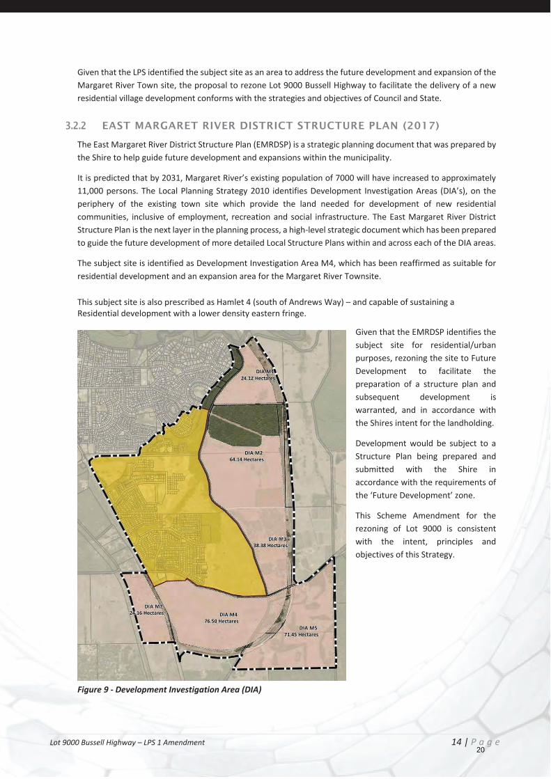
Given that the LPS identified the subject site as an area to address the future development and expansion of the Margaret River Town site, the proposal to rezone Lot 9000 Bussell Highway to facilitate the delivery of a new residential village development conforms with the strategies and objectives of Council and State.
3.2.2 EAST MARGARET RIVER DISTRICT STRUCTURE PLAN (2017)
The East Margaret River District Structure Plan (EMRDSP) is a strategic planning document that was prepared by the Shire to help guide future development and expansions within the municipality.
It is predicted that by 2031, Margaret River’s existing population of 7000 will have increased to approximately 11,000 persons. The Local Planning Strategy 2010 identifies Development Investigation Areas (DIA’s), on the periphery of the existing town site which provide the land needed for development of new residential communities, inclusive of employment, recreation and social infrastructure. The East Margaret River District Structure Plan is the next layer in the planning process, a high-level strategic document which has been prepared to guide the future development of more detailed Local Structure Plans within and across each of the DIA areas.
The subject site is identified as Development Investigation Area M4, which has been reaffirmed as suitable for residential development and an expansion area for the Margaret River Townsite. This subject site is also prescribed as Hamlet 4 (south of Andrews Way) – and capable of sustaining a Residential development with a lower density eastern fringe.
Given that the EMRDSP identifies the subject site for residential/urban purposes, rezoning the site to Future Development to facilitate the preparation of a structure plan and subsequent development is warranted, and in accordance with the Shires intent for the landholding.
Development would be subject to a Structure Plan being prepared and submitted with the Shire in accordance with the requirements of the ‘Future Development’ zone.
This Scheme Amendment for the rezoning of Lot 9000 is consistent with the intent, principles and objectives of this Strategy.
Figure 9 - Development Investigation Area (DIA)
20

Lot 9000 Bussell Highway – LPS 1 Amendment 15 | P a g e
Figure 10: East Margaret River District Structure Plan
21
Lot 9000 Bussell Highway – LPS 1 Amendment 16 | P a g e
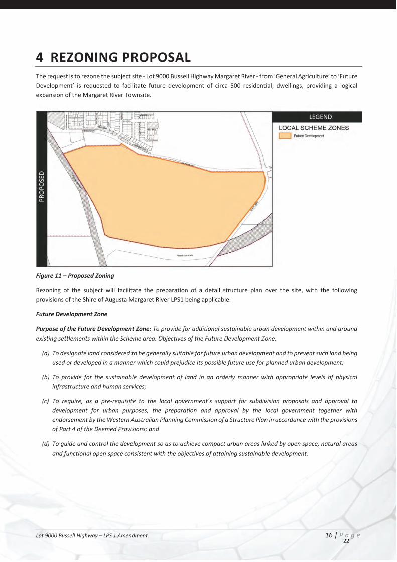
4 REZONING PROPOSAL The request is to rezone the subject site - Lot 9000 Bussell Highway Margaret River - from ‘General Agriculture’ to ‘Future Development’ is requested to facilitate future development of circa 500 residential; dwellings, providing a logical expansion of the Margaret River Townsite.
Figure 11 – Proposed Zoning
Rezoning of the subject will facilitate the preparation of a detail structure plan over the site, with the following provisions of the Shire of Augusta Margaret River LPS1 being applicable.
Future Development Zone
Purpose of the Future Development Zone: To provide for additional sustainable urban development within and around existing settlements within the Scheme area. Objectives of the Future Development Zone:
(a) To designate land considered to be generally suitable for future urban development and to prevent such land being used or developed in a manner which could prejudice its possible future use for planned urban development;
(b) To provide for the sustainable development of land in an orderly manner with appropriate levels of physical infrastructure and human services;
(c) To require, as a pre-requisite to the local government’s support for subdivision proposals and approval to development for urban purposes, the preparation and approval by the local government together with endorsement by the Western Australian Planning Commission of a Structure Plan in accordance with the provisions of Part 4 of the Deemed Provisions; and
(d) To guide and control the development so as to achieve compact urban areas linked by open space, natural areas and functional open space consistent with the objectives of attaining sustainable development.
22
Lot 9000 Bussell Highway – LPS 1 Amendment 17 | P a g e
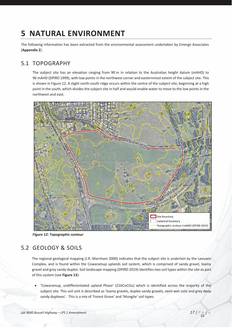
5 NATURAL ENVIRONMENT The following information has been extracted from the environmental assessment undertaken by Emerge Associates (Appendix 2).
5.1 TOPOGRAPHY The subject site has an elevation ranging from 90 m in relation to the Australian height datum (mAHD) to 96 mAHD (DPIRD 1999), with low points in the northwest corner and easternmost extent of the subject site. This is shown in Figure 12. A slight north-south ridge occurs within the centre of the subject site, beginning at a high point in the south, which divides the subject site in half and would enable water to move to the low points in the northwest and east.
Figure 12: Topographic contour
5.2 GEOLOGY & SOILS The regional geological mapping (J.R. Marnham 2000) indicates that the subject site is underlain by the Leeuwin Complex, and is found within the Cowaramup uplands soil system, which is comprised of sandy gravel, loamy gravel and grey sandy duplex. Soil landscape mapping (DPIRD 2019) identifies two soil types within the site as part of this system (see Figure 13):
‘Cowaramup, undifferentiated upland Phase’ (216CoCOu) which is identified across the majority of the subject site. This soil unit is described as ‘loamy gravels, duplex sandy gravels, semi-wet soils and grey deep sandy duplexes’. This is a mix of ‘Forest Grove’ and ‘Mungite’ soil types.
23
Lot 9000 Bussell Highway – LPS 1 Amendment 18 | P a g e
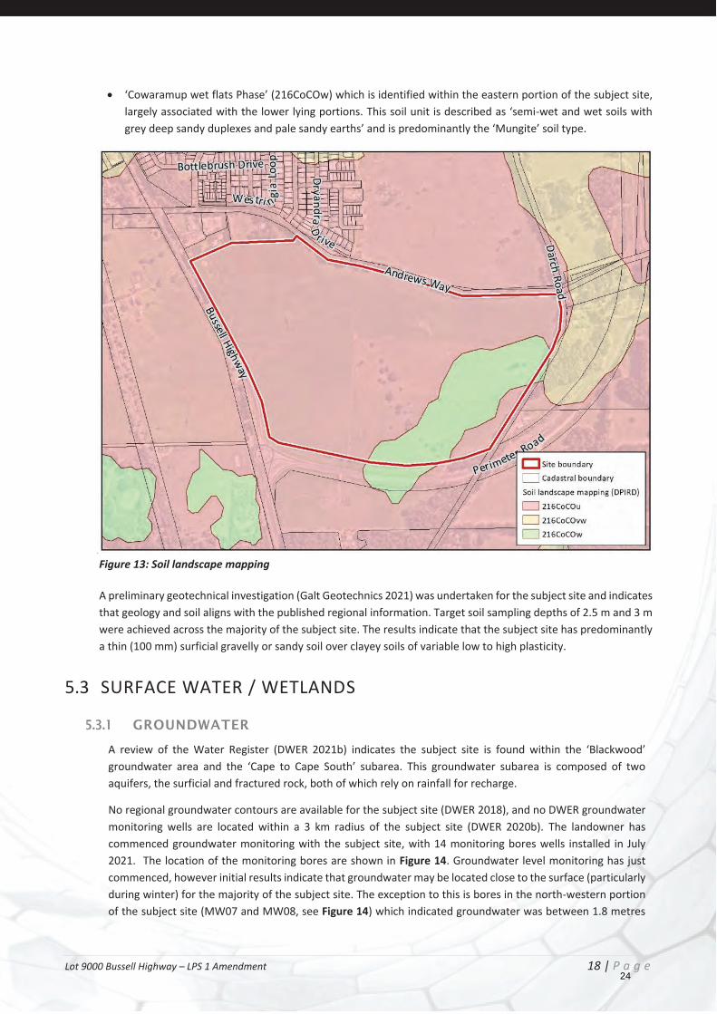
‘Cowaramup wet flats Phase’ (216CoCOw) which is identified within the eastern portion of the subject site, largely associated with the lower lying portions. This soil unit is described as ‘semi-wet and wet soils with grey deep sandy duplexes and pale sandy earths’ and is predominantly the ‘Mungite’ soil type.
Figure 13: Soil landscape mapping
A preliminary geotechnical investigation (Galt Geotechnics 2021) was undertaken for the subject site and indicates that geology and soil aligns with the published regional information. Target soil sampling depths of 2.5 m and 3 m were achieved across the majority of the subject site. The results indicate that the subject site has predominantly a thin (100 mm) surficial gravelly or sandy soil over clayey soils of variable low to high plasticity.
5.3 SURFACE WATER / WETLANDS
5.3.1 GROUNDWATER
A review of the Water Register (DWER 2021b) indicates the subject site is found within the ‘Blackwood’ groundwater area and the ‘Cape to Cape South’ subarea. This groundwater subarea is composed of two aquifers, the surficial and fractured rock, both of which rely on rainfall for recharge.
No regional groundwater contours are available for the subject site (DWER 2018), and no DWER groundwater monitoring wells are located within a 3 km radius of the subject site (DWER 2020b). The landowner has commenced groundwater monitoring with the subject site, with 14 monitoring bores wells installed in July 2021. The location of the monitoring bores are shown in Figure 14. Groundwater level monitoring has just commenced, however initial results indicate that groundwater may be located close to the surface (particularly during winter) for the majority of the subject site. The exception to this is bores in the north-western portion of the subject site (MW07 and MW08, see Figure 14) which indicated groundwater was between 1.8 metres
24
Lot 9000 Bussell Highway – LPS 1 Amendment 19 | P a g e
below ground level (m BGL) to >3.2 mBGL. Given the low permeability of in situ soils, groundwater levels are inferred to be seasonally perched and not an expression of the combined Leeuwin superficial aquifer.
Further monitoring to capture the winter groundwater peak and baseline data for groundwater quality is currently underway.
5.3.2 SURFACE WATER
The subject site is located within the ‘Busselton Coast’ basin surface water catchment, with the majority of subject site within the Margaret River sub-catchment, while the portion along the southern boundary is within the Boodjidup River sub-catchment.
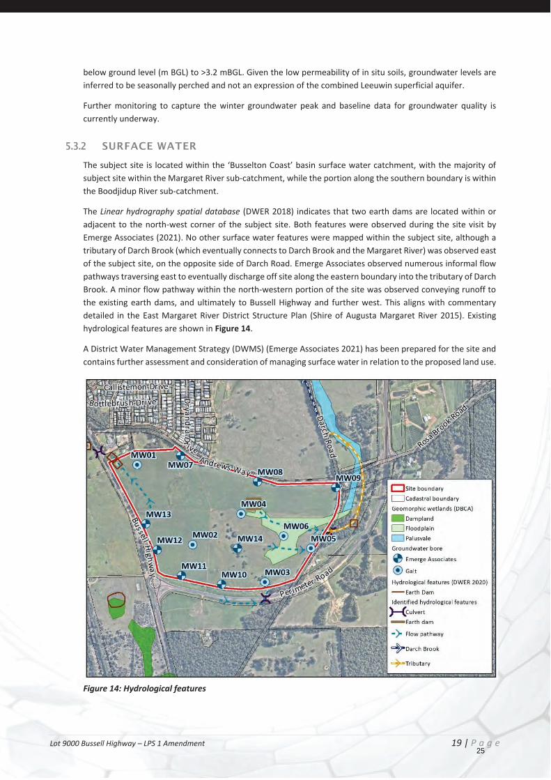
The Linear hydrography spatial database (DWER 2018) indicates that two earth dams are located within or adjacent to the north-west corner of the subject site. Both features were observed during the site visit by Emerge Associates (2021). No other surface water features were mapped within the subject site, although a tributary of Darch Brook (which eventually connects to Darch Brook and the Margaret River) was observed east of the subject site, on the opposite side of Darch Road. Emerge Associates observed numerous informal flow pathways traversing east to eventually discharge off site along the eastern boundary into the tributary of Darch Brook. A minor flow pathway within the north-western portion of the site was observed conveying runoff to the existing earth dams, and ultimately to Bussell Highway and further west. This aligns with commentary detailed in the East Margaret River District Structure Plan (Shire of Augusta Margaret River 2015). Existing hydrological features are shown in Figure 14.
A District Water Management Strategy (DWMS) (Emerge Associates 2021) has been prepared for the site and contains further assessment and consideration of managing surface water in relation to the proposed land use.
Figure 14: Hydrological features
25
Lot 9000 Bussell Highway – LPS 1 Amendment 20 | P a g e
5.3.3 WETLANDS
No wetlands of international importance (i.e. Ramsar wetlands) have been identified within the site or in proximity.
A geomorphic wetland (as identified within the Department of Biodiversity Conservation and Attractions (DBCA) Geomorphic Wetlands Leeuwin Naturaliste Ridge and Donnybrook to Nannup - Unreviewed (DBCA 2018a) database) is mapped within the eastern portion of the subject site and is described as a floodplain feature. Further to the east-northeast, a palusvale wetland feature has been identified and is associated with Darch Brook. These features are shown in Figure 14, and contain no remnant native vegetation and are not required to retained, however maintenance of their hydrological function is addressed within the DWMS (Emerge Associates 2021).
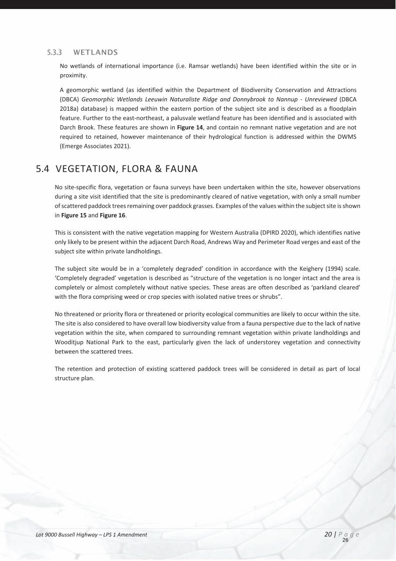
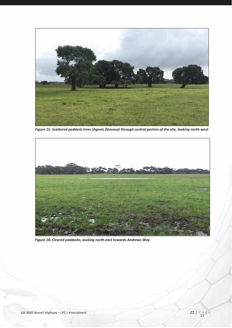
5.4 VEGETATION, FLORA & FAUNA No site-specific flora, vegetation or fauna surveys have been undertaken within the site, however observations during a site visit identified that the site is predominantly cleared of native vegetation, with only a small number of scattered paddock trees remaining over paddock grasses. Examples of the values within the subject site is shown in Figure 15 and Figure 16.
This is consistent with the native vegetation mapping for Western Australia (DPIRD 2020), which identifies native only likely to be present within the adjacent Darch Road, Andrews Way and Perimeter Road verges and east of the subject site within private landholdings.
The subject site would be in a ‘completely degraded’ condition in accordance with the Keighery (1994) scale. ‘Completely degraded’ vegetation is described as “structure of the vegetation is no longer intact and the area is completely or almost completely without native species. These areas are often described as ‘parkland cleared’ with the flora comprising weed or crop species with isolated native trees or shrubs”.
No threatened or priority flora or threatened or priority ecological communities are likely to occur within the site. The site is also considered to have overall low biodiversity value from a fauna perspective due to the lack of native vegetation within the site, when compared to surrounding remnant vegetation within private landholdings and Wooditjup National Park to the east, particularly given the lack of understorey vegetation and connectivity between the scattered trees.
The retention and protection of existing scattered paddock trees will be considered in detail as part of local structure plan.
26
Lot 9000 Bussell Highway – LPS 1 Amendment 21 | P a g e
Figure 15: Scattered paddock trees (Agonis flexuosa) through central portion of the site, looking north-west
Figure 16: Cleared paddocks, looking north-east towards Andrews Way
27
Lot 9000 Bussell Highway – LPS 1 Amendment 22 | P a g e
6 HAZARD & RISK The following information has been extracted from the environmental assessment undertaken by Emerge Associates (Appendix 2).
6.1 ROAD NOISE Bussell Highway is identified by State Planning Policy 5.4 – Road and Rail Noise as a ‘other significant freight/traffic route’.
A portion of the subject site is identified within 200 m of Bussell Highway, accordingly residential development in this area will need to be considered pursuant to the provisions of State Planning Policy 5.4 – Road and Rail Noise. Potential noise impacts are capable of being addressed adequately through the structure plan process that will follow.
6.2 CONTAMINATED SITE A review of the DWER Contaminated Sites Database (DWER 2021a) did not identify any registered contaminated sites within or in proximity to the site. In addition, the lack of visual evidence of past horticultural uses within the site (associated with fertiliser, herbicide and pesticide use) or other contaminating land uses is consistent with the site being unlikely to be contaminated.
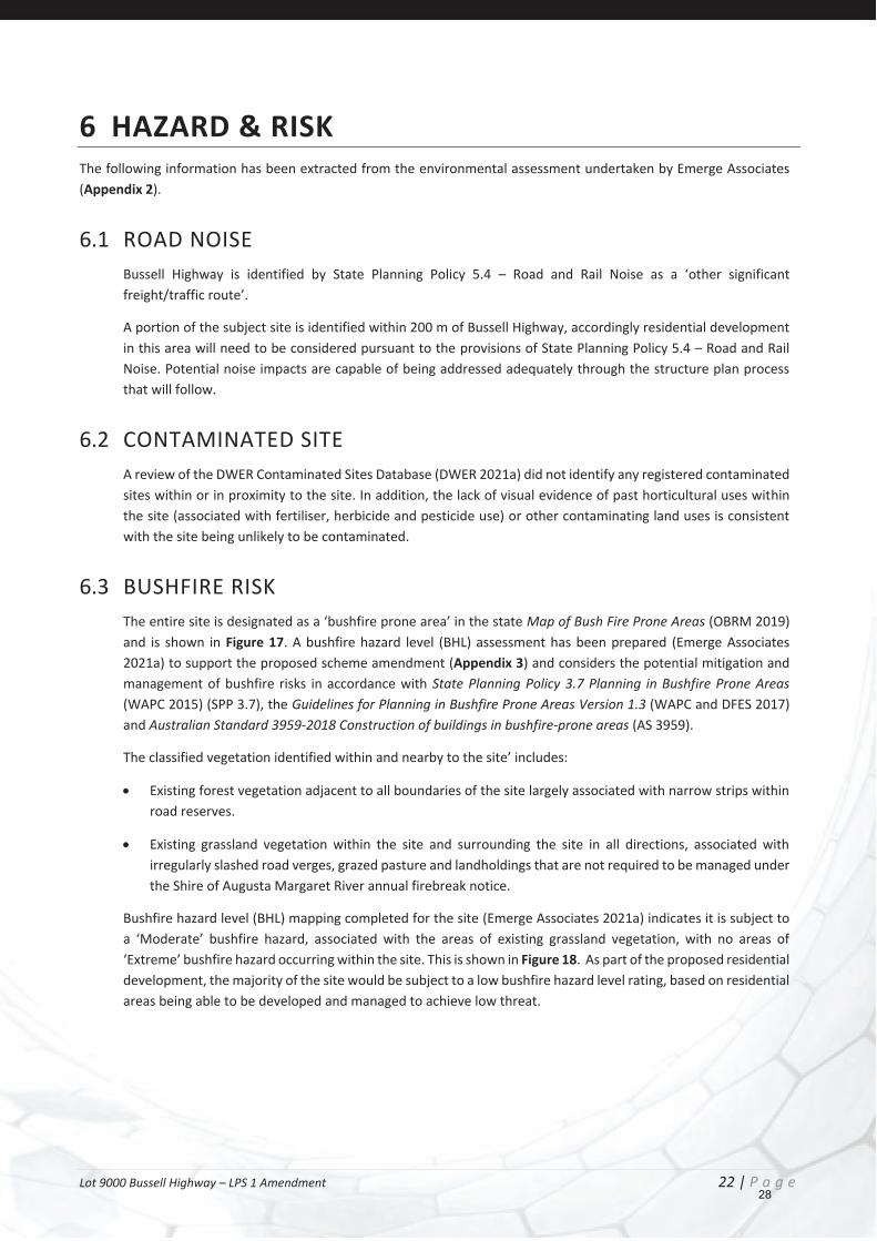
6.3 BUSHFIRE RISK The entire site is designated as a ‘bushfire prone area’ in the state Map of Bush Fire Prone Areas (OBRM 2019) and is shown in Figure 17. A bushfire hazard level (BHL) assessment has been prepared (Emerge Associates 2021a) to support the proposed scheme amendment (Appendix 3) and considers the potential mitigation and management of bushfire risks in accordance with State Planning Policy 3.7 Planning in Bushfire Prone Areas (WAPC 2015) (SPP 3.7), the Guidelines for Planning in Bushfire Prone Areas Version 1.3 (WAPC and DFES 2017) and Australian Standard 3959-2018 Construction of buildings in bushfire-prone areas (AS 3959).
The classified vegetation identified within and nearby to the site’ includes:
Existing forest vegetation adjacent to all boundaries of the site largely associated with narrow strips within road reserves.
Existing grassland vegetation within the site and surrounding the site in all directions, associated with irregularly slashed road verges, grazed pasture and landholdings that are not required to be managed under the Shire of Augusta Margaret River annual firebreak notice.
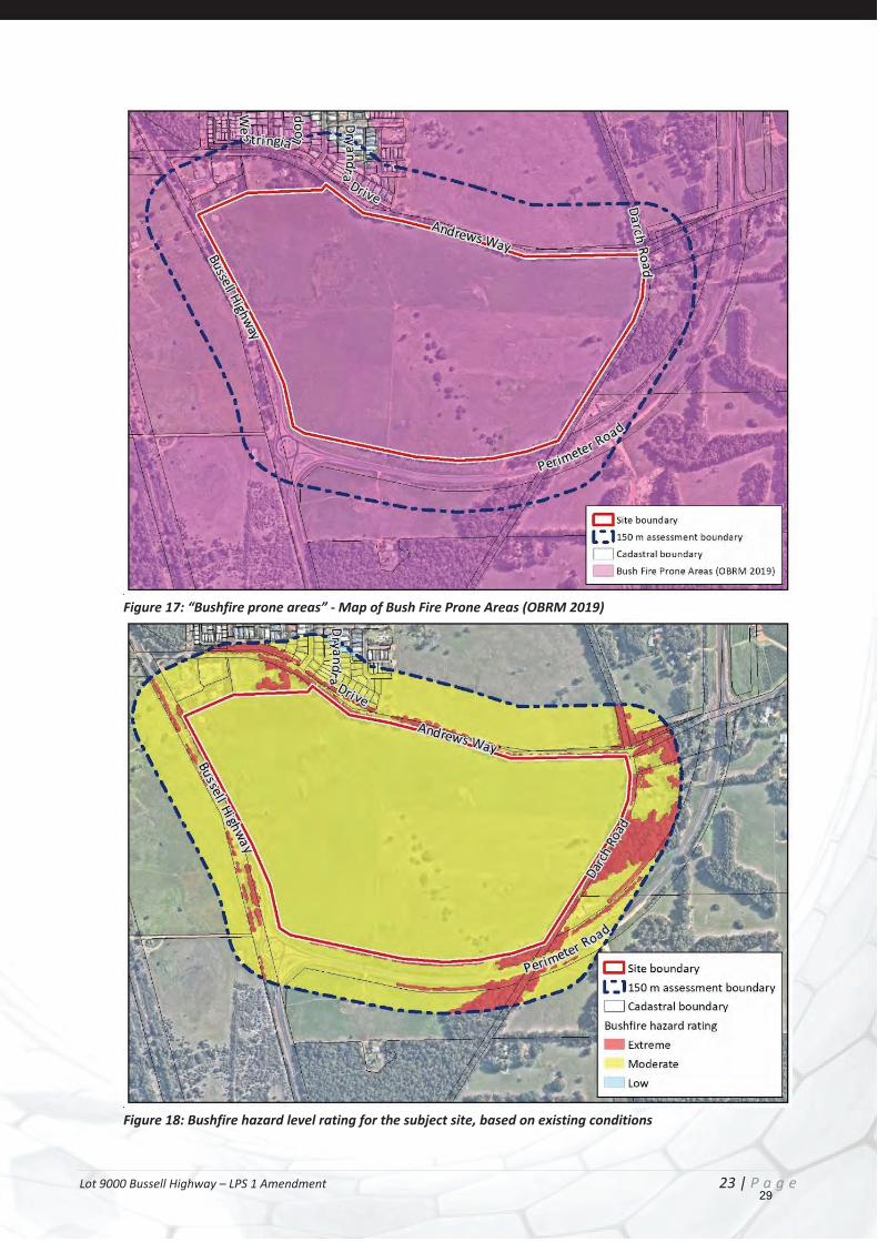
Bushfire hazard level (BHL) mapping completed for the site (Emerge Associates 2021a) indicates it is subject to a ‘Moderate’ bushfire hazard, associated with the areas of existing grassland vegetation, with no areas of ‘Extreme’ bushfire hazard occurring within the site. This is shown in Figure 18. As part of the proposed residential development, the majority of the site would be subject to a low bushfire hazard level rating, based on residential areas being able to be developed and managed to achieve low threat.
28
Lot 9000 Bussell Highway – LPS 1 Amendment 23 | P a g e
Figure 17: “Bushfire prone areas” - Map of Bush Fire Prone Areas (OBRM 2019)
Figure 18: Bushfire hazard level rating for the subject site, based on existing conditions
29
Lot 9000 Bussell Highway – LPS 1 Amendment 24 | P a g e
The BHL assessment (Emerge Associates 2021) demonstrates that the subject site can achieve an appropriate bushfire hazard level (currently moderate, which will change to low as development is implemented) to support the proposed intensification of land use and satisfy clause 6.2 (b) of SPP 3.7.
The subject site has sufficient area to accommodate setbacks to ensure BAL rating of BAL-29 or less can be achieved at habitable buildings, and is located in an area that provides opportunities for egress to at least two different destinations. A BMP will be prepared to support any future structure plan(s) or subdivision application(s) and will need to assess the proposed development design in consideration of the recommendations of the BHL assessment prepared to support the scheme amendment, SPP 3.7 and the Guidelines.
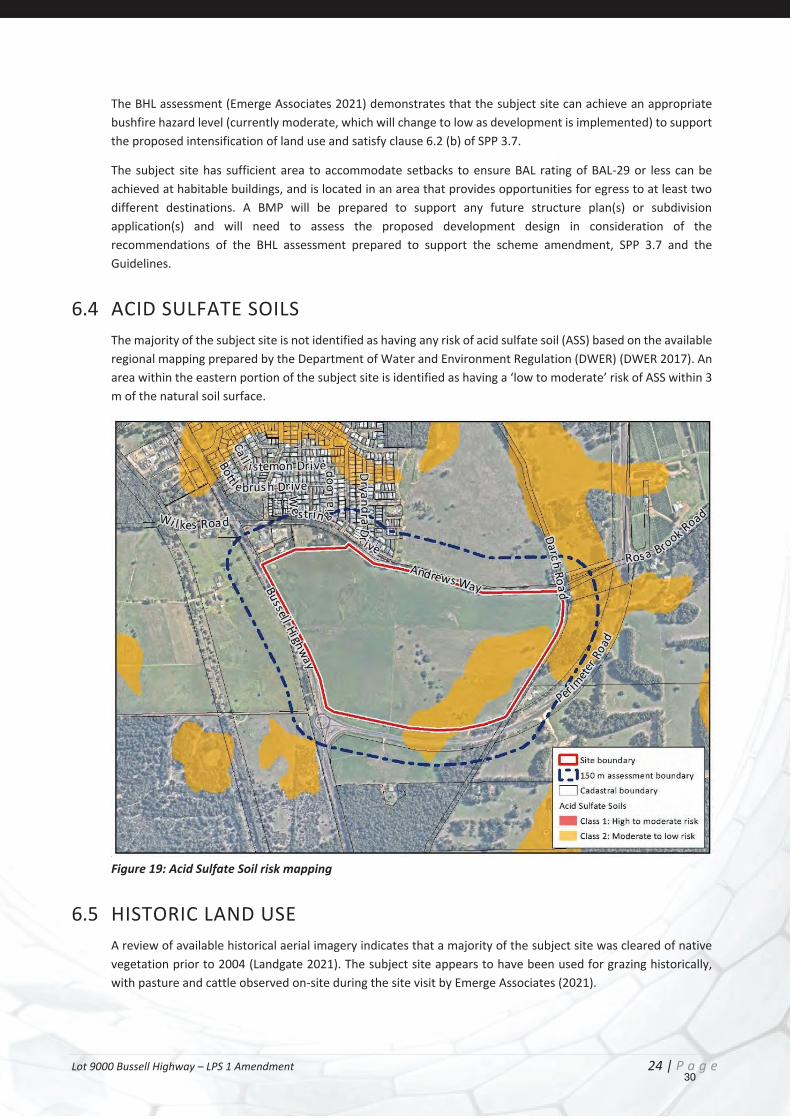
6.4 ACID SULFATE SOILS The majority of the subject site is not identified as having any risk of acid sulfate soil (ASS) based on the available regional mapping prepared by the Department of Water and Environment Regulation (DWER) (DWER 2017). An area within the eastern portion of the subject site is identified as having a ‘low to moderate’ risk of ASS within 3 m of the natural soil surface.
Figure 19: Acid Sulfate Soil risk mapping
6.5 HISTORIC LAND USE A review of available historical aerial imagery indicates that a majority of the subject site was cleared of native vegetation prior to 2004 (Landgate 2021). The subject site appears to have been used for grazing historically, with pasture and cattle observed on-site during the site visit by Emerge Associates (2021).
30
Lot 9000 Bussell Highway – LPS 1 Amendment 25 | P a g e
6.6 UNEXPLODED ORDINANCE (UXO) The subject site is not an area identified with having substantial, slight or other UXO potential.
6.7 ABORIGINAL HERITAGE PLACES The Aboriginal Heritage Inquiry System (AHIS) is maintained pursuant to Section 38 of the Aboriginal Heritage Act 1972 by the Department of Planning, Lands and Heritage (DPLH), and contains information on registered Aboriginal heritages sites and other heritage places throughout Western Australia. In accordance with the Aboriginal Heritage Due Diligence Guidelines (DAA 2013), a search of the AHIS online database (DPLH 2021a) was undertaken.
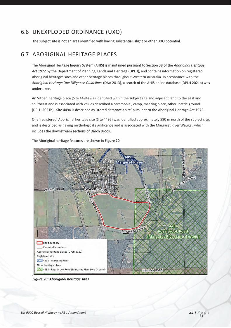
An ‘other heritage place (Site 4494) was identified within the subject site and adjacent land to the east and southeast and is associated with values described a ceremonial, camp, meeting place, other: battle ground (DPLH 2021b) . Site 4494 is described as ‘stored data/not a site’ pursuant to the Aboriginal Heritage Act 1972.
One ‘registered’ Aboriginal heritage site (Site 4495) was identified approximately 580 m north of the subject site, and is described as having mythological significance and is associated with the Margaret River Waugal, which includes the downstream sections of Darch Brook.
The Aboriginal heritage features are shown in Figure 20.
Figure 20: Aboriginal heritage sites
31

Lot 9000 Bussell Highway – LPS 1 Amendment 26 | P a g e
6.8 EUROPEAN HERITAGE A desktop search of the State Heritage Office database, which includes state and local lists (Heritage Council of WA 2021), the Australian Heritage Database, which includes the National and Commonwealth Heritage Lists (Department of Agriculture Water and Environment 2019) and the Shire of Augusta Margaret River Heritage Inventory (Greenward Consulting 2012) indicates that the subject site and adjacent areas do not contain any non-indigenous heritage sites.
32
Lot 9000 Bussell Highway – LPS 1 Amendment 27 | P a g e
7 SERVICES AND FILL The project engineers Stantec have reviewed the subject site with findings detailed in the report contained as Appendix 4. The following provides a summary of key findings.
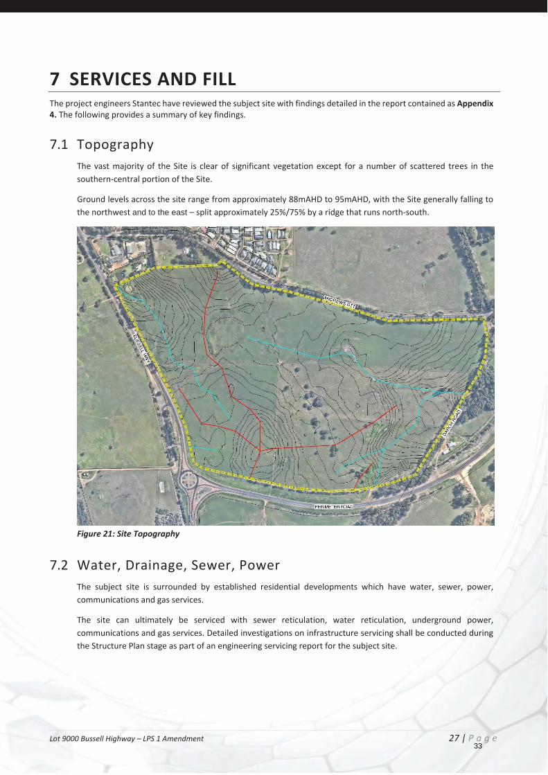
7.1 Topography The vast majority of the Site is clear of significant vegetation except for a number of scattered trees in the southern-central portion of the Site.
Ground levels across the site range from approximately 88mAHD to 95mAHD, with the Site generally falling to the northwest and to the east – split approximately 25%/75% by a ridge that runs north-south.
Figure 21: Site Topography
7.2 Water, Drainage, Sewer, Power The subject site is surrounded by established residential developments which have water, sewer, power, communications and gas services.
The site can ultimately be serviced with sewer reticulation, water reticulation, underground power, communications and gas services. Detailed investigations on infrastructure servicing shall be conducted during the Structure Plan stage as part of an engineering servicing report for the subject site.
33

Lot 9000 Bussell Highway – LPS 1 Amendment 28 | P a g e
7.2.1 SEWERAGE
The Site is located within the Water Corporation’s SD113 Margaret River Long Term Sewer Planning (SD113) scheme boundary, meaning that allowance has been made within Water Corporation’s planning to service the Site with reticulated sewerage. Extension to existing infrastructure is able to be utilised to service the subject site. The detail of these extensions are detailed in Section 2 of Appendix 4.
An alternative to WaterCorp reticulation is also available for the site, being a private reticulated network serviced by a recycled waterplan (RWP). This would be in lieu of connecting to the Water Corporation reticulated sewer network.
Figure 22 - Wastewater Planning – Water Corp
Such a system would be operated by a private operator, who specialise in delivering a range of wastewater solutions within the south-west of Australia. The recycled water produced by the RWP would be treated to a high and fit-for-purpose standard that will facilitate reuse within the subject site for irrigation of public open space (POS) and potential school ovals.
Any private reticulated network and associated RWP would be regulated through the Economic Regulatory Authority and relevant Environmental Protection Act approvals (DPLH 2019a). The Wastewater Servicing Overview (Appendix 4) has been undertaken to ascertain the viability of such an approach at this early phase of planning, and summarise possible aspects of such a system that would be subject of further detailed discussion with Council in the subsequent planning phases.
Further detail on this approach is outlined in the DWMS (Emerge Associates 2021c) (Attachment 5) and Wastewater Servicing Overview (Water West 2021) (Appendix 4), however confirmation of this approach will be outlined in the successive local water management strategy (LWMS) as part of local structure planning.
34
Lot 9000 Bussell Highway – LPS 1 Amendment 29 | P a g e
7.2.2 WATER SUPPLY
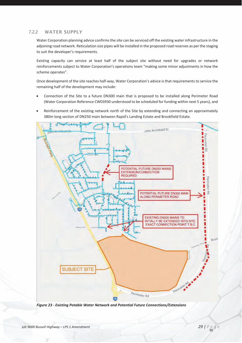
Water Corporation planning advice confirms the site can be serviced off the existing water infrastructure in the adjoining road network. Reticulation size pipes will be installed in the proposed road reserves as per the staging to suit the developer’s requirements.
Existing capacity can service at least half of the subject site without need for upgrades or network reinforcements subject to Water Corporation’s operations team “making some minor adjustments in how the scheme operates”.
Once development of the site reaches half-way, Water Corporation’s advice is that requirements to service the remaining half of the development may include:
Connection of the Site to a future DN300 main that is proposed to be installed along Perimeter Road (Water Corporation Reference CW03930 understood to be scheduled for funding within next 5 years), and
Reinforcement of the existing network north of the Site by extending and connecting an approximately 380m long section of DN250 main between Rapid’s Landing Estate and Brookfield Estate.
Figure 23 - Existing Potable Water Network and Potential Future Connections/Extensions
35
Lot 9000 Bussell Highway – LPS 1 Amendment 30 | P a g e
7.2.3 DRAINAGE
A DWMS (Emerge Associates 2021, see Appendix 5) has been prepared for the subject site and outlines the proposed drainage approach. It has been prepared to establish the water management methods for development within the subject site based on site-specific investigations, and are consistent with relevant state and Shire requirements. It is also intended to provide guidance to the general stormwater management principles for the area and to guide the development of future local water management strategy (LWMS) and urban water management plan (UWMP) documents.
The overall objective for the development will be to mimic the existing hydrological regime of the subject site and to provide a sustainable approach to water use within the subject site. This includes ensuring the post-development peak discharge rates from the subject site should not exceed pre-development peak discharge rates. This will be achieved by ensuring runoff up to the 1% annual exceedance probability (AEP) rainfall event is detained within the development, before discharging off site at an appropriate flow rate.
The presence of clayey soils at relatively shallow levels across the majority of the subject site along with locally perched groundwater will likely diminish the near-surface storage capacity of the subject site after periods of high rainfall. It is anticipated that water sensitive urban design (WSUD) measures can still be appropriately implemented however these will have specific design considerations to manage erosion and to ensure that they are able to dry out in an acceptable time and provide the required water quality treatment outcomes.
Key aspects of the water management strategy that will assist in achieving the broad objectives and water management criteria proposed include:
Understanding soil profile limitations and accounting for these in the earthworks strategy, drainage designs and overall servicing/supply strategy.
Managing shallow perched groundwater and soil conditions by the use of imported fill, clay layer grading and subsoil drains.
Maintaining the existing surface water regime by retaining overall site grading, discharge locations and peak flow rates for stormwater.
Supporting an appropriate water balance for the site which accounts for the availability of water (including recycled water), beneficial end uses and site limitations (largely based on soil types and shallow groundwater).
Overall, it will be possible for future development within the site to appropriately manage stormwater, groundwater, and surface water to address the state and local policies and expectations and includes measures are regularly applied as part of typical residential development processes. Public open space irrigation needs are proposed to be satisfied through use of recycled water. Detail regarding the implementation of water management measures will be addressed in subsequent water management documents.
7.3 Accessibility
7.3.1 ROADS & PATHS
The subject site is located within an established area comprising a network of Local Roads, and Highways and Main Roads.
The Margaret River Perimeter Road provides access the wider region, intersecting with Bussell Highway at the southwestern corner of the subject site. This road was recently completed, and no further upgrades are anticipated at this stage. The proportion of the Perimeter Road reserve that abuts the southern boundary of the subject site is currently zoned General Agriculture, though it is acknowledged that this will be zoned Highways
36

Lot 9000 Bussell Highway – LPS 1 Amendment 31 | P a g e
and Main Roads under TPS 1 to reflect the balance of the reserve.
Access to the subject site is able to be gained from Bussell Highway to the west and Andrews Way to the north. Andrews Way is a sealed and uncurbed rural style road, with no direct access being granted for residential dwellings on the northern side (Brookfield Estate). No direct access to residential dwellings (crossovers) is anticipated on the south side (subject site).
Road assessment of the existing road pavements will be undertaken in the next planning phase (Structure Plan), where road networks and residential urban layouts are proposed.
There is no further road widening of the surrounding reserves identified within the subject site by current zoning boundaries.
7.3.2 PATHS
There is an existing path network within the locality, providing access form the subject site to the Margert River Townsite.
The Wadandi Track is located west of the subject site, on the western side of Bussell Highway. Darch Road which traverses the eastern boundary of the subject site is identified as a primary path network by East Margaret River DSP.
37
Lot 9000 Bussell Highway – LPS 1 Amendment 32 | P a g e
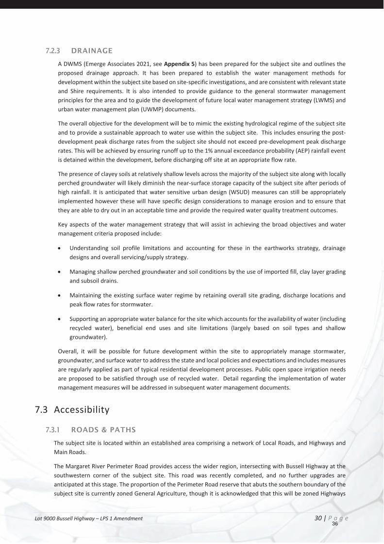
Figure 24 – East Margaret River DSP Path Network
It is expected the subdivision roads will include paths that link the development to these exterior path networks.
38
Lot 9000 Bussell Highway – LPS 1 Amendment 33 | P a g e
7.4 Electricity and Gas Supply Electricity services are located in the surrounding area and have been designed with capacity to be extended into the subject area.
High Voltage (HV) overhead service within the Southern Perimeter Rd road reserve.
HV overhead service to the South of Perimeter Rd up to Darch Rd
HV overhead and underground service to the East of Darch Rd (between Perimeter and Rosa Brook Roads)
HV underground service within the Northern Rosa Brook road reserve (from Leschenaultia Ave to Sandalwood Drive
All electrical reticulation will be underground in accordance with accepted practice and State Government requirements.
ATCO Gas does not operate a reticulated natural gas network in the Margaret River area and therefore it is not possible to service the Site with reticulated natural gas.
7.5 Telecommunications Telstra has advised that existing services can be extended to provide for required telecommunications services within the subject area. NBN infrastructure is in the area and can be extended through the development of the subject site.
According to the NBN rollout map (07/07/2021), the land to be subdivided falls within the NBN fixed line footprint.
7.6 Siteworks and Fill Based on development works of adjacent areas, and water modelling investigations, it is anticipated the site will require fill for dwelling construction to achieve required separation to groundwater levels and facilitate drainage.
The strategy to be implemented through development will provide an appropriate level of fill coupled with groundwater control to ensure that lots have the intended functionality. This will be supported by lot connection pits, which will convey runoff into the road drainage network. Runoff from lots and roads will then be conveyed to a WSUD measure/feature where it will be treated and detained within the estate drainage.
An earthwork and fill strategy will be required for the next planning stage. It is envisaged that the overall earthwork levels will mimic those existing onsite to facilitate integration with the surrounding area and maintain the existing surface water regime. The earthworks concept strategy will be used to inform the detailed surface runoff modelling that will assist in refining the structure plan and will inform the LWMS.
The extent of filling will need to consider various factors including: 1% AEP flood separation, site classification requirements, separation to ground water and sewer servicing requirements.
It is anticipated that fill will be sourced from local sand extraction pits as typical with other development sites in the area.
The subject site can adequately be earth worked to facilitate development for residential purposes.
39
Lot 9000 Bussell Highway – LPS 1 Amendment 34 | P a g e
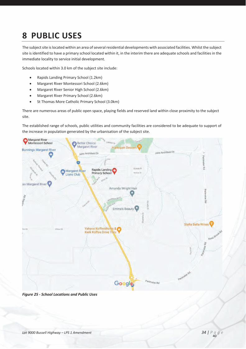
8 PUBLIC USES The subject site is located within an area of several residential developments with associated facilities. Whilst the subject site is identified to have a primary school located within it, in the interim there are adequate schools and facilities in the immediate locality to service initial development.
Schools located within 3.0 km of the subject site include:
Rapids Landing Primary School (1.2km) Margaret River Montessori School (2.6km) Margaret River Senior High School (2.6km) Margaret River Primary School (2.6km) St Thomas More Catholic Primary School (3.0km)
There are numerous areas of public open space, playing fields and reserved land within close proximity to the subject site.
The established range of schools, public utilities and community facilities are considered to be adequate to support of the increase in population generated by the urbanisation of the subject site.
Figure 25 - School Locations and Public Uses
40

Lot 9000 Bussell Highway – LPS 1 Amendment 35 | P a g e
9 FUTURE STRUCTURE PLAN Under the provisions of LPS1, rezoning the subject site Future Development, will facilitate the preparation of a structure plan over the site, which will guide future development for residential purposes.
Whilst preparation of the structure plan will be subject to detailed technical reports and detail design evolution, initial discussions have been had with regard to an urban form that may be pursued. This has taken into consideration current access limitations (no access from Perimeter Road), and natural contours (catchments) within the site.
Figure 26 - Residential Village Concept
The premise behind the above vision includes urban cells with green links between villages/precincts. These links may be in the form of open space spines, or a heavily treed road network, though the aim of the development is to be respectful to the site and minimise the extent of earth working etc.
The resulting urban development will result in increased tree numbers throughout the site, also a resulting increasing tree canopy cover once the estate is finished and the trees matured.
41
Lot 9000 Bussell Highway – LPS 1 Amendment 36 | P a g e
10 CONSULTATION & JUSTIFICATION As noted in the preceding sections the rezoning of the site to Future Development will facilitate the preparation of a detailed Structure Plan, and subsequent development of residential lots / dwellings.
The proposed rezoning and future structure planning of the subject site has been the subject of discussions with the Shire of Augusta Margaret River. The Shire’s planning administration have ‘in principle’ acknowledged rezoning of the subject site to Future Development being appropriate, subject to the proponent undertaking the associated planning process.
The overarching criteria to support an extension of a residential / urban zone is detailed below;
Justification Criteria Response The land is capable of being provided with essential services and agreement has been reached between the developers and service providers with regard to the staging and financing of services.
As noted in the preceding sections above, the subject site is surrounded by established urban land with all infrastructure services available for connection / extension. Further detailed infrastructure requirements will be considered as part of an Engineering Servicing Report during the Structure Planning stage.
Planning is sufficiently advanced to depict an acceptable overall design to guide future development.
A vision structure plan layout has been prepared for the subject site (Appendix 7) depicting the intended overall design for the subject site and its ability to integrate with the adjoining road network and urban areas. The design is subject to further discussions and technical input following rezoning of the site.
The proposed urban development represents a logical progression of development.
As illustrated by the figure below, the extension of the Future development zone south is the only remnant area that remains north of Perimeter Road that fronts Bussell Highway. To this end, rezoning to consolidate this area with the surrounding area would represent orderly and proper planning and the logical progression of the urban front. It is also noted that the Shire has expressed their support for the rezoning, as it will facilitate the delivery of district playing fields and also future planning for the primary school site as identified by the East Margaret River District Structure Plan.
42
Lot 9000 Bussell Highway – LPS 1 Amendment 37 | P a g e 43

Lot 9000 Bussell Highway – LPS 1 Amendment 38 | P a g e
Regional requirements (such as regional roads, open space and public purposes) have been satisfied or provision made for them.
The subject site is within an established urban area where regional roads, open space and public purposes have already been satisfied. The subject site will facilitate additional open space areas and playing field.
Any constraints to urban development, including in relation to environmental, hazard and risk issues, can be satisfactorily addressed.
As outlined in the preceding sections above, core environmental issues have already been considered during the preparation of the East Margaret River District Structure Plan, and again through this rezoning proposal. Detailed consideration of environmental (i.e. drainage etc), hazards (i.e., bushfire) and other risk issues shall be investigated during the structure plan stage.
In addition, the preceding information, the provisions, and objective of the Scheme with regard to the Future Development zone are also met by the proposal.
Future Development Zone Purpose of the Future Development Zone: To provide for additional sustainable urban development within and around existing settlements within the Scheme area. Objectives of the Future Development Zone:
(a) To designate land considered to be generally suitable for future urban development and to prevent such land being used or developed in a manner which could prejudice its possible future use for planned urban development;
(b) To provide for the sustainable development of land in an orderly manner with appropriate levels of physical infrastructure and human services;
(c) To require, as a pre-requisite to the local government’s support for subdivision proposals and approval to development for urban purposes, the preparation and approval by the local government together with endorsement by the Western Australian Planning Commission of a Structure Plan in accordance with the provisions of Part 4 of the Deemed Provisions; and
(d) To guide and control the development so as to achieve compact urban areas linked by open space, natural areas, and functional open space consistent with the objectives of attaining sustainable development.
Analysis of the current market demand and lot supply with Margaret River has also been undertaken in support of the rezoning proposal.
It is evident from the research summarised in Appendix 6 that Margaret River needs an increase in land supply to meet demand, and Lot 9000 Bussell Highway which is zoned ‘Future Urban’ in the Shire of Augusta-Margaret River Local Planning Strategy has the ability to provide a solid short / medium term land supply.
Lot 9000 Bussell Highway is located in direct proximity to established residential estates, deeming it viable to extend services through to the subject site. The other ‘future urban’ zoned large lots within the Planning Strategy are located too far from existing services to deem it economically viable to develop into traditional lots in the short to medium term.
44
Lot 9000 Bussell Highway – LPS 1 Amendment 39 | P a g e
11 CONCLUSION The information and justification provided in this report is submitted to support the rezoning of Lot 9000 Bussell Highway, Margaret River from ‘General Agriculture’ to ‘Future Development’.
The proposed zoning is appropriate and should be supported by the Shire of Augusta Margaret River and the WAPC for the following reasons:
The strategic planning frameworks and statutory processes which apply to the subject site have been addressed in the content of this submission and demonstrate the appropriateness of the rezoning;
The land is highly accessible, given its frontage to Highways and Main Roads Reserve (Bussell Highway); The logical extension of the development front from the north. The Perimeter Road to the south of the site
limits any further expansion southward; Is consistent with the objectives of the Shire of Augusta Margaret Rivers Local Planning Strategy; Is consistent with the objectives of the East Margaret River District Structure Plan; Will facilitate the development of a viable residential estate, and facilitate the creation of a district playing
field and primary school site through development.
Based on the information presented in this report, it is considered that the proposed rezoning to Future Development warrants favourable consideration by the relevant authorities given the opportunities presented.
Investigations undertaken to address items raised by various government agencies during early engagement, demonstrate that the proposed scheme amendment is unlikely to result in development that would significantly impact environmental attributes or values, or nearby land uses as the proposed future development can be suitably managed through standard urban development processes.
Should the rezoning be supported, it will ensure future land use and development occurs in a coordinated and logical manner.
Accordingly, it is requested that the relevant authorities consider the subject application based on its merits with a positive view in supporting the proposal.
45